Embed Size (px)
Citation preview
LCGISNGEOSPATIAL SEARCH
PROGRAM
User Manual
Coastal Studies InstituteLouisiana State University
Baton Rouge, Louisiana 70803
Department of the Interior
U.S. Geological Survey
LCGISN GeoSpatial Search Program
USER MANUAL
1995
Randolph A. McBride1 and S. Jeffress Williams2 Principal Investigators
Technical Writer Joel Register3
Compilers* Jay Arnold4, DeWitt Braud Jr.4, Michael Carpenter5 , Matteson W.
Hiland 1 , Farrell W. Jones6, Anthony J. Lewis4, Randolph A.McBride1 , Joel Register3 , Sachin Shroff7, Henry Streiffer8, Christine
Todd5, and Lynda D. Wayne1
Programmers Srinivasa Lingineni9 and Sudish Mogli10
Contributors*Denise Babin5, Mark R. Byrnes1 , Niranjan Chintam6, Don W.
Davis11 , and Nina S.N. Lam4
Open-File Report 95-214
"Listed in alphabetical order
Notes
Coastal Studies Institute, 331 Howe-Russell Geoscience Complex, Loui siana State University, Baton Rouge, Louisiana 70803
r\
United States Geological Survey, MS 914, National Center, Reston, Vir ginia 22092
o
Department of English, Louisiana State University, Baton Rouge, Loui siana 70803
4 Department of Geography and Anthropology, Louisiana State Univer sity, Baton Rouge, Louisiana 70803
School of Library and Information Science, Louisiana State University, Baton Rouge, Louisiana 70803
6 CADGIS Research Laboratory, 215 Design Building., Louisiana State University, Baton Rouge, Louisiana 70803
System Science Department, Louisiana State University, Baton Rouge, Louisiana 70803
Q
Decision Associates, 1949 Ferndale Ave., Baton Rouge, Louisiana 70806
9 Computer Science Department, Louisiana State University, Baton Rouge, Louisiana 70803
Department of Electrical and Computer Engineering, Louisiana State University, Baton Rouge, Louisiana 70803
Center for Coastal, Energy, and Environmental Resources, 256 Military Science Building, Louisiana State University, Baton Rouge, Louisiana 70803
This report was prepared under contract to the U.S. Geological Survey and has not been reviewed for conformity with USGS editorial standards or with the North American Stratigraphic Code. Opinions and conclu sions expressed herein do not necessarily represent those of the USGS. Any use of trade, product, or firm names is for descriptive purposes only and does not imply endorsement by the U.S. Government.
ACKNOWLEDGEMENTS
The authors gratefully acknowledge the initial assistance of Louise McLaughlin and Claudia Holland of the company, Information Research, who helped to get this project started on the right track. Fur thermore, several graduate assistants and student workers have played a critical role in accomplishing the goals set for LCGISN. These include Chris Campany, Bill Foster, Christina Hebert, Regan Kelly, and Vandana Viddyarthee. LCGISN was tested at the Southern Science Center of the National Biological Service (NBS) in Lafayette, LA, and at the US Army Corps of Engineers-New Orleans District (US ACE-NOD) in New Orleans, LA. Among the personnel who generously contributed time to the program were Marcia McNifif, Natalie Gormanous, Greg Martin, and Janelda Biagas of NBS and Rob Cunningham, Jay Ratcliff, and Ralph Scheid of US ACE-NOD. John Gerone of the Tulane School of Public Health and Tropical Medicine assisted in the testing of network connec tions to LCGISN. The manual was edited by Michael A. Cofifey and Nicola F. Mason with editorial assistance from Brian Bienvenu of the LSU Center for Coastal, Energy, and Environmental Resources.
Table of Contents
Welcome ........................................... 1Data Types in the System .............................. 2Base Map Layers ..................................... 3Technical Support .................................... 5Submitting Records to LCGISN ......................... 6Contents of This Document ............................ 7Conventions Used in the Manual......................... 7
The Basics
1.0 Overview of a Search ........................... 112.0 Logging In ................................... 15
Welcome Menu .............................. 193.0 Online Help ...................................214.0 Screen Conventions ............................ 23
Menu Controls ............................... 24Mouse Controls .............................. 25Pull-down Lists and Key-in Boxes ............... 26
Scroll Bars................................ 275.0 Base Map .................................... 29
Spatial Search Methodology .................... 30Setthe Base Map ........................ ... 31Define a Location for a Search .................. 32
6.0 Pocket Menu .................................. 33Map View Controls ........................... 34
Window Area.............................. 34Zoom .................................... 35Center.................................... 37Fit....................................... 37Tips for Maximizing Performance.............. 38
Pocket Menu Utilities .......................... 39User Message for LCGISN ...................39Notepad .................................. 40Bulletin Board............................. 41
Menus & Procedures
7.0 Main Menu ................................... 458.0 Data Types Menu .............................. 47
Literature Search Criteria Menu ................. 49Date Key-in Menu ......................... 51
Photography Search Criteria Menu ............... 52Scale Key-in Menu ......................... 54
Map Search Criteria Menu ...................... 55Imagery Search Criteria Menu ................... 57Audiovisual Search Criteria Menu ............... 59Tabular Search Criteria Menu ................... 60Geotechnical Search Criteria Menu ............... 61
9.0 People & Organization Search Menu ............... 63Hierarchical Searches of Organizations ............ 66
10.0 Specify Location Menu ......................... 67MBR by Mouse .............................. 69Coordinates Key-in Menu ...................... 70USGS 7.5-Min. Quadrangles Index Menu ......... 71
Select from List............................ 73Select by Block ............................ 75Select from Map ........................... 76
Geographic Names Locator Menu ................ 7711.0 Subject Headings Menu ......................... 79
Tips for Using Subject Headings ................. 8512.0 Query Management ............................ 8713.0 Search Results Menu ........................... 8914.0 General Search Strategies ........................ 9115.0 Tutorial ...................................... 93
Photography Search ........................... 94Literature Search ............................ 104
Glossary.......................................... 121References ........................................ 159Appendix......................................... 161Index ............................................ 165

WELCOME TO LCGISN
WelcomeThe LCGISN GeoSpatial Search Program was developed to provide a means for locating sources of information about Louisiana's coastal zone. Users can search the LCGISN data base for catalog records describing data held by participating institutions. Search results provide detailed descriptions of the data ("metadata") along with the names of potentially valuable contacts: individuals working in universities, private organizations, and local, state, and federal agencies who may assist users in accessing these data.
In addition to performing searches by subject terms, authors, and dates, users can search the LCGISN data base geographically. The ability to define searches by interacting with a base map of Louisiana allows users to narrow searches to records dealing with a specific location without having to know the geographic coordinates of the area of interest.
Users can, of course, specify location by latitude and longitude or by Universal Transverse Mercator (UTM) coordinates, but they may also key in a place name, choose from a list of quadrangles for the state, point to a USGS 7.5-min. quadrangle on the base map, or draw a box (a minimum bounding rectangle or MBR) on the base map, enclosing their area of interest.
This ability to restrict searches to a particular geographic area and to specify a location by disparate means makes the LCGISN GeoSpatial Search Program a unique, versatile, and powerful research tool.
The GeoSpatial Search Program
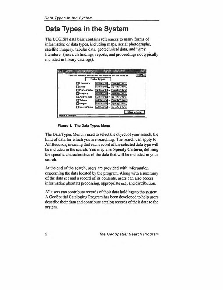
Data Types in the System
Data Types in the SystemThe LCGISN data base contains references to many forms of information or data types, including maps, aerial photographs, satellite imagery, tabular data, geotechnical data, and "grey literature" (research findings, reports, and proceedings not typically included in library catalogs).
Data Typesgj] Literature
EJ Photography E3] Imagery EiAucfovieual Q Tabular E| People QGeotechnical Specify Criteria
r criteria |p«l«ct datatype.
Figure 1. The Data Types Menu
The Data Types Menu is used to select the object of your search, the kind of data for which you are searching. The search can apply to AH Records, meaning mat each record of the selected data type will be included in the search. You may also Specify Criteria, defining the specific characteristics of the data that will be included in your search.
At the end of the search, users are provided with information concerning the data located by the program. Along with a summary of the data set and a record of its contents, users can also access information about its processing, appropriate use, and distribution.
All users can contribute records of their data holdings to the system. A GeoSpatial Cataloging Program has been developed to help users describe their data and contribute catalog records of their data to the system.
The GeoSpatial Search Program
Base Map Layers
Base Map Layers
The LCGISN base map is a composite map of Louisiana that incorporates a variety of data from multiple sources. State, parish, and USGS quadrangle boundaries, roads and rivers, cities and towns, and offshore lease blocks are among the data layers that may be displayed. A satellite image (1993 Thematic Mapper data) provides an aesthetic and very accurate foundation upon which these other layers are displayed.
The Set Base Maps Menu is used to control the information displayed on the base map.
LOUISIANA COA3TM. OEOOHAPHiC INfOfyjumON SY8TSM NETWORK
B«M Map L«y»r»
Pointed Quad* PhyriMl Transit OfhtureE^JMrah PT.|- rjj|Mnr>ftC*«t> [xjlntmtttt gjj Shipping C*umwtr>
01:100,000 QOEOMinrBMin Q$«cwid«y rjBtthymnry
^1:2W,OM QhilTMdt
IfUpd^t VWw/M«p«| ||
p»tup th« r«quir»d lay«r« and upd»t« th» vi«».
Figure 2. The Base Map Layers Menu
When you first log into the GeoSpatial Search Program, the base map will not appear immediately. To display the base map, click on Set Base Maps on the Main Menu and select one or more layers from those listed. Clicking on either the Check Mark or the Display on Map button on the Specify Location Menu will cause the base map to appear.
Any combination of base map layers in any of the five categories can be activated at the same time. (Keep in mind that the more layers that are displayed, the longer it will take the system to redraw the screen.)
The base map layers are described in Appendix 1.
The GeoSpatial Search Program


Technical Support
Technical SupportTo continue to develop the GeoSpatial Search Program and related supporting software, we need feedback from users. Please keep us informed about your work and information needs. This information will help us to continue to develop the system.
As a means of collecting feedback, the LCGISN technical commit tee has included a Send to LCGISN button on the Pocket Menu, which is accessible from any of the program's menus. Chapter 6.2 describes the Pocket Menu utilities, including the message feature.
While using the program, please take a moment to describe problems, evaluate features of the program, or suggest additional capabilities that would improve the system.
An effective means of letting us know about your work is to fill out the questionnaire included in the March 1994 LCGISN Newsletter. Completing this form will place you on our mailing list for future publications.
To receive information and report problems concerning the GeoSpatial Search Program, contact the Information Services Division (ISD) of the LSU Center for Coastal, Energy, and Environmental Resources (CCEER). A toll-free phone number (funded by the Louisiana Department of Natural Resources) may be used to report problems, request printed information, or submit LCGISN search requests (for users without Internet access). The number to call is 1-800-256-3742.
The LCGISN Technical Committee is dedicated to improving and expanding access to highly functional computer tools for referencing and locating information about Louisiana's environment and natural resources. We encourage users to explore the GeoSpatial Search Program, to discover ways that the system could better meet their needs, and to fully participate in the development of the system and its data base.
The GeoSpatial Search Program
Submitting Records to LCGISN
Submitting Records to LCGISNThe value of the GeoSpatial Search Program depends on the size and scope of its data base. Users are encouraged to catalog their data and submit as many records as possible to LCGISN.
Existing database files in Oracle-compatible database formats can be loaded directly into LCGISN from PCs, mainframes, or Unix- based workstations that are connected to the Internet. To help users inventory their data holdings, a PC-based software application has been developed that provides a consistent format for cataloging spatial data.
The GeoSpatial Cataloging Program provides a framework for users to describe their data in detail, producing the metadata ("data about data") that can then be submitted to LCGISN or any other database system. For more information about the GeoSpatial Cataloging Program, see the November 1994 LCGISN Newsletter or call 1-800-256-3742.
At all times, individuals or agencies who submit catalog records to LCGISN will maintain possession of their data and control the terms of access to their data. For all catalog records submitted to LCGISN, the controlling agency will prepare metadata, which will include descriptions of the data, their collection and processing, and the conditions under which they may be accessed.
LCGISN provides spatial data users with a detailed collection of database fields that follow cataloging standards established by the Federal Geographic Data Commission (FGDC) and the Library of Congress. By introducing these standards into organizations and agencies in Louisiana, LCGISN can provide a gateway to further efforts to share and exchange geospatial data.
LCGISN users are encouraged to become participants in the effort to catalog data concerning the Louisiana coast LCGISN provides an effective means of filing and retrieving information about the contents and locations of data holdings. We encourage organiza tions to adapt the system to meet their specific information and data management needs.
The GeoSpatial Search Program
Contents of This Document
Contents of This DocumentThis document describes the major features of the GeoSpatial Search Program and introduces the reader to the software. The manual is organized in four major parts and includes a glossary of unfamiliar terms and an index. The four parts of the manual are: Welcome to LCGISN, System Basics, a Tutorial, and Menus and Procedures.
Each section of the manual is composed of chapters describing the program and the procedures for interacting with its menus and maps. The chapters include headings along with decimal numbers (1.0, 2.0, 3.0, etc.). Each chapter is composed of one or more sections that are also decimal numbered (chapter 1.0 is followed by section 1.1).
Conventions Used in the ManualThe first letters of the names of all menus are capitalized and generally followed by the word "Menu." Sometimes, however, the name will be shortened. Therefore, the statements "Go to the Set Base Maps Menu" and "Go to Set Base Maps" are used interchangeably.
Names of buttons appear in bold and are usually preceded by a verb that instructs the user to take some action, such as "Click on Set Base Maps." In this case, the boldface type makes it clear that Set Base Maps is a button and not a menu.
Terms that require some explanation may also appear boldfaced. All boldfaced terms appear in the glossary.
The verb "select" is used interchangeably with "click on."
A command that should be entered at the keyboard appears in all caps inside brackets. For example, an instruction to press the enter key (called the return key on a typewriter will appear in the form shown below.
[ENTER]
The GeoSpatial Search Program

THE BASICS
1.0 Overview of a Search 2.0 Logging On
Welcome Menu 3.0 Online Help 4.0 Screen Conventions
Menu ControlsMouse ControlsPull-down Lists and Key-in Boxes
Scroll Bars 5.0 Base Map
Spatial Search Methodology Set the Base Map Define a Location for a Search
6.0 Pocket MenuMap View Controls
Window AreaZoomCenterFitTips for Maximizing Performance
Pocket Menu UtilitiesSend a Message to LCGISNNotepadBulletin Board

Overview of a Search
1.0 Overview of a SearchThe LCGISN GeoSpatial Search Program is similar to other database tools, with the exception of several additional features. First, the search program allows geographic locations to be included in database searches. Customized menus are used to define searches, and geographic locations can be added to searches by either typing a name (or a coordinate) into a menu or by using the mouse to designate a position on the base map.
The GeoSpatial Search Program uses a base map on which various data layers are displayed, including roads and rivers, parish boundaries, and USGS 7.5-min. quadrangle boundaries. Users can vary the contents, scale, display area, and level of detail of this base map to make it easier to locate a geographic area of interest and include it in a search.
Conducting a search can be conceptualized as the process of telling the computer how to restrict the results of your search to those records that match particular characteristics search criteria that you define. The goal is to define search criteria as precisely as possible.
The steps of a search process do not have to proceed in any particular order. Searches begin at the Main Menu (Figure 3) with the selection of a data type. (The first button, Set Base Maps, is used to change the information displayed on the base map and does not actually affect searches.)
For each data type, you have the option of either returning all records of that data type or limiting your search to the records matching criteria that you specify.
Geographic locations may be entered by drawing a box called a Minimum Bounding Rectangle (MBR) directly on the base map, by entering latitude and longitude or Universal Transverse Mercator (UTM) coordinates into the program, or by selecting a USGS 7.5- min. quadrangle from a scrolling list. The program will display the location on the base map before you actually add it to your search.
The GeoSpatial Search Program 11
Overview of a Search
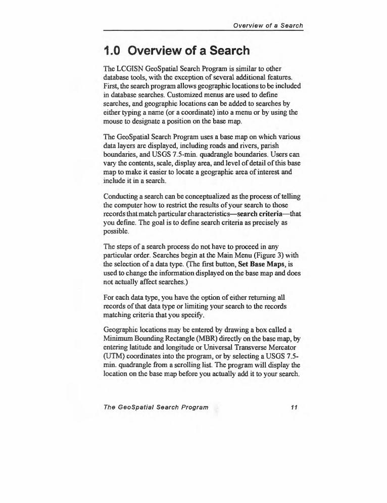
From the Main Menu (Figure 3), you can perform the following tasks:
1. select the data type that will be the object of your search,2. specify criteria, the characteristics of the data for which you
are searching,3. restrict your search to a particular geographic location,4. define subject terms to add to the search, and5. execute the search that you have created.
ExMut* Ouvry / P«rf«rm S*«roh
Cl»«f Omry |i... .: -j| Oc t* Omry M*mg«m«nt
OH fculld y«ur
Figure 3. The Main Menu
Selecting Set Base Maps takes you to the Base Map Layers Menu (see Figure 2), where you change the information displayed on the map.
The other three buttons on the Main Menu are used to define a search. Selecting Specify Data Type takes you to the Data Types Menu (Figure 1), where you specify the kind of data that will be the object of your search. From the Data Types Menu, you may also define the characteristics of the data you would like to find. This process is described in Chapter 9.0 (Data Types Menu).
On the following page is a diagram of the GeoSpatial Search Process. Notice that after selecting a data type and specifying data type criteria, you return to the Main Menu to add a location and/or subject heading (keyword) to your query. From the Main Menu, you may also return to any of the menus and modify your selections.
12 The GeoSpatial Search Program
Overview of a Search
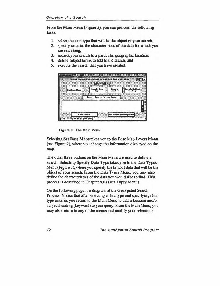
Conceptual Diagram of a GeoSpatial Search
1. Searches begin at the Main Menu, to which you must return to define each part of a search or to execute a search.
2. Select a data type and specify the characteristics of the data for which you are searching.
3. Specify a location or subject heading(s). The computer will use your input to construct a search query.
4. When satisfied with your search, return to the Main Menu to execute it.
5. Results may be displayed, saved, or printed. Additional information concerning the processing and availability of the data is also provided.
The GeoSpatial Search Program 13

Logging In
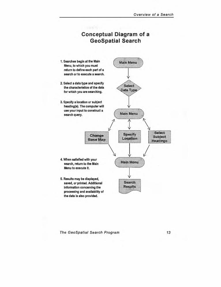
2.0 Logging InThe LCGISN GeoSpatial Search Program can be accessed by any Unix workstation running X-Windows with a direct connection to the Internet. The program resides on an Intergraph server in the Computer-Aided Design Geographic Information System (CADGIS) computer lab at LSU. The first step in running the GeoSpatial Search Program is to initiate a telnet session with the server at LSU.
From your command line type: telnet lcgisn.lsu.edu [ENTER]
A login prompt should appear asking for your user name and password. Log into the system using the user name and password shown below.
user name: Icguserl
password: beta 1994
When the system accepts your login name and password, the information shown in Figure 4 will appear.
CLIX Systea U Release 3.1 6165gienetCopyright (c) 1981 AT&TCopyright (e) 1992Intergraph Corporation; All Right* ReservedIncluding Rpplieation Programs. File Formate, and Uisual Display!Login last used from waap.csi.lsu.edu: Ued Sep 7 68:21:67 1991
tt NNNNN NNttNN ttNtt KNNNN N tttt N UN ttNtt NNNtttt N N ttN NNtttt N K ttNNtt tt NNNNN NUNtt N tttttt NNNtttt N tttt tt tt N NNtttt tttt*Ntt*K NttNNtt tttttttttt NttN NNNNN N tt
UelcoMe to tha Louisiana Coastal Geographic Information SyeteB Network
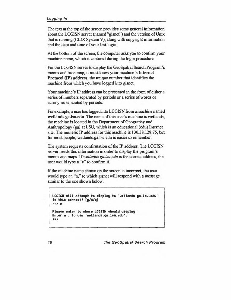
LCGISN will atteapt to display to 'aayhau.cadgis.leu.edu*. le this correct? [y/n/q]
Figure 4. The LCGISN login screen
The GeoSpatial Search Program 15
Logging In_______________________________
The text at the top of the screen provides some general information about the LCGISN server (named "gisnet") and the version of Unix that is running (CLIX System V), along with copyright information and the date and time of your last login.
At the bottom of the screen, the computer asks you to confirm your machine name, which it captured during the login procedure.
For the LCGISN server to display the GeoSpatial Search Program's menus and base map, it must know your machine's Internet Protocol (IP) address, the unique number that identifies the machine from which you have logged into gisnet.
Your machine's IP address can be presented in the form of either a series of numbers separated by periods or a series of words or acronyms separated by periods.
For example, a user has logged into LCGISN from a machine named wetlands.ga.Isu.edu. The name of this user's machine is wetlands, the machine is located in the Department of Geography and Anthropology (ga) at LSU, which is an educational (edu) Internet site. The numeric IP address for this machine is 130.38.128.75, but for most people, wetlands.ga.lsu.edu is easier to remember.
The system requests confirmation of the IP address. The LCGISN server needs this information in order to display the program's menus and maps, lfwetlands.ga.lsu.edu is the correct address, the user would type a "y" to confirm it.
If the machine name shown on the screen is incorrect, the user would type an "n," to which gisnet will respond with a message similar to the one shown below.
LCGISN will atteapt to display to 'uetlands.ga.lsu.edu' Is this correct? [y/n/q] = = > n
Please enter to where LCGISN should display. Enter a . to use 'uetlands.ga.lsu.edu'. = = >
16 The GeoSpatial Search Program
________________________________Logging In
When the program prompts you for an IP address, you can give the correct machine name (either the alphabetic or numeric IP address), type "q" to quit, or type a period (.) to accept the original name (in this case wetlands.ga.lsu.edu) as valid.
After you confirm that the IP address is correct, you should see more information, and eventually the LCGISN Welcome Menu will appear (see Figure 5).
If the Welcome Menu does not appear, you may have to instruct your machine to allow LCGISN to display its menus and maps on your monitor. To do this, you add the gisnet's IP address to your machine's host table (a list of addresses that have permission to display the output that your computer creates).
On a Unix workstation, open the Console window and type:
xhost gisnet.cadgis.lsu.edu [Return]
On a PC, you may have to enter gisnet's IP address into a file in your X-Windows software package. This procedure varies depending on the version of X-Windows you are using. Consult your documentation for instructions about adding gisnet's IP address to your version of X-Windows.
The GeoSpatial Search Program 17

________________________________Logging In
2.1 Welcome Menu
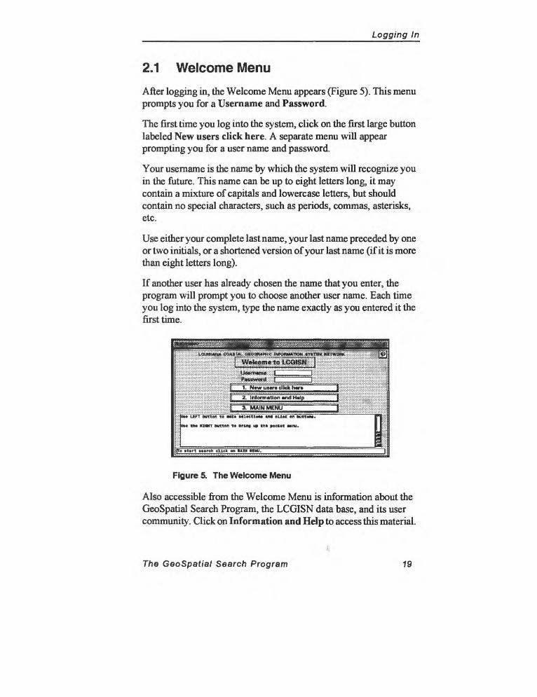
After logging in, the Welcome Menu appears (Figure 5). This menu prompts you for a User name and Password.
The first time you log into the system, click on the first large button labeled New users click here. A separate menu will appear prompting you for a user name and password.
Your username is the name by which the system will recognize you in the future. This name can be up to eight letters long, it may contain a mixture of capitals and lowercase letters, but should contain no special characters, such as periods, commas, asterisks, etc.
Use either your complete last name, your last name preceded by one or two initials, or a shortened version of your last name (if it is more than eight letters long).
If another user has already chosen the name that you enter, the program will prompt you to choose another user name. Each time you log into the system, type the name exactly as you entered it the first time.
tiawiiiM&^^t:^^
UM LEFT Button to MIC* MltetlMM «nd eLlek en kutttnt.
DM the HMHT Button t» bring i* th» poctit wnu.
> »t«rt March click on Mm IIH
Figure 5. The Welcome Menu
Also accessible from the Welcome Menu is information about the GeoSpatial Search Program, the LCGISN data base, and its user community. Click on Information and Help to access this material.
The GeoSpatial Search Program 19
Logging In________________________________
Information and Help includes overviews of the menus, search methods, and database contents of the GeoSpatial Search Program. This section also informs users of updates to the program. Be sure to check the contents of this section periodically for information about changes to the system or new additions to the data base.
In the top right-hand corner of each menu is a Question Mark button, which activates the online help system. The help system can remain active as you continue to use the system.
The final button on the Welcome Menu takes you to the Main Menu. The Main Menu is the heart of LCGISN, the place where you begin defining your searches and where you return to execute them.
20 The GeoSpatial Search Program

Online Help
3.0 Online HelpEach menu includes one or more Menu Control Buttons in its upper- right corner. One of these, the Question Mark, activates online help describing the use of each menu. An example of online help is shown in Figure 6.
Online help represents a shortened version of the information contained in the LCGISN Users Manual. In some cases, however, the information available online may be more current, reflecting recent modifications or additions to the program.
File Settings Help
Contentsj Search | Back | Up j History | « | »
Topic GeUinghelp_____________________
Use these procedures to get help.
To select and view an article from a list of topics:To display a recently-viewed topicTo determine your location in the topic hierarchyTo search for text:To see help for each selected tool (Trackinc):To pet help on a dialog box contra! (context-sensitive he!p):
Figure 6. Online Help Table of Contents
The Help Menu can remain open as you use the program or you may close it (by clicking on File and then selecting Exit) and re-open it as you need it. The help system is context sensitive, meaning that when you invoke the Help Menu (by clicking on the Question Mark on any of the program's menus), it will automatically acess the help topic relevant to the part of the program in which you are working.
The underlined text on the menu in Figure 6 (which will appear blue on a color monitor) are hypertext links. Point to one of the topics and click the left mouse button to go to that section of the online help files. (You can change the color of these online links by clicking on Settings and then selecting Display from the available options.)
The GeoSpatial Search Program 21
Online Help_________________________________
Contents: Displays the table of contents for the help file.
Back: Returns to the last topic you viewed in the online help window.
Search: Opens the Search Menu and allows you to search the contents of the online help files.
Up: Moves one level up the hierarchy of help topics.
History: Displays a list of all the topics you have viewed, allowing you to click on the one to which you want to return.
The Left Arrow: Takes you to the previous topic in the structure of the online help file. Use the arrow buttons to move through the sequence of information as it was arranged by the program's developers.
The Right Arrow: Takes you to the next topic in the structure of the online help file.
Click on the Topic bar to see a list of the topics you have most recently viewed. Clicking on one of the topics will return you to that part of the online help file.
For more information on using online help, click on Help on the Help Menu and select Using Online Help.
When you are finished viewing the help files, click on File and then select Exit from the available options.
22 The GeoSpatial Search Program
Screen Conventions
4.0 Screen ConventionsAs shown in Figure 7, the GeoSpatial Search Program's screen has three parts: the base map, which displays a map of Louisiana along with various layers of information (roads, parish boundaries, USGS quadrangles); the menus used to define and execute searches; and a message bar along the bottom of the menus that provides information about program operations.
Menu
Message Bar
Base Ma
Figure 7. The three parts of the LCGISN screen
The screen in Figure 7 shows the Main Menu and the base map with two active layers: parish boundaries and the coastal zone.
The message bar located along the bottom of each menu provides general instructions for using a particular menu or performing an operation. In the screen above, the message bar reads, "You may set up your base map or build your query." Prompts for particular actions or reminders of available options will appear on the Message Bar as you use the program.
The GeoSpatial Search Program 23

Screen Conventions
4.1 Menu Controls
The three Menu Control Buttons in the top right-hand corner of each menu are used to control your movement through the system. Each button is used consistently throughout the program. The uses of the three Menu Control Buttons are described in Figure 8.
The most important of these is the Check Mark, on which you click after making a selection that you want the program to accept as part of your search criteria.
The Check Mark button tells the program to add the selection(s) on the current menu to your search.
The X button rejects all selection(s) on the current menu and goes back to the previous menu.
The Question Mark button brings up the online help system.
Figure 8. The Menu Control Buttons and their functions
No selection actually becomes part of the query used by the program to conduct a search until the Check Mark for that menu is clicked. (To reject criteria and return to the previous menu, click on the X button.)
Clicking on one of the four large buttons in the middle of the Main Menu (see Figure 7) takes you to another menu that provides additional options for refining a search. These options may lead to other menus as well. Therefore, after defining a search on a number of menus, it is sometimes necessary to click on the Check Mark on more than one menu to return to the Main Menu and continue defining a search.
24 The GeoSpatial Search Program
Screen Conventions
4.2 Mouse Controls
Most of the commands for executing searches are entered by pointing to a menu or the base map and clicking on the left mouse button. Although many search criteria can be keyed in, you must use the mouse to move through the program by clicking on the Menu Control Buttons.
The GeoSpatial Search Program supports a two-button mouse. (On a three-button mouse, use the left and right buttons and ignore the middle button.)
Use the Left Button to make selections on the menus andbase map;
Use the Right Button to reset a selection on the base mapor bring up the Pocket Menu (described in Section 6).
In many cases, using the mouse to define searches is faster and more reliable than using the keyboard. For example, the program contains many pull-down lists of typical selections (see Figure 9). Using the mouse to make selections from these lists allows you to control and modify the terms that the program uses to conduct a search.
The main liability of using the keyboard is that varying spellings or terminology can produce inaccurate search results. Whenever possible, take advantage of pull-down lists, which give some idea of the contents of the data base and the range of appropriate selections at a particular place in the program.
Use the keyboard to enter search criteria that do not appear or cannot be selected from a list, such as geographic coordinates or the name of an author or title.
Composing effective searches requires a match between the terms being used to search for information and the terms by which that information is stored in the system. Therefore, becoming more familiar with the contents of the data base will improve your chances of producing accurate and useful search results.
The GeoSpatial Search Program 25
Screen Conventions
4.3 Pull-down Lists and Key-in Boxes
Although the mouse is used to move from one menu to another in the GeoSpatial Search Program, many menus contain key-in boxes that allow entries to be typed directly into the search program.
To enter text into a key-in box, move the mouse until the cursor is inside a box, click the left mouse button, and begin typing. Entries can be capitalized or entered in all lowercase; none of the menus in the GeoSpatial Search Program are case sensitive.
Some key-in boxes include a pull-down list of possible selections. In the Subject Heading Menu shown in Figure 9, a pull-down list of terms at the top of the hierarchy can be accessed by clicking on the pull-down control bar located on the right side of the key-in box.
LOUISIANA COASTA
Key-in box
L GEOGRAPHIC INFORMATION SYSTEI
Subject Headings»
W NETWORK
Pull-dot control
Mxlvn bar
k
Subject IT |ai«
[[Add to Subject Li«t|
Narrower Rait
Agriculture AnlBal* AnthropologyKavoualay* laaeha* lioLogy lira* lotany IrMkwater* Canal* CartographyCh*Bical* ChMlatry City planning
i ir
Figure 9. Key-in boxes and pull-down controls
In most case, entries can be typed into a key-in box or selected from a list accessed by clicking on a pull-down control bar.
Clicking on one of the items in a pull-down list selects it, causing it to appear in the key-in box. In Figure 9, clicking on Biology from the pull-down list would select it; it would then appear in the Subject box.
26 The GeoSpatial Search Program
Screen Conventions
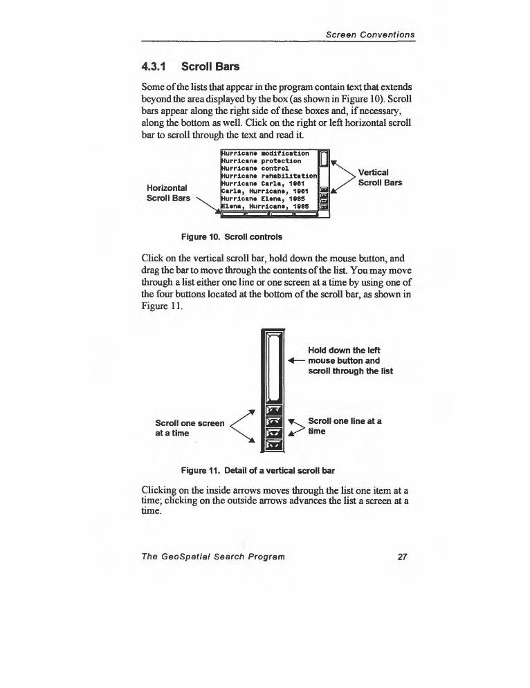
4.3.1 Scroll Bars
Some of the lists that appear in the program contain text that extends beyond the area displayed by the box (as shown in Figure 10). Scroll bars appear along the right side of these boxes and, if necessary, along the bottom as well. Click on the right or left horizontal scroll bar to scroll through the text and read it.
Horizontal Scroll Bars
Hurricane Modification Hurricane protection Hurricane control Hurricane rehabilitation Hurricane Carla, 1961 Carla, Hurricane, 1961 Hurricane Elena, 1985 Elena, Hurricane, 1985
& & 5 \M
Vertical Scroll Bars
Figure 10. Scroll controls
Click on the vertical scroll bar, hold down the mouse button, and drag the bar to move through the contents of the list. You may move through a list either one line or one screen at a time by using one of the four buttons located at the bottom of the scroll bar, as shown in Figure 11.
Scroll one screen at a time
Hold down the left mouse button and scroll through the list
Scroll one line at a time
Figure 11. Detail of a vertical scroll bar
Clicking on the inside arrows moves through the list one item at a time; clicking on the outside arrows advances the list a screen at a time.
The GeoSpatial Search Program 27

Ease Map
5.0 Base MapThe Geospatial Search Program allows information to be searched geographically: you specify a location or area on a map and then search for records referenced to that particular location. The base map is used to locate and define the precise geographic area of your search.
The Geospatial Search Program base map can be adjusted to make it easier to specify a location. Changing the information displayed on the base map is referred to as Setting the Base Map. Parish boundaries, roads, rivers, and cities are among the available data layers. Once you have located your area of interest, you need to add it to your search criteria by Defining a Location for a Search.
This chapter describes the procedures used to set the base map and define a location for a search. An overview of the program's Spatial Search Methodology serves as an introduction to the chapter, explaining the methods used to include geographic locations in search instructions.
Chapter 6 describes another important function related to the base map: the process of modifying the area of the map displayed on the screen. The Pocket Menu is used to change the window area of the base map by resetting the base map to its original condition, centering the map on a location, or zooming in or out.
The GeoSpatial Search Program 29
Base Map________________________________
5.1 Spatial Search Methodology
The basic search strategy is to define the particular type of data as the object of the search and then add a geographic location to your search instructions. Precise geographic locations can be combined with conventional search criteria (i.e., authors, dates, titles, key words, film type and scale, holding agency, map type, or theme) to develop effective searches for hard-to-find data that is rarely treated in other reference sources.
Each data type is referenced to a particular geographic location, using a set of coordinates defining an upper-left and lower-right corner. Data are referenced uniquely; that is, some data may be referenced to a very specific location, perhaps smaller than a USGS 7.5-min. quadrangle, while other data are referenced very broadly (i.e., to a very large MBR such as a parish or a region like the coastal zone or the Gulf of Mexico).
The location selected on the Specify Location Menu is used to execute the spatial part of your search. After the program executes the nonspatial components of the search, the program finds those records that are referenced to an MBR that overlaps the area you define.
Non-spatial data type criteria such as author, title, publisher, and keywords are based on US MARC cataloging standards and the Library of Congress Subject Headings. For aerial photography, imagery, and digital maps, the FGDC Content Standard for Digital Geospatial Metadata provided a format for both cataloging and the report format of search results.
The size of the area to which catalog records are referenced depends on the data type and the rigor of the cataloging methodology. For many data types, a USGS 7.5-min. quadrangle is a reasonable approximation of a typical geographic reference. The GeoSpatial Search Program provides USGS 7.5-min. quadrangles as a layer on the base map; additionally, the USGS 7.5-min. Quadrangle Index, which can be accessed from the Specify Location Menu, provides a useful means of selecting locations based on quadrangle boundaries.
30 The GeoSpatial Search Program
________________________________Base Map
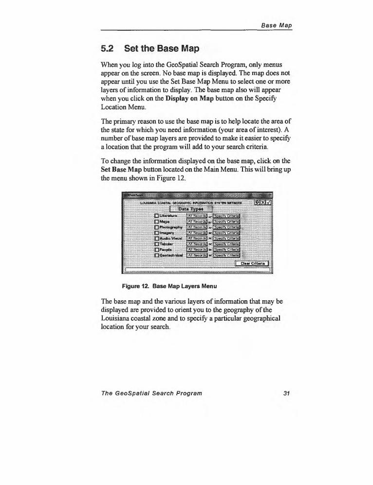
5.2 Set the Base Map
When you log into the GeoSpatial Search Program, only menus appear on the screen. No base map is displayed. The map does not appear until you use the Set Base Map Menu to select one or more layers of information to display. The base map also will appear when you click on the Display on Map button on the Specify Location Menu.
The primary reason to use the base map is to help locate the area of the state for which you need information (your area of interest). A number of base map layers are provided to make it easier to specify a location that the program will add to your search criteria.
To change the information displayed on the base map, click on the Set Base Map button located on the Main Menu. This will bring up the menu shown in Figure 12.
Figure 12. Base Map Layers Menu
The base map and the various layers of information that may be displayed are provided to orient you to the geography of the Louisiana coastal zone and to specify a particular geographical location for your search.
The GeoSpatial Search Program 31
flase Map__________________________________
5.3 Define a Location for a Search
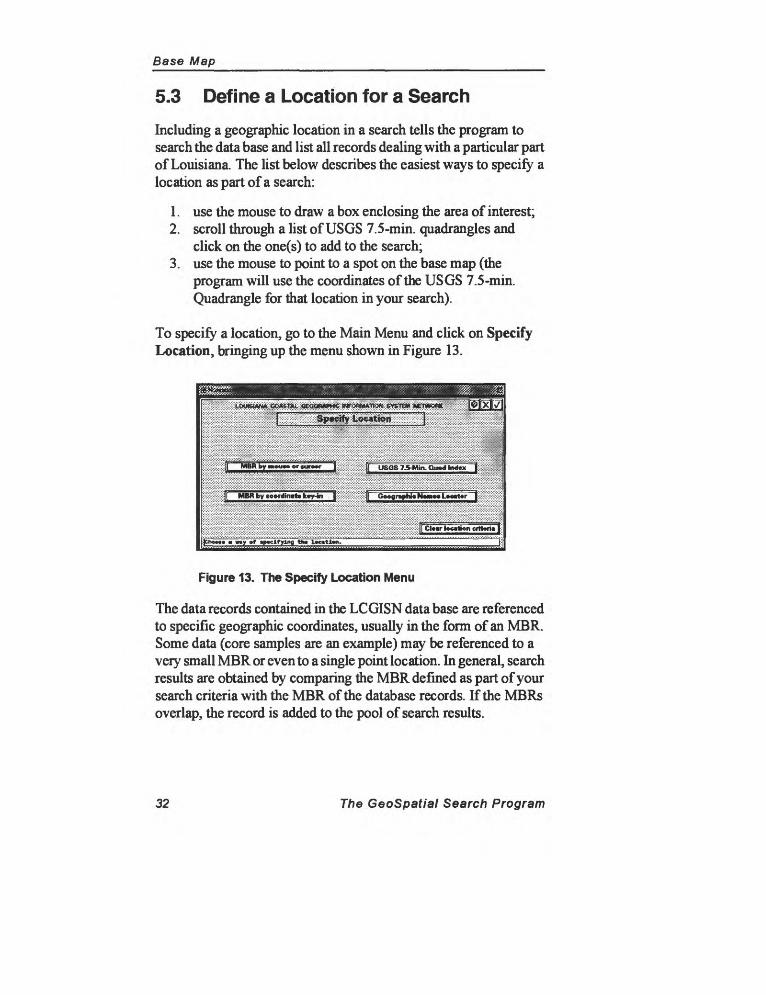
Including a geographic location in a search tells the program to search the data base and list all records dealing with a particular part of Louisiana. The list below describes the easiest ways to specify a location as part of a search:
1. use the mouse to draw a box enclosing the area of interest;2. scroll through a list of USGS 7.5-min. quadrangles and
click on the one(s) to add to the search;3. use the mouse to point to a spot on the base map (the
program will use the coordinates of the USGS 7.5-min. Quadrangle for that location in your search).
To specify a location, go to the Main Menu and click on Specify Location, bringing up the menu shown in Figure 13.
!';ii&!iiiji^I Specify :i.oea«0n
:|T USOS 7.Mlin. Quad Kd«»
MBR by cootdinrt* lay-in j
my »f »p»cifylng th»
[Cl»«r tocrion criteria ]
Figure 13. The Specify Location Menu
The data records contained in the LCGISN data base are referenced to specific geographic coordinates, usually in the form of an MBR. Some data (core samples are an example) may be referenced to a very small MBR or even to a single point location. In general, search results are obtained by comparing the MBR defined as part of your search criteria with the MBR of the database records. If the MBRs overlap, the record is added to the pool of search results.
32 The GeoSpatial Search Program
Pocket Menu
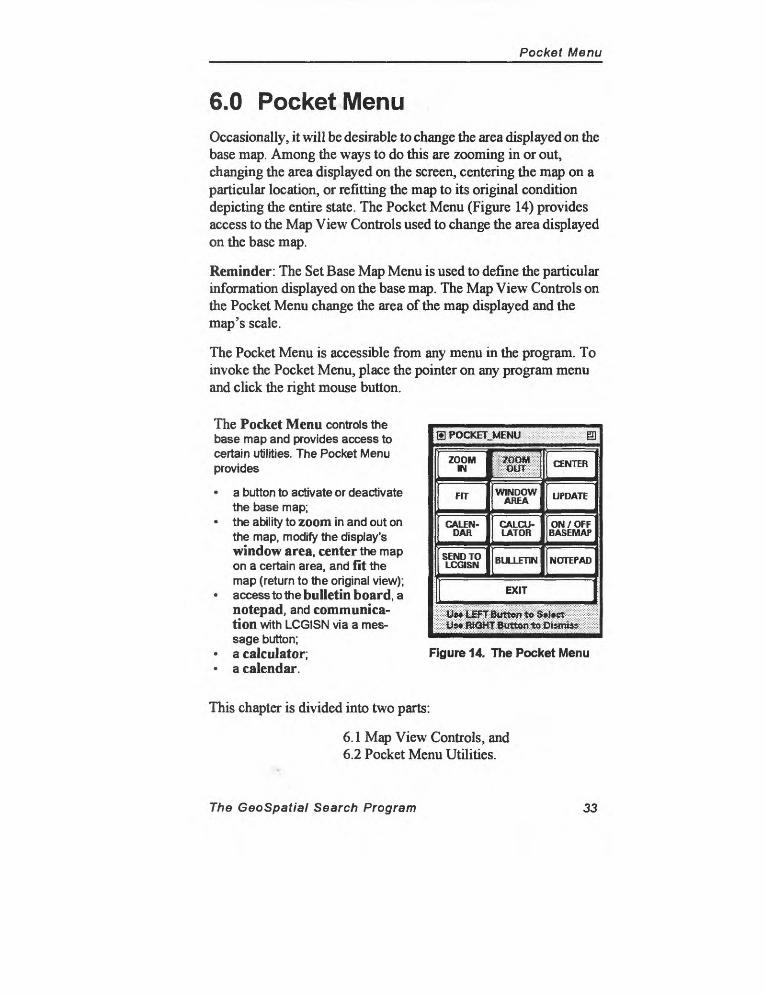
6.0 Pocket MenuOccasionally, it will be desirable to change the area displayed on the base map. Among the ways to do this are zooming in or out, changing the area displayed on the screen, centering the map on a particular location, or refitting the map to its original condition depicting the entire state. The Pocket Menu (Figure 14) provides access to the Map View Controls used to change the area displayed on the base map.
Reminder: The Set Base Map Menu is used to define the particular information displayed on the base map. The Map View Controls on the Pocket Menu change the area of the map displayed and the map's scale.
The Pocket Menu is accessible from any menu in the program. To invoke the Pocket Menu, place the pointer on any program menu and click the right mouse button.
The Pocket Menu controls the base map and provides access to certain utilities. The Pocket Menu provides
a button to activate or deactivate the base map;
the ability to zoom in and out on the map, modify the display's window area, center the map on a certain area, and fit the map (return to the original view);
access to the bulletin board, a notepad, and communica tion with LCGISN via a mes sage button;
a calculator; a calendar.
SPOCKET^MENU BJ
ZOOM IN
FIT
CALEN DAR
SEND TO LCGISN
; [if ;WINDOW
AREA
CALCU LATOR
BULLETIN
CENTER
UPDATE
ON / OFF BASEMAP
NOTEPAD
\ EXIT
W&**l£n Button; to $*l*ct 1s -SJlSftffiQH
Figure 14. The Pocket Menu
This chapter is divided into two parts:
6.1 Map View Controls, and6.2 Pocket Menu Utilities.
The GeoSpatial Search Program 33
Pocket Menu
6.1 Map View Controls
The Pocket Menu controls the area of the base map displayed as you use the program. Use the Pocket Menu to change the display window, to zoom in or out, to center the display on a particular point, and to reset the map to its original condition (showing the entire state).
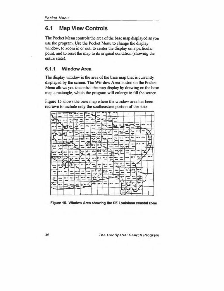
6.1.1 Window Area
The display window is the area of the base map that is currently displayed by the screen. The Window Area button on the Pocket Menu allows you to control the map display by drawing on the base map a rectangle, which the program will enlarge to fill the screen.
Figure 15 shows the base map where the window area has been redrawn to include only the southeastern portion of the state.
Figure 15. Window Area showing the SE Louisiana coastal zone
34 The GeoSpatial Search Program
Pocket Menu
Use the following steps to redraw the Window Area.
1. Place the cursor on any menu and click the right mouse but ton to activate the Pocket Menu.
2. Click on the Window Area button on the Pocket Menu. Move the mouse until the arrow is pointing to one comer of the rectangle containing the location or area of interest.
3. Click the left mouse button once to anchor the comer of your rectangle.
4. Move the mouse until the rectangle encloses your area of interest. When the rectangle reaches the desired dimension, click the left mouse button again to anchor the other corner of the rectangle.
To reset your selection at any time during the process, click the right mouse button. Clicking the right mouse button always resets selections on the base map.
6.1.2 Zoom
The zoom feature enlarges a particular portion of the base map to make it easier to see more details or reduces it to include more map area on the screen at one time. Use the following steps to use the zoom feature.
1. Place the cursor on any menu and click the right mouse but ton to activate the Pocket Menu.
2. Click on the Zoom button on the Pocket Menu. Move the mouse until the arrow is pointing to the center of the area you want to zoom in on and click the left mouse button.
3. The program will redraw the base map twice as large, and the location you selected will become the center of the new display window.
Zoom out works just like zoom in. The location where you click on the base map becomes the center of the new map display, which is redrawn half as large.
Figure 16 shows the screen after zooming in on the base map shown in Figure 15.
The GeoSpatial Search Program 35
Pocket Menu
Figure 16. The base map in Figure 15 after a zoom.
36 The GeoSpatial Search Program
Pocket Menu
6.1.3 Center
The Center button on the Pocket Menu allows you to click on a point anywhere on the base map and make it the center point of the display.
1. Click on the Center button on the Pocket Menu.2. Move the mouse until the arrow points to the location that
you would like to be the center of the new screen window. Click the left mouse button.
3. The program will redraw the base map with the point you selected as its center point.
Center the map on the part of the state that contains your area of interest. By doing this, you will be able to add a specific location to the criteria that the program uses to perform the search.
6.1.4 Fit
To specify a location on the base map (by clicking on a point or drawing an MBR around a location), the location must be visible on the screen. To display this area of interest, it will sometimes be desirable to return the map to its original appearance, showing all of the state. To do this, use the Fit button on the Pocket Menu.
1. Click on the Fit button on the Pocket Menu.2. The program will return the screen window to its original
default setting, which shows the entire state of Louisiana.
The GeoSpatial Search Program 37
Pocket Menu
6.1.5 Tips for Maximizing Performance
Although the GeoSpatial Search Program base map provides considerable functionality, enlarging the size of the map and displaying numerous data layers can slow the system's performance. Keep in mind that map display is not integral to performing searches on the system; the map is provided to support program search capabilities by helping you define an area of interest.
The base map will not appear when you first log onto the program. After locating your area of interest or adding an MBR to the search, you may even want to turn off the base map.
Generally, only a few base map layers should be displayed at any one time. It also may be helpful to keep the size of the base map as small as possible.
Another way to maintain system speed is first to define all parts of a search except the location and then set the base map. This way you place a minimum amount of strain on the network and get the maximum amount of performance from the system.
38 The GeoSpatial Search Program
Pocket Menu
6.2 Pocket Menu Utilities
The Pocket Menu also includes a number of other useful utilities. The most useful may be the messaging features built into the program the Bulletin Board, Notepad, and Send a Message. The other two utilities the calendar and the calculator are shown below.
All of these utilities can be accessed from anywhere in the program through the Pocket Menu. To access the Pocket Menu, move the mouse until the arrow is on any menu and click the right mouse button.
All of the features described in this chapter can remain on the screen in their own windows (or as icons) as you use the program.
6.2.1 User Message for LCGISN
Messages to LCGISN can serve a number of useful purposes. Your opinions, impressions, and needs are important in defining future developments or refinements of the system. By providing information about your work and your experiences using the system, you are directly contributing to the development and improvement of the GeoSpatial Search Program.
When you click on the Pocket Menu button labeled Send to LCGISN, the menu shown in Figure 17 appears.
ij!jii .
T«ll urn *ut you think l
Figure 17. The User Message Menu
The GeoSpatial Search Program 39
Pocket Menu
Type your message into the box. The message can be as long as you like, and you can send as many messages as you like while using the system.
After typing your message, click on the Check Mark to send the message to the LCGISN staff. The message will automatically include your name, the time it was sent, and the screen you were on when you sent it.
If you make a mistake, use either the delete or the backspace key to erase the error, and then type the correction. If you want to start over, click on the Clear Message button. Click on the X button if you decide you do not want to send a message and wish to return to the program.
6.2.2 Notepad
A Notepad is provided where you can enter text that will be saved to a file and retrieved after you log off the system. You enter text into the Notepad much like you use the User Message to LCGISN Menu. If you make a mistake, use the arrow keys to move around in the block of text and the delete key to erase the error.
Any messages written in the Notepad will remain in the Notepad until you exit the GeoSpatial Search Program. Each time you open the Notepad, you will see the messages mat have been written since you logged onto the system.
For example, if you make some notes in the Notepad when first logging onto the system and then close the Notepad and open it again (by once again calling up the Pocket Menu and clicking on the Notepad button), the notes will appear exactly as they were written.
The Notepad functions differently than the Send a Message to LCGISN feature. Notes are held in the Notepad even after clicking on the Check Mark to close the menu. When using the Send a Message to LCGISN feature, the program sends your message (via e-mail) each time you click on the Check Mark.
40 The GeoSpatial Search Program
Pocket Menu
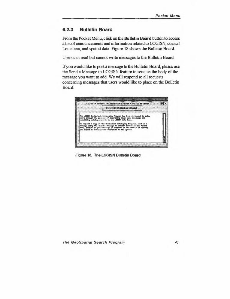
6.2.3 Bulletin Board
From the Pocket Menu, click on the Bulletin Board button to access a list of announcements and information related to LCGISN, coastal Louisiana, and spatial data. Figure 18 shows the Bulletin Board.
Users can read but cannot write messages to the Bulletin Board.
If you would like to post a message to the Bulletin Board, please use the Send a Message to LCGISN feature to send us the body of the message you want to add. We will respond to all requests concerning messages that users would like to place on the Bulletin Board.
Tho LCtIM ootpatlal Cataloging Progru ha* boon dovalopod to guldo u»ort through tha Brecon eT aaMrlMng tnolr *mta Molding* and lubadttlng catalog racorda to tho LMItM oxta naaa.
roquoot oopy or tno Oootpatlal Cataloging Prograa, oond uo t : Mmaga uolng tha 'land a Bomago to LCUM' button on tho Poekatlonu. Inoluda In your Boaaaf* an oatlamta eT tho nua*«r eT rocorda
you oxpoct to catalog and contributa to tho ayotaa.
Figure 18. The LCGISN Bulletin Board
The GeoSpatial Search Program 41


MENUS & PROCEDURES
7.0 Main Menu8.0 Data Types Menu
Literature Search Criteria Menu Date Key-in Menu
Photography Search Criteria Menu Scale Key-in Menu
Map Search Criteria MenuImagery Search Criteria MenuAudiovisual Search Criteria MenuTabular Search Criteria MenuGeotechnical Search Criteria Menu
9.0 People & Organization Search MenuHierarchical Searches of Organizations
10.0 Specify Location MenuMBR by MouseKey-in Coordinates MenuUSGS 7.5-Min. Quadrangles Index Menu
Select from List Select by Block Select from Map
Geographic Names Locator Menu 11.0 Subject Headings Menu
Tips for Using Subject Headings 12.0 Query Management 13.0 Search Results Menu 14.0 General Search Strategies 15.0 Tutorial
Photography SearchLiterature Search

Main Menu
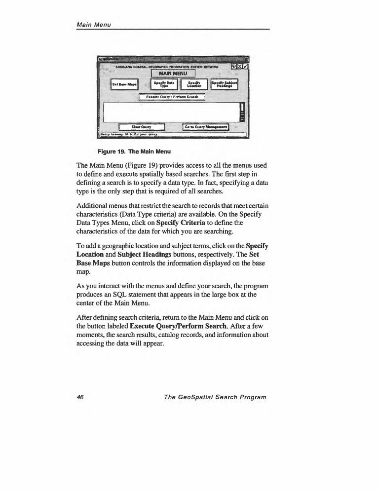
8.0 Main MenuThe Main Menu is the most important screen in the GeoSpatial Search Program. All searches begin at the Main Menu, and you must return to the Main Menu to execute a search. Furthermore, each step in a search is defined by responding to menus that must be accessed from the Main Menu. Therefore, you usually return to the Main Menu after fulfilling each of the four major tasks used to develop searches setting the base map, selecting a data type, specifying a location, and specifying subject headings.
As shown in Figure 19, the Main Menu has three parts:
1. the four buttons on the top of the menu are used to define and execute a search;
2. a large text box in the middle of the menu displays the Structured Query Language (SQL) statement that the program uses to perform a database search. The system uses this statement to locate within the LCGISN data base records that match the criteria contained in the query.
3. three longer, narrower buttons along the bottom of the menu initiate actions based on the query that you have defined. Execute Query/Perform Search tells the computer to process the search instructions that you have defined; Clear Query erases the currently defined search; and Go To Query Management brings up a separate menu where you can save your queries and recall queries that you defined during previous sessions using the program.
The Query Management Menu allows more advanced users to compose original queries or edit queries that have been developed by interacting with the program's menus (see Chapter 13.0). Query Management also allows query statements to be saved and recalled for future use.
The GeoSpatial Search Program 45
Main Menu
tOUWANA CO»»T*L OEOORAPHC INFORMATION SYgTEM IgTWORK
I MAIN MENU I s
S«t Beee Mep» Specify DeU Type Location
Specify _ _.. Heeding;
Execute Query / Perfenn Scorch
Clear Query |Ce te Query Management ]
petup b«»«e«p OK build your query.
Figure 19. The Main Menu
The Main Menu (Figure 19) provides access to all the menus used to define and execute spatially based searches. The first step in defining a search is to specify a data type. In fact, specifying a data type is the only step that is required of all searches.
Additional menus that restrict the search to records that meet certain characteristics (Data Type criteria) are available. On the Specify Data Types Menu, click on Specify Criteria to define the characteristics of the data for which you are searching.
To add a geographic location and subject terms, click on the Specify Location and Subject Headings buttons, respectively. The Set Base Maps button controls the information displayed on the base map.
As you interact with the menus and define your search, the program produces an SQL statement that appears in the large box at the center of the Main Menu.
After defining search criteria, return to the Main Menu and click on the button labeled Execute Query/Perform Search. After a few moments, the search results, catalog records, and information about accessing the data will appear.
46 The GeoSpatial Search Program
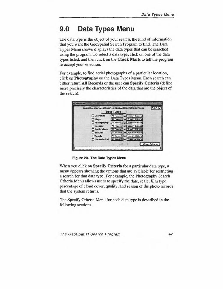
Data Types Menu
9.0 Data Types MenuThe data type is the object of your search, the kind of information that you want the GeoSpatial Search Program to find. The Data Types Menu shown displays the data types that can be searched using the program. To select a data type, click on one of the data types listed, and then click on the Check Mark to tell the program to accept your selection.
For example, to find aerial photographs of a particular location, click on Photography on the Data Types Menu. Each search can either return All Records or the user can Specify Criteria (define more precisely the characteristics of the data that are the object of the search).
LOUISIANA COASTAL OEOOftAPHIC INFORMATION SYSTH* NETWORK
Data Typ«<Q literature
FJ Photography rjim«g«y £J Audio VisualO Tabular Qp«opl«
All Records
All Records
All Records
All Records
Specify Criteria]
Specify Criteria]
Specify Criteria
Specify Criteria
Figure 20. The Data Types Menu
When you click on Specify Criteria for a particular data type, a menu appears showing the options that are available for restricting a search for that data type. For example, the Photography Search Criteria Menu allows users to specify the date, scale, film type, percentage of cloud cover, quality, and season of the photo records that the system returns.
The Specify Criteria Menu for each data type is described in the following sections.
The GeoSpatial Search Program 47
Data Types Menu
All RecordsWhen searching for a particular data type, the program will search all records stored in the data base unless you choose to specify criteria. Clicking on the name of one of the data types listed and on the Check Mark on the Specify Data Types Menu tells the program that the search will apply to all records of that data type in the data base.
Note that even if no search criteria are specified on the Specify Data Types Menu, a search can still be conducted by clicking on one of the other buttons on the Main Menu and defining a location (Specify Location) or a keyword (Specify Subject Headings).
Specify CriteriaClicking on the Specify Criteria button beside a particular data type brings up a Specify Criteria Menu that allows the search to be restricted to records that meet certain requirements. This is one of the most important features of the GeoSpatial Search Program, providing great control over the details of searches.
Clear CriteriaClicking on Clear Criteria resets the data type criteria to the default, which is to include All Records in the search. Use this button to reset the search criteria before redefining them.
48 The GeoSpatial Search Program
Literature Search Criteria Menu
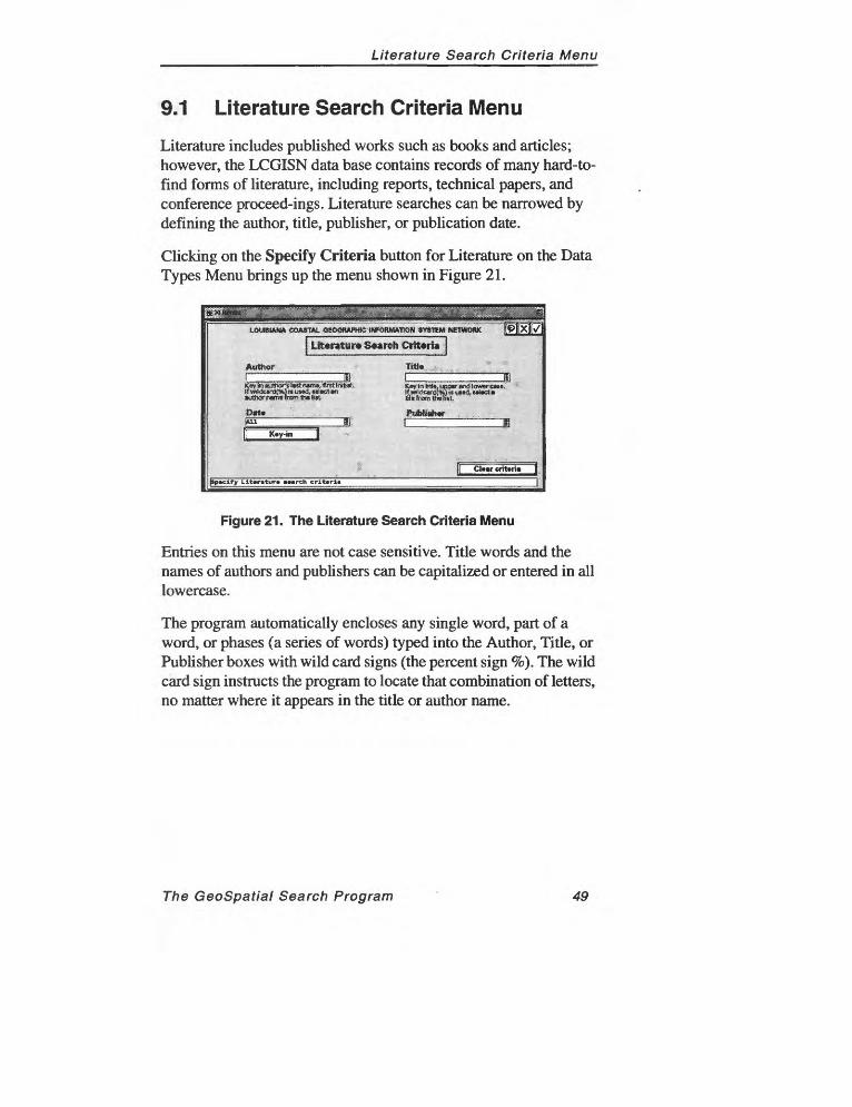
9.1 Literature Search Criteria Menu
Literature includes published works such as books and articles; however, the LCGISN data base contains records of many hard-to- find forms of literature, including reports, technical papers, and conference proceed-ings. Literature searches can be narrowed by defining the author, title, publisher, or publication date.
Clicking on the Specify Criteria button for Literature on the Data Types Menu brings up the menu shown in Figure 21.
LOUISIANA COASTAL OtCXWAPWC INfORMAtlON 3YS1EM NETWOfUC
Literature Search Criteria]
Author Trtl»
Key In Mo, upper end lower cau.' )f wildcard!*,)» «tnd, utect a SS* from lh» Set,
l»iut)tj«h»rr «
K«y-in
|Sp«clfy Llt«r«tur» »»«rch crlttrn
Figure 21. The Literature Search Criteria Menu
Entries on this menu are not case sensitive. Title words and the names of authors and publishers can be capitalized or entered in all lowercase.
The program automatically encloses any single word, part of a word, or phases (a series of words) typed into the Author, Title, or Publisher boxes with wild card signs (the percent sign %). The wild card sign instructs the program to locate that combination of letters, no matter where it appears in the title or author name.
The GeoSpatial Search Program 49
Literature Search Criteria Menu
AuthorThe name of the person(s) or organizations that produced the work. If the work has more than one author, the work will be listed alphabetically by the first name listed.
TitleThe name by which the work is known. Titles for literature are generally quite formal. Other data types have less "official" titles. In that case, the work will be referred to by its common name (a Thematic Mapper image, for example), or it will be given a generic, descriptive title.
DateThe date of publication. For unpublished data, such as a satellite image that is transferred electronically rather than as hard copy, date will be the date of its collection. Date can be entered by a key-in menu, which is described in section 9.1.1.
PublisherThe organization responsible for producing or disseminating the work. The publisher can be a commercial publisher, an agency or organization, a school, or an individual (as in the case of self- published or electron-ically published works).
50 The GeoSpatial Search Program
Date Key-in Menu
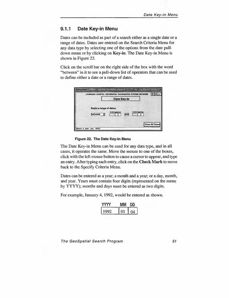
9.1.1 Date Key-in Menu
Dates can be included as part of a search either as a single date or a range of dates. Dates are entered on the Search Criteria Menu for any data type by selecting one of the options from the date pull down menu or by clicking on Key-in. The Date Key-in Menu is shown in Figure 22.
Click on the scroll bar on the right side of the box with the word "between" in it to see a pull-down list of operators that can be used to define either a date or a range of dates.
LOUISIANA COASTAL QEOQftAMflC INFOflMAHON SYSTEM NETWORK
Date K«y-ln
!ICI««rAllD«t**l
y»«r (»»: 1OTO)
Figure 22. The Date Key-in Menu
The Date Key-in Menu can be used for any data type, and in all cases, it operates the same. Move the mouse to one of the boxes, click with the left mouse button to cause a cursor to appear, and type an entry. After typing each entry, click on the Check Mark to move back to the Specify Criteria Menu.
Dates can be entered as a year; a month and a year; or a day, month, and year. Years must contain four digits (represented on the menu by YYYY); months and days must be entered as two digits.
For example, January 4,1992, would be entered as shown.
YYYY MM DD
1992 I 01 | 04
The GeoSpatial Search Program 51
Photography Search Criteria Menu
9.2 Photography Search Criteria Menu
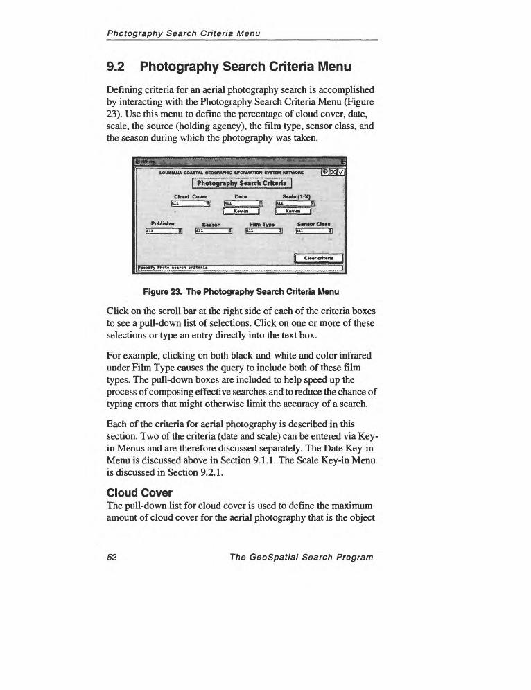
Defining criteria for an aerial photography search is accomplished by interacting with the Photography Search Criteria Menu (Figure 23). Use this menu to define the percentage of cloud cover, date, scale, the source (holding agency), the film type, sensor class, and the season during which the photography was taken.
LOUISIANA COASTAL GEOGRAPHIC INFORMATION SYSTEM NETWORK
} Photography S«arch Criteria |
Cloud Cov*r D«t«
Pufaliahar S«ii«m f Am Typ* SmtofClMV" ....« >"^ II l"i II im 1
Cl««r criteria
|»p«elfy Photo «««rch crlt«rl»
Figure 23. The Photography Search Criteria Menu
Click on the scroll bar at the right side of each of the criteria boxes to see a pull-down list of selections. Click on one or more of these selections or type an entry directly into the text box.
For example, clicking on both black-and-white and color infrared under Film Type causes the query to include both of these film types. The pull-down boxes are included to help speed up the process of composing effective searches and to reduce the chance of typing errors that might otherwise limit the accuracy of a search.
Each of the criteria for aerial photography is described in this section. Two of the criteria (date and scale) can be entered via Key- in Menus and are therefore discussed separately. The Date Key-in Menu is discussed above in Section 9.1.1. The Scale Key-in Menu is discussed in Section 9.2.1.
Cloud CoverThe pull-down list for cloud cover is used to define the maximum amount of cloud cover for the aerial photography that is the object
52 The GeoSpatial Search Program
Photography Search Criteria Menu
of the search. For most purposes, a smaller percentage of cloud cover is desirable.
DateOn the Photography Search Criteria Menu, date refers to the date of content, when the photography was taken. The dates that appear in the pull-down list are Newest, 1990-present, 1980-89,1970-79, 1960-69,1950-59, and Oldest. Clicking on Newest or Oldest will bring up the most recent or oldest single record in the data base, respectively.
Click on the button labeled Key-in to bring up the Date Key-in Menu, which is discussed in Section 9.1.1.
ScaleAerial photography of different scales provide varying levels of detail and typically are used for different purposes. You can add a scale to your search by typing the denominator of the scale into the key-in box (for example, type "24,000" to specify a scale of 1:24,000).
A pull-down list of typical aerial photography scales appears when you click on the pull-down control bar. You may click on one or more of these scales.
Click on the button labeled Key-in to bring up the Key-in Scale Menu, discussed in Section 9.2.1.
PublisherClick on this button to scroll through a list of the agencies or organizations that originally contracted for the flight on which the photography was taken.
SeasonThe time of the year during which the imagery was recorded.
Film TypeA number of different types of film are used for aerial photography. Among the film types that appear in the pull-down list are color, color infrared, black-and-white.
The GeoSpatial Search Program 53
Scale Key-in Menu
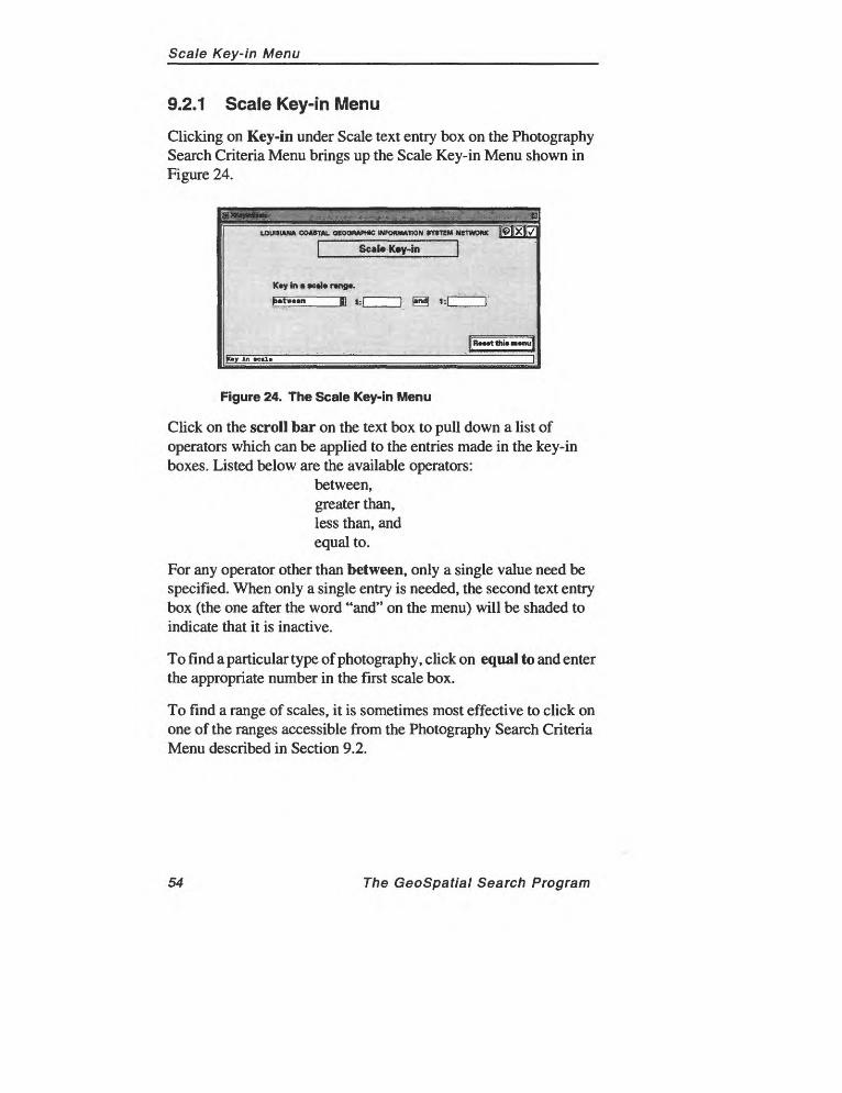
9.2.1 Scale Key-in Menu
Clicking on Key-in under Scale text entry box on the Photography Search Criteria Menu brings up the Scale Key-in Menu shown in Figure 24.
LOUISIANA COASTAL QEOQIWHK INFORMATION *Y»T!M NETWORK
Scal«K«y-in
K*y In * « ) r«ng«.
RcMtthmmnu
Figure 24. The Scale Key-in Menu
Click on the scroll bar on the text box to pull down a list of operators which can be applied to the entries made in the key-in boxes. Listed below are the available operators:
between,greater than,less than, andequal to.
For any operator other than between, only a single value need be specified. When only a single entry is needed, the second text entry box (the one after the word "and" on the menu) will be shaded to indicate that it is inactive.
To find a particular type of photography, click on equal to and enter the appropriate number in the first scale box.
To find a range of scales, it is sometimes most effective to click on one of the ranges accessible from the Photography Search Criteria Menu described in Section 9.2.
54 The GeoSpatial Search Program
Map Search Criteria Menu
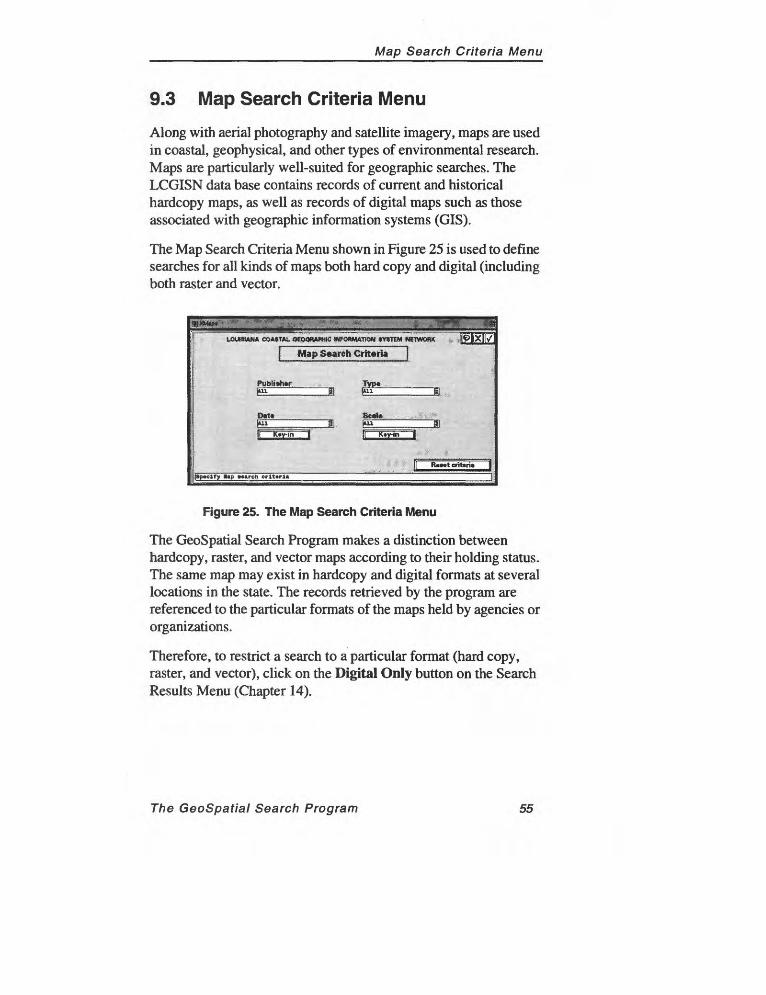
9.3 Map Search Criteria Menu
Along with aerial photography and satellite imagery, maps are used in coastal, geophysical, and other types of environmental research. Maps are particularly well-suited for geographic searches. The LCGISN data base contains records of current and historical hardcopy maps, as well as records of digital maps such as those associated with geographic information systems (GIS).
The Map Search Criteria Menu shown in Figure 25 is used to define searches for all kinds of maps both hard copy and digital (including both raster and vector.
LOUISIANA COASTAL OKWWHIC INFORMATION WTEM NETWORK -IffllXH^H
Publittw Typ« "
Dat» ________ Seal*~"j
}Sp«clTy Bap »««rch crlt«ri«
Figure 25. The Map Search Criteria Menu
The GeoSpatial Search Program makes a distinction between hardcopy, raster, and vector maps according to their holding status. The same map may exist in hardcopy and digital formats at several locations in the state. The records retrieved by the program are referenced to the particular formats of the maps held by agencies or organizations.
Therefore, to restrict a search to a particular format (hard copy, raster, and vector), click on the Digital Only button on the Search Results Menu (Chapter 14).
The GeoSpatial Search Program 55
Map Search Criteria Menu
PublisherThe map publisher is the agency or organization that issued the map. Maps may be issued without being available for sale to the general public.
Maps may be issued internally by an organization or group, without being generally available outside the organization or group. Saying that a particular data type is published implies that it is available to the public, perhaps but not necessarily for a fee.
Date/PeriodThe pull-down list for Date/Period provides a list of dates from which a selection can be made. Click on one of the periods. To specify a specific date or range of dates, click on Key-in and follow the instructions in Date Key-in Menu (described in Section 9.1.1).
Newest1990-present1980-891970-791960-691950-59Oldest
ThemeTypical map types appear in this pull-down list. This list is derived from the Defense Mapping Agency's Digital Chart of the World.
Thefollowing themes are included: Aeronautical, Atmospheric, Cultural, Drainage, Hypsography, Land Cover, Ocean Features, Hypsography, Political/Oceans, Populated Places, Railroads, Roads.
ScaleThe pull-down list for Scale contains a list of typical map scales. Click on one of the scales to add it to your search. To select a range of scales, click on Key-in. (See Section 9.2.1 for a discussion of the Scale Key-in Menu).
56 The GeoSpatial Search Program

Imagery Search Criteria Menu
9.4 Imagery Search Criteria Menu
Another data type important to environmental researchers is imagery. Imagery originates from satellites and aircraft. The GeoSpatial Search Program allows users to search for imagery by specifying criteria associated with other data types (date and publisher) along with the platform and sensor, the particular instruments used to produce the image.
In addition, the season during which the imagery was recorded also can be included in a search.
The menu in Figure 26 is used to define search criteria for imagery.
imagery Search Criteria
Publiatw____ Platform______
Out*
tgtry »»«rch crlt«ri«
Figure 26. The Imagery Search Criteria Menu
Imagery can be in one of two possible formats: digital (which implies raster) and hard copy. You may restrict your search to one of these formats from the Search Results Menu after your initial search is complete.
NotG: If a particular image contains vector overlays, a classification scheme, or an attached data base, the GeoSpatial Search Program will recognize it as a map.
The publisher of an image is considered to be the agency or organization that distributes the data; this may not be the same as the agency or organization that originally collected the data, which the GeoSpatial Search Program treats as the author of the image.
The GeoSpatial Search Program 57
Imagery Search Criteria Menu
DateThis is the date of content the day when the imagery was collected. Instructions for specifying a date appear in Section 9.2.
SeasonThe season is the time of the year during which the imagery was recorded. There are five possible selections: All (the default), Spring, Summer, Fall, and Winter.
Season is determined by the beginning and end dates as they appear on the calender.
Specifying the season of the imagery offers an alternative means of including a date in your search. If both a date and a season are entered, the season takes priority and will be used during the search. Therefore, if you specify a particular date for the search, do not also specify a season.
PlatformIn LCGISN, platform represents the type of satellite employed on the mission. In addition to aircraft (airplanes in addition to satellites are used to collect imagery), the pull-down list offers a number of options, including such typical forms of platforms as Landsat, Spot, and AVHRR.
Sensor TypeA sensor is the instrument used to collect imagery data. The pull down list shows many of the typical instruments: Multi-spectral, TM, Pan, Radar, CAMS, and RBV.
58 The GeoSpatial Search Program
Audiovisual Search Criteria Menu
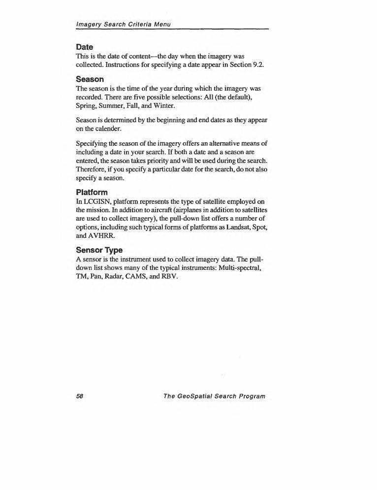
9.5 Audiovisual Search Criteria Menu
The GeoSpatial Search Program includes the menu shown in Figure 27 as a means of searching for a wide range of audiovisual materials, including slides, photographs, audio and video tapes, and computer software.
Author
Audiovisual Starch Criteria
Titi*
191X17
PuWi»h«r Typ« of M«t«riri
Oat*
pp«clTy *u<lio/vi»u«l »»«rch cnt»rl«
Figure 27. The Audiovisual Search Criteria Menu
Search criteria available on the Audiovisual Search Criteria Menu except Type of Material were described in Section 9.1 (Literature Search Criteria Menu).
Type of MaterialAudiovisual data include a number of different media. Clicking on the pull-down menu control bar for Type of Material makes the following list appear.
SlidesVideoAudioPhotographySoftware
By default, the program searches for all audiovisual records held in the data base. Click on a Type of Material to limit your search to a particular form of audiovisual material.
The GeoSpatial Search Program 59
Tabular Search Criteria Menu
9.6 Tabular Search Criteria Menu
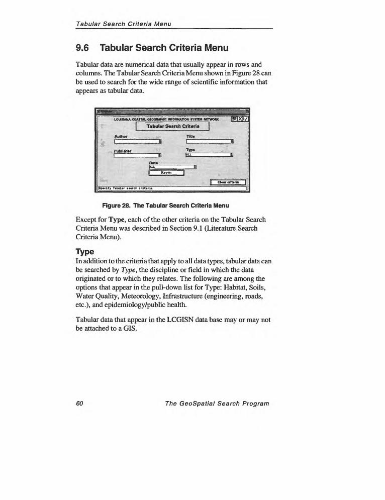
Tabular data are numerical data that usually appear in rows and columns. The Tabular Search Criteria Menu shown in Figure 28 can be used to search for the wide range of scientific information that appears as tabular data.
LOUISIANA COASTAL OfMWHIC MFOMMT10M SYSTEM NETWORK
Figure 28. The Tabular Search Criteria Menu
Except for Type, each of the other criteria on the Tabular Search Criteria Menu was described in Section 9.1 (Literature Search Criteria Menu).
TypeIn addition to the criteria that apply to all data types, tabular data can be searched by Type, the discipline or field in which the data originated or to which they relates. The following are among the options that appear in the pull-down list for Type: Habitat, Soils, Water Quality, Meteorology, Infrastructure (engineering, roads, etc.), and epidemiology/public health.
Tabular data that appear in the LCGISN data base may or may not be attached to a GIS.
60 The GeoSpatial Search Program

Geotechnical Search Criteria Menu
9.7 Geotechnical Search Criteria Menu
An important type of data that the GeoSpatial Search Program is designed to store and query is geotechnical data. The Geotechnical Search Criteria Menu (Figure 29) is used to search for a variety of geotechnical data covered by the LCGISN data base.
| G«ot»chnic«l Search Criteria
Author Till*
Type
J5LK«y-in
|Sp»clfy O»et»chnic«l »»«rch crlt»rl«
Figure 29. The Geotechnical Search Criteria Menu
Except for Type, each criteria on the Geotechnical Search Criteria Menu is described in Section 9.1 (Literature Search Criteria Menu).
TypeGeotechnical data comprise a number of subtypes. Clicking on the pull-down control bar for Type accesses the following list of typical geotechnical data.
Sediment Sample Core/Boring Geophysical Other
By default, all the records in the data base are searched when geotechnical data is selected as the data type. Clicking one of the geotechnical data types listed above restricts the search to those records.
The GeoSpatial Search Program 61

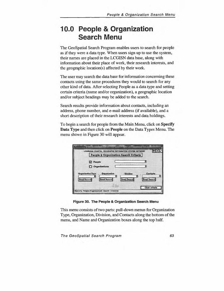
People & Organization Search Menu
10.0 People & Organization Search Menu
The GeoSpatial Search Program enables users to search for people as if they were a data type. When users sign up to use the system, their names are placed in the LCGISN data base, along with information about their place of work, their research interests, and the geographic location(s) affected by their work.
The user may search the data base for information concerning these contacts using the same procedures they would to search for any other kind of data. After selecting People as a data type and setting certain criteria (name and/or organization), a geographic location and/or subject headings may be added to the search.
Search results provide information about contacts, including an address, phone number, and e-mail address (if available), and a short description of their research interests and data holdings.
To begin a search for people from the Main Menu, click on Specify Data Type and then click on People on the Data Types Menu. The menu shown in Figure 30 will appear.
LQUttUUW CO»8TA1. OtOOt^tfmC INTOBHUTION>y»TtM NETWCKW
| P«op|g & Organization Saarch Criteria
£3] t>«opl« L
Q Organization* C
OrgcnlntionTyp* Org*niz«ti«fl DivIriMi C«nt«ct»
Figure 30. The People & Organization Search Menu
This menu consists of two parts: pull-down menus for Organization Type, Organization, Division, and Contacts along the bottom of the menu, and Name and Organization boxes along the top half.
The GeoSpatial Search Program 63
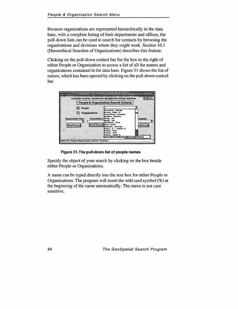
People & Organization Search Menu
Because organizations are represented hierarchically in the data base, with a complete listing of their departments and offices, the pull-down lists can be used to search for contacts by browsing the organizations and divisions where they might work. Section 10.1 (Hierarchical Searches of Organizations) describes this feature.
Clicking on the pull-down control bar for the box to the right of either People or Organization to access a list of all the names and organizations contained in the data base. Figure 31 shows the list of names, which has been opened by clicking on the pull-down control bar.
LOUHIAN* COASMl QEOOftAPtaC INfORMATlOK «WEM MEWOflK
P«opi»& Organization Search Criteria J
|»p«clTy f opH/Orgmlntlon »««rch criteria ~
Figure 31.The pull-down list of people names
Specify the object of your search by clicking on the box beside either People or Organizations.
A name can be typed directly into the text box for either People or Organizations. The program will insert the wild card symbol (%) at the beginning of the name automatically. The menu is not case sensitive.
64 The GeoSpatial Search Program
People & Organization Search Menu
Read Record
A short-cut has been provided that makes it easier to view information about people and organizations without going through the entire process of defining and executing a search.
The record for any organization or contact that appears in the pull down list for either Organization or Contact along the bottom half of the screen can be read by clicking on the Read Record button.
The GeoSpatial Search Program
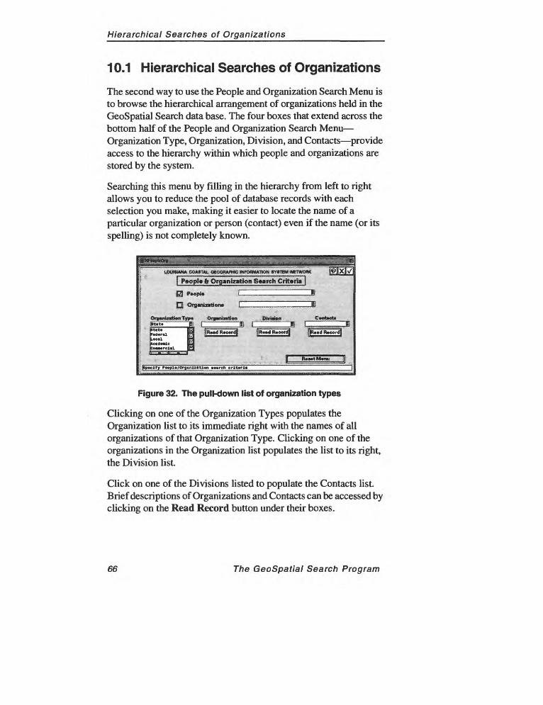
Hierarchical Searches of Organizations
10.1 Hierarchical Searches of Organizations
The second way to use the People and Organization Search Menu is to browse the hierarchical arrangement of organizations held in the GeoSpatial Search data base. The four boxes that extend across the bottom half of the People and Organization Search Menu Organization Type, Organization, Division, and Contacts provide access to the hierarchy within which people and organizations are stored by the system.
Searching this menu by filling in the hierarchy from left to right allows you to reduce the pool of database records with each selection you make, making it easier to locate the name of a particular organization or person (contact) even if the name (or its spelling) is not completely known.
UXJKUNA COATHU. OEOOtUUWC tHfOBMCTON 8Y«TtM M6TWOBK
[P»opl« Ir Organization Search Criteria]
)PJ Organization* L
Of»«niCTa<HiTyt>« Orgtriotion Division
Ty F»opl«/Orfl»nli«tlon «»«rch crlt»rl«
Figure 32. The pull-down list of organization types
Clicking on one of the Organization Types populates the Organization list to its immediate right with the names of all organizations of that Organization Type. Clicking on one of the organizations in the Organization list populates the list to its right, the Division list.
Click on one of the Divisions listed to populate the Contacts list. Brief descriptions of Organizations and Contacts can be accessed by clicking on the Read Record button under their boxes.
66 The GeoSpatial Search Program
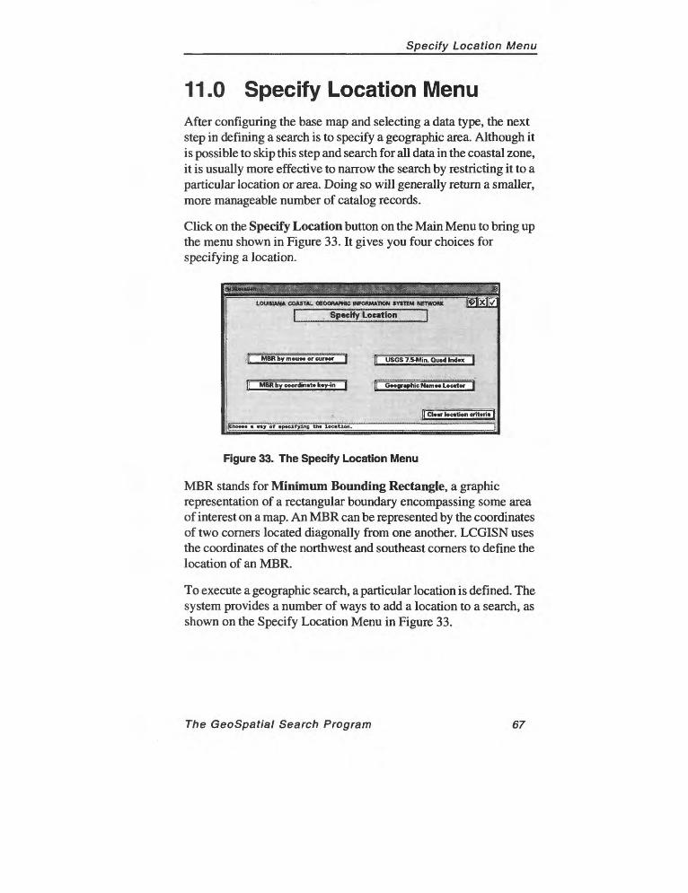
Specify Location Menu
11.0 Specify Location MenuAfter configuring the base map and selecting a data type, the next step in defining a search is to specify a geographic area. Although it is possible to skip this step and search for all data in the coastal zone, it is usually more effective to narrow the search by restricting it to a particular location or area. Doing so will generally return a smaller, more manageable number of catalog records.
Click on the Specify Location button on the Main Menu to bring up the menu shown in Figure 33. It gives you four choices for specifying a location.
LOUISIANA COASTAL GKXWAWiC INFORMATION SYSTEM METWOWC
Specify Location
MBR by moUM or cutter I f[ USGS 7.5-Min. Quid lnd«x|
MBR by coordinate k«yin | || Geographic N«m»« Locator |
I Cl*«r location crit«ri«l
|Ch«o»» « »ty cf «p»clTylnB tin loc«tlon.
Figure 33. The Specify Location Menu
MBR stands for Minimum Bounding Rectangle, a graphic representation of a rectangular boundary encompassing some area of interest on a map. An MBR can be represented by the coordinates of two corners located diagonally from one another. LCGISN uses the coordinates of the northwest and southeast corners to define the location of an MBR.
To execute a geographic search, a particular location is defined. The system provides a number of ways to add a location to a search, as shown on the Specify Location Menu in Figure 33.
The GeoSpatial Search Program 67
Specify Location Menu
1. MBR by Mouse. Use the mouse to draw a rectangle directly on the base map.
2. MBR by Coordinate Key-in. Enter the latitude and longitude or Universal Transverse Mercator (UTM) coordinates directly into the program.
3. USGS 7.5-Min. Quadrangle Index. Scroll through a list of the quadrangles for Louisiana and the adjacent areas of the coastal zone. Choose one or more quadrangles from the list, or click somewhere on the base map. The boundary of the quadrangle for that location will be added to your search.
4. Geographic Names Locator. Enter the name of any location in the state and the program will display its location on the map and add its boundary to your search criteria.
The choice of which method to use to specify a location depends on many factors. Your familiarity with the geography of the state and the data for which you are searching, the level of geographic detail needed in a search, and the number of records of a particular data type in the data base influence which of the four methods is most useful.
For example, for a literature search, using the mouse to select a location on the base map or typing a place name into the geographic names index should be adequate because literature may not be referenced to a specific geographic location.
However, when searching for aerial photography or a map, the geographic location might need to be defined very precisely. In this case, keying in the latitude and longitude of the location or changing the base map layers to activate the USGS 7.5-min. quadrangle boundaries would allow very precise coordinates to be added to a search.
68 The GeoSpatial Search Program
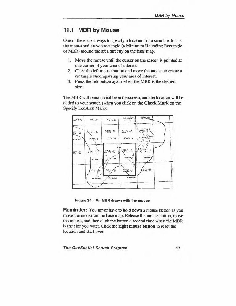
MBR by Mouse
11.1 MBR by Mouse
One of the easiest ways to specify a location for a search is to use the mouse and draw a rectangle (a Minimum Bounding Rectangle or MBR) around the area directly on the base map.
1. Move the mouse until the cursor on the screen is pointed at one corner of your area of interest.
2. Click the left mouse button and move the mouse to create a rectangle encompassing your area of interest.
3. Press the left button again when the MBR is the desired size.
The MBR will remain visible on the screen, and the location will be added to your search (when you click on the Check Mark on the Specify Location Menu).
Figure 34. An MBR drawn with the mouse
Reminder: You never have to hold down a mouse button as you move the mouse on the base map. Release the mouse button, move the mouse, and then click the button a second time when the MBR is the size you want. Click the right mouse button to reset the location and start over.
The GeoSpatial Search Program 69
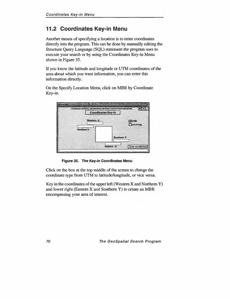
Coordinates Key-in Menu
11.2 Coordinates Key-in Menu
Another means of specifying a location is to enter coordinates directly into the program. This can be done by manually editing the Structure Query Language (SQL) statement the program uses to execute your search or by using the Coordinates Key-in Menu shown in Figure 35.
If you know the latitude and longitude or UTM coordinates of the area about which you want information, you can enter this information directly.
On the Specify Location Menu, click on MBR by Coordinate Key-in.
Coordinates Kay-in
w««t«m: x.
NarttomY
| Cl««r coordin«t»»|
Figure 35. The Key-in Coordinates Menu
Click on the box at the top middle of the screen to change the coordinate type from UTM to latitude/longitude, or vice versa.
Key in the coordinates of the upper left (Western X and Northern Y) and lower right (Eastern X and Southern Y) to create an MBR encompassing your area of interest.
70 The GeoSpatial Search Program
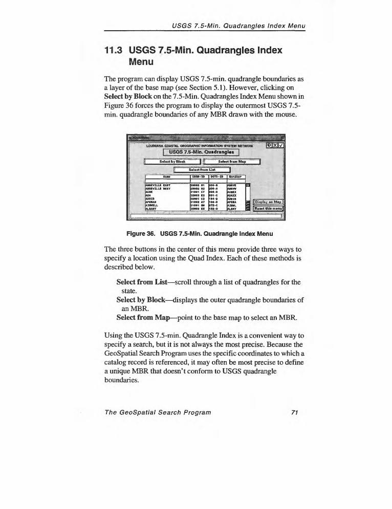
USGS 7.5-Min. Quadrangles Index Menu
11.3 USGS 7.5-Min. Quadrangles Index Menu
The program can display USGS 7.5-min. quadrangle boundaries as a layer of the base map (see Section 5.1). However, clicking on Select by Block on the 7.5-Min. Quadrangles Index Menu shown in Figure 36 forces the program to display the outermost USGS 7.5- min. quadrangle boundaries of any MBR drawn with the mouse.
USGS 7.5-Min. Quadrangles
S»Uct by BlockJ
S»l»ctfrom M«p
S*l*ctfrom LwtJ
UBEVILLE UIT UKVILLE WEST KM
I«O«2 H1 J»O»2 m 31O»1 CT 3209* E2 900*1 Cl 31O»» AT 310*1 O* 300** If
2O*-B 2O*-ADM-D 9*1-C IM-D IM-D JT2-C 152-D
A1IVCUBVWUIEXADAXXADDIS AFEIA AIHA.M.BNY
Figure 36. USGS 7.5-Min. Quadrangle Index Menu
The three buttons in the center of this menu provide three ways to specify a location using the Quad Index. Each of these methods is described below.
Select from List scroll through a list of quadrangles for thestate.
Select by Block displays the outer quadrangle boundaries ofan MBR.
Select from Map point to the base map to select an MBR.
Using the USGS 7.5-min. Quadrangle Index is a convenient way to specify a search, but it is not always the most precise. Because the GeoSpatial Search Program uses the specific coordinates to which a catalog record is referenced, it may often be most precise to define a unique MBR that doesn't conform to USGS quadrangle boundaries.
The GeoSpatial Search Program 71
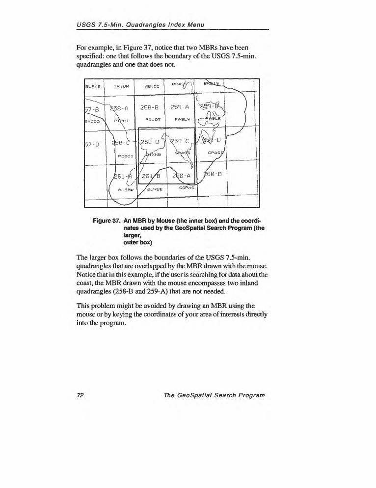
USGS 7.5-Min. Quadrangles Index Menu
For example, in Figure 37, notice that two MBRs have been specified: one that follows the boundary of the USGS 7.5-min. quadrangles and one that does not.
Figure 37. An MBR by Mouse (the inner box) and the coordi nates used by the GeoSpatial Search Program (the larger, outer box)
The larger box follows the boundaries of the USGS 7.5-min. quadrangles that are overlapped by the MBR drawn with the mouse. Notice that in this example, if the user is searching for data about the coast, the MBR drawn with the mouse encompasses two inland quadrangles (258-B and 259-A) that are not needed.
This problem might be avoided by drawing an MBR using the mouse or by keying the coordinates of your area of interests directly into the program.
72 The GeoSpatial Search Program
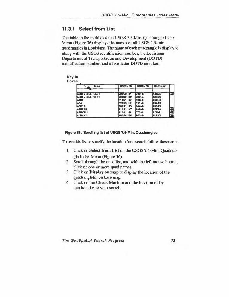
USGS 7.5-Min. Quadrangles Index Menu
11.3.1 Select from List
The table in the middle of the USGS 7.5-Min. Quadrangle Index Menu (Figure 36) displays the names of all USGS 7.5-min. quadrangles in Louisiana. The name of each quadrangle is displayed along with the USGS identification number, the Louisiana Department of Transportation and Development (DOTD) identification number, and a five-letter DOTD moniker.
Key-inBoxes
"\^ Nane^
ABBEVILLE EASTABBEVILLE WESTACMEADAADDISAFEHANAIMWELLALBANY
USGS -ID
29092 H129092 H231091 C732093 E230091 C331092 A731091 0830090 E5
DOTD -ID
209 -B209 -A096 -D031 -C164-D108-D072 -C152-D
Moniker
ABBVEABBVWICMEXADAXXHDD ISAFEMAfclMWLALBNY
[fid
EaJHa
Figure 38. Scrolling list of USGS 7.5-Min. Quadrangles
To use this list to specify the location for a search follow these steps.
1. Click on Select from List on the USGS 7.5-Min. Quadran gle Index Menu (Figure 36).
2. Scroll through the quad list, and with the left mouse button, click on one or more quad names.
3. Click on Display on map to display the location of the quadrangle(s) on base map.
4. Click on the Check Mark to add the location of the quadrangles to your search.
The GeoSpatial Search Program 73
USGS 7.5-Min. Quadrangles Index Menu_____________
Entries also may be typed directly into one of the key-in boxes under the table titles. Follow the steps below to key in entries on the USGS 7.5-Min. Quadrangle Index.
1. With the left mouse button, click inside the appropriate key-in box.
2. Type the name or number you would like to enter into the search, and press [ENTER].
3. If the entry is a valid selection, it will appear highlighted in the list. Press [ENTER] again to accept it. If the entry you typed is not found, try another spelling or scroll through the list to find it.
4. Click on the Check Mark to add the location to your search.
Reset this menu: Click on Reset this menu to clear any selections that have been made on the menu and respecify the quadrangle boundaries that will be used in a search.
Display on Map: After selecting a quad from the list by clicking on its name, click on Display on Map to display the location of the quadrangle on the base map.
Adding More Than One Quadrangle to a SearchIf more than one quadrangle is selected, the program will perform the search using the smallest possible MBR containing both quadrangles. For quadrangles that are far apart from one another, the MBR created is likely to contain a large number of quadrangles that may be unwanted.
Always click on Display on map before adding a location to a search to be sure that the location that the program is using to conduct the geographic component of a search includes only your area(s) of interest.
74 The GeoSpatial Search Program

USGS 7.5-Min. Quadrangles Index Menu
11.3.2 Select by Block
Use Select by Block to draw an MBR on the base map and allow the program to determine the coordinates of the USGS 7.5-min. quadrangles that your MBR overlaps and add their outer boundary to the criteria used to perform a search.
1. Click on Select by Block on the 7.5-Min. Quadrangle Index Menu (Figure 36).
2. Move the mouse until the arrow is pointing to the base map and draw a small rectangle on the screen.
3. The modified rectangle that is displayed on the base map will include all the quadrangles overlapped by the MBR drawn on the base map, as shown in Figure 39.
The MBR on the base map may appear quite a bit larger than the one drawn with the mouse.
Figure 39. MBR by Block
Select by Block displays a modified rectangle containing the all of the USGS 7.5-min. quadrangles overlapped by the rectangle drawn on the base map with the mouse.
The GeoSpatial Search Program 75
USGS 7.5-Min. Quadrangles Index Menu
11.3.3 Select from Map
Another way to enter geographic coordinates for your search is by pointing to a particular place on the base map and allowing the program to create the MBR for your search (the boundaries of all the USGS 7.5-min. quadrangles that are overlapped by the MBR of your search area).
1. Click on Select from Map on the USGS 7.5-Min. Quadran gle Index Menu (Figure 36).
2. The program will ask whether you want to viewinformation about each of the quadrangles you select. Click on either Yes or No.
3. Point to the your area of interest on the base map and click the left mouse button. The USGS 7.5-min. quadrangle boundary of the location you clicked on will be highlighted.
4. Continue clicking on other areas with the left mouse button.
5. When you are satisfied with your selections, click anywhere on the map with the right mouse button.
The information pages provided for each 7.5-min. quadrangle include details such as the latitude and longitude of the quadrangle boundaries, the USGS number, and the Louisiana Department of Transportation and Development's (DOTD) five-letter moniker for that quadrangle.
After you click on the quadrangles to add to your search, the program creates an MBR containing all the quadrangles that were selected. In some cases, this may result in unwanted quadrangles being added to the search.
76 The GeoSpatial Search Program
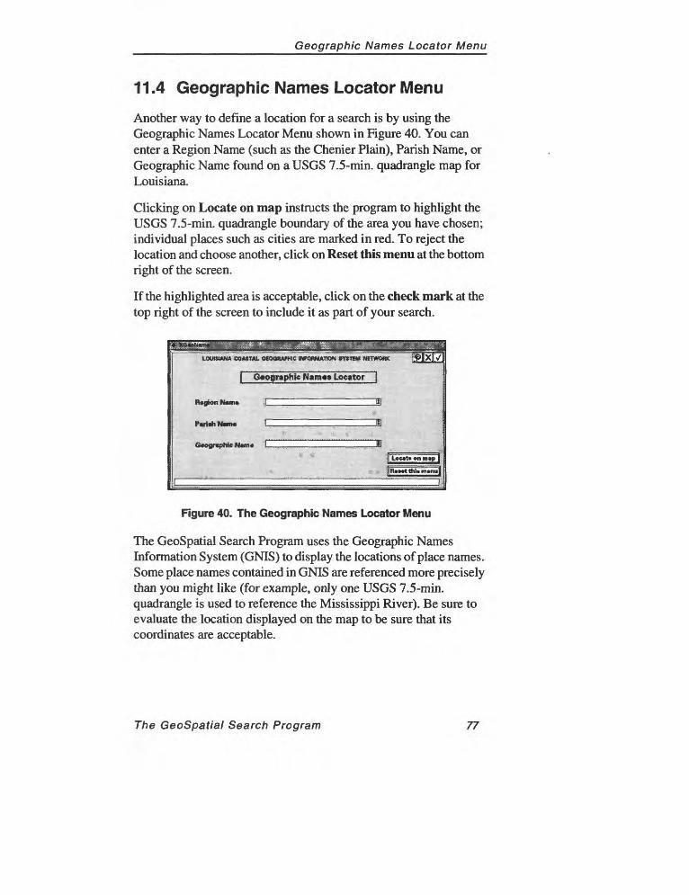
Geographic Names Locator Menu
11.4 Geographic Names Locator Menu
Another way to define a location for a search is by using the Geographic Names Locator Menu shown in Figure 40. You can enter a Region Name (such as the Chenier Plain), Parish Name, or Geographic Name found on a USGS 7.5-min. quadrangle map for Louisiana.
Clicking on Locate on map instructs the program to highlight the USGS 7.5-min. quadrangle boundary of the area you have chosen; individual places such as cities are marked in red. To reject the location and choose another, click on Reset this menu at the bottom right of the screen.
If the highlighted area is acceptable, click on the check mark at the top right of the screen to include it as part of your search.
LOUISIANA COASTAL OeOQWU-HIC INFORMATION SYSTEM NETWORK
I Geographic N«m«» Locator J
togionftem* A 51
Geographic NMM -L,..,. 7 7 ... ,T, .. .. ...7". . ..§
| Loc»t» on m»p ]
j(R»mtthh m»nu]
Figure 40. The Geographic Names Locator Menu
The GeoSpatial Search Program uses the Geographic Names Information System (GNIS) to display the locations of place names. Some place names contained in GNIS are referenced more precisely than you might like (for example, only one USGS 7.5-min. quadrangle is used to reference the Mississippi River). Be sure to evaluate the location displayed on the map to be sure that its coordinates are acceptable.
The GeoSpatial Search Program 77

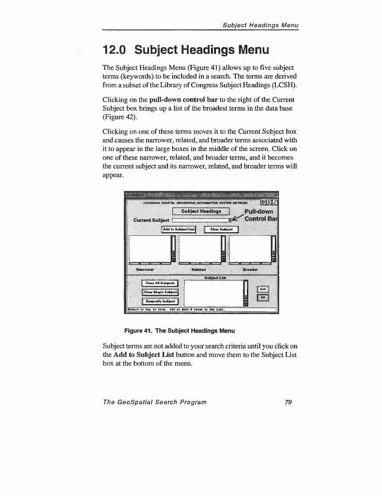
Subject Headings Menu
12.0 Subject Headings MenuThe Subject Headings Menu (Figure 41) allows up to five subject terms (keywords) to be included in a search. The terms are derived from a subset of the Library of Congress Subject Headings (LCSH).
Clicking on the pull-down control bar to the right of the Current Subject box brings up a list of the broadest terms in the data base (Figure 42).
Clicking on one of these terms moves it to the Current Subject box and causes the narrower, related, and broader terms associated with it to appear in the large boxes in the middle of the screen. Click on one of these narrower, related, and broader terms, and it becomes the current subject and its narrower, related, and broader terms will appear.
LOUISIANA COASTAL OtOQBAPMIC INFORMATION SYSTEM NETWORK
Bro«der
Subject U«tv [[ Clear All Subject* |
[[Cleer Single Subject] ;
[[ Reepecify Subject j ;
[[AND]]
|»»l»ct or k«y In t«r». Add »t aoat » t«r»» to th« ll»t.
Figure 41. The Subject Headings Menu
Subject terms are not added to your search criteria until you click on the Add to Subject List button and move them to the Subject List box at the bottom of the menu.
The GeoSpatial Search Program 79

Subject Headings Menu
Up to five subject terms can be added to a search by moving each term to the Subject List at the bottom of the screen. Subject terms do not become part of searches until they appear in the Subject List and the Check Mark for the Subject Heading Menu is clicked.
An unlimited number of subject headings can be added to a search, though more than two or three can have the undesirable effect of significantly reducing the number of records found in the search. After selecting the appropriate subject terms and adding them to the Subject List, click on the Check Mark to add the terms to the search criteria and go back to the Main Menu, where the search can be executed.
Add to Subject List moves the Current Subject to the Subject List at the bottom of the menu. Subject headings must be moved to the Subject List to become part of searches.
Clear Subject removes the current subject.
Clear All Subjects removes all the terms from the Subject List, allowing a new set of subject headings to be specified. Click on Clear All Subjects and then click on the Check Mark to reset the search criteria so that it includes no subject headings.
Clear Single Subject removes only those terms from the Subject List that you have highlighted (by clicking on them); the Current Subject remains unchanged.
Respecify Subject removes the highlighted term from the Subject List and makes it the Current Subject, redisplaying its narrower, broader, and related terms.
80 The GeoSpatial Search Program
Subject Headings Menu
&%gtMM!&? J%3""'"' v ¥'' v'?'\Z '"-.;" :>--r-----^-- -;;:-- :-- -.....- --. - ..,..,.,,.,,..,,,,,,,..^,.,.,. .,,....,,..,. ...^
UJWSIANA COASTAL OKWRAPHIC WFORWATION SYSTEM NETWORK
1 Subject Heading* ]
Current Subject y
[[Add t« Subject Lict]........... . . ' - - - -
|!
N»rrow*r R»t
[ ClrarAII Subject* ] |
|cu«r SingU Subject] ?
f[ ftetfwify Subject ]
,Ii
AnlHli Anthropology ( you* l.y.
llology llrd» lotany Iroakntor* n»l» rtography
houotry Ity planning
llHtologyOMt*OBMrct OBputiro
|
IMXK7
!i___ i
r
i
p»l»ct tr k*y In tor*. Add it Boot B ttrM to tut ll>t.
Figure 42. Pull-down list of broadest subject terms
Example: In the menu shown in Figure 42, clicking on the pull down control bar next to the Current Subject box has accessed a list of broad terms related to coastal studies and spatial data. This list can be scrolled to find a term relevant to your search. The term is not added to the search until it is moved into the Subject List at the bottom of the menu.
The Subject Heading Menu allows users to browse the hierarchy of subject terms used by the GeoSpatial Search Program. Clicking on a term in the pull-down list causes its narrower, related, and broader terms to be displayed. Using the Subject Headings Menu to browse the terms associated with each subject term enables users to experiment with different combinations of subject headings in their searches.
For example, clicking on the term Cartography in the list shown in Figure 42 produces the menu shown in Figure 43.
The GeoSpatial Search Program 81
Subject Headings Menu
UXMUNA COASTAL OKK3RAPHIC MFOMUmON SVTHM WTWOAK
Subject H«ading»
Currant Subject
||AddtoSubi«etLi»t| ]| Cloor Subject j
kgrlculturtl aipplng Contour* (C«rtofr«phjr) Envlroiw*nt«L opplnfl Foroot nipping a*«lo«lc«l nipping Up printing tap ocelot >po, Bllltary
i'lap projection
^
Up.tathoomtlHL geography lurvoylno,
i
NMTOWW R*f*t*d
SufafrctU*
| AND |
[ -W ]
|Choo»o anotlur t«r» OB add to tho lift.
Figure 43. Cartography as the Current Subject
By repeating this process of selecting terms and browsing the narrower, related, and broader terms, you can find the keywords that best describe the information for which you are searching.
In Figure 43, for example, you might decide that "cartography" is too broad to lead to the information you need. Two subjects that seem more relevant to your search are "Environmental mapping" and "Agricultural mapping." Clicking on Environmental mapping produces the menu shown in Figure 44.
82 The GeoSpatial Search Program
Subject Headings Menu
|pW*P'l ""* " " -;-;;; -"i;-r;;;;;;; - :>;* -%- --% ; .;r I * | ' a i; ^ig
LOUISIANA COASTAL QtOQRAPHtC INfOftMATTON «Y*TEM NETWORK T[9[fX[[>/
Sub{«et KMding*
currant Subject ^>«t«i».nt.i »n>in« g|(C*» »HUJtw«. 11** % t» tftatf wHdowdt.J
[(Add to Subject Lietl 1 Cleer Subject 1
Narrower
- Cirtopraphy
! !i Ia a9
Related Broader
_ Subject Lit* ' ; "' -' " -" ' ' "[[ CleerAIISubjeete | En»ironmnt.i «PPlnB
jj Clear Single Subject) i 1) I
j[ Reepedfy Subject [ ! * l^mtiV
[Subject tiMdlng lUcil to ll«t.
Figure 44. Environmental mapping as the Current Subject
If this term seems like it may produce the kinds of results you need, add it to your search by clicking on Add to Subject List. In Figure 44, Environmental mapping has been added to the Subject List at the bottom of the screen.
To see the narrower, related, and broader terms related to the second term, Agricultural mapping, click on Cartography, which is listed as a broader term. (If Environmental mapping is a narrower term under Cartography, Cartography has to be a broader term under Environmental mapping.)
Clicking on Cartography produces the original menu shown in Figure 43. On this menu, clicking on Agricultural mapping produces the menu shown in Figure 45.
The GeoSpatial Search Program 83
Subject Headings Menu
LOUISIANA COASTAL GEOGRAPHIC INFCHWATON SYS1EM NETWORK
Subject H«ading*
Current-Sut>j««t lAt^iau^'j^pping".
[[Add to Subject LittJ
Narrower
Subj««tu*tEnvlrona>ntkl lapping Agricultural Mpplng
jsub]*ct hMdlng «dd»a to
Figure 45. Agricultural mapping as the Current Subject
No narrower terms appear for either Environmental mapping or Agricultural mapping. Therefore you decide to add Agricultural mapping to your search by clicking on the Add to Subject List button. To add these terms to your search and return to the Main Menu, click on the Check Mark.
84 The GeoSpatial Search Program
Tips for Using Subject Headings
12.1 Tips for Using Subject Headings
Because it is difficult to tell what combinations of search terms will produce the most useful results, it may be necessary to experiment with different combinations of broader, narrower, and related terms. A number of searches may have to be executed to find the most effective search strategy.
For example, in the example described previously, it is impossible to know whether the two narrower terms, "Agricultural mapping" and "Environmental mapping," will produce better results than adding the broader term "Cartography" to the search criteria. A good general approach is to perform multiple searches with different combinations of Subject Terms, varying one term at a time.
Subject headings are more useful for some data types than others. For literature, audio-visual data, and most maps, subject headings provide a very effective means of focusing a search. This is because these types of data have traditionally had subject terms associated with them. Other data, such as photography and imagery, usually do not have subject terms associated with them.
This situation may change as more data are cataloged and added to the LCGISN data base. The GeoSpatial Cataloging Program provides a means of associating standard sets of subject headings with all kinds of data. (Contact the LCGISN Technical Committee for more information about the GeoSpatial Cataloging Program.)
The Subject Headings Menu gives users access to the hierarchical relationships that the program uses to perform subject searches of the data base. These parent and child terms appear as lists of broader, related, and narrower terms for each subject term moved to the Current Subject box.
Interactively broadening and narrowing search terms provides a means of evaluating and executing a variety of possible search strategies.
The GeoSpatial Search Program 85

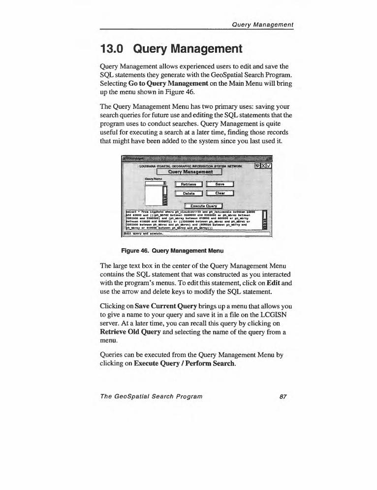
Query Management
13.0 Query ManagementQuery Management allows experienced users to edit and save the SQL statements they generate with the GeoSpatial Search Program. Selecting Go to Query Management on the Main Menu will bring up the menu shown in Figure 46.
The Query Management Menu has two primary uses: saving your search queries for future use and editing the SQL statements that the program uses to conduct searches. Query Management is quite useful for executing a search at a later time, finding those records that might have been added to the system since you last used it.
LOUISIANA COASTAL oeOORAI-mC FORMATION SYSTEM NETWQflK
Query Manag«m*nt
ExjeutjjQujr^J
l»et fro* icgphoto ttwr* ph_el9udcov<=10 Mid ph_ratio«ctl* b*t**«i 24000 ind 03000 md (((pn mra b*t»*n 3200000 Mid 3300000 »r pn_n>r«x bttwtcn 33IOOOO Mid 330eoeoY MM (ph tuny b*t»*n 410000 Mid (00000 »r ph H>rny Mtvmn 410000 Mid 400000)) »r ((3300000 bitmwi ph iDru *nt ph ibna »r 3*«0000 b*t««i ph_«Br«« Mid ph.iern) and (400000 b*tw»n ph_«Brny and
_»»r»y »r 4100OO~b«t»»«n pn »erny «nd ph_«Br»y)))_______~__________
|tdlt qu»ry Mid »i»cut».
Figure 46. Query Management Menu
The large text box in the center of the Query Management Menu contains the SQL statement that was constructed as you interacted with the program's menus. To edit this statement, click on Edit and use the arrow and delete keys to modify the SQL statement.
Clicking on Save Current Query brings up a menu that allows you to give a name to your query and save it in a file on the LCGISN server. At a later time, you can recall this query by clicking on Retrieve Old Query and selecting the name of the query from a menu.
Queries can be executed from the Query Management Menu by clicking on Execute Query / Perform Search.
The GeoSpatial Search Program 87

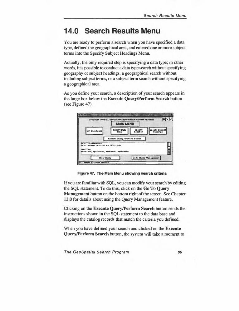
Search Results Menu
14.0 Search Results MenuYou are ready to perform a search when you have specified a data type, defined the geographical area, and entered one or more subject terms into the Specify Subject Headings Menu.
Actually, the only required step is specifying a data type; in other words, it is possible to conduct a data type search without specifying geography or subject headings, a geographical search without including subject terms, or a subject term search without specifying a geographical area.
As you define your search, a description of your search appears in the large box below the Execute Query/Perform Search button (see Figure 47).
Ex»cut» Qu«fy / Perform S««rch I
.OCATTON: XMI7E21, ny=*2*44»0, «*»700BB, y=323MOO
CU«r Query )| G« to Ou«ry M«n«g«m«nt]
»««rch Criteria cl«»r«d.
Figure 47. The Main Menu showing search criteria
If you are familiar with SQL, you can modify your search by editing the SQL statement. To do this, click on the Go To Query Management button on the bottom right of the screen. See Chapter 13.0 for details about using the Query Management feature.
Clicking on the Execute Query/Perform Search button sends the instructions shown in the SQL statement to the data base and displays the catalog records that match the criteria you defined.
When you have defined your search and clicked on the Execute Query/Perform Search button, the system will take a moment to
The GeoSpatial Search Program 89
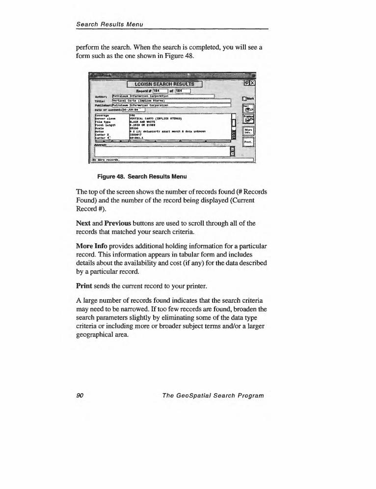
Search Results Menu
perform the search. When the search is completed, you will see a form such as the one shown in Figure 48.
IMXI
t 1184 | <rf JIM |
|Cov*rag«BwiMr cl«Mrila type Pool length
Notn b«nt.r XCont«r y£
100 VERTICAL CARTO (IMLIEf *TEMEO) ILACK AND WHITE J.25IN OH 21011 252001 E LA; dttMttrti w»ct nth ft dtto unknown JSBO*1TM1M3.4
t
AfaftrKtt ' ' "'";: .:-:.,;i " '--
g or* record*.
Figure 48. Search Results Menu
The top of the screen shows the number of records found (# Records Found) and the number of the record being displayed (Current Record #).
Next and Previous buttons are used to scroll through all of the records that matched your search criteria.
More Info provides additional holding information for a particular record. This information appears in tabular form and includes details about the availability and cost (if any) for the data described by a particular record.
Print sends the current record to your printer.
A large number of records found indicates that the search criteria may need to be narrowed. If too few records are found, broaden the search parameters slightly by eliminating some of the data type criteria or including more or broader subject terms and/or a larger geographical area.
90 The GeoSpatial Search Program
Search Results Menu
14.1 General Search Strategies
Specifying criteria allows great control over the precise contents of your search. To use the GeoSpatial Search Program most effectively, learn to define the most precise criteria for each type of data to return the records you need.
When you specify a location as part of your search, the search will be most effective if you understand something about the way the program handles place names and geographic coordinates.
Using the Geospatial Search Program most effectively will probably require some experience to become familiar with the nuances of the system. When defining and refining LCGISN search instructions (queries), keep the following general guidelines in mind.
The Specify Subject Headings Menu is not an effective means of specifying a location because subject terms in the GeoSpatial Search Program lack geographic components.
The best way to ensure that your search includes a minimum geographic area while still encompassing your area of interest is to conduct a separate search for each USGS 7.5-min. quadrangle overlapped by your area of interest.
To do this, set up all your search criteria except geographic area. On the Specify Location Menu, click on the USGS 7.5-Min. Quadrangle Index. Click on Select from Map but include only one quadrangle. Execute your search and save or print out your search results.
Conduct another search keeping all the search criteria except geographic location the same. Click on USGS 7.5-Min. Quadrangle Index and Select from Map. Click on a different quadrangle in your area of interest. Return to the Main Menu and execute the search again.
For each search you conduct, change only the quadrangle added as the geographic component of your search criteria.
The GeoSpatial Search Program 91

__________________________________Tutorial
15.0 Tutorial
The following tutorial describes the basic procedures used in the LCGISN GeoSpatial Search Program. Reading "The Basics" and then completing this tutorial should provide an adequate introduction to the system.
The best way to learn the program is to use the program; do not hesitate to experiment with the system. Let us know your ideas about expanding or improving it.
Skills Needed to Complete This Tutorial: Beforebeginning this tutorial, users should become familiar with the GeoSpatial Search Program mouse and menu conventions, which are described in Part One of the manual. It also will be helpful to spend some time experimenting with the many ways of navigating the system before working through the tutorial.
Reminder: Entries made on menus do not become part of the search criteria (the algorithm that the program will use to find the object of your search) until you click on the menu's Check Mark, which tells the program to accept a particular selection. Remember to click on the Check Mark to tell the program to add your selection to the search criteria and go on to the next task.
Click on the X button to cancel an entry and start over or to go back to the previous menu.
Sometimes you must click on the Check Mark of two or more menus to continue a search. For example, after defining search cri teria on the Photography Criteria Menu, you have to "Check Out" of both that menu and the Specify Data Types Menu to return to the Main Menu and either continue to define or execute the search.
Contents: This tutorial describes two types of searches: one for aerial photography and one for literature (a journal article). Both searches deal with a similar geographic location and type of ecosystem. The major difference is the data type, which as you will see also affects the search strategies that are likely to be effective.
The Geospatial Search Program 93
Tutorial
15.1 Photography Search
This tutorial has two parts, each of which describes a particular type of search for records related to a research project dealing with environmental changes in coastal Louisiana.
As you work through the tutorial, imagine that you are involved in a project to study coastal erosion around the Atchafalaya Bay area of Louisiana. You have an immediate need for two kinds of data: aerial photography of the coast, preferably for a range of dates, and literature, an article that may have been published in a conference proceedings.
The first part of the tutorial describes a search for aerial photography covering your area of interest (Atchafalaya Bay) over a range of dates. Specifically, you would like to find the earliest and latest photography available for the coastline around Atchafalaya Bay.
(Other materials, such as samples of photography for intervening years or historical maps, also might be useful, but these searches are beyond the scope of this tutorial. You may want to experiment with them on your own, however.)
The Photography Search Process1. Log into LCGISN2. Begin Your Search from the Main Menu3. Select the Data Type4. Specify Search Criteria5. Specify Location6. Enter Atchafalaya Bay on the Geographic Names Locator7. Execute Your Search
94 The GeoSpatial Search Program
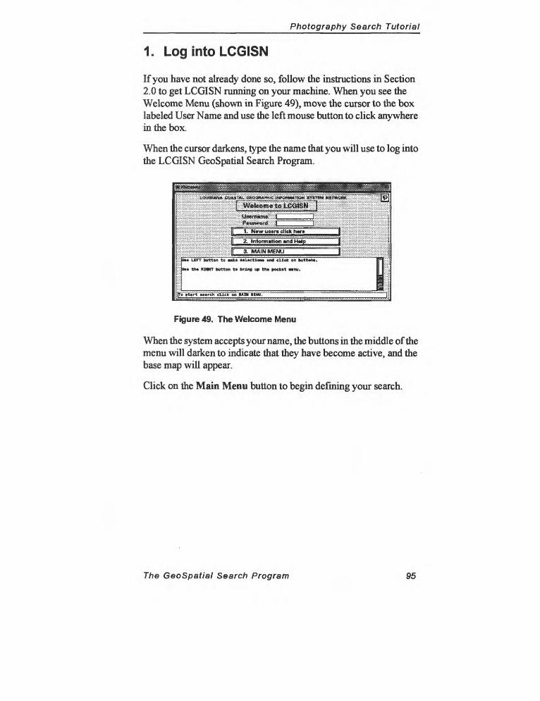
Photography Search Tutorial
1. Log into LCGISN
If you have not already done so, follow the instructions in Section 2.0 to get LCGISN running on your machine. When you see the Welcome Menu (shown in Figure 49), move the cursor to the box labeled User Name and use the left mouse button to click anywhere in the box.
When the cursor darkens, type the name that you will use to log into the LCGISN GeoSpatial Search Program.
SSS^tciiCroti^..............,.,,,.,;:,. : - -- -^""
1. N«w users click hw» J2. Information and H«lp
[( 3. MAIN MENU3_3iill;:::::::::S
;]UM LEFT buttoiTta MM oloetlon* «* ellok on button*.~
VM tho RIWT button to bring up tno »«cKot MDU.
To »t«rt uireh click on MIN KNU.
Figure 49. The Welcome Menu
When the system accepts your name, the buttons in the middle of the menu will darken to indicate that they have become active, and the base map will appear.
Click on the Main Menu button to begin defining your search.
The GeoSpatial Search Program 95

Photography Search Tutorial
2. Begin Your Search from the Main Menu
The Main Menu (shown in Figure 50) is the centerpiece of the GeoSpatial Search Program: it is where you begin defining your searches and where you must return to execute them.
I MAIN MENU It-r ...... : rr-^- ^TT!
; Specify D*t* Typ.
Sp.fySubj.ctl « |:
Ex«cut* Gu»ry / P*rf«nn Search
Mp OB build your qmrj.
IliigigC I Oo to Qufty M«n«9tm»nt \
Figure 50. The Main Menu
The four buttons in middle of the Main Menu are used to access the various parts of the program. The Set Base Maps button is used to control the information displayed on the base map and doesn't directly affect searches. For information about the base map, see Section 5.2.
The first step in defining a search is to select a data type.
96 The GeoSpatial Search Program
Photography Search Tutorial
3. Select the Data Type
On the Main Menu, click on Specify Data Type, which will bring up the Data Types Menu shown in Figure 51.
(JCUSHMA COAWAL «CX5PjMmWQnH*11Wi. KtttW NMWOSli
Figure 51. The Data Types Menu
The object of the current search is aerial photography, so click on Photography on the Data Types Menu.
By default, the program will find all photography, represented on the menu by the All Records button, which is depressed when the menu appears. Because you want to limit your search to records meeting certain conditions, click on the Specify Criteria button to the right of Photography. You should see the Photography Search Criteria Menu shown in Figure 52.
Your object is to find aerial photography for a range of dates. You have several choices concerning the way that the program conducts your search. One option is to conduct separate searches for the earliest and latest photography. Alternatively, you could search for all photography in your area of interest and then scroll through the list to find the dates you need.
The GeoSpatial Search Program 97
Photography Search Tutorial
4. Specify Search Criteria
For each data type, the GeoSpatial Search Program provides different possible search parameters. When you select a data type, you have the option of changing the data type criteria as well. The Aerial Photography Criteria Menu is shown in Figure 52.
jijiiij^^
CUir criteria
Pilot* »»«rch crtt«rli~
Figure 52. Photography Search Criteria Menu
The first step is to limit your search to photographs that meet your needs with a minimum of cloud cover.
Click on the pull-down control bar to the right of the box under "Scale (1:X)" and click on three lines: <10,000; 10,000 to 24,000; and 24,000 to 63,000. This will cause your search to return records of all photography at a scale of 1:63,000 or less.
Next, click on the pull-down control bar to the right of the Cloud Cover box and click on <10 percent.
Click on the Check Mark on both the Photography Search Criteria Menu and the Specify Data Types Menu to return to the Main Menu. From the Main Menu, you will continue to define your search by specifying a location.
98 The GeoSpatial Search Program
Photography Search Tutorial
5. Specify Location
Because the research you want to locate deals with Atchafalaya Bay, you need to add this location to the search. The four buttons in the center of the Specify Location Menu shown in Figure 53 represent the four ways to include a location as part of a search.
juJ^^A%'^r^yX.->:*-^v-J-v-^»yj'>i'>:'i':'---^'JJjgj--jjg.-j-j
^sssaaa*^^^jfssH^ssssSfiiSiSfipit.
jl MBR by m«UM or curaor J
f[ MBR by coordinate kcynn 1
ocatioi* ;
:|F USGS 7.5-Min. Quid Indt x |
:f[ G«ographi«NMi** Locator 1
k
- jfcioar location criteria (
]Uwo» my *1 (pocifying th< Location. f.
Figure 53. The Specify Location Menu
There are four ways to restrict searches to data dealing with a particular location.
1. Click on MBR by Mouse to draw a rectangle on the base map, enclosing the location of your area of interest and add ing its coordinates to your search.
2. Click on USGS 7.5-Min. Quadrangle Index to scroll through a list of the 7.5-min. quadrangles for Louisiana, click on one of them, display its location on the base map, and add its coordinates to your search.
3. Click on MBR by Coordinate Key-in, type thecoordinates of your area of interest, and add them to your search.
4. Click on Geographic Names Locator and type in a location name to include in your search.
To add a location to your aerial photography search, click on Geographic Names Locator.
The GeoSpatial Search Program 99
Photography Search Tutorial
6. Enter Atchafalaya Bay on the Geographic Names Locator
Type "Atchafalaya Bay" in the box labeled Geographic Name at the bottom of the menu.
Click on the button labeled Geographic Names Locator on the Specify Location Menu to bring up the menu shown in Figure 54. On this menu, you can type the name of a location, either a region ("Acadiana"), body of water ("Lake Pontchartrain"), or a particular location, such as a town or city, and add its coordinates as the location part of your search criteria.
a
Ji(L»crt»»«i»«pJ:
l|R*Mtthi»m«nu
Figure 54. The Geographic Names Locator Menu
The Geographic Names Locator is useful when you know the name of your area of interest but are unsure of its precise location. Displaying the location of a place name on the base map prior to adding its coordinates to a search can ensure that the MBR the program is using to conduct your search matches the location you have in mind.
When you have typed a location into the Geographic Name box, click on Locate on Map (or the Check Mark). The program will outline the quadrangle containing the location in red and, in some cases, place a red dot showing the exact location of the name. When the location of "Atchafalaya Bay" is displayed, the base map should look like Figure 55.
The latitude and longitude of two USGS 7.5-min. quadrangles highlighted in Figure 55 will be added to your search when you click
100 The GeoSpatial Search Program
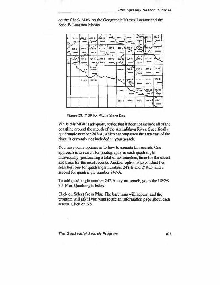
Photography Search Tutorial
on the Check Mark on the Geographic Names Locator and the Specify Location Menus.
Figure 55. MBR for Atchafalaya Bay
While this MBR is adequate, notice that it does not include all of the coastline around the mouth of the Atchafalaya River. Specifically, quadrangle number 247-A, which encompasses the area east of the river, is currently not included in your search.
You have some options as to how to execute this search. One approach is to search for photography in each quadrangle individually (performing a total of six searches, three for the oldest and three for the most recent). Another option is to conduct two searches: one for quadrangle numbers 248-B and 248-D, and a second for quadrangle number 247-A.
To add quadrangle number 247-A to your search, go to the USGS 7.5-Min. Quadrangle Index.
Click on Select from Map. The base map will appear, and the program will ask if you want to see an information page about each screen. Click on No.
The GeoSpatial Search Program 101
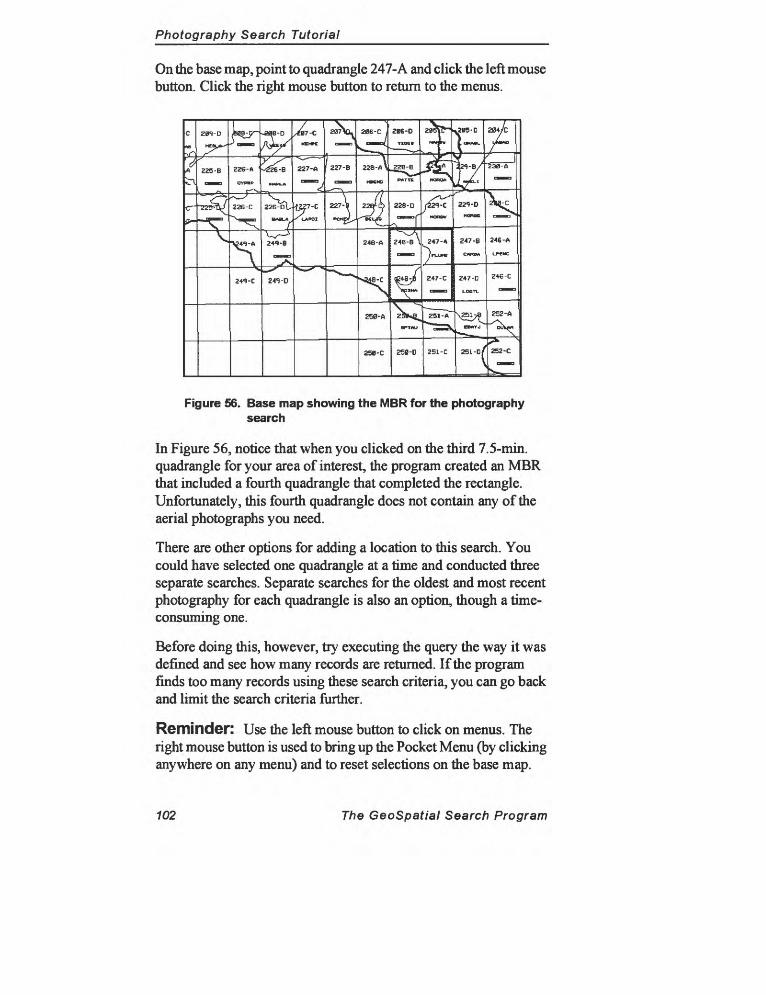
Photography Search Tutorial
On the base map, point to quadrangle 247-A and click the left mouse button. Click the right mouse button to return to the menus.
Figure 56. Base map showing the MBR for the photography search
In Figure 56, notice that when you clicked on the third 7.5-min. quadrangle for your area of interest, the program created an MBR that included a fourth quadrangle that completed the rectangle. Unfortunately, this fourth quadrangle does not contain any of the aerial photographs you need.
There are other options for adding a location to this search. You could have selected one quadrangle at a time and conducted three separate searches. Separate searches for the oldest and most recent photography for each quadrangle is also an option, though a time- consuming one.
Before doing this, however, try executing the query the way it was defined and see how many records are returned. If the program finds too many records using these search criteria, you can go back and limit the search criteria further.
Reminder: Use the left mouse button to click on menus. The right mouse button is used to bring up the Pocket Menu (by clicking anywhere on any menu) and to reset selections on the base map.
102 The GeoSpatial Search Program
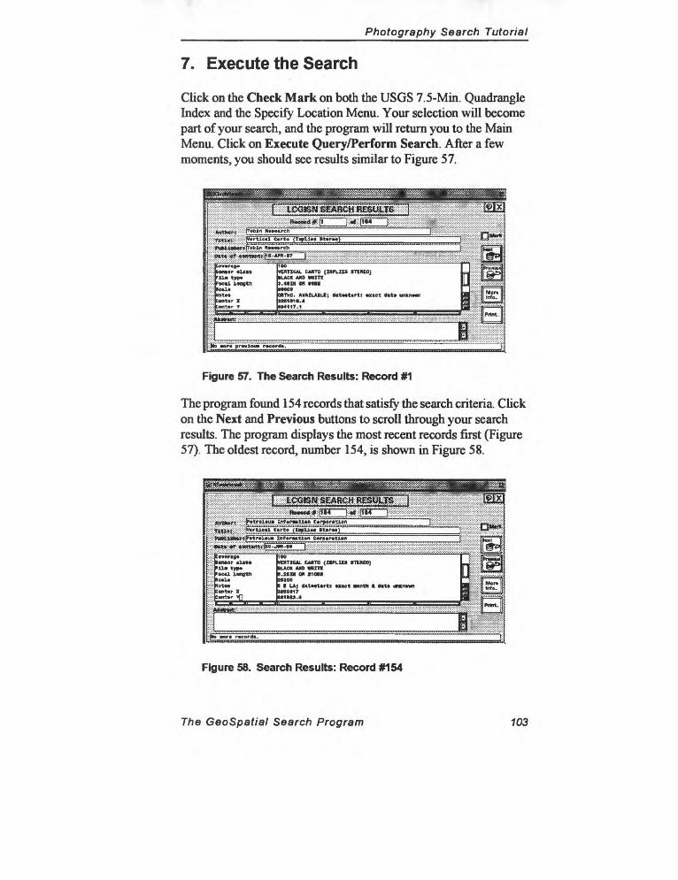
Photography Search Tutorial
7. Execute the Search
Click on the Check Mark on both the USGS 7.5-Min. Quadrangle Index and the Specify Location Menu. Your selection will become part of your search, and the program will return you to the Main Menu. Click on Execute Query/Perform Search. After a few moments, you should see results similar to Figure 57.
MtiMr cltM 11- typ. 'oc«l Lwigtn
<OtW:«n*r x:*n>*r T
*&*tt^-!iXfXf:X:l
VERTICAL CMTO (IIPLICS STiMEOj ILACK MS M»TC).4e» CR MmneeeOKTHC. MAILAtLI; dttMtirt: *zict dtt* unkiMnn IM1018.4IM11T.1
^^f^^^-^^yf^^
-
\«
1i pr«Miou» record*.
Figure 57. The Search Results: Record #1
The program found 154 records that satisfy the search criteria. Click on the Next and Previous buttons to scroll through your search results. The program displays the most recent records first (Figure 57). The oldest record, number 154, is shown in Figure 58.
o JMtt W^dMtjkttjyo- ̂ g^Jxs;>igxo>: ...... ;:^?Si^:>^?^^SSSx....
;ev*r<o«ItnMr !< >!! tyy*=»Ml lengthle*l*<at»»:*nt*r X:*nt»r >0
1«0ICMTICAL CMTO (XtfLIEt 1TER£O) tLACN M» KHITIr.sen M sio»iwzoot I LA| a«tMt*rti Muct Btntti k 0«t« iHcnownttSOtl?UIIUt.4
r
1
i
I
Info.aL,,^-.
Figure 58. Search Results: Record #154
The GeoSpatial Search Program 103
Literature Search Tutorial
15.2 Literature Search
In this second part of the tutorial, your first goal will be to locate an article about a project to use computer simulations to model the Louisiana coast around the mouth of the Atchafalaya River. You don't recall the author of the study but believe that its results may have been published sometime in the late 1970's. The only information you have is that the project used mathematical simulation techniques and dealt with that particular area of the coast.
To define a new search, this time specifying literature rather than aerial photography as your data type, begin at the Main Menu. Although you could click on the button Clear Query and start over defining your search, you can also leave the query statement in place and change only the criteria necessary to define a new search.
The Literature Search Process
1. Log into LCGISN2. Begin Your Search from the Main Menu3. Click on Specify Data Types4. Specify Criteria for the Literature Search5. Narrow Your Search to a Range of Dates6. Add a Geographic Location to the Search7. Enter Atchafalaya Bay on the Geographic Names Locator8. Add a Subject Heading9. Execute the Search10. Initial Search Results11. Add a Title Term to Your Search12. Execute the Search (Again)
704 The GeoSpatial Search Program
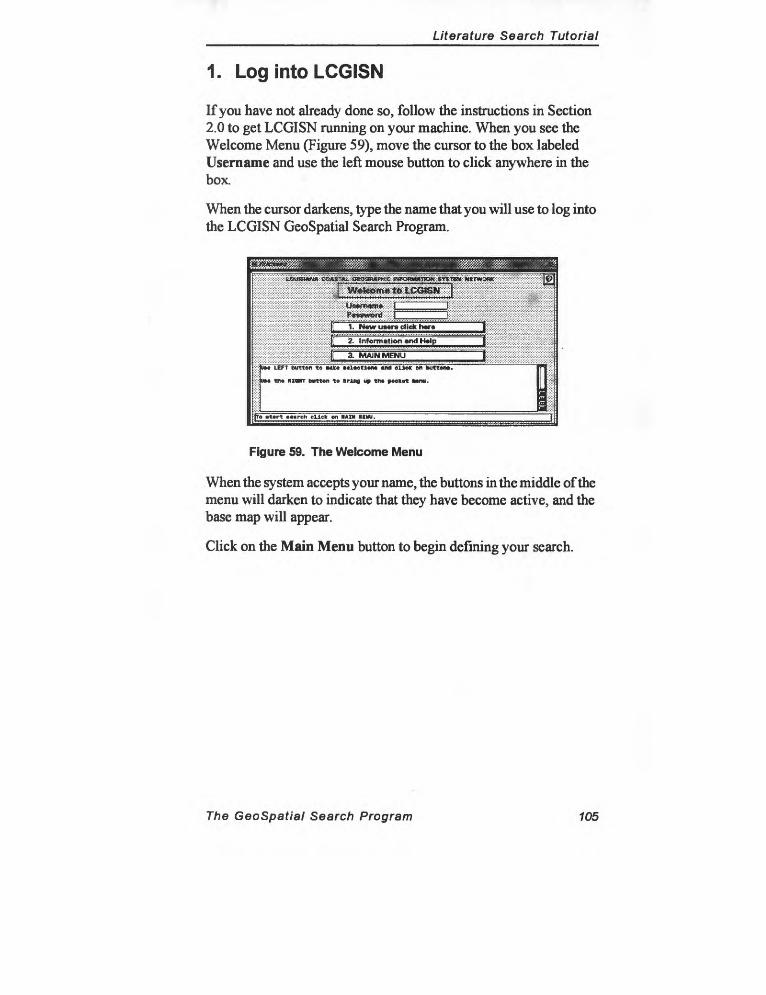
Literature Search Tutorial
1. Log into LCGISN
If you have not already done so, follow the instructions in Section 2.0 to get LCGISN running on your machine. When you see the Welcome Menu (Figure 59), move the cursor to the box labeled Username and use the left mouse button to click anywhere in the box.
When the cursor darkens, type the name that you will use to log into the LCGISN GeoSpatial Search Program.
^ougi<triM:it:^-r>iL^:i^iM
1. N«w users click hare
2. Information and H»lp
3. MAIN MENU
:':-: :
DM LEFT button to ** loetloiM and ellt* en button*.
; DM tt» RZ«HT button to bring up th* peekot Mnu.
i «tort >o>rch click on MM IIMU.
Figure 59. The Welcome Menu
When the system accepts your name, the buttons in the middle of the menu will darken to indicate that they have become active, and the base map will appear.
Click on the Main Menu button to begin defining your search.
The GeoSpatial Search Program 105
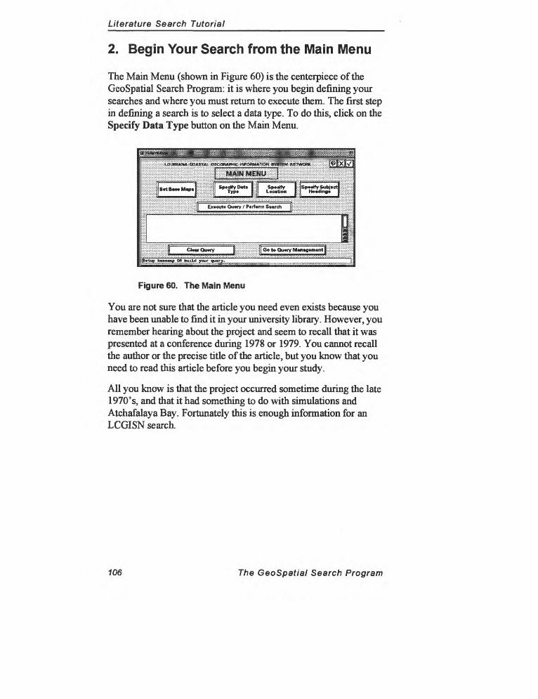
Literature Search Tutorial
2. Begin Your Search from the Main Menu
The Main Menu (shown in Figure 60) is the centerpiece of the GeoSpatial Search Program: it is where you begin defining your searches and where you must return to execute them. The first step in defining a search is to select a data type. To do this, click on the Specify Data Type button on the Main Menu.
Figure 60. The Main Menu
You are not sure that the article you need even exists because you have been unable to find it in your university library. However, you remember hearing about the project and seem to recall that it was presented at a conference during 1978 or 1979. You cannot recall the author or the precise title of the article, but you know that you need to read this article before you begin your study.
All you know is that the project occurred sometime during the late 1970's, and mat it had something to do with simulations and Atchafalaya Bay. Fortunately this is enough information for an LCGISN search.
106 The GeoSpatial Search Program
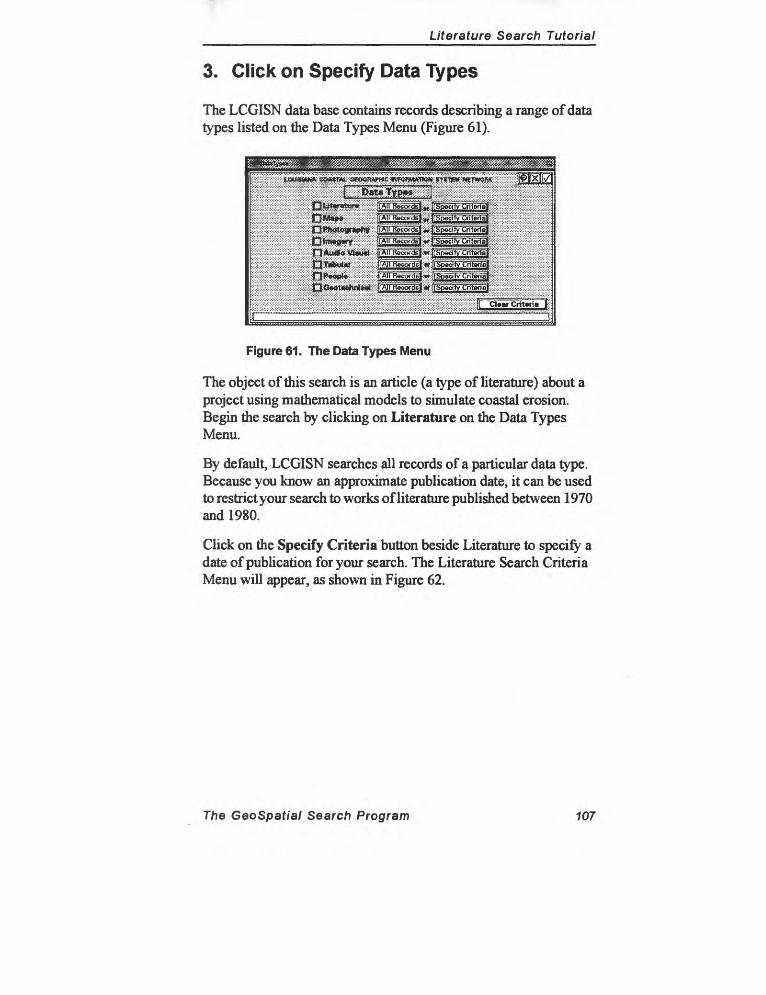
Literature Search Tutorial
3. Click on Specify Data Types
The LCGISN data base contains records describing a range of data types listed on the Data Types Menu (Figure 61).
Figure 61. The Data Types Menu
The object of this search is an article (a type of literature) about a project using mathematical models to simulate coastal erosion. Begin the search by clicking on Literature on the Data Types Menu.
By default, LCGISN searches all records of a particular data type. Because you know an approximate publication date, it can be used to restrict your search to works of literature published between 1970 and 1980.
Click on the Specify Criteria button beside Literature to specify a date of publication for your search. The Literature Search Criteria Menu will appear, as shown in Figure 62.
The GeoSpatial Search Program 107
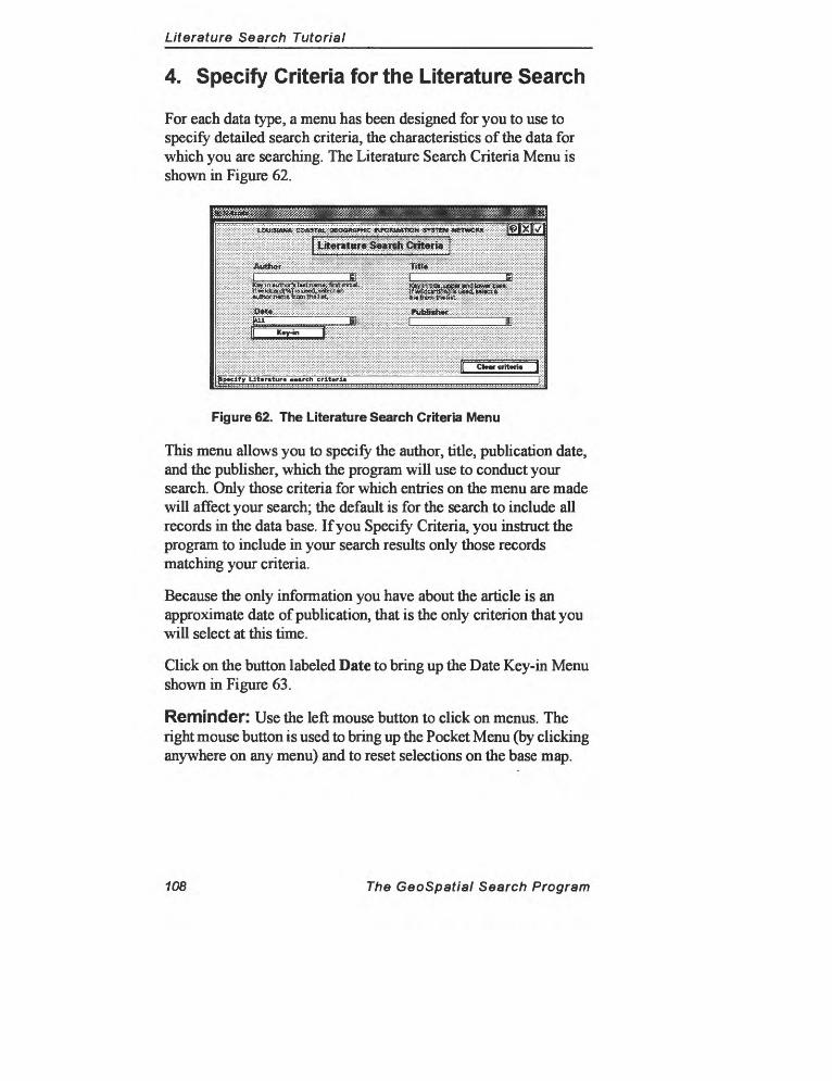
Literature Search Tutorial
4. Specify Criteria for the Literature Search
For each data type, a menu has been designed for you to use to specify detailed search criteria, the characteristics of the data for which you are searching. The Literature Search Criteria Menu is shown in Figure 62.
Figure 62. The Literature Search Criteria Menu
This menu allows you to specify the author, title, publication date, and the publisher, which the program will use to conduct your search. Only those criteria for which entries on the menu are made will affect your search; the default is for the search to include all records in the data base. If you Specify Criteria, you instruct the program to include in your search results only those records matching your criteria.
Because the only information you have about the article is an approximate date of publication, that is the only criterion that you will select at this time.
Click on the button labeled Date to bring up the Date Key-in Menu shown in Figure 63.
Reminder: Use the left mouse button to click on menus. The right mouse button is used to bring up the Pocket Menu (by clicking anywhere on any menu) and to reset selections on the base map.
108 The GeoSpatial Search Program
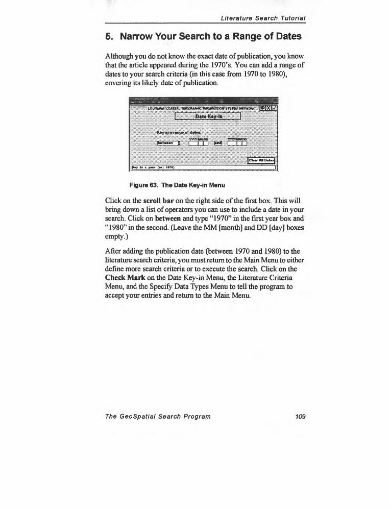
Literature Search Tutorial
5. Narrow Your Search to a Range of Dates
Although you do not know the exact date of publication, you know that the article appeared during the 1970's. You can add a range of dates to your search criteria (in this case from 1970 to 1980), covering its likely date of publication.
::;:;:£ :;;:;:£J!*^
Figure 63. The Date Key-in Menu
Click on the scroll bar on the right side of the first box. This will bring down a list of operators you can use to include a date in your search. Click on between and type "1970" in the first year box and "1980" in the second. (Leave the MM [month] and DD [day] boxes empty.)
After adding the publication date (between 1970 and 1980) to the literature search criteria, you must return to the Main Menu to either define more search criteria or to execute the search. Click on the Check Mark on the Date Key-in Menu, the Literature Criteria Menu, and the Specify Data Types Menu to tell the program to accept your entries and return to the Main Menu.
The GeoSpatial Search Program 109
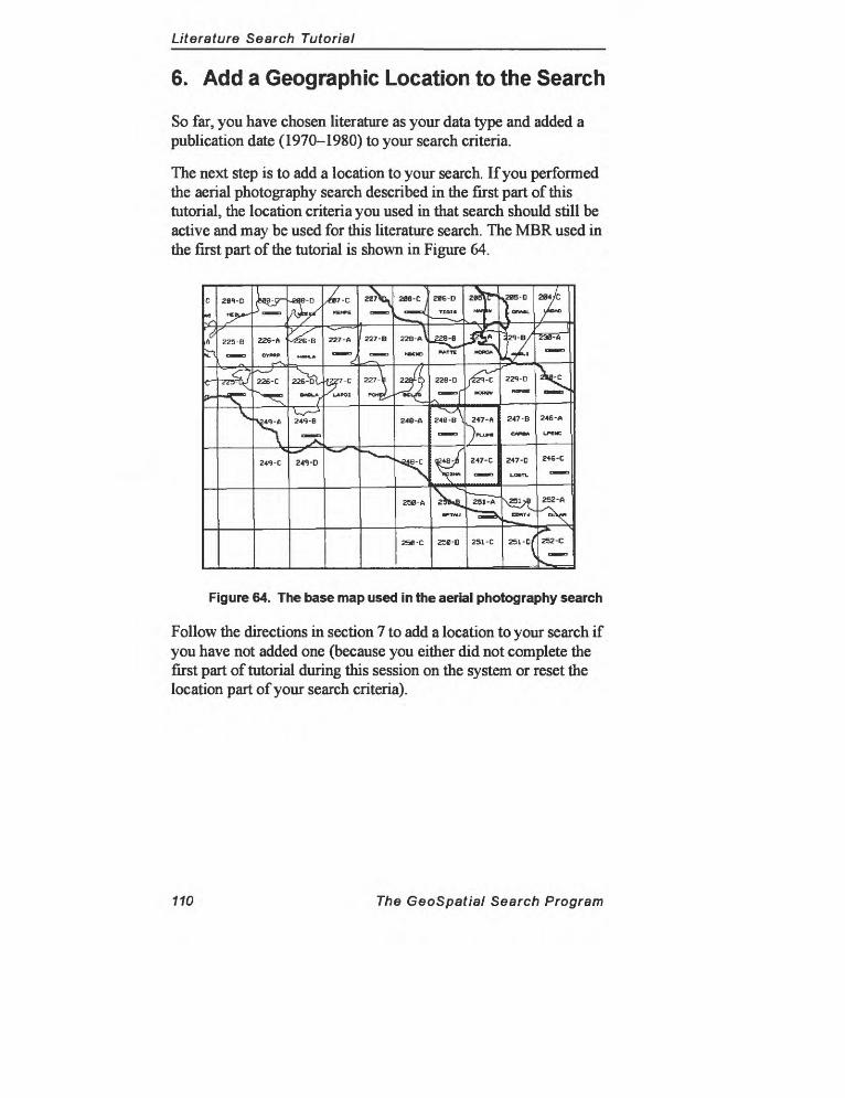
Literature Search Tutorial
6. Add a Geographic Location to the Search
So far, you have chosen literature as your data type and added a publication date (1970-1980) to your search criteria.
The next step is to add a location to your search. If you performed the aerial photography search described in the first part of this tutorial, the location criteria you used in that search should still be active and may be used for this literature search. The MBR used in the first part of the tutorial is shown in Figure 64.
Figure 64. The base map used in the aerial photography search
Follow the directions in section 7 to add a location to your search if you have not added one (because you either did not complete the first part of tutorial during this session on the system or reset the location part of your search criteria).
110 The GeoSpatial Search Program
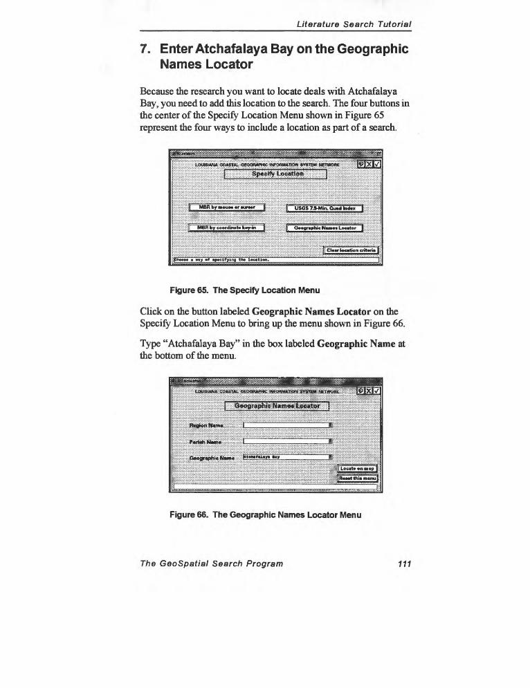
Literature Search Tutorial
7. Enter Atchafalaya Bay on the Geographic Names Locator
Because the research you want to locate deals with Atchafalaya Bay, you need to add this location to the search. The four buttons in the center of the Specify Location Menu shown in Figure 65 represent the four ways to include a location as part of a search.
^ ^
Ij MBRI>y»«u»«<»rcur»»r j; [[ USGS 7-S-Min. Gu«d hi<l«x \
[ MBR by coordinate fcoy-io j: [[ Oo^flraphic !<» » Locrtor | '?:
j|CU»r tocrticn criteria |
i IM> mf «p»cifying th> location._______________________________
Figure 65. The Specify Location Menu
Click on the button labeled Geographic Names Locator on the Specify Location Menu to bring up the menu shown in Figure 66.
Type "Atchafalaya Bay" in the box labeled Geographic Name at the bottom of the menu.
iSiiigw^S^-iijp^iS^^g
^:1ii«:SB*.*H*<JRic
1 , ^ J
|Loc«to»nBi»pJ;
|Ro»»tthi» m»nu|
"_______ ~i:;
Figure 66. The Geographic Names Locator Menu
The GeoSpatial Search Program 111
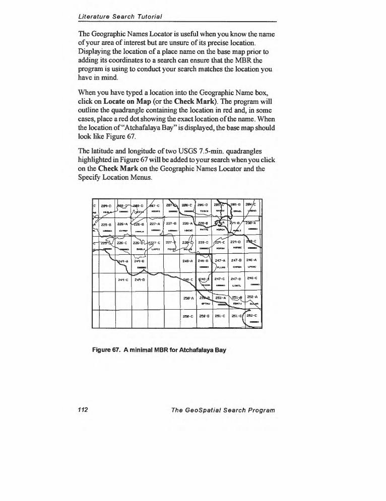
Literature Search Tutorial
The Geographic Names Locator is useful when you know the name of your area of interest but are unsure of its precise location. Displaying the location of a place name on the base map prior to adding its coordinates to a search can ensure that the MBR the program is using to conduct your search matches the location you have in mind.
When you have typed a location into the Geographic Name box, click on Locate on Map (or the Check Mark). The program will outline the quadrangle containing the location in red and, in some cases, place a red dot showing the exact location of the name. When the location of "Atchafalaya Bay" is displayed, the base map should look like Figure 67.
The latitude and longitude of two USGS 7.5-min. quadrangles highlighted in Figure 67 will be added to your search when you click on the Check Mark on the Geographic Names Locator and the Specify Location Menus.
2B6-D
Traic
228 -B
PAT1C
c~ "zzr&y fCT-C
24«i-B
"^
24VD
Figure 67. A minimal MBR for Atchafalaya Bay
112 The GeoSpatial Search Program
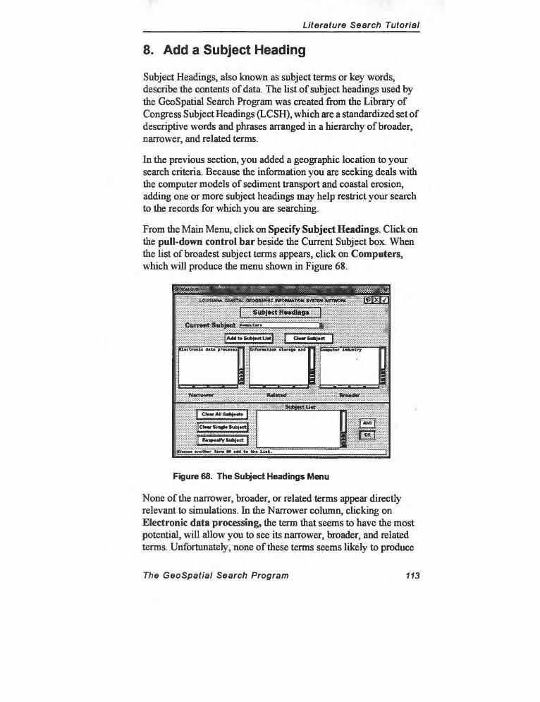
Literature Search Tutorial
8. Add a Subject Heading
Subject Headings, also known as subject terms or key words, describe the contents of data. The list of subject headings used by the GeoSpatial Search Program was created from the Library of Congress Subject Headings (LCSH), which are a standardized set of descriptive words and phrases arranged in a hierarchy of broader, narrower, and related terms.
In the previous section, you added a geographic location to your search criteria. Because the information you are seeking deals with the computer models of sediment transport and coastal erosion, adding one or more subject headings may help restrict your search to the records for which you are searching.
From the Main Menu, click on Specify Subject Headings. Click on the pull-down control bar beside the Current Subject box. When the list of broadest subject terms appears, click on Computers, which will produce the menu shown in Figure 68.
Figure 68. The Subject Headings Menu
None of the narrower, broader, or related terms appear directly relevant to simulations. In the Narrower column, clicking on Electronic data processing, the term mat seems to have the most potential, will allow you to see its narrower, broader, and related terms. Unfortunately, none of these terms seems likely to produce
The GeoSpatial Search Program 113
Literature Search Tutorial
the results you want either.
Click on Computers to make that term the Current Subject once again, and then click on the Add to Subject List to move the term "Computers" to the Subject List at the bottom of the screen. The menu should now look exactly like Figure 68. Click on the Check Mark to accept this selection as part of your search and return to the Main Menu.
114 The GeoSpatial Search Program
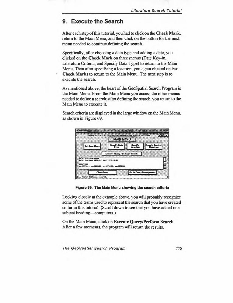
r'
______________________Literature Search Tutorial
9. Execute the Search
After each step of this tutorial, you had to click on the Check Mark, return to the Main Menu, and then click on the button for the next menu needed to continue defining the search.
Specifically, after choosing a data type and adding a date, you clicked on the Check Mark on three menus (Date Key-in, Literature Criteria, and Specify Data Type) to return to the Main Menu. Then after specifying a location, you again clicked on two Check Marks to return to the Main Menu. The next step is to execute the search.
As mentioned above, the heart of the GeoSpatial Search Program is the Main Menu. From the Main Menu you access the other menus needed to define a search; after defining the search, you return to the Main Menu to execute it.
Search criteria are displayed in the large window on the Main Menu, as shown in Figure 69.
^
f|S«tl
Eiocut* Ou«ry / P«rt«fm Sorch
, IQF-3M44M,
rdi Criteria cl«ar«d.
Figure 69. The Main Menu showing the search criteria
Looking closely at the example above, you will probably recognize some of the terms used to represent the search that you have created so far in this tutorial. (Scroll down to see that you have added one subject heading computers.)
On the Main Menu, click on Execute Query/Perform Search. After a few moments, the program will return the results.
The GeoSpatial Search Program 115
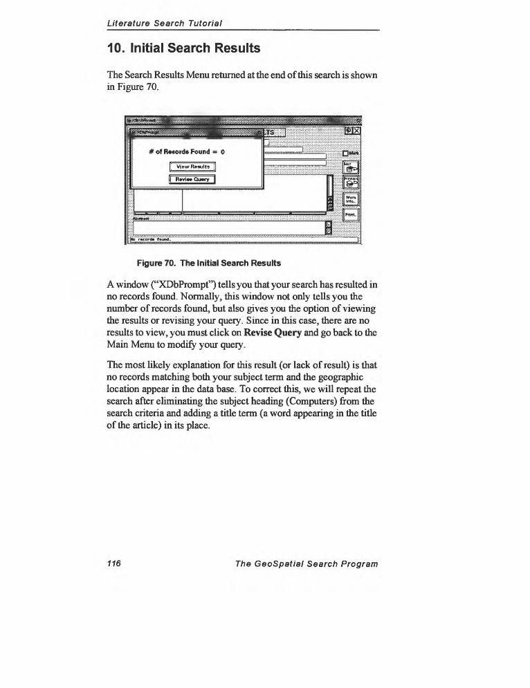
Literature Search Tutorial
10. Initial Search Results
The Search Results Menu returned at the end of this search is shown in Figure 70.
Figure 70. The Initial Search Results
A window ("XDbPrompt") tells you that your search has resulted in no records found. Normally, this window not only tells you the number of records found, but also gives you the option of viewing the results or revising your query. Since in this case, there are no results to view, you must click on Revise Query and go back to the Main Menu to modify your query.
The most likely explanation for this result (or lack of result) is that no records matching both your subject term and the geographic location appear in the data base. To correct this, we will repeat the search after eliminating the subject heading (Computers) from the search criteria and adding a title term (a word appearing in the title of the article) in its place.
116 The GeoSpatial Search Program
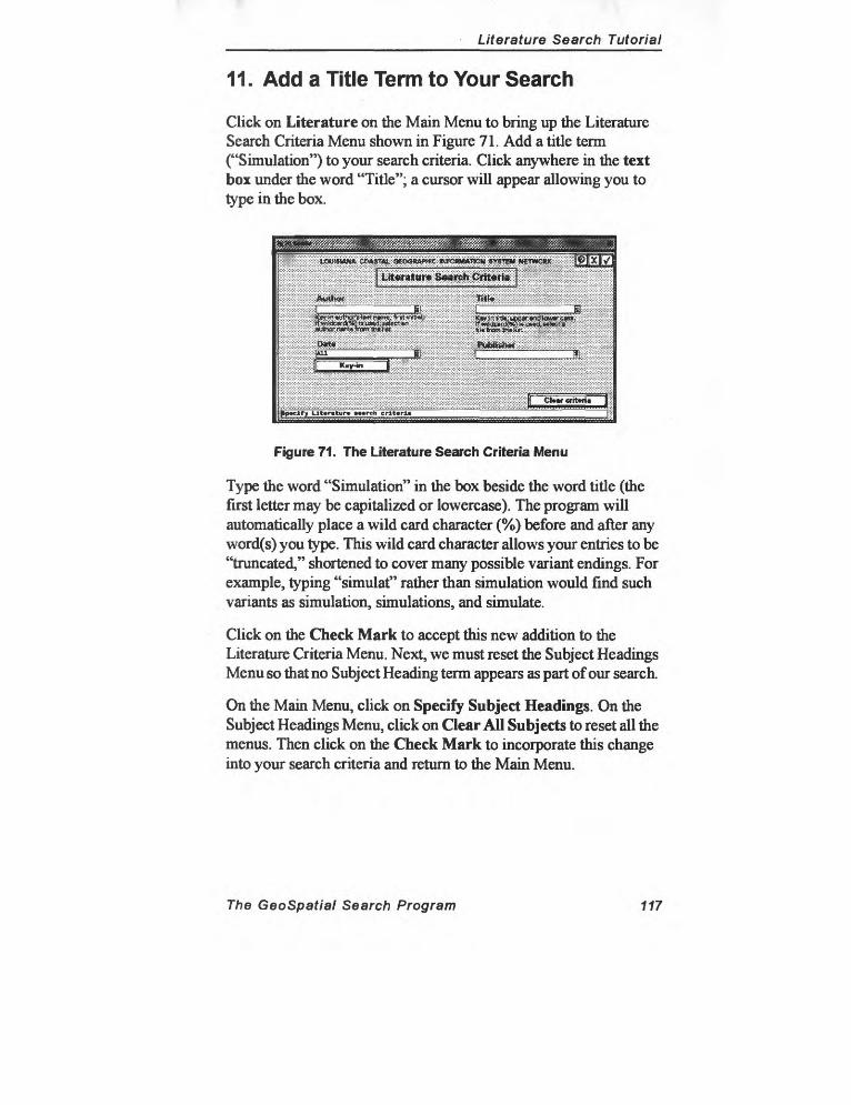
Literature Search Tutorial
11. Add a Title Term to Your Search
Click on Literature on the Main Menu to bring up the Literature Search Criteria Menu shown in Figure 71. Add a title term ("Simulation") to your search criteria. Click anywhere in the text box under the word "Title"; a cursor will appear allowing you to type in the box.
ij!jWj!igj^!^ ''"'''"'^'"'''
Figure 71. The Literature Search Criteria Menu
Type the word "Simulation" in the box beside the word title (the first letter may be capitalized or lowercase). The program will automatically place a wild card character (%) before and after any word(s) you type. This wild card character allows your entries to be "truncated," shortened to cover many possible variant endings. For example, typing "simulat" rather than simulation would find such variants as simulation, simulations, and simulate.
Click on the Check Mark to accept this new addition to the Literature Criteria Menu. Next, we must reset the Subject Headings Menu so that no Subject Heading term appears as part of our search.
On the Main Menu, click on Specify Subject Headings. On the Subject Headings Menu, click on Clear All Subjects to reset all the menus. Then click on the Check Mark to incorporate this change into your search criteria and return to the Main Menu.
The GeoSpatial Search Program 117
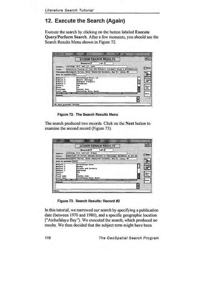
Literature Search Tutorial
12. Execute the Search (Again)
Execute the search by clicking on the button labeled Execute Query/Perform Search. After a few moments, you should see the Search Results Menu shown in Figure 72.
****?*; :M*nnl"B»i *-t «na L.F. Una
(ut>< «c T Itcntfiliyt KiwipTUT ln§ (0»l6jy)
transport ItrttBTlov
5ow.tr USA fcjm-xil MO,.
""r«t £um zoo, ! '^« ^ «tcli«f«lyi HJv«r iMii_____________________________
|Pnm :iv iMimri: ff^^ffffffff^f:
i BBra prwioo* r«c»rd>. [
Figure 72. The Search Results Menu
The search produced two records. Click on the Next button to examine the second record (Figure 73).
ggggftSj^^BI^^^^^^^^^^^^~~* if^'Mjia^SB^jij^p^' j"""" ---------pix-
-........-.-.--.Mi^^^TT"^^2.'.''."... k ... - ..:::p«r>nJJig»', « «"<! t.F. Q'H»JIL .......................
tltl«: x::jMi»a«tl»n of For*»t Chcngw Ml«t«3 to hydrol»g4o V»rl«BI»« Ui tT» At| _______Plvltlon,
~" ktclwfiitym ltl«*r " r;: tuKt»nt t Ulliwj: lub|*et 1 PorMt* «nd f orwitry L-:|Cuk|«et 4 Kytir«lagy;: C«untry USA (! LA B -.-;-.-.- ....!: Itc* MM CecttU. IOM | ::::?x:: -ec«l MM ktch«f«l«y»M»»rt«»lr^^^^^^^^^^^^^^^^^^^ | ...SSf:
'"" :::::"'J
Figure 73. Search Results: Record #2
In this tutorial, we narrowed our search by specifying a publication date (between 1970 and 1980), and a specific geographic location ("Atchafalaya Bay"). We executed the search, which produced no results. We then decided mat the subject term might have been
118 The GeoSpatial Search Program
Literature Search Tutorial
responsible for producing this undesirable output. We decided to add a title term ("Simulation") to the search.
After eliminating the Subject Heading term "Computers" on the Subject Heading, we returned to the Main Menu and executed the search. The new search criteria produced a very narrow range of search results (two records) that provided exactly the information we were seeking.
Narrowing searches for other data types would require different search strategies. For example, if the object of our search had been aerial photography, we would not have used author or title as search criteria because they are not associated with that data type. Instead, we would use criteria characteristic of aerial photography. For instance, we might have specified a scale, holding agency, or sensor class. Experimenting with the program will help you to develop search strategies that result in adequate numbers of returns.
Conclusion : This tutorial described two fairly typical geospatial searches. First, a search for aerial photography. The search criteria specified that air photos at scales of less than 1:63,000 and cloud cover of less than 10 percent would be acceptable. A geographic location was added to the search and defined as the area around Atchafalaya Bay. This search returned 154 records that were arranged in reverse chronological order (most recent first).
Next, a literature search was described. In this search, you sought an article published between 1970 and 1980, geographically referenced to the same location as the first search, containing "Simulation" as part of its title. This search located two records that met the criteria.
For details about the role of spatial references in GeoSpatial Program searches, see Section 5.1 (Spatial Search Methodology) and Section 15.0 (General Search Strategies). For more information about using Subject Headings, see Section 12.0 (Subject Headings Menu).
The GeoSpatial Search Program 119

Glossary
IntroductionDeveloping a comprehensive glossary for the GeoSpatial Search Program was challenging because of the inclusive, multi- disciplinary nature of the project and the diverse group of potential users. It would be very difficult to cover all possible terms and definitions in a way that satisfies professionals in the many fields this project encompasses. This glossary does not attempt this kind of comprehensive treatment.
What follows might be called a "functional glossary," a collection of definitions of terms and processes the user is likely to encounter when using the GeoSpatial Search Program.
Most of the relevant technical and special terms related to geographic information systems (GIS), remote sensing, cartography, library and information science, computer networking, and the Internet have been included. When possible, the definitions also clarify the difference between conventional meanings of a term and the use of the term in the GeoSpatial Search Program.
Rather than looking on this glossary as a finished product, it may be more useful to see it as the beginning of an ongoing effort to develop a standard terminology related to spatial indexing and geospatial metadata.
Please send any additional definitions or corrections to the LCGISN technical committee by e-mail or by using the Send to LCGISN utility in the GeoSpatial Search Program.
Glossary 121

Glossary
AbstractA brief narrative summary of the data set. The abstract should provide infor mation about the sources and process ing of the data set. The abstract, along with a statement of the purpose or intended use of the data, provides a complete overview of the data.
accessThe process of obtaining data from or placing data into storage in a com puter.
Access ConstraintsRestrictions and legal prerequisites for accessing the data set. These include any access constraints applied to assure the protection of privacy or intellectual property, and any special restrictions or limitations on obtaining the data set.
Access InstructionsInstructions on the steps required to access the data set.
access timeA measure of the time interval required for the data to be retrieved from storage and delivered to the user. Indicating the size of the file (in kilo bytes) provides the user with an idea of the relative access time.
accuracyThe closeness of the results of obser vations, computations, or estimates to true values or values accepted as being true. Accuracy relates to the quality of a result and is distinguished from precision, which relates to the quality of the operation used to obtain the result.
accuracy assessmentComparison of a classification to geo graphical data assumed to be true. Usually, the assumed-true data are derived from ground truthing.
accuracy reportA list of the percentages of accuracy computed from the error matrix in a classification accuracy assessment.
ACSMAmerican Congress on Surveying and Mapping.
addressSee Internet Protocol (IP) address and Universal Resource Locator (URL).
ADPAutomated data processing.
ADPEAutomated data processing equip ment.
AECArmy Environmental Center.
aerial photographGenerally, any photograph of the ter rain taken with a camera mounted in an aircraft. Aerial photography is called simply Photography in LCGISN's data base.
aerial photographs, compositeAerial photographs made with a cam era having one principal lens and two or more surrounding and oblique lenses symmetrically placed. The sev eral resulting photographs may be rectified in printing to permit assem bly as verticals with the same scale.
Glossary 123
aerial photographs, oblique
aerial photographs, obliqueA photograph taken with the camera axis directed between the horizontal and the vertical. (1) High oblique: an oblique photograph in which the apparent horizon is shown. (2) Low oblique: an oblique photograph in which the apparent horizon is not shown.
aerial photographs, verticalAn aerial photograph made with the optical axis of the camera approxi mately perpendicular to the earth's surface and with the film as nearly horizontal as is practicable.
Aerial Photography Summary Record System (APSRS)A computer-based information sys tem maintained by the National Car tographic Information Center (NCIC) for recording and retrieving details pertaining to aerial photography held by numerous federal, state, and pri vate organizations.
AISee Associate Investigator (AI).
American Standard Code for Infor mation Exchange (ASCII)A seven-bit code adopted as a stan dard to facilitate interchange of data between various machines and sys tems.
AM/FMAutomated Mapping/Facilities Man agement.
AMLARC Macro Language.
annotationThe writing of notes, sketching of geologic contacts, or any other
explanatory markings on an aerial photograph or map. Computer map ping and image processing software usually have this capability for digital products.
anonymous FTPA process for retrieving files using the File Transfer Protocol. Users log on as "anonymous," and use their e-mail address as a password.
ANSIAmerican National Standards Insti tute.
APAAmerican Planning Association.
APIApplication Programming Interface.
archieA software system on the Internet for locating files stored on FTP servers that matches keyword entries to file names. (Archie is to anonymous FTP servers as Veronica is to Gopher serv ers.)
areaLevel of spatial measurement refer ring to a two-dimensional defined space. A polygon on the earth as pro jected onto a horizontal plane is an example of an area.
area of interestThe geographic location for which the user is searching for information. After locating the area of interest on the GeoSpatial Search Program's base map, the location is added to the query statement using the Specify Locations Menu.
ARPAAdvanced Research Projects Agency.
124 Glossary
base map
array(1) A series of items arranged in a meaningful pattern. (2) A series of addressable data elements in the form of a grid or matrix.
ASCEAmerican Society of Civil Engineers.
ASCIISee American Standard Code for Information Exchange (ASCII).
aspect ratioThe ratio of the length of a feature in relation to its width.
Associate Investigator (AI)An associate or assistant to a PI on a research problem, task, or subtask.
attributeA set or collection of datum that describes the characteristics of real- world entities or conditions. Attribute data are usually alphanumeric. Attribute data are used to describe the graphic representation of an entity on a map such as a label, e.g., a polygon label. Large amounts of attribute data such as those associated with a GIS are usually maintained as separate attribute data sets and are related to a map by names or codes.
authorThe originator of a data set. May be an individual, agency, or institution.
AVHRRAdvanced Very High Resolution Radiometer. A sensor on NOAA sat ellites.
axis(1) A straight line around which a plane figure may rotate to produce a
solid; a line of symmetry. (2) One of a set of reference lines for a coordinate system.
azimuth(1) The direction of a line given as an angle measured clockwise from a ref erence direction, usually north. (2) In radar remote sensing, the direction at right angles to the antenna beam; in side-looking radar, the direction par allel to ground track.
azimuth lineA line on an aerial photograph repre senting a true direction between two points, generally from the photo graphic center point to some second point.
azimuthal projectionA map projection that is created from projecting the surface of the earth to the surface of a plane.
back-upMaking a copy of a file or a whole disk for safe keeping in case the origi nal is lost or damaged.
bandA defined range or interval of fre quencies or wavelengths of the elec tromagnetic spectrum that exhibits common characteristics.
base map(1) A map showing certain fundamen tal information, used as a base on which additional data of specialized nature are compared or compiled. (2) A map containing all the information from which maps showing specialized information can be prepared; a source map. TheLCGISNGeoSpatial Search Program uses a base map as a refer-
Glossary 125

baud rate
ence to enable users to specify loca tions to include in data base queries.
baud rateA measure of the speed of data trans mission between a computer and the other devices equivalent to bits per second.
bitAn abbreviation of binary digit. A single character of a language employing only two distinct kinds of characters or values, 0 or 1.
bit mapA pattern of bits (i.e., ON/OFF) on the grid stored in memory and used to generate an image on a raster scan display.
BLMBureau of Land Management (under the U.S. Department of Interior).
BLOBBinary large object.
BMPMicrosoft Windows bitmapped image format.
Boolean operatorsThe terms and, or, and not as used to relate several search results. LCGISN allows the boolean operators and and or to be associated with subject head ings (key words) as part of a search.
Bounding CoordinatesThe limits of coverage of a data set expressed by latitude and longitude values in the order westernmost, east ernmost, northernmost, and southern most. For data sets that include a complete band of latitude around the earth, the West Bounding Coordinate shall be assigned the value -180.0, and the East Bounding Coordinate shall be assigned the value 180.0.
BPIBits per inch. Measures the number of bits stored in a linear inch of a track on a recording surface, such as a disk or tape.
bpsBits per second.
browserAnother term for viewer. A browser is a software package that permits you to explore the World-Wide Web. NCSA Mosaic is a browser.
BTWBy the way.
bytesA unit of eight contiguous bits or binary digits within the internal mem ory of a computer. One byte contains a sufficient number of bits to repre sent any alphabetic or numeric char acter in binary form, so that it forms a basic unit for designating capacity of computer storage.
CADComputer-Assisted Design/Drafting/ Drawing.
cadastral mapA map showing the boundaries of subdivisions of land to describe and record ownership. A cadastral map also may show culture, drainage, and other features relating to the value and use of land.
CAD/CAMAcronym for Computer-Aided Design/Computer-Aided Mapping. Differs from a geographic informa tion system (GIS) in that the system can only create displays. It cannot analyze or process the base data.
126 Glossary
cell size
CADDComputer-Aided Design and Draft ing.
CADGISThe Computer-Aided Design Geo graphic Information System (CADGIS) Computing Lab located in the New Design Building at LSU. LCGISN resides on a server located in this lab.
CAEComputer-Assisted Engineering.
CAIComputer-Assisted Instruction (same as CAL).
CALComputer-Assisted Learning (same as CAI).
CAMComputer-Assisted Manufacturing.
CANCooperative Agreement Notice.
CASTCenter for Advanced Spatial Technol ogies.
catalog(1) A collection of information arranged in a systematic way that enables consistent searching and ref erencing. (2) The process of preparing materials to be placed into a system that enables them to be searched and referenced as consistently and as accurately as possible.
catalog recordsA restricted body of text containing standard and repeating elements or fields defining the features that char acterize a particular type of object or information. The LCGISN GeoSpatial
Search Program provides a means for searching and retrieving catalog records describing the contents, uses, and availability of eight types of data.
CBDCommerce Business Daily. Adver tises projects for bid.
CCCarrying Capacity.
CCEERSee Center for Coastal, Environmen tal, and Energy Resources (CCEER).
CDRCorel Draw format.
CD ROMCompact Disk Read-Only Memory.
CECorps of Engineers.
CECERU.S. Army Corps of Engineers Con struction Engineering Research Labo ratory.
CEDDCommittee for the Exchange for Digi tal Data.
ceUA defined geometric shape that stores data or defines an area that is labeled. The most common mapping cell is a square.
cell libraryA file in which cells are stored and later accessed during a design session and used to place cells or symbols within a design file.
cell sizeThe area that one pixel represents, measured in map units. For example, one cell in the image may represent an
Glossary 127
center
area 30 meters by 30 meters on the ground. Sometimes called "pixel size".
centerTo click on a point on the base map, making it become the new center of the display window. To "center" the base map, click on the Center button on the Pocket Menu.
Center for Coastal, Environmen tal, and Energy Resources (CCEER)A consortium of twelve research and teaching units at Louisiana State Uni versity in Baton Rouge, LA.
center pointThe point at the exact center of a pho tograph, corresponding in position to the optical axis of the camera.
central processing unit (CPU)The part of a computer that controls the interpretation and execution of instructions. A CPU does not include main memory, peripherals, or inter faces.
CERNThe European Laboratory for Particle Physics in Geneva, Switzerland where the World-Wide Web was originated by Tim Berners-Lee. The acronym CERN comes from the earlier French title Conseil Europeen pour la Recherche Nucleire.
CGMComputer Graphic Metafile format.
check markOne of the three menu control buttons in the top right-hand corner of most GeoSpatial Search menus that are used to control movement through the program. Clicking on the Check Mark
button accepts a command and returns the user to the previous menu.
CIRColor infrared.
CitationInformation used to reference the data set. The citation section of metadata includes such fundamental informa tion as the name of the author (origi nator), the title, publication date, and publisher (or issuing agency).
classA surface characteristic type or cate gory that is of interest to an investiga tor or user; for example, forest by type, vigor, or condition, or water by color or temperature.
classificationThe process of assigning individual pixels of a multispectral image to cat egories, generally on the basis of spectral reflectance characteristics.
clearinghouseA distributed network of geospatial data producers, managers, and users linked electronically. Establishing spatial data clearinghouses is a major goal of the National Spatial Data Infrastructure (NSDI). The plan encourages data providers to develop means to describe available data in an electronic form, and to provide these descriptions (or "metadata") using means that can be accessed over a communications network.
clientComputers running client software connect to server machines holding information. The client makes requests to a server for documents and is responsible for displaying the infor-
728 Glossary
controlling agency
mation. NCSA Mosaic is an example of client software. Currently, the LCGISN GeoSpatial Search Program is not client software because all of its code resides on the server at LSU.
Cloud CoverThe area of a data set obstructed by clouds, expressed as a percentage of the spatial extent.
CMYCyan, magenta, yellow.
CNRICorporation for National Research Initiatives.
color compositeColor image produced by assigning colors to three selected compounds of a multi-image.
color composite imageA color image prepared by projecting individual black-and-white multi- spectral images in color.
Color Infrared (CIR) filmPhotographic film sensitive to energy in the visible and near-infrared wave lengths. Color infrared film is espe cially useful for detecting changes in the condition of the vegetative can opy, often manifested in the near- infrared region of the spectrum. By convention blue color is assigned to the recorded green band; green color to the red band and red color to the near-infrared band. NOTE
Color-infrared film is not sensitive in the thermal infrared region and there fore cannot be used as a heat-sensitive detector.
composite mapA single map created by joining together several separately digitized maps.
composite photographA photograph made by assembling the separate photographs, made by the several lenses of a multiple-lens cam era in simultaneous exposure, into the equivalent of a photograph taken with a single, wide-angle lens.
concatenateTo connect in a series. To link or append.
conic projectionA map projection that is created from projecting the surface of the earth to the surface of a cone.
Contact InformationIdentity of, and means to communi cate with, person(s) and organiza tion^) associated with the data set.
contourLine joining points of equal vertical distance above or below a datum.
contour intervalThe vertical distance between two adjacent contours. Frequently known as the vertical interval (VI.).
contour mapA topographic map that portrays relief by means of contour lines.
control, ground(1) Control obtained by ground sur veys as distinguished from control obtained by photogrammetric meth ods; (2) Ground (in-situ) observations to aid in interpretation of remote sen sor data.
controlling agencyThe agency that is responsible for deciding the terms under which a par ticular type of data can be accessed. Sometimes the controlling agency is the same as the holding agency, the location where data physically reside.
Glossary 129
control point
control pointA point with a given horizontal posi tion and a known surface elevation to be used in estimating unknown eleva tions elsewhere in the area to be mapped.
coordinate pairA set of Cartesian coordinates describing the location of a point, line, or area (polygon) feature in rela tion to the common coordinate system of the data base.
covarianceThe measure of how two variables change in relation to each other. If larger values of X are associated with larger values of Y, the covariance is positive. The covariance is negative if larger values of X are associated with smaller values of Y. The covariance approaches zero if the variables have no association.
CPUSee Central Processing Unit (CPU).
CRDACooperative Research and Develop ment Agreement.
criteriaSee search criteria.
CSISee Coastal Studies Institute (CSI).
Currentness ReferenceThe basis on which the time period of content information is determined.
DARPADefense Advanced Research Projects Agency.
dataMeasurements or observations about real-world entities. A single datum has three potential components:
(1) attribute information that describe the substance, characteristics, vari ables, values, and similar qualities of the datum; (2) geographical informa tion that describes the position of the datum in space relative to other data; and (3) temporal information that describes the instant or period of time for which the datum is valid.
data classThose pixels in an overlay represent ing a specific ground condition and carrying the same data value.
data compressionAny technique that condenses the available data so as to make data stor age or transmission more efficient with minimal loss of information.
data definitionA specific statement of the particular features that differentiate one data set of a particular data type from another of the same data type. After selecting a data type, users of the GeoSpatial Search Program define the particular features of that data type for which they would like the program to search.
data dictionaryRepository of information about the definition, structure, and usage of data. It does not contain the actual data.
data layerData having similar characteristics being contained in the same plane or overlay (e.g., roads, rivers). Usually information contained in a data layer is related and is designed to be used with other layers for analysis in a GIS.
130 Glossary
Description
Data Quality InformationA general assessment of the quality of the data set. (Recommendations on information to be reported and tests to be performed are found in "Spatial Data Quality," which is chapter 3 of part 1 in the Spatial Data Transfer Standard (SDTS), Department of Commerce, 1992.
data recordsRepresentation and storage of data items, e.g., a single map, a single sheet of statistics, a fixed or variable length machine-readable record.
data reductionTransformation of observed values into useful, ordered, or simplified information.
data set(1) A file or files that contain related geometric and attribute information; a collection of related data. (2) A named collection of logically related data records arranged in a prescribed manner. The physical set of data of one data type being referred to or being used in the context of a data processing operation. (3) A specific collection of related data elements used for a particular task; may include data from many sources and in many formats.
data typeThe name of a data set based on the nature of the real-world entities or conditions described by the data. Examples include forest stand data, soil type data, campsite locations data, habitat type data, insect damage map, ownership boundaries. When the data are represented and stored on maps the term is synonymous with "map layer".
Data TypeThe term used to refer to the many kinds of data treated by the GeoSpa- tial Search Program. Data Types include literature, aerial photography, maps (hardcopy, raster, and vector), satellite imagery, audiovisual materi als, as well as tabular and geotechni- cal data. People also are treated as a data type because the system contains details about its users as well as data contacts and allows users to search for information (phone numbers, addresses, areas and topics of interest) about people.
Database Management System (DBMS)A specialized piece of computer soft ware used to process structured infor mation in various ways. The DBMS used by LCGISN include Oracle and Microsoft FoxPro.
DBMSSee Database Management System (DBMS).
DDLData Definition Language.
defaultA value automatically assigned, or an action automatically taken, unless otherwise specified.
DEMDigital Elevation Model (USGS brand of a DIM). Elevation data is produced by the USGS at scales of 1:24,000 and 1:250,000.
DescriptionA characterization of the data set summarizing the data sources and processing and a statement of purpose describing its intended use and limita tions. Also called an abstract. A
Glossary 131
Detailed Description
description of each data type record appears in the data base and can be accessed from the search results menu by selecting Additional Information.
Detailed DescriptionDescription of the entities, attributes, attribute values, and related character istics encoded in the data set.
DGNIntergraph MicroStation design file.
DIGESTDigital Geographic Exchange Stan dard.
digital dataData in the form of numbers. In geo graphic processing, both the X, Y, and Z coordinates of location and attribute characteristics are represented by numbers.
digital elevation model (DEM)A file with terrain elevations recorded for the intersection of a fine-grained grid and organized by quadrangle as the digital equivalent of the elevation data on a topographic base map.
digital imageA two-dimensional array of regularly spaced picture elements (pixels) con stituting a picture.
digital line graph (DLG)A digital computer file containing lists of point coordinates describing boundaries, drainage lines, transporta tion routes, and other linear features, organized by quadrangle as the digital equivalent of the linear hydrographic and cultural data on a topographic base map.
digital terrain model (DTM)A land surface represented in digital form by an elevation grid or lists of three-dimensional coordinates.
Digital Transfer OptionThe means and media by which a data set is obtained from the distributor.
digitizingThe process of converting an image recorded originally on photographic material into numerical format or dig ital numbers for computer processing.
display resolutionThe number of pixels that can be viewed on the display device monitor, horizontally and vertically.
display windowThe area of the base map that is cur rently visible on the screen to the user. To change the display window, acti vate the Pocket Menu by clicking the right mouse button while pointing to the body of any menu. The following commands are available for changing the display window: zoom in, zoom out, fit, center, and window area.
distortionAny shift in the position of an image on a photograph that alters the per spective characteristics of the photo graph. Causes of image distortion include lens aberration, differential shrinkage of film or paper, and motion of the film or camera.
distributed processingA method of organizing data process ing so that both processing and data can be distributed among different machines in one or more locations.
732 Glossary
EA
Distribution InformationInformation about the distributor of and options for obtaining the data set.
DLDigital library.
DLGDigital Line Graph.
DNSDomain Name System. A distributed database system for translating com puter names (like ruby.ora.com) into numeric Internet addresses (like 194.56.78.2) and vice versa.
DOCDepartment of Commerce.
documentationThe written specifications indicating a computer program's goals, memory requirements, data structures, and log arithms. The description and format for the data to be entered and the description and format of the results should be included in a program's documentation.
Document Type Definition (DTD)A specific markup language written using SGML. HTML is an example of a DTD.
DODDepartment of Defense.
DOEDepartment of Energy.
Domain Name System (DNS)A general purpose distributed, repli cated, data query service chiefly used on the Internet for translating host- names into Internet addresses. DNS can be configured to use a sequence of name servers, based on the domains in the name being looked for, until a match is found. DNS is usually
installed as a replacement for the hostname translation offered by Sun Microsystem's Network Information System (NIS). Whereas NIS relies on a single server, DNS is a distributed data base. It can be queried interac tively using the command "nslookup". The Domain Name Sys tem refers to both the way of naming hosts and the servers and clients that administer that information across the Internet.
DOSDisk operating system.
DOTDepartment of Transportation.
DOTDDepartment of Transportation and Development.
DPIDots per inch.
DSSDecision support system.
DTDSee Document Type Definition (DTD).
DTEDDigital Terrain Elevation Data (DMA brandofaDTM).
DTMDigital terrain model.
DXFAutoCAD Data Exchange Format (for CAD data).
e-mailElectronic mail.
EAEnvironmental Assessment.
Glossary 133
EDI
EDISee Electronic Document Interchange (EDI).
EDMElectronic distance measuring.
EEWSEnvironmental Early Warning Sys tem.
EISEnvironmental Impact Statement.
Electronic Document Interchange (EDI)A common means for intercompany transfer of information. Data such as purchase orders can be sent between companies, speeding the process of ordering materials and cutting admin istrative costs.
elementThe smallest item of interest in a sur vey. It is a single entity of vector data, such as a point, a line, or a polygon.
enhancementThe process of altering the appear ance of an image so that the inter preter can extract more information. Enhancement may be done by digital or photographic methods.
EOFEnd of File.
EOSEarth Observing System.
EOSATEarth Observation Satellite Company.
EPAEnvironmental Protection Agency.
EPSEncapsulated PostScript format.
EREntity-relation model.
ERDASEarth Resource Data Analysis Sys tem.
EROSEarth Resource Observation Sys tem a remote sensing agency administered by U.S. Geological Sur vey.
errorThe difference between an observed or computed value of a quantity and the ideal or true value of that quantity. Metadata should include statements about a data set's accuracy or error, including the results of error-checking tests.
ESRIEnvironmental Systems Research Institute, Inc.
ETISEnvironmental Technical Informa tion System.
FAQFrequently asked questions.
FCCFederal Communications Commis sion.
FDFunctional description.
FEFacilities Engineer or Engineering.
featheredgingThe thinning of overlapping edges of photographs before assembling into a mosaic in order to make match lines less noticeable. When overlapping
134 Glossary
geodesy
edges are feathered, shadows and sharp changes in contrast are reduced or eliminated. Also called feathering.
featureAn object or aspect of the earth's sur face, such as a road, vegetation, or townsite. On a map, a "map feature".
Federal Information Processing Standards (FIPS)Official source within the Federal Government of information process ing standards. Developed by the Insti tute for Computer Sciences and Technology at the National Institute of Standards and Technology (NIST), formerly the National Bureau of Stan dards.
FEMAFederal Emergency Management Agency.
FGDCFederal Geographic Data Committee.
FHAFederal Highway Administration.
fieldA group of characters or words that is treated as a unit of data.
File Decompression TechniqueRecommendations of algorithms or processes (including means of obtain ing these algorithms or processes) that can be applied to read or expand data sets to which data compression tech niques have been applied.
file serverA centralized information strorage device that can be accessed by the users of a network.
FIPSFederal Information Processing Stan dard.
fitTo return the LCGISN GeoSpatial Search Program display window to its original (default) appearance, causing the base map to show the entire state of Louisiana. Click on the Fit Button on the Pocket Menu to "fit" the base map to the display window.
flight line(1) A line drawn on a map or chart to represent the track over which an air craft has been flown or is to be flown.(2) The line connecting the principal points of vertical aerial photographs.
FOIAFreedom of Information Act.
Format NameThe name of the data transfer format.
Format Version DateDate of the version of the format.
FSTSFederal Secure Telephone Service.
FTPFile Transfer Protocol. Internet (TCP/ IP) software that allows files to be transferred between a host and a remote computer. Programs based on this protocol are also called FTP.
GEMDigital Research graphical environ ment manager format.
GEMSGlobal Environmental Monitoring System.
geodesyThe science that treats the determina tion of the size and figure of the earth (geoid) by such direct measurements as triangulation, precise traverse, tri- lateration, leveling, gravimetric observations, satellite triangulation,
Glossary 135
geographic coordinates
and Doppler methods. The applied science of geodesy takes account of the figure and size of the earth.
geographic coordinatesA coordinate system for explaining the surface of the earth. Geographical coordinates are defined by latitude and by longitude (Lat/Long), with respect to an origin located at the intersection of the equator and the Prime (Greenwich) Meridian.
geographic dataA collection of data that are individu ally or collectively attached to geo graphic location. See also geospatial data.
geographic information system (CIS)A unique system designed for a par ticular application that stores, enhances, combines and analyzes lay ers of geographic data to produce interpretable information. A GIS may include computer images, hardcopy maps, statistical data, or any other data included in a study, as well as computer software and human knowl edge. GISs are used for solving com plex geographic planning and management problems.
georeference systemAn X, Y, or X, Y, Z coordinate system that locates points on the surface of the earth as a reference to points on a map. Systems include latitude-longi tude, Universal Transverse Mercator, and State Plane Coordinate.
georeferencingThe process of assigning map coordi nates to image data and then resam pling the pixels of the image to conform to the map projection grid.
GeoSpatial Cataloging ProgramA distributed application that enables users to catalog data for inclusion in the Louisiana Coastal GIS Network data base. Developed using Microsoft FoxPro for Windows, the program guides users through the process of developing metadata in accordance with the FGDC's Content Standard for Digital Geospatial Metadata.
geospatial dataInformation that identifies the geo graphic location and characteristics of natural or constructed features and boundaries on the earth. This informa tion may be derived from, among other things, remote sensing, map ping, and surveying technologies.
GeoSpatial Search ProgramA program available on the Internet that enables users to search and retrieve metadata by interacting with a base map. Funded by USGS, the GeoSpatial Search Program was developed as part of the Louisiana Coastal GIS Network (LCGISN) at Coastal Studies Institute, Louisiana State University, Baton Rouge, LA.
GIFCompuServe Graphic Image Format.
GILSGovernment Information Listing Ser vice.
GISSee geographic information system (GIS).
GLISGlobal Land Information System. An interactive computer system devel oped by the U.S. Geological Survey (USGS) for scientists seeking sources of information about the earth's land
136 Glossary
hierarchical database structure
surfaces. GLIS contains metadata (descriptive information about data sets). Through GLIS, scientists can evaluate data sets, determine their availability, and place online requests for products. GLIS is more than a mere list of products. It offers online samples of earth science data that may be ordered through the system.
GopherMenu-driven system on a server machine that presents files available for retrieval in hierarchical fashion. Gopher is considered easy to use because of its menu system.
GopherspaceTerm for the interconnected Gopher servers.
GPOGovernment Printing Office.
GPSGlobal Positioning System.
GRASSGeographic Resources Analysis Sup port System.
gray literatureHard-to-find texts such as conference proceedings, reports, and technical papers. LCGISN contains references to gray literature, which is generally not found or hard to find in public and university libraries.
gray scaleA monochrome strip of shades rang ing from white to black with interme diate shades of gray; used in a setup for a color photograph and serves to balance the separation negatives and positive dye images.
gridA system of lines superimposed on aerial photographs, maps, or charts
that permit identification of ground locations with respect to the indicated reference system.
Grid Coordinate SystemA plane-rectangular coordinate sys tem usually based on, and mathemati cally adjusted to, a map projection so that geographic positions can be readily transformed to and from plane coordinates.
ground dataSupporting data collected on the ground, and information derived therefrom, as an aid to the interpreta tion of remotely recorded surveys, such as airborne imagery, etc. Gener ally, ground data should be collected concurrently with the airborne survey. Data concerning weather, soils, and vegetation types and conditions are typical.
ground truthInformation concerning the actual state of the environment at the time of a remote sensing overflight.
GSAGeneral Services Administration. An agency responsible for volume pur chases for government agencies.
GUIGraphical user interface.
hard copyAny map, chart, or graphic presenta tion recorded on a sheet in such a manner that it may be stored or trans ported.
HCIHuman-Computer Interaction.
hierarchical database structureA method of arranging computer files or other information so that the units of data storage are connected by a
Glossary 137
holding agency
hierarchically defined pathway. From above to below, relations are one-to- many.
holding agencyThe agency or institution where a par ticular data set resides and from which that data may be obtained. Sometimes but not always the same as the controlling agency, who decides the terms under which a particular type of data can be accessed.
Home PageStart-up document that serves as home base for Internet exploration.
hostA computer connected to a network. Also called a node.
host computerThe primary or controlling computer in a data network.
hostnameThe unique name that is used to iden tify a computer on a network, used to identify it for electronic mail, Usenet News, and other forms of electronic communication. The hostname is an ASCII text string that is translated into a numeric IP address by the "etc/ hosts" file, a domain name system (DNS), or resolver.
HPGLHewlett-Packard Graphics Language. A standard plotter format.
HTMLHypertext Markup Language. The collection of styles used to define the various components (e.g., bulleted list, link, citation, emphasis) of a hypertext document. HTML is an SGMLDTD.
hydrographic mapA map showing a portion of the waters of the earth, including shore lines, the topography along the shores and of the submerged portions, and as much of the topography of the sur rounding country as is necessary for the purpose intended.
hyperlinkWord or graphic in a file displayed on screen with some form of highlighting (color or underlining or both). The word or graphic represents hidden text containing the URL information of another document, which is dis played when you click on the high lighted word or graphic.
ICAInternational Cartographic Associa tion.
Identification InformationBasic information about the data set.
IEOSInternational Earth Observing Sys tem.
IFBInvitation for Bid.
IFFCommodore Amiga interchange for mat file.
IGESInitial graphics exchange specifica tion.
image(1) The likeness of any natural or manmade features, objects, and activ ities. Images can be acquired directly on photographic materials using cam eras, or indirectly if non-imaging types of sensors have been used in
138 Glossary
IRC
data collection. (2) The physical rep resentation of a scene as recorded by a remote-sensing system. Although image is a general term, it is com monly restricted to representations acquired by nonphotographic meth ods.
image classificationQuantitative decision rules that clas sify or identify objects or patterns on the basis of their multispectral radi ance values; as such the normal out put is analogous to an image map requiring no visual interpretation.
image processingEncompasses all the various opera tions that can be applied to photo graphic or image data. These include, but are not limited to, image compres sion, image restoration, image rectifi cation, image enhancement, preprocessing, quantization, spatial filtering, and other image pattern rec ognition techniques.
imageryThe visual representation of energy recorded by remote sensing instru ments. In the LCGISN data base, imagery does not include aerial pho tography (which is treated as the data type Photography) or a digital map (which could be constructed using one or more images, to which line work, classification information, and possibly labels have been added).
IMGDigital Research GEM image format.
Information Services Division (ISD)The unit in CCEER that handles the development, production, and dissem ination of information. ISD is a point of contact for information about
LCGISN and the GeoSpatial Search Program.
infrared (IR)Name assigned to an extensive band of invisible, long wavelength electro magnetic radiations that continue the spectrum beyond visible red light. We can perceive a portion of the infrared spectrum as heat, and some special films are capable of recording energy in the near infrared.
INGRESInteractive Graphics and Retrieval System. A relational data base man agement system.
interpretationThe act of analyzing imagery to pro duce significant, reliable and detailed information concerning the environ mental features of an area and deter mining the significance of the presence, conditions, or use of these features.
IP addressInternet Protocol address. A unique computer address consisting of a series of numbers separated by peri ods in a form such as 128.39.28.139. To make IP addresses easier to remember, short words or abbrevia tions are usually used in place of numbers in IP addresses. Domain Name Systems translate the name back to its numeric equivalent.
IRSee infrared.
IRCInternet Relay Chat. IRC is a software tool that makes it possible to hold real-time keyboard conversations online.
Glossary 139
IR color film
IR color filmInfrared color film. Film consisting of three layers in which the red-imaging responds to photographic IR radiation ranging in wavelength from 0.7 to 0.9 urn. The green-imaging layer responds to red light, and the blue- imaging layer responds to green light.
IRMInformation Resources Management.
ISDSee Information Services Division (ISD).
ISOInternational Standards Organization.
ISOCInternet Society.
ISPRSInternational Society of Photogram- metry and Remote Sensing.
ITCInternational Training Centre for Aerospace Survey and Earth Sciences (The Netherlands).
ITDInstitute for Technology Development (under NSTL).
iterativeA process in which some operation is performed repeatedly.
JPLJet Propulsion Laboratory.
JSCJohnson Space Center (NASA).
key-in boxesBoxes on many of the GeoSpatial Search Program's menus that allow the user to type entries directly into the program. Many key-in boxes also
contain pull-down lists, providing the most common entries for a particular entry.
kilobyteA unit of memory representing 1,024 bytes and often designated with the symbol K, as in 4K for 4 kilobytes. The symbol K is also used to refer to 1,024 words of any specified size.
Lambert conic conformal projec tionA map projection on which all geo graphic meridians are represented by straight lines that meet at a common point outside the limits of the map, and the geographic parallels are repre sented by a series of arcs having this common point as a center.
LANSee Local area network (LAN).
LandsatA series of earth-orbiting satellites that gather Multispectral (MSS) and Thematic Mapper (TM) imagery. Designed primarily for the collection of earth resources data. Operated by EOSAT, a commercial company.
Larger Work CitationThe information identifying a larger work in which the data set is included.
lateral-oblique photographAn oblique aerial photograph taken with the camera axis as nearly as pos sible normal to the flight line. Also called lateral oblique.
latitudeA system of dividing the earth's sur face into equal bands that run east- west. Latitude is measured in degrees, minutes, and seconds from the equa tor.
140 Glossary
map
layer(1) An integrated, areally distributed, set of spatial data usually representing entity instances within one theme, or having one common attribute or attribute value in an association of spatial objects. In the context of raster data, a layer is specifically a two- dimensional array of sealer values associated with all or part of a grid or image. (2) A component of a GIS data base that contains all of the data for one theme. A layer consists of a GIS file and also may include descriptors, a trailer, and other data. See also data layer.
LCDLiquid Crystal Display. A display technology.
LEDLight Emitting Diode. A display tech nology.
legendThe reference that lists the colors, symbols, line patterns, shadings, and other annotation used on a map, and their meanings. The legend often includes the map's title, scale, origin, and other information.
libraryA collection of standard, often used data, computer subroutines, or sym bols in digital form.
line(1) A level of spatial measurement referring to a one-dimensional defined object having a length, direc tion, and connecting at least two points. Examples are roads, railroads, telecommunication lines, streams. (2) A vector data element consisting of a line (the set of pixels directly between
two points), or an unclosed set of lines. (3) A row of pixels in a data file.
LineageInformation about the events, parame ters, and source data that constructed the data set, and information about the responsible parties.
LISLand Information System.
local area network (LAN)A computer network spanning a small geographic area (e.g., an office or building) that allows information and device sharing.
longitudeA system of dividing the earth into bands that run north-south and meet at the poles. Longitude is measured in degrees, minutes, and seconds starting from the "prime meridian," which runs through Greenwich, England.
MacPaintApple Macintosh MacPaint format.
macroA text file containing a series of fre quently used operations that can be executed by a single command. Can also refer to a simple high-level pro gramming language with which the user can manipulate the commands in a GIS.
MADTRANDMA's Mapping Datum Transforma tion software.
mapA representation in a plane surface, at an established scale, of the physical features (natural, artificial, or both) of a part of the earth's surface, with the means of orientation indicated. The
Glossary 141
map coordinate system
LCGISN data base includes records for hard copy, raster, and vector maps.
map coordinate systemA system of expressing locations on the earth's surface.
map gridTwo sets of parallel lines at right angles drawn on a plane surface and used as a rectangular coordinate sys tem for plotting position and scaling distances and directions in surveying and mapping.
map projection(1) A method of representing the three-dimensional spherical surface of a planet on a two-dimensional map surface by systematically drawing lines on a plane surface to represent the parallels of latitude and the merid ians of longitude of the earth. All map projections involve the transfer of lat itude and longitude onto an easily flattened surface. Map projections are concerned primarily with minimizing distortion in area, shape, distance, and direction. (2) The basic system of coordinates used to describe the spa tial distribution of elements in a GIS.
map, thematicA map designed to demonstrate par ticular features or concepts. In con ventional use this term excludes topographical maps.
map, topographicA map showing correct horizontal and vertical positions of features repre sented.
MARCSee USMARC.
MC&GMapping, Charting & Geodesy.
MC&GFDESMapping, Charting & Geodesy Fea ture Data Exchange Standard.
mediaThe physical devices used to record, store, and (or) transmit data.
menu(1) A list of options on a display allowing an operator to select the next operations by indicating one or more choices with a pointing device, such as the stylus of a digital tablet. (2) In the LCGISN GeoSpatial Search Pro gram, the user moves through a series of menus to select a data type, specify search criteria, specify a location, and add subject headings (key words) to the search. Each of the customized forms used in this process is called a menu.
menu control buttonsThe three buttons in the top right- hand corner of most GeoSpatial Search menus that are used to control movement through the program. Clicking on the Check Mark accepts a command and returns the user to the previous menu; clicking on the X But ton cancels a selection and returns the user to the previous menu; clicking on the Question Mark initiates the sys tem's online help utility.
Mercator ProjectionA map projection centered along the Equator with evenly spaced meridians perpendicular to parallels spaced pro gressively farther apart poleward so that compass bearings are not dis torted. A transverse Mercator projec tion uses the same system of projection, but with the projection centered along a meridian to provide low distortion with a zone around the central meridian.
142 Glossary
multispectral image
meridianA great circle on the earth that passes through the geographic poles.
message barA text box along the bottom of all of the GeoSpatial Search Program's menus on which are displayed instructions and feedback as you use the program.
metadataData about the content, quality, condi tion, and other characteristics of data. Metadata are the standardized descriptions of data that appear in the LCGISN data base and enable users of the GeoSpatial Search Program to conduct searches. At the end of a search, the user can view, print, or save to a file the metadata record(s) that have been retrieved.
MGEModular GIS Environment. Inter- graph's GIS packages.
minimum bounding rectangle (MBR)A rectangle drawn as small as possi ble while still enclosing a geographic area of interest. One of the ways to specify a location using the GeoSpa tial Search Program is to draw an MBR on the base map using the mouse.
modelA set of mathematical, verbal expres sions, or steps, that define a set of cri teria and create an output.
modemA device for the conversion of digital and analog signals to allow data trans mission over telephone lines. Modem is an acronym for Modulator-Demod ulator.
mosaicAn assemblage of overlapping aerial or space photographs or images whose edges have been matched to form a continuous pictorial represen tation of a portion of the earth's sur face.
MosaicA distributed hypermedia system developed by NCSA Software Devel opment Group which uses hypertext to navigate remote collections of information. Mosaic allows informa tion discovery and retrieval using the global Internet.
mouseA computer input device that is gener ally used in conjunction with but doesn't replace a keyboard.
mouse buttonsThe LCGISN GeoSpatial Search Pro gram uses a two-button mouse. The left button is used for making selec tions on menus, clicking on control buttons, and drawing on the base map. Use the right button to reject a selec tion on the base map and to activate the Pocket Menu (by clicking on the body of any menu). If your mouse has three buttons, ignore the middle but ton and use the left and right buttons only.
MSAGMaster Street Address Guide.
MSPMicrosoft Paint format.
multispectral imageMulti-image whose components are taken at the same time in different spectral wavelengths.
Glossary 143
mylar
mylarA stable base material used for map work that will maintain close toler ance dimensions if temperature and humidity are retained within close limits.
NASANational Aeronautic and Space Administration.
Native Data Set EnvironmentA description of the processing envi ronment in which the data was pro duced, including items such as the name of the software (including ver sion), the computer operating system, the file name (including the host-, path-, and filenames), and the data set size.
NCDCDSNational Committee for Digital Car tographic Data Standards.
NCGANational Computer Graphics Associa tion.
NCGIANational Center for Geographic Infor mation and Analysis.
NCICNational Cartographic Information Center.
NCSANational Center for Supercomputing Applications at the University of Illi nois, Urbana-Champaign.
near-infrared, photographicThat portion of the electromagnetic spectrum between visible light and thermal infrared with wavelengths from 0.7 to 1 microns. Black-and- white infrared refers to the film type used to image in the portion of the spectrum from 0.7 to 0.9 microns.
networkTwo or more computers connected to each other for the purpose of exchanging information or sharing computer equipment such as devices and peripherals.
Network AddressThe electronic address from which the data set can be obtained from the dis tribution computer. See also IP address and URL.
Network File System (NFS).Sun Microsystems' file system that allows data to be shared with many users.
NFSSee Network File System (NFS).
NGDCNational Geophysical Data Center (under NOAA).
NICNetwork Information Center.
NilNational Information Infrastructure.
NISCNetwork Information Systems Center.
NISTNational Institute of Standards and Technology.
NMASNational Map Accuracy Standards.
NOAA(1) National Oceanic and Atmo spheric Administration. (2) An acro nym for a satellite that, when followed by a number, is used to des ignate a particular satellite in the fam ily of weather satellites launched by NOAA.
144 Glossary
Ordering Instructions
node(1) A station, terminal, computer, or other device in a computer network.(2) A zero-dimensional object that is either a topological junction of two or more links or chains, or an endpoint of a link or chain.
NOSTThe NASA/OSSA Office of Stan dards and Technology.
notepadOne of the utilities available to users of the LCGISN GeoSpatial Search Program that provides an electronic note tablet for recording information that can be saved to a file when the user logs off the system. The notepad is activated by clicking on the Note pad button on the Pocket Menu.
NOVNotice of Violation.
NFSNational Park Service (under USDI).
NRENNational Research and EducationNetwork.
NSDINational Spatial Data Infrastructure.
NSDICCAPNSDI Competitive Cooperative Agreements Program.
NSFNational Science Foundation.
NWINational Wetlands Inventory.
oblique photographA photograph taken with the camera axis intentionally directed between the horizontal and the vertical.
Offline MediaName of the media on which the data set can be received.
Offline OptionInformation about media-specific options for receiving the data set offline (by mail).
OGFOpen GIS Foundation (used to be Open GRASS Foundation).
OGFOpen GRASS Foundation (later became Open GIS Foundation).
OGIOffice of GRASS Integration.
OGISOpen Geodata Interoperability Speci fication.
OGISOpen Geographic Information Sys tems.
on-line documentationHelp files that can be read on the sys tem and that provide command descriptions, sequences, and other information to help you use the soft ware. In LCGISN, clicking on the Question Mark button accesses online documentation.
OPACOnline public access catalog.
open systemsThe concept of multiple vendors' hardware and software working together without proprietary bound aries.
Ordering InstructionsGeneral instructions and advice about, and special terms and services pro-
Glossary 145

ORNL
vided for, the data set by the distribu tor.
ORNLOak Ridge National Laboratory.
orthophotographA copy of a perspective photograph or aerial photograph from which distor tion due to tilt and relief has been removed.
orthophotomapAn orthophotographic map with con tours and color-enhanced carto graphic treatment, presented in a standard quadrangle format and related to standard reference systems.
orthophoto quadA photomap made from an assembly of orthophotographs.
OSOperating system.
OSIOpen System Interconnection. Defined by ISO, OSI is a communica tions protocol intended to become a standard.
overlapThe area common to two successive photos along the same flight strip. The amount of overlap is expressed as a percentage of photo area. Also called endlap.
overlay(1) A transparent sheet giving infor mation to supplement that shown on maps; when the overlay is laid over the map on which it is based, its details will supplement the map. (2) A tracing of selected details on a photo graph, mosaic, or map to present the interpreted features and the pertinent detail, or to facilitate plotting.
parameterA property whose value determines the characteristics or behavior of a thing or process.
PCXPC Paintbrush export format.
PeopleOne of the eight data types included in the LCGISN data base. The GeoSpatial Search Program enables users to search for people (contacts) by organization or organization type, keywords (Subject Headings), and geographic location of research inter est.
photogrammetryThe art, science, and technology of obtaining reliable information about physical objects and the environ ment, through processes of recording, measuring, and interpreting images and patterns of electromagnetic radi ant energy and other phenomena.
photographA picture formed by the action of light on a base material coated with a sensitized solution that is chemically treated to fix the image points at the desired density. Usually now taken to mean the direct action of electromag netic radiation on the sensitized mate rial.
photographic interpretationThe act of examining photographic images for the purpose of identifying objects and judging their significance. Also called photointerpretation or image interpretation.
PhotographyOne of the Data Types searchable using the GeoSpatial Search Program. Photography implies aerial photogra-
146 Glossary
point
phy, and it should not be confused with photos, which are treated by LCGISN as an Audiovisual data type.
photomapA single photo, composite, or mosaic showing coordinates and marginal information.
PIPrincipal Investigator.
PICLotus 1-2-3 picture format.
PICTApple Macintosh picture format.
PINGPacket Internet Groper a TCP/IP utility that sends packets of informa tion to a computer on a network, PING can be used to determine whether a computer is connected to the Internet.
pixel(1) Literally, "picture element". The two-dimensional picture element that is the smallest non-divisible element of a digital image. (2) An individual phosphor element on a display screen. (3) A data element (picture element) having spatial and spectral aspects. The spatial variable defines the appar ent size of the resolution cell (in other words, the area on the scanned surface represented by the data values), and the spectral variable defines the inten sity of the spectral response for that cell in a particular channel.
pixel depthThe number of bits required to store all of the data file values in a file. For example, data with a pixel depth of 8, or 8-bit data, have 256 values (2e8 = 256), ranging from 0 to 255.
Place KeywordThe geographic name of a location covered by a data set. LCGISN han dles place keywords under the Spec ify Locations by Geographical Name.
plane coordinatesCoordinates that are defined by a col umn and row position on a grid (x,y) specifying the locations of points in a plane. In cartography the plane usu ally is a projection of the earth's sur face onto a flattenable cone or cylinder, and the x and y values scaled along the rectangular axes are called "eastings" and "northings".
planimetric mapA map that represents only the hori zontal positions of features. A plani- metrically accurate map shows accurate horizontal distances between features.
plateSee cadastral map.
platformA vehicle or object used to take remote sensing measurements, such as satellites, airplanes, balloons, kites, or rockets.
plotterA computer hardware device that pro duces single or multi-colored pen plots of maps, charts, or figures that are stored in the computer.
PLSSPublic land survey system.
POCPoint of Contact.
point(1) A graphical element representing a position in space. (2) A zero-dimen sional object that specifies geometric
Glossary 147
Point of Contact
location. One coordinate pair or triplet specifies the location. Area point, entity point, and label point are spe cial implementations of the general case.
Point of ContactContact information for an individual or organization that is knowledgeable about the data set.
polarizationThe act or process of filtering energy in such a way that the vibrations are restricted to a single plane. Unpolar- ized energy vibrates in all directions perpendicular to the propagating source.
polygonA set of closed line segments defining an area.
POTSPurchase of Telephones and Services.
PPPPoint-to-Point Protocol.
precisionA quality associated with the refine ment of instruments and measure ments, indicated by the degree of uniformity or identity of repeated measurements. In a somewhat nar rower sense, the term refers to the spread of the observations, or some measure of it, whether or not the mean value around which the spread is measured approximates the true value. Contrast with accuracy.
Process StepA discrete unit of processing that affects either the data or metadata in a data set.
projectTo reproduce as a point, line, or area on a surface by motion in a prescribed direction.
projectionA systematic drawing of lines on a plane surface to represent the parallels of latitude and the meridians of longi tude of the earth or a section of the earth. See also map projection.
protocolSets of rules or standards that describe ways for computer systems to interact with one another to achieve compati bility. These conventions apply to data format, transmission timing and sequencing, and error handling.
PSPostScript format.
Publication DateThe date when the data set is pub lished or otherwise made available for release.
PublisherThe name of the individual or organi zation that published the data set. May be an individual, agency, or institution.
pull-down listsA prepared list of typical entries for a particular text key-in box. On the LCGISNGeoSpatial Search Program, pull-down lists can be accessed by clicking on the pull-down list control bar on the right side of key-in box.
PurposeA summary of the intentions with which the data set was developed. A statement of Intended Purpose should
148 Glossary
rectification
accompany each data set, and along with the abstract or description, it pro vides a complete summary of the data.
quadrangleA rectangular, or nearly rectangular, area covered by a map or plate. The outline is generally defined by paral lels of latitude and meridians of longi tude. Usually associated with USGS topographic maps, called quad maps. Often shortened to quad.
qualityAn essential or distinguishing charac teristic necessary for cartographic data to be fit for use.
Query ManagementThe part of the LCGISN GeoSpatial Search Program that allows you to save, retrieve, and manually edit SQL statements that the program uses to conduct searches.
Question MarkOne of the three buttons in the upper right hand corner of most GeoSpatial Search menus that are used to control movement through the program. Clicking on the Question Mark button initiates the sytem's online help util ity.
R&DResearch and Development.
radar, imagingAn active remote-sensing device that transmits pulses of microwave energy and then receives reflections of the signal from a target. The reflected component is called the echo or backscatter.
RAMRandom Access Memory. Computer memory for the temporary storage of information, instructions, or data.
raster(1) One or more overlapping layers for the same grid or digital image. (2) The pattern of horizontal, parallel scan lines that make up the image on a CRT screen. Each scan line consists of segments varying in intensity.
raster dataCell data arranged in a regular grid pattern in which each unit (or cell) in the grid is assigned an identifying value based on its characteristics. Raster data are organized in a grid of columns and rows. Raster data usu ally represent a planar graph or geo graphical data.
raster objectOne or more images and/or grids, each grid or image representing a layer, such that corresponding grid cells and/or pixels between layers are congruent and registered.
RDBIRelational Database Interface.
RDBMSRelational Data Base Management System.
RDMISResearch & Development Manage ment Information System.
recordA group of items in a file treated as a unit. For example, all data items for a census tract can be grouped as a record and assigned to a single seg ment of a magnetic tape file for con venient storage and retrieval. See also catalog records.
rectificationThe process of making image data conform to a map projection system. In many cases, the image must also be
Glossary 149
rectified print
oriented so that the north direction corresponds to the top of the image.
rectified printA photograph in which tilt displace ment has been minimized from the original negative, and which has been brought to a desired scale.
reference dataData about the physical state of the earth obtained from sources other than the primary remote sensing data source and used in support of the remote sensing data analysis. May typically include maps and aerial pho tographs, topographic information, temperature measurements, and other types of ancillary and ephemeral data. In most cases, more useful if collected concurrently with the primary data- collection mission. Also called ground truth, ground data, ground- based measurements.
reference systemThe map coordinate system to which an image is registered.
regionAn identified subset of the geographi cal data base. Regions may be perma nently defined and named as subsets, such as a watershed, or interactively defined by the user through such methods as outlining an area on the display screen or searching for an area of the database with common attribute values.
reliefThe vertical irregularities of a surface. The elevations or inequalities, collec tively, of a land surface. Relief is usu ally represented graphically by contours, shading, or spot elevations.
remote sensingThe measurement or acquisition of data about an object or scene by a sat ellite or other instrument above or far from the object. Aerial photography, satellite imagery, and radar are all forms of remote sensing.
resamplingTechnique for transforming a raster image to a particular scale and projec tion. During the process data file val ues may be extrapolated for the pixels in a new grid, after the data have been rectified or registered to the other image.
resolution(1) A level of precision in data. Spa tial resolution is a measure of the smallest angular or linear separation between two objects, usually expressed in radians or meters, with a smaller resolution parameter denoting greater resolving power. (2) The mini mum difference between two inde pendently measured or computed values that can be distinguished by the measurement or analytical method being considered or used.
RFBRequest for bid.
RFIRequest for information.
RFPRequest for proposal.
RFQRequest for quotation.
RGBRed, Green, Blue. A method of gener ating colors in a video system.
ROMRead-Only Memory.
150 Glossary

sensor
RSRemote Sensing.
RSDBRemote Sensing DataBase.
S&TScience & Technology.
SAIFSpatial Archive and Interchange For mat.
sampleA subset of a population chosen to gather information about the charac teristics of the population.
scaleThe ratio of distance on a map as related to the true distance on the ground. Scale may be expressed as a ratio, 1:24,000; a representative frac tion, 1/24,000; or an equivalence such as 1 in. = 2,000 ft.
scaled mapA georeferenced map that is accu rately laid-out and referenced to rep resent distances and locations. A scaled map usually has a legend that includes a scale, such as "1 in. = 1,000 ft." The scale is often expressed as a ratio, like 1:12,000, where 1 inch on the map equals 12,000 in. on the ground.
scannerA device for converting images from maps, photographs, or actual objects into digital form for computer pro cessing and viewing.
scanningProcess of using an electronic input device to convert analog information such as maps, photographs, overlays, etc., into a digital format usable by a computer. See also digitizing.
sceneThe area on the ground that is repre sented by an image or photograph.
schemaThe definition of table columns, rela tions, data domain, and other ele ments of a data base, often illustrated using an entity-relationship diagram.
scsSoil Conservation Service (under USDA).
SCSISmall Computer System Interface pronounced "scuzzy."
SDBMSSpatial Database Management Sys tems.
SDTSSpatial Data Transfer Specification. A federal spatial data exchange stan dard.
search criteriaThe definition of features used by the GeoSpatial Search Program to con duct metadata searches. Users enter search criteria by keying information into a series of customized menus and specifying locations by pointing to a base map. The program turns these selections into a Structured Query Language (SQL) statement that it uses to conduct a search of the LCGISN data base.
sensorAny device that is sensitive to levels or changes in physical quantities, such as temperature or electromag netic intensity, and converts these phenomena into a form suitable for input to an information-gathering sys tem. An active sensor system, such as radar, produces the energy needed to
Glossary 151
Series Information
detect these phenomena. A passive sensor system, such as a multi-spec tral scanner aerial photographic cam era, depends on already existing energy sources, e.g., the sun.
Series InformationThe identification of the serial publi cation of which the data set is a part.
ServerComputer that provides services (doc uments, software) to other machines that run specific software (clients) and request those services.
SGMLSee Standard Generalized Markup Language (SGML).
sidelapThe area common to two photos in adjacent flight strips. The amount of sidelap is expressed as a percentage of the total photo area. Also called over lap.
signatureAny characteristic or series of charac teristics by which a material may be recognized. A category is said to have a signature only if the character istic pattern is highly representative of all units of that category.
simulationUsing the digital model of the land scape in a GIS for studying the possi ble outcome of various processes expressed in the form of mathematical models.
SIRShuttle Imaging Radar.
SLIP/PPPAn acronym for Serial Line IP/Point- to-Point Protocol. These two proto cols allow dial-up access to the Inter
net through a serial (regular telephone line) link. Most Internet access pack ages support both, though you can use only one at a time.
SMESubject matter experts.
Source InformationList of sources and a short discussion of the information contributed by each.
spatial(1) Refers to phenomena distributed in space and therefore having physical dimensions. (2) Of or pertaining to the location, proximity to, or orienta tion of objects with respect to one another.
spatial dataSee geographic data or geospatial data.
special-purpose mapAny map designed primarily to meet specific requirements. Usually the map information portrayed on a spe cial-purpose map is emphasized by omitting or subordinating nonessen- tial or less important information. A word or phrase is usually employed to describe the type of information for which a special-purpose map is designed to present, for example, a route, tax, or index map. See com posite map.
SPOTSatellite Probatoire d'Observation de la Terre. Earth resource satellites with high-resolution sensors first launched by France in January 1986 and oper ated by the Centre National d'Etudes Spatiales.
152 Glossary
Subject Headings
spot elevationA point on a map or chart whose height above a specified reference datum is noted, usually by a dot or a small "x" and elevation value. Eleva tions are shown, wherever practica ble, for road forks and intersections, grade crossings, summits of hills, mountains, and mountain passes, water surfaces of lakes and ponds, stream forks, and bottom elevations in depressions and large flat areas. Also called spot height.
SPSSStatistical Package for the Social Sci ences.
SQLSee Standard Query Language (SQL).
sscStennis Space Center.
standardAn exact value (a physical entity or an abstract concept) established and defined by authority, custom, or com mon consent to serve as a reference, model, or rule in measuring quantities or qualities, establishing practices or procedures, or evaluating results. A fixed quantity or quality.
Standard Generalized Markup Language (SGML)A standard for describing markup lan guages.
Standard Order ProcessThe common ways in which the data set may be obtained or received, and related instructions and fee informa tion.
Standard Query Language (SQL)A standardized set of text commands used to conduct searches on relational database management systems.
State Plane Coordinate System (SPSQA plane-rectangular coordinate sys tem established for each state in the U.S. by the National Geodetic Survey.
stereo modelA three-dimensional mental impres sion produced by restricting views of the left and right images of an over lapping pair to the left and right eye, respectively. A stereoscope is used to aid the observer in merging the two views.
stereoscopeA binocular optical instrument for viewing two properly oriented and overlapping photographs or diagrams to obtain the mental impression of a three-dimensional model.
stereoscopic coverageAerial photography acquired with suf ficient overlap to permit complete ste reoscopic analysis. Flights are planned so that photographs will overlap about 60 percent of their width in the line of flight and 10 to 30 percent between flight strips.
stereoscopy(1) The science or art that deals with three-dimensional effects and the methods by which these effects are produced. (2) The science and art that deals with the use of binocular vision for observation of a pair of overlap ping photographs or other perspective views, and with the methods by which such viewing is produced.
STSScience and Technology Studies.
Subject HeadingsThematic keywords. The GeoSpatial Search Program provides users with a
Glossary 153
surveying
subset of the Library of Congress Subject Headings that they can use to add subject terms to spatial data searches.
surveyingThe science and art of determining relative positions of points above, on, or beneath the surface of the earth, or establishing such points. In a more general sense, however, surveying can be regarded as that discipline encom passing all methods of gathering and processing information about the physical earth and the environment. Conventional ground systems are most frequently used, but aerial and satellite surveying methods also are common.
swath widthIn a satellite system, swath width is the total width of the area on the ground covered by the scanner.
synthetic stereo imageA stereo model made by digital pro cessing of a single image. Topo graphic data are used to calculate the geometric distortion.
TCP/IPTransmission Control Protocol/Inter net Protocol. The communications protocol designed to interconnect a variety of different computer equip ment.
telemetryThe science of measuring a quantity or quantities. Measured values are transmitted from remote sensor(s) to a distant station where the quantities are measured, interpreted, or recorded.
telnetThe terminal emulation protocol (or a program based on that protocol) that
lets you log on to other computers on the Internet.
TGATruevision Targa format.
thematic mapA map related to a topic, theme, or subject of discourse. Also called geo graphic, special purpose, distribution, parametric, or planimetric maps. The matic maps emphasize a single topic such as vegetation, geology, or land- ownership.
Thematic Mapper (TM)Landsat data acquired in seven bands with a spatial resolution of 30 x 30 meters. On board Landsat 4 and 5.
theme(1) The overall topic of a map in which the spatial variation of a single phenomenon is illustrated. A vegeta tion theme map, for example, might illustrate such vegetative areas as pin- yon-juniper, Douglas-fir, and sage. The LCGISN GeoSpatial Search Pro gram allows searches using thematic key words called Subject Headings, which were developed using a subset of Library of Congress Subject Head ings (LCSH). (2) A particular type of information, such as soil type or land use, that is represented in a GIS layer.
Theme KeywordCommonly used word or phrase that describes the subject of a data set.
TIFFTagged Image File Format. A stan dard graphic file format.
TIGERTopologically Integrated Geographic Encoding and Referencing. The nationwide digital data base of plani metric base map features developed
154 Glossary
Universal Transverse Mercator (UTM)
by the U.S. Bureau of the Census for the 1990 census.
tileA part of the data base in a GIS repre senting a discrete part of the earth's surface. By splitting a study area into tiles, considerable savings in access times and improvements in system performance can be achieved.
Time Period of Contentlime period(s) for which the data set corresponds to the ground.
TitleThe name by which the data set is known. If the work has more than one edition, the edition cited must be shown in parentheses after the title.
TMThematic Mapper. A multi-spectral scanner on Landsats 4 and 5.
topographicIndicating elevation. Topographic data are image data in which data file values represent digitizing.
topographic mapA map showing the topography (con tours, roads, rivers, etc.) in great accu racy and detail relative to the map scale used. The map should show the horizontal and vertical positions of the features represented. Topographic maps are distinguished from plani- metric maps by the addition of relief in measurable form. A topographic map shows mountains, valleys, and plains; and, in the case of hydro- graphic charts, symbols, and numbers to show depths in bodies of water.
topographyFeatures on the surface of the earth considered collectively as to their form. A single feature is called a
topographic feature. Topography is subdivided into hypsography (relief features), hydrography (water and drainage features) and culture (man- made features).
topologyThe way in which geographical ele ments are linked together.
Transfer SizeThe size, or estimated size, of the transferred data set in megabytes.
TSSDSTri-Service Spatial Data Standard.
TurnaroundTypical turnaround time for the filling of an order.
TVPTopological Vector Profile (of SDTS).
Type of MapThe form of the map through which the data set information is portrayed. Examples include "aerial photo graph," "aeronautical chart," "demo graphic map," "globe," "hydrographic chart," "orthorectified image," "orthophotomap," "political map," "raised relief map," and "topographic map".
Type of Source MediaThe medium of the source data set.
UNEPUnited Nations Environment Pro gram.
Universal Transverse Mercator (UTM)A grid system based on the transverse mercator projection, applied between latitudes 84 degrees North and 80 degrees South on the earth's surface.
Glossary 155
URISA
URISAUrban and Regional Information Sys tems Association.
URLUniversal Resource Locator. Server and path information used in an HTML-coded source file to locate another document.
USAGEU.S. Army Corps of Engineers.
USACERLU.S. Army Construction Engineering Research Laboratory.
USAFU.S. Air Force.
USAIDU.S. Agency for International Devel opment.
USDAU.S. Department of Agriculture.
USDIU.S. Department of the Interior.
Use ConstraintsRestrictions and legal prerequisites for using the data set after access is granted. These include any access constraints applied to assure the pro tection of privacy or intellectual prop erty, and any special restrictions or limitations on obtaining the data set.
USENETInformal network linking many sites; bringer of Netnews.
userThe consumer of the information pro vided by a data-processing system.
user interfaceMethod by which the human operator communicates with the various data base and applications modules.
USFSU.S. Forest Service (under USDA).
USFWSU.S. Fish and Wildlife Service (under USDI).
usesU.S. Geological Survey (under USDI).
USMARCU.S. Machine Readable Catalog.
utilitiesA collection of useful tools available to users of the LCGISN GeoSpatial Search Program. The utilities include the Notepad, a calender, a calculator, and a messaging function. All of the utilities are accessed from the Pocket Menu.
UTMSee Universal Transverse Mercator (UTM).
UTM gridThe Universal Transverse Mercator grid, a system of plane coordinates based on 60 north-south trending zones, each 16 degrees of longitudinal width, that circle the globe.
vectorDirected line segment, with magni tude commonly represented by the coordinates for the pair of end points. Vector data refer to data in an array with one dimension.
vector dataData composed of x-y coordinates representing locations on the earth and taking the form of single points, strings of points (lines), or closed lines (polygons). Only the vertices of vector data are stored, instead of every point that makes up the ele ment.
156 Glossary
WWW
veronicaA software system on the Internet for locating documents stored in gopher servers.
voxelA three-dimensional element that is the smallest non-divisible element of a digital volume.
VPFVector Product Format (DMA stan dard) also known as DIGEST-C, VRF and MIL-STD 600006.
VRFVector Relational Format (see VPF).
WAISWide Area Information Server. WAIS is software that is used to index large text files in servers. On the client side, it finds and retrieves documents in data bases based on user-defined key words.
WANSee Wide Area Network.
WESU.S. Army Waterways Experiment Station.
Wide Area Network (WAN)A computer network in which the nodes are separated by several miles or by thousands of miles. A WAN may be made up of several local area networks (LANs).
wild cardA character used in a computer search program that represents any possible character. Wild cards are especially useful for locating words with slightly different beginnings or endings than the term being specified in the search. For example, if you were not sure of the form of a particular term appear
ing in a computer system, adding a wild card to your search would increase the likelihood that the com puter would find the term for which you are searching. Therefore, adding the LCGISN GeoSpatial Search Pro gram wild card character (%) to the end of "digitiz" (in the form digitiz%) would find digitize, digitizer, digitiz ing, digitization.
window areaThe area of the base map displayed at a particular time. The window area button on the Pocket Menu enables the user to draw an MBR on the base map and make the area encompassed by the MBR the new base map dis play window.
WinsockShort for "Windows Socket," Win- sock is an application programming interface (API) designed to allow Microsoft Windows applications to run over a TCP/IP network.
WMFWindows Metafile Format.
WORMWrite Once Read Many.
WPGWordPerfect Graphic format.
WWWWorld Wide Web. Also called simply "the Web," WWW is a network made up of servers that use hypertext links to find and access files. By way of hypertext, users traverse documents by using browsers such as Mosaic. Web documents can contain graphics, sound, and video in addition to text and are often described as information domains or landscapes.
Glossary 157
WYSIWYG
WYSIWYGWhat You See Is What You Get. Pro nounced "wizzy-wig." Refers to graphics-based display that shows graphics and text on screen the way the printer will print them.
X buttonOne of the three buttons in the top right-hand corner of most GeoSpatial Search menus that are used to control movement through the program. Clicking on the X button cancels a selection and returns the user to the previous menu.
X-WindowsA specification for device-indepen dent windowing operations on devices, developed initially by MIT's Project Athena and now a de facto
standard supported by the X Consor tium. X uses a client-server protocol (the X protocol) and is available on many Unix systems. It has also been described as over-sized, over-fea tured, over-engineered and incredibly over-complicated. X11R6 (version 11, release 6) was released in May 1994. The LCGISN GeoSpatial Search Program relies on X-Windows for the remote display its menus and base map.
zoomThe capability for proportionately enlarging or reducing the scale of a figure or maps displayed on a CRT. Users may zoom in or out on the GeoSpatial Search Program base map by using the button located on the Pocket Menu.
156 Glossary
References
Avery, T.E. and G.L1. Berlin. 1992. Fundamentals of Remote Sensing and Airphoto Interpretation. 5th edition. Mac- millan.
Beatty, F.D. No date. Glossary: Remote Sensing Training. EROS Applications Assistance Facility, National Space Technology Laboratories.
Colwell, R.N., ed. 1983. Manual of Remote Sensing. 2nd edi tion. American Society of Photogrammetry.U.S. Army Corps of Engineers. No date. The All New List of Abbreviations, Acronyms, and Jargon.
Johannsen, CJ. and J.L. Sanders, ed. 1982. Remote Sensing for Resource Management. Soil Conservation Society of America.
ERDAS. 1991. ERDAS Field Guide. ERDAS.CIS World. 1989. The GIS Sourcebook. CIS World.Howe, D.B. The Free On-line Dictionary of Computing.
(http://wombat.doc.ic.ac.uk).Moik, J.G. 1980. Digital Processing of Remotely Sensed
Images. NASA SP-431. National Aeronautics and Space Administration.
O'Dell, Peter. 1989. The Computer Networking Book. Vanana Press.
PC Magazine. 1994. "The Argot of the Internet." PC Magazine. 13:17 (October 11), p. 128.
Sabins, F.F., Jr. 1987. Remote Sensing: Principles and Inter pretation. 2nd edition. WH. Freeman.
Slama, C.C., ed. 1980. Manual of Photogrammetry. 4th edi tion. American Society of Photogrammetry.
Swain, PH. and S.M. Davis. 1978. Remote Sensing: the Quan titative Approach. McGraw-Hill.
Glossary 159

Appendix
The LCGISN Base Map includes 21 vector layers provided to assist users in locating their area of interest. The Base Map Layer Menu shown below is used to change the information displayed on the map.
LOUWIANA COMTAL OeOORAPNK NKWMATION «Y»TM MTWOWC
QUUratura
QNUp.
Q Imagery _______ Q Audiovisual IIAII BacoriSl
QQ**t*chnic«l IIAII BacoriSl
Parish BoundariesParish boundaries were originally digitized from 1:250,000 USGS topographic sheets printed on mylar.
Vector data layers: parish lines, parish polygons and parish labels.
Louisiana Cities and TownsOriginally digitized by LA Department of Transportation and Development (DOTD) from 7.5' USGS Topography maps. City locations and names were separated into a different file for the base map.
USACE New Orleans District (NOD) MapThe original design file was supplied by the U. S. Army Corps of Engineers New Orleans District. The CADGIS Lab converted this file from its original projection of Louisiana south zone of State Plane 1927 (Imperial units) to UTM zone 15 north hemisphere (metric units).
Vector data layers: Major city boundaries, river and coast lines and labels, levee lines and labels, USFW Management Areas and labels,
The Geospatial Search Program 161
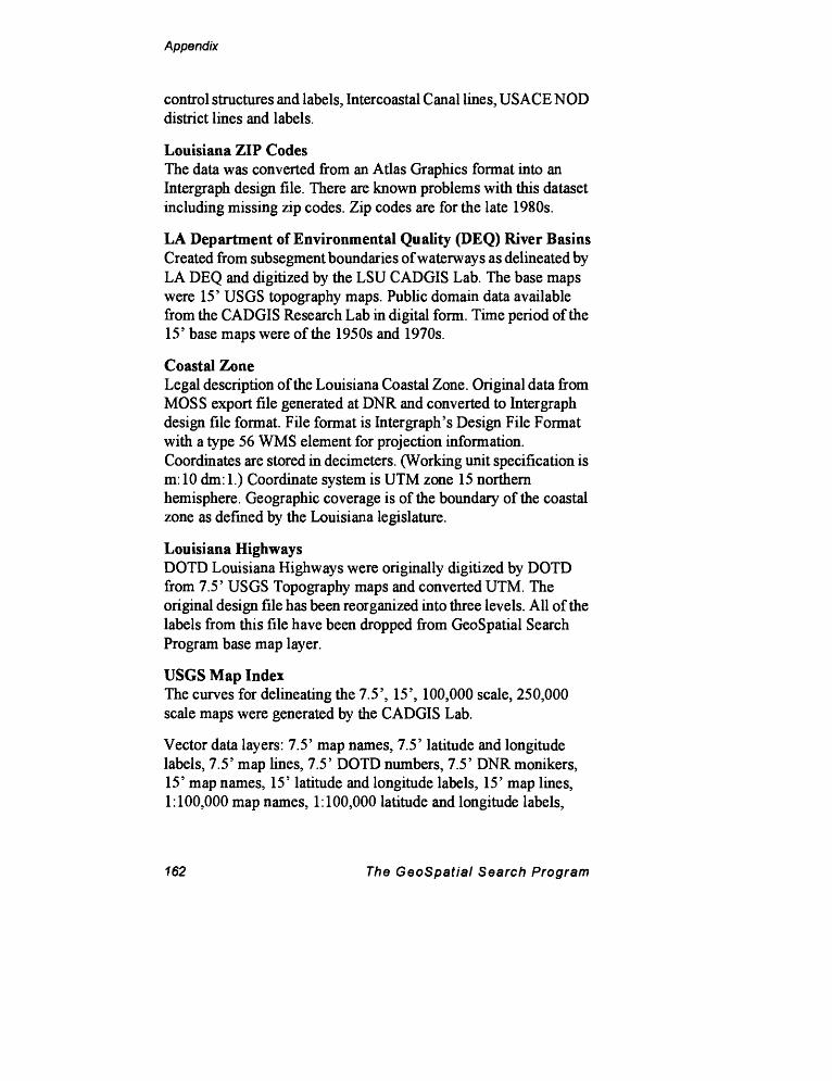
Appendix
control structures and labels, Intercoastal Canal lines, USAGE NOD district lines and labels.
Louisiana ZIP CodesThe data was converted from an Atlas Graphics format into an Intergraph design file. There are known problems with this dataset including missing zip codes. Zip codes are for the late 1980s.
LA Department of Environmental Quality (DEQ) River BasinsCreated from subsegment boundaries of waterways as delineated by LA DEQ and digitized by the LSU CADGIS Lab. The base maps were 15' USGS topography maps. Public domain data available from the CADGIS Research Lab in digital form. Time period of the 15' base maps were of the 1950s and 1970s.
Coastal ZoneLegal description of the Louisiana Coastal Zone. Original data from MOSS export file generated at DNR and converted to Intergraph design file format. File format is Inter graph's Design File Format with a type 56 WMS element for projection information. Coordinates are stored in decimeters. (Working unit specification is m: 10 dm: 1.) Coordinate system is UTM zone 15 northern hemisphere. Geographic coverage is of the boundary of the coastal zone as defined by the Louisiana legislature.
Louisiana HighwaysDOTD Louisiana Highways were originally digitized by DOTD from 7.5' USGS Topography maps and converted UTM. The original design file has been reorganized into three levels. All of the labels from this file have been dropped from GeoSpatial Search Program base map layer.
USGS Map IndexThe curves for delineating the 7.5', 15', 100,000 scale, 250,000 scale maps were generated by the CADGIS Lab.
Vector data layers: 7.5' map names, 7.5' latitude and longitude labels, 7.5' map lines, 7.5' DOTD numbers, 7.5' DNR monikers, 15' map names, 15' latitude and longitude labels, 15' map lines, 1:100,000 map names, 1:100,000 latitude and longitude labels,
162 The GeoSpatial Search Program
Appendix
1:100,000 map lines, 1:250,000 map names, 1:250,000 latitude and longitude labels, 1:250,000 map lines, map frame lines.
Oil and Gas Lease Blocks MapAmoco supplied the original design file. Randy McBride and Farrell Jones fit the file onto a UTM grid for zone 15 northern hemisphere. The spatial accuracy of lease blocks is known to be off by as much as 500 feet.
Vector data layers: shipping courseways lines, lease block (without section) lines, lease block labels, lease section lines, lease section labels, State/Federal water lines, bathymetry contours
Thematic Mapper Image of LouisianaConverted from ERDAS GIS format into Intergraph raster format for 8 bit color index images. The ERDAS trailer file was converted by a C program into an Intergraph color table file. The color table stored in the file was then embedded into the header of the image file.
Not yet ready for public distribution.
Contact Information
Farrell Jones LSU CADGIS Research Laboratory College of Design, Rm. 216 Baton Rouge, LA 70803
504-388-6134 fax 504-388-5040
The Geospatial Search Program 163

Index
Index
Add to Subject List 79 All Records 2,48 Audio/Visual Search Criteria
Menu 59
Bbase map 23, 29-31
ccataloging 6center 37check mark 24Clear All Subjects 80Clear Criteria 48Clear Single Subject 80CLIX 16cloud cover 53Computer Aided Design/Geo
graphic Information Sys tem (CADGIS) Laboratory 15
contacts 1, 63, 66control buttons 24Current Subject 79
Ddata types 2Data Types Menu 47-48date 56
Date Key-in Menu 51
of content 5 3of publication 50
Digital Only 55 division 66
Ee-mail 39Execute Query/Perform Search
89
Federal Geographic Data Com-mitttee (FGDC) 6
feedback 5 film type 53 fit 37
Geographic Names Locator 77GeoSpatial Cataloging Pro
gram 2, 6Geotechnical Search Criteria
Menu 61grey literature 2
Hhardcopy 55 help 5, 21 holdings 55
GeoSpatial Cataloging Program 165
Index
Imagery Search Criteria Menu57-58
Internet Protocal (IP) address16
Kkey-in boxes 26 Key-in Coordinates Menu 70 keywords. See Subject Head
ings
Llayers 3Library of Congress Subject
Headings (LCSH) 79 lists 25 Literature Search Criteria Menu
49-50 locations
specifying 67-77 login 15-19
Mmail 39Main Menu 11,45-46map
controls 34date 56holdings 55layers 3, 31publisher 56scale 56type 56
Map Search Criteria Menu 55- 56
MBR by Mouse 69 menus 23 message bar 23 metadata 1, 6Minimum Bounding Rectangle
(MBR) 11,67,69
N Notepad 40
oonline help 21 Oracle 6 organizations
searching 66type 66
Ppassword 15People and Organization
Search Menu 63-66 Photography Search Criteria
Menu 52-53 platform 58 Pocket Menu 25, 33-41
map controls 34utilities 39
printing 90 publisher 50, 56 pull-down lists 25-26
QQuery Management 45, 87, 89
166 GeoSpatial Search Program
Index
Rraster 55Read Record 65, 66records
printing 90viewing 90
Respecify Subject 80
sscale 53Subject Headings Menu 85
Ttitle 50 Tutorial
Literature Search 104-119Photography Search 94-
103type of map 56 type of material
audiovisual 59geotechnical 61tabular 60
uUniversal Transverse Mercator
(UTM) coordinates 70 User Message for LCGISN 39-
40useraame 19USGS 7.5-Min. Quadrange In
dex 71-77 Select by Block 75 Select from List 73 Select from Map 76
Vvector 55 view
more info 90next record 90previous record 90
wWelcome Menu 19 wild cards (%) 49 Window Area 34-35
zzoom 35
GeoSpatial Cataloging Program 167