Embed Size (px)
Citation preview
April 2020
Hudson-Raritan Estuary Ecosystem Restoration Feasibility Study
Appendix B
Ongoing Restoration Efforts
Final Integrated Feasibility Report
& Environmental Assessment
April 2020
Prepared by the New York District
U.S. Army Corps of Engineers
HRE Final Integrated FR/EA Appendix B – Ongoing Restoration Efforts B-ii
Hudson-Raritan Estuary Ecosystem Restoration Feasibility Study Final Integrated Feasibility Report & Environmental Assessment
HRE Final Integrated FR/EA Appendix B – Ongoing Restoration Efforts B-1
April 2020
1. Introduction
The HRE Study Area is home to remarkable restoration and planning efforts. This appendix covers existing/prior reports (B-1), ongoing (B-2) and completed (B-3) restoration and resilience projects conducted by the USACE and regional partners. These reports and restoration efforts serve as the foundation for the recommendations of this draft Feasibility Report/Environmental Assessment (FR/EA). Together with the actions recommended in this draft report, the ongoing and future restoration efforts will represent both a significant investment in several Hudson Raritan Estuary (HRE) Planning Regions and a tremendous step toward restoring lost ecological values and achieving the regional goals of the HRE Comprehensive Restoration Plan (USACE, 2016). 2. Prior Reports (B-1) Highlighted prior reports considered during the development of this Draft FR/EA are provided in the following sections for the HRE region, each planning region, and/or “source” study. Additional reports can be found in Chapter 10, References. 2.1 Hudson Raritan Estuary Study Area New York-New Jersey Harbor Estuary Program (HEP). 1996. New York-New Jersey Harbor Estuary Program, including the Bight Restoration Plan, Final Comprehensive Conservation and Management Plan. New York: HEP, Electronic. _____, 2008. NY/NJ Harbor Estuary Program Action Plan (2017 Draft, under preparation) _____, 2012. The State of the Estuary 2012: Environmental Health and Trends of the New York-New Jersey Harbor Estuary. New York: HEP, 2012. Electronic _____, 2015. Restoration Progress Report _____, 2016. Restoration Progress Report _____, 2018. Restoration Progress Report United States Army Corps of Engineers (USACE). 2000. Draft Expedited Reconnaissance Study: Hudson-Raritan Estuary Environmental Restoration. USACE, New York District, 2000. _____, 2004. Hudson-Raritan Estuary Environmental Restoration Feasibility Study, Study Area Reports. USACE, New York District. _____, 2015a. North Atlantic Coast Comprehensive Study: Resilient Adaptation to Increasing Risk, Main Report. USACE, Electronic.
HRE Final Integrated FR/EA Appendix B – Ongoing Restoration Efforts B-2
Hudson-Raritan Estuary Ecosystem Restoration Feasibility Study Final Integrated Feasibility Report & Environmental Assessment
_____, 2015.b Use of Natural and Nature-Based Features (NNBF) for Coastal Resilience. USACE, Engineer Research and Development Center. Electronic. _____, 2016. Hudson Raritan Estuary Ecosystem Restoration Feasibility Study Comprehensive Restoration Plan Environmental Document, Final. USACE, New York District, Electronic. USACE and Port Authority of New York and New Jersey (PANYNJ). 2009a. Hudson-Raritan Estuary Comprehensive Restoration Plan, Draft, Volume I. USACE, New York District, Electronic. _____. 2009b. Hudson-Raritan Estuary Comprehensive Restoration Plan, Draft, Volume II USACE, New York District. ______. 2016. Hudson-Raritan Estuary Comprehensive Restoration Plan, Version 1.0, Volume I. USACE, New York District. Electronic. 2.2 Jamaica Bay National Park Service (NPS), 2014. Gateway National Recreation Area, Final General Management Plan, Environmental Impact Statement. April 2014. NPS, 2014a. A New Vision for a Great Urban National Park Gateway National Recreation Area Final General Management Plan / Environmental Impact Statement. April. NYCDEP, 2014. Jamaica Bay Watershed Protection Plan-2014 Update (including Jamaica Bay wastewater treatment plant upgrades and Springfield Gardens, Baisley Pond, and area-wide sewer improvements. NYCDEP, 2016. Jamaica Bay Watershed Protection Plan -2016 Update. NYCDEP, 2018. Combined Sewer Overflow Long Term Control Plan for Jamaica Bay and Tributaries. NYSDEC, 1993, Restoration of Natural Resources through the Jamaica Bay Damages Account: Reconnaissance Phase Report NYCDEP, 1995. Jamaica Bay Comprehensive Watershed Management Plan Sanderson, E.W., W.D. Soleki, J.R. Waldman, & A.S. Parris. 2016. Prospects for Resilience, Insights from New York City’s Jamaica Bay. Island Press. USACE, 1994. Jamaica Bay, Marine Park, and Plumb Beach, New York Combined Beach Erosion Control and Hurricane Protection Reconnaissance Study ______, 1997. Jamaica Bay: Navigational Channels and Shoreline Environmental Surveys
HRE Final Integrated FR/EA Appendix B – Ongoing Restoration Efforts B-3
April 2020
______, 2000. Draft Cultural Resources Baseline Study ______, 2002a. Jamaica Bay Ecosystem Research and Restoration Team (JABERRT) Report ______, 2002b. Existing Conditions, Future Without Project Conditions, Goals and Objectives Report ______, 2002c. Draft HTRW Sampling Program Report ______, 2003a. Draft Water Quality Modeling ______, 2003b. Final Conceptual Plan Report ______, 2003c. Final Conceptual Plan Report, Preliminary Planning Cost Estimates _____, 2003d. Summary of Water Level Data Report _____, 2003e. Shoreline Stability Analysis Report _____. 2003f. Draft Integrated Ecosystem Restoration Report/Environmental Assessment for the Gerritsen Creek Ecosystem Restoration Project. USACE, New York District. _____, 2008. Engineering Documentation Report- NY & NJ Harbor Deepening Project Beneficial Use of Dredged Material to Restore Elders Point West Marsh, Jamaica Bay Marsh Islands, Jamaica Bay, Brooklyn, NY _____, 2010. Detailed Project Report- NY & NJ Harbor Deepening Project Beneficial Use of Dredged Material to Restore Yellow Bar Hassock, Jamaica Bay Marsh Islands, Jamaica Bay, Brooklyn, NY 2.3 Flushing Creek Flushing Meadows-Corona Park Corporation, 1990. “Flushing Meadows-Corona Park Concept Plan” Galvin, C., 1981. “Recommendation for Flushing Bay Earth Breakwater,” prepared for New York District Corps of Engineers (July 7, 1981). Lawler, Matusky & Skelly Engineers (LMS), 1986. “Field Investigations of Flushing Bay and Creek and Meadow and Willow Lakes: Task 3.2 Data Report”, prepared for the NYCDEP. _____, 1987. “Calibration of Time-Variable Flushing Bay and Creek Models and Projections: Task 3.3 and 3.4”, prepared for NYCDEP. _____, 1989. “Environmental Assessment Statement Flushing Bay Water Quality Facility Plan,” prepared for NYCDEP.
HRE Final Integrated FR/EA Appendix B – Ongoing Restoration Efforts B-4
Hudson-Raritan Estuary Ecosystem Restoration Feasibility Study Final Integrated Feasibility Report & Environmental Assessment
_____, 1993. “Additional Water Quality Investigations of Flushing Bay and Creek: Subtask 3.6,” prepared for the New York City Department of Environmental Protection (May 1993). _____, 1993. “Flushing Creek Wetland Enhancement Feasibility Study,” prepared for New York City Department of Environmental Protection (October 1993). _____, 1994. “Flushing Bay Water Quality Facility Planning Project: Receiving Water Modeling”, prepared for the New York City Department of Environmental Protection (November 1994). New York City Department of Environmental Protection (NYCDEP), 1993. “New York City Shoreline Survey Program, Tallman Island Water Pollution Control Plant Drainage Area,” Survey Circular No. 11 (March 31, 1993). ______, 1993. “New York City Shoreline Survey Program, Bowery Bay Water Pollution Control Plant Drainage Area,” Survey Circular No. 11 (March 31, 1993). ______, 1995. “1994 New York Harbor Water Quality Survey” ________, 2011. Flushing Creek Waterbody Watershed Facility Plan Report (Bureau of Engineering Design and Construction; August 2011) New York City Department of City Planning, 1993. “Downtown Flushing Plan, Report no. 93-26” Planning and Research Consulting Associates, 1982. “Queens Community Planning Board Three, Critical Review of the Flushing Bay Tidal Study Performed for the Port Authority of New York and New Jersey by Tetra Tech, Inc., 1982”. Taylor, B. and J. Pagenkoph (TetraTech, Inc.), 1982. “Flushing Bay Hydraulics and Water Quality Study”, prepared for the Port Authority of New York and New Jersey. URS Corporation, 1991. “Flushing Bay CSO Summary of Facility Plan” USACE, Waterways Experiment Station, 1993. WRAP Assistance to US Army Engineer District, New York, Regulatory Branch, “Evaluation of Impact of Breakwater Removal Due to Safety Overrun Construction at LaGuardia Airport Runway 13-31” (July 29, 1993). USACE, 1962. Report of the Chief of Engineers, Review of Reports, Flushing Bay and Creek, New York (House Document 551, 87th Congress, 2nd Session) _____, 1996. Reconnaissance Report, Flushing Bay and Creek, New York. _____, 2001a. Phase I Environmental Site Assessment Reports for the Flushing Bay and Creek Ecological Restoration Project. _____, 2001b. Tidal and Current Measurement Program, Flushing Bay and Creek, New York.
HRE Final Integrated FR/EA Appendix B – Ongoing Restoration Efforts B-5
April 2020
_____, 2001c. Water Quality Sampling Program, Flushing Bay and Creek, New York. _____, 2002a. Final Finfish Report, Flushing Bay and Creek Ecological Restoration Project. _____, 2002b. Final Benthic Report, Flushing Bay and Creek Ecological Restoration Project. The Port Authority of New York and New Jersey, 1992. “LGA 13-31 Overrun/Earthen Breakwater Removal: Environmental Report” U.S. Fish and Wildlife Service, 1995. “Regionally Significant Habitats and Habitat Complexes of the New York Bight Watershed,” (November 1995). 2.4 Bronx River Atwood, K.A., Paiva, M.A., Varghese, S. 2007. Cultural Resources Baseline Study Bronx River Ecosystem Restoration Study, Westchester and Bronx Counties, New York. March 2007. United States Army Corps of Engineers, New England District. Bronx River Alliance (BRA), 2003. Take Me to the River - Discovery and Restoration of the Bronx River BRA 2006a. Bronx River Alliance Ecological Restoration and Management Plan, May 2006, 84 pages plus appendices. Available online: http://www.bronxriver.org/plans/ BRA 2006b. Bronx River Alliance Bronx River Greenway Plan, June 2006, 57 pages plus appendices. Available online: http://www.bronxriver.org/plans/ CWP 2006a. Bronx River Watershed Baseline Assessment. Prepared by the Center for Watershed Protection for Westchester County Department of Planning. April 2006, 36 pages plus appendices. 1985 Bronx River Corridor: Land Use and Zoning Study Bronx River Restoration Project 1986 Bronx River Corridor Implementation Plan Bronx River Restoration Project Bitner, Robert, 1980. The Diversity of the Benthic Macroinvertebrates of the Lower Bronx River (SUNY-Purchase) Bronxville School District, 1999. Special Site Evaluation: Flooding, Parking and Traffic. Engineer's Report Prepared by J. Kenneth Fraser and Associates for the Village of Bronxville Dexter, Barbara, 1990. Bronx River River Keeper Program Final Report (Project Riverwatch), SUNY-Purchase
HRE Final Integrated FR/EA Appendix B – Ongoing Restoration Efforts B-6
Hudson-Raritan Estuary Ecosystem Restoration Feasibility Study Final Integrated Feasibility Report & Environmental Assessment
E.W. Sanderson and D. LaBruna, 2005. Mapping the Historical Ecology and Reconstructing the Historical Flora of the Lower Bronx River: A Guide for Ecosystem Restoration and Outreach, Wildlife Conservation Society Historic American Engineering Record, Bronx River Parkway Reservation (HAER No. NY- 327), developed from 2001-2002 as part of collaborative effort between the National Parks Service and the Westchester County Department of Parks, Recreation, and Conservation. Located online at: http://www.westchesterarchives.com/BRPR/Report_fr.html. Henningson, Durham & Richardson Architecture and Engineering, P.C. 2003. Final Technical Memorandum: Bronx River in Westchester County – Preliminary Water Quality Assessment and Monitoring Program Development. Prepared for: Westchester County Department of Parks, Recreation and Conservation; 25 Moore Avenue; Mt. Kisco, New York 10549. October 2003. Hoffner, J., 2005. Discovery and Restoration of the Bronx River Partnership for Parks Larson, M., D. Sugar and J. Rachlin 2004. Fish passage needs and feasibility assessment. NYC Parks and Recreation, Natural Resource Group and Lehman College Laboratory of Marine and Estuarine Research. Larson, M. and Mankiewicz, P. 2006. Restoring Soundview Park. In: The Tidal Exchange, Newsletter of the New York –New Jersey Harbor Estuary Program. Spring 2006 issue/ Malcolm Pirnie, 1979. Report on Flood Protection Options for Bronxville between Palmer Avenue and the Railroad Bridge NEA. 2007. Wetland Field Assessment and Management Plan for the Bronx River Watershed, Westchester County, New York. Prepared by Northern Ecological Associates, Inc., on behalf of Westchester County Department of Planning. April 2007. 142 NPS and Westchester County Department of Parks, Recreation and Conservation, 2002. Historic American Engineering Record, Bronx River Parkway Reservation (HAER No. NY-327) NYC Department of Parks & Recreation, 1990. Executive Summary Waterfront Management Plan _____, 1998. Assessment of Bronx River Ecosystem - pre-restoration baseline data _____, 2002. Project Status Report: Bronx River Cement Plant Restoration. New York City Parks and Recreation, Natural Resources Group. September 30, 2002. _____, 2008. Bronx River Pilot Oyster Reef 2008 Report
HRE Final Integrated FR/EA Appendix B – Ongoing Restoration Efforts B-7
April 2020
NYC Department of Environmental Protection, 2000. Bronx River Field Sampling and Analysis Program Years 2000-2001(Component 1: Waterbody Biology). Use and Standards Attainment Project ______, 2004. Bronx River Waterbody/Watershed Facility Plan New York City Department of Environmental Protection. March 31, 2004. ______, 2006. City-wide Long Term CSO Control Planning Project: Bronx River Waterbody/Watershed Facility Plan Report. New York City Department of Environmental Protection. February 2006. Prepared by Greeley and Hansen, LLC/ Hazen and Sawyer, P.C./ O’Brien & Gere, Inc. _____, 2009. Bronx River Watershed Water Facility Plan NYC Dept. of Planning, N.D. Comprehensive Waterfront Plan: Reach 8, the Bronx River New York Partnerships for Parks, N.D. Bronx River. NYC Planning Commission, 1979. Restoring the Bronx River New York Schmidt, Robert & Jeanette Samaritan, 1984. Fishes of an Urban Stream: The Bronx River Bronx Blue, 1991. Protecting Nature along Bronx Coastal, Riverfront and Wetland Areas NYSDEC, 1993. East River Tributary Results for 1992 NYSDEC, 1999a. Bronx River Biological Stream Assessment - Bronx and Westchester Counties ____, 1999b. New York Code of Rules and Regulations (6 NYCRR), Chapter X – Division of Water Resources, Subchapter B: Classes and Standards of Quality and Purity Assigned to Fresh Surface and Tidal Salt Waters, Part 935: Upper East River and Long Island Sound within Queens, Bronx and Westchester Counties. Available online at http://www.dec.ny.gov/regs/2485.html Olson, 1997. Results of a Benthic Macroinvertebrate Survey Conducted at Four Sites on the Bronx River on September 20-21, 1997 (c/o NYCDEP) Princeton Hydro, LLC and Monmouth University. 2007. Bronx River Ecosystem Restoration Microbial Source Tracking Study. Prepared for United States Army Corps of Engineers, New York Division; 26 Federal Plaza; New York, NY 10278. May 2007. Rachlin, Pappantoniou, and Warkentine, 2002. A Faunal and Floral List of Organisms found in the Bronx River Estuary. October 2002. Lehman College Laboratory for Marine and Estuarine Research
HRE Final Integrated FR/EA Appendix B – Ongoing Restoration Efforts B-8
Hudson-Raritan Estuary Ecosystem Restoration Feasibility Study Final Integrated Feasibility Report & Environmental Assessment
Rachlin, J., Warkentine, B, and Pappantoniou, A., 2007. An Evaluation of the Icthyofauna of the Bronx River, a Resilient Urban Waterway NYC Dept of Parks & Recreation, 2007. Urban Riparian Wetland Restoration Evaluation: A Case Study of the Bronx River Richard G. Stein & Partners, Architects, 1978. Bronx River Restoration Preliminary Master Plan Bronx River Stein Partnership, 1980. Bronx River Restoration Master Plan Bronx River Restoration USACE, 1912. Chief's Report on dredging the Bronx River _____, 1968. Survey Report for Flood Control: Streams in Westchester County, NY, and Fairfield County, CT _____, 1973. Final Environmental Impact Statement for Maintenance Dredging, Bronx River U.S. Army Corps of Engineers _____, 1980. Bronx River Study: Westchester County Streams, NY & CT Survey Study (Flooding at Bronxville and Tuckahoe) _____, 1997 MFR: Bronx River (NYC & Westchester County) Special Investigations Study Site Visit of 11 August 1997 _____, 1999. Section 905(b) Reconnaissance Study, Bronx River Basin Ecosystem Restoration Study U.S. Army Corps of Engineers _____, 2004. Scoping Document Bronx River Basin, New York Ecosystem Restoration Study, October 2004. _____, 2006. Water Quality and Baseline Data Collection, Final Data and Documentation Report, May 2006. _____, 2007a. Draft Bronx River Watershed - Preliminary Corridor Assessment Report, February 2007.
_____, 2007b. Draft Bronx River Watershed Preliminary Corridor Assessment Report. In Partnership with New York City Department of Environmental Protection and Westchester County. March 2007. _____, 2007c. Bronx River Watershed, Westchester and Bronx Counties, New York, Ecosystem Restoration Study, Existing Conditions Hydrology, HEC-1 Model Development. June 2007. _____, 2008.Section 905(b) Reconnaissance Study, Westchester County Streams, Westchester County, NY and Fairfield County, CT
HRE Final Integrated FR/EA Appendix B – Ongoing Restoration Efforts B-9
April 2020
_____, 2010. Bronx River Basin, Ecosystem Restoration Study- Watershed Opportunities Report. _____, 2010. DRAFT Bronx River Watershed - Preliminary Corridor Assessment Report
USACE, Westchester County Dept of Public Works and NYSDEC, 1971. Flood Plain Information: Bronx River, USAERDC-CHL, 2007. Geomorphic Assessment and Sediment Impact Assessment for the Bronx River, New York – Final Report. March 2007. USFWS 1981. United States Fish and Wildlife Service Atlas of National Wetland Inventory Maps for New York 7.5’ Series Topographic Quadrangle. Westchester County Dept. of Planning, 1999a. Bronx River Parkway Reservation Pond Rehabilitation and Riverbank Stabilization Study ______, 1999b. Westchester County Department of Planning Bronx River Outfall Identification Project Interim Report (Draft) 1999. _____, 2000. Westchester County Department of Planning - Bronx River Parkway Reservation Comprehensive Corridor Management Plan. Final Draft August 2000. _____, 2006. Westchester County Department of Planning Aquatic Restoration Projects. Available online: http://westchestergov.com/planning/environmental.html _____, 2007. Bronx River Watershed Assessment and Management Report WCS. 2005. Mapping the historical ecology and reconstructing the historical flora of the lower Bronx River: a guide for ecosystem restoration and outreach. December 2005. Eric W. Sanderson and Danielle LaBruna, of the Wildlife Conservation Society. Westchester County Dept of Parks, Recreation & Conservation, N.D. A Walker's Guide to the Bronx River Parkway Reservation Westchester County Dept. of Parks, Recreation & Conservation, Bronx River Parkway Reservation (includes inventory of maps of master plan for Bronx River Pkwy/Reservation) 2.5 Hackensack River ENSR, International. 2004. Screening Level Ecological Risk Assessment of Contamination in Wetlands Considered for Restoration in Hackensack Meadowlands District. Final Report. Prepared for the Hackensack Meadowlands Commission and the Meadowlands Environmental Research Institute, New Jersey. 89 pp. + Appendices.
HRE Final Integrated FR/EA Appendix B – Ongoing Restoration Efforts B-10
Hudson-Raritan Estuary Ecosystem Restoration Feasibility Study Final Integrated Feasibility Report & Environmental Assessment
Feltes, R. & Hartman, J.M. 2002. Progress on Monitoring Tidal Restoration Projects in the Hackensack Meadowlands District for the period January 1, 2002, to June 30, 2002. Report Number 7. Lyndhurst, NJ: New Jersey Meadowlands Commission. Hackensack Meadowlands Development Commission (HMDC) 1997. Open Space Plan. April 1997. Hunter Research, Inc., Joel W. Grossman, PhD., and Dorothy Peteet, Ph. D. 2006. Cultural Resource Investigations of Ten Sites in the Hackensack Meadowlands, Hackensack Meadowlands Restoration Project, Hudson and Bergen Counties, New Jersey. Prepared for the U.S. Army Corps of Engineers. Kiviat, E. and K. MacDonald. 2002. Hackensack Meadowlands, New Jersey, Biodiversity: A Review and Synthesis. Prepared for the Hackensack Meadowlands Partnership by Hudsonia Ltd. 72 pp. (available online: http://www.hudsonia.org/r-hm3.htm) Kiviat, E. and K. MacDonald, 2004. Biodiversity Patterns and Conservation in the Hackensack Meadowlands, New Jersey. Urban Habitats, 2 (1). Konsevick, Edward, 1997. Hackensack River Water Quality 1993-1996. Hackensack Meadowlands Development Commission Environmental Operations Research Laboratory. Langan Engineering and Environmental Services, Inc. 1999. Sediment and Water Sampling Report: Kearny Marsh. Kane, R. and D. Githens. 1997. Hackensack River migratory bird report with recommendations for conservation. New Jersey Audubon Society, Bernardsville, New Jersey. 37 pp. The Louis Berger Group, Inc. (LBG). 2003. Marsh Resources Meadowlands Mitigation Bank, Phase 1 Fourth Year Monitoring Report. Submitted to: The U.S. Army Corp of Engineers, New York District, New York, New York. LBG, 2004 [1]. Marsh Resources Meadowlands Mitigation Bank, Phase 3 Prospectus. Submitted to: The Meadowlands Interagency Mitigation Advisory Committee, U.S. Army Corp of Engineers, New York City, New York. LBG, 2004 [2]. Regional Guidebook for Hydrogeomorphic Assessment of Tidal Fringe Wetlands in the Hackensack Meadowlands. Prepared for: The New Jersey Meadowlands Commission, Lyndhurst, New Jersey, and the U.S. Environmental Protection Agency, Region II, New York, New York. Mattson, 1978. The Ecological and Resource Management Plan for the Hackensack Meadowlands. State of New Jersey Hackensack Meadowlands Development Commission.
HRE Final Integrated FR/EA Appendix B – Ongoing Restoration Efforts B-11
April 2020
Metropolitan Waterfront Alliance, 2003. Waterwire News. Landfills to Open Space: NJ Meadowlands. 2003. Retrieved October 2003. http://www.waterwire.net/News/fullstory/cfm?ContID=1377. Mizrahi, David S., Ph.D. New Jersey Audubon Society April 2004. Avian Abundance and Distribution in the New Jersey Meadowlands District: The Importance of Habitat, Landscape, and Disturbance. New Jersey Audubon Society. November, 2007. Avian abundance and distribution in the New Jersey Meadowlands District: The importance of habitat, landscape, and disturbance, Final Report. Prepared for: New Jersey Meadowlands Commission NJMC. 2004. NJMC Master Plan. NJMC (Bragin, A. Brett, Jeff Misuik, Craig A. Woolcott, Kirk R. Barrett, Rafael Jusino-Atrensino) 2005. A fishery resource inventory of the lower Hackensack River within the Hackensack Meadowlands District: A comparative study 2001-2003 vs. 1987-1988. Tiner, Ralph W., John Q. Swords, and Bobbi Jo McClain. 2002. Wetlands Status and Trends for the Hackensack Meadowlands: An Assessment Report from the U.S. Fish and Wildlife Service's National Wetlands Inventory Program, U.S. Fish and Wildlife Service, Northeast Region, 300 Westgate Center Drive, Hadley, MA 01035. Thiesing, M.A. 2002. The Hackensack Meadowlands: An Ecological Paradox. U.S. Fish and Wildlife Service Field Notes. (New Jersey Field Office). United States Army Corp of Engineers - Baltimore District (USACE-Baltimore). 2004. Preliminary Geotechnical and Hazardous, Toxic, & Radioactive Waste Site Investigation. Lyndhurst Riverside Marsh, Lyndhurst, NJ. USACE & NJMC. 2004. Meadowlands Environmental Site Investigation Compilation (MESIC). USACE, 2004. Meadowlands Environmental Site Investigation Compilation (MESIC): Hudson-Raritan Estuary, Hackensack Meadowlands, New Jersey, Final Report. USACE, New York District, 2004b. USACE. 2005. Meadowlands Comprehensive Restoration Implementation Plan, Draft. USACE, New York District, Electronic. USACE, 2006a. Hazardous, Toxic, & Radioactive Waste Site Investigation Report. Anderson Creek Marsh, Secaucus, New Jersey. USACE. 2006b. Combined Geotechnical and HTRW Report for the Meadowlark Marsh and Metromedia Tract. Hackensack Meadowlands, New Jersey.
HRE Final Integrated FR/EA Appendix B – Ongoing Restoration Efforts B-12
Hudson-Raritan Estuary Ecosystem Restoration Feasibility Study Final Integrated Feasibility Report & Environmental Assessment
United States Environmental Protection Agency (USEPA). 1989. Functional Assessment of Wetlands in New Jersey’s Hackensack Meadowlands. USEPA. 1995. Environmental Monitoring and Assessment Program (EMAP): Laboratory Methods Manual – Estuaries, Volume 1: Biological and Physical Analyses. United States Environmental Protection Agency, Office of Research and Development, Narragansett, RI. USFWS. 2004. Draft Planning Aid Report. Hackensack Meadowlands Ecosystem Restoration Project, Bergen and Hudson Counties, New Jersey. Environmental Contaminants Issues for Restoration. USFWS. 2005. Final Planning Aid Report. Hackensack Meadowlands Ecosystem Restoration Project, Bergen and Hudson Counties, New Jersey. Environmental Contaminants Issues for Restoration. USFWS. 2007. The Hackensack Meadowlands Initiative: Preliminary Conservation Planning for the Hackensack Meadowlands, Hudson and Bergen Counties, New Jersey. (Available online: http://www.fws.gov/northeast/njfieldoffice) USFWS. 2007. The Hackensack Meadowlands Initiative: Preliminary Conservation Planning. March 2007. 450pp. USFWS, USACE, U. S. EPA, NMFS, and Hackensack Meadowlands Development Commission. 2000. Wildlife Management Plan for the Hackensack Meadowlands. 36 pp. + appendices Woods Hole Group. 2000. Tidal Datum Analysis for Hackensack Meadowlands Development Commission, 2000. 2.6 Lower Passaic River Note: Baseline information can be found on www.ourpassaic.org and information summarized in the USEPA Remedial Investigation Report (USEPA, 2014). Aqua Survey, 2005. Technical Report, Geophysical Survey, Lower Passaic River Restoration Project Aqua Survey, Inc. and Earth Tech, Inc. 2005. Taxonomic Identification of Benthic Invertebrates from Sediment Collected in the Lower 17 Miles of the Lower Passaic River, In Support of the Lower Passaic River Restoration Project for NJDOT and USACE Earth Tech, Inc. 2004, Ecosystem Functional Assessment Technical Memorandum. Prepared for NJDOT and USACE (www.ourpassaic.org) Earth Tech, Inc. 2005, Report for December 14, 2004-February 24, 2005 Field Reconnaissance (www.ourpassaic.oirg)
HRE Final Integrated FR/EA Appendix B – Ongoing Restoration Efforts B-13
April 2020
Earth Tech, Inc. and Malcom Pirnie, Inc. 2004. Lower Passaic River Restoration Project- Draft Final Biological Review. Prepared for NJDOT Earth Tech, Inc. and Malcom Pirnie, Inc. 2006. Lower Passaic River Restoration Project- Final Restoration Opportunities Report. July 2006 (www.ourpassaic.org) Germano & Associates, Inc. 2005. Final Report Lower Passaic River Project- Sediment Profile Imaging Survey of Sediment and Benthic Habitat Characteristics of the Lower Passaic River, June 2005. Prepared for Aqua Survey, Inc. for NJDOT and USACE. Malcolm Pirnie, Inc. 2005. Report for October 20-22, 2004 Field Reconnaissance (www.ourpassaic.org) NJDOT, 2007. New Jersey’s Position on the Future Navigational Use on the Lower Passaic River River Miles 0-8 (Used Information from Municipality Surveys and Master Plans for restoration planning along entire 17 miles) Municipality Surveys Bayonne/Hudson County (RM 0): James Monkowski, City of Bayonne, Municipal building, 630 Ave C., Bayonne, NJ 07002.
Belleville Township/Essex County (RM 8-10): Thomas Herits, 429 Stephens St. Belleville, NJ 07109. (11/10/06)
Borough of East Newark/Hudson County (RM 5.6-6.1): Robert B. Knapp, Acting Burough Clerk, 34 Sherman Avenue, East Newark, NJ 07029 City of Clifton, Passaic County: (RM 11-13 and RM 17): Ms. Macil Homza, Secretary, Clifton Environmental Protective Commission, City Hall, 900 Clifton Avenue, Clifton, NJ 07013. (10/13/06) Elizabeth (south of RM0): Oscar Ocasio, Department of Planning & Community Development, 50 Winfield Scott Plaza, Elizabeth. (10/11/06)
East Rutherford/Bergen (RM 13): James Cassella, Mayor, 1 Everett Place, East Rutherford, NJ 07073 (10/20/06).
Essex (Third River): Lawrence Ferchak, Essex County Division of Mosquito Control, 99 W. Bradford Avenue, Cedar Grove, NJ 07009.
Passaic County (Clifton/Nutley line to Dundee Dam): Anthony DeNova, County of Passaic, 401 Grand Street, Paterson, NJ 07505. (10/26/06)
HRE Final Integrated FR/EA Appendix B – Ongoing Restoration Efforts B-14
Hudson-Raritan Estuary Ecosystem Restoration Feasibility Study Final Integrated Feasibility Report & Environmental Assessment
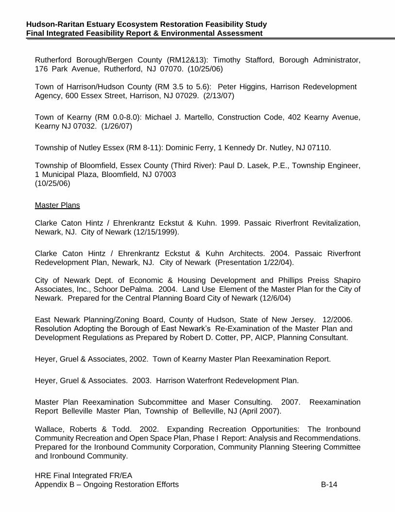
Rutherford Borough/Bergen County (RM12&13): Timothy Stafford, Borough Administrator, 176 Park Avenue, Rutherford, NJ 07070. (10/25/06) Town of Harrison/Hudson County (RM 3.5 to 5.6): Peter Higgins, Harrison Redevelopment Agency, 600 Essex Street, Harrison, NJ 07029. (2/13/07)
Town of Kearny (RM 0.0-8.0): Michael J. Martello, Construction Code, 402 Kearny Avenue, Kearny NJ 07032. (1/26/07)
Township of Nutley Essex (RM 8-11): Dominic Ferry, 1 Kennedy Dr. Nutley, NJ 07110. Township of Bloomfield, Essex County (Third River): Paul D. Lasek, P.E., Township Engineer, 1 Municipal Plaza, Bloomfield, NJ 07003 (10/25/06)
Master Plans Clarke Caton Hintz / Ehrenkrantz Eckstut & Kuhn. 1999. Passaic Riverfront Revitalization, Newark, NJ. City of Newark (12/15/1999).
Clarke Caton Hintz / Ehrenkrantz Eckstut & Kuhn Architects. 2004. Passaic Riverfront Redevelopment Plan, Newark, NJ. City of Newark (Presentation 1/22/04). City of Newark Dept. of Economic & Housing Development and Phillips Preiss Shapiro Associates, Inc., Schoor DePalma. 2004. Land Use Element of the Master Plan for the City of Newark. Prepared for the Central Planning Board City of Newark (12/6/04)
East Newark Planning/Zoning Board, County of Hudson, State of New Jersey. 12/2006. Resolution Adopting the Borough of East Newark’s Re-Examination of the Master Plan and Development Regulations as Prepared by Robert D. Cotter, PP, AICP, Planning Consultant.
Heyer, Gruel & Associates, 2002. Town of Kearny Master Plan Reexamination Report.
Heyer, Gruel & Associates. 2003. Harrison Waterfront Redevelopment Plan.
Master Plan Reexamination Subcommittee and Maser Consulting. 2007. Reexamination Report Belleville Master Plan, Township of Belleville, NJ (April 2007).
Wallace, Roberts & Todd. 2002. Expanding Recreation Opportunities: The Ironbound Community Recreation and Open Space Plan, Phase I Report: Analysis and Recommendations. Prepared for the Ironbound Community Corporation, Community Planning Steering Committee and Ironbound Community.
HRE Final Integrated FR/EA Appendix B – Ongoing Restoration Efforts B-15
April 2020
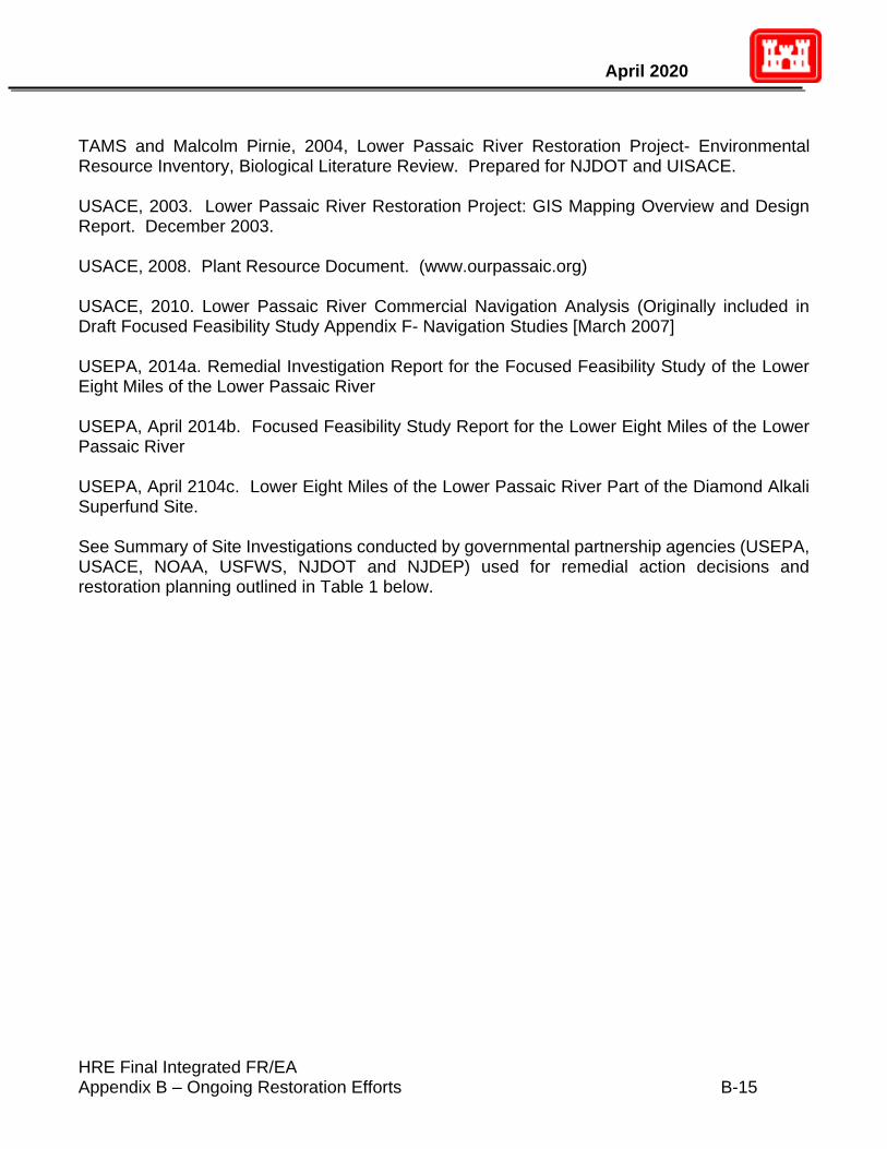
TAMS and Malcolm Pirnie, 2004, Lower Passaic River Restoration Project- Environmental Resource Inventory, Biological Literature Review. Prepared for NJDOT and UISACE. USACE, 2003. Lower Passaic River Restoration Project: GIS Mapping Overview and Design Report. December 2003. USACE, 2008. Plant Resource Document. (www.ourpassaic.org) USACE, 2010. Lower Passaic River Commercial Navigation Analysis (Originally included in Draft Focused Feasibility Study Appendix F- Navigation Studies [March 2007] USEPA, 2014a. Remedial Investigation Report for the Focused Feasibility Study of the Lower Eight Miles of the Lower Passaic River USEPA, April 2014b. Focused Feasibility Study Report for the Lower Eight Miles of the Lower Passaic River
USEPA, April 2104c. Lower Eight Miles of the Lower Passaic River Part of the Diamond Alkali Superfund Site. See Summary of Site Investigations conducted by governmental partnership agencies (USEPA, USACE, NOAA, USFWS, NJDOT and NJDEP) used for remedial action decisions and restoration planning outlined in Table 1 below.
HRE Final Integrated FR/EA Appendix B – Ongoing Restoration Efforts B-16
Hudson-Raritan Estuary Ecosystem Restoration Feasibility Study Final Integrated Feasibility Report & Environmental Assessment
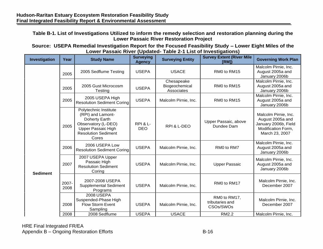
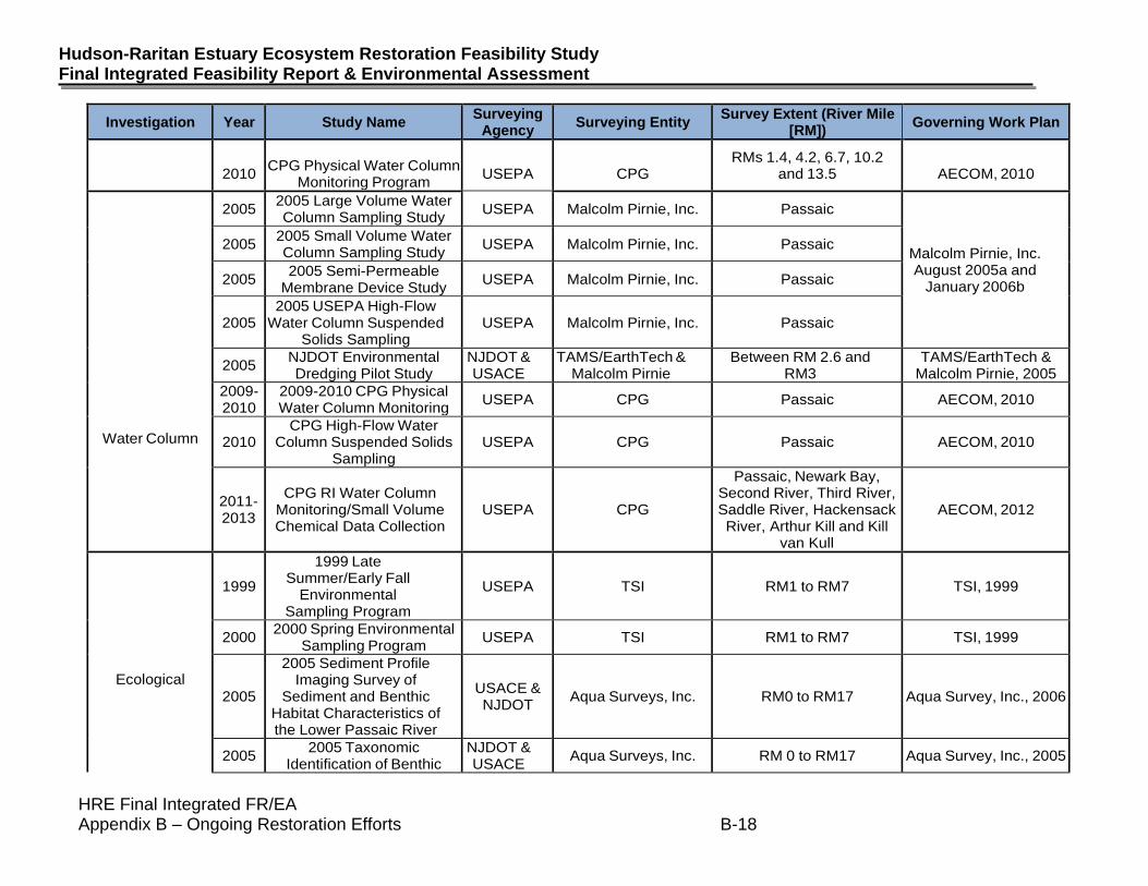
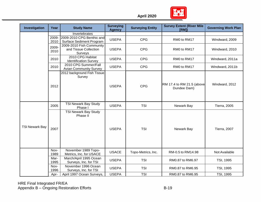
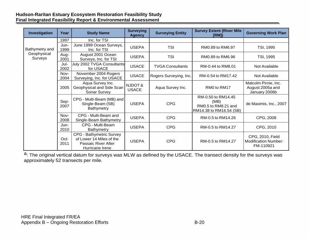
Table B-1. List of Investigations Utilized to inform the remedy selection and restoration planning during the Lower Passaic River Restoration Project
Source: USEPA Remedial Investigation Report for the Focused Feasibility Study – Lower Eight Miles of the Lower Passaic River (Updated- Table 2-1 List of Investigations)
Investigation Year Study Name Surveying
Agency Surveying Entity
Survey Extent (River Mile [RM])
Governing Work Plan
Sediment
2005
2005 Sedflume Testing USEPA USACE RM0 to RM15 Malcolm Pirnie, Inc. August 2005a and
January 2006b
2005
2005 Gust Microcosm
Testing
USEPA
Chesapeake Biogeochemical
Associates RM0 to RM15
Malcolm Pirnie, Inc. August 2005a and
January 2006b
2005 2005 USEPA High
Resolution Sediment Coring USEPA Malcolm Pirnie, Inc. RM0 to RM15
Malcolm Pirnie, Inc. August 2005a and
January 2006b
2005
Polytechnic Institute (RPI) and Lamont-
Doherty Earth Observatory (L-DEO) Upper Passaic High Resolution Sediment
Cores
RPI & L-
DEO
RPI & L-DEO
Upper Passaic, above Dundee Dam
Malcolm Pirnie, Inc. August 2005a and
January 2006b, Field Modification Form,
March 23, 2007
2006 2006 USEPA Low
Resolution Sediment Coring USEPA Malcolm Pirnie, Inc. RM0 to RM7
Malcolm Pirnie, Inc. August 2005a and
January 2006b
2007
2007 USEPA Upper Passaic High
Resolution Sediment Coring
USEPA Malcolm Pirnie, Inc. Upper Passaic Malcolm Pirnie, Inc. August 2005a and
January 2006b
2007-2008
2007-2008 USEPA
Supplemental Sediment Programs
USEPA
Malcolm Pirnie, Inc.
RM0 to RM17 Malcolm Pirnie, Inc.
December 2007
2008
2008 USEPA Suspended-Phase High
Flow Storm Event Sampling
USEPA
Malcolm Pirnie, Inc.
RM0 to RM17, tributaries and CSOs/SWOs
Malcolm Pirnie, Inc. December 2007
2008 2008 Sedflume USEPA USACE RM2.2 Malcolm Pirnie, Inc.
HRE Final Integrated FR/EA Appendix B – Ongoing Restoration Efforts B-17
April 2020
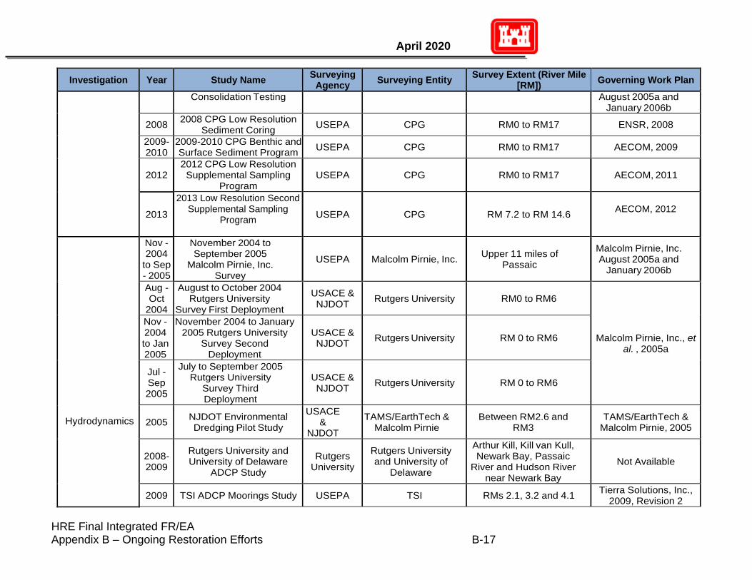
Investigation Year Study Name Surveying
Agency Surveying Entity
Survey Extent (River Mile [RM])
Governing Work Plan
Consolidation Testing August 2005a and January 2006b
2008 2008 CPG Low Resolution
Sediment Coring USEPA CPG RM0 to RM17 ENSR, 2008
2009-2010
2009-2010 CPG Benthic and Surface Sediment Program
USEPA CPG RM0 to RM17 AECOM, 2009
2012 2012 CPG Low Resolution Supplemental Sampling
Program USEPA CPG RM0 to RM17 AECOM, 2011
2013
2013 Low Resolution Second Supplemental Sampling
Program
USEPA CPG RM 7.2 to RM 14.6 AECOM, 2012
Hydrodynamics
Nov - 2004
to Sep - 2005
November 2004 to September 2005
Malcolm Pirnie, Inc. Survey
USEPA Malcolm Pirnie, Inc. Upper 11 miles of
Passaic
Malcolm Pirnie, Inc. August 2005a and
January 2006b
Aug - Oct
2004
August to October 2004 Rutgers University
Survey First Deployment
USACE & NJDOT
Rutgers University RM0 to RM6
Malcolm Pirnie, Inc., et al. , 2005a
Nov - 2004 to Jan 2005
November 2004 to January 2005 Rutgers University
Survey Second Deployment
USACE & NJDOT
Rutgers University RM 0 to RM6
Jul - Sep 2005
July to September 2005 Rutgers University
Survey Third Deployment
USACE & NJDOT
Rutgers University RM 0 to RM6
2005 NJDOT Environmental Dredging Pilot Study
USACE &
NJDOT
TAMS/EarthTech & Malcolm Pirnie
Between RM2.6 and RM3
TAMS/EarthTech & Malcolm Pirnie, 2005
2008-2009
Rutgers University and University of Delaware
ADCP Study
Rutgers University
Rutgers University and University of
Delaware
Arthur Kill, Kill van Kull, Newark Bay, Passaic
River and Hudson River near Newark Bay
Not Available
2009 TSI ADCP Moorings Study USEPA TSI RMs 2.1, 3.2 and 4.1 Tierra Solutions, Inc.,
2009, Revision 2
HRE Final Integrated FR/EA Appendix B – Ongoing Restoration Efforts B-18
Hudson-Raritan Estuary Ecosystem Restoration Feasibility Study Final Integrated Feasibility Report & Environmental Assessment
Investigation Year Study Name Surveying
Agency Surveying Entity
Survey Extent (River Mile [RM])
Governing Work Plan
2010
CPG Physical Water Column
Monitoring Program
USEPA
CPG
RMs 1.4, 4.2, 6.7, 10.2 and 13.5
AECOM, 2010
Water Column
2005 2005 Large Volume Water Column Sampling Study
USEPA Malcolm Pirnie, Inc. Passaic
Malcolm Pirnie, Inc. August 2005a and
January 2006b
2005 2005 Small Volume Water Column Sampling Study
USEPA Malcolm Pirnie, Inc. Passaic
2005 2005 Semi-Permeable
Membrane Device Study USEPA Malcolm Pirnie, Inc. Passaic
2005 2005 USEPA High-Flow
Water Column Suspended Solids Sampling
USEPA Malcolm Pirnie, Inc. Passaic
2005 NJDOT Environmental Dredging Pilot Study
NJDOT & USACE
TAMS/EarthTech & Malcolm Pirnie
Between RM 2.6 and RM3
TAMS/EarthTech & Malcolm Pirnie, 2005
2009-2010
2009-2010 CPG Physical Water Column Monitoring
USEPA CPG Passaic AECOM, 2010
2010 CPG High-Flow Water
Column Suspended Solids Sampling
USEPA CPG Passaic AECOM, 2010
2011-2013
CPG RI Water Column Monitoring/Small Volume Chemical Data Collection
USEPA CPG
Passaic, Newark Bay, Second River, Third River, Saddle River, Hackensack River, Arthur Kill and Kill
van Kull
AECOM, 2012
Ecological
1999
1999 Late Summer/Early Fall
Environmental Sampling Program
USEPA TSI RM1 to RM7 TSI, 1999
2000 2000 Spring Environmental
Sampling Program USEPA TSI RM1 to RM7 TSI, 1999
2005
2005 Sediment Profile Imaging Survey of
Sediment and Benthic Habitat Characteristics of the Lower Passaic River
USACE & NJDOT
Aqua Surveys, Inc. RM0 to RM17 Aqua Survey, Inc., 2006
2005 2005 Taxonomic
Identification of Benthic NJDOT & USACE
Aqua Surveys, Inc. RM 0 to RM17 Aqua Survey, Inc., 2005
HRE Final Integrated FR/EA Appendix B – Ongoing Restoration Efforts B-19
April 2020
Investigation Year Study Name Surveying
Agency Surveying Entity
Survey Extent (River Mile [RM])
Governing Work Plan
Invertebrates
2009-2010
2009-2010 CPG Benthic and Surface Sediment Program
USEPA CPG RM0 to RM17 Windward, 2009
2009-2010
2009-2010 Fish Community and Tissue Collection
Surveys USEPA CPG RM0 to RM17 Windward, 2010
2010 2010 CPG Habitat
Identification Survey USEPA CPG RM0 to RM17 Windward, 2011a
2010 2010 CPG Summer/Fall
Avian Community Survey USEPA CPG RM0 to RM17 Windward, 2011b
2012
2012 background Fish Tissue Survey
USEPA CPG RM 17.4 to RM 21.5 (above
Dundee Dam) Windward, 2012
TSI Newark Bay
2005 TSI Newark Bay Study
Phase I USEPA TSI Newark Bay Tierra, 2005
2007
TSI Newark Bay Study Phase II
USEPA TSI Newark Bay Tierra, 2007
Nov-1989
November 1989 Topo-Metrics, Inc. for USACE
USACE Topo-Metrics, Inc. RM-0.5 to RM14.98 Not Available
Mar-1995
March/April 1995 Ocean Surveys, Inc. for TSI
USEPA TSI RM0.87 to RM6.97 TSI, 1995
Nov-1996
November 1996 Ocean Surveys, Inc. for TSI
USEPA TSI RM0.87 to RM6.95 TSI, 1995
Apr- April 1997 Ocean Surveys, USEPA TSI RM0.87 to RM6.95 TSI, 1995
HRE Final Integrated FR/EA Appendix B – Ongoing Restoration Efforts B-20
Hudson-Raritan Estuary Ecosystem Restoration Feasibility Study Final Integrated Feasibility Report & Environmental Assessment
Investigation Year Study Name Surveying
Agency Surveying Entity
Survey Extent (River Mile [RM])
Governing Work Plan
Bathymetry and Geophysical
Surveys
1997 Inc. for TSI
Jun-1999
June 1999 Ocean Surveys, Inc. for TSI
USEPA TSI RM0.89 to RM6.97 TSI, 1995
Aug-2001
August 2001 Ocean Surveys, Inc. for TSI
USEPA TSI RM0.89 to RM6.96 TSI, 1995
Jul-2002
July 2002 TVGA Consultants for USACE
USACE TVGA Consultants RM-0.44 to RM8.01 Not Available
Nov-2004
November 2004 Rogers Surveying, Inc. for USACE
USACE Rogers Surveying, Inc. RM-0.54 to RM17.42 Not Available
2005 Aqua Survey Inc.
Geophysical and Side Scan Sonar Survey
NJDOT & USACE
Aqua Survey Inc. RM0 to RM17 Malcolm Pirnie, Inc. August 2005a and
January 2006b
Sep-2007
CPG - Multi-Beam (MB) and Single-Beam (SB)
Bathymetry USEPA CPG
RM-0.50 to RM14.45 (MB)
RM0.5 to RM8.21 and RM14.38 to RM16.54 (SB)
de Maximis, Inc., 2007
Nov-2008
CPG - Multi-Beam and Single-Beam Bathymetry
USEPA CPG RM-0.5 to RM14.26 CPG, 2008
Jun-2010
CPG - Multi-Beam Bathymetry
USEPA CPG RM-0.5 to RM14.27 CPG, 2010
Oct-2011
CPG - Bathymetric Survey of Lower 14 Miles of the
Passaic River After Hurricane Irene
USEPA CPG RM-0.5 to RM14.27 CPG, 2010, Field
Modification Number: FM-110921
a: The original vertical datum for surveys was MLW as defined by the USACE. The transect density for the surveys was approximately 52 transects per mile.
HRE Final Integrated FR/EA Appendix B – Ongoing Restoration Efforts B-21
April 2020
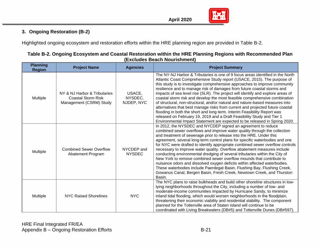
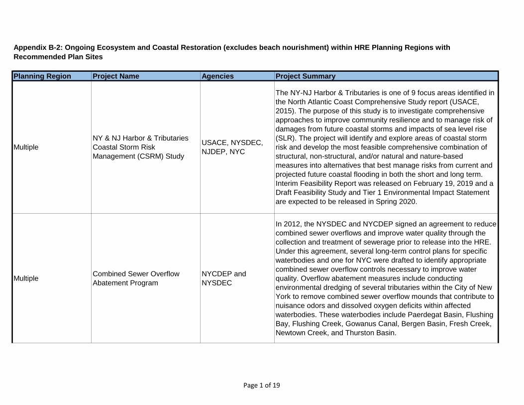
3. Ongoing Restoration (B-2) Highlighted ongoing ecosystem and restoration efforts within the HRE planning region are provided in Table B-2.
Table B-2. Ongoing Ecosystem and Coastal Restoration within the HRE Planning Regions with Recommended Plan (Excludes Beach Nourishment)
Planning Region
Project Name Agencies Project Summary
Multiple NY & NJ Harbor & Tributaries
Coastal Storm Risk Management (CSRM) Study
USACE, NYSDEC,
NJDEP, NYC
The NY-NJ Harbor & Tributaries is one of 9 focus areas identified in the North Atlantic Coast Comprehensive Study report (USACE, 2015). The purpose of this study is to investigate comprehensive approaches to improve community resilience and to manage risk of damages from future coastal storms and impacts of sea level rise (SLR). The project will identify and explore areas of coastal storm risk and develop the most feasible comprehensive combination of structural, non-structural, and/or natural and nature-based measures into alternatives that best manage risks from current and projected future coastal flooding in both the short and long term. Interim Feasibility Report was released on February 19, 2019 and a Draft Feasibility Study and Tier 1 Environmental Impact Statement are expected to be released in Spring 2020.
Multiple Combined Sewer Overflow
Abatement Program NYCDEP and
NYSDEC
In 2012, the NYSDEC and NYCDEP signed an agreement to reduce combined sewer overflows and improve water quality through the collection and treatment of sewerage prior to release into the HRE. Under this agreement, several long-term control plans for specific waterbodies and one for NYC were drafted to identify appropriate combined sewer overflow controls necessary to improve water quality. Overflow abatement measures include conducting environmental dredging of several tributaries within the City of New York to remove combined sewer overflow mounds that contribute to nuisance odors and dissolved oxygen deficits within affected waterbodies. These waterbodies include Paerdegat Basin, Flushing Bay, Flushing Creek, Gowanus Canal, Bergen Basin, Fresh Creek, Newtown Creek, and Thurston Basin.
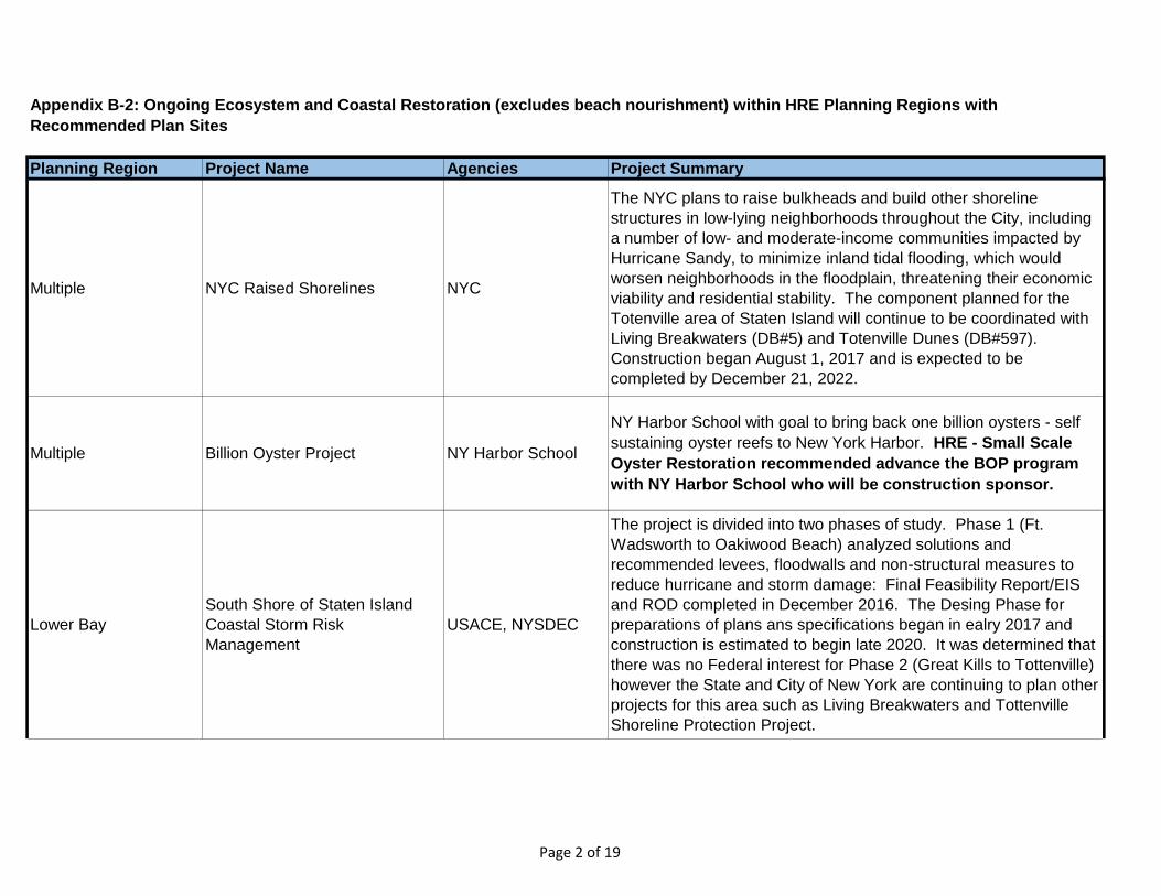
Multiple NYC Raised Shorelines NYC
The NYC plans to raise bulkheads and build other shoreline structures in low-lying neighborhoods throughout the City, including a number of low- and moderate-income communities impacted by Hurricane Sandy, to minimize inland tidal flooding, which would worsen neighborhoods in the floodplain, threatening their economic viability and residential stability. The component planned for the Tottenville area of Staten Island will continue to be coordinated with Living Breakwaters (DB#5) and Tottenville Dunes (DB#597).
HRE Final Integrated FR/EA Appendix B – Ongoing Restoration Efforts B-22
Hudson-Raritan Estuary Ecosystem Restoration Feasibility Study Final Integrated Feasibility Report & Environmental Assessment
Planning Region
Project Name Agencies Project Summary
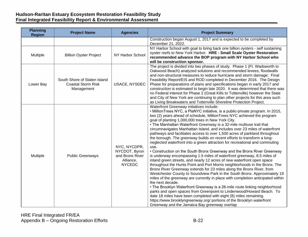
Construction began August 1, 2017 and is expected to be completed by December 21, 2022.
Multiple Billion Oyster Project NY Harbor School
NY Harbor School with goal to bring back one billion oysters - self sustaining oyster reefs to New York Harbor. HRE - Small Scale Oyster Restoration recommended advance the BOP program with NY Harbor School who will be construction sponsor.
Lower Bay South Shore of Staten Island
Coastal Storm Risk Management
USACE, NYSDEC
The project is divided into two phases of study. Phase 1 (Ft. Wadsworth to Oakwood Beach) analyzed solutions and recommended levees, floodwalls and non-structural measures to reduce hurricane and storm damage: Final Feasibility Report/EIS and ROD completed in December 2016. The Design Phase for preparations of plans and specifications began in early 2017 and construction is estimated to begin late 2020. It was determined that there was no Federal interest for Phase 2 (Great Kills to Tottenville) however the State and City of New York are continuing to plan other projects for this area such as Living Breakwaters and Tottenville Shoreline Protection Project.
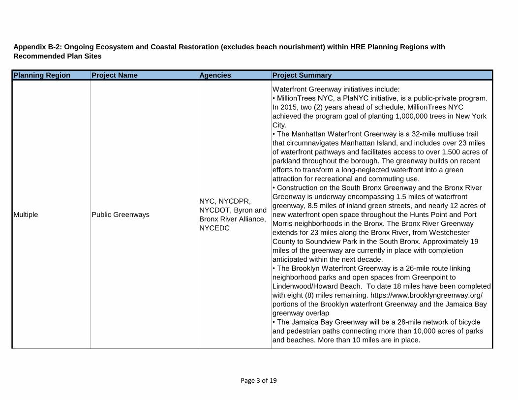
Multiple Public Greenways
NYC, NYCDPR, NYCDOT, Byron and Bronx River
Alliance, NYCEDC
Waterfront Greenway initiatives include: • MillionTrees NYC, a PlaNYC initiative, is a public-private program. In 2015, two (2) years ahead of schedule, MillionTrees NYC achieved the program goal of planting 1,000,000 trees in New York City. • The Manhattan Waterfront Greenway is a 32-mile multiuse trail that circumnavigates Manhattan Island, and includes over 23 miles of waterfront pathways and facilitates access to over 1,500 acres of parkland throughout the borough. The greenway builds on recent efforts to transform a long-neglected waterfront into a green attraction for recreational and commuting use. • Construction on the South Bronx Greenway and the Bronx River Greenway is underway encompassing 1.5 miles of waterfront greenway, 8.5 miles of inland green streets, and nearly 12 acres of new waterfront open space throughout the Hunts Point and Port Morris neighborhoods in the Bronx. The Bronx River Greenway extends for 23 miles along the Bronx River, from Westchester County to Soundview Park in the South Bronx. Approximately 19 miles of the greenway are currently in place with completion anticipated within the next decade. • The Brooklyn Waterfront Greenway is a 26-mile route linking neighborhood parks and open spaces from Greenpoint to Lindenwood/Howard Beach. To date 18 miles have been completed with eight (8) miles remaining. https://www.brooklyngreenway.org/ portions of the Brooklyn waterfront Greenway and the Jamaica Bay greenway overlap
HRE Final Integrated FR/EA Appendix B – Ongoing Restoration Efforts B-23
April 2020
Planning Region
Project Name Agencies Project Summary
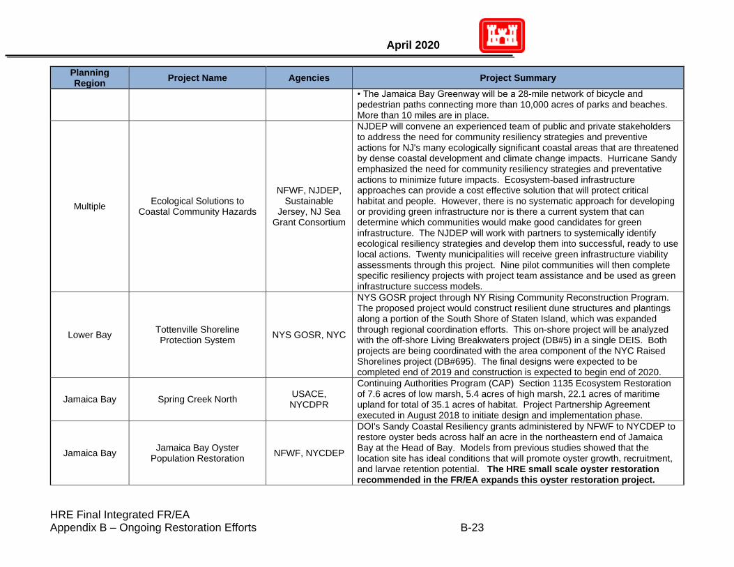
• The Jamaica Bay Greenway will be a 28-mile network of bicycle and pedestrian paths connecting more than 10,000 acres of parks and beaches. More than 10 miles are in place.
Multiple Ecological Solutions to
Coastal Community Hazards
NFWF, NJDEP, Sustainable
Jersey, NJ Sea Grant Consortium
NJDEP will convene an experienced team of public and private stakeholders to address the need for community resiliency strategies and preventive actions for NJ's many ecologically significant coastal areas that are threatened by dense coastal development and climate change impacts. Hurricane Sandy emphasized the need for community resiliency strategies and preventative actions to minimize future impacts. Ecosystem-based infrastructure approaches can provide a cost effective solution that will protect critical habitat and people. However, there is no systematic approach for developing or providing green infrastructure nor is there a current system that can determine which communities would make good candidates for green infrastructure. The NJDEP will work with partners to systemically identify ecological resiliency strategies and develop them into successful, ready to use local actions. Twenty municipalities will receive green infrastructure viability assessments through this project. Nine pilot communities will then complete specific resiliency projects with project team assistance and be used as green infrastructure success models.
Lower Bay Tottenville Shoreline Protection System
NYS GOSR, NYC
NYS GOSR project through NY Rising Community Reconstruction Program. The proposed project would construct resilient dune structures and plantings along a portion of the South Shore of Staten Island, which was expanded through regional coordination efforts. This on-shore project will be analyzed with the off-shore Living Breakwaters project (DB#5) in a single DEIS. Both projects are being coordinated with the area component of the NYC Raised Shorelines project (DB#695). The final designs were expected to be completed end of 2019 and construction is expected to begin end of 2020.
Jamaica Bay Spring Creek North USACE, NYCDPR
Continuing Authorities Program (CAP) Section 1135 Ecosystem Restoration of 7.6 acres of low marsh, 5.4 acres of high marsh, 22.1 acres of maritime upland for total of 35.1 acres of habitat. Project Partnership Agreement executed in August 2018 to initiate design and implementation phase.
Jamaica Bay Jamaica Bay Oyster
Population Restoration NFWF, NYCDEP
DOI's Sandy Coastal Resiliency grants administered by NFWF to NYCDEP to restore oyster beds across half an acre in the northeastern end of Jamaica Bay at the Head of Bay. Models from previous studies showed that the location site has ideal conditions that will promote oyster growth, recruitment, and larvae retention potential. The HRE small scale oyster restoration recommended in the FR/EA expands this oyster restoration project.
HRE Final Integrated FR/EA Appendix B – Ongoing Restoration Efforts B-24
Hudson-Raritan Estuary Ecosystem Restoration Feasibility Study Final Integrated Feasibility Report & Environmental Assessment
Planning Region
Project Name Agencies Project Summary
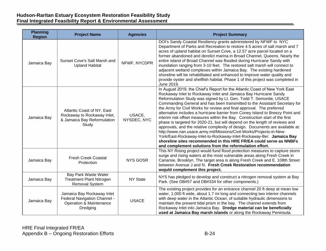
Jamaica Bay Sunset Cove's Salt Marsh and
Upland Habitat NFWF, NYCDPR
DOI's Sandy Coastal Resiliency grants administered by NFWF to NYC Department of Parks and Recreation to restore 4.5 acres of salt marsh and 7 acres of upland habitat on Sunset Cove, a 12.57 acre parcel located on a former abandoned and derelict marina in Broad Channel, Queens. Nearly the entire island of Broad Channel was flooded during Hurricane Sandy with inundation ranging from 3-10 feet. The restored salt marsh will connect to adjacent wetland complexes within Jamaica Bay. The existing hardened shoreline will be rehabilitated and enhanced to improve water quality and provide oyster and shellfish habitat. Phase 1 of this project was completed in June 2019.
Jamaica Bay
Atlantic Coast of NY, East Rockaway to Rockaway Inlet, & Jamaica Bay Reformulation
Study
USACE, NYSDEC, NYC
In August 2019, the Chief’s Report for the Atlantic Coast of New York East Rockaway Inlet to Rockaway Inlet and Jamaica Bay Hurricane Sandy Reformulation Study was signed by Lt. Gen. Todd T. Semonite, USACE Commanding General and has been transmitted to the Assistant Secretary for the Army for Civil Works for review and final approval. The preferred alternative includes a hurricane barrier from Coney Island to Breezy Point and interim risk offset measures within the Bay. Construction start of the first phase is targeted for 2020-21, but will depend on the length of reviews and approvals, and the relative complexity of design. Documents are available at: http://www.nan.usace.army.mil/Missions/Civil-Works/Projects-in-New-York/East-Rockaway-Inlet-to-Rockaway-Inlet-Rockaway-Be/. Jamaica Bay shoreline sites recommended in this HRE FR/EA could serve as NNBFs and complement solutions from the reformulation effort.
Jamaica Bay Fresh Creek Coastal
Protection NYS GOSR
This NY Rising project would fund flood protection measures to capture storm surge and rising waters at the most vulnerable areas along Fresh Creek in Canarsie, Brooklyn. The target area is along Fresh Creek and E. 108th Street between Avenue J and N. Fresh Creek Restoration recommendation wojuld complement this project.
Jamaica Bay Bay Park Waste Water
Treatment Plant Nitrogen Removal System
NY State NYS has pledged to develop and construct a nitrogen removal system at Bay Park. (See DB#57 and DB#334 for other components.)
Jamaica Bay
Jamaica Bay Rockaway Inlet Federal Navigation Channel -
Operation & Maintenance Dredging
USACE
The existing project provides for an entrance channel 20 ft deep at mean low water, 1,000 ft wide, about 1.7 mi long and connecting two interior channels with deep water in the Atlantic Ocean, of suitable hydraulic dimensions to maintain the present tidal prism in the bay. The channel extends from Rockaway Inlet into Jamaica Bay. Dredge material can be beneficially used at Jamaica Bay marsh islands or along the Rockaway Peninsula.
HRE Final Integrated FR/EA Appendix B – Ongoing Restoration Efforts B-25
April 2020
Planning Region
Project Name Agencies Project Summary
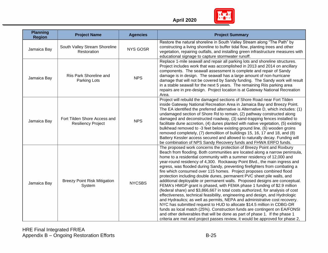
Jamaica Bay South Valley Stream Shoreline
Restoration NYS GOSR
Restore the natural shoreline in South Valley Stream along “The Path” by constructing a living shoreline to buffer tidal flow, planting trees and other vegetation, repairing outfalls, and installing green infrastructure measures with educational signage to capture stormwater runoff.
Jamaica Bay Riis Park Shoreline and
Parking Lots NPS
Replace 1-mile seawall and repair all parking lots and shoreline structures. Project includes work that was accomplished in 2013 and 2014 on ancillary components. The seawall assessment is complete and repair of Sandy damage is in design. The seawall has a large amount of non-hurricane damage that will not be covered by Sandy funding. The Sandy work will result in a stable seawall for the next 5 years. The remaining Riis parking area repairs are in pre-design. Project location is at Gateway National Recreation Area.
Jamaica Bay Fort Tilden Shore Access and
Resiliency Project NPS
Project will rebuild the damaged sections of Shore Road near Fort Tilden inside Gateway National Recreation Area in Jamaica Bay and Breezy Point. The EA identified the preferred alternative is Alternative D, which includes: (1) undamaged section of Shore Rd to remain, (2) pathway constructed along damaged and deconstructed roadway, (3) sand-trapping fences installed to facilitate dune accretion, (4) dunes planted with native vegetation, (5) existing bulkhead removed to -3 feet below existing ground line, (6) wooden groins removed completely, (7) demolition of buildings 15, 16, 17 and 18, and (8) Battery Kessler access secured and allowed to naturally decay. Funding will be combination of NPS Sandy Recovery funds and FHWA ERFO funds.
Jamaica Bay Breezy Point Risk Mitigation
System NYCSBS
The proposed work concerns the protection of Breezy Point and Roxbury Beach from flooding. Both communities are located along a narrow peninsula, home to a residential community with a summer residency of 12,000 and year-round residency of 4,300. Rockaway Point Blvd., the main ingress and egress, was flooded during Sandy, preventing firefighters from combating a fire which consumed over 115 homes. Project proposes combined flood protection including double dunes, permanent PVC sheet pile walls, and additional deployable or permanent walls. Proposed designs are conceptual. FEMA's HMGP grant is phased, with FEMA phase 1 funding of $2.9 million (federal share) and $3,866,667 in total costs authorized, for analysis of cost effectiveness, technical feasibility, engineering and design, and Hydrologic and Hydraulics; as well as permits, NEPA and administrative cost recovery. NYC has submitted request to HUD to allocate $14.5 million in CDBG-DR funds as local match (25%). Construction funds are contingent on EA/FONSI and other deliverables that will be done as part of phase 1. If the phase 1 criteria are met and project passes review, it would be approved for phase 2,
HRE Final Integrated FR/EA Appendix B – Ongoing Restoration Efforts B-26
Hudson-Raritan Estuary Ecosystem Restoration Feasibility Study Final Integrated Feasibility Report & Environmental Assessment
Planning Region
Project Name Agencies Project Summary
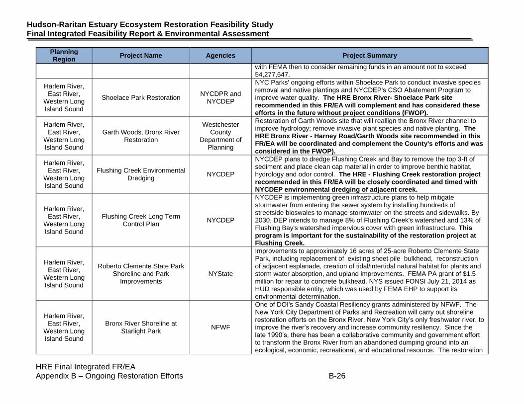
with FEMA then to consider remaining funds in an amount not to exceed 54,277,647.
Harlem River, East River,
Western Long Island Sound
Shoelace Park Restoration NYCDPR and
NYCDEP
NYC Parks' ongoing efforts within Shoelace Park to conduct invasive species removal and native plantings and NYCDEP's CSO Abatement Program to improve water quality. The HRE Bronx River- Shoelace Park site recommended in this FR/EA will complement and has considered these efforts in the future without project conditions (FWOP).
Harlem River, East River,
Western Long Island Sound
Garth Woods, Bronx River Restoration
Westchester County
Department of Planning
Restoration of Garth Woods site that will reallign the Bronx River channel to improve hydrology; remove invasive plant species and native planting. The HRE Bronx River - Harney Road/Garth Woods site recommended in this FR/EA will be coordinated and complement the County's efforts and was considered in the FWOP).
Harlem River, East River,
Western Long Island Sound
Flushing Creek Environmental Dredging
NYCDEP
NYCDEP plans to dredge Flushing Creek and Bay to remove the top 3-ft of sediment and place clean cap material in order to improve benthic habitat, hydrology and odor control. The HRE - Flushing Creek restoration project recommended in this FR/EA will be closely coordinated and timed with NYCDEP environmental dredging of adjacent creek.
Harlem River, East River,
Western Long Island Sound
Flushing Creek Long Term Control Plan
NYCDEP
NYCDEP is implementing green infrastructure plans to help mitigate stormwater from entering the sewer system by installing hundreds of streetside bioswales to manage stormwater on the streets and sidewalks. By 2030, DEP intends to manage 8% of Flushing Creek's watershed and 13% of Flushing Bay's watershed impervious cover with green infrastructure. This program is important for the sustainability of the restoration project at Flushing Creek.
Harlem River, East River,
Western Long Island Sound
Roberto Clemente State Park Shoreline and Park
Improvements NYState
Improvements to approximately 16 acres of 25-acre Roberto Clemente State Park, including replacement of existing sheet pile bulkhead, reconstruction of adjacent esplanade, creation of tidal/intertidal natural habitat for plants and storm water absorption, and upland improvements. FEMA PA grant of $1.5 million for repair to concrete bulkhead. NYS issued FONSI July 21, 2014 as HUD responsible entity, which was used by FEMA EHP to support its environmental determination.
Harlem River, East River,
Western Long Island Sound
Bronx River Shoreline at Starlight Park
NFWF
One of DOI's Sandy Coastal Resiliency grants administered by NFWF. The New York City Department of Parks and Recreation will carry out shoreline restoration efforts on the Bronx River, New York City’s only freshwater river, to improve the river’s recovery and increase community resiliency. Since the late 1990’s, there has been a collaborative community and government effort to transform the Bronx River from an abandoned dumping ground into an ecological, economic, recreational, and educational resource. The restoration

HRE Final Integrated FR/EA Appendix B – Ongoing Restoration Efforts B-27
April 2020
Planning Region
Project Name Agencies Project Summary
area is located in the South Bronx between Westchester Avenue and 172nd Street in the tidal estuary of the river. The project will revitalize floodplain functions for 1.7 acres, re-naturalize 740 feet of armored shoreline, and restore native saltmarsh grasses on half an acre of new wetland habitat. Further, 11 acres of parkland will be enhanced using stormwater best management practices and have reduced toxic substance exposure through the removal of contaminated fill. NFWF is administering a grant totaling $4,400,000, which includes $4,350,000 in DOI funds, and $50,000 in private foundation funds. Design was completed in April 2016. Bid packages for site remediation, wetlands creation, and Bronx River shoreline re-naturalization were due in April 2016. Comments from NYSDEC and USACE on 1st permit submission are being addressed.
Harlem River, East River,
Western Long Island Sound
Hunts Point Resiliency NYCEDC
One of the winning proposals from HUD's Rebuild by Design competition. The current scope of the project includes the continued study, analysis, planning, and stakeholder engagement related to the proposal and the design and construction of a resulting pilot project at Hunts Point in the Bronx. Total HUD CDBG-DR funds for the project is $51 million, with $20 million from the Rebuild by Design allocation.
Newark Bay, Passaic River, Hackensack
River
Diamond Alkali Superfund Site- Remedial
Investigation/Feasibility Study USEPA
RI/FS for lower 17-mile study area (including tributaries) from Dundee Dam to Newark Bay- Operable Unit 2 [Coordinated Restoration Program since 2003] and Newark Bay RI/FS (Operable Unit 3). Restoration of Oak Island Yard would be implemented after remediation and additional restoration opportunities in Newark Bay and Lower Passaic would be coordinated and sequenced with the superfund program.
Newark Bay, Passaic River, Hackensack
River
RBD Meadowlands Flood Protection Project
NJDEP
One of the winning proposals from HUD’s Rebuild by Design competition. Funds will support the first phase of a flood protection project in the northern New Jersey meadowlands, within the Boroughs of Little Ferry, Moonachie, Carlstadt, and Teterboro, and the Township of South Hackensack. Such measures will be designed to address the impacts of coastal and riverine (fluvial) flooding on the quality of the human environment in the Project Area due to both sea level rise and storm hazards, including heavy rainfall events and intense coastal storm events. The approximate Project Area boundaries are: Hackensack River to the east; Paterson Plank Road and the southern boundary of Carlstadt to the south; State Route 17 to the west; and Interstate 80 and the northern boundary of the Borough of Little Ferry to the north.
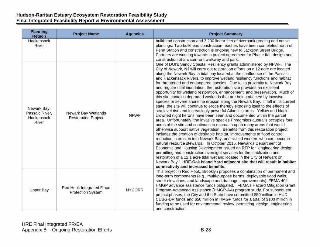
Newark Bay, Passaic River,
Joseph G. Minish Passaic River Waterfront Park
USACE, NJDEP Construction of 1 mile of bulkhead (steel sheet piles with concrete cap) at Minish Passaic River Waterfront Park, Newark. Construction scheduled to start in February 2020. Phase I of the project includes 6,000 linear feet of
HRE Final Integrated FR/EA Appendix B – Ongoing Restoration Efforts B-28
Hudson-Raritan Estuary Ecosystem Restoration Feasibility Study Final Integrated Feasibility Report & Environmental Assessment
Planning Region
Project Name Agencies Project Summary
Hackensack River
bulkhead construction and 3,200 linear feet of riverbank grading and native plantings. Two bulkhead construction reaches have been completed north of Penn Station and construction is ongoing new to Jackson Street Bridge. Partners are working towards a project agreement for Phase II/III design and construction of a waterfront walkway and park.
Newark Bay, Passaic River, Hackensack
River
Newark Bay Wetlands Restoration Project
NFWF
One of DOI's Sandy Coastal Resiliency grants administered by NFWF. The City of Newark, NJ will carry out restoration efforts on a 12 acre are located along the Newark Bay, a tidal bay located at the confluence of the Passaic and Hackensack Rivers, to improve wetland resiliency functions and habitat for threatened and endangered species. Due to its proximity to Newark Bay and regular tidal inundation, the restoration site provides an excellent opportunity for wetland restoration, enhancement, and preservation. Much of this site contains degraded wetlands that are being affected by invasive species or severe shoreline erosion along the Newark Bay. If left in its current state, the site will continue to erode thereby exposing itself to the effects of sea level rise and increasingly powerful Atlantic storms. Yellow and black-crowned night herons have been seen and documented within the parcel area. Unfortunately, the invasive species Phragmites australis occupies four acres of the site and continues to encroach upon many areas that would otherwise support native vegetation. Benefits from this restoration project includes the creation of desirable habitat, improvements to flood control, reduction in erosion into Newark Bay, and skilled workers who can become natural resource stewards. In October 2015, Newark's Department of Economic and Housing Development issued an RFP for "engineering design, permitting and construction oversight services for the stablization and restoration of a 12.1 acre tidal wetland located in the City of Newark on Newark Bay." HRE-Oak Island Yard adjacent site that will result in habitat connectivity and increased benefits.
Upper Bay Red Hook Integrated Flood
Protection System NYCORR
This project in Red Hook, Brooklyn proposes a combination of permanent and long-term components (e.g., multi-purpose berms, deployable flood walls, street elevations, and landscape and drainage improvements). FEMA 404 HMGP advance assistance funds obligated. FEMA's Hazard Mitigation Grant Program-Advanced Assistance (HMGP-AA) program study. For subsequent project phases, the City and the State have committed $50 million in HUD CDBG-DR funds and $50 million in HMGP funds for a total of $100 million in funding to be used for environmental review, permitting, design, engineering and construction.
HRE Final Integrated FR/EA Appendix B – Ongoing Restoration Efforts B-29
April 2020
Planning Region
Project Name Agencies Project Summary
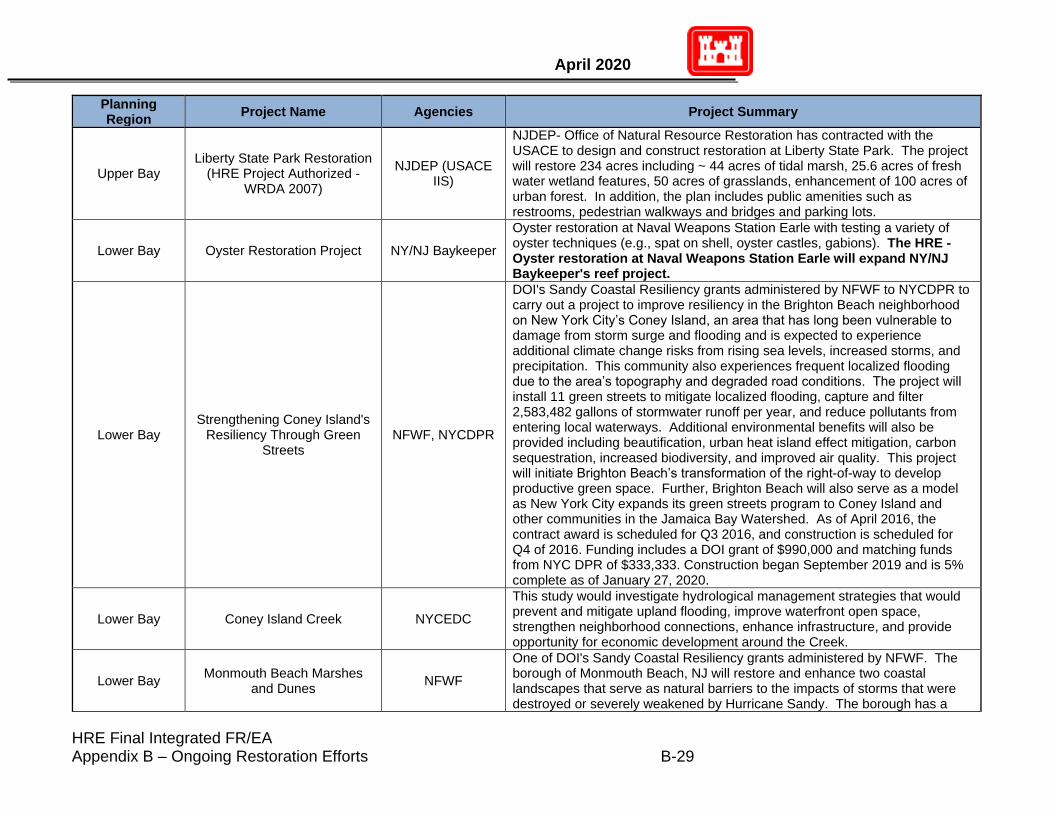
Upper Bay Liberty State Park Restoration
(HRE Project Authorized - WRDA 2007)
NJDEP (USACE IIS)
NJDEP- Office of Natural Resource Restoration has contracted with the USACE to design and construct restoration at Liberty State Park. The project will restore 234 acres including ~ 44 acres of tidal marsh, 25.6 acres of fresh water wetland features, 50 acres of grasslands, enhancement of 100 acres of urban forest. In addition, the plan includes public amenities such as restrooms, pedestrian walkways and bridges and parking lots.
Lower Bay Oyster Restoration Project NY/NJ Baykeeper
Oyster restoration at Naval Weapons Station Earle with testing a variety of oyster techniques (e.g., spat on shell, oyster castles, gabions). The HRE - Oyster restoration at Naval Weapons Station Earle will expand NY/NJ Baykeeper's reef project.
Lower Bay Strengthening Coney Island's
Resiliency Through Green Streets
NFWF, NYCDPR
DOI's Sandy Coastal Resiliency grants administered by NFWF to NYCDPR to carry out a project to improve resiliency in the Brighton Beach neighborhood on New York City’s Coney Island, an area that has long been vulnerable to damage from storm surge and flooding and is expected to experience additional climate change risks from rising sea levels, increased storms, and precipitation. This community also experiences frequent localized flooding due to the area’s topography and degraded road conditions. The project will install 11 green streets to mitigate localized flooding, capture and filter 2,583,482 gallons of stormwater runoff per year, and reduce pollutants from entering local waterways. Additional environmental benefits will also be provided including beautification, urban heat island effect mitigation, carbon sequestration, increased biodiversity, and improved air quality. This project will initiate Brighton Beach’s transformation of the right-of-way to develop productive green space. Further, Brighton Beach will also serve as a model as New York City expands its green streets program to Coney Island and other communities in the Jamaica Bay Watershed. As of April 2016, the contract award is scheduled for Q3 2016, and construction is scheduled for Q4 of 2016. Funding includes a DOI grant of $990,000 and matching funds from NYC DPR of $333,333. Construction began September 2019 and is 5% complete as of January 27, 2020.
Lower Bay Coney Island Creek NYCEDC
This study would investigate hydrological management strategies that would prevent and mitigate upland flooding, improve waterfront open space, strengthen neighborhood connections, enhance infrastructure, and provide opportunity for economic development around the Creek.
Lower Bay Monmouth Beach Marshes
and Dunes NFWF
One of DOI's Sandy Coastal Resiliency grants administered by NFWF. The borough of Monmouth Beach, NJ will restore and enhance two coastal landscapes that serve as natural barriers to the impacts of storms that were destroyed or severely weakened by Hurricane Sandy. The borough has a
HRE Final Integrated FR/EA Appendix B – Ongoing Restoration Efforts B-30
Hudson-Raritan Estuary Ecosystem Restoration Feasibility Study Final Integrated Feasibility Report & Environmental Assessment
Planning Region
Project Name Agencies Project Summary
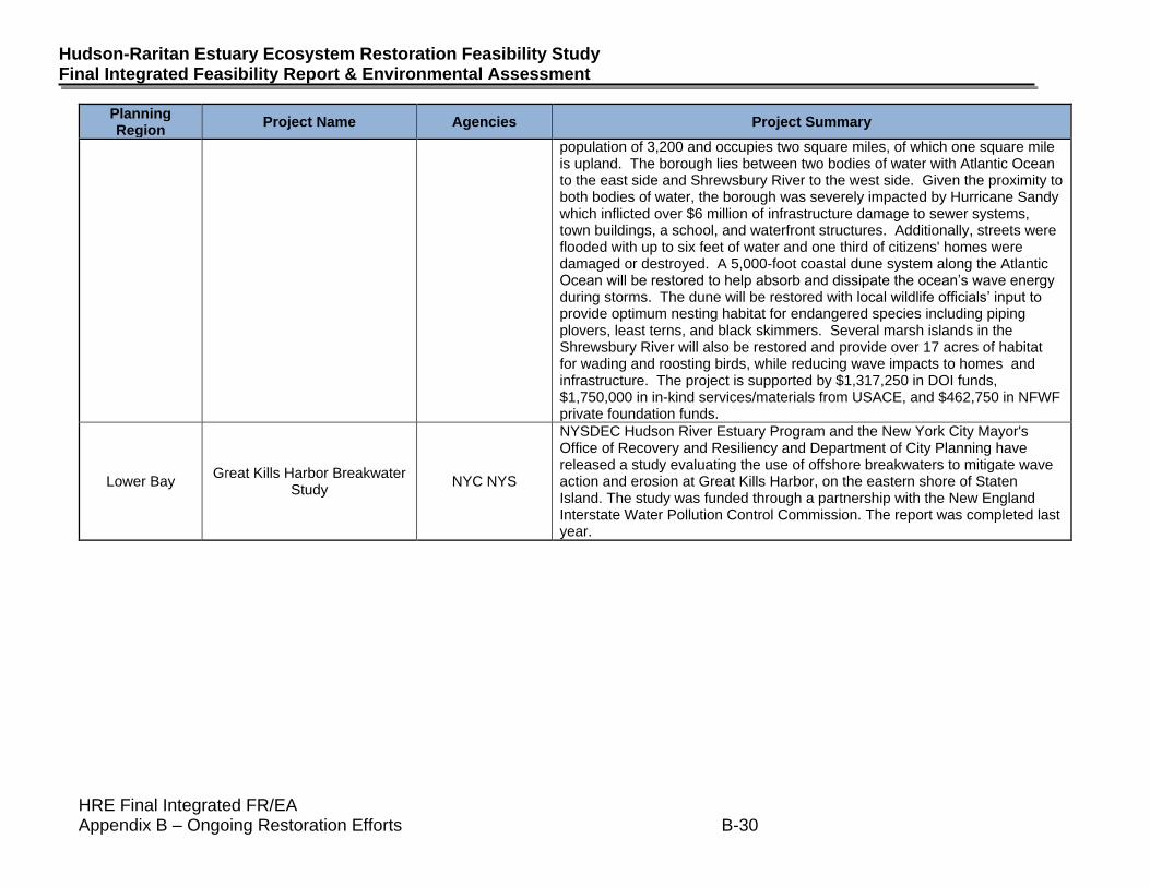
population of 3,200 and occupies two square miles, of which one square mile is upland. The borough lies between two bodies of water with Atlantic Ocean to the east side and Shrewsbury River to the west side. Given the proximity to both bodies of water, the borough was severely impacted by Hurricane Sandy which inflicted over $6 million of infrastructure damage to sewer systems, town buildings, a school, and waterfront structures. Additionally, streets were flooded with up to six feet of water and one third of citizens' homes were damaged or destroyed. A 5,000-foot coastal dune system along the Atlantic Ocean will be restored to help absorb and dissipate the ocean’s wave energy during storms. The dune will be restored with local wildlife officials’ input to provide optimum nesting habitat for endangered species including piping plovers, least terns, and black skimmers. Several marsh islands in the Shrewsbury River will also be restored and provide over 17 acres of habitat for wading and roosting birds, while reducing wave impacts to homes and infrastructure. The project is supported by $1,317,250 in DOI funds, $1,750,000 in in-kind services/materials from USACE, and $462,750 in NFWF private foundation funds.
Lower Bay Great Kills Harbor Breakwater
Study NYC NYS
NYSDEC Hudson River Estuary Program and the New York City Mayor's Office of Recovery and Resiliency and Department of City Planning have released a study evaluating the use of offshore breakwaters to mitigate wave action and erosion at Great Kills Harbor, on the eastern shore of Staten Island. The study was funded through a partnership with the New England Interstate Water Pollution Control Commission. The report was completed last year.
HRE Final Integrated FR/EA Appendix B – Ongoing Restoration Efforts B-31
April 2020
4. Completed Restoration Efforts (B-3)
The completed restoration and resilience projects conducted by the USACE and regional partners are highlighted in the NY-NJ Harbor Estuary Progress Report. Included is the 2009-2014 report, the 2014-2016 update, and the 2017-2019 update.
Planning Region Project Name Agencies Project Summary
Multiple
NY & NJ Harbor & Tributaries
Coastal Storm Risk
Management (CSRM) Study
USACE, NYSDEC,
NJDEP, NYC
The NY-NJ Harbor & Tributaries is one of 9 focus areas identified in
the North Atlantic Coast Comprehensive Study report (USACE,
2015). The purpose of this study is to investigate comprehensive
approaches to improve community resilience and to manage risk of
damages from future coastal storms and impacts of sea level rise
(SLR). The project will identify and explore areas of coastal storm
risk and develop the most feasible comprehensive combination of
structural, non-structural, and/or natural and nature-based
measures into alternatives that best manage risks from current and
projected future coastal flooding in both the short and long term.
Interim Feasibility Report was released on February 19, 2019 and a
Draft Feasibility Study and Tier 1 Environmental Impact Statement
are expected to be released in Spring 2020.
MultipleCombined Sewer Overflow
Abatement Program
NYCDEP and
NYSDEC
In 2012, the NYSDEC and NYCDEP signed an agreement to reduce
combined sewer overflows and improve water quality through the
collection and treatment of sewerage prior to release into the HRE.
Under this agreement, several long-term control plans for specific
waterbodies and one for NYC were drafted to identify appropriate
combined sewer overflow controls necessary to improve water
quality. Overflow abatement measures include conducting
environmental dredging of several tributaries within the City of New
York to remove combined sewer overflow mounds that contribute to
nuisance odors and dissolved oxygen deficits within affected
waterbodies. These waterbodies include Paerdegat Basin, Flushing
Bay, Flushing Creek, Gowanus Canal, Bergen Basin, Fresh Creek,
Newtown Creek, and Thurston Basin.
Appendix B-2: Ongoing Ecosystem and Coastal Restoration (excludes beach nourishment) within HRE Planning Regions with
Recommended Plan Sites
Page 1 of 19
Planning Region Project Name Agencies Project Summary
Appendix B-2: Ongoing Ecosystem and Coastal Restoration (excludes beach nourishment) within HRE Planning Regions with
Recommended Plan Sites
Multiple NYC Raised Shorelines NYC
The NYC plans to raise bulkheads and build other shoreline
structures in low-lying neighborhoods throughout the City, including
a number of low- and moderate-income communities impacted by
Hurricane Sandy, to minimize inland tidal flooding, which would
worsen neighborhoods in the floodplain, threatening their economic
viability and residential stability. The component planned for the
Totenville area of Staten Island will continue to be coordinated with
Living Breakwaters (DB#5) and Totenville Dunes (DB#597).
Construction began August 1, 2017 and is expected to be
completed by December 21, 2022.
Multiple Billion Oyster Project NY Harbor School
NY Harbor School with goal to bring back one billion oysters - self
sustaining oyster reefs to New York Harbor. HRE - Small Scale
Oyster Restoration recommended advance the BOP program
with NY Harbor School who will be construction sponsor.
Lower Bay
South Shore of Staten Island
Coastal Storm Risk
Management
USACE, NYSDEC
The project is divided into two phases of study. Phase 1 (Ft.
Wadsworth to Oakiwood Beach) analyzed solutions and
recommended levees, floodwalls and non-structural measures to
reduce hurricane and storm damage: Final Feasibility Report/EIS
and ROD completed in December 2016. The Desing Phase for
preparations of plans ans specifications began in ealry 2017 and
construction is estimated to begin late 2020. It was determined that
there was no Federal interest for Phase 2 (Great Kills to Tottenville)
however the State and City of New York are continuing to plan other
projects for this area such as Living Breakwaters and Tottenville
Shoreline Protection Project.
Page 2 of 19
Planning Region Project Name Agencies Project Summary
Appendix B-2: Ongoing Ecosystem and Coastal Restoration (excludes beach nourishment) within HRE Planning Regions with
Recommended Plan Sites
Multiple Public Greenways
NYC, NYCDPR,
NYCDOT, Byron and
Bronx River Alliance,
NYCEDC
Waterfront Greenway initiatives include:
• MillionTrees NYC, a PlaNYC initiative, is a public-private program.
In 2015, two (2) years ahead of schedule, MillionTrees NYC
achieved the program goal of planting 1,000,000 trees in New York
City.
• The Manhattan Waterfront Greenway is a 32-mile multiuse trail
that circumnavigates Manhattan Island, and includes over 23 miles
of waterfront pathways and facilitates access to over 1,500 acres of
parkland throughout the borough. The greenway builds on recent
efforts to transform a long-neglected waterfront into a green
attraction for recreational and commuting use.
• Construction on the South Bronx Greenway and the Bronx River
Greenway is underway encompassing 1.5 miles of waterfront
greenway, 8.5 miles of inland green streets, and nearly 12 acres of
new waterfront open space throughout the Hunts Point and Port
Morris neighborhoods in the Bronx. The Bronx River Greenway
extends for 23 miles along the Bronx River, from Westchester
County to Soundview Park in the South Bronx. Approximately 19
miles of the greenway are currently in place with completion
anticipated within the next decade.
• The Brooklyn Waterfront Greenway is a 26-mile route linking
neighborhood parks and open spaces from Greenpoint to
Lindenwood/Howard Beach. To date 18 miles have been completed
with eight (8) miles remaining. https://www.brooklyngreenway.org/
portions of the Brooklyn waterfront Greenway and the Jamaica Bay
greenway overlap
• The Jamaica Bay Greenway will be a 28-mile network of bicycle
and pedestrian paths connecting more than 10,000 acres of parks
and beaches. More than 10 miles are in place.
Page 3 of 19
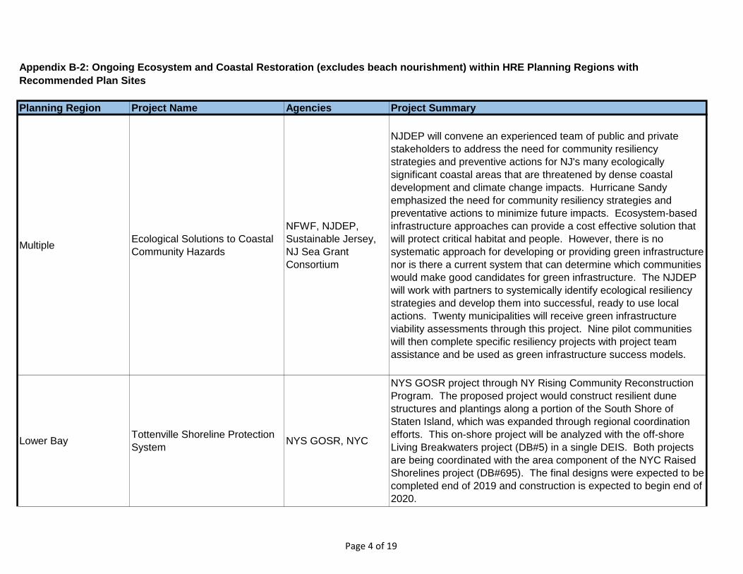
Planning Region Project Name Agencies Project Summary
Appendix B-2: Ongoing Ecosystem and Coastal Restoration (excludes beach nourishment) within HRE Planning Regions with
Recommended Plan Sites
MultipleEcological Solutions to Coastal
Community Hazards
NFWF, NJDEP,
Sustainable Jersey,
NJ Sea Grant
Consortium
NJDEP will convene an experienced team of public and private
stakeholders to address the need for community resiliency
strategies and preventive actions for NJ's many ecologically
significant coastal areas that are threatened by dense coastal
development and climate change impacts. Hurricane Sandy
emphasized the need for community resiliency strategies and
preventative actions to minimize future impacts. Ecosystem-based
infrastructure approaches can provide a cost effective solution that
will protect critical habitat and people. However, there is no
systematic approach for developing or providing green infrastructure
nor is there a current system that can determine which communities
would make good candidates for green infrastructure. The NJDEP
will work with partners to systemically identify ecological resiliency
strategies and develop them into successful, ready to use local
actions. Twenty municipalities will receive green infrastructure
viability assessments through this project. Nine pilot communities
will then complete specific resiliency projects with project team
assistance and be used as green infrastructure success models.
Lower BayTottenville Shoreline Protection
SystemNYS GOSR, NYC
NYS GOSR project through NY Rising Community Reconstruction
Program. The proposed project would construct resilient dune
structures and plantings along a portion of the South Shore of
Staten Island, which was expanded through regional coordination
efforts. This on-shore project will be analyzed with the off-shore
Living Breakwaters project (DB#5) in a single DEIS. Both projects
are being coordinated with the area component of the NYC Raised
Shorelines project (DB#695). The final designs were expected to be
completed end of 2019 and construction is expected to begin end of
2020.
Page 4 of 19
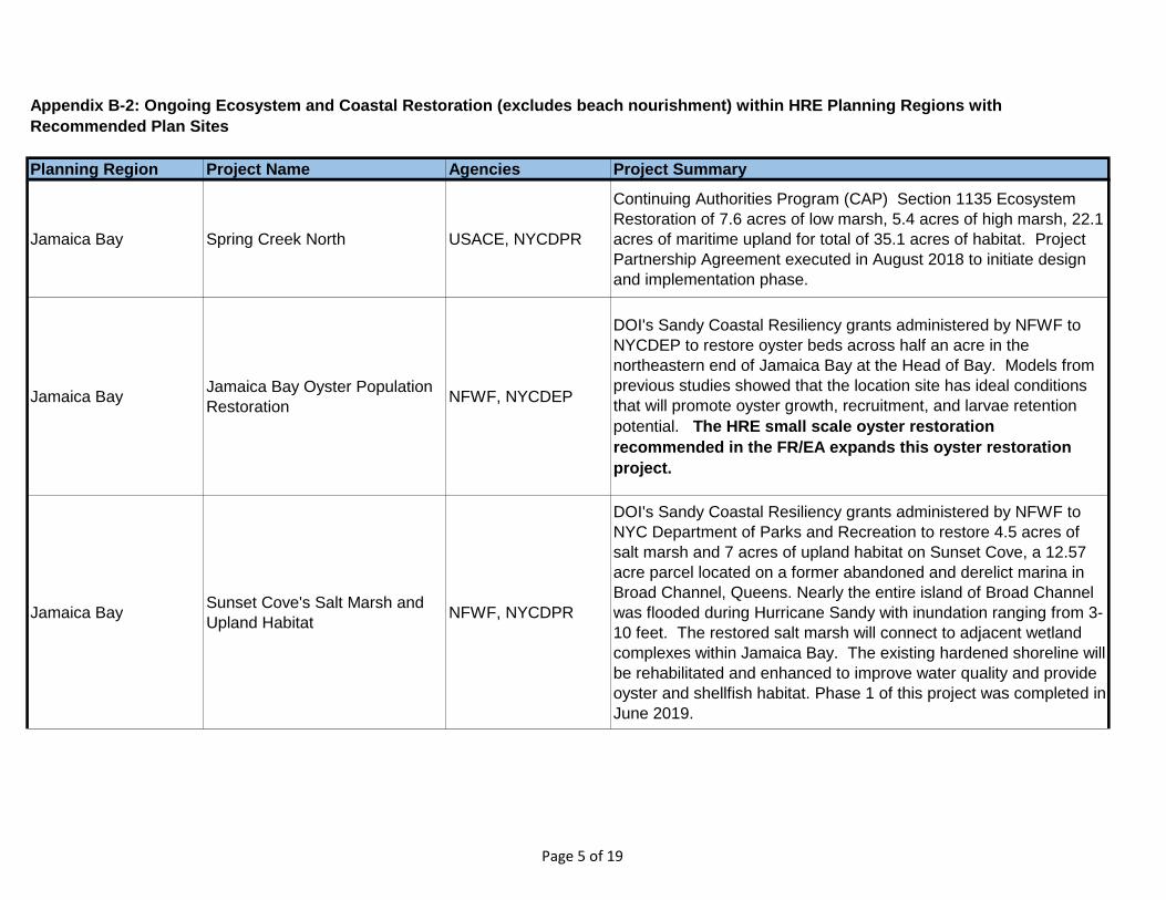
Planning Region Project Name Agencies Project Summary
Appendix B-2: Ongoing Ecosystem and Coastal Restoration (excludes beach nourishment) within HRE Planning Regions with
Recommended Plan Sites
Jamaica Bay Spring Creek North USACE, NYCDPR
Continuing Authorities Program (CAP) Section 1135 Ecosystem
Restoration of 7.6 acres of low marsh, 5.4 acres of high marsh, 22.1
acres of maritime upland for total of 35.1 acres of habitat. Project
Partnership Agreement executed in August 2018 to initiate design
and implementation phase.
Jamaica BayJamaica Bay Oyster Population
Restoration NFWF, NYCDEP
DOI's Sandy Coastal Resiliency grants administered by NFWF to
NYCDEP to restore oyster beds across half an acre in the
northeastern end of Jamaica Bay at the Head of Bay. Models from
previous studies showed that the location site has ideal conditions
that will promote oyster growth, recruitment, and larvae retention
potential. The HRE small scale oyster restoration
recommended in the FR/EA expands this oyster restoration
project.
Jamaica BaySunset Cove's Salt Marsh and
Upland HabitatNFWF, NYCDPR
DOI's Sandy Coastal Resiliency grants administered by NFWF to
NYC Department of Parks and Recreation to restore 4.5 acres of
salt marsh and 7 acres of upland habitat on Sunset Cove, a 12.57
acre parcel located on a former abandoned and derelict marina in
Broad Channel, Queens. Nearly the entire island of Broad Channel
was flooded during Hurricane Sandy with inundation ranging from 3-
10 feet. The restored salt marsh will connect to adjacent wetland
complexes within Jamaica Bay. The existing hardened shoreline will
be rehabilitated and enhanced to improve water quality and provide
oyster and shellfish habitat. Phase 1 of this project was completed in
June 2019.
Page 5 of 19
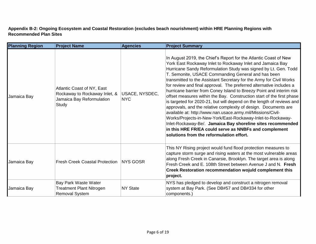
Planning Region Project Name Agencies Project Summary
Appendix B-2: Ongoing Ecosystem and Coastal Restoration (excludes beach nourishment) within HRE Planning Regions with
Recommended Plan Sites
Jamaica Bay
Atlantic Coast of NY, East
Rockaway to Rockaway Inlet, &
Jamaica Bay Reformulation
Study
USACE, NYSDEC,
NYC
In August 2019, the Chief’s Report for the Atlantic Coast of New
York East Rockaway Inlet to Rockaway Inlet and Jamaica Bay
Hurricane Sandy Reformulation Study was signed by Lt. Gen. Todd
T. Semonite, USACE Commanding General and has been
transmitted to the Assistant Secretary for the Army for Civil Works
for review and final approval. The preferred alternative includes a
hurricane barrier from Coney Island to Breezy Point and interim risk
offset measures within the Bay. Construction start of the first phase
is targeted for 2020-21, but will depend on the length of reviews and
approvals, and the relative complexity of design. Documents are
available at: http://www.nan.usace.army.mil/Missions/Civil-
Works/Projects-in-New-York/East-Rockaway-Inlet-to-Rockaway-
Inlet-Rockaway-Be/. Jamaica Bay shoreline sites recommended
in this HRE FR/EA could serve as NNBFs and complement
solutions from the reformulation effort.
Jamaica Bay Fresh Creek Coastal Protection NYS GOSR
This NY Rising project would fund flood protection measures to
capture storm surge and rising waters at the most vulnerable areas
along Fresh Creek in Canarsie, Brooklyn. The target area is along
Fresh Creek and E. 108th Street between Avenue J and N. Fresh
Creek Restoration recommendation wojuld complement this
project.
Jamaica Bay
Bay Park Waste Water
Treatment Plant Nitrogen
Removal System
NY State
NYS has pledged to develop and construct a nitrogen removal
system at Bay Park. (See DB#57 and DB#334 for other
components.)
Page 6 of 19
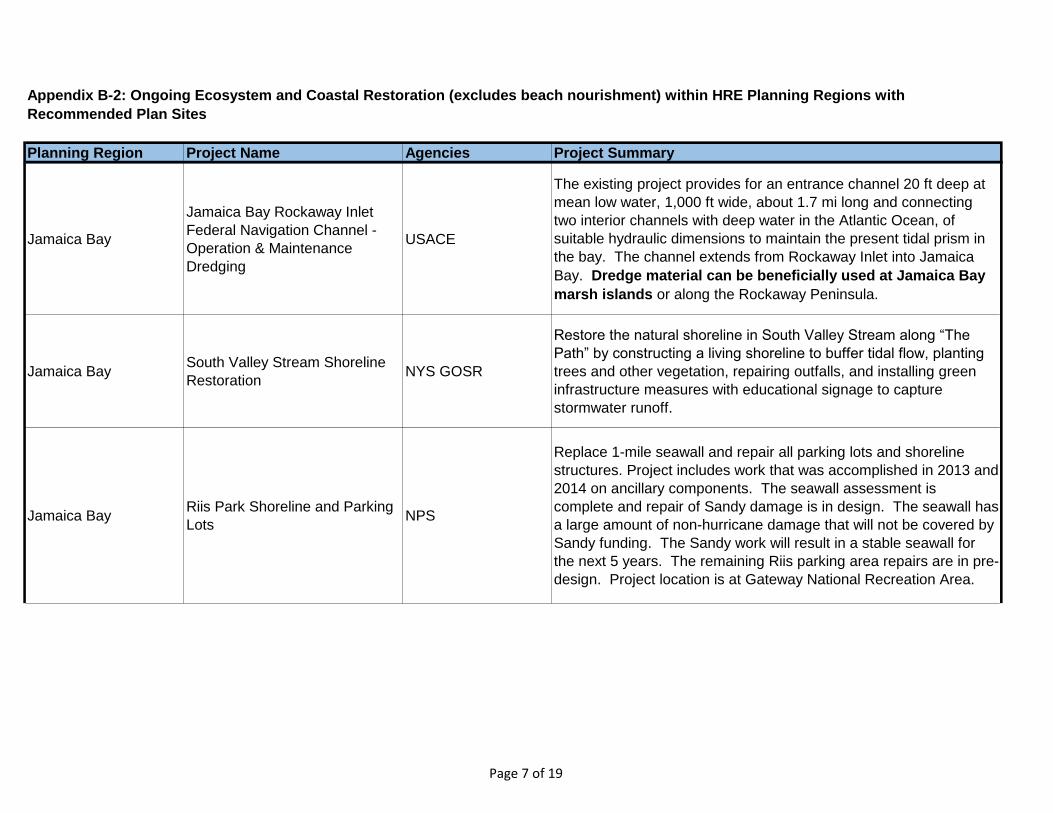
Planning Region Project Name Agencies Project Summary
Appendix B-2: Ongoing Ecosystem and Coastal Restoration (excludes beach nourishment) within HRE Planning Regions with
Recommended Plan Sites
Jamaica Bay
Jamaica Bay Rockaway Inlet
Federal Navigation Channel -
Operation & Maintenance
Dredging
USACE
The existing project provides for an entrance channel 20 ft deep at
mean low water, 1,000 ft wide, about 1.7 mi long and connecting
two interior channels with deep water in the Atlantic Ocean, of
suitable hydraulic dimensions to maintain the present tidal prism in
the bay. The channel extends from Rockaway Inlet into Jamaica
Bay. Dredge material can be beneficially used at Jamaica Bay
marsh islands or along the Rockaway Peninsula.
Jamaica BaySouth Valley Stream Shoreline
RestorationNYS GOSR
Restore the natural shoreline in South Valley Stream along “The
Path” by constructing a living shoreline to buffer tidal flow, planting
trees and other vegetation, repairing outfalls, and installing green
infrastructure measures with educational signage to capture
stormwater runoff.
Jamaica BayRiis Park Shoreline and Parking
LotsNPS
Replace 1-mile seawall and repair all parking lots and shoreline
structures. Project includes work that was accomplished in 2013 and
2014 on ancillary components. The seawall assessment is
complete and repair of Sandy damage is in design. The seawall has
a large amount of non-hurricane damage that will not be covered by
Sandy funding. The Sandy work will result in a stable seawall for
the next 5 years. The remaining Riis parking area repairs are in pre-
design. Project location is at Gateway National Recreation Area.
Page 7 of 19
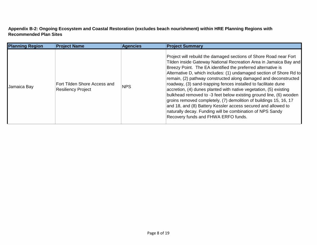
Planning Region Project Name Agencies Project Summary
Appendix B-2: Ongoing Ecosystem and Coastal Restoration (excludes beach nourishment) within HRE Planning Regions with
Recommended Plan Sites
Jamaica BayFort Tilden Shore Access and
Resiliency ProjectNPS
Project will rebuild the damaged sections of Shore Road near Fort
Tilden inside Gateway National Recreation Area in Jamaica Bay and
Breezy Point. The EA identified the preferred alternative is
Alternative D, which includes: (1) undamaged section of Shore Rd to
remain, (2) pathway constructed along damaged and deconstructed
roadway, (3) sand-trapping fences installed to facilitate dune
accretion, (4) dunes planted with native vegetation, (5) existing
bulkhead removed to -3 feet below existing ground line, (6) wooden
groins removed completely, (7) demolition of buildings 15, 16, 17
and 18, and (8) Battery Kessler access secured and allowed to
naturally decay. Funding will be combination of NPS Sandy
Recovery funds and FHWA ERFO funds.
Page 8 of 19
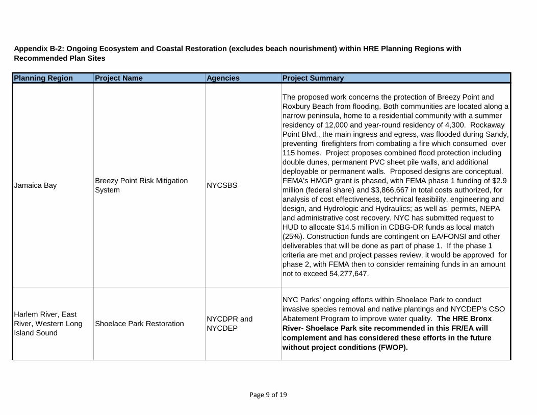
Planning Region Project Name Agencies Project Summary
Appendix B-2: Ongoing Ecosystem and Coastal Restoration (excludes beach nourishment) within HRE Planning Regions with
Recommended Plan Sites
Jamaica BayBreezy Point Risk Mitigation
SystemNYCSBS
The proposed work concerns the protection of Breezy Point and
Roxbury Beach from flooding. Both communities are located along a
narrow peninsula, home to a residential community with a summer
residency of 12,000 and year-round residency of 4,300. Rockaway
Point Blvd., the main ingress and egress, was flooded during Sandy,
preventing firefighters from combating a fire which consumed over
115 homes. Project proposes combined flood protection including
double dunes, permanent PVC sheet pile walls, and additional
deployable or permanent walls. Proposed designs are conceptual.
FEMA's HMGP grant is phased, with FEMA phase 1 funding of $2.9
million (federal share) and $3,866,667 in total costs authorized, for
analysis of cost effectiveness, technical feasibility, engineering and
design, and Hydrologic and Hydraulics; as well as permits, NEPA
and administrative cost recovery. NYC has submitted request to
HUD to allocate $14.5 million in CDBG-DR funds as local match
(25%). Construction funds are contingent on EA/FONSI and other
deliverables that will be done as part of phase 1. If the phase 1
criteria are met and project passes review, it would be approved for
phase 2, with FEMA then to consider remaining funds in an amount
not to exceed 54,277,647.
Harlem River, East
River, Western Long
Island Sound
Shoelace Park Restoration NYCDPR and
NYCDEP
NYC Parks' ongoing efforts within Shoelace Park to conduct
invasive species removal and native plantings and NYCDEP's CSO
Abatement Program to improve water quality. The HRE Bronx
River- Shoelace Park site recommended in this FR/EA will
complement and has considered these efforts in the future
without project conditions (FWOP).
Page 9 of 19
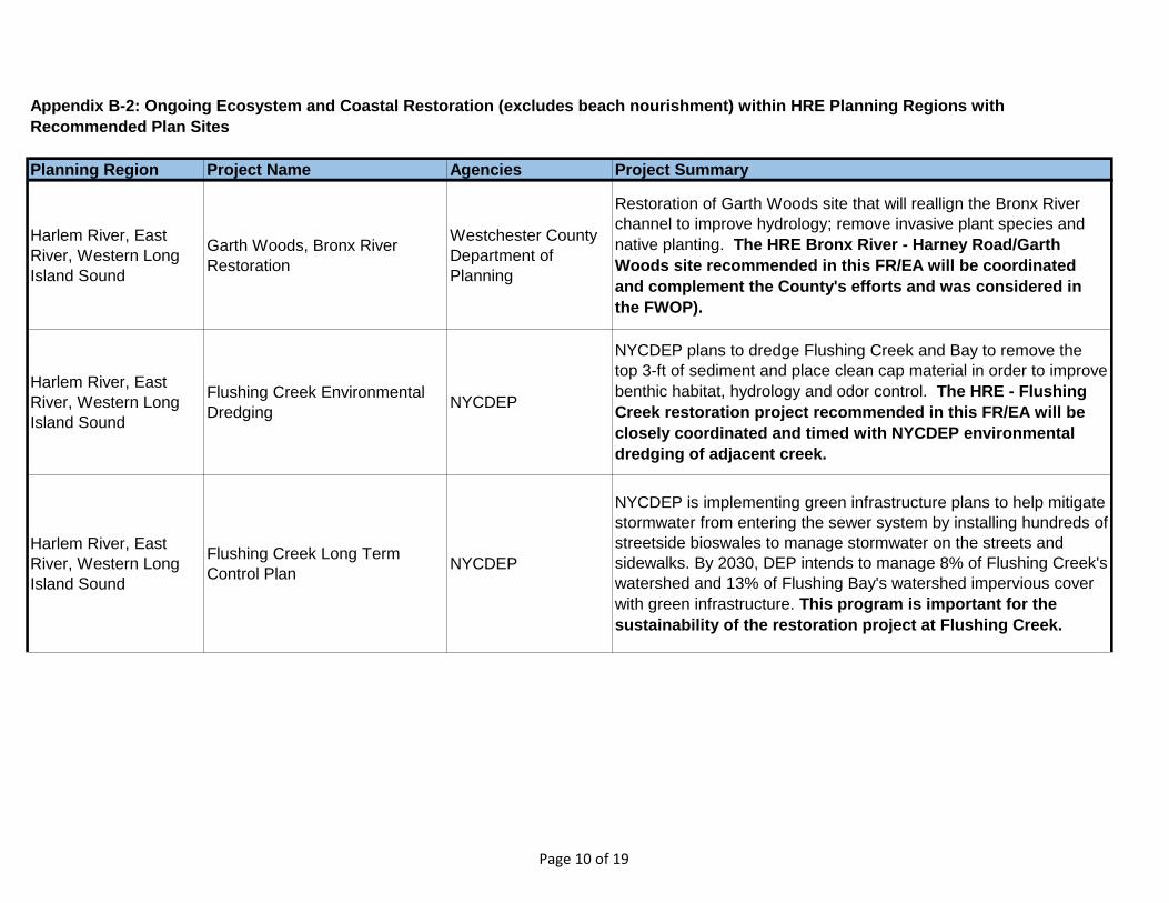
Planning Region Project Name Agencies Project Summary
Appendix B-2: Ongoing Ecosystem and Coastal Restoration (excludes beach nourishment) within HRE Planning Regions with
Recommended Plan Sites
Harlem River, East
River, Western Long
Island Sound
Garth Woods, Bronx River
Restoration
Westchester County
Department of
Planning
Restoration of Garth Woods site that will reallign the Bronx River
channel to improve hydrology; remove invasive plant species and
native planting. The HRE Bronx River - Harney Road/Garth
Woods site recommended in this FR/EA will be coordinated
and complement the County's efforts and was considered in
the FWOP).
Harlem River, East
River, Western Long
Island Sound
Flushing Creek Environmental
DredgingNYCDEP
NYCDEP plans to dredge Flushing Creek and Bay to remove the
top 3-ft of sediment and place clean cap material in order to improve
benthic habitat, hydrology and odor control. The HRE - Flushing
Creek restoration project recommended in this FR/EA will be
closely coordinated and timed with NYCDEP environmental
dredging of adjacent creek.
Harlem River, East
River, Western Long
Island Sound
Flushing Creek Long Term
Control PlanNYCDEP
NYCDEP is implementing green infrastructure plans to help mitigate
stormwater from entering the sewer system by installing hundreds of
streetside bioswales to manage stormwater on the streets and
sidewalks. By 2030, DEP intends to manage 8% of Flushing Creek's
watershed and 13% of Flushing Bay's watershed impervious cover
with green infrastructure. This program is important for the
sustainability of the restoration project at Flushing Creek.
Page 10 of 19
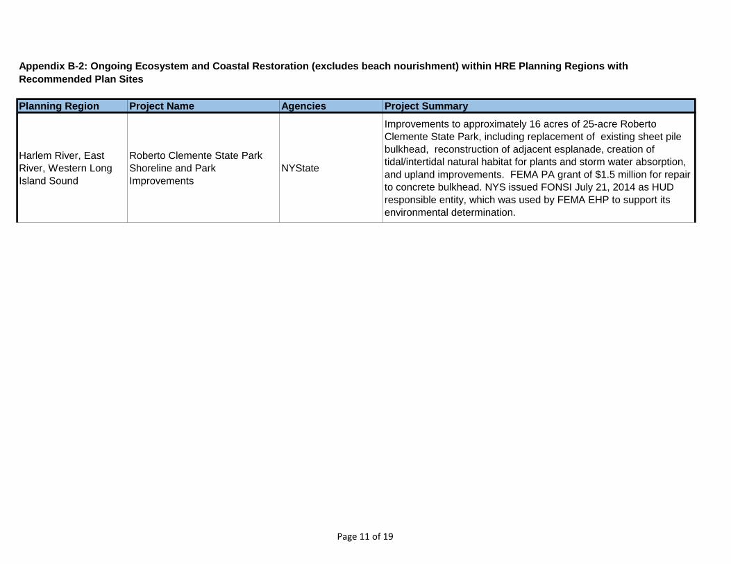
Planning Region Project Name Agencies Project Summary
Appendix B-2: Ongoing Ecosystem and Coastal Restoration (excludes beach nourishment) within HRE Planning Regions with
Recommended Plan Sites
Harlem River, East
River, Western Long
Island Sound
Roberto Clemente State Park
Shoreline and Park
Improvements
NYState
Improvements to approximately 16 acres of 25-acre Roberto
Clemente State Park, including replacement of existing sheet pile
bulkhead, reconstruction of adjacent esplanade, creation of
tidal/intertidal natural habitat for plants and storm water absorption,
and upland improvements. FEMA PA grant of $1.5 million for repair
to concrete bulkhead. NYS issued FONSI July 21, 2014 as HUD
responsible entity, which was used by FEMA EHP to support its
environmental determination.
Page 11 of 19
Planning Region Project Name Agencies Project Summary
Appendix B-2: Ongoing Ecosystem and Coastal Restoration (excludes beach nourishment) within HRE Planning Regions with
Recommended Plan Sites
Harlem River, East
River, Western Long
Island Sound
Bronx River Shoreline at
Starlight ParkNFWF
One of DOI's Sandy Coastal Resiliency grants administered by
NFWF. The New York City Department of Parks and Recreation will
carry out shoreline restoration efforts on the Bronx River, New York
City’s only freshwater river, to improve the river’s recovery and
increase community resiliency. Since the late 1990’s, there has
been a collaborative community and government effort to transform
the Bronx River from an abandoned dumping ground into an
ecological, economic, recreational, and educational resource. The
restoration area is located in the South Bronx between Westchester
Avenue and 172nd Street in the tidal estuary of the river. The
project will revitalize floodplain functions for 1.7 acres, re-naturalize
740 feet of armored shoreline, and restore native saltmarsh grasses
on half an acre of new wetland habitat. Further, 11 acres of
parkland will be enhanced using stormwater best management
practices and have reduced toxic substance exposure through the
removal of contaminated fill. NFWF is administering a grant totaling
$4,400,000, which includes $4,350,000 in DOI funds, and $50,000
in private foundation funds. Design was completed in April 2016. Bid
packages for site remediation, wetlands creation, and Bronx River
shoreline re-naturalization were due in April 2016. Comments from
NYSDEC and USACE on 1st permit submission are being
addressed.
Page 12 of 19
Planning Region Project Name Agencies Project Summary
Appendix B-2: Ongoing Ecosystem and Coastal Restoration (excludes beach nourishment) within HRE Planning Regions with
Recommended Plan Sites
Harlem River, East
River, Western Long
Island Sound
Hunts Point Resiliency NYCEDC
One of the winning proposals from HUD's Rebuild by Design
competition. The current scope of the project includes the
continued study, analysis, planning, and stakeholder engagement
related to the proposal and the design and construction of a
resulting pilot project at Hunts Point in the Bronx. Total HUD CDBG-
DR funds for the project is $51 million, with $20 million from the
Rebuild by Design allocation.
Newark Bay, Passaic
River, Hackensack
River
Diamond Alkali Superfund Site-
Remedial
Investigation/Feasibility Study
USEPA
RI/FS for lower 17-mile study area (including tributaries) from
Dundee Dam to Newark Bay- Operable Unit 2 [Coordinated
Restoration Program since 2003] and Newark Bay RI/FS (Operable
Unit 3). Restoration of Oak Island Yard would be implemented
after remediation and additional restoration opportunities in
Newark Bay and Lower Passaic would be coordinated and
sequenced with the superfund program.
Page 13 of 19
Planning Region Project Name Agencies Project Summary
Appendix B-2: Ongoing Ecosystem and Coastal Restoration (excludes beach nourishment) within HRE Planning Regions with
Recommended Plan Sites
Newark Bay, Passaic
River, Hackensack
River
RBD Meadowlands Flood
Protection ProjectNJDEP
One of the winning proposals from HUD’s Rebuild by Design
competition. Funds will support the first phase of a flood protection
project in the northern New Jersey meadowlands, within the
Boroughs of Little Ferry, Moonachie, Carlstadt, and Teterboro, and
the Township of South Hackensack. Such measures will be
designed to address the impacts of coastal and riverine (fluvial)
flooding on the quality of the human environment in the Project Area
due to both sea level rise and storm hazards, including heavy rainfall
events and intense coastal storm events. The approximate Project
Area boundaries are: Hackensack River to the east; Paterson Plank
Road and the southern boundary of Carlstadt to the south; State
Route 17 to the west; and Interstate 80 and the northern boundary
of the Borough of Little Ferry to the north.
Newark Bay, Passaic
River, Hackensack
River
Joseph G. Minish Passaic River
Waterfront ParkUSACE, NJDEP
Construction of 1 mile of bulkhead (steel sheet piles with concrete
cap) at Minish Passaic River Waterfront Park, Newark. Construction
scheduled to start in February 2020. Phase I of the project includes
6,000 linear feet of bulkhead construction and 3,200 linear feet of
riverbank grading and native plantings. Two bulkhead construction
reaches have been completed north of Penn Station and
construction is ongoing new to Jackson Street Bridge. Partners are
working towards a project agreement for Phase II/III design and
construction of a waterfront walkway and park.
Page 14 of 19
Planning Region Project Name Agencies Project Summary
Appendix B-2: Ongoing Ecosystem and Coastal Restoration (excludes beach nourishment) within HRE Planning Regions with
Recommended Plan Sites
Newark Bay, Passaic
River, Hackensack
River
Newark Bay Wetlands
Restoration ProjectNFWF
One of DOI's Sandy Coastal Resiliency grants administered by
NFWF. The City of Newark, NJ will carry out restoration efforts on a
12 acre are located along the Newark Bay, a tidal bay located at the
confluence of the Passaic and Hackensack Rivers, to improve
wetland resiliency functions and habitat for threatened and
endangered species. Due to its proximity to Newark Bay and
regular tidal inundation, the restoration site provides an excellent
opportunity for wetland restoration, enhancement, and preservation.
Much of this site contains degraded wetlands that are being affected
by invasive species or severe shoreline erosion along the Newark
Bay. If left in its current state, the site will continue to erode thereby
exposing itself to the effects of sea level rise and increasingly
powerful Atlantic storms. Yellow and black-crowned night herons
have been seen and documented within the parcel area.
Unfortunately, the invasive species Phragmites australis occupies
four acres of the site and continues to encroach upon many areas
that would otherwise support native vegetation. Benefits from this
restoration project includes the creation of desirable habitat,
improvements to flood control, reduction in erosion into Newark Bay,
and skilled workers who can become natural resource stewards. In
October 2015, Newark's Department of Economic and Housing
Development issued an RFP for "engineering design, permitting and
construction oversight services for the stablization and restoration of
a 12.1 acre tidal wetland located in the City of Newark on Newark
Bay." HRE-Oak Island Yard adjacent site that will result in
habitat connectivity and increased benefits.
Page 15 of 19

Planning Region Project Name Agencies Project Summary
Appendix B-2: Ongoing Ecosystem and Coastal Restoration (excludes beach nourishment) within HRE Planning Regions with
Recommended Plan Sites
Upper BayRed Hook Integrated Flood
Protection SystemNYCORR
This project in Red Hook, Brooklyn proposes a combination of
permanent and long-term components (e.g., multi-purpose berms,
deployable flood walls, street elevations, and landscape and
drainage improvements). FEMA 404 HMGP advance assistance
funds obligated. FEMA's Hazard Mitigation Grant Program-
Advanced Assistance (HMGP-AA) program study. For subsequent
project phases, the City and the State have committed $50 million in
HUD CDBG-DR funds and $50 million in HMGP funds for a total of
$100 million in funding to be used for environmental review,
permitting, design, engineering and construction.
Upper Bay
Liberty State Park Restoration
(HRE Project Authorized -
WRDA 2007)
NJDEP (USACE IIS)
NJDEP- Office of Natural Resource Restoration has contracted with
the USACE to design and construct restoration at Liberty State
Park. The project will restore 234 acres including ~ 44 acres of tidal
marsh, 25.6 acres of fresh water wetland features, 50 acres of
grasslands, enhancement of 100 acres of urban forest. In addition,
the plan includes public amenities such as restrooms, pedestrian
walkways and bridges and parking lots.
Lower Bay Oyster Restoration Project NY/NJ Baykeeper
Oyster restoration at Naval Weapons Station Earle with testing a
variety of oyster techniques (e.g., spat on shell, oyster castles,
gabions). The HRE - Oyster restoration at Naval Weapons
Station Earle will expand NY/NJ Baykeeper's reef project.
Page 16 of 19
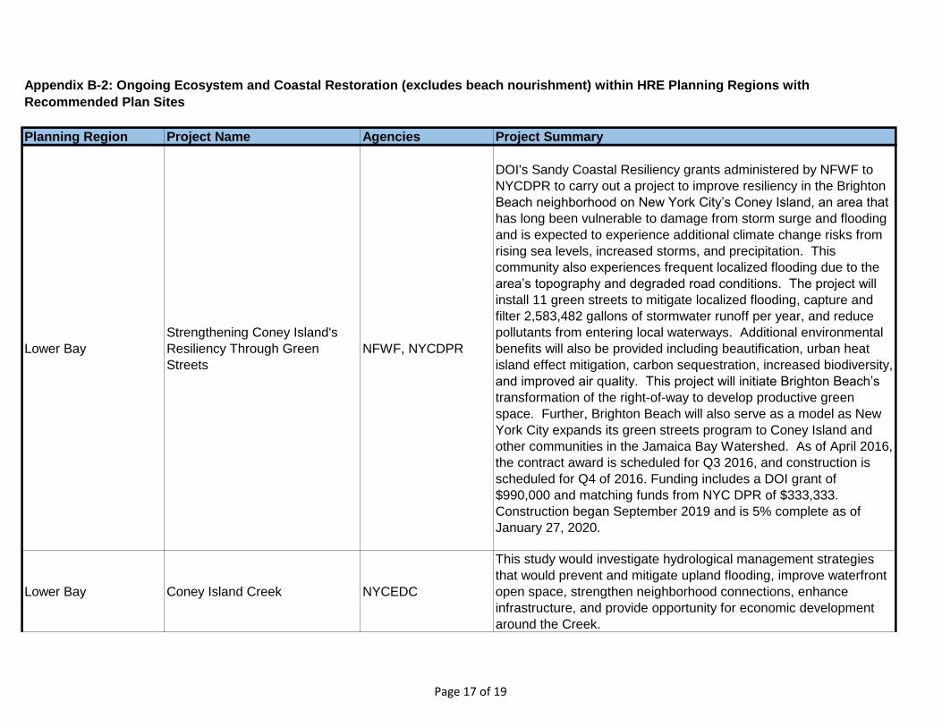
Planning Region Project Name Agencies Project Summary
Appendix B-2: Ongoing Ecosystem and Coastal Restoration (excludes beach nourishment) within HRE Planning Regions with
Recommended Plan Sites
Lower Bay
Strengthening Coney Island's
Resiliency Through Green
Streets
NFWF, NYCDPR
DOI's Sandy Coastal Resiliency grants administered by NFWF to
NYCDPR to carry out a project to improve resiliency in the Brighton
Beach neighborhood on New York City’s Coney Island, an area that
has long been vulnerable to damage from storm surge and flooding
and is expected to experience additional climate change risks from
rising sea levels, increased storms, and precipitation. This
community also experiences frequent localized flooding due to the
area’s topography and degraded road conditions. The project will
install 11 green streets to mitigate localized flooding, capture and
filter 2,583,482 gallons of stormwater runoff per year, and reduce
pollutants from entering local waterways. Additional environmental
benefits will also be provided including beautification, urban heat
island effect mitigation, carbon sequestration, increased biodiversity,
and improved air quality. This project will initiate Brighton Beach’s
transformation of the right-of-way to develop productive green
space. Further, Brighton Beach will also serve as a model as New
York City expands its green streets program to Coney Island and
other communities in the Jamaica Bay Watershed. As of April 2016,
the contract award is scheduled for Q3 2016, and construction is
scheduled for Q4 of 2016. Funding includes a DOI grant of
$990,000 and matching funds from NYC DPR of $333,333.
Construction began September 2019 and is 5% complete as of
January 27, 2020.
Lower Bay Coney Island Creek NYCEDC
This study would investigate hydrological management strategies
that would prevent and mitigate upland flooding, improve waterfront
open space, strengthen neighborhood connections, enhance
infrastructure, and provide opportunity for economic development
around the Creek.
Page 17 of 19
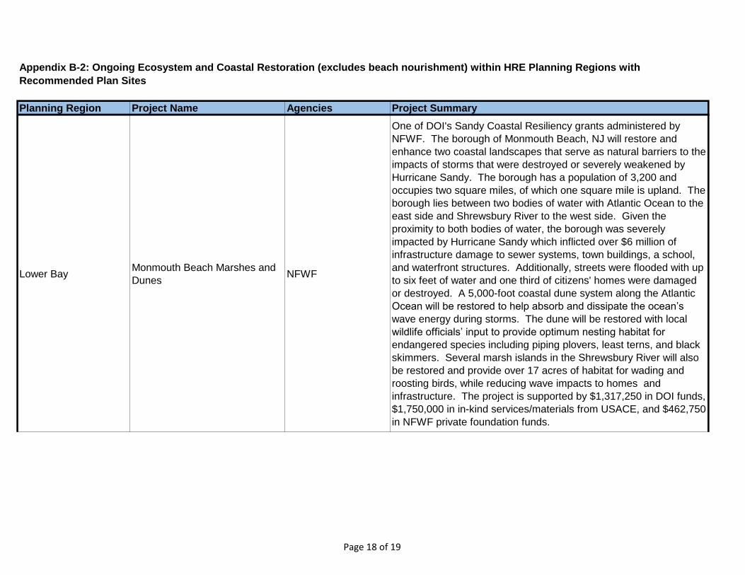
Planning Region Project Name Agencies Project Summary
Appendix B-2: Ongoing Ecosystem and Coastal Restoration (excludes beach nourishment) within HRE Planning Regions with
Recommended Plan Sites
Lower BayMonmouth Beach Marshes and
DunesNFWF
One of DOI's Sandy Coastal Resiliency grants administered by
NFWF. The borough of Monmouth Beach, NJ will restore and
enhance two coastal landscapes that serve as natural barriers to the
impacts of storms that were destroyed or severely weakened by
Hurricane Sandy. The borough has a population of 3,200 and
occupies two square miles, of which one square mile is upland. The
borough lies between two bodies of water with Atlantic Ocean to the
east side and Shrewsbury River to the west side. Given the
proximity to both bodies of water, the borough was severely
impacted by Hurricane Sandy which inflicted over $6 million of
infrastructure damage to sewer systems, town buildings, a school,
and waterfront structures. Additionally, streets were flooded with up
to six feet of water and one third of citizens' homes were damaged
or destroyed. A 5,000-foot coastal dune system along the Atlantic
Ocean will be restored to help absorb and dissipate the ocean’s
wave energy during storms. The dune will be restored with local
wildlife officials’ input to provide optimum nesting habitat for
endangered species including piping plovers, least terns, and black
skimmers. Several marsh islands in the Shrewsbury River will also
be restored and provide over 17 acres of habitat for wading and
roosting birds, while reducing wave impacts to homes and
infrastructure. The project is supported by $1,317,250 in DOI funds,
$1,750,000 in in-kind services/materials from USACE, and $462,750
in NFWF private foundation funds.
Page 18 of 19
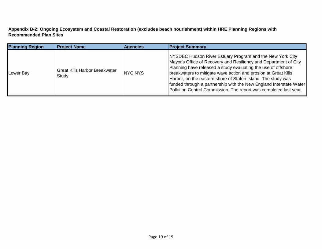
Planning Region Project Name Agencies Project Summary
Appendix B-2: Ongoing Ecosystem and Coastal Restoration (excludes beach nourishment) within HRE Planning Regions with
Recommended Plan Sites
Lower BayGreat Kills Harbor Breakwater
StudyNYC NYS
NYSDEC Hudson River Estuary Program and the New York City
Mayor's Office of Recovery and Resiliency and Department of City
Planning have released a study evaluating the use of offshore
breakwaters to mitigate wave action and erosion at Great Kills
Harbor, on the eastern shore of Staten Island. The study was
funded through a partnership with the New England Interstate Water
Pollution Control Commission. The report was completed last year.
Page 19 of 19
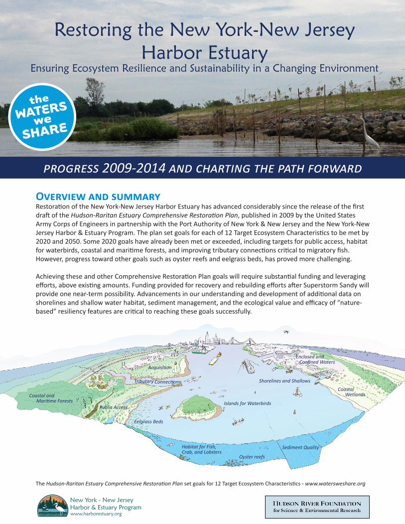
Restoring the New York-New Jersey Harbor Estuary
Ensuring Ecosystem Resilience and Sustainability in a Changing Environment
progress 2009-2014 and charting the path forward
Overview and summary Restoration of the New York-New Jersey Harbor Estuary has advanced considerably since the release of the first draft of the Hudson-Raritan Estuary Comprehensive Restoration Plan, published in 2009 by the United States Army Corps of Engineers in partnership with the Port Authority of New York & New Jersey and the New York-New Jersey Harbor & Estuary Program. The plan set goals for each of 12 Target Ecosystem Characteristics to be met by 2020 and 2050. Some 2020 goals have already been met or exceeded, including targets for public access, habitat for waterbirds, coastal and maritime forests, and improving tributary connections critical to migratory fish. However, progress toward other goals such as oyster reefs and eelgrass beds, has proved more challenging.
Achieving these and other Comprehensive Restoration Plan goals will require substantial funding and leveraging efforts, above existing amounts. Funding provided for recovery and rebuilding efforts after Superstorm Sandy will provide one near-term possibility. Advancements in our understanding and development of additional data on shorelines and shallow water habitat, sediment management, and the ecological value and efficacy of “nature-based” resiliency features are critical to reaching these goals successfully.
Coastal and Maritime Forests
Eelgrass Beds
Public Access
Tributary Connections
Habitat for Fish, Crab, and Lobsters
Islands for Waterbirds
Oyster reefs
Sediment Quality
Coastal Wetlands
Shorelines and Shallows
Enclosed and Confined Waters
Acquisition
The Hudson-Raritan Estuary Comprehensive Restoration Plan set goals for 12 Target Ecosystem Characteristics - www.watersweshare.org
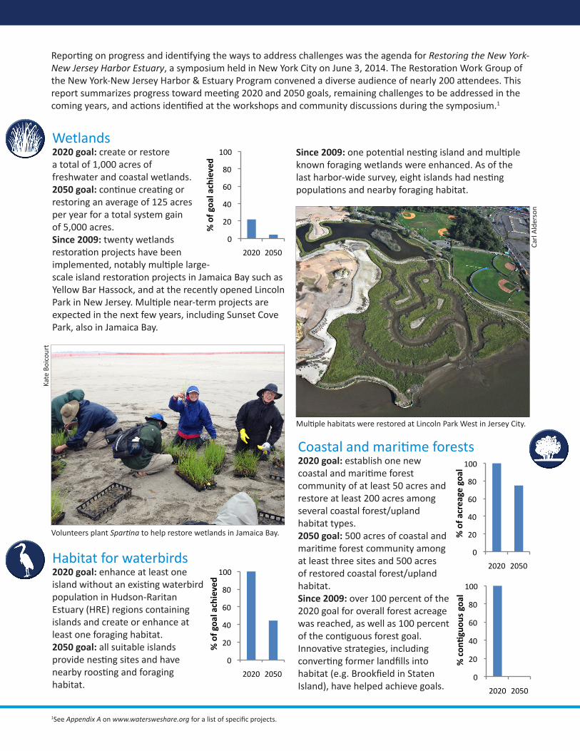
0
20
40
60
80
100
2020 2050
% of goa
l achieved
0
20
40
60
80
100
2020 2050
!"#$%
&'($(
)"'$*+"
0
20
40
60
80
100
2020 2050
% of a
creage goa
l
0
20
40
60
80
100
2020 2050
% of goa
l achieved
Wetlands2020 goal: create or restore a total of 1,000 acres of freshwater and coastal wetlands. 2050 goal: continue creating or restoring an average of 125 acres per year for a total system gain of 5,000 acres. Since 2009: twenty wetlands restoration projects have been implemented, notably multiple large-scale island restoration projects in Jamaica Bay such as Yellow Bar Hassock, and at the recently opened Lincoln Park in New Jersey. Multiple near-term projects are expected in the next few years, including Sunset Cove Park, also in Jamaica Bay.
Habitat for waterbirds2020 goal: enhance at least one island without an existing waterbird population in Hudson-Raritan Estuary (HRE) regions containing islands and create or enhance at least one foraging habitat. 2050 goal: all suitable islands provide nesting sites and have nearby roosting and foraging habitat.
Coastal and maritime forests 2020 goal: establish one new coastal and maritime forest community of at least 50 acres and restore at least 200 acres among several coastal forest/upland habitat types. 2050 goal: 500 acres of coastal and maritime forest community among at least three sites and 500 acres of restored coastal forest/upland habitat. Since 2009: over 100 percent of the 2020 goal for overall forest acreage was reached, as well as 100 percent of the contiguous forest goal. Innovative strategies, including converting former landfills into habitat (e.g. Brookfield in Staten Island), have helped achieve goals.
Volunteers plant Spartina to help restore wetlands in Jamaica Bay.
Kate
Boi
cour
t
Carl
Ald
erso
n
Multiple habitats were restored at Lincoln Park West in Jersey City.
Reporting on progress and identifying the ways to address challenges was the agenda for Restoring the New York-New Jersey Harbor Estuary, a symposium held in New York City on June 3, 2014. The Restoration Work Group of the New York-New Jersey Harbor & Estuary Program convened a diverse audience of nearly 200 attendees. This report summarizes progress toward meeting 2020 and 2050 goals, remaining challenges to be addressed in the coming years, and actions identified at the workshops and community discussions during the symposium.1
Since 2009: one potential nesting island and multiple known foraging wetlands were enhanced. As of the last harbor-wide survey, eight islands had nesting populations and nearby foraging habitat.
1See Appendix A on www.watersweshare.org for a list of specific projects.
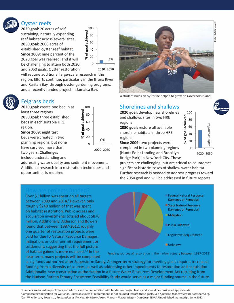
0
20
40
60
80
100
2020 2050
% of goa
l achieved
0
20
40
60
80
100
2020 2050
% of goa
l achieved
0
20
40
60
80
100
2020 2050
% of goa
l achieved
Oyster reefs2020 goal: 20 acres of self-sustaining, naturally expanding reef habitat across several sites. 2050 goal: 2000 acres of established oyster reef habitat. Since 2009: nine percent of the 2020 goal was realized, and it will be challenging to attain both 2020 and 2050 goals. Oyster restoration will require additional large-scale research in this region. Efforts continue, particularly in the Bronx River and Raritan Bay, through oyster gardening programs, and a recently funded project in Jamaica Bay.
Eelgrass beds2020 goal: create one bed in at least three regions 2050 goal: three established beds in each suitable HRE region. Since 2009: eight test beds were created in two planning regions, but none have survived more than two years. Challenges include understanding and addressing water quality and sediment movement. Additional research into restoration techniques and opportunities is required.
Pete
r M
alin
owsk
i
Shorelines and shallows2020 goal: develop new shorelines and shallows sites in two HRE regions. 2050 goal: restore all available shoreline habitats in three HRE regions. Since 2009: two projects were completed in two planning regions (Hunts Point Landing and Brooklyn Bridge Park) in New York City. These projects are challenging, but are critical to counteract significant historic losses of shallow water habitat. Further research is needed to address progress toward the 2050 goal and will be addressed in future reports.
A student holds an oyster he helped to grow on Governors Island.
0%
How are projects funded? Over $1 billion was spent on all targets between 2009 and 2014.2 However, only roughly $240 million of that was spent on habitat restoration. Public access and acquisition investments totaled about $870 million. Additionally, Alderson and Bowers found that between 1987-2012, roughly one quarter of restoration projects were paid for due to Natural Resource Damages, mitigation, or other permit requirement or settlement, suggesting that the full picture of habitat gained is more nuanced.3,4 In the near-term, many projects will be completed using funds authorized after Superstorm Sandy. A longer-term strategy for meeting goals requires increased funding from a diversity of sources, as well as addressing other impediments to restoration and acquisition. Additionally, new construction authorization in a future Water Resources Development Act resulting from the Hudson-Raritan Estuary Ecosystem Feasibility Study would serve as a major funding source in the future.
.1%
2Numbers are based on publicly-reported costs and communication with funders or project leads, and should be considered approximate.3Compensatory mitigation for wetlands, unless in excess of requirement, is not counted toward these goals. See Appendix B on www.watersweshare.org.4Carl W. Alderson, Bowers J., Restoration of the New York/New Jersey Harbor - Harbor History Database. NOAA Unpublished manuscript. June 2012.
Funding sources of restoration in the harbor estuary between 1987-20124
unde
r eva
luati
on
Federal Natural Resource Damages or Remedial
State Natural Resource Damages or Remedial
4i5ga5on
7u8lic 9ni5a5:e
;egisla5:e Re<uirement
Unknown
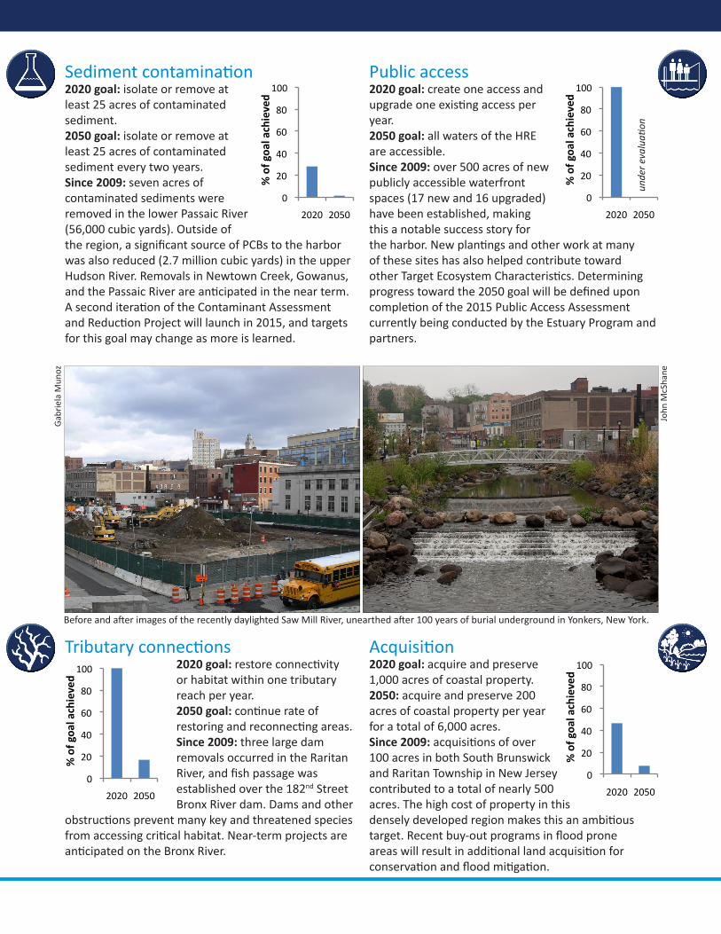
0
20
40
60
80
100
2020 2050
% of goa
l achieved
0
20
40
60
80
100
2020 2050
% of goa
l achieved
0
20
40
60
80
100
2020 2050
% of goa
l achieved
0
20
40
60
80
100
2020 2050
% of goa
l achieved
Sediment contamination2020 goal: isolate or remove at least 25 acres of contaminated sediment.2050 goal: isolate or remove at least 25 acres of contaminated sediment every two years. Since 2009: seven acres of contaminated sediments were removed in the lower Passaic River (56,000 cubic yards). Outside of the region, a significant source of PCBs to the harbor was also reduced (2.7 million cubic yards) in the upper Hudson River. Removals in Newtown Creek, Gowanus, and the Passaic River are anticipated in the near term. A second iteration of the Contaminant Assessment and Reduction Project will launch in 2015, and targets for this goal may change as more is learned.
Tributary connections2020 goal: restore connectivity or habitat within one tributary reach per year.2050 goal: continue rate of restoring and reconnecting areas. Since 2009: three large dam removals occurred in the Raritan River, and fish passage was established over the 182nd Street Bronx River dam. Dams and other
obstructions prevent many key and threatened species from accessing critical habitat. Near-term projects are anticipated on the Bronx River.
Public access2020 goal: create one access and upgrade one existing access per year. 2050 goal: all waters of the HRE are accessible. Since 2009: over 500 acres of new publicly accessible waterfront spaces (17 new and 16 upgraded) have been established, making this a notable success story for the harbor. New plantings and other work at many of these sites has also helped contribute toward other Target Ecosystem Characteristics. Determining progress toward the 2050 goal will be defined upon completion of the 2015 Public Access Assessment currently being conducted by the Estuary Program and partners.
unde
r eva
luati
on
Before and after images of the recently daylighted Saw Mill River, unearthed after 100 years of burial underground in Yonkers, New York.
Acquisition2020 goal: acquire and preserve 1,000 acres of coastal property. 2050: acquire and preserve 200 acres of coastal property per year for a total of 6,000 acres. Since 2009: acquisitions of over 100 acres in both South Brunswick and Raritan Township in New Jersey contributed to a total of nearly 500 acres. The high cost of property in this densely developed region makes this an ambitious target. Recent buy-out programs in flood prone areas will result in additional land acquisition for conservation and flood mitigation.
John
McS
hane
Gab
riel
a M
unoz
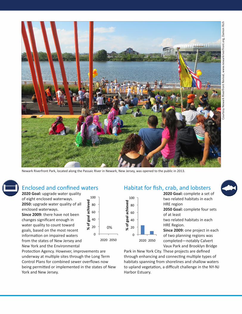
0
20
40
60
80
100
2020 2050
% of goa
l achieved
0
20
40
60
80
100
2020 2050
% of goa
l achieved
Enclosed and confined waters2020 Goal: upgrade water quality of eight enclosed waterways.2050: upgrade water quality of all enclosed waterways.Since 2009: there have not been changes significant enough in water quality to count toward goals, based on the most recent information on impaired waters from the states of New Jersey and New York and the Environmental Protection Agency. However, improvements are underway at multiple sites through the Long Term Control Plans for combined sewer overflows now being permitted or implemented in the states of New York and New Jersey.
Habitat for fish, crab, and lobsters2020 Goal: complete a set of two related habitats in each HRE region2050 Goal: complete four sets of at least two related habitats in each HRE Region.Since 2009: one project in each of two planning regions was completed—notably Calvert Vaux Park and Brooklyn Bridge
Park in New York City. These projects are defined through enhancing and connecting multiple types of habitats spanning from shorelines and shallow waters to upland vegetation, a difficult challenge in the NY-NJ Harbor Estuary.
Newark Riverfront Park, located along the Passaic River in Newark, New Jersey, was opened to the public in 2013.
0%Co
urte
sy N
ewar
k Ri
verf
ront
Rev
ival
, ww
w.n
ewar
kriv
erfr
ont.
org,
Dam
on R
ich
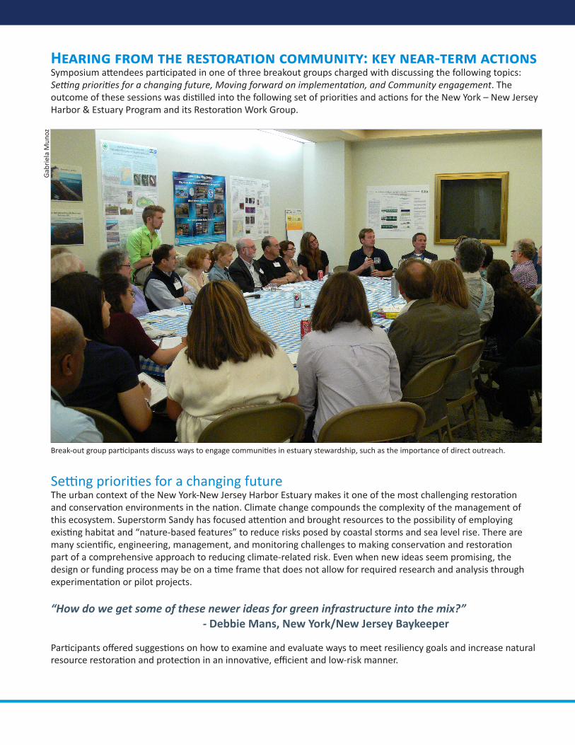
Hearing from the restoration community: key near-term actionsSymposium attendees participated in one of three breakout groups charged with discussing the following topics: Setting priorities for a changing future, Moving forward on implementation, and Community engagement. The outcome of these sessions was distilled into the following set of priorities and actions for the New York – New Jersey Harbor & Estuary Program and its Restoration Work Group.
Setting priorities for a changing future The urban context of the New York-New Jersey Harbor Estuary makes it one of the most challenging restoration and conservation environments in the nation. Climate change compounds the complexity of the management of this ecosystem. Superstorm Sandy has focused attention and brought resources to the possibility of employing existing habitat and “nature-based features” to reduce risks posed by coastal storms and sea level rise. There are many scientific, engineering, management, and monitoring challenges to making conservation and restoration part of a comprehensive approach to reducing climate-related risk. Even when new ideas seem promising, the design or funding process may be on a time frame that does not allow for required research and analysis through experimentation or pilot projects.
“How do we get some of these newer ideas for green infrastructure into the mix?” - Debbie Mans, New York/New Jersey Baykeeper
Participants offered suggestions on how to examine and evaluate ways to meet resiliency goals and increase natural resource restoration and protection in an innovative, efficient and low-risk manner.
Break-out group participants discuss ways to engage communities in estuary stewardship, such as the importance of direct outreach.
Gab
riel
a M
unoz
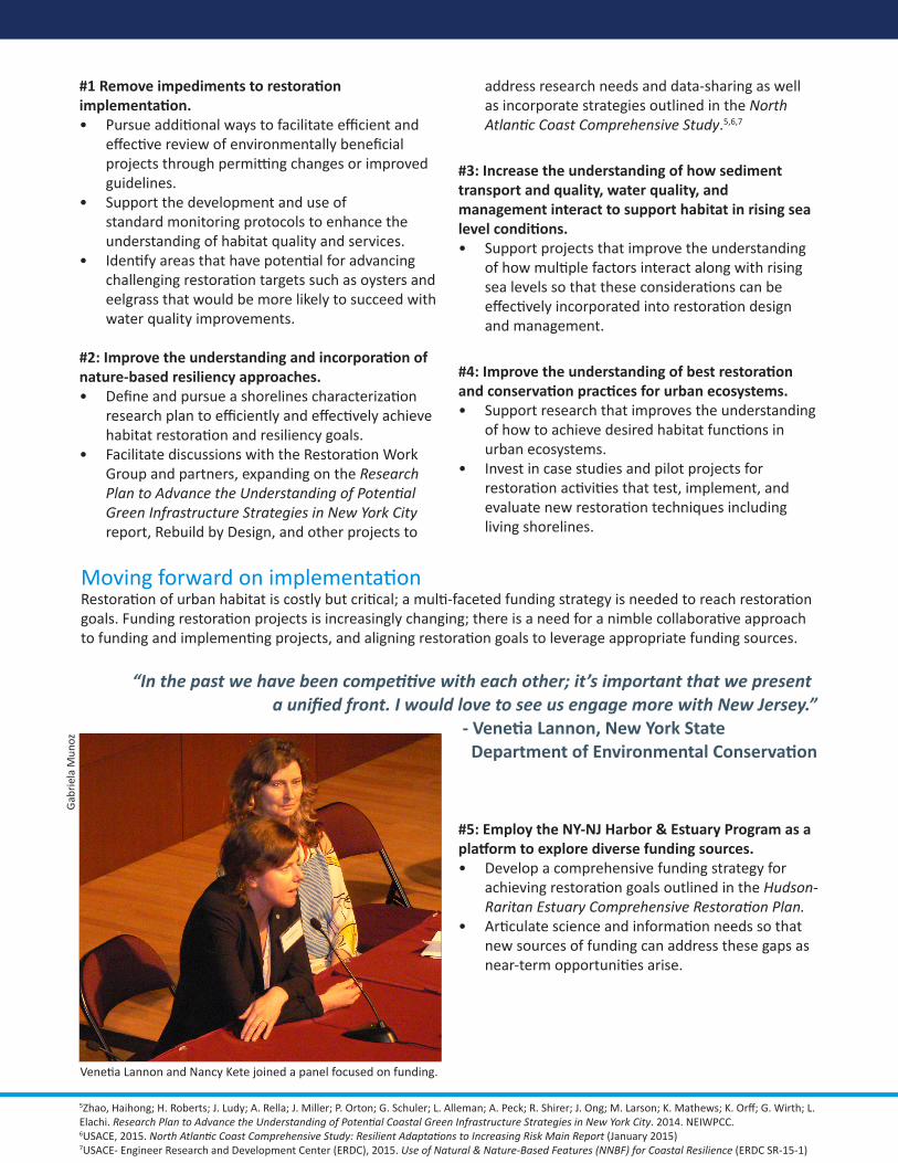
#1 Remove impediments to restoration implementation.
Pursue additional ways to facilitate efficient and • effective review of environmentally beneficial projects through permitting changes or improved guidelines.Support the development and use of • standard monitoring protocols to enhance the understanding of habitat quality and services.Identify areas that have potential for advancing • challenging restoration targets such as oysters and eelgrass that would be more likely to succeed with water quality improvements.
#2: Improve the understanding and incorporation of nature-based resiliency approaches.
Define and pursue a shorelines characterization • research plan to efficiently and effectively achieve habitat restoration and resiliency goals. Facilitate discussions with the Restoration Work • Group and partners, expanding on the Research Plan to Advance the Understanding of Potential Green Infrastructure Strategies in New York City report, Rebuild by Design, and other projects to
address research needs and data-sharing as well as incorporate strategies outlined in the North Atlantic Coast Comprehensive Study.5,6,7
#3: Increase the understanding of how sediment transport and quality, water quality, and management interact to support habitat in rising sea level conditions.
Support projects that improve the understanding • of how multiple factors interact along with rising sea levels so that these considerations can be effectively incorporated into restoration design and management.
#4: Improve the understanding of best restoration and conservation practices for urban ecosystems.
Support research that improves the understanding • of how to achieve desired habitat functions in urban ecosystems. Invest in case studies and pilot projects for • restoration activities that test, implement, and evaluate new restoration techniques including living shorelines.
5Zhao, Haihong; H. Roberts; J. Ludy; A. Rella; J. Miller; P. Orton; G. Schuler; L. Alleman; A. Peck; R. Shirer; J. Ong; M. Larson; K. Mathews; K. Orff; G. Wirth; L. Elachi. Research Plan to Advance the Understanding of Potential Coastal Green Infrastructure Strategies in New York City. 2014. NEIWPCC. 6USACE, 2015. North Atlantic Coast Comprehensive Study: Resilient Adaptations to Increasing Risk Main Report (January 2015)7USACE- Engineer Research and Development Center (ERDC), 2015. Use of Natural & Nature-Based Features (NNBF) for Coastal Resilience (ERDC SR-15-1)
Moving forward on implementation Restoration of urban habitat is costly but critical; a multi-faceted funding strategy is needed to reach restoration goals. Funding restoration projects is increasingly changing; there is a need for a nimble collaborative approach to funding and implementing projects, and aligning restoration goals to leverage appropriate funding sources.
“In the past we have been competitive with each other; it’s important that we present a unified front. I would love to see us engage more with New Jersey.” - Venetia Lannon, New York State Department of Environmental Conservation
#5: Employ the NY-NJ Harbor & Estuary Program as a platform to explore diverse funding sources.
Develop a comprehensive funding strategy for • achieving restoration goals outlined in the Hudson-Raritan Estuary Comprehensive Restoration Plan. Articulate science and information needs so that • new sources of funding can address these gaps as near-term opportunities arise.
Venetia Lannon and Nancy Kete joined a panel focused on funding.
Gab
riel
a M
unoz
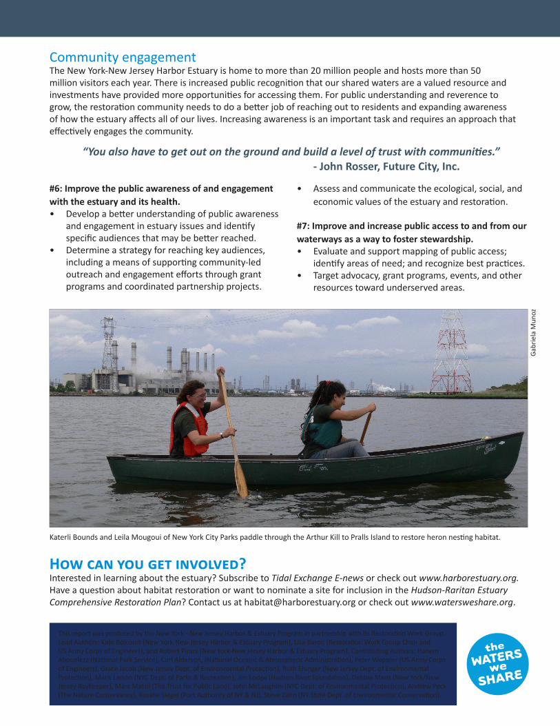
Community engagement The New York-New Jersey Harbor Estuary is home to more than 20 million people and hosts more than 50 million visitors each year. There is increased public recognition that our shared waters are a valued resource and investments have provided more opportunities for accessing them. For public understanding and reverence to grow, the restoration community needs to do a better job of reaching out to residents and expanding awareness of how the estuary affects all of our lives. Increasing awareness is an important task and requires an approach that effectively engages the community.
“You also have to get out on the ground and build a level of trust with communities.” - John Rosser, Future City, Inc.
#6: Improve the public awareness of and engagement with the estuary and its health.
Develop a better understanding of public awareness • and engagement in estuary issues and identify specific audiences that may be better reached. Determine a strategy for reaching key audiences, • including a means of supporting community-led outreach and engagement efforts through grant programs and coordinated partnership projects.
Assess and communicate the ecological, social, and • economic values of the estuary and restoration.
#7: Improve and increase public access to and from our waterways as a way to foster stewardship.
Evaluate and support mapping of public access; • identify areas of need; and recognize best practices. Target advocacy, grant programs, events, and other • resources toward underserved areas.
How can you get involved? Interested in learning about the estuary? Subscribe to Tidal Exchange E-news or check out www.harborestuary.org. Have a question about habitat restoration or want to nominate a site for inclusion in the Hudson-Raritan Estuary Comprehensive Restoration Plan? Contact us at [email protected] or check out www.watersweshare.org.
This report was produced by the New York - New Jersey Harbor & Estuary Program in partnership with its Restoration Work Group. Lead Authors: Kate Boicourt (New York-New Jersey Harbor & Estuary Program), Lisa Baron (Restoration Work Group Chair and US Army Corps of Engineers), and Robert Pirani (New York-New Jersey Harbor & Estuary Program). Contributing Authors: Hanem Abouelezz (National Park Service), Carl Alderson, (National Oceanic & Atmospheric Administration), Peter Weppler (US Army Corps of Engineers), Grace Jacob (New Jersey Dept. of Environmental Protection), Ruth Ehinger (New Jersey Dept. of Environmental Protection), Marit Larson (NYC Dept. of Parks & Recreation), Jim Lodge (Hudson River Foundation), Debbie Mans (New York/New Jersey Baykeeper), Marc Matsil (The Trust for Public Land), John McLaughlin (NYC Dept. of Environmental Protection), Andrew Peck (The Nature Conservancy), Rosalie Siegel (Port Authority of NY & NJ), Steve Zahn (NY State Dept. of Environmental Conservation).
Katerli Bounds and Leila Mougoui of New York City Parks paddle through the Arthur Kill to Pralls Island to restore heron nesting habitat.G
abri
ela
Mun
oz
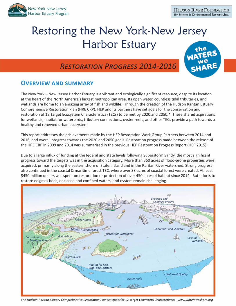
Restoring the New York-New Jersey Harbor Estuary
R P 2014-2016
O The New York – New Jersey Harbor Estuary is a vibrant and ecologically signifi cant resource, despite its loca on at the heart of the North America’s largest metropolitan area. Its open water, countless dal tributaries, and wetlands are home to an amazing array of fi sh and wildlife. Through the crea on of the Hudson Raritan Estuary Comprehensive Restora on Plan (HRE CRP), HEP and its partners have set goals for the conserva on and restora on of 12 Target Ecosystem Characteris cs (TECs) to be met by 2020 and 2050.* These shared aspira ons for wetlands, habitat for waterbirds, tributary connec ons, oyster reefs, and other TECs provide a path towards a healthy and renewed urban ecosystem.
This report addresses the achievements made by the HEP Restora on Work Group Partners between 2014 and 2016, and overall progress towards the 2020 and 2050 goals Restora on progress made between the release of the HRE CRP in 2009 and 2014 was summarized in the previous HEP Restora on Progress Report (HEP 2015).
Due to a large infl ux of funding at the federal and state levels following Superstorm Sandy, the most signifi cant progress toward the targets was in the acquisi on category. More than 360 acres of fl ood-prone proper es were acquired, primarily along the eastern shore of Staten Island and in the Raritan River watershed. Strong progress also con nued in the coastal & mari me forest TEC, where over 33 acres of coastal forest were created. At least $450 million dollars was spent on restora on or protec on of over 450 acres of habitat since 2014. But eff orts to restore eelgrass beds, enclosed and confi ned waters, and oysters remain challenging.
Coastal and Mari me Forests
Eelgrass Beds
Public Access
Tributary Connec ons
Habitat for Fish, Crab, and Lobsters
Islands for Waterbirds
Oyster reefs Sediment Quality
Coastal Wetlands
Shorelines and Shallows
Enclosed and Confi ned Waters
Acquisi on
The Hudson-Raritan Estuary Comprehensive Restora on Plan set goals for 12 Target Ecosystem Characteris cs - www.watersweshare.org
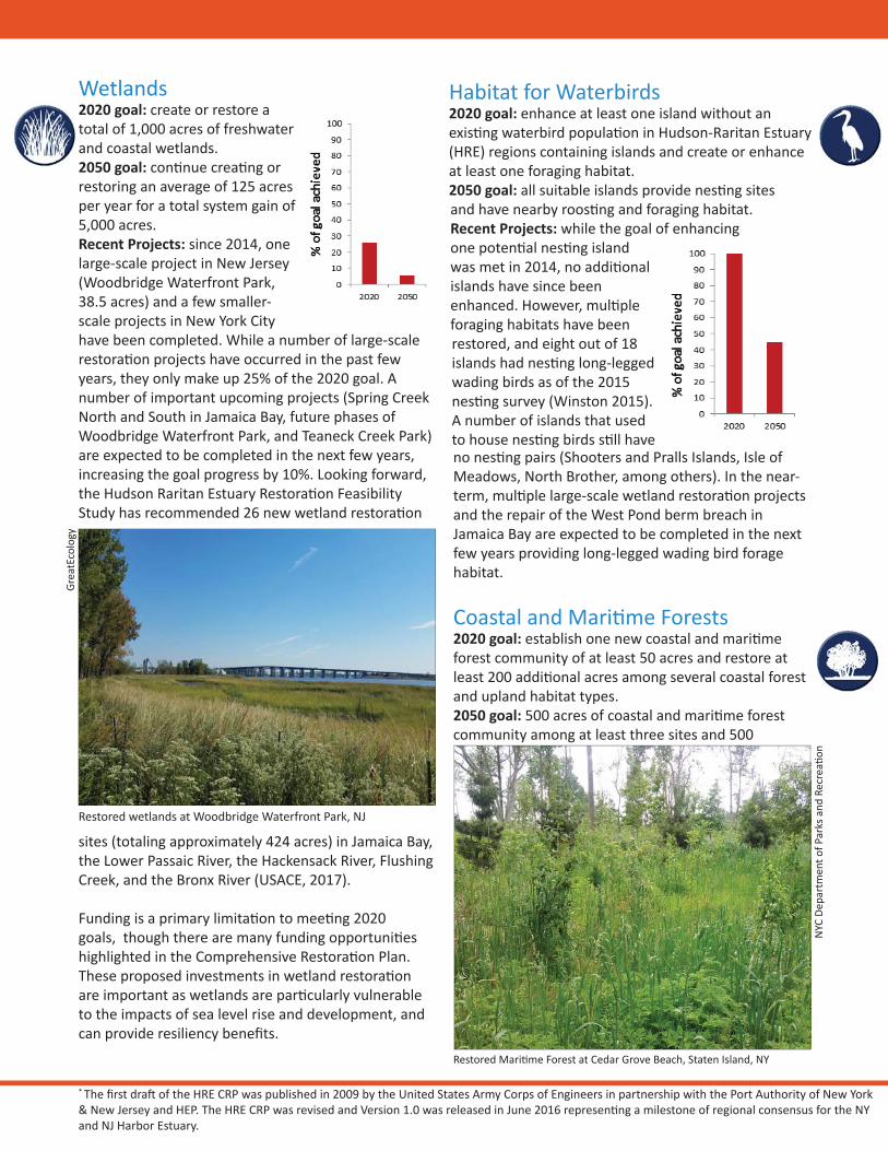
Wetlands2020 goal: create or restore a total of 1,000 acres of freshwater and coastal wetlands. 2050 goal: con nue crea ng or restoring an average of 125 acres per year for a total system gain of 5,000 acres. Recent Projects: since 2014, one large-scale project in New Jersey (Woodbridge Waterfront Park, 38.5 acres) and a few smaller-scale projects in New York City have been completed. While a number of large-scale restora on projects have occurred in the past few years, they only make up 25% of the 2020 goal. A number of important upcoming projects (Spring Creek North and South in Jamaica Bay, future phases of Woodbridge Waterfront Park, and Teaneck Creek Park) are expected to be completed in the next few years, increasing the goal progress by 10%. Looking forward, the Hudson Raritan Estuary Restora on Feasibility Study has recommended 26 new wetland restora on
sites (totaling approximately 424 acres) in Jamaica Bay, the Lower Passaic River, the Hackensack River, Flushing Creek, and the Bronx River (USACE, 2017).
Funding is a primary limita on to mee ng 2020 goals, though there are many funding opportuni es highlighted in the Comprehensive Restora on Plan. These proposed investments in wetland restora on are important as wetlands are par cularly vulnerable to the impacts of sea level rise and development, and can provide resiliency benefi ts.
no nes ng pairs (Shooters and Pralls Islands, Isle of Meadows, North Brother, among others). In the near-term, mul ple large-scale wetland restora on projects and the repair of the West Pond berm breach in Jamaica Bay are expected to be completed in the next few years providing long-legged wading bird forage habitat.
Coastal and Mari me Forests 2020 goal: establish one new coastal and mari me forest community of at least 50 acres and restore at least 200 addi onal acres among several coastal forest and upland habitat types. 2050 goal: 500 acres of coastal and mari me forest community among at least three sites and 500
Restored wetlands at Woodbridge Waterfront Park, NJ
Grea
tEco
logy
* The fi rst dra of the HRE CRP was published in 2009 by the United States Army Corps of Engineers in partnership with the Port Authority of New York & New Jersey and HEP. The HRE CRP was revised and Version 1.0 was released in June 2016 represen ng a milestone of regional consensus for the NY and NJ Harbor Estuary.
Habitat for Waterbirds2020 goal: enhance at least one island without an exis ng waterbird popula on in Hudson-Raritan Estuary (HRE) regions containing islands and create or enhance at least one foraging habitat. 2050 goal: all suitable islands provide nes ng sites and have nearby roos ng and foraging habitat. Recent Projects: while the goal of enhancing one poten al nes ng island was met in 2014, no addi onal islands have since been enhanced. However, mul ple foraging habitats have been restored, and eight out of 18 islands had nes ng long-legged wading birds as of the 2015 nes ng survey (Winston 2015). A number of islands that used to house nes ng birds s ll have
Restored Mari me Forest at Cedar Grove Beach, Staten Island, NY
NYC
Dep
artm
ent o
f Par
ks a
nd R
ecre
a o
n
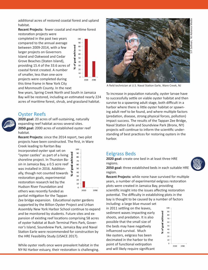
addi onal acres of restored coastal forest and upland habitat. Recent Projects: fewer coastal and mari me forest restora on projects were completed in the past two years compared to the annual average between 2009-2014, with a few larger projects on Governors Island and Oakwood and Cedar Grove Beaches (Staten Island), providing 15.4 of the 33.6 acres of coastal forest created. A number of smaller, less than one-acre projects were completed during this me frame in New York City and Monmouth County. In the next few years, Spring Creek North and South in Jamaica Bay will be restored, including an es mated nearly 224 acres of mari me forest, shrub, and grassland habitat.
Oyster Reefs2020 goal: 20 acres of self-sustaining, naturally expanding reef habitat across several sites. 2050 goal: 2000 acres of established oyster reef habitat. Recent Projects: since the 2014 report, two pilot projects have been constructed. The fi rst, in Ware Creek leading to Raritan Bay incorporated oyster spat set on “oyster castles” as part of a living shoreline project. In Thurston Ba-sin in Jamaica Bay, a 0.5 acre reef was installed in 2016. Addi on-ally, though not counted towards restora on goals, experimental restora on research led by the Hudson River Founda on and others was recently funded as par al mi ga on for the Tappan Zee bridge expansion. Educa onal oyster gardens supported by the Billion Oyster Project and Urban Assembly New York Harbor School con nue to expand and be monitored by students. Future sites and ex-pansion of exis ng reef loca ons comprising 58 acres of oyster habitat at Bush Terminal Piers Park, Gover-nor’s Island, Soundview Park, Jamaica Bay and Naval Sta on Earle were recommended for construc on by the HRE Feasibility Study (USACE 2017).
While oyster reefs once were prevalent habitat in the NY-NJ Harbor estuary, their restora on is challenging.
S.P.
Sul
livan
, N
J Adv
ance
Med
ia
To increase in popula on naturally, oyster larvae have to successfully se le on viable oyster habitat and then survive to a spawning adult stage, both diffi cult in a harbor where there is li le oyster habitat or spawn-ing adult reef to be found, and where mul ple factors (preda on, disease, strong physical forces, pollu on) impact success. The results of the Tappan Zee Bridge, Naval Sta on Earle and Soundview Park (Bronx, NY) projects will con nue to inform the scien fi c under-standing of best prac ces for restoring oysters in the harbor.
Eelgrass Beds2020 goal: create one bed in at least three HRE regions. 2050 goal: three established beds in each suitable HRE region. Recent Projects: while none have survived for mul ple years, a number of experimental eelgrass restora on plots were created in Jamaica Bay, providing scien fi c insight into the issues aff ec ng restora on poten al. The diffi culty in establishing plots in the bay is thought to be caused by a number of factors including: a large blue mussel set in 2011 se ling on the leaves, sediment waves impac ng early shoots, and preda on. It is also possible that the small size of the beds may have nega vely infl uenced survival. Much like oysters, eelgrass has been decimated in the harbor to the point of func onal ex rpa on and will likely require signifi cant
A fi eld technician at U.S. Naval Sta on Earle, Ware Creek, NJ
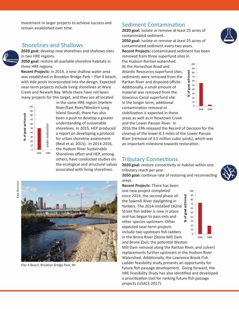
investment in larger projects to achieve success and remain established over me.
Shorelines and Shallows2020 goal: develop new shorelines and shallows sites in two HRE regions. 2050 goal: restore all available shoreline habitats in three HRE regions. Recent Projects: in 2014, a new shallow water area was established in Brooklyn Bridge Park – Pier 4 beach, with de pools incorporated into the design. Expected near-term projects include living shorelines at Ware Creek and Newark Bay. While there have not been many projects for this target, and they are all located
in the same HRE region (Harlem River/East River/Western Long Island Sound), there has also been a push to develop a greater understanding of sustainable shorelines. In 2015, HEP produced a report on developing a protocol for urban shoreline assessment (Reid et al. 2015). In 2014-2016, the Hudson River Sustainable Shorelines eff ort and HEP, among others, have conducted studies on the ecological and structural values associated with living shorelines.
Sediment Contamina on2020 goal: isolate or remove at least 25 acres of contaminated sediment.2050 goal: isolate or remove at least 25 acres of contaminated sediment every two years. Recent Projects: contaminated sediment has been removed from three superfund sites in the Hudson-Raritan watershed. At the Horseshoe Road and Atlan c Resources superfund sites, sediments were removed from the Raritan River and disposed off site. Addi onally, a small amount of material was removed from the Gowanus Canal superfund site. In the longer term, addi onal contamina on removal or stabiliza on is expected in these areas as well as in Newtown Creek and the Lower Passaic River. In 2016 the EPA released the Record of Decision for the cleanup of the lower 8.3 miles of the Lower Passaic River (removal of 3.5 million cubic yards), which was an important milestone towards restora on.
unde
r eva
lua
on
Tributary Connec ons2020 goal: restore connec vity or habitat within one tributary reach per year.2050 goal: con nue rate of restoring and reconnec ng areas. Recent Projects: There has been one new project completed since 2014, the second phase of the Sawmill River dayligh ng in Yonkers. The 2014-installed 182nd Street fi sh ladder is now in place and has begun to pass eels and other species upstream. Other expected near-term projects include two upstream fi sh ladders in the Bronx River (Stone Mill Dam and Bronx Zoo), the poten al Weston Mill Dam removal along the Raritan River, and culvert replacements further upstream in the Hudson River Watershed. Addi onally, the Lawrence Brook Fish Ladder feasibility study presents an opportunity for future fi sh passage development. Going forward, the HRE Feasibility Study has also iden fi ed and developed a priori za on tool for ranking future fi sh passage projects (USACE 2017).
Kate
Boi
cour
t
Pier 4 Beach, Brooklyn Bridge Park, NY
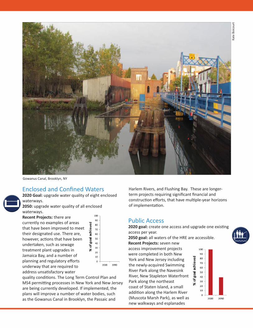
Enclosed and Confi ned Waters2020 Goal: upgrade water quality of eight enclosed waterways.2050: upgrade water quality of all enclosed waterways.Recent Projects: there are currently no examples of areas that have been improved to meet their designated use. There are, however, ac ons that have been undertaken, such as sewage treatment plant upgrades in Jamaica Bay, and a number of planning and regulatory eff orts underway that are required to address unsa sfactory water quality condi ons. The Long Term Control Plan and MS4 permi ng processes in New York and New Jersey are being currently developed. If implemented, the plans will improve a number of water bodies, such as the Gowanus Canal in Brooklyn, the Passaic and
Harlem Rivers, and Flushing Bay. These are longer-term projects requiring signifi cant fi nancial and construc on eff orts, that have mul ple-year horizons of implementa on.
Public Access2020 goal: create one access and upgrade one exis ng access per year. 2050 goal: all waters of the HRE are accessible. Recent Projects: seven new access improvement projects were completed in both New York and New Jersey including the newly-acquired Swimming River Park along the Navesink River, New Stapleton Waterfront Park along the northeast coast of Staten Island, a small addi on along the Harlem River (Muscota Marsh Park), as well as new walkways and esplanades
Gowanus Canal, Brooklyn, NY
Kate
Boi
cour
t
s
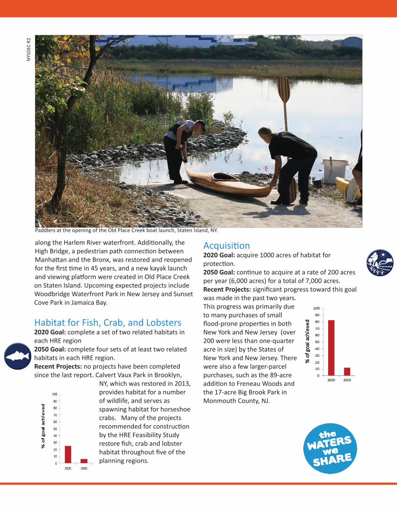
along the Harlem River waterfront. Addi onally, the High Bridge, a pedestrian path connec on between Manha an and the Bronx, was restored and reopened for the fi rst me in 45 years, and a new kayak launch and viewing pla orm were created in Old Place Creek on Staten Island. Upcoming expected projects include Woodbridge Waterfront Park in New Jersey and Sunset Cove Park in Jamaica Bay.
Habitat for Fish, Crab, and Lobsters2020 Goal: complete a set of two related habitats in each HRE region2050 Goal: complete four sets of at least two related habitats in each HRE region.Recent Projects: no projects have been completed since the last report. Calvert Vaux Park in Brooklyn,
NY, which was restored in 2013, provides habitat for a number of wildlife, and serves as spawning habitat for horseshoe crabs. Many of the projects recommended for construc on by the HRE Feasibility Study restore fi sh, crab and lobster habitat throughout fi ve of the planning regions.
Acquisi on2020 Goal: acquire 1000 acres of habitat for protec on.2050 Goal: con nue to acquire at a rate of 200 acres per year (6,000 acres) for a total of 7,000 acres.Recent Projects: signifi cant progress toward this goal was made in the past two years. This progress was primarily due to many purchases of small fl ood-prone proper es in both New York and New Jersey (over 200 were less than one-quarter acre in size) by the States of New York and New Jersey. There were also a few larger-parcel purchases, such as the 89-acre addi on to Freneau Woods and the 17-acre Big Brook Park in Monmouth County, NJ.
Paddlers at the opening of the Old Place Creek boat launch, Staten Island, NY.
NYS
DEC
R2
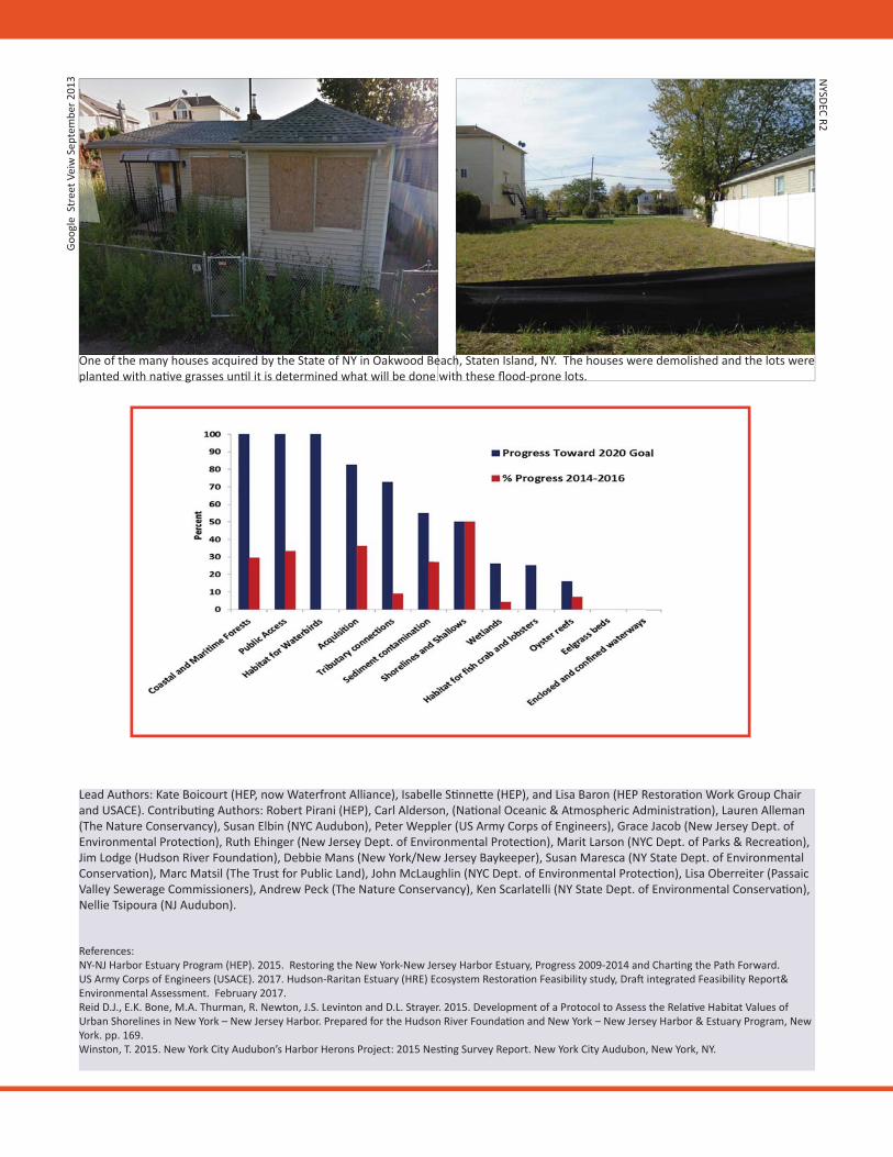
Lead Authors: Kate Boicourt (HEP, now Waterfront Alliance), Isabelle S nne e (HEP), and Lisa Baron (HEP Restora on Work Group Chair and USACE). Contribu ng Authors: Robert Pirani (HEP), Carl Alderson, (Na onal Oceanic & Atmospheric Administra on), Lauren Alleman (The Nature Conservancy), Susan Elbin (NYC Audubon), Peter Weppler (US Army Corps of Engineers), Grace Jacob (New Jersey Dept. of Environmental Protec on), Ruth Ehinger (New Jersey Dept. of Environmental Protec on), Marit Larson (NYC Dept. of Parks & Recrea on), Jim Lodge (Hudson River Founda on), Debbie Mans (New York/New Jersey Baykeeper), Susan Maresca (NY State Dept. of Environmental Conserva on), Marc Matsil (The Trust for Public Land), John McLaughlin (NYC Dept. of Environmental Protec on), Lisa Oberreiter (Passaic Valley Sewerage Commissioners), Andrew Peck (The Nature Conservancy), Ken Scarlatelli (NY State Dept. of Environmental Conserva on), Nellie Tsipoura (NJ Audubon).
References:NY-NJ Harbor Estuary Program (HEP). 2015. Restoring the New York-New Jersey Harbor Estuary, Progress 2009-2014 and Char ng the Path Forward.US Army Corps of Engineers (USACE). 2017. Hudson-Raritan Estuary (HRE) Ecosystem Restora on Feasibility study, Dra integrated Feasibility Report& Environmental Assessment. February 2017. Reid D.J., E.K. Bone, M.A. Thurman, R. Newton, J.S. Levinton and D.L. Strayer. 2015. Development of a Protocol to Assess the Rela ve Habitat Values of Urban Shorelines in New York – New Jersey Harbor. Prepared for the Hudson River Founda on and New York – New Jersey Harbor & Estuary Program, New York. pp. 169.Winston, T. 2015. New York City Audubon’s Harbor Herons Project: 2015 Nes ng Survey Report. New York City Audubon, New York, NY.
One of the many houses acquired by the State of NY in Oakwood Beach, Staten Island, NY. The houses were demolished and the lots were planted with na ve grasses un l it is determined what will be done with these fl ood-prone lots.
Goog
le S
tree
t Vei
w S
epte
mbe
r 201
3 NYSDEC R2
Making progress towards restoring the estuary’s Target Ecosystem Characteris cs.• Goals are nearly met for some targets, but others
are hindered by cost, implementa on challenges, and regulatory concerns. Small-scale projects for shorelines, eelgrass, and shallows and oyster reefs have con nued. Research and collabora on, such as through the Oyster Restora on Research Partnership, HRE Feasibility Study and a current project to inves gate the amounts and spa al pa erns of eelgrass in the Hudson River, is expected to con nue to shed light on status and opportuni es. Signifi cantly increased eff orts will need to be made to further the eelgrass beds target.
Improving the quality and likely success of habitat restora on prac ces• A standard monitoring protocol for urban shorelines
was piloted in the Harbor in 2014-2015, and the Hudson River Sustainable Shorelines program is currently pilo ng a rapid assessment protocol.
• Pilot projects incorpora ng oysters are underway or planned in New York City, and at US Naval Weapons Sta on Earle in Middletown, NJ at Ware Creek.
Suppor ng restora on monitoring and the u lity of monitoring data• There is s ll a need to increase consistency among
resiliency metrics and monitoring, something that HEP, the Science and Resilience Ins tute at Jamaica Bay, NYSDEC, NYCDPR and other partners, plan to pursue as a follow-up to the previously-published Research Plan to Advance the Understanding of Poten al Green Infrastructure Strategies in New York City report.
Advancing the understanding and incorpora on of climate change impacts in habitat management and restora on • An evalua on of all HRE CRP restora on
opportuni es was conducted to determine which sites provide the poten al to serve as NNBFs for coastal resilience. These sites are presented in the HRE Feasibility Report and Environmental Assessment (USACE 2017).
• The North Atlan c Division of the US Army Corps of Engineers recently released a Comprehensive Study, the goals of which were to provide a risk management framework and support resilient coastal communi es and robust, sustainable coastal landscape systems including natural and nature-based features.
• With respect to wetlands habitat, the New Jersey Department of Environmental Protec on and NYC Department of Parks and Recrea on are developing methods and tools for evalua ng exis ng wetland condi on and opportuni es for poten al restora on, given sea level rise predic ons.
• Eff orts to monitor the ability of regional wetlands to adapt to sea level rise and studies of sediment dynamics near marshes in Jamaica Bay are being undertaken by the NYC Department of Parks and Recrea on and Rutgers University.
M K CIn 2014, par cipants in HEP’s Bi-Annual Restora on Conference made sugges ons on how to achieve habitat restora on and protec on goals. These sugges ons will be incorporated into HEP's Dra Ac on Agenda, to be released in May, 2017. Objec ves for the habitat and ecological health sec on include 1) Making progress towards restoring the estuary’s Target Ecosystem Characteris cs 2) improving the quality and likely success of habitat restora on prac ces 3) suppor ng restora on monitoring and the u lity of monitoring data and 4) Advancing the understanding and incorpora on of climate change impacts in habitat management and restora on. The NY-NJ Harbor & Estuary Program and partners are already working towards these objec ves including the following developments since 2014:
H ? Interested in learning about the estuary? Subscribe to Tidal Exchange E-news or check out www.harborestuary.org. Have a ques on about habitat restora on or want to nominate a site for inclusion in the Hudson-Raritan Estuary Comprehensive Restora on Plan? Contact us at [email protected] or check out www.watersweshare.org.
NEW YORK / NEW JERSEY HARBOR & ESTUARY PROGRAM
Restoring the New York - New Jersey Harbor Estuary
Restoration Progress 2017 - 2019
Restoration of the Hudson Raritan Estuary (HRE) continues to progress. Over the past three years, more than 40 projects were completed throughout the waterways and watershed in New York and New Jersey, with signifi cant advancement made in restoring maritime forests, acquiring land for conservation, and improving aquatic connectivity for migratory fi sh and other creatures. While progress towards our goals for oysters and other in-water and shoreline habitat continues to be challenging, continued research and pilot projects have advanced practice. Over $290 Million was spent in restoration in 2017-2019, with acquisition costs making up 85% of this total.
It has been 11 years since the Restoration Work Group adopted the Comprehensive Restoration Plan (CRP) for the Hudson Raritan Estuary and started tracking progress towards our shared goals: 12 Target Ecosystem Characteristics (TECs) that together defi ne the structure, function and biologi-cal diversity of a restored estuary south of the Mario Cuomo (Tappan Zee) Bridge. This report highlights the progress towards these goals over the past three years (2017-2019) since the last Restoration Report. The CRP outlines goals per TEC for 2020 and 2050. As 2020 is almost upon us, it is a good time to assess achievement. The 2020 goals have proven to be largely appropriate; ambitious but achievable. For some of the TECs, we have more than doubled the 2020 goal, while for others there is limited progress. The number of TECs that satisfi ed the 2020 goal has jumped from three in last Restoration Report (2016), to fi ve in this report. Success is controlled by many diverse factors including organizational priorities, opportunistic funding, and expectations of restoration success. For most of the TECs that did not reach the 2020 goal, such as Eelgrass Beds and Oyster Reefs, the restoration community is still largely in a research or piloting phase, refl ect-ing the challenging practice and diffi cult environmental conditions. Exceptions include Wetlands restoration and Sediment Contamination that have established restoration techniques but are controlled by the high cost of these projects. Going forward, the 2050 goals will be reviewed to determine if they continue to refl ect the priorities of the many public and private stakeholders in the restoration community.
One notable change to highlight is that the Restoration Work Group recently determined the need for a new way to track the Enclosed and Confi ned Waters TEC. Millions of dollars in capital invest-ments were made to improve water quality in several confi ned waters since 2009, however that was not being refl ected in the tracking method that was initially chosen. The ultimate goal of this TEC is for the water quality in these confi ned waters to match their receiving waters. The group decided that this could be tracked by metrics of signifi cant eff ort including construction of green and gray infrastructure.
Overview and Summary
Cover Photo: Sunset Park, Queens New York; NYC Parks
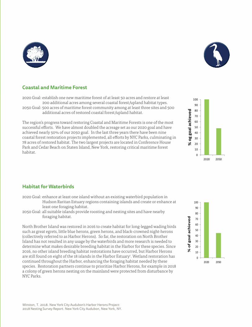
Winston, T. 2018. New York City Audubon’s Harbor Herons Project: 2018 Nesting Survey Report. New York City Audubon, New York, NY.
Coastal and Maritime Forest
2020 Goal: establish one new maritime forest of at least 50 acres and restore at least 200 additional acres among several coastal forest/upland habitat types.2050 Goal: 500 acres of maritime forest community among at least three sites and 500 additional acres of restored coastal forest/upland habitat.
The region’s progress toward restoring Coastal and Maritime Forests is one of the most successful eff orts. We have almost doubled the acreage set as our 2020 goal and have achieved nearly 50% of our 2050 goal. In the last three years there have been nine coastal forest restoration projects implemented, all eff orts by NYC Parks, culminating in 78 acres of restored habitat. The two largest projects are located in Conference House Park and Cedar Beach on Staten Island, New York, restoring critical maritime forest habitat.
Habitat for Waterbirds
2020 Goal: enhance at least one island without an existing waterbird population in Hudson Raritan Estuary regions containing islands and create or enhance at least one foraging habitat. 2050 Goal: all suitable islands provide roosting and nesting sites and have nearby foraging habitat.
North Brother Island was restored in 2016 to create habitat for long-legged wading birds such as great egrets, little blue herons, green herons, and black-crowned night-herons (collectively referred to as Harbor Herons). So far, the restoration on North Brother Island has not resulted in any usage by the waterbirds and more research is needed to determine what makes desirable breeding habitat in the Harbor for these species. Since 2016, no other island breeding habitat restorations have occurred, but Harbor Herons are still found on eight of the 18 islands in the Harbor Estuary1. Wetland restoration has continued throughout the Harbor, enhancing the foraging habitat needed by these species. Restoration partners continue to prioritize Harbor Herons, for example in 2018 a colony of green herons nesting on the mainland were protected from disturbance by NYC Parks.
0
10
20
30
40
50
60
70
80
90
100
2020 2050
% o
g go
al a
chie
ved
0
10
20
30
40
50
60
70
80
90
100
2020 2050
% o
f go
al a
chie
ved
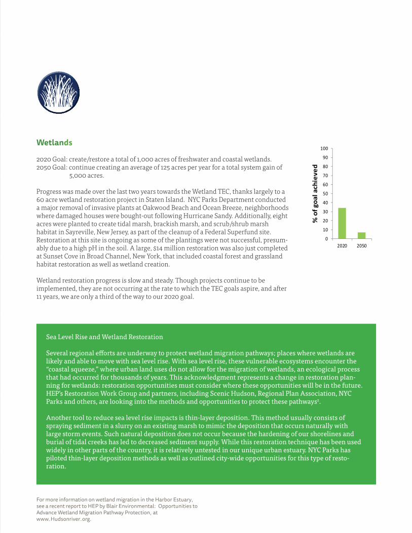
For more information on wetland migration in the Harbor Estuary, see a recent report to HEP by Blair Environmental: Opportunities to Advance Wetland Migration Pathway Protection, at www.Hudsonriver.org.
Wetlands
2020 Goal: create/restore a total of 1,000 acres of freshwater and coastal wetlands. 2050 Goal: continue creating an average of 125 acres per year for a total system gain of 5,000 acres.
Progress was made over the last two years towards the Wetland TEC, thanks largely to a 60 acre wetland restoration project in Staten Island. NYC Parks Department conducted a major removal of invasive plants at Oakwood Beach and Ocean Breeze, neighborhoods where damaged houses were bought-out following Hurricane Sandy. Additionally, eight acres were planted to create tidal marsh, brackish marsh, and scrub/shrub marsh habitat in Sayreville, New Jersey, as part of the cleanup of a Federal Superfund site. Restoration at this site is ongoing as some of the plantings were not successful, presum-ably due to a high pH in the soil. A large, $14 million restoration was also just completed at Sunset Cove in Broad Channel, New York, that included coastal forest and grassland habitat restoration as well as wetland creation.
Wetland restoration progress is slow and steady. Though projects continue to be implemented, they are not occurring at the rate to which the TEC goals aspire, and after 11 years, we are only a third of the way to our 2020 goal.
Sea Level Rise and Wetland Restoration
Several regional eff orts are underway to protect wetland migration pathways; places where wetlands are likely and able to move with sea level rise. With sea level rise, these vulnerable ecosystems encounter the “coastal squeeze,” where urban land uses do not allow for the migration of wetlands, an ecological process that had occurred for thousands of years. This acknowledgment represents a change in restoration plan-ning for wetlands: restoration opportunities must consider where these opportunities will be in the future. HEP’s Restoration Work Group and partners, including Scenic Hudson, Regional Plan Association, NYC Parks and others, are looking into the methods and opportunities to protect these pathways2.
Another tool to reduce sea level rise impacts is thin-layer deposition. This method usually consists of spraying sediment in a slurry on an existing marsh to mimic the deposition that occurs naturally with large storm events. Such natural deposition does not occur because the hardening of our shorelines and burial of tidal creeks has led to decreased sediment supply. While this restoration technique has been used widely in other parts of the country, it is relatively untested in our unique urban estuary. NYC Parks has piloted thin-layer deposition methods as well as outlined city-wide opportunities for this type of resto-ration.
0
10
20
30
40
50
60
70
80
90
100
2020 2050
% o
f goa
l ach
ieve
d
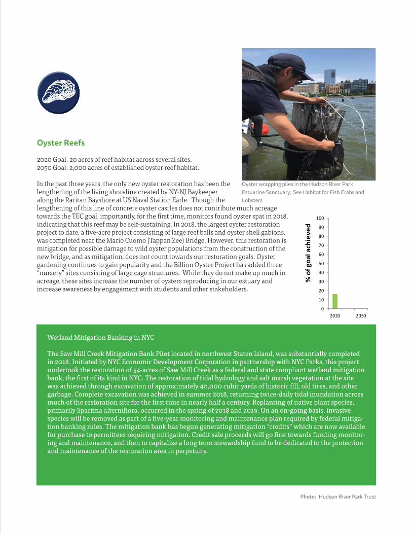
Oyster Reefs
2020 Goal: 20 acres of reef habitat across several sites.2050 Goal: 2,000 acres of established oyster reef habitat.
In the past three years, the only new oyster restoration has been the lengthening of the living shoreline created by NY-NJ Baykeeper along the Raritan Bayshore at US Naval Station Earle. Though thelengthening of this line of concrete oyster castles does not contribute much acreage towards the TEC goal, importantly, for the fi rst time, monitors found oyster spat in 2018, indicating that this reef may be self-sustaining. In 2018, the largest oyster restoration project to date, a fi ve-acre project consisting of large reef balls and oyster shell gabions, was completed near the Mario Cuomo (Tappan Zee) Bridge. However, this restoration is mitigation for possible damage to wild oyster populations from the construction of the new bridge, and as mitigation, does not count towards our restoration goals. Oyster gardening continues to gain popularity and the Billion Oyster Project has added three “nursery” sites consisting of large cage structures. While they do not make up much in acreage, these sites increase the number of oysters reproducing in our estuary and increase awareness by engagement with students and other stakeholders.
Coastal and Maritime Forests
2020 Goal: Establish one new maritime forest of at least 50 acres and restore at least 200 additional acres among several coastal forest/upland habitat types.2050 Goal: 500 acres of maritime forest community among at least three sites and 500 additional acres of restored coastal forest/upland habitat.
Coastal and Maritime Forests
0
10
20
30
40
50
60
70
80
90
100
2020 2050%
of g
oal a
chie
ved
Wetland Mitigation Banking in NYC
The Saw Mill Creek Mitigation Bank Pilot located in northwest Staten Island, was substantially completed in 2018. Initiated by NYC Economic Development Corporation in partnership with NYC Parks, this project undertook the restoration of 54-acres of Saw Mill Creek as a federal and state compliant wetland mitigation bank, the fi rst of its kind in NYC. The restoration of tidal hydrology and salt marsh vegetation at the site was achieved through excavation of approximately 40,000 cubic yards of historic fi ll, old tires, and other garbage. Complete excavation was achieved in summer 2018, returning twice-daily tidal inundation across much of the restoration site for the fi rst time in nearly half a century. Replanting of native plant species, primarily Spartina alternifl ora, occurred in the spring of 2018 and 2019. On an on-going basis, invasive species will be removed as part of a fi ve-year monitoring and maintenance plan required by federal mitiga-tion banking rules. The mitigation bank has begun generating mitigation “credits” which are now available for purchase to permittees requiring mitigation. Credit sale proceeds will go fi rst towards funding monitor-ing and maintenance, and then to capitalize a long term stewardship fund to be dedicated to the protection and maintenance of the restoration area in perpetuity.
Photo: Hudson River Park Trust
Oyster wrapping piles in the Hudson River Park Estuarine Sanctuary; See Habitat for Fish Crabs and Lobsters
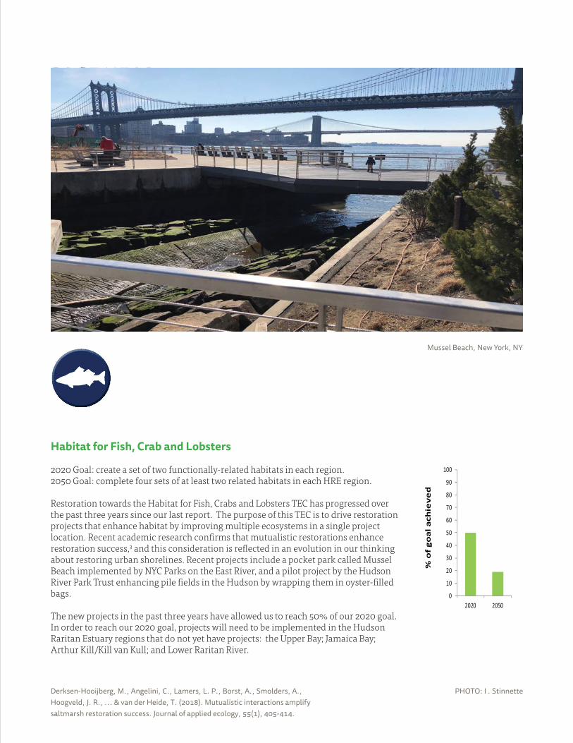
Derksen-Hooijberg, M., Angelini, C., Lamers, L. P., Borst, A., Smolders, A., Hoogveld, J. R., ... & van der Heide, T. (2018). Mutualistic interactions amplify saltmarsh restoration success. Journal of applied ecology, 55(1), 405-414.
• Body text Text column
• Bullet style
• bullet 2
• bullet 3
• bullet 4
Section
PAGE HEAD
PHOTO: I . Stinnette
Habitat for Fish, Crab and Lobsters
2020 Goal: create a set of two functionally-related habitats in each region.2050 Goal: complete four sets of at least two related habitats in each HRE region.
Restoration towards the Habitat for Fish, Crabs and Lobsters TEC has progressed over the past three years since our last report. The purpose of this TEC is to drive restoration projects that enhance habitat by improving multiple ecosystems in a single project location. Recent academic research confi rms that mutualistic restorations enhance restoration success,3 and this consideration is refl ected in an evolution in our thinking about restoring urban shorelines. Recent projects include a pocket park called Mussel Beach implemented by NYC Parks on the East River, and a pilot project by the Hudson River Park Trust enhancing pile fi elds in the Hudson by wrapping them in oyster-fi lled bags.
The new projects in the past three years have allowed us to reach 50% of our 2020 goal. In order to reach our 2020 goal, projects will need to be implemented in the Hudson Raritan Estuary regions that do not yet have projects: the Upper Bay; Jamaica Bay; Arthur Kill/Kill van Kull; and Lower Raritan River.
0
10
20
30
40
50
60
70
80
90
100
2020 2050
% o
f go
al a
chie
ved
Mussel Beach, New York, NY
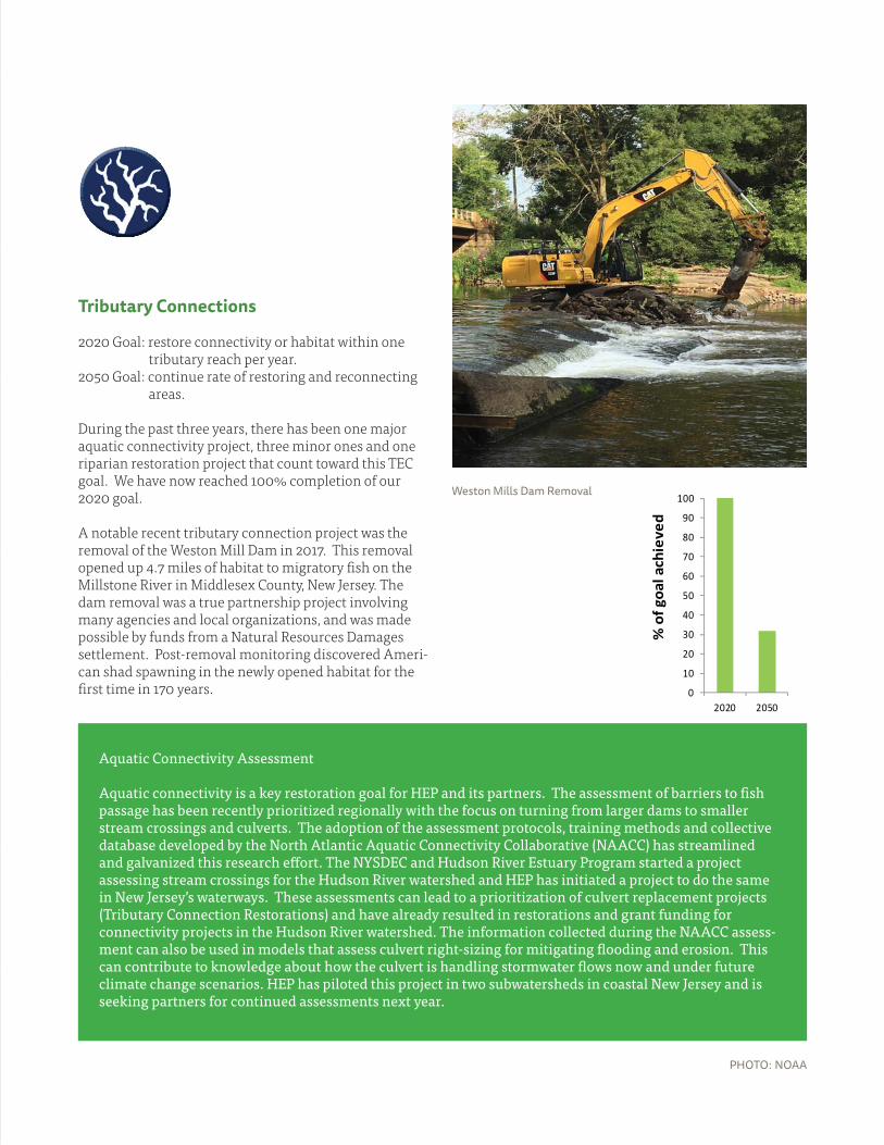
0
10
20
30
40
50
60
70
80
90
100
2020 2050
% o
f goa
l ach
ieve
d
PHOTO: NOAA
Tributary Connections
2020 Goal: restore connectivity or habitat within one tributary reach per year. 2050 Goal: continue rate of restoring and reconnecting areas.
During the past three years, there has been one major aquatic connectivity project, three minor ones and one riparian restoration project that count toward this TEC goal. We have now reached 100% completion of our 2020 goal.
A notable recent tributary connection project was the removal of the Weston Mill Dam in 2017. This removal opened up 4.7 miles of habitat to migratory fi sh on the Millstone River in Middlesex County, New Jersey. The dam removal was a true partnership project involving many agencies and local organizations, and was made possible by funds from a Natural Resources Damages settlement. Post-removal monitoring discovered Ameri-can shad spawning in the newly opened habitat for the fi rst time in 170 years.
Aquatic Connectivity Assessment
Aquatic connectivity is a key restoration goal for HEP and its partners. The assessment of barriers to fi sh passage has been recently prioritized regionally with the focus on turning from larger dams to smaller stream crossings and culverts. The adoption of the assessment protocols, training methods and collective database developed by the North Atlantic Aquatic Connectivity Collaborative (NAACC) has streamlined and galvanized this research eff ort. The NYSDEC and Hudson River Estuary Program started a project assessing stream crossings for the Hudson River watershed and HEP has initiated a project to do the same in New Jersey’s waterways. These assessments can lead to a prioritization of culvert replacement projects (Tributary Connection Restorations) and have already resulted in restorations and grant funding for connectivity projects in the Hudson River watershed. The information collected during the NAACC assess-ment can also be used in models that assess culvert right-sizing for mitigating fl ooding and erosion. This can contribute to knowledge about how the culvert is handling stormwater fl ows now and under future climate change scenarios. HEP has piloted this project in two subwatersheds in coastal New Jersey and is seeking partners for continued assessments next year.
Weston Mills Dam Removal
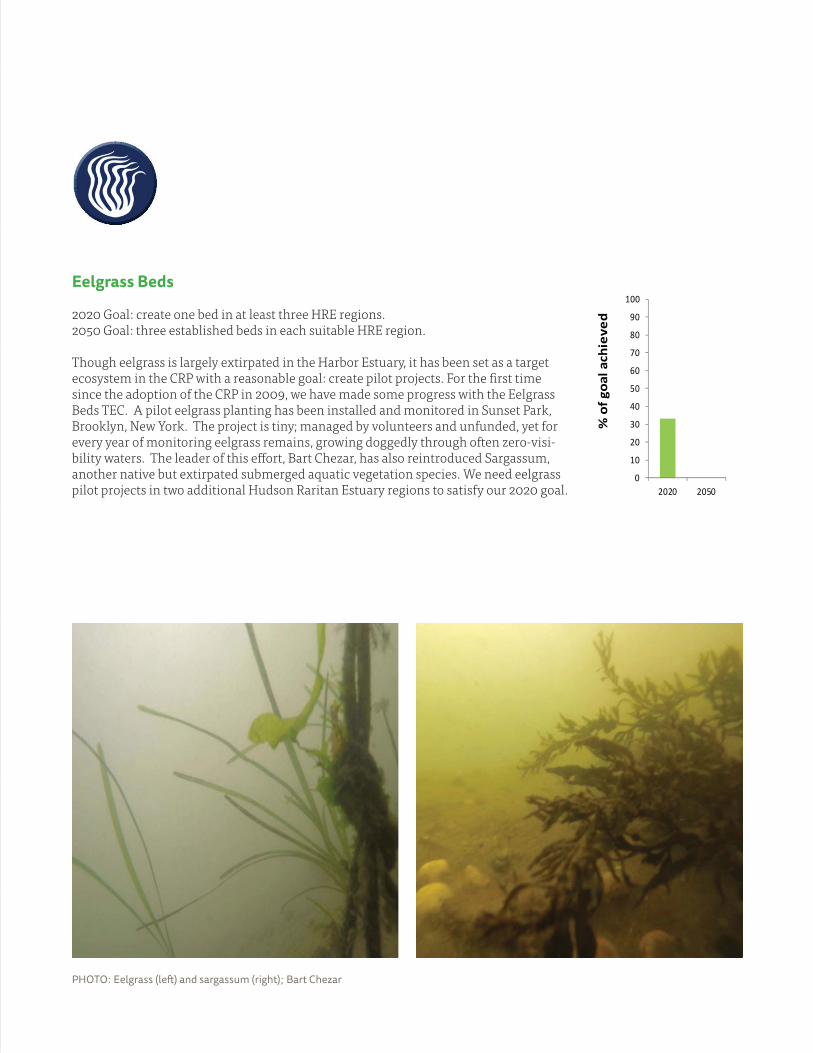
Eelgrass Beds
2020 Goal: create one bed in at least three HRE regions.2050 Goal: three established beds in each suitable HRE region.
Though eelgrass is largely extirpated in the Harbor Estuary, it has been set as a target ecosystem in the CRP with a reasonable goal: create pilot projects. For the fi rst time since the adoption of the CRP in 2009, we have made some progress with the Eelgrass Beds TEC. A pilot eelgrass planting has been installed and monitored in Sunset Park, Brooklyn, New York. The project is tiny; managed by volunteers and unfunded, yet for every year of monitoring eelgrass remains, growing doggedly through often zero-visi-bility waters. The leader of this eff ort, Bart Chezar, has also reintroduced Sargassum, another native but extirpated submerged aquatic vegetation species. We need eelgrass pilot projects in two additional Hudson Raritan Estuary regions to satisfy our 2020 goal.
PHOTO: Eelgrass (left ) and sargassum (right); Bart Chezar
0
10
20
30
40
50
60
70
80
90
100
2020 2050
% o
f goa
l ach
ieve
d
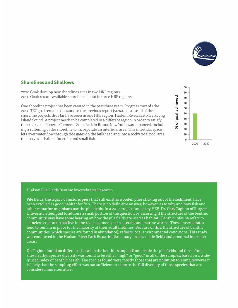
Shorelines and Shallows
2020 Goal: develop new shorelines sites in two HRE regions. 2050 Goal: restore available shoreline habitat in three HRE regions
One shoreline project has been created in the past three years. Progress towards the 2020 TEC goal remains the same as the previous report (50%), because all of the shoreline projects thus far have been in one HRE region: Harlem River/East River/Long Island Sound. A project needs to be completed in a diff erent region in order to satisfy the 2020 goal. Roberto Clemente State Park in Bronx, New York, was enhanced, includ-ing a softening of the shoreline to incorporate an intertidal area. This intertidal space lets river water fl ow through tide gates on the bulkhead and into a rocky tidal pool area that serves as habitat for crabs and small fi sh.
Hudson Pile Fields Benthic Invertebrates Research
Pile fi elds, the legacy of historic piers that still exist as wooden piles sticking out of the sediment, have been extolled as good habitat for fi sh. There is no defi nitive answer, however, as to why and how fi sh and other estuarine organisms use the pile fi elds. In a 2017 project funded by HEP, Dr. Gary Taghon of Rutgers University attempted to address a small portion of the question by assessing if the structure of the benthic community may have some bearing on how the pile fi elds are used as habitat. Benthic infauna refers to spineless creatures that live in the river sediment, such as crabs and marine worms. These invertebrates tend to remain in place for the majority of their adult lifetimes. Because of this, the structure of benthic communities (which species are found in abundance), refl ects local environmental conditions. This study was conducted in the Hudson River Park Estuarine Sanctuary on seven pile fi elds and proximal inter-pier areas.
Dr. Taghon found no diff erence between the benthic samples from inside the pile fi elds and those from sites nearby. Species diversity was found to be either “high” or “good” in all of the samples, based on a wide-ly used index of benthic health. The species found were mostly those that are pollution tolerant, however it is likely that the sampling eff ort was not suffi cient to capture the full diversity of those species that are considered more sensitive.
0
10
20
30
40
50
60
70
80
90
100
2020 2050
% o
f goa
l ach
ieve
d
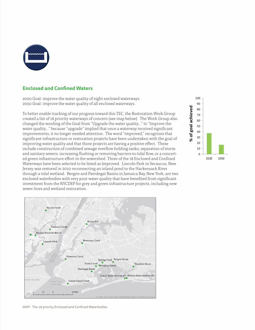
Enclosed and Confi ned Waters
2020 Goal: improve the water quality of eight enclosed waterways. 2050 Goal: improve the water quality of all enclosed waterways.
To better enable tracking of our progress toward this TEC, the Restoration Work Group created a list of 18 priority waterways of concern (see map below). The Work Group also changed the wording of the Goal from “Upgrade the water quality...” to “Improve the water quality…” because “upgrade” implied that once a waterway received signifi cant improvements, it no longer needed attention. The word “improved,” recognizes that signifi cant infrastructure or restoration projects have been undertaken with the goal of improving water quality and that those projects are having a positive eff ect. These include construction of combined sewage overfl ow holding tanks, separation of storm and sanitary sewers, increasing fl ushing or removing barriers to tidal fl ow, or a concert-ed green infrastructure eff ort in the sewershed. Three of the 18 Enclosed and Confi ned Waterways have been selected to be listed as Improved. Lincoln Park in Secaucus, New Jersey, was restored in 2010 reconnecting an inland pond to the Hackensack River through a tidal wetland. Bergen and Paerdegat Basins in Jamaica Bay, New York, are two enclosed waterbodies with very poor water quality that have benefi ted from signifi cant investment from the NYCDEP for grey and green infrastructure projects, including new sewer lines and wetland restoration.
0
10
20
30
40
50
60
70
80
90
100
2020 2050
% o
f goa
l ach
ieve
d
MAP: The 18 priority Enclosed and Confi ned Waterbodies
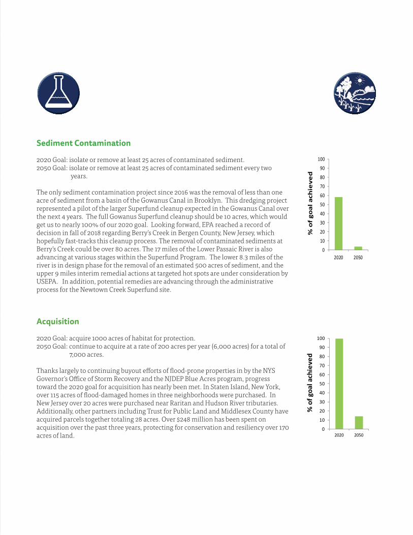
Sediment Contamination
2020 Goal: isolate or remove at least 25 acres of contaminated sediment.2050 Goal: isolate or remove at least 25 acres of contaminated sediment every two years.
The only sediment contamination project since 2016 was the removal of less than one acre of sediment from a basin of the Gowanus Canal in Brooklyn. This dredging project represented a pilot of the larger Superfund cleanup expected in the Gowanus Canal over the next 4 years. The full Gowanus Superfund cleanup should be 10 acres, which would get us to nearly 100% of our 2020 goal. Looking forward, EPA reached a record of decision in fall of 2018 regarding Berry’s Creek in Bergen County, New Jersey, which hopefully fast-tracks this cleanup process. The removal of contaminated sediments at Berry’s Creek could be over 80 acres. The 17 miles of the Lower Passaic River is also advancing at various stages within the Superfund Program. The lower 8.3 miles of the river is in design phase for the removal of an estimated 500 acres of sediment, and the upper 9 miles interim remedial actions at targeted hot spots are under consideration by USEPA. In addition, potential remedies are advancing through the administrative process for the Newtown Creek Superfund site.
Acquisition
2020 Goal: acquire 1000 acres of habitat for protection.2050 Goal: continue to acquire at a rate of 200 acres per year (6,000 acres) for a total of 7,000 acres.
Thanks largely to continuing buyout eff orts of fl ood-prone properties in by the NYS Governor’s Offi ce of Storm Recovery and the NJDEP Blue Acres program, progress toward the 2020 goal for acquisition has nearly been met. In Staten Island, New York, over 115 acres of fl ood-damaged homes in three neighborhoods were purchased. In New Jersey over 20 acres were purchased near Raritan and Hudson River tributaries. Additionally, other partners including Trust for Public Land and Middlesex County have acquired parcels together totaling 28 acres. Over $248 million has been spent on acquisition over the past three years, protecting for conservation and resiliency over 170 acres of land.
0
10
20
30
40
50
60
70
80
90
100
2020 2050
% o
f go
al a
chie
ved
0
10
20
30
40
50
60
70
80
90
100
2020 2050
% o
f goa
l ach
ieve
d
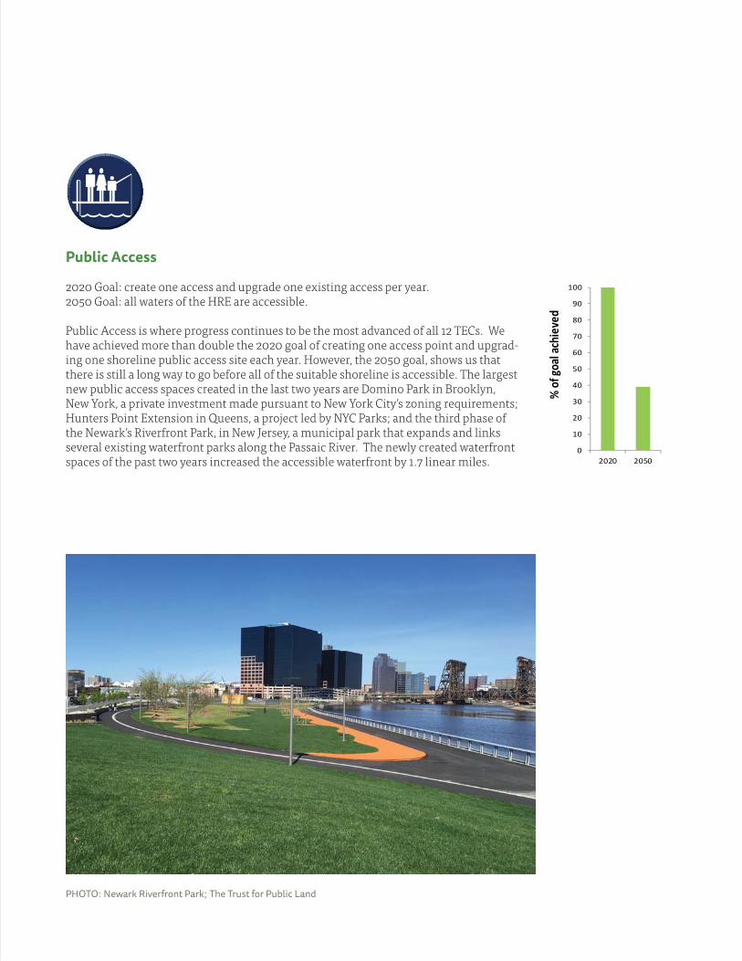
Public Access
2020 Goal: create one access and upgrade one existing access per year. 2050 Goal: all waters of the HRE are accessible.
Public Access is where progress continues to be the most advanced of all 12 TECs. We have achieved more than double the 2020 goal of creating one access point and upgrad-ing one shoreline public access site each year. However, the 2050 goal, shows us that there is still a long way to go before all of the suitable shoreline is accessible. The largest new public access spaces created in the last two years are Domino Park in Brooklyn, New York, a private investment made pursuant to New York City’s zoning requirements; Hunters Point Extension in Queens, a project led by NYC Parks; and the third phase of the Newark’s Riverfront Park, in New Jersey, a municipal park that expands and links several existing waterfront parks along the Passaic River. The newly created waterfront spaces of the past two years increased the accessible waterfront by 1.7 linear miles.
PHOTO: Newark Riverfront Park; The Trust for Public Land
0
10
20
30
40
50
60
70
80
90
100
2020 2050
% o
f goa
l ach
ieve
d
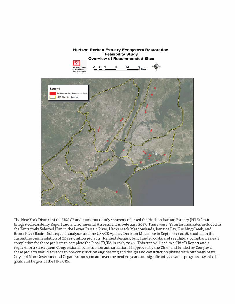
Hudson Raritan Estuary Integrated Feasibility Study The New York District of the USACE and numerous study sponsors released the Hudson Raritan Estuary (HRE) Draft Integrated Feasibility Report and Environmental Assessment in February 2017. There were 33 restoration sites included in the Tentatively Selected Plan in the Lower Passaic River, Hackensack Meadowlands, Jamaica Bay, Flushing Creek, and Bronx River Basin. Subsequent analyses and the USACE Agency Decision Milestone in September 2018, resulted in the current recommendation of 20 restoration projects. Refi ned designs, fully funded costs, and regulatory compliance nears completion for these projects to complete the Final FR/EA in early 2020. This step will lead to a Chief’s Report and a request for a subsequent Congressional construction authorization. If approved by the Chief and funded by Congress, these projects would advance to pre-construction engineering and design and construction phases with our many State, City and Non-Governmental Organization sponsors over the next 20 years and signifi cantly advance progress towards the goals and targets of the HRE CRP.
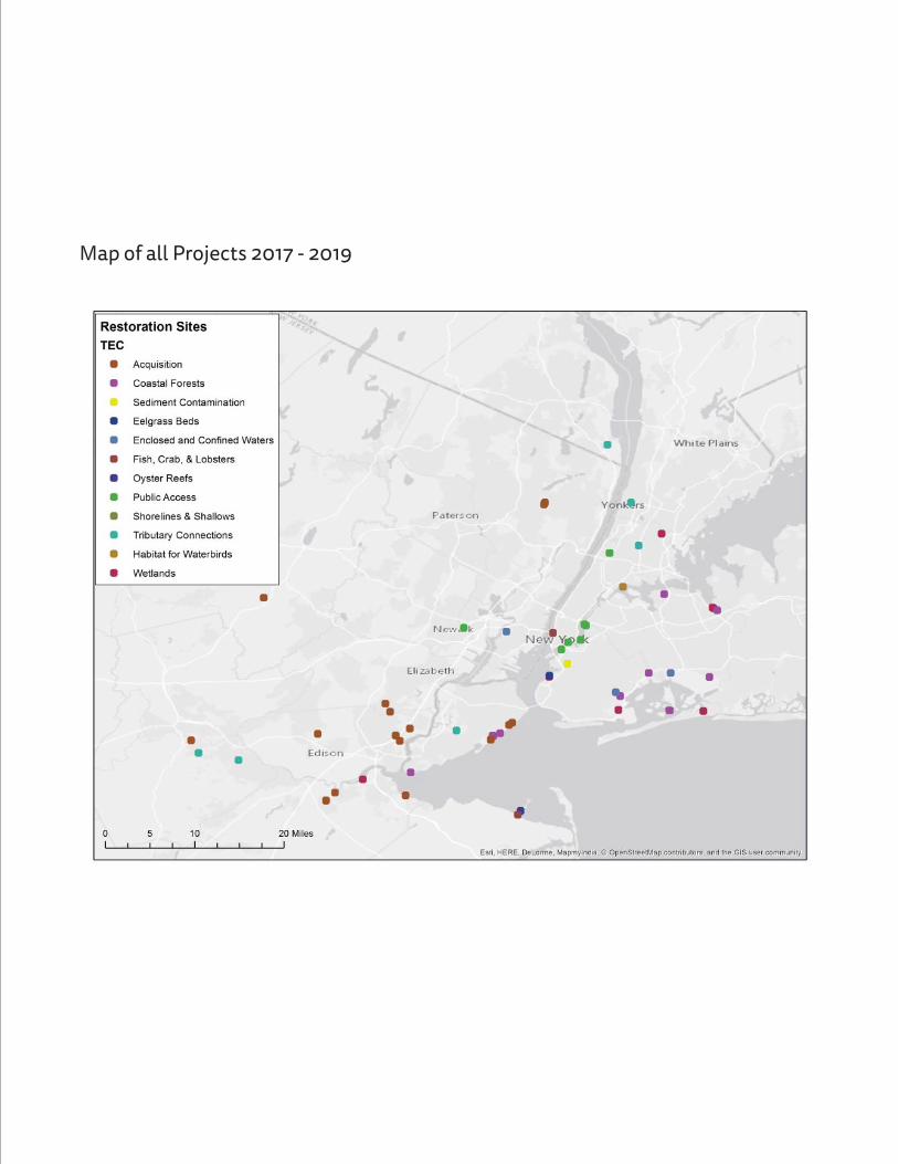
Map of all Projects 2017 - 2019
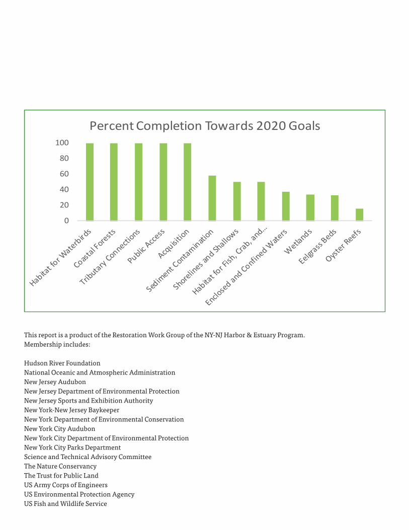
0
20
40
60
80
100
Percent Completion Towards 2020 Goals
This report is a product of the Restoration Work Group of the NY-NJ Harbor & Estuary Program. Membership includes:
Hudson River Foundation National Oceanic and Atmospheric Administration New Jersey AudubonNew Jersey Department of Environmental ProtectionNew Jersey Sports and Exhibition AuthorityNew York-New Jersey Baykeeper New York Department of Environmental ConservationNew York City AudubonNew York City Department of Environmental ProtectionNew York City Parks DepartmentScience and Technical Advisory CommitteeThe Nature ConservancyThe Trust for Public LandUS Army Corps of EngineersUS Environmental Protection AgencyUS Fish and Wildlife Service

NOVEMBER 1, 2019