Embed Size (px)
Citation preview
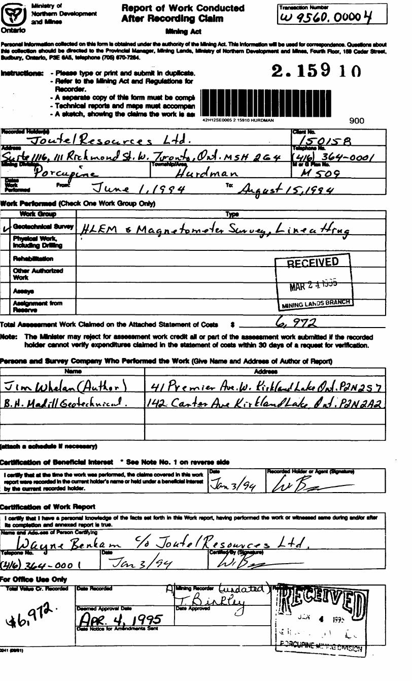
42H12SE0005 2.15810 HURDMAN 010
REPORT ON MAGNETIC AND HLEM SURVEYSOVER THE
JOUTEL RESOURCES PROPERTYHURDMAN TOWNSHIP PORCUPINE MINING DIVISION ONTARIO
NTS 42H/5 5484000N,451000E UTM
RECEIVED
MAR 2 41995
MINING LANDS BRANCH i
2-15910
l&fJ.M. Whelan August 1994
42H12SEOOOS 2.1 W.WmiSSi
010C
CONTENTS
Int. r oduc t ionProperty Description Location and AccessGeneral GeologyPrevious WorkSurvey ProcedureSurvey ResultsConclusionsReferencesCertificate of Qualifications
Appendix I Survey Specifications
l l 4 4789
1011
LIST OF FIGURES
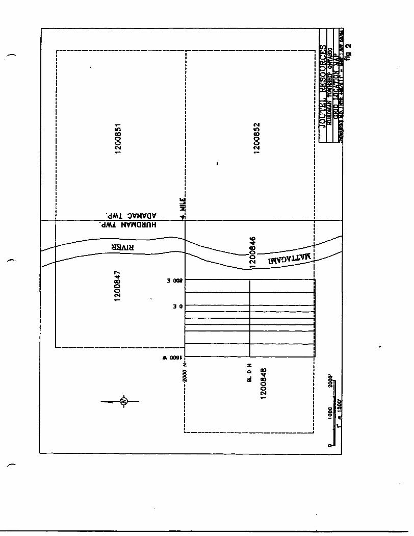
FIGURE l PROPERTY LOCATION PLAN l" ^ 4 MILESFIGURE 2 GRID LOCATION PLAN l" = 1500'FIGURE 3 ASSESSMENT WORK LOCATION PLAN l" = 2640'
236
Maps MM-444 to MM-1777Map Mag-lMap Comp-1 l"Map Mag-PiMap Topo-1
ENCLOSURES
l" = 200* Profiled HLEM Data l" = 200' Magnetic Contours and Data
400* Magnetic Contours and HLEM anomalies l" = 400' Magnetic Profiles l" = 400* Topographic Profiles
INTRODUCTION;
During July 1994, on behalf of Joutel Resources Inc. total field
magnetic and horizontal loop electromagnetic surveys were conducted
over parts of two mining claims located in Hurdman Twp. Ontario,
roughly 4 miles east of the recent (1991,92) zinc discoveries by
Noront Resources.
The surveys were conducted to ground locate a cluster of weak
airborne EM anomalies present in the central portion of the grid.
The work was carried out on a contract basis under the supervision
of the author.
PROPERTY DESCRIPTION LOCATION AND ACCESS
The surveys cover parts of claims 1200846 (6 unit) and 1200848 (9
unit) which form part of a five claim (48 unit) block in which
Joutel Resources holds a beneficial interest. These claims lie in
the southeast section of Hurdman and southwest portion of Adanac
Townships, approximately 16 miles north of the Town of Smooth Rock
Falls. The property was accessed via highway 807 north from Smooth
Rock Falls and an unmaintained logging road west and southwest from
highway 807 to a point 2.5 miles southwest (by road) of the
Mattagami river where a washout prevented further vehicle travel.
From this point survey gear and a canoe were carried by foot along
the logging road, a winter road and a trail, to the 400 foot wide
river opposite the intersection of the 20+00 north tieline and the
west bank of the river, (fig. 1)
Stream crossings on the logging road between the highway and the
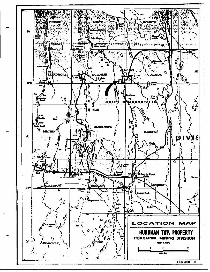
HURDMAN TWP. PROPERTYPORCUPINE MINING DIVISIION
FIGURE 1
K) O O CO
CO
1*00 W
O E
800 E
ro o o oo
HURDMAN TWP.ADANAC TWP.
to o o00 Utro
ro o o oo ut
washout showed signs of deterioration and would require upgrading
prior to there use by any heavy equipment, and as the section of
river opposite the survey area lies in between two sets of rapids
and has 15 to 20 foot clay banks, drill and equipment access might
best be gained in the winter from the west.
GENERAL GEOLOGY;
The survey area and the majority of the surrounding area is
covered by glacial drift limiting outcrop exposure. The underlying
rocks as indicated on Ontario Department of Mines Map 2161 d" s 4
miles) consist primarily of biotite-quartz-feldspar gneiss, hybrid
granitic gneiss, and amphibolite. No faults are shown in the area
but the results of airborne magnetic surveys suggest the presence
of faults and several north trending diabase dykes.
No outcrop were observed in the gridded area.
TOPOGRAPHY:
As shown on map Topo-1 the survey area is of low local relief with
only slight rises in elevation present between lines OE and 4W
north of the baseline, this small hill may indicate a rise in
bedrock topography and a thinning of the overburden. West of line
4+00 west low flat spruce swamp predominates, it appears that this
bog extends a considerable distance west of the property.
PREVIOUS WORK;
1965-66; Inco; 41 claims were covered or partially covered by
ground magnetic, broadside EM and vertical loop EM surveys.
Conductors were subsequently tested by 16 diamond drill holes, no
ULU OR
-14-17-16 IU
UU
*NORONTXGALICO Zn DISCOVERY
1 -- 1A
M O
R-13
{ kU
UD
LDB
I
INOO y.VLBfJO
B
JOUTEL
QRID
* MU
UL
M-
MATTAG
AMI LAK
E MIN
ES H
LD
I- H
ORIZO
NTAL LOO
P EM
VL
EM
- VERTICAL LOO
P EM
M-
GR
OU
ND
M
AGNETIC
VL
FEM
- V
LP-E
M
UU
fOR
-7
^A
SSESSMEN
T W
ORK
LO
CATIO
N
PLAN
9 .
J80!00.
, . ^OP0'
r - 2MO- FIG
.3
assays are recorded on the drill logs but as a number of holes were
drilled in the area of the Noront/Galico Zn showing and sphalerite
is reported in some holes it is presumed Zn values were obtained.
1979-1981: Mattagami Lake Mines; ground magnetic and horizontal
loop EM surveys were conducted over an number of properties in
Hurdman township. The most extensive being conducted on the group
13 property which covered the Noront/Galico Zn. showing. A total of
45 holes appear to have been drilled on the group 13 property. A
number of holes reported excellent zinc values over narrow sampling
widths (up to 15 !feX2.0 f ) within zones averaging up to 2.4^ Zn/37.7'
the zinc values were obtained in sulphide enriched zones containing
varying amounts of py,po,cp, and sph. Anomalous silver values, in
some cases greater than loz./ton have also been reported.
Ground magnetic and HLEM surveys ( 600' coil separation) conducted
on the Mattagami group 12 property partially overlap the Joutel
survey area, the magnetic results show good correlation and two EM
conductors outlined are roughly coincident with anomalies detected
by the Joutel survey. No evidence of the Mattagami grid remains nor
was any evidences of drilling noticed.
1988-91: McKinnon Prospecting; fixed wing airborne magnetic and
VLF-EM surveys were flown in 1988 covering extensive holdings in
Hurdman and surrounding townships. In 1991 the area was resurveyed
by a helicopter borne magnetic, VLF-EM and electromagnetic survey
(Aerodat 5 frequency system). A cluster of four weak EM anomalies
were detected roughly in the centre of the Joutel survey area.
1991 to date: Noront Resources/Galico resources; 16 drill holes
have been filed for assessment work to date, all are in the
vicinity of the zinc showing. Intersections of X.9% Zn/127', 2.4ilA
Zn/44.3, 2.41% Zn/37.7* and numerous narrower intersections have
been reported, (some of the Mattagami and Noront core are at MNDM library)
SURVEY PROCEDURE:
Magnetic: Total field magnetic values were recorded at 50*
intervals on the north south picket lines and at 100* intervals
along the base and tielines using a Scintrex IGS-2/MP-4 proton
precession magnetometer. Diurnal control was maintained using a
Scintrex MP-4 cycling magnetometer set at a 30 second sample
interval, located at the washout on the logging road approximately
2.5 miles east of the property. Survey results are presented as
contours of the total magnetic field at a 50 nT. contour interval
at a scale of l" = 200* and profiles of the total magnetic field at
a scale of l" = 400.
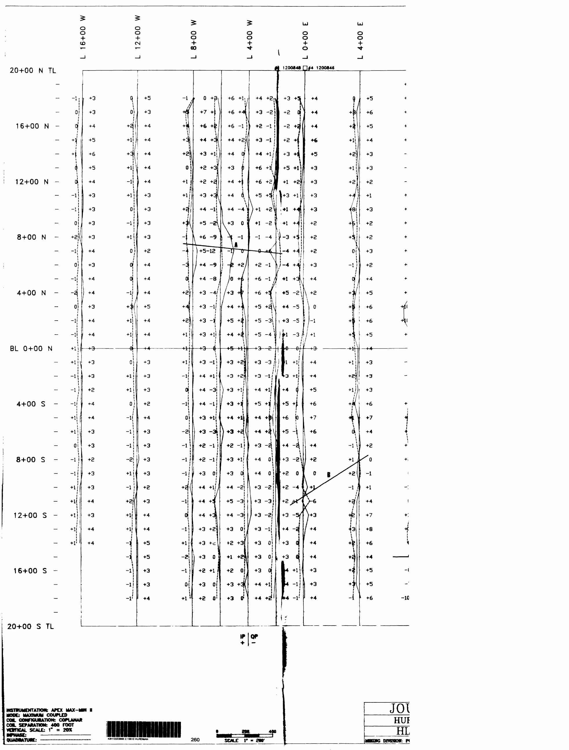
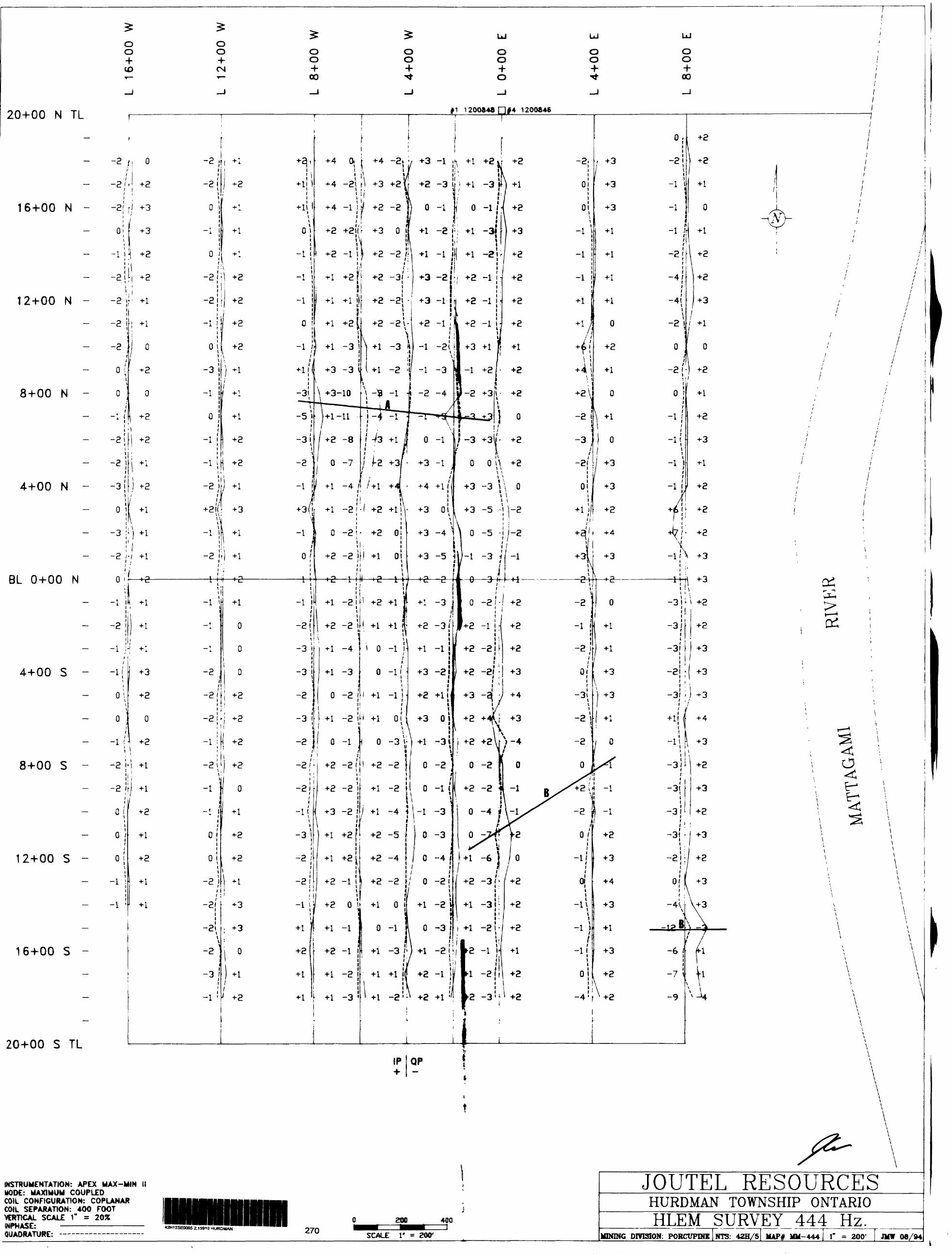
HLEM: Inphase and quadrature values were recorded at 100' intervals
along the north south grid lines using an Apex Max-Min II
electromagnetic system in the maximum coupled mode. Coil
coplanarity was maintained using a Suunto hand held inclinometer,
and as inconsistencies exist in the grid chaining, coil separation
was maintained using the reference cable. Three frequencies
(444,888 and 1777 Hz.) were read at a 400' coil separation,
and the results are presented as profiles of the inphase and
quadrature at a vertical scale of l" s 20% and a horizontal scale of
l" = 200'.
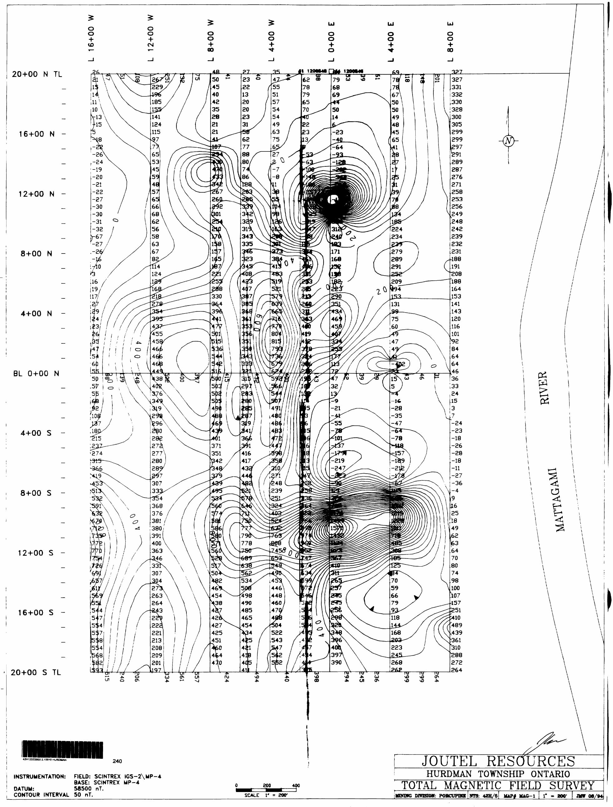
SURVEY RESULTS;
The contoured magnetic data shows a complex generally north south
pattern. Two strongly anomalous features are readily, apparent the
first being a pronounced ellipsoidal (400'xl200') east trending
magnetic high outlined in the south east corner of the survey area
The steep near symmetrical magnetic gradients on lines O and 4
east are indicative of a steeply dipping near surface source body.
The more moderate gradients west of line 2 west suggest either a
westerly plunge or a thickening of overburden over the source.
A pronounced magnetic low centred on line O east at 12+00 north
is also caused by a near surface source, the area has been checked
and cultural contamination has been ruled out.
The contour pattern also suggests the presence of faults the most
definite being a north trending feature along line 600 west.
ELECTROMAGNETIC: Two conductive zones and a weak one line response
are indicated in the HLEM data. Anomaly A is a weak but definite
conductor roughly coincident with a weak magnetic feature, in the
area of the airborne EM anomalies. Anomaly B is a weak and less
definite conductor coincident with the strong magnetic high in the
south east corner of the grid.
A single line response coincident with the northern edge of a weak
magnetic high was detected near the south end of line 800 east
CONCLUSIONS: Two weak EM conductors both coincident with magnetic
features were located in the survey area. In light of the results
to date on the Noront/Calico property further work over these
8
anomalies is warranted.
An examination of the Mattagami and Noront/Galico drill logs
showed that a number of Zn intersections were sphalerite rich but
not associated with pyrite,pyrrhotite massive sulphides.
As sphalerite is a poor conductor, a zone rich in sphalerite but
deficient in other sulphide mineralization would show limited if
any electromagnetic response. An induced polarization survey might
better define such zones, and it is recommended that the anomaly A
and B area and the south end of line 800 east be covered by an IP
survey prior to any drilling.
Respectfully submitted,s*^J.M. Whelan 08/94
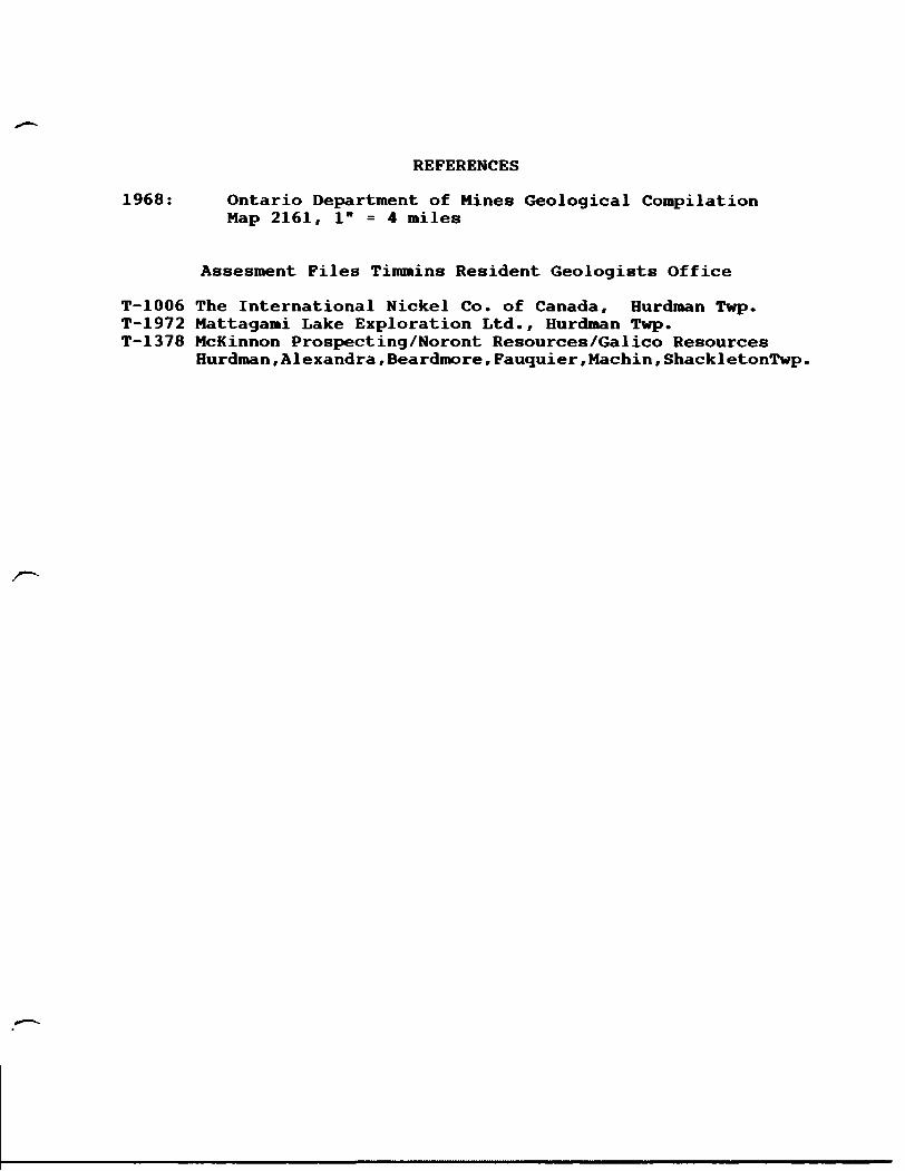
REFERENCES
1968: Ontario Department of Mines Geological Compilation Map 2161, l" = 4 miles
Assesment Files Timmins Resident Geologists Office
T-1006 The International Nickel Co. of Canada, Hurdman Twp.T-1972 Mattagami Lake Exploration Ltd., Hurdman Twp.T-1378 McKinnon Prospecting/Noront Resources/Calico Resources
Hurdman,Alexandra,Beardmore,Fauquier,Machin,ShackletonTwp.
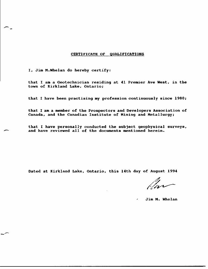
CERTIFICATE OF QUALIFICATIONS
I, Jim M.Whelan do hereby certify:
that I am a Geotechnician residing at 41 Premier Ave West, in the town of Kirkland Lake, Ontario;
that I have been practising my profession continuously since 1980;
that I am a member of the Prospectors and Developers Association of Canada, and the Canadian Institute of Mining and Metallurgy;
that I have personally conducted the subject geophysical surveys, and have reviewed all of the documents mentioned herein.
Dated at Kirkland Lake, Ontario, this 14th day of August 1994
Jim M. Whelan

APPENDIX I
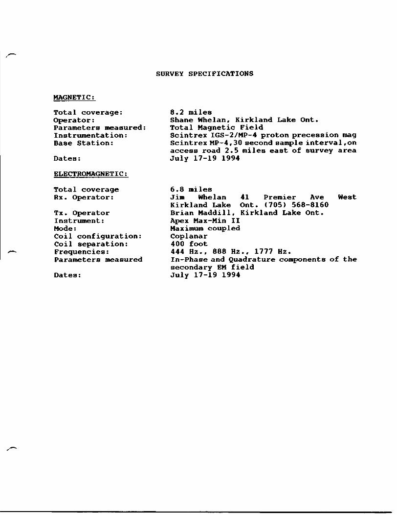
SURVEY SPECIFICATIONS
MAGNETIC;
Total coverage: 8.2 milesOperator: Shane Whelan, Kirkland Lake Ont.Parameters measured: Total Magnetic FieldInstrumentation: Scintrex IGS-2/MP-4 proton precession magBase Station: Scintrex MP-4,30 second sample interval,on
access road 2.5 miles east of survey area Dates: July 17-19 1994
ELECTROMAGNETIC t
Total coverage 6.8 milesRx. Operator: Jim Whelan 41 Premier Ave West
Kirkland Lake Ont. (705) 568-8160Tx. Operator Brian Maddill, Kirkland Lake Ont. Instrument: Apex Max-Min II Mode: Maximum coupled Coil configuration: Coplanar Coil separation: 400 footFrequencies: 444 Hz., 888 Hz., 1777 Hz. Parameters measured In-Phase and Quadrature components of the
secondary EM field Dates: July 17-19 1994
Ministry ofDavatopmant
and
Trarwaaton Numbar
. POOP VReport of Work ConductedAfter Recording deJm ____
MbrinoAct
eolocl^ on S^ tom to oettfnod und^ tio auD^orNy of M ISnlng AA houU to dhoctad lo SM ProvbtcW (ybmoor. taring Unto. MHtty of Nortnwn Dtiiotepnunl and ISma. Fourth Floor. 16S Codar Stroot.
Sudbury. Ontario. P9E SAB. lataphoni (706) S7D-72S4.
Ontario
type or print and submit In dupflcate. Refer to the MMng Act and Regulations tor
2.159 10
A eeparate copy of tfw kum muet be oompli Technical reports and mape muet accompan A eketch. showing the dahne the work le aei
42H12SEOOOS 2 15910 HURDMAN 900
Work (Check One Work Group Only)WorkGroup Typt
Survey
Onsr Aunoftzed
z 4 m jotflin.^..AKDS BRANCH
Total Work Claimed on the Attached Statement of Costa S .
Mbitoter may reject for assessment work credit aN or pert of the cannot verify expendttures claimed In the statement of costs
assessment work submitted If the recorded O days of a reojuest for verification.
••b^ IsV^hflSV *^*- M^aMi^ AM^4 ^ -* -* - ^J Aa^ibtfkM ^Jnw ffom (wvo NWM Bno Aoorw&f Of Aumor ofAddress
\
B. li A+* #rt Ifa^SL+A, J J.
m neceessry)
^A B^^k^JlMi^OT Benencwi * ^— — fc| n * M fcjn 4 ^^.K m^*m^mm^see ivoie ivo* i on reverse
* Vie) CMMW OOW9Q In stllel Wit
hi tt* currant hoktor1* namo or haU undar abyOMK
Certlfteallofi of Work Reportl carSfy Siat l nasa a paraonat knoMttdga of lha facts an torth In thto Work laport, having partorrnad ma work or
i and armaxad raport to troa. ___ ____ ^^^^^^^^^during MMVor altar
.CANo. J
For Office Uee Only
.tor Amiodm*ntt
Approved
S*f
0041 |Wt1)
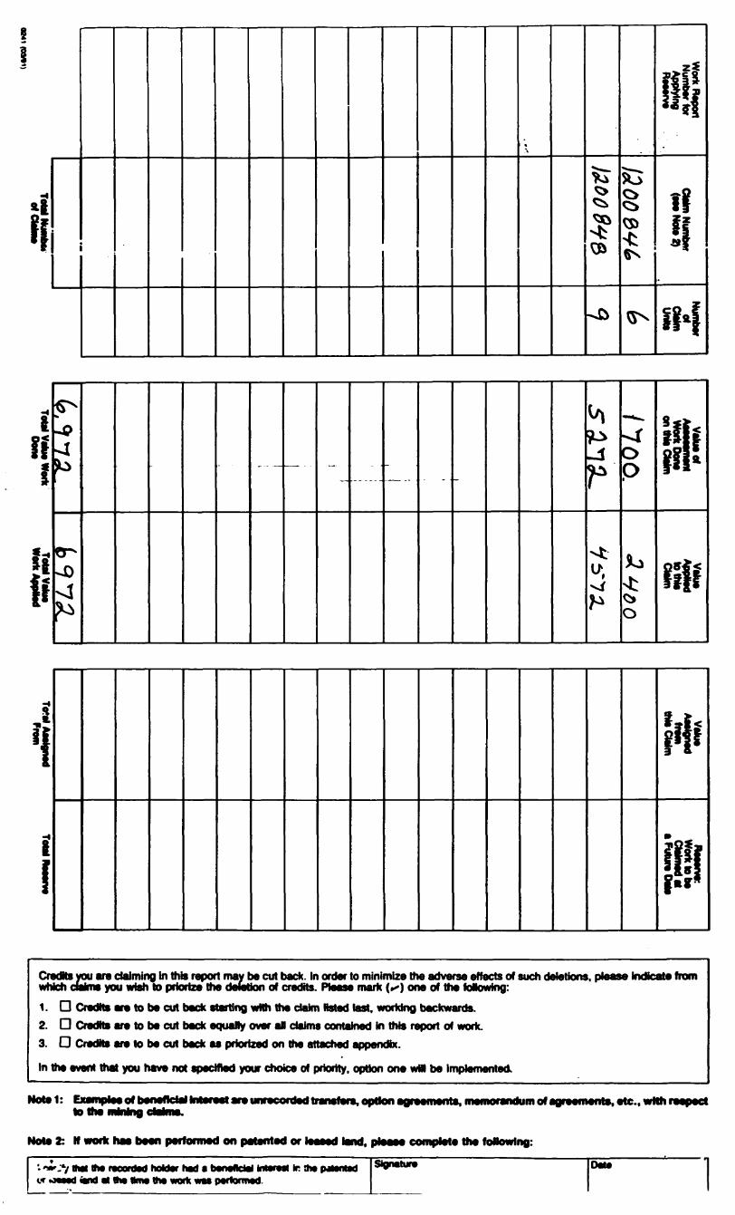
fiif
wi
-0
0--0-4^
------ . .. -
t/i
P-t
5
o p
*o
ftfiff
ri M*
Credte you are claiming in this report may be cut back. In order to minimize the adverse effects of such deletions, which dahl* you wish lo priorize the deletion of credits. Please mark (**) one of the foNowing:
1. D Credtts are to be cut back starting wNh the data Hstad last, working backwards.2. D Credits are to be cut back equally over aP claims contained in this report of work.3. D CredKs are to be cut back as priorized on the attached appendbc.
In the event that you have not specified your choice of priority, option one wM be implemented
Indicate from
Hotel: CxamplMMot benelteiaHntefeat are unrecorded transfers, optics agreenwrts.memc^aridum rt agfeements, etc.. with respect
Note 2: H work haa been performed on patented or liasid land, plaaae complete the following:
V that ttw raoontwf hoktor had c beneAeiel bMmi Ir 9w pjunted at 9m wrw In* work WM performed.
Signature
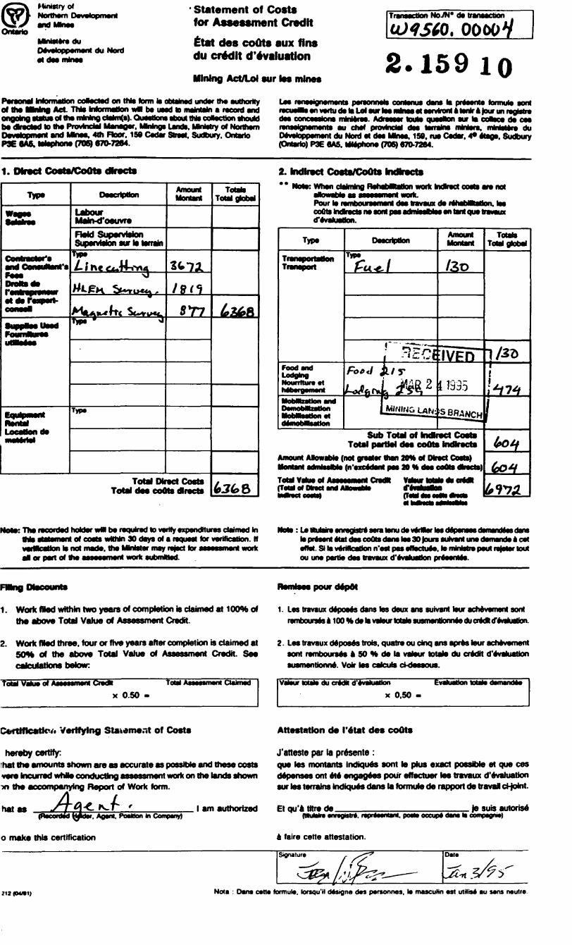
Ministry of
OntarioMMsteredu Oevetoppemenf du Nord at des mines
' Statement of Costs for Assessment Credit
Etat des coOts aux fins du credit devaluation
Mining Act/Lol sur tes mine*
Transaction NoJH* da transaction
. OOOOV
2.159 loParaonal Information coftacted on this term it obtained under the authority ofhelfMng Act Thto Inforrnalton wM be uaad to maMajnareaxd and
of ttw nvnlnQ ctainafs). CKMnons ffrHrt thto coMoction should
Da*atepmanl and Mhws, 4th Floor. 150 Csdar Street. Sudbury. Ontario P3E MS. toliphoni (70S) 670-7264.
Lea renasignernenta poreonnole oontonua dana la pntoente tormuto aont racusWs en vertu de la Lei aur toe msnea at aarviront A tor* a tour un regtotra daa concaaitona mMsraa. Adraassr touto iimrtcn sur la ooaaca da cese^Miea^^W^SMVi^MfteaK oh* B ^^^^af e^sv^t^^^^ ja^^st ^ vakbtA a^ba^L*^aB f ^^A^^^— L ^. tJnjBpJjnfjnifinial U dlen prvWlCMI OM MfflVne) flaWWrVt nWWIVfe) OUDevetoppement du Nord at daa Mkiss. 159. ras Cedar. 4* ataga. Sudbury (Ontario) P3E 6A5. Mlaphona (706) 670-7264.
1. Owiajct Costs/Coots dlracto
r at ala
Mahvd'oeuvreHeld Supervision Supervision sur la terrain
TIPS
Amount
Total Dkact Coats Total daa coOts dlracta
Totato Total global
2. Indirect Costs/CoOts IncHracts ** Mott: Whan daMng RehabMatton wot ctoosH
Pour torefnboursemsnt daafcavaMxda lahabMtaBoii. lwCOutS IndsTtCtLI Ile) Mflt PM drlriMablM Wl taVst QUO l tfSVI
Totals ToW global
rOOfl 4VMLodging NountturaM
partial das ceOta indkactaAmount AfcwaMs (not graatar than 20H at Mraet Costs)
(n'anadsnt pas M * dssToMVahiaof (Total of Dlr*et and
NotKThar ttod holdar wM ba raquirad to varify axpandttures ctoJnwd hi of coats wNMn 30 days of s request tor verification. H
wMcaUon la not made, the MnMer may reject tor assessment work al or part of the assessment work submttsd.
Note: Le ttuWre enregbtrt sera tenu da vwrttor tos cle present Mat des coots dana lea 30 tours aulvant une demands a cat effet. Si la verifcatfon n'est pea eftoctuee. to mWstie paul ratotor toutOU UOe) ptftio dM tfWaMOC
1. Work Wad wtthln Nw y^ars erf completion to daimed at 1CXW* of tha abova Total Value of Assessment Credit.
1. Las travaux deposes dans tos deux ans suivant tour achevement soot rernboufsagalOOttdslavatourtotatosusrnanticflnaBducra^
2. Work Wad threa. four or ftve years after completion is claimed at 50H of the abova Total Value of Assessment Credit. Saa calculations below:
total Value o* Assessment brad* Tow Assessment Owned'
x 0.50 -
2. Las travaux deposes trote, quatra ou dnq ans apras tour achevement sort ramboursas a 50 H da la vatour totato du cradtt tfevaluaUon susmentionna. Voir las cateuls ct-dessous.
Vstour totals du crMH d'evakiation
x 0.50 -
Evaluation totals demands*
Verifying Staudmar.t of Costs Attestation da) I'atat des coOts
heraby certify:that tha amounts shown are aa accurate as possible and these costs vere Incurred whia conducting assessment work on the lands shown
the accompanying Report of Work form.
hatPosition In CornpeYiy)
J'aneste par la presente :qua las montants indiques aont le plus exact possible et qua ces depanses ont eta angageas pour affactuer lea travaux devaluation sur toe terrains Indiques dans la formula de rapport da traval d-joint.
l am authorized Et qu'a litre defVptvMfstaVvl, pOflti) OOCUpf) daVW H
Je suis autorise
o make this certification faire cette attestation.
212 (M/S1) Nota : Dans cells formula. kxsqu'H dtsigna das parsonite*, la mascuNn ast ulHis* au sans nautra
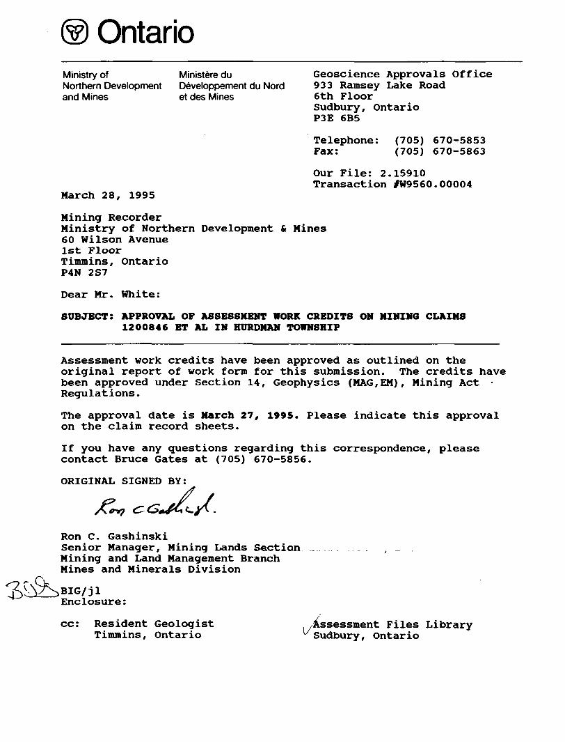
OntarioMinistry of Ministeredu Geoscience Approvals Office Northern Development Developpement du Nord 933 Ramsey Lake Road and Mines et des Mines 6th Floor
Sudbury , Ontar ioP3E 6B5
Telephone: (705) 670-5853 Fax: (705) 670-5863
Our File: 2.15910 Transaction /W9560. 00004
March 28, 1995
Mining RecorderMinistry of Northern Development t Mines60 Wilson Avenue1st FloorTimmins, OntarioP4N 2S7
Dear Mr. White:
SUBJECT: APPROVAL OF ASSESSMENT WORK CREDITS ON MINING CLAIMS 1200846 ET AL IN HURDMAN TOWNSHIP
Assessment work credits have been approved as outlined on the original report of work form for this submission. The credits have been approved under Section 14, Geophysics (MAG, EM), Mining Act - Regulations.
The approval date is March 27, 1995. Please indicate this approval on the claim record sheets.
If you have any questions regarding this correspondence, please contact Bruce Gates at (705) 670-5856.
ORIGINAL SIGNED BY:
Ron C. GashinskiSenior Manager, Mining Lands Section Mining and Land Management Branch Mines and Minerals Division
Enclosure:
cc: Resident Geologist . .Assessment Files Library Timmins, Ontario ^Sudbury, Ontario
-903
ro
o
o
TW
P
OF
BE
AR
DM
OR
E
- —
^^B
fc—
—^-^
^—
——
— ^
——
-™
*
HI!
*'—
——
—l—
—m
et-
t \\
f,
fcijo
•LT
--SSS
J^S
! i 3
^H~^
5 s*i
gyB
jiaJL
JJ^J
^
l *
^^^
lv s
'f J T
i9 f
*
*.
WC
,
M
: *
- A
i a *
i:8'-- *
i
Ifi
I"! iT
rte
.P*'
J-J-*Jc^^3
-^-r
-^-r
sr-i
:','J
3-13
1 *,
l :!
i f
' fi' if
J;
's ,
- -s-i---
v -
*-s-
II M
ll:
l l
' : *
" i
•- ^
-.
-"* ^^
r iV
f--
—
' *
-f 8
\ i
• 1
' 5
[ f
i 1.i:,t
lr^
T y
s i
y c
U-i
7
r
f li
TW
P.
OF
AD
AN
AC
t ;l?
C
*
*n
^\.
*n
f\
^•^
\^
20+00 N TL
16+00 N
12+00 N
8+00 N -
4+00 N -
Bl 0+00 N
4+00 S
8+00 S I-
1 2+001 S -
16+00 S -
20+00 S TL
8(O
o of
o oOD
o o o o o o o o00
I 210
t
o
INSTRUMCNTAIIONi FlfLOl SCINlRtX IOS-i\MP-4BASE: SCINIStX MP-4
DATUM: 5B600 nl. PROFILE SCALF 1" s. 1000 nT.
JOUTEL RESOURCESHURDMAN TOWNSHIP ONTAK10
TOTAL1IAGNETTC7TIELD PRQFIOlSppHBOM POBCUPQ||tlMTB 488/61 tUPI Htff-H l l' - *pu
20+00 N TL
16+00 N
12+00 N
8+00 N
4+00 N
BL 0+00 N
4+00 S
8+00 S
12+00 S
16+00 S
20+00 S TL
o o(O
o o(N
OO
oo
o o o
oo o
o o•H
00
_ fi 170084* QHI4 UOOB46
CAO
H
o
220
CONTOUR INTfRVM 30oT.DATUM SBSOOnTlIL CM ANOUAIt 4M'. OTV
lTKf^HKSHUklJMAN TOWNSHIP ONTARIO
niwilf)N MP.J]" i" -COMP 400 JMW OB/IK
o o*to
o o-f o o00
20+00 N TL
16+00 N
12+00 N -
8-1-00 N
4+00 N
BL 0+00 N
4+00 S -
B+00 S -
12+00 S -
16+00 S
20+00 S TL
8
VERTICAL SCALE 4X HORIZONTALNO ELCVATION TIE INS FROM LINE TO LINE
O O
JOUTEL RESOURCESHURDMAN TOWNSHIP ONTARIO
, .TOPO PROFILES ^PORCUPINE M D l NTS 48HX6| MAPI TOPO-lj f - 400" foy Ofl7fl4
o o+ID
O O* CM
O O-h00
o o o o o oo o-l-00
20+00 N TL 3P7
16+00 N -
12+00 N -
8+00 N -
4+00 N -
BL 0+00 N
4+00 S -
8+00 S -
12+00 S -
16+00 S -
20+00 S TL
S 279f 289 X291 yV^PS^
42H12SB0005 2.15910 HUROUAN 240
INSTRUMENTATION: FIELD: SCINTREX IGS-2\MP-4BASE: SCINTREX MP-4
DATUM: 58500 nT. CONTOUR INTERVAL 50 nT.
o aoo 400 SCALE i' = aw
JOUTEL RESOURCESHURDMAN TOWNSHIP ONTARIO
TOTAL MAGNETIC FIELD SURVEYDIVBIOM: PORCUPTO NTS: 42H/5 MAG-1 200* JMW 09/94
20+00 N TL
16+00 N
12+00 N -
8+00 N
4+00 N
BL 0+00 N
4+00 S -
8+00 S -
12+00 S -
16+00 S -
20+00 S TL
42H12SEDOO5 2.15910 HURDMAN
INSTRUMENTATION: APEX MAX-MIN M MODE: MAXIMUM COUPLED COIL CONFIGURATION: COPLANAR COIL SEPARATION: 400 FOOT VERTICAL SCALE t" = 2055 INPHASE: —————————————— QUADRATURE: ——————————-—
250
o aoo 400SCALE l* = 200'
JOUTEL RESOURCESHURDMAN TOWNSHIP ONTARIOHLEM SURVEY 1777 Hz.
MINING DIVISION: PORCUPINE NTS: 42H/5 MAP#MM-1777 l" ~ 200* JMW 08/94
lOf
093NVMaurw otretz sooraseinzt
10QJ OOt100
orwnoD H mn—xvn
II S 00+OZ
- S 00+91
- S 00+31
- S 00+8
- S
N 00+0 18
- N 00+t
- N 00+8
- N 00+31
- N 00+9 L
11 N 00+03
Oom
o om
oo
00+ o o
K)H-o o
o* -*- o o
20+00 N TL
16+00 N
12+00 N -
8+00 N -
4+00 N -
BL 0+00 N
8+00 S -
12+00 S -
16+00 S
20+00 S TL
o o+CO
-2
-2
ft 1 200843 Df4 1200846
o
-2
O tf
-2
4+00 S - -i
O l
-2
O
O
O i
-l
_1
-t-1
;i f tf f
+1 +2II\ \ i
\ Vij \ t \
k l + 1 -1 1
1 i1 t!-j +1 -2 if
' / '
i ^ 1 '
i " i, i H -t-1 -1 it
! 1 1
1 1 _ .t
1
J! +1
-t-3 -2 iiKf
-t-2 -2(1ji
0 -2 '|
Xy"A+ S +3I1 1
\i
i .1 -i1 i1 t1+1 0 |
ti P l1 1- i
ii
+1 -1
0 -2
0 -3
0 -3i
+2 -2ii
+2 -3 ii i 1 . . '
Jff
+1 -2(1
|j
0 -2 ti ii
+2 -2 ifiti
IL. 1 jl
i+1 -2 f
*2 -2 1ti !
+1 -4
+1 -3iif
0 -2 iftii-t-l -2 iii
1
1 \
- f +2 +1
- -1-2 0
1 -t-l 0\, i\— i-2 — iH~
1
i.l +2 +1
i +1 *i ii•i 0 -1
1ff
0 -l/11
1 t[l +1 -1111 t
t +1 0 l\\ \
J H1 1
*3 O M•Au '
+ S -4 H
1-*-3 -5 ]
ii+ P O ^
1 C L H
1
+ 1 -3 1" 1
i1t
-*-3 -5
\0-5-
it
-1 -3 *in-6 —— 3Hr-
ffi0-21-i ii
+2 -1 i -li
-*-2 —2 1 r| 'ifi i•1-2 -2J -i 'i 'f•*"3 -3 -y
^i y1 1\t/^2 +4A ri \ '
\\
\^
-2
l-2-1
-t-2
-t-2
-t-2
•t-3
+4
-t-3
i-l ! -t-2
-2 M +1
+2
INSTRUMENTATION: APEX MAX-MlN li MODE: MAXIMUM COUPLED COIL CONFIGURATION: COPLANAR COIL SEPARATION: 400 FOOT VERTICAL SCALE 1" = 2055 INPHASE: ————————————— QUADRATURE: -————————————-
-l
-t-2
-l
-l l
O i
-2
•t-2
-2
-3J
-*-3 J
-t-l
42H12SBXX15 2.1S91Q HURDMAN
+2
+ 4
-t-3
-1
-2
-2
-a i
-2 i
O -l
-2
l 0-31
+2 -2
-31
-2 i
i ii i 11
^2
+S
+1
+1
+2
-2
-2 f
-t-l -2 J
; +1 - l\
-1-1
o
o
o-t-l -31
4, -l
-1-2 fi -*-2
^ i-si
i"-i i-1i
-1-2 -
-t-2 -
4 [i i
2J/
O
o
O i +1 O l
+1
+S
+1
-l 8 O
-l IH +1
+1 -2
3
-l
-3/1
-2 l .1
*a -i-.2 -H!
(P QP
-3t
-3 i
-6 t
-7
-9
+3
+3
t
t
O
(
400270
JOUTEL RESOURCESHURDMAN TOWNSHIP ONTARIO
SURVEY 444 HzMINING DIVISION: PORCUPINE NTS: 42H/5 MAP| Mil-444 l" ^ 200' JMW 06/94