Embed Size (px)
Citation preview
52BI3SE0eie 2.4656 SCHWENGER
STKHP ROCK IKON MINKS 1JM1THD
010
M\RSH 1AKK PROPliR'lY
mile north east of Atilcokan on Ilwy 622
N.T.S, 52-B-13Lat 48045.5' to 48O 46.5'Long 910 33.5' to 91 O 35.5'
GHOPHYSICAL REPORT
MAG f, E .M.MAK 3 11983
MINING LAND* Sfcc.lON
March 38, 1982 Raymond A. Bcrnatchez Geologist
S2B13SE8*ie 2.4656 SCHWENGER
TABLE OF010C
Page
Location and Access
History
Regional Geology
Structure
Local Geology
Grid I,ines
Geophysical Surveys - Magnetic Survey- Results of Magnetic Survey- lil ec.t romagnet i c Survey- Results of HIectromagneti c Survey
Conclusions
Recoiimiendati ons
Sketch Maps - Claim Map with Grid- O.G.S. Geophysical Survey (1980) 80516,- O.D.M. Shklanka (1972) Geology Map l"
l
1
2
3
3
4
4455
6
6
l:20,000 -- 1 ,000'
Location
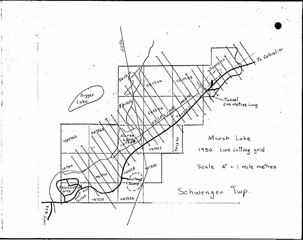
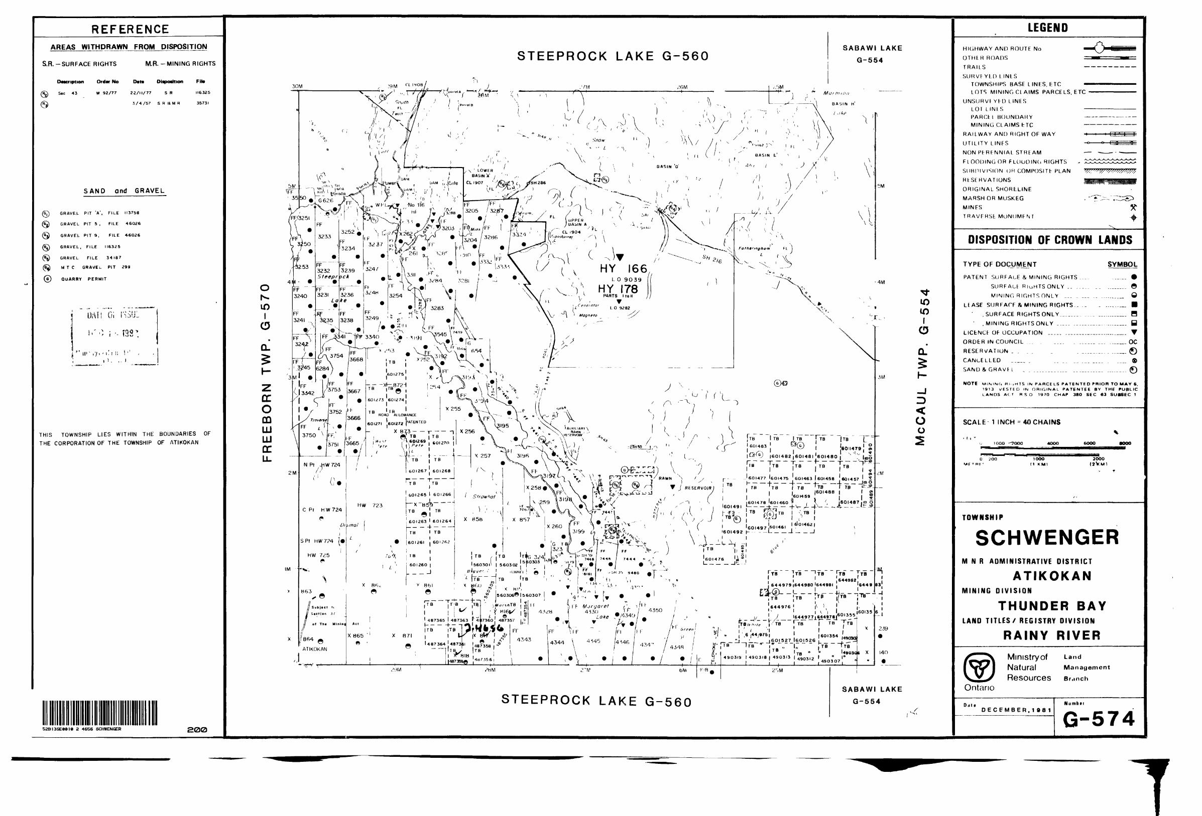
'Hie Marsh Lake group is located immediately northeast of Atikokan along Highway 622 to Caland Ore. The property consists of 19 unleased mining claims numbered 4S7354 to 487365 inclusive and 560301 to 560307 inclusive, ^ fost of the claims are staked over old mining claims with patent surface rights only. 'Ihcse old mining claims are numbered X815, X816, X817, X818, X860, X861, X871 , G323 and G324 . Our claim gi'oup also borders Patented Mining Claims FF 4325, W 4 328, FF 4343 an FF 3199 to the southeast, and northeast.
All of the above mining claims are located in Schwenger Twp and arc shown on plan No. M-2364.
'Hie property is very accessible via Hwy 622 which traverses through the centre of property parallel to the baseline at a bearing of N600K. The northwest section of the property is also accessible by bush trail lead ing to Strawhat Lake. The No. 4 post of claim no. 487365 crosses this trail about 700 metres northeast of the town of Atikokan.
A large portion of the property is covered by a major swamp. This swamp was a major contributing factor in the incompletion of the surveys on this property in the spring flooding of 1981. The unsurveyed area is being completed during the winter-spring of 1982.
History
The previous regional geological mapping of the area has been done by F,. S. Moore (1939), partial systematic mapping by H. L. Smith (1891), M. W. Hartley (1939b), T. L. Tanton (1941a), Steep Rock Iron Mines Ltd and Caland Ore Company Ltd and R. Shklanka (1972).
M. W. Bartley and A. IV. Joliffe greatly contributed towards understanding this complex a rea. Shklanka locates on his map 4 diamond drill holes located within the claim group. The work was done by Rawn Iron Mines Ltd Steep Rock has the drill logs of these holes in their files.
Tlie Strawhat Lake Iron deposit located directly north of our claim group received extensive drilling in pursuit of iron ore at the bottom of the Strawhat Lake.
Caland Ore Company Ltd drilled 3 holes west and north of Margaret Lake. Caland Ore has also driven a drainage tunnel xmder Highway 622 for flood control of Margaret Lake. The tunnel is appi'oximately 1000 feet long and is located on the claim number 560303 and 560304 (MRO)* or Patented claim (SRO)* G324.
MRO Mineral rights only SRO Surface rights only
Regional Geology (Shklanka 1972)
The Steep Rock area is within the Superior Province of the Precambrian Shield and is at the southern contact of the Wabigoon Sub-Province of the Superior Province. 'Hie Steep Rock series is straddled by an east- west belt of metasedimentary rocks to the south and by a felsic in trusive to the east, northeast, north and northwest.
Tlic mctavolcanic me t a sedimentary sequence of the Steep Rock series extends eastward towards Sabawe Lake and Lac des Mille Lacs. A northeast extension of the Steep Rock series extends towards Finlayson Lake - Red Paint Lake and swings easterly to form the Lumby Lake mcta-volcanic - me t a sedimental*)' belt. A westerly belt of the Steep Rock series extends to the Mine Centre area.
All of the above, east, northeast and west belts of metavolcanic meta sediment ary belts are narrow and range in thickness from 500 metres to 4 - 6 km wide. The Steep Rock series forms its thickest sequence north of Atikokan. The Steep Rock series rocks have been intruded by mafic to felsic intrusives rocks.
Tlie mineral occurrence of most economic significant in the area was iron ore (goethitc-hematitc) which supported two major iron operations in the past: Steep Rock Iron Mines (1944-1979) and Gal and Ore Company Ltd. (1960-1980). A minor operation, Canadian Charleson Ltd, extracted goethitc-hematite from the gravel beds south of the Steep Rock Lake from 1958-1965.
Minor gold prospects were discovered in the area in the past, they are the Black Fly property, located about 700 metTcs west of Little Ganell Lake north of the Hogarth Pit (SRIM) , the Baartz prospect located directly west and south of the Black Fly property, and a third property located south and wst of the Wagita Bay dam. Some high but erratic, gold values have been obtained in the past from these three properties.
Recent gold studies in the Atikokan area have concluded that gold is associated with three major environments (after S.J. Wilkinson 1982) Gold deposits of the Atikokan Area, O.G.S., M.I).C. 24.
(i) Mann i on Lake Batholith type - in gneissic massive core of the batholith associated with north easterly trending regional lineaments and late trondhjemit.es which are locally sheared. Shearing strikes parallel to the lineaments and occurred during two or more episodes, the latest of which is related to the mineralization.
(ii) Contact Zone Type - is contained by the plutonic rocks which border the gneissic batholiths along the metavolcanic belt contact. Thin, discontinuous shear zones host the mineraliz ation which is related to at least two episodes of shearing.
* * 4 * J
(i i i) Mctavolcanic-Hosted St rat abound Type - j s associated withlaterally extensive beds of altered felsic tuffs and pyriti- ferous chemical sediments. The mineralization is due to epigenetic enrichment of gold associated within one instance, the intrusion of quart z-feldspar porphyry and in the other, faulting and shearing.
The latter two types ai^e considered to be favourable for occurring on the Marsh Lake property.
Structure
Major structui'al trends predominates in the region and on the property. The faults of major importance in the 7~egion a re t he Quetico, Samuel and Bartley Fault. Many minor faults ai~e also located in the area, and are as follows: Marsh Lake, Strawhat Lake, Atikokan, Dismal Lake, Apungsisagen Lake and Rawn Lake Faults.
The Marsh Lake fault is of significance to the property because of its direction and location along the Mctavolcanic-Marmian Lake Batholith inter face or contact.
Recent staking northeast of the property, east of the Rami Reservoir, near Blue Creek, was initiated by the discovery of a wide quartz carbon ate vein in "-a major east-west structural trend with associated gold and silver values. The major structural trend swings slightly southward to wards the Marsh Lake Faults zone. This structure has been interpreted from aerial photos. There is strong reason to believe from the air photo interpretation that this structure extends eastward to the Atiko Gold Mines property located 8 miles east of the property.
Local Geologynot
Detail surface geological mapping of this property has-been done by the author, yet,the author has used Shklanka's (1972) geology map to inter pret the limited geophysical results.
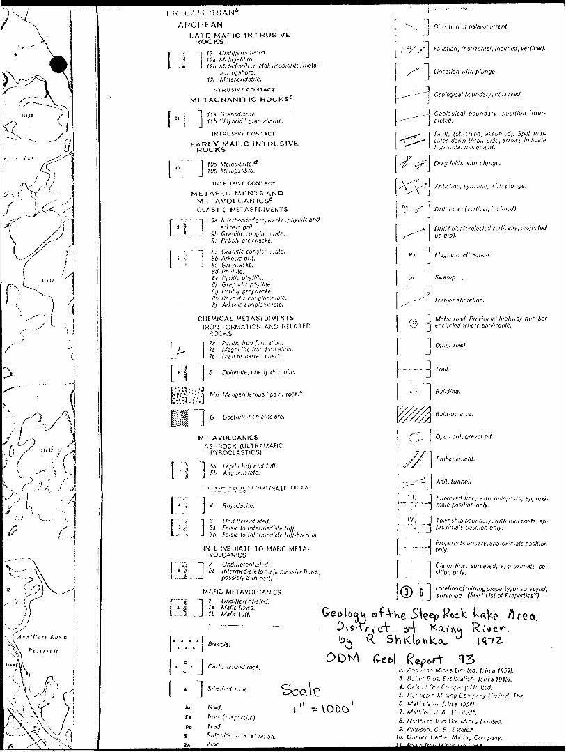
Shklanka observed the following rock types on the property.
Mafic. Metavolcanics - l undifferentiatedla mafic flows
Intermediate to Mafic. Metavolcanics - 2 undifferentiated2a intermediate to mafic
massive flows
Felsic to Intermediate Metavolcanics'- 3 undifferentiated
Ashrock (Ultramafic pyroclastics) Sa Lapilli tuff and tuffb agglomerate
. . . . 4
Chemical Metasediments - 7 c Lean to barren chert
Clastic Metasediments * 8a Granitic conglomerateb Arkosic grit c Greywacke d Phyllite j Arkosic conglomerate
Early Mafic Intrusives - 10a Metadi orite
Metagranitic Rocks - lla Granodiorite
Late Mafic Intrusive Rocks -12 undiffercntiated
It appears from preliminary examination that a large portion of the property is extensively covered with shallow to deep overburden. Most of the good outcrops occur on the northwest and southeast side of the property, with a wide long march covering the central portion of 'the property.
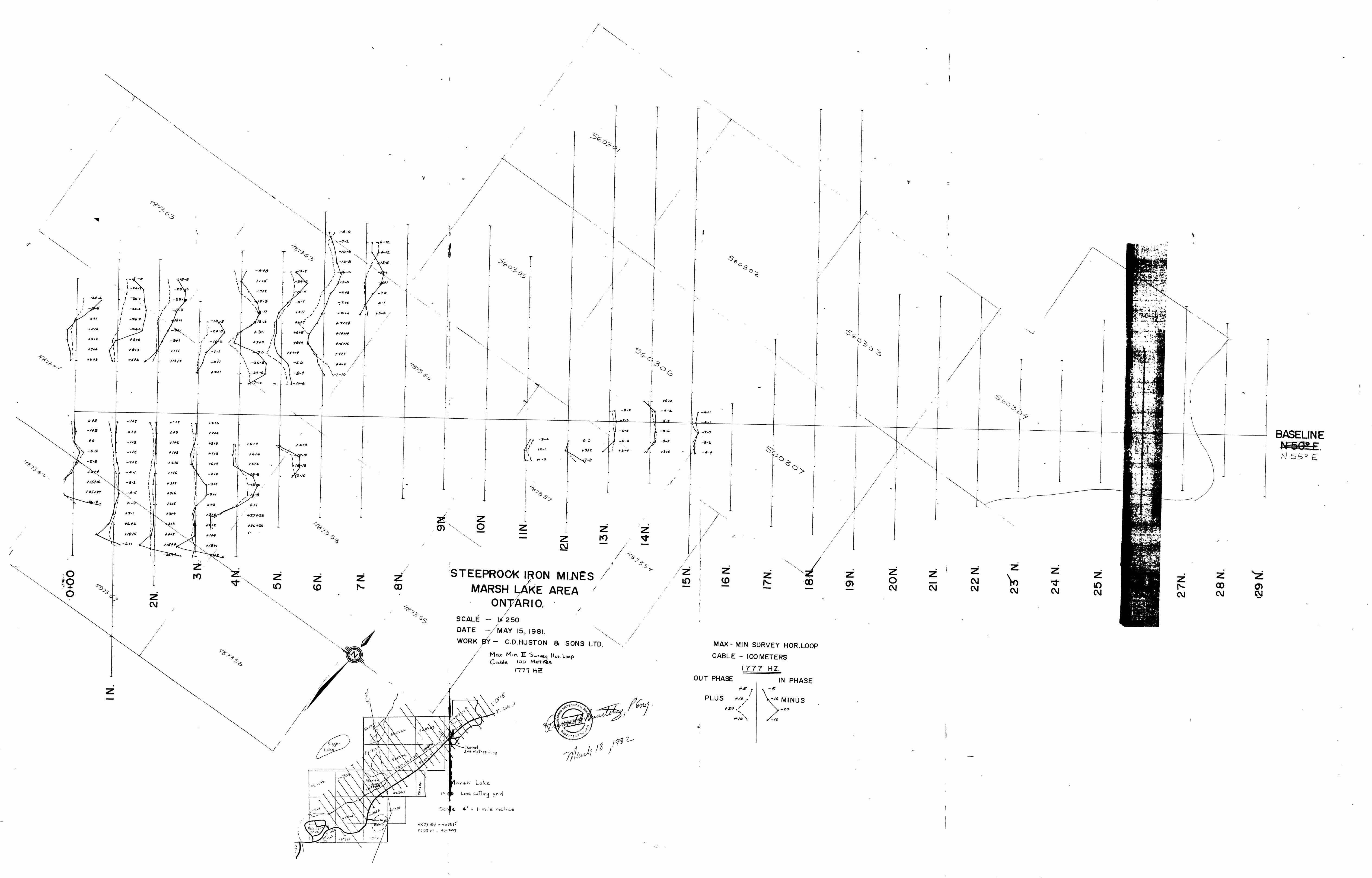
Grid lines - a total of 17.37 km of picket lines and 2.9 km of baseline were cut in spring of 1981. This total linecutting did not cover the entire property. The remaining linecutting is being completed during the winter of 1982.
The present grid was cut with a baseline striking N 60 E and pickets at every 25 metres. Picket lines were established at every 100 metres along the baseline at 90 to the baseline. Stations were established at every 25 metres along the picket lines.
Because of the late start on this grid in the spring of 1981 the magnetic and electromagnetic surveys were not carried out over the complete grid because of sprang flooding in the marshy ai^eas.
Goophysi cal Surveys^
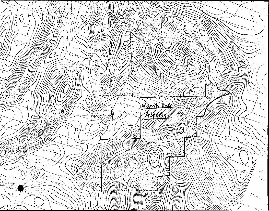
Magnetic - The magnetic readings were taken over 455 stations over a measured distance of 10.7 km along the picket lines. The instrument used was a Scintrex Proton Magnetometer with a resolution of l gamma. The closed loop method was used ever)' hour to correct for diornal variations in the earth's magiietic field. The readings were plotted and contoured on a map attached with this report.
The contour intervals are at 25 gamma and 100 gamma. The gamma readings range from -716 gamma on line 4+OON at 3+50E to a high of 2327 on line 1+OON at 6+50E.
Results of Magnetic Survey
Several magnetic high anomalies were detected in the survey. Two major anomalies are located on lines 0+00, 1+00, 2+00 and 3+OON between 0+00
and 0+75W. This magnetic anomaly appears to be caused by a mafic intrusive mass with disseminated magnetite. A second magnetic high anomaly is located on lines 2CHOON, 21+OON, 22+OQN and 23+00 at 0+75W. This magnetic anoinaly may be caused by a narrow magnetic iron formation,
A third major magnetic high anomaly was detected on line 1-UJON starting at 5+50E. Insufficient data is available from this area to properly inter pret this anomaly. Additional lines have been cut in this area to deline ate this anomaly.
Several areas of magnelic lows arc present on this survey. They may be caused by metasediment s low in magnetic iron and therefore will expi'ess themselves as lows. However one magnetic low anomaly of importance may be located between lines 19+OON at 1+25E and 24+OON at 0+75R. Field in formation has revealed a major quartz-carbonate vein in this general area and the magnetic low expressed here may represent a major quartz-carbonate vein intruded along the Marsh Lake fault contact, between the metavolcanic and the Marmian Lake batholith. This magnetic low warrants closer invest igation for a potential gold environment. Further intrepretation of the magnetics of the property will be completed in 1982 when a complete magiietic survey of the property will have been clone.
Electromagnetic Survey;
Electromagnetic, surveys were conducted on the property with an Apex Max Min li Unit. It was operated in the horizontal loop maximum mode with the transmitter always carried south of the receiver. The two surveys, both utilizing a 100 metre coil separation were carried out over part of the grid. One was done on a frequency of 1777 hz while the second used 444 hz. Results were plotted as profiles and are presented on attached maps.
In all surveys 7-cadings were taken in 25 metre intervals along the picket lines. A reading is constituted by the In-Phase and quadrature component of the secondary field.
Re.siilts of^jyectisomagnetic Survey
Only 163 readings were taken at both frequencies since most of the ground was flooded at the time of the surveys. Surveys across the highway was not possible because of the cable system.
The surveys were therefore incomplete and only partial conductors were encountered. Only the southwest portion of the grid received sufficient coverage to partially detect some anomalies near the highway.
The survey began to detect the western edge of a strong conductor south of the baseline on lines 0+00, 1+OQN, 2+OON, 3+OON and 4+OON at 2+OOE, 3+OOE, 3+25E, and 2+SOE respectively.
. . . . 6
The lines 0+OQ to 7+OQN did not extend far enough west to detect major airborne anomalies in thia area.
No other conductors were detected on the property because of the limited survey coverage. Tt is the intention of SRIM to complete the coverage of the entire claim group in 1982 with additional line cutting, mag and E.M. surveys and to carry out geological mapping of the property.
Conclusion^
The mag and H.M. survey carried nut are inconclusive because of the extent of coverage by the surveys.
McRae's gold survey of the Atikokan area gives additional support that the Marsh Lake Fault zone i s a potential gold bearing structure.
Previous drilling by Rawn Iron Mine along the Marsh Lake Paull zone has indicated favourable geological and mineralogical environment for gold mineralization.
The occurrence of a large quartz-carbonate vein on lines 2Q+OON to 22+OON near the base line supports the concept of gold environment on the property.
Recommendation
1) It is recommended that the grid be extended to the boundaries of the property.
2) That the extension and areas not previously covered be surveyed with a proton magnetometer and FM-16.
3) That the geology be mapped in detail with the objective of locating gold environments along the Marsh Lake Fault Zone.
Raymond A. Bematchez, P. Hng. Geologist
March 23, 1982 :jef
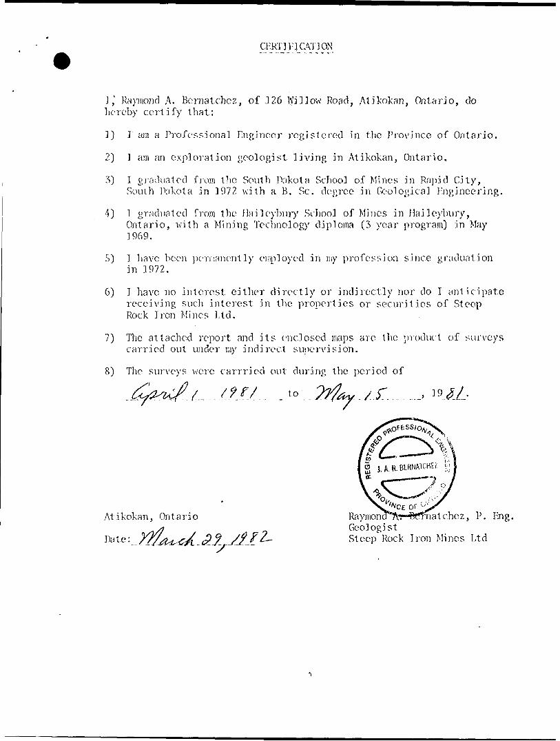
CF.RT] VI CATION
I ,x Raymond A. Bernatchez, of 126 l\Tillow Road, Atikokan, Ontario, do hereby certify that:
1) I am a Pixifessional Engineer registered in the Province of Ontario.
2) I am an exploration geologist living in Atikokan, Ontario,
3) I graduated from the South Dakota School of Mines in Rapid City,South Dakota in 1972 \vith a B. Se. degree in Geological Engineering.
4) l graduated from the Haileybury School of Mines in Haileybury, Ontario, with a Mining Technology diploma (3 year program) in May 3969.
5) I have been permanently employed in my profession since graduation in 1972.
6) I have no interest either directly or indirectly nor do I anticipate 7-ecciving such interest in the properties or securities of Steep Rock Iron Mines Ltd,
7) The attached report and its enclosed maps are the product of surveys carried out under my indirect supervision.
8) The surveys were carrricd out during the period of
x r. ....,
Atikokan, Ontario Raymond^r-Bfrnatchcz, P. Eng.GeologistSteep Rock Iron Mines Ltd
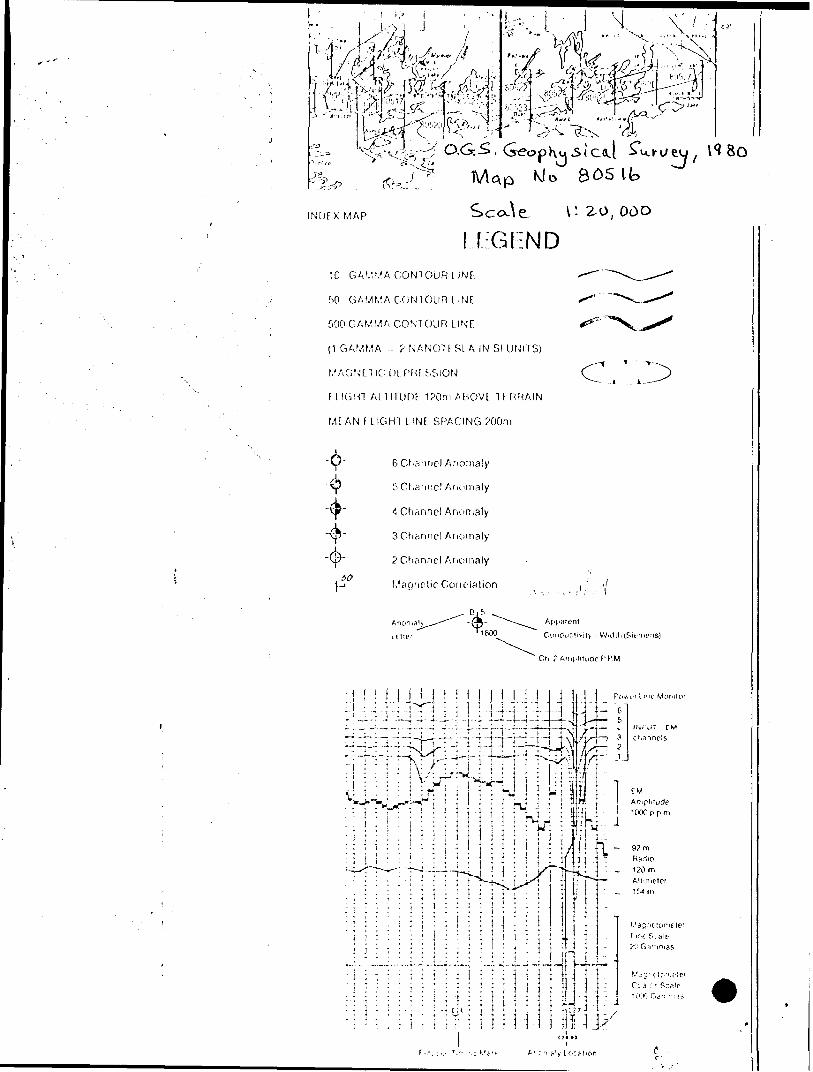
INDEX MAP
f:Gl:ND
10 G AM'/A CONTOUR L INF
f.0 GAMMA CONTOUR l iNF
f.OO GAMMA CONTOUR L INF.
(1 GAMMA r. ? NANOTFSL A IN SI UNITS)
MAGNUICOFPHFSSION
FLIGHT ALTITUDE 1?0m AUOVl TiHRAIN
MF AN F LIGHT LINF SPACING ?00m
6 Channel Anomaly
5 Channel Anomaly
4 Channel Anomaly
3 Channel Anomaly
? Channel Anomaly
Magnetic Conc-lalion
C.
4-
Ct, ?A.ii(.liti,dcF'.P.M
\ ' ,4uA ilif,r\ A t/** n
Kcser i o ir
I'K'I .CAt/if.iKI
AKCHFAN[.AT F MAFIC INIF^USIVE
FLOCKS
JP Undiflerentiated.i Pa Mitagalibro.i?b Mciadiorite^icialeucodiorite.nieta-
ttc Metaperidotite.
INTRUSIVE CONTACT
MLTAGRANITIC ROCKSC
h l!Jfl G rancdiorite.11b "Hybrid" cranxttirit
IKT RUSIVt: COM ACT
FARLY MAFIC INTFSUSIVE ROCKS
"l 1 0a Metadiorite.*1 J 1 0b Meiagabbro.
INTRUSIVE CONTACT
MKTASKD1MKN1 S AND MK1 A VOl.CANICS6 CLASTIC M ETASEDIMENTS[-n
i-nPa Interbedded grey w e:l.e, phyllite and
a'kosic grit.9b Granitic conglomerate. 9c Pebbly greywa:ke.
Ss Gra'iitic c o'.'j/o - 1^1 ale.Sb Arkosic grit.Se Greyv,6:kc.Bd Phyllite.Bc Pvritic phyllite.8! Graphitic phyllite.6g Pebbly greywacke,Sr, Rt:yo!itic conglomerate.Sj Arkosic conglomerate.
CHEMICAL METASED1I/ENTS IRON FORMATION AND RELATED
ROCKS
I la Pyrille iron /:. r f,,a!ia.o.7b Magnetite iron forn-ation,7c lean or bar/en chert.
6 Dolomite, cherty d;' l^^lite.
Mn Manganiftrous "paint rock."
G Goelhite-hemaii'.t o'C,
METAVOLCANICSASHROCK (ULTRAMAFIC
PYROCLASTICS)
1 . "j ~] 5a L apilli tuf! and luff. " ^ j St Aggloi-icrele.
r j i r. i r T o JfJT r f^ *; i"
: Jt:-U
Rhyodacite,
3 Undif!eien!ia!ed.3a Felsic to intennediate tuft.3b Felsic to intfrr.iediale tufl-breccia.
ra J[v.-.]:J
INTERMEDIATE TO MAFIC META VOLCANICS
Unctiflcrcntiiled.Intermedii'.e to rr,a!ic massive Hows,possibly S in pirt.
MAFIC METAVOLCANICSl Undiffcrtritis'.ed.la Mafic flows1b Malic tuff.
Direction of palac-o: urrent.
l K/* f\ foliation; (horizontal, inclined, vertical).
x"]
^
| ,1 G eological boundary, position inter- --~~~~ J p itted.
^^^- ~\ Fault; (observed, assurm-d). Spot indi- ^^" cites down throA side, arrows indicate
^\
L incation with plunge.
Geological tioundary, observed.
ri' fa folds with plunge.
Do f/ O"'" Ma (vertical, inclined).
Drill h'Olc; (projected vertically, projectedCr" | UP Clip),
wt l Magnetic attraction.i,,Swamp. .
-A(fi 3 Motor read. Provincial highway numb O1 l encircled where applicable.
Former shoreline.
\//}
\ Other road.
Trail.
Building.
Built-up area.
Open cut, gravel pit.
Ernbarikment.
Adit, tunnel.
'
"l, J Surveyed line, with rnileposls, approxi-~" " *"i"'"' ""j mate position only.
IV| J Township ttoundary, with mikr'"i '"j proxirr.a! e position only.
f posts, ap-
Pro;x.rty tvundary, app'Oiir-.ale position only.
Claim line, su'veye'd, approriri/dte po sition only.
6 1 l ocal ion of mining property ;unsurveyed, j s urveyed (See "list of Properties").
f -VK Rock
Ro4
ODM
Au
Pt, S
S::,:i'^J ^,-,e.
GM.
t (3d.
71 ne.
Scale
(?eforV?. A,?,d-jf.an r,':r,':s Limited. Jcirca 19591.3. Sjiler K'os. [tpls-alhn, /circa W*?].4. Cslfil Ore Co-'.pany Lirnit'.-d.i. Hi.;ntf,;,t M.rilng Co~ ,'^':y lirrilcd. The.C. ISah claim, lcirce W54].7. Mathieu, J. A..Li'.' ited'.5. Northern Iroi Ort Mines Lifiiled.6. f'i'lison. G. f ., fsMle.*
W. Q^it liec Cartier Mining Ctirr pany.J 1 ft^JL n Iff^r, tJ.lr
,y :-' .-"
[Tv~
V'.
. -.
*. c -'
' - ^
" \ -t,
^^^•-•^-.-^-•-^r ^v—
k^r' x"x- ) ^V
^x-'.
,-.^ \^.^vT
^^ ,,.\^uxr^'\\
'\\ ^ ,'
,"x
' A \ \
\
J v^ W
H-T—
:4 :\-
^\-
" .
^3? "
;^f.^-;U ^
--•"^^/'^iJ
/- 'v'-\-
c :
Y\!
^^ --
x/ ' w
V,..'
2.4656 SCHWENGER 300
1983 03 16 2.4656
Mrs. Audrey HayesMining RecorderMinistry of Natural ResourcesP.O. Box 5000Thunder Bay, OntarioP7C 5G6
Dear Madam:
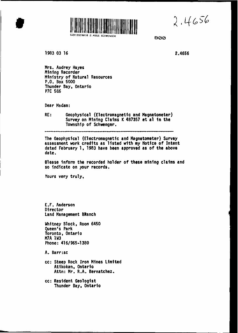
RE: Geophysical (Electromagnetic and Magnetometer) Survey on Mining Claims K 487357 et al 1n the Township of Schwenger.
The Geophysical (Electromagnetic and Magnetometer) Survey assessment work credits as listed with my Notice of Intent dated February l, 1983 have been approved as of the above date.
01ease Inform the recorded holder of these mining claims and so Indicate on your records.
Yours very truly,
E.F. AndersonDirectorLand Management BRanch
Whitney Block, Room 6450Queen's ParkToronto, OntarioM7A 1W3Phone: 416/965-1380
A. Barr:sc
cc: Steep Rock Iron Mines Limited Atikokan, Ontario Attn: Mr. R.A. Bernatchez.
cc: Resident Geologist Thunder Bay, Ontario
Ministry ofNaturalResources
Ontario M,
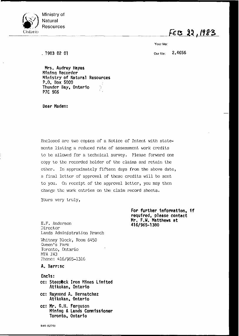
1983 02 01
Your file:
Our file: 2 .4656
Mrs. Audrey Hayes Mining Recorder Ministry of Natural Resources P.O. Box 5000 Thunder Bay, Ontario P7C 5G6
Dear Madam:
Enclosed are two copies of a Notice of Intent with state
ments listing a reduced rate of assessment work credits
to be allowed for a technical survey. Please forward one
copy to the recorded holder of the claims and retain the
other. In approximately fifteen days from the above date,
a final letter of approval of these credits will be sent
to you. On receipt of the approval letter, you may then
change the work entries on the claim record sheets.
Yours very truly,
E.F. AndersonDirectorLands Administration Branch
Whitney Block, Room 6450Queen's ParkToronto, OntarioM?A 1W3Phone: 416/965-1316A. Barr:se
Ends:cc: Steepfcck Iron Mines Limited
Atikokan, Ontariocc: Raymond A. Bernatchez
Atikokan, Ontariocc: Mr. G.H. Ferguson
Mining b Lands Commissioner Toronto, Ontario
845 (6/79)
For further Information, If required, please contact Mr. F.W. Matthews at 416/965-1380
Ministry ofNaturalResources
Ontario
Notice of Intent
for Technical Reports
1983 92 01
2.4656
An examination of your survey report indicates that the requirements of The Ontario Mining Act have not been fully met to warrant maximum assessment work credits. This notice is merely a warning that you will not be allowed the number of assessment work days credits that you expected and also that in approximately 15 days from the above date, the mining recorder will be authorized to change the entries on his record sheets to agree with the enclosed statement. Please note that until such time as the recorder actually changes the entry on the record sheet, the status of the claim remains unchanged.
If you are of the opinion that these changes by the mining recorder will jeopardize your claims, you may during the next fifteen days apply to the Mining and Lands Commissioner for an extension of time. Abstracts should be sent with your application.
If the reduced rate of credits does not jeopardize the status of the claims then you need not seek relief from the Mining and Lands Commissioner and this Notice of Intent may be disregarded.
If your survey was submitted and assessed under the "Special Provision-Performance and Coverage" method and you are of the opinion that a re-appraisal under the "Man-days" method would result in the approval of a greater number of days credit per claim, you may, within the said fifteen day period, submit assessment work breakdowns listing the employees names, addresses and the dates and hours they worked. The new work breakdowns should be submitted direct to the Lands Management Branch, Toronto. The report will be re-assessed and a new statement of credits based on actual days worked will be issued.
816 (82/t.)
Ministry of Natural
Technical Assessment Work Credits
Ontario
File
2.4656
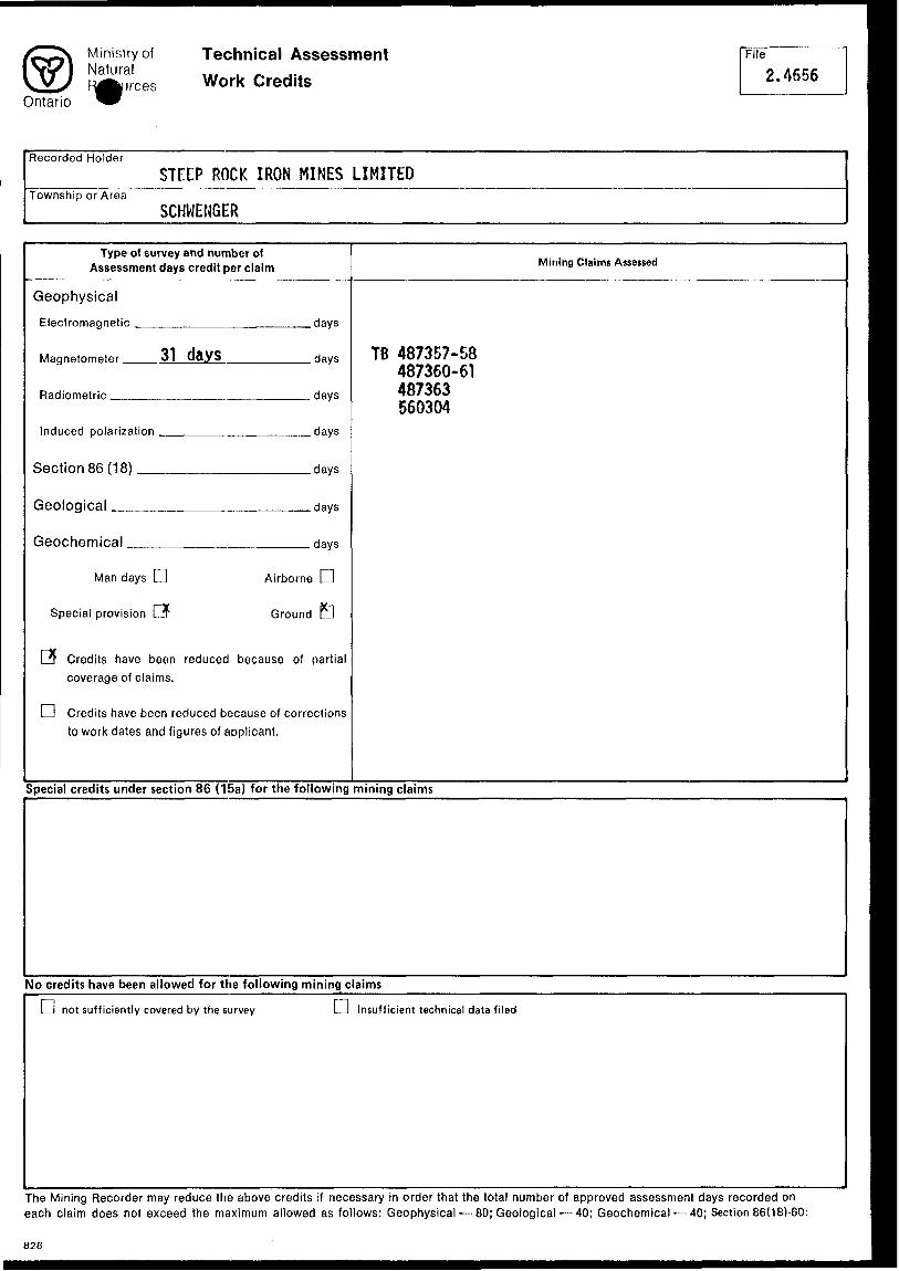
Recorded HolderSTEEP ROCK IRON MINES LIMITED
Township or AreaSCHWENGER
Type of survey and number of Assessment days credit per claim
Geophysical
Electromagnetic
Magnetometer — 31 days
Radiometric ^..
Induced polarization —
Section 86 (18) ——
Geological ————
Geochemical.
.days
.days
. days
.days
.days
.days
. days
Man days LJ
Special provision C*
Airborne LJ
Ground E
PT Credits have been reduced because of partial coverage of claims.
l l Credits have been reduced because of corrections to work dates and figures of applicant.
Mining C laims Assessed
TB 487357-58 487360-61 487363 560304
Special credits under section 86 (15a) for the following mining claims
No credits have been allowed for the following mining claims
Li not sufficiently covered by the survey D Insufficient technical data filed
The Mining Recorder may reduce the above credits if necessary in order that the total number of approved assessment days recorded on each claim does not exceed the maximum allowed as follows: Geophysical — 80; Geological — 40; Geochemical — 40; Section 86(181-60:
828
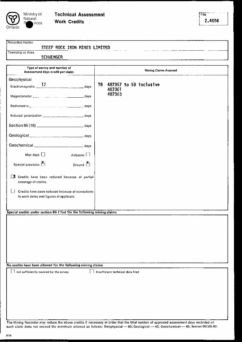
Ministry of Natural
Technical Assessment Work Credits
Ontario
File
2.4656
Recorded HolderSTEEP ROCK IRON MINES LIMITED
Township or AreaSCHWENGER
Type of survey and number of Assessment days credit per claim
Geophysical19
Electromagnetic '
Magnetometer ,
Radiometric
Induced polarization
Section 86 (18)
Geological
Geochemical
Man days L] Airborne
Special provision LI Grounc
FX Credits have been reduced because ofcoverage of claims.
Mining Claims Assessed
davii TB 487357 to 59 Inclusive y 487361
days ^7363
days
days
days
days
days
D
fi
partial
D Credits have been reduced because of correctionsto work dates and figures of applicant.
Special credits under section 86 (15a) for the following mining claims
No credits have been allowed for the following mining claims
L l not sufficiently covered by the survey Insufficient technical data filed
The Mining Recorder may reduce the above credits if necessary in order that the total number of approved assessment days recorded on each claim does not exceed the maximum allowed as follows: Geophysical — 80; Geological — 40; Geochemical — 40; Section 86(181-60:
828
Ontario
Ministry ofNaturalResources
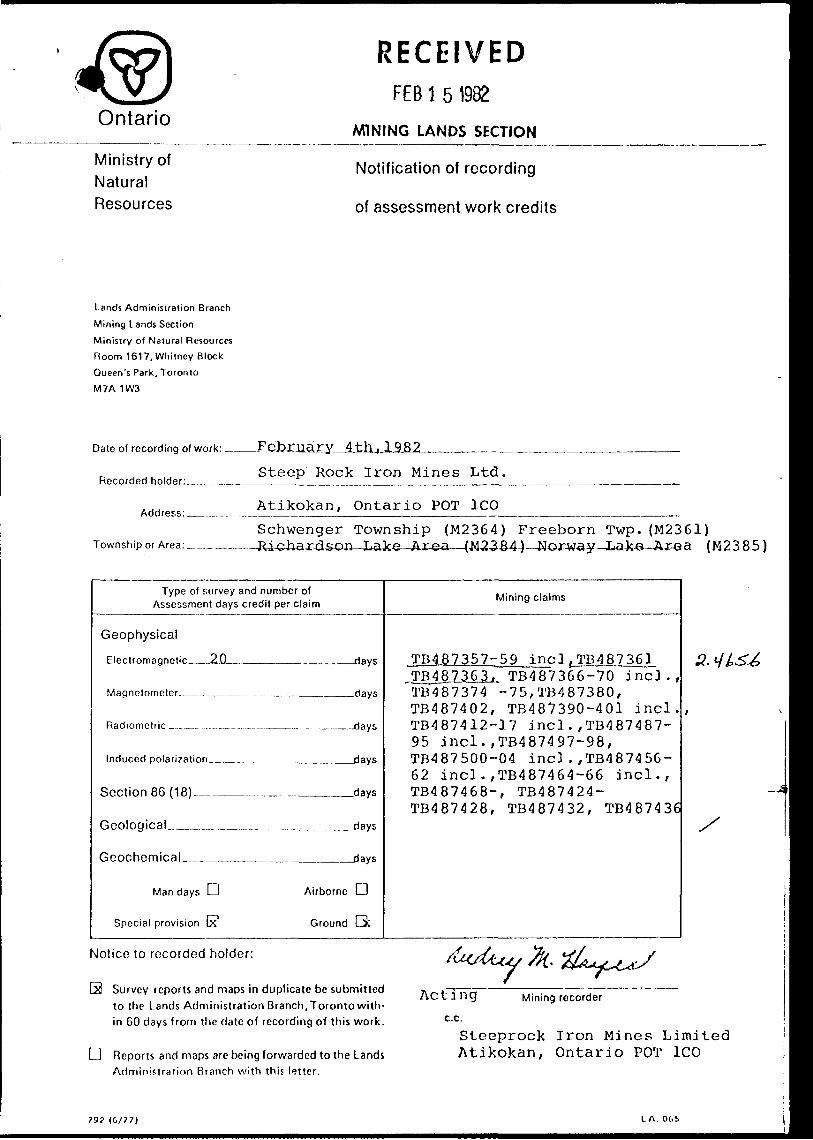
RECEIVEDFEB l 5 1982
MINING LANDS SECTION
Notification of recording
of assessment work credits
Lands Administration Branch
Mining Lands Section
Ministry of Natural Resources
Room 1617, Whitney Block
Queen's Park, Toronto
M7A 1W3
Date of recording of work: —.
Recorded holder:_.
Address: _____
Township or j
Steep Rock Iron Mines Ltd.
Atikokan, Ontario POT ICO ———
Schwenger Township (M2364) Freeborn Twp. (M2361)(M 2 3 8 5)
Type of survey Assessment days
Geophysical
Fleclromao.nfitio 20
Maqnninmetfir
Induced polarization
Section 86 (18)
Geological . . . . ^
Geochemical
Man days D
Special provision 63
and number of credit per claim
. flays
days
days
- ..... days
days
Airborne L 1
Ground Q:
Mining claims
TB487357-59 incl,TB487361TB487J16JL TB487366-70 incl., TB487374 -75,TB487380,TB487402, TB487390-401 incl. TB487412-17 incl . ,TB4 87487-95 incl.,TB487497-98, TB487500-04 incl . ,TB4874 56-62 incl. ,TB487464-66 incl., TB487468-, TB487424-TB487428, TB487432, TB487436
Notice to recorded holder:
S Survey reports and maps in duplicate be submitted to the Lands Administration Branch, Toronto with in 60 days from the date of recording of this work.
d Reports and maps are being forwarded to the Lands Administration Branch with this letter.
Acting Mining recorder
c.c.
Steeprock Iron Mines Limited Atikokan, Ontario POT ICO
79? (G/77) LA. Obi

Ontario
Ministry ofNaturalResources
RECEIVEDFEB l 5 1982
MINING LANDS SECTION
Notification of recording
of assessment work credits
Lands Administration Branch
Mining Lands Section
Ministry of Natural Resources.
Room 1617, Whitney Block
Queen's Park, Toronto
M7A 1W3
Date of recording of work:
Recorded holder:__....
Address: ___ .
Township or Area:^ — .
February 4,1982
Steeprock Iron Mines Limited
Atikokan, Ontario POT ICO
Richardson Lake Area (M2384)Schwenger Twp.(M2364) TvTorway T^Tce Area (M2385) Hepburn Lake Area (M2388) Freeborn Township (M2361)______________
Type of survey and number of Assessment days credit per claim
Geophysical
Electromagnetic-——^————-—-,
Linecutting s,Magnetometer__________4j
Radiometric __,.... ___ -__ __. .- . ___
Induced polarization__________ .. ——
Section 86 (18)____....__^ __
xiays
.days
—days
-days
.Jays
Geological ̂ .—-..——
Geochemical___
Man days Li
Special provision vQ
,- — _____days
.________days
Airborne LJ
Ground XJ
Mining claims
TB487357-58. 1*8487360^61^ TB487363-,TB5?03Q47TB487390-401 incl.,TB487412- 17 incl.,TB487487-95 incl., TB487366-70 incl,TB487374-75 TB487380, TB487402,TB487497- 98, TB487500-04 incl.,TB48745E 68 incl.,TB487424,TB487428. TB487432, TB487436
Notice to recorded holden
Survey reports and maps in duplicate be submitted ,. ^. .-. . ACtinq
to the Lands Administration Branch, Toronto with in 60 days from the date of recording of this work. c-Ci
' J 'f'A.ti/A'Uy SK.'' k^ininn
*;^ Mining recorder
D Reports and maps are being forwarded to the Lands Administration Branch with this letter.
Stoop Rock Iron Mines LimitedP.O. BOX 1376
Atikokan, Ontario POT l CO
79? (0/77) LA. OC.'j
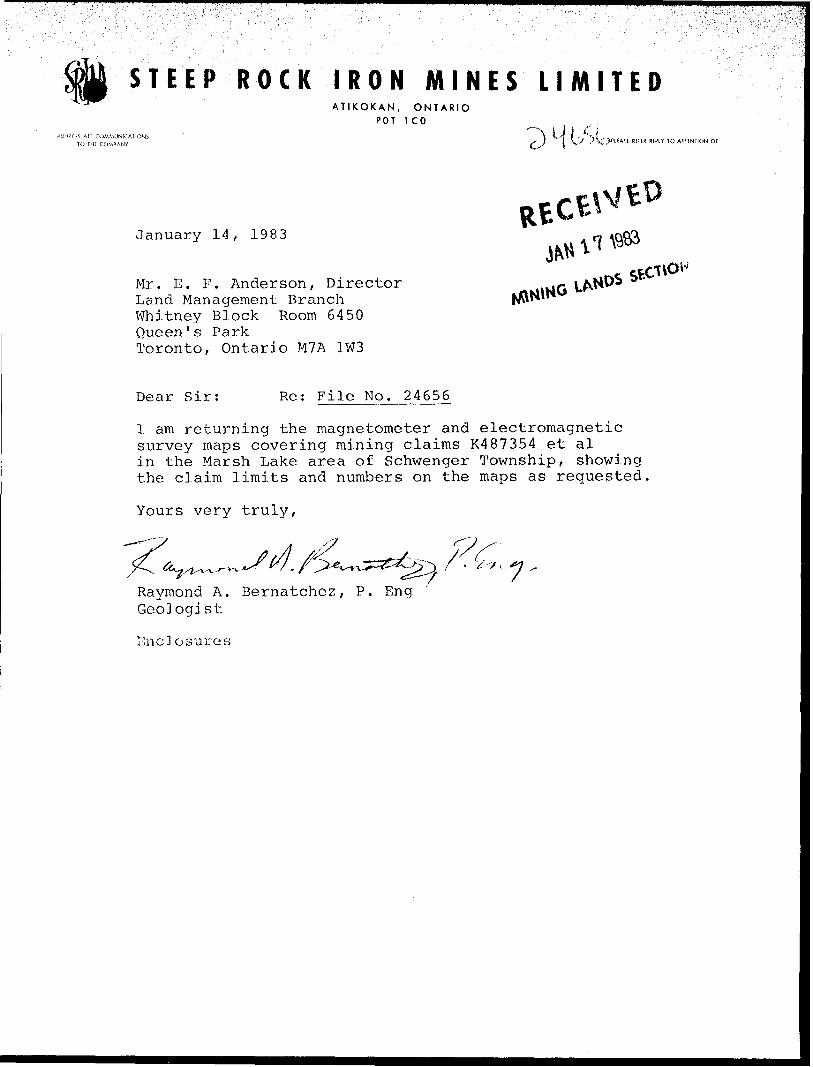
STEEP ROCK IRON MINES LIMITEDATIKOKAN, ONTARIO
POT ICO
j- J l \'J y V,'.J|PLF A^ E REflR RfPLY TO ATTENTIC
January 14, 1983
Mr. E. F. Anderson, Director Land Management Branch Whitney Block Room 6450 Queen's Park Toronto, Ontario M7A 1W3
Rt
Dear Sir: Re: File No. 24656
I am returning the magnetometer and electromagnetic survey maps covering mining claims K487354 et al in the Marsh Lake area of Schwenger Township, showing the claim limits and numbers on the maps as requested,
Yours very truly,
Raymond A. Bernatchez, P. Eng Geologist
Enclosures
Ministry ofNatural
.ResourcesOntoMl
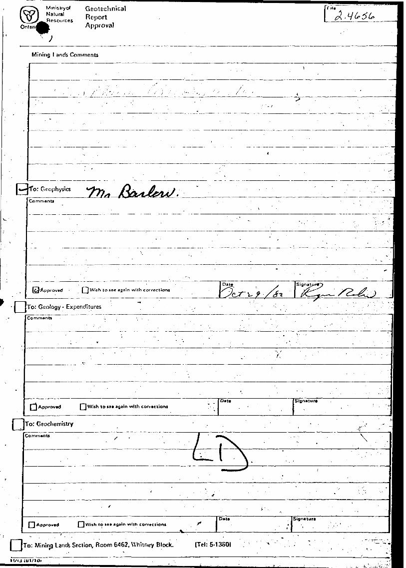
GeotechnicalReportApproval
••••• [rile
Ck
Mining Lands Comments
fo: G eophysics
Commentt
\pproved (~~) Wish to see Bflaln with corrections
To: Geology- Expenditures
Comments
/,
[~j Approved Qwifh to tee *B*' n w'th correction!Date Signature
To: Geochemistry
Comment*
[^Approved [^Wish lo ice m gx'in with corrcciioriiDate Si0n*ture
l T To: Mining Lands Section, Room 6462. Whitney Block. (Tel: 5-1360)
11/1J (Ul.'ldf
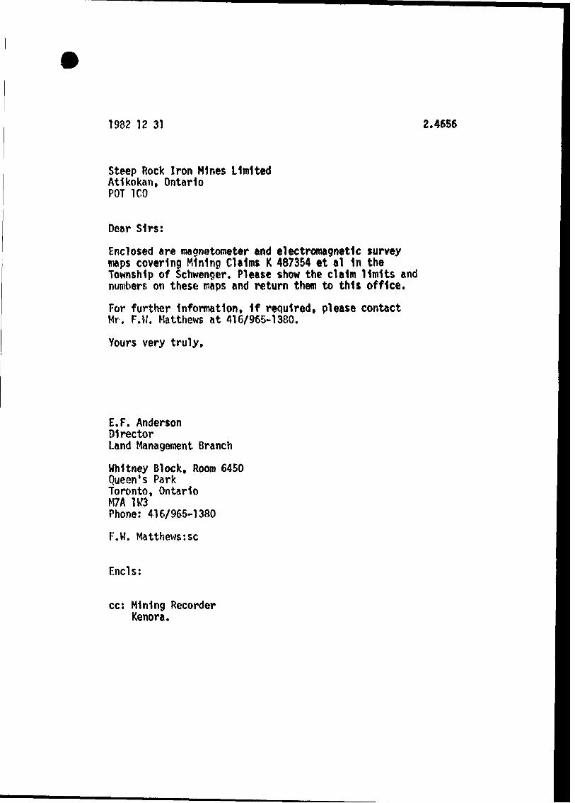
1982 1 2 31 2.4656
Steep Rock Iron Mines Limited Atikokan, Ontario POT ICO
Dear Sirs:
Enclosed are magnetometer and electromagnetic survey maps covering Mining Claims K 487354 et al 1n the Township of Schwenger. Please show the claim limits and numbers on these maps and return them to this office.
For further Information, 1f required, please contact Mr. F.W. Matthews at 416/965-1380.
Yours very truly,
E.F. AndersonDirectorLand Management Branch
Whitney Block, Room 6450Queen's ParkToronto, OntarioM7A 1W3Phone: 416/965-1380
F.W. Matthews:se
Ends:
cc: Mining Recorder Kenora.
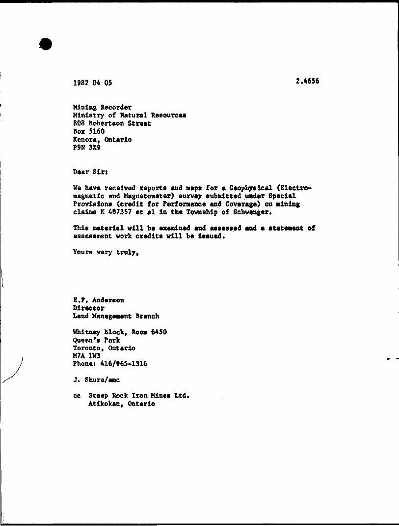
1982 04 05 2.4656
Mining RecorderMinistry of Natural Resources808 Robertson StreetBox 5160Kenora, OntarioP9N 3X9
Dear Sin
Ve have received reports and naps for a Geophysical (Electro magnetic and Magnetometer) survey submitted under Special Provisions (credit for Performance and Coverage) on mining claims K 467357 et al in the Township of Schwenger.
This material will be examined and assessed and a statement of assessment work credits will be issued.
Yours very truly,
E.F. AndersonDirectorLand Management Branch
Whitney Block, Room 6450Queen's ParkToronto, OntarioM7A 1V3Phone: 416/965-1316
J. Skura/amc
cc Steep Rock Iron Mines Ltd. Atikokan, Ontario
TELEPHONE (807) 597-J711 TELEX 073-4JU
STEEP ROCK IRON MINES LIMITEDATIKOKAN, ONTARIO
POT icoADDRESS AU COMMUNICATIONS
TO THE COMPANYPLEASf K ftt KPIV TO ATTENTION OF
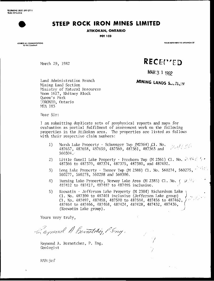
March 29, 1982 RECEfEDMAR 3 l 1982
MINING LANDS S.vflLand Administration BranchMining Land SectionMinistry of Natural ResourcesRoom 1617, Whitney BlockQueen's ParkTORONTO, OntarioM7A 1W3
Dear Sir:
I am submitting duplicate sets of geophysical reports and maps for evaluation as partial fulfilment of assessment work on the following properties in the Atikokan area. The properties are listed as follows with their respective claim numbers:
1) Marsh Lake Property - Schwenger Twp ,(M2364) jCl. No. ,. ; , 487657, 487658, 487659, 487360, 487361, 487363 and560304.;
2) Little Ganell Lake Property - Freeborn Twp (M 2361) CI. No. J . V 487366 to 487370, 487374, 487375, 487380, and 487402.
3) Long Lake Property - Tanner Twp (M 2388) CI. No. 560274, 560275, 560277, 560278, 560298 and 560300.
4) Turning Lake Property, Norway Lake Area (M 2385) CI. No. ( SV 1' 487412 to 487417, 487487 to 487495 inclusive.
5) Keewatin - Jefferson Lake Property (M 2384) Richardson Lake CI. No. 487390 to 487401 inclusive (Jefferson Lake group) CI. No. 487497, 487498, 487500 to 487504, 487456 to 487462, 487464 to 487466, 487468, 487424, 487428, 487432, 487436, ( (Keewatin Lake group). .7
Yours very truly,
W-
Raymond A. Bernatchez, P. Eng. Geologist
RAB:ief
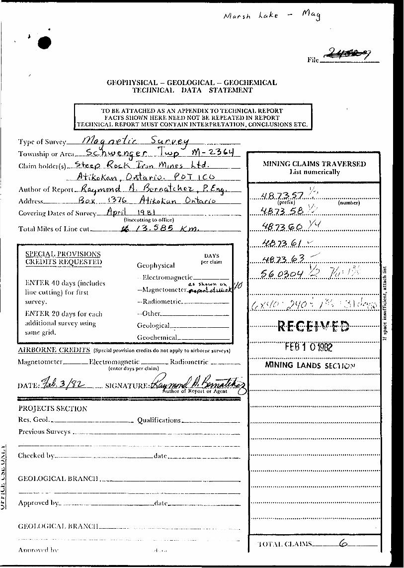
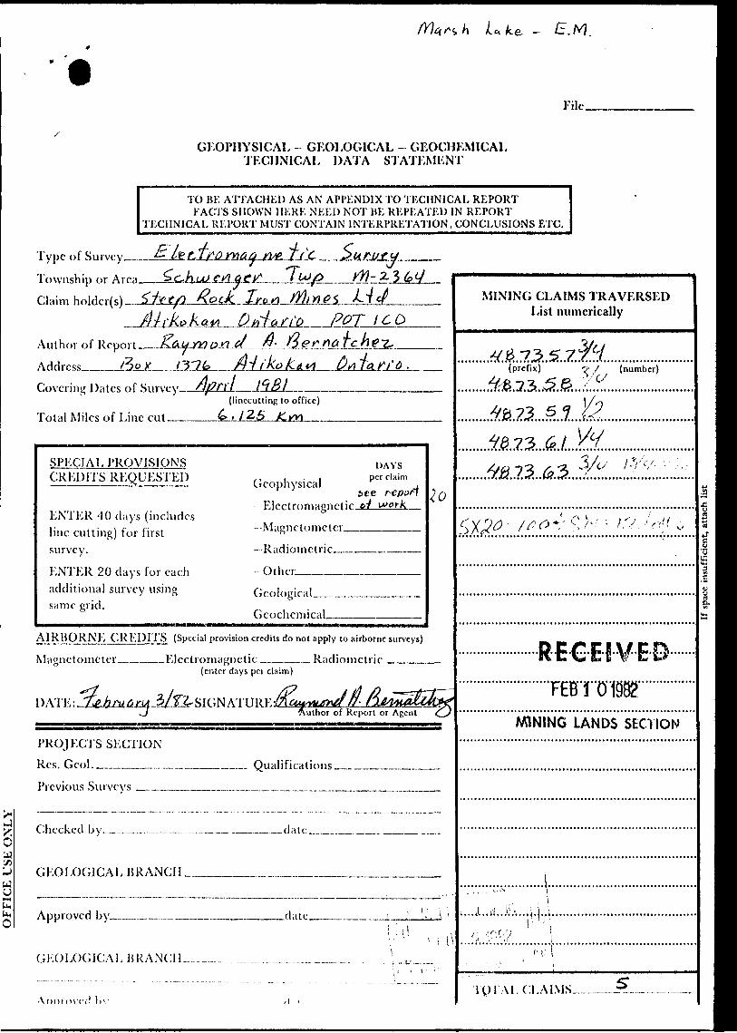
M art h Lc*ke —
File.
GEOPHYSICAL - GEOLOGICAL - GEOCHEMICAL TECHNICAL DATA STATEMENT
TO BE A'lTACHED AS AN APPENDIX TO TECHNICAL REPORTFACTS SHOWN HERE NEED NOT BE REPEATED IN REPORT
TECHNICAL REPORT MUST CONTAIN INTERPRETATION, CONCLUSIONS ETC.
Type of Survey——
Township or Area.
Claim holdcr(s)—-^LieA|2.
\je3-±LC....-
Wines
Author of Report Address _______
-u- d _ r) . Oer/xat c kfe t, i ?, ^ ,
Covering Dates of Survey--ApriL—JfLal—-..-—(linccutting to office)
Total Miles of Line cut______^ . ( 3 ^J
SPECIAL PROVISIONS CREDITS REQUESTED
ENTER 40 days (includes line cutting) for first survey.
ENTER 20 days for each additional survey using same grid.
Geophysical -Electromagnetic.
DAYS per claim
(Li
—Radiometric.-
Other.-———.Geological.Geochemical_
AIRBORNE CREDITS (Special provision credits do not apply to airborne surveys)
Magnetometer _____ Electromagnetic . Radiometric ————
DAl'E:
(enter days per claim)
X- SIGNATURE:IZfe22fea^l/^
Author of RepcReport or Agent
PROJECTS SECTION Res. Gcol._______,. Previous Surveys M——..
Qualifications.
Checked by— .date..-—...—.——. .—.—.—
GEOLOGICAL BRANCH ..
Approved by^.. -date.
GEOLOGICAEBRANCIL.-——-..
Annrovcd \ -i\-
MINING CLAIMS TRAVERSED List numerically
(prefix) (number)
72.
5 1*'-' -
AWNING LANDS SECTION
•lOTALClLAIMS.
Uke. - S.M.
File.
GEOPHYSICAL - GEOLOGICAL - GEOCHEMICAL TECHNICAL DATA STATEMENT
TO BE ATTACHED AS AN APPENDIX TO TECHNICAL REPORTFACTS SHOWN HERE NEED NOT HE REPEATED IN REPORT
TECHNICAL REPORT MUST CONTAIN INTERPRETATION, CONCLUSIONS ETC.
Type of Survey.—
Township or Claim holdcr(s)
Author of Report.
Address____&SL
/fl- ^ 3
an'0 POT ICO
C/
Covering Dates of .Survey
Total Miles of Line cut(linecutting to office). 1 25 K.w\ —M
SPECIAL PROVISIONS CREDl'I'S REQUKSTEl')
ENTER 40 days (includes line c'utting) for first survey.
ENTER 20 days for each additional survey using same grid.
seeGeophysical
--Electromagnetic.-Magnetometer———-Radiometric————-
- Other_____.—..—
DAYSper claim
Geological___... Geochemical___
AIRBORNE CREDITS (Special provision credits do not apply to airborne surveys)
Magnetometer_____Electromagnetic _____ Radiometric: —-——(enter days per claim)
DATE: -Z^JfoCtrM-^lTL SIGN ATURE JKsiqxutetULJ Author of Reputhor of Report or Agent
PROJECTS SECTIONRes. Gcol.______.-.—.—._____... Qualifications.
Previous Surveys _____.___.....__.—..______
Checked by_-......-,_... _....____ .____date
GEOLOGICAL BRANCH _________.M__.
Approved by___._______.—-—.- .date.
GEOLOGICAL HRANC1L
'\!l!)VO\Tc!
MINING CLAIMS TRAVERSED List numerically
.^.M.73,5,z:(prefix) T1 7 (number)
AA1NING LANDS SECTION
TPTALCLAIMS-...-
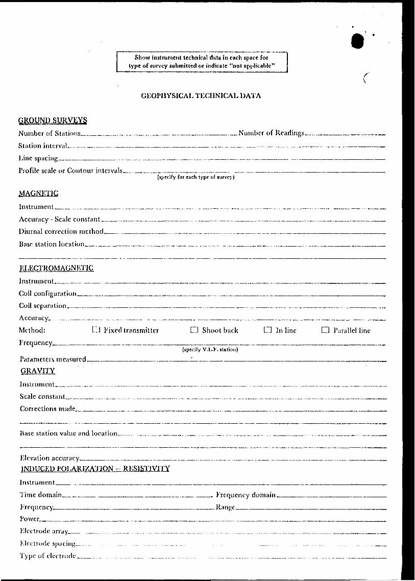
Show instrument technical data in each space for type of survey submitted or indicate "not applicable"
GEOPHYSICAL TECHNICAL DATA
SRVEYSNumber of Stations ________ .
Station interval _______ ̂ .^L-
Line spacing ___ . ____ /JL*L ..J^s.!^
Profile scale or Contour intervals-
of Readings -.-.™ JL~.JL—.21———.
^specify for each type of survey)
MAGNETICV l tyj J ri
Instrument-.,..____f. rot O f) ' ' Id q fi p. j o ^ f* f Q
Accuracy - Scale constant .-LDiurnal correction method._____Q.L Base station location________,
ELECTROMAGNETIC
Instrument .—^—.——.-.Coil configuration______________..Coil separation ___ ___._______..——. Accuracy—^.__-.-....____—.._.____ Method: LI Fixed transmitter Frequency___________________.,—
Parameters measured ___________~_. GRAVITY
Instrument ____...__.. — ____..___..
L J Shoot back tZI In line D Parallel line
{specify V.I..F. station)
Scale constant—^—— Corrections made—
Base station value and location.
Elevation accuracy____.____..._____.. INDUCED POLARIZATION..- RESISTIVITY
Instrument____________:___......-—.Time domain.^^. Frequency-..-™......Power_______
__ Frequency domain. ___ Ranges——.——.—
Electrode arrays.—— Electrode spacing__ Type of electrode,_ ,
Show instrument technical data in each space for type of survey submitted or indicate "not applicable"
GEOPHYSICAL TECHNICAL DATA
Number of Stations____.—™—.-...—_____,__._______ _Number of Readings._—___.————.Slut ion interval._-_ -___-_-* __--_ __ -._ -__-______ ~-__- _^_- -~_ - — -—--__-_ __—_____-_____ Line spacing.__—_-___-_-.—~- __—_ -__—__ *__-_—-___—____-_____^ —_-_____-_______ Profile scale or Contour intervals______________.__.__,. _____—_____..——____—————
(specify for each type of survey)
MAGNETIC
Instrument_ —..-.,_____.......__,._____...,._.__..-...-.__.._______,.___._________._______.Accuracy - Scale constant______.-—.—.___.___.-~...___.._________._______——™-——-— Diurnal correction method_...-.._____.__.^-_...-.. ___...-.._.........__-.-—..-.-..—.-———.—™-——-Base station location_________.__._____________________...____.————--—————.
ELECTROMAGNETIC
Instrument___,— __-.__________.__________________ ————-———-——.-——.—-—-—— Coil configuration ____,____________________________ ̂ .—^——^—^..^^^^—~—— Coil separation.,______.____.___.___,_____._ ___ ___..._,. __ .—..-.-—————-.—.—— A ccuracy_._. -_- — _~.._ ~.. — -——-._—. -,.___. _______,________ ____-_____.__,..—.. Method: CJ Fixed transmitter D Shoot back D Inline 13 I 'arallcl lint- Frequency__________._ _..__._______________________.—-———-.™——^——^——— —
(specify V.I..F. station)
Parameters ineasured _________.__ .__.__JL__. __ _____________________—————-^. GRAVITY
Instrument.___^..,.^,....^.______..—_..._______......____......._ ..^.-.. ,_.._______________.—Scale constant____..^...__.. .......^___..^..__..__.—.._.____,.___^- ....... ___.^..._______Corrections made____...______.._____.______.__...______...______...._____....——
Base station value and location_... .__ —.._____._._......_....___-__ ....______._______.^.
Elevation accuracy____,,.^^..___...—__,.—._.._ ...............___.__ .__ ,.__.___.._.____JNDUCED PPI ARIXATJON - RES1STJVKY
Instrument___...,.______.__________.___________________._____._.-———-————-M.— Time domain______ ________ ______.__.__ Frequency domain_______________.~— Frcquencv_________ — __ — ____ __ ___Rant'c________ ____ _ ———————.j 7 ————' ——— ' '" ————— ' ————— CI — — ——————— " ———————————————————— ————
Power_______.____.______._____________._,^_-_^.^^~,.^_^^__.^____.^-_^_^__^___^Electrode array_..__.._.^___ ...^....^._...._ -..-.—.....,.—— —...—..... -_— - ——-—-———-——.————-—
Electrode spacing........ -.. ...... . .... ...... .... . . ... ,. ....... .. .... . . ..... ............,.. . .... .... ... ..^..-.-.. .^-......-^..^^^
Type of electrode __ . .. .. ..... ... ..... .......... . ,.. ....... ... ... .... . .... .. . .......... -....... .. .... .. .........-... .^.—__
REFERENCEAREAS WITHDRAWN FROM DISPOSITION
S.R.-SURFACE RIGHTS M.R.-MINING RIGHTS
OMcription Order No Dit* Dtaptxltion Flto
riC) Ste 43 W 92/77 23/11/77 S R 116325
fR^ 3 /4/57 S R BM R 35731
SAND ond GRAVEL
GRAVEL PIT 'A', FILE 113758
GRAVEL PIT 5 , FILE 4 6026
GRAVEL PIT 9, FILE 46O26
GRAVEL, FILE 116325
GRAVEL FILE 34187
M T C GRAVEL P IT 299
QUARRY PERMIT
OAI! 01 iSSUL
J '' IP' .7. - i! i i:
THIS TOWNSHIP LIES WITHIN THE BOUNDARIES OF THE CORPORATION OF THE TOWNSHIP OF ATIKOKAN
B2BI3SEaeia Z 4656 SCHWENGER 200
LOi
O
OComLJJ LJJ DCu.
STEEPROCK LAKE G-560SABAWI LAKE
G-554
30M
M
'9 M CLI408/ ~ " l 1 11// ..i^x -^ //sr y a--™
35 M •j~G 6 26 JQV j
X 87J3- — r -— 1 X 256TB ITB }TB I TB " ]
l j - ' iWV^n
1601482 (601481 J60I480 j ' T
l 601267 60I26B
601477 601475 601463(601458 60I45760I4 — — j. _ _ J. _ _ i _ __ L _ _T "TB T TJ RESERVOIR)
i I60I48B l '
\ ' 1 601487. ,1601491 l— - —-± — — -4-V- J--r ~~ ' '
160,49760,46, 01U1^ t--- - — L- — —J- ~ — -J
pri ~ ~ "'TB ~ ""TB" ~ [W ~ TTB
J/. - —- if~TB l TB
863
864
. eibltcl t, etlon J.'
1 Tht Mining
e)KAN
i r--- T-I----I--1 l T B j T B ,TB,
1 1 ^ 11 ' 487365 1 487363 ^ 4
Act ^ — — .(.— ^ ^|
1 I TB ,TB ^Trl
(CI
'
17360
MX 865 "' X 871 i 1 U^ |X 8*^ 1
e ' Q U87 364 J 4873 SI | 48?35a !•iTBx ITB !
1 ' 8 I8 UHMSB!1 | , | 487359^ | t
S603060|56
Kori/iTB i S , 1 Kl
'^ 1 *487357 1.3.
*}J
0307
1 f
^
{" t
w .-1"- - '"J.Fr
4343
\1 *
FF
4344
L j 1
\ f F IF i M F434"
*
[601354
4348 i
j' " l 'v P^/" 1 "! IDUIJ9— ^j l__ |60^527- |6^0I526 i
c" rf B ~I TB f ,' , , L " ,TBS ia, i i I TB ITB 0 " '•'•0301uj 490319 |4903I8|4903I3 (4903,2 l " l"
l'18 ,l -J——— l .490307 ,
STEEPROCK LAKE G-560
X 140
SABAWI LAKE
G-554
LO LOl
O
Oo
/
LEGENDHIGHWAY AND ROUTE No
OTHER ROADS
TRAILS
SURVEYED LINES
TOWNSHIPS BASE LINES. ETCLOTS MINING CI AIMS PARCELS, ETC
UNSURVE YED LINESLOT LINESPARCEl BOUNDARYMINING CLAIMS ETC
RAILWAY AND RIGHT OE WAY f
UTILITY LINES
NON PERENNIAL STREAM -
FLOODING OR FLOODING RIGHTS
SUBDIVISION OR COMPOSITE PLAN
RESERVATIONS
ORIGINAL SHORELINE
MARSH OR MUSKEG
MINES TRAVERSE MONUMENT
DISPOSITION OF CROWN LANDS
TYPE OF DOCUMENT SYMBOL
PATENT SURFACE 4 MINING RIGHTS .... ...... O
SURFACt RIGHTS ONLY .. ..... .. ........ O
MINING RIGHTS ONLY ^.. . ... .. ........ O
LEASE SURFACE 8. MINING RIGHTS . . . ......... B
1 . SURFACE RIGHTS ONLY........ .... .........^ H
' .MINING RIGHTSONLY ..... ..................... B
LICENCE OF OCCUPATION ..... ........................ T
ORDER IN COUNCIL , .... . ...... ... ....... OC
RESERVATION . . . . . ......... . .._. ®
CANCELLED ..... . .. ,. ,. .., .... ,... ®
SANO&GRAVfL . ........... ........ 0
NOTE MINING Rl,,MTS IN PARCELS PATENTED PRIOR TO MAY 6. 1913 VESTED IN ORIGINAL PATENTEE BY THE PUBLIC LANDS AC r RSO 1970 CHAP 380 SEC 63 SUBSEC 1
SCALE 1 INCH = 40 CHAINS
F tu 10QO -~?OOO 4OOO 6OOO •000
o 200MFT RF'
1OOOM KMI
20OO(2VM)
TOWNSHIP
SCHWENGERM N R ADMINISTRATIVE DISTRICT
ATIKOKANMINING DIVISION
THUNDER BAYLAND TITLES/ REGISTRY DIVISION
RAINY RIVERMmiStryof Land
Natural Management
Resources BranchOntario
DateDECEMBER. 1 98 1
Numbu
G-574
x
v
BASELINE N 500E.
M in100
444 H2
STEEPROCK IfRON MINESMARSH J/AKE AREA
ONTARIO.
1^-C\j
00 CM
CD (M
XSCALE- J* 250
DATE —/MAY 15, 1981.
WORKB^- C.D.HUSTON 8 SONS LTD.
MAX-MIN SURVEY HOR.LOOP CABLE -100 METERS
444 HZ.
lil
OUT PHASE
PLUS
/0
IN PHASE-s-
/oMINUS
-20
52B13SE8*18 2 4656 SCHWBJGER 220 - i
STEEPROCK IRON MINESMARSH L/KE AREA
ONTARIO.SCALE - 1/250
xDATE —/MAY 15, 1981.
WORK^V- C.D.HUSTON 8 SONS LTD.f
Max Mm IE Surueu Wor.Uop
BASELINE
0 E
MAX-MIN SURVEY HOP.LOOP
CABLE - IOO METERS
1777 HZ.OUT PHASE . IN PHASE
-s
~" M INUS^ i
s
PLUS