Embed Size (px)
Citation preview
reliminary geologic map of the San Bernardino
y Douglas M. Morton and Fred K. Miller
igital preparation by Pamela M. Cossette2
etailed Description of Map Units, version 1.0
pen-File Report 03-293
ttp://geopubs.wr.usgs.gov/open-file/03-293
003
.S. DEPARTMENT OF THE INTERIOR
repared in cooperation with SURVEY
product of the Southern California Areal Mapping Project
Dept. of Geology
y, Western Region Earth Surface Processes Team
P30' x 60' quadrangle, California
1 2B Dand Kelly R. Bovard1 D OOnline version 1.0 h 2 UU.S. GEOLOGICAL SURVEY PCALIFORNIA GEOLOGICAL A____________________ 1 U.S. Geological Survey, University of California, Riverside Riverside, CA 92521 2 U.S. Geological Surve W904 Riverside Avenue, Spokane, WA 99201-1087
PRELIMINARY GEOLOGIC MAP OF THE SAN BERNARDINO 30’ X 60’ QUADRANGLE, CALIFORNIA
by
D.M. Morton and F.K. Miller
[In this report, San Bernardino quadrangle refers to the San Bernardino 30' X 60' quadrangle. and not to any previously published smaller scale quadrangle maps having the same name.]
GEOLOGIC SUMMARY The San Bernardino 30' X 60' quadrangle in southern California (figs. 1 and 2) is diagonally bisected by the San Andreas Fault zone, separating the San Gabriel and San Bernardino Mountains, major elements of California’s east-oriented Transverse Ranges Province. Included in the southern part of the quadrangle is the northern part of the Peninsular Ranges Province and the northeastern part of the oil-producing Los Angeles basin. The northern part of the quadrangle includes the southern part of the Mojave Desert Province (fig. 2). Rocks of southwestern California are divisible into an older suite of Late Cretaceous and older rocks and a younger suite of post-Late Cretaceous rocks. The age span of the older suite varies considerably from place to place, and the point in time that separates the two suites varies slightly. In the Peninsular Ranges, the older rocks were formed from the Paleozoic to the end of Late Cretaceous plutonism and in the Transverse Ranges over a longer period of time extending from the Proterozoic to metamorphism at the end of the Cretaceous. Within the Peninsular Ranges Province a profound diachronous unconformity marks the pre-Late Cretaceous-post-Late Cretaceous subdivision, but within the Transverse Ranges the division appears to be slightly younger, perhaps coinciding with the end of Cretaceous or extending into early Cenozoic. Initial docking of Peninsular Ranges rocks with Transverse Ranges rocks appears to have occurred at the terminus of plutonism within the Peninsular Ranges. During the Paleogene there was apparently discontinuous but widespread deposition on the basement rocks and little tectonic disruption of the amalgamated older rocks. Dismemberment of the Paleogene and older rocks by strike-slip, thrust, and reverse faulting began in the Neogene and is ongoing. Tertiary sedimentary and volcanic rocks are both unique to specific assemblages, and overlap adjacent assemblages. Pre-Quaternary rocks within the San Bernardino quadrangle consist of three extensive, well-defined basement* rock assemblages, the San Gabriel Mountains, San Bernardino Mountains, and the Peninsular Ranges assemblages, and a fourth assemblage restricted to a narrow block bounded by the active San Andreas Fault and the Mill Creek Fault (fig. 1). Each of these basement rock assemblage is characterized by a relatively unique suite of rocks that was amalgamated by the end of the Cretaceous and (or) early Cenozoic. A few Miocene and Pliocene units cross the boundaries of adjacent assemblages, but are dominante in only one. Tectonic events directly and indirectly related to the San Andreas Fault system have partly dismembered the basement rocks during the Neogene forming the modern-day physiographic provinces (e.g., Hill, 1928, Fenneman, 1931, Reed, 1933, Hinds, 1952, Jahns, 1954). Boundaries of the three major basement rock assemblages only locally coincide with the physiographic province boundaries. The Transverse Ranges Province includes both San Gabriel and San Bernardino Mountains basement rock assemblages. The San Bernardino Basin and the area south of the Sierra Madre fault (fig. 1), generally considered part of the Peninsular Ranges Province, are underlain by San Gabriel Mountains basement, and are here considered a part of that assemblage. The Mojave Desert Province is underlain by San Bernardino Mountains basement, and is here considered a part of that assemblage. Except for generic Quaternary deposits, this geologic summary, the CORRELATION OF MAP UNITS, and the DESCRIPTION OF MAP UNITS are organized by basement rock assemblage.
* In this report, we use the term basement to include not only crystalline rocks, but all pre-Quaternary rocks. Also, in several cases, formally and informally named Quaternary units that are restricted to specific assemblages are listed on the CORRELATION OF MAP UNITS, and the DESCRIPTION OF MAP UNITS as part of those assemblages.
1
Based on offsets of many of the rock units found in the San Bernardino quadrangle, different amounts of lateral displacement have been proposed for the San Andreas Fault system in and south of the Transverse Ranges (e.g., Hill and Dibblee, 1953; Woodford, 1960; Crowell, 1975a; Powell and others, 1993). The Neogene evolution of the Transverse Ranges Province, and its relationship to the San Andreas Fault system in particular, remains controversial due to considerably divergent interpretations (e.g., Dibblee, 1968; Gilluly, 1970; Baird and others, 1974; Campbell and Yerkes, 1976; Dillon and Ehlig, 1993; and Powell, 1993). In the vicinity of the Transverse Ranges, interpretations of the fault system’s evolution are complicated by several abandonded segments and the shifting locus of the fault during the late Cenozoic. Most recent structural interpretations require relatively large rotations within the Transverse Ranges Province (e.g., Kamerling and Luyendyk, 1979; Hornafius and others, 1986; Nicholson and others, 1994; Dickinson, 1996,).
PREVIOUS WORK General
Two 1:250,000 scale geologic map compilations (Rogers, 1967; and Bortugno and Spittler, 1986) published by the California Geological Survey (formerly California Division of Mines and Geology) include the area covered by the San Bernardino 30' X 60' quadrangle. Early discussions of regional geology that includes the area within the quadrangle are found in California Division of Mines Bulletin 170 (Jahns, 1954). Miller (1946) also discussed the regional geology that includes the area covered by the San Bernardino 30' X 60' quadrangle, but much of that work has been superceded.
Figure 3 on sheet 5 shows sources of geologic mapping used to compile the geologic map and digital data base for the San Bernardino quadrangle. It distinguishes published and unpublished mapping by the compilation authors, published and unpublished mapping by others, and shows where work by more than one person overlaps. References for published mapping are given; information for unpublished mapping includes the year(s) the mapping was done, the scale at which it was done, and the individual(s) who did the mapping. Peninsular Ranges
MacKevett (1951) mapped the Jurupa Mountains near the southern margin of the quadrangle, refining and updating earlier work by Daly (1935). Jahns’s 1954 review of the Peninsular Ranges Provinice is dated but still useful. A more current review of basement rocks is given by Todd and others (1988).
Baird and others (1979, 1984) conducted a comprehensive study of the major elemental chemistry of the Peninsular Ranges batholith, and Silver and Chappell (1988) presented new data and reviewed the chemistry and isotopic geochemistry of the batholith. The unique mineralogy of contact metamorphic marble deposits in the Jurupa Mountains, and at Crestmore, Glen Avon, Jensen, and Henshaw quarries are referenced in Murdoch and Webb (1966), and early in geologic studies of the region attracted the attention of numerous mineralogists (e.g., Eakle, 1914, 1917; Rogers, 1929; Daly, 1935). The geology of the Crestmore quarries was studied by Woodford and others (1941, 1943), and Burnham (1959).
Several graduate studies have been done on the northern part the Box Springs Plutonic complex, a part of the Peninsular Ranges batholith (e.g., Menzie, 1962; Joshi, 1967; Stock, 1992).
The Miocene Glendora Volcanics have been studied by Shelton (1955), McCulloh and others (2001, 2002), and Nourse and others (1998). The marine Miocene and Pliocene rocks of the Los Angeles Basin have been the subject of several studies (e.g., Shelton, 1946; Olmsted, 1950; Woodford and others, 1954; Yerkes and others, 1965; and Wright, 1991).
The continental Pliocene and Quaternary sedimentary rocks of the San Timoteo Badlands in the southeast corner of the quadrangle have been studied by numerous workers (e.g., Frick, 1921; Morton and others, 1986; Kendrick, 1996; Albright, 1997, 1999; Kendrick and others, 2002). San Gabriel Mountains
Miller (1928) described the geomorphology of the San Gabriel Mountains, including the Crystal Lake landslide (Miller, 1926) (fig. 1), and later described some of the basement rocks (Miller, 1934, 1946). Noble (1926, 1927, 1932a, 1932b, 1933, 1953, and 1954a) published a number of reports and quadrangle maps centered on the San Andreas Fault, particularly the segment in the northwestern part of the San Bernardino quadrangle. He produced a generalized strip map (Noble, 1954b ) from Soledad Pass to Cajon
2
Pass that in places extends far enough south to include the Vincent Thrust. This map is a distillation of a more detailed map that Noble had completed by 1928, but was never published.
Ehlig (1958) mapped the geology of the Mount Baldy area in detail, including a very detailed map of the Vincent Thrust. He first recognized the regional significance of the thrust, the relationships between metamorphism, structure of lower plate rocks, and the mylonite zone overlying the thrust. Subsequent research by Ehlig (e.g., 1968, 1975, 1981, 1982, 1988a, and 1988b) refined understanding of the regional, structural, and metamorphic history of the eastern San Gabriel Mountains. He generously provided unpublished mapping included in this compilation of the San Bernardino quadrangle.
Detailed history of the Triassic Mount Lowe intrusive suite is given by Barth and Ehlig (1988). May and Walker (1989) presented an interpretive history of the eastern part of the San Gabriel Mountains. McCulloh and others (2001) studied the relationship of the Oligocene granodiorite of Telegraph Peak to the Mountain Meadows Dacite and the Glendora Volcanics (McCulloh and others, 2002). Nourse (2002) presented a comprehensive interpretation of the geology of the central and eastern San Gabriel Mountains and the adjacent Los Angeles basin. He also conducted detailed mapping in all or parts of the Azusa, Glendora, Mount Baldy, and Telegraph Peak quadrangles, generously providing unpublished mapping for this compilation.
Early work in the San Gabriel Mountains by the U.S. Geological Survey was restricted to that done by Noble (1926), but later included reconnaissance mapping by T.W. Dibblee, who subsequently produced syntheses based on his and other peoples’ work (e.g., Dibblee, 1982). Morton (1976), Morton and Matti (1990a, 1990b, 2001a, 2001b), and Morton, Woodburne, and Foster (1990, 2001) conducted detailed mapping in the eastern San Gabriel Moutains, and published regional syntheses that include large parts of the eastern San Gabriel Mountains (Morton, 1975; Morton and Matti, 1987; Matti and Morton, 1993; Morton and Matti, 1993). In addition, U.S. Geological Survey mineral resource assessments were completed for Wilderness and Roadless areas (Crowder, 1967; Evans, 1982; Morton and others, 1983; Cox and others, 1983).
In addition to Ehlig (1958), other research includes Alf (1943, 1948), who first described the mylonites in the southeastern San Gabriel Mountains; Hsu (1955), who described the mineralogy and metamorphic history of the rocks in the Cucamonga Canyon area; and Baird (1956), who worked out structural relationships in the Barrett-Cascade Canyon tributaries of San Antonio Canyon. Jacobson expanded his thesis work (Jacobson, 1980) on the structure of the Pelona Schist (Jacobson, 1983, 1990; Jacobson and others, 2000).
Isotopic studies include Conrad and Davis (1977), Hsu and others (1963), Joseph and others (1982), and Miller and Morton (1977, 1980).
Rocks bounded by the Mill Creek Fault and San Andreas Fault
A variety of continental sedimentary rocks occur in the thin structural block located between the active San Andreas Fault and the older Mill Creek and Wilson Creek Faults. A thick section of rocks that constitute the Miocene fill of a pull-apart basin was first described by Vaughan (1922) who termed them the Potato Sandstone. These and adjacent sedimentary rocks have been the subject of a number of theses (Owens, 1959; Smith, 1959; Gibson, 1971; Demirer, 1985; West, 1987; Hillenbrand, 1990) and other works (Dibblee, 1968, 1982; Morton and Miller, 1975; Matti and others, 1985, 1992b; Sadler and Demirer, 1986; Sadler and others, 1993).
San Bernardino Mountains
Vaughan (1922) made the earliest reconnaissance geologic map of the central San Bernardino Mountains. His work has largely been supplanted by later studies, but he was the first to describe many rock units found in the northeasternmost part of the quadrangle.
Guillou (1953) and Richmond (1960) revised the stratigraphy and structure of the Precambrian and Paleozoic rocks just east of the quadrangle, and although their work has been highly revised, some of it was projected into the quadrangle by Brown (1984, 1987, 1991). Prior to Brown’s work, reconnaissance mapping by Dibblee (1964a, 1964b, 1974) retained a mix of the earlier nomenclature developed by Vaughan, Guillou, and Richmond. Stewart and Poole (1975) correlated Late Proterozoic and Paleozoic units in the San Bernardino Mountains with similar sections in the Great Basin, establishing that the Great Basin stratigraphy did extend to the Transverse Ranges. Their correlations for the most part have been adopted by subsequent workers (e.g., Tyler, 1975, 1979; Cameron, 1981, 1982; Miller and others, 1998, 2000). Brown (1984, 1987, 1991), through detailed, large-scale geologic mapping, was the first to make
3
unit-by-unit correlations of the highly faulted and multiply deformed Paleozoic rocks in the northern San Bernardino Mountains with well established, relatively undeformed Basin and Range units.
The Triassic, Jurassic, and Cretaceous granitic rocks have been studied by Cameron (1981), Frizzell and others (1986), Miller (1977a, 1977b, 1978), and Miller and Morton (1980). All of these studies report isotopic ages for the Mesozoic granitic rocks.
Faults
Active and inactive regional-scale faults within the quadrangle have been mapped and studied since the early part of the 20th century (Lawson and others, 1908). Regional tectonic syntheses have been developed by numerous authors (e.g., Baird and others, 1971; Hadley and Kanamori, 1977; Powell, 1993; Powell and Weldon, 1992; Woodburne, 1975).
Because of its extent, regional significance, and seismicity, most attention has focused on the San Andreas Fault. Apparently the earliest published recognition of the San Andreas fault in southern California was a cryptic description by Schuyler (1896-97). Detailed mapping of the fault in southern California began with the work of Levi Noble in 1910. The first paper to propose major lateral displacement is the classic paper of Hill and Dibblee (1953). General overviews of the San Andreas Fault were presented by Crowell (1960, 1975a, 1975b), Matti and others (1985), Powell (1993), Powell and Weldon (in Wallace, 1990), and Powell and Weldon (1992).
Reconnaissance mapping by Lawson and others (1908) following the 1906 San Francisco earthquake included the San Andreas Fault through the San Bernardino quadrangle. Noble (1926, 1953, 1954a, and 1954b) produced a series of maps and reports that included the San Andreas Fault on the north side of the San Gabriel Mountains. More recent work includes Matti and others (1986), Frizzell and others (1986), Harden and Matti (1989), Matti and Morton (1993), and Weldon and others (1993). Ross (1969) produced a map showing recently active breaks along the San Andreas Fault. Very detailed geologic mapping along the fault in Los Angeles County was conducted by the California Geological Survey (Barrows, 1980, 1985; Barrows and others, 1985; and Barrows and others, 1987 ). Morton and Miller (1975) produced a generalized geologic map along the San Andreas Fault on the south side of the San Bernardino Mountains. Several detailed fault studies have been conducted along the San Andreas Fault in the Cajon Pass area (e.g., Weldon, 1986; Weldon and Sieh, 1985; Weldon and Springer, 1988).
Studies of older strands of the San Andreas Fault system in the quadrangle include: (1) the San Gabriel Fault (Crowell, 1952; Ehlig, 1973; Nourse, 2002), (2) the Punchbowl Fault (Dibblee, 1967, 1968; Ehlig, 1968, 1981, 1982; Woodburne, 1975), (3) the Cajon Valley Fault (Woodburne and Golz, 1972).
Widely varying interpretations of the relationship of the San Jacinto Fault to the San Andreas Fault in the eastern San Gabriel Mountains are discussed in a number of papers (Arnett, 1949; Dibblee, 1968; Morton, 1975; Morton and Matti, 1993; Nourse, 2002). Active breaks along the fault were mapped in the San Bernardino area by Sharp (1972). Kendrick and others (2002) analyzed the spatial and temporal deformation of the northern part of the San Jacinto Fault zone.
Reverse and thrust faults within and bounding the Transverse Ranges were recognized by Hill (1930), but systematic study of them only began after the 1971 San Fernando earthquake. Within the quadrangle, parts of the Cucamonga Fault (reverse) and southern Sierra Madre Fault (thrust), have been studied by Morton (1973, 1976) and Crook and others (1987). Distribution and development of reverse faults on the north front of the San Bernardino Mountains is discussed by Meisling (1984), Meisling and Weldon (1982, 1989), and Miller (1987). Reverse faults within the San Bernardino Mountains have been studied by Sadler (1982, 1985), Strathouse (1982), Jacobs (1982), and Meisling and Weldon (1982, 1989).
Focal mechanisms along the San Andreas Fault Zone were included in comprehensive analyses by Jones (1988). A summary of the seismicity for the period 1978-1984 was included within a regional study by Ziony and Jones (1989). A detailed microseismic study for the eastern San Gabriel Mountains was provided by Cramer and Harrington (1987). Hauksson (1994) presents tectonic analyses of earthquakes originating along the south side of the San Gabriel Mountains; Hauksson and Jones (1991) present analyses for the 1981 Sierra Madre earthquake and the 1988 and 1990 Upland earthquakes.
GEOLOGY OF THE PENINSULAR RANGES ASSEMBLAGE
Introduction
Limited exposures of Peninsular Ranges basement rocks are concentrated along the south edge of the quadrangle, principally in the Jurupa Mountains, La Loma Hills, and the northern part of the Box Springs
4
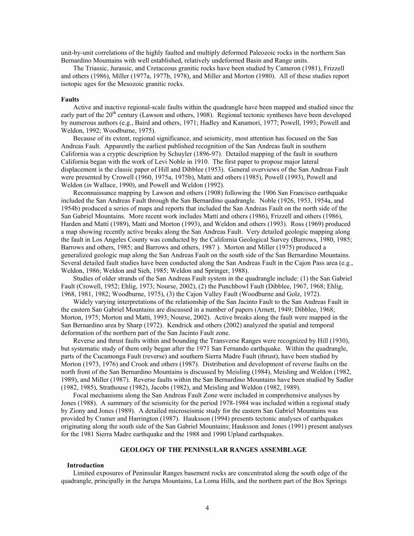
Mountains (fig. 1). In contrast to the steep and rugged topography of the Transverse Ranges, the topography of the northwest Peninsular Ranges is very subdued. Most of the northern part of the basement assemblage is covered by the extensive alluvial fans emanating from the San Gabriel Mountains (Photo 1).
Photo 1. Aerial view looking north from the south edge of the quadrangle across relatively subdued topography of the Jurupa Mountains to the San Gabriel Mountains. Between the Jurupa and San Gabriel Mountains is the extensive alluvial fan complex emanating from the San Gabriel Mountains and deposited on rocks of both the Peninsular Ranges and San Gabriel Mountains assemblages. The prominent peak is Mount San Antonio the highest peak in the San Gabriel Mountains. Cajon Pass is located near the right margin of the photograph.
The Peninsular Ranges basement rock assemblage is made up of the Peninsular Ranges batholith and a
variety of metasedimentary rocks. Tertiary sedimentary rocks of the Los Angeles Basin crop out in the Puente and San Jose Hills along with the spatially associated Glendora Volcanics; both units span the boundary between the Peninsular Ranges and San Gabriel Mountains basement rock assemblages.
The northern part of the Peninsular Ranges physiographic province is divided into a number of fault-bounded blocks (English, 1926, Woodford and others, 1971). The Perris Block constitutes nearly all of the Peninsular Ranges assemblage in the San Bernardino quadrangle; it is bounded on the east by the San Jacinto Fault Zone and on the west by the Elsinore Fault Zone, which lies west of the quadrangle. East of the San Jacinto Fault Zone, the northern end of the San Jacinto Mountains Block lies south of the quadrangle, and there, is underlain by sedimentary rocks of the San Timoteo Badlands. Except for the area east of the San Jacinto Fault, and unknowns introduced by the very poorly defined northwestern boundary, the northern part of Peninsular Ranges basement assemblage coincides fairly well with the northern part of Peninsular Ranges physiographic province.
Mesozoic and older metamorphic rocks
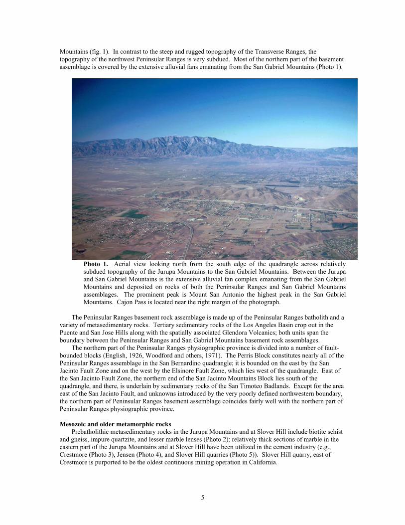
Prebatholithic metasedimentary rocks in the Jurupa Mountains and at Slover Hill include biotite schist and gneiss, impure quartzite, and lesser marble lenses (Photo 2); relatively thick sections of marble in the eastern part of the Jurupa Mountains and at Slover Hill have been utilized in the cement industry (e.g., Crestmore (Photo 3), Jensen (Photo 4), and Slover Hill quarries (Photo 5)). Slover Hill quarry, east of Crestmore is purported to be the oldest continuous mining operation in California.
5
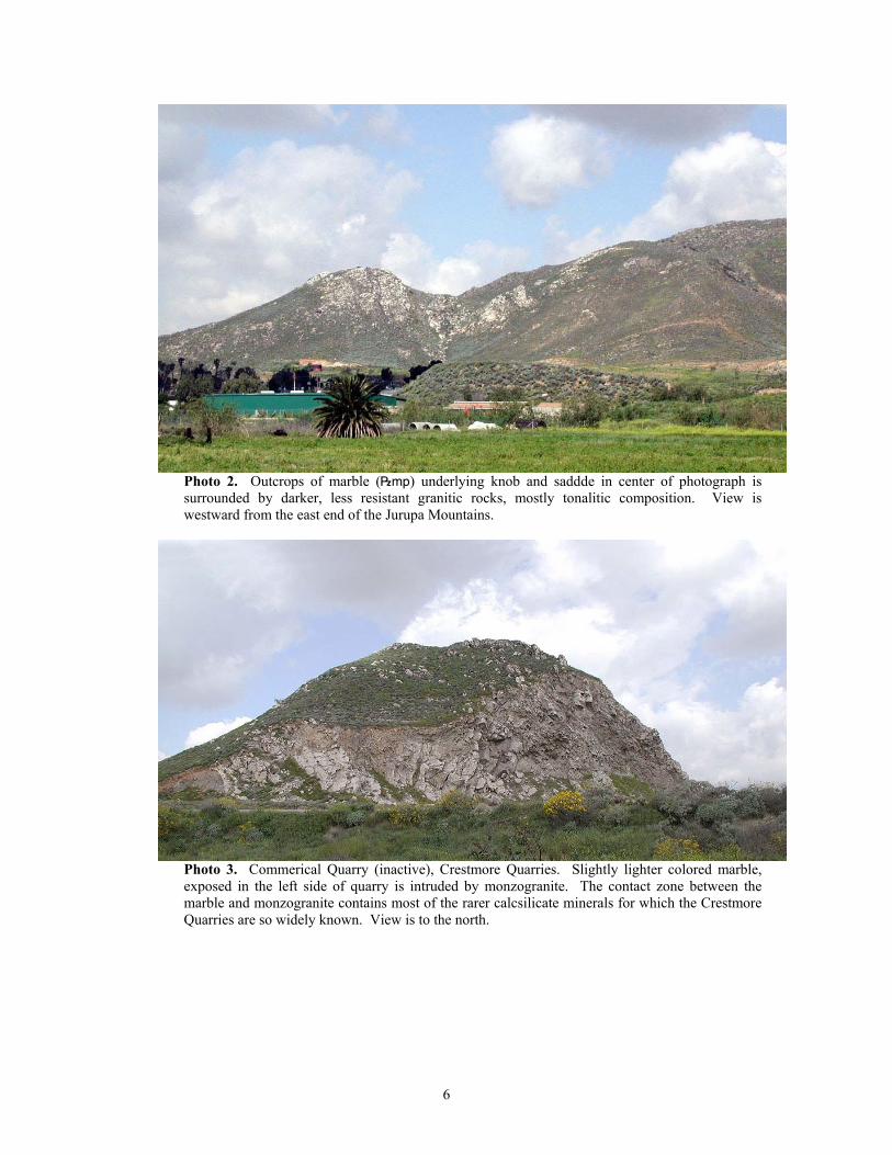
Photo 2. Outcrops of marble (|mp) underlying knob and saddde in center of photograph is surrounded by darker, less resistant granitic rocks, mostly tonalitic composition. View is westward from the east end of the Jurupa Mountains.
Photo 3. Commerical Quarry (inactive), Crestmore Quarries. Slightly lighter colored marble, exposed in the left side of quarry is intruded by monzogranite. The contact zone between the marble and monzogranite contains most of the rarer calcsilicate minerals for which the Crestmore Quarries are so widely known. View is to the north.
6
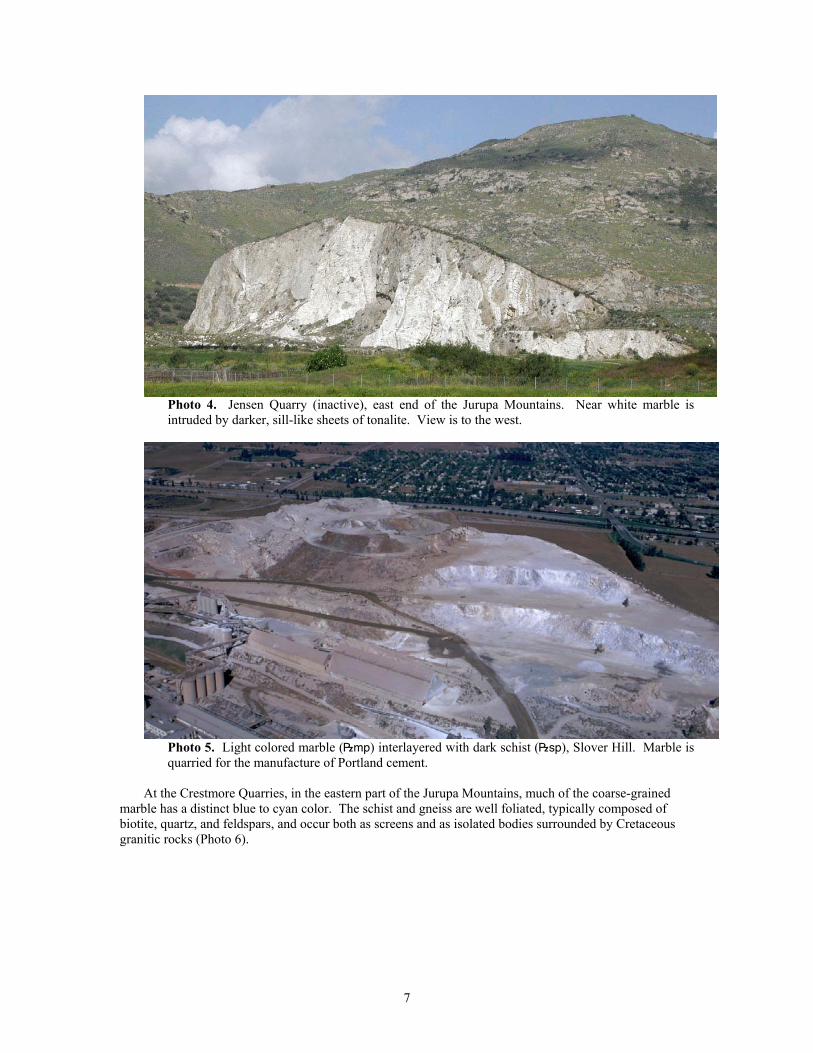
Photo 4. Jensen Quarry (inactive), east end of the Jurupa Mountains. Near white marble is intruded by darker, sill-like sheets of tonalite. View is to the west.
Photo 5. Light colored marble (|mp) interlayered with dark schist (|sp), Slover Hill. Marble is quarried for the manufacture of Portland cement.
At the Crestmore Quarries, in the eastern part of the Jurupa Mountains, much of the coarse-grained
marble has a distinct blue to cyan color. The schist and gneiss are well foliated, typically composed of biotite, quartz, and feldspars, and occur both as screens and as isolated bodies surrounded by Cretaceous granitic rocks (Photo 6).
7
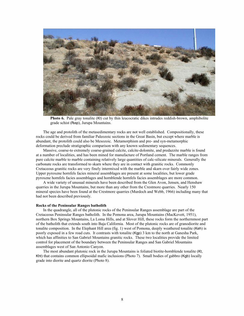
Photo 6. Pale gray tonalite (Kt) cut by thin leucocratic dikes intrudes reddish-brown, amphibolite grade schist (|sp), Jurupa Mountains.
The age and protolith of the metasedimentary rocks are not well established. Compositionally, these
rocks could be derived from familiar Paleozoic sections in the Great Basin, but except where marble is abundant, the protolith could also be Mesozoic. Metamorphism and pre- and syn-metamorphic deformation preclude stratigraphic comparison with any known sedimentary sequences.
Massive, coarse-to extremely coarse-grained calcite, calcite-dolomite, and predazzite marble is found at a number of localities, and has been mined for manufacture of Portland cement. The marble ranges from pure calcite marble to marble containing relatively large quantities of calc-silicate minerals. Generally the carbonate rocks are transformed to skarn where they are in contact with granitic rocks. Commonly Cretaceous granitic rocks are very finely intermixed with the marble and skarn over fairly wide zones. Upper pyroxene hornfels facies mineral assemblages are present at some localities, but lower grade pyroxene hornfels facies assemblages and hornblende hornfels facies assemblages are more common.
A wide variety of unusual minerals have been described from the Glen Avon, Jensen, and Henshaw quarries in the Jurupa Mountains, but more than any other from the Crestmore quarries. Nearly 150 mineral species have been found at the Crestmore quarries (Murdoch and Webb, 1966) including many that had not been described previously.
Rocks of the Peninsular Ranges batholith
In the quadrangle, all of the plutonic rocks of the Peninsular Ranges assemblage are part of the Cretaceous Peninsular Ranges batholith. In the Pomona area, Jurupa Mountains (MacKevett, 1951), northern Box Springs Mountains, La Loma Hills, and at Slover Hill, these rocks form the northernmost part of the batholith that extends south into Baja California. Most of the plutonic rocks are of granodiorite and tonalite composition. In the Elephant Hill area (fig. 1) west of Pomona, deeply weathered tonalite (Keh) is poorly exposed in a few road cuts. It contrasts with tonalite (Kgp) 3 km to the north at Ganesha Park, which has affinities to San Gabriel Mountains granitic rocks. These two localities provide the limited control for placement of the boundary between the Peninsular Ranges and San Gabriel Mountains assemblages west of San Antonio Canyon.
The most abundant plutonic rock in the Jurupa Mountains is foliated biotite-hornblende tonalite (Kt, Kht) that contains common ellipsoidal mafic inclusions (Photo 7). Small bodies of gabbro (Kgb) locally grade into diorite and quartz diorite (Photo 8).
8
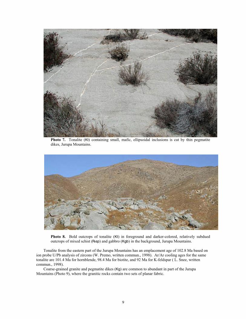
Photo 7. Tonalite (Kt) containing small, mafic, ellipsoidal inclusions is cut by thin pegmatite dikes, Jurupa Mountains.
Photo 8. Bold outcrops of tonalite (Kt) in foreground and darker-colored, relatively subdued outcrops of mixed schist (|sp) and gabbro (Kgb) in the background, Jurupa Mountains.
Tonalite from the eastern part of the Jurupa Mountains has an emplacement age of 102.8 Ma based on
ion probe U/Pb analysis of zircons (W. Premo, written commun., 1998). Ar/Ar cooling ages for the same tonalite are 101.4 Ma for hornblende, 98.4 Ma for biotite, and 92 Ma for K-feldspar ( L. Snee, written commun., 1998).
Coarse-grained granite and pegmatite dikes (Kg) are common to abundant in part of the Jurupa Mountains (Photo 9), where the granitic rocks contain two sets of planar fabric.
9
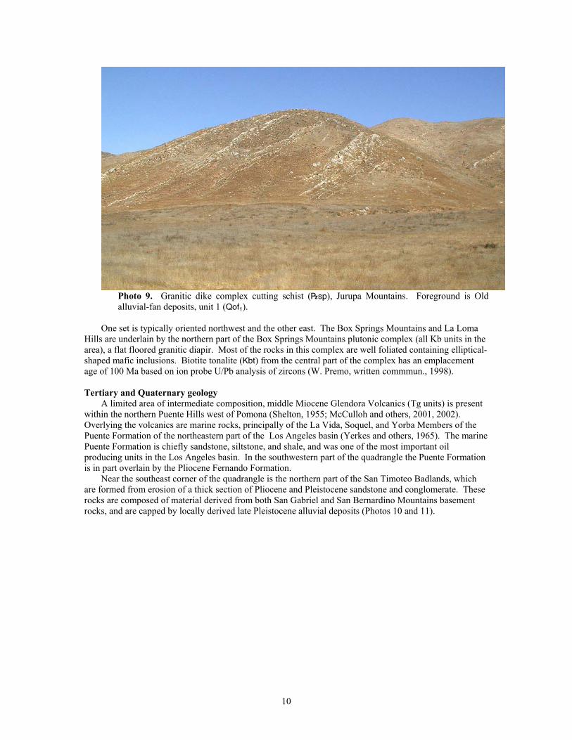
Photo 9. Granitic dike complex cutting schist (|sp), Jurupa Mountains. Foreground is Old alluvial-fan deposits, unit 1 (Qof1).
One set is typically oriented northwest and the other east. The Box Springs Mountains and La Loma
Hills are underlain by the northern part of the Box Springs Mountains plutonic complex (all Kb units in the area), a flat floored granitic diapir. Most of the rocks in this complex are well foliated containing elliptical-shaped mafic inclusions. Biotite tonalite (Kbt) from the central part of the complex has an emplacement age of 100 Ma based on ion probe U/Pb analysis of zircons (W. Premo, written commmun., 1998).
Tertiary and Quaternary geology
A limited area of intermediate composition, middle Miocene Glendora Volcanics (Tg units) is present within the northern Puente Hills west of Pomona (Shelton, 1955; McCulloh and others, 2001, 2002). Overlying the volcanics are marine rocks, principally of the La Vida, Soquel, and Yorba Members of the Puente Formation of the northeastern part of the Los Angeles basin (Yerkes and others, 1965). The marine Puente Formation is chiefly sandstone, siltstone, and shale, and was one of the most important oil producing units in the Los Angeles basin. In the southwestern part of the quadrangle the Puente Formation is in part overlain by the Pliocene Fernando Formation.
Near the southeast corner of the quadrangle is the northern part of the San Timoteo Badlands, which are formed from erosion of a thick section of Pliocene and Pleistocene sandstone and conglomerate. These rocks are composed of material derived from both San Gabriel and San Bernardino Mountains basement rocks, and are capped by locally derived late Pleistocene alluvial deposits (Photos 10 and 11).
10
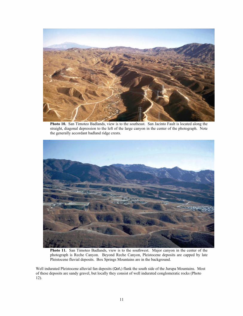
Photo 10. San Timoteo Badlands, view is to the southeast. San Jacinto Fault is located along the straight, diagonal depression to the left of the large canyon in the center of the photograph. Note the generally accordant badland ridge crests.
Photo 11. San Timoteo Badlands, view is to the southwest. Major canyon in the center of the photograph is Reche Canyon. Beyond Reche Canyon, Pleistocene deposits are capped by late Pleistocene fluvial deposits. Box Springs Mountains are in the background.
Well indurated Pleistocene alluvial fan deposits (Qof1) flank the south side of the Jurupa Mountains. Most of these deposits are sandy gravel, but locally they consist of well indurated conglomeratic rocks (Photo 12).
11
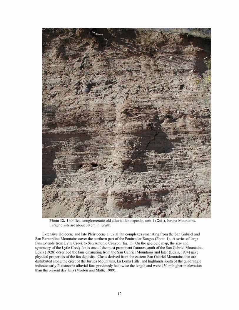
Photo 12. Lithified, conglomeratic old alluvial fan deposits, unit 1 (Qof1), Jurupa Mountains. Larger clasts are about 30 cm in length.
Extensive Holocene and late Pleistocene alluvial fan complexes emanating from the San Gabriel and
San Bernardino Mountains cover the northern part of the Peninsular Ranges (Photo 1). A series of large fans extends from Lytle Creek to San Antonio Canyon (fig. 1). On the geologic map, the size and symmetry of the Lytle Creek fan is one of the most prominent features south of the San Gabriel Mountains. Eckis (1928) described the fans emanating from the San Gabriel Mountains and later (Eckis, 1934) gave physical properties of the fan deposits. Clasts derived from the eastern San Gabriel Mountains that are distributed along the crest of the Jurupa Mountains, La Loma Hills, and highlands south of the quadrangle indicate early Pleistocene alluvial fans previously had twice the length and were 450 m higher in elevation than the present day fans (Morton and Matti, 1989).
12
GEOLOGY OF THE SAN GABRIEL MOUNTAINS ASSEMBLAGE
Introduction In the San Bernardino quadrangle, the San Gabriel Mountains basement rock assemblage includes two
discrete areas, the high standing San Gabriel Mountains and the relatively low San Bernardino basin east of the San Jacinto Fault. The basement rock assemblage is characterized by a unique suite of rocks that include anorthosite, Proterozoic and Paleozoic gneiss and schist, the Triassic Mount Lowe intrusive suite, extensive deformed and undeformed Cretaceous granitic rocks, the Pelona Schist, and Oligocene granitic rocks. Internal structure of the assemblage includes the Vincent Thrust Fault, at least two old, abandonded faults of the San Andreas Fault system, and extensive areas of well-developed to pervasively mylonitized rocks.
The main body of the San Gabriel Mountains (fig. 1) is bounded on the north by the San Andreas Fault and on the south by the Sierra Madre-Cucamonga Fault zone (Matti and Morton, 1993). East of the San Jacinto Fault, the San Bernardino basin is an asymmetric pull-apart basin bounded by the San Andreas Fault on the east, and underlain by many of the same rock units that characterize the San Gabriel Mountains (Morton and Matti, 1993).
Cretaceous and older rocks of the San Gabriel Mountains basement rock assemblage are divided into two structurally and lithologically distinct groups by the Vincent Thrust Fault, a regional, low-angle thrust fault that predates intrusion of Oligocene granitic rocks. The thrust, named for exposures in the Vincent Gap area west of the San Bernardino quadrangle, was first recognized by Levi Noble (unpublished mapping, 1928; published, 1954), and later, by Ehlig (1958), who first described the fault in detail and realized its regional tectonic importance. The Vincent Thrust separates the Mesozoic Pelona Schist in its lower plate from highly deformed gneiss, schist, and granitic rocks in the upper plate. The fault, along with its far-offset, dismembered analogs in the Orocopia and Chocolate Mountains east of the Salton Sea, may underlie much of southern California (Haxel and Dillon, 1978; Ehlig, 1982). Oligocene granodiorite of Telegraph Peak (Ttp) intrudes both the Vincent Thrust and upper and lower plate rocks in the eastern San Gabriel Mountains, and a similar Oligocene granitic rock (Tgry) intrudes the Pelona Schist in the Crafton Hills in the low lying southern part of the San Bernardino basin (fig. 1).
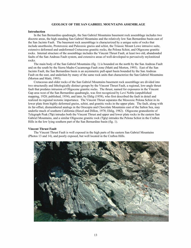
Vincent Thrust Fault
The Vincent Thrust Fault is well exposed in the high parts of the eastern San Gabriel Mountains (Photos 13 and 14), and poorly exposed, but well located in the Crafton Hills.
13
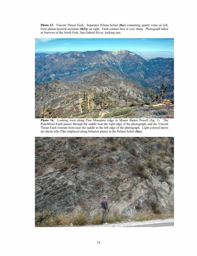
Photo 13. Vincent Thrust Fault. Separates Pelona Schist (}p) containing quartz veins on left, from planar-layered mylonite (}<g) on right. Fault contact here is very sharp. Photograph taken at Narrows of the North Fork, San Gabriel River, looking east.
Photo 14. Looking west along Pine Mountain ridge to Mount Baden Powell (fig. 1). The Punchbowl Fault passes through the saddle near the right edge of the photograph, and the Vincent Thrust Fault extends from near the saddle to the left edge of the photograph. Light colored layers are dacite sills (Ttp) emplaced along foliation planes in the Pelona Schist (}p).
14
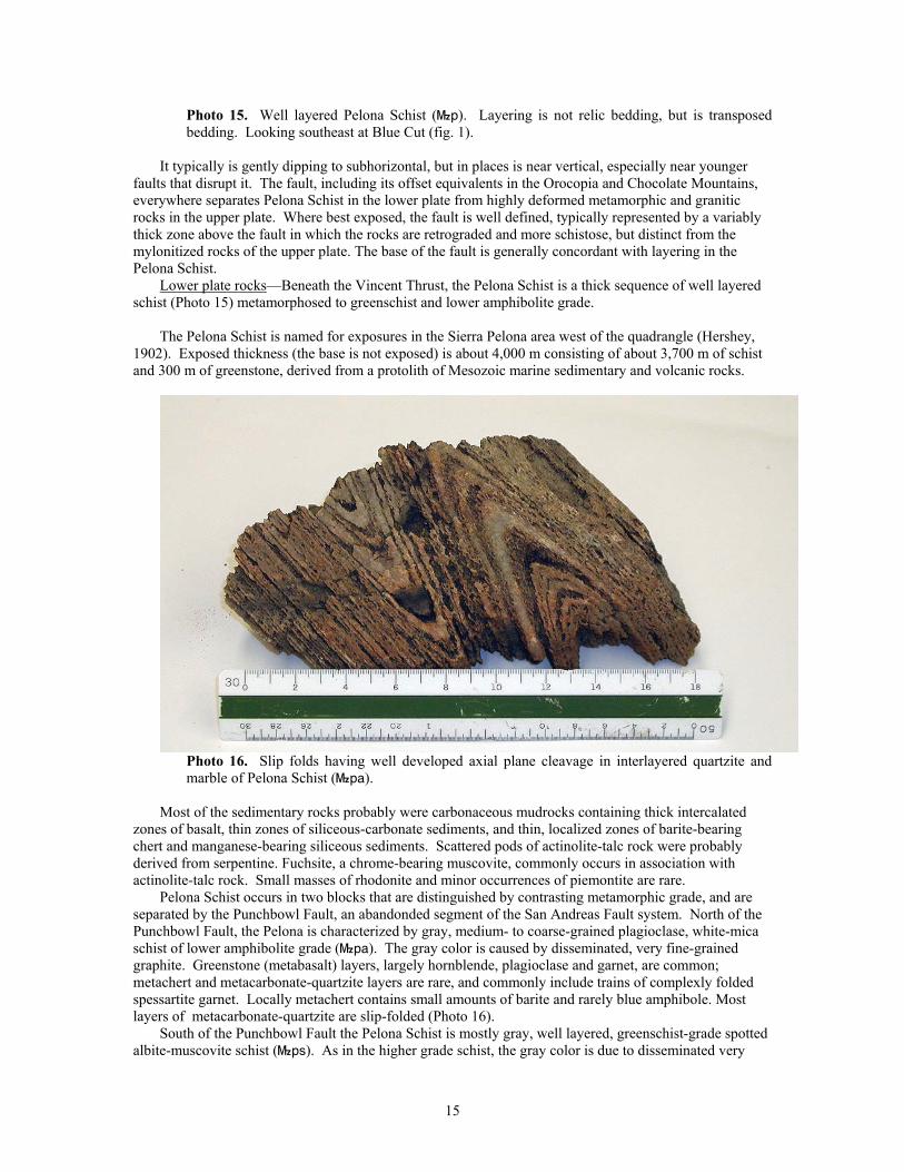
Photo 15. Well layered Pelona Schist (}p). Layering is not relic bedding, but is transposed bedding. Looking southeast at Blue Cut (fig. 1).
It typically is gently dipping to subhorizontal, but in places is near vertical, especially near younger
faults that disrupt it. The fault, including its offset equivalents in the Orocopia and Chocolate Mountains, everywhere separates Pelona Schist in the lower plate from highly deformed metamorphic and granitic rocks in the upper plate. Where best exposed, the fault is well defined, typically represented by a variably thick zone above the fault in which the rocks are retrograded and more schistose, but distinct from the mylonitized rocks of the upper plate. The base of the fault is generally concordant with layering in the Pelona Schist.
Lower plate rocks—Beneath the Vincent Thrust, the Pelona Schist is a thick sequence of well layered schist (Photo 15) metamorphosed to greenschist and lower amphibolite grade.
The Pelona Schist is named for exposures in the Sierra Pelona area west of the quadrangle (Hershey,
1902). Exposed thickness (the base is not exposed) is about 4,000 m consisting of about 3,700 m of schist and 300 m of greenstone, derived from a protolith of Mesozoic marine sedimentary and volcanic rocks.
Photo 16. Slip folds having well developed axial plane cleavage in interlayered quartzite and marble of Pelona Schist (}pa).
Most of the sedimentary rocks probably were carbonaceous mudrocks containing thick intercalated
zones of basalt, thin zones of siliceous-carbonate sediments, and thin, localized zones of barite-bearing chert and manganese-bearing siliceous sediments. Scattered pods of actinolite-talc rock were probably derived from serpentine. Fuchsite, a chrome-bearing muscovite, commonly occurs in association with actinolite-talc rock. Small masses of rhodonite and minor occurrences of piemontite are rare.
Pelona Schist occurs in two blocks that are distinguished by contrasting metamorphic grade, and are separated by the Punchbowl Fault, an abandonded segment of the San Andreas Fault system. North of the Punchbowl Fault, the Pelona is characterized by gray, medium- to coarse-grained plagioclase, white-mica schist of lower amphibolite grade (}pa). The gray color is caused by disseminated, very fine-grained graphite. Greenstone (metabasalt) layers, largely hornblende, plagioclase and garnet, are common; metachert and metacarbonate-quartzite layers are rare, and commonly include trains of complexly folded spessartite garnet. Locally metachert contains small amounts of barite and rarely blue amphibole. Most layers of metacarbonate-quartzite are slip-folded (Photo 16).
South of the Punchbowl Fault the Pelona Schist is mostly gray, well layered, greenschist-grade spotted albite-muscovite schist (}ps). As in the higher grade schist, the gray color is due to disseminated very
15
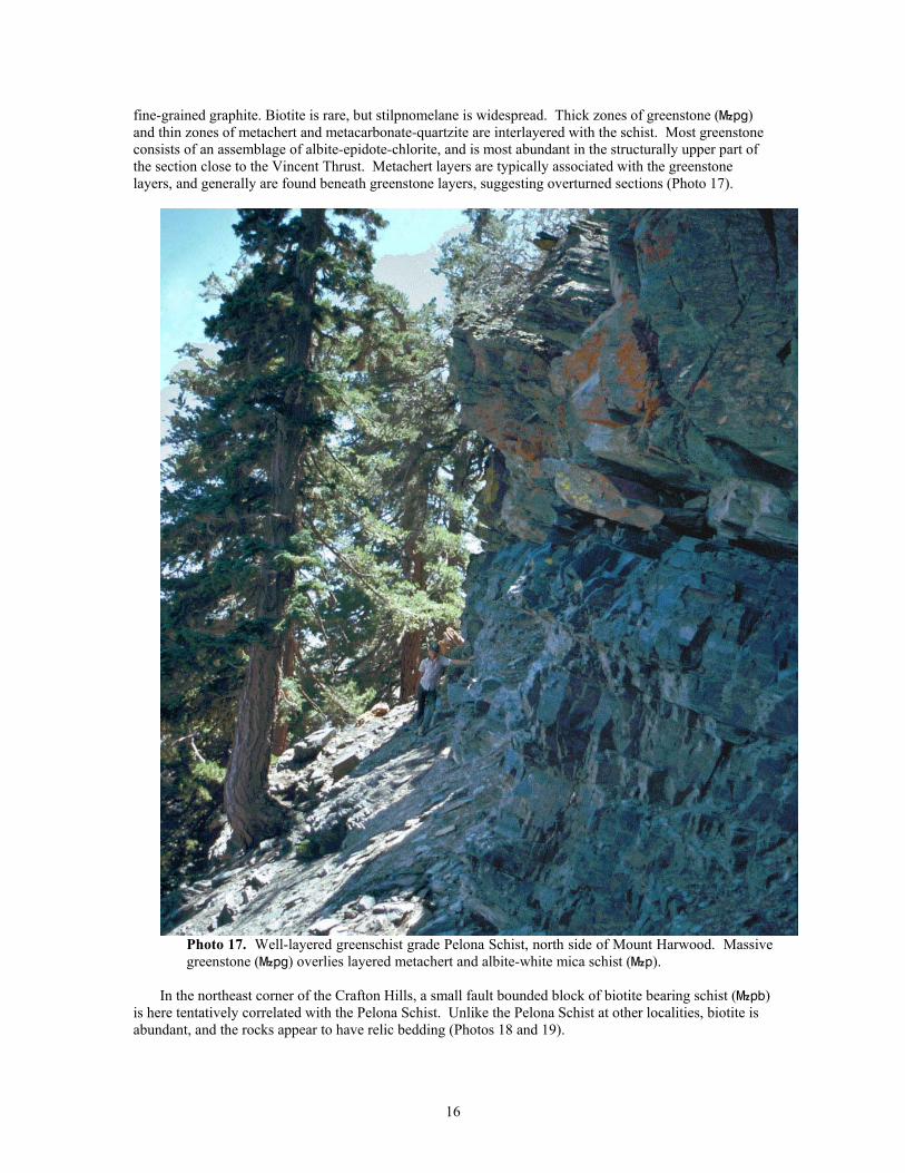
fine-grained graphite. Biotite is rare, but stilpnomelane is widespread. Thick zones of greenstone (}pg) and thin zones of metachert and metacarbonate-quartzite are interlayered with the schist. Most greenstone consists of an assemblage of albite-epidote-chlorite, and is most abundant in the structurally upper part of the section close to the Vincent Thrust. Metachert layers are typically associated with the greenstone layers, and generally are found beneath greenstone layers, suggesting overturned sections (Photo 17).
Photo 17. Well-layered greenschist grade Pelona Schist, north side of Mount Harwood. Massive greenstone (}pg) overlies layered metachert and albite-white mica schist (}p).
In the northeast corner of the Crafton Hills, a small fault bounded block of biotite bearing schist (}pb)
is here tentatively correlated with the Pelona Schist. Unlike the Pelona Schist at other localities, biotite is abundant, and the rocks appear to have relic bedding (Photos 18 and 19).
16
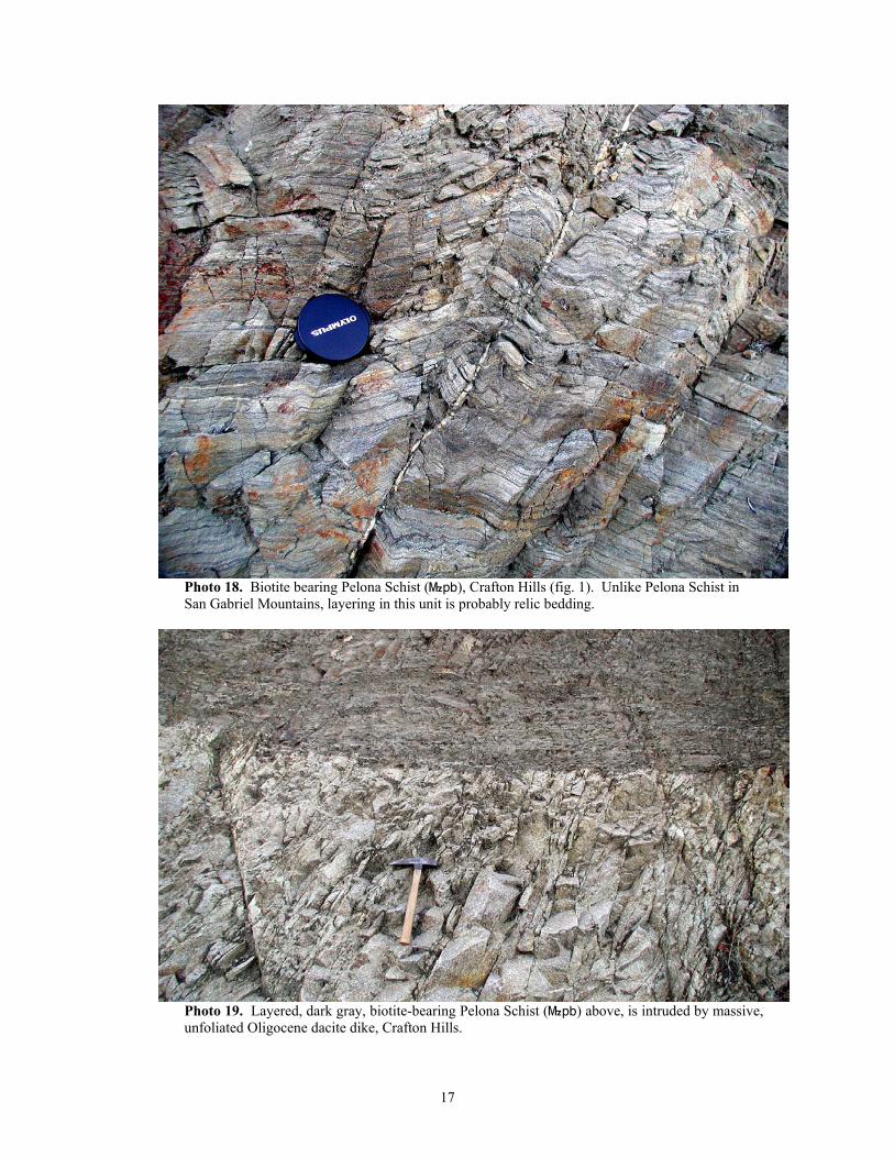
Photo 18. Biotite bearing Pelona Schist (}pb), Crafton Hills (fig. 1). Unlike Pelona Schist in San Gabriel Mountains, layering in this unit is probably relic bedding.
Photo 19. Layered, dark gray, biotite-bearing Pelona Schist (}pb) above, is intruded by massive, unfoliated Oligocene dacite dike, Crafton Hills.
17
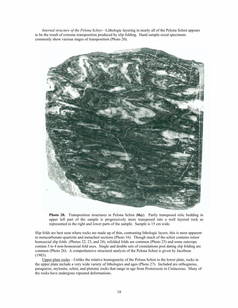
Internal structure of the Pelona Schist—Lithologic layering in nearly all of the Pelona Schist appears to be the result of extreme transposition produced by slip folding. Hand sample-sized specimens commonly show various stages of transposition (Photo 20).
Photo 20. Transposition structures in Pelona Schist (}p). Partly transposed relic bedding in upper left part of the sample is progressively more transposed into a well layered rock as represented in the right and lower parts of the sample. Sample is 15 cm wide.
Slip folds are best seen where rocks are made up of thin, contrasting lithologic layers; this is most apparent in metacarbonate-quartzite and metachert sections (Photo 16). Though much of the schist contains minor homoaxial slip folds (Photos 22, 23, and 24), refolded folds are common (Photo 25) and some outcrops contain 3 to 4 non-homoaxial fold axes. Single and double sets of crenulations post dating slip folding are common (Photo 26). A comprehensive structural analysis of the Pelona Schist is given by Jacobson (1983).
Upper plate rocks—Unlike the relative homogeneity of the Pelona Schist in the lower plate, rocks in the upper plate include a very wide variety of lithologies and ages (Photo 27). Included are orthogneiss, paragneiss, mylonite, schist, and plutonic rocks that range in age from Proterozoic to Cretaceous. Many of the rocks have undergone repeated deformations.
18
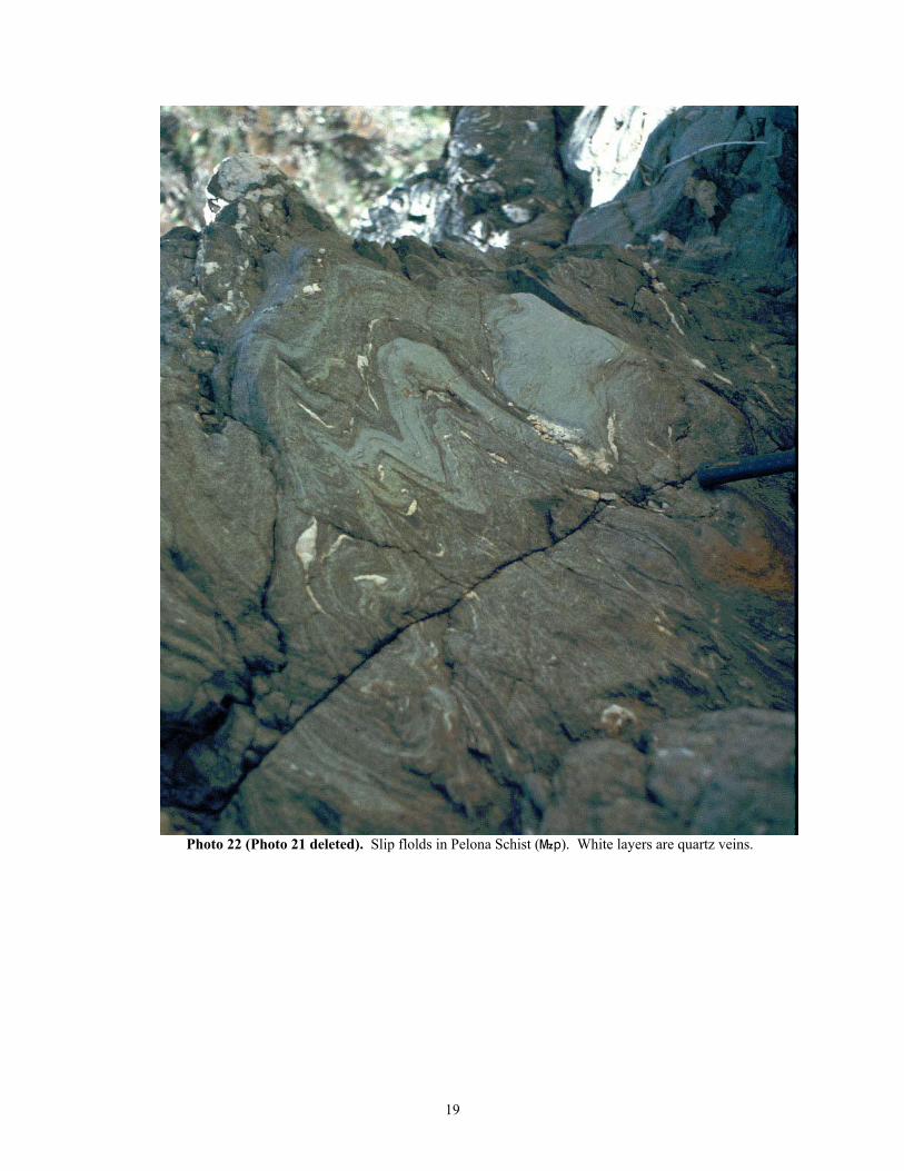
Photo 22 (Photo 21 deleted). Slip flolds in Pelona Schist (}p). White layers are quartz veins.
19
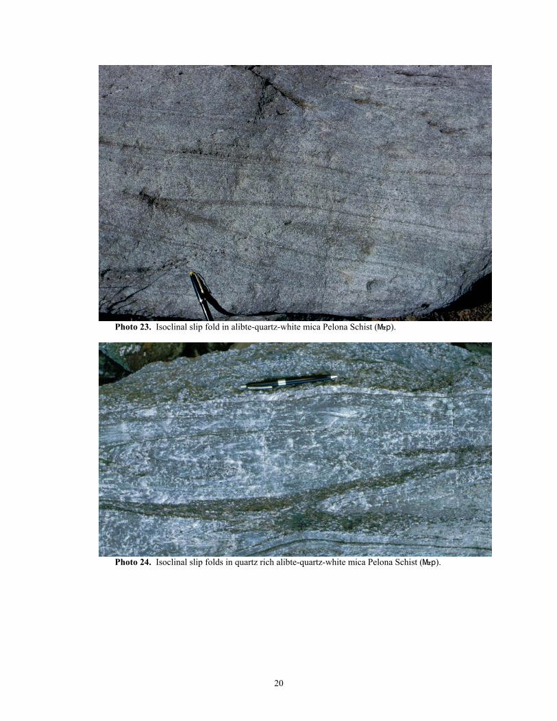
Photo 23. Isoclinal slip fold in alibte-quartz-white mica Pelona Schist (}p).
Photo 24. Isoclinal slip folds in quartz rich alibte-quartz-white mica Pelona Schist (}p).
20
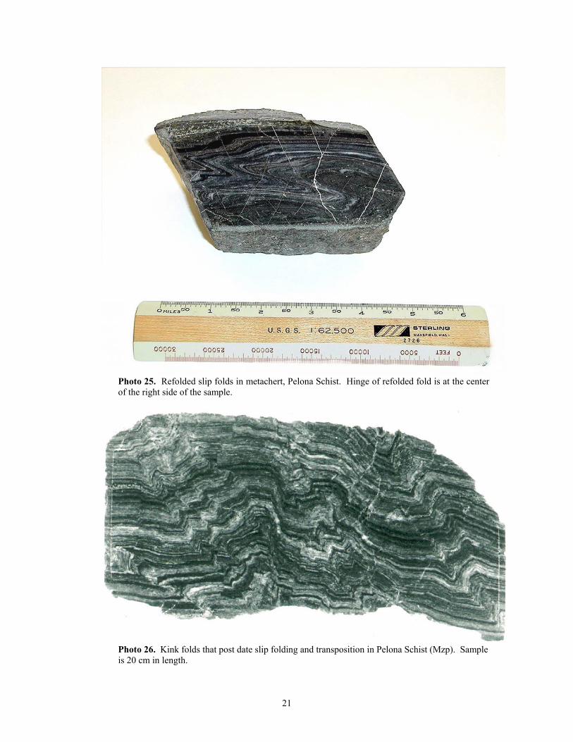
Photo 25. Refolded slip folds in metachert, Pelona Schist. Hinge of refolded fold is at the center of the right side of the sample.
Photo 26. Kink folds that post date slip folding and transposition in Pelona Schist (Mzp). Sample is 20 cm in length.
21
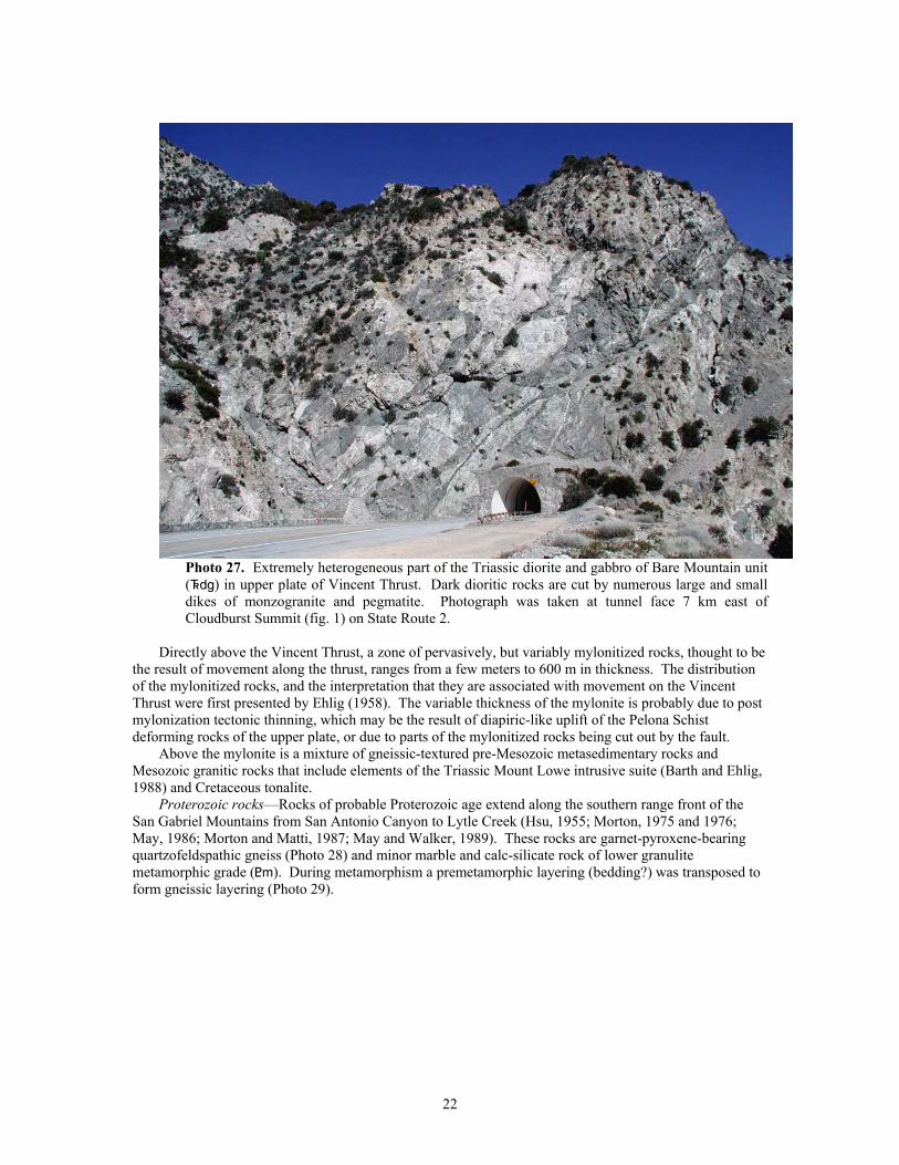
Photo 27. Extremely heterogeneous part of the Triassic diorite and gabbro of Bare Mountain unit (^dg) in upper plate of Vincent Thrust. Dark dioritic rocks are cut by numerous large and small dikes of monzogranite and pegmatite. Photograph was taken at tunnel face 7 km east of Cloudburst Summit (fig. 1) on State Route 2.
Directly above the Vincent Thrust, a zone of pervasively, but variably mylonitized rocks, thought to be
the result of movement along the thrust, ranges from a few meters to 600 m in thickness. The distribution of the mylonitized rocks, and the interpretation that they are associated with movement on the Vincent Thrust were first presented by Ehlig (1958). The variable thickness of the mylonite is probably due to post mylonization tectonic thinning, which may be the result of diapiric-like uplift of the Pelona Schist deforming rocks of the upper plate, or due to parts of the mylonitized rocks being cut out by the fault.
Above the mylonite is a mixture of gneissic-textured pre-Mesozoic metasedimentary rocks and Mesozoic granitic rocks that include elements of the Triassic Mount Lowe intrusive suite (Barth and Ehlig, 1988) and Cretaceous tonalite.
Proterozoic rocks—Rocks of probable Proterozoic age extend along the southern range front of the San Gabriel Mountains from San Antonio Canyon to Lytle Creek (Hsu, 1955; Morton, 1975 and 1976; May, 1986; Morton and Matti, 1987; May and Walker, 1989). These rocks are garnet-pyroxene-bearing quartzofeldspathic gneiss (Photo 28) and minor marble and calc-silicate rock of lower granulite metamorphic grade (<m). During metamorphism a premetamorphic layering (bedding?) was transposed to form gneissic layering (Photo 29).
22
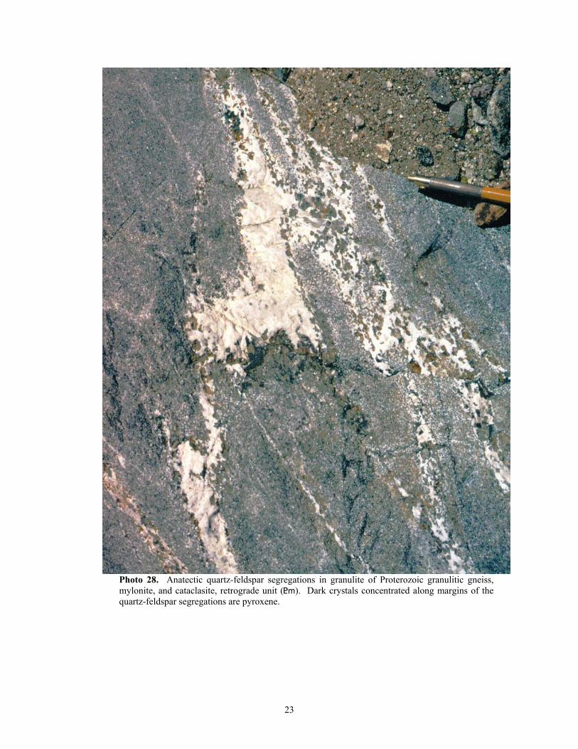
Photo 28. Anatectic quartz-feldspar segregations in granulite of Proterozoic granulitic gneiss, mylonite, and cataclasite, retrograde unit (<m). Dark crystals concentrated along margins of the quartz-feldspar segregations are pyroxene.
23
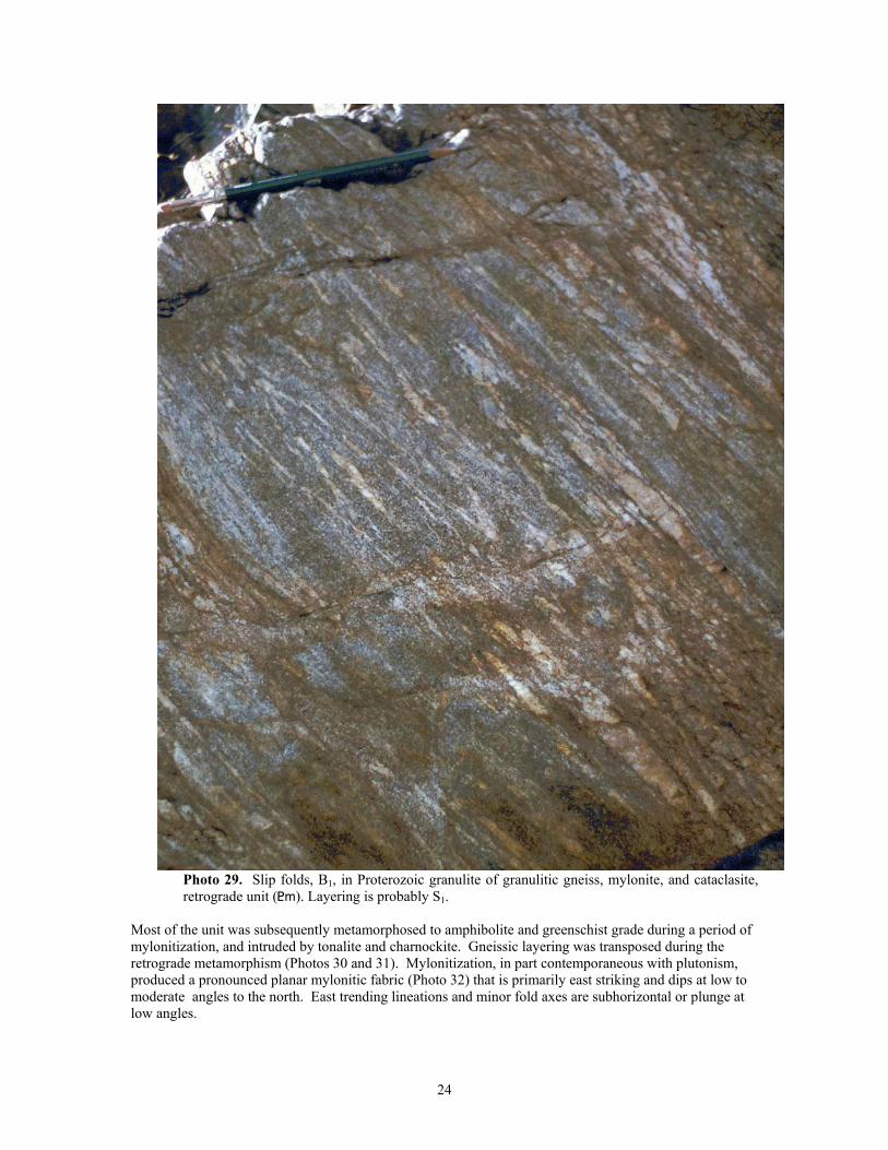
Photo 29. Slip folds, B1, in Proterozoic granulite of granulitic gneiss, mylonite, and cataclasite, retrograde unit (<m). Layering is probably S1.
Most of the unit was subsequently metamorphosed to amphibolite and greenschist grade during a period of mylonitization, and intruded by tonalite and charnockite. Gneissic layering was transposed during the retrograde metamorphism (Photos 30 and 31). Mylonitization, in part contemporaneous with plutonism, produced a pronounced planar mylonitic fabric (Photo 32) that is primarily east striking and dips at low to moderate angles to the north. East trending lineations and minor fold axes are subhorizontal or plunge at low angles.
24
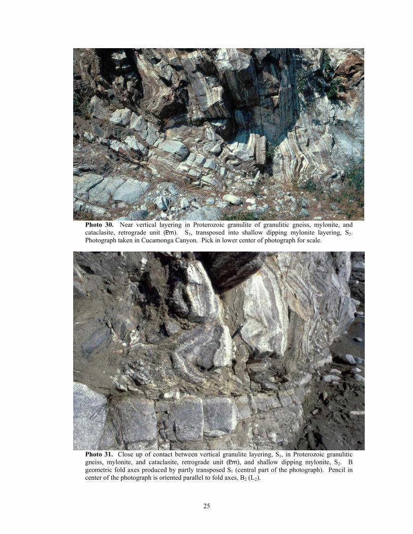
Photo 30. Near vertical layering in Proterozoic granulite of granulitic gneiss, mylonite, and cataclasite, retrograde unit (<m). S1, transposed into shallow dipping mylonite layering, S2. Photograph taken in Cucamonga Canyon. Pick in lower center of photograph for scale.
Photo 31. Close up of contact between vertical granulite layering, S1, in Proterozoic granulitic gneiss, mylonite, and cataclasite, retrograde unit (<m), and shallow dipping mylonite, S2. B geometric fold axes produced by partly transposed S1 (central part of the photograph). Pencil in center of the photograph is oriented parallel to fold axes, B2 (L2).
25
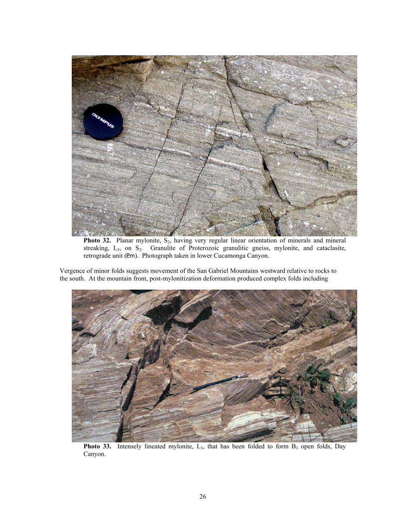
Photo 32. Planar mylonite, S2, having very regular linear orientation of minerals and mineral streaking, L3, on S2. Granulite of Proterozoic granulitic gneiss, mylonite, and cataclasite, retrograde unit (<m). Photograph taken in lower Cucamonga Canyon.
Vergence of minor folds suggests movement of the San Gabriel Mountains westward relative to rocks to the south. At the mountain front, post-mylonitization deformation produced complex folds including
Photo 33. Intensely lineated mylonite, L3, that has been folded to form B3 open folds, Day Canyon.
26
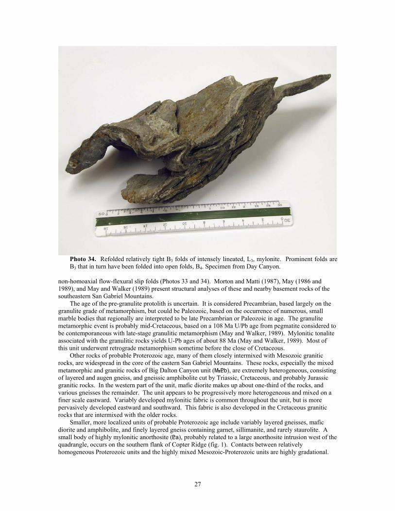
Photo 34. Refolded relatively tight B3 folds of intensely lineated, L3, mylonite. Prominent folds are B3 that in turn have been folded into open folds, B4. Specimen from Day Canyon.
non-homoaxial flow-flexural slip folds (Photos 33 and 34). Morton and Matti (1987), May (1986 and 1989), and May and Walker (1989) present structural analyses of these and nearby basement rocks of the southeastern San Gabriel Mountains.
The age of the pre-granulite protolith is uncertain. It is considered Precambrian, based largely on the granulite grade of metamorphism, but could be Paleozoic, based on the occurrence of numerous, small marble bodies that regionally are interpreted to be late Precambrian or Paleozoic in age. The granulite metamorphic event is probably mid-Cretaceous, based on a 108 Ma U/Pb age from pegmatite considered to be contemporaneous with late-stage granulitic metamorphism (May and Walker, 1989). Mylonitic tonalite associated with the granulitic rocks yields U-Pb ages of about 88 Ma (May and Walker, 1989). Most of this unit underwent retrograde metamorphism sometime before the close of Cretaceous.
Other rocks of probable Proterozoic age, many of them closely intermixed with Mesozoic granitic rocks, are widespread in the core of the eastern San Gabriel Mountains. These rocks, especially the mixed metamorphic and granitic rocks of Big Dalton Canyon unit (}<b), are extremely heterogeneous, consisting of layered and augen gneiss, and gneissic amphibolite cut by Triassic, Cretaceous, and probably Jurassic granitic rocks. In the western part of the unit, mafic diorite makes up about one-third of the rocks, and various gneisses the remainder. The unit appears to be progressively more heterogeneous and mixed on a finer scale eastward. Variably developed mylonitic fabric is common throughout the unit, but is more pervasively developed eastward and southward. This fabric is also developed in the Cretaceous granitic rocks that are intermixed with the older rocks.
Smaller, more localized units of probable Proterozoic age include variably layered gneisses, mafic diorite and amphibolite, and finely layered gneiss containing garnet, sillimanite, and rarely staurolite. A small body of highly mylonitic anorthosite (<a), probably related to a large anorthosite intrusion west of the quadrangle, occurs on the southern flank of Copter Ridge (fig. 1). Contacts between relatively homogeneous Proterozoic units and the highly mixed Mesozoic-Proterozoic units are highly gradational.
27
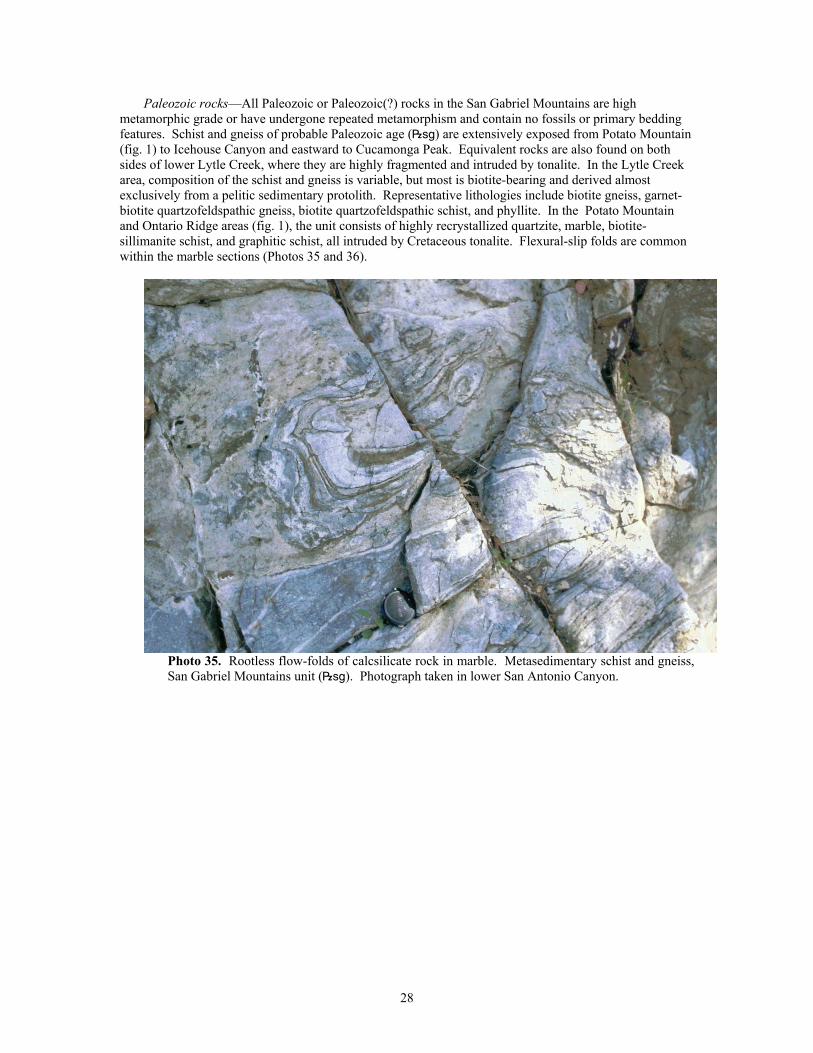
Paleozoic rocks—All Paleozoic or Paleozoic(?) rocks in the San Gabriel Mountains are high metamorphic grade or have undergone repeated metamorphism and contain no fossils or primary bedding features. Schist and gneiss of probable Paleozoic age (|sg) are extensively exposed from Potato Mountain (fig. 1) to Icehouse Canyon and eastward to Cucamonga Peak. Equivalent rocks are also found on both sides of lower Lytle Creek, where they are highly fragmented and intruded by tonalite. In the Lytle Creek area, composition of the schist and gneiss is variable, but most is biotite-bearing and derived almost exclusively from a pelitic sedimentary protolith. Representative lithologies include biotite gneiss, garnet-biotite quartzofeldspathic gneiss, biotite quartzofeldspathic schist, and phyllite. In the Potato Mountain and Ontario Ridge areas (fig. 1), the unit consists of highly recrystallized quartzite, marble, biotite-sillimanite schist, and graphitic schist, all intruded by Cretaceous tonalite. Flexural-slip folds are common within the marble sections (Photos 35 and 36).
Photo 35. Rootless flow-folds of calcsilicate rock in marble. Metasedimentary schist and gneiss, San Gabriel Mountains unit (|sg). Photograph taken in lower San Antonio Canyon.
28
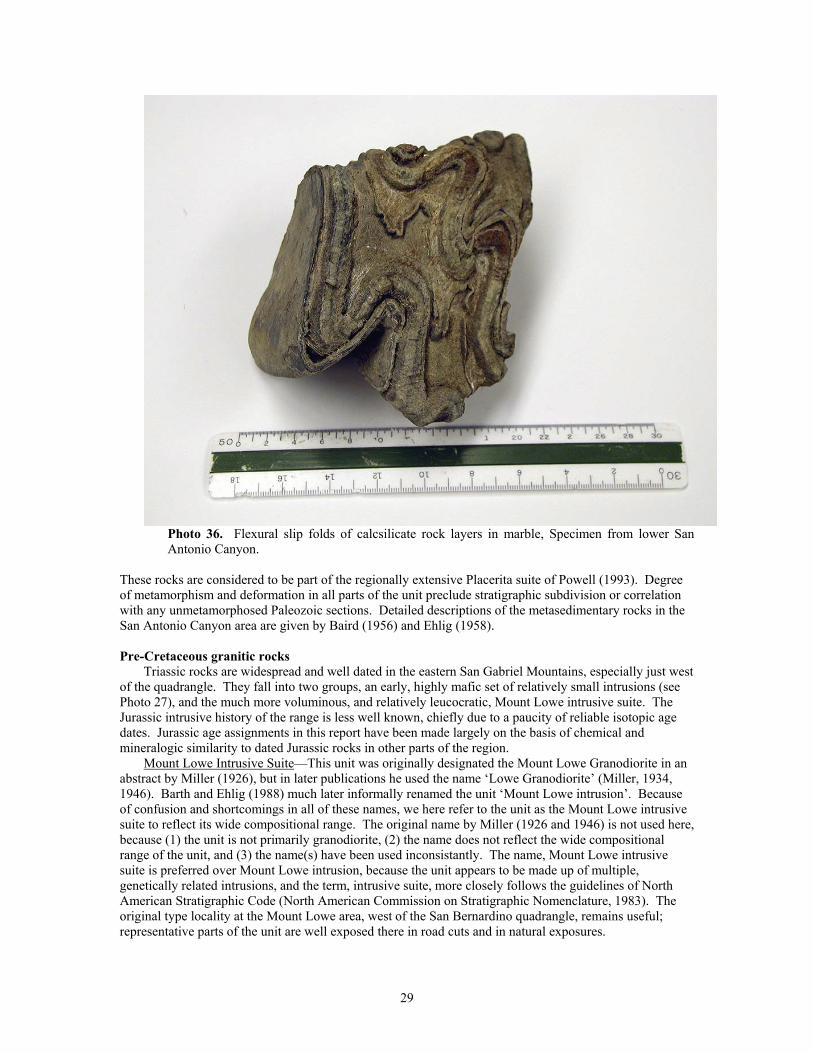
Photo 36. Flexural slip folds of calcsilicate rock layers in marble, Specimen from lower San Antonio Canyon.
These rocks are considered to be part of the regionally extensive Placerita suite of Powell (1993). Degree of metamorphism and deformation in all parts of the unit preclude stratigraphic subdivision or correlation with any unmetamorphosed Paleozoic sections. Detailed descriptions of the metasedimentary rocks in the San Antonio Canyon area are given by Baird (1956) and Ehlig (1958).
Pre-Cretaceous granitic rocks
Triassic rocks are widespread and well dated in the eastern San Gabriel Mountains, especially just west of the quadrangle. They fall into two groups, an early, highly mafic set of relatively small intrusions (see Photo 27), and the much more voluminous, and relatively leucocratic, Mount Lowe intrusive suite. The Jurassic intrusive history of the range is less well known, chiefly due to a paucity of reliable isotopic age dates. Jurassic age assignments in this report have been made largely on the basis of chemical and mineralogic similarity to dated Jurassic rocks in other parts of the region.
Mount Lowe Intrusive Suite—This unit was originally designated the Mount Lowe Granodiorite in an abstract by Miller (1926), but in later publications he used the name ‘Lowe Granodiorite’ (Miller, 1934, 1946). Barth and Ehlig (1988) much later informally renamed the unit ‘Mount Lowe intrusion’. Because of confusion and shortcomings in all of these names, we here refer to the unit as the Mount Lowe intrusive suite to reflect its wide compositional range. The original name by Miller (1926 and 1946) is not used here, because (1) the unit is not primarily granodiorite, (2) the name does not reflect the wide compositional range of the unit, and (3) the name(s) have been used inconsistantly. The name, Mount Lowe intrusive suite is preferred over Mount Lowe intrusion, because the unit appears to be made up of multiple, genetically related intrusions, and the term, intrusive suite, more closely follows the guidelines of North American Stratigraphic Code (North American Commission on Stratigraphic Nomenclature, 1983). The original type locality at the Mount Lowe area, west of the San Bernardino quadrangle, remains useful; representative parts of the unit are well exposed there in road cuts and in natural exposures.
29
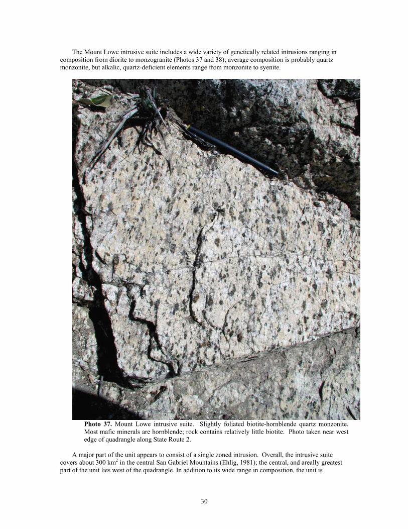
The Mount Lowe intrusive suite includes a wide variety of genetically related intrusions ranging in composition from diorite to monzogranite (Photos 37 and 38); average composition is probably quartz monzonite, but alkalic, quartz-deficient elements range from monzonite to syenite.
Photo 37. Mount Lowe intrusive suite. Slightly foliated biotite-hornblende quartz monzonite. Most mafic minerals are hornblende; rock contains relatively little biotite. Photo taken near west edge of quadrangle along State Route 2.
A major part of the unit appears to consist of a single zoned intrusion. Overall, the intrusive suite
covers about 300 km2 in the central San Gabriel Mountains (Ehlig, 1981); the central, and areally greatest part of the unit lies west of the quadrangle. In addition to its wide range in composition, the unit is
30
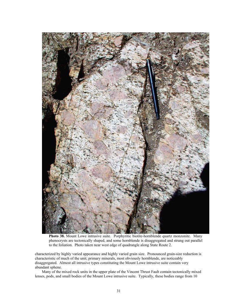
Photo 38. Mount Lowe intrusive suite. Porphyritic biotite-hornblende quartz monzonite. Many phenocrysts are tectonically shaped, and some hornblende is disaggregated and strung out parallel to the foliation. Photo taken near west edge of quadrangle along State Route 2.
characterized by highly varied appearance and highly varied grain size. Pronounced grain-size reduction is characteristic of much of the unit; primary minerals, most obviously hornblende, are noticeably disaggregated. Almost all intrusive types constituting the Mount Lowe intrusive suite contain very abundant sphene.
Many of the mixed rock units in the upper plate of the Vincent Thrust Fault contain tectonically mixed lenses, pods, and small bodies of the Mount Lowe intrusive suite. Typically, these bodies range from 10
31
cm to 5 m thick and from a few meters to several hundred meters long. Athough these bodies have been tectonically elongated, along with the granitic or metamorphic rocks they are intermixed with, they are thoroughly recrystallized and commonly do not exhibit an internal fabric commensurate with the degree of elongation. In places, these tectonically incorporated bodies make up more than ten percent by volume of the mixed unit.
Jurassic rocks—Rocks of inferred Jurassic age are limited in the San Gabriel Mountains, consisting of the quartz monzodiorite of Hutak Canyon (Jhc), the granodiorite and quartz monzonite of Fern Canyon (Jgf), and limited, very small occurrances of gabbro and pyroxenite (^Jgb) that could be Jurassic or Triassic. The quartz monzodiorite of Hutak Canyon is typically heterogeneous with respect to composition, grain size, and texture, but locally is homogeneous. Much of the unit is highly porphyritic, having phenocrysts up to 4 cm long. Hornblende is more abundant than biotite. Feldspars are typically much darker gray than those in Cretaceous granitic rocks, and potassium feldspar commonly has a distinct lavender hue. Phenocryst concentration and size, mafic ratio, feldspar color, and relatively low quartz content are characteristic features of very extensive, well dated Jurassic plutons found in the western and central parts of the Mojave Desert. The granodiorite and quartz monzonite of Fern Canyon shares many of the characteristics of Jurassic rocks in the region, but also contains very abundant pods of younger granitic rocks and included masses of older granitic and metamorphic rocks.
Cretaceous granitic rocks
Cretaceous granitic rocks are widespread in the eastern San Gabriel Mountains, even more so than suggested by the geologic map, because many of the mixed granitic-metamorphic units contain abundant granitic rocks of Cretaceous age. Composition ranges from tonalite to monzogranite, but tonalite is by far the most voluminous. Cretaceous granitic rocks in the San Gabriel Mountains differ from those in the San Bernardino Mountains and Mojave Desert by being more mafic, containing more hornblende and much less potassium feldspar, and commonly having a well developed planar fabric.
Much of the Cretaceous tonalite in the San Gabriel Mountains is gneissic or foliated, and mylonitic fabric and zones of well-developed mylonite are common (Photos 39, 40 and 41).
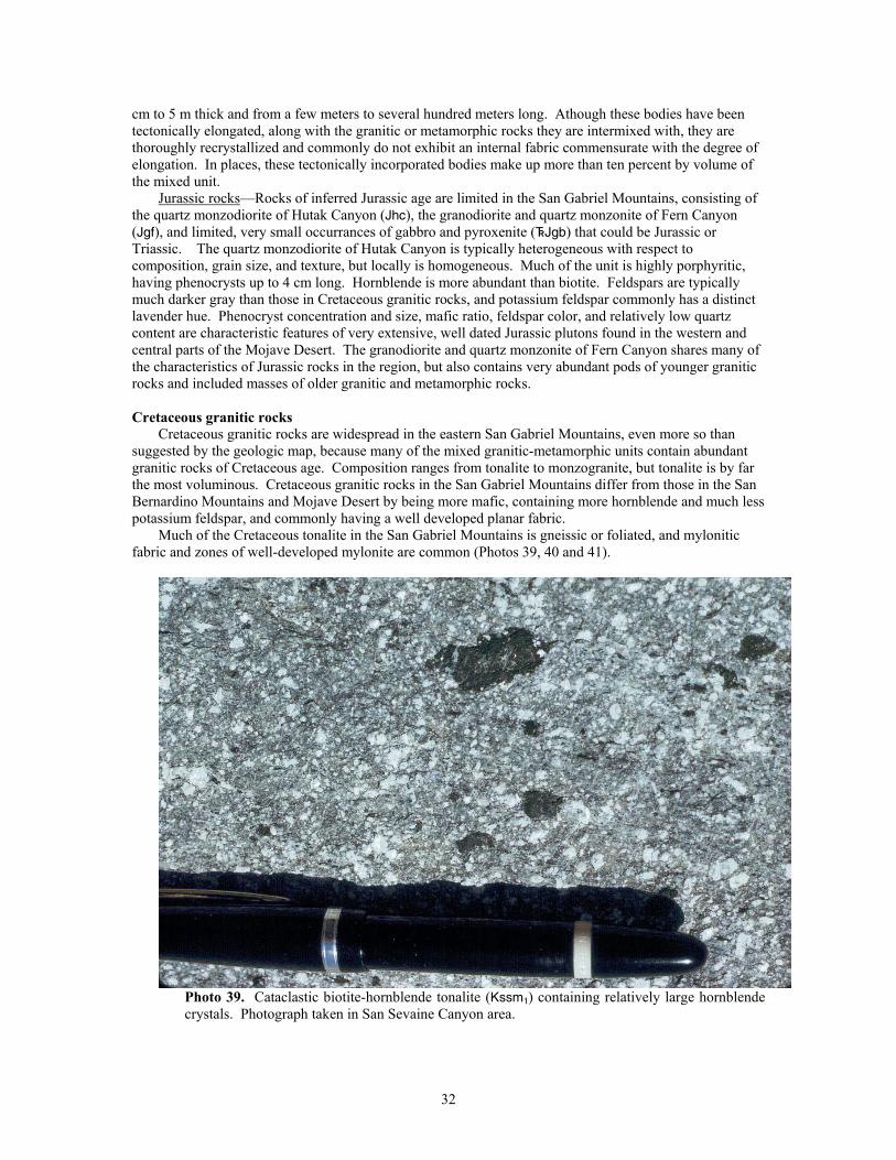
Photo 39. Cataclastic biotite-hornblende tonalite (Kssm1) containing relatively large hornblende crystals. Photograph taken in San Sevaine Canyon area.
32
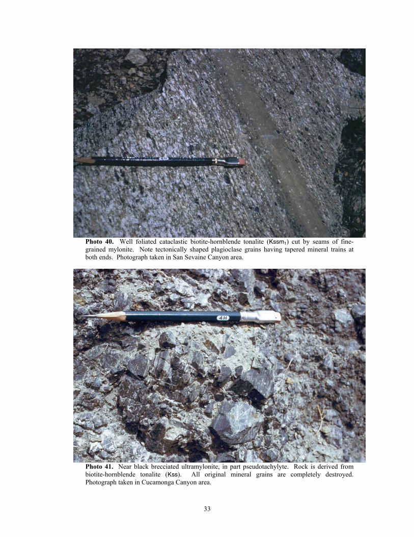
Photo 40. Well foliated cataclastic biotite-hornblende tonalite (Kssm1) cut by seams of fine-grained mylonite. Note tectonically shaped plagioclase grains having tapered mineral trains at both ends. Photograph taken in San Sevaine Canyon area.
Photo 41. Near black brecciated ultramylonite, in part pseudotachylyte. Rock is derived from biotite-hornblende tonalite (Kss). All original mineral grains are completely destroyed. Photograph taken in Cucamonga Canyon area.
33
The degree of mylonitic deformation in the range increases southward toward the mountain front where, in places, tonalite has been uniformly converted to zones of mylonite and mylonitic rock more than 300 m thick. Dikes and small masses of essentially undeformed biotite granodiorite and monzogranite (Kmg) that are late Cretaceous in age (about 78 Ma, May and Walker, 1989) intrude the deformed tonalite. Lenticular bodies of Cretaceous hornblende diorite, the Deer Diorite of Alf (1948) (Kdd), occur along the southern part of the mylonitized tonalitic rock.
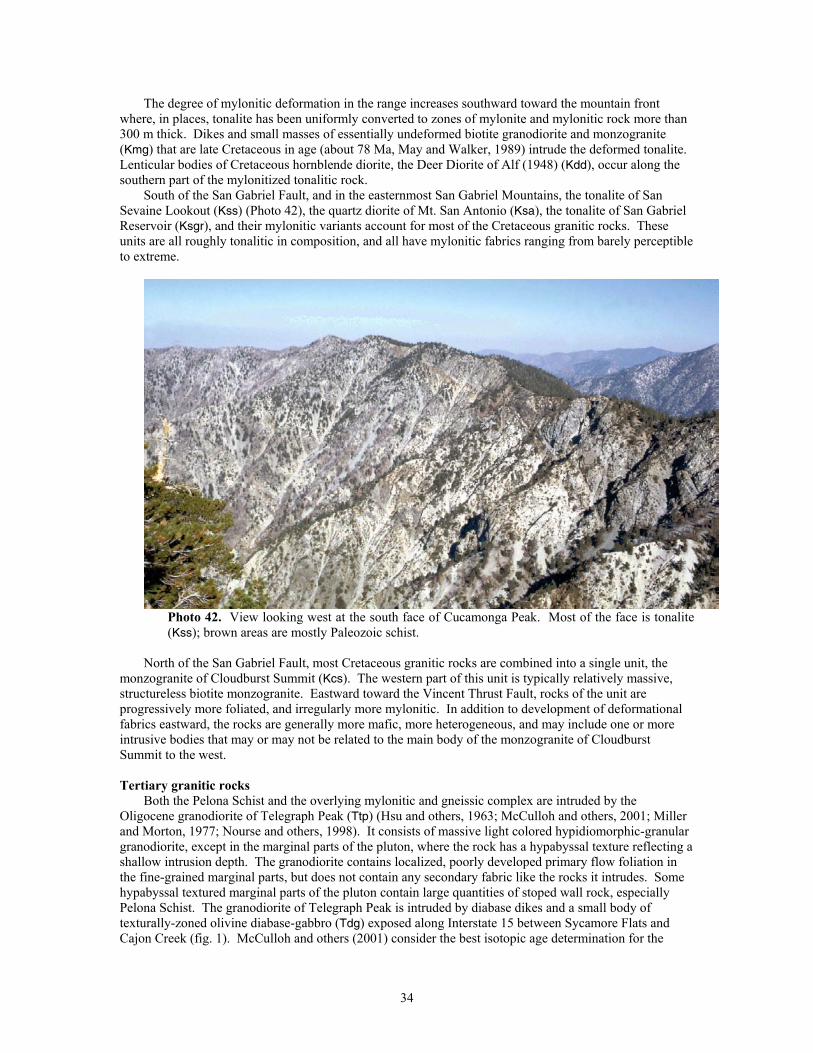
South of the San Gabriel Fault, and in the easternmost San Gabriel Mountains, the tonalite of San Sevaine Lookout (Kss) (Photo 42), the quartz diorite of Mt. San Antonio (Ksa), the tonalite of San Gabriel Reservoir (Ksgr), and their mylonitic variants account for most of the Cretaceous granitic rocks. These units are all roughly tonalitic in composition, and all have mylonitic fabrics ranging from barely perceptible to extreme.
Photo 42. View looking west at the south face of Cucamonga Peak. Most of the face is tonalite (Kss); brown areas are mostly Paleozoic schist.
North of the San Gabriel Fault, most Cretaceous granitic rocks are combined into a single unit, the
monzogranite of Cloudburst Summit (Kcs). The western part of this unit is typically relatively massive, structureless biotite monzogranite. Eastward toward the Vincent Thrust Fault, rocks of the unit are progressively more foliated, and irregularly more mylonitic. In addition to development of deformational fabrics eastward, the rocks are generally more mafic, more heterogeneous, and may include one or more intrusive bodies that may or may not be related to the main body of the monzogranite of Cloudburst Summit to the west.
Tertiary granitic rocks
Both the Pelona Schist and the overlying mylonitic and gneissic complex are intruded by the Oligocene granodiorite of Telegraph Peak (Ttp) (Hsu and others, 1963; McCulloh and others, 2001; Miller and Morton, 1977; Nourse and others, 1998). It consists of massive light colored hypidiomorphic-granular granodiorite, except in the marginal parts of the pluton, where the rock has a hypabyssal texture reflecting a shallow intrusion depth. The granodiorite contains localized, poorly developed primary flow foliation in the fine-grained marginal parts, but does not contain any secondary fabric like the rocks it intrudes. Some hypabyssal textured marginal parts of the pluton contain large quantities of stoped wall rock, especially Pelona Schist. The granodiorite of Telegraph Peak is intruded by diabase dikes and a small body of texturally-zoned olivine diabase-gabbro (Tdg) exposed along Interstate 15 between Sycamore Flats and Cajon Creek (fig. 1). McCulloh and others (2001) consider the best isotopic age determination for the
34
granodiorite to be 26.3 Ma. Hornblende from a diabase dike cutting the Telegraph Peak pluton near Telegraph Peak yielded a K/Ar age of 9.3 Ma.
Tertiary volcanic and sedimentary rocks
Tertiary volcanic and sedimentary rocks are widespread and highly varied in the San Gabriel Mountains assemblage. Almost all are highly disrupted by faults related to the San Andreas Fault system or the thrust and reverse faults along the southern margin of the San Gabriel Mountains. Several units occur only as small areas of outcrop that are not large enough to show on the 1:100,000 scale map plot, but can be located in the digital map coverage, or by making enlarged plots of specific parts of the coverage.
The Glendora Volcanics (Shelton, 1955) are a heterogeneous, highly faulted and redistributed group of Miocene volcanic and volcaniclastic rocks located in the southern foothills of the San Gabriel Mountains and in the San Jose and Puente Hills south of the mountains. These rocks range in composition from rhyolite to basalt, and from flow rock to volcanic breccia and tuff. The upper part of the unit appears to interfinger with the lower part of the overlying Miocene sedimentary rocks of Azusa area (Taz). Other than a variety of hypabyssal dike rocks, the Glendora Volcanics are the only Tertiary volcanic rocks in the San Gabriel Mountains assemblage on the south side of the range.
The sedimentary rocks overlying the Glendora Volcanics in the Azusa area form a sequence of marine sandstone, siltstone, shale, and conglomerate that is also highly faulted, and is here referred to informally as the sedimentary rocks of the Azusa area (Taz). Previously these rocks were correlated with the Topanga Formation (Shelton, 1955; Morton, 1973), which, in the Los Angeles Basin, is primarily recognized on the basis of middle Miocene micro-and megafossil assemblages. To develop a lithostratigraphic framework for rocks included in the type area of the Topanga (Kew, 1923, 1924), Yerkes and Campbell (1979) elevated the Topanga Formation to the Topanga Group, which in the Santa Monica Mountains, includes three formations. From oldest to youngest, the Topanga Group in the Santa Monica Mountains consists of the Topanga Canyon Formation that includes Kew’s type locality, the Conejo Volcanics, and the Calabasas Formation. It is not clear if any of these formations defined by Campbell and Yerkes are present in the San Bernardino quadrangle. Based on their position overlying the Glendora Volcanics, however, the sedimentary rocks of the Azusa area may be correlative with the Calabasas Formation. Because regional correlations and nomenclature of lithostraticgraphic units within the Topanga Goup have not been resolved we here use the informal name, sedimentary rocks of the Azusa area, for these rocks.
The sedimentary rocks of the Azusa area are overlain by the Miocene Puente Formation (Tp), which thickens to the south and west. The Puente Formation is chiefly marine sandstone, siltstone, and shale, and was one of the most important oil producing units in the Los Angeles basin.
On the north side of the San Gabriel Mountains, the marine, Paleocene San Francisquito Formation (Tsf) is located between the San Andreas and Punchbowl Faults. It consists mainly of sandstone, conglomeratic sandstone, conglomerate, and shale, and rests nonconformably on Mesozoic granitic rocks (Koozer, 1980, 1982). The lower part of the San Francisquito Formation includes well stratified, regularly bedded sandstone and conglomerate (Photos 43 and 44). The upper part of the section is fine-grained (Photo 45) and includes sheared and deformed shale containing disrupted sandstone beds (Photos 46 and 47). The San Francisquito Formation contains Turritela pacheocoences, a Paleocene guide fossil. The Punchbowl Fault truncates the southern extent of the San Francisquito Formation (Photo 48).
35
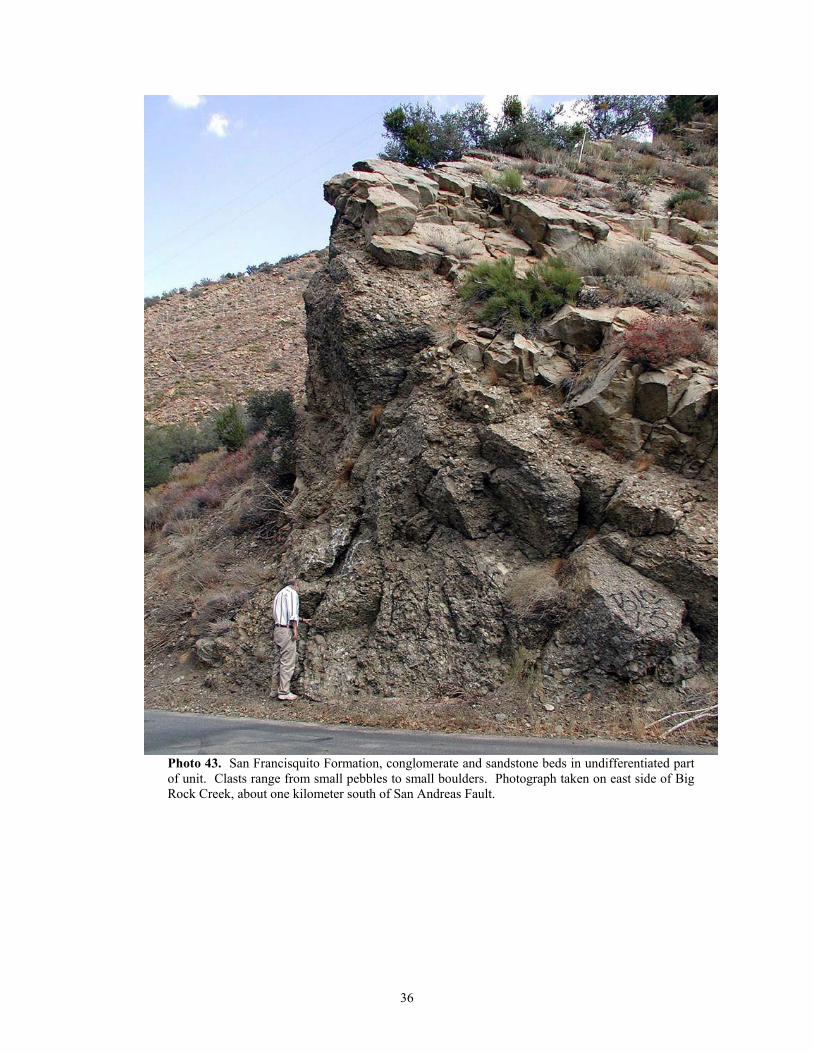
Photo 43. San Francisquito Formation, conglomerate and sandstone beds in undifferentiated part of unit. Clasts range from small pebbles to small boulders. Photograph taken on east side of Big Rock Creek, about one kilometer south of San Andreas Fault.
36
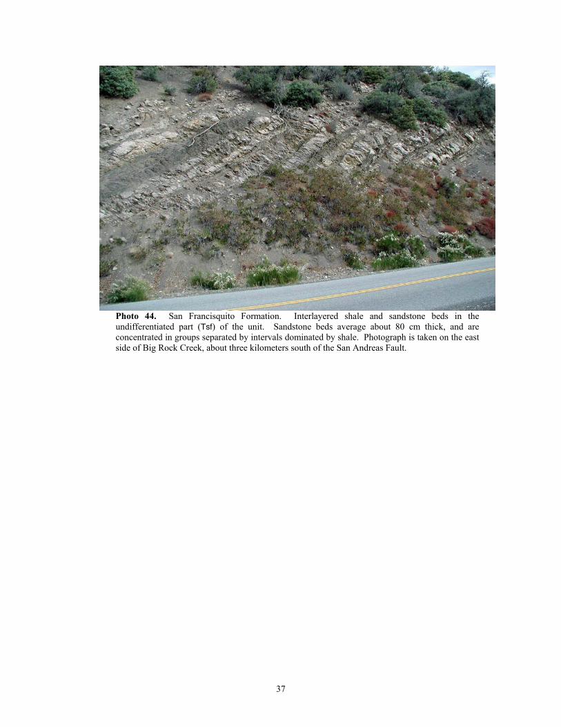
Photo 44. San Francisquito Formation. Interlayered shale and sandstone beds in the undifferentiated part (Tsf) of the unit. Sandstone beds average about 80 cm thick, and are concentrated in groups separated by intervals dominated by shale. Photograph is taken on the east side of Big Rock Creek, about three kilometers south of the San Andreas Fault.
37
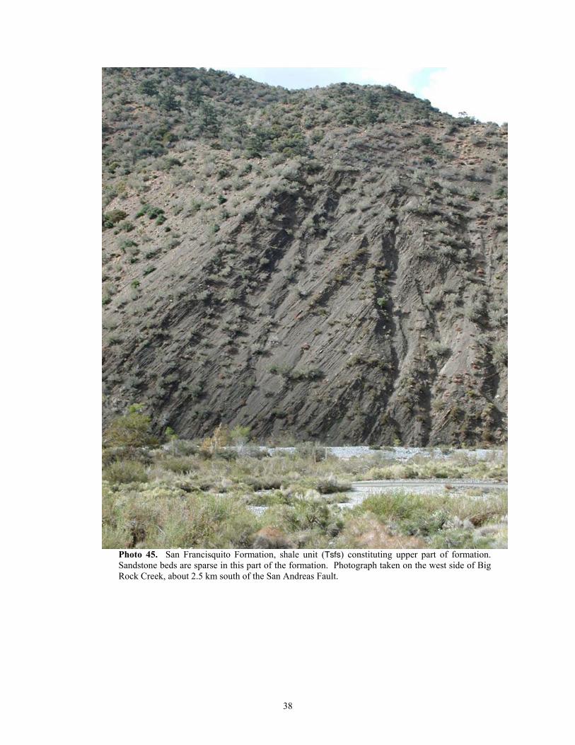
Photo 45. San Francisquito Formation, shale unit (Tsfs) constituting upper part of formation. Sandstone beds are sparse in this part of the formation. Photograph taken on the west side of Big Rock Creek, about 2.5 km south of the San Andreas Fault.
38
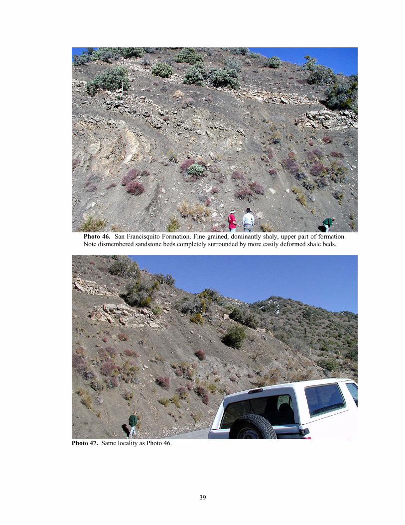
Photo 46. San Francisquito Formation. Fine-grained, dominantly shaly, upper part of formation. Note dismembered sandstone beds completely surrounded by more easily deformed shale beds.
Photo 47. Same locality as Photo 46.
39
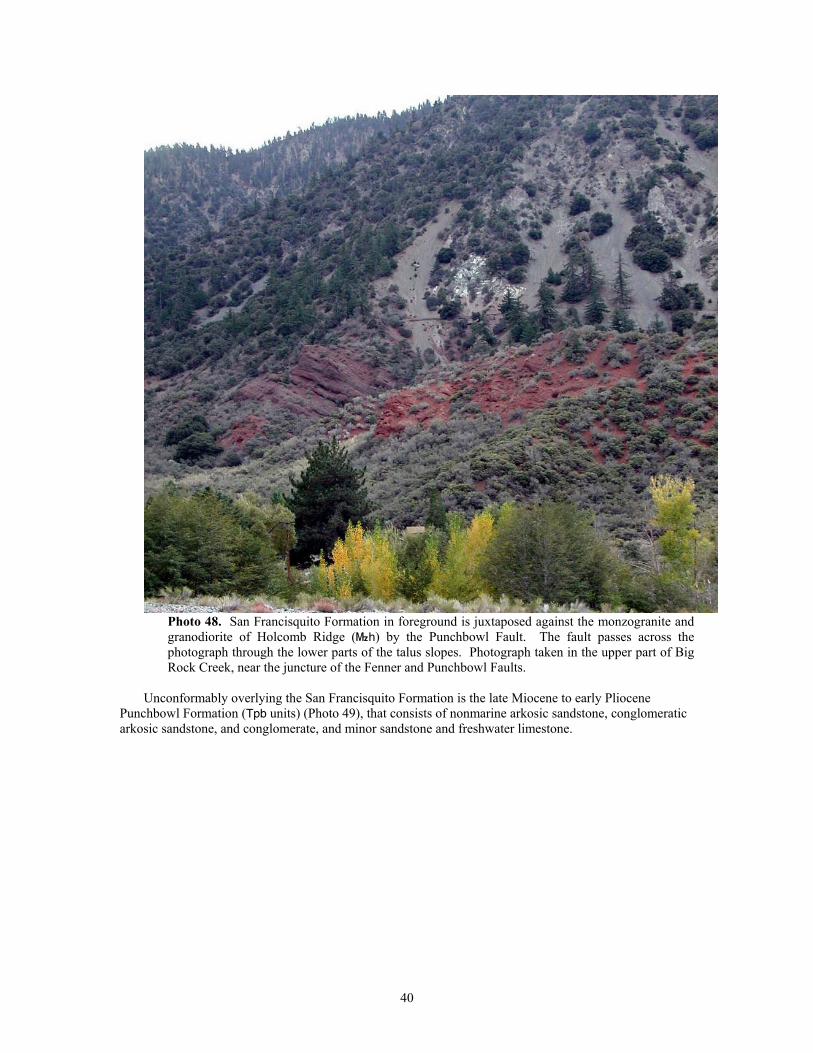
Photo 48. San Francisquito Formation in foreground is juxtaposed against the monzogranite and granodiorite of Holcomb Ridge (}h) by the Punchbowl Fault. The fault passes across the photograph through the lower parts of the talus slopes. Photograph taken in the upper part of Big Rock Creek, near the juncture of the Fenner and Punchbowl Faults.
Unconformably overlying the San Francisquito Formation is the late Miocene to early Pliocene
Punchbowl Formation (Tpb units) (Photo 49), that consists of nonmarine arkosic sandstone, conglomeratic arkosic sandstone, and conglomerate, and minor sandstone and freshwater limestone.
40
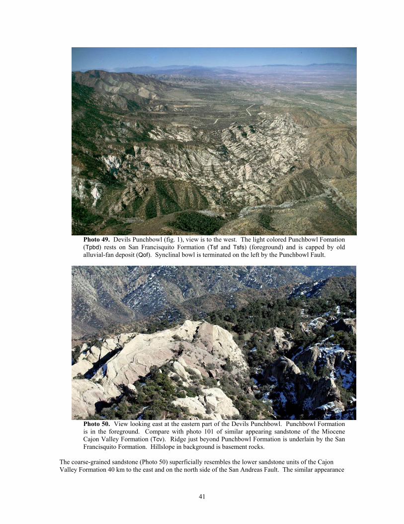
Photo 49. Devils Punchbowl (fig. 1), view is to the west. The light colored Punchbowl Fomation (Tpbd) rests on San Francisquito Formation (Tsf and Tsfs) (foreground) and is capped by old alluvial-fan deposit (Qof). Synclinal bowl is terminated on the left by the Punchbowl Fault.
Photo 50. View looking east at the eastern part of the Devils Punchbowl. Punchbowl Formation is in the foreground. Compare with photo 101 of similar appearing sandstone of the Miocene Cajon Valley Formation (Tcv). Ridge just beyond Punchbowl Formation is underlain by the San Francisquito Formation. Hillslope in background is basement rocks.
The coarse-grained sandstone (Photo 50) superficially resembles the lower sandstone units of the Cajon Valley Formation 40 km to the east and on the north side of the San Andreas Fault. The similar appearance
41
of these two sandstone units led to their specious correlation, and limited the offset on this segment of the San Andreas Fault to an impossibly small 40 km.
South of the Punchbowl Fault, and not in contact with either the San Francisquito Formation or the Punchbowl Formation, are several noncontiguous areas of Vasquez Formation, which in this area consists of andesite, ranging to basalt (Tvv), and containing minor tuffaceous rocks (Tvt). The Quaternary-Tertiary Juniper Hills Formation (Barrows, 1987) is found on both sides of the San Andreas and Punchbowl Faults. It is a highly varied nonmarine unit. Its lithology and physical characteristics vary widely, and at any given locality are a reflection of localized source materials being shed into specific areas of sediment accumulation.
Quaternary geology and landslides
The Quaternary sedimentary history associated with the San Gabriel Mountains assemblage is largely recorded in the area surrounding the assemblage, and not within the area encompassed by the assemblage itself. Uplift and dissection of the eastern San Gabriel Mountains is reflected in the complex array of alluvial deposits emanating from the range, so even though most of these fans lie on basement of other assemblages, they are also included here.
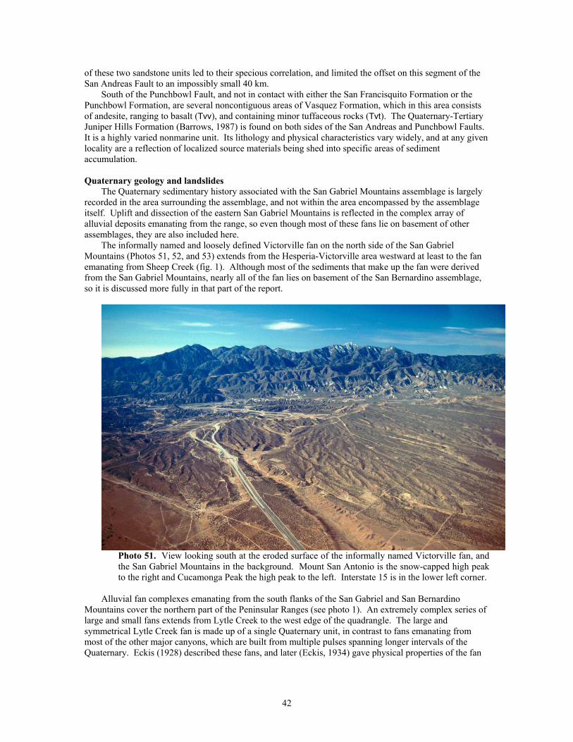
The informally named and loosely defined Victorville fan on the north side of the San Gabriel Mountains (Photos 51, 52, and 53) extends from the Hesperia-Victorville area westward at least to the fan emanating from Sheep Creek (fig. 1). Although most of the sediments that make up the fan were derived from the San Gabriel Mountains, nearly all of the fan lies on basement of the San Bernardino assemblage, so it is discussed more fully in that part of the report.
Photo 51. View looking south at the eroded surface of the informally named Victorville fan, and the San Gabriel Mountains in the background. Mount San Antonio is the snow-capped high peak to the right and Cucamonga Peak the high peak to the left. Interstate 15 is in the lower left corner.
Alluvial fan complexes emanating from the south flanks of the San Gabriel and San Bernardino Mountains cover the northern part of the Peninsular Ranges (see photo 1). An extremely complex series of large and small fans extends from Lytle Creek to the west edge of the quadrangle. The large and symmetrical Lytle Creek fan is made up of a single Quaternary unit, in contrast to fans emanating from most of the other major canyons, which are built from multiple pulses spanning longer intervals of the Quaternary. Eckis (1928) described these fans, and later (Eckis, 1934) gave physical properties of the fan
42
deposits. East of the Lytle Creek Fault at the west side of the mouth of Lytle Creek, an abandoned channel was hydraulic mined for placer gold (Photo 54).
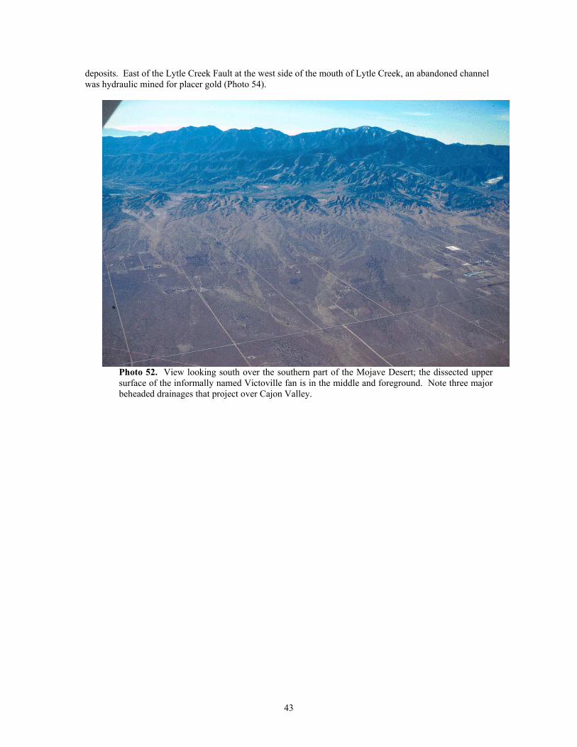
Photo 52. View looking south over the southern part of the Mojave Desert; the dissected upper surface of the informally named Victoville fan is in the middle and foreground. Note three major beheaded drainages that project over Cajon Valley.
43
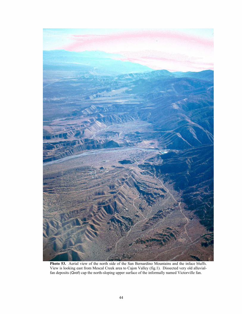
Photo 53. Aerial view of the north side of the San Bernardino Mountains and the inface bluffs. View is looking east from Mescal Creek area to Cajon Valley (fig.1). Dissected very old alluvial-fan deposits (Qvof) cap the north-sloping upper surface of the informally named Victorville fan.
44
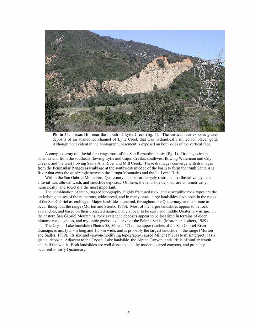
Photo 54. Texas Hill near the mouth of Lytle Creek (fig. 1). The vertical face exposes gravel deposits of an abandoned channel of Lytle Creek that was hydraulically mined for placer gold. Although not evident in the photograph, basement is exposed on both sides of the vertical face.
A complex array of alluvial fans rings most of the San Bernardino basin (fig. 1). Drainages in the
basin extend from the southeast flowing Lytle and Cajon Creeks, southwest flowing Waterman and City Creeks, and the west flowing Santa Ana River and Mill Creek. These drainages converge with drainages from the Peninsular Ranges assemblage at the southwestern edge of the basin to form the trunk Santa Ana River that exits the quadrangle between the Jurupa Mountains and the La Loma Hills.
Within the San Gabriel Mountains, Quaternary deposits are largely restricted to alluvial valley, small alluvial-fan, alluvial wash, and landslide deposits. Of these, the landslide deposits are volumetrically, numerically, and societally the most important.
The combination of steep, rugged topography, highly fractured rock, and susceptible rock types are the underlying causes of the numerous, widespread, and in many cases, large landslides developed in the rocks of the San Gabriel assemblage. Major landslides occurred, throughout the Quaternary, and continue to occur thoughout the range (Morton and Streitz, 1969). Most of the larger landslides appear to be rock avalanches, and based on their dissected nature, many appear to be early and middle Quaternary in age. In the eastern San Gabriel Mountains, rock avalanche deposits appear to be localized in terrains of older plutonic rocks, gneiss, and mylonitic gneiss, exclusive of the Pelona Schist (Morton and others, 1989).
The Crystal Lake landslide (Photos 55, 56, and 57) in the upper reaches of the San Gabriel River drainage, is nearly 5 km long and 1.5 km wide, and is probably the largest landslide in the range (Morton and Sadler, 1989). Its size and canyon-modifying topography caused Miller (1926a) to misinterpret it as a glacial deposit. Adjacent to the Crystal Lake landslide, the Alpine Canyon landslide is of similar length and half the width. Both landslides are well dissected, cut by moderate sized canyons, and probably occurred in early Quaternary.
45
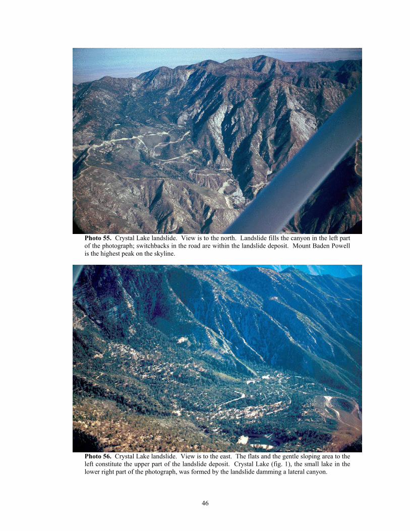
Photo 55. Crystal Lake landslide. View is to the north. Landslide fills the canyon in the left part of the photograph; switchbacks in the road are within the landslide deposit. Mount Baden Powell is the highest peak on the skyline.
Photo 56. Crystal Lake landslide. View is to the east. The flats and the gentle sloping area to the left constitute the upper part of the landslide deposit. Crystal Lake (fig. 1), the small lake in the lower right part of the photograph, was formed by the landslide damming a lateral canyon.
46
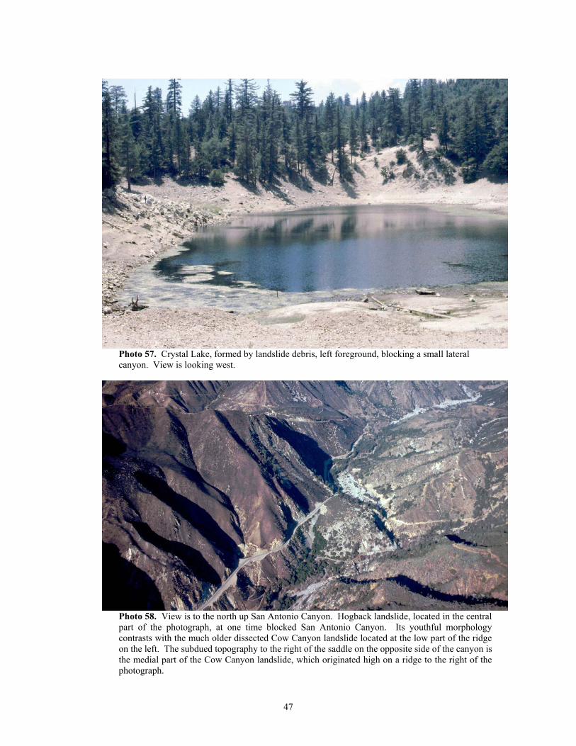
Photo 57. Crystal Lake, formed by landslide debris, left foreground, blocking a small lateral canyon. View is looking west.
Photo 58. View is to the north up San Antonio Canyon. Hogback landslide, located in the central part of the photograph, at one time blocked San Antonio Canyon. Its youthful morphology contrasts with the much older dissected Cow Canyon landslide located at the low part of the ridge on the left. The subdued topography to the right of the saddle on the opposite side of the canyon is the medial part of the Cow Canyon landslide, which originated high on a ridge to the right of the photograph.
47
Landslides appear to be responsible for alterations of major drainage patterns in the San Gabriel
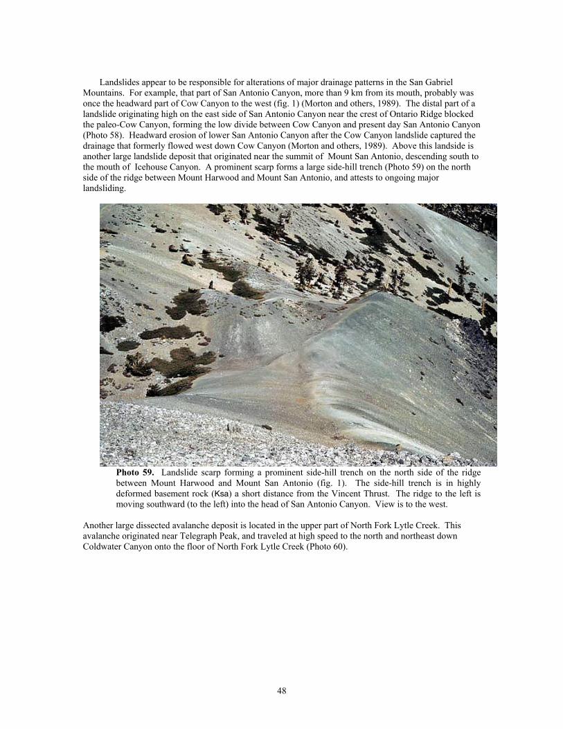
Mountains. For example, that part of San Antonio Canyon, more than 9 km from its mouth, probably was once the headward part of Cow Canyon to the west (fig. 1) (Morton and others, 1989). The distal part of a landslide originating high on the east side of San Antonio Canyon near the crest of Ontario Ridge blocked the paleo-Cow Canyon, forming the low divide between Cow Canyon and present day San Antonio Canyon (Photo 58). Headward erosion of lower San Antonio Canyon after the Cow Canyon landslide captured the drainage that formerly flowed west down Cow Canyon (Morton and others, 1989). Above this landside is another large landslide deposit that originated near the summit of Mount San Antonio, descending south to the mouth of Icehouse Canyon. A prominent scarp forms a large side-hill trench (Photo 59) on the north side of the ridge between Mount Harwood and Mount San Antonio, and attests to ongoing major landsliding.
Photo 59. Landslide scarp forming a prominent side-hill trench on the north side of the ridge between Mount Harwood and Mount San Antonio (fig. 1). The side-hill trench is in highly deformed basement rock (Ksa) a short distance from the Vincent Thrust. The ridge to the left is moving southward (to the left) into the head of San Antonio Canyon. View is to the west.
Another large dissected avalanche deposit is located in the upper part of North Fork Lytle Creek. This avalanche originated near Telegraph Peak, and traveled at high speed to the north and northeast down Coldwater Canyon onto the floor of North Fork Lytle Creek (Photo 60).
48
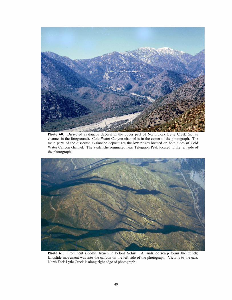
Photo 60. Dissected avalanche deposit in the upper part of North Fork Lytle Creek (active channel in the foreground). Cold Water Canyon channel is in the center of the photograph. The main parts of the dissected avalanche deposit are the low ridges located on both sides of Cold Water Canyon channel. The avalanche originated near Telegraph Peak located to the left side of the photograph.
Photo 61. Prominent side-hill trench in Pelona Schist. A landslide scarp forms the trench; landslide movement was into the canyon on the left side of the photograph. View is to the east. North Fork Lytle Creek is along right edge of photograph.
49
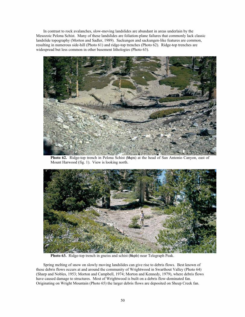
In contrast to rock avalanches, slow-moving landslides are abundant in areas underlain by the Mesozoic Pelona Schist. Many of these landslides are foliation-plane failures that commonly lack classic landslide topography (Morton and Sadler, 1989). Sackungen and sackungen-like features are common, resulting in numerous side-hill (Photo 61) and ridge-top trenches (Photo 62). Ridge-top trenches are widespread but less common in other basement lithologies (Photo 63).
Photo 62. Ridge-top trench in Pelona Schist (}ps) at the head of San Antonio Canyon, east of Mount Harwood (fig. 1). View is looking north.
Photo 63. Ridge-top trench in gneiss and schist (}pb) near Telegraph Peak.
Spring melting of snow on slowly moving landslides can give rise to debris flows. Best known of
these debris flows occurs at and around the community of Wrightwood in Swarthout Valley (Photo 64) (Sharp and Nobles, 1953; Morton and Campbell, 1974; Morton and Kennedy, 1979), where debris flows have caused damage to structures. Most of Wrightwood is built on a debris flow-dominated fan. Originating on Wright Mountain (Photo 65) the larger debris flows are deposited on Sheep Creek fan.
50
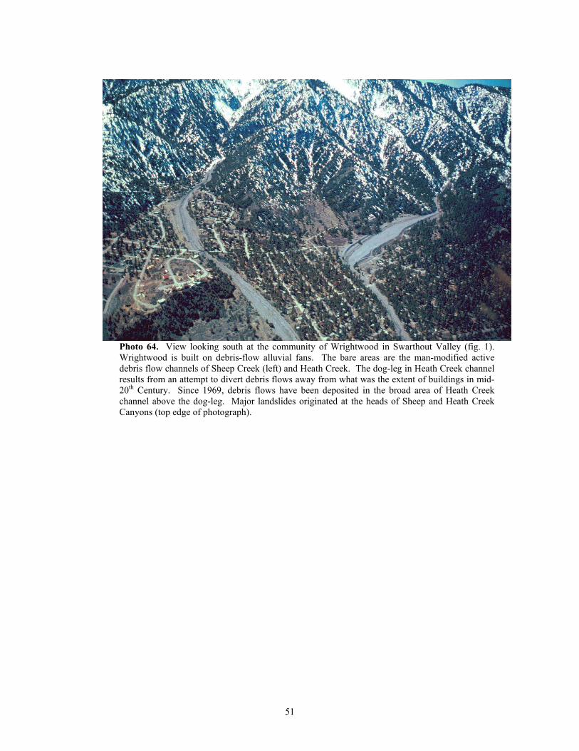
Photo 64. View looking south at the community of Wrightwood in Swarthout Valley (fig. 1). Wrightwood is built on debris-flow alluvial fans. The bare areas are the man-modified active debris flow channels of Sheep Creek (left) and Heath Creek. The dog-leg in Heath Creek channel results from an attempt to divert debris flows away from what was the extent of buildings in mid-20th Century. Since 1969, debris flows have been deposited in the broad area of Heath Creek channel above the dog-leg. Major landslides originated at the heads of Sheep and Heath Creek Canyons (top edge of photograph).
51
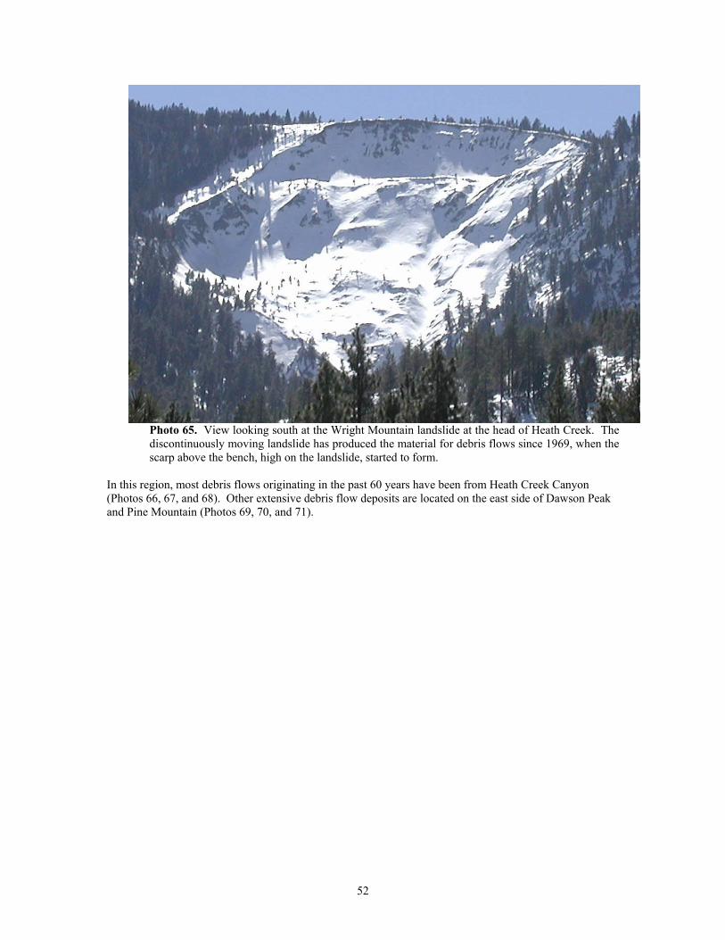
Photo 65. View looking south at the Wright Mountain landslide at the head of Heath Creek. The discontinuously moving landslide has produced the material for debris flows since 1969, when the scarp above the bench, high on the landslide, started to form.
In this region, most debris flows originating in the past 60 years have been from Heath Creek Canyon (Photos 66, 67, and 68). Other extensive debris flow deposits are located on the east side of Dawson Peak and Pine Mountain (Photos 69, 70, and 71).
52
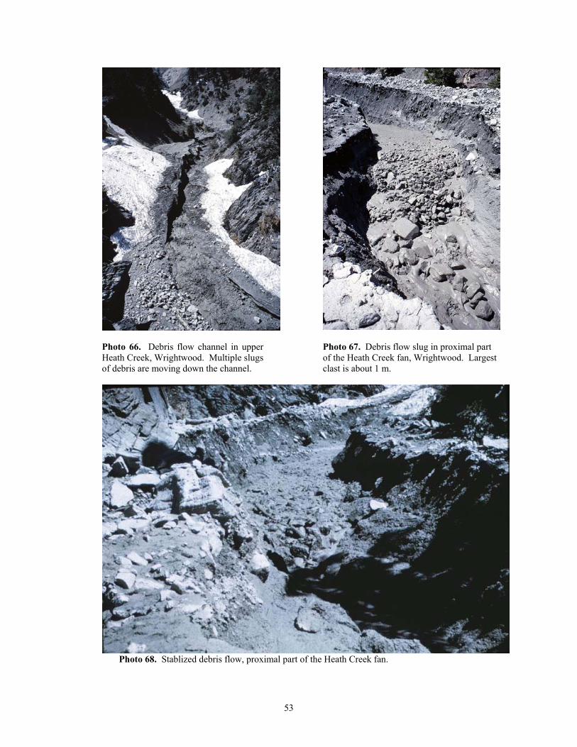
Photo 66. Debris flow channel in upper Heath Creek, Wrightwood. Multiple slugs of debris are moving down the channel.
Photo 67. Debris flow slug in proximal part of the Heath Creek fan, Wrightwood. Largest clast is about 1 m.
Photo 68. Stablized debris flow, proximal part of the Heath Creek fan.
53
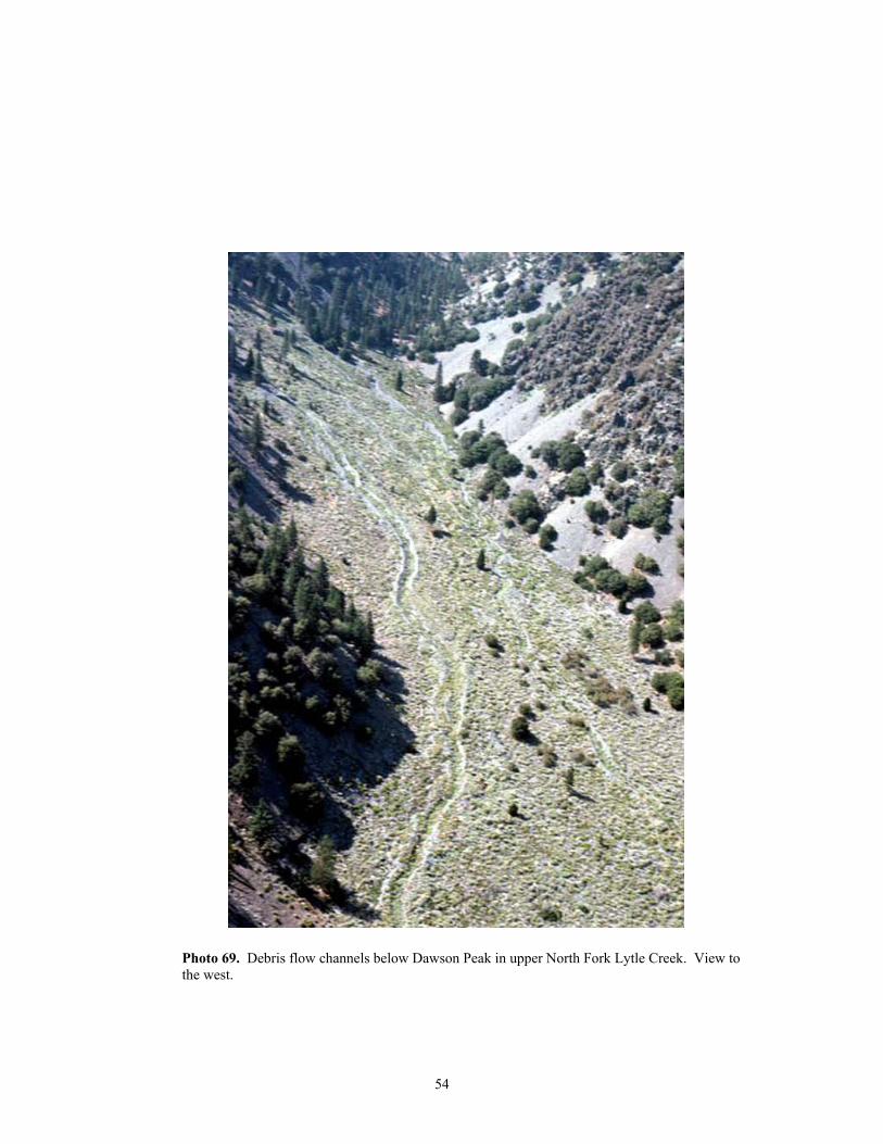
Photo 69. Debris flow channels below Dawson Peak in upper North Fork Lytle Creek. View to the west.
54
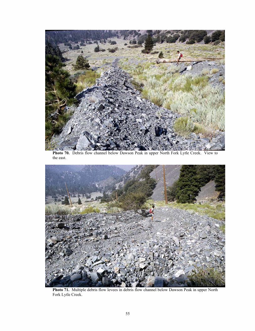
Photo 70. Debris flow channel below Dawson Peak in upper North Fork Lytle Creek. View to the east.
Photo 71. Multiple debris flow levees in debris flow channel below Dawson Peak in upper North Fork Lytle Creek.
55
ROCKS BOUNDED BY THE MILL CREEK FAULT AND THE SAN ANDREAS FAULT Crystalline basement rocks and overlying Tertiary sedimentary rocks between the Mill Creek Fault and
the main trace of the San Andreas Fault Zone are here treated as a separate basement entity, because: (1) the bounding faults, which are both segments of the San Andreas Fault system, appear to have controlled the site, configuration, and sediment sources for the depositional basin of the sedimentary rocks, (2) the crystalline rocks are gneissose to foliated granodiorite and massive diorite to monzogranite granitic rocks (Matti and others, 1983, 1992b) that are unique in the quadrangle, and (3) the structural block contains a third fault, the Wilson Creek Fault, that is considered to be an older strand of the San Andreas Fault system.
Crystalline rocks of this basement assemblage are similar to rocks in the Little San Bernardino Mountains to the southeast, and appear to have been displaced about 50 km by the Wilson Creek and Mill Creek Faults of the San Andreas Fault system (Matti and Morton, 1993). These rocks range from highly deformed gneiss (gg) (Photo 80) of unknown age to relatively undeformed Mesozoic biotite-hornblende diorite (}c).
In the lower part of Mill Creek a thick section of sedimentary rocks lies between the San Andreas Fault and the Wilson Creek Fault. These and similar rocks between the Wilson Creek Fault and the Mill Creek Fault were first described by Vaughan (1922), who named them the Potato Sandstone. This name was also used by Smith (1959) and was extended by Dibblee (1964, 1970, 1973) to include a variety of sedimentary rocks adjacent to the San Andreas Fault Zone from Mill Creek northwestward to Waterman Canyon. The sedimentary rocks south of the Wilson Creek Fault (Yucaipa Ridge Fault of Sadler and others, 1993) and north of the San Andreas Fault were termed Mill Creek Formation by Owens (1959) and were more fully described by Gibson (1964 and 1971). The usage of the name Mill Creek Formation has been relatively consistent since Gibson (1971) (e.g., Dibblee, 1982; Sadler and others, 1993), and the unit is here referred to as the Mill Creek formation of Gibson (1971).
The Mill Creek formation of Gibson (1971) apparently was deposited in a late Miocene pull-apart basin, into which most, but not all, of the sediments entered from the northwest (Sadler and others, 1993). Stratigraphy within this basin is characterized by extreme sedimentary facies changes over short distances. Sadler and others (1993) recognized at least five mappable facies which, with slight modifications, are included in the geologic map of the San Bernardino quadrangle. A thick sandstone unit (Tms) (Photos 72 and 73) that contains turbidite structures (Photos 74 and 75) is well exposed along State Route 38 which follows Mill Creek Canyon. The formation also includes a distinctive basal conglomerate (Tmcp) (Photo 76) at the entrance to Mill Creek Canyon that is characterized by a large proportion of Pelona Schist clasts (Photo 77), and had a
56
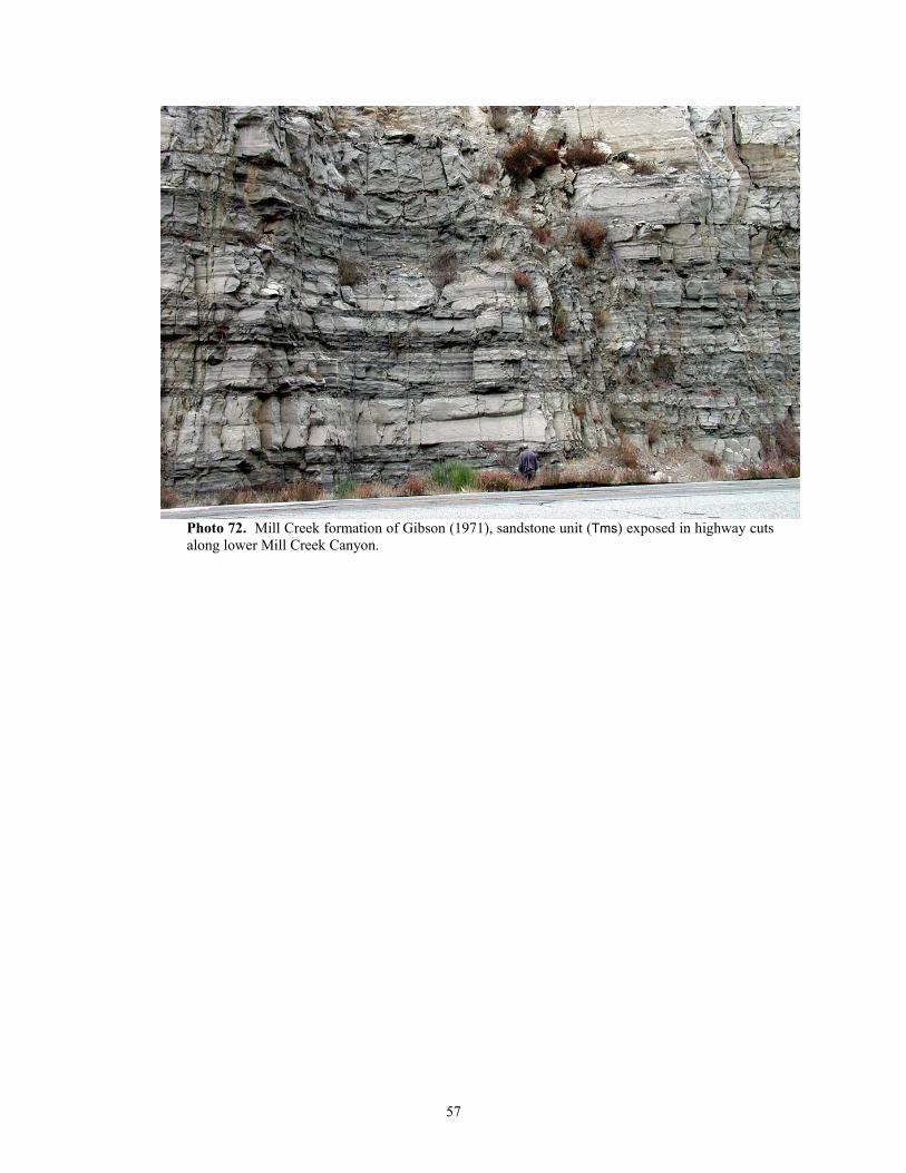
Photo 72. Mill Creek formation of Gibson (1971), sandstone unit (Tms) exposed in highway cuts along lower Mill Creek Canyon.
57
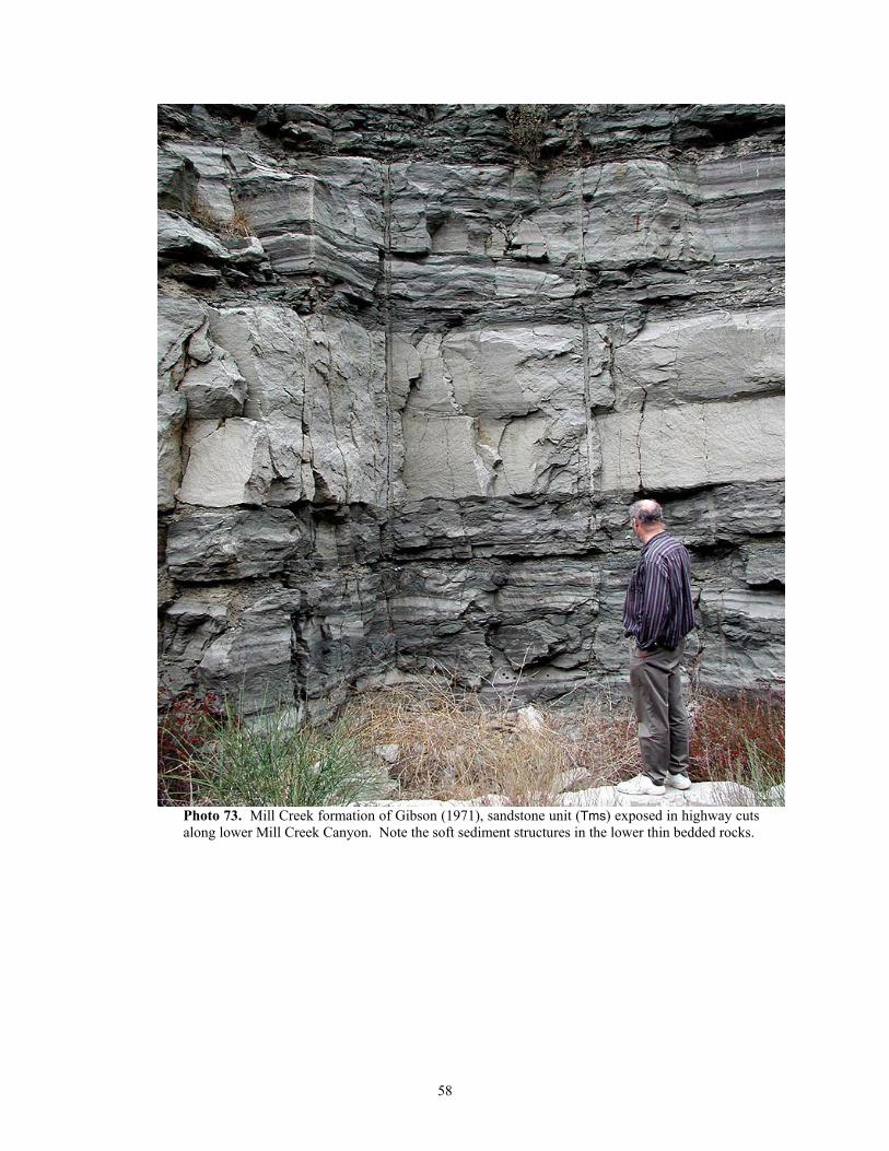
Photo 73. Mill Creek formation of Gibson (1971), sandstone unit (Tms) exposed in highway cuts along lower Mill Creek Canyon. Note the soft sediment structures in the lower thin bedded rocks.
58
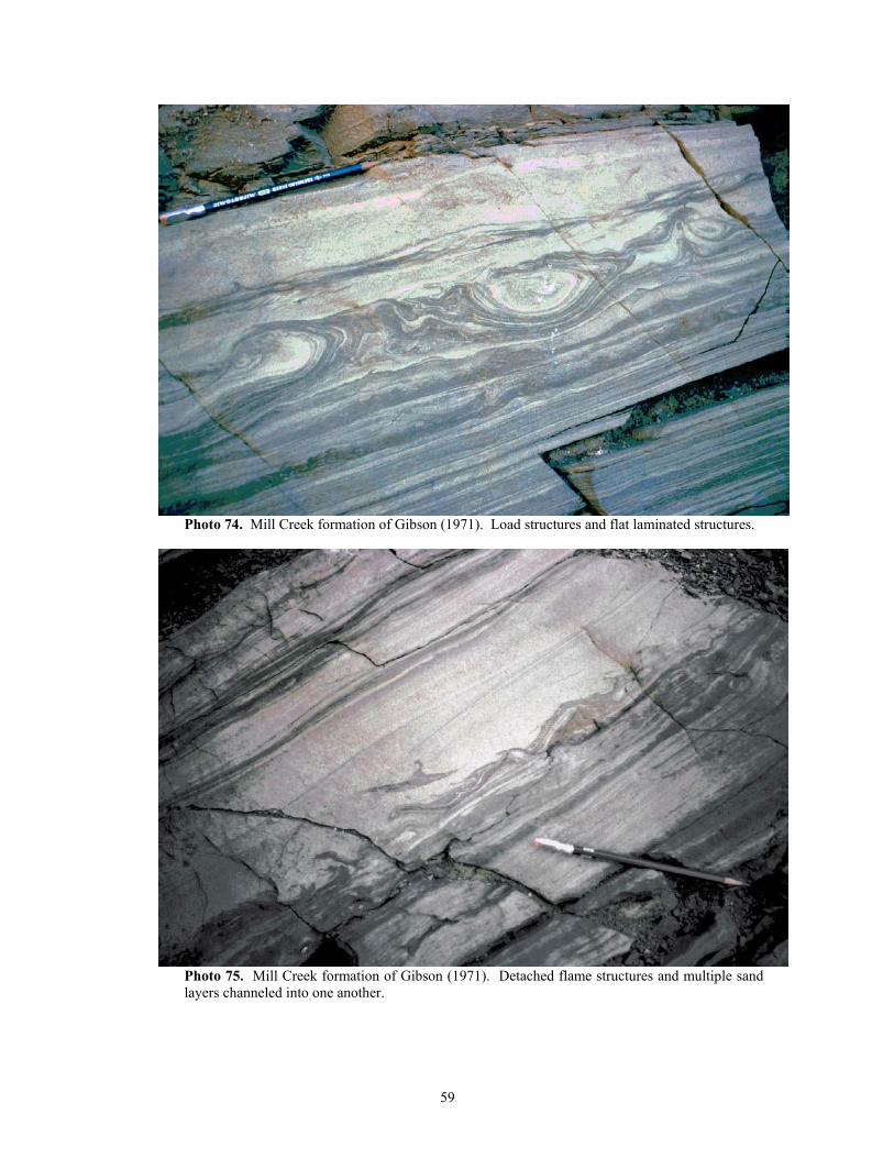
Photo 74. Mill Creek formation of Gibson (1971). Load structures and flat laminated structures.
Photo 75. Mill Creek formation of Gibson (1971). Detached flame structures and multiple sand layers channeled into one another.
59
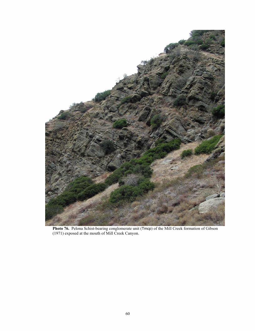
Photo 76. Pelona Schist-bearing conglomerate unit (Tmcp) of the Mill Creek formation of Gibson (1971) exposed at the mouth of Mill Creek Canyon.
60
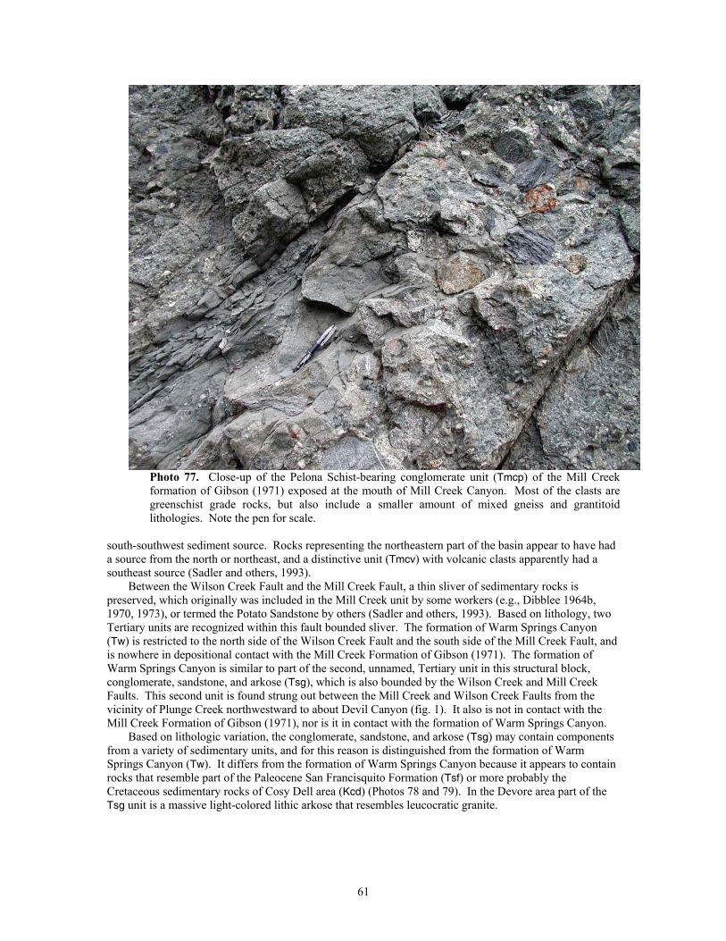
Photo 77. Close-up of the Pelona Schist-bearing conglomerate unit (Tmcp) of the Mill Creek formation of Gibson (1971) exposed at the mouth of Mill Creek Canyon. Most of the clasts are greenschist grade rocks, but also include a smaller amount of mixed gneiss and grantitoid lithologies. Note the pen for scale.
south-southwest sediment source. Rocks representing the northeastern part of the basin appear to have had a source from the north or northeast, and a distinctive unit (Tmcv) with volcanic clasts apparently had a southeast source (Sadler and others, 1993).
Between the Wilson Creek Fault and the Mill Creek Fault, a thin sliver of sedimentary rocks is preserved, which originally was included in the Mill Creek unit by some workers (e.g., Dibblee 1964b, 1970, 1973), or termed the Potato Sandstone by others (Sadler and others, 1993). Based on lithology, two Tertiary units are recognized within this fault bounded sliver. The formation of Warm Springs Canyon (Tw) is restricted to the north side of the Wilson Creek Fault and the south side of the Mill Creek Fault, and is nowhere in depositional contact with the Mill Creek Formation of Gibson (1971). The formation of Warm Springs Canyon is similar to part of the second, unnamed, Tertiary unit in this structural block, conglomerate, sandstone, and arkose (Tsg), which is also bounded by the Wilson Creek and Mill Creek Faults. This second unit is found strung out between the Mill Creek and Wilson Creek Faults from the vicinity of Plunge Creek northwestward to about Devil Canyon (fig. 1). It also is not in contact with the Mill Creek Formation of Gibson (1971), nor is it in contact with the formation of Warm Springs Canyon.
Based on lithologic variation, the conglomerate, sandstone, and arkose (Tsg) may contain components from a variety of sedimentary units, and for this reason is distinguished from the formation of Warm Springs Canyon (Tw). It differs from the formation of Warm Springs Canyon because it appears to contain rocks that resemble part of the Paleocene San Francisquito Formation (Tsf) or more probably the Cretaceous sedimentary rocks of Cosy Dell area (Kcd) (Photos 78 and 79). In the Devore area part of the Tsg unit is a massive light-colored lithic arkose that resembles leucocratic granite.
61
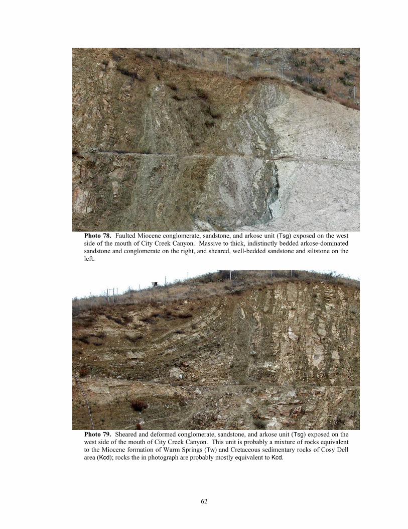
Photo 78. Faulted Miocene conglomerate, sandstone, and arkose unit (Tsg) exposed on the west side of the mouth of City Creek Canyon. Massive to thick, indistinctly bedded arkose-dominated sandstone and conglomerate on the right, and sheared, well-bedded sandstone and siltstone on the left.
Photo 79. Sheared and deformed conglomerate, sandstone, and arkose unit (Tsg) exposed on the west side of the mouth of City Creek Canyon. This unit is probably a mixture of rocks equivalent to the Miocene formation of Warm Springs (Tw) and Cretaceous sedimentary rocks of Cosy Dell area (Kcd); rocks the in photograph are probably mostly equivalent to Kcd.
62
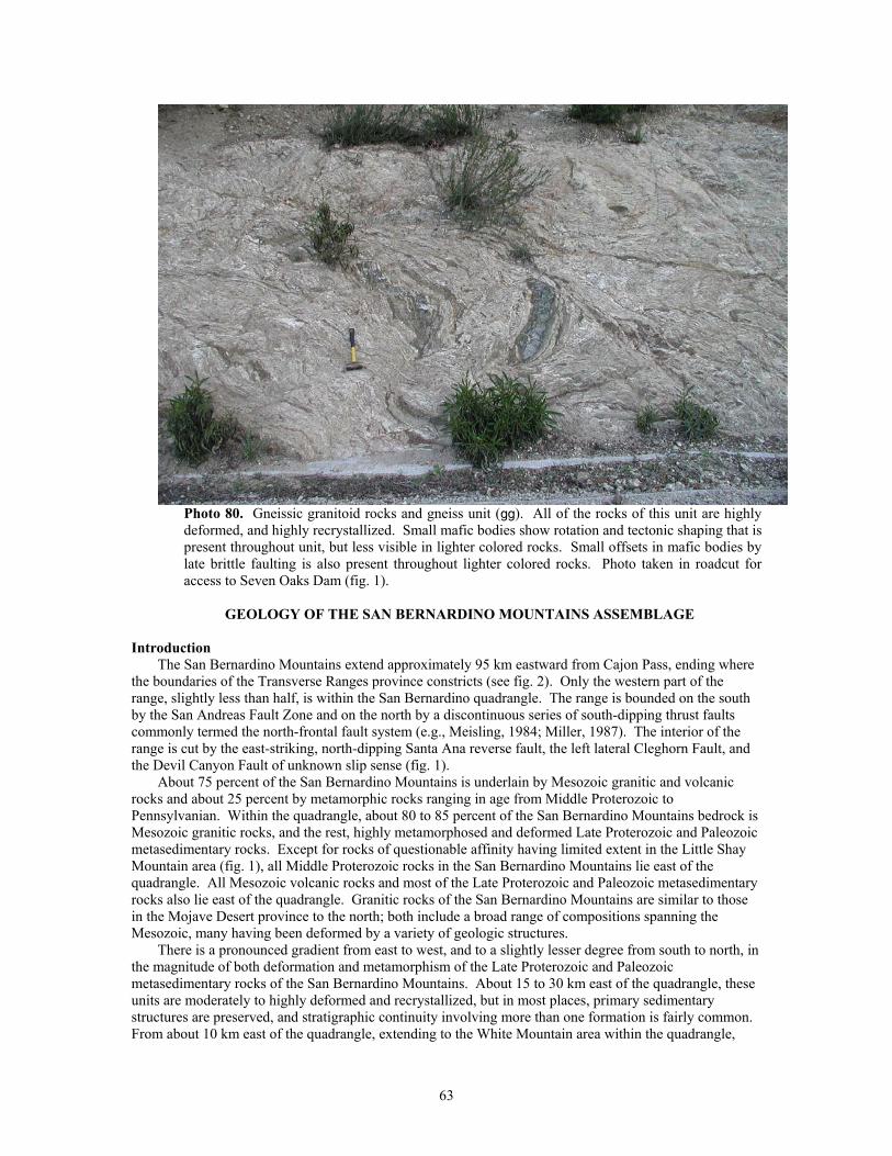
Photo 80. Gneissic granitoid rocks and gneiss unit (gg). All of the rocks of this unit are highly deformed, and highly recrystallized. Small mafic bodies show rotation and tectonic shaping that is present throughout unit, but less visible in lighter colored rocks. Small offsets in mafic bodies by late brittle faulting is also present throughout lighter colored rocks. Photo taken in roadcut for access to Seven Oaks Dam (fig. 1).
GEOLOGY OF THE SAN BERNARDINO MOUNTAINS ASSEMBLAGE
Introduction
The San Bernardino Mountains extend approximately 95 km eastward from Cajon Pass, ending where the boundaries of the Transverse Ranges province constricts (see fig. 2). Only the western part of the range, slightly less than half, is within the San Bernardino quadrangle. The range is bounded on the south by the San Andreas Fault Zone and on the north by a discontinuous series of south-dipping thrust faults commonly termed the north-frontal fault system (e.g., Meisling, 1984; Miller, 1987). The interior of the range is cut by the east-striking, north-dipping Santa Ana reverse fault, the left lateral Cleghorn Fault, and the Devil Canyon Fault of unknown slip sense (fig. 1).
About 75 percent of the San Bernardino Mountains is underlain by Mesozoic granitic and volcanic rocks and about 25 percent by metamorphic rocks ranging in age from Middle Proterozoic to Pennsylvanian. Within the quadrangle, about 80 to 85 percent of the San Bernardino Mountains bedrock is Mesozoic granitic rocks, and the rest, highly metamorphosed and deformed Late Proterozoic and Paleozoic metasedimentary rocks. Except for rocks of questionable affinity having limited extent in the Little Shay Mountain area (fig. 1), all Middle Proterozoic rocks in the San Bernardino Mountains lie east of the quadrangle. All Mesozoic volcanic rocks and most of the Late Proterozoic and Paleozoic metasedimentary rocks also lie east of the quadrangle. Granitic rocks of the San Bernardino Mountains are similar to those in the Mojave Desert province to the north; both include a broad range of compositions spanning the Mesozoic, many having been deformed by a variety of geologic structures.
There is a pronounced gradient from east to west, and to a slightly lesser degree from south to north, in the magnitude of both deformation and metamorphism of the Late Proterozoic and Paleozoic metasedimentary rocks of the San Bernardino Mountains. About 15 to 30 km east of the quadrangle, these units are moderately to highly deformed and recrystallized, but in most places, primary sedimentary structures are preserved, and stratigraphic continuity involving more than one formation is fairly common. From about 10 km east of the quadrangle, extending to the White Mountain area within the quadrangle,
63
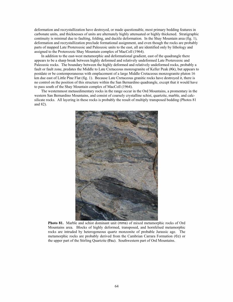
deformation and recrystallization have destroyed, or made questionable, most primary bedding features in carbonate units, and thicknesses of units are alternately highly attenuated or highly thickened. Stratigraphic continuity is minimal due to faulting, folding, and ductile deformation. In the Shay Mountain area (fig. 1), deformation and recrystallization preclude formational assignment, and even though the rocks are probably parts of mapped Late Proterozoic and Paleozoic units to the east, all are identified only by lithology and assigned to the Proterozoic Shay Mountain complex of MacColl (1964).
In addition to the east-west metamorphic and deformational gradient, east of the quadrangle there appears to be a sharp break between highly deformed and relatively undeformed Late Proterozoic and Paleozoic rocks. The boundary between the highly deformed and relatively undeformed rocks, probably a fault or fault zone, predates the Middle to Late Cretaceous monzogranite of Keller Peak (Kk), but appears to postdate or be contemporaneous with emplacement of a large Middle Cretaceous monzogranite pluton 16 km due east of Little Pine Flat (fig. 1). Because Late Cretaceous granitic rocks have destroyed it, there is no control on the position of this structure within the San Bernardino quadrangle, except that it would have to pass south of the Shay Mountain complex of MacColl (1964).
The westernmost metasedimentary rocks in the range occur in the Ord Mountains, a promentary in the western San Bernardino Mountains, and consist of coarsely crystalline schist, quartzite, marble, and calc-silicate rocks. All layering in these rocks is probably the result of multiply transposed bedding (Photos 81 and 82).
Photo 81. Marble and schist dominant unit (mms) of mixed metamorphic rocks of Ord Mountains area. Blocks of highly deformed, transposed, and hornfelsed metamorphic rocks are intruded by heterogeneous quartz monzonite of probable Jurassic age. The metamorphic rocks are probably derived from the Cambrian Carrara Formation (_c) or the upper part of the Stirling Quartzite (<su). Southwestern part of Ord Mountains.
64
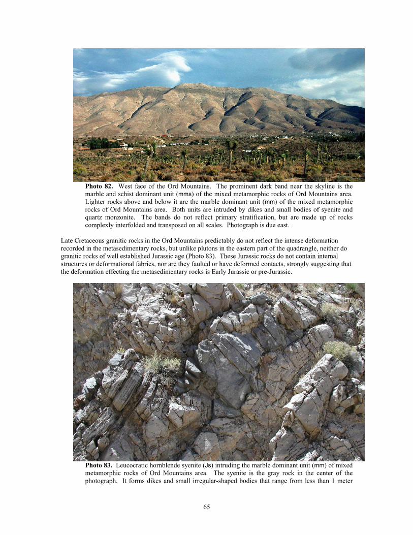
Photo 82. West face of the Ord Mountains. The prominent dark band near the skyline is the marble and schist dominant unit (mms) of the mixed metamorphic rocks of Ord Mountains area. Lighter rocks above and below it are the marble dominant unit (mm) of the mixed metamorphic rocks of Ord Mountains area. Both units are intruded by dikes and small bodies of syenite and quartz monzonite. The bands do not reflect primary stratification, but are made up of rocks complexly interfolded and transposed on all scales. Photograph is due east.
Late Cretaceous granitic rocks in the Ord Mountains predictably do not reflect the intense deformation recorded in the metasedimentary rocks, but unlike plutons in the eastern part of the quadrangle, neither do granitic rocks of well established Jurassic age (Photo 83). These Jurassic rocks do not contain internal structures or deformational fabrics, nor are they faulted or have deformed contacts, strongly suggesting that the deformation effecting the metasedimentary rocks is Early Jurassic or pre-Jurassic.
Photo 83. Leucocratic hornblende syenite (Js) intruding the marble dominant unit (mm) of mixed metamorphic rocks of Ord Mountains area. The syenite is the gray rock in the center of the photograph. It forms dikes and small irregular-shaped bodies that range from less than 1 meter
65
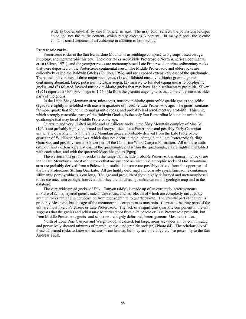
wide to bodies one-half by one kilometer in size. The gray color reflects the potassium feldspar color and not the mafic content, which rarely exceeds 3 percent. In many places, the syenite contains small amounts of arfvedsonite in addition to hornblende.
Proterozoic rocks
Proterozoic rocks in the San Bernardino Mountains assemblage comprise two groups based on age, lithology, and metamorphic history. The older rocks are Middle Proterozoic North American continental crust (Silver, 1971), and the younger rocks are metamorphosed Late Proterozoic marine sedimentary rocks that were deposited on the Proterozoic continental crust. The Middle Proterozoic and older rocks are collectively called the Baldwin Gneiss (Guillou, 1953), and are exposed extensively east of the quadrangle. There, the unit consists of three major rock types, (1) well foliated muscovite-biotite granitic gneiss containing abundant, large, potassium feldspar augen, (2) massive to foliated equigranular to porphyritic gneiss, and (3) foliated, layered muscovite-biotite gneiss that may have had a sedimentary protolith. Silver (1971) reported a U/Pb zircon age of 1,750 Ma from the granitic augen gneiss that apparently intrudes older parts of the gneiss.
In the Little Shay Mountain area, micaceous, muscovite-biotite quartzofeldspathic gneiss and schist (<gsq) are tightly interfolded with massive quartzite of probable Late Proterozoic age. The gneiss contains far more quartz that found in normal granitic rocks, and probably had a sedimentary protolith. This unit, which strongly resembles parts of the Baldwin Gneiss, is the only San Bernardino Mountains unit in the quadrangle that may be of Middle Proterozoic age.
Quartzite and very limited marble and calcsilicate rocks in the Shay Mountain complex of MacColl (1964) are probably highly deformed and recrystallized Late Proterozoic and possibly Early Cambrian units. The quartzite units in the Shay Mountain area are probably derived from the Late Proterozoic quartzite of Wildhorse Meadows, which does not occur in the quadrangle, the Late Proterozoic Stirling Quartzite, and possibly from the lower part of the Cambrian Wood Canyon Formation. All of these units crop out fairly extensively just east of the quadrangle, and within the quadrangle, all are tightly interfolded with each other, and with the quartzofeldspathic gneiss (<gsq).
The westernmost group of rocks in the range that include probable Proterozoic metamorphic rocks are in the Ord Mountains. Most of the rocks that are grouped as mixed metamorphic rocks of Ord Mountains area are probably derived from a Paleozoic protolith, but some are possibly derived from the upper part of the Late Proterozoic Stirling Quartzite. All are highly deformed and coarsely crystalline, some containing sillimanite porphyroblasts 3 cm long. The age and protolith of these highly deformed and metamorphosed rocks are uncertain enough, however, that they are listed as age unknown on the geologic map and in the database.
The very widespread gneiss of Devil Canyon (}<d) is made up of an extremely heterogeneous mixture of schist, layered gneiss, calcsilicate rocks, and marble, all of which are complexly intruded by granitic rocks ranging in composition from monzogranite to quartz diorite. The granitic part of the unit is probably Mesozoic, but the age of the metamorphic component is uncertain. Carbonate-bearing parts of the unit are most likely Paleozoic or Late Proterozoic. The lack of a significant quartzite component in the unit suggests that the gneiss and schist may be derived not from a Paleozoic or Late Proterozoic protolith, but from Middle Proterozoic gneiss and schist or are highly deformed, heterogeneous Mesozoic rocks.
North of Lone Pine Canyon and Wrightwood, localized, but large, areas are underlain by comminuted and pervasively sheared mixtures of marble, gneiss, and granitic rock (fz) (Photo 84). The relationship of these deformed rocks to known structures is not known, but they are in relatively close proximity to the San Andreas Fault.
66
Photo 84. Thoroughly comminuted granitic rock in the San Andreas Fault zone west of Wrightwood (fig. 1). Unit (fz) is typically a moderately consolidated mixture of grains ranging in size from tens of centimeters to clay.
Paleozoic rocks
Paleozoic rocks in the San Bernardino Mountains show the same east to west progressive increase in deformation and metamorphism as seen in the Late Proterozoic units. The Paleozoic units comprise a thick sequence of metasedimentary rocks generally consisting of a lower quartzitic sequence and an upper carbonate rock sequence. The entire lower quartzitic part is Early Cambrian, and includes the Wood Canyon Formation and Zabriskie Quartzite; the Wood Canyon Formation appears to conformably overlie the Late Proterozoic Stirling Quartzite.
Carbonate rocks overlying the quartzite sequence range in age from early Cambrian through Pennsylvanian, and comprise, in ascending order, the Cambrian Carrara and Bonanza King Formations, the Devonian Sultan Limestone, the Mississippian Monte Cristo Limestone, and the Pennsylvanian Bird Springs Formation. Complete, or nearly complete, sections of each of these units exists east of the quadrangle, but within the quadrangle all of the units are highly disrupted and consist only of faulted and folded partial sections. The carbonate rocks have been multiply folded in two or more generations to form mesoscopic to megascopic-scale open to isoclinal folds cut by numerous low-angle faults that have both older-over-younger and younger-over-older geometries (Cameron, 1981; Sadler, 1981; Brown, 1991). Many of the folds and low-angle faults are refolded (Brown, 1991).
Along the eastern edge of the quadrangle in the White Mountain area, highly deformed Paleozoic units are complexly faulted, tightly folded, and recrystallized to the degree that formational assignments of many units are poorly established. In the Ord Mountains area, probable Paleozoic formations are tightly to isoclinally folded, and many of the fold axes faulted to produce pods of one formation completely surrounded by another (Photo 85). Elements of the Wood Canyon (Photo 86, see also Photo 85), Carrara (Photo 87, see also Photo 81), and Bonanza King (see Photo 83) Formations and the Zabriskie Quartzite (Photo 88) are present in the area, but in each unit, all layering consists of multiply transposed bedding, and no stratigraphic continuity could be established. In addition all rocks are intricately intruded by dikes, sills, and pods of Jurassic, leucocratic, hornblende- and arfvedsonite-bearing syenite, and Cretaceous or Jurassic biotite quartz monzonite.
67
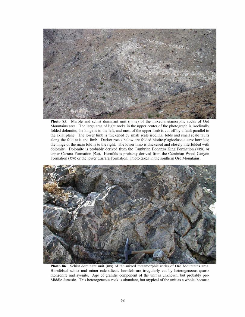
Photo 85. Marble and schist dominant unit (mms) of the mixed metamorphic rocks of Ord Mountains area. The large area of light rocks in the upper center of the photograph is isoclinally folded dolomite; the hinge is to the left, and most of the upper limb is cut off by a fault parallel to the axial plane. The lower limb is thickened by small scale isoclinal folds and small scale faults along the fold axis and limb. Darker rocks below are folded biotite-plagioclase-quartz hornfels; the hinge of the main fold is to the right. The lower limb is thickened and closely interfolded with dolomite. Dolomite is probably derived from the Cambrian Bonanza King Formation (_bk) or upper Carrara Formation (_c). Hornfels is probably derived from the Cambrian Wood Canyon Formation (_w) or the lower Carrara Formation. Photo taken in the southern Ord Mountains.
Photo 86. Schist dominant unit (ms) of the mixed metamorphic rocks of Ord Mountains area. Hornfelsed schist and minor calc-silicate hornfels are irregularly cut by heterogeneous quartz monzonite and syenite. Age of granitic component of the unit is unknown, but probably pre-Middle Jurassic. This heterogeneous rock is abundant, but atypical of the unit as a whole, because
68
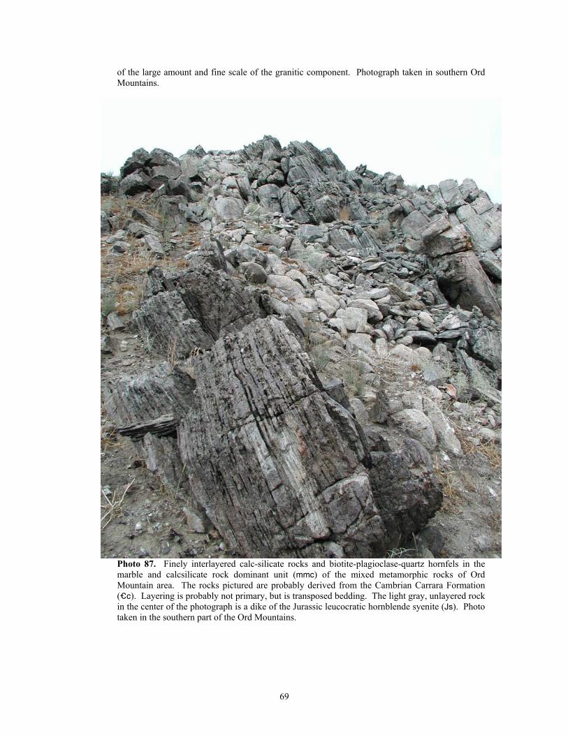
of the large amount and fine scale of the granitic component. Photograph taken in southern Ord Mountains.
Photo 87. Finely interlayered calc-silicate rocks and biotite-plagioclase-quartz hornfels in the marble and calcsilicate rock dominant unit (mmc) of the mixed metamorphic rocks of Ord Mountain area. The rocks pictured are probably derived from the Cambrian Carrara Formation (_c). Layering is probably not primary, but is transposed bedding. The light gray, unlayered rock in the center of the photograph is a dike of the Jurassic leucocratic hornblende syenite (Js). Photo taken in the southern part of the Ord Mountains.
69
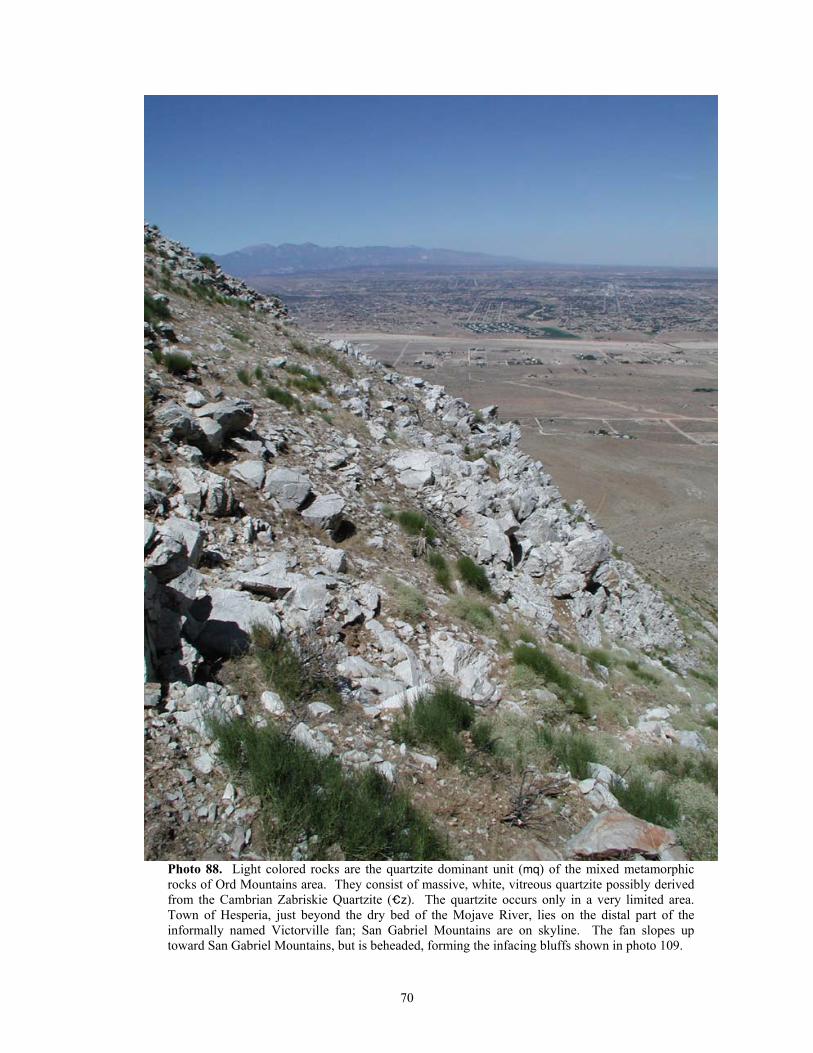
Photo 88. Light colored rocks are the quartzite dominant unit (mq) of the mixed metamorphic rocks of Ord Mountains area. They consist of massive, white, vitreous quartzite possibly derived from the Cambrian Zabriskie Quartzite (_z). The quartzite occurs only in a very limited area. Town of Hesperia, just beyond the dry bed of the Mojave River, lies on the distal part of the informally named Victorville fan; San Gabriel Mountains are on skyline. The fan slopes up toward San Gabriel Mountains, but is beheaded, forming the infacing bluffs shown in photo 109.
70
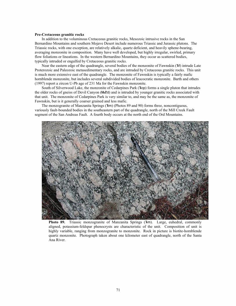
Pre-Cretaceous granitic rocks
In addition to the voluminous Cretaceous granitic rocks, Mesozoic intrusive rocks in the San Bernardino Mountains and southern Mojave Desert include numerous Triassic and Jurassic plutons. The Triassic rocks, with one exception, are relatively alkalic, quartz deficient, and heavily sphene-bearing, averaging monzonite in composition. Many have well developed, but highly irregular, swirled, primary flow foliations or lineations. In the western Bernardino Mountains, they occur as scattered bodies, typically intruded or engulfed by Cretaceous granitic rocks.
Near the eastern edge of the quadrangle, several bodies of the monzonite of Fawnskin (^f) intrude Late Proterozoic and Paleozoic metasedimentary rocks, and are intruded by Cretaceous granitic rocks. This unit is much more extensive east of the quadrangle. The monzonite of Fawnskin is typically a fairly mafic hornblende monzonite, but includes several subdivided bodies of leucocratic monzonite. Barth and others (1997) report a zircon U-Pb age of 231 Ma for the Fawnskin monzonite.
South of Silverwood Lake, the monzonite of Cedarpines Park (^cp) forms a single pluton that intrudes the older rocks of gneiss of Devil Canyon (}<d) and is intruded by younger granitic rocks associated with that unit. The monzonite of Cedarpines Park is very similar to, and may be the same as, the monzonite of Fawnskin, but is it generally coarser grained and less mafic.
The monzogranite of Manzanita Springs (^m) (Photos 89 and 90) forms three, noncontiguous, variously fault-bounded bodies in the southeastern part of the quadrangle, north of the Mill Creek Fault segment of the San Andreas Fault. A fourth body occurs at the north end of the Ord Mountains.
Photo 89. Triassic monzogranite of Manzanita Springs (^m). Large, euhedral, commonly aligned, potassium-feldspar phenocrysts are characteristic of the unit. Composition of unit is highly variable, ranging from monzogranite to monzonite. Rock in picture is biotite-hornblende quartz monzonite. Photograph taken about one kilometer east of quadrangle, north of the Santa Ana River.
71
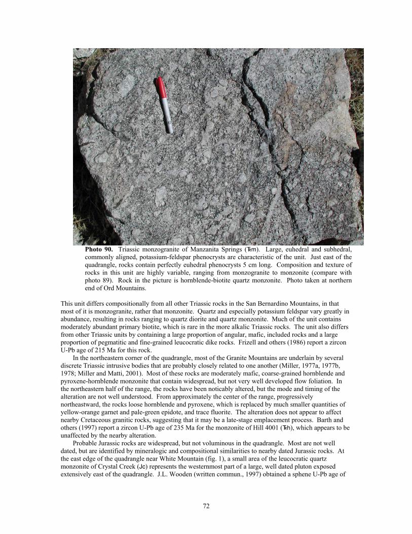
Photo 90. Triassic monzogranite of Manzanita Springs (^m). Large, euhedral and subhedral, commonly aligned, potassium-feldspar phenocrysts are characteristic of the unit. Just east of the quadrangle, rocks contain perfectly euhedral phenocrysts 5 cm long. Composition and texture of rocks in this unit are highly variable, ranging from monzogranite to monzonite (compare with photo 89). Rock in the picture is hornblende-biotite quartz monzonite. Photo taken at northern end of Ord Mountains.
This unit differs compositionally from all other Triassic rocks in the San Bernardino Mountains, in that most of it is monzogranite, rather that monzonite. Quartz and especially potassium feldspar vary greatly in abundance, resulting in rocks ranging to quartz diorite and quartz monzonite. Much of the unit contains moderately abundant primary biotite, which is rare in the more alkalic Triassic rocks. The unit also differs from other Triassic units by containing a large proportion of angular, mafic, included rocks and a large proportion of pegmatitic and fine-grained leucocratic dike rocks. Frizell and others (1986) report a zircon U-Pb age of 215 Ma for this rock.
In the northeastern corner of the quadrangle, most of the Granite Mountains are underlain by several discrete Triassic intrusive bodies that are probably closely related to one another (Miller, 1977a, 1977b, 1978; Miller and Matti, 2001). Most of these rocks are moderately mafic, coarse-grained hornblende and pyroxene-hornblende monzonite that contain widespread, but not very well developed flow foliation. In the northeastern half of the range, the rocks have been noticably altered, but the mode and timing of the alteration are not well understood. From approximately the center of the range, progressively northeastward, the rocks loose hornblende and pyroxene, which is replaced by much smaller quantities of yellow-orange garnet and pale-green epidote, and trace fluorite. The alteration does not appear to affect nearby Cretaceous granitic rocks, suggesting that it may be a late-stage emplacement process. Barth and others (1997) report a zircon U-Pb age of 235 Ma for the monzonite of Hill 4001 (^h), which appears to be unaffected by the nearby alteration.
Probable Jurassic rocks are widespread, but not voluminous in the quadrangle. Most are not well dated, but are identified by mineralogic and compositional similarities to nearby dated Jurassic rocks. At the east edge of the quadrangle near White Mountain (fig. 1), a small area of the leucocratic quartz monzonite of Crystal Creek (Jc) represents the westernmost part of a large, well dated pluton exposed extensively east of the quadrangle. J.L. Wooden (written commun., 1997) obtained a sphene U-Pb age of
72
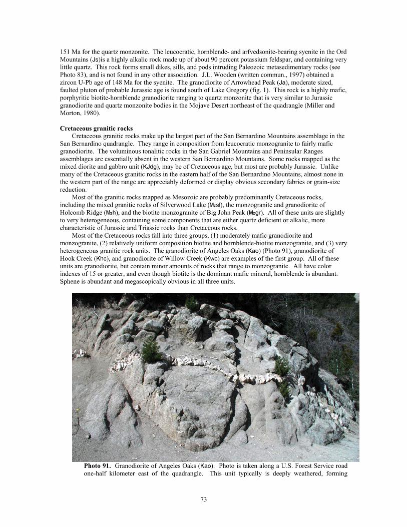
151 Ma for the quartz monzonite. The leucocratic, hornblende- and arfvedsonite-bearing syenite in the Ord Mountains (Js)is a highly alkalic rock made up of about 90 percent potassium feldspar, and containing very little quartz. This rock forms small dikes, sills, and pods intruding Paleozoic metasedimentary rocks (see Photo 83), and is not found in any other association. J.L. Wooden (written commun., 1997) obtained a zircon U-Pb age of 148 Ma for the syenite. The granodiorite of Arrowhead Peak (Ja), moderate sized, faulted pluton of probable Jurassic age is found south of Lake Gregory (fig. 1). This rock is a highly mafic, porphyritic biotite-hornblende granodiorite ranging to quartz monzonite that is very similar to Jurassic granodiorite and quartz monzonite bodies in the Mojave Desert northeast of the quadrangle (Miller and Morton, 1980).
Cretaceous granitic rocks
Cretaceous granitic rocks make up the largest part of the San Bernardino Mountains assemblage in the San Bernardino quadrangle. They range in composition from leucocratic monzogranite to fairly mafic granodiorite. The voluminous tonalitic rocks in the San Gabriel Mountains and Peninsular Ranges assemblages are essentially absent in the western San Bernardino Mountains. Some rocks mapped as the mixed diorite and gabbro unit (KJdg), may be of Cretaceous age, but most are probably Jurassic. Unlike many of the Cretaceous granitic rocks in the eastern half of the San Bernardino Mountains, almost none in the western part of the range are appreciably deformed or display obvious secondary fabrics or grain-size reduction.
Most of the granitic rocks mapped as Mesozoic are probably predominantly Cretaceous rocks, including the mixed granitic rocks of Silverwood Lake (}sl), the monzogranite and granodiorite of Holcomb Ridge (}h), and the biotite monzogranite of Big John Peak (}gr). All of these units are slightly to very heterogeneous, containing some components that are either quartz deficient or alkalic, more characteristic of Jurassic and Triassic rocks than Cretaceous rocks.
Most of the Cretaceous rocks fall into three groups, (1) moderately mafic granodiorite and monzogranite, (2) relatively uniform composition biotite and hornblende-biotite monzogranite, and (3) very heterogeneous granitic rock units. The granodiorite of Angeles Oaks (Kao) (Photo 91), granodiorite of Hook Creek (Khc), and granodiorite of Willow Creek (Kwc) are examples of the first group. All of these units are granodiorite, but contain minor amounts of rocks that range to monzogranite. All have color indexes of 15 or greater, and even though biotite is the dominant mafic mineral, hornblende is abundant. Sphene is abundant and megascopically obvious in all three units.
Photo 91. Granodiorite of Angeles Oaks (Kao). Photo is taken along a U.S. Forest Service road one-half kilometer east of the quadrangle. This unit typically is deeply weathered, forming
73
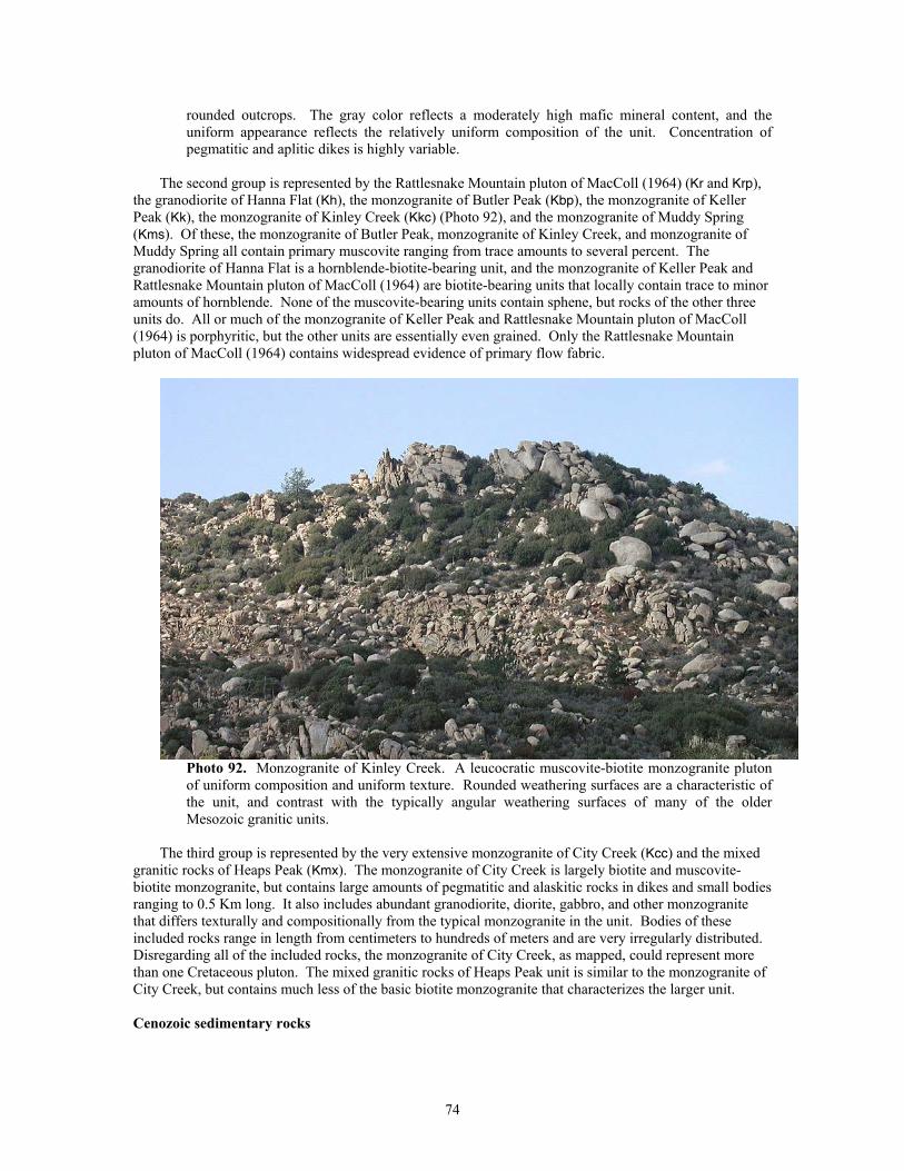
rounded outcrops. The gray color reflects a moderately high mafic mineral content, and the uniform appearance reflects the relatively uniform composition of the unit. Concentration of pegmatitic and aplitic dikes is highly variable.
The second group is represented by the Rattlesnake Mountain pluton of MacColl (1964) (Kr and Krp),
the granodiorite of Hanna Flat (Kh), the monzogranite of Butler Peak (Kbp), the monzogranite of Keller Peak (Kk), the monzogranite of Kinley Creek (Kkc) (Photo 92), and the monzogranite of Muddy Spring (Kms). Of these, the monzogranite of Butler Peak, monzogranite of Kinley Creek, and monzogranite of Muddy Spring all contain primary muscovite ranging from trace amounts to several percent. The granodiorite of Hanna Flat is a hornblende-biotite-bearing unit, and the monzogranite of Keller Peak and Rattlesnake Mountain pluton of MacColl (1964) are biotite-bearing units that locally contain trace to minor amounts of hornblende. None of the muscovite-bearing units contain sphene, but rocks of the other three units do. All or much of the monzogranite of Keller Peak and Rattlesnake Mountain pluton of MacColl (1964) is porphyritic, but the other units are essentially even grained. Only the Rattlesnake Mountain pluton of MacColl (1964) contains widespread evidence of primary flow fabric.
Photo 92. Monzogranite of Kinley Creek. A leucocratic muscovite-biotite monzogranite pluton of uniform composition and uniform texture. Rounded weathering surfaces are a characteristic of the unit, and contrast with the typically angular weathering surfaces of many of the older Mesozoic granitic units.
The third group is represented by the very extensive monzogranite of City Creek (Kcc) and the mixed
granitic rocks of Heaps Peak (Kmx). The monzogranite of City Creek is largely biotite and muscovite-biotite monzogranite, but contains large amounts of pegmatitic and alaskitic rocks in dikes and small bodies ranging to 0.5 Km long. It also includes abundant granodiorite, diorite, gabbro, and other monzogranite that differs texturally and compositionally from the typical monzogranite in the unit. Bodies of these included rocks range in length from centimeters to hundreds of meters and are very irregularly distributed. Disregarding all of the included rocks, the monzogranite of City Creek, as mapped, could represent more than one Cretaceous pluton. The mixed granitic rocks of Heaps Peak unit is similar to the monzogranite of City Creek, but contains much less of the basic biotite monzogranite that characterizes the larger unit.
Cenozoic sedimentary rocks
74
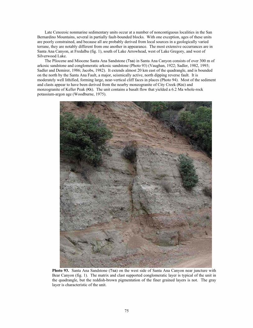
Late Cenozoic nonmarine sedimentary units occur at a number of noncontiguous localities in the San Bernardino Mountains, several in partially fault-bounded blocks. With one exception, ages of these units are poorly constrained, and because all are probably derived from local sources in a geologically varied terrane, they are notably different from one another in appearance. The most extensive occurrances are in Santa Ana Canyon, at Fredalba (fig. 1), south of Lake Arrowhead, west of Lake Gregory, and west of Silverwood Lake.
The Pliocene and Miocene Santa Ana Sandstone (Tsa) in Santa Ana Canyon consists of over 300 m of arkosic sandstone and conglomeratic arkosic sandstone (Photo 93) (Vaughan, 1922; Sadler, 1982, 1993; Sadler and Demirer, 1986; Jacobs, 1982). It extends almost 20 km east of the quadrangle, and is bounded on the north by the Santa Ana Fault, a major, seismically active, north dipping reverse fault. It is moderately well lithified, forming large, near-vertical cliff faces in places (Photo 94). Most of the sediment and clasts appear to have been derived from the nearby monzogranite of City Creek (Kcc) and monzogranite of Keller Peak (Kk). The unit contains a basalt flow that yielded a 6.2 Ma whole-rock potassium-argon age (Woodburne, 1975).
Photo 93. Santa Ana Sandstone (Tsa) on the west side of Santa Ana Canyon near juncture with Bear Canyon (fig. 1). The matrix and clast supported conglomeratic layer is typical of the unit in the quadrangle, but the reddish-brown pigmentation of the finer grained layers is not. The gray layer is characteristic of the unit.
75
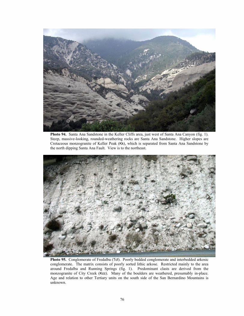
Photo 94. Santa Ana Sandstone in the Keller Cliffs area, just west of Santa Ana Canyon (fig. 1). Steep, massive-looking, rounded-weathering rocks are Santa Ana Sandstone. Higher slopes are Cretaceous monzogranite of Keller Peak (Kk), which is separated from Santa Ana Sandstone by the north dipping Santa Ana Fault. View is to the northeast.
Photo 95. Conglomerate of Fredalba (Tcf). Poorly bedded conglomerate and interbedded arkosic conglomerate. The matrix consists of poorly sorted lithic arkose. Restricted mainly to the area around Fredalba and Running Springs (fig. 1). Predominant clasts are derived from the monzogranite of City Creek (Kcc). Many of the boulders are weathered, presumably in-place. Age and relation to other Tertiary units on the south side of the San Bernardino Mountains is unknown.
76
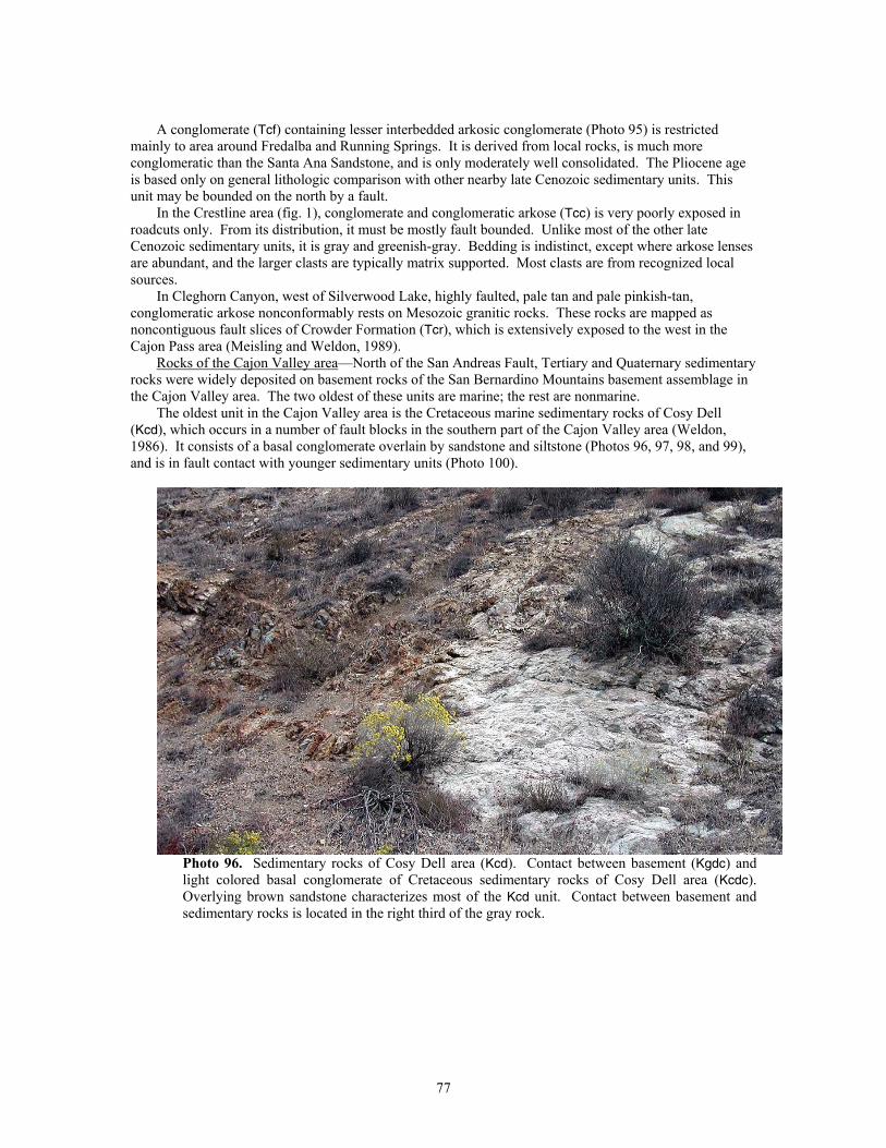
A conglomerate (Tcf) containing lesser interbedded arkosic conglomerate (Photo 95) is restricted
mainly to area around Fredalba and Running Springs. It is derived from local rocks, is much more conglomeratic than the Santa Ana Sandstone, and is only moderately well consolidated. The Pliocene age is based only on general lithologic comparison with other nearby late Cenozoic sedimentary units. This unit may be bounded on the north by a fault.
In the Crestline area (fig. 1), conglomerate and conglomeratic arkose (Tcc) is very poorly exposed in roadcuts only. From its distribution, it must be mostly fault bounded. Unlike most of the other late Cenozoic sedimentary units, it is gray and greenish-gray. Bedding is indistinct, except where arkose lenses are abundant, and the larger clasts are typically matrix supported. Most clasts are from recognized local sources.
In Cleghorn Canyon, west of Silverwood Lake, highly faulted, pale tan and pale pinkish-tan, conglomeratic arkose nonconformably rests on Mesozoic granitic rocks. These rocks are mapped as noncontiguous fault slices of Crowder Formation (Tcr), which is extensively exposed to the west in the Cajon Pass area (Meisling and Weldon, 1989).
Rocks of the Cajon Valley area—North of the San Andreas Fault, Tertiary and Quaternary sedimentary rocks were widely deposited on basement rocks of the San Bernardino Mountains basement assemblage in the Cajon Valley area. The two oldest of these units are marine; the rest are nonmarine.
The oldest unit in the Cajon Valley area is the Cretaceous marine sedimentary rocks of Cosy Dell (Kcd), which occurs in a number of fault blocks in the southern part of the Cajon Valley area (Weldon, 1986). It consists of a basal conglomerate overlain by sandstone and siltstone (Photos 96, 97, 98, and 99), and is in fault contact with younger sedimentary units (Photo 100).
Photo 96. Sedimentary rocks of Cosy Dell area (Kcd). Contact between basement (Kgdc) and light colored basal conglomerate of Cretaceous sedimentary rocks of Cosy Dell area (Kcdc). Overlying brown sandstone characterizes most of the Kcd unit. Contact between basement and sedimentary rocks is located in the right third of the gray rock.
77
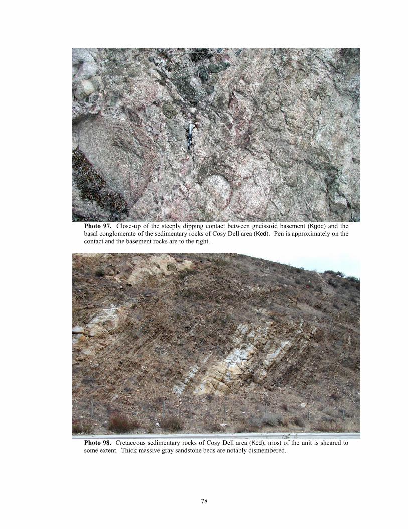
Photo 97. Close-up of the steeply dipping contact between gneissoid basement (Kgdc) and the basal conglomerate of the sedimentary rocks of Cosy Dell area (Kcd). Pen is approximately on the contact and the basement rocks are to the right.
Photo 98. Cretaceous sedimentary rocks of Cosy Dell area (Kcd); most of the unit is sheared to some extent. Thick massive gray sandstone beds are notably dismembered.
78
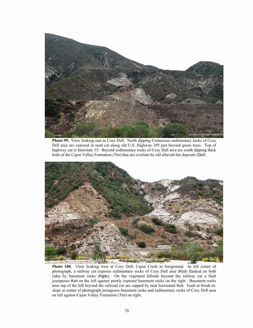
Photo 99. View looking east at Cosy Dell. North dipping Cretaceous sedimentary rocks of Cosy Dell area are exposed in road cut along old U.S. Highway 395 just beyond green trees. Top of highway cut is Interstate 15. Beyond sedimentary rocks of Cosy Dell area are south dipping thick beds of the Cajon Valley Formation (Tcv) that are overlain by old alluvial-fan deposits (Qof).
Photo 100. View looking west at Cosy Dell; Cajon Creek in foreground. In left center of photograph, a railway cut exposes sedimentary rocks of Cosy Dell area (Kcd) flanked on both sides by basement rocks (Kgdc). On the vegetated hillside beyond the railway cut a fault juxtaposes Kcd on the left against poorly exposed basement rocks on the right. Basement rocks near top of the hill beyond the railroad cut are capped by near horizontal Kcd. Fault at break-in-slope at center of photograph juxtaposes basement rocks and sedimentary rocks of Cosy Dell area on left against Cajon Valley Formation (Tcv) on right.
79
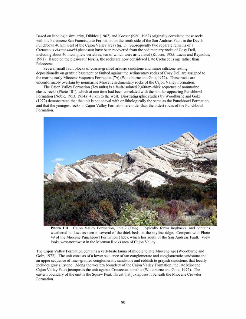
Based on lithologic similarity, Dibblee (1967) and Kooser (l980, 1982) originally correlated these rocks with the Paleocene San Francisquito Formation on the south side of the San Andreas Fault in the Devils Punchbowl 40 km west of the Cajon Valley area (fig. 1). Subsequently two separate remains of a Cretaceous elasmosaurid plesiosaur have been recovered from the sedimentary rocks of Cosy Dell, including about 40 incomplete vertebrae, ten of which were articulated (Kooser, 1985; Lucas and Reynolds, 1991). Based on the plesiosaur fossils, the rocks are now considered Late Cretaceous age rather than Paleocene.
Several small fault blocks of coarse-grained arkosic sandstone and minor siltstone resting depositionally on granitic basement or faulted against the sedimentary rocks of Cosy Dell are assigned to the marine early Miocene Vaqueros Formation (Tv) (Woodburne and Golz, l972). These rocks are unconformably overlain by nonmarine Miocene sedimentary rocks of the Cajon Valley Formation.
The Cajon Valley Formation (Tcv units) is a fault-isolated 2,400-m-thick sequence of nonmarine clastic rocks (Photo 101), which at one time had been correlated with the similar-appearing Punchbowl Formation (Noble, 1953, 1954a) 40 km to the west. Biostratigraphic studies by Woodburne and Golz (1972) demonstrated that the unit is not coeval with or lithologically the same as the Punchbowl Formation, and that the youngest rocks in Cajon Valley Formation are older than the oldest rocks of the Punchbowl Formation.
Photo 101. Cajon Valley Formation, unit 2 (Tcv2). Typically forms hogbacks, and contains weathered hollows as seen in several of the thick beds on the skyline ridge. Compare with Photo 49 of the Miocene Punchbowl Formation (Tpb), which lies south of the San Andreas Fault. View looks west-northwest in the Morman Rocks area of Cajon Valley.
The Cajon Valley Formation contains a vertebrate fauna of middle to late Miocene age (Woodburne and Golz, 1972). The unit consists of a lower sequence of tan conglomerate and conglomeratic sandstone and an upper sequence of finer-grained conglomeratic sandstone and reddish to grayish sandstone, that locally includes gray siltstone. Along the western boundary of the Cajon Valley Formation, the late Miocene Cajon Valley Fault juxtaposes the unit against Cretaceous tonalite (Woodburne and Golz, 1972). The eastern boundary of the unit is the Squaw Peak Thrust that juxtaposes it beneath the Miocene Crowder Formation.
80
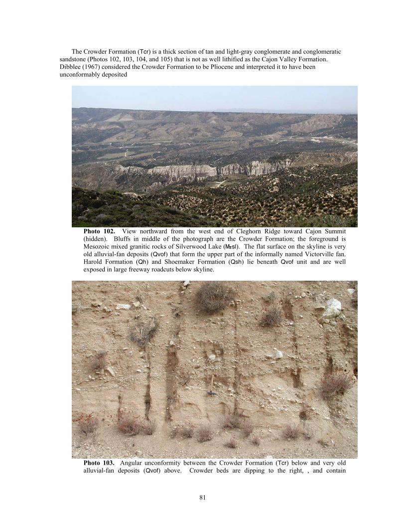
The Crowder Formation (Tcr) is a thick section of tan and light-gray conglomerate and conglomeratic sandstone (Photos 102, 103, 104, and 105) that is not as well lithified as the Cajon Valley Formation. Dibblee (1967) considered the Crowder Formation to be Pliocene and interpreted it to have been unconformably deposited
Photo 102. View northward from the west end of Cleghorn Ridge toward Cajon Summit (hidden). Bluffs in middle of the photograph are the Crowder Formation; the foreground is Mesozoic mixed granitic rocks of Silverwood Lake (}sl). The flat surface on the skyline is very old alluvial-fan deposits (Qvof) that form the upper part of the informally named Victorville fan. Harold Formation (Qh) and Shoemaker Formation (Qsh) lie beneath Qvof unit and are well exposed in large freeway roadcuts below skyline.
Photo 103. Angular unconformity between the Crowder Formation (Tcr) below and very old alluvial-fan deposits (Qvof) above. Crowder beds are dipping to the right, , and contain
81
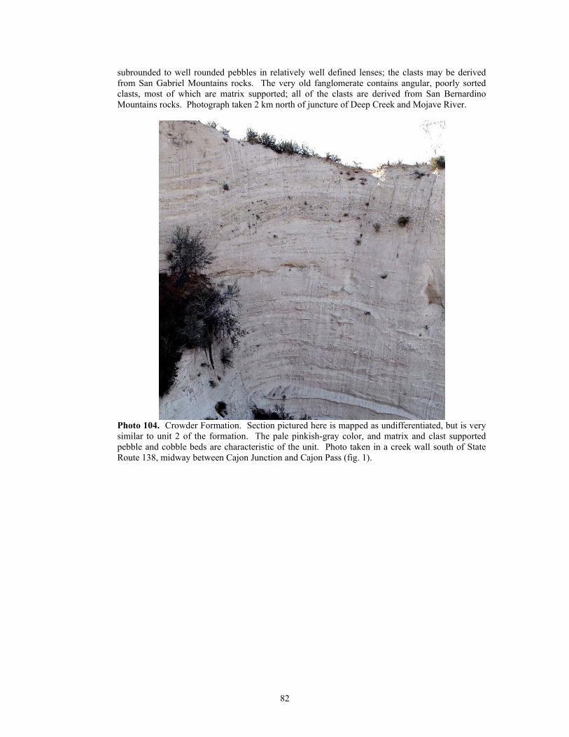
subrounded to well rounded pebbles in relatively well defined lenses; the clasts may be derived from San Gabriel Mountains rocks. The very old fanglomerate contains angular, poorly sorted clasts, most of which are matrix supported; all of the clasts are derived from San Bernardino Mountains rocks. Photograph taken 2 km north of juncture of Deep Creek and Mojave River.
Photo 104. Crowder Formation. Section pictured here is mapped as undifferentiated, but is very similar to unit 2 of the formation. The pale pinkish-gray color, and matrix and clast supported pebble and cobble beds are characteristic of the unit. Photo taken in a creek wall south of State Route 138, midway between Cajon Junction and Cajon Pass (fig. 1).
82
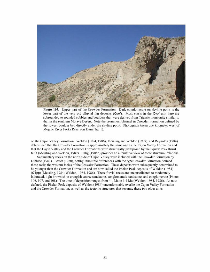
Photo 105. Upper part of the Crowder Formation. Dark conglomerate on skyline point is the lower part of the very old alluvial fan deposits (Qvof). Most clasts in the Qvof unit here are subrounded to rounded cobbles and boulders that were derived from Triassic monzonite similar to that in the southern Mojave Desert. Note the prominent channel in Crowder Formation defined by the lowest boulder bed directly under the skyline point. Photograph taken one kilometer west of Mojave River Forks Reservoir Dam (fig. 1).
on the Cajon Valley Formation. Weldon (1984, 1986), Meisling and Weldon (1989), and Reynolds (1984) determined that the Crowder Formation is approximately the same age as the Cajon Valley Formation and that the Cajon Valley and the Crowder Formations were structurally juxtaposed by the Squaw Peak thrust fault (Meisling and Weldon, 1989). Ehlig (1988b) provides an alternative view of these structural relations.
Sedimentary rocks on the north side of Cajon Valley were included with the Crowder Formation by Dibblee (1967). Foster (1980), noting litholithic differences with the type Crowder Formation, termed these rocks the western facies of the Crowder Formation. These deposits were subsequently determined to be younger than the Crowder Formation and are now called the Phelan Peak deposits of Weldon (1984) (QTpp) (Meisling, 1984; Weldon, 1984, 1986). These fluvial rocks are unconsolidated to moderately indurated, light brownish to orangish coarse sandstone, conglomeratic sandstone, and conglomerate (Photos 106, 107, and 108). The time of deposition ranges from 4.1 Ma to 1.4 Ma (Weldon, 1984, 1986). As now defined, the Phelan Peak deposits of Weldon (1984) unconformably overlie the Cajon Valley Formation and the Crowder Formation, as well as the tectonic structures that separate these two older units.
83
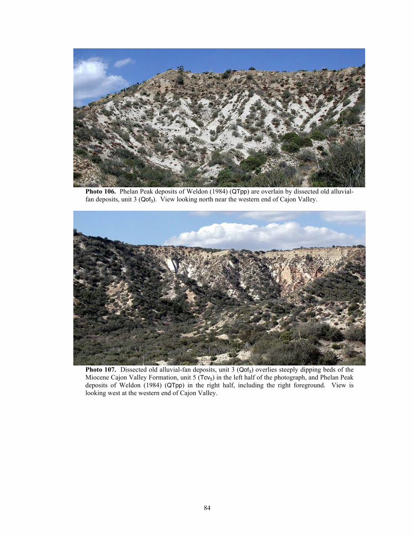
Photo 106. Phelan Peak deposits of Weldon (1984) (QTpp) are overlain by dissected old alluvial-fan deposits, unit 3 (Qof3). View looking north near the western end of Cajon Valley.
Photo 107. Dissected old alluvial-fan deposits, unit 3 (Qof3) overlies steeply dipping beds of the Miocene Cajon Valley Formation, unit 5 (Tcv5) in the left half of the photograph, and Phelan Peak deposits of Weldon (1984) (QTpp) in the right half, including the right foreground. View is looking west at the western end of Cajon Valley.
84
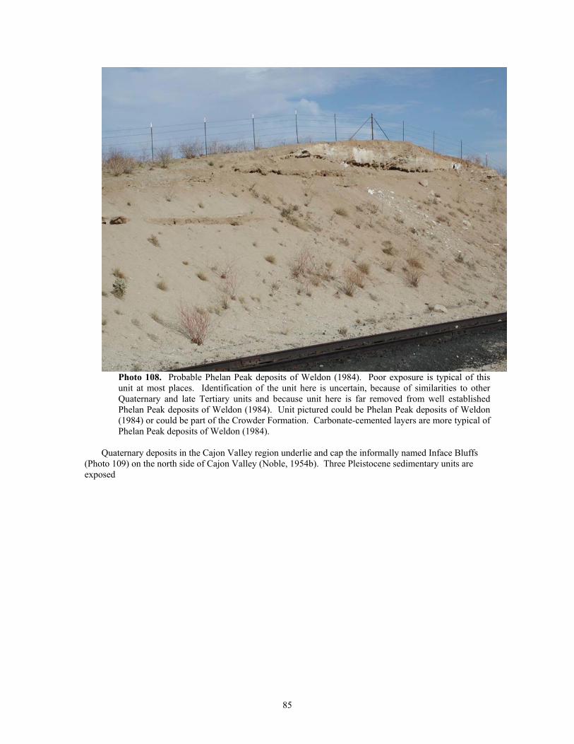
Photo 108. Probable Phelan Peak deposits of Weldon (1984). Poor exposure is typical of this unit at most places. Identification of the unit here is uncertain, because of similarities to other Quaternary and late Tertiary units and because unit here is far removed from well established Phelan Peak deposits of Weldon (1984). Unit pictured could be Phelan Peak deposits of Weldon (1984) or could be part of the Crowder Formation. Carbonate-cemented layers are more typical of Phelan Peak deposits of Weldon (1984).
Quaternary deposits in the Cajon Valley region underlie and cap the informally named Inface Bluffs
(Photo 109) on the north side of Cajon Valley (Noble, 1954b). Three Pleistocene sedimentary units are exposed
85
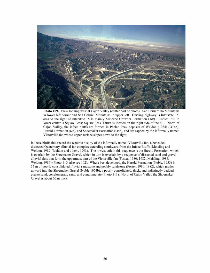
Photo 109. View looking west at Cajon Valley (center part of photo). San Bernardino Mountains in lower left corner and San Gabriel Mountains in upper left. Curving highway is Interstate 15; area to the right of Interstate 15 is mainly Miocene Crowder Formation (Tcr). Conical hill in lower center is Squaw Peak; Squaw Peak Thrust is located on the right side of the hill. North of Cajon Valley, the inface bluffs are formed in Phelan Peak deposits of Weldon (1984) (QTpp), Harold Formation (Qh), and Shoemaker Formation (Qsh), and are capped by the informally named Victorville fan whose upper surface slopes down to the right.
in these bluffs that record the tectonic history of the informally named Victorville fan, a beheaded, dissected Quaternary alluvial fan complex extending southward from the Inface Bluffs (Meisling and Weldon, 1989; Weldon and others, 1993). The lowest unit in this sequence is the Harold Formation, which is overlain by the Shoemaker Gravel, which in turn is overlain by a sequence of dissected sand and gravel alluvial fans that form the uppermost part of the Victorville fan (Foster, 1980; 1982; Meisling, 1984; Weldon, 1986) (Photo 110, also see 102). Where best developed, the Harold Formation (Noble, 1953) is 35 m of poorly consolidated, fluvial sandstone and pebbly sandstone (Foster, 1980, 1982), which grades upward into the Shoemaker Gravel (Noble,1954b), a poorly consolidated, thick, and indistinctly bedded, coarse sand, conglomeratic sand, and conglomerate (Photo 111). North of Cajon Valley the Shoemaker Gravel is about 60 m thick.
86
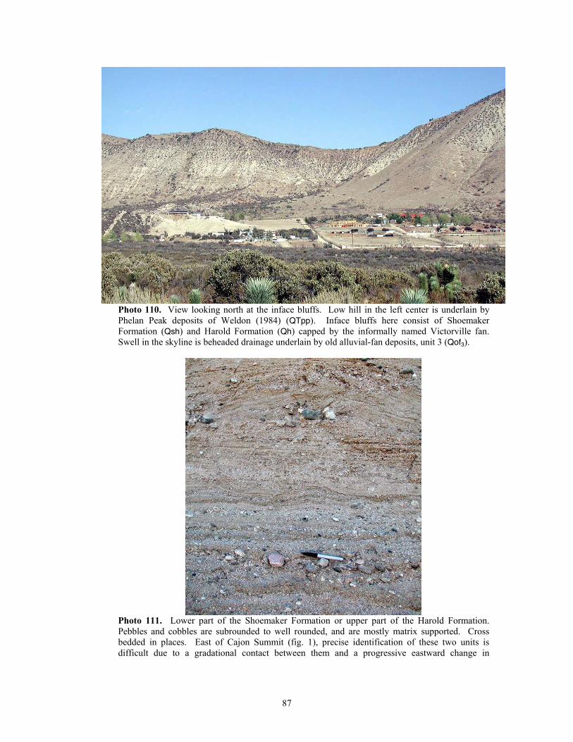
Photo 110. View looking north at the inface bluffs. Low hill in the left center is underlain by Phelan Peak deposits of Weldon (1984) (QTpp). Inface bluffs here consist of Shoemaker Formation (Qsh) and Harold Formation (Qh) capped by the informally named Victorville fan. Swell in the skyline is beheaded drainage underlain by old alluvial-fan deposits, unit 3 (Qof3).
Photo 111. Lower part of the Shoemaker Formation or upper part of the Harold Formation. Pebbles and cobbles are subrounded to well rounded, and are mostly matrix supported. Cross bedded in places. East of Cajon Summit (fig. 1), precise identification of these two units is difficult due to a gradational contact between them and a progressive eastward change in
87
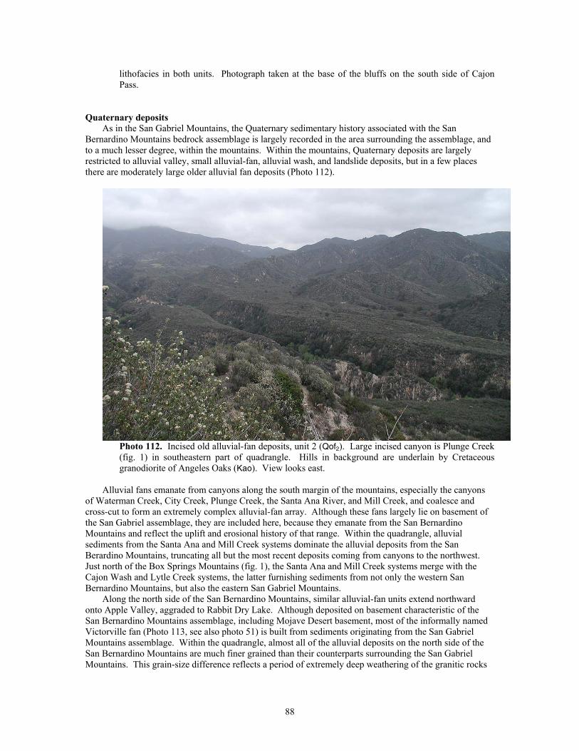
lithofacies in both units. Photograph taken at the base of the bluffs on the south side of Cajon Pass.
Quaternary deposits As in the San Gabriel Mountains, the Quaternary sedimentary history associated with the San
Bernardino Mountains bedrock assemblage is largely recorded in the area surrounding the assemblage, and to a much lesser degree, within the mountains. Within the mountains, Quaternary deposits are largely restricted to alluvial valley, small alluvial-fan, alluvial wash, and landslide deposits, but in a few places there are moderately large older alluvial fan deposits (Photo 112).
Photo 112. Incised old alluvial-fan deposits, unit 2 (Qof2). Large incised canyon is Plunge Creek (fig. 1) in southeastern part of quadrangle. Hills in background are underlain by Cretaceous granodiorite of Angeles Oaks (Kao). View looks east.
Alluvial fans emanate from canyons along the south margin of the mountains, especially the canyons
of Waterman Creek, City Creek, Plunge Creek, the Santa Ana River, and Mill Creek, and coalesce and cross-cut to form an extremely complex alluvial-fan array. Although these fans largely lie on basement of the San Gabriel assemblage, they are included here, because they emanate from the San Bernardino Mountains and reflect the uplift and erosional history of that range. Within the quadrangle, alluvial sediments from the Santa Ana and Mill Creek systems dominate the alluvial deposits from the San Berardino Mountains, truncating all but the most recent deposits coming from canyons to the northwest. Just north of the Box Springs Mountains (fig. 1), the Santa Ana and Mill Creek systems merge with the Cajon Wash and Lytle Creek systems, the latter furnishing sediments from not only the western San Bernardino Mountains, but also the eastern San Gabriel Mountains.
Along the north side of the San Bernardino Mountains, similar alluvial-fan units extend northward onto Apple Valley, aggraded to Rabbit Dry Lake. Although deposited on basement characteristic of the San Bernardino Mountains assemblage, including Mojave Desert basement, most of the informally named Victorville fan (Photo 113, see also photo 51) is built from sediments originating from the San Gabriel Mountains assemblage. Within the quadrangle, almost all of the alluvial deposits on the north side of the San Bernardino Mountains are much finer grained than their counterparts surrounding the San Gabriel Mountains. This grain-size difference reflects a period of extremely deep weathering of the granitic rocks
88
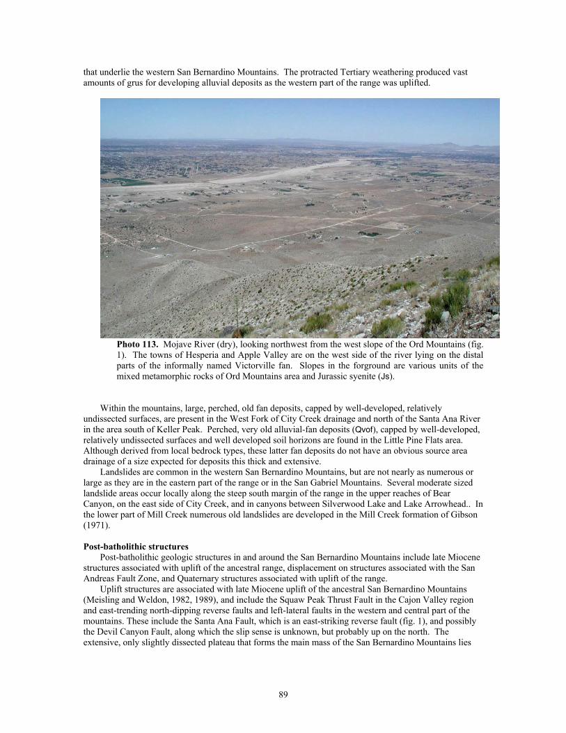
that underlie the western San Bernardino Mountains. The protracted Tertiary weathering produced vast amounts of grus for developing alluvial deposits as the western part of the range was uplifted.
Photo 113. Mojave River (dry), looking northwest from the west slope of the Ord Mountains (fig. 1). The towns of Hesperia and Apple Valley are on the west side of the river lying on the distal parts of the informally named Victorville fan. Slopes in the forground are various units of the mixed metamorphic rocks of Ord Mountains area and Jurassic syenite (Js).
Within the mountains, large, perched, old fan deposits, capped by well-developed, relatively
undissected surfaces, are present in the West Fork of City Creek drainage and north of the Santa Ana River in the area south of Keller Peak. Perched, very old alluvial-fan deposits (Qvof), capped by well-developed, relatively undissected surfaces and well developed soil horizons are found in the Little Pine Flats area. Although derived from local bedrock types, these latter fan deposits do not have an obvious source area drainage of a size expected for deposits this thick and extensive.
Landslides are common in the western San Bernardino Mountains, but are not nearly as numerous or large as they are in the eastern part of the range or in the San Gabriel Mountains. Several moderate sized landslide areas occur locally along the steep south margin of the range in the upper reaches of Bear Canyon, on the east side of City Creek, and in canyons between Silverwood Lake and Lake Arrowhead.. In the lower part of Mill Creek numerous old landslides are developed in the Mill Creek formation of Gibson (1971).
Post-batholithic structures
Post-batholithic geologic structures in and around the San Bernardino Mountains include late Miocene structures associated with uplift of the ancestral range, displacement on structures associated with the San Andreas Fault Zone, and Quaternary structures associated with uplift of the range.
Uplift structures are associated with late Miocene uplift of the ancestral San Bernardino Mountains (Meisling and Weldon, 1982, 1989), and include the Squaw Peak Thrust Fault in the Cajon Valley region and east-trending north-dipping reverse faults and left-lateral faults in the western and central part of the mountains. These include the Santa Ana Fault, which is an east-striking reverse fault (fig. 1), and possibly the Devil Canyon Fault, along which the slip sense is unknown, but probably up on the north. The extensive, only slightly dissected plateau that forms the main mass of the San Bernardino Mountains lies
89
north of the Santa Ana Fault. South of the fault, just south of the quadrangle, is a higher, more dissected terrain that includes the highest summits of the San Bernardino Mountains.
Several strands of the San Andreas Fault Zone traverse the southeastern San Bernardino Mountains and flank the southwestern base of the range (Matti and others, 1992a; Matti and Morton, 1993). Older strands of the zone include the Wilson Creek and Mill Creek Faults; the modern trace of the fault in this region is labled San Andreas Fault Zone on fig. 1 and on the accompanying fault map (Sheet 3). The older strands are responsible for very large right-lateral displacements that over the last few million years have juxtaposed far-traveled crystalline basement rocks against the main mass of the San Bernardino Mountains.
The modern San Andreas Fault Zone is capable of generating large earthquakes, although most of that part of the fault in the quadrangle apparently did not rupture during the 1857 earthquake; rupture occurred only along the segment in the northwesternmost part of the quadrangle. Part of the reason for this may be that south of the Transverse Ranges, much of the strain associated with the San Andreas system has shifted to the San Jacinto Fault Zone (Morton and Matti, 1993, Kendrick and others, 2002).
Locally, complexities in the San Andreas Fault Zone have created associated reverse and thrust-fault zones and normal dip-slip fault zones (Matti and others, 1992a, 1992b). The fault geometry in the Yucaipa area and in the San Gorgonio Pass area east of the quadrangle are examples.
Uplift structures associated with Quaternary uplift of the range include the north-frontal fault zone (Meisling, 1984; Miller, 1987; Sadler, 1982) and faults along the south part of the range that facilitated uplift. Meisling and Weldon (1989) present evidence that in early Quaternary, uplift was accomplished by north-directed upward movements of the San Bernardino Mountains block along south-dipping low-angle structures that underlie the range. This uplift created the majority of the topographic relief along the north face of the San Bernardino Mountains. Although largely complete by middle Quaternary time (Meisling and Weldon, 1989), some tectonism presumably associated with uplift of the range has continued into the late Quaternary, giving rise to strike-slip and thrust-fault scarps that locally break late Quaternary alluvial deposits adjacent to the northern range front (Miller, 1987; Miller and Matti, 2001).
FAULTS
Introduction
Sequential uplifts that formed the San Bernardino and San Gabriel Mountains are a result of movements and complex fault interactions on the numerous faults of the San Andreas Fault system and on various faults both closely, and only partly, related to it (Matti, and others 1992a; Matti and Morton, 1993). Major fault types in the quadrangle include right-lateral and left-lateral strike slip faults, reverse faults, and thrust faults. Numerous small, but no major normal faults have been identified. In addition to the modern San Andreas Fault Zone, several other faults are seismically active, including the San Jacinto Fault Zone, Glen Helen Fault, Cucamonga Fault, Sierra Madre Fault, Santa Ana Fault, and numerous smaller unnamed faults.
San Andreas Fault Zone
Within the San Bernardino quadrangle, the San Andreas Fault Zone is relatively complex compared to the central California segment of the fault zone. The fault zone has a west-northwest orientation through most of the Transverse Ranges, and has shifted position and abandoned major segments through time. The San Gabriel and Punchbowl Faults are abandonded segments of the San Andreas Fault in the San Gabriel Mountains as is the Wilson Creek Fault in the San Bernardino Mountains. Also in the San Bernardino Mountains, the Mill Creek Fault was once the main strand of the San Andreas Fault, and although the main segment shifted southward, the Mill Creek Fault is still seismically active. Within the San Bernardino quadrangle, the present day main trace of the San Andreas, informally termed the San Bernardino strand by Matti and others (1992a), is coincident with another older segment informally termed the Mission Creek strand (Matti and others, 1992a).
Modern trace—The modern, active trace of the San Andreas Fault Zone traverses the quadrangle almost from corner to corner. Reconstruction of the developmental history of the fault in this area (Matti and others, 1992a; Matti and Morton, 1993) shows that it is not a uniformally active fault that has through time followed this present day trace, but is a complex, migrating structure, some of which is coincident with older structures, but most of which is not.
Holcomb Ridge to Cajon Pass—On the north side of the San Gabriel Mountains, the San Andreas Fault forms a nearly linear, relatively simple trace that, over several tens of kilometers, is very slightly
90
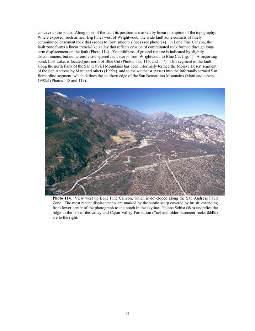
concave to the south. Along most of the fault its position is marked by linear disruption of the topography. Where exposed, such as near Big Pines west of Wrightwood, the wide fault zone consists of finely comminuted basement rock that erodes to form smooth slopes (see photo 84). In Lone Pine Canyon, the fault zone forms a linear trench-like valley that reflects erosion of comminuted rock formed through long-term displacement on the fault (Photo 114). Youthfulness of ground rupture is indicated by slightly discontinuous, but numerous, close-spaced fault scarps from Wrightwood to Blue Cut (fig. 1). A major sag pond, Lost Lake, is located just north of Blue Cut (Photos 115, 116, and 117). This segment of the fault along the north flank of the San Gabriel Mountains has been informally termed the Mojave Desert segment of the San Andreas by Matti and others (1992a), and to the southeast, passes into the informally termed San Bernardino segment, which defines the southern edge of the San Bernardino Mountains (Matti and others, 1992a) (Photos 118 and 119).
Photo 114. View west up Lone Pine Canyon, which is developed along the San Andreas Fault Zone. The most recent displacements are marked by the subtle scarp covered by brush, extending from lower center of the photograph to the notch in the skyline. Pelona Schist (}p) underlies the ridge to the left of the valley and Cajon Valley Formation (Tcv) and older basement rocks (}<d) are to the right.
91
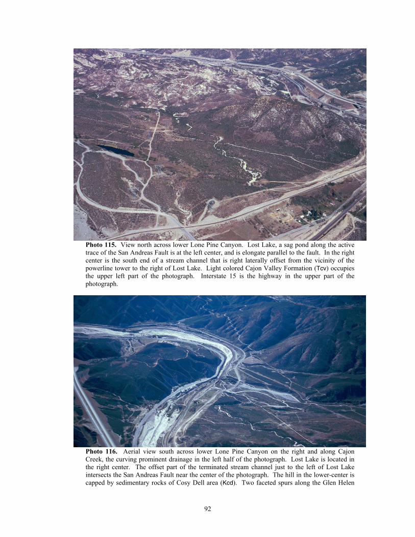
Photo 115. View north across lower Lone Pine Canyon. Lost Lake, a sag pond along the active trace of the San Andreas Fault is at the left center, and is elongate parallel to the fault. In the right center is the south end of a stream channel that is right laterally offset from the vicinity of the powerline tower to the right of Lost Lake. Light colored Cajon Valley Formation (Tcv) occupies the upper left part of the photograph. Interstate 15 is the highway in the upper part of the photograph.
Photo 116. Aerial view south across lower Lone Pine Canyon on the right and along Cajon Creek, the curving prominent drainage in the left half of the photograph. Lost Lake is located in the right center. The offset part of the terminated stream channel just to the left of Lost Lake intersects the San Andreas Fault near the center of the photograph. The hill in the lower-center is capped by sedimentary rocks of Cosy Dell area (Kcd). Two faceted spurs along the Glen Helen
92
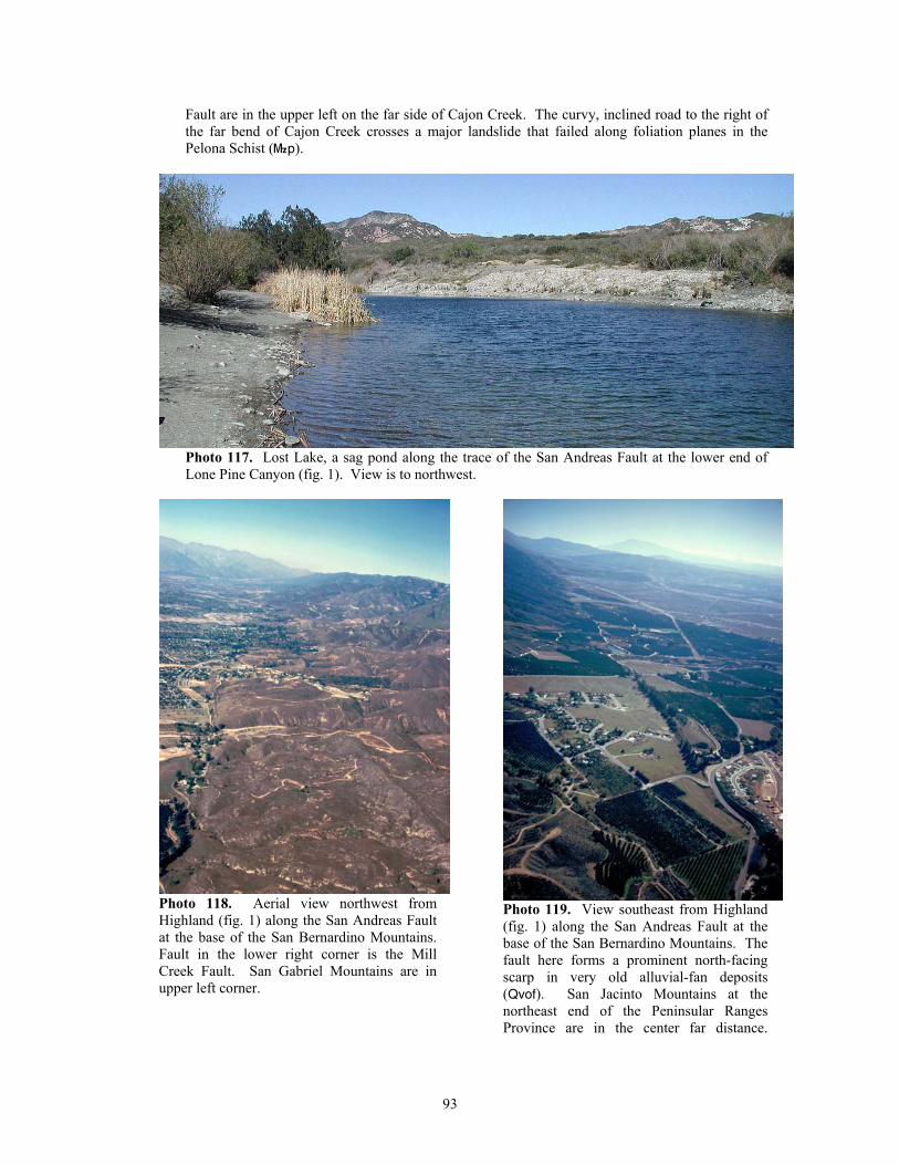
Fault are in the upper left on the far side of Cajon Creek. The curvy, inclined road to the right of the far bend of Cajon Creek crosses a major landslide that failed along foliation planes in the Pelona Schist (}p).
Photo 117. Lost Lake, a sag pond along the trace of the San Andreas Fault at the lower end of Lone Pine Canyon (fig. 1). View is to northwest.
Photo 118. Aerial view northwest from Highland (fig. 1) along the San Andreas Fault at the base of the San Bernardino Mountains. Fault in the lower right corner is the Mill Creek Fault. San Gabriel Mountains are in upper left corner.
Photo 119. View southeast from Highland (fig. 1) along the San Andreas Fault at the base of the San Bernardino Mountains. The fault here forms a prominent north-facing scarp in very old alluvial-fan deposits (Qvof). San Jacinto Mountains at the northeast end of the Peninsular Ranges Province are in the center far distance.
93
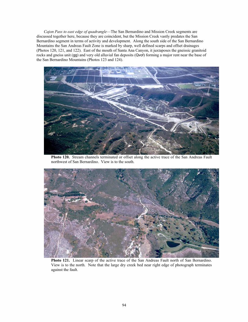
Cajon Pass to east edge of quadrangle—The San Bernardino and Mission Creek segments are discussed together here, because they are coincident, but the Mission Creek vastly predates the San Bernardino segment in terms of activity and development. Along the south side of the San Bernardino Mountains the San Andreas Fault Zone is marked by sharp, well defined scarps and offset drainages (Photos 120, 121, and 122). East of the mouth of Santa Ana Canyon, it juxtaposes the gneissic granitoid rocks and gneiss unit (gg) and very old alluvial fan deposits (Qvof) forming a major rent near the base of the San Bernardino Mountains (Photos 123 and 124).
Photo 120. Stream channels terminated or offset along the active trace of the San Andreas Fault northwest of San Bernardino. View is to the south.
Photo 121. Linear scarp of the active trace of the San Andreas Fault north of San Bernardino. View is to the north. Note that the large dry creek bed near right edge of photograph terminates against the fault.
94
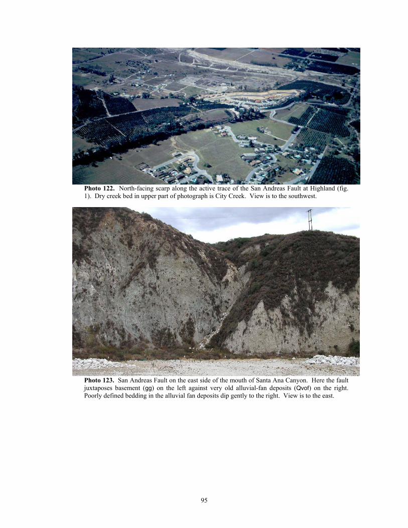
Photo 122. North-facing scarp along the active trace of the San Andreas Fault at Highland (fig. 1). Dry creek bed in upper part of photograph is City Creek. View is to the southwest.
Photo 123. San Andreas Fault on the east side of the mouth of Santa Ana Canyon. Here the fault juxtaposes basement (gg) on the left against very old alluvial-fan deposits (Qvof) on the right. Poorly defined bedding in the alluvial fan deposits dip gently to the right. View is to the east.
95
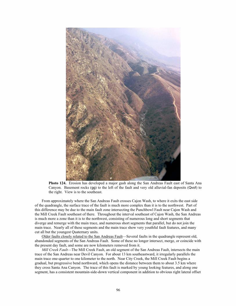
Photo 124. Erosion has developed a major gash along the San Andreas Fault east of Santa Ana Canyon. Basement rocks (gg) to the left of the fault and very old alluvial-fan deposits (Qvof) to the right. View is to the southeast.
From approximately where the San Andreas Fault crosses Cajon Wash, to where it exits the east side
of the quadrangle, the surface trace of the fault is much more complex than it is to the northwest. Part of this difference may be due to the main fault zone intersecting the Punchbowl Fault near Cajon Wash and the Mill Creek Fault southeast of there. Throughout the interval southeast of Cajon Wash, the San Andreas is much more a zone than it is to the northwest, consisting of numerous long and short segments that diverge and remerge with the main trace, and numerous short segments that parallel, but do not join the main trace. Nearly all of these segments and the main trace show very youthful fault features, and many cut all but the youngest Quaternary units.
Older faults closely related to the San Andreas Fault—Several faults in the quadrangle represent old, abandonded segments of the San Andreas Fault. Some of these no longer intersect, merge, or coincide with the present day fault, and some are now kilometers removed from it.
Mill Creek Fault—The Mill Creek Fault, an old segment of the San Andreas Fault, intersects the main trace of the San Andreas near Devil Canyon. For about 13 km southeastward, it irregularly parallels the main trace one-quarter to one kilometer to the north. Near City Creek, the Mill Creek Fault begins a gradual, but progressive bend northward, which opens the distance between them to about 3.5 km where they cross Santa Ana Canyon. The trace of this fault is marked by young looking features, and along one segment, has a consistent mountain-side-down vertical component in addition to obvious right lateral offset
96
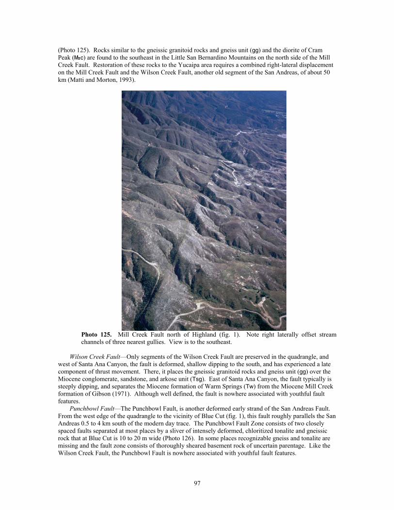
(Photo 125). Rocks similar to the gneissic granitoid rocks and gneiss unit (gg) and the diorite of Cram Peak (}c) are found to the southeast in the Little San Bernardino Mountains on the north side of the Mill Creek Fault. Restoration of these rocks to the Yucaipa area requires a combined right-lateral displacement on the Mill Creek Fault and the Wilson Creek Fault, another old segment of the San Andreas, of about 50 km (Matti and Morton, 1993).
Photo 125. Mill Creek Fault north of Highland (fig. 1). Note right laterally offset stream channels of three nearest gullies. View is to the southeast.
Wilson Creek Fault—Only segments of the Wilson Creek Fault are preserved in the quadrangle, and
west of Santa Ana Canyon, the fault is deformed, shallow dipping to the south, and has experienced a late component of thrust movement. There, it places the gneissic granitoid rocks and gneiss unit (gg) over the Miocene conglomerate, sandstone, and arkose unit (Tsg). East of Santa Ana Canyon, the fault typically is steeply dipping, and separates the Miocene formation of Warm Springs (Tw) from the Miocene Mill Creek formation of Gibson (1971). Although well defined, the fault is nowhere associated with youthful fault features.
Punchbowl Fault—The Punchbowl Fault, is another deformed early strand of the San Andreas Fault. From the west edge of the quadrangle to the vicinity of Blue Cut (fig. 1), this fault roughly parallels the San Andreas 0.5 to 4 km south of the modern day trace. The Punchbowl Fault Zone consists of two closely spaced faults separated at most places by a sliver of intensely deformed, chloritized tonalite and gneissic rock that at Blue Cut is 10 to 20 m wide (Photo 126). In some places recognizable gneiss and tonalite are missing and the fault zone consists of thoroughly sheared basement rock of uncertain parentage. Like the Wilson Creek Fault, the Punchbowl Fault is nowhere associated with youthful fault features.
97
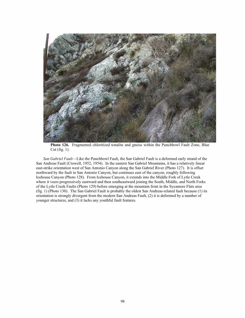
Photo 126. Fragmented chloritized tonalite and gneiss within the Punchbowl Fault Zone, Blue Cut (fig. 1).
San Gabriel Fault—Like the Punchbowl Fault, the San Gabriel Fault is a deformed early strand of the
San Andreas Fault (Crowell, 1952, 1954). In the eastern San Gabriel Mountains, it has a relatively linear east-strike orientation west of San Antonio Canyon along the San Gabriel River (Photo 127). It is offset northward by the fault in San Antonio Canyon, but continues east of the canyon, roughly following Icehouse Canyon (Photo 128). From Icehouse Canyon, it extends into the Middle Fork of Lytle Creek where it veers progressively eastward and then southeastward joining the South, Middle, and North Forks of the Lytle Creek Faults (Photo 129) before emerging at the mountain front in the Sycamore Flats area (fig. 1) (Photo 130). The San Gabriel Fault is probably the oldest San Andreas-related fault because (1) its orientation is strongly divergent from the modern San Andreas Fault, (2) it is deformed by a number of younger structures, and (3) it lacks any youthful fault features.
98
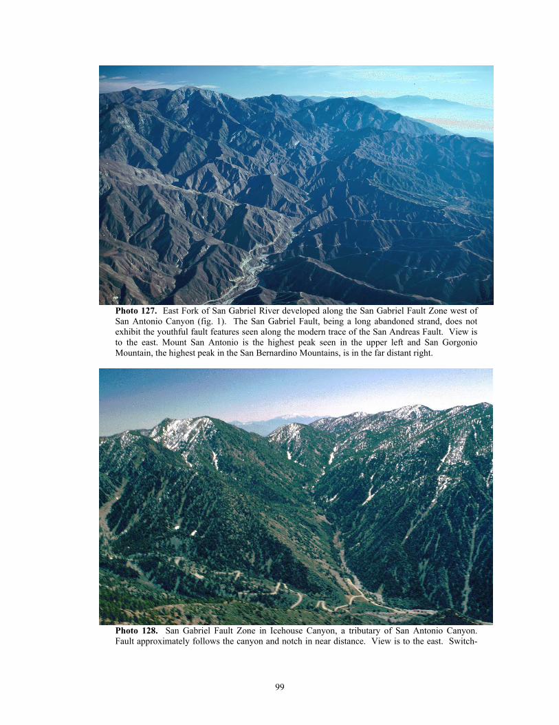
Photo 127. East Fork of San Gabriel River developed along the San Gabriel Fault Zone west of San Antonio Canyon (fig. 1). The San Gabriel Fault, being a long abandoned strand, does not exhibit the youthful fault features seen along the modern trace of the San Andreas Fault. View is to the east. Mount San Antonio is the highest peak seen in the upper left and San Gorgonio Mountain, the highest peak in the San Bernardino Mountains, is in the far distant right.
Photo 128. San Gabriel Fault Zone in Icehouse Canyon, a tributary of San Antonio Canyon. Fault approximately follows the canyon and notch in near distance. View is to the east. Switch-
99
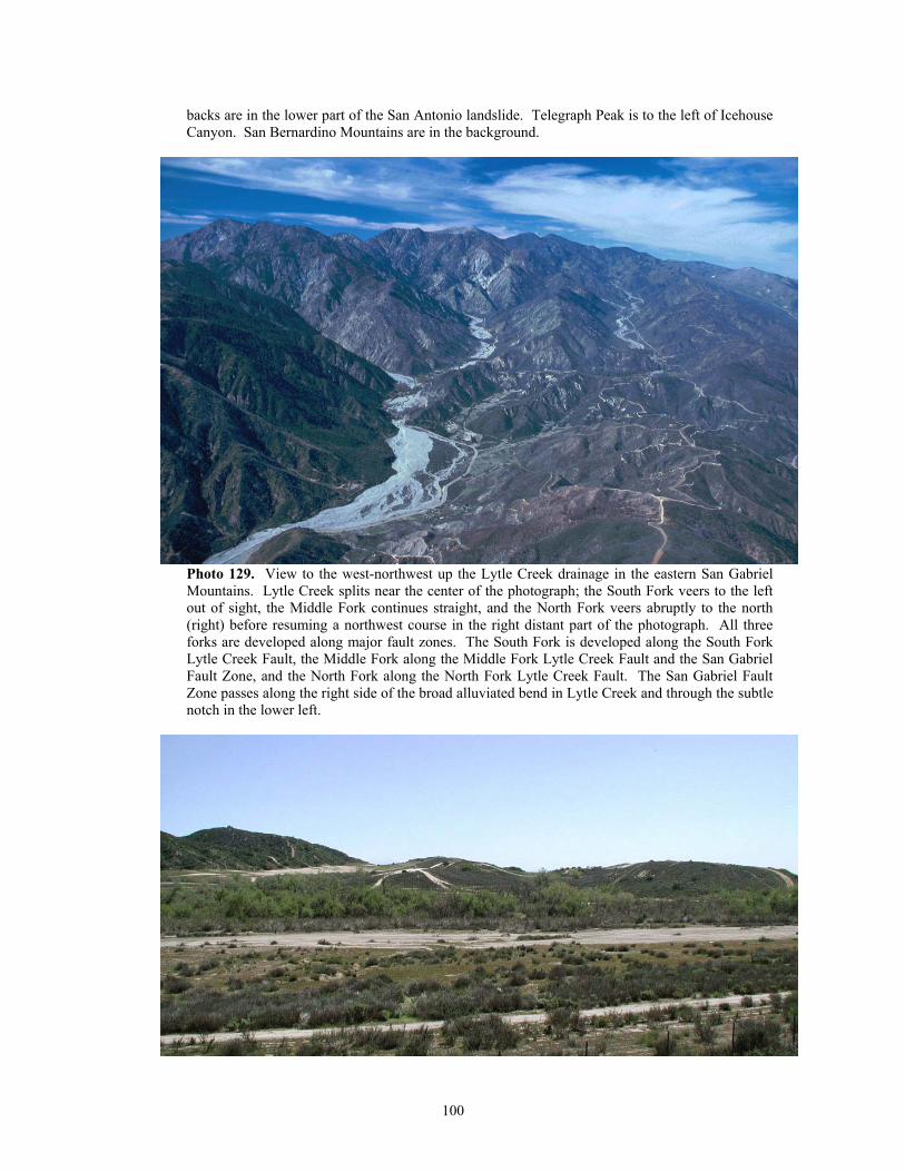
backs are in the lower part of the San Antonio landslide. Telegraph Peak is to the left of Icehouse Canyon. San Bernardino Mountains are in the background.
Photo 129. View to the west-northwest up the Lytle Creek drainage in the eastern San Gabriel Mountains. Lytle Creek splits near the center of the photograph; the South Fork veers to the left out of sight, the Middle Fork continues straight, and the North Fork veers abruptly to the north (right) before resuming a northwest course in the right distant part of the photograph. All three forks are developed along major fault zones. The South Fork is developed along the South Fork Lytle Creek Fault, the Middle Fork along the Middle Fork Lytle Creek Fault and the San Gabriel Fault Zone, and the North Fork along the North Fork Lytle Creek Fault. The San Gabriel Fault Zone passes along the right side of the broad alluviated bend in Lytle Creek and through the subtle notch in the lower left.
100
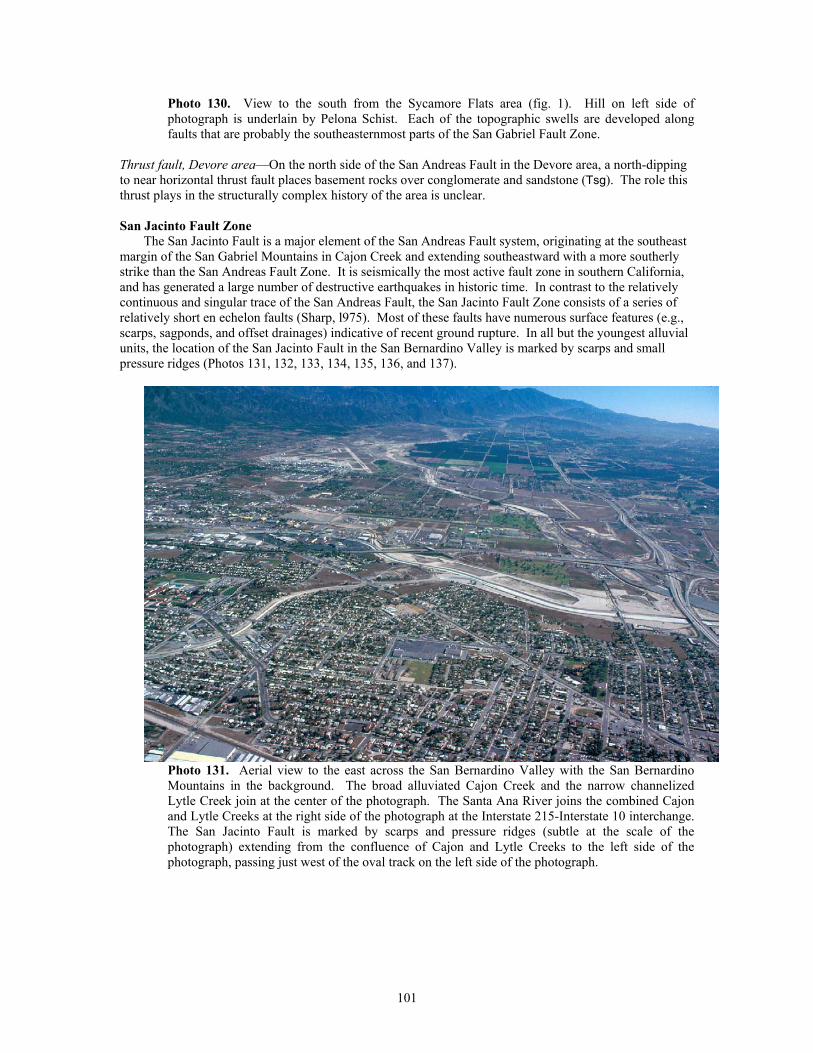
Photo 130. View to the south from the Sycamore Flats area (fig. 1). Hill on left side of photograph is underlain by Pelona Schist. Each of the topographic swells are developed along faults that are probably the southeasternmost parts of the San Gabriel Fault Zone.
Thrust fault, Devore area—On the north side of the San Andreas Fault in the Devore area, a north-dipping to near horizontal thrust fault places basement rocks over conglomerate and sandstone (Tsg). The role this thrust plays in the structurally complex history of the area is unclear.
San Jacinto Fault Zone
The San Jacinto Fault is a major element of the San Andreas Fault system, originating at the southeast margin of the San Gabriel Mountains in Cajon Creek and extending southeastward with a more southerly strike than the San Andreas Fault Zone. It is seismically the most active fault zone in southern California, and has generated a large number of destructive earthquakes in historic time. In contrast to the relatively continuous and singular trace of the San Andreas Fault, the San Jacinto Fault Zone consists of a series of relatively short en echelon faults (Sharp, l975). Most of these faults have numerous surface features (e.g., scarps, sagponds, and offset drainages) indicative of recent ground rupture. In all but the youngest alluvial units, the location of the San Jacinto Fault in the San Bernardino Valley is marked by scarps and small pressure ridges (Photos 131, 132, 133, 134, 135, 136, and 137).
Photo 131. Aerial view to the east across the San Bernardino Valley with the San Bernardino Mountains in the background. The broad alluviated Cajon Creek and the narrow channelized Lytle Creek join at the center of the photograph. The Santa Ana River joins the combined Cajon and Lytle Creeks at the right side of the photograph at the Interstate 215-Interstate 10 interchange. The San Jacinto Fault is marked by scarps and pressure ridges (subtle at the scale of the photograph) extending from the confluence of Cajon and Lytle Creeks to the left side of the photograph, passing just west of the oval track on the left side of the photograph.
101
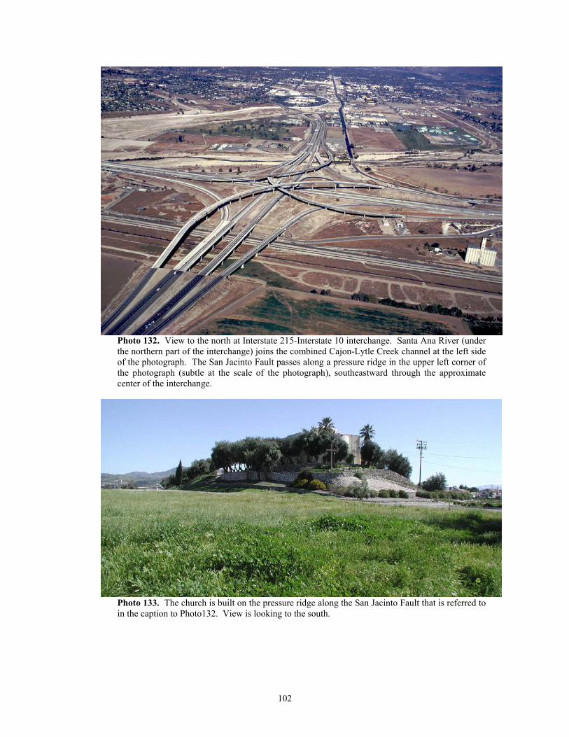
Photo 132. View to the north at Interstate 215-Interstate 10 interchange. Santa Ana River (under the northern part of the interchange) joins the combined Cajon-Lytle Creek channel at the left side of the photograph. The San Jacinto Fault passes along a pressure ridge in the upper left corner of the photograph (subtle at the scale of the photograph), southeastward through the approximate center of the interchange.
Photo 133. The church is built on the pressure ridge along the San Jacinto Fault that is referred to in the caption to Photo132. View is looking to the south.
102
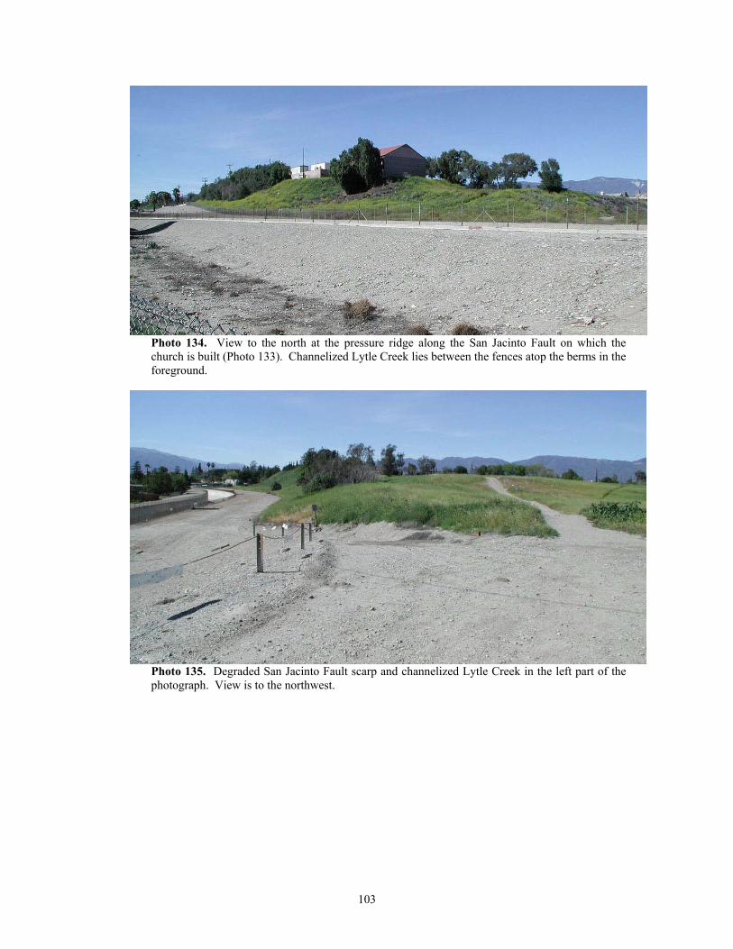
Photo 134. View to the north at the pressure ridge along the San Jacinto Fault on which the church is built (Photo 133). Channelized Lytle Creek lies between the fences atop the berms in the foreground.
Photo 135. Degraded San Jacinto Fault scarp and channelized Lytle Creek in the left part of the photograph. View is to the northwest.
103
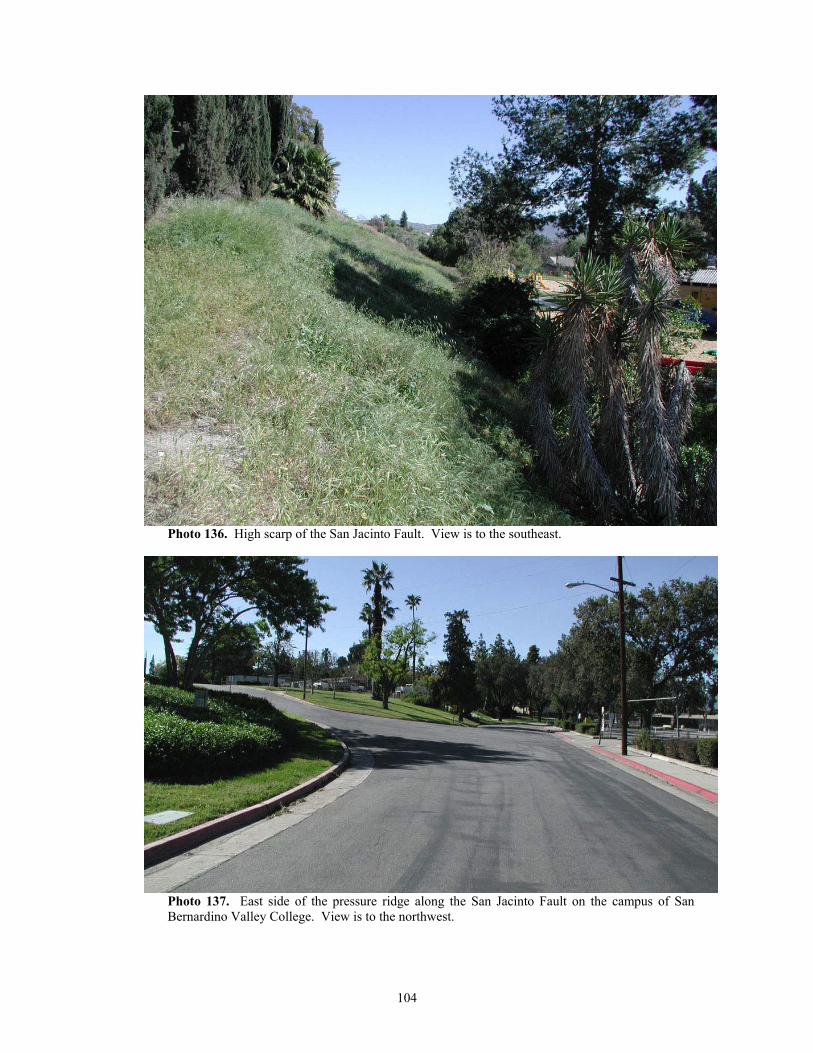
Photo 136. High scarp of the San Jacinto Fault. View is to the southeast.
Photo 137. East side of the pressure ridge along the San Jacinto Fault on the campus of San Bernardino Valley College. View is to the northwest.
104
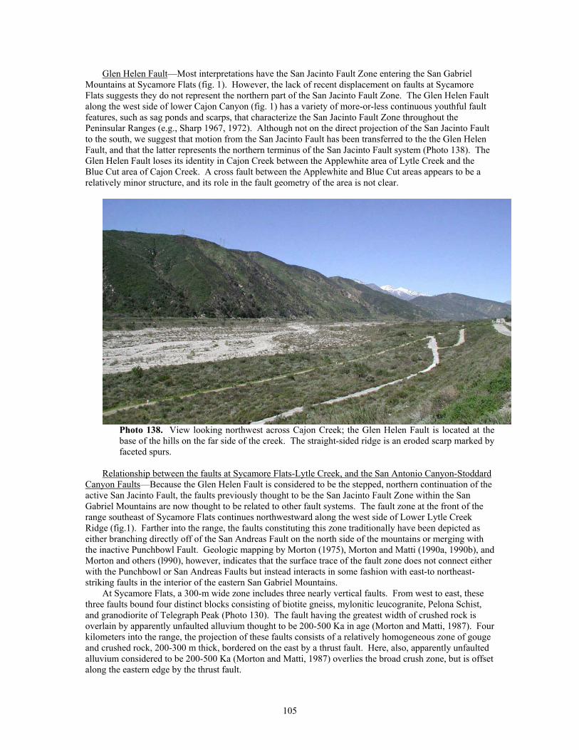
Glen Helen Fault—Most interpretations have the San Jacinto Fault Zone entering the San Gabriel Mountains at Sycamore Flats (fig. 1). However, the lack of recent displacement on faults at Sycamore Flats suggests they do not represent the northern part of the San Jacinto Fault Zone. The Glen Helen Fault along the west side of lower Cajon Canyon (fig. 1) has a variety of more-or-less continuous youthful fault features, such as sag ponds and scarps, that characterize the San Jacinto Fault Zone throughout the Peninsular Ranges (e.g., Sharp 1967, 1972). Although not on the direct projection of the San Jacinto Fault to the south, we suggest that motion from the San Jacinto Fault has been transferred to the the Glen Helen Fault, and that the latter represents the northern terminus of the San Jacinto Fault system (Photo 138). The Glen Helen Fault loses its identity in Cajon Creek between the Applewhite area of Lytle Creek and the Blue Cut area of Cajon Creek. A cross fault between the Applewhite and Blue Cut areas appears to be a relatively minor structure, and its role in the fault geometry of the area is not clear.
Photo 138. View looking northwest across Cajon Creek; the Glen Helen Fault is located at the base of the hills on the far side of the creek. The straight-sided ridge is an eroded scarp marked by faceted spurs.
Relationship between the faults at Sycamore Flats-Lytle Creek, and the San Antonio Canyon-Stoddard
Canyon Faults—Because the Glen Helen Fault is considered to be the stepped, northern continuation of the active San Jacinto Fault, the faults previously thought to be the San Jacinto Fault Zone within the San Gabriel Mountains are now thought to be related to other fault systems. The fault zone at the front of the range southeast of Sycamore Flats continues northwestward along the west side of Lower Lytle Creek Ridge (fig.1). Farther into the range, the faults constituting this zone traditionally have been depicted as either branching directly off of the San Andreas Fault on the north side of the mountains or merging with the inactive Punchbowl Fault. Geologic mapping by Morton (1975), Morton and Matti (1990a, 1990b), and Morton and others (l990), however, indicates that the surface trace of the fault zone does not connect either with the Punchbowl or San Andreas Faults but instead interacts in some fashion with east-to northeast-striking faults in the interior of the eastern San Gabriel Mountains.
At Sycamore Flats, a 300-m wide zone includes three nearly vertical faults. From west to east, these three faults bound four distinct blocks consisting of biotite gneiss, mylonitic leucogranite, Pelona Schist, and granodiorite of Telegraph Peak (Photo 130). The fault having the greatest width of crushed rock is overlain by apparently unfaulted alluvium thought to be 200-500 Ka in age (Morton and Matti, 1987). Four kilometers into the range, the projection of these faults consists of a relatively homogeneous zone of gouge and crushed rock, 200-300 m thick, bordered on the east by a thrust fault. Here, also, apparently unfaulted alluvium considered to be 200-500 Ka (Morton and Matti, 1987) overlies the broad crush zone, but is offset along the eastern edge by the thrust fault.
105
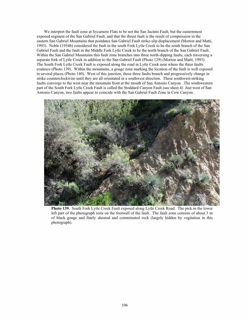
We interpret the fault zone at Sycamore Flats to be not the San Jacinto Fault, but the easternmost exposed segment of the San Gabriel Fault, and that the thrust fault is the result of compression in the eastern San Gabriel Mountains that postdates San Gabriel Fault strike-slip displacement (Morton and Matti, 1993). Noble (1954b) considered the fault in the south Fork Lytle Creek to be the south branch of the San Gabriel Fault and the fault in the Middle Fork Lytle Creek to be the north branch of the San Gabriel Fault. Within the San Gabriel Mountains this fault zone branches into three north-dipping faults, each traversing a separate fork of Lytle Creek in addition to the San Gabriel Fault (Photo 129) (Morton and Matti, 1993). The South Fork Lytle Creek Fault is exposed along the road in Lytle Creek near where the three faults coalesce (Photo 139). Within the mountains, a gouge zone marking the location of the fault is well exposed in several places (Photo 140). West of this junction, these three faults branch and progressively change in strike counterclockwise until they are all orientated in a southwest direction. These southwest-striking faults converge to the west near the mountain front at the mouth of San Antonio Canyon. The southwestern part of the South Fork Lytle Creek Fault is called the Stoddard Canyon Fault (see sheet 4) Just west of San Antonio Canyon, two faults appear to coincide with the San Gabriel Fault Zone in Cow Canyon.
Photo 139. South Fork Lytle Creek Fault exposed along Lytle Creek Road. The pick in the lower left part of the photograph rests on the footwall of the fault. The fault zone consists of about 3 m of black gouge and finely sheared and comminuted rock (largely hidden by vegitation in this photograph).
106
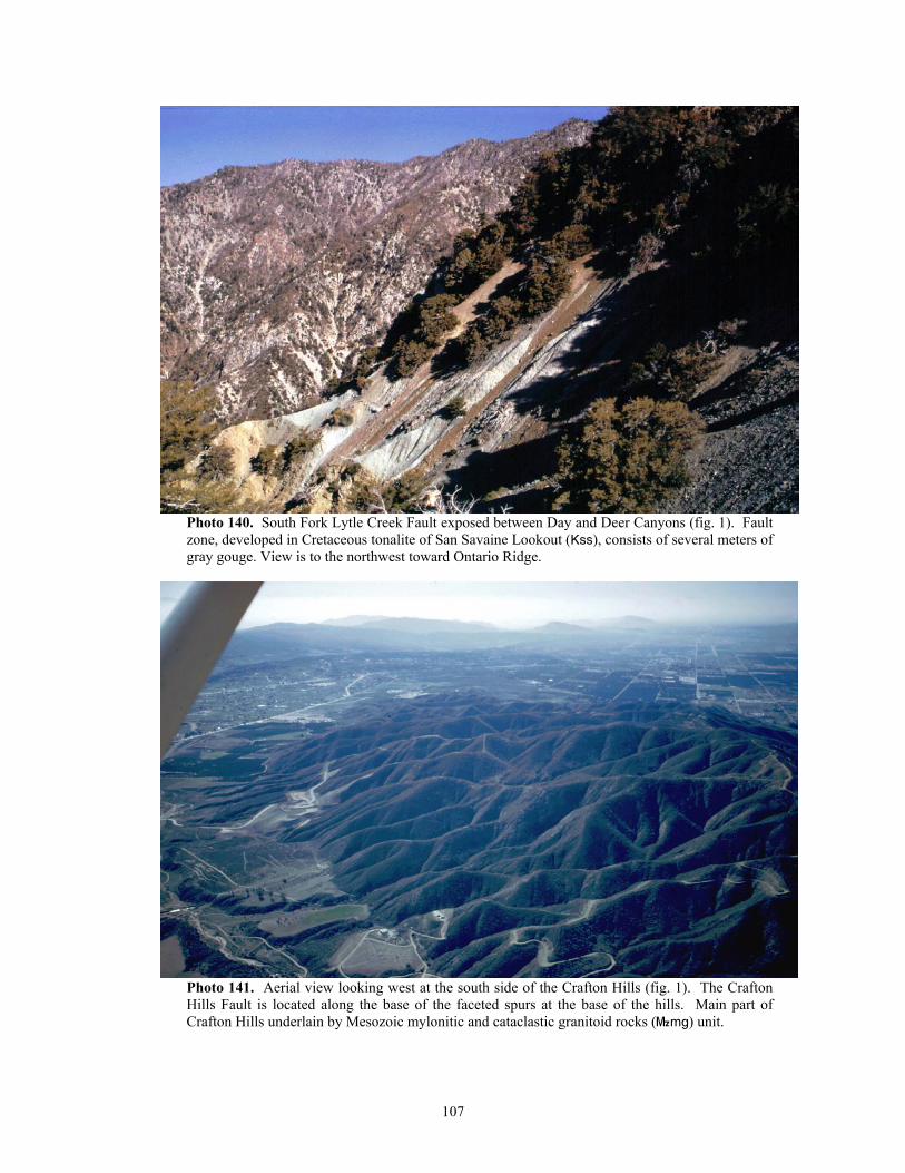
Photo 140. South Fork Lytle Creek Fault exposed between Day and Deer Canyons (fig. 1). Fault zone, developed in Cretaceous tonalite of San Savaine Lookout (Kss), consists of several meters of gray gouge. View is to the northwest toward Ontario Ridge.
Photo 141. Aerial view looking west at the south side of the Crafton Hills (fig. 1). The Crafton Hills Fault is located along the base of the faceted spurs at the base of the hills. Main part of Crafton Hills underlain by Mesozoic mylonitic and cataclastic granitoid rocks (}mg) unit.
107
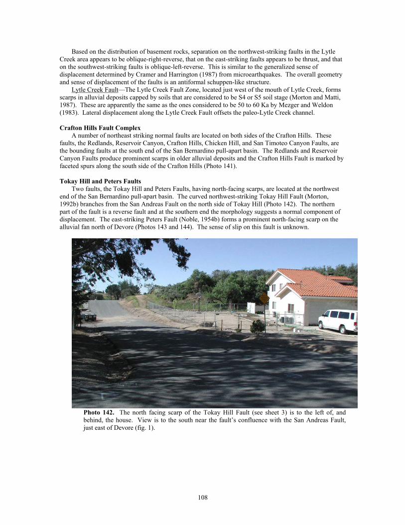
Based on the distribution of basement rocks, separation on the northwest-striking faults in the Lytle Creek area appears to be oblique-right-reverse, that on the east-striking faults appears to be thrust, and that on the southwest-striking faults is oblique-left-reverse. This is similar to the generalized sense of displacement determined by Cramer and Harrington (1987) from microearthquakes. The overall geometry and sense of displacement of the faults is an antiformal schuppen-like structure.
Lytle Creek Fault—The Lytle Creek Fault Zone, located just west of the mouth of Lytle Creek, forms scarps in alluvial deposits capped by soils that are considered to be S4 or S5 soil stage (Morton and Matti, 1987). These are apparently the same as the ones considered to be 50 to 60 Ka by Mezger and Weldon (1983). Lateral displacement along the Lytle Creek Fault offsets the paleo-Lytle Creek channel.
Crafton Hills Fault Complex
A number of northeast striking normal faults are located on both sides of the Crafton Hills. These faults, the Redlands, Reservoir Canyon, Crafton Hills, Chicken Hill, and San Timoteo Canyon Faults, are the bounding faults at the south end of the San Bernardino pull-apart basin. The Redlands and Reservoir Canyon Faults produce prominent scarps in older alluvial deposits and the Crafton Hills Fault is marked by faceted spurs along the south side of the Crafton Hills (Photo 141).
Tokay Hill and Peters Faults
Two faults, the Tokay Hill and Peters Faults, having north-facing scarps, are located at the northwest end of the San Bernardino pull-apart basin. The curved northwest-striking Tokay Hill Fault (Morton, 1992b) branches from the San Andreas Fault on the north side of Tokay Hill (Photo 142). The northern part of the fault is a reverse fault and at the southern end the morphology suggests a normal component of displacement. The east-striking Peters Fault (Noble, 1954b) forms a prominent north-facing scarp on the alluvial fan north of Devore (Photos 143 and 144). The sense of slip on this fault is unknown.
Photo 142. The north facing scarp of the Tokay Hill Fault (see sheet 3) is to the left of, and behind, the house. View is to the south near the fault’s confluence with the San Andreas Fault, just east of Devore (fig. 1).
108
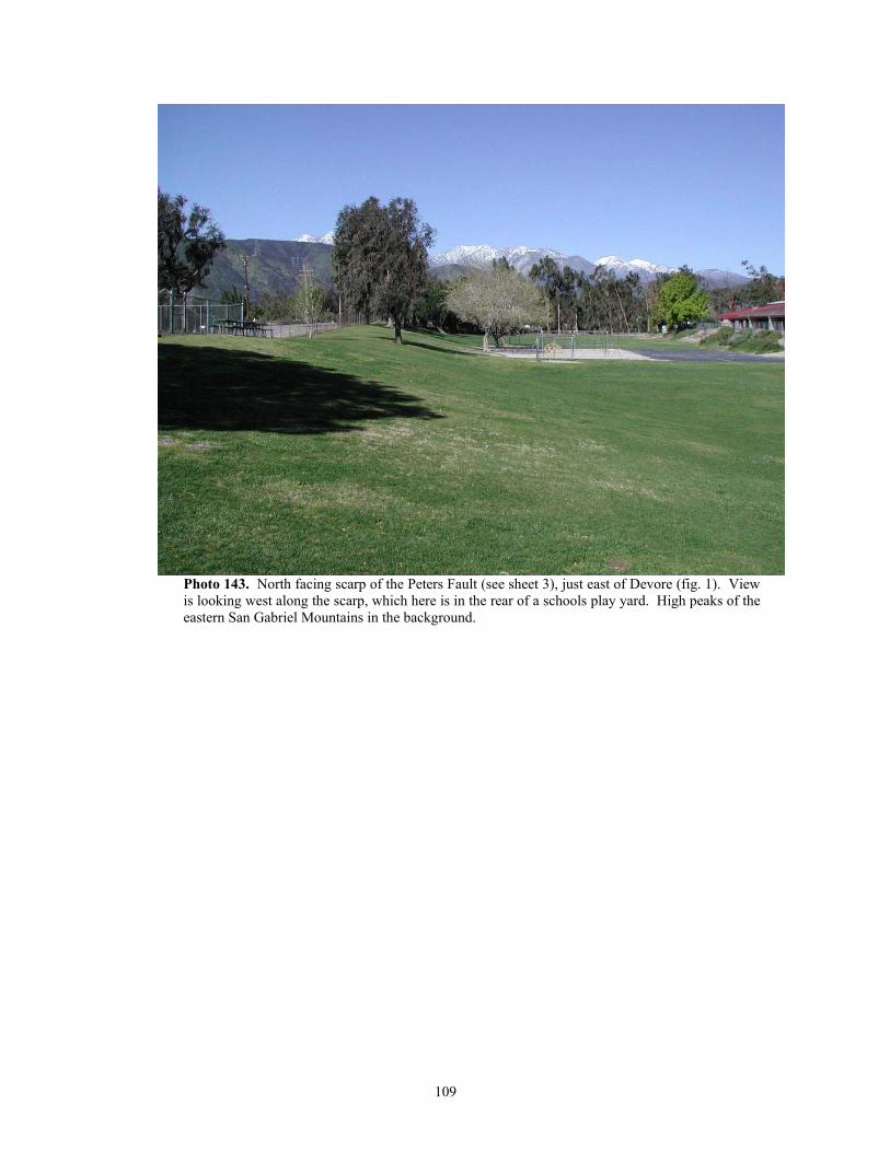
Photo 143. North facing scarp of the Peters Fault (see sheet 3), just east of Devore (fig. 1). View is looking west along the scarp, which here is in the rear of a schools play yard. High peaks of the eastern San Gabriel Mountains in the background.
109
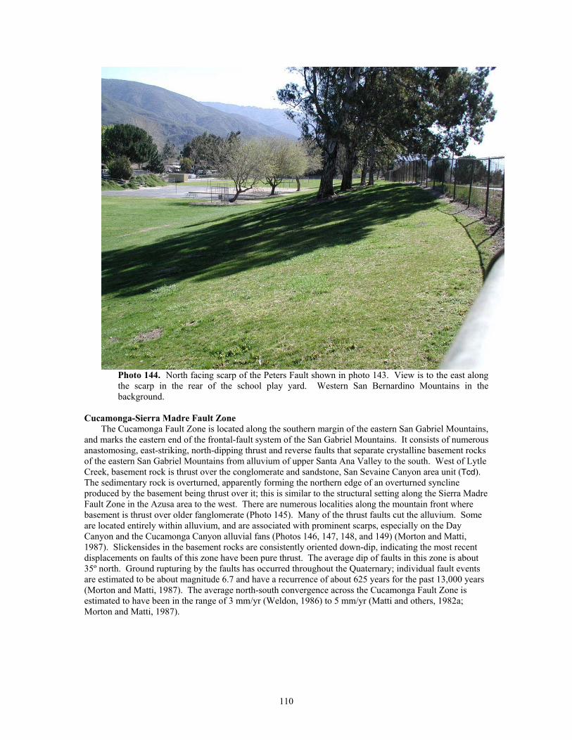
Photo 144. North facing scarp of the Peters Fault shown in photo 143. View is to the east along the scarp in the rear of the school play yard. Western San Bernardino Mountains in the background.
Cucamonga-Sierra Madre Fault Zone
The Cucamonga Fault Zone is located along the southern margin of the eastern San Gabriel Mountains, and marks the eastern end of the frontal-fault system of the San Gabriel Mountains. It consists of numerous anastomosing, east-striking, north-dipping thrust and reverse faults that separate crystalline basement rocks of the eastern San Gabriel Mountains from alluvium of upper Santa Ana Valley to the south. West of Lytle Creek, basement rock is thrust over the conglomerate and sandstone, San Sevaine Canyon area unit (Tcd). The sedimentary rock is overturned, apparently forming the northern edge of an overturned syncline produced by the basement being thrust over it; this is similar to the structural setting along the Sierra Madre Fault Zone in the Azusa area to the west. There are numerous localities along the mountain front where basement is thrust over older fanglomerate (Photo 145). Many of the thrust faults cut the alluvium. Some are located entirely within alluvium, and are associated with prominent scarps, especially on the Day Canyon and the Cucamonga Canyon alluvial fans (Photos 146, 147, 148, and 149) (Morton and Matti, 1987). Slickensides in the basement rocks are consistently oriented down-dip, indicating the most recent displacements on faults of this zone have been pure thrust. The average dip of faults in this zone is about 35º north. Ground rupturing by the faults has occurred throughout the Quaternary; individual fault events are estimated to be about magnitude 6.7 and have a recurrence of about 625 years for the past 13,000 years (Morton and Matti, 1987). The average north-south convergence across the Cucamonga Fault Zone is estimated to have been in the range of 3 mm/yr (Weldon, 1986) to 5 mm/yr (Matti and others, 1982a; Morton and Matti, 1987).
110
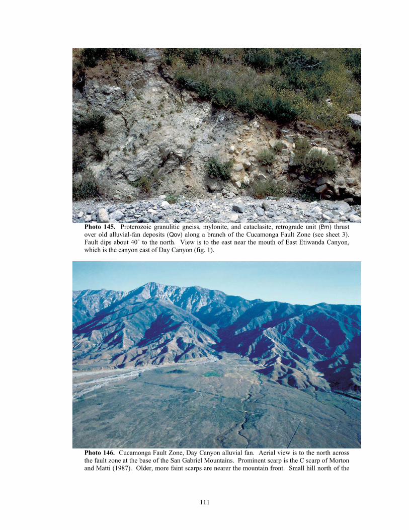
Photo 145. Proterozoic granulitic gneiss, mylonite, and cataclasite, retrograde unit (<m) thrust over old alluvial-fan deposits (Qov) along a branch of the Cucamonga Fault Zone (see sheet 3). Fault dips about 40˚ to the north. View is to the east near the mouth of East Etiwanda Canyon, which is the canyon east of Day Canyon (fig. 1).
Photo 146. Cucamonga Fault Zone, Day Canyon alluvial fan. Aerial view is to the north across the fault zone at the base of the San Gabriel Mountains. Prominent scarp is the C scarp of Morton and Matti (1987). Older, more faint scarps are nearer the mountain front. Small hill north of the
111
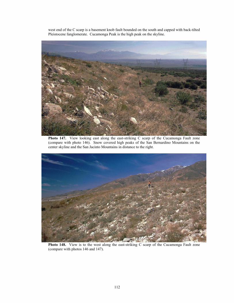
west end of the C scarp is a basement knob fault bounded on the south and capped with back-tilted Pleistocene fanglomerate. Cucamonga Peak is the high peak on the skyline.
Photo 147. View looking east along the east-striking C scarp of the Cucamonga Fault zone (compare with photo 146). Snow covered high peaks of the San Bernardino Mountains on the center skyline and the San Jacinto Mountains in distance to the right.
Photo 148. View is to the west along the east-striking C scarp of the Cucamonga Fault zone (compare with photos 146 and 147).
112
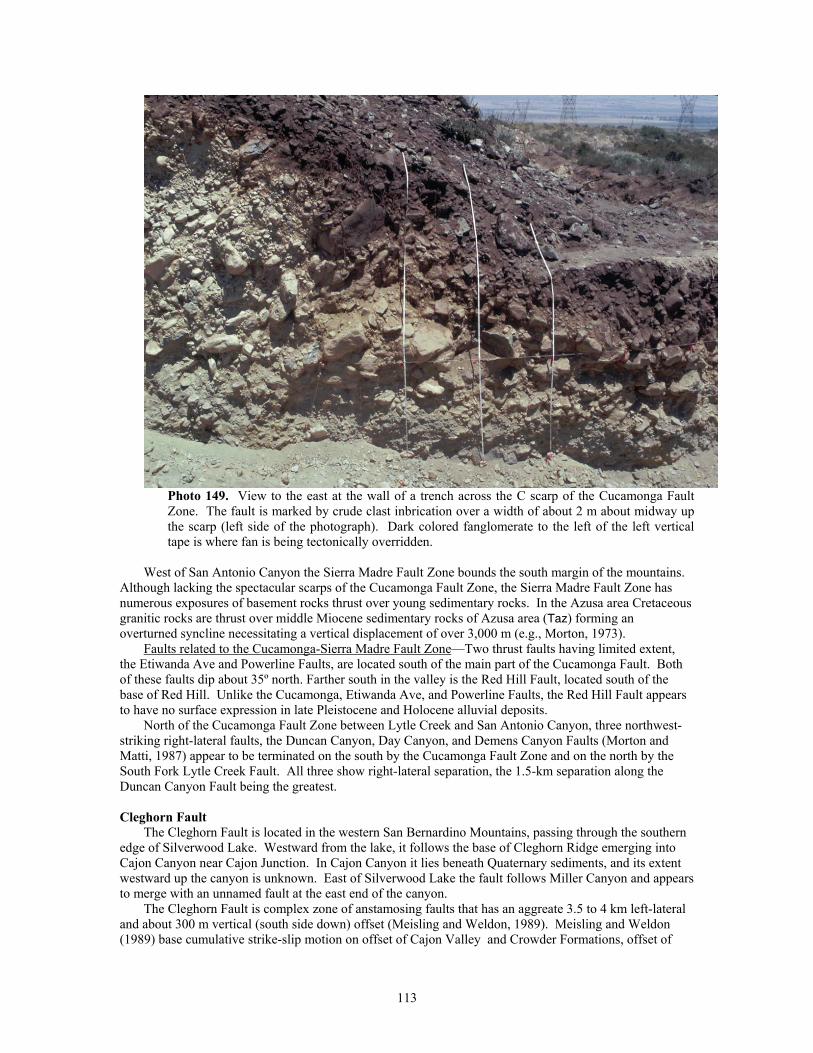
Photo 149. View to the east at the wall of a trench across the C scarp of the Cucamonga Fault Zone. The fault is marked by crude clast inbrication over a width of about 2 m about midway up the scarp (left side of the photograph). Dark colored fanglomerate to the left of the left vertical tape is where fan is being tectonically overridden.
West of San Antonio Canyon the Sierra Madre Fault Zone bounds the south margin of the mountains.
Although lacking the spectacular scarps of the Cucamonga Fault Zone, the Sierra Madre Fault Zone has numerous exposures of basement rocks thrust over young sedimentary rocks. In the Azusa area Cretaceous granitic rocks are thrust over middle Miocene sedimentary rocks of Azusa area (Taz) forming an overturned syncline necessitating a vertical displacement of over 3,000 m (e.g., Morton, 1973).
Faults related to the Cucamonga-Sierra Madre Fault Zone—Two thrust faults having limited extent, the Etiwanda Ave and Powerline Faults, are located south of the main part of the Cucamonga Fault. Both of these faults dip about 35º north. Farther south in the valley is the Red Hill Fault, located south of the base of Red Hill. Unlike the Cucamonga, Etiwanda Ave, and Powerline Faults, the Red Hill Fault appears to have no surface expression in late Pleistocene and Holocene alluvial deposits.
North of the Cucamonga Fault Zone between Lytle Creek and San Antonio Canyon, three northwest-striking right-lateral faults, the Duncan Canyon, Day Canyon, and Demens Canyon Faults (Morton and Matti, 1987) appear to be terminated on the south by the Cucamonga Fault Zone and on the north by the South Fork Lytle Creek Fault. All three show right-lateral separation, the 1.5-km separation along the Duncan Canyon Fault being the greatest.
Cleghorn Fault
The Cleghorn Fault is located in the western San Bernardino Mountains, passing through the southern edge of Silverwood Lake. Westward from the lake, it follows the base of Cleghorn Ridge emerging into Cajon Canyon near Cajon Junction. In Cajon Canyon it lies beneath Quaternary sediments, and its extent westward up the canyon is unknown. East of Silverwood Lake the fault follows Miller Canyon and appears to merge with an unnamed fault at the east end of the canyon.
The Cleghorn Fault is complex zone of anstamosing faults that has an aggreate 3.5 to 4 km left-lateral and about 300 m vertical (south side down) offset (Meisling and Weldon, 1989). Meisling and Weldon (1989) base cumulative strike-slip motion on offset of Cajon Valley and Crowder Formations, offset of
113
monoclinal axes, and restoration of offset older faults. They suggest that about 0.5 km of motion took place in the last 500,000 years, and as much as 200 m since 50,000 to 100,000 years ago.
Santa Ana Fault
The Santa Ana Fault is a north dipping reverse fault that places Cretaceous granitic rocks over Miocene Santa Ana Sandstone and Cretaceous and Triassic granitic rocks. It has an irregular trace north of the canyon of the Santa Ana River, and extends at least another 20 to 25 km east of the quadrangle. Most dip measurements on the fault are between 30 and 60 degrees north. A number of continuous and discontinuous, branching faults roughly parallel the Santa Ana Fault on the south, suggesting a possible relationship to the reverse fault. Dip measurements are not available for these faults, but distribution of Santa Ana Sandstone relative to the faults indicates that sense of movement on at least one may be opposite that of the Santa Ana Fault.
West of Plunge Creek, the Santa Ana Fault has monzogranite of City Creek (Kcc) in both the hanging wall and footwall, and is difficult to identify as a single through-going structure. The westward projection of the fault appears to cross City Creek near the intersection of the East and West Forks, and to continue northwestward for at least another 6 km. Although not shown on the geologic map, the fault may continue northwestward and eventually merge with the Devil Canyon Fault.
Devil Canyon Fault
The Devil Canyon Fault is an east striking, multiply branching, high-angle fault that appears to intersect the San Andreas Fault just southeast of Cable Canyon (fig. 1). Eastward from the San Andreas Fault, it is fairly well defined to about where it crosses City Creek; east of City Creek its location and extent are not well established. The fault and its branches bound and enclose areas of a Tertiary, undifferentiated conglomerate and arkose unit (Tcu), suggesting localized graben-like structures. Limited fault dip measurements in the central and western parts are near vertical. Topographic break-in-slope associated with much of the fault suggests mountain-side (north) down sense of movement. If this is the case, it is the opposite sense of movement associated with the nearby, semi-parallel Santa Ana Fault.
Fault zone bounding north side of San Bernardino Mountains
Northward and eastward from the vicinity Deep Creek exits the San Bernardino Mountains, a prominent, discontinuous system of south dipping reverse faults bounds the north side of the range. Meisling (1984) and Meisling and Weldon (1989) refer to the faults as a thrust system, but except for the east central part of the zone, well east of the quadrangle, limited dip measurements are mostly greater than 40º. They interpret the zone to shallow considerably at depth.
Eroded fault and fault-line scarps tens of meters high are associated with late movement on parts of the fault zone. North of the Ord Mountains segment of the San Bernardino Mountains, the fault zone passes into a monoclinal flexture for several kilometers and then back into a fault (Meisling, 1984; Meisling and Weldon, 1989). Meisling, 1984, Meisling and Weldon, 1989, and J.C. Matti (oral commun.) consider northeast and east striking parts of this fault zone to be dominantly reverse or thrust movement, but some of the northwest striking parts to be strike slip.
Initial development of the fault zone was in early Pleistocene, but maximum movement occurred in middle Pleistocene. Middle Pleistocene fanglomerates flanking the western part of the range contain abundant, large, angular clasts derived from the range, so elevation and drainage pattern off of the range had been established by that time. Meisling and Weldon (1989) consider this north-bounding fault system to be responsible for most of the uplift of the central San Bernardino Mountains, and that uplift tapered off towards the western and eastern ends of the range.
Squaw Peak Fault
The Squaw Peak Fault is a deformed fault of unknown extent interpreted by Meisling and Weldon (1989) to be a late Miocene to early Pliocene thrust. It is highly disrupted by younger faults, and bends from a north strike in it southern part to a west-northwest strike in its northern part. Where exposed, the southern part of the fault dips steeply east, and the northern and western part, shallowly north. In the northern part, the fault places Crowder Formation over Cajon Valley Formation, and in the southern part, granitic rocks of the San Bernardino assemblage over Cajon Valley Formation.
114
The following notes pertain to: (1) the organization of bedrock units in the following DESCRIPTION OF MAP UNITS section and in the accompanying CORRELATION OF MAP UNITS, and (2) the classification scheme used for the generic Quaternary units. The CORRELATION OF MAP UNITS and the DESCRIPTION OF MAP UNITS are organized by rock assemblage, because each assemblage is separated by a major fault or fault zone. The San Gabriel Mountains assemblage is bounded by the San Andreas, Cucamonga, and San Jose Fault Zones; the Peninsular Ranges assemblage by the Cucamonga, San Jose, and San Jacinto Fault Zones; and the San Bernardino Mountains assemblage by the San Andreas Fault Zone The fourth, less extensive, assemblage is bounded by the Mill Creek Fault and southernmost strands of the San Andreas Fault Zone (fig. 1). Quaternary sedimentary units without formal or informal names are classified by a combination of age and sedimentary processes (J.C. Matti, written commun.). This classification is the most objective scheme available for subdividing the complex array of Quaternary units in the region, but users of this report should be aware of a number of limitations imposed on the scheme. Accurate ages are available for very few of these generic units. Subdivisions of some units, e.g., Qyf1 compared to Qyf2, are based almost entirely on relative characteristics and relative age. Interpretation of sedimentary processes are questionable for some units at some localities. Climatic conditions that influenced deposition of Quaternary units probably differed north and south of the Transverse Ranges during the Quaternary. Because of these limitations, many specific generic Quaternary units at one locality, e.g., Qyf1, may not be temporally equivalent to Qyf1 at all other localities. Due to differences in source area materials and differences in depositional conditions at specific sites, Qyf1 at one location, in most cases, will not have the same appearance as Qyf1 at another location. Many of the generic Quaternary units, e.g., Qyf, are subdivided, e.g., Qyf1 and Qyf2. In these cases, Qyf is the undifferentiated young alluvial-fan unit, and Qyf1 and Qyf2 are subdivisions where they can be recognized. The relation between the undifferentiated units and their subdivisions is the same for old (Qo) and very old (Qvo) Quaternary units also. See Bull (1991) for information on soils classification nomenclature used in many of the Quaternary unit descriptions. Place names used in the following Description of Map Units are shown in Figure 1, because many that appear on the base map accompanying the geologic coverage are obscured by the geology.
DESCRIPTION OF MAP UNITS
SURFICIAL DEPOSITS Qdg Disturbed ground (late Holocene)—Bedrock fragmented to sand- and gravel-sized
pieces; commonly mixed with Quaternary sedimentary material found at site. Occurs mainly in areas where construction or excavation has obscured, mixed, redistributed, or covered naturally occurring units; thickness generally less than 3 meters. Areas shown as disturbed ground are localities where results of human activity generally preclude accurate identification or classification of natural geologic units
Qaf Artificial fill (late Holocene)—Sand, gravel, and bedrock from pits, quarries, and excavations related to construction; mapped primarily where materials are placed for construction of highways, canals, railway grades, dams, and water catchment basins. Only large features are mapped; not shown in some places where unit obscures detailed surficial or bedrock relations. Differs from
115

disturbed ground (Qdg) in that generally large amounts of rock and (or) sediment have been imported to site
Qw Very young wash deposits (late Holocene)—Unconsolidated sand and gravel deposits in active washes, ephemeral river channels of axial-valley streams, and in channels on active surfaces of alluvial fans; has fresh flood scours and channel-and-bar morphology. Essentially no soil development. Subject to localized reworking and introduction of new sediment mainly during winter months. In places, especially upper reaches of some drainages, contains clasts several meters across that were deposited by flash floods. Grain shape ranges from angular to rounded; larger clasts tend to be more rounded than smaller clasts. All sediment derived from local bedrock or reworked from local, older Quaternary deposits. In Mojave River bed, almost all sediment is fine- to very coarse-grained sand containing lesser gravel and pebbles; clasts larger than pebbles are sparse. Gravel bars up to 100 m long fairly common. In beds of Arrastre Creek, Mescal Creek, and Big Rock Creek, clasts are mixed sand to boulders and include numerous bars dominated by one or another of larger clast sizes. Unit in Sheep Creek differs from other Qw deposits; it is dominated by debris-flow deposits originating in steep headwaters area of drainage in Mesozoic Pelona Schist. Debris flows catastrophically transported during years of heavy snowfall when rapid melt occurs (Morton and Campbell, 1974; Sharp and Nobles, 1953). In Cajon Wash and beds of Lytle Creek and Santa Ana River, clasts are mixed sand to boulders, coarsening toward mountains; in lower reaches of Santa Ana River, unit consists mostly of unconsolidated sand and gravel. North of mountains and west of Mojave River, nearly all Qyw deposits are cut by medial channels of Qw too small to show at map scale. Divisions are distinguished by relative position in local terrace riser succession and by overlapping relations. In northwestern part of quadrangle, within 2 km of San Andreas Fault zone, includes most of stream channel deposits unit of Barrows and others (1985) and Barrows (1987). Locally subdivided to include:
Qw3 Very young wash deposits, Unit 3—Unconsolidated sand, gravel, and pebble deposits that form very slightly elevated terraces within, or along margins of, active Mojave River channel. Grain size distribution and degree of rounding generally same as Qw deposits at similar distances from mountain front. Has slightly less prominent vegetative cover than most Qw deposits. Probably intermittently active during high water in years of peak rainfall. Range of clast size, shape, and distribution similar to that of Qw deposits
Qw2 Very young wash deposits, Unit 2—Unconsolidated, mixed sand, gravel, pebble, cobble, and boulder deposits that form slightly elevated, low terraces within, or along margins of, active washes. Grain size distribution and degree of rounding generally same as Qw units at similar distances from mountain front. Clast compositions reflect bedrock and older Quaternary sources within individual drainages. Commonly has noticeably denser vegetative cover than Qw3 deposits, especially larger, older bushes and trees. Appears to be intermittently active based on localized bar-and-swale geomorphology and channel scouring. May or may not undergo redistribution or destruction during high water in years of peak rainfall. Range of clast size, shape, and distribution similar to that of Qw deposits
Qw1 Very young wash deposits, Unit 1—Unconsolidated sand-and-gravel deposits that form consistent, but low, elevated terraces in or marginal to channelized washes of streams and rivers. Grain size distribution and degree of rounding generally same as Qw units at similar distances from mountain front. Largely abandoned by modern stream flows; less likely to become occupied or destroyed by major flood events than Qw2 deposits. Has noticeably denser vegetative cover than Qw3 or Qw2 deposits, commonly having incipient soil development, and larger, older bushes and trees. Range of clast size, shape, and distribution similar to that of Qw deposits
116
Qf Very young alluvial-fan deposits (late Holocene)—Unconsolidated to slightly coherent, essentially undissected deposits of sand, gravel, and boulders that form active and recently active parts of alluvial fans. Clasts typically angular to subrounded, rarely rounded. Deposits generally coarsen toward heads of fans. Relative abundance of clast sizes varies greatly depending on setting, size of drainage area, and sediment source. At most places, unit lacks soil development, but on south side of San Bernardino Mountains, locally is capped by weak A/AC soils. On north side of San Bernardino and San Gabriel Mountains, unit occurs chiefly as small fans emanating from limited-extent, steep canyons, mouths of channels cut in dissected scarps, or mouths of channels cut in elevated, older Quaternary deposits. Surfaces typically cut by braided streams, but deposition exceeds dissection. Where subdivision of Qf deposits is possible, subunits are distinguished from one another by relative position in local terrace riser succession, by local superposition, or by relative dissection. Includes:
Qf2 Very young alluvial-fan deposits, Unit 2—Unconsolidated to loosely compacted alluvial fan deposits. Essentially undissected, but surface typically cut by anastomosing network of channels. Size, shape, and distribution of clasts similar to that of unit Qf. Distinguished in most cases as fans built out on Qf1 sediments, and to some degree as fans relatively less dissected than, or emanating from channels cut into, Qf1 sediments. Appearance from place to place differs greatly; primarily dependent on sediment source, steepness of source area and fan location, and distance from mountain front
Qf1 Very young alluvial-fan deposits, Unit 1—Unconsolidated to loosely compacted alluvial fan-deposits, varying in grain size from sand to boulders. Degree of compaction unreliable for distinguishing Qf1 from other Qf units or some Qyf units. Has general physical characteristics of Qf and Qf2 sediments. Mode of occurrence, in addition to range of clast size, clast shape, and clast distribution, similar to that of unit Qf and Qf2. Distinguished in most cases as fans upon which Qf and Qf2 fans have built, and to lesser degree as fans that are relatively more dissected than Qf and Qf2 fans, or as fans that are cut by channels from which Qf and Qf2 fans emanate. Appearance from place to place differs greatly; primarily dependent on sediment source, steepness of source area and fan location and distance from mountain front
Qa Very young alluvial-valley deposits (late Holocene)—Unconsolidated deposits of silty, sandy and cobbly alluvium deposited by streams in through-going stream valleys; cemented only where carbonate rocks are in source area. Includes:
Qa1 Very young alluvial-valley deposits, Unit 1—Largely unconsolidated to barely consolidated alluvial deposits in valley bottoms. Varies in grain size from sand to boulders; finer size-fractions more common. Has general physical characteristics of Qa sediments, but is relatively more dissected than Qa, and is distinguished by relative position in local terrace-riser succession. Appearance from place to place differs greatly; primarily dependent on sediment source and steepness of source area
Qc Very young colluvial deposits (late Holocene)—Unconsolidated sediment and loose sediment, rock fragments, and soil material deposited by rain wash or slow continuous downslope creep; found mainly, but not exclusively, at base of slopes or hillsides. In western San Bernardino Mountains, much of sediment is angular, derived from extensive grus developed on Cretaceous and Jurassic units. No soil development
Qt Very young talus deposits (late Holocene)—Unconsolidated to slightly consolidated deposits of angular pebble-, cobble-, and boulder-size material that form scree and rubble on hill slopes and at base of slopes. In places loose and hazardous to walk on. Best developed below steep faces of highly fractured granitic and metamorphic rocks in eastern San Gabriel Mountains. In places, probably
117
includes some colluvium. Numerous small talus cones found on steeper slopes in San Bernardino and eastern San Gabriel Mountains are too small to map
Qsw Very young slopewash deposits (late Holocene)—Unconsolidated sand, cobbles, and pebbles deposited by water not confined to channels. Most deposits are angular, multi-mineralogic sand derived from in-place weathering of granitic rocks, but many include larger clasts transported by torrential storms or clasts spalled from up-slope outcrops of bedrock
Qls Very young landslide deposits (late Holocene)—Slope-failure deposits consisting of chaotically mixed soil and rubble and (or) displaced bedrock blocks; most are debris slides and rock slumps or earth slumps. Landslides may or may not be active. Landslide morphology well preserved. In San Bernardino Mountains in Holcomb Creek drainage northeast of Lake Arrowhead, consists of granitic rubble. On west side of Bear Canyon, near east edge of quadrangle, consists of granitic rubble and probably includes some talus In eastern San Gabriel Mountains between Deer Canyon and Sam Sevaine Flats, consists of granitic rubble and possibly includes some talus and slope wash
Qp Very young playa deposits (late Holocene)—Pale-brown to pale-gray, silty, sandy clay, and clayey silt. Relatively coherent where damp or dry. All playa deposits, including Qp1, restricted to Rabbit Dry Lake and small unnamed dry lake 7 km west of Rabbit Dry Lake. New sediment is distributed and uppermost part of existing sediment redistributed by wind generated wave action during wet periods. Along margins, mixed with and includes some very young eolian deposits (Qe)
Qp1 Very young playa deposits, Unit 1—Pale-brown to pale-gray silty, sandy clay, and clayey silt. Relatively coherent where completely dry. Slightly elevated and locally shows incipient dissection compared to active playa surface of Rabbit Dry Lake. Along margins, mixed with and includes some very young eolian deposits (Qe)
Ql Very young lacustrine deposits (late Holocene)—Silt, sand, and gravel associated with sag ponds along San Andreas Fault strands. Sediments are commonly submerged, but are exposed partly or completely during dry periods.
Qe Very young eolian deposits (late Holocene)—Fine-grained sand and silt mainly along north bank of Arrastre Canyon, between San Bernardino and Granite Mountains. Thin, forms sand patches in lee of desert vegetation; mapped only where sand patches have coalesced. No dune morphology
Qs Very young surficial deposits (late Holocene)—Silt, sand, and pebble- to small-cobble gravel. Mostly unconsolidated, but locally, slightly consolidated. Includes many small scattered deposits consisting of sediment that does not have features allowing confident assignment to any specific surficial materials unit. Some were identified on aerial photographs, and not checked at site. Probably includes wash, alluvial-fan, colluvial, and valley-filling deposits
Qs1 Very young surficial deposits, Unit 1—Sand and pebble to small- cobble gravel not assigned to any specific surficial materials unit. Essentially same characteristics as very young surficial deposits unit (Qs), but distinguished either as terraces cut into Qs sediments, or parts of Qs sediments that show anomalous dissection
Qyw Young wash deposits (Holocene and late Pleistocene)—Unconsolidated to slightly consolidated sand and gravel deposits in marginal parts of active and recently active washes and ephemeral river channels of axial-valley streams. Differs from very young wash deposits by absence or modification of flood scours, modified channel-and-bar morphology, and immature soil horizons. Mapped mainly on north sloping fan surfaces north of Cajon Summit area, where sediment is mixed with eroded and slumped material from steep, high, stream embankments. Clast size reflects distance from mountain front to same degree as Qw deposits All is sediment derived from local bedrock or reworked from local, older Quaternary deposits. West of Rabbit Dry Lake and west of
118
Silverwood Lake, includes sediment in partially abandoned washes. Subunits are distinguished by relative position in local terrace riser succession. Includes:
Qyw3 Young wash deposits, Unit 3 (early Holocene)—Unconsolidated silt, sand, and coarse-grained sand to cobble alluvium. Forms low, moderately well defined terrace risers along Antelope Valley wash south of Hesperia. Truncated by locally younger Qyw sediments, but shows very little surface modification
Qyw2 Young wash deposits, Unit 2 (early Holocene)—Unconsolidated to slightly consolidated silt, sand, and coarse-grained sand to cobble alluvium. Forms relatively low, but well defined terrace risers along Antelope Valley wash south of Hesperia. Truncated by Qyw3 sediments, but shows only slight surface modification
Qyw1 Young wash deposits, Unit 1 (early Holocene and late Pleistocene)—Unconsolidated to slightly consolidated silt, sand, and coarse-grained sand to cobble alluvium. Forms well defined terrace risers along west side of Mojave River southeast of Hesperia. Stands above, and is truncated by younger Qyw2 sediments; shows slight surface modification
Qyf Young alluvial-fan deposits (Holocene and late Pleistocene)—Unconsolidated to moderately consolidated silt, sand, pebbly cobbly sand, and bouldery alluvial-fan deposits having slightly to moderately dissected surfaces. Young alluvial-fan deposits, including subunits, constitute most widespread, and probably greatest in terms of sediment volume, of all Quaternary units. Forms large and small fans throughout quadrangle. Covers large areas in upper part of Cajon Canyon and on north side of San Gabriel Mountains west of Sheep Creek. Close to mountains, unit typically contains large proportion of cobbles and boulders. Intermediate and distal parts of large fans west of Sheep Creek are mainly pale-brown, mixed silt to medium-grained sand, containing sparse, coarse-grained sand and pebble lenses. Except where coarser-grained lenses are present, stratification is obscure. Clast compositions, especially in upper third of fans, reflect bedrock source areas and clast compositions of nearby older Quaternary units. Fans emanating from areas underlain by deeply weathered Cretaceous granitic rocks are relatively fine grained and contrast with coarser grained fans emananating from areas underlain by Triassic and older rocks. Includes from youngest to oldest:
Qyf5 Young alluvial-fan deposits, Unit 5 (late Holocene)—Unconsolidated to slightly consolidated coarse-grained sand to bouldery alluvial fan deposits having slightly dissected to essentially undissected surfaces. Stage S7 soils in Devore area. Notably finer grained in some parts of quadrangle, especially in distal parts of fans. Braided stream pattern on surfaces of fans that is related to deposition is relatively unmodified. On south side of San Gabriel Mountains, includes large, well formed fan emanating from Lytle Creek drainage; largely boulder alluvium in headward parts of fan, grading southward into dominantly sand and gravel. West of Phelan, includes Sheep Creek fan which has distinct gray-green color, and strongly contrasts with nearly all other alluvial material in quadrangle. Sheep Creek fan is composed essentially of material derived from Pelona Schist, and mainly deposited by debris flows. Parts of unit subsequently redistributed by conventional stream flow, especially in distal areas. Fans of Qyf5 sequence are younger than Qyf4 fans based mainly on relative position in terrace riser sequence and on superposition and overlap relations of adjacent fans
Qyf4 Young alluvial-fan deposits, Unit 4 (late Holocene)—Unconsolidated to slightly consolidated silt, sand, and coarse-grained sand to bouldery alluvial fan deposits having slightly to moderately dissected surfaces. Stage S7 soils in Devore area. Fans emanating from canyons on south side of San Gabriel Mountains contain large proportion of coarse boulders, especially in upper parts. Fans emanating from canyons on south side of San Bernardino Mountains contain coarse boulders in upper parts, but grade over short distances southward into sand and
119
pebble alluvium. On south side of both ranges, typically braided stream pattern on surfaces of fans related to deposition is only slightly modified. Large area of Qyf4 between Granite Mountains and Mojave River is slightly consolidated silt and sand, that contains lenses and individual matrix-supported clasts generally less than 2 cm across. Represents large area of coalesced fan material. Surface is smooth and undulating, showing only slight dissection in upper parts. Unit in this part of quadrangle may contain some axial-valley deposits, especially near western end of Granite Mountains. Age relative to Qyf5 and Qyf3 based mainly on overlap relations of adjacent fans and degree of dissection compared to fans in general area
Qyf3 Young alluvial-fan deposits, Unit 3 (middle Holocene)—Slightly to moderately consolidated silt, sand, and coarse-grained sand to bouldery alluvial fan deposits having slightly to moderately dissected surfaces. In Devore area, unit has stage S6 or incipiently developed stage S5 soils developed. West of Mojave River, consists of relatively uniform, medium brown silt and sand containing sparse granule and pebble lenses and scattered, matrix-supported, pebble-sized clasts. Fan surfaces are slightly to moderately dissected, and in many places show low amplitude, rolling surfaces having swales and ridges parallel to axes of fans. In this area, may include some Qyf2 and Qyf4 deposits. Cut by several large Qyw washes incised to depths as great as 4 m, containing active medial Qw channels too small to map
Qyf2 Young alluvial-fan deposits, Unit 2 (early Holocene)—Slightly consolidated coarse-grained sand to bouldery alluvial fan deposits having moderately dissected surfaces and, in Devore area, well-developed S5 soils. Widespread on both north and south sides of San Gabriel and San Bernardino Mountains, mainly forming relatively small fans. On south side of mountains, especially San Gabriel Mountains, fans contain high percentage of boulders. On north side of San Bernardino Mountains, east of Mojave River, fans are made up largely of sand to pebble sized clasts in a silty matrix. There, most show no stratification; surfaces are relatively smooth, but are cut by discreet, wide, deeply incised channels
Qyf1 Young alluvial-fan deposits, Unit 1 (early Holocene and late Pleistocene)—Slightly to moderately consolidated silt, sand, and coarse-grained sand to bouldery alluvial fan deposits having moderately dissected surfaces. Has well-developed S5 soils on south side of San Gabriel and San Bernardino Mountains. Appears to form major fill that was deposited throughout San Bernardino Valley region during transition between late Pleistocene and Holocene (McFadden and Weldon, 1987; Morton and Matti, 1987). Also, widespread on north side of San Bernardino Mountains, but mainly forming relatively small fans. On south side of mountains, especially San Gabriel Mountains, fans contain much higher percentage of boulders than on north side of San Bernardino Mountains, east of Mojave River. There fans are made up largely of sand to pebble sized clasts, and most show no stratification
Qya Young alluvial-valley deposits (Holocene and late Pleistocene)—Slightly to moderately consolidated silt, sand, and gravel deposits. Units distinguished from each other on basis of soil-profile development, relative position in local terrace-riser succession, and degree of erosional dissection. In central and eastern San Gabriel Mountains, some deposits contain abundant boulders derived from steep valley sides and steep tributary canyons. Unit in that area also may include some very young alluvial-fan deposits (Qf) and young alluvial-fan deposits (Qyf) emanating from tributary canyons and gulches, especially along Prairie Fork of San Gabriel River. Includes:
Qya5 Young alluvial-valley deposits, Unit 5 (late Holocene)—Upper part of late Quaternary valley fills. Consists mainly of thin- to thick-bedded very fine to medium sand that varies from white and light gray (10YR 8/1 and 7/1) to very pale brown (10YR 8/3 and 8/4 to 7/3). Sand is interlayered with subordinate
120
pebbly fine sand and dark-colored organic-rich layers. On south side of Transverse Ranges, unit commonly capped by weak A/C soil (San Emigdio fine sandy loam of Woodruff and Brock, 1980, map sheet 10). South of mountain front, forms large and small benches along Santa Ana River, Yucapia Creek, and Cajon Wash. Although not differentiated, some deposits mapped as Qw and Qyw adjacent to Mojave River may be part of this unit
Qya4 Young alluvial-valley deposits, Unit 4 (late Holocene)—Forms thin veneers resting on strath terraces incised into unit Qya3, or forms low terrace risers standing one meter or less above active washes. Consists of pale brown and very pale brown (10YR 6/3 to 8/3) fine to coarse sand and pebbly sand that coarsens upstream to poorly sorted fine to coarse sand and sandy-pebble to small-cobble gravel. On south side of Transverse Ranges, unit capped by weak A/AC/Cox soils (Hanford coarse sandy loam and Tujunga loamy sand of Woodruff and Brock, 1980, map sheet 10). Occupies inactive channels adjacent to Mill Creek and forms benches along Santa Ana River, City Creek, and Yucaipa Creek. Although not mapped, some deposits mapped as Qw and Qyw flanking main channel of Mojave River may be part of this unit
Qya3 Young alluvial-valley deposits, Unit 3 (middle Holocene)—Forms terrace risers standing 1 to 2 m above active washes. Unit probably is no more than 2 to 5 m thick, and consists of pale brown and very pale brown (10YR 6/3 to 7/3 and 7/4 to 8/4) fine to coarse sand and pebbly sand that coarsens up-stream to poorly sorted fine to coarse sand and sandy pebble to small-cobble gravel. On south side of Transverse Ranges, unit capped by weak to moderate A/AC/Cox soils (Tujunga loamy sand and gravelly loamy sand of Woodruff and Brock, 1980; locally includes Soboba gravelly loamy sand). In Yucaipa Valley region, unit represents aggradational event, and formed as fluvial sediment, back-filled valleys buttressing against high-standing older alluvial deposits. Extensively developed adjacent to Santa Ana River channel, and on northeast side of Cajon Wash, flanking Shandin Hills on both sides
Qya2 Young alluvial-valley deposits, Unit 2 (early Holocene)—Forms terrace risers intermediate to those of Qya1 and Qya3. Consists of pale brown and very pale brown, fine to very coarse-grained sand and pebbly sand that coarsens upstream to poorly sorted sand and sandy pebble to small-cobble gravel. Areally very restricted compared to other Qya units
Qya1 Young alluvial-valley deposits, Unit 1 (early Holocene and late Pleistocene)—Forms terrace risers standing several meters above active washes. Probably is less than 5 m thick and consists of pale brown and very pale brown (10YR 6/3 to 8/3) fine to very coarse sand and pebbly sand that coarsens up-stream to poorly sorted sand and sandy pebble to small-cobble gravel. Unit is capped by moderately developed A/AC/Bcambric/Cox soils (grouped variously by Woodruff and Brock, 1980, into Greenfield and Tujunga loamy sand and sandy loam and Oak Glen gravelly sandy loam). In Yucaipa Valley region, unit formed as fluvial sediment, backfilled valleys, buttressing against high-standing older alluvial deposits. In San Bernardino Valley area, unit is part of region-wide fill that was deposited during transition between late Pleistocene and Holocene (McFadden and Weldon, 1987; Morton and Matti, 1987)
Qyc Young colluvial deposits (Holocene and late Pleistocene)—Undissected to slightly dissected, unconsolidated to slightly consolidated, relatively stabilized deposits of sediment, rock fragments, and soil material deposited by rain wash or slow continuous downslope creep. In northwestern San Bernardino Mountains, largely derived from redistribution of extensive grus developed on Cretaceous and Jurassic units. Minor soil development
Qyt Young talus deposits (Holocene and late Pleistocene)—Slightly to moderately dissected, consolidated to cemented deposits of angular and subangular pebble-, cobble-, and boulder-size material that form scree and rubble on hill slopes and at base of slopes. In most cases, debris is angular and unsorted. In some areas,
121
probably includes localized chutes of Qt and active talus. In San Gabriel Mountains, includes distal parts of some talus cones that gradationally pass into slopewash-like deposits originating from finer grained material preferentially washed from talus
Qysw Young slope-wash deposits (Holocene and late Pleistocene)—Unconsolidated to slightly consolidated sand, cobbles, and pebbles deposited by water not confined to channels. Rarely more than a few meters thick, except locally at bases of some broad, extensive slopes. Surfaces show incipient dissection. Probably includes colluvium at places, and colluvial deposits, especially in northwestern part of quadrangle probably includes slope-wash materal
Qyls Young landslide deposits (Holocene and late Pleistocene)—Slope-failure deposits that consist of displaced bedrock blocks and (or) chaotically mixed rubble. Slightly dissected or modified surfaces. Deposits may or may not be active under current range of climatic conditions. Widespread throughout quadrangle, but found as concentrated, multiple slides in steep areas of highly fractured Mesozoic granitic rocks and in areas underlain by Mesozoic Pelona Schist, especially along or near San Andreas Fault Zone. Large area of Qyls west of Bluecut is made up of numerous large and small landslides. Concentration of young landslides at head of Bear Canyon near east edge of quadrangle, contain numerous low-angle, subhorizontal gouge and breccia zones that probably formed at time of landsliding
Qyp Young playa deposits (Holocene and late Pleistocene)—Pale-brown to pale-gray silty, sandy clay, and clayey silt. Relatively coherent where completely dry. Slightly elevated, hummocky, and shows slight dissection by low gradient streams compared to modern playa deposits
Qye Young eolian deposits (Holocene and late Pleistocene)—Silt and medium- to fine-grained sand. Relatively large deposits east and west of Mojave River are thin and in places include patches of alluvial-fan deposits not completely covered by eolian material. Subtle, modified dune morphology preserved in parts of large deposit east of Mojave River. Slightly dissected by thin, discontinuous, poorly developed stream channels oriented mainly parallel to dune crests. Numerous, small, discontinuous eolian deposits too small to show at map scale are scattered east and west of Mojave River. Includes:
Qyed1 Young eolian deposits (dune sand), Unit 1 (early Holocene and late Pleistocene)—Slightly consolidated to moderately consolidated, yellowish brown (10YR 5/4) to pale brown (10YR 6/3) and light brownish gray (10YR 6/2), fine to medium sand, silty sand, and slightly gravelly sand; locally contains layers of sandy pebble gravel and gravelly sand. Found east of Lytle Creek-Cajon Creek Wash on south side of Shandin Hills. Similar to unit Qoed3. Forms large northwest-trending dunes that appear to be broadly linguoid to longitudinal
Qyes1 Young eolian deposits (sheet sand), Unit 1 (early Holocene and late Pleistocene)—Slightly consolidated to moderately consolidated, yellowish brown (10YR 5/4) to pale brown (10YR 6/3) and light brownish gray (10YR 6/2), fine to medium sand, slightly gravelly sand, sandy pebble gravel, and gravelly sand. Gravelly beds represent fluvial deposits interstratified with the finer-grained eolian deposits that mainly are sand. Restricted to area east of Lytle-Creek-Cajon Creek Wash, west and southwest of the Shandin Hills. On east side of wash forms low rolling surfaces adjacent to unit Qyed1, and is lithologically similar to that unit
Qys Young surficial deposits (Holocene and late Pleistocene)—Sand to boulder deposits not assigned to any specific surficial materials unit of this age. Includes wash, alluvial fan, colluvial, and valley-filling deposits. Slightly dissected, slightly consolidated. Most small deposits in northern San Bernardino Mountains are in inactive parts of stream channels, and are mixtures of grus, valley-filling sediment, and slumped or sheetwashed sediment from sides of stream valleys.
122
Almost all deposits assigned to this unit were identified from aerial photographs, and not observed directly
Qof Old alluvial-fan deposits (late to middle Pleistocene)—Moderately to well consolidated silt, sand, and gravel. Subunits are distinguished on basis of soil-profile development, degree of dissection, and relative position in local terrace-riser succession. On south side of San Bernardino Mountains, reddish-brown alluvial fan deposits of primarily sand- to boulder-sized clasts are moderately consolidated and slightly to moderately dissected. They have moderate to well developed pedogenic soils (A/AB/B/Cox profiles with Bt horizons). On north side of San Bernardino Mountains, Qof deposits near east edge of quadrangle are mainly coarse debris flows consisting of angular boulders in matrix ranging from small boulders to silt. They are essentially unstratified, and have moderately well developed soil horizons and well dissected surfaces. Old fan deposits southeast of Hesperia, east of Mojave River, are stream-deposited, consisting of poorly to moderately well stratified pebble- to boulder-bearing sand, containing pebble to boulder lenses. Fan surfaces are cut by well defined channels separated by relatively smooth surfaces having moderately well developed soil horizons. West of Sheep Creek, on north side of San Gabriel Mountains, Qof fans consist of massive to poorly bedded, sand to boulder alluvium. Many show 2-m-thick soil profiles having well developed B1 horizons ranging from dark brown to orangish-brown. Moderately well consolidated; highly dissected (Kenney, 1999). Includes:
Qof3 Old alluvial-fan deposits, Unit 3 (late to middle Pleistocene)—On south side of San Bernardino Mountains, moderately dissected interstratified sand and gravel capped by soils having Bt horizons a few tens of centimeters thick (Greenfield soils of Woodruff and Brock, 1980). Unit occurs in alluvial fans that flank Yucaipa Ridge and San Bernardino Mountains west of mouth of Mill Creek Canyon. Southeast of Hesperia and east of Arrastre Canyon, unit is reddish-brown in upper meter, grading downward to mediun brown; primarily sand- to boulder-sized clasts; moderately consolidated and variably dissected. Cut by deep canyons, but relatively smooth, undulating, elevated surfaces; commonly ponded against Qvof1. Distinguished primarily by relative overlap relations at fan margins and relative dissection. East and west of Sheep Creek, fans are similar to those southeast of Hesperia, but surfaces are modified by numerous low-relief arroyos
Qof2 Old alluvial-fan deposits, Unit 2 (late to middle Pleistocene)—On south side of San Bernardino Mountains, moderately dissected interstratified sand and gravel capped by soils having Bt horizons as much as 50 cm thick (Ramona soils of Woodruff and Brock, 1980). Unit occurs in alluvial fans that flank Crafton Hills, Yucaipa Ridge, and San Bernardino Mountains, and locally within the ranges (Photo 112). On north side of San Bernardino Mountains, south of Rabbit Lake, unit is largely massive debris flows having irregular, varibly disseced, bouldery surfaces. Proximal parts of fans are reddish-brown in upper meter, and have much higher sand and gravel fraction near surface; moderately consolidated; surface littered with abundant, very large, angular boulders. Unit commonly flanks and laps onto Qvof2. Distinguished by relative degree of dissection and overlap relations at fan margins
Qof1 Old alluvial-fan deposits, Unit 1 (middle Pleistocene)—On south side of San Bernardino Mountains, moderately dissected interstratified sand and gravel capped by soils having Bt horizons as much as 50 to 150 cm thick (Ramona soils of Woodruff and Brock, 1980. On north side of San Bernardino Mountains, reddish-brown alluvial fan deposits of primarily sand- to boulder-sized clasts that are moderately consolidated and slightly to moderately dissected. Distinguished as terraces cut into locally older Qof sediments. On north side of San Bernardino Mountains, chiefly restricted to small area northeast of Silverwood Lake. There, distinguished from other Quaternary units using aerial
123
photographs; deposits are distinctly elevated and more dissected than Qyf units, but less dissected than locally older Qof units
Qoa Old alluvial-valley deposits (late to middle Pleistocene)—On south side of San Bernardino Mountains, consists of moderately to well consolidated silt, sand, and gravel having moderate to well developed pedogenic soils (A/AB/B/Cox profiles with Bt horizons). Subunits are distinguished on basis of soil-profile development and relative position in local terrace-riser succession. Consists of two main deposits (Qoa1 and Qoa2) that filled valley areas as result of deposition by Oak Glen and Yucaipa Creeks and their tributaries, and third (Qoa3) that forms thin veneer on strath terrace cut into Qoa2. Qoa units rest unconformably on underlying San Timoteo Formation. Mapped as undifferentiated Qoa only west of Santa Ana River, near Crestmore. Includes:
Qoa3 Old alluvial-valley deposits, Unit 3 (late to middle Pleistocene)—On south side of San Bernardino Mountains, alluvial-valley deposit that forms thin veneer of sand and pebbly sand on strath terrace incised into unit Qoa2. Capped by soils having thin to moderate Bt horizons (Greenfield soils of Woodruff and Brock, 1980). Unit very restricted, mapped only in southeastern part of quadrangle
Qoa2 Old alluvial-valley deposits, Unit 2 (late to middle Pleistocene)—On south side of San Bernardino Mountains, moderately dissected interstratified sand and gravel capped by soils having Bt horizons as much as 50 cm thick (Ramona soils of Woodruff and Brock, 1980). Unit mapped only in southeastern part of quadrangle. In valley of Oak Glen Creek, north of Yucaipa, unit Qoa2 forms widespread fill more than 10 m thick that rests unconformably on unit Qoa1. On bench beneath City of Yucaipa, unit Qoa2 is more restricted in distribution and forms thin veneer deposited on strath incised into Qoa1
Qoa1 Old alluvial-valley deposits, Unit 1 (late to middle Pleistocene)—On south side of San Bernardino Mountains, moderately dissected interstratified sand and gravel capped by soils having Bt horizons as much as 150 cm thick (Ramona soils of Woodruff and Brock, 1980). Unit occurs in and south of valley of Oak Glen Creek, north of Yucaipa, in southeastern part of quadrangle. There, consists of poorly sorted sand and pebble-cobble-boulder gravel preserved beneath overlying unit Qoa2. In Yucaipa Valley, Qoa1 forms widespread body deposited by stream flows of Yucaipa and Oak Glen Creeks that converged southwest and flowed down ancestral Live Oak Canyon
Qoc Old colluvial deposits (late to middle Pleistocene)—Slightly to well dissected, unconsolidated to slightly consolidated, stabilized deposits of sediment, rock fragments, and soil material deposited by rain wash or slow continuous downslope creep. Forms small, discontinuous deposits at various places in quadrangle, but most abundantly in northwesternmost and northeasternmost parts
Qols Old landslide deposits (late to middle Pleistocene)—Slope-failure deposits that consist of chaotically mixed rubble and (or) displaced bedrock blocks (terminology follows Varnes, 1978). Moderately dissected, and probably inactive under current climatic and tectonic conditions. Large area of multiple slides mapped in Yucaipa Ridge area in southeastern part of quadrangle; there slides developed almost entirely in Mill Creek formation of Gibson (1971). Large area of multiple slides also mapped on east side of San Antonio Ridge in upper part of San Gabriel River drainage; there slides mainly developed in Pelona Schist
Qolb Old lacustrine deposits (bar) (late to middle Pleistocene)—Pale-brown to pale-gray silty, sandy clay, and clayey silt. Has higher sand and silt component than younger lacustrine deposits. Relatively coherent where completely dry. Slightly elevated and incipiently dissected. Along margins, mixed with and includes some eolian deposits (Qoe). Mapped only around Rabbit Lake (dry) in northeastern part of quadrangle
124
Qoe Old eolian deposits (late to middle Pleistocene)—Stablized silt and medium- to fine-grained sand. Unconsolidated to slightly consolidated. Mapped only around Rabbit Lake (dry) in northeastern part of quadrangle
Qoed3 Old eolian deposits (dune sand), Unit 3 (late to middle Pleistocene)—Slightly consolidated to moderately consolidated, yellowish brown (10YR 5/4) to light yellowish brown (10YR 6/4) and very pale brown (10YR 7/4), fine to medium sand and lesser amounts of silty sand and slightly gravelly sand that is well sorted to poorly sorted. Occurs on Rialto-Colton terrace west of Lytle-Creek-Cajon Creek Wash and north of Santa Ana River. Depositional structures are texturally massive to finely laminated. Forms large north-trending longitudinal dunes. Unit may be as much as 80 ft thick where dune forms are tallest (Clarke, 1977)
Qoes3 Old eolian deposits (sheet sand), Unit 3 (late to middle Pleistocene)—Slightly consolidated to moderately consolidated, yellowish brown (10YR 5/4) to light yellowish brown (10YR 6/4) and very pale brown (10YR 7/4), fine to medium sand and lesser amounts of silty sand and slightly gravelly sand that is well sorted to poorly sorted; locally contains layers of sandy pebble gravel and gravelly sand. Occurs on Rialto-Colton terrace west of Lytle-Creek-Cajon Creek Wash and north of Santa Ana River. Similar to unit Qoed3, except lacks surface dune forms. Depositional structures are texturally massive to finely laminated. Forms sheets and low rolling upper surfaces adjacent to dunes of unit Qoed3
Qos Old surficial deposits (Holocene and late Pleistocene)—Reddish-brown alluvial deposits not assigned to any specific surficial materials unit of this age. Chiefly sand- to boulder-sized clasts that are moderately consolidated and slightly to moderately dissected. Includes alluvial fan, colluvial, and valley-filling deposits. Forms small, discontinuous deposits at various places in quadrangle, but most abundantly in Lake Arrowhead area, along eastern edge of quadrangle, and in San Gabriel Canyon area
Qvof Very old alluvial-fan deposits (middle to early Pleistocene)—Moderately to well consolidated silt, sand, gravel, and conglomerate. Subdivided units are distinguished on basis of soil-profile development, relative position in local terrace-riser succession, and overlapping relationships. Very extensively developed on north side of San Bernardino and San Gabriel Mountains, especially in area between Mojave River and Sheep Creek alluvial fan. Includes upper part of unit Meisling and Weldon (1989) term Victorville fan deposits (see Photos 105 and 51). Typically consists of medium to dark reddish-brown lithic arkose. Moderately to well consolidated; in places, supports natural and artifical vertical faces 10 m high. Grain size variable over wide range, but mostly medium to very coarse sand; ranges from sparsely to highly conglomeratic. Bedding features obscure in much of unit, most commonly defined by lensoidal pods of conglomerate or conglomeratic, lithic arkose. Contains abundant, conspicuous clasts of Pelona Schist in most of unit. In places subdivided into:
Qvof3 Very old alluvial-fan deposits, Unit 3 (middle to early Pleistocene)—In Yucaipa area and northwestward along and near San Andreas Fault, limited to localized deposits of brown silty sand a few meters thick that overlies unit Qvof2. Consists of well consolidated, crudely stratified, light yellowish-brown (10YR 6/4 to 5/4), texturally massive to faintly laminated, poorly sorted, fine- to very coarse-grained sand. Capped by A/AB/B soils having Bt horizons as much as 1 to 2 m thick (Ramona soils as mapped by Woodruff and Brock, 1980). Extensively developed in Grand Terrace area north of Riverside. There, unit consists of thick, yellowish-brown, massive to moderately well bedded, sparsely conglomeratic arkose. Moderately well consolidated. Matrix supported, sparsely distributed pebble beds are common locally. On north side of San Bernardino Mountains, near east edge of quadrangle, unit consists of massive debris flow deposits containing unsorted, unbedded, angular and subrounded
125
boulders up to 1 m across. Upper meter of deposits is orangish-brown, grading downward to light and medium brown. Upper surfaces are littered with angular and subrounded boulders
Qvof2 Very old alluvial-fan deposits, Unit 2 (early Pleistocene)—In Yucaipa area and northwestward along and near San Andreas Fault, unit forms sequence of sand and subordinate gravel as much as 30 m thick. Well dissected, well consolidated, but friable, well stratified, medium- to very coarse-grained sand containing abundant pale pink, potassium feldspar rich, angular granules and pebbles; locally capped by veneer of unit Qvof3 or by A/AB/B soil. On north side of San Bernardino Mountains, near east edge of quadrangle, unit consists of massive debris flow deposits consisting of angular and subrounded boulders and lesser sand and gravel. Upper part is pale orangish-brown, grading downward to light and medium brown. Probably more than 10 m thick Deeply incised compared to Qof fans. Flanked and overlapped by Qof2 and Qvof3 debris flows, and cut by thrust faults partly responsible for uplift of range
Qvof1 Very old alluvial-fan deposits, Unit 1 (early Pleistocene)—In Yucaipa area and northwestward along and near San Andreas Fault, unit is reddish-brown, strongly pigmented alluvial fan deposits. Primarily sand- to pebble-sized clasts, but includes deposits containing cobbles and boulders. Typically well-consolidated and has well-dissected surfaces. On south side of San Bernardino and San Gabriel Mountains fan surfaces are extremely dissected and capped by stage S1 soils. On north side of San Bernardino Mountains, east of Mojave River, unit is highly variable from place to place depending chiefly on source area and proximity to range front. Near east edge of quadrangle, perched erosional remnants of fans at range front consist of boulder conglomerate debris flows. North of range front, midway between east edge of quadrangle and Mojave River, unit is several tens of meters thick, consisting of indistinctly bedded, conglomeratic, lithic arkose. Moderately well consolidated. Uppermost part is highly pigmented, ranging from reddish-brown to dark orangish brown. Clasts are mostly mixed granitic rocks, ranging from small pebbles to boulders 30 cm across. Unit is cut by large canyons, and is elevated relative to surrounding Quaternary units. Debris flows may be present, but much of unit here is stream deposited
Qvoa Very old alluvial-valley deposits (middle to early Pleistocene)—Alluvial deposits dominated by sand, but containing scattered gravel and pebble layers. Typically well consolidated and highly pigmented in upper parts. May not show generic relationship to modern drainages. Includes:
Qvoa3 Very old alluvial-valley deposits, Unit 3 (middle to early Pleistocene)—In areas east and west of mouth of Santa Ana River, unit consists of alluvial deposits, but locally includes regolith or pedogenic-soil profile developed on San Timoteo beds of Frick (1921). Unit is deeply dissected and capped by mature A/AB/B soils. East of San Timoteo Canyon, sediment is well consolidated, reddish brown, silty, fine- to coarse-sand containing scattered pebble to cobble gravel layers. Westward, unit is interstratified yellowish-tan sand and gravel interlayered with Bt-bearing paleosols having 7.5YR to 5YR hues. In Yucaipa Canyon south of Dunlap Acres, unit has more pronounced reddish hue, is more dissected, and pedogenic surface soil is thicker and better developed. Locally, unit scours irregularly into underlying San Timoteo beds of Frick (1921), and consists of brown, interlayered sandy and gravelly sediment that is slightly to moderately consolidated
Qvoa2 Very old alluvial-valley deposits, Unit 2 (early Pleistocene)—Well consolidated, reddish brown, silty, fine- to coarse-sand containing scattered pebble to cobble gravel. Restricted to limited area in Plunge Creek drainage east of San Bernardino
126
Qvoa1 Very old alluvial-valley deposits, Unit 1 (early Pleistocene)—Well consolidated, highly pigmented, reddish brown, silty, fine- to coarse-sand containing scattered pebble to cobble gravel
Qvosw Very old slopewash deposits (middle to early Pleistocene)—Highly pigmented, reddish brown, fine- to coarse-sand and gravel. Moderately well consolidated, and moderately dissected. Restricted to single area in Granite Mountains in northeastern corner of quadrangle. Could be side-hill erosional remnant of different Qvo unit
Qvols Very old landslide deposits (middle to early Pleistocene)—Slope-failure deposits that consist of displaced bedrock blocks and (or) chaotically mixed rubble. Geomorphic form of landslides poorly, or not at all, preserved. Inferred to have accumulated late in main uplift history of Transverse Ranges. In San Bernardino Mountains includes large multiple slides in canyon of City Creek and numerous scattered slides along mountain front within one or 2 kilometers of San Andreas Fault. In San Gabriel Mountains, includes two large, multiple slide masses at Crystal Lake (see Photos 55 and 56) and Alpine Canyon in upper reaches of North Fork of San Gabriel River. Deposits in both slide areas are highly dissected
Qvor Very old regolith and (or) pedogenic soil (middle to early Pleistocene)—Surficial weathering profile developed on San Timoteo formation; has mature A/AB/B soil profile having Bt horizon as much as 1 to 3 m thick (Kendrick and others, 1994; Kendick, 1996). Locally, Qvor is included within unit Qvoa3. West of mouth of San Timoteo Canyon, unit Qvor contains metaquartzite clasts recycled from quarzite conglomerate member of San Timoteo beds of Frick (1921) (QTstcq). Also forms limited exposures in Devil Canyon and near Cajon
Qvos Very old surficial deposits (middle to early Pleistocene)—Well dissected, slightly to moderately consolidated alluvium; light yellowish brown to yellowish brown. In Yucapia area, contains angular to subangular clasts of locally derived gneissic and granitic rocks. Crudely bedded to very thick bedded, poorly sorted sand and granule-bearing sand interlayered with subordinate granule- and pebble-bearing gravel. Also forms limited exposures in Plunge Creek area and in Ord Mountins, and numerous small exposures in Jurupa Hills
PENINSULAR RANGES ASSEMBLAGE
San Timoteo beds of Frick (1921) (Pleistocene and Pliocene)—Lithologically
diverse sandstone, conglomeratic sandstone, and conglomerate; nearly all sandstone is arkosic and much is lithic. Named by Frick (1921) for upper Pliocene, vertebrate-bearing, nonmarine strata in San Timoteo Canyon. Upper part of San Timoteo beds contain vertebrate fauna of earliest Pleistocene Irvingtonian I age (Repenning, 1987); Eckis (1934) had earlier suggested Pleistocene age for upper part of section in 1934. Albright (1997) shows vertebrate fossils are throughout most of upper part of unit. Lower part of San Timoteo beds of Frick (1921) is Pliocene. Clasts within unit appear to be entirely derived from Transverse Range sources similar in composition to rocks presently exposed in eastern San Gabriel Mountains, central San Bernardino Mountains, and in San Bernardino-Yucaipa area (Matti and Morton, 1993). Includes three informal members and local subdivision of upper member:
QTstu Upper member (Pleistocene and Pliocene)—Medium- to thick-bedded, moderately to well sorted, moderately indurated, very fine- to coarse-grained sandstone interlayered with subordinate pebbly sandstone and pebble to small-cobble gravel. Sandstone intervals are distinctly yellowish gray throughout much of unit. Sandy matrix of gravel beds is lighter colored than typical sand beds, and ranges from light gray to pale yellow and light yellowish brown. Clasts in gravel layers are subrounded to subangular, and represent most nearby basement rocks. Locally includes pebbly, coarse-grained arkosic sandstone,
127
here informally referred to as Reche Canyon member (QTstr). Upper part of unit contains middle Pleistocene (Irvingtonian-II) Shutt Ranch local fauna dated as about 780 to 990 Ka (Albright, 1997, 1999). Also contains late Pliocene to early Pleistocene Irvingtonian I, Shutt Ranch and El Casco local faunas, about 1.8 Ma (Repenning, 1987; M.O. Woodburne, oral commun., 2003). Erodes to form sharp-ridged badlands topography
QTstcq Quartzite-bearing conglomerate member (Pleistocene and Pliocene)—Distinctive, well-indurated conglomerate consisting largely of clasts derived from central part of San Bernardino Mountains. Characterized by quartzite clasts derived from Precambrian terrain and by megaporphyry clasts (Matti, and Morton, 1993; Morton and others, 1986)
Tstl Lower member (Pliocene)—Mostly gray, moderately well indurated, well-sorted fine-grained sandstone containing subordinate pebble lenses, and sparse medium-grained sandstone beds. Represents distal flood plain deposit. Erodes to form slightly more rounded badlands topography than younger part of San Timoteo beds
Fernando Formation (Pliocene)—Siltstone, sandstone, pebbly sandstone, and conglomerate. Name introduced by Eldridge and Arnold (1907) for marine deposits on northwest side of San Fernando Valley. Formalized by Kew (1924) for similar-appearing rocks in Ventura basin. Durham and Yerkes (1964) defined current usage in Santa Ana 30’ X 60’ quadrangle. In Puente Hills, Fernando Formation is about 1825 m thick (Yerkes, 1972). Lower part equivalent to Repetto Formation in Los Angeles basin (Woodring, 1938). Includes two members separated by regional erosional unconformity:
Tfu Upper member—In eastern part of Puente Hills, consists of sandstone, pebbly sandstone, and sandy conglomerate. Sandstone and pebbly sandstone are pale gray to brownish gray, thick-bedded to massive, and friable. Sandstone typically fine- to coarse-grained, poorly sorted, friable, silty, and massive. Pebbly sandstone is brownish gray, thick-bedded to massive, poorly sorted, and friable. Conglomerate (Tfuc) is brown, contains clasts up to 45 cm long, and is about 490 m thick in western part of Puente Hills. West of quadrangle, middle part of member includes almost 600 m of pale gray, massive, poorly sorted, friable, micaceous rock ranging from siltstone to medium-grained sandstone. Abundant marine mollusks occur in upper part of member
Tfl Lower member—Siltstone, sandstone and conglomerate. Includes brownish-gray to pale-gray, sandy, micaceous siltstone, fine- to medium-grained friable sandstone, and brownish-gray, unsorted, massive, pebbly conglomerate. Contains local beds of intraformational breccia, and locally common foraminifera. Conglomerate at base of member contains angular clasts of white Miocene-age siltstone and near-black diabase. Member is up to 730 m thick. Includes zone of predominantly conglomeratic rock (Tflc) of unknown thickness and unknown extent
Puente Formation (early Pliocene and Miocene)—Marine sandstone, siltstone, and shale. Named by Eldrige and Arnold (1907) for exposures in Puente Hills. English (1926) extended distribution of Puente Formation to area south of Puente Hills, distinguishing three units, from youngest to oldest, (1) shale, sandstone, and conglomerate (2) sandstone, and (3) shale. Daviess and Woodford (1949) subdivided Puente Formation in northwestern Puente Hills into four members, from youngest to oldest, (1) Sycamore Canyon member, (2) upper siltstone member, (3) sandstone member, and (4) lower siltstone member. Schoellhamer and others (1954) later designated formalized member names that are in current usage. Divided into:
Tpsc Sycamore Canyon Member (early Pliocene and Miocene)—Predominantly sandstone and pebble conglomerate. Sycamore Canyon Member is laterally variable, composed of varying amounts of pale gray, thick-bedded to massive, medium- to coarse-grained, friable sandstone; pale gray, thin-bedded, siliceous
128
siltstone; pale gray, poorly bedded siltstone, and brownish-gray, massive conglomerate. Contains bathyal depth foraminiferal fauna (Yerkes, 1972). Includes zone of predominantly conglomeratic rock (Tpscc) of unknown extent
Tpy Yorba Member (Miocene)—Siltstone and sandstone; siltstone predominates. Named by Schoellhamer and others (1954) for Yorba bridge east of community of Atwood, just south of quadrangle. White to gray, thin bedded, micaceous and siliceous siltstone and sandy siltstone. Siltstone contains beds of fine-grained sandstone and white to pale gray limy concretions and concretionary beds. In eastern Puente Hills, upper part of Yorba contains large boulders enclosed in relatively fine-grained rocks and is interpreted as turbidity current deposit (Durham and Yerkes, 1959)
Tpls Soquel and La Vida Members, undifferentiated (Miocene)—Sandstone and siltstone. Undivided unit consists of characteristic lithologies of both members. Shown where members are too similar to be distinguished or detailed mapping is not available
Tpsq Soquel Member (Miocene)—Sandstone and siltstone; sandstone predominates. Named by Schoellhamer and others (1954) for exposures in Soquel Canyon in eastern Puente Hills, just southwest of quadrangle. Gray to yellowish-gray, massive to well-bedded, medium- to coarse-grained, poorly sorted sandstone interbedded with matrix-supported pebbly sandstone. Many sandstone beds are graded. Locally conglomeratic (Tpsqc). Lower part commonly contains ellipsoidal calcite-cemented concretions 30 cm to 1.5 m in diameter
Tplv La Vida Member (Miocene)—Siltstone and subordinate sandstone. Named by Schoellhamer and others (1954) for exposures near La Vida Mineral Springs in eastern Puente Hills, just southwest of quadrangle. Light-gray to black, massive to well-bedded, generally friable siltstone. Weathered surfaces are typically white or pale gray. Locally consists of porcellaneous siltstone or shale. Contains widespread fish remains, abundant foraminifera, local phosphate nodules, and sparse limy siltstone. Interbedded sandstone beds range from 2 cm to over 1 m thick. Includes a few beds of vitric tuff
Glendora Volcanics (Miocene)—Volcanic flow rocks ranging from rhyolite to basalt interlayered with breccia, tuff, and locally, sedimentary conglomerate. Partly intercalated with sedimentary rocks of Azusa area (Taz) and partly underlie lowest Taz strata (Shelton, 1955; Morton, 1973). Forms very discontinuous, heterogeneous, highly faulted exposures along southern part of San Gabriel Mountains, and in San Jose and Puente Hills. Internal stratigraphy poorly established due to faulting and discontinuous exposure. Consists of:
Tgr Rhyolite and dacite flows—Finely layered, gray to reddish-gray, felsic rhyolite and rhyolite to dacite. Rocks are about 90 percent rhyolitic glass containing about 10 percent very fine grained phenocrysts of oligoclase and trace amounts of tridymite. In some areas unit contains perlite and autobrecciated flow-rock. At north end of Puente Hills, rocks are pervasively silicified and pyritized (Shelton, 1955)
Tgrb Rhyolite and dacite breccia—Angular fragments of gray, finely layered, spherulitic glass in tuffaceous matrix. Restricted to single, small area at north end of Puente Hills (Shelton, 1955)
Tga Andesite flows—Light- to dark-gray andesite and andesite flow breccia; very large proportion of unit is breccia. Andesite averages about 60 percent aphanitic groundmass and 40 percent sub-millimeter phenocrysts. All andesite has plagioclase phenocrysts, but content and distribution of mafic mineral phenocrysts is highly variable; varieties include hypersthene-bearing, augite-hypersthene-bearing, hornblende-bearing, and biotite-bearing (Shelton, 1955)
Tgj Tuff breccia of Johnson Peak area—Massive, orangish-brown-weathering tuff breccia composed of andesite blocks as large as 3 m, in fine-grained tuffaceous matrix. Andesite blocks average about 15 percent of rock, matrix about 85 percent. Poorly consolidated; easily eroded (Shelton, 1955)
129
Tgb Basalt flows—Fine-grained basalt flow rock, commonly vesicular. Mostly holocrystalline, consisting of plagioclase, augite, opaque minerals, and trace olivine. Flow structure well defined at some places. Flow breccia developed locally (Shelton, 1955)
Kg Granitic dikes, undifferentiated (Cretaceous)—Includes texturally diverse group of leucocratic granitic dikes composed mainly of quartz and alkali feldspars. Restricted to two small areas in Jurupa Mountains. Dikes do not show on geologic map plot, but are in database and can be made to plot. They range in thickness from few centimeters to over one meter and are up to several hundred meters in length (see Photo 9). Most are tabular; some are texturally and compositionally unzoned, irregular-shaped bodies. Some dike rocks have foliated or gneissoid fabric. Textures are mostly coarse grained and equigranular granitic but range from aplitic to pegmatitic. Accessory minerals include biotite, muscovite, and garnet
Kmgt Monzogranite and tonalite, undivided (Cretaceous)—Undivided biotite monzogranite and biotite-hornblende tonalite. Restricted to single occurrance in Jurupa Mountains
Kmp Monzogranite (Cretaceous)—Biotite monzogranite. Medium to coarse grained; nonporphyritic and nonfoliated to faintly foliated. Relatively leucocratic. Restricted to two small areas of exposure along southern border of quadrangle, just south of San Jacinto Fault
Box Springs plutonic complex (Cretaceous)—Box Springs plutonic complex is an elliptical, flat-floored, basin-shaped, composite granitic complex centered on Box Springs Mountains, east of Riverside. Most of it lies south of quadrangle. Interpreted as lower part of granitic diapir. Complex has core of essentially massive to indistinctly layered biotite tonalite surrounded by zone of foliated biotite granodiorite to tonalite. Progressively outward from biotite granodiorite to tonalite zone is a discontinuous zone of foliated, heterogeneous porphyritic granodiorite, followed by uniform porphyritic granodiorite. Other compositionally and texturally diverse granitic rocks also occur within complex, but in smaller amounts. All rocks of complex were included in Perris quartz diorite by Dudley (1935) and in Bonsall tonalite by Larsen (1948). Units are described in general order from core outward; order does not imply relative sequence of intrusion. Includes:
Kbt Biotite tonalite (Cretaceous)—Massive, fine- to medium-grained, equigranular biotite tonalite; forms core of Box Springs plutonic complex. Much has faint to moderately prominent, very regular compositional layering. Rocks contain about 35 to 40 percent quartz and 6 to 12 percent biotite. Hornblende is absent and potassium feldspar ranges from 1 to 4 percent. Mineral alignment is poorly developed or absent, but much of rock has incipient to well-developed primary layering defined by differences in mafic mineral concentrations. Unit contains sparse, equant to elliptical-shaped, fine-grained, mesocratic inclusions; some have relatively mafic rims. Inclusions tend to be aligned parallel to compositional layering. Zircon ages of rock are 98.6 Maid and 100.4 Maip (W. Premo, 1998, written commun.)
Kbfg Biotite granodiorite and tonalite—Light gray, medium- to coarse-grained foliated biotite granodiorite and tonalite. Contains 25 to 35 percent quartz, 8 to 15 percent biotite, and minor hornblende. Potassium feldspar occurs as small interstitial grains and sparse subhedral phenocrysts up to 1.5 cm in diameter. Potassium feldspar appears to progressively decrease inward within unit; tonalite most abundant in inner part. Mesocratic discoidal inclusions oriented parallel to foliation are common, but not abundant. South of quadrangle, grades into granodiorite, undifferentiated unit (Kgd)
Kbfgi Biotite granodiorite and tonalite containing abundant inclusions—Biotite granodiorite and tonalite similar to that found in Kbfg, but containing abundant
130
discoidal, mafic inclusions; restricted to eastern part of complex, east of biotite granodiorite and tonalite unit (Kbfg)
Kbhg Heterogeneous porphyritic granodiorite—Heterogeneous porphyritic granodiorite and subordinate tonalite. In most places surrounds biotite granodiorite and tonalite unit (Kbfg). May pinch out northward beneath Quaternary and Tertiary deposits. South of quadrangle, where complex is more completely exposed, unit is absent on west side. Medium to coarse grained, light gray, foliated, and porphyritic; subhedral potassium feldspar crystals are up to 2.5 cm long. Quartz ranges from 25 to 35 percent; biotite and subordinate hornblende, from 10 to 15 percent. Uneven distribution of mafic minerals imparts heterogeneous appearance that distinguishes rock from surrounding units. Discoidal mesocratic inclusions oriented parallel to foliation are widespread. Unit typically cut by numerous dikes of leucocratic granitic rock and pegmatite
Kbg Porphyritic granodiorite—Coarse-grained, light gray, foliated, porphyritic biotite granodiorite and subordinate tonalite. In most places where adjacent to heterogeneous porphyritic granodiorite unit (Kbhg), contact is gradational. Groundmass is plagioclase, quartz (30 to 40 percent), and mafic minerals (5 to 10 percent). Mafic minerals are biotite and sparse hornblende, which are distinctly more evenly distributed than in heterogeneous granodiorite (Kbhg). Subhedral potassium feldspar phenocrysts are up to 2.5 cm in length. Discoidal mesocratic inclusions are oriented parallel to foliation
Kbft Biotite-hornblende tonalite—Light- to medium gray, medium- to coarse-grained, foliated tonalite. Contains 20 to 25 percent quartz and about 25 percent biotite and hornblende in subequal amounts. Hornblende and biotite occur as ragged crystals. Potassium feldspar present, but sparse. Anhedral, interstitial sphene is conspicuous accessory mineral. Contains abundant, fine-grained, mesocratic, ellipsoidal- to discoidal-shaped mafic inclusions aligned parallel to foliation
Kbht Heterogeneous biotite tonalite—Light-gray, inequigranular, foliated biotite tonalite, ranging from medium to coarse grained. Restricted to northwestern Box Springs Mountains, at south edge of quadrangle. Distinguished from other rocks in complex by leucocratic character. Contains 1 to 4 percent biotite as thin, subhedral plates, irregularly concentrated and aligned to produce wispy, swirled foliation. Leucocratic tonalite encloses pods and lenses of tonalite containing about 15 percent biotite as large ragged plates. Both types of tonalite contain abundant quartz (30 to 40 percent) and very sparse potassium feldspar (1 percent or less). Contains dispersed, mesocratic, discoidal inclusions and abundant granitic pegmatite dikes
Kbgt Heterogeneous granodiorite and tonalite—Light- to medium-gray, medium- to coarse-grained, texturally heterogeneous, foliated, hornblende-biotite tonalite and granodiorite. Best exposures are on Blue Mtn, 3 km northeast of Highgrove, and in La Loma Hills, northwest of Highgrove. Moderately abundant discoidal, mesocratic inclusions oriented parallel to foliation
K|ts Mixed tonalite and biotite schist (Cretaceous and Paleozoic)—Biotite-hornblende tonalite finely mixed with quartzo-feldspathic biotite schist. Restricted to southern Jurupa Mountains in southern part of quadrangle. Schist is fine to coarse grained, and ranges from moderately to highly biotite rich. Locally sillimanite-bearing. Tonalite generally intruded parallel to schistosity
K|t1s Mixed tonalite, Unit 1 and schist (Cretaceous and Paleozoic)—Tonalite finely mixed with quartzo-feldspathic biotite schist
K|tm Mixed tonalite and marble (Cretaceous and Paleozoic)—Biotite-hornblende tonalite finely mixed with marble. Restricted to southern and eastern Jurupa Mountains in southern part of quadrangle. Marble ranges from coarse to very coarse grained, and is mostly calcite. Color most commonly white or pale gray, but locally pale blue. Shape and orientation of tonalite intrusions are more irregular than where tonalite intrudes schist
131
K|tms Mixed tonalite, marble, and schist (Cretaceous and Paleozoic)—Biotite-hornblende tonalite finely mixed with both schist and calcite marble. Restricted to Crestmore area at east end of Jurupa Mountains in southern part of quadrangle. Here, intrusive rocks include leucocratic monzogranite in addition to tonalite. Large variety of exotic minerals found at Crestmore considered to be result of metamorphism related to monzogranite body. Much of coarse-grained marble has distinct blue to cyan color
Kgdp Granodiorite (Cretaceous)—Biotite and hornblende-biotite granodiorite, undifferentiated. Typically is massive, medium grained, and contains relatively fewer inclusions than more mafic rocks of batholith. Restricted mainly to Jurupa Mountains in southern part of quadrangle
Kgd1 Granodiorite, Unit 1 (Cretaceous)—Medium grained, mostly massive-textured biotite-hornblende granodiorite. Restricted to small areas in Jurupa Mountains
Kht Heterogeneous tonalite (Cretaceous)—Heterogenous hornblende-biotite tonalite; locally ranging to granodiorite. Most is fairly mafic. Typically contains ellipsoidal to disc-shaped melanocatic inclusions (see Photo 7). Most is well foliated, commonly having two sets of foliations and locally is lineated
Kdqd Diorite and quartz diorite, undifferentiated (Cretaceous)—Dark gray, medium-to coarse-grained mixtures of hornblende diorite and biotite-hornblende quartz diorite
Kd Diorite, undifferentiated (Cretaceous)—Mostly fine-to medium-grained, massive, dark gray to black hornblende diorite. Restricted to small mass in central Jurupa Mountains; more extensive south of quadrangle
Kgdt Granodiorite and tonalite, undifferentiated (Cretaceous)—Admixed, foliated, medium-grained hornblende-biotite tonalite and biotite-hornblende granodiorite. Contains abundant ellipsoidal mafic inclusions
Kt Tonalite (Cretaceous)—Light to medium gray, medium- to coarse-grained, foliated biotite-hornblende tonalite. Forms discontinuous, pod-shaped masses surrounding, but not in contact with, biotite tonalite (Kbt). Contains 20 to 25 percent quartz and about 25 percent biotite and hornblende in subequal amounts. Hornblende and biotite occur as ragged crystals. Potassium feldspar present, but very sparse. Anhedral, interstitial sphene is conspicuous accessory mineral. Contains abundant, fine-grained, mesocratic, ellipsoidal- to discoidal-shaped mafic inclusions aligned parallel to foliation Restricted to southern part of quadrangle
Keh Tonalite of Elephant Hill (Cretaceous)—Mesocratic, medium grained biotite hornblende tonalite. Poorly exposed due to intense, deep decomposition by weathering. Contains dark, small, ellipsoidal inclusions. Limted to poor exposures extending east 1.5 km from Elephant Hill, west of Pomona. Exposed in road cuts on State Highway 71 east of Elephant Hill. Tonalite is similar to tonalitic granitic rocks in Peninsular Ranges batholith, and differs from tonalitic granitic rocks found in San Gabriel Mountains, chiefly by magnetic properties and initial Sr ratio
Kgb Gabbro (Cretaceous)—Mainly hornblende gabbro. South of quadrangle, includes Virginia quartz-norite and gabbro of Dudley (1935), and San Marcos gabbro of Larsen (1948). Typically brown-weathering, medium-to very coarse-grained hornblende gabbro; very large poikilitic hornblende crystals are common, and very locally gabbro is pegmatitic. Much is very heterogeneous in composition and texture. Includes noritic and dioritic composition rocks
|a Amphibolite (Paleozoic)—Black hornblende amphibolite. Poorly developed foliation and locally poorly developed lineation. Includes some hornblende plagioclase rock
|mp Marble, Peninsular Ranges (Paleozoic)—Massive, coarse-to extremely coarse-grained calcite, calcite-dolomite, and predazzite marble. Ranges from pure calcite marble to marble containing relatively large quantities of calc-silicate minerals. Generally is transformed to skarn where marble is in contact with
132
granitic rocks. At Crestmore contains upper pyroxene hornfels facies mineral assemblage; elsewhere generally of moderate pyroxene hornfels facies assemblage. At Slover Hill marble contains hornblende hornfels facies mineral assemblages
|sp Biotite schist and gneiss, Peninsular Ranges (Paleozoic)—Well foliated schist and gneiss occurring both as screens and isolated bodies in granitic rocks, and as bodies interlayered with marble. Composition of schist and gneiss is variable, but most is biotite-bearing
SAN GABRIEL MOUNTAINS ASSEMBLAGE
QTfz Crushed rock in fault zones (Quaternary to Tertiary)—Gouge and crushed and
brecciated rock developed along fault zones related to San Andreas, San Gabriel, and Punchbowl Fault Zones
Qh Harold Formation (Pleistocene)—Sandstone, conglomeratic sandstone, and lesser siltstone and conglomerate. Found on both sides of and within San Andreas Fault zone. Ranges from massive to relatively thin bedded; lensoidal bedding common. Tan to light-brown; some is reddish brown. Contains discontinuous carbonate-cemented layers, carbonate crack fillings and nodules. Moderately well consolidated. Most clasts are subrounded to moderately rounded, and include Mesozoic Pelona Schist, rocks of Triassic Mount Lowe intrusive suite, and gneiss, all characteristic of basement rocks of northeastern San Gabriel Mountains. Unit probably represents low-gradient alluvial fans and associated distal playa deposits. Ranges from about 150 m thick near Sheep Creek to about 75 m thick a few kilometers west of Cajon Pass
QTjh Juniper Hills Formation, undifferentiated (Pleistocene and Pliocene)—Arkosic sandstone, silty sandstone, lesser conglomerate, and thin bedded shale; generally coarse grained, poorly sorted, commonly containing pebbles and cobbles. Also includes lesser amounts of siltstone, gypsiferous shale, and coarse sedimentary breccia. Pinkish gray, pale tan, and reddish brown. Poorly to moderately-well indurated; bedding ranges from poor to distinct. Many clasts probably recycled from Pliocene and Miocene Punchbowl Formation (Tpb). Represents interstratified and interfingering fluvial, lucustrine, and playa deposits (Barrows, 1980, 1987; Barrows and others, 1985). Named by Barrows (1987) for exposures in Juniper Hills area. Located in northwestern part of quadrangle, mostly south of San Andreas Fault; subdivided on basis of lithology or clast composition. Units QTjhv, QTjha, QTjhcs, and QTjhp are found south of Punchbowl Fault. Units QTjhsb, QTjhf, and QTjh undifferentiated are found between southern and northern branches of Nadeau Fault. Between northern Nadeau and San Andreas Faults, Juniper Hills Formation is undifferentiated. No Juniper Hills Formation is found between Punchbowl and southern Nadeau Faults. Where subdivided, includes:
Units between northern and southern Nadeau Faults QTjhr Red arkose unit—Red to dark-red pebbly arkose and minor white and gray silty
sandstone. Found only near northern Nadeau Fault where it is deformed and highly pigmented by iron oxides. Contains subrounded clasts of leucocratic granitic and varicolored volcanic rocks that are typically fractured. Resembles Punchbowl Formation from which much of sediment may have been derived (Barrows and others, 1985)
QTjhc Clay-shale unit—Thin-bedded, greenish-gray and light-brown to nearly black, gypsiferous, silty, clayey shale. Contains very thin-bedded, flaggy, maroon sandstone, white arkose, and chalky white limy interbeds. Lacustrine. Unit develops soft, brown, expansive clay soils containing abundant chips of gypsum. Pollen suggests early Pliocene flora (Barrows, 1985)
133
QTjhs Siltstone unit—Siltstone, pale gray. Includes interbeds of fine-grained, white arkosic sandstone, and gray claystone containing dark red-brown layers (Barrows and others, 1985)
QTjhb Arkosic breccia unit—Arkosic breccia. White to pale gray, coarse grained, poorly sorted, angular clasts. Includes fanglomerate containing boulders of pink and pale-tan monzogranite, brownish-pink pegmatite, hornblende gabbro, hornblendite, and gray diorite. Forms lowest unit of Juniper Hills Formation between San Andreas and northern Nadeau Faults. Deposited unconformably on Mesozoic granitic rocks. Also found locally north of San Andreas Fault (Barrows and others, 1985)
Units between San Andreas and northern Nadeau Faults QTjhf Fine-grained unit—Silty sandstone. Light brown to pale tan, thin bedded,
moderately well consolidated. Includes abundant, maroon, ellipsoidal to irregular-shaped, sandy concretions containing angular, white quartz grains, biotite, and locally abundant pebbles of Pelona Schist. Represents shallow lucastrine or playa deposits. Restricted mainly to small area 1.5 km northeast of Juniper Hills between northern and southern Nadeau Faults (Barrows and others, 1985)
QTjhsb Sedimentary breccia unit—Angular rubble. White to light gray, poorly to moderately well stratified, coarse to very coarse grained, poorly sorted. Contains abundant clasts as large as 1 m in diameter derived from diorite gneiss and gneissic hornblende quartz diorite basement. May represent local variation of arkosic breccia unit (QTjhb) (Barrows and others, 1985)
Units south of Punchbowl Fault QTjhp Playa deposit unit—Clayey siltstone and claystone. Contains abundant, white,
flaky gypsum layers as thick as 3 cm. Reddish brown to dark brown, weakly consolidated, soft. Develops granular soil (Barrows and others, 1985)
QTjhv Volcanic clast unit—Conglomerate. Contains angular to subrounded, gray to dark-brown pebbles and cobbles of andesite from Vasquez Formation. Volcanic clasts intermixed with distinctly lesser amounts of leucocratic granitic rock clasts. Matrix is composed of light-gray, poorly-consolidated silt (Barrows and others, 1985)
QTjha Arkosic sandstone unit—Arkosic sandstone. Near white, coarse grained, poorly sorted. Appears to be derived, at least in part, from rocks of undivided Mount Lowe intrusive suite. Restricted to small, scattered outcrops in 4 km2 area in northwest corner of quadrangle (Barrows and others, 1985)
QTjhcs Conglomeratic sandstone unit—Conglomeratic sandstone. Pebble- to cobble-sized clasts in poorly consolidated sandy matrix. Most clasts are volcanic rocks and leucocratic granitic rocks. Most volcanic rocks are conspicuously not derived from Vasquez Formation, but along with granitic rocks are probably reworked clasts derived from Punchbowl Formation (Barrows and others, 1985)
Tdc Duarte conglomerate of Shelton (1946) (Pliocene or Miocene)—Conglomerate containing sandy beds and lenses, and locally clay-rich beds. Restricted mainly to Bradbury area and to fault-bounded exposures in Sierra Madre Fault zone. Gray, unconsolidated to poorly consolidated, relatively massive to indistinctly bedded. Clasts are mainly granitic and gneissic rocks from San Gabriel Mountains, but also includes clasts of decomposed volcanic rocks similar to volcanic rocks found in Glendora Volcanics. Clasts generally well rounded and over one meter long. Contains no fossils, but considered to be Pliocene or Miocene by Shelton (1955)
Tp Puente Formation (early Pliocene and Miocene)—Marine sandstone, siltstone, and shale. Named by Eldrige and Arnold (1907) for exposures in Puente Hills. English (1926) extended distribution of Puente Formation to area south of Puente Hills, subdividing three units, from youngest to oldest, (1) shale, sandstone, and conglomerate (2) sandstone, and (3) shale. Daviess and Woodford (1949) subdivided Puente Formation in northwestern Puente Hills
134
into four members, from youngest to oldest, (1) Sycamore Canyon member, (2) upper siltstone member, (3) sandstone member, and (4) lower siltstone member. Schoellhamer and others (1954) later designated formalized member names that are in current usage. Includes:
Tpsc Sycamore Canyon Member (early Pliocene and Miocene)—Predominantly sandstone and pebble conglomerate. Sycamore Canyon Member is laterally variable, composed of varying amounts of pale gray, thick-bedded to massive, medium- to coarse-grained, friable sandstone; pale gray, thin-bedded, siliceous siltstone; pale gray, poorly bedded siltstone, and brownish-gray, massive conglomerate. Contains bathyal depth foraminiferal fauna (Yerkes, 1972). Included in Tpsc is zone of predominantly conglomeratic rock (Tpscc) of unknown extent
Tpls Soquel and La Vida Members, undifferentiated (Miocene)—Sandstone and siltstone. Undivided unit consists of characteristic lithologies of both members. Shown where members are too similar to be distinguished or detailed mapping is not available
Tpsq Soquel Member (Miocene)—Sandstone and siltstone; sandstone predominates. Named by Schoellhamer and others (1954) for exposures in Soquel Canyon in eastern Puente Hills, just southwest of quadrangle. Gray to yellowish-gray, massive to well-bedded, medium- to coarse-grained, poorly sorted sandstone interbedded with matrix-supported pebbly sandstone. Many sandstone beds are graded. Locally conglomeratic (Tpsqc). Lower part commonly contains ellipsoidal calcite-cemented concretions 30 cm to 1.5 m in diameter
Tplv La Vida Member (Miocene)—Siltstone and subordinate sandstone. Named by Schoellhamer and others (1954) for exposures near La Vida Mineral Springs in eastern Puente Hills, just southwest of quadrangle. Light-gray to black, massive to well-bedded, generally friable siltstone. Weathered surfaces are typically white or pale gray. Locally consists of porcellaneous siltstone or shale. Contains widespread fish remains, abundant foraminifera, local phosphate nodules, and sparse limy siltstone. Interbedded sandstone beds range from 2 cm to over 1m in thickness. Includes a few beds of vitric tuff
Punchbowl Formation (early Pliocene and late Miocene)—Arkosic sandstone, conglomeratic arkosic sandstone, and conglomerate, and minor sandstone and freshwater limestone (see Photo 49) (Barrows and others, 1985). Subdivided into:
Tpbv Volcanic-clast unit—Arkosic sandstone, silty sandstone, and minor freshwater limestone. Most of unit is white to pinkish tan, well indurated, and prominently stratified. Arkosic sandstone is coarse grained, pebbly to cobbly, and contains matrix- and clast-supported lenses of conglomerate. Subrounded pebble and cobble clasts of granitic rocks predominate, but varicolored tuffaceous and porphyritic volcanic rocks that range in composition from rhyolite to andesite comprise up to 40 percent of clast population. Clasts of mafic granitic rocks are conspicuously absent. Silty sandstone is yellowish tan, greenish brown, and reddish brown, and is thin bedded. Freshwater limestone is thin bedded, white, and nodular (Barrows and others, 1985)
Tpbd Diorite-clast unit—Arkosic sandstone, and pebble-, cobble-, and boulder-bearing arkosic sandstone. Includes conglomerate lenses and beds. Clasts are generally subrounded. Most of unit is grayish white to pale pinkish gray, well cemented and coarse grained. Clasts include (1) coarse- and medium-grained, leucocratic monzogranite to granodiorite, (2) coarse-grained, mafic, gneissic diorite, (3) rocks from San Francisquito Formation, and (4) red-spotted, leucocratic granite. Clast size and abundance and proportion of gneissic clasts increase downward in unit (Barrows and others, 1985)
Tpbb Breccia unit—Megabreccia; dark reddish brown. Composed of debris derived from San Francisquito Formation. Very poorly sorted blocks of sandstone and conglomerate as large as 1.5 m in length. Bedding features poorly developed.
135
Found discontinuously, and only where Punchbowl Formation rests on San Francisquito Formation (Barrows and others, 1985)
Tcd Conglomerate and sandstone, San Sevaine Canyon area (Pliocene and Miocene)—Moderately indurated, gray, massive to moderately well bedded, non-marine boulder conglomerate. Contains some interbeds of coarse-grained, moderately indurated sandstone. Found in very restricted exposures in footwall of Cucamonga Fault zone along San Gabriel Mountain front where conglomerate unconformably underlies units Qof2 and Qvof2 and is overthrust by Proterozoic granulitic gneiss, mylonite, and cataclasite, retrograded unit (<m). Includes:
Tvc Volcaniclastic conglomerate (Miocene)—Conglomerate similar to conglomerate and sandstone, San Sevaine Canyon area unit (Tcd), but containing sparse clasts of argillic-altered, silicic volcanic rocks. Interlayered in very limited exposures with unit Tcd; extent beyond sparse outcrops is unknown
Ts Mixed marine and nonmarine sedimentary rocks (Miocene to Paleocene)—Faulted and brecciated arkosic sandstone, conglomeratic, arkosic sandstone, sandstone, and shale. Restricted to single fault slice south of Devils Punchbowl, near Valyermo (fig. 1). Arkosic and conglomeratic rocks are probably part of nonmarine Miocene Punchbowl Formation, and sandstone and shale are probably part of marine Paleocene San Francisquito Formation
Taz Sedimentary rocks of Azusa area (Middle Miocene)—Marine sandstone, siltstone, shale, and conglomerate; most of unit is coarse grained. Previously correlated with the Topanga Formation (Shelton, 1955, Morton, 1973). Topanga Formation was named by Kew (1923) for predominantly sandstone unit in Santa Monica Mountains; further subdivided by Vedder (1957). Kew (1923) recognized similar rocks in Puente Hills, Santa Ana Mountains, and San Joaquin Hills. Topanga Formation was elevated to Group rank by Yerkes and Campbell (1979). Due to nomenclature problem and inexact correlation with current Topanga usage in type area, Topanga-equivalent rocks in San Bernardino quadrangle are here referred to as sedimentary rocks of Azusa area. Sedimentary rocks of Azusa area consists of coarse-grained, massive to thick-bedded sandstone and conglomerate, interbedded with fine-grained, thinly bedded sandstone, siltstone, and lesser diatomaceous, fissile, and partly silicified shale. Shale is gray to grayish-white; coarser rocks are pale tan to yellowish-tan. Conglomerate clasts are predominantly granitic and gneissic rocks, and lesser volcanic rocks. Intercalated with Miocene Glendora Volcanics. At its type locality, probable correlative Topanga Canyon Formation in Topanga Canyon, unit Taz contains middle Miocene fauna characterized by Turritella ocoyana. North of Azusa, unit contains Luisian foraminifera (Shelton 1955). Locally includes:
Tazc Conglomerate—In Bradbury area (fig. 1), monolithologic conglomerate composed of gneissic quartz diorite is tentatively considered part of sedimentary rocks of Azusa area (Topanga Formation of Morton, 1973). Conglomerate contains minor pale brown, silty sandstone to fine-grained sandstone beds. In addition to monolithologic character, conglomerate and fine-grained beds differ from sedimentary rocks of Azusa area (Taz) occurring near Azusa in that they contain no diagnostic fossils or intercalated volcanic rocks
Glendora Volcanics (Miocene)—Volcanic flow rocks ranging from rhyolite to basalt interlayered with breccia, tuff, and locally, sedimentary conglomerate. Partly intercalated with sedimentary rocks of Azusa area (Taz) and partly underlie lowest Taz strata (Shelton, 1955; Morton, 1973). Forms very discontinuous, compositionally and texturally heterogeneous, highly faulted exposures along southern part of San Gabriel Mountains, and in San Jose and Puente Hills. Internal stratigraphy poorly established due to faulting and discontinuous exposure. Includes:
136
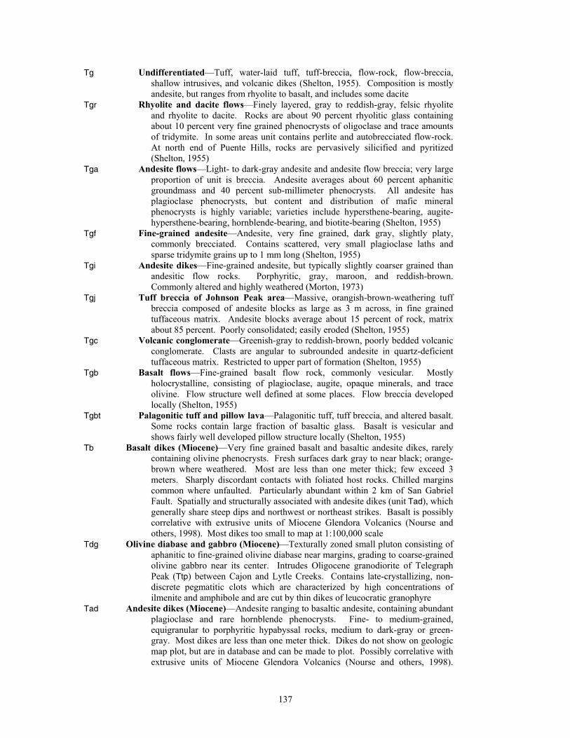
Tg Undifferentiated—Tuff, water-laid tuff, tuff-breccia, flow-rock, flow-breccia, shallow intrusives, and volcanic dikes (Shelton, 1955). Composition is mostly andesite, but ranges from rhyolite to basalt, and includes some dacite
Tgr Rhyolite and dacite flows—Finely layered, gray to reddish-gray, felsic rhyolite and rhyolite to dacite. Rocks are about 90 percent rhyolitic glass containing about 10 percent very fine grained phenocrysts of oligoclase and trace amounts of tridymite. In some areas unit contains perlite and autobrecciated flow-rock. At north end of Puente Hills, rocks are pervasively silicified and pyritized (Shelton, 1955)
Tga Andesite flows—Light- to dark-gray andesite and andesite flow breccia; very large proportion of unit is breccia. Andesite averages about 60 percent aphanitic groundmass and 40 percent sub-millimeter phenocrysts. All andesite has plagioclase phenocrysts, but content and distribution of mafic mineral phenocrysts is highly variable; varieties include hypersthene-bearing, augite-hypersthene-bearing, hornblende-bearing, and biotite-bearing (Shelton, 1955)
Tgf Fine-grained andesite—Andesite, very fine grained, dark gray, slightly platy, commonly brecciated. Contains scattered, very small plagioclase laths and sparse tridymite grains up to 1 mm long (Shelton, 1955)
Tgi Andesite dikes—Fine-grained andesite, but typically slightly coarser grained than andesitic flow rocks. Porphyritic, gray, maroon, and reddish-brown. Commonly altered and highly weathered (Morton, 1973)
Tgj Tuff breccia of Johnson Peak area—Massive, orangish-brown-weathering tuff breccia composed of andesite blocks as large as 3 m across, in fine grained tuffaceous matrix. Andesite blocks average about 15 percent of rock, matrix about 85 percent. Poorly consolidated; easily eroded (Shelton, 1955)
Tgc Volcanic conglomerate—Greenish-gray to reddish-brown, poorly bedded volcanic conglomerate. Clasts are angular to subrounded andesite in quartz-deficient tuffaceous matrix. Restricted to upper part of formation (Shelton, 1955)
Tgb Basalt flows—Fine-grained basalt flow rock, commonly vesicular. Mostly holocrystalline, consisting of plagioclase, augite, opaque minerals, and trace olivine. Flow structure well defined at some places. Flow breccia developed locally (Shelton, 1955)
Tgbt Palagonitic tuff and pillow lava—Palagonitic tuff, tuff breccia, and altered basalt. Some rocks contain large fraction of basaltic glass. Basalt is vesicular and shows fairly well developed pillow structure locally (Shelton, 1955)
Tb Basalt dikes (Miocene)—Very fine grained basalt and basaltic andesite dikes, rarely containing olivine phenocrysts. Fresh surfaces dark gray to near black; orange-brown where weathered. Most are less than one meter thick; few exceed 3 meters. Sharply discordant contacts with foliated host rocks. Chilled margins common where unfaulted. Particularly abundant within 2 km of San Gabriel Fault. Spatially and structurally associated with andesite dikes (unit Tad), which generally share steep dips and northwest or northeast strikes. Basalt is possibly correlative with extrusive units of Miocene Glendora Volcanics (Nourse and others, 1998). Most dikes too small to map at 1:100,000 scale
Tdg Olivine diabase and gabbro (Miocene)—Texturally zoned small pluton consisting of aphanitic to fine-grained olivine diabase near margins, grading to coarse-grained olivine gabbro near its center. Intrudes Oligocene granodiorite of Telegraph Peak (Ttp) between Cajon and Lytle Creeks. Contains late-crystallizing, non-discrete pegmatitic clots which are characterized by high concentrations of ilmenite and amphibole and are cut by thin dikes of leucocratic granophyre
Tad Andesite dikes (Miocene)—Andesite ranging to basaltic andesite, containing abundant plagioclase and rare hornblende phenocrysts. Fine- to medium-grained, equigranular to porphyritic hypabyssal rocks, medium to dark-gray or green-gray. Most dikes are less than one meter thick. Dikes do not show on geologic map plot, but are in database and can be made to plot. Possibly correlative with extrusive units of Miocene Glendora Volcanics (Nourse and others, 1998).
137
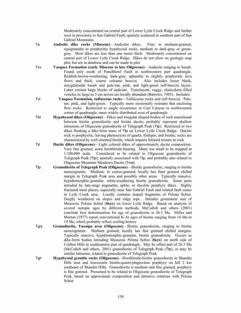
Moderately concentrated on central part of Lower Lytle Creek Ridge and farther west in proximity to San Gabriel Fault; sparsely scattered in southern part of San Gabriel Mountains
Ta Andesite dike rocks (Miocene)—Andesitic dikes. Fine- to medium-grained, equigranular to porphyritic hypabyssal rocks, medium to dark-gray or green-gray. Most dikes are less than one meter thick. Moderately concentrated on central part of Lower Lytle Creek Ridge. Dikes do not show on geologic map plot, but are in database and can be made to plot
Tvv Vasquez Formation (early Miocene to late Oligocene)—Andesite ranging to basalt. Found only south of Punchbowl Fault in northwestern part quadrangle. Reddish-brown-weathering, dark-gray, aphanitic to slightly porphyritic lava flows and thick, coarse volcanic breccia. Also includes lesser black, amygdaloidal basalt and pale-tan, pink, and light-green tuff-breccia layers. Latter contain large blocks of andesite. Translucent, vuggy, chalcedony-filled vesicles as large as 5 cm across are locally abundant (Barrows, 1985). Includes:
Tvt Vasquez Formation, tuffaceous rocks—Tuffaceous rocks and tuff breccia. Pale-tan, pink, and light-green. Typically more erosionally resistant that enclosing flow rocks. Restricted to single occurrence in Carr Canyon in northwestern corner of quadrangle; more widely distributed west of quadrangle
Ttd Hypabyssal dikes (Oligocene)—Dikes and irregular shaped bodies of rock transitional between biotite granodiorite and biotite dacite; probably represent shallow intrusions of Oligocene granodiorite of Telegraph Peak (Ttp). Restricted to two dikes flanking a dike-form mass of Ttp on Lower Lytle Creek Ridge. Dacitic rock is porphyritic, having phenocrysts of quartz, feldspar, and biotite; rocks are characterized by well oriented biotite, which imparts foliated texture to rock
Td Dacite dikes (Oligocene)—Light colored dikes of approximately dacite composition. Very fine grained, some hornblende-bearing. Many too small to be mapped at 1:100,000 scale. Considered to be related to Oligocene granodiorite of Telegraph Peak (Ttp); spatially associated with Ttp, and probably also related to Oligocene Mountain Meadows Dacite (Tmd)
Ttp Granodiorite of Telegraph Peak (Oligocene)—Biotite granodiorite, ranging to biotite monzogranite. Medium- to coarse-grained; locally has finer grained chilled margin in Telegraph Peak area and possibly other areas. Typically massive, hypidiomorphic-granular, white-weathering biotite granodiorite. Some parts intruded by late-stage pegmatite, aplite, or rhyolite porphyry dikes. Highly fractured most places, especially near San Gabriel Fault and related fault zones in Lytle Creek area. Locally contains stoped fragments of Pelona Schist. Deeply weathered on slopes and ridge tops. Intrudes greenstone unit of Mesozoic Pelona Schist (}ps) on lower Lytle Ridge. Based on analysis of several isotopic ages by different methods, McCulloh and others (2001) conclude best determination for age of granodiorite is 26.3 Ma. Miller and Morton (1977) report conventional K-Ar ages of biotite ranging from 14 Ma to 19 Ma, which probably reflect cooling history
Tgry Granodiorite, Yucaipa area (Oligocene)—Biotite granodiorite, ranging to biotite monzogranite. Medium grained; locally has fine grained chilled margins. Typically massive, hypidiomorphic-granular, biotite granodiorite. Occurs as dike-form bodies intruding Mesozoic Pelona Schist (}ps) on north side of Crafton Hills in southeastern part of quadrangle. May be offset part of 26.3 Ma (McCulloh and others, 2001) granodiorite of Telegraph Peak (Ttp), or may be similar intrusion, related to granodiorite of Telegraph Peak
Tgh Hypabyssal granitic rocks (Oligocene)—Hornblende-biotite granodiorite in Shandin Hills area and leucocratic biotite-quartz-plagioclase porphyry on hill 2 km southeast of Shandin Hills. Granodiorite is medium and fine grained, porphyry is fine grained. Presumed to be related to Oligocene granodiorite of Telegraph Peak, based on approximate composition and intrusive relations with Pelona Schist
138
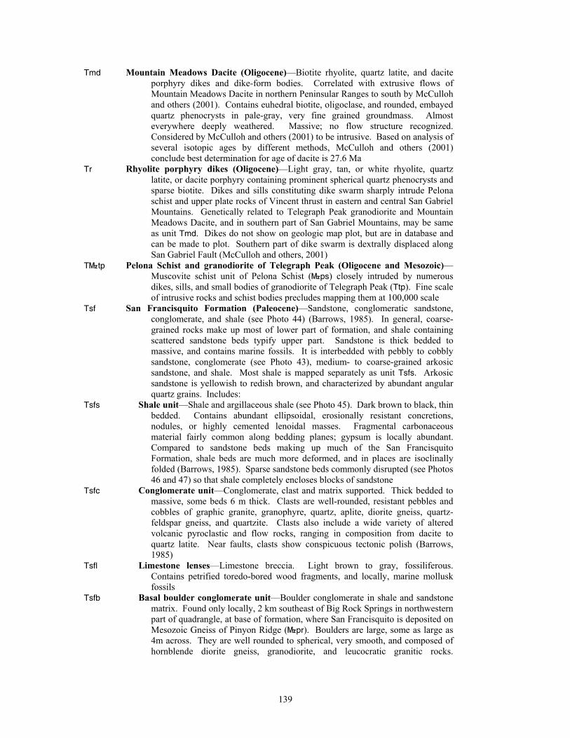
Tmd Mountain Meadows Dacite (Oligocene)—Biotite rhyolite, quartz latite, and dacite porphyry dikes and dike-form bodies. Correlated with extrusive flows of Mountain Meadows Dacite in northern Peninsular Ranges to south by McCulloh and others (2001). Contains euhedral biotite, oligoclase, and rounded, embayed quartz phenocrysts in pale-gray, very fine grained groundmass. Almost everywhere deeply weathered. Massive; no flow structure recognized. Considered by McCulloh and others (2001) to be intrusive. Based on analysis of several isotopic ages by different methods, McCulloh and others (2001) conclude best determination for age of dacite is 27.6 Ma
Tr Rhyolite porphyry dikes (Oligocene)—Light gray, tan, or white rhyolite, quartz latite, or dacite porphyry containing prominent spherical quartz phenocrysts and sparse biotite. Dikes and sills constituting dike swarm sharply intrude Pelona schist and upper plate rocks of Vincent thrust in eastern and central San Gabriel Mountains. Genetically related to Telegraph Peak granodiorite and Mountain Meadows Dacite, and in southern part of San Gabriel Mountains, may be same as unit Tmd. Dikes do not show on geologic map plot, but are in database and can be made to plot. Southern part of dike swarm is dextrally displaced along San Gabriel Fault (McCulloh and others, 2001)
T}tp Pelona Schist and granodiorite of Telegraph Peak (Oligocene and Mesozoic)—Muscovite schist unit of Pelona Schist (}ps) closely intruded by numerous dikes, sills, and small bodies of granodiorite of Telegraph Peak (Ttp). Fine scale of intrusive rocks and schist bodies precludes mapping them at 100,000 scale
Tsf San Francisquito Formation (Paleocene)—Sandstone, conglomeratic sandstone, conglomerate, and shale (see Photo 44) (Barrows, 1985). In general, coarse-grained rocks make up most of lower part of formation, and shale containing scattered sandstone beds typify upper part. Sandstone is thick bedded to massive, and contains marine fossils. It is interbedded with pebbly to cobbly sandstone, conglomerate (see Photo 43), medium- to coarse-grained arkosic sandstone, and shale. Most shale is mapped separately as unit Tsfs. Arkosic sandstone is yellowish to redish brown, and characterized by abundant angular quartz grains. Includes:
Tsfs Shale unit—Shale and argillaceous shale (see Photo 45). Dark brown to black, thin bedded. Contains abundant ellipsoidal, erosionally resistant concretions, nodules, or highly cemented lenoidal masses. Fragmental carbonaceous material fairly common along bedding planes; gypsum is locally abundant. Compared to sandstone beds making up much of the San Francisquito Formation, shale beds are much more deformed, and in places are isoclinally folded (Barrows, 1985). Sparse sandstone beds commonly disrupted (see Photos 46 and 47) so that shale completely encloses blocks of sandstone
Tsfc Conglomerate unit—Conglomerate, clast and matrix supported. Thick bedded to massive, some beds 6 m thick. Clasts are well-rounded, resistant pebbles and cobbles of graphic granite, granophyre, quartz, aplite, diorite gneiss, quartz-feldspar gneiss, and quartzite. Clasts also include a wide variety of altered volcanic pyroclastic and flow rocks, ranging in composition from dacite to quartz latite. Near faults, clasts show conspicuous tectonic polish (Barrows, 1985)
Tsfl Limestone lenses—Limestone breccia. Light brown to gray, fossiliferous. Contains petrified toredo-bored wood fragments, and locally, marine mollusk fossils
Tsfb Basal boulder conglomerate unit—Boulder conglomerate in shale and sandstone matrix. Found only locally, 2 km southeast of Big Rock Springs in northwestern part of quadrangle, at base of formation, where San Francisquito is deposited on Mesozoic Gneiss of Pinyon Ridge (}pr). Boulders are large, some as large as 4m across. They are well rounded to spherical, very smooth, and composed of hornblende diorite gneiss, granodiorite, and leucocratic granitic rocks.
139
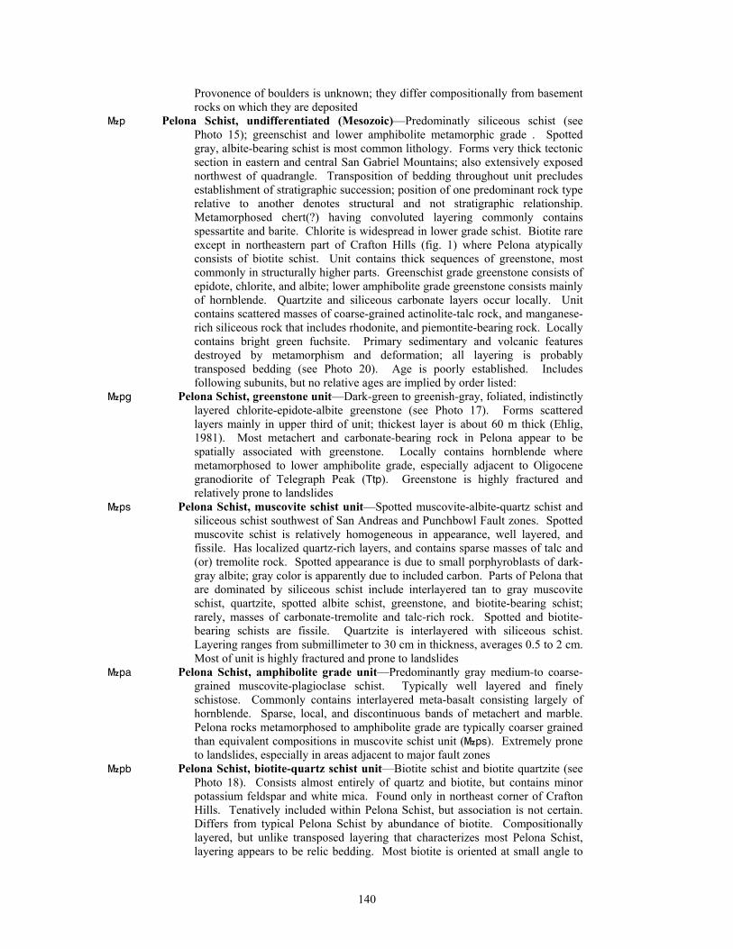
Provonence of boulders is unknown; they differ compositionally from basement rocks on which they are deposited
}p Pelona Schist, undifferentiated (Mesozoic)—Predominatly siliceous schist (see Photo 15); greenschist and lower amphibolite metamorphic grade . Spotted gray, albite-bearing schist is most common lithology. Forms very thick tectonic section in eastern and central San Gabriel Mountains; also extensively exposed northwest of quadrangle. Transposition of bedding throughout unit precludes establishment of stratigraphic succession; position of one predominant rock type relative to another denotes structural and not stratigraphic relationship. Metamorphosed chert(?) having convoluted layering commonly contains spessartite and barite. Chlorite is widespread in lower grade schist. Biotite rare except in northeastern part of Crafton Hills (fig. 1) where Pelona atypically consists of biotite schist. Unit contains thick sequences of greenstone, most commonly in structurally higher parts. Greenschist grade greenstone consists of epidote, chlorite, and albite; lower amphibolite grade greenstone consists mainly of hornblende. Quartzite and siliceous carbonate layers occur locally. Unit contains scattered masses of coarse-grained actinolite-talc rock, and manganese-rich siliceous rock that includes rhodonite, and piemontite-bearing rock. Locally contains bright green fuchsite. Primary sedimentary and volcanic features destroyed by metamorphism and deformation; all layering is probably transposed bedding (see Photo 20). Age is poorly established. Includes following subunits, but no relative ages are implied by order listed:
}pg Pelona Schist, greenstone unit—Dark-green to greenish-gray, foliated, indistinctly layered chlorite-epidote-albite greenstone (see Photo 17). Forms scattered layers mainly in upper third of unit; thickest layer is about 60 m thick (Ehlig, 1981). Most metachert and carbonate-bearing rock in Pelona appear to be spatially associated with greenstone. Locally contains hornblende where metamorphosed to lower amphibolite grade, especially adjacent to Oligocene granodiorite of Telegraph Peak (Ttp). Greenstone is highly fractured and relatively prone to landslides
}ps Pelona Schist, muscovite schist unit—Spotted muscovite-albite-quartz schist and siliceous schist southwest of San Andreas and Punchbowl Fault zones. Spotted muscovite schist is relatively homogeneous in appearance, well layered, and fissile. Has localized quartz-rich layers, and contains sparse masses of talc and (or) tremolite rock. Spotted appearance is due to small porphyroblasts of dark-gray albite; gray color is apparently due to included carbon. Parts of Pelona that are dominated by siliceous schist include interlayered tan to gray muscovite schist, quartzite, spotted albite schist, greenstone, and biotite-bearing schist; rarely, masses of carbonate-tremolite and talc-rich rock. Spotted and biotite-bearing schists are fissile. Quartzite is interlayered with siliceous schist. Layering ranges from submillimeter to 30 cm in thickness, averages 0.5 to 2 cm. Most of unit is highly fractured and prone to landslides
}pa Pelona Schist, amphibolite grade unit—Predominantly gray medium-to coarse-grained muscovite-plagioclase schist. Typically well layered and finely schistose. Commonly contains interlayered meta-basalt consisting largely of hornblende. Sparse, local, and discontinuous bands of metachert and marble. Pelona rocks metamorphosed to amphibolite grade are typically coarser grained than equivalent compositions in muscovite schist unit (}ps). Extremely prone to landslides, especially in areas adjacent to major fault zones
}pb Pelona Schist, biotite-quartz schist unit—Biotite schist and biotite quartzite (see Photo 18). Consists almost entirely of quartz and biotite, but contains minor potassium feldspar and white mica. Found only in northeast corner of Crafton Hills. Tenatively included within Pelona Schist, but association is not certain. Differs from typical Pelona Schist by abundance of biotite. Compositionally layered, but unlike transposed layering that characterizes most Pelona Schist, layering appears to be relic bedding. Most biotite is oriented at small angle to
140
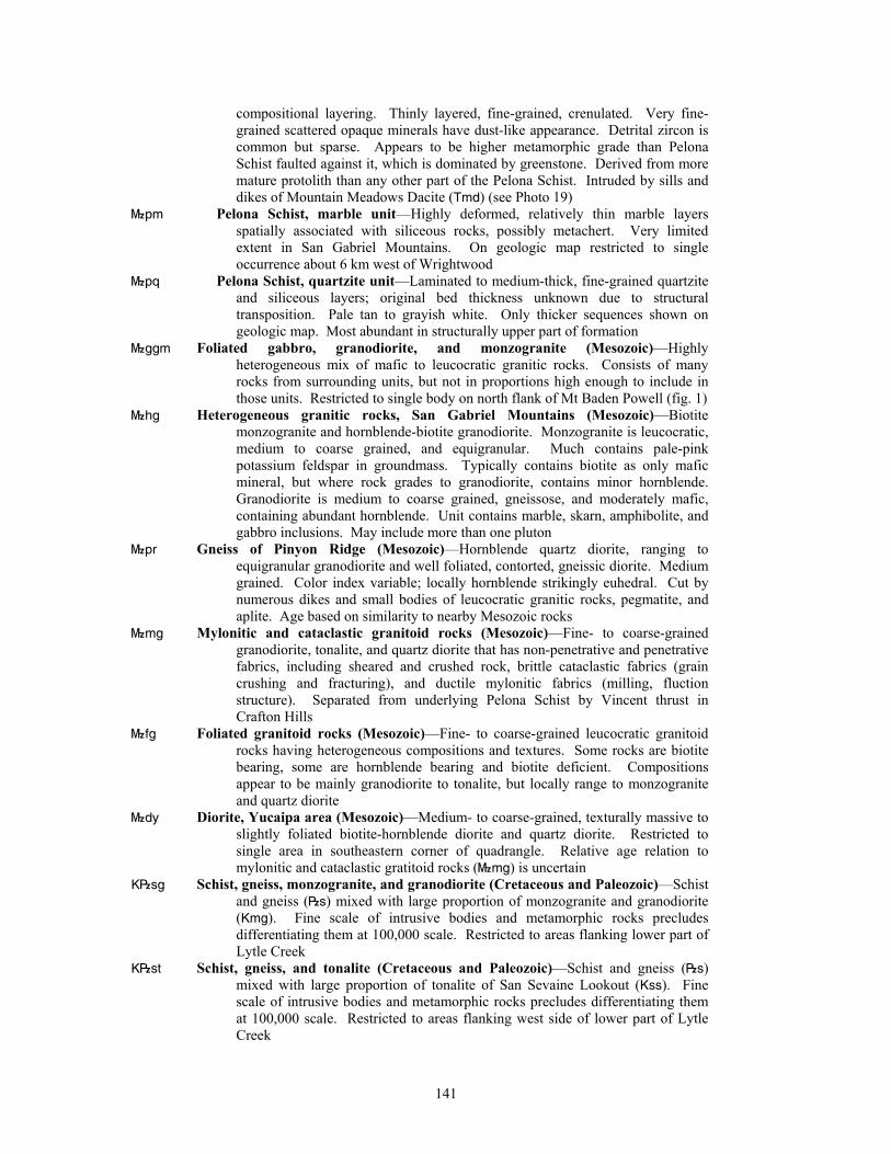
compositional layering. Thinly layered, fine-grained, crenulated. Very fine-grained scattered opaque minerals have dust-like appearance. Detrital zircon is common but sparse. Appears to be higher metamorphic grade than Pelona Schist faulted against it, which is dominated by greenstone. Derived from more mature protolith than any other part of the Pelona Schist. Intruded by sills and dikes of Mountain Meadows Dacite (Tmd) (see Photo 19)
}pm Pelona Schist, marble unit—Highly deformed, relatively thin marble layers spatially associated with siliceous rocks, possibly metachert. Very limited extent in San Gabriel Mountains. On geologic map restricted to single occurrence about 6 km west of Wrightwood
}pq Pelona Schist, quartzite unit—Laminated to medium-thick, fine-grained quartzite and siliceous layers; original bed thickness unknown due to structural transposition. Pale tan to grayish white. Only thicker sequences shown on geologic map. Most abundant in structurally upper part of formation
}ggm Foliated gabbro, granodiorite, and monzogranite (Mesozoic)—Highly heterogeneous mix of mafic to leucocratic granitic rocks. Consists of many rocks from surrounding units, but not in proportions high enough to include in those units. Restricted to single body on north flank of Mt Baden Powell (fig. 1)
}hg Heterogeneous granitic rocks, San Gabriel Mountains (Mesozoic)—Biotite monzogranite and hornblende-biotite granodiorite. Monzogranite is leucocratic, medium to coarse grained, and equigranular. Much contains pale-pink potassium feldspar in groundmass. Typically contains biotite as only mafic mineral, but where rock grades to granodiorite, contains minor hornblende. Granodiorite is medium to coarse grained, gneissose, and moderately mafic, containing abundant hornblende. Unit contains marble, skarn, amphibolite, and gabbro inclusions. May include more than one pluton
}pr Gneiss of Pinyon Ridge (Mesozoic)—Hornblende quartz diorite, ranging to equigranular granodiorite and well foliated, contorted, gneissic diorite. Medium grained. Color index variable; locally hornblende strikingly euhedral. Cut by numerous dikes and small bodies of leucocratic granitic rocks, pegmatite, and aplite. Age based on similarity to nearby Mesozoic rocks
}mg Mylonitic and cataclastic granitoid rocks (Mesozoic)—Fine- to coarse-grained granodiorite, tonalite, and quartz diorite that has non-penetrative and penetrative fabrics, including sheared and crushed rock, brittle cataclastic fabrics (grain crushing and fracturing), and ductile mylonitic fabrics (milling, fluction structure). Separated from underlying Pelona Schist by Vincent thrust in Crafton Hills
}fg Foliated granitoid rocks (Mesozoic)—Fine- to coarse-grained leucocratic granitoid rocks having heterogeneous compositions and textures. Some rocks are biotite bearing, some are hornblende bearing and biotite deficient. Compositions appear to be mainly granodiorite to tonalite, but locally range to monzogranite and quartz diorite
}dy Diorite, Yucaipa area (Mesozoic)—Medium- to coarse-grained, texturally massive to slightly foliated biotite-hornblende diorite and quartz diorite. Restricted to single area in southeastern corner of quadrangle. Relative age relation to mylonitic and cataclastic gratitoid rocks (}mg) is uncertain
K|sg Schist, gneiss, monzogranite, and granodiorite (Cretaceous and Paleozoic)—Schist and gneiss (|s) mixed with large proportion of monzogranite and granodiorite (Kmg). Fine scale of intrusive bodies and metamorphic rocks precludes differentiating them at 100,000 scale. Restricted to areas flanking lower part of Lytle Creek
K|st Schist, gneiss, and tonalite (Cretaceous and Paleozoic)—Schist and gneiss (|s) mixed with large proportion of tonalite of San Sevaine Lookout (Kss). Fine scale of intrusive bodies and metamorphic rocks precludes differentiating them at 100,000 scale. Restricted to areas flanking west side of lower part of Lytle Creek
141
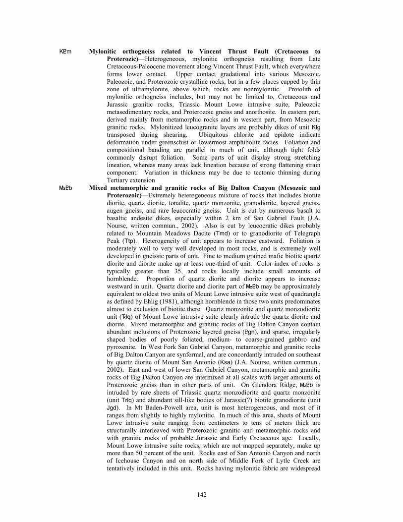
K<m Mylonitic orthogneiss related to Vincent Thrust Fault (Cretaceous to Proterozic)—Heterogeneous, mylonitic orthogneiss resulting from Late Cretaceous-Paleocene movement along Vincent Thrust Fault, which everywhere forms lower contact. Upper contact gradational into various Mesozoic, Paleozoic, and Proterozoic crystalline rocks, but in a few places capped by thin zone of ultramylonite, above which, rocks are nonmylonitic. Protolith of mylonitic orthogneiss includes, but may not be limited to, Cretaceous and Jurassic granitic rocks, Triassic Mount Lowe intrusive suite, Paleozoic metasedimentary rocks, and Proterozoic gneiss and anorthosite. In eastern part, derived mainly from metamorphic rocks and in western part, from Mesozoic granitic rocks. Mylonitized leucogranite layers are probably dikes of unit Klg transposed during shearing. Ubiquitous chlorite and epidote indicate deformation under greenschist or lowermost amphibolite facies. Foliation and compositional banding are parallel in much of unit, although tight folds commonly disrupt foliation. Some parts of unit display strong stretching lineation, whereas many areas lack lineation because of strong flattening strain component. Variation in thickness may be due to tectonic thinning during Tertiary extension
}<b Mixed metamorphic and granitic rocks of Big Dalton Canyon (Mesozoic and Proterozoic)—Extremely heterogeneous mixture of rocks that includes biotite diorite, quartz diorite, tonalite, quartz monzonite, granodiorite, layered gneiss, augen gneiss, and rare leucocratic gneiss. Unit is cut by numerous basalt to basaltic andesite dikes, especially within 2 km of San Gabriel Fault (J.A. Nourse, written commun., 2002). Also is cut by leucocratic dikes probably related to Mountain Meadows Dacite (Tmd) or to granodiorite of Telegraph Peak (Ttp). Heterogeneity of unit appears to increase eastward. Foliation is moderately well to very well developed in most rocks, and is extremely well developed in gneissic parts of unit. Fine to medium grained mafic biotite quartz diorite and diorite make up at least one-third of unit. Color index of rocks is typically greater than 35, and rocks locally include small amounts of hornblende. Proportion of quartz diorite and diorite appears to increase westward in unit. Quartz diorite and diorite part of }<b may be approximately equivalent to oldest two units of Mount Lowe intrusive suite west of quadrangle as defined by Ehlig (1981), although hornblende in those two units predominates almost to exclusion of biotite there. Quartz monzonite and quartz monzodiorite unit (^lq) of Mount Lowe intrusive suite clearly intrude the quartz diorite and diorite. Mixed metamorphic and granitic rocks of Big Dalton Canyon contain abundant inclusions of Proterozoic layered gneiss (<gn), and sparse, irregularly shaped bodies of poorly foliated, medium- to coarse-grained gabbro and pyroxenite. In West Fork San Gabriel Canyon, metamorphic and granitic rocks of Big Dalton Canyon are synformal, and are concordantly intruded on southeast by quartz diorite of Mount San Antonio (Ksa) (J.A. Nourse, written commun., 2002). East and west of lower San Gabriel Canyon, metamorphic and granitic rocks of Big Dalton Canyon are intermixed at all scales with larger amounts of Proterozoic gneiss than in other parts of unit. On Glendora Ridge, }<b is intruded by rare sheets of Triassic quartz monzodiorite and quartz monzonite (unit Trlq) and abundant sill-like bodies of Jurassic(?) biotite granodiorite (unit Jgd). In Mt Baden-Powell area, unit is most heterogeneous, and most of it ranges from slightly to highly mylonitic. In much of this area, sheets of Mount Lowe intrusive suite ranging from centimeters to tens of meters thick are structurally interleaved with Proterozoic granitic and metamorphic rocks and with granitic rocks of probable Jurassic and Early Cretaceous age. Locally, Mount Lowe intrusive suite rocks, which are not mapped separately, make up more than 50 percent of the unit. Rocks east of San Antonio Canyon and north of Icehouse Canyon and on north side of Middle Fork of Lytle Creek are tentatively included in this unit. Rocks having mylonitic fabric are widespread
142
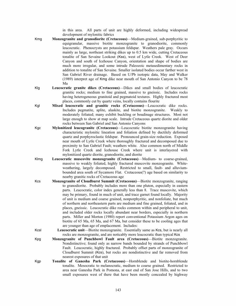
in this area. All parts of unit are highly deformed, including widespread development of mylonitic fabrics
Kmg Monzogranite and granodiorite (Cretaceous)—Medium-grained, sub-porphyritic to equigranular, massive biotite monzogranite to granodiorite, commonly leucocratic. Phenocrysts are potassium feldspar. Weathers pale gray. Occurs mainly as large, northeast striking dikes up to 0.5 km wide, cutting Cretaceous tonalite of San Sevaine Lookout (Kss), west of Lytle Creek. West of Deer Canyon and south of Icehouse Canyon, orientation and shape of bodies are much more irregular, and some intrude Paleozoic metasedimentary rocks in addition to tonalite of San Sevaine. Smaller isolated bodies occur farther west in San Gabriel River drainage. Based on U/Pb isotopic data, May and Walker (1989) interpret age of Kmg dike near mouth of San Antonio Canyon to be 78 Ma
Klg Leucocratic granite dikes (Cretaceous)—Dikes and small bodies of leucocratic granitic rocks; medium to fine grained, massive to gneissic. Includes rocks having heterogeneous granitoid and pegmatoid textures. Highly fractured most places, commonly cut by quartz veins, locally contains flourite
Kgl Mixed leucocratic and granitic rocks (Cretaceous)—Leucocratic dike rocks. Includes pegmatite, aplite, alaskite, and biotite monzogranite. Weakly to moderately foliated; many exhibit buckling or boudinage structures. Most not large enough to show at map scale. Intrude Cretaceous quartz diorite and older rocks between San Gabriel and San Antonio Canyons
Kgc Mylonitized leucogranite (Cretaceous)—Leucocratic biotite monzogranite having characteristic mylonitic lineation and foliation defined by ductilely deformed quartz and porphyroclastic feldspar. Pronounced grain-size reduction. Exposed near mouth of Lytle Creek where thoroughly fractured and decomposed due to proximity to San Gabriel Fault; weathers white. Also common north of Middle Fork Lytle Creek and Icehouse Creek where unit is interlayered with mylonitized quartz diorite, granodiorite, and diorite
Klmg Leucocratic muscovite monzogranite (Cretaceous)—Medium- to coarse-grained, massive to weakly foliated, highly fractured muscovite monzogranite. White-weathering, largely decomposed. Restricted to small, fault- and alluvium-bounded area south of Sycamore Flat. Cretaceous(?) age based on similarity to nearby granitic rocks of Cretaceous age
Kcs Monzogranite of Cloudburst Summit (Cretaceous)—Biotite monzogranite, ranging to granodiorite. Probably includes more than one pluton, especially in eastern parts. Leucocratic, color index generally less than 8. Trace muscovite, which may be primary, found in much of unit, and trace garnet found locally. Majority of unit is medium and coarse grained, nonporphyritic, and nonfoliate, but much of northern and northeastern parts are medium and fine grained, foliated, and in places, gneissic. Leucocratic dike rocks common within and peripheral to unit, and included older rocks locally abundant near borders, especially in northern parts. Miller and Morton (1980) report conventional Potassium Argon ages on biotite of 65 Ma, 65 Ma, and 67 Ma, but consider these to be cooling ages that are younger than age of emplacement. Includes:
Kcsl Leucocratic unit—Biotite monzogranite. Essentially same as Kcs, but is nearly all rocks are monzogranite, and are noticably more leucocratic than typical Kcs
Kpg Monzogranite of Punchbowl Fault area (Cretaceous)—Biotite monzogranite. Nondistinctive; found only as narrow bands bounded by strands of Punchbowl Fault. Leucocratic, highly fractured. Probably offset parts of monzogranite of Cloudburst Summit (Kcs), but rocks are nondistinctive and far removed from nearest exposures of that unit
Kgp Tonalite of Ganesha Park (Cretaceous)—Hornblende and biotite-hornblende tonalite. Mesocratic to melanocratic, medium to coarse grained. Restricted to area near Ganesha Park in Pomona, at east end of San Jose Hills, and to two small exposures west of there that have been mostly concealed by highway
143
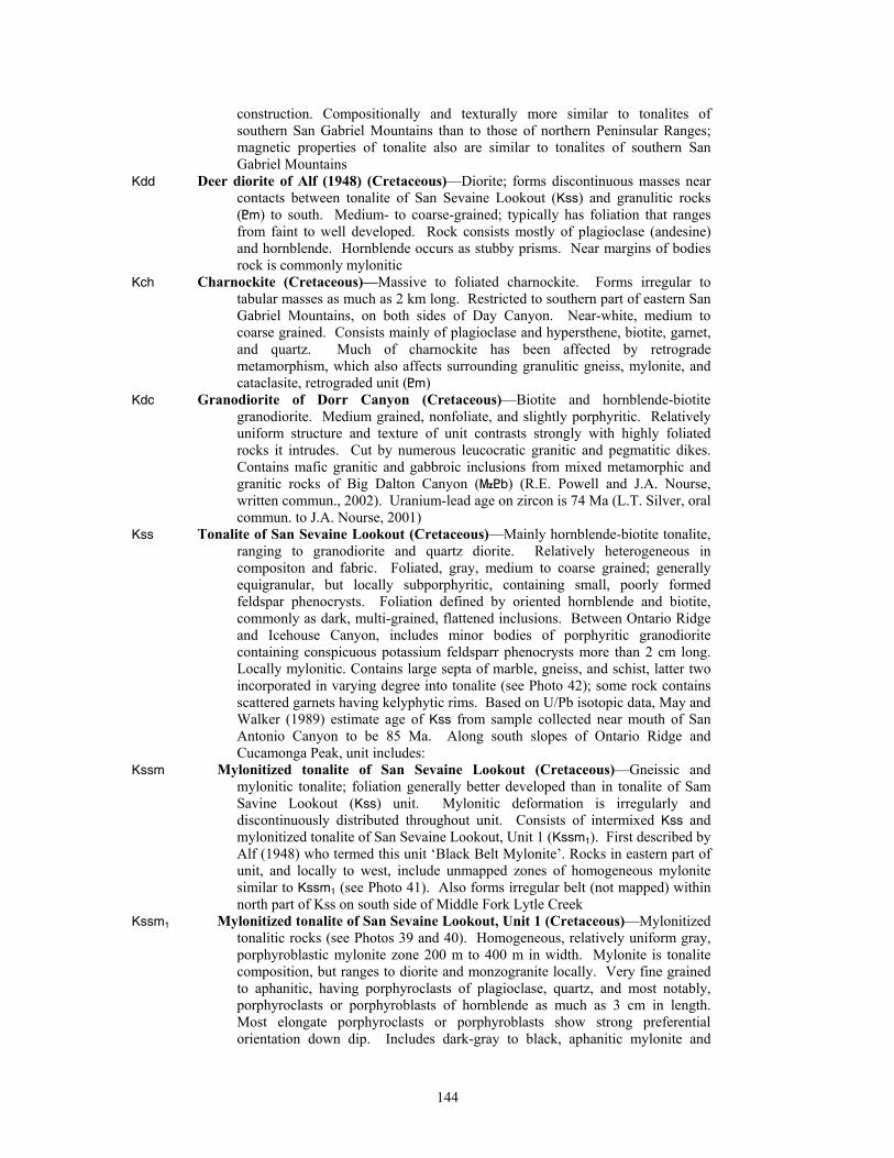
construction. Compositionally and texturally more similar to tonalites of southern San Gabriel Mountains than to those of northern Peninsular Ranges; magnetic properties of tonalite also are similar to tonalites of southern San Gabriel Mountains
Kdd Deer diorite of Alf (1948) (Cretaceous)—Diorite; forms discontinuous masses near contacts between tonalite of San Sevaine Lookout (Kss) and granulitic rocks (<m) to south. Medium- to coarse-grained; typically has foliation that ranges from faint to well developed. Rock consists mostly of plagioclase (andesine) and hornblende. Hornblende occurs as stubby prisms. Near margins of bodies rock is commonly mylonitic
Kch Charnockite (Cretaceous)—Massive to foliated charnockite. Forms irregular to tabular masses as much as 2 km long. Restricted to southern part of eastern San Gabriel Mountains, on both sides of Day Canyon. Near-white, medium to coarse grained. Consists mainly of plagioclase and hypersthene, biotite, garnet, and quartz. Much of charnockite has been affected by retrograde metamorphism, which also affects surrounding granulitic gneiss, mylonite, and cataclasite, retrograded unit (<m)
Kdc Granodiorite of Dorr Canyon (Cretaceous)—Biotite and hornblende-biotite granodiorite. Medium grained, nonfoliate, and slightly porphyritic. Relatively uniform structure and texture of unit contrasts strongly with highly foliated rocks it intrudes. Cut by numerous leucocratic granitic and pegmatitic dikes. Contains mafic granitic and gabbroic inclusions from mixed metamorphic and granitic rocks of Big Dalton Canyon (}<b) (R.E. Powell and J.A. Nourse, written commun., 2002). Uranium-lead age on zircon is 74 Ma (L.T. Silver, oral commun. to J.A. Nourse, 2001)
Kss Tonalite of San Sevaine Lookout (Cretaceous)—Mainly hornblende-biotite tonalite, ranging to granodiorite and quartz diorite. Relatively heterogeneous in compositon and fabric. Foliated, gray, medium to coarse grained; generally equigranular, but locally subporphyritic, containing small, poorly formed feldspar phenocrysts. Foliation defined by oriented hornblende and biotite, commonly as dark, multi-grained, flattened inclusions. Between Ontario Ridge and Icehouse Canyon, includes minor bodies of porphyritic granodiorite containing conspicuous potassium feldsparr phenocrysts more than 2 cm long. Locally mylonitic. Contains large septa of marble, gneiss, and schist, latter two incorporated in varying degree into tonalite (see Photo 42); some rock contains scattered garnets having kelyphytic rims. Based on U/Pb isotopic data, May and Walker (1989) estimate age of Kss from sample collected near mouth of San Antonio Canyon to be 85 Ma. Along south slopes of Ontario Ridge and Cucamonga Peak, unit includes:
Kssm Mylonitized tonalite of San Sevaine Lookout (Cretaceous)—Gneissic and mylonitic tonalite; foliation generally better developed than in tonalite of Sam Savine Lookout (Kss) unit. Mylonitic deformation is irregularly and discontinuously distributed throughout unit. Consists of intermixed Kss and mylonitized tonalite of San Sevaine Lookout, Unit 1 (Kssm1). First described by Alf (1948) who termed this unit ‘Black Belt Mylonite’. Rocks in eastern part of unit, and locally to west, include unmapped zones of homogeneous mylonite similar to Kssm1 (see Photo 41). Also forms irregular belt (not mapped) within north part of Kss on south side of Middle Fork Lytle Creek
Kssm1 Mylonitized tonalite of San Sevaine Lookout, Unit 1 (Cretaceous)—Mylonitized tonalitic rocks (see Photos 39 and 40). Homogeneous, relatively uniform gray, porphyroblastic mylonite zone 200 m to 400 m in width. Mylonite is tonalite composition, but ranges to diorite and monzogranite locally. Very fine grained to aphanitic, having porphyroclasts of plagioclase, quartz, and most notably, porphyroclasts or porphyroblasts of hornblende as much as 3 cm in length. Most elongate porphyroclasts or porphyroblasts show strong preferential orientation down dip. Includes dark-gray to black, aphanitic mylonite and
144
ultramylonite layers (psuedotachylyte) approximately 3 cm thick, which in some parts of unit are highly concentrated
Kssg Mixed tonalite of San Sevaine Lookout and gneiss (Cretaceous)—Mainly hornblende-biotite tonalite containing numerous large and small bodies of layered gneiss (<gn). Much more heterogeneous than either Kss or <gn. Found between Sawpit and San Gabriel Canyons at front of range north of Monrovia
Ksgr Tonalite of San Gabriel Reservoir (Cretaceous)—Biotite-hornblende tonalite, ranging to granodiorite and quartz-bearing diorite. Forms east-west elongate body at front of San Gabriel Mountains on both sides of San Gabriel Canyon. Similar to tonalite of San Sevaine Lookout (Kss), but consistently more mafic. Medium to coarse grained, locally containing sparse plagioclase or potassium feldspar phenocrysts up to 2 cm long. Most rocks are weakly to moderately foliated, but at some places, foliation is either strongly developed or almost absent. Hornblende typically much more abundant than biotite; average color index is about 30, but varies widely from about 15 to 40. Contains abundant gneiss bodies ranging in size from tens of centimeters to hundreds of meters in length; bodies are larger and more abundant near contacts with large mapped gneiss units. Unit is moderately heterogeneous with respect to texture and composition, but much more homogeneous than bounding Mesozoic to Proterozoic units found northward to San Gaberial Fault. Considered Cretaceous based on similarity to tonalite of San Sevaine Lookout (Kss) and quartz diorite of Mount San Antonio (Ksa)
Ksa Quartz diorite of Mount San Antonio (Cretaceous)—Hornblende-biotite quartz diorite; medium grained, equigranular, weakly to moderately foliated. Massive sill-like bodies intrude Triassic rocks and Precambrian gneiss on summit and south face of Mount San Antonio. Similar intrusive sheets traced as far west as Coldwater Canyon (J.A. Nourse, written commun., 2002). Correlative quartz diorite is dextrally displaced by San Gabriel fault to West Fork San Gabriel River drainage, where thick foliated body with Triassic and Proterozoic wall rocks extends southwest through Pine Mountain and Monrovia Peak to Mount Wilson. This body is bounded on south by Clamshell-Sawpit Canyon fault. Commonly contains conspicuous inclusions of Mount Lowe intrusive suite (J.A. Nourse, written commun., 2002). Intruded by veins and dikes of leucocratic granite (Klg) that may share foliation with Ksa
Klv Heterogeneous granitic rocks of La Verne area (Cretaceous)—Moderately heterogeneous granitic rocks, chiefly tonalite. Also includes gneissoid biotite quartz diorite and granodiorite. All rocks cut by fairly abundant dikes of leucocratic granitic rocks, pegmatite, and aplite. Restricted to single occurrence at foot of San Gabriel Mountains 3 km north-northeast of La Verne
Jhc Quartz monzodiorite of Hutak Canyon (Jurassic)—Quartz monzodiorite ranging to quartz diorite and hornblendite. Heterogeneous to very heterogeneous with respect to composition, grain size, and texture, especially in northern part. Locally homogeneous in southern part. Generally pinkish gray to greenish gray and coarse grained. Much is highly porphyritic, having phenocrysts up to 4 cm long. Hornblende more abundant than biotite. Feldspars are typically much darker gray than those in Cretaceous granitic rocks, and potassium feldspar commonly has distinct lavender hue
Jgf Granodiorite and quartz monzonite of Fern Canyon (Jurassic(?))—Predominantly biotite granodiorite ranging to quartz monzonite. Much is porphyritic, containing 1- to 2-cm-long lavender to pale-gray potassium feldspar phenocrysts. Locally hornblende-bearing in Sunset Peak area and on eastern Glendora Ridge. Medium grained, moderately to well foliated; larger phenocrysts commonly exhibit augen shapes. Intruded by leucocratic granite dikes (Klg) that share deformational fabric. Forms large, roughly oval shaped body centering between San Antonio and San Dimas Canyons. Texture and composition moderately variable; could include more than one intrusive body.
145
Contains numerous, large screens of older Mesozoic diorite or quartz diorite and Proterozoic gneiss, whose distribution mimics oval form of Fern Canyon body (J.A. Nourse, written commun., 2002). Similar body exposed in East Fork San Gabriel Canyon north of the San Gabriel Fault
J^gb Gabbro and pyroxenite (Jurassic? or Triassic?)—Medium- to coarse-grained gabbro and pyroxenite. Forms irregular pods in quartz diorite and diorite part of Mesozoic and Proterozoic mixed metamorphic and granitic rocks of Big Dalton Canyon unit (}<b) and in Proterozoic layered gneiss unit (<gn). In places, hornblende and pyroxene are recrystallized to biotite. Age is uncertain; probably Mesozoic, but appears to predate Cretaceous granitic rocks
Mount Lowe Intrusive Suite (Triassic)—Includes variety of genetically related intrusions ranging in composition from diorite to monzogranite; average composition probably quartz monzonite, but alkalic, quartz-deficient elements also range from monzonite to syenite. Part of unit may consist of single zoned intrusion. Covers about 300 km2 in central San Gabriel Mountains (Ehlig, 1981); central part of unit lies west of quadrangle. Originally designated Mount Lowe Granodiorite in abstract (Miller, 1926), later termed Lowe granodiorite (Miller, 1934, 1946). Barth and Ehlig (1988) renamed unit Mount Lowe intrusion. Unit is here informally named Mount Lowe intrusive suite to reflect its wide compositional range. Original name by Miller (1926 and 1946) is abandoned, because (1) unit is not primarily granodiorite, (2) name does not reflect wide compositional range of unit, and (3) inconsistant usage of name. Name, Mount Lowe intrusive suite is preferred over Mount Lowe intrusion, because unit appears to be made up of multiple intrusions, and term, intrusive suite, more closely follows guidelines of North American Stratigraphic Code (North American Commission on Stratigraphic Nomenclature, 1983). Rocks in Mount Lowe area in Mt. Wilson 7.5’ quadrangle are still useful, where representative parts of unit are well exposed in road cuts and natural exposures. In addition to wide range in composition, unit is characterized by highly varied appearance, highly varied grain-size, grain-size reduction in much of unit, primary minerals commonly disaggregated, and abundant sphene. Ehlig (1981) and J.A. Nourse (written commun., 2002) suggest that quartz diorite and diorite widely exposed west of quadrangle, and to lesser degree in western part of quadrangle, are oldest part of Mount Lowe intrusive suite. They show these rocks are intruded by younger parts of Mount Lowe intrusive suite. Because of compositional differences with Mount Lowe intrusive suite, quartz diorite and diorite rocks are here included in Mesozoic and Proterozoic metamorphic and granitic rocks of Big Dalton Canyon unit (}<b), but could be part of Mount Lowe intrusive suite. Barth and others (1990) report a U-Pb zircon age of 218 Ma for Mount Lowe. Subdivided into following units; listed from younger to older as determined from field relations:
^lu Undifferentiated—Quartz monzodiorite, ranging to quartz monzonite and quartz diorite. Mostly pale gray; nearly everywhere foliated (see Photo 37). Composition, texture, and grain size vary over wide range. Much of undifferentiated unit is one of two rock types, (1) leucocratic, porphyritic quartz monzodiorite to quartz diorite containing biotite and sparse garnet, and (2) leucocratic quartz monzodiorite containing moderately abundant hornblende, abundant sphene, and lesser biotite
^lq Porphyritic quartz monzonite and quartz monzodiorite—Porphyritic biotite quartz monzonite predominates, but unit is interlayered with much hornblende quartz monzodiorite (see Photo 38). Both varieties intrude quartz diorite and diorite parts of Mesozoic and Proterozoic metamorphic and granitic rocks of Big Dalton Canyon unit (}<b), which J.A. Nourse (written commun., 2002) suggests may be earliest phase of Mount Lowe intrusive suite. Phenocrysts in quartz monzonite are 2 to 6 cm-long potassium feldspar; west of quadrangle, Ehlig (1981) reports phenocrysts to 10 cm in length. Color index in both quartz
146
monzonite and quartz monzodiorite averages 7, rarely exceeds 10, but is moderately variable at all scales. Hornblende in quartz monzodiorite is near-phenocrystic, averaging 0.5 to 1 cm in length; hornblende-dominated rocks may or may not contain biotite. Both quartz monzonite and quartz monzodiorite are moderately to well-foliated, and show grain-size reduction, tectonic rounding of phenocrysts, and disaggregation of hornblende. Includes:
^ll Porphyritic biotite quartz monzonite—Porphyritic biotite quartz monzonite. Locally subdivided from ^lq where unit uniformly contains little or no hornblende bearing rocks
^lh Hornblende-biotite quartz monzonite—Hornblende-biotite quartz monzonite. Locally subdivided from ^lq where rock uniformly contains visible hornblende in addition to biotite
^lb Equigranular leucocratic biotite quartz monzonite—Biotite quartz monzonite, ranging to monzogranite. Generally medium grained and equigranular, lacking foliation typical of most other Mount Lowe intrusive suite units. Average color index between 4 and 7; contains no hornblende. Plagioclase ranges from oligoclase to albite, and is most abundant mineral in rock. Potassium feldspar is orthoclase; most occurs as small phenocrysts (Ehlig, 1981). Quartz is generally less than 20 percent of rock, but ranges from a few percent to about 25 percent. Unit grades into, and locally intrudes, porphyritic quartz monzonite and quartz monzodiorite unit (^lq). West of quadrangle, makes up volumetrically largest part of Mount Lowe intrusive suite. Part of rocks mapped as this unit could be Late Cretaceous, and may correlate with monzogranite and granodiorite unit (Kmg)
^dg Diorite and gabbro of Bare Mountain (Triassic)—Mixed mafic granitic rocks. Mostly diorite and gabbro, but includes minor, mafic granodiorite and tonalite. Nearly all rocks contain abundant hornblende, many intermediate composition granitic rocks have some biotite, and gabbroic rocks generally contain some pyroxene. Grain size ranges from fine to coarse. Some gabbroic and dioritic rocks show layering that may be primary. Development of secondary foliation progressively increases eastward. As mapped, unit probably represents more than one intrusive event, and may include small amounts of Cretaceous or Jurassic rocks, especially in eastern exposures (see Photo 27). Forms numerous small bodies south of San Andreas Fault from west edge of quadrangle, 22 km eastward to vicinity of Dorr Canyon. Cox and others (1983) report unit is intruded by Triassic Mount Lowe intrusive suite (^lu) in western part of quadrangle
|sg Metasedimentary schist and gneiss, San Gabriel Mountains (Paleozoic)—Well foliated schist and gneiss exposed on Penstock Ridge and extensively in eastern San Gabriel Mountains. In Penstock Ridge area, composition of schist and gneiss is variable, but most is biotite-bearing and derived almost exclusively from pelitic sedimentary protoliths. Most common lithologies include biotite gneiss, garnet-biotite quartzofeldspathic gneiss, biotite quartzofeldspathic schist, and phyllite. Commonly displays well-developed millimeter- and centimeter-scale chevron and isoclinal folds. Intruded by leucocratic biotite monzogranite and pegmatite dikes, which are variably affected by ductile deformation. May be interfolded with marble or quartzite layers and medium grained (Proterozoic?) biotite augen gneiss of monzogranitic composition. In Potato Mountain and Ontario Ridge area (fig. 1), unit consists of highly recrystallized quartzite, marble, biotite-sillimanite schist, and graphitic schist, all intruded by Cretaceous tonalite. Considered to be part of Placerita suite of Powell (1993). Degree of metamorphism and deformation In all parts of unit precludes stratigraphic subdivision or correlation with other Paleozoic sections
|mg Marble, San Gabriel Mountains (Paleozoic)—Coarse grained calcite marble containing variable amounts of calcsilicate minerals including forsterite and
147
diopside; phlogopite is minor, but widespread mineral. Locally mylonitic; gneissic in western part of quadrangle
|qg Quartzite, San Gabriel Mountains (Paleozoic)—White, gray, and tannish-gray quartzite; typically has orange-hued weathered surfaces. Massive to thickly layered; layering may or may not reflect primary bedding. Feldspathic in many places; highly feldspathic locally. Commonly biotite bearing. Unit found along ridges flanking San Antonio Canyon
<a Anorthosite (Proterozoic)—Mylonitic anorthosite. Forms single 1.5 km dike-form mass on south flank of Copter Ridge between South and Iron Forks of San Gabriel River. Composed of plagioclase and minor mafic minerals, all highly mylonitized, showing extreme grainsize reduction. Surrounded by Cretaceous to Proterozoic mylonitic orthogneiss related to Vincent Thrust Fault (K<m); pervasive mylonitic fabric precludes determination of relative age relations.
<gnd Dioritic gneiss or amphibolite (Proterozoic)—Relatively mafic gneiss ranging in composition from diorite to amphibolite. Presumed derived from dioritic and gabbroic intrusive rocks
<pv Gneiss of Pleasant View Ridge (Proterozoic)—Quartzofeldspathic biotite gneiss. Alternating leucocratic and biotite-rich layers. In northwestern part of quadrangle, forms moderate-size body east of Little Rock Creek and smaller bodies west of creek. Moderately heterogeneous. Age assignment based on similarity to gneiss and augen gneiss in Soledad Basin area (Cox and others, 1983). Includes:
<pva Gneiss of Pleasant View Ridge, augen gneiss—Biotite augen gneiss; coarse grained. Granodiorite composition. Contains large potassium feldspar megacrysts. Surrounded by gneiss of Pleasant View Ridge (<pv)
<gt Pelitic gneiss of Troop Peak (Proterozoic)—Pelitic gneiss containing irregularly scattered schist layers. Biotite gneiss locally containing sillimanite, garnet, and rarely staurolite. Heterogeneous; partly resulting from variable concentration of leucocratic intrusive rock in unit. Fine to coarse grained; intensity of foliation development variable. Contacts poorly established, partly due to gradational character, especially where bordered by mixed metamorphic and granitic rocks of Big Dalton Canyon (}<b)
<m Granulitic gneiss, mylonite, and cataclasite, retrograde (Proterozoic)—Prograde granulitic gneiss that is largely retrograde to amphibolite and greenschist grade mylonite and cataclasite. Granulitic gneiss includes quartz-feldspar gneiss, garnet-quartz-feldspar gneiss, amphibolite, garnet-pyroxene rich rocks, and spinel-pyroxene rich rocks. Gneiss contains layers of coarse-grained marble (|mg) that are progressively more mylonitic southward in unit
<gu Granulitic gneiss, mylonite, and cataclasite (Proterozoic)—Same protolith as granulitic gneiss, mylonite, and cataclasite, retrograde unit (<m), but most of prograde mineralogy and texture is preserved. Unit is compositionally layered, but massive garnet-pyroxene-plagioclase rock. Includes irregularly distributed, small areas of mylonitized rocks
<gn Layered gneiss, undifferentiated (Proterozoic)—Thinly layered, fine-grained gneiss; layered on millimeter scale. Foliation has mylonitic appearance. Isoclinal folds are common; multiple generations of deformational fabrics preserved. Metamorphosed to upper amphibolite facies. Probably derived from texturally diverse volcanic, fine grained intrusive, and immature sedimentary protoliths. Intruded by foliated to gneissic granodiorite unit (<gd) and gneissic quartz diorite of unknown age (Morton, 1973; J.A. Nourse, written commun., 2002). U-Pb ages on zircons suggest sedimentary protolith accumulated between 1.68 and 1.75 Ga (Silver, 1971). Includes (no relative age relations implied by order listed):
<gn6 Layered gneiss, Unit 6—Mixed gneiss, marble, calcsilicate rocks, amphibolite, and leucocratic rocks. Gneissic rocks include biotite-quartz-feldspar gneiss,
148
hornblende-biotite-quartz-feldspar gneiss, and hornblende-quartz-feldspar gneiss.
<gn5 Layered gneiss, Unit 5—Gneissic granodiorite to monzogranite. Although included in layered gneiss unit (<gn), rocks of <gn5 are not obviously layered. Medium grained, having weakly developed gneissic, and locally cataclastic, fabric. Generally more leucocratic than other <gn units
<gn4 Layered gneiss, Unit 4—Heterogeneous mixture of highly deformed gneiss, layered gneiss, and gneissic granodiorite to monzogranite, all cut by locally abundant leucocratic granitic dikes. Layered gneiss is relatively undeformed, alternating layers of leucocratic and biotite-rich rocks; biotite-rich layers contain garnet. Other rocks are ductilely and brittlely deformed
<gn3 Layered gneiss, Unit 3—Mixed gneissic quartz diorite and gneiss; much is cataclastic. Granitic rock is highly deformed, and much of gneiss is highly chloritic. Unit is characterized by dark green color resulting from abundance of chlorite in rocks. Gneiss is fine grained and contains lenses of leucocratic augen gneiss (Morton, 1973). Gneiss also contains partially chloritized biotite, some white mica, and structurally elongated, strained quartz grains; augen in leucocratic parts are pink potassium feldspar
<gn2 Layered gneiss, Unit 2—Biotite-rich gneiss having variable amounts of quartz and feldspar. Contains moderate to large proportion of rocks probably derived from foliated to gneissic granodiorite unit (<gd) and foliated to gneissic monzogranite unit (<gm)
<gn1 Layered gneiss, Unit 1—Quartzofeldspathic gneiss containing variable amounts of biotite
<gd Foliated to gneissic granodiorite (Proterozoic)—Porphyritic biotite granodiorite, medium grained; highly foliated to gneissic. Texturally resembles medium-grained biotite granite augen gneiss (<gm), but augen and gneissosity are not as well developed, and rocks are more leucocratic. Biotite and potassium feldspar are recrystallized, and typically form multi-grain aggregates. Commonly grades into layered gneiss, unit 2 (<gn2). Foliation may be tightly to isoclinally folded. Well exposed in San Gabriel Canyon near Morris and San Gabriel Reservoirs. Extensively intruded by quartz diorite and diorite parts of Mesozoic and Proterozoic metamorphic and granitic rocks of Big Dalton Canyon unit (}<b) (J.A. Nourse, written commun., 2002). U-Pb ages on zircons suggest emplacement ages between 1.65 and 1.68 Ga (Silver, 1971)
<gm Medium-grained biotite granite augen gneiss (Proterozoic)—Medium-grained biotite-rich augen gneiss; approximately monzogranite composition. Differs from unit <gc mainly by grain size. Augen are potassium feldspar typically between 0.5 and 1 cm in length. Strong foliation or gneissosity is commonly folded isoclinally. Typically, very weathered; least weathered outcrops occur along lower West Fork San Gabriel River. Underlies large areas between San Gabriel and San Antonio Canyons. Sample on western Glendora Ridge gave zircon Pb-Pb age of 1.67 Ga (Ehlig, 1981). Includes medium-grained, highly foliated to gneissic, leucocratic, biotite monzogranite that forms small bodies in San Dimas Canyon area (J.A. Nourse, written commun., 2002)
<gc Coarse-grained biotite granite augen gneiss (Proterozoic)—Coarse-grained biotite augen gneiss; approximately monzogranite composition. Augen are potassium feldspar up to 8 cm in length that are flattened and locally isoclinally folded. Forms numerous, noncontiguous bodies within and around granodiorite and quartz monzonite of Fern Canyon (Jgf); shapes and orientations of bodies roughly mimic outer form of Jgf. Bodies in vicinity of upper Bell Canyon and upper West Fork San Dimas Canyon form closed map-scale folds (J.A. Nourse, written commun., 2002)
gr Granitic rocks, undifferentiated (age unknown)—Tonalite to monzogranite; leucocratic biotite monzogranite and granodiorite most common. Mostly monzogranite to granodiorite south of San Andreas Fault. Unit includes variety
149
of granitic rocks, nearly all in very small, restricted areas. Probably includes rocks from many different plutons. Near and within San Andreas Fault Zone, unit is highly brecciated and crushed (Barrows, 1985). Part of unit is described by Ross (1972) as being distinctive due to abundance of hornblende relative to biotite compared to other nearby granitic rocks of this approximate composition. Rocks assigned to this unit on opposite sides of San Andreas Fault are not correlative. Age is probably Mesozoic, but unit could be all or part Proterozoic
dgm Diorite gneiss and migmatite (age unknown)—Hornblende-diorite gneiss and migmatite. Dark gray to black. Foliated and complexly deformed. Migmatite is contorted and locally blastomylonitic. Unit also includes amphibolite, coarse-grained hornblendite, and uralitized ultramafic rocks (Barrows, 1985). Restricted mainly to Juniper Hills area between San Andreas Fault Zone and Punchbowl Fault
gnm Cataclastic gneiss (age unknown)—Cataclastic and mylonitic biotite gneiss intruded by granitic rocks which are also mylonitized. Gneiss is layered, intensely slip folded, and contains amphibolite grade mineral assemblages. Restricted to Scotland area in Lytle Creek drainage, eastern San Gabriel Mountains. Gneiss contains scattered pods of white, coarse- to very fine-grained, massive and mylonitic marble (|mg). Includes:
cgm Chloritized cataclastic granitic rocks (age unknown)—Cataclastic biotite gneiss containing large proportion of cataclasized, chloritic granitic rocks. Restricted to Scotland area in Lytle Creek drainage, eastern San Gabriel Mountains, adjacent to cataclastic gneiss unit (gnm)
gnb Gneiss of Blue Cut area (age unknown)—Compositionally and texturally heterogeneous, chloritized biotite gneiss containing variable amounts of chloritized hornblende tonalite. Highly broken and fractured. Mappable unit limited to fault-bounded sliver within Punchbowl Fault Zone in Blue Cut area in Cajon Canyon
cru Crystalline rocks, undifferentiated (age unknown)—Highly mixed granitic and metamorphic rocks. Partly reconnaissance mapped; partly unmapped. Probably contains elements of Mount Lowe intrusive suite, mixed metamorphic and granitic rocks of Big Dalton Canyon (}<b), and Cretaceous granitic rocks. Contacts with mylonitic orthogneiss related to Vincent Thrust Fault (K<m) and undifferentiated unit (^lu) of Mount Lowe intrusive suite are highly gradational and poorly established
ROCKS BOUNDED BY THE MILL CREEK FAULT AND SAN ANDREAS
FAULT Mill Creek formation of Gibson (1971) (Miocene)—Nonmarine claystone,
mudstone, sandstone, and conglomerate; probably late Miocene (Woodburne, 1975). Nonconformably overlies gneissic granitiod rocks and gneiss unit (gg); upper contact is erosional. Gibson (1964, 1971) applied name Mill Creek Formation to outcrops Vaughan (1922) originally grouped within his Potato Sandstone. Here, Mill Creek Formation is restricted to beds between San Bernardino and Wilson Creek strands of San Andreas Fault. Five informal subunits are recognized based on overall lithologic character. Subunits intertongue with one another, but order of description approximates stratigraphic order from youngest to oldest. Includes:
Tmm Mudstone unit—Mudstone predominates over sandstone. Chiefly thin- to medium-bedded claystone, mudstone, and siltstone; sandstone distinctly subordinate. Has massive appearance, but contains flat to irregular laminations that range from faint to prominent. Fine-grained rocks are greenish-gray, greenish-brown, and brown. Locally contains mudcracks, flat-pebble conglomerate, and possibly mudchip-breccia. Unit is recessive
150
Tmcv Volcanic-clast-bearing unit—Sandstone and pebble-cobble-bearing sandstone; fine to coarse grained, moderately well to well sorted, pale brown to light gray, weathers pale tan. Contains clasts of aplite, granitoid rocks, and gneiss, but characterized by rounded to subrounded pebbles and small cobbles of volcanic rocks, including latite, quartz latite, basaltic andesite, and andesite. Medium to very thick bedded. Lenticular bedded; lenses range from tens to hundreds of meters long. Ledge forming
Tms Sandstone unit—Sandstone predominates over mudstone. Sandstone is yellowish-gray, gray, and pale brown. Bedding ranges from massive to laminated (see Photo 72); cross lamination and graded bedding common; convolute laminated and pillow-and-ball structure locally (see Photos 73, 74, and 75)
Tma Arkose unit—Stratigraphic interval dominated by pale-brown to yellowish-tan weathering arkosic sandstone. Pebbly and cobbly sandstone and conglomerate lenses locally abundant; clasts are rounded to subangular, and consist mainly of leucocratic granitoid rocks and gneiss, some muscovite-bearing. Framework grains and conglomerate matrix are feldspar-rich and locally contain detrital muscovite. Medium to very thick bedded. Lenticular bedded; lenses range from tens to hundreds of meters long
Tmcp Pelona Schist-bearing conglomerate unit—Sandstone, pebbly sandstone, and pebble-cobble conglomerate characterized by clasts of bluish-gray, coarsely crystalline Pelona Schist (see Photo 77). Thick- to very thick-bedded, brownish-gray to greenish-gray weathering (see Photo 76). Moderately to poorly sorted. In addition to Pelona Schist, clasts include dark-green gneissic diorite, intermediate composition granitoids, milky vein quartz, aplite and alaskite, and rare volcanic rocks. Schist clasts are similar to bedrock of unit }ps that Mill Creek Formation depositionally overlies in east part of quadrangle. Ledge forming
Tw Formation of Warm Springs Canyon (Miocene)—Nonmarine sandstone and conglomerate. Heterogeneous; consists of sedimentary rocks dominated by well sorted to poorly sorted sandstone, conglomerate, and conglomeratic sandstone interlayered with mudrock in some stratigraphic intervals. Clasts range from pebbles to large cobbles; typically pebbles and small cobbles, and are subangular to subrounded, dominated by leucocratic to mesocratic gneissic rocks and leucocratic granitoid rocks. Hornblende diorite-gabbro clasts are minor but distinctive. Unit occupies same structural position as conglomerate, sandstone, and arkose unit (Tsg) to northwest, but probably does not contain some older elements included in that unit. Base of unit is faulted against Mesozoic orthogneiss of Alger Creek (}ga), but equivalent deposits east of quadrangle rest depositionally on crystalline rocks of San Bernardino Mountains assemblage. Upper contact is erosional
Tsg Conglomerate, sandstone, and arkose (Miocene)—Conglomerate and lithic, conglomeratic arkose. Clasts range from 1 cm to about 20 cm, poorly sorted, subangular to well rounded. Matrix- and clast-supported. Most derived from granitic and gneissic rocks, but subordinate amount of quartzite, vein quartz, calcsilicate rock, and silicic volcanic rocks. Arkose is pale pink, gray, and greenish-brown. Most of unit lacks conspicuous bedding, but locally is well bedded where arkose lenses are abundant. From approximately City Creek southeastward, unit contains fault–bounded wedges of well lithified, interbedded sandstone, shale, and conglomerate, which may be Paleocene San Francisquito Formation or more probably Cretaceous Sedimentary rocks of Cosy Dell area. Proportion of unit southeast of City Creek that is possible San Francisquito Formation or sedimentary rocks of Cosy Dell area is unknown. Because Tsg is fault-bounded and may be comprised of more than one unit, thickness is unknown. Restricted to zone bounded by Mill Creek and Mission Creek strands of San Andreas Fault
151
}i Inclusion-rich granitoid rocks (Mesozoic)—Narrow elongate zones of mafic inclusions enclosed by gneissic granitoid rocks and gneiss unit (gg). Restricted to very small exposures near area Santa Ana River exits mountains; probably more unmapped }i. Most inclusions are diorite to quartz diorite, some gabbro, typically flattened and ovoid
}c Diorite of Cram Peak (Mesozoic)—Biotite-hornblende quartz-bearing diorite. Forms elongate, partly fault-bounded bodies east of Santa Ana River in southeastern part of quadrangle. Medium to coarse grained. Color index about 18; hornblende and biotite subequal. Some hornblende to 1.5 cm long. Plagioclase is sodic to intermediate andesine. Orthoclase is very sparse and interstitial to plagioclase and quartz. Quartz averages about 4 percent. Rock ranges from massive to having well developed foliation. Intrudes gneissic granitoid rock and gneiss unit (gg). Compositionally similar to Jurassic granitic rocks in region, but could be Cretaceous or Triassic
}g Granitoid rocks (Mesozoic)—Light-gray to pinkish-gray, texturally massive to slightly foliated, medium- to coarse-grained, biotite-bearing, leucocratic granitoid rock that is monzogranitic to granodioritic in composition. Rock locally has K-feldspar phenocrysts as much as 1 cm long
}gy Mesocratic granitoid rocks (Mesozoic)—Fine- to coarse-grained granodiorite, tonalite, and quartz diorite; highly weathered. Has variable, but distinctly higher color index than granitoid rocks unit (}g). Forms small bodies in gneissic granitoid rocks and gneiss unit (gg)
}ga Orthogneiss of Alger Creek (Mesozoic)—Light-gray, fine- to medium-grained biotite-hornblende granodiorite having well developed lenticular laminated fabric resulting from streaks of quartz, pink feldspar, and mafic aggregates. Locally encloses thin lenses of foliated amphibolite. Unit commonly is sheared and fractured, and weathers to dark brown color. Named for Alger Creek in quadrangle to east where unit crops out directly northeast of Mill Creek strand of San Andreas fault
gg Gneissic granitoid rocks and gneiss (age unknown)—Crystalline rocks characterized by compositional and textural heterogeneity and well developed gneissic fabric resulting from alternating mafic-rich and mafic-poor layers. Compositional layering ranges from millimeter and centimeter laminations to layering tens of meters thick. Mafic layers are biotite-rich, typically internally foliated, and range in composition from granodiorite to tonalite. Mafic-poor layers are quartzofeldspathic, texturally massive to foliated, and generally are granodiorite, but include monzogranite, tonalite, and rarely quartz monzodiorite. Unit contains zones of concentrated inclusions and attenuated dikes of mafic granitoid rock; some mapped (}i), but most are only a few meters wide. Unit locally cut by low-angle shear zones; rocks throughout unit are fractured. Age and protolith unknown. Unit probably is plutonic complex of heterogeneous mafic and intermediate rocks deformed during or subsequent to intrusion. Part of unit may be related to Diorite of Cram Peak (}c)
SAN BERNARDINO MOUNTAINS ASSEMBLAGE
Qb Sedimentary breccia of Meisling (1984) (Pleistocene)—Well cemented, pale gray to
pale tan sedimentary breccia. Restricted to small outcrops in northern San Bernardino Mountains, north of Juniper Flats. Clasts are mostly Paleozoic carbonate rocks. Relation to other Quaternary units is unknown, but appears to be older than Qvof
QTs Conglomerate, conglomeratic arkose, and clayey arkose (Pleistocene and Pliocene)—Consolidated to poorly indurated conglomerate and conglomeratic arkose. Restricted to area west of White Mountain, near eastern edge of quadrangle. Upper 1 to 4 m of unit are highly pigmented (5YR 4/6 to 7.5YR 4/6), main body of unit much less so, grading to medium brown. Highly
152
pigmented (5YR 4/6 to 7.5YR 4/6) sediment that appears to be stratigraphiclly lower than pigmented upper part of unit may represent buried soil horizons. Clasts range from small pebbles to 40 cm-wide boulders; subangular to moderately rounded. Matrix ranges from fine silt to coarse sand; poorly sorted. Clasts are marble, quartzite, and granitic rocks, all of which appear to be locally derived from identifiable San Bernardino Mountains sources; no clasts of volcanic rocks or metavolcanic rocks were found that would suggest northern source area
Qsh Shoemaker Gravel (Pleistocene)—Conglomerate; lithic arkosic conglomerate and lithic arkosic sandstone. Pale grayish-brown; moderately well consolidated. Clasts range in size from pebbles to meter-wide boulders, and are typically subrounded to rounded. Numerous conglomerate and conglomeratic arkose lenses, commonly meters thick, define bedding, but overall, unit has massive appearance. Clast composition includes large variety of granitic types ranging from monzogranite to mafic tonalite and monzonitic rocks of Triassic Mount Lowe intrusive suite. Unit also contains clasts of Pelona Schist, volcanic rocks, and Tertiary sedimentary rocks. Contact with underlying Harold Formation (Qh) is gradational (see Photo 112); unconformably overlain by very old Quaternary fanglomerate deposits (Qvof). Unit is locally about 100 m thick, tapering to zero thickness southeastward and northwestward; extent beneath Qvof deposits is unknown. M.D. Kenney (written commun., 1999) considers Shoemaker to be time-transgressive, oldest to southeast and youngest to northwest
Qh Harold Formation (Pleistocene)—Sandstone, conglomeratic sandstone, and lesser conglomerate in relatively thin beds and lenses. Tan to light-brown. Contains discontinuous carbonate-cemented layers. Moderately well consolidated, but very friable. Most clasts are subrounded to moderately rounded, and include Pelona Schist, rocks of Mount Lowe intrusive suite, and gneiss, all characteristic of basement rocks of northeastern San Gabriel Mountains. Ranges from about 150 m thick near Sheep Creek to about 75 m thick a few kilometers west of Cajon Pass. East of Cajon Pass, Harold Formation is difficult to confidently distinguish from Shoemaker Gravel, so there, all sedimentary rocks above Phelan Peak deposits of Weldon (1984) (QTpp) or Crowder Formation (Tcr) and below very old alluvial fan deposits (Qvof) are mapped as Shoemaker Gravel
QTpp Phelan Peak deposits of Weldon (1984), undifferentiated (Pleistocene and Pliocene)—Interbedded siltstone, claystone, siliceous ash, sandstone and lesser conglomerate (Meisling and Weldon, 1989, Kenney, written commun., 1999). Conglomerate clasts are both derived from nearby basement and recycled from older sedimentary units. Clasts include marble, granitic, volcanic, and variety of metamorphic rocks. Unit contains paleosols, carbonate-cemented layers, and fresh-water gastropod-bearing layers; thickness up to 500 m (Meisling and Weldon, 1989). Some rocks mapped as Crowder Formation (Tcr) east of Mojave River, probably include Phelan Peak deposits of Weldon (1984) and may include Harold Formation
QTpp3 Phelan Peak deposits of Weldon (1984), Unit 3 (Pleistocene and Pliocene)—Claystone and siltstone containing lesser sandy zones in which sand is either disseminated or restricted to beds. Includes argillic paleosols and carbonate-cemented layers. Very similar to Unit 1 (Tpp1). Bruhnes-Matayama polarity reversal is contained in this unit (Meisling and Weldon, 1989)
Tpp2 Phelan Peak deposits of Weldon (1984), Unit 2 (Pliocene)—Sandstone, conglomeratic sandstone, and lesser conglomerate. Contains marble clasts considered by Foster (1980) to be derived from Table Mountain area, and by Weldon and others (1993) from Liebre Mountain area on southwest side of San Andreas Fault. Unit is noticeably coarser grained and more conglomeratic than Unit 1 (Tpp1) or Unit 3 (QTpp3) (Meisling and Weldon, 1989; Foster, 1980)
153
Tpp1 Phelan Peak deposits of Weldon (1984), Unit 1 (Pliocene)—Claystone and siltstone containing lesser sand that is both disseminated and restricted to beds. Includes argillic paleosols, carbonate-cemented layers, and gastropod-bearing siltstone. Orangish-brown; moderately well to very well consolidated (M.D. Kenney, written commun., 1999). Contains 3.8 Ma ash bed found in Cajon Pass area and in Mescal Creek area (Weldon and others, 1993). Unit previously referred to as volcanogenic unit of Crowder Formation by Foster (1980). Other than ash bed, unit is very similar to Unit 3 (QTpp3)
Tcc Conglomerate of Crestline (Pliocene)—Conglomerate and conglomeratic arkose. Restricted to a few small areas west of Crestline. Clasts range from pebbles to small boulders, poorly sorted, subangular to rounded. Dominantly matrix-supported. Clasts appear to be derived from San Bernardino Mountains granitic units. Gray and greenish-gray. Bedding is indistinct, except where arkose lenses are abundant. Age and relation to other Tertiary units on south side of San Bernardino Mountains is unknown
Tcf Conglomerate of Fredalba (Pliocene)—Conglomerate and lesser interbedded arkosic conglomerate; matrix is poorly sorted lithic arkose ranging in grain size from very fine to very coarse. Restricted mainly to area around Fredalba and Running Springs, and to few smaller areas south of Lake Arrowhead. Pale tan to nearly white. Poorly bedded, matrix- and clast-supported boulder conglomerate containing sparse arkosic lenses up to 40 cm thick and 50 m long (see Photo 95). Predominant clasts are slightly porphyritic biotite monzogranite probably derived from Cretaceous monzogranite of City Creek (Kcc). Many boulders are weathered, presumably in-place, because weathered boulders are too friable to survive stream transport. Other clast types include fine-grained, leucocratic, granitic rocks, pegmatite, and mafic, fine-grained dike rocks. Average clast size is about 40 cm across, ranging up to 1 m across. Age and relation to other Tertiary units on south side of San Bernardino Mountains is unknown
Tcu Conglomerate and arkose, undifferentiated (Pliocene)—Conglomerate and arkose. Pale tan and pale pinkish-tan. Bedding defined by conglomeratic lenses in arkose; channel and fill common. Restricted to several, mostly fault-bounded areas between City Creek and Waterman Canyon. Thickness unknown. Meisling and Weldon (1989) consider unit to be easternmost part of Crowder Formation. Also similar to Pliocene and Miocene Santa Ana Sandstone (Tsa)
Tav Anaverde Formation, undifferentiated (Pliocene)—Arkosic sandstone and lesser clayey shale and conglomerate. Coarse grained, white to reddish brown, massive to poorly bedded, weakly to fairly well consolidated (Barrows, 1979, 1985). Includes:
Tavc Clay-shale unit—Clayey shale interbedded with sandy siltstone, and locally, arkosic sandstone. Light to dark gray grading to brown, thin bedded, sandy, silty; locally contains abundant gypsum. Arkosic sandstone is pale tan and medium bedded. Leaf fragments present in some beds. Parts of unit develop expansive clay soils (Barrows, 1985)
Tavb Pale-tan arkose unit—Pebbly arkose; silty interbeds in upper part of unit. Pale tan to gray, medium bedded to massive, medium to very coarse grained. In eastern part, contains carbonaceous material and plant fragments in locally occurring, flaggy, micaceous siltstone layers. In places conglomeratic, containing subangular to subrounded granitic rocks of unknown provenance in arkosic matrix (Barrows, 1985)
Tavr Red arkose unit—Pebbly arkose, and in lower part, arkosic conglomerate. Pink to brownish red, coarse grained, medium to thick bedded. Very angular to subangular pebbles and cobbles of biotite-hornblende diorite in lower conglomeratic part (Barrows, 1985)
Tavw White arkose unit—Arkosic sandstone. Massive, coarse grained; resembles weathered granitic rocks. Clasts are angular, equant grains of granitic rocks
154
ranging in composition from granite to diorite. Locally, unit contains sparse, red-brown silty layers. Grades upward into red arkose member (Barrows, 1985)
Tcr Crowder Formation (Miocene)—Arkosic sandstone, pebbly arkosic sandstone, and conglomerate. Formation is a generally, but very irregularly fining-upward sequence. Pale pinkish-tan, pale gray to near-white, and pale brown. Bedding characteristics range widely from non-parallel lensoidal beds characterized by large-scale trough cross-bedding and channel and fill, to parallel-planar and near-massive. Much of upper part of unit is indistinctly bedded, almost massive-appearing silty, arkosic sandstone containing sparse, matrix-supported pebbles and cobbles that do not define bedding. Locally subdivided into 5 subunits by Foster (1980). Differences between Crowder subdivisions are very subtle, and are not applicable formation-wide. Any particular subunit cannot be confidently identified in non-contiguous areas unless nearly complete bounding subunits are present. Combined color, induration, and bedding characteristics are used to distinguish Crowder Formation from other late Tertiary and early Quaternary units. In addition Crowder contains no Pelona Schist or rocks of Mount Lowe intrusive suite. Some rocks mapped as Crowder Formation east of Mojave River, probably include Phelan Peak deposits of Weldon (1984) (QTpp). Locally includes:
Tcr5 Crowder Formation, Unit 5—Pebbly arkose and arkosic conglomerate. Pale pink to pale tan, coarse grained, medium to thick bedded, poorly bedded. Unit represents slight reversal to poorly defined fining upward trend in formation
Tcr4 Crowder Formation, Unit 4—Arkosic sandstone and pebbly arkosic sandstone. Most is medium to fine grained, and contains relatively large fraction of silt and possibly clay. Compared to older Crowder units, Unit 4 has very little conglomerate in beds or lenses, and contains widely scattered, isolated pebbles to large cobbles. Tan to pale-brown. Some bedding similar to Unit 1 (Tcr1), but much of unit is massive appearing
Tcr3 Crowder Formation, Unit 3—Arkosic sandstone and pebbly arkosic sandstone. Pale pinkish-tan to pale grayish-white. Well consolidated to slightly indurated. Appears to have fewer and thinner conglomeratic lenses than Unit 1 (Tcr1), but contains some as thick as 2 m. Other bedding characteristics and clast composition similar to that in Unit 1 (Tcr1)
Tcr2 Crowder Formation, Unit 2—Lithic arkose. Greenish-gray, grayish-orange, and pale pink. Noticably less consolidated than bounding units; forms badland topography. Restricted occurance east of Cajon Junction; pinches and loses definition eastward
Tcr1 Crowder Formation, Unit 1)—Arkosic sandstone, pebbly arkosic sandstone, and minor conglomerate (see Photo 103). Most is pale pinkish-tan. Well consolidated to slightly indurated; supports high, steep road-cuts and high canyon walls of downcut streams (see Photos 102 and 104), but most natural exposures are rounded and covered with weathered or eroded debris. Contains widely scattered, matrix-supported, large cobble and small boulder clasts, and sparse, widely spaced, 2 cm to 3 m thick lenses of cobble to boulder conglomerate; most lenses less than 15 cm thick. Clasts are angular to well rounded, average is subrounded. Chief clast types are fine- and coarse-grained, relatively leucocratic biotite monzogranite, and lesser metavolcanic rock, quartzite, dark-gray hornfelsic rock, epidote-quartz rock, and possibly aphanitic, non-vesicular basalt. Unit contains irregularly spaced, sparse, lensoidal beds of light brown, medium- to fine-grained arkosic, biotitic sandstone that may be slightly carbonaceous and range in thickness from 2 cm to about 1 m. Bedding is mainly non-parallel, discontinuous, lensoidal, and characterized by large-scale trough cross-bedding and channel and fill. In some road cuts, bedding is 70 cm to 1 m thick, and parallel-planar; lateral extent of individual beds is unknown
Tsa Santa Ana Sandstone (Pliocene and Miocene)—Arkosic sandstone and conglomeratic arkosic sandstone. Characterized by very abundant detrital
155
biotite in almost all rocks. Pale gray to pale brownish- and pinkish-gray. Well consolidated to moderately well lithified, supports 25-m-high nearly vertical cliff faces (see Photo 94). Most of unit is massive appearing, but bedding is relatively well defined by numerous, 5-cm- to 50-cm-thick lenses of conglomeratic arkose and by 5-cm- to 20-cm-thick lenses of sandy siltstone. Clasts range from pebbles to boulders that are angular to subrounded. Most are biotite monzogranite probably derived from monzogranite of City Creek (Kcc) and monzogranite of Keller Peak (Kk). Matrix is poorly sorted, angular to subrounded, medium to very coarse grained. Very fine-grained silty, argillaceous, and possibly calcareous material is interstitial to matrix grains. Irregularly bedded, greenish-gray and brownish-gray siltstone and mudstone near base of unit (see Photo 93). Up to 320 m thick in quadrangle, possibly thicker to east (Jacobs, 1982). Monzogranite locally thrust over upper part; elswhere, unit is unconformably overlain by Quaternary deposits. Contains basalt flow yielding 6.2 Ma whole-rock potassium-argon age (Woodburne, 1975)
Cajon Valley Formation (Miocene)—Arkosic conglomerate and conglomeratic sandstone, interbedded with arkosic and biotitic sandstone and siltstone. Conglomerate content of formation decreases upward in section; upper part of formation contains minor lignite and limestone. About 2,400 m thick. Subdivided into 6 units and one subunit. Nearly all contacts are gradational. Bedding is discontinuous, nonparallel, and typically lensoidal. Large- and small-scale cross-bedding very common. Finer grained beds are more laterally continuous than coarser grained beds. Descriptions of formation and its subdivisions are taken largely from Woodburne and Golz (1972), although they referred to unit as Punchbowl Formation. For unit nomenclature, we follow later usage of Foster (1980). Consists of:
Tcv6 Cajon Valley Formation, Unit 6—Conglomeratic sandstone and sandstone. Contains abundant clasts of dark-green and maroon porphyritic tuff and flow rock of latite composition. Interbedded with subordinate varicolored siltstone and fine-grained sandstone; also contains pale-green mudstone near middle of unit. Similar to unit 4 (Tcv4), but differs in that metavolcanic rock clasts are much more uniformly colored than those in unit 4. Thickness is about 275 m, but upper contact is unconformity. Unfossiliferous (Woodburne and Golz, 1972)
Tcv5 Cajon Valley Formation, Unit 5—Heterogeneous sequence of interbedded conglomerate and conglomeratic sandstone, pebbly fine- and coarse-grained sandstone, and siltstone. Near middle of unit, includes sparse thin beds of black mudstone, plant-bearing lignite, and pale-gray to tan, impure, fresh-water limestone. Conglomeratic rocks are mottled maroon and gray similar to those in unit 4. Fine-grained sandstone beds are purplish-green, greenish-brown, and maroon. Medium-grained sandstone is yellowish-tan and contain sparse cobbles of granodiorite. Lateral variation of relative proportions of sedimentary rock types varies greatly. Fresh-water limestone contains invertebrate fossils and clastic rocks contain vertebrate fossils, none of which are sufficient for precise dating. From stratigraphic position unit is considered late Miocene (Woodburne and Golz, 1972). Includes:
Tcv5a Cajon Valley Formation, Unit 5a—Conglomerate and conglomeratic sandstone. Reddish-brown; contains cobbles and pebbles noticeably more angular than elsewhere in Cajon Valley Formation. Clasts are chiefly gneiss, marble, and quartzite, and lesser granodiorite and fine-grained schist. Unit is at least 880 m thick, but is not differentiated from surrounding units everywhere on map. Appears to be wedge-shaped, interfingering with unit 5 (Tcv5)
Tcv4 Cajon Valley Formation, Unit 4—Arkosic conglomerate and conglomeratic sandstone. Includes abundant interbeds of arkosic, pebbly, fine- to medium-grained sandstone, and siltstone locally in uppermost part of unit. Mottled
156
maroon and pale-grayish-tan, locally white. Well indurated; forms cliffs and hogbacks. Similar to unit 2 (Tcv2), but differs by clast content that includes very abundant, multicolored metavolcanic rocks of latite to quartz latite composition, and by nearly total absence of fine-grained metamorphic rocks. Maximum thickness about 210 m. Unfossiliferous (Woodburne and Golz, 1972)
Tcv3 Cajon Valley Formation, Unit 3—Arkosic conglomerate and conglomeratic sandstone interbedded with coarse- to fine-grained sandstone and siltstone. Most of unit is light-gray to pale-tan, except for most fine-grained sandstone and siltstone beds which are reddish-brown. Induration of coarse-grained rocks about same as in unit 2 (Tcv2), but finer grained rocks are less resistant. Gradationally overlain by unit 5 (Tcv5), and to south truncated by wedge of unit 4 (Tcv4). Thickness varies from about 150 to about 275 m. Contains vertebrate fossils, including Merychippus tehachapiensis indicating probable middle Miocene age (Woodburne and Golz, 1972)
Tcv2 Cajon Valley Formation, Unit 2—Conglomerate and conglomeratic sandstone. Contains interbeds of light gray to light tan, fine-grained sandstone which increase upsection. Reddish-brown, fine-grained sandstone and siltstone beds common in upper part of unit. Well indurated, forms hogbacks (see Photo 101); surfaces characterized by weathered hollows up to 1 m in diameter. Differs from Unit 1 (Tcv1) by much higher degree of induration, greater yellow to tan pigmentation, and higher proportion of reddish-brown, fine-grained sandstone beds. Ranges in thickness from 425 to 550 m. Contains Merychippus tehachapiensis indicating probable middle Miocene age (Woodburne and Golz, 1972)
Tcv1 Cajon Valley Formation, Unit 1—Arkosic conglomerate and conglomeratic sandstone. Pale gray to white. Interbedded with fine-grained sandstone and siltstone. Nonresistant to moderately resistant. Vertically and possibly laterally gradational with unit 2 (Tcv2). Thickness ranges from 210 to 300 m (Woodburne and Golz, 1972)
Tv Vaqueros Formation (Miocene and Oligocene)—Marine, arkosic sandstone, sandstone, and siltstone. White, coarse-grained, fossiliferous, arkosic sandstone and brown, flaggy, concretionary sandstone and siltstone in lower part. Alternating reddish-brown and light-gray, fine-grained sandstone and siltstone in upper part (Woodburne and Golz, 1972). About 150 m thick near Cajon Junction; thins to southeast and northwest. Contains Turritella inezana and cetacean vertebrae
TKmg Mafic granodiorite (Tertiary or Cretaceous)—Medium- to fine-grained hornblende-biotite granodiorite; highly seriate. Color index about 20. As mapped, restricted to two dikes, one in western Granite Mountains, other on east side of Lovelace Canyon (fig. 1) in northern San Bernardino Mountains; latter is highly porphyritic, containing abundant 2-cm-long potassium feldspar phenocrysts. Numerous other dikes too small to show at map scale found throughout quadrangle. Age based on intrusive relations with Cretaceous plutons and similarity to both Tertiary and Cretaceous mafic dikes
Kcd Sedimentary rocks of Cosy Dell area (Cretaceous)—Thin- to medium-bedded arkosic sandstone and siltstone. Restricted to several small, noncontiguous areas on north side of San Andreas Fault near Cosy Dell (fig. 1) and in eastern part of Lone Pine Canyon (Woodburne and Golz, 1972). Sandstone is fine to coarse grained, tan, brown, and shades of tannish gray. Bedding is irregular, parallel planar, and lensoidal; cross lamination fairly common (see Photos 98 and 99). Contains conglomerate and conglomeratic layers (Kcdc), especially in lower part (see Photos 96 and 97). Nonconformably deposited on granitic and gneissic rocks, and faulted against Cajon Valley Formation (see Photo 100); unknown amount of upper part not preserved. Age is based on occurrence of sparse elasmosaurid Pleisiosaur remains (Kooser, 1985; Lucas and Reynolds, 1991). Includes:
157
Kcdc Sedimentary rocks of Cosy Dell area, conglomerate (Cretaceous)—Coarse boulder and cobble conglomerate as thick as 60 m at base of sedimentary rocks of Cosy Dell area (Kcd) (see Photos 96 and 97), and thinner cobble and pebble conglomerate higher in unit. Basal conglomerate consists of angular and subrounded clasts of granodiorite and gneiss of unknown, but possibly local, provenance; both clast and matrix supported. Volcanic clasts common in early Tertiary conglomeratic units in region appear to be absent (Woodburne and Golz, 1972). Bedding is indistinct except where lenses or beds of sandstone are present
KJhs Mixed granitic rocks of Hopi Spring (Cretaceous and Jurassic)—Biotite quartz monzonite or quartz monzodiorite intruded by small to moderate amounts of monzogranite of Coxey Road (Kcr). Underlies irregular shaped area 12 km northeast of Lake Arrowhead. Contacts with monzogranite are highly gradational. Quartz monzonite or quartz monzodiorite is medium to coarse grained, except constituent biotite is medium to fine grained. Quartz averages 10 to 15 percent of rock. Plagioclase is sodic andesine; potassium feldspar is orthoclase. Color index ranges from 15 to 20; biotite is only mafic mineral, but opaque mineral(s) much more abundant than in other units of similar composition. Sphene is abundant, allanite and epidote present but sparse. Texture is seriate; no obvious directional fabric. Cretaceous and Jurassic age based on textural similarities with nearby Cretaceous granitic rocks, and of quartz monzonite or quartz monzodiorite composition with nearby Jurassic granitic rocks
KJos Mixed granitic rocks of Oak Spring (Cretaceous and Jurassic)—Predominantly biotite quartz monzodiorite, but includes abundant dikes, pods, and irregular masses of monzogranite of City Creek (Kcc). Underlies small, irregularly shaped area northeast of Luna Mountain, 13 km north-northeast of Lake Arrowhead. Quartz monzodiorite is medium grained, containing about 15 percent quartz. Plagioclase is intermediate to calcic oligoclase; potassium feldspar is microcline. Color index averages 18; biotite is only mafic mineral. Contains abundant sphene and opaque mineral(s), and trace epidote and allanite. Texture is even grained. Contacts with surrounding units are gradational over several tens of meters. Age based on compositional and textural similarities to nearby rocks of both Cretaceous and Jurassic age
KJsp Mixed granitic rocks of South Peak (Cretaceous and Jurassic)—Biotite quartz monzonite, ranging to quartz syenite, and containing abundant inclusions, and small screens of Cambrian and Late Proterozoic metasedimentary units. Also includes minor leucocratic monzogranite probably of Cretaceous age. Main mass of granitic rock is shown on map, but dikes, sills, and irregular masses are found over much of White Mountain area (fig. 1) and westward. Biotite quartz monzonite is medium to coarse grained and equigranular to seriate. Plagioclase is calcic oligoclase. Potassium feldspar is highly perthitic microcline, and very abundant; very high potassium feldspar to plagioclase ratio. Color index varies widely from about 3 to about 15; biotite is only mafic mineral. Texture ranges from equigranular to seriate. Unit has compositional and textural characteristics of both Cretaceous and Jurassic plutons in region
K^mm Mixed monzogranite and leucocratic monzonite (Cretaceous and Triassic)—Leucocratic hornblende monzonite cut by dikes and small bodies of biotite monzogranite, and hornblende-biotite monzogranite that ranges to granodiorite and possibly quartz monzodiorite. Forms irregular shaped bodies in western Granite Mts (fig. 1)
}gr Biotite monzogranite of Big John Peak (Mesozoic)—Biotite monzogranite. Forms small, partly fault-bounded pluton about 12 km northwest of Wrightwood. Except for sparse, localized hornblende, biotite is only mafic mineral; color index averages 5, but varies widely. Contains thin, lenticular inclusions of layered gneiss, schist, and marble. Medium to fine grained, has faintly
158
developed foliation in parts of unit, especially near contacts with host rocks. Relatively homogeneous compared to nearby granitic units. Conventional potassium-argon biotite age is 69 Ma, but is considered cooling age, not emplacement age (Miller and Morton, 1980). Probably Cretaceous based on compositional and textural similarities to Cretaceous plutons in region, but could be Jurassic
}gd Gneissic granodiorite of Holcomb Ridge (Mesozoic)—Hornblende-biotite granodiorite. Forms noncontiguous bodies east and west of mouth of Mescal Creek, 13 km west of Phelan. Biotite dominant, hornblende minor; color index averages about 12. Medium grained, irregularly porphyritic. Moderately to poorly developed foliation is defined by alternating fine- and coarse-grained layers, and by thin layers of segregated hornblende. Contains moderately abundant inclusions of marble, schist, and mafic gneiss oriented parallel to foliation. Intrudes }|m and }gn. Cut by numerous pegmatite, alaskite, and aplite dikes. Characterized by cuniform metallic mineral contained within large sphene crystals (Kenney, 1999). Considered correlative with granodiorite at Squaw Peak (Kenney, 1999) which yields U-Pb zircon age of 75 to 81 Ma (Silver and others, 1988)
}og Heterogeneous hornblende-biotite orthogneiss (Mesozoic)—Hornblende-biotite orthogneiss; granodiorite ranging to monzogranite in composition. Forms numerous irregular shaped masses in mixed orthogneiss, paragneiss, and granitic rocks unit (}gn) about 10 km west-southwest of Phelan. Consists of thin layers containing 10 to 15 percent mafic minerals irregularly distributed in relatively leucocratic rock that in places contains small, pale pink potassium feldspar phenocrysts or porphyroblasts. Grain size ranges from fine to very coarse; mafic minerals generally finer grained than accompanying felsic minerals. Contains lenticular inclusions of gneiss and marble oriented parallel to foliation. Shows isoclinal folding on all scales. Texture and composition very heterogeneous, but not as much so as mixed orthogneiss, paragneiss, and granitic rocks unit (}gn), with which }og is intricately intermixed. Kenney (1999) considers }og to be younger than }gn
}h Monzogranite and granodiorite of Holcomb Ridge (Mesozoic)—Monzogranite and granodiorite. Monzogranite is medium to coarse grained, generally leucocratic, having biotite as only mafic mineral. Granodiorite is medium to coarse grained, moderately mafic, and typically contains hornblende and biotite. Moderately heterogeneous; probably represents more than one pluton. Unit is slightly gneissic, and contains marble, calcsilicate rocks, amphibolite, and gabbro inclusions
}u Mesozoic granitic rocks, undivided (Mesozoic)—Monzogranite to diorite, including small areas of monzonite. Underlies highly irregular area around White Mountain in northeastern part of quadrangle. Includes heterogeneous, nondistinctive granitic rocks that cannot be assigned to larger granitic units in quadrangle. Fine- to coarse-grained; massive to foliate and lineate. Eastern part of unit is mixed monzogranite and granodiorite that resembles nearby Cretaceous rocks; color index generally less than 12. Most of unit is heterogeneous mix of monzogranite, monzodiorite, diorite, and monzonite that resembles nearby Cretaceous, Jurassic, and Triassic rocks, and has color indices ranging from 10 to 50
}sl Mixed granitic rocks of Silverwood Lake (Mesozoic)—Biotite granodiorite and monzogranite; hornblende-biotite quartz monzonite, quartz monzodiorite, and tonalite; hornblende monzonite. Very heterogeneous unit that includes numerous granitic rock types, and elements of several distinct intrusive events. Color index ranges from 10 to 35. Most constituent rock types contain abundant, but, in several cases, irregularly distributed sphene. Texture variable, but many parts of this composite unit are deformed, having flattened, recrystallized, sutured quartz, and bent and milled feldspars. Eastern part of unit
159
is cut by abundant unmapped dikes and irregular shaped bodies of Cretaceous monzogranite of City Creek (Kcc), Cretaceous monzogranite of Kinley Creek (Kkc), pegmatite, and alaskite. Unit at most places is very deeply weathered Based on comparisons with other plutons in region, granodiorite and monzogranite are probably Cretaceous, hornblende-biotite rocks are probably Cretaceous and Jurassic, and monzonite is probably Triassic
}mx Mixed mafic rocks and monzogranite (Mesozoic)—Biotite-hornblende quartz monzodiorite and biotite monzogranite. Restricted to single, moderate-sized, partly fault-bounded body 7 km south of Lake Arrowhead. Compositionally and texturally heterogeneous unit. Monzogranite and associated dikes intrude quartz monzodiorite on all scales. Much of quartz monzodiorite is slightly foliate to gneissose, but is interlayered with rock having no apparent directional fabric. Quartz monzodiorite has color index of about 20; hornblende and biotite subequal. All hornblende contains very abundant round inclusions of quartz that gives grains swiss-cheese appearance in thin section. Very abundant sphene. Plagioclase averages an30 and sparse potassium feldspar is orthoclase. Monzogranite is even grained to subporphyritic, but typically exhibits some grain-size reduction and annealing, especially in quartz. Biotite is only mafic mineral; average color index is 10. Monzogranite is probably Cretaceous monzogranite of City Creek (Kcc). Unit }mx also contains numerous masses of hornblende gabbro that may be dikes, large included bodies, or both. Much of unit is internally deformed in that many constituent rock types appear to be fault-bounded and disaggregated. Monzogranite is probably Cretaceous, but precise age of other rock types is unknown, although probably Mesozoic
}|m Mixed granitic and metasedimentary rocks, and gneiss (Mesozoic and Paleozoic)—Mafic schist, leucocratic monzogranite, quartzite, marble, and calcsilicate rocks; intruded by gneissic granodiorite of Holcomb Ridge (}gd), which constitutes volumetrically large proportion of unit. Mafic schist is dominantly plagioclase, amphibole, and clinopyroxene, but may include biotite or garnet. Leucocratic monzogranite contains distinctive reddish-brown biotite, large bluish-gray quartz porphyroblasts, and locally, garnet. Much quartzite is impure, containing plagioclase and biotite, and is tan or green. Quartzite ranges from fine grained to very coarse grained, and some may be conglomeratic. Protolith of metasedimentary rocks considered Paleozoic, but for some could be Late Proterozoic
}<d Gneiss of Devil Canyon (Mesozoic to Proterozoic)—Gneiss, schist, migmatite, and granitic rock. Includes numerous pods of Paleozoic(?) marble too small to show at scale of map, especially in lower part of Devil Canyon; also may include larger, undetected marble bodies between Devil Canyon and Cable Canyon. Underlies extensive area on northeast side of San Andreas Fault from north of San Bernardino to Big John Peak area (fig. 1). Most of unit is layered biotite-quartz-microcline-plagioclase gneiss, but muscovite and garnet zones are present locally, and hornblende-rich zones are common. Large, irregularly shaped pods of foliate granitic rocks are also common. Schistose biotite-rich zones are relatively thin and sparse. Parts of unit lack prominent layering and resemble massive augen gneiss and metamorphosed pegmatite bodies. Discordant dikes, pods, and small bodies of granitic rocks are probably related to Cretaceous and Jurassic plutons. Age of gneissic part of unit is uncertain, but elements could range from late Mesozoic to Proterozoic. Appears to be intruded by Mesozoic mixed granitic rocks of Silverwood Lake (}sl) and Cretaceous or Jurassic quartz monzonite of Crestline (KJc). Intrusive relationship with Triassic monzonite of Cedarpines Park (^cp) is uncertain
}<m Mixed granitic and metamorphic rocks (Mesozoic to Proterozoic)—Extremely heterogeneous mixture of large and small igneous and metamorphic inclusions in leucocratic medium-grained monzogranite. Forms small body west of Lovelace Canyon. In much of unit, volume of inclusions exceeds volume of
160
monzogranite containing them. Leucocratic monzogranite is composed of about equal parts intermediate oligoclase and microcline, and averages about 25 percent quartz. Color index variable, but does not exceed 5. Monzogranite is equigranular, has both medium- and fine-grained variants. Inclusions are derived from (1) Triassic monzonite of Fawnskin, (2) unnamed monzodiorite of probable Jurassic age, (3) fine-grained metamorphosed, leucocratic granitic rocks of unknown age, and (4) Paleozoic and (or) Late Proterozoic carbonate-bearing sedimentary rocks and fine-grained clastic rocks. Some inclusions are rounded, some are angular, especially larger ones. In addition to containing inclusions, monzogranite in small and large irregular shaped dikes cut inclusions. Unit appears to grade into Cretaceous heterogeneous leucocratic granitic rocks unit (Khl)
}<l Mixed granitic rocks, quartzite, and schist of Lizard Springs (Mesozoic to Proterozoic)—Heterogeneous mixture of leucocratic biotite monzogranite, biotite quartz monzonite and quartz monzodiorite, fine- to medium-grained quartzite, and fine-grained feldspar-quartz-biotite schist. Locally, schist contains andalusite and (or) sillimanite, and very locally schist contains pods and small screens of calcsilicate rock. Leucocratic monzogranite resembles Cretaceous monzogranite of Coxey Road (Kcr), but is compositionally and texturally more heterogeneous. More quartz-deficient granitic rocks resemble Jurassic quartz monzonite of Crystal Creek (Jc), Cretaceous and Jurassic mixed rocks of South Peak (KJsp), and Jurassic quartz monzodiorite of Dry Canyon (Jd). Quartzite in unit probably from Cambrian Zabriskie Quartzite (_z), Cambrian Wood Canyon Formation (_w), and Late Proterozoic Stirling Quartzite (<su). Schist in unit probably derived from Wood Canyon Formation and calcsilicate from carbonate-bearing parts of Stirling Quartzite. Internal and bounding contacts highly gradational
Kl Leucocratic granitic rocks (Cretaceous)—Fine- to coarse-grained leucocratic granitic rocks, chiefly monzogranite composition; color index typically less than 3. Forms dikes, sills, pods, and small bodies in many parts of western San Bernardino Mountains, most too small to map. Typically more resistant to weathering than host rocks. Includes alaskite, pegmatite, aplite, and heterogeneous monzogranite. Large mass south of Little Shay Mountain is composite body of sheet-like masses of pegmatite, micropegmatite, and monzogranite. Rocks are generally nonfoliate, nonlineate, and spatially associated with Cretaceous plutons
Krl Leucocratic rocks of Rattlesnake Mountain pluton of MacColl (1964) (Cretaceous)—Fine- to coarse-grained leucocratic granitic rocks, chiefly monzogranite. Spatially restricted to Cretaceous Rattlesnake Mountain pluton of MacColl (1964), but genetic association is uncertain; forms several noncontiguous bodies that mimic form of large mafic bodies in pluton. Appears to be much more uniform with respect to texture and composition than leucocratic granitic rocks unit (Kl). Distinguished by low color index and by fine-grained margins in outer 2 m of bodies. Color index rarely more than 2; unevenly distributed biotite is only mafic mineral in rock. Nonfoliate, but locally shows intergranular, cataclastic grain-size reduction
Khl Heterogeneous leucocratic granitic rocks (Cretaceous)—Fine-, medium-, and coarse-grained leucocratic monzogranite, possibly ranging to quartz monzonite; fine-grained rocks vastly predominate. Irregularly mixed on scales from hand-sample to hillside. Nearly all rocks are monzogranite composition; possible quartz monzonite may represent inclusions derived from leucocratic Jurassic rocks. Plagioclase is intermediate oligoclase and potassium feldspar is microcline. Quartz averages about 20 percent of rock. Fine-grained rocks typically have color index less than 3; coarse-grained rocks, some of which contain sphene, have color index between 3 and 8. Biotite is only mafic mineral
161
in unit regardless of grain size. Granitic texture, but locally has subtle lineation and foliation. Forms irregularly shaped body west of Lovelace Canyon
Kaw Alaskite of western Granite Mountains (Cretaceous)—Very leucocratic monzogranite. Restricted to single pluton in western Granite Mountains, east of Apple Valley in northeastern part of quadrangle. Color index ranges from 0 to 1. Biotite is only mafic mineral; occurs as sub-millimeter grains that are partly altered. Contains 25 to 30 percent quartz. Plagioclase is intermediate albite; potassium feldspar is microcline and is more abundant than plagioclase. Contains secondary muscovite and up to 0.3 percent opaque minerals. Medium-grained, equigranular, has no foliation. Minor, localized intergranular grain-size reduction. Unit is relatively homogeneous with respect to composition, grain-size, and texture. Paucity of biotite and relatively large amount of opaque minerals may indicate unit has undergone selective alteration. Distinguished from alaskite of Sunset Cove (^a) by texture, sparse biotite, and absence of fluorite and garnet. Cretaceous age assignment based on compositional and textural similarities to nearby Cretaceous granitic rocks
Kmbb Biotite monzogranite (Cretaceous)—Coarse- and medium-grained leucocratic monzogranite, grading from gneiss to gneissic granite. Restricted to several fault-bounded exposures in San Andreas Fault zone, 5 km southeast of Blue Cut, on east side of Cajon Canyon. Sub-porphyritic, containing small, poorly formed, pink potassium feldspar phenocrysts. Intensely fractured, but relatively resistant to erosion, forming smooth, rounded exposures; fractures commonly contain epidote. Cretaceous age based on similarity to nearby granitic rocks of Cretaceous age
Khr Hybrid rocks (Cretaceous)—Biotite monzogranite containing high proportion of evenly and unevenly mixed, partially resorbed quartzite and schist; rocks have near-granitic texture, but non-granitic compositions. Also contains irregular pods of older monzonite that have poorly defined, gradational borders
Kdp Monzogranite of Deadman Point (Cretaceous)—Biotite monzogranite, very quartz-rich. Restricted to single pluton in western Granite Mountains, east of Apple Valley in northeastern part of quadrangle. Plagioclase is calcic oligoclase; potassium feldspar is microcline, which is more abundant than plagioclase. Biotite is only mafic mineral; typically occurs as 1 mm grains, much smaller than felsic minerals. Color index averages about 5. Medium- to coarse-grained. Monzogranite is relatively homogeneous, leucocratic, non-foliate, and non-porphyritic. Forms highly irregular body and numerous dikes. Contains numerous small pods of heterogeneous medium-to fine-grained alaskitic rock that grade into typical Deadman Point biotite monzogranite. Cretaceous age assignment based on compositional and textural similarities to nearby Cretaceous granitic rocks
Kms Monzogranite of Muddy Spring (Cretaceous)—Medium- to coarse-grained muscovite-biotite monzogranite. Forms very elongate, highly irregular body that intrudes Cretaceous monzogranite of Keller Peak (Kk) and Proterozoic quartzite and gneiss units west of Shay Mountain. Distinguished by uniform grain size, abundant potassium feldspar (microcline), low color index, and potassium feldspar much more abundant than plagioclase (calcic oligoclase). Color index averages about 5; biotite is only mafic mineral. Muscovite is sparse and fine grained. Hypidiomorphic-granular; has no directional or penetrative fabric. Resembles and may be related to monzogranite of Coxey Road (Kcr)
Kkc Monzogranite of Kinley Creek (Cretaceous)—Muscovite-biotite monzogranite. Forms large body northwest of Lake Arrowhead (see Photo 92). Medium-grained; locally subporphyritic. Plagioclase is intermediate oligoclase. Potassium feldspar is orthoclase and microcline, and in much of unit has slight pink tint. Biotite is only mafic mineral. Color index averages 8. Muscovite generally less than 0.5 percent of rock; some is probably secondary. Contains abundant zircon, some having much larger grain size than typical in granitic
162
rocks. No sphene in unit. Very quartz-rich, averages 30 percent, as high as 35 percent. In much of unit quartz is highly strained, flattened, has sutured borders, and shows incipient grain-size reduction. Deformation not reflected in megascopic fabric. Considered Cretaceous on basis of textural and compositional similarity to nearby Cretaceous plutons
Kmc Monzogranite of Malony Creek (Cretaceous)—Biotite monzogranite. Forms small, elongate body 2 km north of Lake Arrowhead. Medium grained; even grained. Plagioclase is calcic oligoclase. Potassium feldspar is orthoclase, microperthitic orthoclase, and microcline. Potassium feldspar much more abundant than plagioclase. Biotite is only mafic mineral; color index averages 8. Trace amounts of muscovite appear to be secondary. Similar to monzogranite of Kinley Creek, but contains no primary muscovite and nearly everywhere has trace amount of sphene; unusual in this region for leucocratic, biotite-only monzogranite. In places, biotite defines crude, incipient foliation. Typically very deeply weathered. Contacts with monzogranite of City Creek (Kcc) are gradational over 10 m to 300 m and mapped locations at many places are highly subjective. Considered Cretaceous on basis of textural and compositional similarity to nearby Cretaceous plutons
Kbm Heterogeneous, leucocratic biotite monzogranite (Cretaceous)—Biotite monzogranite, ranging to granodiorite. Characterized by average color index below 3, and extreme textural inhomogeniety. Forms three small bodies south of Juniper Flats, northern San Bernardino Mountains. Plagioclase averages intermediate oligoclase, potassium feldspar is microcline. Biotite is generally only mafic mineral, but in at least one place contains 2 percent hornblende as only mafic mineral. Locally contains up to 2 percent muscovite. Except for muscovite-bearing rocks, contains very sparse, anhedral sphene that has granular or spongy character; in region, sphene in rocks of this composition is unusual. Textural variations include (1) even-grained, fine-grained rocks, (2) rocks that are essentially graphic and myrmekitic intergrowths, and (3) rocks that are essentially the latter that contain centimeter-sized inclusions of the former. Textures are mixed on all scales, and have both gradational and sharp boundaries between textural regimes. Considered Cretaceous based on compositional similarities with nearby Cretaceous rocks, but hornblende-bearing rocks may represent inclusions of Jurassic granitic rocks
Kcc Monzogranite of City Creek (Cretaceous)—Biotite monzogranite, muscovite-biotite monzogranite, pegmatite, and alaskite. Very heterogeneous, containing included masses of older monzogranite, granodiorite, diorite, and gabbro ranging in length from centimeters to hundreds of meters. Most included masses are probably Cretaceous, but some could be as old as Jurassic. Biotite monzogranite and muscovite-biotite monzogranite are probably different parts of same intrusion, and make up at least 70 percent of unit by surface outcrop. Southern part of unit is relatively uniform, even-grained to subporphyritic, medium- to coarse-grained monzogranite, some of which contains muscovite and some of which does not. Most monzogranite is quartz-rich, but quartz is deformed and sutured. Biotite is only mafic mineral, and in much of unit is intergranular to felsic minerals and slightly disaggregated. In some monzogranite muscovite is primary; rarely exceeds one percent of rock. Plagioclase averages an20, and is subordinate to potassium feldspar; potassium feldspar is both orthoclase and microcline. Beginning about 4 km south of Lake Arrowhead, unit becomes increasingly heterogeneous northward by increase in dike rocks and included masses of older granitic rocks. Grades into mixed granitic rocks of Heaps Peak (Kmx), in which included material constitutes up to 70 percent of rocks. Unit is typically very deeply weathered, and in southern part, highly fractured. Contact with monzogranite of Keller Peak (Kk) is poorly defined as phenocrysts in that unit decrease in size and concentration westward, and rocks are difficult to distinguish from monzogranite of City Creek. Similarity of two units suggest
163
they could be related. Conventional potassium-argon age of biotite from muscovite-biotite monzogranite from southern part of unit is 66 Ma, but is considered cooling age by Miller and Morton (1980)
Kpm Porphyritic biotite monzogranite (Cretaceous)—Coarse-grained biotite monzogranite ranging almost to syenogranite. Forms small irregular shaped body about 4 km west of Rattlesnake mountain. Texturally and mineralogically uniform. Contains microcline phenocrysts to several centimeters long. Biotite is only mafic mineral; color index about 10. Plagioclase averages an20; distinctly subordinate to potassium feldspar, which is all microcline. Abundant quartz, none of which is deformed. Groundmass texture is even grained to seriate, no directional fabric. Ranges from medium to coarse grained. Contains no sphene, but has moderately large, anhedral allanite. Cretaceous age assignment based on compositional and mineralogical similarity to nearby Cretaceous granitic rocks
Kk Monzogranite of Keller Peak (Cretaceous)—Medium to very coarse-grained biotite monzogranite. Forms very large body southeast of Lake Arrowhead, that extends at least 5 km east of quadrangle. Grain size is coarse to very coarse in eastern part of unit, grading nonuniformly to medium grained in western part; as mapped, may represent more than one intrusion. In western part, is similar to monzogranite of City Creek (Kcc). Irregularly porphyritic; has sparse, 2-cm-long, well-formed microcline phenocrysts, especially in eastern part; some are pink. Plagioclase is calcic oligoclase to sodic andesine. Contains sparse sphene in eastern part of unit, largely absent in western part. Average color index 9; relatively uniform throughout unit. Biotite is only mafic mineral. In western part, rock contains trace amounts of muscovite, which may or may not be primary. Texture is hypidiomorphic-granular; rock has no directional fabric. Conventional K-Ar age on biotite is 71 Ma; considered cooling age (Miller and Morton, 1980)
Kbp Monzogranite of Butler Peak (Cretaceous)—Fine- to medium-grained muscovite-biotite monzogranite. Forms north-south irregularly elongate body near eastern edge of quadrangle. Distinguished by even-grained texture and presence of muscovite. Color index averages 6; biotite is only mafic mineral. Biotite:muscovite ratio averages 3:1 but varies widely, grading southward into rocks containing only trace muscovite. Texture is hypidiomorphic-granular; rock has no directional fabric. In northern and western parts, highly broken and cut by numerous subhorizontal fractures and gouge zones probably related to landsliding. Completely surrounded by, grades into, and probably related to monzogranite of Keller Peak
Kh Granodiorite of Hanna Flat (Cretaceous)—Coarse-grained hornblende-biotite granodiorite. Forms 0.5- to 1-km-wide body around northeastern part of monzogranite of Keller Peak (Kk). Irregularly porphyritic; has 2-cm-long, poorly formed, scattered phenocrysts of orthoclase containing patches of microcline. Plagioclase composition averages intermediate andesine. Average color index 10 near contact with monzogranite of Keller Peak, grading outward to about 15; concentration of hornblende and sphene also increases outward from monzogranite of Keller Peak. Body interpreted to represent outer part of monzogranite of Keller Peak that was contaminated by intrusion into relatively mafic Triassic monzonite of Fawnskin (^f). Conventional K-Ar ages on hornblende and biotite, respectively, are 70.5 Ma and 71.5 Ma (Miller and Morton, 1980; considered by them to be cooling age); 40Ar/39Ar incremental age on same hornblende sample is 76.5 Ma (R.J. Fleck, written commun., 1996)
Rattlesnake Mountain pluton of MacColl (1964) (Cretaceous)—Biotite monzogranite and hornblende-biotite monzogranite. Forms large irregular shaped body in northern San Bernardino Mountains, centering about 14 km northeast of Lake Arrowhead. Pluton contains large bodies of leucocratic and highly mafic rocks. Coarse-grained, locally ranging to very coarse-grained and
164
medium-grained. Typically porphyritic, but includes large bodies of even-grained, nonporphyritic rock. Microcline phenocrysts form up to 20 percent of porphyritic rock, but in places, are sparse and irregularly distributed. Plagioclase composition is intermediate to calcic oligoclase. Average color index is 10, but ranges up to 18; less than half of rocks in pluton contain hornblende. Very abundant sphene, and trace amounts of allanite and muscovite, latter probably secondary. Most rocks have hypidiomorphic-granular groundmass texture, but in places phenocrysts show crude alignment. Primary flow structure is poorly to moderately well defined in much of pluton by wispy streaks of concentrated mafic minerals and by aligned flat inclusions; fabric is not reflected by preferred alignment of groundmass minerals. Considered Cretaceous on basis of textural and compositional similarity to nearby Cretaceous plutons. Divided into:
Krp Porphyritic monzogranite—Coarse-grained porphyritic biotite monzogranite and hornblende-biotite monzogranite. Contains scattered, pale pink to white, 2 to 3 cm-long phenocrysts of mixed microcline and perthitic orthoclase. Plagioclase is white, intermediate to calcic oligoclase, and is noticeably more abundant than potassium feldspar. Quartz averages about 25 percent of rock. Biotite is only mafic mineral in more than half of unit; where present, hornblende grains are small. Color index averages about 10, increasing to as much as 18 where pluton intrudes mafic country rocks; hornblende and sphene content increase with color index. Texture is granitic and rocks lack penetrative fabric, however, primary flow structure is defined in some parts of pluton by streaks of concentrated mafic minerals and in much of pluton by aligned flat inclusions. Except for streaks of mafic minerals and near contacts with mafic plutons, rocks are relatively homogeneous with respect to composition and texture. Similar to and may be related to monzogranite of Keller Peak (Kk)
Kr Even-grained monzogranite—Medium- to coarse-grained biotite monzogranite. Similar in most respects to porphyritic monzogranite of Rattlesnake Mountain pluton of MacColl (1964), except that it contains few or no phenocrysts, rarely contains hornblende, and is moderately variable with respect to grain-size, and composition. Specifically, parts of unit are medium to fine grained and limits of biotite variation is noticeably greater than in porphyritic parts of pluton. Appears to grade into, and may be related to part of monzogranite of Luna Mountain
Kdh Monzogranite of Devils Hole (Cretaceous)—Biotite monzogranite. Restricted to small body along Deep Creek, 4 km northeast of Lake Arrowhead. Coarse-grained; very porphyritic. Pale pink, slightly perthitic orthoclase phenocrysts make up as much as 25 percent of some rocks. Phenocrysts average 2.5 cm, are as long as 4 cm, and contain 20 to 50 percent included plagioclase (intermediate oligoclase). Some appear to be tectonically shaped. Color index averages 13; biotite is only mafic mineral. Texture is porphyritic, but groundmass grain size is distinctly bimodal. Groundmass contains irregular shaped masses of fine-grained felsic minerals between coarse grains of same minerals. Rock is cut by thin shear zones containing broken and rehealed minerals. Some quartz is highly strained and tectonically shaped, and some biotite is disaggregated and strung out along thin shear zones. Deformation is apparent in thin section only, not in outcrop. Rock is considered Cretaceous based on similarity of composition and primary igneous texture to that of nearby Cretaceous granitic rocks. However, deformation seen in monzogranite of Devils Hole is not found in adjacent Cretaceous rocks
Kgdb Biotite granodiorite (Cretaceous)—Coarse- and medium-grained biotite granodiorite. Sub-porphyritic, containing small, poorly formed, pink potassium feldspar phenocrysts. Intensely fractured, but relatively resistant to erosion, forming smooth, rounded exposures; fractures commonly contain epidote. Cretaceous age based on similarity to nearby granitic rocks of Cretaceous age
165
Kgdc Biotite granodiorite, Cajon area (Cretaceous)—Granodiorite, ranging to monzogranite. Most is massive, tan weathering biotite granodiorite, locally gneissoid. Medium to coarse grained. Color index generally less than 12. Cut by numerous leucocratic granitic and pegmatitic dikes. Restricted to a few square kilometers of highly faulted rocks west of Cajon Junction area
Kml Mixed mafic and leucocratic granitic rocks (Cretaceous)—Heterogeneous fine-grained hornblende-biotite monzogranite. Forms small, irregularly shaped bodies southeast of Lovelace Canyon in northern San Bernardino Mountains, 16 km northeast of Lake Arrowhead. Prominently zoned plagioclase is intermediate oligoclase; potassium feldspar is microcline. Quartz averages about 20 percent of rock, and is strained. Hornblende concentrated in fine-grained centimeter-long ovoids that have color index of about 60 and hornblende:biotite ratio of about 10:1. Ovoids grade over 1 mm into rock typical of unit in which color index ranges from 8 to 20, and hornblende:biotite ratio averages about 1:10. Heterogeneity due to irregular variation in color index and concentration of ovoids. Sphene is abundant, anhedral to subhedral, and concentrated near mafic ovoids. Texture is granitic to seriate; no penetrative directional fabric. Unit appears to be fine-grained component of Cretaceous heterogeneous leucocratic granitic rocks unit (Khl) that is contaminated by partially resorbed rocks from Cretaceous or Jurassic mixed diorite and gabbro unit (KJdg)
Kcr Monzogranite of Coxey Road (Cretaceous)—Biotite monzogranite. Forms very irregular body that intrudes Cretaceous and Jurassic mixed rocks of Hopi Springs (KJhs) north of Little Pine Flat, 3 km southwest of White Mountain. Distinguished by very abundant quartz, abundant potassium feldspar (microcline), low color index, and potassium feldspar more abundant than plagioclase (calcic oligoclase). Has sparse, irregularly distributed, 1.5-cm-long, highly perthitic microcline phenocrysts. Color index ranges from 3 to 5. Biotite is only mafic mineral. Looks heterogeneous near contacts with mixed granitic rocks of Hopi Springs (KJhs), due to incomplete ingestion of that rock. Texture is hypidiomorphic-granular; rock has no directional fabric. Resembles and may be related to monzogranite of Muddy Spring, but contains no muscovite
Kcm Tonalite of Circle Mountain (Cretaceous)—Biotite-hornblende tonalite. Heterogeneous, intensely fractured, typically foliated. Contains varying amounts of included gneissic rock and coarse-grained marble. Locally contains calcsilicate rocks resulting from reaction of tonalite and marble
Kmx Mixed granitic rocks of Heaps Peak (Cretaceous)—Similar to monzogranite of City Creek (Kcc), but proportion of biotite monzogranite and muscovite-biotite monzogranite is much smaller. Very heterogeneous, generally consisting of more than 70 percent included masses of older monzogranite, granodiorite, diorite, and gabbro. Proportion of highly mafic rocks is also greater than in unit Kcc. Most included masses are probably Cretaceous, but some could be as old as Jurassic. Grades into monzogranite of City Creek over zone at least 200 m wide; placement of contacts is highly subjective
Kbf Monzogranite of Burnt Flats (Cretaceous)—Biotite monzogranite. Forms small body 7 km north of Lake Arrowhead. Fine- to medium-grained; texture is highly seriate. Noticeably finer grained and more resistant to weathering than surrounding rocks. Color index ranges from 12 to 15. Contains sphene. Inclusions and screens of mixed rock abundant near borders and locally in other parts of body. Considered Cretaceous on basis of textural and compositional similarity to nearby Cretaceous plutons
Kwcy Monzogranite of Willow Canyon (Cretaceous)—Biotite monzogranite. Forms small body north of Redonda Ridge, 13 km northeast of Lake Arrowhead. Coarse- to very coarse-grained; slightly porphyritic. Phenocrysts are 1-cm-long, poorly formed, pale-pink microcline. Plagioclase is calcic andesine. Biotite is only mafic mineral; color index averages 12. Sphene moderately abundant. Except
166
for sparse, poorly formed phenocrysts, texture is hypidiomorphic-granular. Unit is fairly uniform with respect to composition and texture. Considered Cretaceous on basis of textural and compositional similarity to nearby Cretaceous plutons
Kao Granodiorite of Angeles Oaks (Cretaceous)—Hornblende-biotite granodiorite. Forms large, elongate, partly fault-bounded pluton in eastern part of quadrangle just north of Mill Creek strand of San Andreas Fault. Coarse-grained, nonfoliate, and nonporphyritic. Color index averages 15; biotite forms centimeter-wide grains in places. Hornblende and biotite subequal in eastern part of body, but central and western parts range from subequal to having only minor hornblende. Difference may reflect hornblende-rich Triassic host rocks in eastern part, or could indicate two separate plutons. Plagioclase averages an35; potassium feldspar is microperthitic orthoclase. Quartz forms large, multi-grain masses that show moderate deformation and suturing. Deeply weathered most places (see Photo 91). Hornblende and biotite from sample 5 km east of quadrangle yielded conventional potassium-argon ages of 71 Ma and 72 Ma, respectively (Miller and Morton, 1980); considered cooling ages, not emplacement ages
Khc Granodiorite of Hook Creek (Cretaceous)—Hornblende-biotite granodiorite, ranging almost to tonalite. Forms moderate sized pluton east of Lake Arrowhead. Coarse to very coarse grained. Plagioclase is sodic and intermediate andesine. Potassium feldspar is orthoclase containing minor patches of microcline. Hornblende and biotite about subequal. Average color index 18. In parts of unit, biotite forms centimeter-wide grains. Contains very abundant sphene. Very similar to Cretaceous granodiorite of Willow Creek (Kwc), but typically has much higher plagioclase:potassium feldspar ratio. Considered Cretaceous on basis of textural and compositional similarity to nearby Cretaceous plutons
Kwc Granodiorite of Willow Creek (Cretaceous)—Hornblende-biotite granodiorite. Forms well-defined pluton 3 km north of Lake Arrowhead. Medium- to coarse-grained. Plagioclase is sodic and intermediate andesine. Potassium feldspar is slightly perthitic orthoclase containing minor patches of poorly twinned microcline. Most potassium feldspar is interstitial to other minerals. Average color index 15. Hornblende:biotite ratio averages 1:4; most hornblende distinctly smaller than biotite. Abundant euhedral sphene, some as long as 4 mm. Minor opaque minerals, epidote, and allanite, trace zircon and apatite. Granitic texture, no directional fabric, no intergranular cataclasis. Considered Cretaceous on basis of textural and compositional similarity to nearby Cretaceous plutons
KJta Tonalite of Ord Mountains (Cretaceous or Jurassic)—Hornblende-biotite and biotite-hornblende tonalite. Forms single, partially fault-bounded, irregularly shaped pluton east of Mojave River, southern part of Ord Mountains. Coarse grained, non-foliate, non-porphyritic; has no directional fabric. Hornblende:biotite averages about 1:2; color index averages 17. Potassium feldspar nearly absent. Plagioclase ranges from calcic oligoclase to sodic andesine. Quartz averages about 25 percent, and is undeformed. Sphene fairly abundant, but paler tan than in most other hornblende-biotite rocks in region. Unit is uniform with respect to texture and composition except around margins and in southern part. Margins are about 50 percent more mafic, and grain size highly variable. Southern part of unit contains inclusions and septa of more mafic and more leucocratic rocks having gradational borders with tonalite. Probably Cretaceous, but all or part could be Jurassic; age assignment based on textural and compositional similarities to plutons of those ages in region
KJgm Mixed granitic rocks, gneiss, and quartzite (Cretaceous or Jurassic)—Heterogeneous mixture of (1) diverse granitic rocks, (2) leucocratic, fine-grained rocks probably part of Jurassic fine-grained rocks of Silver Canyon
167
(Jsc), (3) white and gray vitreous quartzite, (4) calcsilicate rocks, and (5) medium- to coarse-grained quartz-feldspar-biotite gneiss and locally andalusite-sillimanite-biotite schist. Unit forms several large and small bodies west of Rattlesnake Mountain. Relative amounts of constituents are highly variable, both on local and unit-wide scale, but granitic component accounts for approximately 80 percent of unit overall. Biotite and hornblende-biotite granodiorite, quartz monzonite, and quartz monzodiorite make up bulk of granitic rocks. Most are medium to coarse grained, non-porphyritic, and have color index ranging from 10 to 20; probably more than one intrusive event represented. One-meter- to 100-m-long pods, dikes, and sills of leucocratic granitic rocks ranging from biotite monzogranite to quartz diorite are very abundant in western and northern parts of unit; also found irregularly throughout unit. Probably associated with nearby Cretaceous plutons, but some granitic rock appears to be result of localized partial melting of gneiss protolith during metamorphism. Rocks considered part of fine-grained rocks of Silver Canyon (Jsc) are identical to those described for that unit. Age and provenance of included metamorphic rocks imprecisely known, but probably Paleozoic and Late Proterozoic
KJdd Quartz monzonite of Dawn O’Day Canyon (Cretaceous or Jurassic)—Biotite quartz monzonite; averages about 15 percent quartz. Fairly heterogeneous with respect to included material, containing variable amounts of metasedimentary schist, and inclusions and dikes of other granitic rocks. Color index ranges from 5 to 18, commonly within single large outcrop. Biotite is only mafic mineral; rock typically has trace amounts of very fine grained muscovite, probably not primary. Potassium feldspar is microcline, plagioclase is calcic andesine. Has compositional and textural characteristics of both Cretaceous and Jurassic plutons in region
KJqd Quartz-bearing diorite (Cretaceous or Jurassic)—Hornblende-biotite diorite; typically contains 2 to 4 percent quartz; up to 15 percent quartz near contact with monzogranite of Devils Hole (Kdh). Restricted to small area 6 km northeast of Lake Arrowhead. Medium- to fine-grained; slight foliation, but too indistinct to measure. Plagioclase is calcic oligoclase to sodic andesine; potassium feldspar is orthoclase. Color index averages 20, but varies widely; hornblende and biotite occur in subequal amounts. Age based on overlapping compositional and textural similarities to Cretaceous and Jurassic granitic rocks
KJhb Hornblende-biotite granodiorite (Cretaceous or Jurassic)—Compositionally and texturally heterogeneous hornblende-biotite granodiorite. Ranges to, or includes pods of, biotite granodiorite and biotite monzogranite. Fine- to coarse-grained; seriate. Grain size, texture, and composition irregularly variable throughout unit; could represent more than one intrusive event. Forms irregular shaped masses in western Granite Mountains, in northeastern part of quadrangle
KJdg Mixed diorite and gabbro (Cretaceous or Jurassic)—Biotite-hornblende diorite and quartz diorite, hornblende-biotite diorite and quartz diorite, pyroxene-hornblende gabbro, and hornblende gabbro. Fine- to coarse-grained. Dioritic rocks appear to have possible spatial relation to Paleozoic carbonate rocks and intermediate composition Mesozoic plutons. Rocks of this unit have wide compositional and textural range, but are distinguished from rocks of other units by their very high color index, which averages 45. All rocks consist of plagioclase (intermediate andesine) and hornblende ±quartz; most contain biotite; some contain clinopyroxene and orthopyroxene. Rarely rocks contain enough potassium feldspar to be monzodiorite, but most contain almost none. Accessory minerals include sphene, apatite, epidote, allanite, and opaque mineral(s). Typically, rocks are even grained hypidiomorphic-granular, but textures include porphyritic, glomeroporphyritic, and pegmatitic. Compositions of large mafic bodies within Rattlesnake pluton of MacColl (1964) (Kr) are particularly variable, partly due to contamination by monzogranite of
168
Rattlesnake pluton. Unit probably includes rocks of more than one period of intrusion, possibly during both Cretaceous and Jurassic
KJsc Quartz diorite of Sand Canyon (Cretaceous or Jurassic)—Hornblende-biotite quartz diorite, ranging to quartz monzodiorite and tonalite. Forms single, elongate pluton between City Creek and Waterman Canyon, 2 km north of San Andreas Fault zone. Plagioclase averages an40; sparse potassium feldspar is orthoclase. Hornblende: biotite ratio is variable, but averages 1:3; color index averages 20, and is relatively uniform. Quartz averages about 18 percent. Medium to coarse grained, characterized by mafic minerals wrapping around, and seemingly forming a matrix for felsic minerals. Quartz is highly deformed and sutured; feldspars show variable grain-size reduction and tectonic rounding. Despite mineral deformation, however, rocks are not foliated or lineated. Texture and composition relatively uniform throughout pluton. Appears to intrude gneiss of Devil Canyon (}<d), but does not have foliation or gneissosity of that unit. Considered Cretaceous or Jurassic based on textural and compositional similarities to Cretaceous and Jurassic granitic rocks in region
KJc Quartz monzodiorite of Crestline (Cretaceous or Jurassic)—Medium- to coarse-grained biotite-hornblende monzodiorite, ranging to quartz diorite and granodiorite. Color index averages 20, and hornblende is more abundant than biotite. Characterized by very abundant sphene. Rock is typically foliated and in places lineated. Nonporphyritic. Appears to intrude Mesozoic to Proterozoic gneiss of Devil Canyon (}<d), and is intruded by Cretaceous monzogranite of City Creek (Kcc); relation to Jurassic granodiorite of Arrowhead Peak (Ja) unknown. Considered Cretaceous or Jurassic based on textural and compositional similarities to Cretaceous and Jurassic granitic rocks in region; mineral composition suggests Jurassic may be more likely
Jcr Cataclastic rocks (Jurassic)—Fine-grained to aphanitic cataclastic rocks. Medium- to dark-gray, commonly having green tint. Derived primarily from extreme deformation of granitic units and Jurassic fine-grained rocks of Silver Canyon (Jsc). In central part of cataclastic zone, most rocks are highly comminuted, nearly aphanitic, and relatively uniform. Uniform rocks in central part of zone grade outward by appearance of grains and grain-aggregates that are tectonically reduced in size, but are distinctly larger than near-aphanitic groundmass. Progressive gradation outward continues into rocks retaining some pre-deformation primary texture, but are cut by close spaced, anastomosing seams of cataclastic rock. These rocks grade progressively into granitic rocks that show intergranular milling and are cut by widely spaced zones of microbreccia, and hence into essentially undeformed rocks. Gradational zone from noticeably deformed to apparently undeformed rock varies from few meters to over 100 m wide, so placement of contacts is fairly subjective in some places
Js Leucocratic hornblende syenite (Jurassic)—Syenite to quartz-bearing syenite. Uniformly pale gray. Contains sparse hornblende, and locally, scattered grains of arfvedsonite that appear to be partly replaced by hornblende; color index averages about 3. Medium to coarse grained; even grained. Does not have foliation or other directional fabric contained in other nearby granitic or metamorphic rocks. Restricted to numerous, small, irregularly shaped bodies intruding highly recrystallized metasedimentary rocks in northwesternmost San Bernardino Mountains (see Photo 83). In places grades into rocks having color index of 8 to 10, and containing about 12 percent quartz. These rocks are probably not related to syenite, but are older or younger than syenite. Barth and others (1997) report zircon U-Pb ages ranging from 149 Ma to 158 Ma, clustering at 152 Ma
Jc Leucocratic quartz monzonite of Crystal Creek (Jurassic)—Hornblende-biotite quartz monzonite and biotite quartz monzonite, ranging to monzonite. Restricted to small area at eastern edge of quadrangle, 1.5 km northeast of White Mountain, but is very extensive in Fawnskin 7.5’ quadrangle to east.
169
Leucocratic. Coarse-grained. Distinguished by low quartz content, low color index, and presence of hornblende and sphene in most samples. Plagioclase is calcic oligoclase; potassium feldspar is highly perthitic microcline and orthoclase. Average color index is 5, locally as high as 12. U-Pb age on sphene from quartz monzonite is 151 Ma (J.L. Wooden, written commun., 1997)
Jwm Monzodiorite of White Mountain (Jurassic)—Biotite monzodiorite, ranging to quartz monzodiorite and microcline-bearing quartz diorite. Medium- to coarse-grained. Quartz content ranges from 2 to 10 percent. Plagioclase is calcic oligoclase; potassium feldspar, very subordinate to plagioclase, is microcline. Color index is about 17; biotite is only mafic mineral. Contains sphene and abundant allanite. Strongly resembles Jurassic quartz monzodiorite of Dry Canyon (Jd), and may be noncontiguous part of same intrusion. Considered Jurassic based on compositional similarities to nearby Jurassic plutons
Ja Granodiorite of Arrowhead Peak (Jurassic)—Porphyritic, medium- to coarse-grained biotite-hornblende granodiorite. Characterized by potassium feldspar phenocrysts averaging 3 cm in length and as large as 5 cm. Color index between 15 and 20; hornblende generally more abundant than biotite, but not in all rocks. Rock has irregular foliation and commonly contains lineation similar to that in quartz monzodiorite of Crestline (KJc). Irregular foliation imparts swirled appearance to rocks at some places. Unit is very similar to widespread porphyritic biotite-hornblende rocks in Mojave Desert that yield concordant hornblende and biotite K/Ar ages between 165 Ma and 170 Ma (Miller and Morton, 1980)
Jrr Biotite quartz monzodiorite of Redonda Ridge (Jurassic)—Medium- to coarse-grained biotite quartz monzodiorite, ranging to monzodiorite. Restricted to one large and several small bodies at west end of Redonda Ridge in east-central part of quadrangle. Rocks average about 6 percent quartz, but some have less than 5 percent. Plagioclase is intermediate andesine, and potassium feldspar, averaging 12 percent, is orthoclase. Color index is about 18 and varies little; biotite is only mafic mineral. Contains abundant sphene. Even-grained to seriate, having no directional fabric, but locally contains abundant aligned, elongate inclusions. Strongly resembles quartz monzodiorite of Dry Canyon (Jd), and may be noncontiguous part of same intrusion. Considered Jurassic based on compositional similarities to nearby Jurassic plutons
Jd Quartz monzodiorite of Dry Canyon (Jurassic)—Biotite quartz monzodiorite, ranging to monzodiorite. Restricted to small area at east edge of quadrangle in White Mountain area; extensively exposed in quadrangle to east. Medium- to coarse-grained. Distinguished by relatively low quartz content and relatively high color index in rock having biotite as its only mafic mineral. Quartz content ranges from 3 to 8 percent. Plagioclase is sodic andesine; potassium feldspar, very subordinate to plagioclase, is microcline. Color index averages 15. Contains sparse sphene, even where intruding sphene-rich Triassic monzonite of Fawnskin (^f). Has wide gradational contact with fine grained rocks of Silver Canyon (Jsc). Considered Jurassic based on compositional similarities to nearby Jurassic plutons
Jsc Fine-grained rocks of Silver Canyon (Jurassic)—Pale-gray to medium-gray, very fine-grained porphyroblastic rock made up predominantly of quartz, plagioclase, and potassium feldspar. Typically contains bands of very fine-grained quartz up to 2 mm thick, commonly separated by bands of concentrated feldspar. Contains variable amounts of biotite, up to 5 percent, and trace muscovite. Inferred to be metamorphosed mylonitic or cataclastic rocks of possible monzogranite to quartz monzodiorite composition, but could be very fine grained, slightly metamorphosed, leucocratic granitic rocks, or leucocratic metavolcanic rocks. Distinct and not derived from Jurassic cataclastic rock unit (Jcr); differs in that recrystallization has erased nearly all traces of penetrative fabric. Protolith and age very uncertain. In adjacent Fawnskin 7.5’ quadrangle,
170
Miller and others (2001) considered unit to be older than Jurassic quartz monzodiorite of Dry Canyon (Jd); unit now thought to be younger, based on ubiquitous presence of 0.2- to 1-m-long, wispy, inclusion-like masses of Dry Canyon rock in Silver Canyon rock
^m Monzogranite of Manzanita Springs (Triassic)—Biotite-hornblende monzogranite and hornblende monzogranite, ranging to quartz monzodiorite and quartz monzonite. Forms three relatively large masses between Running Springs and east edge of quadrangle, one completely fault bounded. Also one small body at north end of Ord Mountains (see Photo 89). Rocks are characterized by pale-pink potassium feldspar phenocrysts averaging about 2.5 cm in length, but ranging from 1 to 5 cm. High concentrations of leucocratic and mafic dike rocks and mafic inclusions are also characteristic of unit, in places making up more than 50 percent of rocks. Plagioclase averages sodic andesine. Potassium feldspar is microcline and orthoclase, and is confined almost exclusively to phenocrysts. Locally, rocks containing only sparse phenocrysts are almost quartz diorite composition. Quartz is interstitial to most other minerals. Color index ranges from 12 to 18; hornblende:biotite ratio ranges from about 2:1 to rocks containing only hornblende. Sphene is abundant and allanite is found in most rocks. Some rocks have no directional fabric, but primary and secondary foliations are common, though irregularly developed (see Photo 90). Frizzell and others (1986) report U/Pb age on zircon of 215 Ma; Miller and Morton (1980) report K/Ar ages of 70 Ma on biotite and 75 Ma on hornblende, but consider both to be cooling ages, not emplacement ages
^cp Monzonite of Cedarpines Park (Triassic)—Medium-grained biotite-hornblende monzonite and hornblende monzonite; locally porphyritic. Contains sparse quartz. Average color index 20; hornblende:biotite ratio everywhere greater than 10:1. Hornblende commonly has cores of pyroxene. Most of body has poorly developed, highly irregular foliation and lineation, probably primary, that gives rocks swirled or folded appearance. Deformed and moderately to highly foliated in northwestern part of body. Structurally elongated pods meters to tens of meters long are found in Mesozoic to Proterozoic gneiss of Devil Canyon (}<d) and Mesozoic mixed granitic rocks of Silverwood Lake (}sl) units. Rock is very similar to Triassic monzonite of Fawnskin (^f) 27 km to east, which yields zircon U/Pb age of 231 Ma (Barth and others, 1997)
^f Monzonite of Fawnskin (Triassic)—Hornblende monzonite, ranging to quartz monzonite and monzodiorite. Medium- to coarse-grained, locally porphyritic. Distinguished by very low quartz content and abundance of hornblende and sphene. Quartz generally less than 5 percent; where monzonite intrudes quartzite units, is as high as 12 percent, but most quartz is exotic. Hornblende commonly has altered pyroxene cores. Plagioclase is intermediate to calcic oligoclase; potassium feldspar is microcline. Ratio of microcline to plagioclase is highly variable, but generally greater than 3:2. Color index averages 18; hornblende, pyroxene, and less commonly biotite are mafic minerals. Texture is hypidiomorphic-granular to seriate, locally porphyritic. Flow aligned feldspar and hornblende impart foliated or lineated appearance to rock in places, but fabric is highly variable in orientation even on outcrop scale. Zircon U-Pb age is 231 Ma (Barth and others, 1997)
^fl Leucocratic monzonite of Fawnskin (Triassic)—Identical to monzonite of Fawnskin, except color index is between 10 and 15, and microcline is generally much more abundant than plagioclase; unit ranges to syenite in places. Underlies two small areas in northeastern part of quadrangle, and larger area in northwestern part of Fawnskin quadrangle (Miller and others,1998)
^lm Fine-grained leucocratic monzonite (Triassic)—Augite-hornblende monzonite, monzodiorite, and quartz monzodiorite. Fine-grained, equigranular to slightly and irregularly porphyritic. Quartz ranges from about 4 percent to 12 percent, but relatively high-quartz rocks of this unit have obviously acquired some quartz
171
from quartzite host rocks. Plagioclase is sodic andesine, and potassium feldspar is orthoclase. Ratio of orthoclase to plagioclase is less than 1:2 in all rocks, unlike typical monzonite of Fawnskin (^f). Color index averages about 8, but is misleading in outcrop, because hornblende is fine grained, pale and does not look like mafic mineral. Considered Triassic on basis of mineralogical and compositional similarities to monzonite of Fawnskin (^f), but high quartz content and relatively low potassium feldspar content are similar to some Jurassic granitic rocks in region
^a Alaskite of Sunset Cove (Triassic)—Medium- to fine-grained, leucocratic, garnet- and fluorite-bearing alaskite. Contains no mafic minerals other than very sparse opaque minerals. Plagioclase is albite; potassium feldspar is perthitic orthoclase and minor microcline. Some potassium feldspar appears to have partially replaced plagioclase. Quartz content about 25 percent. Garnet is pale gold and forms small, typically very fine-grained, spongy masses. Very sparse fluorite forms 1 mm and sub-millimeter grains; some is purple and visible in hand specimen. Texture is characterized by variable bimodal grain size. One to 3 mm-long grains of quartz, plagioclase, and orthoclase are irregularly distributed in groundmass composed mostly of 0.1- to 0.01-mm-long grains of same minerals. Plagioclase replaced by potassium feldspar, presence of fluorite, and absence of mafic minerals indicate unit may have undergone severe late-stage-emplacement alteration. Triassic age assignment based on compositional and alteration features that, in this region, are found only in Triassic granitic rocks
^sp Quartz monzonite of Strawberry Peak (Triassic)—Monzonite and quartz monzonite, latter probably resulting from introduction of quartz after (or late-stage) emplacement. Rock contains abundant, finely granular, yellow-orange garnet and pale green epidote that replaces hornblende and pyroxene. Very sparse purple fluorite scattered irregularly through unit. Small unaltered shreds of hornblende are rare. No other mafic minerals in rock. Texture ranges from even-grained to seriate; much of rock is subporphyritic similar to monzonite of Fifteenmile Point (^fp). Garnet appears to be alteration or late-stage reaction product derived from pyroxene and probably hornblende. Rocks may have undergone recrystallization subsequent to alteration
^rl Monzonite of Rabbit Lake (Triassic)—Hornblende monzonite and quartz monzonite. Medium- to coarse-grained. Very similar to both monzonite of Fifteenmile Point (^fp) and monzonite of Strawberry Peak (^sp), but texture is more uniformally even-grained. Some of unit altered similar to monzonite of Strawberry Peak, but alteration not as thorough. Probably textural variation of monzonite of Fifteenmile Point pluton
^fp Monzonite of Fifteenmile Point (Triassic)—Pyroxene-hornblende monzonite. Medium to coarse grained. Texture ranges from even-grained to seriate; much of rock is subporphyritic. One or both feldspars commonly are lath-shaped, and in combination with hornblende, define poorly to moderately well developed primary foliation. Potassium feldspar is orthoclase, and plagioclase is intermediate oligoclase. Quartz sparse, but ubiquitous, varying from 1 to 4 percent. Average color index 12; relatively constant, but locally as high as 22 and as low as 5. Most of unit contains clinopyroxene, both as cores in hornblende, and as stand-alone grains. Sphene and epidote are very abundant, and allanite is sporadically abundant
^h Monzonite of Hill 4001 (Triassic)—Hornblende monzonite. Forms elongate, dike-form body in Granite Mountains northwest of Rabbit Lake (dry) in northwestern part of quadrangle. Medium grained. Texture is seriate, locally even-grained. Most of unit has distinct, but poorly developed primary flow foliation. Unlike other monzonite units in region, hornblende forms large equant grains imparting spotted appearance to rock. Size of hornblende decreases eastward in unit. Contains very abundant sphene and large, sparsely scattered allanite. Average color index is 8. Barth and others (1997) report U-Pb age of 235 Ma
172
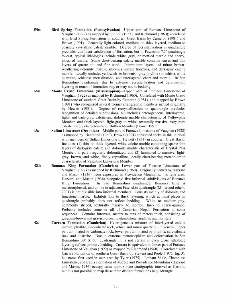
*bs Bird Spring Formation (Pennsylvanian)—Upper part of Furnace Limestone of Vaughan (1922) as mapped by Guillou (1953), and Richmond (1960); correlated with Bird Spring Formation of southern Great Basin by Cameron (1981) and Brown (1991). Generally light-colored, medium- to thick-layered, medium to coarsely crystalline calcite marble. Degree of recrystallization in quadrangle precludes confident subdivision of formation, but in Fawnskin 7.5’ quadrangle to east, typical lithologies include white, gray, or mottled marble and cherty, silicified marble. Some chert-bearing calcite marble contains lenses and thin layers of quartz silt and fine sand. Intermittent layers of minor brown-weathering dolomite marble, siliceous marble horizons, and dark-gray calcite marble. Locally includes yellowish- to brownish-gray phyllite (or schist), white quartzite, schistose metasiltstone, and interlayered chert and marble. In San Bernardino quadrangle, due to extreme recrystallization and deformation, layering in much of formation may or may not be bedding
Mm Monte Cristo Limestone (Mississippian)—Upper part of Furnace Limestone of Vaughan (1922) as mapped by Richmond (1960). Correlated with Monte Cristo Limestone of southern Great Basin by Cameron (1981), and mapped by Brown (1991) who recognized several formal stratigraphic members named originally by Hewett (1931). Degree of recrystallization in quadrangle precludes recognition of detailed subdivisions, but includes heterogeneous, interlayered, light- and dark-gray, calcite and dolomite marble characteristic of Yellowpine Member, and thick-layered, light-gray to white, texturally massive, very pure calcite marble characteristic of Bullion Member (Brown 1991)
Ds Sultan Limestone (Devonian)—Middle part of Furnace Limestone of Vaughan (1922) as mapped by Richmond (1960); Brown (1991) correlated rocks in this interval with members of Sultan Limestone of Hewett (1931) in southern Great Basin. Includes: (1) thin- to thick-layered, white calcite marble containing sparse thin layers of dark-gray calcite and dolomite marble characteristic of Crystal Pass Member; in part irregularly dolomitized, and (2) laminated to massive, light-gray, brown, and white, finely crystalline, locally chert-bearing metadolomite characteristic of Valentine Limestone Member
_bk Bonanza King Formation (Cambrian)—Lower part of Furnace Limestone of Vaughan (1922) as mapped by Richmond (1960). Originally named by Hazzard and Mason (1936) from exposures in Providence Mountains. In type area, Hazzard and Mason (1936) recognized five informal subdivisions of Bonanza King Formation. In San Bernardino quadrangle, Bonanza King is metamorphosed, and unlike in adjacent Fawnskin quadrangle (Miller and others, 2001) is not divisible into informal members. Consists mainly of dolomite and limestone marble. Exhibits thin to thick layering, which at most places in quadrangle probably does not reflect bedding. White to medium-gray, commonly striped, texturally massive to mottled, fine- to coarse-grained. Probably includes some or all of Cambrian Nopah Formation in some sequences. Contains intervals, meters to tens of meters thick, consisting of greenish-brown and grayish-brown metasiltstone, argillite, and hornfels
_c Carrara Formation (Cambrian)—Heterogeneous mixture of interlayered calcite marble, phyllite, calc-silicate rock, schist, and minor quartzite. In general, upper part dominated by carbonate rock; lower part dominated by phyllite, calc-silicate rock and quartzite. Due to extreme metamorphism and deformation in San Bernardino 30’ X 60’ quadrangle, it is not certain if even gross lithologic layering reflects primary bedding. Carrara is equivalent to lower part of Furnace Limestone of Vaughan (1922) as mapped by Richmond (1960). Correlated with Carrara Formation of southern Great Basin by Stewart and Poole (1975, fig. 3), but name first used in map area by Tyler (1975). Latham Shale, Chambless Limestone, and Cadiz Formation of Marble and Providence Mountains (Hazzard and Mason, 1936) occupy same approximate stratigraphic interval as Carrara, but it is not possible to map these three distinct formations in quadrangle
173
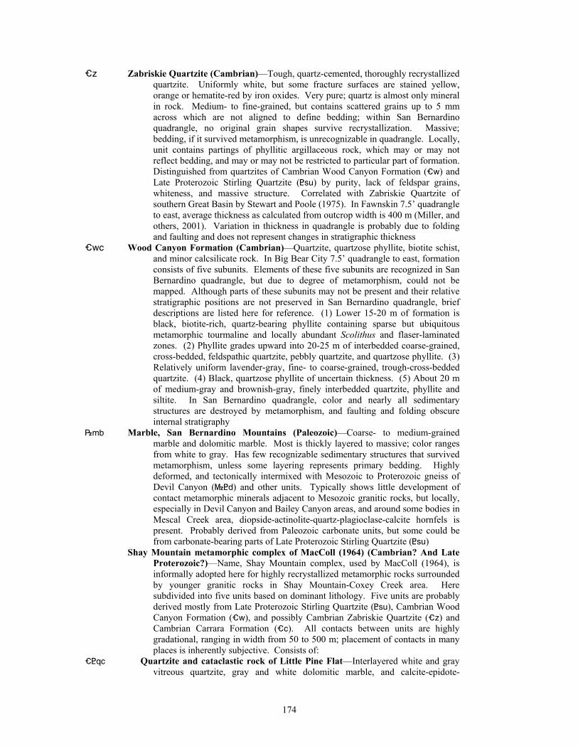
_z Zabriskie Quartzite (Cambrian)—Tough, quartz-cemented, thoroughly recrystallized quartzite. Uniformly white, but some fracture surfaces are stained yellow, orange or hematite-red by iron oxides. Very pure; quartz is almost only mineral in rock. Medium- to fine-grained, but contains scattered grains up to 5 mm across which are not aligned to define bedding; within San Bernardino quadrangle, no original grain shapes survive recrystallization. Massive; bedding, if it survived metamorphism, is unrecognizable in quadrangle. Locally, unit contains partings of phyllitic argillaceous rock, which may or may not reflect bedding, and may or may not be restricted to particular part of formation. Distinguished from quartzites of Cambrian Wood Canyon Formation (_w) and Late Proterozoic Stirling Quartzite (<su) by purity, lack of feldspar grains, whiteness, and massive structure. Correlated with Zabriskie Quartzite of southern Great Basin by Stewart and Poole (1975). In Fawnskin 7.5’ quadrangle to east, average thickness as calculated from outcrop width is 400 m (Miller, and others, 2001). Variation in thickness in quadrangle is probably due to folding and faulting and does not represent changes in stratigraphic thickness
_wc Wood Canyon Formation (Cambrian)—Quartzite, quartzose phyllite, biotite schist, and minor calcsilicate rock. In Big Bear City 7.5’ quadrangle to east, formation consists of five subunits. Elements of these five subunits are recognized in San Bernardino quadrangle, but due to degree of metamorphism, could not be mapped. Although parts of these subunits may not be present and their relative stratigraphic positions are not preserved in San Bernardino quadrangle, brief descriptions are listed here for reference. (1) Lower 15-20 m of formation is black, biotite-rich, quartz-bearing phyllite containing sparse but ubiquitous metamorphic tourmaline and locally abundant Scolithus and flaser-laminated zones. (2) Phyllite grades upward into 20-25 m of interbedded coarse-grained, cross-bedded, feldspathic quartzite, pebbly quartzite, and quartzose phyllite. (3) Relatively uniform lavender-gray, fine- to coarse-grained, trough-cross-bedded quartzite. (4) Black, quartzose phyllite of uncertain thickness. (5) About 20 m of medium-gray and brownish-gray, finely interbedded quartzite, phyllite and siltite. In San Bernardino quadrangle, color and nearly all sedimentary structures are destroyed by metamorphism, and faulting and folding obscure internal stratigraphy
|mb Marble, San Bernardino Mountains (Paleozoic)—Coarse- to medium-grained marble and dolomitic marble. Most is thickly layered to massive; color ranges from white to gray. Has few recognizable sedimentary structures that survived metamorphism, unless some layering represents primary bedding. Highly deformed, and tectonically intermixed with Mesozoic to Proterozoic gneiss of Devil Canyon (}<d) and other units. Typically shows little development of contact metamorphic minerals adjacent to Mesozoic granitic rocks, but locally, especially in Devil Canyon and Bailey Canyon areas, and around some bodies in Mescal Creek area, diopside-actinolite-quartz-plagioclase-calcite hornfels is present. Probably derived from Paleozoic carbonate units, but some could be from carbonate-bearing parts of Late Proterozoic Stirling Quartzite (<su)
Shay Mountain metamorphic complex of MacColl (1964) (Cambrian? And Late Proterozoic?)—Name, Shay Mountain complex, used by MacColl (1964), is informally adopted here for highly recrystallized metamorphic rocks surrounded by younger granitic rocks in Shay Mountain-Coxey Creek area. Here subdivided into five units based on dominant lithology. Five units are probably derived mostly from Late Proterozoic Stirling Quartzite (<su), Cambrian Wood Canyon Formation (_w), and possibly Cambrian Zabriskie Quartzite (_z) and Cambrian Carrara Formation (_c). All contacts between units are highly gradational, ranging in width from 50 to 500 m; placement of contacts in many places is inherently subjective. Consists of:
_<qc Quartzite and cataclastic rock of Little Pine Flat—Interlayered white and gray vitreous quartzite, gray and white dolomitic marble, and calcite-epidote-
174
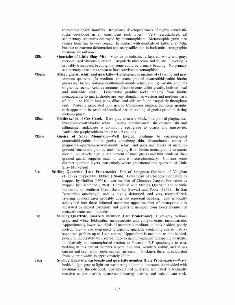
tremolite-diopside hornfels. Irregularly developed zones of highly cataclastic rocks developed in all constituent rock types. Very recrystallized; all sedimentary structures destroyed by metamorphism. Metamorphic grain size ranges from fine to very coarse. In contact with quartzite of Little Shay Mtn, but due to extreme deformation and recrystallization in both units, stratigraphic relations are unknown
_<lsm Quartzite of Little Shay Mtn—Massive to indistinctly layered, white and gray, recrystallized vitreous quartzite. Irregularly micaceous and foliate. Layering is probably transposed bedding, but some could be primary bedding. No primary sedimentary structures appear to have survived metamorphism
_<gsq Mixed gneiss, schist and quartzite—Heterogeneous mixture of (1) white and gray vitreous quartzite, (2) medium- to coarse-grained quartzofeldspathic biotite gneiss and locally andalusite-sillimanite-biotite schist, and (3) variable amounts of granitic rocks. Relative amounts of constituents differ greatly, both on local and unit-wide scale. Leucocratic granitic rocks ranging from biotite monzogranite to quartz diorite are very abundant in western and northern parts of unit; 1- to 100-m-long pods, dikes, and sills are found irregularly throughout unit. Probably associated with nearby Cretaceous plutons, but some granitic rock appears to be result of localized partial melting of gneiss protolith during metamorphism
_<cc Biotite schist of Cox Creek—Dark gray to nearly black, fine-grained plagioclase-muscovite-quartz-biotite schist. Locally contains andalusite or andalusite and sillimanite; andalusite is commonly retrograde to quartz and muscovite. Andalusite porphyroblasts are up to 1.5 cm long
_<sm Gneiss of Shay Mountain—Well layered, medium- to coarse-grained quartzofeldspathic biotite gneiss containing thin, discontinuous zones of plagioclase-quartz-muscovite-biotite schist, and pods and layers of medium-grained leucocratic granitic rocks ranging from biotite monzogranite to quartz diorite. Relatively high quartz content of most gneiss and thin bands of fine-grained quartz suggests much of unit is metasedimentary. Contains some discreet quartzite layers, particularly where gradational into quartzite of Little Shay Mtn (<lsm)
<su Stirling Quartzite (Late Proterozoic)—Part of Saragossa Quartzite of Vaughan (1922) as mapped by Dibblee (1964b). Lower part of Chicopee Formation as mapped by Guillou (1953); lower member of Chicopee Canyon Formation as mapped by Richmond (1960). Correlated with Stirling Quartzite and Johnnie Formation of southern Great Basin by Stewart and Poole (1975). In San Bernardino quadrangle, unit is highly deformed, and very recrystallized; layering in most cases probably does not represent bedding. Unit is locally subdivided into three informal members; upper member of metaquartzite is separated by mixed carbonate and quartzite member from lower member of metacarbonate rock. Includes:
<sq Stirling Quartzite, quartzite member (Late Proterozoic)—Light-gray, yellow-gray, and white feldspathic metaquartzite and conglomeratic metaquartzite. Approximately lower two-thirds of member is medium- to thick-bedded, poorly sorted, fine- to coarse-grained feldspathic quartzite containing sparse matrix-supported pebbles up to 1 cm across. Upper third is medium- to thin-bedded, poorly to moderately well sorted, fine- to medium-grained feldspathic quartzite. In relatively unmetamorphosed section in Fawnskin 7.5’ quadrangle to east, bedding in this part of member is parallel-planar, weathers slabby, and shows current and oscillation ripple-marked surfaces. Thickness there, as calculated from outcrop width, is approximately 230 m
<scq Stirling Quartzite, carbonate and quartzite member (Late Proterozoic)—Wavy bedded, light-gray to light-tan-weathering dolomitic limestone interbedded with medium- and thick-bedded, medium-grained quartzite, laminated to texturally massive calcite marble, quartz-sand-bearing marble, and calc-silicate rock.
175
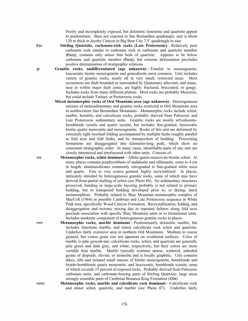
Poorly and incompletely exposed, but dolomitic limestone and quartzite appear to predominate. Base not exposed in San Bernardino quadrangle; unit is about 120 m thick in Jacoby Canyon in Big Bear City 7.5’ quadrangle to east
<sc Stirling Quartzite, carbonate-rich rocks (Late Proterozoic)—Relatively pure carbonate rock similar to carbonate rock in carbonate and quartzite member (<scq); contains only minor thin beds of quartzite. Appears to be below carbonate and quartzite member (<scq), but extreme deformation precludes positive determination of stratigraphic relations
gr Granitic rocks, undifferentiated (age unknown)—Tonalite to monzogranite; leucocratic biotite monzogranite and granodiorite most common. Unit includes variety of granitic rocks, nearly all in very small, restricted areas. Most occurences are fault bounded or surrounded by Quaternary alluvium, and many, near or within major fault zones, are highly fractured, brecciated, or gougy. Includes rocks from many different plutons. Most rocks are probably Mesozoic, but could include Tertiary or Proterozoic rocks
Mixed metamorphic rocks of Ord Mountain area (age unknown)—Heterogeneous mixture of metasedimentary and granitic rocks restricted to Ord Mountains area in northwestern San Bernardino Mountains. Metamorphic rocks include schist, marble, hornfels, and calcsilicate rocks, probably derived from Paleozoic and Late Proterozoic sedimentary units. Granitic rocks are mostly arfvedsonite-hornblende syenite and quartz syenite, but includes fine-grained, leucocratic biotite quartz monzonite and monzogranite. Rocks of this unit are deformed by extremely tight isoclinal folding accompanied by multiple faults roughly parallel to fold axes and fold limbs, and by transposition of bedding. Preexisting formations are disaggregated into kilometer-long pods, which show no consistant stratigraphic order. In many cases, identifiable parts of one unit are closely intermixed and interlayered with other units. Consists of:
ms Metamorphic rocks, schist dominant—Albite-quartz-muscovite-biotite schist. At many places contains porphyroblasts of andalusite and sillimanite, some to 4 cm in length; aluminosilicates commonly retrograded to fine-grained white mica and quartz. Fine to very coarse grained, highly recrystallized. In places, intricately intruded by heterogeneous granitic rocks, some of which may have derived from partial melting of schist (see Photo 86). No sedimentary structures preserved; banding or large-scale layering probably is not related to primary bedding, but to transposed bedding developed prior to, or during, latest metamorphism. Probably related to Shay Mountain metamorphic complex of MacColl (1964) or possibly Cambrian and Late Proterozoic sequence in White Peak area, specifically Wood Canyon Formation. Recrystallization, folding, and disaggregation and tectonic mixing due to repeated failures along fold axes preclude association with specific Shay Mountain units or to formational units. Includes moderate component of heterogeneous granitic rocks in places
mm Metamorphic rocks, marble dominant—Predominantly dolomitic marble, but includes limestone marble, and minor calcsilicate rock schist and quartzite. Underlies fairly extensive area in northern Ord Mountains. Medium to coarse grained, but coarse grain size not apparent on weathered surfaces. Color of marble is pale grayish-tan; calcsilicate rocks, schist, and quartzite are generally pale green and dark gray, and white, respectively, but their colors are more variable than marble. Marble typically contains sparse, scattered, anhedral grains of diopside, olivine, or tremolite and is locally graphitic. Unit contains dikes, sills and isolated small masses of biotite monzogranite, hornblende and biotite-hornblende quartz monzonite, and leucocratic, hornblende syenite, none of which exceeds 15 percent of exposed rocks. Probably derived from Paleozoic carbonate units, and carbonate-bearing parts of Stirling Quartzite; large areas strongly resemble parts of Cambrian Bonanza King Formation (_bk)
mmc Metamorphic rocks, marble and calcsilicate rock dominant—Calcsilicate rock and minor schist, quartzite, and marble (see Photo 87). Underlies fairly
176
extensive area in northern Ord Mountains. Typical assemblages include: diopside-olivine-calcite, sphene-labradorite-tremolite, sphene-labradorite-diopside, sphene-tremolite-diopside-labradorite. Compared to metamorphic rocks, marble dominant unit (mm), calcsilicate minerals in mmc unit are generally more abundant than carbonate minerals. Fine to coarse grained. Color variable, ranging from white to pale gray; commonly having pale-green tint. Contains dikes, sills and isolated small masses of monzogranite, quartz monzonite, and monzogranite, but rarely exceeds 15 percent of exposed rocks. Probably derived from Paleozoic carbonate units, and carbonate-bearing parts of Stirling Quartzite
mms Metamorphic rocks, marble and schist dominant—Predominantly dolomitic marble and schist; minor calcsilicate rocks and quartzite. Bedding is strongly transposed and in many places rocks are intruded on fine scale by Mesozoic granitic rocks (see Photo 81). Underlies fairly extensive area in northern Ord Mountains, structurally interlayered or interfolded with metamorphic rocks, marble dominant unit (mm) (see Photo 85). Marble and schist are both segregated into thick bands and interlayered on fine scale. Eastern part of unit consists of thick band averaging about 100 m thick that contains only limited marble, calcsilicate, rocks, and quartzite. Western part of unit consists of about equal numbers of marble and schist layers, and scattered layers of calcsilicate, rocks, and quartzite Marble is essentially same as marble in mm unit. Schist Unit contains dikes, sills and isolated small masses of biotite monzogranite, hornblende and biotite-hornblende quartz monzonite, and leucocratic hornblende syenite, which rarely exceeds 15 percent of exposed rocks. Probably derived from Wood Canyon Formation, Paleozoic carbonate units, and carbonate-bearing parts of Stirling Quartzite
mq Metamorphic rocks, quartzite dominant—Predominently white, vitreous quartzite (see Photo 88). Most likely parts of Late Proterozoic or early Paleozoic units. In most places, mixed with schist or gneiss
mx Metamorphic rocks, mixed—Quartzite, marble, calcsilicate rocks, schist, and gneiss. Proportion of each rock type highly variable. Typically cut by dikes and small bodies of alkalic granitic rocks
gn Gneiss—Quartz-rich, medium to coarse grained, moderately well foliated, typically not layered. Some contains muscovite, garnet, and aluminosilicate minerals. Probably derived from parts of Late Proterozoic or early Paleozoic units; probably not part of Middle Proterozoic Baldwin Gneiss east of quadrangle
gb Gabbro (age unknown)—Dark-gray to black, medium- to coarse-grained gabbro, ranging to hornblende diorite. Includes layered gabbro, orbicular gabbro, and pegmatitic gabbro (Barrows, 1985). Intruded by abundant leucocratic pegmatite dikes of probable Mesozoic age
177
REFERENCES Albright, L.B.,III, 1997., Geochronology and vertebrate paleontology of the San Timoteo
Badlands, southern California: Ph.D thesis, Riverside, California, Univ. California, 328 p.
Albright, 1999, Magnetostratigraphy and biochronology of the San Timoteo Badlands, southern Califrornia, with implications for local Pliocene-Pleistocene tectonic and depositional patterns: Geological Society of America Bulletin, v. 111, no. 9., p. 1265-1293.
North American Commission on stratigraphic nomenclature, 1983, North American stratigraphic code: American Association of Petroleum Geologists Bulletin, vol. 67, no. 5, p. 841-875.
Arnett, G.R., 1949, Geology of the Lytle Creek area, California: Compass, v. 26, p. 294-304. Alf, R.M., 1943. Mylonites in the eastern San Gabriel Mountains, California: California Journal of
Mines and Geology, vol. 39, p. 145-151. Alf, R.M., 1948, A mylonite belt in the southeastern San Gabriel Mountains, California:
Geological Society of America Bulletin, v. 59, p. 1101-1120. Baird, A.K., 1956, Geology of a portion of San Antonio Canyon, San Gabriel Mountains:
Claremont, California, Claremont Graduate School., M.A. thesis, 91 p. Baird, A.K., Baird, K.W., and Welday, E.E., 1979, Batholithic rocks of the northern Peninsular
Ranges, southern California, in Abbott, P.L., and Todd, V.R., eds., Mesozoic crystalline rocks: San Diego, California State University, Department of Geological Sciences, p. 111-132.
Baird, A. K., Baird, K. W., Woodford, A. O., and Morton, D. M., 1971, The Transverse Ranges: A unique structural-petrochemical belt across the San Andreas fault system: Geological Society of America Abstracts with Programs, v. 3, no. 2, p. 77-78.
Baird, A.K. and Miesch, A.T., 1984, Batholithic rocks of southern California - A model for the petrochemical nature of their source materials: U.S. Geological Survey Professional Paper 1284, 42 p.
Barrows, A.G., 1980, Geologic map of the San Andreas Fault Zone and adjoining terrane, Juniper Hills and vicinity: California Division of Mines and Geology Open-File Report 80-2 LA, scale, 1:9,600.
Barrows, A.G., 1987, Geology of the San Andreas Fault Zone and adjoining terrane, Juniper Hills and vicinity, Los Angeles County, California in Hester, R.L. and Hallinger, D.E., editors, San Andreas Fault-Cajon Pass to Palmdale: American Association of Petroleum Geologists Pacific Section Guidebook No. 59, p. 93-157, scale 1:24,000.
Barrows, A.G., Kahle, J.E., and Beeby, D.J., 1985, Earthquake hazards and tectonic history of the San Andreas fault zone, Los Angeles County, California: California Division of Mines and Geology Open-File Report 85-10 LA, 250 p.
Barrows, A.G., Kahle, J.E., and Beeby, D.J., 1987, Earthquake hazards and tectonic history of the San Andreas fault zone, Los Angeles, County, California, in Hester, R.L., and Hallinger, D.E., eds., San Andreas fault-Cajon Pass to Palmdale: Pacific Section, American Association of Petroleum Geologists Volume and Guidebook 59, p. 1-92.
Barth, A.P., and Ehlig, P.L., 1988, Geochemistry and petrogenesis of the marginal zone of the Mount Lowe Intrusion, central San Gabriel Mountains, California: Contributions to Mineralogy and Petrology, v. 100, p. 192-204.
Barth, A. P., Tosdal, R. M., and Wooden, J. L., 1990, A petrologic comparison of Triassic plutonism in the San Gabriel and Mule Mountains, southern California: Journal of Geophysical Research, v. 95, no. B12, p. 20075-20096.
Barth, A.P., Tosdal, R.M., Wooden, J.L., and Howard, K.A., 1997, Triassic plutonism in southern California: Southward younging of arc initiation along a truncated continental margin: Tectonics, v. 16, p. 290-304.
Bortugno, E.J., and Spittler, T.E., 1986, Geologic map of the San Bernardino Quadrangle: California Division of Mines and Geology, Regional Geologic Map Series, Map No. 3A, scale 1:250,000.
Brown, H.J., 1984, Summary of the geology of the north range front of the San Bernardino Mountains, Lucerne Valley, California, in Kupferman, S., McIver, D., and Morton, P.,
178
eds., Major limestone producers of the western Mojave Desert, California: American Institute of Mining Engineers, 112th Annual Meeting, Los Angeles, Field Trip Guidebook, p. 12-19.
Brown, H.J., 1987, Geologic setting and operations overview, Lucerne Valley limestone mining district, Lucerne Valley, California, in Pierce, W., ed., 21st Annual Industrial Mineral Conference Proceedings: Arizona Bureau of Mines Special Report 4, p. 44-54.
Brown, H.J., 1991, Stratigraphy and paleogeographic setting of Paleozoic rocks in the San Bernardino Mountains, California, in Cooper, J.D., and Stevens, C.H., eds., Paleozoic Paleogeography of the western United States-II: Pacific Section, Society of Economic Paleontologists and Mineralogists, v. 67, p. 193-207.
Bull, W.B., 1991, Geomorphic responses to climatic change: New York, Oxford University Press, 326 p.
Burnham, C.W., 1959, Contact metamorphism of magnesian limestones at Crestmore, California: Geological Society of America Bulletin, vol. 70, p. 879-920.
Cameron, C.S., 1981, Geology of the Sugarloaf and Delamar Mountain areas, San Bernardino Mountains, California: Cambridge, Massachusetts Institute of Technology, Ph.D. Thesis, 399 p.
_______, 1982, Stratigraphy and significance of the Upper Precambrian Big Bear Group, in Cooper, J.D., Troxel, B. , and Wright, L., Geology of selected areas of the San Bernardino Mountains and western Mojave Desert, and southern Great Basin of California: Geological Society of America, Cordilleran Section, Field Trip n. 9, p. 5-20.
Campbell, R. H., and Yerkes, R. F., 1976, Cenozoic evolution of the Los Angeles basin area—relation to plate tectonics, in Howell, D. G., ed., Aspects of the geologic history of the California continental borderland: Pacific Section, American Association of Petroleum Geologists Miscellaneous Publication 24, p. 541-558.
Clarke, A.O., 1977, Quaternary surficial deposits and their relationship to landforms in the San Bernardino Valley: Riverside, University of California, Ph.D. thesis, 140 p.
Conrad, R.L., and Davis, T.E., 1977, Rb/Sr Geochronology of cataclastic rocks of the Vincent thrust, San Gabriel Mountains, southern California: Geological Society of America Abstracts with Programs, v. 9,. no. 4, p. 403-404.
Cramer, C. H., and Harrington, J. M., 1987, Seismicity and tectonics of the Cucamonga fault and the eastern San Gabriel Mountains, San Bernardino County, in Recent reverse faulting in the Transverse Ranges, California: U.S. Geological Survey Professional Paper 1339, p. 7-26.
Crook, Richard, Jr., Allen, C. R., Kamb, Barclay, Payne, C. M., and Protor, R. J., 1987, Quaternary geology and seismic hazard of the Sierra Madre and associated faults, western San Gabriel Mountains, in Recent reverse faulting in the Transverse Ranges, California: U.S. Geological Survey Professional Paper 1339, p. 27-63.
Crowell, J.C., 1952, Probable large lateral displacement on San Gabriel faut, southern California: American Association of Petroleum Geologists Bulletin, vol. 36, p. 2026-2035.
Crowell, J.C., 1960, The San Andreas fault in southern California: Report of the 21st International Geologic Congress, Copenhagen, part 18, p. 49-52
_______, ed., 1975a, San Andreas fault in southern California: California Division of Mines and Geology Special Report 118, 272 p.
_______., 1975b, The San Andreas fault in southern California, in Crowell, J. C., ed., San Andreas fault in southern California: California Division of Mines and Geology Special Report 118, p. 7–27.
Crowder, D.F. 1967, Mineral resources of the Devil Canyon-Bear Canyon primitive area, California: U.S. Geological Survey Bulletin 1230-G.
Cox, B.F., Powell, R.E., Hinkle, M.E., and Lipton, D.A., 1983, Mineral resource potential map of the Pleasant View Roadless Area, Los Angeles County, California: U.S. Geological Survey Miscellaneous Field Studies Map MF-1649-A.
Daly, J.W., 1935, Paragenesis of mineral assemblages at Crestmore, California: American Mineralogist, vol. 20, p. 638-659.
179
Daviess, S.N., and Woodford, A.O., 1949, Geology of the northwestern Puente Hills, Los Angeles County, California: U.S. Geological Survey Oil and Gas Investigation, Preliminary Map 83.
Dibblee, T. W., Jr., 1964a, Geologic map of the Lucerne Valley quadrangle, San Bernardino County, California: U.S. Geological Survey Miscellaneous Geologic Investigations Map I-426, scale 1:62,500.
_______, 1964b, Geologic map of the San Gorgonio Mountain quadrangle, San Bernardino and Riverside Counties, California: U.S. Geological Survey Miscellaneous Geologic Investigations Map I-431, scale 1:62,500.
_______, Jr., 1967, Areal geology of the western Mojave Desert, California: U.S. Geological Survey Professional Paper 522, 153 p.
_______, 1968, Displacements on San Andreas fault system in San Gabriel, San Bernardino, and San Jacinto Mountains, southern California, in Dickinson, W.R., and Grantz, Arthur, eds., Proceedings of conference on geologic problems of San Andreas fault system: Stanford University Publications in Geological Sciences, v. XI, p. 269-278.
_______, 1974, Geologic Map of the Lake Arrowhead Quadrangle, San Bernardino County, California: U.S. Geological Survey Open-File Report 74-56, scale 1:62,500.
_______, 1982, Geology of the San Gabriel Mountains, southern California, in Fife, D.L., and Minch, J.A., eds., Geology and mineral wealth of the California Transverse Ranges: South Coast Geological Society Guidebook no. 10 (Mason Hill volume), p. 131-147.
Dillon, J.T., and Ehlig, P.L., 1993, Displacement on the southern San Andreas fault, in Powell, R.E., Weldon, R.J., and Matti, J.C., eds., The San Andreas fault system: displacement, palinspastic reconstruction, and geologic evolution: Geological Society of America Memoir 178, p. 199-216.
Dudley, P.H., 1935, Geology of a portion of the Perris block, southern California: California Journal Mines and Geology, v. 31, p. 487-506.
Durham, D.L., and Yerkes, R.F., 1959, Geologic map of the eastern Puente Hills, Los Angeles Basin, California: U.S. Geol. Survey Oil and Gas Map OM-195.
_______, 1964, Geology and oil resources of the eastern Puente Hills, southen California: U.S. Geol. Survey Prof. Paper 420-B, 62 p.
Eakle, A.S., 1914, Some contact metamorphic minerals in crystalline limestone at Crestmore, near Riverside, California: Geological Society of America Bulletin, vol. 25, p. 125.
Eckis, R. W., 1928, Alluvial fans of the Cucamonga district, southern California: Journal of Geology, v. 36, p. 224-247.
Eckis, R. W., 1934, South coastal-basin Investigations: Geology and ground water storage capacity of valley fill - south coastal basin investigation: California Div. Water Resources Bull. 45, 279 p.
Ehlig, P.L., 1958, Geology of the Mount Baldy region of the San Gabriel Mountains, California: Los Angeles, California, University of California, Ph.D. thesis, 153 p.
_______, 1968, Causes of distribution of Pelona, Rand, and Orocopia Schists along the San Andreas and Garlock faults, in Dickinson, W.R., and Grantz, A., eds., Conference on Geologic Problems of San Andreas Fault System, Proceedings: Stanford University Publications in Geological Sciences, v. 11, p. 294-306.
_______, History, Seismicity and engineering geology of the San Gabriel fault, in Moran, D.E, Slosson, J.E.,, Stone, R.O., and Yelverton, C.A., eds., Geology, Seismicity, and environmental impact: Association of Engineering Geolog8ists Special Publications October 1973, p. 247-251.
_______, 1975, Basement rocks of the San Gabriel Mountains south of the San Andreas fault, southern California: in Crowell, J.C., ed., San Andreas fault in southern California: California Division of Mines and Geology Special Report 118, p. 177-186.
_______, 1981, Orgin and tectonic history of the basement terrane of the San Gabriel Mountains, central Transverse Ranges, in, Ernst, W.G., ed., The geotectonic Development of California; Ruby Volume 1: Englewood Cliffs, New Jersey, Prentice-Hall, p. 253-283.
_______, 1982, The Vincent thrust: Its nature, paleogeographic reconstruction across the San Andreas fault and bearing on the evolution of the Transverse Ranges, in Fife, D.L., and Minch, J.A., eds., Geology and mineral wealth of the California Transverse Ranges;
180
Mason Hill Volume: Santa Ana, California, South Coast Geological Society Annual Symposium and Guidebook 10, p. 370-379.
_______, 1988a, Characteristics of basement rocks exposed near the Cajon Pass scientific drill hole, in Zoback, M.D., Silver, L.T., Henyey, Thomas, and Thatcher, Wayne, eds., Scientific drilling near the San Andreas fault: Geophysical Research Letters, v. 15, no. 9 (supplement), p. 949-952.
_______, 1988b, Geologic structure near the Cajon Pass scientific drill hole, in Zoback, M.D., Silver, L.T., Henyey, Thomas, and Thatcher, Wayne, eds., Scientific drilling near the San Andreas fault: Geophysical Research Letters, v. 15, no. 9 (supplement), p. 953-956.
Eldridge, G. H., and Arnold, R., 1907, The Santa Clara Valley, Puente Hills, and Los Angeles oil districts, southern California: U.S. Geol. Survey Bull. 309, 266 p.
English, W.A. 1926, Geology and oil resources of the Puente Hills Region, California: U.S. Geol. Survey Bull. 768. 110 p.
Evans, J.G., 1982, Mineral resources of the Sheep Mountain Wilderness Study Area and the Cucamonga Wilderness and additions, Los Angeles and San Bernardino Counties, California: US. Geological Survey Bulletin 1506, 92 p.
Fenneman, N.M., 1931, Physiography of western United States: New York, McGraw-Hill Co., 534 p.
Foster, J.H., 1980, Late Cenozoic evolution of Cajon Valley, southern California: Riverside, University of California, Ph.D. Thesis, 235 p.
Foster, J.H., 1982, Late Cenozoic tectonic evolution of Cajon Valley, southern California, in Sadler, P.M., and Kooser, M.A., eds., Late Cenozoic stratigraphy and structure of the San Bernardino Mountains, field trip 6 of Cooper, J.D., compiler, Geologic excursions in the Transverse Ranges, southern California: Geological Society of America, Cordilleran Section, 78th Annual Meeting, Anaheim, Calif., 1982, Volume and Guidebook, p. 67-73.
Frick, Childs, 1921, Extinct vertebrate faunas of the badlands of Bautista Creek and San Timoteo Canyon, southern California: Univ. California Pub., Depart. Geol. Sciences Bull., v. 12, p. 277-409.
Frizzell, V. A., Jr., Mattinson, J. M., and Matti, J. C., 1986, Distinctive Triassic megaporphyritic monzogranite: Evidence for only 160 km offset along the San Andreas fault, southern California: Journal of Geophysical Research, v. 91, no. B14, p. 14080–14088.
Gibson, R.C., 1964, Geology of a portion of the Mill Creek area, San Bernardino County, California: Riverside, University of California, M.S. Thesis, 50 p.
Gibson, R. C., 1971, Non-marine turbidites and the San Andreas fault, San Bernardino Mountains, California, in Elders, W. A., ed., Geological excursions in southern California; Geological Society of America Cordilleran Section Annual Meeting Guidebook: Riverside, University of California Campus Museum Contributions, no. 1, p. 167-181.
Guillou, R.B., 1953, Geology of the Johnston Grade area, San Bernardino County, California: California Division of Mines Special Report 31, 18 p.
Gilluly, J., 1970, Crustal deformation the western United States, in Johnson, H, and Smith, R.P., eds., The megatectonics of continents and oceans: New Brunswick, New Jersey, Rutgers University Press, p. 47-73.
Hadley, D., and Kanamori, H., 1977 Seismic structure of the Transverse Ranges, California: Geological Society of America Bulletin, vol. 88, p. 1469-1478.
Harden, J.W., and Matti, J.C., 1989, Holocene and late Pleistocene slip rates on the San Andreas fault in Yucaipa, California, using displcaced alluvial-fan deposits and soil chronology: Geological Society of America Bulletin, vol. 101, p. 1107-1117.
Hersey, O.H., 1902, Some crystalline rocks of southern California: American Geologist vol. 29, p. 273-290.
Hauksson, E., 1994, The 1981 Sierra Madre earthquake sequence in southern California: Seismological and tectonic analysis: Bulletin of Seismological Society of America, v. 84, p. 1058-1074.
Hauksson, E., and Jones, L.M., 1991, The 1988 and 1990 Upland earthquakes: Left-lateral faulting adjacent to the central Transverse Ranges: Journal of Geophysical Research, v. 96, p. 8143-8165.
181
Haxel, Gordon, and Dillon, John, 1978, The Pelona-Orocopia Schist and Vincent-Chocolate Mountain thrust system, southern California, in Howell, D.G., and McDougall, K.A., eds., Mesozoic Paleogeography of the Western United States: Pacific Section, Society of Economic Paleontologists and Mineralogists, Pacific Coast Paleogeography Symposium 2, p. 453-469.
Hazzard, J.C., and Mason, J.F., 1936, Middle Cambrian formations of the Providence and Marble Mountains, California: Geological Society of America Bulletin, v. 47, p. 229-240.
Hewitt, D.F., 1931, Geology and ore deposits of the Goodsprings quadrangle, Nevada: U.S. Geological Survey Professional Paper 162, 171 p.
Hill, M.L., 1930, Structure of the San Gabriel Mountains north of Los Angeles,California, with a foreword by F.S. Hudson: Berkeley, California, University of California Department of Geological Sciences Bulletin, v. 19, no. 6, p. 137-170.
Hill, M. L., and Dibblee, T. W., Jr., 1953, San Andreas, Garlock, and Big Pine faults, California; A study of the character, history, and tectonic significance of their displacements: Geological Society of America Bulletin, v. 64, p. 443-458.
Hinds, N.E.A., 1952, Evolution of the California landscape: California Division of Mines, Bulletin 158, 240p.
Hornafius, J. S., Luyendyk, B. P., Terres, R. R., and Kamerling, M. J., 1986, Timing and extent of Neogene tectonic rotation in the western Transverse Ranges, California: Geological Society of America Bulletin, v. 97, p. 1476-1487.
Hsu, K.J., 1955, Granulites and mylonites of the region about Cucamonga and San Antonio Canyons, San Gabriel Mountains, California: University of California Publications in Geological Sciences, v. 30, p. 223-324.
Hsu, K. J., Edwards, G, and McLaughlin, W. A., 1963, Age of intrusive rocks of the southeastern San Gabriel Mountains, California: Geological Society of America Bulletin, v. 74, p. 507-512.
Jacobs, S.E., 1982, Geology of a part of the upper Santa Ana River valley, San Bernardino Mountains, San Bernardino County, California: Riverside, California, University of California, M.A. Thesis, 107 p.
Jacobson, C.E., 1983, Structural geology of the Pelona Schist and Vincent thrust, San Gabriel Mountains, California: Geological Society of America Bulletin, v. 94, n. 6, p. 753-767.
Jacobson, C.E., 1990, The 40Ar/39Ar geochronology of the Pelona Schist and related rocks, southern California: Journal of Geophysical Research, v. 95, no. B1, p. 509-528.
Jacobson, C.E., Barth, A., and Grove, M., 2000, Late Cretaceous protolith age and provenance of the Pelona and Orocopia Schists, southern California: Implications for evolution of the cordilleran margin: Geology, v. 28, p. 219-222.
Jones, L.M., 1988, Focal mechanisms and the state of stress on the San Andreas fault in southern California: Journal of Geophysical Research, v. 93, no. B8, p. 8869-8891.
Joseph, S.E., Criscione, J.J., Davis, T.E., and Ehlig, P.L., 1982, The Lowe igneous pluton, in Fife, D.L., and Minch, J.A., eds., Geology and mineral wealth of the California Tranverse Ranges: South Coast Geological Society Guidebook no. 10 (Mason Hill volume).
Jahns, R.H., ed., 1954, Geology of southern California: California Division of Mines Bulletin 170.
Joshi, M.S., 1967, The genesis of the granitic and associated rocks of the Box Springs Mountains, Riverside, California: Riverside, California, University of California, PhD thesis, 169 p.
Kamerling, M.J., and Luyendyk, B/P., 1979, Tectonic rotations of the Santa Monica Mountains region, western Transverse Ranges, California, suggested by paleomagnetic verctors: Geological Society of America Bulletin, v. 90, p. 331-337.
Kendrick, K.J., 1996, Descriptions and laboratory analysis for soils in the northern San Timoteo Badlands, California: U.S. Geological Survey Open-File Report 96-93, 6 p.
Kendrick, K.J., McFadden, L.D., and Morton, D.M., 1994, Soils and slip rates along the northern San Jacinto fault, in McGill, S.F., and Ross, T.M., eds., Geological investigations of an active margin: Geological Society of America Cordilleran Section Guidebook, Trip No. 8, p. 146-151.
182
Kendrick, K.J., Morton, D.M., Wells, S.G, and Simpson, R.W., 2002, Spatial and temporal deformation along the northern San Jacinto fault, southern California: Seismological Society of America Bulletin, vol. 92, no. 7, p. 2782-2802.
Kenney, M.D., 1999, Emplacement, offset history, and recent uplift of basement within the San Andreas Fault System, northeast San Gabriel Mountains, California: Eugene, Oregon, University of Oregon, Ph.D. thesis, 357 p.
Kew, W.S.W., 1923, Geologic formations of a part of southern California and their correlation: American Association of Petroleum Geologists Bulletin, v. 7, p. 411-420.
_______, 1924, Geology and oil resources of a part of Los Angeles and Ventura Counties, California: U.S. Geol. Survey Bull. 753, 202 p.
Kooser, M.A., 1980, Stratigraphy and sedimentology of the San Francisquito Formation, Transverse Ranges, California: Riverside, California, University of California, Ph.D. thesis, 201 p.
_______, 1982, Stratigraphy and sedimentology of the type San Francisquito Formation, southern California, in Crowell, J.C., and Link, M.H., eds., Geologic history of Ridge Basin, southern California: Pacific Section, Society of Economic Paleontologists and Mineralogists, Field trip guide and volume, p. 53-61.
Kooser, M. A., 1985, Paleocene plesiosaur(?), in Reynolds, R. E., compiler, Geologic investigations along Interstate 15, Cajon Pass to Manix Lake, California: Redlands, California, San Bernardino County Museum Publications, p. 43-48.
Larsen, E.S., 1948, Batholith and associated rocks of Corona, Elsinore, and San Luis Rey quadrangles, southern California: Geol. Society America Mem. 29, 182 p.
Lawson, A.C., and others, 1908, The California earthquake of April 18, 1906: Carnegie Institute of Washington, Publication 87, vol 1, part 1, 254 p.
Lucas, S.G. and Reynolds, R.e., 1991, Late Cretaceous(?) plesiosaurs from Cajon Pass, California, in, Woodburne, M.O., Reynodls, R.E., and Whistler, D.P., eds., Inland southern California: The last 70 million years: San Bernardino County Museum Association Quarterly, v. 38, p. 52-53.
MacColl, R.S., 1964, Geochemical and structural studies in batholithic rocks of southern California: Part 1, Structural geology of Rattlesnake Mountain pluton: Geological Society of America Bulletin, v. 75, p. 805-822.
MacKevett, E.M., 1951, Geology of the Jurupa Mountains, San Bernardino and Riverside Counties, California: California Division of Mines Special Report 5.
Matti, J. C., Cox, B. F., and Iverson, S. R., 1983, Mineral resource potential map of the Raywood Flat Roadless Area, San Bernardino and Riverside Counties, California: U.S. Geological Survey Miscellaneous Field Studies Map MF-1563-A, scale 1:62,500.
Matti, J.C., and Morton, D.M., 1993, Paleogeographic evolution of the San Andreas fault in southern California: A reconstruction based on a new cross-fault correlation, in Powell, R.E., Weldon, R.J., and Matti, J.C., eds., The San Andreas fault system: displacement, palinspastic reconstruction, and geologic evolution: Geological Society of America Memoir 178, p. 107-159.
Matti, J.C., Morton, D.M. and Cox, B.F., 1985, Distribution and geologic relations of fault systems in the vicinity of the central Transverse Ranges, southern California: U.S. Geological Survey Open-File Report 85-365, 27 p., scale 1:250,000.
Matti, J.C., Morton, D.M. and Cox, B.F., 1992a, The San Andreas fault system in the vicinity of the central Transverse Ranges province, southern California: U.S. Geological Survey Open-File Report 92-354, 40 p., scale 1:250,000.
Matti, J.C., Morton, D.M., Cox, B.F., Carson, S.E., and Yetter, T.J., 1992b, Geologic map of the Yucaipa 7.5' quadrangle, California: U.S. Geological Survey Open-File Report 92-446, Scale 1:24,000.
May, D.J., 1986, Amalgamation of metamorphic terranes in the southeastern San Gabriel Mountains, California: Santa Barbara, California, University of California, Ph.D. thesis, 325 p.
May, D.J., 1989, Late Cretaceous intra-arc thrusting in southern California: Tectonics, v. 8, p. 1159-1173.
183
May, D.J., and Walker, N.W., 1989, Late Cretaceous juxtaposition of metamorphic terranes in the southeastern San Gabriel Mountains, California: Geological Society of America Bulletin, v. 101, p. 1246-1267.
McCulloh, T. H., Beyer, Larry A., and Morin, Ronald W., 2001, Mountain Meadows Dacite: Oligocene intrusive complex that welds together the Los Angeles basin, northwestern Peninsular Ranges, and central Transverse Ranges, California: U.S. Geological Survey Professional Paper 1649, 34 p.
McCulloh, T. H., Fleck, R.J., Denison, R.E., Beyer, L.A., and Stanley, R.G., 2002, Age and tectonic significance of volcanic rocks in the northern Los Angeles Basin, California: U.S. Geological Survey Professional Paper 1669, 24 p.
McFadden, L.D., and Weldon, R.J., 1987, Rates and processes of soil development on Quaternary terraces in Cajon Pass, California: Geological Society of America Bulletin, v. 98, p. 280-293
Meisling, K.E., 1984, Neotectonics of the north frontal fault system of the San Bernardino Mountains, southern California: Cajon Pass to Lucerne Valley: Pasadena, California, California Institute of Technology, Ph.D. thesis, 394 p.
Meisling, K.E., and Weldon, R.J., 1982, The late-Cenozoic structure and stratigraphy of the western San Bernardino Mountains, in Sadler, P.M., and Kooser, M.A., eds., Late Cenozoic stratigraphy and structure of the San Bernardino Mountains, field trip 6 of Cooper, J.D., compiler, Geologic excursions in the Transverse Ranges, southern California: Geological Society of America, Cordilleran Section, 78th Annual Meeting, Anaheim, Calif., 1982, Volume and Guidebook, p. 75-82.
Meisling, K. E., and Weldon, R. J., 1989, Late Cenozoic tectonics of the northwestern San Bernardino Mountains, southern California: Geological Society of America Bulletin, v. 101, p. 106-128.
Menzie, T.E., 1962, The geology of the Box Springs Mountains, Riverside County, California: Palo Alto, California, Stanford University, M.S. thesis, 50 p.
Mezger, L.L., and Weldon, R.J., 1983, Tectonic implications of the Quaternary history of lower Lytle Creek, southeast San Gabriel Mountains: Geological Society of America Abstracts with Programs, v. 15, no. 5, p. 418.
Miller, C.F., 1977a, Alkali-rich monzonites, California: origin of near silica-saturated alkaline rocks and their significance in a calc-alkaline batholithic belt: Los Angeles, California, University of California, Ph.D. thesis, 283 p.
Miller, C.F., 1977b, Early alkalic plutonism in the calc-alkaline batholithic belt of California: Geology, v. 5, p. 685-688.
Miller, C.F., 1978, An early Mesozoic alkalic magmatic belt in western North America, in Howell, D.G., and McDougall, K.A., eds., Mesozoic paleogeography of the western United States: Pacific Section, Society of Economic Paleontologists and Mineralogists, p. 163-173.
Miller, F. K., and Morton, D. M., 1977, Comparison of granitic intrusions in the Pelona and Orocopia Schists, southern California: U.S. Geological Survey Journal of Research, v. 5, no. 5, p. 643-649.
_______, 1980, Postassium-argon geochronology of the eastern Transverse Ranges and southern Mojave Desert, southern California: U.S. Geological Survey Professional Paper 1152, 30 p.
Miller, F.K., 1987, Reverse-fault system bounding the north side of the San Bernardino Mountains, in Morton, D.M., and Yerkes, R.F., eds., Recent reverse faulting in the Transverse Ranges, California: U.S. Geological Survey Professional Paper 1339, p. 83-95.
Miller, F.K. and Matti, J.C., 2001, Digital geologic map of the Fifteenmile Valley 7.5' quadrangle, San Bernardino County, California: U.S. Geological Survey Open-File Report 01-132, scale, 1:24,000.
Miller, F.K., Matti, J.C., and Brown, H.J., 2000, Digital geologic map of the Butler Peak 7.5’ quadrangle, San Bernardino County, California: U.S. Geological Survey Open-File Report, OF-00-145, 16 p., scale 1:24,000.
184
Miller, F.K., Matti, J.C., Brown, H.J., and Powell, R.E., 1998, Digital geologic map of the Fawnskin 7.5' quadrangle, San Bernardino County, California: U.S. Geological Survey Open-File Report 98-579, version 1.1, 18 p., scale, 1:24,000.
Miller, W.J., 1926, Crystalline rocks of the middle-southern San Gabriel Mountains, California [abs]: Geological Society of America Bulletin, v.37, p. 149.
_______, 1926a, Glaciation in the San Gabriel Mountains, California: Journal of Geology, vol. 34(1), p. 74-82.
_______, 1928, Geomorphology of the southwestern San Gabriel Mountains of California: Berkeley, University of California Department of Geological Sciences Bulletin, v. 17, p. 193-240.
_______, 1934, Geology of the western San Gabriel Mountains of California: University of California at Los Angeles Publications in Mathematical and Physical Sciences, v. 1, no. 1, 114 p.
_______, 1946, Crystalline rocks of southern California: Geological Society of America Bulletin, v.57, p. 457-542.
Morton, D. M., 1973, Geology of parts of the Azusa and Mount Wilson quadrangles, San Gabriel Mountains, Los Angeles County, California: California Division of Mines and Geology Special Report 105, 21 p.
_______, 1975, Synopsis of the geology of the eastern San Gabriel Mountains, southern California, in Crowell, J.C., ed., San Andreas fault in southern California: California Division of Mines and Geology Special Report 118, p. 170-176.
_______, D.M., 1976, Geologic map of the Cucamonga fault zone between San Antonio Canyon and Cajon Creek, southern California: U.S. Geological Survey Open-File Report 76-726, scale 1:24,000.
Morton, D.M., and Campbell, R.H., 1974, Spring mudflows at Wrightwood, southern California: Quarterly Journal of Engineering Geology, v. 7, p.377-384.
Morton, D.M., and Kennedy, M.P., 1979, Part 1: Wright Mountain mudflows--1967 landsliding, in Landsliding and mudflows at Wrightwood, San Bernardino County, California: California Division of Mines and Geology Special Report 136, p.1-6.
Morton, D. M., and Matti, J. C., 1987, The Cucamonga fault zone: Geologic setting and Quaternary history, in Recent reverse faulting in the Transverse Ranges, California: U.S. Geological Survey Professional Paper 1339, p. 179-203.
_______, 1989, A vanished late Pliocene to early Pleistocene alluvial-fan complex in the northern Perris Block, southern California, in Colburn, I.P., and Minch, J., eds., Conglomerates in basin analysis: A symposium dedicated to A.O. Woodford: Pacific Section Society of Economic Paleontologists and Mineralogists, v. 62, p. 73-80.
_______, 1990a, Geologic map of the Cucamonga Peak 7.5' Quadrangle, California: U.S. Geological Survey Open-File Report 90-694, scale 1:24,000.
_______, 1990b, Geologic map of the Devore 7.5' Quadrangle, California: U.S. Geological Survey Open-File Report 90-695, scale 1:24,000.
_______, 1993, Extension and contraction within an evolving divergent strike-slip fault complex: The San Andreas and San Jacinto fault zones at their convergence in southern California, in Powell, R.E., Weldon, R.J., and Matti, J.C., eds., The San Andreas fault system: displacement, palinspastic reconstruction, and geologic evolution: Geological Society of America Memoir 178, p. 217-230.
_______, 2001a, Geologic map of the Cucamonga Peak 7.5' Quadrangle, San Bernardino County, California: U.S. Geological Survey Open-File Report 01-311, scale 1:24,000.
_______, 2001b, Geologic map of the Devore 7.5' Quadrangle, San Bernardino County, California: U.S. Geological Survey Open-File Report 01-173, scale 1:24,000.
Morton, D.M., Matti, J.C., Miller, F.K., and Repenning, C.A.., 1986, Pleistocene conglomerate from the San Timoteo Badlands, southern California: Constraints on strike-slip displacements on the San Andreas and San Jacinto faults: Geol. Soc. America Abst. with Programs, v. 18, p. 161.
Morton, D.M., and Miller, F.K., 1975, Geology of the San Andreas fault zone north of San Bernardino between Cajon Canyon and Santa Ana Wash, in Crowell, J.C., ed., San
185
Andreas fault in southern California: California Division of Mines and Geology Special Report 118, p. 136-146.
Morton, D.M., Rodriguez, E.A., Obi, C.M., Simpson, R.W., Jr., and Peters, T.J., 1983, Mineral resource potential map of the Cucamonga Roadless Areas, San Bernardino County, California: U.S. Geological Survey Miscellaneous Field Studies Map MF-1646-A, scale 1:31,680.
Morton, D.M., and Sadler, P.M, 1989, The failings of the Pelona Schist: landslides and sackungen in the Lone Pine Canyon and Wrightwood areas, eastern San Gabriel Mountains, southern California, in Sadler, P.M., and Morton, D.M., eds., Landslides in a semi-arid environment: Redlands, California, Publications of the Inland Geological Society, v. 2, p. 301-322.
Morton, D.M., Sadler, P.M., and Minnich, R.A., 1989, Large rock-avalanche deposits: examples from the central and eastern San Gabriel Mountains of southern California, in Sadler, P.M., and Morton, D.M., eds., Landslides in a semi-arid environment: Redlands, California, Publications of the Inland Geological Society, v. 2, p. 323-337.
Morton, D.M., and Streitz, R., 1969, Reconnaissance map of major landslides, San Gabriel Mountains, California: California Division of Mines and Geology Map Sheet 15.
Morton, D.M., Woodburne, M.O., and Foster, J., 1990, Geologic map of the Telegraph Peak Quadrangle, southern California: U.S. Geological Survey Open-File Report 90-693, scale 1:24,000.
Morton, D.M., Woodburne, M.O., and Foster, J., 2001, Geologic map of the Telegraph Peak Quadrangle, San Bernardino County, California: U.S. Geological Survey Open-File Report 01-293, scale 1:24,000.
Murdoch, Joseph, and Webb, R.W., 1966, Minerals of California: California Division of Mines and Geology Bulletin 189, 559 p.
Nicholson, C., Sorlien, C.C., Atwater, T., Crowell, J.c., and Luyendyk, B.P., 1994, Microplate capture, rotation of the western Transverse Ranges, and initiation of the San Andreas transform as a low-angle fault system: Geology, v. 22, p. 491-495.
Noble, L.F., 1926, The San Andreas rift and some other active faults in the desert region of southeastern California: Carnegie Inst. Washington, Yearbook 25, p. 415-428.
Noble, L.F., 1927, Noble, L.F., 1932a, The San Andreas rift in the desert region of southeastern California: Carnegie
Inst. Washington, Yearbook 31, p. 355-363. Noble, L.F., 1932b, Noble, L.F., 1933, Excursion to the San Andreas fault and Cajon Pass, in Gale, H.S., ed., Southern
California: 16th International Geologic Congress, Guidebook 15, 68 p. Noble, L.F., 1953, Geology of the Pearland Quadrangle, California: U.S. Geological Survey
Geologic Quadrangle Map GQ-24, scale 1:24,000. Noble, L.F., 1954a, Geology of the Valyermo Quadrangle and vicinity, California: U.S.
Geological Survey Geologic Quadrangle Map GQ-50, scale 1:24,000. Noble, L.F., 1954b, The San Andreas fault zone from Soledad Pass to Cajon Pass, California; in
Geology of southern California, ed., Jahns, R.H., Division of Mines Bulletin 170, Chapter IV, p. 37-48.
Nourse, J.A., 2002, Middle Miocene reconstruction of the central and eastern San Gabriel Mountains, southern California, with implications for evolution of the San Gabriel fault and Los Angeles basin, in Barth, A., ed., Contributions to crustal evolution of the southwestern United States: Geological Society of America Special Paper 365, p. 161-185.
Nourse, J.A., Weigand, P.W., and Hazelton, G.B., 1998, Igneous and tectonic response of the eastern San Gabriel Mountains to Neogene extension and rotation of the Transverse Ranges bloc, in Behl, R.J., ed., Guidebook to field trip No. 10, 94th Annual Meeting, Cordilleran Section of the Geological Society of America, p. 1-15.
Olmsted, F.H., 1950, Geology and oil prospects of western San Jose Hills, Los Angeles County, California: California Journal of Mines and Geology, vol. 46, no. 2, p. 191-213.
Owens, G.V., 1959, Sedimentary rocks of lower Mill Creek, San Bernardino Mountains, California: Claremont, California, Claremont Graduate School, M.A. thesis.
186
Powell, R.E., 1993, Balanced palinspastic reconstruction of pre-Late Cenozoic paleogeology, southern California: geologic and kinematic constraints on evolution of the San Andreas fault system, in Powell, R.E., Weldon, R.J., and Matti, J.C., eds., The San Andreas fault system: displacement, palinspastic reconstruction, and geologic evolution: Geological Society of America Memoir 178, p. 1-106.
Powell, R.E., and Weldon, R.J., 1992, Evolution of the San Andreas fault: Annual Review of Earth and Planetary Sciences, v. 20, p. 431-468.
Reed, R.D., R.D., 1933, Geology of California: Tulsa, Oklahoma, American Assoc. of Petroleum Geologists, 355 p.
Repenning, C.A., 1987, Biochronology of the microtine rodents of the United States, in, Woodburne, M.O., ed., Cenozoic mammals of north America: Geochronology and biostratigraphy: Berkeley and Los Angeles, Univ. California Press, p. 236-268.
Reynolds, R.E., 1984, Miocene faunas in the lower Crowder Formation: a preliminary discussion, in Hester, R.L., and Hallinger, D.E., eds., San Andreas fault--Cajon Pass to Wrightwood: American Association of Petroleum Geologists, Pacific Section, Volume and guidebook no. 55, p. 17-21.
Richmond, J.F., 1960, Geology of the San Bernardino Mountains north of Big Bear Lake, California, with a tabulated list of mines and mineral deposits by C.H. Gray, Jr.: California Division of Mines Special Report 65, 68 p.
Rogers, A.F., 1929, Periclase from Crestmore near Riverside, California, with a list of minerals from this locality: American Mineralogist, vol, 14, p. 462-469.
Rogers, T.H., comp., 1967, San Bernardino sheet of Geologic map of California: California Division of Mines and Geology, scale 1:250,000.
Ross, D.C., 1969, Map showing recently active breaks along the San Andreas fault between Tejon Pass and Cajon Pass, California: U.S. Geological Survey Misc. Geol. Inv. Map I-553.
_______, 1972, Petrographic and chemical reconnaissance study of some granitic and gneissic rocks near the San Andreas fault from Bodega Head to Cajon Pass, California: U.S. Geological Survey Professional Paper 698, 92 p.
Sadler, P.M., 1981, The structure of the northeast San Bernardino Mountains, California: notes to accompany 7.5 minute quadrangle maps submitted for compilation onto the San Bernardino 10x20 quadrangle: California Division of Mines and Geology Open File Report OFR 82-18 S.F., 26 p.
_______, 1982, An introduction to the San Bernardino Mountains as the product of young orogenesis, in Sadler, P.M., and Kooser, M.A., eds., Late Cenozoic stratigraphy and structure of the San Bernardino Mountains, field trip 6 of Cooper, J.D., compiler, Geologic excursions in the Transverse Ranges, southern California: Geological Society of America, Cordilleran Section, 78th Annual Meeting, Anaheim, Calif., 1982, Volume and Guidebook, p. 57-65.
_______, 1993, The Santa Ana Basin of the central San Bernardino Mountains: evidence of the timing of uplift and strike slip relative to the San Gabriel Mountains, in Powell, R.E., Weldon, R.J., and Matti, J.C., eds., The San Andreas fault system: displacement, palinspastic reconstruction, and geologic evolution: Geological Society of America Memoir 178, p. 307-321.
_______, 1985, Santa Ana Sandstone: its provenance and significance for the late Cenozoic history of the Transverse Ranges, in Reynolds, R.E., Compiler, Geologic investigations along Interstate 15, Cajon Pass to Manix Lake, California: San Bernardino County Museum Publication, p. 69-78.
Sadler, P.M., and Demirer, Ali, 1986, Geology of upper Mill Creek and Santa Ana Canyon, southern San Bernardino Mountains, California, field trip 12 of Ehlig, P.L., compiler, Neotectonics and faulting in southern California: Geological Society of America, Cordilleran Section, 82nd Annual Meeting, Los Angeles, California, 1986, Guidebook and Volume, p. 129-140.
Schoellhamer, J.E., Kinney, D.M., Yerkes, R.F. and Vedder, J.G., 1954, Geologic map of the northern Santa Ana Mountains, Orange and Riverside Counties, California: U.S. Geol. Survey Oil and Gas investigations Map OM 154 (scale 1:24,000).
187
Schuyler, J.D., 1896-1897, Reservoirs for irrigation: U.S. Geological Survey, 18th Annual Report, pt. 4, p. 617-740.
Sharp, R.P., and Nobles, L.H., 1953, Mudflow of 1941 at Wrightwood, southernCalifornia: Geological Society of America Bulletin, v.64, p. 547-560.
Sharp, R. V., 1967, San Jacinto fault zone in the Peninsular Ranges of southern California: Geological Society of America Bulletin, v. 78, p. 705–729.
_______, 1972, Map showing recently active breaks along the San Jacinto fault zone between the San Bernardino area and Borrego Valley, California: U.S. Geological Survey Miscellaneous Geologic Investigations Map I-675.
_______, 1975, En echelon fault patterns of the San Jacinto fault zone, in Crowell, J.C., ed., San Andreas fault in southern California: California Division of Mines and Geology Special Report 118, p. 147-152.
Shelton, J.S., 1946, Geologic map of northeast margin of San Gabriel Basin, Los Angeles County, California: U.S. Geological Survey Oil and Gas Investigation Preliminary Map 63.
Shelton, J.S., 1955, Glendora volcanic rocks, Los Angeles Basin, California: Geol. Soc. Amer. Bull., v. 66, n. 1, p. 45-89.
Silver, L.T., 1971, Problems of crystalline rocks of the Transverse Ranges: Geological Society of America Abstracts with Programs, v. 3, no. 2, p. 193-194.
Silver, L.T., and Chappel, B.W., 1988, The Peninsular Ranges batholith: An insight into the evolution of the Cordilleran batholiths of southwestern Northern America: Trans. Royal Soc. of Edinburgh, Earth Sciences, v. 79, p. 105-121.
Silver, L.T., James, E.W., and Chappel, B.W., 1988, Petrological and geochemical investigations at Cajon Pass Deep Drill Hole: Geophysical Reasearch Letters, vol. 15, no. 9, p. 961-964.
Smith, R.E., 1959, Geology of the Mill Creek area: Los Angeles, University of California, M.A. thesis.
Stewart, J.H., and Poole, F.G., 1975, Extension of the Cordilleran miogeosynclinal belt to the San Andreas fault, southern California: Geological Society of America Bulletin, v. 86, p. 205-212.
Stock, J. 1992, Orientation and shape of mafic inclusions in the Box Springs Mountains pluton, Riverside and San Bernardino Counties, California: Riverside, California, University of California, M.S. thesis, 248 p.
Strathouse, E.C., 1982, The Santa Ana Sandstone (Miocene in part) and evidence for Late-Cenozoic orogenesis in the San Bernardino Mountains, in Sadler, P.M., and Kooser, M.A., eds., Late Cenozoic stratigraphy and structure of the San Bernardino Mountains, field trip 6 of Cooper, J.D., compiler, Geologic excursions in the Transverse Ranges, southern California: Geological Society of America, Cordilleran Section, 78th Annual Meeting, Anaheim, Calif., 1982, Volume and Guidebook, p. 97-102.
Todd, V.R., Erskine, B.G., and Morton, D.M., 1988, Metamorphic and tectonic evolution of the northern Peninsular Ranges batholith, in, Ernst, ed., Ruby vol. P. 894-937.
Tyler, D.L., 1975, Stratigraphy and structure of the late Precambrian-early Cambrian clastic metasedimentary rocks of the Baldwin Lake area, San Bernardino Mountains, California: Houston, Texas, Rice University, M.S. thesis, 40 p.
Tyler, D.L., 1979, The Cordilleran miogeosyncline and Sevier(?) orogeny in southern California, in Newman, G.W., and Goode, H.D., eds., Basin and Range symposium and Great Basin field conference: Rocky Mountain Association of Geologists and Utah Geological Association, p. 75-80.
Varnes, D.J., 1978, Slope movement and types and processes, chap. 2 of Schuster, R.L., and Krizek, R.J., eds., Landslides: analysis and control: Wash. D.C., Transportation Research Board, National Academy of Sciences, Special Report 176, p. 11-33.
Vaughan, F.E., 1922, Geology of the San Bernardino Mountains north of San Gorgonio Pass: California University Publications in Geological Sciences, v. 13, p. 319-411.
Vedder, J.G., 1957, New stratigraphic names used on geologic map of the San Joaquin Hills-San Juan Capistrano area, Orange County, California in Vedder, J.G., Yerkes, R.F., and Schoellhamer, J.E., Geologic map of the San Joaquin Hills-San Juan Capistrano area, Orange County, California: U.S. Geol. Survey Oil and Gas Inv. Map OM-193.
188
189
Wallace, R. E., ed., 1990, The San Andreas fault system, California: U.S. Geological Survey Professional Paper 1515, 283 p.
Weldon, R.J., 1984, Implications of the age and distribution of the late Cenozoic stratigraphy in Cajon Pass, southern California, in Hester, R.L., and Hallinger, D.E., eds., San Andreas fault—Cajon Pass to Wrightwood: American Association of Petroleum Geologists, Pacific Section, Volume and guidebook no. 55, p. 9-16.
_______, 1986, The late Cenozoic geology of Cajon Pass; implications for tectonics and sedimentation along the San Andreas fault: Pasadena, California, California Institute of Technology, Ph.D. thesis, 382 p.
Weldon, R.J., Meisling, K.E., and Alexander, J, 1993, A speculative history of the San Andreas Fault in the central Transverse Ranges, California, in Powell, R.E., Weldon, R.J., and Matti, J.C., eds., The San Andreas Fault System: Displacement. palinspastic reconstruction, and geologic evolution: Boulder, Colorado, Geological Society of America Memoir 178, p. 161-198.
Weldon, R.J., II, and Sieh, K.E., 1985, Holocene rate of slip and tentative recurrence interval for large earthquakes on the San Andreas fault, Cajon Pass, southern California: Geological Society of America Bulletin, v. 96, p. 793-812.
Weldon, R.J., Jr., and Springer, J.E., 1988, Active faulting near the Cajon Pass well, southern California; Implications for the stress orientation near the San Andreas fault: Geophysical Research Letters, vol. 15, p. 993-996.
Woodburne, M. O., 1975, Cenozoic stratigraphy of the Transverse Ranges and adjacent areas, southern California: Geological Society of America Special Paper 162, 91 p.
Woodburne, M. O., and Golz, D. J., 1972, Stratigraphy of the Punchbowl Formation, Cajon Valley, southern California: Berkeley, University of California Publications in Geological Sciences, v. 92, 73 p.
Woodford, A. O., 1960, Bedrock patterns and strike-slip faulting in southwestern California: American Journal of Science, v. 258A (Bradley Volume), p. 400-417.
Woodford, A.O, Crippen, R.A., and Garner, K.B., 1941, Section across Commercial quarry, Crestmore, California: American Mineralogist, vol. 26, p. 351-381.
_______, 1943, Crestmore minerals: California Division of Mines Report 39, p. 333-365. Woodford, A.O., Schoellhamer, J.E., Vedder, J.G., and Yerkes, R.F., 1954, Geology of the Los
Angeles Basin, in Jahns, R. H., ed., 1954, Geology of southern California: California Division of Mines Bulletin 170, vol. 1, p. 65-81.
Woodford, A.O., Shelton, J.S., Doehring, D.O., and Morton, R.K., 1971, Pliocene-Pleistocene history of the Perris Block, southern California: Geological Society of America Bulletin, v. 82, p. 3421-3448.
Woodring, W.P., 1938, Lower Pliocene mollusks and echinoids from the Los Angeles basin, California, and their inferred environment: U.S. Geological Survey Prof. Paper 190, 67 p.
Woodruff, G.A., and Brock, W.Z., 1980, Soil survey of San Bernardino County, southwestern part, California: U.S. Department of Agriculture, Soil Conservation Service, 64 p., scale 1:24,000.
Wright, T.L., 1991, Structural geology and tectonic evolution of the Los Angeles basin, California, in Biddle, K.T., ed., Active basin margins: American Association of Petroleum Geologists Memoir 52, p. 35-134.
Yerkes, R.F., 1972, Geology and oil resources of the western Puente Hills area, southern California: U.S. Geol. Survey Prof. Paper 420-C, 63 p.
Yerkes, R.F., and Campbell, R.H., Stratigraphic nomenclature of the central Santa Monica Mountains, Los Angeles County, California: U.S. Geological Survey Bulletin 1457-E, p. E1-E31.
Yerkes, R. F., McCulloh, T. H., Schoellhamer, J. E., and Vedder, J. G., 1965, Geology of the Los Angeles basin, California—an introduction: U.S. Geological Survey Professional Paper 420-A, 57 p.
Ziony, J.I., and Jones, L.M., 1989, Map showing late Quaternary faults and 1978-1984 seismicity of the Los Angeles region: U.S. Geological Survey Miscellaneous Field Studies Map MF-1964.


![[Bernardino Monaldi e] le opere tarde di Girolamo Macchietti](https://img.pdfslide.net/doc/110x75/63622974a514f501cd0d1d22/bernardino-monaldi-e-le-opere-tarde-di-girolamo-macchietti.jpg)


