Embed Size (px)
Citation preview

The above referenced Project was scheduled for the Planning Commission meeting of March17, 2016. Since the Project is located in Joshua Tree, the Planning Division informed the publicin the notice of hearing that anyone interested in attending the Planning Commission meetingcould do so through interactive video available at the Bob Burke Joshua Tree GovernmentCenter. Unfortunately, on the morning of March 17th, technical difficulties prevented use of theinteractive video.
There were approximately 50 people in Joshua Tree who prepared to address the Commissionby video on March 17th. In order to accommodate the speakers in Joshua Tree, the PlanningCommission voted to continue the public hearing for the Altamira Project to Thursday, March24, 2016, at 9:00 am.
March 21, 2016
CHRIS WARRICK, Senior PlannerLand Use Services Department
HONORABLE PLANNING COMMISSION
909-387-4112
ALTAMIRA/YV105 - TENTATIVE TRACT MAP 18255 TO CREATE 248 SINGLE FAMILY RESIDENTIAL LOTS, AND CONDITIONAL USE PERMIT (CUP) FOR CONSTRUCTION OF A SEWAGE PACKAGE TREATMENT PLANT ON 105.24 ACRES, APN: 0601-211-09 AND 13,
PROJECT NO. P200700997
1 of 207

LAND USE SERVICES DEPARTMENT
PLANNING COMMISSION STAFF REPORT
HEARING DATE: March 17, 2016 AGENDA ITEM 2
Project Description
APN: 0601-211-09 and 13 APPLICANT: YV 105 LLP/Terra Nova
COMMUNITY: Joshua Tree LOCATION: North side of Alta Loma Drive, west side
of Sunny Vista Road and south side of Sunburst Road
PROJECT NO: P200700997 STAFF: Chris Warrick
REP('S): Terra Nova Planning & Research, Inc. PROPOSAL: A) Tentative Tract Map 18255 to create
248 single family residential lots, one lot for a one-acre community center and 40 lettered lots for private streets, landscaping and drainage facilities on 105.24 acres.
B) Conditional Use Permit (CUP) for the construction of a sewer package treatment plant to serve the single family structures within Tentative Tract 18255.
232 Hearing Notices Sent On: March 4, 2016 Report Prepared By: Chris Warrick SITE INFORMATION: Parcel Size: 105 acres Vegetation: Joshua Tree Woodland Terrain: Moderate slope with an average of 6%
SURROUNDING LAND DESCRIPTION:
AREA EXISTING LAND USE LAND USE ZONING DISTRICT SITE Vacant Single Residential (RS-10M) 10,000 sf. min. lot size North Vacant and Existing Single Family
Development Single Residential (RS-10M) 10,000 sf. min lot size and (RS-14M) 14,000 sf. min. lot size
South Existing Single Family Development Single Residential (RS-14M) 14,000 sf. min. lot size East Existing Single Family Development Single Residential (RS-10M) 10,000 sf. min. lot size West Existing Single Family Development Single Residential (RS-14M) 14,000 sf. min. lot size
and (RS-10M) 10,000 sf. Min. lot size AGENCY COMMENT City Sphere of Influence: N/A N/A Water Service: Joshua Basin Water District Per Resolution Sewer Service: Private Treatment Maintained be Joshua Basin Water District
STAFF RECOMMENDATION: That the Planning Commission APPROVE Tentative Tract Map 18255 and the Conditional Use Permit. In accordance with Section 86.08.010 of the Development Code, this action may be appealed to the Board of Supervisors.
2 of 2072 of 207

VICINITY MAP
3 of 2073 of 207

LOCAL AERIAL MAP
4 of 2074 of 207
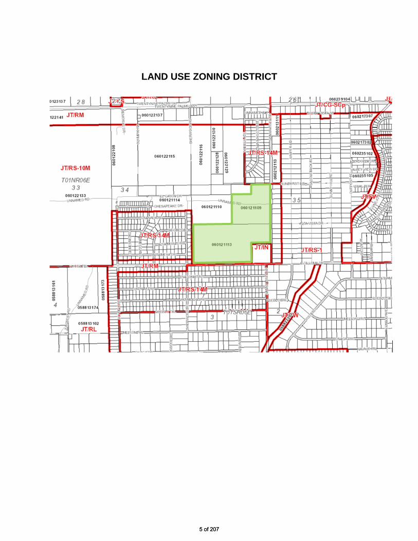
LAND USE ZONING DISTRICT
5 of 2075 of 207

TENTATIVE TRACT 18255
6 of 2076 of 207

SITE PHOTOS
LOOKING SOUTHWEST FROM SUNBURST DR.
LOOKING SOUTHWEST FROM NORTHWEST CORNER OF SITE
7 of 2077 of 207

SITE PHOTOS
LOOKING NORTH FROM SUNBURST DR. AND SUNNY VISTA RD.
LOOKING WEST FROM SUNNY VISTA RD.
8 of 2078 of 207

SITE PHOTOS
LOOKING NORTH FROM SUNNY VISTA RD.
LOOKING SOUTH ALONG SUNNY VISTA RD.
9 of 2079 of 207

SITE PHOTOS
LOOKING NORTH FROM ALTA LOMA DR. AND SUNNY VISTA RD.
LOOKING WEST ALONG ALTA LOMA DR.
10 of 20710 of 207

SITE PHOTOS
LOOKING NORTH FROM ALTA LOMA DR.
LOOKING NORTHWEST FROM ALTA LOMA DR.
11 of 20711 of 207

PROJECT DESCRIPTION The applicant requests approval of a Tentative Tract Map to subdivide 105 acres into 248 single family lots and a Conditional Use Permit (CUP) to construct a sewer package treatment plant to serve the subdivision (Project). The Project is a gated community with private streets, a community park, passive open space areas and two stormwater basins. At buildout, the development will contain 248 single-family houses on residential lots no smaller than 10,000 square feet, with some lots exceeding 20,000 square feet. The average proposed residential lot size is 11,528 square feet, or just over ¼ acre. The proposed package treatment plant will treat all wastewater generated on-site to a tertiary level, which will then be recharged to the groundwater basin via injection wells. Upon completion, the package treatment plant will be managed and operated by the Joshua Basin Water District (JBWD). If at some point in the future a public sewer system is constructed and becomes available in the community, this Project will be required to connect to the sewer system and the package treatment plant will be decommissioned. The subject property is located in the unincorporated community of Joshua Tree in the Morongo Basin of San Bernardino County. The property is one-half mile south of State Highway 62 (Twentynine Palms Highway). The Project site is bounded on the south by Alta Loma Drive, on the west by scattered single-family residential development and Sherwood Road, on the east by Sunny Vista Road, and on the north by vacant land and Sunburst Drive. Friendly Hills Elementary School is located adjacent to the site and occupies the northwest corner of Alta Loma Drive and Sunny Vista Road. Immediately to the north, west and south of the subject property are lands that are subdivided into single-family lots with average lot sizes of 18,000 square feet. Somewhat farther to the east is another residential subdivision with lots ranging from approximately 7,600 square feet to 14,000 square feet in size. There is limited development to the north of the property and lands to the northwest remain vacant. The subject property is currently vacant. Vegetation on the subject property is sparse and is made up of shrubs and groundcover typical of the area, including an open Joshua tree woodland across much of the site, as well as cactus, yucca species, and other local perennial and annual plant species. The site slopes gently to the north, with an elevation of approximately 3,200 feet on the southern boundary of the property and about 3,000 feet on the northern boundary, with an average slope of approximately 6 percent. Well-defined watersheds of limited size generate storm flows that are tributary to the subject property, with both sheet and channelized flows passing through the area and the subject property. On-site drainage includes an unnamed blue-line stream. ANALYSIS: Land Use Compatibility. This Project is consistent with the County General Plan and all development and performance standards of the County Development Code. The minimum lot size allowed in the RS-10M District is 10,000 square feet and the proposed lot sizes in the proposed subdivision range from 10,000 to 20,320 square feet, with an overall average of 11,528 square feet. The proposed Project allows for the logical and orderly extension of residential development in an area that is already partially developed with residential development that have similar densities and lot sizes. The Project further implements the goals of the County General Plan by allowing residential land uses that provide a range of styles, densities, and affordability ranging from traditional urban neighborhoods to more “rural” neighborhoods.
12 of 20712 of 207

Biological Resources. The Biological Resources report prepared by AMEC, an environmental consultant, identifies 11 sensitive species that have the potential to inhabit the site. All of these species, except the Loggerhead Shrike and Prairie Falcon, were determined to have an absent or absent to low occurrence probability. The Loggerhead Shrike was designated with a moderate to high occurrence probability, and the Prairie Falcon was determined to have a moderate probability of foraging, but its preferred nesting habitat (cliffs) do not exist onsite. Burrowing owls or their signs were not observed onsite; however, two potentially suitable burrows were encountered in the south-central portion of the site. A focused tortoise survey was performed on-site and within the zone of influence transects. This systematic survey detected no tortoises or their signs (scat, burrows, pallets, carcasses, etc.) onsite or in the Project vicinity. The entire Biological Resources study concludes that with implementation of mitigation measures and execution of the Streambed Alteration Agreement development of the Project will have a less than significant impact on biological resources. However, the potential for the desert tortoise and burrowing owl to occur onsite still exists. In order to ensure compliance with both federal and state Endangered Species Acts, and the California Fish and Game Code, focused and preconstruction clearance surveys for these species will be conducted in accordance with the respective federal and state survey guidelines prior to issuance of a grading permit for any phase of this Project. If either tortoise or burrowing owl are found onsite, additional federal and state “take” permits and conditions would be required prior to any Project-related site disturbance.
Wastewater Package Treatment Plant: Currently the community of Joshua Tree does not have a sanitary sewer system, and all residences, businesses, and other water consumers use septic tanks to dispose of effluent. To avoid the addition of 248 septic tank users to the area, the Project will include the construction of an onsite package plant, which will treat wastewater to a tertiary level; that is, to a degree that the water can be used for groundwater recharge. Thus, the treated water will be injected into sub-surface soils. The Project will comply with all regulations and requirements established by the Regional Water Quality Control Board (RWQCB). The design and plans for the on-site package plant will be reviewed and approved by County Environmental Health, JBWD and the RWQCB prior to the issuance of building permits. The design of the package plant will accommodate projected flows for each phase of the residential Project. The plant will have an ultimate capacity to treat at least 53,000 gallons per day or the maximum effluent that could be generated on-site at buildout, as required by the package plant's discharge permit. Water Service. In October 2007, the JBWD issued its first will-serve letter for the Project and included the Project’s demand in its demand model for the 2010 Urban Water Management Plan. The JBWD issued three subsequent will-serve letters for the Project with the most recent issued on July 15, 2015. Although this most recent will-serve letter states that there is an ample supply of water within the JBWD to serve the Project, actual water service to the Project shall not be provided by the District during the term of any Declared Drought State of Emergency. This means that the Project could not obtain grading permits, building permits, or record a Final Map until the Declared State of Emergency is lifted and/or the District issues an unconditional water will-serve letter for the Project.
13 of 20713 of 207

Traffic: The traffic study prepared by Kunzman Associates identified potentially significant traffic-related impacts associated with the development of the proposed Project. The objectives of the traffic study were to assess existing traffic conditions in the vicinity of the site, predict traffic levels for scenario years 2010 and 2030, and determine on-site and off-site improvements and system management actions needed to achieve the County’s level of service (LOS) policy. At buildout, the Project is expected to generate 2,412 daily vehicle trips, of which 189 occur during the morning peak hour (7:00 am to 9:00 am) and 254 occur during the evening peak hour (4:00 pm to 6:00 pm). The proposed Project does not exceed the County’s threshold volume of 100 two-way peak hour trips for highways. All roadways analysed are expected to operate at a LOS C or better except for the intersections of Torres Avenue and Twentynine Palms Highway (SR-62) and Sunny Vista Road and Twentynine Palms Highway, which would operate at a LOS D to F. With the construction of road improvements required of this Project, these two LOS D-F intersections are projected to operate within acceptable Levels of Service (LOS of C or better) during the peak hours for Year 2035. A fair share contribution for this Project to fund the unfunded portion of the required road improvements is required, and will be based on the fair share percentages calculated in the revised Kunzman Associates traffic study. When an application for a building permit is filed, the amount of the contribution will be adjusted to reflect actual construction costs, if available, or will be adjusted to account for anticipated construction costs using the Caltrans Construction Cost Index. Air Quality: The Project air quality analysis shows that both short-term and long-term emissions from the Project will not exceed the Mojave Desert Air Quality Management District (MDAQMD) established significance thresholds and the impact is considered less than significant with mitigation measures incorporated. The Project will not violate any air quality standard or contribute substantially to an existing or projected air quality violation, because the proposed use does not exceed thresholds of concern as established by the MDAQMD. A dust control plan will be required as a mitigation measure to regulate construction activities that could create windblown dust. Construction painting activities will be restricted as a mitigation measure and additional air quality mitigation measures have been incorporated to further reduce impacts. Greenhouse Gasses: The County’s Greenhouse Gas Emissions Reduction Plan (GHG Plan) was adopted on December 6, 2011, and became effective on January 6, 2012. The GHG Plan establishes a GHG emissions reduction target for the year 2020 that is 15 percent below 2007 emissions. The Plan is consistent with AB 32 (California Global Warming Solutions Act) and sets the County on a path to achieve more substantial long-term reductions in the post-2020 period. Achieving this level of emissions will ensure that the contribution to greenhouse gas emissions from activities covered by the GHG Plan will not be cumulatively considerable. Implementation of the County’s GHG Plan is achieved through the Development Review Process by applying appropriate reduction requirements to reduce GHG emissions. All new development is required to quantify the Project’s GHG emissions and adopt feasible mitigation to reduce Project emissions below a level of significance. The developer may use the GHG Plan Screening Tables as a tool to assist with calculating GHG reduction measures and the determination of a significance finding. Projects that garner 100 or more points in the Screening Tables do not require quantification of project-specific GHG emissions. The proposed Project has garnered more than 100 points on the Screening Tables through the application of energy efficient reduction measures, construction debris diversion measures, and per capita water use
14 of 20714 of 207

reduction measures. As a result, the Project is considered to be consistent with the GHG Plan and is therefore determined to have a less than significant individual and cumulative impact for GHG emissions. The GHG reduction measures proposed by the developer through the Screening Tables Review Process have been included in the Project design or will be included as needed, in the Conditions of Approval for the Project. Comments and Opposition. The Draft Mitigated Negative Declaration for this Project was circulated for public review and comment on August 13, 2014. The Land Use Services Department received numerous comments regarding the Initial Study and Mitigated Negative Declaration (Exhibit D). The comments relate to the Project itself, as well as to concerns about potential environmental impacts that may be associated with the Project. A summary of the comments received and staff’s responses are included in the attached Response to Comments (Exhibit E). Based upon staff’s assessment of the comments received, there were no issues raised or comments provided that indicate significant, unmitigated impacts associated with the Project. CEQA Compliance. In compliance with the California Environmental Quality Act (CEQA), an Initial Study (Exhibit C) has been completed for the proposed Project and it concludes that the Project will not have a significant adverse impact on the environment with the implementation of all the Conditions of Approval and environmental mitigation measures. Therefore, adoption of a Mitigated Negative Declaration is recommended. RECOMMENDATION: That the Planning Commission: 1) ADOPT the recommended findings for approval of the Project; 2) ADOPT the Mitigated Negative Declaration; 3) APPROVE Tentative Tract Map 18255 to create 248 single family residential lots, one lot for
a one-acre community center and 41 lettered lots for private streets, landscaping and drainage facilities on 105.24 acres, subject to the conditions of approval;
4) APPROVE the Conditional Use Permit (CUP) for construction of a sewage package
treatment plant to serve Tentative Tract 18255, subject to the conditions of approval; and.
5) FILE the Notice of Determination. ATTACHMENTS: Exhibit A: Findings Exhibit B: Conditions of Approval Exhibit C: Initial Study Exhibit D Comments and Opposition (Emails and Letters) Exhibit E: Response to Comments
15 of 20715 of 207

EXHIBIT A
Findings
16 of 20716 of 207

FINDINGS: TENTATIVE TRACT MAP 18255 [SBCC 87.02.060] Tentative Tract Map 18255 to create 248 single family residential lots, one lot for a one-acre community center and 40 lettered lots for private streets, landscaping and drainage facilities on 105.24 acres (Map Project). 1. The proposed map, subdivision design, and improvements are consistent
with the General Plan, any applicable community plan, and any applicable specific plan, because the Map Project allows for the orderly subdivision and development of land within the density specified by the proposed Single Residential (RS-10M) Land Use District. The Map Project allows for orderly residential development, consistent with the following goal of the County General Plan:
Goal LU 2: Residential land uses will be provided in a range of styles, densities, and affordability and in a variety of areas to live, ranging from traditional urban neighborhoods to more “rural” neighborhoods.
2. The site is physically suitable for the type and proposed density of
development, because the site is sufficient in size to accommodate the proposed development and all the proposed lots meet the minimum development and performance standards of the Single Residential (RS-10M) District. The proposed tract map includes access to accommodate the proposed development.
3. The design of the subdivision and the proposed improvements are not likely to
cause substantial environmental damage or substantially and avoidably injure fish or wildlife or their habitat, because based upon the biological resources analysis and findings, and with the implementation of the mitigation measures set forth in the CEQA analysis conducted for this Map Project, potential impacts to sensitive biological resources will be avoided or reduced to levels that are less than significant.
4. The design of the subdivision and type of improvements are not likely to
cause serious public health problems, because the site location, the subdivision design, and the density proposed are such that hazards from flood, fire, noise and other potential public health hazards are minimal with the implementation of the proposed conditions of approval and mitigation measures.
5. The design of the subdivision or the type of improvements will not conflict with
easements acquired by the public at large for access through or use of, property within the proposed subdivision, because the recorded map will require all necessary public rights of easements to be shown. The development will include four-points of legal and physical access to the site with proper documentation of
EXHIBIT A
17 of 20717 of 207

those access rights. The conditions of approval shall require that any easement conflicts be resolved and that statements of concurrence be provided from utility companies, whose easements may be affected by the proposed development prior to recordation.
6. The discharge of the sewage from the proposed subdivision into the
community sewer system will not result in violation of existing requirements prescribed by the California Regional Water Quality Control Board. Currently the community of Joshua Tree does not have a sanitary sewer system, and all residences, businesses, and other water consumers use septic tanks to dispose of effluent. To avoid the addition of 248 septic tank users to the area, the Map Project will include the construction of an onsite wastewater package treatment plant, which will treat wastewater to tertiary levels, which will allow the treated water to be safely injected into sub-surface soils. The construction of the package treatment plant will enable the Map Project to comply with all regulation and requirements established by the California Regional Water Quality Control Board, the Joshua Basin Water District, the County Division of Environmental Health Services and the Building and Safety Division.
7. The design of the subdivision provides, to the extent feasible, passive or
natural heating and cooling opportunities; because the proposed lots will provide adequate building setbacks for the land use. The building setbacks promote optimum spacing of structures to create adequate opportunity for the use of solar technology.
8. The proposed subdivision, its design, density and type of development and
improvements conforms to the regulations of the Development Code and the regulations of any public agency having jurisdiction by law, because the size and shape of the proposed lots are adequate for the type of residential development proposed, and the appropriate agencies, including County Land Use Services, County Surveyor, County Public Works, County Fire, County Environmental Health Services, County Building and Safety, County Special Districts and LAFCO, have all reviewed the Map Project and applied appropriate conditions of approval and mitigation measures
9. The Environmental Initial Study has been prepared in compliance with the
California Environmental Quality Act (CEQA) and it is determined, on the basis of staff’s independent evaluation, that the Map Project will not have a significant adverse impact on the environment with the implementation of all the conditions of approval and environmental mitigation measures. The Mitigated Negative Declaration for this Map Project reflects the County's independent judgment in making this decision. Therefore, adoption of a Mitigated Negative Declaration is recommended.
18 of 20718 of 207

FINDINGS: CONDITIONAL USE PERMIT [SBCC 85.06.040] Conditional Use Permit (CUP) for the construction of a sewer package treatment plant (CUP Project) to serve the single family structures within Tentative Tract 18255 1. The site for the proposed use is adequate in terms of shape and size to
accommodate the proposed use and all landscaping, open space, setbacks, walls and fences, yards, and other required features pertaining to the application. The 1.5-acre site (Lot KK of Tentative Tract 18255) will accommodate the proposed sewer package treatment plant. The CUP Project will be developed through a ministerial design-build permit process, subject to approval by the Joshua Basin Water District, the California Regional Water Quality Control Board, the County Division of Environmental Health Services and the Land Use Services Department, to assure industry standards are achieved. All setbacks meet or exceed the requirements of the Development Code for the proposed land use and the existing zoning.
2. The site for the proposed use has adequate access, which means that the site
design and proposed conditions of approval provide for the streets surrounding the site to be improved fully to provide legal and physical access to the site, and appropriate regional circulation mitigation has been required. The sewer package treatment plant site (Lot KK) is adjacent to Sunburst Drive on the north and two additional private streets within tract 18255. The proposed sewer package treatment plant will be developed with the first phase of Tentative Tract 18255 and the primary access to the Lot KK will be provided by means of private street (Lot F).
3. The proposed use will not have a substantial adverse effect on abutting
properties or the allowed use of the abutting properties, which means that the use will not generate excessive noise, traffic, vibration, lighting, glare, or other disturbance. The proposed sewer package treatment plant will be constructed under a ministerial design-build permit process that is subject to the all development and performance standards of the County Development Code, including noise, vibration, lighting, glare, or other disturbance. In addition, the use will not interfere with the present or future ability to use solar energy systems.
4. The proposed use and manner of development are consistent with the goals,
maps, policies, and standards of the County General Plan and any applicable Community or Specific Plan. The proposed Conditional Use Permit site plan, together with the provisions for its design and improvement are consistent with the County General Plan. The CUP Project specifically implements the following General Plan Policies:
19 of 20719 of 207

General Plan Policy CI 9.1: Control the timing and intensity of future development and ensure that future development is contingent on the provision of infrastructure facilities and public services. General Plan Policy CI 12.2: Support the local wastewater/sewering authorities in implementing wastewater collection and treatment facilities when and where required by the appropriate RWQCB and the County DEHS.
5. There is supporting infrastructure, existing or available, consistent with the
intensity of the development, to accommodate the proposed CUP Project without significantly lowering service levels. The developer will be required to construct road improvements for the development of Tentative Tract 18255, which will also accommodate the site of the proposed wastewater package treatment plant.
6. The lawful conditions stated in the approval are deemed reasonable and
necessary to protect the overall public health, safety and general welfare, because the conditions of approval include measures to ensure that the proposed wastewater package treatment plant is constructed in conformance with all State, County and local regulations to ensure industry standards are achieved.
7. The design of the site has considered the potential for the use of solar energy
systems and passive or natural heating and cooling opportunities, through the orientation and design of the building to take advantage of passive solar heating capabilities.
8. The Environmental Initial Study has been prepared in compliance with the
California Environmental Quality Act (CEQA) and it is determined, on the basis of staff’s independent evaluation, that the CUP Project will not have a significant adverse impact on the environment with the implementation of all the conditions of approval and environmental mitigation measures. The Mitigated Negative Declaration for this CUP Project reflects the County's independent judgment in making this decision. Therefore, adoption of a Mitigated Negative Declaration is recommended.
20 of 20720 of 207

EXHIBIT B
Conditions of Approval
21 of 20721 of 207

CONDITIONS OF APPROVAL
TENTATIVE TRACT 18255 AND CONDITIONAL USE PERMIT
ALTAMIRA/YV105 LLP
GENERAL REQUIREMENTS Conditions of Operation and Procedure
LAND USE SERVICES – Planning (909) 387-8311 1. Project Approval Description. Tentative Tract Map 18255 is approved to be
recorded and constructed in compliance with the San Bernardino County Code (SBCC), the conditions of approval stated herein and the approved stamped tentative tract map. This approval includes the requirements of any approved reports (e.g. traffic study, noise study). Tentative Tract 18255 is approved to subdivide 105 gross acres into 248 numbered residential lots, one numbered lot for a community recreation center, and 37 lettered lots for private streets, landscaping, drainage and a Conditional Use Permit (CUP) for a sewer package treatment plant. APN: 0601-211-09 and 13, Project No: P200700997.
2. Wastewater Package Treatment Plant. This project includes a Conditional Use
Permit (CUP) for the construction of a wastewater package treatment plant located on Lot KK of Tentative Tract 18255. The plant will be designed to industry standards with capacity to serve Tentative Tract 18255. Prior to the issuance of building permits for the proposed package plant all plans will be subject to review and approval by the Joshua Basin Water District (JBWD), the California Regional Water Quality Control Board (CRWQCB) and the County Department of Environmental Health Services (DEHS) and the Building and Safety Division to assure that industry standards are achieved. Wastewater will be treated to tertiary standards and injection wells used to recharge water to the underlying soils and aquifer. The treatment plant will be operated by the Joshua Basin Water District and will be regularly monitored by JBWD and the CRWQCB.
3. “Developer” Defined. The term “developer” as used in these conditions of approval
for this project and for any development of this project site, includes all of the following: the applicant, the property owner and any lessee, tenant or sub-tenant, operator and/or any other agent or other interested party of the subject project and/or project site and/or any heir or any other successor in interest in the project site or project land use by sale or by lease of all or of a portion of the project site or project land uses and/or any other right given to conduct any land use in any or all of the project structures or any area on the project site.
4. Expiration. This conditional approval shall become null and void unless all conditions
have been completed and the Tentative Map has been deemed complete by the County Surveyor for purposes of recordation within thirty–six (36) months following the effective approval date, unless an extension of time is granted.
EXHIBIT B
22 of 20722 of 207

PLEASE NOTE: This will be the ONLY notice given of the approval expiration date. The “developer” is responsible for initiation of any extension request.
5. Extension of Time. Where circumstances cause delays, which do not permit
compliance with the required recordation time limit, the developer may submit for review and approval an application requesting an extension of time. County Planning may grant such requests for extensions of time in compliance with the State Map Act Section 66452.6. An Extension of Time may be granted upon a successful review of an Extension of Time application, which includes a justification of the delay in recordation, a plan of action for completion and submittal of the appropriate fee, not less than 30 days prior to the expiration date. The granting of an extension request is a discretionary action that may be subject to additional or revised conditions of approval.
6. Revisions. Any proposed change to the approved Tentative Tract Map and/or the
conditions of approval shall require that an additional land use application (e.g. Revision to an Approved Action) be submitted to County Planning for review and approval.
7. Condition Compliance. Condition compliance confirmation for purposes of the Final
Map recordation will be coordinated by the County Surveyor. 8. Indemnification. In compliance with SBCC §81.01.070, the developer shall agree,
to defend, indemnify, and hold harmless the County or its “indemnitees” (herein collectively the County’s elected officials, appointed officials (including Planning Commissioners), Zoning Administrator, agents, officers, employees, volunteers, advisory agencies or committees, appeal boards or legislative body) from any claim, action, or proceeding against the County or its indemnitees to attack, set aside, void, or annul an approval of the County by an indemnitee concerning a map or permit or any other action relating to or arising out of County approval, including the acts, errors or omissions of any person and for any costs or expenses incurred by the indemnitees on account of any claim, except where such indemnification is prohibited by law. In the alternative, the developer may agree to relinquish such approval.
Any condition of approval imposed in compliance with the County Development
Code or County General Plan shall include a requirement that the County acts reasonably to promptly notify the developer of any claim, action, or proceeding and that the County cooperates fully in the defense. The developer shall reimburse the County and its indemnitees for all expenses resulting from such actions, including any court costs and attorney fees, which the County or its indemnitees may be required by a court to pay as a result of such action.
The County may, at its sole discretion, participate at its own expense in the
defense of any such action, but such participation shall not relieve the developer of
23 of 20723 of 207

their obligations under this condition to reimburse the County or its indemnitees for all such expenses.
This indemnification provision shall apply regardless of the existence or degree of fault of indemnitees. The developer’s indemnification obligation applies to the indemnitees’ “passive” negligence but does not apply to the indemnitees’ “sole” or “active” negligence or “willful misconduct” within the meaning of Civil Code Section 2782.
9. Development Impact Fees. Additional fees may be required prior to issuance of
development permits. Fees shall be paid as specified in adopted fee ordinances. 10. Project Account. The Job Costing System (JCS) account number is P200700997.
This is an actual cost project with a deposit account to which hourly charges are assessed by various county agency staff (e.g. Land Use Services, Public Works and County Counsel). Upon notice, the “developer” shall deposit additional funds to maintain or return the account to a positive balance. The “developer” is responsible for all expenses charged to this account. Processing of the project shall cease, if it is determined that the account has a negative balance and that an additional deposit has not been made in a timely manner. A minimum balance of $3,000.00 shall be in the project account at the time of project approval and the initiation of the Condition Compliance Review. Sufficient funds shall remain in the account to cover all estimated charges that may be made during each compliance review. All fees required for processing shall be paid in full prior to final inspection, occupancy and/or operation of each approved use in each approved structure or land use activity area. There shall be sufficient funds ($1000.00) remaining in the account to properly fund file closure and any other required post-occupancy compliance review and inspection requirements (e.g. landscape performance).
11. Additional Permits. The property owner, developer, and land use operator are all
responsible to ascertain and comply with all laws, ordinances, regulations and any other requirements of Federal, State, County and Local agencies as are applicable to the development and operation of the approved land use and project site. These include: a) FEDERAL: Federal Aviation Administration b) STATE: Regional Water Quality Control Board (RWQCB) – Colorado River
Region, South Coast Air Quality Management District (AQMD). c) COUNTY: Land Use Services-Building and Safety/Code Enforcement, County
Fire; Public Health-Environmental Health Services (DEHS), Public Works, AND d) LOCAL: Joshua Basin Water District, Local Agency Formation Commission
(LAFCO), 12. Condition Compliance. In order to obtain construction permits for grading, building,
final inspection and tenant occupancy for each approved building, the developer shall process a Condition Compliance Release Form (CCRF) for each respective building and/or phase of the development through County Planning in accordance with the
24 of 20724 of 207

directions stated in the Approval letter. County Planning shall release its holds on each phase of development by providing to County Building and Safety the following:
a) Grading Permits - a copy of the signed CCRF for grading/land disturbance and
two “red” stamped and signed approved copies of the grading plans. b) Building Permits - a copy of the signed CCRF for building permits and three
“red” stamped and signed approved copies of the final approved site plan. c) Final Inspection - a copy of the signed CCRF for final inspection of each
respective building, after an on-site compliance inspection by County Planning. 13. Lighting – Streets. Street lamps shall be low-scale, low-intensity lighting and well-
shielded. Street lighting shall be limited to the greatest extent practicable, while retaining safe and defensible space. Street lighting at major and secondary access drives may be required, as well as at the most heavily traveled intersections within the development. Wherever possible, other, smaller scale and lower intensity lighting should be used. [Mitigation Measure I-1] General Requirements/Planning
14. Lighting – Common Areas. Common area, pedestrian and other project lighting
shall utilize the lowest levels of illumination practicable. No upward lighting of mountain slopes shall be permitted. Landscape lighting shall be shielded to direct and limit areas of illumination. Lighting plans shall be provided with project building and landscape plans, and very reasonable effort shall be made to protect night skies. The developer shall utilize the lowest levels of private and community level lighting necessary to provide adequate visibility and security, while protecting adjoining lands. No flashing, pulsing or animated lighting will be permitted. Elevated lighting, including but not limited to parking lot lighting, shall be full-cutoff fixtures. Drop or sag lens fixtures shall not be permitted. Semi-cutoff fixtures constructed to direct 95% of light rays below the horizontal plane may be permitted upon careful review by the County. [Mitigation Measure I-2] General Requirements/Planning
15. Desert Native Landscaping. The development of the residential subdivision,
including the individual single family lots, the common area landscape lots and the natural and re-naturalized perimeter and internal drainage facilities shall utilize reclaimed vegetation consisting of Joshua Trees and other Mojave Desert wash scrub (mesquite, palo verde, ironwood, smoketree, etc.) recovered from the site. Other native and drought-tolerant materials shall also be used. No invasive plant materials shall be permitted. A landscape palette consistent with these provisions shall be submitted to the project biologist and County for final approval. The Conditions, Covenants and Restrictions (CC&Rs’) for the project shall include specific regulations that prohibit the removal of native desert plants without the preparation of a biological report and receiving a tree removal permit from the County of San Bernardino. The developer shall be responsible for disclosing to each property owner that there are regulations prohibiting the removal of native desert plants without the appropriate permits. [Mitigation Measure IV-3] General Requirements/Planning
25 of 20725 of 207
LAND USE SERVICES – Code Enforcement Division (909) 387-4044 16. Enforcement. If any County enforcement activities are required to enforce
compliance with the conditions of approval, the property owner shall be charged for such enforcement activities in accordance with the County Code Schedule of Fees.
17. Weed Abatement. The applicant shall comply with San Bernardino County weed
abatement regulations [SBCC§ 23.031-23.043] and periodically clear the site of all non-complying vegetation. This includes removal of all Russian thistle (tumbleweeds).
COUNTY FIRE – Community Safety (909) 386-8465
18. Jurisdiction. The above referenced project is under the jurisdiction of the San
Bernardino County Fire Department herein “Fire Department”. Prior to any construction occurring on any parcel, the applicant shall contact the Fire Department for verification of current fire protection requirements. All new construction shall comply with the current California Fire Code requirements and all applicable statutes, codes, ordinances and standards of the Fire Department.
19. Construction permits, including Fire Condition Letters, shall automatically expire
and become invalid unless the work authorized by such permit is commenced within 180 days after its issuance, or if the work authorized by such permit is suspended or abandoned for a period of 180 days after the time the work is commenced. Suspension or abandonment shall mean that no inspection by the Department has occurred with 180 days of any previous inspection. After a construction permit or Fire Condition Letter, becomes invalid and before such previously approved work recommences, a new permit shall be first obtained and the fee to recommence work shall be one-half the fee for the new permit for such work, provided no changes have been made or will be made in the original construction documents for such work, and provided further that such suspension or abandonment has not exceeded one year. A request to extend the Fire Condition Letter or Permit may be made in writing PRIOR TO the expiration date justifying the reason that the Fire Condition Letter should be extended.
PUBLIC HEALTH – Environmental Health Services (DEHS) (800) 442-2283
20. Water Purveyor. The water purveyor shall be Joshua Basin Water District (JBWD). 21. Sewer Purveyor. Method of sewage disposal shall be an EHS approved package
treatment plant to be operated by Joshua Basin Water District.
26 of 20726 of 207

LAND USE SERVICES – Land Development – Drainage (909) 387-8311 22. Infrequent Flood Hazards. The site may be subject to infrequent flood hazards by
reasons of overflow, erosion and debris deposition in the event of a major storm. 23. Tributary Drainage. Adequate provisions should be made to intercept and conduct
the tributary off site - on site drainage flows around and through the site in a manner, which will not adversely affect adjacent or downstream properties at the time the site is developed.
24. Natural Drainage. The natural drainage courses traversing the site shall not be
occupied or obstructed. Any modification or diversion of natural drainage courses shall be based upon County approved Drainage Study and Grading plan for the project.
25. Additional Drainage Requirements. In addition to drainage requirements stated
herein, other "on-site" and/or "off-site" improvements may be required which cannot be determined from tentative plans at this time and would have to be reviewed after more complete improvement plans and profiles have been submitted to this office.
26. Detention Basin Maintenance. The property owner/“developer” is required to
provide periodic and continuous maintenance of all drainage facilities listed in the County approved Drainage Study for the project. This includes but is not limited to, filter material replacement and sediment removal, as required to assure peak performance of all BMPs. Furthermore, such maintenance activity will require compliance with all Local, State, or Federal laws and regulations, including those pertaining to confined space and waste disposal methods in effect at the time such maintenance occurs.
PUBLIC WORKS – Traffic Division (909) 387-8186 27. Alta Loma Drive Access. The project driveway access along Alta Loma Drive shall
be outbound only. 28. Project Access Design. Sight distances at each project access shall be reviewed
by the Traffic Division with respect to the California Highway Design Manual. 29. Sunburst Drive Access. The driveway along Sunburst Drive shall be gated and
designated as emergency access only. 30. Sunny Vista Drive Access. This project is a gated community, therefore a
turnaround shall be provided at the Sunny Vista Drive access.
27 of 20727 of 207

PUBLIC WORKS - Solid Waste Management (909) 387-8701
31. Recycling Storage Capacity – The developer shall provide adequate space and storage bins for both refuse and recycling materials. This requirement is to assist the County in compliance with the recycling requirements of Assembly Bill (AB) 2176.
28 of 20728 of 207

PRIOR TO ISSUANCE OF GRADING PERMITS The following shall be completed:
LAND USE SERVICES - Building and Safety (909) 387- 8311 32. Retaining Wall Plans. Submit plans and obtain separate building permits for any
required walls or retaining walls. 33. Geology Report. A geology report shall be submitted to the Building and Safety
Division for review and approval by the County Geologist and fees paid for the review prior to grading permits.
34. Geotechnical (Soil) Report. When earthwork quantities exceed 5,000 cubic yards,
a geotechnical (soil) report shall be submitted to the Building and Safety Division for review and approval prior to issuance of grading permits.
35. Grading Plans. One copy of the proposed engineered grading plans shall be
submitted for plan review with appropriate fees and approval of these obtained, when earthwork quantities exceed fifty (50) cubic yards.
36. Erosion Control Plan. One copy of the proposed engineered erosion and sediment
control plans shall be submitted for plan review with appropriate fees and approval of these obtained.
37. Erosion Control Devices. Prior to land disturbance, erosion control devices must
be installed at all perimeter openings and slopes. No sediment is to leave the job site.
38. Geology Report. When proposed earthwork quantities exceed 5,000 cubic yards,
including construction of private roads, an engineering geology report is required to be submitted with appropriate fees to the County Geologist for review and approval prior to issuance of grading permits.
39. Demolition Permit. Two copies of engineered plans to demolish any existing
buildings or structures shall be submitted for review with appropriate fees and approval of these obtained. Underground structures shall be broken in, back-filled and inspected before covering. Any structure requiring a building permit to be originally constructed requires a demolition permit to be removed properly.
40. NPDES -NOI. Submit a copy of the Notice of Intent (NOI) obtained from the
Regional Water Quality Control Board in compliance with the National Pollutant Discharge Elimination System (NPDES), when proposed grading is one acre or more. Contact local Regional Water Quality Control Board for information.
41. WDID. Submit a copy of the Regional Water Quality Control Board (RWQCB)
permit letter with the Waste Discharge Identification (WDID) number assigned by
29 of 20729 of 207

the RWQCB when proposed grading is one acre or more. The letter must include the total land disturbance area including all clearing, grading, and/or excavation areas. Contact the local RWQCB for more information.
LAND USE SERVICES - Planning (909) 387- 8311 42. Final Phasing and Construction Plan. Prior to the issuance of a grading permit or
recordation of the first final map, whichever occurs first, the developer shall submit a final phasing and construction plan covering the entire Tentative Map for review and approval by the Planning Division. The plan shall specifically address the following: a) Vehicular access for each map or phase of development. Each map and/or
phase of development shall have 2 points of vehicular access for fire and other emergency equipment, and for routes of escape which will safely handle evacuations as required by the Development Code.
b) Submit a master grading plan that addresses grading for each phase of development. The approved conceptual grading plan shall be provided to the Building and Safety Division and shall be used as a guideline for subsequent detailed grading plans for individual units or phases of the Tentative Map. The plan shall include techniques to be used to prevent erosion and sedimentation during and after grading, and approximate time frames for grading and areas which may be graded during the higher probability rain months of January through March. The master grading plan shall also identify areas where temporary grading occurs on any phase other than the one being graded for development.
c) Identify all public and private street improvements to be constructed by phase.
d) Submit a master utility plan that identifies all water and sewer facilities to be constructed for each phase of development.
e) Identify all drainage improvements to be constructed by phase. The two basins located on Lot AA and Lot Z, shall be constructed and completed prior to the issuance of the first building permit for Phase 1.
f) Submit a master Landscaping Plan for typical front yards, slopes, open space areas and street landscaping. Landscaping plans that affect the road right-of-way shall be submitted to the County Traffic Division for review and approval.
g) Submit a separate wall and fencing plan for each phase of development.
43. Water Verification. Applicant shall procure a verification letter from the water agency with jurisdiction. This letter shall state whether or not water connection and service shall be made available to the project by the water agency.
44. Permission for Off-Site Grading. Written permission shall be obtained from any
affected property owners allowing the proposed grading and/or facilities to be installed outside of the tract boundaries. A copy of the written authorization shall be submitted to the Planning Division for review and approval.
30 of 20730 of 207

45. AQ-Dust Control Plan. The “developer” shall prepare, submit for review and obtain approval from County Planning of both a Dust Control Plan (DCP) consistent with SCAQMD guidelines and a signed letter agreeing to include in any construction contracts/ subcontracts a requirement that project contractors adhere to the requirements of the DCP. The DCP shall include the following requirements: a) Exposed soil shall be kept continually moist to reduce fugitive dust during all
grading and construction activities, through application of water sprayed a minimum of two times each day.
b) Any portion of the site to be graded shall be pre-watered to a depth of three feet prior to the onset of grading activities.
c) During high wind conditions (i.e., wind speeds exceeding 25 mph), areas with disturbed soil shall be watered hourly and activities on unpaved surfaces shall cease until wind speeds no longer exceed 25 mph.
d) Any area that will remain undeveloped for a period of more than 30 days shall be stabilized using either chemical stabilizers and/or a desert wildflower mix hydroseed on the affected portion of the site.
e) Storage piles that are to be left in place for more than three working days shall be sprayed with a non-toxic soil binder, covered with plastic or revegetated.
f) Imported fill and exported excess cut shall be adequately watered prior to transport, covered during transport, and watered prior to unloading on the project site.
g) Storm water control systems shall be installed to prevent off-site mud deposition.
h) All trucks hauling dirt away from the site shall be covered. i) Construction vehicle tires shall be washed, prior to leaving the project site. j) Rumble plates shall be installed at construction exits from dirt driveways. k) Paved access driveways and streets shall be washed and swept daily when
there are visible signs of dirt track-out. l) Street sweeping shall be conducted daily when visible soil accumulations
occur along site access roadways to remove dirt dropped or tracked-out by construction vehicles. Site access driveways and adjacent streets shall be washed daily, if there are visible signs of any dirt track-out at the conclusion of any workday and after street sweeping. [Mitigation Measure III-1] Prior to Grading Permits/Planning
46. AQ - Construction Mitigation. The “developer” shall submit for review and obtain
approval from County Planning of a signed letter agreeing to include as a condition of all construction contracts/subcontracts requirements to reduce vehicle and equipment emissions and other impacts to air quality by implementing the following measures and submitting documentation of compliance: The developer/construction contractors shall do the following: a) Provide documentation prior to beginning construction demonstrating that the
project will comply with all SCAQMD regulations including 402, 403, 431.1, 431.2, 1113 and 1403.
31 of 20731 of 207

b) Each contractor shall certify to the developer prior to construction-use that all equipment engines are properly maintained and have been tuned-up within last 6 months.
c) Each contractor shall minimize the use of diesel-powered vehicles and equipment through the use of electric, gasoline or CNG-powered equipment. All diesel engines shall have aqueous diesel filters and diesel particulate filters.
d) All gasoline-powered equipment shall have catalytic converters. e) Provide onsite electrical power to encourage use of electric tools. f) Minimize concurrent use of equipment through equipment phasing. g) Provide traffic control during construction to reduce wait times. h) Provide on-site food service for construction workers to reduce offsite
trips. i) Implement the County approved Dust Control Plan (DCP) j) Suspend use of all construction equipment operations during second stage
smog alerts. NOTE: For daily forecast, call (800) 367-4710 (San Bernardino and Riverside counties). [Mitigation Measure III-2] Prior to Grading Permits/Planning
47. Tree Removal Permit. A County Tree Removal Permit shall be required for the
removal of a Joshua tree or other regulated desert native plant. [Mitigation Measure IV-1] Prior to Grading Permit/Planning
48. Joshua Tree Survey. A Joshua tree survey and report and a Joshua Tree
Management Program shall be completed and submitted to County Planning prior to the issuance of a grading permit or recordation of a final tract map for any phase of this project. The required Joshua tree survey and report will be prepared for each phase of development by a Desert Native Plant Specialist and will include a field inventory of Joshua trees throughout each phase, indicating their approximate height, age, health rating, transferability, and whether they are a clone or single-trunked tree. The report will include a plot plan for each phase showing the on-site locations of all Joshua trees and will identify any regulated desert native plants. [Mitigation Measure IV-2] Prior to Grading Permit/Planning
49. Nesting Bird Mitigation – Pre-Construction Surveys. Within 30 days prior to
vegetation clearing or ground disturbance associated with construction or grading that would occur during the nesting/breeding season (February through August, unless determined otherwise by a qualified biologist based on observations in the region), the Applicant shall retain a qualified biologist to determine if active nests of species protected by the Migratory Bird Treaty Act or the California Fish and Game Code are present within or adjacent to the disturbance zone or within 100 feet (300 feet for raptors) of the disturbance zone. The surveys will be conducted no more than seven days prior to initiation of disturbance work within active project areas. If ground disturbance activities are delayed, then additional pre-disturbance surveys will be conducted such that no more than seven days will have elapsed between the survey and ground disturbance activities. If ground disturbance will be phased
32 of 20732 of 207

across the project site, pre-disturbance surveys may also be phased to conform to the development schedule.
If active nests are found, clearing and construction within 100 feet of the nest (or a lesser distance if approved by the U.S. Fish & Wildlife Service) will be postponed or halted, until the nest is vacated and juveniles have fledged, as determined by the biologist. Avoidance buffers will be established in the field with highly visible construction fencing or flagging, and construction personnel will be instructed on the sensitivity of nest areas. A qualified biologist will serve as a construction monitor during those periods when construction activities will occur near active nests to ensure that no inadvertent impacts on these nests occur. The results of pre-construction nesting bird surveys, including graphics showing the locations of any nests detected, and documentation of any avoidance measures taken, will be submitted to the County of San Bernardino and the California Department of Fish & Wildlife within 14 days of completion of the pre-construction surveys or construction monitoring to document compliance with applicable state and federal laws pertaining to the protection of native birds. [Mitigation Measure IV-4] Prior to Grading/Planning
50. Burrowing Owl Mitigation – Pre-Construction Surveys. Within 14 days prior to ground disturbance, the Applicant will retain a qualified biologist to conduct burrowing owl surveys within the area to be disturbed. The survey will be performed by walking parallel transects spaced no more than 20 meters apart, and will be focused on detecting burrows that are occupied, or are suitable for occupation, by the burrowing owl. The results of the surveys, including graphics showing the locations of any active burrows detected and any avoidance measures required, will be submitted to the County of San Bernardino and the California Department of Fish & Wildlife (CDFW) within 14 days following completion of the surveys. If active burrows are detected, the following take avoidance measures will be implemented: a) If burrowing owls are observed using burrows on-site during the non-breeding
season (September through January, unless determined otherwise by a qualified biologist based on field observations in the region), occupied burrows will be left undisturbed, and no construction activity will take place within 300 feet of the burrow where feasible (see below).
b) If avoiding disturbance of owls and owl burrows on-site is infeasible, owls will be excluded from all active burrows through the use of exclusion devices placed in occupied burrows in accordance with protocols established in CDFW’s Staff Report on Burrowing Owl Mitigation (2012). Specifically, exclusion devices, utilizing one-way doors, will be installed in the entrance of all active burrows. The devices will be left in the burrows for at least 48 hours to ensure that all owls have been excluded from the burrows. Each of the burrows will then be excavated by hand and/or mechanically and refilled to prevent reoccupation. Exclusion will continue until the owls have been
33 of 20733 of 207

successfully excluded from the disturbance area, as determined by a qualified biologist.
c) Any active burrowing owl burrows detected on-site during the breeding season (February through August, unless determined otherwise by a qualified biologist based on field observations in the region), will not be disturbed. Construction activities will not be conducted within 300 feet of an active on-site burrow at this season. [Mitigation Measure IV-5] Prior to Grading Permit/Planning
51. Burrowing Owl Mitigation – Management Plan. Prior to issuance of a grading permit,
a habitat management plan for the burrowing owl will be developed. The plan will include provisions for protecting foraging habitat and replacing any active burrows from which owls may be passively evicted as allowed by Mitigation Measure BIO-1. The Burrowing Owl Management Plan will be submitted to the County of San Bernardino and the California Department of Fish and Wildlife for review and approval prior to issuance of a grading permit for the Project. At a minimum, the plan will include the following elements: a) If occupied burrows are to be removed, the plan will contain schematic
diagrams of artificial burrow designs and a map of potential artificial burrow locations that would compensate for the burrows removed.
b) All active on-site burrows excavated as described in Mitigation Measure BIO-1 will be replaced with suitable natural or artificial burrows within the preservation areas approved by the County of San Bernardino.
c) Measures prohibiting the use of rodenticides during the construction process if any active on-site burrows are identified.
d) The plan will ensure that adequate suitable burrowing owl foraging habitat is provided in proximity to natural or artificial burrows within off-site mitigation areas. [Mitigation Measure IV-6] – Prior to Grading Permit/Planning
52. Pre-Construction Mojave Desert Tortoise Surveys and Avoidance. Within 14 days
prior to construction-related ground clearing and/or grading, the Applicant shall retain a qualified biologist to conduct surveys for signs of occupancy by the Mojave desert tortoise. Should any sign indicating the presence of Mojave desert tortoise be detected, the Applicant shall not proceed with ground clearing and/or grading activities in the area of the find, and shall instead contact the USFWS and CDFW to develop an avoidance strategy and/or seek authorization for incidental take of Mojave desert tortoise. The results of the pre-construction surveys, including graphics showing the locations of any tortoise sign detected, and documentation of any avoidance measures taken, shall be submitted to the USFWS, CDFG, and the County of San Bernardino within 14 days of completion of the pre-construction surveys or construction monitoring to document compliance with applicable federal and state laws pertaining to the protection of Mojave desert tortoise. [Mitigation Measure IV-7] – Prior to Grading Permit/Planning
34 of 20734 of 207

53. Department of Fish and Wildlife (CDFW). A mapped blue line stream occurs on portions of the project site as well as additional dry channels Development of the proposed project will result in construction activities within and adjacent to approximately 9.73 acres of streambeds as delineated by AMEC and within the jurisdiction of the California Department of Fish and Wildlife (CDFW). It is estimated that of the total cut and fill, approximately 37,820 cubic yards (cy), will be removed from streambeds and used to construct improvements on-site. These stream courses have been mapped as “Waters of the State”, and would require a Streambed Alteration Agreement from CDFW prior to issuance of a grading permit or recordation of the Final Map. The Streambed Alteration Agreement with CDFW assures that potential impacts to streambeds are reduced to less than significant levels. If any of these stream courses qualify as federal jurisdictional waters, any alteration of these courses due to project activities would require consultation with the U.S. Army Corps of Engineers prior to grading or recordation of the Final Map. [Mitigation Measure IV-8] Prior to Grading Permit/Planning
54. Construction Noise. The “developer” shall submit and obtain approval from County
Planning of a signed letter agreeing to include as a condition of all construction contracts/subcontracts requirements to reduce noise impacts during construction, which shall include the following vehicle and equipment emissions and other impacts to air quality by implementing the following measures and submitting documentation of compliance: The developer/construction contractors shall do the following: a) During the project site excavation and grading, the construction contractors
shall equip all construction equipment, fixed or mobile, with properly operating and maintained mufflers, consistent with the manufactures standards.
b) The construction contractor shall place all stationary construction equipment so that emitted noise is directed away from the noise sensitive receptors nearest the project site.
c) The construction contractor shall limit all construction-related activities that would result in high noise levels between the hours of 7:00 a.m. and 6:00 p.m., Monday through Saturday excluding holidays.
d) The construction contractor shall locate equipment staging in areas that will create the greatest distance between construction-related noise sources and noise sensitive receptors nearest the project site during all project construction.
e) The construction contractor shall limit haul truck deliveries to the same hours specified for construction equipment. To the extent feasible, haul routes shall not pass sensitive land uses or residential dwellings. [Mitigation Measure XII-1] Prior to Grading Permit/Planning
55. Construction and Demolition Debris Diversion Program (GHG Reduction Measure
R2W5). Pursuant to the requirements of Solid Waste Management the contractor shall recycle a minimum of 50% of all project related construction and demolition debris. Prior to issuance of a Grading Permit the developer shall submit a plan of
35 of 20735 of 207

construction recycling showing how a minimum of 50% of all construction related materials will be recycled (6 points).
COUNTY FIRE – Community Safety (760) 995-8201 56. Water System. Prior to any land disturbance, the water systems shall be designed
to meet the required fire flow for this development and shall be approved by the Fire Department. The required fire flow shall be determined by using Appendix IIIA of the Uniform Fire Code. [F05]
LAND USE SERVICES - Land Development - Drainage (909) 387-8311 57. Grading Plans. Grading plans shall be submitted to Land Development Division for
review and approval obtained, prior to construction. An $806 deposit for grading plan review will be collected upon submittal to the Land Development Division. Deposit amounts are subject to change in accordance with the latest approved fee schedule.
58. Streambed Alteration Agreement. California Department of Fish and Wildlife must be notified per Fish and Game code number 1602. A streambed alteration agreement shall be provided prior to grading.
36 of 20736 of 207

PRIOR TO RECORDATION OF THE FINAL MAP(S) The Following Conditions Shall Be Completed
LAND USE SERVICES – Planning (909) 387-8311
59. HOA required. The Developer shall establish a Homeowners’ Association (HOA)
for the purpose of monitoring and maintaining common area amenities and where applicable, private lot areas with HOA maintenance easements. The HOA shall include all lots in Tentative Tract 18255 and shall be formed to the satisfaction of County Planning. The Developer shall submit the following to County Planning for review and approval: a) Cover Letter. Reference the project case number P200700997 and identify
the contact individual (with contact information) for any questions concerning the submitted documents.
b) By-Laws/CC&R. The proposed HOA By-Laws, Declaration of Covenants, Conditions and Restrictions (CC&R’s), and HOA Rules and Regulations shall be submitted for review and approval obtained from County Planning. The By-laws and the CC&R’s, as approved by the County, shall not be modified or rescinded without County approval. The CC&R’s shall: • Provide for a minimum term of 60 years. • Provide for the establishment of an HOA comprised of the owners of
each individual lot or unit as tenants in common. • Provide for common area ownership to be by either the HOA or the
owners of each individual lot or unit as tenants in common. • Contain the following note verbatim: "Notwithstanding any provision in
this Declaration to the contrary, the following provisions shall apply: The property owners' association established herein shall manage and continuously maintain the 'common area', more particularly described on Exhibit 'A', attached hereto, and shall not sell or transfer the 'common area' or any part thereof, absent the prior written consent of the County of San Bernardino or the County's successor-in-interest. The property owners' association shall have the right to assess the owners of each individual lot or unit for the reasonable cost of maintaining such 'common area', and shall have the right to lien the property of any such owner who defaults in the payment of a maintenance assessment. An assessment lien, once created, shall be paid in full prior to all other liens recorded subsequent to the notice of assessment or other document creating the assessment lien. This Declaration shall not be terminated, 'substantially' amended, or property deannexed there from absent the prior written consent of the County of San Bernardino or the County's successor-in-interest. A proposed amendment shall be considered 'substantial' if it affects the extent, usage, or maintenance of the 'common area' established pursuant to the Declaration., In the event of any conflict between this Declaration and the Articles of Incorporation, the Bylaws, or the property owners' association Rules and Regulations, if any, this Declaration shall control."
37 of 20737 of 207

c) Sample Title. A sample document conveying title to the purchaser of an individual lot or unit, which provides that the declaration of covenants, conditions, and restrictions is incorporated therein by reference.
d) Recordation. After approval by the County, the HOA By-Laws, the Declaration of Covenants, Conditions and Restrictions (CC&R’s) shall be recorded and a copy of the recorded documents shall be provided to County Planning. The submitted documents shall include: One (1) copy and one (1) original, wet signed, notarized and ready for recordation declaration of covenants, conditions, and restrictions; attached to these documents there shall be included a legal description of the property included within the covenants, conditions and restrictions and a scaled map or diagram of such boundaries, both signed and stamped by a California registered civil engineer or licensed land surveyor.
e) HOA Responsibilities. The HOA documents (CC&R’s) shall indicate that the HOA is required to maintain the private streets (including snow removal where appropriate) street landscaping, common area landscaping, fuel modification measures, slopes, fencing, retaining walls, drainage facilities, and water quality facilities. The HOA shall enforce architectural controls to insure compatibility of colors, materials, landscaping and overall aesthetic appearance, including prompt removal of graffiti. The HOA shall require that roof mounted mechanical equipment shall be screened from view, on all sides to minimize any visual and aesthetic adverse impacts. Homeowners shall be required to incorporate drought-resistant, fire retardant, and water conserving plants and irrigation systems in their landscaping designs. Homeowners will be required to maintain any required fuel modification and sound attenuation measures.
f) Landscaped Area Maintenance. The maintenance of landscaped areas shall be the sole responsibility of the developer until the transfer to individual ownership of the lots or until the maintenance is officially assumed by the required Homeowners’ Association (HOA). A separate water meter shall be installed in any common easement landscaped area, in conformance with an approved landscaping plan.
LAND USE SERVICES - Building & Safety Division (909) 387-8311
60. Geology Report. A geology report shall be submitted to the Building and Safety
Division for review and approval by the County Geologist and fees paid for the review prior to recordation of the final map.
61. Geotechnical (Soil) Report. When earthwork quantities exceed 5,000 cubic yards,
a geotechnical (soil) report shall be submitted to the Building and Safety Division for review and approval prior to recordation of the final map.
PUBLIC HEALTH - Environmental Health Services (DEHS) (800) 442-2283
62. Water Purveyor. The water purveyor shall be Joshua Basin Water District (JBWD).
38 of 20738 of 207

63. Water Verification. Applicant shall procure a verification letter from the water
agency with jurisdiction. This letter shall state whether or not water connection and service shall be made available to the project by the water agency. This letter shall reference the File Index Number and Assessor’s Parcel Number (on file with EHS).
64. Sewage Disposal. Method of sewage disposal shall be an EHS approved sewage
package treatment plant.
65. Sewer Verification. Applicant shall procure a verification letter from the sewering agency with jurisdiction. This letter shall state whether or not sewer connection and service shall be made available to the project by the sewering agency. The letter shall reference the File Index Number and Assessor’s Parcel Number. (JBWD).
66. Regional Board Clearance. Written clearance shall be obtained from the designated
California Regional Water Quality Control Board (listed below) and a copy forwarded to the Department of Environmental Health Services. Colorado River Basin Region, 73-720 Fred Waring Dr., Suite 100, Palm Desert, CA 92260, 760-346-7491.
67. On-Site Waste Water Treatment Plant. An on-site treatment plant will be allowed
under the following conditions: A “Soil Percolation Report” shall be submitted to DEHS for review and approval. All lots shall be connected to an approved treatment plant prior to occupancy”. For information, please contact Water / Wastewater / Land Use Section at (909) 387-4666.
68. Preliminary Acoustic Information. Submit preliminary acoustical information
demonstrating that the proposed project maintains noise levels at or below San Bernardino County Noise Standard(s), San Bernardino Development Code Section 87.0905(b). The purpose is to evaluate potential future on-site and/or adjacent off-site noise sources. If the preliminary information cannot demonstrate compliance to noise standards, a project specific acoustical analysis shall be required. Submit information/analysis to the DEHS for review and approval. For information and acoustical checklist, contact DEHS at (909) 387-4666.
69. Existing Wells. If wells are found onsite then, evidence shall be provided that all
wells are (1) properly destroyed under permit from that Country OR (2) constructed to DEHS standards, properly sealed and certified to the County as inactivated OR (3) constructed to DEHS standards and meet the quality standards for the proposed use of the water (industrial and/or domestic). Evidence shall be submitted to DEHS/Water Section for approval. Contact DEHS/Water Section for approval. Contact DEHS/Water Section for more information at 909-387-4666.
70. Installation/Finance of Waste Water Treatment Plant. The following are the steps
that must be completed to meet the requirements for installation and/or finance of the on-site/off-site water system and/or sewer system.
39 of 20739 of 207

a) Where the water and/or sewer system is to be installed prior to recordation, submit a signed statement to DEHS from the approved utility of jurisdiction confirming the improvement has been installed and accepted.
b) Where a bond is to be posted in lieu of installation of the improvement, the
developer shall submit evidence of financial arrangements agreeable to the water purveyor and/or sewering entity to DEHS for review and approval.
LAND USE SERVICES - Land Development - Drainage (909) 387-8311
71. Drainage Improvements. A Registered Civil Engineer shall investigate and design
adequate drainage improvements to intercept and conduct the off-site and on-site drainage flows around and through the site in a manner, which will not adversely affect adjacent or downstream properties. Submit drainage study for review and obtain approval. A $550 deposit for drainage study review will be collected upon submittal to the Land Development Division. Deposit amounts are subject to change in accordance with the latest approved fee schedule.
72. Drainage Easements. Adequate San Bernardino County Drainage Easements
(minimum fifteen [15] feet wide) shall be provided over the natural drainage courses, drainage facilities/or concentration of runoff from the site. Proof of recordation shall be provided to the Land Development Division.
73. Detention Basins. . Detention basins shall be designed and constructed, prior to
issuance of any building permits for each phase, in accordance with the drainage study and the criteria set forth in the County Detention Basin Policy, adopted by the County Board of Supervisors. All work shall be reviewed and approved by the Land Development.
74. Storm Drain Plans. Permanent drainage improvements will be required to
intercept and conduct larger drainage flows through or around the site in an approved manner. Submit Storm Drain Plans for review and approval.
75. FEMA Flood Zone. The Project is located within Flood Zone X Unshaded and D
according to FEMA Panel Number 8140H and 8880H dated 08/28/2008. There is no elevation requirement for structure in Zone X Unshaded. Flood Hazards are undetermined in Zone D but possible. The requirements may change based on the most current Flood Map prior to issuance of grading permit.
76. Topo Map. A topographic map shall be provided to facilitate the design and review
of necessary drainage facilities.
77. On-site Drainage Easement. On-site flows shall be directed within a drainage easement.
40 of 20740 of 207

78. Natural Drainage. The natural drainage courses traversing the site shall not be occupied or obstructed.
79. On-site Flows. On-site flows need to be directed to the nearest County road or
drainage facilities unless an acceptance of drainage letter is secured from the adjacent property owners.
80. Grading Plans. Grading plans shall be submitted for review and approval obtained
if grading occurs prior to Final Map recordation. An $806 deposit for grading plan review will be collected upon submittal to the Land Development Division. Deposit amounts are subject to change in accordance with the latest approved fee schedule.
81. PROJECT SPECIFIC CONDITIONS (Prior to Recordation): California Department
of Fish and Wildlife must be notified per Fish and Game code number 1602. A streambed alteration agreement shall be provided.
LAND USE SERVICES - Land Development - Roads (909) 387-8311 82. Road Dedication/Improvement. The developer shall submit for review and obtain
approval from the Land Use Services Department the following dedications and plans for the listed required improvements, designed by a Registered Civil Engineer (RCE), licensed in the State of California.
Sunny Vista Road (Secondary Highway – 88’)
a) Road Dedication. A 24 foot grant of easement is required to provide a half-
width right-of-way of 44 feet. b) Street Improvements. Design curb and gutter with match up paving 32 feet
from centerline. c) Sidewalks. Design sidewalks per County Standard 109 Type “B”. Meandering
sidewalks may be permitted with project boundary terminus at Standard location for future connection.
d) Curb Returns and Sidewalk Ramps. Curb returns and sidewalk ramps shall be designed per County Standard 110. Adequate easement shall be provided to ensure sidewalk improvements are within Public right-of-way.
Sunburst Drive (1/4 Section Line – 88’)
a) Road Dedication. A 44 foot grant of easement is required to provide a half-
width right-of-way of 44’. b) Street Improvements. Design curb and gutter with match up paving 18 feet
from centerline with a minimum 26 feet of paving. c) Sidewalks. Design sidewalks per County Standard 109 Type “B”.
41 of 20741 of 207

d) Curb Returns and Sidewalk Ramps. Curb returns and sidewalk ramps shall be designed per County Standard 110. Adequate easement shall be provided to ensure sidewalk improvements are within Public right-of-way.
Alta Loma Drive (Secondary Highway – 88’)
a) Road Dedication. A 44 foot grant of easement is required to provide a half-
width right-of-way of 44’. b) Street Improvements. Design curb and gutter with match up paving 32 feet
from centerline. c) Sidewalks. Design sidewalks per County Standard 109 Type “B”. Meandering
sidewalks may be permitted with project boundary terminus at Standard location for future connection.
d) Curb Returns and Sidewalk Ramps. Curb returns and sidewalk ramps shall be designed per County Standard 110. Adequate easement shall be provided to ensure sidewalk improvements are within Public right-of-way.
Private Street (Private - 42’)
a) Road Dedication. A 42 foot grant of easement is required to provide a full-
width right-of-way of 42. b) Street Improvements. Design 30 foot full width paved section with curb and
gutter. c) Sidewalks. Design sidewalks per County Standard 109 type “C”. d) Driveway Approach. Design driveway approach per 2010 Caltrans Driveway
Standard Detail A87A (W=12’ min – 34’ max), and located per San Bernardino County Standard 130.
e) Curb Returns and Sidewalk Ramps. Curb returns and sidewalk ramps shall be designed per County Standard 110. Adequate easement shall be provided to ensure sidewalk improvements are within Public right-of-way.
f) Cul-de-sac Design. The proposed cul-de-sacs shall be designed and constructed full width to County Standards and the map revised as necessary to accomplish this.
83. Road Standards and Design. All required street improvements within the County
Maintained Road System (CMRS) shall comply with latest San Bernardino County Road Planning and Design Standards and the San Bernardino County Standard Plans. Road sections shall be designed to Desert Road Standards of San Bernardino County, and to the policies and requirements of the County Department of Public Works and in accordance with the General Plan, Circulation Element.
84. Private Roads. Private roads to be constructed within this development shall be in
accordance with the Private Road Standards in the San Bernardino County Transportation Road Planning and Design Standards Manual and they shall not be entered into the County Maintained Road System.
42 of 20742 of 207

85. Street Improvement Plans. The developer shall submit for review and obtain approval of street improvement plans prior to construction. Final plans and profiles shall indicate the location of any existing utility facility or utility pole which would affect construction. Any utility affecting construction shall be relocated as necessary without cost to the County. Street improvement plans shall not be approved until all necessary right-of-way is acquired.
86. Improvement Securities. Any required road, drainage, and/or utility improvements
for subdivisions shall be bonded in accordance with County Development code unless constructed and approved prior to recordation. All necessary fees shall be provided in accordance with the latest fee schedule.
87. Maintenance Bond. Once all required road, drainage, and/or utility improvements
have been constructed and approved, a maintenance bond for a period of one year shall be required to insure satisfactory condition of all improvements. Submit necessary fees, per the latest fee schedule, for new securities.
88. Construction Permits. Prior to installation of County maintained road and drainage
improvements, a construction permit is required from County Public Works, Transportation Operations Division, Permit Section, (909) 387-8046, as well as other agencies prior to work within their jurisdiction. Submittal shall include a materials report and pavement section design in support of the section shown on the plans. Applicant shall conduct classification counts and compute a Traffic Index (TI) Value in support of the pavement section design.
89. Encroachment Permits. Prior to installation of driveways, sidewalks, etc., adjacent
to County maintained roads, an encroachment permit is required from County Public Works, Transportation Operations Division, Permit Section, (909) 387-8046, as well as other agencies prior to work within their jurisdiction.
90. Soils Testing. Any grading within the road right-of-way prior to the signing of the
improvement plans shall be accomplished under the direction of a soils testing engineer. Compaction tests of embankment construction, trench back fill, and all sub-grades shall be performed at no cost to San Bernardino County and a written report shall be submitted to the Transportation Operations Division, Permits Section of County Public Works, prior to any placement of base materials and/or paving.
91. Open Roads/Cash Deposit. Existing County roads, which will require
reconstruction, shall remain open for traffic at all times, with adequate detours, during actual construction. A cash deposit shall be made to cover the cost of grading and paving prior to issuance of road encroachment permit. Upon completion of the road and drainage improvement to the satisfaction of the Department of Public Works, the cash deposit may be refunded.
43 of 20743 of 207

92. Access Rights. Vehicular access rights shall be restricted on Alta Loma Dr., Sunny Vista Rd, and Sunburst Dr. along the side and/or rear of double frontage lots.
93. Access Restriction. An approved type wall/barrier shall be required along the side
and/or rear of double frontage lots and shall be constructed outside of public right-of-way.
94. Turnarounds. Turnarounds at dead end streets shall be in accordance with the
requirements of the County Department of Public Works and Fire Department.
95. Two Access Points. A minimum two points of ingress/egress are required or alternative approved by County Fire Department.
96. Street Type Entrance. Street type entrance(s) with curb returns shall be
constructed at the entrance(s) to the development.
97. Transitional Improvements. Right-of-way and improvements (including off-site) to transition traffic and drainage flows from proposed to existing, shall be required as necessary.
98. Street Gradients. Road profile grades shall not be less than 0.5% unless the
engineer at the time of submittal of the improvement plans provides justification to the satisfaction of County Public Works confirming the adequacy of the grade.
99. Building Setback Lines. Building Setback Lines cannot be placed inside a patent
reservation. Contact County Public Works, Transportation Right-of-Way to obtain information about the abandonment procedure for patent reservations (909) 387- 7951
PUBLIC WORKS –Office of Surveyor (909) 387-8148 100. Non-interference Letter. Developer shall present evidence to the County
Surveyor's Office that he has tried to obtain a non-interference letter from any utility company that may have rights of easement within the property boundaries.
101. Easements of Record. Easements of record not shown on the tentative map shall
be relinquished or relocated. Lots affected by proposed easements or easement of record, which cannot be relinquished or relocated, shall be redesigned.
102. Final Monumentation. Final monumentation, not set prior to recordation, shall be
bonded with a cash amount deposited with the office of the county surveyor as established per the county fee schedule 16.0215B (c) (6).
103. Payment of Actual Cost Fees. Prior to approval for recordation, all fees required
under actual cost job number P200700734 for Tract 18255 shall be paid in full.
44 of 20744 of 207

PRIOR TO ISSUANCE OF BUILDING PERMITS The following shall be completed:
LAND USE SERVICES - Building and Safety (909) 387-8311 104. Construction Plans. Any building, sign, or structure to be constructed or located on
site, will require professionally prepared plans based on the most current County and California Building Codes, submitted for review and approval by the Building and Safety Division.
105. Temporary Use Permit. A Temporary Use Permit (T.U.P.) for the office trailer will
be required or it must be placed on a permanent foundation per State H.C.D. guidelines. A T.U.P. is only valid for a maximum of five (5) years.
106. Outdoor Lighting Plans. Three copies of the proposed professionally prepared
outdoor lighting plan shall be submitted for plan review with appropriate fees and approval of these shall be obtained with permits, prior to any lighting installation.
LAND USE SERVICES - Planning (909) 387-8311 107. Water Verification. Applicant shall procure a verification letter from the water
agency with jurisdiction. This letter shall state whether or not water connection and service shall be made available to the project by the water agency.
108. Wastewater Package Treatment Plant – Plan Review. Prior to issuance of Building
Permits for the Wastewater package treatment plant, the Developer shall submit a final plan of design for review and approval by the Planning Division. The plan shall contain building footprints, building setbacks, mechanical equipment and building elevations (all sides). The plan shall be subject to review by the Joshua Basin Water District (JBWD), the California Regional Water Quality Control Board (CRWQCB), the County Department of Environmental Health Services (DEHS), Building and Safety Division, and the Land Development Division.
109. Wastewater Package Treatment Plant - Permits. The wastewater package treatment
plant shall be subject to review and approval by the Joshua Basin Water District (JBWD), the California Regional Water Quality Control Board (CRWQCB), the County Department of Environmental Health Services (DEHS) and the Building and Safety Division to assure that industry standards are achieved. Wastewater will be treated to tertiary standards and injection wells used to recharge water to the underlying soils and aquifer. The treatment plant will be operated by the Joshua Basin Water District and will be regularly monitored by JBWD and the CRWQCB.
110. Energy Efficiency for New Residential Development (GHG Reduction Measure
R2E6). The project shall include GHG reduction measures which include the specific features listed below. The developer shall provide a certified letter from a
45 of 20745 of 207

qualified energy consultant showing that the 2010 Title 24 energy efficiency requirements for each feature is being exceed by the amounts listed below: a) Insulation – Enhanced Insulation (rigid wall insulation R-13, roof/attic: R-38
(15 points) b) Windows – Enhanced Insulation (0.32 U-Factor, 0.25 SHGC) (7 points) c) Air Infiltration (Blower Doors HERS Verified Envelope Leakage or equivalent)
(8 points) d) Heating and Cooling Distribution System – Distribution loss reduction with
inspection (HERS Verified Duct Leakage or equivalent) (12 points) e) Space Heating/cooling Equipment – Very High Efficiency HVAC (SEER
16/80% AFUE or 9 HSPF) (9 points) f) Water Heaters – High Efficiency Water Heaters (0.72 Energy Factor) (15
points) g) Daylighting – All rooms within the living space have daylight (through use of
windows, solar tubes, skylights, etc.) (1 Point) h) Artificial Lighting – High Efficiency Lights (50% of in-unit fixtures are high
efficiency) (10 points) i) Appliances – Energy Star Refrigerator, Dish Washer and Washing Machine)
(3 points)
111. Renewable Fuel/Low Emissions Vehicles (GHG Reduction Measure R2T5). Provide circuit and capacity in garages of residential units for use by an electric vehicle (1 Point).
112. Potable Water - Per Capita Water Use Reduction Goal (GHG Reduction Measure
R2WC1). The project shall include the following potable water reduction measures indicated below: a) Showers – Water Efficient Showerheads (2.0 gpm) (3 points). b) Toilets – Water Efficient Toilets (1.5 gpm) (3 points). c) Faucets – Water Efficient Faucets (1.28 gpm) (3 points).
113. Irrigation and Landscaping - (GHG Reduction Measure R2WC1). The project shall
include the following irrigation and landscaping reduction measures indicated below: a) Water Efficient Landscaping - No conventional turf (warm season turf to <50%
of required landscape area and/or low water using plants are allowed) (6 points).
b) Water Efficient Irrigation Systems – Weather based irrigation control systems or moisture sensors (demonstrate 20% reduced water use) (3 Points).
114. Landscape and Irrigation Plan. Landscape and Irrigation Plans shall be prepared
in conformance with Chapter 83.10, Landscaping Standards, of the County Development Code. Three (3) sets of landscape plans shall be submitted to the Planning Division for review and approval. The landscape and irrigation plans shall include details for the following improvements and features, as applicable: a) Pedestrian walkways and bicycle paths, with cross-sections.
46 of 20746 of 207

b) Entry treatment details and project entrances, including monument signs, walls, landscaping and hardscapes.
c) Walls and fences, indicating locations, heights and proposed materials. d) Proposed buffer treatment (walls/landscape) for double frontage lots or
transition areas, including site-specific measures for screening. e) All signs, pursuant to the standards of the County Development Code. No
primary signs will be permitted. f) Proposed site development plan for the Community Center, including building
footprints, drives, parking areas, landscaped areas, lot dimensions, setbacks, slopes and their heights.
g) Transit improvements, such as bus turnouts and shelters, as recommended by the County Public Works Department and the local transit authority.
115. Individual Lot Landscaping. The Developer shall be responsible for providing
landscaping and irrigation in the front and street side yard areas of all single family residential lots. Landscaping of one model home shall consist only of drought tolerant landscaping to give potential homebuyers an option for a low maintenance yard with limited water usage.
116. Model Home Complex TUP. Where model homes or Model Home Complexes are
proposed, the Developer shall submit, with appropriate fees, an application for a Temporary Use Permit (TUP). A model home or model home complex may be authorized before the completion of subdivision improvements in compliance with the following standards. a) The sales office and any off-street parking shall be converted back to
residential use and/or removed before the issuance of the Final Occupancy Permit or within 14 days from the sale of the last parcel in the subdivision, whichever first occurs.
b) The model home complex shall be used to sell only units within the subdivision within which the complex is located.
c) Model home permits will be finaled and the model homes will be allowed to be open to the public only after all subdivision improvements are completed and accepted by the County.
d) Model home sign permits will be issued only after all subdivision improvements are completed and accepted by the County.
e) The review authority over the TUP may require other conditions of approval deemed necessary to protect the public health, safety, and general welfare of persons residing or working in the neighborhood.
117. Project Development Standards. Prior to issuance of Building Permits for any
phase of the project, the Developer shall submit a final plan of design for review and approval by the Planning Division. That plan shall contain the following elements: a) A final site plan showing all lots, building footprints, setbacks, mechanical
equipment and model home assignments on individual lots. b) Each model floor plan and elevations (all sides).
47 of 20747 of 207

c) Two (2) sets of photographic or color prints of the sample board and colored elevations shall be submitted for review.
d) There shall be a minimum of five different floor plans for this project. For development projects that are to be constructed in phases, a phasing plan shall be submitted to assure that the requirements for the number of floor plans is being met.
e) Building setbacks shall be as shown on the approved Tentative Map. f) Air Conditioning units, fireplaces, and entertainment center pop-outs may
encroach up to two feet into the non-gated side yard thus allowing a minimum three feet clearance to property line, wall, or toe of slope. If Air Conditioning units, fireplaces, and entertainment center pop-outs are proposed on the gated side yard, then a minimum of five feet free and clear shall be provided to the property line, wall, or toe of slope.
g) The colors and materials on adjacent residential structures should be varied to establish a separate identity for the dwellings. A variety of colors and textures of building materials is encouraged, while maintaining overall design continuity in the neighborhood. Color sample boards shall be submitted as a part of the application and review process.
h) All windows must be trimmed. Shutters, pot shelves, clay vents, outlookers and/or decorative grille details used on the front elevation must be carried around to the rear elevation.
i) All new residences with garages shall be provided with roll-up (i.e. on tracks) garage doors (either sectional wood or steel).
j) Lots the backup to perimeter roads or along visible perimeter edges shall incorporate single story homes as often as feasible. The proportion of single story homes must meet or exceed the proportion represented in the overall product mix, with a minimum requirement of 50% on lots that backup to perimeter streets.
k) All elevations along visible edges must meet the following requirements. • No single-story home may have an uninterrupted side-to-side gable. • No uninterrupted two-story masses facing perimeter edges are allowed
(permitted on interior conditions). • A 12-inch gable or hip projection can be added to create an acceptable
massing. 118. AQ - Coating Restriction Plan. The developer shall submit for review and obtain
approval from County Planning of a Coating Restriction Plan (CRP), consistent with SCAQMD guidelines and a signed letter agreeing to include in any construction contracts/subcontracts a condition that the contractors adhere to the requirements of the CRP. The CRP measures shall be following implemented to the satisfaction of County Building and Safety: a) Architectural coatings with Reactive Organic Compounds (ROC) shall not
have content greater than 100 g/l. b) Architectural coating volume shall not exceed the significance threshold for
ROG, which is 75 lbs. /day and the combined daily ROC volume of
48 of 20748 of 207

architectural coatings and asphalt paving shall not exceed the significance threshold for ROC of 75 lbs. per day.
c) High-Volume, Low Pressure (HVLP) spray guns shall be used to apply coatings.
d) Precoated/natural colored building materials, water-based or low volatile organic compound (VOC) coatings shall be used, if practical.
e) Comply with SCAQMD Rule 1113 on the use or architectural coatings. [Mitigation Measure III-3] Prior to Building Permits/Planning
119. Perimeter Block Wall. The project shall include the construction of a 6-foot high
concrete block wall at the perimeter of the project adjacent to the school. The wall shall be constructed of decorative material consistent with the other walls throughout the project. The perimeter walls adjacent to the school shall be constructed with Phase 1 and Phase 4. [Mitigation Measure XII-2] Prior to Building Permit/Planning
120. AQ – Design. The developer shall include the following air quality design
considerations, where feasible, into the project design (per SBCC § 83.14.030). The building design with these features shall be submitted for review and approval obtained from County Planning in coordination with County Building and Safety: a) Bicycle Plan. Participate in implementation of the Countywide Bicycle Plan,
through construction of on/off- site facilities or contribution of fees. b) Transit improvements. Transit improvements (e.g. bus pullouts, bus signage,
bus pads, and/or bus shelters) shall be provided along existing or planned transit routes. The need for and nature of those improvements shall be determined in cooperation with the designated local transportation authority (e.g. MBTA, MARTA or other).
c) Energy conservation. Conserve energy through the use of alternative energy resources (e.g. passive lighting, heating, ventilation and air conditioning) and conservation efforts in wastewater treatment, irrigation and use of recycled water. Incorporate energy efficient lighting and California Energy Commission insulation standards into the design.
d) SCAQMD – Design. New and modified stationary sources shall be required to install Best Available Control Technology and offset any new emissions such that there is no net gain in emissions within the air basin. (SCAQMD Regulation XIII) [Mitigation Measure III-4] Prior to Building Permits/Planning
PUBLIC WORKS – Traffic Division (909) 387-8186 121. Fair Share Fees. A fair share contribution shall be paid to the Department of
Public Works – Traffic Division. At the present time, the total estimated fair share contribution is $68,400 as detailed in the table below. When an application for a building permit is filed, this amount will be adjusted to reflect actual construction costs incurred, if available, or will be adjusted to account for future construction
49 of 20749 of 207

costs using the Caltrans Construction Cost Index. [Mitigation Measure XVI-1] Prior to Building Permit/Traffic Division
INTERSECTION ESTIMATED COST
FAIR SHARE PERCENTAGE
ESTIMATED CONTRIBUTION
Sunny Vista Road at Twentynine Palms Hwy.
$400,000 17.1% $68,400
COUNTY FIRE – Community Safety (760) 995-8201 122. Fire Fee. The required fire fees shall be paid to the San Bernardino County Fire
Department/Community Safety Division (909) 386-8400. 123. Access. The development shall have a minimum of 3 points of vehicular access.
These are for fire/emergency equipment access and for evacuation routes.
a) Single Story Road Access Width. All buildings shall have access provided by approved roads, alleys and private drives with a minimum twenty six (26) foot unobstructed width and vertically to fourteen (14) feet six (6) inches in height. Other recognized standards may be more restrictive by requiring wider access provisions.
b) Multi-Story Road Access Width. Buildings three (3) stories in height or more
shall have a minimum access of thirty (30) feet unobstructed width and vertically to fourteen (14) feet six (6) inches in height. [F-41]
124. Turnaround. An approved turnaround shall be provided at the end of each
roadway one hundred and fifty (150) feet or more in length. Cul-de-sac length shall not exceed six hundred (600) feet; all roadways shall not exceed a 12% grade and have a minimum of forty five (45) foot radius for all turns. In the FS1, FS2 or FS-3 Fire Safety Overlay District areas, there are additional requirements. [F-43]
125. Combustible Protection. Prior to combustibles, being placed on the project site an
approved paved road with curb and gutter and fire hydrants with an acceptable fire flow shall be installed. The topcoat of asphalt does not have to be installed until final inspection and occupancy. [F-44]
126. Combustible Vegetation. Combustible vegetation shall be removed as follows:
a) Where the average slope of the site is less than 15% - Combustible vegetation shall be removed a minimum distance of thirty (30) feet from all structures or to the property line, whichever is less.
b) Where the average slope of the site is 15% or greater - Combustible vegetation shall be removed a minimum one hundred (100) feet from all
50 of 20750 of 207
structures or to the property line, whichever is less. County Ordinance # 3586 [F52]
127. Water System Residential. A water system approved by the Fire Department is
required. The system shall be operational, prior to any combustibles being stored on the site. Detached single family residential developments may increase the spacing between hydrants to be no more than six hundred (600) feet and no more than three hundred (300) feet (as measured along vehicular travel-ways) from the driveway on the address side of the proposed single family structure. [F-54b]
128. Street Sign. This project is required to have an approved street sign (temporary or
permanent). The street sign shall be installed on the nearest street corner to the project. Installation of the temporary sign shall be prior any combustible material being placed on the construction site. Prior to final inspection and occupancy of the first structure, the permanent street sign shall be installed. [F72]
129. Spark Arrestor. An approved spark arrestor is required. Every chimney that is
used in conjunction with any fireplace or any heating appliance in which solid or liquid fuel are used, shall have an approved spark arrestor visible from the ground that is maintained in conformance with the California Fire Code. [F87]
130. Override Switch. Where an automatic electric security gate is used, an approved
Fire Department override switch (Knox ®) is required. Standard 902.4 [F86]
131. Private Road Maintenance. For all tracts and large developments the applicant shall submit plans for all private roads and/or fire access roads to the Fire Department. The applicant shall construct and maintain all such roads. In addition, the applicant shall provide to the Fire Department a signed maintenance agreement as detailed in the General Requirement conditions (Fire #F-9) for ongoing road maintenance and snow removal (where applicable). This shall include all primary and secondary access routes that are not otherwise maintained by a public agency. Standard 902.2.1 [F47]
132. Secondary Access Paved. Prior to building permits being issued to any new
structure, the secondary access road shall be paved or an all-weather surface and shall be installed as specified in the General Requirement conditions (Fire #F-9), including width, vertical clearance and turnouts, if required. [F90]
133. Primary Access Paved. Prior to building permits being issued to any new
structure, the primary access road shall be paved or an all-weather surface and shall be installed as specified in the General Requirement conditions (Fire # F-9), including width, vertical clearance and turnouts, if required. [F89]
134. Side Yard Construction. Exterior walls of residential and accessory buildings or
portions thereof shall be constructed a minimum thirty (30) foot from all adjacent
51 of 20751 of 207

structures. All residential structures shall have interior side yards setbacks of twenty percent (20%) of lot width. [F71]
135. Fire Sprinkler-NFPA #13. An automatic fire sprinkler system complying with NFPA
Pamphlet #13 and the Fire Department standards is required. The applicant shall hire a Fire Department approved fire sprinkler contractor. The fire sprinkler contractor shall submit three (3) sets of detailed plans to the Fire Department for review and approval. The plans (minimum 1/8" scale) shall include hydraulic calculations and manufacture's specification sheets. The contractor shall submit plans showing type of storage and use with the applicable protection system. The required fees shall be paid at the time of plan submittal. Standard 101.1 [F59]
LAND USE SERVICES - Land Development - Roads (909) 387-8311
136. Encroachment Permits. Prior to installation of publicly maintained driveways,
sidewalks, etc., an encroachment permit is required from County Public Works, Transportation Operations Division, Permit Section, (909) 387-8046, as well as other agencies prior to work within their jurisdiction.
137. Construction Permits. Prior to installation of publicly maintained road and drainage
improvements, a construction permit is required from County Public Works, Transportation Operations Division, Permit Section, (909) 387-8046, as well as other agencies prior to work within their jurisdiction. Submittal shall include a materials report and pavement section design in support of the section shown on the plans. Applicant shall conduct classification counts and compute a Traffic Index (TI) Value in support of the pavement section design.
138. Open Roads/Cash Deposit. Existing County roads, which will require
reconstruction, shall remain open for traffic at all times, with adequate detours, during actual construction. A cash deposit shall be made to cover the cost of grading and paving prior to issuance of road encroachment permit. Upon completion of the road and drainage improvement to the satisfaction of the Department of Public Works, the cash deposit may be refunded.
PUBLIC WORKS - Solid Waste Management (909) 387-8701
139. Construction and Demolition Waste Management Plan (CDWMP) Part 1 – The
developer shall prepare, submit, and obtain approval from SWMD of a CDWMP Part 1 for each phase of the project (Max of 8 Homes on one CWMP). The CWMP shall list the types and weights or volumes of solid waste materials expected to be generated from construction. The CDWMP shall include options to divert from landfill disposal, materials for reuse or recycling by a minimum of 50% of total weight or volume. Forms can be found on our website at www.sbcounty.gov/dpw/solidwaste. An approved CDWMP Part 1 is required before a demolition permit can be issued.
52 of 20752 of 207

Upon completion of construction, the developer shall complete SWMD’s CDWMP Part 2 and shall provide documentation of diversion of materials including but not limited to receipts, invoices or letters showing material type(s) and weights or volume from diversion facilities or certification of reuse of materials on site. An approved Part 2 of the CDWMP is required prior to issuance of occupancy.
53 of 20753 of 207

PRIOR TO FINAL INSPECTION OR OCCUPANCY PERMITS The Following Shall Be Completed:
LAND USE SERVICES - Building and Safety (909) 387-8311 140. Occupancy. All required conditions and/or improvements shall be completed and
approved by all County Departments and other agencies as indicated in these Conditions of Approval and the Condition Compliance Release Forms shall be completed.
LAND USE SERVICES - Planning (909) 387-8311 141. Final Occupancy of Single Family Units. Prior to final occupancy of the first structure
requiring sewer service within Tentative Tract 18255, the wastewater package treatment plant shall be completed to the satisfaction of Joshua Basin Water District (JBWD), the California Regional Water Quality Control Board (CRWQCB) and the County Department of Environmental Health Services (DEHS) and the Building and Safety Division.
142. Individual Lot Landscaping Installed. Prior to final occupancy of each individual lot,
all front yard and street side yard landscaping, irrigation, hardscape, exterior features (benches, walkways, etc), walls and fencing shall be installed as shown on the approved landscaping plans.
143. Landscape Certificate of Completion. Prior to the issuance of the certificate of
occupancy or final inspection for each phase of the project, a Landscape Certificate of Completion shall be prepared pursuant to Section 83.10.100 for the County Development Code. The Certificate of Completion shall be submitted to the Planning Division certifying that the landscape and irrigation has been installed in accordance with the approved landscape plans. The Landscape Certificate of Completion shall be signed and dated by the licensed professional who prepared the plans.
144. Model Home and Phased Landscaping. Prior to final inspection of the first building
permit for the model homes, all exterior community landscaping adjacent to the street that provides primary access to the models and all landscaping at the project entry serving the models shall be fully installed in conformance with the approved landscape plans. One hundred percent (100%) of the installed landscaping shall be healthy and flourishing within each phase of the development as shown on the approved landscape plans.
145. Walls and Fences Installed. All required walls and fences as detailed on the
Tentative Map shall be installed prior to occupancy of any structure within each phase of development.
54 of 20754 of 207

146. On-Site and Off-Site Improvements Installed. All required on-site and off-site improvements required in conjunction with this Tentative Tract Map shall be completed prior to occupancy of any structure within each phase of development. The installation of such improvements shall be sufficient to ensure protection from storm water or run-off, safe vehicular access for occupants and public safety vehicles and the ordinary intended use of the structures to be occupied.
LAND USE SERVICES - Land Development - Drainage (909) 387-8311 147. Drainage Improvements. All required drainage improvements shall be completed
by the applicant. The private registered engineer shall inspect improvements outside the County right-of-way and certify that these improvements have been completed according to the approved plans. Certification letter shall be submitted to Land Development.
LAND USE SERVICES - Land Development - Roads (909) 387-8311 148. Road Improvements. All required improvements on County maintained roads shall
be completed by the applicant, inspected and approved by County Public Works. Completion of road and drainage improvements does not imply acceptance for maintenance by the County.
149. Private Roads/Improvements. All required improvements not entering into the
County Maintained Road System shall be completed by the developer. Construction of private roads and private road related drainage improvements shall be inspected and certified by the engineer. Certification shall be submitted to Land Development by the engineer identifying all supporting engineering criteria.
150. Condition of Road Improvements. At the time of occupancy for all structures, the
condition of all required on-site and off-site improvements shall be acceptable to County Public Works.
151. Structural Section Testing. A thorough evaluation of the structural road section, to
include parkway improvements, from a qualified materials engineer, shall be submitted to County Public Works.
152. CMRS Exclusion. Internal road improvements within this development shall not be
entered into the County Maintained Road System (CMRS).
153. Parkway Planting. Trees, irrigation systems, and landscaping required to be installed on public right-of-way shall be approved by the County Public Works/Current Planning, maintained by the adjacent property owner or other County-approved entity.
154. Phased Projects. Projects within any phase of a phased project shall have all
required on-site and off-site public road and drainage improvements required for
55 of 20755 of 207

such a phase sufficiently completed by the applicant, inspected and approved for construction of that phase, prior to final inspection or occupancy for any buildings or other structures in that phase.
The term “phase” as used here shall mean the following: “The block of building permits drawn on less than the whole project” or “A plan of building construction which indicates blocks of construction of less than the whole project.”
In each phase, the installation of any on-site or off-site public road improvements shall be sufficiently completed so as to ensure protection from storm or drainage run off, a safe and drivable access for fire and other emergency/safety vehicles, and the ordinary and intended use of the buildings or structures. The Building Official, with the concurrence of the Land Development Division may approve any plan or approve a change to an approved plan, which complies with the intent of this policy.
COUNTY FIRE – Community Safety (909) 386-8465 155. Hydrant Marking. Blue reflective pavement markers indicating fire hydrant
locations shall be installed as specified by the Fire Department. In areas where snow removal occurs or non-paved roads exist, the blue reflective hydrant marker shall be posted on an approved post along the side of the road, no more than three (3) feet from the hydrant and at least six (6) feet high above the adjacent road. [F80]
156. Residential Addressing. The street address shall be installed on the building with
numbers that are a minimum of four (4) inches in height and with a one half (½) inch stroke. The address shall be visible from the street. During the hours of darkness, the numbers shall be internally and electrically illuminated. Numbers shall contrast with their background and be legible from the street. Where the building is fifty (50) feet or more from the roadway, additional contrasting four (4) inch numbers shall be displayed at the property access entrances. [F81]
157. Inspection by Fire Department. Permission to occupy or use the building
(Certification of Occupancy or Shell Release) will not be granted until the Fire Department inspects, approves and signs off on the Building and Safety job card for "fire final". [F03]
158. Street Sign. This project is required to have an approved street sign (temporary or
permanent). The street sign shall be installed on the nearest street corner to the project. Installation of the temporary sign shall be prior any combustible material being placed on the construction site. Prior to final inspection and occupancy of the first structure, the permanent street sign shall be installed. Standard 901.4.4 [F72]
56 of 20756 of 207

PUBLIC WORKS - Solid Waste Management (909) 387-8701
159. Construction and Demolition Waste Management Plan (CDWMP) Part 2 – The developer shall complete SWMD’s CDWMP Part 2 for construction and demolition. This summary shall provide documentation of actual diversion of materials including but not limited to receipts, invoices or letters from diversion facilities or certification of reuse of materials on site. The CDWMP Part 2 shall provide evidence to the satisfaction of SWMD that demonstrates that the project has diverted from landfill disposal, material for reuse or recycling by a minimum of 50% of total weight or volume of all construction waste.
END OF CONDITIONS
57 of 20757 of 207

EXHIBIT C
Initial Study
58 of 20758 of 207

SAN BERNARDINO COUNTY INITIAL STUDY ENVIRONMENTAL CHECKLIST FORM
This form and the descriptive information in the application package constitute the contents of Initial Study pursuant to County Guidelines under Ordinance 3040 and Section 15063 of the State CEQA Guidelines. PROJECT LABEL:
APN: 0601-211-09 and 13 APPLICANT: YV 105 LLP/Terra Nova USGS Quad: Joshua Tree North & South
COMMUNITY: Joshua Tree T, R, Section: T: 1N R: 6E Sec.34 SE ¼ LOCATION: North side of Alta Loma Drive, west side
of Sunny Vista Road and south side of Sunburst Road
Thomas Bros.: Page 4958, grids: H1, J1, H2, and J2.
PROJECT NO: P200700997 Planning Area: Joshua Tree STAFF: Chris Warrick Land Use Zoning: RS-10M
REP('S): Terra Nova Planning & Research, Inc. PROPOSAL: A) Tentative Tract Map 18255 to create
248 single family residential lots, one lot for a one-acre community center and 40 lettered lots for private streets, landscaping and drainage facilities on 105.24 acres.
B) Conditional Use Permit (CUP C) D) ) for the construction of a sewer
package treatment plant to serve the single family structures within Tentative Tract 18255.
Overlays: None
PROJECT CONTACT INFORMATION:
Lead agency: County of San Bernardino Land Use Services Department - Current Planning 385 North Arrowhead Avenue San Bernardino, CA 92415-0182
Contact person: Chris Warrick, Planner Phone No: (909) 387-4112
Project Sponsor: Terra Nova Planning and Research, Inc.
400 South Farrell, Suite B-205 Palm Springs, Ca 92262
Phone No: (760) 320-9040 E-mail: [email protected]
OVERVIEW AND EXISTING CONDITIONS: The subject property consists of 105± acres located in the unincorporated community of Joshua Tree, San Bernardino County, California. The subject property is located adjacent to an existing elementary school and partially built-out residential neighborhoods comprised of single-family homes. The applicant has filed a subdivision map (TTM 18255) to subdivide 105 acres for the development of 248 single-family lots, public and private streets, recreation and open space areas, and various drainage facilities. The applicant has also submitted an application for a Conditional Use Permit for the construction of a sewage package treatment plant that will serve the residential subdivision. The proposed subdivision has a minimum net lot area of 10,000 square feet. Some lots exceed 20,230 square feet and the proposed average residential lot size is 11,528 square feet. The subject property is currently vacant and no structures exist on-site. However, there are two unpaved roads and a footpath that transects the subject property, as well as disturbance from OHV use. In addition, there is an existing but unused utility easement that runs east/west across the midsection of the site, which has been abandoned.
EXHIBIT C
59 of 20759 of 207

The site slopes gently to the north, with an elevation of approximately 3,200 feet on the southern boundary of the property and about 3,000 feet on the northern boundary, with an average slope of approximately 6 percent. Uplands occur to the south and well-defined watersheds of limited size generate storm flows that are tributary to the subject property, with both sheet and channalized flows passing through the area and the subject property. On-site drainage includes an unnamed blue-line stream. Drainage along Alta Loma Drive and tributary to the site is to be trained and diverted along the north side of the road, to drain to specific locations along the project frontage. A third drainage originates from the southwest and cuts through the northwest corner of the site. The subject property is designated Zone X on the Federal Insurance Rate Map for the area prepared by the Federal Emergency Management Agency (FEMA). Zone X designates lands located outside the 100-year flood plain but within the 500-year flood plain. Vegetation on the subject property is sparse and is made up of shrubs and groundcover typical of the area, including an open Joshua tree woodland across much of the site, as well as cactus, yucca species, and other local perennial and annual plant species. Biological resources surveys conducted on the subject property indicated no presence of sensitive plant or animal species. The area has been known to harbor desert tortoise, although no tortoise or tortoise sign were detected on the site during multiple surveys. Burrowing owl may also occasionally occupy the site. Site development will result in the removal of native vegetation, including Joshua tree and associated elements of this woodland. Removal of on-site vegetation will be done in accordance with Title 8, Division 9 of the County of San Bernardino Development Code, Native Plant Ordinance. PROJECT LOCATION The subject property is located in the unincorporated community of Joshua tree in the Morongo Basin area of San Bernardino County. The property is one-half mile south of State Highway 62 (Twentynine Palms Highway). The project site is bounded on the south by Alta Loma Drive, on the west by scattered single-family residential development and Sherwood Road, on the east by Sunny Vista Road, and on the north by vacant land and Sunburst Drive. Friendly Hills Elementary School is located adjacent to the site and occupies the northwest corner of Alta Loma Drive and Sunny Vista Road. Immediately to the north, west and south of the subject property are lands that are subdivided into single-family lots with average lot sizes of 18,000 square feet. Somewhat farther to the east is another residential subdivision with lots ranging from approximately 7,600 square feet to 14,000 square feet in size. There is limited development to the north of the property and lands to the northwest remain vacant (See exhibits 1 through 3). The site may be reached from State Highway 62 via Sunny Vista Road or from Alta Loma Drive, which also provides important east-west connectivity in the area (Please see attached Project Vicinity Map and Site Aerials). PROJECT DESCRIPTION: The project proposes the development of a subdivision on 105± acres within the community of Joshua Tree in San Bernardino County. At buildout, the development will contain 248 single-family homes on residential lots no smaller than 10,000 square feet, with some lots exceeding 20,000 square feet. The proposed average residential lot size is 11,528 square feet. The proposed development will provide for on-site recreational facilities including a 1-acre community park in the northeast portion of the site. Development will also incorporate passive open space areas, including areas suitable for walking and to exercise domestic pets within stormwater basins, undeveloped open space and the stormwater channel in the western portion of the site. Project development will also result in construction of infrastructure to serve the site, including public and private roads, drainage channels, and retention basins. The project includes the construction of an onsite wastewater treatment package plant, to be sited in the northeast portion of property on approximately 0.93 acres on lot KK, just south of Sunburst Drive. The proposed package plant will treat all wastewater generated
60 of 20760 of 207

on-site to tertiary levels, and will then be recharged to the groundwater basin via injection wells. This facility will be managed by the Joshua Basin Water District. Site preparation will require grading activities, alteration of onsite drainages, and the removal and relocation of Joshua Tree woodland vegetation. Removal of on-site vegetation will be done in accordance with Title 8, Division 9 of the County of San Bernardino Development Code, Native Plant Ordinance. Any removed vegetation that is removed will be placed in a nursery and re-introduced into the project landscaping. The review of onsite drainages with the California Department of Fish and Wildlife will require that a Streambed Alteration Agreement (SAA) (Section 1600-1603) be issued by the California Department of Fish and Wildlife (CDFW). The SAA application for has been filed with CDFW and is currently being processed. The project is expected to impact approximately 37,820 cubic yards (cut and fill) within the designated streambed, and 9.73 acres of drainage area. ENVIRONMENTAL/EXISTING SITE CONDITIONS:
AREA EXISTING LAND USE LAND USE/OVERLAY DISTRICT
Site Vacant Single Residential (RS-10M)
North Vacant, Single Family Residential Single Residential (RS-14M)
Single Residential (RS-10M)
South Single Family Residential
Elementary School
Single Residential (RS-14M)/FS2
Institutional (IN)
East Single Family Residential Single Residential (RS-10M)
West Single Family Residential Single Residential (RS-14M)
Multiple Residential (RM) Other public agencies whose approval is required (e.g., permits, financing approval, or participation agreement.): 1602 Streambed Alteration Agreement from CDFW.
Federal: None. State of California: Regional Water Quality Control Board, and Department of Fish and Wildlife. County of San Bernardino: Land Use Services Department – Planning, Land Development, Code Enforcement, Building and Safety, Public Health-Environmental Health Services, Special Districts, Public Works, and County Fire. Local: Joshua Basin Water District.
61 of 20761 of 207
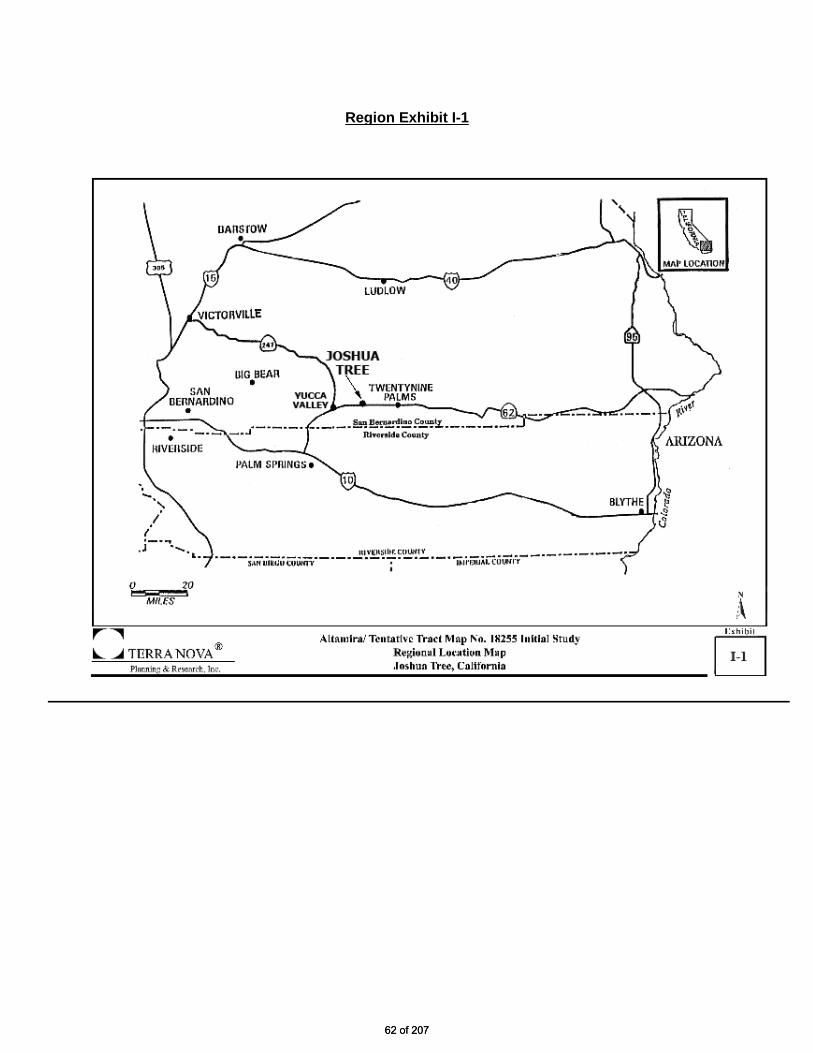
Region Exhibit I-1
62 of 20762 of 207
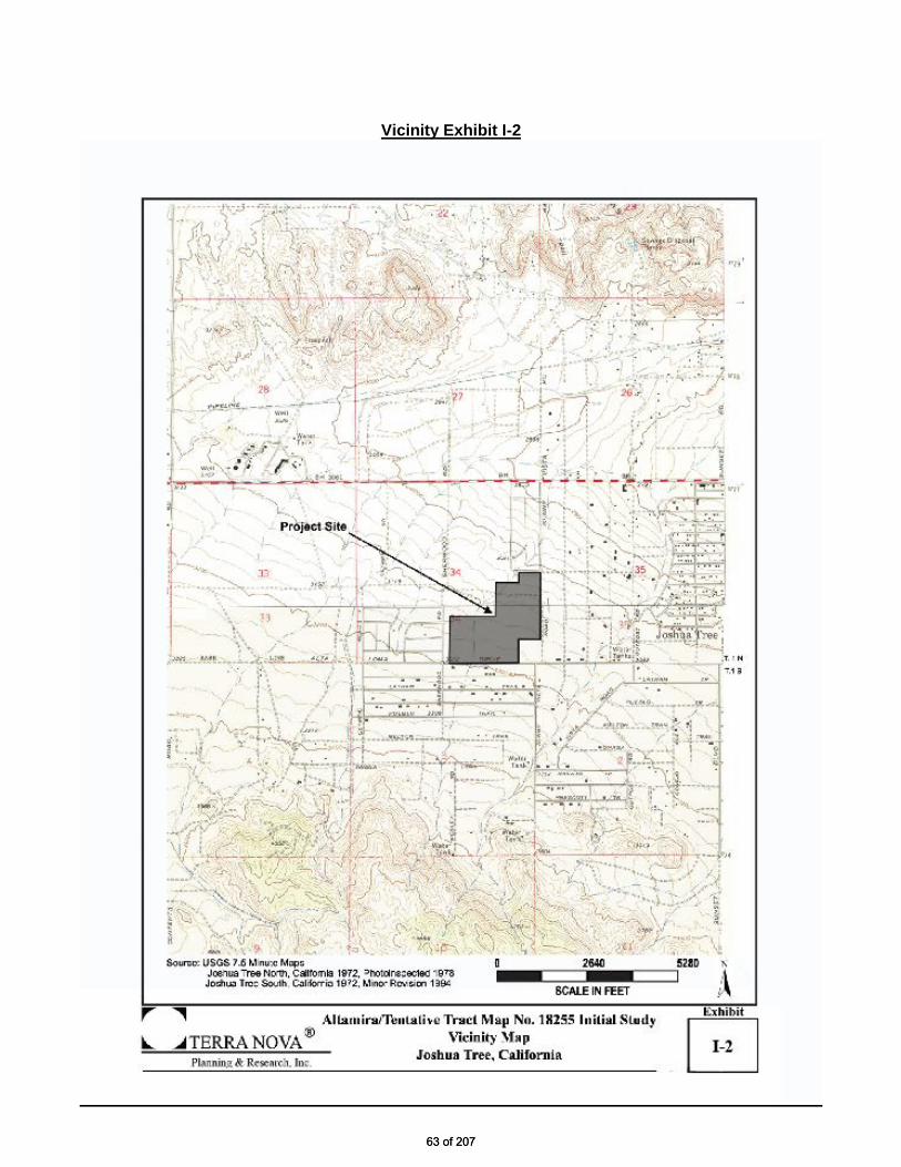
Vicinity Exhibit I-2
63 of 20763 of 207

Aerial Exhibit I-3
64 of 20764 of 207

Streams Exhibit I-4
65 of 20765 of 207

TTM 18255 Exhibit I-5
66 of 20766 of 207

EVALUATION FORMAT This initial study is prepared in compliance with the California Environmental Quality Act (CEQA) pursuant to Public Resources Code Section 21000, et seq. and the State CEQA Guidelines (California Code of Regulations Section 15000, et seq.). Specifically, the preparation of an Initial Study is guided by Section 15063 of the State CEQA Guidelines. This format of the study is presented as follows. The project is evaluated based upon its effect on seventeen (17) major categories of environmental factors. Each factor is reviewed by responding to a series of questions regarding the impact of the project on each element of the overall factor. The Initial Study Checklist provides a formatted analysis that provides a determination of the effect of the project on the factor and its elements. The effect of the project is categorized into one of the following four categories of possible determinations:
Potentially Significant Impact
Less than Significant With Mitigation Incorporated
Less than Significant No Impact
Substantiation is then provided to justify each determination. One of the four following conclusions is then provided as a summary of the analysis for each of the major environmental factors. 1. No Impact: No impacts are identified or anticipated and no mitigation measures are required.
2. Less than Significant Impact: No significant adverse impacts are identified or anticipated and no
mitigation measures are required.
3. Less than Significant Impact with Mitigation Incorporated: Possible significant adverse impacts have been identified or anticipated and the following mitigation measures are required as a condition of project approval to reduce these impacts to a level below significant. The required mitigation measures are: (List of mitigation measures)
4. Potentially Significant Impact: Significant adverse impacts have been identified or anticipated. An Environmental Impact Report (EIR) is required to evaluate these impacts, which are (List of the impacts requiring analysis within the EIR).
At the end of the analysis the required mitigation measures are restated and categorized as being either self- monitoring or as requiring a Mitigation Monitoring and Reporting Program.
67 of 20767 of 207

ENVIRONMENTAL FACTORS POTENTIALLY AFFECTED: The environmental factors checked below would be potentially affected by this project, involving at least one impact that is a "Potentially Significant Impact" as indicated by the checklist on the following pages.
Aesthetics Agriculture and Forestry Resources Air Quality
Biological Resources Cultural Resources Geology / Soils Greenhouse Gas Emissions Hazards & Hazardous Materials Hydrology / Water Quality Land Use/ Planning Mineral Resources Noise Population / Housing Public Services Recreation
Transportation / Traffic Utilities / Service Systems Mandatory Findings of Significance
DETERMINATION: (To be completed by the Lead Agency) On the basis of this initial evaluation, the following finding is made:
The proposed project COULD NOT have a significant effect on the environment, and a NEGATIVE DECLARATION shall be prepared.
Although the proposed project could have a significant effect on the environment, there shall not be a significant effect in this case because revisions in the project have been made by or agreed to by the project proponent. A MITIGATED NEGATIVE DECLARATION shall be prepared.
The proposed project MAY have a significant effect on the environment, and an ENVIRONMENTAL IMPACT REPORT is required.
The proposed project MAY have a "potentially significant impact" or "potentially significant unless mitigated" impact on the environment, but at least one effect 1) has been adequately analyzed in an earlier document pursuant to applicable legal standards, and 2) has been addressed by mitigation measures based on the earlier analysis as described on attached sheets. An ENVIRONMENTAL IMPACT REPORT is required, but it must analyze only the effects that remain to be addressed.
Although the proposed project could have a significant effect on the environment, because all potentially significant effects (a) have been analyzed adequately in an earlier EIR or NEGATIVE DECLARATION pursuant to applicable standards, and (b) have been avoided or mitigated pursuant to that earlier EIR or NEGATIVE DECLARATION, including revisions or mitigation measures that are imposed upon the proposed project, nothing further is required.
July 15, 2014
Signature: prepared by Chris Warrick, Senior Planner Date
July 15, 2014
Signature: David Prusch, Supervising Planner Planning Division
Date
68 of 20768 of 207
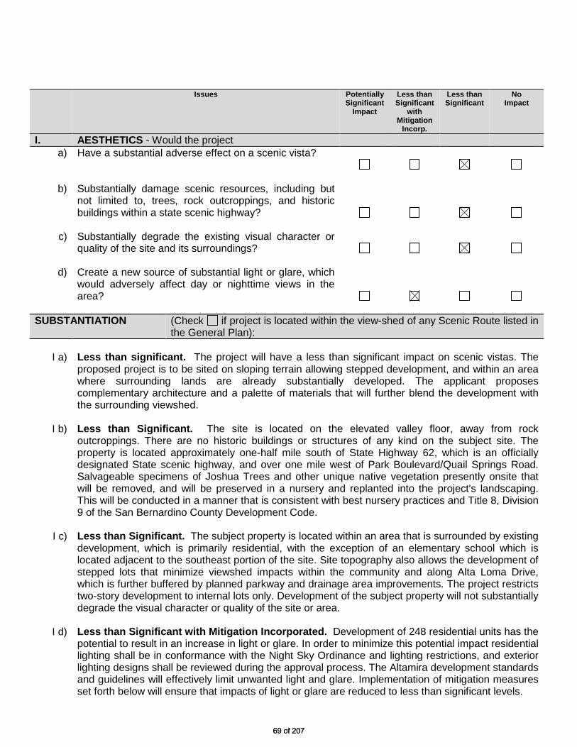
Issues Potentially Significant
Impact
Less than Significant
with Mitigation
Incorp.
Less than Significant
No Impact
I. AESTHETICS - Would the project a) Have a substantial adverse effect on a scenic vista?
b) Substantially damage scenic resources, including but not limited to, trees, rock outcroppings, and historic buildings within a state scenic highway?
c) Substantially degrade the existing visual character or quality of the site and its surroundings?
d) Create a new source of substantial light or glare, which
would adversely affect day or nighttime views in the area?
SUBSTANTIATION (Check if project is located within the view-shed of any Scenic Route listed in
the General Plan):
I a) Less than significant. The project will have a less than significant impact on scenic vistas. The proposed project is to be sited on sloping terrain allowing stepped development, and within an area where surrounding lands are already substantially developed. The applicant proposes complementary architecture and a palette of materials that will further blend the development with the surrounding viewshed.
I b) Less than Significant. The site is located on the elevated valley floor, away from rock
outcroppings. There are no historic buildings or structures of any kind on the subject site. The property is located approximately one-half mile south of State Highway 62, which is an officially designated State scenic highway, and over one mile west of Park Boulevard/Quail Springs Road. Salvageable specimens of Joshua Trees and other unique native vegetation presently onsite that will be removed, and will be preserved in a nursery and replanted into the project's landscaping. This will be conducted in a manner that is consistent with best nursery practices and Title 8, Division 9 of the San Bernardino County Development Code.
I c) Less than Significant. The subject property is located within an area that is surrounded by existing
development, which is primarily residential, with the exception of an elementary school which is located adjacent to the southeast portion of the site. Site topography also allows the development of stepped lots that minimize viewshed impacts within the community and along Alta Loma Drive, which is further buffered by planned parkway and drainage area improvements. The project restricts two-story development to internal lots only. Development of the subject property will not substantially degrade the visual character or quality of the site or area.
I d) Less than Significant with Mitigation Incorporated. Development of 248 residential units has the
potential to result in an increase in light or glare. In order to minimize this potential impact residential lighting shall be in conformance with the Night Sky Ordinance and lighting restrictions, and exterior lighting designs shall be reviewed during the approval process. The Altamira development standards and guidelines will effectively limit unwanted light and glare. Implementation of mitigation measures set forth below will ensure that impacts of light or glare are reduced to less than significant levels.
69 of 20769 of 207

Possible significant adverse impacts have been identified or anticipated and the following
mitigation measures are required as conditions of project approval to reduce these impacts to a level below significant.
MM# Mitigation Measures I-1 Lighting – Streets. Street lamps shall be low-scale, low-intensity lighting and well-shielded. Street
lighting shall be limited to the greatest extent practicable, while retaining safe and defensible space. Street lighting at major and secondary access drives may be required, as well as at the most heavily traveled intersections within the development. Wherever possible, other, smaller scale and lower intensity lighting should be used. [Mitigation Measure I-1] General Requirements/Planning
I-2 Lighting – Common Areas. Common area, pedestrian and other project lighting shall utilize the lowest levels of illumination practicable. No upward lighting of slopes shall be permitted. Landscape lighting shall be shielded to direct and limit areas of illumination. Lighting plans shall be provided with project building and landscape plans, and every reasonable effort shall be made to protect night skies. The developer shall utilize the lowest levels of private and community level lighting necessary to provide adequate visibility and security, while protecting adjoining lands. No flashing, pulsing or animated lighting will be permitted. Elevated lighting, including but not limited to parking lot lighting, shall be full-cutoff fixtures. Drop or sag lens fixtures shall not be permitted. Semi-cutoff fixtures constructed to direct 95% of light rays below the horizontal plane may be permitted upon careful review by the County. [Mitigation Measure I-2] General Requirements/Planning
70 of 20770 of 207
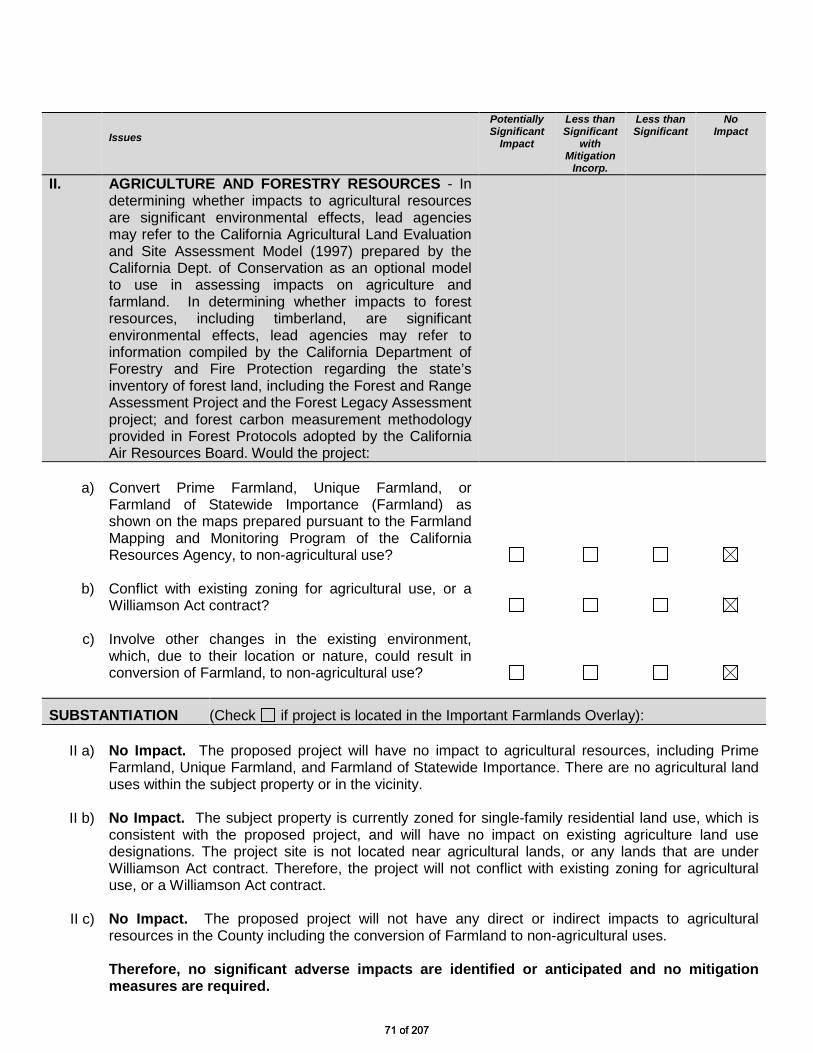
Issues
Potentially Significant
Impact
Less than Significant
with Mitigation
Incorp.
Less than Significant
No Impact
II. AGRICULTURE AND FORESTRY RESOURCES - In determining whether impacts to agricultural resources are significant environmental effects, lead agencies may refer to the California Agricultural Land Evaluation and Site Assessment Model (1997) prepared by the California Dept. of Conservation as an optional model to use in assessing impacts on agriculture and farmland. In determining whether impacts to forest resources, including timberland, are significant environmental effects, lead agencies may refer to information compiled by the California Department of Forestry and Fire Protection regarding the state’s inventory of forest land, including the Forest and Range Assessment Project and the Forest Legacy Assessment project; and forest carbon measurement methodology provided in Forest Protocols adopted by the California Air Resources Board. Would the project:
a) Convert Prime Farmland, Unique Farmland, or
Farmland of Statewide Importance (Farmland) as shown on the maps prepared pursuant to the Farmland Mapping and Monitoring Program of the California Resources Agency, to non-agricultural use?
b) Conflict with existing zoning for agricultural use, or a Williamson Act contract?
c) Involve other changes in the existing environment,
which, due to their location or nature, could result in conversion of Farmland, to non-agricultural use?
SUBSTANTIATION (Check if project is located in the Important Farmlands Overlay): II a) No Impact. The proposed project will have no impact to agricultural resources, including Prime
Farmland, Unique Farmland, and Farmland of Statewide Importance. There are no agricultural land uses within the subject property or in the vicinity.
II b) No Impact. The subject property is currently zoned for single-family residential land use, which is
consistent with the proposed project, and will have no impact on existing agriculture land use designations. The project site is not located near agricultural lands, or any lands that are under Williamson Act contract. Therefore, the project will not conflict with existing zoning for agricultural use, or a Williamson Act contract.
II c) No Impact. The proposed project will not have any direct or indirect impacts to agricultural
resources in the County including the conversion of Farmland to non-agricultural uses. Therefore, no significant adverse impacts are identified or anticipated and no mitigation
measures are required.
71 of 20771 of 207

ISSUES Potentially Significant
Impact
Less than Significant
with Mitigation
Incorp.
Less than Significant
No Impact
III. AIR QUALITY - Where available, the significance criteria established by the applicable air quality management or air pollution control district may be relied upon to make the following determinations. Would the project:
a) Conflict with or obstruct implementation of the applicable air quality plan?
b) Violate any air quality standard or contribute
substantially to an existing or projected air quality violation?
c) Result in a cumulatively considerable net increase of any criteria pollutant for which the project region is non-attainment under an applicable federal or state ambient air quality standard (including releasing emissions, which exceed quantitative thresholds for ozone precursors)?
d) Expose sensitive receptors to substantial pollutant concentrations?
e) Create objectionable odors affecting a substantial
number of people?
SUBSTANTIATION (Discuss conformity with the South Coast Air Quality Management Plan, if
applicable):
III a) Less than Significant. Development of the subject property will not interfere with implementation of the Air Quality Plan as established by the Mojave Desert Air Quality Management District (MDAQMD). Based on the Air Quality Impacts Analysis, which can be seen in full in Appendix A of this document, grading, construction, and operation-related emissions do not exceed the District’s thresholds and therefore will not conflict with the Air Quality Plan. Table III-1 (Below) shows the annual and daily thresholds for the MDAQMD.
Table III-1 Emissions Thresholds for MDAQMD
Criteria Pollutant Annual Threshold (tons)
Daily Threshold (pounds)
Carbon Monoxide (CO) 100 548 Nitrogen Oxide (NOx) 25 137 Volatile Organic Compounds (VOC) 25 137 Sulfur Oxide (SOx) 25 137 Particulate Matter (PM10 and PM2.5) 15 82 Source: “MDAQMD CEQA and Federal Conformity Guidelines,” June 2007.
72 of 20772 of 207

III b) Less than significant with Mitigation Incorporated. The Mojave Desert Air Quality Management District (MDAQMD) is in severe non-attainment for ozone and PM10. The District has met the attainment standards for SOx, NOx, lead, and CO. With the implementation of mitigation measures set forth below, development of the subject project will not contribute to an air quality violation beyond the existing non-attainment designation mentioned above. The Air Quality tables below quantify the potential emissions that may result from all activities associated with development of the project, including site preparation, construction, and operation. It should be noted that the following analysis assumes construction on 105 acres with no more than 17 acres of active disturbance on any given day. Also, see the appended Air Quality Study for methodology and modeling assumptions. Fugitive Dust Site preparation and grading activities will result in the generation of fugitive dust. Development will allow for as much as 17 acres to be actively disturbed on any given day. In the event that a 17 acre area is disturbed simultaneously, with the implementation of mitigation measures approximately 76.37 pounds of fugitive dust per day is estimated to be generated. With implementation of BMP’s and other measures set forth below, the MDAQMD daily threshold of 82 pounds for particulate matter would not be exceeded and impacts associated with air quality impacts from fugitive dust generation would be less than significant.
Table III-2
Fugitive Dust Potential (Unmitigated) Area to be Total Potential
Disturbed Factor Mitigated Dust 17.0 ± acres 20.0 lbs./day/acre 76.37 lbs./day Source: URBEMIS 2007 version 9.2.4. Construction Summary The proposed project will generate emissions from the operation of construction equipment, workers travel to and from the site, trenching activities for the installation of utilities, roadway paving, application of architectural coating, and the delivery of materials to the project site. Emissions for all pollutants of concern are well below the thresholds as established by MDAQMD (Table III-3).
Table III-3 Construction Emission Summary
(pounds per day) CO ROG NOx SO2 PM10 PM2.5 CO2 Equip. Emissions 2014 60.59 8.14 62.42 0.08 3.10 2.85 11,318.84 Equip. Emissions 2015 25.53 22.49 25.53 0.07 1.49 1.36 9,712.17 MDAQMD Threshold 548.00 137.00 137.00 137.00 82.00 N/A N/A Note that emission projections for summer and winter are equivalent.
73 of 20773 of 207

Operational Summary The project has the potential to generate stationary source emissions from residential dwelling units and moving source emissions from vehicle trips. Stationary sources include the use of natural gas and electricity. Table III-4 shows that emissions for all criteria pollutants are below the MDAQMD thresholds.
Table III-4 Operational Emission Summary
(pounds per day) CO ROG NOx SO2 PM10 PM2.5 CO2 Summer Area Source Emissions 13.00 14.03 4.23 0.00 0.04 0.04 5,258.35 Operational Emissions 354.03 28.59 49.57 0.38 61.20 12.33 37,469.21 Summer Emissions 367.03 42.62 53.80 0.38 61.24 12.37 42,727.56 Winter Area Source Emissions 111.35 51.51 7.69 0.31 17.01 16.38 10,035.51 Operational Emissions 339.18 32.23 58.66 0.32 61.20 12.33 34,171.06 Winter Emissions 450.53 83.74 66.35 0.63 78.21 28.71 44,206.57 MDAQMD Threshold 548.00 137.00 137.00 137.00 82.00 N/A N/A
III c) Less than Significant. Although the County is in “severe non-attainment” for ozone and PM10, development of the project will not significantly contribute to this violation. As demonstrated in the Air Quality tables above, the subject development will not result in a cumulatively considerable net increase of any criteria pollutants. Nonetheless, in order to further reduce potential impacts to air quality, mitigation measures are set forth below.
III d) Less than Significant with Mitigation Incorporated. The subject property is located in proximity to sensitive receptors, including residential development to the east, west and south, and an elementary school adjacent to the southeast corner of the project site. Additionally, the project will be phased, which may result in construction activities occurring adjacent or in proximity to occupied homes. To limit potential impacts to nearby receptors, the project shall utilize best control measures and BMPs, shall limit construction activities to specified hours as delineated in the General Plan, and adhere to those guidelines established in the Altamira PDP. In addition, implementation of the mitigation measures set forth below will further reduce potential impacts to air quality.
III e) Less than Significant. Development of the subject property is not expected to result in
objectionable odors. With the exception of a neighborhood community center and the proposed wastewater treatment package plant, all buildings on the project site are single-family residences that will not generate objectionable odors. The community center is intended to serve only project residents' needs, and food preparation or any other community-related activity is not expected to generate any objectionable odors. The package plant will incorporate odor control filters and design specifications to assure that odors associated with treatment are avoided. This and other mitigation measures set forth below will ensure that impacts to air quality including undesirable odors are reduced to less than significant levels.
Possible significant adverse impacts have been identified or anticipated and the following mitigation measures are required as conditions of project approval to reduce these impacts to a level below significant.
74 of 20774 of 207

MM# Mitigation Measures III-1 AQ-Dust Control Plan. The “developer” shall prepare, submit for review and obtain approval from
County Planning of both a Dust Control Plan (DCP) consistent with SCAQMD guidelines and a signed letter agreeing to include in any construction contracts/ subcontracts a requirement that project contractors adhere to the requirements of the DCP. The DCP shall include the following requirements: a) Exposed soil shall be kept continually moist to reduce fugitive dust during all grading and
construction activities, through application of water sprayed a minimum of two times each day. b) Any portion of the site to be graded shall be pre-watered to a depth of three feet prior to the
onset of grading activities. c) During high wind conditions (i.e., wind speeds exceeding 25 mph), areas with disturbed soil
shall be watered hourly and activities on unpaved surfaces shall cease until wind speeds no longer exceed 25 mph.
d) Any area that will remain undeveloped for a period of more than 30 days shall be stabilized using either chemical stabilizers and/or a desert wildflower mix hydroseed on the affected portion of the site.
e) Storage piles that are to be left in place for more than three working days shall be sprayed with a non-toxic soil binder, covered with plastic or revegetated.
f) Imported fill and exported excess cut shall be adequately watered prior to transport, covered during transport, and watered prior to unloading on the project site.
g) Storm water control systems shall be installed to prevent off-site mud deposition. h) All trucks hauling dirt away from the site shall be covered. i) Construction vehicle tires shall be washed, prior to leaving the project site. j) Rumble plates shall be installed at construction exits from dirt driveways. k) Paved access driveways and streets shall be washed and swept daily when there are visible
signs of dirt track-out. l) Street sweeping shall be conducted daily when visible soil accumulations occur along site
access roadways to remove dirt dropped or tracked-out by construction vehicles. Site access driveways and adjacent streets shall be washed daily, if there are visible signs of any dirt track-out at the conclusion of any workday and after street sweeping.
[Mitigation Measure III-1] Prior to Grading Permits/Planning
III-2 AQ - Construction Mitigation. The “developer” shall submit for review and obtain approval from County Planning of a signed letter agreeing to include as a condition of all construction contracts/subcontracts requirements to reduce vehicle and equipment emissions and other impacts to air quality by implementing the following measures and submitting documentation of compliance: The developer/construction contractors shall do the following: a) Provide documentation prior to beginning construction demonstrating that the project will
comply with all SCAQMD regulations including 402, 403, 431.1, 431.2, 1113 and 1403. b) Each contractor shall certify to the developer prior to construction-use that all equipment
engines are properly maintained and have been tuned-up within last 6 months. c) Each contractor shall minimize the use of diesel-powered vehicles and equipment through the
use of electric, gasoline or CNG-powered equipment. All diesel engines shall have aqueous diesel filters and diesel particulate filters.
d) All gasoline-powered equipment shall have catalytic converters. e) Provide onsite electrical power to encourage use of electric tools. f) Minimize concurrent use of equipment through equipment phasing. g) Provide traffic control during construction to reduce wait times. h) Provide on-site food service for construction workers to reduce offsite trips. i) Implement the County approved Dust Control Plan (DCP) j) Suspend use of all construction equipment operations during second stage smog alerts.
NOTE: For daily forecast, call (800) 367-4710 (San Bernardino and Riverside counties).
75 of 20775 of 207

[Mitigation Measure III-2] Prior to Grading Permits/Planning
III-3 AQ - Coating Restriction Plan. The developer shall submit for review and obtain approval from County Planning of a Coating Restriction Plan (CRP), consistent with SCAQMD guidelines and a signed letter agreeing to include in any construction contracts/subcontracts a condition that the contractors adhere to the requirements of the CRP. The CRP measures shall be following implemented to the satisfaction of County Building and Safety: a) Architectural coatings with Reactive Organic Compounds (ROC) shall not have content greater
than 100 g/l. b) Architectural coating volume shall not exceed the significance threshold for ROG, which is 75
lbs. /day and the combined daily ROC volume of architectural coatings and asphalt paving shall not exceed the significance threshold for ROC of 75 lbs. per day.
c) High-Volume, Low Pressure (HVLP) spray guns shall be used to apply coatings. d) Precoated/natural colored building materials, water-based or low volatile organic compound
(VOC) coatings shall be used, if practical. e) Comply with SCAQMD Rule 1113 on the use or architectural coatings. [Mitigation Measure III-3] Prior to Building Permits/Planning
III-4 AQ – Design. The developer shall include the following air quality design considerations, where feasible, into the project design (per SBCC § 83.14.030). The building design with these features shall be submitted for review and approval obtained from County Planning in coordination with County Building and Safety: a) Bicycle Plan. Participate in implementation of the Countywide Bicycle Plan, through
construction of on/off- site facilities or contribution of fees. b) Transit improvements. Transit improvements (e.g. bus pullouts, bus signage, bus pads, and/or
bus shelters) shall be provided along existing or planned transit routes. The need for and nature of those improvements shall be determined in cooperation with the designated local transportation authority (e.g. Omnitrans, MARTA or other).
c) Energy conservation. Conserve energy through the use of alternative energy resources (e.g. passive lighting, heating, ventilation and air conditioning) and conservation efforts in wastewater treatment, irrigation and use of recycled water. Incorporate energy efficient lighting and California Energy Commission insulation standards into the design.
d) SCAQMD – Design. New and modified stationary sources shall be required to install Best Available Control Technology and offset any new emissions such that there is no net gain in emissions within the air basin. (SCAQMD Regulation XIII)
[Mitigation Measure III-4] Prior to Building Permits/Planning
76 of 20776 of 207
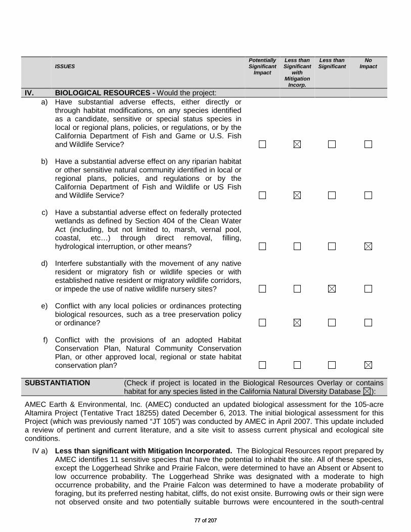
ISSUES
Potentially Significant
Impact
Less than Significant
with Mitigation
Incorp.
Less than Significant
No Impact
IV. BIOLOGICAL RESOURCES - Would the project: a) Have substantial adverse effects, either directly or
through habitat modifications, on any species identified as a candidate, sensitive or special status species in local or regional plans, policies, or regulations, or by the California Department of Fish and Game or U.S. Fish and Wildlife Service?
b) Have a substantial adverse effect on any riparian habitat or other sensitive natural community identified in local or regional plans, policies, and regulations or by the California Department of Fish and Wildlife or US Fish and Wildlife Service?
c) Have a substantial adverse effect on federally protected wetlands as defined by Section 404 of the Clean Water Act (including, but not limited to, marsh, vernal pool, coastal, etc…) through direct removal, filling, hydrological interruption, or other means?
d) Interfere substantially with the movement of any native resident or migratory fish or wildlife species or with established native resident or migratory wildlife corridors, or impede the use of native wildlife nursery sites?
e) Conflict with any local policies or ordinances protecting biological resources, such as a tree preservation policy or ordinance?
f)
Conflict with the provisions of an adopted Habitat Conservation Plan, Natural Community Conservation Plan, or other approved local, regional or state habitat conservation plan?
SUBSTANTIATION (Check if project is located in the Biological Resources Overlay or contains
habitat for any species listed in the California Natural Diversity Database ):
AMEC Earth & Environmental, Inc. (AMEC) conducted an updated biological assessment for the 105-acre Altamira Project (Tentative Tract 18255) dated December 6, 2013. The initial biological assessment for this Project (which was previously named “JT 105”) was conducted by AMEC in April 2007. This update included a review of pertinent and current literature, and a site visit to assess current physical and ecological site conditions.
IV a) Less than significant with Mitigation Incorporated. The Biological Resources report prepared by AMEC identifies 11 sensitive species that have the potential to inhabit the site. All of these species, except the Loggerhead Shrike and Prairie Falcon, were determined to have an Absent or Absent to low occurrence probability. The Loggerhead Shrike was designated with a moderate to high occurrence probability, and the Prairie Falcon was determined to have a moderate probability of foraging, but its preferred nesting habitat, cliffs, do not exist onsite. Burrowing owls or their sign were not observed onsite and two potentially suitable burrows were encountered in the south-central
77 of 20777 of 207

portion of the site. A focused tortoise survey was performed on-site and within the zone of influence. This systematic survey detected no tortoises or their signs (scat, burrows, pallets, carcasses, etc.) onsite or in the project vicinity. The entire Biological Resources study can be found in Appendix B of this document and concludes that with implementation of mitigation measures and execution of the Streambed Alteration Agreement (California Fish and Game Code Section 1602: further discussed below) development of the project will have less than significant impacts on biological resources. Potential for the desert tortoise and burrowing owl to occur onsite still exists. In order to ensure compliance with both federal and state Endangered Species Acts, and Fish and Game code, focused and preconstruction clearance surveys for these species conducted in accordance with the respective federal and state survey guidelines would be required prior to, and/or as a condition of approval, by any Project grading permits. If either tortoise or burrowing owl are found onsite, additional federal and state “take” permits and conditions would be required prior to any project-related site disturbance. The Migratory Bird Treaty Act (MBTA) makes it unlawful to pursue, capture, kill, and/or possess, or attempt to engage in any such conduct to any migratory bird, nest, egg or parts thereof. Impacts to nesting birds can be avoided by either: 1) avoiding grading and/or vegetation clearance during the nesting season (which is generally February 1 through August 15); or 2) conducting a nesting bird survey to determine if and where birds are nesting and avoidance of the nesting areas until nesting has been completed (e.g., phased development). If impacts cannot be avoided, permits for incidental take of nesting birds may be granted by the Secretary of the Interior. Project grading permits should require MBTA compliance as a condition of approval. Implementation of the project may have a low potential to affect Le Conte’s Thrashers, Loggerhead Shrikes, and Prairie Falcons, as well as common bird species that may nest on the site (several Cactus Wren [Campylorhynchus brunneicapillus] nests were observed in cacti on various locations on the site). Suitable habitat for Burrowing Owls is also present on the project site, although no sign of owls and only two burrows capable of hosting owls were observed on the site.
The potential for occurrence for the special status species identified by the initial biological assessment remain the same. One additional species that has recently been added to the CNDDB, hoary bat, has a very low potential to occur. Parish’s club cholla, a recently added historic record from the site’s vicinity, is considered absent.
IV b) Less than significant with Mitigation Incorporated. The dominant plant community onsite is
characterized as sparse Joshua Tree “Woodland” intermixed with Mojave Mixed Wood Scrub (Holland 1986). In the northern (down-slope) portion of the site habitat is characterized as Mojave Creosote Bush Scrub. Within the portions of the site that are delineated as blue-line streams or drainages, vegetation is a mixture of Mojave Creosote Bush Scrub and Mojave Desert Wash Scrub (the microphyllous tree species is not present). Development of the proposed project will result in construction activities within and adjacent to approximately 9.73 acres of streambeds as delineated by AMEC and within the jurisdiction of the California Department of Fish and Wildlife (CDFW). It is estimated that of the total cut and fill, approximately 37,820 cubic yards (cy), will be removed from streambeds and used to construct improvements on-site. These stream courses have been mapped as “Waters of the State”, and would require a Streambed Alteration Agreement from CDFW prior to issuance of a grading permit or recordation of the Final Map. The Streambed Alteration Agreement with CDFW assures that potential impacts to streambeds are reduced to less than significant levels.
78 of 20778 of 207
IV c) No Impact. The project will not result in a direct or indirect adverse impact to any federally protected wetlands, since there are no wetlands onsite or in the project vicinity. As mentioned above, there are ephemeral streams crossing the onsite, but these are not under federal jurisdiction but are regulated by CDFW. A Streambed Alteration Agreement application has been filed with CDFW.
IV d) Less than significant. Development of the subject property will not significantly interfere with the
movement or migration of any wildlife species, including obstruction of a wildlife corridor or access to a nursery site. The subject property is bounded by major roadways and development on the east, west and south.
IV e) Less than significant with Mitigation Incorporated. Implementation of the project will result in
impacts to biological resources on the site. However, some portions of the site have been moderately disturbed, and some areas have been cleared. Some of the “biological value” of the site has already been lost to off-road vehicle use, and by roaming neighborhood pets. The following plants identified onsite are subject to the County of San Bernardino Development Code, Chapter 88.01, Plant Protection and Management: Joshua Tree, Mesquite, Creosote Bush (greater than 10 feet in diameter), and the Mojave Yucca. These plants are not Federally or State protected endangered species, threatened species, or species of concern; however, they are a biologically valuable resource to wildlife in the region and are regulated by County Ordinance, which prohibits their removal without a required finding by the review authority concerning the tree’s location or condition (County Code Section 88.01.050). This Ordinance also requires that all transferable Joshua trees which are proposed for removal, be transplanted or stockpiled for future transplanting whenever possible. Full Joshua tree surveys will be required for each phase of the proposed project as a part of the approval requirements. A Joshua tree report will be prepared for each phase’s full Joshua tree survey, for acceptance by the County. Each report will include the mapped location, size, health, and transferability of the trees surveyed, and specific recommendations for maximizing Joshua tree preservation within that phase. A Joshua Tree Transplantation Plan shall be prepared along with each phase’s Joshua tree report. The proposed project phase-specific timeframes, maintenance, monitoring, and reporting specifications will be provided to ensure maximum survivability of the Joshua trees within each phase.
IV f) No Impact. As proposed the project will not interfere or conflict with the objectives of any
established local, regional, or state habitat conservation plans.
Possible significant adverse impacts have been identified or anticipated and the following mitigation measures are required as conditions of project approval to reduce these impacts to a level below significant.
MM# Mitigation Measures
IV-1 Tree Removal Permit. A County Tree Removal Permit shall be required for the removal of a Joshua tree or other regulated desert native plant. [Mitigation Measure IV-1] Prior to Grading Permit/Planning
IV-2 Joshua Tree Survey. A Joshua tree survey and report and a Joshua Tree Management Program shall be completed and submitted to County Planning prior to the issuance of a grading permit or recordation of a final tract map for any phase of this project. The required Joshua tree survey and report will be prepared by a Desert Native Plant Specialist and will include a field inventory of Joshua trees throughout the site, indicating their approximate height, age, health rating,
79 of 20779 of 207

transferability, and whether they are a clone or single-trunked tree. The report will include a plot plan showing the on-site locations of all Joshua trees and will identify any regulated desert native plants. [Mitigation Measure IV-2] Prior to Grading Permit/Planning
IV-3 Desert Native Landscaping. The development of the residential subdivision, including the individual single family lots, the common area landscape lots and the natural and re-naturalized perimeter and internal drainage facilities shall utilize reclaimed vegetation consisting of Joshua Trees and other Mojave Desert wash scrub (mesquite, palo verde, ironwood, smoketree, etc.). Other native and drought-tolerant materials shall also be used. No invasive plant materials shall be permitted. A landscape palette consistent with these provisions shall be submitted to the project biologist and County for final approval. The Conditions, Covenants and Restrictions (CC&Rs’) for the project shall include specific regulations that prohibit the removal of native desert plants without the preparation of a biological report and receiving a tree removal permit from the County of San Bernardino. The developer shall be responsible for disclosing to each property owner that there are regulations prohibiting the removal of native desert plants without the appropriate permits. [Mitigation Measure IV-3] General Requirements/Planning
IV-4 Nesting Bird Mitigation – Pre-Construction Surveys. Within 30 days prior to vegetation clearing or ground disturbance associated with construction or grading that would occur during the nesting/breeding season (February 1 through August 31, unless determined otherwise by a qualified biologist based on observations in the region), the Applicant shall retain a qualified biologist to determine if active nests of species protected by the Migratory Bird Treaty Act or the California Fish and Game Code are present within or adjacent to the disturbance zone or within 100 feet (300 feet for raptors) of the disturbance zone. The surveys will be conducted no more than seven days prior to initiation of disturbance work within active project areas. If ground disturbance activities are delayed, then additional pre-disturbance surveys will be conducted such that no more than seven days will have elapsed between the survey and ground disturbance activities. If ground disturbance will be phased across the project site, pre-disturbance surveys may also be phased to conform to the development schedule. If active nests are found, clearing and construction within 100 feet of the nest (or a lesser distance if approved by the U.S. Fish & Wildlife Service) will be postponed or halted, until the nest is vacated and juveniles have fledged, as determined by the biologist. Avoidance buffers will be established in the field with highly visible construction fencing or flagging, and construction personnel will be instructed on the sensitivity of nest areas. A qualified biologist will serve as a construction monitor during those periods when construction activities will occur near active nests to ensure that no inadvertent impacts on these nests occur.
The results of pre-construction nesting bird surveys, including graphics showing the locations of any nests detected, and documentation of any avoidance measures taken, will be submitted to the County of San Bernardino and the California Department of Fish & Wildlife within 14 days of completion of the pre-construction surveys or construction monitoring to document compliance with applicable state and federal laws pertaining to the protection of native birds. [Mitigation Measure IV-4] Prior to Grading/Planning
IV-5 Burrowing Owl Mitigation – Pre-Construction Surveys. Within 14 days prior to ground disturbance, the Applicant will retain a qualified biologist to conduct burrowing owl surveys within the area to be disturbed. The survey will be performed by walking parallel transects spaced no more than 20 meters apart, and will be focused on detecting burrows that are occupied, or are suitable for occupation, by the burrowing owl. The results of the surveys, including graphics showing the locations of any active burrows detected and any avoidance measures required, will be submitted to the County of San Bernardino and the California Department of Fish & Wildlife (CDFW) within 14 days following completion of the surveys. If active burrows are detected, the following take avoidance measures will
80 of 20780 of 207

be implemented: a) If burrowing owls are observed using burrows on-site during the non-breeding season
(September through January, unless determined otherwise by a qualified biologist based on field observations in the region), occupied burrows will be left undisturbed, and no construction activity will take place within 300 feet of the burrow where feasible (see below).
b) If avoiding disturbance of owls and owl burrows on-site is infeasible, owls will be excluded from all active burrows through the use of exclusion devices placed in occupied burrows in accordance with protocols established in CDFW’s Staff Report on Burrowing Owl Mitigation (2012). Specifically, exclusion devices, utilizing one-way doors, will be installed in the entrance of all active burrows. The devices will be left in the burrows for at least 48 hours to ensure that all owls have been excluded from the burrows. Each of the burrows will then be excavated by hand and/or mechanically and refilled to prevent reoccupation. Exclusion will continue until the owls have been successfully excluded from the disturbance area, as determined by a qualified biologist.
c) Any active burrowing owl burrows detected on-site during the breeding season (February through August, unless determined otherwise by a qualified biologist based on field observations in the region), will not be disturbed. Construction activities will not be conducted within 300 feet of an active on-site burrow at this season.
[Mitigation Measure IV-5] Prior to Grading Permit/Planning
IV-6 Burrowing Owl Mitigation – Management Plan. If burrowing owl are determined to occupy the project site, prior to issuance of a grading permit, a habitat management plan for the burrowing owl will be developed. The plan will include provisions for protecting foraging habitat and replacing any active burrows from which owls may be passively evicted as allowed by Mitigation Measure BIO-1. The Burrowing Owl Management Plan will be submitted to the County of San Bernardino and the California Department of Fish and Wildlife for review and approval prior to issuance of a grading permit for the Project. At a minimum, the plan will include the following elements: a) If occupied burrows are to be removed, the plan will contain schematic diagrams of artificial
burrow designs and a map of potential artificial burrow locations that would compensate for the burrows removed.
b) All active on-site burrows excavated as described in Mitigation Measure BIO-1 will be replaced with suitable natural or artificial burrows within the preservation areas approved by the County of San Bernardino.
c) Measures prohibiting the use of rodenticides during the construction process if any active on-site burrows are identified.
d) The plan will ensure that adequate suitable burrowing owl foraging habitat is provided in proximity to natural or artificial burrows within off-site mitigation areas.
[Mitigation Measure IV-6] – Prior to Grading Permit/Planning
IV-7 Pre-Construction Mojave Desert Tortoise Surveys and Avoidance. Within 14 days prior to construction-related ground clearing and/or grading, the Applicant shall retain a qualified biologist to conduct surveys for signs of occupancy by the Mojave desert tortoise. Should any sign indicating the presence of Mojave desert tortoise be detected, the Applicant shall not proceed with ground clearing and/or grading activities in the area of the find, and shall instead contact the USFWS and CDFW to develop an avoidance strategy and/or seek authorization for incidental take of Mojave desert tortoise. The results of the pre-construction surveys, including graphics showing the locations of any tortoise sign detected, and documentation of any avoidance measures taken, shall be submitted to the USFWS, CDFG, and the County of San Bernardino within 14 days of completion of the pre-construction surveys or construction monitoring to document compliance with applicable federal and state laws pertaining to the protection of Mojave desert tortoise. [Mitigation Measure IV-7] – Prior to Grading Permit/Planning
81 of 20781 of 207

IV-8 Department of Fish and Wildlife (CDFW). A mapped blue line stream occurs on portions of the project site as well as additional dry channels Development of the proposed project will result in construction activities within and adjacent to approximately 9.73 acres of streambeds as delineated by AMEC and within the jurisdiction of the California Department of Fish and Wildlife (CDFW). It is estimated that of the total cut and fill, approximately 37,820 cubic yards (cy), will be removed from streambeds and used to construct improvements on-site. These stream courses have been mapped as “Waters of the State”, and would require a Streambed Alteration Agreement from CDFW prior to issuance of a grading permit or recordation of the Final Map. The Streambed Alteration Agreement with CDFW assures that potential impacts to streambeds are reduced to less than significant levels. If any of these stream courses qualify as federal jurisdictional waters, any alteration of these courses due to project activities would require consultation with the U.S. Army Corps of Engineers prior to grading or recordation of the Final Map. [Mitigation Measure IV-8] Prior to Grading Permit/Planning
82 of 20782 of 207

ISSUES Potentially Significant
Impact
Less than Significant
with Mitigation
Incorp.
Less than Significant
No Impact
V. CULTURAL RESOURCES - Would the project
a) Cause a substantial adverse change in the significance of a historical resource as defined in §15064.5?
b) Cause a substantial adverse change in the significance
of an archaeological resource pursuant to §15064.5?
c) Directly or indirectly destroy a unique paleontological resource or site or unique geologic feature?
d) Disturb any human remains, including those interred
outside of formal cemeteries?
SUBSTANTIATION (Check if the project is located in the Cultural or Paleontologic
Resources overlays or cite results of cultural resource review): V a/b) Less Than Significant. Based on the Historical/Archaeological Resources Report prepared by
CRM Tech, which included records search, historical research, a field survey, and consultation with California’s American Heritage Commission, there are no historical or archaeological resources onsite or in the project vicinity. Therefore, development of the subject property is not expected to result in any adverse impacts to historical or archaeological resources.
As mentioned above, a comprehensive historical/archeological report was prepared for the subject
property and found no indication that any historical, archeological, or paleontological resource would be directly or indirectly impacted as a result of the proposed project. The site-specific report, which can be found in Appendix C of this document, concludes that there are no paleontological resources or unique geological features onsite.
V c/d) Less Than Significant. According to the Historical/Archaeological Resources Report prepared for
this project, development of the proposed project will not directly or indirectly impact paleontological resources or disturb human remains. The field survey did not find any indication that human remains are present onsite or have the potential to be present. If any human remains are discovered during construction of this project, standard requirements in the Conditions of approval will require the developer to contact the County Coroner and the County Museum for a determination of appropriate measures to be taken. Potential impacts associated with human remains and paleontological resources are expected to be less than significant.
A standard condition of approval will be applied to the project to require the developer to contact the County Museum in the event of discovery of any artifact during construction, for instructions regarding evaluation for significance as a cultural of paleontological resource. No significant adverse impacts are identified or anticipated and therefore no mitigation measures are required.
83 of 20783 of 207

ISSUES
Potentially Significant
Impact
Less than Significant
with Mitigation
Incorp.
Less than Significant
No Impact
VI. GEOLOGY AND SOILS - Would the project: a) Expose people or structures to potential substantial
adverse effects, including the risk of loss, injury, or death involving:
i. Rupture of a known earthquake fault, as delineated
on the most recent Alquist-Priolo Earthquake Fault Zoning Map Issued by the State Geologist for the area or based on other substantial evidence of a known fault? Refer to Division of Mines and Geology Special Publication 42
ii. Strong seismic ground shaking? iii. Seismic-related ground failure, including
liquefaction?
iv. Landslides?
b) Result in substantial soil erosion or the loss of topsoil?
c) Be located on a geologic unit or soil that is unstable, or that would become unstable as a result of the project, and potentially result in on or off site landslide, lateral spreading, subsidence, liquefaction or collapse?
d) Be located on expansive soil, as defined in Table 181-B of the California Building Code (2001) creating substantial risks to life or property?
e) Have soils incapable of adequately supporting the use of septic tanks or alternative wastewater disposal systems where sewers are not available for the disposal of wastewater?
SUBSTANTIATION (Check if project is located in the Geologic Hazards Overlay District):
VI a) Less Than Significant Impact. A Geotechnical Investigation was prepared by Landmark Consultants, Inc. in order to identify the site’s geotechnical parameters and can be found in Appendix E of this document. The study determined that the project site does not lie within a State of California Alquist-Priolo Earthquake Fault Zone. The potential for a surface fault rupture within the project boundary is considered unlikely since the USGS and CDMG fault lines are well delineated and do not intersect with the project site nor are they inferred by patterns of area faulting. The subject property is located in proximity to a number of faults and has the potential to be subject to severe ground shaking. The closest fault, the Pinto Mountain Fault, is 1.2 miles north of the project site. The potential for liquefaction to occur onsite is low since the depth to groundwater is greater than 100 feet, and liquefaction typically occurs where groundwater is less than 50 feet below the ground
84 of 20784 of 207

surface. Historical geologic maps of the region reveal no indication of landslides, and none were observed during the site visit. However, site development will result in numerous manufactured slopes, which shall be engineered to resist sloughing or slope failure in the event of strong ground shaking.
VI b) Less Than Significant Impact. The project will not result in substantial soil erosion or the loss of
topsoil, because the site will be paved and landscaped. Erosion control plans will be required to be submitted, approved and implemented. Measures to reduce and control erosion of soil during construction and long term operation are required by SCAQMD through its Rule 403 for control of fugitive dust, the Regional Water Quality Control Board (RWQCB) under its administration of the State’s General Construction Permit, and the County of San Bernardino Public Works Department through its Storm Water Management Program. Implementation of requirements under SCAQMD Rule 403 for control of fugitive dust would reduce or eliminate the potential for soil erosion due to wind. Implementation of Best Management Practices (BMPs) that would be included in the applicant’s Storm Water Pollution Prevention Plan (SWPPP), would reduce soil erosion due to storm water or water associated with construction.
VI c) Less Than Significant Impact. There is no indication that the subject property is located in an
area that is geologically unstable or would become unstable as a result of development. As mentioned above, it is unlikely that a landslide, lateral spreading, subsidence, liquefaction or collapse would occur onsite or in the project vicinity. The proposed project will include the development of manufactured slopes, which may be subject to lateral stresses in the event of a nearby earthquake. The geotechnical study prepared for the project also sets forth recommendations for grading and site engineering, which addresses and mitigates the potential for slope instability.
VI d) Less Than Significant Impact. Expansive soils contain a significant amount of clay particles and
have the ability to give up or take on water. When such soils shrink or swell, the change in volume exerts tremendous pressures on loads that are placed on them. As mentioned above, soils onsite are primarily comprised of sand, and are not considered to be highly expansive due to the relatively minor amount of clay present in the soils. Therefore potential impacts associated with expansive soils are considered to be less than significant.
VI e) Less Than Significant Impact. Septic tanks will not be used on-site; rather, all wastewater
generated onsite will be routed to an onsite wastewater treatment plant, which will treat wastewater to tertiary levels.
Therefore, no significant adverse impacts are identified or anticipated and no mitigation measures are required.
85 of 20785 of 207

Issues Potentially Significant
Impact
Less than Significant
with Mitigation
Incorp.
Less than Significant
No Impact
VII GREENHOUSE GAS EMISSIONS - Would the project:
a) Generate greenhouse gas emissions, either directly or indirectly, that may have a significant impact on the environment?
b) Conflict with any applicable plan, policy or regulation of
an agency adopted for the purpose of reducing the emissions of greenhouse gases?
SUBSTANTIATION:
a) Less than Significant. The County’s Greenhouse Gas Emissions Reduction Plan (GHG Plan) was adopted on December 6, 2011 and became effective on January 6, 2012. The GHG Plan establishes a GHG emissions reduction target for the year 2020 that is 15 percent below 2007 emissions. The Plan is consistent with AB 32 and sets the County on a path to achieve a more substantial long-term reduction in the post-2020 period. Achieving this level of emissions will ensure that the contribution to greenhouse gas emissions from activities covered by the GHG Plan will not be cumulatively considerable.
In 2007, the California State Legislature adopted Senate Bill 97 (SB97), which required that the CEQA Guidelines be amended to include provisions addressing the effects and mitigation of GHG emissions. New CEQA Guidelines have been adopted that require: inclusion of a GHG analyses in CEQA documents; quantification of GHG emissions; a determination of significance for GHG emissions; and, adoption of feasible mitigation to address significant impacts. The CEQA Guidelines [Cal. Code of Regulations Section 15083.5 (b)] also provide that the environmental analysis of specific projects may be tiered from a programmatic GHG plan that substantially lessens the cumulative effect of GHG emissions. If a public agency adopts such a programmatic GHG Plan, the environmental review of subsequent projects may be streamlined. A project’s incremental contribution of GHG emissions will not be considered cumulatively significant if the project is consistent with the adopted GHG plan.
Implementation of the County’s GHG Plan is achieved through the Development Review Process by applying appropriate reduction requirements to projects, which reduce GHG emissions. All new development is required to quantify a project’s GHG emissions and adopt feasible mitigation to reduce project emissions below a level of significance. A review standard of 3,000 metric tons of carbon dioxide equivalent (MTCO2e) per year is used to identify and mitigate project emissions. Based on the CalEEMod statistical analysis, multi-family residential projects with more than 85 units typically generate more than 3,000 MTCO2e. For projects exceeding 3,000 MTCO2e per year of GHG emissions, the developer may use the GHG Plan Screening Tables as a tool to assist with calculating GHG reduction measures and the determination of a significance finding. Projects that garner 100 or more points on the Screening Tables do not require quantification of project-specific GHG emissions. The point system was devised to ensure project compliance with the reduction measures in the GHG Plan such that the GHG emissions from new development, when considered together with those from existing development, will allow the County to meet its 2020 target and support longer-term reductions in GHG emissions beyond 2020. Consistent with the CEQA Guidelines, such projects are consistent with the Plan and, therefore, will be determined to have a less than significant individual and cumulative impact for GHG emissions.
86 of 20786 of 207

The proposed project has garnered 102 points on the Screening Tables through the application of Building Energy Reduction Measures by 1) exceeding energy efficiency standards in Title 24 of the Building Code by 15%, 2) utilizing high-efficiency lighting fixtures and appliances, 3) providing pedestrian linkages to nearby commercial uses, 4) improving bicycle linkages between the site and other land uses, 5) utilizing EPA high efficiency shower heads, faucets and toilets, and 6) providing solar ready homes. The project is consistent with the GHG Plan and is therefore determined to have a less than significant individual and cumulative impact for GHG emissions. The GHG reduction measures proposed by the developer through the Screening Tables review process are included in the project design, and will be included as conditions of approval.
b) Less than Significant. The proposed project is not anticipated to conflict with any applicable plan, policy or regulation of an agency adopted for the purpose of reducing the emissions of greenhouse gases. In January of 2012, the County of San Bernardino adopted a Greenhouse Gas Emissions Reduction Plan (GHG Plan). The proposed project is consistent with the GHG Plan and potential impacts are expected to be less than significant.
Therefore, no significant adverse impacts are identified or anticipated and no mitigation measures are required.
87 of 20787 of 207

ISSUES
Potentially Significant
Impact
Less than Significant
with Mitigation
Incorp.
Less than Significant
No Impact
VIII. HAZARDS AND HAZARDOUS MATERIALS - Would the project:
a) Create a significant hazard to the public or the Environment through the routine transport, use, or disposal of hazardous materials?
b) Create a significant hazard to the public or the environment through reasonably foreseeable upset and accident conditions involving the release of hazardous materials into the environment?
c) Emit hazardous emissions or handle hazardous or acutely hazardous materials, substances, or waste within one-quarter mile of an existing or proposed school?
d) Be located on a site, which is included on a list of
hazardous materials sites compiled pursuant to Government Code Section 65962.5 and, as a result, would it create a significant hazard to the public or the environment?
e) For a project located within an airport land use plan or, where such a plan has not been adopted, within two miles of a public airport or public use airport, would the project result in a safety hazard for people residing or working in the project area?
f)
For a project within the vicinity of a private airstrip, would the project result in a safety hazard for people residing or working in the project area?
g) Impair implementation of or physically interfere with an adopted emergency response plan or emergency evacuation plan?
h) Expose people or structures to a significant risk of loss, injury or death involving wildland fires, including where wildlands are adjacent to urbanized areas or where residences are intermixed with wildlands?
SUBSTANTIATION
VII a) Less Than Significant Impact. Existing and planned land uses on the subject property are limited to open space and single family residential uses, neither of which generates hazardous or toxic materials that will require routine transport, use, or disposal. Onsite hazardous waste generation will be limited to household hazardous wastes (batteries, light bulbs, appliances. The County offers free disposal of such wastes on the 3rd Saturday of each month at 62499 29 Palms Highway Joshua Tree, California. Potential hazards to the public or the environment as a result of this project are expected to be less than significant.
88 of 20788 of 207

VIII b) Less Than Significant Impact. There are no reasonably foreseeable conditions onsite or within
the project description that have the potential to lead to an accident involving the release of hazardous material that would impact the public or the environment. Impacts from an accidental release of hazardous materials as a result of the proposed project are expected to be less than significant.
VIII c) Less Than Significant Impact. Although there is a school adjacent to the southeast corner of the
subject property, development and operation of the residential subdivision is not expected to result in the use of hazardous materials or the generation of hazardous waste that would adversely impact the school. The proposed project will not be a hazardous waste emitter or handler. The school will not be impacted by hazardous materials emitted from the subject property and potential impacts associated with hazardous materials from the project site are considered to be less than significant.
VIII d) No Impact. A Phase I Environmental Assessment was conducted for the subject property and the
entire report can be found in Appendix G of this document. The assessment included a field survey, review of local geology, hydrogeology, current and historical conditions, and an environmental database review, which searched the National Priority List and other records for hazardous material releases within one (1) mile of the site. The Phase I Environmental Assessment did not identify any existing hazardous materials onsite or in the project vicinity. Development of the subject property is not expected to create a significant hazard to the public or environment due to existing hazardous materials onsite, and potential impacts associated with existing hazardous materials on-site or in the project vicinity are considered to be less than significant.
VIII e/f) No Impact. The subject property is not located within close proximity to a public or private airstrip.
The proposed project is not located within an airport land use plan, and the nearest airport is the Roy Williams Airport located over 6 miles from the site. Development of the project is not expected to result in safety hazards related to airport use for people residing or working within the project site. Potential impacts from the Roy Williams Airport are expected to be less than significant.
VIII g) Less Than Significant Impact. The San Bernardino Office of Emergency Services through the
County Fire Department is responsible for disaster planning and emergency management within the County. Development of the subject property will not interfere with an adopted emergency response plan or an emergency evacuation plan. The project is expected to have a less than significant impact on the County’s emergency response plan and emergency evacuation plan.
VIII h) Less Than Significant Impact. The fire hazard threat on-site site and in the project vicinity is characterized as "moderate" due to the arid climate, vegetation, and fuel loads. Lands to the immediate south (south of Alta Loma Drive) are within the Fire Safety Area 2 (FS2) Overlay area. The FS2 areas include lands just to the north and east of the mountains FS1 areas in the mountain-desert interface. These areas have gentle to moderate sloping terrain and contain light to moderate fuel loading. Fire safety and prevention measures, including non-combustible and combustion-resistant building materials (roofs, eaves, etc.) vegetation management can greatly reduce the risk of fires. With proper management and fire safety awareness hazards associated with wildland fires are expected to be less than significant.
Therefore, no significant adverse impacts are identified or anticipated and no mitigation measures are required.
89 of 20789 of 207

ISSUES Potentially Significant
Impact
Less than Significant
with Mitigation
Incorp.
Less than Significant
No Impact
IX. HYDROLOGY AND WATER QUALITY - Would the project:
a) Violate any water quality standards or waste discharge
requirements?
b) Substantially deplete groundwater supplies or interfere substantially with groundwater recharge such that there would be a net deficit in aquifer volume or a lowering of the local groundwater table level (e.g., the production rate of pre-existing nearby wells would drop to a level, which would not support existing land uses or planned uses for which permits have been granted)?
c) Substantially alter the existing drainage pattern of the site or area, including through the alteration of the course of a stream or river, in a manner that would result in substantial erosion or siltation on- or off-site?
d) Substantially alter the existing drainage pattern of the site or area, including through the alteration of the course of a stream or river, or substantially increase the rate or amount of surface runoff in a manner that would result in flooding on- or off-site?
e) Create or contribute runoff water, which would exceed the capacity of existing or planned storm water drainage systems or provide substantial additional sources of polluted runoff?
f) Otherwise substantially degrade water quality?
g) Place housing within a 100-year flood hazard area as mapped on a Federal Flood Hazard Boundary or Flood Insurance Rate Map or other flood hazard delineation map?
h) Place within a 100-year flood hazard area structure that would impede or redirect flood flows?
i) Expose people or structures to a significant risk of loss,
injury or death involving flooding, including flooding as a result of the failure of a levee or dam?
j) Inundation by seiche, tsunami, or mudflow?
90 of 20790 of 207

SUBSTANTIATION (Check if project is located in the Flood Hazard Overlay District):
IX a) Less Than Significant Impact. To ensure that runoff within the project site does not contain pollutants, NPDES permit requirements will be imposed by the County, as appropriate. The lands tributary to the subject property are limited in area and are comprised of partially built out single-family residential subdivisions of lot 14,000 square foot and larger in size. The quality of runoff from lands tributary to the subject property is expected to be affected primarily by suspended solids (turbidity), with limited organic (oxygen demand) loads. Upstream runoff crosses Alta Loma Drive and may pick up a variety of organic and inorganic compounds deposited by vehicular traffic. The project design incorporates stormwater intercept and conveyance channels, as well as three stormwater detention basins, which are to be partially vegetated as re-naturalized community open space. These detention basins will provide stormwater quality remediation by bio-filtration provided by trees, shrubs and groundcovers. The detention function will also maximize the percolation of runoff into the soil column. A Preliminary Water Quality Management Plan (WQMP) was prepared and has been approved by the County Public Works Department. The Final WQMP is required prepared prior to approval of the Final TTM and/or Final Development Plan. As proposed and through the implementation of standard mitigation measures (see below) the project is not expected to violate any water quality standards or wastewater discharge requirements.
IX b) Less Than Significant Impact. The project is not expected to generate a significant need for
additional water resources, and the Joshua Basin Water District has indicated that it is able and willing to serve the proposed project. Joshua Basin Water District (JBWD) has approximately 4,700 potable water service connections across a 100 square mile service area. JBWD supplies high quality ground water obtained from district-owned wells. The water system presently consists of an estimated 625,000 acre-feet of usable water drawn from five wells, conveyed through approximately 270 miles of mainlines and stored in 17 reservoirs. The proposed subdivision will result in an intensification of land use, but one that is well below maximum potential intensities of development (2.46 du/ac v. 4 du/ac) permitted under the General Plan. The natives-based zeriscape landscape palette is very efficient and will be comprised of site-sourced and other native desert and other drought-tolerant materials, and will limit water demands from irrigation needs. The proposed project will meet or exceed the requirements of the County’s water-conserving landscaping ordinance. The development standards and guidelines for the project (see Altamira PDP) also include the extensive use of native desert and other drought-tolerant vegetation.
At buildout, the project has the potential to utilize approximately 50.26 acre-feet of water per year or 45,000 gallons per day for potable consumption. This figure is based on a usage factor of 69.3 gallons per person per day,1 an average household occupancy of 2.68 persons,2 and assumes that all homes in the project area are water-efficient and fully compliant with Title 24. Assuming that 10% of the total site, or 10.5 acres will be landscaped with moderate desert plants, onsite irrigation would demand 32.6 acre-feet per year or approximately 29,000 gallons per day. The overall water demand onsite is projected to be approximately 82.86 acre-feet per year or 74,000 gallons per day. This estimated water demand will not substantially deplete groundwater supplies, or interfere with groundwater recharge. Development of the proposed project is not
1 “Residential End Uses of Water” prepared by American Waterworks Association, 1999/2000. 2 “County Population and Housing Estimates,” California Department of Finance, 2008.
91 of 20791 of 207

expected to result in the lowering of the groundwater table including any potential impacts to existing groundwater extraction wells. The project's long-term impact to water resources is expected to be less than significant, and the implementation of water conservation standards will reduce potential impacts to less than significant levels.
IX c) Less Than Significant with Mitigation Incorporated. Development of the proposed project will result in construction activities within and adjacent to approximately 9.73 acres of streambeds as delineated by AMEC and within the jurisdiction of the California Department of Fish and Wildlife (CDFW). It is estimated that of the total cut and fill, approximately 37,820 cubic yards (cy), will be removed from streambeds and used to construct improvements on-site. Development of the proposed project will result in construction activities within and adjacent to approximately 9.73 acres of streambeds as delineated by AMEC and within the jurisdiction of the California Department of Fish and Wildlife (CDFW). It is estimated that of the total cut and fill, approximately 37,820 cubic yards (cy), will be removed from streambeds and used to construct improvements on-site. These stream courses have been mapped as “Waters of the State”, and would require a Streambed Alteration Agreement from CDFW prior to issuance of a grading permit or recordation of the Final Map. The Streambed Alteration Agreement with CDFW assures that potential impacts to streambeds are reduced to less than significant levels. The applicant has filed a Streambed Alteration Agreement application with CDFW. The Streambed Alteration Agreement with CDFW assures that potential impacts to streambeds are reduced to less than significant levels. See Section IV Biological Resources for further discussion and mitigation regarding impacts to existing streambeds. Some bank excavation will be necessary to construct the channalized stormwater drainage system. Excavation is expected to be minimal. The project will result in construction of a stormwater intercept system, which will be within and adjacent to a portion of the unnamed blue-line stream. A portion of the streambed will be converted to a permanent detention basin, and a narrow segment will be filled and compacted to support residential lots. Each phase of development shall be protected from the 100-year tributary storm flows. Although development of the proposed project will involve work within a designated blue-line stream and modifications to the drainage pattern onsite, extensive hydrological analysis and engineering plans have demonstrated that with the use of mitigation measures, impacts can be reduced to less than significant levels. The hydrology and drainage study can be found in Appendix D of this document.
IX d) Less Than Significant Impact. Development of the site will result in limited changes to onsite hydrology as determined by the hydrograph analysis. This analysis concludes that peak flow rates from the subject property will ultimately increase by 47 CFS, and onsite runoff volume will result in an additional 5.39 acre feet. These changes will be accommodated through the use of three proposed detention basins that will reduce peak flows by 164 CFS, and will establish a combined storage volume of 9.42 acre feet. The proposed stormwater intercept system will minimize the extent of potential flooding and convey flows in a channelized fashion to onsite retention basins, which then discharge off-site in a manner comparable to the natural condition. As mentioned above, development of the proposed project will result in limited modifications to the drainage patterns on-site, but are intended to reduce as much as possible the potential for flooding. The project design includes drainage improvements that address any potential drainage impacts and the potential for flooding to less than significant levels.
IXI e) Less Than Significant Impact. The stormwater intercept system has been engineered to
accommodate the peak flow rate that may occur as a result of development. As mentioned above, the project proposes a combined stormwater retention area of 9.42 acre feet, which is expected to
92 of 20792 of 207

capture and retain any additional flows that may be generated as a result of development on-site. The central channel will be soft bottom, which will further serve to capture contaminants before they can be transported farther downstream. The project is not expected to create or release any polluted runoff.
IX f) Less Than Significant Impact. Less than significant impacts to water quality are expected to
result from construction of the proposed project. Precautions against accidental spillage or other potential sources of contamination during project construction are inherent in the project design. Impacts to water quality as a result of this project are expected to be mitigated by on-site facilities.
IX g) Less Than Significant Impact. The subject property is not mapped as occurring within a flood
hazard zone. Portions of the project planning area are vulnerable to flashfloods during high-intensity storm events, summer thundershowers, and winter storms conditions, as evidenced by drainages crossing the site. Drainage within the proposed site and vicinity is limited to the ephemeral streams and dry washes draining local watersheds created by the surrounding elevated terrain. As mapped by FEMA, the proposed project is located within a Flood Hazard Zone X. Zone X is considered to be subjected to minimal flooding including areas of 1-percent annual chance sheet flow flooding where average depths are less than 1 foot, and areas of 1-percent annual chance stream flooding where the contributing drainage area is less than 1 square mile. As noted above and hydrology study, planned flood control improvements will protect Alta Loma Drive from flooding, will safely convey off-site drainage through the site, and effectively manage on-site runoff. No significant flood threat is expected to impact the proposed subdivision.
IX h) Less Than Significant Impact. As mentioned above, the proposed project is not located within a
100-year flood hazard area. As designated by FEMA the project site is located within a Flood Zone X, which apply to areas that are subject to minimal flooding. Impacts associated with the 100-year flood hazard are expected to be less than significant.
IX i) Less Than Significant Impact. Construction of the proposed project will not place residential units
in the path a flood hazard zone, and flooding is not anticipated. Channelization of the streambed in conjunction with drainage basins and retention onsite is expected to prevent flooding, while maintaining the integrity of the natural drainage patterns onsite. Potential impacts from flooding are expected to be less than significant.
IX j) No Impact. The proposed project is not susceptible to seiche, tsunamis, or mudflow given the
location of the project site. There are no significant bodies of water adjacent to or in the vicinity of the project site. Similarly, the project is not located in proximity to steep slopes where mudflows may occur. Therefore, potential impacts associated with seiche, tsunamis, or mudflows are considered unlikely.
Possible significant adverse impacts related to hydrology and water quality have been identified or anticipated and the following mitigation measures are required as conditions of project approval to reduce these impacts to a level below significant.
MM# Mitigation Measures
See Mitigation Measure IV-8 Biological Resources
93 of 20793 of 207

ISSUES Potentially Significant
Impact
Less than Significant
with Mitigation
Incorp.
Less than Significant
No Impact
X. LAND USE AND PLANNING - Would the project: a) Physically divide an established community?
b) Conflict with any applicable land use plan, policy, or
regulation of an agency with jurisdiction over the project (including, but not limited to the general plan, specific plan, local coastal program, or zoning ordinance) adopted for the purpose of avoiding or mitigating an environmental effect?
c) Conflict with any applicable habitat conservation plan or natural community conservation plan?
SUBSTANTIATION
X a) No Impact. The proposed project will not divide an established community. Surrounding lands consist of scattered residential dwelling units to the east west and south; land to the north are largely undeveloped. The proposed project will fill between these spatially distinct neighborhoods. In this regard, the proposed project is considered to be infill development, and is not expected to physically divide an established community.
X b) Less Than Significant Impact. The proposed project does not conflict with any applicable habitat
conservation plans or natural community conservation plans. However, as stated previously, a mapped blue line stream occurs on portions of the project site. Additional dry channels also occur on the site. If any of these stream courses qualify as federal jurisdictional waters any alteration of these courses due to project activities would require consultation with the U.S. Army Corps of Engineers. Additionally, these stream courses are highly likely to qualify as “Waters of the State”, and would also require a Streambed Alteration Agreement from CDFW prior to any modification. As noted above, a Streambed Alteration Agreement application has been filed with the CDFW.
X-c) Less Than Significant Impact The proposed project does not conflict with any applicable habitat conservation plans or natural community conservation plans.
Therefore, no significant adverse impacts are identified or anticipated and no mitigation measures are required.
94 of 20794 of 207

ISSUES Potentially Significant
Impact
Less than Significant
with Mitigation
Incorp.
Less than Significant
No Impact
XI. MINERAL RESOURCES - Would the project:
a) Result in the loss of availability of a known mineral resource that would be of value to the region and the residents of the state?
b) Result in the loss of availability of a locally important mineral resource recovery site delineated on a local general plan, specific plan or other land use plan?
SUBSTANTIATION (Check if project is located within the Mineral Resource Zone Overlay): XI a/b) No Impact. The project will not result in the loss of availability of a known mineral resource that will
be of value to the region and the residents of the state, because there are no identified important mineral resources on the project site and the site is not within a Mineral Resource Zone Overlay. The proposed project is designated for residential land use and mineral extraction would be incompatible with existing and planned land uses in the area.
No Impact. The project will not result in the loss of availability of a locally important mineral resource recovery site delineated on a local general plan, specific plan or other land use plan, because there are no identified locally important mineral resources on the project site. The underlying soils in the area could be recovered, but the area has already been developed with residential uses and it is impractical to recover those resources. As such the area has not been identified as a locally important mineral resource.
Therefore, no significant adverse impacts are identified or anticipated and no mitigation measures are required.
95 of 20795 of 207

ISSUES
Potentially Significant
Impact
Less than Significant
with Mitigation
Incorp.
Less than Significant
No Impact
XII. NOISE - Would the project:
a) Exposure of persons to or generation of noise levels in excess of standards established in the local general plan or noise ordinance, or applicable standards of other agencies?
b) Exposure of persons to or generation of excessive groundborne vibration or groundborne noise levels?
c) A substantial permanent increase in ambient noise
levels in the project vicinity above levels existing without the project?
d) A substantial temporary or periodic increase in ambient noise levels in the project vicinity above levels existing without the project?
e) For a project located within an airport land use plan or, where such a plan has not been adopted, within two miles of a public airport or public use airport, would the project expose people residing or working in the project area to excessive noise levels?
f)
For a project within the vicinity of a private airstrip, would the project expose people residing or working in the project area to excessive noise levels?
SUBSTANTIATION (Check if the project is located in the Noise Hazard Overlay District or is
subject to severe noise levels according to the General Plan Noise Element ):
XII a) Less Than Significant Impact. Noise is an undesirable byproduct of urban development and can
contribute to both temporary and permanent physical impairment, including hearing loss, fatigue, stress, annoyance, and anxiety. The evaluation of noise levels is important to protecting the health and welfare of the general public and preserving a high quality of life in urban areas. Sensitive receptors are those land uses that are particularly sensitive to noise intrusion, including residences, schools, libraries, churches, hospitals, nursing homes, and other health care facilities. Day care centers, parks, and other outdoor recreation areas may also be considered sensitive receptors. Moderately sensitive land uses include cemeteries, golf courses, hotels and motels, and dormitories. There are sensitive receptors in the immediate project vicinity including residences and an elementary school. The nearest sensitive receptors to the project site is the school located adjacent to the southeast corner of the project site. Various residential developments are located to the west, south, and east of the subject.
96 of 20796 of 207

Noise levels are calculated on a logarithmic scale in decibels, which is the unit of measurement that describes the amplitude, or strength, of sound. The measurements are weighted and added over a specified time period to reflect not only the magnitude of the sound, but also its duration, frequency and time of occurrence. The San Bernardino County General Plan uses the A-weighted decibel (dBA) for measuring noise levels. This unit de-emphasizes the very low and high frequency components of sound in a manner similar to the response of the human ear. The most common sounds measure between 40 dBA (very quiet) and 100 dBA (very loud). The Community Noise Equivalent Level (CNEL) is the average intensity of a sound over a 24-hour period, and includes penalty factors for sounds that occur in evening and nighttime hours. Five decibels are added to sounds that occur during evening hours (from 7 p.m. to 10 p.m.), and 10 decibels are added to sounds that occur during nighttime hours (between 10 p.m. and 7 a.m.). These adjustments account for the decrease in background noise levels that occur during evening and nighttime hours, as well as people’s increased sensitivity to, and decreased tolerance for, noise during these times. Noise sources can be classified as either “line sources” (such as a busy street) or “point sources” (a commercial air compressor). A number of factors affect noise as it travels through the air, including temperature, wind speed and direction, hard and soft ground surfaces, and intervening vegetation and walls. “Soft site” conditions represent the sound propagation loss over natural surfaces, such as earth and vegetation, while “hard site” conditions represent the loss over hard ground surfaces, such as asphalt, concrete, and stone. A noise reduction rate of 4.5 dBA per doubling of distance is typically observed in soft site conditions, while a reduction of 3.0 dBA typically occurs in hard site conditions. To evaluate the existing noise environment in the project vicinity, a site-specific noise study was conducted in which noise measurements were taken at four (4) locations in the study area between the hours of 11:00 a.m. and 1:00 p.m. on July 17, 2007. Noise monitoring locations are shown in Exhibit 5-A of the Noise Study, which can be found in Appendix F of this document. Sites were selected based on their respective impact potential. Each site was monitored for a minimum of ten (10) minutes. Precision monitoring equipment was mounted on tripods, fully calibrated and equipped with windscreens to measure ambient noise in a manner similar to human perception. In San Bernardino County a significant noise impact would generate an increase in noise level by more than 3 dBA CNEL and would exceed the County’s exterior noise standard of 60 dBA CNEL or interior standard of 45 dBA CNEL for residential uses. The county permits an exterior noise level of up to 65 dBA CNEL when noise reduction techniques have been incorporated into the design. The proposed project may result in a 3 to 4 dBA increase off site, but the overall off site level would be 58.4 dBA, which is below the County’s threshold.3 However, at project buildout on site noise levels would exceed county thresholds due to traffic along Sunny Vista Road and Alta Loma Drive. Noise measurements taken adjacent to these roadways ranged from 57.1 to 60.7 dBA. With the use of a 5 to 6 foot sound wall, potential impacts can be reduced to less than significant levels. Noise levels shall be maintained at or below County Standards, Development Code Section 83.01.080.
XII b) Less Than Significant with Mitigation Incorporated. Construction activities may result in short term impacts to the noise environment including groundbourne vibration and noise. Potential noise impacts will be short term during construction and will end once the project is operational. At buildout the project is not expected to generate groundbourne vibration or noise that is excessive. Short-term impacts associated with construction will be limited to the greatest extent practicable with the implementation of the mitigation measures outlined below.
3 “Yucca Valley 105 Noise Analysis County of San Bernardino, California,” prepared by Urban Crossroads on August 14, 2007.
97 of 20797 of 207

XII c) Less Than Significant with Mitigation Incorporated. The noise study analyzes the future noise environment at buildout of the project based on predicted traffic flows on-site and in the project vicinity. Future traffic volumes are taken from the Traffic Impact Analysis that was prepared for this project. A site-specific traffic prediction model that analyzes associated noise impacts was created utilizing the predicted traffic volume, mix, and speed. Details on the methodology used to create this model can be found in Section 6.1 of the noise study, the full noise study can be found in Appendix F of this document. The noise report compares the existing noise environment with the future noise environment with and without the proposed project. Future scenario years 2010 and 2030 were analyzed for the proposed project. Currently, 100 feet from the centerline of the roadway adjacent to the project site, the noise level along Alta Loma Drive is 57.6 dBA, and 54.4 dBA along Sunny Vista Road. In 2010 the noise environment along Alta Loma Drive was projected to be 59.4 dBA, whereas noise contours along Sunny Vista Road would be 55.7 dBA with the project. With development of the proposed project, the noise environment in 2030 along Alta Loma Drive would be 60.7 dBA, whereas noise contours along Sunny Vista Road would be 57.1 dBA. Based on the model established in the noise study, the noise environment associated with the roadways adjacent to the project site and in the project vicinity would not be significantly impacted by development of the proposed project for scenario year 2010. However, the noise environment in 2030 along Alta Loma Drive has the potential to exceed the County’s threshold of 60 dBA by 0.7 dBA CNEL. Therefore, in order to reduce potential impacts from excessive noise along Alta Loma Drive, mitigation measures for noise reduction are set forth below. In addition to set backs and utilizing retention basins and landscaping as noise barrier, a sound wall may be useful to further reduce potential impacts to less than significant levels. As mentioned above, buildout of the project will result in a modest increase to the noise environment on-site due to traffic volume on adjacent roadways. It should be noted that the Friendly Hills Elementary School, located adjacent to the southeast corner of the subject property has the potential to generate elevated noise levels associated with outdoor activities. The ball field is located 180 feet from the boundary of the proposed project and has the potential to be a source of noise. However, if the outdoor activities comply with the San Bernardino County Development Code for stationary noise sources potential impacts are expected to be less than significant. Nonetheless, a concrete block screen wall will be constructed at the project boundary adjacent to the school.
XII d) Less Than Significant with Mitigation Incorporated. Construction of the proposed project will
result in a temporary increase to the noise environment on site and immediately adjacent to the project. The San Bernardino County Development Code Section 83.01(g) permits construction related noise between 7:00 am and 6:00 pm Monday through Saturday excluding holidays. Short-term impacts associated with construction will be limited to the greatest extent practicable with the implementation of the mitigation measures outlined below.
XI e/f) No Impact. The proposed project is not located within an airport land use plan or within the vicinity
of a private airstrip and will not expose residents or sensitive receptor to air traffic noise. Therefore, impacts associated with air traffic will be less than significant.
Possible significant adverse impacts have been identified or anticipated and the following mitigation measures are required as conditions of project approval to reduce these impacts to a level below significant.
MM# Mitigation Measures XII-1 Construction Noise. The “developer” shall submit and obtain approval from County Planning of a
signed letter agreeing to include as a condition of all construction contracts/subcontracts
98 of 20798 of 207

requirements to reduce noise impacts during construction, which shall include the following vehicle and equipment emissions and other impacts to the noise environment by implementing the following measures and submitting documentation of compliance: The developer/construction contractors shall do the following: a. During the project site excavation and grading, the construction contractors shall equip all
construction equipment, fixed or mobile, with properly operating and maintained mufflers, consistent with the manufactures standards.
b. The construction contractor shall place all stationary construction equipment so that emitted noise is directed away from the noise sensitive receptors nearest the project site.
c. The construction contractor shall limit all construction-related activities that would result in high noise levels between the hours of 7:00 a.m. and 6:00 p.m., Monday through Saturday excluding holidays.
d. The construction contractor shall locate equipment staging in areas that will create the greatest distance between construction-related noise sources and noise sensitive receptors nearest the project site during all project construction.
e. The construction contractor shall limit haul truck deliveries to the same hours specified for construction equipment. To the extent feasible, haul routes shall not pass sensitive land uses or residential dwellings.
[Mitigation Measure XII-1] Prior to Grading Permit/Planning
XII-2 Perimeter Block Wall. The project shall include the construction of a 6-foot high concrete block wall at the perimeter of the project adjacent to the school. The wall shall be constructed of decorative material consistent with the other walls throughout the project. The perimeter walls adjacent to the school shall be constructed with Phase 1 and Phase 4. [Mitigation Measure XII-2] Prior to Building Permit/Planning
99 of 20799 of 207

ISSUES
Potentially Significant
Impact
Less than Significant
with Mitigation
Incorp.
Less than Significant
No Impact
XIII. POPULATION AND HOUSING - Would the project:
a) Induce substantial population growth in an area, either directly (for example, by proposing new homes and businesses) or indirectly (for example, through extension of roads or other infrastructure)?
b) Displace substantial numbers of existing housing, necessitating the construction of replacement housing elsewhere?
c) Displace substantial numbers of people, necessitating the construction of replacement housing elsewhere?
SUBSTANTIATION
XIII a) The proposed project is not expected to result in substantial population growth. The project will not generate more than 248 new single-family residential units. Based on the average household size of 2.68 persons per household, the project could generate a population increase of as many as 665 persons. This is a less than significant increase in the County’s total population.
XIII b/c) There are no existing structures or building onsite, therefore no housing or individuals would be
displaced by the implementation of the proposed project and no replacement housing will need to be built elsewhere.
Therefore, no significant adverse impacts are identified or anticipated and no mitigation measures are required.
100 of 207100 of 207

ISSUES
Potentially Significant
Impact
Less than Significant
with Mitigation
Incorp.
Less than Significant
No Impact
XIV. PUBLIC SERVICES
a) Would the project result in substantial adverse physical impacts associated with the provision of new or physically altered governmental facilities, need for new or physically altered governmental facilities, the construction of which could cause significant environmental impacts, in order to maintain acceptable service ratios, response times or other performance objectives for any of the public services:
Fire Protection? Police Protection? Schools? Parks?
Other Public Facilities? SUBSTANTIATION XIV a) Fire Protection
The South Desert Division of the San Bernardino County Fire Department provides fire services for the proposed project and vicinity. This division covers nearly 8,000 square miles, including the project site, and contains 17 fire stations, three of which are within the community of Joshua Tree. The proposed project will generate additional need for fire protection services, but is not expected to require additional services beyond those currently available. The County requires, as a standard condition of approval, that projects participate in Community Facilities District(s) to assure that the costs associated with added services are recovered. This condition will assure that impacts to fire services are reduced to less than significant levels. The subject property and vicinity are served by the following fire stations: Station 36: is located at 6715 Park Boulevard in Joshua Tree. Fire Station 36 is home to six career firefighters (one Captain, two Engineers, and three LT firefighters) working a 48/96-hour work shift. The station houses one Type I Engine Company, one Squad vehicle and one reserve engine. A staff of seven paid-call firefighters augment the on-duty crews. Fire crews from our Joshua Tree station routinely assist the National Park Service, Twentynine Palms Fire, and the Marine Corps Fire Services. Station 35: is located at 6562 Sierra Avenue in Joshua Tree. Fire Station 35 is home to paid call crews from the local community. The station houses one Type II/III Engine Company and one Water Tender. Station 44: is located at 65430 Winters Road in Joshua Tree. This station is currently inactive due to staffing shortages. This station is located in the northeastern portion of the Joshua Tree area known as Copper Mountain Mesa. Units from Station 35 (Panorama) or Station 36 (Joshua Tree) currently handle these incidents.
101 of 207101 of 207

Police Protection Police services for the proposed project are provided by the San Bernardino County Sheriff’s Department. The proposed project will generate additional need for police protection, but is not expected to require additional services beyond those currently available. Standard lighting will be integrated into the project design, which will serve as a safety feature and as a crime deterrent. In addition, the project is proposed as gated community, which will further deter crime. As a standard condition of approval, the County requires that projects participate in costs associated with added services via fees. This condition will assure that impacts to police services are reduced to less than significant levels. The local County Sheriff's Station is located at 6527 White Feather Road in Joshua Tree. The Morongo Basin Station is the third largest Sheriff's station in both area and total number of calls for law enforcement services in the County. The station is part of the county's Law and Justice Complex located in Joshua Tree. The facility there also houses three courtrooms and a County Jail with capacity for 79 inmates. The station has some 200 members in its various Volunteer Forces organizations. Volunteer units such as Uniformed Patrol Reserves, Search and Rescue, Mounted Equestrian Search and Rescue, Explorer Scouts, and seven separate Citizen Patrol Units, work in support of uniformed patrol deputies to provide a dynamic and community-based law enforcement service. Schools School services for the project site are provided by the Morongo Unified School District (MUSD), and include bus services to all schools. The Altamira neighborhood has been under development for several years and has more recently included the development of the Friendly Hills Elementary School adjacent to the site, which was underway by 1989. In the community of Joshua Tree there are two (2) elementary schools, and within the district there are two (2) high school, 2 middle schools, and a number of private schools within the basin. In addition, the Copper Mountain Community College is located in the community of Joshua Tree. Since Altamira is a single-family residential project the proponent is required to participate in the state-mandated school mitigation fee program, which will help offset the cost of constructing new schools or expanding existing schools. Using the Morongo Unified School District Student Generation rate of 0.78 students per dwelling unit, the project is expected to generate approximately 202 students. The Morongo Unified School District school mitigation fees are $2.63 per square foot of residential development. 4 The families living in the Altamira project will be able to take advantage of the full range of K through 12 and community college educational opportunities available while minimizing travel. In addition to the various library resources associated with the Morongo Basin School District and Copper Mountain College, the community of Joshua Tree also hosts a branch library of the County Library system. The Joshua Tree library is located at 6465 Park Boulevard and was originally established in 1945. Parks The County General Plan requires new residential development to provide a local park and recreational facilities at rate of not less than 3 acres per 1,000 population. This could include the dedication of lands, payment of fees, or both. The proposed project will include a community center with a pool and community building as part of the design. In addition to the proposed on-site community center, the Joshua Tree Park and Recreation Community Center offers a range of active
4 Personal communication with Linda Hamilton, Morongo Unified School District, September 2008
102 of 207102 of 207

and passive recreational opportunities for residents. The proposed project is also situated in close proximity to Joshua Tree National Park, which provides many recreational opportunities including hiking, biking, camping, and rock climbing. The existing and proposed recreational opportunities are expected to be adequate to meet the demands of the proposed project and no impacts to recreational amenities are expected. Policy OS 1.9 of the County General Plan ensures that open space and recreation areas are both preserved and provided to contribute to the overall balance of land uses and quality of life. One of the programs established by this policy is to require new residential development to provide local park and recreation facilities at a rate of not less than 3 acres per 1,000 population. This could include the dedication of lands, payment of fees, or both. Based on the average household size of 2.68 persons per household, the project could generate a population increase of as many as 665 persons. Pursuant to the General Plan policy stated above, a population of 665 would require 2-acres of parkland, and or the payment of fees. The project includes a 0.86 acre site for the development of a private park. The park will also include a number of improvements, including a swimming pool and spa, a children’s playground area and a 2,000 square foot community recreation building. Section 89.02.040 (f) of the County Development Code establishes credits for private open space. Where private open space for park and recreational purposes is provided in a proposed subdivision and the space is to be privately owned and maintained by the future residents of the subdivision, the areas shall be credited up to 75 percent against the requirement of a dedication for park and recreation purposes. Therefore, since this project is required to have 2 acres of park and recreation facilities, pursuant to Section 83.02.040, this requirement can be reduced to 0.5 acres, which is a 75% reduction.
Therefore, no significant adverse impacts are identified or anticipated and no mitigation measures are required.
103 of 207103 of 207

ISSUES Potentially Significant
Impact
Less than Significant
with Mitigation
Incorp.
Less than Significant
No Impact
XV. RECREATION
a) Would the project increase the use of existing neighborhood and regional parks or other recreational facilities such that substantial physical deterioration of the facility would occur or be accelerated?
b) Does the project include recreational facilities or require the construction or expansion of recreational facilities, which might have an adverse physical effect on the environment?
SUBSTANTIATION
XV a) As mentioned above, the Joshua Tree Park and Recreation Community Center offers a range of active and passive recreational opportunities for residents. In addition, Joshua Tree National Park provides a number of outdoor recreational activities and is in close proximity to the project site. At buildout, the proposed development has the potential to support as many as 665 additional residents. Although this increase in population would contribute to the use of existing neighborhood and regional parks and recreational facilities, impacts are expected to be less than significant.
XV b) Policy OS 1.9 of the County General Plan ensures that open space and recreation areas are both
preserved and provided to contribute to the overall balance of land uses and quality of life. One of the programs established by this policy is to require new residential development to provide local park and recreation facilities at a rate of not less than 3 acres per 1,000 population. This could include the dedication of lands, payment of fees, or both. Based on the average household size of 2.68 persons per household, the project could generate a population increase of as many as 665 persons. Pursuant to the General Plan policy stated above, a population of 665 would require 2-acres of parkland, and or the payment of fees. The project includes a 0.86 acre site for the development of a private park. The park will also include a number of improvements, including a swimming pool and spa, a children’s playground area and a 2,000 square foot community recreation building. Section 89.02.040 (f) of the County Development Code establishes credits for private open space. Where private open space for park and recreational purposes is provided in a proposed subdivision and the space is to be privately owned and maintained by the future residents of the subdivision, the areas shall be credited up to 75 percent against the requirement of a dedication for park and recreation purposes. Therefore, since this project is required to have 2 acres of park and recreation facilities, pursuant to Section 83.02.040, this requirement can be reduced to 0.5 acres, which is a 75% reduction. In addition, the existing recreational opportunities available within the community and the nearby Joshua Tree National Park are expected to be adequate to meet the recreational needs of future residents without adversely impacting the environment or necessitating an expansion of recreational facilities. Therefore, no impacts to recreational amenities are expected.
Therefore, no significant adverse impacts are identified or anticipated and no mitigation measures are required.
104 of 207104 of 207

ISSUES
Potentially Significant
Impact
Less than Significant
with Mitigation
Incorp.
Less than Significant
No Impact
XVI. TRANSPORTATION/TRAFFIC - Would the project: a) Cause an increase in traffic, which is substantial in
relation to the existing traffic load and capacity of the street system (i.e., result in a substantial increase in either the number of vehicle trips, the volume to capacity ratio on roads, or congestion at intersections)?
b) Exceed, either individually or cumulatively, a level of service standard established by the county congestion management agency for designated roads or highways?
c) Result in a change in air traffic patterns, including either an increase in traffic levels or a change in location that results in substantial safety risks?
d) Substantially increase hazards due to a design feature (e.g., sharp curves or dangerous intersections) or incompatible uses (e.g., farm equipment)?
e) Result in inadequate emergency access?
f) Result in inadequate parking capacity?
g) Conflict with adopted policies, plans, or programs supporting alternative transportation (e.g., bus turnouts, bicycle racks)?
SUBSTANTIATION The following summaries are based in part on the revised project Traffic Study prepared by
Kunzman Associates, Inc. dated March 22, 2011 and revised September 29, 2011. The analysis and conclusions set forth in the traffic report were further validated in a December 4, 2013 validation letter. Please refer to this Traffic Study for further details.
XVI a/b) Less Than Significant with Mitigation Incorporated. The traffic study prepared by Kunzman Associates identified potentially significant traffic-related impacts associated with the development of the proposed project. The subject property is bounded on the south by Alta Loma Drive (Secondary Highway/88-foot R/W) and on the east by Sunny Vista Drive (Secondary Highway/88-foot R/W). Current improvements on these roadways provided one paved travel lane in each direction. As stated in the traffic impact analysis, the objectives of the study were to assess existing traffic conditions in the vicinity of the site, predict traffic levels for scenario years 2010 and 2030, and determine on-site and off-site improvements and system management actions needed to achieve the County’s level of service (LOS) requirements. The “Level of Service” (LOS) is a qualitative measurement that describes operational conditions within a traffic stream. Speed, travel time, driving comfort, safety, and traffic interruptions are considered into the LOS. Levels of Service are described as a range of alphabetical connotations, “A” through “F,” which are used to characterize roadway operating conditions. LOS A represents
105 of 207105 of 207

the best, free flow conditions, whereas LOS F indicates the worst conditions. Levels of service are also sometimes represented as volume to capacity ratios, or vehicle demand divided by roadway capacity. As the ratio approaches 1.00, roadway operations approach LOS F. Existing traffic volumes on roadways adjacent to the site and in the project vicinity were established through monitoring specific roadways and intersections between September 2006 and June of 2007. All roadways monitored, with the exception of two intersections, currently operate at LOS C or better during peak hours. Northeast of the project site along Twentynine Palms Highway (SR-62), the intersections of the highway with Torres Avenue and Sunny Vista Road operate at a LOS E and F, respectively. At buildout the project is expected to generate 2,412 daily vehicle trips, of which 189 occur during the morning peak hour (7:00 am to 9:00 am) and 254 occur during the evening peak hour (4:00 pm to 6:00 pm). The proposed project does not exceed the County’s threshold volume of 100 two-way peak hour trips for freeways. However, the proposed project does exceed the arterial link threshold volume of 50 two-way trips during peak hours. For scenario year 2014 and 2035 traffic related impacts with and without the proposed project are comparable. All roadways analysed are expected to operate at a LOS C or better except for the following intersections that would operate at a LOS D to F.
• Torres Avenue and Twentynine Palms Highway SR-62 • Sunny Vista Road and Twentynine Palms Highway SR-62
In order to meet the Level of Service standards established by San Bernardino County for the above mentioned roadways and intersections, a LOS C or above needs to be achieved. The study area intersections identified above are projected to operate within acceptable Levels of Service during the peak hours for Year 2035 with the proposed road improvements required of this project. A fair share contribution for this project is required and will be based on the fair share percentages calculated in the revised Kunzman Associates traffic study dated September 29, 2011 and further validated in December 4, 2013. The total fair share contribution shall be paid to the Department of Public Works - Traffic Division per Mitigation Measure XVI-1, below. At the present time, the total estimated fair share contribution is $68,400. When an application for a building permit is filed, this amount will be adjusted to reflect actual construction costs incurred, if available, or will be adjusted to account for future construction costs using the Caltrans Construction Cost Index.
XVI c) No Impact. The project site is approximately 3.6 miles east of the Yucca Valley Airport and
approximately 6 miles west of the Roy Williams Airport in Joshua Tree. The project will not result in a change in air traffic patterns, including either an increase in traffic levels or a change in location that results in substantial safety risks, because there is no anticipated notable impact on air traffic volumes by passengers or freight generated by the proposed uses and no new air traffic facilities are proposed. The proposed project will have no impact on air traffic patterns.
XVI d) Less than Significant Impact. The proposed project does not present hazards or conflicts
associated with design features onsite or surrounding land uses. Internal circulation provides for multiple travel routes and utilizes cul-de-sac street ends to limit through traffic. Surrounding land uses, like the project site, are residential. Therefore, the proposed project is not expected to have any impact due to hazards in the design features or from incompatible uses.
XVI e) Less Than Significant Impact. The project will provide adequate emergency access at project
buildout and during all phases of construction. At project buildout primary access will be taken from Alta Loma Drive and Sunburst Drive (egress, and emergency ingress only), and Sunny Vista Road
106 of 207106 of 207

(full ingress and egress). Internal roads have been designed per San Bernardino County standards, and will support emergency vehicles. Emergency access during construction will be provided for all phases of development. Therefore, development of the project will have no adverse impacts to emergency access during construction or at buildout.
XVI f) Less Than Significant Impact. Adequate parking will be provided on site to accommodate the
proposed residential use. Each single-family residential lot accommodates two enclosed parking spaces either as a covered driveway or garage. In addition on street parking will also be available. Parking will also be provided at the community center. The proposed project will result in less than significant impacts related to parking capacity.
XVI g) Less Than Significant Impact. The proposed project will not conflict with the use of alternative
modes of transportation or with any adopted policies, plans, or programs. Although currently there is no public transportation in the vicinity of the project, public transportation may become available in the future. The project provides both improved public roads and sidewalks, as well as a partial bike path along Alta Loma Drive.
Possible significant adverse impacts have been identified or anticipated and the following mitigation measures are required as conditions of project approval to reduce these impacts to a level below significant.
MM# Mitigation Measures
XVI-1 Fair Share Fees. A fair share contribution shall be paid to the Department of Public Works – Traffic Division. At the present time, the total estimated fair share contribution is $68,400 as detailed in the table below. When an application for a building permit is filed, this amount will be adjusted to reflect actual construction costs incurred, if available, or will be adjusted to account for future construction costs using the Caltrans Construction Cost Index. [Mitigation Measure XVI-1] Prior to Building Permit/Traffic Division
INTERSECTION ESTIMATED COST FAIR SHARE PERCENTAGE
ESTIMATED CONTRIBUTION
Sunny Vista Road at Twentynine Palms Hwy.
$400,000 17.1% $68,400
107 of 207107 of 207

ISSUES
Potentially Significant
Impact
Less than Significant
with Mitigation
Incorp.
Less than Significant
No Impact
XVII. UTILITIES AND SERVICE SYSTEMS - Would the project:
a) Exceed wastewater treatment requirements of the applicable Regional Water Quality Control Board?
b) Require or result in the construction of new water or
wastewater treatment facilities or expansion of existing facilities, the construction of which could cause significant environmental effects?
c) Require or result in the construction of new storm water drainage facilities or expansion of existing facilities, the construction of which could cause significant environmental effects?
d) Have sufficient water supplies available to serve the project from existing entitlements and resources, or are new or expanded entitlements needed?
e) Result in a determination by the wastewater treatment provider, which serves or may serve the project that it has adequate capacity to serve the project's projected demand in addition to the provider's existing commitments?
f) Be served by a landfill(s) with sufficient permitted
capacity to accommodate the project's solid waste disposal needs?
g) Comply with federal, state, and local statutes and
regulations related to solid waste?
SUBSTANTIATION
XVII a/b)
Less Than Significant Impact. The project in and of its self is not expected to exceed wastewater treatment requirements or necessitate the construction of new water or wastewater treatment facilities. Currently the community of Joshua Tree does not have a sanitary sewer system, and all residences, businesses, and other water consumers use septic tanks to dispose of effluent. To avoid the addition of 248 septic tank users to the area, the project will include the construction of an onsite package plant, which will treat wastewater to tertiary levels and inject treated water into sub-surface soils. The project will comply with all regulation and requirements established by the Regional Water Quality Control Board.
XVII c) Less Than Significant Impact. A hydrology study that includes a stormwater drainage plan has
been conducted for the proposed project and can be found in Appendix D of this document. The project will involve the development of an onsite stormwater intercept system that includes three (3) retention basins and a reinforced water conveyance channel. As mentioned above, the project will require a Streambed Alteration Agreement with CDFW in order to construct these improvements. The agreement delineates the area of impact and sets forth mitigation measures to lessen potential
108 of 207108 of 207

impacts. The proposed stormwater drainage and intercept system is designed to capture and retain stormwater runoff onsite. Development of the proposed project is expected to result in the incremental increase of 5.39-acre feet compared to the existing conditions. Excess runoff will be retained within the proposed basins which provide for a combined storage volume of approximately 9.42 acre feet. The project is not expected to significantly alter drainage patterns offsite and no expansion or new storm water drainage facilities beyond what is proposed as part of the project will be required.
XVII d) Less Than Significant Impact. Joshua Basin Water District has indicated that it is able and willing
to serve the proposed project. Joshua Basin Water District (JBWD) has approximately 4,700 potable water service connections across a 100 square mile service area. JBWD supplies high quality ground water obtained from district-owned wells. The water system presently consists of an estimated 625,000 acre-feet of usable water in storage drawn from five wells, conveyed through approximately 270 miles of mainlines and stored in 17 reservoirs. Currently, the JBWD has recently constructed groundwater recharge basins and associated facilities. The planned project includes the construction of recharge basin facilities each 25 to 35 acres in size, and a 10,500 to 20,000 linear foot extension of the Morongo Basin Pipeline to the new basin. These facilities enhance the District's overall groundwater management plan. The developer will be required to connect to existing JWBD infrastructure to provide water to the site for construction and domestic water service. JBWD water mains are fronting the subject property along both Sunny Vista Road and Alta Loma Drive. JBWD facilities also already cross through the subject property and will be relocated with development and in accordance with JBWD. The developer will be required to comply with all rules, regulations, and other requirements of the JWBD in order to initiate water service to the site. Water service requirements may include, but are not limited to, upgrades, modifications, replacement, and expansion of existing JWBD facilities. Current water supply, entitlements and additional recharge and other facilities are expected to be sufficient to meet the water needs of existing development, the proposed project and future users. Water mains and lines will need to be installed onsite in order to provide residences with domestic water service. Impacts to the water supply as a result of development of this project are expected to be less than significant.
XVII e) Less Than Significant Impact. Currently there is no wastewater treatment provider within the
community of Joshua Tree and residences and businesses rely on on-lot septic systems to process and manage wastewater. The use of septic tanks has in part contributed to degraded water quality in the region and is considered a long-term threat to water quality in the Joshua Basin. In order to avoid further impacts to water quality the project will install an on-site sewage treatment package plant, which will treat wastewater flows to tertiary levels. The plant will be designed to industry standards and tailored to the specificities of the site by the Project’s certified sanitary engineer. The proposed package plant will be reviewed by the Joshua Basin Water District and approved by the Regional Water Quality Control board to assure industry standards are achieved. Wastewater will be treated to tertiary standards and injection wells used to recharge water to the underlying soils and aquifer. The treatment plant will be operated by the Joshua Basin Water District and will be regularly monitored by JBWD and the CRWQCB.
XVII f) Less Than Significant Impact. The proposed project is not anticipated to generate substantial
amounts of solid waste. Local waste hauling and transport is conducted by Waste Management, Inc. Solid waste is disposed of at the Landers Sanitary Landfill, which is owned and operated by the County of San Bernardino Solid Waste Management Division. The Landers landfill capacity is over 3 million cubic yards, and is permitted to accept 1,200 tons of solid waste per day.
109 of 207109 of 207

The community of Joshua Tree provides residents with County-sponsored free dump days. Household hazardous waste items can be disposed of at the County operated fire department on a monthly basis.
XVII g) Less Than Significant Impact. The proposed project will abide by all local, state, and federal
requirements pertaining to the disposal of solid wastes. On-site recycling and solid waste source reduction programs will be implemented at project build-out in accordance with local and state requirements, including AB 1327, Chapter 18 (California Solid Waste Reuse and Recycling Access Act of 1991).
Therefore, no significant adverse impacts are identified or anticipated and no mitigation measures are required.
110 of 207110 of 207

ISSUES Potentially Significant
Impact
Less than Significant
with Mitigation
Incorp.
Less than Significant
No Impact
XVIII. MANDATORY FINDINGS OF SIGNIFICANCE: a) Does the project have the potential to degrade the quality
of the environment, substantially reduce the habitat of a fish or wildlife species, cause a fish or wildlife population to drop below self-sustaining levels, threaten to eliminate a plant or animal community, reduce the number or restrict the range of a rare or endangered plant or animal or eliminate important examples of the major periods of California history or prehistory?
b) Does the project have impacts that are individually limited, but cumulatively considerable? (“Cumulatively considerable” means that the incremental effects of a project are considerable when viewed in connection with the effects of past projects, the effects of other current projects, and the effects of probable future projects)?
c) Does the project have environmental effects, which will cause substantial adverse effects on human beings, either directly or indirectly?
SUBSTANTIATION XVIII a) Less Than Significant with Mitigation Incorporated. The proposed project has limited potential
to degrade the quality of the environment. The subject property is located in an area that has already been subject to extensive development, including residential and school development. Existing development, which surrounds the property on three sides, has resulted in edge effects including roaming dogs and OHV vehicle use of the site. Potential impacts from the proposed subdivision will be reduced to less than significant levels through the implementation of mitigation measures set forth in this document. Such action will assure that the project does not substantially reduce habitat for fish or wildlife species, cause a fish or wildlife population to drop below self-sustaining levels, eliminate a plant or animal community, or reduce the number or restrict the range of a rare or endangered plant or animal. Implementation of the mitigation measures set forth in this document assure that any potential impacts to the environment are reduced to less than significant levels.
XVIII b) Less Than Significant Impact. The proposed project will result in the development of 248 single-
family residential dwelling units, which has the potential to house approximately 665 people. The subject lands are surrounded on three sides by development and constitutes an "infilling" of the already established suburban residential pattern. Development of the proposed project is not expected to result in cumulatively considerable impacts. In addition, the analysis provided in this Initial Study it has been demonstrated that the project is in compliance with all applicable regional plans including but not limited to, water quality, air quality, and plans or regulations for the reduction of greenhouse gas emissions. Compliance with these regional plans serves to reduce impacts on a regional basis so that the Project would not produce impacts, that considered with the effects of other past, present, and probable future projects, would be cumulatively considerable.
XVIII c) Less Than Significant Impact With Mitigation Incorporated. The project will not have
environmental effects that will cause substantial adverse effects on human beings, either directly or
111 of 207111 of 207

indirectly, as there are no such impacts identified by the studies conducted for this project or identified by review of other sources or by other agencies. Increases in air quality emissions, noise, and traffic will be created by the implementation of the project. These potential impacts have been thoroughly evaluated and impacts from noise and traffic were determined to be less than significant with adherence to mandatory requirements or construction of improvements is required. Implementation of the mitigation measures and adherence to mandatory requirements and standard conditions will ensure that impacts from the Project are neither individually significant nor cumulatively considerable in terms of any adverse effects upon the region.
112 of 207112 of 207

XIX. MITIGATION MEASURES (Any mitigation measures, which are not 'self-monitoring' shall have a Mitigation Monitoring and Reporting Program prepared and adopted at time of project approval)
SELF MONITORING MITIGATION MEASURES: (Condition compliance will be verified by existing procedure)
I-1 Lighting – Streets. Street lamps shall be low-scale, low-intensity lighting and well-shielded. Street lighting shall be limited to the greatest extent practicable, while retaining safe and defensible space. Street lighting at major and secondary access drives may be required, as well as at the most heavily traveled intersections within the development. Wherever possible, other, smaller scale and lower intensity lighting should be used. [Mitigation Measure I-1] General Requirements/Planning
I-2 Lighting – Common Areas. Common area, pedestrian and other project lighting shall utilize the lowest levels of illumination practicable. No upward lighting of mountain slopes shall be permitted. Landscape lighting shall be shielded to direct and limit areas of illumination. Lighting plans shall be provided with project building and landscape plans, and very reasonable effort shall be made to protect night skies. The developer shall utilize the lowest levels of private and community level lighting necessary to provide adequate visibility and security, while protecting adjoining lands. No flashing, pulsing or animated lighting will be permitted. Elevated lighting, including but not limited to parking lot lighting, shall be full-cutoff fixtures. Drop or sag lens fixtures shall not be permitted. Semi-cutoff fixtures constructed to direct 95% of light rays below the horizontal plane may be permitted upon careful review by the County. [Mitigation Measure I-2] General Requirements/Planning
III-1 AQ-Dust Control Plan. The “developer” shall prepare, submit for review and obtain approval from County Planning of both a Dust Control Plan (DCP) consistent with SCAQMD guidelines and a signed letter agreeing to include in any construction contracts/ subcontracts a requirement that project contractors adhere to the requirements of the DCP. The DCP shall include the following requirements: a) Exposed soil shall be kept continually moist to reduce fugitive dust during all grading and
construction activities, through application of water sprayed a minimum of two times each day. b) Any portion of the site to be graded shall be pre-watered to a depth of three feet prior to the
onset of grading activities. c) During high wind conditions (i.e., wind speeds exceeding 25 mph), areas with disturbed soil
shall be watered hourly and activities on unpaved surfaces shall cease until wind speeds no longer exceed 25 mph.
d) Any area that will remain undeveloped for a period of more than 30 days shall be stabilized using either chemical stabilizers and/or a desert wildflower mix hydroseed on the affected portion of the site.
e) Storage piles that are to be left in place for more than three working days shall be sprayed with a non-toxic soil binder, covered with plastic or revegetated.
f) Imported fill and exported excess cut shall be adequately watered prior to transport, covered during transport, and watered prior to unloading on the project site.
g) Storm water control systems shall be installed to prevent off-site mud deposition. h) All trucks hauling dirt away from the site shall be covered. i) Construction vehicle tires shall be washed, prior to leaving the project site. j) Rumble plates shall be installed at construction exits from dirt driveways. k) Paved access driveways and streets shall be washed and swept daily when there are visible
signs of dirt track-out. l) Street sweeping shall be conducted daily when visible soil accumulations occur along site
access roadways to remove dirt dropped or tracked-out by construction vehicles. Site access driveways and adjacent streets shall be washed daily, if there are visible signs of any dirt track-out at the conclusion of any workday and after street sweeping. [Mitigation Measure III-1] Prior
113 of 207113 of 207

to Grading Permits/Planning
III-2 AQ - Construction Mitigation. The “developer” shall submit for review and obtain approval from County Planning of a signed letter agreeing to include as a condition of all construction contracts/subcontracts requirements to reduce vehicle and equipment emissions and other impacts to air quality by implementing the following measures and submitting documentation of compliance: The developer/construction contractors shall do the following: a) Provide documentation prior to beginning construction demonstrating that the project will
comply with all SCAQMD regulations including 402, 403, 431.1, 431.2, 1113 and 1403. b) Each contractor shall certify to the developer prior to construction-use that all equipment
engines are properly maintained and have been tuned-up within last 6 months. c) Each contractor shall minimize the use of diesel-powered vehicles and equipment through the
use of electric, gasoline or CNG-powered equipment. All diesel engines shall have aqueous diesel filters and diesel particulate filters.
d) All gasoline-powered equipment shall have catalytic converters. e) Provide onsite electrical power to encourage use of electric tools. f) Minimize concurrent use of equipment through equipment phasing. g) Provide traffic control during construction to reduce wait times. h) Provide on-site food service for construction workers to reduce offsite trips. i) Implement the County approved Dust Control Plan (DCP) j) Suspend use of all construction equipment operations during second stage smog alerts.
NOTE: For daily forecast, call (800) 367-4710 (San Bernardino and Riverside counties). [Mitigation Measure III-2] Prior to Grading Permits/Planning
III-3 AQ - Coating Restriction Plan. The developer shall submit for review and obtain approval from County Planning of a Coating Restriction Plan (CRP), consistent with SCAQMD guidelines and a signed letter agreeing to include in any construction contracts/subcontracts a condition that the contractors adhere to the requirements of the CRP. The CRP measures shall be following implemented to the satisfaction of County Building and Safety: a) Architectural coatings with Reactive Organic Compounds (ROC) shall not have
content greater than 100 g/l. b) Architectural coating volume shall not exceed the significance threshold for ROG,
which is 75 lbs. /day and the combined daily ROC volume of architectural coatings and asphalt paving shall not exceed the significance threshold for ROC of 75 lbs. per day.
c) High-Volume, Low Pressure (HVLP) spray guns shall be used to apply coatings. d) Precoated/natural colored building materials, water-based or low volatile organic
compound (VOC) coatings shall be used, if practical. e) Comply with SCAQMD Rule 1113 on the use or architectural coatings. [Mitigation Measure III-3] Prior to Building Permits/Planning
III-4 AQ – Design. The developer shall include the following air quality design considerations, where feasible, into the project design (per SBCC § 83.14.030). The building design with these features shall be submitted for review and approval obtained from County Planning in coordination with County Building and Safety: a) Bicycle Plan. Participate in implementation of the Countywide Bicycle Plan, through
construction of on/off- site facilities or contribution of fees. b) Transit improvements. Transit improvements (e.g. bus pullouts, bus signage, bus pads,
and/or bus shelters) shall be provided along existing or planned transit routes. The need for and nature of those improvements shall be determined in cooperation with the designated local transportation authority (e.g. Omnitrans, MARTA or other).
c) Energy conservation. Conserve energy through the use of alternative energy resources (e.g. passive lighting, heating, ventilation and air conditioning) and conservation efforts in wastewater treatment, irrigation and use of recycled water. Incorporate energy efficient
114 of 207114 of 207

lighting and California Energy Commission insulation standards into the design. d) SCAQMD – Design. New and modified stationary sources shall be required to install Best
Available Control Technology and offset any new emissions such that there is no net gain in emissions within the air basin. (SCAQMD Regulation XIII)
[Mitigation Measure III-4] Prior to Building Permits/Planning
IV-1 Tree Removal Permit. A County Tree Removal Permit shall be required for the removal of a Joshua tree or other regulated desert native plant. [Mitigation Measure IV-1] Prior to Grading Permit/Planning
IV-2 Joshua Tree Survey. A Joshua tree survey and report and a Joshua Tree Management Program shall be completed and submitted to County Planning prior to the issuance of a grading permit or recordation of a final tract map for any phase of this project. The required Joshua tree survey and report will be prepared by a Desert Native Plant Specialist and will include a field inventory of Joshua trees throughout the site, indicating their approximate height, age, health rating, transferability, and whether they are a clone or single-trunked tree. The report will include a plot plan showing the on-site locations of all Joshua trees and will identify any regulated desert native plants. [Mitigation Measure IV-2] Prior to Grading Permit/Planning
IV-3 Desert Native Landscaping. The development of the residential subdivision, including the individual single family lots, the common area landscape lots and the natural and re-naturalized perimeter and internal drainage facilities shall utilize reclaimed vegetation consisting of Joshua Trees and other Mojave Desert wash scrub (mesquite, palo verde, ironwood, smoketree, etc.). Other native and drought-tolerant materials shall also be used. No invasive plant materials shall be permitted. A landscape palette consistent with these provisions shall be submitted to the project biologist and County for final approval. The Conditions, Covenants and Restrictions (CC&Rs’) for the project shall include specific regulations that prohibit the removal of native desert plants without the preparation of a biological report and receiving a tree removal permit from the County of San Bernardino. The developer shall be responsible for disclosing to each property owner that there are regulations prohibiting the removal of native desert plants without the appropriate permits. [Mitigation Measure IV-3] General Requirements/Planning
IV-4 Nesting Bird Mitigation – Pre-Construction Surveys. Within 30 days prior to vegetation clearing or ground disturbance associated with construction or grading that would occur during the nesting/breeding season (February through August, unless determined otherwise by a qualified biologist based on observations in the region), the Applicant shall retain a qualified biologist to determine if active nests of species protected by the Migratory Bird Treaty Act or the California Fish and Game Code are present within or adjacent to the disturbance zone or within 100 feet (300 feet for raptors) of the disturbance zone. The surveys will be conducted no more than seven days prior to initiation of disturbance work within active project areas. If ground disturbance activities are delayed, then additional pre-disturbance surveys will be conducted such that no more than seven days will have elapsed between the survey and ground disturbance activities. If ground disturbance will be phased across the project site, pre-disturbance surveys may also be phased to conform to the development schedule. If active nests are found, clearing and construction within 100 feet of the nest (or a lesser distance if approved by the U.S. Fish & Wildlife Service) will be postponed or halted, until the nest is vacated and juveniles have fledged, as determined by the biologist. Avoidance buffers will be established in the field with highly visible construction fencing or flagging, and construction personnel will be instructed on the sensitivity of nest areas. A qualified biologist will serve as a construction monitor during those periods when construction activities will occur near active nests to ensure that no inadvertent impacts on these nests occur.
115 of 207115 of 207

The results of pre-construction nesting bird surveys, including graphics showing the locations of any nests detected, and documentation of any avoidance measures taken, will be submitted to the County of San Bernardino and the California Department of Fish & Wildlife within 14 days of completion of the pre-construction surveys or construction monitoring to document compliance with applicable state and federal laws pertaining to the protection of native birds. [Mitigation Measure IV-4] Prior to Grading/Planning
IV-5 Burrowing Owl Mitigation – Pre-Construction Surveys. Within 14 days prior to ground disturbance, the Applicant will retain a qualified biologist to conduct burrowing owl surveys within the area to be disturbed. The survey will be performed by walking parallel transects spaced no more than 20 meters apart, and will be focused on detecting burrows that are occupied, or are suitable for occupation, by the burrowing owl. The results of the surveys, including graphics showing the locations of any active burrows detected and any avoidance measures required, will be submitted to the County of San Bernardino and the California Department of Fish & Wildlife (CDFW) within 14 days following completion of the surveys. If active burrows are detected, the following take avoidance measures will be implemented: a) If burrowing owls are observed using burrows on-site during the non-breeding season
(September through January, unless determined otherwise by a qualified biologist based on field observations in the region), occupied burrows will be left undisturbed, and no construction activity will take place within 300 feet of the burrow where feasible (see below).
b) If avoiding disturbance of owls and owl burrows on-site is infeasible, owls will be excluded from all active burrows through the use of exclusion devices placed in occupied burrows in accordance with protocols established in CDFW’s Staff Report on Burrowing Owl Mitigation (2012). Specifically, exclusion devices, utilizing one-way doors, will be installed in the entrance of all active burrows. The devices will be left in the burrows for at least 48 hours to ensure that all owls have been excluded from the burrows. Each of the burrows will then be excavated by hand and/or mechanically and refilled to prevent reoccupation. Exclusion will continue until the owls have been successfully excluded from the disturbance area, as determined by a qualified biologist.
c) Any active burrowing owl burrows detected on-site during the breeding season (February through August, unless determined otherwise by a qualified biologist based on field observations in the region), will not be disturbed. Construction activities will not be conducted within 300 feet of an active on-site burrow at this season.
[Mitigation Measure IV-5] Prior to Grading Permit/Planning
IV-6 Burrowing Owl Mitigation – Management Plan. Prior to issuance of a grading permit, a habitat management plan for the burrowing owl will be developed. The plan will include provisions for protecting foraging habitat and replacing any active burrows from which owls may be passively evicted as allowed by Mitigation Measure BIO-1. The Burrowing Owl Management Plan will be submitted to the County of San Bernardino and the California Department of Fish and Wildlife for review and approval prior to issuance of a grading permit for the Project. At a minimum, the plan will include the following elements: a) If occupied burrows are to be removed, the plan will contain schematic diagrams of artificial
burrow designs and a map of potential artificial burrow locations that would compensate for the burrows removed.
b) All active on-site burrows excavated as described in Mitigation Measure BIO-1 will be replaced with suitable natural or artificial burrows within the preservation areas approved by the County of San Bernardino.
c) Measures prohibiting the use of rodenticides during the construction process if any active on-site burrows are identified.
d) The plan will ensure that adequate suitable burrowing owl foraging habitat is provided in proximity to natural or artificial burrows within off-site mitigation areas.
[Mitigation Measure IV-6] – Prior to Grading Permit/Planning
116 of 207116 of 207

IV-7 Pre-Construction Mojave Desert Tortoise Surveys and Avoidance. Within 14 days prior to construction-related ground clearing and/or grading, the Applicant shall retain a qualified biologist to conduct surveys for signs of occupancy by the Mojave desert tortoise. Should any sign indicating the presence of Mojave desert tortoise be detected, the Applicant shall not proceed with ground clearing and/or grading activities in the area of the find, and shall instead contact the USFWS and CDFW to develop an avoidance strategy and/or seek authorization for incidental take of Mojave desert tortoise. The results of the pre-construction surveys, including graphics showing the locations of any tortoise sign detected, and documentation of any avoidance measures taken, shall be submitted to the USFWS, CDFG, and the County of San Bernardino within 14 days of completion of the pre-construction surveys or construction monitoring to document compliance with applicable federal and state laws pertaining to the protection of Mojave desert tortoise. [Mitigation Measure IV-7] – Prior to Grading Permit/Planning
IV-8 Department of Fish and Wildlife (CDFW). A mapped blue line stream occurs on portions of the project site as well as additional dry channels Development of the proposed project will result in construction activities within and adjacent to approximately 9.73 acres of streambeds as delineated by AMEC and within the jurisdiction of the California Department of Fish and Wildlife (CDFW). It is estimated that of the total cut and fill, approximately 37,820 cubic yards (cy), will be removed from streambeds and used to construct improvements on-site. These stream courses have been mapped as “Waters of the State”, and would require a Streambed Alteration Agreement from CDFW prior to issuance of a grading permit or recordation of the Final Map. The Streambed Alteration Agreement with CDFW assures that potential impacts to streambeds are reduced to less than significant levels. If any of these stream courses qualify as federal jurisdictional waters, any alteration of these courses due to project activities would require consultation with the U.S. Army Corps of Engineers prior to grading or recordation of the Final Map. [Mitigation Measure IV-8] Prior to Grading Permit/Planning
XII-1 Construction Noise. The “developer” shall submit and obtain approval from County Planning of a signed letter agreeing to include as a condition of all construction contracts/subcontracts requirements to reduce noise impacts during construction, which shall include the following vehicle and equipment emissions and other impacts to air quality by implementing the following measures and submitting documentation of compliance: The developer/construction contractors shall do the following: a. During the project site excavation and grading, the construction contractors shall equip all
construction equipment, fixed or mobile, with properly operating and maintained mufflers, consistent with the manufactures standards.
b. The construction contractor shall place all stationary construction equipment so that emitted noise is directed away from the noise sensitive receptors nearest the project site.
c. The construction contractor shall limit all construction-related activities that would result in high noise levels between the hours of 7:00 a.m. and 6:00 p.m., Monday through Saturday excluding holidays.
d. The construction contractor shall locate equipment staging in areas that will create the greatest distance between construction-related noise sources and noise sensitive receptors nearest the project site during all project construction.
e. The construction contractor shall limit haul truck deliveries to the same hours specified for construction equipment. To the extent feasible, haul routes shall not pass sensitive land uses or residential dwellings.
[Mitigation Measure XII-1] Prior to Grading Permit/Planning
XII-2 Perimeter Block Wall. The project shall include the construction of a 6-foot high concrete block wall at the perimeter of the project adjacent to the school. The wall shall be constructed of decorative material consistent with the other walls throughout the project. The perimeter walls adjacent to the school shall be constructed with Phase 1 and Phase 4. [Mitigation Measure XII-2] Prior to Building
117 of 207117 of 207

Permit/Planning
XVI-1 Fair Share Fees. A fair share contribution shall be paid to the Department of Public Works – Traffic Division. At the present time, the total estimated fair share contribution is $68,400 as detailed in the table below. When an application for a building permit is filed, this amount will be adjusted to reflect actual construction costs incurred, if available, or will be adjusted to account for future construction costs using the Caltrans Construction Cost Index. [Mitigation Measure XVI-1] Prior to Building Permit/Traffic Division
INTERSECTION ESTIMATED COST FAIR SHARE PERCENTAGE
ESTIMATED CONTRIBUTION
Sunny Vista Road at Twentynine Palms Hwy.
$400,000 17.1% $68,400
118 of 207118 of 207

GENERAL REFERENCES California Department of Conservation. Alquist-Priolo Special Studies Zone Act Map Series (PRC 27500). California Department of Conservation. 2010 Geologic Map of California. Accessed September 2013. County of San Bernardino. Countywide Integrated Waste Management Plan. 2007. County of San Bernardino Development Code, Adopted 2007 and Revised 2013. County of San Bernardino. County of San Bernardino General Plan. Adopted 2007 and Amended 2013. County of San Bernardino. 2006 General Plan Program Final Environmental Impact Report. Adopted 2007. County of San Bernardino Land Use Services Planning Department. Zoning & Hazard Overlay Maps. Accessed September 2013. County of San Bernardino. Land Use Zoning Districts Map. Accessed September 2013. County of San Bernardino. San Bernardino County Stormwater Program Model Water Quality Management Plan Guidance. 2005. Federal Emergency Management Agency. Flood Insurance Rate Map & Flood Boundary Map. Accessed September 2013. California Department of Water Resources Bulletin #118 (Critical Regional Aquifers), 1975. CEQA Guidelines, Appendix G. County Museum Archaeological Information Center. County of San Bernardino Identified Hazardous Materials Waste Sites List, April 1998. County of San Bernardino, Countywide Integrated Waste Management Plan, March 1995. County of San Bernardino, June 2004, San Bernardino County Stormwater Program, Model Water Quality Management Plan Guidance. County of San Bernardino Road Planning and Design Standards. Final Program Environmental Impact Report, San Bernardino County 2007 General Plan, prepared by URS Corporation Inc., February 2007. Federal Emergency Management Agency Flood Insurance Rate Map and Flood Boundary Map. South Coast Air Quality Management District, CEQA Air Quality Handbook, November 1993. Mojave Desert Air Quality Management District, Mojave Desert Planning Area – Federal Particulate Matter (PM10) Attainment Plan, July 1995.
119 of 207119 of 207

PROJECT SPECIFIC STUDIES AIR QUALITY STUDY “San Bernardino County California, Air Quality Impact Analysis for Tentative Tract Map 18255,” prepared by Terra Nova Planning and Research, Inc., in September of 2007; revised February 4, 2010. BIOLOGICAL STUDY “Baseline Biological and Focused Desert Tortoise Survey of the JT 105 Project Site, Joshua Tree, unincorporated San Bernardino County, California,” prepared by AMEC Earth & Environmental, Inc., on April 27th 2007; updated December 6, 2013. CULTURAL STUDY “Historical/Archeological Resources Survey Report Tentative Tract Map No. 18255 Near the community of Joshua Tree San Bernardino, California,” prepared by CRM TECH on April 17, 2007, updated December 17, 2013. DRAINAGE STUDY “Preliminary Drainage Study for Tentative Tract Map No. 18225 Joshua Tree, California,” prepared by Fomotor Engineering, October 2007. GEOLOGY/SOILS STUDY “Geotechnical Investigation Proposed Single-Family Residential Development APN’s 0601-211-009 & 003 Yucca Valley, California,” prepared by LandMark Geo Engineers and Geologists on August 25th 2006. NOISE STUDY “Yucca Valley 105 Noise Analysis County of San Bernardino, California,” prepared by Urban Crossroads, Inc., on August 14th 2007. PHASE I STUDY “Phase I Environmental Site Assessment for Assessor Parcel Numbers 0601-211-09 and 13 Joshua Tree, San Bernardino County, California,” prepared by Terra Nova Planning and Research in March of 2007 TRAFFIC STUDY “County of San Bernardino Yucca Valley 105 Traffic Impact Analysis,” prepared by Kunzman Associates, on March 22, 2011. WATER QUALITY MANAGEMENT PLAN “Water Quality Management Plan for Altamira Preliminary Development Plan and Tentative Tract Map No. 18255” prepared by Terra Nova Planning & Research, Inc. and Fomotor Engineering. July 2010.
120 of 207120 of 207

EXHIBIT D
Comments and Opposition (Emails and Letters)
121 of 207121 of 207

August 13, 2014 To whom it may concern, Today, we received in the mail, a letter from the county of San Bernardino. This was not a happy event for us. We live here in a very peaceful and beautiful area, and apparently someone wants to build 248 homes very near to us, with an accompanying sewer treatment plant. We are not being told WHERE the sewage treatment plant will be constructed, it could be next door to us. Please make that location clear immediately. The traffic here will be terrible, one of the problems being the entrance to Sunny Vista RD. off of the main 29 Palms Hwy. It was poorly designed and very recently finished. Just thinking of hundreds of people going in and out of there is frightening. Please rethink the location of this tract of homes. Thank you for your attention. Sincerely, Lucienne Ladanne owner of property @ 7162 Juniper Rd. Joshua Tree, Ca 92252 (760)947-9191
August 16, 2014 Dear Mr. Warrick: We just received your letter regarding the above tract and project, and would like to take a few minutes to address our concerns. We moved to Joshua Tree in 2005, and the main reason was to get away from the low desert and all of their development where houses are so, so close together. Now it appears that you are planning on building 248 new homes plus One-Acre Community Center, private streets, Landscaping and drainage facilities on 105.24 acres as well as Sewer Package Treatment Plant. There are already plenty of empty homes for sale, and does not make sense to build 248 more homes. Do you realize how the traffic will increase? Also, we as well as our neighbors, enjoy our walks through the desert, and you are taking that away from us. You are also taking away our property values which have already been hit hard, plus there is the water and drainage issue. Please add this letter to the many that you have received from our neighbors here in Joshua Tree who are very much opposed to this project. Sincerely, Albert & Gayle Christy August 16, 2014 Hello, We visited your website and were looking for the environmental and Public comment draft and did not find it. Can you please send a PDF version of the documents pertaining to this project. We are directly affected by this project and would like to have more information. We think that a project of this size in our area would negatively impact the wildlife, traffic, existing homeowners in the area.
EXHIBIT D
122 of 207122 of 207

Please reply as soon as possible. Debra and Jack Pfeiffer
August 28, 2014 Chris Warrick, Senior Planner County of San Bernardino Land Use Services Department - Planning Division 385 North Arrowhead Avenue, First Floor San Bernardino, CA 92415-0182 Mr. Warrick: There are two significant issues with the Initial Study for the project identified as TENTATIVE TRACT 18255, Project Number P200700997: Section VII Greenhouse Gas Emissions is inadequate as written. The project claims to have achieved a score of 102 on the GHG Plan Screening Tables, but no copy is attached to inform the reader precisely what is being claimed (all of the appendices should be on the County website for review). The general text included in this section states that the project is claiming credit for “providing pedestrian linkages to nearby commercial uses” and “improving bicycle linkages between the site and other land uses.” This is the first and only time either measure is mentioned. The claim of pedestrian linkages to nearby commercial uses is particularly troublesome. The nearest commercial use to the project site is approximately 1.5 miles away at SR-62 and Hallee Road. There are no sidewalks presently connecting the site to this location. In fact, there are no sidewalks whatsoever between Friendly Hills Elementary School and the High Desert Motel (and none on the south side of SR-62 before Hallee Road). To connect the project site to the commercial uses on Hallee Road, the project would need to provide continuous sidewalks along Sunny Vista Road and eastbound SR-62 between Sunny Vista Road and Hallee Road. If the project is proposing to do this, it was not addressed in the Initial Study. If it is not, I do not see how it can claim credit for providing a pedestrian linkage to the nearest commercial use. Furthermore, there were no details provided on what the bicycle linkages would entail or what they would connect to. Any such improvements need to be included in the project description and subsequent environmental analysis. Removing either of these measures would likely drop the project below 100 points on the GHG Plan Screening Table, and the project would be required to quantify its GHG emissions. Given its scope (248 units), it would be prudent to do so in any event. While each jurisdiction is entitled to its own methodology, projects far smaller in scope in other jurisdictions are required to at least quantify their greenhouse gas emissions. For example, Bay Area AQMD CEQA guidelines have a screening level of 58 single family dwelling units. Projects larger than that are required to quantify their GHG emissions. This project would exceed that number by 190 units. The Bay Area is obviously much more urban than San Bernardino County, particularly the Morongo Basin, but the global nature of climate change renders that point moot. Since insufficient evidence was presented in the document, the project should be required to quantify its GHG emissions and if necessary, outline a mitigation plan for any impacts that arise. Section XVI Transportation/Traffic describes LOS impacts at Sunny Vista Road/SR-62 and Torres Avenue/SR-62, but only identifies mitigation as a fair share contribution to proposed road improvements to the intersection at Sunny Vista Road/SR-62. No mitigation for the impact at Torres Avenue/SR-62 is
123 of 207123 of 207

identified. Additionally, no details are given as to what this intersection improvement is. Signalization is a reasonable assumption, but if that is the case, the addition of yet another signal on an increasingly busy state highway should be disclosed to the public. This section should be revised to identify mitigation for the impact at Torres Avenue/SR-62 and describe the proposed intersection improvements to which the project would be contributing its fair share. These are not small issues and as such, the Initial Study should be revised to adequately address these items and recirculated for public review before the project moves forward. Regards, Brad J. Napientek, M.S. 61966 Sunburst Circle Joshua Tree, CA 92252 [email protected]
August 31, 2014 Dear Ms. Warrick, Where and when will there be a public meeting? If there is not to be a public meeting held about this project, who would we contact to voice our concern? We feel that a project this size in Joshua Tree would negatively impact our community. The traffic and safety issues this project would inflict on our community would be impressive, especially near Friendly Hills Elementary School. We see that the studies done regarding the different factors considered are mostly out of date by several years. We hope that when the wildlife/habitat studies are done they will include the coyote population which uses this corridor frequently. Will they be updated prior to a hearing? We are expressing our heartfelt concern that San Bernardino County Planning Commission would consider a project of this size at this time. Respectfully, John and Debra Pfeiffer 7217 Sunny Vista Rd. Joshua Tree, CA. 92252
September 3, 2014 Dear Mr. Warrick: Recently we received a letter from San Bernardino Notice of Intent concerning Project Title: Tentative Tract 18255 Project No.: P200700997 We own the property numbered 060206101 at 7125 Sunny Vista Road, Joshua Tree, CA 92252. The letter went on to inform us of a project for a tract of land in which 248 numbered lots and 40 lettered lots are proposed to be created on 105 acres with an additional private meeting facility and drainage facilities. We received notice of this same project earlier in the year, sent a letter to San Bernardino County Land Use and attended a meeting in Joshua Tree voicing our concerns. I tried to access the information on the web site listed in the letter but was unable to locate it. We are definitely opposed to this proposal for several reasons. First, it seems ill advised considering the depressed housing market in this area. We purchased our home in 2005 at $350,000 and it is now assessed at $183,000. This is a loss of nearly 50%! Glutting an already depressed market with more homes seems like foolishness.
124 of 207124 of 207

Second, all the homes in the area are on at least 1 1/4 acres lots. Having this many homes on such limited land would definitely require a change in the zoning laws. We are in a desert and dense development of this type would affect the ground water quality and the water table. Water use in general would increase beyond sustainability. Joshua Tree does not have a sewer system and the people here cannot afford the additional cost that would be required for a sewer system. Yucca Valley is facing this problem now because of poor planning and unneeded and unwanted development that has strained its resources. We do not want to be in that situation. Third, the traffic will be dangerous, especially so close to the elementary school on Sunny Vista and Alta Loma. There is only one main artery through the Valley and that is Twentynine Palms Highway. Fourth, the unnecessary and unwise development of this nature would negatively affect the quality and character of the community. Joshua Tree is a beautiful, natural area with a very fragile ecosystem. The Joshua Tree National Park draws millions of tourists from all over the world each year. This translates into millions of dollars for Morongo Valley. To endanger this ecosystem seems reckless and short sighted. Astronomers and other scientists are already very concerned with the light pollution on the west side of the park. The proposed development would exacerbate that situation. We fell in love with the area nine years ago when we moved here from Michigan to retire because of the starry nights, the wild life, the rural character and the beautiful views. Now that is all endangered. We definitely are opposed to this development and hope that the promise of questionable tax dollars will not destroy this beautiful area, so close to our National Treasure. We understand that times are tough and counties as well as cities need money but please don’t do this for that reason. Please think of our environment and future generations. Why destroy what is beautiful for questionable profit? Sincerely yours, Louise and Dennis Henretty
September 4, 2014 Attn: Chris Warrick, Planner Dear Mr. Warrick, I am vehemently OPPOSED to the Alta Mira housing development planned for Joshua Tree. Mostly because Joshua Tree is already in OVERDRAFT of it's aquifer. Nothing should be constructed during the worst drought in California history. The other reason for my opposition is because it will hurt the ECONOMY which travel from all over the world to see wide open space. That development would be constructed in the scenic thoroughfare causing 100's of native species of vegetation, including Joshua Trees to be uprooted. The view is breathtaking to behold while traveling towards Joshua Tree main shopping district along Hwy. 62 (Twentynine Palms Hwy.). There must be desert tortoise living there also and it also appears to be in the wild life corridor. Do not allow this project to break ground. Sincerely, Julia Buckley, Joshua Tree resident since 2010 63527 Walpi Dr.
September 4, 2014 I am strongly against this project. The desert area does not need high density housing.
125 of 207125 of 207

There are many empty houses in the area at this time and the population is not expected to increase now that the base will be having less troops. I do not want to see a half-filled mass of houses. The increased traffic, increased demand on a water district already stretched to the limit, as well as other local resources cannot support this addition at this time. The project does not put enough money into increased supports for that much of a population increase. Sincerely, Lauren McGowan
September 4, 2014 Dear Chris Warrick: I am writing to express my deep concern and opposition over this project and to: 1) Request an extension of the public comments period beyond September 12 at 5pm 2) Confer to County Planning that this issue has been before the Joshua Tree Community and fully understood with a 99% rejection 3) Insist that this Initial Study should conclude with the requirement of an EIR being required if this project is to go forward in County Planning I hope you will attend our community meeting on Monday, June 8th at 6:30 pm at The Joshua Tree Community Center where this topic will be addressed by the Municipal Advisory Council. Sincerely, Shauna Tucker Joshua Tree Resident
September 4, 2014 Dear Mr. Warrick: Recently we received a letter from San Bernardino Notice of Intent concerning Project Title: Tentative Tract 18255 Project No.: P200700997 We own the property numbered 060206101 at 7125 Sunny Vista Road, Joshua Tree, CA 92252. The letter went on to inform us of a project for a tract of land in which 248 numbered lots and 40 lettered lots are proposed to be created on 105 acres with an additional private meeting facility and drainage facilities. We received notice of this same project earlier in the year, sent a letter to San Bernardino County Land Use and attended a meeting in Joshua Tree voicing our concerns. I tried to access the information on the web site listed in the letter but was unable to locate it. We are definitely opposed to this proposal for several reasons. First, it seems ill advised considering the depressed housing market in this area. We purchased our home in 2005 at $350,000 and it is now assessed at $183,000. This is a loss of nearly 50%! Glutting an already depressed market with more homes seems like foolishness.
126 of 207126 of 207

Second, all the homes in the area are on at least 1 1/4 acres lots. Having this many homes on such limited land would definitely require a change in the zoning laws. We are in a desert and dense development of this type would affect the ground water quality and the water table. Water use in general would increase beyond sustainability. JoshuaTree does not have a sewer system and the people here cannot afford the additional cost that would be required for a sewer system. Yucca Valley is facing this problem now because of poor planning and unneeded and unwanted development that has strained its resources. We do not want to be in that situation. Third, the traffic will be dangerous, especially so close to the elementary school on Sunny Vista and Alta Loma. There is only one main artery through the Valley and that is Twentynine Palms Highway.
Fourth, the unnecessary and unwise development of this nature would negatively affect the quality and character of the community. Joshua Tree is a beautiful, natural area with a very fragile ecosystem. The Joshua Tree National Park draws millions of tourists from all over the world each year. This translates into millions of dollars for Morongo Valley. To endanger this ecosystem seems reckless and short sighted. Astronomers and other scientists are already very concerned with the light pollution on the west side of the park. The proposed development would exacerbate that situation.
We fell in love with the area nine years ago when we moved here from Michigan to retire
because of the starry nights, the wild life, the rural character and the beautiful views. Now that is all endangered. We definitely are opposed to this development and hope that the promise of questionable tax dollars will not destroy this beautiful area, so close to our National Treasure. We understand that times are tough and counties as well as cities need money but please don’t do this for that reason. Please think of our environment and future generations. Why destroy what is beautiful for questionable profit? Sincerely yours, Louise and Dennis Henretty
September 4, 2014 Hello, I wanted to make sure I got my comments in on time. I am vehemently opposed to this idea. This is a crazy and ill thought out plan for a tiny community like Joshua Tree. As a home owner and a realtor, I can tell you that it is hard to sell a $100k home much less a $250k home in a gated community. Good luck. Not to mention that we do not have the infrastructure to support this massive drain on our resources. We are in a severe drought, a recession and Joshua Tree has many important and protected wildlife corridors that will be decimated by this useless and unwanted development. All the houses that were built in the 2000s were foreclosed on and the community has barely started to recover from that. This is a disaster in the making. I say No. Thank you.
127 of 207127 of 207

Best Regards, Arabella Field [email protected] c 323.804.1482
September 5, 2014 To: Chris Warrick Senior Planner San Bernardino County I am writing in regard to YV105 LLP/Terra Nova (the Alta Mira Project) in Joshua Tree. My husband and I live one block from this proposed housing development. Joshua Tree is not the kind of community that can support a dense housing development like the one being proposed. To say that such a development will have little or no impact on the scenic vistas of this area is not only misguided, but is grossly inaccurate. The property where they are planning to build 248 homes is currently a beautiful section of raw desert – complete with Joshua Trees, Mojave yuccas and many other native species. It is because of such areas of undeveloped land that most of the residents love it here. My husband and I chose to buy property here because we don’t want to have views of suburban housing tracts and box stores. We want to look at the desert. This kind of development will destroy the one of the main things that makes our community unique. Our view of the setting sun is now unobstructed by rooftops. It is a view of silhouetted Joshua Trees. It is beautiful. A development of 248 homes will effectively destroy that view. It is a view loved and shared by all of our neighbors. It is also very hard to understand how anyone can assert that the light pollution, traffic, and dust from such a large development won’t impact our community. Even if the streets are illuminated by “low scale, low-intensity lighting” they will still be lit. The street we live on, just one block away, is NOT illuminated at all. Adding street lights and lights in the common areas is just the beginning of the light pollution. Each home is sure to have outdoor lights. Multiply that by 248 plus the street lights and common area lights and now the view of the desert night sky is gone. There is currently no traffic light on the intersection of Sunny Vista and Highway 62. With 248 new homes, I am sure the county will be required to spend money to provide all of those residents with a way to enter the highway. Who will be buying these homes? Does Terra Nova think the buyers will be employees of Walmart? Home Depot? From what I have heard, those jobs are all filled immediately. If the new residents are going to be commuting to Palm Springs or the low desert, then the traffic along Highway 62 will increase substantially. This kind of commuting DOES impact air quality. I am voicing my opposition to this development. I strongly urge you to require an EIR for this proposed development with the hope that whoever is in charge of the EIR isn’t blind, as it seems were the persons responsible for the Initial Study. Sincerely, Karine M. Swenson 6925 Juniper Rd. Joshua Tree, CA -- Karine (ka-ree-nah) Swenson
128 of 207128 of 207

Joshua Tree, CA 92252 karineswenson.com ponosmom.blogspot.com
September 6, 2014 Dear Mr. Warrick: There are a lot of reasons why the Initial Study of the Alta Mira housing project in Joshua Tree was inadequate and why the project should be subject to an EIR under CEQA. 1.Transportation/Traffic The Alta Loma project wraps around two sides of the school and will have an entrance/exit on to both Sunny Vista and Alta Loma. Parents and neighboring homes experience daily traffic jams during Friendly Hills Elementary School drop off and pick up times. The intersection of Sunny Vista and Alta Loma is a magnet for traffic and the sidewalks a danger zone for pedestrians. The traffic analysis does not include Friendly Hills Elementary School in the project description nor is it located on the maps. For examples see Figure 1 - Project Location Map; Figure 10 - Project Average Daily traffic Volumes; or Figure 11 - Project Morning Peak Hour Intersection Turning Movement Volumes. (Check traffic volumes on Figures 10 and 11.) Using Adobe Search there were no hits for ‘Friendly Hills Elementary School’, ‘Elementary School’, or ‘School’. The daily trips by parents to drop off and pick up their children at Friendly Hills Elementary School are not included in the traffic analysis. There is no explanation for this. If the project is built a dangerous situation will only become more dangerous. This analysis is flawed at its core and is not usable for this project. 2. Public Services/Fire Protection Joshua Tree NP to the south of the development is not mentioned in the IS. However, the foothills of Quail Mountain that reach out from the park into the community are identified by Cal Fire as a State Responsibility Area. Wildland lightening strike fires moving out of the park are not unknown. In the event of a fire what is the plan for staging fire firefighting equipment and the emergency evacuation of residents from the surrounding neighborhoods, the 248 houses in Alta Mira project, and the school?. Comments from the Fire Department are needed? 3. Utilities and Service Systems Water Joshua Basin water district has indicated that it is able and willing to serve the proposed project. IS, XVII d page 51 This is no longer true, the will serve notification has expired and our entire state is in severe drought with mandatory conservation measures in place. The Alta Mira project is not included in the 2010 JBWD Urban Water Management Plan. JBWD has not yet been approached so has yet to determine its ability to serve this new community during construction or at buildout. Hydrology and Water Quality Estimates are that the project will use 45,000 gallons of water a day for potable consumption based on a usage factor of 69.3 gallons per person per day. This is the average consumption for indoor usage and does not address outdoor landscaping, which, even with desert adapted plants, is more consumptive that indoor usage. The calculations for water usage at buildout are in error. Figures used for calculations must be supplied by JBWD. The 248 10,000 square foot and larger lots could have impacts on the water supply. A detailed approved plan should be in place before construction begins. The plan should include the county updated Model Water Efficient Landscape Ordinance, Landscaping Standards, and Plant Protection and Maintenance.
129 of 207129 of 207

Details are important; for instance, where will the approximately 1000 Joshua Trees and possibly twice as many Mojave Yucca be stored and cared for before replanting and who monitors the ‘nursery’ and plan compliance? 4. Biological resources - IS, page 19 Desert Tortoise and Wildlife Linkage The project is located within an area where residents have seen the threatened Desert Tortoise. The results of studies by Circle Mountain Biological Consultants for the Mojave Desert Land Trust (MDLT) and others have identified tortoise sign in 21 surveys on numerous sites in areas surrounding the proposed development. Map here. Timing of tortoise survey The tortoise update survey was conducted on Dec. 6, 2013 when tortoise are underground for the winter. This survey needs to be updated during the desert tortoises’ most active periods -- April through May or September through October if there have been winter storms. Surrounding Conservation Lands Since the Alta Mira project was introduced in 2006 the MDLT has made a considerable investment in land to preserve the linkage corridors between Joshua Tree National Park and the Marine Base. To date they have acquired Sec. 33 – 640; Sec.9 - 530 acres; Quail Mtn. Project - 955 acres; Nolina Peak - 639 acres (conveyed to JTNP) as part of their Wildlife Linkage Campaign. 5. Aesthetics Conservation Values The IS does not identify impacts to the scenic vistas, resources, or visual character of the area. The IS does not reference the Joshua Tree Community Plan 2007 nor does it reference the Morongo Basin Conservation Priorities Report 2012 and the mapping program which analyzes conservation values at the parcel level. Sincerely, Cody Dolnick PO Box 942 Joshua Tree, CA 92252
September 8, 2014 Dear Mr. Warrick: I'm writing to express my dismay about the proposed Alta Mira Housing project. As you may already know, Joshua Tree is a special place in San Bernardino County, and one that we who live here work hard to protect. The protection we work for isn't for ourselves, as we are all short-timers, relatively speaking. I believe I can speak for many when I say we're not opposed to this development as an attempt to protect our property values, in the classical sense. The protection we fight for is akin to planting a tree today whose shade we'll never enjoy. We work hard to protect this place for future generations to enjoy. While the landscape from Los Angeles and San Diego to here fills up in a blurring sameness, we cannot overlook the importance of preserving this unique and thriving locality -- Joshua Tree --- a dusty tourist village serving visitors seeking out a beautiful desert wilderness. From my reading, I'm most concerned about the attention to water. The developers must work with the Joshua Basin Water District to accurately estimate water usage during construction and going forward. We must carefully manage residential development so we do not tap out our precious aquifer resources, or risk polluting the aquifer with massive increases in septic systems. Without water, there will be no
130 of 207130 of 207

businesses to support those visitors seeking out the California wilderness. No water means future empty houses --- none of us want that! This project needs to really assess its impact to the environment -- water in particular, and most certainly its impact to wildlife. I believe it will have a significant affect on the environment and that an environmental impact report (EIR) is absolutely required. Most sincerely, Stacy Doolittle PO Box 1264 Joshua Tree CA 92252
September 9, 2014 Dear Mr. Warrick; My name is Alexis Sonnenfeld and I have lived in Joshua Tree since 1998 - 16 years. I'm urging the county to not approve this misguided development project, that has been being proposed yet again, in various forms for close to 10 years now. Besides the number of obvious glaring concerns that have been discussed repeatedly, that the developers claim to have adequately addressed, including: 1. water supply issues - we are currently experiencing one of the worst droughts in CA history 2. traffic - Daily school traffic from Friendly Hills Elementary school is not even mentioned or included in the presented traffic analysis3 3. waste water - package treatment plant on site - numerous issues 4. Fire - increased fire response burdens 5. wildlife corridors I would instead like to bring your attention to a different concern, that has not been addressed and can't be resolved by anything other than not going through with this project. According to the JBWD data, the current Joshua Tree population is about 8,600, and the Joshua Tree CSA is approximately 100 Sq. miles, which gives an average population density for Joshua Tree of 86 people per sq. mile. According to the project, and San Bernardino County census data of the average household size and family size in houses of aprrx. 2.7, this project will add an increase of 670 people. Now this proposed project is 248 houses situated on 105 acres, which is 0.17 sq. miles, or a little less than 1/5th of a square mile. 670 people is nearly 10% of the total population of all of Joshua Tree. What this project essentially proposes to do, is situate 10% or 1/10th the entire population of Joshua Tree, into 1/5th of a square mile of Joshua Tree, or into 1/600th the total area of Joshua Tree. That's an equivalent population density of 3,940 people per sq. mile versus the average of 86 per sq. mile currently for Joshua Tree! This is insanity. This is a population density on par with a larger city like Los Angeles or San Diego, crammed into .17 sq. mile property in the middle of one of the better, far less densely populated residential neighborhoods in Joshua Tree. As a builder that specializes in custom remodel, we already have a glut of many poorly built tract houses from the last bubble, resulting in the devastating crash, from which we still haven't recovered. We don't need more, ill-conceived houses in a misguided, disproportionately large tract housing development in one of the typical, tranquil residential neighborhoods of Joshua Tree. Much to the contrary of the developers' reasoning. this will not enhance this Joshua Tree neighborhood in any way, unless you define a massive increase in population density, traffic issues, noise, light, and probable decline in slow to recover property values as an enhancement. Hasn't the county learned anything from the last real estate bubble and crash? Instead what we need is an innovative approach to encouraging the rehabbing of the existing glut of houses we already have, and consider future projects based on their compatibility with the vision of the
131 of 207131 of 207

Joshua Tree community plan which is continuously ignored by this county's planning department and development proposals like this one. I am appalled at the lack of thought and suspension of reality demonstrated by Terra Nova, the developers, and the county of San Bernardino for even considering development proposals like these. I am also appalled at the continuous ignoring of the desires and vision of the majority of the Joshua Tree community, and the seeming indifference to the type of quality of life that is the primary reason for most of us to choose to live here. We don't need more housing, we need better, more sustainable housing. We don't need more population density, we need to try and preserve the existing one. We don't need to dilute the existing scarce jobs and resources with an ever increasing population, we need to concentrate, and protect jobs and resources in innovative and efficient ways. This will allow the community to preserve it's character, it's quality of life, and still be a vibrant, and economically viable community that more than does it's part to contribute to the county's tax coffers. Instead, San Bernardino County seems intent on destroying Joshua Tree's inherent nature, instead of protecting it, so as to guarantee a future, and sustainable tax base for the county. I urge you to reject this proposed Alta Mira project for all the above reasons. This will also set a terrible precedent for future development, and likely precipitate an onslaught of similarly ill-conceived development proposals far into the future. I thank you for your time, and hope you will carefully consider these issues of concern. Sincerely, Alexis Sonnenfeld
September 9, 2014 Dear Mr. Warrick, I am writing you to voice my concerns regarding a proposed project in the community of Joshua Tree, California. As a concerned homeowner in Joshua Tree, I strongly believe the Alta Mira housing project (PROJECT NO: P200700997; Tentative Tract Map 18255) has the potential to negatively impact our community. I am a firm believer in homeownership, real estate investment, and providing all individuals with the opportunity to live in a home that fits their needs. That said, there are too many "red flags" and concerns with respect to this particular project. My concerns in this email come mainly from an economic perspective. I truly believe this project has the potential to slow the recovery of our local housing market and adversely impact the value of existing properties in the area for many years to come. I'm surprised that a developer believes the proposed subdivision of nearly 250 homes will be a lucrative venture given the historical data, the current state of the economy, the local housing market and the relative lack of employment in the area. We can easily learn from recent history what happens when subdivisions are started and consumers do not purchase the properties. At least one subdivision was attempted in Joshua Tree during the real estate boom. This was not successful then, even when consumer interest was at a peak. That project stalled and the values of the completed homes dropped by more than half. This impacted home values throughout the entire area. We are slowly recovering from that decline, however, introducing 248 homes into the current market has the potential to further devalue home prices by increasing the housing inventory to a level beyond what this area can support. There is a high risk of creating a subdivision of half-finished homes and an overabundance of inventory that won't sell. Joshua Tree is not in an urban or suburban setting where residents can easily find work if they lose a job or move here without employment. There aren't many jobs luring residents here in the first place. We are
132 of 207132 of 207
basically a rural community with few major employers offering full-time employment. These employers have historically been the Marine Corps Base, Copper Mountain College, MUSD and Hi-Desert Medical Center. There are only a few retailers and restaurants in the community where residents can find additional full-time work. Reports throughout the area show there are often over 100 applications submitted for a single retail, food service, or part-time position. In fact, one news article stated “close to 1000 applicants turned out for 150 jobs at the Tortoise Rock Casino job fair” last year. News reports also state the military is downsizing and this is impacting the number of military and civilian personnel at the Marine Base. With respect to the local job market, the following statement is taken directly from the Department of Defense’s website; this is how they describe the Morongo Basin to military personnel and their dependents, “Employment: Finding a job in the high desert can be tricky. The Morongo Basin does not have a strong tourist or industrial base which provides for a variety of professional or technical positions”. Given the relative lack of employment in the area, many homeowners and residents are forced to commute an hour or more for their jobs. These facts combined with high fuel prices and a relatively high cost of living in the area creates a very risky financial situation, especially when you look at adding nearly 250 additional residences. As we have seen in the past, when homeowners experience financial hardship, they run the risk of defaulting on their mortgages and many unfortunately lose their homes. Given the higher volume of proposed properties in this development and the economic uncertainty of the Morongo Basin, this risk will be even higher. There is a strong chance Joshua Tree will be left with a "skeleton" of a subdivision, full of abandoned houses and foreclosed properties. The sad possibility is the land will be cleared and never developed when all parties finally realize that the project was a bad idea financially. By then, existing home values will be driven even lower because of the surplus inventory and whatever habitat that previously existed for our native species in the project site will have vanished. From a housing perspective, we are still seeing foreclosures on the market in our community. In addition, Joshua Tree residential home sales do not show a level that will support 248 additional homes. This can be seen by searching MLS data, county data and public sites such as Redfin, which reports sales from multiple MLS systems. A search on the Redfin site for single-family home sales in Joshua Tree with a similar lot size to the proposed community (.25 - .5 acres) in the $100,000-$200,000 range shows there were only 25 homes sold over the past year that fit this criteria. Expanding the search to 2 years shows only 41 closed transactions for the two years combined. If you increase the price point to $200,000-$300,000, the number is even lower (there is only one reported closed transaction on this site that fits this criteria over the past year). If you search Joshua Tree sales based on the prices stated by the Terra Nova spokesperson in the 2009 community meeting (prices over $275,000), there have only been 5 closed sales this past year in Joshua Tree as shown by Redfin and county records. These, however, were all on acreage (each listing was on over 2 acres, two were on 10 acre or more parcels). Based on these numbers and depending on the listing price, it could theoretically take well over 10 years to sell all of the properties in the subdivision and the properties simply may not sell at the prices or volumes anticipated by the developer. Logical questions and concerns are: Where will qualified buyers for 248 homes come from? How long will these homes sit on the market? How many properties will not sell, leaving many vacant homes in our community? What price point is the developer thinking they will be able to list the homes for given the job market and average income of our residents? The basic rule of economics, supply and demand, has always driven any housing market. The demand for this number of homes is not present or supported in our community. In addition to the negative economic impact of the project, I agree with many residents in the community that this project has the potential to adversely impact our natural, biological and environmental resources. I have read the published report and still believe "less than significant impact" is a questionable statement with respect to that area of land, even with so called "mitigation incorporated". The bottom line is, many of the visitors that come to Joshua Tree and citizens that ultimately settle here are in search of a natural and native desert setting, similar to the National Park we live by. These visitors and residents are coming here to get away from the city and suburbia; not to visit
133 of 207133 of 207

it, or live in it. By creating a subdivision such as this you begin a cultural shift that has the potential to actually undermine the true appeal of Joshua Tree; you run the risk of depreciating the worth and value of what the community has to offer. Given all of these risks, is this controversial project justified? Are all of the risks worth whatever small gain the developer believes they will experience? Is it worth jeopardizing the financial well-being, economic recovery and the quality of life for the existing residents and future residents that hope to call Joshua Tree home? That is for the county to decide. I can only voice my opinion and tell you that every local resident I speak with about this project thinks it is a very bad idea. I truly have not had one person say they agree with the approval of a project such as this in Joshua Tree. History confirms this with negative community feedback for the project in 2009. As far as I can see this hasn't changed. Sincerely, Brent Long - Joshua Tree Resident
September 9, 2014 I am strongly opposed to the Alta Mira housing project planned for Joshua Tree. A gated development of this density is simply not compatible with the community, regardless of what current zoning allows. In addition, many issues regarding the project have not been addressed by the developers. A full environmental impact report is needed before the project is even considered for approval by the County. The developers are speculators from outsdide of the area who do not have the interests of our community at heart and whose assurances concerning the project I simply do not believe. Robert Morris P.O.Box 1065 Joshua Tree California
September 9, 2014 RE: AltaMira Project I am once again dismayed that the County of San Bernadino does not feel that it is necessary to follow the law on projects that are in the outlying areas such as Joshua Tree. Below are the the actual guidelines included in the law showing what is required for an EIR. These seem very straight forward. Please follow the law. "When any of the following conditions occur the lead agency shall find that a project may have a significant effect on the environment which will require a Mandatory Finding of Significance. Such a finding shall require an EIR to be prepared (CEQA Guidelines Section 15065): "When a project has the potential to achieve short-term goals to the disadvantage of long-term environmental goals;
• When a project has possible environmental effects which are individually limited but cumulatively considerable;
• When the environmental effects of a project will cause substantial adverse effects on human beings, either directly or indirectly."
I believe that an EIR is not only necessary but mandated in this situation. TRAFFIC: The three way intersection near Friendly Hills School is dangerous at the present time and will only get worse with more traffic. The AltaMira proponents give a presentation showing a future four lane road and statistics for 2035. I am concerned with here and now. NOW it is a narrow two lane with an off set intersection and few sidewalks. No mention of the school was made in the traffic survey. I drive this street several times a week at various times of the day, as I live on Alta Loma, and I see the actual
134 of 207134 of 207

conditions. I am concerned with safety, not if I have to wait three seconds longer at the stop sign! This is another item that was omitted in the plan. WATER: Water use was talked about, but never fully addressed. The "project" was first drawn up in 2006! We have been in a drought situation for several years. The County needs to consider the people who live here! Is there enough water to sustain the current population? They had talked to the JBWD, but that has expired. Instead of looking for tax growth from an unpopular project that nobody wants (including realtors) and has a slim chance of succeeding for anyone except a few investors at the top, the County should be looking for ways to build on what is already here. Make it easier for residents to start up small businesses, help eliminate the need for large numbers of parking places for a small business (this is not San Bernardino), help with loans to rehab existing homes etc. I am one of the people who bought a home in Joshua Tree this year. A small 1980's fixer upper. I am helping put it back on thetax rolls. I came here to get out of a gated community! I am an "empty nester" and I don't want to live next to a school yard of yelling children. The investors have dollar signs in their eyes and it's catching. Neither the investors or planners is going to live in this high density community. These are very unpopular in Joshua Tree. The price sounds low, but for that amount you can purchase a rather nice home on a larger lot in this area. Give Joshua Tree a chance to be someplace unique, we don't want to be like Rancho Mirage or San Bernardino! J.E. Tucker Joshua Tree, CA
September 9, 2014 Hi, Chris. I'm writing to you again about my concerns over the proposed Alta Mira housing project in Joshua Tree. After seeing the latest presentation by the developers at our M.A.C. meeting last evening I am even more gravely concerned and appalled at the continued lack of vision and judgement on the part of the County and this developer over the detrimental impact such a project would have on the eco-system, the JT community, the National Park and the entire Morongo Basin. Your failure to require an EIR is negligent at best. And the fact that neither you nor any or your constituents were in attendance at this meeting only further reinforces our community's request for an extension of public comment and a full review and reconsideration of a project that will, without a shadow of a doubt, pose serious, irreversible consequences to Joshua Tree and the surrounding area. This is simply unacceptable and intolerable. I can't imagine how you could possibly think such unsustainable development, abuse and destruction of our native vegetation, wildlife corridors and habitats, water supply, landscapes, tourism, and local economy could be justifiable, comprehensible or ethical. Between this, the solar fields and the formula retail predators we, and those who love to visit us, are in a constant battle against the odds. It makes zero sense. It is my sincerest hope that you will take this message to heart and understand how critically important your actions and decisions are to the future of the Mojave Desert, JTNP, the village of Joshua Tree and the entire Morongo Basin. No amount of money can ever replace what will be lost here. Thank you in advance for your consideration of this very important matter.
135 of 207135 of 207

Sincerely, Shauna Tucker Joshua Tree Resident
September 10, 2014 Those of us who live in the Morongo Basin can pretty much predict what will happen if the enormous Alta Mira housing project is permitted in Joshua Tree. The land, which is now pristine will be stripped, a few houses will be built, they will be slow to sell if they do sell, the developer abandons the project and we are left with stripped land and blowing sand and dust. The demand for a development of such magnitude does not exist here. The water in Joshua Tree is limited and our aquifer is not being replenished. Joshua Tree is connected to the water pipeline from the Delta but that does not mean we will ever get water from there if the drought continues. It is time that planners in CA start listening to what scientists are telling us; there is no promise of water as the extreme drought may last for years; perhaps decades. There should be a moratorium on building until we see what the future brings forth. You should be doing all you can to protect what little water we have left. Sincerely, Elizabeth Szabo 61102 Onaga Trail Joshua Tree, CA 92252
September 10, 2014 Chris Warrick, Senior Planner September 10, 2014 County of San Bernardino Tom O’Key Land Use Services Department - Planning Division PO Box 425 385 North Arrowhead Avenue, First Floor Joshua Tree, CA. 92252 San Bernardino, CA 92415-0182 Dear Mr. Warrick, Please accept this letter as my statement in objection to the Alta Mira Housing Development that is in the approval process for construction in the community of Joshua Tree. For all of the best reasons I believe that have been mentioned by other citizens, who have added their objections, and of which I agree and concur, one I see as being the most relevant. The project will financially fail. It will be in the same condition as other similar projects that sit unfinished and in the hands of lenders who are desperate to find entities to complete them. All of these gated housing projects remain unfinished. Transitions of eager builders who try and fail to finish them is a cavalcade of continued defaults. Failure to complete these projects brought impacts on the respective neighborhoods that has been extensively negative and objectionable. This project will fail as well. A very respected realtor in the Joshua Tree area has said, “no-one will buy these houses as this isn’t what they come here to find.” And, Yucca Valley hasn’t been able to sell two thirds of the unfinished or unbuilt units approved, there?
136 of 207136 of 207

If you are willing to admit that the project can’t survive the test of “need” for this kind of development, then you would be telling the truth. Approving it simply on the merits of a group of misguided individuals because of their high hopes and dreams is negligent. If the approval of this project is partially based on minimal financial viability, then this would be negligent. Projects like this must reflect the true needs, character, and desires of a community. Not a paper trail of outdated conclusions to feeble chances for success. Especially when there is only marginal expectations that the performance of this project's initiators can be found to be no better than their predecessors, who sought approval for the failed projects they elated about. To approve the Alta Mira Housing Development is a negligent action. Yours truly, Tom O’Key Joshua Tree 9/10/14
September 10, 2014 Dear Chris Warrick: As a former resident of Sunny Vista Road in Joshua Tree, I am writing to express my opposition to the adoption of a Mitigated Negative Declaration for the proposed Alta Mira Housing Project. There are two factors that I believe are of primary importance: 1. The will-to-serve notification from Joshua Basin Water District has expired. The Alta Mira project is not included in the 2010 JBWD Urban Water Management Plan. JBWD has yet to determine its ability to serve this new community during construction or at buildout. The drought and the fact that JBWD water supplies are contaminated with Chromium 6 are new factors that need to be taken into account. 2. The traffic analysis for the Alta Mira Project does not include Friendly Hills Elementary School, nor is the school located on the maps. I lived for eight months in a house that sits directly opposite the proposed project. I know from first-hand experience that school traffic is very heavy in mornings and afternoons, from school buses to parents dropping off and picking up their children. In addition, Sunny Vista is treated like a highway by local drivers. Speeding is epidemic, with cars, trucks, and delivery vehicles typically gunning it at 60+ miles per hour. My husband and I couldn’t take it—it was like living on a highway—so we moved to a different neighborhood. I do not see any measures in place yet to effectively mitigate speeding and protect schoolchildren, their families, or Alta Mira residents, should the project be built. Thank you for considering these comments. I believe a full EIR for the Alta Mira Project is essential. Cynthia Anderson 5524 Grand Ave. Yucca Valley, CA 92284
September 10, 2014 Mr. C. Warrick Land Use San Bernardino County Mr. Warrick: We all know anything can look good on paper. Alta Mira has all the right answers and all the bells and whistles...there is a reality to this huge, high density, brightly lit, extremely graded development in our small rural community of Joshua Tree.
137 of 207137 of 207

Will a homebuyer be happy to buy a house in our community, only to realize they now live closed off from the very community they thought they wanted to be in. Their view is not the vibrant sunrises and sunsets, the long eared jackrabbits, the quail running from bush to bush with their families...Their view is of the house next door...right in their faces...blocking all nature and replacing it with the neighbors cars, rv's, porch and patio lights...in their faces. I now look west and the skies are so dark..the stars so bright. Thats what Joshua Tree is....thats what visitors all over world come to visit us and photograph our landscape and our wildlife and our stars. The Alta Mira Project will have an orange glow over it that will affect our unique, Dark Sky for miles around. This project will destroy the Joshua Tree way of life forever. I feel the developers will only have enough money to start this project, destroy the landscape for the sake of money, destroy the natural wildlife corridors that we work so hard to protect, destroy our night sky which brings tourist dollars from all over the world. I feel a large, walled community in Joshua Tree might...might appeal to a few people, but if you want to live in Joshua Tree, you want to experience Joshua Tree. If you need a walled community, the low desert would suit that lifestyle best. Personally, I would probably chuckle at and shun anyone who moved into that complex. I don't think the developers were forthcoming in a lot of questions that were asked regarding tortoise habitat, grading, etc. I think this group will most likely come in and destroy things and plead ignorant. I do not have a good feeling about them. I don't think they have the resources to see this development through and I predict this community will turn into low income housing for multi family dwellings . I just do not see a good outcome here at all. I see major water usage and waste during grading and building that we just don't have and may not have for years. I feel this could very well be a 15 year project which will disrupt every aspect of the Friendly Hills School on the proposed corner of Sunny Vista and Alta Loma, it will disrupt the lives and lifestyles of every homeowner above the project that has to see the destruction ongoing for years. Its sad....not Joshua Tree lifestyle... This project offends us like a dairy farm would offend the tennis clubs down below. Doesn't fit...doesn't belong...we don't want it...the wildlife, the dark skies, the tourists can't afford it... Please look beyond the fluff and color and the proposals and see the realities of this and any large scale projects for Joshua Tree. The damage will be vast and the affects will be permanent. We welcome anyone who wants to live among us, build a home, enjoy our lifestyle that has been here for many generations...Joshua Tree lifestyle is not a new phenomenon. Your legacy can be that you helped preserve Joshua Tree to remain in its natural state. Its ok that others want to live the way they do. Please preserve this one special little corner for many generations to enjoy for many years.... Thanks for this opportunity to comment on this very sensitive subject. Patti and CJ Glover 6864 Outpost Rd Joshua Tree, Ca. 92252 760-413-2948 32 year resident in the Morongo Basin
September 10, 2014 Dear Mr. Warrick - How many newly constructed homes does the Morongo Basin need? The ones currently on the market (several are in Yucca Valley) are NOT SELLING at rates that homes in
138 of 207138 of 207

other areas sell at. If fact, newly built homes SIT EMPTY FOR YEARS out here. Just look at real estate statistics to see what the actual NEED is for newly built homes, and why buy new (on a tiny lot) when you can buy used at much lower prices and with much larger parcels? And where is the WATER going to come from for all these proposed homes? The bottom line is this: The 248 proposed homes in the Alta Mira project area WILL SIT EMPTY and UNSOLD for a very long time. Who will benefit from this?!???? How does the money pan out for the County when newly built homes go unsold for YEARS???? Unsold homes do not generate property taxes. Your job as a county planner is to facilitate NEEDED housing - not profits for developers. There are plenty of houses in the Morongo Basin that currently sit empty that need fixing up, and that are affordable. Fixing up EXISTING HOMES provides jobs to locals and this gets the local economy going when affordable homes are being lived in, so that habitation inventory is SUSTAINABLE given the recovering economy. Joshua Tree is NOT Temecula or Murrieta, and the proposed type of homes in the Alta Mira project is a guaranteed money-loser, would be a horrid eyesore, and absolutely an "I TOLD YOU SO!!!" verification that the county is on the wrong track (i.e., continued fiscal sinkhole). Instead of handing money to greedy developers, maybe the County can provide low-cost loans for people to fix up their existing home using local contractors - that's something I'd gladly support! Thank you for waking up to the NEW ECONOMIC REALITY that you cannot just keep building with no awareness of economic cycles of boom and bust. Alta Mira is the WRONG PROJECT at this time. Please don't let the developers walk all over you (and us) while they destroy this place and run off with their business losses. Thank you for doing the right thing for voters and residents by NOT ALLOWING the Alta Mira proejct to go forward. Laura Emerick 57082 Campanula St. Yucca Valley, CA 92284
September 11, 2014 Chris Warrick, Senior Planner County of San Bernardino Land Use Services Department - Planning Division 385 North Arrowhead Avenue, First Floor San Bernardino, CA 92415-0182 Please conduct an EIR on the Alta Mira site before breaking ground. Thank you. Dan O'Dowd
September 11, 2014 My name is Drew Reese, my wife and I have an Inn in Joshua Tree called Spin and Margies Desert Hideaway www.deserthideaway.com
139 of 207139 of 207

We cater to people who come to hike in Joshua Tree National Park. They tell us, the reason they come to Joshua Tree is because of the open landscape, the lack of over-sized development and the night skies. They always mention, the dread passing through Yucca Valley on the way to our Inn and the Park, because of the ugly developments ( The Super Wal-Mart, Home Depot and now Marshalls and Petco) in Yucca Valley. My wife and I went to the initial meeting on this project a few years ago, when the developers offered a similar plan. At that time, everyone (except Julian Gonzales of course...) said the project was too dense and not right for Joshua Tree. Apparently that information went in one ear and out the other, as they have returned with essentially the same plan, maybe adding a blade of grass here and there. First of all, we don't need a Gated Community in Joshua Tree. These kind of projects are more common in Indian Wells to Palm Springs, etc. The reason people choose to live up here in the Hi-desert is the open space, lack of congestion, good air and the beautiful night skies. Joshua Tree National Park is the main tourist attraction here and Joshua Tree is a Gateway Community, not a Gated Community. This project as it stands is over-developed with too many houses and a complete destruction of the natural landscape which includes, Joshua Trees, Creosote, Yuccas and native cactus. There are also Tortoise on the land who consider it their home. On paper, this walled-in housing project with one exit and one entrance, looks more like a Minimum Security Prison that a place most people would want to live. If you look at the surrounding area, each house has a bit of land to it, giving the neighbors a little breathing room. The only development like this is in Yucca at Copper Hills, which is a disaster, you hardly know you're in the desert there. The only way I could see this project being viable would be if they would cut the number of houses to perhaps 50 and worked with the natural features of the land, preserving the vegetation and siting each one of the houses to take advantage of the views. They should also be required to install solar on each house. Thank you for your time. Drew Reese and Mindy Kaufman -- www.drewreesephoto.com www.flickr.com/photos/drewreese www.deserthideaway.com
September 11, 2014 Dear Chris Warrick - I am writing to express my concerns regarding the proposed Altamira housing project slated for the Friendly Hills area of Joshua Tree. The project brings back the prospect of high density housing on a large scale which is inappropriate for it's location for several reasons: 1. Effect on viewsheds from the Joshua Tree National Park. 2. Effect on the wilderness linkages between the Joshua Tree national Park and Marine Corps base at Twentynine Palms (and beyond) 3. Traffic densities and the concern that school traffic was not included in the traffic study.
140 of 207140 of 207

4. Water - Joshua Tree has not received an allocation, along with many other communities, to enable recharging the aquifer through the new recharge pipe. Construction use, inappropriate landscaping and high density housing will put a strain on our water resources. 5. Fragile housing market which has not rebounded yet and may spin again if these homes are bought and then lost by their purchasers At a minimum, this project should undergo an Environmental Impact Report before any further decisions are made. Thank you for considering these points. Sincerely Bernard Leibov 62732 Sullivan Road / PO Box 1525 Joshua Tree, CA 92252 917.669.6098
September 11, 2014 Dear Mr. Warrick, I attended last Monday's presentation given by Terra Nova during the evening MAC meeting. There is no way in Hell this project can be allowed to be built during the worst drought in California history. Joshua Tree is already in overdraft and has installed a pipeline to take water from another municipality aquifer which is ALSO in overdraft. Pasted below are facts concerning the proposed Terra Nova housing tract with regard to WATER REQUIREMENTS. NOTE:Even though water isn't the ONLY reason this project is an abomination to a small desert tourist town as well as a total waste of the developer's $3.5million dollars that already spent, (Note: I do not ever follow the steps of FOOLISHNESS. Do you?) water is the #1 concern to me and it should also be to the San Bernardino County Planning Department. AT THE VERY LEAST, an EIR must be REQUIRED. However, spending another DIME on this project during the worst drought in California's history, is a total waste of time and money. For starters, the lots cannot be graded without removing hundreds of thousands of gallons from the aquifer for dust mitigation and soil compaction. Nor can the lots be graded without removing carbon eating vegetation which needs to stay there to not worsen the already bad effects of previous grading in the region which contributes to our current problem of climate change. You do know that the vegetation that is there naturally is cleaning the carbon from the desert air, don't you? It should be illegal to remove desert vegetation that is cleaning carbon from the air while our state/country/world is already fighting the effects of climate change. Please do everything in your power to remove the Alta Mira project that is proposed by Terra Nova from consideration once and for all. It is wrong from a WATER and climate change stand-point and also from many other stand-points. But this letter is concerning what I consider to be the biggest one; THE WATER SUPPLY. And you can quote me on that. Sincerely,
141 of 207141 of 207

Julia Buckley 63527 Walpi Dr. Joshua Tree CA 92252 EXCERPT PASTED BELOW: Utilities and Service Systems Water Joshua Basin water district has indicated that it is able and willing to serve the proposed project. IS, XVII d page 51 This is no longer true, the will serve notification has expired and our entire state is in severe drought with mandatory conservation measures in place. The Alta Mira project is not included in the 2010 JBWD Urban Water Management Plan. JBWD has not yet been approached so has yet to determine its ability to serve this new community during construction or at buildout. Hydrology and Water Quality - IS, page 33 Estimates are that the project will use 45,000 gallons of water a day for potable consumption based on a usage factor of 69.3 gallons per person per day. This is the average consumption for indoor usage and does not address outdoor landscaping, which, even with desert adapted plants, is more consumptive that indoor usage. The calculations for water usage at buildout are in error. Figures used for calculations must be supplied by JBWD. For Water Use During Construction, reference the following: Air Quality Mitigation - IS, III-1 AQ-Dust Control Plan page 17 -Exposed soil must be kept wet during grading – water at least 2 times a day -Any portion of the site to be graded shall be pre-watered to a depth of three feet prior to the onset of grading activities. -(and 10 additional requirements that use water.) The 248 10,000 square foot and larger lots could have impacts on the water supply. A detailed approved plan should be in place before construction begins. The plan should include the county updated Model Water Efficient Landscape Ordinance, Landscaping Standards, and Plant Protection and Maintenance. Details are important; for instance, where will the approximately 1000 Joshua Trees and possibly twice as many Mojave Yucca be stored and cared for before replanting and who monitors the ‘nursery’ and plan compliance?
September 11, 2014 Dear Mr. Warrick, I am writing to express my strong opposition to the proposed 248-unit housing development in Joshua Tree, California. I am a concerned resident of the neighborhood with a master's degree in plant biology, and there are numerous impacts to the environment and to the character of the community that I would like to address. I would hate to see this pristine area of native desert vegetation destroyed in favor of a too-large development with a 6-foot-high wall surrounding much of it. High-quality desert habitats are disappearing rapidly in southern California, with terrible outcomes for native plant communities and wildlife. As it stands right now, the area proposed for development serves as an excellent linkage permitting movement of animals across the landscape. In particular, desert tortoises are present on the property (based on friends' observations--I don't trust the flawed tortoise survey that took place in the winter, when the animals would be brumating underground), and as a threatened species, they need to be protected. Putting up such a large housing tract would likely exclude the tortoise--something unacceptable with a threatened species. I am also deeply concerned about water resources. California is in the throes of an historic drought, but it would be a mistake to think that relief will inevitably come. Increasing population and expending
142 of 207142 of 207

development have placed far greater demands on the region's water supply than are sustainable in the long term. Groundwater in other parts of the state has been drawn down to the point where taps are running dry. As it is right now, the native, drought-adapted vegetation does not place undue demands on scarce water resources. New housing units and the associated landscaping would place demands on an already strained water supply. The nearby community of Yucca Valley has made numerous mistakes in its expansion, allowing too much development with insufficient infrastructure. Quality of life there has suffered as a result. It would be a mistake to allow the same errors to be made in Joshua Tree. Again, I urge you not to permit this inappropriate development to proceed at this time. Thank you. Cathy Bell 61090 Navajo Trail Joshua Tree, CA 92252
September 11, 2014 Dear Mr. Warrick, I am a resident of Joshua Tree CA., a home owner, taxpayer and a registered voter. I am writing to say that I am opposed to the proposed Alta Mira Housing Project. I was opposed to it 8 years ago and I am still opposed to it today. This project in no way enhances our community or the plan for our community development. The fact that is a gated community is certainly a problem for the wild life corridor the the MBCA has worked so hard to keep open. The fact that these houses would be packed close together and be 240 in number is an outrageous burden on the community resources, not to say any thing of the fact that we are not an affluent community and we can not even sell our existing homes. The Traffic problems at that area because of the Friendly Hills School during certain times and the road configuration is already problematic and the construction and increased traffic will likely cause additional accidents and further endanger the children at the crossing. The increase use of water during construct and the traffic and the noise, dust, debris and destruction of native plants and animal habitat is also of great concern to this small community. The thing that originally attracted me to the Joshua Tree area was the pristine beauty of the National Park and the fact that it was a small community. This development is more indicative of the Palm Springs area and these developments have significantly changed the ecology of that area... it is imperative that we do not do this to our beautiful fragile ecology here, which is already being encroached on by developers who only want to make money. Thank you for your consideration, Noreen Lawlor
September 11, 2014 Dear Mr. Warrick, As a long time Joshua Tree resident, and concerned citizen, I want to express my strong opposition to the proposed Alta Mira gated housing project. It is completely out of character with the community of Joshua Tree, and would drastically increase traffic, noise-, and light-pollution. The proposed project lies in a recognized wildlife corridor, including desert tortoise habitat. I respectfully ask you to not approve this project. Sincerely, Annica Kreuter
143 of 207143 of 207

59945 Navajo Trail Joshua Tree, CA 92252
September 11, 2014 Dear Mr. Warrick, I am writing you in reference to the Alta Mira Housing Project being planned in the Friendly Hills area of Joshua Tree. I live in Joshua Tree: this is my community, and I strongly oppose the Alta Mira Housing Project. Please consider that this project will increase the population of Joshua Tree by 10%. Where will these people work? In the low desert, I presume, as the job market here cannot support those numbers. How can Highway 62 and Alta Loma accommodate the increased commuter traffic? There just isn't sufficient infrastructure in this area to support such an increase. The flood abatement planned is insufficient. A gated community in a rural area is simply not appropriate. Wild life corridors are already in danger. The Land Trust has bought up a lot of the adjacent land including Section 33 for the purpose of creating a wild life linkage from the National Park over to the Marine Base. This project is in direct conflict with the conservation efforts this community supports. And besides, "planned communities" are ugly and out of step with the Joshua Tree Community Plan. You only need one visit to this community to know that the people who live here are intent on maintaining the unique character of our homes. Also, the night skies would be affected, we have a low lighting ordinance, which helps greatly toward supporting our tourism based economy. The bottom line is that the housing is not needed and we do not want it. Thank you, Carrie Yeager Owner/Innkeeper The Desert Lily B&B, Joshua Tree, CA 760.366.4676 310.849.7290 cell www.thedesertlily.com
September 11, 2014 Dear Mr. Warrick, As a long-time Joshua Tree resident (1982) and former MAC member, this letter is to express my opposition to the "gated community" housing project near Friendly Hills Elementary School. With problems from breaking a wildlife corridor, to water, traffic, and more, it is unconscionable to move forward. It does not fit in with our community what-so-ever. If it goes through, it's just one more of way too many examples that "we the people" no longer have a voice, or at the least, our voice is ignored. It's time to build trust and respect instead. Please do whatever you can to put a stop to this project ASAP. Regards, Paula
144 of 207144 of 207

Paula Jeane, Ph 720-323-3990
September 11, 2014 I am a resident of Joshua Tree. I am a registered voter and I am strongly opposed to this project. Joshua Tree is a special community and has neither the desire nor the infrastructure to support this project. It will gravely affect our natural environment and our ecosystem. I and my neighbors will fight to stop this project. Sincerely, Julie Rice, PsyD, LMFT
September 11, 2014 Dear Mr. Warrick, I am a resident of Joshua Tree who resides a few blocks south of the proposed Alta Mira high density Housing project. I strongly believe that this project is completely inappropriate for Joshua Tree. The residents of Joshua Tree have told the county of San Bernardino that we strongly object to this housing project, time and time again. The houses are too close together and sets a bad president that will lead to more and larger high density housing projects. Joshua Tree is a small rural community that is quickly being turned into an urban area. This has serious consequences for our precious water supply, indigenous plants and endangered wildlife. The cost for homeowners already living in the area will increase for things like sewer treatment plants etc. Once again, I do not want this project, it is of no benefit to Joshua Tree and will only hurt it. Sincerely, Joseph Bottar My email address is [email protected] My phone number is 760-6043650
September 11, 2014 Dear Mr. Warrick, I am a resident of Yucca Valley,CA, a home owner, taxpayer, retired teacher, artist and a registered voter. I am writing to say that I am opposed to the proposed Alta Mira Housing Project. I was opposed to it 8 years ago and I am still opposed to it today. This project will not benefit our community or the plan for our community development. It will create problems for the wild life corridor the the MBCA has worked so hard to keep open. Closely packed track homes in no way reflect the population of our beautiful hi desert, where people seek open vistas. Currently there are more houses on the market that are selling. There is also a water shortage. The thing that originally attracted me to the Joshua Tree area was the beauty of the National Park and the fact that it was a small community. This housing project would be a detriment to our beautiful fragile ecology here, which is already being encroached on by developers. Thank you,
145 of 207145 of 207

Janis Commentz
September 12, 2014 Dear Mr. Warrick: I live approximately 1/2 mile from this proposed project directly up Sunny Vista on Sandalwood Trail. I wholeheartedly oppose this project due to its adverse impact. There is insufficient infrastructure to support this increased number of residents; buses, water, roads. As well as a lack of jobs for this large number of people. In addition, it would adversely effect the environment inhabited by the Desert Tortoise, which is a federally protected endangered species. Thank you for considering my opinion, it is very much appreciated. Sterling Wilson 61140 Sandalwood Trail Joshua Tree CA 92252
September 12, 2014 Mr. Warrick, Please do not give the Alta Mira housing project in Joshua Tree construction permission. i attended the meeting last Monday night in Joshua Tree and I found the whole project badly organized, with poor planning and a lack of respect for our beautiful desert. Many of the statements made by the planners were rubbish: They did their EIR in December when tortoises are hibernating. They told us the homeowners would use 68 gallons of water a day. They told us the project would need to be walled in as the locals would use their community roads for short cuts. They told us the homes were primarily for “empty nesters”, (then why do empty nesters need 2000 square foot 4 bedroom homes). They told us the project would bring jobs to the area, what? gardeners and maids like the Ahmanson ranch in Calabasass, CA? I oppose the project on the following grounds: We do not need a gated bedroom community in Joshua Tree. The use and waste of water would be catastrophic. Our pristine night sky, (one of the very few left in S. California), would have a huge halo of light over the southern side of town. The Joshua tree/Creosote scrub biome would be irreparably damaged. The developers have no proof that people would buy those homes. When I was re-habbing my house, our builder jumped through hoops set by SBC county, I was not allowed to have a grey water system, every step of the job had to be permitted, we had to have a port
146 of 207146 of 207

potty etc etc, yet the Alta Mira people can proceed without an SBC EIR, what about CEQA???? What about an EIR by an outside agency now, when the Tortoises are up? i am sure you will have many letters and emails about this project, and i hope you will err on the side of good judgement and deny the Alta Mira housing project. Yours truly, Jane Fawke Homeowner Joshua Tree, CA
September12, 2014 As a tax-payer and 6 month resident of Joshua Tree, I am very concerned about this project. First and foremost, it is out of character to the area: the charm of the Joshua Tree community is its rural nature and the mix of residences - middle income families, creative-type transplants, government-assisted households all living in close proximity to each other in mixed neighborhoods on plots of less than one acre to 5 acres or more. Many houses exhibit the resourcefulness of the original homesteaders. The proposal would bring a density of similarly styled and occupied residences in a walled-off enclave. There is no sewer system in Joshua Tree, can the basin support this many more septic tanks or the run-off? Will the water basin support this many more households? Will the county be able to keep up the streets and roads? Further, I am concerned about the wildlife linkages. We would further destroy the character of the area if we discourage the wildlife native to the area and the vistas of open land. If we destroy the character of the area, we destroy our tourist-based economy. The park and dry winter weather together will not draw all of the vacation and part-time residents who now bring money into the area. Joshua Tree is a unique community. That's why most of us are here. Please don't make us into an "Other Desert City". Martha Mackey 61415 El Coyote Lane Joshua Tree CA 92252
September 12, 2014 Please don’t let this project go through! This is so wrong for our community in so many ways. The added traffic on Alta Loma, water usage during construction in a critical drought, a Gated Community in Joshua Tree! Yucca Valley or 29 Palms would be way more appropriate for this project. Thanks for your time and consideration, Kim Chasen [email protected]
September 12, 2014 Dear Mr. Warrick, I am a resident of Joshua Tree, a home owner, taxpayer, and registered voter. I am opposed to the proposed Alta Mira project. This type of development is incompatible with the desert and with our community. High density doesn’t make sense here—not for the land (water demands, wildlife corridors)— or for our community (gates, traffic, and new homes in a very weak market).
147 of 207147 of 207

We are a small community and also a very active one with a great deal invested in the future of this corner of the desert. We have nothing to gain and everything to lose from this predatory development and I’m appalled that anyone who proclaims to be in public service on our behalf would give this project a moment’s serious consideration. I ask you to exercise the responsibility that you’ve been given to protect the interests of our community and stop this development. Thank you for your consideration, Dr. Catherine Svehla Mythic Mojo: Start a mini-Revolution in consciousness www.mythicmojo.com
September 12, 2014 Dear Mr. Warrick, My name is Hilary Sloane. I am a home owner, tax payer, resident of Joshua Tree, and an Environmental Journalist. I have written about this project before and find it very questionable for this particular community. I am going to borrow some points from a friend and resident Noreen Lawlor. This project in no way enhances our community or the plan for our community development. The fact that it is a gated community is certainly a problem for the wild life corridor the the MBCA has worked so hard to keep open. The fact that these houses would be packed close together and be 240 in number is an outrageous burden on the community resources, not to say anything of the fact that we are not an affluent community and we can not even sell our existing homes. There are Traffic problems at this section because of the Friendly Hills School, and the increased traffic will likely cause additional accidents and further endanger the children at the crossing. The increase use of water during construction and the traffic and the noise, dust, debris and destruction of native plants and animal habitat is also of great concern to this small community. The thing that originally attracted me to the Joshua Tree area was the pristine beauty of the National Park and the fact that it was a small community. This development is more indicative of the Palm Springs area and these developments have significantly changed the ecology of that area. it is imperative that we do not do this to our beautiful fragile ecology here, which is already being encroached on by developers who only want to make money. And I want to personally add a reminder of the health risks from clear cutting the land. I do wonder why San Bernardino continues to proceed in this direction when the community has so clearly declared it's wishes. What do we have to do to be heard? I ask this as a journalist and will look for a response. Thank you, Hilary Sloane
September 12, 2014 Hi Chris, just another word about the negative feeling I have regarding this project. I live on Sunny Vista across the road from where this is to be constructed. Some of the negative effects that I feel are present are as follows: ~ the traffic on Alta Loma as well as Sunny Vista is currently very bad when the children are coming and leaving Friendly Hills Elementary School. At these times of the day it is very difficult to get out onto Hwy
148 of 207148 of 207

62 and the 4-corner stop at Sunny Vista and Alta Loma making it extremely dangerous for the drivers as well as the children. ~ The trash that the neighborhood experiences from the children and their parents throwing it out their car windows is a shame. ~ the housing market is extremely depressed. Houses currently in the neighborhood aren't selling for what they are worth. How are all these new homes going to sell? Has anybody thought about this or is the County only seeing tax revenue? And if these homes don't sell, who pays the taxes then? ~ Joshua Tree is a vacation destination because of the ruralness, beauty of the desert, the night skies and the serenity that one can find here. Tourism supports our community. This will turn us into another Disney World. ~ I'm sure you have heard every reason in the world why the project is not wanted. Please listen to us, we pay taxes too. It's not about someone buying a parcel here and building a home. This is about tearing up the desert, destruction of our community in an area that does not only not support it, but economically cannot support it. Sincerely, Beverly Noble Real Estate Broker Notary Public Lic 01487305 P.O. Box 1055 Joshua Tree, CA 92252 760-218-2292 cell
September 12, 2014 Chris Warrick, Planner [email protected]. Alta Mira/YV105 Housing Project in Joshua Tree Dear Mr. Warrick: As a resident of Joshua Tree who cares deeply about the very special character of our community, I wish to go on record as objecting to the Alta Mira Housing Project. It is inappropriate and harmful not only to our community sensibilities, but to the ecology and conservation of our desert land. I know that profit is a motive for the proponents, and that leads to income for the County, but there are far too many ways that the residents of Joshua Tree lose out on a project like this. I hope to see the project withdrawn, but at the very least, a lot of issues need much more study and changes must be made. A mitigated Negative Declaration is NOT appropriate for this project for many reasons, some of which are listed below. 1. Community Sensibility Joshua Tree is a desert retreat and a vacation destination with a small town feeling, unique shops and services, and literally a breath of fresh air compared to “suburbia.” Gated communities like this (I still see a wall around the plans for this project, even though the developer denies it’s gated) belong in suburbia, not in a town like JT, which offers relief from big box stores and concrete monotony. 2. Traffic and Safety It is an extraordinary oversight that the traffic study doesn’t even mention there’s an elementary school on two borders of the proposed development area. I know it is mentioned in other Initial Study documents, but how could it not be mentioned in the Traffic Study when the community already has issues about
149 of 207149 of 207

safety and traffic patterns in the area? 3. Tortoise survey Tortoises are almost never out of their burrows in winter, yet that’s when one of the tortoise surveys was completed. 4. Water Even though Joshua Basin Water District has in the past and will probably in the future continue to proffer a will-serve document, the state’s water crisis and our own regional water issues are being ignored. Individual lots and common areas within an HOA-type community will require far more water than individual homes on similar acreage, especially with our extensive success in the Morongo Basin in educating homeowners about water-wise landscaping. 5. Conservation Lands nearby After a long struggle supported by the Marine Corps Air Ground Combat Center and Joshua Tree National Park, the nearby “Section 33” property just a bit west of YV105, purchased by the Mojave Desert Land Trust only a few years ago, provides a distinct visual break from the corporate-logo heavy driving approach through eastern Yucca Valley and provides an entrée into the National Park atmosphere that Joshua Tree (the village) represents, and that makes us the tourist destination that supports our economy. To have a large housing development just east of this conservation area interrupt what is now a gateway vision of Joshua Tree desert would be a blight and a slap in the face to the thousands of residents and others who fought for the Section 33 property as a welcome space to Joshua Tree National Park and the JT community. In addition, the replanting of thousands of Joshua Trees and Mojave Yucca plants that would be required of this project would diminish the strength of the ecological system we saved with Section 33. While these topics are not inclusive, I hope that you and the Planning Commission will consider the need for decent scrutiny on these and other issues related to the Alta Mira Housing Project/YV105. Again, the documents on file for the IS/MND are neither complete nor compelling and additional study is absolutely necessary. Laraine Turk, Ph.D. PO Box 305 64024 Hollinger Road Joshua Tree, CA 92252 [email protected]
September12, 2014 Dear Mr. Warrick, I am a resident of Joshua Tree who resides a few blocks south of the proposed Alta Mira high density Housing project. I strongly believe that this project is completely inappropriate for Joshua Tree. The residents of Joshua Tree have told the county of San Bernardino that we strongly object to this housing project, time and time again. The houses are too close together and sets a bad president that will lead to more and larger high density housing projects. Joshua Tree is a small rural community that is quickly being turned into an urban area. This has serious consequences for our precious water supply, indigenous plants and endangered wildlife. The cost for homeowners already living in the area will increase for things like sewer treatment plants etc. Once again, I do not want this project, it is of no benefit to Joshua Tree and will only hurt it. Sincerely,
150 of 207150 of 207

Joseph Bottari My email address is [email protected] My phone number is 760-6043650
September 12, 2014 Chris Warrick, Senior Planner, County of San Bernardino – Land Use Services Department Re: Altamira Housing Project proposed by Terra Nova Planning & Research (APN 0601-211-09 and 13). Dear Mr. Warrick, I am a property owner and resident of Pioneertown, California (PO Box 644, Pioneertown 92268) and would like to comment on the Altamira Housing Project proposed by Terra Nova Planning & Research. I do not feel that the Initial Survey (IS) accurately analyzes the potential environmental effects of the development. It is a misrepresentation to classify this project having “less than significant impact” on the environment. In particular I am concerned about: Aesthetics - the views from the surrounding sides of the project would be significantly impacted. Presently, neighboring residences and passing motorists (including tourists en route to Joshua Tree National Park) are afforded a view of the pristine105-acre site. In the aftermath of a development on the scale proposed, viewers would see an entirely man-made re-sculpted site denuded of native vegetation and the wildlife it supports. Altamira would stand out in this way and the rural and natural visual character of that area would be permanently lost. Studies conducted by Joshua Tree National Park show that visitors rate the desert’s uninterrupted vistas as their greatest draw to the area. Let’s not pave paradise or we’ll loose the tourist economy. Biological Resources – the IS does not mention the site’s proximity to Joshua Tree National Park. The Terra Nova site is also close to a parcel recently acquired by the Mojave Desert Land Trust (MDLT), with similar conservation values to those the MDLT felt worthy of preserving. In particular: it lies within a documented wildlife corridor that connects the Marine Base with JT National Park. The 6’ wall around at least sections of Altamira will create a “no go” zone for most wildlife: in the midst of an intact natural landscape, an island free of native vegetation and wildlife. I consider this significant impact. The area is known to support the desert tortoise which the IS did not adequately survey as the creatures were hibernating. The IS mentions surveys will be completed prior to construction to determine the presence of tortoise, burrowing owls, and nesting birds. However, even with relocation or avoidance the creatures will not likely return to live with this built community. Thousands of native plants, including Joshua Trees and yuccas grow on this site. As Basin residents know - these signature plants cannot easily be successfully relocated and many will be lost. I would like to see a detailed plan of how plants will be relocated - preferably back onto the site. How can the IS honestly state “no” or “less than significant” impacts in response to: * Conflict with the provisions of an adopted Habitat Conservation Plan, Natural Community Conservation Plan, or other approved local, regional or state habitat conservation plan? * Does the project have the potential to degrade the quality of the environment, substantially reduce the habitat of a fish or wildlife species, cause a fish or wildlife population to drop below self-sustaining levels, threaten to eliminate a plant or animal community, reduce the number or restrict the range of a rare or endangered plant or animal Land Use – while the current zoning code in the county plan may allow for proposals such as this project to be considered, it is completely out of sync with the Joshua Tree Community Plan established in 2007. Dense housing tracts are the rule through out coastal and inland empire Southern California. The high desert in the Morongo Basin is however better suited to low-density rural residences. The community’s
151 of 207151 of 207

response at the MAC meeting in 2009 and reiterated again last week demonstrates that the IS response of “no impact” is clearly inaccurate as to the whether Altamira will: Physically divide an established community? Public Services - this site is included with a Cal Fire “State Responsibility Area.” Is there a plan for mass evacuation in the event of a wild land fire originating from within nearby Joshua Tree National Park be coordinated, especially given the restriction to traffic flow established by limited number of the exits out of Altamira. Traffic - it is inconceivable that the IS traffic study does mention that a school, Friendly Hills Elementary School would be surrounded by Altamira on two sides. Traffic congestion and safety concerns are well understood by parents dropping off and picking up students, as well as neighboring residents passing through during those times. The addition of 248 households in the immediate vicinity would certainly increase the pressures on an already taxed traffic corridor. The IS study also neglects to mention the presence of Marine Base traffic or factor in how a new dense residential population will impact Base operations along highway 62. Hydrology - the impact to the aquifer already in over-draft has not been adequately considered. The fact that the JBWD did not receive water from the California Aquaduct this year, as hoped to replenish the aquifer using the newly constructed percolation pond, raises concerns for me. Apparently however, the developer is not concerned that present and future extreme drought conditions might impact water availability for the residents in Altamira and neighboring households. Is this magical thinking? Where’s this water coming from? How will the engineering outlined serve the aquifer if the Altamira runoff is not delivered to JBWD’s percolation pond? How can the water use of 248 new residences not impact and limit the community’s water resources? In conclusion: the initial study for the proposed Altamira Housing Project falls short of accurately accessing a range of impacts. Terra Nova’s finding of Mitigated Negative Declaration is a misrepresentation at best. I find it slanted in the favor of developers looking to profit. Many long-term and permanent impacts to the fragile and irreplaceable desert landscape – the Morongo Basin’s greatest asset - have been over looked. This project’s potential impacts clearly warrant a full and independent environmental study, an EIR. Thank you for allowing the community to comment. I look forward to hearing how the public’s concerns are heard and integrated into future planning for this project, as well as others. Sincerely, Sarah Kennington [email protected] 760/ 365.7291
September 12, 2014 Dear Mr. Warrick, Please accept this letter as my statement in objection to the Alta Mira Gated Housing Development that is in the approval process for construction in the community of Joshua Tree. This project is completely inconsistent with the rural charming character of Joshua Tree, this is an Orange County scale size development. There are no other projects like it, and for a good reason. The community of Joshua Tree loves open spaces, that is why we move here. The draw of Joshua Tree is for its beauty of the desert, dark night skies and culture. We rely on the tourist industry to sustain our homegrown businesses, as 1.4 million visitors come here to see Joshua Tree National Park, the Art galleries and one
152 of 207152 of 207

of a kind shops, and eateries. If you turn our village into Orange County the tourist will stop coming ! and that means less tax dollars for the county coffers. My mom bought a home in a smaller sized gated community with a 133 house build out over 6 years ago in Yucca Valley. As of today only 20 homes have sold, they are on the second or 3rd owners as the original one went bankrupt. They finally built 8 more homes and have sold 0 and it has been between 6-8 months since completion, obviously a poorly made descision on the county planning department. The Altamira project boasted an attraction for empty nesters, it did not work for the project my mom lives in. I suggest you focus on all the already started unfinished projects in the Morongo Basin instead of approving more future blight. It only makes sense not approve the Altamira project, as their facts do not support a yes vote. A yes vote is a negligent vote, and sure to affect our beautiful village of Joshua Tree in a negative way. Thank you for your time, Valeree Woodard Home Owner, Tax Payer and Registered Voter.
September 12, 2014 Dear Mr. Warrick: I am writing to comment on this proposed project, which would have a direct impact on me as a homeowner on San Angelo Avenue. Since I volunteer in Joshua Tree National Park, and recreate there as well, I frequently drive past the proposed site along Sunny Vista on my way to and from the park. I'll get right to the point. The root problem with the project is this: too many houses in too little space for this community, which is currently spread out and essentially rural, not suburban. I was incredulous when I heard how many houses they want to put in, and now am also appalled to learn that the project is proceeding as though it were a rational thing to do for this community. It is not! The whole concept just does not fit here--simple as that. I moved here 20 years ago to escape suburbia, and now I find it nipping at my heels, and for no good reason. If the demand for single-family housing were that high, the house next door to me would not have been on the market for the past year in the same price range as those proposed. A high-density, gated housing tract is also bound to have substantial environmental impacts, by its very nature. The increased demand on our water basin, and the light pollution at night are the ones that come to my mine at once. The fact that a water treatment plant is planned for this project is already telling, and again the population density is the root reason for this. This project is not needed or desirable, and remains objectionable on both aesthetic and environmental grounds. Please put it someplace else, not in Joshua Tree. Thank you for your consideration. Sincerely yours, Lynn Ellen Holden 6715 San Angelo Ave Joshua Tree, CA 92252-2201
September 12, 2014 Dear Mr. Chris Warrick, Our Municipal Advisory Council voted to request an extension of the comment period for this Alta Mira development. Just in case, the extension is not granted, which would be a disrespectful decision indeed, I wanted to make sure you got this email on the 12th, condemning this proposed Alta Mira project.
153 of 207153 of 207

1) First point is that I was shocked that the Initial Study (IS) did NOT reference the Joshua Tree Community Plan in its General References. The State mandated Community Plans, so that counties would not ignore the desires of a specific community, due to the importance of this thing called community identity. There is a reporting process that the county has to make to the state to show how they are respecting these Community Plans. 2) This proposed project shows a complete lack of respect towards Friendly Hills Elementary School, where I have two children attending. It is unbelievable, and downright negligent, that the traffic study did not look at all the traffic around Friendly Hills Elementary School. At 9:00am to 9:30 am, and 3:15pm to 4:00pm, it is chaos. Hundreds of cars. So, I looked at it. I did a very informal, but fairly accurate traffic survey at the AltaLoma/Sunny Vista intersection last week. 9:05 to 9:30am. I could not keep track of folks coming up hill on Sunny Vista and turning left/right onto Alta Loma, but made an educated guess by the other numbers, and the fact it was a constant stream of cars. This shows how many trips through the intersection. A car may have come/dropped kids off/ gone through again, but they were impacting the intersection with each trip. 200 + trips through the intersection in 20 minutes at "drop-off" time. 20 pedestrians up there, too. 12 people used cross-walk. The crossing guard helped cross 5 sets of kids. The folks turning up Sunny Vista were constantly in peril of the East-bound Alta Loma hitting them. One almost-hit was observed. The cross guard has said there are MANY close-calls, but she has never seen an actual accident, which is amazing. I see folks run through that stop sign (at off-school hours) almost every time I drive down Sunny Vista to Alta Loma. The cops are often there. They are also often there at pick-up (which is even crazier than the drop-off). The photographs are from "pick-up" in the afternoon, and it was a less-crowded day. In photo #..164 the car, at the right is where the entrance to the development is. Note pedestrians crossing in front of busses, people walking along side, and semi-truck passing through on Alta Loma. I often see semi's or delivery trucks going through the intersection. The deliveries to the school are either the main entrance, or they are large trucks (Which have to BACK OUT onto Sunny Vista, very close to the corner) that use that staff entrance. Point of all the above is: IT IS CHAOTIC, and already dangerous. I can NOT believe they did not include this intersection in their study. 3) From my point of view/opinion, the school is already fairly at capacity. If 100 kids enrolled all at once (unlikely) I have NO idea what they would do with them. Every class room is filled with kids. Two grades have 3 kids, and they have a little space, but the other 5 grades are almost at capacity. Probably a lot of other kids would get transferred to Onaga or JT Elementary, making some unhappy parents. The IS just brushes off this consideration. 4) The developers came back to JT to do a presentation. I was at their previous presentation in 2009, when over 100 people were there in opposition. That would indicate controversy. This time, about 60 or 70 were in attendance. How many letters and emails in opposition did the county receive during the last round of comments? I would like to feel certain that all our comments are being reviewed and included. http://www.dfg.ca.gov/habcon/ceqa/intrnlproced/eir.html “In cases where it is not clear whether there is substantial evidence that a project may have a significant effect on the environment, an EIR shall be prepared when there is serious public controversy concerning the environmental effect of a project (CEQA Guidelines, Section 15064).” The developers said that they had made great changes from the 2009 visit. I saw few. 5) ONE change may have been that they said they were selling the houses at a lower price. Well, that makes sense to SAY that, but do the numbers pencil out? They claim to have already spent $ 3.5 million,
154 of 207154 of 207

that is $14,000 per house. Currently, I believe buy to build ratio here is 85 to 100. Meaning it is still cheaper to buy than build, and THAT figure is on a developed street with water, I assume. Traditionally, it has always been cheaper to buy than build here, except during the mini-bubble/boom we had around 2005/2006. It makes one wonder if they are designing this project to fail for some sort of tax write-off? The developer SOUNDED nervous about convincing the necessary lenders that they could sell the houses, as well. From my understanding, lenders tend to want the buy to build ratio to be 100 to 85. In other words, they lend you the money, and you can sell the house for at least 15% more, than the cost to build. I do NOT see this project penciling out in any legitimate way for them. 6) At the presentation, they said Joshua Tree has “cache.” Well, their design DESTROYS the “cache” of the site. Is that not obvious to them? Most people who move here by choice, WANT the native plants on their property, and WANT some space and views. They move here because it is one of the few places left in California that has some real sense of place. Destroy that, and throw a bunch of houses really close together, and surround by wall, does NOT have “cache.” I would have thought we have moved past this obviously failed development model by now. The recession, and the growing understanding of sustainable development clearly point away from this type of antiquated design. And I will reference the Joshua Tree Community Plan that we all worked on, the county approved and then referenced/attached to the Development Code, here, that the community is officially against this sort of thing. 7) The whole drainage and waste water treatment. What about the poor houses just to the north, and what about the Angel View facility? They seem likely to be affected by all the water the development is piping/dumping to the north. What keeps that concentrated amount of water from flooding the places below? 8) The California Fish and Wildlife Streambed Alteration Agreement. Is approval of this project contingent on approval of this Agreement? The developers said they are phasing the project. IS that a requirement of their proposal/submittal to you: clear phases? Will they have to destroy the land to get to the streambed first, before destroying the whole eastern edge, just to find out they can not sell these properties? So, obviously, there is controversy and a lot of legitimate questions coming from the community, that need a proper EIR to address them. Sincerely, Janet Armstrong Johnston, Architect PO Box 2141, Joshua Tree, CA 92252 760-366-4774
155 of 207155 of 207

156 of 207156 of 207

September 12, 2014 Dear Mr. Warrick, I am writing today as a resident of the high desert to express my opposition to the proposed 248 unit Altarnira Housing Project proposed by Terra Nova Planning & Research (APN 0601-211-09 and 13) for the community of Joshua Tree in the County of San Bernardino. This project as proposed would create a development that is inappropriate for the community by utilizing a walled and enclosed perimeter unlike ANY existing housing in the Joshua Tree community. A development such as the proposed would be inappropriate and out of character for the community as described in the 2007 Joshua Tree Community plan of 2007. Additionally , this project as designed is in contradiction to the wishes and desires of the community as expressed in the previous MAC (Municipal Advisory Committee) serving the Joshua Tree Community. The above being said, the following issues and concerns should be fully evaluated and considered before any approval is granted for this development:
1. EIR. The project must be required to present a complete and thorough Environmental Impact Report . A Mitigated Negative Declaration is not appropriate for this development.
2. Adjacent land uses. The proposed development does not consider the presence of the immediately adjoining elementary school. Complete evaluation of all traffic impacts from this development must be considered and since NO mention of the presence of the school has been made within the application , approval without said discussion should not be given.
3. Water. With the existing drought in full effect, a thorough evaluation of the water use of the development, both during construction, and after construction must be undertaken. A current will-serve letter should be required from the Joshua Basin Water District to confirm their ability and willingness to serve the development .
4. Sewage wastewater. The method and means of treating wastewater must be fully and thoroughly presented. The method of addressing this element should include how wastewater will be treated should the project be phased over time to insure that any package sewage treatment system will function properly when anyly a portion of the ultimate build-out has been constructed. Any considerations fo utilizing the wastewater as a re-charge to the aquifer must be evaluated in light of the site geology and how any wastewater might percolate into the aquifer.
5. Native plants. With there being a large number of native plants to be affected by the development, a complete plan of action must be created to show how any transplanted or relocated plants are to be staged during the construction. Should the project be phased over time, how will these plants be treated?
6. Wildlife impact. A complete and thorough evaluation of the project's affect on wildlife must be performed. This should include a tortoise study conducted during the time that tortoise are active -the sp1ing, not during the winter when these animals are hibernating. Given the proximity of Joshua Tree National Park nearby , consideration of wildlife corridors must be made to insure that this project does not disrupt any migration patterns. The presence of a wall or gate around the development will surely affect and degrade the ability of animals to migrate and should not be permitted without mitigating measures being provided.
7. Viewsheds. The construction of an enclosed and walled community stripped of native vegetation is in opposition to the character of the area. Over the last several years, the Mojave Desert Land Trust has spent a great deal of time and money to acquire parcels to extend and preserve the natural character of the area to be considered
The above issues must be fully studied and evaluated and most importantly , the wishes of the adjacent community addressed. Only through the process of a complete EIR can the complete affect of the project be evaluated and considered.
157 of 207157 of 207

Thank you for your consideration.
Steve Bardwell 52015 Gamma Gulch Road Pioneertown, CA 92268 (760) 365-7291 steve@ bardwellcase.com
September 12, 2014
JTCA - Joshua Tree Community Association P.O. Box 754
Joshua Tree, California 92252 September 12, 2014
Chris Warrick, Senior Planner [email protected] County of San Bernardino Land Use Services Department - Planning Division 385 North Arrowhead Avenue, First Floor San Bernardino, CA 92415-0182 Dear Mr. Warrick: In addition to the specific comments below, we believe that the project is likely to have a significant impact on wildlife and other biological resources, scenic views, air and water quality, water availability, traffic, community safety (including the safety of schoolchildren next to the project), noise, the night sky and the overall quality of life in Joshua Tree. For these reasons we believe that the project should be denied. At a minimum, a full Environmental Impact Report disclosing and analyzing these significant impacts should be prepared. Comments: Light Pollution MM 1-2 violate CEQA because it impermissibly defers the formulation of the specific mitigation measures without specifying any concrete performance standards. Expressions such as "every reasonable effort" or "lowest levels lighting necessary to provide adequate visibility and security" are unduly vague and do not amount to quantitative standards. The M ND fails to include any analysis on the levels of night lights that cause a significant impact on nocturnal animals and humans. Accordingly, the M ND's conclusion that with mitigation, the impact on night sky would be reduced to less than significant is not supported by substantial evidence. I-2 Lighting - Common Areas. Common area, pedestrian and other project lighting shall utilize the lowest levels of illumination practicable. No upward lighting of slopes shall be permitted. Landscape lighting shall be shilded to direct and limit areas of illumination. Lighting plans shall be provided with project building and landscape plans, and every reasonable effort shall be made to protect night skies. The developer shall utilize the lowest levels of private and community level lighting necessary to provide adequate visibility and security, while protecting adjoining lands. No flashing, pulsing or animated lighting will be permitted. Elevated lighting, including but not limited to parking lot lighting, shall be full-cutoff fixtures. Drop or sag lens fixtures shall not be permitted. Semi-cutoff fixtures constructed to direct 95% of light rays below the horizontal plane may be permitted upon careful
158 of 207158 of 207

Air Quality The MND's discussion of air quality impacts is inadequate and in violation of CEQA. The MND claims that despite the region's severe non-attainment status for ozone and PM10, the project will not result in a significant impact on air quality because "development of the subject project will not contribute to an air quality violation beyond the existing non-attainment designation mentioned above." Subsection IIIC claims "Although the County is in "severe non-attainment" for ozone and PM10, development of the project will not significantly contribute to this violation. As demonstrated in the Air Quality tables above, the subject development will not result in a cumulatively considerable net increase of any criteria pollutants." The MND's conclusion that the Project will not result in a cumulatively significant air quality impact is in violation of CEQA because it conflates the concept of direct impacts with cumulative impacts. Under CEQA, Drainage and Storm water Discharge The MND admits that the project will result in significant impact on a blue line stream and will significantly alter the site's drainage pattern. The MND also admits that the Project will significantly increase the quantity and velocity of stormwater discharge from the site. Without any adequate explanation, the MND concludes that neither the alteration of stream (including excavation and use of fill from the streambed), nor the increase in stormwater discharge will result in a significant impacts. Based on the description of the project, it appears that substantial evidence supports a fair argument that the Project would have a significant impact on the site hydrology. It thus appears that the Project will "Substantially alter the existing drainage pattern of the site or area, including through the alteration of the course of a stream" in a manner that could result in substantial erosion or siltation off or on-site, and/or increase both the rate and amount of surface water runoff in a manner that could result in flooding on-site. The MND therefore must be revised to provide a detailed explanation of both the Project's potential for causing a significant hydrological impact, as well as a thorough discussion of the proposed mitigation measures to explain how these measures will be effective in addressing the project's hydrological impacts. Water Supply The MND does not include an adequate analysis of project impacts on water supplies. Instead of analyzing the Project's impact on the Joshua Basin Water District ("J BWD"), the MND s merely states that the agency has indicated that it is willing and able to supply water to the project. The M ND goes on to misleadingly claim that "the water system pre5ently consists of an estimated 625,000 acre-feet of usable water drawn from five wells, conveyed through approximately 270 miles of mainlines and stored in 17 reservoirs." These claims are false and misleading because (1) the water district's willingness to serve the project does not mean the project would not have a significant impact on water supplies and (2) the 625,000 acre-feet ("AF") is the basin's total capacity, but the basin has been in a state of overdraft for decades because the quantity of water extracted from the basin far exceeds the recharge rate. In Santiago County Water District v. County of Orange (1981) 118 Cal.App.3d 818, the Court held that a water district's "can serve" letter was insufficient as a matter of law to substitute for an environmental assessment of the availability of water and the impacts of a Project on the local water supply. Accordingly, JBWD's will-serve letter or indication that it is willing to serve the project is not a substitute for an environmental review of the project's impacts on the agency's water supplies. Moreover, the total capacity of the basin is not the sole factor in determining the project's impacts on water supplies. As the basin is in a state of overdraft, any additional draw to meet the project's water demand may result in a significant impact on the reliability of the supplies and the JWBD's ability to meet its obligations to its current customers.
159 of 207159 of 207

Traffic • The traffic counts for the M ND, which were conducted in 2006 and 2007, are unreliable and
stale in 2014. The M ND's traffic study must be revised to include more up to date traffic surveys.
The MND concludes that with mitigation, Project impacts on two intersections (Torres Avenue and Twentynine Palms Highway SR-62 and Sunny Vista Road and Twentynine Palms Highway SR-62) that are projected to operate at LOS D and F would be reduced to a less than significant level. The M ND reaches this conclusion based on the assumption that the traffic flows at these intersections would be improved with "proposed road improvements required of this project." The M ND then calculates this project's "fair share" contribution to the overall cost of these projects. The M ND's discussion of these "road improvement" projects is wholly inadequate. The M ND fails to provide any details, such as the nature of these projects, and more importantly fails to discuss the likelihood that these projects would be timely funded and implemented. Without this information, it is impossible to conclude the Project's impacts on traffic would be mitigated.
Sincerely, David Fick, Chair JTCA - Joshua Tree Community Association P.O. Box 754 Joshua Tree, Ca. 92252
September 14, 2014 Dear Mr. Warrick, Both my husband and I are opposed to this building project. It will in no beautify the open desert, but what is even more important, it will allow greater usage of water, which is a resource, of which we have very little. There are many home in the area for sale. People can buy existing homes, which helps the economy. Building more homes is not a solution to anything. My husband and I have solar, we have an electric car, we removed any trees and plantings requiring a great deal of water, we conserve our water usage every day, and we bought an existing home. We lived in Joshua Tree a number of years ago. We left for a period of time to allow me to go back east to finish my undergraduate degree. We came back, because we love the rural quality of life here. More subdivisions do not better the quality of life. This is our home and where we intend to remain. My husband is a retired veteran. Please give careful consideration to this project and the long-range consequences of building more houses. You are in a position to make responsible decisions, and we hope that you make one in this case. Most sincerely, Leonard R. and Beverly Ann Kaply 7237 Juniper Road Joshua Tree, CA 92252
September 15, 2014 Dear Sir/Madam, I just saw online that this project has once again resurfaced, after local residents let it be known loud and clear that they do not want this sort of dense, suburban development in their community. It is unclear to me also, how anyone with any idea of the economic climate, and demographic knowledge of this area, could think that these residences could be filled, if similar projects in Yucca Valley cannot.
160 of 207160 of 207

I lived in that neighborhood in the early 90s, and while I live in Landers now, I am considering a move back to Joshua Tree soon. However, I am considering the more 'unattractive' area north of town, because of projects like this, and cross my fingers that the new elementary school on Sunburst doesn't likewise catch the attention of developers like the Aalta Mira site did. Sincerely, Marcia Geiger
September 15, 2014 As a homeowner in Joshua Tree, a property owner and a land owner, I would like to formally express my opposition to the Alta Mira project. It will overwhelm our small community. We supposedly live in Joshua Tree "Village," that's what our specific plan says. The county needs to protect the unique nature of our community of artists, musicians, rock climbers and businesses so it doesn't just become faceless urban sprawl. I support the Morongo Basin Conservation Assn. and their efforts to fight this inappropriate development in the middle of our small rural setting. Please help us keep it the way that the residents and business owners want it. Thank you. Marla Jo Fisher Check out my website at MarlaJoFisher.com
September 15, 2014 Mr. Warrick, I am a Joshua Tree home owner & resident. I am against the Alta Mira Housing project proposed for Joshua Tree. This type of gated, HIGH DENSITY development is NOT appropriate for our area. The fact that these developers are forced into providing a onsite waste water treatment is enough proof! Too many people to close together in a RURAL AREA. Fill in the county's suburban areas: DO NOT CREATE MORE SPRAWL. Kim Stringfellow www.kimstringfellow.com 7776 Rockwood Road Joshua Tree, CA 92252
September 16, 2014 Dear Mr. Warrick, The housing development known as Altamira is not consistent with the Joshua Tree Community Plan and should be denied. At a minimum, the applicants should be required to complete an Environmental Impact Statement. A Mitigated Negative Declaration is not sufficient to address the many impacts of this proposed project. For example:
1. The growth inducing impacts of this project have not been adequately disclosed.
161 of 207161 of 207

This project will increase the population of Joshua Tree by approximately 10%. Further analysis should be conducted regarding the additional burden on all service providers, educational facilities and law enforcement, as well as the increase in vehicular traffic.
2. The tortoise habitat survey is flawed and should be re-conducted. Many Joshua Tree residents have observed tortoise activity on or near the site. The findings of the original survey are inaccurate. If ignored, this one issue alone could be grounds for a CEQA lawsuit.
3. Traffic impacts have not been adequately disclosed. Left-hand turns from Route 62 onto Sunny Vista and left hand turns from Alta Loma into the project are extremely hazardous. The application does not mention plans for additional signalization. Furthermore, the safety of schoolchildren at neighboring Friendly Hills Elementary School has not been adequately assured.
4. The project is not in conformance with the General Plan. The Joshua Tree Community Plan’s primary goal is the preservation of the rural desert character of the town. This gated, walled project is a dense, suburban-style development which is completely out of character with the prevailing pattern of development in the surrounding area. This project is wrong for Joshua Tree in every way. People do not move to our community to live in gated developments; that is what they come here to escape. They move to places like this for the wide, open spaces, the starry night skies, the abundance of wildlife and the incredible open vistas. They do not move here to live in a house that is ten feet away from their neighbor’s house. The Preliminary Development Plan devotes considerable space to design and landscape guidelines aimed at varying the housing type and specifying plant palettes. The problem is that there is no enforcement mechanism for ensuring that these guidelines are adhered to. At what stage of the entitlement process will the plans be reviewed for conformance with design and landscape regulations? The inspectors at the Department of Building and Safety are not trained to examine design and landscape plans. Without the creation of a Design Review Board or a requirement for each house to be reviewed by a responsible county agency, these guidelines are meaningless and will not be enforced. If, as is likely, each phase will be sold off and built by a different builder, there is no guarantee that any efforts will be made to avoid the drab, cookie-cutter effect which these weak guidelines seek to prevent. And, since the build out could take many years, any institutional knowledge about the design guidelines will vanish with the turnover of County staffers. Joshua Tree residents are not anti-development. But we will seek to prevent developments, such as Altamira, which do not respect the rural nature of our community. Bonnie Kopp PO Box 824 Joshua Tree, CA 92252 760-285-6745 www.trueworldbungalow.com
September 17, 2014 Hello. I live in Joshua Tree and I am writing to protest the proposed Alta Mira Housing Project. I DO NOT WANT it here and DO NOT SUPPORT it here...I will protest it every step of the way, should you chose to allow it
162 of 207162 of 207

to go forward. It would be a terrible invasion to our prescious eco system here. Do the RIGHT thing and say NO. Thanks for your attention to this matter. Rebecca Ann Sinkula Joshua Tree CA.
September 23, 2014 Dear Mr. Warrick I would like to voice my strong opposition to the proposed project in Joshua Tree on Parcel 0601-211-09/Project P200700997/CF (aka the Alta Mira housing project). I think a modern subdivision (especially a walled/restricted access proposal) is completely contrary to the flavor and to the interest of the Joshua Tree Community. Residents as well as visitors, who drive the economic engine of the area, benefit from the unique high desert community and do not want a cookie cutter development like the ones you see in metropolitan areas. Those type of developments do nothing to foster the quality and character of the high desert experience that residents as well as visitors want when they think about Joshua Tree. This proposed development would have a negative impact on these qualities. Other significant issues with this proposed development include a large increase in light pollution, an increase in traffic, an increase in noise and drainage issues. These are just a few of the things that will affect residences far outside of the proposed project and not just the ones directly adjacent to it. It will also kill a large section of Joshua Tree desert that is vanishing fast which is a major reason for the unique quality of life in Joshua Tree. The desert never recovers from these type of projects regardless of what the developer may do to relocate the trees, vegetation and wildlife, which includes many protected and endangered species. It is important to note that not only will it affect the parcel proposed for development, but it will also directly affect a considerable area of land and property not adjacent to the project. There are also disadvantages for the developer. Where do they propose to find buyers for these properties? Where will the people work would live in these properties (unemployment is higher in this area than other surrounding communities)? What will the developer do mitigate construction dust (and associated high water usage), noise, traffic, etc. during and after construction? How long will this project take to complete? Many, many years? This will harbor serious resentment between the developer and the surrounding residents and will have long term negative effects not limited to pollution and noise. These are just a few issues will likely significantly raise the cost of the project. There will likely be a large opposition to this project that the developer will have to address in both time and money. The developer may present solutions to these issues but considering the history and activism in the community of Joshua Tree, it will likely cost them far more than they are expecting. At the very minimum the developer should be required to file a detailed Environmental Impact Report and be held accountable for any and all negative effects for the life of the project; meaning decades or longer. As we have already recently seen in our community (ie, Wal Mart, Home Depot, Petco to name just a few) developers have been grossly irresponsible in relocating desert flora and fauna. They promised to project the desert but have by any direct observation killed it entirely. Don't take my word for it. Go take a look for yourself. Please do not let this developer ruin the character of our community. They are only in it for the money and they will be gone when the project is completed (as will the construction jobs). We have been residents of Joshua Tree for many years and plan to be here for the long term. We will be affected by the developers profit motive for decades and get nothing for it except a lesser quality of life. I sincerely hope that you and the decision makers keep this in mind and fairly represent the greater good of the residents and community and not that of a developer that has no long term interest in our beautiful high desert town.
163 of 207163 of 207

Thank you for your consideration, Matthias Recker 6925 Juniper Rd. Joshua Tree, CA 92252 760-699-1483
September 29, 2014 Dear Chris Warrick, I am writing in regards to the Alta Mira Housing Project in which we are completely opposed to. We live in Joshua Tree and hate the thought of an actual housing project on this scale. We are the gateway city to the National Park- no homes like this are seem for miles around (at this level). We run vacation rentals and know for a fact that people come here to see the artists that live here, the hip little community that the papers all write about...they aren't coming here to see housing projects. I am requesting that you vote against it. Thank you, Christa Cranston
October 3, 2014 Hello Chris Warrick, Please send a copy of the Biological Study referenced on page 62 of the Initial Study for Project P200700997, APN 0601-211-09 and 13, found at http://www.sbcounty.gov/Uploads/lus/Environmental/ISP200700997.pdf, entitled, “Baseline Biological and Focused Desert Tortoise Survey of the JT 105 Project Site, Joshua Tree, unincorporated San Bernardino County, California,” prepared by AMEC Earth & Environmental, Inc., on April 27th 2007; updated December 6, 2013.” I am a biologist specializing in desert tortoises and particularly wish to examine the Biological Report regarding that species. Thank you for your time. Sincerely, Paul M. Delaney PhD Professor, Biology Chair, Science and Mathematics Division Copper Mountain College 6162 Rotary Way Joshua Tree CA 92252 (760) 366-3791, ext 0257 [email protected]
October 13, 2014 To whom it may concern:
164 of 207164 of 207

My name is Brendan Hughes and I live in Joshua Tree. I am deeply concerned about the impacts the Alta Mira Housing Project will have on the Friendly Hills neighborhood, in which I live. I believe the Initial Study (IS) is flawed in many respects, especially regarding transportation, water, and biological resources. The transportation analysis, beginning on page 47 of the IS, does not seem to take into account the weekday traffic jams at the intersection of Sunny Vista and Alta Loma due to the drop-off and pick-up of children at the Friendly Hills Elementary School. This is a serious issue at that intersection and it is already quite dangerous for pedestrians as well as drivers. Adding several hundred more people per day from a new community will complicate and slow the traffic pattern dramatically. This issue needs to be addressed, and a solution needs to be found, before any approval is granted. The water analysis, beginning on page 51 of the IS, states that the Joshua Basin Water District is able and willing to serve the project. This is no longer true since that agreement has expired. JBWD has not stated a current willingness to serve the project and this project is not included in the 2010 Urban Water Management Plan. Additionally, construction of the proposed project would create a large draw on Joshua Tree's water resources to keep down dust. We are in a severe statewide drought and it is no time to be wasting our precious water resources on keeping the ground wet. Finally, the biological resources are described on page 19 of the IS. This analysis does list the species likely to inhabit the site, such as the federally-threatened desert tortoise. However, the tortoise survey was not performed during the active periods for tortoises, in the spring and fall. It was done in December, when every tortoise is underground in its burrow. Another survey should be completed during a period of tortoise activity. What will happen if a tortoise is found onsite? Also, all of the Joshua trees and Mojave yuccas onsite would need to be transplanted. Is this factored into the cost estimates? For all of these reasons further analysis under CEQA is required, and an EIR should be prepared. The circumstances under which an EIR is required are below, from the CA DFW website: The decision to prepare an EIR will be made either during preliminary review or at the conclusion of the Initial Study. An EIR shall be prepared if there is substantial evidence that the project may have a significant effect on the environment. The determination of whether a project may have a significant effect on the environment calls for careful judgment, based to the extent possible on scientific and factual data. In cases where it is not clear whether there is substantial evidence that a project may have a significant effect on the environment, an EIR shall be prepared when there is serious public controversy concerning the environmental effect of a project (CEQA Guidelines, Section 15064). It is clear that the community is very concerned about this project, as shown is several previous MAC meetings on the subject. Also, totally grading and clearing 105 acres to build houses will certainly have a "significant" effect on the environment. Thank you. Brendan Hughes 60444 Onaga Trl Joshua Tree, CA 92252
October 14, 2014 Good afternoon Mr. Warrick: I am writing in opposition of the proposed 248-home residential housing project in Joshua Tree. Here are the following reasons I am against this development:
1. The addition of that many homes will severely overload available roads in the area. Alta Loma is in marginal condition right now. Has a traffic study been completed?
165 of 207165 of 207

2. Availability of water to support this large development. We are already mining groundwater in the basin to support the existing population of Yucca Valley, Joshua Tree, and 29 Palms. Adding this many more residences in the middle of California’s extreme drought will only make matters worse. Safe yields of pumped groundwater must be followed to prevent permanent damage from soil compaction after removal of the water. The aquifer’s storage capacity will be irreparably harmed. The Joshua Basin Water District has not made allowances for the Alta Mira project in their latest projections of water usage.
3. Urban blight. Most residents moved to this area for the unique character and open spaces. I don’t believe a medium- to high-density typical suburban development will sell in this area. There are numerous houses already for sale in the area that remain unsold. No doubt, the developer will sell the project in stages to minimize upfront costs. Future phases will only be built if there is sufficient demand and earlier phases sell out completely. It is customary for all of the grading, subsurface improvements, and roads and sidewalks installed all at once for the tract. If the project doesn’t sell well, we could be left with unbuilt lots in an ugly tract development. A previous development was contemplated west of the cemetery (now referred to as Section 33) that failed miserably and the property was seized by the bank. That land was subsequently purchased by the Mojave Desert Land Trust and will remain open space.
I urge the county to deny approval of this housing project. It is not right for the area and I don’t believe there is enough demand or available jobs for it to be successful. Please contact me with any questions or comments. Robert J. Stechmann, Jr., CEG, CHG Stechmann Geoscience, Inc. 8434 Tortuga Trail – HC 1 Box 1063 Joshua Tree, California 92252-9725 (714) 337-3966 [email protected]
October 18, 2014 Dear Mr. Warrick, Mojave Desert Land Trust (”Trust”) has acquired significant land in the Morongo Basin for conservation of open space, wildlife corridors, and scenic resources. To date, the Trust has acquired over 3,000 acres and invested over $3 million with funding partners including membership donations, the California Department of Fish and Wildlife, Department of Defense, Wildlife Conservation Board, and private foundations. One area that has been the subject of great investment is on the western side of the community of Joshua Tree, near La Contenta and Alta Loma Drive. This important wildlife corridor runs from Joshua Tree National Park north to the 29 Palms Marine Corps Base, and many species in the area depend on it for continued population stability in the area, such as the desert tortoise, a federally and state listed reptile. In the Initial Study relating to the Alta Mira housing project in Joshua Tree, we find that any analysis of the impact of additional traffic on Alta Loma Drive caused by the housing development is lacking. Since the housing project sits along Alta Loma Drive, it is safe to assume the majority of trips into the town of Yucca Valley will be along this route. We are particularly concerned what the effect of this traffic will be on our conservation investment in the wildlife corridor that runs south-north over Alta Loma Drive just east of La Contenta Road. We are asking the County to require the developer to investigate this impact with further study during the course of its environmental review. Because of this reason, we are against granting the
166 of 207166 of 207

developer/applicant the ability to file a mitigated negative declaration under the restrictions imposed by the California Environmental Quality Act. Thank you for your consideration. Frazier Haney ______________________________________ Frazier Haney Conservation Director Mojave Desert Land Trust 61732 29 Palms Highway Joshua Tree, CA 92252 (760) 366-5440 [email protected] www.MojaveDesertLandTrust.org
167 of 207167 of 207

Tucson • Seattle • San Francisco • Joshua Tree • Pinos Altos • Portland • Washington, DC
P.O. Box 549 Joshua Tree, CA 92252 760-366-2232 www.biologcaldiversity.org
via electronic mail September 12, 2014 Chris Warrick, Senior Planner San Bernardino County Land Use Services 385 N. Arrowhead Ave. First Floor San Bernardino, CA 92415-0182 [email protected] Re: Project Number P200700997: A) Tentative Tract Map 18255 to create 248 single
family residential lots, one lot for a one-acre community center and 40 lettered lots for private streets, landscaping and drainage facilities on 105.24 acres. B) Conditional Use Permit (CUP) for the construction of a sewer package treatment plant to serve the single family structures within Tentative Tract 18255.
On behalf of the Center for Biological Diversity and its over 100,000 members and supporters in California, I am writing to express our substantial concerns regarding the above referenced project. While some level of development may ultimately be appropriate or acceptable on the project site, we do not see how approval and construction this specific project, as currently designed and analyzed could proceed in a manner that would be consistent with relevant county, state and federal requirements. Consequently, we believe the County should reject any discretionary permits sought by the developer. While the sensitive location of the project is, standing alone, sufficient reason for the County to reject the project, we believe that the project cannot at this juncture be lawfully approved by the County due to lack of conformance with applicable law. Among the many problems with the project are 1) an incomplete and/or inaccurate development application; 2) lack of compliance with the environmental review provisions of the California Environmental Quality Act (CEQA); and 3) lack of compliance with the permitting requirement of the California Endangered Species Act (CESA), the federal Endangered Species Act (ESA) and other applicable laws. Until and unless the project proponent can demonstrate compliance with these requirements, the application cannot be approved.1 1) The project site is poorly suited for development. While only superficial biological surveys of the project site have, to our knowledge, been conducted, the ecological significance of the site is self-evident. The parcel is important both for the wildlife and botanical resources known or inferred to be on-site (e.g. desert tortoise and hundreds of mature Joshua trees), as well as for the role it plays in maintaining connectivity 1 Additionally, we believe the County’s limited notice to interested parties is confusing and does a poor job of providing information to allow for meaningful comment and participation by the public. By setting a short comment deadline, not providing ready access to key documents, and making no mention of the project’s need for public hearings and Planning Commission and Board of Supervisors approval, the notice gives the impression that the project may somehow be exempt from these requirements.
168 of 207168 of 207
2
between Joshua Tree National Park and other public lands to the north, including the Marine Corps Air Ground Combat Center at Twentynine Palms. The most significant resource likely occurring on site is the state and federally threatened desert tortoise. The species has been documented as occupying adjacent areas of Section 34, including lands directly west and north of the project site, as well as on nearby Sections 4 and 33. Residents of the neighborhood surrounding the project site have also reported tortoise sitings in the area. There is every reason to assume that tortoises occupy the project site, at least intermittantly. Additionally, the project site is in an area that has been identified as tortoise habitat by the U.S. Geological Survey.2 Consequently, we do not see how the project proponent can move forward with development of the parcel absent obtaining take authorization for this state and federally-protected species.3 In addition to the tortoise, other special-status species documented near the project site include the prairie falcon, Le Conte’s thrasher and loggerhead shrike. The golden eagle has also been observed just south and west of the project site and therefore may forage on the parcel. Similarly, the burrowing owl is known from areas near the site and could be found on further surveys of the site. Each of these species has been recognized by state and/or federal wildlife agencies as requiring special protection so as to ensure their long-term viability in California. Among the plants, survey results were likely of inadequate duration, timing, and repetition to determine presence or absence of all rare, sensitive or other special-status plants that might occur on the property. Nevertheless, numerous plants protected by state or local ordinance are known to occur on site. Most visible of course is the Joshua tree, with hundreds of mature individuals present on the project site. Recent studies have demonstrated on-going range contraction for the species in light of global warming, increasing the relative conservation priority of existing healthy stands of Joshua trees.4 In addition to the importance of the botanical and wildlife resources on the parcel itself, development of the parcel is likely to result in a substantial impairment of wildlife connectivity in the area. Just west of the parcel is a critical wildlife corridor between Joshua Tree National Park and lands to the north. This area, the Joshua Tree North Linkage, is one of the most important habitat corridors in the region and represents the most intact corridor remaining between highly-developed areas in Yucca Valley to the west and the higher-density parts of Joshua Tree to the east. Traffic, off-road vehicle use, light pollution and other impacts resulting from project development, would, without substantial mitigation, severely diminish the remaining functionality of this corridor.
2 Report and layers available at http://pubs.usgs.gov/of/2009/1102/ 3 Tortoises in this general area have been reduced to very low densities. Therefore cursory presence/absence surveys often fail to detect the species notwithstanding clear documentary evidence gathered by neighbors and others of their presence. We believe sufficient evidence of tortoise use of the project area exists such that the County and developer would be unwise to attempt development without the required authorizations. 4 Cole et al., 2011. Past and ongoing shifts in Joshua tree distribution support future modeled range contraction. Ecological Applications, 21(1), pp. 137–149.
169 of 207169 of 207

3
The portion of the Joshua Tree North Linkage adjacent to the project site is known to be used by numerous species. Coyotes, bobcats and kit fox have all been observed crossing Alta Loma just west of the project site, while the American badger and mountain lion have been documented nearby. The Mojave Desert Land Trust, working in conjunction with the California Department of Fish and Wildlife, the Wildlife Conservation Board, the 29 Palms Marine Base and other private and public partners has expended millions of dollars to acquire and protect over 2700 acres of lands in this linkage, including lands to the south and west of the project site. A key assumption of this conservation effort is maintaining wildlife connectivity across Alta Loma Drive. Given the project would result in a significant increase in traffic on Alta Loma, absent substantial mitigation, none of which is proposed by the applicant or analyzed in the available documents, approval of the project would cause unmitigated significant impacts on the adjacent wildlife corridor and the species that are dependant upon it, would compromise the integrity and functionality of this linkage, and consequently undermine the conservation efforts of the State, Federal and private entities that have contributed millions of dollars to its conservation. In sum, the project site, absent substantial additional mitigation, none of which is proposed by the applicant, is unsuitable for the type of development proposed by the project proponent. 2) The project requires the preparation of an EIR under CEQA As explained further below, the Initial Study and Proposed Mitigated Negative Declaration (MND) for the proposed project fails to meet the minimum standards of the California Environmental Quality Act (CEQA), Public Resources Code § 21000 et seq., and the CEQA Guidelines, title 14, California Code of Regulations, § 15000 et seq. In particular, the MND fails to disclose, analyze, and propose measures to avoid or mitigate the project’s significant environmental effects. Substantial evidence demonstrates that impacts from the project are individually and cumulatively significant. Accordingly, the County must prepare an Environmental Impact Report (EIR) addressing these impacts, in full compliance with CEQA, before it can approve the project. The Legislature enacted CEQA to “[e]nsure that the long-term protection of the environment shall be the guiding criterion in public decisions.” No Oil, Inc. v. City of Los Angeles, 13 Cal. 3d 68, 74 (1974). The Supreme Court has repeatedly held that CEQA must be interpreted to “afford the fullest possible protection to the environment.” Wildlife Alive v. Chickering, 18 Cal. 3d 190, 206 (1976) (quotation omitted). CEQA also serves “to demonstrate to an apprehensive citizenry that the agency has, in fact, analyzed and considered the ecological implications of its action.” Laurel Heights Improvement Ass’n v. Regents of Univ. of Cal., 47 Cal. 3d 376, 392 (1988) (“Laurel Heights I”). If CEQA is “scrupulously followed,” the public will know the basis for the agency’s action and “being duly informed, can respond accordingly to action with which it disagrees.” Id. Thus, CEQA “protects not only the environment but also informed self-government.” Id. CEQA applies to all “discretionary projects proposed to be carried out or approved by public agencies.” Pub. Res. Code § 21080(a). Accordingly, before taking any action, a public agency must conduct a “preliminary review” to determine whether the action is a “project” subject to CEQA. See Muzzy Ranch Co. v. Solano County Airport Land Use Comm’n, 41 Cal. 4th 372, 380
170 of 207170 of 207

4
(2007). A “project” is “the whole of an action” directly undertaken, supported, or authorized by a public agency “which may cause either a direct physical change in the environment, or a reasonably foreseeable indirect physical change in the environment.” Pub. Res. Code § 21065; CEQA Guidelines § 15378(a). Under CEQA, “the term ‘project’ refers to the underlying activity and not the governmental approval process.” California Unions for Reliable Energy v. Mojave Desert Air Quality Mgmt. Dist., 178 Cal. App. 4th 1225, 1241 (2009) (quoting Orinda Ass’n v. Bd. of Supervisors, 182 Cal. App. 3d 1145, 1171-72 (1986)). The definition of “project” is “given a broad interpretation in order to maximize protection of the environment.” Lighthouse Field Beach Rescue v. City of Santa Cruz, 131 Cal. App. 4th 1170, 1180 (2005) (internal quotation omitted). A project need not even involve tangible physical activity so long as the agency’s discretionary action has the potential to lead to either a direct or a reasonably foreseeable indirect physical change in the environment. See Communities for a Better Env’t v. Cal. Res. Agency, 103 Cal. App. 4th 98, 126 (2002) (“Governmental organizational activities, such as annexation approvals and school district reorganizations, which constitute an essential step culminating in an environmental effect are ‘projects’ within the scope of CEQA.”); see also, e.g., Muzzy Ranch, 41 Cal. 4th at 382-83; Fullerton Joint Union High Sch. Dist. v. State Bd. of Educ., 32 Cal. 3d 779, 796-97 (1982); Bozung v. Local Agency Formation Comm’n, 13 Cal. 3d 263, 277-81 (1975). CEQA requires the preparation of environmental review documents “as early as feasible in the planning process to enable environmental considerations to influence project program and design and yet late enough to provide meaningful information for environmental assessment.” Laurel Heights I, 47 Cal.3d at 395; see also CEQA Guidelines § 15004(b). The purpose of CEQA is to provide decision-makers and the public with environmental information before decisions are made, not after. As the California Supreme Court observed in Laurel Heights I, “[i]f post-approval environmental review were allowed, [CEQA analyses] would likely become nothing more than post hoc rationalizations to support action already taken. We have expressly condemned this [practice].” 47 Cal. 3d at 394 (citation omitted). Moreover, “public agencies shall not undertake actions concerning the proposed public project that would have a significant adverse effect or limit the choice of alternatives or mitigation measures, before completion of CEQA compliance.” CEQA Guidelines § 15004(b)(2). In particular, an agency shall not “take any action which gives impetus to a planned or foreseeable project in a manner that forecloses alternatives or mitigation measures that would ordinarily be part of CEQA review of that public project.” CEQA Guidelines § 15004(b)(2)(B). The legal principles outlined above make clear that CEQA applies to the County’s approval of any permits requested or needed by the project proponent. The time for CEQA review of this Project is now, when environmental considerations still can inform the County’s decision, and before the County takes any step that forecloses any potential mitigation measures or alternatives. Laurel Heights I, 47 Cal.3d at 394-95; CEQA Guidelines § 15004(b)(2)(B). Environmental review must accompany a public agency’s earliest commitment to a course of action, taking into account bureaucratic momentum; “CEQA review may not always be postponed until the last governmental step is taken.” Save Tara v. City of West Hollywood, 45 Cal. 4th 116, 134-35 (2008).
171 of 207171 of 207
5
In carrying out its CEQA review of the project, the County must prepare a full EIR given the project’s numerous likely significant impacts. The determination of whether an environmental effect is significant calls for “careful judgment on the part of the public agency involved, based to the extent possible on scientific and factual data.” CEQA Guidelines § 15064(b). Where, as here, there is substantial evidence to support a fair argument that the proposed project may have a significant effect on the environment, preparation of an EIR is required. Public Resources Code §§ 21100, 21151; CEQA Guidelines § 15064(a)(1), (f)(1); Communities for a Better Env’t v. South Coast Air Quality Mgmt. Dist., 48 Cal. 4th 310, 319 (2010); No Oil, Inc., 13 Cal. 3d at 82. This “fair argument” test “establishes a low threshold for initial preparation of an EIR, which reflects a preference for resolving doubts in favor of environmental review.” Architectural Heritage Assn. v. County of Monterey, 122 Cal. App. 4th 1095 (2004). By contrast, a negative declaration is appropriate only when there is no substantial evidence in light of the whole record before the public agency that the project, as revised, may have a significant effect on the environment. Pub. Res. Code §§ 21064.5, 21080(c); CEQA Guidelines §§ 15006(h), 15064(f)(2), 15070(b), 15369.5.5 If evidence demonstrating a significant impact exists, an EIR must be prepared, even if the lead agency also can point to substantial evidence in the record supporting its determination that no significant effect will occur. Architectural Heritage, 122 Cal. App. 4th at 1109-10. The lead agency may not dismiss evidence because it believes that there is contrary evidence that is more credible. Pocket Protectors v. City of Sacramento, 124 Cal. App. 4th 903, 935 (2005). A negative declaration must reflect the agency’s independent judgment. Pub. Res. Code § 21082.1(c)(3). Mitigation measures must meet specific standards under CEQA. Public agencies “shall provide that measures to mitigate or avoid significant effects on the environment are fully enforceable through permit conditions, agreements, or other measures.” Pub. Res. Code § 21081.6(b). CEQA’s requirements for mitigation measures are intended to ensure those measures are enforceable and are actually implemented. See Fed’n of Hillside and Canyon Ass’ns v. City of Los Angeles, 83 Cal. App. 4th 1252, 1260-61 (2000); see also Pub. Res. Code § 21081.6; CEQA Guidelines § 15126.4(b). CEQA prohibits public agencies from approving projects with significant environmental impacts unless all feasible mitigation measures to minimize those impacts are adopted; where feasible mitigation measures exist, a public agency cannot approve a project without specifically finding that legally adequate measures have been incorporated into the project. See Pub. Res. Code §§ 21002, 21002.2(b), 21081(a)(1). An agency also must adopt a mitigation monitoring and reporting plan to ensure that measures are actually implemented following project approval. Pub. Res. Code § 21081.6(a)(1); CEQA Guidelines §§ 15074(d), 15097. If mitigation is infeasible, the agency must make a specific finding to this effect, and
5 CEQA defines a “mitigated negative declaration” as
a negative declaration prepared for a project when the initial study has identified potentially significant effects on the environment, but (1) revisions in the project plans or proposals made by, or agreed to by, the applicant before the proposed negative declaration and initial study are released for public review would avoid the effects or mitigate the effects to a point where clearly no significant effect on the environment would occur, and (2) there is no substantial evidence in light of the whole record before the public agency that the project, as revised, may have a significant effect on the environment.
Pub. Res. Code § 21064.5 (emphasis added); see also id. § 21080(c)(2); CEQA Guidelines § 15369.5.
172 of 207172 of 207

6
must adopt a statement of overriding considerations before it can approve the project. Pub. Res. Code § 21081(a)(3), (b); CEQA Guidelines §§ 15091(a)(3), 15093. Here, the presence of numerous Joshua trees and other sensitive resources on site, the location of the project near a wildlife corridor, the proximity to a national park, substantial traffic and greenhouse emissions resulting from the project, and other impacts all support, at a minimum, a fair argument that the project will have significant environmental impacts. An EIR must be prepared for the project. The project proponent used a checklist form to assess whether any of seventeen categories of environmental factors had the potential to be significantly impacted by the project, finding that for most, there was no potential for significant impact, and for several others that any such impacts would be mitigated to less than significance. However, the substantiation in the checklist is cursory, incomplete, refers to documents not made readily available for review, and ignores entire categories of impacts. We highlight several of these failings below. In the Aesthetics section the MND finds all impacts other than lighting to be less than significant without mitigation, and lighting to be less than significant with minimal mitigations measures. Given the project will eliminate numerous, likely hundreds of, Joshua Trees, the species that gives both the community and the national park their names, it is clear to us that there is at least a fair argument that the project will degrade the scenic qualities of the area. The project will be visible from Hwy 62, a designated scenic highway, and is directly adjacent to Alta Loma Drive, which has become a primary access road for visitors accessing Joshua Tree National Park from the west. Moreover, the project would be visible from vistas from the ridgelines within the northern boundary of the park itself as well as the various houses and vacation properties to the south of the project. With regards to lighting, the proposed mitigation is inadequate to reduce impacts to less than significant levels. First, lighting has impacts beyond “aesthetics,” including potentially significant adverse impacts on wildlife that is analyzed nowhere in the MND. Additionally, Mitigation Measure (MM) 1-2 violates CEQA because it impermissibly defers the formulation of the specific mitigation measures without specifying any concrete performance standards. Expressions such as “every reasonable effort” or “lowest levels” of lighting necessary to provide “adequate” visibility and security are unduly vague and do not amount to quantitative standards. The MND fails to include any analysis of the levels of night lighting that can cause a significant impact on nocturnal animals (or people), nor on the actual amounts of light ultimately to be generated by the project. Moreover, while there are purported mitigation measures for streets and “common areas” there are no apparent requirements for lighting mitigation for the 248 houses that are ultimately to be constructed and will likely be the largest source of light pollution in the area. Accordingly, the MND’s conclusion that with mitigation, the impact on night sky would be reduced to less than significant is not supported by substantial evidence. The Air Quality section is similarly flawed. The MND claims that the despite the region’s severe non-attainment status for ozone and PM10, the project will not result in a significant impact on air quality because “development of the subject project will not contribute to an air quality violation beyond the existing non-attainment designation.” The MND’s conclusion that the project will not result in a cumulatively significant air quality impact is not supported by
173 of 207173 of 207

7
substantial evidence, as the only evidence cited in its support are tables that purportedly show the project’s air emissions do not exceed the Mojave Desert Air Quality Management District’s (MDAQMD) thresholds of significance. These thresholds, however, relate only to a project’s direct emissions, and cannot be relied upon to draw conclusions about the significance of the project’s cumulative impacts. “The relevant question to be addressed in the [CEQA document] is not the relative amount of [ozone] precursors emitted by the project when compared with preexisting emissions, but whether any additional amount of precursor emissions should be considered significant in light of the serious nature of the ozone problems in this air basin.” Kings County Farm Bureau v. City of Hanford (1990) 221 Cal.App.3d 692, 718. Under the MDAQMD’s CEQA Guidelines, the County is required to analyze the significance of a subdivision’s cumulative air quality impacts by considering the individual project’s emissions in addition to all other similar projects, “from the standpoint of each type of impact (cumulative construction emissions, residential gas consumption, solvent use, transportation emissions, congestion, etc.)” MDAQMD CEQA Guideline, p. 8-9. The MND’s discussion of the project’s cumulative air quality impacts is inadequate as it does not include any consideration of other projects within the County or the air basin. The MND should be revised to include a list of all other similar projects within the air basin, Joshua Tree, the Morongo Basin, or other appropriate geographic area. In addition, the MND must quantify the collective expected emissions from these sources in addition to the proposed project in order to gauge the significance of the project’s cumulative impact on air quality. Additionally, the MND claims the project falls below the 82 pound daily threshold for PM10 by only generating 76.37 pounds a day. However this number is generated by the “assumption” that no more than 17 acres of land will be subject to disturbance on a given day. However it does not appear that this limitation is a required condition of approval. Moreover, there is no information in the MND or associated documents as to how the PM10 emissions were calculated. For example, given PM10 emissions increase as wind speed increases, if the calculation was based on average wind speed, it is likely that on the frequent above-average windy days that occur in Joshua Tree, daily thresholds of PM10 would be exceeded.6 The MND is defective, moreover, because it fails to include a discussion of the health effects of high levels of ozone and PM10 common in the project area. Dust can have negative impacts not just on people but on wildlife, as disease among desert tortoises is thought to be exacerbated by dusty conditions. Similarly, several construction projects in the Mojave Desert have been linked to Valley Fever outbreaks. These impact should have been analyzed. See, e.g. Bakersfield Citizens for Local Control v. City of Bakersfield (2004) 124 Cal.App.4th 1184, 1219 (EIR set aside in part because it contained “no acknowledgement or analysis of the well-known connection between reduction in air quality and increases in specific respiratory conditions and illnesses.”). Additionally, the MND’s discussion of odors is cursory at best. Given a sewage treatment
6 The MND states that areas with disturbed soils will be watered hourly during windy conditions. However, given the MND also says construction operations and hauling will be limited to 7am to 6pm Monday through Saturday, while high wind events frequently occur at night, we do not see how the project can simultaneously comply with both the Air Quality and Noise mitigation requirements.
174 of 207174 of 207

8
facility will be built, there is almost by definition a fair argument that substantial odors may result. Yet the MND simply states that the plant “will incorporate odor control filters and design specifications to assure that odors associated will treatment are avoided.” Without providing any details, thresholds, performance standards, or other means for the public to discern how odors will be dealt with, the MND clearly does not meet the requirements of CEQA. The Biological Resources section of the MND is similarly flawed. Specific issues with such resources, including the desert tortoise, migratory birds and Joshua trees are discussed in sections 1 and 3 of this letter. Additionally, the MND summarily concludes that modification of almost ten acres of streambeds will not have a significant impact since the Streambed Alteration Agreement to be worked out with DFW will somehow avoid or mitigate those impacts. The description of the impacts and the mitigation measures should be in the CEQA document itself and cannot be differed to some later process. In any event, we do not see how destruction of almost ten acres of natural desert washes can be considered less than significant. The Geology and Soils section makes numerous conclusory assertions without providing information, data or analysis to back them up. While this is a problem in and of itself, we note one particularly nonsensical assertion in this section. The MND states that the project “will not result in substantial soil erosion or the loss of topsoil, because the site will be paved and landscaped.” The act of paving and landscaping a site, which in this case will be preceded by mass grading, by definition causes the loss of topsoil. The Greenhouse Gas Emissions section is also cursory and incomplete. First, neither the MND nor the Air Quality appendix that purports to contain the GHG analysis appears to actually include the “screening table” used to determine that the project’s impacts would be less than significant. In any event, it is hard to see how a project that will result in additional vehicle trips, energy use, and population growth, can be considered consistent with California and County requirements to reduce overall emissions well below current levels. Merely increasing such emissions less rapidly than they might increase absent mitigation measures still results in cumulatively significant impacts. Moreover, the specific mitigation measures proposed are insufficient to meaningfully reduce GHG emissions from the project. For example, making homes “solar ready” is a far cry than requiring solar panels on all homes within the project. There is no information or analysis of how many, if any, of these “solar ready” homes will actually generate their electricity via solar power. Perhaps the most glaring omission from the GHG section is the utter failure to disclose, analyze or mitigate the likely significant methane emissions that will result from the sewage treatment plant. If such a facility is to be built, it should be required to capture and use all methane generated by the facility.7 The Hydrology and Water Quality section provides yet another cursory “analysis” of likely significant impacts that are somehow found not to be significant. As noted above, we do not see how destruction of almost ten acres of desert streambeds can be considered less than significant.
7 For an example of how a wastewater facility can harness methane see https://www.ebmud.com/water-and-wastewater/environment/wastewater-energy. The MND should examine all such potential mitigation measures.
175 of 207175 of 207
9
This portion of the MND provides slightly more detail than the Biological Resources section, but no more support for its finding that such impacts are not significant. The Population and Housing portion of the MND is perhaps the most cursory of all such sections. The MND inappropriately compares the project to the overall County population rather than the population on the area in which it will be built. The projected population increase resulting from the project is approximately 10% of the current resident population of Joshua Tree, while it would result in a much greater increase in the population of the southwest Joshua Tree neighborhoods in which it resides. These increases cannot be summarily dismissed as insignificant. The Transportation/Traffic section documents significant traffic issues resulting from the project but somehow concludes that the impacts will be insignificant. While over 2400 vehicle trips in a small community are clearly a significant impact on the immediate area, the MND dismisses these.8 This section is also confusing as it states that 189 daily trips occur during the morning rush hour and 254 occur during the evening rush hour, yet somehow the threshold of 100 two-way freeway trips is not met. Given most of the 189 morning departures will likely return during the evening peak, we do not see how this can be the case. Additionally, the recognition that the project will exceed the arterial thresholds should itself be enough to trigger more extensive CEQA review. As noted in section 1 above, increased traffic on Hwy 62 and Alta Loma Drive will also significantly impact the functionality of the wildlife corridor immediately to the west of the project as well as overall connectivity between Joshua Tree National Park and the marine base. Finally, the MND states that the project does not create traffic hazards with surrounding land uses. Given the project is directly adjacent to an elementary school, the substantial increase in morning traffic when children are arriving poses a significant increase in risk to a particularly vulnerable subset of the population. This is nowhere analyzed in the MND. The Utilities and Service Systems section completely fails to provide any meaningful detail on the wastewater treatment facility that will accompany the project. This facility, standing alone even absent the proposed housing, is of sufficient scale and potential impact that it would likely trigger an EIR. Yet it receives only a paragraph of description that provides no details on the size, scale, type, appearance, operations or impacts. CEQA requires such essential components of the project be analyzed up front. The failure to do so here renders the MND infirm. Additionally, the water availability section is unconvincing. It is our understanding that the JBWD statement that water is available to serve the project is expired, and particularly in light of the current extreme drought facing the state, it is unclear whether such water is truly available. Lastly, in light of the fact that JBWD water currently does not meet state standards for Hexavalent chromium (chromium 6), it is unclear whether the project can rely on such water for meeting its legal obligations. As the above makes clear, we believe that there is at a minimum, a fair argument that the project will have significant environmental impacts triggering the need for an EIR. Consequently, if the County is inclined to allow this project to proceed, it cannot adopt the MND but instead must begin the process of preparing an EIR. 8 This number was apparently generated between 7 and 8 years ago and is itself out of date, and likely underestimates impacts.
176 of 207176 of 207

10
3) The project requires additional approvals under CESA, the ESA and other laws As noted above, the project site is almost certainly habitat for the threatened desert tortoise. The species is listed as “threatened” under both the California Endangered Species Act (CESA) and the federal Endangered Species Act (ESA). Since any land disturbance on the site could result in legally-prohibited “take”9 of the species, no construction can begin prior to the receipt of take authorization under CESA and the ESA. While the CESA process and standards are somewhat comparable to those under the ESA, CESA requires any take to be “fully mitigated.” Consequently, we believe an appropriate mitigation package for development that is compliant with CESA standards would likely require acquisition, protection and long-term management of lands on at least a three-to-one, and perhaps five-to-one, ratio to the project. While the developer may ultimately apply for and receive the appropriate authorizations under the ESA and CESA the project cannot move forward until and unless it does. Moreover, if the County approves the project without adequate take authorization, the County and its officials may also be held liable for any take that does occur, as courts have repeatedly held that government actions authorizing third parties to engage in harmful actions can constitute an illegal taking under Section 9 of the ESA. See Strahan v. Coxe, 127 F.3d 155, 158, 163 (1st Cir.1997), cert. denied, 525 U.S. 830 (1998) (state agency caused takings of the endangered right whale because it "licensed commercial fishing operations to use gillnets and lobster pots in specifically the manner that is likely to result in violation of [the ESA]"); Defenders of Wildlife v. Administrator, Envtl. Protection Agency, 882 F.2d 1294, 1300-01 (8th Cir.1989) (federal agency caused takes of the endangered black-footed ferret through its "decision to register pesticides" even though other persons actually distributed or used the pesticides); Loggerhead Turtle v. City Council of Volusia City, 148 F.3d 1231, 1253 (11th Cir. 1998) (county's inadequate regulation of beachfront artificial light sources may constitute a taking of turtles in violation of the ESA). In addition to the tortoise, other species either documented on or near the project site or likely to occur there have special status under the law and would therefore require additional survey, analysis, protection and mitigation under any development scenario. As mentioned above, sensitive species include the prairie falcon, Le Conte’s thrasher and loggerhead shrike. Under Section 15380 of CEQA, sensitive species are generally treated similarly to species listed under CESA for purposes of environmental review and mitigation. The California Fish and Game Code also prohibits the destruction of the nest of any owl species. F&G Code Section 3503.5. At least three owl species, the great horned owl, the barn owl and the burrowing owl has been found nearby and may occur on site. Similarly, the federal Migraotry Bird Treaty Act and Bald and Golden Eagle Protection Act serve to protect species that may occur on the site. Authorizations under these statutes may also be needed. Numerous desert plants on site are protected under state law which regulates the removal of such
9 Under the ESA the term “take” means to “harass, harm, pursue, hunt, shoot, wound, kill, trap, capture, or collect, or to attempt to engage in any such conduct.” 16 U.S.C. § 1532(19). Take has been interpreted by courts to include habitat modification such as through development.
177 of 207177 of 207

11
plants. See California Code, Division 23: California Desert Native Plants, Sections 80001 - 80201. Consequently, avoidance and/or salvage and transplant of Joshua trees, Mojave yuccas and various types of cactus, among others, is required. Verifying the presence or absence of special-status ephemeral plants on the site generally requires multiyear botanical surveys carried out in years with sufficient and properly-timed rainfall such that spring and/or fall blooming plants would be detectable. Such surveys would need to be completed before the preparation of any EIR under CEQA. At least one wash crosses the parcel and is considered “waters of the state” for purposes of state law. Consequently, any development in the wash would require a Streambed Alteration Agreement from the Department of Fish and Wildlife under Section 1601-1603 of the Fish and Game Code. Issuance of such an authorization is an action subject to CEQA, requiring the Department to sign off on any EIR prepared for the project. Consequently, even if the County of San Bernardino were to approve an MND or a shoddy EIR, the Department would have to separately approve it. In sum, given the sensitive biological resources present near or on the project site, approval of and construction of the project cannot lawfully occur prior to compliance with the review and mitigation requirements of not just CEQA, but also the ESA, CESA, and several other federal, state and local laws. Conclusion As the above makes clear, we believe that the site of the proposed project is ecologically important, both for the wildlife and plant resources on site, as well as for the role it plays in providing habitat connectivity between Joshua Tree National Park and public lands to the north. We therefore request that any requested permits for the project be denied. We also request that we be added to the mailing list for the project and contacted about any further proceedings related to it. If you have further questions, do not hesitate to contact me.
Sincerely,
Brendan Cummings Senior Counsel Center for Biological Diversity P.O. Box 549 Joshua Tree, CA 92252
178 of 207178 of 207

179 of 207179 of 207

180 of 207180 of 207
P.O. Box 24 Joshua Tree, California 92254
www.mbconservation.org
October 16, 2014 Chris Warrick, Senior Planner County of San Bernardino Land Use Services Department - Planning Division 385 North Arrowhead Avenue, First Floor San Bernardino, CA 92415-0182 Sent by Electronic Mail [email protected]
RE: Project Number: P200700997 A proposal to subdivide 105 acres for the development of 248 single-family lots, public and private streets, recreation and open space areas, and various drainage facilities.
Dear Mr. Warrick,
We thank you for extending the comment period on this proposal and for providing to the Morongo Basin
Conservation Association digital copies of the Project Specific Studies, which we have made available to the
public on the MBCA website www.mbconservation.org
Based on our review of the Initial Study and the Project Specific Studies we find that CEQA requires an EIR: the
approval of this project under a Mitigated Negative Declaration is illegal.
Land Use Services determined, based on the Initial Study of Tentative Tract 18255 (hereafter referred to as the
Altamira project or project) that there is no substantial evidence that the project or any of its aspect may cause
a significant effect on the environment, and therefore, will recommend that the Planning Commission approve
a Mitigated Negative Declaration for the project. This recommendation is contrary to law.
We understand that an Initial Study is not an EIR and need not address the CEQA checklist of environmental
factors in great depth. But the depth must be sufficient and current if the public is to understand the project,
bring forth information on aspects of the project that could prove harmful to the environment, and support
your recommendation to the Planning Commission.
Following our review we maintain that the Initial Study and specific studies provided for this development are
incomplete, out-of-date, misdirect by omission, or are just plain wrong. The project was incorrectly described
181 of 207181 of 207

and requires an EIR for the public to be fully informed. We are not suggesting that this project cannot go
forward, just that this development, as designed and discussed in the Initial Study and explained before the
Morongo Basin Municipal Advisory Council is inappropriate for the location and could possibly cause harm to
the environment.
Misdirection by Omission – Where is Joshua Tree National Park?
The gated Altamira project is proposed for the unincorporated community of Joshua Tree. Joshua Tree is
famous worldwide as a picturesque small town gateway to Joshua Tree National Park. Local businesses
successfully support the needs of Park visitors (600,000 enter through the West Entrance annually) and are in
turn supported by the tourists dollars. The residents hold the Park and the community as the foundation for
their quality-of-life. Joshua Tree National Park is not referred to in the Initial Study although it is less than two
miles from the proposed development. The Park is a key player when considering the aesthetics of the area,
the biological resources, land use/planning, population/housing, hazards, transportation, public services,
geology/soils, and hydrology. By omission the Initial Study says “Don’t look South!” We seriously doubt those
investing in the subdivision of this tract will overlook the Park when advertising the amenities of Altamira. It is
also, as we will point out, a mistake to overlook Quail Mountain – The Storm Catcher.
Aesthetics – a community perception
The determination that a gated community with 248 houses on 105 acres will have less than significant
impacts on scenic vistas, will not substantially damage scenic resources including the pristine Joshua tree/
Mojave yucca forest, or degrade the visual quality of its surroundings (Page 11) is a personal opinion without
empirical factual support.
The opinion of community members is that it will impact all of those areas. For factual support we base our
observations on the Morongo Basin Conservation Priorities Report – A strategy for preserving conservation
values 2012.1
The Conservation Priorities Report is the result of a basin wide effort that allowed communities to address
growth and development by defining specific areas to focus their preservation efforts. The conservation
priority areas were established in order to recognize and map areas of environmental and economic interest
that should be taken into consideration when land development is being proposed. The features were mapped
by parcel and graded high, medium, or low priority based on location. The sophisticated data gathering
process, modeling, and GIS mapping used for this project is a unique effort in the county and the state.
Participants in this multi-year project included federal, state, county, municipal and non-governmental
organizations, environmental scientists, and citizens of the Morongo Basin, many of them from the community
of Joshua Tree. Participants called themselves the Morongo Basin Open Space Group (MBOSG). To evaluate
parcels an interactive mapping program was developed and the complete report (Figure 1) for the Altamira
project is found at the end of the letter.
1 http://www.mbconservation.org/conservation_priorities_report_and_interactive_map
182 of 207182 of 207

Two of the conservation values are pertinent to the analysis of aesthetics – Community Identity and
Community Views and Treasures. The features are graded A, B, F, and N. A is high, B is moderate, F is low, and
N is not applicable. Scoring of the features is explained below.
Table 1. Scoring of Values
Maintain Overall Community Identity = Moderate Identify Community Views & Treasures = Moderate
Visual Quality = B Separates Communities = A Proximity = A Land Use & current zoning= F Parcel size & ownership = A Highway Frontage = N
Land Ownership = A Dark Night Skies = B Iconic Views = A Ridgelines = N Scenic Highway/Byway = N Scenic View Areas = B
Visual Quality – Parcels with lots of Joshua trees, large rocks, and yuccas (as determined by a windshield survey) score higher. Separates Communities – Parcels located between the town of Yucca Valley and the census-designated place boundary of Joshua Tree, and between Copper Mountain College and Twentynine Palms, score higher. Proximity – Parcels adjacent to SR 62 or the boundaries of Yucca Valley or Joshua Tree score higher. Parcel size & ownership - Parcels, or assemblages of commonly owned parcels, larger than 20 acres and within view of SR 62 score higher Land Ownership – Parcels included in the MSOSG outreach project “community treasure mapping” score higher. Dark Night Skies - Parcels within or overlapping linkage design and with no development score higher. Parcels with no development that are adjacent to other parcels with no development score higher. Iconic Views - Parcels in areas of no or low-density development score higher. Parcels with slopes greater than 15 degrees score higher. Community defined scenic view areas – Places identified in MB Open Space Group meetings and outreach score higher. Land Use and Population – Neighborhoods and Growth
Neighborhoods – a community perception The Initial Study concludes that the gated Altamira project will not divide an established community because the scattered residential dwellings to the east, west, and south are spatially distinct neighborhoods and the project will fill between them and thus have no impact. (Page 36)
How is this lack of impact determined? The space between the scattered dwellings? Lot size to the immediate south and west is zoned 14,000 sq. ft. for single residential and one acre minimum for single residential to the east. Does this spacing mean there is no neighborhood cohesion? It could, but just as probable is a neighborhood bound together by friendships among students and their families that have or are currently attending Friendly Hills Elementary School and La Contenta Middle School, which bracket the Project. There are no gated walls separating the surrounding homes just streets and back yards to be crossed. The determination that the single family homes surrounding the Altamira Project on the east, south and west do not represent a neighborhood appears based on urban perceptions. The conclusions of the Initial Study do not reflect empirical facts about the community.
Growth rate – Let’s get real The Initial Study states that the Altamira project will not result in substantial growth. (Page 42) How was this
determined? This conclusion was reached by comparing 665 new residents to the population in San
183 of 207183 of 207
Bernardino County, which is just over 2 million. This comparison is disingenuous, misleading, and another
example of misdirection. The correct question asks how the 665 residents affect the population of the
community of Joshua Tree, where the project would be located and the people live. The County CSA 20 district
and the Joshua Basin Water District estimate a population of about 8,600 residents spread out over 100 square
miles, which is 86 persons per square mile. Communities in the Morongo Basin grow at approximately 1% a
year. The proposed 665 resident increase represents a 12.9% growth rate. If the proposed 665 residents
followed the existing pattern they would be spread over 6.5 square miles rather than stuffed into one-sixth of
a mile.
The real population increase for Joshua Tree is orders of magnitude greater than the Initial Study claims and represents a potentially significant impact. A development with fewer homes, larger lots and without an excluding wall and gates would be in keeping with the existing neighborhood.
Changing neighborhood Since the 1980’s, when the zoning of the Altamira tract was set at 10,000 sq. ft. minimum, the neighborhood has changed. Originally Section 33, just west of the project (see Map 2), carried the same 10,000 sq. ft. zoning. The 640 acres in Section 33 are now conservation lands purchased by the Mojave Desert Land Trust as part of their ongoing Wildlife Linkage Campaign.2 If Altamira is built in Joshua Tree, as currently designed, it will stand out from the built and unbuilt environment surrounding it and by its density and surrounding wall, could sacrifice the functionality of the wildlife corridors (Map 1) and compromise the millions of dollars spent to protect the wildlife corridors. Please see Biological Resources below.
Altamira – a stand-alone community The Altamira project was presented to the community at Municipal Advisory Council (MAC) meetings on two occasions, in 2009 and 2014. On both occasions numerous residents clearly and emotionally stated that a densely built gated community does not fit in Joshua Tree. The 2014 Initial Study does not specifically say the project will be a gated community, although there will be a brick wall separating the development from the school. However, during the 2014 MAC meeting the surrounding wall and the two gates were described in detail along with the proponent’s justifications for developing a gated community.
There are no gated communities in Joshua Tree and the idea of walling homes off from the rest of the community is foreign and uncomfortable to the residents. Since the beginning of gated communities they have been studied by anthropologists to determine their effect on neighborhoods. It has been found that gated communities foster new forms of segregation and exclusion, exacerbate social cleavages, and work to manufacture the very problem they purport to resolve – an unfounded fear of others.3 As such, they leave an undesirable mark on both spaces and psyches. In Joshua Tree, residents count open space, a strong sense of community, and an atmosphere of social inclusion as important and invaluable cultural resources. Indeed, they are resources that define Joshua Tree as a desirable place to live and visit, critical for the town’s social and economic wellbeing – and thus must be cherished. However, they are resources that stand to be eroded
2 To date, Mojave Desert Land Trust, along with our partners and supporters, has invested $4.2 million to preserve 2,750 acres in this wildlife corridor. Acquisitions include 639 acres adjacent to the National Park known as Nolina Peak, 957 acres known as the Quail Mountain Project, 531 acres adjacent to Nolina Peak, and now an additional 623 acres, known as Section 33. http://www.mojavedesertlandtrust.org/linkcampaign.php 3 Low, Setha (2001) The Edge and the Center: Gated Communities and the Discourse of Urban Fear. American
Anthropologist. 103: 45-48. Low, Setha (2006) A Nation of Gated Communities. In The Insecure American, eds. Hugh Gusterson and Catherine Besteman. Pp. 27-44.
184 of 207184 of 207

substantially and irredeemably by the insertion of this kind of high-intensity, walled, and gated development into the town’s social and natural landscape. Biological Resources
Desert Tortoise Surveys The 2007 Baseline Biological and Focused Desert Tortoise Survey is out of date and void and the property must be reanalyzed. The desert tortoise survey updates were performed in winter. U.S. FWS protocol requires tortoise surveys be performed in April through May and September and October, never in December and January. Based on survey work by Circle Mountain Biological Consultants (CMBC) for the Mojave Desert Land Trust the land area between the Park and Hwy 62 and between Park Boulevard and La Contenta is excellent habitat for tortoise. Please see Map 2 at the end of this letter for the results of 41 surveys by CMCB of 33 sites in the vicinity of the proposed Altamira development. An EIR is required. Wildlife Linkages SC Wildlands released A Linkage Design for the Joshua Tree – Twentynine Palms Connection in December 2008.4 This report was not referenced when determining there would be less than significant interference with the movement of any native resident or migratory wildlife species or with established native resident or migratory wildlife corridors... (Pages 19, 21) The project is surrounded by linkage arms reaching between Joshua Tree National Park and the Marine Base. The Project could have potentially significant impact on wildlife movement without mitigations incorporated into the design of the project. See Map 1 at the end of this letter. An EIR is required.
The Morongo Basin Conservation Priorities Report analysis for Wildlife Connectivity and Habitat scores the following features as significant.
Connectivity Impediments = B (parcels without roads score higher) Threats = A (Parcels with proposed development or approved designs score higher) Barriers = B (Potential crossing location) Species Preservation = B (Parcels score higher if they overlap with areas where species from the California Natural Diversity database are mapped.)
Hydrology
A record storm (2” in one hour) on September 16th sent a wall of water and mud south through neighborhoods, across the Altamira tract, on to Highway 62. https://www.youtube.com/watch?v=WczQU-6KuhI. Many perimeter walls were damaged or destroyed and houses suffered structural damage. Flooding and a motorist’s death on Sunny Vista is described in this news article http://www.z1077fm.com/storms-cause-a-fatality-in-joshua-tree-mud-and-flooding/
Regardless of FEMA maps, this flood event demonstrates that dangerous sheet and channelized flows can and will pass through the project location, souring and deepening channels as well as creating new ones. The Initial Study does not describe the project location in relation to Quail Mountain in Joshua Tree National Park; it refers only to the ‘uplands’ with their well-defined watersheds. The uplands are the foothills of Quail Mountain. At 5,810 feet this is the highest mountain in the Park and the highest point in the Little San Bernardino Mountains. Quail Mountain is a storm catcher. The magnitude of September 16 storm and flood
4 http://www.scwildlands.org/reports/Default.aspX
185 of 207185 of 207

cannot be considered a one-time event. Hydrology issues c, d, f, I, I, and j require a reevaluation, this time factoring in the entire watershed, not just the sub-watersheds. An EIR is required.
Public Services – Fires and Floods
How prepared would Altamira be to protect residents and structures within its gated community from the wall of mud and water that cascaded through the tract area on September 16? Would emergency vehicles have been able to come to the residents’ aid? The same goes for assistance during fire. The area down slope from Quail Mountain is subject to wildland fires. See Map 3 at the end of this letter for the fire history of Joshua Tree National Park from 1967 to 2012. As noted earlier Quail Mountain is a storm catcher which means it is also prone to lightning strike fires. Most fires are Class A or B fires, less than 10 acres (lightning strikes). However, the amount of fuel from invasive grasses has altered the fire history of the Park in recent years making large wildland fires more common.
Wildland fires are increasingly prevalent because of the ongoing drought and climate change. CalFire has designated the foothills of Quail Mountain outside the park as a State Responsibility Area (SRA). Please see Map 4 at the end of this letter for the boundary of the SRA adjacent to the proposed Altamira development.
The history of fire and flood in this area requires planning to protect all residents and provide for orderly evacuation in times of danger. The density of residents in the Altamira Project makes a safe evacuation for all residents of the area, including school children if the emergency occurs when school is in session, dangerous and problematic. The need for efficient and effective emergency response is significant and must be planned for in advance. The Initial Study appears totally unaware of any threat to the project site and area residents from fire or flood. An EIR is required.
Traffic Analysis – totally flawed Analysis fails to include adjacent elementary school
The Traffic Impact Analysis (Revised) September 29, 2011 is fatally flawed. The elementary school at the southeast corner of the Altamira Project is not included in the analysis. The Initial Study refers to the school, which incidentally has been on that corner since the 1980s, so there is no excuse for the Traffic Analysis to have left it entirely off the map. The safe arrival and departure of 390 students is a serious concern. Besides those arriving by car or bus, many others bike or walk through the surrounding neighborhood to school. Three miles to the west of the Project is La Contenta Middle School with 749 students that also arrive and depart on to Alta Loma and Hwy 62. In addition the traffic analysis does not include the significant basin wide traffic increases when the Marine Base is changing shifts. The traffic analysis, one of the most import studies for this project, must start over. Project approval without a fresh analysis would be illegal. An EIR is required.
EIR is required under CEQA – The public has been misinformed The above comments demonstrate that the Initial Study and the specific studies provided for this project are either incomplete, out-of-date, misdirect by omission, or just plain wrong. The project, as designed, will potentially have significant effects on the environment. The project is incorrectly described under CEQA and requires an EIR for the public to be fully informed. Without an EIR, approval of this project would be in violation of the law. Sincerely,
Pat Flanagan Board Member, MBCA
186 of 207186 of 207

Cc: Supervisor James Ramos Chief of Staff Phil Paule Field Representative Mike Lipsitz
187 of 207187 of 207

Figure 1. Conservation Priorities Analysis of APN 0601-211-13, one of two Altamira project parcels
188 of 207188 of 207

Map 1. Wildlife corridors surrounding the Altamira project The Altamira project is the blue rectangle Wildlife corridors are filled with red dots Section 33 is conservation land owned by the Mojave Desert Land Trust
Sec. 33
3
Sec. 33
189 of 207189 of 207

Map 2. Results of 41 Desert Tortoise Surveys on 33 Sites in Joshua Tree, CA Map courtesy of the Mojave Desert Land Trust Altamira Project Green fill indicates tortoise sign found on site
190 of 207190 of 207

Map 3. Fire History of Joshua Tree National Park from 1967 to 2012
Quail Mountain – 5, 810 feet elevation above sea level
191 of 207191 of 207

Map 4. CalFire State Responsibility Area Lands shadowed by a yellow overlay are with State Responsibility Area
Altamira Project site
Friendly Hills Elementary School
192 of 207192 of 207

EXHIBIT E
Response to Comments
193 of 207193 of 207

County of San Bernardino Land Use Services Department - Planning Division 385 North Arrowhead Avenue, First Floor San Bernardino, CA 92415-0182
Project Title: TTM 18255 / ALTAMIRA Project No.: P200700997 APN: 0601-211-09 and 13 Community: Joshua Tree Project Description: A) Tentative Tract Map 18255 to create 248 single family residential
lots, one lot for a one-acre community center and 40 lettered lotsfor private streets, landscaping and drainage facilities on 105.24acres.
B) Conditional Use Permit (CUP) for the construction of a sewerpackage treatment plant to serve the single family structureswithin Tentative Tract 18255.
PROJECT & CEQA RESPONSE TO COMMENTS
Introduction
The Draft Mitigated Negative Declaration for this project was circulated for public review and comment on August 13, 2014. The Initial Study and Notice of Completion were sent to the State Clearinghouse and the surrounding property owners were sent a notice of intent to adopt a Mitigated Negative Declaration. The Land Use Services Department received numerous comments regarding the Initial Study and Mitigated Negative Declaration. The comments relate to the project itself, as well as to concerns about potential environmental impacts that may be associated with the project. The general comments received by the County, have been aggregated and summarized based on the categories of environmental factors in the Initial Study.
Based upon staff’s assessment of the comments received, there were no issues raised or comments provided that constitute significant, unmitigated impacts associated with the project.
1. Aesthetics
Comments: Comments received cited concerns regarding a block wall around the projectand that this design was unlike other development in the community, and questioned itsappropriateness and consistency with the community description in the Joshua TreeCommunity Plan. Conservation lands located one-half mile to the northwest were cited asthe basis for concern that the project is out of character with surrounding lands. Concern thatviews north across the site to and beyond Highway 62 would be obstructed were also cited.The potential of the project to emit significant levels of light and glare, and impacts on thenight sky were also cited.
EXHIBIT E
194 of 207194 of 207

Response: The project block wall will be constructed around a few portions of the project, including along Sunny Vista Road, a limited portion of Alta Loma Drive and along the limited project boundary with Sunburst Drive. The project’s boundary block wall would also be built along the rear yards of approximately five lots located on the east side of Sherwood Road. No other residential lands or views from public streets would be exposed to the project’s boundary block wall. Elsewhere along the project boundary, especially along Alta Loma Drive, wrought iron fence is planned to provide views into landscape areas and across the top of homes located immediately north and downslope of Alta Loma Drive. Project walls and fences will not have a significant impact on neighborhood views. While the proposed development differs from other development in the community, its design is appropriate in that it diversifies the local housing stock, provides private roads and other internal amenities, and reflects a respect for the geographic and climatic conditions of the area. The proposed Altamira community is located approximately one-half mile southeast of Section 33, which was acquired by the Mojave Desert Land Trust for wildlife habitat and as part of a wildlife movement corridor. The Altamira project is surrounded by development on three sides and is bounded by Sunny Vista Road, Alta Loma Drive and partially by Sherwood Road and Sunburst Drive. The proposed project neither threatens nor aesthetically clashes with the referenced conservation lands. concerns about the Project’s potential to emit significant levels of light and glare, and impacts on the night sky were also cited. The project will have very low lighting levels, including low profile street lighting, fully shielded home and other security lighting. Impacts are expected to be less than significant with mitigation measures incorporated as cited in the Project Initial Study. The project will also be required to comply with Chapter 83.07 of the County Development Code, Glare and Outdoor Lighting.
2. Agricultural and Forestry-Comments & Resources
No comments were received. 3. Air Quality
Comments: Comments included statements that the air quality analysis is inadequate and in violation with CEQA. Another comment stated that the job market for new residents living in the project are in the low desert and that the commutes will have a significant impact on air quality. One comment states that the linkages between the project and existing and future commercial services are not described in adequate detail. Responses: A detailed air quality and greenhouse gas impact analysis1 was conducted in conformance with County and Mojave Desert Air Quality Management District. The project will not interfere with implementation of the Air Quality Plan as established by the Mojave
1 “Air Quality Impact Analysis for the Altamira Community, TTM 18255”, prepared by Terra Nova Planning & Research, Inc. September 21, 2012.
195 of 207195 of 207

Desert Air Quality Management District. Based on the Air Quality Impacts Analysis for this project, grading, construction, and operation-related emissions do not exceed the District’s thresholds and therefore will not conflict with the Air Quality Plan. As a result of the overall air quality impact analysis for this project, possible significant adverse impacts have been identified or anticipated. However, impacts are expected to be less than significant with mitigation measures incorporated as cited in the Project Initial Study.
4. Biological Resources
Comments: A variety of comments were received regarding potential impacts to biological resources. Commentators included the Center for Biological Diversity (CBD), the Morongo Basin Conservation Association and the Mojave Desert Land Trust. The project proponent and the CBD have negotiated a settlement that addresses biological resources and other areas of concern raised by the CBD and others. As a result, the CBD has withdrawn their comments on and are no longer opposed to the project. Relevant terms and conditions that address the CBDs concerns are addressed in responses to comments. Several individuals also made comments on this subject. Comments included simple requests for more study, concern over the loss of native vegetation, concern regarding the timing of desert tortoise surveys, and impacts to wildlife movement corridors. Summary comments and responses are set forth below. Comment: Comments regarding wildlife connectivity included the following: A. Area is an excellent wildlife linkage across the landscape. B. Project likely to result in substantial impairment of wildlife connectivity in the area. C. Critical wildlife corridor located just to the west. D. Added project traffic will significantly impact wildlife corridor across Alta Loma. E. Role in providing connectivity between Joshua tree National Park and other public lands
to the north, including the 29 Palms Marine Base.
Response: The subject property is surrounded on all of three sides and a portion of its fourth side by residential development and existing General Plan arterial roadways. The site is also adjacent to an elementary school. A cursory review of the surrounding development pattern clearly shows that the subject lands do not serve as a safe or effective wildlife corridor. The proposed project will not affect or interfere with the proposed wildlife corridor to the west and northwest. Most Altamira traffic is projected to be bound for and originate from Highway 62. Alta Loma Drive traffic is and will remain an obstacle to wildlife movement regardless of whether the Altamira project is developed. The Mojave Desert Land Trust has recognized this issue with its purchase of Section 33 to the northwest of Altamira and bounded on the north by State Highway 62. The proposed Altamira project does not create significant impacts on wildlife movement corridors either directly, indirectly or cumulatively.
Comment: Comments regarding wildlife and habitat include the following: A. Native desert vegetation and high quality desert habitat to be destroyed. B. Native, drought-adapted vegetation does not place undue demands on water resources
196 of 207196 of 207

C. Superficial biological analysis. D. Ecologically significant site with tortoise and hundreds of mature Joshua Trees. E. Desert tortoise are present on the property F. Tortoise survey was conducted in the winter G. Tortoise known to occur to the NW and may occasionally move onto subject property. H. Project would require take authorization. I. Le Conte’s thrasher, Prairie falcon and loggerhead shrike could all occur on site.
Response: As discussed in the CEQA analysis conducted for this project, the dominant plant community onsite is characterized as sparse Joshua Tree “Woodland” intermixed with Mojave Mixed Wood Scrub. In the northern (down-slope) portion of the site habitat is characterized as Mojave Creosote Bush Scrub. Within the portions of the site that are delineated as blue-line streams or drainages, vegetation is a mixture of Mojave Creosote Bush Scrub and Mojave Desert Wash Scrub (the microphyllous tree species is not present). The on-site habitat has also been impacted by off-road vehicle use, roaming dogs and cats, and local neighbors walking their pets. These plants are not Federally or State protected endangered species, threatened species, or species of concern; however, they are a biologically valuable resource to wildlife in the region and are regulated by County Ordinance, which prohibits their removal without a required finding by the review authority concerning the tree’s location or condition (County Code Section 88.01.050). This Ordinance also requires that all transferable Joshua trees which are proposed for removal, be transplanted or stockpiled for future transplanting on site whenever possible. Full Joshua tree surveys will be required for each phase of the proposed project as a part of the approval requirements. A Joshua tree report will be prepared for each phase’s full Joshua tree survey, for acceptance by the County. Each report will include the mapped location, size, health, and transferability of the trees surveyed, and specific recommendations for maximizing Joshua tree preservation within that phase. A Joshua Tree Transplantation Plan shall be prepared along with each phase’s Joshua tree report. The proposed project phase-specific timeframes, maintenance, monitoring, and reporting specifications will be provided to ensure maximum survivability of the Joshua trees within each phase. A protocol tortoise survey was conducted on the entire project site and surrounding lands in April of 2007. There have been subsequent site visits by the project biologists, the last being in December of 2013. None of the site visits or surveys detected tortoise or tortoise sign on the subject or surrounding lands. Based upon current findings, no state or federal “Take” permit should be required for this project to proceed. However, within 14 days prior to construction-related ground clearing and/or grading, the Applicant shall retain a qualified biologist to conduct surveys for signs of occupancy by the Mojave Desert tortoise. Should any sign indicating the presence of Mojave Desert tortoise be detected, the Applicant shall not proceed with ground clearing and/or grading activities in the area of the find, and shall instead contact the USFWS and CDFW to develop an avoidance strategy and/or seek authorization for incidental take of Mojave Desert tortoise.
197 of 207197 of 207

Other sensitive species, including Burrowing Owl, LeConte’s Thrasher, Loggerhead Shrike, may occasionally use the site but were not detected during the site surveys and visits. Adherence to the Migratory Bird Treaty Act (MBTA) will ensure that subsequent, pre-construction surveys will be conducted and significant impacts to these and other sensitive species that may occur on the site shall be avoided or reduced to levels that are less than significant. Within 14 days prior to ground disturbance, the Applicant will retain a qualified biologist to conduct burrowing owl surveys within the area to be disturbed. The results of the surveys, including graphics showing the locations of any active burrows detected and any avoidance measures required, will be submitted to the County of San Bernardino and the California Department of Fish & Wildlife (CDFW) within 14 days following completion of the surveys. If active burrows are detected, specific avoidance measures will be implemented as outlined in the Project’s Mitigation Measures. Therefore, based upon the biological resources analysis and findings, and with the implementation of the mitigation measures set forth in the CEQA analysis conducted for this project, TTM 18255 potential impacts to sensitive biological resources shall be avoided or reduced to levels that are less than significant.
5. Cultural Resources
No comments were received. 6. Geology and Soils
No comments were received. 7. Greenhouse Gas Emissions
Comment: Comments regarding greenhouse gas include the following: A. Development will reduce vegetative cover that is absorbing GHG’s. B. The Initial Study claims that credit for providing pedestrian-commercial linkages allows
the project to meet the GHG requirements but does not describe linkages in detail. C. Removal of existing “carbon-eating vegetation” will contribute negatively to climate
change
Response: The County’s Greenhouse Gas Emissions Reduction Plan (GHG Plan) was adopted on December 6, 2011 and became effective on January 6, 2012. The GHG Plan establishes a GHG emissions reduction target for the year 2020 that is 15 percent below 2007 emissions. The Plan is consistent with AB 32 and sets the County on a path to achieve a more substantial long-term reduction in the post-2020 period. Achieving this level of emissions will ensure that the contribution to greenhouse gas emissions from activities covered by the GHG Plan will not be cumulatively considerable.
Implementation of the County’s GHG Plan is achieved through the Development Review Process by applying appropriate reduction requirements to projects, which reduce GHG emissions. All new development is required to quantify a project’s GHG emissions and adopt feasible mitigation to reduce project emissions below a level of significance. A review standard of 3,000 metric tons of carbon dioxide equivalent (MTCO2e) per year is used to
198 of 207198 of 207

identify and mitigate project emissions. For projects exceeding 3,000 MTCO2e per year of GHG emissions, the developer may use the GHG Plan Screening Tables as a tool to assist with calculating GHG reduction measures and the determination of a significance finding. Projects that garner 100 or more points on the Screening Tables do not require quantification of project-specific GHG emissions. The point system was devised to ensure project compliance with the reduction measures in the GHG Plan such that the GHG emissions from new development, when considered together with those from existing development, will allow the County to meet its 2020 target and support longer-term reductions in GHG emissions beyond 2020. Consistent with the CEQA Guidelines, such projects are consistent with the Plan and, therefore, will be determined to have a less than significant individual and cumulative impact for GHG emissions. The proposed project has garnered 112 points on the Screening Tables through the application of Building Energy Reduction Measures, Water Conservation Measures, Renewable Fuel and Alternative Fuel Vehicle Measures and Construction and Demolition Waste Diversion Measures. The project is consistent with the GHG Plan and is therefore determined to have a less than significant individual and cumulative impact for GHG emissions. The GHG reduction measures proposed by the developer through the Screening Tables review process are included in the project design, and will be included as conditions of approval.
Finally, with regard to GHG reduction points associated with pedestrian-commercial linkages, the project acquired 2 points for providing bicycle linkages between residential and other land uses. The project will provide sidewalks and a painted (Class II) bike lane on those portions of Sunny Vista Road and Alta Loma Drive, the widening of which is the responsibility of the developer. These sidewalks shall incrementally add to the multi-modal capabilities of these two arterial roadways. The project’s sidewalk improvements along Sunny Vista Road will provide almost one-half mile of sidewalks and bike path northward toward the Highway 29 commercial corridor, which is located one-half mile north of the subject property.
8. Hazards and Hazardous Materials
No comments were received. 9. Hydrology and Water Quality
Comment: One commentator stated that drainage is a concern, stating that “it appears that substantial evidence supports a fair argument” that the project will “substantially alter the existing drainage pattern of the site or area including through the alteration of the course of a stream”.
Response: The subdivision will not significantly alter the existing drainage pattern on the subject or adjoining properties. As proposed, TTM 18255 will channelize an existing drainage through the central portion of the project, capturing upstream storm runoff on both the north and south side of Alta Loma Drive. These storm flows will be discharged into a basin and weir, and will be released in a manner consistent with the natural drainage pattern. A drainage channel currently passing through a residential subdivision immediately west of the
199 of 207199 of 207

subject property will be intercepted at the project’s west boundary, channelized and discharged in a manner consistent with the natural drainage pattern. Finally, upstream sheet flow stormwater along the eastern portion of the project’s Alta Loma Drive frontage will be captured in a detention basin and piped to another detention basin on the north end of the project and just south of Sunburst Drive. From this basin there will be a metered discharge into an existing County drainage easement.
Comment: Cost of living will increase with development of community sewer system.
Response: There could be some future cost to existing homeowners if their on-lot septic systems fail and there is a threat of groundwater contamination. Otherwise, existing residences that already have septic tanks will not be required to connect to a municipal sewer system if one becomes available. Therefore, the project’s requirement to have an on-site wastewater treatment plant should not affect the cost of living of others living in Joshua Tree and will protect groundwater. The plant will be located in the north (downslope) end of the project, just south of Sunburst Drive.
It should be noted that TTM 18255 and all such subdivisions are required to follow programmatic regulatory reviews that have been established by the State and County to ensure that development plant avoids and/or mitigates for potential adverse impacts to local water quality. Inherent in the project design and the County’s review process are the following standards and mitigation measures designed to address issues of water quality and supply.
A. Each phase of tract submitted for final recordation shall be accompanied by final
drainage improvement plans that substantially conform to the approved tentative map. B. The applicant shall submit a final landscape plan and plant palette for the project, which
shall substantially conform to the County’s Landscape Ordinance, incorporating native and other drought-tolerant plant materials to the greatest extent practicable. No invasive plants shall be permitted.
C. The excavated portions of all sediment retention and stormwater detention basins will
be replanted with native vegetation. It is anticipated that excavations will provide areas suitable for growth of wash vegetation typical of the site and area, which shall include Joshua tree, Cooper's goldenbush, burrobush, desert willow, catclaw acacia, mesquite, chuparosa, smoke tree and associated plants. Detention basins shall be revegetated when removed by major storms.
D. Constructed drainage facilities on the subject property, including but not limited to
stormwater channels and pipes conveying runoff, shall be kept clean and operational at all times.
E. The developer shall provide detailed plans for stormwater management facilities and
shall coordinate with the County Land Development Division and the Flood Control District, where necessary, to assure that runoff is conveyed to off-site facilities in a safe and efficient manner.
200 of 207200 of 207

F. In accordance with the General Construction Activities Stormwater Permit required by
the California State Water Resources Control Board, the project proponent shall develop and implement a stormwater pollution prevention plan (SWPPP) specifying best management practices (BMPs) in order to reduce construction-related stormwater runoff pollution to acceptable levels.
G. The designs and plans for the on-site package plant, which will treat wastewater to
tertiary levels, shall be reviewed and approved by County Environmental Health, Joshua Basin Water District and the California Regional Water Quality Control Board prior to the issuance of building permits.
H. Each phase of the design and construction of the on-site package plant shall be
equipped to manage projected flows for that phase. The plant shall have an ultimate capacity to treat at least 53,000 gallons per day or the maximum effluent that could be generated on-site at buildout, as required by the package plant's discharge permit.
10. Land Use Planning
Comment: One comment states that the proposed development does not take into consideration the adjacent Friendly Hills Elementary School.
Response: The proximity of the proposed residential subdivision on lands adjacent to the existing elementary school is appropriate. Future residents will include families with children and the closeness of the school will allow parents to safely walk their children or allow their children to walk to the school. A single family residential subdivision is a desirable and appropriate land use next to an elementary school. The subdivision does not create a significant land use compatibility issue.
Comment: Another commentator states that project homes are too close together and will set a bad precedent that will lead to more and larger high-density housing projects. Response: The General Plan Land Use Designation of the subject property is Single Residential (RS-10M), 10,000 square foot minimum lot size. Lot sizes in the subdivision range from 10,000 square feet to 20,320 square feet, with an overall average of 11,528 square feet. The project is consistent with the County General Plan and all development and performance standards of the County Development Code. It should be noted that the Single Residential (RS) Land Use designation allows a density of up to four units per acre. However, this density can generally only be achieved when the subdivision contains 7,200 square foot lots. Generally, the maximum density that can be achieved with 10,000 square foot lots is approximately three units per acre. The density of the proposed project is only 2.36 units per acre. Comment: One comment states that the project proponent claims that the market for these homes are “empty-nesters”, and asks why empty nesters need 2000 sf, 4-bedroom homes.
201 of 207201 of 207

Response: The project proponent indicates that their preliminary market analysis shows that the proposed project will appeal to a variety of buyers, including families with children, retirees and empty-nesters, move-up families and others. Home sizes are expected to range from 1,800 square feet to 2,300 square feet. Comment: One comment questions the appropriateness of this project, stating that a gated community amongst so many non-gated housing areas does divide the community as opposed to the claims in the Initial Study that the project “will not divide an established community because the scattered residential dwellings... are spatially distinct neighborhoods and the project will fit between them and thus have no impact”. Response: The project will not separate or divide an established community. The subject property is currently vacant and surrounding residential development is generally scattered. The CEQA concerns have to do with the separation of an existing community by construction of a highway or railroad line.
11. Mineral Resources
No comments were received. 12. Noise
No comments were received. 13. Population and Housing
Comment: Population is currently at 86 persons per sq. mi. and communities currently grow at 1% per year – if 665 new residents moved in that would be a 12.5% growth rate... “stuffed into 1/6 of a mile” Response: Based on the 2010 Census Designated Place Data for Joshua Tree, the population is 7,414 within an area of approximately 30 square miles. Therefore, the average population density is actually 247 persons per square mile. The average household size in Joshua Tree is 2.35 persons per unit, which means that the project will have approximately 580 persons at buildout. This means that the project will have a population density of approximately 3,536 persons per square mile. Per the County General Plan, the maximum population density for projects in the Single Residential (RS-10M) Land Use District is 7,471 persons per square mile in the Desert Planning Region. Although the population density of the proposed project is much higher than the average for the community, it is still far below what was projected by the General Plan and the project is consistent with other existing neighborhoods in the vicinity that are developed at an equal or higher density on lands zoned for 7,200 square foot lots. The minimum lot size allowed for this development is 10,000 square feet. However, the largest residential lot in the development is over 20,000 square feet and the average residential lot size is 11,528 square feet. As noted elsewhere in this response to comments, issues of greenhouse gas emissions, as well as issues of water use, have encouraged the
202 of 207202 of 207

State and County to adopt regulations that increase land use efficiencies, reduce vehicle miles traveled, and reduce per capita water use.
14. Public Services
Comment: No inclusion of Fire Department comments regarding emergency evacuation of residents and staging of firefighting equipment in the case of lightning strike wild fires moving out of JTNP from the South. Response: County Planning staff has consulted with the County Fire Department regarding this project. All issues raised with regard to design, access, fire safety and maintaining the ability of the Fire Department to respond and fight fires in the proposed development have been addressed. There are no significant obstacles to the provision of fire protection services to the project or surrounding properties that are associated with the proposed development. Comment: Friendly Hills Elementary School is near capacity. If even 100 additional students enrolled from the project, it would force some children to be transferred to Onaga or Joshua Tree Elementary, making for some unhappy parents. Response: There have been no written comments provided by the Morongo Unified School District with regard to the proposed residential development. Nonetheless, the applicant has conferred with school district administration of issues associated with the project, including enhancing access to the elementary school. In summary, there is no indication that the proposed project would result in substantial adverse physical impacts associated with the provision of new or physically altered governmental facilities, need for new or physically altered governmental facilities, the construction of which could cause significant environmental impacts, in order to maintain acceptable service ratios, response times or other performance objectives for any of the public services:
15. Recreation
No comments were received. 16. Transportation/Traffic
Comment: Traffic analysis does not include Friendly Hills Elementary School; drop-off and pick-up times of heavy traffic in the area are not addressed in the analysis.
Response: Traffic volumes associated with the Friendly Hills Elementary School were included in the project traffic analysis and are reflected in field-collected traffic counts and in calculations of future traffic. Morning and evening peak hour traffic counts taken at the intersection of Alta Loma Drive and Sunny Vista Road clearly show that the school only affects the AM peak hour and has little effect on PM traffic volumes. The school hours also include start times (9:30 AM) that are later than the proposed project’s peak hour AM traffic
203 of 207203 of 207

volumes. The peak periods of AM and PM traffic for the proposed project are 7 to 8 AM and 4 to 6 PM, well before and after the schools start and end times. Comment: Speeding on Sunny Vista is a major problem – Altamira plans do not address these issues. Response: Travelers driving in excess of the posted speed limit is a common issue associated with roadways situated along largely undeveloped lands. This road’s uninterrupted straight alignment can also encourage excess speed. As additional development occurs on Sunny Vista Road there will be more points of access and more “friction”, which will serve to reduce speeding. Comment: Project will result in significant traffic increases. Response: The traffic study and supplemental reports prepared for this project have been reviewed by both County and Caltrans engineers and clearly indicate that the Altamira residential development will not have a significant impact on roadway capacity or operating levels of service either in the project’s opening year or upon project buildout.
17. Utilities and Service Systems
Comment: A variety of questions have been posed regarding the Joshua Basin Water District’s (JBWD) Urban Water Management Plan (UWMP) and the relationship of the demands generated by Tentative Tract 18255 to the UWMP. Comments have been made regarding the two “Will Serve” letters provided by the JBWD for this project. Comment was also made that the project is not included in the JBWD UWMP, which is incorrect. The following are the areas regarding water resources and the JBWD, which warrant a response:
A. The last Will Serve letter has expired B. Altamira is not included in the JBWD Urban Water Management Plan C. JBWD’s groundwater supplies are contaminated with Chromium 6 D. Project will place additional strain on an already depleted water supply E. Project CEQA analysis does not address landscape water demand F. Sewage treatment package plant location and efficacy
Response: Joshua Basin Water District (JBWD) has approximately 4,700 potable water service connections across a 100 square mile service area. JBWD supplies high quality ground water obtained from district-owned wells. The water system presently consists of an estimated 625,000 acre-feet of usable water in storage. The JBWD has constructed groundwater recharge basins and associated facilities, which include recharge basin facilities and 10,500 to 20,000 linear foot extension of the Morongo Basin Pipeline to the new basin. These facilities will facilitate the District's overall groundwater management plan. In October 2007, the JBWD issued its first will-serve letter for the project and included the
204 of 207204 of 207

project’s demand in its demand model for the 2010 UWMP. The District’s UWMP demand projections are based largely on population growth, with annual demand projected to be 1,944 acre-feet per year in 2020 and 2,099 acre-feet by 2030. The JBWD issued three subsequent will-serve letters for the project with the most recent issued on July 15, 2015. Although this most recent will-serve letter states that there is an ample supply of water within the Joshua Basin Water District to serve the Project, actual water service to the Project shall not be provided by the District during the term of any Declared Drought State of Emergency. This means that the project could not obtain grading permits, building permits, or record a Final Map until the Declared State of Emergency is lifted and the District issues an unconditional water will-serve letter for the Project. As indicated on the Initial Study, the estimated consumption for both indoor and landscape use and projected demand, based on a high level of in-home and drought-tolerant landscaping is 82.86 acre feet per year. The developer will be required to connect to existing JWBD water lines to provide water to the site for construction and domestic water service. JBWD water mains are fronting the subject property along both Sunny Vista Road and Alta Loma Drive. Existing JBWD facilities currently cross through the subject property and will be relocated with development and in accordance with JBWD. The developer will be required to comply with all rules, regulations, and other requirements of the JWBD in order to initiate water service to the site. Water service requirements may include, but are not limited to, upgrades, modifications, replacement, and expansion of existing JWBD facilities. Current water supply, entitlements and additional recharge and other facilities are expected to be sufficient to meet the water needs of existing development, the proposed project and future users. The JBWD has indicated that the District has sufficient supplies to serve the project. Water mains and lines will need to be installed onsite in order to provide residences with domestic water service. Impacts to the water supply as a result of development of this project are expected to be less than significant. As set forth in the Initial Study and as may be conditioned by the County, the project shall utilize efficient irrigation systems that avoid runoff and minimize evaporation, and maximize effective watering of plant roots. Drip irrigation and moisture detectors may also increase irrigation efficiency. No lawn/turf is proposed within the development Landscape and irrigation plans shall be approved by the County prior to installation.
Response to Chromium 6 Concerns 2 : Information regarding Chromium 6 has been disseminated by the JBWD, the news media and the Regional Water Quality Control Board. Chromium 6 (Hexavalent chromium) is a heavy metal found naturally at low concentrations within groundwater in many parts of the State, including basins serving the District. It is currently regulated at the California and federal levels under California and U.S. EPA’s primary drinking water standards for total chromium.
2 Joshua Basin Water District Web Site: http://www.jbwd.com/water-quality/chromium-6-information/ accessed December 24, 2014.
205 of 207205 of 207

Chromium can exist in one of the two relevant forms: hexavalent chromium and trivalent chromium. Each of these can transform into the other depending on the surrounding conditions. Trivalent chromium is non-toxic and is, in fact, an essential nutrient. Hexavalent chromium can be toxic, depending on the concentration and exposure pathway. Up to now, drinking water regulation for chromium was stated in terms of total chromium for several reasons, including the ability of the two relevant forms of chromium to transform into the other. The existing National Maximum Contaminant Level (MCL) for total chromium established by the EPA is one hundred parts per billion (ppb). The existing California standard is 50 ppb. The District has been testing for total chromium for the past 5 years. The District’s latest test, in April of 2014, showed a range of 12 to 26 ppb; these levels meet existing National and California State standards for total chromium. The United States Geological Service did the latest testing, and specifically tested for chromium 6 as well, indicating mostly chromium 6 and very little chromium 3. On July 1, 2014 the new CDPH regulations for chromium 6 (10 ppb) went into effect. The District states that its tap water remains safe for drinking, cooking, and all other needs. The JBWD states: “Chromium-6 is being regulated by the state for potential health impacts after many years of consumption, not because of immediate health risks. Based on the information we have to date, it appears that we will be unable to meet the new standards set by CDPH immediately. Since the release of the proposed regulation in April the District has begun planning in three areas to address the potential problem. These include depth dependent sampling, treatment avoidance methodologies, and treatment methodologies. We will be working with CDPH, California Rural Water Association, Mojave Water Agency, USGS and other partners to develop a compliance plan. Implementation of the plan will take several years to complete. Costs of this regulation to Joshua Basin are unknown at this time, however they could exceed several million dollars. It is our mission to provide safe, reliable drinking water and the District will work to comply with the new MCL as soon as possible.”
18. Mandatory Findings of Significance
No comments were received. 19. County Requirements and Regulatory Compatibility
Comment: Relevant comments on this subject included the following: A. How can such a development be consistent with relevant county, state and federal
requirements? B. Cannot be approved due to lack of conformance with applicable law. C. Proposed houses are too close and set a bad precedent; will lead to higher density
residential developments. D. This is not the type of development found or wanted in Joshua Tree.
206 of 207206 of 207

Response: The General Plan Land Use Designation of the subject property is Single Residential (RS-10M), 10,000 square foot minimum lot size. Lot sizes in the subdivision range from 10,000 square feet to 20,320 square feet, with an overall average of 11,528 square feet. The project is consistent with the County General Plan and all development and performance standards of the County Development Code. It should be noted that the Single Residential (RS) Land Use designation allows a density of up to four units per acre. However, this density can generally only be achieved when the subdivision contains 7,200 square foot lots. Generally, the maximum density that can be achieved with 10,000 square foot lots is approximately three units per acre. The density of the proposed project is only 2.36 units per acre.
207 of 207207 of 207


