Embed Size (px)
Citation preview
1298 Journal of Applied Sciences Research, 9(3): 1298-1304, 2013 ISSN 1819-544X This is a refereed journal and all articles are professionally screened and reviewed
ORIGINAL ARTICLES
Corresponding Author: Dony Adriansyah Nazaruddin,Geoscience Programme, Faculty of Earth Science, Universiti Malaysia Kelantan, Locked Bag No. 100, 17600 Jeli, Kelantan, Malaysia E-mail: [email protected]
Some Geological Attractions Of Mount Chamah Area, Kelantan, Malaysia 1Dony Adriansyah Nazaruddin, 2Hasimah Hassan, 2Ahmad Fadli Ahmad Sanusi
1Geoscience Programme, Faculty of Earth Science, Universiti Malaysia Kelantan, Locked Bag No. 100, 17600 Jeli, Kelantan, Malaysia 2Laboratory of Geology and Soil Science, Faculty of Earth Science, Universiti Malaysia Kelantan, Locked Bag No. 100, 17600 Jeli, Kelantan, Malaysia ABSTRACT
Mount Chamah (peak: 2171 m) is the highest point in the state of Kelantan, Malaysia and is one of the mountain peaks of the Main (Titiwangsa) Range, the “backbone” of Peninsular Malaysia. Preliminary identification and mapping of geological attractions in Mount Chamah area have been conducted by Universiti Malaysia Kelantan in collaboration with Kelantan State Forestry Department in 2011. Like other areas in the range, Mount Chamah area was also formed mostly of intrusive (granitic) rocks. Several main geological attractions in the area have been identified, such as Pichong River, Lata Pichong Waterfall, “Boat Rock” outcrop, and the morphologic panorama of the summit area. Key words: Mount Chamah, the Main Range, geological attraction, identification, mapping. Introduction
Beautiful landforms and landscapes such as mountains, hills, rivers, lakes, waterfalls, etc are some geological attractions of an area. Those landforms and landscapes have many stories to tell: the materials, the processes, the products, and the history of the Earth. All those things are studied in geology, a science that study about planet Earth, the materials of which it is made, the processes that act on these materials, the products formed, and the history of the planet and its life forms since its origin (Neunendorf et al., 2005). Geological attractions of an area should be identified and exposed for many purposes and objectives, such as education, tourism, area planning and management, and so on. Geologists (or Earth scientists) should be “the spearhead” to introduce the geological attractions of an area to the general public.
In Peninsular Malaysia, there are several mountains located along the Main Range (also called the Titiwangsa Range). One of the popular mountain peaks is Mount Chamah, which is situated in the western corner of Kelantan, near the state border with Perak and within the area of Gua Musang district (Figure 1). Its peak is the highest point in Kelantan (2171 m/7123 ft). From the GPS reading, it lies on the coordinates of N 5013.632’, E 101034.438’. It is the tenth highest mountain in Malaysia. It is the fifth in Peninsular Malaysia and is also one of the Group 7 (G7), a mountain category with more than 7.000 feet (2134 m) altitude in Peninsular Malaysia. There are only seven mountains in this group: Mount Tahan (7175 feet/ 2187 m), Mount Korbu (7162 feet/ 2183 m), Mount Yong Belar (7156 feet/ 2181 m), Mount Gayong (7129 feet/ 2173 m), Mount Chamah (7123 feet/ 2171 m), Mount Yong Yap (7110 feet/ 2167 m), and Mount Ulu Sepat (7089 feet/ 2161 m). Therefore, all these mountains are called G7 category after the number seven is taken from the height and the number. All are located in the Titiwangsa Range except Mount Tahan, which is in the Tahan Range.
Mount Chamah area is assumed as the most challenging mountain in Malaysia because of its accessibility from the town to the area and from the start of the trek to the peak. It is a remote and secluded mountain, as well as a dense forest, but contains some beautiful landforms and landscapes within its area. It is also rather untouched and still unknown by general public and even by researchers. This mountain is famous only among few hikers and conservationists. This area has a wide range of natural resources, both biodiversity and geodiversity.
In geodiversity, even the area is monotonously dominated by granitic rocks, it possesses some beautiful geological features, such as hilly to mountainous terrain, rivers, waterfalls, and rock outcrops. Some of them have potential as geotourism resources of the area. This location should be conserved and developed properly and should be promoted to the public. However, it has to be done under good management and careful monitoring so that the impact to its environment is minimal. Therefore, this area should be gazetted as one of the new geotourism site in Kelantan.

1299 J. Appl. Sci. Res., 9(3): 1298-1304, 2013
Fig. 1: The location map of Mount Chamah Identification and mapping of geological attractions in Mount Chamah area is still in the early stage and
was done during the Explore Chamah 2011 programme. The objectives of this study are to identify and to map geological attractions of Mount Chamah area, the hidden treasures of Kelantan; and to make general observations of the geological attractions in the area.
Materials And Methods
Materials of the research include topographic map, photographs and literatures related to geological features
and the study area. Methods comprise office and field stages. At the office stage, literatures were collected. At the field stage, an exploration/expedition programme was performed in Mount Chamah forest area to identify the geological attractions of the area and to take photographs. The Explore Chamah 2011 programme was carried out along the trek between the campsite to the summit area. There are 4 locations of geological attractions found along the trek. In each location, several geological aspects were observed and characterized. Only the beautiful and interesting geological attractions are discussed in this paper. Rock sampling and identification were done to the fresh rocks and the weathered ones (soils). Application of GIS is needed to create maps, such as geological map and geological attractions distribution map of the area.
Geology Of Mount Chamah Area:
Mount Chamah area is a part of the Main Range, the “backbone” of Peninsular Malaysia and the most
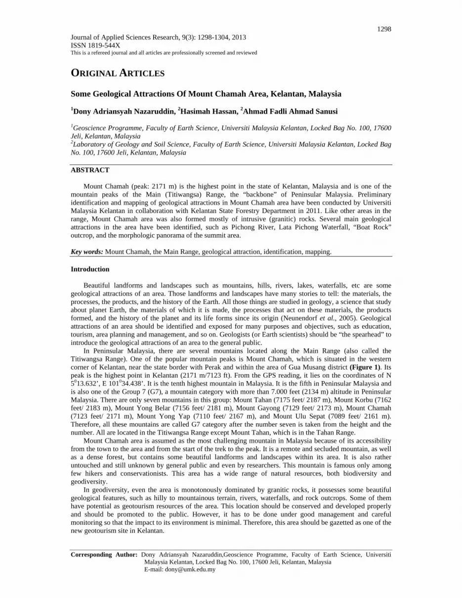
prominent mountain range which extends from southern Thailand in the north to Negeri Sembilan in the south with the elevations rarely less than 910 m and peaks of over 2,100 m (Raj, 2009). The morphology of Mount Chamah area is marked by the undulating hills with steep valley walls and sharp-crested ridges with the summit at elevation of 2171 m. Like other areas in the range, Mount Chamah area consists mostly of acid intrusive rocks (granitic rocks) with some enclaves of sedimentary and metamorphic rocks (Figure 2).
The rock units in the area are dominated by monotonous granitic rocks, representing the Main Range Granite (Figure 3). If we observe closer to the outcrops, granite in some areas here are coarse to very coarse grained (large phenocrysts, up to 7 cm). They are megacrystic granites and pegmatitic texture (Figure 4). This area is overlain by thick granitic soils (regolith), the weathering product of granitic rocks (Figure 5).
1300 J. Appl. Sci. Res., 9(3): 1298-1304, 2013
Fig. 2: Location map and geological map of Mount Chamah area and its surroundings.
Fig. 3: An outcrop of granitic rock in the Lata Pichong waterfall, Mount Chamah area.
Fig. 4: A megacrystic granite with coarse to very coarse grained (large phenocrysts, up to 7 cm) in the Lata Pichong waterfall, Mount Chamah area.

1301 J. Appl. Sci. Res., 9(3): 1298-1304, 2013
Fig. 5: The granitic soil (regolith) in Mount Chamah area. Geological Attractions Of Mount Chamah Area:
Eder and Patzak (2004) stated that many countries have started to develop schemes for recognizing
important geological and geomorphological sites or landscapes within their national boundaries. Such sites are important for educating the general public in geological and environmental matters. They also serve as tools for demonstrating sustainable development and for illustrating methods of site conservation whereby recalling that rocks, minerals, fossils, soils, landforms and landscapes are both the products and records of the evolution of our planet Earth.
The Mount Chamah area itself is one of the largest montane forests in Kelantan. Due to this, it is important for flora and fauna conservation. In addition to biotic elements, abiotic parts are also would become a subject of interest. Wonderful landforms such as the waterfall, the river, hilly to mountainous terrain, the interesting rock outcrop and so on would become attractions of this location. They are some geological features that make this area interesting and enjoyable. These geological attractions are potentials for geotourism resources.
Identification and mapping of geotourism resources in Mount Chamah area is still in the early stage and was done during the Explore Chamah 2011 programme, organized by Kelantan State Forestry Department in collaboration with Universiti Malaysia Kelantan. Some potential geotourism resources were identified, such as Lata Pichong Waterfall, Pichong River, “Boat Rock” outcrop, and morphologic panorama in the summit area. Map of geological attractions distribution in Mount Chamah area is shown in Figure 6. Earth scientists/geologists have some important roles to study all geological matters of the area and to expose and bring this information to the authorities and the public.
Fig. 6: Map of geological attractions distribution in Mount Chamah area.
1302 J. Appl. Sci. Res., 9(3): 1298-1304, 2013
Ibrahim Komoo (2000) elaborated in his paper regarding the conservation geology which is introduced to affect a paradigm shift in the geological community towards the utilization of geological resources and attractions without destruction. These kinds of resources/attractions need to be developed and managed based on the conservation concept for the benefit of the present society and future generations. According to Tjia Hong Djin (2000), Earth scientists/geologists can contribute to the sustained development of the area by identifying geological aspects and bringing this information to the knowledge of general public and the relevant authorities.
Some of the geological attractions in Mount Chamah area are as follow:
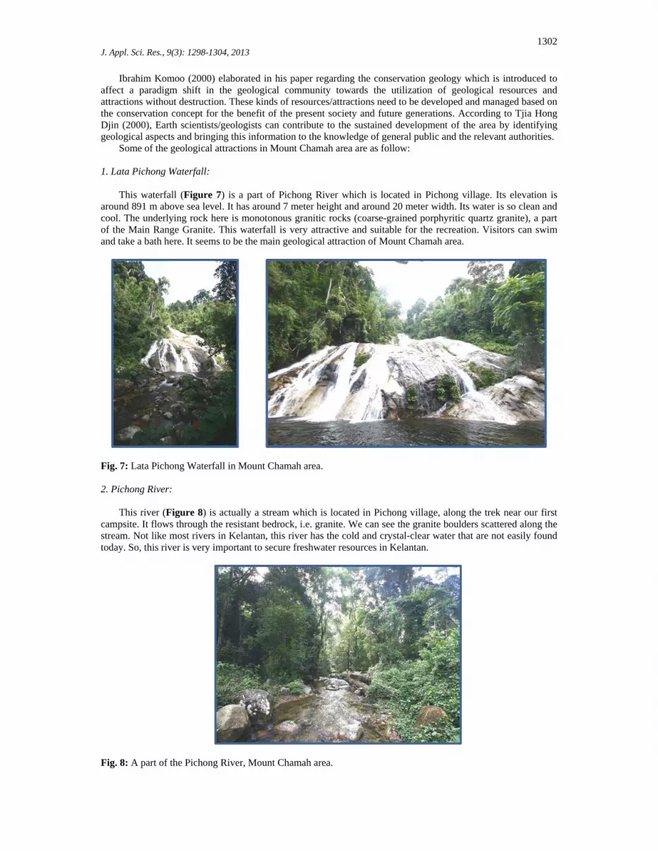
1. Lata Pichong Waterfall: This waterfall (Figure 7) is a part of Pichong River which is located in Pichong village. Its elevation is
around 891 m above sea level. It has around 7 meter height and around 20 meter width. Its water is so clean and cool. The underlying rock here is monotonous granitic rocks (coarse-grained porphyritic quartz granite), a part of the Main Range Granite. This waterfall is very attractive and suitable for the recreation. Visitors can swim and take a bath here. It seems to be the main geological attraction of Mount Chamah area.
Fig. 7: Lata Pichong Waterfall in Mount Chamah area. 2. Pichong River:
This river (Figure 8) is actually a stream which is located in Pichong village, along the trek near our first
campsite. It flows through the resistant bedrock, i.e. granite. We can see the granite boulders scattered along the stream. Not like most rivers in Kelantan, this river has the cold and crystal-clear water that are not easily found today. So, this river is very important to secure freshwater resources in Kelantan.
Fig. 8: A part of the Pichong River, Mount Chamah area.

1303 J. Appl. Sci. Res., 9(3): 1298-1304, 2013
3. “Boat Rock” Outcrop: Boat Rock (“Batu Perahu” in Malay) is actually a name given by staff of Kelantan State Forestry
Department to an outcrop of granitic rock in Mount Chamah area. This granite outcrop is unique because its shape is like a boat (Figure 9). It provides an example of the importance of geological interpretation at this unique phenomenon. Boat Rock is a 2.5-metre overhanging natural wall of granite which extends for a length of about 10 m. The granite is interpreted to undergo fracturing before some parts of it weathered. The weathered part of granite is then eroded by rain waters running off the exposed part. Here the rock was slowly dissolved. When the weathered and dissolved part of granite was removed due to erosion, a tilted and smooth slope was revealed. The outcrop looks like a boat until this time. The process occurred over a long period of time.
Fig. 9: (a) The side view of the “boat rock” outcrop; (b) the front view of the outcrop; and (c) A fisherman’s boat as a model or comparator. 4. Morphologic Panorama of the Summit Area:
It has always been a challenge to climb to the summit area of Mount Chamah. A hiker might be able to see
wild animal and other fauna and flora, whereas there are a lot mosses to the summit area. Moreover, it will be fun and enjoyable when a hiker arrived at the peak of the mount. They can see and enjoy beautiful panorama from the top such as the wonderful scenery of the Titiwangsa Range and some of its peaks. Some landforms which can be observed here such as mountains, undulating hills, mountain valleys, and hill slopes. This range is the result of some geological processes such as tectonic uplift and erosion that produced that mountainous range (Figure 10).
Fig. 10: Some morphologic panorama observed in the summit area of Mount Chamah.
1304 J. Appl. Sci. Res., 9(3): 1298-1304, 2013
Conclusion: Mount Chamah area presents some of interesting geological attractions in Kelantan. These are Lata Pichong
Waterfall, Pichong River, “Boat Rock” outcrop, and the morphologic panorama in the summit area of the mountain. Geologists could play an important role in identifying, mapping, and promoting the geological attractions of the area. Detail geological features and geological attractions mapping of Mount Chamah area are needed to be conducted.
The local and central governments need to build the supporting elements in the area, such as the proper roads (accessibility) and facilities for researchers, hikers, tourists and general public. The academics and researchers have to take a part in proposing attempts for conservation and development planning of the area, such as for the purpose of a new (geo)tourism destination in Kelantan. Acknowledgments
The Explore Chamah 2011 Programme was financially supported by the State Government of Kelantan,
Kelantan State Forestry Department, and Universiti Malaysia Kelantan. Thanks are also due to Mount Chamah villagers and all colleagues and researchers involved in the exploration.
References
Eder, F.W. and M. Patzak, 2004. Geoparks-geological attractions: A tool for public education, recreation and
sustainable economic development. Paris: UNESCO, Division of Earth Sciences. Ibrahim Komoo, 2000. Conservation Geology: A Multidisciplinary Approach in Utilization of Earth Resources
without Destruction. In: Ibrahim Komoo and Tjia, H.D. (ed.). Resource Development for Conservation and Nature Tourism. Geological Heritage of Malaysia. Bangi: LESTARI UKM.
Neunendorf, K.K.E., J.P.Jr. Mehl and J.A. Jackson, 2005. Glossary of Geology. 5th Ed. Alexandria: American Geological Institute.
Raj, J.K., 2009. Geomorphology. In: Hutchison, C.S. and Tan, D.N.K. (Eds) Geology of Peninsular Malaysia¸ 5-29. Kuala Lumpur: Geological Society of Malaysia.
Tjia, H.D., 2000. Geological Treasures of Malaysia. In: Ibrahim Komoo and Tjia, H.D. (ed.). Resource Development for Conservation and Nature Tourism. Geological Heritage of Malaysia. Bangi: LESTARI UKM.