Embed Size (px)
Citation preview

Barristers and Solicitors Wellington Solicitors Acting: Paul Beverley / David Randal Email: [email protected] Tel 64-4-499 4242 Fax 64-4-499 4141 PO Box 2694 DX SP20201 Wellington 6140
BEFORE A BOARD OF INQUIRY PEKA PEKA TO NORTH ŌTAKI EXPRESSWAY PROJECT
In the matter of the Resource Management Act 1991
And
In the matter of a notice of requirement and resource consent
applications by the NZ Transport Agency for the
Peka Peka to North Ōtaki Expressway Project
And
In the matter of a notice of requirement by New Zealand
Railways Corporation / KiwiRail Holdings Limited
(trading as KiwiRail) for the realignment of a
section of the North Island Main Trunk railway line
through Ōtaki
STATEMENT OF EVIDENCE OF SCOTT THOMAS LARNED (AQUATIC ECOLOGY) ON BEHALF OF THE APPLICANTS
12 July 2013

Page 1
TABLE OF CONTENTS
QUALIFICATIONS AND EXPERIENCE.................................................................... 2
BACKGROUND AND ROLE ..................................................................................... 2
SCOPE OF EVIDENCE ............................................................................................ 3
EXECUTIVE SUMMARY .......................................................................................... 4
EXISTING ENVIRONMENT ...................................................................................... 6
CONSTRUCTION EFFECTS, MITIGATION AND MONITORING ........................... 13
ROAD RUNOFF EFFECTS, MITIGATION AND MONITORING ............................. 16
FISH AND INVERTEBRATE PASSAGE EFFECTS, MITIGATION AND
MONITORING ........................................................................................................ 17
WATERWAY HABITAT LOSS AND ALTERATION EFFECTS, MITIGATION AND
MONITORING ........................................................................................................ 19
WETLAND HABITAT LOSS AND ALTERATION EFFECTS, MITIGATION AND
MONITORING ........................................................................................................ 26
RESPONSE TO COUNCIL / OTHER REPORTS ................................................... 26
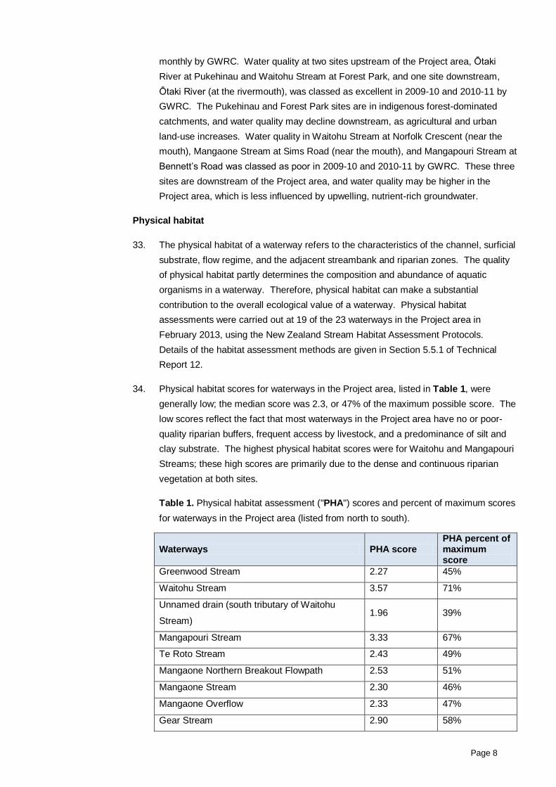
RESPONSE TO SUBMISSIONS ............................................................................ 31
CONCLUSION........................................................................................................ 36
ANNEXURE A: WATERWAYS IN THE PEKA PEKA TO NORTH ŌTAKI PROJECT
AREA ..................................................................................................................... 38
ANNEXURE B – OBSERVATIONS OF FISH SPECIES ......................................... 39
ANNEXURE C – ATTRIBUTES OF WATERWAYS ................................................ 40
ANNEXURE D – CULVERT/CHANNEL ALTERATION DETAILS ........................... 41

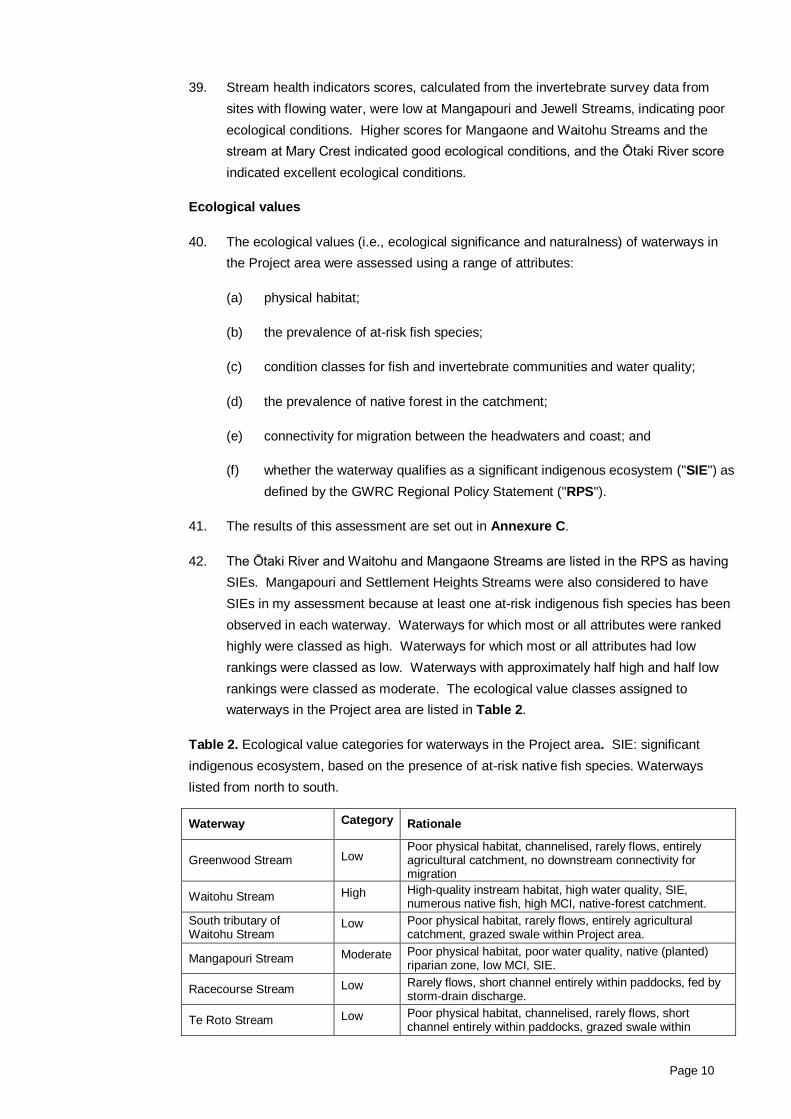
Page 2
QUALIFICATIONS AND EXPERIENCE
1. My name is Scott Thomas Larned.
2. I am a Principal Scientist in the Freshwater Ecology Group at the National Institute of
Water and Atmospheric Research ("NIWA") in Christchurch. I have been on the
science staff at NIWA since 2001.
3. I have the following qualifications and experience relevant to the evidence I shall give:
(a) BSc in Botany from Sonoma State University, California, MSc in Biology from
Humboldt State University, California, and PhD in Ecology from University of
Hawaii;
(b) 19 years of experience in aquatic ecology research and management;
(c) author of approximately 50 peer-reviewed science papers and book chapters
and 25 client reports on various issues in aquatic ecology and management;
and
(d) assessments of the potential environmental effects of numerous large
infrastructure developments, including hydro-electric schemes and large
irrigation schemes.
4. I am a member of the New Zealand Freshwater Sciences Society and Society for
Freshwater Science.
5. I confirm that I have read the 'Code of Conduct' for expert witnesses contained in the
Environment Court Practice Note 2011. My evidence has been prepared in
compliance with that Code. In particular, unless I state otherwise, this evidence is
within my sphere of expertise and I have not omitted to consider material facts known
to me that might alter or detract from the opinions I express.
BACKGROUND AND ROLE
6. My evidence is given in relation to the notices of requirement and resource consent
applications lodged by the NZTA and KiwiRail for the Peka Peka to North Ōtaki
Expressway (the "Expressway") and North Island Main Trunk ("NIMT") Railway
realignment (together, the "Project").
7. In preparing my evidence I have:
(a) gained detailed knowledge of the Project area through undertaking a number of
site visits between January 2011 and February 2013;
(b) reviewed Project documentation and plans, attended expert meetings and
workshops throughout the Project design and preparation of the designation;
and
(c) participated in a meeting and site visit with representatives of local iwi.
Page 3
8. I prepared Technical Report 12 Peka Peka to North Ōtaki - Aquatic Ecology, dated
March 2013 ("Technical Report 12") in volume 3 of the Assessment of Environmental
Effects Report ("AEE"). This report provides an assessment of the predicted effects of
the Project on stream biota, water quality and physical habitat.
9. In preparing my evidence NIWA scientists and I undertook the following surveys:1
(a) biological surveys in March 2011, July 2012 and February 2013, during which
the following surveys were carried out:
(i) qualitative fish surveys(electric fishing in 10 waterway reaches within the
Project area);
(ii) qualitative and quantitative aquatic invertebrate collections;
(iii) qualitative macrophyte surveys; and
(iv) a fish, aquatic invertebrate and macrophyte survey of the Ōtaki Railway
Wetland; and
(b) physical habitat surveys of 19 of the 23 waterways in accordance with the
Stream Habitat Assessment Protocols for Wadeable Rivers and Streams of
New Zealand.
10. In preparing my evidence I have referred to the evidence of Mr John Turner, Mr
Warren Bird, Dr Grant Webby and Mr David McKenzie, and on information in the
technical reports on landscape (Technical Report 8), hydrology (Technical Report 9),
stormwater (Technical Report 10), and terrestrial ecology (Technical Report 11).
11. I have contributed to the assessment and planning of a mitigation proposal for
offsetting effects of the Project on stream ecosystems. I also provided advice on the
proposed resource consent conditions, attached to the evidence of Ms Rebecca
Beals, and the Draft Ecological Management Plan ("Draft EMP"). An updated version
of the Draft EMP is attached to the evidence of Mr John Turner.
SCOPE OF EVIDENCE
12. My evidence addresses the following matters:
(a) the existing environment;
(b) the possible effects of Project construction on aquatic ecology, and the
proposed mitigation measures (including monitoring);
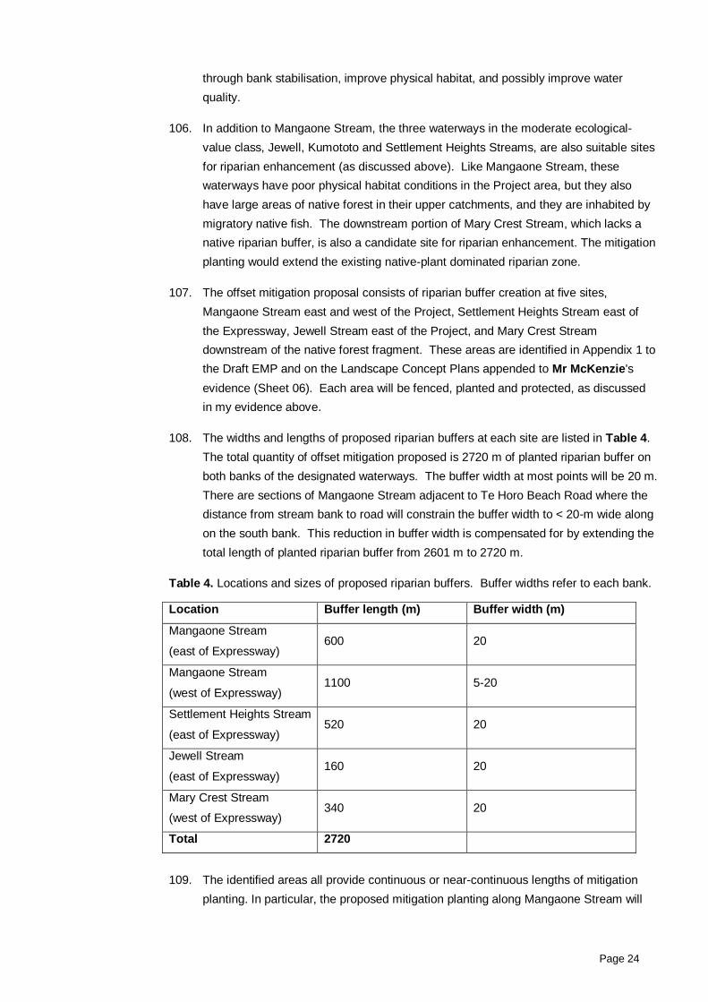
(c) the effects of the Project in terms of road runoff;
(d) effects on fish and invertebrate passage, and proposed mitigation;
(e) stream habitat loss and alteration arising from the Project, and proposed offset
mitigation; and
1 Further detail is set out in sections 5.5 and 5.6 of Technical Report 12.
Page 4
(f) wetland habitat loss and alteration arising from the Project, and proposed
mitigation.
EXECUTIVE SUMMARY
13. The Project is located on the Kāpiti plains west of the Tararua Range. The Project
crosses 12 large catchments and several smaller catchments, with 23 natural streams
and artificial drains. The largest waterway is the perennial Ōtaki River. The second
and third largest, Waitohu and Mangaone Streams, are near-perennial (rarely dry),
and the fourth largest, Mangapouri Stream, is spring-fed and perennial.
14. All other waterways in the Project area are intermittent, and in most of these
waterways the dry reaches are in or near the Project area. In addition, the Project will
affect approximately 0.5 ha of the 0.8 ha Ōtaki Railway Wetland, which is a significant
(due to the rareness of wetlands in the area) but highly modified wetland. This
wetland is assessed in more detail in the evidence of Mr John Turner.
15. All waterways in the Project area are modified in terms of riparian zones, channels,
flow regimes, and/or water quality. Most of the waterways are in grazed farmland,
with minimal or no riparian setback, minimal or no riparian shading, and riparian
vegetation composed of pasture grass and other non-native plants. Channel
modifications include realignment along roads and paddock boundaries, widening,
stop-banks and weirs, gravel extraction, and weed infestation. The flow regimes of
some waterways are affected by irrigation and stockwater abstraction. Water quality
in many waterways in the Project area is negatively affected by storm-drain discharge,
stock access, runoff from agricultural land and roads, bank erosion, and nitrate-rich
groundwater.
16. There are five potential adverse effects associated with the Project on aquatic
ecosystems. These are addressed individually below, the proposed mitigation and
conditions (including the Draft EMP) are summarised, and my overall conclusion as to
the effects of the Project on each is given.
17. Construction activities. Expressway construction poses risks of sediment and
contaminant input to waterways due to erosion, spills and leaks. In my opinion, the
effects of Expressway construction on aquatic ecology in the Project area will be low
and acceptable, for the following reasons.
18. Most (19 of 23) waterways in the Project area are intermittent and construction
activities will be concentrated into dry periods. Sediment yield to most waterways
(including all waterways with moderate and high ecological value) is predicted to be
low. The only catchments predicted to be at risk of high sediment yield are small, with
no defined channels and terminate in soakage areas or drains. Fish will be relocated,
and excluded, from construction areas. Best management practices will be used
regarding materials, vehicles and machinery. Erosion prevention and sediment
control measures (e.g., sediment detention systems) and monitoring protocols
(including pre-construction mudfish surveys), which are detailed in the Construction

Page 5
Environmental Management Plan ("CEMP") and Erosion and Sediment Control Plan
("ESCP"), will be implemented.
19. Road runoff. Road runoff from the Expressway poses risks of contaminant input to
waterways from vehicle and roadbed sources, and channel erosion due to water
drainage to channels with insufficient flow attenuation. In my opinion, the aquatic
ecology effects of contaminants in road runoff from the Project will be low and result in
a better aquatic ecology outcome than presently exists for SH1, for the following
reasons. Runoff from the Expressway will be treated in vegetated attenuation swales
and wetlands, in accordance with the 2010 NZTA Stormwater Treatment Standard for
State Highway Infrastructure. This is a higher level than currently exists for State
Highway 1 in the Project area, which lacks attenuation and treatment structures.
20. The erosive effects of runoff from the Expressway are likely to be minimal because:
(a) the surface area of new road that will intercept rainfall and generate runoff is
relatively small in relation to the catchment in the Project area;
(b) stormwater detention systems and attenuation swales will modulate drainage to
waterways; and
(c) the banks of channels that receive road runoff from drains will be protected with
rip-rap.
21. Fish and invertebrate passage. The presence of the Expressway creates a risk that
fish and invertebrate migration along waterways will be impeded. In my opinion, the
effects of the Expressway on migration will be low and acceptable for the following
reasons. At all locations where a known fish-bearing or a potential fish-bearing
waterway crosses the Expressway, fish passage will be provided. Potential fish-
bearing waterways include intermittent channels where no fish have been observed,
but connectivity to the coast indicates that the waterway could be used for migration.
22. Design features for fish passage structures will include embedded culvert inverts,
provision of low flow channels, baffles and resting areas, and angular rock substrate to
increase roughness. Permanent diversion channels will be designed to avoid any
velocity or structural barriers to fish passage; these diversion channels will be limited
to intermittent channels and swales that have low ecological value. Fish passage
structures and fish in all waterways and diversion channels will be monitored post-
construction (and will be monitored by an ecologist at one and four years after
construction). The fact that the Expressway will be perpendicular to waterway
channels in the Project area minimizes barriers to aerial invertebrate movement, and
the Ōtaki River and Waitohu Stream will be crossed with bridges that will not create
migration barriers.
23. Waterway habitat loss and alteration. The construction of the Expressway will lead
to some loss and alteration of waterway habitat due to culvert and rip-rap installation
and waterway diversion. In my opinion, the negative effects of waterway habitat loss
and alteration will be appropriately mitigated by a large-scale riparian restoration
Page 6
programme, and the residual negative effects will be low and acceptable, for the
following reasons:
(a) the offset mitigation proposal includes 2.6 km of riparian planting composed of
native trees and shrubs, in 20-m wide buffers on both banks where possible;
(b) the planting will be concentrated into five areas to maximise the ecological
benefits of long buffers;
(c) the riparian buffers will be fenced and provided with five years of inspection and
maintenance (including replacement of dead or damaged plants) to ensure
successful establishment and control insect pests and weeds; and
(d) the riparian buffers will be provided with long-term legal protection.
24. Offset mitigation through riparian restoration is appropriate for waterways in the
Project area, in my view, because the original riparian vegetation along the waterways
has been lost, and riparian planting has been shown to improve aquatic ecological
conditions in New Zealand streams.
25. Wetland habitat loss and alteration. Approximately 0.5 ha of the 0.8 ha Ōtaki
Railway Wetland will be filled to accommodate the Expressway. In my opinion, the
negative effects of the loss of wetland area will be appropriately mitigated by
construction of wetlands of greater area than the wetland area lost, and the residual
negative effects will be low and acceptable, for the following reasons:
(a) the Ōtaki Railway Wetland appears to contain few fish (by species and
abundance), and no rare aquatic invertebrate taxa;
(b) a wetland condition assessment indicated that the wetland is highly modified
and vulnerable to future degradation, independent of the Project's effects; and
(c) offset mitigation for the loss of the Railway Wetland will take the form of two
constructed wetlands of greater area (1.1 ha).
EXISTING ENVIRONMENT
Environmental setting
26. The Project is located on the Kāpiti plains west of the Tararua Range. On the
western, coastal, portion of the plains the predominant landforms are vegetated sand
dunes. On the eastern, inland, portion of the plains the predominant landforms are
alluvial fans and terraces deposited by rivers draining the Tararua Range. The
boundary between the inland and coastal plains from Ōtaki to Waikanae
approximately coincides with SH1.
27. The Project will cross 12 large catchments (each > 1 km2) and several smaller
catchments in the Project area. Three bridges and numerous culverts are to be
constructed at waterway (streams, drains and rivers) crossings. In addition, a
Page 7
depression containing the “Railway Wetland” near Ōtaki is to be mostly filled to
accommodate the Project.
28. There are 23 natural streams and artificial drains in the Project area, including
ephemeral swales and ephemeral tributaries of larger waterways. A map with the
locations of waterways in the Project area is attached as Annexure A. An inventory
of each waterway is contained within Section 5.2 of Technical Report 12. The largest
waterway is the perennial Ōtaki River. The second and third largest, Waitohu and
Mangaone Streams, are near-perennial (rarely dry), and the fourth largest,
Mangapouri Stream, is spring-fed and perennial. All smaller waterways in the Project
area are intermittent, and on most of these waterways the dry reaches are in or near
the Project area.
29. The natural streams in the Project area originate in the western Tararua Range
foothills and flow west across the plains toward the coast. As these streams cross the
inland portion of the plains, they lose flow by seepage to the underlying, poorly
confined aquifers. As they approach the coast, the streams shift from losing flow to
gaining flow from upwelling groundwater from the underlying confined and semi-
confined aquifers. Flow losses from small streams in the eastern plains causes them
to be intermittent for part of most years. Flow intermittence appears to be a natural
feature of many streams on the Kāpiti alluvial plain, and it has strong effects on
aquatic communities.
30. All waterways in the Project area are modified in terms of riparian zones, channels,
flow regimes, and/or water quality (see the inventory of each waterway in Section 5.2
of Technical Report 12). Most of the waterways are in grazed farmland, with minimal
or no riparian setback, minimal or no riparian shading, and riparian vegetation lacking
or composed of pasture grass and other non-native plants. Channel modifications
include realignment along roads and paddock boundaries, widening, stop-banks,
weed infestation and gravel extraction. The flow regimes of some waterways are
affected by irrigation and stockwater abstraction. Water quality in many waterways in
the Project area is negatively affected by storm drain discharge, stock access, runoff
from agricultural land and roads, bank erosion, and nitrate-rich groundwater.
31. With the exception of Mangapouri Stream and the stream near Mary Crest, riparian-
zone vegetation bordering streams in the Project area is composed entirely of non-
native species. Riparian vegetation at the Mangapouri Stream site in the Pare-o-
Matangi reserve is dominated by native trees and shrubs that were planted in a
restoration programme. The stream at Mary Crest flows through a native-bush
fragment and has a native species-dominated riparian zone for approximately half of
its 300 m length. The riparian vegetation at all other sites is composed of mixtures of
non-native grasses, forbs, shrubs and trees.
Water quality
32. Water quality is not currently monitored at waterways within the Project area.
However, several sites upstream and downstream of the Project area are monitored
Page 8
monthly by GWRC. Water quality at two sites upstream of the Project area, Ōtaki
River at Pukehinau and Waitohu Stream at Forest Park, and one site downstream,
Ōtaki River (at the rivermouth), was classed as excellent in 2009-10 and 2010-11 by
GWRC. The Pukehinau and Forest Park sites are in indigenous forest-dominated
catchments, and water quality may decline downstream, as agricultural and urban
land-use increases. Water quality in Waitohu Stream at Norfolk Crescent (near the
mouth), Mangaone Stream at Sims Road (near the mouth), and Mangapouri Stream at
Bennett’s Road was classed as poor in 2009-10 and 2010-11 by GWRC. These three
sites are downstream of the Project area, and water quality may be higher in the
Project area, which is less influenced by upwelling, nutrient-rich groundwater.
Physical habitat
33. The physical habitat of a waterway refers to the characteristics of the channel, surficial
substrate, flow regime, and the adjacent streambank and riparian zones. The quality
of physical habitat partly determines the composition and abundance of aquatic
organisms in a waterway. Therefore, physical habitat can make a substantial
contribution to the overall ecological value of a waterway. Physical habitat
assessments were carried out at 19 of the 23 waterways in the Project area in
February 2013, using the New Zealand Stream Habitat Assessment Protocols.
Details of the habitat assessment methods are given in Section 5.5.1 of Technical
Report 12.
34. Physical habitat scores for waterways in the Project area, listed in Table 1, were
generally low; the median score was 2.3, or 47% of the maximum possible score. The
low scores reflect the fact that most waterways in the Project area have no or poor-
quality riparian buffers, frequent access by livestock, and a predominance of silt and
clay substrate. The highest physical habitat scores were for Waitohu and Mangapouri
Streams; these high scores are primarily due to the dense and continuous riparian
vegetation at both sites.
Table 1. Physical habitat assessment ("PHA") scores and percent of maximum scores
for waterways in the Project area (listed from north to south).
Waterways PHA score PHA percent of maximum score
Greenwood Stream 2.27 45%
Waitohu Stream 3.57 71%
Unnamed drain (south tributary of Waitohu
Stream) 1.96 39%
Mangapouri Stream 3.33 67%
Te Roto Stream 2.43 49%
Mangaone Northern Breakout Flowpath 2.53 51%
Mangaone Stream 2.30 46%
Mangaone Overflow 2.33 47%
Gear Stream 2.90 58%

Page 9
Unnamed drain (Northern tributary of Settlement
Heights Stream) 2.20 44%
Settlement Heights Stream 1.71 34%
Coolen Stream 2.03 41%
Avatar Stream 3.27 65%
Edwin Stream 2.83 57%
Jewell Stream 3.12 62%
Cording Stream 2.50 50%
Unnamed drain north of Awatea Stream 1.73 35%
Awatea Stream 2.13 43%
Kumototo Stream 2.10 42%
Aquatic biota
Fish
35. At least one native, migratory fish was caught in nine out of 10 waterways surveyed in
the Project area in March 2011 and July 2012. Details of the fish survey methods are
given in Section 5.6.1 of Technical Report 12.
36. A total of 16 native fish species, of which 13 are migratory and three are naturalised
non-native species, have been reported from the Project area in the New Zealand
Freshwater Fish Database ("NZFFDB"). Observations from all sources of fish species
in the Project area are listed in Annexure B. The Ōtaki River and Waitohu and
Mangaone Streams are each inhabited by several species of native fish with poor
climbing abilities (e.g., giant kokopu). Longfin eels were the only fish species
observed in Mangapouri Stream.
37. Based on the presence of migratory fish in numerous intermittent waterways, it is
predicted that:
(a) fish migrate through the intermittent reaches when flow is present; and
(b) each waterway that crosses the Project, and that drains a catchment extending
from the coast to the Tararua foothills, is a migration route for one or more
native fish species.
Invertebrates
38. A total of 83 aquatic invertebrate taxa were found in the nine waterways surveyed in
the Project area in March 2011 and July 2012. An additional 32 invertebrate taxa
were collected from seeps and in light boxes in otherwise dry channels in February
2013. Details of the invertebrate survey methods are given in Section 5.6.1 of
Technical Report 12. None of the taxa collected during field surveys in the Project
area were classified as threatened in the Department of Conservation list of New
Zealand freshwater invertebrates for which a conservation status has been
determined.
Page 10
39. Stream health indicators scores, calculated from the invertebrate survey data from
sites with flowing water, were low at Mangapouri and Jewell Streams, indicating poor
ecological conditions. Higher scores for Mangaone and Waitohu Streams and the
stream at Mary Crest indicated good ecological conditions, and the Ōtaki River score
indicated excellent ecological conditions.
Ecological values
40. The ecological values (i.e., ecological significance and naturalness) of waterways in
the Project area were assessed using a range of attributes:
(a) physical habitat;
(b) the prevalence of at-risk fish species;
(c) condition classes for fish and invertebrate communities and water quality;
(d) the prevalence of native forest in the catchment;
(e) connectivity for migration between the headwaters and coast; and
(f) whether the waterway qualifies as a significant indigenous ecosystem ("SIE") as
defined by the GWRC Regional Policy Statement ("RPS").
41. The results of this assessment are set out in Annexure C.
42. The Ōtaki River and Waitohu and Mangaone Streams are listed in the RPS as having
SIEs. Mangapouri and Settlement Heights Streams were also considered to have
SIEs in my assessment because at least one at-risk indigenous fish species has been
observed in each waterway. Waterways for which most or all attributes were ranked
highly were classed as high. Waterways for which most or all attributes had low
rankings were classed as low. Waterways with approximately half high and half low
rankings were classed as moderate. The ecological value classes assigned to
waterways in the Project area are listed in Table 2.
Table 2. Ecological value categories for waterways in the Project area. SIE: significant
indigenous ecosystem, based on the presence of at-risk native fish species. Waterways
listed from north to south.
Waterway Category Rationale
Greenwood Stream Low Poor physical habitat, channelised, rarely flows, entirely agricultural catchment, no downstream connectivity for migration
Waitohu Stream High High-quality instream habitat, high water quality, SIE, numerous native fish, high MCI, native-forest catchment.
South tributary of Waitohu Stream
Low Poor physical habitat, rarely flows, entirely agricultural catchment, grazed swale within Project area.
Mangapouri Stream Moderate Poor physical habitat, poor water quality, native (planted) riparian zone, low MCI, SIE.
Racecourse Stream Low Rarely flows, short channel entirely within paddocks, fed by storm-drain discharge.
Te Roto Stream Low Poor physical habitat, channelised, rarely flows, short channel entirely within paddocks, grazed swale within
Page 11
Project area.
Ōtaki River High High-quality instream habitat, high water quality, SIE, numerous native fish, high MCI, native-forest catchment.
Mangaone Northern Breakout Flowpath
Low Poor physical habitat, channelised, rarely flows, short channel entirely within paddock, grazed swale within Project area.
Mangaone Stream High Poor physical habitat and poor water quality, numerous native fish species, SIE, high MCI, native-forest catchment.
Mangaone Overflow Low Poor physical habitat, channelised, rarely flows, short channel entirely within paddock, grazed swale within Project area.
School Stream Low Channelised, rarely flows, some native forest in upstream catchment, no downstream connectivity for migration.
Gear Stream Low Moderate physical habitat, channelised, rarely flows, some native forest in upstream catchment, minimal downstream connectivity for migration.
North tributary of Settlement Hts Str
Low Poor physical habitat, channelised, rarely flows, short channel within paddock.
Settlement Heights Stream
Moderate Poor physical habitat, channelised, rarely flows, some native forest in upstream catchment, SIE.
Coolen Stream Low Poor physical habitat, channelised, rarely flows, short channel entirely within paddock.
Avatar Stream Low Poor physical habitat, channelised, rarely flows, short channel entirely within paddock.
Mary Crest High SIE, native plant-dominated riparian zone, high MCI.
Edwin Stream Low Poor physical habitat, channelised, rarely flows, short channel entirely within paddock, grazed swale within Project area.
Jewell Stream Moderate Large catchment, predominately native forest land cover upstream of Project area, low MCI, at least one native fish.
Cording Stream Low Poor physical habitat, channelised, rarely flows, short channel entirely within paddock.
Unnamed drain N of Awatea Stream
Low Poor physical habitat, channelised, rarely flows, short channel entirely within paddock, grazed swale within Project area.
Awatea Stream Low Poor physical habitat, upstream catchment is predominately native forest.
Kumototo Stream Moderate Poor physical habitat, at least shortfin eels present, some native forest in upstream catchment.
43. Four waterways were classed as high in ecological value: Waitohu, Mangaone and
Mary Crest Streams and the Ōtaki River. These waterways are perennial or near-
perennial, inhabited by at-risk native fish, and have moderate to high numbers of
pollution-sensitive invertebrates. Physical habitat and riparian zone composition in
these four waterways do not all score highly, but these conditions can be improved
through restoration efforts, including mitigation measures proposed for the Project
(discussed further below).
44. Mangaone Stream in particular is highly degraded in terms of physical habitat and
water quality. However, the abundance of native fish species, the high-diversity
invertebrate fauna (with a high proportion of taxa from the pollution-sensitive orders
Ephemeroptera, Plecoptera and Trichoptera), and the large proportion of upstream
catchment in native forest landcover make Mangaone Stream a prime candidate for
restoration.
Page 12
45. Four waterways were classed as moderate in ecological value. Three are intermittent
(Settlement Heights, Jewell and Kumototo Streams) and the fourth is perennial
(Mangapouri Stream). All four waterways are likely to function as migration pathways
during flowing periods, as indicated by the presence of one or more native migratory
fish during the field survey. Three of these waterways have some native forest
landcover in the upstream catchment. Mangapouri Stream lacks native forest
landcover in most of the catchment, but that is partially compensated for by the
presence of several thousand native trees and shrubs that have been planted in the
riparian zone of the Pare-o-Matangi reserve. Settlement Heights, Jewell and
Kumototo Streams are partially or entirely unfenced in the Project area, and stock
access appears to be a contributing factor in habitat degradation.
46. The remaining 15 waterways were classed as having low ecological value. These
waterways are intermittent, with straightened or entirely artificial channels, highly
degraded physical habitat, and most lack connectivity required for upstream (e.g. Te
Roto and Avatar Stream) or downstream (e.g., Greenwood and School Streams)
migrations by diadromous fish (fish that migrate between marine and freshwater
environments). Several of these waterways are soil-filled swales that are not
distinguished from surrounding farmland in terms of grazing, mowing and other
farming activities. With the exception of Avatar Stream, and the unnamed drain north
of Settlement Heights Stream, all of the low-value waterways are partially or entirely
unfenced in the Project area.
Ōtaki Railway Wetland
47. The 0.8 hectare “Ōtaki Railway Wetland” will be affected by the Project. This wetland
is adjacent to the NIMT corridor, north of Ōtaki and immediately west of SH1.
48. The physical and biological condition of the Ōtaki Railway Wetland was assessed in
Technical Report 11 and is addressed in the evidence of Mr John Turner. The
wetland condition score was low, which reflects substantial modification of wetland
hydrology and vegetation. The wetland receives piped stormwater from neighbouring
residential areas. Wetland drainage is impeded by railroad and road embankments;
parts of the wetland are used for grazing livestock, and the wetland is vegetated with a
mixture of native and invasive non-native vegetation.
49. Two shortfin eels were the only fish caught in an overnight trapping survey of the Ōtaki
Railway Wetland. A total of 26 invertebrate taxa were collected in the wetland during
the same survey. The numerically dominant taxa were midges, oligochaete worms
and copepods. None of the invertebrate taxa in the wetland are rare in New Zealand,
and the community was similar to those of other low-elevation wetlands of the Kāpiti
Coast and elsewhere in the North Island. The submerged, floating and emergent
macrophytes in the wetland were dominated by non-native species and a few
widespread native species; no rare macrophytes were observed.

Page 13
CONSTRUCTION EFFECTS, MITIGATION AND MONITORING
Construction effects
50. During Project construction, activities on and near stream banks and in channels,
including excavation, filling, installation of culverts, bridges and fords and stream-
channel realignment, may increase sediment input to waterways. Construction
activities also create a risk of contaminants spills and leaks that reach waterways.
Sediment input to waterways is a primary potential environmental concern during
construction because earthworks create a risk of increased sediment yield over
natural rates, and elevated sediment inputs have numerous adverse ecological
effects.
51. Soft-bottomed streams, as predominantly found in the Project area, typically contain
species tolerant of sediment deposition. This is especially so as most waterways in
the Project area have stock access.
52. To assess the risk of elevated sediment input to waterways during construction,
sediment yield was estimated for each catchment in the Project area during the
construction period and the current (background) period. Sediment yields were
estimated with an empirical model, the Universal Soil Loss Equation ("USLE"). Details
of the USLE and its application to the Project area are given in the Draft Erosion and
Sediment Control Plan ("ESCP") and the evidence of Mr Warren Bird.
53. Results of USLE calculations for the Project area indicate that estimated increases in
sediment yield due to construction are low for 17 out of 21 catchments. Predicted
yields for these 17 catchments ranged from < 0.1 to 13.8% above background.
Notably, the catchments of waterways with high ecological value in Table 2, the Ōtaki
River and Waitohu and Mangaone Streams, are predicted to have very low
construction sediment yields (≤ 0.2% above background).
54. In the four remaining catchments, sediment yields are predicted to be higher
compared with background, ranging from 22.0 to 79.8% above background. The
catchments are Te Manuao, Andrews 1 and 2, and Cavallo. These catchments are
very small (4.5-35.2 ha), they have no defined channels and they terminate in
soakage areas or drains. Therefore, in my opinion, the effect of construction sediment
input to these waterways on ecological values is low.
55. In addition to risks of sediment and contaminant input, construction activities in
channels may impede flow or require flow diversion, which may in turn affect fish that
inhabit the construction area or are moving through the area. Mitigation for these
effects is discussed in the following section.
Construction mitigation
56. The Draft ESCP outlines best management practices ("BMPs") with respect to
temporary construction activities, and lists specific erosion and sediment control
practices that will be employed during Project construction. In addition to BMPs for
Page 14
general construction activities, guidelines for protecting waterways from adverse
effects of construction are set out in Section 4.5 of the Draft EMP.
57. In perennial streams, instream works that partially impede flow can be undertaken
during migration periods if appropriate fish passage is provided around the works.
Instream works that fully divert flow or block fish movements should, when possible,
be concentrated into periods outside of the peak migration. The proposed conditions
stipulate that any work that will occur in the wetted channel outside of the period 1
March to 31 July will require a specific programme and methodology to manage
migration of native fish during peak migration periods (prepared in consultation with
GWRC).
58. Periods of complete flow diversion and dewatering should be preceded by fish
collection and relocation to unaffected reaches (commonly referred to as “fish
rescue”), under the supervision of a fish biologist. Fish rescue will also apply to the
construction of permanent diversion channels, if they are constructed during flowing
periods when fish are present. This requirement is unlikely to arise, as all permanent
diversion channels are planned for intermittent waterways. A fish rescue and
relocation plan consisting of collection, housing and relocation procedures will be
developed as set out in Section 7 of the Draft EMP.
59. Based on the combination of erosion and sediment control measures, construction
and post-construction monitoring (discussed below), fish rescue and relocation, and
the low risk of elevated sediment input to waterways with high ecological values, the
effects of Project construction on waterways are expected to be low and acceptable.
Monitoring
60. Monitoring requirements to assess the effects of construction activities on waterways
are summarised below. Section 8.2 of the Draft EMP sets out the monitoring
proposed for the Project, as required by the proposed conditions.
61. Pre-construction monitoring will be carried out at the Ōtaki River and Waitohu Stream,
as set out in the evidence of Mr Bird and in section 8.2.1 of the Draft EMP, to
establish background variability between the upstream and downstream monitoring
sites. In addition visual assessments of the flow frequency of the Jewell, Kumototo or
Settlement Heights Streams will occur as set out in section 8.2.1 of the Draft EMP.
The intermittent waterway selected for construction monitoring will be the one with the
greatest frequency of flow, to facilitate monitoring schedules.
62. Construction-phase ecological monitoring will be carried out at the Ōtaki River and
Waitohu, Mangapouri and Mangaone Streams, and at the chosen intermittent
waterways in the moderate ecological-value class (Jewell, Kumototo or Settlement
Heights Streams). The intermittent streams will be monitored during periods when
flowing water is present.
63. Turbidity will be used as the key indicator for monitoring construction effects
associated with suspended sediment (as set out in the proposed conditions and
Page 15
section 8.2.2 of the Draft EMP), and trigger levels for construction effects will be based
on turbidity. Turbidity is a well recognised and widely used indicator. Naturally
occurring exceedances of turbidity triggers act as “false positives” or false alarms that
require costly responses and investigation. The proposed trigger level outlined in the
conditions, Draft EMP and the evidence of Mr Warren Bird is:
(a) For the Mangapouri and Mangaone streams and the chosen intermittent
waterway (one of Jewell, Kumototo or Settlement Heights Streams) the
proposed trigger level is a 50% or greater increase in turbidity (as
nephelometric turbidity units (NTU)) between upstream and downstream
monitoring sites, when the downstream turbidity exceeds 5 NTU.
(b) For the Ōtaki River and Waitohu Stream the proposed trigger level is also a
50% or greater increase in turbidity (as nephelometric turbidity units (NTU))
between the upstream and downstream monitoring sites, when the downstream
turbidity exceeds 5 NTU, but it is indicative only until the pre-construction
monitoring identifies the background turbidity variations. The final turbidity
trigger for these waterways (and a report on the monitoring results supporting
the final turbidity trigger level as required in section 8.2.1 of the Draft EMP) will
be included in sections 8.2.2 and 9.1 of the Draft EMP.
64. I acknowledge that the proposed 50% trigger level differs from approaches (not yet
trialled) proposed for other NZTA projects (e.g., the proposed trigger for the MacKays
to Peka Peka project is a 20% increase from upstream to downstream sites). The
50% trigger level is proposed as a compromise between lower trigger levels, which
may occur frequently due to natural variation in turbidity between monitoring sites, and
higher trigger levels, which could allow adverse effects on aquatic biota to occur
undetected.
65. Although there is a higher risk of undetected suspended sediment pulses using a 50%
trigger level in lieu of a lower level, I consider the proposed 50% trigger to be
appropriate for aquatic ecology in the Project area because:
(a) the USLE monitoring estimated a low sediment yield for 17 out of 21
catchments (as noted above); and
(b) the 4 catchments with high predicted sediment yields have low ecological value
as they are very small, have no defined channels and terminate in soakage
areas or drains.
66. If trigger levels are exceeded during construction, and the exceedance is attributed to
construction activities (through comparisons of conditions upstream and downstream
of the construction area), several responses are required as set out in the proposed
conditions and the Draft EMP (section 9.1). This comprehensive suite of actions
includes audits of erosion and sediment control measures, follow-up invertebrate
sampling, and remedial and mitigation measures.
Page 16
Construction-phase monitoring
67. Turbidity monitoring (as discussed above) will take place in phase with construction
activities, i.e., when construction is underway near a major waterway, the waterway
will be monitored until the construction is complete.
68. In addition to turbidity, five other variables will be monitored at the five monitoring
sites, starting in the construction phase: fine and coarse sediment deposits and oil-
and-grease will be monitored monthly; and aquatic macroinvertebrates and fish will be
monitored quarterly. In addition, spot monitoring will be triggered by unscheduled
events such as spills and construction accidents. Details of the monitoring variables,
their purposes and standardised monitoring procedures are set out in Section 8.2.2 of
the Draft EMP.
Post-construction monitoring
69. Post-construction monitoring of water quality and biotic communities is recommended
for a two-year period. Post-construction monitoring will employ the paired sites on
each of the five waterways listed above for construction monitoring. Quarterly
monitoring of fine sediment deposits, aquatic macroinvertebrates and fish is proposed.
The two-year period should be followed by a review to determine whether remedial
measures are needed, or continued monitoring is necessary. These details, and
monitoring methods, are set out in section 8.2.3 of the Draft EMP.
70. Aquatic ecological conditions will be monitored at the remnant Ōtaki Railway Wetland,
constructed Kennedy and Mary Crest wetlands for three years after their completion to
ensure that the wetlands achieve a level of aquatic ecological condition equal to that
of established wetlands. Aquatic invertebrates in quarterly replicate samples will be
used as the indicators of ecological condition. These monitoring requirements are set
out in section 8.2.3 of the Draft EMP.
ROAD RUNOFF EFFECTS, MITIGATION AND MONITORING
71. Road runoff can transport contaminants to receiving streams and can cause increased
channel erosion. The contaminants in road run-off include metals, hydrocarbons,
nutrients, dissolved and particulate organic matter, and other materials from vehicle
tyres, bodies, engines, cargoes and exhaust, and road bitumen and paint. These
contaminants have the potential to affect aquatic organisms through direct toxicity, or
indirectly, by altering stream pH or reducing dissolved oxygen. Erosion problems
occur when a large proportion of storm runoff is routed by road drainage systems into
channels with insufficient flow attenuation.
72. In all but the largest storms, all runoff from the Expressway is to be treated in
vegetated attenuation swales, dry ponds and wetlands. These structures reduce or
prevent the transport of contaminants from the road to waterways by physical and
biological uptake and degradation. Details of the locations and designs of these
structures are set out in the evidence of Mr Warren Bird (and in Technical Report 10
– Assessment of Stormwater Effects). Road runoff from the Expressway is to be

Page 17
treated to meet the 2010 NZTA Stormwater Treatment Standard for State Highway
Infrastructure. This is a higher treatment level than currently exists at SH1, which
lacks attenuation and treatment structures.
73. A large proportion of the traffic that currently uses SH1 will shift to the Expressway
when it is completed. This shift means that most road runoff associated with traffic will
be treated by the Expressway detention and attenuation systems. As a result,
contamination of waterways from road runoff in the Project area is expected to
decrease from current levels and the Expressway will have a net positive effect on
road runoff water quality.
74. The erosive effects of road runoff from the Expressway are likely to be minimal for
three reasons. First, the surface area of new road that will intercept rainfall and
generate runoff is relatively small, in relation to the relevant catchment areas as a
whole. Second, stormwater detention systems and attenuation swales will modulate
drainage to streams. Third, the banks of stream channels that receive road runoff
from drains will be protected with rip-rap.
FISH AND INVERTEBRATE PASSAGE EFFECTS, MITIGATION AND MONITORING
Fish and invertebrate passage effects
75. Most of the native fish in the Project area undertake upstream and downstream
migrations between the sea and the upstream reaches used for spawning, rearing,
and adult stages. Migration barriers can cause local fish population reduction or loss,
or create disjunct populations and reduce or eliminate gene flow. The culverts that will
cross the Project could be potential migration barriers, unless they are designed to
facilitate fish passage.
76. The abilities of New Zealand migratory fish to traverse barriers differ among species
and life-history stages. Information about the fall heights, culvert lengths and grades,
and water depths and velocities that different species and life-stages can traverse is
limited. In addition, there is often incomplete knowledge of the migratory species that
inhabit a catchment and require migration routes. To avoid these effects, the fish
passage designs to be used are suitable for weak-swimming and poor-climbing fish
such as juvenile inanga. These designs will also be protective for other species and
juvenile stages.
Fish and invertebrate passage mitigation
77. Each waterway that crosses the Project, and that drains a catchment extending from
the coast to the Tararua foothills, is predicted to be migration route for one or more
native fish species. This prediction is based on the observation that native, migratory
fish were found in eight such waterways near SH1. The fact that most of the streams
have intermittent reaches at SH1 does not preclude their use by native fish; migrations
between upstream tributaries and the coastal plain must occur during flowing periods.
Page 18
78. A total of 17 waterways and two wetlands in the Project area are predicted to be fish
migration routes. The remaining waterways are very short, lack defined channels
and/or lack any connection to upstream tributaries or to the coast (either directly or via
other waterways). These waterways do not require fish passage as they are not
migration routes.
79. All known and all predicted fish migration routes in the Project area will be provided
with effective fish passage as part of Project mitigation. On 15 waterways and two
wetlands, culverts will be designed for fish passage (see Annexure D). Permanent
diversion channels will also designed to avoid velocity or structural barriers to fish
passage as set out in the proposed conditions and Section 4.9 of the Draft EMP. All
permanent diversion channels will replace sections of intermittent waterways, drains
and swales that are currently in poor ecological condition. The Ōtaki River and
Waitohu Stream will be crossed with bridges which will not create migration barriers.
80. Details of appropriate culvert and fish passage designs are set out in the evidence of
Mr Bird (and in Technical Report 10 – Assessment of Stormwater Effects). Design
features include embedding the culvert inverts, provision of low flow channels, baffles
and resting areas, and increasing the roughness of the low flow channel with angular
rock substrate (see Section 4.8 of the Draft EMP). In the absence of complete
knowledge of the migratory fish that pass through the Project area, fish passage will
be designed to accommodate species with poor climbing ability and non-climbers.
81. With the provision of effective fish passage under the Project at all streams used for
migration, and post-construction monitoring to ensure that fish-passage culverts
function properly (as discussed above), the effects of the Project on fish migration and
invertebrates are expected to be low and acceptable.
Fish and invertebrate monitoring
82. Inadequate culvert maintenance is a major cause of fish passage problems.
Inspections of the 17 fish-passage culverts will be carried out by qualified ecologists
one and four years after installation. These inspections are set out in the proposed
conditions and the Draft EMP (Section 8.2.3).
83. After the four-year inspection, on-going visual inspections of the 17 fish passage
culverts will be linked to the maintenance programme and aimed at removing
obstructions, preventing scour and bank erosion, and repairing structures as
necessary as set out in the Draft EMP.
84. In addition to culvert inspections, fish will be monitored upstream and downstream of
the Project at quarterly intervals for two years after construction (see Section 8.2.3 of
the Draft EMP). The purpose of the culvert and fish monitoring is to ensure that fish
passage through Project culverts is effective and to trigger repairs or alterations if
required.
Page 19
WATERWAY HABITAT LOSS AND ALTERATION EFFECTS, MITIGATION AND
MONITORING
Waterway habitat loss and alteration effects
85. Habitat loss and alteration associated with the Project will be caused by the
installation of culverts, concrete aprons and rip-rap, by channel diversion, and by the
loss of most of the Ōtaki Railway Wetland. Since most waterways in the Project area
will cross the Project at approximately right angles, the total length of new culverts and
modified banks will be small relative to stream length. Bridges where the Expressway
crosses the Ōtaki River and Waitohu Stream are not considered to represent habitat
loss, because natural channels and flows will be retained at these sites.
86. The total length of new culverts for the Project is 1,214 m (as shown in Annexure D).
The lengths of individual culverts planned for waterways in the Project area range
from approximately 16 m to 120 m (as shown in Annexure D). For most waterways,
the culverts will occupy a very small proportion of the total length of stream channel.
87. At most stream crossing points, the stream channel will be altered upstream and
downstream of the Project by headwall aprons and rip-rap. At several sites, channels
will be realigned to direct water to culverts and reduce flood risks. The length of
altered channel associated with aprons, rip-rap and realignment or permanent
diversion totals 1,520 m in the Project area, and the lengths of altered channel in
individual waterways range from 0 to 500 m (see Annexure D).
88. The total length of new waterway works (culverts, permanent diversions and rip-rap)
by the Project is 2,734 m (see Annexure D). This distance has reduced from the
2,834 m I used in Technical Report 12 to develop the proposed mitigation package
because of an error of 100m identified in the evidence of Mr Bird (which is discussed
in paragraph 94(b) below). For the reasons explained in paragraph 94 below I have
however maintained the same offset mitigation length in the mitigation proposal.
Waterway habitat loss and alteration mitigation
89. Since some waterway habitat loss and alteration is unavoidable, and onsite mitigation
not possible, the best approach for mitigating adverse effects is offset mitigation.
Offset mitigation is used to counteract negative environmental effects at one point with
environmental improvements at another point.
90. A simple, systematic approach was used to evaluate offset mitigation requirements for
the loss and alteration of waterway length associated with the Project. This approach
combined:
(a) the ecological value classes in Table 2;
Page 20
(b) the lengths of new waterway works (2,834 m)2 (that is, the sum of the lengths of
new culverts, permanent diversions and rip-rap and aprons); and
(c) simple environmental offset mitigation ratios (Table 3).
91. Rip-rap and rock armouring can provide beneficial habitat for fish, invertebrates, algae
and bryophytes. This is especially so for the soft bottomed waterways that
predominate in the Project area. Therefore, although included within the total length
of waterway mitigation required, this is a conservative approach due to the potential
aquatic ecology benefits that hard substrate can provide.
92. As can be seen from Annexure C, the ecological values were identified using multiple
ecological criteria including:
(a) physical habitat;
(b) the prevalence of at-risk fish species;
(c) condition classes for fish and invertebrate communities and water quality;
(d) the prevalence of native forest in the catchment;
(e) connectivity for migration between the headwaters and coast; and
(f) whether the waterway qualifies as a SIE as defined by the RPS.
93. These criteria were used without weighting to group waterways into the ecological
value categories in Table 2 and to support the proposed mitigation ratios and riparian
planting lengths. In my opinion, this approach is appropriate, transparent and robust.
As explained above, the mitigation approach I have taken utilised the total length of all
new waterway works (culverts, permanent diversions and rip-rap) rather than the
length of existing waterway affected. The evidence of Mr Bird, in response to issues
raised by the GWRC, sets out the length of existing waterways affected by the Project
as 2,552 m, which is less than the 2,834 m length of the new waterway works I used.
94. In completing my evidence two errors in the calculation of the required mitigation
lengths have been identified. These are:
(a) A 110-m diversion in the Settlement Heights catchment was inadvertently
attributed in Technical Report 12 to the moderate ecological-value Settlement
Heights Stream rather than to an unnamed, low ecological-value farm drain that
joins Settlement Heights Stream at SH1 (Table 2). I can confirm that the
unnamed drain will be permanently diverted, not Settlement Heights Stream.
This error resulted in an additional 88 m of riparian mitigation being proposed.
This is a small additional length and I have recommended that it is retained in
the present proposed mitigation length of 2,601 m (which exceeds the total
length of waterway affected by the Project). Therefore, Annexure D and Table
2 This mitigation length is 100 m longer than set out in Annexure C (2,734 m) due to an error in Appendix 10D to
the Stormwater Technical Report 10, as explained in the evidence of Mr Bird. The total disturbed length of the Racecourse stream was initially calculated at 220 m rather than 120 m.
Page 21
3 keep the same distances and mitigation requirements as in Technical Report
12 but I have footnoted the correct reference to the unnamed northern tributary.
(b) The calculation of the length of disturbed waterway in Appendix 10D of
Technical Report 10 contained an error in the length of the Racecourse Stream.
The measurement should have been 120 m rather than 220 m. This error
resulted in an additional 77 m of riparian mitigation being proposed. This also is
a small additional length and I have recommended that it is retained in the
present proposed mitigation length of 2,601 m (which exceeds the total length
of waterway affected by the Project). In my opinion this length should be
retained. Therefore, while the lengths disturbed for the Racecourse culvert in
Annexure D and Table 3 have been corrected to 120m, the proposed length of
offset mitigation in Table 3 has kept the same distance as in Technical Report
12 (154 m). The cumulative effect of the two errors listed here (for the
Settlement Heights tributary and Racecourse Stream) is the addition of 165m of
riparian planting on both banks to the mitigation proposal.
Table 3. Linear mitigation requirements based on total lengths of new waterway works (total
disturbed) in the Project area.
Waterway Ecological
value
Compensation
ratio
Total
disturbed (m)
Mitigation
required (m)
Mangaone Stream High 2 115 230
Mangapouri Stream at
Expressway Moderate 1.5 160 240
Settlement Heights Stream3 Moderate 1.5 170 255
Jewell Stream Moderate 1.5 140 210
Kumototo Stream Moderate 1.5 115 172.5
Greenwood Stream Low 0.7 55 38.5
Waitohu Tributary Stream Low 0.7 60 42
Racecourse Stream Low 0.7 120 1544
Te Roto Stream Low 0.7 65 45.5
Railway Wetland Low 0.7 95 66.5
Kennedy Wetland Low 0.7 20 14
Mangaone Overflow Low 0.7 66 46.2
School Stream at Link road Low 0.7 520 364
Gear Stream at Gear Road Low 0.7 240 168
Coolen Stream Low 0.7 44 30.8
Avatar Stream Low 0.7 64 44.8
Edwin Stream Low 0.7 200 140
3 As explained in paragraph 94(a) mitigation for the 110m diversion was calculated using the moderate-value
Settlement Heights Stream, but the diversion will actually affect a low value, intermittent, unnamed tributary. This error resulted in an additional 88 m (255 m proposed instead of 167 m) of riparian mitigation planting. 4 As explained in paragraph 94(b) this mitigation length is 77 m longer due to an error in Appendix 10D to the
Stormwater Technical Report 10, as explained in the evidence of Mr Bird. The total disturbed length of the Racecourse stream was initially calculated at 220 m rather than 120 m.
Page 22
Cavallo Stream Low 0.7 320 224
Cording Stream Low 0.7 75 52.5
Awatea Stream Low 0.7 90 63
Total 2734 2601
95. In my view it is appropriate to apply offset mitigation ratios of 2:1, 1.5:1, and 0.7:1 to
waterways in the high, moderate and low ecological-value classes, respectively (see
Table 3). The rationale for these ratios is that the uncertainty of offset mitigating
adverse effects of the Project increases with the ecological value of the waterway. For
waterways in the high and moderate ecological-value classes, mitigated lengths need
to be 50-100% greater than disturbed lengths to be certain that adverse effects are
mitigated. For waterways in the low ecological-value class, relatively smaller amounts
of mitigation will offset adverse effects of the Project. The offset mitigation
requirements are based on channel length disturbed rather than wetted area disturbed
because the proposed offset mitigation seeks to maximise the width of mitigation
areas, as noted below.
96. The Ōtaki River and Waitohu Stream were not included in the calculations, because
habitat loss is expected to be negligible in these waterways, which will be bridged
across their entire widths (albeit with bridge piles constructed in the bed of the
watercourses). The culverts to be installed at the Ōtaki Railway and Kennedy
wetlands were included in offset mitigation calculations (see Table 3).
97. The offset mitigation ratios were applied to the predicted length of altered waterway,
and the values summed to give a total offset mitigation requirement in units of channel
length (Table 3). Using this approach, a total of 2,601 m of waterway require
environmental improvements to mitigate the adverse environmental effects caused by
the Project.
Riparian buffers
98. The creation or enhancement of riparian buffers is one of the most common forms of
mitigation for potential adverse effects on waterways. Riparian planting has been
shown previously to improve aquatic ecological conditions in New Zealand streams.
99. Riparian planting is appropriate for waterways in the Project area because the original
riparian vegetation along nearly all of the waterways across the plains has been
removed by land-clearing for agriculture and urban development.
100. The widths of planted riparian buffers can influence the degree to which planting
improves ecological conditions. Planted buffer widths of approximately 10 m can
produce detectable benefits, based on a review of riparian enhancement projects on
the North Island of New Zealand. The Auckland Regional Council Riparian Zone
Management Strategy recommends a minimum planted buffer width of 10 m. In my
opinion a 20-m buffer (where possible) will substantially reduce the risk that the
planted buffers are too narrow to have significant ecological benefits. I note that the
Page 23
Kāpiti Coast District Council ("KCDC"), in its submission (at paragraph 7.1), supports
this proposed buffer width.
101. The lengths of planted riparian buffers also influence the degree to which planting
improves ecological conditions in waterways. Studies of riparian forest fragments
indicate that some benefits of riparian buffers (e.g., shading, reduction of algal cover)
are achieved within lengths of 10s of metres. Other benefits (e.g., reductions in
turbidity and fine sediment deposition, reductions in water temperature, increased
aquatic invertebrate diversity) require riparian buffer lengths of 100s or 1000s of
metres. The proposal set out below focusses on long, wide riparian buffers to ensure
that the adverse effects of the Project on waterways are mitigated, and long term
ecological benefits will be delivered. In addition to the riparian planting in the
mitigation proposal, riparian planting, and fencing will occur where appropriate at all
sites where new culverts are installed, and along all permanent diversion channels
(see paragraph 111).
Waterway offset mitigation proposal
102. The offset mitigation proposal is to mitigate the effects of the Project on ecological
conditions in existing waterways that will cross the Project, through the enhancement
of at least 2601 m of channel, as specified in Table 3.
103. The proposed offset mitigation consists of riparian retirement, planting riparian buffers,
fencing, and protection (insect and weed control, plant replacement, fence repair and
long-term protection) on both banks at the selected waterways. This proposal resulted
from assessments of numerous alternatives, including instream habitat enhancement
and smaller riparian buffer planting at all waterways in the area. Plant species to be
used for offset mitigation riparian planting are listed in Technical Report on Landscape
and Visual Assessment (Technical Report 8) and in the Draft EMP (Section 6.3).
104. To maximise the ecological benefits, the proposed offset mitigation focuses on
creating wide and long riparian buffers on a small number of waterways in the Project
area that currently have moderate to high ecological values (as shown in Table 2).
The emphasis on a few large projects in lieu of many small projects is consistent with
mitigation strategies for the MacKays to Peka Peka and Transmission Gully sections
of the Wellington Northern Corridor Road of National Significance ("RoNS").
105. Of the four waterways in the high ecological-value class in Table 2, Mangaone Stream
is, in my opinion, the most suitable for large-scale riparian enhancement. Mangaone
Stream has high potential to benefit from riparian enhancement (see paragraph 37).
The existing riparian zone is limited to grass and small exotic shrubs for most of the
length of the stream from the coast to the base of the Tararua foothills (> 10 km),
there is severe bank erosion in many areas, and there is widespread stock access to
the stream. Despite these problems, there is a diverse fish fauna with numerous
migratory species, and a diverse invertebrate fauna that is indicative of good
ecological conditions. Large-scale riparian enhancement is likely to reduce erosion
Page 24
through bank stabilisation, improve physical habitat, and possibly improve water
quality.
106. In addition to Mangaone Stream, the three waterways in the moderate ecological-
value class, Jewell, Kumototo and Settlement Heights Streams, are also suitable sites
for riparian enhancement (as discussed above). Like Mangaone Stream, these
waterways have poor physical habitat conditions in the Project area, but they also
have large areas of native forest in their upper catchments, and they are inhabited by
migratory native fish. The downstream portion of Mary Crest Stream, which lacks a
native riparian buffer, is also a candidate site for riparian enhancement. The mitigation
planting would extend the existing native-plant dominated riparian zone.
107. The offset mitigation proposal consists of riparian buffer creation at five sites,
Mangaone Stream east and west of the Project, Settlement Heights Stream east of
the Expressway, Jewell Stream east of the Project, and Mary Crest Stream
downstream of the native forest fragment. These areas are identified in Appendix 1 to
the Draft EMP and on the Landscape Concept Plans appended to Mr McKenzie's
evidence (Sheet 06). Each area will be fenced, planted and protected, as discussed
in my evidence above.
108. The widths and lengths of proposed riparian buffers at each site are listed in Table 4.
The total quantity of offset mitigation proposed is 2720 m of planted riparian buffer on
both banks of the designated waterways. The buffer width at most points will be 20 m.
There are sections of Mangaone Stream adjacent to Te Horo Beach Road where the
distance from stream bank to road will constrain the buffer width to < 20-m wide along
on the south bank. This reduction in buffer width is compensated for by extending the
total length of planted riparian buffer from 2601 m to 2720 m.
Table 4. Locations and sizes of proposed riparian buffers. Buffer widths refer to each bank.
Location Buffer length (m) Buffer width (m)
Mangaone Stream
(east of Expressway) 600 20
Mangaone Stream
(west of Expressway) 1100 5-20
Settlement Heights Stream
(east of Expressway) 520 20
Jewell Stream
(east of Expressway) 160 20
Mary Crest Stream
(west of Expressway) 340 20
Total 2720
109. The identified areas all provide continuous or near-continuous lengths of mitigation
planting. In particular, the proposed mitigation planting along Mangaone Stream will
Page 25
extend a total of approximately 1700 m (with breaks for the Expressway, railway, SH1
and local driveways).
110. The extensive riparian buffers proposed as offset mitigation should improve ecological
conditions in these waterways. With these measures in place, in my view the overall
effect of the Project on waterway habitat will be low and appropriate.
111. In addition to the wide and long riparian buffers proposed for offset mitigation, smaller
riparian plantings, and fencing to exclude stock and protect the planting, will occur
where appropriate at all sites where new culverts are installed, and along all
permanent diversion channels (Sections 4.10 and 12.1 of the Draft EMP). These
plantings are not counted towards the 2720-m of large-scale riparian buffers detailed
above. At Expressway culverts, disturbed banks on either side of the Expressway will
be planted with native species and fenced as appropriate. At the permanent diversion
channels planned for the Racecourse, School Road, Gear Road, unnamed tributary of
Settlement Heights, and Edwin and Cavallo Culverts, both banks will be planted and
fenced as appropriate. The planting width for banks adjacent to new culverts and
permanent diversion channels will be 5 m where possible (for example it will depend
on setback from the road/property boundaries, safety and flood management issues
particular to each site).
112. Riparian planting within the Project area will be provided with biannual maintenance
and inspection for five years after planting. The planted areas will be checked for
dead or diseased plants, proliferations of weeds and insect pests, and broken fences.
Maintenance will consist of plant replacement, weed cutting, fence repair and insect
and weed control. A three-year period of weed control is often needed before planted
riparian buffers consisting of New Zealand native plants are self-sustaining, and
increasing the maintenance period to five years will help to ensure that this goal is
achieved.
Waterway habitat loss and alteration monitoring
113. Planted riparian buffers will be monitored and maintained as described above and in
greater detail in the Draft EMP (Sections 8.2.3 and 10).
114. Brown mudfish (an endemic fish listed as declining) have been reported from wetlands
in the Waitohu and Mangaone catchments. These observations raise the possibility
that brown mudfish occur in waterways in the Project area, although none were
observed during field surveys. Prior to the commencement of any stream diversion
work in affected waterways, surveys of brown mudfish will be carried out by an
ecologist with prior experience in mudfish surveys. Details of the mudfish survey
designs will be set out in the Section 12.2 of the Draft EMP.
Page 26
WETLAND HABITAT LOSS AND ALTERATION EFFECTS, MITIGATION AND
MONITORING
Wetland habitat loss and alteration effects
115. The depression containing the Ōtaki Railway Wetland immediately north of Ōtaki will
be partially filled to accommodate the Project.
Wetland habitat loss and alteration mitigation
116. Plans for mitigation for the loss of the Ōtaki Railway Wetland are provided in the
evidence of Mr John Turner and in his technical report on terrestrial ecology
(Technical Report 11). The remnant Ōtaki Railway Wetland, will be restored as set
out in section 5 of the Draft EMP. Two new wetlands will be constructed, the Kennedy
Wetland adjacent to the Ōtaki Railway Wetland, and the Mary Crest Wetland on the
west side of the Expressway near Peka Peka (see section 6.1 of the Draft EMP). The
constructed wetlands are expected to have established vegetation and aquatic
organisms, and to be suitable for native birds in 2-3 years.
117. Given that the existing Ōtaki Railway Wetland is small and highly modified, the
constructed wetlands are suitable mitigation and the adverse effects of the Project on
wetland aquatic biota in the Project area will be low and appropriate.
Wetland habitat loss and alteration monitoring
118. Aquatic ecological conditions will be monitored at the remnant Ōtaki Railway Wetland
and the constructed Kennedy and Mary Crest wetlands for three years after their
completion to ensure that the wetlands achieve a level of aquatic ecological condition
equal to that of established wetlands. Aquatic invertebrates in quarterly replicate
samples will be used as the indicators of ecological condition. Hydrological conditions
and vegetation (both pre-existing and restoration plantings) at the Ōtaki Railway
Wetland and the Kennedy and Mary Crest wetlands will also be monitored for three
years. Detailed wetland monitoring procedures will be set out in the Draft EMP
(Sections 8.1.2 and 8.2.3).
RESPONSE TO COUNCIL / OTHER REPORTS
GWRC Key Issues Report of 17 May 2013
119. GWRC identifies several issues that concern potential effects of the Project on aquatic
ecology. These include issues that are identified as “key issues” and others that are
not so identified. Each of these issues are addressed below. In cases where
responses to GWRC issues have been added to the body of this evidence statement,
they are identified below. Several of the issues raised by GWRC appear in more than
one section of the GWRC Key Issues report; they are consolidated in the responses
below.
Page 27
120. GWRC Issue 1: GWRC seek further information about locations and lengths of
waterways that will be affected by reclamation (channel burial) and diversion (creation
of new channels) (GWRC report paragraphs 96 and 161).
121. Response: The information requested is provide in the evidence of Mr Bird and
discussed in my evidence above. The total length of new waterway works (culverts,
permanent diversion and rip-rap) by the Project is 2,734 m (see Annexure D). As set
out in my evidence above, due to an error in Appendix 10D to Technical Report 10
(which inadvertently added 100m to one waterway length) my offset mitigation was
based on a total length of 2,834 m. I used this distance to calculate the proposed
offset mitigation package. The actual length of existing waterway affected by the
Project is 2,552 m, which is less than the minimum length of riparian planting
proposed for offset mitigation (2,601 m in Table 3). Updates to the Draft EMP
concerning specification of diversion channels are required as set out in the proposed
consent conditions and section 12.1 of the Draft EMP.
122. GWRC Issue 2: GWRC recommends that new diversion channels provide “suitable
new instream habitat”. Post-construction monitoring of diversion channels is required
to ensure that fish passage is adequate. Riparian planting for offset mitigation is
proposed for these sections. GWRC also seeks clarity as to whether the Fish Rescue
Plan applies to the areas of waterway to be permanently diverted (GWRC report
paragraphs 23, 161, 162, 163, 165).
123. Response: Permanent diversion channels will be provided with riparian planting as
recommended by GWRC and as set out in my evidence above. The Draft EMP
(Sections 4.10 and 12.1) has been updated to include this requirement. Permanent
diversion channels will be designed to avoid any velocity or structural barriers to fish
passage (and will be monitored by an ecologist at one and four years after
construction). These requirements have been added to the proposed conditions and
the Draft EMP (sections 8.2.3 and 12.1). The fish rescue plan (section 7 of the Draft
EMP) includes fish rescue for diversions. To make it explicit, this section of the Draft
EMP has been amended to refer to permanent (as well as temporary) diversion
channels. All waterways that will be affected by diversions are intermittent, and it is
planned that where possible works occur during dry periods (section 4.6 of the Draft
EMP), so fish rescue although provided for is unlikely to be required.
124. The permanent diversion channels on Racecourse, School and Gear Streams, and
the unnamed northern tributary of Settlement Heights Stream will replace existing
channel lengths that are intermittent, straight drainage ditches through farm land.
These channels have low ecological value and lack meanders, riffles and other natural
habitat features at present. Matching existing channel complexity at these sites (as
sought by GWRC) does not require the provision of meanders, riffles and other natural
habitat features.
125. GWRC Issue 3: There is no information about Hadfield Catchment (GWRC report
paragraphs 86).
Page 28
126. Response: The applicants have confirmed5 that there are no works planned for the
Hadfield Catchment.
127. GWRC Issue 4: Restrictions on the timing and methods of instream work to minimise
negative effects on fish spawning and migration should be included in the consent
conditions (GWRC report paragraph 158).
128. Response: As discussed in my evidence above, the proposed conditions stipulate
that any work that will occur in the wetted channel outside of the period 1 March to 31
July will require a specific programme and methodology to manage migration of native
fish (prepared in consultation with GWRC).
129. The consent conditions also require the NZTA to prepare and submit to the GWRC for
certification a comprehensive EMP. Section 4.6 of the draft EMP specifies that, where
possible, instream works in intermittent waterways will be scheduled to be undertaken
in dry and drying periods when fish passage is either not possible or is likely to be
minimal. Where possible, construction schedules will consider peak migration periods
and will be contained within the CEMP and, where relevant, the SSEMPs. When
construction must be scheduled during flowing periods, block nets will be used to
exclude fish, and the fish present will be collected and relocated, as specified in the
Fish Rescue Plan, in Section 7 of the draft EMP.
130. GWRC issue 5: There is an error in Technical Report 12 (Aquatic Ecology) about one
versus two mudfish being recorded in the NZFFDB (GWRC report paragraph 159).
GWRC also raise potential effects on mudfish as a key concern (GWRC report
paragraph 160).
131. Response: Agreed. There are brown mudfish records in the NZFFDB from the
Mangaone and Waitohu catchments. As discussed in my evidence above, although
there are two mudfish records in the NZFFB, no mudfish were recorded in the surveys
undertaken for the Project. However, the proposed conditions and the Draft EMP
(section 12.2) provide for mudfish surveys prior to stream diversion work in affected
waterways. These surveys are, in my opinion, appropriate to ensure that if there are
mudfish in affected waterways they will be located and transferred.
132. GWRC Issue 6: Long culverts may preclude fish passage (GWRC report paragraph
165).
133. Response: Culvert length can be a problem if there are no resting sites in a culvert
and the culvert length exceeds the distance some fish species swim without resting.
The culverts for the Project will employ fish passage components that include baffles
and resting pools. These fish passage designs will meet the guidelines developed for
New Zealand fish species (see Technical Reports 10 and 12 for specifications and
references). The proposed culverts will appropriately provide for fish passage of
weak-swimming and poor-climbing fish such as juvenile inanga, and should therefore
be suitable for other species and juvenile stages.
5 Through a memorandum of counsel to the Board of Inquiry dated 25 June 2013.
Page 29
134. GWRC Issue 7: The compensation ratio of 0.7 for waterways of low ecological value
is not in accordance with the principle of "no net loss". Riparian planting is only
proposed for sections of four waterways, so ecological condition at remaining
waterways may decline (GWRC paragraph 167).
135. Response: In my opinion, for the reasons given in my evidence above, the offset
mitigation proposal will achieves "no net loss" of biodiversity values. In determining
the offset mitigation ratios, I started with an assessment of the ecological values of
waterways in the Project area. As my evidence explains, most of these waterways are
of low ecological value (see Tables 2 and 3). I then, as also set out in my evidence,
considered what form of offset mitigation would be most appropriate to mitigate the
effects of the Project on waterways. The strategy is to create large, long riparian
buffers on a waterways that currently have moderate to high ecological values, in lieu
of small buffers at many sites (most of which are currently in poor ecological
condition). In my opinion, for the reasons expressed in my evidence above, 20 m-
wide riparian planting over long lengths of moderate and high value waterways
provides excellent mitigation for the effects of the Project and superior mitigation to
small-scale enhancements at individual waterways, particularly those with low
ecological value. Such an outcome is consistent with that used for the MacKays to
Peka Peka project.
136. Further, I applied my professional judgement in determining the offset mitigation ratio
for the low-value waterways of 0.7. There are currently no accepted models for
scientifically determining ecological value and ecological offset mitigation ratios for
intermittent waterways, and all of the low-value waterways in the Project area are
intermittent. No such models or methodologies are supplied in the regional or district
planning documents. It is important to note that the low-value waterways will not be
removed, they will be altered (i.e., by culvert installation, rip-rap installation, and in four
cases, diversion). These waterways are clearly of low ecological value (i.e., they flow
predominantly through straightened drains in farmland, lack connectivity to upstream
habitat with higher value or to the coast, lack or have minimal riparian buffers, and
have poor-quality instream habitat conditions (see Section 5.2 of Technical Report
12). Therefore, adding 0.7 m of offset mitigation for each 1 m of disturbed channel to
the mitigation package is, in my opinion, appropriate.
137. In my opinion, even though the Project will affect a large total length of low-value
waterways (see Table 3), the proposed riparian planting offset mitigation package
(20m wide planting on either side of the selected waterways) outweighs any negative
effects on the low-value waterways. An offset mitigation ratio of higher than 0.7 for
these low value waterways would not in my view reflect their value, the effects of the
Project or the benefits of the proposed riparian offset mitigation.
138. Finally, as discussed in my evidence above, in response to GWRC's comments, all
culvert sites and all permanent diversions will be provided, where possible, with 5-m
riparian planting, in addition to the larger-scale riparian offset mitigation planting that I
have described.
Page 30
139. GWRC Issue 8: Offset mitigation areas need to be permanently protected, e.g.,
through covenanting. (GWRC report paragraph 168).
140. Response: I agree that the riparian offset mitigation areas should be provided with
long-term protection. While the NZTA holds designation on these lands, it will protect
the offset mitigation areas. If land is sold, the NZTA will provide appropriate protection
(such as a covenant) for the offset mitigation areas. The conditions of consent have
been amended to make this long term protection explicit.
141. GWRC Issue 9: More detail and clarification is required in Section 9 of the EMP
regarding the proposed trigger levels, response and remedial actions for
macroinvertebrate sampling, fish monitoring, fine sediment deposits and oil and
grease are required (GWRC report paragraph 215).
142. Response: Section 9.2 of the Draft EMP refers to Section 8.2.2 which contains more
detailed information including the proposed monitoring methods. In my opinion the
Draft EMP contains sufficient information for the stage of its development, including
reference to standard sample, measuring and assessment techniques and how the
limits should be determined for the different variables. The final EMP, which will
contain all the details reflective of detailed design, is proposed to be certified by the
GWRC.
143. GWRC Issue 10: A preconstruction monitoring plan could resolve timing issues about
pre-construction monitoring, specifically turbidity monitoring sites, mudfish survey
methods and the EMP, which is to be submitted 20 days prior to construction (GWRC
report paragraph 216, 217, 218).
144. Response: Pre-construction turbidity monitoring will be carried out only at the Ōtaki
River and Waitohu Stream, as set out in the evidence of Mr Bird and in section 8.2.1
of the Draft EMP, to establish background variability between the upstream and
downstream monitoring sites (see paragraphs 61 and 63 above). The mudfish surveys
are to occur shortly before construction commences near each waterway. This means
that additional follow-up trapping of mudfish that may have recolonised an area
between the time of the survey and construction is not required. The intent of the
EMP is that it is provided, as a whole, to the GWRC for certification, 20 working days
prior to any works on the Project commencing. Therefore, the timing of having this
information in the EMP is suitable. However, GWRC is correct that the Draft EMP
inadvertently included two requirements for the provision of the results of the mudfish
survey. The correct approach is that the results of the surveys will be provided to the
GWRC within 10 working days of the completion of the data collection and will not be
included as part of the EMP. Section 12.2 of the EMP, and the proposed conditions of
consent, have been amended accordingly. Therefore, I do not consider that a
separate preconstruction monitoring plan is necessary given the low level of pre-
construction monitoring required.
Page 31
KCDC Key Issues Report of 17 May 2013
145. The KCDC Key Issues Report identified several issues related to aquatic ecology in
the Project area. In each case, the KCDC report referred to the GWRC report.
Therefore, no separate responses to those issues are listed here.
RESPONSE TO SUBMISSIONS
KCDC (submission 102892)
146. KCDC Issue 1: KCDC seeks that opportunities to mitigate effects of stream diversions
be extensively explored and that assurance be provided that new stream habitat
appropriately mitigates for loss or modification of habitat (paragraph 7.2). KCDC is
also concerned about the culverting of streams as a last resort.
147. Response: All permanent diversion channels and all waterway segments that are
affected by culvert installation will be stabilised to prevent erosion, planted with native
riparian plants and fenced, where appropriate, to protect the waterway and planting.
Permanent diversion channels will be planted along their entire length, on both banks,
where appropriate (section 4.10 of the Draft EMP). In my view the mitigation I have
recommended, as discussed in my evidence above, will substantially improve
ecological conditions and protect stream habitat in waterways that currently have high
and moderate ecological values.
148. The offset mitigation proposal resulted from consideration of alternative mitigation
options, including instream habitat enhancement and smaller riparian buffer planting at
all waterways in the area. The proposal to create wide and long riparian buffers at five
sites is intended to maximise ecological benefits. Distributing the offset mitigation
measures over a large number of sites would, in my opinion, dilute the ecological
benefits. In particular, focusing offset mitigation on the numerous sites that are
currently highly degraded, highly intermittent drains and swales would provide little
benefit to those sites, or to the Project area as a whole. The emphasis on a few large
projects in lieu of many small projects is consistent with the offset mitigation strategies
for the MacKays to Peka Peka and Transmission Gully sections of the Wellington
Northern Corridor RoNS. An additional benefit of the offset mitigation proposal is that
the mitigation sites can be protected in perpetuity.
149. The NZTA's approach to this Project is only to provide culverting where required. As
noted in my evidence above, the Expressway will traverse 12 large catchments and
several smaller catchments. Culverting is required to cross most of these waterways.
All culverts within waterways that are predicted to be fish migration routes will provide
for fish passage.
150. KCDC Issue 2: KCDC queries the robustness of fish sampling and the absence of
mudfish sampling (paragraph 7.3).
151. Response: The fish sampling methods are provided in Section 5.6.1 of Technical
Report 12. The KCDC submission does not elaborate on its concerns with the
Page 32
sampling methods. Single-pass electric fish surveys were used to determine whether
fish were present and the composition of fish, particularly native migratory species.
The fish surveys were non-quantitative and not intended to produce estimates of fish
density; instantaneous estimates of fish density made far before the commencement
of construction would not be useful. In my opinion, the sampling provided sufficient
information on to which to base my assessments of the need for fish-passage, which
were required to develop plans for culverts in advance of consent lodgement. While
specific mudfish surveys were not carried as part of the AEE, such surveys are
specified as pre-construction monitoring requirements.
152. Fish monitoring proposed for the Project will follow the electric-fishing protocol that
has been designed for robust assessments of fish diversity and relative abundance in
wadeable New Zealand waterways, by Bruno David and colleagues. This is an
accepted and standardised protocol, and is reflected in the Draft EMP (Section 8.2.2).
Mudfish surveys are specified in the draft conditions, and detailed methods for the
mudfish surveys are included in Draft EMP (Section 12.2).
153. As mentioned above, while no specific mudfish surveys were undertaken, numerous
fish surveys were undertaken and no mudfish were identified. I am comfortable with
the robustness of the fish sampling proposed and consider it appropriate.
154. KCDC Issue 3: KCDC raises an issue about the potential ecological effects of settled
(coarse) sediments that can affect benthic habitat near the site of entry, in addition to
suspended (fine) sediments that settle slowly and affect water clarity near the site of
entry (paragraph 7.4).
155. Response: I agree. Coarse sediments generated by out-of-stream works such as
dewatering are relatively easily controlled by retention ponds, sediment barriers, and
transport off-site. Coarse sediments that are bypass these structures will be
dominated by sand fractions; sand slugs that appear downstream of construction sites
can be a potential problem.
156. The Draft EMP specified that fine sediment deposition will be monitored downstream
of construction sites (Section 8.2.2). This section of the EMP has been updated to
provide for coarse sediment (sand) monitoring and exceedence limits will be included
(and Section 9.2). Sediment deposit monitoring will be carried out downstream of
construction sites using the sediment depth procedure set out in the Cawthron
publication on Sediment Assessment Methods (Clapcott et al. 2011). The Draft EMP
(section 4.5)also specifies that instream structures used in construction, such as fords,
are designed to minimise erosion, and the channel downstream of these structures is
to be inspected following large flows for accumulations of coarse and fine sediment.
In addition, instream works in intermittent streams, which make up the majority of
waterways in the Project area, will occur during dry periods where possible (section
4.6 of the Draft EMP).
157. KCDC Issue 4: While KCDC considers the measures intended to minimise the risk of
construction activities on fish migration appropriate, it seeks further clarification on "the

Page 33
potential effects of earthworks on diversions during the migration periods" (Paragraph
7.5).
158. Response: As discussed above, the proposed conditions stipulate that any work that
will occur in the wetted channel outside of the period 1 March to 31 July will require a
specific programme and methodology to manage migration of native fish (prepared in
consultation with GWRC).
159. Clarification is also provided in the Draft EMP which covers the potential effects of
earthworks on diversions during migration periods in Sections 4.5 and 4.6. These
measures include:
(a) areas of stream that are affected by culvert installation and temporary diversion
to be block-netted upstream and downstream to keep fish out of the affected
area;
(b) where possible, construction activities in intermittent waterways will be
scheduled to be undertaken in dry and drying periods when fish passage is
either not possible or is likely to be minimal;
(c) in perennial and near-perennial streams, in-stream construction activities that
impede flow or fish movements will be concentrated into periods outside of the
peak migration periods; and
(d) short-term in-stream works can be undertaken during migration periods, if few
migratory native fish are present upstream and downstream of the construction
site, and the fish present are collected and relocated, as specified in the Fish
Rescue Plan.
160. KCDC Issue 5: KCDC considers that the AEE confuses mitigation with risk
minimisation for sediment effects which has resulted in proposed best-management
construction practices being designed to minimise the effects of construction works on
aquatic values rather than to mitigate them (Paragraph 7.7).
161. Response: I agree that the focus in the conditions and various management plans is
on ensuring that best management practices are used to minimise (and thereby
mitigate) adverse effects of sediment input. I support this preventative mitigation
approach. As I see it, the underlying question is: with best management practices
implemented through the conditions as proposed, what are the effects of the Project
and do they require further mitigation than those already proposed in the conditions?
162. Based on the combination of erosion and sediment control measures, construction
and post-construction monitoring, timing and management of works during fish
migration, fish rescue, the low risk of elevated sediment input to waterways with high
ecological values, and the existing soft bottom predominant waterway environment, I
consider that the effects of Expressway construction on waterway ecology will be low.
163. KCDC Issue 6: KCDC queries (at paragraph 7.8) the accuracy of the assessments on
ecological value related to aquatic ecosystems (without any elaboration) and raises
Page 34
concerns about the riparian mitigation proposed (despite supporting the "substantial"
riparian planting proposed in paragraph 7.1).
164. Response: I consider that my assessments are appropriate and have provided me
with sufficient information to adequately assess the effects of the Project. I have
addressed offset mitigation issues at length in my evidence above. In summary, I am
satisfied that the offset mitigation I have proposed appropriately mitigates the effects
of the Project on waterways and, at the very least, achieves "no net loss" of
biodiversity values.
165. KCDC Issue 7: KCDC seeks justification for the proposed turbidity trigger of 50%
given that a trigger of 20% has been applied to other NZTA projects in the area.
166. Response: I have addressed this issue in my evidence above. In my opinion, for the
reasons set out in those paragraphs, the 50% trigger is appropriate for the aquatic
ecology affected by the Project.
167. KCDC Issue 8: KCDC notes that riparian planting is not planned for the Ōtaki River
where it crosses the Project area (Paragraph 7.9).
168. Response: I confirm that riparian planting along the Ōtaki River is not part of the
mitigation proposal. While I did consider such planting, the effects of riparian planting
on the banks of a wide braided river, such as the Ōtaki River, would not have
measureable benefits for water quality or aquatic ecology (as recognised by KCDC in
its submission). Even after planted trees matured (if not removed by floods), they
would have negligible effects on water quality and aquatic ecology, due to the
mismatch between relatively small planted areas and the very large river-floodplain
system. Very large areas of riparian planting along the whole river system would be
required to achieve any measurable aquatic ecology benefit which, on such a large
system, would only occur over many decades. Riparian buffer restoration is, in my
opinion, much more effective on small waterways. Riparian buffer planting as I
propose is also, in my opinion, far more closely related to the effects of the Project
which are predominantly culverting of small, intermittent, waterways and diversions at
four small, intermittent, waterways.
169. KCDC Issue 9: KCDC notes that it is unclear whether mitigation planting is proposed
on streams separate to stream realignments and that this, in turn, could result in
double dipping (Paragraph 7.10).
170. Response: There is no double-dipping in the mitigation proposal. As noted above,
riparian plantings will be made (where possible) at all sites where new culverts are
installed, and along all permanent diversion channels (section 4.10 of the Draft EMP).
These plantings have not been counted towards the 2,720 m of large-scale riparian
buffers in the mitigation proposal.

Page 35
GWRC (102880)
171. The issues raised in GWRC's submission are a brief summary of the more detailed
material contained in its key issues report, and addressed above. Therefore, my
responses to the GWRC submission are as set out above.
Sharyn Sutton (102855), Wayne Jarvis (102869)
172. These submissions raise matters relating to potential adverse ecological effects
generally, in terms of loss of stream habitat and associated riparian margins, effects
on native fish, and the release of sediment across affected catchments. For the
reasons expressed in detail in my evidence above, while the Project will have adverse
effects on aquatic ecology, I consider that those effects will be appropriately mitigated.
Caleb Royal (102883), Pātaka Moore (102888) and Rupene Waaka (102897)
173. I understand that the NZTA discussed the proposed riparian planting mitigation
approach with Nga Hapū o Ōtaki. These submissions do not comment on the
adequacy of the approach but rather all propose that Nga Hapū o Ōtaki be involved in
the development and implementation of the EMP and the mitigation proposed.
Amended conditions are proposed, as set out in the evidence of Ms Beals, providing
for a Community Liaison Group to consider iwi and wider community involvement in
implementing mitigation measures. Further, the Draft EMP (Section 1) requires that
document to be finalised in consultation with Nga Hapū o Ōtaki and I support that
approach.
Kelly Donovan and Jarrod Lill (102887)
174. This submission relates to the effects of the proposed riparian mitigation planting on
their property at 40 Te Horo Beach Road. I recognise and fully accept the owners'
strong attachment to their property and their association with the planting they have
undertaken. In terms of this planting, in my view it will be able to be incorporated into
the riparian mitigation planting proposed as part of the Project. There is no proposal
to remove existing native riparian plants. Rather, the proposed planting will be
designed to fit in with what is already present, will supplement the efforts the owners
have already made and should further enhance birdlife on their property (and in the
surrounding area).
175. The proposed riparian planting, and the Project as a whole, will not have an adverse
effect on eels at this property. Rather, I expect that, with the riparian planting
proposed, eel populations and aquatic life generally will further improve on a waterway
with high ecological value but poor physical habitat, water quality and riparian zone
composition (as discussed in my evidence above).
176. I have explained above my reasons for recommending that long lengths of the
Mangaone Stream be planted to mitigate waterway effects of the Project. I recognise
that this planting affects people's property. That is why I have been careful in my
assessment as to the nature and amount of mitigation reasonable to mitigate for the
Page 36
Project's effects. In my opinion, the proposed riparian planting, which includes 40 Te
Horo Beach Road, is necessary to mitigate the Project's effects appropriately.
John Camm and Christine Stone (102847)
177. This submission concerns weed control at sites proposed to be used for riparian
planting. It is acknowledged that where stream margins are currently regularly grazed
or mown, as is the case along the edge of the 46 Te Horo Beach Road, the risk of
weed establishment is low. Fencing such sections of stream and excluding stock for
the purpose of riparian planting will increase the risk of weed invasion in these areas,
especially during the establishment phase.
178. To address this potential problem, all sites of riparian planting within the Project area
will be provided with biannual maintenance and inspection for five years after planting
(section 8.2.3 of the Draft EMP). The planted areas will be checked for dead or
diseased plants, proliferations of weeds and insect pests and broken fences.
Maintenance will consist of plant replacement, weed cutting, fence repair and insect
and weed control. Once established, native riparian trees and shrubs should reduce
the colonisation and growth of weeds in these areas, although some weed
establishment around the margins of the riparian planting is still likely occur (though
this is likely to be less of an issue than currently exists). Where the riparian margins
proposed for planting already support native trees and shrubs, these will be left in
place and supplementary planting provided as necessary, along with 5 years of
maintenance.
Gillian and Barry Hart (102865)
179. This submission also notes that riparian planting sites may become infested with
weeds. As discussed above, weed control will be provided for riparian planting in the
Project area for 5 years. Once the riparian planting is established, weed issues are
likely to be less than currently occur.
Ōtaki Community Board (102894)
180. The Ōtaki Community Board states that the loss of streams must be accounted for
and properly mitigated and the culverting should be minimised. The Board also raises
issues about "low compensation ratios". I have addressed both of these matters in
detail above. I consider that the effect of the Project on streams has been
appropriately mitigated and that the mitigation ratios used are appropriate.
CONCLUSION
181. In my opinion:
(a) the construction effects of the Project on aquatic ecology, with the proposed
conditions (including monitoring) and the management techniques to be
developed through the Draft EMP, are low and acceptable;

Page 37
(b) the effects of the Project on fish passage, with all culverts in fish-bearing or
potentially fish-bearing streams designed to facilitate fish passage, and
appropriate monitoring conditions, will be low and appropriate;
(c) the aquatic ecology effects of contaminants in road runoff from the Project will
be low and result in a better aquatic ecology outcome than presently exists for
SH1;
(d) with the extensive riparian restoration programme proposed as mitigation, the
effects of the Project on waterway habitat will be low and appropriate; and
(e) with the proposed mitigation, the effects of the Project on the Ōtaki Railway
Wetland will be low and appropriate.
Scott Thomas Larned
12 July 2013
Page 38
ANNEXURE A: WATERWAYS IN THE PEKA PEKA TO NORTH ŌTAKI PROJECT AREA

Page 39
ANNEXURE B – OBSERVATIONS OF FISH SPECIES
Observations of fish species in waterways in and near the Project area, and classification of migratory and climbing behaviour and conservation status. Records are from the 2011-2012 field surveys and the NZFFDB. Conservation status from Allibone et al. (2010). Paranephrops planifrons (koura) is included as it is recorded in the NZFFDB. Symbols: S+N = present during surveys and recorded in NZFFDB. S = present during 2011-2012 field surveys only. N = recorded in NZFFDB only. BM = inanga reported in the Ōtaki River by Boffa-Miskell (2001). Blank = not recorded in these waterways.
Fish species Migratory Climbing ability Conservation status
Man
gao
ne
Ōta
ki
Wait
oh
u
Man
gap
ou
ri
Sett
lem
en
t H
ts
Co
ole
n
Mary
Cre
st
Jew
ell
Ku
mo
tot
Anguilla dieffenbachii (longfin eel) Yes High (juvenile) Declining S+N S+N S+N S S S
Anguilla australis (shortfin eel) Yes High (juvenile) Not threatened N N N S S S
Gobiomorphus huttoni (redfin bully) Yes Moderate Declining S+N S+N S+N
Gobiomorphus cotidianus (common bully) Yes Moderate Not threatened N N N
Gobiomorphis breviceps (upland bully) No Low-moderate Not threatened S+N N
Galaxias brevipinnis (koaro) Yes High Declining N N N
Galaxias fasciatus (banded kokopu) Yes High (juvenile) Not threatened S+N S+N N S S S
Galaxias argenteus (giant kokopu) Yes Low Declining N N
Galaxias postvectis (shortjaw kokopu) Yes High Declining N N S+N
Galaxias maculatus (inanga) Yes Low Declining N BM N
Cheimarrichthys fosteri (torrentfish) Yes Low Declining S S+N N
Neochanna apoda (brown mudfish) No Low Declining N N
Retropinna retropinna (common smelt) Yes None Not threatened N
Geotria australis (lamprey) Yes High Declining S N
Rhombosolea retiaria (black flounder) Yes None Not threatened N
Paranephrops planifrons (koura) No Moderate Not evaluated S+N N S+N S
Salmo trutta (brown trout) Some Low (juvenile) Naturalised N N N
Oncorhynchus mykiss (rainbow trout) No Low (juvenile) Naturalised S
Scardinius erythrophthalmus (rudd) No None Naturalised N
Page 40
ANNEXURE C – ATTRIBUTES OF WATERWAYS
Attributes used to assess ecological values of waterways in the Project area. Water quality classes are from GWRC reports. Invertebrate (MCI, QMIC), fish (Fish IBI) and physical habitat (PHA) scores are from surveys in the Project area. Native fish species are from field surveys and NZFFDB; some NZFFDB records are for sites upstream or downstream of the Project area. SIE: significant indigenous ecosystem in the GWRC pRPS. Connectivity: high = continuous, semi-natural channels from headwaters to coast, moderate= downstream connections to drains, low = no connectivity upstream and/or downstream. Waterways listed from north to south.
Waterway Water
quality PHA MCI QMCI Fish IBI
Native fish
SIE Connectivity
Dominant land cover
upstream of
Project
Greenwood Stream
– Low – – – – – Low Agriculture
Waitohu Stream
Excellent upstream High Good Excellent Poor 14 Yes High
Native forest, agriculture
South
tributary of Waitohu Stream
– Low – – – – – Low Agriculture
Mangapouri Stream
Poor Moderate Poor Poor Very Poor
1 Yes High Urban
Racecourse Stream
– – – – – – – Low Agriculture
Te Roto
Stream – Low – – – – – Low Agriculture
Ōtaki River Excellent upstream – Excellent Excellent Fair 12 Yes High Native forest
Mangaone Northern Breakout
Flowpath
– Low – – – – – Low Agriculture
Mangaone
Stream Poor Low Good Poor Poor 11 Yes High
Pasture
native forest
Mangaone Overflow
– Low – – – – – Low Agriculture
School Stream
– – – – – – Low Agriculture
Gear Stream – Moderate – – – – – Low Agriculture
North tributary of Settlement Hts Stream
– Low – – – – – Low Agriculture
Settlement Heights
Stream
– Very Low – – – 3 Yes Moderate Agriculture
Coolen Stream
– Low – – – 1 – Low Agriculture
Avatar Stream – Moderate – – – – – Low Agriculture
Mary Crest – Good Fair Poor Yes Moderate No upstream
area
Edwin Stream – Moderate – – – – – Low Agriculture
Jewell Stream – Moderate Poor Poor Poor 1 – Moderate Native forest,
agriculture
Cording Stream
– Moderate – – – – – Low Agriculture
Unnamed drain N of Awatea
Stream
– Very Low – – – – – Low Agriculture
Awatea
Stream – Low – – – – – Low
Native forest,
agriculture
Kumototo Stream
– Low – – Poor 1 – Moderate Agriculture
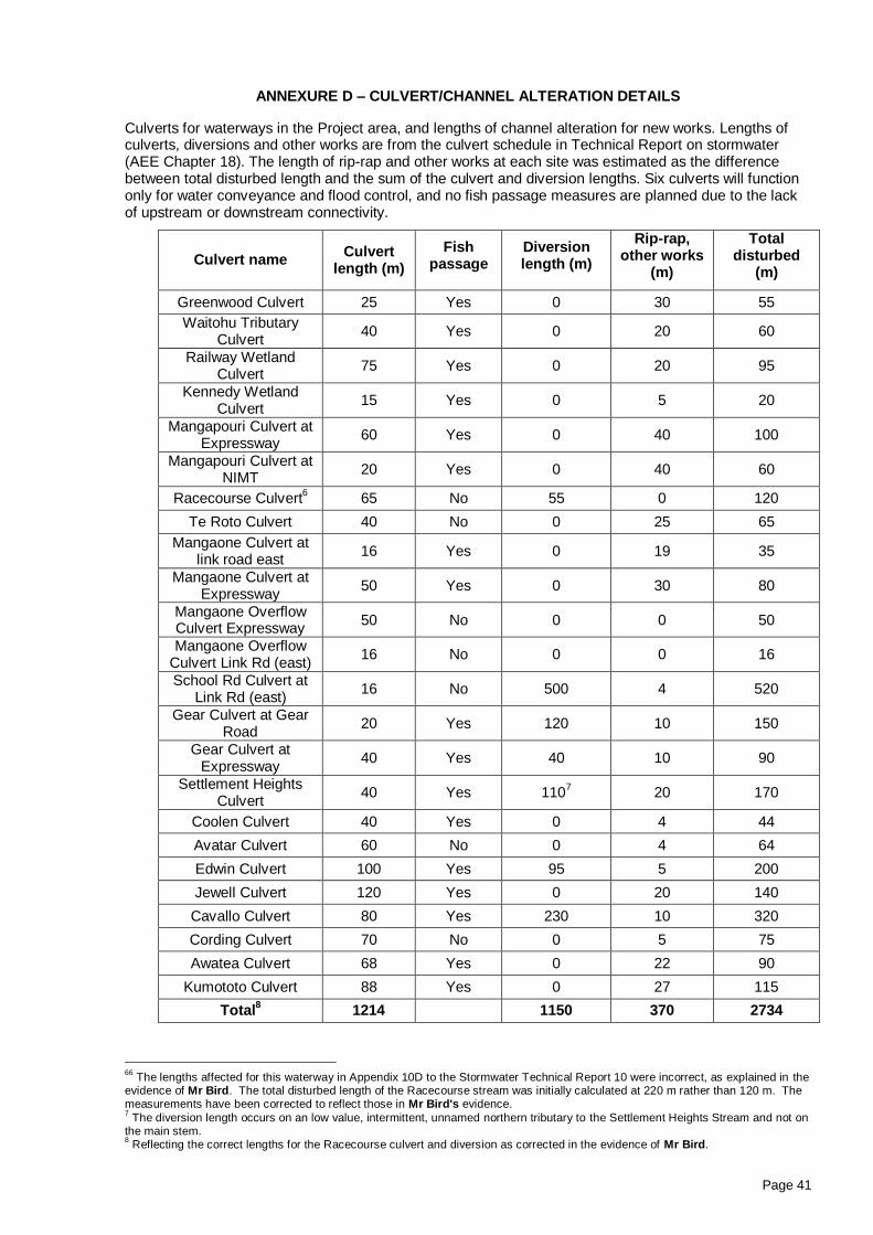
Page 41
ANNEXURE D – CULVERT/CHANNEL ALTERATION DETAILS
Culverts for waterways in the Project area, and lengths of channel alteration for new works. Lengths of culverts, diversions and other works are from the culvert schedule in Technical Report on stormwater (AEE Chapter 18). The length of rip-rap and other works at each site was estimated as the difference between total disturbed length and the sum of the culvert and diversion lengths. Six culverts will function only for water conveyance and flood control, and no fish passage measures are planned due to the lack of upstream or downstream connectivity.
Culvert name Culvert
length (m)
Fish passage
Diversion length (m)
Rip-rap, other works
(m)
Total disturbed
(m)
Greenwood Culvert 25 Yes 0 30 55
Waitohu Tributary Culvert
40 Yes 0 20 60
Railway Wetland Culvert
75 Yes 0 20 95
Kennedy Wetland Culvert
15 Yes 0 5 20
Mangapouri Culvert at Expressway
60 Yes 0 40 100
Mangapouri Culvert at NIMT
20 Yes 0 40 60
Racecourse Culvert6 65 No 55 0 120
Te Roto Culvert 40 No 0 25 65
Mangaone Culvert at link road east
16 Yes 0 19 35
Mangaone Culvert at Expressway
50 Yes 0 30 80
Mangaone Overflow Culvert Expressway
50 No 0 0 50
Mangaone Overflow Culvert Link Rd (east)
16 No 0 0 16
School Rd Culvert at Link Rd (east)
16 No 500 4 520
Gear Culvert at Gear Road
20 Yes 120 10 150
Gear Culvert at Expressway
40 Yes 40 10 90
Settlement Heights Culvert
40 Yes 1107 20 170
Coolen Culvert 40 Yes 0 4 44
Avatar Culvert 60 No 0 4 64
Edwin Culvert 100 Yes 95 5 200
Jewell Culvert 120 Yes 0 20 140
Cavallo Culvert 80 Yes 230 10 320
Cording Culvert 70 No 0 5 75
Awatea Culvert 68 Yes 0 22 90
Kumototo Culvert 88 Yes 0 27 115
Total8 1214 1150 370 2734
66
The lengths affected for this waterway in Appendix 10D to the Stormwater Technical Report 10 were incorrect, as explained in the evidence of Mr Bird. The total disturbed length of the Racecourse stream was initially calculated at 220 m rather than 120 m. The measurements have been corrected to reflect those in Mr Bird's evidence. 7 The diversion length occurs on an low value, intermittent, unnamed northern tributary to the Settlement Heights Stream and not on
the main stem. 8 Reflecting the correct lengths for the Racecourse culvert and diversion as corrected in the evidence of Mr Bird.