Embed Size (px)
Citation preview

The Study on Risk Management for Sediment-Related Disaster on Final Report Volume II Selected National Highways in the Republic of the Philippines Main Report
NIPPON KOEI CO., LTD. June 2007
OYO INTERNATIONAL CORPORATION
5-1
CHAPTER 5
RESULTS OF PILOT INVENTORY SURVEY
5.1 Results of Preliminary Inventory Survey
5.1.1 Selection of Road Sections for PIS
The Road Sections to be surveyed were selected before the conduct of the PIS (Stage I) based on the information from the preparatory study, the initial field reconnaissance survey conducted by the Study Team together with the Counterpart Team from the 4th to the 12th of April 2006 and suggestions from the DPWH. Selected Road Sections for PIS are listed in Table 5.1.
The selection of Road Sections for the Inventory Survey was carried out considering the following criteria:
1) Security in the area,
2) Accessibility;
3) Coverage of all kinds of disaster types;
4) Equitable regional distribution;
5) Suggestions from DPWH; and
6) Present condition of the road.
The Study on Risk Management for Sediment-Related Disaster on Final Report Volume II Selected National Highways in the Republic of the Philippines Main Report
NIPPON KOEI CO., LTD. June 2007
OYO INTERNATIONAL CORPORATION
5-2
Table 5.1 Road Sections Selected for the Preliminary Inventory Survey
Region Road Section Section
(km) Length
(km) DEO in Charge
Road Classification
AADT Disaster
Types
241-244 3 Baguio City Kennon Rd
214-241 27 Benguet 1st
S 6,880/ 5,014
RS, RC, RE, SC, DF
Baguio- Bontoc Rd (Halsema Highway) 263-341 78 Benguet 2nd
A(OT) 953 RS, SC, RC, DF, LS
Nueva Vizcaya- Ifugao-Mt Province Rd (Lagawe- Banaue)
301-333 32 Ifugao
S 275/ 3,116 SC, RS,
DF, RC, LS
CAR
Subtotal Length(km) 140 Daang Maharlika (LZ) (Dalton Pass)
208-220 12 Nueva Vizcaya Sub
A(NS) 3,769 RS, SC, RC, DF, RE II
Subtotal Length(km) 12 5-30 25 Cebu City Cebu- Balamban
Transcentral 30-42 12 Cebu 3rd A(EW) 1,001/
1,305 RS, SC, RC, DF
Toledo-Baliri- Santander Rd (Ginatilan- Alegria)
143-179 36 Cebu 4th A(NS) 500/
12,000
CE, RC, RE, SC, RS
VII
Subtotal Length(km) 73 Wright-Taft-Borongan Rd 843-859 16 Samar 2nd A(EW) 500/
1,374 RS, SC, RC, DF
995-1003 8 Leyte 5th Daang Maharlika (LT) (Mahaplag- Sugod) 1003- 1018 15 Southern
Leyte
A(NS)
659/ 1,581
RS, SC, RC, DF, RE, LS
VIII
Subtotal Length(km) 39 Misamis Oriental- Bukidnon-Agusan Road
1428-1464 36 Bukidnon 3rd
A(NS) 3,421 RS, SC, RC
Bukidnon-Davao City Rd 1605-1607 2 Bukidnon
2nd A(NS) 3,340 SC, RS,
RC
X
Subtotal Length (km) 38
Davao-Cotabato Road 1525-1555 30 Davao-Del Sur 1st
A(NS) 3,486/ 6,517
RE, RS, SC XI
Subtotal Length (km) 30 Total Length (km) 332
Disaster Types; SC: Soils Slope Collapse; RC: Rock Slope Collapse; LS: Landslide; RS: Road Slip; DF: Debris Flow; RE: River Erosion; CE: Coastal Erosion; In each Road Section, the disaster type is listed in the order of dominance Road Classification; A(NS) Arterial (North-South Backbone), A(EW): Arterial (East-West Lateral), A(OT): Arterial (Other Road of Strategic Importance), S: Secondary National Road,
5.1.2 Result of Preliminary Inventory Survey
Sixteen National Highway road sections in six Regions were selected for the pilot PIS. A total length of 332 km had been surveyed by mid-January 2007.
Along the 332 km of road sections, 1933 slopes were surveyed based on the PIS Criteria.
The Study on Risk Management for Sediment-Related Disaster on Final Report Volume II Selected National Highways in the Republic of the Philippines Main Report
NIPPON KOEI CO., LTD. June 2007
OYO INTERNATIONAL CORPORATION
5-3
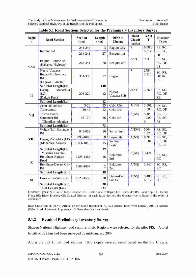
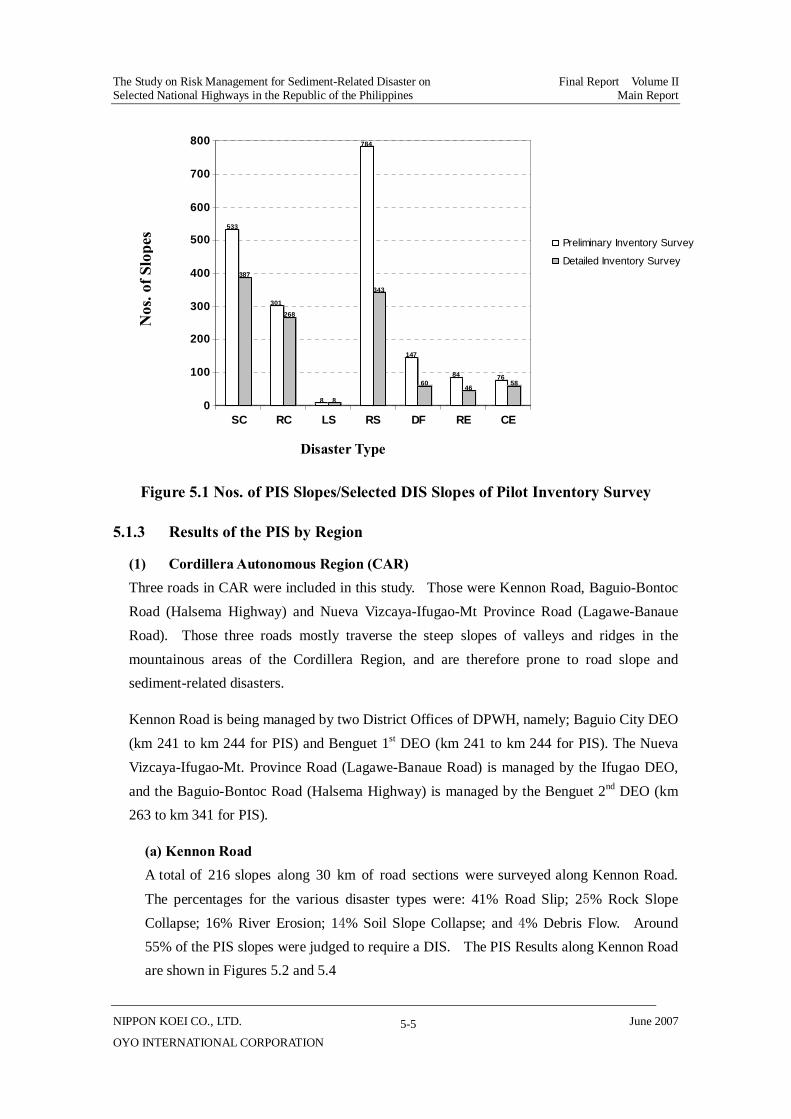
Results indicate that around 61% of the slopes had a high risk level that required a DIS. The distribution of the disaster types and number of slopes in the PIS and the DIS are shown in Table 5.2. A summary of the PIS results is shown in Table 5.3 and Figure 5.4.
Table 5.2 Distribution of Disaster Types in PIS Sections
Disaster Type PIS Slopes Selected DIS Slopes
Soil Slope Collapse 533 (28%) 387 (73% of PIS)
Rock Slope Collapse 301 (16%) 268 (89% of PIS)
Landslides 8 (0%) 8 (100% of PIS)
Road Slips 784 (41%) 334 (44% of PIS)
Debris Flow 147 (8%) 60 (41% of PIS)
River Erosion 84 (4%) 46 (55% of PIS)
Costal Erosion 76 (4%) 58 (76% of PIS)
Total 1933 (100%) 1170 (61% of PIS)
Source: PIS results for the 332 km of sections surveyed in 16 selected road sections.
The Study on Risk M
anagement for Sedim
ent-Related D
isaster on Final R
eport Volume II
Selected National H
ighways in the R
epublic of the Philippines M
ain Report
NIPPO
N K
OEI CO
., LTD.
June 2007
OY
O IN
TERN
ATION
AL C
OR
POR
ATION
5-4
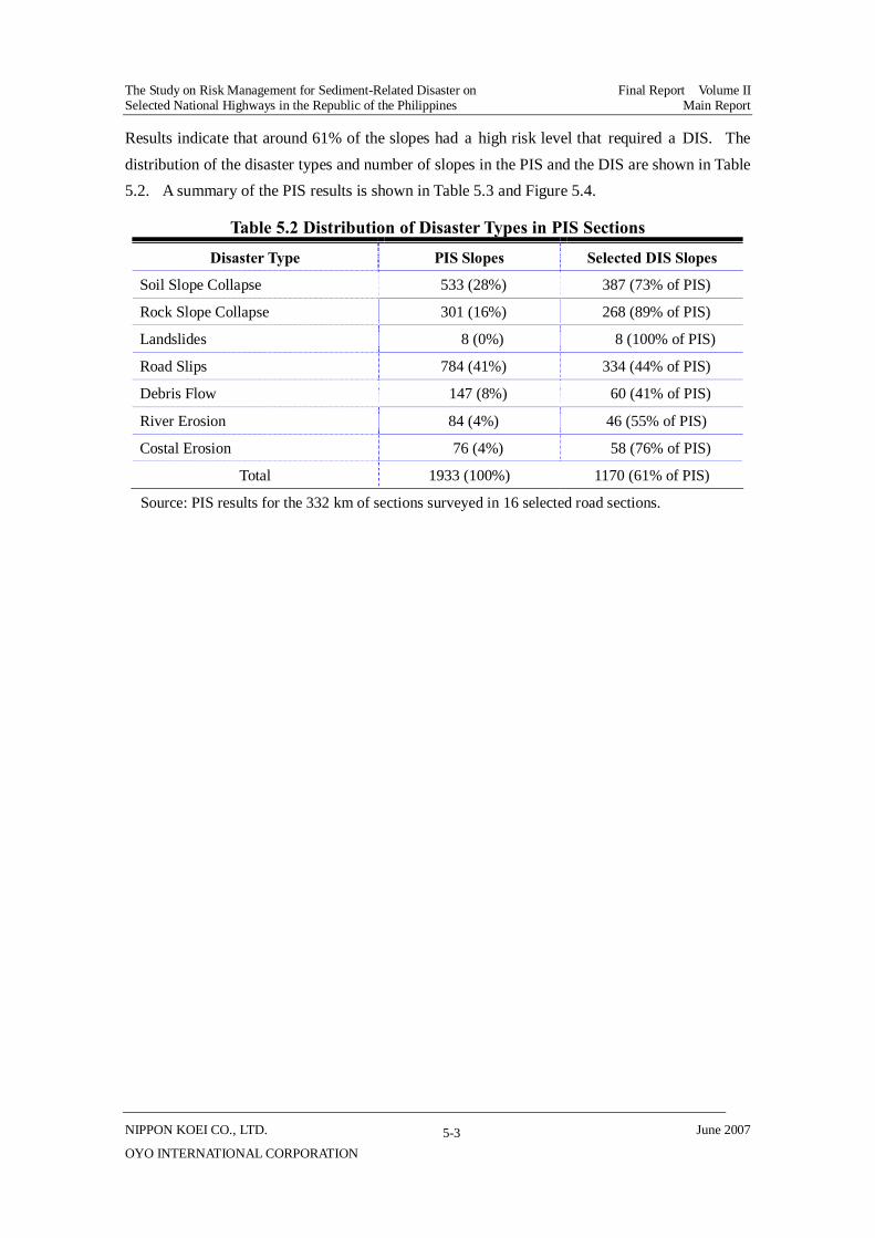
Table 5.3 PIS Result of Study Road Sections
The Study on Risk Management for Sediment-Related Disaster on Final Report Volume II Selected National Highways in the Republic of the Philippines Main Report
NIPPON KOEI CO., LTD. June 2007
OYO INTERNATIONAL CORPORATION
5-5
Figure 5.1 Nos. of PIS Slopes/Selected DIS Slopes of Pilot Inventory Survey
5.1.3 Results of the PIS by Region
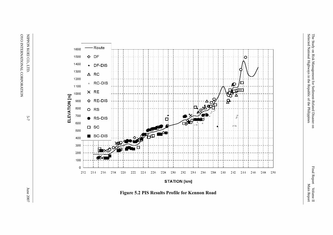
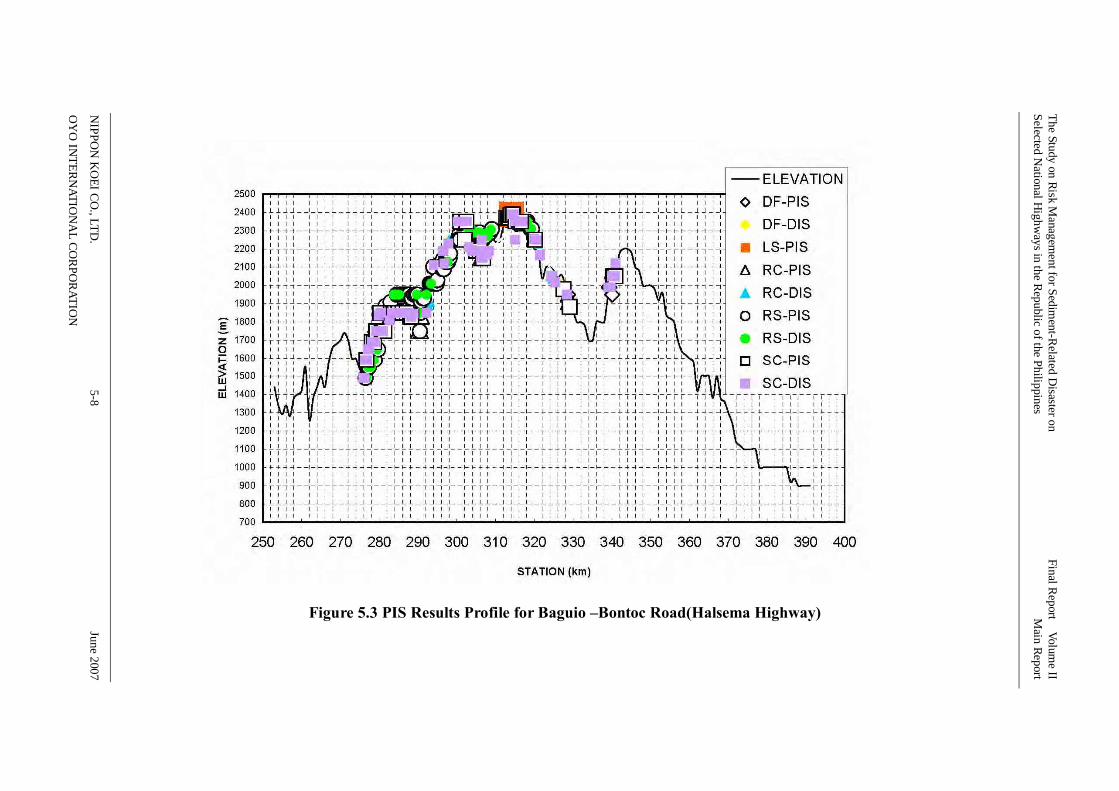
(1) Cordillera Autonomous Region (CAR) Three roads in CAR were included in this study. Those were Kennon Road, Baguio-Bontoc Road (Halsema Highway) and Nueva Vizcaya-Ifugao-Mt Province Road (Lagawe-Banaue Road). Those three roads mostly traverse the steep slopes of valleys and ridges in the mountainous areas of the Cordillera Region, and are therefore prone to road slope and sediment-related disasters.
Kennon Road is being managed by two District Offices of DPWH, namely; Baguio City DEO (km 241 to km 244 for PIS) and Benguet 1st DEO (km 241 to km 244 for PIS). The Nueva Vizcaya-Ifugao-Mt. Province Road (Lagawe-Banaue Road) is managed by the Ifugao DEO, and the Baguio-Bontoc Road (Halsema Highway) is managed by the Benguet 2nd DEO (km 263 to km 341 for PIS).
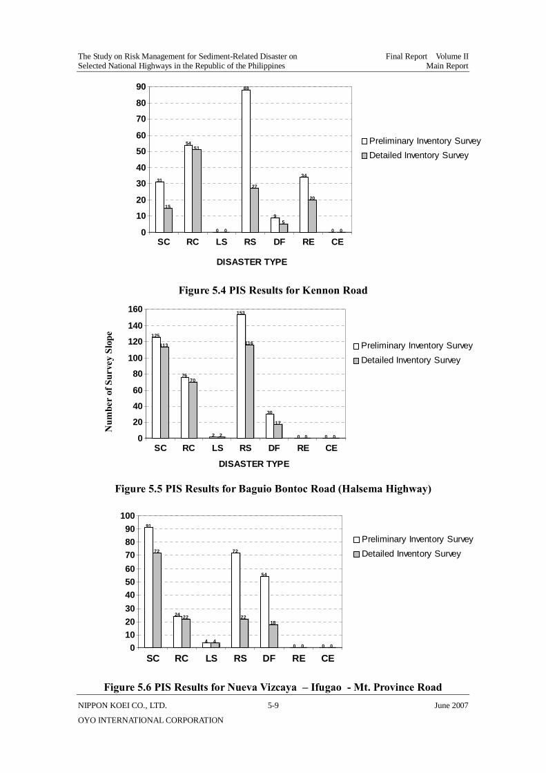
(a) Kennon Road A total of 216 slopes along 30 km of road sections were surveyed along Kennon Road.
The percentages for the various disaster types were: 41% Road Slip; 25% Rock Slope Collapse; 16% River Erosion; 14% Soil Slope Collapse; and 4% Debris Flow. Around 55% of the PIS slopes were judged to require a DIS. The PIS Results along Kennon Road are shown in Figures 5.2 and 5.4
Nos
. of S
lope
s 533
387
301268
8 8
784
343
147
6084
4676
58
0
100
200
300
400
500
600
700
800
SC RC LS RS DF RE CE
Preliminary Inventory Survey
Detailed Inventory Survey
Disaster Type
The Study on Risk Management for Sediment-Related Disaster on Final Report Volume II Selected National Highways in the Republic of the Philippines Main Report
NIPPON KOEI CO., LTD. June 2007
OYO INTERNATIONAL CORPORATION
5-6
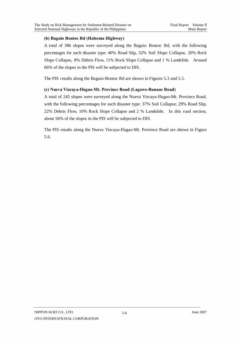
(b) Baguio Bontoc Rd (Halsema Highway) A total of 386 slopes were surveyed along the Baguio Bontoc Rd, with the following percentages for each disaster type: 40% Road Slip, 32% Soil Slope Collapse, 20% Rock Slope Collapse, 8% Debris Flow, 11% Rock Slope Collapse and 1 % Landslide. Around 66% of the slopes in the PIS will be subjected to DIS.
The PIS results along the Baguio-Bontoc Rd are shown in Figures 5.3 and 5.5.
(c) Nueva Vizcaya-Ifugao-Mt. Province Road (Lagawe-Banaue Road) A total of 245 slopes were surveyed along the Nueva Vizcaya-Ifugao-Mt. Province Road, with the following percentages for each disaster type: 37% Soil Collapse; 29% Road Slip, 22% Debris Flow, 10% Rock Slope Collapse and 2 % Landslide. In this road section, about 56% of the slopes in the PIS will be subjected to DIS.
The PIS results along the Nueva Vizcaya-Ifugao-Mt. Province Road are shown in Figure 5.6.
The Study on Risk Managem
ent for Sediment-R
elated Disaster on
Final Report Volum
e II Selected N
ational Highw
ays in the Republic of the Philippines
Main Report
NIPPO
N K
OEI CO
., LTD.
5-7 June 2007
OY
O IN
TERN
ATION
AL CO
RPORATIO
N
Figure 5.2 PIS Results Profile for Kennon Road
The Study on Risk Managem
ent for Sediment-R
elated Disaster on
Final Report Volum
e II Selected N
ational Highw
ays in the Republic of the Philippines
Main Report
NIPPO
N K
OEI CO
., LTD.
5-8 June 2007
OY
O IN
TERN
ATION
AL CO
RPORATIO
N
Figure 5.3 PIS Results Profile for Baguio –Bontoc Road(Halsema Highway)
The Study on Risk Management for Sediment-Related Disaster on Final Report Volume II Selected National Highways in the Republic of the Philippines Main Report
NIPPON KOEI CO., LTD. 5-9 June 2007
OYO INTERNATIONAL CORPORATION
Figure 5.4 PIS Results for Kennon Road
Figure 5.5 PIS Results for Baguio Bontoc Road (Halsema Highway)
Figure 5.6 PIS Results for Nueva Vizcaya – Ifugao - Mt. Province Road
31
15
5451
0 0
88
27
95
34
20
0 00
10
20
30
40
50
60
70
80
90
SC RC LS RS DF RE CE
Preliminary Inventory Survey Detailed Inventory Survey
DISASTER TYPE
NO. O
F SU
RVEY
SIT
E
125
113
7670
2 2
153
116
30
17
0 0 0 00
20
40
60
80
100
120
140
160
SC RC LS RS DF RE CE
Preliminary Inventory Survey Detailed Inventory Survey
DISASTER TYPE
NO. O
F SU
RVEY
SIT
E
91
72
24 22
4 4
72
22
54
18
0 0 0 00102030405060708090
100
SC RC LS RS DF RE CE
Preliminary Inventory Survey Detailed Inventory Survey
NO. O
F SU
RVEY
SIT
E
Num
ber
of S
urve
y Sl
ope

The Study on Risk Management for Sediment-Related Disaster on Final Report Volume II Selected National Highways in the Republic of the Philippines Main Report
NIPPON KOEI CO., LTD. 5-10 June 2007
OYO INTERNATIONAL CORPORATION
(2) Region II The section of the Daang Maharlika (LZ) (km 208+000 to km 220+000) was surveyed.
(a) Daang Maharlika (LZ) (Dalton Pass) A total of 118 slopes along a road length of 12 km (km 208+000 to km 220+000) were surveyed along Daang Maharlika (LZ). Of these, 31% were Road Slips; 26% Soil Slope Collapse; 23% Rock Slope Collapse; 14% Debris Flow; and the remaining 5% River Erosion. Around 42% of the PIS slopes meet the DIS selection criteria. The PIS result along Daang Maharlika (LZ) is shown in Figures 5.7. and 5.8.
Figure 5.7 PIS Results for Daang Maharlika (LZ)
31
11
27
23
0 0
37
9
17
56
20 00
5
10
15
20
25
30
35
40
SC RC LS RS DF RE CE
Preliminary Inventory Survey Detailed Inventory Survey
DISASTER TYPE
NO. O
F SU
RVEY
SIT
EN
umbe
r of
Sur
vey
Slop
e

The Study on Risk M
anagement for Sedim
ent-Related D
isaster on Final R
eport Volume II
Selected National H
ighways in the R
epublic of the Philippines M
ain Report
NIPPO
N K
OEI C
O., LTD
. 5-11
June 2007
OY
O IN
TERN
ATION
AL C
OR
POR
ATION
150
170
190
210
230
250
270
290
310
330
350
370
390
410
430
450
470
49020
8+00
0
209+
000
210+
000
211+
000
212+
000
213+
000
214+
000
215+
000
216+
000
217+
000
218+
000
219+
000
220+
000
KM. STATION
ELEV
ATI
ON
(m)
DF DF-DIS
RC RC-DIS
RE RE-DIS
RS RS-DIS
SC SC-DIS
ROAD
Figure 5.8 PIS Results Profile for Daang Maharlika (LZ)
The Study on Risk Management for Sediment-Related Disaster on Final Report Volume II Selected National Highways in the Republic of the Philippines Main Report
NIPPON KOEI CO., LTD. 5-12 June 2007
OYO INTERNATIONAL CORPORATION
(3) Region VII Two Road Sections were surveyed in the PIS for Region VII, namely: Cebu Balamban Transcentral Highway and the Ginatilan Alegria Section of Toledo-Baliri-Santander Rd. The former is under the management of and maintained by two DEOs, the Cebu City DEO (km 5 to km 30) and Cebu 3rd DEO (km 30 to km 42) and the later is under the Cebu 4th DEO.
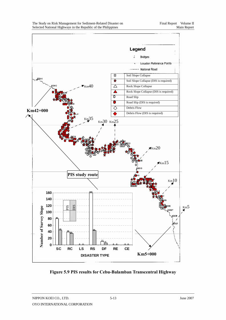
(a) Cebu-Balamban Transcentral Highway The Cebu-Balamban Transcentral Highway traverses the mountainous area of Cebu province with a total of 279 sub-sections meeting the PIS criteria. The disaster types observed were Road Slips (55%); Soil Slope Collapse (28%); Rock Slope Collapse (13%); and Debris Flow (4%). Considering the present conditions along this route, around 45% qualify for DIS.
The PIS results of the Cebu-Balamban Transcentral Highway are shown in Figure 5.9.
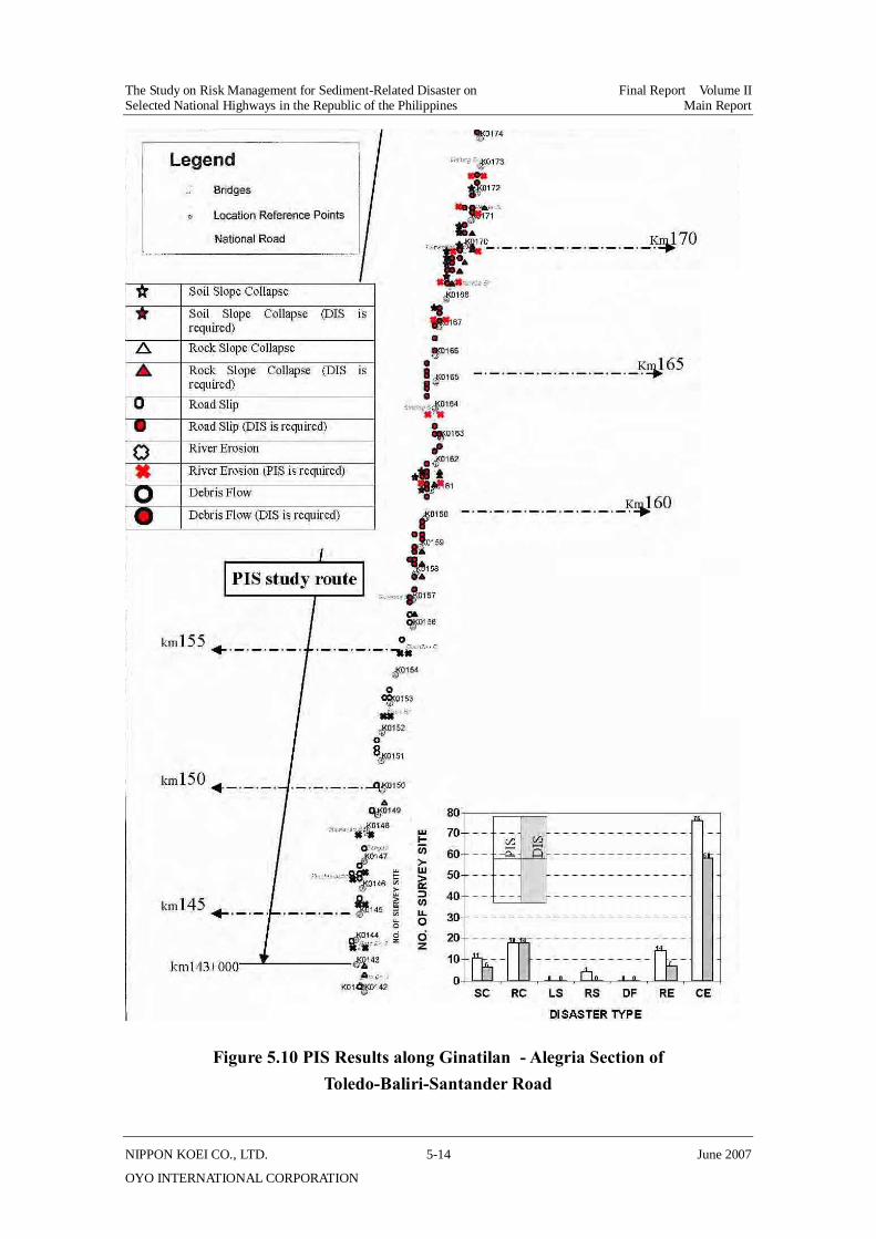
(b) Ginatilan Alegria Section of Toledo-Baliri-Santander Rd The total length of surveyed sections along Ginatilan Alegria Section of Toledo-Baliri-Santander Rd is 36 km, starting from km 143 to km 179. The most common disaster type was Coastal Erosion (62%) caused by tidal action. The remaining 38% is distributed into combinations of Soil Slope Collapse, Rock Slope Collapse and River Erosion. Around 72% of PIS slopes require a DIS.
The PIS results along Ginatilan Alegria Section are shown in Figure 5.10.
The Study on Risk Management for Sediment-Related Disaster on Final Report Volume II Selected National Highways in the Republic of the Philippines Main Report
NIPPON KOEI CO., LTD. 5-13 June 2007
OYO INTERNATIONAL CORPORATION
Figure 5.9 PIS results for Cebu-Balamban Transcentral Highway
Km5
Km40
Km30 Km25
Km20
Km15
Km10
Km35
CEBU-BALAMBAN TRANSCENTRAL HIGHWAY
80
36
152
011
0
279
5135
97
0 7 0 0
190
0
25
50
75
100
125
150
175
200
225
250
275
300
SC RC LS RS DF RE CE Total
DISASTER TYPE
NO. O
F SU
RVEY
SIT
E
Preliminary Inventory SurveyDetailed Inventory Survey
PIS study route
Km5+000
Km42+000
80
4539
35
0 0
160
44
116
0 0 0 00
20
40
60
80
100
120
140
160
SC RC LS RS DF RE CE
DISASTER TYPE
NO. O
F SU
RVE
Y S
ITE
PIS
DIS
Soil Slope Collapse
Soil Slope Collapse (DIS is required)
Rock Slope Collapse
Rock Slope Collapse (DIS is required)
Road Slip
Road Slip (DIS is required)
Debris Flow
Debris Flow (DIS is required)
Num
ber
of S
urve
y Sl
ope
The Study on Risk Management for Sediment-Related Disaster on Final Report Volume II Selected National Highways in the Republic of the Philippines Main Report
NIPPON KOEI CO., LTD. 5-14 June 2007
OYO INTERNATIONAL CORPORATION
Figure 5.10 PIS Results along Ginatilan - Alegria Section of Toledo-Baliri-Santander Road
The Study on Risk Management for Sediment-Related Disaster on Final Report Volume II Selected National Highways in the Republic of the Philippines Main Report
NIPPON KOEI CO., LTD. 5-15 June 2007
OYO INTERNATIONAL CORPORATION
(4) Region VIII
There are two Road Sections for Pilot PIS in Region VIII, namely: the Wright-Taft-Borongan Road, which is under the responsibility of the Samar 2nd DEO; and the Mahaplag-Sugod Section of Daang Maharlika (LT) under the Leyte 5th DEO and Southern Leyte DEO.
(a) Wright - Taft - Borongan Rd PIS in Wright-Taft road started at km 843+000 and ended at km 859+000.
A total of 65 slopes were surveyed along the Wright-Taft-Borongan Road, which traverses a mountainous area. The disaster types observed were: 52% Road Slips; 28%, Soil Slope Collapse; 14% Rock Slope Collapse; and 6% Debris Flow. About 55% of the 65 PIS slopes conform to the DIS criteria.
The PIS results for Wright- Taft- Borongan Rd are shown in Figure 5.11.
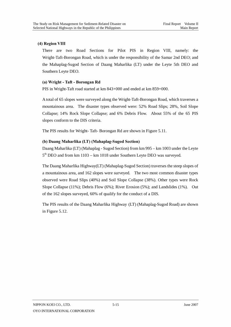
(b) Daang Maharlika (LT) (Mahaplag-Sugod Section) Daang Maharlika (LT) (Mahaplag - Sugod Section) from km 995 – km 1003 under the Leyte 5th DEO and from km 1103 – km 1018 under Southern Leyte DEO was surveyed.
The Daang Maharlika Highway(LT) (Mahaplag-Sugod Section) traverses the steep slopes of a mountainous area, and 162 slopes were surveyed. The two most common disaster types observed were Road Slips (40%) and Soil Slope Collapse (38%). Other types were Rock Slope Collapse (11%); Debris Flow (6%); River Erosion (5%); and Landslides (1%). Out of the 162 slopes surveyed, 60% of qualify for the conduct of a DIS.
The PIS results of the Daang Maharlika Highway (LT) (Mahaplag-Sugod Road) are shown in Figure 5.12.

The Study on Risk M
anagement for Sedim
ent-Related D
isaster on Final R
eport Volum
e II Selected N
ational Highw
ays in the Republic of the Philippines
Main Report
NIPPO
N K
OEI C
O., LTD
. 5 - 16
June 2007
OY
O IN
TERN
ATION
AL C
OR
POR
ATION
Figure 5.11 PIS Results for Wright-Taft-Borongan Road
The Study on Risk Management for Sediment-Related Disaster on Final Report Volume II Selected National Highways in the Republic of the Philippines Main Report
NIPPON KOEI CO., LTD. 5 - 17 June 2007
OYO INTERNATIONAL CORPORATION
MAHAPLAG-SOGOD ROAD
162
01010
2
61
18
61
155
01010
2
57
18
58
0
25
50
75
100
125
150
175
SC RC LS RS DF RE CE Total
DISASTER TYPE
NO. O
F S
URV
EY S
ITE
Preliminary Inventory SurveyDetailed Inventory Survey
Km990
Km995
Km1000
km 1005
Km 1010
Km 1015
PIS study Road
Km 1018
Km995
^
Figure 5.12 PIS Results for Daang Maharlika Highway (LT) (Mahaplag-Sugod Section)
61
42
18 18
2 2
64
26
97 8
5
0 00
10
20
30
40
50
60
70
SC RC LS RS DF RE CE
DISASTER TYPE
NO
. OF
SUR
VEY
SIT
E
Soil Slope Collapse
Soil Slope Collapse (DIS is required)
Rock Slope Collapse
Rock Slope Collapse (DIS is required)
Road Slip
Road Slip (DIS is required)
River Erosion
River Erosion (DIS is required)
Debris Flow
Debris Flow (DIS is required)
The Study on Risk Management for Sediment-Related Disaster on Final Report Volume II Selected National Highways in the Republic of the Philippines Main Report
NIPPON KOEI CO., LTD. 5 - 18 June 2007
OYO INTERNATIONAL CORPORATION
6960
20 18
0 0
157
71
1 0 1 0 0 00
20
40
60
80
100
120
140
160
SC RC LS RS DF RE CE
Preliminary Inventory Survey Detailed Inventory Survey
DISASTER TYPE
NO. O
F SU
RVEY
SIT
E(5) Region X
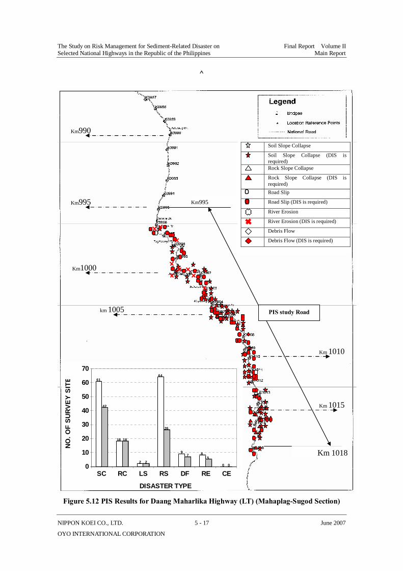
The original scope of this study did not include any Road Sections in Mindanao. However, with the strong recommendation of the DPWH, the Study Team added two Road Sections for Region X as pilot survey sections and one route for Region XI. The Region X routes were Sayre Highway (Misamis Oriental-Bukidnon-Agusan Road) and the Bukidnon-Davao City Road.
The PIS was undertaken jointly by the Central Office (CO) counterpart personnel and the field engineers from Bukidnon's 2nd and 3rd DEOs. The surveyed section starts from km 1427+717 and runs to km 1463+500 traversing mostly mountainous areas. The surveyed section of Bukidnon–Davao City Road, which starts at km 1605+685 and runs to km 1607+000, was also undertaken jointly by CO counterpart personnel and DEO representatives and was found to have terrain characteristics similar to the Sayre Highway.
(a) Sayre Highway (Misamis Oriental-Bukidnon-Agusan Road) Sayre Highway has a total of 248 slopes meeting the PIS criteria. The disaster types observed are Road Slips (63%); Soil Slope Collapse (28%); Rock Slope Collapse (8%); and River Erosion (0%). A total of 72% of those PIS slopes require DIS.
PIS results for Sayre Highway are shown in Figure 5.13.
Figure 5.13 PIS Result for Sayre Highway (Misamis Oriental-Bukidnon-Agusan Road)
(b) Bukidnon-Davao City Road Along this road, nine slopes were surveyed, and the prevalent disaster types observed were Soil Slope Collapse (67%); Road Slips (22%); and Rock Slope Collapse (11%). Results

The Study on Risk Management for Sediment-Related Disaster on Final Report Volume II Selected National Highways in the Republic of the Philippines Main Report
NIPPON KOEI CO., LTD. 5 - 19 June 2007
OYO INTERNATIONAL CORPORATION
show that all of the slopes need to be included in the DIS.
The PIS results for the Bukidnon-Davao City Road are shown in Figure 5.14.
Figure 5.14 PIS Result for Bukidnon-Davao City Road
(6) Region XI
The route identified for Region XI was the Davao-Cotabato road from km 1525 to km 1555. During the survey headed by the Davao del Sur DEO, it was found that most of the route traverses flat terrain with agricultural plantations. However, 27 slopes were identified during the PIS.
(a) Davao - Cotabato Road The disaster types observed were River Erosion (78%); Road Slips (15%); and Soil Slope Collapse (7%), of which, 60% of the PIS slopes require DIS.
The PIS results for the Davao-Cotabato Road are shown in Figure 5.15.
Figure 5.15 PIS Result for Davao-Cotabato Road
6 6
1 1
0 0
2 2
0 0 0 0 0 00
1
2
3
4
5
6
Preliminary Inventory Survey Detailed Inventory Survey
NO. O
F SU
RVEY
SIT
E
2 2
0 0 0 0
4
2
0 0
21
12
0 00
5
10
15
20
25
SC RC LS RS DF RE CE
Preliminary Inventory Survey Detailed Inventory Survey
DISASTER TYPE
NO. O
F SU
RVE
Y SI
TE
The Study on Risk Management for Sediment-Related Disaster on Final Report Volume II Selected National Highways in the Republic of the Philippines Main Report
NIPPON KOEI CO., LTD. 5 - 20 June 2007
OYO INTERNATIONAL CORPORATION
5.2 Result of Detailed Inventory Survey
5.2.1 Selection of Road Sections for DIS
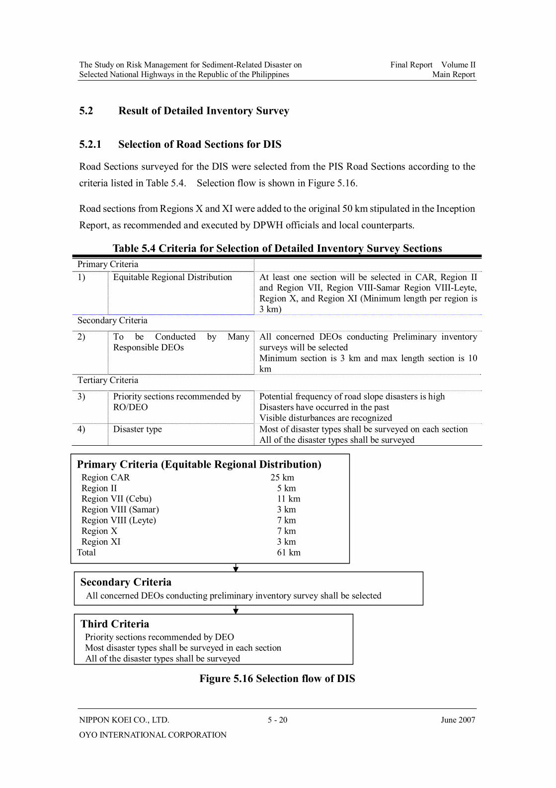
Road Sections surveyed for the DIS were selected from the PIS Road Sections according to the criteria listed in Table 5.4. Selection flow is shown in Figure 5.16.
Road sections from Regions X and XI were added to the original 50 km stipulated in the Inception Report, as recommended and executed by DPWH officials and local counterparts.
Table 5.4 Criteria for Selection of Detailed Inventory Survey Sections Primary Criteria 1) Equitable Regional Distribution At least one section will be selected in CAR, Region II
and Region VII, Region VIII-Samar Region VIII-Leyte, Region X, and Region XI (Minimum length per region is 3 km)
Secondary Criteria
2) To be Conducted by Many Responsible DEOs
All concerned DEOs conducting Preliminary inventory surveys will be selected Minimum section is 3 km and max length section is 10 km
Tertiary Criteria
3) Priority sections recommended by RO/DEO
Potential frequency of road slope disasters is high Disasters have occurred in the past Visible disturbances are recognized
4) Disaster type Most of disaster types shall be surveyed on each section All of the disaster types shall be surveyed
Figure 5.16 Selection flow of DIS
Primary Criteria (Equitable Regional Distribution) Region CAR 25 km Region II 5 km Region VII (Cebu) 11 km Region VIII (Samar) 3 km Region VIII (Leyte) 7 km Region X 7 km Region XI 3 km Total 61 km
Secondary Criteria All concerned DEOs conducting preliminary inventory survey shall be selected
Third Criteria Priority sections recommended by DEO
Most disaster types shall be surveyed in each section All of the disaster types shall be surveyed

The Study on Risk Management for Sediment-Related Disaster on Final Report Volume II Selected National Highways in the Republic of the Philippines Main Report
NIPPON KOEI CO., LTD. 5 - 21 June 2007
OYO INTERNATIONAL CORPORATION
Table 5.5 Selected Length of PIS and DIS
Region PIS Section length (km) DIS Section length (km) DIS/PIS length (%) Region CAR 140 25 18
Region II 12 5 41
Region VII (Cebu) 73 11 15
Region VIII(Samaur) 16 3 19
Region VIII(Layrte) 23 7 30
Region X 38 7 18
Region XI 30 3 10
Total 332 61 18
Table 5.6 Selected Road Sections for Detailed Inventory Survey
PIS DIS Region
Road Sections Section Length km
Section Lengthkm
No. of Slopes
DEO in Charge
Road Classification
AADT Disaster
Type
241-244 3 241-244 3 10 Baguio City Kennon Rd
214-241 27 227-234 7 32 Benguet 1st
S 6,880/ 5,014
SC, RC, RE, DF, RS
Baguio- Bontoc Rd [Halsema Highway] 263-341 78 275-280 5 43 Benguet
2nd
A(OT) 953 SC, RC, LS, RE, DF, RS
Nueva Vizcaya- Ifugao-Mt Province Rd [ Lagawe - Banaue]
301-333 32 301-306318-323 10 33 Ifugao
S 275/ 3,116 SC, RC,
LS, DF, RS
CA
R
Subtotal 140 25 118
Daang Maharlika (LZ) [ Dalton Pass ] 208-220 12 208-213 5 27
Nueva Vizcaya Sub
A(NE) 3,769 SC, RC, RS, DF, RE
II
Subtotal 12 5 27 5-30 25 27-30 3 19 Cebu City Cebu- Balamban
Transcentral Highway 30-42 12 33-37 4 28 Cebu 3rd A(EW) 1,001/
1,305 SC, RC, RS, DF
Toledo-Baliri-Santander Rd [ Ginatilan- Alegria ]
143-179 36 172-176 4 4 Cebu 4th A(NS) 500/
12,000 SC, RC, RE, CE, RS
VII
Subtotal 73 11 51 Wright-Taft-Borongan Rd 843-859 16 844-847 3 13 Samar 2nd A(EW) 500/
1,374 SC, RC, RS, DF
995-1003 8 1000-1003 3 9 Leyte 5th Daang Maharlika (LT) [ Mahaplag- Sugod ] 1003- 1018 15 1003-1007 4 26 Southern
Leyte
A(NS)
659/ 1,581
SC, RC, LS, RE, RS, DF
VIII
Subtotal 39 10 48 Sayre Highway [ Misamis Oriental - Bukidnon - Agusan Road ]
1428-1464 36 1444-1449 5 33 Bukidnon 3rd
A(NS) 3,421 SC, RC, RS, RE
Bukidnon - Davao City Rd 1605-1607 2 1605-1607 2 9 Bukidnon
2nd A(NS) 3,340 SC, RC,
RS
X
Subtotal 38 7 42
Davao - Cotabato Rd 1525-1555 30 1532-1535 3 4 Davao-del Sur 1st
A(NS) 3,486/ 6,517
SC, RS, RE
XI
Subtotal 30 3 4 Total Length (km) 332 61 290
Disaster Types; SC: Soils Slope Collapse; RC: Rock Slope Collapse; LS: Landslide; RS: Road Slip; DF: Debris Flow; RE: River Erosion; CE: Coastal Erosion; Road Classification; A(NS) Arterial (North-South Backbone), A(EW): Arterial (East-West Lateral), A(OT): Arterial (Other Road of Strategic Importance), S: Secondary National Road,
The Study on Risk Management for Sediment-Related Disaster on Final Report Volume II Selected National Highways in the Republic of the Philippines Main Report
NIPPON KOEI CO., LTD. 5 - 22 June 2007
OYO INTERNATIONAL CORPORATION
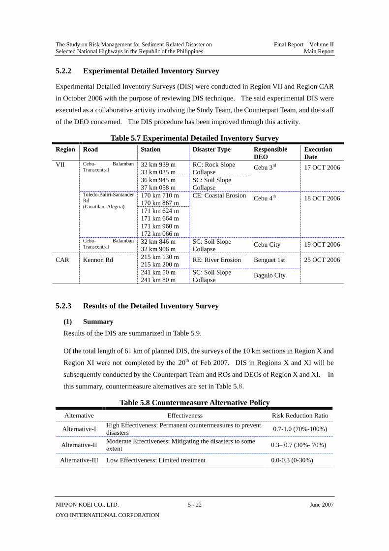
5.2.2 Experimental Detailed Inventory Survey
Experimental Detailed Inventory Surveys (DIS) were conducted in Region VII and Region CAR in October 2006 with the purpose of reviewing DIS technique. The said experimental DIS were executed as a collaborative activity involving the Study Team, the Counterpart Team, and the staff of the DEO concerned. The DIS procedure has been improved through this activity.
Table 5.7 Experimental Detailed Inventory Survey Region Road Station Disaster Type Responsible
DEO Execution Date
32 km 939 m 33 km 035 m
RC: Rock Slope Collapse
Cebu- Balamban Transcentral
36 km 945 m 37 km 058 m
SC: Soil Slope Collapse
Cebu 3rd
17 OCT 2006
170 km 710 m 170 km 867 m 171 km 624 m 171 km 664 m
Toledo-Baliri-Santander Rd (Ginatilan- Alegria)
171 km 960 m 172 km 066 m
CE: Coastal Erosion Cebu 4th 18 OCT 2006
VII
Cebu- Balamban Transcentral
32 km 846 m 32 km 906 m
SC: Soil Slope Collapse
Cebu City 19 OCT 2006
215 km 130 m 215 km 200 m
RE: River Erosion Benguet 1st CAR Kennon Rd 241 km 50 m
241 km 80 m SC: Soil Slope Collapse
Baguio City
25 OCT 2006
5.2.3 Results of the Detailed Inventory Survey
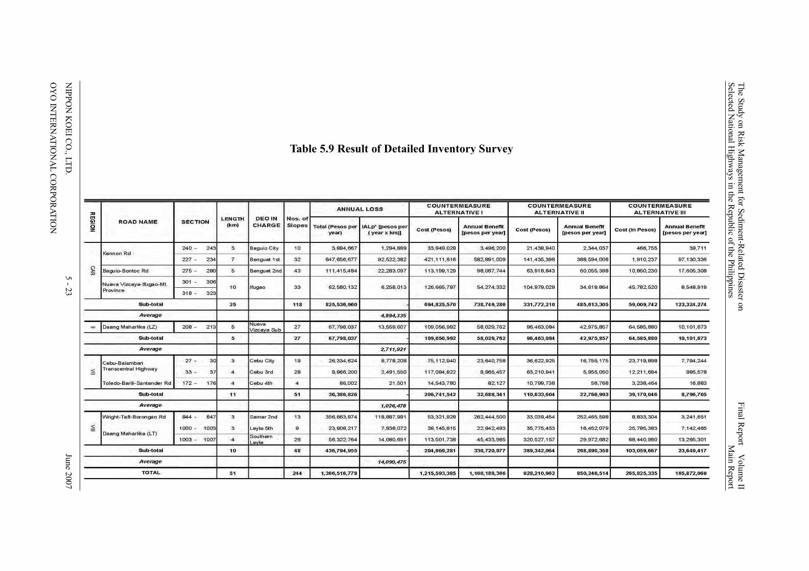
(1) Summary Results of the DIS are summarized in Table 5.9.
Of the total length of 61 km of planned DIS, the surveys of the 10 km sections in Region X and Region XI were not completed by the 20th of Feb 2007. DIS in Regions X and XI will be subsequently conducted by the Counterpart Team and ROs and DEOs of Region X and XI. In
this summary, countermeasure alternatives are set in Table 5.8.
Table 5.8 Countermeasure Alternative Policy Alternative Effectiveness Risk Reduction Ratio
Alternative-I High Effectiveness: Permanent countermeasures to prevent disasters 0.7-1.0 (70%-100%)
Alternative-II Moderate Effectiveness: Mitigating the disasters to some extent 0.3– 0.7 (30%- 70%)
Alternative-III Low Effectiveness: Limited treatment 0.0-0.3 (0-30%)
The Study on Risk M
anagement for Sedim
ent-Related D
isaster on Final R
eport Volum
e II Selected N
ational Highw
ays in the Republic of the Philippines
Main Report
NIPPO
N K
OEI C
O., LTD
. 5 - 23
June 2007
OY
O IN
TERNATIO
NA
L CORPO
RATION
Table 5.9 Result of Detailed Inventory Survey
The Study on Risk Management for Sediment-Related Disaster on Final Report Volume II Selected National Highways in the Republic of the Philippines Main Report
NIPPON KOEI CO., LTD. 5 - 24 June 2007
OYO INTERNATIONAL CORPORATION
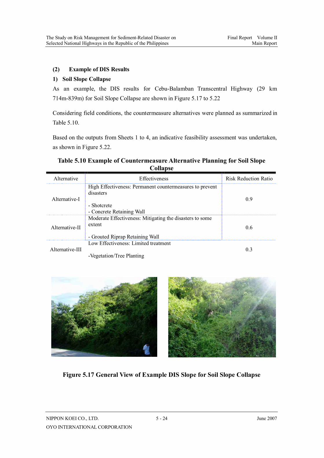
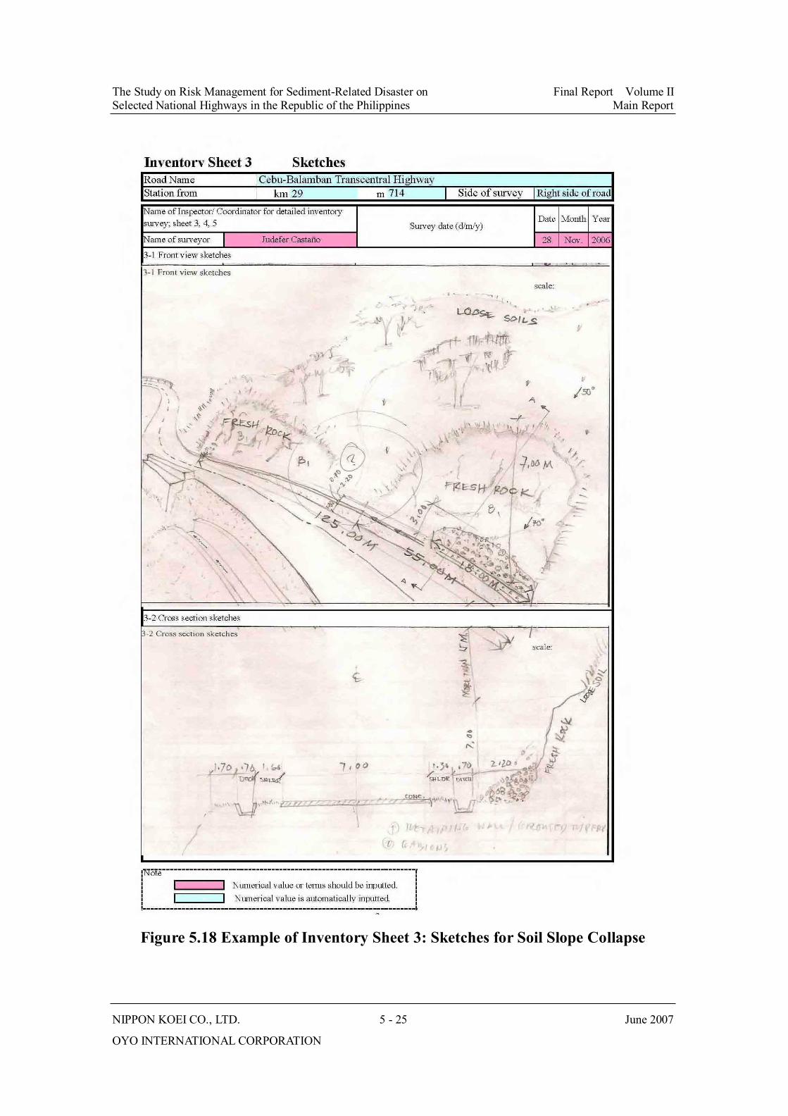
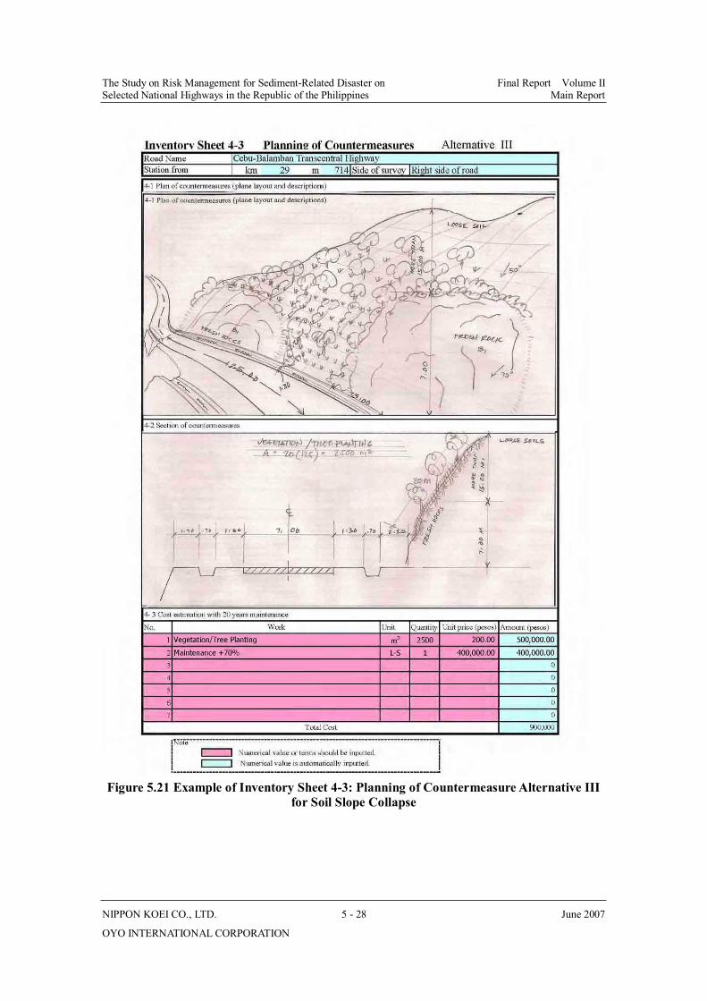
(2) Example of DIS Results 1) Soil Slope Collapse As an example, the DIS results for Cebu-Balamban Transcentral Highway (29 km 714m-839m) for Soil Slope Collapse are shown in Figure 5.17 to 5.22
Considering field conditions, the countermeasure alternatives were planned as summarized in Table 5.10.
Based on the outputs from Sheets 1 to 4, an indicative feasibility assessment was undertaken, as shown in Figure 5.22.
Table 5.10 Example of Countermeasure Alternative Planning for Soil Slope Collapse
Alternative Effectiveness Risk Reduction Ratio
Alternative-I
High Effectiveness: Permanent countermeasures to prevent disasters
- Shotcrete - Concrete Retaining Wall
0.9
Alternative-II
Moderate Effectiveness: Mitigating the disasters to some extent
- Grouted Riprap Retaining Wall
0.6
Alternative-III Low Effectiveness: Limited treatment
-Vegetation/Tree Planting 0.3
Figure 5.17 General View of Example DIS Slope for Soil Slope Collapse
The Study on Risk Management for Sediment-Related Disaster on Final Report Volume II Selected National Highways in the Republic of the Philippines Main Report
NIPPON KOEI CO., LTD. 5 - 25 June 2007
OYO INTERNATIONAL CORPORATION
Figure 5.18 Example of Inventory Sheet 3: Sketches for Soil Slope Collapse

The Study on Risk Management for Sediment-Related Disaster on Final Report Volume II Selected National Highways in the Republic of the Philippines Main Report
NIPPON KOEI CO., LTD. 5 - 26 June 2007
OYO INTERNATIONAL CORPORATION
Figure 5.19 Example of Inventory Sheet 4-1: Planning of Countermeasure Alternative I for Soil Slope Collapse

The Study on Risk Management for Sediment-Related Disaster on Final Report Volume II Selected National Highways in the Republic of the Philippines Main Report
NIPPON KOEI CO., LTD. 5 - 27 June 2007
OYO INTERNATIONAL CORPORATION
Figure 5.20 Example of Inventory Sheet 4-2: Planning of Countermeasure Alternative II for Soil Slope Collapse
The Study on Risk Management for Sediment-Related Disaster on Final Report Volume II Selected National Highways in the Republic of the Philippines Main Report
NIPPON KOEI CO., LTD. 5 - 28 June 2007
OYO INTERNATIONAL CORPORATION
Figure 5.21 Example of Inventory Sheet 4-3: Planning of Countermeasure Alternative III for Soil Slope Collapse

The Study on Risk Management for Sediment-Related Disaster on Final Report Volume II Selected National Highways in the Republic of the Philippines Main Report
NIPPON KOEI CO., LTD. 5 - 29 June 2007
OYO INTERNATIONAL CORPORATION
Figure 5.22 Example of Inventory Sheet 5: Indicative Feasibility Assessment for Soil Slope Collapse