Embed Size (px)
Citation preview

2002 21st Street Condominiums Project
Draft Environmental Impact Report
SCH#2007031019
September 2012
Prepared for:
City of Santa Monica
Planning and Community Development Department
1685 Main Street
Santa Monica, CA 90401
Prepared by:
Rincon Consultants, Inc.
180 North Ashwood Avenue
Ventura, CA 93003
City of
Santa Monica

2002 21st Street Condominiums Project
Draft Environmental Impact Report
Prepared by:
City of Santa Monica Planning & Community Development Department
1685 Main Street Santa Monica, California 90401
Contact: Ms. Rachel Kwok
Prepared with the assistance of:
Rincon Consultants, Inc. 180 N. Ashwood Avenue Ventura, California 93003
September 2012

This report is printed on 50% recycled paper with 50% post-consumer content and chlorine-free virgin pulp.

2002 21st Street Condominiums Project EIR
Table of Contents
City of Santa Monica SCH #2007031019
i
2002 21st Street Condominiums Project
Table of Contents Page
Executive Summary ............................................................................................................................. ES-1 1.0 Introduction 1.1 Purpose and Legal Authority........................................................................................... 1-1 1.2 Lead, Responsible, and Trustee Agencies ...................................................................... 1-1 1.3 Environmental Review Process ....................................................................................... 1-2 1.4 Environmental Impact Report Background ................................................................... 1-3 1.5 Scope and Content ............................................................................................................. 1-4 2.0 Project Description 2.1 Project Applicant ................................................................................................................ 2-1 2.2 Project Location .................................................................................................................. 2-1 2.3 Existing Site Characteristics ............................................................................................. 2-1 2.4 Project Characteristics ....................................................................................................... 2-2 2.5 Projected Construction Schedule ................................................................................... 2-13 2.6 Project Objectives ............................................................................................................. 2-13 2.7 Required Approvals and Permits .................................................................................. 2-13 3.0 Environmental Setting 3.1 Regional Setting .................................................................................................................. 3-2 3.2 Project Site Setting .............................................................................................................. 3-2 3.3 Cumulative Projects Setting .............................................................................................. 3-2 4.0 Environmental Impact Analysis ..................................................................................................... 4-1 4.1 Shadows ............................................................................................................................. 4.1-1 4.2 Air Quality ......................................................................................................................... 4.2-1
4.3 Construction Effects ......................................................................................................... 4.3-1 4.4 Neighborhood Effects....................................................................................................... 4.4-1 4.5 Noise ................................................................................................................................... 4.5-1 4.6 Transportation/Traffic ..................................................................................................... 4.6-1 4.7 Greenhouse Gas Emissions ............................................................................................. 4.7-1
5.0 Other CEQA Considerations 5.1 Economic and Population Growth ................................................................................... 5-1 5.2 Removal of Obstacles to Growth ...................................................................................... 5-1 5.3 Irreversible Environmental Effects ................................................................................... 5-2 6.0 Alternatives 6.1 Alternatives Considered and Rejected ............................................................................ 6-1 6.2 Alternatives Analyzed ....................................................................................................... 6-2 6.3 No Project Alternative ........................................................................................................ 6-3 6.4 Reduced Project Alternative .............................................................................................. 6-3

2002 21st Street Condominiums Project EIR
Table of Contents
City of Santa Monica SCH #2007031019
ii
6.5 Senior Housing Condo Project Alternative .................................................................... 6-5 6.6 Environmentally Superior Alternative ........................................................................... 6-7 7.0 References and Report Preparers 7.1 References ............................................................................................................................ 7-1 7.2 Report Preparers ................................................................................................................. 7-3 List of Figures Figure 1-1 Environmental Review Process ........................................................................ 1-5 Figure 2-1 Regional Location................................................................................................ 2-3 Figure 2-2 Site Vicinity .......................................................................................................... 2-4 Figure 2-3 Aerial View .......................................................................................................... 2-5 Figure 2-4 Existing Site Photos ............................................................................................. 2-6 Figure 2-5 Surrounding Land Use Photos .......................................................................... 2-7 Figure 2-6 Site Plan ............................................................................................................... 2-9 Figure 2-7 Garage Plan ........................................................................................................ 2-11 Figure 4.1-1 Summer Solstice Shadows – June 21st ........................................................... 4.1-5 Figure 4.1-2 Winter Solstice Shadows – December 21st .................................................... 4.1-7 Figure 4.5-1 Land Use/Noise Compatibility Matrix ........................................................ 4.5-4 List of Tables Table ES-1 Summary of Significant Environmental Impacts, Mitigation Measures, and Residual Impacts ...................................................................................... ES-3 Table 2-1 Summary of Project Characteristics ................................................................. 2-2 Table 3-1 Cumulative Projects in Santa Monica .............................................................. 3-3 Table 4.2-1 Current Federal and State Ambient Air Quality Standards ...................... 4.2-2 Table 4.2-2 Ambient Air Quality Data .............................................................................. 4.2-5 Table 4.2-3 SCAQMD Air Quality Significance Thresholds .......................................... 4.2-8 Table 4.2-4 Operational Emissions Associated with the Proposed Project.................. 4.2-9 Table 4.3-1 Exterior Noise Standards ................................................................................ 4.3-3 Table 4.3-2 SCAQMD Construction Significance Thresholds ....................................... 4.3-4 Table 4.3-3 SCAQMD LSTs for Construction for 1-Acre Site ........................................ 4.3-5 Table 4.3-4 Noise Zone I Exterior Noise Standards ......................................................... 4.3-8 Table 4.3-5 Typical Noise Levels at Construction Sites .................................................. 4.3-8 Table 4.3-6 Anticipated Noise Levels at Closest Sensitive Receptor Locations
During Construction ........................................................................................ 4.3-9 Table 4.3-7 Vibration Source Levels for Construction Equipment.............................. 4.3-11 Table 4.3-8 Estimated Maximum Unmitigated Construction Emissions ................... 4.3-12 Table 4.4-1 Summary of Neighborhood Effects ............................................................... 4.4-4 Table 4.5-1 Noise Monitoring Results ............................................................................... 4.5-2 Table 4.5-2 Exterior Noise Standards ................................................................................ 4.5-5 Table 4.5-3 Significance of Changes in Operational Roadway Noise Exposure ......... 4.5-6 Table 4.5-4 Noise Levels Associated with Traffic on Area Roadways ......................... 4.5-7 Table 4.6-1 Weekday Neighborhood Traffic Volumes ................................................... 4.6-2 Table 4.6-2 Project Trip Generation Rates......................................................................... 4.6-5 Table 4.6-3 Project Trip Generation Estimates ................................................................. 4.6-5

2002 21st Street Condominiums Project EIR
Table of Contents
City of Santa Monica SCH #2007031019
iii
Table 4.6-4 City of Santa Monica Intersection Significant Impact Criteria .................. 4.6-6 Table 4.6-5 City of Santa Monica Street Segment Significant Impact Criteria for
Collector, Feeder, and Local Streets .............................................................. 4.6-7 Table 4.6-6 Intersection Levels of Service ......................................................................... 4.6-8 Table 4.6-7 Cumulative Year (2020) Intersection Levels of Service .............................. 4.6-9 Table 4.6-8 Neighborhood Street Segment Impact Analysis ....................................... 4.6-11 Table 4.7-1 Estimated Electrical Consumption .............................................................. 4.7-13 Table 4.7-2 Estimated Annual Operational Emissions of Greenhouse Gases ........... 4.7-13 Table 4.7-3 Estimated Annual Mobile Emissions of Greenhouse Gases .................... 4.7-14 Table 4.7-4 Combined Net Annual Emissions of Greenhouse Gases ........................ 4.7-14 Table 4.7-5 Project Consistency with Applicable Climate Action team Greenhouse
Gas Emission Reduction Strategies ............................................................. 4.5-15 Table 4.7-6 Project Consistency with Applicable Attorney General and OPR’s
Global Warming and Greenhouse Gas Reduction Measures .................. 4.7-19 Table 4.7-7 Project Consistency with Land Use and Circulation Element and
Sustainable City Plan ..................................................................................... 4.7-20 Table 6-1 Reduced Project Alternative Daily Traffic Trips ............................................ 6-5 Table 6-2 Senior Housing Condo Project Alternative Daily Traffic Trips ................... 6-7 Table 6-3 Impact Comparison of Alternatives ................................................................. 6-8 Appendices
Appendix A: Initial Study and Notice of Preparation Appendix B: Air Quality and Greenhouse Gas Emissions Worksheets Appendix C: Noise Measurements and Modeling Results Appendix D: Traffic Memorandum

2002 21st Street Condominiums Project EIR
Table of Contents
City of Santa Monica SCH #2007031019
iv
This page intentionally left blank

2002 21st Street Condominiums Project EIR
Executive Summary
City of Santa Monica SCH #2007031019
ES-1
EXECUTIVE SUMMARY This section summarizes the characteristics of the proposed project and the potential environmental impacts, mitigation measures, and residual impacts associated with the proposed project.
PROJECT SYNOPSIS Project Applicant Park Virginia, LLC 11693 San Vicente Boulevard, # 213 Los Angeles, CA 90049 (310) 399-9995 Project Description The project site is located in the western portion of Los Angeles County, in the City of Santa Monica. The project site is regionally accessible from Interstate 10 (the Santa Monica Freeway) and State Route 1 (Pacific Coast Highway). The site consists of four existing contiguous parcels totaling approximately 28,935 square-feet (0.66-acre) and is located southwest of the intersection of Virginia Avenue and 21st Street. The project site is currently developed with one-story bungalow apartments containing a total of 15 residential units. The parcel at 2002 21st Street contains five residential units in two buildings. 2008 21st Street contains four units in two buildings. 2014 and 2018 21st Street each contain three units in two buildings. All of the buildings contain garage structures adjacent to the alley. The buildings were constructed between 1935 and 1951. A low concrete block wall and wooden fence border the site adjacent the public sidewalk along 21st Street and Virginia Avenue. Landscaping includes bottlebrush, fan palm, oleander, syzygium, and a variety of low growing shrubs and herbaceous ornamentals. The site is designated Low Density Housing and zoned R2, Low Density Multiple Residential. The project site is bordered by residential uses. The proposed project involves demolition of the existing improvements and the development of a two story (plus roof deck) 21-unit condominium complex on the 0.66-acre project site. Two of the proposed units would be reserved as affordable housing units. A total of 48 parking spaces would be provided within a subterranean structure containing 21 private two-car garages. A minimum of four guest parking spaces are also proposed within the subterranean garage. The project requires a minimum of four guest parking spaces. Each of the 21 units would be two-bedroom, two and one-half bathroom townhouse style condominiums with two stories above a private garage. The units would range from approximately 1,022 square feet to 1,554 square feet. The site layout is configured around a courtyard. Private outdoor space would be provided with patios on the ground level, balconies on the second level and roof decks for each unit on top of the building. A network of pathways and landscaping facilitates pedestrian circulation within the courtyard, which would primarily be accessed from the Virginia Avenue frontage and 20th Court Alley guest parking. Vehicular access to the subterranean garage would be from a single driveway from 20th Court Alley.

2002 21st Street Condominiums Project EIR
Executive Summary
City of Santa Monica SCH #2007031019
ES-2
It is anticipated that construction of the project would commence in late 2013. The site preparation phase is anticipated to last about four months. Building completion is estimated for late2014. However, the construction schedule could be extended depending on weather conditions and their effect on development. It is anticipated that the project would be constructed in a single phase.
ALTERNATIVES As required by CEQA, the EIR examines a range of alternatives to the proposed project. These alternatives are described and evaluated in Section 6.0, Alternatives. Studied alternatives include:
Alternative 1: No Project - The no project alternative assumes that the development proposed as part of the project would not occur. The existing bungalow apartments would remain. The site would remain in its current condition.
Alternative 2: Reduced Project- This alternative would maintain a similar building design to the proposed project, but would accommodate only 15 condominium units. This alternative would include the demolition of the existing 15 one-story bungalow apartments. The total number of residential units constructed would be 15; six fewer units than the proposed project and a net increase of zero units, as compared to the existing apartment complex on the project site. As with the proposed project, the site layout would be configured around a courtyard, with private outdoor space including patios provided at the ground level for each unit. Parking would be provided within a subterranean structure containing 15 private two-car garages as well as guest parking. Access to the garage would be from a single driveway from 20th Court Alley, the same as with the proposed project.
Alternative 3: Senior Housing Condo Project - This alternative would maintain a similar building design to the proposed project, but would provide 21 senior housing condominium units. This alternative would include the demolition of the existing 15 one-story bungalow apartments. The total number of residential units constructed would be 21; the same as the proposed project but would be intended for senior residents. As with the proposed project, the site layout would be configured around a courtyard, with private outdoor space including patios provided at the ground level for each unit. Like the proposed project, parking would be provided within a subterranean structure containing 21 private two-car garages as well as guest parking. Access to the subterranean parking garage would be from a single driveway from 20th Court Alley, the same as with the proposed project.
SUMMARY OF ENVIRONMENTAL IMPACTS AND MITIGATION MEASURES Table ES-1 includes a brief description of the environmental issues relative to the proposed project, the identified environmental impacts, proposed mitigation measures, and residual impacts after mitigation measures. Impacts are categorized by classes. Class I impacts are defined as significant, unavoidable adverse impacts which require a statement of overriding considerations to be issued pursuant to the State CEQA Guidelines §15093 if the project is

2002 21st Street Condominiums Project EIR
Executive Summary
City of Santa Monica SCH #2007031019
ES-3
approved. Class II impacts are significant adverse impacts that can be feasibly mitigated to less than significant levels and which require findings to be made under Section 15091 of the State CEQA Guidelines. Class III impacts are considered less than significant impacts, and Class IV impacts are beneficial impacts.
Table ES-1 Summary of Environmental Impacts,
Mitigation Measures, and Residual Impacts
Impact Mitigation Measures Significance After
Mitigation
SHADOWS
Impact SH-1 Residential uses adjacent to the project site are mostly shaded by existing trees. The proposed project would cast shadows onto adjacent residential uses. However, because these residential uses are already shaded, the proposed project would not substantially alter shadow conditions and impacts would be Class III, less than significant.
Mitigation is not required. Less than significant without mitigation.
AIR QUALITY
Impact AQ-1 Operation of the proposed project would generate air pollutant emissions, but emissions would not exceed SCAQMD operational significance thresholds. Therefore, the project’s long-term impact to regional air quality would be Class III, less than significant.
Mitigation is not required. Less than significant without mitigation.
Impact AQ-2 Long-term mobile emissions associated with the proposed project would incrementally increase CO concentrations at heavily congested intersections in the area. However, CO levels would remain within state and federal standards, and the increase of V/C ratio would be less than 2% for intersections rated D or worse. Therefore, impacts would be Class III, less than significant.
Mitigation is not required. Less than significant without mitigation.
CONSTRUCTION EFFECTS
Impact CON-1 Project construction and equipment staging would temporarily increase truck traffic in the project area, which could disrupt the normal use of the sidewalk and adjacent streets, and affect parking availability. This is a Class II, significant but mitigable, impact.
CON-1 Construction Impact
Mitigation Plan. The applicant shall prepare, implement, and maintain a Construction Impact Mitigation Plan which shall be designed to: • Prevent material traffic impacts on the surrounding roadway network. • Minimize parking impacts both to public parking and access to private parking to the greatest extent practicable.
Less than significant with mitigation.

2002 21st Street Condominiums Project EIR
Executive Summary
City of Santa Monica SCH #2007031019
ES-4
Table ES-1 Summary of Environmental Impacts,
Mitigation Measures, and Residual Impacts
Impact Mitigation Measures Significance After
Mitigation • Ensure safety for both those constructing the project and the surrounding community • Prevent substantial truck traffic through residential neighborhoods. The Construction Impact Mitigation Plan shall be subject to review and approval by the following City departments: Public Works Department, Fire, Planning and Community Development and Police to ensure that the Plan has been designed in accordance with this mitigation measure. This review shall occur prior to building permit issuance for the project. It shall at a minimum, include the following: Ongoing requirements throughout the duration of construction: • A detailed traffic control plan for work zones shall be maintained which includes at a minimum accurate existing and proposed: parking and travel lane configurations; warning, regulatory, guide and directional signage; and area sidewalks, bicycle lanes and parking lanes. The plan shall include specific information regarding the project’s construction activities that may disrupt normal pedestrian and traffic flow and the measures to address these disruptions. Such plans must be reviewed and approved by the Strategic & Transportation Planning Division prior to commencement of construction and implemented in accordance with this approval. • Work within the public right-of-way shall be performed between 9:00 AM and 4:00 PM , including: dirt and demolition material hauling and construction material delivery. Work within the public right-of-way outside of these hours shall only be allowed after the issuance of an after-hours construction permit. • Streets and equipment should be cleaned in accordance with

2002 21st Street Condominiums Project EIR
Executive Summary
City of Santa Monica SCH #2007031019
ES-5
Table ES-1 Summary of Environmental Impacts,
Mitigation Measures, and Residual Impacts
Impact Mitigation Measures Significance After
Mitigation established Public Works requirements. • Trucks shall only travel on a City approved construction route. Truck queuing/staging shall not be allowed on Santa Monica Streets. Limited queuing may occur on the construction site itself. • Materials and equipment should be minimally visible to the public; the preferred location for materials is to be on-site, with a minimum amount of materials within a work area in the public right-of-way, subject to a current Use of Public Property permit. • Any requests for work before or after normal construction hours within the public right-of-way shall be subject to review and approval through the After Hours Permit process administered by the Building and Safety Division. • Provision of off-street parking for construction workers, which may include the use of a remote location with shuttle transport to the site, if determined necessary by the City of Santa Monica. Project Coordination Elements that shall be implemented prior to commencement of construction: • Advise the traveling public of impending construction activities (e.g. information signs, portable message signs, media listing/notification, implementation of an approved traffic control plan. • Approval from the City through issuance of a Use of Public Property Permit, Excavation Permit, Sewer Permit or Oversize Load Permit, as well as any Caltrans Permits required, for any construction work requiring encroachment into public rights-of-way. • Timely notification of construction schedules to all affected agencies (e.g. Big Blue Bus, Police Department, Fire Department, Public

2002 21st Street Condominiums Project EIR
Executive Summary
City of Santa Monica SCH #2007031019
ES-6
Table ES-1 Summary of Environmental Impacts,
Mitigation Measures, and Residual Impacts
Impact Mitigation Measures Significance After
Mitigation Works Department, and Planning and Community Development Department) and to all owners and residential and commercial tenants of property within a radius of 500 feet. • Coordination of construction work with affected agencies in advance of start of work. Approvals may take up to two weeks per each submittal. • Approval by the Strategic & Transportation Planning Division of any haul routes, for earth, concrete or construction materials and equipment handling.
Impact CON-2 Demolition of existing structures and construction of the proposed project would generate temporary construction noise that would be periodically audible to sensitive receptors near the project site. This is a Class II, significant but mitigable, impact.
CON-2(a) Restrictions on
Excavation and
Foundation/Conditioning. Excavation, foundation-laying, and conditioning activities (the noisiest phases of construction) shall be restricted to between the hours of 10:00 AM and 3:00 PM, Monday through Friday, in accordance with Section 4.12.110(d) of the Santa Monica Municipal Code as it would apply to residential zones.
CON-2(b) Diesel Equipment
Mufflers. All diesel equipment shall be operated with closed engine doors and shall be equipped with factory recommended mufflers.
CON-2(c) Electrically-Powered
Tools. Electrical power shall be used to run air compressors and similar power tools.
CON-2(d) Additional Noise
Attenuation Techniques. For all noise generating construction activity on the project site, additional noise attenuation techniques shall be employed to reduce noise levels to City of Santa Monica noise standards. Such techniques may include, but are not limited to, the use of sound blankets on noise generating equipment and the construction of temporary sound barriers between construction sites and nearby sensitive receptors.
CON-2(e) Construction Sign
Less than significant with mitigation.

2002 21st Street Condominiums Project EIR
Executive Summary
City of Santa Monica SCH #2007031019
ES-7
Table ES-1 Summary of Environmental Impacts,
Mitigation Measures, and Residual Impacts
Impact Mitigation Measures Significance After
Mitigation Posting. In accordance with Municipal Code Section 4.12.120, the project applicant shall be required to post a sign informing all workers and subcontractors of the time restrictions for construction activities. The sign shall also include the City telephone numbers where violations can be reported and complaints associated with construction noise can be submitted.
Impact CON 3 Project-related demolition and construction activities would intermittently generate groundborne vibration on and off site in the immediate vicinity. Vibration levels may affect sensitive receptors adjacent to the project site. Impacts would be Class I, significant and unavoidable.
No feasible mitigation measures are available.
Impacts would be significant and unavoidable.
Impact CON-4 Project construction would create a temporary increase in air pollutant and dust emissions. However, estimated maximum daily emissions would not exceed established SCAQMD thresholds for any pollutant. Therefore, air quality impacts would be Class III, less than significant.
None necessary.
Less than significant without mitigation.
NOISE
Impact N-1 Project-generated traffic would incrementally increase noise levels on area roadways. However, the change in noise levels would be less than one dB. Therefore, the effect of increased traffic noise on existing uses would be Class III, less than significant.
Mitigation is not required. Less than significant without mitigation.
Impact N-2 Operation of the proposed project would generate noise from on-site noise sources that include stationary equipment, such as rooftop ventilation and heating systems, and general residential activities. Project-generated noise associated with building operations may exceed the City’s exterior noise standards. This is a Class II, significant but mitigable, impact.
N-2(a) Rooftop Ventilation. Parapets shall be installed around all rooftop ventilation systems.
N 2(b) Exterior Mechanical
Equipment. All exterior mechanical equipment shall be oriented away from adjacent residential uses and shall be fitted with sound-rated parapets.
Less than significant with mitigation.

2002 21st Street Condominiums Project EIR
Executive Summary
City of Santa Monica SCH #2007031019
ES-8
Table ES-1 Summary of Environmental Impacts,
Mitigation Measures, and Residual Impacts
Impact Mitigation Measures Significance After
Mitigation
TRANSPORTATION/TRAFFIC
Impact T-1 The proposed project would result in a net increase in traffic compared to existing conditions of approximately 39 daily trips, which include two AM peak hour trips and three PM peak hour trips. Such an increase would not exceed thresholds at any study area intersections during Approval Year (2012) Plus Project or Cumulative Year (2020) Plus Project conditions. Therefore, impacts on intersections would be Class III, less than significant.
Mitigation is not required. Less than significant without mitigation.
Impact T-2 The proposed project would result in a net increase in traffic compared to existing conditions of approximately 39 daily trips. Such an increase would not exceed the City’s thresholds at any of the neighborhood street segments. Therefore, impacts on neighborhood street segments would be Class III, less than significant.
Mitigation is not required. Less than significant without mitigation.
GREENHOUSE GAS EMISSIONS
Impact GHG-1 The proposed project would generate GHG emissions from both mobile and operational sources. However, project emissions would not exceed the 10,000 tons CDE/year threshold and would not conflict with any applicable plan, policy or regulation of an agency adopted for the purpose of reducing the emissions of GHGs. Therefore, impacts would be Class III, less than significant.
Mitigation is not required. Less than significant without mitigation.

2002 21st Street Condominiums Project EIR
Section 1.0 Introduction
City of Santa Monica SCH #2007031019
1-1
1.0 INTRODUCTION This document is a Draft Environmental Impact Report (EIR) for the proposed 2002 21st Street Condominiums Project located at 2002 - 2018 21st Street (hereafter referred to as the proposed project or the project). The proposed project involves the construction of a two story (plus roof deck) 21-unit condominium complex building with a one-level subterranean parking garage containing 48 spaces. . This section discusses: (1) the environmental impact report background; (2) the legal basis for preparing an EIR; (3) the scope and content of the EIR; (4) lead, responsible, and trustee agencies; and (5) the environmental review process required under the California Environmental Quality Act (CEQA). The project is described in greater detail in Section 2.0, Project Description.
1.1 PURPOSE AND LEGAL AUTHORITY The proposed project requires the discretionary approval of the City of Santa Monica Planning Commission (or City Council, if appealed). Therefore, this EIR has been prepared in accordance with the California Environmental Quality Act (CEQA) (Public Resources Code [PRC] Sections 21000 et seq.), the CEQA Guidelines, (California Code of Regulations, Title 14, Sections 15000 et seq.), and the City of Santa Monica’s CEQA procedures and requirements. In accordance with Section 15121 of the State CEQA Guidelines, the purpose of this EIR is to serve as an informational document that:
“...will inform public agency decision-makers and the public generally of the significant environmental effects of a project, identify possible ways to minimize the significant effects, and describe reasonable alternatives to the project.”
This EIR has been prepared as a Project EIR pursuant to Section 15161 of the CEQA Guidelines. A Project EIR is appropriate for a specific development project. As stated in the CEQA Guidelines:
“This type of EIR should focus primarily on the changes in the environment that would result from the development project. The EIR shall examine all phases of the project, including planning, construction, and operation.”
This EIR is to serve as an informational document for the public and City of Santa Monica decision-makers. The process will culminate with a Planning Commission hearing to consider certification of a Final EIR and approval of the project. Section 2.7 in Section 2.0 Project Description, provides a detailed description of approvals that may be necessary for the proposed project.
1.2 LEAD, RESPONSIBLE, AND TRUSTEE AGENCIES The CEQA Guidelines define lead, responsible, and trustee agencies. The City of Santa Monica is the lead agency for the project because it holds principal responsibility for approving the project.

2002 21st Street Condominiums Project EIR
Section 1.0 Introduction
City of Santa Monica SCH #2007031019
1-2
A responsible agency refers to a public agency other than the lead agency that has discretionary approval over the project, and a trustee agency refers to a state agency having jurisdiction by law over natural resources affected by a project. There are no responsible or trustee agencies for this project as no other agencies have approval authority over any aspect of the project.
1.3 ENVIRONMENTAL REVIEW PROCESS The major steps in the environmental review process, as required under CEQA, are outlined below and illustrated on Figure 1-1. The steps are presented in sequential order. 1. Notice of Preparation (NOP). After deciding that an EIR is required, the lead agency must
file an NOP soliciting input on the EIR scope to the State Clearinghouse, other concerned agencies, and parties previously requesting notice in writing (CEQA Guidelines Section 15082; Public Resources Code Section 21092.2). The NOP must be posted in the County Clerk’s office for 30 days. The NOP may be accompanied by an Initial Study that identifies the issue areas for which the proposed project could create significant environmental impacts.
2. Draft Environmental Impact Report (Draft EIR). The Draft EIR must contain:
a) table of contents or index; b) summary; c) project description; d) environmental setting; e) discussion of potentially significant impacts (direct, indirect, cumulative, growth-
inducing and unavoidable impacts); f) a discussion of alternatives; and g) mitigation measures.
3. Notice of Completion/Notice of Availability of Draft EIR. A lead agency must file a
Notice of Completion with the State Clearinghouse when it completes a Draft EIR and prepare a Public Notice of Availability for the Draft EIR. The lead agency must place the Notice in the County Clerk’s office for 45 days (Public Resources Code Section 21092) and send a copy of the Notice to anyone requesting it (CEQA Guidelines Section 15087). Additionally, public notice of Draft EIR availability must be given through at least one of the following procedures: a) publication in a newspaper of general circulation; b) posting on and off the project site; and c) direct mailing to owners and occupants of contiguous properties. The lead agency must solicit input from other agencies and the public, and respond in writing to all comments received (Public Resources Code Sections 21104 and 21253). The minimum public review period for a Draft EIR is 30 days. When a Draft EIR is sent to the State Clearinghouse for review, the public review period must be 45 days unless the State Clearinghouse (Public Resources Code 21091) approves a shorter period of not less than 30 days.
4. Final EIR. A Final EIR must include: a) the Draft EIR; b) copies of comments received
during public review; c) list of persons and entities commenting; d) responses to comments; and e) any other information added by the lead agency.

2002 21st Street Condominiums Project EIR
Section 1.0 Introduction
City of Santa Monica SCH #2007031019
1-3
5. Certification of Final EIR. Prior to making a decision on a proposed project, the lead agency must certify that: a) the Final EIR has been completed in compliance with CEQA; b) the Final EIR was presented to the decision-making body of the lead agency; and c) the decision-making body reviewed and considered the information in the Final ElR prior to approving a project (CEQA Guidelines Section 15090).
6. Lead Agency Project Decision. A lead agency may: a) disapprove a project because of its significant environmental effects; b) require changes to a project to reduce or avoid significant environmental effects; or c) approve a project despite its significant environmental effects, if the proper findings and statement of overriding considerations are adopted (CEQA Guidelines Sections 15042 and 15043).
7. Findings/Statement of Overriding Considerations. For each significant impact of the project identified in the EIR, the lead or responsible agency must find, based on substantial evidence, that either: a) the project has been changed to avoid or substantially reduce the magnitude of the impact; b) changes to the project are within another agency's jurisdiction and such changes have or should be adopted; or c) specific economic, social, or other considerations make the mitigation measures or project alternatives infeasible (CEQA Guidelines Section 15091). If an agency approves a project with unavoidable significant environmental effects, it must prepare a written Statement of Overriding Considerations that sets forth the specific social, economic, or other reasons supporting the agency's decision.
8. Mitigation Monitoring Reporting Program. When an agency makes findings on significant effects identified in the EIR, it must adopt a reporting or monitoring program for mitigation measures that were adopted or made conditions of project approval to mitigate significant effects.
9. Notice of Determination. An agency must file a Notice of Determination within 5 days
after deciding to approve a project for which an EIR is prepared (CEQA Guidelines Section 15094). A local agency must file the Notice with the County Clerk. The Notice must be posted for 30 days and sent to anyone previously requesting notice. Posting of the Notice starts a 30-day statute of limitations on CEQA legal challenges (Public Resources Code Section 21167[c]).
1.4 ENVIRONMENTAL IMPACT REPORT BACKGROUND A Notice of Preparation (NOP) of an environmental impact report was prepared for the proposed project and distributed on June 17, 2010 for agency and public review for a 30-day review period. The City received one NOP response from the Native American Heritage Commissions. The letter indicated that Native American cultural resources were not indentifed at the project site. The NOP and responses are presented in Appendix A, along with the Initial Study that was prepared for the project.

2002 21st Street Condominiums Project EIR
Section 1.0 Introduction
City of Santa Monica SCH #2007031019
1-4
1.5 SCOPE AND CONTENT This EIR addresses the environmental issues determined to be potentially significant as determined in the Initial Study prepared by the City of Santa Monica and responses to the NOP (see Appendix A). The issues addressed in this EIR include:
Aesthetics (Shadows)
Air Quality
Construction Effects
Neighborhood Effects
Noise
Transportation/Circulation
Greenhouse Gas Effects This EIR analyzes the potentially significant environmental impacts of the project, including project-specific and cumulative effects, in accordance with provisions set forth in the CEQA Guidelines. In addition, the EIR recommends feasible mitigation measures, where possible, that would reduce or eliminate adverse environmental effects. The EIR references pertinent City policies and guidelines, certified EIRs and adopted CEQA documents, and background documents prepared by the City in preparing the analysis. A full reference list is contained in Section 7.0, References and Report Preparers. Section 6.0, Alternatives section of the EIR was prepared in accordance with Section 15126.6 of the CEQA Guidelines. The Alternatives discussion evaluates the CEQA-required “no project” alternative and two alternative development scenarios for the site. It also identifies the environmentally superior alternative among the alternatives assessed. The level of detail contained throughout this EIR is consistent with the requirements of CEQA and applicable court decisions. The CEQA Guidelines provide the standard of adequacy on which this document is based. The Guidelines state:
An EIR should be prepared with a sufficient degree of analysis to provide decision-makers with information which enables them to make a decision which intelligently takes account of environmental consequences. An evaluation of the environmental effects of the proposed project need not be exhaustive, but the sufficiency of an EIR is to be reviewed in light of what is reasonably feasible. Disagreement among experts does not make an EIR inadequate, but the EIR should summarize the main points of disagreement among the experts. The courts have looked not for perfection, but for adequacy, completeness, and a good faith effort at full disclosure. (Section 15151)

Section 1.0 Introduction
Figure 1-1 City of Santa Monica
Environmental Review Process
Lead Agency (City of Santa Monica) prepares Initial Study
City sends Notice of Preparation (NOP) to responsible agencies
City prepares Draft EIR
Public Review Period (30 day minimum)
City files Notice of Completion and gives public notice of availability of Draft EIR
City prepares Final EIR, including responses to comments on the Draft EIR
City prepares findings on the feasibility of reducing significant environmental effects
City makes a decision on the project
City files Notice of Determination with County Clerk
City solicits comment from Agencies & Public on the adequacy of the Draft EIR
Responsible Agency decision-making bodies consider the Final EIR
City solicits input from Agencies & Publi c on the content of the Draft EIR
2002 21st Street Condominiums Project EIR
SCH #20070310191-5

2002 21st Street Condominiums Project EIR
Section 1.0 Introduction
City of Santa Monica SCH #2007031019
1-6
This page intentionally left blank

2002 21st Street Condominiums Project EIR
Section 2.0 Project Description
City of Santa Monica SCH #2007031019
2-1
2.0 PROJECT DESCRIPTION This section identifies the project applicant and project location and also provides a detailed description of the proposed project, including a description of the major project characteristics, project objectives, and a listing of discretionary approvals needed for the project. The focus is on those characteristics and activities (operation and construction) associated with the project that could cause physical changes to the environment.
2.1 PROJECT APPLICANT Park Virginia, LLC 11693 San Vicente Boulevard, # 213 Los Angeles, CA 90049 (310) 399-9995
2.2 PROJECT LOCATION The project site is located in the western portion of Los Angeles County, in the City of Santa Monica. Santa Monica is approximately 10 miles west of downtown Los Angeles. The City is bounded to the north, east, and south by urban communities within the City of Los Angeles and to the west by the Pacific Ocean. Figure 2-1 illustrates the regional location of the project site and Figure 2-2 shows the project’s location within Santa Monica. The project site is regionally accessible from Interstate 10 (the Santa Monica Freeway) and State Route 1 (Pacific Coast Highway). The site consists of four existing contiguous parcels totaling approximately 28,935 square-feet (0.66-acre). The site is located south of the intersection of Virginia Avenue and 21st Street. The site address is 2002-2018 21st Street. Figure 2-3 shows an aerial view of the project site.
2.3 EXISTING SITE CHARACTERISTICS The project site is currently developed with 15 one-story bungalow apartments. The parcel at 2002 21st Street contains five residential units in two buildings. The parcel at 2008 21st Street contains four units in two buildings. The parcels at 2014 and 2018 21st Street each contain three units in two buildings. All of the buildings contain garage structures adjacent to the alley. The buildings were constructed between 1935 and 1951. A low concrete block wall and wooden fence border the site adjacent the public sidewalk along 21st Street and Virginia Avenue. Landscaping includes bottlebrush, fan palm, oleander, syzygium, and a variety of low growing shrubs and herbaceous ornamentals. The project site is located in an urbanized setting. The project site is bordered by various residential uses, including single family dwelling units and multi-family structures along 21st Street and Virginia Avenue. The residential neighborhood along 21st Street and Virginia Avenue is well landscaped with street trees, shrubs and other vegetation. Pico Boulevard is approximately 500 feet southeast of the project site and contains various commercial and retail land uses. 20th Street, approximately 200 feet southwest of the project site, contains multi-family residential structures. Virginia Avenue Park, located one block northeast of the project

2002 21st Street Condominiums Project EIR
Section 2.0 Project Description
City of Santa Monica SCH #2007031019
2-2
site, is approximately 300 feet away. Santa Monica College, located at 1900 Pico Boulevard is approximately 0.25 miles from the project site. Figure 2-4 provides photos of the existing site characteristics. Figure 2-5 provides photos of the surrounding land uses. The project site is zoned R2, Low Density Multiple Residential. The project site is located in the Pico neighborhood of the City as identified in the City’s Land Use and Circulation Element (LUCE) and has a land use designation of low density housing. Maximum allowable height is 30 feet and maximum allowable density for this land use designation is 29 units per net acre. As indicated, the low density housing designation is designed to preserve and protect the existing character of the residential neighborhood. Typical uses include single family housing, duplexes and triplexes, townhouse style units, low-scale courtyard housing, institutional residential uses like child care homes, transitional housing or hospice facilities, and neighborhood-serving uses such as child care, neighborhood grocery stores and community facilities.
2.4 PROJECT CHARACTERISTICS The proposed project involves demolition of the existing improvements and development of a two-story (plus roof deck) 21-unit condominium complex building on the 0.66-acre project site. Two of the proposed units would be reserved as very low income units. A total of 48 parking spaces would be within a one-level subterranean structure containing 21 private two-car garages. A minimum of four guest parking spaces are also proposed within the subterranean garage. Figure 2-6 provides the project’s site plan. Figure 2-7 provides the Garage Plan for the subterranean parking area. Table 2-1 summarizes the project characteristics.
Table 2-1 Summary of Project Characteristics
Lot Size 0.66 acres (28,935 square feet)
Total Proposed Dwelling Units 21 units
Total Proposed Floor Area 26,325 sf
Floor Area Ratio 0.91
Maximum Building Height 26’6” at the top of building 27’8” at the roof deck guard rail 33’0” at the stairwell shafts
a
Number of Levels Above Grade 2 + roof deck
Number of Levels Below Grade 1 level
Parking Spaces 48
Source: Farhad Ashofteh Inc. Plan Set dated 2/26/2009 a
Per Santa Monica Municipal Code, height at stairwell shafts are excluded from the maximum building height calculation
Each of the 21 units would be two-bedroom, two and one-half bathroom townhouse style condominiums with two stories above a private garage. The units would range from approximately 1,022 square feet to 1,554 square feet. The site layout is configured around a

Long B e a c h
Moorpark
Calabasas Thous and Oaks
5
210
105
110710
405 10
605
710
10
210
5
71010
710
10
5
101
101 101
101
1
42
19
27
126
91
22
47
42
1
0 5 102.5 Miles
118
23
San Fernando
Santa Monica
2002 21st Street Condominiums Project EIR Section 2.0 Project Description
City of Santa MonicaFigure 2-1 Regional Location
Los Angeles Project Location
SCH #20070310192-3

Source: National Geographic TOPO! Beverly Hills, 1995.
0 1000 2000 Feet
Site Vicinity City of Santa Monica
Figure 2-2
2002 21st Street Condominium Project EIR Section 2.0 Project Description
SITE
SCH #20070310192-4

Section 2.0 Project Description
Figure 2-3 City of Santa Monica
Aerial View
2002 21st Street Condominiums Project EIR
Project Site
VIRGIN
IA AVE
VIRGIN
IA AVE
20TH CT
20TH CT
20TH STREET
20TH STREET
21ST STREET
21ST STREET
Aerial Source: City of Santa Monica, 2005
Scale in Feet
0 50 100
SCH #20070310192-5

2002 21st Street Condominiums Project EIRSection 2.0 Project Description
Figure 2-4City of Santa Monica
Existing Site Photos
Photo 1 - Site frontage along 21st Street. Photo 2 - Streetscape at corner of 21st Street and Virginia.
Photo 3 - Existing one-story bungalow apartments. Photo 4 - Garage units along the rear alley.
SCH #20070310192-6

2002 21st Street Condominiums Project EIRSection 2.0 Project Description
Figure 2-5City of Santa Monica
Surrounding Land Use Photos
Photo 1 - Multi-family residence at 2024 21st Street (adjacent to southeast border of the project site)
Photo 2 - One and two-story multi-family residences across 21st Street from the site.
Photo 3 - Two-story multi-family residences across Virginia Avenue from the site.
Photo 4 - Multi-family residences with garages along the rear alley (southwest of the site).
SCH #20070310192-7

2002 21st Street Condominiums Project EIR
Section 2.0 Project Description
City of Santa Monica SCH #2007031019
2-8
This page intentionally left blank.

2002 21st Condominiums ProjectInitial Study
Figure 2-6City of Santa Monica
Site PlanSource: Farhad Ashofte Inc., February 26, 2009.
/ 0 10 20 Feet
SCH #20070310192-9

2002 21st Condominiums ProjectInitial Study
Figure 2-7City of Santa Monica
Garage PlanSource: Farhad Ashofte Inc., February 26, 2009.
/ 0 9 18 Feet
SCH #20070310192-11

2002 21st Street Condominiums Project EIR
Section 2.0 Project Description
City of Santa Monica SCH #2007031019
2-13
courtyard. Private outdoor space would be provided with patios on the ground level, balconies on the second level and roof decks for each unit on top of the building. A network of pathways and landscaping facilitates pedestrian circulation within the courtyard, which would primarily be accessed from the Virginia Avenue frontage and through the subterranean parking garage with access at the rear alley along the southwest border of the site (between 21st Street and 20th Street). Vehicular access to the subterranean garage would be from a single driveway from 20th Court Alley.
2.5 PROJECTED CONSTRUCTION SCHEDULE It is anticipated that construction of the project would commence in late-2013. The site preparation phase is anticipated to last about four months. The proposed project would require demolition of the existing bungalows on-site and construction of the proposed 21-unit condominium complex building with subterranean parking. Approximately 6,600 cubic yards of dirt is anticipated to be exported by the proposed project. Building completion is estimated for late 2014. However, the construction schedule could be extended depending on weather conditions and their effect on development. It is anticipated that the project would be constructed in a single phase.
2.6 PROJECT OBJECTIVES The applicant’s objective for the project is to expand the City’s existing housing stock by developing a multifamily residential development that would be compatible with the existing Pico neighborhood and consistent with the LUCE.
2.7 REQUIRED APPROVALS
The proposed project would require the discretionary approval of the City of Santa Monica Planning Commission (or City Council, if appealed) prior to initiating construction. The proposed project would require approval by the Architectural Review Board for design-related matters. Specifically, the following approvals would be required:
Certification of the Final EIR
Development Review Permit (Permit DR 06-007)
Tract Map 66625 (Permit TM 06-021)
Architectural Design Review
Building and Demolition permits
Any other incidental discretionary approvals needed for the construction and operation of the proposed project.

2002 21st Street Condominiums Project EIR
Section 2.0 Project Description
City of Santa Monica SCH #2007031019
2-14
This page intentionally left blank.
2002 21st Street Condominiums Project EIR
Section 3.0 Environmental Setting
City of Santa Monica SCH #2007031019
3-1
3.0 ENVIRONMENTAL SETTING
This section provides a general overview of the environmental setting for the project. More detailed descriptions of the environmental setting germane to each environmental issue area can be found in Section 4.0, Environmental Impact Analysis. According to CEQA Guidelines Section 15125, an EIR must include a description of the existing physical environmental conditions in the vicinity of the proposed project to provide the “baseline condition” against which project-related impacts are compared. Normally, the baseline condition is the physical condition that exists when the NOP is published or when environmental analysis begins. The NOP for the proposed project was published on June 17, 2010. However, the CEQA Guidelines and the Courts have recognized that the date for establishing an environmental baseline cannot be rigid. The California Supreme Court determined that “[n]either CEQA nor the CEQA Guidelines mandate a uniform, inflexible rule for determination of the existing conditions baseline. Rather, an agency enjoys the discretion to decide, in the first instance, exactly how the existing physical conditions without the project can most realistically be measured, subject to review, as with all CEQA factual determinations, for support by substantial evidence.” (Communities for a Better Environment v. South Coast Air Quality Management Dist. (2010) 48 Cal.4th 310, 320). The Supreme Court further stated that “Environmental conditions may vary from year to year and in some cases it is necessary to consider conditions over a range of time periods. In some circumstances, peak impacts or recurring periods of resource scarcity may be as important environmentally as average conditions. Where environmental conditions are expected to change quickly during the period of environmental review for reasons other than the proposed project, project effects might reasonably be compared to predicted conditions at the expected date of approval, rather than to conditions at the time analysis is begun.” (Communities for a Better Environment, supra, 48 Cal.4th at p. 328.) For this EIR, the NOP year for existing conditions (2010) is generally used as the baseline environmental setting for analyzing most of the project’s impact areas in this EIR. However, for the analysis of traffic impacts, this EIR uses the project’s approval year of 2012 as the ‘baseline’ environmental setting. The purpose of establishing the project’s approval year as the ‘baseline’ for the analysis for traffic impacts is that it is a more accurate representation of traffic conditions that change over the time period that the EIR is being prepared. Therefore, an ambient growth rate of 0.8% has been applied to account for increased traffic volume from related projects that have received their Certificates of Occupancy between the NOP date and project’s anticipated approval year and for forecasted traffic growth as substantiated by Southern California Association of Governments (SCAG) projections, LA County Congestion Management Plan (CMP) subarea projections, and the City’s actual historical traffic volume patterns. The decision in Pfeiffer v. City of Sunnyvale City Council, (2011) 200 Cal.App.4th 1552 and Save Our Peninsula Committee v. Monterey County Bd. of Supervisors (2001) 87 Cal.App.4th 99, 125-126, supports this alternative use of baseline traffic levels: “For instance, where the issue involves an impact on traffic levels, the EIR might necessarily take into account the normal increase in traffic over time. Since the environmental review process can take a number of years, traffic

2002 21st Street Condominiums Project EIR
Section 3.0 Environmental Setting
City of Santa Monica SCH #2007031019
3-2
levels as of the time the project is approved may be a more accurate representation of the existing baseline against which to measure the impact of the project.” Because an environmental baseline that differs from the date of the NOP is reasonable and results in a more accurate environmental analysis of traffic impacts, this EIR uses the estimated time of project approval (2012) as the baseline for analyzing traffic impacts.
3.1 REGIONAL SETTING The project site is located in the City of Santa Monica, in western Los Angeles County, within the greater Los Angeles metropolitan area (refer to Figure 2-1, Regional Location, and Figure 2-2, Project Vicinity). Santa Monica is approximately 10 miles west of downtown Los Angeles. The City is bounded to the north, east, and south by communities within the City of Los Angeles and to the west by the Pacific Ocean. Santa Monica is almost entirely developed, with only 1% of its land area considered undeveloped. The Mediterranean climate of the region and the coastal influence produce moderate temperatures year round, with rainfall concentrated in the winter months.
3.2 PROJECT SITE SETTING The project site is currently developed with 15 one-story bungalow apartments. The parcel at 2002 21st Street contains five residential units in two buildings. The parcel at 2008 21st Street contains four units in two buildings. The parcels at 2014 and 2018 21st Street each contain three units in two buildings. All of the buildings contain garage structures adjacent to the alley. The buildings were constructed between 1935 and 1951. A low concrete block wall and wooden fence border the site adjacent the public sidewalk along 21st Street and Virginia Avenue. Existing landscaping includes bottlebrush, fan palm, oleander, syzygium, and a variety of low growing shrubs and herbaceous ornamentals. Figure 2-4 in Section 2.0, Project Description, provides photos of the existing site characteristics. The project site is located in an urbanized setting. The project site is bordered by various residential uses, including single family dwelling units and multi-family structures along 21st Street and Virginia Avenue. The residential neighborhood along 21st Street and Virginia Avenue is well landscaped with street trees, shrubs and other vegetation. Pico Boulevard is approximately 500 feet southeast of the project site and contains various commercial and retail land uses. 20th Street, approximately 200 feet southwest of the project site, contains multi-family residential structures. Virginia Avenue Park, located one block northeast of the project site, is approximately 300 feet away. Santa Monica College, located at 1900 Pico Boulevard is approximately 0.25 miles from the project site. Figure 2-5 in Section 2.0, Project Description, provides photos of the surrounding land uses.
3.3 CUMULATIVE PROJECTS SETTING CEQA Guidelines Section 15130 states that an EIR shall discuss cumulative impacts of a project when the project’s incremental effect is cumulatively considerable. CEQA Guidelines Section 15355 defines cumulative impacts as two or more individual actions that, when considered together, are considerable or which compound or increase other environmental impacts. Cumulative impacts are the changes in the environment that result from the incremental impact of development of the proposed project and other nearby projects. For example, traffic impacts

2002 21st Street Condominiums Project EIR
Section 3.0 Environmental Setting
City of Santa Monica SCH #2007031019
3-3
of two nearby projects may be insignificant when analyzed separately, but could have a significant impact when analyzed together. Cumulative impact analysis allows the EIR to provide a reasonable forecast of future environmental conditions and can more accurately gauge the effects of a series of projects. Cumulative study areas are defined based on an analysis of the geographical scope relevant to each particular environmental issue. Therefore, the cumulative study area for each individual environmental impact issue may vary. For example, a cumulative impact associated with aesthetics generally only affects properties within the vicinity of the project site, while a cumulative air quality impact could affect the entire South Coast Air Basin. For the purposes of this EIR, the potential cumulative effects of the proposed project are based upon a list of projects identified by the City and neighboring jurisdictions, as well as reasonable foreseeable development as envisioned in the LUCE, depending upon the specific impact being analyzed. Table 3-1 provides a list of recently completed, approved, and pending projects in the City of Santa Monica. These projects are considered in the cumulative analyses in Section 4.0, Environmental Impact Analysis.
Table 3-1
Cumulative Projects in Santa Monica
Project Location Use Size Project Status
Fast Food/Retail/Office 1540 2nd Street Mixed Use 68 KSF Final
12-Unit Condominium 858 3rd Street condominium 12 DU Pending
12-Unit Condominium 860 3rd Street condominium 12 DU Pending
5-Unit Condominium 947 4th Street condominium 5 DU Under
construction
AMC Movie Theater DA 1318 4th Street movie screens 83 KSF Pending
retail 2.1 ksf
Retail/Office 1427 4th Street office 44.2 KSF Under
construction
retail 11.5 KSF
62-Unit Mixed-use Building
1539 4th Street residential 62 DU Final
5-Unit Condominium 914 5th Street condominium 5 DU Under
construction
Retail/Residential 1241 5th Street residential 49 DU Final
retail 2.794 KSF
Multi-Family Residential 1410 5th Street apartments 56 DU Final
Retail 5.086 KSF
Retail 2.8 KSF
Mixed Use 1437 5th Street apartments 26 DU Under
construction
retail 3.3 KSF
Retail 1450 5th Street retail 3.86 KSF Under
construction
Mixed Use 1548 5th Street affordable
apartments 46 DU Final
commercial 0.72 KSF
Mixed Use 1244 6th Street apartments 50 du Pending
retail 2.4 KSF
Mixed Use 1548 6th Street Residential 38 du Final

2002 21st Street Condominiums Project EIR
Section 3.0 Environmental Setting
City of Santa Monica SCH #2007031019
3-4
Table 3-1
Cumulative Projects in Santa Monica
Project Location Use Size Project Status
Mixed Use DA 1317 7th Street Residential 57 du Pending
retail 2.6 KSF
Multi Family Residential 1418 7th Street
apartments 50 DU Final
retail 49.5 KSF
Multi Family Residential 1427 7th Street apartments 50 DU Renewing permit
retail 1.677 KSF
Senior Housing 1514 7th Street senior apartments 26 DU Under
construction
8-Unit Condominium 2510 7th Street condominium 8 DU Approved
5-Unit Condominium 1211 9th Street condominium 5 DU Approved
5-Unit Condominium 1027 10th Street condominium 5 du Final
13-Unit Condominium 1224 10th Street condominium 13 DU Approved
6-Unit Condominium 1318 10th Street condominium 6 DU Final
6-Unit Condominium 1531 10th Street condominium 6 DU Approved
5-Unit Condominium 1750 10th Street condominium 7 DU Approved
6-Unit Condominium 1804 10th Street condominium 6 DU Final
5-Unit Condominium 1038 11th Street condominium 5 du Final
8-Unit Condominium 1444 11th Street condominium 8 DU Approved
5-Unit Condominium 1518 11th Street condominium 6 DU Final
5-Unit Condominium 1524 11th Street condominium 5 DU Final
5-Unit Condominium 1544 11th Street condominium 5 DU Final
Artist Lofts 1639 11th Street artist lofts 66 DU Withdrawn
15-Unit Condominium (Turtle Villas)
1211 12th Street apartments 15 DU Pending
16-Unit Condominium 1652 12th Street condominium 16 DU Approved
5-Unit Condominium 914 14th Street condominium 5 DU Final
6-Unit Condominium 1434 14th Street condominium 6 DU Approved
Mixed Use 1458 14th Street senior apartments 20 DU Final
retail 2.5 KSF
Media Production 1551 14th Street media production 5.776 KSF
30-Unit Apartment 1511 15th Street apartments 30 DU Under
construction
5-Unit Condominium 1105 18th Street condomininium 5 DU Final
Outpatient Surgery & Treatment Center
1217-1231 16th St medical office
building 45 KSF
Under construction
5-Unit Condominium 1537 16th Street condominium 5 DU Final
11-Unit Condominium 1803 16th Street condominium 11 DU Approved
8-Unit Condominium 908 17th Street condominium 8 DU Final
5-Unit Condominium 919 17th Street condominium 5 DU Approved
7-Unit Condominium 1807 17th Street condominium 7 DU Approved
6 Unit Condominium 1949 17th Street condominium 6 DU Under
construction
Senior Housing 1753 18th Street senior apartments 18 DU Approved
6-Unit Subdivision 1927 18th Street residential 6 DU Approved
5-Unit Condominium 811 19th Street condominium 5 DU Under

2002 21st Street Condominiums Project EIR
Section 3.0 Environmental Setting
City of Santa Monica SCH #2007031019
3-5
Table 3-1
Cumulative Projects in Santa Monica
Project Location Use Size Project Status
construction
5-Unit Subdivision 851 19th Street residential 5 DU Final
8-Unit Condominium 917 19th Street condominium 8 DU Under
construction
5-Unit Condominium 1035 19th Street condominium 5 DU Final
8-Unit Condominium 941 20th Street condominium 8 DU Final
5-Unit Condominium 1119 20th Street condominium 5 DU Under
construction
Office Bldg. 1507 20th Street office 4.612 KSF Final
101-unit affordable housing
1671 20th Street affordable housing 101 DU Final
5-Unit Condominium 1818 20th Street condominium 5 DU Approved
6-Unit Condominium 853 21st Street condominium 6 DU Under
construction
5-Unit Condominium 1027 21st Street condominium 5 DU Final
5-Unit Condominium 1120 21st Street condominium 5 DU Final
19-Unit Condominium 2002 21st Street condominium 19 DU Pending
St. Johns Medical Center (North Campus) DA
1328 22nd Street hospital 470 KSF Final
Bergamont Transit Village (Papermate DA)
1681 26th Street creative/media
production 495 KSF Pending
residential 325 DU
specialty retail 47 KSF
8-Unit Condominium 2323 28th Street condominium 8 DU Approved
6-Unit Condominium 2401 28th Street condominium 6 DU Under
construction
10-Unit Condominium 2512 28th Street condominium 10 DU Final
Multifamily Residential 1751 Appian Way apartments 14 DU Under
construction
Mixed Use 603 Arizona Ave residential 39 DU Renewing permit
retail 2.5 KSF Renewing permit
Mixed Use 702 Arizona Ave residential 49 DU Approved
retail 6.3 KSF
Skilled Nursing Facility 1131 Arizona Ave. rehabilitation center 48 Beds Pending
7-Unit Condominium 217 Bicknell condominium 7 DU Under
construction
Mixed Use 401 Broadway residential 56 DU Approved
commercial 10.42 KSF
Mixed Use 525 Broadway condominium 125 DU Renewing permit
restaurant 9 KSF
Mixed Use 626 Broadway affordable
apartments 48 DU Final
retail 4 KSF
SRO 829 Broadway residential 97 DU Under
construction
32-Unit Condominium 1502 Broadway condominium 32 DU Under
construction
Mixed Use 1906 Broadway residential 32 DU Under
construction
retail 0.4 ksf
Under construction

2002 21st Street Condominiums Project EIR
Section 3.0 Environmental Setting
City of Santa Monica SCH #2007031019
3-6
Table 3-1
Cumulative Projects in Santa Monica
Project Location Use Size Project Status
33-Units Affordable Housing
2602 Broadway affordable
apartments 33 DU
Under construction
5-Unit Condominium 1902 California Ave. condominium 5 DU Final
8-Unit Condominium 1311 Centinela condominium 8 DU Final
Self Storage facility 1707 Cloverfield Blvd self storage 31.4 KSF Final
16-Unit Condominium 1940 Cloverfield Blvd condominium 16 DU Approved
retail 17 KSF Approved
Big Blue Bus 612 Colorado Avenue maintenance
Facility 75.6 KSF Final
26- Housing Units 711 Colorado Avenue affordable
apartments 26 DU
Under construction
Lionsgate/Post Production Facility DA
2834 Colorado Avenue post-production 171 KSF Approved
retail 9 KSF Approved
Village Trailer Park - mixed use DA
2930 Colorado Avenue apartments 166 DU Pending
condominium 227 DU Pending
retail 12 KSF Pending
post-production 105 KSF Pending
Roberts Center 2848 Colorado Avenue Post-Production 97 KSF Pending
retail 22.7 KSF Pending
multifamily housing 170 DU Pending
6-Unit Condominium 1134 Euclid Street condominium 6 DU Pending
5-Unit Condominium 1327 Euclid Street condominium 5 DU Under
construction
6-Unit Condominium 1171 Franklin Street condominium 6 DU Under
construction
5-Unit Condominium 1243 Franklin Street condominium 5 DU Final
45-Unit Affordable Condominium
1943-59 High Place condominium 45 DU Under
construction
6-Unit Condominium 3214-18 Highland Ave condominium 6 DU Approved
6-Unit Condominium 2015 Idaho Ave. condominium 6 DU Final
Edison School 2425 Kansas elementary school 65 KSF Pending
SRO Project 1447 Lincoln Blvd affordable
apartments 97 DU
Under construction
Mixed-Use 1650 Lincoln Blvd housing 90 DU Pending
retail 1.5 KSF Pending
Mixed-Use 1660 Lincoln Blvd housing 82 DU Pending
retail 1.5 ksf Pending
Walgreens 1907 Lincoln Blvd. retail/pharmacy 12 KSF Pending
Mixed-Use 2001 Main St. retail 4.15 KSF Under
construction
apartments 14 DU
Mixed Use 212 Marine St. residential 24 DU Approved
Commercial 9 KSF Approved
6-Unit Condominium 1920 Montana Ave condominium 6 DU Approved

2002 21st Street Condominiums Project EIR
Section 3.0 Environmental Setting
City of Santa Monica SCH #2007031019
3-7
Table 3-1
Cumulative Projects in Santa Monica
Project Location Use Size Project Status
5-Unit Condominium 1719 Ocean Front Walk condominium 5 DU Final
8-Unit Condominium 1332
Ocean Park Blvd. condominium 8 DU Approved
20-Unit Condominium 301 Ocean Ave. condominium 20 DU Approved
Miramar Hotel Revitilization Plan DA
1133 Ocean Ave. Hotel 265 Room
s Pending
residential 120 dU Pending
Specialty Retail 6.4 KSF Pending
food and beverage
space 12.08 KSF Pending
Meeting Place 11.5 KSF Pending
Shangri La hotel 1301 Ocean Ave. Hotel Addition 20 rooms Final
Hill Street Partners DA 1333-1337 Ocean Ave. Hotel 75 Room
s Approved
Restaurant 3 KSF
Travelodge (Shore) Hotel 1515 Ocean Ave. Hotel 173 Room
s Final
New Roads 3131 Olympic Blvd. private school 115.3 KSF Under
construction
9-Unit Condominium 125 Pacific St. condominium 9 DU Under
construction
5-Unit Condominium 126 Pacific St. condominium 5 DU Final
Public Recreational and Meeting Facility
(Annenberg Beach House)
415 Palisades Beach Rd. pool housing, entry
pavilion, event house, north house
23 KSF Final
32-Unit Affordable Housing
430-530 Pico Blvd affordable
apartments 32 DU
Under construction
18-Unit Condominium 1112 Pico Blvd. condominium 18 DU Under
construction
Mixed-Use 2222 Pico Blvd. residential 2 DU Final
Mixed Use 2802 Pico Blvd affordable housing 33 DU Under
construction
retail 2.399 KSF
retail 0.6 KSF
Mixed Use Residential
and Retail 3205 Pico Blvd residential 5 DU Approved
retail 0.7 KSF Approved
Mayfair Theater 212 Santa Monica Blvd apartments 38 DU Under
construction
retail 9.7 KSF
Mixed-Use 519 Santa Monica Blvd
retail apartments
9.044 KSF 39 DU
Under construction
32-Units/Mixed Use 1802 Santa Monica Blvd apartments 26 DU Pending
auto dealership 15.1 KSF
Affordable Housing 2601 Santa Monica Blvd apartments 44 DU Final
Mixed-Use Building 3107 Santa Monica Blvd apartments 10 DU Final
retail 12.28 KSF

2002 21st Street Condominiums Project EIR
Section 3.0 Environmental Setting
City of Santa Monica SCH #2007031019
3-8
Table 3-1
Cumulative Projects in Santa Monica
Project Location Use Size Project Status
22-Unit Condominium/Synagogu
e 130 San Vincente Blvd condominium 22 DU
project did not proceed
Research & Development (Agensys)
1800 Stewart St research &
development 153 KSF
Under construction
12-Unit Condominium 2121 Virginia Ave condominium 12 DU Final
Residential 2345-49 Virginia Ave & apartments 47 DU Under
construction
Multi-Family Residential 507 Wilshire Blvd 50 residential 50 DU Final
5,351 sf
commercial 5.351 KSF
Mixed-Use Hotel 710 Wilshire Blvd hotel 285 Room
s Pending
retail 6.7 KSF
restaurant 9.73 DU
Paseo Nebraska DA 3020 Nebraska residential 545 DU Pending
retail 80 KSF
Mixed-Use 2300 Wilshire Blvd condominium 30 DU Pending
retail 22.3 KSF
restaurant 2.7 KSF
Mixed-Use 2919-23 Wilshire Blvd apartments 26 DU Pending
retail 3.095 KSF
supermarket 8.5 KSF
6-Unit Condominium 1319 Yale Street condominium 6 DU Under
construction
Santa Monica UCLA Hospital
Wilshire to north, Arizona to south, 16th to east, 15th to
west
n/a n/a
Under construction
Civic Center Specific Plan
Colorado to north, Pico to
south, 4th to east, Ocean to west
Residential 325 DU Under
construction
Office 53 KSF
Restaurant/Retail 25 KSF
City Service
Building 40 KSF
Auditorium Expansion
20 KSF
Early Childhood
Center 12.5 KSF
Park 12.8 Acre
Soccer Field 1 Field
Pier Bridge Widening and Pier Ramp
Colorado Ave/Santa Monica
Pier
widen pier bridge & construct ramp to
PCH1440/1550 Lot
Pending
Exposition Light Rail Construction [3]
East City limits to Colorado Avenue
Light rail
Under construction
Virginia Av. Park Expansion
Pico & Cloverfield Blvds.
city park addition 3.65 acre Final

2002 21st Street Condominiums Project EIR
Section 3.0 Environmental Setting
City of Santa Monica SCH #2007031019
3-9
Table 3-1
Cumulative Projects in Santa Monica
Project Location Use Size Project Status
Mixed Commerical (City of LA)
11122 W Pico Blvd apartments 538 DU Unknown
Target 212 KSF Unknown
supermarket 54 KSF Unknown
Downtown Santa Monica Parking Program
Wilshire Blvd to north, 6th
court to east, Colorado Avenue to south, and 4th
court to west
Rebuild/Seismic Retrofit of Parking
structures
Under construction
Mixed-Use (City of LA) 100 Sunset Avenue retail 10 ksf Pending
Condominiums 1621 Franklin Street condominium 5 DU Pending
Salvation Army Rehabilitation Center DA
1665 10th Street rehabilitation center 86 beds Pending
warehouse 10.8 KSF Pending
retail 15.25 ksf Pending
St. Monica School Expansion
725 California Ave. Church/Community
Center 27.5 KSF
Under construction
School 7.5 KSF
Pico Branch Library 2200 Virginia Avenue library 7,500 KSF Pending
New Courtyard by Marriot DA
1554 5th Street hotel 136 Room
s Pending
New Hampton Inn and Suites DA
501 Colorado Ave hotel 136 Room
s Pending
Santa Monica College AET Campus Expansion
(SMC jurisdiction) 1660 Stewart St School 20 ksf Approved
Production space 28 KSF
Colorado Esplanade
Colorado Avenue between 4th and Ocean
pedestrian promenade
Pending
5-Unit Condominium 1533 11th Street condominiums 5 DU Approved
Office with Retail 3008 Santa Monica Blvd office 11 KSF Pending
retail 10 KSF
California Incline Bridge Replacement
Ocean Avenue and
California bridge replacement 0
Pending
Mixed Use 3402 Pico Boulevard apartments 300 DU Pending
retail 5 KSF
Mixed Use 1318 Second Street residential 56 DU Pending
retail 6.84 ksf
Retail Grocer 2800 Wilshire retail conversion to
retail market 13 ksf Pending
Source: City Planning Division: City of Santa Monica. Cumulative Development Projects. April 3, 2012.
Project Status Key:
Final: Project is complete and has been given final inspection. Approved: Project has been approved by the City but has not yet began construction. Pending: Project is pending approvals by the City. Under construction: Project has obtained building permits and is under construction. Renewing permit: Project's approvals have expired and applicant is requesting renewal of permit.

2002 21st Street Condominiums Project EIR
Section 3.0 Environmental Setting
City of Santa Monica SCH #2007031019
3-10
This page intentionally left blank.

2002 21st Street Condominiums Project EIR
Section 4.0 Environmental Impact Analysis
City of Santa Monica SCH #2007031019
4-1
4.0 ENVIRONMENTAL IMPACT ANALYSIS This section discusses the potential environmental effects of the proposed project for the specific issue areas that were identified through the Initial Study (see Appendix A) and NOP process as having potentially significant impacts. “Significant effect” is defined by CEQA Guidelines §15382 as “a substantial, or potentially substantial, adverse change in any of the physical conditions within the area affected by the project including land, air, water, minerals, flora, fauna, ambient noise, and objects of historic or aesthetic significance. An economic or social change by itself shall not be considered a significant effect on the environment, but may be considered in determining whether the physical change is significant.” The assessment of each issue area begins with a discussion of the existing conditions (or setting) as well as a discussion of the regulatory framework relevant to that issue area. Following the setting is a discussion of the project’s impacts relative to the issue area. Within the impact analysis, the first subsection identifies the methodologies used and the “significance thresholds,” which are those criteria used to determine whether potential impacts are significant. The next subsection describes each impact of the proposed project, mitigation measures for significant impacts, and the level of significance remaining after implementation of mitigation. Each impact under consideration for an issue area is separately listed in bold text, with the discussion of the impact and its significance following. Each bolded impact listing also contains a statement of the significance determination for the environmental impact as follows:
Class I, Significant and Unavoidable: An impact that cannot be reduced to below the threshold level given reasonably available and feasible mitigation measures. Such an impact requires a Statement of Overriding Considerations to be issued if the project is approved. Class II, Significant but Mitigable: An impact that can be reduced to below the threshold level given reasonably available and feasible mitigation measures. Such an impact requires findings to be made. Class III, Less Than Significant: An impact that may be adverse, but does not exceed the threshold levels and does not require mitigation measures. However, mitigation measures that could further lessen the environmental effect may be suggested if readily available and easily achievable. Class IV, Beneficial: An impact that would reduce existing environmental problems or hazards.
The impact analysis concludes with a discussion of cumulative effects, which evaluates the impacts associated with the proposed project in conjunction with other past, present, and probable future development in the area.

2002 21st Street Condominiums Project EIR
Section 4.0 Environmental Impact Analysis
City of Santa Monica SCH #2007031019
4-2
This page intentionally left blank.

2002 21st Street Condominiums Project EIR
Section 4.1 Shadows
City of Santa Monica SCH #2007031019
4.1-1
4.1 SHADOWS This section analyzes potential project aesthetic impacts as a result of the proposed project. The focus of this analysis is the project’s shading effects on shadow-sensitive uses.
4.1.1 Setting
a. Existing Conditions. The project site is located in an urbanized setting, and is currently developed with 15 one-story bungalow apartments. The parcel at 2002 21st Street contains five residential units in two buildings. The parcel at 2008 21st Street contains four units in two buildings. The parcels at 2014 and 2018 21st Street each contain three units in two buildings. All of the buildings contain garage structures adjacent to the alley. The buildings were constructed between 1935 and 1951. A low concrete block wall and wooden fence border the site adjacent the public sidewalk along 21st Street and Virginia Avenue. On-site landscaping includes bottlebrush, fan palm, oleander, syzygium, and a variety of low growing shrubs and herbaceous ornamentals. Figure 2-4 in Section 2.0, Project Description, provides photos of the existing site characteristics.
The project site is bordered by various residential uses, including single family dwelling units and multi-family structures along 21st Street and Virginia Avenue. The residential neighborhood along 21st Street and Virginia Avenue is well landscaped with street trees, shrubs and other vegetation. Most of the length of 21st Street and Virginia Avenue along and near the project site is almost completely shaded for most of the day by a nearly continuous canopy of trees, with the exception of the northern corner of the project site, at the intersection of Virginia Avenue and 21st Street, which is relatively open and unshaded. 20th Court Alley, which forms the southwestern boundary of the project site, does not have any street trees or other vegetation and is therefore more exposed to the sun. Figure 2-5 in Section 2.0, Project Description, provides photos of surrounding land uses. The existing onsite structures are one-story buildings. Because of the limited height of these buildings, their shadows do not extend significantly onto adjacent properties or surrounding streets and alleys. Buildings immediately surrounding the project site include a mix of one and two-story buildings of mass and scale similar to the proposed project, with the general pattern of building massing featuring a majority of two-story structures intermixed with some one-story structures.
b. Shadow Sensitive Uses. Facilities and operations that are typically considered sensitive to the effects of shading include solar collectors; nurseries; residential uses; primarily outdoor-oriented retail uses (e.g., certain restaurants); or routinely useable outdoor spaces associated with recreational, institutional (e.g., schools), or residential land uses. These uses are considered sensitive because sunlight is important to function, physical comfort, and/or commerce. The project site is located in a residential neighborhood. Shadow sensitive uses adjacent to the project site include the surrounding residences.
d. Regulatory Setting. Shadowing effects are indirectly addressed in the City’s building design and visual character regulations and policies. The topic of shadows is

2002 21st Street Condominiums Project EIR
Section 4.1 Shadows
City of Santa Monica SCH #2007031019
4.1-2
addressed in several City policies, including those contained in the City’s Land Use and Circulation Element (2010). These policies include the following:
Policy LU16.1 Design Buildings with Consideration of Solar Patterns. In designing new buildings, consider the pattern of the sun and the potential impact of building mass on habitable outdoor spaces and adjacent structures in order to minimize shadows on public spaces at times of the day and year when warmth is desired, and provide shade at times when cooling is appropriate, and minimize solar disruption on adjacent properties. Policy LU16.2 Preserve Solar Access to Neighborhoods. The same development standard that is adopted to require a step down building envelope to transition commercial buildings to lower adjacent residential properties also needs to assure solar access to the residential buildings. Policy H7.5 Ensure that site and building design responds to Santa Monica’s natural environment through access to natural light and air.
4.1.2 Impact Analysis
a. Methodology and Significance Thresholds. Shading is a common and expected occurrence in urban areas and is often considered a beneficial feature of the environment when it provides cover from excess sunlight and heat. The consequences of shadows on land uses may be positive, including cooling effects during warm weather, or negative, such as the loss of natural light necessary for solar energy purposes or the loss of warming influences during cool weather. While some incidental shading on shadow sensitive uses is commonly acceptable, shading that occurs over extended periods of time can be considered a detriment. In determining shadow effects, several factors are considered:
Affected land use (i.e., is it a shadow-sensitive use whereby sunlight is essential to its use)
Duration (i.e., how many hours per day might a use be shadowed);
Time of day (i.e., is it in shadow at a time of day when sunlight is most important)
Season (i.e., what time of year might a particular use be in shadow)
Extent (i.e., what percentage of a particular use may be in shadow)
Nature of the shadows (i.e., is the shadow more solid or more dappled in nature)
Pre-existing conditions (i.e., are there existing buildings, landscaping or other features that currently shadow the use)
Shadow impacts are considered significant if shadow-sensitive uses would be shaded by project-related structures for more than three hours between 9:00 AM and 3:00 PM between late October and early April (including the winter solstice), or for more than four hours between early April and late October (including the summer solstice). For this analysis, shadows that would result from the proposed structure are modeled using the Google SketchUp 3D modeling program. The program utilizes the project’s elevations from the proposed site plans to demonstrate the shadow lengths at 9:00 AM, 12:00 PM, and 3:00 PM for both the winter solstice (December 21st) and summer solstice (June 21st).

2002 21st Street Condominiums Project EIR
Section 4.1 Shadows
City of Santa Monica SCH #2007031019
4.1-3
As previously discussed, facilities and operations that are typically considered sensitive to the effects of shading include solar collectors; nurseries; residential uses; primarily outdoor-oriented retail uses (e.g., certain restaurants); or routinely useable outdoor spaces associated with recreational, institutional (e.g., schools), or residential land uses. These uses are considered sensitive because sunlight is vital to function, physical comfort, and/or commerce. To determine potential shade and shadow impacts, graphic depictions of expected shadow conditions were created utilizing the project site plans to design a simplified model of the proposed development using Google SketchUp Pro® and associated aerials from Google Earth®. The shadows constructed using this model were prepared for both the Summer Solstice (June 21st) and Winter Solstice (December 21st), and are shown in Figures 4.11-1 and 4.11-2, respectively. The City of Santa Monica establishes that a proposed project would have a significant impact related to shadows if it would:
Result in shadow-sensitive uses shaded by project-related structures for more than three hours between 9:00 AM and 3:00 PM between late October and early April (including the winter solstice), or for more than four hours between early April and late October (including the summer solstice).
b. Project Impacts and Mitigation Measures.
Impact SH-1 Residential uses adjacent to the project site are mostly
shaded by existing trees. The proposed project would cast shadows onto adjacent residential uses. However, because these residential uses are already shaded, the proposed project would not substantially alter shadow conditions and impacts would be Class III, less than significant.
The proposed project would replace the existing one-story, flat-roofed bungalows with a new two-story (plus roof deck) condominium complex building. The maximum height of the proposed building would be 26’6” at the top of building, 27’8” at the roof deck guard rail, and 33’0” at the stairwell shafts. . The proposed project would cast longer shadows than the existing onsite buildings. In general, shadows cast by buildings are longest at the winter solstice and shorten through the spring equinox until their shortest length during the summer solstice. The projected summer solstice (June 21) shadows are illustrated on Figure 4.1-1. At 9:00 AM during summer mornings, shadows would fall to the northwest but, would not project off-site. As the morning progresses, shadows would shorten and move southeast. At noon, shadows from the proposed project would be minimal and would not project off-site. The project’s shadow would lengthen toward the southeast throughout the afternoon during summer, and at 3:00 PM would fall onto parts of the sidewalk and portions of 21st Street adjacent to the project site. The shadow would not, however, project onto any adjacent properties. No shadow sensitive uses would be shaded for more than four hours on the summer solstice and no significant shadow impacts would occur.

2002 21st Street Condominiums Project EIR
Section 4.1 Shadows
City of Santa Monica SCH #2007031019
4.1-4
Figure 4.1-2 shows winter solstice shadows that would be generated by the proposed project. At 9:00 AM on winter mornings, shadows from the project would extend to the northwest across Virginia Avenue onto the front lawns of the two-story apartment buildings across the street from the project site, but would not fall onto the buildings themselves. Shadows would move northeasterly throughout the morning such that by noon, the winter solstice shadows would extend onto the sidewalk and parts of Virginia Avenue, and onto the sidewalk and almost halfway out onto 21st Street. The proposed project’s shadow would lengthen during the afternoon and by 3:00 PM would fall to the northeast, completely across 21st Street and extending slightly up the first-floor fronts of the multi-family buildings directly across 21st Street from the project site, as shown in the axonometric view in Figure 4.1-2. Most of these buildings, however, are already shaded by the large trees along 21st Street, which already produce almost complete shade at this time of day in the winter (as shown in Figure 4.1-2). The two-story building at the eastern corner of Virginia Avenue and 21st Street is an exception, because this corner is not shaded by large street trees, but only the bottom right hand corner of this building would be shaded by proposed project buildings, and a smaller street tree in front of this building may already shade that part of the building at 3:00 PM on the winter solstice. As previously discussed, shadow impacts are considered significant if shadow-sensitive uses would be shaded by project related structures for more than three hours between 9:00 AM and 3:00 PM between late October and early April (including Winter Solstice). Figure 4.1-2 indicates that no shadow-sensitive uses would be shaded by project-related structures for such a length of time. The front yards and a minimal amount of the first story of some of the residential buildings across 21st Street from the proposed project site may experience some shading from the project in the late afternoon during the shortest days of winter. However, the period in which this shading would occur would not exceed the three-hour threshold and, in most cases, these residential uses are already extensively, if not completely, shaded by existing street trees at that time of year. Consequently, the proposed project would not substantially alter shadow conditions as compared to existing conditions and the impact of the proposed project would be less than significant.
Mitigation Measures. Mitigation is not required. Level of Significance After Mitigation. The proposed project’s impact related to
shadows from the proposed project would be less than significant without mitigation.
c. Cumulative Impacts. Cumulative development of buildings of greater height, including the proposed project, would generally increase shadowing throughout the City. Cumulative shadow impacts could occur if the proposed project and nearby projects would result in cumulative shadows on the same shadow-sensitive uses. Table 3-1 in Chapter 3.0 Project Description provides a list of known development projects located throughout the City. Based on a review of this list, there are no projects in the surrounding project vicinity that could result in cumulative shadow effects in combination with the proposed project. Furthermore, the shadow effects of individual buildings would be addressed on a case-by-case basis since shadowing is dependent upon building height, massing, and location, as well as the immediately surrounding uses. Therefore, the proposed project’s contribution to cumulative shadow would not be cumulatively considerable.

2002 21st Street Condominiums Project EIRSection 4.1 Shadows
Figure 4.1-1City of Santa Monica
Summer Solstice Shadows - June 21stAerial Source: Google 2010, Rincon Consultants, Inc., July 2010.
12:00 PM
©2010 Google TM
©2010 Google TM
©2010 Google TM
9:00 AM
Scale: 1" = 120'
3:00 PM
21st StreetVirg
inia A
ve
21st Street
Virginia
Ave
/
21st StreetVirg
inia A
ve
Shadow direction
SCH # 2007031019 4.1-5

2002 21st Street Condominiums Project EIR
Section 4.1 Shadows
City of Santa Monica SCH #2007031019
4.1-6
This page intentionally left blank.

2002 21st Street Condominiums Project EIRSection 4.1 Shadows
Figure 4.1-2City of Santa Monica
Winter Solstice Shadows - December 21st
Aerial Source: Google 2010, Rincon Consultants, Inc., July 2010.
3:00 PM View looing slightly northwest.
12:00 PM Scale: 1" = 100'
©2010 Google TM
/©2010 Google TM
©2010 Google TM
©2010 Google TM
9:00 AM Scale: 1" = 100' 3:00 PM Scale: 1" = 100'
Scale: 1" = 80'
21st Street
Virginia
Ave
/
21st Street
Virginia
Ave
/
21st Street
Virginia
Ave
21st StreetVirginia Ave
Shadow direction
SCH #20070310194.1-7
2002 21st Street Condominiums Project EIR
Section 4.2 Air Quality
City of Santa Monica SCH #2007031019
4.2-1
4.2 AIR QUALITY This section analyzes the proposed project’s long-term, operational impact to local and regional air quality. Temporary construction effects are discussed under Section 4.3, Construction Effects. For a discussion of impacts related to greenhouse gases and climate change please refer to Section 4.7, Greenhouse Gas Emissions. Air quality modeling results in this section are provided in Appendix B.
4.2.1 Setting a. Climate and Meteorology. Santa Monica is on the western edge of the Los Angeles
Coastal Plain, immediately adjacent to the Santa Monica Bay. The area is within the marine microclimate zone and the fog belt. The climate of the City is heavily influenced by its proximity to the Pacific Ocean, except during Santa Ana wind conditions. Winters are mild, and temperatures are above freezing. Spring and summer days are frequently cloudy, particularly during May and June, due to the presence of high fog. Summers are cool due to the moderating effect of sea breezes. Humidity tends to be higher than in communities further inland. Average daytime temperatures range from highs of 69 degrees Fahrenheit in July, August, and September to 64 degrees in January and February. Overnight low temperatures vary from an average of 61 degrees in January and February to 64 degrees in August. The lowest temperature recorded in Santa Monica was 33 degrees (1953); the highest was 104 degrees (1963). The moderating effects of the Pacific Ocean keep winter temperatures above freezing along the coastline and summer temperatures moderate. However, high temperatures occur when there are Santa Ana wind conditions creating an offshore flow. Santa Ana winds are strong northerly or northeasterly winds that originate from the desert of the Great Basin and predominantly occur from September through March. Usually warm, dry, and full of dust, these winds are particularly strong in passes and at the mouths of canyons. Sustained winds of 60 miles per hour, with higher gusts, are fairly common for these conditions. On average, Santa Ana wind conditions occur five to ten times a year, with each event lasting up to a few days. Annual precipitation in Santa Monica averages around 11.8 inches, with maximum rainfall of about 25 inches. Rainfall occurs almost exclusively from late October to early April.
b. Air Pollution Regulation. To protect the public health and welfare, the federal and state governments have identified six criteria air pollutants and established ambient air quality standards through the Federal Clean Air Act and California Clean Air Act. Federal and state standards have been established for six criteria pollutants, including ozone (O3), carbon monoxide (CO), nitrogen dioxide (NO2), sulfur dioxide (SO2), particulates less than 10 and 2.5 microns in diameter (PM10 and PM2.5), and lead (Pb). California has also set standards for sulfates, hydrogen sulfide, vinyl chloride, and visibility-reducing particles. Table 4.2-1 lists the current federal and state standards for criteria pollutants. Characteristics of these criteria pollutants are described below.

2002 21st Street Condominiums Project EIR
Section 4.2 Air Quality
City of Santa Monica SCH #2007031019
4.2-2
Table 4.2-1
Current Federal and State Ambient Air Quality Standards
Pollutant Federal Standard California Standard
Ozone 0.075 ppm (8-hr avg) 0.09 ppm (1-hr avg)
0.07 ppm (8-hr avg)
Carbon Monoxide 9.0 ppm (8-hr avg)
35.0 ppm (1-hr avg)
9.0 ppm (8-hr avg)
20.0 ppm (1-hr avg)
Nitrogen Dioxide 0.053 ppm (annual avg) 0.18 ppm (1-hr avg)
0.030 ppm (annual avg)
Sulfur Dioxide 0.5 ppm (3-hr avg)
0.075 ppm (1-hr avg)
0.04 ppm (24-hr avg)
0.25 ppm (1-hr avg)
Lead 1.5 g/m3
(calendar quarter) 1.5 g/m3
(30-day avg)
Particulate Matter (PM10) 150 g/m3
(24-hr avg) 20 g/m
3 (annual avg)
50 g/m3
(24-hr avg)
Particulate Matter (PM2.5) 15 g/m
3 (annual avg)
35 g/m3
(24-hr avg) 12 g/m
3 (annual avg)
ppm= parts per million
g/m3 = micrograms per cubic meter
Source: California Air Resources Board,http://www.arb.ca.gov/research/aaqs/aaqs2.pdf, September 2010.
Ozone. Ozone is produced by a photochemical reaction (triggered by sunlight) between nitrogen oxides (NOx) and reactive organic gases (ROG). NOx is formed during the combustion of fuels, while reactive organic gases are formed during combustion and evaporation of organic solvents. Because ozone requires sunlight to form, it mostly occurs in substantial concentrations between the months of April and October. Ozone is a pungent, colorless toxic gas with direct health effects on humans including respiratory and eye irritation and possible changes in lung functions. Groups most sensitive to ozone include children, the elderly, persons with respiratory disorders, and people who exercise strenuously outdoors. Carbon Monoxide. CO is a local pollutant that is found in high concentrations only near a source of carbon monoxide. The major source of CO, a colorless, odorless, poisonous gas, is automobile traffic. Elevated concentrations, therefore, are usually only found near areas of high traffic volumes. CO’s health effects are related to its affinity for hemoglobin in the blood. At high concentrations, CO reduces the amount of oxygen in the blood, causing heart difficulty in people with chronic diseases, reduced lung capacity and impaired mental abilities. Nitrogen Dioxide. NO2 is a by-product of fuel combustion, with the primary source being motor vehicles and industrial boilers and furnaces. The principal form of nitrogen oxide produced by combustion is nitric oxide (NO), but NO reacts rapidly to form NO2, creating the mixture of NO and NO2 commonly called NOx. Nitrogen dioxide is an acute irritant. A relationship between NO2 and chronic pulmonary fibrosis may exist, and an increase in bronchitis in young children at concentrations below 0.3 parts per million (ppm) may occur. NO2 absorbs blue light and causes a reddish brown cast to the atmosphere and reduced visibility. It can also contribute to the formation of PM10 and acid rain.

2002 21st Street Condominiums Project EIR
Section 4.2 Air Quality
City of Santa Monica SCH #2007031019
4.2-3
Suspended Particulates. Atmospheric particulate matter is comprised of finely divided solids and liquids such as dust, soot, aerosols, fumes, and mists. The particulates that are of particular concern are PM10 (which measures no more than 10 microns in diameter) and PM2.5, (a fine particulate measuring no more than 2.5 microns in diameter). The characteristics, sources, and potential health effects associated with the small particulates (those between 2.5 and 10 microns in diameter) and PM2.5 can be different. Major man-made sources of PM10 are agricultural operations, industrial processes, combustion of fossil fuels, construction, demolition operations, and entrainment of road dust into the atmosphere. Natural sources include wind blown dust, wildfire smoke, and sea spray salt. The finer, PM2.5 particulates are generally associated with combustion processes as well as being formed in the atmosphere as a secondary pollutant through chemical reactions. PM2.5 is more likely to penetrate deeply into the lungs and poses a serious health threat to all groups, but particularly to the elderly, children, and those with respiratory problems. More than half of the small and fine particulate matter that is inhaled into the lungs remains there, which can cause permanent lung damage. These materials can damage health by interfering with the body’s mechanisms for clearing the respiratory tract or by acting as carriers of an absorbed toxic substance. Nitrogen Dioxide. NO2, like O3, is not directly emitted into the atmosphere but is formed by an atmospheric chemical reaction between nitric oxide (NO) and atmospheric oxygen. NO and NO2 are collectively referred to as NOX and are major contributors to O3 formation. NO2 also contributes to the formation of PM10. High concentrations of NO2 can cause breathing difficulties and result in a brownish-red cast to the atmosphere with reduced visibility. There is some indication of a relationship between NO2 and chronic pulmonary fibrosis. Some increase of bronchitis in children (two and three years old) has also been observed at concentrations below 0.3 ppm. Sulfur Dioxide. SO2 is a colorless, pungent gas formed primarily by the combustion of sulfur-containing fossil fuels. Main sources of SO2 are coal and oil used in power plants and industries. Generally, the highest levels of SO2 are found near large industrial complexes. In recent years, SO2 concentrations have been reduced by the increasingly stringent controls placed on stationary source emissions of SO2 and limits on the sulfur content of fuels. SO2 is an irritant gas that attacks the throat and lungs. It can cause acute respiratory symptoms and diminished ventilator function in children. SO2 can also yellow plant leaves and erode iron and steel. Sulfur oxide (SOX) refers to any of several compounds of sulfur and oxygen, the most important of which is SO2. Lead. Pb in the atmosphere occurs as particulate matter. Sources of lead include leaded gasoline; the manufacturers of batteries, paint, ink, ceramics, and ammunition; and secondary lead smelters. Prior to 1978, mobile emissions were the primary source of atmospheric lead. Between 1978 and 1987, the phase-out of leaded gasoline reduced the overall inventory of airborne lead by nearly 95 percent. With the phase-out of leaded gasoline, secondary lead smelters, battery recycling, and manufacturing facilities have become lead-emission sources of greater concern. Lead monitoring is done periodically for major stationary sources since the primary sources of atmospheric lead (leaded gasoline and lead-based paint) are no longer an issue. Prolonged exposure to atmospheric lead poses a serious threat to human health. Health effects associated with exposure to lead include gastrointestinal disturbances, anemia, kidney disease, and in severe cases, neuromuscular and neurological dysfunction. Of particular
2002 21st Street Condominiums Project EIR
Section 4.2 Air Quality
City of Santa Monica SCH #2007031019
4.2-4
concern are low-level lead exposures during infancy and childhood. Such exposures are associated with decrements in neurobehavioral performance, including intelligence quotient performance, psychomotor performance, reaction time, and growth. In addition to these criteria air pollutants, diesel particular matter is classified as the primary airborne carcinogen in the State. The California Air Resources Board (CARB), in the Air Quality and Land Use Handbook: A Community Health Perspective (June 2005) recommends avoiding siting new sensitive land uses, such as residences, schools, daycare centers, playgrounds, or medical facilities, within 500 feet of a freeway, urban roads with 100,000 vehicles/day, or rural roads with 50,000 vehicles/day. Additional non-cancer health risk attributable to proximity to freeways was seen within 1,000 feet and was strongest within 300 feet. California freeway studies show about a 70% drop-off in particulate pollution levels at 500 feet (ARB, 2005). However, CARB recommendations from the Air Quality and Land Use Handbook are advisory and are not expressly intended to be used as a significance threshold for the purposes of CEQA. c. Current Air Quality. The local air quality management agency is required to monitor air pollutant levels to assure that the national and California air quality standards are met and, in the event they are not, to develop strategies to meet these standards. Depending on whether the standards are met or exceeded, the local air basin is classified as being in “attainment” or “non-attainment”, respectively. If there are not enough data available to determine whether the standard is exceeded in an area, the area is designated “unclassified.” Santa Monica is located within the South Coast Air Basin (the Basin), which is under the jurisdiction of the South Coast Air Quality Management District (SCAQMD). The SCAQMD is required to monitor air pollutant levels to ensure that air quality standards are met and, if they are not met, to develop strategies to meet the standards. The Basin is a non-attainment area for both the federal and state standards for ozone, PM 10, and PM2.5. The basin is in attainment for both the federal and state standards for CO, SOx and NO2. The South Coast Air Basin monitoring station located nearest to the project site is the Veteran’s Administration Hospital in West Los Angeles, approximately 3.5 miles northeast of the site. Ambient concentrations of ozone, CO, and NO2 are monitored at this station. However, particulate matter data is not available from the West Los Angeles monitoring station; therefore, data for this pollutant has been taken from the Los Angeles-North Main Street station, located in downtown Los Angeles. Table 4.2-2 shows the number of days each of the standards has been exceeded at these stations. As indicated, the ozone concentration exceeded state standard on 3 days in 2008, 6 days in 2009, and 2 days in 2010. The PM10 concentration exceeded state standards on 2 days in 2008, 4 days in 2009, and did not exceed the standard in 2010. PM 2.5
concentrations exceeded federal standards on 10 days in 2008, 7 days in 2009, and 5 days in 2010. No exceedances of either the state or federal standards for NO2 or CO have occurred at the West Los Angeles Station since 1996.

2002 21st Street Condominiums Project EIR
Section 4.2 Air Quality
City of Santa Monica SCH #2007031019
4.2-5
Table 4.2-2 Ambient Air Quality Data
Pollutant 2008 2009 2010
Ozone, ppm - Worst Hour a 0.111 0.131 0.099
Number of days of State exceedances (>0.09 ppm) 3 6 2
Number of days of Federal exceedances (>0.12 ppm) 0 1 0
Carbon Monoxide, ppm - Worst 8 Hours a 1.76 1.51 1.44
Number of days of State/Federal exceedances (>9.0 ppm) 0 0 0
Nitrogen Dioxide, ppm - Worst Hour a 0.09 0.077 0.071
Number of days of State exceedances (>0.25 ppm) 0 0 0
Particulate Matter <10 microns, g/m3 Worst 24 Hours
b 64 70 41
Number of samples of State exceedances (>50 g/m3 ) 2 4 0
Number of samples of Federal exceedances (>150 g/m3 ) 0 0 0
Particulate Matter <2.5 microns, g/m3 Worst 24 Hours
b 78.3 61.6 48.6
Number of samples of Federal exceedances (>35 g/m3 )
10 7 5
a West Los Angeles-VA Hospital Monitoring Station
b Los Angeles-North Main Street Monitoring Station
Source: SCAQMD, Historical Data by Year available at http://www.aqmd.gov/smog/historicaldata.htm
d. Air Quality Management. The USEPA is responsible for setting and enforcing the
National Ambient Air Quality Standards (NAAQS) for atmospheric pollutants (see federal standards in Table 4.2-1). It regulates emission sources that are under the exclusive authority of the federal government, such as aircraft, ships, and certain locomotives. The USEPA also maintains jurisdiction over emissions sources outside state waters (outer continental shelf), and establishes various emissions standards for vehicles sold in states other than California. As part of its enforcement responsibilities, the USEPA requires each state with federal nonattainment areas to prepare and submit a State Implementation Plan (SIP) that demonstrates the means to attain the federal standards. The SIP must integrate federal, state, and local plan components and regulations to identify specific measures to reduce pollution, using a combination of performance standards and market-based programs within the timeframe identified in the SIP.
California Air Resources Board, a part of the California Environmental Protection Agency, is responsible for the coordination and administration of both federal and state air pollution control programs within California. In this capacity, California ARB conducts research, sets California Ambient Air Quality Standards (CAAQS) (see state standards in Table 4.2-1), compiles emission inventories, develops suggested control measures, provides oversight of local programs, and prepares the SIP. California ARB establishes emissions standards for motor vehicles sold in California, consumer products (such as hair spray, aerosol paints, and barbecue

2002 21st Street Condominiums Project EIR
Section 4.2 Air Quality
City of Santa Monica SCH #2007031019
4.2-6
lighter fluid), and various types of commercial equipment. It also sets fuel specifications to further reduce vehicular emissions.
The SCAQMD shares responsibility with CARB for ensuring that all State and federal ambient air quality standards are achieved and maintained throughout the South Coast Air Basin. Under state law, the SCAQMD is required to prepare an overall plan for air quality improvement for pollutants for which the District is in non-compliance. Every three years, the SCAQMD prepares an overall plan for the air quality improvement. Each iteration of the plan is an update of the previous plan and has a 20-year horizon. The SCAQMD has prepared several comprehensive updates to the Plan. The Plan was updated in 2003 and in 2007. The purpose of the 2007 Air Quality Management Plan for the South Coast Air Basin is to set forth a comprehensive program that will lead the region into compliance with federal 8-hour ozone and PM2.5 air quality standards. The Final 2007 AQMP is available to download at http://www.aqmd.gov/aqmp/07aqmp/07AQMP_draftfinal.html. e. Sensitive Receptors in the Project Area. Certain population groups are more sensitive to air pollution than others, in particular, children, the elderly, and acutely ill and chronically ill persons, especially those with cardio-respiratory diseases. As identified by the SCAQMD, sensitive land uses include those locations where such individuals are concentrated, such as long term health facilities (hospitals, rehabilitation centers, and convalescent homes), schools /childcare centers, residences, and parks with active recreational uses. The nearest sensitive receptors in the vicinity of the project site include residences in the multi- and single-family residential neighborhood that surround the project site (located approximately 40 feet to the north, south, east and west of the project site). The schools nearest to the project site include the New Path Montessori School at 1962 20th St, about 215 feet northwest of the project site across 20th Street from the intersection of 20th Street and Virginia Avenue; Santa Monica College, about 575 feet south of the project site, on the south side of the intersection of Pico Boulevard and 19th Street; and Edison Elementary School, about 1,500 feet (0.3 miles) northeast of the project site at 2425 Kansas Avenue.
4.2.2 Impact Analysis a. Methodology. The air quality analysis conforms to the methodologies recommended
in the SCAQMD CEQA Air Quality Handbook (1993). Regional Air Quality Pollutant emissions were quantified using the California Air Resources Board’s URBEMIS 2007 (version 9.2.4) computer model and trip generation rates from the EIR traffic study (see Section 4.7, Transportation/Traffic). The estimate of operational emissions includes both emissions from vehicle trips and from electricity and natural gas consumption. The net increases in operational emissions were compared with the SCAQMD’s significance thresholds.
Localized Air Quality In addition to the regional air quality thresholds shown above, the SCAQMD has developed Localized Significance Thresholds (LSTs) in response to the Governing Board’s Environmental

2002 21st Street Condominiums Project EIR
Section 4.2 Air Quality
City of Santa Monica SCH #2007031019
4.2-7
Justice Enhancement Initiative (1-4), which was prepared to update the CEQA Air Quality Handbook. LSTs were devised in response to concern regarding exposure of individuals to criteria pollutants in local communities. LSTs represent the maximum emissions from a project that will not cause or contribute to an air quality exceedance of the most stringent applicable federal or state ambient air quality standard at the nearest sensitive receptor, taking into consideration ambient concentrations in each source receptor area (SRA), project size, distance to the sensitive receptor, etc. However, LSTs only apply to emissions within a fixed stationary location, including idling emissions during both project construction and operation. LSTs have been developed for NOx, CO, PM10 and PM2.5. LSTs are not applicable to mobile sources such as cars on a roadway (Final Localized Significance Threshold Methodology, SCAQMD, June 2003). As such, only LSTs for construction emissions would apply to the proposed project since the project would not include any fixed stationary sources of emissions as part of the proposed site improvements. LSTs for construction emissions are discussed in Section 4.3, Construction Effects.
Localized air quality impacts could occur as a result of CO hotspots. Areas with high vehicle density, such as congested intersections (LOS E or worse), have the potential to create high concentrations of CO, known as CO hot spots. Pursuant to SCAQMD, a CO hotspot analysis should be conducted for intersections where the proposed project would have a significant impact at a signalized intersection, causing the level of service (LOS) to change to E or F or when the volume to capacity ratio (V/C) increases by 2% or more as a result of a proposed project for intersections rated D or worse (SCAQMD, 2003). For example, if an intersection would operate at LOS D without the project and the addition of project traffic would cause the intersection’s LOS to change to E, that intersection would be analyzed using the CALINE4 model.
b. Significance Thresholds
In accordance with Appendix G of the State CEQA Guidelines, the proposed project would have a significant impact related to air quality if the proposed project would:
• Conflict with or obstruct implementation of the applicable air quality plan; • Violate any air quality standard or contribute substantially to an existing or projected air
quality violation; • Expose sensitive receptors to substantial pollutant concentrations; and/or • Create objectionable odors affecting a substantial number of people.
As indicated in Appendix A, the proposed project would not result in a significant impact with regard to conflicting with implementation of the applicable air quality plan and odors. Since the overall population increase of the project would not exceed population forecasts of the AQMP, and would not conflict with or obstruct implementation of the AQMP. In addition, residential uses would not be expected to generate objectionable odors that would affect a substantial number of people (see Appendix A for further discussion). Therefore, these issues will not be discussed further in this EIR.
Regional Air Quality Impacts
The SCAQMD has developed specific CEQA significance thresholds to assess operational air quality impacts. Table 4.2-3 lists the operational significance thresholds for regional air quality impacts recommended by the SCAQMD for projects within the Basin.

2002 21st Street Condominiums Project EIR
Section 4.2 Air Quality
City of Santa Monica SCH #2007031019
4.2-8
Table 4.2-3 SCAQMD Air Quality Significance Thresholds
Mass Daily Thresholds
Pollutant Operation Thresholds
NOx 55 lbs/day
ROG 55 lbs/day
PM10 150 lbs/day
PM2.5 55 lbs/day
SOx 150 lbs/day
CO 550 lbs/day
Lead 3 lbs/day
Toxic Air Contaminants (TACs) and Odor Thresholds
TACs
(including carcinogens
and non-carcinogens)
Maximum Incremental Cancer Risk ≥ 10 in 1 million
Hazard Index ≥ 1.0 (project increment)
Odor Project creates an odor nuisance pursuant to SCAQMD Rule 402
Ambient Air Quality for Criteria Pollutants a
NO2
1-hour average
annual average
SCAQMD is in attainment; project is significant if it causes or contributes to
an exceedance of the following attainment standards:
0.25 ppm (state)
0.053 ppm (federal)
PM10
24-hour average
annual geometric average
annual arithmetic mean
10.4 g/m3 (construction)
b & 2.5 g/m
3 (operation)
1.0 g/m3
20 g/m3
PM2.5
24-hour average
10.4 g/m3 (construction)
b & 2.5 g/m
3 (operation)
Sulfate
24-hour average
25 ug/m3
CO
1-hour average
8-hour average
SCAQMD is in attainment; project is significant if it causes or contributes to
an exceedance of the following attainment standards:
20 ppm (state)
9.0 ppm (state/federal)
Source: SCAQMD, CEQA handbook (SCAQMD, 1993), http://www.aqmd.gov/ceqa/hdbk.html revised October 2006. a Ambient air quality thresholds for criteria pollutants based on SCAQMD Rule 1303, unless otherwise stated.
b Ambient air quality threshold based on SCAQMD Rule 403.
KEY: Lbs/day = pounds
per day
ppm = parts per
million
ug/m3 = microgram
per cubic meter
≥ greater than or
equal to

2002 21st Street Condominiums Project EIR
Section 4.2 Air Quality
City of Santa Monica SCH #2007031019
4.2-9
Localized Impacts Impacts relating to CO concentrations are considered significant if the additional CO from a project creates a “hot spot” where either the California one-hour standard of 20 parts per million (ppm) carbon monoxide or the federal and state eight-hour standard of 9.0 ppm is exceeded.
b. Project Impacts and Mitigation Measures.
Impact AQ-1 Operation of the proposed project would generate air pollutant emissions, but emissions would not exceed SCAQMD operational significance thresholds. Therefore, the project’s long-term impact to regional air quality would be Class III, less than significant.
The URBEMIS 2007 v.9.2.4 model was used to calculate net increase in emissions associated with the proposed project based on the proposed and existing land uses and the number of vehicle trips generated by the new development and the existing uses. The net increase in long-term emissions associated with the proposed project, as presented in Table 4.2-4, includes those emissions associated with vehicle trips (mobile emissions) and the use of electricity, natural gas and landscaping maintenance equipment (area emissions)during operation of the project. Please note that for this analysis, the URBEMIS model utilizes Institute of Transportation Engineers (ITE) rates for vehicle trips. ITE rates are typically greater than the Santa Monica rates used in the traffic memo prepared by Fehr & Peers (March 2012). Thus the air quality emissions represent a worst-case/conservative estimate of emissions.
Table 4.2-4 Operational Emissions Associated with the Proposed Project (lbs/day)
Emission Source ROG NOx CO PM10 PM2.5
Stationary Source Emission Estimates 1.26 0.23 1.64 0.01 0.01
Vehicle Emission Estimates* 0.94 1.20 11.06 2.13 0.41
Sum of Source and Vehicle Emissions 2.20 1.43 12.70 2.14 0.4
Sum of Source and Vehicle Emissions for the Existing Apartment Complex
(1.62) (1.05) (9.75) (1.58) (0.32)
Net Increase of Emissions 0.58 0.38 2.95 0.56 0.08
SCAQMD Thresholds 55 55 550 150 55
Exceeds Threshold? No No No No No
Source: URBEMIS 2007 calculations. See Appendix B for calculations. * Net new vehicle emissions (existing vehicle emissions were subtracted from new vehicle emissions associated with proposed project).

2002 21st Street Condominiums Project EIR
Section 4.2 Air Quality
City of Santa Monica SCH #2007031019
4.2-10
As indicated in Table 4.2-4, the net increase in daily ROG emissions would be less than one pound, the increase in daily NOX emissions would be less than one pound, the increase in CO emissions would approximately three pounds, and the increase in PM10 and PM2.5 emissions would be less than one pound. The incremental increase in ROG, NOx, CO, PM10, and PM2.5
emissions associated with the proposed project would be less than the SCAQMD’s thresholds of 55 lbs per day for ROG, NOx, or PM2.5, 550 lbs per day for CO, and 150 lbs per day for PM10. Comparison of project emissions to LSTs was not deemed necessary, as the majority of operational air pollutants from the proposed project would be generated from vehicles that travel to and from the site (Final LST Methodology, 2003). Vehicle trips account for 25% of ROG emissions, 64% of NOx emissions, 69% of CO emissions, 99% of PM10 emissions, and 93% of PM2.5 emissions. As long-term operational emissions would not exceed SCAQMD thresholds, impacts would not be significant.
Mitigation Measures. Operational emissions associated with the proposed project would not exceed SCAQMD thresholds. Therefore, mitigation is not necessary.
Level of Significance after Mitigation. Impacts would be less than significant without mitigation.
Impact AQ-2 Long-term mobile emissions associated with the proposed project would incrementally increase CO concentrations at heavily congested intersections in the area. However, CO levels would remain within state and federal standards, and the increase of V/C ratio would be less than 2% for intersections rated D or worse. Therefore, impacts would be Class III, less than significant.
Areas with high vehicle density, such as congested intersections, have the potential to create high concentrations of CO, known as CO “hot spots”. A project’s localized air quality impact is considered significant if CO emissions create a hot spot where either the California one-hour standard of 20 ppm or the federal and state eight-hour standard of 9.0 ppm is exceeded. This typically occurs at severely congested intersections (LOS E or worse). Reports from the West Los Angeles-VA Hospital Monitoring Station indicate that CO level highs over the past three years ranged from 1.51 – 1.96 ppm, well below the 9 ppm 8-hour standard. The proposed project was analyzed to determine whether a CO “hotspot” analysis was required pursuant to Caltrans’ CO protocol. “Hotspots” are locations where the federal or state ambient air quality standards could be exceeded because of the concentration of motor vehicles that are idling. Other factors contributing to a CO hotspot include the configuration of the intersection, distance to the receptors and patterns of air circulation. Exceedance of CO standards is most likely to occur at those locations with significant traffic congestion, meaning LOS operations of E or F. Based on the LOS criteria and the results of the traffic memo prepared by Fehr & Peers (March 2012), three intersections are expected to operate at LOS E or F in at least one of the peak hours including:
20th Street & Pico Boulevard (PM peak hour)

2002 21st Street Condominiums Project EIR
Section 4.2 Air Quality
City of Santa Monica SCH #2007031019
4.2-11
Cloverfield Boulevard & I-10 Eastbound On-Ramp (PM peak hour)
Cloverfield Boulevard & I-10 Westbound Off-Ramp (AM peak hour) However, as noted in the traffic memo, the average increase in vehicular delay as a result of the increase of traffic from the proposed project would be less than 15 seconds and the increase in V/C would be less than 0.005 with the addition of project traffic. As such the proposed project would not result in an increase of V/C of 2% or more and a CO hotspot analysis is not required.
Mitigation Measures. Mitigation is not necessary because the impacts would be less than significant. Level of Significance After Mitigation. Impacts would be less than significant without mitigation.
c. Cumulative Impacts. SCAQMD’s approach to determining cumulative air quality impacts for criteria air pollutants is to first determine whether or not the proposed project would result in a significant project-level impact to regional air quality based on SCAQMD significance thresholds. If the project does not exceed SCAQMD thresholds, then the lead agency needs to consider the additive effects of related projects only if the proposed project is part of an ongoing regulatory program or is contemplated in a Program EIR, and the related projects are located within an approximately one mile of the proposed project site. If there are related projects within the vicinity (one-mile radius) of the proposed project site, that are part of an ongoing regulatory program or are contemplated in a Program EIR, then the additive effect of the related projects should be considered. As the proposed project is not part of an ongoing regulatory program, the SCAQMD recommends that project-specific air quality impacts be used to determine the potential cumulative impacts to regional air quality. As discussed under Impact AQ-1, the proposed project would result in an increase in daily operational emissions; however, emissions would not exceed the SCAQMD thresholds. Because the proposed project would not generate emissions that exceed the SCAQMD’s operational thresholds, operation of the project would not have a cumulatively considerable contribution with regard to criteria pollutants. Therefore, the project’s contribution to cumulative regional long term air quality impacts would not be cumulatively considerable. In addition, the proposed project would not contribute to a significant cumulative impact related to localized CO hotspots. Localized CO concentrations from the proposed project and future growth were analyzed under the Cumulative Plus Project (Year 2020) Conditions. As discussed under Impact AQ-2, project-generated traffic, together with other cumulative traffic in the area, would incrementally increase CO levels in the site vicinity. However, CO levels would not exceed state and federal standards. Cumulative impacts associated with CO hotspots would be less than significant.

2002 21st Street Condominiums Project EIR
Section 4.2 Air Quality
City of Santa Monica SCH #2007031019
4.2-12
This page intentionally left blank.
2002 21st Street Condominiums Project EIR
Section 4.3 Construction Effects
City of Santa Monica SCH #2007031019
4.3-1
4.3 CONSTRUCTION EFFECTS This section analyzes the proposed project’s temporary construction effects. Construction effects are related to the building demolition, site preparation/grading, and building construction activities that would occur during project construction. These include potential construction-related impacts associated with traffic, noise, and air quality. As discussed in the Initial Study prepared for this project (see Appendix A), water quality impacts associated with construction-related activities for the proposed project would be less than significant and, therefore, are not considered in this section.
4.3.1 Setting
a. Traffic. The project site is located at 2002-2018 21st Street, south of the intersection of Virginia Avenue and 21st Street. Regional access to the project site is provided primarily by the Santa Monica Freeway (I-10), which runs in an east-west direction and connects Santa Monica to downtown Los Angeles, via interchanges at 20th Street to the west (which has a westbound onramp and an eastbound off-ramp) and Cloverfield Boulevard to the east (which has a westbound off-ramp and an eastbound on-ramp). The San Diego Freeway (I-405), the primary north-south freeway through the western Los Angeles metro area, is located about two miles to the east. Access to and from I-405 is available via I-10 east or east-west arterials such as Pico Boulevard and Olympic Boulevard.
b. Noise. Some land uses are considered more sensitive to construction-related noise levels than others, due to the amount of noise exposure (in terms of both exposure time and insulation from noise) and the types of activities typically involved. As provided in the City’s Noise Ordinance (Chapter 4.12 of the Santa Monica Municipal Code), residences, public or private schools, places of worship, cemeteries, libraries, hospitals and similar health care institutions are considered noise-sensitive uses. Noise-sensitive receptors in the project vicinity include single family dwelling units and multi-family structures along 21st Street, Virginia Avenue, and 20th Court, approximately 50 feet from the project site. A Jehovah’s Witness church is located approximately 350 feet to the northeast of the project site at 2119 Virginia Avenue. The schools nearest to the project site include the New Path Montessori School at 1962 20th St, about 215 feet southwest of the project site across 20th Street from the intersection of 20th Street and Virginia Avenue; Santa Monica College, about 575 feet south of the project site, on the south side of the intersection of Pico Boulevard and 19th Street; and Edison Elementary School, about 1,500 feet (0.3 miles) northeast of the project site at 2425 Kansas Avenue.
c. Air Quality. Some land uses are considered more sensitive to construction-related
air pollution than others due to the types of population groups or activities involved. Sensitive population groups include children, the elderly, the acutely ill, and the chronically ill, especially those with cardio-respiratory diseases. The SCAQMD identifies the following land uses as air quality sensitive receptors: long term health care facilities, rehabilitation centers, convalescent centers, retirement homes, residences, schools, playgrounds, childcare centers, and athletic facilities. Residential uses are also considered sensitive to air pollution because residents (including children and the elderly) tend to be at home for extended periods of time, resulting in sustained exposure to any pollutants present. Industrial and commercial areas are less sensitive to air pollution because exposure periods are relatively short and intermittent as the majority of the workers tend to stay indoors most of the time. The working population is

2002 21st Street Condominiums Project EIR
Section 4.3 Construction Effects
City of Santa Monica SCH #2007031019
4.3-2
generally the healthiest segment of the public. The project site is located adjacent to single and multi-family residential buildings. Uses that would be sensitive to air pollution include the single family dwelling units and multi-family structures along 21st Street, Virginia Avenue, and 20th Court, New Path Montessori School, Virginia Avenue Park, Santa Monica College, and Edison Elementary School. Therefore, sensitive receptors near the project site may be affected by temporary construction activity.
4.3.2 Impact Analysis
a. Methodology and Significance Thresholds. Project construction was determined to have the potential to generate significant impacts related to temporary changes in construction-related traffic patterns, noise, and air quality.
Traffic. Traffic impacts associated with construction activities are considered potentially significant if project construction would materially interfere with the existing traffic flow, causing unsafe conditions, or introduces substantial truck traffic through a residential area.
Noise. Noise associated with construction activity was evaluated using construction
equipment noise level estimates contained in the report Transit Noise and Vibration Impact
Assessment conducted by Harris Miller Miller & Hanson Inc. (May 2006).
The following thresholds of significance are based on Appendix G of the 2012 CEQA
Guidelines. For purposes of this EIR, implementation of the proposed project may have a
significant adverse impact on noise if it would do any of the following:
Result in exposure of persons to or generation of noise levels in excess of standards established in the local general plan or noise ordinance, or applicable standards of other agencies
Result in exposure of persons to or generation of excessive groundborne vibration or groundborne noise levels
Result in a substantial permanent increase in ambient noise levels in the project vicinity above levels existing without the project
Result in a substantial temporary or periodic increase in ambient noise levels in the project vicinity above levels existing without the project
If located within an airport land use plan or, where such a plan has not been adopted, within 2 miles of a public airport or public use airport, expose people residing or working in the project area to excessive noise levels
If located within the vicinity of a private airstrip, expose people residing or working in the project area to excessive noise levels
The CEQA Guidelines do not define the levels at which increases in ambient noise are considered “substantial.” A noise level increase of 3 dBA is barely perceptible to most people, a 5 dBA increase is readily noticeable, and a difference of 10 dBA would be perceived as a doubling of loudness. However, as the existing level of ambient noise increases, the allowable level of project generated noise increases, but the total amount that community noise exposure is allowed to increase is reduced. As a result, the noise standards set forth in the City of Santa Monica Noise Ordinance (Municipal Code Section 4.12) are utilized as thresholds. The Ordinance applies to all noise sources located on private property. As part of this ordinance,

2002 21st Street Condominiums Project EIR
Section 4.3 Construction Effects
City of Santa Monica SCH #2007031019
4.3-3
properties within the City are assigned a Noise Zone with exterior noise standards. Residential properties are designated as Noise Zone I; commercial districts are designated Noise Zone II; and manufacturing or industrial districts are designated as Noise Zone III. The noise standards for the City are shown in Table 4.3-1.
Table 4.3-1
Exterior Noise Standards
Noise
Zone Time Interval
Allowable Leq
15-Minute Continuous
Measurement Period
5-Minute Continuous
Measurement Period
I
Monday – Friday
10 PM – 7 AM
7 AM – 10 PM
50 dBA
60 dBA
55 dBA
65 dBA
Saturday and Sunday
10 PM – 8 AM
8 AM – 10 PM
50 dBA
60 dBA
55 dBA
65 dBA
II
All Days of Week
10 PM – 7 AM
7 AM – 10 PM
60 dBA
65 dBA
65 dBA
70 dBA
III Anytime 70 dBA 75 dBA
Source: City of Santa Monica Municipal Code §4.12.060(a).
If any portion of a parcel is located within 100 feet of a noise zone with higher noise standards, as compared to the noise standards for the noise zone in which the parcel is located, then the maximum allowable exterior equivalent noise level for the entire parcel is the average of the noise standards of the two noise zones. However, any noise level measurement must be taken at least 25 feet from the parcel line of the source of the noise (SMMC §4.12.060). City noise standards apply to any noise-generating activity that exceeds the applicable level. Noise is measured at 15-minute and 5-minute continuous measurement periods (see Table 4.4-1, Section 4.4, Noise). The equivalent noise level needs only to exceed the maximum noise level once in the measurement period. The City’s Noise Ordinance (SMMC §4.12.110) restricts construction activity to the hours between 8:00 AM and 6:00 PM Monday through Friday, between 9:00 AM and 5:00 PM on Saturday, and does not allow construction activity to occur on Sunday or major national holidays. In general, per the City’s Noise Ordinance, the equivalent noise level during construction is prohibited from exceeding the standard on the receiving property, plus 20 dB (i.e., 80 dBA for Zone I during the daytime for a 15-minute continuous period). The maximum instantaneous noise level during construction is prohibited from exceeding the standard plus 40 dB (i.e., 100 dB for Zone I during the daytime for a 15-minute continuous period). However, construction-related noise exceeding these thresholds is permitted, provided that it is restricted to the hours between 10:00 AM and 3:00 PM weekdays. Given the fact that residents of urban areas are used to such temporary construction noise from time to time, the City does not consider construction activities consistent with these timing limits to constitute significant environmental effects.
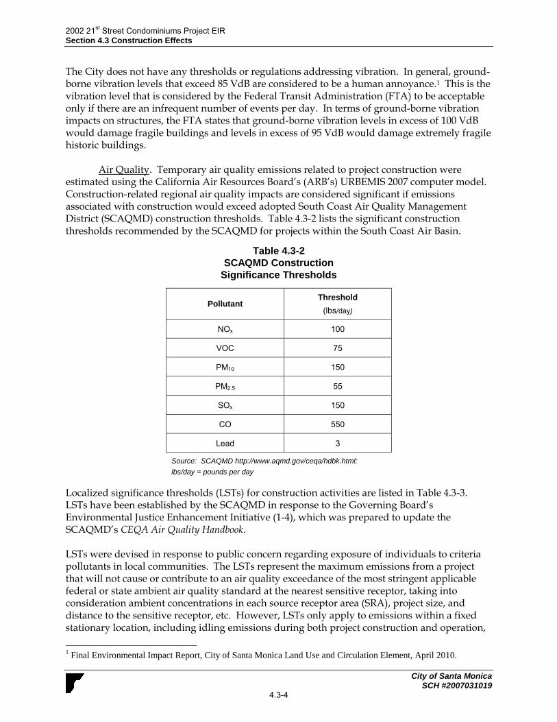
2002 21st Street Condominiums Project EIR
Section 4.3 Construction Effects
City of Santa Monica SCH #2007031019
4.3-4
The City does not have any thresholds or regulations addressing vibration. In general, ground-borne vibration levels that exceed 85 VdB are considered to be a human annoyance.1 This is the vibration level that is considered by the Federal Transit Administration (FTA) to be acceptable only if there are an infrequent number of events per day. In terms of ground-borne vibration impacts on structures, the FTA states that ground-borne vibration levels in excess of 100 VdB would damage fragile buildings and levels in excess of 95 VdB would damage extremely fragile historic buildings.
Air Quality. Temporary air quality emissions related to project construction were estimated using the California Air Resources Board’s (ARB’s) URBEMIS 2007 computer model. Construction-related regional air quality impacts are considered significant if emissions associated with construction would exceed adopted South Coast Air Quality Management District (SCAQMD) construction thresholds. Table 4.3-2 lists the significant construction thresholds recommended by the SCAQMD for projects within the South Coast Air Basin.
Table 4.3-2
SCAQMD Construction
Significance Thresholds
Pollutant Threshold
(lbs/day)
NOx 100
VOC 75
PM10 150
PM2.5 55
SOx 150
CO 550
Lead 3
Source: SCAQMD http://www.aqmd.gov/ceqa/hdbk.html;
lbs/day = pounds per day
Localized significance thresholds (LSTs) for construction activities are listed in Table 4.3-3. LSTs have been established by the SCAQMD in response to the Governing Board’s Environmental Justice Enhancement Initiative (1-4), which was prepared to update the SCAQMD’s CEQA Air Quality Handbook. LSTs were devised in response to public concern regarding exposure of individuals to criteria pollutants in local communities. The LSTs represent the maximum emissions from a project that will not cause or contribute to an air quality exceedance of the most stringent applicable federal or state ambient air quality standard at the nearest sensitive receptor, taking into consideration ambient concentrations in each source receptor area (SRA), project size, and distance to the sensitive receptor, etc. However, LSTs only apply to emissions within a fixed stationary location, including idling emissions during both project construction and operation,
1 Final Environmental Impact Report, City of Santa Monica Land Use and Circulation Element, April 2010.

2002 21st Street Condominiums Project EIR
Section 4.3 Construction Effects
City of Santa Monica SCH #2007031019
4.3-5
and LSTs have been developed only for NOx, CO, and PM. LSTs have been developed for emissions within areas up to 5 acres in size, with air pollutant modeling recommended for activity within larger areas. Table 4.3-3 includes LSTs for projects of one acre in size in Source Receptor Area 2 (SRA-2), which is designated by the SCAQMD as the Northwest Coastal LA County area and includes Santa Monica. LSTs do not apply to mobile sources such as cars on a roadway. According to the SCAQMD publication, Final Localized Significance (LST) Thresholds Methodology, the use of LSTs is voluntary, to be implemented at the discretion of local agencies. The URBEMIS 2007 v.9.2.4 model was used to estimate the localized construction emissions (see Appendix B).
Table 4.3-3
SCAQMD LSTs for Construction for 1-Acre Site
Pollutant
Allowable emissions as a function of receptor
distance in feet from a one acre site boundary (lbs/day)
82 feet 164 feet 328 feet 656 feet 1,640 feet
Gradual conversion of NOx to NO2
103 104 121 156 245
CO 562 833 1,233 2,367 7,724
PM10
4 12 27 57 146
PM2.5 3 4 8 18 77
Source: http://www.aqmd.gov/CEQA/handbook/LST/appC.pdf August 2006 With Links to: 1) SRA/City Table; and 2) Appendix B - Mass Rate LST Look-up Tables and http://www.aqmd.gov/CEQA/handbook/PM2_5/PM2_5.html
b. Project Impacts and Mitigation Measures.
The proposed project would require demolition of the existing bungalows on-site and construction of the proposed 21-unit condominium complex building with subterranean parking. Approximately 6,600 cubic yards of dirt is anticipated to be exported by the proposed project. It is anticipated that construction of the project would commence in late-2013. The site preparation phase is anticipated to last about four months. Building completion is estimated for late 2014.
Impact CON-1 Project construction and equipment staging would temporarily increase truck traffic in the project area, which could disrupt the normal use of the sidewalk and adjacent streets, and affect parking availability. This is a Class II, significant but mitigable, impact.
Although the City does not allow construction staging to occur on city streets, during construction of the project, construction activities may occur on existing street right of ways and temporary close a portion of Virginia Avenue, 21st Street, and 21st Court. In addition, construction activity could require the temporary closure of the sidewalks adjacent to the site. This would temporarily disrupt pedestrian activity in the area.

2002 21st Street Condominiums Project EIR
Section 4.3 Construction Effects
City of Santa Monica SCH #2007031019
4.3-6
In addition to the reduction of on-street parking capacity during construction, construction site workers would temporarily compete with other users for parking facilities. This could temporarily reduce the available supply of public parking. Impacts to pedestrian and vehicular flow in the area and the temporary reduction in on-street parking capacity would be potentially significant.
Mitigation Measures. The following is required to mitigate temporary traffic impacts during construction.
CON-1 Construction Impact Mitigation Plan. The applicant shall prepare, implement, and maintain a Construction Impact Mitigation Plan which shall be designed to:
Prevent material traffic impacts on the surrounding roadway network. Minimize parking impacts both to public parking and access to private
parking to the greatest extent practicable. Ensure safety for both those constructing the project and the
surrounding community. Prevent substantial truck traffic through residential neighborhoods.
The Construction Impact Mitigation Plan shall be subject to review and approval by the following City departments: Public Works Department, Fire, Planning and Community Development and Police to ensure that the Plan has been designed in accordance with this mitigation measure. This review shall occur prior to building permit issuance for the project. It shall at a minimum, include the following:
Ongoing requirements throughout the duration of construction:
A detailed traffic control plan for work zones shall be maintained which includes at a minimum accurate existing and proposed: parking and travel lane configurations; warning, regulatory, guide and directional signage; and area sidewalks, bicycle lanes and parking lanes. The plan shall include specific information regarding the project’s construction activities that may disrupt normal pedestrian and traffic flow and the measures to address these disruptions. Such plans must be reviewed and approved by the Strategic & Transportation Planning Division prior to commencement of construction and implemented in accordance with this approval.
Work within the public right-of-way shall be performed between 9:00 AM and 4:00 PM , including: dirt and demolition material hauling and construction material delivery. Work within the public right-of-way outside of these hours shall only be allowed after the issuance of an after-hours construction permit.
Streets and equipment should be cleaned in accordance with established Public Works requirements.

2002 21st Street Condominiums Project EIR
Section 4.3 Construction Effects
City of Santa Monica SCH #2007031019
4.3-7
Trucks shall only travel on a City approved construction route. Truck queuing/staging shall not be allowed on Santa Monica Streets. Limited queuing may occur on the construction site itself.
Materials and equipment should be minimally visible to the public; the preferred location for materials is to be on-site, with a minimum amount of materials within a work area in the public right-of-way, subject to a current Use of Public Property permit.
Any requests for work before or after normal construction hours within the public right-of-way shall be subject to review and approval through the After Hours Permit process administered by the Building and Safety Division.
Provision of off-street parking for construction workers, which may include the use of a remote location with shuttle transport to the site, if determined necessary by the City of Santa Monica.
Project Coordination Elements that shall be implemented prior to commencement of construction: Advise the traveling public of impending construction activities (e.g.
information signs, portable message signs, media listing/notification, implementation of an approved traffic control plan.
Approval from the City through issuance of a Use of Public Property Permit, Excavation Permit, Sewer Permit or Oversize Load Permit, as well as any Caltrans Permits required, for any construction work requiring encroachment into public rights-of-way.
Timely notification of construction schedules to all affected agencies (e.g. Big Blue Bus, Police Department, Fire Department, Public Works Department, and Planning and Community Development Department) and to all owners and residential and commercial tenants of property within a radius of 500 feet.
Coordination of construction work with affected agencies in advance of start of work. Approvals may take up to two weeks per each submittal.
Approval by the Strategic & Transportation Planning Division of any haul routes, for earth, concrete or construction materials and equipment handling.
Level of Significance After Mitigation. With implementation of the required
Construction Impact Mitigation Plan, impacts would be reduced to a less than significant level.
Impact CON-2 Demolition of existing structures and construction of the proposed project would generate temporary construction noise that would be periodically audible to sensitive receptors near the project site. This is a Class II, significant but mitigable, impact.
As described in the Noise Setting (above), the City’s Noise Ordinance prohibits the equivalent noise level resulting from demolition and other construction activities from exceeding the exterior noise standard for any zone by more than 20 dB and the instantaneous noise level from exceeding the standard by more than 40 dB except between the hours of 10:00 AM to 3:00 PM

2002 21st Street Condominiums Project EIR
Section 4.3 Construction Effects
City of Santa Monica SCH #2007031019
4.3-8
weekdays. The project site is located in a residential area of Santa Monica, which is classified as Noise Zone I and is subject to the exterior noise standards listed in Table 4.3-4.
Table 4.3-4
Noise Zone I Exterior Noise Standards
Noise Zone Time Interval
Allowable Leq
15-Minute Continuous
Measurement Period
5-Minute Continuous
Measurement Period
I
Monday – Friday
10 PM – 7 AM
7 AM – 10 PM
50 dBA
60 dBA
55 dBA
65 dBA
Saturday and Sunday
10 PM – 8 AM
8 AM – 10 PM
50 dBA
60 dBA
55 dBA
65 dBA
Source: City of Santa Monica Municipal Code Section 4.12.060(a).
As shown in Table 4.3-4, noise standards are 60 dBA for 15-minute continuous measurement periods and 65 dBA for 5-minute continuous measurement periods from 7 AM to 10 PM on weekdays and from 8 AM to 10 PM during weekends. Therefore, construction-related noise generated on the project site would not be permitted to exceed 80 dB, or 100 dB for instantaneous noise, at adjacent properties between the hours of 10 AM and 3 PM weekdays. As shown in Table 4.3-5, noise levels associated with heavy equipment typically range from about 76 to 101 dBA at 50 feet from the source (Harris Miller Miller & Hanson Inc., May 2006).
Table 4.3-5
Typical Noise Levels at Construction Sites
Equipment Onsite Average Noise Levelat 50 Feet
Compactor 82 dBA
Air Compressor 81 dBA
Concrete Mixer 85 dBA
Saw 76 dBA
Scraper/Paver 89 dBA
Dozer 85 dBA
Jack Hammer 88 dBA
Source: Transit Noise and Vibration Impact Assessment, Harris Miller Miller & Hanson Inc., May 2006.
The grading and excavation phase of project construction, which may include the use of scrapers, pavers, compactors, dozers, and jack hammers, tends to create the highest noise levels because of the operation of heavy equipment. Continuous operation of this equipment during

2002 21st Street Condominiums Project EIR
Section 4.3 Construction Effects
City of Santa Monica SCH #2007031019
4.3-9
a nine-hour workday would generate noise onsite and at adjacent receptor locations that would be above ambient levels and could exceed applicable noise standards. Table 4.3-6 shows the anticipated noise levels at the sensitive receptors closest to the project site. Anticipated noise levels could reach 95 dBA at the closest sensitive receptor location as a result of excavation, foundation-laying, and conditioning activities (the noisiest phase of construction).
Table 4.3-6
Anticipated Noise Levels at Closest Sensitive
Receptor Locations During Construction
Sensitive
Receptor
Distance from
Project Site
Anticipated
Maximum Noise
Level
Residents adjacent to the south of the project site
25 feet south 95 dBA
Residents across Virginia Avenue
50 feet north 89 dBA
Residents across 21
st Street
50 feet east 89 dBA
Residents across 20
th Court
50 feet west 89 dBA
New Path Montessori School
215 feet northwest
76.3 dBA
Jehovah’s Witness church / Virginia Avenue Park
350 feet northeast
72.1 dBA
Please see Appendix C for modeling results.
As shown in Table 4.3-6, residents south, north, east, and west would be exposed to noise levels exceeding 80 dB. Therefore, construction noise impacts would be potentially significant.
Mitigation Measures. The following mitigation measures are required.
CON-2(a) Restrictions on Excavation and Foundation/Conditioning. Excavation, foundation-laying, and conditioning activities (the noisiest phases of construction) shall be restricted to between the hours of 10:00 AM and 3:00 PM, Monday through Friday, in accordance with Section 4.12.110(d) of the Santa Monica Municipal Code as it would apply to residential zones.
CON-2(b) Diesel Equipment Mufflers. All diesel equipment shall be operated
with closed engine doors and shall be equipped with factory-recommended mufflers.

2002 21st Street Condominiums Project EIR
Section 4.3 Construction Effects
City of Santa Monica SCH #2007031019
4.3-10
CON-2(c) Electrically-Powered Tools. Electrical power shall be used to run air
compressors and similar power tools. CON-2(d) Additional Noise Attenuation Techniques. For all noise-generating
construction activity on the project site, additional noise attenuation techniques shall be employed to reduce noise levels to City of Santa Monica noise standards. Such techniques may include, but are not limited to, the use of sound blankets on noise generating equipment and the construction of temporary sound barriers between construction sites and nearby sensitive receptors.
CON-2(e) Construction Sign Posting. In accordance with Santa Monica
Municipal Code Section 4.12.120, the project applicant shall be required to post a sign informing all workers and subcontractors of the time restrictions for construction activities. The sign shall also include the City telephone numbers where violations can be reported and complaints associated with construction noise can be submitted.
Level of Significance After Mitigation. Implementation of Measure N-2(a) would
ensure compliance with the City of Santa Monica Noise Ordinance, with regards to the hours of operation of excavation, foundation-laying, and conditioning activities. Implementation of measures N-2(b), through N-2(e) would reduce construction-related noise. With implementation of the above mitigation measures, temporary construction-related noise impacts would be less than significant.
Impact CON 3 Project-related demolition and construction activities would
intermittently generate groundborne vibration on and off site in the immediate vicinity. Vibration levels may affect sensitive receptors adjacent to the project site. Impacts would be Class I, significant and unavoidable.
With respect to groundborne vibration, the proposed project would involve standard construction activities such as demolition, asphalt removal and excavation activities. Each of these is anticipated to result in some vibration that may be felt on and off site in the immediate vicinity of the project site, as commonly occurs with construction projects. Table 4.3-7 identifies various vibration velocity levels for the types of construction equipment that would operate at the project site during construction. Based on the information presented in Table 4.3-7, vibration levels could temporarily and intermittently reach and exceed 87 VdB at residences adjacent to the south and southeast of the project site. Vibration levels at this receptor would exceed the human annoyance threshold of 85 VdB. Therefore, construction vibration impacts on nearby residential uses would be significant without mitigation.

2002 21st Street Condominiums Project EIR
Section 4.3 Construction Effects
City of Santa Monica SCH #2007031019
4.3-11
Table 4.3-7
Vibration Source Levels for Construction Equipment
Equipment
Approximate VdB
25 Feet 50 Feet 60 Feet 75 Feet 100 Feet
Large Bulldozer 87 81 79 77 75
Loaded Trucks 86 80 78 76 74
Jackhammer 79 73 71 69 67
Small Bulldozer 58 52 50 48 46
Source: Federal Railroad Administration, 1998 Note: Construction would not include the use of a pile driver; therefore, pile driving equipment was not included in the analysis of construction vibration.
Mitigation Measures. The primary means to reduce construction vibration is to limit
the distance between the source and the receiver including either through vibration barriers (such as a wave barrier), temporary relocation of the adjacent sensitive receptors, or limiting construction equipment by weight and location. However, because of the physical constraints of the project site and the adjacent location of the sensitive receptors, none of these options are considered feasible. Therefore, since construction activity (e.g., demolition and excavation activities) must occur on the project site, no feasible mitigation measures are available.
Level of Significance After Mitigation. Impacts would be significant and unavoidable. Impact CON-4 Project construction would create a temporary increase in air
pollutant and dust emissions. However, estimated maximum daily emissions would not exceed established SCAQMD thresholds for any pollutant. Therefore, air quality impacts would be Class III, less than significant.
Construction of the proposed project would temporarily generate air pollutant emissions. Table 4.3-8 shows the estimated maximum daily emissions of criteria air pollutants, calculated using the URBEMIS software. Emissions are shown for the various phases of construction, including demolition (Phase I), grading (Phase II), paving (Phase III), building construction (Phase IV), and coating (Phase V). The operation of heavy construction equipment during all phases of project construction would generate emissions of ozone precursors (ROC and NOx), as well as CO. In addition to the emissions associated with the construction equipment, construction worker vehicles traveling to and from the site would contribute a small amount of emissions. Demolition and associated activities would be required to comply with SCAQMD Rule 403, Fugitive Dust, which requires the implementation of Reasonably Available Control Measures (RACM) for all fugitive dust sources, and compliance with the Air Quality Management Plan (AQMP), which identifies Best Available Control Measures (BACM) and Best Available Control Technologies (BACT) for area sources and point sources, respectively. Required SCAQMD

2002 21st Street Condominiums Project EIR
Section 4.3 Construction Effects
City of Santa Monica SCH #2007031019
4.3-12
Rule 403 measures were incorporated into the URBEMIS software calculations shown in Table 4.3-6.
Table 4.3-8
Estimated Maximum Unmitigated Construction Emissions
(lbs/day)
Unmitigated Emissions (lbs/day)
ROG NOx CO PM10 PM2.5
Phase I Demolition 1.2 9.0 6.3 3.2 11
Phase II Grading 2.8 22.4 12.6 1.7 1.1
Phase III Paving 1.9 11.1 8.6 0.9 0.9
Phase IV Building Construction
1.1 8.4 6.4 0.5 0.5
Phase V Coating 5.3 0.0 0.2 0.0 0.0
Maximum lbs/day 5.3 22.4 12.6 3.2 1.1
SCAQMD Thresholds 75 100 550 150 55
Threshold Exceeded? No No No No No
Localized Significant Thresholds
a (LSTs)
N/A 103 562 4 3
Threshold Exceeded? N/A No No No No
Source: URBEMIS 2007, Version 9.2.4; see Appendix B for calculations. a LSTs are for a one acre project in SRA-2 at a distance of 82 feet from the site boundary.
Note: Unmitigated construction emissions include Rule 403 requirements.
As indicated in Table 4.3-8, project-generated emissions would not exceed the temporary construction thresholds or LST thresholds. The LSTs for sensitive receptors 82 feet from the project site were used to illustrate the closest receptor located adjacent to the project site per the LST methodology guidelines. Therefore, temporary air quality impacts related to project construction would not be significant.
Mitigation Measures. Mitigation is not required since emissions would not exceed SCAQMD thresholds or LST thresholds for construction.
Level of Significance After Mitigation. Impacts would be less than significant without mitigation.
c. Cumulative Impacts. Table 3-2 (Section 3.0 Environmental Setting) provides a list of the recently completed, approved, and pending development projects located throughout the City. Construction activities associated with development projects would create temporary traffic, noise, and air quality impacts similar to those described for the project.

2002 21st Street Condominiums Project EIR
Section 4.3 Construction Effects
City of Santa Monica SCH #2007031019
4.3-13
Construction traffic impacts are typically localized to the area surrounding the project construction site. Cumulative construction traffic impacts would generally only occur if the proposed project and related development projects impacted the same streets. Based on a review of Table 3-2, there are no development projects located in the vicinity of the project site that would have the potential to create cumulative traffic impacts in conjunction with the project. Therefore, the proposed project would not result in a significant cumulative construction-related traffic impact. Similarly, construction noise and grounborne vibration impacts are typically localized as noise and vibration attenuates with increasing distance. Based on a review of Table 3-2, there are no development projects located in the vicinity of the project site that would have the potential to create cumulative noise impacts in conjunction with the project. However, the proposed project would not result in a significant cumulative construction-related noise or vibration impacts. With regard to air quality, according to the SCAQMD, individual construction projects that exceed the SCAQMD’s recommended daily thresholds for project-specific impacts would cause a cumulatively considerable increase in emissions for those pollutants for which the Air Basin is in non-attainment. Construction-related daily emissions for the proposed project would not exceed the SCAQMD’s significance thresholds. Consequently, the proposed project would not have a significant cumulative impact on regional and localized air quality due to construction-related emissions.

2002 21st Street Condominiums Project EIR
Section 4.3 Construction Effects
City of Santa Monica SCH #2007031019
4.3-14
This page intentionally left blank

2002 21st Street Condominiums Project EIR
Section 4.4 Neighborhood Effects
City of Santa Monica SCH #2007031019
4.4-1
4.4 NEIGHBORHOOD EFFECTS This section summarizes the proposed project’s impacts to the surrounding neighborhood.
4.4.1 Setting
a. Regulatory Setting. The Land Use Element of the City of Santa Monica’s General Plan requires the completion of a neighborhood impact statement, with public input. This requirement details the assessment of neighborhood impacts associated with all proposed projects, by looking at possible impacts to the character and cohesiveness of each neighborhood in the City. The principal objective stated under “Neighborhood Participation” in the Land Use Element is to encourage citizen and neighborhood participation in the City planning process to ensure the realization of plan goals.
b. Existing Neighborhood Characteristics. The project site is located in an urbanized setting and is currently developed with 15 one-story bungalow apartments. The parcel at 2002 21st Street contains five residential units in two buildings. The parcel at 2008 21st Street contains four units in two buildings. The parcels at 2014 and 2018 21st Street each contain three units in two buildings. All of the buildings contain garage structures adjacent to the alley. A low concrete block wall and wooden fence border the site adjacent the public sidewalk along 21st Street and Virginia Avenue. On-site landscaping includes bottlebrush, fan palm, oleander, syzygium, and a variety of low growing shrubs and herbaceous ornamentals. Figure 2-4 in Section 2.0, Project Description, provides photos illustrating the existing site characteristics.
The project site is bordered by various residential uses, including single family dwelling units and multi-family structures along 21st Street and Virginia Avenue. The residential neighborhood along 21st Street and Virginia Avenue is well landscaped with street trees, shrubs and other vegetation. Pico Boulevard is approximately 500 feet southeast of the project site and contains various commercial and retail land uses. 20th Street, approximately 200 feet southwest of the project site, contains multi-family residential structures. Virginia Avenue Park, located one block northeast of the project site, is approximately 300 feet away. Santa Monica College, located at 1900 Pico Boulevard is approximately 0.25 miles from the project site. The residential neighborhood along 21st Street and Virginia Avenue is landscaped with street trees, shrubs and other vegetation. Most of the length of 21st Street and Virginia Avenue along and near the project site is almost completely shaded for most of the day by a nearly continuous canopy of trees, with the exception of the northern corner of the project site, at the intersection of Virginia Avenue and 21st Street, which is relatively open and unshaded. The southwestern boundary of the project site, which is 20th Court Alley, is more exposed to sun due to the absence of street trees and other vegetation. Figure 2-5 in Section 2.0, Project Description, provides photos of surrounding land uses.
4.4.2 Summary of Neighborhood Impacts and Mitigation Measures A discussion of the project’s effects on the surrounding neighborhood follows. Project impacts that would affect the surrounding neighborhood are summarized in Table 4.4-1. Included in the criteria for neighborhood effects are impacts that would affect the surrounding community,

2002 21st Street Condominiums Project EIR
Section 4.4 Neighborhood Effects
City of Santa Monica SCH #2007031019
4.4-2
such as shadows, construction effects, noise and traffic. The significance criteria for each impact listed below are described in their respective sections Section 4.1, Shadows; Section 4.2, Air Quality; Section 4.3, Construction Effects; Section 4.5, Noise; and Section 4.6, Traffic. Please refer to individual report sections for detailed analyses of project impacts and mitigation measures for each issue area. Shadows. Development of the proposed project would replace 15 one-story residential units with a two-story residential building with one level of subterranean parking. As discussed in Section 4.1, Shadows, under Impact SH-1, the front yards and a minimal amount of the first story of some of the buildings across 21st Street from the project site may experience some shading from the project in the late afternoon during the shortest days of winter. However, the period in which this shading would occur would not exceed the three-hour significance threshold and, in most cases, these yards and buildings are already extensively, if not completely, shaded by existing street trees at that time of year. Consequently, the proposed project would not substantially alter shadow conditions as compared to existing conditions and the impact of the proposed project would be less than significant.
Air Quality. Development of the proposed project would replace 15 one-story residential units with a two-story residential building with one level of subterranean parking. As discussed in Section 4.2, Air Quality, under Impact AQ-1, the incremental increase in ROG, NOx, CO, PM10, and PM2.5 emissions associated with the proposed project would be less than the SCAQMD’s thresholds of 55 lbs per day for ROG, NOx, or PM2.5, 550 lbs per day for CO, and 150 lbs per day for PM10. As long-term operational emissions would not exceed SCAQMD thresholds, impacts would not be significant. In addition, as discussed under Impact AQ-2, project-generated traffic would incrementally increase CO levels in the site vicinity. However, CO levels would not exceed state and federal standards. Thus impacts would not be significant. Construction Effects. Project construction would temporarily increase truck traffic in the project area, which could disrupt traffic on adjacent streets such as Virginia Avenue, 21st Street, and 21st Court. Although the City does not allow construction staging to occur on city streets, during construction of the project, construction activities may occur on existing street right of ways and temporary close a portion of Virginia Avenue, 21st Street, and 21st Court. This would temporarily disrupt pedestrian activity in the area. However, implementation of a Construction Impact Mitigation Plan (Mitigation Measure CON-1), which would provide for a pedestrian, traffic, and parking capacity management during construction, would reduce impacts to a less than significant level. Project construction would intermittently generate noise that exceeds the City’s noise standards on and adjacent to the project site and that may affect sensitive receptors near the site. These potentially significant impacts could be reduced to a less than significant level through mitigation measures proposed in Sections 4.2, Construction Effects, including the use of diesel equipment mufflers; electrically powered tools; restrictions on the hours of site preparation activities; additional noise attenuation techniques (e.g., the use of noise blankets and temporary sound barriers); and the posting of signs to inform workers and neighbors of construction
2002 21st Street Condominiums Project EIR
Section 4.4 Neighborhood Effects
City of Santa Monica SCH #2007031019
4.4-3
activity times and how to report violations. Impacts would be less than significant with mitigation. As described in Section 4.3, Construction Effects, under Impact CON-3, vibration levels could temporarily and intermittently reach and exceed 87 VdB at residences adjacent to the south of the project site. Vibration levels at this receptor would exceed the human annoyance threshold of 85 VdB. Therefore, construction vibration impacts on nearby residential uses would be significant without mitigation. Demolition and grading activities have the potential to generate air pollutant emissions; however, estimated emissions would be below South Coast Air Quality Management District Thresholds. Therefore, the impact with respect to temporary air quality would be less than significant. Noise. In the long term, project-generated traffic would incrementally increase noise along local roadways. However, project-related and cumulative traffic noise increases would not exceed adopted significance thresholds. Therefore, the effect of increased traffic noise on existing uses would be less than significant. Noise associated with operation of the proposed project may be periodically audible at adjacent properties. Noise events that are typical of residential developments include music, conversations, doors slamming, and children playing. These noises could emanate from inside buildings, from outdoor patios and outdoor common areas at the first floor level, from second floor balconies, or from roof decks. On-site operations are expected to also involve noise associated with rooftop mechanical equipment such as ventilation and heating systems, and trash hauling. Continuous project-generated noise associated with building operations, such as rooftop mechanical equipment, may exceed daytime or nighttime thresholds. However, with implementation of mitigation measures N-2(a-b), impacts would be less than significant. As discussed in Section 4.5, Noise, noise generated by the movement of vehicles in and out of the proposed subterranean parking garage and noise associated with trash collection activities were found to be less than significant.
Transportation/Traffic. The proposed project would increase traffic on neighborhood roadways. However, as discussed in Section 4.6, Transportation/Traffic, the project would result in less than a 1% change on 21st between Virginia Avenue and Pico Boulevard and on Virginia Avenue between 20th Street and 21st Street. Less than a 1% change on these segments would not exceed either the threshold of a 12.5% increase in ADT on Virginia Avenue or a 25% increase in ADT on 21st Street. Thus impacts are less than significant on neighborhood roadway segments. .In addition, that the average increase in vehicular delay would be less than 15 seconds and the increase in V/C would be less than 0.005 with the addition of project traffic (Fehr & Peers, March 2012). Therefore, the project is not expected to create a significant impact on operating conditions at intersections in the vicinity of the project site. Impacts to intersections would be less than significant.

2002 21st Street Condominiums Project EIR
Section 4.4 Neighborhood Effects
City of Santa Monica SCH #2007031019
4.4-4
Table 4.4-1 Summary of Neighborhood Effects
Impact Mitigation Measures
Section 4.1, Shadows
Impact SH-1 Residential uses adjacent to the project site are
mostly shaded by existing trees. The proposed project would cast shadows onto adjacent residential uses. However, because these residential uses are already shaded, the proposed project would not substantially alter shadow conditions and impacts would be Class III, less than significant.
None required. See pages 4.1-3 for a complete discussion of the impact.
Section 4.2, Air Quality
Impact AQ-1 Operation of the proposed project would generate
air pollutant emissions, but emissions would not exceed SCAQMD operational significance thresholds. Therefore, the project’s long-term impact to regional air quality would be Class III, less than significant.
None required. See pages 4.2-9 for a complete discussion of the impact.
Impact AQ-2 Long-term mobile emissions associated with the
proposed project would incrementally increase CO concentrations at heavily congested intersections in the area. However, CO levels would remain within state and federal standards, and the increase of V/C ratio would be less than 2% for intersections rated D or worse. Therefore, impacts would be Class III, less than significant.
None required. See pages 4.2-10 for a complete discussion of the impact.
Section 4.3, Construction Effects
Impact CON-1 Project construction and equipment staging
would temporarily increase truck traffic in the project area, which could disrupt the normal use of the sidewalk and adjacent streets, and affect parking availability. This is a Class II, significant but mitigable, impact.
CON-1 Construction Impact Mitigation Plan.
See page 4.3 -6 for a complete discussion of this impact.
Impact CON-2 Demolition of existing structures and
construction of the proposed project would generate temporary construction noise that would be periodically audible to sensitive receptors near the project site. This is a Class II, significant but mitigable, impact.
CON-2(a) Restrictions on Excavation and Foundation/ Conditioning.
CON 2(b) Diesel Equipment Mufflers. CON 2(c) Electrically-Powered Tools. CON-2(d) Additional Noise Attenuation
Techniques. CON-2(e) Construction Sign Posting. See page 4.3-7 for a complete discussion of this impact.
Impact CON 3 Project-related demolition and construction
activities would intermittently generate groundborne vibration on and off site in the immediate vicinity. Vibration levels may affect sensitive receptors adjacent to the project site. Impacts would be Class I, significant and unavoidable.
No feasible mitigation measures are available. Impacts would be significant and unavoidable. See page 4.3-10 for a complete discussion of this impact.
Impact CON-4 Project construction would create a temporary
increase in air pollutant and dust emissions. However, No mitigation measures are required.
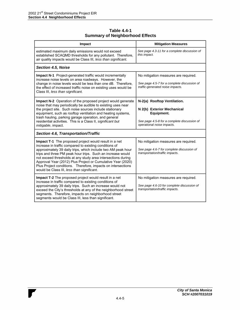
2002 21st Street Condominiums Project EIR
Section 4.4 Neighborhood Effects
City of Santa Monica SCH #2007031019
4.4-5
Table 4.4-1 Summary of Neighborhood Effects
Impact Mitigation Measures
estimated maximum daily emissions would not exceed established SCAQMD thresholds for any pollutant. Therefore, air quality impacts would be Class III, less than significant.
See page 4.3-11 for a complete discussion of this impact.
Section 4.5, Noise
Impact N-1 Project-generated traffic would incrementally
increase noise levels on area roadways. However, the change in noise levels would be less than one dB. Therefore, the effect of increased traffic noise on existing uses would be Class III, less than significant.
No mitigation measures are required. See page 4.5-7 for a complete discussion of traffic-generated noise impacts.
Impact N-2 Operation of the proposed project would generate
noise that may periodically be audible to existing uses near the project site. Such noise sources include stationary equipment, such as rooftop ventilation and heating systems, trash hauling, parking garage operation, and general residential activities. This is a Class II, significant but mitigable, impact.
N-2(a) Rooftop Ventilation. N 2(b) Exterior Mechanical
Equipment. See page 4.5-8 for a complete discussion of operational noise impacts.
Section 4.6, Transportation/Traffic
Impact T-1 The proposed project would result in a net
increase in traffic compared to existing conditions of approximately 39 daily trips, which include two AM peak hour trips and three PM peak hour trips. Such an increase would not exceed thresholds at any study area intersections during Approval Year (2012) Plus Project or Cumulative Year (2020) Plus Project conditions. Therefore, impacts on intersections would be Class III, less than significant.
No mitigation measures are required. See page 4.6-7 for complete discussion of transportation/traffic impacts.
Impact T-2 The proposed project would result in a net
increase in traffic compared to existing conditions of approximately 39 daily trips. Such an increase would not exceed the City’s thresholds at any of the neighborhood street segments. Therefore, impacts on neighborhood street segments would be Class III, less than significant.
No mitigation measures are required. See page 4.6-10 for complete discussion of transportation/traffic impacts.

2002 21st Street Condominiums Project EIR
Section 4.4 Neighborhood Effects
City of Santa Monica SCH #2007031019
4.4-6
This page intentionally left blank

2002 21st Street Condominiums Project EIR
Section 4.5 Noise
City of Santa Monica SCH #2007031019
4.5-1
4.5 NOISE This section evaluates the proposed project’s long-term operational impact on local noise conditions. Temporary construction noise is addressed in Section 4.2, Construction Effects.
4.5.1 Setting
a. Overview of Sound Measurement. Noise level (or volume) is generally measured in
decibels (dB) using the A-weighted sound pressure level (dBA). The A-weighting scale is an adjustment to the actual sound power levels to be consistent with that of human hearing response, which is most sensitive to frequencies around 4,000 Hertz (about the highest note on a piano) and less sensitive to low frequencies (below 100 Hertz).
The sound pressure level is measured on a logarithmic scale with the 0 dB level based on the lowest detectable sound pressure level that people can perceive (an audible sound that is not zero sound pressure level). Based on the logarithmic scale, a doubling of sound energy is equivalent to an increase of 3 dB, and a sound that is 10 dB less than the ambient sound level has no effect on ambient noise. Because of the nature of the human ear, a sound must be about 10 dB greater than the reference sound to be judged as twice as loud. In general, a 3 dB change in community noise levels is noticeable, while 1-2 dB changes generally are not perceived. Quiet suburban areas typically have noise levels in the range of 40-50 dBA, while those along arterial streets are in the 50-60+ dBA range. Normal conversational levels are in the 60-65 dBA range, and ambient noise levels greater than 65 dBA can interrupt conversations. Noise levels typically attenuate (or drop off) at a rate of 6 dB per doubling of distance from point sources such as industrial machinery. Noise from lightly traveled roads typically attenuates at a rate of about 4.5 dB per doubling of distance. Noise from heavily traveled roads typically attenuates at about 3 dB per doubling of distance. In addition to the instantaneous measurement of sound levels, the duration of sound is important since sounds that occur over a long period of time are more likely to be an annoyance or cause direct physical damage or environmental stress. One of the most frequently used noise metrics that considers both duration and sound power level is the equivalent noise level (Leq). The Leq is defined as the single steady A-weighted level that is equivalent to the same amount of energy as that contained in the actual fluctuating levels over a period of time (essentially, the average noise level). Typically, Leq is summed over a one-hour period. The time period in which noise occurs is also important since noise that occurs at night tends to be more disturbing than that which occurs during the daytime. Two commonly used noise metrics – the Day-Night average level (Ldn) and the Community Noise Equivalent Level (CNEL) - recognize this fact by weighting hourly Leqs over a 24-hour period. The Ldn is a 24-hour average noise level that adds 10 dB to actual nighttime (10 PM to 7 AM) noise levels to account for the greater sensitivity to noise during that time period. The CNEL is identical to the Ldn, except it also adds a 5 dB penalty for noise occurring during the evening (7 AM to 10 PM).
b. Existing Noise Conditions and Sources. The most common sources of noise in the project vicinity are transportation-related, such as automobiles, trucks, and motorcycles on

2002 21st Street Condominiums Project EIR
Section 4.5 Noise
City of Santa Monica SCH #2007031019
4.5-2
nearby roadways. Motor vehicle noise is of concern because it is characterized by a high number of individual events, which often create a sustained noise level, and because of its proximity to areas sensitive to noise exposure. The primary noise generator affecting the project site is traffic along Virginia Avenue and 21st Street, which border the northwest and northeast sides of the project site. Traffic noise from the busier but more distant streets of 20th Street and Pico Boulevard also affects the site. Daytime (approximately 10:00 AM -11:30 AM) 20-minute noise measurements were taken using an ANSI Type II integrating sound level meter on October 30, 2009. Results of this noise monitoring are shown in Table 4.5-1. The noise measurements were taken at four locations adjacent to and near the project site, as described in Table 4.5-1.
Table 4.5-1
Noise Monitoring Results
Measurement Location Primary Noise
Source
Approximate Distance to
Primary Noise Source
Leq
(dBA)
Nearest
Sensitive
Receptor
2109 Virginia Avenue Virginia Avenue 18 feet to centerline 55.4 Residences on both sides of
Virginia Avenue
2019 Virginia Avenue Virginia Avenue 17 feet to centerline 57.1 Residences on both sides of
Virginia Avenue
2020 20th
Street 20th
Street 36 feet to centerline 70.5 Residences on
20th
Street
2018 21st Street 21
st Street 17 feet to centerline 57.4
Residences on both sides of 21
st
Street
Source: Field visit using ANSI Type II Integrating sound level meter.
Based on the street segments analyzed in the traffic study, the following roadway segments were determined to have some potential for noise impacts due to their proximity to noise-sensitive residential uses and estimated contribution of project-related traffic to the segment:
1) Virginia Avenue between 20th Street and 21st Street 2) 21st Street between Virginia Avenue and Pico Boulevard c. Sensitive Receptors. Noise exposure goals for different land uses reflect the varying
noise sensitivities associated with those uses. Pursuant to the City of Santa Monica Municipal Code, noise-sensitive land uses include: residences, public or private schools, places of worship, cemeteries, libraries, hospitals and similar health care institutions (SMMC Section 4.12.020, 6(r)). These land uses are most sensitive to noise intrusion and therefore have more stringent noise exposure targets than manufacturing or industrial uses that are not subject to effects such as sleep disturbance. The project site is located in an urbanized setting bordered by various residential uses including single family dwelling units and multi-family structures along 21st Street, Virginia Avenue, and 20th Court. The nearest sensitive receptors in the vicinity of the project site include surrounding residences. Other noise sensitive receptors located in the vicinity of the project site include single-family residences to the north, east, south, and west. A Jehovah’s Witness church is located approximately 350 feet to the northeast of the project site at

2002 21st Street Condominiums Project EIR
Section 4.5 Noise
City of Santa Monica SCH #2007031019
4.5-3
2119 Virginia Avenue. The church building itself, however, is located at the rear of the property, about 200 feet back from the street, with a two-story apartment building intervening between it and the project site. The schools nearest to the project site include the New Path Montessori School at 1962 20th St, about 215 feet northwest of the project site across 20th Street from the intersection of 20th Street and Virginia Avenue; Santa Monica College, about 575 feet south of the project site, on the south side of the intersection of Pico Boulevard and 19th Street; and Edison Elementary School, about 1,500 feet (0.3 miles) northeast of the project site at 2425 Kansas Avenue.
d. Regulatory Setting. The City of Santa Monica General Plan Noise Element was revised in 1992. The Noise Element provides a description of existing and projected future noise levels, and incorporates comprehensive goals, policies, and implementing actions. The Noise Element also includes a Land Use/Noise Compatibility Matrix, shown in Figure 4.5-2, which identifies the compatibility of different land uses with a range of noise levels, from less than 55 dBA CNEL to over 80 dBA CNEL. For example, with mitigation, residential uses are considered compatible with noise environments of up to 70 dBA CNEL; however, schools and libraries are considered compatible with noise environments of up to only 65 dBA. The City Noise Ordinance (Municipal Code Section 4.12) enforces the goals and policies of the Noise Element. Consistent with the Noise Element, the Noise Ordinance requires that noise attenuation features be followed in the siting and design of new development if necessary. The Noise Ordinance prohibits any “unnecessary, excessive, or annoying noise and vibration” in the City. The Ordinance does not control traffic noise, but applies to all noise sources located on private property. As part of this ordinance, properties within the City are assigned a noise zone based on their corresponding zoning district. Residential districts are designated as Noise Zone I; commercial districts are designated Noise Zone II; and manufacturing or industrial districts are designated as Noise Zone III. The Ordinance also limits the amount of noise generated by uses during normal operation that may affect the surrounding areas. Table 4.5-2 shows the allowable noise levels and corresponding times of day for each of the three identified noise zones. The standards plus 20 dB (i.e., 80 dBA for daytime hours for Zone I) apply to maximum instantaneous noises occurring for any period of time, as required by Section 4.12.060 of the Noise Ordinance. Section 4.12.110 of the Noise Ordinance states that noise created by construction activity shall not cause the equivalent noise level to exceed the noise standards specified in Table 4.5-2 plus 20 dB, or the maximum instantaneous sound level plus 40 dBA, and that any construction that exceeds the equivalent noise level standard shall occur between the hours of 10 AM and 3 PM, Monday through Friday. The project site is within Zone I, and the residential parcels surrounding the project are also within Noise Zone I. The closest properties in any other Noise Zone are the properties zoned C-2 along Pico Boulevard, which are in Noise Zone II. Subsection (d) of Section 4.12.060 (Exterior Noise Standards) of the Noise Ordinance also states, “[i]f the ambient noise level exceeds the allowable exterior noise level standard, the ambient noise level shall be the standard.” It also states that “[i]f any portion of a parcel is located within 100 feet of a noise zone with higher noise standards as compared to the noise standards for the noise zone in which the parcel is located, then the maximum allowable exterior equivalent noise level for the entire parcel shall be the average of the noise standards of the two noise zones. However, any noise level measurement must be taken at least twenty-five feet from the parcel line of the source of the noise.”

2002 21st Street Condominiums Project EIRSection 4.5 Noise
Figure 4.5-1City of Santa Monica
Land Use/Noise Compatibility Matrix
Proposed Land Use Categories Compatible Land Use Zones (in CNEL)
<60 60-65 >65UsesCategories
ZONE A -
ZONE B -
ZONE C -
Clearly Compatible: Specified land use is satisfactory, based upon the assumption that any buildings involvedare of normal conventional construction without any special noise insulation requirements.
Normally Incompatible: New construction or development should generally be discouraged. If newconstruction or development does proceed, a detailed analysis of noise reduction requirements must be made.
Compatible with Mitigation: New construction or development (i.e., substantial remodels and additionsrepresenting 50% or more of existing square footage, including garage square footage), should be undertakenonly after detailed analysis of the noise reduction requirements are made and needed noise insulation featuresin the design are determined. Conventional construction, with closed windows and fresh air supply systemson air conditioning, will normally suffice. Note that residential uses are prohibited with Airport CNELgreater than 65.
RESIDENTIAL
RESIDENTIAL
COMMERCIAL Regional, District
COMMERCIAL Recreation
COMMERCIALINDUSTRIALINSTITUTIONAL
COMMERCIAL Regional, Village District, Special
COMMERCIAL General, Special
COMMERCIAL Recreation
INSTITUTIONAL Civic Center
INSTITUTIONAL General
INDUSTRIAL, INSTITUTIONAL
OPEN SPACE
OPEN SPACE
A B B
B
B B
B
B
B
B
B
AA
AAA
A
A
AAA
AA
A
AA
A
A A
C
C
CC
Mobile Home
Single Family, Duplex,Multiple Family
Hotel, Motel, Transient Lodging
Commercial Retail, Bank,Restaurant, Movie Theater
Office Building, Researchand Development, ProfessionalOfiices
Amphitheater, Concert Hall,Auditorium, Meeting Hall
Children's Amusement Park,Miniature Golf Course, SportsClub
Automobile Service Station, AutoDealership
Parks
Golf Course, Cemeteries,Nature Centers
Hospital, Church, Library,Schools' Classroom, Day Care
Manufacturing, Warehousing,Wholesale, Utilities
Source City of Santa Monica Planning and Zoning Division, May 1995.
SCH #20070310194.5-4

2002 21st Street Condominiums Project EIR
Section 4.5 Noise
City of Santa Monica SCH #2007031019
4.5-5
Table 4.5-2
Exterior Noise Standards
Noise Zone Time Interval
Allowable Leq
15-Minute Continuous
Measurement Period
5-Minute Continuous
Measurement Period
I
Monday – Friday
10 PM – 7 AM
7 AM – 10 PM
50 dBA
60 dBA
55 dBA
65 dBA
Saturday and Sunday
10 PM – 8 AM
8 AM – 10 PM
50 dBA
60 dBA
55 dBA
65 dBA
II
All Days of Week
10 PM – 7 AM
7 AM – 10 PM
60 dBA
65 dBA
65 dBA
70 dBA
III Anytime 70 dBA 75 dBA
Source: City of Santa Monica Municipal Code Section 4.12.060(a).
4.5.2 Impact Analysis
a. Methodology and Significance Thresholds. Noise levels associated with existing and future traffic along area roadways were calculated using the Federal Highway Administration’s Traffic Noise Model (TNM) 2.5 lookup tables (noise modeling data sheets can be viewed in Appendix C of this document). The model calculations are based on traffic data from the EIR traffic study (see Appendix D). Based on guidance provided in Appendix G of the 2012 CEQA Guidelines, implementation of the proposed project may have a significant adverse impact on noise if it would do any of the following:
Result in exposure of persons to or generation of noise levels in excess of standards established in the local general plan or noise ordinance, or applicable standards of other agencies
Result in exposure of persons to or generation of excessive groundborne vibration or groundborne noise levels
Result in a substantial permanent increase in ambient noise levels in the project vicinity above levels existing without the project
Result in a substantial temporary or periodic increase in ambient noise levels in the project vicinity above levels existing without the project
If located within an airport land use plan or, where such a plan has not been adopted, within 2 miles of a public airport or public use airport, expose people residing or working in the project area to excessive noise level
If located within the vicinity of a private airstrip, expose people residing or working in the project area to excessive noise levels

2002 21st Street Condominiums Project EIR
Section 4.5 Noise
City of Santa Monica SCH #2007031019
4.5-6
Section XIV, Noise, of the Initial Study for the proposed project (Appendix A) determined that the proposed project would result in less than significant impacts related to airport and airstrip noise. Therefore, these issues are not discussed further in this EIR. Construction (temporary) noise impacts and groundborne vibration impacts are analyzed in Section 4.3, Construction Effects, of this EIR. The focus of this EIR analysis is on the project’s operational impacts relative to exceedance of noise standards and permanent increase in ambient noise levels. The CEQA Guidelines do not define the levels at which increases in ambient noise are considered “substantial.” A noise level increase of 3 dBA is barely perceptible to most people, a 5 dBA increase is readily noticeable, and a difference of 10 dBA would be perceived as a doubling of loudness. However, as the existing level of ambient noise increases, the allowable level of project generated noise increases, but the total amount that community noise exposure is allowed to increase is reduced. As a result and consistent with the threshold used for the City of Santa Monica Land Use and Circulation Element EIR , the noise standards set forth in Table 4.5-3, were used to determine whether or not increases in roadway noise would be considered significant. Impacts relating to onsite activities are considered significant when project-related activities create noise exceeding the standards as identified by the applicable noise zone for the project site, as shown in Table 4.5-2.
Table 4.5-3
Significance of Changes in Operational
Roadway Noise Exposure
Ldn or Leq in dBA
Existing Noise Exposure
(Without Project)
Allowable Noise Exposure
Increase
<60 5
60-65 3
>65 1.5
Source: Final EIR for the Land Use and Circulation Element, City of Santa Monica,
b. Project Impacts and Mitigation Measures.
Impact N-1 Project-generated traffic would incrementally increase noise
levels on area roadways. However, the change in noise levels would be less than one dB. Therefore, the effect of increased traffic noise on existing uses would be Class III, less than significant.

2002 21st Street Condominiums Project EIR
Section 4.5 Noise
City of Santa Monica SCH #2007031019
4.5-7
Development of the proposed project would increase the amount of vehicle trips to and from the site, which would increase traffic noise on area roadways. The project could therefore increase noise at neighboring uses. Noise-sensitive uses include residential development adjacent to the project site, as described above in the Setting. Estimated average daily traffic (ADT) values from the traffic study (Fehr and Peers, March 2012) were used to model the change in noise levels resulting from increased traffic on two study area roadway segments. Table 4.5-4 lists noise levels that would occur at the closest receptor to the roadway (approximately 32.8 feet from the centerline of each roadway segment). Noise levels at distances greater than 32.8 feet from the centerline would be lower due to attenuation provided by increased distance from the noise source. Generally, noise from heavily traveled roadways decreases approximately three dBA for every doubling of distance. The noise modeling results indicate that the project would increase noise levels on each of these street segments by approximately 0.1 dBA compared to existing conditions. In addition, the noise modeling results indicate that the project would increase cumulative noise levels on the Virginia Avenue street segment by approximately 0.1 dBA compared to cumulative base conditions and would not create a measureable increase in noise at the 20th Street segment. Therefore, project-related traffic noise increases would not exceed the noise thresholds shown in Table 4.5-3 or significantly affect sensitive receptors in the study area.
Table 4.5-4
Noise Levels Associated with Traffic on Area Roadways* (dBA CNEL)
Roadway Existing
Existing
Plus
Project
Change
Due to
Project
(Existing
Plus
Project)
Cumulative
Base**
Cumulative
Plus
Project**
Change Due to
Project
(Cumulative Base
Plus Project)
Virginia Avenue between 20
th St. and
Cloverfield 53.1 53.2 0.1 53.4 53.5 0.1
20th
Street between Delaware and Pico
64.9 65.0 0.1 65.2 65.2 0.0
* At a distance of 32.8 feet from roadway centerline. ** Future Growth includes Ambient Growth and Cumulative Projects
See Noise Modeling Data sheets in Appendix D of this document.
Mitigation Measures. Mitigation is not required as impacts would be less than
significant. Level of Significance After Mitigation. The proposed project’s impact related to traffic
noise would be less than significant without mitigation.
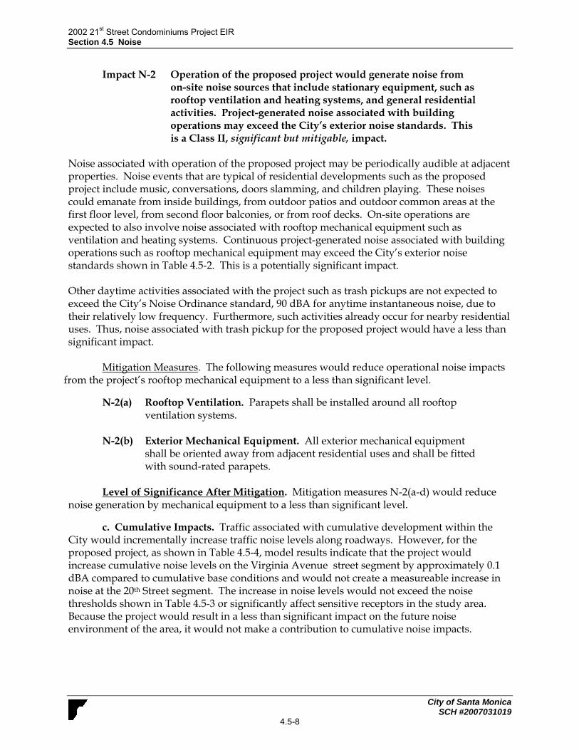
2002 21st Street Condominiums Project EIR
Section 4.5 Noise
City of Santa Monica SCH #2007031019
4.5-8
Impact N-2 Operation of the proposed project would generate noise from on-site noise sources that include stationary equipment, such as rooftop ventilation and heating systems, and general residential activities. Project-generated noise associated with building operations may exceed the City’s exterior noise standards. This is a Class II, significant but mitigable, impact.
Noise associated with operation of the proposed project may be periodically audible at adjacent properties. Noise events that are typical of residential developments such as the proposed project include music, conversations, doors slamming, and children playing. These noises could emanate from inside buildings, from outdoor patios and outdoor common areas at the first floor level, from second floor balconies, or from roof decks. On-site operations are expected to also involve noise associated with rooftop mechanical equipment such as ventilation and heating systems. Continuous project-generated noise associated with building operations such as rooftop mechanical equipment may exceed the City’s exterior noise standards shown in Table 4.5-2. This is a potentially significant impact. Other daytime activities associated with the project such as trash pickups are not expected to exceed the City’s Noise Ordinance standard, 90 dBA for anytime instantaneous noise, due to their relatively low frequency. Furthermore, such activities already occur for nearby residential uses. Thus, noise associated with trash pickup for the proposed project would have a less than significant impact.
Mitigation Measures. The following measures would reduce operational noise impacts from the project’s rooftop mechanical equipment to a less than significant level.
N-2(a) Rooftop Ventilation. Parapets shall be installed around all rooftop ventilation systems.
N-2(b) Exterior Mechanical Equipment. All exterior mechanical equipment
shall be oriented away from adjacent residential uses and shall be fitted with sound-rated parapets.
Level of Significance After Mitigation. Mitigation measures N-2(a-d) would reduce
noise generation by mechanical equipment to a less than significant level.
c. Cumulative Impacts. Traffic associated with cumulative development within the City would incrementally increase traffic noise levels along roadways. However, for the proposed project, as shown in Table 4.5-4, model results indicate that the project would increase cumulative noise levels on the Virginia Avenue street segment by approximately 0.1 dBA compared to cumulative base conditions and would not create a measureable increase in noise at the 20th Street segment. The increase in noise levels would not exceed the noise thresholds shown in Table 4.5-3 or significantly affect sensitive receptors in the study area. Because the project would result in a less than significant impact on the future noise environment of the area, it would not make a contribution to cumulative noise impacts.

2002 21st Street Condominiums Project EIR
Section 4.6 Transportation/Traffic
City of Santa Monica SCH #2007031019
4.6-1
4.6 TRANSPORTATION/TRAFFIC This section discusses the proposed project’s potential impacts to the local circulation system and parking. The analyses used in this study draw on base data from the City of Santa Monica’s TRAFFIX database. The information has been summarized from the traffic study memo prepared for the proposed project by Fehr & Peers/Kaku Associates (March 2012). This memo is included in its entirety in Appendix D.
4.6.1 Setting
a. Existing Street System. The project site is located at 2002-2018 21st Street (2020 Virginia Avenue) on the southern corner of the intersection of 21st Street and Virginia Avenue in the City of Santa Monica. Regional access to the project site area is provided primarily by the Santa Monica Freeway (I-10), which runs in an east-west direction and connects Santa Monica to downtown Los Angeles, via interchanges at 20th Street to the west (which has a westbound onramp and an eastbound offramp) and Cloverfield Boulevard to the east (which has a westbound offramp and an eastbound onramp). The San Diego Freeway (I-405), the primary north-south freeway through the western Los Angeles metropolitan area, is located about two miles to the east. Access to and from I-405 is available via I-10 east or east-west arterials such as Pico Boulevard and Olympic Boulevard. Listed below are the seven study area intersections (all in the City of Santa Monica within about 1,500 feet of the project site) included in this traffic analysis:
• 20th Street and Delaware Avenue • 20th Street and Pico Boulevard • 23rd Street and Pico Boulevard • Cloverfield Boulevard and Pico Boulevard • Cloverfield Boulevard and Virginia Avenue • Cloverfield Boulevard and I-10 On-Ramp • Cloverfield Boulevard and I-10 Off-Ramp
Impacts on two street segments, listed in Table 4.6-1, are also analyzed. The City of Santa Monica General Plan Land Use and Circulation Element (LUCE, 2010) defines the street system according its use by various modes including walking, biking, transit, and automobile. These street types include Boulevard, Special Streets, Downtown Commercial, Neighborhood Commercial, Major Avenue, Secondary Avenue, Minor Avenue, Industrial Avenue, Neighborhood Street, Shared Street, Parkway, Pathway, Bikeway, Highway, and Alley. Not all street types are within the study area for this project. The City streets in the project site vicinity are described below, as designated by the Santa Monica LUCE:
• 21st Street – 21st Street is a north-south street providing two travel lanes, one lane per direction. On-street parking is permitted. 21st Street is designated as a Neighborhood Street.
• Virginia Avenue – Virginia Avenue is an east-west street providing two travel lanes, one lane per direction. On-street parking is permitted. Virginia Avenue is designated as a Neighborhood Street.

2002 21st Street Condominiums Project EIR
Section 4.6 Transportation/Traffic
City of Santa Monica SCH #2007031019
4.6-2
• 22nd Street – 22nd Street is a north-south street providing two travel lanes, one lane per direction. On-street parking is permitted. 22nd Street is designated as a Neighborhood Street.
• Delaware Avenue – Delaware Avenue is an east-west street providing two travel lanes, one lane per direction. On-street parking is permitted. Delaware Avenue is designated as a Neighborhood Street.
• Cloverfield Boulevard – Cloverfield Boulevard is a north-south street providing four travel lanes (two lanes per direction). Left-turn lanes are provided at major intersections near the project site. Onstreet parking is permitted. Cloverfield Boulevard provides eastbound on-ramp and westbound offramp access to I-10 and is designated as a Major Avenue north of Pico Boulevard and a Secondary Avenue south of Pico Boulevard.
• Pico Boulevard – Pico Boulevard is an east-west street providing four travel lanes (two lanes per direction). Left-turn lanes are provided at intersections and raised median islands are present at many mid-block locations near the project site. On-street parking is permitted. Pico Boulevard is designated as a Boulevard.
• 20th Street – 20th Street is a north-south street providing two travel lanes, one in each direction. On-street parking is permitted. 20th Street provides westbound on-ramp and eastbound off-ramp access to I-10 and is designated as a Secondary Avenue from San Vicente Boulevard to Montana Avenue and a Minor Avenue from Montana Avenue to Ocean Park Boulevard.
b. Existing Traffic Volumes. As discussed above, seven intersections were chosen for analysis for the proposed project. The Traffic Study analyzed operating conditions at these key intersections and traffic volumes on roadway segments in the vicinity of the project site. Existing weekday morning (7:30 to 9:30 AM) and afternoon peak period (5:00 to 7:00 PM) traffic volumes and levels of service (LOS) were obtained from the current City of Santa Monica TRAFFIX database. Twenty-four hour machine-count traffic volumes were collected on Tuesday, February 28, 2012 at two key roadway segments serving the project:
• 21st Street between Virginia Avenue and Pico Boulevard • Virginia Avenue between 20th Street and 21st Street
Table 4.6-1
Weekday Neighborhood Traffic Volumes
Location Street
Classification Existing ADT
Virginia Avenue between 20th
Street and 21st Street Local 2,207
21st Street between Virginia Avenue and Pico Boulevard Local 1,091
Data Source: Quality Traffic Data, LLC traffic counts from Tuesday February 28, 2012.
The counts indicate that 21st Street carries approximately 1,091 vehicles per day (vpd) adjacent to the project site between Virginia Avenue and Pico Boulevard, and Virginia Avenue carries approximately 2,207 vpd between 20th Street and 21st Street. The 24-hour count sheets are included in the attachment to the Traffic Study in Appendix D.

2002 21st Street Condominiums Project EIR
Section 4.6 Transportation/Traffic
City of Santa Monica SCH #2007031019
4.6-3
c. Existing Levels of Service. LOS is a qualitative measure used to describe the condition of traffic flow, ranging from excellent conditions at LOS A to failure (overloaded conditions) at LOS F. The City of Santa Monica uses the “Operational Analysis” method from Highway Capacity Manual (HCM) (Transportation Research Board, 2000) to determine the average vehicular delay and corresponding LOS for signalized intersections. All of the intersections analyzed in the Traffic Study are signalized. LOS definitions for signalized intersections are provided in Table 1 of the Traffic Study. The LOS scale for signalized intersections ranges from A (average control delay per vehicle of less than 10 seconds per vehicle with no vehicle waiting longer than one red light and no approach fully used) to F (average control delay of more than 80 seconds per vehicle with backups from nearby locations or on cross streets potentially restricting or preventing movement of vehicles out of the intersection approaches, and with tremendous delays with continuously increasing queue lengths).
Existing weekday AM and PM peak hour levels of service for seven intersections in the vicinity of the project site were obtained from the City of Santa Monica TRAFFIX database, are shown below:
20th Street and Delaware Avenue - LOS A (AM) and LOS B (PM)
20th Street and Pico Boulevard - LOS D (AM) and LOS F (PM)
23rd Street and Pico Boulevard - LOS B (AM and PM)
Cloverfield Boulevard and Pico Boulevard - LOS C (AM and PM)
Cloverfield Boulevard and Virginia Avenue - LOS A (AM and PM)
Cloverfield Boulevard and I-10 On-Ramp - LOS D (AM) and LOS F (PM)
Cloverfield Boulevard and I-10 Off-Ramp - LOS F (AM) and LOS B (PM) d. Existing Public Transit Service. Santa Monica’s Big Blue Bus provides public
transit service near the project site:
Big Blue Bus Line 6 (SMC Commuter) – Line 6 provides service to Santa Monica College Main Campus and Airport Campuses along Pico Boulevard, Bundy Avenue, Ocean Park Boulevard, 20th Street, Centinela Avenue, and Venice Boulevard. In the study area, Line 6 operates east along Pico Boulevard south of the project site.
Big Blue Bus Line 7/Rapid 7 (Pico Boulevard) - Line 7 runs from downtown Santa Monica to the Rimpau Transit Center via Pico Boulevard. In the study area, Line 7 operates on Pico Boulevard south of the project site.
Big Blue Bus Line 11 (Campus Connector) – Line 11 provides service along Pico Boulevard, 20th Street, Santa Monica Boulevard, and Westwood Boulevard traveling to the UCLA Campus. In the study area, Line 11 operates along 20th Street west of the project site.
Mini Blue Sunset Ride – Sunset Ride is a community circulator that provides access to Santa Monica Community College’s dispersed campuses in the central and eastern portions of the City. In the study area, Sunset Ride operates on 20th Street and Pico Boulevard during weekdays only.
Mini Blue Crosstown Ride – Crosstown Ride provides service in a clockwise loop along 20th Street, Ocean Park Boulevard, 17th Street, Pearl Street, 14th Street, and Montana Avenue. In the study area, it operates south on 20th Street with a stop at Pico Boulevard and 20th Street, west of the project site during weekdays only.

2002 21st Street Condominiums Project EIR
Section 4.6 Transportation/Traffic
City of Santa Monica SCH #2007031019
4.6-4
4.6.2 Impact Analysis
a. Methodology and Significance Thresholds. This section describes how the potential for project-generated traffic impacts were determined. Peak hour traffic impacts for the project were evaluated for the peak hours during typical weekday morning (7:30 to 9:30 AM) and afternoon peak periods (5:00 to 7:00 PM). The following three traffic scenarios were analyzed in the study:
(1) Approval Year (2012) Conditions –This scenario develops traffic conditions expected
at the project approval year (2012) and provides the baseline by which approval year project impacts were evaluated.
(2) Approval Year (2012) plus Project Conditions – This analysis identifies the potential direct impacts of the proposed project on approval year traffic operating conditions by adding the project-generated traffic to the Approval Year No Project traffic forecasts.
(3) Cumulative Base (Year 2020) Conditions - This scenario projects the future traffic growth and intersection operating conditions that could be expected from regional growth and known related projects in the vicinity of the project site. These analyses provide the baseline conditions against which project impacts are evaluated.
(4) Cumulative plus Project (Year 2020) Conditions - This analysis identifies the incremental impacts of the proposed project on future traffic operating conditions by adding the traffic expected to be generated by the proposed project to the cumulative base traffic forecasts.
Project Traffic Projections. The traffic projections for the proposed project were
developed using the following three steps: 1) estimating the trip generation of the project, 2) determining trip distribution, and 3) assigning the project traffic to the roadway system.
Project Trip Generation. Santa Monica is generally characterized by compact urban development, high levels of public transit service, walkable and bikeable streets, and employer-sponsored Travel Demand Management (TDM) programs. The unique local characteristics of Santa Monica require, when possible, the development of specific trip generation rates to estimate trips associated with land uses in Santa Monica.
Local trip generation rates were developed and calibrated for existing conditions as part
of the Santa Monica Travel Demand Forecasting Model (TDFM) development for a variety of land use types. As part of TFDM development, these “existing” trip generation rates were initially based on residential trip generation surveys, the SCAG regional model, the San Diego Association of Governments’ (SANDAG) trip generation survey, recently calibrated models in similar areas, and Trip Generation, 8th Edition. The rates were then modified to account for local conditions based on counts, production-to-attraction balancing, and the difference between ITE and model land use definitions. The existing Santa Monica trip generation rates are unique to the Santa Monica model, and they are ultimately based on the results of model calibration and validation. The project’s trip generation rates for the residential uses are derived from the Santa Monica TDFM model.

2002 21st Street Condominiums Project EIR
Section 4.6 Transportation/Traffic
City of Santa Monica SCH #2007031019
4.6-5
Table 4.6-2 presents the trip generation rates used in this analysis as well as the projected total and net new trips generated by the project. Table 4.6-3 presents the trips generated by the proposed project. The project would generate approximately 136 daily vehicle trips, of which about nine trips would occur during the AM peak hour and eleven trips would occur during the PM peak hour. The existing residential units collectively generate approximately 97 daily trips, including seven AM peak hour trips and eight PM peak hour trips. Thus, the proposed project would be expected to generate a net increase of approximately 39 daily trips, including two trips during the AM peak and three trips during the PM peak hour.
Table 4.6-2
Project Trip Generation Rates
Land Use
Trips per Average
Daily
AM Peak Hour PM Peak Hour
In Out Total In Out Total
Multifamily – 2 cars Dwelling unit (DU)
6.49 20% 80% 0.45 65% 35% 0.5
Source: Fehr&Peers, March 2012 (see Appendix D)
Table 4.6-3
Project Trip Generation Estimates
Land Use Size (Units) Average
Daily Trips AM Peak Hour PM Peak Hour
Proposed Project: Condominium 21 136 2 7 9 7 4 11
Existing Use: Apartment -15 -97 -1 -6 -7 -5 -3 -8
Net New Incremental Trips 39 1 1 2 2 1 3
Source: Fehr&Peers, March 2012 (see Appendix D)
Significance Thresholds. The City of Santa Monica has established criteria for assessing whether project-related traffic increases result in significant impacts on operating conditions of intersections and roadway segments within the City.
Intersection Operation Thresholds. The City of Santa Monica has established criteria for assessing whether project-related traffic increases result in significant impacts on operating conditions of intersections. Table 4.6-4 summarizes the significance criteria, which is based on the classification of the streets at the intersection (i.e., arterial or collector street) and the operating conditions of the intersection under approval year or cumulative traffic conditions. Functional street classifications in Table 4.6-4 are from the City’s previous Circulation Element. The 2010 LUCE has adopted a different typology for streets within the City, but the significance criteria have not yet been revised to reflect the new nomenclature. Therefore, the existing significance criteria based on the previous LUCE street classification are used.

2002 21st Street Condominiums Project EIR
Section 4.6 Transportation/Traffic
City of Santa Monica SCH #2007031019
4.6-6
The potential significance of a project’s impact is measured by either the change in average vehicular delay or by a change in the intersection LOS to an unacceptable condition. If the base LOS is F, significance is defined in terms of a change in V/C ratio (as calculated by the HCM operational method). The V/C ratio is used because the average vehicular delay cannot be calculated using the HCM operational method if the intersection exhibits oversaturated traffic conditions. Using the criteria identified in Table 4.6-4 for the City of Santa Monica, a project’s impact at an intersection would not be significant if, for example, it is an arterial intersection operating at LOS D with the addition of project traffic and the incremental change in the average vehicle delay is less than 15 seconds. However, if the intersection is operating at LOS E after the addition of project traffic and the average vehicle delay increases by any amount, the project impact is considered significant. All impacts in LOS F are based on the V/C ratio, with project-related increases of 0.005 or greater considered significant
Table 4.6-4
City of Santa Monica Intersection Significant Impact Criteria
Future Base Scenario Future Plus Project Scenario
If LOS = A, B, or C Significant Impact If:
And is a collector street intersection Average vehicle delay increase is 15 seconds or LOS becomes D, E, or F
And is an arterial intersection Average vehicle delay is 15 seconds or LOS becomes E or F
If LOS = D Significant Impact If:
And is a collector street intersection Average vehicle delay increases by any amount
And is an arterial intersection Average vehicle delay increase is 15 seconds or LOS becomes E or F
If LOS = E Significant Impact If:
And is a collector or arterial intersection Average vehicle delay increases by any amount
If LOS = F Significant Impact If:
And is a collector or arterial intersection HCM V/C ratio net increase is 0.005
Neighborhood Traffic Impact. The City of Santa Monica’s California Environmental Quality Act (CEQA) impact criteria that are used to evaluate potential traffic impacts on street segments are based on the existing ADT and the projected level of increase that can be attributed to the project. The significance criteria for collector, feeder, and local streets are shown in Table 4.6-5. Functional street classifications in Table 4.6-5 are from the City’s previous Circulation Element. The 2010 LUCE has adopted a different typology for streets within the City, but the significance criteria have not yet been revised to reflect the new nomenclature. Therefore, the existing significance criteria based on the previous LUCE street classification are used.

2002 21st Street Condominiums Project EIR
Section 4.6 Transportation/Traffic
City of Santa Monica SCH #2007031019
4.6-7
Table 4.6-5
City of Santa Monica Street Segment Significant Impact Criteria
for Collector, Feeder, and Local Streets
Collector Streets
A transportation impact is significant if the Base Average Daily Traffic Volume (ADT) is:
greater than 13,500 and there is a net increase* of one trip or more in ADT due to project related traffic
greater than 7,500 but less than 13,500 and the project related traffic increases* the ADT by 12.5% or the ADT becomes 13,500 or more
less than 7,500 and the project related traffic increases*the ADT by 25%
Feeder Streets
A transportation impact is significant if the Base Average Daily Traffic Volume (ADT) is:
greater than 6,750 and there is a net increase* of one trip or more in ADT due to project related traffic
greater than 3,750 but less than 6,750 and the project related traffic increases* the ADT by 12.5% or the ADT becomes 6,750 or more
less than 3,750 and the project related traffic increases* the ADT by 25%
Local Streets
A transportation impact is significant if the Base Average Daily Traffic Volume (ADT) is:
greater than 2,250 and there is a net increase* of one trip or more in ADT due to project related traffic
greater than 1,250 but less than 2,250 and the project related traffic increases* the ADT by 12.5% or the ADT becomes 2,250 or more
less than 1,250 and the project related traffic increases* the ADT by 25%
*Average Daily Traffic Volume "increase" denotes adverse impacts; "decrease" denotes beneficial impacts.
It should be noted that traffic impacts related to hazards due to a design feature, emergency access, parking capacity, alternative transportation, and access to other properties and uses were determined to be less than significant in the Initial Study (Appendix A) and thus will not be further discussed in the EIR. Therefore the traffic analysis contained in this section will focus on the proposed project’s impact to intersections and neighborhood street segments.
b. Project and Cumulative Impacts and Mitigation Measures. Impact T-1 The proposed project would result in a net increase in traffic
compared to existing conditions of approximately 39 daily trips, which include two AM peak hour trips and three PM peak hour trips. Such an increase would not exceed thresholds at any study area intersections during Approval Year (2012) Plus Project or Cumulative Year (2020) Plus Project conditions. Therefore, impacts on intersections would be Class III, less than significant.
The proposed project would remove 15 existing apartment units and would redevelop the site with 21 condominium units. This would result in a net increase of six residential units and would increase traffic by approximately 39 daily trips which include two AM peak hour trips and three PM peak hour trips within the vicinity of the project site. Approval Year (2012) Analysis Table 4.6-6 presents existing and projected levels of service for the analyzed intersections in the
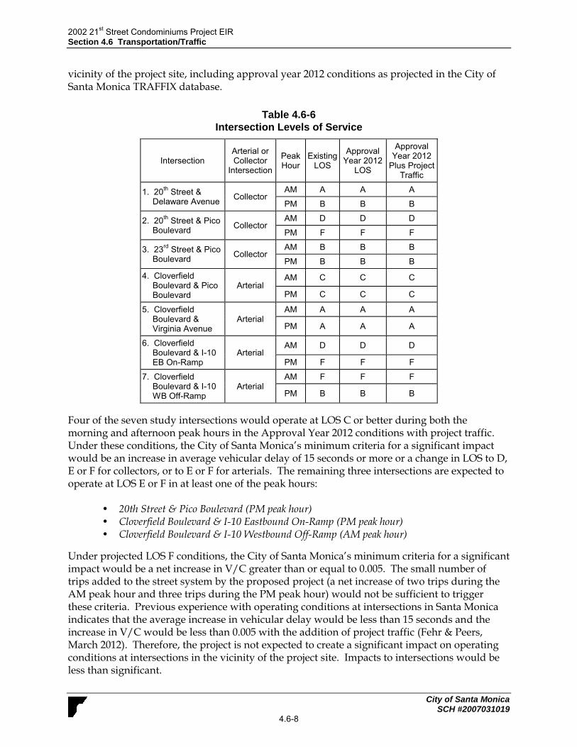
2002 21st Street Condominiums Project EIR
Section 4.6 Transportation/Traffic
City of Santa Monica SCH #2007031019
4.6-8
vicinity of the project site, including approval year 2012 conditions as projected in the City of Santa Monica TRAFFIX database.
Table 4.6-6
Intersection Levels of Service
Intersection Arterial or Collector
Intersection
Peak Hour
Existing LOS
Approval Year 2012
LOS
Approval Year 2012
Plus Project Traffic
1. 20th
Street & Delaware Avenue
Collector AM A A A
PM B B B
2. 20th
Street & Pico Boulevard
Collector AM D D D
PM F F F
3. 23rd
Street & Pico Boulevard
Collector AM B B B
PM B B B
4. Cloverfield Boulevard & Pico Boulevard
Arterial AM C C C
PM C C C
5. Cloverfield Boulevard & Virginia Avenue
Arterial AM A A A
PM A A A
6. Cloverfield Boulevard & I-10 EB On-Ramp
Arterial AM D D D
PM F F F
7. Cloverfield Boulevard & I-10 WB Off-Ramp
Arterial AM F F F
PM B B B
Four of the seven study intersections would operate at LOS C or better during both the morning and afternoon peak hours in the Approval Year 2012 conditions with project traffic. Under these conditions, the City of Santa Monica’s minimum criteria for a significant impact would be an increase in average vehicular delay of 15 seconds or more or a change in LOS to D, E or F for collectors, or to E or F for arterials. The remaining three intersections are expected to operate at LOS E or F in at least one of the peak hours:
• 20th Street & Pico Boulevard (PM peak hour) • Cloverfield Boulevard & I-10 Eastbound On-Ramp (PM peak hour) • Cloverfield Boulevard & I-10 Westbound Off-Ramp (AM peak hour)
Under projected LOS F conditions, the City of Santa Monica’s minimum criteria for a significant impact would be a net increase in V/C greater than or equal to 0.005. The small number of trips added to the street system by the proposed project (a net increase of two trips during the AM peak hour and three trips during the PM peak hour) would not be sufficient to trigger these criteria. Previous experience with operating conditions at intersections in Santa Monica indicates that the average increase in vehicular delay would be less than 15 seconds and the increase in V/C would be less than 0.005 with the addition of project traffic (Fehr & Peers, March 2012). Therefore, the project is not expected to create a significant impact on operating conditions at intersections in the vicinity of the project site. Impacts to intersections would be less than significant.

2002 21st Street Condominiums Project EIR
Section 4.6 Transportation/Traffic
City of Santa Monica SCH #2007031019
4.6-9
Cumulative Year (2020) Analysis Table 4.6-7 presents existing and projected levels of service for the analyzed intersections in the vicinity of the project site, including cumulative year 2020 conditions as projected in the City of Santa Monica TRAFFIX database. Four of the seven study intersections would operate at LOS C or better during both the morning and afternoon peak hours in the Approval Year 2012 conditions with project traffic. Under these conditions, the City of Santa Monica’s minimum criteria for a significant impact would be an increase in average vehicular delay of 15 seconds or more or a change in LOS to D, E or F for collectors, or to E or F for arterials. The remaining three intersections are expected to operate at LOS E or F in at least one of the peak hours:
• 20th Street & Pico Boulevard (PM peak hour) • Cloverfield Boulevard & I-10 Eastbound On-Ramp (PM peak hour) • Cloverfield Boulevard & I-10 Westbound Off-Ramp (AM peak hour)
Table 4.6-7
Cumulative Year (2020) Intersection Levels of Service
Intersection Arterial or Collector
Intersection
Peak Hour
Existing LOS
Cumulative Year 2020
LOS
Cumulative Year 2020
LOS
1. 20th
Street & Delaware Avenue
Collector AM A A A
PM B B B
2. 20th
Street & Pico Boulevard
Collector AM D C C
PM F F F
3. 23rd
Street & Pico Boulevard
Collector AM B C C
PM B B B
4. Cloverfield Boulevard & Pico Boulevard
Arterial AM C C C
PM C C C
5. Cloverfield Boulevard & Virginia Avenue
Arterial AM A A A
PM A A A
6. Cloverfield Boulevard & I-10 EB On-Ramp
Arterial AM D D D
PM F F F
7. Cloverfield Boulevard & I-10 WB Off-Ramp
Arterial AM F F F
PM B B B
Under projected LOS F conditions, the City of Santa Monica’s minimum criteria for a significant impact would be a net increase in V/C greater than or equal to 0.005. The small number of trips added to the street system by the proposed project (a net increase of three trips during each peak hour) would not be sufficient to trigger these criteria. Previous experience with operating conditions at intersections in Santa Monica indicates that the average increase in vehicular delay would be less than 15 seconds and the increase in V/C would be less than 0.005 with the addition of project traffic (Fehr & Peers, 2012). Therefore, the project is not expected to create a significant impact on operating conditions at intersections in the vicinity of the project site. Impacts to intersections would be less than significant.

2002 21st Street Condominiums Project EIR
Section 4.6 Transportation/Traffic
City of Santa Monica SCH #2007031019
4.6-10
Mitigation Measures. Mitigation is not necessary because the impacts would be less than significant. Level of Significance After Mitigation. Impacts would be less than significant without mitigation.
Impact T-2 The proposed project would result in a net increase in traffic
compared to existing conditions of approximately 39 daily trips. Such an increase would not exceed the City’s thresholds at any of the neighborhood street segments. Therefore, impacts on neighborhood street segments would be Class III, less than significant.
The significance of project-related impacts on neighborhood street segments was determined by the application of a set of significance criteria established by the City of Santa Monica as shown in Table 4.6-5. Functional street classifications used with respect to LOS and street segment analysis are based on the City’s previous Circulation Element. The 2010 LUCE has adopted a different typology for street the in the City, but the significance criteria have not yet been revised. The analysis was conducted for the following segments:
Virginia Avenue between 20th Street and 21st Street
21st Street between Virginia Avenue and Pico Boulevard
As shown in Table 4.6-3, the project is projected to generate a net increase of 39 daily trips. The project’s parking would be accessed via 20th Court, which intersects Virginia Avenue and Pico Boulevard. Project traffic would travel along either Virginia Avenue or Pico Boulevard to access the project’s parking facility. For the neighborhood impact analysis, it was assumed that approximately one half of the project’s net new daily trips would enter 20th Court via Virginia Avenue. This would result in a projected increase of 20 daily trips on Virginia Avenue. The projected increase in trips on 21st Street is expected to be 10 daily trips since the proposed project would provide garage access from 20th Court. Pick-up and drop-off at the proposed project would occur along 21st Street. For this analysis, it was assumed that approximately one-quarter of the project’s daily trips (approximately ten trips) would access the project site via 21st Street. The remaining nine trips would enter 20th Court via Pico Boulevard. On Virginia Avenue, increasing the average daily traffic (ADT) by 12.5% would be considered a significant impact. On 21st Street, increasing the average daily traffic (ADT) by 25% would be considered a significant impact. As shown in Table 4.6-8, the proposed project would not exceed these thresholds and therefore, would not result in any significant neighborhood traffic impacts.
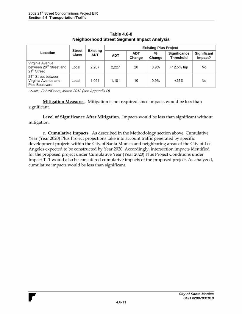
2002 21st Street Condominiums Project EIR
Section 4.6 Transportation/Traffic
City of Santa Monica SCH #2007031019
4.6-11
Table 4.6-8
Neighborhood Street Segment Impact Analysis
Location Street
Class
Existing
ADT
Existing Plus Project
ADT ADT
Change
%
Change
Significance
Threshold
Significant
Impact?
Virginia Avenue between 20
th Street and
21st Street
Local 2,207 2,227 20 0.9% +12.5% trip No
21st Street between
Virginia Avenue and Pico Boulevard
Local 1,091 1,101 10 0.9% +25% No
Source: Fehr&Peers, March 2012 (see Appendix D)
Mitigation Measures. Mitigation is not required since impacts would be less than
significant.
Level of Significance After Mitigation. Impacts would be less than significant without mitigation.
c. Cumulative Impacts. As described in the Methodology section above, Cumulative Year (Year 2020) Plus Project projections take into account traffic generated by specific development projects within the City of Santa Monica and neighboring areas of the City of Los Angeles expected to be constructed by Year 2020. Accordingly, intersection impacts identified for the proposed project under Cumulative Year (Year 2020) Plus Project Conditions under Impact T -1 would also be considered cumulative impacts of the proposed project. As analyzed, cumulative impacts would be less than significant.

2002 21st Street Condominiums Project EIR
Section 4.6 Transportation/Traffic
City of Santa Monica SCH #2007031019
4.6-12
This page intentionally left blank.

2002 21st Street Condominiums Project EIR
Section 4.7 Greenhouse Gas Emissions
City of Santa Monica SCH #2007031019
4.7-1
4.7 GREENHOUSE GAS EMISSIONS This section analyzes the proposed project’s impacts related to global climate change from both mobile and operational pollutant generators. GHG modeling results and calculations are included in Appendix B.
4.7.1 Setting
a. Overview of Global Climate Change. Global climate change (GCC) is a change in the
average weather of the earth that is measured by temperature, wind patterns, precipitation, and storms over a long period of time. The baseline, against which these changes are measured, originates in historical records identifying temperature changes that have occurred in the past, such as during previous ice ages. The global climate is continuously changing, as evidenced by repeated episodes of substantial warming and cooling documented in the geologic record. The rate of change has typically been incremental, with warming or cooling trends occurring over the course of thousands of years. The past 10,000 years have been marked by a period of incremental warming, as glaciers have steadily retreated across the globe. However, scientists have observed an unprecedented acceleration in the rate of warming during the past 150 years. GCC is a documented effect. Although the degree to which the change is caused by anthropogenic (man-made) sources is still under study, the increase in warming has coincided with the global industrial revolution, which has seen the widespread reduction of forests to accommodate urban centers, agriculture, and the use of fossil fuels – primarily the burning of coal, oil, and natural gas for energy. Per the United Nations Intergovernmental Panel on Climate Change (IPCC, 2007), the understanding of anthropogenic warming and cooling influences on climate has led to a high confidence (90% or greater chance) that the global average net effect of human activities since 1750 has been one of warming. Most of the observed increase in global average temperatures, since the mid-20th century, is likely due to the observed increase in anthropogenic GHG concentrations per the Intergovernmental Panel on Climate Change (IPCC) (2007). While there is some disagreement by individual scientists with some of the findings of the IPCC, the majority of scientists working on climate change agree with the main conclusions, as do the majority of major scientific societies and national academies of science. Disagreement within the scientific community is always present for all issues; however, the current state of knowledge suggests that GCC warming is occurring, with eleven of twelve years from 1995-2006 ranking among the twelve warmest years in the instrumental record of global surface temperature since 1850 (IPCC, 2007). In addition, the majority of scientists agree that anthropogenic sources are a main, if not primary, contributor to the GCC warming. b. Overview of Greenhouse Gases. Gases that absorb and re-emit infrared radiation in the atmosphere are called greenhouse gases (GHG), in reference to the fact that greenhouses retain heat. Common GHGs include water vapor, carbon dioxide (CO2), methane (CH4), nitrous oxides (N2Ox), fluorinated gases, and ozone. GHG are emitted by both natural processes and human activities. Water vapor, the most prevalent GHG, is excluded from the list of analyzed GHGs because it is short-lived in the atmosphere and its atmospheric concentrations are largely determined by natural processes, such as oceanic evaporation.

2002 21st Street Condominiums Project EIR
Section 4.7 Greenhouse Gas Emissions
City of Santa Monica SCH #2007031019
4.7-2
GHGs are emitted by both natural processes and human activities. Of these gases, CO2 and CH4 are emitted in the greatest quantities from human activities. Emissions of CO2 are largely by-products of fossil fuel combustion, whereas CH4 results from off-gassing associated with agricultural practices and landfills. Man-made GHGs, many of which have greater heat-absorption potential than CO2, include fluorinated gases, such as hydrofluorocarbons (HFCs), perfluorocarbons (PFC), and sulfur hexafluoride (SF6) (California Environmental Protection Agency [CalEPA], 2006). Different types of GHGs have varying global warming potential (GWPs). The GWP of a GHG is the potential of a gas or aerosol to trap heat in the atmosphere. Because GHGs absorb different amounts of heat, a common reference gas (CO2) is used to relate the amount of heat absorbed to the amount of the gas emissions, referred to as “carbon dioxide equivalent” (CDE), and is the amount of a GHG emitted multiplied by its GWP. Carbon dioxide has a GWP of one. By contrast, CH4 has a GWP of 21, meaning its global warming effect is 21 times greater than CO2 on a molecule per molecule basis. The accumulation of GHG in the atmosphere regulates the earth’s temperature. Without the natural heat trapping effect of GHG, Earth’s surface would be about 34° C cooler (CalEPA, 2006). However, it is believed that emissions from human activities, particularly the consumption of fossil fuels for electricity production and transportation, have elevated the concentration of these gases in the atmosphere beyond the level of naturally occurring concentrations. The following discusses the primary GHGs of concern. Carbon Dioxide. The global carbon cycle is made up of large carbon flows and reservoirs. Billions of tons of carbon in the form of CO2 are absorbed by oceans and living biomass (i.e., sinks) and are emitted to the atmosphere annually through natural processes (i.e., sources). When in equilibrium, carbon fluxes among these various reservoirs are roughly balanced (U.S. Environmental Protection Agency [USEPA], April 2008). CO2 was the first GHG demonstrated to be increasing in atmospheric concentration, with the first conclusive measurements being made in the last half of the 20th Century. Concentrations of CO2 in the atmosphere have risen approximately 35% since the industrial revolution. Per the IPCC (2007), the global atmospheric concentration of CO2 has increased from a pre-industrial value of about 280 parts per million (ppm) to 379 ppm in 2005. The atmospheric concentration of CO2 in 2005 exceeds the natural range over the last 650,000 years (180 to 300 ppm) as determined from ice cores. The average annual CO2 concentration growth rate was larger during the last 10 years (1995–2005 average: 1.9 ppm per year) than it has been since the beginning of continuous direct atmospheric measurements (1960–2005 average: 1.4 ppm per year), although there is year-to-year variability in growth rates. Currently, CO2 represents an estimated 82.7% of total GHG emissions (DOE, EIA, December 2008). The largest source of CO2, and of overall GHG emissions, is fossil fuel combustion. Methane. CH4 is an effective absorber of radiation; though its atmospheric concentration is less than that of CO2and its lifetime in the atmosphere is limited to 10 to 12 years. It has a GWP approximately 21 times that of CO2. Over the last 250 years, the concentration of CH4 in the atmosphere has increased by 148% (IPCC, 2007), although emissions have declined from 1990 levels. Anthropogenic sources of CH4 include enteric fermentation associated with domestic livestock, landfills, natural gas and petroleum systems, agricultural activities, coal mining, wastewater treatment, stationary and mobile combustion, and certain industrial processes (USEPA, April 2008).

2002 21st Street Condominiums Project EIR
Section 4.7 Greenhouse Gas Emissions
City of Santa Monica SCH #2007031019
4.7-3
Nitrous Oxide. Concentrations of N2O began to rise at the beginning of the industrial revolution. N2O is produced by microbial processes in soil and water, including those reactions that occur in fertilizers that contain nitrogen. Use of these fertilizers has increased over the last century. Agricultural soil management and mobile source fossil fuel combustion are the major sources of N2O emissions. N2O’s GWP is approximately 310 times that of CO2. Fluorinated Gases (HFCS, PFCS and SF6). Fluorinated gases, such as HFCs, PFCs, and SF6, are powerful GHGs that are emitted from a variety of industrial processes. Fluorinated gases are used as substitutes for ozone-depleting substances such as chlorofluorocarbons (CFCs), hydrochlorofluorocarbons (HCFCs), and halons, which have been regulated since the mid-1980s because of their ozone-destroying potential and are phased out under the Montreal Protocol and Clean Air Act Amendments of 1990. Electrical transmission and distribution systems account for most SF6 emissions, while PFC emissions result from semiconductor manufacturing and as a by-product of primary aluminum production. Fluorinated gases are typically emitted in smaller quantities than CO2, CH4, and N2O, but these compounds have much higher GWPs. SF6 is the most potent GHG that the IPCC has evaluated.
c. Greenhouse Gas Inventory. Worldwide anthropogenic emissions of GHG were
approximately 40,000 million metric tons (MMT) CDE in 2004, including ongoing emissions from industrial and agricultural sources, but excluding emissions from land use changes (i.e., deforestation, biomass decay) (IPCC, 2007). CO2 emissions from fossil fuel use accounts for 56.6% of the total emissions of 49,000 million metric tons CDE (includes land use changes) and all CO2 emissions are 76.7% of the total. Methane emissions account for 14.3% of GHG and N2O emissions for 7.9% (IPCC, 2007).
US Emissions. Total U.S. GHG emissions were 7,282 million metric tons CDE in 2007 (DOE EIA, December 2008), or about 14% of worldwide GHG emissions. U.S. emissions rose by 16.7% from 1990 to 2007. The residential and commercial end-use sectors accounted for 17% and 15%, respectively, of CO2 emissions from fossil fuel combustion in 2007 (DOE EIA, December 2008). Both sectors rely heavily on electricity for meeting energy demands, with 72% and 79%, respectively, of their emissions attributable to electricity consumption for lighting, heating, cooling, and operating appliances. The remaining emissions were due to the consumption of natural gas and petroleum for heating and cooking.
State of California Emissions. Based upon the California Air Resources Board (ARB) California Greenhouse Gas Inventory for 2000-2008 (http://www.arb.ca.gov/cc/inventory/data/data.htm), California produced 478 MMT CDE in 2008. The major source of GHG in California is transportation, contributing 37% of the state’s total GHG emissions. Electricity generation is the second largest source, contributing 24% of the state’s GHG emissions (California Energy Commission [CEC], June 2010). California emissions are due in part to its large size and large population compared to other States. By contrast, California had the fourth lowest CO2 emissions per capita from fossil fuel combustion in the country in 2004, due in part to the success of its energy-efficiency and renewable energy programs and commitments that have lowered the state’s GHG emissions rate of growth by more than half of what it would have been otherwise (CEC, 2006). Another factor that reduces California’s per capita fuel use and GHG emissions, as compared to other states, is its relatively mild climate. ARB staff has projected statewide unregulated GHG emissions for the year 2020, which represent the emissions that would

2002 21st Street Condominiums Project EIR
Section 4.7 Greenhouse Gas Emissions
City of Santa Monica SCH #2007031019
4.7-4
be expected to occur in the absence of any GHG reduction actions, will be 596 MMT CDE (ARB, 2007).
City of Santa Monica Emissions. Policy S1.2 from the recently adopted Land Use and Circulation Element (LUCE) requires the City to “prepare a greenhouse gas emissions inventory approximately every five years using accounting standards approved by ICLEI and the California Air Resources Board. As part of the Santa Monica’s Sustainable City Progress Report, beginning in 1990, the City has maintained a GHG emissions inventory (last updated November 2009), which allows the City to measure its progress toward achieving the goals contained in the Sustainable City Plan. According to the 2009 GHG Emissions Report 1990 GHG emissions for the City totaled 924,293 metric tons of CO2E, and 2007 GHG emissions for the City totaled 941,625 metric tons of CO2E. Overall, GHG emissions in 2007 declined by 7% compared to 1990 levels. The majority of the reduction in GHG emissions occurred in the waste sector, in which emissions fell by 48%. In addition, the City’s Renewable Energy Portfolio and use of green power energy sources has also reduced community emissions (reduced by 8%) and the corporate emissions (reduced by 36%). In addition, the GHG emissions under the 2030 LUCE are expected to be reduced from existing conditions because of LUCE strategies to reduce Citywide GHG emissions, energy use, water use, and solid waste generation such as:
The creation of a new GHG emissions inventory and a comprehensive Climate Action Plan with a goal of adoption in 2010;
Implementation of No Net New Trips policy designed to hold PM peak hour auto trips to and from Santa Monica at or below 2008 levels;
Increasing in the number of buildings constructed to LEED (or equivalent) standards;
Implementation of the Community Energy Independence Initiative with the goal of zero net energy imports communitywide by 2020;
Development of a zero waste strategy to achieve at least 90 percent diversion of all waste produced in the City;
Implementation of the City‘s comprehensive water reduction strategy; and
Increased sustainability in municipal operations: this includes requiring LEED-certified green buildings, retrofitting buildings for increased energy efficiency, replacing the existing fleet with alternative fuel vehicles, and renewable energy purchasing. d. Effects of Global Climate Change. Global climate change has the potential to affect
numerous environmental resources through potential impacts related to future air temperatures and precipitation patterns. Scientific modeling predicts that continued GHG emissions at or above current rates would induce more extreme climate changes during the 21st century than were observed during the 20th century. A warming of about 0.2°C (0.36°F) per decade is projected, and there are identifiable signs that global warming could be taking place, including substantial ice loss in the Arctic (IPCC, 2007). According to the California Environmental Protection Agency’s 2009 Final Climate Action Team Biennial Report, potential impacts in California of global warming may include loss in snow pack, sea level rise, more extreme heat days per year, more high ozone days, more large forest fires, and more drought years (CEC, 2009). Below is a summary of some of the potential effects reported by an array of studies that could be experienced in California as a result of global climate change.

2002 21st Street Condominiums Project EIR
Section 4.7 Greenhouse Gas Emissions
City of Santa Monica SCH #2007031019
4.7-5
Sea Level Rise. According to The Impacts of Sea-Level Rise on the California Coast, prepared
by the California Climate Change Center (CCCC) (May 2009), climate change has the potential to induce substantial sea level rise in the coming century. The rising sea level increases the likelihood and risk of flooding. The study identifies a sea level rise on the California coast over the past century of approximately eight inches. Based on the results of various global climate change models, sea level rise is expected to continue. The California Climate Adaptation Strategy (December 2009) estimates a sea level rise of up to 55 inches by the end of this century.
Air Quality. Higher temperatures, conducive to air pollution formation, could worsen
air quality in California. Climate change may increase the concentration of ground-level ozone, but the magnitude of the effect, and therefore its indirect effects, are uncertain. If higher temperatures are accompanied by drier conditions, the potential for large wildfires could increase, which, in turn, would further worsen air quality. However, if higher temperatures are accompanied by wetter, rather than drier conditions, the rains would tend to temporarily clear the air of particulate pollution and reduce the incidence of large wildfires, thereby ameliorating the pollution associated with wildfires. Additionally, severe heat accompanied by drier conditions and poor air quality could increase the number of heat-related deaths, illnesses, and asthma attacks throughout the state (CEC, March 2009).
Water Supply. Analysis of paleoclimatic data (such as tree-ring reconstructions of
stream flow and precipitation) indicates a history of naturally and widely varying hydrologic conditions in California and the west, including a pattern of recurring and extended droughts. Uncertainty remains with respect to the overall impact of climate change on future water supplies in California. However, the average early spring snowpack in the Sierra Nevada decreased by about 10%during the last century, a loss of 1.5 million acre-feet of snowpack storage. During the same period, sea level rose eight inches along California’s coast. California’s temperature has risen 1°F, mostly at night and during the winter, with higher elevations experiencing the highest increase. Many Southern California cities have experienced their lowest recorded annual precipitation twice within the past decade. In a span of only two years, Los Angeles experienced both its driest and wettest years on record (California Department of Water Resources [DWR], 2008; CCCC, May 2009).
This uncertainty complicates the analysis of future water demand, especially where the
relationship between climate change and its potential effect on water demand is not well understood. The Sierra snowpack provides the majority of California's water supply by accumulating snow during our wet winters and releasing it slowly when we need it during our dry springs and summers. Based upon historical data and modeling DWR projects that the Sierra snowpack will experience a 25% to 40% reduction from its historic average by 2050. Climate change is also anticipated to bring warmer storms that result in less snowfall at lower elevations, reducing the total snowpack (DWR, 2008).
Hydrology. As discussed above, climate changes could potentially affect: the amount of
snowfall, rainfall, and snow pack; the intensity and frequency of storms; flood hydrographs (flash floods, rain or snow events, coincidental high tide and high runoff events); sea level rise and coastal flooding; coastal erosion; and the potential for salt water intrusion. Sea level rise may be a product of climate change through two main processes: expansion of sea water as the

2002 21st Street Condominiums Project EIR
Section 4.7 Greenhouse Gas Emissions
City of Santa Monica SCH #2007031019
4.7-6
oceans warm and melting of ice over land. A rise in sea levels could result in coastal flooding and erosion and could jeopardize California’s water supply. Increased storm intensity and frequency could affect the ability of flood-control facilities, including levees, to handle storm events.
Agriculture. California has a $30 billion agricultural industry that produces half of the country’s fruits and vegetables. Higher CO2 levels can stimulate plant production and increase plant water-use efficiency. However, if temperatures rise and drier conditions prevail, water demand could increase; crop-yield could be threatened by a less reliable water supply; and greater ozone pollution could render plants more susceptible to pest and disease outbreaks. In addition, temperature increases could change the time of year certain crops, such as wine grapes, bloom or ripen, and thereby affect their quality (CCCC, 2006).
Ecosystems and Wildlife. Climate change and the potential resulting changes in weather patterns could have ecological effects on a global and local scale. Increasing concentrations of GHGs are likely to accelerate the rate of climate change. Scientists expect that the average global surface temperature could rise as discussed previously: 1.0-4.7°F (0.6-2.5°C) in the next 50 years, and 2.2-10°F (1.4-5.8°C) in the next century, with substantial regional variation. Soil moisture is likely to decline in many regions, and intense rainstorms are likely to become more frequent. Sea level could rise as much as two feet along most of the U.S. coast. Rising temperatures could have four major impacts on plants and animals: (1) timing of ecological events; (2) geographic range; (3) species’ composition within communities; and (4) ecosystem processes, such as carbon cycling and storage (Parmesan, 2004; Parmesan, C. and H. Galbraith, 2004) While the above mentioned potential impacts identify the possible effects of climate change at a global and potentially statewide level, in general scientific modeling tools are currently unable to predict what impacts would occur locally. e. Regulatory Setting.
International and Federal Regulations. The United States is, and has been, a participant in the United Nations Framework Convention on Climate Change (UNFCCC) since it was produced by the United Nations in 1992. The objective of the treaty is “stabilization of greenhouse gas concentrations in the atmosphere at a level that would prevent dangerous anthropogenic interference with the climate system.” This is generally understood to be achieved by stabilizing global greenhouse gas concentrations between 350 and 400 ppm, in order to limit the global average temperature increases between 2 and 2.4°C above pre-industrial levels (IPCC 2007). The UNFCC itself does not set limits on greenhouse gas emissions for individual countries or enforcement mechanisms. Instead, the treaty provides for updates, called “protocols,” that would identify mandatory emissions limits.
Five years later, the UNFCC brought nations together again to draft the Kyoto Protocol (1997). The Protocol established commitments for industrialized nations to reduce their collective emissions of six greenhouse gases (carbon dioxide, methane, nitrous oxide, sulfur hexafluoride, hydrofluorocarbons, and perfluorocarbons) to 5.2% below 1990 levels by 2012. The United States is a signatory of the Protocol, but Congress has not ratified it yet and the United States

2002 21st Street Condominiums Project EIR
Section 4.7 Greenhouse Gas Emissions
City of Santa Monica SCH #2007031019
4.7-7
has not bound itself to the Protocol’s commitments (UNFCCC, 2007). The Protocol is due to expire in 2012. The United States is currently using a voluntary and incentive-based approach toward emissions reductions in lieu of the Kyoto Protocol’s mandatory framework. The Climate Change Technology Program (CCTP) is a multi-agency research and development coordination effort (led by the Secretaries of Energy and Commerce) that is charged with carrying out the President’s National Climate Change Technology Initiative (USEPA, December 2007; http://www.epa.gov/climatechange/policy/cctp.html). However, recent court cases may change the voluntary approach to address climate change and greenhouse gas emissions. The U.S. Supreme Court in Massachusetts et al. v. Environmental Protection Agency et al. ([2007] 549 U.S. 05-1120) held that the United States Environmental Protection Agency (EPA) has the authority to regulate motor-vehicle GHG emissions under the federal Clean Air Act.
California Regulations. Assembly Bill (AB) 1493 (2002), referred to as Pavley I, requires CARB to develop and adopt regulations to achieve “the maximum feasible and cost-effective reduction of GHG emissions from motor vehicles.” On June 30, 2009, EPA granted the waiver of Clean Air Act preemption to California for its greenhouse gas emission standards for motor vehicles beginning with the 2009 model year. In 2005, Governor Schwarzenegger issued Executive Order S-3-05, establishing statewide GHG emissions reduction targets. Executive Order (EO) S-3-05 provides that by 2010, emissions shall be reduced to 2000 levels; by 2020, emissions shall be reduced to 1990 levels; and by 2050, emissions shall be reduced to 80% of 1990 levels (CalEPA, 2006). In response to EO S-3-05, CalEPA created the Climate Action Team (CAT), which in March 2006, published the Climate Action Team Report (the “2006 CAT Report”) (CalEPA, 2006). The 2006 CAT Report identified a recommended list of strategies that the state could pursue to reduce GHG emissions. These are strategies that could be implemented by various state agencies to ensure that the emission reduction targets in EO S-3-05 are met and can be met with existing authority of the state agencies. The strategies include the reduction of passenger and light duty truck emissions, the reduction of idling times for diesel trucks, an overhaul of shipping technology/ infrastructure, increased use of alternative fuels, increased recycling, and landfill methane capture, etc. California’s major initiative for reducing GHG emissions is outlined in Assembly Bill 32 (AB 32), the “California Global Warming Solutions Act of 2006,” signed into law in 2006. AB 32 codifies the Statewide goal of reducing GHG emissions to 1990 levels by 2020 (essentially a 25% reduction below 2005 emission levels; the same requirement as under S-3-05), and requires ARB to prepare a Scoping Plan that outlines the main State strategies for reducing GHGs to meet the 2020 deadline. In addition, AB 32 requires ARB to adopt regulations to require reporting and verification of statewide GHG emissions. After completing a comprehensive review and update process, the ARB approved a 1990 statewide GHG level and 2020 limit of 427 MMT CDE. The Scoping Plan was approved by ARB on December 11, 2008, and includes measures to address GHG emission reduction strategies related to energy efficiency, water use, and recycling and solid waste, among other measures.

2002 21st Street Condominiums Project EIR
Section 4.7 Greenhouse Gas Emissions
City of Santa Monica SCH #2007031019
4.7-8
The Scoping Plan includes a range of GHG reduction actions that may include direct regulations, alternative compliance mechanisms, monetary and non-monetary incentives, voluntary actions, and market-based mechanisms. Executive Order S-01-07 was enacted on January 18, 2007. The order mandates that a Low Carbon Fuel Standard (“LCFS”) for transportation fuels be established for California to reduce the carbon intensity of California’s transportation fuels by at least 10% by 2020. Senate Bill (SB) 97, signed in August 2007, acknowledges that climate change is an environmental issue that requires analysis in California Environmental Quality Act (CEQA) documents. In March 2010, the Natural Resources Agency (Resources Agency) adopted amendments to the State CEQA Guidelines for the feasible mitigation of GHG emissions or the effects of GHG emissions. The adopted guidelines give lead agencies the discretion to set quantitative or qualitative thresholds for the assessment and mitigation of GHGs and climate change impacts. The California Air Pollution Control Officers Association (CAPCOA) released a white paper, entitled CEQA and Climate Change, in January, 2008. The white paper contains the disclaimer that it is intended as a resource, not a guidance document,‖ and examines various threshold approaches available to air districts and lead agencies for determining whether GHG emissions are significant. Senate Bill (SB) 375, signed in August 2008, enhances the State’s ability to reach AB 32 goals by directing ARB to develop regional greenhouse gas emission reduction targets to be achieved from vehicles for 2020 and 2035. SB 375 directs each of the state’s 18 major Metropolitan Planning Organizations (MPO) to prepare a “sustainable communities strategy” (SCS) that contains a growth strategy to meet these emission targets for inclusion in the Regional Transportation Plan (RTP). On September 23, 2010 ARB adopted final regional targets. for reducing greenhouse gas emissions in 2020 and 2035. ARB Resolution 07-54 establishes 25,000 metric tons of GHG emissions as the threshold for identifying the largest stationary emission sources in California for purposes of requiring the annual reporting of emissions. This threshold is just over 0.005% of California’s total inventory of GHG emissions for 2004. In addition, the California Attorney General‘s Office has developed a separate set of suggested mitigation measures, which are periodically revised, with the intent of reducing GHG emissions consistent with AB 32 direction. For more information on the Senate and Assembly bills, Executive Orders, and reports discussed above, and to view reports and research referenced above, please refer to the following websites: www.climatechange.ca.gov and http://www.arb.ca.gov/cc/cc.htm.
Local Regulations and CEQA Requirements. Pursuant to the requirements of SB 97, the Resources Agency has adopted amendments to the CEQA Guidelines for the feasible mitigation of GHG emissions or the effects of GHG emissions. The adopted CEQA Guidelines provide regulatory guidance on the analysis and mitigation of GHG emissions in CEQA documents, while giving lead agencies the discretion to set quantitative or qualitative thresholds for the
2002 21st Street Condominiums Project EIR
Section 4.7 Greenhouse Gas Emissions
City of Santa Monica SCH #2007031019
4.7-9
assessment and mitigation of GHGs and climate change impacts. To date, the Bay Area Air Quality Management District (BAAQMD), the South Coast Air Quality Management District (SCAQMD) (for industrial projects where the SCAQMD is the lead agency only), and the San Joaquin Air Pollution Control District (SJVAPCD) have adopted quantitative significance thresholds for GHGs. In addition, in an effort to guide professional planners, land use officials, and CEQA practitioners, OPR prepared CEQA and Climate Change: Addressing Climate Change through California Environmental Quality Act (CEQA). This document offers informal guidance regarding the steps lead agencies should take to address climate change in CEQA documents. This guidance was developed in cooperation with the Resources Agency, Cal EPA, and the ARB. The City of Santa Monica has developed a Sustainable City Progress Report to measure its performance in achieving goals set forth in the City’s Sustainable City Plan (revised 2006). The Progress Report uses a range of indicators to measure the City’s progress toward a more sustainable city. The City has included a measure of GHG emissions among its indicators because it recognizes the physical and socio-economic disruptions that climate change could cause if unabated. The target for this indicator is to reduce emissions to 30% below 1990 levels by 2015 for City operations and to reduce emissions to 15% below 1990 levels by 2015 for the City as a whole. As part of the Progress Report, beginning in 1990, the City has maintained a GHG emissions inventory (last updated November 2009), which allows the City to measure its progress toward achieving the goals contained in the Sustainable City Plan. According to the 2009 GHG Emissions Report 1990 GHG emissions for the City totaled 924,293 metric tons of CO2E, and 2007 GHG emissions for the City totaled 941,625 metric tons of CO2E. Overall, GHG emissions in 2007 declined by 7% as compared to 1990 levels. The majority of the reduction in GHG emissions occurred in the waste sector, in which emissions fell by 48%. In addition, the City’s Renewable Energy Portfolio and use of green power energy sources has also reduced community emissions (reduced by 8%) and the corporate emissions (reduced by 36%).
4.7.2 Impact Analysis a. Methodology. The proposed project would generate GHG emissions from mobile
and operational sources. Construction emissions are a one-time source and are not considered in the project’s ability to conflict with the State’s GHG reduction goals. Thus, the impact discussion is focused on the project’s mobile and operational sources.
Direct Emissions from Mobile Combustion. Emissions of CO2 from transportation sources were quantified using the California Air Resource Board’s URBEMIS 2007 (version 9.2.4) computer model. N2O and CH4 emissions were quantified using the California Climate Action Registry General Reporting Protocol (March 2007) direct emissions factors for mobile combustion (see Appendix B for calculations). Using the trip rates from the March 2012Fehr & Peers Traffic Memo, total daily mileage was calculated in URBEMIS 2007 and extrapolated to derive total annual mileage. Emission rates were based on the vehicle mix output, generated by URBEMIS, and the emission factors found in the California Climate Action Registry General Reporting Protocol. One of the limitations to a quantitative analysis is that emission models, such as URBEMIS, evaluate aggregate emissions and do not demonstrate, with respect to a global impact, what proportion of these emissions are “new” emissions, specifically attributable to the proposed project in question. For most projects, the main contribution of GHG emissions is from motor

2002 21st Street Condominiums Project EIR
Section 4.7 Greenhouse Gas Emissions
City of Santa Monica SCH #2007031019
4.7-10
vehicles and the total vehicle miles traveled (VMT), but the quantity of the emissions appropriately characterized as “new” is uncertain. Traffic associated with a project may be relocated trips from other locales, and consequently, may result in either a higher or lower net VMT. In this instance, it is likely that some of the proposed project-related GHG emissions associated with traffic and energy demand would be truly “new” emissions; but, it is also likely that some of the emissions represent diversion of emissions from other locations. Thus, although GHG emissions are associated with the project, it is not possible to discern how much diversion is occurring or what fraction of those emissions represent global increases. In the absence of information regarding the types of trips, the VMT generated by URBEMIS and correlated to the traffic report is used as a conservative estimate. Indirect Emissions from Operational Activities. Operational emissions are those that would occur during daily operation of the proposed project. They include the generation of emissions from natural gas use, landscaping, consumer products, along with off-gassing from architectural coatings. These pollutant sources are quantified in the URBEMIS modeling conducted for the proposed project (see Appendix B). N2O and CH4 emissions were quantified using the California Climate Action Registry General Reporting Protocol (March 2007) indirect emission factors for electricity use (see Appendix B for calculations). The calculations and emission factors contained in the General Reporting Protocol were selected based on technical advice provided to the Registry by the California Energy Commission. This methodology is considered reasonable and reliable for use, as it has been subjected to peer review by numerous public and private stakeholders, in particular the CEC, and is recommended by CAPCOA (January 2008).
b. Significance Thresholds. According to the 2012 CEQA Guidelines, impacts related to
GHG emissions from the proposed project would be significant if the project would:
Generate greenhouse gas emissions, either directly or indirectly, that may have a significant impact on the environment?
Conflict with an applicable plan, policy or regulation adopted for the purpose of reducing the emissions of greenhouse gases?
Any individual project, unless it is a massive construction project, does not generate sufficient GHG emissions to directly influence GCC; therefore, the issue of GCC typically involves an analysis of whether a project’s contribution towards an impact is cumulatively considerable. “Cumulatively considerable” means that the incremental effects of an individual project are significant when viewed in connection with the effects of past projects, the effects of other current projects, and the effects of probable future projects (CEQA Guidelines, Section 15355). The 2012 CEQA Guidelines do not establish a threshold of significance for GHG impacts; instead lead agencies have the discretion to establish significance thresholds for their respective jurisdictions. A lead agency may look to thresholds developed by other public agencies or other expert entities, such as CAPCOA, so long as the threshold chosen is supported by substantial evidence. SCAG, SCAQMD, and the City of Santa Monica has not adopted a GHG significance threshold applicable to the development of non-stationary source projects. Therefore, guidance documents from other agencies and CEQA were evaluated for determining an appropriate significance threshold. The significance threshold utilized for the City of Santa Monica is based on

2002 21st Street Condominiums Project EIR
Section 4.7 Greenhouse Gas Emissions
City of Santa Monica SCH #2007031019
4.7-11
the methodologies recommended by the California Air Pollution Control Officers Association (CAPCOA), CEQA, and the Climate Change white paper (January 2008). CAPCOA conducted an analysis of various approaches and significance thresholds, ranging from a zero threshold (all projects are cumulatively considerable) to a high of 40,000 to 50,000 metric tons of CO2. For example, an approach assuming a zero threshold and compliance with AB 32 2020 targets would require all discretionary projects to achieve a 33 percent reduction from projected BAU emissions to be considered less than significant. In a presentation given by the SCAQMD, the agency notes that the application of a zero threshold would require that all discretionary projects subject to CEQA prepare EIRs instead of negative declarations and notices of exemption as there may not be meaningful mitigation for small projects. A zero threshold approach could be considered on the basis that climate change is a global phenomenon, and not controlling small source emissions would potentially neglect a major portion of the GHG inventory. However, the CEQA Guidelines also recognize that there may be a point where a project’s contribution, although above zero, would not be a considerable contribution to the cumulative impact (CEQA Guidelines, Section 15130(a)). Therefore, a threshold of greater than zero is considered more appropriate for the analysis of GHG emissions under CEQA. Another method would use a quantitative threshold of greater than 900 metric tons CO2e per year based on a market capture approach that requires mitigation for greater than 90 percent of likely future discretionary development. This threshold would generally correspond to office projects of approximately 35,000 sf, retail projects of approximately 11,000 sf, or supermarket space of approximately 6,300 sf. Another potential threshold would be the 10,000 metric tons standard used by the Market Advisory Committee for inclusion in a GHG Cap and Trade System in California. A 10,000 metric ton significance threshold would correspond to the GHG emissions of approximately 550 residential units, 400,000 sf of office space, 120,000 sf of retail, and 70,000 sf of supermarket space. This threshold would capture roughly half of new residential or commercial development. The basic concepts for the various approaches suggested by CAPCOA are used herein to determine whether or not the proposed project’s GHG emissions are “cumulatively considerable.” CAPCOA’s suggested quantitative thresholds are generally more applicable to development on sites at the periphery of metropolitan areas, also known as “greenfield” sites, where there would be an increase in vehicle miles traveled (VMT) and associated GHG emissions than to infill development, which would generally reduce regional VMT and associated emissions. As the City of Santa Monica is generally built out, most commercial development within the City is infill or redevelopment and would be expected to generally reduce VMT and reliance on the drive-alone automobile use as compared to further suburban growth at the periphery of the region. A reduction in vehicle use and VMT can result in a reduction in fuel consumption and in air pollutant emissions, including GHG emissions. Recent research indicates that infill development reduces VMT and associated air pollutant emissions, as compared to greenfield sites. For example, a 1999 simulation study conducted for the USEPA, comparing infill development to greenfield development, found that infill development results in substantially fewer VMT per capita (39 percent compared to 52 percent) and generates fewer emissions of most air pollutants and GHGs. For this reason, the most conservative (i.e., lowest) thresholds, suggested by CAPCOA, would not be appropriate for the proposed project given that it is located in a community that is highly urbanized. Similarly, the 900-ton threshold was also determined to be too conservative for general development in the South Coast Air Basin.

2002 21st Street Condominiums Project EIR
Section 4.7 Greenhouse Gas Emissions
City of Santa Monica SCH #2007031019
4.7-12
Thus, Santa Monica has selected a dual threshold methodology that considers the 10,000 tons CDE/year threshold (the second lowest non-zero threshold) as a quantitative benchmark for significance and qualitative consideration of existing GHG emissions reduction strategies, policies, and regulations. The qualitative analysis will measure the proposed project’s consistency with the CalEPA GHG emissions reduction strategies that were prepared by CalEPA’s Climate Action Team (CAT) for projects below 10,000 tons CDE/year. The CAT strategies are recommended to reduce GHG emissions at a statewide level to meet the goals of the Executive Order S-3-05 (http://www.climatechange.ca.gov). Further, the project analysis will measure consistency with the California Attorney General’s, Global Warming Measures (2008) and OPR’s, CEQA and Climate Change (2008) greenhouse gas reduction measures which aim to curb the generation of emissions through suggestions pertaining to land use, transportation, renewable energy, energy efficiency, etc. Finally, the project’s consistency with the recently updated Land Use and Circulation Element (LUCE), which sets the vision for the City with regards to land use and transportation policies, and the Sustainable City Plan, which describes a multimodal transportation system that minimizes congestion and pollution. Therefore, the project’s contribution to cumulative impacts to GCC would be cumulatively considerable if the project would:
Generate 10,000 tons CDE/year, or
Be inconsistent with any of the GHG reduction strategies and policies set forth by the 2006 CAT Report, OPR’s CEQA and Climate Change GHG Reduction Measures, and the Attorney General’s Global Warming Measures the City’s Land Use and Circulation Element, and the Sustainable City Plan.
c. Project Impacts and Mitigation Measures.
Impact GHG-1 The proposed project would generate GHG emissions from both mobile and operational sources. However, project emissions would not exceed the 10,000 tons CDE/year threshold and would not conflict with any applicable plan, policy or regulation of an agency adopted for the purpose of reducing the emissions of GHGs. Therefore, impacts would be Class III, less than significant.
Implementation of the proposed project would generate GHG emissions from mobile and operational sources. Construction emissions are a one-time source and are not considered in the project’s ability to conflict with the State’s GHG reduction goals. Thus, the impact discussion is focused on the project’s mobile and operational sources. Estimate of GHG Emissions. GHG emissions estimates include both the mobile emissions and operational emissions. The GHG emissions associated with the existing apartment complex was also calculated in order to determine the proposed project’s overall net increase of GHG emissions compared to existing conditions.

2002 21st Street Condominiums Project EIR
Section 4.7 Greenhouse Gas Emissions
City of Santa Monica SCH #2007031019
4.7-13
Operational Indirect and Stationary Direct Emissions. Build-out of the project site could consume up to 42,000 kilowatt-hours [kWh]/year more than the existing use (15 apartment units) (Table 4.7-1).
Table 4.7-1 Estimated Electricity Consumption
Type of Use
Units
Electricity Demand Factor 1
Annual Electricity Demand (kWh/year)
Existing Apartments 15 7000 kWh/ksf/year 105,000
Proposed Condos 21 7,000 kWh/unit/year
147,000
Net Increase 42,000
sf = square feet kWH = kilowatt hour ksf = 1,000 square feet 1 Source: CAPCOA, January 2008. CEQA and Climate Change. See Appendix B for data sheets.
The generation of electricity through combustion of fossil fuels typically yields carbon dioxide, and to a smaller extent nitrous oxide and methane. As discussed above, annual electricity emission can be calculated using the California Climate Action Registry General Reporting Protocol, which has developed emission factors based on the mix of fossil-fueled generation plants, hydroelectric power generation, nuclear power generation, and alternative energy sources associated with the regional grid. Carbon dioxide emission estimates using the URBEMIS model also take into account emissions from other operational sources such as natural gas use for space heating. Table 4.7-2 shows the estimated stationary operational emissions of GHGs from the proposed project, the emissions from the existing apartment complex and the net total that would result from the proposed project.
Table 4.7-2 Estimated Annual Operational Emissions of Greenhouse Gases
Source
Annual Emissions
Emissions CDE
Carbon Dioxide (CO2) 101.72 tons (short, US) 92 metric tons
Methane (CH4) 2
0.0020 metric tons 0.04 metric tons
Nitrous Oxide (N2O) 0.0005metric tons 0.17 metric tons
Project Total 92 metric tons
Existing Apartment Complex Total 66 metric tons
Net New Total 26
CDE = carbon dioxide equivalents Source: Calculation Methodology per California Climate Action Registry General Reporting Protocol, Reporting Entity-Wide Greenhouse Gas Emissions, Version 2.2, March 2007, page 30-35. See Appendix B for GHG emission factor assumptions.
Transportation Emissions. Mobile source GHG emissions were estimated using the Fehr & Peers Traffic Memo and the total vehicle miles traveled estimated in URBEMIS 2007 (v. 9.2.4).
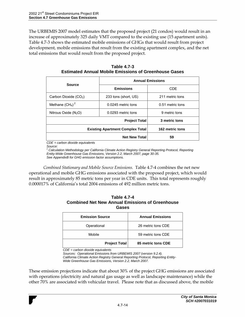
2002 21st Street Condominiums Project EIR
Section 4.7 Greenhouse Gas Emissions
City of Santa Monica SCH #2007031019
4.7-14
The URBEMIS 2007 model estimates that the proposed project (21 condos) would result in an increase of approximately 325 daily VMT compared to the existing use (15 apartment units). Table 4.7-3 shows the estimated mobile emissions of GHGs that would result from project development, mobile emissions that result from the existing apartment complex, and the net total emissions that would result from the proposed project.
Table 4.7-3 Estimated Annual Mobile Emissions of Greenhouse Gases
Source Annual Emissions
Emissions CDE
Carbon Dioxide (CO2) 233 tons (short, US) 211 metric tons
Methane (CH4) 2
0.0245 metric tons 0.51 metric tons
Nitrous Oxide (N2O) 0.0293 metric tons 9 metric tons
Project Total 3 metric tons
Existing Apartment Complex Total 162 metric tons
Net New Total 59
CDE = carbon dioxide equivalents Source: 1.Calculation Methodology per California Climate Action Registry General Reporting Protocol, Reporting
Entity-Wide Greenhouse Gas Emissions, Version 2.2, March 2007, page 30-35. See AppendixB for GHG emission factor assumptions.
Combined Stationary and Mobile Source Emissions. Table 4.7-4 combines the net new
operational and mobile GHG emissions associated with the proposed project, which would result in approximately 85 metric tons per year in CDE units. This total represents roughly 0.000017% of California’s total 2004 emissions of 492 million metric tons.
Table 4.7-4 Combined Net New Annual Emissions of Greenhouse
Gases
Emission Source Annual Emissions
Operational 26 metric tons CDE
Mobile 59 metric tons CDE
Project Total 85 metric tons CDE
CDE = carbon dioxide equivalents Sources: Operational Emissions from URBEMIS 2007 (version 9.2.4). California Climate Action Registry General Reporting Protocol, Reporting Entity-Wide Greenhouse Gas Emissions, Version 2.2, March 2007.
These emission projections indicate that about 30% of the project GHG emissions are associated with operations (electricity and natural gas usage as well as landscape maintenance) while the other 70% are associated with vehicular travel. Please note that as discussed above, the mobile

2002 21st Street Condominiums Project EIR
Section 4.7 Greenhouse Gas Emissions
City of Santa Monica SCH #2007031019
4.7-15
emissions are in part a redirection of existing travel to other locations, and so already a part of the total California GHG emissions.
GHG Cumulative Significance. The proposed project’s contribution of 85 metric tons of CDE would not exceed the 10,000 metric ton CDE threshold identified above in the Methodology and Significance section. Therefore, the project’s operational contribution to GHG would not be cumulatively considerable. As discussed in Section 4.6.2(a), the proposed project would have a significant impact on GHG emissions if it would exceed the 10,000 tons CDE/year threshold, or if it would be inconsistent with the GHG reduction strategies set forth by the CAT, OPR, the Attorney General, CAPCOA, the City’s Land Use and Circulation Element, and the Sustainable City Plan. Tables 4.7-5, 4.7-6, and 4.7-7 compare GHG reduction strategies set forth in these documents to project components and federal, state, and local requirements that would apply to the project. Several of these actions are already required by California regulations. Consistency with these measures illustrates that the project would not conflict with the State’s greenhouse gas legislation.
Table 4.7-5
Project Consistency with Applicable Climate Action Team
Greenhouse Gas Emission Reduction Strategies
Strategy Project Consistency
California Air Resources Board
Vehicle Climate Change Standards
AB 1493 (Pavley) required the state to develop and adopt regulations that achieve the maximum feasible and cost-effective reduction of climate change emissions emitted by passenger vehicles and light duty trucks. Regulations were adopted by the ARB in September 2004.
Not Applicable. These are CARB enforced
standards for vehicle manufacturing. Therefore, this strategy is not applicable to the project
Diesel Anti-Idling
The ARB adopted a measure to limit diesel-fueled commercial motor vehicle idling in July 2004.
Consistent - Current State law restricts diesel truck
idling to five minutes or less. Diesel trucks operating to and from the project site are subject to this statewide law. Construction vehicles are also subject to this regulation.
Hydrofluorocarbon Reduction
1) Ban retail sale of HFC in small cans.
2) Require that only low GWP refrigerants be used in new vehicular systems.
3) Adopt specifications for new commercial refrigeration.
4) Add refrigerant leak-tightness to the pass criteria for vehicular inspection and maintenance programs.
5) Enforce federal ban on releasing HFCs.
Not applicable – This strategy applies to the sale,
manufacturing, and regulation of consumer products. All applicable products would comply with the regulations that are in effect at the time of manufacture. Therefore, this strategy is not applicable to the project..
Alternative Fuels: Biodiesel Blends
ARB would develop regulations to require the use of 1 to 4 percent biodiesel displacement of California diesel fuel.
Not Applicable: These are CARB strategies for
regulating the use of alternative fuels and increasing heavy duty vehicle efficiency. Therefore, this strategy is not applicable to the project.
Consistent - Residents of the project could choose to
purchase flex-fuel vehicles and utilize this fuel once it is commercially available in the region and local vicinity.
Alternative Fuels: Ethanol
Increased use of E-85 fuel.
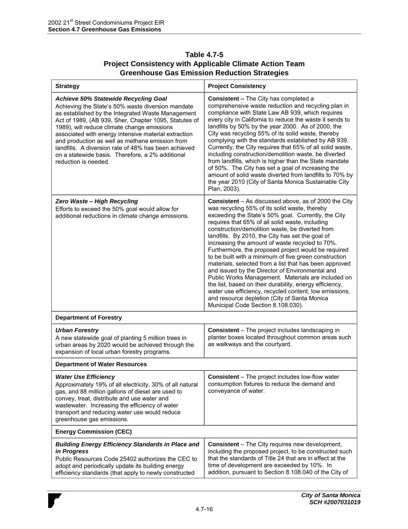
2002 21st Street Condominiums Project EIR
Section 4.7 Greenhouse Gas Emissions
City of Santa Monica SCH #2007031019
4.7-16
Table 4.7-5
Project Consistency with Applicable Climate Action Team
Greenhouse Gas Emission Reduction Strategies
Strategy Project Consistency
Achieve 50% Statewide Recycling Goal
Achieving the State’s 50% waste diversion mandate as established by the Integrated Waste Management Act of 1989, (AB 939, Sher, Chapter 1095, Statutes of 1989), will reduce climate change emissions associated with energy intensive material extraction and production as well as methane emission from landfills. A diversion rate of 48% has been achieved on a statewide basis. Therefore, a 2% additional reduction is needed.
Consistent – The City has completed a
comprehensive waste reduction and recycling plan in compliance with State Law AB 939, which requires every city in California to reduce the waste it sends to landfills by 50% by the year 2000. As of 2000, the City was recycling 55% of its solid waste, thereby complying with the standards established by AB 939. Currently, the City requires that 65% of all solid waste, including construction/demolition waste, be diverted from landfills, which is higher than the State mandate of 50%. The City has set a goal of increasing the amount of solid waste diverted from landfills to 70% by the year 2010 (City of Santa Monica Sustainable City Plan, 2003).
Zero Waste – High Recycling
Efforts to exceed the 50% goal would allow for additional reductions in climate change emissions.
Consistent – As discussed above, as of 2000 the City
was recycling 55% of its solid waste, thereby exceeding the State’s 50% goal. Currently, the City requires that 65% of all solid waste, including construction/demolition waste, be diverted from landfills. By 2010, the City has set the goal of increasing the amount of waste recycled to 70%. Furthermore, the proposed project would be required to be built with a minimum of five green construction materials, selected from a list that has been approved and issued by the Director of Environmental and Public Works Management. Materials are included on the list, based on their durability, energy efficiency, water use efficiency, recycled content, low emissions, and resource depletion (City of Santa Monica Municipal Code Section 8.108.030).
Department of Forestry
Urban Forestry
A new statewide goal of planting 5 million trees in urban areas by 2020 would be achieved through the expansion of local urban forestry programs.
Consistent – The project includes landscaping in
planter boxes located throughout common areas such as walkways and the courtyard.
Department of Water Resources
Water Use Efficiency
Approximately 19% of all electricity, 30% of all natural gas, and 88 million gallons of diesel are used to convey, treat, distribute and use water and wastewater. Increasing the efficiency of water transport and reducing water use would reduce greenhouse gas emissions.
Consistent – The project includes low-flow water
consumption fixtures to reduce the demand and conveyance of water.
Energy Commission (CEC)
Building Energy Efficiency Standards in Place and in Progress
Public Resources Code 25402 authorizes the CEC to adopt and periodically update its building energy efficiency standards (that apply to newly constructed
Consistent – The City requires new development,
including the proposed project, to be constructed such that the standards of Title 24 that are in effect at the time of development are exceeded by 10%. In addition, pursuant to Section 8.108.040 of the City of

2002 21st Street Condominiums Project EIR
Section 4.7 Greenhouse Gas Emissions
City of Santa Monica SCH #2007031019
4.7-17
Table 4.7-5
Project Consistency with Applicable Climate Action Team
Greenhouse Gas Emission Reduction Strategies
Strategy Project Consistency
buildings and additions to and alterations to existing buildings).
Santa Monica Municipal Code, the proposed project would be required to use pipe insulation for hot water circulation and heat traps for inlets and outlets of non-circulated hot water heaters. Also, Section 8.108.060 of the Santa Monica Municipal Code requires that projects (including the proposed project) use appliances, heating systems, lighting and other energy-using devices, which meet specific energy efficiency factors.
Appliance Energy Efficiency Standards in Place and in Progress
Public Resources Code 25402 authorizes the Energy Commission to adopt and periodically update its appliance energy efficiency standards (that apply to devices and equipment using energy that are sold or offered for sale in California).
Consistent – Under State law, appliances that are
purchased for the project – both pre- and post-development – would be consistent with energy efficiency standards that are in effect at the time of manufacture. Section 8.108.060 of the Santa Monica Municipal Code requires that projects (including the proposed project) use appliances, heating systems, lighting and other energy-using devices, which meet specific energy efficiency factors.
Fuel-Efficient Replacement Tires & Inflation Programs
State legislation established a statewide program to encourage the production and use of more efficient tires.
Consistent - Residents of the project site could
purchase tires for their vehicles that comply with state programs for increased fuel efficiency.
Municipal Utility Energy Efficiency Programs/Demand Response
Includes energy efficiency programs, renewable portfolio standard, combined heat and power, and transitioning away from carbon-intensive generation.
Not applicable - The project would not preclude implementation of this strategy by municipal utility providers.
Municipal Utility Renewable Portfolio Standard
California’s Renewable Portfolio Standard (RPS), established in 2002, requires that all load serving entities achieve a goal of 20 percent of retail electricity sales from renewable energy sources by 2017, within certain cost constraints.
Not applicable - The project would not preclude
implementation of this strategy by Southern California Edison.
Municipal Utility Combined Heat and Power
Cost effective reduction from fossil fuel consumption in the commercial and industrial sector through the application of on-site power production to meet both heat and electricity loads.
Not applicable - This strategy addresses incentives
that could be provided by utility providers such as Southern California Edison and The Gas Company.
Alternative Fuels: Non-Petroleum Fuels
Increasing the use of non-petroleum fuels in California’s transportation sector, as recommended as recommended in the CEC’s 2003 and 2005 Integrated Energy Policy Reports.
Consistent - Residents of the project site could
purchase alternative fuel vehicles and utilize these fuels once they are commercially available in the region and local vicinity.
Business, Transportation and Housing
Measures to Improve Transportation Energy Efficiency
Builds on current efforts to provide a framework for
Consistent – The project site is located in a
developed environment adjacent to residential areas. Additionally, bike racks would be provided onsite to

2002 21st Street Condominiums Project EIR
Section 4.7 Greenhouse Gas Emissions
City of Santa Monica SCH #2007031019
4.7-18
Table 4.7-5
Project Consistency with Applicable Climate Action Team
Greenhouse Gas Emission Reduction Strategies
Strategy Project Consistency
expanded and new initiatives including incentives, tools and information that advance cleaner transportation and reduce climate change emissions.
facilitate the use of alternative modes of transportation. These features would help to reduce vehicle trips and consequently greenhouse gas emissions.
Smart Land Use and Intelligent Transportation Systems (ITS)
Smart land use strategies encourage jobs/housing proximity, promote transit-oriented development, and encourage high-density residential/commercial development along transit corridors.
ITS is the application of advanced technology systems and management strategies to improve operational efficiency of transportation systems and movement of people, goods and services.
The Governor is finalizing a comprehensive 10-year strategic growth plan with the intent of developing ways to promote, through state investments, incentives and technical assistance, land use, and technology strategies that provide for a prosperous economy, social equity and a quality environment.
Smart land use, demand management, ITS, and value pricing are critical elements in this plan for improving mobility and transportation efficiency. Specific strategies include: promoting jobs/housing proximity and transit-oriented development; encouraging high density residential/commercial development along transit/rail corridor; valuing and congestion pricing; implementing intelligent transportation systems, traveler information/traffic control, incident management; accelerating the development of broadband infrastructure; and comprehensive, integrated, multimodal/intermodal transportation planning.
Consistent – The project site is located in a
developed environment adjacent to residential areas. Additionally, the project site proposes bike racks to facilitate the use of alternative modes of transportation. These features would help to reduce vehicle trips and consequently greenhouse gas emissions.
Public Utilities Commission (PUC)
Accelerated Renewable Portfolio Standard
The Governor has set a goal of achieving 33 percent renewable in the State’s resource mix by 2020. The joint PUC/Energy Commission September 2005 Energy Action Plan II (EAP II) adopts the 33 percent goal.
Not applicable - The project would not preclude implementation of this strategy by energy providers.

2002 21st Street Condominiums Project EIR
Section 4.7 Greenhouse Gas Emissions
City of Santa Monica SCH #2007031019
4.7-19
Table 4.7-6 Project Consistency with Applicable Attorney General and OPR’s Global Warming and
Greenhouse Gas Reduction Measures
Strategy Project Consistency
Attorney General Global Warming Reduction Measures
Energy Efficiency
Install efficient lighting and lighting control systems. Use daylight as an integral part of lighting systems in buildings.
Install energy efficient heating and cooling systems, appliances and equipment, and control systems.
Consistent – The project includes natural sunlight
throughout the site. Consistent – The project proposal includes the use of
high efficiency fixtures and controls to reduce energy needs.
Water Conservation and Efficiency
Design buildings to be water-efficient. Install water-efficient fixtures and appliances.
Consistent – The project proposal includes the use of
low-flow water consumption fixtures to reduce water demand.
Land Use Measures
Include mixed-use, infill, and higher density in development projects to support the reduction of vehicle trips, promote alternatives to individual travel, and promote efficient delivery of services and goods.
Consistent – The proposed project is an infill
development located in an urban setting adjacent to residential land uses.
Transportation and Motor Vehicles
Limit idling time for commercial vehicles, including delivery and construction vehicles.
Provide the necessary facilities and infrastructure to encourage the use of low or zero-emission vehicles
Consistent - Currently, the California Air Resources
Board’s (CARB) Airborne Toxic Control Measure (ATCM) to Limit Diesel-Fueled Commercial Motor Vehicle Idling restricts diesel truck idling to five minutes or less. Diesel trucks operating from and making deliveries to, the project site are subject to this state-wide law. Construction vehicles are also subject to this regulation. Consistent – The proposed project includes bike racks
to facilitate the use of non-vehicular transportation.
OPR Greenhouse Gas Reduction Measures
Land Use and Transportation
Limit idling time for commercial vehicles, including delivery and construction vehicles.
Encourage infill, redevelopment, and higher density development, whether in incorporated or unincorporated settings.
Consistent - Currently, the California Air Resources
Board’s (CARB) Airborne Toxic Control Measure (ATCM) to Limit Diesel-Fueled Commercial Motor Vehicle Idling restricts diesel truck idling to five minutes or less. Diesel trucks operating from and making deliveries to, the project site are subject to this state-wide law. Construction vehicles are also subject to this regulation. Consistent – The proposed project is an infill project in a
highly developed area adjacent to a residential neighborhood.
Urban Forestry
Preserve or replace onsite trees (that are removed due to development) as a means of providing carbon storage.
Consistent – The proposed project will not affect
adjacent street trees. The project would be required to comply with the Santa Monica Municipal Code, Section 7.40.160, which requires guards or protectors to prevent damage to public trees during construction activities. Additionally, the project proposes planter boxes throughout common areas such as walkways and the

2002 21st Street Condominiums Project EIR
Section 4.7 Greenhouse Gas Emissions
City of Santa Monica SCH #2007031019
4.7-20
Table 4.7-6 Project Consistency with Applicable Attorney General and OPR’s Global Warming and
Greenhouse Gas Reduction Measures
Strategy Project Consistency
courtyard
Energy Conservation Policies and Actions
Recognize and promote energy saving measures beyond Title 24 requirements for residential and commercial projects
Consistent – The City requires new development,
including the proposed project, to be constructed such that the standards of Title 24 that are in effect at the time of development are exceeded by 10%.
Table 4.7-7
Project Consistency with Land Use and Circulation Element and Sustainable City Plan
Policy/Goal Project Consistency
Lane Use and Circulation Element (LUCE)
LU2.4 Affordable and Workforce Housing.
Create diverse housing options along the transit corridors and in the activity centers, replacing some commercial potential with additional affordable and workforce housing, and encouraging affordable workforce housing near the transit stations.
Consistent. The project site is located in a developed
environment adjacent to residential areas. The project would increase the number of residential units in Santa Monica and would provide two very low income units. Additionally, the project site proposes bike racks and is located within walking distance to existing transit lines (#6, #7, #10, #11, #27, #41, and #44) which would facilitate the use of alternative modes of transportation.
LU2.5 Vehicle Trip Reduction.
Achieve vehicle trip reduction through comprehensive strategies that designate land uses, establish development and street design standards, implement sidewalk, bicycle and roadway improvements, expand transit service, manage parking, and strengthen Transportation Demand Management programs that support accessibility by transit, bicycle and foot, and discourage vehicle trips at a district-wide level. Monitor progress using tools that integrate land use and transportation factors. Increase bicycle and pedestrian connectivity in transit districts and adjust bus and shuttle services to ensure success of the transit system.
Consistent. The proposed project is an infill project in a
highly developed area adjacent to residences as well as commercial uses and other services. The project would increase the number of residential units in Santa Monica and would provide two very low income units. Further, the project proposes bike racks and the site is located within walking distance to existing transit lines (#6, #7, #10, #11, #27, #41, and #44) which would help to facilitate the use of alternative modes of transportation. These features would help to reduce vehicle trips and consequently greenhouse gas emissions.
LU4.4 Pedestrian-Oriented Design.
Engage pedestrians with ground floor uses, building design, site planning, massing and signage that promote vibrant street life and emphasize transit and bicycle access.
Consistent. As described above, the project site is
located in a developed environment adjacent to residential areas. The project proposes bike racks and the site is located within walking distance to existing transit lines (#6, #7, #10, #11, #27, #41, and #44) which would help to facilitate the use of alternative modes of transportation.
Sustainable City Plan
Resource Conservation Goal 1
Significantly decrease overall community consumption, specifically the consumption of non-local, non-renewable, non-recyclable and non-
Consistent - As discussed above, as of 2000 the City
was recycling 55% of its solid waste, thereby exceeding the State’s 50% goal. Currently, the City requires that 65% of all solid waste, including construction/demolition

2002 21st Street Condominiums Project EIR
Section 4.7 Greenhouse Gas Emissions
City of Santa Monica SCH #2007031019
4.7-21
Table 4.7-7 Project Consistency with Land Use and Circulation Element
and Sustainable City Plan
Policy/Goal Project Consistency
recycled materials, water, and energy and fuels. The City should take a leadership role in encouraging sustainable procurement, extended producer responsibility and should explore innovative strategies to become a zero waste city.
waste, be diverted from landfills. By 2010, the City has set the goal of increasing the amount of waste recycled to 70%. Furthermore, the proposed project would be required to be built with a minimum of five green construction materials, selected from a list that has been approved and issued by the Director of Environmental and Public Works Management. Materials are included on the list, based on their durability, energy efficiency, water use efficiency, recycled content, low emissions, and resource depletion (City of Santa Monica Municipal Code Section 8.108.030).
Transportation Goal 1
Create a multi-modal transportation system that minimizes and, where possible, eliminates pollution and motor vehicle congestion while ensuring safe mobility and access for all without compromising our ability to protect public health and safety.
Consistent - As described above, the project site is
located in a developed environment adjacent to residential areas. The project proposes bike racks and the site is located within walking distance to existing transit lines (#6, #7, #10, #11, #27, #41, and #44) which would help to facilitate the use of alternative modes of transportation. In addition, the proposed project is an infill project in a highly developed area adjacent to residences as well as commercial uses and other services.
Transportation Goal 2
Facilitate a reduction in automobile dependency in favor of affordable alternative, sustainable modes of travel.
Consistent - The project site is located in a developed
environment adjacent to residential areas. Additionally, the project proposes bike racks and the site is located within walking distance to existing transit lines (#6, #7, #10, #11, #27, #41, and #44). These features would help to reduce vehicle trips and consequently greenhouse gas emissions. In addition, the proposed project is an infill project in a highly developed area adjacent to residences as well as commercial uses and other services.
Open Space and Land Use Goal 2
Implement land use and transportation planning and policies to create compact, mixed-use projects, forming urban villages designed to maximize affordable housing and encourage walking, bicycling and the use of existing and future public transit systems.
Consistent -The proposed project is an infill project in a
highly developed area adjacent to residences as well as commercial uses and other services. The project would increase the number of residential units in Santa Monica and would provide two very low income units. Further, the project proposes bike racks and the site is located within walking distance to existing transit lines (#6, #7, #10, #11, #27, #41, and #44) which would help to facilitate the use of alternative modes of transportation.
As indicated above in Tables 4.7-6, 4.7-7, and 4.7-8, the proposed project would be generally consistent with the applicable GHG reduction strategies recommended to reduce the generation of greenhouse gas emissions in the 2006 CAT Report, OPR’s CEQA and Climate Change, the Attorney General’s Global Warming Measures, the City’s Land Use and Circulation Element, and the Sustainable City Plan. Therefore, the proposed project would be consistent with the objectives of AB 32, SB 97, and SB 375, and would therefore, result in less than significant impacts to climate change.
Mitigation Measures. No mitigation is required since the impact would not be significant.

2002 21st Street Condominiums Project EIR
Section 4.7 Greenhouse Gas Emissions
City of Santa Monica SCH #2007031019
4.7-22
Level of Significance after Mitigation. Impacts would be less than significant without mitigation. c. Cumulative Impacts. As indicated above in Impact GHG-1, emissions associated with the proposed project were found to be less than significant. Analyses of greenhouse gases are cumulative in nature as they affect the accumulation of greenhouse gases in the atmosphere. Because project-related GHG emissions are only important in the context of cumulative emissions, the focus of the GHG analysis is on answering the question of whether incremental contributions of GHGs are a cumulatively considerable contribution to global warming effects. As shown in Tables 4.7-6 through 4.7-8, the proposed project would be consistent with adopted plans and policies. Therefore, the proposed project would not contribute to a cumulative impact related to greenhouse gas emissions.

2002 21st Street Condominiums Project EIR
Section 5.0 Other CEQA Considerations
City of Santa Monica SCH #2007031019
5-1
5.0 OTHER CEQA CONSIDERATIONS Section 15126.2(d) of the State CEQA Guidelines requires a discussion of a proposed project’s potential to foster economic or population growth, including ways in which a project could remove an obstacle to growth. Growth does not necessarily create significant physical changes to the environment. However, depending upon the type, magnitude, and location of growth, it can result in significant adverse environmental effects. The proposed project’s growth-inducing potential is therefore considered significant if it could result in significant physical effects in one or more environmental issue areas. The most commonly cited example of how an economic effect might create a physical change is where economic growth in one area could create blight conditions elsewhere by causing existing competitors to go out of business and the buildings to be left vacant. Section 15126.2(c) of the State CEQA Guidelines also requires a discussion of “significant irreversible environmental changes which would be caused by the proposed project should it be implemented. Uses of nonrenewable resources during the initial and continued phases of the project may be irreversible since a large commitment of such resources makes removal or nonuse thereafter unlikely. Primary impacts and, particularly, secondary impacts (such as a highway improvement which provides access to a previously inaccessible area) generally commit future generations to similar uses. Also, irreversible damage can result from environmental accidents associated with the project. Irretrievable commitments of resources should be evaluated to assure that such current consumption is justified.”
5.1 ECONOMIC AND POPULATION GROWTH The proposed project involves the demolition of approximately 15 apartment units. The project would involve the subsequent construction of a 21-unit condominium complex on the 0.66-acre project site. Two of the proposed units would be reserved as low income units. Parking would be provided within a subterranean structure containing 48 spaces. The project would generate short-term employment opportunities during construction, which would draw workers from the existing regional work force. Therefore, the proposed project would not be considered growth-inducing as it would not affect long-term employment opportunities. The proposed net increase of 5 residential units would increase the City’s population by approximately 10 people. This number is based on the City average of 1.87 people per household (Census 2010). Given the City’s estimated population of 89,736 people (Census, 2010), this represents an increase in population of less than 0.01% and therefore is not considered significant.
Mitigation Measures. None required.
Residual Impacts. No significant environmental impacts relating to economic or population growth are anticipated.
5.2 REMOVAL OF OBSTACLES TO GROWTH The proposed project would be located in a fully urbanized residential neighborhood in Santa Monica, which is well-served by existing infrastructure. Minor improvements to water, sewer,

2002 21st Street Condominiums Project EIR
Section 5.0 Other CEQA Considerations
City of Santa Monica SCH #2007031019
5-2
and drainage connection infrastructure could be necessary, but would be sized to specifically serve the proposed project. No new roads would be required. Because the project constitutes redevelopment within an urbanized area and does not require the extension of new infrastructure through undeveloped areas, project implementation would not remove an obstacle to growth.
Mitigation Measures. None required.
Residual Impacts. No significant environmental impacts relating to the removal of obstacles to population growth are anticipated.
5.3 IRREVERSIBLE ENVIRONMENTAL EFFECTS The CEQA Guidelines require that EIRs discuss the significant environmental changes that would occur with project development. CEQA also requires decisionmakers to balance the benefits of a proposed project against its unavoidable environmental risks in determining whether to approve a project. This section addresses non-renewable resources, the commitment of future generations to the proposed uses, and irreversible impacts associated with the proposed development. Conversion of the project site from the existing 15 unit apartment complex to a 21 unit condominium complex with subterranean parking would likely result in a long-term commitment of the site to such uses. Development of the proposed project would result in alteration of the urban built environment that would be irreversible. Construction of the new building would involve the use of building materials and energy, some of which are non-renewable resources. Consumption of these resources would occur with any development in the region and are not unique to the proposed project. The addition of an estimated 10 new residents would irreversibly increase local demand for non-renewable energy resources such as petroleum and natural gas. However, the project site is located in close proximity to existing bus routes and the project would provide bike racks to encourage alternative modes of transporation. The minor increased traffic from the project would result in increased regional air pollutant emissions, which would incrementally contribute to the degradation of air quality. However, the development of additional residential units in a job-rich environment with ample mass transit opportunities is anticipated to benefit the overall community in the long term by facilitating reduced vehicle miles traveled.

2002 21st Street Condominiums Project EIR
Section 6.0 Alternatives
City of Santa Monica SCH #2007031019
6-1
6.0 ALTERNATIVES As required by Section 15126.6 of the CEQA Guidelines, this EIR examines a range of reasonable alternatives to the proposed project. Three alternatives are analyzed: the CEQA-required “No Project” alternative, a “Reduced Project” alternative, and a “Senior Housing Condo Project” alternative. This section also includes a discussion of the environmentally superior alternative among those studied.
6.1 ALTERNATIVES CONSIDERED AND REJECTED CEQA Guidelines Section 15126.6(c) states that an EIR should identify any alternatives that were considered for analysis but rejected as infeasible and briefly explain the reasons for their rejection. According to the CEQA Guidelines, the factors that may be used to eliminate an alternative from detailed consideration include: the alternative’s failure to meet most of the basic project objectives, the alternative’s infeasibility, or the alternative’s inability to avoid significant environmental impacts. The following alternative to the project was considered and rejected and rejected from consideration.
Alternative Site
Development of the proposed project at an alternative location would not ensure that potentially significant impacts would be avoided or substantially lessened. Depending on the specific site and the environmental constraints present within that area, an alternative location could potentially result in additional environmental impacts when compared to the proposed project. Therefore, development of the project at an alternative location is rejected and considered infeasible. The proposed project would develop new residential uses in an existing residential neighborhood and therefore, is consistent and compatible with surrounding uses. Development of the project at an alternate location, particularly within a residential neighborhood may not necessarily avoid the project’s significant and irreversible construction impacts related to vibration as these impacts would be relocated to another location.
Alternatives to Avoid or Reduce Significant and Unavoidable Construction Impacts of the Proposed Project
Section 15126.6 of the CEQA Guidelines states that an EIR shall discuss alternatives to the project that avoid or substantially lessen any significant effects of the project. The significant and unavoidable impact associated with the project (e.g., construction vibration) would occur as a result of construction activities and not with proposed operation. As discussed in Section 4.3, Construction Effects, construction of the project would result in significant and unavoidable vibration impacts on nearby sensitive receptors. The primary means to reduce construction vibration is to limit the distance between the source and the receiver including either through vibration barriers (such as a wave barrier), temporary relocation of the adjacent sensitive receptors, or limiting construction equipment by weight and location. However, because of the physical constraints of the project site and the adjacent location of the sensitive receptors, none of these options are considered feasible. This is deemed infeasible as construction activity (e.g., demolition) for any new development must occur on-site at the property line. Therefore, alternatives to avoid or reduce the significant and unavoidable construction vibration impacts of the proposed project were rejected and considered infeasible.

2002 21st Street Condominiums Project EIR
Section 6.0 Alternatives
City of Santa Monica SCH #2007031019
6-2
6.2 ALTERNATIVES ANALYZED The CEQA statute, the CEQA Guidelines, and related recent court cases do not specify a precise number of alternatives to be evaluated in an EIR. Rather, “the range of alternatives required in an EIR is governed by the rule of reason that sets forth only those alternatives necessary to permit a reasoned choice.”1 At the same time, Section 15126.6(b) of the CEQA Guidelines requires that “...the discussion of alternatives shall focus on alternatives to the project or its location which are capable of avoiding or substantially lessening any significant effects of the project” and Section 15126.6(f) requires, “The alternatives shall be limited to ones that would avoid or substantially lessen any of the significant effects of the project.” Accordingly, alternatives that would not address potentially significant effects are not considered herein. However, the CEQA Guidelines require that a "No Project" alternative must be included and, if appropriate, an alternative site location should be analyzed.2 Other project alternatives may involve a modification of the proposed land uses, density, or other project elements at the same project location.
Alternatives should be selected on the basis of their ability to attain all or most of the basic objectives of the project while reducing the project’s significant environmental effects. Section 15126.6(d) of the CEQA Guidelines state that “...[t]he EIR should briefly describe the rationale for selecting alternatives to be discussed [and]...shall include sufficient information to allow meaningful evaluation, analysis and comparison with the proposed project.”3 The feasibility of the alternatives is another consideration in the selection of alternatives. Section 15126.6(f)(1) of the CEQA Guidelines state that "[a]mong the factors that may be taken into account when addressing the feasibility of alternatives are site suitability, economic viability, availability of infrastructure, general plan consistency, other plans or regulatory limitations [and] jurisdictional boundaries...”4 “The range of feasible alternatives shall be selected and discussed in a manner to foster meaningful public participation and informed decision making.”5 Alternatives that are considered remote or speculative, or whose effects cannot be reasonably predicted do not require consideration. Therefore, the primary considerations in the selection and evaluation of alternatives include feasibility, the potential to mitigate significant project-related impacts, and the ability to reasonably inform the decision-maker.
As indicated previously, the proposed project’s significant and unavoidable impacts are associated with construction, rather than on-site operations. No feasible mitigation measures (beyond the No Project Alternative) are available to avoid and/or substantially lessen these significant construction impacts of the proposed project. For the purposes of this EIR, three alternatives were selected for study. These alternatives would reduce the proposed project’s operational traffic impacts, which were determined to be less than significant.
The following three alternatives are evaluated here for the proposed project.
1CEQA Guidelines, California Code of Regulations (CCR), Title 14, Division 6, Chapter 3, Section
15126.6(f). 2CEQA Guidelines, CCR, Title 14, Division 6, Chapter 3, §15126.6(e) and §15126(f)(2).
3Ibid, §15126.6(e) and §15126(f).
4Ibid, §15126.6(f)(1).
5Ibid, §15126.6(f).

2002 21st Street Condominiums Project EIR
Section 6.0 Alternatives
City of Santa Monica SCH #2007031019
6-3
6.3 NO PROJECT ALTERNATIVE
6.3.1 Description The No Project alternative assumes that the development proposed as part of the project would not occur. The existing 15 bungalow apartments that currently exist onsite would remain. The site would retain its current condition and all existing structures would remain in place. The CEQA Guidelines require analysis of this alternative.
6.3.2 Impact Analysis No change in environmental conditions would occur under this alternative. This alternative would avoid the proposed project’s significant and unavoidable construction vibration impact as well as the significant, but mitigable impacts relating to construction traffic and noise, operational noise, and neighborhood effects. Overall, this alternative’s impacts would be lower than those of the proposed project for all issues, including the issues discussed in the Initial Study in Appendix A. It should be noted, however, that with the exception of the significant and unavoidable construction vibration impact, the proposed project would not have any significant environmental impacts that cannot be reduced to below a level of significance. It should also be noted that implementation of the No Project alternative at this time would not preclude future redevelopment of the site, nor would it meet the project objectives, which include adding to the stock of condominium housing in the City. Consequently, the benefits of the proposed project with respect to adding housing in the City would not be realized.
6.4 REDUCED PROJECT ALTERNATIVE 6.4.1 Description This alternative would maintain a similar building design to the proposed project, but would accommodate only 15 condominium units. This alternative would include the demolition of the existing 15 one-story bungalow apartments. The total number of residential units constructed would be 15; six fewer units than the proposed project and a net increase of zero units, as compared to the existing apartment complex on the project site. As with the proposed project, the site layout would be configured around a courtyard, with private outdoor space including patios provided at the ground level for each unit. Parking would be provided within a subterranean structure containing 15 private two-car garages as well as guest parking. Access to the garage would be from a single driveway from 20th Court Alley, the same as with the proposed project.
6.4.2 Impact Analysis
a. Shadows. The physical appearance of the structures in the urban landscape would be similar to those of the proposed project and the facades would retain the same style as the proposed project. Similar to the proposed project, shadow impacts would be less than

2002 21st Street Condominiums Project EIR
Section 6.0 Alternatives
City of Santa Monica SCH #2007031019
6-4
significant, with the reduction of residential units. As with the proposed project, no mitigation measures would be needed for this alternative.
b. Air Quality. The long-term air quality emissions from the Reduced Project alternative would be incrementally reduced from those of the proposed project, due to the overall reduction in residential units from 21 units to 15 units. Similar to the proposed project, both regional air quality impacts and localized impacts related to carbon monoxide (CO) concentrations would be less than significant. Since there would be no increase in the number of residential units on-site, air pollutant emissions would be similar to existing conditions. As with the proposed project, no mitigation measures would be required for this alternative.
c. Construction Effects. Due to the reduced number of new units that would be constructed on the project site, construction effects associated with this alternative would be similar, though incrementally reduced to those of the proposed project. Impacts regarding temporary changes to traffic patterns, parking availability, and noise would still be significant but mitigable; therefore, mitigation measures identified for the proposed project would apply. Construction-related air quality impacts would remain less than significant. Because construction activity, like the proposed project, would occur within approximately 25 feet of the adjacent residences to the south and southeast of the project site, impacts related to groundborne vibration would remain significant and unavoidable.
d. Neighborhood Effects. This alternative would have incrementally reduced neighborhood effects as compared to the proposed project due to the reduction in traffic associated with the construction of fewer new residential units. With the Reduced Project alternative, daily trip generation on study area roadway segments would be lower than with the proposed project, because this alternative would result in a reduction of 6 residential units compared to the proposed project. In addition, this alternative would not result in any increase in vehicular delay at any of the study area intersections compared to existing conditions. Neighborhood impacts related to shadows, air quality, traffic, and noise would be less than significant with mitigation, the same as with the proposed project. However, neighborhood impacts related to construction effects would be significant and unavoidable as a result of groundborne vibration, the same as the proposed project.
e. Noise. This alternative would have reduced noise impacts as compared to those of the proposed project. As trip generation would be lower than with the proposed project, operational roadway noise would also be reduced and the impact would remain less than significant, the same as with the proposed project. Operational noise impacts associated with rooftop ventilation and heating systems, trash hauling, parking garage operation, and general residential activities would be similar to those of the proposed project. Mitigation measures identified for the proposed project would apply and the overall impact classifications would remain the same as with the proposed project (significant but mitigable). Since there would be no increase in the number of residential units on-site, vehicular traffic noise would be similar to existing conditions.
f. Traffic. As discussed under “Neighborhood Effects,” this alternative would generate fewer daily trips than the proposed project, and a similar number of trips as compared to the existing improvements on the site. Likewise, the estimated daily trip generation on the two

2002 21st Street Condominiums Project EIR
Section 6.0 Alternatives
City of Santa Monica SCH #2007031019
6-5
roadway segments (Virginia Avenue and 21st Street) would be reduced as compared to the proposed project. In addition, this alternative would not increase vehicular delay at any of the study area intersections. Like the proposed project, this alternative would result in less than significant impacts for project and cumulative conditions at both intersections and street segments. Table 6-1 summarizes the trip generation characteristics of this alternative compared to the proposed project and the existing apartment complex at the project site.
Table 6-1 Reduced Project Alternative Daily Traffic Trips
Size Daily Trip Rate Daily Trips
Existing Use Apartments
15 units 6.49 per unit 97
Proposed Project Condominiums
21 units 6.49 per unit 136
Reduced Project alternative Condominiums
15 units 6.49 per unit 97
Source: Fehr&Peers, March 2012
g. Greenhouse Gas Emissions. The long-term greenhouse gas emissions from the
Reduced Project alternative would be incrementally reduced from those of the proposed project, due to the overall reduction in residential units from 21 units to 15 units. Similar to the proposed project, greenhouse gas emissions would have a less than significant impact on the environment. Since there would be no increase in the number of residential units on-site, GHG emissions would be similar to existing conditions. As with the proposed project, no mitigation measures would apply to this alternative.
6.5 SENIOR HOUSING CONDO PROJECT ALTERNATIVE 6.5.1 Description This alternative would maintain a similar building design to the proposed project, but would provide 21 senior housing condominium units. This alternative would include the demolition of the existing 15 one-story bungalow apartments. The total number of residential units constructed would be 21; the same as the proposed project but would be intended for senior residents. As with the proposed project, the site layout would be configured around a courtyard, with private outdoor space including patios provided at the ground level for each unit. Like the proposed project, parking would be provided within a subterranean structure containing 21 private two-car garages as well as guest parking. Access to the subterranean parking garage would be from a single driveway from 20th Court Alley, the same as with the proposed project.
6.5.2 Impact Analysis
a. Shadows. The physical appearance of the structures in the urban landscape would be similar to those of the proposed project and the facades would retain the same style as the
2002 21st Street Condominiums Project EIR
Section 6.0 Alternatives
City of Santa Monica SCH #2007031019
6-6
proposed project. Similar to the proposed project, shadow impacts would be less than significant. As with the proposed project, no mitigation measures would be needed for this alternative.
b. Air Quality. The long-term air quality emissions from the Senior Housing Condo Project alternative would be reduced from those of the proposed project, due to the fewer traffic trips associated with senior residents compared to the proposed project (see discussion below in f. Traffic). Similar to the proposed project, both regional air quality impacts and localized impacts related to carbon monoxide (CO) concentrations would be less than significant. In addition, because this alternative would result in fewer overall daily traffic trips than the existing apartment complex (see below for traffic reductions), this alternative would result in incrementally fewer air emissions than existing conditions. This would be a beneficial impact to air quality.
c. Construction Effects. Construction effects associated with this alternative would be similar to those associated with the proposed project since the overall building design would be similar. Impacts regarding temporary changes in traffic patterns, parking availability, and noise would remain significant but mitigable. Mitigation measures identified for the proposed project would apply. Construction-related air quality impacts would remain less than significant. In addition, because construction activity, like the proposed project, would occur within approximately 25 feet of the adjacent residences to the south and southeast of the project site, impacts related to groundborne vibration would remain significant and unavoidable.
d. Neighborhood Effects. This alternative would have reduced neighborhood effects as compared to the proposed project due to the reduction in traffic associated with the construction of senior housing units. With the Senior Housing Condo Project alternative, daily trip generation would be lower than with the proposed project, because this alternative would result in a reduction of approximately 63 daily trips compared to the proposed project. Because senior housing units generally result in fewer average daily trips than standard apartment units, this alternative would also result in a net decrease of 24 trips in daily trip generation when compared with existing conditions on the project site. The reduction in total daily trips on this segment compared to the proposed project and compared to existing conditions would have a beneficial impact on traffic. Neighborhood impacts related to shadows, construction effects, and noise would be less than significant with mitigation, the same as with the proposed project.
e. Noise. This alternative would have lower noise impacts as compared to those of the proposed project. The Senior Housing Condo Project alternative would involve development of senior residential units which would result in fewer average daily trips than the proposed project’s condominium units, and would also lead to an overall reduction of daily traffic trips compared to existing conditions. Therefore, trip generation and associated traffic noise would be lower than with the proposed project, and would also be reduced from existing conditions, and would have a beneficial impact on traffic noise. Operational noise impacts, including rooftop ventilation and heating systems, trash hauling, parking garage operation, and general residential activities, would be similar to those of the proposed project. Mitigation measures identified for the proposed project would apply and the overall impact classifications would remain the same as with the proposed project (significant but mitigable).

2002 21st Street Condominiums Project EIR
Section 6.0 Alternatives
City of Santa Monica SCH #2007031019
6-7
f. Traffic. As discussed under “Neighborhood Effects,” this alternative would generate
fewer daily trips than the proposed project (63 fewer trips), and fewer daily trips than the existing uses on the site (24 fewer trips). Likewise, the estimated daily trip generation on study area roadway segments and the overall vehicular delay at study area intersections would be reduced as compared to both the proposed project and the existing uses on the site. Because existing traffic volumes would be reduced compared to existing conditions under the Senior Housing Condo Project alternative, this would be a beneficial impact. Table 6-2 summarizes the trip generation characteristics of this alternative as compared to the proposed project and to the existing improvements on the project site.
Table 6-2 Senior Housing Condo Project Alternative Daily Traffic Trips
Size Daily Trip Rate Daily Trips
Existing Use Apartments
15 units 6.49 per unit 97
Proposed Project Condominiums
21 units 6.49 per unit 136
Senior Housing Condo Project Condominiums
21 units 3.48 per unit 73
Source: Fehr&Peers, March 2012; and, Institute of Transportation Engineers (ITE). Trip Generation, Eighth Edition, 2008
g. Greenhouse Gas Emissions. The long-term greenhouse gas emissions from the
Senior Housing Condo Project alternative would be reduced from those of the proposed project, due to the overall reduction in traffic trips associated with senior residential units. In addition, this alternative would result in fewer greenhouse gas emissions than existing conditions as it would have 24 fewer daily traffic trips than the existing apartment complex. This would result in incrementally fewer greenhouse gas emissions than the proposed project. As such, this alternative would result in beneficial impacts related to greenhouse gas emissions.
6.6 ENVIRONMENTALLY SUPERIOR ALTERNATIVE This section identifies the environmentally superior alternative. The No Project alternative would involve no change to the environment and could therefore be considered environmentally superior overall. In addition, the No Project alternative would not result in a significant and unavoidable impact related to groundborne vibration. However, that alternative fails to achieve the applicant’s objectives for the project, to add to the stock of condominium housing in the City. The Reduced Project alternative would be environmentally superior among the development alternatives since this alternative would result in a reduction of environmental impacts with respect to construction effects as compared to the proposed project given the reduced level of construction. The Reduced Project alternative would reduce the overall size of the project, from a total of 21 residential units to 15 residential units, incrementally reducing construction effects compared to

2002 21st Street Condominiums Project EIR
Section 6.0 Alternatives
City of Santa Monica SCH #2007031019
6-8
the proposed project. This alternative would satisfy the applicant’s objective to add to the stock of condominium housing in the City. However, like the proposed project, this project would not avoid the significant and unavoidable impact related to groundborne vibration during construction. In addition, it should be noted that this alternative would not be consistent with Government Code §65585.5(i). The Senior Housing Condo Project alternative would be equivalent to the proposed project. However, like the proposed project, this alternative would not avoid the project’s significant and unavoidable impact related to groundborne vibration during construction. Table 6-3 compares the impacts for each of the alternatives.
Table 6-3 Impact Comparison of Alternatives
Issue Proposed
Project No Project
Reduced Project
Senior Housing Condo Project
Shadows = = = = Air Quality = =/+ = / + = Construction Effects = + = = Neighborhood Effects = =/+ =/+ = Noise = =/+ =/+ = Transportation/Traffic = =/+ =/+ = Greenhouse Gas Emissions = =/+ = / + =
+ Superior to the proposed project (reduced level of impact) - Inferior to the proposed project (increased level of impact) = / + slightly superior to the proposed project in one or more aspects, but not significantly superior = Similar level of impact to the proposed project

2002 21st Street Condominiums Project EIR
Section 7.0 References and Report Preparers
City of Santa Monica SCH #2007031019
7-1
7.0 REFERENCES AND REPORT PREPARERS
7.1 REFERENCES Association of Environmental Professionals (AEP). Alternative Approaches to Analyzing
Greenhouse Gas Emissions and Global Climate Change in CEQA Documents. June 29, 2007. California Air Pollution Control Officers Association. CEQA and Climate Change: Addressing
Climate Change through California Environmental Quality Act (CEQA). January 2008. California Air Resources Board. Ambient Air Quality Standards. September 2010. Available at:
http://www.arb.ca.gov/research/aaqs/aaqs2.pdf California Air Resources Board. Climate Change Emission Control Fact Sheet, 2007.
http://www.arb.ca.gov/cc/factsheets/cc_newfs.pdf California Air Resources Board. Greenhouse Gas Inventory Data, 2000-2008.
http://www.arb.ca.gov/cc/inventory/data/data.htm California Air Resources Board. URBEMIS 2007 Emissions Model version 9.2.4. 2007. California Climate Action Registry. California Climate Action Registry General Reporting Protocol:
Reporting Entity-Wide Greenhouse Gas Emissions. Version 3.1. January 2009. California Department of Water Resources. Progress on Incorporating Climate Change into
Management of California’s Water Resources. July 2006 California Energy Commission. Inventory of California Greenhouse Gas Emissions and Sinks: 2000-
2004. December, 2006. California Energy Commission. Inventory Draft 2009 Biennial Report to the Governor and
Legislature. Staff Draft Report. March 2009. California Environmental Protection Agency, March 2006. Climate Action Team Report to
Governor Schwarzenegger and the Legislature. http://www.climatechange.ca.gov/climate_action_team/reports/2006-04-03_FINAL_CAT_REPORT_EXECSUMMARY.PDF
Cayan, D., A.L. Luers, M. Hanemann, G. Granco, and B. Croes. Scenarios of Climate Change in
California: An Overview. California Climate Change Center, State of California. White Paper, CEC-500-2005-203-SF. March 2006
Cayan, D., E. Maurer, M. Dettinger, M. Tyree, K. Hayhoe, C. Bonfils, P. Duffy, and B. Santer.
Climate Scenarios for California: Climate Action Team Reports to the Governor and Legislature. 2006.

2002 21st Street Condominiums Project EIR
Section 7.0 References and Report Preparers
City of Santa Monica SCH #2007031019
7-2
City of Santa Monica Big Blue Bus. Accessed October 21, 2008. Available online at: http://www.bigbluebus.com/
City of Santa Monica. General Plan Land Use and Circulation Element. 2010. City of Santa Monica. Municipal Code. Available online at:
http://www.qcode.us/codes/santamonica/ City of Santa Monica. Noise Ordinance, Municipal Code Section 4.12. Amended in February
2004. City of Santa Monica. Official Homepage. 2010. City of Santa Monica. Sustainable City Plan. February 2003, revised October 2006. City of Santa Monica. Trip Generation Memo. City of Santa Monica. Zoning Ordinance. Available online at:
http://www01.smgov.net/planning/planningcomm/zoningordinace.htm Federal Highway Administration. Traffic Noise Model (TNM) 2.5 lookup tables Fehrs and Peers/Kaku Associates. 2002-2018 21st Street Condominiums Project Traffic Impact Analysis Technical Memorandum. March 2012. Harris Miller Miller & Hanson Inc. Transit Noise and Vibration Impact Assessment. Prepared
for the Federal Transit Administration. May 2006. Intergovernmental Panel on Climate Change [IPCC], 2007: Summary for Policymakers. In:
Climate Change 2007: The Physical Science Basis. Contribution of Working Group I to the Fourth Assessment Report of the Intergovernmental Panel on Climate Change [Solomon, S., D. Qin, M. Manning, Z. Chen, M. Marquis, K.B. Averyt, M.Tignor and H.L. Miller (eds.)]. Cambridge University Press, Cambridge, United Kingdom and New York, NY, USA.
Kiparsky, Michael and Peter H. Gleick, 2003. Climate Change and California Water Resources: A
Survey and Summary of the Literature. California Energy Commission Report 500-04-073 National Institutes of Health, National Institute on Deafness and Other Communication
Disorders, Bethesda, Maryland 20892. January 1990. Parmesan, C. 2004. Ecological and Evolutionary Responses to Recent Climate Change. Parmesan C, Galbraith H. 2004. Observed Ecological Impacts of Climate Change in North America.
Arlington, VA: Pew Cent. Glob. Clim. Change South Coast Air Quality Management District. CEQA Air Quality Handbook. 1993, revised 2006.
Available at: http://www.aqmd.gov/ceqa/hdbk.html

2002 21st Street Condominiums Project EIR
Section 7.0 References and Report Preparers
City of Santa Monica SCH #2007031019
7-3
South Coast Air Quality Management District. Final Localized Significance (LST) Thresholds Methodology. June 2003, revised July 2008.
Transportation Research Board. Highway Capacity Manual. 2000. U.S. Department of Energy, Energy Information Administration,. Official Energy Statistics from the
U.S. Government. December 2008. http://www.eia.doe.gov/iea/. United States Environmental Protection Agency. 2010 U.S. Greenhouse Gas Inventory Report:
Inventory of U.S. Greenhouse Gas Emissions and Sinks: 1990-2008. April 15, 2010. United States Environmental Protection Agency. Climate Change Technology Program
(CCTP). December 2007. http://www.epa.gov/climatechange/policy/cctp.html. United States Environmental Protection Agency. Noise from Construction Equipment and
Operations, Building Equipment, and Home Appliances. 1971. United Nations Framework Convention on Climate Change (www.unfccc.int), 2007.
7.2 REPORT PREPARERS This EIR was prepared by Rincon Consultants, Inc., under contract to the City of Santa Monica Planning Department. Consultant staff involved in the preparation of the EIR are listed below. Rincon Consultants, Inc. Joe Power, AICP, Principal Matt Maddox, Project Manager Greg Martin, AICP, Senior Planner Morgan Wazlaw, Environmental Planner Chris Bersbach, Environmental Planner Kathy Babcock, Graphics Technician Katherine Warner, Graphics Technician Katie Stanulis, Production Coordinator Fehr & Peers Steve Crosley, Transportation Planner

2002 21st Street Condominiums Project EIR
Section 7.0 References and Report Preparers
City of Santa Monica SCH #2007031019
7-4
This page intentionally left blank

Appendix A Initial Study and Notice of Preparation

CITY OF SANTA MONICA CITY PLANNING DIVISION
1685 MAIN STREET, ROOM 212 SANTA MONICA, CA 90407
NOTICE OF PREPARATION
OF A DRAFT ENVIRONMENTAL IMPACT REPORT 2002 21ST STREET CONDOMINIUMS PROJECT
DATE: June 17, 2010 TO: State Clearinghouse, Responsible Agencies, Trustee Agencies, Organizations and
Interested Parties LEAD AGENCY: City of Santa Monica City Planning Division 1685 Main Street, Room 212 Santa Monica, CA 90401 Contact: Steve Mizokami, Associate Planner Phone: (310) 458-8341 The City of Santa Monica intends to prepare an Environmental Impact Report (EIR) for the 2002 21st Street Condominiums Project. In accordance with Section 15082 of the State CEQA Guidelines, the City of Santa Monica has prepared this Notice of Preparation to provide Responsible Agencies and other interested parties with information describing the proposal and its potential environmental effects. The following environmental factors, identified in the initial study, that would potentially be affected by the project include: • Aesthetics (shadows) • Neighborhood Effects • Air Quality • Noise • Construction Effects • Traffic • Greenhouse Gas Emissions PROJECT APPLICANT: Park Virginia, LLC 11693 San Vincente Blvd. #213. Los Angeles, CA 90049 PROJECT LOCATIONS: 2002 – 2018 21st Street, Santa Monica, California PROJECT DESCRIPTION: The project is located on 28,935 square feet (0.66 acres) southwest of the intersection of Virginia Avenue and 21st Street. The site currently consists of four contiguous parcels containing 15 residential units in 8 buildings with garages that front the rear alley along the southwest border of the site (between 21st Street and 20th Street). The structures were constructed between 1935 and 1951. The proposed project involves demolition of all existing structures on the site and construction of a new two-story 21-unit condominium complex. Parking would be provided in a subterranean structure containing 21 private two car garages (42 parking stalls) and one handicap stall for residents. In addition, the subterranean structure would provide five guest parking spaces (standard, compact and handicap spaces). Pedestrian access would be provided from Virginia Avenue, while vehicular access to the subterranean garage would be from a single driveway

fronting the rear alley along the southwest border of the site (between 21st Street and 20th Street). The applicant has applied for the following discretionary permits: a Development Review permit (DR 06-007) for a project exceeding 15,000 square feet of floor area and a Vesting Tentative Tract Map (TM 06-021). The project’s architectural and landscape design will also require discretionary approval from the Architectural Review Board and ministerial plan check review for compliance with pertinent building codes.
REVIEW PERIOD: As specified by the State CEQA Guidelines, the Notice of Preparation will be circulated for a 30-day review period. The City of Santa Monica welcomes agency and public input during this period regarding the scope and content of environmental information related to your agency’s responsibility that must be included in the Draft EIR. Comments may be submitted, in writing, by 5:30 p.m. on July 17, 2010 and addressed to:
Steve Mizokami, Associate Planner City of Santa Monica, City Planning Division
1685 Main Street, Room 212 Santa Monica, CA 90401
Telephone: (310) 458-8341 E-mail: [email protected]
ESPAÑOL: Este es una noticia para la preparación de un reporte sobre los posibles efectos ambientales en referencia a la construcción propuesta de un desarrollo que incluye 21 condominios, lo cual puede ser de interés a usted. Para más información, llame a Carmen Gutiérrez, al número (310) 458-8341. ______________________________ _____________________________ Amanda Schachter Date Planning Manager

City of Santa Monica
2002 21st Street Condominiums Project
Draft Initial Study June 2010

2002 21st Street Condominiums Project
Initial Study
Prepared by:
City of Santa Monica Planning and Community Development Department
1685 Main Street Santa Monica, CA 90407 Contact: Steve Mizokami
Associate Planner
Prepared with the assistance of:
Rincon Consultants, Inc. 790 East Santa Clara Street, Suite 103
Ventura, California 93001
June 2010

This report produced on 50% recycled paper with 30% post-consumer content.

2002 21st Street Condominiums Project Initial Study
City of Santa Monica i
TABLE OF CONTENTS Page Initial Study 1. Project title .......................................................................................................................... 1 2. Lead agency name and address ...................................................................................... 1 3. Contact person and phone number ................................................................................ 1 4. Project location .................................................................................................................. 1 5. Project sponsor’s name and address .............................................................................. 1
6. General plan designation ................................................................................................. 1 7. Zoning ................................................................................................................................. 1 8. Description of project ....................................................................................................... 1 9. Surrounding land uses and setting ................................................................................. 2 10. Other public agencies whose approval is required ...................................................... 3 Environmental Factors Affected ............................................................................................. 3 Determination ............................................................................................................................ 4 Environmental Checklist .......................................................................................................... 5 Discussion I. Aesthetics ................................................................................................................. 5 II. Agricultural Resources ........................................................................................... 6 III. Air Quality ............................................................................................................... 7 IV. Biological Resources ............................................................................................... 9 V. Construction Effects ............................................................................................... 11 VI. Cultural Resources .................................................................................................. 12 VII. Economic and Social Impacts ................................................................................ 13 VIII. Geology and Soils ................................................................................................... 13 IX. Greenhouse Gas Emissions ................................................................................... 16 X. Hazards and Hazardous Materials ...................................................................... 16 XI. Hydrology and Water Quality .............................................................................. 19 XII. Land Use and Planning .......................................................................................... 22 XIII. Mineral Resources .................................................................................................. 23 XIV. Neighborhood Effects ............................................................................................ 23 XV. Noise ......................................................................................................................... 24 XVI. Population and Housing ........................................................................................ 25 XVII. Public Services ......................................................................................................... 26 XVIII. Recreation ................................................................................................................ 28 XIX. Shadows ................................................................................................................... 29 XX. Transportation/Traffic ........................................................................................... 29 XXI. Utilities and Service Systems ................................................................................ 32 XXII. Mandatory Findings of Significance .................................................................... 35 References .................................................................................................................................. 38

2002 21st Street Condominiums Project Initial Study
City of Santa Monica ii
List of Figures Figure 1 Regional Location Figure 2 Site Vicinity Figure 3 Aerial View Figure 4 Site Plan Figure 5 Garage Plan Figure 6 Existing Site Photos Figure 7 Surrounding Land Uses

2002 21st Street Condominiums Project Initial Study
City of Santa Monica 1
INITIAL STUDY
1. Project title: 2002 21st Street Condominiums
2. Lead agency name and address: City of Santa Monica, City Planning Division 1685 Main Street, Room 212 Santa Monica, CA 90401
3. Contact Person and Phone Number: Steve Mizokami, Associate Planner (310) 458-8341
4. Project location: The project site is located in the western portion of Los Angeles
County, in the City of Santa Monica. Figure 1 illustrates the regional location of the project site and Figure 2 shows the project’s location within Santa Monica. The project site is regionally accessible from Interstate 10 (the Santa Monica Freeway) and State Route 1 (Pacific Coast Highway). The site consists of four existing contiguous parcels totaling approximately 28,935 square-feet (0.66-acre). The site is located south west of the intersection of Virginia Avenue and 21st Street. The site address is 2002-2018 21st Street. Figure 3 shows an aerial view of the project site.
5. Project sponsor’s name and address: Park Virginia, LLC 11693 San Vincente Blvd. #213. Los Angeles, CA 90049 6. General Plan designation: Low Density Housing
7. Zoning designation: R2 District, Low Density Multiple Residential 8. Description of project:
The project site is currently developed with 15 one-story bungalow apartments. The parcel at 2002 21st Street contains five residential units in two buildings. 2008 21st Street contains four units in two buildings. 2014 and 2018 21st Street each contains three units in two buildings. The proposed project involves demolition of all existing structures on the site and construction of a new two-story 21-unit condominium complex at the 0.66-acre project site. Two of the 21 proposed units would be reserved as low income units. Each of the 21 units would be two-bedroom, two and one-half bathroom townhouse style condominiums with

2002 21st Street Condominiums Project Initial Study
City of Santa Monica 2
two stories above a private garage. The units would range from approximately 1,022 square feet to 1,554 square feet. The site layout is configured around a courtyard. Private outdoor space would be provided with patios on the ground level, balconies on the second level and roof decks for each unit on top of the building. A network of pathways and landscaping facilitates pedestrian circulation within the courtyard, which would primarily be accessed from the Virginia Avenue frontage and through the subterranean parking garage with access at the rear alley along the southwest border of the site (between 21st Street and 20th Street). Vehicular access to the subterranean garage would be from a single driveway from the rear alley along the southwest border of the site (between 21st Street and 20th Street). Vehicles would access the rear alley via Virginia Avenue. Figure 4 provides the proposed project’s Site Plan. Parking would be provided within a subterranean structure containing 21 private two-car garages. Guest parking is also proposed within the subterranean garage. The project requires a minimum of four guest parking spaces. Table 1 summarizes the project characteristics. Figure 5 provides the proposed project’s Garage Plan.
9. Surrounding land uses and setting:
The project site is bordered by various residential uses including single family dwelling units and multi-family structures along 21st Street and Virginia Avenue. The residential neighborhood along 21st Street and Virginia Avenue are well landscaped with street trees, shrubs and other vegetation. Pico Boulevard is approximately 500 feet southeast of the project site and contains various commercial and retail land uses. 20th Street, approximately 200 feet southwest of the project site, contains multi-family residential structures. The Virginia Avenue Park, located one block northeast of the project site, is within a short walking distance at approximately 300 feet away. Santa Monica College is also located in close proximity to the project site, located at 1900 Pico Boulevard approximately 0.25 miles from the project site. Figure 6 contains photos of the project site as it currently exists. Figure 7 contains photos of the various land uses that surround the project site.
Table1 Summary of Project Characteristics
Lot Size 0.66 acres (28,935 square feet)
Total Floor Area 16,806 sf
Floor Area Ratio 0.58
Maximum Building Height • 26’6” at the top of building • 27’8” at the roof deck guard rail • 33’0” at the stairwell shafts
Number of Levels Above Grade 2 + roof deck
Number of Levels Below Grade 1 level
Parking Spaces 48
Source: Farhad Ashofteh Inc. Plan Set dated 2/26/2009
2002 21st Street Condominiums Project
Initial Study
City of Santa Monica
3
10. Necessary public agency approvals:
The proposed project would require the discretionary approval of the City of Santa Monica Planning Commission prior to initiating construction. If appealed, the City Council would make decisions related to approval prior to initiation of construction. City Council approval would be required for the Final Map. The proposed project would require approval by the Architectural Review Board for design-related matters. Specifically, the following approvals would be required:
Certification of the Final EIR
Development Review Permit (permit DR 06-007)
Tract Map 66625 (permit TM 06-021)
Architectural Design Review (ARB)
Building and Demolition Permits
Any other incidental discretionary approvals needed for the construction and operation of the proposed project.
ENVIRONMENTAL FACTORS AFFECTED The environmental factors checked below would be potentially affected by this project, involving at least one impact that is “Potentially Significant” or “Potentially Significant Unless Mitigation Incorporated” as indicated by the checklist on the following pages.
Aesthetics Agriculture Resources Air Quality
Biological Resources Construction Effects Cultural Resources
Economics and Social Impacts
Geology/Soils Greenhouse Gas Emissions
Hazards & Hazardous Materials
Hydrology/Water Quality
Land Use/Planning
Mineral Resources Neighborhood Effects Noise
Population/Housing Public Services Recreation
Shadows Transportation/Traffic Utilities/Service Systems
Mandatory Findings of Significance
2002 21st Street Condominiums Project Initial Study
City of Santa Monica 4
DETERMINATION: On the basis of this initial evaluation:
I find that the proposed project COULD NOT have a significant effect on the environment, and a NEGATIVE DECLARATION will be prepared.
I find that although the proposed project could have a significant effect on the environment, there will not be a significant effect in this case because revisions in the project have been made by or agreed to by the project proponent. A MITIGATED NEGATIVE DECLARATION will be prepared.
I find that the proposed project MAY have a significant effect on the environment, and an ENVIRONMENTAL IMPACT REPORT is required.
I find that the proposed project MAY have a “potentially significant impact” or “potentially significant unless mitigated” impact on the environment, but at least one effect (1) has been adequately analyzed in an earlier document pursuant to applicable legal standards, and (2) has been addressed by mitigation measures based on the earlier analysis as described on attached sheets. An ENVIRONMENTAL IMPACT REPORT is required, but it must analyze only the effects that remain to be addressed.
I find that although the proposed project could have a significant effect on the environment, because all potential significant effects (a) have been analyzed adequately in an earlier EIR or NEGATIVE DECLARATION pursuant to applicable standards, and (b) have been avoided or mitigated pursuant to that earlier EIR or NEGATIVE DECLARATION, including revisions or mitigation measures that are imposed upon the proposed project, nothing further is required.
Amanda Schachter Date Planning Manager
2002 21st Street Condominiums Project Initial Study
City of Santa Monica 5
ENVIRONMENTAL CHECKLIST
Potentially Significant
Impact
Potentially Significant
Unless Mitigation
Incorporated
Less than Significant
Impact No
Impact I. AESTHETICS – Would the project: a) Have a substantial adverse effect on a
scenic vista?
b) Substantially damage scenic resources, including, but not limited to, trees, rock outcroppings, and historic buildings within a state scenic highway?
c) Substantially degrade the existing visual character or quality of the site and its surroundings?
d) Create a new source of substantial light or glare which would adversely affect day or nighttime views in the area?
a, b) The proposed project includes redevelopment of a site currently developed with one-story bungalow apartments (15 units) in an urbanized area of Santa Monica. The proposed project would replace the existing structures and vegetation with a two-story condominium development and a subterranean parking garage. Project development would have no effect on a scenic vista, nor would it damage scenic resources such as trees, rock outcroppings, or historic buildings within a state scenic highway. The existing structures are not listed on the City’s Historic Resources Inventory nor do they meet the any of the criteria for designation as individual landmarks as discussed below in Section VI, Cultural Resources. No impacts are anticipated. c) The proposed project includes the construction of a two-story structure (approximately 30 feet tall) with a subterranean parking garage. The project site is currently developed with one-story bungalow apartments containing a total of 15 residential units. The site is also developed with landscaping that includes trees, turf and ornamental shrubs. Each of the existing apartments also contains a garage structure located in the rear alley along the southwest border of the site (between 21st Street and 20th Street). The residential neighborhood in the vicinity of the project site contains a mix of one and two-story multi-family residential structures and single family dwelling units. A two-story multi-family residential building neighbors the site at the southeast site boundary (2024 21st Street, see Photo #1 in Figure 7). One-story and two-story multi-family residential structures are located across from the project site on 21st Street (see Photo #2 in Figure 7). Two-story multi-family residential buildings also exist across from the project site on Virginia Avenue (2019 and 2023 Virginia Avenue, see Photo #3 in Figure 7). And one and two-story multi-family residential buildings (that front 20th Street) are located to the southwest of the project site along the rear

2002 21st Street Condominiums Project Initial Study
City of Santa Monica 6
alley (see Figure #4 in Figure 7). Thus, although the overall height and intensity of development on the site would increase, project development could be considered consistent with height and scale of surrounding development. Renderings of the project submitted by the applicant show that the building incorporates a number of step backs on each floor as required by Santa Monica Municipal Code. The proposed project would be an upgrade from the existing bungalow style apartments and is not likely to substantially degrade the existing visual character of the site and its surroundings. Potential impacts are expected to be less than significant. d) The proposed project would involve replacement of the existing one-story bungalow apartments (15 units) in an urbanized area of Santa Monica with a two-story condominium development (21 units) and a subterranean parking garage. For security purposes, the building would incorporate lighting in common areas and at pedestrian and automobile access locations. Light would be shed from residence windows in the first and second floors. Parking garage ingress and egress points would also be lighted. However, the existing one-story bungalow contains lighting, and the site is located in a developed, residential area in the City of Santa Monica. The site is highly urbanized and street lights as well as lighted residential development surround the project site. The potential for adverse effects due to new sources of light and glare is less than significant and will not be discussed in the EIR. The potential to create shadows at shadow and sunlight sensitive uses including adjacent residences on Virginia Avenue and 21st Street are further discussed in Section XIX, Shadows.
Potentially Significant
Impact
Potentially Significant
Unless Mitigation
Incorporated
Less than Significant
Impact No
Impact II. AGRICULTURAL RESOURCES -- Would the project: a) Convert Prime Farmland, Unique
Farmland, Farmland of Statewide Importance (Farmland), as shown on the maps prepared pursuant to the Farmland Mapping and Monitoring Program of the California Resources Agency, to non-agricultural use?
b) Conflict with existing zoning for agricultural use, or a Williamson Act contract?
c) Involve other changes in the existing environment which, due to their location or nature, could result in conversion of Farmland, to non-agricultural use?
a-c) The project would involve redevelopment of existing residential structures in the city of Santa Monica. The project would have no effect on Prime Farmland, Unique Farmland, or Farmland of Statewide importance. In addition, the project site is not zoned for agricultural

2002 21st Street Condominiums Project Initial Study
City of Santa Monica 7
development, nor is it under a Williamson Act contract. The project would not directly or indirectly result in the conversion of farmland to non-agricultural use. No impacts to agricultural resources are anticipated.
Potentially Significant
Impact
Potentially Significant
Unless Mitigation
Incorporated
Less than Significant
Impact No
Impact III. AIR QUALITY -- Would the project: a) Conflict with or obstruct implementation of
the applicable air quality plan?
b) Violate any air quality standard or contribute substantially to an existing or projected air quality violation?
c) Result in a cumulatively considerable net increase of any criteria pollutant for which the project region is non-attainment under an applicable federal or state ambient air quality standard (including releasing emissions which exceed quantitative thresholds for ozone precursors)?
d) Expose sensitive receptors to substantial pollutant concentrations?
e) Create objectionable odors affecting a substantial number of people?
The project site is within the South Coast Air Basin, which is under the jurisdiction of the South Coast Air Quality Management District (SCAQMD). The local air quality management agency is required to monitor air pollutant levels to ensure that the air quality standards are met and, if they are not met, to develop strategies to meet the standards. Depending on whether or not the standards are met or exceeded, the air basin is classified as being in “attainment” or “nonattainment.” The South Coast Air Basin is in nonattainment for both the federal and state standards for ozone, carbon monoxide, and nitrogen dioxide, as well as the state standard for PM10. Thus, the basin currently exceeds several state and federal ambient air quality standards and is required to implement strategies that would reduce the pollutant levels to recognized acceptable standards. This non-attainment status is a result of several factors, the primary ones being the naturally adverse meteorological conditions that limit the dispersion and diffusion of pollutants, the limited capacity of the local airshed to eliminate pollutants from the air, and the number, type, and density of emission sources within the South Coast Air Basin. The SCAQMD has adopted an Air Quality Management Plan (AQMP) that provides a strategy for the attainment of state and federal air quality standards. The SCAQMD has adopted the following thresholds for temporary construction-related pollutant emissions:

2002 21st Street Condominiums Project Initial Study
City of Santa Monica 8
• 75 pounds per day ROC • 100 pounds per day NOx • 550 pounds per day CO • 150 pounds per day of SOx • 150 pounds per day of PM10 • 55 pounds per day of PM2.5
The SCAQMD also has established the following significance thresholds for project operations within the South Coast Air Basin:
• 55 pounds per day of ROC • 55 pounds per day of NOx • 550 pounds per day of CO • 150 pounds per day of SOx • 150 pounds per day of PM10 • 55 pounds per day of PM2.5
a) The proposed project would involve the demolition of the existing one-story bungalow apartments (15 units) and the construction of a two-story building to accommodate 21 condominium units and a subterranean parking garage. Generally, a project would conflict with or potentially obstruct implementation of an air quality plan if the project would contribute to population growth in excess of that forecasted in the air quality management plan. Using the average household size in the City of 1.919 people per household (Department of Finance, January 2009), the proposed project would result in a net increase of approximately 12 residents (6 net new units x 1.919, see Section XVI, Population & Housing). Department of Finance estimates the current population of Santa Monica to be 92,494 people (Department of Finance, January 2009). The population generated by the proposed project would represent an increase of less than 0.012%. In addition, it is expected that not all new residents to the proposed development will be new residents to the City of Santa Monica. It is anticipated that a portion of the residents will be relocating within Santa Monica to the proposed residential units at 2002 21st Street. Therefore, the proposed project would not cause the existing population to exceed the population forecasts of the AQMP, and would not conflict with or obstruct implementation of the AQMP. The impact of the proposed project on attainment of goals identified in the local air quality management plan would be less than significant. b-c) To prepare the site for redevelopment, all existing structures and vegetation would be removed. Site preparation would involve excavation of earth to a depth sufficient to accommodate the proposed subterranean parking garage (approximately 12 feet) and foundation engineering. In addition, the project would generate traffic associated with 21 residence units. Buildout of the proposed project would generate temporary construction emissions and long-term emissions primarily associated with increased vehicle trips and energy consumption. These emissions could exceed SCAQMD thresholds. As a result, impacts to air quality associated with temporary and long-term emissions would be potentially significant. This issue will be analyzed further in an EIR. d) Certain population groups are considered more sensitive to air pollution than others. Sensitive population groups include children, the elderly, the acutely ill and the chronically ill, especially those with cardio-respiratory diseases. Residential uses are also considered sensitive to air pollution because residents (including children and the elderly) tend to be at home for

2002 21st Street Condominiums Project Initial Study
City of Santa Monica 9
extended periods of time, resulting in sustained exposure to any pollutants present. Sensitive receptors within the vicinity of the proposed project site include children and the elderly that reside within the neighborhood of the project site. Upon completion of the proposed project, the residential units would not generate toxic air pollutants. However, residences in the project vicinity could be exposed to substantial temporary pollutant concentrations during project construction. Impacts would be potentially significant and this issue will be further analyzed in an EIR. e) The proposed project would involve construction of a 21-unit condominium complex. This type of use would not be expected to generate objectionable odors that would affect a substantial number of people. Residential uses are not included on Figure 5-5, Land Uses Associated with Odor Complaints, of the 1993 SCAQMD CEQA Air Quality Handbook. Additionally, the project would comply with City requirements applicable to maintenance of trash areas to minimize potential odors. Therefore, it is unlikely that the proposed project would generate objectionable odors affecting a substantial number of people and impacts would be less than significant.
Potentially Significant
Impact
Potentially Significant
Unless Mitigation
Incorporated
Less than Significant
Impact No
Impact IV. BIOLOGICAL RESOURCES -- Would the project: a) Have a substantial adverse effect, either
directly or through habitat modifications, on any species identified as a candidate, sensitive, or special status species in local or regional plans, policies, or regulations, or by the California Department of Fish and Game or U.S. Fish and Wildlife Service?
b) Have a substantial adverse effect on any riparian habitat or other sensitive natural community identified in local or regional plans, policies, or regulations, or by the California Department of Fish and Game or U.S. Fish and Wildlife Service?
c) Have a substantial adverse effect on federally protected wetlands as defined by Section 404 of the Clean Water Act (including, but not limited to, marsh, vernal pool, coastal, etc.) through direct removal, filling, hydrological interruption, or other means?
d) Interfere substantially with the movement of any native resident or migratory fish or wildlife species or with established native resident or migratory wildlife corridors, or impede the use of native wildlife nursery sites?

2002 21st Street Condominiums Project Initial Study
City of Santa Monica 10
Potentially Significant
Impact
Potentially Significant
Unless Mitigation
Incorporated
Less than Significant
Impact No
Impact e) Conflict with any local policies or
ordinances protecting biological resources, such as a tree preservation policy or ordinance?
f) Conflict with the provisions of an adopted Habitat Conservation Plan, Natural Community Conservation Plan, or other approved local, regional, or state habitat conservation plan?
a-d) The proposed project site is located within a developed portion of the city of Santa Monica. The project area is located within an existing urbanized area that has been previously disturbed. Landscaping includes bottlebrush, fan palm, oleander, syzygium, and a variety of low growing shrubs and herbaceous ornamentals. The site lacks significant native vegetation that would provide a habitat for any unique, rare, or endangered plant or animal species. The site does not contain and is not adjacent to wetlands. The area is highly urbanized and there is no potential for adverse effects to wildlife resources or their habitat either directly or indirectly. There would be no impact. e) The proposed project would involve removal of all privately-owned ornamental vegetation and trees located within the footprint of the proposed structures. However, the applicant is proposing planter boxes throughout common areas such as walkways and the courtyard. There are six public street trees adjacent to the project site (three trees on Virginia Avenue and three trees on 21st Street). The project would be required to comply with the Santa Monica Municipal Code, Section 7.40.160, which requires guards or protectors to prevent damage to public trees during construction activities. As part of the proposed project’s site plan (Prepared by Farhad Ashoteh, Inc., dated February 26, 2009), the project would incorporate the following measures during project construction:
• Coordinate all off-site improvements within the Tree Protection Zone (TPZ) with the Community Foresters Office
• No construction materials or activities are allowed in the TPZ • Pruning of City trees to provide clearance for construction activities shall only be done by
City of Santa Monica Community Forest Operations. • Fence the TPZ (as shown on site plan) with suitable fencing material to prevent wounds to
the tree and soil compaction within the root zone. • Post the fence with a sign stating “Tree Protection Zone – Keep Out”
With implementation of the above measures during construction and adherence to Section 7.40.160 of the Santa Monica Municipal Code, the project would not conflict with local policies protecting street trees. There would be no impact and further analysis in an EIR is not warranted.

2002 21st Street Condominiums Project Initial Study
City of Santa Monica 11
f) The proposed project involves redevelopment of an existing developed site within the City of Santa Monica. The proposed project would not conflict with any adopted Habitat Conservation Plan, Natural Community Conservation Plan, or other approved local, regional, or state habitat conservation plan. There would be no impact.
Potentially Significant
Impact
Potentially Significant
Unless Mitigation
Incorporated
Less than Significant
Impact No
Impact V. CONSTRUCTION EFFECTS-- Would the project: a) Have considerable construction-period
impacts due to the scope, or location of construction activities.
a) The proposed project would involve construction over a period between 12-24 months. Construction activity may temporarily re-route traffic on 21st Street, Virginia Avenue or the alley at the southwest border of the site (between 21st Street and 20th Street). During construction, the storage of construction equipment may require the use of alternate street parking and temporary closure of a portion of 21st Street or Virginia Avenue. Construction activity may also require the temporary closure of the sidewalks adjacent to the site, thus disrupting pedestrian activity in the area. In addition to the reduction of parking capacity during construction of the proposed project, construction site workers would temporarily compete with other users for parking facilities, thus temporarily reducing the available supply of public parking. Impacts to pedestrian and vehicular flow in the area and the temporary reduction of on-street parking capacity are considered potentially significant temporary impacts, and will be discussed further in an EIR. In addition, noise generated by construction equipment, diesel and dust air pollutant emissions generated by grading activities, and sediment transported by runoff are adverse construction effects that are also discussed further in the Initial Study under Section III, Air Quality; Section XV, Noise; and Section XI, Hydrology and Water Quality.
Potentially Significant
Impact
Potentially Significant
Unless Mitigation
Incorporated
Less than Significant
Impact No
Impact VI. CULTURAL RESOURCES -- Would the project: a) Cause a substantial adverse change in
the significance of a historical resource as defined in §15064.5?
b) Cause a substantial adverse change in the significance of an archaeological resource as defined in §15064.5?
c) Directly or indirectly destroy a unique

2002 21st Street Condominiums Project Initial Study
City of Santa Monica 12
Potentially Significant
Impact
Potentially Significant
Unless Mitigation
Incorporated
Less than Significant
Impact No
Impact VI. CULTURAL RESOURCES -- Would the project:
paleontological resource or site or unique geologic feature?
d) Disturb any human remains, including those interred outside of formal cemeteries?
a) Historic designation may be given to a property by National, State, or local authorities. In order for a building to qualify for listing in the National Register of Historic Places, the California Register of Historical Resources, or as a locally significant property in the City of Santa Monica, it must meet one or more identified criteria of significance. The property must also retain sufficient architectural integrity to continue to evoke the sense of place and time with which it is historically associated. A historic resources evaluation was conducted for the site (San Buenaventura Research Associates, 2007). The project site does not meet any of the criteria for designation as an individual landmark, nor does it appear to be a contributor to any potential historic district. The project site is not listed in the Santa Monica Historic Resources Inventory. In addition, no properties within the immediate vicinity of the project site appear to be listed or eligible for listing (San Buenaventura Research Associates, 2007). None of these properties, either individually or as a grouping, appears to be eligible under Criterion 1/A (historic events). While the neighborhood is associated with the historical theme of Santa Monica’s mid-20th century residential development, it appears to be only generally associated with this theme and represents no known, notable contribution towards this theme. These properties do not appear to be eligible for listing under Criterion 2/B (historically significant individuals). No occupants or owners of the properties are known to have made a significant contribution towards the historical development of the community. None of these properties appear to be eligible for listing under Criterion 3/C (design). They are at most modest examples of residential architectural styles commonly constructed during the 1930s, 1940s and 1950s, of which numerous, more fully-realized and more completely intact examples can be found in Santa Monica. The immediate neighborhood represents a variety of periods and styles from historic and non-historic periods, and is not cohesive as a grouping (district). The project site does not appear to be eligible for listing on the National Register of Historic Places, the California Register of Historic Resources, or the City of Santa Monica historic landmarks or districts list (accessed October 26, 2009). Therefore, the property should not be regarded as a significant historical resource for purposes of CEQA and the proposed project would not result in a significant impact to historic resources. No impact would occur. b-d) There is no evidence to suggest presence of archaeological resources. The project site is highly disturbed due to urbanization that has occurred in the vicinity of the site. A paleontological investigation at the project site determined that the site is located on Quaternary fill and alluvium soil deposits from the recent Holocene period (USGS, 2005). The investigation

2002 21st Street Condominiums Project Initial Study
City of Santa Monica 13
concluded that there is a low chance for paleontological resources and that no further investigation is necessary (Rincon Consultants, Inc., October 2009). Therefore the likelihood of finding intact significant cultural resources is very low. In addition, Health and Safety Code § 7050.5, Public Resources Code § 5097.98 and § 15064.5 of the California Code of Regulations (CEQA Guidelines) mandate procedures to be followed, including that construction or excavation be stopped in the event of an accidental discovery of any human remains in a location other than a dedicated cemetery until the County coroner or medical examiner can determine whether the remains are those of a Native American. Note that § 7052 of the Health & Safety Code states that disturbance of Native American cemeteries is a felony. Therefore, the project would have a less than significant impact on cultural resources.
Potentially Significant
Impact
Potentially Significant
Unless Mitigation
Incorporated
Less than Significant
Impact No
Impact VII. ECONOMIC and SOCIAL IMPACTS -- Would the project: a) Have economic or social effects which
would result in additional physical changes (e.g. if a new shopping center located away from downtown shopping area would take business away from downtown and thereby cause business closures and eventual deterioration of the downtown)?
a) The proposed project would involve the construction of 21 condominiums. Since the project would entail the redevelopment of an existing residential lot (15 apartments) to accommodate more residents, the project would not result in a change in land use. The proposed increase in residential units would contribute to available housing in the Santa Monica community; however, the increase of six units would neither induce population growth nor require additional services resulting in subsequent physical changes. Construction activity associated with the project would generate temporary jobs. The project would not have economic or social effects that would result in adverse physical changes or deterioration of the surrounding area, as the area is currently developed with residential uses. The economic and social impacts would be less than significant. This issue will not be further discussed in the EIR.
Potentially Significant
Impact
Potentially Significant
Unless Mitigation
Incorporated
Less than Significant
Impact No
Impact VIII. GEOLOGY and SOILS – Would the project: a) Expose people or structures to potential
substantial adverse effects, including the risk of loss, injury, or death involving:

2002 21st Street Condominiums Project Initial Study
City of Santa Monica 14
Potentially Significant
Impact
Potentially Significant
Unless Mitigation
Incorporated
Less than Significant
Impact No
Impact VIII. GEOLOGY and SOILS – Would the project:
i) Rupture of a known earthquake fault, as delineated on the most recent Alquist-Priolo Earthquake Fault Zoning Map issued by the State Geologist for the area or based on other substantial evidence of a known fault?
ii) Strong seismic ground shaking?
iii) Seismic-related ground failure, including liquefaction?
iv) Landslides?
b) Result in substantial soil erosion or the loss of topsoil?
c) Be located on a geologic unit or soil that is unstable as a result of the project, and potentially result in on- or off-site landslide, lateral spreading, subsidence, liquefaction, or collapse?
d) Be located on expansive soil, as defined in Table 1-B of the Uniform Building Code, creating substantial risks to life or property?
e) Have soils incapable of adequately supporting the use of septic tanks or alternative wastewater disposal systems where sewers are not available for the disposal of wastewater?
a(i, ii). There are no Alquist-Priolo Earthquake Fault Zones within the City (General Plan Safety Element, 1995). The project site is located approximately 0.5 miles south of the South Branch Santa Monica Fault, and within 10 miles of the Malibu Coast Fault, the Palos Verdes Fault, the Hollywood Fault, the Newport-Englewood Fault, the Northridge (E. Oakridge) Fault, and the Compton Thrust Fault (City of Santa Monica Geologic Hazards Map, April 2001). The potential for surface rupture at the project site is considered low; however, the site could potentially experience severe seismic ground shaking in the event of an earthquake on the Santa Monica fault or any of several other faults in the area. The design and construction of the building is required to be engineered to withstand the expected ground acceleration that may occur at this site, pursuant to local building regulations and applicable provisions of the Uniform Building Code (UBC) and the California Building Code (CBC). Adherence to standard engineering and

2002 21st Street Condominiums Project Initial Study
City of Santa Monica 15
construction practices would reduce potential impacts from ground shaking to a less than significant level. No mitigation is required. a(iii). Liquefaction describes the phenomenon in which groundshaking works cohesionless soil particles into a tighter packing which induces excess pore pressure. These soils may acquire a high degree of mobility and lead to structurally damaging deformations. Liquefaction begins below the water table, but after liquefaction has developed, the groundwater table will rise and cause the overlying soil to mobilize. Liquefaction typically occurs in areas where the groundwater is less than 30 feet from the surface and where the soils are composed of poorly consolidated fine to medium sand. According to the Department of Conservation Seismic Hazard Zones Map, the project site is located within an area that has low to no potential for liquefaction and landslides (DOC, 1999). The City of Santa Monica’s Geologic Hazards Map also shows that the project site is located in an area that has low to no potential for liquefaction and landslides (City of Santa Monica Geologic Hazards Map, April 2001). Therefore impacts from liquefaction and landslides are considered less than significant. a(iv). The geologic character of an area determines its potential for landslides. Steep slopes, the extent of erosion, and the rock composition of a hillside all contribute to the potential for slope failure and landslide events. In order to fail, unstable slopes need to be disturbed; common triggering mechanisms of slope failure include undercutting slopes by erosion or grading, saturation of marginally stable slopes by rainfall or irrigation; and, shaking of marginally stable slopes during earthquakes. The proposed project site is currently developed and is relatively flat and hence has a low potential for landslide hazards as there are no significant hillsides or unstable slopes within the vicinity of the project site. Therefore, impacts would be less than significant. b) The project would involve redevelopment of a completely urbanized level site in a residential area of Santa Monica. As the project site is developed with 15 one-story bungalow apartments, project development would not have the potential to cause substantial erosion or the loss of topsoil. The impact would be less than significant. c, d) According to the California Department of Conservation Seismic Hazard Zones Map, the proposed project site is not located in an area that is subject to landslides, settlement due to seismic shaking, liquefaction, or lateral spreading (DOC, 1999). Therefore, the potential for impacts relating to soil instability is considered low; impacts would be less than significant. e) The project would be served by the City’s wastewater disposal system. The project is not proposing a septic system; therefore, there is no potential for adverse effects due to soil incompatibility. There would be no impact.

2002 21st Street Condominiums Project Initial Study
City of Santa Monica 16
Potentially Significant
Impact
Potentially Significant
Unless Mitigation
Incorporated
Less than Significant
Impact No
Impact IX. GREENHOUSE GAS EMISSIONS - Would the project: a) Generate greenhouse gas emissions,
either directly or indirectly, that may have a significant impact on the environment?
b) Conflict with any applicable plan, policy or regulation of an agency adopted for the purpose of reducing the emissions of greenhouse gases?
a-b) The proposed project would involve the demolition of the existing one-story bungalow apartments (15 units) and the construction of a two-story building to accommodate 21 condominium units and a subterranean parking garage. Since the proposed project would increase the number of residential units provided at the site, the project may incrementally increase greenhouse gas emissions. The EIR will analyze whether the proposed project would generate greenhouse gas emissions that may have a significant impact on the environment. In addition, the EIR will analyze whether the project would conflict with any applicable plan, policy or regulation adopted for the purpose of reducing greenhouse gas emissions. Impacts related to greenhouse gas emissions are potentially significant and will be further analyzed in an EIR.
Potentially Significant
Impact
Potentially Significant
Unless Mitigation
Incorporated
Less than Significant
Impact No
Impact X. HAZARDS and HAZARDOUS MATERIALS - Would the project: a) Create a significant hazard to the public or
the environment through the routine transport, use, or disposal of hazardous materials?
b) Create a significant hazard to the public or the environment through reasonably foreseeable upset and accident conditions involving the release of hazardous materials into the environment?
c) Emit hazardous emissions or handle hazardous or acutely hazardous materials, substances, or waste within ¼ mile of an existing or proposed school?

2002 21st Street Condominiums Project Initial Study
City of Santa Monica 17
Potentially Significant
Impact
Potentially Significant
Unless Mitigation
Incorporated
Less than Significant
Impact No
Impact d) Be located on a site which is included on
a list of hazardous material sites compiled pursuant to Government Code Section 65962.5 and, as a result, would it create a significant hazard to the public or the environment?
e) For a project located within an airport land use plan or, where such a plan has not been adopted, within two miles of a public airport or public use airport, would the project result in a safety hazard for people residing or working in the project area?
f) For a project within the vicinity of a private airstrip, would the project result in a safety hazard for people residing or working in the project area?
g) Impair implementation of or physically interfere with an adopted emergency response plan or emergency evacuation plan?
h) Expose people or structures to a significant risk of loss, injury, or death involving wildland fires, including where wildlands are adjacent to urbanized areas or where residences are intermixed with wildlands?
a) The proposed project would involve replacement of 15 one-story bungalow apartments with a new two-story 21-unit condominium complex at the 0.66-acre project site. Residential uses do not involve the routine transport, use or disposal of hazardous substances, other than minor amounts typically used for maintenance. There would be no impact. b, c) The nearest schools to the project site are New Path Montessori School (350 feet southwest), Edison elementary school (0.35 miles northeast), and Grant elementary school (0.5 miles southeast). Operation of the proposed project would not involve the use or transport of hazardous materials; and therefore, nearby schools would not be adversely affected. However, construction of the project would involve demolition of the existing onsite structures, which, due to their age, may contain asbestos and lead-based paints and materials. The removal of any asbestos-containing materials would be required to comply with all applicable existing rules and regulations, including SCAQMD Rule 1403 (Asbestos Demolition and Renovation Activities). In addition, the proposed project would be required to comply with California Occupational Safety and Health Administration (CalOSHA) regulations regarding lead-based materials. The California Code of Regulations, §1532.1, requires testing, monitoring, containment, and disposal of lead-based materials, such that exposure levels do not exceed

2002 21st Street Condominiums Project Initial Study
City of Santa Monica 18
CalOSHA standards. Therefore, impacts related to hazardous emissions or materials affecting school sites are less than significant, and further analysis in an EIR is not warranted. d) The project site does not appear on any hazardous material site list compiled pursuant to Government Code Section 65962.5. The following databases were checked (October 26, 2009) for known hazardous materials contamination at the project site:
• Comprehensive Environmental Response, Compensation, and Liability Information System (CERCLIS) database;
• Geotracker search for leaking underground fuel tanks; • Investigations- Cleanups (SLIC) and Landfill sites, Cortese list of Hazardous Waste and
Substances Sites; and • The Department of Toxic Substances Control’s Site Mitigation and Brownfields
Database. The project site does not appear on any of the above lists; thus, no impacts are anticipated with respect to this issue. e, f) The project site is located within a residential zone of Santa Monica and is located approximately one mile northwest of the Santa Monica Municipal Airport. The project site is not within an area covered by an airport land use plan, nor is it located in the vicinity of a private air strip (City of Santa Monica Map Catalog, Airport Influence Area, 2003). The project area is not within the aircraft takeoff and landing flight paths as indicated on the City of Santa Monica official website (http://www01.smgov.net/airport/images_ap/img_21_Dep_Map.jpg) and (http://www01.smgov.net/airport/images_ap/img_rwy3.jpg). In addition, minimum altitude over any congested area of a city, town, or settlement, or over any open air assembly of persons, is an altitude of 1,000 feet above the highest obstacle within a horizontal radius of 2,000 feet of the aircraft (http://www01.smgov.net/airport/n_flight_paths.aspx). Thus, because the project site is not within the normal take off and landing paths and because the minimum altitude is 1,000 feet above the highest obstacle in the vicinity of the project site, air traffic associated with the Santa Monica Municipal Airport would not result in a safety hazard for future residents. There would be no impact. g) The proposed project would include replacement of 15 one-story bungalow apartments with a new two-story 21-unit condominium complex at the 0.66-acre project site. The project includes emergency access along Virginia Avenue and 21st Street and in the rear at alley between 21st and 20th Streets through the 20-foot wide access ramp to the subterranean garage. The proposed project is not anticipated to conflict with an adopted emergency response plan or emergency evacuation plan, and would not interfere with traffic on adjacent streets or through the neighborhood. The impact would be less than significant, and further analysis in an EIR is not warranted. h) The project site is located in a developed residential area in Santa Monica. The project site and surrounding area are entirely urbanized. The proposed project would not expose persons or structures to wildfire hazard risks. There would be no impact.

2002 21st Street Condominiums Project Initial Study
City of Santa Monica 19
Potentially Significant
Impact
Potentially Significant
Unless Mitigation
Incorporated
Less than Significant
Impact No
Impact XI. HYDROLOGY and WATER QUALITY – Would the project: a) Violate any water quality standards or
waste discharge requirements?
b) Substantially deplete groundwater supplies or interfere substantially with groundwater recharge such that there would be a net deficit in aquifer volume or a lowering or the local groundwater table level (e.g., the production rate of pre-existing nearby wells would drop to a level which would not support existing land uses or planned uses for which permits have been granted)?
c) Substantially alter the existing drainage pattern of the site or area, including through the alteration of the course of a stream or river, in a manner which would result in substantial erosion or siltation on- or off-site?
d) Substantially alter the existing drainage pattern of the site or area, including the alteration of the course of a stream or river, or substantially increase the rate or amount of surface runoff in a manner which would result in flooding on- or off-site?
e) Create or contribute runoff water which would exceed the capacity of existing or planned stormwater drainage systems or provide substantial additional sources of polluted runoff?
f) Otherwise substantially degrade water quality?
g) Place housing within a 100-year flood hazard area as mapped on a federal Flood Hazard Boundary or Flood Insurance Rate Map or other flood hazard delineation map?
h) Place within a 100-year flood hazard area structures which would impede or redirect flood flows?
i) Expose people or structures to a significant risk of loss, injury, or death involving flooding, including flooding as a result of the failure of a levee or dam?

2002 21st Street Condominiums Project Initial Study
City of Santa Monica 20
Potentially Significant
Impact
Potentially Significant
Unless Mitigation
Incorporated
Less than Significant
Impact No
Impact XI. HYDROLOGY and WATER QUALITY – Would the project: j) Inundation by seiche, tsunami, or
mudflow? a) The proposed project would involve replacement of one-story bungalow apartments containing a total of 15 residential units with a new two-story 21-unit condominium complex at the 0.66-acre project site. Due to the residential nature of the proposed project, it is not anticipated to violate water quality standards or waste discharge requirements. In addition, the proposed project will be required to submit a Stormwater discharge permit which is discussed below. The impact would be less than significant with respect to water quality standards and waste discharge requirements. b) The proposed project would not substantially deplete groundwater supplies or significantly reduce groundwater recharge. As discussed under Section XXI, Utilities and Service Systems, the project would result in a net increase in water demand of about 1,140 gallons per day (gpd). The City‘s water supply is adequate to meet water demand through 2020 (City of Santa Monica Environmental Programs Division, 2002 Water Efficiency Strategic Plan, 2002); thus, the proposed project would not significantly affect water supply. Nevertheless, the project would be required to implement water conservation techniques as required by the City, which could reduce water demand. Although the site would consist of nearly 98% impervious surfaces, the size of the site is such that it would not contribute significantly to groundwater recharge. Therefore, impacts relating to groundwater are considered less than significant. c-d) The project would not alter the course of any stream or other drainage and would not increase the potential for flooding. The proposed project would require connections to the City’s storm drain system to provide adequate drainage; however, no new connections would be required as the project site is in an area adequately served by storm drains. As discussed above, adherence to the City’s urban runoff programs would reduce the quantity and level of pollutants within runoff leaving the site. Therefore, impacts relating to erosion, siltation, and flooding would be less than significant. e) The proposed site is currently developed with 15 one-story bungalow apartments. All of the buildings contain garage structures adjacent to the alley. The majority of the site is paved and thus impermeable. However, there are some permeable areas between buildings along the walkways where landscaping currently exists. Landscaping includes bottlebrush, fan palm, oleander, syzygium, and a variety of low growing shrubs and herbaceous ornamentals. The proposed development includes some permeable surfaces in the form of landscaping and planter boxes within the courtyard and at the front, side and rear yard setbacks; however, the proposed subterranean parking garage would limit infiltration capacity. Thus, to provide a conservative estimate, it is presumed that 98% of the site would be impervious. The City of Santa Monica has an Urban Runoff Mitigation Ordinance that requires applicants for all new development proposals to submit an Urban Runoff Mitigation Plan to the Department of

2002 21st Street Condominiums Project Initial Study
City of Santa Monica 21
Environmental and Public Works Management for approval (Municipal Code § 7.10.050). This Plan identifies design elements to be included in the project that would infiltrate or treat project-generated runoff by an amount equal to or greater than the volume of runoff produced by a 0.75-inch storm event. The design elements must meet one or more of the following goals: 1) Maximize permeable areas to allow for more percolation of runoff into the ground; 2) Maximize the amount of runoff directed to permeable areas and/or maximize stormwater storage for reuse or infiltration; or 3) Remove pollutants through installation of treatment control BMPs. Examples of design elements that could be incorporated into the project to achieve these goals include, but are not limited to: biofilters, swales, and green strips; orienting roof runoff to permeable areas; grading the site to divert runoff to permeable areas; and using cisterns or other retention structures to capture runoff for reuse. The Plan must also include steps for ongoing maintenance of BMPs throughout the life of the project. In accordance with the City’s Ordinance, the proposed project would need to include engineering design measures that would ensure that stormwater runoff would be contained on site for a 0.75-inch storm event. If such design measures are infeasible at this site, an in lieu fee would be charged. The City of Santa Monica Environmental & Public Works Department provides a simple formula for determining the amount of runoff that would need to be mitigated for new development in order to comply with the 0.75-inch reduction goal. The following formula applies to new development: Proposed Impervious Area (sq. ft) * 0.0625 feet = Planned Mitigation (cubic feet) For the proposed development at 2002 21st Street, the amount of impervious area would be 28,356 square feet (28,935 * 98% = 28,356). Therefore, the amount of stormwater that would need to be mitigated via BMP infiltration and/or treatment and release would be approximately 1,772 cubic feet. As the proposed development would be required by ordinance to meet the 0.75 inch reduction goal (or pay an in lieu fee), impacts to the City storm drain system would be less than significant. f) The proposed project would involve replacement of 15 one-story bungalow apartments with a new two-story 21-unit condominium complex at the 0.66-acre project site. The proposed residential project would not involve uses that would be likely to degrade water quality. Impacts would be less than significant and no mitigation is required g, h) According to the Federal Emergency Management Agency (FEMA), the entire City of Santa Monica is located within Flood Zone X, which is characterized by a minimal risk of flooding and located outside the 100-year flood hazard area (FEMA, 2006). Therefore, development of the proposed project would not expose people or structures to significant flood hazards and would not impede or redirect flood flows. No impacts would occur. i, j) There are no dams or levees located in the vicinity of the project site; thus, the potential for flooding due to dam failure is low. The project site is not located near any major bodies of surface water; therefore, impacts from seiches are not expected. The project site is located approximately 1.75 miles from the Pacific Ocean and is not likely to be inundated by a tsunami

2002 21st Street Condominiums Project Initial Study
City of Santa Monica 22
(Los Angeles County Tsunami Hazard Map, OES, Accessed October 2009). No impacts would occur.
Potentially Significant
Impact
Potentially Significant
Unless Mitigation
Incorporated
Less than Significant
Impact No
Impact XII. LAND USE AND PLANNING - Would the proposal: a) Physically divide an established
community?
b) Conflict with any applicable land use plan, policy, or regulation of an agency with jurisdiction over the project (including, but not limited to the general plan, specific plan, local coastal program, or zoning ordinance) adopted for the purpose of avoiding or mitigating an environmental effect?
c) Conflict with an applicable habitat conservation plan or natural community conservation plan?
a) The project site is located in a residential area in Santa Monica. No new through streets are proposed and no through streets would be abandoned. Project development would not divide an established community and the impact with respect to division of an established community would be less than significant. No mitigation is necessary. b) The project site is zoned R2, Low Density Multiple Residential and designated in the General Plan as “Low Density Residential.” The purpose of the R2 district, as stated in the Zoning Ordinance (Section 9.04.08.06.010), is to “provide a low density multiple family residential neighborhood (zero to twenty-nine dwelling units per net residential acre) free of disturbing noises, excessive traffic, and hazards created by moving automobiles. The R2 district is designed to prevent burdens on the public facilities, including sewer, water, electricity and schools by an influx and increase of people to the degree larger than the City’s geographic limits, tax base, or financial capabilities can reasonably and responsibly accommodate. The R2 district affords protection from deleterious environmental effects and serves to maintain and protect the existing character and state of the residential neighborhood.” Pursuant to the Zoning Ordinance (Section 9.04.08.06.060 Property Development Standards), the height limit in the R2 Zone for roofs is 30 feet. Maximum parcel coverage is 60 percent of the parcel area. An open space requirement of 50 square feet per unit also applies. The proposed project meets these standards. The applicant has applied for a Development Review permit for a development project exceeding 15,000 SF of floor area. In addition, the project applicant has applied for a Vesting Tentative Tract Map. Given the Development Review permit and Tract Map request, the project

2002 21st Street Condominiums Project Initial Study
City of Santa Monica 23
appears to be consistent with applicable land use designations and zoning. The impact with respect to land use would be less than significant and no mitigation is required. c) The project site is located in an entirely urbanized area of Santa Monica. There are no natural communities or habitats at the project site, and no habitat conservation or natural community plans apply to the site. Therefore, the project would not conflict with any habitat/natural community conservation plans. There would be no impact.
Potentially Significant
Impact
Potentially Significant
Unless Mitigation
Incorporated
Less than Significant
Impact No
Impact XIII. MINERAL RESOURCES -- Would the project: a) Result in the loss of availability of a known
mineral resource that would be of value to the region and the residents of the state?
b) Result in the loss of availability of a locally important mineral resource recovery site delineated on a local general plan, specific plan, or other land use plan?
a-b) The project site is located in a developed urban area that does not provide any mineral resource value. Development of the proposed project would not result in the loss of the availability of a known mineral resource that would be of value locally, regionally, or to the State (California Geological Survey/U.S. Geological Survey, 2003). There would be no impact.
Potentially Significant
Impact
Potentially Significant
Unless Mitigation
Incorporated
Less than Significant
Impact No
Impact XIV. NEIGHBORHOOD EFFECTS – Would the project result in: a) Have considerable effects on the project
neighborhood? a) As discussed throughout this initial study, the proposed project would result in short- and long-term air quality, construction effects, noise, shadows, and traffic impacts that could have significant effects on the surrounding neighborhood. The project’s effects on the neighborhood are potentially significant and will be further discussed and evaluated in the EIR.

2002 21st Street Condominiums Project Initial Study
City of Santa Monica 24
Potentially Significant
Impact
Potentially Significant
Unless Mitigation
Incorporated
Less than Significant
Impact No
Impact XV. NOISE – Would the project result in: a) Exposure of persons to or generation of
noise levels in excess of standards established in the local general plan or noise ordinance, or applicable standards of other agencies?
b) Exposure of persons to or generation of excessive groundborne vibration or groundborne noise levels?
c) A substantial permanent increase in ambient noise levels above levels existing without the project?
d) A substantial temporary or periodic increase in ambient noise levels in the project vicinity above levels existing without the project?
e) For a project located within an airport land use plan or, where such a plan has not been adopted, within two miles of a public airport or public use airport, would the project expose people residing or working in the project area to excessive noise levels?
f) For a project within the vicinity of a private airstrip, would the project expose people residing or working in the project area to excessive noise?
a-d) The proposed project would add additional residential development to an area in Santa Monica that supports multiple family development. As future use of the site would be similar to the surrounding uses, it is not anticipated that the proposed development would substantially alter the ambient noise levels in the vicinity of the project site. However, there could be potentially significant temporary noise impacts due to construction activities and potentially significant permanent noise increase due to increased traffic from the 21 proposed residential units. Both short- and long-term noise issues will be explored and discussed in more detail in the EIR. e-f) The closest airport is the Santa Monica Municipal Airport, located approximately one mile southeast of the project site. The project site is located within a residentially zoned area in Santa Monica. The project area is not within the aircraft takeoff and landing flight paths as indicated on the City of Santa Monica official website (http://www01.smgov.net/airport/ images_ap/img_21_Dep_Map.jpg) and (http://www01.smgov.net/airport/images_ap/ img_rwy3.jpg). In addition, minimum altitude over any congested area of a city, town, or settlement, or over any open air assembly of persons, is an altitude of 1,000 feet above the

2002 21st Street Condominiums Project Initial Study
City of Santa Monica 25
highest obstacle within a horizontal radius of 2,000 feet of the aircraft (http://www01.smgov.net/airport/n_flight_paths.aspx). Thus, because the project site is not within the normal take off and landing paths and because the minimum altitude is 1,000 feet above the highest obstacle in the vicinity of the project site, air traffic associated with the Santa Monica Municipal Airport would not expose future residents to excessive noise from air traffic. In addition, the project is outside of the 65 CNEL Airport Land Use Plan Noise Contour (http://www.smgov.net/isd/gis/map_catalog/csm_map_catalog/airportinfluencearea.pdf). The impact would be less than significant without mitigation.
Potentially Significant
Impact
Potentially Significant
Unless Mitigation
Incorporated
Less than Significant
Impact
No Impact
XVI. POPULATION AND HOUSING — Would the project: a) Induce substantial population growth in an
area, either directly (for example, by proposing new homes and businesses) or indirectly (for example, through extension of roads or other infrastructure)?
b) Displace substantial numbers of existing housing, necessitating the construction of replacement housing elsewhere?
c) Displace substantial numbers of people, necessitating the construction of replacement housing elsewhere?
a) The proposed project is expected to generate approximately 12 new residents, based upon the most current Department of Finance Population and Housing estimates (1.919 persons per household x 6 additional residential units). Given the most current estimated population of the City at 92,494 people (Department of Finance, January 2009); the population generated by the proposed project would represent an increase of less than 0.012%. As the project would not substantially increase population, impacts relating to population growth would be less than significant. b-c) The existing onsite residential development that would be demolished to accommodate the proposed project consists of 15 residential units that are currently occupied. The proposed project would include 21 new residential units (2 low income units and 19 market-rate condominiums), resulting in a net increase of six units. Thus, the project would not necessitate the construction of replacement housing. Pursuant to Section 4.36.020 of the Santa Monica Municipal Code, the owner of the existing apartment complex would be required to pay tenant relocation fees. Impacts related to the displacement of people and housing would be less than significant and further analysis of this issue in an EIR is not warranted.

2002 21st Street Condominiums Project Initial Study
City of Santa Monica 26
Potentially Significant
Impact
Potentially Significant
Unless Mitigation
Incorporated
Less than Significant
Impact No
Impact XVII. PUBLIC SERVICES a) Would the project result in substantial
adverse physical impacts associated with the provision of new or physically altered governmental facilities, or the need for new or physically altered governmental facilities, the construction of which could cause significant environmental impacts, in order to maintain acceptable service ratios, response times or other performance objectives for any of the public services:
i) Fire protection?
ii) Police protection?
iii) Schools?
iv) Parks?
v) Other public facilities? a(i) The City of Santa Monica Fire Department provides fire protection services in the City of Santa Monica and maintains an Automatic Aid Agreement with the City of Los Angeles Fire Department, as well as a Mutual Aid Agreement with other fire departments in the region. The site would be served by fire Station 123, located at 1302 19th Street, approximately 0.9 miles from the site (Santa Monica Fire Department Administrative Staff, October 2009). Fire Station 125, located at 2450 Ashland Avenue, is also located in close proximity to the project site, approximately 0.85 miles from the site. Other stations would respond to emergencies at the project site as needed. Development of the proposed project would incrementally increase demand for fire protection services compared to existing conditions due to an increase of six residential units at the project site (21 proposed units compared to 15 existing units). However, this is not expected to place a significant additional burden on the fire department. The site’s close proximity to Fire Station 123 would ensure an adequate response time by the Fire Department in emergency situations. In addition, the Fire Department would review site plans, site construction, and the actual structure prior to occupancy to ensure that required fire protection safety features, including building sprinklers and emergency access, are implemented. Development with modern materials and in accordance with current standards, inclusive of fire sprinklers, would enhance safety from fire in comparison to the existing older units that would be removed, and would support fire protection services. The proposed project would not result in the need to construct new or altered fire protection facilities. Impacts would be less than significant.

2002 21st Street Condominiums Project Initial Study
City of Santa Monica 27
a(ii) The City of Santa Monica Police Department (SMPD) provides police protection services in the City and maintains mutual assistance programs with the Los Angeles County Sheriff’s Department and the City of Los Angeles Police Department. The SMPD is located at 333 Olympic Drive. The project would incrementally increase the demand for police protection services compared to existing conditions due to the projected 12 new residents (See Section XVI, Population and Housing for further detail). However, this increase would not significantly affect the Police Department’s ability to respond to emergency situations or substantially decrease the level of service in the City, thereby resulting in the need to construct new facilities. Therefore, impacts are less than significant. a(iii) The Santa Monica-Malibu Unified School District (SMMUSD) provides primary and secondary public education services to students living in the local area. In the District, there are currently 10 elementary schools, two middle schools, two high schools, one alternative school, one continuation school, and a community day school. The District has a total enrollment (2008-2009) of about 11,591 students (California Department of Education from 2008-2009 School Year). The proposed project would remove 15 existing apartments and develop 21 new condominiums suitable for families with children, which would incrementally increase enrollment at existing school facilities. However, Santa Monica School District is currently experiencing its fifth year of enrollment decline. According to the California Basic Education Data System (CBEDS), enrollment dropped by 97 students from the 2007-2008 to the 2008-2009 school years. Thus the increase of potentially 12 new residents in the area would not likely lead to a significant impact on local schools. Regardless, in accordance with State law the applicant would be required to pay school impact fees. Currently, the School District maintains the fee at $1.93 per square foot for multi-unit residential development; the school impact fees would be collected for the net increase in residential development on-site (SMMUSD, 2005). Pursuant to Section 65995 (3)(h) of the California Government Code (Senate Bill 50, chaptered August 27, 1998), the payment of statutory fees “...is deemed to be full and complete mitigation of the impacts of any legislative or adjudicative act, or both, involving, but not limited to, the planning, use, or development of real property, or any change in governmental organization or reorganization.” Thus, payment of the development fees is considered full mitigation for the proposed project's impacts under CEQA; impacts would be less than significant. a(iv) The proposed project would result in a net increase of six dwelling units on-site and would increase the demand for usage of existing parks in the City. Virginia Avenue Park, located one block northeast of the project site, is approximately 300 feet away. The 5.82 acre park includes picnic areas, two playgrounds, a tot-lot sandbox, two basketball courts, handball and sand volleyball courts, a soccer field, barbecue facilities, walking paths, a splash area, and provides both education and recreation programs in its four buildings. The residential component of the project is expected to generate approximately 12 new residents (See Section XVI, Population and Housing for further detail). The addition of 12 new residents would increase the demand for and usage of the City parks. The City assesses a tax on new residential development to be used for the acquisition, improvement, and expansion of public parks, playground, and/or recreational facilities. Pursuant to the Santa Monica

2002 21st Street Condominiums Project Initial Study
City of Santa Monica 28
Municipal Code (§6.80.050), the project developers would be expected to pay the Park and Recreation Facilities tax. Payment is required to the City for each dwelling unit constructed. With payment of the park tax at the time of the issuance of a building permit, it is not anticipated that the project would significantly increase demand on parks within close proximity to the project site (see Section XVIII, Recreation for further detail). Impacts would be less than significant. a(v) The proposed project would contribute incrementally toward impacts to City Public Services and facilities such as storm drain usage (discussed in Section XI, Hydrology and Water Quality), public parks (discussed above in this section), solid waste disposal (discussed in Section XXI, Utilities and Service Systems), water usage and wastewater disposal (discussed in more detail in Section XXI, Utilities and Service Systems). The project’s contribution is offset through payment of fees that are used to fund storm drain improvements, school facility expansions etc. The project’s contribution, taking into account existing capacities and assuming compliance with existing ordinances would be less than significant. No mitigation is necessary.
Potentially Significant
Impact
Potentially Significant
Unless Mitigation
Incorporated
Less than Significant
Impact No
Impact XVIII. RECREATION — a) Would the project increase the use of
existing neighborhood and regional parks or other recreational facilities such that substantial physical deterioration of the facility would occur or be accelerated?
b) Does the project include recreational facilities or require the construction or expansion of recreational facilities which might have an adverse physical effect on the environment?
a, b) The proposed project would demolish 15 residential units at the project site and would develop 21 new condominiums. This would result in an increase of six units at the site and approximately 12 new residents (See Section XVI, Population and Housing for further detail). Thus the proposed project would increase the number of residents in the area. This has the potential to increase demand for recreation. As discussed above, pursuant to the Municipal Code, this project would be required to pay taxes that fund parks and park improvements. Virginia Avenue Park is within walking distance (approximately 300 feet from the project site), and taking into consideration miles of public beaches and other park facilities within a short drive of the site, it is not anticipated that the project would increase demand on parks to the extent that they would suffer substantial physical deterioration or that new park facilities would need to be built to accommodate the demand. The project would not significantly deteriorate the parks within the surrounding area including Virginia Avenue Park (approximately 300 feet

2002 21st Street Condominiums Project Initial Study
City of Santa Monica 29
away), Stewart Street Park (approximately 0.5 miles away), Memorial Park (approximately 0.5 miles away), and Clover Park (0.75 miles away). Impacts would be less than significant.
Potentially Significant
Impact
Potentially Significant
Unless Mitigation
Incorporated
Less than Significant
Impact No
Impact XIX. SHADOWS — a) Would the project produce extensive
shadows affecting adjacent uses or properties?
a) The proposed project would be up to two stories in height, which is taller than some of the existing adjacent buildings. Thus the project has the potential to produce shadows that may affect neighboring properties. Shadow impacts are potentially significant and this issue will be discussed and evaluated further in the Aesthetics section of the EIR.
Potentially Significant
Impact
Potentially Significant
Unless Mitigation
Incorporated
Less than Significant
Impact No
Impact XX. TRANSPORTATION / TRAFFIC — Would the project: a) Cause an increase in traffic which is
substantial in relation to the existing traffic load and capacity of the street system (i.e., result in a substantial increase in either the number of vehicle trips, the volume to capacity ratio on roads, or congestion at intersections)?
b) Exceed, either individually or cumulatively, a level of service standard established by the county congestion management agency for designated roads or highways?
c) Result in a change in air traffic patterns, including either an increase in traffic levels or a change in location that results in substantial safety risks?
d) Substantially increase hazards due to a design feature (e.g., sharp curves or dangerous intersections) or incompatible use (e.g., farm equipment)?
e) Result in inadequate emergency access?
f) Result in inadequate parking capacity?

2002 21st Street Condominiums Project Initial Study
City of Santa Monica 30
Potentially Significant
Impact
Potentially Significant
Unless Mitigation
Incorporated
Less than Significant
Impact No
Impact XX. TRANSPORTATION / TRAFFIC — Would the project: g) Conflict with adopted policies, plans, or
programs supporting alternative transportation (e.g., bus turnouts, bicycle racks)?
h) Involve right-of-way dedication resulting in a reduced lot area?
i) Reduce access to other properties and uses?
j) Create abrupt grade differential between public and private property?
a) The proposed project would demolish 15 residential units at the project site and would develop 21 new condominiums. The additional residents (12 new residents) associated with the proposed project may generate an increase in vehicle trips and may exceed volume to capacity ratios on roads and intersections. A traffic report will be prepared for the proposed project and these potentially significant impacts will be explored and discussed further in the EIR. b) The project may exceed a level of service standard established by the county congestion management agency for designated roads or highways. A traffic report will be prepared for the proposed project and these potentially significant impacts will be explored and discussed further in the EIR. c) The project involves replacement of 15 existing apartments with 21 new condominiums. The proposed project would be two stories in height and would not affect air traffic patterns. There would be no impact. d) The project would involve site access from the existing rear alley located between 21st Street and 20th Street. Access to the alley is provided from Virginia Avenue from the north or from Pico Boulevard from the south. The alley would provide vehicular access to the new subterranean parking structure to accommodate parking needs of both the residents and visitors. The proposed plans would be evaluated for consistency with City standards for provision of access and the impact with respect to traffic hazards would be less than significant. This issue will not be discussed in the EIR. e) The project would not result in inadequate emergency access because the Fire Department would review site plans, site construction, and the actual structures prior to occupancy to ensure that required fire protection safety features, including building sprinklers and emergency access, are implemented. The impact is less than significant without mitigation. f) Santa Monica Municipal Ordinance Number 9.04.10.08.040 indicates that for residential projects, 2 spaces are required for two-or-more bedroom units. Residential projects also must

2002 21st Street Condominiums Project Initial Study
City of Santa Monica 31
provide guest parking (total number of units divided by five). With 21 proposed condominium units (all two-bedrooms), the project would be required to provide 42 total residential spaces and four guest parking spaces. Parking requirement calculations are presented in Table 2 and are discussed below.
Table 2 Parking Requirements
Type of Use Quantity Requirement Parking
Residential Component
2 Bedroom Apartments 21 units 2 spaces/ unit 42
Guest Parking Total # Units / 5 4
Total Parking Required for Project 46
Source: Santa Monica Municipal Ordinance Number 9.04.10.08.040 Plans for the proposed project include a subterranean parking structure that would provide private two-car garages for each of the 21 units (42 total spaces). The structure would also provide five guest parking spaces including two standard spaces, two compact spaces and one handicap space. A total of 47 parking spaces are proposed as part of project development. As the applicant meets the code requirements for parking, impacts would be less than significant. g) The project site is within two blocks of seven stops (on 20th Street and Pico Boulevard) serviced by Santa Monica Big Blue Bus routes including the Santa Monica College Commuter, the Sunset Ride, the Super 7 and Route 11. The nearest designated bike route is on Pearl Street (two blocks southeast). The nearest bike lane is on Pico Boulevard (one block southeast) (City of Santa Monica Information Systems Division, 2007). The project would not conflict with any programs, policies or plans supporting alternative transportation. Impacts would be less than significant. h) The project proposal does not include a right-of-way dedication that would reduce lot area. There would be no impact. i) The proposed project would not adversely affect access for other properties and parcels. The project does not propose to alter the traffic pattern on existing streets in the vicinity of the site (Virginia Avenue or 21st Street). Site access to the subterranean garage would be provided via the existing alley (located between 21st Street and 20th Street). This would not affect access to adjacent properties or uses. Impacts in the long term would be less than significant. As discussed above in Section V, Construction Effects, construction activity for the proposed project may temporarily re-route traffic on 21st Street, Virginia Avenue or the existing alley. During construction, the storage of construction equipment may require the use of alternate street parking and temporary closure of a portion of 21st Street or Virginia Avenue. In addition, the improvements to the existing alley such as resurfacing could reduce access to other properties during construction. Temporary construction impacts, including access to other properties will be further discussed within the Construction Effects section of the EIR.

2002 21st Street Condominiums Project Initial Study
City of Santa Monica 32
j) The proposed project would be introducing access to a subterranean garage. The garage would be accessed from the alley between 20th Street and 21st Street. Access to the alley is provided from Virginia Avenue from the north or from Pico Boulevard from the south. The plan section showing garage access indicates the proposed entrance flush with alley (Site Plans prepared by Farhad Ashofteh, Inc., dated February 26, 2009. Thus, the project would not create a substantial grade differential between public and private property. The impact would be less than significant and no mitigation or additional discussion in the EIR is required.
Potentially Significant
Impact
Potentially Significant
Unless Mitigation
Incorporated
Less than Significant
Impact No
Impact XXI. UTILITIES AND SERVICE SYSTEMS — Would the project: a) Exceed wastewater treatment
requirements of the applicable Regional Water Quality Control Board?
b) Require or result in the construction of new water or wastewater treatment facilities or expansion of existing facilities, the construction of which could cause significant environmental effects?
c) Require or result in the construction of new storm water drainage facilities or expansion of existing facilities, the construction of which could cause significant environmental effects?
d) Have sufficient water supplies available to serve the project from existing entitlements and resources, or are new or expanded entitlements needed?
e) Result in a determination by the wastewater treatment provider which serves or may serve the project that it has adequate capacity to serve the project’s projected demand in addition to the provider’s existing commitments?
f) Be served by a landfill with sufficient permitted capacity to accommodate the project’s solid waste disposal needs?
g) Comply with federal, state, and local statutes and regulations related to solid waste?
a, b, e) The local sewer collection system is owned by the City of Santa Monica and is managed, operated, and maintained by the Water Resources Division of the City’s Environmental and Public Works Management Department. Sewer flow is treated at the City of Los Angeles’ Hyperion Treatment Plant located approximately seven miles southeast of Santa Monica, along

2002 21st Street Condominiums Project Initial Study
City of Santa Monica 33
the Santa Monica Bay coastline. Wastewater in the City flows primarily by gravity in a southerly direction, and is delivered to the treatment plant via the Coastal Interceptor Sewer. The City has an agreement with the City of Los Angeles for Wastewater Disposal services and pays fees to Los Angeles based on monthly effluent flows to the treatment plant (City of Santa Monica Official Homepage, 2009; RAND Corporation Headquarters EIR, 2000). Table 3 summarizes the estimated wastewater generation for the proposed project. Wastewater generation is typically about 80% of the total water demand. The project would demolish and replace the existing 15 residential units and develop 21 new condominiums. The estimated net increase in wastewater generation is 912 gpd. This increase in wastewater would be within the City’s contractual entitlement (unlimited flow) for flows to the Hyperion Treatment Plant. Therefore, the proposed project would not be expected to significantly affect the City’s wastewater conveyance system and impacts would be less than significant.
Table 3 Estimated of Wastewater Generation
Type of Use Quantity Generation Factor Amount (gpd)
Proposed Use
Residential (condominiums) 21 units (2 BD) 152 gallons/2-bd unit 3,192
Existing Use
Residential (apartments)ª 15 units (2 BD) 152 gallons/2-bd unit 2,280
Net Increase in Wastewater Demand 912
Source: Wastewater Generation Rates are 80% of the Water Demand rates in the Civic Center Specific Plan Comprehensive Update, Downtown Redevelopment Plan Amendment and Associated Development, Final EIR, 2004. ªThe exact quantity of bedrooms in the 15 units was not known. Therefore to provide a conservative estimate, all existing residential units are assumed to have 2 bedrooms. Notes: gpd = gallons per day, bd= bedroom
c) The project would demolish the existing 15 apartment units and develop 21 new condominiums. Due to the proposed subterranean parking garage, it is anticipated that the project site would be over 98% impervious after project development. However, the proposed project would be required to comply with the Urban Runoff Pollution Control Ordinance (SMMC Chapter 7.10), which is intended to decrease the volume and improve the quality of runoff from development (see Section XI, Hydrology and Water Quality). Compliance with this Ordinance would reduce runoff from the project site. Therefore, impacts to storm water quality conveyance facilities would be less than significant. d) Water for the Santa Monica service area is supplied from both groundwater and imported sources. Presently, the City owns and operates 11 water wells. Six wells are in the Santa Monica Subbasin, and the remaining five wells are in the Charnock Subbasin. The Metropolitan Water District (MWD) of Southern California delivers imported water from the Colorado River and State Water Project to the City (City of Santa Monica Water Efficiency Strategic Plan, 2002). The potable water supply for the proposed project would be delivered by the City of Santa Monica water system. Table 4 summarizes the net increase in water demand that is anticipated

2002 21st Street Condominiums Project Initial Study
City of Santa Monica 34
from the proposed project. As shown in Table 4, project development would result in a net increase in water demand of 1,140 gpd. This demand on the City water supplies could be accommodated by existing supplies of water (City of Santa Monica 2000 Urban Water Management Plan, 2000). In addition, new construction is required to comply with the Water Consumption Limits and Fees for New Development (Santa Monica Municipal Code, Section 7.16.050), which requires payment of water demand mitigation fees to the City to offset the estimated total water demand of the project. Therefore, impacts to the City’s water supply would be less than significant.
Table 4 Estimated Water Demand
Type of Use Quantity Generation Factor Amount (gpd)
Proposed Use
Residential (condominiums) 21 units (2 BD) 190 gallons/2-bd unit 3,990
Existing Use
Residential (apartments) ª 15 units (2 BD) 190 gallons/2-bd unit 2,850
Net Increase in Water Demand 1,140
Source: Generation Rates are from the Civic Center Specific Plan Comprehensive Update, Downtown Redevelopment Plan Amendment and Associated Development, Final EIR, 2004. ªThe exact quantity of bedroom in the 15 units was not known. Therefore to provide a conservative estimate, all existing residential units are assumed to have 2 bedrooms. Notes: gpd = gallons per day, bd= bedroom
f, g) The City of Santa Monica provides refuse collection service. The Solid Waste Management Division of the Environmental and Public Works Management Department operates the solid waste management system. Solid waste from Santa Monica is disposed at the following facilities on a regular basis: Puente Hills Landfill, Sunshine Canyon Landfill, Simi Valley Landfill, and City of Commerce’s Waste to Energy Incinerator. In addition, the City recycles electronics equipment through Electronics Partners Corporation (ePC) and recycles tires through CRM Co. LLC (City of Santa Monica, 2009). Table 5 summarizes the permitted throughput, estimated capacity, and estimated closure date for these facilities.
Table 5 Solid Waste Disposal Facilities
Facility Permitted Daily
Throughput (tons/day)
Estimated Remaining
Capacity (CY)*
Estimated Closure
Date
Puente Hills Landfill 13,200 49,348,500 2013
Sunshine Canyon SLF County Extension 12,100 111,200,000 2037
Simi Valley Landfill and Recycling Center 3,000 23,201,173 2033
Commerce Refuse-to-Energy Facility 1,000 --- ---
Source: California Integrated Waste Management Board Website, http://www.ciwmb.ca.gov/swis/Search.asp,

2002 21st Street Condominiums Project Initial Study
City of Santa Monica 35
accessed on 10/27/2009. * Remaining capacity estimates are based on reported estimated closure date minus the annual average throughput since date of reported remaining capacity. cy=cubic yards
The City has completed a comprehensive waste reduction and recycling plan in compliance with State Law AB 939, which required every city in California to reduce the waste it sends to landfills by 50% by the year 2000. As of 2006, the City was recycling 68% of its solid waste, thereby complying with the standards established by AB 939. The City has also set a goal of increasing the amount of solid waste diverted from landfills to 70% by the year 2010 (City of Santa Monica Sustainable City Plan, 2003). As shown in Table 6, project development would result in a net increase of 44.5 pounds of solid waste per day or 16,206 pounds of solid waste per year. In keeping with the City’s extensive recycling program, approximately 32% of this waste, or 14 pounds per day would be deposited in landfills. To reach the City goal of 70% solid waste diversion by the year 2010, 13 pounds per day would be deposited in landfills. Although the project would incrementally contribute to solid waste generation, the project would be required to comply with local regulations regarding solid waste reduction and impacts to the City’s solid waste collection and disposal system would be less than significant.
Table 6 Solid Waste Generation
Land Use Size (SF) Generation Rate Total (lbs/year)
Residential (Condominiums 21 units 41 persons *
3.7 lbs/resident/day ** 55,371
Existing Residential Units to be Removed
15 units 29 *
3.7 lbs/resident/day ** 39,165
Total Net Solid Waste Generation Increase 16,206 Notes: SF = square feet * Resident estimates were generated using population projections from Section XVI Population and Housing ** Source: Civic Center Specific Plan Comprehensive Update, Downtown Redevelopment Plan Amendment and Associated Development, Final EIR, 2004
Potentially Significant
Impact
Potentially Significant
Unless Mitigation
Incorporated
Less than Significant
Impact No
Impact XXII. MANDATORY FINDINGS OF SIGNIFICANCE — a) Does the project have the potential to
substantially reduce the habitat of a fish or wildlife species, cause a fish or wildlife population to drop below self- sustaining levels, eliminate a plant or animal

2002 21st Street Condominiums Project Initial Study
City of Santa Monica 36
Potentially Significant
Impact
Potentially Significant
Unless Mitigation
Incorporated
Less than Significant
Impact No
Impact community, reduce the number or restrict the range of a rare or endangered plant or animal or eliminate important examples of the major periods of California history or prehistory?
b) Does the project have impacts that are individually limited, but cumulatively considerable? (“Cumulatively considerable” means that the incremental effects of a project are considerable when viewed in connection with the effects of past projects, the effects of other current projects, and the effects of probable future projects)?
c) Does the project have environmental effects which will cause substantial adverse effects on human beings, either directly or indirectly?
a) As discussed in Section IV, Biological Resources, the project site is in an urbanized area and lacks sensitive animal species or associated habitat. Onsite vegetation consists of ornamental landscaping and plants. Although the Pacific Ocean is located approximately 1.75 miles from the project site, there are no existing waterways connecting the ocean to the site. The lack of large-scale contiguous native habitats and the ease of public access to the shoreline have resulted in little opportunity for sensitive plant and animal species to remain in the City of Santa Monica. The project does not involve development in a federally protected wetland and does not involve improvements that would impair or interrupt hydrological flow into a wetland. The limited wildlife that exists in the area has adapted to the urban environment and there are no known migratory wildlife corridors. As discussed in Section VI, Cultural Resources, the project site is not regarded as a significant historical resource for purposes of CEQA and the proposed project would not result in a significant impact to historic resources. In addition, there is no evidence to suggest presence of either archaeological or paleontological resources. As discussed throughout this document, the impact to theses issues would be less than significant. b) As documented herein, there is a less than significant potential for adverse and impacts related to agricultural resources, biological resources, cultural resources, geology and soils, hazards and hazardous materials, hydrology and water quality, land use and planning, population and housing, economic and social, public services, utilities and service systems, recreation, mineral resources, and population and housing. The project’s net increase of 12 residents and six condominiums would not cause cumulatively considerable impacts in these areas. The project does have potential aesthetics (shadows), air quality, construction effects, greenhouse gas emissions, neighborhood effects, noise, and traffic impacts that could be

2002 21st Street Condominiums Project Initial Study
City of Santa Monica 37
significant and cumulatively considerable. These potentially significant adverse impacts will be explored and discussed in more detail in the EIR. c) The proposed project has potential for adverse effects to human beings due to shadowing, air quality, construction effects, greenhouse gas emissions, neighborhood effects, noise, and traffic. These potentially significant adverse effects will be explored and discussed in more detail in the EIR.

2002 21st Street Condominiums Project Initial Study
City of Santa Monica 38
REFERENCES
California Code of Regulations: Subchapter 4. Construction Safety Orders Article 4. Dusts, Fumes, Mists, Vapors, and Gases: §1532.1 Lead. California Department of Conservation. Seismic Hazard Zones Map-Beverly Hills Quadrangle, 1999. Accessed October 28, 2009. http://gmw.consrv.ca.gov/shmp/download/pdf/ozn_bevh.pdf California Department of Education. Complete Data Files (CBEDS) 2008-2009
Enrollment. Accessed October 22, 2009. http://www.cde.ca.gov/ds/sd/cb/studentdatafiles.asp
California Department of Finance. January 2009. County Population and Housing Estimates. California Department of Toxic Substances Control, 2009. EnviroStor Database.
Accessed October 27, 2009. Available online at: http://www.envirostor.dtsc.ca.gov.
California Integrated Waste Management Board, Estimated Solid Waste Generation
Rates, Accessed October 27, 2009Available online at: http://www.ciwmb.ca.gov/wastechar/WasteGenRates/default.htm
City of Santa Monica. 2003. Sustainable City Plan. City of Santa Monica. 1995. Safety Element EIR. City of Santa Monica Information Systems Division. Santa Monica Bike Map, 2007.
Accessed October 27, 2009. http://www01.smgov.net/isd/gis/map_catalog/index.html
City of Santa Monica Information Systems Division. Santa Monica Geologic Hazards,
2001. Accessed October 27, 2009. http://www01.smgov.net/isd/gis/map_catalog/index.html
City of Santa Monica Official Website. Airport Runway flight paths. Accessed October
27, 2009. Available online at: http://www01.smgov.net/airport/images_ap/img_21_Dep_Map.jpg http://www01.smgov.net/airport/images_ap/img_rwy3.jpg
City of Santa Monica Official Website. Requested Flight Paths. Accessed October 27,
2009. Available online at: http://www01.smgov.net/airport/n_flight_paths.aspx City of Santa Monica Official Homepage, 2009. City of Santa Monica General Plan: Land Use Element, 1984.

2002 21st Street Condominiums Project Initial Study
City of Santa Monica 39
City of Santa Monica General Plan: Draft Land Use and Circulation Element, June 2008. City of Santa Monica Historic Resources Inventors. Accessed October 26, 2009.
http://www01.smgov.net/planning/planningcomm/historicresources.html City of Santa Monica, Map Catalog, Airport Influence Area (ALUC). Accessed October
27, 2009. http://www.smgov.net/isd/gis/map_catalog/index.html City of Santa Monica Water Efficiency Strategic Plan, 2002 City of Santa Monica 2000 Urban Water Management Plan, 2000 City of Santa Monica Zoning Ordinance available online at
http://www01.smgov.net/planning/planningcomm/zoningordinace.htm Civic Center Specific Plan Comprehensive Update, Downtown Redevelopment Plan Amendment and Associated Development, Final EIR, 2004. Comprehensive Environmental Response, Compensation, and Liability Information
System (CERCLIS). Superfund Information Systems. CERCLIS Database. Accessed October 26, 2009. Available online at: http://www.epa.gov/superfund/sites/cursites/
Department of Toxic Substances Control. DTSC’s Hazardous Waste and Substances
Site List- Site Cleanup. (Cortese List). Accessed October 26, 2009. Available online at: http://www.calepa.ca.gov/SiteCleanup/CorteseList/default.htm.
Farhad Ashofteh, Inc., Site Plans. February 2009. Federal Emergency Management Agency (FEMA) Flood Insurance Rate Map (FIRM),
Map #06037C1590F, September 2006. Available at: www.msc.fema.gov Geotracker search for leaking underground fuel tanks, Spills-Leaks-Investigations-
Cleanups (SLIC) and Landfill sites. GeoTracker. Accessed October 26, 2009. Available online at: http://geotracker.swrcb.ca.gov
Personal Communication, City of Santa Monica Fire Department Administrative Staff,
October 23, 2009. RAND Corporation Headquarters EIR, 2000. Rincon Consultants Inc., Paleontological Investigation performed by Julie Broughton,
PhD (c), November 2, 2009. Santa Monica-Malibu Unified School District Official Homepage. Accessed October 22,
2009. Available online at: http://www.smmusd.org

2002 21st Street Condominiums Project Initial Study
City of Santa Monica 40
South Coast Air Quality Management District, 1993. CEQA Air Quality Handbook.
Figure 5-5 Land Uses Associated with Odor Complaints. United States Geological Survey (USGS) Preliminary Geologic Map of the Los Angeles
30’ x 60’ Quadrangle, Southern California compiled by Robert F. Yerkes and Russell H. Campbell, 2005.


Appendix B Air Quality: URBEMIS 2007
Greenhouse Gas Emissions: Calculations Worksheets

9/23/2010 12:27:25 PM
Page: 1
Urbemis 2007 Version 9.2.4
File Name: L:\ESP\LA Co\S Monica\06-60120 SM 2002-18 21st Street Condo EIR\Document\ADEIR\Appendices\Air Quality and GHG\2002 21st Street.urb924
Project Name: 2002 21st Street
Project Location: Los Angeles County
On-Road Vehicle Emissions Based on: Version : Emfac2007 V2.3 Nov 1 2006
Off-Road Vehicle Emissions Based on: OFFROAD2007
Summary Report for Summer Emissions (Pounds/Day)
CONSTRUCTION EMISSION ESTIMATES
2013 TOTALS (lbs/day unmitigated) 5.25 7.76 6.15 0.00 0.01 0.45 0.46 0.00 0.41 0.42 1,180.03
2013 TOTALS (lbs/day mitigated) 5.25 7.76 6.15 0.00 0.01 0.45 0.46 0.00 0.41 0.42 1,180.03
2012 TOTALS (lbs/day mitigated) 2.75 22.42 12.63 0.00 2.64 1.09 3.23 0.55 1.00 1.13 2,440.97
2012 TOTALS (lbs/day unmitigated) 2.75 22.42 12.63 0.00 9.86 1.09 10.95 2.06 1.00 3.06 2,440.97
ROG NOx CO SO2 PM10 Dust PM10 Exhaust PM10 PM2.5 Dust PM2.5 Exhaust
PM2.5 CO2
TOTALS (lbs/day, unmitigated) 0.94 1.20 11.06 0.01 2.13 0.41 1,274.24
OPERATIONAL (VEHICLE) EMISSION ESTIMATES
ROG NOx CO SO2 PM10 PM2.5 CO2
TOTALS (lbs/day, unmitigated) 1.26 0.23 1.64 0.00 0.01 0.01 265.64
AREA SOURCE EMISSION ESTIMATES
ROG NOx CO SO2 PM10 PM2.5 CO2

9/23/2010 12:27:25 PM
Page: 2
TOTALS (lbs/day, unmitigated) 2.20 1.43 12.70 0.01 2.14 0.42 1,539.88
SUM OF AREA SOURCE AND OPERATIONAL EMISSION ESTIMATES
ROG NOx CO SO2 PM10 PM2.5 CO2

9/23/2010 12:28:05 PM
Page: 1
File Name: L:\ESP\LA Co\S Monica\06-60120 SM 2002-18 21st Street Condo EIR\Document\ADEIR\Appendices\Air Quality and GHG\2002 21st Street.urb924
Project Name: 2002 21st Street
Project Location: Los Angeles County
On-Road Vehicle Emissions Based on: Version : Emfac2007 V2.3 Nov 1 2006
Off-Road Vehicle Emissions Based on: OFFROAD2007
Urbemis 2007 Version 9.2.4
Detail Report for Summer Construction Mitigated Emissions (Pounds/Day)
ROG NOx CO SO2 PM10 Dust PM10 Exhaust PM10 Total PM2.5 Dust PM2.5 Exhaust PM2.5 Total CO2
CONSTRUCTION EMISSION ESTIMATES (Summer Pounds Per Day, Mitigated)
Time Slice 1/2/2012-1/27/2012 Active Days: 20
1.20 9.04 6.34 0.00 3.23 1.09 1,192.512.64 0.59 0.55 0.54
3.23Demolition 01/02/2012-01/27/2012
1.20 9.04 6.34 0.00 1.09 1,192.512.64 0.59 0.55 0.54
Demo On Road Diesel 0.19 2.23 0.90 0.00 0.01 0.09 0.10 0.00 0.08 0.09 367.92
Demo Worker Trips 0.03 0.05 0.95 0.00 0.01 0.00 0.01 0.00 0.00 0.00 124.29
Fugitive Dust 0.00 0.00 0.00 0.00 2.63 0.00 2.63 0.55 0.00 0.55 0.00
Demo Off Road Diesel 0.98 6.77 4.49 0.00 0.00 0.49 0.49 0.00 0.45 0.45 700.30
Time Slice 1/30/2012-6/29/2012 Active Days: 110
2.75 22.42 12.63 0.00 1.70 1.13 2,440.970.60 1.09 0.13 1.00
1.70Mass Grading 01/30/2012-06/29/2012
2.75 22.42 12.63 0.00 1.13 2,440.970.60 1.09 0.13 1.00
Mass Grading On Road Diesel 0.04 0.42 0.17 0.00 0.00 0.02 0.02 0.00 0.02 0.02 69.36
Mass Grading Worker Trips 0.03 0.05 0.95 0.00 0.01 0.00 0.01 0.00 0.00 0.00 124.29
Mass Grading Dust 0.00 0.00 0.00 0.00 0.59 0.00 0.59 0.12 0.00 0.12 0.00
Mass Grading Off Road Diesel 2.69 21.95 11.51 0.00 0.00 1.07 1.07 0.00 0.99 0.99 2,247.32

9/23/2010 12:28:05 PM
Page: 2
For Soil Stablizing Measures, the Apply soil stabilizers to inactive areas mitigation reduces emissions by:
The following mitigation measures apply to Phase: Mass Grading 1/30/2012 - 6/29/2012 - Default Mass Site Grading/Excavation Description
For Soil Stablizing Measures, the Water exposed surfaces 3x daily watering mitigation reduces emissions by:
PM10: 5% PM25: 5%
For Soil Stablizing Measures, the Replace ground cover in disturbed areas quickly mitigation reduces emissions by:
PM10: 84% PM25: 84%
Construction Related Mitigation Measures
Time Slice 1/1/2013-1/25/2013 Active Days: 19
1.03 7.76 6.15 0.00 0.46 0.42 1,180.030.01 0.45 0.00 0.41
0.46Building 07/25/2012-01/25/2013 1.03 7.76 6.15 0.00 0.42 1,180.030.01 0.45 0.00 0.41
Building Worker Trips 0.04 0.08 1.33 0.00 0.01 0.01 0.01 0.00 0.00 0.01 187.91
Building Vendor Trips 0.04 0.39 0.34 0.00 0.00 0.02 0.02 0.00 0.01 0.02 98.73
Building Off Road Diesel 0.95 7.29 4.48 0.00 0.00 0.43 0.43 0.00 0.39 0.39 893.39
Time Slice 1/28/2013-3/1/2013 Active Days: 25
5.25 0.01 0.21 0.00 0.00 0.00 29.950.00 0.00 0.00 0.00
0.00Coating 01/28/2013-03/01/2013 5.25 0.01 0.21 0.00 0.00 29.950.00 0.00 0.00 0.00
Coating Worker Trips 0.01 0.01 0.21 0.00 0.00 0.00 0.00 0.00 0.00 0.00 29.95
Architectural Coating 5.25 0.00 0.00 0.00 0.00 0.00 0.00 0.00 0.00 0.00 0.00
Time Slice 7/2/2012-7/20/2012 Active Days: 15
1.90 11.08 8.64 0.00 0.94 0.86 1,254.560.01 0.93 0.00 0.86
0.94Asphalt 07/02/2012-07/22/2012 1.90 11.08 8.64 0.00 0.86 1,254.560.01 0.93 0.00 0.86
Paving On Road Diesel 0.03 0.35 0.14 0.00 0.00 0.01 0.02 0.00 0.01 0.01 57.81
Paving Worker Trips 0.05 0.10 1.65 0.00 0.01 0.01 0.02 0.00 0.00 0.01 217.52
Paving Off-Gas 0.10 0.00 0.00 0.00 0.00 0.00 0.00 0.00 0.00 0.00 0.00
Paving Off Road Diesel 1.72 10.64 6.84 0.00 0.00 0.91 0.91 0.00 0.84 0.84 979.23
Time Slice 7/25/2012-12/31/2012 Active Days: 114
1.12 8.40 6.36 0.00 0.52 0.47 1,180.050.01 0.51 0.00 0.47
0.52Building 07/25/2012-01/25/2013 1.12 8.40 6.36 0.00 0.47 1,180.050.01 0.51 0.00 0.47
Building Worker Trips 0.04 0.08 1.43 0.00 0.01 0.01 0.01 0.00 0.00 0.01 187.93
Building Vendor Trips 0.04 0.44 0.37 0.00 0.00 0.02 0.02 0.00 0.02 0.02 98.73
Building Off Road Diesel 1.03 7.87 4.56 0.00 0.00 0.49 0.49 0.00 0.45 0.45 893.39

9/23/2010 12:28:05 PM
Page: 3
PM10: 44% PM25: 44%
For Unpaved Roads Measures, the Manage haul road dust 3x daily watering mitigation reduces emissions by:
PM10: 61% PM25: 61%
For Unpaved Roads Measures, the Reduce speed on unpaved roads to less than 15 mph mitigation reduces emissions by:
PM10: 61% PM25: 61%
For Soil Stablizing Measures, the Equipment loading/unloading mitigation reduces emissions by:
PM10: 69% PM25: 69%
4 Cement and Mortar Mixers (10 hp) operating at a 0.56 load factor for 6 hours per day
Off-Road Equipment:
1 Pavers (100 hp) operating at a 0.62 load factor for 7 hours per day
Acres to be Paved: 0.57
1 Water Trucks (189 hp) operating at a 0.5 load factor for 8 hours per day
1 Tractors/Loaders/Backhoes (108 hp) operating at a 0.55 load factor for 7 hours per day
Phase: Paving 7/2/2012 - 7/22/2012 - Default Paving Description
1 Concrete/Industrial Saws (10 hp) operating at a 0.73 load factor for 8 hours per day
Off-Road Equipment:
2 Tractors/Loaders/Backhoes (108 hp) operating at a 0.55 load factor for 6 hours per day
1 Rubber Tired Dozers (357 hp) operating at a 0.59 load factor for 1 hours per day
On Road Truck Travel (VMT): 86.81
Phase: Demolition 1/2/2012 - 1/27/2012 - Default Demolition Description
1 Rubber Tired Dozers (357 hp) operating at a 0.59 load factor for 6 hours per day
Building Volume Daily (cubic feet): 6250
Building Volume Total (cubic feet): 250000
On Road Truck Travel (VMT): 16.36
Onsite Cut/Fill: 75 cubic yards/day; Offsite Cut/Fill: 0 cubic yards/day
1 Graders (174 hp) operating at a 0.61 load factor for 6 hours per day
Off-Road Equipment:
Fugitive Dust Level of Detail: Low
Phase: Mass Grading 1/30/2012 - 6/29/2012 - Default Mass Site Grading/Excavation Description
Maximum Daily Acreage Disturbed: 0.1
Total Acres Disturbed: 0.57
Phase Assumptions

9/23/2010 12:28:05 PM
Page: 4
Rule: Residential Interior Coatings begins 7/1/2008 ends 12/31/2040 specifies a VOC of 50
Rule: Residential Exterior Coatings begins 1/1/2005 ends 6/30/2008 specifies a VOC of 250
Phase: Architectural Coating 1/28/2013 - 3/1/2013 - Default Architectural Coating Description
Rule: Residential Interior Coatings begins 1/1/2005 ends 6/30/2008 specifies a VOC of 100
Rule: Nonresidential Exterior Coatings begins 1/1/2005 ends 12/31/2040 specifies a VOC of 250
Rule: Residential Exterior Coatings begins 7/1/2008 ends 12/31/2040 specifies a VOC of 100
Rule: Nonresidential Interior Coatings begins 1/1/2005 ends 12/31/2040 specifies a VOC of 250
Phase: Building Construction 7/25/2012 - 1/25/2013 - Default Building Construction Description
1 Rollers (95 hp) operating at a 0.56 load factor for 7 hours per day
1 Tractors/Loaders/Backhoes (108 hp) operating at a 0.55 load factor for 7 hours per day
2 Forklifts (145 hp) operating at a 0.3 load factor for 6 hours per day
1 Tractors/Loaders/Backhoes (108 hp) operating at a 0.55 load factor for 8 hours per day
Off-Road Equipment:
1 Cranes (399 hp) operating at a 0.43 load factor for 4 hours per day

9/23/2010 12:28:15 PM
Page: 1
AREA SOURCE EMISSION ESTIMATES (Summer Pounds Per Day, Unmitigated)
Architectural Coatings 0.04
Consumer Products 1.08
Hearth - No Summer Emissions
Landscape 0.12 0.02 1.55 0.00 0.01 0.01 2.81
Natural Gas 0.02 0.21 0.09 0.00 0.00 0.00 262.83
TOTALS (lbs/day, unmitigated) 1.26 0.23 1.64 0.00 0.01 0.01 265.64
Source ROG NOx CO SO2 PM10 PM2.5 CO2
Area Source Changes to Defaults
File Name: L:\ESP\LA Co\S Monica\06-60120 SM 2002-18 21st Street Condo EIR\Document\ADEIR\Appendices\Air Quality and GHG\2002 21st Street.urb924
Project Name: 2002 21st Street
Project Location: Los Angeles County
On-Road Vehicle Emissions Based on: Version : Emfac2007 V2.3 Nov 1 2006
Off-Road Vehicle Emissions Based on: OFFROAD2007
Urbemis 2007 Version 9.2.4
Detail Report for Summer Area Source Unmitigated Emissions (Pounds/Day)

9/23/2010 12:28:25 PM
Page: 1
OPERATIONAL EMISSION ESTIMATES (Summer Pounds Per Day, Unmitigated)
Condo/townhouse general 0.94 1.20 11.06 0.01 2.13 0.41 1,274.24
TOTALS (lbs/day, unmitigated) 0.94 1.20 11.06 0.01 2.13 0.41 1,274.24
Source ROG NOX CO SO2 PM10 PM25 CO2
Analysis Year: 2012 Temperature (F): 80 Season: Summer
Emfac: Version : Emfac2007 V2.3 Nov 1 2006
Does not include correction for passby trips
Does not include double counting adjustment for internal trips
Condo/townhouse general 1.31 5.81 dwelling units
21.00 122.01 1,232.64
122.01 1,232.64
Summary of Land Uses
Land Use Type Acreage Trip Rate Unit Type No. Units Total Trips Total VMT
Light Auto 53.4 0.6 99.2 0.2
Vehicle Fleet Mix
Vehicle Type Percent Type Non-Catalyst Catalyst Diesel
File Name: L:\ESP\LA Co\S Monica\06-60120 SM 2002-18 21st Street Condo EIR\Document\ADEIR\Appendices\Air Quality and GHG\2002 21st Street.urb924
Project Name: 2002 21st Street
Project Location: Los Angeles County
On-Road Vehicle Emissions Based on: Version : Emfac2007 V2.3 Nov 1 2006
Off-Road Vehicle Emissions Based on: OFFROAD2007
Urbemis 2007 Version 9.2.4
Detail Report for Summer Operational Unmitigated Emissions (Pounds/Day)

9/23/2010 12:28:25 PM
Page: 2
Other Bus 0.1 0.0 0.0 100.0
Heavy-Heavy Truck 33,001-60,000 lbs 0.5 0.0 0.0 100.0
Med-Heavy Truck 14,001-33,000 lbs 0.9 0.0 22.2 77.8
School Bus 0.1 0.0 0.0 100.0
Motorcycle 2.3 60.9 39.1 0.0
Urban Bus 0.1 0.0 0.0 100.0
Motor Home 0.8 0.0 87.5 12.5
Light Truck < 3750 lbs 6.8 1.5 97.0 1.5
Lite-Heavy Truck 10,001-14,000 lbs 0.5 0.0 60.0 40.0
Light Truck 3751-5750 lbs 22.9 0.4 99.6 0.0
Lite-Heavy Truck 8501-10,000 lbs 1.5 0.0 86.7 13.3
Med Truck 5751-8500 lbs 10.1 1.0 99.0 0.0
Vehicle Fleet Mix
Vehicle Type Percent Type Non-Catalyst Catalyst Diesel
Trip speeds (mph) 30.0 30.0 30.0 30.0 30.0 30.0
% of Trips - Commercial (by land use)
% of Trips - Residential 32.9 18.0 49.1
Rural Trip Length (miles) 17.6 12.1 14.9 15.4 9.6 12.6
Urban Trip Length (miles) 12.7 7.0 9.5 13.3 7.4 8.9
Travel Conditions
Home-Work Home-Shop Home-Other Commute Non-Work Customer
Residential Commercial

9/23/2010 12:28:25 PM
Page: 3
Operational Changes to Defaults

Appendix C Noise Measurements and Modeling Results

C:\LARDAV\SLMUTIL\200221ST.bin Event Data Peak Meas Time of Excd Over Number Date Time Lmax Duration Leq SEL Lmax Peak------"----------"--------"--------"--------"-----"-----"-----"-----"-----"----------"-----"-----
0 30Oct 09 10:21:53 10:21:55 6.1 64.3 72.1 66.9 78.90 30Oct 09 10:36:40 10:36:46 9 67.8 77.3 73 830 30Oct 09 10:42:47 10:42:49 6.1 63 70.9 67.1 76.70 30Oct 09 10:45:59 10:46:02 23.3 73.6 87.2 81.3 94.30 30Oct 09 10:46:40 10:46:42 17.2 68.9 81.2 76.2 920 30Oct 09 10:47:21 10:47:23 53.1 75.7 93 91.9 102.40 30Oct 09 10:48:18 10:48:19 7.1 67.8 76.2 73.7 85.50 30Oct 09 10:48:33 10:48:37 6.7 65.8 74.1 71.2 88.50 30Oct 09 10:48:44 10:48:52 11.6 68.2 78.8 72.2 84.20 30Oct 09 10:49:06 10:49:16 27.8 72.4 86.8 77.8 91.70 30Oct 09 10:49:39 10:49:47 35.5 71.3 86.8 82.6 93.50 30Oct 09 10:50:17 10:50:18 11.9 71 81.8 79.7 910 30Oct 09 10:50:42 10:50:44 18.3 71.4 84.1 79 89.90 30Oct 09 10:51:07 10:51:23 20.2 70.7 83.7 76 91.60 30Oct 09 10:51:30 10:52:10 53.7 70.8 88.1 82 92.60 30Oct 09 10:52:24 10:52:32 13.9 67.5 78.9 75.5 87.90 30Oct 09 10:52:50 10:52:54 30.9 70.6 85.5 77.9 90.90 30Oct 09 10:53:26 10:53:28 11.1 70.4 80.8 77.7 89.40 30Oct 09 10:53:39 10:54:12 50.2 72.9 90 80.2 92.20 30Oct 09 10:54:37 10:55:17 55.1 70 87.4 80.1 91.10 30Oct 09 10:55:35 10:55:49 36 72.5 88 80.8 93.20 30Oct 09 10:56:39 10:56:43 17.6 71.8 84.2 78.5 90.60 30Oct 09 10:57:03 10:57:42 61.8 72.3 90.2 85.9 96.20 30Oct 09 10:58:12 10:58:16 7.8 66.5 75.4 71 840 30Oct 09 10:58:33 10:58:40 15 69.6 81.4 75.8 87.80 30Oct 09 10:58:52 10:59:15 30.5 71.7 86.5 80 92.30 30Oct 09 10:59:35 10:59:44 18.8 73 85.7 78.9 93.60 30Oct 09 10:59:59 11:00:12 23.7 71.6 85.3 80 92.70 30Oct 09 11:00:35 11:01:12 44.1 72.3 88.8 79.3 94.80 30Oct 09 11:01:52 11:01:54 8.4 71 80.2 76.9 88.70 30Oct 09 11:02:05 11:02:08 6 63.6 71.4 66.3 78.60 30Oct 09 11:02:45 11:02:55 29.5 71.1 85.9 79.8 92.10 30Oct 09 11:03:15 11:03:18 8.1 63.6 72.7 66.8 83.70 30Oct 09 11:04:00 11:04:08 15.2 71.2 83.1 78.8 90.50 30Oct 09 11:04:35 11:04:44 17 72.5 84.8 79.1 92.50 30Oct 09 11:04:52 11:05:07 24.8 74 88 85.5 97.40 30Oct 09 11:05:30 11:05:32 16.1 72.6 84.6 79.1 91.70 30Oct 09 11:05:49 11:05:57 9.9 67 77 72 83.40 30Oct 09 11:10:50 11:10:59 13.6 65.1 76.5 71.9 84.80 30Oct 09 11:11:34 11:11:37 8 66.4 75.5 72.1 82.90 30Oct 09 11:11:42 11:11:46 16.6 66.7 78.9 71.6 84.5

C:\LARDAV\SLMUTIL\200221ST.bin Interval Data
Date Time Duration Leq SEL Lmax Lmin Peak Uwpk L(10) L(33) L(50) L(90)----------"--------"--------"-----"-----"-----"-----"-----"-----"-----"-----"-----"-----"-----"----- 30Oct 09 10:02:35 1200 55.4 86.2 74.4 40 86.2 98.1 57 50.8 48.4 44.2 30Oct 09 10:24:24 1200 57.1 87.9 73 40.2 96.9 100.6 60.1 54.9 52.9 46.5 30Oct 09 10:45:59 1200 70.5 101.3 91.9 48.8 102.4 110.2 74.3 69.5 66 56.3 30Oct 09 11:09:04 1200 57.4 88.2 78.6 44 93.5 102.6 59.8 54.2 51.9 47.3

C:\LARDAV\SLMUTIL\200221ST.bin Run/Stop DataTime Meas HistoryNumber Date Time Type Cause Record ------"----------"--------"----------"-----"-------
0 30Oct 09 10:02:35 Run Key 10 30Oct 09 10:22:35 Stop Intv 1230 30Oct 09 10:24:24 Run Key 1240 30Oct 09 10:44:24 Stop Intv 2460 30Oct 09 10:45:59 Run Key 2470 30Oct 09 11:05:59 Stop Intv 3690 30Oct 09 11:09:04 Run Key 3700 30Oct 09 11:29:04 Stop Intv 492

Stop IntvC:\LARDAV\SLMUTIL\200221ST.bin Time History DataSample Period (sec): 10.000
Meas Number Date Time Level Lmax SEL ------"----------"--------"-----"-----"----- Run Key
0 30Oct 09 10:02:35 44.2 47.3 54.20 30Oct 09 10:02:45 45.7 54.1 55.70 30Oct 09 10:02:55 47.8 49.3 57.80 30Oct 09 10:03:05 50.9 53.5 60.90 30Oct 09 10:03:15 57.3 63.7 67.30 30Oct 09 10:03:25 47.5 51.2 57.50 30Oct 09 10:03:35 45.6 47.7 55.60 30Oct 09 10:03:45 48.3 55.7 58.30 30Oct 09 10:03:55 61.8 71.3 71.80 30Oct 09 10:04:05 45.6 47.3 55.60 30Oct 09 10:04:15 58.4 64.8 68.40 30Oct 09 10:04:25 53.7 62.3 63.70 30Oct 09 10:04:35 64.5 72.6 74.50 30Oct 09 10:04:45 50.5 56.4 60.50 30Oct 09 10:04:55 45.9 57.9 55.90 30Oct 09 10:05:05 45.2 56.6 55.20 30Oct 09 10:05:15 44.7 50.3 54.70 30Oct 09 10:05:25 45.2 49.6 55.20 30Oct 09 10:05:35 42.9 44.9 52.90 30Oct 09 10:05:45 46.8 49.6 56.80 30Oct 09 10:05:55 63.1 70.2 73.10 30Oct 09 10:06:05 60.6 67.9 70.60 30Oct 09 10:06:15 54.3 62.8 64.30 30Oct 09 10:06:25 54.2 57.5 64.20 30Oct 09 10:06:35 54.3 56.8 64.30 30Oct 09 10:06:45 53 55.3 630 30Oct 09 10:06:55 50.7 53.7 60.70 30Oct 09 10:07:05 48.4 51.6 58.40 30Oct 09 10:07:15 45.5 47.8 55.50 30Oct 09 10:07:25 48.4 53.4 58.40 30Oct 09 10:07:35 63.5 70.5 73.50 30Oct 09 10:07:45 47.7 51.3 57.70 30Oct 09 10:07:55 49.2 54.3 59.20 30Oct 09 10:08:05 61 67.8 710 30Oct 09 10:08:15 51.5 55.8 61.50 30Oct 09 10:08:25 48.1 50.1 58.10 30Oct 09 10:08:35 48.7 52.7 58.70 30Oct 09 10:08:45 46.4 50.2 56.40 30Oct 09 10:08:55 46 50.9 560 30Oct 09 10:09:05 44.9 48.1 54.90 30Oct 09 10:09:15 45 52.1 550 30Oct 09 10:09:25 46.6 58.4 56.60 30Oct 09 10:09:35 49.3 61.9 59.3

0 30Oct 09 10:09:45 56 59.1 660 30Oct 09 10:09:55 53.4 57.7 63.40 30Oct 09 10:10:05 55.3 61.6 65.30 30Oct 09 10:10:15 60 67.1 700 30Oct 09 10:10:25 49.4 55.6 59.40 30Oct 09 10:10:35 47.1 54.4 57.10 30Oct 09 10:10:45 46 50.4 560 30Oct 09 10:10:55 55.6 65.6 65.60 30Oct 09 10:11:05 49.4 52.9 59.40 30Oct 09 10:11:15 49.6 52.9 59.60 30Oct 09 10:11:25 48 52.3 580 30Oct 09 10:11:35 49.6 56.3 59.60 30Oct 09 10:11:45 49 57.8 590 30Oct 09 10:11:55 50 57.2 600 30Oct 09 10:12:05 57.3 63.7 67.30 30Oct 09 10:12:15 47.1 50.8 57.10 30Oct 09 10:12:25 46.1 47 56.10 30Oct 09 10:12:35 46.6 48 56.60 30Oct 09 10:12:45 46.8 47.8 56.80 30Oct 09 10:12:55 52.9 59.7 62.90 30Oct 09 10:13:05 60.6 67.5 70.60 30Oct 09 10:13:15 47.1 48.7 57.10 30Oct 09 10:13:25 46.1 47.4 56.10 30Oct 09 10:13:35 51.9 58.3 61.90 30Oct 09 10:13:45 62.4 69.5 72.40 30Oct 09 10:13:55 48.7 51.8 58.70 30Oct 09 10:14:05 46.9 48.2 56.90 30Oct 09 10:14:15 47 48.9 570 30Oct 09 10:14:25 47.6 52.7 57.60 30Oct 09 10:14:35 55.1 59.5 65.10 30Oct 09 10:14:45 50 60 600 30Oct 09 10:14:55 49.2 55.4 59.20 30Oct 09 10:15:05 56.3 64.2 66.30 30Oct 09 10:15:15 60.3 67.9 70.30 30Oct 09 10:15:25 58.8 66.9 68.80 30Oct 09 10:15:35 62.9 69.5 72.90 30Oct 09 10:15:45 51.3 53.9 61.30 30Oct 09 10:15:55 51.6 54 61.60 30Oct 09 10:16:05 50.8 54.2 60.80 30Oct 09 10:16:15 53.6 57.3 63.60 30Oct 09 10:16:25 60.8 67.5 70.80 30Oct 09 10:16:35 53.2 56.5 63.20 30Oct 09 10:16:45 60.7 67.8 70.70 30Oct 09 10:16:55 50.3 55.2 60.30 30Oct 09 10:17:05 49.1 54 59.10 30Oct 09 10:17:15 47.8 51.2 57.80 30Oct 09 10:17:25 64 74.4 740 30Oct 09 10:17:35 63.3 70.9 73.30 30Oct 09 10:17:45 50.4 56 60.40 30Oct 09 10:17:55 45.6 48.4 55.60 30Oct 09 10:18:05 44.2 47 54.2

0 30Oct 09 10:18:15 43.3 45.8 53.30 30Oct 09 10:18:25 42.7 45.4 52.70 30Oct 09 10:18:35 43 45.9 530 30Oct 09 10:18:45 49.6 57.4 59.60 30Oct 09 10:18:55 62.4 70.2 72.40 30Oct 09 10:19:05 45.2 53.2 55.20 30Oct 09 10:19:15 58.4 64.2 68.40 30Oct 09 10:19:25 49.3 54.5 59.30 30Oct 09 10:19:35 47.4 51.4 57.40 30Oct 09 10:19:45 52 60 620 30Oct 09 10:19:55 45.3 49.7 55.30 30Oct 09 10:20:05 44 46.2 540 30Oct 09 10:20:15 44.9 48.3 54.90 30Oct 09 10:20:25 46.5 50.7 56.50 30Oct 09 10:20:35 48.3 51 58.30 30Oct 09 10:20:45 48.6 51.6 58.60 30Oct 09 10:20:55 47.3 50.5 57.30 30Oct 09 10:21:05 45.7 48.1 55.70 30Oct 09 10:21:15 47.8 53.4 57.80 30Oct 09 10:21:25 52.5 55.9 62.50 30Oct 09 10:21:35 55.4 58.3 65.40 30Oct 09 10:21:45 57.9 64.6 67.90 30Oct 09 10:21:55 62 66.9 720 30Oct 09 10:22:05 51.5 54.9 61.50 30Oct 09 10:22:15 50.5 53.5 60.50 30Oct 09 10:22:25 47.3 50.8 57.30 30Oct 09 10:22:35 48.6 48.5 58.6
Stop Intv Run Key
0 30Oct 09 10:24:24 61 67.3 710 30Oct 09 10:24:34 56.3 59.8 66.30 30Oct 09 10:24:44 58.3 65.4 68.30 30Oct 09 10:24:54 55.6 61.2 65.60 30Oct 09 10:25:04 54 58 640 30Oct 09 10:25:14 43 45.9 530 30Oct 09 10:25:24 58 65.7 680 30Oct 09 10:25:34 50 53.8 600 30Oct 09 10:25:44 46.3 54.8 56.30 30Oct 09 10:25:54 56.8 72.4 66.80 30Oct 09 10:26:04 47.9 53.4 57.90 30Oct 09 10:26:14 56.7 63.9 66.70 30Oct 09 10:26:24 54.6 61 64.60 30Oct 09 10:26:34 45.2 49.6 55.20 30Oct 09 10:26:44 54.6 58.2 64.60 30Oct 09 10:26:54 60.7 69.3 70.70 30Oct 09 10:27:04 50.7 53.8 60.70 30Oct 09 10:27:14 59.4 69.3 69.40 30Oct 09 10:27:24 56.6 67.8 66.60 30Oct 09 10:27:34 49.3 52.6 59.30 30Oct 09 10:27:44 52.7 57.2 62.70 30Oct 09 10:27:54 58.7 64.8 68.7

0 30Oct 09 10:28:04 52.7 56.9 62.70 30Oct 09 10:28:14 53.3 58.4 63.30 30Oct 09 10:28:24 47.6 53.3 57.60 30Oct 09 10:28:34 50.1 59 60.10 30Oct 09 10:28:44 53.8 62.7 63.80 30Oct 09 10:28:54 53.8 58.8 63.80 30Oct 09 10:29:04 54.4 65.7 64.40 30Oct 09 10:29:14 54.2 62.2 64.20 30Oct 09 10:29:24 50.6 58.3 60.60 30Oct 09 10:29:34 54.4 64.6 64.40 30Oct 09 10:29:44 54.5 58 64.50 30Oct 09 10:29:54 52.4 55.5 62.40 30Oct 09 10:30:04 52.2 55.7 62.20 30Oct 09 10:30:14 51.6 59.9 61.60 30Oct 09 10:30:24 49 55.9 590 30Oct 09 10:30:34 48.8 54 58.80 30Oct 09 10:30:44 52 58.6 620 30Oct 09 10:30:54 56.3 60.7 66.30 30Oct 09 10:31:04 54.1 59.7 64.10 30Oct 09 10:31:14 49.8 54.8 59.80 30Oct 09 10:31:24 59.3 66.8 69.30 30Oct 09 10:31:34 63.9 71.8 73.90 30Oct 09 10:31:44 53.8 56.3 63.80 30Oct 09 10:31:54 49 55.1 590 30Oct 09 10:32:04 49.4 54.5 59.40 30Oct 09 10:32:14 50.9 54.4 60.90 30Oct 09 10:32:24 56.9 60.3 66.90 30Oct 09 10:32:34 62.2 67.7 72.20 30Oct 09 10:32:44 58.5 62.3 68.50 30Oct 09 10:32:54 54.4 59.9 64.40 30Oct 09 10:33:04 47.7 54.2 57.70 30Oct 09 10:33:14 48.6 54.3 58.60 30Oct 09 10:33:24 50.8 56.2 60.80 30Oct 09 10:33:34 49.4 54.3 59.40 30Oct 09 10:33:44 52.3 55.4 62.30 30Oct 09 10:33:54 48.4 55 58.40 30Oct 09 10:34:04 48.8 54.7 58.80 30Oct 09 10:34:14 52 59.7 620 30Oct 09 10:34:24 59.3 66.9 69.30 30Oct 09 10:34:34 55 58.7 650 30Oct 09 10:34:44 57.9 61.9 67.90 30Oct 09 10:34:54 54.9 59.9 64.90 30Oct 09 10:35:04 52.7 57.1 62.70 30Oct 09 10:35:14 59.4 66.7 69.40 30Oct 09 10:35:24 55.1 60.2 65.10 30Oct 09 10:35:34 56.4 61.6 66.40 30Oct 09 10:35:44 54.3 56.3 64.30 30Oct 09 10:35:54 54.8 59.1 64.80 30Oct 09 10:36:04 61.6 69.8 71.60 30Oct 09 10:36:14 52.8 55.7 62.80 30Oct 09 10:36:24 52.7 57.1 62.7

0 30Oct 09 10:36:34 59.1 65.8 69.10 30Oct 09 10:36:44 67.1 73 77.10 30Oct 09 10:36:54 59.2 66.6 69.20 30Oct 09 10:37:04 61.6 69.9 71.60 30Oct 09 10:37:14 57.1 66 67.10 30Oct 09 10:37:24 52.5 58.2 62.50 30Oct 09 10:37:34 56.2 65 66.20 30Oct 09 10:37:44 52.2 55.7 62.20 30Oct 09 10:37:54 60.1 64.7 70.10 30Oct 09 10:38:04 52.3 57.5 62.30 30Oct 09 10:38:14 53 56.7 630 30Oct 09 10:38:24 52.2 55.9 62.20 30Oct 09 10:38:34 58.7 63.9 68.70 30Oct 09 10:38:44 63.1 68 73.10 30Oct 09 10:38:54 60.5 63.4 70.50 30Oct 09 10:39:04 63.3 69.1 73.30 30Oct 09 10:39:14 62.2 71.6 72.20 30Oct 09 10:39:24 62 71.2 720 30Oct 09 10:39:34 59.8 66.5 69.80 30Oct 09 10:39:44 50.1 56.4 60.10 30Oct 09 10:39:54 53 55.7 630 30Oct 09 10:40:04 50.7 56.7 60.70 30Oct 09 10:40:14 53.9 58.3 63.90 30Oct 09 10:40:24 48.3 54.1 58.30 30Oct 09 10:40:34 50.5 52.6 60.50 30Oct 09 10:40:44 50.1 56.8 60.10 30Oct 09 10:40:54 48.8 53 58.80 30Oct 09 10:41:04 52.3 57.8 62.30 30Oct 09 10:41:14 54.1 57.9 64.10 30Oct 09 10:41:24 56 61.1 660 30Oct 09 10:41:34 62.2 68.9 72.20 30Oct 09 10:41:44 61.4 68.8 71.40 30Oct 09 10:41:54 54 63.5 640 30Oct 09 10:42:04 60.2 68.3 70.20 30Oct 09 10:42:14 50.8 57.7 60.80 30Oct 09 10:42:24 55.1 59.3 65.10 30Oct 09 10:42:34 58.7 64.7 68.70 30Oct 09 10:42:44 61.8 67.1 71.80 30Oct 09 10:42:54 57.7 60.1 67.70 30Oct 09 10:43:04 62.7 69.3 72.70 30Oct 09 10:43:14 59.5 69.1 69.50 30Oct 09 10:43:24 56.1 59.5 66.10 30Oct 09 10:43:34 52.2 54.5 62.20 30Oct 09 10:43:44 55.1 57.5 65.10 30Oct 09 10:43:54 52.3 56.4 62.30 30Oct 09 10:44:04 47.4 51.2 57.40 30Oct 09 10:44:14 48.4 50.5 58.40 30Oct 09 10:44:24 49 49 59
Stop Intv Run Key
0 30Oct 09 10:45:59 74.5 81.3 84.5

0 30Oct 09 10:46:09 73.6 79.5 83.60 30Oct 09 10:46:19 63 70.5 730 30Oct 09 10:46:29 54.4 58 64.40 30Oct 09 10:46:39 69 76.2 790 30Oct 09 10:46:49 67.4 73.3 77.40 30Oct 09 10:46:59 54 56.8 640 30Oct 09 10:47:09 57.8 60.9 67.80 30Oct 09 10:47:19 80.5 91.9 90.50 30Oct 09 10:47:29 73.3 77.7 83.30 30Oct 09 10:47:39 76.1 83.9 86.10 30Oct 09 10:47:49 70.5 73.8 80.50 30Oct 09 10:47:59 69.5 72.4 79.50 30Oct 09 10:48:09 64.4 71.4 74.40 30Oct 09 10:48:19 66.2 73.7 76.20 30Oct 09 10:48:29 64.2 71.2 74.20 30Oct 09 10:48:39 63.1 70.8 73.10 30Oct 09 10:48:49 67.8 72.2 77.80 30Oct 09 10:48:59 62.8 73.9 72.80 30Oct 09 10:49:09 74.6 77.8 84.60 30Oct 09 10:49:19 71.2 73.7 81.20 30Oct 09 10:49:29 66.8 73.6 76.80 30Oct 09 10:49:39 73.7 82.6 83.70 30Oct 09 10:49:49 72.3 76.1 82.30 30Oct 09 10:49:59 65.5 70.4 75.50 30Oct 09 10:50:09 71.2 79.7 81.20 30Oct 09 10:50:19 67.7 74.6 77.70 30Oct 09 10:50:29 56.7 63.2 66.70 30Oct 09 10:50:39 71.3 79 81.30 30Oct 09 10:50:49 70.6 73.7 80.60 30Oct 09 10:50:59 62 69.1 720 30Oct 09 10:51:09 71.6 75 81.60 30Oct 09 10:51:19 69.3 76 79.30 30Oct 09 10:51:29 70.3 79.5 80.30 30Oct 09 10:51:39 70.5 78.7 80.50 30Oct 09 10:51:49 69.9 74.7 79.90 30Oct 09 10:51:59 68.9 73.5 78.90 30Oct 09 10:52:09 73.9 82 83.90 30Oct 09 10:52:19 63.3 67.4 73.30 30Oct 09 10:52:29 68.3 75.5 78.30 30Oct 09 10:52:39 56.5 59.4 66.50 30Oct 09 10:52:49 73.1 77.9 83.10 30Oct 09 10:52:59 69.1 74.9 79.10 30Oct 09 10:53:09 68.3 73.4 78.30 30Oct 09 10:53:19 68 77.7 780 30Oct 09 10:53:29 68.2 75.5 78.20 30Oct 09 10:53:39 73.4 77.9 83.40 30Oct 09 10:53:49 73.5 78.4 83.50 30Oct 09 10:53:59 67.5 74 77.50 30Oct 09 10:54:09 75.4 80.2 85.40 30Oct 09 10:54:19 71.5 78.5 81.50 30Oct 09 10:54:29 60.5 64.9 70.5

0 30Oct 09 10:54:39 71.4 76.2 81.40 30Oct 09 10:54:49 69.3 75 79.30 30Oct 09 10:54:59 71.1 74 81.10 30Oct 09 10:55:09 70.4 80.1 80.40 30Oct 09 10:55:19 68.4 75.5 78.40 30Oct 09 10:55:29 67.3 74 77.30 30Oct 09 10:55:39 72.8 79.9 82.80 30Oct 09 10:55:49 73.9 80.7 83.90 30Oct 09 10:55:59 71.6 79 81.60 30Oct 09 10:56:09 61.3 69.2 71.30 30Oct 09 10:56:19 66.1 73.9 76.10 30Oct 09 10:56:29 55.8 65.5 65.80 30Oct 09 10:56:39 73.1 78.5 83.10 30Oct 09 10:56:49 67.9 75.7 77.90 30Oct 09 10:56:59 65.5 71.2 75.50 30Oct 09 10:57:09 71.4 74.8 81.40 30Oct 09 10:57:19 68.5 74 78.50 30Oct 09 10:57:29 73.4 77.6 83.40 30Oct 09 10:57:39 75.3 85.9 85.30 30Oct 09 10:57:49 72.1 74.9 82.10 30Oct 09 10:57:59 69 75.8 790 30Oct 09 10:58:09 65.6 71 75.60 30Oct 09 10:58:19 61 66.4 710 30Oct 09 10:58:29 67 71.6 770 30Oct 09 10:58:39 69.5 75.8 79.50 30Oct 09 10:58:49 70.3 77.3 80.30 30Oct 09 10:58:59 71.8 78.5 81.80 30Oct 09 10:59:09 72.5 79.9 82.50 30Oct 09 10:59:19 61.2 70.3 71.20 30Oct 09 10:59:29 69.6 77.7 79.60 30Oct 09 10:59:39 73.7 78.9 83.70 30Oct 09 10:59:49 67 74.4 770 30Oct 09 10:59:59 71.5 79.9 81.50 30Oct 09 11:00:09 72.7 80 82.70 30Oct 09 11:00:19 65.1 71.4 75.10 30Oct 09 11:00:29 66 73.6 760 30Oct 09 11:00:39 68.8 74.9 78.80 30Oct 09 11:00:49 71.8 75.9 81.80 30Oct 09 11:00:59 74.7 78.4 84.70 30Oct 09 11:01:09 72.9 79.3 82.90 30Oct 09 11:01:19 62 69.1 720 30Oct 09 11:01:29 62.9 68.6 72.90 30Oct 09 11:01:39 56.2 65.9 66.20 30Oct 09 11:01:49 70.2 76.9 80.20 30Oct 09 11:01:59 62.3 66.3 72.30 30Oct 09 11:02:09 62.8 68 72.80 30Oct 09 11:02:19 60.9 68.1 70.90 30Oct 09 11:02:29 54.7 58.8 64.70 30Oct 09 11:02:39 70.3 79.6 80.30 30Oct 09 11:02:49 73.2 79.8 83.20 30Oct 09 11:02:59 67.7 70 77.7

0 30Oct 09 11:03:09 63.7 66.8 73.70 30Oct 09 11:03:19 61.2 64.8 71.20 30Oct 09 11:03:29 63.1 69.6 73.10 30Oct 09 11:03:39 55.7 63.5 65.70 30Oct 09 11:03:49 64.9 72.1 74.90 30Oct 09 11:03:59 68.4 78.8 78.40 30Oct 09 11:04:09 71.3 78.6 81.30 30Oct 09 11:04:19 65.6 71.6 75.60 30Oct 09 11:04:29 65.8 74 75.80 30Oct 09 11:04:39 74.1 79.1 84.10 30Oct 09 11:04:49 65.6 68.9 75.60 30Oct 09 11:04:59 77 85.5 870 30Oct 09 11:05:09 70.1 80.8 80.10 30Oct 09 11:05:19 59.2 63.3 69.20 30Oct 09 11:05:29 73.7 79.1 83.70 30Oct 09 11:05:39 67.8 76 77.80 30Oct 09 11:05:49 67 72 770 30Oct 09 11:05:59 68.5 68.5 78.5
Stop Intv Run Key
0 30Oct 09 11:09:04 51 53.3 610 30Oct 09 11:09:14 55.2 61.2 65.20 30Oct 09 11:09:24 51.2 62 61.20 30Oct 09 11:09:34 61.5 68.8 71.50 30Oct 09 11:09:44 59.6 67 69.60 30Oct 09 11:09:54 55.6 59.7 65.60 30Oct 09 11:10:04 57.5 62.6 67.50 30Oct 09 11:10:14 57.3 60.9 67.30 30Oct 09 11:10:24 62.5 67.8 72.50 30Oct 09 11:10:34 62.8 68.4 72.80 30Oct 09 11:10:44 62.9 66.7 72.90 30Oct 09 11:10:54 65.7 71.9 75.70 30Oct 09 11:11:04 63.1 66.9 73.10 30Oct 09 11:11:14 60.1 64.9 70.10 30Oct 09 11:11:24 57.1 60.2 67.10 30Oct 09 11:11:34 66.2 72.1 76.20 30Oct 09 11:11:44 67.8 71.6 77.80 30Oct 09 11:11:54 61.3 65.9 71.30 30Oct 09 11:12:04 52 57.6 620 30Oct 09 11:12:14 53.7 57 63.70 30Oct 09 11:12:24 52.1 56.3 62.10 30Oct 09 11:12:34 52.8 59.4 62.80 30Oct 09 11:12:44 53.4 56.8 63.40 30Oct 09 11:12:54 53.8 57.2 63.80 30Oct 09 11:13:04 53.5 56.7 63.50 30Oct 09 11:13:14 57.5 72.3 67.50 30Oct 09 11:13:24 53.3 61.2 63.30 30Oct 09 11:13:34 52.4 55.4 62.40 30Oct 09 11:13:44 51.2 59.6 61.20 30Oct 09 11:13:54 51.2 55.6 61.20 30Oct 09 11:14:04 54.4 61.4 64.4

0 30Oct 09 11:14:14 52.2 55.8 62.20 30Oct 09 11:14:24 57.8 62.4 67.80 30Oct 09 11:14:34 59.8 64 69.80 30Oct 09 11:14:44 57.1 60 67.10 30Oct 09 11:14:54 57.6 60.3 67.60 30Oct 09 11:15:04 55.9 59.5 65.90 30Oct 09 11:15:14 51.8 57.7 61.80 30Oct 09 11:15:24 49.6 52.7 59.60 30Oct 09 11:15:34 47.8 51.5 57.80 30Oct 09 11:15:44 49 52.1 590 30Oct 09 11:15:54 53.3 58.5 63.30 30Oct 09 11:16:04 51.2 55.2 61.20 30Oct 09 11:16:14 54.1 57.7 64.10 30Oct 09 11:16:24 65.4 72.6 75.40 30Oct 09 11:16:34 52.1 57 62.10 30Oct 09 11:16:44 58.6 65.3 68.60 30Oct 09 11:16:54 51.4 56.1 61.40 30Oct 09 11:17:04 56.1 65.5 66.10 30Oct 09 11:17:14 62.6 70.3 72.60 30Oct 09 11:17:24 52.9 56.8 62.90 30Oct 09 11:17:34 55.4 60.5 65.40 30Oct 09 11:17:44 51.2 53.2 61.20 30Oct 09 11:17:54 53.2 55.1 63.20 30Oct 09 11:18:04 56.6 61.7 66.60 30Oct 09 11:18:14 57.3 60.3 67.30 30Oct 09 11:18:24 56.8 61.8 66.80 30Oct 09 11:18:34 55.6 61.9 65.60 30Oct 09 11:18:44 53.4 60.4 63.40 30Oct 09 11:18:54 57.8 62.4 67.80 30Oct 09 11:19:04 59.4 72.1 69.40 30Oct 09 11:19:14 50.8 54.8 60.80 30Oct 09 11:19:24 48.1 50.8 58.10 30Oct 09 11:19:34 47.2 48.9 57.20 30Oct 09 11:19:44 48.7 51.5 58.70 30Oct 09 11:19:54 53.9 57.8 63.90 30Oct 09 11:20:04 61.7 68.2 71.70 30Oct 09 11:20:14 54.9 60.7 64.90 30Oct 09 11:20:24 51.3 57.3 61.30 30Oct 09 11:20:34 46.2 48.2 56.20 30Oct 09 11:20:44 46.3 48.4 56.30 30Oct 09 11:20:54 47.7 50.4 57.70 30Oct 09 11:21:04 49.5 51.9 59.50 30Oct 09 11:21:14 49.1 51.3 59.10 30Oct 09 11:21:24 51.2 54.5 61.20 30Oct 09 11:21:34 55.5 60.4 65.50 30Oct 09 11:21:44 56.1 59.4 66.10 30Oct 09 11:21:54 55.3 56.8 65.30 30Oct 09 11:22:04 55.1 56.3 65.10 30Oct 09 11:22:14 54.4 55.9 64.40 30Oct 09 11:22:24 50.2 55.8 60.20 30Oct 09 11:22:34 51.8 57.2 61.8

0 30Oct 09 11:22:44 47.6 49.5 57.60 30Oct 09 11:22:54 49.6 54.1 59.60 30Oct 09 11:23:04 49 51.9 590 30Oct 09 11:23:14 68.9 78.6 78.90 30Oct 09 11:23:24 49 51.7 590 30Oct 09 11:23:34 47.8 51.3 57.80 30Oct 09 11:23:44 47.7 50.1 57.70 30Oct 09 11:23:54 51.9 58.6 61.90 30Oct 09 11:24:04 49.9 53.3 59.90 30Oct 09 11:24:14 52.8 57.9 62.80 30Oct 09 11:24:24 62.6 69.1 72.60 30Oct 09 11:24:34 53.3 60.9 63.30 30Oct 09 11:24:44 47.6 50.6 57.60 30Oct 09 11:24:54 46.3 48.3 56.30 30Oct 09 11:25:04 46.1 47.8 56.10 30Oct 09 11:25:14 46.8 49.4 56.80 30Oct 09 11:25:24 49.2 51.8 59.20 30Oct 09 11:25:34 49.9 53.9 59.90 30Oct 09 11:25:44 49.1 50.9 59.10 30Oct 09 11:25:54 50.2 55.4 60.20 30Oct 09 11:26:04 48.5 52 58.50 30Oct 09 11:26:14 50 55.6 600 30Oct 09 11:26:24 48.4 56.3 58.40 30Oct 09 11:26:34 48.7 52.9 58.70 30Oct 09 11:26:44 53.8 59.9 63.80 30Oct 09 11:26:54 55.4 59.7 65.40 30Oct 09 11:27:04 51.8 54.8 61.80 30Oct 09 11:27:14 49.7 52.2 59.70 30Oct 09 11:27:24 49.7 55 59.70 30Oct 09 11:27:34 48.8 53.7 58.80 30Oct 09 11:27:44 47.4 51.1 57.40 30Oct 09 11:27:54 50.4 59.9 60.40 30Oct 09 11:28:04 50.4 55.2 60.40 30Oct 09 11:28:14 54.5 57.2 64.50 30Oct 09 11:28:24 51.3 57 61.30 30Oct 09 11:28:34 47 49.6 570 30Oct 09 11:28:44 48.9 52.1 58.90 30Oct 09 11:28:54 48.6 52.5 58.60 30Oct 09 11:29:04 49.2 49.2 59.2
Stop Intv

Contour
TO DETERMINE NOISE CONTOURS FOR A GIVEN NOISE LEVEL
ATTENUATION RATE: 6 dBA/DOUBLING OF DISTANCE(Choice: 3, 4.5, or 6) Note: Within 0-10 feet from
NOISE LEVEL: 89 dBA the source, there isREFERENCE DISTANCE: 50 FEET virtually no attenuation.
DISTANCE SPECIFIC NOISENOISE CONTOUR FROM SOURCE DISTANCE LEVEL
75 251 feet 50 89.070 446 feet 100 83.065 792 feet 150 79.560 1409 feet 200 77.055 2506 feet 400 70.950 4456 feet 25 95.0
75 251 feet74 281 feet73 315 feet72 354 feet71 397 feet70 446 feet69 500 feet68 561 feet67 629 feet66 706 feet65 792 feet64 889 feet63 998 feet62 1119 feet61 1256 feet60 1409 feet
Page 1

Contour
TO DETERMINE NOISE CONTOURS FOR A GIVEN NOISE LEVEL
ATTENUATION RATE: 6 dBA/DOUBLING OF DISTANCE(Choice: 3, 4.5, or 6) Note: Within 0-10 feet from
NOISE LEVEL: 89 dBA the source, there isREFERENCE DISTANCE: 50 FEET virtually no attenuation.
DISTANCE SPECIFIC NOISENOISE CONTOUR FROM SOURCE DISTANCE LEVEL
75 251 feet 50 89.070 446 feet 100 83.065 792 feet 150 79.560 1409 feet 200 77.055 2506 feet 400 70.950 4456 feet 50 89.0
75 251 feet74 281 feet73 315 feet72 354 feet71 397 feet70 446 feet69 500 feet68 561 feet67 629 feet66 706 feet65 792 feet64 889 feet63 998 feet62 1119 feet61 1256 feet60 1409 feet
Page 1

Contour
TO DETERMINE NOISE CONTOURS FOR A GIVEN NOISE LEVEL
ATTENUATION RATE: 6 dBA/DOUBLING OF DISTANCE(Choice: 3, 4.5, or 6) Note: Within 0-10 feet from
NOISE LEVEL: 89 dBA the source, there isREFERENCE DISTANCE: 50 FEET virtually no attenuation.
DISTANCE SPECIFIC NOISENOISE CONTOUR FROM SOURCE DISTANCE LEVEL
75 251 feet 50 89.070 446 feet 100 83.065 792 feet 150 79.560 1409 feet 200 77.055 2506 feet 400 70.950 4456 feet 215 76.3
75 251 feet74 281 feet73 315 feet72 354 feet71 397 feet70 446 feet69 500 feet68 561 feet67 629 feet66 706 feet65 792 feet64 889 feet63 998 feet62 1119 feet61 1256 feet60 1409 feet
Page 1

Contour
TO DETERMINE NOISE CONTOURS FOR A GIVEN NOISE LEVEL
ATTENUATION RATE: 6 dBA/DOUBLING OF DISTANCE(Choice: 3, 4.5, or 6) Note: Within 0-10 feet from
NOISE LEVEL: 89 dBA the source, there isREFERENCE DISTANCE: 50 FEET virtually no attenuation.
DISTANCE SPECIFIC NOISENOISE CONTOUR FROM SOURCE DISTANCE LEVEL
75 251 feet 50 89.070 446 feet 100 83.065 792 feet 150 79.560 1409 feet 200 77.055 2506 feet 400 70.950 4456 feet 350 72.1
75 251 feet74 281 feet73 315 feet72 354 feet71 397 feet70 446 feet69 500 feet68 561 feet67 629 feet66 706 feet65 792 feet64 889 feet63 998 feet62 1119 feet61 1256 feet60 1409 feet
Page 1

Appendix D Traffic Memorandum

201 Santa Monica Boulevard, Suite
TECHNICAL MEMORANDUM
Date: March 23, 2012
To: Matt Maddox, Rincon Consultants
From: Steve Crosley and Alex Rixey
Subject: 2002-2018 21st Street Condominiums Project
Traffic Impact Analysis
This memorandum summarizes the results of a traffic impact analysis conducted by Fehr & Peers for the
proposed 21-unit condominium project
of Santa Monica under Approval Year (2012
no significant traffic impacts are expected
PROJECT DESCRIPTION
The project site is located at 2002-
would involve the demolition of 1
construction of a 27,542 square foot building containing
proposed project would provide a total of
well as three guest parking spaces in a subterranean
be provided from 20th Court and pedestrian access would be provided from 21
EXISTING CONDITIONS
The assessment of existing conditions relevant to this study includes operating conditions at key
intersections and traffic volumes on
PM peak period traffic volumes and
Monica TRAFFIX database. 24-hour traffic volumes were
project.
Existing Street System
20th Street, Cloverfield Boulevard, and Pico Boulevar
and its vicinity. Regional access is provided from the Santa Monica Freeway (I
Street to the west and Cloverfield Boulevard to the east.
, Suite 500 Santa Monica, CA 90401 (310) 458-9916 Fax (310) 394
www.fehrandpeers.com
TECHNICAL MEMORANDUM
Rincon Consultants
Alex Rixey
Street Condominiums Project
Traffic Impact Analysis
This memorandum summarizes the results of a traffic impact analysis conducted by Fehr & Peers for the
unit condominium project located at 2002-2018 21st Street (2020 Virginia Avenue)
ear (2012) and Future Year (2020) conditions. According to
no significant traffic impacts are expected to be generated by the proposed project.
-2018 21st Street in the City of Santa Monica. The propo
15 existing apartment units that provide 15 parking spaces
construction of a 27,542 square foot building containing 21 market-rate condominium units.
a total of 45 parking spaces that includes 21 private, two
well as three guest parking spaces in a subterranean facility. Driveway access to the parking facility
edestrian access would be provided from 21st Street.
The assessment of existing conditions relevant to this study includes operating conditions at key
traffic volumes on roadway segments in the vicinity of the project site.
peak period traffic volumes and levels of service (LOS) were obtained from the current City of Santa
hour traffic volumes were collected at key roadway segments serving the
Street, Cloverfield Boulevard, and Pico Boulevard are key streets providing access to the project site
and its vicinity. Regional access is provided from the Santa Monica Freeway (I-10) via interchanges at 20
Street to the west and Cloverfield Boulevard to the east.
9916 Fax (310) 394-7663
LA07-2124.01
This memorandum summarizes the results of a traffic impact analysis conducted by Fehr & Peers for the
(2020 Virginia Avenue) in the City
According to the analysis,
Street in the City of Santa Monica. The proposed project
that provide 15 parking spaces and the
rate condominium units. The
21 private, two-car garages as
parking facility would
The assessment of existing conditions relevant to this study includes operating conditions at key
in the vicinity of the project site. Existing AM and
ervice (LOS) were obtained from the current City of Santa
collected at key roadway segments serving the
d are key streets providing access to the project site
10) via interchanges at 20th

To: Mr. Matt Maddox
March 23, 2012
Page 2
Brief descriptions of key streets in the vicinity of the project site follow:
• 21st Street – 21
st Street is a north
On-street parking is permitted. 21
• Virginia Avenue – Virginia Avenue is an east
direction. On-street parking is permitted. Virginia Avenue is designated as
Street.
• 22nd Street – 22
nd Street is a north
On-street parking is permitted. 22
• Delaware Avenue – Delaware Avenue is an east
per direction. On-street park
Street.
• Cloverfield Boulevard – Cloverfield Boulevard is north
lanes per direction). Left-turn lanes are provided at major intersections
street parking is permitted. Cloverfield Boulevard
off-ramp access to I-10 and
Secondary Avenue south of Pico Boulevard
• Pico Boulevard – Pico Boulevard is an east
direction). Left-turn lanes are provided at intersections and raised median islands are present at
many mid-block locations nea
designated a Boulevard.
• 20th Street – 20
th Street is a north
On-street parking is permitted. 20
access to I-10 and is designated
and a Minor Avenue from Pico Boulevard to
Existing Traffic Volumes
24-hour machine counts were conducted on
• 21st Street between Virginia Avenue and Pico Boulevard
• Virginia Avenue between 20
The counts indicate that 21st Street carries approximately 1,
project site between Virginia Avenue and Pico Boulevard
vpd between 20th Street and 21
st Street
memorandum.
in the vicinity of the project site follow:
Street is a north-south street providing two travel lanes, one lane per direction.
street parking is permitted. 21st Street is designated as a Neighborhood Street
Virginia Avenue is an east-west street providing two travel lanes, one lane per
street parking is permitted. Virginia Avenue is designated as
Street is a north-south street providing two travel lanes, one lane per direction.
street parking is permitted. 22nd Street is designated as a Neighborhood Street
Delaware Avenue is an east-west street providing two travel lanes, one lane
street parking is permitted. Delaware Avenue is designated as a
Cloverfield Boulevard is north-south street providing four travel lanes (two
turn lanes are provided at major intersections near the project site. On
street parking is permitted. Cloverfield Boulevard provides eastbound on-ramp and westbound
and is designated as a Major Avenue north of Pico Boulevard and a
south of Pico Boulevard.
Pico Boulevard is an east-west street providing four travel lanes (two lanes per
turn lanes are provided at intersections and raised median islands are present at
block locations near the project site. On-street parking is permitted. Pico Boulevard is
Street is a north-south street providing two travel lanes, one in each direction.
street parking is permitted. 20th Street provides westbound on-ramp and eastbound off
10 and is designated asa Secondary Avenue from Wilshire Boulevard
a Minor Avenue from Pico Boulevard to Ocean Park Boulevard.
hour machine counts were conducted on Tuesday, February 28, 2012 at the following two locations:
Street between Virginia Avenue and Pico Boulevard
irginia Avenue between 20th Street and 21
st Street
Street carries approximately 1,090 vehicles per day (vpd) adjacent to the
Virginia Avenue and Pico Boulevard, and Virginia Avenue carries approximatel
Street. The 24-hour count sheets are included in the attachment to this
south street providing two travel lanes, one lane per direction.
treet.
west street providing two travel lanes, one lane per
street parking is permitted. Virginia Avenue is designated as a Neighborhood
travel lanes, one lane per direction.
treet.
west street providing two travel lanes, one lane
ing is permitted. Delaware Avenue is designated as a Neighborhood
south street providing four travel lanes (two
near the project site. On-
ramp and westbound
north of Pico Boulevard and a
west street providing four travel lanes (two lanes per
turn lanes are provided at intersections and raised median islands are present at
street parking is permitted. Pico Boulevard is
south street providing two travel lanes, one in each direction.
ramp and eastbound off-ramp
Wilshire Boulevard to Pico Boulevard
at the following two locations:
vehicles per day (vpd) adjacent to the
and Virginia Avenue carries approximately 2,205
hour count sheets are included in the attachment to this
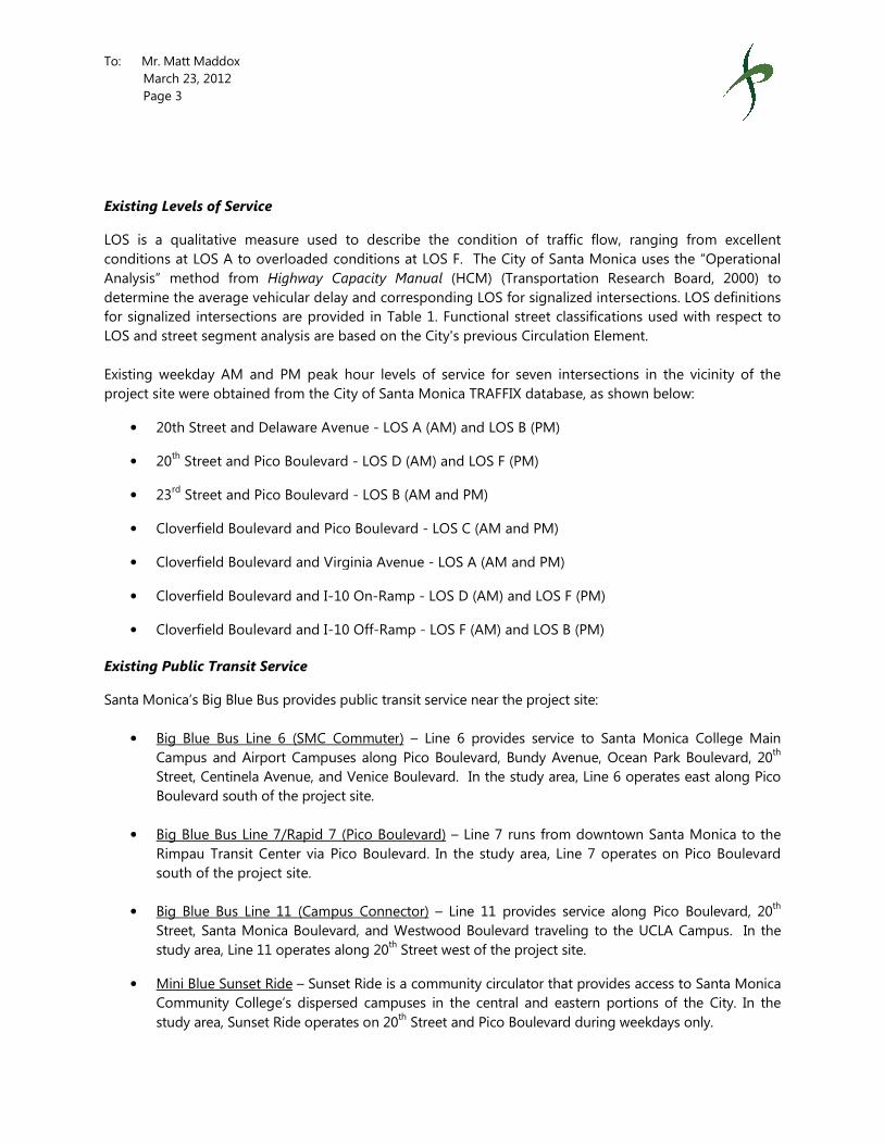
To: Mr. Matt Maddox
March 23, 2012
Page 3
Existing Levels of Service
LOS is a qualitative measure used to describe the condition of traffic flow, ranging from excellent
conditions at LOS A to overloaded conditions at LOS F. The City of Santa Monica uses the “Operational
Analysis” method from Highway Capacity Manual
determine the average vehicular delay and corresponding LOS
for signalized intersections are provided in Table 1.
LOS and street segment analysis are based on the City's previous Circulation Element.
Existing weekday AM and PM peak hour levels of service for seven intersections in the vicinity of the
project site were obtained from the City of Santa
• 20th Street and Delaware Avenue
• 20th Street and Pico Boulevard
• 23rd Street and Pico Boulevard
• Cloverfield Boulevard and Pico Boulevard
• Cloverfield Boulevard and Virginia Avenue
• Cloverfield Boulevard and I-
• Cloverfield Boulevard and I-
Existing Public Transit Service
Santa Monica’s Big Blue Bus provides
• Big Blue Bus Line 6 (SMC Commuter
Campus and Airport Campuses along Pico Boulevard, Bundy Avenue, Ocean Park Boulevard, 20
Street, Centinela Avenue, and Venice Boulevard.
Boulevard south of the project site.
• Big Blue Bus Line 7/Rapid 7 (Pico Boulevard)
Rimpau Transit Center via Pico Boulevard. In the study area, Line 7 operates on
south of the project site.
• Big Blue Bus Line 11 (Campus Connector
Street, Santa Monica Boulevard, and
study area, Line 11 operates
• Mini Blue Sunset Ride – Sunset Ride is a community circulator that provides access to Santa Monica
Community College’s dispersed campuses in the central and eastern portions of the City. In the
study area, Sunset Ride operates on 20
LOS is a qualitative measure used to describe the condition of traffic flow, ranging from excellent
conditions at LOS A to overloaded conditions at LOS F. The City of Santa Monica uses the “Operational
Highway Capacity Manual (HCM) (Transportation Research Board, 2000) to
determine the average vehicular delay and corresponding LOS for signalized intersections.
for signalized intersections are provided in Table 1. Functional street classifications used with respect to
are based on the City's previous Circulation Element.
peak hour levels of service for seven intersections in the vicinity of the
project site were obtained from the City of Santa Monica TRAFFIX database, as shown below:
Street and Delaware Avenue - LOS A (AM) and LOS B (PM)
nd Pico Boulevard - LOS D (AM) and LOS F (PM)
Street and Pico Boulevard - LOS B (AM and PM)
Cloverfield Boulevard and Pico Boulevard - LOS C (AM and PM)
Cloverfield Boulevard and Virginia Avenue - LOS A (AM and PM)
-10 On-Ramp - LOS D (AM) and LOS F (PM)
-10 Off-Ramp - LOS F (AM) and LOS B (PM)
s public transit service near the project site:
SMC Commuter) – Line 6 provides service to Santa Monica College Main
Campus and Airport Campuses along Pico Boulevard, Bundy Avenue, Ocean Park Boulevard, 20
Street, Centinela Avenue, and Venice Boulevard. In the study area, Line 6 operates
roject site.
Big Blue Bus Line 7/Rapid 7 (Pico Boulevard) – Line 7 runs from downtown Santa Monica to the
Rimpau Transit Center via Pico Boulevard. In the study area, Line 7 operates on
pus Connector) – Line 11 provides service along Pico Boulevard, 20
, Santa Monica Boulevard, and Westwood Boulevard traveling to the UCLA Campus
operates along 20th Street west of the project site.
Sunset Ride is a community circulator that provides access to Santa Monica
Community College’s dispersed campuses in the central and eastern portions of the City. In the
study area, Sunset Ride operates on 20th Street and Pico Boulevard during weekdays
LOS is a qualitative measure used to describe the condition of traffic flow, ranging from excellent
conditions at LOS A to overloaded conditions at LOS F. The City of Santa Monica uses the “Operational
(HCM) (Transportation Research Board, 2000) to
for signalized intersections. LOS definitions
Functional street classifications used with respect to
peak hour levels of service for seven intersections in the vicinity of the
database, as shown below:
to Santa Monica College Main
Campus and Airport Campuses along Pico Boulevard, Bundy Avenue, Ocean Park Boulevard, 20th
operates east along Pico
Line 7 runs from downtown Santa Monica to the
Rimpau Transit Center via Pico Boulevard. In the study area, Line 7 operates on Pico Boulevard
Pico Boulevard, 20th
to the UCLA Campus. In the
Sunset Ride is a community circulator that provides access to Santa Monica
Community College’s dispersed campuses in the central and eastern portions of the City. In the
during weekdays only.

To: Mr. Matt Maddox
March 23, 2012
Page 4
• Mini Blue Crosstown Ride –
Ocean Park Boulevard, 17th Street, Pearl Street, 14
it operates south on 20th Street with
during weekdays only.
PROJECT TRIP GENERATION ANALYSIS
Santa Monica is generally characterized by compact urban development, high levels of public transit
service, walkable and bikeable streets, and e
programs. The unique local characteristics of Santa Monica require the development of specific trip
generation rates to estimate trips associated with land uses in Santa Monica.
Local trip generation rates were developed and calibrated for existing and future conditions as part of the
Santa Monica travel demand forecasting model
part of the model development, these trip generation rates were initially
generation surveys, the SCAG regional model, the San Diego Association of Governments’ (SANDAG) trip
generation survey, recently calibrated models in similar areas, and
Transportation Engineers [ITE], 2008). The rates were then modified to account for local conditions based
on counts, production-to- attraction balancing, and the difference between ITE and model land use
definitions.
Project-generated trips were estimated using local trip
model was also used to estimate the trips
Table 2 presents the trip generation rates used in this analysis as well as the
trips generated by the project.
As indicated in Table 2, the project would generate approximately
nine trips would occur during the AM
existing residential units collectively generate approximately
trips and eight PM peak hour trips.
increase of approximately 39 daily
during the PM peak hour.
INTERSECTION IMPACT ANALYSIS
The significance of project-related impacts on future intersection operating conditions is determined
the application of a set of significance criteria established by the City of Santa Monica. For reference, the
City’s significance criteria for intersections are displayed in Table 3.
Approval Year (2012) Conditions
Table 4 presents the year 2012 Approval
project site as projected in the City of Santa Monica
Santa Monica’s minimum criteria for a significant impact for each of the analyzed intersections accordin
– Crosstown Ride provides service in a clockwise loop along 20
Street, Pearl Street, 14th Street, and Montana Avenue. In the study area,
Street with a stop at Pico Boulevard and 20th Street, west of the project site
ION ANALYSIS
Santa Monica is generally characterized by compact urban development, high levels of public transit
service, walkable and bikeable streets, and employer-sponsored Travel Demand Management (TDM)
programs. The unique local characteristics of Santa Monica require the development of specific trip
generation rates to estimate trips associated with land uses in Santa Monica.
s were developed and calibrated for existing and future conditions as part of the
travel demand forecasting model (TDFM) development for a variety of land use types. As
these trip generation rates were initially based on residential trip
regional model, the San Diego Association of Governments’ (SANDAG) trip
alibrated models in similar areas, and Trip Generation, 8th Edition
[ITE], 2008). The rates were then modified to account for local conditions based
attraction balancing, and the difference between ITE and model land use
generated trips were estimated using local trip generation rates found in the City’s
to estimate the trips generated by the existing residential units on the project site.
Table 2 presents the trip generation rates used in this analysis as well as the projected
As indicated in Table 2, the project would generate approximately 136 daily vehicle trips, of which about
AM peak hour and 11 trips would occur during the PM
ts collectively generate approximately 97 daily trips, including seven
peak hour trips. Thus, the proposed project would be expected to generate a net
daily trips, including two trips during the AM peak hour and
ANALYSIS
related impacts on future intersection operating conditions is determined
significance criteria established by the City of Santa Monica. For reference, the
ity’s significance criteria for intersections are displayed in Table 3.
pproval Year conditions at the analyzed intersections in the vicinity of the
project site as projected in the City of Santa Monica TRAFFIX database. Table 4 also presents the City of
Santa Monica’s minimum criteria for a significant impact for each of the analyzed intersections accordin
Crosstown Ride provides service in a clockwise loop along 20th Street,
Street, and Montana Avenue. In the study area,
, west of the project site
Santa Monica is generally characterized by compact urban development, high levels of public transit
sponsored Travel Demand Management (TDM)
programs. The unique local characteristics of Santa Monica require the development of specific trip
s were developed and calibrated for existing and future conditions as part of the
(TDFM) development for a variety of land use types. As
based on residential trip
regional model, the San Diego Association of Governments’ (SANDAG) trip
Edition (Institute of
[ITE], 2008). The rates were then modified to account for local conditions based
attraction balancing, and the difference between ITE and model land use
generation rates found in the City’s TDFM. The
generated by the existing residential units on the project site.
projected total and net new
daily vehicle trips, of which about
PM peak hour. The
seven AM peak hour
Thus, the proposed project would be expected to generate a net
peak hour and three trips
related impacts on future intersection operating conditions is determined by
significance criteria established by the City of Santa Monica. For reference, the
nalyzed intersections in the vicinity of the
database. Table 4 also presents the City of
Santa Monica’s minimum criteria for a significant impact for each of the analyzed intersections according

To: Mr. Matt Maddox
March 23, 2012
Page 5
to their functional classification and
classifications used with respect to LOS
Circulation Element.
Four study intersections operate at LOS C or better during both the morning and afternoon peak hour
Under these conditions, the City of Santa Monica’s minimum criteria for a significant impact would be an
increase in average vehicular delay of 15 seconds or more or a ch
to E or F for arterials. The remaining
the peak hours:
• 20th Street & Pico Boulevard (PM peak hour)
• Cloverfield Boulevard & I-10
• Cloverfield Boulevard & I-10 Westbound Of
Under projected LOS F conditions, the City of Santa Monica’s minimum criteria for a significant
would be a net increase in V/C greater than
The small number of trips added to the street system by the propos
during the AM peak hour and three
criteria. Previous experience with operating conditions at intersections in the City of Santa Monica
indicates that the average increase in
V/C would be less than 0.005 with the addition of project traffic. Therefore, the project is not expected to
create a significant impact on operating
Future (2020) Conditions
Table 5 presents the year 2014 cumulative conditions at the analyzed intersections in the vicinity of the
project site as projected in the City of San
Santa Monica’s minimum criteria for a significant impact for each of the analyzed intersections according
to their functional classification and cumulative base level of service.
Four study intersections operate at
Under these conditions, the City of Santa Monica’s minimum criteria for a significant impact would be an
increase in average vehicular delay of 15 seconds or
to E or F for arterials. The remaining t
one of the peak hours:
• 20th Street & Pico Boulevard (PM peak hour)
• Cloverfield Boulevard & I-10
to their functional classification and Approval Year baseline level of service.
classifications used with respect to LOS and street segment analysis are based on the City's previous
sections operate at LOS C or better during both the morning and afternoon peak hour
Under these conditions, the City of Santa Monica’s minimum criteria for a significant impact would be an
increase in average vehicular delay of 15 seconds or more or a change in LOS to D, E or F
. The remaining two intersections are expected to operate at LOS F in at least one of
Street & Pico Boulevard (PM peak hour)
0 Eastbound On-Ramp (PM peak hour)
10 Westbound Off-Ramp (AM peak hour)
Under projected LOS F conditions, the City of Santa Monica’s minimum criteria for a significant
greater than or equal to 0.005.
trips added to the street system by the proposed project (a net increase of
trips during the PM peak hour) would not be sufficient to trigger these
criteria. Previous experience with operating conditions at intersections in the City of Santa Monica
increase in vehicular delay would be less than 15 seconds and the increase in
with the addition of project traffic. Therefore, the project is not expected to
create a significant impact on operating conditions at intersections in the vicinity of the project site.
cumulative conditions at the analyzed intersections in the vicinity of the
project site as projected in the City of Santa Monica TRAFFIX database. Table 5 also presents the City of
Santa Monica’s minimum criteria for a significant impact for each of the analyzed intersections according
to their functional classification and cumulative base level of service.
LOS C or better during both the morning and afternoon peak hour
Under these conditions, the City of Santa Monica’s minimum criteria for a significant impact would be an
increase in average vehicular delay of 15 seconds or more or a change in LOS to D, E or F
. The remaining three intersections are expected to operate at LOS E or
Street & Pico Boulevard (PM peak hour)
0 Eastbound On-Ramp (PM peak hour)
Functional street
are based on the City's previous
sections operate at LOS C or better during both the morning and afternoon peak hours.
Under these conditions, the City of Santa Monica’s minimum criteria for a significant impact would be an
ange in LOS to D, E or F for collectors, or
intersections are expected to operate at LOS F in at least one of
Under projected LOS F conditions, the City of Santa Monica’s minimum criteria for a significant impact
a net increase of two trips
) would not be sufficient to trigger these
criteria. Previous experience with operating conditions at intersections in the City of Santa Monica
and the increase in
with the addition of project traffic. Therefore, the project is not expected to
conditions at intersections in the vicinity of the project site.
cumulative conditions at the analyzed intersections in the vicinity of the
also presents the City of
Santa Monica’s minimum criteria for a significant impact for each of the analyzed intersections according
LOS C or better during both the morning and afternoon peak hours.
Under these conditions, the City of Santa Monica’s minimum criteria for a significant impact would be an
more or a change in LOS to D, E or F for collectors or
at LOS E or F in at least

To: Mr. Matt Maddox
March 23, 2012
Page 6
• Cloverfield Boulevard & I-10 Westbound Of
Under projected LOS F conditions, the City of Santa Monica’s minimum criteria for a significant
would be a net increase in V/C greater than
The small number of trips added to the street system by the proposed project
trigger these criteria. Previous experience with operating conditions at intersections in the City of Santa
Monica indicates that the average
increase in V/C would be less than
expected to create a significant impact on operating conditions at intersections in the vicinity of the
project site.
NEIGHBORHOOD STREET SEGMENT IMPACT ANALY
The significance of project-related impacts on
application of a set of significance criteria established by the City of Santa Monica. For reference, the
City’s significance criteria for collector, feeder and local streets are displayed in Table
classifications used with respect to LOS
Circulation Element. The 2010 LUCE has adopted a different typology for streets in the City, but the
significance criteria have not yet been revised.
• Virginia Avenue between 20
• 21st Street between Virginia Avenue and Pico Boulevard
As shown in Table 2, the project is projected to generate a net increase of
parking would be accessed via 20th
traffic would travel along either Virginia Avenue or Pico Boulevard
For neighborhood impact analysis, it was assumed that approximately one half of the project’s
daily trips would enter 20th Court via Virginia Avenue.
trips on Virginia Avenue. The projected increase in
proposed project would provide garage
project would occur along 21st Street.
the project’s net new daily trips (approximately
remaining nine new trips would enter 20
On Virginia Avenue, increasing the
impact. On 21st Street, increasing the
impact. As shown in Table 7, the project is
impacts.
10 Westbound Off-Ramp (AM peak hour)
Under projected LOS F conditions, the City of Santa Monica’s minimum criteria for a significant
greater than or equal to 0.005.
trips added to the street system by the proposed project would not be sufficient to
iteria. Previous experience with operating conditions at intersections in the City of Santa
Monica indicates that the average increase in vehicular delay would be less than 15 seconds
increase in V/C would be less than 0.005 with the addition of project traffic. Therefore, the project is not
expected to create a significant impact on operating conditions at intersections in the vicinity of the
SEGMENT IMPACT ANALYSIS
related impacts on neighborhood street segments is determined
application of a set of significance criteria established by the City of Santa Monica. For reference, the
ity’s significance criteria for collector, feeder and local streets are displayed in Table 6
classifications used with respect to LOS and street segment analysis are based on the City's previous
Circulation Element. The 2010 LUCE has adopted a different typology for streets in the City, but the
een revised. The analysis was conducted for the following segments:
Virginia Avenue between 20th Street and 21
st Street
Street between Virginia Avenue and Pico Boulevard
As shown in Table 2, the project is projected to generate a net increase of 42 daily trips. The project’s th Court, which intersects Virginia Avenue and Pico Boulevard
Virginia Avenue or Pico Boulevard to access the project
rhood impact analysis, it was assumed that approximately one half of the project’s
Court via Virginia Avenue. This would result in a projected increase of
projected increase in trips on 21st Street is expected to be
garage access from 20th Court. Pick-up and drop-off at the proposed
Street. For this analysis, it was assumed that approximately one
(approximately ten trips) would access the project site via 21
enter 20th Court via Pico Boulevard.
asing the average daily traffic (ADT) by 12.5% would be considered a significant
Street, increasing the average daily traffic (ADT) by 25% would be considered a significa
, the project is not expected to result in any significant neighborhood traffic
Under projected LOS F conditions, the City of Santa Monica’s minimum criteria for a significant impact
would not be sufficient to
iteria. Previous experience with operating conditions at intersections in the City of Santa
vehicular delay would be less than 15 seconds and the
roject traffic. Therefore, the project is not
expected to create a significant impact on operating conditions at intersections in the vicinity of the
neighborhood street segments is determined by the
application of a set of significance criteria established by the City of Santa Monica. For reference, the
6. Functional street
are based on the City's previous
Circulation Element. The 2010 LUCE has adopted a different typology for streets in the City, but the
following segments:
daily trips. The project’s
Pico Boulevard. Project
to access the project’s parking facility.
rhood impact analysis, it was assumed that approximately one half of the project’s net new
This would result in a projected increase of 20 daily
Street is expected to be low since the
off at the proposed
For this analysis, it was assumed that approximately one-quarter of
via 21st Street. The
% would be considered a significant
by 25% would be considered a significant
significant neighborhood traffic

To: Mr. Matt Maddox
March 23, 2012
Page 7
CONCLUSIONS
This study was undertaken to analyze the potential traffic impacts of the proposed
unit condominium project on a site presently containing
would be provided in a subterranean
would have two assigned parking space
residents. In contrast, the existing apartment complex provides only one off
Therefore, the project would likely increase the amount of available on
neighborhood by satisfying future parking demand off
The proposed project is not expected to generate a noticeable increase
of two trips during the AM peak hour and
residential uses on the site are taken into account
operating conditions at intersections in the vicinity of the project site.
The project is projected to generate a net increase of
would be accessed via 20th Court, these trips would travel on either
Avenue to obtain access to the project
significant impacts are anticipated on
based on the City’s thresholds.
This study was undertaken to analyze the potential traffic impacts of the proposed construction of a
unit condominium project on a site presently containing 15 apartment units. A total of
would be provided in a subterranean facility, representing a net increase of 30 off-street
gned parking spaces; three visitor spaces would be shared among the project
he existing apartment complex provides only one off-street space per unit.
he project would likely increase the amount of available on-street parking for the surrounding
parking demand off-street.
The proposed project is not expected to generate a noticeable increase in peak hour trips
AM peak hour and three trips during the PM peak hour)
are taken into account. No significant impacts are therefore anticipated on
operating conditions at intersections in the vicinity of the project site.
to generate a net increase of 39 daily trips. Since the project’s parking garage
Court, these trips would travel on either Virginia Avenue
Avenue to obtain access to the project, with some vehicles using 21st Street to Virginia Avenue
significant impacts are anticipated on the neighborhood street segments in the vicinity of the project site
construction of a 21-
A total of 45 parking spaces
street spaces. Each unit
among the project
street space per unit.
parking for the surrounding
trips (a net increase
peak hour) when the existing
. No significant impacts are therefore anticipated on
daily trips. Since the project’s parking garage
or Pico Boulevard
Street to Virginia Avenue. No
in the vicinity of the project site
TABLE 2
TRIP GENERATION RATES AND ESTIMATES
Trip Generation Rates [a]
Trips Average AM Peak Hour PM Peak Hourper Daily In Out Total In Out Total
Multifamily - 2 Cars DU 6.49 20% 80% 0.45 65% 35% 0.5
Trip Generation Estimates
Average AM Peak Hour PM Peak HourDaily In Out Total In Out Total
Proposed Project: Condominium
21 136 2 7 9 7 4 11
Existing Use: Apartment -15 -97 -1 -6 -7 -5 -3 -8
Net New Incremental Trips 39 1 1 2 2 1 3
[a] Trip generation from Santa Monica Travel Demand Forecasting Model (Area Type 2) without Expo reduction
Land Use
Land Use Size

TABLE 1
LEVEL OF SERVICE DEFINITIONS FOR SIGNALIZED INTERSECTIONS
(2000 HIGHWAY CAPACITY MANUAL OPERATIONS METHOD)
Level of ServiceAverage Control
Delay per Vehicle (seconds)
A <10.0 EXCELLENT. No vehicle waits longer than one red light andno approach phase is fully used.
B >10.0 and <20.0 VERY GOOD. An occasional approach phase is fully utilized;many drivers begin to feel somewhat restricted within groupsof vehicles.
C >20.0 and <35.0 GOOD. Occasionally drivers may have to wait through morethan one red light; backups may develop behind turningvehicles.
D >35.0 and <55.0 FAIR. Delays may be substantial during portions of the rushhours, but enough lower volume periods occur to permitclearing of developing lines, preventing excessive backups.
E >55.0 and <80.0 POOR. Represents the most vehicles intersectionapproaches can accommodate; may be long lines of waitingvehicles through several signal cycles.
F >80.0 FAILURE. Backups from nearby locations or on cross streetsmay restrict or prevent movement of vehicles out of theintersection approaches. Tremendous delays withcontinuously increasing queue lengths.
Source: Highway Capacity Manual, Transportation Research Board, 2000.
Definition

TABLE 3
CITY OF SANTA MONICA SIGNIFICANT IMPACT CRITERIA
ARTERIAL AND COLLECTOR INTERSECTIONS
==> and is a collector street
intersection or
==> and is an arterial
intersection or
==> and is a collector street
intersection
==> and is an arterial
intersection or
==> and is a collector or
arterial intersection
==> and is a collector or
arterial intersection
IF LOS = F SIGNIFICANT IMPACT IF:
HCM V/C ratio net increase is > 0.005
LOS becomes E or F
IF LOS = E SIGNIFICANT IMPACT IF:
Any net increase in average seconds of delay per vehicle
Average vehicle delay increase is > 15 seconds
FUTURE BASE SCENARIO FUTURE PLUS PROJECT SCENARIO
IF LOS = A, B, OR C SIGNIFICANT IMPACT IF:
Average vehicle delay increase is > 15 seconds
LOS becomes D, E, or F
Average vehicle delay increase is > 15 seconds
LOS becomes E or F
IF LOS = D SIGNIFICANT IMPACT IF:
Any net increase in average seconds of delay per vehicle

Arterial or Year 2012 Year 2012
Collector Peak Existing Approval Year Approval Year with ProjectIntersection Hour LOS LOS LOS
1. 20th Street & Collector A.M. A A A Average delay increase is >= 15 seconds or LOS becomes D, E or F
Delaware Avenue P.M. B B B Average delay increase is >= 15 seconds or LOS becomes D, E or F
2. 20th Street & Arterial A.M. D D D Average delay increase is >= 15 seconds or LOS becomes E or F
Pico Boulevard P.M. F F F HCM V/C ratio net increase is > 0.005
3. 23rd Street & Arterial A.M. B B B Average delay increase is >= 15 seconds or LOS becomes E or F
Pico Boulevard P.M. B B B Average delay increase is >= 15 seconds or LOS becomes E or F
4. Cloverfield Boulevard & Arterial A.M. C C C Average delay increase is >= 15 seconds or LOS becomes E or F
Pico Boulevard P.M. C C C Average delay increase is >= 15 seconds or LOS becomes E or F
5. Cloverfield Boulevard & Arterial A.M. A A A Average delay increase is >= 15 seconds or LOS becomes E or F
Virginia Avenue P.M. A A A Average delay increase is >= 15 seconds or LOS becomes E or F
6. Cloverfield Boulevard & Arterial A.M. D D D Average delay increase is >= 15 seconds or LOS becomes E or F
I-10 EB On-Ramp P.M. F F F HCM V/C ratio net increase is > 0.005
7. Cloverfield Boulevard & Arterial A.M. F F F HCM V/C ratio net increase is > 0.005
I-10 WB Off-Ramp P.M. B B B Average delay increase is >= 15 seconds or LOS becomes E or F
TABLE 4
EXISTING AND APPROVAL YEAR INTERSECTION LEVELS OF SERVICE
Intersection Threshold for Significant Impact

Arterial or Year 2020 Year 2020
Collector Peak Existing Cumulative Cumulative with ProjectIntersection Hour LOS LOS LOS
1. 20th Street & Collector A.M. A A A Average delay increase is >= 15 seconds or LOS becomes D, E or F
Delaware Avenue P.M. B B B Average delay increase is >= 15 seconds or LOS becomes D, E or F
2. 20th Street & Arterial A.M. D C C Average delay increase is >= 15 seconds or LOS becomes E or F
Pico Boulevard P.M. F F F HCM V/C ratio net increase is > 0.005
3. 23rd Street & Arterial A.M. B C C Average delay increase is >= 15 seconds or LOS becomes E or F
Pico Boulevard P.M. B B B Average delay increase is >= 15 seconds or LOS becomes E or F
4. Cloverfield Boulevard & Arterial A.M. C C C Average delay increase is >= 15 seconds or LOS becomes E or F
Pico Boulevard P.M. C C C Average delay increase is >= 15 seconds or LOS becomes E or F
5. Cloverfield Boulevard & Arterial A.M. A A A Average delay increase is >= 15 seconds or LOS becomes E or F
Virginia Avenue P.M. A A A Average delay increase is >= 15 seconds or LOS becomes E or F
6. Cloverfield Boulevard & Arterial A.M. D D D Average delay increase is >= 15 seconds or LOS becomes E or F
I-10 EB On-Ramp P.M. F F F HCM V/C ratio net increase is > 0.005
7. Cloverfield Boulevard & Arterial A.M. F F F HCM V/C ratio net increase is > 0.005
I-10 WB Off-Ramp P.M. B B B Average delay increase is >= 15 seconds or LOS becomes E or F
TABLE 5
EXISTING AND PROJECTED INTERSECTION LEVELS OF SERVICE
Intersection Threshold for Significant Impact

TABLE 6
CITY OF SANTA MONICA SIGNIFICANT IMPACT CRITERIA
COLLECTOR, FEEDER, AND LOCAL STREETS
COLLECTOR STREETS
greater than 13,500 and there is a net increase* of one trip or more in ADT due to project related traffic
greater than 7,500 but less than 13,500 and the project related traffic increases* the ADT by 12.5% or the ADT becomes 13,500 or more
less than 7,500 and the project related traffic increases* the ADT by 25%
FEEDER STREETS
greater than 6,750 and there is a net increase* of one trip or more in ADT due to project related traffic
greater than 3,750 but less than 6,750 and the project related traffic increases* the ADT by 12.5% or the ADT becomes 6,750 or more
less than 3,750 and the project related traffic increases* the ADT by 25%
LOCAL STREETS
greater than 2,250 and there is a net increase* of one trip or more in ADT due to project related traffic
greater than 1,250 but less than 2,250 and the project related traffic increases* the ADT by 12.5% or the ADT becomes 2,250 or more
less than 1,250 and the project related traffic increases* the ADT by 25%
A transportation impact is significant if the Base Average Daily Traffic Volume (ADT) is:
Note:
* Average Daily Traffic Volume "increase" denotes adverse impacts; "decrease" denotes
beneficial impacts.
A transportation impact is significant if the Base Average Daily Traffic Volume (ADT) is:
A transportation impact is significant if the Base Average Daily Traffic Volume (ADT) is:

Existing Existing plus Project
Daily Daily Daily Traffic % Significance Significant
Traffic Traffic Change Change Threshold Impact?
Virginia Avenue
between 20th Street and 21st Street Local 2,207 2,227 20 0.9% +12.5% No
21st Street
between Virginia Avenue and Pico Boulevard Local 1,091 1,101 10 0.9% +25% No
Notes:
* Negligible change in number of daily trips on 21st Street since the project's vehicular access would be via the 20th Court alley.
TABLE 7
NEIGHBORHOOD TRAFFIC IMPACT ANALYSIS
LocationStreet
Classification

ATTACHMENT
TRAFFIC COUNT SHEETS

Average Daily Traffic VolumesQuality Traffic Data, LLC
NB SB EB WB NB SB EB WB
00:00 2 2 12:00 4 10
00:15 2 2 12:15 7 15
00:30 0 1 12:30 4 17
00:45 1 5 3 8 13 12:45 8 23 10 52 75
01:00 0 1 13:00 7 12
01:15 1 3 13:15 3 8
01:30 0 1 13:30 2 10
01:45 0 1 0 5 6 13:45 6 18 12 42 60
02:00 1 0 14:00 10 18
02:15 2 0 14:15 6 4
02:30 0 0 14:30 12 12
02:45 0 3 0 0 3 14:45 7 35 10 44 79
03:00 0 0 15:00 6 9
03:15 0 0 15:15 5 18
03:30 0 0 15:30 1 15
03:45 0 0 0 0 15:45 3 15 14 56 71
04:00 0 1 16:00 4 12
04:15 0 0 16:15 8 15
04:30 0 0 16:30 1 15
04:45 0 0 0 1 1 16:45 7 20 13 55 75
05:00 0 0 17:00 4 20
05:15 0 0 17:15 5 17
05:30 0 0 17:30 4 12
05:45 1 1 0 0 1 17:45 4 17 13 62 79
06:00 1 1 18:00 3 8
06:15 0 0 18:15 6 9
06:30 4 0 18:30 3 18
06:45 0 5 1 2 7 18:45 1 13 7 42 55
07:00 3 5 19:00 1 12
07:15 2 18 19:15 4 11
07:30 2 44 19:30 3 8
07:45 6 13 44 111 124 19:45 6 14 3 34 48
08:00 4 43 20:00 7 11
08:15 1 15 20:15 3 7
0
Tuesday, February 28, 2012
City of Santa Monica, CA
GPS COORDINATES:
START DATE:
AM COUNTS PM COUNTS
CROSS STREETS: Virginia Avenue and Pico Boulevard
QTD PROJ/LOC #: 700118 - 002
ON STREET: 21st Street
VICINITY:
08:15 1 15 20:15 3 7
08:30 0 18 20:30 4 2
08:45 2 7 12 88 95 20:45 8 22 5 25 47
09:00 3 23 21:00 1 5
09:15 9 27 21:15 8 1
09:30 0 11 21:30 2 8
09:45 2 14 9 70 84 21:45 2 13 7 21 34
10:00 1 7 22:00 1 3
10:15 3 9 22:15 1 4
10:30 3 6 22:30 2 2
10:45 9 16 13 35 51 22:45 2 6 1 10 16
11:00 2 25 23:00 0 0
11:15 1 10 23:15 0 2
11:30 6 6 23:30 0 1
11:45 4 13 7 48 61 23:45 1 1 2 5 6
TOTALS: 78 368 446 TOTALS: 197 448 645
SPLIT 17.5% 82.5% 40.9% SPLIT 30.5% 69.5% 59.1%
PEAK HOUR 11:30 07:15 07:15 PEAK HOUR 14:00 16:30 16:15
PH VOLUME 21 149 163 PH VOLUME 35 65 83
PHF 0.75 0.85 0.82 PHF 0.83 0.81 0.86
EB WB
1091275
DAY'S TOTAL
816
NB TOTALSB
9701 W Pico Blvd, Suite 205, Los Angeles, CA, 90035
Phone: 310-341-0019 Fax: 310-807-9247 [email protected]
QUALITY TRAFFIC DATA, LLC

Average Daily Traffic VolumesQuality Traffic Data, LLC
NB SB EB WB NB SB EB WB
00:00 3 5 12:00 22 13
00:15 4 3 12:15 12 24
00:30 2 0 12:30 22 22
00:45 7 16 3 11 27 12:45 22 78 21 80 158
01:00 1 2 13:00 21 17
01:15 2 1 13:15 21 15
01:30 1 1 13:30 24 18
01:45 1 5 1 5 10 13:45 17 83 28 78 161
02:00 0 0 14:00 33 33
02:15 0 1 14:15 21 19
02:30 0 0 14:30 17 21
02:45 1 1 0 1 2 14:45 23 94 8 81 175
03:00 1 1 15:00 17 22
03:15 0 0 15:15 22 21
03:30 1 0 15:30 30 12
03:45 0 2 0 1 3 15:45 20 89 18 73 162
04:00 2 0 16:00 26 11
04:15 2 1 16:15 12 17
04:30 1 0 16:30 20 19
04:45 1 6 0 1 7 16:45 17 75 15 62 137
05:00 3 0 17:00 20 16
05:15 3 2 17:15 19 16
05:30 5 3 17:30 16 10
05:45 7 18 4 9 27 17:45 18 73 18 60 133
06:00 4 2 18:00 15 17
06:15 5 5 18:15 13 19
06:30 3 7 18:30 18 30
06:45 12 24 11 25 49 18:45 17 63 20 86 149
07:00 6 8 19:00 19 14
07:15 8 18 19:15 24 12
07:30 12 32 19:30 12 12
07:45 21 47 32 90 137 19:45 10 65 6 44 109
08:00 20 17 20:00 16 4
08:15 14 15 20:15 9 5
0
Tuesday, February 28, 2012
City of Santa Monica, CA
GPS COORDINATES:
START DATE:
AM COUNTS PM COUNTS
CROSS STREETS: 20th and Cloverfield Boulevard
QTD PROJ/LOC #: 700118 - 001
ON STREET: Virginia Avenue
VICINITY:
08:15 14 15 20:15 9 5
08:30 13 15 20:30 13 4
08:45 9 56 14 61 117 20:45 14 52 10 23 75
09:00 6 20 21:00 20 8
09:15 18 27 21:15 22 8
09:30 19 26 21:30 7 3
09:45 14 57 21 94 151 21:45 17 66 11 30 96
10:00 13 12 22:00 9 2
10:15 17 16 22:15 9 9
10:30 12 12 22:30 4 3
10:45 11 53 17 57 110 22:45 6 28 6 20 48
11:00 27 16 23:00 4 3
11:15 18 24 23:15 4 4
11:30 9 11 23:30 3 4
11:45 16 70 16 67 137 23:45 3 14 2 13 27
TOTALS: 355 422 777 TOTALS: 780 650 1430
SPLIT 45.7% 54.3% 35.2% SPLIT 54.5% 45.5% 64.8%
PEAK HOUR 11:45 07:15 07:30 PEAK HOUR 15:15 13:45 13:30
PH VOLUME 72 99 163 PH VOLUME 98 101 193
PHF 0.82 0.77 0.77 PHF 0.82 0.77 0.73
EB WB
1135 1072 2207
DAY'S TOTAL
NB TOTALSB
9701 W Pico Blvd, Suite 205, Los Angeles, CA, 90035
Phone: 310-341-0019 Fax: 310-807-9247 [email protected]
QUALITY TRAFFIC DATA, LLC