Embed Size (px)
Citation preview
World Geography 3202 Practice Multiple Choice
Unit 2 – World Climate Patterns
Pg. 1/16
Outcomes: SCO 2.1: The student will be expected to demonstrate an understanding of how the earth’s movement in space causes the occurrence of and the conditions related to day and night and the seasons, including the following delineations:
2.1.1 Distinguish between the terms rotation and revolution. (k) 2.1.2 Explain how cloud cover influences the range of temperatures from day to night. (k) 2.1.3 Define the terms equinox and solstice. (k) 2.1.4 Explain how changes in the seasons, in the northern hemisphere and the southern hemisphere, relate to the earth’s revolution around the sun. (k) 2.1.5 Describe the factors that account for differences in length of day as seasons change. (k) 2.1.6 Describe the factors that account for differences in temperature as seasons change. (k) SCO 2.2: The student will be expected to detect patterns in the distribution of temperatures on the earth’s surface, including the following delineations:
2.2.1 Explain how the greenhouse effect moderates climates. (k) 2.2.2 Generalize that temperatures tend to decrease from low to high latitudes. (a) 2.2.3 Explain how the earth’s shape causes temperatures to decrease from low to high latitudes. (k) 2.2.4 Given selected data, assess the accuracy of temperature descriptions. (i) SCO 2.3: The student will be expected to demonstrate an understanding of the cause of winds and how winds affect climate, including the following delineations:
2.3.1 Define the term prevailing winds. (k) 2.3.2 Describe conditions that result in land breezes and sea breezes. (k) 2.3.3 State the impact of the coriolis effect on wind direction. (k) 2.3.4 Infer how wind systems relate to major pressure belts. (a) 2.3.5 Explain how wind systems and temperature are related. (k) 2.3.6 Define the terms windward, leeward, and rain shadow. (k) 2.3.7 Examine how the type of rainfall (i.e., orographic, frontal, and convectional) is related to the nature of location. (a) 2.3.8 Explain how wind systems and precipitation are related. (k) SCO 2.4: The student will be expected to demonstrate an understanding of how ocean currents affect climate, including the following delineations:
2.4.1 Define the term ocean current. (k) 2.4.2 Analyze how ocean currents can create different climatic conditions for two locations on the same latitude. (a) SCO 2.5: The student will be expected to demonstrate an understanding how distance from the ocean affects climate, including the following delineations:
2.5.1 Define the term temperature range. (k) 2.5.2 Analyze the relationship between range in temperature and distance from the ocean. (a) 2.5.3 Define the term monsoon. (k)
World Geography 3202 Practice Multiple Choice
Unit 2 – World Climate Patterns
Pg. 2/16
2.5.4 Explain why winter and summer monsoons occur. (k) 2.5.5 Describe the relationship between seasonal level of precipitation and distance from the ocean. (k) SCO 2.6: The student will be expected to demonstrate an understanding of the relationship between elevation and climate, including the following delineations:
2.6.1 Define the term elevation. (k) 2.6.2 Describe the relationship between the elevation of a point and its temperature and precipitation. (k) 2.6.3 Analyze the relationship between temperature and precipitation of a point and its location relative to a mountain system. (a) SCO 2.7: The student will be expected to demonstrate an understanding of the combined effect of climatic conditions and the zones they produce, including the following delineations:
2.7.1 Given relevant information, determine climatic conditions within selected zones. (a) 2.7.2 Draw conclusions about patterns in the distribution of climatic conditions that give rise to the distribution of climatic zones. (a) SCO 2.8: The student will be expected to demonstrate an understanding of how climate conditions may affect human activity, including the following delineations:
2.8.1 Demonstrate, using examples, how human activity is influenced by climatic conditions.(a) 2.8.2 Examine how human activity affects climatic conditions (e.g., greenhouse effect, ozone depletion, global warming). (a) 2.8.3 Argue a preference for the aesthetic appeal of selected climatic conditions. (i) 2.8.4 Examine how selected climatic phenomena (e.g., El Nino, lake effect, hurricanes) affect human activity. (I)
Multiple Choice Questions: Which refers to atmospheric conditions of a particular region over a short period of time? A) climate B) solar output C) temperature range D) weather
World Geography 3202 Practice Multiple Choice
Unit 2 – World Climate Patterns
Pg. 3/16
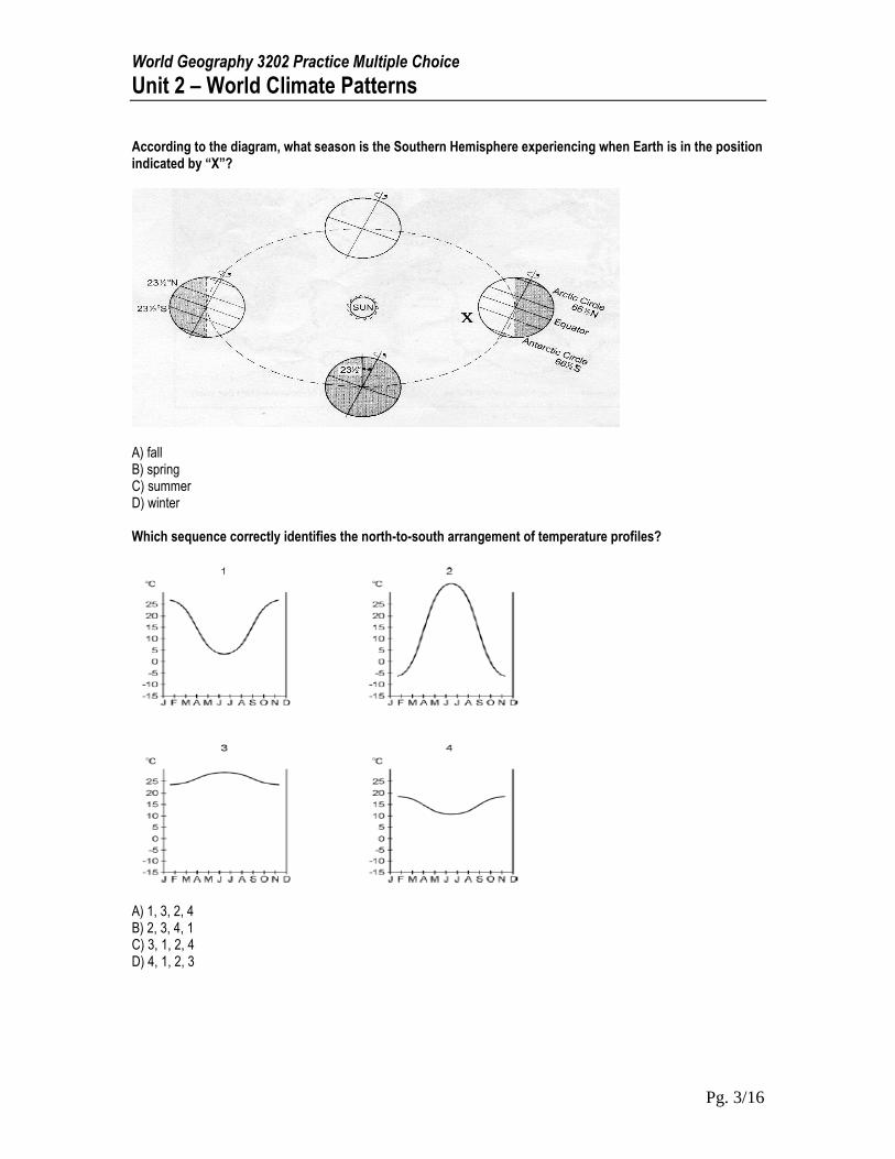
According to the diagram, what season is the Southern Hemisphere experiencing when Earth is in the position indicated by “X”?
A) fall B) spring C) summer D) winter Which sequence correctly identifies the north-to-south arrangement of temperature profiles?
A) 1, 3, 2, 4 B) 2, 3, 4, 1 C) 3, 1, 2, 4 D) 4, 1, 2, 3
World Geography 3202 Practice Multiple Choice
Unit 2 – World Climate Patterns
Pg. 4/16
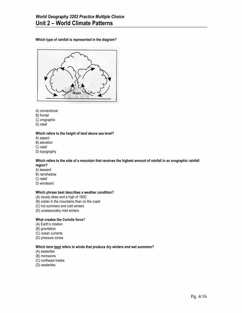
Which type of rainfall is represented in the diagram?
A) convectional B) frontal C) orographic D) relief Which refers to the height of land above sea level? A) aspect B) elevation C) relief D) topography Which refers to the side of a mountain that receives the highest amount of rainfall in an orographic rainfall region? A) leeward B) rainshadow C) relief D) windward Which phrase best describes a weather condition? (A) cloudy skies and a high of 180C (B) colder in the mountains than on the coast (C) hot summers and cold winters (D) unseasonably mild winters What creates the Coriolis force? (A) Earth’s rotation (B) gravitation (C) ocean currents (D) pressure zones Which term best refers to winds that produce dry winters and wet summers? (A) easterlies (B) monsoons (C) northeast trades (D) westerlies
World Geography 3202 Practice Multiple Choice
Unit 2 – World Climate Patterns
Pg. 5/16
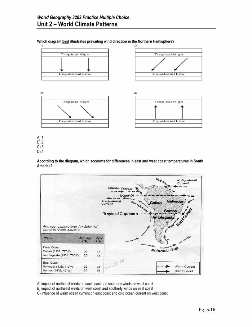
Which diagram best illustrates prevailing wind direction in the Northern Hemisphere?
A) 1 B) 2 C) 3 D) 4 According to the diagram, which accounts for differences in east and west coast temperatures in South America?
A) impact of northeast winds on east coast and southerly winds on west coast B) impact of northeast winds on west coast and southerly winds on east coast C) influence of warm ocean current on east coast and cold ocean current on west coast
World Geography 3202 Practice Multiple Choice
Unit 2 – World Climate Patterns
Pg. 6/16
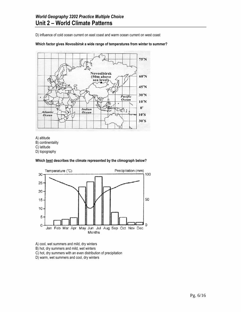
D) influence of cold ocean current on east coast and warm ocean current on west coast Which factor gives Novosibirsk a wide range of temperatures from winter to summer?
A) altitude B) continentality C) latitude D) topography Which best describes the climate represented by the climograph below?
A) cool, wet summers and mild, dry winters B) hot, dry summers and mild, wet winters C) hot, dry summers with an even distribution of precipitation D) warm, wet summers and cool, dry winters
World Geography 3202 Practice Multiple Choice
Unit 2 – World Climate Patterns
Pg. 7/16
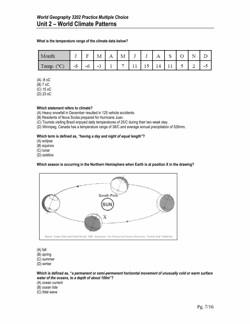
What is the temperature range of the climate data below?
(A) -8 oC (B) 7 oC (C) 15 oC (D) 23 oC Which statement refers to climate? (A) Heavy snowfall in December resulted in 125 vehicle accidents. (B) Residents of Nova Scotia prepared for Hurricane Juan. (C) Tourists visiting Brazil enjoyed daily temperatures of 25/C during their two week stay. (D) Winnipeg, Canada has a temperature range of 38/C and average annual precipitation of 526mm. Which term is defined as, “having a day and night of equal length”? (A) eclipse (B) equinox (C) lunar (D) solstice Which season is occurring in the Northern Hemisphere when Earth is at position X in the drawing?
(A) fall (B) spring (C) summer (D) winter Which is defined as, “a permanent or semi-permanent horizontal movement of unusually cold or warm surface water of the oceans, to a depth of about 100m”? (A) ocean current (B) ocean tide (C) tidal wave
World Geography 3202 Practice Multiple Choice
Unit 2 – World Climate Patterns
Pg. 8/16
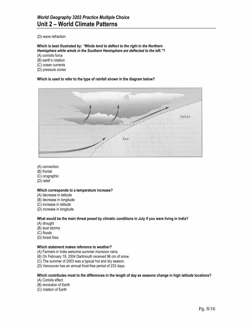
(D) wave refraction Which is best illustrated by: “Winds tend to deflect to the right in the Northern Hemisphere while winds in the Southern Hemisphere are deflected to the left.”? (A) corriolis force (B) earth’s rotation (C) ocean currents (D) pressure zones Which is used to refer to the type of rainfall shown in the diagram below?
(A) convection (B) frontal (C) orographic (D) relief Which corresponds to a temperature increase? (A) decrease in latitude (B) decrease in longitude (C) increase in latitude (D) increase in longitude What would be the main threat posed by climatic conditions in July if you were living in India? (A) drought (B) dust storms (C) floods (D) forest fires Which statement makes reference to weather? (A) Farmers in India welcome summer monsoon rains. (B) On February 19, 2004 Dartmouth received 96 cm of snow. (C) The summer of 2003 was a typical hot and dry season. (D) Vancouver has an annual frost-free period of 233 days. Which contributes most to the differences in the length of day as seasons change in high latitude locations? (A) Coriolis effect (B) revolution of Earth (C) rotation of Earth
World Geography 3202 Practice Multiple Choice
Unit 2 – World Climate Patterns
Pg. 9/16
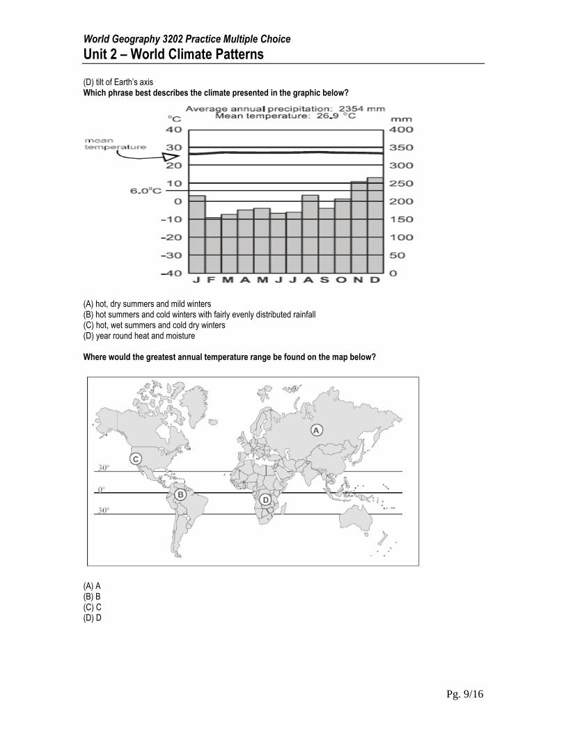
(D) tilt of Earth’s axis Which phrase best describes the climate presented in the graphic below?
(A) hot, dry summers and mild winters (B) hot summers and cold winters with fairly evenly distributed rainfall (C) hot, wet summers and cold dry winters (D) year round heat and moisture Where would the greatest annual temperature range be found on the map below?
(A) A (B) B (C) C (D) D
World Geography 3202 Practice Multiple Choice
Unit 2 – World Climate Patterns
Pg. 10/16
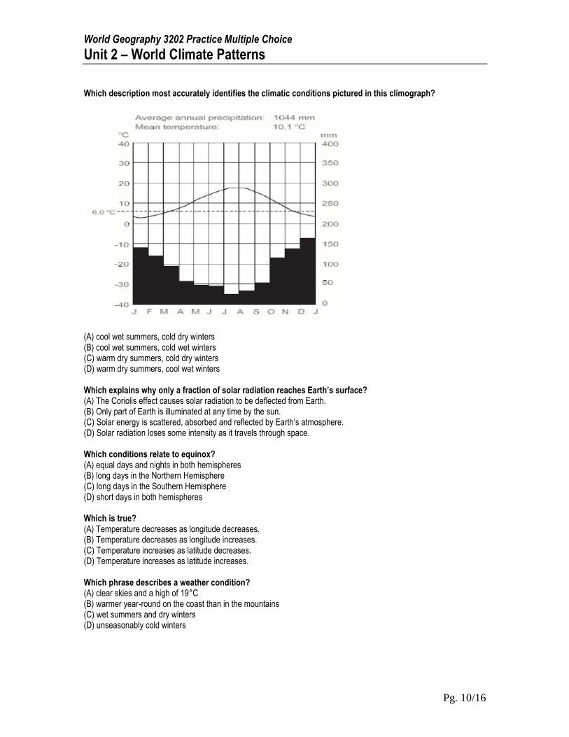
Which description most accurately identifies the climatic conditions pictured in this climograph?
(A) cool wet summers, cold dry winters (B) cool wet summers, cold wet winters (C) warm dry summers, cold dry winters (D) warm dry summers, cool wet winters Which explains why only a fraction of solar radiation reaches Earth’s surface? (A) The Coriolis effect causes solar radiation to be deflected from Earth. (B) Only part of Earth is illuminated at any time by the sun. (C) Solar energy is scattered, absorbed and reflected by Earth’s atmosphere. (D) Solar radiation loses some intensity as it travels through space. Which conditions relate to equinox? (A) equal days and nights in both hemispheres (B) long days in the Northern Hemisphere (C) long days in the Southern Hemisphere (D) short days in both hemispheres Which is true? (A) Temperature decreases as longitude decreases. (B) Temperature decreases as longitude increases. (C) Temperature increases as latitude decreases. (D) Temperature increases as latitude increases. Which phrase describes a weather condition? (A) clear skies and a high of 19°C (B) warmer year-round on the coast than in the mountains (C) wet summers and dry winters (D) unseasonably cold winters
World Geography 3202 Practice Multiple Choice
Unit 2 – World Climate Patterns
Pg. 11/16
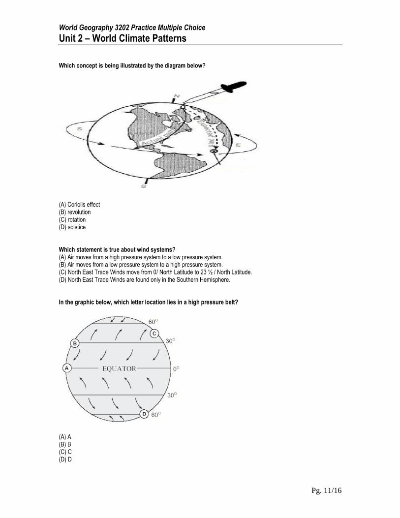
Which concept is being illustrated by the diagram below?
(A) Coriolis effect (B) revolution (C) rotation (D) solstice Which statement is true about wind systems? (A) Air moves from a high pressure system to a low pressure system. (B) Air moves from a low pressure system to a high pressure system. (C) North East Trade Winds move from 0/ North Latitude to 23 ½ / North Latitude. (D) North East Trade Winds are found only in the Southern Hemisphere. In the graphic below, which letter location lies in a high pressure belt?
(A) A (B) B (C) C (D) D
World Geography 3202 Practice Multiple Choice
Unit 2 – World Climate Patterns
Pg. 12/16
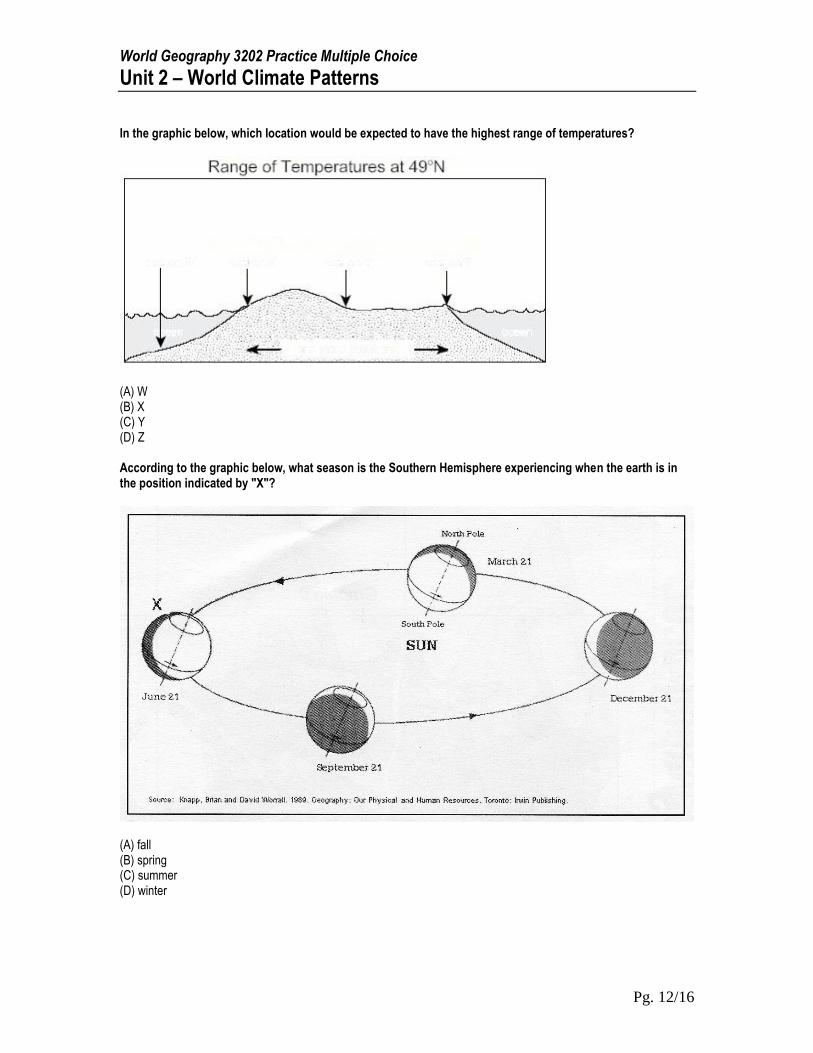
In the graphic below, which location would be expected to have the highest range of temperatures?
(A) W (B) X (C) Y (D) Z According to the graphic below, what season is the Southern Hemisphere experiencing when the earth is in the position indicated by "X"?
(A) fall (B) spring (C) summer (D) winter
World Geography 3202 Practice Multiple Choice
Unit 2 – World Climate Patterns
Pg. 13/16
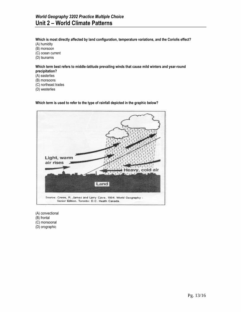
Which is most directly affected by land configuration, temperature variations, and the Coriolis effect? (A) humidity (B) monsoon (C) ocean current (D) tsunamis Which term best refers to middle-latitude prevailing winds that cause mild winters and year-round precipitation? (A) easterlies (B) monsoons (C) northeast trades (D) westerlies Which term is used to refer to the type of rainfall depicted in the graphic below?
(A) convectional (B) frontal (C) monsoonal (D) orographic
World Geography 3202 Practice Multiple Choice
Unit 2 – World Climate Patterns
Pg. 14/16
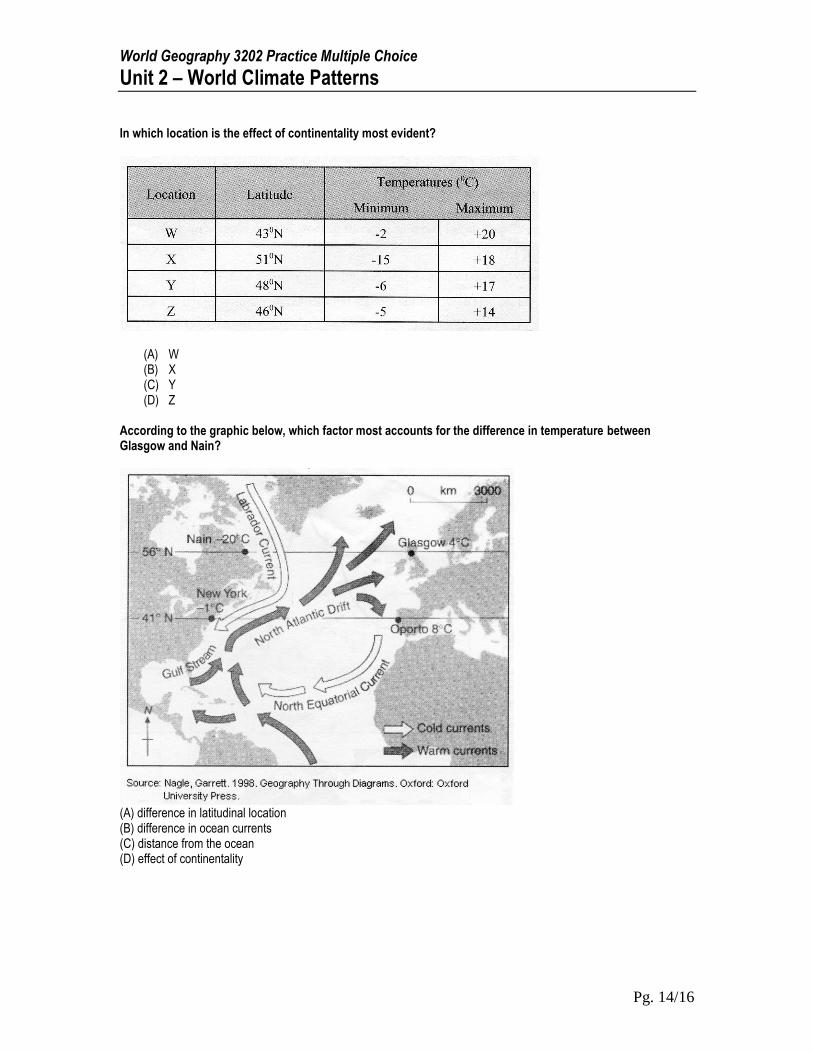
In which location is the effect of continentality most evident?
(A) W (B) X (C) Y (D) Z
According to the graphic below, which factor most accounts for the difference in temperature between Glasgow and Nain?
(A) difference in latitudinal location (B) difference in ocean currents (C) distance from the ocean (D) effect of continentality
World Geography 3202 Practice Multiple Choice
Unit 2 – World Climate Patterns
Pg. 15/16
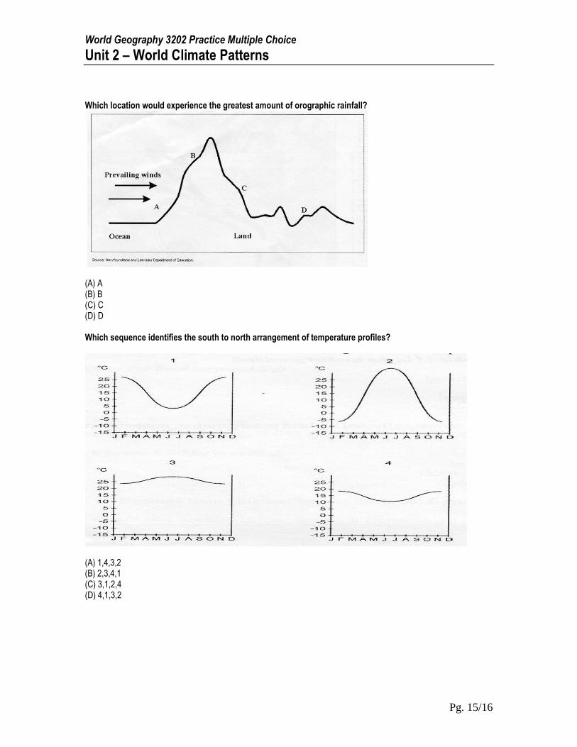
Which location would experience the greatest amount of orographic rainfall?
(A) A (B) B (C) C (D) D Which sequence identifies the south to north arrangement of temperature profiles?
(A) 1,4,3,2 (B) 2,3,4,1 (C) 3,1,2,4 (D) 4,1,3,2
World Geography 3202 Practice Multiple Choice
Unit 2 – World Climate Patterns
Pg. 16/16
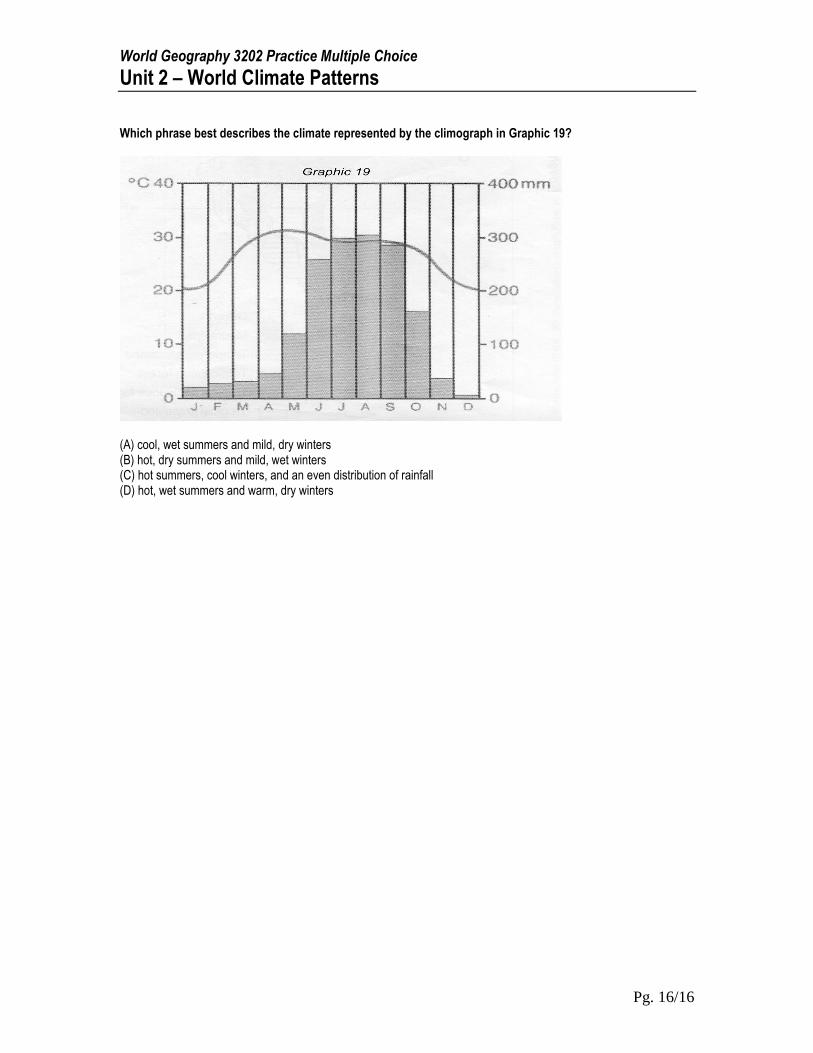
Which phrase best describes the climate represented by the climograph in Graphic 19?
(A) cool, wet summers and mild, dry winters (B) hot, dry summers and mild, wet winters (C) hot summers, cool winters, and an even distribution of rainfall (D) hot, wet summers and warm, dry winters