Embed Size (px)
Citation preview
ECONOMIC AND GENERAL GEOLOGY. 63
71125-63_ 71 GEOLOGY OF THE RAPID RIVER AREA
by W. L. Matthews.
INTRODUCTION About five weeks, from mid-February to the end of March, were
spent in the area south of the Arthur River, in the Trowutta Quadrangle. The work was carried out in conjunction with work being done by Forestry Commission Officers who were assessing the timber potential of the area. To do this, a number of tracks were 'cut, the use of which aided geological surveying in the areas of thick scrub.
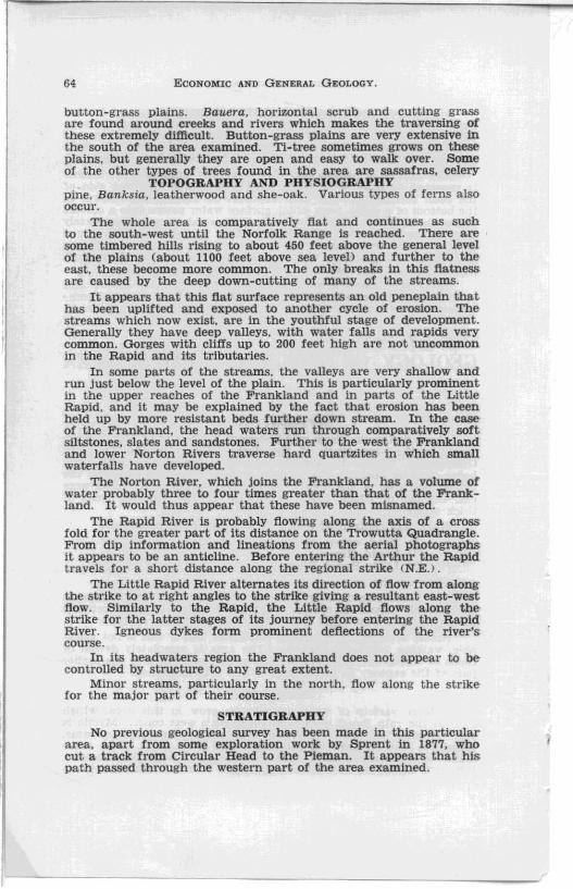
Work was centralised about three camp sites, namely:(1) Head waters of Frankland River; (2) Rapid River; (3) Little Rapid River;
.as shown on the map. The Little Rapid River, although not shown on most maps. is
considerably larger than some that are shown. It flows between the Arthur and Rapid and is in fairly close proximity to them.
Access is normally gained by helicopter. but if this is not available. walking is the only means. The area is completely devoid of roads or tracks of any kind although some tracks used in the earlier part of the century lie to the west of the area examined.
VEGETATION A large variety of trees and shrubs grow in this area, which
falls in the rain forest region of Tasmania's west coast. Myrtle is very common on the flat damp land and around the streams. Eucalypts tend to grow on the ridges and drier parts. The three main species repres.ented are obliqua, ovata and silicitolia. Silici/olia occurs mainly around the edges of the forest and on the
64 ECONOMIC AND GENERAL GEOLOGY.
button-grass plains. Bauera, horizontal scrub and cutting grass aTe found around creeks and rivers which makes the traversing of these extremely diftlcult. Button-grass plains are very extensive in the south of the area examined. Tl-tree sometimes grows on these plains, but generally they are open and easy to walk over. Some of the other types of trees found in the area are sassafras, celery
TOPOGRAPHY AND PHYSIOGRAPHY pine. Banksia, leatherwood and she-oak. Various types of ferns a lso occur.
The whole area is comparatively flat and continues as such to the south-west until the Norfolk Range is reached. There are some timbered hills rising to about 450 feet above the general level of the plains (about 1100 feet above sea level) and further to the east. these become more common. The only breaks in this flatness are caused by the deep down-cutting of many of the streams.
It appears that this flat surface represents an old peneplain that has been uplifted and exposed to another cycle of erosion. The streams which now exist. are in the youthful stage of development. Generally they have deep valleys, with water falls and rapids very common. Gorges with cUffs up to 200 feet high are not uncommon in the Rapid and its tributaries.
In some parts of the streams. the valleys are very shallow and run just below the level of the plain. This is particularly prominent in the upper reaches of the Frankland and in parts of the Little Rapid. and it may be explained by the fact that erosion has been held up by more resistant beds further down stream. In the caseof the Frankland. the head waters run through comparatively soft siltstones, slates and sandstones. Further to the west the Frankland and lower Norton Rivers traverse hard Quartzites in which small waterfalls have developed.
The Norton River. which joins the Frankland, has a volume of water probably three to four times greater than that of the Frankland. It would thus appear that these have been misnamed.
The Rapid River is probably flowing along the axis of a cross fold for the greater part of its distance on the Trowutta Quadrangle. From dip information and lineations from the aerial photographs it appears to be an anticline. Before entering the Arthur the Rapid travels for a short distance along the regional strike (N.E. >.
The Little Rapid River alternates its direction of flow from along the strike to at right angles to the strike giving a resultant east-west How. Similarly to the Rapid, the Little Rapid Hows along the strike for the latter stages of its journey before entering the Rapid River . Igneous dykes form prominent deflections of the river's course.
In its headwaters region the Frankland does not appear to be controlled by structure to any great extent.
Minor streams. particularly in the north, flow along the strike' for the major part of their course.
STRATIGRAPHY No previous geological survey has been made in this particular
area, apart from some exploration work by Sprent in 1877. who cut a track from Circular Head to the Pieman. It appears that his path passed through the western part of the area examined .
i
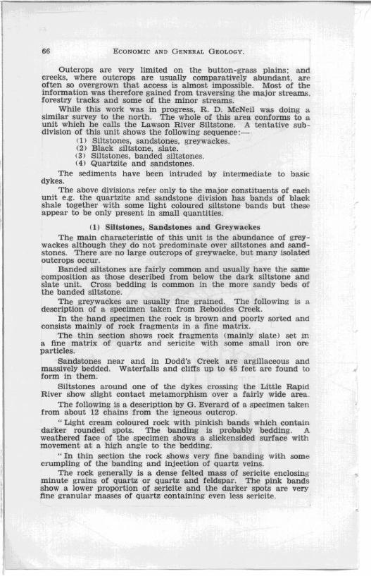
LEGEND PRECAMBRIAN
S ILTSTONES, SANDSTONES & (;REYWACKES .. D BLACK SILTSTONES , SLATES........ .. .... . D SILTSTONES, BANDED SILTSTONES . .. ......... 0 QUARTZITES & SANDSTONES... ..8 DOLE/UTE DYKES.
ANTrCLlNE
SYNCLINE
. ......... " ..... A
.......... ~
STRIKE & DIP OF BEDDIN!i. ..•.•. ..- 20'
ESTABLISHED BOUNDARy ••. .. • .. /
INFERRED BOUNDARI'. ........... /-'
CAMP SITE .... . ................. o2 _____ \ ___ ---f'l
GEOLOGICAL SKETCH MAP
RAPID RIVER AREA
Scm
W. L.MATTHEWS GEOLO<aIST
17'':.JULY 1960
.:::
l1j (")
0 Z 0
~ (")
> Z t::j
0 tIIJ Z tIIJ ::1:1 > t"'
0 tIIJ 0 t"' 0 c;l
~
66 ECONOMIC AND GENERAL GEOLOGY.
Outcrops are very limited on the button-grass plains ; and creeks. where outcrops are usually comparatively abundant. are often so overgrown that access is almost impossible. Most of the information was therefore gained from traversing the major streams, forestry tracks aDd some of the minor streams.
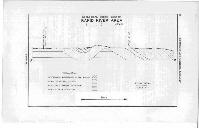
While this work was in progress, R. D. McNeil was doing a similar survey to the north. The whole of this area conforms to a unit which he calls the Lawson River Siltstone. A tentative subdivision of this unit shows the following sequence:-
( 1) Siltstones. sandstones, greywackes. (2) Black slltstone. slate. (3) Siltstones, banded siltstones. (4) Quartzite and sandstones.
The sediments have been intruded by intermediate to basic dykes.
The above divisions refer only to the major constituents of each unit e.g. the quartzite and sandstone division has bands of black shale together with some light coloured siltstone bands but these appear to be only present in small quantities.
(1) Siltstones. Sandstones and Greywackes The main eharacteristic of this unit is the abundanee of grey
wackes although they do not predominate over siltstones and sandstones. There are no large outcrops of greywacke. but many isolated outcrops occur.
Banded siltstones are fairly common and usually have the same composition as those described from below the dark siltstone and slate unit. Cross bedding is common in the more sandy beds of the banded slltstone.
The greywackes are usually fine grained. The following is a description of a specimen taken from Reboides Creek.
In the hand specimen the rock is brown and poorly sorted and consists mainly of rock fragments in a fine matrix.
The thin section shows rock fragments (mainly slate) set in a flne matrix of quartz and sericite with some small iron ore particles.
Sandstones near and in Dodd's Creek are argillaceous and massively bedded. Waterfalls and cliffs up to 45 feet are found to form in them.
Siltstones around one of the dykes crossing the Little Rapid River show slight contact metamorphism over a fairly wide area.
The following Is a description by G. Everard of a specimen taken from about 12 chains from the igneous outcrop .
.. Light cream coloured rock with pinkish bands which contain darker rounded sPOts. The banding is probably bedding. A weathered face of the specimen shows a slickensided surface with movement at a high angle to the bedding.
"In thin section the rock shows very fine banding with some crumpling of the banding and injection of quartz veins.
The rock generally is a dense felted mass of sericite enclosing minute grains of quartz or Quartz and feldspar. The pink bands show a lower proportion of sericite and the darker spots are very fine granular masses of quartz containing even less sericite.
ECONOMIC AND Gi:NERAL GEOLOGY. 67
The specimen is a contact metamorphosed argillaceous rock m which spotting due to segregation has occurred but the process has not gone far enough for the production of new minerals ".
The colour of the spotted rocks varies and the range includes light brown, darker brown, green and purple.
A green sheared variety collected not far from the outcropping dyke has the following characteristics:- fine grained rock with a ground mass of fine quartz and sericite, sPOts which are aggregates of quartz with very little or no sericite. Some of the sPOts are elongated and those that are. have a constant direction of elongation. This suggests that contact metamorphism took place before shearing.
(2) Black Siltstone, Slate This unit is made up of dark grey to black siltstone and in
several localities slaty cleavage has been developed. Some outcrops give the appearance of being baked. since they are very hard and compact: bedding is well developed and varies from thick to thin. Jointing is often very well developed and the rock forms rhombs of regular shape.
The composition of these rocks is mainly fine quartz and sericite material together with large Quantities of what is apparently graphite or other carbonaceous materiaL Small amounts of iron ore are also observed in thin section. In one specimen two sets of lineations at an angle of about 600 were observed. One is probably bedding and the other probably slight development of cleavage although this cannot be seen in the hand specimen.
Pyrite. in perfect cubes, is common along the bedding planes. Sometimes the pyrite is finely disseminated throughout the rock but generally it is confined to certain bedding planes in fairly coarse crystals. The crystals are usually set in a thin layer of quartz. Springs. that develop in the rock rich in pyrite, have a bright orange stain of iron oxide around them.
Very fine ripple marking has been observed near the mouth of Doss's Creek.
Interbedded with the black shale and slate are sandstones. greywackes and fine grained schists. Schists obtained in the Little Rapid River are described by G. Everard as follows: -
(1) .. Pale greyish. sheared. micaceous rock somewhat granular and friable .
In thin section the rock consists of rounded grains of quartz in a sericitic matrix.
The rock is a fine grained Quartz sericite schist .. . (2) .. Fine grained, sheared. dark grey rock, soft and
micaceous. In thin section it is a fine oriented mass of quartz and
sericite with porphyroblasts of Quartz and feldspar cutting across the orientation.
The rock is a fine grained quartz sericite schist ... The specimen was collected near a basic dyke. Another rock collected near the same dyke on the Little Rapid
contains about 20% of calcite together with many rock fragments set in a matrix of fine quartz and sericite. Some Quartz porphyro-

68 ECONOMIC AND GENERAL GEOLOGY .
blasts have also formed. Rock fragments probably make up 20% of the rock. The calcite occurs in large irregularly shaped particles and aggregates up to 2.5 mm. in length.
The band from which the specimen was collected, is narrow and is bounded by greywacke on one side and black slate on the other.
A few sandstone bands are present in this unit in some localities. Sometimes they are flecked with black slate particles and muscovlte is often present. The sandstones are usuallY arg1llaceous.
(3) Siltstones. Banded Siltstones This unit is made up predominantly of siltstones with lesser
amounts of sandy siltstones, sandstone and black slate and minor quantities of Quartzite, greywacke and phyll1tic rocks.
The siltstones vary a good deal in colour. Grey, light green. light blue, brown and banded members are common and in one locality a pink variety occurs. The banded members are made up of alternations of dark grey to black and almost white bands, but some are not SO contrasting in nature.
Some of the siltstones are massively bedded and almost structureless while others are thinly bedded. well jOinted and have a platy appearance. Some of the more compact beds are a lso well jointed.
Very fine quartz. clay material and sometimes sercite are t he chief constituents of the siltstones. In thin section the banded siltstones show that the lighter bands consist mainly of fine quartz and sericite while the darker bands have together with these minerals a powdery black substance which is probably carbonaceous matter.
The greywackes consist of rock particles and argillaceous matter. The most prominent rock fragments are black slate particles.
Sandstones in the unit are often argillaceous and contain a fai r amount of muscovite.
The siltstones grade into the black slate and therefore they appear to be conformable with it.
(4) Quartzite and Sandstones
The Quartzite which outcrops in the western part of the area is usually massively bedded and is from clean white to grey-green and brownish in colour. Some bands are fairly argillaceous and Quartz veining is comparatively common. These quartzites are compact hard and resistant to erosion. Waterfalls are common in the streams where they outcrop. The only mineralisation appears to be small pieces of pyrite in some localities.
Compact sandstones are interbedded with the Quartzite a nd. like t he Quartzite. they are clean white to rather argillaceous. They are also massively bedded. and often have Quite a lot of muscovite . Quartz veins are common.
Interbedded with these are very minor bands of black to dark grey siltstone.
ECONOMIC AND GENERAL GEOLOGY. 69
The western extent of this unit was not determined. On the western edge of the area mapped. there is a strong lineation produced by the junction of a forest area with the button-grass plain. This probably indicates a change in rock type, even though a traverse was made down the Frankland for about one quarter of a mile in the forest itself without any change of rock type being observed.
Sprent. on his exploration expedition, mentions that he spent some time in a forest (which is very likely this one) and he found dark blue slates together with clay slates containing pyrite. It therefore seems likely that the quartzite does not extend very far into the forest .
IGNEOUS INTRUSIONS Several dykes outcrop in the area. These all have a north
easterly trend and are parallel to the strike of the sedimentary rocks. It appears that they were intruded along joints parallel to the fold axes.
A description by G. Everard of a specimen taken to the east of Camp 3 in Reboides Creek is as follows:-
"Greenish. medium to coarse grained rock showing crystals of feldspar and hornblende.
In thin section the rock consists mainly of large plagioclase crystals. Hornblende is in much smaller amounts but sometimes encloses the plagioclase. Quartz has crystallised last in irregular interstitial masses. A little pyrite and magnetite are also present.
The rock Is a diorite." A description of another specimen taken in the Little Rapid
River is as follows: -.. In thin section the rock is medium to coarse grained
consisting mainly of plag10clase and pyroxene with minor amounts of llmenite and / or chromite and Quartz.
The plagioclase is in large laths which have been largely sericit1sed. It shows multiple twinning and has an R.I. greater than balsam but alteration is too great to determine the feldspar type.
Pyroxene occurs in anhedral crystals part of which has been altered to green pleochroic chlorite.
Ilmenite occurs in grains up to 1 mm. across. It has been altered to leucoxene. On first sight it looks like chromite because it is translucent and brown.
Small grains of anhedral quartz are fairly common. Approximate percentages of minerals present are: -
Plagioclase Pyroxene nmenite Quartz
The rock is a Quartz dolerite ",
% 50 40
5 2.3
l ...,
.'"
GEOLOGICAL SKETCH SECTION
RAPID RIVER AREA o 2M/LES L' __________ L-________ ,
~ ~ ~ ~ ~
~ ~ t~ ; ~ 'J
:t: ; ~ c: \" ~
~l . rp' ~
~ I \ .~ . ..... ~ .. ~. ~«-: .... ... . D ... .
"J f-----~~ .. • ..• . ..... ... ____ ~ .... . : . . . "::::::::: ::::: ::::::::::::::::::: ~ A . . . . . . . . . . .-:-:-:-:-:-:-:.:-: -: -:-: B
PRECAMBRIAN
SILTSTONES, SANOSTONES &. t:REYII'ACKES D BLACK SILTSTONES, SLATES 0 SILTSTONES, BANDED SILTSTONES 0 QUARTZITES &. SANDSTONES . . _ B
5cm
W L MATTHEWS GEOLOGIST 17"'.JULY /960
l".1 C'l o Z o i!: .... C'l
> Z "

ECONOMIC AND GENERAL GEOLOGY. 71
These dykes no doubt belong to the same period of intrusion. They probably do not exceed 100 feet in width and are much less in most localities.
The wide metamorphic zone around one of the dykes may be caused by an offshoot from the main dyke because no other such width of metamorphism was found along the length of the dyke in question.
STRUCTURE The regional strike of the sediments is in a N.N.E.-N.E direction.
Folding is open and simple. Dips do not exceed about 45° in most cases. A distinct anticline and syncline have been mapped and another possible syncline occurs at the eastern edge of the area. Cross folding in a west to north-westerly direction indicates another period of folding. These cross-folds are not nearly as strong as the north-easterly trending folds.
Minor faulting was noted in a number of localities but faulting on a major scale was not observed although it may well exist.
ECONOMIC GEOLOGY Very little mineralisation has taken place except for the deposi
tion of pyrite. The pyrite along the bedding planes tends to suggest that it is syngenetic but examination of the bedding planes shows there is no curving around the crystals. In one specimen of banded siltstone there are several pyrite veins at right angles to the bedding and the bedding planes are bent in a "V" shape around the veins. Thus it would appear that the pyrite is epigenetic.
Panning in several creeks resulted in only minor traces of ilmenite.
Soil in the forest areas is fertile and would probably be comparable in quality to the rich soil further to the north. The buttongrass plains are usually underlain by quartzites and sandstones, or very inferior soil producers.
CORRELATIONS Most of the rock exposures described in adjoining areas show
dolomite sometimes in large thicknesses. No dolomite was seen in this area, and if any does occur it is probably not very ex·tensive although it could underlie areas of buttongrass where outcrops are rare. The presence of a large percentage of carbonate mineral in a band of the black shale and slate unit suggests the dolomite was not far away during the deposition of this unit.
The rocks of this area probably belong to the Balfour Series of Ward which is probably also equivalent to part of the Rocky Cape Group of Spry. There does not seem to be the extent of quartzite which the upper Rocky Cape Group contains. It is therefore probable that this is basal Rocky Cape Group. It compares fairly accurately wIth the type section except for the occurrence in the latter of the narrow band of dolomite.
REFERENCES. GULLIN':. A. B .. 1959.- The Underground Ware}' Resourx:e of the Smithton District.
Tas. D ept. MiliCS UfulcTIJTO'II.nd WateT SuPplll PapcT No.5. Ny"" P. U.; FINACANE, K. J.: and BLAKfJ, F., 1934.-Geology of Smithton District..
Tas. Geol. SUTV. Bull. No. 4l. SPRENT, C. P. and SCOTT, J. R., 1877.- Western Country. Tas. HOltSe of Asscmbl/l
Paper No. 27. LCD. Council PapeT No. 21. SPRY. A. H., 1957.- Preeambrian Rocks of Tas .. Part I. Dolerites of the North·
West Coast, Tas .. PTOC. ROll. Soc. Tas .. Vol. 91. WAHD. L. K., 19!1'1.- The Mount Balfoul' Mining Field. Tall. Geological SuTve"
Httllt'tin No. 10.