Embed Size (px)
Citation preview
41J10MM01t2.157MMJBWEL 010
O
1570 8
REPORT OM Tint
GEOLOGY AMD COPPER-PRECIOUS METAL MIMERALIZATIOM
OM THE
JBMTIMA MIME PROPERTY
ALBAMEL ft MICHOLAS TOVMSHIPS
OMTARIO
FOR
A. J. ROY
TOBOITO, GHTASIO
15, 1994
V. O. VILLOUGHBY, B. Se. (BOBS. )
KK&J RBSODRCB ASSOCIATES LIMITED
Oil
2JUUABT
A program of geological napping and prospecting on the Jentlna Hine Property concentrated on the evaluation of two, east-west trending copper-precious metal structural zones.
The lo. l Copper-Precious Metal Structure Is delineated over a strike length of 3,500 feet and Is hosted mainly by Espanola Formation limestone. Yidth varies from 60 feet on the west to 150 feet on the east. The showing consists of a chalcopyrlte-bearing quartz-chlorlte -i-/- albite breccia hasted by a chloritic shear. Extensive albite-sllica alteration Is associated and later subparallel and cross-cutting quartz-carbonate veins are also mineralized.
Massive sulphide horizons In the Bo. l Structure occur In Pit l at the Main Showing In the east. An 8-foot channel sample containing some massive sulphide assayed 6.782 copper and 1.90 oz silver per ton. Gold values of up to 0.03 oz per ton were returned from some samples.
At the east end, channels from Trench l returned up to O.63* copper over 4 feet and O.4452 copper over 10 feet. Grab samples of mineralized rock returned up to 1.252 copper and 0.029 cz gold per ton. A 5-foot channel from Trench 2, 300 feet eas~ of Trench l, ran l.882 copper.
The Id. 2 Copper Structure consists of mainly quartz- carbonate veining hosted by sheared and chloritized Espanola Formation siltstone and Gowganda Formation conglomerate. To date, the zone measures 4,400 feet long (east-west). Due to poor exposure, the width Is not well defined. The host structure is on a line with the White River Lead Mine (Cu-Pb-Ag-Au-Zn-Co-Ei) , 3,000 feet to the west. To the east, the zone was not prospected beyond a 250-foot long area of trenching, and Is considered open in that direction.
The Southeast Trench gave 1.832 copper over a 4-foot channel of chalcopyrite-rich quartz veining. A grab of semi-massive chalcopyrite from a pit 250 feet to the west assayed 13.002 copper.
The mineralized structures are considered to represent a class of polymetallic quartz veins and/or Cu-Au-bearlng veins and breccia pipes commonly found within the Proterozoic Huronian Basin. They may be parallel or subsidiary faults to the Flack Lake Fault Zone, a reverse thrust fault which may be the northern boundary fault for the Huronian Basin. Archean basement racks outcrop to the north.
Other known copper-precious metal zones on the Jentlna Property Include the Canamiska Zone, a 9,600-foot long EM conductor and soil geochemical zone. The best reported drill intersection was 1.442 copper over 19.5 feet. Some narrower sections graded in excess of 42 copper.
Structural-mlneralcgic and aeromagnetic features at the No. l Copper-Precious Metal Structure suggest the most likely target for economic mineralization on the Jentlna ground Is polymetallic CCu-Ag Au) mineralized breccia zones or pipes similar to the Proterozoic Olympic Dam deposit in Australia and the Vernecke Mountains deposits of the Yukon.
Other possible mineral targets are high-grade polymetallic veins, a style which historically has produced, over 36,000 tons of copper plus some precious metals In the Huronian Basin, VMS- style deposits In either Huronian and/or Archean volcanics, Archean style lode gold mineralization along or subsidiary to the Flack Lake Fault System, and perhaps SEDEX mineralization.
A two phase exploration program, emphasizing structural mapping, lithogeochemical sampling and diamond drilling is proposed to test the various possible styles of mineralization on the Jentina Property. Estimated cost of this work is 4881,000.
4M10MWI0192.1SIWMBANB. 01OC
TABLE OP CONTENTS
SUMMARY
1.0 INTRODUCTION l
2.O PROPERTY AMD DESCRIPTION 22.1 Location, Access and Infrastructure 22.2 Claim Status 4
3.0 PREVIOUS VUKK. 73.1 Mining and Exploration Company Activity 7
3.1.1 Sudbury Basin Mines Limited, 1927-1929 73.1.2 A. H. Clark, 1956 93.1.3 Plcton Uranium Mines Ltd., 1955-1968 93.1.4 Brace-Presto Mines Ltd., 1964-1965 103.1.5 Canamiska Copper Mines Ltd., 1965 123.1.6 Hanna Mining Company, 1969 133.1.7 Paquette Claims, 1952-1965 143.1.8 Atlantic Richfield Co.,
Triller Explorations Ltd.. 1967-1968 143.1.9 Stanford Mines Limited, 1971-1972 15
3.1.10 Gowganda Silver Mines Limited, 1972 163.1.11 Fort Norman Explorations Inc., 1974-1975 173.1.12 Charles M. Mortimer, 1984 2O3.1.13 International Mine Services Ltd.. 1986 203.1.14 United Reef Petroleums Limited, 1988 20
3.2. Academic and Government Studies 22
3.2.1 Paul Scheerer, University of Wisconsin,1956 22
3.2.2 J.W. Gasch and T.A. Vogel, Universityof Wisconsin, 1959 23
3.2.3 Provincial Government Surveys 233.2.4 Federal Government Surveys 23
4.0 REGIONAL GEOLOGY AID MINERAL IZATIOI 254. l Geological and Structural Framework 254.2 Base Metal and Precious Production 324.3 Mineral Deposits 35
5.0 EXPLORATION MODEL 43 5. l Polymetallic Veins, Breccias and Breccia
Pipes 435.2 Volcanogenic Massive Sulphide Deposits 545.3 Archean Lode Gold Deposits 545.4 Exploration Techniques 55
6.0 GEOLOGICAL MAPPING AID SAMPLING PROGRAM 59
7. O EXPLORATION RESULTS 627.1 Preamble 627.2 Geology and Distribution of Lltaologlcal
Units 627.3 Structural Geology and Xlnerallzatlon 667.4 Copper and Precious Betals-Bearing Structures 69
7.4.1 Vo. l Copper-Precious Setal Structure 707.4.2 To. 2 Copper Structure 787.4.3 Concluding Remarks 83
8.0 COBCLUSIOBS 85
9. O RBCQOEFDATIOIS 88
CERTIFICATE OF QUALIFICATIONS
PLATES
APPETOICES
CERTIFICATES OP ABALYSIS
APS
LIST OP FIGURESpage
Figure 1: General Location lap 3
Figure 2: Claim lap 6
Figure 3: 8 General geology and adit workings at the Little White River Lead line (after loore, 1929)
Figure 4: 18Plan of trenching and drill hole locations at the lain Showing,Fort lorman Explorations (after Rupert, 1974)
Figure 5: 24 Regional total field magnetics covering the Jentlna Property
Figure 6: 26 Regional geology and mineral deposits (after Roscoe ft Card, 1992)
Figure 7: 27 Geological sketch map of the Huronian Basin showing elements of the Penokean Fold Belt (after Bennett et al. 1991)
Figure 8: 28 Schematic diagram illustrating the paleotectonic model proposed for the formation and deformation of the Huronian Basin (after Bennett et al, 1991)
Figure 9: 3O Chronology of deformation and metallogenic events in the Proterozoic Huronian Supergroup (after Fyon et al, 1992)
Figure 1O: 40 Copper deposits across Southern Province (after Pearson, 1979)
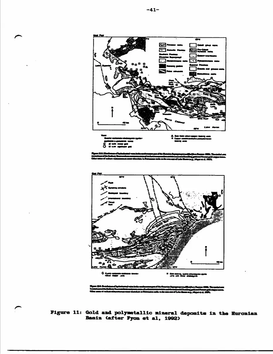
Figure 11: 41Gold and polymetallic mineral deposits in the Huronian BasinCafter Fyon et al. 1992)
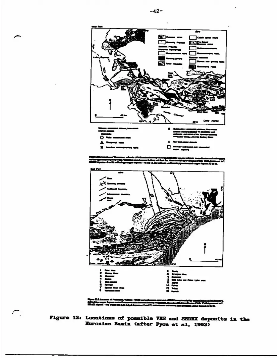
Figure 12: 42 Locations of possible VIS and HKIIKI deposits in the Huronian Basin (after Fyon et al, 1992)
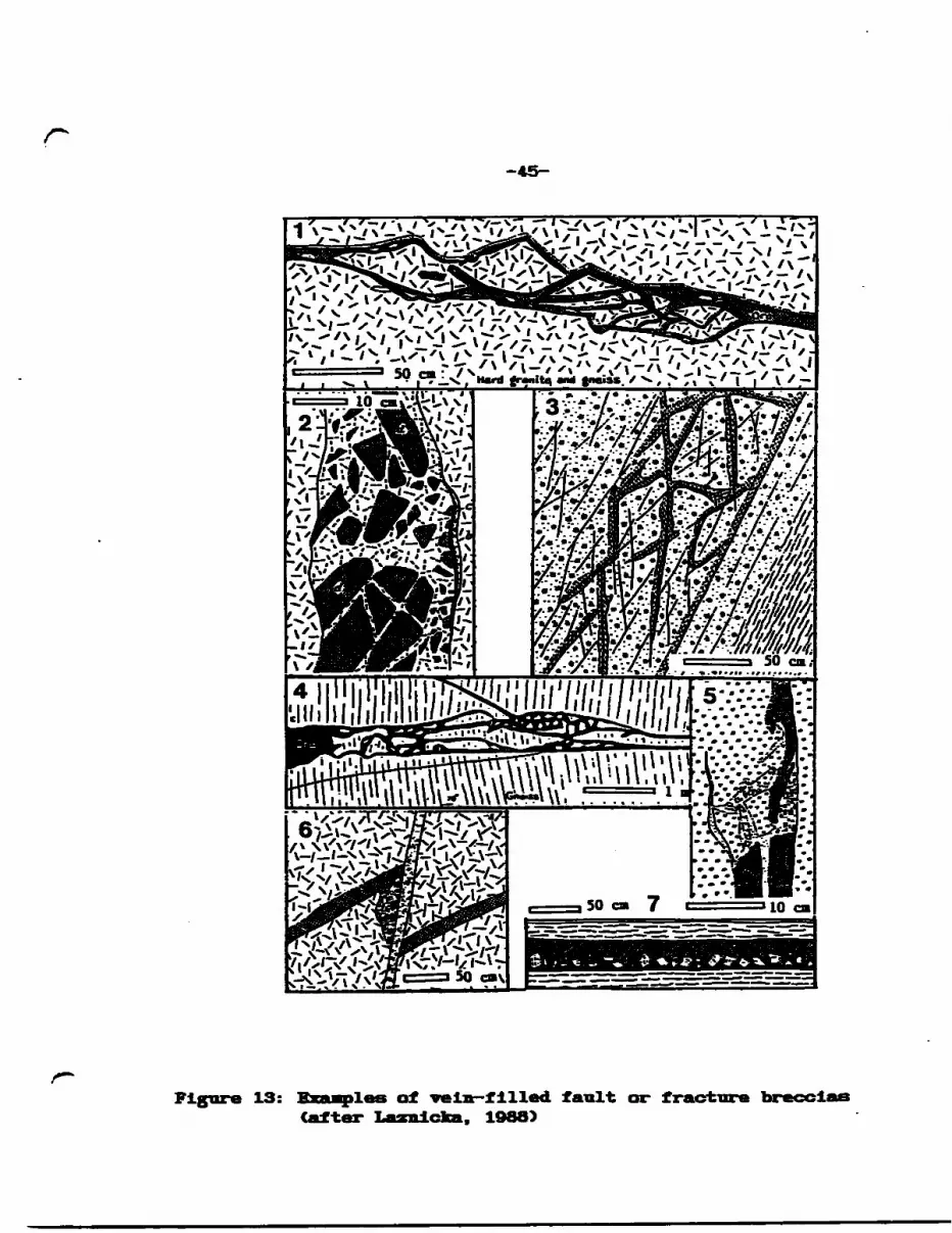
Figure 13: 45 Examples of vein filled fault or fracture breccias (after Laznlcka, 1988)
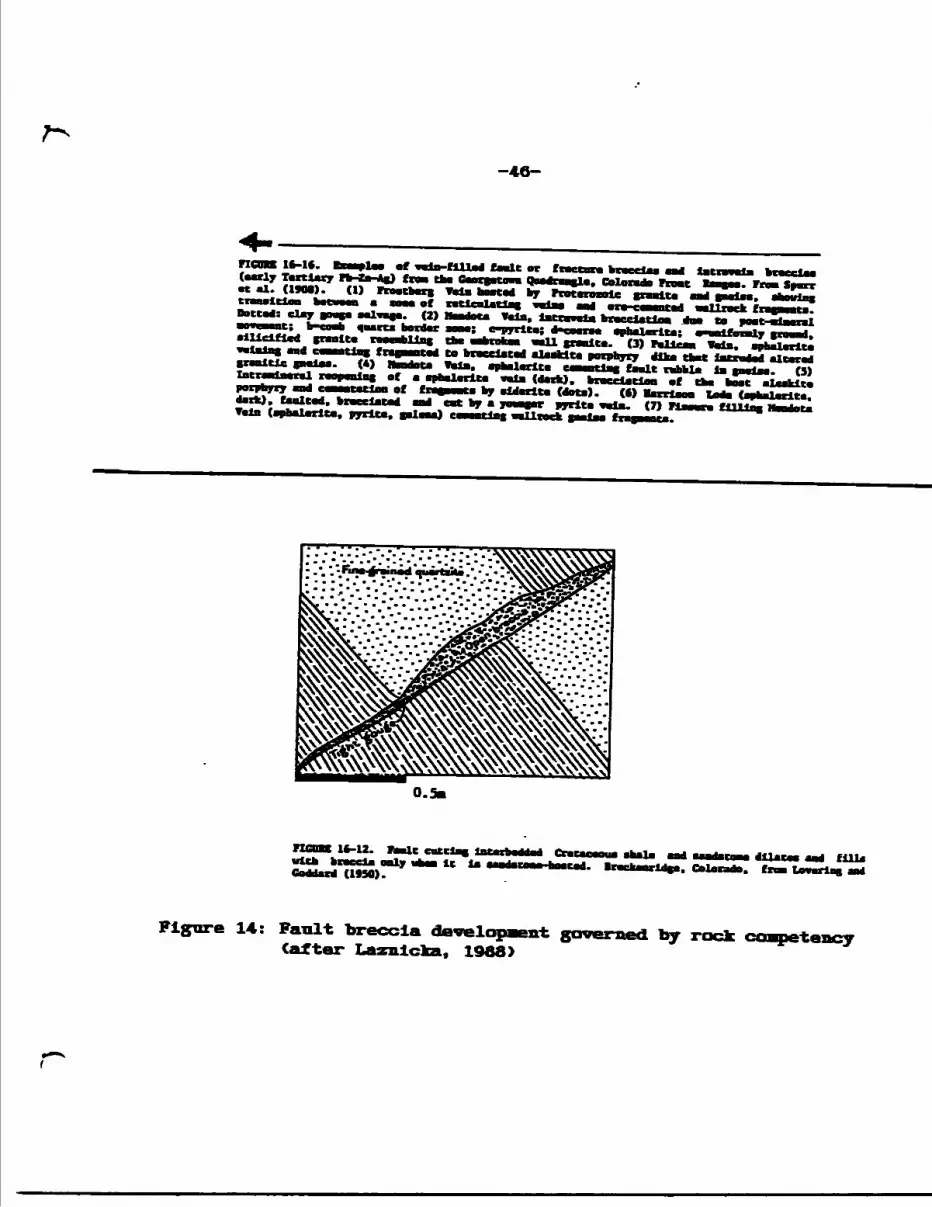
Figure 14: 46Fault breccia development governed by rock competency (afterLaznlcka, 1988)
Figure 15: 47 Breccia formation due to faulting and fracturing (after Laznlcka, 1988)
Figure 16: 48Morphology of a diatreme showing relative sites of possible
Qization (after Laznlcka, 1988)
Figure 17: 49 Morphology of mineralized breccia In host sediments at the Victoria Mine, levada (after Atkinson et al, 1982)
Figure 18: 50 Mineralized skarn breccia at the Victoria Mine, levada (after Atkinson et al, 1982)
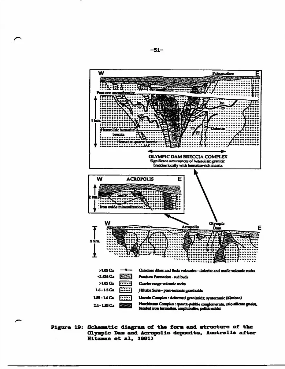
Figure 19: 51 Schematic diagram of the form and structure of the Olympic Dam and Acropolis deposits, Australia after Hltzman et al, 1991)
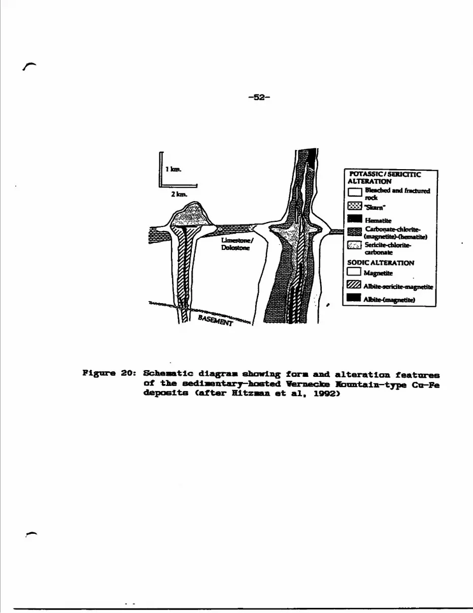
Figure 20: 52 Schematic diagram showing form and alteration features of the sedimentary hosted vernecke Mountain type Cu Fe deposits (after Hitzaan et al, 1992)
Figure 21: 53 Tectonic setting of Olympic Dam-vernecke Mountain breccia style precious and base metal deposits (after Hltzman et al, 1992)
Figure 22: 57 Proterozoic volcanic hosted VMS deposits in the Snow Lake area, northern Manitoba (after Walford and Franklin, 1982)
Figure 23: 58 Section of the Anderson VMS Mine, Manitoba (after valford and Franklin, 1982)
Figure 24: 72 Trench l, east face: geology, sample sites and assay results
Figure 25: 75 Trench 2, east face: geology, sample sites and assay results
Figure 26: 76 Plan map of pits and trenches, Main Showing area
Figure 27: 77 Main Showing, Pit l, south face: geology, sample sites and results
A Figure 28: 81 . SB trench, neat face: geology, sample sites and assay results
LIST OF TABLES
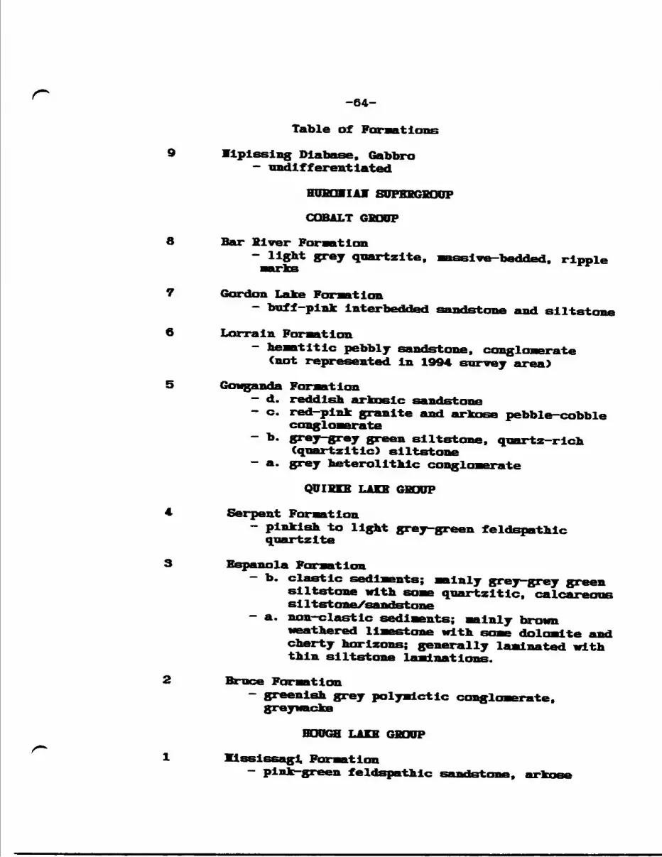
Table 1: Table of Formations 31
Table 2: 33List of Copper ft Precious Metals Production in the SouthernProvince (excluding the Sudbury Basin and Keweenawan deposits)
Table 3: 34 Documented Copper Inventory in the Huronian Basin
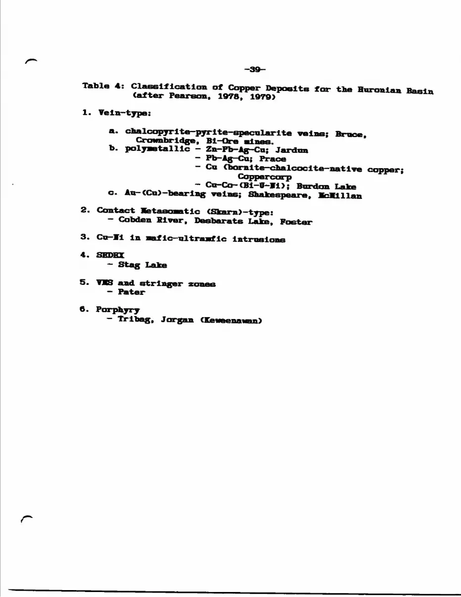
Table 4: 39 Classification of Copper Deposits for the Huronian Basin (after Pearson. 1978, 1979)
Table 5: Table of Formations, Jentlna Hine Property 64
Table 6: 70 (Mineralized) breccia/vein zones and associated alteration
LIST OF APPEIDICES
APPEMDIZ A: Summary Diamond Drill LogsA. l Plcton Uranium Mines Ltd., 1955-1968 Al A.2 Canamlska Copper Mines Ltd., 1965 A2 A. 3 Hanna Mining Company, 1969 A10 A.4 Atlantic Rlchfiled Company, 1968 A1O A.5 Stanford Mines Limited, 1971-1972 All
APPEMDIZ B: Diamond Drill Logs, Fort Morman Rxplorations Inc., 1974
APPEMDIZ C: 1988 Rock Sample Descriptions and Analytical Results, United Reef Petroleums Limited
APPEMDIZ D: 1993 Rock Sample Descriptions and Analytical Results
APPEMDIZ B: 1994 Rock Sample Descriptions and Analytical Results
LIST OF HAPS
Hap la: Area Geology, Structures and Mineral Occurrences; Albanel Twp. (scale, 1:2O,OOO)
Hap Ib: Area Geology, Structures and Mineral Occurrences; nicholas Twp. (scale, 1:2O,OOO)
Map A: Exploration Data Compilation, ^"" " g*-** Copper Mines Ltd. , 1965 (scale, l* ~ 500* )
Geology and KLneral Structure laps W9 Sheet S9 Sheet B Sheet SB Shoot
(scale l" = 20O')
LIST OF PLATES
Plate 1:View south of Nipissing diabase ridge at approximately L64+OOW,17+OOS C*94 grid)
Plate 2:Exposed ridge of Gowganda Formation arkosic sandstone with somegranite pebbles; at L24+OOW. 3+OOS C*94 grid)
Plate 3:View to northwest of Bndakal Lake; from the position of Plate 2
Plate 4:View north-northwest of Archean granite along the trace of the Flack Lake Fault, north of the Little White River; from the position of Plate 2
Plate 5:Ripple marks and some slump folding In Bar River Formationquartzite at L25+OOE. 7+5OS C*93 grid)
Plate 6:View west of the Bailey bridge across the Little White River;from the position of Plate 5
Plate 7:Ridge of Klsslssagl Formation sandstone north of the Little WhiteRiver; view north from the position of Plate 5 .
Plate 8:Graded bedding in Gowganda Formation arkosic sandstone/quartzite at approximately L12+OOW. 2+75S C'94 grid); stratIgrahlc tops are indicated to be overturned to the north
Plate 9:Slump features In Gowganda Formation heterolithic conglomerate along the property access road at approximately L36+OOW, TL12+OO1" C*94 grid)
Plate 10:The author standing at the east face. Trench l, of Mineralized quartz chlorite albite breccia and quartz carbonate vein zone in host Espanola Formation limestone and siltstone. Channel samples sites 9402 to the left CO.2851 Cu over 6.0 ft.) and 9403 to the right (0.335* Ga over 5.0 ft.)
Plate 11:Chris Xarchildon measuring strike and dip of siltstone strata (bottom) at the east face, Trench 1. The siltstone is overlain by sulphide rich quartz chlorite +S— albite breccia and altered limestone/siltetone. Channel sample site 9405 (0.093Z Cu over 6.0 ft.) is displayed
Plate 12:Typical quartz chlorite breccia in Trench la at approximately L1+5OV, TL10+OOM O93 grid); Malachite-staining with chalcopyrite blebs show preference for cross cutting fracture pli
Plate 13:Chris standing at the east end, south face of Pit l, the Main Showing; channel sample sites 9423 (1.35* Cu over 9.0 ft.) to the left and 9422 (6.78* Cu, 1.90 oz Ag/T and 195 ppb Au over 8.O ft.) to the right
Plate 14:At the went end, sooth face Pit l with channel sample sites 9424 (O.80* Cu and l,OSO ppb Au over 6.0 ft.) to the left, sample site 9425 (l.OO* Cn over 9.0 ft.) to the right
Plate 15:Close up of sample site 9422 showing massive sulphide (pyrite chalcopyrite bornite) horizon at lower right and folded Espanola Formation limcotone/slltstone at upper right
Plate 16:Chloritic shear zone at sample site 9423 showing malachite- staining and chalcopyrite bearing *aii***T- parallel and oblique quartz velnlets
Plate 17:View of the west face of the Southeast Trench, 1st terrace, atapproximately L3+5OV, 4-H5OS C94 grid). Chip channel sample site9441 (1.83* Cu over 4.0 ft.) across the main sulphide-bearing quartz vein; chloritic shear zone on either side and with some quartz chlorite breccia
Plate 18:View of the west face of the Southeast trench, 2nd terrace, 15ft. east of the location of Plate 17. Chip channel sample site9442 returned 1.22* Cn over 6.0 ft.r
-i-
1.0 I1TKODUCTIOM
Sporadic exploration has been carried out in the property
area for a number of years targeting what were referred to as
mineralized quartz veins. Exploration activity and provincial
government surveys In the Huronian in the Sudbury area in recent
years, plus research and property visits by the author in and
around the property area, indicate that particular structural and
alteration features characterize the Huronian Basin deposits,
such as regional fault zones, occurrences of mineralized breccia
pipes and associated albitization, and that such features have
largely been un-recognized or Ignored in the region west of
Sudbury.
The emerging consensus is that regional fault patterns and
Increasingly recognized zones of deformation have played a major
role in metallic mineral deposition and that recognition of
structure and alteration may lead to the discovery of significant
economic deposits. The fact that most researchers consider the
Huronian-Archean Interaction to be one of continental collision-
subduct ion zone mechanics conjures epithermal (Cordilleran-type)
and mesothermal (Archean-style) models as applicable to the
Huronian Basin.
This report on the current and historical exploration work
on the Jentina project and environs describes the field mapping y
prospecting results and reflects on the regional structural
context of Jentina copper-precious metal mineralization.
-2-
2.0 PROPERTY DESCRIPTION AID LOCATION
2. l Location, Access and Infrastructure
The Jentlna mineral property Is located In central east
Albanel Township and central west Nicholas Township, District of
Algoma, Sault Ste. Marie Mining Division, Ontario (Figure 1). The
main claim block fallows, and in places contains, some 4 Km of
length of the westerly flowing Little White River. All weather
secondary Highway 546 follows the course of the river, crossing
the northern part of the main claim block. This route connects
the property to Iron Bridge to the southwest, some 45 Km and to
Elliot Lake, 50 Km southeast.
The property is covered by well forested, steep-sided east-
west running outcrop ridges with elevations of up to 1,500 feet.
Numerous denuded rock promlnatories provide many scenic vistas.
The main forest cover consists of poplar with some scattered
stands of pine and maple. Timber on portions of the western part
of the property was harvested in 1989.
Numerous CATV) trails and roads, some in consequence of the
logging operation, provide access to the western part of the
property, particularlly from the Vhlte River Lodge. The lodge is
located 200 m west of the claim block and was used as a base for
the field mapping/prospecting program.
Access to the eastern part of the claim block was provided
by an AT7 trail from the Vhlte River Lodge which swings south of
Le Scarbo Lake and east to the eastern property boundary. A trail
extends south from this route to the Vhite River, close to the
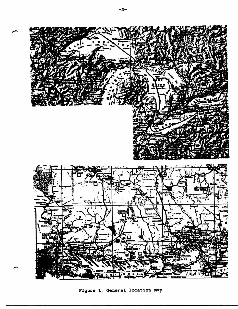
-3-
Flgure 1: General location map
-4-
Albanel Vlcholas township boundary. A logging road running
north from Highway 546 extends just west of the northern claim
group.
The uranium mining town of Billot Lake, with a population of
13,500, Is the closest available centre for mining and
development services and supplies as well as possible custom
milling facilities. At present, there Is no electrical power
source In the region of the Jentina Property.
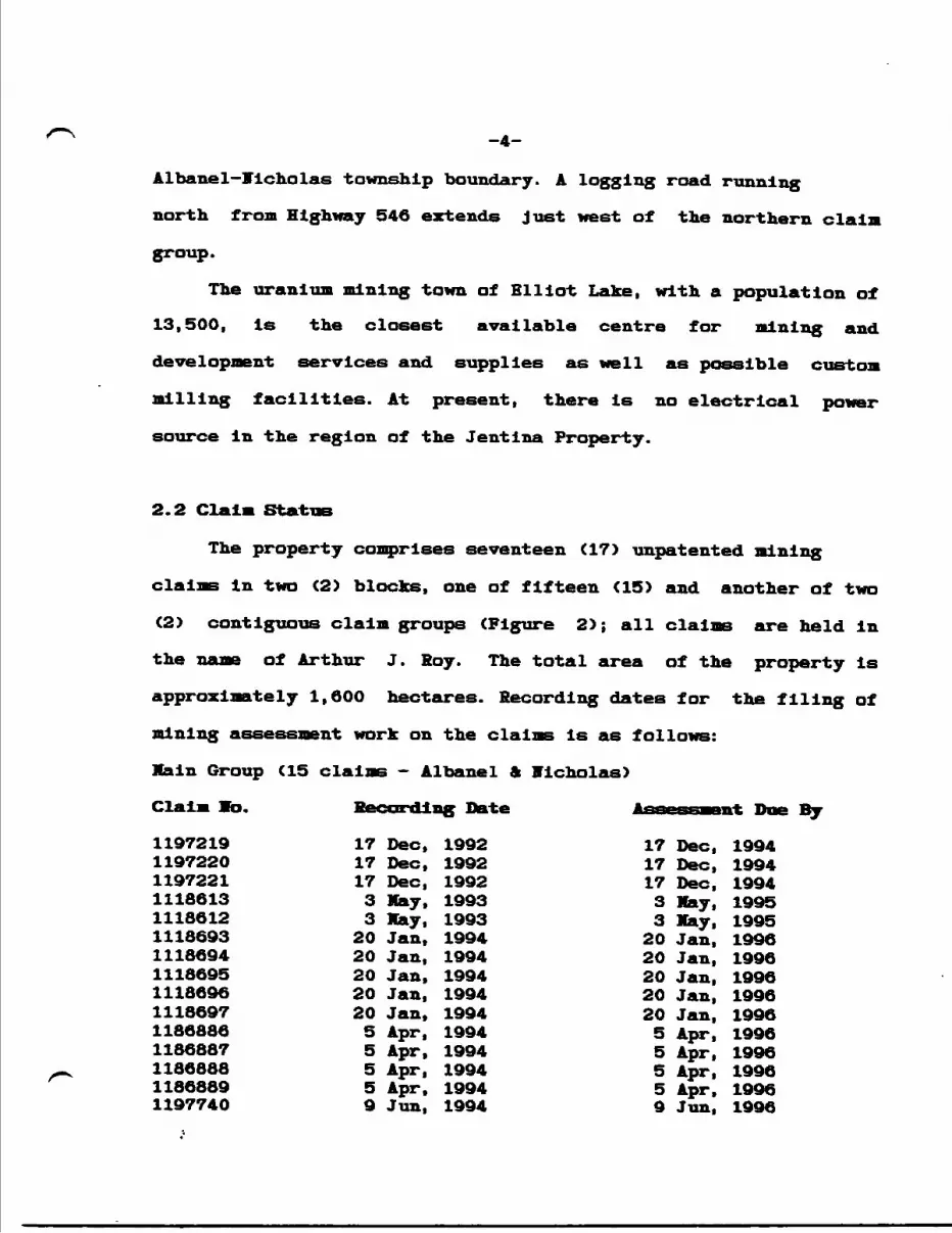
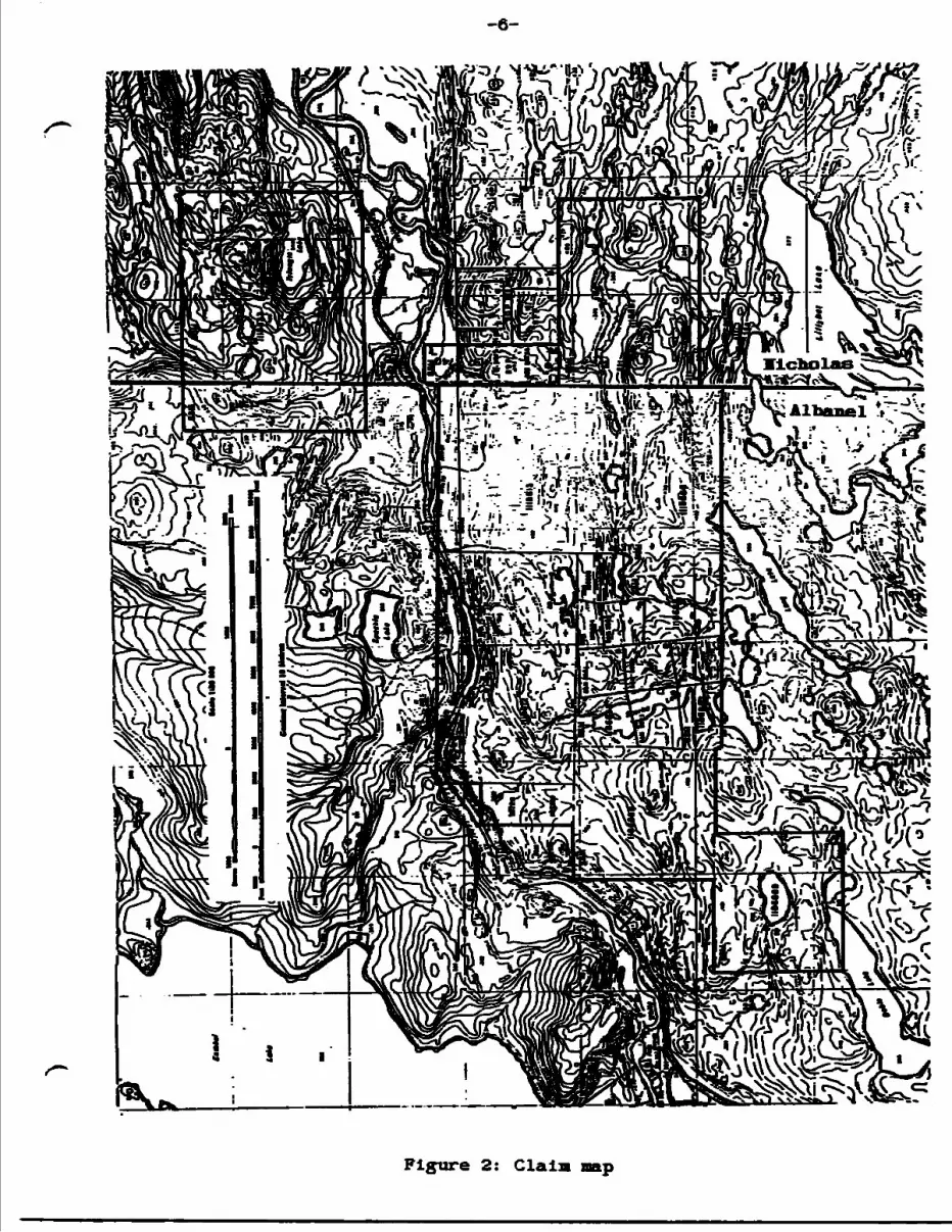
2.2 Claim Stati
The property comprises seventeen (17) unpatented mining
claims In two (2) blocks, one of fifteen (15) and another of two
(2) contiguous claim groups (Figure 2); all claims are held in
the name of Arthur J. Soy. The total area of the property Is
approximately 1,600 hectares. Recording dates for the filing of
mining assessment work on the claims Is as follows:
Main Group (15 claims - Albanel ft nicholas)
Claim To. Recording Date Assessment Due By
1197219 17 Dec, 1992 17 Dec, 19941197220 17 Dec, 1992 17 Dec, 19941197221 17 Dec, 1992 17 Dec, 19941118613 3 Hay, 1993 3 May, 19951118612 3 May, 1993 3 May, 19951118693 20 Jan, 1994 20 Jan, 19961118694 20 Jan, 1994 20 Jan, 19961118695 20 Jan, 1994 20 Jan, 19961118696 20 Jan, 1994 20 Jan, 19961118697 20 Jan, 1994 20 Jan, 19961186886 5 Apr, 1994 5 Apr, 19961186887 5 Apr, 1994 5 Apr, 19961186888 5 Apr, 1994 5 Apr, 19961186889 5 Apr. 1994 5 Apr, 19961197740 9 Jun, 1994 9 Jun, 1996
-5-
Trlangle Lake Group (Albanel A Hi. cho las)
Clala Id. Recording Date * —— —tar lil Due By
1118633 25 lov, 1993 25 lov, 19951118634 25 Ibv, 1993 25 Jov, 1995
-6-
Figure 2: Claim nap
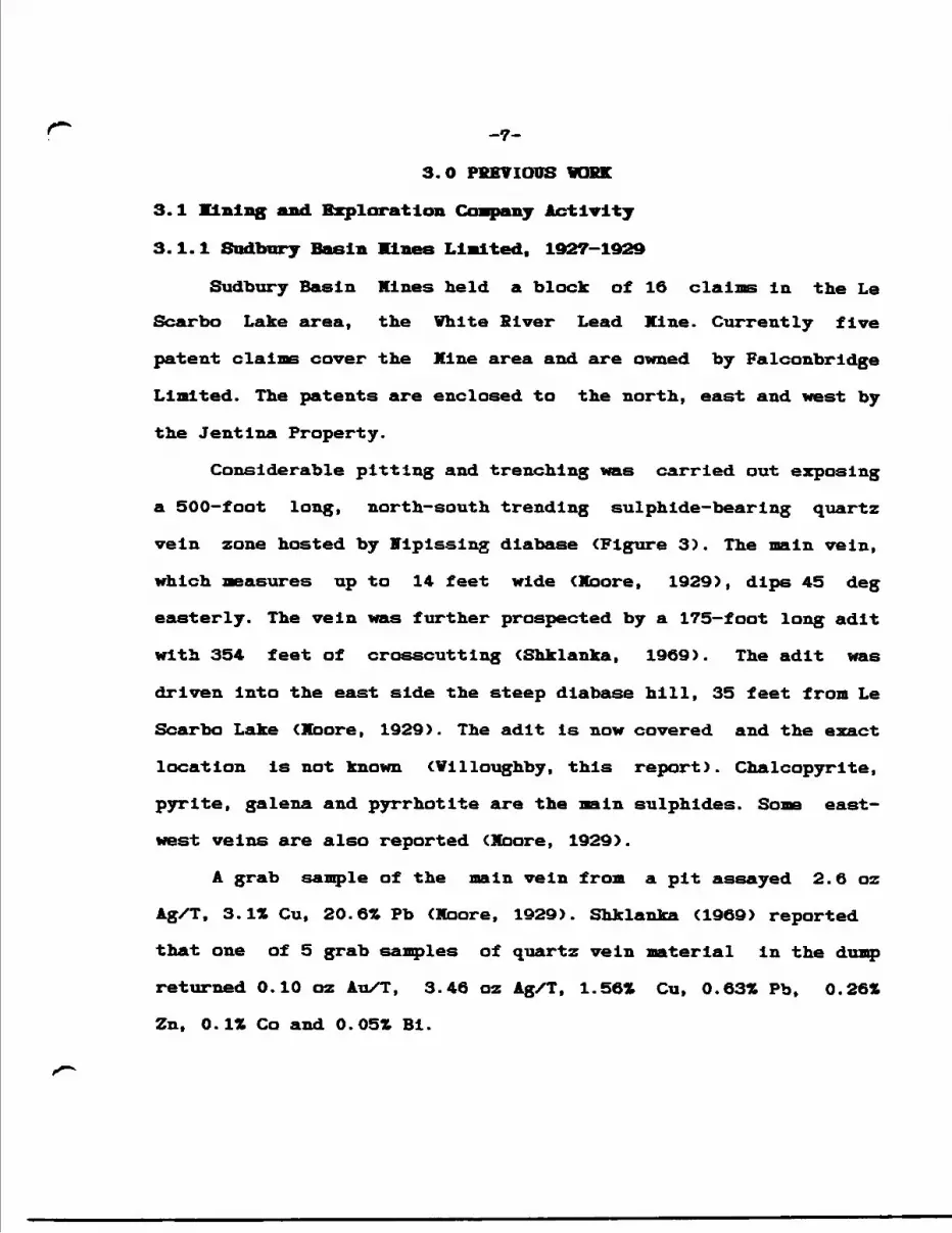
r -7-3.0 PREVIOUS 1GKK
3.l lining and. Exploration Company Activity
3.1.1 Sudbury Basin Mines Limited. 1927-1929
Sudbury Basin Mines held a block of 16 claims in the Le
Scarbo Lake area, the White Blver Lead Mine. Currently five
patent claims cover the Mine area and are owned by Falconbridge
Limited. The patents are enclosed to the north, east and west by
the Jentlna Property.
Considerable pitting and trenching was carried out exposing
a 500-foot long, north-south trending sulphide-bearing quartz
vein zone hosted by Nipissing diabase (Figure 3). The main vein,
which measures up to 14 feet wide < Moor e, 1929), dips 45 deg
easterly. The vein was further prospected by a 175—foot long adit
with 354 feet of crosscutting (Shklanka, 1969). The adit was
driven Into the east side the steep diabase hill, 35 feet from Le
Scarbo Lake (Moore, 1929). The adit is now covered and the exact
location is not known (Willoughby, this report). Chalcopyrite,
pyrite, galena and pyrrhotite are the main sulphides. Some east-
west veins are also reported (Moore, 1929).
A grab sample of the main vein from a pit assayed 2.6 oz
Ag/T, 3.1* Cu, 20.6* Pb (Moore, 1929). Shklanka (1969) reported
that one of 5 grab samples of quartz vein material in the dump
returned 0.10 oz Au/T, 3.46 oz Ag/T, 1.56* Cu, 0.63* Pb, 0.26*
Zn, 0.1* Co and 0.05* Bi.
V---'-- 2-- V V
v v
V
V
i w - - f .j -' * * v vp *J * v w * l |v
"5601
Scale. 20 Chajns-1 Inch
Figure 3: General geology and. ad.lt Blver Lead Mine (after
kinge at the Little White 1929)
3.1.2 A. H. Clark, 1956
Mr. Clark, a prospector, uncovered some copper
mineralization in a shear zone on a steep rock face north of and
overlooking the Little White River at a position approximately
1,000 feet west of the Highway 546 bailey bridge. This falls
within or close to the northwestern corner of Jentlna Block
1118612 (Figure 2, Map la). Siemiatkowska reports the
mineralization is contained in a horizontal, chloritlzed shear
zone trending 040 deg close to or within the trace of the
regional Flack Lake Fault and hosted by nipissing diabase (1978).
ffumerous quartz-carbonate -l-/- feldspar, epidote veins measure up
to l—foot wide and contain narrow fractures containing
chalcopyrite with some pyrite and specularite. Clark's sampling
returned 0.62ft Cu in a grab.
3.1.3 Picton Uranium lines Ltd., 1955-1968
The company carried out uranium exploration including
geological mapping and diamond drilling over central-east Albanel
Township covering the northern part of the Jentlna Main Claim
Block, north to Speckle Lake. A total of 1,629 ft. of drilling in
four holes were completed north of the Little White Biver. Three
of the holes (l to 3) apparently targeted Klsslssagi Formation
quartz pebble sandstone and conglomerate. Uranium assays were
low. Some diabase was intersected. Hole 4, a vertical hole
situated north of Speckle Lake, reported quartzite (Bar Blver
Formation?) and interbedded siltstone/arglllite. Some hematite
-10-
was noted in all of the holes, however no mention of sulphide
mineralization was made. Hole locations are shown on Map la.
Albanel. Summary logs are presented in Appendix A.
3.1.4 Brace-Presto Mines Ltd., 1964-1965
The company carried out geological mapping, IP surveying and
diamond drilling on a block of claims In Nicholas Township
located 300 feet south of a copper-cobalt showing on patent claim
87P. The Bruce-Presto group Is covered by the eastern part of the
Jentlna Main claim block. Apparently, the patent claims to the
north were also surveyed geophysically by Bruce-Presto.
The exploration work was directed by D.C. McEechnle, P.Eng.,
who also directed a program of trenching and drilling on the
patent claim in 1952. He described the showing as chalcopyrite-
cobalt arsenides in a westerly striking shear zone in a basic
Intrusive Nipissing diabase). The zone was traced over a length
of 500 feet. Mineralization varies in width from 9 to 25 feet and
grades of 2-3* copper and trace to 21t cobalt were returned.
Preliminary drilling (1952) showed that the mineralized zone dips
approximately 45 deg south and crosses onto the Bruce-Presto
ground ^e, Jentlna Property) at a depth of 350—400 feet.
The 1964 IP survey showed a weak conductive response over
the surface showing with much higher IP readings "over a
considerable distance to the west". The zone apparently strikes
north of west. Two drill holes south of the patent were
completed, and although assay results are not Indicated on the
-11-
drill logst Shklanka (1969) reports assays of O.70* Cu over 12.3
ft. and 1.962 Cu over 11.5 ft. Drill logs are summarized,
following:
Hole go.___Location______Bearing______Dip
5 claim SSX 68607 353 deg - 45 deg
Lithology Hineralization
O - 6.0' overburden6.0 — 22.0' calcareous siltstone
22.0 - 45.0' quartzite, bedded and nassive45.0 - 61.6' calcareous siltstone61.6 - 97.6' siltstone, argillite diss po, py at 84.0-97.6'97.6 - 99.5' quartzite99.5 - 174.5' greywacke minor po, py174.5 - 203.0' feldspathic quartzite
EOH
Hole lo. Location
6 claim SSK 69591
Lithology
Bearing
353 deg
Dip
- 45 deg
Mineral!:
O - 26.O' overburden26.0 — 40.0' quartzite40.0 - 137.0' greywacke, sheared and fractured137.0 - 193.0' greywacke, conglomerate193.0 - 383.0' greywacke cp seams at 325.0'383.0 - 404.0' chloritic shear in greywacke tr diss cp404.0 - 485.0' greywacke485.0 - 522.0* diabase
EOH
Vote that these holes did not intersect a mineralized shear
in diabase. There is no report accompanying the drill logs.
-12-
3.1.5 Canaalska Copper lines Ltd., 1965
Canamiska held a block of 42 claims covering Dobie Lake. The
northeastern portion of this block Is currently part of the
Jentlna Xain claim block (Map la). The company completed EX surveying (no report specifying method), soil geochemistry,
trenching and 4,653 feet of diamond drilling In 19 holes. A
compilation map showing exploration results Is given as Xap A.
Several EH conductors were delineated, the most significant
measuring approximately 9,600 feet ^.8 miles) long. Short soil
sample lines across the conductor returned anomalous copper-in-
solls values of up to 6,400 ppm.
Hine of the 19 drill holes were completed in the vicinity of
L32+OOB and returned significant copper values. Hole 65-11
returned an assay of 1.821 Cu over 7.5 ft. of drill core and
contains a 2.5-foot section grading 4.60* Cu. Other significant
intersections Include;
Hole l (L32+OOE, 15+10F); 0.1061 Co over 65.0* 9 110.0 - 175.O*0.2601 Cn over 7.5* C 150.0 - 157.5*
Hole 6 (L32+25E, 16+255); O.532* Cn over 25.0* 9 5.O - 30.O'2.00* Cn over 5.O* C 2O.O - 25.O*
Hole 7 (L32+25E, 16+25V); 1.441 Cn over 19.5* 9 17.5 - 3O.O*
Hole 9 (L31+75E, 16+30V); O.42* Cn over 12.5* 9 27.5 - 40.0*1.30X Cn over 2.5* 9 32.5 - 35.O*
The anomalous holes cover a strike length of 200 feet.
Geochemistry in this area returned a maximum value of 1,500
ppm and no drilling was carried out In the area of soil values In
excess of 6,000 ppm to the northeast which cover a strike length of 1,600 feet CXap A). Additionally, the coincident EX conductor
r- -is-is indicated to continue eastwards off the property. Hence, the
best part of the mineralized conductor is untested and is
apparently open to the east. This zone is on -the Jentlna claims.
Drill logs are absent from the assessment files and
orientation of strata and the mineralization may only be
surmmized from the drill sections on file. Some of the holes
apparently Intersected "greenstone" at depth, possibly Huronian
volcanics. Brief summaries of lithology and mineralization taken
from the drill sections are given in Appendix A.
3.1.6 Hanna lining Company, 1969
The company completed a 3,000-foot drill hole bearing 360
deg and with collar angle at -85 deg. Apparently part of a
uranium exploration project, the hole was located approximately
200 m east—northeast of the lo. l corner post of Jentlna Main
Group claim 1118612, north of the Little White River. The hole
intersected feldspathic quartzite to greywacke to a depth of
1,071 ft. Significantly, the remainder of the hole cut basalt,
perhaps of Archean or Aphebian age. Archean basalts are mapped
along the Little White River some 2 miles to the west, Huronian
Supergroup Dollyberry Lake Formatlorn basalts 1.5 miles to the
east (Robertson, 1969). An extensive zone of faulting was
intersected at 2,884 - 2,911 ft.; the Flack Lake Fault? Some
brecciation and shearing was also reported at 2,258 - 2,263 ft.
and plots in the vlcinty of the trace at the Little White River
-14-
Antlcllne. The log le summarized In Appendix A.
3.1.7 Paquette Claims, 1952-1965C?)
Siemiatkowska (1978) reported that two mineralized zones, a
ITorth and a South Zone, were discovered In 1952 on a 20 claim
block In the Triangle Lake area. Part of the Jentlna Triangle
Lake Group covers portions of these claims. In 1954, chip samples
across these zones assayed O.46* Cu over 3 ft. and O.08* Cu over
l ft. Some airborne geophysics was flown over the claim area In
1965. Apparently a 453-foot drill hole was completed (worker
unknown) and Intersected mainly arkose. Some minor copper
mineralization was found over a 1.3-foot width. The claim group
later became the Stanford Mines ground (Section 3.1.9).
3.1.8 Atlantic Klchfleld Co.. Triller Explorations Ltd.. 1967-68
These two uranium exploration companies held a large block
of claims in Albanel Township, probably covering most of the
Jentlna Main Claim Block. Geological mapping and surface
magnetometer surveying was carried out and was not reviewed by
the author. Two drill holes were completed; hole P-2, designated
A2 on Map la, Is situated Just north of the SE Trench (section
3.1.11 and 7.4.2). Hole P-4, shown as A4 on Map la, is located
north of Speckle Lake and close to Plcton Uranium Mines hole P4.
The holes were drilled vertically to depths of 4,587 and 2,962
feet respectively.
Hole P-4 apparently collared into diabase which ran to a
-15-
depth of 1,675 feet. This seems to contradict the drilling In
nearby Plcton Uranium Klnes hole P4 (1955) which did not
Intersect appreciable diabase. P-4 then Intersected argillite,
quartzite, arkosic quartzite and conglomerate. The hole hit thin
pyrltlc to cherty siltstone beds In an argillite unit at 1,687 -
2,350 ft. Unfortunately the drill log Is too generalized to offer
detailed structural and mineralogic Information.
Hole P-2 Intersected Interbedded argillite, chloritic
argillite, quartzite and limestone, probably of the Espanola
Formation to a depth of 4,082 ft. A section of diabase (sill)
occurs at 325 - 2,446 ft. The hole reportedly Intersected Archean
mafic-Intermediate volcanics at a depth of 4,082 ft. until the
end of the hole. Some highly sheared siltstone is also noted
within this Interval. Jo sulphide mineralization is reported.
The drill logs are summarized in Appendix A.
3.1.9 Stanford Mines Limited, 1971-1972
Blasting of a copper-stained scarp face located 300 ft.
northeast of the South Zone, Paquette Claims, (also referred to
as the Hamilton Claims and located on the current Triangle Lake
Group) uncovered a 4—6 foot wide shear zone measuring 55 ft. long
bearing 020 deg. The zone is hosted by a basic intrusive
(Stanford Xlnes, 1972) or Lorraine Formation sandstone
(Siemiatkowska, 1978). Several fractures within the shear
contained chalcopyrite filling. Disseminated chalcopyrite occurs
between fractures. Stanford reported grab sample assays of up to
-16-
7.45* Cu, 0.28 oz Ag/T in fracture-filling-type, and 1.6* Cu,
O. 15 oz Ag/T In disseminated-type mineralization. Siemiatkowska
(1978) reported quartz carbonate veining trending 265 deg
carrying chalcopyrite, malachite, azurite and specularite.
Siemiatkowska's grab samples assayed up to 15.6* Cu, 0.24* Zn,
0.36 oz Ag/T and 0.02 os Au/T. The east-west zone trends parallel
to the Bndakai Lake Fault (Map la).
Six drill holes were completed and two holes returned
anomalous copper and silver values. Hole 4 returned 0.27* Cu and
0.47 oz Ag/T over 11.0 ft. (containing a 1-foot Interval grading
1.12* Cu and 4.05 oz Ag/T) in volcanics (Nipissing Diabase?) and
hole 3 reported 0.94* Cu and 0.14 oz Ag/T over 2.2 ft. In diorite
(Nipissing Diabase?). The holes were drilled northwesterly to
intersect the 020 deg-bearing cuperlferous shear. Drill log
summaries are given In Appendix A.
3.1.10 Gowganda Silver Klnes Limited. 1972
Gowganda Silver Klnes held two large claim blocks at the
eastern end of the Jentina ground. The main Gowganda block
covered the northern part of the Jentina Main Claim Group and the
southern part of the Triangle Lake Group. A smaller claim group
covered the northeastern part of the Triangle Lake Group. The
Gowganda holdings are shown on ODK Map P.560 and indicates that
some diamond drilling may have been carried out. Other copper
occurrences, notably those on the historic Sanford Kines Property
and the patent and former patent claims at the east end of
-17-
Jentina Main Claim Block are also indicated on this map.
3.1.11 Fort Warman Explorations Incorporated, 1974-1975
The company held a block of 99 claims covering the eastern
part of the Jentlna Property, Main Block. An airborne geophysical
survey consisting of Mag, EM, radiometrlcs and resisltivity was
carried out by Barringer Research. Three areas of significant
copper mineralization were Investigated;
1) Extensive stripping, trenching and four diamond drill
holes totalling 633 ft. were carried out over the Jentina Main
Showing area (Vo. l Copper - Precious Metal Structure).
Siemiatkowska (1978) described the showing as a 100-foot long by
50-foot wide sulphide-bearing shear zone trending 065 deg and
dipping 65 deg south in silicified Espanola Formation limestone.
The shear is "rich in chlorite with minor brecciation." A 3—foot
wide zone of chlorite and magnetite-bearing limestone envelopes
the mineralization. Chalcopyrite, pyrite, malachite and azurite
were identified. The chalcopyrite occurs "as a replacement along
fractures and as massive blebs associated with quartz-carbonate
C veins/stringers] and chlorite." Siemiatkowska's three grab
samples assayed 5.352, 1.29* and 0.682 copper with traces of gold
and silver. One sample returned O.092 cobalt.
Surface plan maps of the trenches and stripped areas,
including drill hole locations are given in Figure 4.
C*46l '
-19-
The best drill Intersections are listed:
Hole 74-1: 0.99* Cu over 13 ft. at 53.0-68.0*and Included; 1.742 Cu, 0.11 oz Ag/T over 2.5 ft at 57.5-
60.0 ft. 1.35* Cu over 5.0 ft. at 63.0-68.0 ft.
* apparently a 1.9-foot section was missing In the Interval. Sludge sampling of this hole returned 1.36* Cu over 24.6 ft. at 51.0-75.6 ft.
Hole 74-2: 0.27* Cu over 3.5 ft. at 61.0-64.5 ft.
Hole 74-4: 0.52* Cu over 20 ft. at 102.5-122.5 ft. and Included; 0.70* Cu over 5.0 ft. at 109-114 ft.
Mr. Soy Rupert, the geologist on the project concluded that "the
mineralized zone....is a bedded structure interlaminated with
overlying beds and conformable with the strata " (1974), a
surprising conclusion after a review of his excellent drill logs
which provide details on lithology, structure and copper
mineralization. Copies of the logs are included as Appendix B.
2) A shear and breccia zone hosted by Gowganda Formation
conglomerate and sandstone was trenched close to the Albanel-
Vlcholas township boundary, central-east part of Jentina Block
1118696. According to Siemiatkowska, the 30-foot long trench
exposed a 10-foot wide, east-west striking quartz-carbonate vein
containing disseminated chalcopyrite and pyrite. A grab sample
assayed 2.6* copper (Siemiatkowska, 1978).
3) Some copper mineralization hosted by Espanola Formation
limestone occurs just north of Highway 546 along the Albanel-
fficholas township boundary. The 10-foot wide chlorite-epldote
shear zone trends 075 deg and dips 35 deg north and contains
-20-
narrow quartz-carbonate stringers with minor pyrite,
chalcopyrite, malachite and azurite. Siemiatkowska shows a trench
in the area (OGS Map 2399). The zone lies between the
northeastern part of Jentina Main Block and southwestern part of
the Triangle Lake Block.
3.1.12 Charles X. Mortimer. 1984
Mr. Mortimer drilled one 175-foot drill hole bearing
northeasterly near the northerly-flowing creek at the Albanel-
Micholas township boundary, now on Jentlna claim 1197740
(formerly patent claim 89P). The hole reported intersected quartz
stringers in greenstone (diabase?). to analytical results, if
any, were given.
3.1.13 International Mine Services Ltd.. 1986
This company, on behalf of A.J. Roy, carried out line-
cutting, VLF-EM surveying and reconnaissance geological mapping
on a block of 17 claims more-or-less the equivalent area to
Jentlna Block 1118612 and which includes the Main Showing. The EM
survey failed to clearly Identify the sulphide zone over the Main
Showing. Some sampling of the Main Showing was also carried out.
3.1.14 United Reef Petroleums Limited. 1988
URP optioned the A. J. Roy 17 claims and carried out
geological mapping, prospecting, magnetometer and soil
geochemical surveying using the existing 1986 grid for control.
-21-The survey provided an outcrop—geology nap with good
llthologlcal descriptions. The southern part of the property Is covered by Nipissing diabase which shows some textural zoning and differentiation.
Adjoining the diabase to the north Espanola Formation limestone/dolomite and siltstone Is napped. Soil geochemistry over this part of the property generally returned elevated copper and zinc values compared to other underlying lithologies. Mumerous rock samples also contain anomalous copper and zinc values. Although the geochemistry may imply skarn-style possibilities related to the diabase, rock samples are described as sulphide and malachite-bearing quartz-carbonate stringers / veins within limestone/slltstone with the best concentrations in a linear structural zone (the lo. l Copper-Precious Metal Structure, 1994) on-strlke with the Main Showing. The geochemical and quartz stringer zone measures approximately 3,400 feet long.
Several Cu, Au and Ag soil values were also found over Mlssissagl Formation lithologies north of the Llttel White River.
Marrow lead, zinc and gold soil geochem zones were detected In the diabase and are oriented oblique to the intrusive trend and local stratigraphy, probably delineating fault structures. Significantly, some prospecting south of the property encountered sulphide-rich quartz veins hosted by diabase. Grab samples assayed up to 1.3961 Pb, O.6581 Cu and 1,889 ppb Au (samples 4008-4011). Unfortunately, the location of these samples are not known and were not found during the 1994 project. The sample
-22-
descrlptions resemble those from the Vhlte River Lead Mine
(section 3.1.1).
Channel sampling of the Main Showing came up with 5.35*
copper over 23 ft. from the main pit (Pit 1); this sample
interval contained a 13—foot section which assayed 8.981 copper
and O.020 oz gold/ton. A pit situated 10-20 feet to the east of
Pit l returned a channel sample value of 0.8421 copper over 6.6
feet.
Sock sample descriptions and assay results of anomalous
samples from 1988 are given in Appendix C. Most of the samples
are indicated on Map l, HV Sheet, Geology and Mineralized
Structures.
The magnetic survey shows sparse contrast, perhaps a
function of wide line spacing (400 feet) rather than lack of
variation In magnetic signature across the property.
3.2 Academic and Government Studies
3.2.1 Paul Schecrer, University of Wisconsin, 1956
Mr. Scheerer carried out geological mapping at a scale of
4" sl mile in the Albanel-Vicolas townships area. The study
outlined the geological units In the Jentlna Mine property area
and identified a substantial fault structure along the northern
ridge of the Little Vhite River valley. Part of this structure
may be a portion of the Flack Lake Fault.
-23-
3.2.2 J.W. Gash and T.A. Vogel, University of Wisconsin, 1959
These two researchers napped approximately the sane area as
Scheerer. An east-west antiformal structure was mapped across the
northern part of the current Jentlna Main Claim Block in Bruce
(Espanola?) Formation limestone. A northeasterly anticlinal-
synclinal pair is noted within Gowganda Formation sediments Just
north of Le Scarbo Lake.
3.2.3 Provincial Government Surveys
Geological surveying of Vicholas Township was carried out by
the Ontario Division of Xlnes in 1969 at a scale of 1:31,680, ODK
Map 2347 (Robertson, 1969). The mapping also Included Raimbault
Township which adjoins nicholas to the east. There Is no
accompanying report. Albanel Township was mapped at the same
scale in 1974 by K. X. Siemiatkowska and Includes west adjacent
township Varley (OGS Map 2399). OGS Report 178, "Geology of the
Endikai Lake Area", 1978, accompanies the maps.
3.2.4 Federal Government Surveys
The Jentlna property areas are covered by l" = l mile
Geological Survey of Canada aeromagnetic maps Flack Lake — Map
2241 G and Wakomata Lake - Map 2227G (1962-1963). The survey
shows a prominent circular magnetic low feature over the Main
Showing area on the Jentina Property. The magnetic data was later
digitized by the OGS in 1993. Figure 5 Is an MR&J computer
printout of the digitized data covering the Jentlna claims.
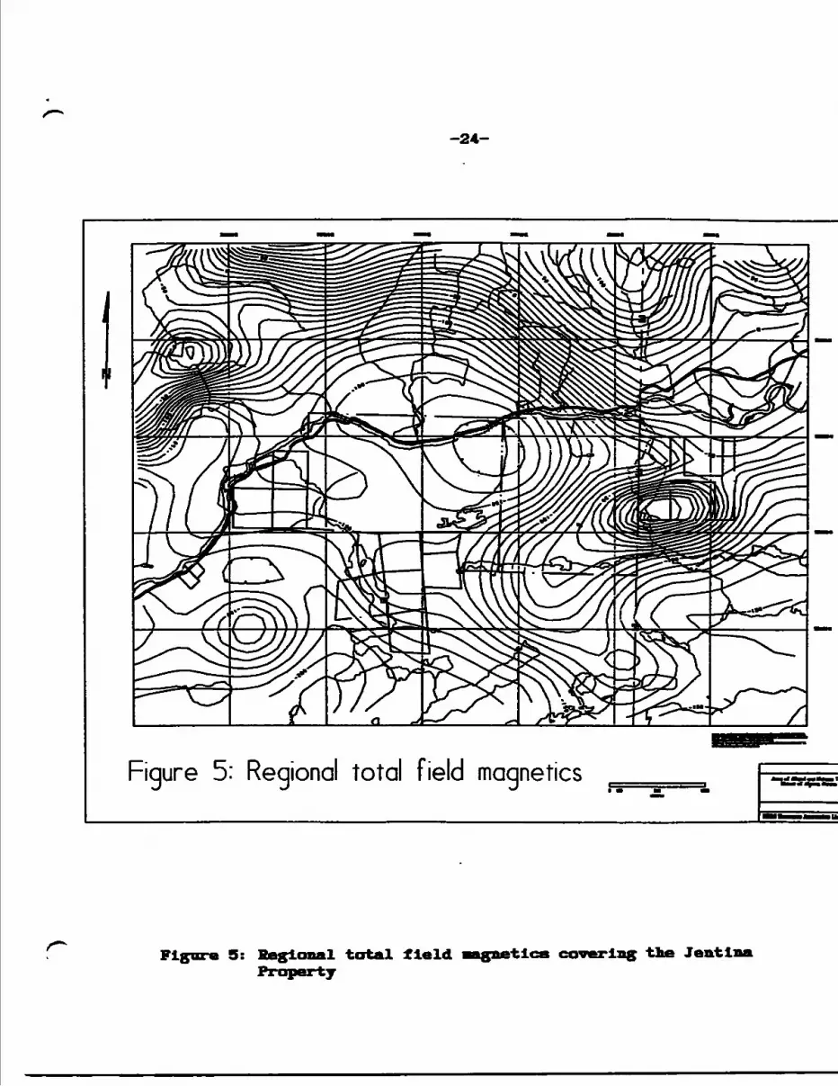
-24-
Figure 5: Regional total field magnetics
Figure 5: Regional total field •agnetics covering tie Jentli
-24A-
Results of a regional lake geochemical survey was published
by the GSC In 1987. An anomalous copper value of 980 ppm is
reported from Triangle Lake. Significantly, the trace of the
east-west striking Endakal Lake Fault crosses the lake OCap Ib).
-25-
4.0 KHGIOWAL GEOLOGY AID XIIEBALIZATIOI
4.1 Geological and Structural Framework
The Jentina Mine Property is located at the north-central
part of the Huronian "Basin" of Proterozoic-aged Huronian Group
of mainly fluvial, in part glacial, clastic sediments and basal
tholeiitic to alkaline volcanics (Roscoe and Card, 1992, Bennett
et al, 1991) (Figures 6 47). The region of Huronian
sedimentation, extending 145 miles from Just east of Sudbury to
Sault Ste. Marie to the west is designated the Southern
Structural Province.
The Basin is considered to have been a passive rift during
Archean times, activated circa 2.4 Ga with the uplift of
surrounding Archean blocks, contemporaneous extrusion of volcanic
rocks and subsequent deposition of the Hough Lake, Quirke Lake
and Cobalt groups circa 2.45 - 2.2 Ga (Bennett et al, 1991).
Provenance of the sedimentary material is indicated to be from
the northwest (Bennett et al, 1991, Roscoe and Card, 1992)).
The essentially east-west curvilinear Flack Lake - Endikai
Lake Fault System, which crosses the northern part of the Jentina
claims, defines the unconformity of Huronian sediments to the
south with Archean volcanics, granites and mlgnatltes to the
north. The Flack Lake Fault, traced over a distance of 150 Km
(Siemiatkowska, 1978), is considered to be a reverse thrust
fault, probably a prior, Archean—aged normal fault, which was
reactivated during the Penokean Orogeny circa 1.8 Ga (Bennett et
al, 1991 and Fyon et al, 1992), probably not unlike other
rtU
iC p
lUlM
*
BM
ioic
r*
lil*
plu
ton
MkU
wM
irM
pliiln
g
flu
lrkt
Uk*,
Mou
th U
tf,
Illlw
Uk*
Oio
ufii
imw
vo
lcu
lii!
k
kra
-iM
rlh
nli
* Im
ruilo
ni
Ut*
ff
MU
t
C*l
ly I
MlM
U* (M
ill
IMiU
till
Mtt
MlO
MllO
, H
ltllM
MM
I
Fig.
2.
Geo
logy
and
min
eral
dep
osits
of
ihe
north
sho
re o
f la
ke H
uron
reg
ion.
CC
-Cr
oker
Com
plex
; fl
l 'Bm
Coba
lt-W
anap
ilci
Bell;
fiF
7'Zn
Gre
nvill
c Fr
om T
ecio
nic
Zone
; LC
iCm
Leva
ck G
neis
s Co
mpl
ex;
AlfZ
mM
urra
y Fa
ult
Zone
; MID
* M
anito
ulin
Isla
nd D
isco
ntui
iy;
Oh'
mO
ntpi
ns F
aults
;-Vi't
f-Sud
bury
-Esp
unol
a Be
ll; l
lV/tf
-Wei
icrn
Hur
onia
n Be
ll.
t* l •3 • l
(B
(P
O
-H irs it i i !a
H
l
s v\n
\\7 f r
f Jlir fi*
l a
S5
f!
-28-
lum rift
MdCm l Rift crus?
Fy.:g Cocctt Group
l |Qurt* LfiM Group
Cntk Usmc normal
Figure 8: Schematic diagram Illustrating the paleotectonic aodel proposed for the feu nation and deformation of the Huronian Basin (after Bennett et al. 1991)
-29-
regianal Archean boundary faults, for example the Cadillac Break
in Quebec. The Cadillac Tectonic Zone separates Early and Kiddle
Archean supracrustals from Late Archean basinal sediments, the
Timiskaming Group ( Hubert et al, 1984, Gauthier et al, 1990,
Villoughby, 1993). A continental-arc collision
mechanism Is envisioned to have been operative during Penokean
deformation by many researchers (Figure 8) (Bennett et al, 1991).
Locally, the Flack Lake Fault has produced considerable ductile
shearing and brittle deformation of host rocks with attendent
brecciation and quartz veining (Anthony and Villoughby, 1988).
Numerous northeasterly and northwesterly faults are also
delineated and as a reponse to various degrees of movement along
all faults a series of fault-bounded rotated blocks were formed.
Many llthologlcal contacts may in fact be tectonic (Villoughby,
this study).
The Penokean deformation features (folding, faulting)
affected both Archean and Huronian rocks and Indicates general
north-south compression and may be part of the postulated Great
Lakes Tectonic Zone stretching from Sudbury west to Minnesota
(Bennett et al, 1991).
Intrusion of Vipissing diabase and gabbro sills are dated at
approximately 2.2 Ga, prior to the main deformation event. These
intrusive bodies occur as undulating sheets and/or funnel—shaped
bodies intruding both the Archean basement and the Hurionlan
sequences.
A tectonic chronology and timing of metallogenic events,
-29A-
irlzed by Fyon et al ^992) is given as Figure 9.
The geology In the area of the Jentina Property la given In
Haps la, Albanel Twp and Ib, Nicholas Twp. A local table of
formations is listed, Table 1.
'!3
aiitl
332393333
• ••l ill li
—
m
1 M
'
i \
jjiii 1,1
111 liii it liijif.
i81
j ——
— i.
nalH
I '
1——
40.—
J
iii liiiiiil Ih
M.,
1——
1 II
- --
I-H
t——
a
iii iii-Xli-4
*-
'
J——
1
li1 li!ii
a
11t
fifH
H•H
4*
|Is3
C
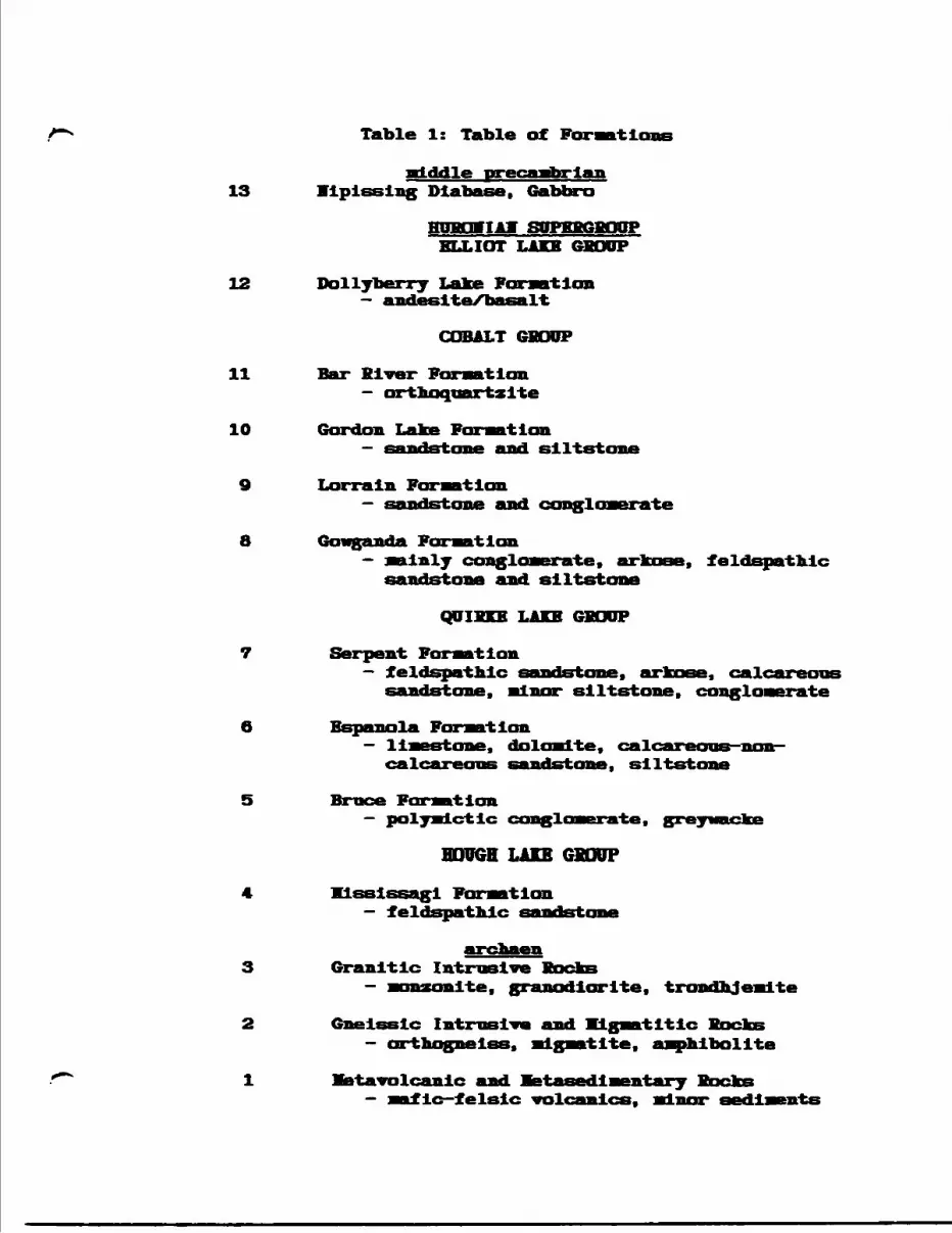
Table 1: Table of For aa 11
attddle precanibrian 13 Vlplsslng Diabase, Gabbro
ELLIOT LAKE GHOUP
12 Dollyberry Lake F- andeslte/basalt
COBALT 6BOUP
11 Bar River Formation — orthoquartzite
10 Gordon Lake Formationand si l t st
Lorrain ForvatIonconglomerate
8 Gowganda Formation— mainly conglomerate, arkose, feldspathic sandstone and siltstone
QUIHKE LAKE GSODP
7 Serpent Formation— feldspathic sandstone, arkose, calcareous
sandstone, minor siltstone, conglomerate
la Fomntlon- limestone, dolomite, calcareans- calcareaaB sandstone, siltstone
Broce For matIon Le
BOUGH LAKE GBODPKlsslssagl Foraatlon
— feldspatnlc sandstone
Granitic Intrusive Bocks- nonzonlte, granodiorite, trondnjealte
Gneissic Intrusive and KLgaatltlc- orthognelss, ndgnwtlte, amphibolite
rtavolcanlc and netasedlaentaryTlc—felsic volcanics, minor sediments
-32-
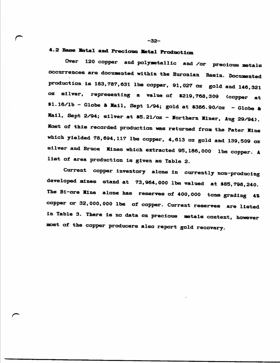
4.2 Base Mietal and Precious Setal Production
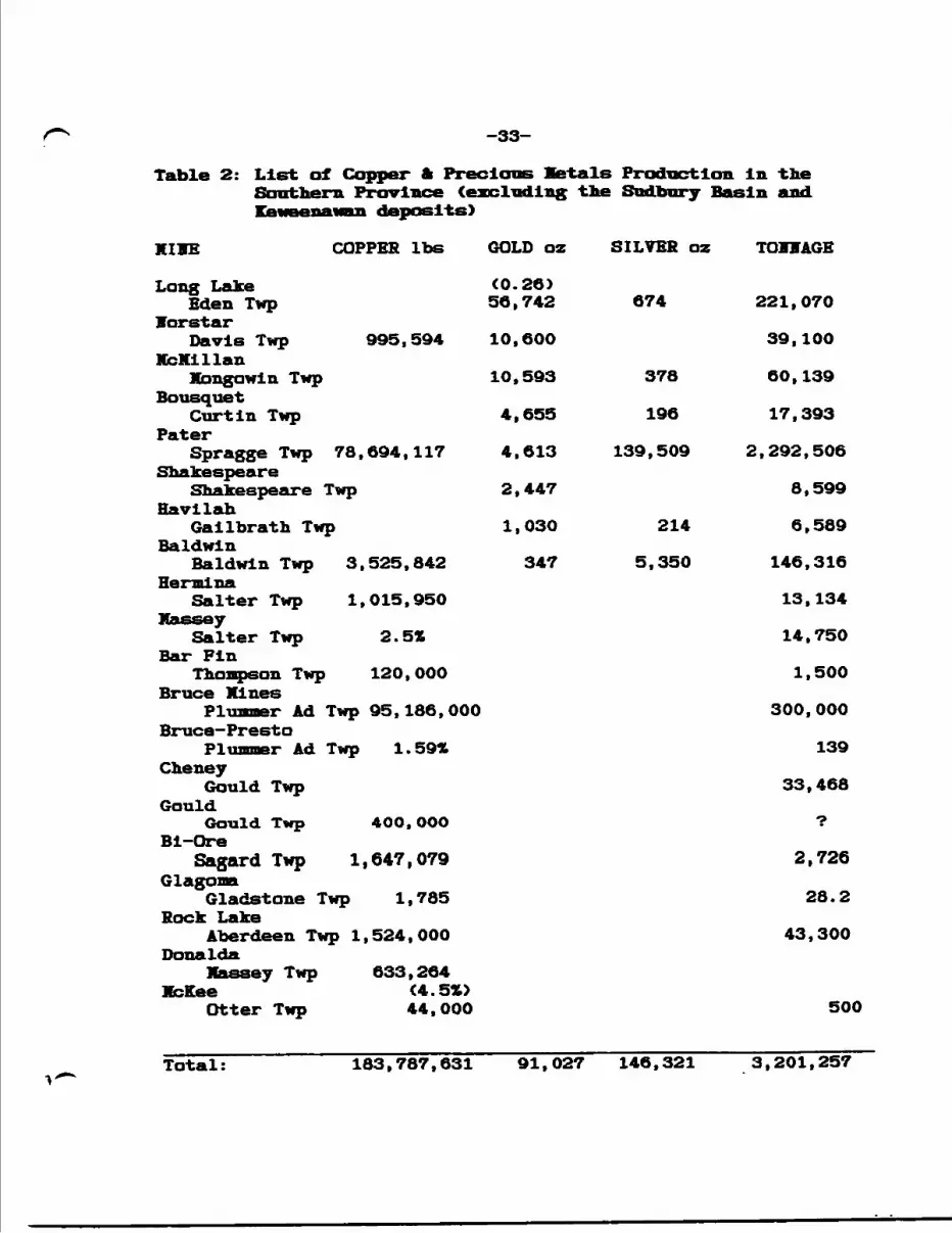
Over 120 copper and polymetallic and /or precious metals occurrences are docuaented within the Huronian Basin. Documented production is 183,787,631 Ibs copper, 91,027 oz gold and 146,321 oz silver, representing a value of S219,768,309 (copper at S1.16/1b - Globe A Mail, Sept 1/94; gold at 3386.90/oz - Globe ft Mail, Sept 2/94; silver at 35.21/oz - Northern Miner, Aug 29/94). Most of this recorded production was returned from the Pater Mine which yielded 78,694,117 Ibs copper, 4,613 oz gold and 139,509 oz silver and Bruce Mines which extracted 95,186,000 Ibs copper. A list of area production is given as Table 2.
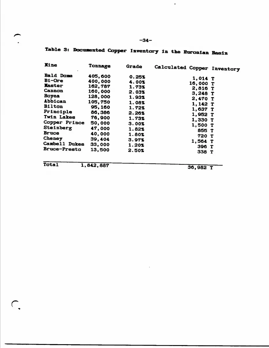
Current copper Inventory alone in currently non-producing developed mines stand at 73,964,000 Ibs valued at 885,798,240. The Bi-ore Mine alone has reserves of 400,000 tons grading 4Z copper or 32,000,000 Ibs of copper. Current reserves are listed in Table 3. There is no data on precious metals content, however
st of the copper producers also report gold recovery.
-33-
iaDJ.e A \ ijisi ox trapper m rreciouB Jtei.aj.s n-oancxion in XJie Southern Province (excluding tie Sudbury Basin and Keweenawan deposits)
KIBE COPPER Ibs
Long Lake Eden Twp
VorstarDavis Twp
KcKlllanKongo win Twp
Bousquet Curtin Twp
PaterSpragge Twp 78,
Shakespeare Shakespeare Twp
HavilahGailbrath Twp
BaldwinBaldwin Twp 3,
HermlnaSalter Twp 1,
Massey Salter Twp
Bar FinThompson Twp
Bruce XinesPlummer Ad Twp
Bruce-PrestoPlummer Ad Twp
Cheney Gould Twp
GouldGould Twp
Bi-OreSagard Twp 1,
Glagona Gladstone Twp
Rock LakeAberdeen Twp 1,
Dona IdaXaasey Twp
XcKeeOtter Twp
995,594
694,117
525,842
015,950
2.5*
120,000
95,186,000
1.59%
400, OOO
647,079
1,785
524,000
633,264 (4.51)44,000
GOLD oz
(0.26) 56,742
10,600
10,593
4,655
4.613
2,447
1,030
347
SILVER oz TOHVAGE
674 221,070
39,100
378 60,139
196 17,393
139,509 2,292,506
8,599
214 6,589
5,350 146,316
13.134
14,750
1,500
300, 000
139
33,468
7
2,726
28.2
43,300
500
Total: 183.787,631 91,027 146,321 3,201,257
-34-
Table 3: Documented Copper Inventory in the Huronian Basin
Mine Tonnage Grade Calculated Copper InventoryBald Done 405,600 0.25* 1,014 TBi-Ore 400,000 4.00* 16,000 TMaster 162,787 1.73* 2,816 TCannon 160,000 2.03* 3,248 TBoyea 128,000 1.93* 2,470 TAbbican 105,750 1.08* 1,142 TBilton 95,160 1.72* 1,637 TPrinciple 86,386 2.26* 1,952 TTwin Lakes 76,900 1.73* 1,330 TCopper Prince 50,000 3.00* 1,500 TStelnberg 47,000 1.82* 855 TBruce 40,000 1.80* 720 TCheney 39,404 3.97* 1,564 TCambell Dukes 33,000 1.20* 396 TBruce-Presto 13,500 2.50* 338 T
Total——————1,842,887 36,982 T——
r
-35-
4.3 Mineral Deposits
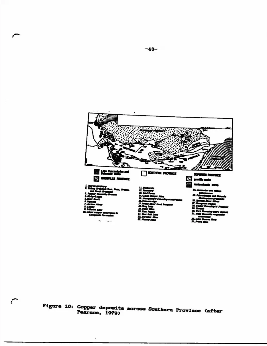
Earlier reseachers, notably Pearson (1978, 1979) and Innes and Colvine (1990), have Identified and classified the various styles and patterns of base and precious metal occurrences of the Huronian Basin. Pearson studied specifically copper metallogeny of the Huronian, however many of the copper deposits contain other base metals and precious metals and are probably best described as polymetallic (Table 4, Figures 6 ft 10-12).
Review of various literature providing deposit descriptions and some property visits by FR4J personnel over the past 6 years, indicate that most deposits in the region are structurally controlled, sulphide-bearing quartz vein or breccia/alteration zones (chlorite, silica, carbonate, albite), or mineralizaed breccia pipes. Most contain significant magnetite, hematite and specularite. Pearson's classification, aside from "veins", apparently relies on host rock type such that mineralized veins in Huronian volcanics are VMS deposits, those in Lorrain - Gordan Lake Formation sandstones are SEDEX deposits, deposits hosted by Espanola Formation limestone close to diabase are skarn deposits, etc. Brief descriptlions of selected deposits are given by way of illustration.
The Pater Hine consisted of two, 1,000-foot long by 7-foot wide ore shoots in a shear zone hosted by schistose Huronain metasedlments and metavolcanlcs. The deposit was delineated to a depth of 4,000 feet. Mineralization consisted of chalcopyrite, pyrrhotite and pyrite in brecciated quartz veins. Copper grades
-36-
averaged 2. Q71L. The shear structure runs oblique to the Hurray
Fault. The deposit is probably not VMS-style.
Auriferous, arsenopyrite—rich quartz veins at HcXlllan are
localized along a drag fold within Gowganda Fornation quartzite
at the contact with nipissing diabase. The main vein measured 25
feet wide over a strike length of 300 feet to a depth of 325
feet. The style of mineralization is considered typical of the Au
+S- Cu -bearing vein catagory. Gold grades averaging 0.18 oz Au/T
were mined. The main vein measured 30O feet long by 25 feet wide
to the 325-foot level.
At Bi—Ore, average grade of ore milled was 4.0* copper. The
deposit Is described as a series of fissure veins lying along
faults in host cherty quartzite. A property visit by IB&J in 1993
found chalcopyrite mineralization In albitlzed material.
Both the Scadding and Long Lake mines are mineralized
breccia pipes. The Long Lake body measures 250 feet long by 250
feet wide, plunging steeply southeasterly to a depth of 340 feet.
Mineralogy consisted of pyrite, arsenopyrite, pyrrhotite,
chalcopyrite and galena. Mill-head grade at Scadding was
reported as O.159 oz Au/T.
Although some skarn—type deposits occur in the region may be
related to nipissing intrusion (2.2 Ga), most vein-type deposits
post-date intrusion at 1.8 Ga, probably hydrothermally /
epithermally generated during Penokean Orogeny (Fyon et al,
1992). The Vo. l Copper-Precious Metal Structure on the Jentlna
Property, although hosted by Espanola Formation limestone/
r-37-
siltstone close to diabase, snows no contact metasomatic features. A description of the Foster occurrence by Pearson (1979) reports tungstun, molybdenum, copper, zinc and silver in idocrase dlopslde-garnet skarn In Espanola Formation rocks, adjacent to a diabase sill.
Both Pearson (1979) and Chandler (1984) report on possible red bed copper mineralization at Stag Lake and Cobre Lake, 20 miles east of the Jentlna Property. The mineralization consists of disseminated chalcopyrite and pyrite localized along the contact of Lorrain Formation arenite with Gordon Lake Formation mudstone/sandstone. Vo significant copper concentrations are as yet reported, however the contact is mapped over a length of 3.2 Em. Currently, the Ontario Geological Survey is investigating red bed copper potential of this area (Hike Hailstone, Assisstent Regional Geologist, Sault Ste. Marie,; personel communication, July, 1994).
Ho significant Vi Cu mineralization Is reported in the central and western part of Southern Province.
The Coppercorp and Tribag deposits (Hellkean-age) at Mamainse Point, north of Sault Ste Marie, catagorlzed as porphyry by Pearson, are generally considered to be breccia pipe mineralization Clorman and Sawkins, 1985 and Richards and Spooner, 1989). Some breccia-like orebodles are recognized In the Huronian, eg Long Lake.
Many of the vein and breccia-type deposits are accompanied by soda metasomatism or albitization (including Jentlna). Fyon et
-38-
al (1992) describe the nature of albite alteration, quoting
various sources, notably VIIf Meyer of the Ontario Geological
Survey: "the alteration is manifested by veins, dike-like zones,
stratabound, areally extensive massive zones and zones of
brecciated, altered rock". At some gold deposits, eg Scadding,
albite is commonly replaced by carbonate and later quartz-
chlorlte. Commonly associated with Sudbury Breccia and Sudbury
area Huronian rocks, albitization is dated to 1.7 Ga (Schandl,
1992 and Fyon et al, 1992), implying that at least the Au-Cu vein
association is younger than the formation of polymetallic veins
(1.8 Ga, deposited during the Penokean Orogeny, Figure 9).
Schandl points out that the presence of albite may relate to
"deep—seated plutonism and faulting". Perhaps the presence of
albite is a necessary signature of polymetallic deposits rich in
gold.
As yet, no Archean—style lode gold deposits have been
discovered, however the tectonic setting of the regional Flack
Lake Fault Zone bears some similarity to the Larder Lake—Cadillac
Tectonic Zone, Abitibi Belt, which historically hosts numerous
commercial gold deposits (Gauthier et al, 1990, Willoughby,
1993).
-39-
Table 4: Classification of Copper Deposits for tile Huronian. Basin (after Pearson. 1978. 1979)
Yein—type:
dialcopyrite—pyrite-specnlarlte veins;Crownbridge, Bl-Ore mil
b. polymetallic - Zn— Pb-Ag-Cn; Jardnn- Pb-Ag-Cu; Prace- Cn Cbornlte—cnalcocite— native copper;
Co- Cu-Co- (Bi-U-Mi); Bnrdon Lake
An- (Cn)— bearing veins; Shakespeare, XcKlllan
2. Contact MetaeoMatic (Skarn)—type:— Cobden Kiver, Desbarats Lake. Foster
3. Cu-Wi in mafle—nltravfic intrusions
4. SEDBZ- Stag Lake
5. VBS and stringer- Pater
O*— Tribag, Jorgan (Xeweenawan)
-40-
Flgnre 10: Copper deposits at Pearson. 1979)
Southern Province Cafter
-41-
*——~H• d* BM
Figure 11: Gold and polymetallic m± lin Cafter Fyon et al.
il depo8l*ts In the Huronian 1992)
ra H- tt
l L 5!o H m H
tr H-
"
4
l!
Jla l
l (O
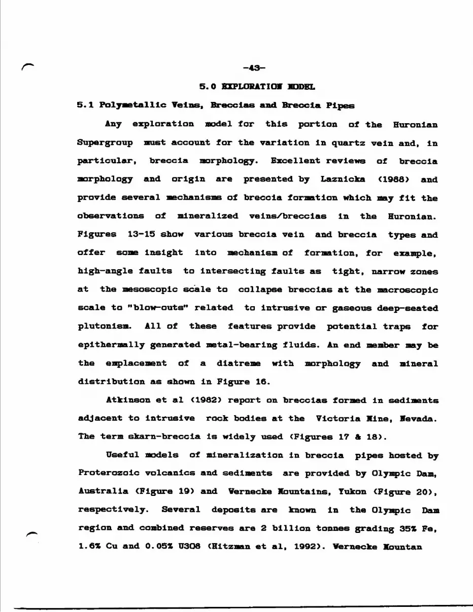
r* -43-5. O EZPLOHATIOV MODEL
5.l Polymetallic Veins, Breccias and Breccia Pipes
Any exploration model for this portion of the Huronian
Supergroup must account for the variation In quartz vein and, In
particular, breccia morphology. Excellent reviews of breccia
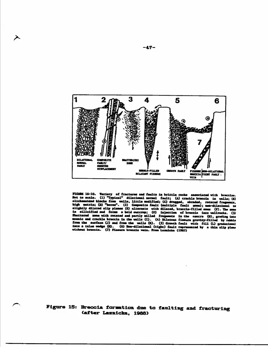
morphology and origin are presented by Laznlcka ^988) and
provide several mechanisms of breccia formation Which may fit the
observations of mineralized veins/breccias In the Huronian.
Figures 13-15 show various breccia vein and breccia types and
offer some Insight Into mechanism of formation, for example,
high—angle faults to Intersecting faults as tight, narrow zones
at the mesoscopic scale to collapse breccias at the macroscopic
scale to "blow-outs" related to Intrusive or gaseous deep—seated
plutonism. All of these features provide potential traps for
epithermally generated metal-bearing fluids. An end member may be
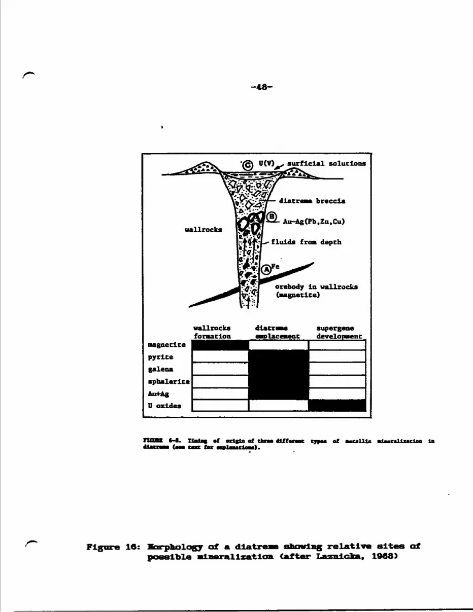
the emplacement of a diatreme with morphology and mineral
distribution as shown in Figure 16.
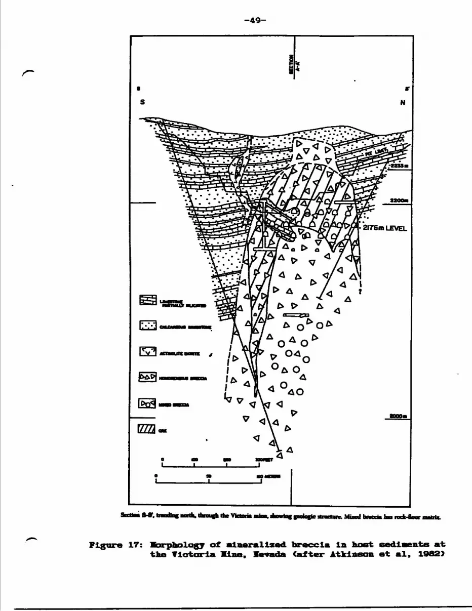
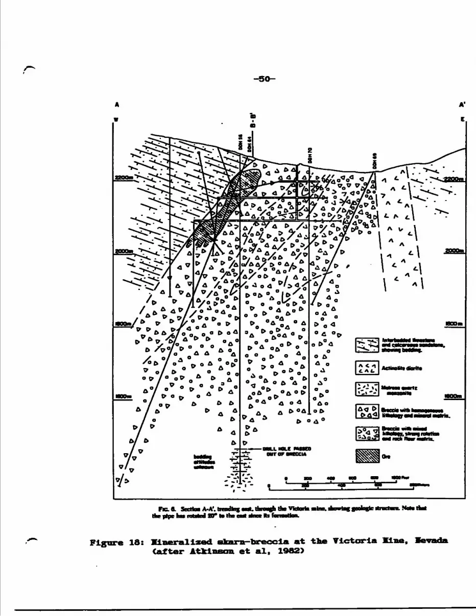
Atkinson et al (1982) report on breccias formed in sediments
adjacent to intrusive rock bodies at the Victoria Mine, Mevada.
The term skarn-breccia is widely used (Figures 17 A 18).
Useful models of mineralization in breccia pipes hosted by
Proterozoic volcanics and sediments are provided by Olympic Dam,
Australia (Figure 19) and Vernecke Mountains, Yukon (Figure 20),
respectively. Several deposits are known in the Olympic Dam
region and combined reserves are 2 billion tonnes grading 35* Fe,
1.6* Cu and 0.05* U3O8 (Hitzman et al, 1992). Vernecke Mbuntan
-44-breccias host l million tonnes containing 297* Fe plus 500,000 tonnes of 0.571 Cu (Hitzman et al, 1992).
Hltzman et al suggest that this style of deposit Is "a distinct class of ore deposit characterized by low-titanium, iron-rich rocks formed in extensional tectonic environments", for example, at continental margins and subduction zones (Figure 21). Such a geological environment has been postulated for the Southern Province (Bennett et al, 1992).
Given the current state of knowledge of Huronian Supergroup mineralization, this style of mineralization is considered the main target for economic mineralization at this time.
C996I 'vatofuxf^
x r C -* v v~W/ -'--^^'^w-v/i^4-;"J5- - f - i v
-9*-
-46-
16-16. tiaaalM *f (early Tertiary Pb-Zn-A*J Crm tbm•t al. (1908). (1) Irootbergtraaelclm becvem a wo* of Datcad: el^ |oaM M!*M*- (2)•awcBut; b-eaab qnarcz border MM; e-pyrtt*;•llleiflcd gmlM riBialil lin tb*
. by Fmraavtc
Colorado Froat ai graaita aad
Vela.
grmiUe (*)
ta bneelatloa d•phalarlt*; ,
(3) TmUcmn Vt&n. aptalwit*Co braeeliccd almklta putpUyrj dike Chat latrudiJ mltmrmt fUa. mbaUrlO f mint Ing fmlc rabble la gmiM. (3) or a mbalnlta vvia (dark), bneetctlon of tb* loot •luklto •C Cnffamto by otdorito (dot*). (6) ••rrlna lodo (apmluit*. dark), faulead. braeclaud md eat by a ynnaaar vyrlto mia. (7) Tola (aphalarlta. pyrite, ealeaa)
16-12. Imlc eattlag laterbaddad breccia only vhm It la
(ItSO). •rerbmrldga. Colarado.dllatea aad fill*
Crm Ltmrlat aad
Figure 14: Fault breccia developaen-t governed by rock (after Laznlcka, 1968)
•ney
-47-
veu
16-10. Variety of fraecuna aad faolta ia brittle rocka aaaoeiacod wich breccia*, •ac to acale. (1) "Typical' dllattnual oonal fault; (A) crackle breccia ia valla; U) friorf.- f COB valla, little -~"*l'rJ; (CI drafted, abraded, rotated fraaucau. (D) "borae". (2) Caapoalte fault (Multiple fault cone); aatt-dUacioaal to jn\*rmQ allp plaoaa (E) alternate with dilated, breccia-filled oaoe (F). The no* la ailiciflad and fane e bold outcrop; (G) Injection of breccia into vallncka. (1) ne* uich rotated aad partly allied fraceenta ia the centre (H), gradlnc lato crackle breed* la the valla (I). (4) Ulecaat flaaure gravity-filled by rubble U) and froB the valla (K). 15) Crouch fault with fill (L) andatleaal OD. (6) MB-diUciaaal flight) fault represented by e thin allp plea* (7) fleeure breccia vela. Tram l-arairka CI9V7}
Figure 15: Breccia 11 (after L rlcka.
doe to faulting and. fractiirlng 1988)
-48-
'fS\ U(V) . surficial solutions
wallrocks formation
Au-Ag(Pb.Za.Cu)
fluids from depth
orebody la wallrocks (magnetite)
supergene development
nCDBE ft-*. TlBlat oC orltln of tbm *Lfh 'tor cjpoa of Mcallle Blaar&lluclao la
Figure 16: Karphalagy of a diatreme sbowlng relative sites of possible Mineralization Cafter Laznlcfca. 1988)
-49-
Figure 17: Morphology of mineral ized breccia in host sedlaents at the Victoria Mine, levada (after Atkinson et al. 1982)
-50-
A'
E
Frc.1 Sectta A-AM Ae pipe hat rotated 30T to the e-Jt i
Figure 18: Klaerallzed (after Atkl
•tt-breccla at the Victoria Mine, et al. 1982)
-51-
Boct-ore
1km. t
OLYMPIC DAM BRECCIA COMPLEXSignificant occunenoes of hehsuliiic granitic
breccias hxally with hematite-rich matrix
Caiidner dikes and Beda volcanics - dolerite and mafic volcanic racks Panduia Formation - nad beds Gawlernnge volcanic rocksHil
Lincoln Complex : defanned granitoids: syntectonic (Kiinban)
Figure 19: Schematic diagram of the form and structure of the Olympic Dam and Acropolis deposits, Australia after Hltzman et al, 1991)
-52-
POTASSIC/ SERICITIC ALTERATIONi i DKBchcd md fractured 1——'rock
^3-Skarn'
•l Hematite g|3| Caibonate-diJorite- ^^^ (magnetiteMhematite) E7TS Sericile-ehlorite-
SODIC ALTERATION CJ Magnetite
Albile-scriciteH urtite
l ABrite-Onagnetite)
20: Schematic diagram showing for; of the sedimentary-hasted deposits (after Hitzaan et al.
and alteration featiXbnntain—type Cu-Fe
1992)
-53-
OLYMFIC WERNECKE BAYAN DAM REDBANK OBO
KIRUNA GREAT BEAR&E MISSOURI MAGMATIC
ACROPOLIS ZONE
Figure 21: Tectonic setting at Olympic DaB-Vernecke ftrantain.breccia style precious and base aetal deposits Cafter HitzBon et al. 1992)
-54-
5.2 Volcanogenic massive Suphlde Deposits
Although no significant VMS deposit has been discovered in the volcanic rocks of the Huronian Supergroup, naselve sulphide deposits are important in the FIin FIon-Snow Lake district of Aphebian volcanics, northern Manitoba (Figure 22). The Anderson Lake Klne (Figure 23) had reserves of 3.3 million tonnes grading 3.44* Cu and O. IX Zn in 1977 and the FI in Flon Klne reported reserves of 62 million tonnes grading 2.18Z Cu and 4. tt Zn In 1977 CValfrod and Franklin, 1982). A VMS deposit model is considered to be viable for the Huronian Basin.
Additionally, an Archean VMS deposit may lie buried at depth beneath the Huronian supracrustals. Archean volcanics are Indicated to outcrop Just to the north of the Jentina Milne Property.
5.3 Archean Lode Gold Deposits
The Flack Lake Fault Zone is considered to represent a regional unconformity between Huronian supracrustals to the south with Archean "basement" to the north and indeed may be the northern boundary fault of the Huronian Basin. In the Jentina Property area, the fault zone comprises several fault traces containing some sizeable wedges of Archean granitic and supracrustal material.
The geological literature is volumous with descriptions of quartz vein-hosted gold deposits localized within brittle-ductile deformation zones which are generally formed along the trace of
-55-
these aajor regional unconformities or "breaks", for example the
Cadillac Break In Quebec. Deposits are frequently found in
subsidiary structures to the "breaks" within the older Archean
volcano-sedimentary sequences as well as within the younger, Late
Archean sedimentary basins, the Timiskamlng-type sediments. The
sediments represent baslnal fill material from the uplifted
Archean sequences.
The Huronian sediments and volcanics represent in-filling of
a rift system with material mainly derived from the Archean
hinterland to the northwest. Although no lode gold deposits have
been Identified, the Archean-Proterozclc interface, particularly
in the region of the boundary faults, may provide gold targets.
5.4 Exploration Teclmlqi
In general, surface EX geophysical methods are ineffective
in the delineation of the relatively narrow mineralization
(averaging 10 - 25 feet) and erratically distributed sulphides
within polymetallic structural zones. Part of the problem has
been the configuration of geophysical control grids. To
geophysically explore for the high grade ore shoots prevalent
within these narrow, however extremely long structures (in some
cases greater than one mile), line spacings of 100 feet or less
are necessary, with stations of less than 25 feet. Magnetic
surveying also will benefit from detailed griding as narrow,
enveloping iron-rich alteration packages (chlorite, magnetite)
associated with
-56-
minerallzation, will be read.
Soil geochemistry has been shown to be successful in
cases, for example the Canamlska work in the southwest part of the Jentlna Property.
To the author's knowledge, no detailed structural napping has been carried out In the north—central part of the Huronian Basin. The Jentlna napping Identified at least two orders of schistosity plus countless fracture, cleavage and minor fault orientations. Undoubtedly, unknown structural domains await discovery, some of which may contain economic mineral concentrations.
Jo systematic mapping and rock geochemistry over many of the area showings has been tried or documented. Happing, together with magnetic surveying and aerial photography are considered the best methods of delineation of structures and pipe-like features. Mechanical stripping of the extension of known mineralized zones is also a good prospecting tool.
-57-
ri Moore(HW). Unit moen
NA - NorAcme (cold). S - StaL L*- Linda. R - Rod.A-DHt-
•s follows: H - Ham Lake Stack. O - Grassy River Stock. HB - HtaUet i. P " Pidver Gneiss Dome. W ™ Wckasko Slock.
Figure 22: Protei le volcanic-hosted TB5 deposits In the Snow Banltoba Cal-ter Waif ord and
Franklin. 1982)
-5a-
Figure 23: Section at the T1S line, Manitoba (afterValford and Franklin, 1982)
-59-
6.0 GEOLOGICAL IAPPI1G AID SAHPH1G PKOGRAM
A two phase program of lisostructural napping, blasting X trenching and systematic sampling was carried over two stunner field seasons in 1993 and 1994.
The 1993 (June) portion of the program consisted of 76,550
feet (15 miles) of linecutting covering claims 1118612 and 1113613 and prospecting along the strike of the known copper- silver-bearing, structure (the Kaln Showing) located in the northeastern part of claim 1118612 (L31+OOE, 16+005), Albanel Township. Claim 1118612 is the main portion of the original Art Roy 17 claim block (1986-88).
Most of the linecutting was carried out on 1118613. A tie line at 10+OOV was cut across 1118612 and some short cross lines were cleared, more-or—less corresponding to the 1986 control grid. The tie line follows the trace of the lo. l Coppez—Precious Metal Structure. The original baseline was re-cut from LO+00 west
to L24+OOY and extended to L44+OOY over claim 1197219. Line spacing is 40O feet with stations every 100 feet.
A program of blasting and trenching was carried out in mid-
July over various parts of the Vo. l Structure in the area of TL10+OOF. The pit at the Main Showing was also cleared out and re-blasted. A total of 22 rock samples were collected, both grab and chip channel. ICP analysis (32 elements) was carried out by Chemex Labs Ltd., Klsslssauga, Ontario.
A 400-foot spaced line grid totalling 124,430 feet (23.6
-60-
rniles) was cut In Hay and June, 1994 over the southern claim area
(excluding southwestern claim 1186889). From mid-June to mid-July lisostructural mapping, prospecting and sampling was carried out over most of the grid area, including the 1993 grid. Claim
1118696 nicholas Township, which was grided in 1994 was not
investigated at this time.
Happing was carried out at a scale of l" = 100' using the
cut grid, topographic maps and alrphotos for control. The final
geology and mineralized structure maps are presented at a scale of l" - 200' in four sheets (FV Sheet, SV Sheet, IE Sheet and SE
Sheet). Topographic bases were produced from a digital
computation compiled by BR&J, printed by The Drafting Clinic, Kissassauga, Ontario. Drafting services were performed by Xlnroc
Management Limited, Toronto and 9R&J Resource Associates Limited.
A total of 45 rock samples was collected, many chip channels, and assayed for copper, gold and silver at Chenez Labs, Kississaugua, Ontario.
Art Roy, the property holder, subaitted 4 rock samples from
Trench l (the lo. l Structure) to Royal Oak Mines Inc. of
Timmins. The company assayed the samples for gold and also
performed some multi-element analyses.
The Triangle Lake claims north of the Little Vhlte River and claim 1186889, Dobie Lake, which adjoins the southwestern part of the main block, were not visited during the course of the 1993—94 project. Assessment data for these areas however are reviewed in this report (section 3.0).
-61-
Llnecutting was carried out by fform KcBride, Votre Dane de
Ford, Quebec.
Personnel: Mr. Art Roy retained the services of VR&J Resource
Associates Limited of Toronto, Ontario to carry out the program.
Lithostructural mapping and Interpretation <1994> was carried out
by H. O. Willoughby, B.Se. (Bans.), President of IR&J Resource
Associates Limited. Mr. Willoughby was assisted by Chris
Marchildon, Pe ne tang, Ontario, a. recent graduate from Sir Sanfred
Fleming College. Mr. Marchildon carried out prospecting, grab and
channel sampling plus some geological mapping. J.M. Sirunias,
H.A.Se., P.Eng., Vice President - Engineering of FR&J Resource
Associates Limited, Kississauga, Ontario, directed the 1993
trenching/blasting and sampling program.
-62-
7.0 EXPLORATION RESULTS
7.1 Preamble
The field study was designed to Investigate the nature and
extent of the various known copper and precious metal-bearing
structures as well as other, previously unrecognized, local
structural features faults, shears, folds). Detailed lithologic
and stratigraphic analysis was not attempted and lithologlcal
designations generally conform to those established by government
surveys (see Siemiatkowska, 1978 and Robertson, 1969). However,
It was possible to subdivide the Gowganda and Espanola formations
at the property scale during the course of systematic grid
mapping.
Vumerous fault and airphoto lineaments, not previously
mapped or recognized by the OGS, are important contributions to
the knowledge of the geology in the general Endakal Lake area and
on the property. Some are considered by the author to have played
a significant role in the distribution of mineralization on the
Jentina claim block.
7.2 Geology and Distribution of Llthological Units
The study area is dominated by a high ridge of nipissing
diabase stretching east-west across the central part of the claim
block from Le Scarbo Lake in the west to and beyond the property
boundary in the east. An irregular mass of diabase occurs along
the east shore of Le Scarbo Lake on the Falconbridge patent and
to the southeast onto the Jentina property. Some vertical cliff
-63-
faces are presented CPlate 1).
Espanola Formation llmestone/dolomite and siltstone envelope
the diabase, with limestone the matin lithology to the north,
siltstone to the south. The Espanola encloses the western end of
the diabase and folding (synformal) is evident. The fold axis may
be occupied by the diabase sill, however bedding features south
of the Intrusive are Indicated to dip and young (rhythymic
bedding) to the south conforming to the southerly dips of
Espanola Formation limestone/siltstone north of the diabase. In
general, bedding is shallower north of the sill.
Bb contact metamorphic features contact are evident, however
limestone is contorted and brecciated close to diabase.
Espanola Formation lithologies north of the diabase host the
Fa. l Ccpper-Precious Metal Structure, while part of the Ha. 2
Copper Structure, located south of the diabase, Is hosted by
Espanola Formation siltstone.
StratIgraphically underlying the Espanola Formation, and
north of the diabase sill, are a few exposures of Bruce Formation
conglomerate and greywacke. Exposures of older Misslssagl
Formation feldspathic sandstone occur along the steep northern
slope south of the Little Vhlte Elver and along the northern
course of the river (Plates 6 and 7).
Gordon Late Formation sandstone is indicated to outcrop
along the Little Vhlte River at the northwestern part of the
claim block. The trace of the Flack Lake Fault trends east-
northeasterly across this part of the property. The author did
-64-
Table of Formations
9 Viplssing Diabase, Gabbro— undlfferentlated
HUROVIAV SUPERGROUP
COBALT GROUP
8 Bar River Formation— light grey quartzite, massive—bedded, ripple marks
7 Gordon Lake Formation— buff-pink Interbedded sandstone and siltstone
6 Lorrain Formation— hematltic pebbly sandstone, conglomerate
(not represented in 1994 survey area)
5 Gowganda Formation— d. reddish arkosic sandstone—c. red—pink granite and arkose pebble—cobble
conglomerate— b. grey—grey green siltstone, quartz-rich
(quartzitic) siltstone—a. grey heterolithic conglomerate
QUIRKE LAKE GROUP
4 Serpent Formation— pinkish to light grey—green feldspathic
quartzite
3 Espanola Formation— b. clastic sediments; mainly grey—grey green
siltstone with some quartzitic, calcareous siltstone/sandstone
— a. non—clastic sediments; mainly brownweathered limestone with some dolomite and cherty horizons; generally laminated with thin siltstone laminations.
2 Bruce Formation— greenish grey polymictic conglomerate,
greywacke
BOUGH LAKE GROUP
l Xisslssagi, Formation— pink—green feldspathic sandstone, ar!
-65-
not visit exposures of Bruce, Xlssissagi and Gordon Lake
formations during this program. Outcrop locations are taken from
the 1988 United Beef Petroleums mapping.
The western and southern part of the property is dominated
by conglomerates, quartzltes and siltstones, quartzitic
slltstones assigned to the Gowganda Formation (Plates 2-4). The
mapping identified four units within the Gowganda and are listed
and descibed in the Table of Formations. The sandstones and
conglomerates are fairly massive and some of the numerous Joint
measurements may represent bedding. Some graded bedding in the
arkosic sandstone member was recognized, for example L12+OOY,
2+75S (Plate 5). An example of Gowganda Formation heterolithic
conglomerate is shown in Plate 9. Quartz veining and chloritic
shearing in Gowganda Formation polymictic conglomerate close to
the Albanel-fficholas township boundary is Indicated to be part of
the Ho. 2 Copper Structure.
Difficulty was encountered distinguishing Serpent For-™**"**
feldspathic quartzite from Gowganda Formation arkosic sandstone.
Serpent Formation outcrops at the western end of the property
along Highway 546 and a small, probably fault-bound section
occurs south of the diabase sill centred at approximately
L48+OOV, 4+OOS. Quartz veining and stockwork In this area may be
the western extension of the Ho. 2 Copper Structure.
An extremely high ridge of grey, ripple-marked quartzite in
the area of L20+OOV, TLIO+OOH Is probably Bar River Formation
(Plate 5). Previously the exposure was Included within the
-66-
Espanola Formation (Siemiatkowska, 1978 and Anthony and Willoughby, 1988). The outcrop gives a good view of the general terrain on the property (Plate 6).
7.3 Structural Geology and Mineralization
The lithologles display a pronounced east-west structural trend as indicated by bedding, schistosity and (fracture) cleavage plus shearing. For the most part schistosity or cleavage (SI) dip steeply to the north with bedding (So) mainly moderately to shallowly south dipping. Some rare 2nd order cleavage (S2) was noted. The author suggests detailed structural measurements and analysis are necessary to determine the significance of many of these features. Possibly another phase of folding other than that Indicated from bedding, may be deduced or structural domains relating to mineralization may be outlined.
Extensive shearing is associated with the Id. l and lo. 2 Copper Structures. These predominately chloritic zones dip very steeply to the north.
Several northerly fault traces are evident from field mapping and airphoto studies (Haps la, Ib, geology maps). The fault running through Le Scarbo Lake terminates the main portion of the diabase sill as well as cuts off the western extension of the Ho. l Copper-Precious Metal Structure (Geology Map, BY Sheet). A grab sample of quartz-veined Espanola Formation siltstone at L4+80V, 2+OOV from 1988 (sample 3918) Is situated in the area of the fault trace and assayed 351 ppb gold. Perhaps the
-67-
fault has sane economic significance. The fault also shows unit
offset and termination in the Le Scarbo Lake area (Geology Hap,
SV Sheet).
Other northerly fault traces show some unit displacements,
notably a structure displacing diabase and Espanola Formation
limestone in the northeast, Geology Hap, IB Sheet, as well as
Gowganda Formation units to the south (Geology Map, SE Sheet).
A rather well developed northeasterly striking structural
fabric is evident on airphotos and topographic maps. In the
field, a series of apparently brittle faults in this orientation
serve to offset the lo. l and 2 Copper Structures. The Canamlska
Copper Zone apparently occupies a northeasterly structure.
Additionally, some zones of Intense shearing follow this
orientation, especially the 300-foot wide serlcite-chlorite-
carbonate SCS Shear Zone in the northeast of the Jentina
Property, best observed on the Highway 546 road cut. A 1993 grab
sample of shear material assayed 0.068% copper. A narrower shear,
the TSS at approximately L16+OOE, TL10+OOV, contains talc,
sericite +S- actinolite plus chlorite breccia and may displace
the lo. l Copper-Precious Ketal Structure right laterally. A 1988
grab sample of this material which contained quartz-carbonate
veining assayed O.402* zinc. Both the SCS and TSS are indicated
on Geology Map, IV Sheet.
Significantly, these BIB structures trend sub—parallel to
oblique to the regional Flack Lake Fault (System). perhaps
representing conjugate or subsidiary fractures/faults.
-68-
Some mineralization Is known along the trace of the Flack
Lake Fault. In the northwestern part of the property, a
continuous chip sample across 2 feet of quartz vein-chlorite
schist within the Flack Lake Fault Zone assayed 0.392 copper
(1988, sample 3902). Chalcocite, chalcopyrite and malachite were
identified in the vein material.
A few northwesterly structures are indicated in the north-
central part of the property (Geology Hap, W Sheet). The 1988
soil geochemical survey uncovered some anomalous gold, copper and
zinc anomalies over diabase which trend northwesterly, perhaps
indicating some mineralized quartz veins. The anomalies occur in
the southeast portion of claim 1118612.
Topographic considerations suggest some east-west
structures. Two such faults are indicated; along the diabase
through Lost Lake, southern part of claim 1118612, and south of
the diabase In a low—lying flat area across northern claim
1118696. Additionally, quartz stringers occur in Gowganda
Formation siltstone west and southwest of Le Scarbo Lake, close
to a low-lying east-west running creek and swampy area. An east-
west striking shear or fault is Interpreted. Significantly, the
To.l and 2 Copper Structures trend east-west (Section 7.4).
Some folding is Indicated on the Jentina Property. As
previously mentioned, a synformal structure in Espanola Formation
siltstone is indicated at the western end of the diabase sill. An east-west striking antiformal axis is indicated from bedding
measurements through the Bar Biver Formation exposure centered at
-69-
L23+OOE, TL10+OOV. Support for the northeasterly striking Little Vhite River Anticline Is provided by bedding features in Espanola Formation lithologies in the area of L16+OOV-12+OOV, 11+001 and
L12+OOV-L8+OOV, BLO+00. Some weak copper (up to 0.1131) and zinc
Cup to 0.0201) mineralization In quartz velning and breccia
hosted by Espanola Formation limestone was previously considered
to be related to the fold axial trace, however the velning trends
northwesterly.
7.4 Copper and Precious metals-Bearing Structures
Two linear mineralized structural zones, one located north
of the central diabase sill, the other to the south, were delineated during the field program. These copper-rich structures represent a class of polymetallic, probably epithermal to mesothermal quartz—chlorite breccia veins and chloritic shears widely recognized throughout the Huronian Basin. Among the characteristics of these deposits Is pervasive to scattered
albite alteration and the occurrence of unevenly distributed,
high-grade (Cu-Zn-Pb-Ag-Au), massive sulphide "shoots".
Numerous breccia textures, late quartz-carbonate velning and
massive sulphide "horizons" are recognized in the Jentlna showings and are described following. The principle mappable
alteration and structural features on the main claim block are listed in Table 6.
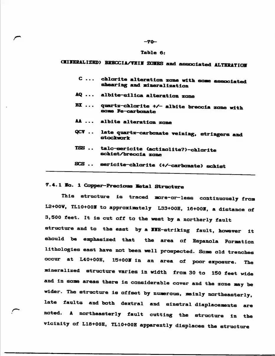
-7O-
Table 6:
miEKALIZED) BKECCIA/YEIY ZOMBS and associated ALTERATION
C ... chlorite alteration zone with some associated shearing and Mineralization
AQ ... alblte-slllca alteration zone
BZ ... quartz-chlorite +X— albite breccia zone with BOMB Fe—carbonate
AA ... albite alteration
QCV .. late quartz—carbonate veinlng, stringers and stockwork
TSS .. talc-sericlte (actinolite?)-chlorite schist/breccia zone
SCS .. sericite—chlorite (+X—carbonate) schist
7.4.1 lo. l Copper—Precious Ketal Structure
This structure is traced more-or-less continuously froot L2+OOV, TL10+OOW to approximately L33+OOE, 16+001*. a distance of 3,500 feet. It is cut off to the west by a northerly fault structure and to the east by a WE-striking fault, however it should be emphasized that the area of Espanola Formation lithologies east have not been well prospected. Some old trenches occur at L40+OOE, 15+OOff in an area of poor exposure. Themineralized structure varies In width from 30 to 150 feet wide and in some areas there is considerable cover and the zone may be wider. The structure is offset by numerous, mainly northeasterly,late faults and both dextral and slnstral diaplacements are^•—*.
. noted. A northeasterly fault cutting the structure in thevicinity of L18+OOE, TL10+OOE apparently displaces the structure
-71-
350 feet left laterally. The talc-chlorite (-actinolite) shear TSS is also terminated by this fault. Some displacement across northwesterly-bearing faults is also evident (Geology Hap, HE Sheet).
The main host is Espanola Formation llaestone/dolomite, however this unit contains narrow (to 3 feet) beds of siltstone. Siltstone and cherty siltstone host is common in the area of L20+OOE to L29+OOE, along the edge of the high ridge of Bar Biver Formation quartzite. At least part of the structure is Indicated to follow an Espanola Formation - Klssissagi Formation (sandstone) contact; L10+OOE - L20+OOB. The structure seems to trend parallel to local bedding, dipping steeply to the north vs the shallower bedding attitudes.
At the east and west ends, the structure is bordered by a chlorite alteration or chloritic shear zone, enveloping the sulphide-bearing breccia vein and alteration zone. The chloritic material is also mineralized with disseminated chalcopyrite and quartz stringers. Considerable malachite staining is common (Plate 16).
The west end of the zone forme a relative topographic knoll with a rather sharp north-south edge. This section was blasted during 1993, forming a clean rock face measuing 60 feet long, designated Trench 1. Figure 24 shows the general geology and chip channel sample sites across the trench (east) face. Chloritic shear material clearly encloses the structure and dips steeply to the south. Some unaltered limestone and siltstone selvadegs or
o o
T
K •*
C to
e T
B e
-ZL
-
-73-
xenollths of various size and form are common In the quartz- chlorite breccia zone to the north.
The main body of the structure consists of irregular quartz- chlorite breccia with considerable unevenly dlstlbuted albite - silica alteration. This material contains irregular pods up to 2 square feet of semi—massive pyrite and chalcopyrite, roughly 5* of the zone. lumerous scattered disseminations and large (2 inches) blebs of chalcopyrite occur in the quartz-alblte alteration zone, apparently showing preference for north - northeasterly fractures (Plate 12). Some late quartz +X- carbonate veins cross the zone, both parallel to the east-west trend (Plate 10) and as relatively flat-lying eactenslonal features running north-south (Figure 24).
Plates 10-11 and Figure 24 show that bedding features are quite diseernable and some gentle warp-like folding is observed. Some of these folds may have been generated by the numerous southerly dipping to vertical mesoscopic faults. Plate 11 shows a rather broad section of unaltered laminated siltstone beneath pervasive albite-slllca alteration.
Chip channel sample results are shown on Figure 24. Detailed rock sample descriptions are provided in Appendix E. The best samples returned O.6301 Cu over 4.0 ft. and O.4451 Cu over 10.0 ft. A 1993 grab sample assayed 1.261 Cu.
Bo gold values were returned from this sampling program, however 4 grab samples sent for anaylsls to Soyal Oak Kines Inc. returned the following gold assays:
-74-
Samnle Au An •L n't i. onCppb) (oz/T)
12151 855 0.025
12152 480 0.014
12153 410 0.012
12154 995 0.029
llmestone(?); sil w l* bands of qtz, IX bornite
chloritic shear; qtz bands, 1-42 chalcopyrite
albite-sillca alte; 1- chalcopyrite, 12 bornite In late fractures
albite-sillca alte; fg sulphides, coarse chalcopyrite
A 5-foot vertical channel sample of sulphide-bearing quartz chlorite from small Trench la (Ll+OOV, TLlO+OOff) assayed O.305* Cu. The chalcopyrite blebs generally align with a series of northerly fractures (Plate 12).
The zone of mixed quartz—chlorite breccia and albite-sillca alteration persists east to approximately LO+50V. Grab sample 9412 of this material contains 216 late quartz-carbonate ve in Ing and 31 stringers and blebs of chalcopyrite. The sample returned 0.302 Cu.
Trench 2. a narrow and shallow north-south trench located at Ll+OOE, TL10+OOF, cut an Impressive 35-foot wide zone of quartz- chlorlte with some albite breccia and late, more-or-less structure parallel, quartz-carbonate velnlng (Figure 25). Sample 9416, which assayed 1.882 Cu over 5 ft., consists of 20X quartz- carbonate veining and breccia in chlorltlzed limestone. A narrow C4") band or lense of 452 chalcopyrite is contained in the Interval.
A sulphide-bearing, 8"-wide quartz vein containing 22
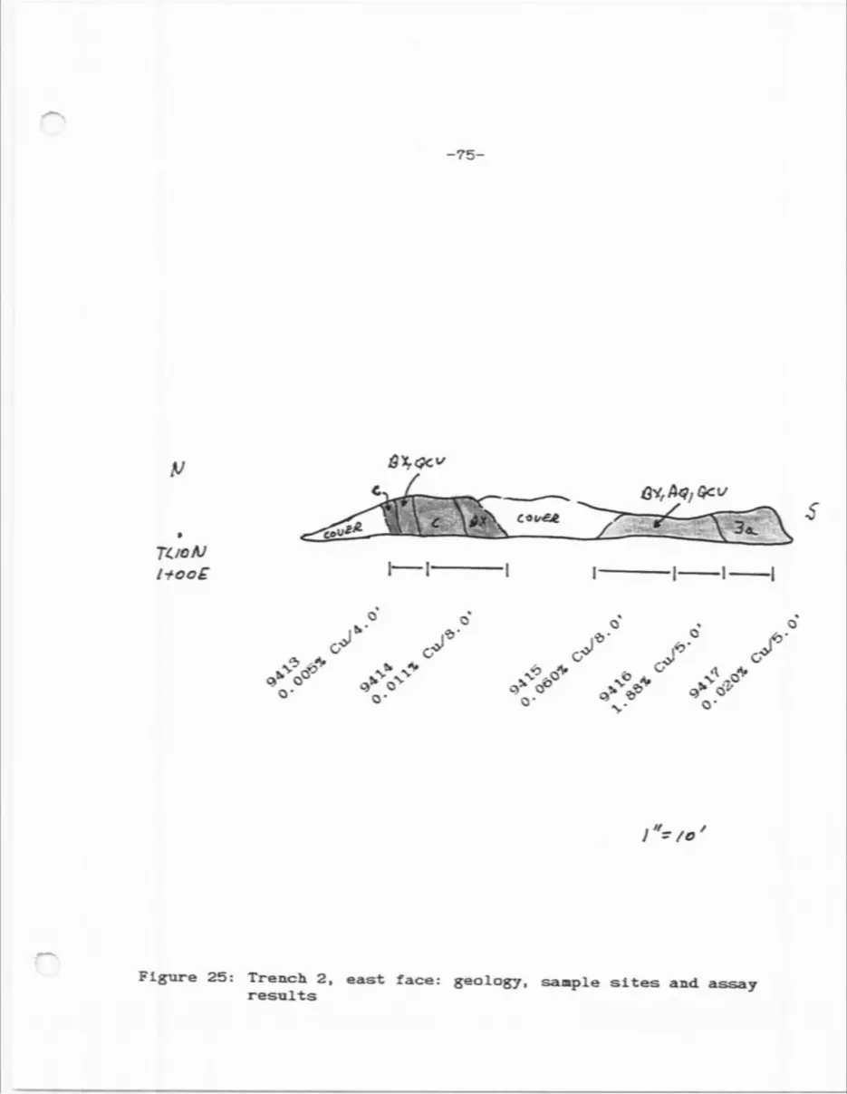
-75-
^ C*uA4/
•v
o- o-
J6'
Figure 25: Trench 2, east face: geology, sample sites and assay results
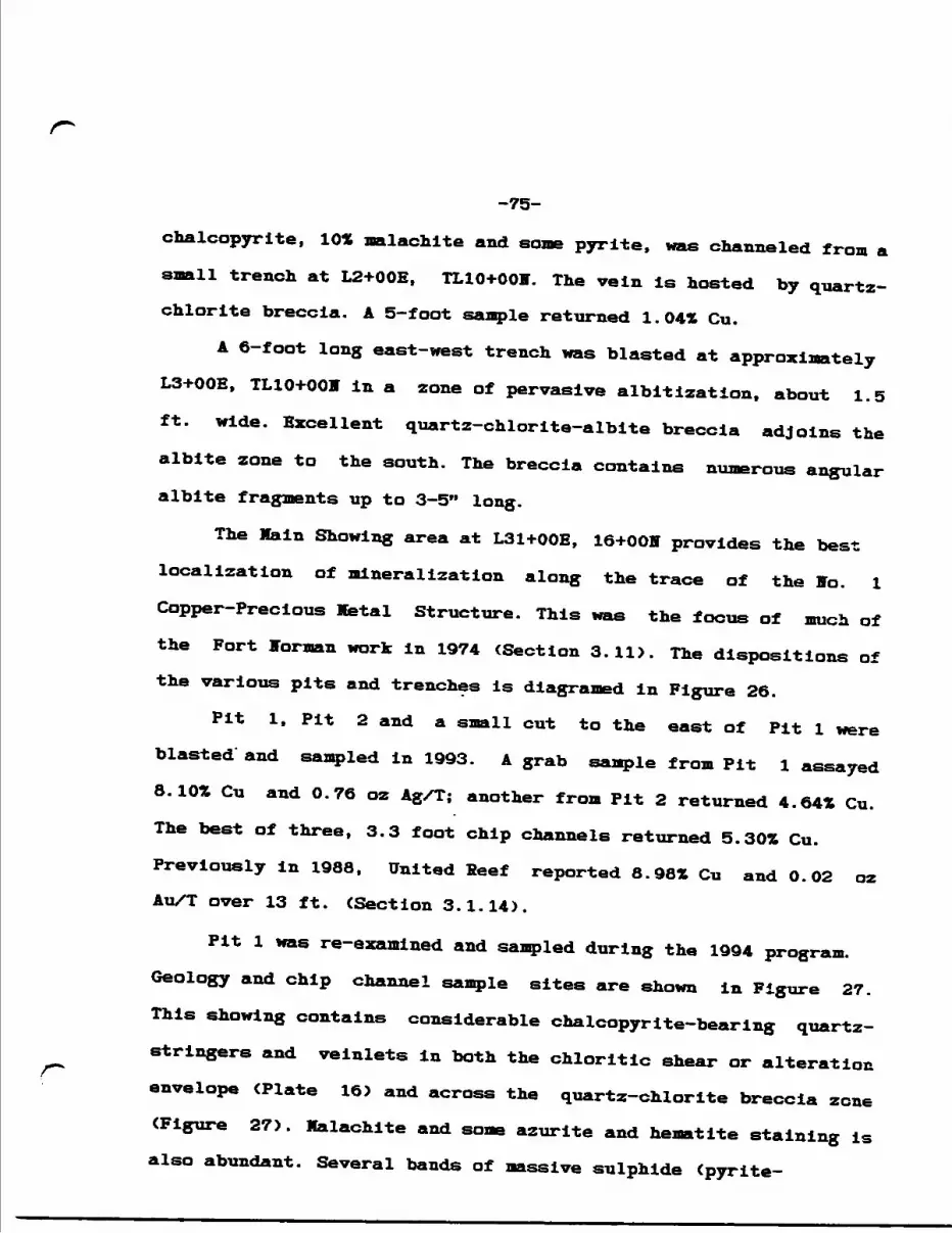
-75-
chalcopyrite, 10* malachite and some pyrite, was channeled from a small trench at L2+OOE, TL10+OOV. The vein Is hosted by quartz- chlorlte breccia. A 5-foot sample returned 1.041 Cu.
A 6-foot long east-west trench was blasted at approximately L3+OOE, TL10+OOM In a zone of pervasive albitization, about 1.5 ft. wide. Excellent quartz-chlorite-alblte breccia adjoins the albite zone to the south. The breccia contains numerous angular albite fragments up to 3-5" long.
The Main Showing area at L31+OOE, 16+OON provides the best localization of mineralization along the trace of the Ho. l Copper-Precious Metal Structure. This was the focus of much of the Fort lorman work in 1974 (Section 3.11). The dispositions of the various pits and trenches is diagramed in Figure 26.
Fit l, Pit 2 and a small cut to the east of Pit l were blasted' and sampled in 1993. A grab sample from Pit l assayed 8.10* Cu and 0.76 oz Ag/T; another from Pit 2 returned 4.64* Cu. The best of three, 3.3 foot chip channels returned 5.30* Cu. Previously in 1988. United Reef reported 8.98* Cu and 0.02 oz Au/T over 13 ft. (Section 3.1.14).
Pit l was re-examined and sampled during the 1994 program. Geology and chip channel sample sites are shown in Figure 27. This showing contains considerable chalcopyrite—bearing quartz- stringers and veinlets in both the chloritic shear or alteration envelope CPlate 16J and across the quartz-chlorite breccia zone (Figure 27). Malachite and some azurite and hematite staining is also abundant. Several bands of massive sulphide (pyrite-
projo dv*
r.-V
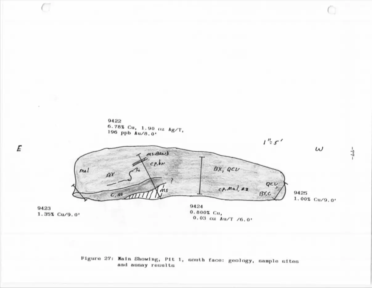
-77-
c \.
Ifi O
o; o
*Jt
\Xs
c o
— \C*
tc-
3
tcC
M
1 xC
Q
-
O2
90a e- T3
B B
ft a
C* ~
-78-
chalcopyrite) measuring up to 8" wide are found from place-to-
place and apparently follow bedding planes or perhaps a
subparallel fracture/fault (Plate 15). The plate also shows
folding of the host cherty limestone (lower right) and siltstone
(upper left).
The degree of schistosity and some faulting is well
illustrated in Plates 13 and 14. Sample sites are also depicted.
Chip channel sample assay results are given in Figure 27. The
best result was from 9422 which crossed some semi-masslve
sulphide horizons containing 201 chalcopyrite, plus 151
chalcopyrite and some bornite, pyrite in late quartz
vein/stringer material. The sample returned 6.78* Cu, 1.90 oz
Ag/T plus some gold over 8 ft. Sample 9424, over 6 ft., assayed
O.80* Cu and 0.03 oz Au/T In a quartz vein-rich quartz-chlorite
breccia zone. Some portions of massive pyrlte-chalcopyrite pods
to 5" were included In the sample.
7.4.2 To. 2 Copper Structure
This more-or-less east-west striking mineralized structure
is poorly exposed over a length of approximately 4,400 ft., from
L48+OOY, 4+OOS to L4+OOV, 4+50S ('94 grid). Continuity over this
distance is assumed as exposed portions of the zone occurs at the
same relative station on 7 of the 12 lines, which to date, are
indicated to cross the structure. The zone was not detected to
the west of L48+OOY, however the orientation of the structure is
on a direct line to the Little White River Lead Mine (Section
-79-
3.1.1) situated 3,000 feet in that direction. The grid east of
L4+OOV was not mapped, hence the structure is open in that
direction. It measures 50 - 300 feet wide, as indicated on
Geology Hap, SE Sheet.
The structure crosses three major rock units, Serpent
Formation feldspathic quartzite in the west. Gowganda Formation
conglomerate and in the east and Espanola Formation siltstone
across most of its length, indicating the feature may be a
previously undetected regional fault/shear zone.
As is observed in the f o. l Structure, several north to WE
trending faults show displacments of up to 100 feet.
The zone consists predominately of chloritized and sheared
siltstone and conglomerate characterized by considerable gossan
and carbonatization. Shear zone orientations are mainly steep to
the south with bedding subparallel and not as steep. Some north
dipping schistositles CS2?) are also noted.
The best section of quartz—chlorite—albite +X— carbonate
breccia occurs In the vicinity of L32+OOY, 2+0OS and Is sited
along the trace of a northeast trending fault at the intersection
with the lo. 2 Copper Structure. Although rock samples from this
exposure returned 80 ppm copper and nil gold and silver, the
alteration and breccia textures are similar to that observed at
the western end of the Jo. l Copper-Precious Metal Structure. Some
brecciation and chloritization in siltstone at L28+OOV, BLO+00
lies along this fault, consequently this northeasterly feature
may warrent furthur investigation.
-80-
Low copper values are returned from grab samples of
sulphide-bearing quartz veinlets hosted by chloritlzed and
sheared Espanola Formation siltstone, for example sample 9433
(O.300ft Cu), 9435 (0.210* Cu) and 9437 CO.086ft Cu). The quartz
veinlets trend subparallel to the trend of the Ho. 2 Copper
Structure, dipping steeply to the south, All of the samples
contain disseminated to blebs of chalcopyrite with some pyrite
and varying amounts of hematite and malachite. Some quartz-
chlcrite breccia is occassional associated, but is not as
pervasive as the lo. l Structure. An exposure of pyritic albite-
slllca altered rock is located Just north of the 0.086ft Cu
outcrop at L12+OOW, 5+10S.
Some Gowganda Formation siltstone at L24+OOV, 6+50S is
carbonatized and contains considerable chlorite, pyrite and
magnetite. The outcrop is either part of the lo. 2 Structure or
has been affected by the adjacent northerly fault trace.
Quartz veining and irregular quartz stockwork with attendant
silicification best describe the ffo. 2 Structure in Serpent
Formation at the west end. Only traces of pyrite occur in vein
material, however some low copper was assayed from three grab
samples; 9430 - quartz stockwork material, 0.012ft Cu, 9431 -
quartz vein within stockwork, 0.043ft Cu and 9432 - quartz vein,
0.017ft Cu. The quartz veins trend oblique to that of the Ho. 2
Structure.
The best exposure of sulphide—rich quartz veining with
associated chloritic shearing occurs in the Southeast Trench at
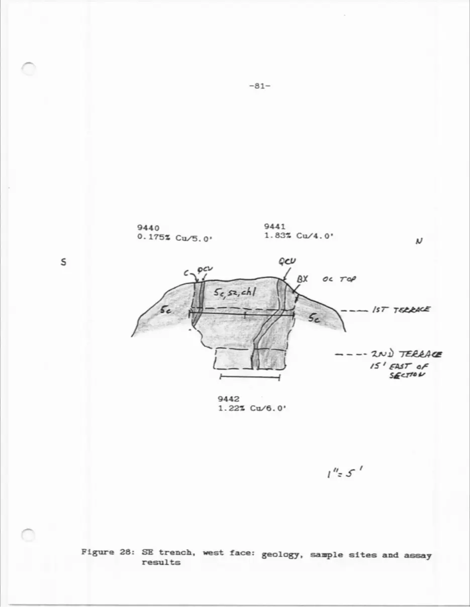
-SI-
9440O. 175Z Cu/5.O'
9441l. 83-Z Cu/4. O
Of. Tot
V—— M——JL-JLJ
-——— /ST
S f err* f
94421.22* Cu/6.0'
i** f 1
Figure 28: SE trench, west face: geology, saaple sites and assay results
-82-
L3+50V, 4+75S (Figure 28). The main trench measures 100 feet long
and Is up to 9 feet wide to a variable depth of approximately 10 feet. It Is terraced eastwards down the side of a large outcrop
area (Gowganda Formation conglomerate), following the strike of a
sulphide-rich quartz vein system (Geology Hap, SB Sheet, Plates
17 and 18). Two chip channels for a combined 9-foot width were
taken across the zone at the first terrace close to the western,
upper end of the trench (Plate 17). The northern sample, 9441,
cavers the main quartz vein which measures 3 feet wide. It dips
variably to the south to vertically. The vein contains 251 semi-
massive patches of chalcopyrite, pyrite and possibly galena. Some
sheared and quartz-carbonate veined (stringers) host rock
material was Included with the sample which assayed 1.33* over
4.0 ft.
The 5—foot sample to the south, sample 9440, consisted of a
quartz-carbonate stringer zone in chloritic, schistose
conglomerate with some minor chalcopyrite. It ran O.1751 Cu.
A channel across the vein system from the second terrace, 15
feet to the east, assayed 1.221 Cu over 6 ft. (Plate 18).
Scattered trenching and pitting was carried out westwards
along the zone for an additional 150 feet, le the total
continuous length of this mineralized vein zone Is 250 feet. A
grab sample of vuggy quartz—carbonate vein material containing
1571 chalcopyrite assayed 13.001 Cu. The sample is debris from the
most-westerly trench (Geology Map, SE Sheet).
A grab sample from a 1-foot wide chloritic and gossan-
-83-
stained shear contained a l" wide quartz vein mineralized with 22
chalcopyrite and 102 malachite. The sample C9439) assayed O.1352
Cu and le located at L4+OOY, 5+OOS, 25 feet south of the
Southeast Trench area.
7.4.3 Concluding Remarks
Field observations indicate that the two mineralized
structures represent significant fault and shear zones which
likely were generated during reverse faulting along the Flack
Lake Fault system as part of Penokean deformation. The zones run
parallel to the Flack Lake Fault and may be viewed as subsidiary
features.
The mineralization is Indicated to be a poly-phase event
consisting of; 1) shearing accompanied by some brittle fracturing
and brecciation followed by 2) later quartz—carbonate velning.
Sulphide and copper mineralization is found in both cases.
The lo. l Copper-Precious Metal Structure is ascribed
mainly to CI); it is not clear if the breccia textures resulted
from fault-like brittle fracturing, or represent a "blow-out"
feature, perhaps feeding off a larger deep—seated breccia—pipe or
felsic intrusive. The author favours the latter scenario for the
following reasons:
a) The host rock lithology is relatively soft, plastic-like limestone and likely would not produce the very hard quartz- chlorite breccia observed by merely faulting. Some solution was Involved.
b) The presence of albite which is generally associated with Au-Cu-bearing breccia pipes and veins in the region and held to be a metasomatic feature associated with intrusive activity. According to regional studies, albitization is post-Penokean.
-84-
c) aeromagnetic surveying shows a strong circular magnetic low feature centered more-or-less over the Main Showing (Figure 5); a burled breccia pipe?
Alternatively, Intersecting faults may produce breccia.
Some later quartz-carbonate velnlng cuts the Jo. l Structure
and in some places quartz-carbonate breccia is observed
suggesting this material may represent a pre- or syn-velnlng
event at the time of the "blow-out".
The lo. 2 Copper Structure is characterized by quartz-
carbonate velnlng hosted by a chloritic shear zone. As yet, no
significant brecciation is apparently associated, except in the
vicinity of cross-faults. Some quartz stockwork is evident in
Serpent Formation feldspathic quartzite at the western end.
Little albite is associated. This zone is considered to be mainly
a mineralized quartz-carbonate vein system, typical of many area
Fenokeon-type (polymetallic) veins.
Both structures are offset by younger northeasterly and
northwesterly faults. The significance of these structures to
mineralization is not clear, if any, however, the best assays
from the Vo. l Structure occur in the vicinity of cross-faults.
-85-
8. O COICLUSIOKS
The Jentlna Property is situated adjacent and partly overlying the regional Flack Lake Fault, a reverse thrust fault, a prior Archean nornal fault re-activated during the Penokean Orogeny. The fault zone is probably the northern boundary of the Huronian volcano-sedimentary basin with provenance being the Archean hinterland to the north and northwest.
Geological napping on the property indicates that the curvilinear, locally east-west trending Flat Lake Fault System has produced considerable ductile shearing and brittle deformation within the nearby host rocks across the northern Huronian Basin.Several copper-precious metal showings on the Jentina Property are indicated to be associated with east-west striking shear and fault zones, Including the trace of the Flack Lake and Endakai Lake faults.There is no record of detailed structural studies in the region implying many mineralized structures are yet to be discovered.
In particular, two mineralized, approximately east—west structural zones are delineated on the Jentina claims during the mapping program and show brittle to ductile deformation effects:
1) The Ho. l Copper-Precious Metal Structure, located north of the central Nipissing diabase sill, is traced over a length of 3,500 feet. It is poorly explored to the east. Vhere exposed the structure measures 30 to 150 feet wide. The main host rock is Espanola Formation limestone.The best assay results were returned from Pit l at the Main Showing at L31+OOE, 16+OOT, the eastern-most extent of the structure discovered to date. An 8-foot channel sample assayed 6.782 Cu, 1.90 oz Ag/T (1994). Some gold was returned from channel sample 9424: 0.802 Cu and 0.03 oz Au/T. A 1993 grab sample returned 8.102 Cu, 0.76 oz Ag/T.At the east end in Trench l (L2+OOV, TL10+OOF), the best channel sample returned O.63* Cu over 4.0 feet. A grab of albite— silica material returned 0.029 02 Au/T. A sample from Trench 2, 300 feet to the east, assayed 1.882 Cu over 5.0 feet.The structure is characterized by quartz-chlorite breccia and albite-slllca alteration, features typical of many area Au-Cu veins and breccia pipes. The main sulphides include pyrite and chalcopyrite which occurs in semi—massive bands more-or-less parallel to steeply dipping cleavage Cor bedding?) and as disseminated blebs or pods, frequently aligned with cross-cutting fractures in alteration zones and as disseminations in quartz str ingers/veins.
-86-
2) The lo. 2 Copper Structure, located south of the diabase sill. Is exposed east-west for 4,400 feet. Jo napping/prospecting was carried out along strike to the east. To the west, the structure is on a line with the Vhite River Lead Mine, 3,000 feet away. Grab sampling of quartz vein debris at the mine by the Ontario Department of Mines in 1969 yielded 3.46 oz Ag/T, 0.10 oz Au/T, 1.561 Cu plus some Pb, Zn, Co, Bi.
The best assay from the lo. 2 Structure was returned from the Southeast Trench: 1.83* Cu over 4.0 feet. A grab sample of semi-massive chalcopyrite from a pit 150 feet to the west assayed 13.001 Cu.
The structure crosses a variety of host rocks, characterized by sulphide-rich quartz-carbonate veins in chloritic shears in Espanola Formation siltstone and Gowganda Formation conglomerate and as quartz stringers, stockwork in Serpent Formation feldspathic quartzite.
The If a. 2 Structure is concluded to represent the class of polymetallic) quartz vein-hosted deposits found within the Huronian Basin, emplaced during the Penokean Orogeny, and may represent a previously un-recognized fault zone parallel to the Flack Lake Fault Zone, or perhaps part of this system.
Age dating Information and field relationships indicate that all mineralization post-dates Vlpissing diabase intrusion.
Other areas of known significant copper-precious metal mineralization worthy of exploration on the Jentina claims include:
a) Canamiska Zone; a 9,600-foot long EM conductor and copper in soils anomalous geochemical zone occupying an EVE-trending structure. The best drill Intersection f. 1965) was 1.44ft Cu over19.5 feet (hole 65-7). Apparently no drilling was carried outover the northeastern, part of the zone where soil values of up to 6,000 ppm are reported.
b) Flack Lake Fault Zone; grab samples from an east-west striking quartz-carbonate zone assayed up to 15.63* Cu, 0.24* Zn, 0.36 oz Ag/T and 0.02 oz Au/T (1978).
A 2-foot chip channel along the trace of the Flack Lake Fault at the northwestern corner of Jentina Main Block assayed O.390* Cu (1988).
A 4 to 6-foot wide northerly trending shear extends from the Flack Lake Fault on the Triangle Lake Claims. Grab sample assays of up to 7.45* Cu and 0.28 oz Ag/T are reported from copper sulphide-rich quartz veinlets (1971). Some disseminated mineralization in the host rock ran 1.6* Cu and 0.15 oz Ag/T.
A copper in lake sediment anomaly from Triangle Lake gave 980 ppm. The trace of the Endakai Lake Fault crosses the lake.
-87-
c) Bruce-Presto Zone; a 500-foot long shear zone in diabase on a patent claim adjoining the northeastern corner of the Jentina Property, Main Block, reported copper-cobalt values of 2- 3* Cu and trace-2% Co (1950's). The zone is Indicated to dip south onto the Jentina claims. 1964 drilling on the Jentina ground and south of the showing returned assays of up to l. 96X Cu over 11.5 feet In host Espanola Formation siltstone.
d) Various soil geochemical areas; two broad areas of anomalous soil geochemical metal values are recognized (1988): an area of elevated Cu-Ag-Au over the Hississagi Formation sandstone north of the Little White River and an area of Cu-Zn underlain by Espanola Formation lithologies north of the central nipissing diabase sill. Although generally considered to be due to the numerous metalliferous quartz-carbonate veinlets/velns In these areas, a possible SEDEX derivation should not be dismissed out of hand. Some sedimentary copper mineralization is reported at the Lorrain-Gordon Lake Formation Interface 20 miles east of the property.
Structural-mineralogic and aeromagnetic features at the Ho. l Copper-Precious Metal Structure suggest the most likely target for economic mineralization on the Jentina ground is polymetallic (Cu-Ag-Au) mineralized breccia zones or pipes similar to the Proterozoic Olympic Dam deposit in Australia and the Wernecke Mountains deposits of the Yukon.
Other possible primary exploration targets are listed following.
- Sufficient grade and tannage may exist in quartz-veinhosted copper (-polymetallic) vein-style mineralization, forexample the Ho.2 Copper Structure and the Canamlska Zone.
-"Greenstone" (Huronian volcanics?) at a vertical depth of approximately 250 feet was intersected in Canamlska drill holes. Atlantic Bichfield drilling in 1967 intersected "Archean" volcanics at a depth of approximately 4,000 feet Just north of the Ho. 2 Copper Structure. Archean volcanics are indicated to outcrop Just north of the Jentina Property.
Although no significant VMS-style of mineralization has been discovered in the region, the presence of both Archean and Proterozoic volcanics in the vicinity of Jentina suggest volcanogenic massive sulphide mineralization Is a target on the property.
- The Flack Lake Fault Zone, demonstrated to be a regional unconformity between Huronian supracrustals to the south and Archean rocks to the north, has imparted various ductile to brittle deformation effects on area host lithologies. Regional unconformities or deformation zones are common sites for the localization of Archean-style auriferous quartz vein deposits.
-88-
The Flack Lake Fault System nay provide gold targets.
9. O
Two approaches to furthur explore the property should be considered; 1) exploration follow-up of the two main known zones of mineralization which would entail mechanical stripping and diamond drilling and 2) detailed evaluation of the entire Jentlna claim area, including the outlying areas not yet investigated. The second approach would consist of detailed griding of all or parts of the property, le 100-foot spaced lines with 50-foot stations, stressing detailed magnetometer surveying and structural mapping, lithogeochemical sampling. Both structural details and litogeochemistry are lacking for this part of the Huronian Basin. The role of EH or IP surveying in this district is not well established and some test surveying may be advantageous.
The advantages to the second approach is two-fold:a) to provide a structural synthesis of the property possibly determining the controls of the known mineralization, as well as aiding in the discovery of other zones. The study will investigate structure intersections, various magnetite features, confirm the cause of the aeromagnetic circular feature, etc. The relationship of the property structures to the Flack Lake Fault System may be determined.
b) establish a lithogeochemical database from which alteration features may be determined and signatures of buried mineral deposits, such as polymetallic breccia pipes and VMS deposits, may be outlined.
The second approach will provide the most information to allow selection of the optimum diamond drill targets. The following exploration proposal and budget is forwarded:
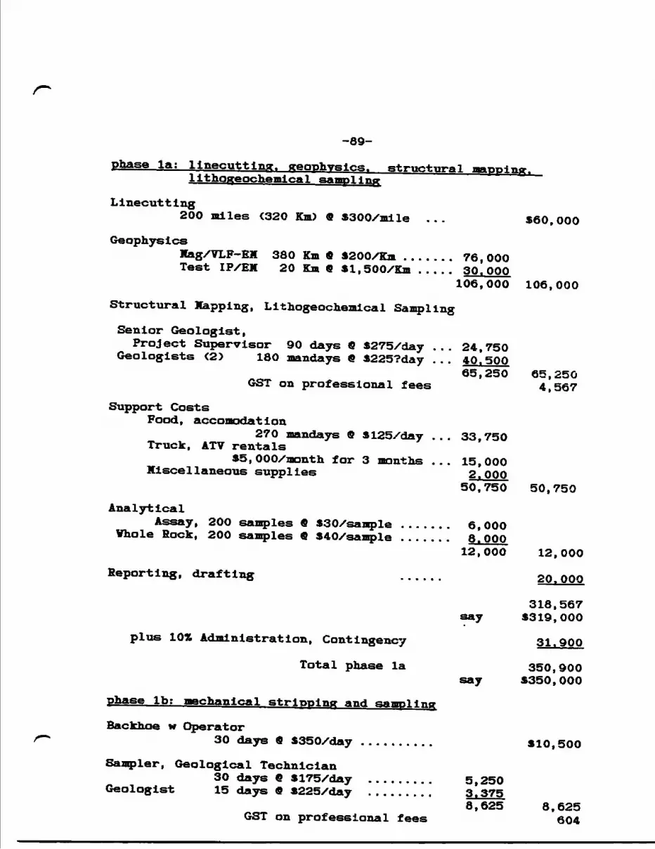
-89-
pfoase la; llnecutting. geophysics. structural lithogeochemical sampling
Llnecutting200 miles (320 Km) 9 SSOO/mlle ... 560,000
GeophysicsMag/VLF-EX 380 Km 9 4200/Km . . . . . . . 76,000Test IP/EH 20 Km 9 Sl.SOO/Km . .... 30.000
106,000 106,000
Structural Happing, Lithogeochemical Sampling
Senior Geologist,Project Supervisor 90 days 9 5275/day ... 24,750 Geologists (2) 180 mandays 9 S225?day ... 40.500
65,250 65,250 GST on professional fees 4,567
Support CostsFood, accomodation
270 mandays 9 3125/day ... 33,750 Truck, ATV rentalsS5,000/month for 3 months ... 15,000 Miscellaneous supplies 2.OOP
50,750 50,750
AnalyticalAssay, 200 samples 6 SSO/sanple . . . .... 6,000Whole Rock, 200 samples 9 940/sample . . . . . . . 8.000
12,000 12,000
Reporting, drafting ...... 20.OOP
318,567 say S319,000
plus 10t4 Administration, Contingency 31.900
Total phase la 350,900say 5350,000
phase Ib; mechanical stripping and sampling
Backhoe w Operator30 days 0 5350/day . . . . . . . . . . 410,500
Sampler, Geological Technician30 days 9 8175/day . . . . . . . . . 5,250
Geologist 15 days 9 3225/day . . . . . . . . . 3.3758,625 8.625
GST on professional fees 604
-90- Support Costs
Food, AcconodatIon45 mandays fi 5125/day . . . . . . 5,625
Truck, ATV rental . . . . . . . . 3,000
Miscellaneous Supplies . . . . . . . . 1.OOP9,625 9,625
Analytical200 assays fi 530/sample . . . . . . . . 6.000
35,354 say 535,500
plus I QTt Administration, Contingency 3.550
Total phase Ib 39,050say 539,000
Total phase l 5389,000
-91-
phase 2 i Drilling
Road Building
Drilling 20,000 feet fi 520/foot
Geologist 60 days fi S250XdayGST on professional fees
Support CostsFood , Accomodat i on
60 days fi 5125/day Truck, ATV rental
S2,OOOXmonth Miscellaneous Supplies
plus 1071 Administration, Contingency
Total phase 2
Total phase l and 2
say
520,000
400,000
15,0001,050
7,500
4,0001.000
447,5505448,000
44.800
492,8005492,000
•881.000
Respectfully submitted Date: September 15, 1994
F.O. Willoughby, B.Se.(Hons.)
KHFKKEBCHS
Anthony, E.G. and Willoughby, 1988: Report on geological and soil geochemical surveying of the Albanel copper-gold property: Unpubl report for United Reef Petroleums Limited, Oct., 1988, 54 pgs.
Atkinson, V. V. , Kacmarowskl, J. H. and Erlckson, A. J., 1982: Geology of a skarn-breccia orebody at the Victoria Mine, Elko County, Sevada; Econ. Geol. v. 77, no. 4 p 899-918.
Bennett, G., Dressler, B.O. and Robertson, J.A., 1991: TheHuronian Supergroup and associated Intrusive rocks, pp 549- 592 In Geology of Ontario, Ont. Geol. Surv., Spec. Vol. 34, part l, 711 pgs.
Chandler, F. Y., 1984: Sedimentary setting of an Early Proterozoic copper occurrence in the Cobalt Group, Ontario: a preliminary assessment; p 185-192. in Current Research, Part A, Geol. Surv. Canada, paper 84-1A.
Ennls, G.F., 1955: Diamond drill logs for Plcton Uranium Hlnes Limited; Assessment file Albanel 0012, Resident Geologist's Office, Sault Ste. Marie.
Fyon, J.A., Bennett, G., Jackson, S.L., Garland, X.I. and Easton, R. H. , 1992: Metallogeny of the Proterozoic eon, northern Great Lakes region, Ontario, pp 1177-1217 In Geology of Ontario, Ont. Geol. Surv., Spec. Vol. 4, pqrt 2, 1525 pgs.
Gauthier, V . , Rocheleau, K., Kelly, D. and Gagnon, T., 1990: Controls on the distribution of gold mineralization within the Cadillac Tectonic Zone, Rouyn-Beauchastel Segment, Abitibi, Quebec; In The Northwestern Quebec Polymetallic Belt: A SuT|nroi r'y of 60 Years of Mining Exploration; CIMH Spec. Vol. 43, K. Rive, P.Verpaelst and others, editors, p 185-198.
Gasch, J.V. and Vogel, T.A., 1959: Unpubl geology map, Univ. of Vlsconsin; Assessment files, Resident Geologist's Office, Sault Ste. Marie Mining Division.
Gowganda Silver Mines Limited, 1972: Geological plan, Groups a ft B, Twp 163; from ODM Map P.560.
GSC, 1987, Regional lake sediment and water geochemical reconnaissance data, Ontario, VTS 41J, Geol. Surv. Canada, Open File 1356.
Hanna Mining Company, 1969: Diamond drill log, hole 16; Assessment file Albanel 0017, Resident Geologist's Office, Sault Ste. Marie.
Hltzman, X. V., Oreskes, F. and Einaudi, H.T., 1992: Geological characteristics and tectonic setting of Proterozoic iron- oxide ^u-U-Au-REE) deposits; Precam. Res. , v. 58, p 241- 287.
Hubert, C., Trudel, P. and Gellnas, L., 1984: Archean wrench fault tectonics and structural evolution of the Blake River Group, Abitibi Belt, Quebec; Can Jour Earth Sci., vol. 21 no. 9 p 1024-1032.
Innes, D.G. and Colvine, A.C., 1990: Metallogenetic development of the eastern part of the Southern Province of Ontario; in Summary of Field, Ont. Gecl. Surv. SP 90, p 184-189.
Laznlcka, P., 1988: Breccias and Coarse Fragmentltes; petrology, environments, associations, ores; developments in economic geology 25; Elsevier, Tew York, 832 pgs.
McKecknie, D.C., 1964: Report on the property of Bruce-Presto Mines Limited in Townships 163 and 169, Sault Ste. Marie Mining Division, Ontario, 3 pgs with drill logs; Assessment file Albanel 0028, Resident Geologist's Office, Sault Ste. Marie.
Moore, E.S., 1930: Ore deposits near the Forth Shore of Lake Huron; Ont. Dept. Mines Ann. Rep, v.38, pt. 7, p 1-51.
Herman, D.I. and Sawkins, F.J., 1985: The Tribag breccia pipes: Precambrian Cu-Mo deposits. Batchawana Bay, Ontario; Econ. Geol. vol. 80, no. 6 p 1593-1621.
OGS, 1993, Single master aeromagnetic data; Ont. Geol. Survey, ERLIS Data Set 1.
Pearson, V.V., 1978: Copper metallogeny, Lake Huron area, Ontario; Geol. Surv. Canada, Paper 78-1A, p 263-268.
Pearson, V.V., 1979: Copper metallogeny, north shore region of Lake Huron, Ontario; Geol. Surv. Canada, Paper 79-1A, p 289- 304.
Richards, J.P. and Spooner, E.T.C., 1989: Evidence for Cu-(Ag) mineralization by magmatic-meteorlc fluid mixing in Keweenawan fissure veins, Mamainse Point, Ontario; Bean. Geol., v. 84, p 360-385.
Robertson, J.A., 1969:ant. Dept. Mines geology map, Map 2347, Nicholas and Raimbault townships, scale 1:31,680.
Robertson, J.A., 1970: Geology of the Soragge area; Ont. Dept. Mines, GR 76, 109 pgs.
Roscoe, S.M. and Card, K.D., 1992: Early Proterozoic tectonics and metallogeny of the Lake Huron region of the Canadian Shield; Precam. Res., v.58, p 99-119.
Rupert, R.J., 1974: Diamond drill logs for Fort Forman Explorations Inc.; Assessment file Albanel 0015, Resident Geologist's Office, Sault Ste. Marie.
Schandl, E., 1992: Few light on Sudbury-type rocks; Forthern Klner, August 23, 1992, p 5.
Scheerer, P., 1956: Unpubl geology map, Univ. of Wisconsin; Assessment files, Resident Geologist's Office, Sault Ste. Marie Mining Division.
Shklanka, R., 1969: Copper, nickel, lead and zinc deposits of Ontario; Ont. Dept. Mines, MRC 12, 394 pgs.
Siemiatkowska, K. M., 1978: Geology of the Endikai Lake area, District of Algoma; Cnt. Geol. Surv., Report 178, 79 pgs. Accompanied by Map 2399, scale 1:31,680.
Sullivan, D. W., 1967: Diamond drill report for Trlller Explorations Ltd., 9 pgs; Assessment file Albanel 0024, Resident Geologist's Office, Sault Ste. Marie.
Thomson, Jas.E., Ferguson, S.A., Johnstone, V.G.Q., Pye, G.E., Savage, V. S. and Thomson, R., 1957: Copper, nickel, lead and zinc deposits of Ontario; Ont. Dept. Mines, MRC 2, 126 pgs.
Yalford, P.C. and Franklin, J.M., 1982: The Anderson Lake Mine, Snow Lake, Manitoba; p 481-523 in Precambrian Sulphides, H. S. Memorial Volume, edited by R.V. Hutchinson, C.D. Spence and J.X. Franklin; Geol. Ass. Canada, Spec. Paper 25, 791PSS -
Vharton, R.E., 1968: Diamond drill logs for Atlantic Richfield Company; Assessment file Albanel 0013, Resident Geologist's Office, Sault Ste. Marie.
Vllllajns, R. H., 1965-1966: Drill sections at l" ~ 20' and l" = 50' for Canamiska Copper Xlnes Limited; Assessment file Albanel 0031, Resident Geologist's Office, Sault Ste. Marie.
Willoughby, F.O., 1993: Structural controls for gold mineralization at the Granada Gold Mine and Granada Extension properties: delineation of a significant, 8 Km long auriferous shear zone system, the Granada Tectonic Zone; unpub draft report for KVG Resources Inc., 21 pgs.
Zlmmerman, J.R., 1971, 1972: Geololgical report on the Hamilton claim group for Stanford Mines Limited with drill logs; Assessment file Albanel 0020, Resident Geologist's Office, Sault Ste. Marie.
CERTIFICATE OP QU1
I, Veil O. Willoughby, residing at 651 Cosburn Avenue, Toronto, Ontario, do certify that:
1) I an a geologist, a graduate of Carleton University, Ottawa, Ontario, with a B.Se. (Hons.) degree in 1974 and that I have been practising my profession since graduation.
2) I am President of 3TR4J Resource Associates Limited, a consulting firm Incorporated under the Business Corporation Act, 1982, in the Province of Ontario, since August, 1989 and which is authorized by the Association of Professional Engineers of Ontario to engage in the business of providing services that are within the practice of professional engineering under the Professional Engineers Act, 1984.
3) I have a personal 1/5 Interest in the Jentina Hine Property.
4) The statements contained in this report and conclusions and recommendations are based on my observations while so engaged in conducting and supervising field operations during the period June 22 to July 24, 1993 and June 18 to July 18, 1994.
Toronto, Ontario SI *^ *T/Pjtr
Dated: September 15, 1994 Veil O. WilloughbyB. Se. (Hons.)

PLATES
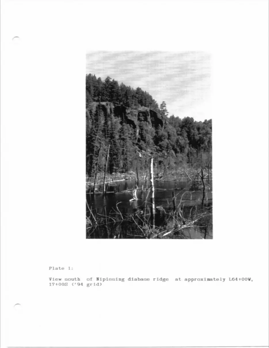
Plate 1:
View south of Iipissing diabase ridge at approximately L64tOOV, 17+OOS ('94 grid)
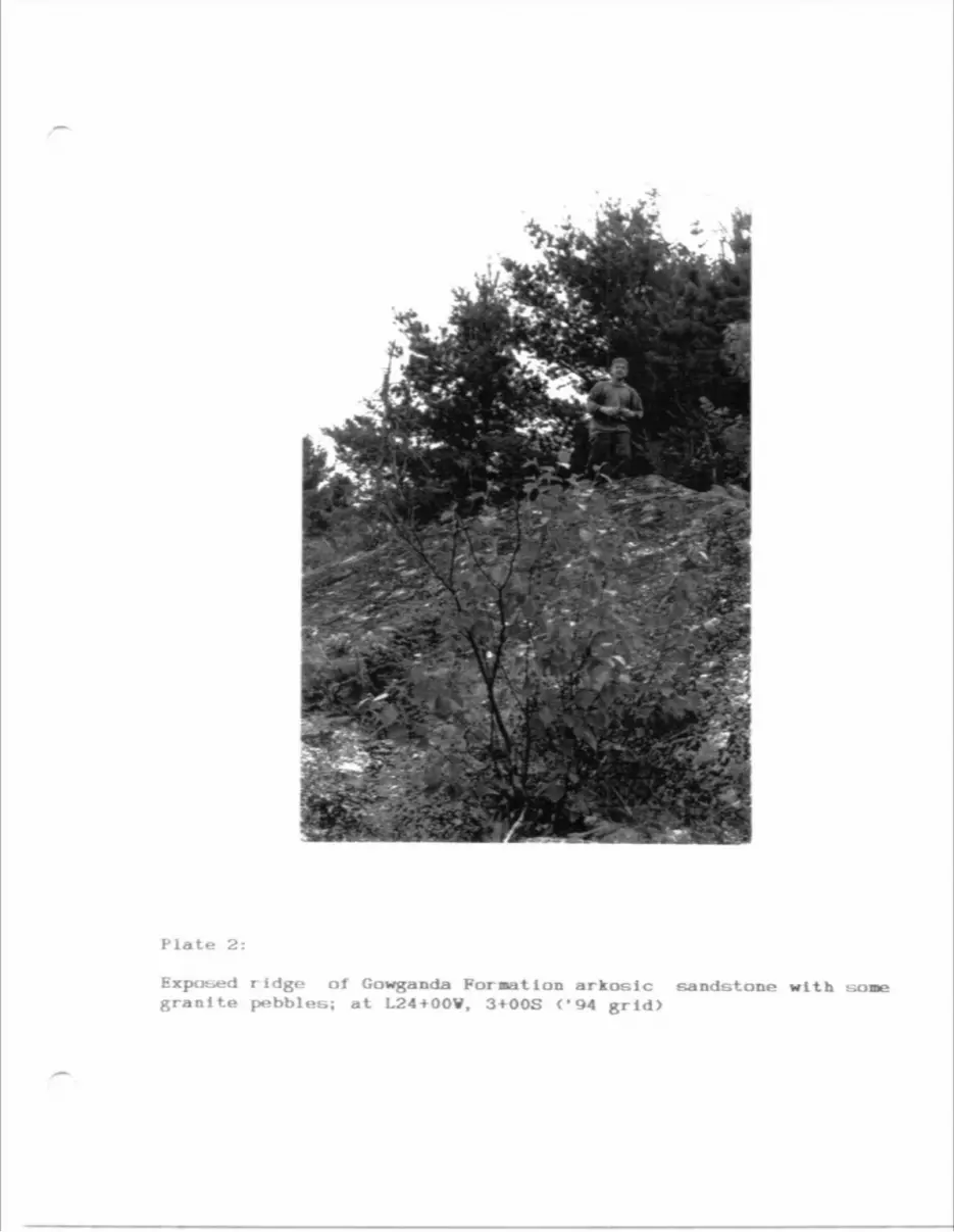
Plate 2:
Exposed ridge of Gowganda Formation arkosic sandstone with soi granite pebblee; at L24+OOV, 3+OOS <'94 grid)
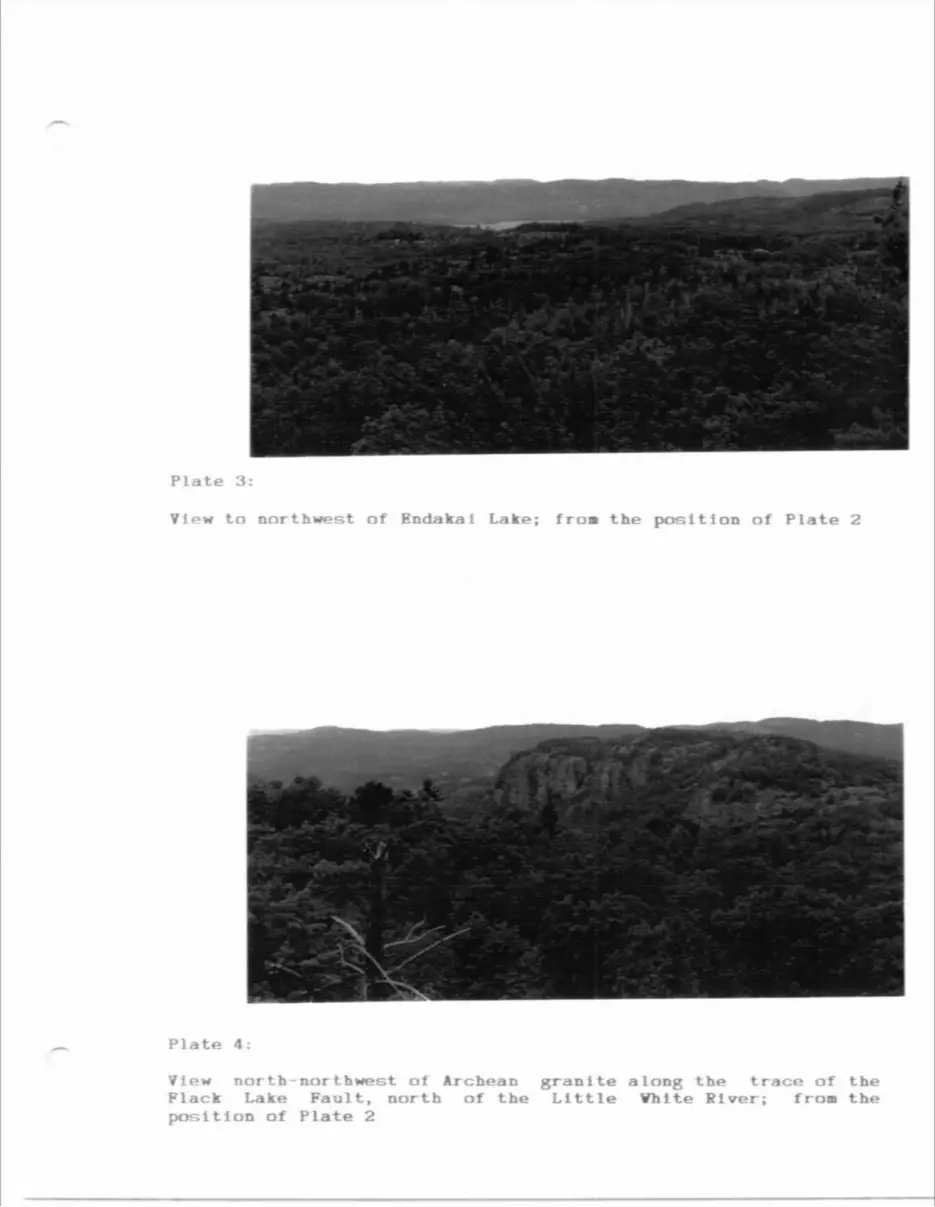
Plate 3:
View to northwest of Endaka i Lake; fro* the position of Plate 2
Plate 4:
View north-northwest of Archean grani te a long the trace of the Flack Lake Fault, north of the Little Vhlte Fiver; fro* the position of Plate 2
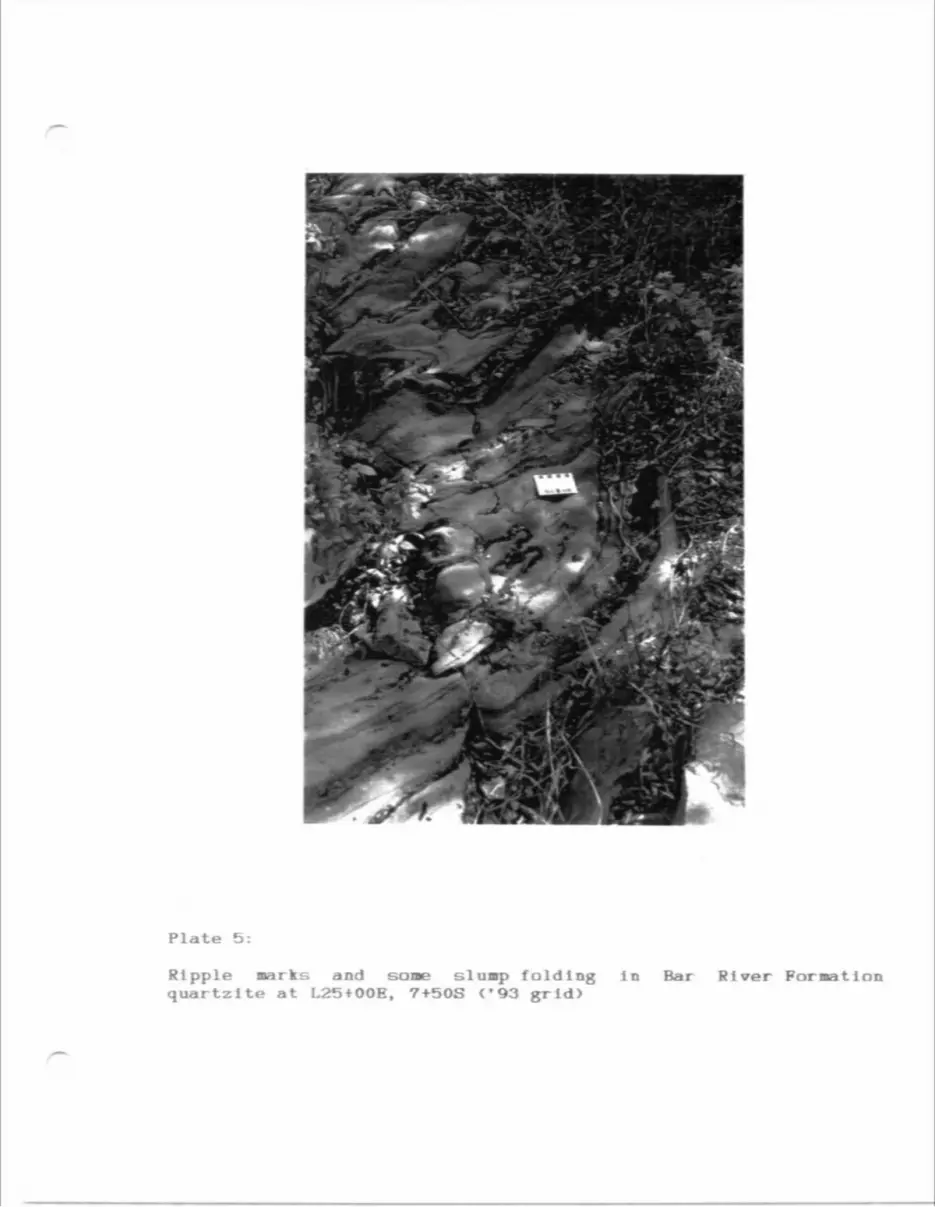
Plate 5:
Ripple aarks and some sluap folding In Bar River Formation quartzite at L25+OOE, 7+50S C'93 grid)
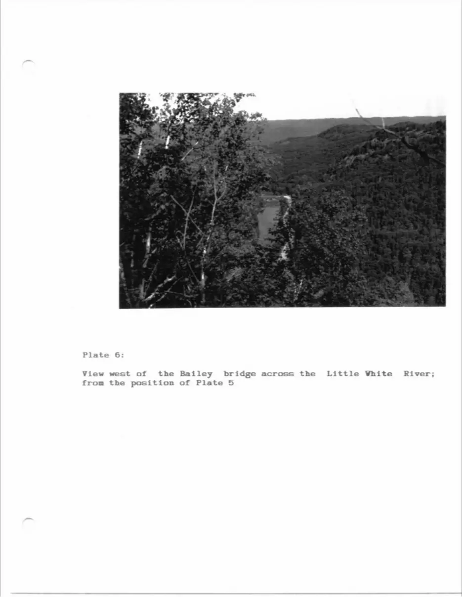
Plate 6:
View west of the Bailey bridge across the from the position of Plate 5
Little Vhite River;
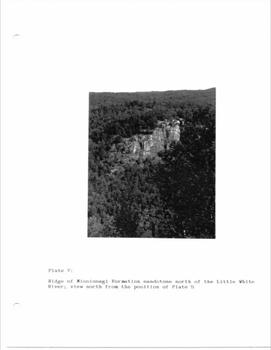
Plate 7:
Ridge of MisslssagI Formation sandstone north of the Little Vhlte River; view north from the position of Plate b
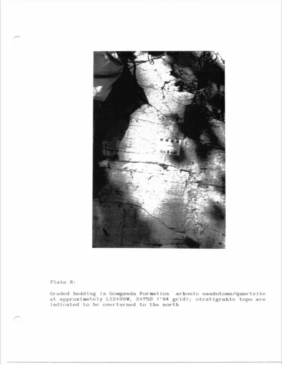
Plate 8:
Graded bedding in Gowganda Formation arkosic sandstone/quartzlte at approximately L12+OOW, 2+75S ('94 grid); stratlgrahlc tops are indicated to be overturned to the north
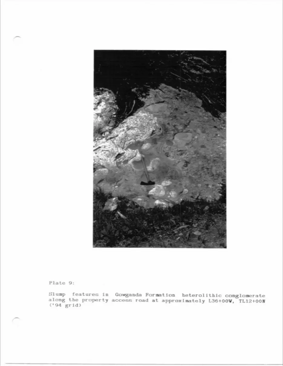
Plate 9:
SI uiBp f ea t ures l o along the property ('94 grid)
Gowganda ForB access road at
it Ion heterolIthlc conglomerate approximately L36+OOV, TL12+001
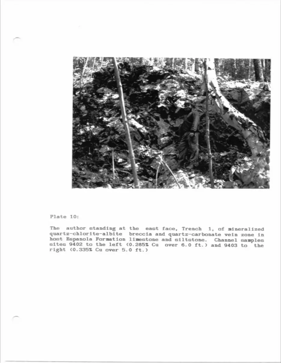
Plate 10:
The author standing at the east face, Trench l, of Mineralized quartz-chlorite-albite breccia and quartz-carbonate vein zone In host Espanola Formation limestone and siltstone. Channel samples sites 9402 to the left (0.285X Cu over 6.0 ft.) and 9403 to the right (O.3351 Cu over 5.0 ft.)
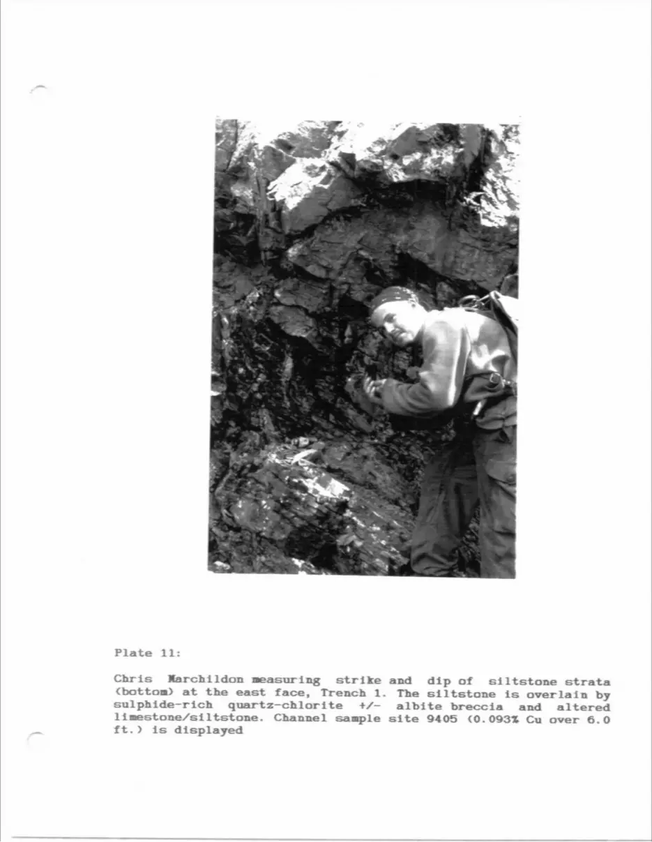
Plate 11:
Chris Marehi ldon Measuring strike and dip of siltstone strata (bottom) at the east face. Trench 1. The siltstone is overlain by sulphide-rich quartz-chlorite t/- albite breccia and altered limestone/silt&tone. Channel sample site 9405 (0.093Z Cu over 6.0 ft.) is displayed
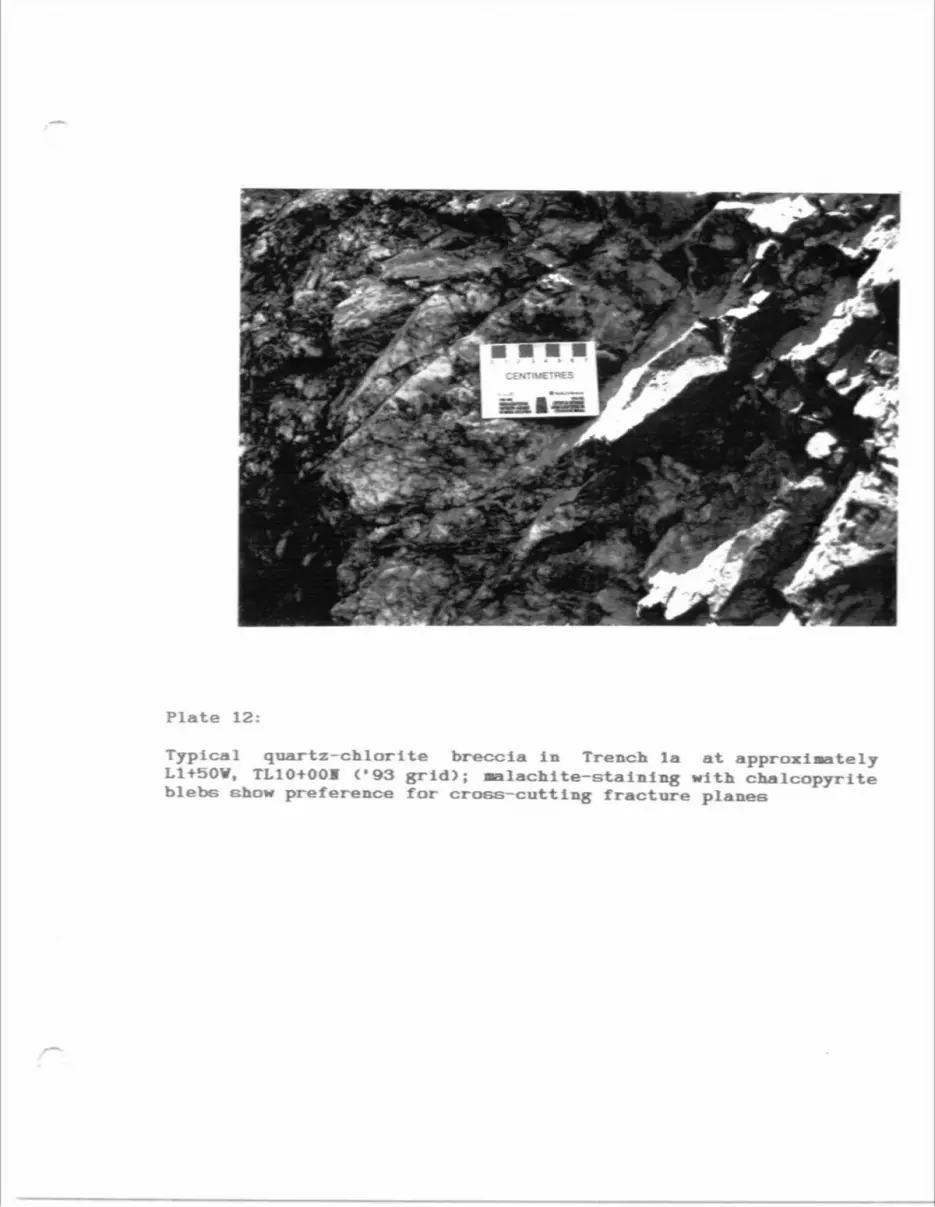
Plate 12:
Typical quartz-chlorlte breccia in Trench la at approximately L1+50V, TL10+OOM ('93 grid); Malachite-staining with chalcopyrite blebs show preference for cross-cutting fracture planes
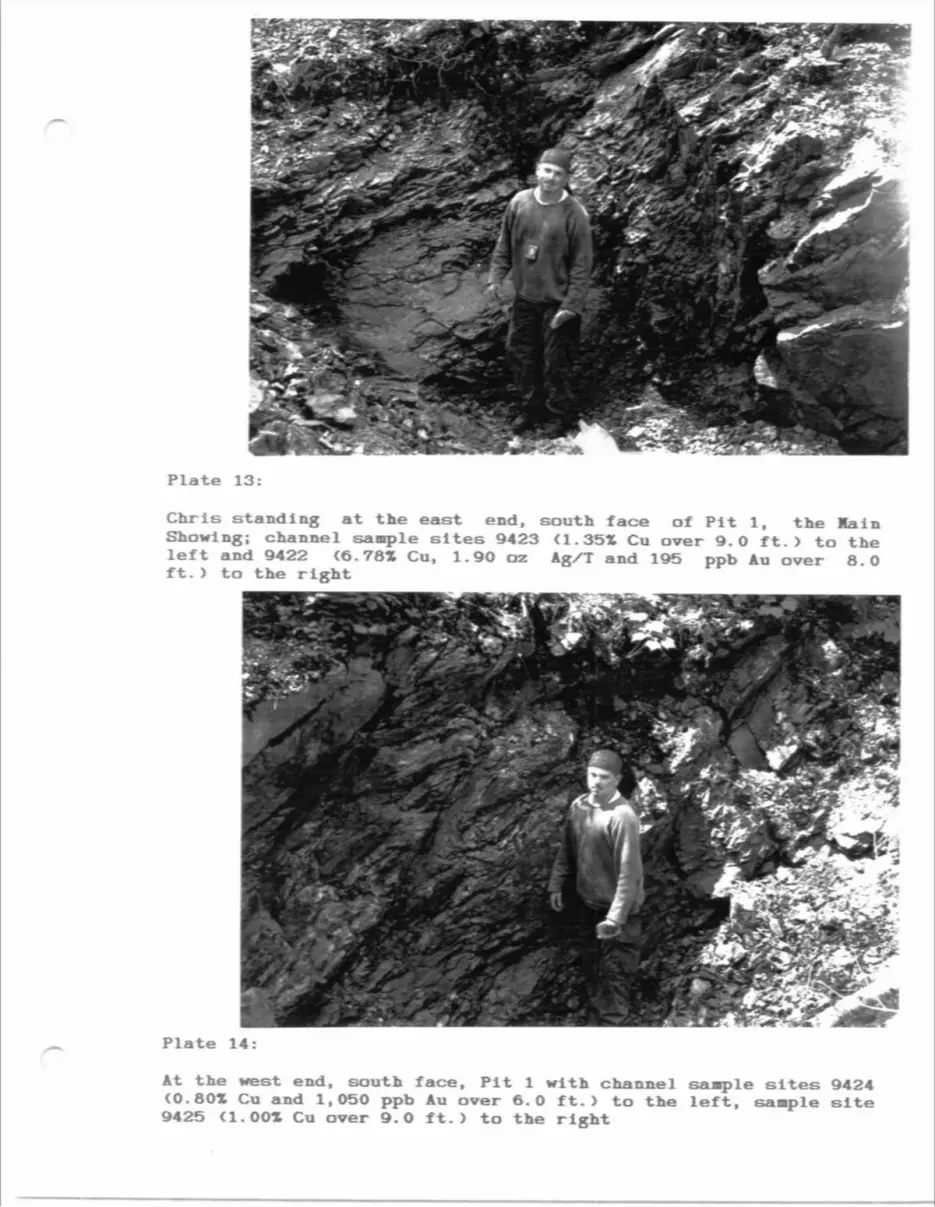
Plate 13:
Chris standing at the east end, south face of Pit l, the Hain Showing; channel sample sites 9423 (1.351 Cu over 9.0 ft.) to the left and 9422 (6.78* Cu, l.9O oz Ag/T and 195 ppb Au over 8.0 ft. y to the right
Plate 14
At the west end, south face, Pit l with channel sample sites 9424 {0.80X Cu and 1,050 ppb Au over 6.0 ft.) to the left, sample site 9425 Cl.OO* Cu over 9.0 ft.) to the right
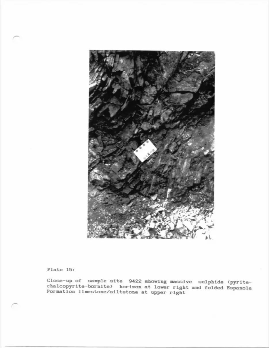
Plate 15:
Close-up of saaple site 9422 showing aassive sulphide (pyrite- chalcopyrlte-bornite) horizon at lower right and folded Espanola FormatIon llMeetone/siItstone at upper right
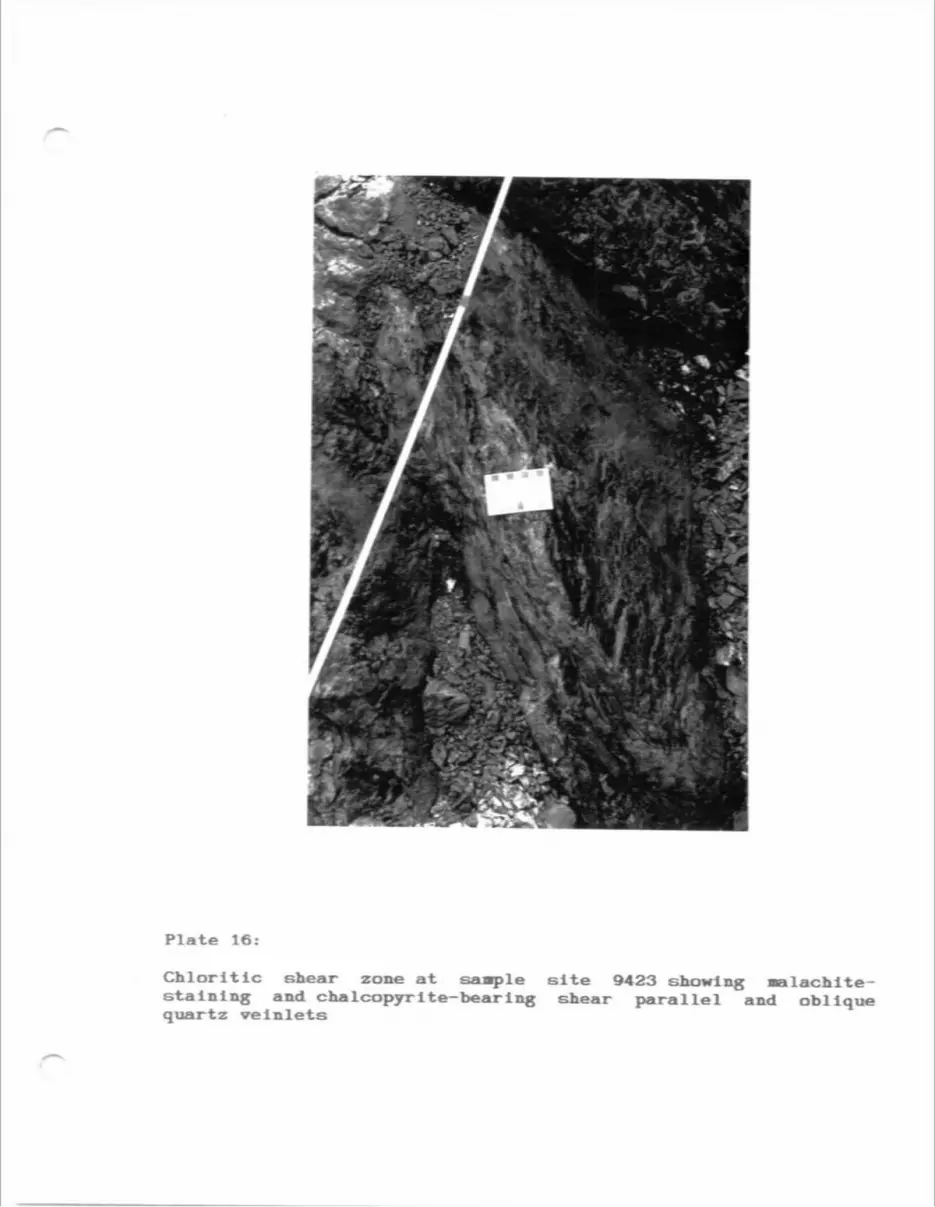
Plate 16:
Chloritic shear zone at saaple site 9423 showing •alachlte- stalning and chalcopyrite-bearing shear parallel and oblique quartz veInlets
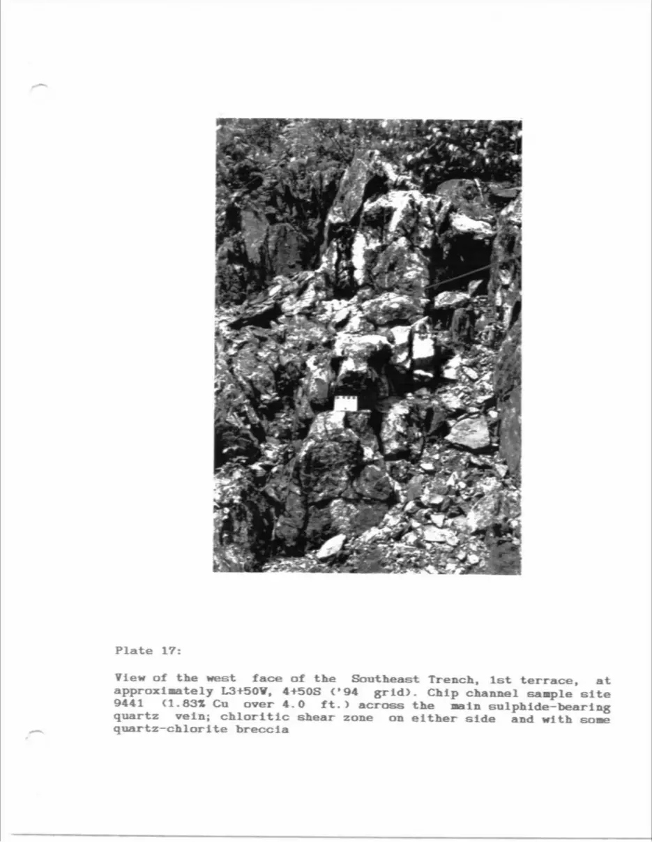
Plate 17:
View of the west face of the Southeast Trench, 1st terrace, at approximately L3+50V, 4+50S ('94 grid). Chip channel sample site 9441 (1.831 Cu over 4.0 ft.) across the Bain sulphide-bearing quartz vein; chloritic shear zone on either side and with sone quartz-chlorlte breccia
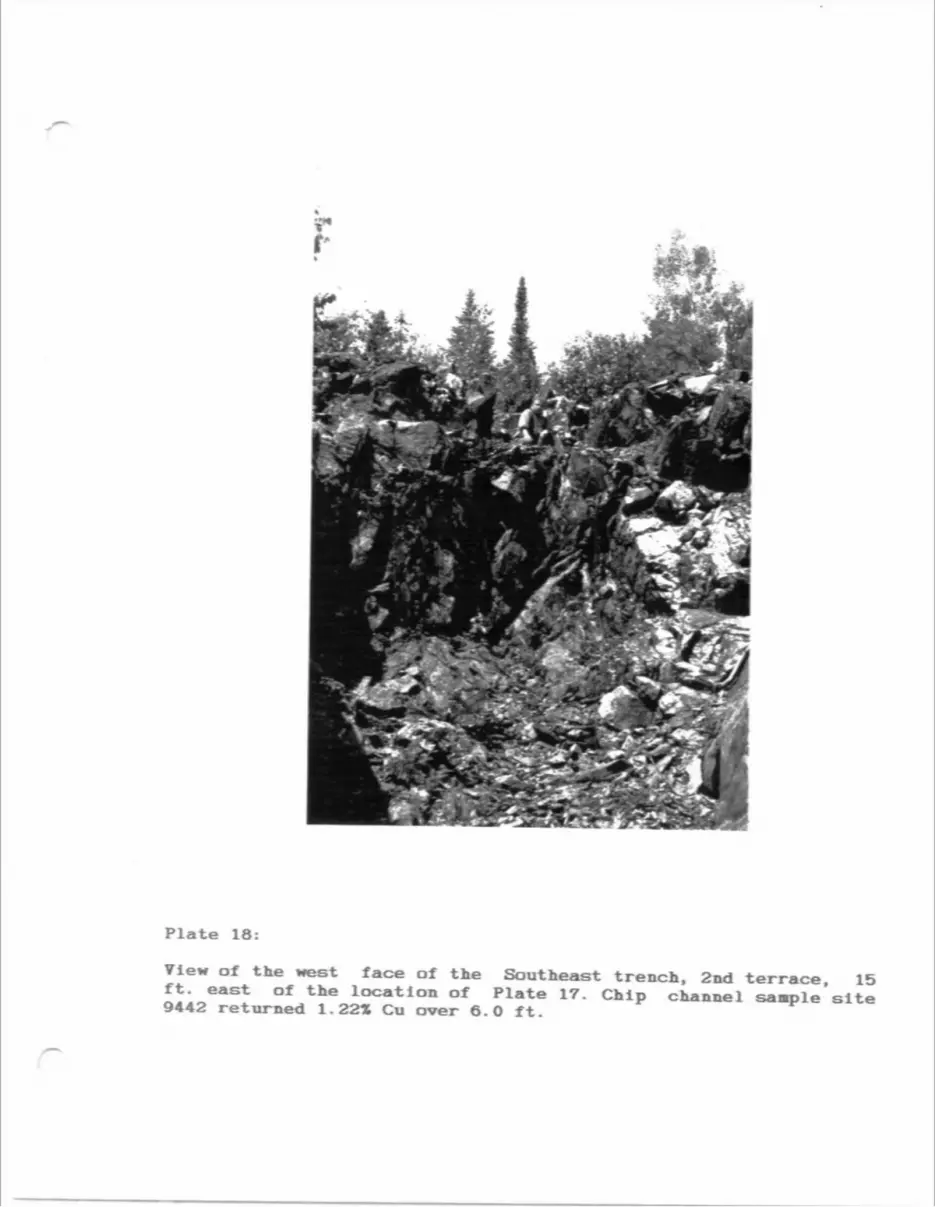
Plate 18:
View of the west face of the Southeast trench, 2nd terrace, 15 ft. east of the location of Plate 17. Chip channel sample site 9442 returned 1.221 Cu over 6.0 ft.

APPEIDICBS

APPEMDII A: Summary Dlaaond Drill Logs
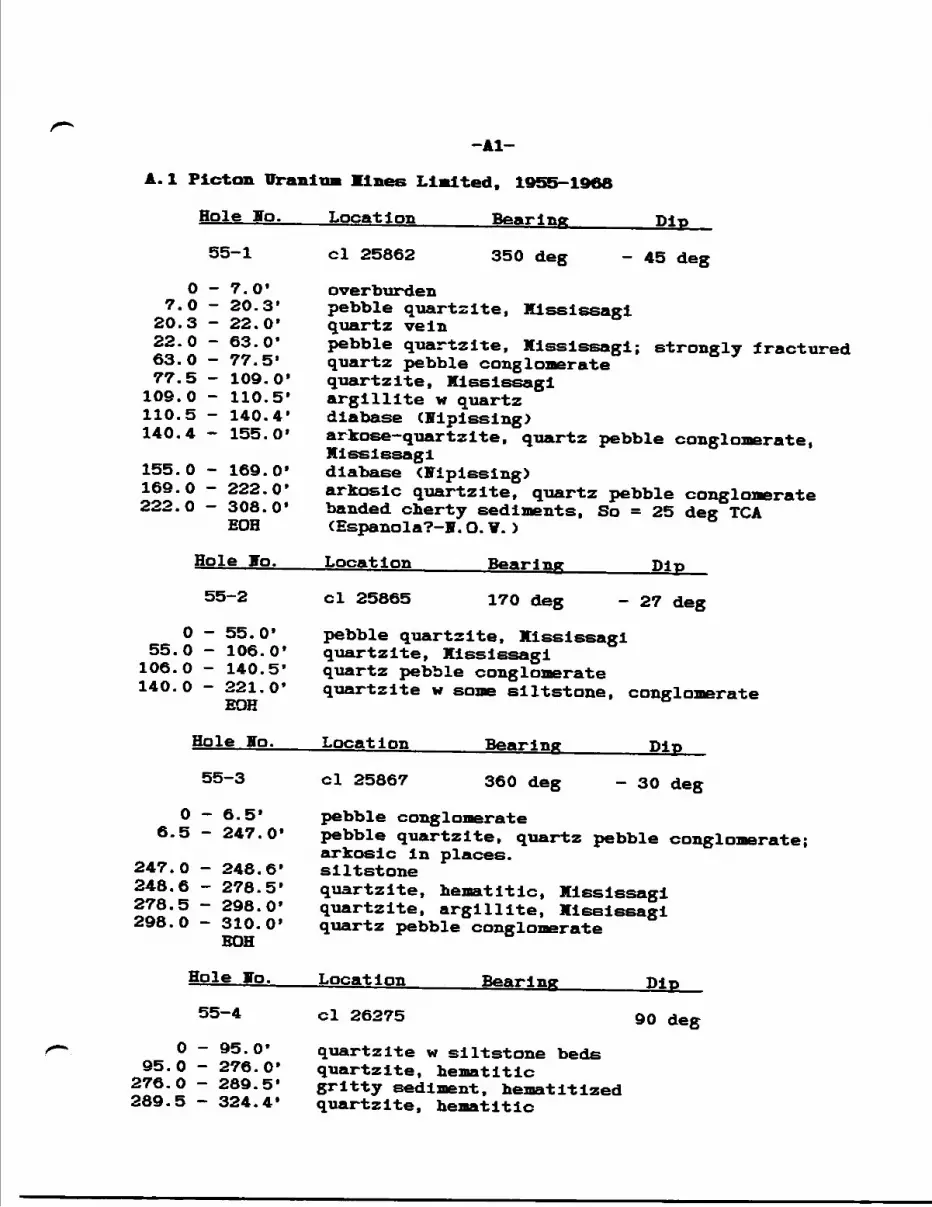
-Al-
A.l Picton Uranium lines Limited, 1955-1968
Hole Jo.___Location______Bearing_______Dip
55-1 ci 25862 350 deg - 45 deg
O - 7.0' overburden7.0 - 20.3' pebble quartzite, Xlssissagl
20.3 - 22.0' quartz vein22.0 - 63.0' pebble quartzite, Mississagi; strongly fractured63.0 - 77.5' quartz pebble conglonerate77.5 - 109.0' quartzite, Mississagi109.0 - 110.5* argillite w quartz110.5 - 140.4' diabase (nipissing)140.4 - 155.0' arkose-quartzite, quartz pebble conglomerate,
Mississagi155.0 - 169.0' diabase (Fiplssing)169.0 - 222.0' arkosic quartzite, quartz pebble conglomerate 222.0 - 308.0' banded cherty sediments, So = 25 deg TGA
EOH (Espanola?-!.O.V.)
Hole Jo.___Location______Bearing_______Dip
55-2 ci 25865 170 deg - 27 deg
O - 55.0' pebble quartzite, Mississagi 55.0 - 106.0' quartzite, Kississagl 106.0 - 140.5' quartz pebble conglomerate 140.0 - 221.0' quartzite w some siltstone, conglomerate EOH
Hole ITo.___Location______Bearing_______Dip
55-3 ci 25867 360 deg -30 deg
O - 6.5' pebble conglomerate 6.5 - 247.0* pebble quartzite, quartz pebble conglomerate;
arkosic in places. 247.0 - 248.6' siltstone248.6 - 278.5* quartzite, hematitlc, Mississagi 278.5 - 298.0* quartzite, argillite, Miselssagi 298.0 - 310.0' quartz pebble conglomerate
BOH
Hole Jo.___Location______Bearing_______Dip
55-4 ci 26275 90 deg
O - 95.0* quartzite w siltstone beds95.0 - 276.0' quartzite, hematitic
276.0 - 289.5' gritty sediment, hematltlzed289.5 - 324.4* quartzite, hematitic
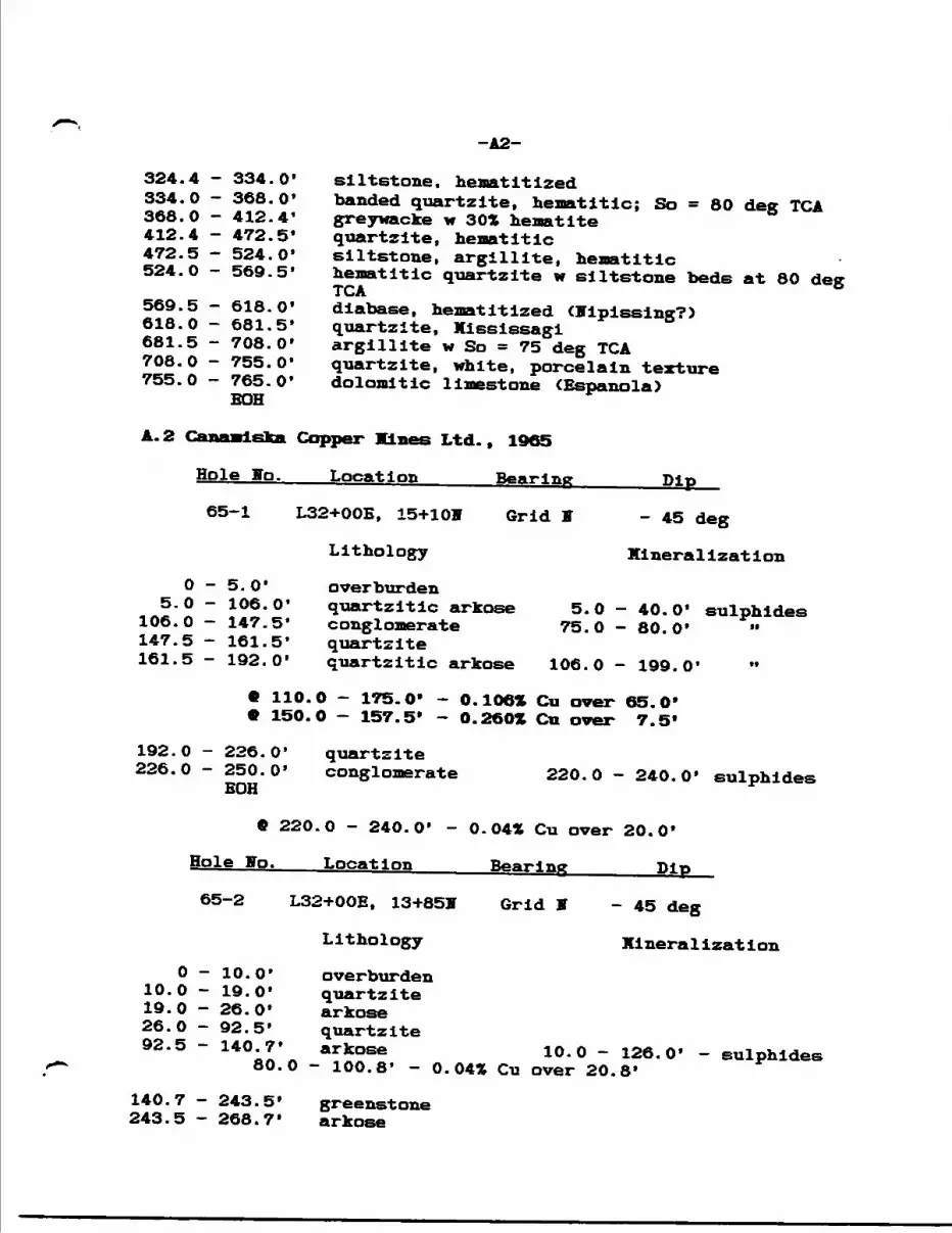
-A2-
324.4 - 334.0' siltstone, hematltized334.0 - 368.0* banded quartzite, henatitlc; So ^ 80 deg TGA368.0 - 412.4' greywacke w 30* hematite412.4 - 472.5' quartzite, henatitlc472.5 - 524.0' siltstone, argillite, hematltlc524.0 - 569.5* henatitlc quartzite w siltstone beds at 80 deg
TGA569.5 - 618.0* diabase, henatitlzed Nipissing?)618.0 - 681.5* quartzite, Xississagi681.5 - 708.0* argillite w So " 75 deg TGA708.0 - 755.0* quartzite, white, porcelain texture755.0 - 765.0* dolomitic limestone (Espanola)
BOH
A. 2 Canaaieka Copper lines Ltd., 1965
Hole Jo.___Location______Bearing_______Dip
65-1 L32+OOE, 15+10H Grid J -45 deg
Lithology Klnerallzatlon
O - 5.0* overburden5.O - 106.0* quartzitic arkose 5. O — 40.0' sulphides106.0 - 147.5* conglomerate 75.0 - 80.0* "147.5 - 161.5* quartzite
161.5 - 192.0* quartzitic arkose 106.0 - 199.0*
C 110.0 - 175.0* - O.106* Cu over 65.0* 9 150.0 - 157.5* - 0.260X Cu over 7.5f
192.0 - 226.0* quartzite226.0 - 250.0' conglomerate 220.O - 240.0' sulphides EOH
9 220.0 - 240.0' - 0.04* Cu over 20.0*
Hole ffo.___Location______Bearing_______Dip
65-2 L32+OOE, 13+85V Grid V - 45 deg
Lithology Kineralization
O - 10.0* overburden10.0 - 19.0* quartzite19.0 - 26.0* arkose26.0 - 92.5* quartzite92.5 - 140.7* arkose 10.0 - 126.0* - sulphides80.0 - 100.8* - 0.04* Cu over 20.8*
140.7 - 243.5* greenstone 243.5 - 263.7' arkose
-A3-
268.7 - 339.5* greenstone 275.0 - 339.5' - sulphides 277.0 - 323.5' - brecciated
6 275.0 - 285.0' - 0.05* Cu over 10.0*6 295.0 - 310.0' - 0.03* Cu over 15.0*e 315.0 - 325.0' - 0.03* Cu over 10.0'
339.5 - 363.0' 363.0 - 454.0*
EOH
Hole Jo.
arkose greenstone
Location Bearing Dip
65-3 L36+OOE, 20+OOF Grid S
Lithology
- 45 deg
Hineralization
O - 25.0'25.0 - 50.0'50.0 - 75.0'75.0 - 91.0*91.0 - 141.5'
overburden arkosearkose, tuff greenstone arkose/tuff 25.0 - 150.0* - sulphides
30.0 - 40.0' - 0.06* Cu over 10.0'48.0 - 58.0* - 0.03* Cu over 10.0*70.0 - 75.0' - 0.03* Cu over 5.0*85.0 - 95.0* - 0.06* Cu over 10.0*
141.5 - 317.0' 317.0 - 323.5* 323.5 - 338.0* 338.0 - 350.0'
EOH
greenstone arkose/tuff greenstone arkose/tuff 338.O - 350.O' - sulphides
6 335.0 - 350.0* - 0.11* Co over 15. O*
Hole Jo. Location Bearing Dip
65-4 L20+OOE, 6+OOff Grid H
Lithology
- 45 deg
MineralIzationO - 19.0*
19.0 - 84.0*overburden arkose 19.O - 84.O* - sulphides
C 30.0 - 40.0* - 0.07* Cu over 10*
84.0 - 111.7* conglomerate111.7 - 181.5* arkose161.5 - 201.0* greenstone201.0 - 218.0* arkose/tuff218.0 - 257.9' quartzitic arkose
84.0 - 350.0' - scattered narrow sulphide sections
-A4-
257.9 - 350.0' greenstone BOH
Hole So.-——-Location_____Bearing————^Dip
65-6 L32+25E, 16+25F Grid S -45 degLithology Mineralization
O - 4.0' overburden4.0 - 20.0' quartzite
20.0 - 46.0' arkose 4.O - 46.0' - sulphides9 5.O - 3O.O* - O.532* Cu over 25.0* C 20.0 - 25.0* - 2. GOZ Cu over 5. O*
46.0 - 67.0' quartzite, arkose67.0 - 90.0* quartzite 46.0 - 90.0' - sulphides EOH
9 6O.O - 75.O* - 0.171 Cn over 15.0*
Hole Jo.___Location______Bearing_______Dip 65-7 L32+25E, 16+255 Grid S -30 deg
Lithology MineralizationO - 4.0' overburden
4.0 - 17.5* quartzite17.5 - 40.0' arkose 4.O - 40.0' - sulphides
6 17.5 - 25.0* - 1.71* Cu over 7.5* 6 25.O - SO.O* - 1.21* Cn over 12.5*
or * 17.5 - 3O.O* - 1.44* Cn over 19.5*
40.0 - 69.0' quartzite, arkose69.0 - 95.0* quartzite 40.0 - 95.0* - sulphides EOH
9 90.0 - 95.0* - 0.38* Co over 5.0*
Hole lo.____Location______Bearing_______Dip
65-8 L31+75B, 16+305 Grid S -45 deg
Lithology MineralizationO - 3.0' overburden
3.0 - 24.0' quartzite24.0 - 47.0' arkose
-A5-
47.0 - 90.0* BOH
Hole Jo.
quartzite 24.0 - 90.0' - sulphides
Location______Bearing_______Dip
65-9
0-3.0* 3.0 - 19.0* 19.0 - 59.0*
L31+75B, 16+30H
Lithology
overburdenquartzitearkose
Grid S -30 deg
Kinerallzatlon
3.0-59.0* - sulphides
9 27.5 - 4O.O* - 0.421 Cu over 12.5' * 32.5 - 35.0* - 1.301 Cu over 2.5*
59.0 - 81.0* BOH
Hole Ho.
quartzite 59.0 - 81.0 - sulphides
Location______Bearing_______Pip
65-10
0-3.0* 3.0 - 32.0*
32.0 - 52.0*
L31+25E, 16+30F
Lithology
overburdenquartzitearkose
Grid S - 45 deg
Ml neralisat ion
52.0 - 90.0* EOE
Hole Jo.
10.0 - 52.0* - sulphides
42.5 - 45.0* - 0.321 Cu over 2.5*
52.0 - 90.0* - sulphidesquartzite
Location Bearing Pip
65-11
O - 15.0*15.0 - 36.0*36.0 - 70.0*
L32+75B, 16+601
Lithology
overburdenquartzitearkose
Grid S -45 deg
Mineralization
15.0 - 57.0*- sulphides
42.5 - 50.0* - 1.821 Cu over 7.5* 45.0 - 47.5* - 4.601 Cu over 2.5'*
70.0 - 97.O* BOH
quartzite 60.0 - 97.0* - sulphides
fi 62.5 - 65.0* - 0.63Z Cu over 2.5*
-A6-
* Assessment file shows an averaged grade of 2.51* Cu over 10.0', however two assay Intervals as stated above are shown on the drill section. The 2.51* figure (Incorrect) is shown on Map A.
Hole Jo.___Location______Bearing_______Dio
65-12 L32+25E, 17+OOff Grid S - 45 deg
Lithology Mineralization
O — 7.0* overburden7.0 - 22.0* quartzite22.0 - 46.0' arkose 7.0 - 46.0' - sulphides
® 7.0 - 30.0* - 0.06* Cu over 23.0'
46.0 - 75.0* quartzite75.0 - 93.0* arkose93.0 - 105.0* quartzite 80.0 - 105.0' - sulphides
fi 95.0 - 10O.O' - 0.51* Cu over 5.0*
105.0 - 128.0' quartzlte/arkose128.0 - 160.0* quartzite 105.0 - 150.0' - sulphides
Q 95.0 - 125.0* - 0.17* Cu over 3O.O'C 125.0 - 150.0* - 0.07* Cu over 25.0*
160.0 - 260.0* greenstone EOH
Hole Ho.___Location______Bearing_______Dip
65-13 L33+25E, 16+50V Grid S -45 deg
Lithology Mineralization
O - 10.0* overburden10.0 - 27.0* quartzite27.0 - 75.0' arkose 42.0 - 52.5' - sulphides
e 42.0 - 52.5* - 0.23* Cu over 10.5* C 50.0 - 52.5* - 0.58* Cu over 2.5*
75.0 - 105.0* - quartzite 60.0 - 80.0* - sulphides 105.0 - 125.0' - quartzite/arkose
EOH
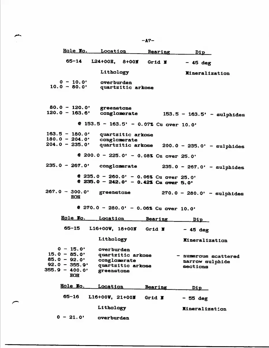
Hole If o. Location
-A7-
Bearlng Dip
65-14 L24+OOE, 8+OOff Grid H
Lithology
O - 10.0' 10.0 - 80.0*
- 45 deg
Klnerallzation
overburden quartzitic arkose
80. 120.
163.180.204.
235
0 - 120.0' greenstone0 - 163.6' conglomerate 153.5
9 153.5 - 163.5' - 0.071 Cu over
5 - 180.0' quartzitic arkose0 - 204.0' conglomerate0 - 235.0' quartzitic arkose 200.0
9 200.0 - 225.0' - O. 08* Cu over
0 - 267.0' conglomerate 235.0
9 235.0 - 260.0' - 0.06* Cu over 9 235. O - 242. O* - 0.42* Cu over
- 163.5* - sulphides
10.0'
- 235.0'
25.0'
- 267.0'
25.0* 5.0'
- sulphides
- sulphides
267. 0 - 300.0' EOH
greenstone 270.0 - 280.0' - sulphides
9 270.0 - 280.0* - 0.06* Cu over 10.0'
Hole Bo.___Location______Bearing_______Pip
65-15 L16+OOV, 18+OOV Grid K
Lithology
O15.085.092.0
355.9
15.0'85.0'92.0*355.9'400.0*EOH
overburden quartzitic arkose conglonerate quartzitic arkose greenstone
- 45 deg
Kinerallzation
numerous scattered narrow sulphide sections
Jo.. Location
65-16 L16+OOV, 21+OOH
Lithology
O - 21.0' overburden
- 55 deg
Kineralizat ion
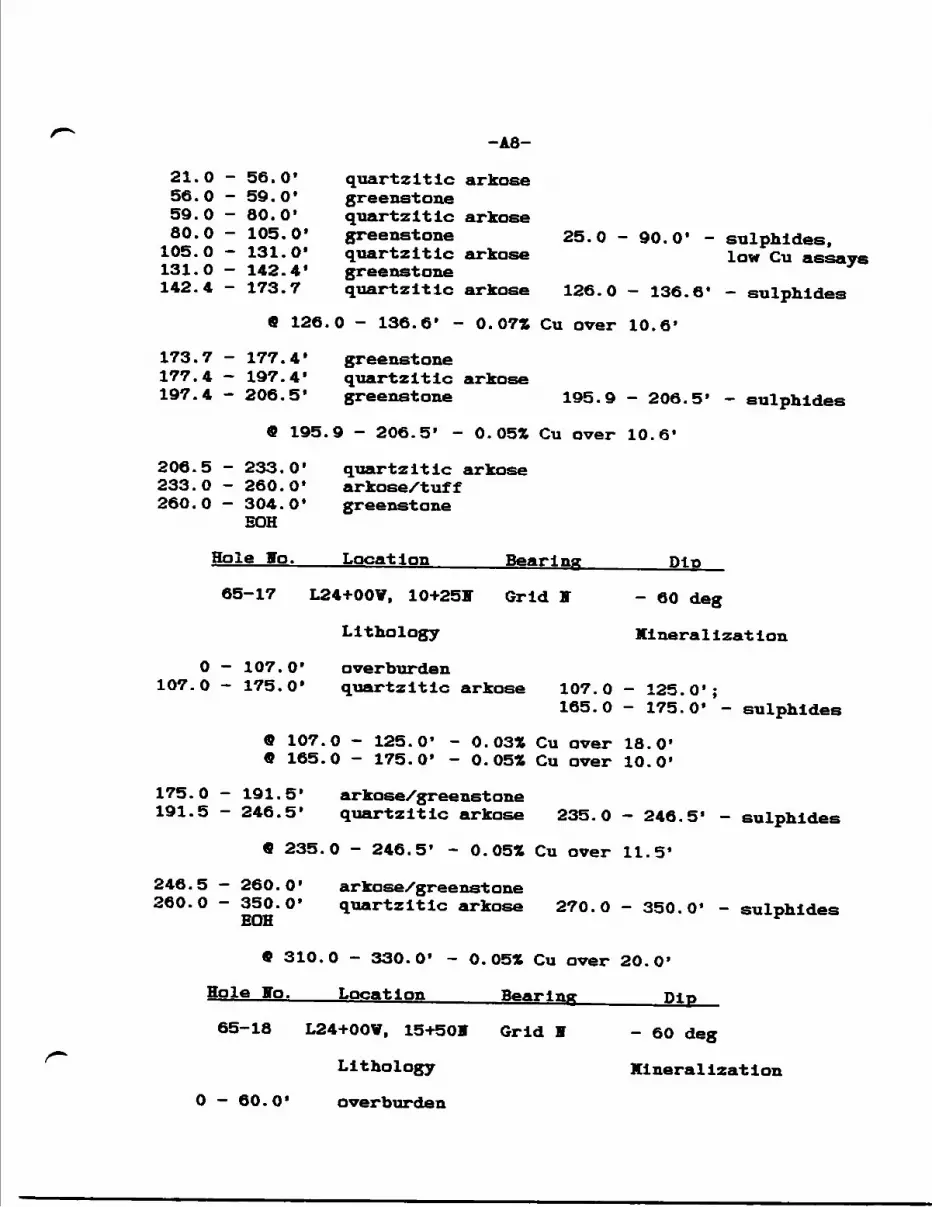
-A8-
21.0 - 56.0' quartzitic arkose56.0 - 59.0' greenstone59.0 - 80.0' quartzitic arkose80.0 - 105.0' greenstone 25.0 - 90.0' - sulphides,105.0 - 131.0' quartzitic arkose low Cu assays131.0 - 142.4' greenstone142.4 - 173.7 quartzitic arkose 126.0 - 136.6* - sulphides
6 126.0 - 136.6' - 0.07* Cu over 10.6'
173.7 - 177.4* greenstone177.4 - 197.4' quartzitic arkose197.4 - 206.5' greenstone 195.9 - 206.5' - sulphides
9 195.9 - 206.5' - 0.05* Cu over 10.6'
206.5 - 233.0' quartzitic arkose 233.0 - 260.0* arkose/tuff 260.0 - 304.0' greenstone
EOH
Hole Ho.___Location______Bearing_______Dip
65-17 L24+OOV, 10+25F Grid I -60 deg
Lithology Kinerallzatlon
O - 107.0* overburden 107.0 - 175.0' quartzitic arkose 107.0 - 125.0';
165.0 - 175.0* - sulphides
9 107.0 - 125.0* - 0.03* Cu over 18.0* 9 165.0 - 175.0' - 0.05* Cu over 10.0'
175.0 - 191.5' arkose/greenstone191.5 - 246.5' quartzitic arkose 235.0 - 246.5* - sulphides
9 235.0 - 246.5* - 0.05* Cu over 11.5*
246.5 — 260.0* arkose/greenstone260.0 - 350.0' quartzitic arkose 270.O - 350.0* - sulphides
EOH
9 310.0 - 330.0' - 0.05* Cu over 20.0*
Hole Jo.___Location______Bearing_______Dip
65-18 L24+OOV, 15+50V Grid H -60 deg
Lithology Klneralization
O - 60.0* overburden

-A9-
60.0 - 214.3* quartzitic arkose 60.0 - 120.0';160.0 - 214.3* - sulphides
9 160.0 - 180.0* - 0.05* Cu over 20.0* 9 180.0 - 200.0* - 0.07* Cu over 20.0*
214.3 - 228.8* greenstone228.8 - 287.5* quartzitic arkose 250.0 - 287.5' - sulphides
9 25O.O - 270.0* - 0.10* Cn over 20.0*
287.5 - 309.0* greenstone 287.5 - 309.0* - sulphides
9 287.5 - 309.0* - 0.05* Cu over 21.5'
309.0 - 435.6* arkose/greenstone 435.6 - 441.0' quartzitic arkose441.0 - 470.0* greenstone 435.6 - 450.0' - sulphides 470.0 - 500.0* quartzitic arkose 470.0 - 500.0' - sulphides
SOB
9 480.0 - 482.5* - 0.17* Cu over 2.5*
Hole Jo.___Location______Bearing_______Dip
65-19 L40+OOV, 25+505 Grid V -45 deg
Lithology Hineralizatlon
O - 12.0' overburden12.0 - 167.5* quartzitic arkose
167.5 - 205.5* greenstone205.5 - 230.0* quartzitic arkose230.0 - 245.9' greenstone 12.O - 245.9' - sulphides
9 50.0 - 90.0* - 0.05* Cu over 40.0*9 90.0 - 110.0* - 0.07* Cu over 20.0'9 150.0 - 195.0' - 0.05* Cu over 45.0'9 195.0 - 215.0* - 0.07* Cu over 20.0*
245.9 - 325.0* quartzitic arkose 245.9 - 275.0* - sulphides325.0 - 335.4* conglomerate335.4 - 390.2* arkose390.2 - 414.0* greenstone414.0 - 425.6* arkose425.6 - 467.0* greenstone
EOH
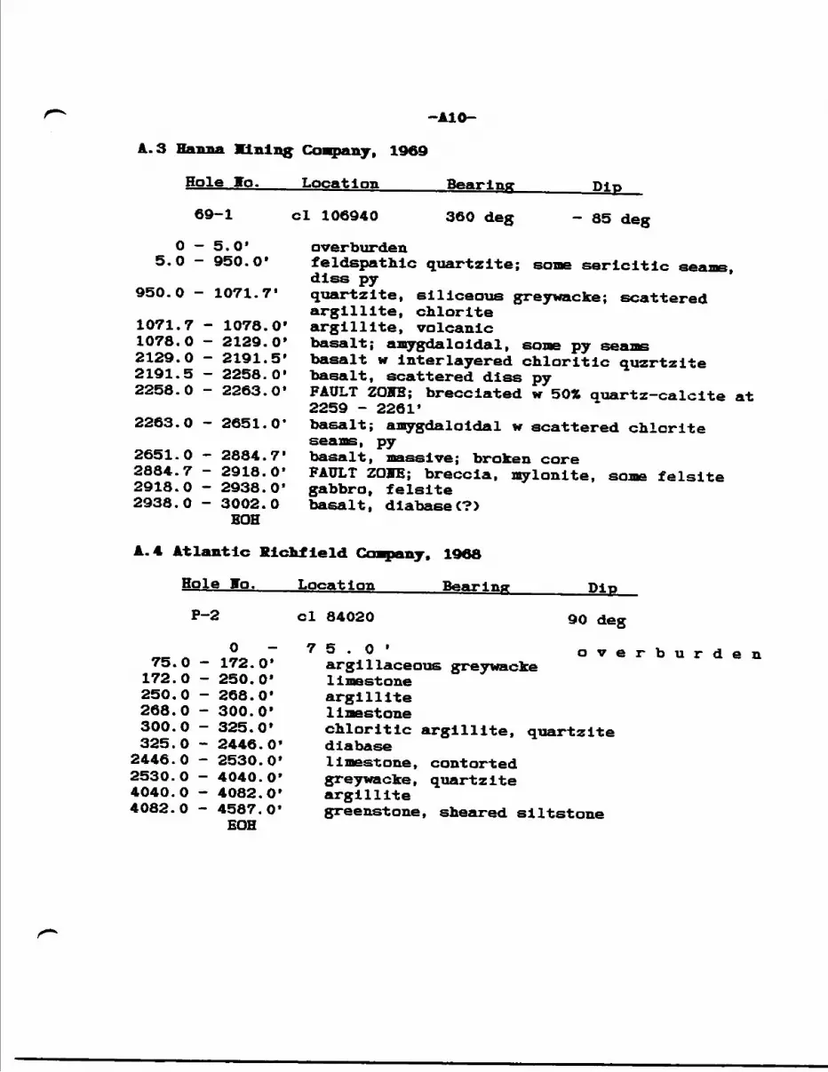
-AID-
Hole Jo.
69-1
0 - 5.0'5.0 - 950.0*
950.0 - 1071.7*
1071.7 - 1078.0'1078.0 - 2129.0'2129.0 - 2191.5*2191.5 - 2258.0'2258.0 - 2263.0*
2263.0 - 2651.0*
2651.0 - 2884.7'2884.7 - 2918.0*2918.0 - 2938.0*2938.0 - 3002.0
BOH
r — — — f —— j * — —
Location Bearing Dip
ci 106940 360 deg - 85 deg
overburdenfeldspathic quartzite; some sericitic seams,dlss pyquartzite, siliceous greywacke; scatteredargillite, chloriteargillite, volcanicbasalt; amygdaloidal, some py seamsbasalt w inter layered chloritic quzrtzitebasalt, scattered diss pyFAULT ZOVB; brecciated w 502 auartz-calcite at2259 - 2261*basalt; amygdaloidal w scattered chloriteseams, pybasalt, massive; broken coreFAULT ZOIE; breccia, mylonite, some felsitegabbro, felsitebasalt, diabase C?)
A. 4 Atlantic Ricltfleld Cmranv. 1908
Hole Jo.
P-2
075.0 - 172.0*172.0 - 250.0'250.0 - 268.0'268.0 - 300.0'300.0 - 325.0'325.0 - 2446.0*2446.0 - 2530.0*2530.0 - 4040.0'4040.0 - 4082.0'4082.0 - 4587.0*
BOH
Location Bearing Dip
ci 84020 90 deg
75.0* overburdenargillaceous greywackel imestoneargillitelimestonechloritic argillite, quartzitediabaselimestone, contortedgreywacke, quartziteargillitegreenstone, sheared siltstone
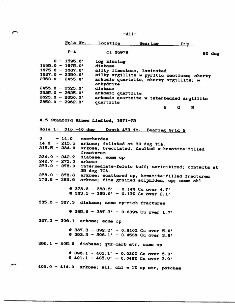
-All-
Hole Bo.____Location______Searing_______Dip
P-4 ci 86979 90 deg
O - 1595. O' log missing 1595.0 - 1675.0' diabase1675.0 - 1687.0* silty limestone, laminated1687.0 - 2350.0' silty argillite w pyrltlc sections; cherty 2350.0 - 2455.0* arkosic quartzite, cherty argillite; w
anhydrite2455.0 - 2525.0* diabase 2525.0 - 2625.0* arkosic quartzite2625.0 - 2850.0* arkosic quartzite w Interbedded argillite 2850.0 - 2962.0* quartzite
E O H
A. 5 Stanford Mines Limited. 1971-72
Hole 1: Dip -40 deg Depth 473 ft. Bearing Grid E
O — 14.O overburden14.0 - 215.5 arkose; foliated at 30 deg TGA.215.5 - 234.0 arkose, brecciated, faulted w hematite-filled
fractures234.0 - 242.7 diabase; some cp 242.7 - 273.0 arkose 273.0 - 278.0 Intermedlate-felslc tuff; sericltlzed; contacts at
25 deg TGA.278.0 - 378.8 arkose; scattered cp, hematite-filled fractures 378.8 — 385.6 arkose; fine grained sulphides, cp: some ehl
9 378.8 - 383.5* - 0.14* Cu over 4.7* 9 383.5 - 385.6* - 0.13* Cu over 2.1*
385.6 - 387.3 diabase; some cp-rich fractures
9 385.6 - 387.3* - 0.039* Cu over 1.7*
387.3 - 396.1 arkose; some cp
9 387.3 - 392.3* - 0.040* Cu over 5.0' 9 392.3 - 396.1* - 0.053* Cu over 3.8*
396.l — 405.O diabase; qtz-carb str, some cp
* 396.1 - 401.1* - 0.030* Cu over 5.0* 9 401.1 - 405.0* - 0.048* Cu over 3.9'
405.0 - 414.0 arkose; sil, chl w l* cp str, patches
-A12-
9 405.0 - 410.0' - 0.16* Cu over 5.0* 9 410.0 - 414.0' - 0.04* Cu over 4.0'
414.0 - 434.0 fault(?); strongly fractured w hematite and cpfilling; low Cu assays
434.0 - 473.0 arkose; some scattered cp EOH
9 444.0 - 449.0' - 0.049* Cu over 5.0'
Hole 2; Pip -50 deg Depth 242 ft. Bearing HV
O -14.0 overburden 14.0 -85.0 arkose; some cbl, cp 85.0 -89.0 diabase89.0 - 197.0 diabase, diorite; dlss py, cp at 100.0 - 121.0 197.0 - 242.0 arkose
EOH
- core split but not assayed
Hole 3; Dip -70 deg Depth 280 ft. Bearing 336 deg
O -12.0 overburden12.0 - 70.7 arkose; minor dlss cp w some chl70.7 - 72.0 magnetite-rich band; mlcaeous w qtz-carb str; some
cp In sil patches Clabelled Iron formation In log)
9 70.7 - 72.0* - 0.14* Cu, 0.25 oz Ag/T aver 1.3*
72.0 - 97.0 arkose; some specularite and py to base 97.0 - 262.7 diabase, diorite; carb str w py, CD and l* diss cp
at 173.3 - 175.5
9 173.3 - 175.5* - 0.94* Co, 0.14 oz Ag/T over 2.2*9 175.5 - 180.5* - 0.041* Cu, o. 10 oz Ag/T over 5.0'
262.7 - 280.0 arkose EOH
Hole 4; Dip -50 deg Depth 660 ft. Bearing TV
O — 36.O overburden36.O - 449.O arkose449.0 - 571.0 diorite (diabase?)571.0 - 607.6 volcanic C?) (possibly nipissing diabase); w
numerous fractures, str, masses of chalcopyrite;sil bx zone at 578.0 - 581.0
9 571.0 - 581.0' - 0.28* Cu over 10.0'9 571.0 - 574.0* - O 53* Cu over 3.0'9 584.0 - 605.0' - 0.41* Cu over 21.0'
-A13-
O 594.O - 595.0* - 1.12* Cnt 4.05 oz Au/T over l.O'
607.6 - 660.0 arkose EOH
Hole 5; Dip -70 deg Depth 876 ft. Bearing Grid V
034.0 -
515.0 -636.0 -641.0 -649.7 -658.0 -662.0 -809.0 -831.0 -843.0 -
Hole 6:
34.0515.0636.0
overburdenarkose; scattered qtz— carb str, cpdiabase
641.0 arkose649.7658.0662.0809.0831.0843.0876.0EOH
-
Diu
diabasearkosediabaseandesite tuff (?)greywackearkosegreywacke
no sampling or assaying indicated
-50 dear De nth 1.039 ft. Bearing Grid V
O — 46.O overburden46.0 - 594.0 arkose; w cp-bearIng qtz veining at 139.0
139.3, 149.0 - 149.2, 166.6 - 168.0.594.0 - 1,039.0 diabase, diorite, mafic volcanic<?)
EGH- no sampling or assaying indicated
APPEIDIZ B:
Dlaaond Drill Logs. Fort lioraan Explorations Inc., 1974
ICL
'l
TN
I M
ININ
G A
CT
- M
PA
HT
HE
NT
BF
MIN
BI
fH-A
DI
AUON
D DR
ILLI
NG L
OOG
NH
.LIM
CO
MPA
NY
C. H
OBTX
XER
DA
K H
OLE
tT
AB
TE
P
1 BA
TE
CO
MPL
ET
ED
F.b.
28,
197
4 |lt
ar.
t, 1
974
1 IPL
MA
TIO
N C
O., O
WNE
R O
il OP
TION
EE
FortM
onan
Gro
up
FOOT
AOE
FROM
TO
0.
8.0
12.0
i f 'f
29.0
8.0
12.0
17."
ii?.
U
37. f 1 D—
MOC
B TY
PE
Casin
gEs
pano
la Fa
.
Espa
nola
Silts
tone
Mem
ber
iV 11 * n
-
-
fc&
n^
RA
T B
LO
OO
ID
Mar.
4,1
974
DA
T B
IU
IIM
ITT
ED
ll.f
l * *n ftf
t lw
cnq
r mn
Iwb,
kvl
jlll h M
* FI
LL
IN
ON
tw
Appr
ox. 3
20
| 16
5 C.M
H 1
~40
LO
OQ
EP
BY
"
liiiUI
TTID
IMU
f|Ml*
i^^
——
—
j, |
"j^
r^jL
*v'^
"1
'
f/^^tr
.'
it i - 1
'
"
DEIC
MIP
TION
,
; C
ttlw
r, gr
ain
ill.
! I..
IMIV
, •In
.itU
, •bM
Mlv
i^ •
II.
1 -
5 to
252
quan
s an
d fe
rrugi
nous
oar
boria
t* v
einl
ets
UD t
o 3"
id*
in b
recc
ial
roka
n Co
r*.
501ar
k *r
*v-B
T*en
inor
DV.
hlor
itie
iacjQ
fJZoi
.s.
buff
.bl
oBiit
e.•e
tiona
1ao
k*d
am
Tr.
cfan
d Bf
•d f
g.•o
vtt
t.
cher
t or
BU
tst-o
na
fa.-n
iD.
L B
BB
BC
ifte
rto
• aT
PAV
'
bsoo
no
crea
m
ne s
oft
*o 6"
ar*
bra
e1 a
nnul
ar,
in
ehlo
riti
e el
ltBto
ne B
S* vp
evw
aeke
L&UT
at
end
of s
ectio
n BV
BfHt
V D
ore
MrdM
17.
0V.
l/fl
" en
vel
nlet
at
17.8
.P
V. colo
ured
ery
Bta
llina
lf.m
v B
lltB
tona
or
S tow
ards
end
of
Mat
lm
Sav*
t*a1
ated
^jL
nBsto
na f
raom
ente
ve
rv t
ivhU
va
chlo
riti
c m
atri
x.
lim
tni^
LC
A It
P1
racc
iate
d or
fra
ctur
edK.
chl
or:
anin
a* m
Ltie
si
iv b*
i•e
ar 3
7. 5
' . bu
tra
ctur
as
i*ms
and
irina
ry
V. l
lfflv
f. t
. ai
ltat
one
aa a
bava
! anl
nae
or b
recc
ia f
llll
nja
. So
ma
mos
t ch
lori
te a
eeea
ra t
o be
dav
elim
ed a
lone
or a
lone
ori
n ary
lam
inae
on
each
aid
e of
fra
ctur
a*re
ccia
fra
nnm
ts a
re l
ess
than
2"V
av.M
.. l
" w
— M
. i.*ip
eeel
at,l(
1 va
ryin
anvu
la*
fra.
vman
t.a
4nfH
*lt
.M n
nm
*-A
*n
~n
m*
*1
rmm
1f
p
-p
..
-
1
120*
SE
of 1
4 Po
Bt,
Clai
m N
o. 35
9621
PL M
A.
•CA
tUX
MIL
! *
.
70"
•••i
•Muni.
raiM
il 4
.
.
*M
.
.•M
il.
-
w
1
ncATio
N (
84 4
ND
LE N
O.
IP A
U H
^*
'i
3596
21ip
,, L*
t, fm
. on
L.I,
MM) L
n*J
35E
TP.
169
21N
PMO
PEN
TV N
AMI
Lit
tl
Whi
te R
i\•A
MPL
E F
OO
T A
BB
r MOM
TO
1
SAM
PLE
LENO
TH
rarJ
root
rtT
AM
AV
t * .
1 —r -
MI
MIN
ING
ACT
- O
IMIIT
MC
HT
W H
INM
DIAM
OND
DRIL
LINO
LOf
lIIM
I m B
M r*t
* b
r mn
urn
Iwb,
mil f
ill In
tor
pwih
n tt
Imm
Ml IT
M H
ill M
M lw
ix
h k
.U.
puem
moM
tin
, IM
KH
I, al
iau
li, •
Item
toii.
*M
.
i.
can t* i
r
Iffi
l ir m
l ? 3 5*i i
|2 S'
i s s
f o 5 ?ft s? 2* 2O** A W^" ^'
M^ s!
4r
|lSo2S
E B
Hs.:
8Hkvl fill In t** n*k h*l*.
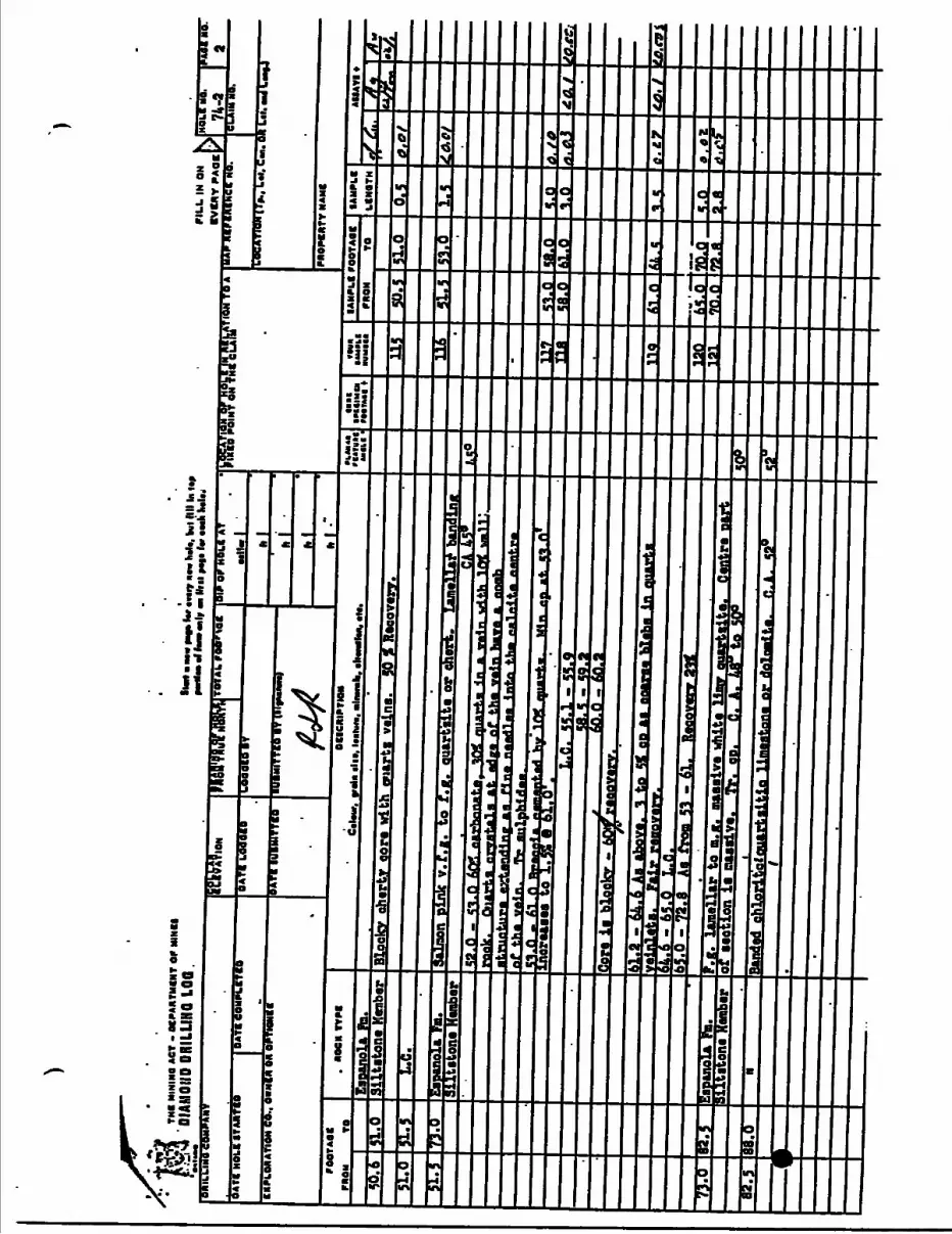
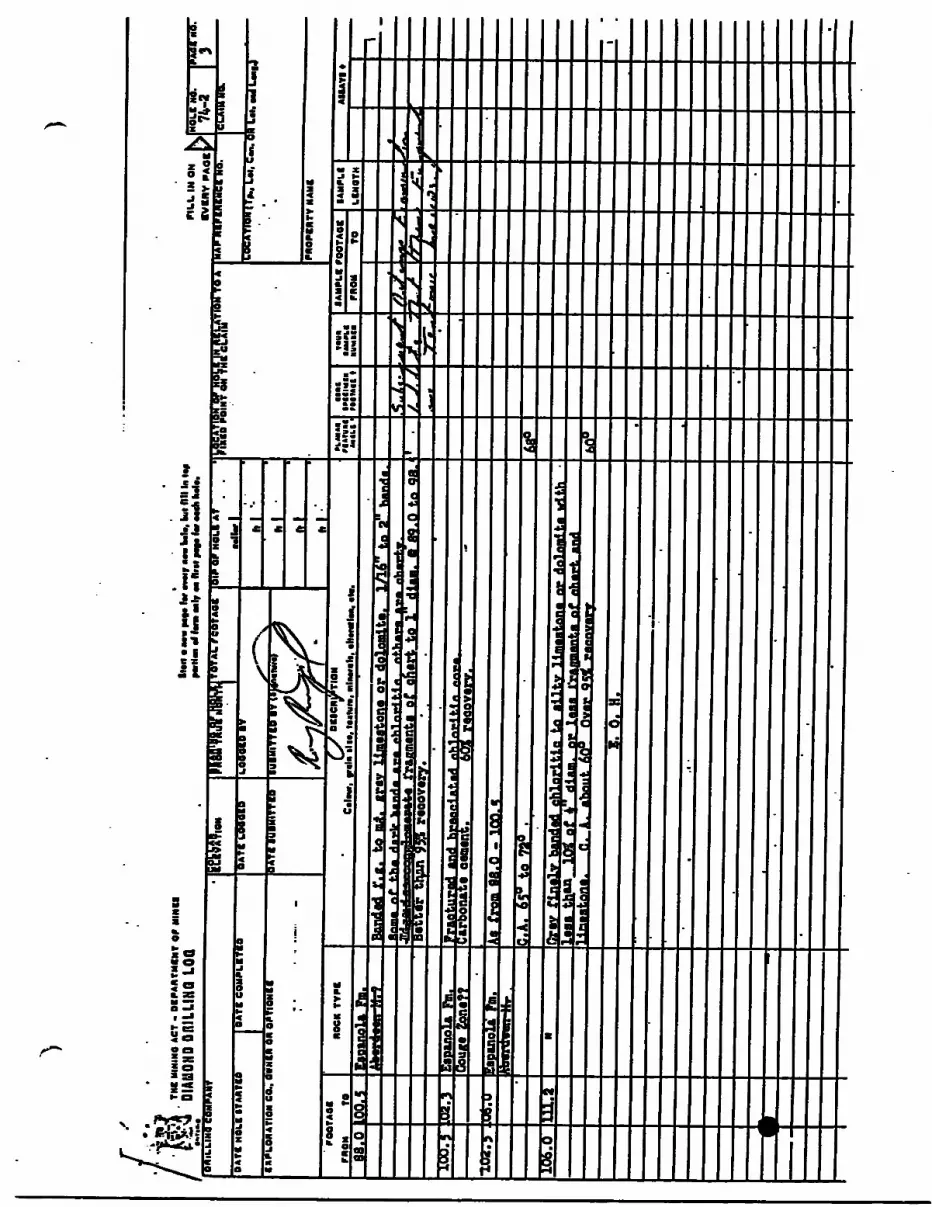
|j|HIIs
s4 MH]
jSn*
e ^S S
irs -i! [l
I If
11
J!
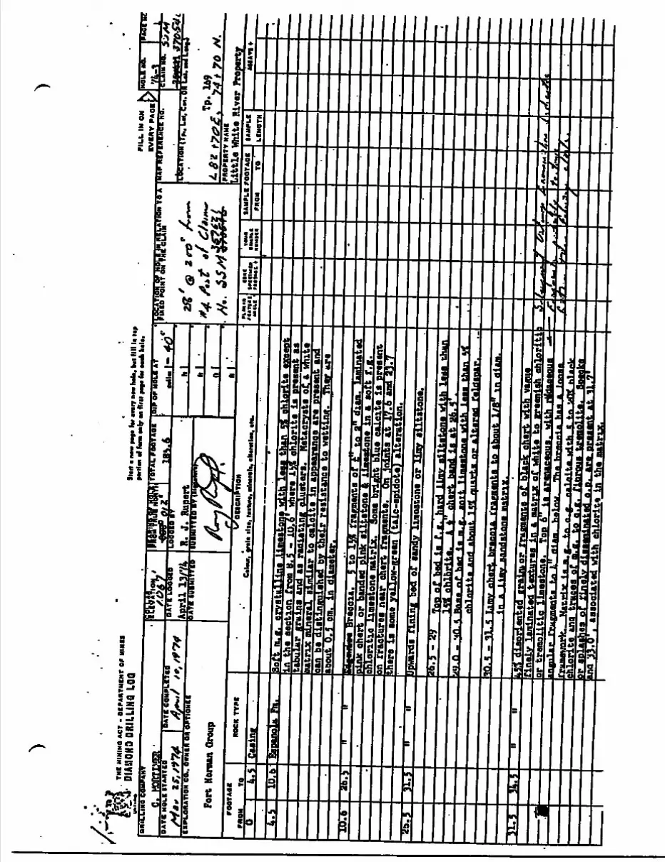
•/•'f' ^n
YH
I M
ININ
O A
CT
- O
f PA
WTH
CN
f W
MIN
I!DI
AMON
D DR
ILLI
NG L
OGlllr
t IM
W m
i (M
mir
e**
h*U
, kill I
I li
Up
•Wiin
wr.
. Mir-
nMip
It-r.
...iih
.u.
PIL
L I
N O
N4O
LC H
O.
IPA
ST
ettA
e J-
'JC
LAIM
HO
. ^
^/t
y
M
ne lB
BIL
LIN
a C
OM
PAN
Y
DA
T!
NO
LI
ITA
NT
OA
TI
CO
MP
Lf T
IO
(IP
LO
NA
YIO
N C
O.,
OW
NM
ON
OP
T
Fort
Nor
man
Grou
p
TOTA
L n
OT
AO
f
_IB
S.4
R. J
. R
uert
[. R
uper
TT IO
BY
(II
Sif
OF
HO
U A
T
mil.
- 4
OIO
N TO
A
.OC
ATi
gn (T
ja, L
ot, C
M.
f *
-aar
iai S
TO-S
^Ll
Lil. tu
t L*(
J
~"
Little White River P
roperty
rOO
TAfll
M
OM
TO
MOCK
TY
P*
VXO
IICM
IPTI
ON
C
ilcur
, tr
ain
ilid
ln
lv*,
mln
tnlt
, iN
acM
lvi,
til.
fi M
l*
rlir
uil
••lil
'cu
tIV
ICIM
U
M*1
MC
t•m
n•*
M(t
*•V
MM
)
IAU
PL
I roO
TAO
IM
OM
TOlA
MP
kf
LIN
OT
HA
HA
VI *
4.5
Casin
g iDiZ
4. S
JXJ.
6.S5
soii.
itiil
lins
.lim
esto
ne w
ith l
ess
t,oa
s t a
n ...
__,.. _ .
n
the
sect
ion
from
B. S
- I
P. i!
' whe
re 1
MI e
ilor
ite I
s pr
eeen
' i as
chlo
rite
eice
ept
tabu
lar
grai
ns a
nd a
s ra
diat
ing
clus
ters
. H
stac
ryat
s of
. a w
hite
ting
iloli
mat
rixto
cal
cite
in
appe
aran
ce a
re p
rese
nt a
ndth
eir
resi
stan
ce t
o w
ettin
g.
They
*re
er.
ID. 6
Brecoia.
5 to lw f
:a o
' to
a" diamTj aminatad
lin* chert o
r banded p
nk
siltstone
tt l aeatone
:n a s
ofi; f
.g.
chloritic
limestone
matrix.
ght
blue e
a, ,e
ite is present
in rraetures near c
hert f
ra imenta. On Joints at 1
7.6 and 837y
•here
is s
ome yelloy-green
talc-epidote)
alteration,
31.5
ipwaraa nning
bea of sandy limestone or limy s
iltstone.
*o.S - f
) top of bed I
s f. g.
hard
limy siltstone with
leas
i r*^
uiZ3
iT3^
^*i!'
'^ru
Tz*^
^rzj
^rz^
Tt.*
r**^
^^^^
\*A
nh
lorl
te.
A *
cher
t ba
nd i
s at
26.
S*
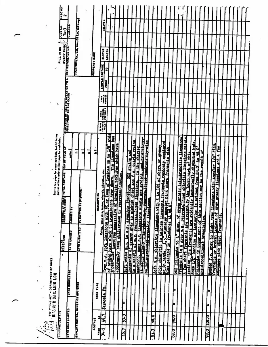
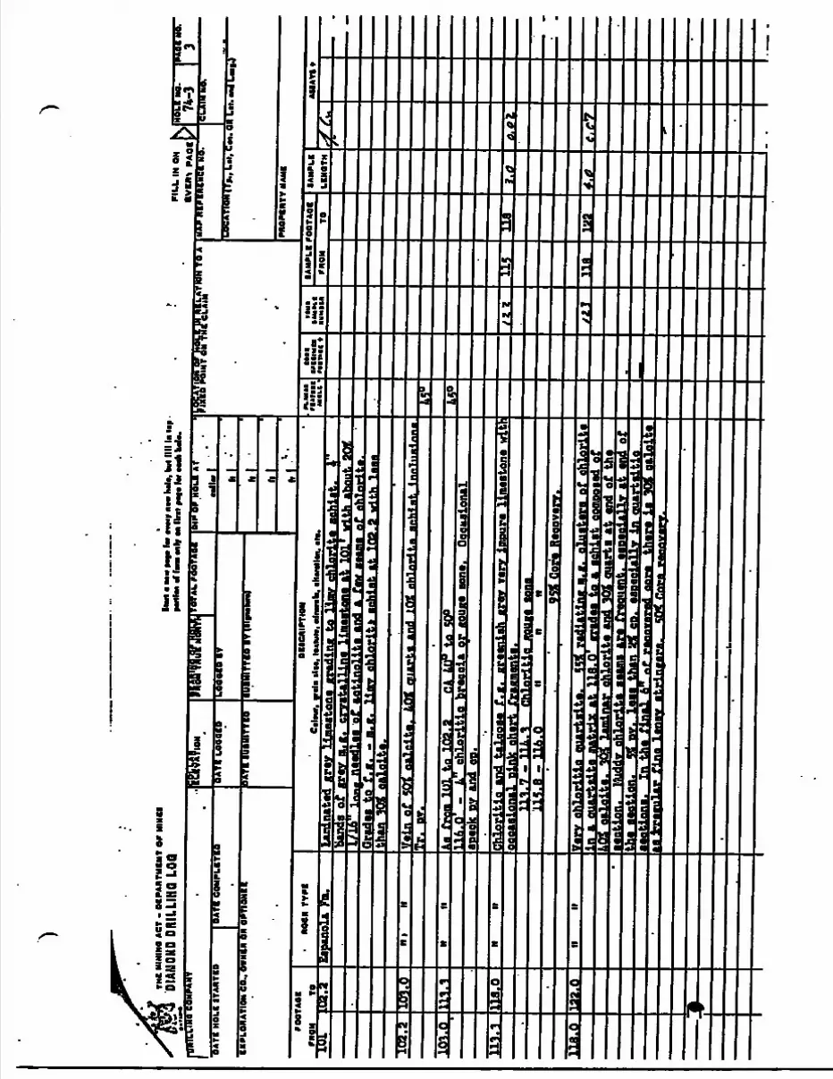
THC
MIN
IM A
CT
- O
IPA
NT
MB
NT
W H
INB
tDI
AMON
D DR
ILLI
HQ L
OOSt
art t
M*
Ht*
hf
**w
r n
n h
*l(,
fcul I
II! l
* l*
p -
fntt
nt if
IITB
tnhf
M ll
ril f*
t* lv *
Hh
hil*
.P
ILL
IN O
NP
AO
I
OA
TI
HO
LIIT
AM
TC
DO
ATB
GO
HP
I.BT
tM'k
OM
ATI
ON
CO
., OW
NCII
ON O
PTI
ON
!!D
ATB
IU
IMIT
TK
OIU
BMIT
TKB
IT 1
DIP
OF
HO
U A
T
IlL
hi
ITIO
H IT
*., k
*l. C
n. O
H L
il. m
* LM
|J
74-3
PNO
PIN
TV N
AHB
rOO
TAO
B
PP.O
M
TCN
OC
K T
VP
IO
BICN
IPTM
M
Cri
mr,
r*
1" i
l "i
Hiln
tti •
liMM
h. f
ttfM
Otn
, *H
.ro
iuit
MIL
t -
mi
•xiiw
n
ntn
ic *
IAM
PLB
rO
QTA
OB
TOIAHPLB
LBNOTH
AU
* V
I t
iOl
(972
Eapu
pUFn
.laminated gr
1/16
le
ma
nood
laa
'of
actin
olite
aUnda
101'
with
abo
ut g
Crf
few ••una
of ehlarit*.
CradM t
o f. g.
- m. t
. limy ahlarit*
at t
oa.g with
1Mthan T
Ot o
aloitB.
102.
210
3.0
H)
IIV
ain
of S
OT e
alei
ta,
JOI
quar
t* a
nd l
pg e
hlor
tta
anht
nf,
fr.
mr.
Aa:
1O1
Qif
liAa
fro
m I
tH t
o IQ
g.g
CA L
ti
116.
O
- L
chlo
ritl
o br
ecci
ta M
0.0
-
L ch
lori
tlo
brac
eli.
or g
ouge
eon
*.
Oce
mio
nal
BPOC
K py
and
ea.
H ir
Mto
na w
ltlL
Li.
3.a
, t i
l. 9
Chlo
rlti
a yi
uf*
BOM
m.a
- 1
16.0
9S*
Cora
Rec
ovir
v.lia
.Q
132.
0C
,C?
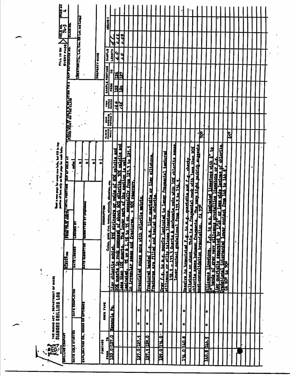
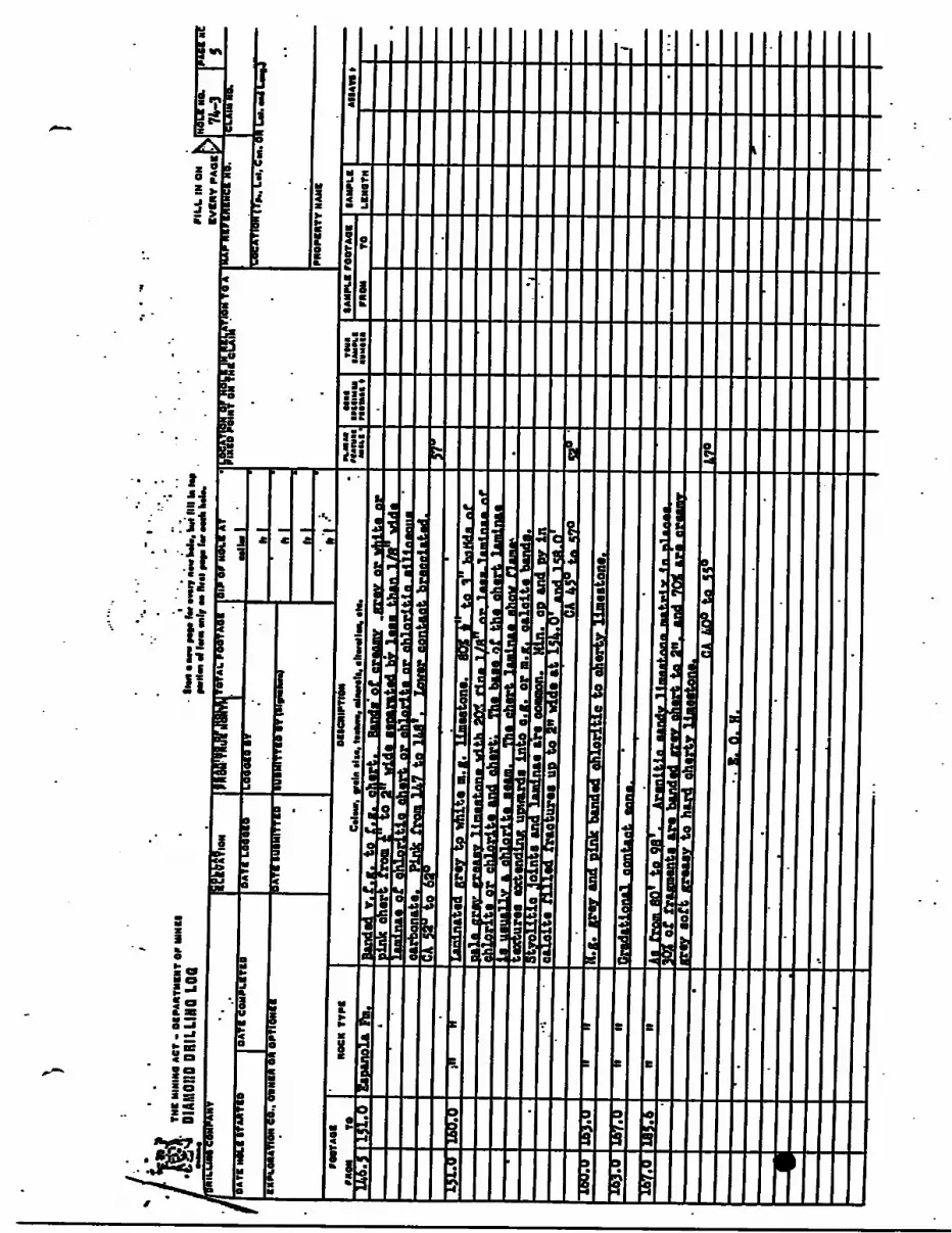
F
IR I
rf•lr
ili
i
p n
•h
i
l!ll.
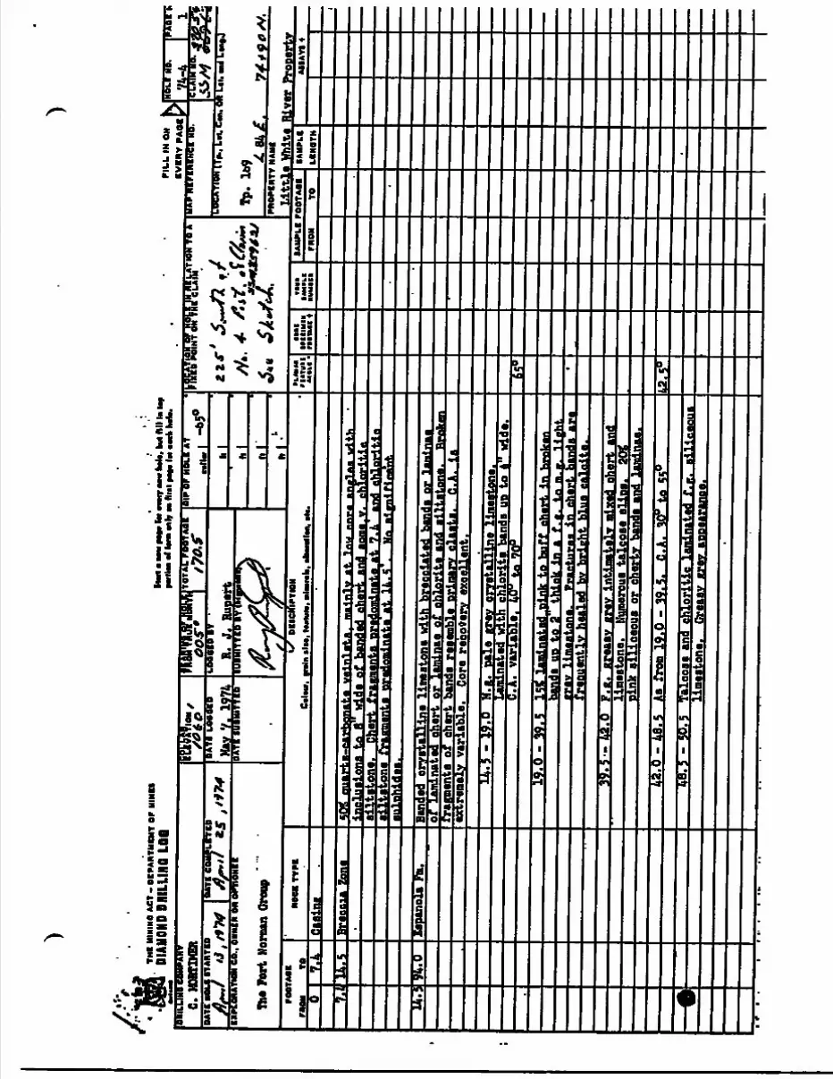
))
TH
I M
ININ
a AC
T -
OC
PAN
TMB
NT
OP
MIN
I!DI
AMON
D DR
ILLI
NO L
OO
rOO
TM
I O
II TO
NOCK
TV
nDU
CKlP
TIO
N C
iUur
. r*
'" *
li*i I
MIW
*. n
lllii(
b. m
tlm
mtt
n, ti
t.1A
.Ca
sing
JLl
Brec
cia
tone
SOS
qu
artg
-ear
hn
nat
.a v
a1n
1ata
| m
ain
ly a
t l
^^
^^
^^
V—
i*"
.-
..-
—
X
*l'
l B J J
B
Aif
f*
WA
^J^
J
a~ - -
-I
—
- M
nu n
ni*a
nglA
i al
ori"*
^iti
ine
. C
hert
fra
aman
ta p
redo
min
ate
at t
.L
and
ehlo
riti
ne
fra
gmen
t a p
rado
min
ata
at,U
. . S '
7 Ma
at a
ni f l
Mnt
.•jtlBbidj
tJ^l
94.0
Eapa
noli
Fm.
s:f'tl-rT-aT-tn'j-ffTl' .
Ine limestone with breeeiated
bande or laminae
nated
eiert
or l
aminae o
f chlorite and a
lltatona.
Brafcen
frag
men
t a o
fbands
resemble Drinarv e
laata.
C.A. i
aextremely
variable.
Core r
ecovery
excellent.
14.5 -
19.0
H.g. p
ale
grey c
rysta,.!:
with c
hlorli.i
ala, line
limeatone.
Lam
inate
d wi
;.e banda
UP to
B wide.
C. A
. va
riab
le.
J.O
.
19.0
- 3
9.. 5
15*
lam
inat
ed ..p
ink
to b
uff
cher
t in
hm
lcaba
nda
UP t
o 2
thia
k in
a f
. g.
ta m
. g.
Hah
tiv
limaa
tone
.in
cha
rt h
anda
are
qent
lv h
eale
d bv
bri
ght
blue
cal
cite
.39.5—
42.0
F.K. g
reasy
grlimestone.
Numerous talcose s
lips.
pink s
iliceous o
r cht
42.0 - 48.5
Aa f
rom 19.0 - 3
9.5.
C.A. 30" to S
S048.5 -
50.5
Talcose
and
chloritic
llnestone.
Greasy x
rev aDoearanee.
uo|*
^
I* Oaa fi
ivau BBS. --.?
*- -A
T: r" -** y1.'**
" ~l
UW
fl 8
BB
I -A
Q
Sg
'IBg
*)|9CU
Jf JO
IU03W
O1*"*-
S 'SO
I66
Ll
fiufcliiLJti^iiiW
T?•^np^^^pt^"* o^ p*iu^v*iif
TO O66
921•*!'H
6'50T" 5'86
Si'86 " 0"
oi.oe **"juuoj"pj- --z_i i.-- JT-
•li
TTiy •ptreg BUP^BBUI \ BBoa
* "SOB O
! RT
Q
'M - O
'Tf.
oOi
^08-^
09 'Y
-a '5'65 - 0'6T
mq
j *Y
Q'TA
- S'^S
ABTOJQ
-qar uoo
T1"0*01 s'66 Boa;
•Y 5'M
- 5'OSt iivin
ZMH1BNB1
BldHVI01
•eviooj iidnviilfnm
•M
iId
ll VMM
IBV
MO
JIltV
N A
1M
UO
IU
pi"
! rm
wo
'"S f*n
Z \
•ON
lOV
ail
'ON
110N
l noi±
v9ai
M* 1IV
MO
M riO
dia
IB minium
AM fjigom
Bin
win
i iiva
aiseai nva
BIN
OIldB
MO n*M
AMB A
BN
ON
I11M
001 ONI11IHO ONOHVIOIIN
IH JO
INlM
lNV
dlO
- 19V BNINIH M
l
f lii J .i
lii . i37
•ff t.fM
;s
i
j
it
i
i
l
jL it........ -,......
m
m S -
r
l— - — - " -""s
- 1 JL.
t
3S
iH
S
j 1
i ! Si? I- i [s
^ 1 r
i *
j 1' 1 1
H!|hHi if mmm
m
1 B1 Vi r
m
rm
i
.
•^
"r
j"z
"-"J
"'
s a
11
ii
ir i i i
r i i i i aBt
f
\ iyr
S
il
p*1
If
i•c5?
\H.
i5|
0sra
H
HB
f
ja c
r
i a
O
ili0
ar- e a
.
li'ii
|
-
-
e 3!E* z
Syrf-
S
9
APPETOIX C:
1968 Sock Sanple Descriptions and Analytical Kesnlts
United Beef Petrolenns Limited
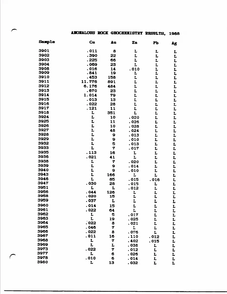
ALDUS BOCK GBQCHEKISTKY RESULTS, 1988
Saaple Cn An Zn Pb Ag
390139023903390439083909391039113912391339143915391639173918392439253926392739283929393239333935393639383939394039433946394739513956395839593960396139623963396439653966396739683969 3973 3977
f 3978 398O
.011
.390
.225
.069
.016
.841
.45311.7766. 176.670
1.014.013.022.121LLLLLLLLL
.113
.021LLLLL
.030L
.044
.020
.037
.014
.022LL
.022
.046
.022
.011LL
.022L
.010L
82266231419
1588914842379132811
3511011104899571641799
1668528L
12615L1564519878
167L76613
LLLL
.010LLLLLLLLLL
.020
.026
.028
.024
.013
.010
.013
.017LL
.020
.014
.010L
.015
.015
.012LLLLL
.017
.025
.021L
.076
.110
.402
.038
.012
.026
.014
.032
LLLLLLLLLLLLLLLLLLLLLLLLLLLLL
.016LLLLLLLLLLLL
.012
.015LLLLL
LLLLLLLLLLLLLLLLLLLLLLLLLLLLLLLLLLLLLLLLLLLLLLLLL
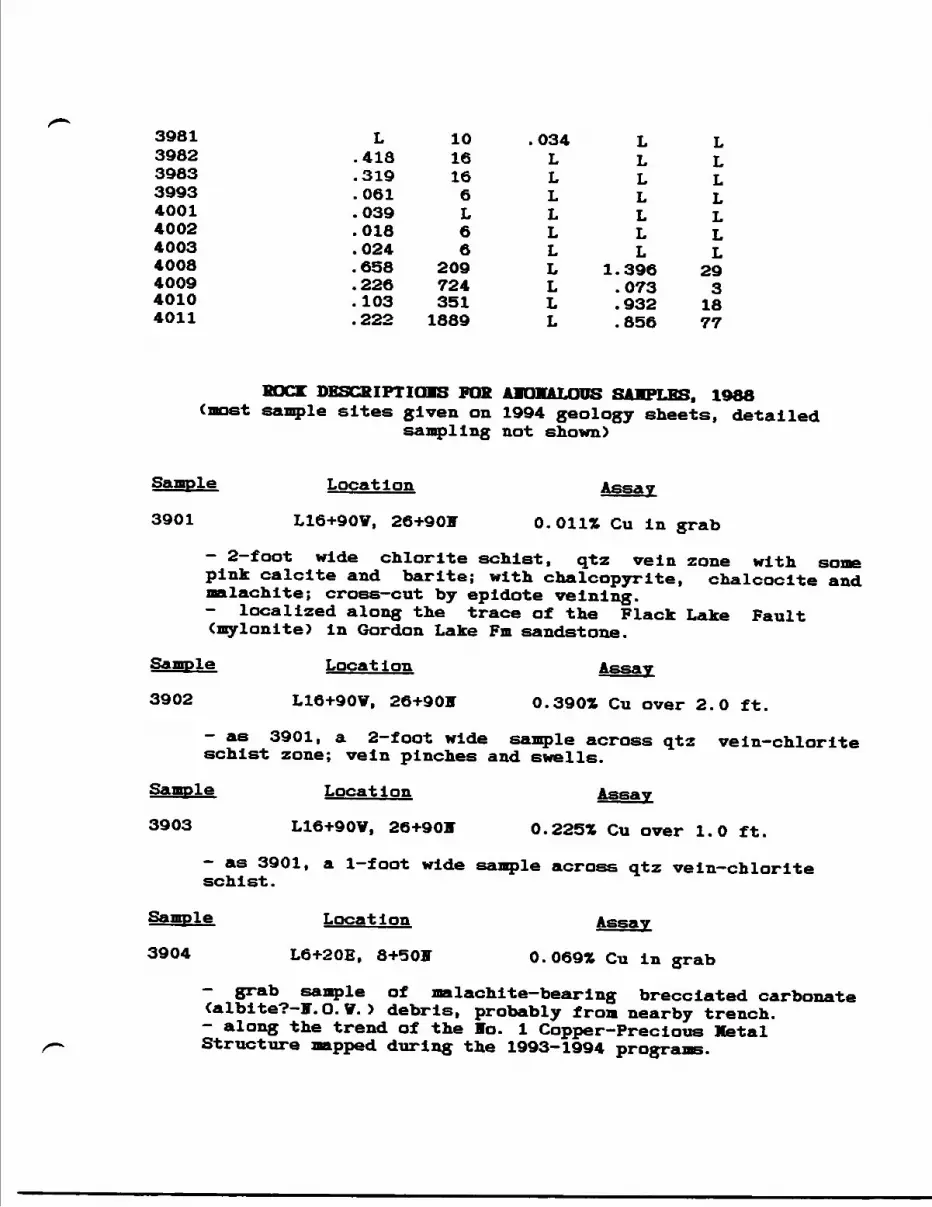
3981 L 10 .034 L L3982 .418 16 L L L3983 .319 16 L L L3993 . 061 6 L L L4001 .039 L L L L4002 .018 6 L L L4003 .024 6 L L L4008 .658 209 L 1.396 294009 .226 724 L .073 34010 .103 351 L .932 184011 .222 1889 L .856 77
BUCK DESCRIPTIONS FOR A1OHALOUS SAMPLES. 1988(most sample sites given on 1994 geology sheets, detailed
sampling not shown)
Sample Location Assay
3901 L16+90V, 26+901 O.Oil* Cu in grab
— 2—foot wide chlorite schist, qtz vein zone with some pink calcite and barite; with chalcopyrite, chalcocite and malachite; cross—cut by epidote veinlng.- localized along the trace of the Flack Lake Fault (mylonite) in Gordon Lake Fm sandstone.
Sample Location Assay
3902 L16+90V, 26+905 O.3901 Cu over 2.0 ft.
- as 3901, a 2-foot wide sample across qtz vein-chlorite schist zone; vein pinches and swells.
Sample Location Assay
3903 L16+90V, 26+901 Q.225% Cu over 1.0 ft.
— as 3901, a 1-foot wide sample across qtz vein—chlorite schist.
Sample Location Assay
3904 L6+20E, 3+5 O IT 0.069* Cu in grab
— grab sample of malachite—bearing brecciated carbonate (albite?-?.O. V. ) debris, probably from nearby trench.- along the trend of the Vo. l Copper-Precious Metal Structure mapped during the 1993-1994 progre
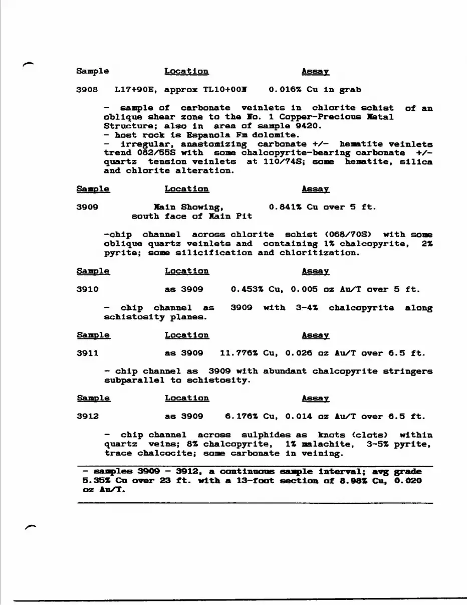
Sample Location Assay
3908 L17+90E, approx TL10+OOV 0.016* Cu In grab
- sample of carbonate veInlets In chlorite schist of an oblique shear zone to the To. l Copper-Precious Metal Structure; also in area of sample 9420.- host rock is Espanola Fm dolomite.- irregular, anas tom! z ing carbonate -i-/— hematite veinlets trend 082/55S with some chalcopyrlte-bearlng carbonate */- quartz tension veinlets at 110/74S; some hematite, silica and chlorite alteration.
Sample Location Assay
3909 Main Showing, O.841* Cu over 5 ft. south face of Main Pit
-chip channel across chlorite schist (068/708) with some oblique quartz veinlets and containing l* chalcopyrite, 2* pyrite; some silicification and chloritization.
Sample Location Assay
3910 as 3909 O.453* Cu, 0.005 oz Au/T over 5 ft.
- chip channel as 3909 with 3-4* chalcopyrite along schistosity planes.
Sample Location Assay
3911 as 3909 11.776* Cu, 0.026 oz Au/T over 6.5 ft.
- chip channel as 3909 with abundant chalcopyrite stringers subparallel to schistosity.
Sample Location Assay
3912 as 3909 6.176* Cu, 0.014 oz Au/T over 6.5 ft.
- chip channel across sulphides as knots (clots) within quartz veins; 8* chalcopyrite, l* malachite, 3-5* pyrite, trace chalcocite; some carbonate In veinlng.
3909 — 3912, a continuous sample Interval; avg grade 5.35* Cu over 23 ft. with a 13-foot section of 8.981 Cu, 0.02O oz Au/T.
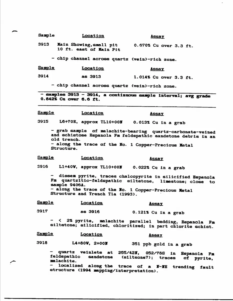
Sample Location Assay
3913 Main Showing,small pit 0.6702 Cu over 3.3 ft. 10 ft. east of Main Pit
- chip channel across quartz tvein)-rich zone.
Saaple Location Assay
3914 as 3913 1.0141 Cu over 3.3 ft.
— chip channel across quartz tvein)-rich zone.
iles 3913 - 3914, a continuous sample Interval; avg grade O.8422 Ga aver 6.6 ft.
Sample Location Assay
3915 L6+70E, approx TL10+OOF 0.0131 Cu in a grab
- grab sample of malachite-bearing quartz-carbonate-veined and schistose Espanola Fm feldspathic sandstone debris in an old trench.- along the trace of the So. l Copper-Precious Metal Structure.
Sample Location Assay
3916 L1+40V, approx TL10+OOH O.022* Cu in a grab
- dissem pyrite, traces chalcopyrite in silicified Espanola Fm quartzitic—feldspathic siltstone, limestone; close to sample 9406A.- along the trace of the to. l Copper-Precious Metal Structure and Trench Tla ^993).
Sample Location Assay
3917 as 3916 O. 121* Cu in a grab
- < 2% pyrite, malachite parallel bedding, Espanola Fm siltstone; silicified, chloritized; in part chlorite schist.
Sample Location Assay
3918 L4+80V, 2+001 351 ppb gold in a grab
- quartz veinlets at 255/42F, 052/78S in Espanola Fm feldspathic sandstone (siltsone?); traces of pyrite, malachite.- localized along the trace of a F-ME trending fault structure C1994 mapping/interpretation).
Sample Locat ion Assay
3924 L19+OOV, 10+801 0.0202 Zn in a grab
- 3X dissem pyrite localized along bedding in Espanola Fm siltstone/chert; So = 295/18S.
Sample Location Assay
3925 L22+50V, 10+605 0.0261 Zn in a grab
- traces of pyrite in Espanola Fm siItstone/sandstone; ripple marks; SO ^ 220/74V.- close to Scarbo Creek; a fault zone?
Location Assay
L17+OOV, 5+30S 0.028* Zn in a grab
- traces of pyrite and carbonate velnlets in Espanola Fm siltstone/chert; So = 058/15S, SI s 105/88S (fracture cleavage?) and carbonate veinlet orientation at 042/90.- localized along the trace of a HV-SE trending fault, along Scarbo Creek.
Sample Location Assay
3927 L15+OOV, 1+001 O.024* Zn in a grab
- weakly pyrltlc quartz veinlets parallel bedding in Espanola Fm laminated siItstone/sandstone; So - 292/90.- in the vicinity of the axial trace of the Little White River Anticline.
Sample Location Assay
3928 as 3927 0.013* Zn in a grab
-quartz—carbonate blebs and Irregular stringers in Espanola Fm siltstone with dissem pyrite; locally silicified, hematltized and chloritlzed.
Sample Location Assay
3929 L14+80V, 0+8OF 0.010* Zn in a grab
- pyrite and irregular quartz veining, breccia in Espanola Fm dolomite, limestone; very close to 3927, 3928.
Sample Location Assay
3932 L16+2OV, 26+905 O.013* Zn In a grab
- shear zone flanked by crush breccia In Espanola Fm siltstone, adjacent the Flack Lake Fault; schistosity at 064/65S; variably hematltlzed.
Location Assay
L16+40V, 26+905 0.017* Zn In a grab
- shear zone trending 070/10S with quartz velnlets and dlssem pyrite hasted by Espanola Fm siltstone adjacent to the Flack Lake Fault; some silicification.
Sample Location Assay
3935 L16+50V, 3+505 0.113* Cu In a grab
- brecciated, bedded Espanola Fm limestone-dolomite with some pyrite, chalcopyrite in breccia and quartz velnlng subparallel to bedding.- outcrop along Scarbo Creek and proximal to the Little Vhlte Siver Anticline axial trace.
Sample Location Assay
3936 as above 0.02li Cu in a grab
- similar to 3935, with l* pyrite, more quartz velnlng and chloritization.
Sample Location Assay
3937 L16+70V, 3+905 0.020Z Zn over 6 ft.
- series of grabs quartz-chlorlte breccia zone in Espanola Fm limestone- dolomite; zone oriented 114/90 with pyrite in host.
Sample Location Assay
3938 as above 0.014* Zn over 9 ft.
- similar to 3937, a series of grabs over 9 ft.
Sample Location Assay
3939 as above 0.010* Zn over 5 ft.
- similar to 3937, a series of grabs over 5 ft.
Sample Locat ion Assay
3943 L41+OOE, 23+OOff 166 ppb Au in a grab
- sericitized, hematitized Mississagl Fm feldspathic sandstone.; some quartz pebble horizons.
Sample Location Assay
3946 L40+OOE, 25+003 0.016* Pb. 0.015* Zn in a grab
- bedding parallel quartz veinlets at 072/28S in silicified Espanola Fm limestone/siltstone; veinlets more or less at contact.
Sample Location Assay
3947 L39+80E, 1+2OS 0.0302 Cu, 0.0151 Zn in a grab
- 6" quartz vein plus veinlets at 276/699 in Nipissing gabbro. Close to a northeasterly fault trace.
Sample Locat ion Assay
3951 L44+OOE, 11+30S 0.012* Zn in a grab
- pyrrhotite-pyrite-bearing Nipissing diabase, epldotlzed; close to an east-west fault trace.
Sample Location Assay
3956 L32+OOE, l1+8OF O.044* Cu, 126 ppb Au in a grab
- vuggy quartz vein with chlorite selvedges (quartz-chlorite breccia - J.Q.V.) in Espanola Fm dolomite; close to Main Showing and a WE fault trace.
Sample Location Assay
3958 L33+80E, 13+10E 0.020* Cu in a grab
- pyrite, chalcopyrlte-bearlng Irregular quartz-carbonate veinlng in Espanola Fm limestone/siltstone. In creek bed east of Main Showing.
Sample Location Assay
3959 as above 0.037* Cu over 2 ft.
- 2—foot chip channel over a quartz pod/vein which shows boudinage along 090/45S in chlorite schist; contains pyrite and chalcopyrite.
Sample Location
3960 as above O.0141 Cu in a grab
- quartz veinlets and chlorite selvedges containing chalcopyrite and pyrite in Espanola Fm limestone/siltstone.Sample Location
3961 L32+80E, 11+90V 0.022* Cu over 4 ft.- 4-foot chip channel sample across chlorite schist containing numerous quartz pods with pyrite, chalcopyrite; some hematltization; sample from North Pit, Main Showing area.
Sample Location Assay
3962 L28+OOE, 5+805 0.017* Zn in a grab
- brecciated Espanola Fm limestone in contact with Nipissing diabase. Possibly along the trace of an E1E fault.
Sample Location Assay
3963 L28+20E, 3+8OF O. 025* Zn In a. grab
- pyritic Flpissing gabbro close to a FBTE fault trace. Sample Location Assay
3964 L23+80E, 5+8Off 0.022ZCu, O.021* Zn in a grab- silicified Espanola Fm limestone with traces pyrite at the contact with Nipissing diabase.
Sample Location Assay
3965 L22+OOE, 9+25* 0.046* Cu in a grab
- zone of chlorite schist (TSS- see '94 legend) In Espanola Fm dolomite.
Sample Location Assay
3966 L19+40E, 9+60J 0.022* Cu, 0.076* Zn in a grab- quartz-veined frost heave of chlorite schist tfSS) in Espanola Fm dolomite. Also close to a VE fault trace.
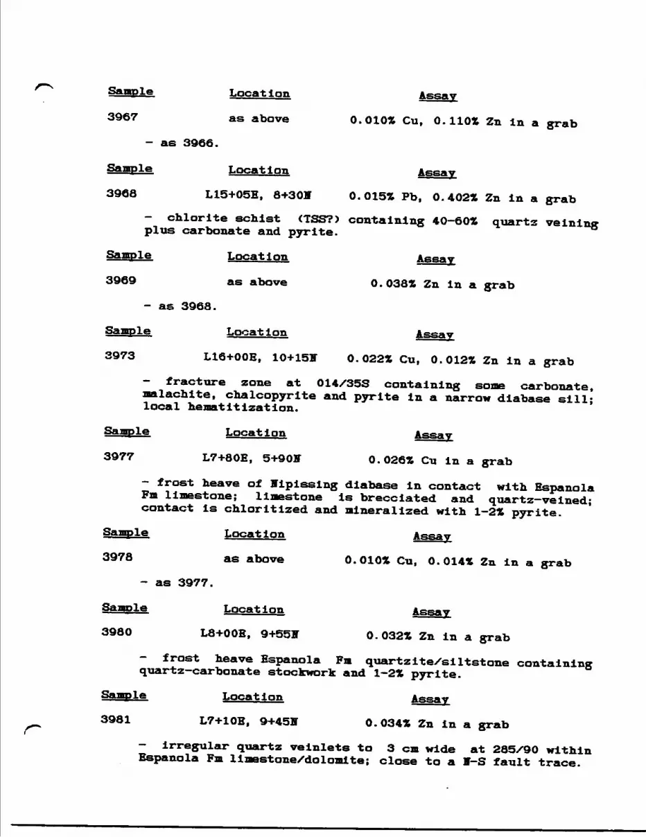
Sample Location Assay
3967 as above O.0102 Cu, O.1101 Zn In a grab
- as 3966.
Sample Location Assay
3968 L15+05E, 8+30H 0. 015* Pb, 0.402* Zn in a grab- chlorite schist (TSS?) containing 40-60* quartz velnlng plus carbonate and pyrite.
Sample Location Assay
3969 as above O.038* Zn in a grab
- as 3968.
Sample Location Assay
3973 L16+OOE, 10+15F 0.022* Cu, 0.012* Zn in a grab
- fracture zone at 014/35S containing some carbonate, malachite, chalcopyrite and pyrite in a narrow diabase sill; local hematitlzation.
Location Assay
L7+80E, 5+90H 0.026* Cu in a grab
- frost heave of Vipisslng diabase in contact with Espanola Fm limestone; limestone is brecciated and quartz—veined; contact is chloritized and mineralized with 1-2* pyrite.
Sample Location
3978 as above 0.010* Cu, 0.014* Zn in a grab
- as 3977.
Sample Location Assay
3980 L8+OOE, 9+55IT 0.032* Zn in a grab
- frost heave Espanola Fm quartziteXsiItstone containing quartz-carbonate stockwork and 1-2* pyrite.
Location Assay
L7+10E, 9+455 0.034* Zn in a grab
- irregular quartz velnlets to 3 cm wide at 285/90 within Espanola Fm limestone/dolomite; close to a V-S fault trace.
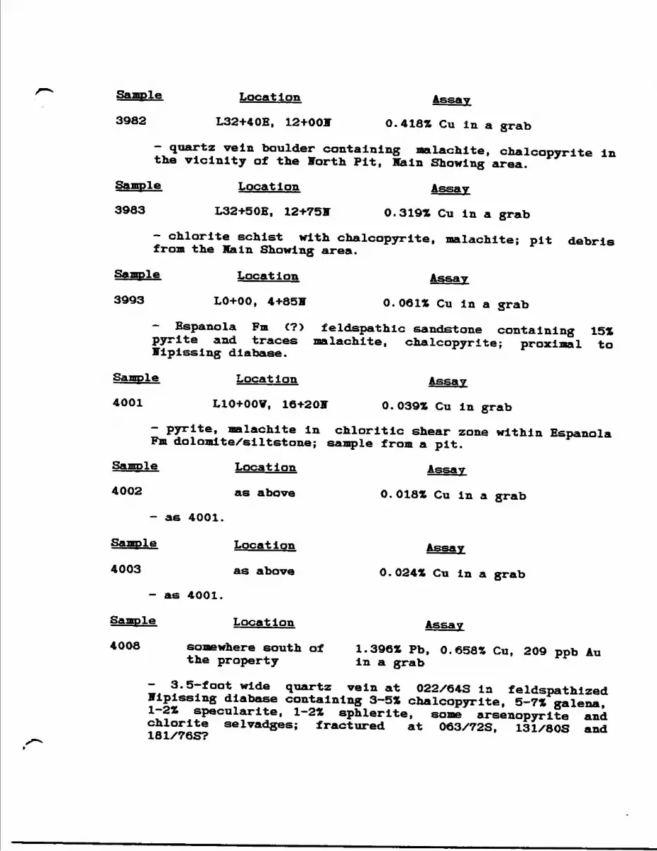
Sample Location Assay
3982 L32+40E, 12+001 0.418* Cu in a grab
- quartz vein boulder containing malachite, chalcopyrite in the vicinity of the Forth Pit, Main Showing area.
Sample Location Assay
3983 L32+50E, 12+75V O. 319* Cu in a grab
- chlorite schist with chalcopyrite, malachite; pit debris from the Ka In Showing area.
Sample Location Assay
3993 LO+00, 4+85V O. 061* Cu in a grab
- Espanola Fm C?) feldspathic sandstone containing 15* pyrite and traces malachite, chalcopyrite; proximal to Nipissing diabase.
Sample Location Assay
4001 L10+OOV, 16+20V 0.039* Cu in grab
- pyrite, malachite in chloritic shear zone within Espanola Fm dolomite/siltstone; sample from a pit.
Sample Location Assay
4002 as above 0.018* Cu In a grab
- as 4001.
Sample Location Assay
4003 as above O . 024* Cu in a grab
- as 4001.
Sample Locat ion Assay
4008 somewhere south of 1.396* Pb, 0.658* Cu, 209 ppb Au the property in a grab
- 3.5— foot wide quartz vein at 022/64S in feldspathlzed Nipissing diabase containing 3-5* chalcopyrite, 5-7* galena, 1-2* specularite, 1-2* sphlerlte, some arsenopyrite and chlorite selvadges; fractured at 063/72S, 131/80S and 181/76S?
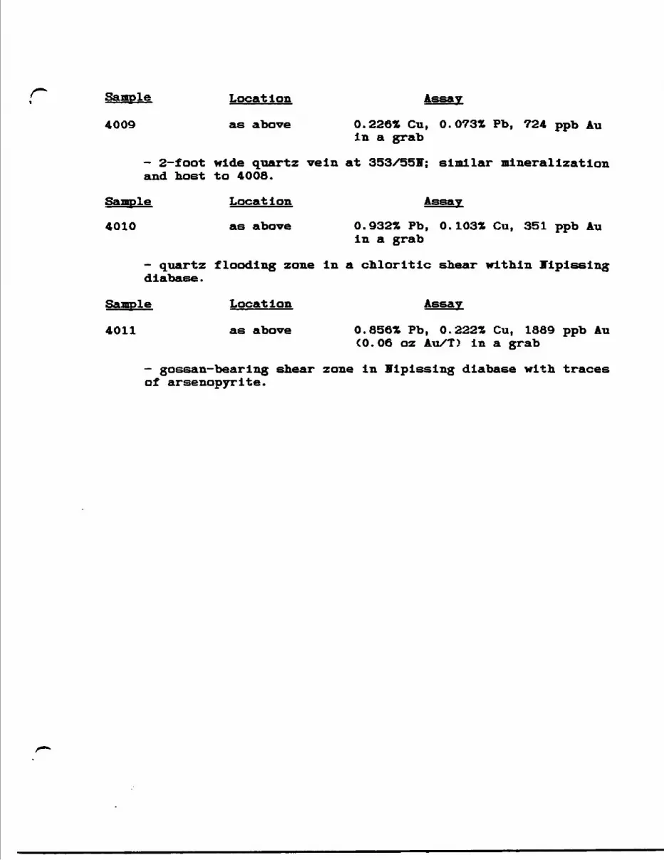
Sample Location
4009 as above 0.226* Cu, O.073* Pb, 724 ppb Auin a grab
- 2-foot wide quartz vein at 353/55V; similar mineralization and host to 4008.
Location Assay
4010 as above 0.932* Pb, 0.103* Cu, 351 ppb Auin a grab
- quartz flooding zone in a chloritic shear within Tlpissing diabase.
Sample Location Assay
4011 as above 0.856* Pb, 0.222* Cu, 1889 ppb Au(0.06 oz Au/T) in a grab
- gossan-bearing shear zone in nipissing diabase with traces at arsenopyrite.

AFPEMDIX D:
1993 Rock Saaqrte Descriptions and Analytical Basalts
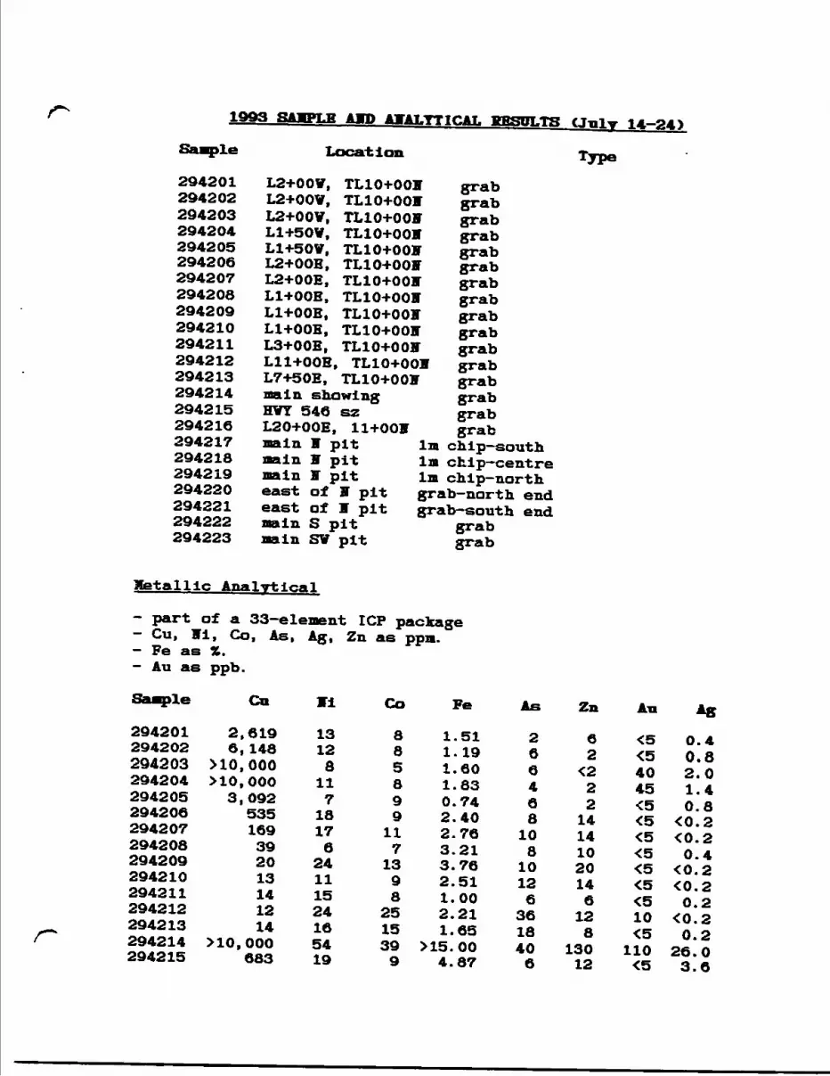
1993 RAMPT.K *wp *T*T.YTTC*T, CJnl —4)
Sanple
294201294202294203294204294205294206294207294208294209294210294211294212294213294214294215294216294217294218294219294220294221294222294223
Location Type
L2+OOV,L2+OOV,L2+OOV,L1+50V,L1+50V,L2+OOB,L2+OOE,Ll+OOE,Ll+OOB,Ll+OOE,L3+OOE,Lll+OOBL7+50E,main showingHVT 546 szL20+OOE, 11+OOHmain T pitnain V pitmain F piteast of F piteast of F pitmain S pitnaln SV pit
TL10+OOF TL10+001 TL10+OOF TL10+OOF TL10+OOF TL10+OOF TLl0+0OF TL10+OOF TLl0+0OF TL10+OOF TL10+OOF TL10+OOF
TL10+OOF
grabgrabgrabgrabgrabgrabgrabgrabgrabgrabgrabgrabgrabgrabgrabgrab
In chip-south 1m chip-centre In chip-north grab-north end grab-south end
grabgrab
Metallic Analytical
- part of a 33-element ICP package- Cu, VI, Co, As, Ag, Zn as ppn.- Fe as 3*.- Au as ppb.
Sample Cn
294201294202294203294204294205294206294207294208294209294210294211294212294213294214294215
2,6196, 148
MO, 000MO, 0003,092535169392013141214
MO, 000683
13128
117
18176
24111524165419
Co Fe As Zn
885899
1171398
2515399
1.511.191.601.830.742.402.763.213.762.511.002.211.65
M5.004.87
266468
10810126
3618406
62
422214141020146128
13012
4045
10
110
0.40.82.01.40.8
40. 2^0. 20.4
^0. 2^0. 20.2
•CO.20.2
26.03.6
Metallic Assays
- Cu, Vi, Co, Fe, As as H , fusian-ICP-AES- S as *, Leco IR Detector- Au as ppb, FA-AAS- Ag as ppjn, AAS-BKGD CORE- Au*, Pd, Pt (not shown) as ppb, FA-ICP-AFSSaaple Cu Vi Co Fe As S Au Ag294203 1.26 ^. 02 410.01 1.8 ^.01 1.18 22*294204 0.88 -CO. 02 ^.01 2.1 W . 01 0.78294214 18.10 ^.02 <0.01 21.5 <0.01 18.20 112*294217294218294219294220294221294222
294217294218294222
2.885.300.560.060.024.64
^.02 '<0. 02 ^{ 0 . 02 *<0. 02 *<0.02 x<0. 02 x
:o.oiCO. 01:o.oiCO. 01:o.oiCO. 01
5.09.45.71.31.38.0
^.01<0. 01<0. 01"10. 01^.01<0.01
2.595.460.470.060.034.68
5080^^<575
74*100*120*
4.28.20.6
<0.2•^. 25.0

APPEIDIZ E:
1994 Sock Sample Descriptions and Analytical Kesults
Sample Ho. Location Description
9401 L2+OOV TLl0+0ON -chip sample over 4 ft., East Face; East Rx Face chlorite alteration zone plus albite Trench l alteration zone, south side of face.
-3-51 malachite in all sections with 22 cp, 12 py in quartz stringers in chlorite zone and up to 12 cp-fllled fractures in albite zone.
9402 " -chip sample over 6 ft.; quartz-albitealteration and breccia zone with 32 quartz—carbonate velning.-32 cp, some py as pods and blebs in all phases; some as inclusions in chlorite patches; 12 malachite.
9403 " -chip sample over 5 ft.; quartz-albitebreccia and alteration zone w up to 102 quartz stringers, veinlets.-12 cp, 22 py blebs and Irregular masses mainly associated w quartz +S- Fe-carb velning; 32 malachite throughout.
9404 " -grab sample; albite-slllca alteration w102 quartz velning.-32 cp blebs and 102 malachite.
9405 " -chip sample over 6 ft.; chlorite-quartz+S- albite breccia and alteration zone C152) in host siltstone.-cut by narrow quartz-chlorite veins which contain some large splashes of cp; local silicification to l" in vein host.-some malachite, hemitlte in host rock.
9406 " -chip sample over 3ft; quartz-chloritebreccia with some late quartz velning.-several small grains of cp in quartz and albite plus scattered malachite.
9406a Ll+OOV TL10+OOH -chip sample over 5 ft.; sillca-alblte Trench 1A alteration zone w minor bs; some later V9402 quartz-carbonate velning (12); sample
contains some host rock, apparentlysiltstone.-3-52 cp blebs mainly in siliceous sections some of which may be late, and 72 malachite.
9407 L2+OOV TL10+OOF -a representative grab sample covering East Bx Face the Interval 1-10 ft. across the top of
Trench l the Bast Rock Face; consists of albite alteration zone.
9408
9409
9410
-chip sample over 10 ft. across top of face, Interval 10-20 ft.; consists of albite alteration zone with 102 quartz- carbonate veining, stringers; some silicification?-3-52 irregularily distributed masses of cp, traces py and a few grains of aspy.-82 malachite, minor azurite.-includes some calcareous sediment (siltstone?).
-chip sample over 10 ft, across top of face, Interval 20-30 ft.; quartz-albite breccia and extensive albite alteration zone; some relict host rock laminations.-52 quartz, 22 cp blebs and masses, 52 malachite.
-chip sample over 10 ft., across top of face, Interval 30-40 ft.; quartz-albite alteration and breccia zone with 32 malachite staining.
9411
9412 Ll+OOV 9+80V
-chip sample over 10 ft. across top of face, interval 40-50 ft.; consists of albite (bx) alteration w 12 malachite, quartz-chlorite breccia w 32 Irregular masses and dlssem cp, plus some host limestone.-cp mainly contained in quartz.
-grab sample; albite and chlorite alteration zone w 22 quartz -l-/- carbonate veining In host calcareous siltstone and limestone.-32 cp as blebs and stringers, minor py and 52 malachite.
9413 Ll+OOE TLIO+OOF Trench 2, East Face
-chip sample over 4 ft., interval 21-25 ft.; mixed zone of cuartz-Fe—carbonate- chlorite breccia and chlorite (alteration?); some vuggy aspect to breccia.
9414
9415
9416
9417
-chip sample aver 8 ft., interval 25-33 ft. and Including 5 ft. of cover; quartz- carbonate-chlorlte breccia w some later quartz stringers; tr cp.
-chip sample over 8 ft. , interval. 42-50 ft.; quartz ^/-carbonate)-chlorite breccia.
-chip sample over 5 ft., Interval 50—55 ft.; quartz-carbonate veining and breccia in intensely sheared green calcareous sediment or chlorltlzed limestone.-201 vein material; one 1/4" vein contains 451 cp, SK malachite.
-chip sample over 5 ft., Interval 55-60 ft.; mainly light brown to buff weathered, light grey limestone with some 8" of quartz (carb)-chlorite breccia.
9418 L2+OOE, 10+OON -Chip sample over 5 ft; narrow (-CI ft.)quartz vein in quartz-(chlorite) breccia. -10* malachite w 1-2* cp +X- py as large (1/2" dia) blebs and some dissem; mainly contained in quartz vein material, possibly post-breccia.
9419 Lll+OOE TL10+OON -grab sample from a small trench;chlorite-quartz-albite breccia; no
W9404 visible mineralization.
9420 L17+OOE TLlO+OOff -grab sample; talc-chlorlte (actinolite)schist and chlorite breccia with
V9406, 9409 stringers of quartz; 5* chlorite clotsor frags, a few albite frags.
9421 L27+OOB 10+OOH -grab sample of dolomitic limestone;pale greenish grey, weathers buff to
V9413 light brown; totally crystalline w somevery thin darker laminae; no visible mineralization.
9422 L31+30B 15+90S -chip sample over 8 ft.; mainlyMain Showing mineralized quartz-chlorite breccia w
Pit l some massive sulphide pods and a few bands of semi-massive py—cp parallel altered host rock laminations.-15* cp w some bn, py in vein material.-overall this sample 45* sulphides of which 20* is cp; 3-5* malachite.
9423 " -chip sample over 9 ft.; mainly chloriticshear w quartz stringers and large semi- massive cp-py pods; also 50* quartz- chlorite breccia and quartz-carbonate veinlng containing cp blebs and stringers; some vein material parallel to host rock laminations; siltstone?-overall sulphide content this sample, 8* cp w minor py, tr bn plus 5* malachite.
9424 " -chip sample over 6 ft; quartz vein/sllalte zone; some vuggy quartz vein material; most of veinlng is late; also chlorlte-quartz breccia.-a few massive py-cp pods w tr bn in chl material; < l% dissem cp in late veins; 3* malachite throughout.
9425 " -chip sample over 9 ft.; quartz veIn/silalteration zone; up to 50* vuggy qtz vein material w strong sil of laminated sed Climestone or siltstone); some qtz-chl bx.- 3* pyrite w scattered associated cp, all as massive pods to 4" dia and blebs in qtz; 8* malachite in vein and host; some albite as alte and frags.
9426 L40+OOV 3+OOS -grab sample; fine grained calcareoussiltstone, pale light greenish grey,
V9413 weathers brown to light grey; weaklaminations or schistosity and a z— crenulation fabric.- l* dissem py.
9427 L28+OOV 7+OOS -grab sample; narrow quartz stringers^*) in schistose siltstone; tr py.
9428 L12+OOW 12+OOS -grab sample; fine-medium grainedquartzitic sandstone-siItstone with5* flecks of orange weathered feldspar;35* Quartz, tr pyrite; somewhat sil C?).
9429 L6+OOV 12+5OS
9430 L49+OOV 3+80S
9431 L48+50V 3+8OS
9432 L48+OOV 3+50S
9433 L40+OOV 3+5OS
9434
9435
L36+OOV 5+OOS
V9423
L32+OOV 4+0 OS
V9424
-grab sample; narrow quartz vein In weakly sheared and chl silts-cone; 201 of sample consists of quartz vein material.
-grab sample; Irregular quartz stringer zone-stockwork In silicified pinkish feldspathic quartzite; some quartz flooding or reconstitution of quartzite component.-some narrow quartz veinlets showing preferential east-west attitude.-no visible sulphide mineralization.
-grab sample; mixed quartz velnlng and chloritic shear zone material hosted by feldspathic quartzite; trend is oblique to stratigraphy.-21 py in chlorite shear.
-chip sample over 3.2 ft; massive white quartz vein in feldspathic quartzite; tr py or cp.
-grab sample; weakly-moderately chl quartzose siltstone Cup to 102 quartz grains).-several narrow quartz veins/stringers Cto 1071) containing 32 cp, seme py; also some hematite, malachite and azurite. Albite?; 1-2* dissent, splashes cp in siliceous pods, strings; local silicification of host.
-grab sample; quartzitic to arkosic sandstone/siItstone, light grey.-lit quartz ve inlets w scattered cp
*s, dissem (32) plus traces py.
-grab sample; quartz—ankerite veining in chl, weakly sil siltstone.—32 Irregular blebs and masses of chalcopyrite; 1-22 malachite; traces of hematite and pyrite.
9436 L18+OOV 18+OOS -grab sample; white bull quartz w 102feldspar fragments and 52 chlorite fragments or assimilated host conglomerate . -no visible mineralization.
9436a L32+OOV 2+30S
V9425
-grab sample; chloritlzed, weakly albltlzed sheared and somewhat brecciated to vuggy siltstone.-w 2-53 narrow schistosity parallel quartz -l-/- feldspar veins.-situated at the northern edge of a quartz-alblte—chlorite breccia zone.
9437 L12+OOV 4+OOS
9438 L24+OOV 6+70S
-grab sample; moderately sil, chl grey green quartzitic sandstone.-2-31 cp, py masses and some scattered dlssem, 21 malachite.-some narrow py-cp-fllled fractures.
-grab sample; dark green, strongly magnetic rock, possibly intrusive. Vith 10*, <l/Qtt dla subangular translucent quartz grains.-minor quartz-carb veinlng.
9439 L4+30V, 5+OOS
9440 L3+50V, 4+60S SE Trench
9441 L3+50V, 4+6OS SE Trench
-grab sample of l foot wide chl-gossan shear zone in arkosic sandstone/ conglomerate; contains l" wide quartz vein (103 of sample) which contains 23 dlssem cp, 103 malachite.
-chip sample over 5 ft.; quartz-Fe—carbvein and stringer zone in sheared,weakly chl conglomerate/sandstone; veinmaterial comprises 253 of sample, ofwhich 303 is Fe-carb.^13 dlssem cp in quartz, some malachitestaining.
-chip sample over 4 ft.; sulphide-rich quartz-Fe-carb veinlng and some str in sheared conglomerate; main vein to 3 ft. wide; extensive gossan in host, minor bx.-53 Fe-carb.-253 semi-massive patches of cp, gn, py, generally as isolated groups, all In vein material; py very bright and some may be gn; some aspy?; cp as amorphous massives to anhedral crystalline w some copper reddish tarnishing; 2-53 emerald green malachite In both velning and host rock.
9442 L3+35V, 4+6OS SE Trench
9443 L5+OOY, 4+50S
-chip sample over 6 ft. of mineralized quartz vein from trench, 15 ft. to east of 9441; also contains 101 cbl host rock material.-mainly white quartz w some scattered Fe- carb-filled vugs; 101 cp and py or gn masses, very unevenly distributed; some barren patches of quartz velnlng.-minor malachite.
-grab sample of vuggy quartz vein float material from a trench on strike with SB Trench; strong gossan and 15X cp and dissem; host is conglomerate.

CESTIPICATES OF ANALYSIS
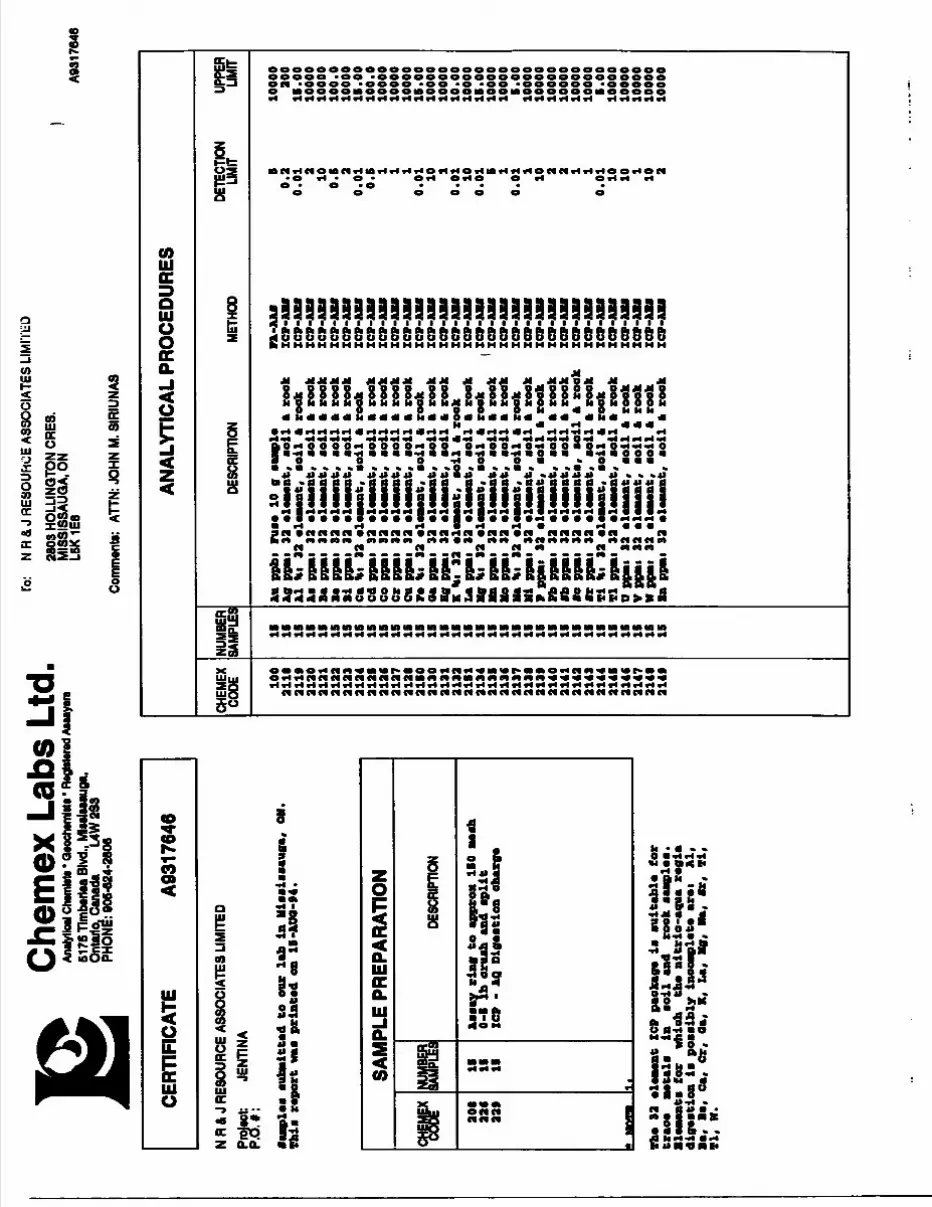
Che
mex
Lab
s Lt
d,An
alytic
al Ch
arnia
n * Q
aoch
wnM
a' Ra
gMar
ad A
tMya
re61
7STi
mbM
tM B
lvd.,
Mlss
laaau
ga,
Ont
ario
. Can
ada
L4W
2S3
PHO
NE: 9
06-6
24-2
806
lo:
N R
S, J
RESO
UHO
E AS
SOCI
ATES
LIM
ITED
2603
HO
LLIN
QTO
N CR
ES.
MIS
SISS
AUQ
A, O
N LS
K 1E
6
Com
nwnt
o:
ATTN
: JOH
N M.
SIR
IUNA
S
A931
7646
CERT
IFIC
ATE
A931
7646
N R
A J
RESO
URCE
ASS
OCI
ATES
LIM
ITED
Prol
tot:
JENT
INA
P.O.
#:
•am
plea
aut
eitt
ad t
o m
ix l
ab i
n H
iaai
aaau
ga,
Thl
a re
port
waa
pri
nted
en
H-A
OO
-94.
OH.
SAM
PLE
PREP
ARAT
ION
W20
122
4 aa*
sm IS
IB
IS
1l
DESC
RIPT
ION
Aaa
ay r
ing
to a
ppro
x IS
O me
ah
0-5
Ib o
ruah
and
apl
it
ICP
- AQ
Dig
aatio
n ch
arge
The
3a e
lement Z
CP package i
* au
itab
le fer
trace
meta
la
in
aeil a
nd reek a
amplea.
Blemwta
fer
whie
h the ni
trio
-aqu
a regia
digestion
ia pee
aibl
y in
oomp
lete
are
i Al,
Ba,
Be,
ea,
Cr.
Ga,
K, La,
Mg,
Ha,
Ir,
Ti,
TI,
H.
ANAL
YTIC
AL P
ROCE
DURE
S
CHEM
EXCO
DE 100
2118
an*
aiao
aiai
2122
2123
21
2421
21a ia
c21
27ai
aia le
o31
3021
3121
3221
S121
3421
3521
3621
37ai
ai21
3*21
4031
4131
4321
4331
4421
4531
4C31
4731
4131
49
NUMB
ERSA
MPLE
S
IB IS IB IB IB IB IS
IS IS IB IS IS IS IS IB IB IS IS IS IS IS IB IB IB IS IS IS IB IS IS IS IS IB
DESC
RIPT
ION
Au p
pbi
ruae
10
g aa
mpl
eAg
ppm
i 33
ele
aMat
, ae
il A
roo
kA
l tit
33
elaa
wnt
, ae
il f
t re
ekAa
PPM
I 33
ele
men
t, ae
il f
t re
ekBa
PPM
I 33
ele
men
t, ae
il f
t re
ekBe
ppM
i 32
ele
men
t, ae
il f
t re
ekBi
PPM
I 33
ele
men
t, ae
il f
t re
ek
Ca t
ii 33
ele
men
t, ae
il f
t re
ekCd
PPM
I 33
ele
men
t, ae
il f
t re
ekCo
PPM
I 33
ele
men
t, ae
il f
t re
ekCr
ppM
i 33
ele
men
t, ae
il f
t re
ekCu
PPM
I 33
ele
men
t, ao
il f
t re
ekre
tit
33 e
lem
ent,
aoil
ft
reek
aa p
pMi
33 e
lem
ent,
veil
ft
reek
Hg P
PMI
33 e
lem
ent,
aoil
ft
reek
K *i
33
elem
ent,
aeil
ft
reek
La P
PMI
33 e
lem
ent,
aeil
ft
reek
Mg t
it 33
ele
men
t, ae
il f
t re
ekMn
ppm
i 33
ele
men
t, ae
il f
t re
ekale
PPM
I 33
ele
men
t, ae
il f
t re
ekHa
Hi
33 e
lem
ent,
aoil
ft
reek
Hi
ppm
i 33
ele
men
t, ae
il f
t re
ekP
PPM
I 33
ele
men
t, ae
il f
t re
ekPb
PPM
I 33
ele
men
t, ae
il f
t re
ekflb
ppm
i 33
ele
men
t, ae
il f
t re
ek•o
ppm
i 33
ele
men
t a,
aeil
ft
reek
•r p
pmi
33 e
lem
ent,
aeil
ft
reek
Ti H
i 33
ele
men
t, ao
il f
t re
ekTl
ppm
i 33
ele
men
t, ae
il f
t re
ekU
ppm
i 33
ele
men
t, ao
il f
t re
ekV
ppm
i 33
ele
men
t, ao
il f
t re
ekW
PPM
I 33
ele
men
t, ae
il f
t re
ekIn
ppm
i 33
ele
men
t, ao
il f
t ro
ek
METH
OD
FA-A
Afl
XCP
-ABf
ICP-
AU
ICP-
AB
flIC
P-A
UIC
P-A
Bfl
ICP
-AII
IC
P-A
Bfl
ICP-
AB
fIC
P-A
Bfl
ICP-
AB
flIC
P-A
Bfl
ICP-
AB
flIC
P-A
Bfl
ICP-
AB
flIC
P-A
Bfl
ICP-
AB
fll I
CP-A
Bfl
( IC
P-A
Bfl
ICP-
AB
flIC
P-A
Bfl
ICP-
AB
flIC
P-A
Bfl
ICP-
AB
flIC
P-A
Bfl
ICP-
AB
flIC
P-A
Bfl
ICP-
AB
flIC
P-A
Bfl
ICP-
ABf
lIC
P-A
Bfl
ICP-
ABf
lIC
P-A
Bfl
DETE
CTIO
NLIM
IT B0.
30.
013 10 0. 0.
0 0. 0.01 10 1
0.01 10
0.01
s 10.
011 10 3 3 1 1
0.01 10 10 1 10 3
UPPE
RLIM
IT
1000
030
0IB
. 00
1000
010
000
100.
010
000
IB. 0
010
0.0
1000
010
000
1000
0IS
. 00
1000
010
000
10.0
010
000
IS. 0
010
000
1000
0S.
00
1000
010
000
1000
010
000
1000
010
000
S. 0
010
000
1000
010
000
1000
010
000
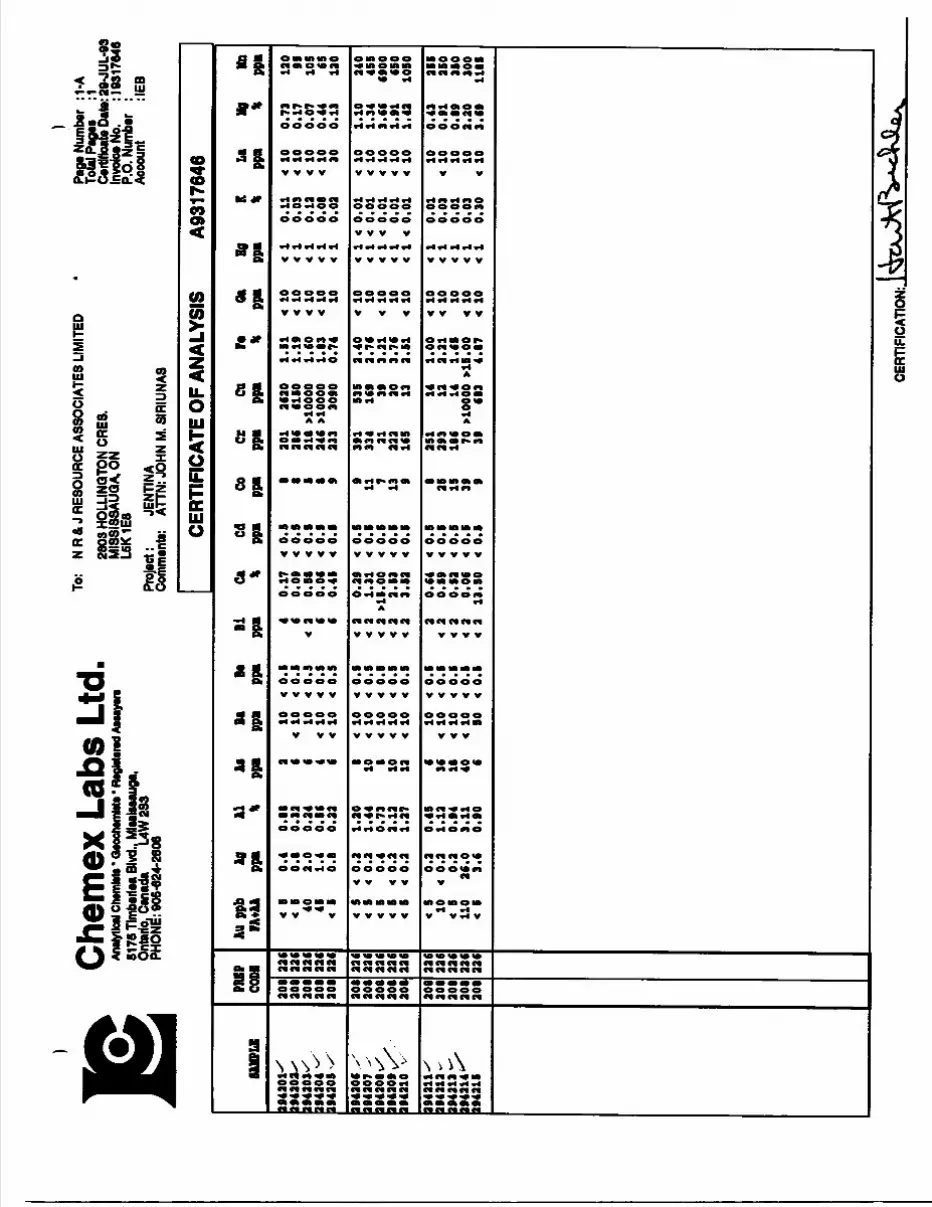
Che
mex
Lab
s Lt
d,An
alytic
al Ch
tmM
*- Qa
oche
mM* *
R*g
l* 61
75 T
imba
rtaa
Blvd
.. Ml
aalsa
auga
, On
tario
. Can
ada
UW
2S3
PHON
E: 9
06-6
24-2
806
To:
N R
4 J
RESO
URCE
ASS
OCIA
TES
LIM
ITED
2803
HOLL
INQ
TONC
RE8.
M
ISSI
SSAU
QA.O
N L6
K1E6
Proj
ect:
JENT
INA
Com
men
t*:
ATTN
: JOH
N M.
SIR
IUNA
S
Pag*
Num
ber
:1-A
To
tal P
ag**
:l
C*r
tiflo
ai*D
ato:
29^U
L.93
In
voice
No.
: 193
1764
6 P.
O. N
umbe
r :
Acco
unt
:IEB
SAMPLE
194301^
194303^
194303V
1943
04
1943
0S
'
I9430C .S
1943
07 ^
1943
08 v/^
194309 vX
1943
10 v
1943
11^
1943
13 -
194313 -^
1943
14 "^
1943
1S
ra ea 301
301
308
308
308
308
308
308
308
308
308
308
308
308
308
IV DI 33 C
33(
336
336
336
336
336
336
336
336
336
336
336
336
336
AU p
pb
Ag
Al
AS
Bl
BeIA+AA
ppn
* PPB
ppB
ppi
< t
0.
0.88
10
0.
< B
0.
0.33
<
10
0.
40
3.
0.34
10
0.
45
1.
0.56
10
0.
< B
0.
0.33
10
0.
4 S
< Q.
1 .
30
8 10
0.
< B
< 0.
1.
44
10
10
0.
< B
0.
0.73
8
10
0.
< B
< 0
. 3.
13
10
10
0.
< B
< 0.
1.
37
13
10
0.
4 S
0.
0.4B
6 10
0.
10
4 0.
1.
13
36
10
0.
4 S
0.
0.94
18
10
0.
110
36.0
3.11
40
10
4 0.
4
B 3.6
0.90
6 BO
4
0.
CERTIFICATE OF ANALYSIS
Bi
Ga
Cd
Co
Gr
Ga
r*
Ot
1PP
B \
PPI
PPB
PPB
PPB
* PP
B Pi
0.17
0.
301
3630
.5
1 4
10
0.09
0.
386
61SO
.19
4 10
4 O.
B8
0.
318 ^0
000
.60
4 10
0.06
0.
346
xlOO
OO
.83
4 10
0.4B
0.
333
3090
.74
10
4 0.
39
0.
9 391
S3S
.40
4 10
4 1.
31
0.
11
334
169
.76
10
m. 00
0.
7 31
39
.31
4 10
3.53
0.
13
333
30
.76
10
3.B3
0.
9
16S
13
.SI
4 10
0.64
0.
8 251
14
.00
4 10
O.B9
0.
25
393
13
.31
4 10
O.S3
0.
IS
186
14
.69
10
0.06
0.
39
70 t
lOOO
O X1
5.00
4
10
13. SO
0.
9 39
683
4.87
4 10
A931
7646
lg K
La
Hj
Mn
p *
PPB
* ppB
0.11
10
0.
73
130
0.03
10
0.
17
95
0.13
10
0.07
105
0.08
10
0.
44
65
0.03
30
0.13
130
4 0.
01
10
1.10
340
4 0.
01
10
1.34
4SS
4 0.
01
4 10
3.66
6900
0.01
4
10
1.91
6SO
4 0.
01
4 10
1.43
10SO
0.01
10
0.43
355
0.03
4 10
0.91
350
0.01
10
0.89
380
0.03
10
3.30
300
0.30
4
10
3.69
1115
CERT
IFIC
ATIO
N:.
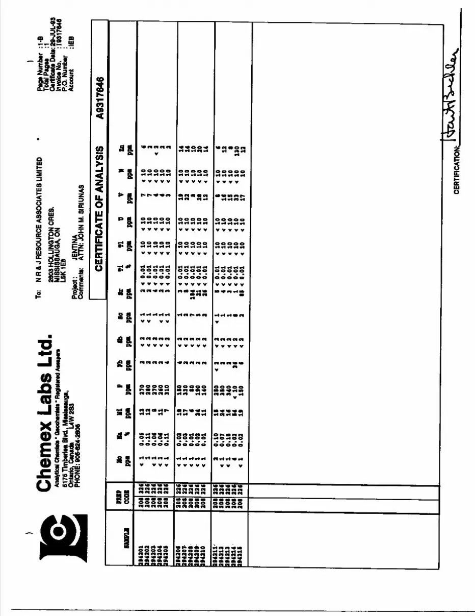
Che
mex
Lab
s Lt
d,An
alytic
al Ch
emto
lt * Q
eooh
tmMi
* Re
gMer
ed A
tMye
ra51
76 T
lmba
riaa
Blvd
., M
iaat
oaug
a,
Onta
rio, C
anad
a L4
W2S
3 PH
ONE:
906
-624
-280
6
To:
NR
& J
RESO
URCE
ASS
OCIA
TES
LIM
ITED
2803
HOL
LINQ
TON
ORES
. M
ISSI
SSAU
QA.O
N L6
K 1E
8Pr
ojec
t: JE
NTIN
ACo
mm
ents:
AT
TN: J
OHN
M. S
IRIU
NAS
Paoe
Num
ber
:1-B
To
tal P
age*
:l
Certi
ficat
e Da
te: 29
-JUL
-03
Invo
ice N
o. : 1
9317
648
P.O.
Num
ber
: Ac
coun
t :IE
B
SUffL
K
1943
01
1943
03
1943
01
1943
04
1943
0S
1943
0629
430*
19
4308
19
4309
1943
1019
4311
- 19
4313
19
4313
1943
14
2943
15
PRIP
CO
DE
308
308
308
308
208
208
208
208
208
208
208
208
208
208
206
226
336
336
336
336
326
336
326
336
336
336
336
326
336
336
Mo
Ut
Hi
P Pb
flb
ppi
\ pp
i pp
i pp
i pp
i
41
0.
06
13
370
0.11
13
38
00.
06
B 37
0 0.
06
11
360
0.11
7
310
0.03
18
IS
O 0.
03
17
330
0.01
6
80
0.03
34
19
0 0.
01
11
140
0.10
IS
3S
O 4
0.07
24
35
0 0.
1S
16
340
0.03
84
4
10
36
4 4
0.03
19
IS
O 6
4
CERT
IFIC
ATE
OF A
NALY
SIS
A931
7646
So
ST
Ti
Tl
0 V
ppi
ppi
* pp
i pp
i pp
i4
0.01
10
4
10
7 4
0.01
10
4
10
7 0.
01
10
4 10
4
4 0.
01
10
4 10
4
4 0.
01
10
4 10
3
0.01
10
10
19
0.
01
10
10
33
184
0.01
10
10
8
31
0.01
10
10
38
36
0.
01
10
10
134
S 0.
01
10
10
8 4
0.01
10
10
16
1
0.01
10
10
IS
1
4 0.
01
4 10
10
33
as 4
o.oi
4 10
10 17
N En
PPI
PPB
10
6 10
3
10
43
10
3 10
3
10
14
10
1410
10
10
30
10
14
10
6 10
13
10
8
10
130
10
13
CER
TIFI
CA
TIO
N:
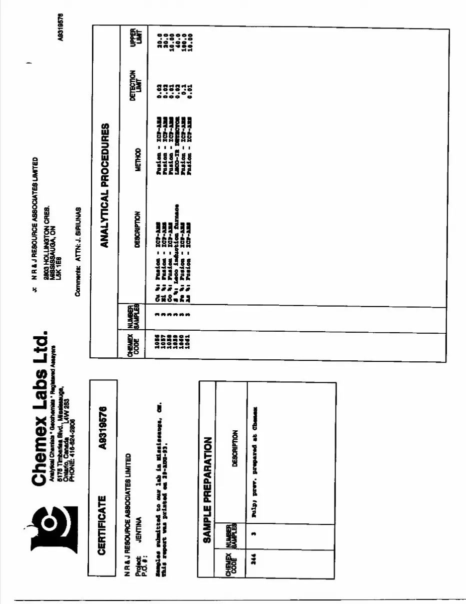
Chem
ex L
abs
Ltd.
Analy
tical
Chtm
toti*
Oao
cham
Mi'
RagM
erad
Aiu
yere
6175
Tlm
bariM
Blvd
., M
laslss
auga
, On
tario
. Can
ada
UW
283
PHON
E: 4
16-6
24-2
806
o: N
R&
J RE
SOUR
CE A
SSOC
IATE
S LI
MIT
ED26
03 H
OLLI
NOTO
N OR
ES.
MI8
SISS
AUG
AON
L6K1
E8
Com
men
te:
AnN
: J. 6
IRIU
NA8
A831
9576
CERT
IFIC
ATE
A031
9576
N R
4 J
RESO
URCE
ASS
OCIA
TES
LIM
ITED
Proje
ct:
JENT
INA
P.O
.*:
aufc
adtte
d to
our
lab
in
Mia
aiea
awa,
OH
. T
his
repo
rt v
aa p
rint
ed e
a 29
-MM
-93.
SAM
PLE
PREP
ARAT
ION
W24
4
m 3
DESC
RIPT
ION
Ful
pi p
rer.
pre
pare
d at
Ctia
neii
ANAL
YTIC
AL P
ROCE
DURE
S
CHEM
EX
CODE 10
8610
57
1059
1060
1061
NUMB
ER
SAMP
LES
DESC
RIPT
ION
METH
ODDE
TECT
ION
LIMIT
UPPE
R LIM
IT
Cu *
i ru
eioa
- x
cr-J
tu
•i *
i ru
Biea
- Z
CV-JU
U Co
Hi
fliM
iea
- xc
v-ua
n
*i
Leoo
iad
uetio
n fu
raae
e re
\t
rusi
ea -
XCV
-US
Aa *
i ru
aioB
- X
CV-A
Ea
- xc
v-Au
- IC
9-U
* ru
iien
- IC
T-JU
M UC
O-XR
mra
cmi
raai
ea -
xcv
-Aia
fu
alea
- x
cr-
o.oa
0.09
0.01 0.02
0.1
0.01
20.0
20.0
10.00
40.0
100.0
10.00
Chem
ex L
abs
Ltd.
Analy
tical
Clwm
litt *
Qeo
chem
Wa * M
glstar
ed A
iuya
ra51
75 Tl
mber
tea B
lvd., M
lHlM
auga
, On
tario,
Can
ada
L4W
283
PHO
NE: 4
16-8
24-2
806
A N
R&
J R
ESO
URCE
ASS
OCI
ATES
UM
ITED
2803
HO
LLIN
QTO
N O
RES.
M
ISSI
S8AU
GA,
ON
L5K
1E8
Proj
ect:
JENT
INA
Comm
ents:
AT
TN: J
. 8IR
IUNA
8
TofaJ
Pag
es
:1 Ce
rtfflc
afe D
ate: 2
9-AU
Q-93
Inv
oice N
o. : 1
0310
676
P.O.
Num
ber
: Ac
coun
t :IE
B
CER
TIFI
CAT
E O
F AN
ALYS
IS
A931
9576
•AM
PLE
394303
394304
39
33
14
PB
EP
CODE
34
43
44
34
4
— —
—.
Cu *
1.2
C0
.88
18
.10
Hi <
0.
03
< 0
. 0
3-C
0.0
3
CO •C
0.0
1<
0.0
1K
0.0
1
8 *
(LO
CO
)
1.1
80
.78
18.3
0
F*
1.8
3.1
31
.9
Aa < 0
.01
< 0
.01
< 0
.01
CERT
IFIC
ATIO
N:.
Chem
ex L
abs
Ltd.
Analy
tical
crwm
toti *
Qao
oham
liti -
RagM
erad A
waya
ra61
76 Tl
mberi
es. B
lvd., M
lMiM
auga
, On
tario.
Can
ada
L4W
283
PHON
E: 41
6-62
4-28
06
j;
N R
ft J
RESO
URCE
ASS
OCI
ATES
LIM
ITED
2603
HO
LLIN
QTO
N O
RES.
MIS
SISS
AUQ
A.O
NL6
K1E
8
Comm
ents:
ATT
N: J.
SIR
IUNA
S
A931
9677
CERT
IFIC
ATE
A931
0577
N R
ft, J R
ESOU
RCE
ASSO
CIAT
ES L
IMIT
EDPr
otec
t JE
NTIN
A P.
OY#:
•aB
ploi
aub
Bitt
ad t
o ou
r la
b la
Mi*
aia
*hia
rep
ort
vaa
pria
tod
ea 3
0-A
DO
-93.
SAM
PLE
PREP
ARAT
ION
^P 20
5 22
6 22
*
NUMB
ER 2 2 2
it
DESC
RIPT
ION
Bann
han
riag
to
appr
o* 1
50 B
OBh
0-5
Ib o
ruab
and
api
i t
XCP
- AQ
oig
oBtio
a ob
arg*
92 a
laav
aat
ICP
paok
ago
is a
uita
bla
for
trao
a aw
tala
la
M
il aa
d ro
ok •
••pi
***
•lava
nt*
for
vhio
h tt
e ai
trio
-agj
ua r
ogia
di
goit
ioa
i* p
onib
ly i
nooa
vpla
ta a
roi
Al,
B*,
M,
ea,
Cr.
O*,
K, L
a, M
g, *a
, fer
, fi
, vi
, w
.
ANAL
YTIC
AL P
ROCE
DURE
S
CHEM
EX
CODE 10
0 2118
211*
2120
2121
2122
2123
2124
2125
2126
2127
2128
21
SO21
3021
312132
2131
2134
2135
213C
2137
2138
2138
2140
2141
2142
2143
2144
2145
2146
2147
2148
214*
NUMBER
[SAMPLES
DESCRIPTION
METH
ODDE
TECT
ION
LIMIT
UPPE
R LIM
IT
Aa ppb
i ruao 1
0 g
Ag PPB
I 32 o
loBoat, Mil
a rook
Al H
i 32 o
loBo
at, Mil
a rook rook
rook
rook
rook
rook
rook
rook
rook
rook
rook
rook
rook
•i Ca H
i 32
Cd p
pmi
32 o
lCo
PPB
I 32
ala
iMat
co
ilCr
PPB
I 32
ola
maa
t so
ilCu
PPB
I 32
ala
tMat
co
ilr*
Hi
32 o
lMM
at,
coil
al
32
OlM
MB
t B
Oil
i 32
olaMat
aoil
K Hi
32
ol
La PPB
I 32
Kg H
i 32 l
32
l 32 o
li•a H
i 32 o
li•i P
PBI
32
•oil a
rook
•oil
•oil
a
XC
P-A
UX
CP-
AU
X
CP-
AU
X
CP-
AU
X
CP-
AU
ICP-AM
XCV-AH
XCP-
zcp-
ICP-
rook
rook
rook
rook
rook rook
rook
ICP-AM
xcp-au
rook
rook
V PP
BI 32
olataaat,
Pb PPB
I 32 o
loBo
at,
rail
•b PPBI 32 OlOBWt, Mil
M PPBI
32 o
lOBoati. Mil
a ro
ok•r PPB
I 32 o
loBo
at, Mil a
rook
•i H
i 32
Tl P
PBI
32
O PPB
I 32 i
V PPBI
32 o
l W PPBI
32 i
la
ppB
i 32 o
:
XCP-AU
XCP-AM
XCP-AU
•oil a
•oil a
rook
, Boil a
rook
, Mil
a rook
, toil a
roo
k it,
Mil
a rook
XCP-AU
XCP-AU
XCP-AU
XCP-AU
XCP-AU
XCP-AU
XCP-AU
50.2
0.01 2 10 0. 0.01
0. 0.01 10 l
0.01 10
0.01 5 l
0.01 l 10 2 2 l l
0.01
10
10 l 10 2
10000
200
15.0
010
000
1000
010
0.0
1000
013
.00
100.
010
000
1000
010
000
15.0
010000
1000
010
.00
1000
015
.00
1000
010
000
5.00
10000
1000
010
000
1000
010
000
1000
05.
0010000
1000
010000
10000
1000
0
Chem
ex L
abs
Ltd,
AnHy
fcxl C
tam
tott
* O*o
ch*m
tot*
' Reg
Mwwl
Aan
ym61
76 Tl
mber
tea B
lvd.. M
taelu
auga
, On
tarta
Cana
da
L4W
283
PHON
E: 41
6-62
4-28
06
.o:
N R
4. J
RESO
URCE
ASS
OCIA
TES
LIM
ITED
2803
HOL
LINQ
TON
CRE8
.M
IS8I
8SAU
QA.
ON
L6K1
E8Pr
oject:
JE
NTIN
A Co
mmen
ts:
ATTN
: J. 8
IRIU
NA8
Paga
Nu..j
er :
1-A
Total
Pag
ee
:1 Ce
rtific
ate D
ate: 3
0-AU
Q-93
Inv
oice N
o. : 1
9319
577
P.O.
Num
ber
: Ac
coun
t :IE
B
CERT
IFIC
ATE
OF A
NALY
SIS
A931
9577
ram
i1I
431(
-^1*
4223
S
no con
90S
205
22*
22C
Jtapp
b J
ujA
lAfla
BeB
iCa
Cd
Co
CrC
ttred
aH
g
K La
Mg
Ib
FA
+U
ppa\
H pp
B pie
i pp
i na
*
ppm
ppa
ppa
ppa
% pp
a pp
a %
pp
• *
PS*
41
4 0.
2 4.
11
42
4 10
4
0. B
4 3.
49
O.S
22
1C
1 1*
t.
06
10
24 0
.01
4 10
3.
61
1070
4 B
4 0.
2 0.
31
10
4 10
4
O.S
4
2 0.
40
4 O
.S
4 33
1 12
1.
04
4 10
4
1 4
0.01
4
10
0.33
12
B
CERT
IFIC
ATIO
N:
Chem
ex L
abs
Ltd,
Analy
tical
Cham
Ma *
Qaoc
hamM
a * R
aglat
arad A
aaay
ara61
76 Tl
mbar
laa B
lvd., M
lselee
auga
, On
tario.
Can
ada
L4W
2S3
PHON
E: 4
1642
4-28
06
j:
NR
& J
RESO
URCE
ASS
OCIA
TES
LIM
ITED
2803
HOL
LINO
TON
ORES
. M
ISSI
SSAU
GA, O
N L6
K1E8
Proj
ect:
JENT
INA
Com
men
ts:
ATTN
: J. 8
IRIU
NA8
Tofe
lPag
ea
:1 Ce
rtNlca
fi Da
te: 3
0-AU
Q-93
In
voice
No.
: 1
8319
677
P.O.
Num
ber
: Ac
coun
t :IE
B
CERT
IFIC
ATE
OF
ANAL
YSIS
A931
9577
cox
•t tt
p PF"A PP
I8r PI*
TiTl
Dra
PPB
PPB
PPB
1*42
10
1*43
2120
8 20
S22
C 22
60.
010.
0261 41
240 40
22 4 l
21 60.
110.
01*
10
< 10
* 10
<
1013
3 630
<
10BO
6
CERT
IFIC
ATIO
N;.

Chem
ex L
abs
Ltd,
Analy
tical
Char
nian'
Qeoc
ham
liti *
Ragl
ittrtd
Atity
tra51
75 T
bnbe
rlM B
lvd..
Miu
ltiau
ga,
Onta
rio. C
anad
a U
W2S
3 PH
ONE:
416
-624
-280
6
To:
NRaJ
RESO
URCE
ASSO
CIAT
ES L
IMIT
ED28
03 H
OLLI
NQTO
N OR
ES.
MIS
SISS
AUQA
.ON
L6K1
E8
Com
men
ts: A
TTN:
J. S
IRIU
NA8
A931
9B78
CERT
IFIC
ATE
A931
9578
N R
A J
RESO
URCE
ASS
OCIA
TES
LIM
ITED
Proje
ct:
JENT
INA
P.O
.*:
Saap
loa
auba
dtta
d to
our
lab
in
Mia
aiaa
auga
, ON
. Vb
ia r
epor
t wa
a pr
inte
d on
24-
JUJO
-B3.
SAM
PLE
PREP
ARAT
ION
w 205
226
238
em s 6 6
DESC
RIPTIO
N
Oaoo
baai
ring
to
appr
o* 1
50
0-5
Ib a
ruab
and
apl
ita*
abM
itrio
-aqu
a-ra
gia
diga
atio
n
ANAL
YTIC
AL P
ROCE
DURE
S
CHEM
EX
CODE 10
0 6
NUMB
ER
SAMP
LES
DESC
RIPT
ION
METH
ODDE
TECT
ION
LIMIT
UPPE
R LIM
IT
Au p
pb:
ruao
10
g aa
avl*
n,
-AlB
5
1000
0 HH
OS-a
qua
ngi
a di
goat
JU
kB-BK
OD c
om
0.2
100.
0
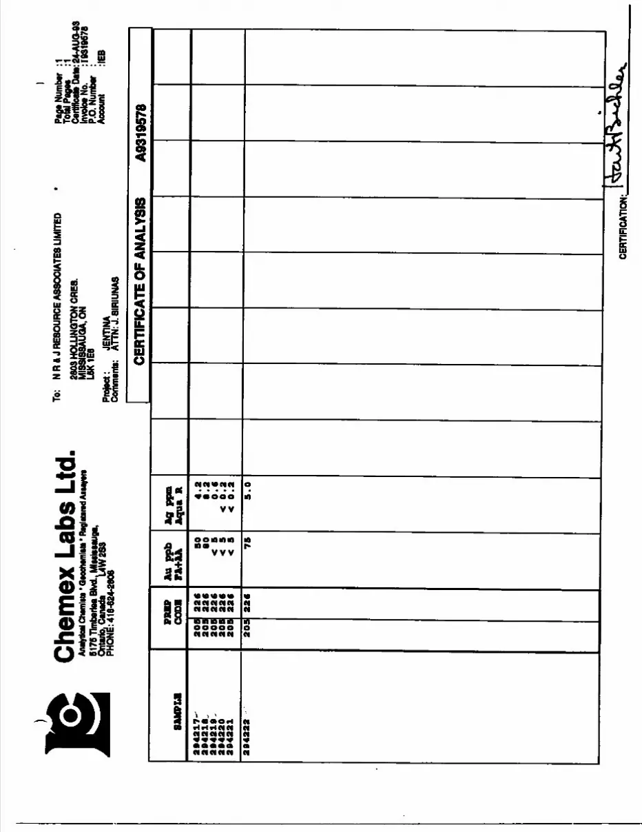
Chem
ex L
abs
Ltd,
Afwy
nnl C
hwnw
ti * u
Moh
wnl
itt51
75 Tl
mba
rlM B
lvd.. M
lMls
uuga
, On
tario.
Can
ada
UW
283
PHON
E: 4
16-6
24-2
806
To:
N R
A J R
ESOU
RCE
ASSO
CIAT
ES U
MIT
ED28
03HO
LUNQ
TONC
RE8.
MISS
ISSA
UOA.
ONL6
K1E8
Proj
ect:
JENT
INA
Comm
ents:
AT
TN: J
. SIR
IUNA
S
l
Paga
Num
ber
:1 To
fil P
ages
:1
Cerft
icate
DatB
:24-
AUQ-
93
Invoic
e No.
: 103
1967
6 P.
O. N
umbe
r :
Acco
unt
:IEB
CERT
IFIC
ATE
OF A
NALY
SIS
8ANP
LB294217-
29
42
18
, 294219,
2942
20
2942
21
2942
22
PREP
CO
DE
209
209
209
209
209
209
226
226
226
226
226
226
Au p
pb
FA+A
A 50
80
<
5
75
Ag p
prn
Aqu
a R 4.2
8.2
0
.6
5.0
A931
9578
IAn^
Sj
t4\^
S,0
-.CE
RTIF
ICAT
ION;
.
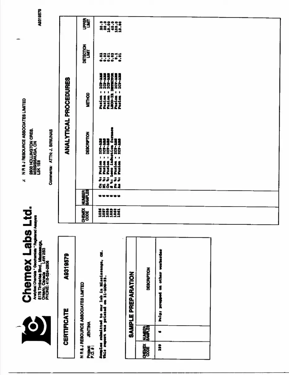
Chem
ex L
abs
Ltd,
Analy
tical
Ctwm
Mi *
Qwxh
wnto
M' R
agMw
wt A
iuye
ra51
76 Tl
mbm
tea B
lvd.,
Mtoa
laaau
ga,
Ontar
io. C
anad
a L4
W 28
3 PH
ONE:
416
-624
-280
6
j: N
Ra
J RE
SOUR
CE A
SSOC
IATE
S LI
MITE
D28
03 H
OLLI
NQTO
N OR
ES.
MI8
SI88
AUQA
,ON
L6K1
E8
Comm
ents:
ATT
N: J.
SIR
IUNA
S
A931
9570
CERT
IFIC
ATE
A931
9579
N R
A J
RESO
URCE
ASS
OCIA
TES
LIMI
TED
Prot
ect
JENT
INA
P.O
.*:
taap
lai
•ofe
ad.tt
ad t
o aa
r la
b in
Mia
aiaa
auga
, *U
a re
port
MM
pri
nted
OB
91-M
Q-M
.
SAM
PLE
PREP
ARAT
ION
W
399
SAW
^K c
DESC
RIPT
ION
Pul
pi p
r*pp
*d o
n ot
bar
wor
feor
ter
ANAL
YTIC
AL P
ROCE
DURE
S
CHEM
EX
CODE 10
3*10
87
10B
(10B9
lOCO
1061
NUMB
ER
SAMP
LES
DESC
RIPT
ION
METH
ODDE
TECT
ION
LIMIT
UPPE
R LIM
IT
cu *
•i
*l
Flu
lOB
-
ZC
P-oe
li
ruel
oB -
m
*i
Looo
iad
oetio
B
ra i
n ra
eioa
- z
cv-
JU \
t ft
tele
a -
ICV-
- xc
v-A
U
raal
on -
ZCP
-AU
raai
oa -
o.oa
0.02
o.oi
o.o
a o.
i o.
oi
ao.o
ao.o
10.00
40.0
100.
010
.00
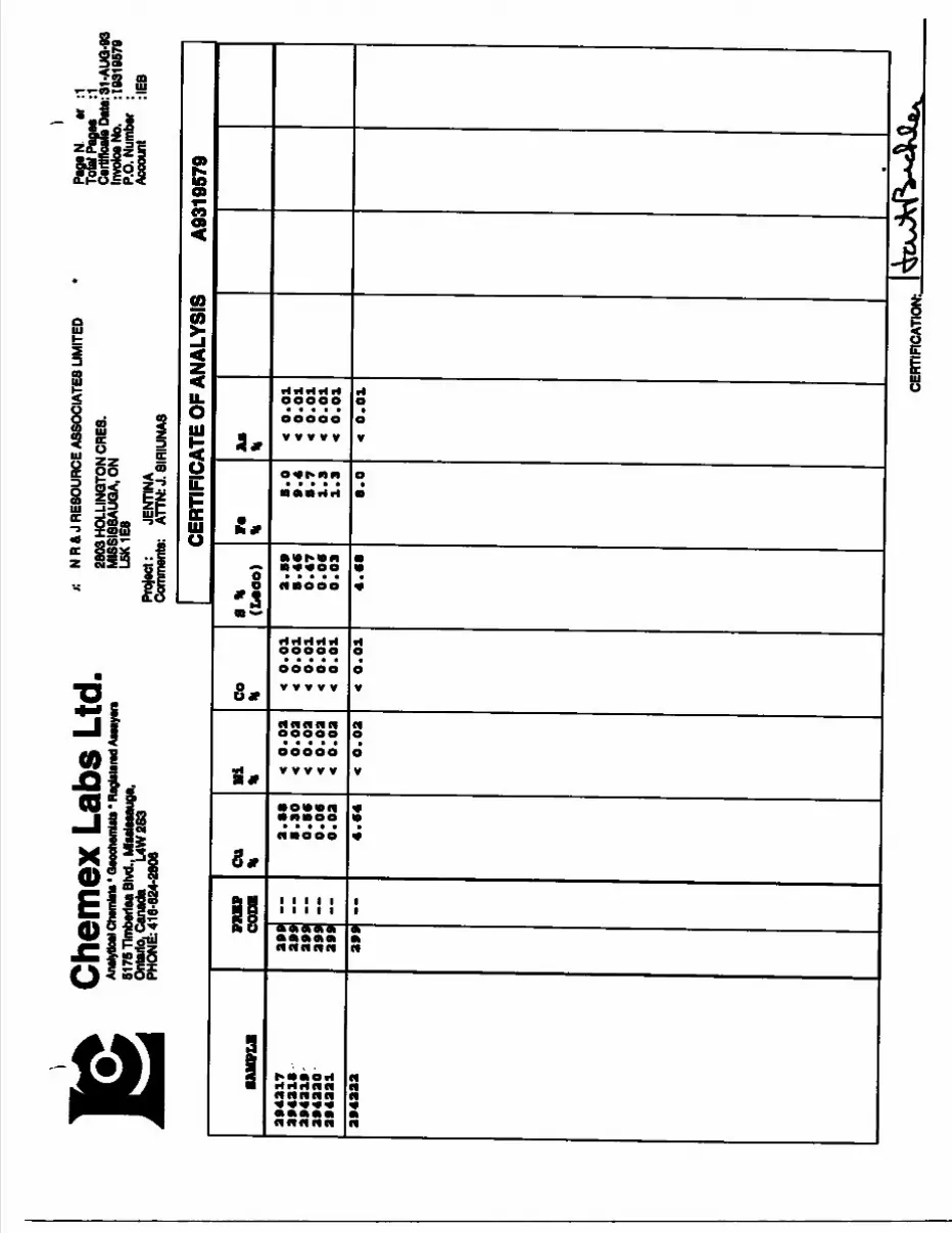
Chem
ex L
abs
Ltd,
Analy
tical
Cham
lata *
Qeo
ohem
lata *
Reg
latara
d Aaa
ayara
61
76 Tl
mbe
rfaa B
lvd., M
leat
oaug
a,
Ontar
io. C
anad
a L4
W28
3 PH
ONE:
416
-624
-280
6
r. N
R& J
RESO
URCE
ASS
OCIA
TES
LIMI
TED
2803
HOL
LINQ
TON
CRES
. M
ISSI
88AU
GA, O
N L5
K1E8
Proj
ect:
JENT
INA
Comm
ents:
AT
TN: J
. SIR
IUNA
8
Page
N ar
:1
Total
Pag
es
:1 Ce
rtMca
fe Da
te:3
1-AU
Q-93
Inv
oice N
o. : 1
8319
679
P.O.
Num
ber
: Ac
coun
t :IE
B
CERT
IFIC
ATE
OF A
NALY
SIS
A931
9579
SAM
PLE
2943
1729
4218
2942
10
2042
20
2942
21
2942
22
PU
PCO
DE
299
299
299
299
299
299
~
CU
\
2. 1
CB
. SO
O
.B6
0.0
6o.
oa4.6
4
Hi
* < 0.0
2
< 0
.02
< 0.0
2
4 0.0
2
t 0
. 02
< 0
.02
CO
H
< 0
. 01
< 0
.01
< 0
.01
< 0.0
14
0.0
1
4 0.0
1
B t
(1*00)
2.8
9
0.4
60.4
7
0.0
6
0.0
3
4.6
8
r*
it8
0 9
4 S
7 1
91
3
8.0
Aa
K <
0.0
1
<
0.0
1
4 0.0
1<
0.0
1 4
0.0
14
0
.01 CE
RTIF
ICAT
ION:
^
tA-A
^M
V'*
*!^

Chem
ex L
abs
Ltd,
Analy
tical
Chem
ist* *
Qao
chwn
ltt* *
Rag
Mara
d Aaw
yara
5175
Tlm
berlM
Blvd
., M
lMls
Mug
a,
Ontar
io. C
anad
a L4
W2S
3 PH
ONd:
416
-624
-280
6
N R
8, J
RESO
URCE
ASS
OCIA
TES
LIM
ITED
2803
HOL
LINQ
TON
CRES
. M
ISSI
SSAU
QA. O
N L5
K1E8
Comm
ents:
AnN
: J. S
IRSI
UNAS
A932
0675
CERT
IFIC
ATE
A932
0675
N R
4 J
RESO
URCE
ASS
OCIA
TES
LIM
ITED
Proje
ct:
P.O.
l:
•aaplea
aubadtted to our l
ab in MiiaiaMuga,
OH.
Miia r
eport ma printed oa 14-acP-O.
SAM
PLE
PREP
ARAT
ION
w 944
NUMB
ER B
DESC
RIPT
ION
Pulp
; p
r*r.
pre
pare
d at
eh m
mr
ANAL
YTIC
AL P
ROCE
DURE
S
CHEM
EX
CODE 97
5•7
7•7
6
NUMB
ERSA
MPLES
!DE
SCRI
PTIO
NME
THOD
DETE
CTIO
N LIM
ITUP
PER
LIMIT
Au p
pbi
XCV-
fluor
*BO
*M*
p*ek
ag*
VA-X
CP-A
Tfl
Pd p
pbi
lCP-
fluoM
saav
e* p
aalu
o*
n-l
Cf-
Ut
ft p
pbi
XC
P-rl
uor*
ae*a
o* p
noka
o*
PA-IC
P-AT
010000
10000
10000
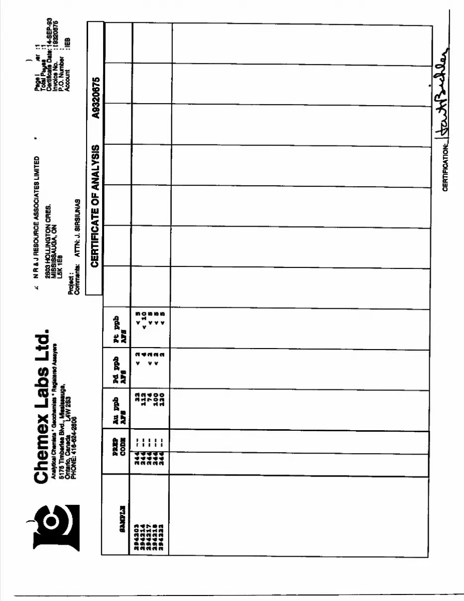
Chem
ex L
abs
Ltd,
Analy
tical
Cham
lata'
Qaoc
haml
ata *
Ragla
tarad
Aata
yera
5176
Tlm
berte
a Blvd
., Ml
eslea
auga
, On
tario.
Can
ada
UW
2S3
PHON
E: 4
16-6
24-2
606
f. N
R 4
J RE
SOUR
CE A
SSOC
IATE
S LI
MIT
ED28
03 H
OLLI
NQTO
N CR
E8.
MIS
SISS
AUQA
, ON
L5K1
E8Pr
ojec
t:Co
mm
ents
: AT
TN: J
. SIR
SIUN
AS
il m
: 1
Toial
Pay
ee
:1 Ce
rtific
ate
Date
: 14-
SEP-
93
Invo
ice N
o.
: 193
2067
5 P.
O. N
umbe
r :
Acco
unt
:IEB
CERTIFICATE OF ANALYSIS
A9320675
SAMPLE
294203
294214
294217
294210
294222
PRIP
COBB
244
244
244
244
244
-~
Au ppb
ATS
23
112
74
10O
12 O
Pd ppb
ATS
< 2 4
< 2
< 2 2
Pt ppb
ATS
< a
< 10
< B
< B
X B
CERT
IFIC
ATIO
N:.
05/10/94 09:35 0705 360 1532 ROYAL OAK EXPL. QI002/002
ROYAL OAK AHALYTICAL LABORATORY CEEtTZETCATE OF ANALYSIS
DATE:
8
9"l
1112
13
14
15
16
17
18
19
20
21
22
24
LablB Chief CheB
07/04/94 09:32 O705 360 1532
ASSAI LABORATORIES 29-jm-94 BEPOEI
ROYAL OAK EIPL. 8002/002
HEP. 18686 PA6ESir j.
~~ *i2lSl-(212152: 12121 53DXR121S4 i
0 0X212151
SAHPLE
DXR12161 OIE12152 DXR12163 BXR12164 A
9 DXR12151
SAHPLE
BXR12161OZR12162 DXK12163OXR12164A
D DXR12151
BE FPH ICP0.6•—
<.S1.6 <.5 <.6 2.2 <.S
apf sICP2
110 285 126 678 683 121
A6 FPH-KP
0.1 — - .
1.4 8.9 .6
3.9.6
1.2
TA XICP
0.01" -^— .
2.81 .10 .84
1.46 2.80 2.74
FE XICP
0.01— —— — -Mm
1.37 9.661.29 2.96 4.28 1.38
CD PFHICP 1
'-" t -m m
<l •CI<l 11 ^
H.XICP
0.01•" ••MM—.
.43 1.62 .22 .66
1.86 .42
CO PPH ICP 1
— ~ — ___
16 36 18 3415 16
SI PPHICP10
*" m m ,
^0 ^0<10 <10^0 <10
11 XICP
0.01i l m ,
3.63 1.97 1.17 1.96 7.62 3.70
31 PPH ICP 1
•"••™ B.MMI
65 6848 8937 57
SB PPH ICP 5
•II B
7 ^6^ ^^
P XICP
0.01•MMJM—— MMH
.03
.02 ^01 .01 .23 .03
CO. PPH ICP 0.5
~MMMMI M —— ,
666065800 5880
20600 61.2
6830B. ~-
:.?i— — — —~33131018
1300 30
E XICP
0.01" *-— ——— a,.
.35
.06
.06
.10 2.34
21 PPH ICP0.5
•~— m , -^
15.3 86.2 60.6 90.8 86.3 15.6
LA FPHICP 0.5-6.4
2356.2
12.2 46.97.6
Ci XICP
0.011 ———————————————— TMJ
.39
.44
.412.683.61 .37
AS FPH ICP3
••^-MMMMM
13 13 20 43 O 13
9 PPH ICP 10
K10 ^0^0^0 ^0K10
se PPIICP 0.5
••- --•^-^
2.7 3.8 .9
2.1 13.62 B• O
SK PPH ICP0.5
13.6 2.8 9.1
16.8 712 13.2
ra FPRICP2
1280 181431 0
1480
:n XICP
0.01-•MMM-. MMM.
.07
.05
.02
.03
.59
.08
T FPH ICP0.1
6.2 : 10.6
2.0 7.6
20.9 6.3
BIFPH ICP3
nr. np nrOFonr
T PPH ICP2
•—— WMMMvH.
6961 4340
13667
ZR FPH ICP0.6
97.9 48.6 20.5 39.4
225 98.0
GR FPH ICP1— — '—
590 634 699 768 76
630
HO PPH ICP1
6 1 7 4
Kl 6
T
^^^- Q
(.-tt^ *j
u
Che
mex
Lab
s Lt
d,An
alytic
al Chw
nMi *
Qeoc
htmW
i - Re
gW61
76 T
lmbe
rtM B
lvd.,
Mlaa
latau
ga,
Ontar
io. C
anad
a U
W2S
3 PH
ONE:
9064
24-2
606
•ywi
To:
NR
4 J
RESO
URCE
ASS
OCI
ATES
LIM
ITED
2803
HO
LLIN
QTO
N OR
ES.
MIS
SISS
AUQ
A.O
N L6
K 1E
8
Com
mut
e:
ATTN
: NEI
L O
WLO
UQ
HB
Y
CC: J
OHN
SIR
UNAS
A942
1949
CERT
IFIC
ATE
A942
1949
N R
A J
RESO
URCE
ASS
OCI
ATES
LIM
ITED
Praj
act
JENT
INA
P.O
.*:
•aap
lea
auba
itted
to
our
lab
in M
iaai
eaau
ga,
ON.
Thia
rep
ort
ma
prin
ted
ea 1
0-1.
00-9
4.
SAM
PLE
PREP
ARAT
ION
W
20S
226
231
®m 4B 4B 4B
DESC
RIPT
ION
Oeoa
haei
ring
to
appr
ox I
SO M
an0-
B Ib
aru
ah a
nd a
plit
Nitr
ia-a
qua-
regl
a di
geat
ioa
ANAL
YTIC
AL P
ROCE
DURE
S
CHEM
EX
CODE
NUMB
ER
SAMP
LES
100 C a
4B
48
4B
DESC
RIPT
ION
METH
ODDE
TECT
ION
LIMIT
UPPE
R LIM
IT
Au p
pbi
ruae
10
g aa
nple
regi
a di
geat
Cu P
PBI
HM09
-agu
a re
gia
dige
atJU
ka-B
XOD
CORR
B0.2
l
1000
010
0.0
1000
0
Che
mex
Lab
s Lt
d,An
alytic
al Ch
wnM
i' Qao
ctom
Mi' F
tagW
6176
Tim
lMriM
Blvd
.. M
lMlM
Mig
a,
Onta
rio. C
anad
a U
W 2
83
PHON
E: 9
06-6
24-2
606
To:
NR
4 J
RESO
URCE
ASS
OCIA
TES
UMIT
ED26
03 H
OLLI
NQTO
N CR
ES.
MIS
SI3S
AUQ
A.O
N L6
K1E8
Proj
tct:
JENT
INA
Com
men
ts:
ATTN
: NEI
L O'W
ILLO
UQHB
Y
Papa
Num
ber
:l To
w P
agaa
*2
C*
rtlflc
atoD
ate:
10.A
UQ-9
4 In
voice
No.
: 1
0421
049
P.O.
Num
ber
: Ac
coun
t :IE
BCC
: JOH
N SI
RUNA
S
CERTIFICATE OF ANALYSIS
SAMPLE
9401
9403
9403
9404
9405
9406
9406A
9407-
9408-
9409x
9410-
9411--,
9413"*^
9413-
9414-
9418-
9416.
9417
9418
- s
9419
9430 >
9431*/
942*'
9433-
9434
942BX
9436
9437
9438
9439
9430 -
" 9431' ,
9433'
9433 '
9434 -^
9438^
9436
, 9436A s
9437
9438
.,-
PRBP
CODB
306
306
306
308
308
308
308
308
308
308
308
308
306
306
306
306
308
308
308
308
308
308
308
308
308
308
308
308
308
308
306
308
aoB
aos
aos
306
308
308
308
306
336
336
336
336
336
336
336
336
336
336
336
336
336
336
336
336
336
226
236
336
336
336
326
336
336
326
236
336
336
336
336
336
336
336
336
336
336
336
336
336
Au ppb
VA+AA 1
196 30
1080
60
*
<
< < < < * 3
< < < < < <
A0 ppm
Aqua R 0.
0.
0.
0.
< 0. 0.
0.
< 0.
0.
0. 0.4. 0
.0.
< 0
. <
0.
< 0.3
2.6
< 0.2
2.8
< 0.2
< 0.2
0.6
68.0
2.0
2.2
1.7
0.2
0.2
< 0.2
< 0.2
< 0.3
K 0.3
< 0.3
0.6
< 0.3
0.3
< 0.3
* 0.2
4 0.2
< 0.3
CU ppn 6
300
3880
3380
3080
930
3080
3080
680
4460
1800
1360
1000
3000
48
106
600
xlOOOO
198
^0000
68 98
103
^0000
JMOOOO
8000
10000
386
386
310
190
113
436
166
3000
1100
3100
75
80
860
95
A9421949
CERTIFICATION: ^xJcfV^jL .
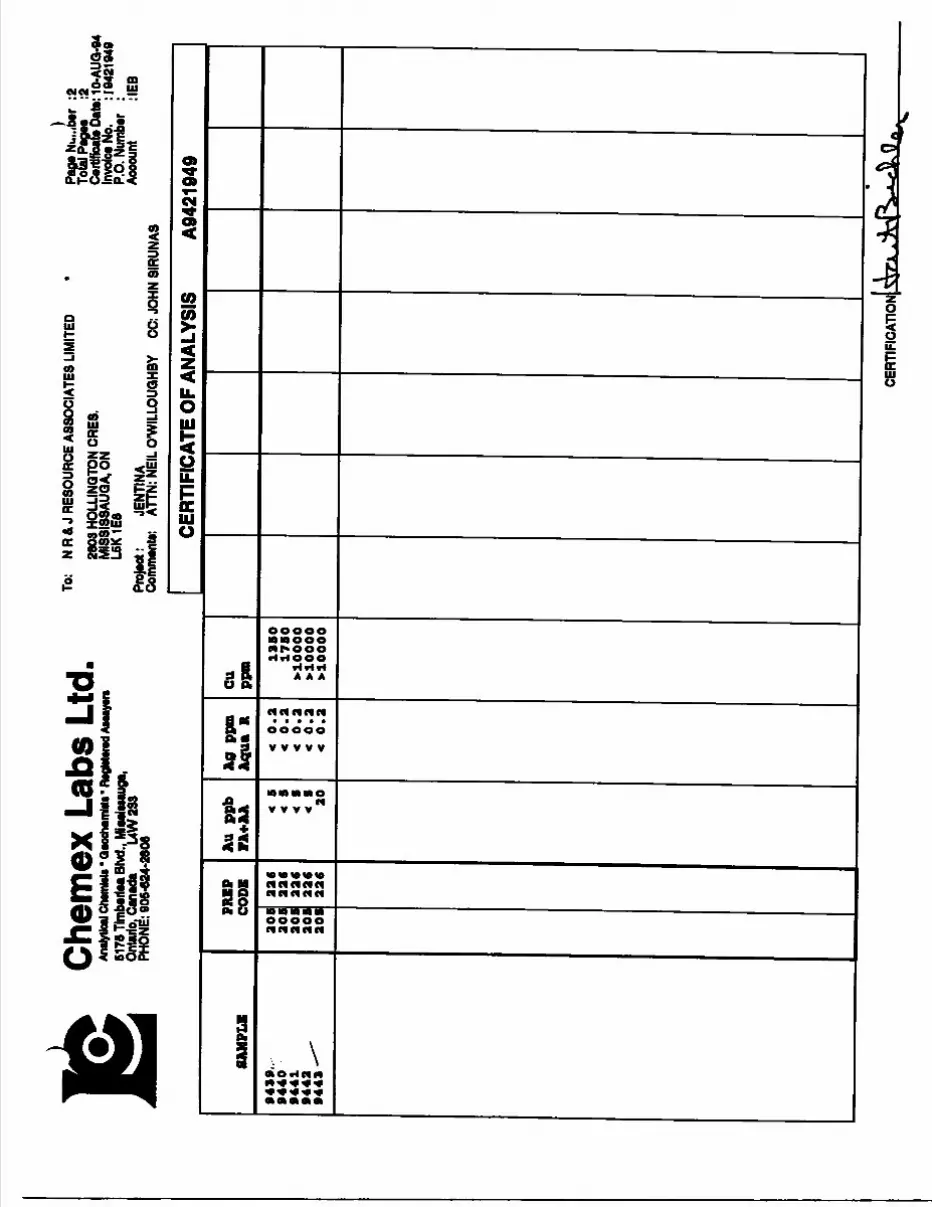
Chem
ex L
abs
Ltd,
Analy
tical
Chem
toto *
QM
Chm
Mi' R
tgM
wvd
Auay
wv61
76 T
lmba
ilM B
lvd.,
Mia
cluau
ga,
Ont
ario
, Can
ada
L4W
2S3
PHON
E: 0
06-6
24-2
806
To:
NR
& J
RES
OUR
CE A
SSO
CIAT
ES L
IMIT
ED28
03 H
OLL
INQ
TON
CRES
.M
ISSI
SSAU
GA.
ON
L5K1
E8Pr
elec
t *
JENT
INA
Com
men
t*:
ATTN
: NEI
L O
'WIL
LOUQ
HBY
Page
Nu.
.ib*r
:2
To
tal P
ages
;2
Ca
rtlflo
ata
Date
: 10-
AUQ
-84
Invo
ice N
o.
: 104
2194
9 P.
O. N
umbe
r :
Acco
unt
:IEB
CC: J
OHN
SIR
UNAS
CERTIFICATE OF ANALYSIS
A9421949
8AMPLH
9439
,.
9440
9441
9442 ^
9443 -"^
PRBP
CODE
208
208
208
208
208
226
226
226
226
226
Au p
pb
FA+AA t
8 *
64 8
< 8
20
A0 P
Pffl
Aqua R
< 0.2
<
0.2
< 0.2
<
0.2
<
0.2
CU ppo 1
380
1780
*10000
>10000
xlOOOO
CERT
IFIC
ATIO
I
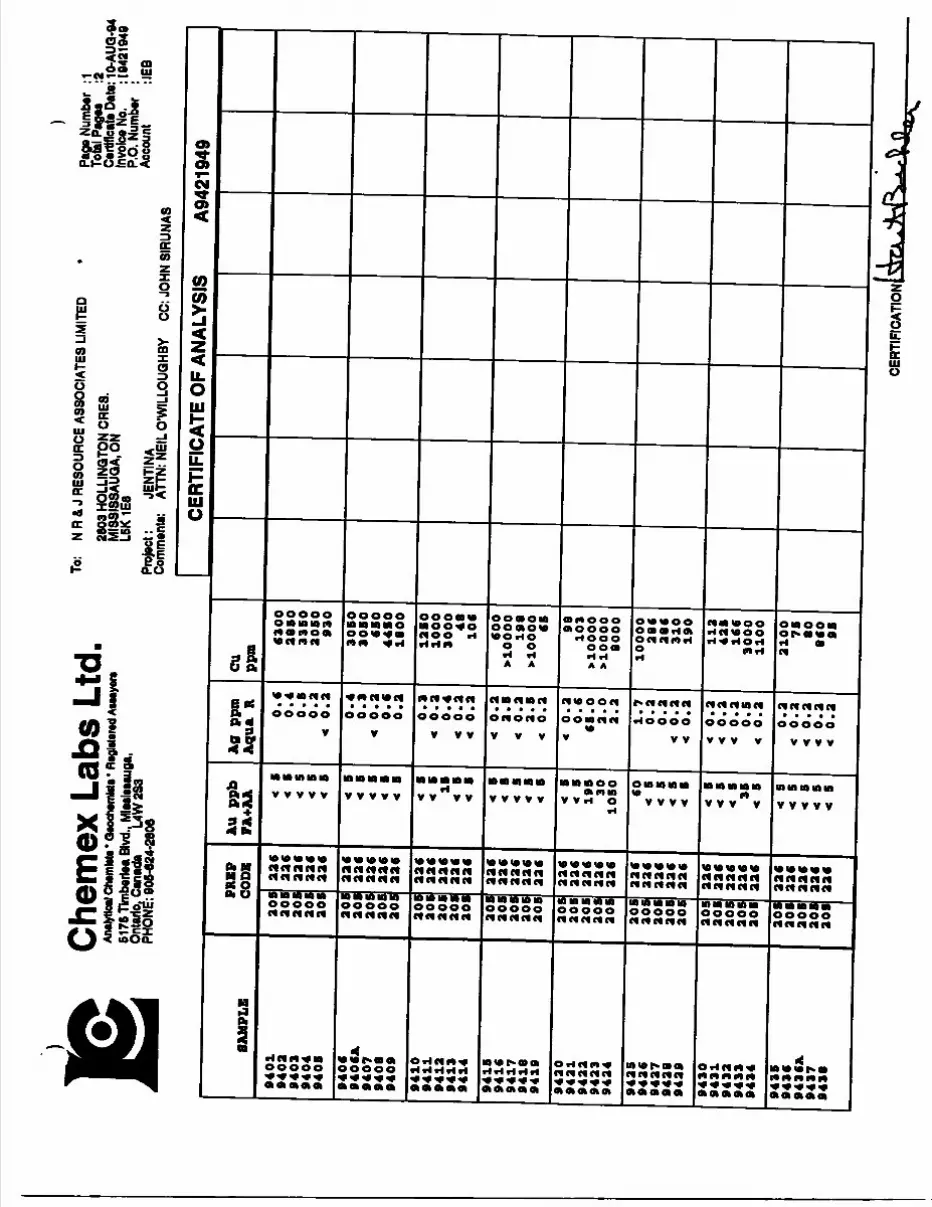
Che
mex
Lab
s Lt
d,An
alytic
*! Ch
wnM
i' Qto
clwin
Mt "
Rtg
Mm
d At
wyer
t61
76 T
imbe
riaa
Blvd
., M
lMlM
auga
, On
tario
. Can
ada
L4W
2S3
PHON
E: 9
06-6
24-2
606
To:
NR
& J
RESO
URCE
ASS
OCIA
TES
LIM
ITED
2603
HOL
LINQ
TON
CRES
. M
ISSI
SSAU
QA.O
N L5
K 1E
8Pr
ojac
t: JE
NTIN
ACo
mm
ent*:
AT
TN: N
EIL O
'WIL
LOUG
HBY
)Pa
ge N
umbe
r :1
Tota
l Pag
es
:2
Certi
ficat
e Da
ta: 1
0-AU
Q-94
In
vote
aNo.
: 1
0421
949
P.O
.Num
bar
: Ac
coun
t :IE
BCC
: JOH
N SI
RUNA
S
CERTIFICATE OF ANALYSIS
SAMPLE
9401
9402
9403
9404
940S
940C
9406A.
9407
9408
9409
9410
9411
9412
9413
9414
941S
941C
9417
9418
9419
9420
9421
9422
9423
9424
9425
942C
9427
9428
9429
9430
9431
9432
9433
9434
943S
943C
943CA
9437
9438
PREP
CODE
aos
aos
aos
aos
aos
205
aos
aos
aos
205
aos
aos
aos
aos
aos
208
20S
20S
206
205
205
205
205
205
205
205
205
206
205
20S
205
206
20S
aos
aoB
aos
aos
aos
aos
aos
aac
aac
aac
aac
aac
aac
aac
aac
aac
aac
aac
aac
aac
aac
aac
aac
aac
aac
aac
aac
aac
22C
22C
22C
226
22C
22C
226
22C
aac
aac
aac
aac
aac
aac
aac
aac
aac
aac
aac
Au ppb
FA+AA 1
195 30
1050 CO 3
•t l
Aa ppm
Aqua R 0.
0.
0.
0.t
0.
0.
0.
< 0.
0.
0. 0.
< 0.
0.
< 0.
< 0.
< 0
. a.<
o.a
2. S
< 0.2
< 0.2
0.6
65.0
2.0
2.2
1.7
0.2
0.2
< 0.2
t o .
a<
o.a
< o.a
< o .
a0.6
< o.a
o.a
< o.a
< o .
a *
o.a
< o.a
cu
ppm C
300
3850
3350
2050
930
3060
3080
CSO
4450
1800
1250
1000
3000
4810C
COO
*10000
198
xlOOOO
65 98103
xlOOOO
^0000
8000
10000
286
286
310
190
112
42S
ICC
3000
1100
2100
75
80
8CO
95
A9421949
CERT
IFIC
ATIO
N;
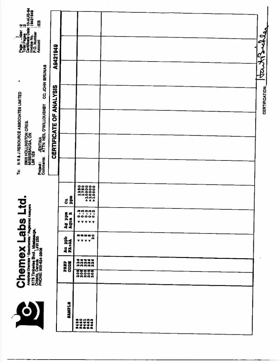
Che
mex
Lab
s Lt
d.An
alytic
al Ch
MnM
a" Q
aoch
tmlil*
* Ft
ogliM
rad A
uaya
ra61
75 T
lmbe
rtea
Blvd
.. M
latlaa
auga
, O
ntar
io. C
anad
a L4
W2S
3 PH
ONE
: 906
-024
-280
6
To:
NR
& J
RES
OUR
CE A
SSO
CIAT
ES L
IMIT
ED26
03 H
OLL
ING
TON
CRES
.M
IS8I
SSAU
QA.
ON
L6K1
E6Pr
ojec
t: JE
NTIN
ACo
mm
ents
: AT
TN: N
EIL
©'W
ILLO
UGHB
Y
:2To
tal P
agaa
:2
Ca
iHllo
ata D
ate: 1
0-AU
Q-94
In
voloa
No.
: 104
2194
9 P.
O. N
umba
r ;
Acco
unt
:IEB
CC: J
OHN
SIR
UNAS
CERTIFICATE OF ANALYSIS
A9421949
SAMPLE
9419
9440
9441
9442
9443
PREP
CODE
205
205
205
205
205
22*
22*
226
22*
22*
Au p
pb
FA+AA <
5<
54 5
< 5
20
Kg ppm
Aqua R
< 0.2
< 0.2
t 0.2
< 0.2
< 0.2
CU ppm 13
50
1750
^0000
>10000
>10000
*
CERT
IFIC
ATIO
N:
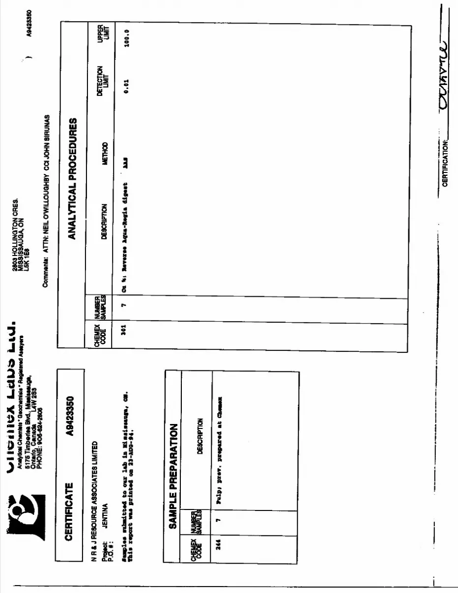
Analy
tical
Chem
Mt'
QMch
wiM
s - ft
ogMa
rad A
ssay
ira61
76 T
imba
riaa
Blvd
., M
lulM
auga
, On
tario
. Can
ada
L4W
2S3
PHON
E: 9
06-6
24-2
806
2603
HOL
LINQ
TON
CRES
. M
ISSI
SSAU
QA.O
N L5
K 1E
8
Com
m0n
ta:
ATTN
: NEI
L O'
WIL
LOUG
HBY
CCIJ
OHN
SIR
UNAS
A942
3350
CERT
IFIC
ATE
A942
3350
N R
A J
RESO
URCE
ASS
OCIA
TES
LIM
ITED
Proj
ect:
JENT
INA
P.O.
# :
to o
ur l
ab i
n M
ical
iMiig
a, O
N.
Thla
rep
ort
waa
prin
ted
on 2
3 -AD
O- 9
4.
SAM
PLE
PREP
AR
ATI
ON
CHEM
EX 244
OT 7
DESC
RIPT
ION
Pulp
f pr
ev.
prep
ared
at
Cbea
ex
ANAL
YTIC
AL P
ROCE
DURE
S
CHEM
EX
CODE 30
1
NUMB
ER
SAMP
LES
DESC
RIPT
ION
METH
ODDE
TECT
ION
LIMIT
UPPE
R LIM
IT
di I
n R
ever
ie A
qua-
Xag
ia d
iges
t0.
0110
0.0
CERT
IFIC
ATIO
N:.
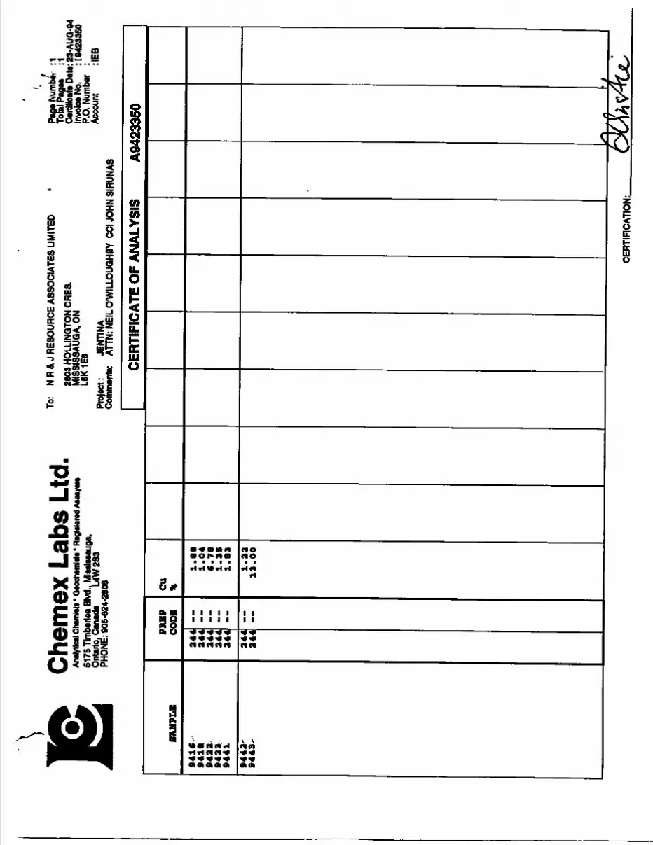
Che
mex
Lab
s Lt
d.An
alytic
al Ch
amhta
* Qa
ocha
mlitc
' Reg
Mmvd
Aua
yara
61
76 T
lmba
riaa
Blvd
.. M
latlaa
auga
, On
tario
. Can
ada
L4W
2S3
PHON
E: 9
06-6
24-2
606
To:
NR
& J
RESO
URCE
ASS
OCIA
TES
LIM
ITED
2603
HOL
LINQ
TON
CRES
. M
ISSI
SSAU
QA.O
N L6
K1E8
Proje
ct *
JENT
INA
Com
men
t*:
ATTN
: NEI
L ©'W
ILLO
UGHB
Y CC
I JOH
N SI
RUNA
S
Paga
Num
b*
:1 To
tal P
aga*
:1
Certi
ficat
e Da
ta: 23
-AUQ
-94
Invo
teaN
o.
: 104
2335
0 P.
O. N
umbe
r :
Acco
unt
:IEB
CERT
IFIC
ATE
OF A
NALY
SIS
A942
3350
SAM
PLE
9416
94
18
9422
94
23
9441
9443
- 94
43-
PRB
P CO
DE
244
244
244
244
244
244
244
~
CU *
1.8
0
1.0
4
9. 7
8 1.3
9
1.8
3
1.2
2
13.0
0
f\ *
fiJ
CERT
IFIC
ATIO
N:.
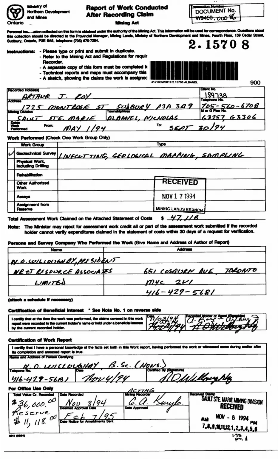
RePOft Of WO1* Rtco|-ng
Mining Actl on ttria tom to obMnad under ths authority ol MN MMno Act. This information wal to uMd lw correapondanca. Questions about
Ms cosodlon should lw dtaected to ine PiovkwW MsnsQsr, MWny Lands, IMnMiy of Northern Development end Mnss, Fourth Floor, 158 Coder Sheet, Sudbury. Ontario. P3E 6A5. tatsphons (70S) 870-7264.
Ontario
DOCUMENT No. 1 W94GO . c?UO W* '
B^M^^B^BB^^C^e^e^BM s9l^h^k^k^ O*M*^ ft r M^la^a) A 0*^1 AaeeMBAaB} aav 4^a Mtttfa^fte^K•lauucuona; - fioaso type or print ana suomn in oupucaie.- Refer to the Mining Act and Regulations for requlr
2.1570 8A separate copy of this form must be completed fi Technical reports and maps must accompany this A sketch, showing the claims the work is assignee
41J10SWOO19 2.1570B ALBANEL 900OHM NO.
JS*S3A 3/3
M or Q Plan6.1-30*
Frame To:
Woffc Performed (Check One Work Group Only)Work Group Type
Geotechnical Survey
Physical tndudtog DrMng
Other AutriortzedHf nHrnut K
Assays NOV 1 7 1994
MINING LAMPS l
Total Assessment Work Claimed on the Attached Statement of Costs S *J7sNote: The Minister may reject for assessment work credit all or part of the assessment work submitted if the recorded
holder cannot verify expenditures claimed in the statement of costs within 30 days of a request for verification.
Person* and Survey Company Who Performed the Work (Give Name and Address of Author of Report)Name Address
flf.A.Us/LL
flan • fJnlal k*A^tau*iA* * g*.—— •x*—A — *ta — 4 **m*. ——— — - —*-*^DonvnciM 1111010*1 000 NOi0 ivo. i on I0v0f00 0100that at the iperfo i nw cWflw oovwsd In this woffc
in the currant hoktar'e name or held under a banalcWby the currant i
1 oertHy Hist 1 taw s psraonsJ knowtodgs of ttw twts sst forth In this Work Ms completion and amend report is trua.
t. having performed toe work or sama during andtor after
and of PHWM Cardfyfeig
&T O LASJData
For Offlc* Un Only
MwDeemed J
NoBca tor Amertdmenu Sam
AppiDMd X
Ml
RECEIVED-8 1994
aMifoaai)
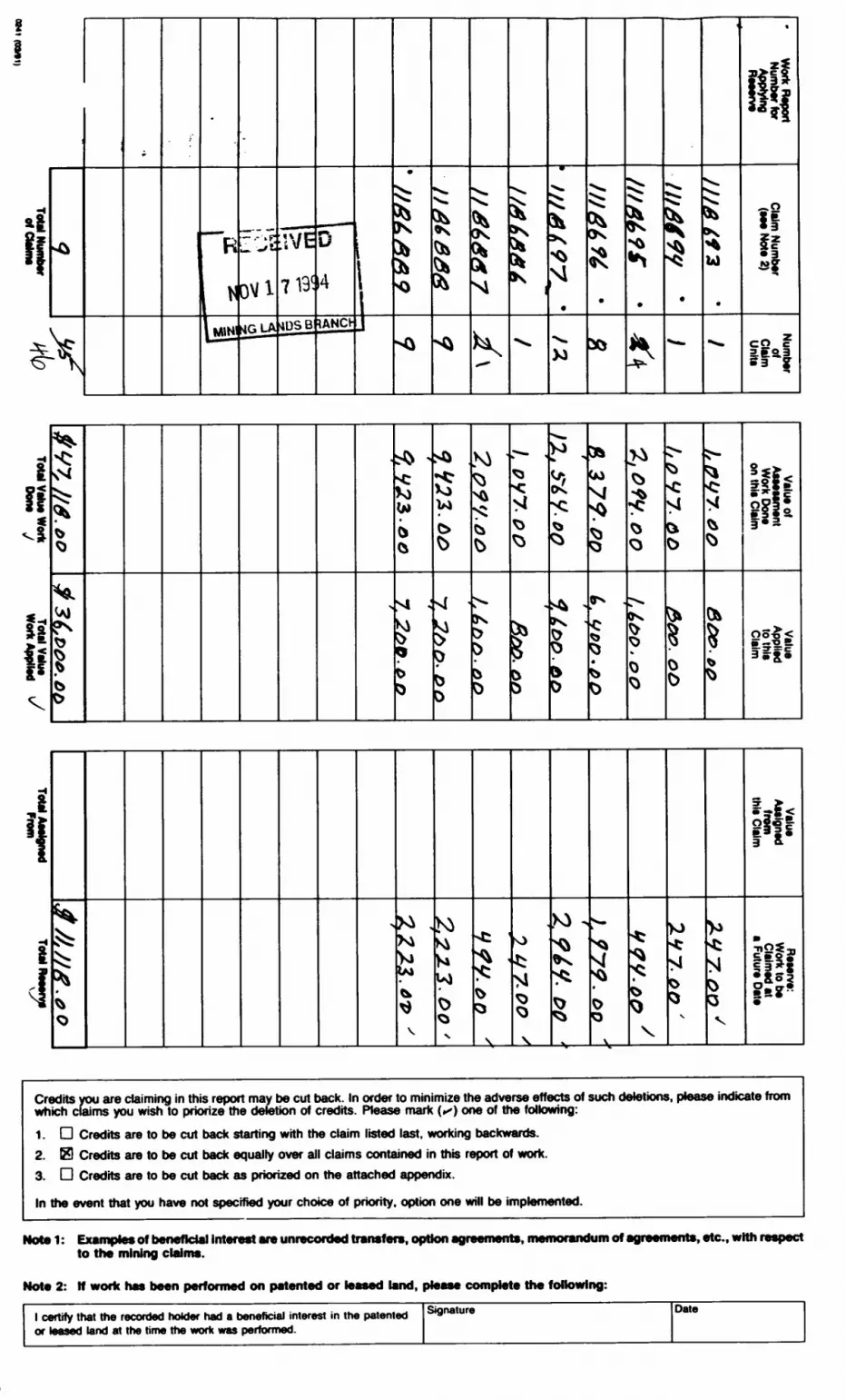
Total Number ifl/O Total Value Work Total Value j Total Assigned Total Henry*
otCWms lvy Done J Work Applied v From \S
nut muxi *
*
XsM
*
^v
b O
l-
r:jjAljj
L. 'J 2
ovi4GLA
WE
4DSB•a •i *"
014
tANCt-
i' /J 'fi '/L A 'A 9
•0
l
*
lM
K
^^W
J^
J^^
Ki
^
\i
X)
l
*
III At* 9 S '
^
S-*
X
Ui
*
-
si!ilif
iH
1
04
(i
si ,Si
0
o
C)
D
^
0
^J
^
?"
foh ^
"S
?"
(M
M
C
e
^
o
(K
0
s0
o
s
^
ft
?!if
l^
V
h*
^
x
^BT^
^
O
M
V
M -
5
0
V\
)0
ov
S
V
3 8.*
m
Credits you are daiming in this report may be cut back. In order to minimize the adverse effects of such deletions, please indicate from which claims you wish to priorize the deletion of credits. Please mark (^) one of the following:
1. G Credits are to be cut back starting with the claim listed last, working backwards.
2. 69 Credits are to be cut back equally over all claims contained in this report of work.
3. G Credits are to be cut back as priorized on the attached appendix.
In the event that you have not specified your choice of priority, option one will be implemented.
MnA^ 1 - PWAIVM*!** Aff h^nafirlal liitar^at AIM iinrar rtntmtt trmnmtmtm fhj*il*kn aur^Min^ifciM •••••••m J —* - ~" -"* -— ** **A~ .~l*k m m m— m m*
to the mining claims.
Note 2: If work has been performed on patented or leased land, please complete the following:
l certify that the recorded holder had a beneficial interest in the patented or leased land at the time the work was performed.
Signature Date
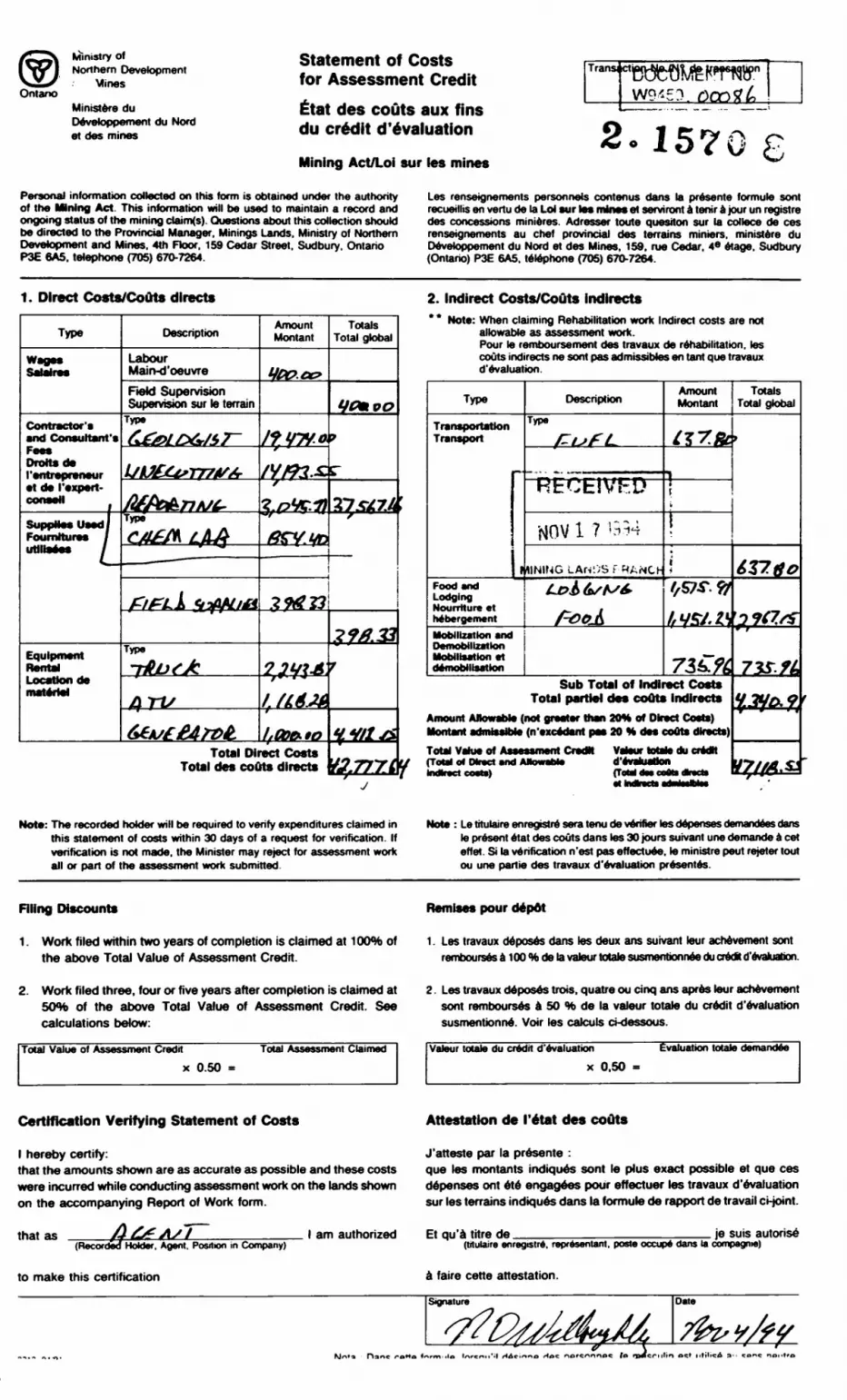
Ontano
Ministry ofNorthern Development
Mines
Ministers du Devetoppement du Nord et des mines
Statement of Costs for Assessment Creditfetat des couts aux fins du credit d'evaluation
Mining Act/Loi sur les mines
Trans* cti
2.15?0 8Personal information collected on this form is obtained under the authority of the Mining Act. This information will be used to maintain a record and ongoing status of the mining daim(s). Questions about this collection should be directed to the Provincial Manager, Minings Lands. Ministry of Northern Development and Mines. 4th Floor. 159 Cedar Street. Sudbury. Ontario P3E 6A5. telephone (70S) 670-7264.
Les renseignements personnels contenus dans la presente formute son! recueillis en vertu de la Lol sur le* mines et sen/iron! a tenir d jour un registre des concessions minieres. Adresser toute quesiton sur la collece de ces renseignements au chef provincial des terrains miniers. ministers du Devetoppement du Nord et des Mines, 159. rue Cedar. 4* etage. Sudbury (Ontario) P3E 6A5. telephone (705) 670-7264.
1. Direct Costs/Couts directs
Type
Wage* Satainn
Contractor'sand Consultant'sFaaaDroitsdel •fltrQpronMirat da ('expert-
SwppHMUMdFoumituresutilto*es
Equipment Rental Location de material
Description
Labour Main-d'oeuvreField Supervision Supervision sur le terrain
Type
Type
t/
Amount Montan!
Totals Total global
Total Direct Costs Total des couts directs
2. Indirect Costs/Gouts indirects* * Note: When claiming Rehabilitation work Indirect costs are not
allowable as assessment work.Pour le remboursement des travaux de rehabilitation, tes couts indirects ne sont pas admissibtes en tant que travaux d'evaluation.
Type
Transportation Transport
1
Food and Lodging Nourrtture et hebergementMobilization and Demobilization Mobilisation et demobilisation
Description
Type
/T/L,/^
RE?Jb!VF.D
MOV 1 7 tt*
dlNIUG LAHtVSF-HANCH
L&&&SV&-
teoA
Amount Montant
/?7)5c
1 ————tif
1
ti
//S7^- 9t
IfV&.Q
73^Sub Total of Indirect Costs
Total partM des couts IndirectsAmount Allowable (not greater than 2OH of Direct Costs) Montant admissible (n'excedant pas 20 H das couts directs)Total VahM of Assessment CradM Valeur totato du crsdtt (ToM of Dlract and Allowable d'svakjattonIndhxLl fn*tm\ fToM do eadte draet*
Totals Total global
t
63760
'J 9(7 rf^ r
73S.U
Z&4
V7/M.S1•tin
Note: The recorded holder will be required to verify expenditures claimed in this statement of costs within 30 days of a request for verification. If verification is not made, the Minister may reject for assessment work all or part of the assessment work submitted.
: Le titulaire enregistr6 sera tenu de verifier tes depenses demandees dans le present etat des coots dans tes 30 jours suivant une demande a cet effet. Si la verification n'est pas effectuee, le ministre peut rejeter tout on une partie des travaux d'evaluation presentes.
Filing Discounts Remises pour depot
1 . Work filed within two years of completion is claimed at 1 GtWb of the above Total Value of Assessment Credit.
1 . Les travaux deposes dans tes deux ans suivant teur achievement sont rer^*xxJrsesa1(X^%dela^raleortotalesusmemk>1^^ducrftcltd'^valuation.
2. Work filed three, four or five years after completion is claimed at 50*H) of the above Total Value of Assessment Credit. See calculations below:
Total Value of Assessment Credit Total Assessment Claimed
x 0.50
2. Les travaux deposes trois, quatre ou cinq ans apres teur achevement sont rembourses a 50 "to de la valeur totate du credit d'evaluation susmentJonne. Voir les calculs ct-dessous.
Valeur tattle du credit d'evaluation
x 0.50
Evaluation totale demandee
Certification Verifying Statement of Costs Attestation de I'etat des couts
l hereby certify:that the amounts shown are as accurate as possible and these costs were incurred while conducting assessment work on the lands shown on the accompanying Report of Work form.
that as A? ASl(Recorded Holder. Agent. Position in Company)
to make this certification
J'atteste par la presente :que les montants indiques sont le plus exact possible et quo ces depenses ont ete engagees pour effectuer les travaux d'evaluation sur les terrains indiques dans la formute de rapport de travail ci-joint.
l am authorized Et qu'a litre de je suis autorise(titulaire enregtstre. representant. poste occupe dans la compagnie)
a faire cette attestation.
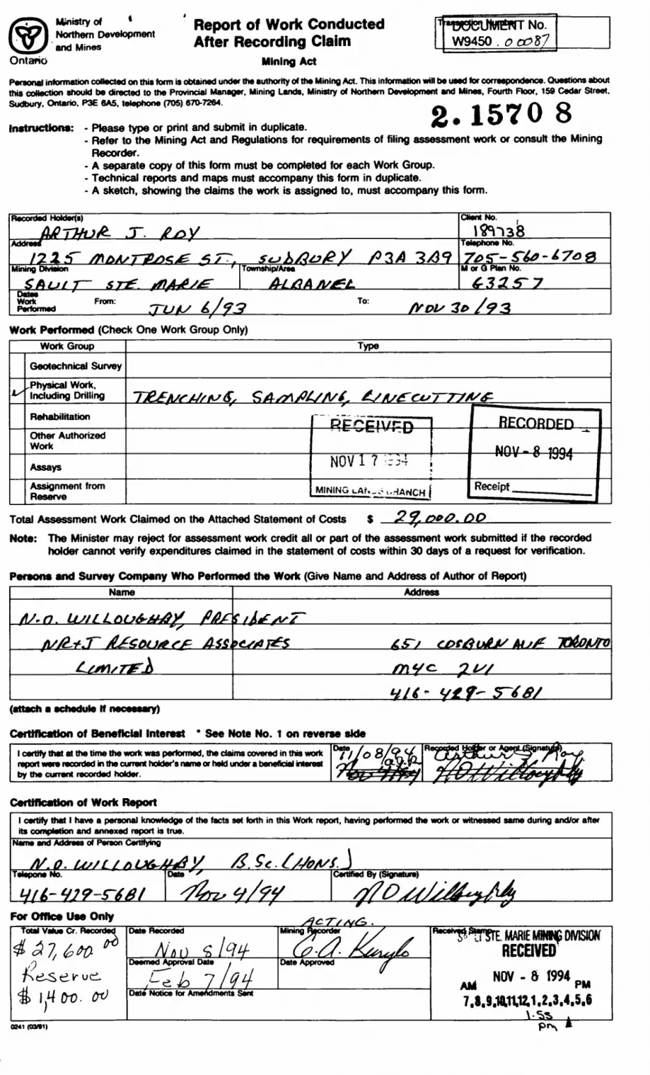
Ministry of * Northern Development and Mines
Ontario
Report of Work Conducted After Recording Claim
Mining Act
No. W9450 . o 00*7
Personal information collected on this torm is obtained under the authority of the Mining Act. This intormaten will be used for correspondence. Chiestions about this collection should be directed to the Provincial Manager. Mining Lands. Ministry of Northern Development and Mines. Fourth Floor. 159 Cedar Street. Sudbury. Ontario. P3E 6A5. telephone (705) 670-7264. ^. ^ ^2* 1570 8Instructions: - Please type or print and submit in duplicate. •w ~
- Refer to the Mining Act and Regulations for requirements of filing assessment work or consult the Mining Recorder.
- A separate copy of this form must be completed for each Work Group.- Technical reports and maps must accompany this form in duplicate.- A sketch, snowing the claims the work is assigned to, must accompany this form.
ded HoUer(s) Cttont No.iffmsTT. stjkAu&y fi 3 A 3X59
Mining Division ^Township/Area
A-LAAM or Q No.
Z S? 3 To:Work Perfonned (Check One Work Group Only)
WorkGroup
IX
Geotechnical Survey
..Physical Work. Including Drilling
Rehabilitation
Other Authorized Work
Assays
Assignment from Reserve
Type
TJtefi/sM/fisS, SA-sn/HsA/t. AsAs2rov~r77*s^f
RECEIVPD
NOV1 1 : r54v
MINING LAN-..- t.HANCH
——— —— - ——————————
REnnRDED
— NOV - 8 1Q94 —
Receipt———————— - ———— -
Total Assessment Work Claimed on the Attached Statement of Costs S 2 J. 0*0. OONote: The Minister may reject for assessment work credit all or part of the assessment work submitted if the recorded
holder cannot verify expenditures claimed in the statement of costs within 30 days of a request for verification.
Persons and Survey Company Who Perfonned the Work (Give Name and Address of Author of Report)
(attach a schedule If necessary)
Certification of Beneficial Interest * See Note No. 1 on reverse sidel certify that at the time the work was performed, the claims covered in this work report ware recorded in the current holder's name or held under a beneficial interest by the current recorded holder. ft
Certification of Work Reportl certify that l have a personal knowledge of the facts set forth in this Work report, having performed the work or witnessed same during and/or after its completion and annexed report is true.
Name and Address of Person Certifying
. Lu/L X p V /Z. Se f/SfiA/S. JTelepone Date Certified By (Signature)
For Ofttee Use OnlyTotal Value Cr. Recordedli i frQ
j
Date Recorded
Doomed Approval Date ,
PI k 7/94
Mining Recorder . S
{-P ~L^1 ' f^^^L^ff'f)Date Approved /f
Date Nobce for Amendments Sent
Racaiv#su I!?rE. MARIE MIMNG DMSIOrY RECEIVED
^ NOV - 6 1994 pw
7.8.9.10,1X12,1,2.3.4.5.6
(841 (03*1) plN^ A
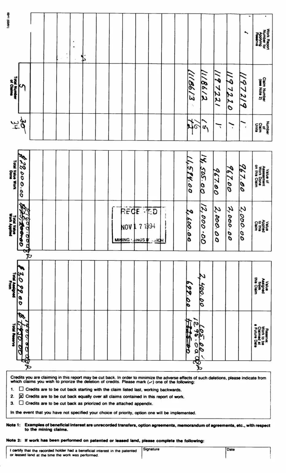
s*ifl\ C/j
^
,.
t i
SV.Ukl
"^. x^
^(K
**
•S
"S
^N•x.
-
^
vi
N*
-
^
5Kl
^
||ffl
" 3
-^oii!|
SiJS3 |
iiri
Is1li
00k0
*F*^s
fs• r
i
Mil
RFC
NOV
ING '.
E---J
.71:
;NDSI
r D)34
r ..iic
•-—:
1
j
'
ifeQ
•si
S6
iQ^
*s^^5O
^4
rx
x^•^
s0
^N
V
^0
^
N^^
,M^\
?0
ilflf*s~
lift
ff
i *
Xf^\ H
^
l *t1
0
tNLCc
^x
cQcs
^*x
5
b
gt(o{rf m ffltp l\ c
Kl
^g0
CV
^1
S
V
5 >oio e.P*-
n*7* ^
Credits you are daiming in this report may be cut back. In order to minimize the adverse effects of such deletions, please indicate from which claims you wish to priorize the deletion of credits. Please mark (^) one of the following:1. D Credits are to be cut back starting with the claim listed last, working backwards.2. j*3 Credits are to be cut back equally over all claims contained in this report of work.3. D Credits are to be cut back as priorized on the attached appendix.
In the event that you have not specified your choice of priority, option one will be implemented.
UA*A 1 - FwmmrklA* nf KArkAffl^l*! intiir^at Arm unrar nrrlari innmimrm rtntlAn A*inAAm*nt* •••••••lil mnhim f\f wir*Ann*nta Atf* with rmtrMT't
to the mining claims.
Note 2: If work has been performed on patented or leased land, please complete the following:
l certify that the recorded holder had a beneficial interest in the patented or leased land at the time the work was performed.
Signature Date
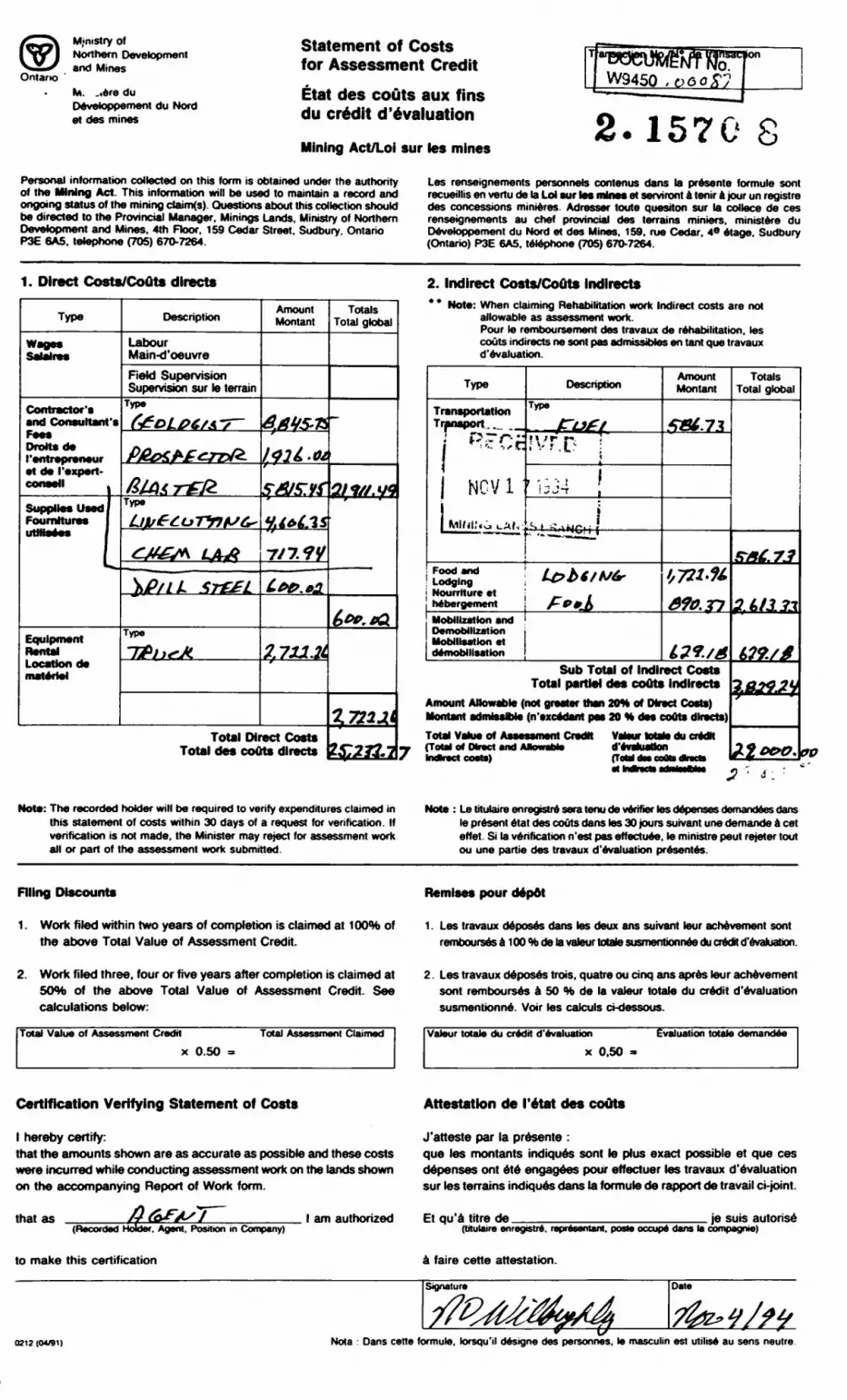
Ontario
Ministry ofNorthern Developmentand Mines
M. ,t6re du Devetoppement du Nord et des mines
Statement of Costs for Assessment CreditEtat des couts aux fins du credit devaluation
Mining Act/Loi sur les mines2.1570 S
Personal information collected on this form is obtained under the authority of the Mining Act. This information will be used to maintain a record and ongoing status of the mining daim(s). Questions about this collection should be directed to the Provincial Manager, Minings Lands. Ministry of Northern Development and Mines. 4th Floor. 159 Cedar Street. Sudbury. Ontario P3E 6A5, telephone (705) 670-7264.
Les renseignements personnels contenus dans la presents formula sont recueillis en vertu de la Lot sur les mines et serviront a tenir a jour un registre des concessions minieres. Adresser touts question sur la collece de ces renseignements au chef provincial des terrains miniers. ministers du Devetoppement du Nord et des Mines. 159. rue Cedar, 4e etage. Sudbury (Ontario) P3E 6A5. telephone (705) 670-7264.
1. Direct Costs/Couts directs
Type
—.
Satalras
Contractor's and Consultant's FeesDraitsde ('entrepreneur et de ('expert-
Supplies Used Foumitures
Equipment Rents! Location de materiel
Description
Labour Main-d'oeuvreReid Supervision Supervision sur to terrain
Type
y&dx TffrType
Type
Amount Montan!
7/7 W
Total Direct Costs Total des couts directs
Totals Total global
252*2.
2. Indirect Costs/Couts indirects* * Note: When claiming Rehabilitation work Indirect costs are not
allowable as assessment work.Pour le remboursement des travaux de rehabilitation, les couts indirects ne sont pas admissibles en tant que travaux d'evaluation.
Type
Transportation Transport.^.
4 \"f '-~- i ~j ^ : '.. -, f C
| NCV 1 '
1 KlKjlN-j uAt,
Food and Lodging Nourrtture et hebergementMobilization and Demobilization Mobilisation et demobilisation
Description
Type
~fL3fl' \ ' f r* - ''"•'•'.i..1- ;
i
,.-,. ji j J T ,
pS t -UNC.'i ( ———————
L&bf/vt' f**J*
Amount Montan!
**867Z
1,721-K
6?o.Tp
i?1.fASub Total of Indirect Coats
Total partM des couts indirectsAmount Allowable (not greater than 20* of Direct Coats) Montant admissMe (n'excedant psi 20 H des coots directs)Total Value of Assessment Credit Vatour totato du credK (Total d Direct and Afcwabto d'tvahiadon IndkBd ctMtet rToW dm cotti dtaeh
Totals Total global
1
s*e.7j
?.U1Z*
U9./6
7.014JV* ~
22 0*0.
Note: The recorded holder will be required to verify expenditures claimed in this statement of costs within 30 days of a request for verification. If verification is not made, the Minister may reject for assessment work all or part of the assessment work submitted.
Note : Le titulaire enregistre sera tenu de verifier les depenses demandees dans le present etat des couts dans les 30 jours suivant une demands a cet effet. Si la verification n'est pas effectuee. le ministre peut rejeter tout ou une partie des travaux d'evaluation presentes.
Filing Discounts Remises pour depot
1. Work filed within two years of completion is claimed at 100*ft of the above Total Value of Assessment Credit.
Les travaux deposes dans les deux ans suivant tour achevement sont remb(Xlrsesa100%ctelavaleurtotatesusn1e^tx>^nee(luCTftdHd'&valuatlon.
2. Work filed three, four or five years after completion is claimed at 5Cm of the above Total Value of Assessment Credit. See calculations below:
Total Value of Assessment Credit Total Assessment Claimedx 0.50
2. Les travaux deposes trois, quatre ou cinq ans apres tour achevement sont rembourses a 50 M de la vatour totato du credit d'evaluation susmentionne. Voir tos caJculs ct-dessous.
Vateur totato du credit devaluationx 0,50
Evaluation totale demandee
Certification Verifying Statement of Costs Attestation de I'etat des couts
l hereby certify:that the amounts shown are as accurate as possible and these costs were incurred while conducting assessment work on the lands shown on the accompanying Report of Work form.
that as(Recorded Holder. Agent. Position in Company)
to make this certification
J'atteste par la presente :que les montants indiques sont le plus exact possible et que ces depenses ont ete engagees pour effectuer les travaux d'evaluation sur les terrains indiques dans la formuto de rapport de travail ci-joint.
l am authorized Et qu'a litre de je suis autoris6(titulaire enregistre. representant. paste occupe dans la compagnie)
a faire eerie attestation.
Signature Date
0212 (OU91) Nota : Dans cette formule, kxsqu'il designe des personnes. le masculin est utilise au sens neutre.
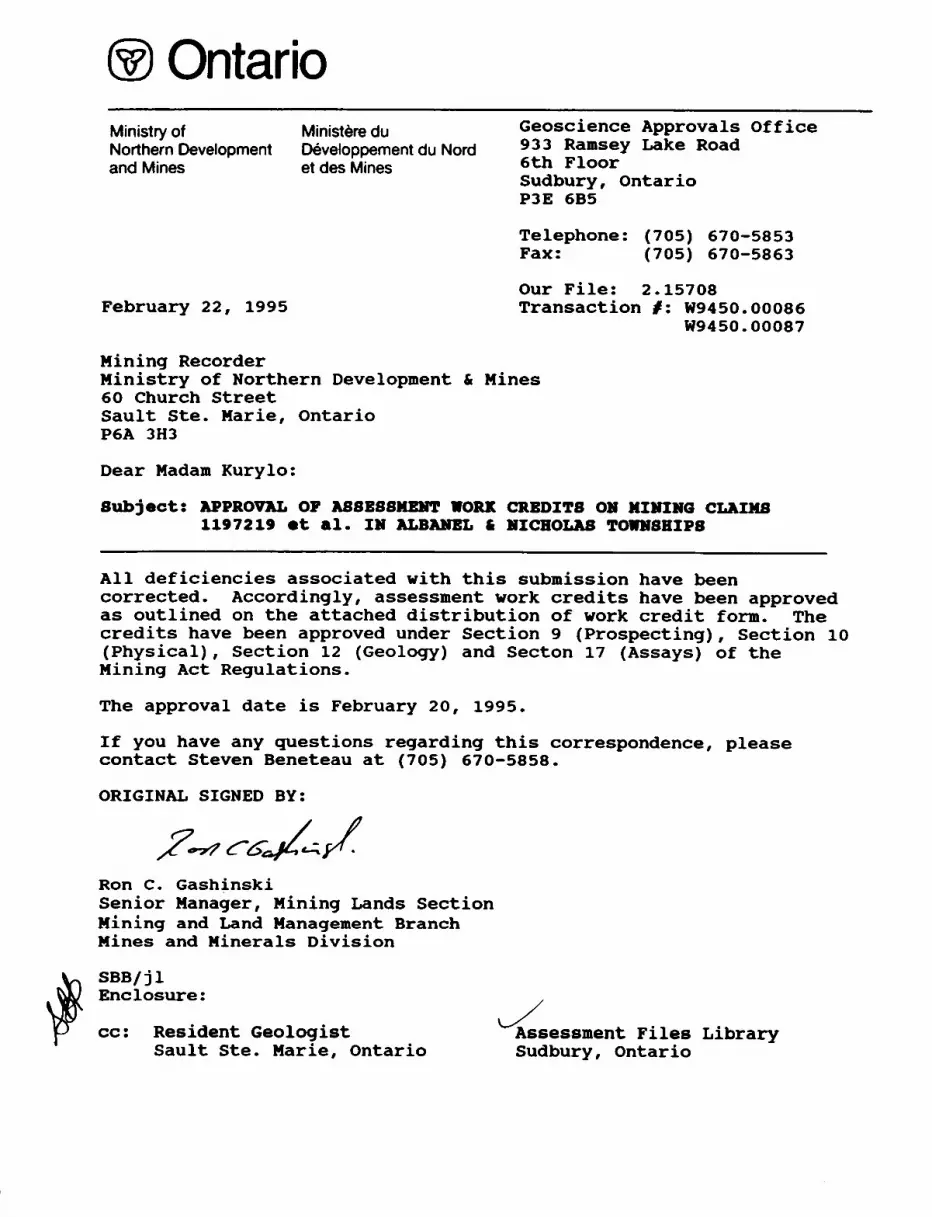
OntarioMinistry ofNorthern Developmentand Mines
Minister® duOeveloppement du Nord et des Mines
Geoscience Approvals Office 933 Ramsay Lake Road 6th Floor Sudbury, Ontario P3E 6B5
February 22, 1995
Telephone: (705) 670-5853 Fax: (705) 670-5863
Our File: 2.15708 Transaction /: W9450. 00086
W9450. 00087
Mining RecorderMinistry of Northern Development 6 Mines60 Church StreetSault Ste. Marie, OntarioP6A 3H3
Dear Madam Kurylo:
Subject: APPROVAL OF ASSESSMENT WORK CREDITS ON MINING CLAIMS 1197219 et al. IN ALBANEL 6 NICHOLAS TOWNSHIPS
All deficiencies associated with this submission have been corrected. Accordingly, assessment work credits have been approved as outlined on the attached distribution of work credit form. The credits have been approved under Section 9 (Prospecting), Section 10 (Physical), Section 12 (Geology) and Secton 17 (Assays) of the Mining Act Regulations.
The approval date is February 20, 1995.
If you have any questions regarding this correspondence, please contact Steven Beneteau at (705) 670-5858.
ORIGINAL SIGNED BY:
Ron C. GashinskiSenior Manager, Mining Lands Section Mining and Land Management Branch Mines and Minerals Division
SBB/jl Enclosure:
cc: Resident GeologistSault Ste. Marie, Ontario
Assessment Files Library Sudbury, Ontario
REPORT OF WORK FORM
Please note, the assessment credit has been distributed to reflect the value of work performed on each claim.
FEBRUARY 22, 1995 FILE: 2.15708 TRANSACTION f W9450.00087
VALUE OF ASSESSMENT CLAIM WORK DONE
1197221 $ 863.001197220 $ 863.001197219 ^ 863.001118612 $19,888.001118613 $ 6,400.00
TOTAL $28 / 877.00
FILE: 2.15708 TRANSACTION i W9450.00086
VALUE OF ASSESSMENTCLAIM WORK DONE
1186888* $10,042.001186887* S 550.001186886* S 1,218.001118694' $ 1,060.001118693. ^ 1,881.001118695* S 3,377.001118696* $26,345.001118697 S 0.00 NO ASSESSMENT WORK PERFORMED1186889 $ 0.00 NO ASSESSMENT WORK PERFORMED
TOTAL $44 / 473.00
l/D
O
LU
fm
Ol lCD
MWatry ofNaturalResources
Mnistry ofNorthern Developmentand Mines
Ontario
DOCUMENT No. VY9450
INDEX TO LAND DISPOSITION
PUN
G-3257TOWNSHIP
ALBANEL
M.N.R. ADMINISTRATIVE DISTRICT
BLIND RIVERMINING DIVISION
SAULT STE. MARIELAND TITUS/REGISTRY DMSIOM
ALGOMA
.1570
RECEIVED
NOV l 71994
MINING LANDS BRANCH
1:2* M*
1*1
Contour littoral 10 Motrao
AREAS WITHDRAWN FROM DISPOSITION
SYMBOLS
i- Mining Rights Only WO* Surface ftghta Only H * S - Mining and Surface Rights
BoundaryTownship. Maridlan, Baseline.
Road allowance; surveyed . . . .shoreline . . .
Lot/Concession; surveyed... unsurveyed
Pare**; surveyedunaurveyad . . ... . ...
Hight-e*-way; road . . . .
KSEHVED FQfl PUBLIC USE
utWty.
Reservation. emr, p*t, ma...Contour .. ,. . ..
Interpolated . Approximate Depression. .
SfC.M/eO Vf.fi/St IS/lt/M I.R.O. 9.14*4
Control point (horizontal) ..,................................... A
Flooded land....................................., r-i-i-r—i-i-i-i-i-r
Mine head frame .............................................. a
Pipeline (above ground) ............................ ——— ———
Railway; single track..............,........,....... ———-———double track.............................. -*——M——*-abandoned.......................,....... -*— —— —*-
Road: highway, county, township .................... ^^———--™access ...................................,. ^——™™—~trail, bush................................... ————————
•Shoreline (original).................................
Transmission lin*.................................. —-———-—
WbodadanM.....................................
(j*
DISPOSmON OF CROWN LANDSPatent
Surface A Mining Rights Surface Rights Only Mining Rights Only
LeaseSurface 4 Mining Rights Surface Rights Only Mining Rights Orrty
Licence of Occupation ........................................ .T
Ordar-in-Counctl............................................. .OC
RIGHTS *W SSH 189513,416366 (SEE ONTAWO
QAETTE-MAY 9/92
FACE B MHNe RK3HTS SSM 389624,416366.416367
FOR PBOSPECT1IW.3TAKING QUT.SALE AT 7-OO AM STANDARD TWE JUNE 1/92.
S RUT OFCLAM SSM SBCXTOW WraSPECTINft ST1UWG OUT. MLC OR LEfiflt
7-00 Ml STANDARD THE JUNE 1*4
ONTARK) fiAZETTE WAY 14/94*) THAT MAP lLED
RCES
B a
Canceled
THE INFORMAAPPEARS ONHAS BEEN CFROM VARIOUSAND ACCURACY IS NOT GUARANTEED THOSE WISHING TO STAKE MlN- ING CLAIMS SHOULD CON SULT WITH THE MINING RECORDER. MINISTRY OF NORTHERN DEVELOP MENT AND MINES, FOR AD DITIONAL INFORMATION ON THE STATUS OF THE LANDS SHOWN HEREON.
Sand 4 Gravel .
^F^^^^tf^*^^^^^?
Th* 195O" Chang*
A, ta,
MiM*
Map base and land disposition drafting by Surveys and Mapping Branch. Ministry of Natural Resources.
The disposition of land, location of tot fabric and parcel boundanes-on
41J10SW0019 2.15708 ALBANEL 200
\
^WB^ww^W
Ministry ot Ministry ofNatural Northern DevelopmentResources and Mines
Ontario RECEIVED
FEB 2 INDEX TO LAND DISPOSITION
G-3257TOWNSHIP
ALBANEL
M.N.R. ADMINISTRATIVE DISTRICT
BLIND RIVERMINING DIVISION
SAULT STE. MARIELAND TITLES/REGISTRY DIVISJ2N
ALGOMA
Scale 1:20 MM
t 11
IMS t II MM 500* 1*1
Contour Interval 10 Metres
SAULT STE DATE OF ISSUE
FEB 24 1995
SAULT STE. MARIE MINING RECORDER'S OFFICE
'i:
(AREAS WITHDRAWN FROM DISPOSITION
MRO- Mining Rights OrtfySRO- Surface Rights On*yM +1-Mining and Surface Rights
SYMBOLS CMvN*. FS*
BoundaryTownship, Meridian, Baseline.
Road allowance; surveyed... .shoreline...
Lot/Concession; surveyed... unsurveyed
Parcel; surveyedunsurveyed .........
Rtght-c* way; roedrariway ........utHtty... ...
Reservation ........ L.......
Cliff, Prt, Prte . ... .
ContourInterpolatedApproximate
Depression.................
Qj) HESEHVEO fQH PUBLIC USE U3SS6
V S EC.36/SO W.6/A2 IS/H/CK S.ft.O- *I494
(VT) tffVSfo ^/v^f f a/f,
Control point (horizontal) ...................................... A
Hooded land....................................., z-l-l-l-l-l-l-l-l-l-l
Mine head frame .............................................. a
Pipeline (above ground) ............................ ——— ———
Railway; single track...,...,....................... ———-——•~double track.............................. --——-———abandoned............................... -*— —'— —l-
Road; highway, county, township .................... =e ==access ..................................... =====—=-trail, bush................................... ——————
Shoreline (original).................................
Transmission line.................................. —*———-——
VttxxJed area......................................
-**
J 5AA-
DISPOSITION OF CROWN LANDSPatent
Surface A Mining Rights Surface Rights Only Mining Rights Only
LeaseSurface 4 Mining Rights Surface Rights Only Mining Rights Onty
Licence of Occupation ........................................ .T
Order-in-Councd............................................. .OC
Cancelled . ..................................................9
l MINING RIGHTS O*y SSM 389513,41*368 (SEE ONTARIO
GAETTE-MAY 9/9?
SURFACE a MINING RIGHTS SSM 389624.4i6366.ti6367OPEN FOH PROSPECTING.STAKiNG OUT,SALE AT 7-00 AMSTANDARD TIME JUNE 1/92.
1.0-1*5 PART OfCUUM SSM 8322OPEN FOR PROSPECTING. STAMNG OUT, SALE Ofl LEASE AT 7-00 AM STANDARD TIME JUK 1/S4
(SEE ONTAWO GAZETTE MAY w/M")
.e
.Q
B .B
THE INFORMATION THAT APPEARS ON THIS MAP HAS BEEN COMPILED FROM VARIOUS SOURCES AND ACCURACY IS NOT GUARANTEED. THOSE WISHING TO STAKE MIN ING CLAIMS SHOULD CON SULT WITH THE MINING RECORDER, MINISTRY OF NORTHERN DEVELOP MENT AND MINES, FOR AD DITIONAL INFORMATION ' ON THE STATUS OF THE LANDS SHOWN H6REON.
Reservation.. -
Sand A Grave*.
The l Appr ox, -
Haanelic Be*ring* w7 Annrj *- ' r ^ *- fl
Map base and land disposition drafting by Surveys and Mapping Branch. Ministry of Natural Resources.
The disposition of land, location of lot fabric and parcel boundaries on this index was compiled for administrative purposes only.
s
. l*LO
41J10SW0019 2 .15708 ALBANEL 210
"~ U(S
tt l ift HIl . *V- l l
^ t -j*T . v, -1/ ;*.m Cu. 9.M B* A**/T ^
* ~— J^*(U* *V** I*.*' - BMCw *var li,*' - CM
-J ^X i
DH
CH
GR
—— #
* B rv
GKOLOGT LEGEHD
middle precanbrian
VIpiseIng Diabase, Gabbro
HUROHIAI SUPERGROUP
ELLtOT LAKE GROUP
Dollyberry Lake Format ion- andeslte/basalt
COBALT GROUP
Bar River Foraa11on- orthoquartzite
Gordon Lake Formation- sandstone and siltstone
Lorraln Format i on- sandstone and conglomerate
Gowganda Formation- naInly conglomerate, arkose, feldspathic
sandstone and siltstone
QUIRKE LAKE GROUP
Serpent Format Ion- feldspathic sandstone, arkose, calcareous
sandstone, minor siltstone, conglomerate
Espanola Formation- limestone, dolomite, calcareou; calcareous sandstone, sil tston
Bruce Farmatlon- polymictic conglomerate, greywa
HOUGH LAKE GROUP
Klsslssagl Formation- feldspathic sandstone
archaen
Granitic Intrusive Rocks- monzonite, granodiorite, trondhjemite
Gneissic Intrusive and Mlgmatltlc Rocks- ortbognelss, migmatite, amphibolite
Ketavolcanic and Hetasedlmentary Rocks- mafic-feIsle volcanics, minor sediments
SrHBOLS
regional faults
local faults and airphoto lineaments
base-precious metals (mainly copper)- bearlng structures (shear zones, quartz-chlorlte t/- albite breccia zones and/or quartz-carbonate ve l ne)
. copper occurrence
. drill hole
. chip channel sample
. grab sample
PREVIOUS WORKERS
Albanel Township
Plcton Uranium Mines Ltd., 1955-68
Canamlska Copper Mines Limited, 1965—66
Hanna Mining Company, 1969
Stanford Mines Limited, 1971-72
Fort Warman Explorations Inc., 1974-75
United Reef Petroleums Limited, 1986
Micholae Township
Gowganda Silver Mines Limited, 1972
for
i.J. Roy- 4 ~
AREA GEOLOOY, STRUCTURES and MINERAL OCCURRENCES
IB&J RBSOURCH ASSCTIATBS LIIITED
Kap lo.: la. Albanel Twp.Compiled bv: I.Prawn by: I.
Willoughby Willoughby
Date: 31 August. 1994Scale: 1:20.000
Sources: Siemiatkowska, 1978; Anthony and Vllloughby, 1936.AB6es6Bent Piles, HDM, Sault Ste. larle ae at 19O4, Vtlloughby (mapping reGults, this project), 1994.
41J10SW0019 2.15708 ALBANEL 220
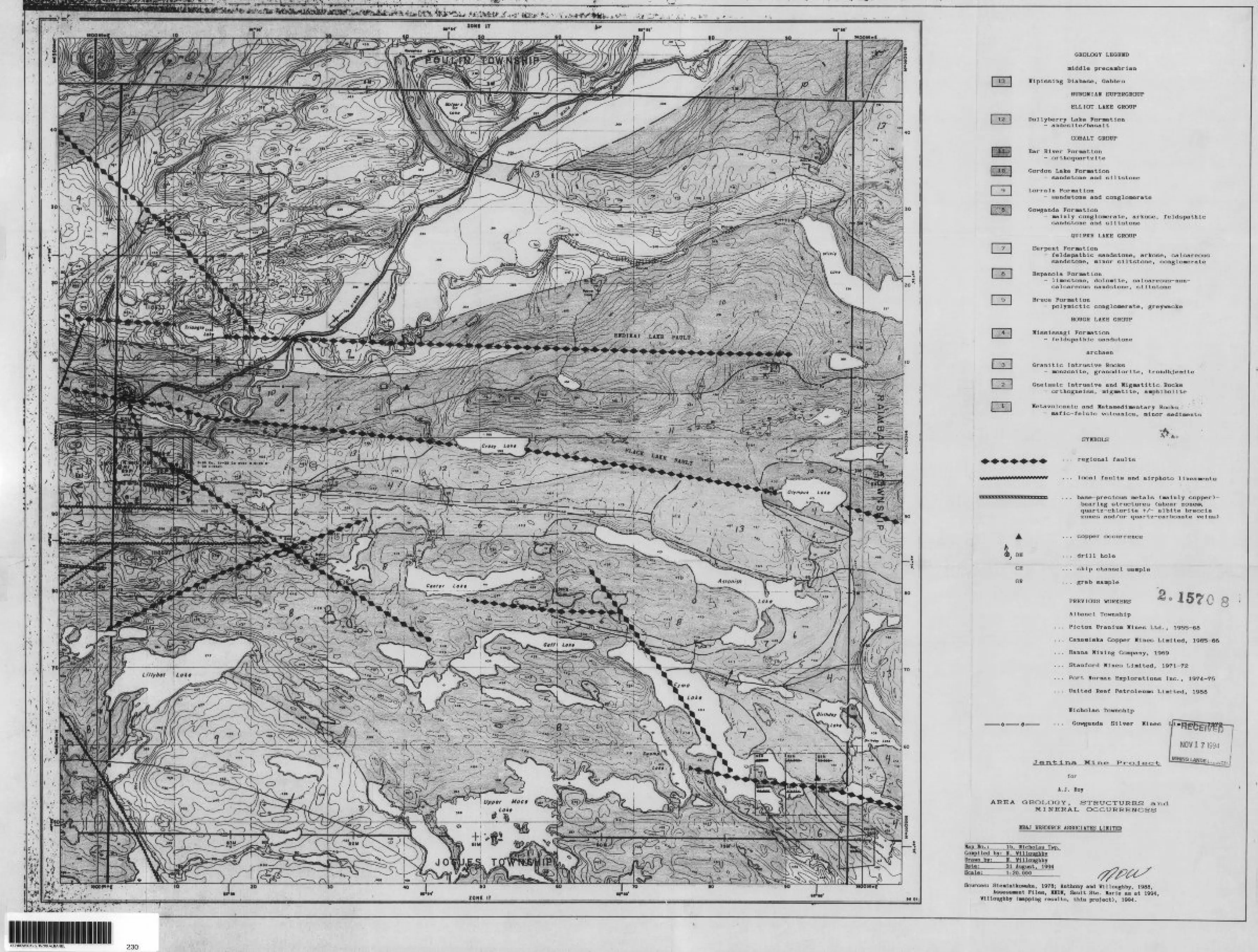
"W \ *
j.-'
13
DH
CH
GR
GEOLOGY LKGEMD
•Iddle precambrian
nipissing Diabase, Gabbro
HUROBIAI SUPERGROUP
ELLIOT LAKE GROOF
Dollyberry Lake Farnatian- andeslte/basalt
COBALT GROUP
Bar River Formation- orthoquartzite
Gordon Lake Formation- sandstone and siltetone
Lorraln Forma 11on- sandBtone and conglomerate
Gowganda Formation- mainly conglomerate, arkose, feldspathic
sandstone and siltstone
QUIRKE LAKE GROUP
Serpent Formation- feldspathic sandstone, arkose, calcareous
sandstone, nlnor siltstone, conglomerate
Espanola Formation- 11 meetone, dolomite, calcareous-non-
calcareous sandstone, siltstone
Bruce Formation- poiynlctlc conglomerate, greywacke
HOUGH LAKE GROUP
Vlsslesagl Formation- feldspathic sandntone
archaen
Granitic Intrusive Rocks- monzonite, granodiorite, trondhjemite
Gneissic Intrusive and Xigmatitlc Rocks- orthngnelss, migmatite, amphibolite
Metavolcanlc and Hetasedlnentary Rocks- maflc-felslc volcanics, minor sediments
SYMBOLS
regional faulte
local faulte and airphoto llneanente
base-precious raetale (maInly copper)- bearlng structures (shear zone**, quartz-chlorite -t/— albite breccia zones and/or quartz-carbonate veins)
. copper occurrence
. drill hole
. chip channel sample
. grab sample
1570PREVIOUS WORKERS
Albanel TownshIp
... Plcton Uranium Mines Ltd., 1955-68
. . . Canamiska Copper JClnes Limited, 1965-66
... Hanna Mining Company, 1969
... Stanford Mines Limited, 1971-72
... Fort Herman Explorations Inc., 1974-75
... United Reef Petroleums Limited, 1988
Ylcholas Township
... Gowganda Silver Mines
MineMINING
for
A. J. Roy
AREA GEOLOGY , STRUCTURES anti MI NERAL OCCURRENCES
RESOURCE ASSOCIATES LIICITHD
Map In. ; l b. Ilchdlas Twp.Co api led by: 1. VlUoughby Drawn by: I. WilloughbyDate: 31 August. 1994Scale: 1:20.000
Sources: Siemiatkowska, 1978; Anthony and Vllloughby, 1988,i6BeeB*ent Piles, HDM, Sault Ste. Marie as at 1904,
Vllloughby (mapping results, this project), 1994.
41J10SW0019 2.15708 ALBANEL 230
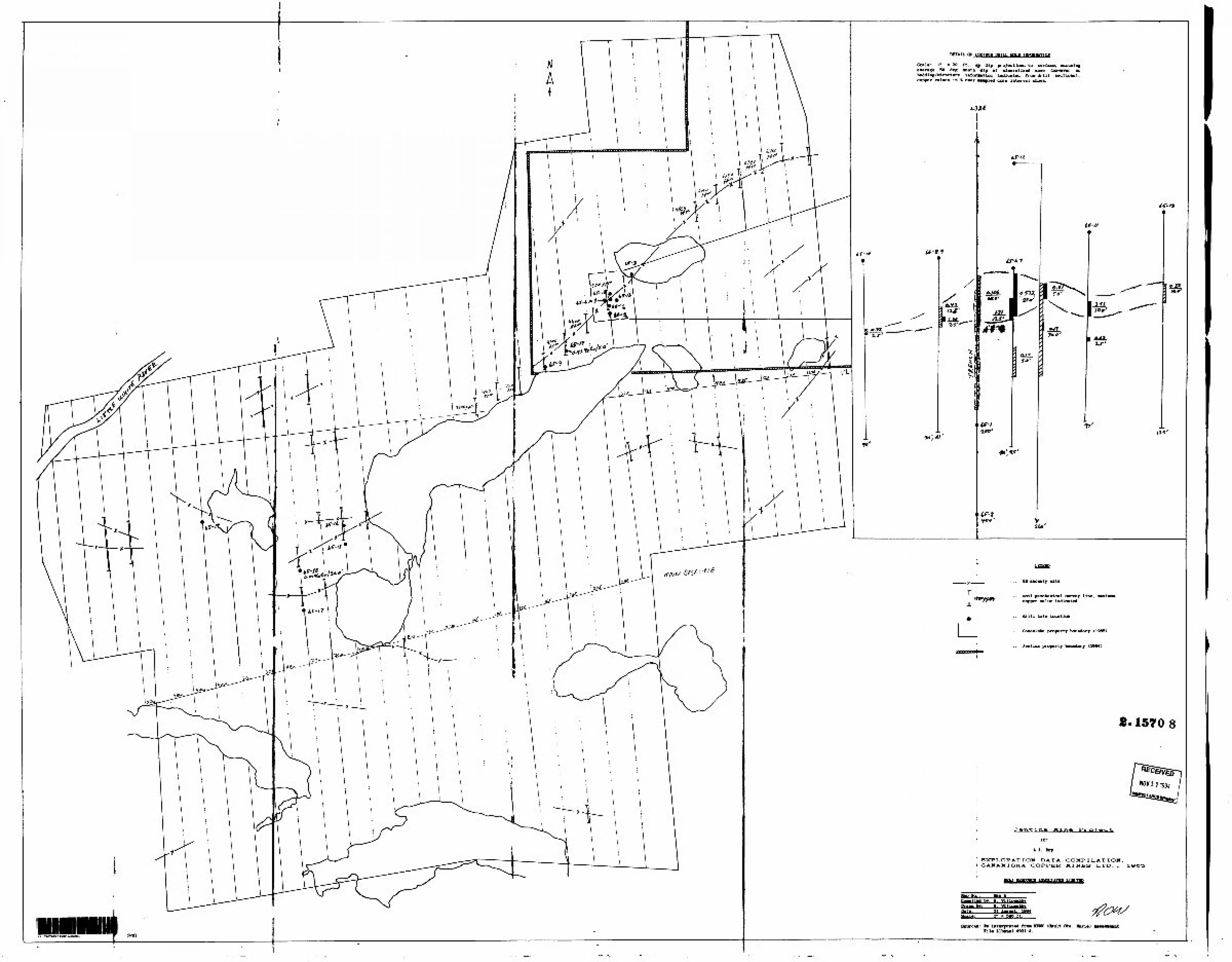
DETAIL DRILL HOLE IIPOBMATIOI
Scale: l" - 20 ft. ; up dip projections to surface, assuming average 50 deg south dip of mineralized zone (however no bedding/structure information indicated from drill sections); copper values in l over sampled core interval shown.
tf-13
l**'
El anomaly axis
soil geochemical survey line, mull copper value indicated
drill hole location
Canaaiska property boundary (1965)
Jentina property (1994)
2. 1570 8
LtfNtlVG LANQSflfcfife/
P r-0.1 eo-fc
for
i.J. Boy
EXPLORATION DATA COMPILATION, CANAMISKA COPPER MINES LTD., l 965
JBSjQQKClB^AJiSOCIATES^IIITlD
Map
Of*m \
mno Abv: I. Vlllnimrhbv
I. Vt l lonvKbvPate: 31 Amrogt. 1994Scale:' l* * 300 ft. tfWSources: le-Interpreted from HDM (Sault Ste. Marie)
File AlbMMl 0031-4.knt
41J10SW0019 i 15708 ALBANEL
•** ^ •—- ^
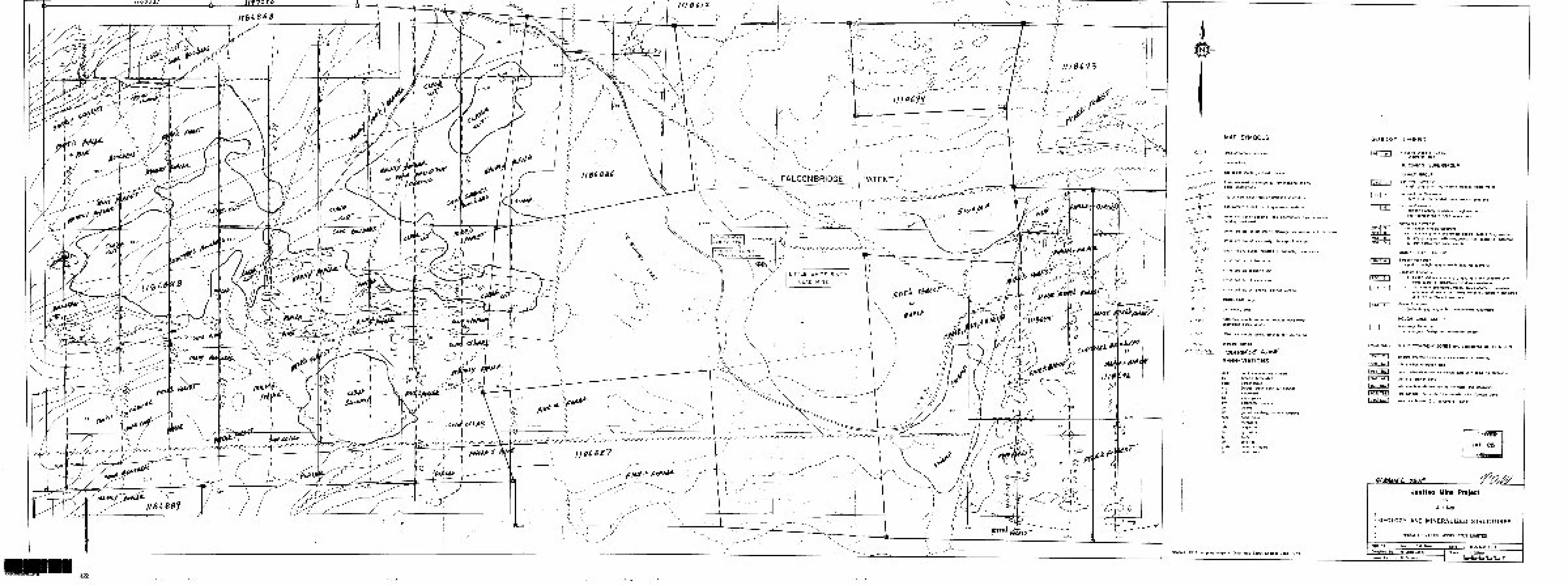
H P -^ _ ^jr Z — — ^-_ s
FALG0NBRIDGE PATENT
O \ 0oz AuXT, 3 46 or Ag/TCut-Pb.Zn.Co, S. ( 1969)
PffltM-
, - -
MAP SYMBOLS
area of outcrop exposure
small outcrop
geological contact, defined, assumed
fault, indicated or interpreted from mapping andXor aerial photographs
approximate axial trace cf anticline or antiform
approximate axial trace of syncline or synform
strike and dip of bedding, tops indetermmed,tops determined, bedding overturned
strike and dip of schistosity, cleavage , inclined, vertical, 1st order
strike and dip of schistosity, cleavage ; 2nd order
small fold w plunge indicated, s-symmetry, z-symmetry
strike and dip of fracturing
strike and dip of quartz vein
strike and dip of shear zone
strike and dip of jointing, inclined, vertical
trench , small, large
pit , small, large
968 rock sample series w precious -base metal anomalous assay values
1994 rock sample series, assayed for Cu, Au, Ag
character sample
jn fi vets ZABBREVIATIONS
weakly-moderately alteredbreccia, brecciatedcarbonatized(area) forest clear cut harvesteh Ion 11 zedchalcopyritecarbonate vein letsgalenagraded bedding, rhythmic layering"hemaritizedmalachitemagnetitepyrrhotitepyritesilicifiedquartz stringersquartz vein
Sources. 1994 mapping program, OGS Map 2399, Endikai Lake, 1974
GEOLOGY LEGEND
921 j 91
936[ 8 l
901 l 7 l
923945912962
93G| 3 l
903-1 3 j
9481 2 l
910 j \ l
Mipissmg Diabase, Gabbro- undifferentiated
HURONIAN SUPERGROUP
COBALT GROUPBar River Formation
- light gray quartzite, massive-bedded, ripple marks
Gordon Lake Formation- buff-pink interbedded sandstone and siltstone
Lorrain Formation- hematitic pebbly sandstone, conglomerate
{not represented in 1994 survey area)
Gowganda Formation- d reddish arkosic sandstone-c red-pink granite and arkose pebble-cobble conglomerate-b grey-grey green siltstone,quartz-rich (quarzitic) siltstone-a grey heterolithic conglomerate
QUIRKE LAKE GROUP
Serpent Formation- pinkish to Tight grey-green feldspathic quartzite
Espanola Formation-b clastic sediments , mainly grey-grey green siltstone with
some quarzitic, calcareous siltstone X sandstone- a non-clastic sediments , mainly brown weathered limestone
with some dolomite and cherty horizons , generally laminated with thin siltstone laminations
Bruce Formation- greenish grey polymictic conglomerate, greywacke
HOUGH LAKE GROUP
Mississagj Formation- pink-green feldspathic sandstone, arkose
(MIMZRAUZED) BRECCIA/VEIN ZONES and associated ALTERATION
931'l C
918 l AQ
925 j BX
942 j AA
929[ QCV
909[TSS
956|SCS
chlorite alteration zone with some associated shearing
albite-silica alteration zone
quartz -chlorite -t- f- albite breccia zone with some Fe-carbonate
ci bite alteration zone
late quartz-carbonate veinmg, stringers and stockwork
talc-sencite (actinolite?) - chlorite schist X breccia zone
sericite - chlorite (*X-carbonate) schist
iVED
1995
Jentina Mine Projectfor
A.J. Roy
GEOLOGY AND MINERALIZED STRUCTURES
NR8J RESOURCE ASSOCIATES LIMITED
Mbp No. Map l , SW Sheet DateCompiled by N WilloughbyDKN*I by B Fa l (ado
31 August, 1994Scale
250\
tgofLf2f ^ __ ^
TRENCHES. DRILLING 1950*3
HW*
T - ^r~
li
SI
S2
TO
sz•o
O . CD
* 3935
* 9418
W9423
7- 7 -
MAP SYMBOLS
area of outcrop exposure
small outcrop
geo logical contact j defined, assumed
fault, indicated or interpreted from mopping and /or aerial photographs
approximate axial trace of anticline or antiform
approximate axial trace of syncline or synform
strike and dip of bedding , tops undetermined, tops determined, bedding overturned
strike and alp of schistosity, cleavage , inclined, vertical i 1st order*
strike and dip of schistosity, cleavage ; 2nd order
small fold m plunge indicated, s -symmetry, z- symmetry
strike and dip of fracturing
strike and dip of quartz vein
strike and dip of shear zone
strike and dip of jointing, inclined, vertical
trench, small, large
pit , small , large
1986 rock sample series w precious -base metal anomalous assay values
1994 rock sample series, assayed for Cu, Au, Ag
character sample
Sources -. 1994 mappi
ABBREVIATIONS
ALTE weakly -moderately alteredbx breccia, brecciatedcarb carbonatizedc c. (area) forest clear cut harvestchl chtonttzedcp chalcopyritecvt carbonate vein letsgn galenaGb graded bedding, rhythmic layeringhem nemo Wiredmal malachitemte magnetitepo pyrrhotitepy pyritesil silicifiedq str quartz stringersqv quartz vein
program; OGS Mop 2347, Nicholas a Raimbault Twos, 1969.
GEOLOGY
9 l
19361 6 j
l 7 l
l 1*1
923945912962
END
lawng Dta base, Gabbro-••differentiated
HUrVMNAN SUPERGROUP
COBALT GROUPBar flintr Formation
- ttgJ* gray quartzite, massive-bedded, ripple marks
Gordfa Late Formationr
-buff-pink interbedded sandstone and siltstoneLorram Formation
-fcMMhtte pebbly sandstone, conglomerate l not represented in 1994 survey area)i
Gowganda Formation- *l veddwli arkosic sandstone-t MeVpMfc granite and arkose pebble-cobble conglomerote-b. ami fjey green siltstone,quartz-rich (quarzitic) siltstone-la. fray Marotithic conglomerate
LAKE GROUP
1930131
3 l
l 9481 2 l
Ser
Esp
Brua*
(MINERALIZED)
to light grey-green feldspathic quartzite
itionsediments, mainly grey-grey green siltstone with
i tic, calcareous siltstone X sandstone sediments , mainly brown weathered limestone
dolomite and cherty horizons , generally laminated siltstone laminations
grey polymictic conglomerate, greywacke
LAKE GROUPFormation
feldspathic sandstone, arkose
CCrA/VEHt-ZONES and toted ALTERATION
918 l
l 925 1 BX j
|942| AA]
j 929| QCV]
l 909| TSSl
j 956 j SCS| seri
chloBp alteration zone with some associated shearing
otbi&Miico alteration zone
quorjpj^btorite -t- /- albite breccia zone with* some Fe-corbanotialbi^B^pleration zone
late'ei^rte-corbonate vening, stringers and stockwork
talcHMldte (actinoliteP) - chlorite schist7breccio zone
te U J- carbonate) schist
RECEIVED
FEB9 1995
Jtntina Mint Projectfor
A. J Roy
GEOLOGY AND MINERALIZED STRUCTURES
ISJ RESOURCE ASSOCIATES LIMITED
Map No. Date 31 August. 1994Compiled by WilloughbyDrawn by Fallodo
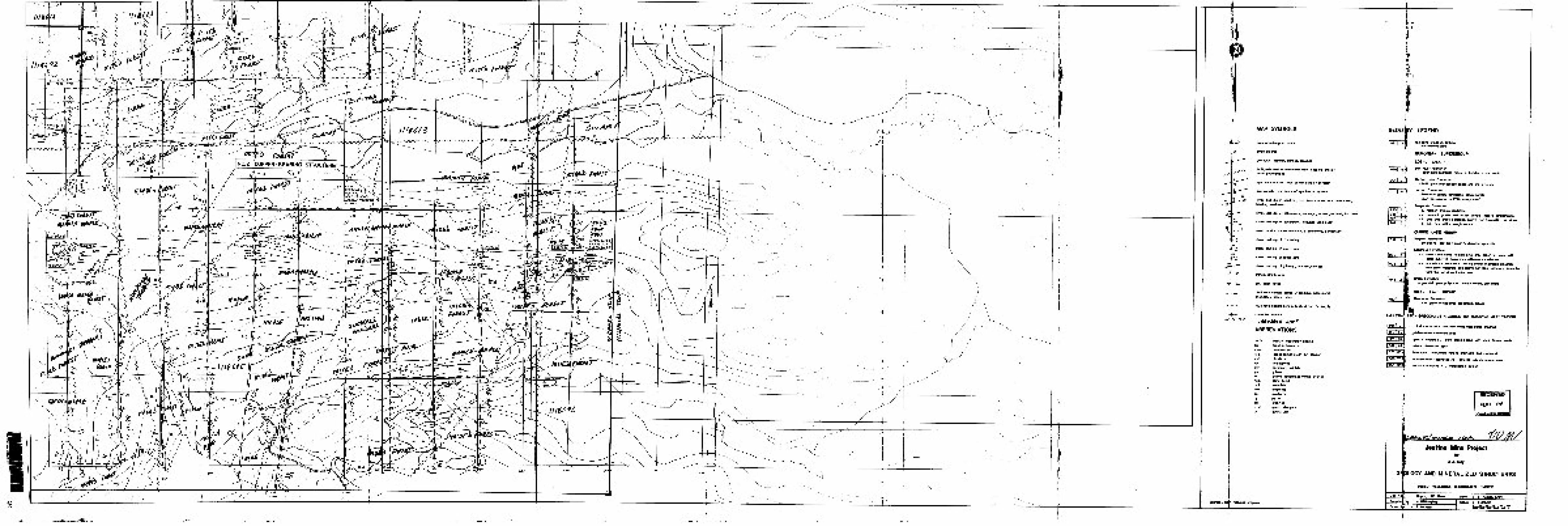
—ir2——.*l X S
NO. 2 COPPER-BE API N
RtGHFUXOVERTICALHOLE P2 (1967)ARCHEAN VOLCANICS (?)AT40OO
^*1"^l3h^i
n^ri
//WC*7**A^
-aft
—LU8
-4-)ut**bfrtf
MAP SYMBOLS
area of outcrop exposure
smaH outcrop
geological contact; defined, assumed
fault, indicated or interpreted from mapping and /or aerial photographs
approximate axial trace of anticline or antiform
approximate axial trace of syncline or synform
strike and dip of bedding} tops indeterminedt 1ops determined, bedding overturned
strike and dp of schistosity, cleavage ; inclined, vertical , 1st order
strike and dip of schistosity, cleavage; 2nd order
small fold w plunge indicated, s -symmetry, z-symmetry
strike and dip of fracturing
strike and dip of quartz vein
strike and dip of shear zone
strike and dip of jointing, inclined, vertical
trench , small , large
pit , small, large
(988 rock sample series w precious -base metal anomalous assay values
1994 rock sample series, assayed for Cu, Au, Ag
character sample
ABBREVIATIONS
ALTEbxcarbc c.chlcpcvtgnGbhemmalmtepopy silq str qv
weakly-moderately alteredbreccia, brecciatedcorbonotized(area) forest clear cut harvestdtloritizedchalcopyritecarbonate vein letsgalenagraded bedding, rhythmic layeringhematttizedmalachitemagnetitepyrrhotitepyritesilicifiedquartz stringersquartz vein
mapping program.
r*
ln
GEOLCfeY LEGEND
190' l 7|
modi
923945912962
l
1930 [ 3 |]
19031 3
Nipissing Diobose, Gabbro- undifferentiated
HURONIAN SUPERGROUP
COBALT GROUPBar River Formation
- light gray quartzite, massive-bedded, npple marks
Gordon Lake Formation-buff-pink interbedded sandstone and siltstone
Lorrain Formation- hematittc pebbly sandstone, conglomerate
{not represented in 1994 survey area)
Gowganda Formation- d. reddish arkosic sandstone-c red-pink granite an* arkose pebble-cobble conglomerate-b. grey-grey green siltstone,quartz-rich (quarzitic) siltstone-a grey heterolithic conglomerate
QUIRKE LAKE GROUPSerpent Formation
- pinkish to light grey-green feldspathic quartzite
Espanola Formation-ta. dashc sediments; mamly grey-grey green siltstone with
some quarzitic, calcareous siltstone/sandstone-a non-clastic sediments , mamly brown weathered limestone
with same dolomite and cherty horizons , generally laminated with thm siltstone laminations
Brace Formation~ greenish grey polymictic conglomerate, greywacke
HOUGH LAKE GROUPissagj Formation
- pin k-green feldspathic sandstone, arkose
(MINERALIZER BRECCIA/VEIN ZONES and associated ALTERATION
93l| c
9181 AQ
9251 BX
9421 AA
chlorite alteration zone with some associated shearingaibite-silica alteration zone
quartz-chlorite ^/-albite breccia zone with some Fe-carbonatealbite alteration zone
tale quartz-carbonate vein mg, stringers and stockwork
talc-sericite (actinolite P) - chlorite schist X breccia zonesericite-chlorite (* A carbonate) schist
RECEIVED
FEB9 1995
Jtntino Mine Projectfor
A.J. Roy
GBDLOGY AND MINERALIZED STRUCTURES
NR8J RESOURCE ASSOCIATES UMtTEO
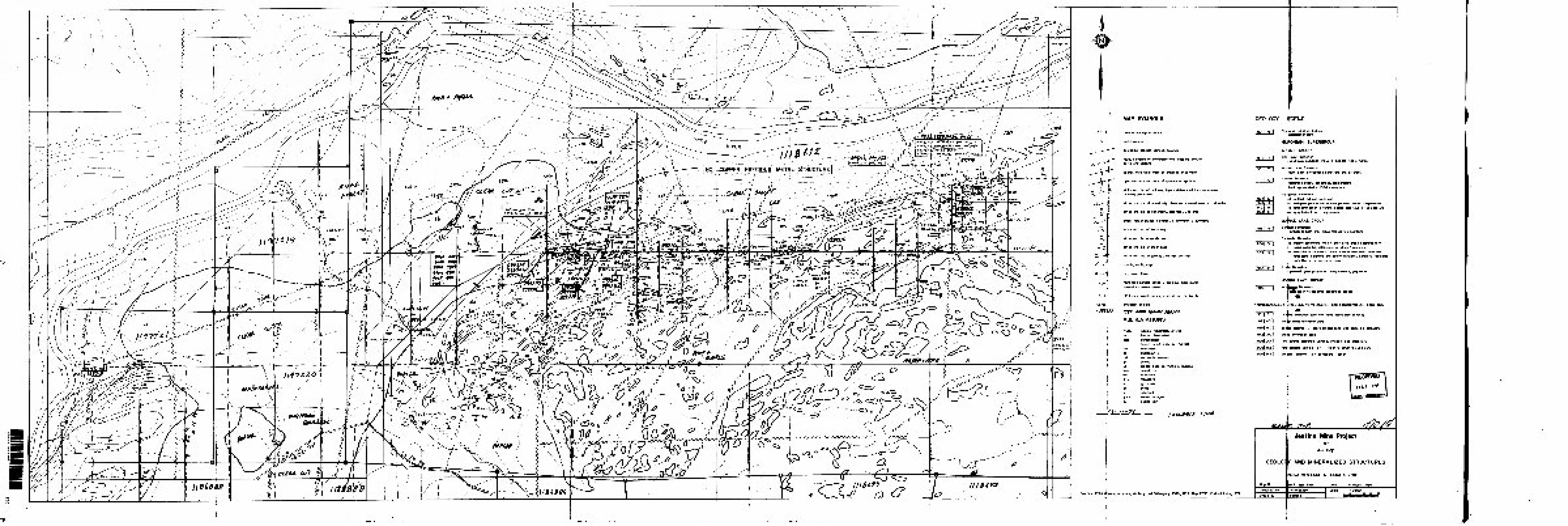
IS)OB O
ClOUS METAL- STRUCTURE
Q.030% Cu 0015"^!*
TO
SO^A-5
S220
SZ
•O
e , cri
* 3935 ]
* 9418
W9423
MAP SYMBOLS
area of outcrop exposure
small outcrop
geological contact ; defined, assumed
fault, indicated or interpreted from mapping and /or aerial photographs
approximate axial trace of anticline or antiform
approximate axial trace of syncline or synform
strike and dip of bedding, tops tndetermined, tops determined, bedding overturned
stnke and dp of schistosity, cleavage , inctmed, vertical , l st order
strike and dip of schistosity, cleavage, 2nd order
small fold w plunge indicated, s -symmetry, z- symmetry
strike and dip of fracturing
strike and dtp of quartz vein
strike and dip of shear zone
strike and dip of jointing-, inclined, vertical
trench, small, large
ptt , small , large
1968 rock sample series w precious -base metal anomalous assay values
1994 rock sample series, assayed for Cu, Au, Ag
character sample
miABBREVIATIONS
ALTE weakly -moderately alteredbx brecaa, brecciatedcarb carbonatizedc c. (area) forest clear cut harvestchl chtontizedcp chalcopyritecvt carbonate vein letsgn galenaGb graded bedding, rhythmic layeringhem nemo fi ri zedmal malachitemte magnetitepo pyrrhotitePV pyntesil silicifiedq str quartz stringersqv quartz vein
~ 2?-jH
Sources. 1994 4appmg program; Anthony and Willoughby, 1986; OGS Map 2399, Endikoi Late, 1974.
GEOLOGY LEGEND
92' l 9 l
l 936 1 8 l
\ l
923945912962
Nip ssing OKI bo se, Gabbro- undifferentiated
HURONIAN SUPERGROUP
COBALT GROUP
Bar River Formation-light gray quartzite, massive-bedded, ri ppi e marks
Gordon Lake Formation- buff-pink interbedded sandstone and siltstone
Lorrain Formation-hematite pebbly sandstone, conglomerate
(not represented m 1994 survey area)i
Gowganda Formation-d. reddish arkosic sandstone-c red-pink granite and arkose pebble-cobble conglomerate-b. grey-grey green siltstone,quartz-rich (quarzittc) siltstone-a grey heterolithic conglomerate
J9031 3 l
|948| 2 l
QUIJRKE LAKE GROUP
Serpent Formation- pinkish to light grey-green feldspathic quartzite
Espewdo Formation-b. dexhc sediments, mainly grey-grey green siltstone with
! sane quorzitic, calcareous siltstone /sandstone^clastic sediments , mainly brown weathered limestone
\ dolomite and cherty horizons, generally laminatedsiltstone laminations
\ Brute Ruination
tsh grey polymictic conglomerate, greywacke
HOtfGN LAKE GROUP
Mi formationfeldspathic sandstone, arkose
(MINERALIZED) 3RECCIA/VEIN ZONES and associated ALTERATION
931 l
918 l AQ l tb|^t
925 j BX
942J AA l
9291 QCVl
alteration zone with some associated shearing
albfte-silica alteration zone
qua|t*-cMDnte-*- /-otote brecaa zone wtth some Fe- carbonate
alb** alteration zone
late| ajuartz- carbonate vein mg, stnngers and stockwork
909|TSSl talc
956 j SCS| ser rite-chlonte U/- carbonate) schist
-sericite (actinolite?) - chlonte schist /breccia zone
f
Jentina Minefor
A.J. Roy
GEOLOClir AND MINERALIZED STRUCTURES
RESOURCE ASSOCIATES LIMITED
Map No l ; NW Sheet Date : 31 August, 1994Compiled by WilloughbyDrawn by Faltada
Scale . l : 25OOQ 20 4O CO to too