Embed Size (px)
Citation preview

,----·--------~---~------~~-·-·--·-· ------------------------')"---------.. ---~---, : i
l \
I l
I
I
I l
I I I I i
CALIFORNIA STATE UNIVERS~TY, NORTHRIDGE
THE ~REHISTORY OF THE LO\'JER PORTION OF THE PIRU CREEK DRAINAGE BASIN, VENTURA COUNTY, CALIFORNIA:
An Ethnohistorical and Archaeological Reconstruction
A graduate project submitted in partial satisfaction of the requirements for
the degree of Naster of Arts in
Anthropology
by
Robert ~opez
January, 1974 i I I
l t L-------------~----··-~·-··----··--·--------··----·--·-··-----.. ·----·-----·------·-·------------·---------·-·---:..----J

,----~------··---.. ·------·--···-------~--------------.. -------·----·---... ······--------·-···--·-----·-·- ... ·--~
1 I I i I ! I l
I
The graduate project of Robert Lopez is approved:
California State University, Northridge
ii

r--------~---------.. ·--
TABLE OF CONTENTS
i
ILIST OF TABLES ••••••
!LIST OF FIGURES • • • • • I ! !LIST OF MAPS ••••••• I !INTRODUCTION ••• • •• •
!ABSTRACT ••••••••• l I
i !THE AREA •••••••••
I
I I
Topography • • • • • •
Climate • • • • • • •
Vegetation • • • .. • •
Fauna • .. • • • • • •
•
•
I HISTORICAL BACKGROUND • •1 •
I ! ETHNOGfu\PHIC BACKGROUND • ..
jARCHAEOLOGICAL BACKGROUND • I
~CONCLUSION • •••••••
I NOTES • • • • • • • • • • •
•
•
•
•
•
•
•
•
•
BIBLIOGRAPHY • • • • • • • •
I
I
• • • • • • •
• • • • • • •
• • • • • • •
• • • • • • •
• • • • • • •
• • • • • • •
• • • • • • •
• • • • • • •
• • • • • • •
• • • • • • •
• • • • • • •
• • • • • • •
• • • • • • •
• • • • • • •
• • • • • • •
• • • • • • •
Page
• • • • • iv
• • • •• v
• . .... vi
• • • •• vii
• • • •• ix
• . .. .. 1
• • ••• 1
• • • • • 6
• • • •• ll
• • • • • 13
• • • • • 17
• • • •• 30
• • • • • 45
• • • •• 92
• • • • • 100
• • • •• 101
I I I !
L----------~--------·-------- _________ ,. ______ . _________ !
iii
..

:Tables
1.
2 ..
LIST OF TABLES
Explanation of the Symbols in Figure 7 ~
'l'ool Frequencies Flats Sites ••.
at Selected Bridgeport
····~···$····
.. .
.. . 3. Plant Resources Associated with Bridgeport
Flats •••••••••• • • e> o • • e • ·•
P* -· ln Pocket
iv
Page
66
8 .., - I

LIST OF FIGURES
, F'igure
1. Two Hundred Years of Precipitation Data Collected from Various Sources for the
Page
Piru Creek Drainage Basin • • • • • • • • p•
2. Mean Monthly Temper~ture, in Degrees Fahrenheit, from Data at the Sandberg Weather Station • o • • • • • • • • • • • • • 8
3. A Typical Monthly Precipitation Pattern, in Inches, from Data Gathered at the Sand-berg Weather Station. • • .. • o • • • ., • 9
4. Annual Precipitation, in Inches, from Data Gathered at the Sandberg Weather Stationa 10
5. Examples of the Most Recognizable Petro-glyphs from the Canton Canyon Caves • • • 58
6. Cave No. 3 at Blue Point •• . ..
7. Cave No. 7 at Blue Point •• • • e • . .. 65
8. Fustero Cave, Located Near the Village of Koovung • .. ~ • • • • • ~ • ~ • • ~ ~ • • 68
9. Bar Graph of the Gathering Seasons of Selected Plant Resources from Bridgeport Flats ••••• · •••••••• - • Q • • 86
P* -· In Pocket
v

.Haps
LIST OF MAPS
Page
1. Modern Perspective as of 1972 of the Piru Creek Drainage Basin • • • o • • • • • • ~ P*
2. Part of a r-1ap which Appeared v:i th Richard VanValkenburg's 1935 "Notes on the Ethnography and Archaeology of the Ventureno Chumash Indians" • • $ • • • • • • • • • • P$
3. Bridgeport Flats and Vicinity with Archaeological Sites Indica ted.. • .. .. • • • • • • 77
4w Territorial Relationships of Aboriginal Populations Around the Piru Creek Drain-age Basin& ••••••• c • ~ ••••• ~ 95
p.- - In Pocket
vi

INTRODUCTION
Anthropology has been one of the few academic dis
ciplines which has always stressed the value to be gained
from an interdisciplinary approach to research. This
Graduate Project, therefore, will be an attempt to inte
grate archaeological and historical research in an effort
to reconstruct a partial, if not complete, prehistory of
an area of Southern California known as the Piru Creek
Drainage Basin.
The research for this Graduate Project ~as begun in
June of 1970 and was carried out in two distinct phases.
The first phase will consist of an expanded version of the
traditional archaeological survey in which the research
area is to be covered by the most expedient method avail-
able~ The object of this research phase is not only the
location of archaeological sites but also the location and
identific?.tion of the various r·esources in the area which
could have been available to prehistoric occupants.
The second phase of the research will consist of an
archival search for any early historic records pertaining
to the area,. It is hoped that any material gathered from
early historical sources can be used either to interpret
or add tc the results of the archaeological phase of the
iesearch~ Most of the materials to be used will be pri-
vii

mary sources, many in unpublished form, and the informa
tion gained from local informants.
viii

I
ABSTRACT
THE PREHISTORY OF THE LOWER PORTION OF THE PIRU CREEK DRAINAGE BASIN,
VENTURA COUNTY, CALIFORNIA:
An Ethnohistorical and Archaeological Reconstruction
by
Robert Lopes
Master of Arts in Anthropology
July, 1973
The Piru Creek Drainage Basin of Ventura County is a ;
!unique environmental zone which holds a relatively import~
lant place in the historic&l record of Southern California.:
i !However, the area has always posed a certain amount of
!question in the minds of archaeologists as to the exact
nature of its prehistoric utilization but no attempt had
ever been made to reconstruct its prehistory.
I This Graduate Project, therefore, is an attempt to
!integrate two basic research techniques; an expanded ver
., sion of the traditional archaeological site survey and an · I
lethnohistoric archival inquiry, in an effort to recon-
!struct a partial, if not the complete, prehistory of the I -i area. ! l j i L,_,._,_,._,~ .. ~-···~--~---..._-·-·-·--~-~---·~~--·---~----------~-·~.,n·----·-·-·----•~--~·--~~-·-•-"'-~-~ .. ,_, ____ ..._..._,_J
ix

,-----·--·------·-----···---------1 The end result, while if did not
!goal of reconstruction of the I !Drainage Basin, hopefully will
I :effort since it does present a I !nature I
I !bable methods I
--------l reach the expected i
I prehistory of the Piru Cree~
I
be considered a worthwhile I I
fuller understanding of the !
of the peoples who occupied the area and their pro~
I of resource utilization during prehistoric 1
I • ltJ.mes.
I
I l I 1.__--------~-----·------------
X
I .J

THE AREA
The focus of this research was centered in the lower
~ortion of an area of Southern California known as the
~Piru Creek Drainage BasinQ" This basin encompasses por-
;tions of Los Angeles, Kern and Ventura Counties with the
largest portion confined in the northeastern corner of
,Ventura County (Map 1)~ The basin is of particular in-1 1tE:rest because it constitutes an isolated environmenta.l i
!zone, somewhat transitional between the dry desert regions j ;to the east and the moist C0·3.S ta1 strip to the v;est, which
:appears to have supported an aboriginal population which
!was different during the precontact period from the i .
iChumash so commonly associated with the rest of Ventura
:Countv., ! -
The headwaters of the Piru Creek rise in a broad ex-
;panse of terrain located above the town of Gorman between
ithe southernmost section of the Topatopa Mountains and
,Mount Pinoso This area, comprising most of the upper
basin, is act~ally thought to
have been occupied by a different aboriginal population
than that which occupied the lower portion of the drain-
'age basin. However, the upper portion is included here
n1ere 1y to fi 11 m.i.t the topographica.l ~m.d envlronrr.enta1
1

aspects of the total drainage basin. The uppermost por-
.tion of the drainage basin is actually located in the
center of the Transverse Ranges, a group of mountains
'which trend east-west and include the San Gabriel Mount-
ains, and are in opposition to the general northwest
1 trend of the Coast Ranges (Carmen 1964). From the
uppermost section of its drainage basin the Piru Creek
drains southward descending rapidly to meander across an
area of gentle relief until it joins the Santa Clara River
near the town of Piru in Ventura Countye The Santa Clara
River in turn drains westward entering the Pacifj.c Ocean
just south of the city of Ventura.
There is at present one reservior on Piru Creek, the
San Felicia Dam, located about five miles upstream from
the confluence of the Piru Creek and thG Santa Clara
River. This dam impounds the runoff from about 425 square
miles of the drainage basin, however, this area will be
reduced once the Pyramid Rock Reservior, which is present-
ly under construction, becomes operational. This second
reservior loca~ed 6.5 miles upstream from the San Felicia
Dam is expected to act as cat.chment for about 285 square
miles of the upper sections of the lower portion of the
drainage basin. A third reservior is also being consider-
ed, this to be located at the southern end of the Hardluck
Valley, about five miles above the Pyramid Rock Dam.
The physiography of the area about Pyramid Rock is
2

r-~- --- -------- -- -----l !distinctly different from the rest of the Piru Creek I
I Frainage Basin. The general flow of the streams in the
iupper portion of the basin is to the east while in the
l :lower portion of the basin the streams tend to flow to-1
~ards the south; also the topography of the upper portion I i
' :is mountainous with very few valley flats while the lower '
;portion is characterized by topography of g~ntle rolling
'hills with frequent wide valley flats adjacent to the
iCr~ek's channel. These factors can in part be explained
lby the geological history of the area which shows that
I".G• the Piru Creek Drainage Basin is included in that
portion of the Transverse Ranges which make up a part of
:the eastern end of the Ventura stratigraphic basin~ The
Transverse Ranges are of a complex structural and strati-
graphic province, they were formed by marine deposition
throughout most of the Tertiary Period," (Hershey 1902:6) ' i :and since th$t period have been altered as a result of !
;the extreme tectonic activity. The portion of the lower
:Piru Creek Drainage Area between the Pyramid Rock damsite
:and the San Felicia Dam appears to be formed in "e~~ thick. I
!sedimentary sequences composed of moderately well consoli idated sandstone and conglomerates with interbedded shale
h . . 1 t . . ' f th 'I' . t. ,.., . d w.1cn are c1arac er1st1C o - e er 1ary ~er1o Q Basement
.rock for ~che sedimentary series is an assemblage of pre-
•Cretaceous igneous and metamorphic rocks which underlies
much of the high country in the uppar portion of the
i, -~ •.
3

4
basin" (Hershey 1902:7). Recent tectonic activity i
!appears to have created the present southward drainage of
'the upper portion of the basin; there is a strong indica-
,tion that in the past the Piru Creek might have drained
northeastward into the Mojave Desert~ This same tectonic
activity might also explain why there appears to be the
same proportion of slopes facing north as those facing
southe Another possible explanation for the southward
drainage of the basin might be inferred as a rescilt of
faulting activities. The major portion of the basin is
bisected by the northwest trending San Gabriel Fault,
which is a major rift with a large well drained lateral
separation and is further bound in the northeastern part
by the San Andreas Fault, the major structural lineament
of California (Cordova 1956)~
Most of the valley flats along the lower portions of
the Piru Creek are marked along their outtermost rims by
steep mountain walls which give way to intermittenly
gentle slopes and level open benches, these in turn drop
dovm steep embankments t:o the floor of the Piru Creek's
channel. The level areas of most of the benches and
valley flats vary in size between the upper and lower
portions of the basin, however, most are alike in that
they are covered by shallow, irregular stony soils formed
in place by residual weathering of the thick sedimentary
sequences. Typical of these soils is an Altamont Loam,

[" _______ , __ ---------· i !identified by a 1920 soil survey, which is generally I !from 8 to 15 inches deep and contains shale fragments and \ ~caliche concentrations both of which occur locally in the
formations of the upper portion of the basin. Soils
along the creek's channel appear to be mostly young spor-
adically located alluvia.l soils, characteristic of these
is Yolo Sandy Loam, but these soils generally only vary
in thickness from 12 to 30 inches and are of a lighter
textured nature than the standard Yolo Sandy Loam
(Carter 1956; Edwards §t al 1970; Nelson ~t al 1920;
Storie and Weir 1941).
The mineral materials locally available for tool
manufacture by prehistoric aboriginal inhabitants are
quite limited. The most plentiful locally occurring min-
eral is quartzite, which can be found weathering from the
banks of the Piru Creek's channel.. Some chalcedony and
felsite were noted in small quantities; but it could not
be determined if these occurred locally or if they were
imported~ If they do occur locally the only possible
quarrying source would have t:o be the old strean• beds
which make up the overlying depo.si ts of 1nost of the high
benches in the upper portion of the drainage basin~
Imported materials range from Vasquez basalt 7 found
30 miles to the southeast in the Vasquez Rocks Area of
•Agua Dulce Canyon; Franciscan Chert, from the Santa
Barbara area 60 miles to the northwest; and banded chert
5

5
Madela shale series in the Santa Monica Mount-
ains. Obsidian is rare to the Piru Creek Drainage Basin,
the closest known source being in the Little Lake and
Coso Range regions of Inyo County some 200 miles to the
northeast. Probably the most plentiful imported tool
manufacturing material is Grimes Canyon fused shale,
sometimes mistaken for obsidian; this occurs some 20 miles
to the southwest of the Piru Creek's confluence with the
:Santa Clara River. This fused shale represents a rare
occurrence of burnt shale mixing with oil seeps in a
Monterey shale formation occurring in the canyon~ The
'resulting fused shale comes in three color combinations;
redt gray and black, all of which range in appearance
from a deep, lustrous texture to a dull, glassy quality.
Climate
A climatic profile for the Piru Creek Drainage Basin
is difficult to identify because of the regional and top- .
ographical variations between the basin'& upper and lower
portions, however, the basin's general climate can be
identified as I"ledetex:ranean, or more properly if we accept
the Koppen Scale of clim&tic conditions as Csa. This type
of climatic condition is the result of two important
. factors: first, the location of the Piru Creek Drainage
·Basin between the dry climate of the Mojave Desert and the
'humid mesothermal climate of the Southern Califor~ia

!coast; and secondly by the fact that the Piru Creek Drain
lage Basin experiences drastic se&sonal changes in temp
lerature from warm, dry summers to damp, roj_ld winters .. ! i Generally, precipitation is moderate with 90% of the I !total annual rainfall occurring during the period between i !October to April. In the course of my research I was
1able to compile a table of precipitation relating the
iPiru Creek Drainage Basin for the period from 1769 to
1972. (Figure 1)~ This came mainly from early historical
journals, the records of Fort Tejon, the records of
Missions San Buenaventura and San Fernando and from the
records of the various agricultural service agencLes in
the area. While not 100% accurate, this table does reveal
some interesting facts; for instance the average annual
rainfall since 1769 has been 17.01 inches~ The Sandberg
weather station, located in the northeastern quarter of
the basin at an altitude of 4~517 feet or about 400 feet
higher than the mean altitude for the whole basin, at
present has the only known long term precipitation and
temperature profiles for the area. (Figures 2 & 3)~
At Sandberg, annual precipitation ranges from 12 in-
ches at the station to about 24 inches at the Temescal
;station, in the southwestern portion of the basin~ Mean
annual rainfall for the entire basin based upon informa-
!tion collected since 1933 supports the previously stated
figure of 17 .. 01 inches. (Figure 4) .. 'rhe data collected
7

r I I
I I I I I
-------«---------·----· ----·---·--.. ------~--·-----1
tOO -
80
70-
50-
~--
40-
FIGURE 2; --~ Mecm monthly temperGture :t in degrees
Fohrenht!it~ from data ct the Sandberg
I
8

-i
2
l
I 0 _j_J ·-
-- I I I
- . JAtJ FEB MAR APR MAY JU~~ JUL ~.UG SEP OC1
FIGURE 3 ~v~
A typic a! monthly precipitation pattern, In inches, from d(Ha gathered at ihe
Scmdi:H?rg Weather Station.
9
t I
l '''"''·

I 404
I
I 30i
I !
00 20i w :t: (.)
z 10.
I
-·-···-------~· ·····-~----~-----·-·-··-.------··,·- ---~-- -···---· ·--·----~--------•..•. ---- -·-·-"
fl I
!940
MEAN ANNUAL PRECIPITATION
1950
FIGURE 4 <illf"""'"""''''""''"'"'""'-
·------·~-------... ------·---------~·-·-~--~
1960 1970
!
I I i I ! I l I
i I
I 1
l I
l l
i Annual precipitatitHs~ in inches, from data gathered I
I ot the Sandberg Weather Station.
............................... - ................... -------.. -· -----------------.. ·--·-·---------···--j
l-' 0

r--~-----------------~--------------~--- ~------- --- --· -- -----·-·· ·-· ----- .. i l )can also be used to explain certain climatic patterns
I :such as a possible 6 to 8 year flood cycle. I I In the light of over two hundred years of precipita-
ltion data it is interesting to note that the annual pre~ l ;
icipitation supports the contention of a Mediterranean type i ;
!climate. Granted it tends to show extreme precipitation
:variability from year to year for a long period of time,
but in turn this allows us to speculate that the climatic
;conditions of the Piru Creek Drainage Basin may have not
jchanged greatly in the last 200 years.
iy_eget.a tlon
The most common form of native vegetation occurring
in the Piru Creek Drainage Basin is chaparral~ Chamise i 1 (Ad ' f . 1 ' ' • 1 ~ d ' t . th . : _;~nos-coma ...:~.sc.:l:,.::;,u~ .. a-s,~; J..s c ear.1y onu.nan :tn J..S
area, particularly on. those canyon slopes which ctre under-
:lain by sandstone and conglomerate fox:mations.. Inter:
spaced in the open areas between stands of chamise can be
found seasonal grasses such a5 California Brol.lte Grass
!
ired to as Reedgrass (~ymus_cC?ndensatus).. These grasses
·tend to be particularly dominant in soils formed of the
finer grained sedimentary alluviums even if these soils
occur within the chaparral zone. In the lower portion of
;the drainage basin Wild Buckwheat (Eriqonum Fasciculatum ~ ... __._~---..- - -
11

~-----·---.. ----.·--"'·"-·----------··· -- ........ --· .......... ··········-·- ....................................... ·----·-·-·--·-------····· .. ·-····--·
i..;.v...;;"~f;..;o;..;;.l;;;.~.;;;o...;l~.;o;;.;s;;..u.;;;m;;.;.;.) appears to have replaced most of the sea
lsonal grasses. Groves or thickets of Scrub Oak <guerc1.g;~ I !~rm~s~) occupy a dominant position along the upper sec-
itions of most of the basin's foothill rims, while isolated i I \Stands of Coastal Live Oak <guercus agrifoli~) can be i !found in the side canyons of the lower portion of the : !
:drainage area. Similar stands of Canyon Live Oak (~
chrxsol.§.Ei~) can be found on the rocky slopes and in the
canyons of the upper portion of the drainage basin. The
ichannel of the Piru Creek is lined with cottonwoods (Pop-1 ~ I
[Jll_.gs_ trich~carEa) (Em~E£~_s fol_~.olo;:;a), willows (S~~!'~~..e.-' 1silifolia v. hindseana) and small stands of California t-- - -!
I jBlackwalnut. {Jug~rrs calif2.rnia) can also be found in or I !near the creek•s channel zone. Throughout the area oak
belts are transitional at altitudes of 2500 feet into
'mac~oc~EE;~) and juniper (Jun~e,~}:"'US cal:i.fornica) ., Hmvever,
this generalized pattern does not hold true for all parts
of the drainage basin, some areas support distincti.ve
plant communities which are usually the result of the
unique topographical or climatic conditions.
'l'oday the 1o· ... 1er portion of the Piru Creek Drainage
Basin shows the evidence of critical overgrazing in that
most of the native plant communities have either been
replaced by introduced vegetation or have retreated into
the inaccessible and marginal portions of the basine This
12

~vergrazing has given the region a definite "bad lands" ! laopearance .. I . ! Faune3:
At present the animal population of the Piru Creek i :orainage Basin is very disturbed, mostly because of the ! !extremely heavy recreational use which the area presently
[experiences, and also because of the large herds of graz-
'ing animals introduced as a result of the cattle ranching
;activitiesG Mro Dale King, 2 a resident of the basin
!since 1900, says that in the past the native animal pop-;
iulation, while not extremely large, was very stable., The I !
!following list of fauna represents both those sighted : :by me during the periods of my field work in the area and
!also those indicated by Mr~ King. The fauna preceded by
an asterisk (*) indicate species which Mr., King remembers
as having once been present in the area but which no
1 longer occur there:
lo Mammals ... ~--
California Mule Deer (9£~~~ californicus)
"'Bighorn Sheep <s:>v~!! can_ade~soni)
Dog (fman~s -~)
13

•Puma (Felis concolor)
Bobcat {Lvnx rufus californicus)
Spotted Skunk (§,p:LJ..ogale gracilis)
Striped Skunk (~phitis mPphjltis)
Raccoon (Procyon lotor)
Broad-footed Mole (~~panu~~atimanu~)
Ground Squirrel (£,itel1,~§- beE;£[1e_yi. b~~~)
Pocket Gopher (Thomorl}ys bc;:tta~ negl~£.'£~..2)
California Field Mouse (_terom~·s~LSE:~.cuE_)
Gambel • s Deer 1'"1ouse (Peroms.'ls manicuJ.a.tus gambell)
Harvest Mouse (Rerthrodontomy..£.)
Woodrat (~eotoma ~pi~)
Jackrabbit (~epus califor~~~~~)
Cottontail (Sylvilaq£S audub~~)
Badger (~idea taxus)
2. Birds
•Mallard (Anas plat_yi..~hJ'nchos)
Coot (Hudhen} (Fulica am~,E}..:.,cana)
Turkey Vulture (CaJ;ha_£!_e2_ aura)
Cal5.fornia Condor (~nO<L"i.ElLE.eJ)forn.~)
Redtailed Hawk (~ueto jam~~ce~~i~)
14

~~~-.-v-•• -·••·--~··--··-----~~··~••·•-••->-••~--· ••• • ••~•·-~ ·- -• __ ,_._, ··-· ---- . ------------------- --·---- ________ _, _______ --- ------ ----·----·------- -----------, I
I O~e1l ( Otus asio)
Raven (Corvus corax)
Black-chinned Hummingbird (~~.::hus alexandi)
Anna's Hummingbird (£a~YE~~ a~)
Acorn Woodpecker (BalaQ£SE~xra formi~qra)
Scrub Jay (~<2~~esc;~_~)
California Thrasher (Tcx~~ivi~)
Western Meadowlark (Sturn.!1}21L neqlecta)
*Bullock's Oriole <.I.s~1s bullo~)
Brewer's Blackbird (~~~us_c~2nocep~~~)
Fox Sparrow (~~~)
Lincoln's Sparrow (Melosoiza lincolni) ----,~-....__,- ......... _......_
Western Fence Lizard {Sceloporus occidentalis) --~ .. ,_.,..,..___,_'If~~-~~-
Gopher Snake (fetuo£his catenifer)
Western Rattlesnake (Crotalus viridis) ~------~
California r1ountain King Snake (~ID..E£2J?_e 1 t:b.§. !.£ n a tSL_-E.. aEY]; r 'dbr a )
Western Spade:foot Frog (f)capll1-.s?.P~ .. rD.!IlOnq~)
Red=legged Frog {~pa_~)
A consideration of the fauna available and used
during the period of aboriginal occupation would have
greatly aided in reaching a better understanding of the
prehistory of the area~ However 1 in the absence of his-
I
15

torical records this information can only be inferred
i :through excavation. At present the limited excavations
in the area have yielded only some fragments of deer
bone, mostly in the form of broken bone awls, and also
some tortoise shell, in all probability traded into the
basin from the desert regions to the east since no tort-
oise presently occur in the area and it is very unlikely
that they could have occurred during aboriginal times~
The data derived from faunal studies could be used to
determine any potential migration routes, cycles or pat-
·terns of large herd animals or flocks of fowl through the
basin~ If any routes occurred they could have been
:applied to locate sites vJhich were probably used to ex-
plait these migration routes.. Thus faunal data could
·have been used to explain an aspect of land utilization,
!within a defined territory, not based solely upon the
ava.iJability of plant resources or climatic conditions ..
'It is unfortunate that this is one aspect of my inquiry
!into the prehistoric use of the Piru Creek Drainage Basin
:which I have been forced to shelve until such time as
.extensive excavations can be conducted at several key
locations in the basin.
16

r~ ~ ------ ----- ---- -~------- --- ---· ----- -----~~--- --- ----- --~-~- ~ .. ----- -- ---- ----------~---- ~ ---- --· --- ----- ------~- ----- ---- ----- ------ ..... ----------- ---· ----- ---------1 i I
I I
j
i
HISTORICAL BACKGROUND
Ventura County3 experienced its first European con-
i :tact in 1542 when Juan Rodriguez Cabrillo stopped for
three days at the coastal Chumash village of Shisholop
!(Ven-3), which was located at what is now part of the
ibeach front east of the county fair grounds in the c.ity of
,Ventura. It is questionable whether Cabrillo ventured in-
land during this brief stay; however, from his journal we
know that he intended to send two members of his party
into the interior, possibly to locate the Colorado River
(Wheeler 1879:306)~ However, it is impossible to say whe-
ther he did this or not as no further mention is made, in
the rest of his journal, of the outcome of this venture~
The second European contact of the area occurred
sixty years later when in 1602 Sebastian Vizcaino stopped
at 1.1rhat is presumed to be the same coastal Chumash villa.ge
of Shisholop. Vizcaino does not appear to have disembark~~
ed or in fact to have spent more than one day in the area
(Bo1.ton 1925).
After these two early contacts Ventura County did not
experience another direct European contact for one hundred
and sixty-seven years when in 1769 a land expedition
penetrated the eastern part of the county~ This land ex-
'pedition under the command of Gaspar de Portola had been
17

r--~----- ·-·· I
:sent overland from San Diego to relocate and colonize I !Monterey Bay, which had been discovered by Vizcaino short-
lly after he had left the vicinity of Shisholop in 1602e I ~he Portola Expedition was made up of seventy Spaniards ! i
and an undetermined number of Indian servants. V>Je are
~ortunate in that this expedition contained four diarists:
Gaspar de Portola, the commander; Fra Juan Crespi, one
of the two Franciscans accompanying the expeditions;
~iguel Costanzo, the expedition's engineer; and Pedro
~ages, a solider who was in charge of a company of Catalan
i ~olunteers (Bolton 1926; Englehardt 1915; Smith, N~ ' 1910; Smith, D.E~ and Teggart 1909; Priestly 1937)o Gen
ierally these diarists agree in their various accounts of
1the expedition, mostly with regard to the locations that
I i
jthey visited. HovJever, each diarist differs in tbe a.mount ;
1and types of local observat!ons they made of the various
locations that they visitede Fra Crespi, for instance,
started the expedition making rather pleasant comments
;about the Indians which they met; however, later in his ! is • ! JOurnal ~ t can be noted that he hac somewhat t:oned down I
ihis enthusiasm for themo Pedro Fages, whose journal was I I
'not discovered until the late 1930's, is by far the most
observant of the diarists noting particular differences in
:the customs, dress and manner of living for each new
.group of Indians which the expedition encountered~
The Portola Expedition entered Ventura County by way
18

of the upper or eastern end of the Santa Clara River j ;Valley, probably through the present location of Castaic ! ' 1Junction. Once it entered the valley the expedition tra-
;veled southwest down the river drainage towards the sea. i
On the first day (August 10, 1769) of the expedition's
descent to the coast Fra Crespi reported in his journal
that:
·~· following the valley west-southwest, and also the arroyo, which runs with a good stream of water, and has banks well grown with cottonwoods, live oaks, and willows. The land continues good) with plenty of grass, and is of large extent~ The mountains on either side are very high and bare, but abundantly covered with grass~ On the summits are seen some live oaks and pines. The range is very steep~
After three leagues' march we stopped in the same valley on the banks of the arroyo, and found ourselves here without any village. The place was given the same name mentioned yesterday, Canada de Santa Clara. On arriving we found that the arroyo was flowing with plenty of ~tJater, but 3. little whi1e afterwards we observed that it had dried up with the heat of the sun, sinking into the sand, of which it has a great deal in the large bed, which resembles a river. This peculiarity struck us, and we observed afte~wards that other arroyos ran at night and dried up by day. We noticed in this valley that the earth was very spongy, insecure, and whitish, and that the animals sank in at every stepo
Friday, August 11.- At half-past six in the morning we set out from this arroyo, going westsouthwest and following the valley. After traveling a little distance we or served t·ha t the arroyo broke off, sinking into the sand in its bed. We traveled about three leagues by the same valley, and stopped in the neighborhood of· a very populous village on the bank of another arroyo with much running water, which comes out of the mountains through a narrow canyon and empties into this valley of Santa Clara, which in this. place seems to have a greater \I'Jidth., 'l'h.e people of this village have no other protection than a large brush shelter inside a big corral.
In the afternoon seven chiefs came to visit us ~lith a numerous following of Indians with bows and arrows, but carrying the bow-strings loose, which
19

is a sign of peace. They brought us an abundant present of seeds, acorns, walnuts, and pine-nuts, which they spread out before us. The chiefs, having learned who was in charge, offered to the commander, to us, and to the officers, several necklaces of little stones, white~ black, and red, whose texture and material was similar to coral. There must have been more than five hundred of the heathen; the governor gave them some beads. 'The place was named Santa Clara, since the valley continues, and it is a very suitable site for a good mission, for it has all the requisites for it •••• With the sage that the heathen gave us a mule was loaded with a good pack; the rest was divided among all the others. (Bolton 1926:142-144)
From the physical descriptions presented in these two
journal entries it is safe to assume that on August the
lOth the expedition very likely stopped near the vicinity
of San Hartinez Grande Canyon and then on August the 11th
proceeded to the mouth of the Piru Creek., In this area
of the Santa Clara Valley the lateral canyons tend to
have: wide mouths and the:i.r stream channels are almost
!always deeply cut, this would explain the confusing jour-
naJ. references to valleys and arroyos. After spending
1one night at the mouth of the Piru Creek the expedition
:proceeded westward down the Santa Clara River to the
coast, and then from there proceeded northward to Mon-
terei. The Portola Expedition returned to San Diego by
much the same route as they had taken on their journey
north, however, upon entering the Santa Clara River
Valley rather than continue eastward towards Piru Creek
they turned southeastward in the vicinity of Santa Paula
and eventually entered the San Fernando Valley by way of
20

Calabazas Pass (Bolton 1926:144).
Between 1770 and 1776 there appears to have been no
Spanish expeditions into the upper area of the Santa Clara
;River Valley {Forbes 1966:139). However, this does not
discount the probability of isolated, unreported contacts
by single individuals (Forbes 1966:140) and there is even
some question as to whether or not Pedro Pages revisited
the area when in 1772, while in pursuit of some Spanish
deserters from San Diego, he is reported to have camped
in the Lake Hughes area.
In 1776 the last of the important early European con-
tacts occurred when Fra Franciso de Garces visited the
area. Garces set out from San Gabriel Mission on April 9,
1776 accompanied only by his interpreter, Sevastian 7 an
ex-San Gabriel Mission neophyte and by two Jamajabs (Mo-
:jave Indian traders) who acted as guides. It was Garces~
intention on this journey to travel on a northwesterly
course from San Gabriel Mission in an attempt to find a
.better and more direct route from Yuma to Monterey. It
does not appear that it was his intention to visit the
Piru Creek area, however, upon reaching the vicinity of
Castaic Junction, on April 13, 1776, one of his Jamajabs
took sick and as he notes in his journal he was forced to
stay over in the area for ten days:
I passed over a sierra that comes off from the Sierra Nevada and runs to the west-northwest 1 and entered into the Valle da Santa Clara, having gone two leagues on a north course; in the afternoon, having
21

gone a league and a half northwest, I arrived at the Cienega de Santa Clara. One of the Jamajabs (Mojaves) having been taken sick, I tarried in this place until the 23d day; during which time I visited various rancherias (villages) that there are in these sierras, as also the caxones (canyons) and from whose inhabitants I experienced particular meekness and affability. I baptized one infirm old man, the father of the chief of these rancherias, having instructed him by means of Sevastian, though with difficulty. There came other Indians from trw northnortheast and promised to conduct me to their land, as also they did with five more Jamajabs (Mojaves) who arrived these days to trade. (Coues 1900:267-268)
Upo~ leaving the Castaic Junction area Garces states that:
I went half a league northeast and found a laguna (Lake Hughes), and near thereto a rancheria where, according to the signs, had been Senor Capitan Faxes (Fages)e The Indians were very affable, and the women cleanlier andAneater than any I had seen before of this same Beneme~ nation~ In the evening there came two Indians from the north, known to the Jamajabs (1'1ojaves) by the name Cua.bajay (Kitnaerm.:dd. (Coues 1900:268~269)
:In this second entry from Garces' journal it can be as-
lsumed that from Castaic Junction he proceeded northward
:through the Fort Tejon area and into the Southern part l i
'of the San Joaquin Valley~
Garces' expedition marked the end of what rn:lght be
:called the ~contact period" and ushered in the "colonial '
1period." The missions established by the Franciscan
' :Fathers at San Buenaventura in 1782 and San Fernando in
1797 were the first important points of colonization to
affect the vicinity of the Piru Creek Drainage Basin
during this second historical phase. Forbes (1966:147)
states that once a mission was established it began to
,w·-'-~"""-••••·--•·•-••••-·•••-••--•«••••« .---• '"'""" ""'""""'""-• "•••••"'" ...... , ......... .-.......... ._ • ------••«-«««••·----•«•
l !take converts from the Indian villages in its immediate
~icinity. By this he is suggesting that the missions were_ i I jactually carrying on an active program of depopulation and I
!pacification, in that: I
i I The kind of mission implemented in California was of
the reducci_9!!, or ~on (reduction or congregation) type, a variant of missionary activity developed in northcentral Mexico in the 1570's and utilized throughout Coahuila, Texas, Chihuahua, northwestern Sonora and Baja California. This type of mission was not erected in an already existing pueblo with sufficient population to support a church but was utilized as a device for gathering together (congregating) natives who were dispersed in small villages and for "reducing" them from their "free, undisciplinedil way of life to that of a disciplined subject of Spain. (Forbes 1969:29)
'In other words Forbes contends that the missions were est-
ablished for some very specific purposes other than just
' th - ~ t. '" +-h I d . i e sa~va 10n OL ~ e n 1an. Although he does not state
it openly, others have and thus it is generally believed
that the missions were mainly established to maintain a
strong control over the aboriginal population while at
the same time work towards the development of a basis for
the economic support of the Spanish colonial establish-
ments~
The exact methods of attracting Indians into the
missions can never really be known, however, several pos-
sible techniques are alluded to in the literature of the
,period~ One possible technique was to attract Indians by
1gifts of goods and food$ Then after receiving some in-
struction in the Christian faith, they were baptized and
23

:·--·--·-- . -----. ----·· ----------------~----··------------···-----· -------!
became neophytes. Another possible method was to baptize
)small children, without benefit of instruction in the I
~aith, and then when they reached the age of seven, take ; jthem into the mission as neophytes, often separating them
from their parents. As was to be expected whole families
would more than likely move into the mission to be near
the child. There is even the possibility that village
chiefs were forced to send certain quotas of converts to
the missions from time to time or that whole villages were
brought into the mission by force. Whatever the case,
once the Indian was baptized he came under the complete
control of the missionaries. These controls were so
,strict, for instance, that the Indians could not leave
the vicinity of the mission without written permission
.from the missionaries. I do not intend to judge these
1early missionaries for either their motives or methods.
However, I would like to thank them not for what they did
:to the Indian but rather for the records they kept~
Each mission maintained among others three very im-
portant ledgers:· one in which were recorded all baptisms,.
another for marriages and a third for deaths~ By far the
most important ledger is the "Baptismal Record" not only
because it records the initial contact of an Indian with
the mission but also because it's entries often contain
other useful information. An example of a typical entry
would be the following, translated from the Baptismal
24

r·----------------------------··------------------·-·-----------------.. ---------------------- ---------------------------------------------·1
!Record of Mission San Fernando: . I I ! I No. 2 And also on the sameday (August 14, 1802) in · 1 the church of this mission I baptized a child i of about 2 years of age, (formerly) called
Ii
i Toya, the son of Aczayu, captain of the Ranch-eria of Piiru and a relative of Lugo, captain of the Rancheria of Piibit. I named him
I Casiano. Pablo Antonio Cota, Sergent of I Escolta from San Buenaventura was his god-' ' father. In testimony where of I have noted
this and signed, Fra Francisco Dumetz
All entries were listed in sequential, numerical order and
·since each number was assigned only once these can, there-
'fore, be used as the focal point of any analysis of the
:data contained in the Baptismal Record$ Entries such as l
!ctate of birth, age, place of baptism, and the convert's
village can be used to interpret population movement~
.The listina of t;he convert's various relatives and their J .,J
l
:villages can in turn be used to reconstruct kinship and
residence patterns. Entries in the Baptismal Record also
often contained information as to the circumstances which
'prompted a baptism, \-Jheth~~r condi ti.ons or sometimes just
an anecdotal remark about the particular day's occur-
rences., However, as v.rith any activity involving human '
ibehavior, discrepancies do occur, the most common appear
to be misspelled proper names or the omission of some of
' the elements in the previously stated example of a typical
While the records kept by the Franciscans at both
Missions, San Buenventura and San Fernando, are virtually
untapped reserviors of factual historical and ethno-
25

!graphical data, they are, however, also capable of sup-1
!porting Forbes' contentions about the real aims of the I jmission system. An analysis of these records reveals a
)very definite pattern of conversion in that large groups I !of Indians, often from a single village or from several I : 'closely related villages, are sometimes baptized together ! J
and their Baptismal Record entries will be found to usual-
jly contain all or most of the information outlined in :the
previously stated typical entry~ Then by reading on in
!the records it will be noticed that mention of these newly ! !baptized neophytes begins to appear in other entries,
!either ~s parents or sponsors of other converts. However, i jthese subsequent entries no longer represent these Indians
las residents of their originally stated villages but
!rather as residing in the village attached to the mission.., ! I :There i.s a good example of the occurrence of this type of ' . ! ' lpattern represented in the Piru Creek Drainage Basin, i i • 1when ~n 1803 fifty-two Indians were baptized at Mission
San Fernando from the village of Piiru, which is thought
to have been located at the confluence of the Piru Creek
and the Santa Clara River. It may only have been a coin-
:cidence; however, these baptisms occurred just one year
after Mission San Fernando had expanded its economic act-
ivities into the area by establishing an assistancia or
granery in the vicinity of what is now Castaic Junction
:(Van Valkenburg 1935: 8)., These were not actually the
26

27
,first converts to have been made or taken from the basin
I :area, there were seven baptisms in 1801 and six in 1802, l ~owever, these thirteen baptisms were mostly older indi-
lviduals, possibly baptized when they were in danger of ; ' :death. After 1803 the record shows forty-one baptisms in
!1804, five in 1805 and then none until two baptisms were
recorded in 1811, which are the last entries to bear
~village names from the basin area.
In an attempt to locate other possible converts from
.the basin area a search was also made in the Baptismal
Records of Mission San Buenaventura; but it revealed that
no Indians were baptized in.to t:hat mission from the vilr~
lages within the lower portion of the Piru Creek Drainage
Basin, or at least no entries appear with the names of
these villages in the record. However, a search of the
'historical records of the period did reveal a rather in-
teresting fact. It appears that the area and thus the
'aboriginal population rightly belonged to and were under
~the jurisdiction of Mission San Buenaventura and thus it
appears strange that Indians from this region were being
baptized into Mission San Fernando rather than Mission
San Buenventura.
The question of the ownership of the Piru Creek
Drainage Basin first arises, when in 1821 the Franciscan
Fathers from Mission San Buenaventura openly objected to
Governor Sola's attempts to grant the area to a Captain

r·---··-·----------·-·---·-· ........ "' ---·----·-- ..... ----- -·- ·-----· -- ...... ---- ___ ........ _ ... ·---- - -- .................... ---- -- ·----·----------· ...................... _________ ...... ·-----l I 1
iDe la Guerra. The Father's objection took the form of a
!series of letters between themselves and the Governor, in I ~which they clearly stated their reasons as to how and why
!they came to have control over the land. The result of I /these protests was that Governor Sola did not grant Rancho
iPiru to De la Guerra (Englehardt 1930:56-59)~ It was '
interesting to note, that the fact that Mission San Buena-
;ventura was not taking converts from the area never enter!
'ed into the correspondence but rather the fact that the
mission had been using the area as a cattle station for
the thirty years previous to 1821 appears to have been
the argument which swayed the final decision in favor of
the mission. If Governor Sola had waited but twelve more
years he would not have encountered this opposition to
his attempts to grant Rancho Piru to De la Guerra. In
.1833 the California legislatur~ passed a law "secular-
1 izing" all the California missions; with the passage of
this law the mission lands and their Indian dependents
moved from under the control of the Franciscan Fathers
into the hands of civilian administrators. In effect the
secularization of the missions was a great land grab since
!within ten years after secularization all mission lands
·:were in private hands.
In 1841 the ar:ea of the Piru Creek Drainage Basin
first went into private hands when Governor Pico created
Rancho Camulos out of a portion of Mission San Fernando's
28

,---<' _ __,..__ ---~·~-·- ··-· -----~··-- -·· -···~··---_.~ ... -. .- ·-· .----- -.. -----~--~ .. ., ____ , -- ---- ~-. ----- "" ~ -... i !Rancho San Francisco and granted it to Antonio del Valle. I I
jThe del Valle family did not, however, immediately take I I iup residence in the area, rather the first Europeans to I
actually live in the area were Francisco Lopez and Jose
jSullanes. These men were granted a large tract of land, i
:within the area of the lower portion of the Piru Creek !
:Drainage Basin, in 1843, by Governor Micheltorena which
1they called Rancho Temescal.
Thus in the short period of 75 years between 1769 and
1844 the Piru Creek Drainage Basin experienced major
political, social and economic changes and also establish~
ed patterns of land utilization and e~ploitation which
,Persist even today.
29

ETHNOGRAPHIC BACKGROUND
It is generally felt that at the time of the first
Spanish contact (1769) the lower portion of the Piru
Creek Drainage Basin was part of a larger area inhabited
by a Shoshonear.-speaking group which have come to be knmm
.as the "Alliklik .. a Actually Alliklik is not the name used
by this Shoshonean group to refer to themselves, rather,
it is a name, meaning "the grunters or stammerers \-Jho live
over the hill," which was applied to them by their v-1este1~n
neighbors the Hokan-speaking Ventuerno Chumash. Their l
!northern neighbors the Penutian-speaking Yokuts knew them
as the "O'owiye'its,n a name vJhich also meant the "grunt·-
:ers." However, their closest Shoshonean-speaking neigh-
bors, the Kitanemuk whose territory formed the Alliklik's
:eastern border, called them the "Tataviarn" or "people of
where the morning sun hits" (Harrington 1934:56; Kroeber
• 1925:614; VanValkenburg 1935:4)~ It appears that these
are not the only names associated with the group who once
populated the lower portion of the Piru Creek Drainage
Basin~ Recent research into the history of the Fustero
family, the last aboriginal occupants cf the drainage
basin, reveals that the older members of the family refer-
red to themselves as the '"Ataplili'ish," a completely
different name for ... ,hich unfortunately we have no trans-
30

llation.
Considering the rather scant ethnographic data for
the Piru Creek Drainage Basin, it appears that in order
to prevent confusion the presently accepted term of I
!Alliklik is the most workable designation in referring to
the aboriginal population who occupied the area at the
time of Spanish contact. In fact a recent linguistic
study (Lamb 1964) of Southern California Shoshonean-speak-
ers has used the term Alliklik in referring to the pre-
historic population of the Piru Creek Drainage Basin. ' !This study goes even further in that it classifies Allik-
'lik as one of the four Serrano languages of the Takic
family of Uto-Aztecan stock~ The other three Serrano
languages were Kitanemuk, Vanyume, and Serrano proper.
In the absence of good, factual ethnographic and
archaeological data ·~ 1<... is difficult to reconstruct the
'culture of the Alliklik; however, based upon what we know
iabout other Southern California Shoshonean groups we can
make some rather safe general assumptionso The Alliklik
were probably organized along the model of a small tribe-
i let practicing a hunting and gathering subsistence pattern ' ! !within a well defined territory. My research in the
·Baptismal Hecords of Mission San Fernando indicates that
· they were also probably patrilineal since the few kinship
connections I was able to make invariably linked two or
more males together; whereas similar research at Mission
31

iSanta Barbara which involved the matrilinealy oriented ! jChumash consistently linked female relatives together~
I !There was also a strong indication in the records that, j
!for the most part, the population was monogamous with a ! I !tendency towards village exogamy except that in one case i !reference is made to the fact that the village chieftain
icould have more than one vdfe if both came from the same
village~ However, with reference to the wives of village ' ' h' +t . c. ~e ... a1ns, at another point in the records mention is
.made of the fact that the most desirable marriage for a
village chieftain was with a woman of his own villages
This tendency towards marriages based upon a system cf
!village exogamy may serve as an explanation of why I was i :
lonly able to reconstruct nuclear families with the data
I extracted from the Baptismal Records of Mission San
Fernando. I was only collecting those entries in the
Records of individuals who claimed a village located with-
in the Piru Creek Drainage Basin as their place of origin
and thus could very well have missed many possible macri-
ages. However, if I had translated all of the Baptismal
iRecord I would have very likely been able to reconstruct
!extended families very much like those reconstructed from I
·the Santa Barba.ra R-ecords.. The tendency towa.rds village
·exogamy is further supported by Ii'orbes ( 1966: 138) when he
says that, "o•Q undoubtedly many or most natives from
: Tuju.nga to Halibu and Piru to Topanga were bilingual and
:intermarriage was common,.~ .. n
32

~~----··· ---------····-··· ···-········ ····---··--------·-···-~-- --· .. . . . ...... -- . .. .. .................. -----·- .... ------ .... ---- ..... ·- ------ .... -- -------· Other than a few general comments contained in the
i
~ission San Fernando Records there is almost nothing in ! ithe way of early ethnographic information on this area. I
i ~ven the journals of the early Spanish explorers who re-
icorded many aspects of aboriginal culture as they en-i
icountered it on their way to the north prior to reaching ' , :the area of the Piru Creek Drainage Basin but upon reach-
:ing the basin area they make no specific comments about
'the Alliklik's way of lifed I can only assume that the
cultural adaptation of the Alliklik did not differ in any-! !way from that of other Southern California Shoshonean-
1speaking populations of the time.
In 1811 the Spanish government made its only attempt
!at learning about the California Indians when it sent to i
ieach of the missions a list of thirty-six questions known i I
jas the Interrog_atisD-, the questions have been lost but I
I Jthe replies or Resouestas have survived. The following ' =
; 6 inun~ered statements are answers submitted by the Fathers ;
:of Mission San Fernando followed by some of my own com-1
!ments ..
lo At this Mission we know of no other class of people but those de Razon and Indians ..
Anyone who was not an Indian was considered to be
~lt~--£~ R~~ people who reasoned. This was
because the Spanish felt that they used their
reason or intelligence while the Indian followed
his instincts or appetites~
33

r---'"--- 2:--- ~Those de Razon' some of them, I California, while others came
of Sonora.
came up from Lower from the Province
3.
In the Respuestas of other missions mention is
made of the fact that the Indians do not know
their original habitat or place of origin* In
Mission San Fernando's E_espuest~ this fact does
not·even appear to have been considered, possibly
because the mission was drawing converts from
a dispersed population which outwardly appeared
similar.
The ceople de Razon speak Spanish, the Indians speak three <Ii.S'fii1C.t idioms 1 but there are many who understand Spanish, although they speak it imperfectly.
The three languages were probably Gabrielino,
Serrano and Hokan (Chumash).. 'l'he first two are
fairly certain; the third, however, is question-
able mostly because no Chumash were baptised into
Mission San Fernando and also the Chumash were
known to the population around San Fernando as
the upak'enoyak" or ttfar people" indicating that
they probably did not mix with them very often.
The only other possible language would be "Ham-
inot", a confusing term which occurs in most of
the published literature for this area - it ap-
pears to have been used for those groups living
in the vicinity of Fort Tejonc
4. Speaking in general, the Indians are indifferent toward their wivess although there are not want-
34

ina those who entertain a true love for them. The parents give their children no education whatever. They possess only so much as the Mission Fathers give them.
As is to be expected Hunters and Gatherers do not
tend to have formal educational institutions,
rather the educational process is a part of
everyday life.
5-6. At present there is not observed any aversion for either Europeans or Americans, rather only a supreme indifference.
Obviously even at this early date California was
already beginning to experience settlement from
other than Spanish colonists.
7. There is not known any inclination on their part for reading and writing, neither in their own idiom cor in that of the Spaniards~ and they lack: every kind of characters (letters).
The Fathers obviously knew nothing about or had
never seen the numerous rock paintings which a-
bound in the region; although in the records men-
tion is made that the Indians did draw animals in
the sand and on tree trunkse Probably the main
reason the Fathers knew nothing about the re-
gion's rock art was that it was associated with
the population's precontact religion and the
Fathers did everything they could to discourage
this previous form of worship.
8.. The method (as we understand it) which the Indians should employ in order to speak and understand the Spanish language v..1ould be to increase the Spanish population: for experience teaches us that thos.::~ Indi.ans who live among the Span-
35

iards, or in their ranchos, speak and understand.
It appears that it was difficult to get the In-
dian to do anything he did not wish to, without
the force of arms.
9. By nature the Indians are compassionate and generous without distinction as to sex.
Hospitality was the rule, even an enemy was
granted three days rest.
10. The superstitions which we have observed are the follo~ing: In order that their faces may not be burnt, they paint themselves with ochre (almagre) of red and other colors. In order not to become tired climbing hills, they carry a stick or stone. For hunting deer they drink salt water and eat of a plant, the leaf of which is large and dark green, while the flower is white. The Spaniards call the flower Toluache, but in the Indian language it is Manit. With this they intoxicate themselves; and they take it in order to become strong in order not to fear anyone (tomer a nadie), that snakes may not bite them and that darts and arrows may not pierce their bodies.
Toluache is detura and by intoxication is meant a.
drug induced state not the result of any form of
liquor. Also other information from the records
shows that fishermen and hunters were not allowed:
to eat what they caught lest they loose the abil-'
ity to catch more, fasting was common before im-
portant ceremonies and most competitive games,
and there existed at least a one year postpartum
sex taboo or until the child could stand alone.
11. There are Catechisms of the Christian Doctrine approved by the Bishops in Spanish and translated into the Indian language~ These are used in the morning and eveninge
36
To date I have been unable to locate a catechism
in an Indian language which could have been used
at Mission San Fernando.
12. No·inclination to idolatry is observed in our neophytes; nor can it be said that in savagery they practiced any formal idolatry. In the vicinity of their rancherias and on the mountain, they used to have some places which they kept very clean, swept~ and adorned with beautiful plumage put on poles. To these places they would go as to their sacred placeso Here they would assemble in time of need and conduct a sort of pilgrimage. One of their number, in the name of all the rest, who observed profound silence, would pray for rain, offering an abundance of acorns, seeds~ and wild fruits which constitute their daily sustenances They would catch fish or kill deer in order that no bear might catch them or the bite of a rattlesnake might not afflict theme They would pray also for health and other good things. At the end of the supplication, they would, in their simplicity and crude veneration, offer beads, acorns, and various seeds, in order that they might be regarded with favor by the invisible one whom they pictured to themselves according to their rude notions, as the author and giver of rains, seeds, fruits, and other good things. The first part of this petition was always uniform. It was preceded by a salutation which in our language means as much as "Grand Captain .or Captain or Captains, behold us and hear what vie say. n
Some old men, pretending to be doctors, but beinq only graduated from the school of their own ig- -norance, simplicity, and rudeness, tell a long series of ridiculous fables regarding the creation of the world and its governmente The boys and young folk take great delight in them and will even pay an old fellow to get him to recite his stories. Nevertheless, some neophytes having good sense and possessing true Christian sentiments frequently told me that they kne'l.v the foolishness of these stories; and when they saw the boys in such circles, one or more would not be wanting to instruct them, reminding them of what is true and certain; namely, that there is One who created all things and gave all things~ This much is sure, the pagan people of this vicinity are well disposed and they have listened to us
37

with attention or pleasure when we spoke to them of God, the Creator of heaven and earth and all things.
13. In moral as well as political affairs, notable improvement may be observed in this Mission, which was founded seventeen years ago.
14. The Indians make no compact or conditions in their matrimonial affairs. The suitor himself or through a substitute gives to the father of the bride two or three dol~ars in beads~ The gentile gives to the bride a shawl similar to a cape, made of the skins of the rabbit or otter, or lamb as also a small basket. After they have presented themselves to the missionary and the examination, prescribed by the Council of Trent, proved that there is no impediment, the missionary marries them during a Nuptial Mass according to the Roman Ritual {los casa y vela segun el Rituale Romano). Also in paganism they are wont to offer a p-resent to the .P,.Eetend:i. ta, to her parents, though not always. Some, naturally of a good and faithful disposition, will keep their matrimonial contract inviolate; but, generally speaking, it is almost incredible how readily they take and divorce wives, and how the wives themselves, in not a few cases, divorce their husbands, not regarding or understanding the marriage bond. Such is their rudeness and ignorance in this ..
The only known impediments were that one or both
of the parties were not baptised or that they
were married to someone elsew Polygyny was not
permitted by the Fathers although there are
strong indications that the chiefs were allowed
more than one wife; and that the Fathers allowed
older polygynous marriages to terminate natural~
ly ..
15. All observe the same customs as reaards curative methods~ The best known are the f~llowing (Kroeber 1908:14): Pespibat (Ivespibat) -This is composed of wild tobacco, lime, yorines (iron),
38
mixed together and fermented. This they take to relieve pains in the stomach and to heal wounds. El Chuchupate {an umbelliferous plant), in their idiom called Cayat. This is an herb, each stem or stalk of which has three round leaves with a spike in the middle. The flower is white. They chew the root and rub themselves where they feel pain. They use this also for headache. With the Anisa plant they purge themselves. With the herb called Pasmo (del Pasmo - convulsion) they relieve pain in the molar and other teeth. When boiled, it is taken to sweat; and when ground, it is used like snuff {como polvo de tabaco) tobacco. The Chilicote (Echinocystis macrocarpa), called Yjaihix in Indian, is toasted and mixed with the powder of a crushed stone called bafa (pafa), in Indian pajeax (Paheasa?)j and is then used to remove inflammation, to remove the film from the eyes (cataracts- nubes de los ojos}, . to bring on menstruation, to heal wounds, to cure urinary maladies; and when boiled it is taken to bring about perspiration (humederse). Those who suffer from venereal humors (syphilitic convenerados)1 those who ~re poisoned or crippled, cleanse themselves with powdered alum stone and copperas (piedra alumbre y alcaparrosa) mixed~ When they feel oppressed, they bleed themselves with a fJint~ When they are restless, they refresh themselves with the water derived from the bark of the ash-tree. When they suffer pains in the side, they put red ants in water and apply them alive, externally, at the same time striking themselves with nettles (counter irritants). They do not drink thermal waters, but they bathe in them. Among the more prominent diseases are the gallico (humor galice/French disease or syphilis), from which a considerable number dies Spring is the time when they more often take sick. The number of deaths exceeds that of births.
16. They have no calendar from which to tell the seasons of the year. They distinguish only winter and summer., Neither have ·they a particular time set apart for eatinge Hence for the time they spend in eating and drinking they do not regulate the hours ..
Their calendar was probably seasonal or locat-
ional since they had to be at certain places to
39

I I
I I i l
, I ! i I
gather certain resources or else loose a vital
part of their food supply. In the notes of J.P.
Harrington only words for sunrise (morning),
highest sun (noon), sunset (evening) and darkness
(night) have been noted, but as yet, there have
been no references to seasonal or calendaric
periods of time. Because of the lack of "proper"
concepts of time one of the first things all the
missions did was install bells which were used
to guide the Indians in everything they did.
17. It cannot be said how many times a day they eat, because they are eating every little whiler and more so at night than in the daytime; for v:henever they are so disposed, they eat. The food they partake of as Christians is the same as that of the Spaniards; but they at the same time do
.not despise the pinole and seeds which they were accustomed to use in their pagan state, and many even prefer them~ The food they used in paganism are acorns, pine-nuts, sage {in their language called pasill- chia), islai (called in their idiom chamix), and numberless others 1 which they use besides. The meat they eat is obtained from the deer 1 coyote, antelope, jackrabbit, rabbit, squirrel, rat, dog, all birds, mole, snakes, and rattlesnakes; while those on the coast are fond of every species of fish, especially the whale~
It is interesting that the bear is not given in
the list of animals eaten; Kroeber (1908:13ff)
feels that many California Indians refrained from
eating bear on account of its human resemblance~
18. It is not known whether in the sa~age state they used fermented drinks.
19.. Nor is it knov:n whether these gentiles adored the sun or the moon.
40

r------------- ·- ----- -------------------------------------------- ----- -.. --' 20. They still preserve the customs of their fore-
21.
fathers; but a great change is noticed in those who were born of Christian parents. Here they do not know from which direction or region their ancestors came to occupy this countrye
If a pagan Indian dies, they dig a deep hole$ In this they put a pot, a basket, an otte~ skin, and two or three dollars worth of beads. On this they place the corpse and then cover it with earthe Immediately they send notice to the rancherias of the district, so that all, old~ young, and children, may paint themselves for the general feast, during which they serve all kinds of pinole, meat, etc. Thereupon the chief earnestly commends all present never to mention the name of the deceased, lest he come to haunt them (arrastrarlos). All must come weeping. Finally, they burn the hut and everything the deceased possessed.
Cremations appear to have been common among the
Shoshonean groups prior to contact; after con-
tact. extenried face up burials were common only
for converts.
22. Commonly, they are not true to thelr agreements, nor do they keep their promises. Nevertheless, there are many who do observe fidelitye
23. All are very much inclined to lying; many even glory in knowing better than others how to deceive and not be detected~ Some lie in the face of every evidence.
24. The most dominant vices are drunkenness, stealing, and fornication.
All virtues unknown before the coming of the
Spanish to be sure!
25. The readily loan money, beads, seeds, and other effects; and they will in their pagan state likewise loan their own wives to one another.
It is reported by Harrington that loans bearing
interest rates of 50 to 100% were common.
41
26. All work in community, and from its products they eat and dress.
There appears to have been more cooperation and
a more equal distribution of wealth prior to con-
tact because of the rules of reciprocity under
which they once operated.
27. They are vindictive; and in their pagan state, they know no other chastisement than killing the evil-doer either by violence or poison. They had frequent wars to defend their wives and their collection of acorns and seeds.
It appears that the Alliklik had frequent pro-
blems with raiding Yokuts since while visiting
them Garces mentions that he "••• continued to
counsel the captain that there should be no more
\var against those of Santa Clara, where they had
killed another captain~" (Co~es 1900:302)
The cause of the warfare was probably the surplus
food resources which the Alliklik gathered in the
spring and stored against a less abundant season
later in the year.
28. It is not known that they are inclined to immolate human victims to their gods.
29. It is not known whether the Indian savages offer human sacrifices to thei.::.· gods.. They no longer burn the corpses, as at the beginning cf the conquest; but they still put seeds with them in the grave ..
30~ All are dressed alike and partake of the same food.,
31. There are no Caciques or governors. The Indians respect only those whb were the chiefs of their rancherias (villages) in paganism; and these do
42

~----··· _____________ .,_ ------~-- .. ··--··- ...... . ............... -·· -·---· ... ··- ·-------.. ------· ·- .. -~------- ....................................... ·-- ·--- .. - .... ..
1 not molest them at all, nor do they demand any service from them.
This answer appears to be dealing with social
class - prior to contact villages came under one
or more chieftains or captains as the Spanish
chose to call them. There does not appear to
have been one all-powerful chieftain but rather
several chieftains, one for each of the important
social activities of the group. These various
chieftains probably functioned very much like the
uRabbi t Chiefs" of the Desert Shoshone.. Once the;
Indians were converted, however, there was a
class order at the head of which was an elected
_?lC~£ (mayor) for each village and selected
~£_§.(foremen and/or overseers).
32. Neither men nor women give any personal service.
33. The musical instruments which the gentiles use, and even many of the Christians, are the flute made of the elder, certain little sticks~ and some whistles made of deer boneso Their music, like their chants, are more dismal than cheerful~ They are fond of our instruments and they use them, string instruments as well as wind instruments.
The "little sticks" maybe rattles made of a part-
ly split stick, like a clap stick; such instru-
ments were used by many California Indians. It
is thought that some form of dance was known
since once in the marriage records one of the
Fathers admonishes the couple not to partake of
43

the strange and ridiculous contortions of the
body which the older people call dance.
34~ No one is known to have distinguished himself in arms or letters; for, as said before, they lack all characters; and in this Mission no one as yet is known to be able to read and write.
35. The gentiles have no idea of eternity, of reward or punishment, of heaven, purgatory, and hell. The Christians say they believe these truths.
36. The clothing the Indians wore until now are the following: The men wear a shirt of wool, called Coton; a strip of woolen cloth, with which, instead of pants, they cover themselves and which is called Taparabo; and a blanket. The women wear the same shirt or Caton, a petticoat, and a blanketG All go barefoot. The means that could be employed to have the Indians clothed would be the encouragement and promotion of com= merce. All dress themselves from the products of the Mission.-Fr. Pedro Munoz, Fr~ Joaquin Pasqual Nuez.-Mission San Fernando Rey, February 3, 1814o (Santa Barbara Mission Archives)
44

ARCHAEOLOGICAL BACKGROUND
Until recently there had never been an adequate arch-
~eological inquiry of the lower portion of the Piru Creek
Drainage Basin or for that matter of any part of the Upper
Santa Clara River Valleye The only thing which could be
said to have come anywhere near being called an inquiry
was a brief series of surveys conducted in the 1930's by
Richard Van Valkenburg for the Los Angeles County Jlt!useum
of Natural History. In 1970 I began my research in the
area and from 1971 to 1973 a series of surveys were con
:ducted as part of the clearing operations for the Pyramid
and Hardluck Reservoir Projects~ My research and that of
Richard Van Valkenburg was confined to the lower portion
iof t-he P 1' ru C k n · B · · · l t-h k -3 t · _ _ ree Lra1nage as1n wn1 e _.e wor con~uc·ea
as part of the Pyramid and Hardluck Projects was confined
to the upper and middle portions of the Piru Creek Drain-
'age Basin.
It appears that all Van Valkenburg did was collect
.the locations of village and cave sites (Map 2) from local
'informants but he did not undertake any major excavations
other than npottingn around in a fe\4 caves with the inten-
tion of collecting artifacts for museum displays. My own
research consisted of taking all published information
both histor.ic and etrmoqraphic and attempt to .r:eloca.'!:e
45

f""·~-··"·-- -------~-"···- ------ --·--<·------- ---------------- ------. ······ --·· ....... -...... ---1 !the sites which had previously been reported and also to
I ~heck the area for any other previously unreported sites. l [The results of my efforts is the following list of site ;
I 1d . . . ( th b . th . d t ; escr1pt1ons e num ers 1n paren es1s correspon o i 'those on Map 2) •
(8) Camulus (ka-mulus, Ka-moolus) meaning "The Cedar 11
~as located two miles to the southeast of the confluence
:of the Piru Creek and the Santa Clara River. In the early
:1800's Mission San Fernando established a cattle station
iat this site which was later refurbished by the Del Valle I . !family as the headquarters for their Rancho Camulus~ i !There is a strong indication that Camulus was not a pre) i !historic village site, but rather was created at the time
!Mission Sati Fernando .established its cattle station there~, i
isince neither the Portola Expedition or Garces' report i ;
'encountering any sites between Chaguya-vit (Castaic June-
tion) ai1d the Piruo From the number of Indians baptized
into Mission San Fernando from this site it is safe to
;assume that it was never a large major village site, also l :many of the baptisms after 1835 were of non-Allikliks.
jThe site, however, because of its close association to the
!historic site of the Del Valle Rancho has always been
'mentioned in the literature~ Kroeber in his Handbook of
:correctly; however, his spelling is in the modern Spanish
,form whereas everyother village on his map is in a phone-
46

,..--·-·· .. ~-----~--~-~--·-~----~~- ··--~--·· --~------ ·········--· -----······
' i I
!tic forme The site no longer exists because first it was i leither washed away by the 1928 St. Francis Dam disaster i !or it was lost as a result of continuous cultivation since
I lthe Mission period.
I (10) Piru (Pi•duah-vit, Pi'duhuku-bet, Piiru, Pii-
!bet) meaning "the place of the favored reeds" was supposed
~to have been located at the present site of the town of
'Piru. This was the largest and most important Alliklik
village in the lower portion of the Piru Creek Drainage
Basin. It was here that the Portola Expedition reports
meeting what they estimated to be over 400 Indians~ This
size of a population appears too large, mostly considering
the carrying capacity of the area; however, there are two
possible explanations, both based upon a fact ~tich all
the diarists comment upon. Namely, that this village had
no other protection other than a large brush shelter in-
·side a big corral. It was a common practice of most
Southern California Indians during periods of mild weath-
er not to construct structures during a short encampment,
l most often if anything '•vas put up it would be a ramada
!surrounded by a wind screen. The two possible explana-
' tions for the large population encountered at Piru could
be that either the Alliklik had heard of the Portola Ex-
:pedition's being i.n the vicinity and had gathered to meet
: them or the Exped~tion happened to have come upon the
:Alliklik when they had gathered for some type of ceremony.
47

48
r-~-~-- -.... ~···--·-·- .'" .. -· -- ~ k···-- ~----·-~-- --- ~--- --------- .. _____ . --~- . ·--~-- - --· ... ··--·-· -·---- ---·-·· ,_ -~--- __ .. _________ --.. ----·-»--· -·"---- ~-·----~ ----~--,~·--·--·- ---- -------·- ..
! ·whatever the reason for the large population, from 1802 on
virtually every Indian baptized claimed Piru as his place
of origin, this also may hint that Piru was the major
village of the Alliklik. Like Camulus, Piru also suffered
the ravages of the St. Francis Dam Flood. I have spent
many hours in the field either alone or accompanied by
students from Moorpark College, for all of our efforts we
were unable to relocate this village site. We were, how-
ever, able to center on one very probable location, the
settling grounds of the United Conservation Water District
just east of the present town of Piru. Van Valkenburg
:reports a cemetery for this village, however, to date no
human remains have ever been reported for anywhere in the
immediate area ..
(11) Akavavi-Kashtii (Akawait Puhiu-a-te'kwit)
' meaning 11 the place of the road runners mortar" was actual-
i ily two small villages located on both banks of Piru Creek
three miles north of its mouth. This is reported to have
~been the last Alliklik village in the lower portion of th~
Piru Creek Drainage Basin to be abandoned. Mr. Hugh War-
ring one of the earliest American settlers of the Basin
reports that as late as 1868 the site was still in use by
members of the F'ustero family., He reports that grand-
:father Juan (Lugo) and grandmother Sinfrosa used the site
continually, mostly the temescal (sweat house) which was
·located on the second terrace of the creek, while the huts

:\<,•hich comprised the village v.Jere located on the flat which
:makes up the present bank of the creek. He reports that
:the temescal was built against the east bank of the creek
~ith it's roof only about two feet above the surface of
:the ground and was constructed of mud and willow brush.
Mr. Warring stated that the fire was lighted inside and
that the smoke poured out of the entrance way. 'l'oday the
;village site on the eastern side of the creek is under
permanent pasture and has not been cultivated in the last
however, the site area on the western bank is
;all but lost as & result of continuous cultivation since
the Spanish contact periode Mr. Morris King, the land's
present tenant, reports finding several stone bowls and
numerous examples of milling tools while plowing in the
'area. These, however 1 are artifacts of such a.n undiffer-' i 1entiated nature that it is impossible to formulate a
typical Alliklik assemblage from them.. 'I'he temesca.l vlcts
,lost after the 1968 flood; however, prior to this all
that remained was a circular depression about two 7 m.
;cteep ·by five m. along its east west axis and four m.
along its north south axiss The interior was full of
brush and the entrance way had all but eroded away~
{ 12) Calera Ranch site - this was not a village s:t te
but rather was reported to have been a very productive
cave .in Lime Canyon •.,;hich was "excavated" in 1908 by 'i'omas
Dominguez, a vaquero of the Rancho Calera. Dominguez's
49

!··-·--·-···-!excavation is reported to have yielded three large whist
lies, a finely made storage basket, and a feathered head
ldress all of which were presented to the Ventura Pioneer I ~useum and have since been lost. There is also reported l
!to have been a site associated with this cave; however, '
!Lime Canyon has experienced extensive disturbance as a
!result of oil production activities. The materials des-
lcribed from this cave hint at some type of a ceremonial
most likely the cache of some Alliklik shamen. There
is a precedent for such a cache in the region of the lower
rPiru Creek Drainage Basin at Pyle's San Martin Mountains
'Cave where a large collection of baskets, headdresses,
whistles, bull roarers and other ceremonial objects were
!discovered and later all sold to the Rev. Stephen Bowers j lwho in turn sold them to the Harvard Peabody Museum.
(13) ~tSe!}.g, for which there is no known translation
was a large village and cemetery located not at the mouth
of Reasoner Canyon as Van Valkenburg shows in his map of
the region but rather it ~as located on Rancho Esperanza
' ·Which was later called Temescal Flats and which is now
part of Lake Piru. The village site occupied a small
knoll at the northern extent of the Temescal Flats area,
and today during periods of low water in Lake Piru people
flock to ttindiar. Island 11 a.nd hunt for relics, repeated
,attempts at posting the site have failed to keep people
offo The extent of the midden represented indicates the
50

jvillage may very well have dated from a period prior to
/Spanish contact; however, the cemetry probably does not
:go back beyond 1800G From what we have learned of other I !Southern California Shoshcnean groups we know that prier I
i ito missionization cremation was the customary method of
disposing of the dead and cemeteries were not used until
'cremating was stopped by the Fathers. At present it is
,not known exactly how many burials were made at this ce-
metery; however, the Records of Mission San Fernando do
:hint that it was consecrated by the Fathers sometime be-
fore 1805 with the last reported burial taking place in
1879.
( 14) Reasoner Cai:!Y2£ - two si te:s '"'ere reported to
have been located in this canyon - one at the mcuth of the.
canyon and a second located two miles into the canyon.
fact that these sites were unnamed indicates that they
jmay not have been important villages~ The site at the ! ,mouth of the canyon was located where the present ranch
buildings of the Dale King Ranch are located today. In
il860 it was reported that an Alliklik jacal (brush hut) !
was still standing on the site. Today although still un-
excavated the site remains fairly intact although the
·midden appears to be irregular and very shallow* The site
further into the canyon appears to have been a small quar-
1ry site - over 95% of this site was lost to an oil explor-
ation road; however, the little that remained showed a
51

high percentage of chipping waste and broken uncompleted
tools hinting at a possible quarry site. Mr. Dale King
has several projectile points while it was still intact.
All of these points; however, are made of Grimes Canyon
fused shale while the most predominant raw material in
the area is quartzite.
(16) !:!.uvung (Huyung, Taquish-vit) meaning "the place
:of ball lightning 1' obviously referring to a natural phe-
:nomenon is a site complex consisting of an open grinding
station, three storage caves and a natural spring all
contained within an ecozone of rich oak parklandse In
fact, Huvung was reputed to have been one of the Allik-
lik's favorite locations during the acorn gathering season
and also it was probably used at least once more during
the year because of the possibility of using the storage
caves for any surplus acoins and also a year-around sup-
ply of water from Arabian Springs, both particularly
when there were few plant food resources and little water
. available in the region. All three caves were excavated ' lin 1933, two by Iral Alcock and one by Richard Van Valken-
burg while both men were conducting archaeological sur-
veys in the area for the Los Angeles County Museum of
Natural History; however, no publication resulted from
'<
'
52

the excavations and. the only field notes which have sur
vived are a few pages of VanValkenburg's activities.
No indication is given in these notes of what was recover~
ed, however, Van Valkenburg does mention uncovering two
distinct levels of occupation. He speculates that the
upper of Alliklik level was superimposed upon an earlier
:and more archaic level which he attributes to the Ventu
reno Chumash. This supposition creates somewhat of a
'problem - from the small ~mount of artifactual material
either retrieved or attributed to the lower portion of
the Piru Creek Drainage Basin I have never come across an
artifact which could be said to be typically or uniquely
Alliklik~ In fact, if anything can be said of the arti
facts attributed to this region it is that they are un
differentiated from those artifacts occurring in surround
ing regions$ The only possible explanation for Van Valk
enburg's statement is that he found something in the
lower level which he felt was atypical for the Alliklik
but which was typical for the Ventureno Chumash~ Besides
the grinding station associated with the cave sites it
was expected that the region would contain other small
gathering type sites; however, no others were located.
The area of these sites has been under the ownership of
the Lechler family since before 1900 and they are reputed
ito have a very impressive collection of artifacts from
the area; however, I was never able to gain access to his
53

54
collection~ The Lechler's also at one time hired female
members of the Fustero family as housemaids but they could
get them as live-in domestics because they would not
the night in the area. The fear of the Fustero
women stemmed from the fact that sometime between 1840 and
1870 a large group of Allikliks died of measles at this
site and were never properly buried, as a result their
ghosts haunted the area and supposedly the phenomenon of
ball lightning was first noticed after these deaths. Hu-
vung is also of interest because the canyons within which
it is located form a natural corridor through the San
Martin Mountains between Piru and Castaic Creeks.
(17) Ku..Yl!!l9:. (Koovung) meaning "the place of the yel-
low flowers" was completely destroyed as a result of thE'
activities connected with the construction of Lake Piru~
It was never reputed to have been a large or important
village site, however, its importance lies in the fact
that this was the home of the Fusteros, the last aborigin-
al occupants of the Piru Creek Drainage Basin. And it
was at this site that Juan Jose Fustero 1 the last full-
blooded Alliklik, was laid to rest in 1921.
( 19) the last named location of the lower
portion of the Piru Creek Drainage Basin, was a small
vi 11age and tli>JO associated storage caves Nhic.h Van Valk-
enburg has mislocated on Map 2. They actually should be
on the eastern bank of Piru Creek facing Agua Blanca

!canyon. There is no known translation for Poipin, how-! ' I lever, the Fustero family knew this site and reported that I 1it contained several rock rings. The site was lost some-
ltime between 1880 and 1910 as the result of hydrologic i
~mining, which deposited two to three m. of sedimentary
'gravels over the total site area. While checking the
1creek bank a small section of midden was noted; however,
!considering the amount of overburden upon the site any
excavation is out of the question. The fact that the site
contained rock rings is of the greatest interest$ J~P~
Harrington mentions the fact that rocks were used to an-
chor the dome shaped brush huts o:f the Ki tanemuk wh:i.t::h in
turn may have been a practice of the Alliklik also~ If
this was the case then Poipin was the last major village
site of the lower portion of the Piru Creek Drainage
Basin ..
{ 28) Devils Pot H<:;>.~ - Richard Van Valkenburg r.e-
,ported that in 1934 a U~S. Forest employee, William Whit-
1care, informed him that there was a village and cemetery i :site at the Devils Pot Holes. The Devils Pot Holes are a 1
lunique area above the western rim of Piru Canyon, one Pot I
·Hole is actually a natural sink while the second Pot Hole
is a spring and two meadows~ Members of the Fustero fam-
ily and many longtime residences of the Piru Creek Drain-
:age Area all report that the Pot Holes were used by the
iAlliklik as a stronghold mostly in time of troubles with
55

i !the Yokuts. It is not known whether or not Van Valkenburg i lever checked out Whitcare's information, however, for
Ieight days I crawled over every inch of Pot Holes. There i I
1was little in the way of evidence of a site location, how-~
i jever, a very probable location was located in the area of l
ithe natural sink but at the time of my survey the location l l :was under about five mo of water. The Pot Hole does have
;certain advantages which support it's desirability as a
stronghold, for one thing its almost inaccessible, there
was no trail into the area and it took almost eight hours
to cut one. Also the area of the Pot Holes was rich in
food resources, fresh water and shelter.
Besides the village locations discussed here, the
lower portion of the Piru Creek Drainage Basin is also
characterized by numerous caves and rock shelters. Some
of these caves have already been mentioned in association
with named village sites; however, there are many more
caves which ~;;ere used during the area's pre-contact and
!protocontact periods. Cave sites appear to have been used
1as either habitation or storage sites if not as both.
:unlike the village sites no cave sites were named so that j ;
!it will be necessary to refer to them by their location ..
P..~vils ~~!2:L.'2l1. - two small rock shelters are locc.ted
in this canyon each in association with a spring; however,
the shelters are so small that they could have served for
:no other purpose than as storage locations. Also if there
56

was an open site in association with these locations it i has been lost since the Black Ranch house is presently I !located on the only possible area near the shelterse
I Canton Ca:c:!)'on formerly known as Janes Flats, has two
I ~ery interesting caves located near its entrance. The
£ield notes of the Los Angeles County Museum of Natural I
History show that these caves were worked twice, once dur-
~ng the 1932 field season and during the 1934 field sea-
~on. But as with so many other museum projects which were
~ndertaken before 1940 the field notes are not complete l ~nd very few publications resulted from the research ef: I
fortsG The fact that we do not know what was recovered !
! ~rom these caves is truly unfortunate since these contain
~he last remaining petroglyphs (Figure 5) in the lower I ! portion of the Piru Creek Drainage Basin. One of the
~aves is so small that it could serve only as a storage
: units however, the other cave is large enough to serve I
I as a habitation site except that it is located three m~
~p the side of the inside wall of an arroyo and there
~s no open ground at the entrance, in fact the nearest
~evel ground is 300 m~ away at Janes Flatse The petro-
~lyphs consist of several groups of small pecked holes
either in a circular pattern around a pecked depression or
in random clusters. There are also several groups of
scratched lines as if someone had been tallying something.
The rest of the petroglyphs consist of a seiies of what
57

LEFTSlDE
{2}
SMALL SIDE POCKET
(4) 18
Exarnples of the most recognizable petroglyphs from the Canton Canyon Coves.
58

r~~·••r•<•~ ---~~-~-- ~~------ ... ~~~-~~,----·-·-~---··-·· ~--
i
!appear to be bird tracks, a leaf and two figures one in
!the form of a flying insect and the other an apparent rep-1 ;
lresentation of a human form. No explanation is available i i ifor these petroglyphs but since the cave in which they i loccur was a habitation site it is safe to assume that I
'their explanation is not religious.
Blue Point is a large, heavily wooded valley flat
,which is bisected by Piru Creek and is surrounded by steep
~sandstone ridges. Its location at almost the center of
the lower portion of the Piru Creek Drainage Basin as well.
as the close proximity of many deep and complex canyons
appears to have made it an ideal location for a 11base
camp." As is to be expected with most food collecting so-
lcieties one of the most pressing problems is the elderly.
Since food collectors are nomadic, they could not always
be expected to keep up with the band, mostly if bands
,were moving frequently over rough terrain. The canyons I
I
lin this central part of the Drainage Basin are rich in
food resources, however, the terrain is rough and it will
not support a large population nor will it sustain a small I
;population for any length of time. As a result the most
:economic method of exploiting such an area is to establish
a base camp from which gathering parties could go out into
the surrounding country while the elderly and very young
,remained at a centrally located base. This method of
'land and resource exploitation lendri itself towards the
59

efficient use of what is available, the amassing of a i isurplus, thus most base camps were also storage points !
~rom which the resources were later portaged to winter ' ~illages. Blue Point turns out to be an ideal camp local I
jtion because of its central location and the fact that
!the valley flat with its wooded shelter and good water !
~upply is surrounded by sandstone ridges which are honey-
~ombed with small caves and crevices, ideal as storage
~nits$ We have already mentioned the fact that the All-i iiklik were often raided for their surplus resources and I ~lue Point with its capacity as a storage depot tends to
:support the assumption that the Allikliks stored surplus ! ~esourc~s and thus encouraged raiding. Most of the caves
'at Blue Point are difficult to get to, fairly secure l i !against the elements and most animals and also some are i !even hidden from view, all favorable factors in the se-' ! !lection of storage units. In all I located ten good pos-
lsible storage locations and about fifteen more which are ' i
!so small it is not really worth mentioning them$ Rather I
ithan list and record each as a possible archaeological
:site I have listed them merely as components of one large
'complex., In revie1..ving Van Valkenburg' s maps and notes I
determined that the ten caves I located were also worked
Blue Point Cave 1 - the first cave located on the
'eastern bank of the valley flat is on a sandstone ledge
60

r -------·~-- ~------------------·-"--· ---- --- ~ ----- ---·--·-·-·--- --~ ------ ... --·--·--- --· . ·-·-·· . -- - ·-···· -- -- ·-·--·---------! i :some seven m. above the bed of Piru Creek. It is a small
leave whose triangular shaped entrance (3 rn. by 75 crn. 8 l
:leads into a low three m. deep chamber. In 1935 Van I !Valkenburg and others from the Los Angeles County Museum I
!of Natural ~istory excavated this cave and removed a I
!
:1arg~ amount of material from it, in fact the nuclei
1of the museum 1 s collection for this region comes from
this and the other caves at Blue Point and in particular
.from Van Valkenburg's "potting 11 activities for the 1933
!to 1935 field seasons. Since the interior of the cave i 1was so badly disturbed I excavated a small test trench
(30x20x90 em.) into the center of the cave's entrance
ledge. The midden was of a very poor quality, as was
~o be expected since the cave was probably used as a
storage unit and not a habitation site. The lower levels
of the trench were made up almost entirely of pack rat
materials, indicating that at some previous date the
cave had been cleared out, probably during Van Valken-
burg's excavations. The only material of an artifactual
,nature which I recovered was a small section of basketry
consisting of a three by two em. piece made by twilled
twining over double rods.
Blue Point Cave 2 - is a very sma.ll cave, roughly
one m8 square, or just large enough to contain two
large storage basketse This cave is located five me
' above Cave 1 and is hidden from view by a large boulder
61

;near its entrance. There was no entrance ledge and no-1
\thing inside of the cave to positively confirm that this i !cave was ever used by anyone, however, there are several
\small holes, which might have been cut as hand or foot I
holds, cut a.round the boulder near the entrance. l
Blue Point Cave 3 - is a rock shelter (Figure 6)
:located about in the center of the eastern half of the
valley flat; it is the only location at Blue Point that
points directly tovvards human habitation. This rock shel
)ter is so heavily used today that it is impossible for us i !to look critically at it. This shelter itself is contain-I
1ed in a large boulder and its interior is two by hvo and I !a half m~ square, although it only averages one and a
'half m~ in height. It has a very adequate entrance ledge l
' iwhich is located only five m. above the creek bed.. In I :association with Cave 3 are two large boulders, in one,
1is located two rather deep bedrock mortars. No testing I iwas conducted at this cave, since it has experienced i iheavy disturbance from activities at the campground. I I 1 Blue f.:..:?il}_t Caves ,~ and 6 - are all small possible ! 1storage caves located, in the northwestern portion of the ! valley flat, in a sandstone cliff face with access limit-
ed to one small ledge.. In searching these caves no indi-·
cations of use could be determined although these maybe
the thr<:.e caves in which Van Val.kenburg reports finding
remnants of basketry during his 1934 field season's
62

BEDROC!< MORTARS
CREEK
~
20' ABOVE CREEK
Cave No. 3 at 8! ue Point.
...... -----·---,
I ' ' '
I !
! I i
t
I I I
,. . -·-· .,. ..... . . . .. .. ·~------.-.................. ----------- . .. .• ...i
63

r~--~----~-·--~-~~.- --~-- --~ -·--·~---- --------~------- -·- ------· ...... -------- .. ------ .... -! !activities.
I Blue Point Cave 7 is a large cave located twenty
:m. above the creek bed on a sandstone cliff face in the
imiddle of the western portion of the valley flat. The
!entrance to this cave is rather circular {2 by 2 m.) and 1
!leads into a chamber whose ceiling descends from two
!at the entrance to thirty ern. at the back wall~ (Figure
'7). An interesting feature of this cave is the slope
of the floor which slants inwards rather than outwards.
iinward slanting floors are sometimes used as indicators I
of a habitation cave rather than as a storage cave;
however, Van Valkenburg excavated this cave during the
1934 and 1935 field seasons and the material he recovered
. i 1' t ' ' T hl , " d' t' . +- t j-S 1s ea 1n aL e ~, 1n 1ca·1ng 1b as as orage cave l
I t h b't '. . . 'no a a.1 a~1on s1te. It is unfortunate that his notes
on the interpretation of the excavation and a complex
ilist of the materials recovered have been loste And I I 1with them has been lost an important item of data since j !considerina the nature of the field notes for these ex-i '-'
,cavations only VanValkenburg could accurately evaluate
!the nature and relationship of this and other caves which
he worked.
burg's notes indicate that it was located at the extreme
.southwestern end of the valley flat. VanValkenburg
indicates that it was more of a rock shelter than a cave~
64

65
I FOR EXPLINATION OF THE SYMBOLS.

r---~~-------------·------------~-----------·--·-------------·--l
I I
! I i TABLE 1 I I I I I I I I Explanation of the Syrnbols in Figure 7 I I I I ~~; :£hysical F'eatures:
I
Artifacts
a. Stones in debris I b. Fill consisting of dry sand and dust, falleri
sandstone roof particles, small burned and unburned sticks and twigs and pack rat nest debris
c. Virgin sand
d. Bedrock
Coiled, asphalted basket: bot torn, gn dia., depth 8"
B. Coiled, asphalted basket fragments, depth
c .. Coileds asphalted basket bottom, 6" dia, ~ depth 3"
D. Twined basketry fragment 9 depth 4"
Ee Split bone, deer tibia, one joint hacked off, and stump heated- Asphalt present on stump, depth 5"
F~ Small pads of asphalt, depth 6"
G. Scattered ash (no definite layer)
' sn:
I ''" ________ .. -··· --------.---···-- .................... _, _____ ,,_,, _______ -·-·-·· .... -· .... , ___ ... J
66

67
but he does not list any dimensions so it is hard to check
,as to what it was exactly, cave or rock shelter? Van
Valkenburg's notes do not mention conducting any excava-
tions at this location for it seems that the primary
attraction was not excavation, but rather was a series
of pictographs located against the back wall of the shel-
ter. The notes describing these pictographs are among
the materials missing from Van Valkenburg's files, how-
ever, local residents of the basin report that they were
in three colors, red, white and black, and that a bullseye
or sunburst was the predominant element~ This cave was
last reported intact in 1950; then sometime between 1950
·and 1955 someone tried to remove the pictographs with
dynamite and as a result blew the whole shelter and a
substantial section of the overhanging cliff to "" . .. K~ngoow
come. 11
Blue Point Cave_2 - or Fustero Cave (Figure 8) is
not actually located at Blue Point proper but rather at
a point seven miles from the mouth of Piru Creek. The
cave is thought to be associated with the village of Ku-
vung and may have served the village as a storage unit.
This cave was first revealed in 1933 by Joe Fustero, the
eldest scm of Juan Jose l'"ustero. It was not worked,
however, until the 1935 field season thus explaining the
reason why it was given a Blue Point designator~ The
cave entrance is over S':?ven and a half m .. wide which in

-··--·-··-··· ······- ·-·-·-·-- ............ _ ....................... -.. _ .. _____ ., .. __ , ____________ l
~/~~ ---------~· ~~%%} ~ -~0'Y/~?j " ~~ PACKRAT ~ ~~~~~ DEBRIS"), . ·~--~~ @~Y# DECOMPOSED DEBRIS~ .---.-r:c.~~;.~~~
.....:/'~ ~-:-.:··~· .. r -··. -·· ~-.. ·::~9 ·.· .. ··c::::i •.. , ..... ~\·': -..~· ... -~ .·- · ' · · -:. .:-.: ·.; • . . - . ·. ·: .... r""S.. : .· ·c::.' -. -. . . c:? l"""'rl . . . . . .
·'·-=· :;- :::. D>,y.-:-.·: ~ ~ ·:·.: .. · . :-:~:i. : ;- .... .
~~~ . SANDSTONE?'"''· . POWDERY DUST
Fustero
FIGURE 8 ~~~
Cavef ~ocated near the
Koovung. village of
--~-... -----..... -·A_.....,,..._, ________ ,.,,_~, ... ____ ,_,_.,..,.._.._...,,,.._ .. _,,..,.,_, ••- -~··
···~- .. ······~·-··· .. ·--··~--~---·--·--·~-~---·-------·- --~------------~----~---~--··· .... ·-------·
I
! I
I
I
I I I
I I ~
0'1 co

----~-~--·-~--- ~---~-----------·-----·.------ ----~- -···- -------- _" ___ - ··- -------···-·-· ·--·. -~--- ~~--· ·--·-· -·· -----··-----~-~ ···-- ------------· ..... --~------~---·· -····--~,_ _________ -·- -·
i l jturn leads into a chamber of three and a half m. in depth I !by two and a half m. in height. The cave is located in a
I ;rather friable sandstone ledge sixty-eight m. above the i !creek level and only has one hazardous entrance requiring
ja 10 m. sheer drop from the top of the cliff; however,
i :along the northern face of the cliff there is a tallus
!slide which could be covering the prehistoric entrance ro-
;ute to the cave. The excavation of this cave yielded the
,following impressive list of materials:
Item 1. - Bottom of a small coiled basket or the cover for a storage basketo 6 rod bundle foundation. 5 coils to the inch. Piece is 5~" in diameter. Active element 1s 3/32" wide split bark. 7 stitches to the inche Coil to left, clockwise, stitches interlock ..
Item 2. - Bottom of a fine weave coiled baskete Fine grass bundle foundation~ 12 coils to the inch.. Active element is l/16n wide bark. 13 stitches to the inch. Red-dish stain on one side of fragment. Coil to right, counterclockwise. Non-interlocking stitches. Piece is 2~11 in diameter ..
Item 3. - Fragment of coiled basketry. 7 rod bundle foundation.. ~n in diameter.. Active element is 3/32" wide split bark. 7 stitches per inch.. Asphalt on one side, 3"x 3/411 in diameter ..
Item 44 - Fragment of coiled basketry. Same basket as #3. Piece is 2"x~11 in diameter.
Item 5. - Fragment of coiled basketry~ Same basket as #3. Piece is 2"xl" in diameter.
Item 6. - Fragment of coiled basketry. Same basket as #3.. Piece is l~"x3/8" in diameter.
69

, ... --.. ·-·-·····---·-·--·---·-··----·~-··-~-----------·--·-·-·····------~·---~--.. ---··-·····----·-··---, i I I Item 7. - Fragment of coiled basketry. Same i I ~!~~~: as #3. Piece is l\"x3/B" in dia- i
!,
1 Item 8. - Fragment of asphalt covered baskete! Weave twilled twining. 8 vertical ele-
' ments to the inch. 8 pairs of active ele-
1
ments to the inch. Decorative note on edge. Active element crosses over 3 pas-
1 sive elements instead of 2 and in one case . 1 crosses 4 passive elements. Active element
split bark 3/32" vJide. Vertical rods 3/32" diameter. Piece is l~"x2" in diameter ..
Item 9. - Rim fragment of heavy coiled basketry8 Grass and split bark bundle foundation. Active element is split bark 1/8" wide. Asphalt on one side. Stitches non-interlocking.. Bundle 3/8" diametero Possible diameter of mouth of basket ~- 12>z". Piece is 7~"xl~" in diameter.
Item 10. - Rim fragment of heavy coiled basket. Bundle foundation~ Piece was where coil endad to finish the rims Coiling was to the right. Asphalt on what was the out-. sideo Possible large storage basket~ Bun-! dle foundation 7/16" diameter. Active ele-i ment split bark l/8" v-Iide. Non-interlock-ing stitches. 4 stitches per inch~ Piece is lO:!-z"xl>4" in diameter ..
Item 11. - Fragment o£ heavy coiled basket~ Grass bundle foundation~ 7/16" diameter. Active element is split bark l/8" diameter~: 4 stitches to the inch. Non-interlockinq · stitches.. Piece is 5}4"X2" in diameter.. -
Item 12. -Fragment of storage basket. Bundle foundation* 3/8" diameter. Large bun-. dle 3/4n diameter. Many different sizes of grass used in foundation. 1 piece of split bark in the grass of the large bundlee Active element split bark l/8" wide~ Active element on large 3/16 11 bundle.. Non·-interlockina stitchese Asohalt on one side. Piece is 3~ 11 x2" in di~meter ..
Item 13. - Small fragment of coiled basket. Diameter of bundle foundation%". Foundation is grass. Grass in bundle is quite uniform in size. Active element .is 1/811
70

r·----··-----·-----~-----------:--··------·-·---------------------·-------·-·1
I wide of split bark. Piece is 2\"x5/8n in : I diameter. i
I Item 14. - Large fragment of coiled basket~ I j Grass bundle foundation is ~" diametere ! , Active element is split bark l/8" wideD I 5 stitches per inch. Stitches non-inter-
locking. Piece is 10~"x3~" in diameter~
2. Cordage (Indian hemp. All not fragments~ Two strand left spiral twist~)
Item 15. - Fragment of net. Cord left spiral twist. 1/16" diameter. 2" long.
Item 16. - Fragment of net~ Cord 2 strand, left spiral twist l/16" diameter~ l~" long.
Item 17. - Fragment of net. Cord 2 strand, left spiral twist, l/16u diameter. 2" long.
Item 18. - Piece of cord 2u long, 2 left spiral twist l/16n diameter. long.
Item 19. - Fragment of net$ Cord 2 left spiral twist. Hesh is 3/8",.
strand l~4H
s·tra.nr.:! ~ 3nx2" .•
Item 20. - Fragment of net~ 2 strand left spiral twist 1/16" diameter. Mesh is 1~". l~" long.
Item 21. - Fragment of net. Cord 2 left spiral t'tilst 3/32" diameter .. 13/8" (?)
strand Mesh
Item 22. - Fragment of net& Cord 2 strand left spiral twist 1/1611 diameter. 2~" long.
(Specimens 17 1 18, 20, and 22 are very brittle which was caused by asphalt or rat dung .. j
1 tern 23 .. strand
- P ieee 3J~n left spir.:=tl
long, 7/ 64n diamt-:!ter, 2 twist. 3%" long. '
l ·~·~~--··. -~ ....... -........ ~·~ ...... -~····- ....... --........... -·~·--···· ... ---·-- ·--·~-- ......... ----·-·· .... ·----·----------"---.. -1
71

I I I
I
Items 24-31. - Cordage 1/16" to 3/32n ln diameter, 2 strand left spiral twist. 2" long.
Items 32-36. - Small pieces of hair cord. 1n long.
Item 37. - Bundle of hair cord braidedo 12 strands. 3 groups of 4 strands each. 2 strand cords, left spiral twist 3/32" in diameter. Diameter of braid 3/8".
Item 38. - Small mass of hair. l"xl"o
Item 39e - Tassel of hair. 3 5/16" long,. ~" diameter. 3" long.
Item 40. - Cord knotted on a feather. Black feather may be crow. Cord of Indian hemp, 2 strand left spiral twist, 1/1611 diameter. Knot same as in above with quill of feather forming the "n" strand~ 3~" long6
4. Bone
Item 41~ - Bone awl. Cannon bone split lengthwise, leaving condyle to form handle. No doubt it is deer cannon. Length 4 7/8"., Point is well shaped. Point starts to taper 1%" from th~ point tip on one side and 1~" t:Jn the other side~
Item 42o - Fragment of deer scapula~ One edge has been rounded off. Shows evidence of having been rubbed to form a point at one end.. 4 7/8n long, 1 3/8n at vlidest point.,
Item 43. - Deer scapula. Unworked. 7 5/8" long. 4 3/4n \vide at one end and 1 5/131< at the other ..
It:ern 44. - Split bone, 6 3/8n long, unworked ..
5. Other Material
Item 45. - Split antler arrowflaker. 4" long, both c~nds rounded. One end quite smooth ..
Fraa~ent of antler. 2 prong, 1 _,prong is 2::.;'' long, the other
72

. J
is 2" long. One side has been shattered. Found shattered side up •
Item 47 .. -Fragment of wood. Use unknown .. 2 7/16" long; 2" wide and tapers to 1~" wide, 3/8" thick and thins off at the edges.
Item 48. - Fragment of arrow cane 3 5/8" long, 3/8" in diameter, unworked.
Item 49. - Fragment of fibrous grass. 4 3/4" long, fibers have been separated at one end ..
Item 50. - Rock oyster shell. 2~" diameter, is stained inside with iron oxide - red.
Item 51. - Small hammerstone& 1 3/4" long, 1 1/8" in diameter. Very hard rock.
Items 52-55. - Three pieces of Grimes Canyon false obsidian. 2 blackish pieces, 1 gray.
Item 56. - Fragment of red rock. Grimes Canyon false obsidiano
Items 57-61.,. tle shell.
Five fragments of desert tur-2n to l~n ..
·Item 62. - Piece of f:Lbrous grass., 7 11 long.
At the time of Van Valkenburg's excavation the midden
on the floor of the cave averaged between twelve to twenty
inches in depth and was composed of loose sandstone dust,
pack rat nest materia1s and oak leaves and oak twigs ..
From the materials recovered it is safe to assume that the
chief functions of this cave was storage; then considering
the lack of European trade materials it is also safe to
assume that its period of usage was in the prehistoric
and not the historic past. Although, there was no mention
of the method of excavation, it is safe to assume that
73

Van Valkenburg approached the cave from a s~ratigraphic
point of view. However, the list of materials recovered
does not mention at what depth and at what location these
~aterials were found, so that it is impossible to formu
late a sequence of cordage or basket weaving styles which
could later be worked into some sort of time sequence.
The presence of flakes and awl points in the cave seems to
indicate that storage baskets were probably repaired there
at the beginning of each storage season most likely from
the darnage of· rodent activity. Today this cave is seldom
disturbed mostly because of its hazardous access; however,
the pack rats have returned and they presently have a
deposit of sixty to seventy-five cmo in depth in the back
part of the cave.
The Ellis Apiary forms the southern extent of what is
kriown as the Piru Creek Gorge. The Gorge is a twisting,
steep-walled channel about five miles in length - it lacks
any valley flats suitable for campsites so that if it was
~sed its only function would have been as either an effec
tive border or as a portage between the middle and lower
portions of the Piru Creek Drainage Basin. At the north
ern entrance of the Piru Creek Gorge is an open valley
flat known as Frenchmen's Flats. The ecozone of the Fren
chmen1s Flats region indicates an excellent early spring
gathering area~ There are also reports that a large vil
lage site was once located here, however, there were no
74

baptisms in the records of Mission San Fernando attributed
to it. Today the site no longer exists, having been lost
first to the construction of UeS. Highway 99 and more
:recently to u.s. Interstate 5.
Three miles north of the entrance to the Piru Creek
Gorge are Bridgeport Flats and the Pyramid Rock Reserviorw
Properly speaking Bridgeport Flats is a part of the mid
dle portion of the Piru Creek Drainage Basin and thus
outside of the area of concern for this Project; however,
since it was the only undisturbed site locality encounter
ed, I have included here in an attempt to clear up some
of the questions which the site locations of the lower
portion can not answer.
Bridgeport Flats can be located on Piru Creek at a
.point about sixty miles northeast of Los Angeles proper$
It is a small valley flat which comprises a land area of
approximately three-quarters of a mile (east-west) by one
and one-quarter miles (north-south) at its widest and
longest extensions, and may be defined as that area bound
on the south by Pyramid Rock, the existing Interstate 5
on the east, the mouths of Canada Los Alamos and Charlie
Canyon on the north and by the mouth of Beartrap Canyon
on the west~
Field work at Bridgeport Flats was conducted during
the late fall of 1971 and early spring of 1972 by a team
of archaeologists working under contract for the State of
'75
California, Department of Parks and Recreation and the
United Metropolitan Water District of Los Angeles. In the
course of the field work we located and salvaged, as far
.as possible, a total of 10 archaeological sites. (Map 3)
Most of our activities were confined to surface collect
ing.
A brief description each site, including size,
locatj_on, collection procedure and any special features is
given below:
IlE_id~ort Flats No~ 1 (LAn-396) This site consisted
of artifacts unevenly scattered over the surface of a long
flat terrace at the base of a steep hill, northeast of and
three to five m. above Carlos Canyon Creek at its conflu
ence with Piru Creek. The site, which covered the entire
terrace, measured 80x200 m. with the long axis running
~ast-west~ The site was covered with a moderately heavy
~oncentration of chemise chaparral, much of it over two
m~ high~ The entire terrace was measured and divided
~nto lOxlO m. units with plastic surveyors tape at the
four corners and cotton twine delimiting the sides. Each
unit was collected (sometimes on hands and knees}, mater
ial bagged and labeled as to unit of origin. A total of
142 complete units were collected, an area of over 14 7 200
square m~ Some of the more obvious concentrations of
material were detected during collection but no special
features were noted.
76

'28
,,
' ' ' ' ' \
27 26
\ ------------~~------~~--------------~------
33
""\~96 ~~
" \ I
(
" I
\ J
.,/~93 (
/::
0 f 2 3 4 500 0 FT. L_. ____ _l_·w.:r.l ...... -.:'0\1 -~ __ L___; T. M 1 0 ~~--~ IKM. -•~· 15Y2
lJ.S.G.S. BLACK MTN.ji CALIF.· I 7.5 MIN. QUAD
1956
Bridgeport Ffa!s tmd vicinity with archoeologica! ~lites indicated.
Fl

r-·-····· ····--·-····--·-·- --···-····· .......... . I
i i l
Bridgepor~ Flats No. 2 (LAn-439) This site is simi-
ilar to Bridgeport Flats No~ 1 but occupies a terraced I
:grassy hillside approximately 25 m~ above Piru Creek and
' jseveral hundred m. west of the confluence of Los Alamos
1creek to P iru Creek. The areal extent of the material
I ' :scattered on the terraces was estimated at 50xl50 m .. l
~The site was collected by areas rather than with a lOxlO
m. grid because of the surface disturbances caused by
travelers and u.s. Forest Service personnel who crossed
'over the Bailey Trail and camped on the site many years.
The northern portion of the site appears to have been
disturbed some years ago, and an old garbage pit (about
8xl2 m.) was located in the center of the southern area.
The extent of site disturbance is best reflected by the
total absence of projectile points and the highly disper-
sed condition of the artifacts {i.e~, artifacts scattered
over a wide area). No special features were noted.
B£ddgeport Flats No~ 3 {LAn-393) Consisting of scat-
tered artifactual material running along the northwest
edge of a long, flat (E-W) grassy terrace some 15 m.
above and just southeast of Piru Creek$ The west end of
.the terrace is cut by a small intermittent stream, and
only a few artifacts were found on the west side of the
resulting arroyoe Artifacts were distributed over an
area measuring 25x200 m0, nearly all of which were found
adjacent to the edge of the terrace, from which Piru Creek
78

r··-- -·· .,. ........... --· ----· ·-"·· -- ··- . ··-- - . !
jis hidden from view by tall dense chemise chaparral. The \ :entire site, except for the small area west of the arroyo l lwas collected using a lOxlO m. grid. No concentrations l i [of material or special features were notede I
Bri~Eort Flats No. 4 (LAn-394) Located on a series i ,of high terraces beginning 20 m. above the west side of
Beartrap Canyon Creek where it flows into Piru Creek
,from the southwest. A series of features were recorded
inc+uding 16 bedrock mortars, ranging in si.ze from 8 ern.
dia~eter and 3 cme deep to 22 em. diameter and 20 em.
deep, all of which were located on a 3x6 m. sandstone
outcropping in the NE quadrant of the site. A burned
lrock feature (possible a small roasting oven) was located
weathering out of the soil bank immediately east of the
!bedrock mortars~ A third feature consisting of a pitted ! 1
boulder (lxl.S m.) with one bedrock mortar (13 em~ diamet-
:er and 9 em~ deep) was found approximately 10 m~ south i 1of the large bedrock mortar feature on the edge of the
eroding bank ..
The site measured 120x60 m. with the largest area
jrunning (N-S) along the edge of the highest teErace.
Along this edge the terrace drops onto a small bench where
the previous mentioned features were located. The edge
of this slope was used as the N-S datum line. The site
was collected in quadrants.
Br:idqeoort Flats No .. 5 (LAn-392) Located at the ..,.,~-... ~ ..... ·-·----~--~-~--
79

.--------····-"--···-·-·--·--·- ------·-·-·-·---------- ··-·----- --- ·-·-- ........... ·--··----------------
!southeast end of Bridgeport Flats where Piru Creek enters l !into Piru Gorge, this site had been almost totally bull-! I dozed away .. It appeared that the top 0.5 plus rn. of the i
lsite had been removed and a dirt road cut (SSW/NNE)
l . jacross the s1te. A few dark soil areas were observed in i !fresh bulldozer cuts. North-South and East-West datum
'lines were laid out, and because the site was so disturbed
'it was collected in quadrants with each quadrant no large~ i I
than 20x20 rn ..
~it1g_~2rt Flats No, 6 (LAn-438) was bounded on the
west side by Los Alamos Creek and the east side by Piru
:creek, and situated on a bench formed at the confluence
iof the two creeks~ The entire bench, some 10 rna above
'the streams, was covered by chemise chaparral with two
large junipers at the top o£ the steep west bank above
Los Alamos Creek. A bulldozed dirt road ran NE/SW through
lthe center of the site and down into and across Los Alamos
1
Creek~ This triangular site measured 30x30x30 mv To
facilitate surface collecting, the edges of the road-cut
were used as central datum lines (the road ran about 45°
NE} bisecting the site into east and west halves. Stakes
1were laid out at 10 m~ intervals along both edges of the
road and a lOxlO m» grid was laid out from these sta-
kes. Only two of the units are complete lOxlO m. squares
.(W3 and E3)~ A rock feature was observed eroding out
of the wastern bank of the road cut, noted and later
80

excavated. This feature consisted of generally flat slabs
of stone lining the walls of an excavated pit measuring
less than lxl m. The east half of this feature had
been destroyed by the road cut and careful excavation of
the west half yielded no traces of burning, contained
material or covering (lid, etc.)~ A storage pit is in
dicated but beyond that its function is unknown at the
· 'present time.
Br~dgep~ft Fl~!2.!_l (LAn~-395, 442, 443 and 444)
This was first thought to be one large site; however, it
was decided that it was four sites made up simply of
areas of thinly scattered lithic refuseo Bridgeport
Flats No~ 7a was located some 30 m. above the west side
of Piru Creek on the same high terrace but about 60 m.
northwest of Bridgeport Flats No. 4. The terrace was
here blanketed by a thin cover of chemis chaparral. The
site consisted of a very thin scatter of artifacts over
a 20x20 m~ area. The other three sites were located along
Los Alamos Creek (just north of Bridgeport Flats) and were
all covered by dense chemis chaparral~ Bridgeport Flats
No& 7b was located on a small bench 10 m. above the east
side of Los Alamos Creek and consisted of artifacts
scattered very thinly over a lOxlO m. area. Bridgeport
'Flats No. 7c was located 200 m. north of Bridgeport
.Flats No. 7b on a small bench just west of Los Alamos
:Creek~ This site is bordered on the north by steep
8.1
I (Slopes, and on the west and south by arroyos. Old u.s. i
!H. . ! ~gnway 99 cut through the eastern end of the site. Brid-1
jgeport Flats No. 7d was located 110 m. north of Bridgeport t ' :Flats No. 7c and consisted of material very thinly scat-i I
itered over 200 square m. of 20° slope which dipped into ' ! the \vestern side of Los Alamos Creek. A. small intermit-
i .tent stream ran across the southwest corner of the site.
iBecause of the small size of these sites and the minimum '
1yield of cultural items (less than 50 items per site)
leach was simply treated as one spatial unit with all
material collected placed in one bag~ (Actually Bridge-
:port Flats Nos. 7b, 7c and 7d were totally collected by an \ ! ,employee of the u~s. Forest Service who was not aware that
discreet spatial information may have been lost not re-
cording the exact physical location of individual arti-
facts on these very small, specialized activity, sites.
The material recovered from the Bridgeport Flats
isites was organized into nine functional categories by
~Clay Singer9 (personal communication) of the U.CuL.A.
Archaeological Survey. For the most part the various fun-
ctional categories reflect Singer's personal bias' in lit-'
.hie tool analysis but lacking comparative collections for
the region this bias is of little concern. Since most of
the Bridgeport Flats collections are small (numbering less
than 100 artifacts) and raw numbers would tend to confuse
any comparative analysis, the various individual site col-
82

I ilections were taken as a single sample and the relative
rrequency.of artifacts in each of the functional categori
~s occurr1ng at each site were computed as a percentage
I pf the total sample. The tool types making up each of the
kunctional categories were: i
1. Grindin_g- mortars, pestles, monos, metates and abraders.
2. Pounding - angular and abrading (reused core) hammers, cobble hammerstones.
3~ f£9..i~£Ll~I~oin.t.§_- arrmv, atlatle (dart), and spear points.
4. Cuttinq - flake knives, biface knives and sawso -----.....,;. 5.. ChoEJ?.inq an~k~ng- choppers, chopping knives
and sawss
6.. P1annina _ __.. scraper planes, pulping planes~
7. Scrap!_!!.9. utilized flake scraper-s~ retouched scrapers (convex, concave and straight), notches, denticulates, nosed and end scrapers.
8.. !:_erfora't:.in_g - drills, reame.rs ~ beaks {bees) :send piercing tools (percoirs)e
9.. !'!..isce llaneou~ - gravers, bur ins, gouges, chisels, horned notches, and multi-function tools~
An analysis of the figures presented in Table 2 poi-
nts to several well grounded assumptions. First the ab-
sence of a similarity in the ten sites negates the pos-
sibility that they represent relocations by an annually
returning population. However, there does appear to be
two specific site types, the base camp and the gathering l
site and the various examples of each of these types couldi !
be taken as relocations by annually returning populations.!
l
83

kh~~a~k of·-~a=· in the vicinity of Bridgeport Flats
----~
! fight be proposed as an argument against calling some of
fhe s~tes base camps, however, the storage pit associated
Mith No. 6 seems to point towards some form of substitu-1 ! ~ion storage unit. I
The fact that most of the middens
~ssociated with the various sites lacked depth is a very
~ood argument for calling them seasonal gathering sites i ~nd their distribution over the valley flat may be ex-'
I
1
l ! I I l l I i
I ~lained through the assumption that proximity to water I was;
a primary requirement for a desirable site location but l
' ;
ithe Piru Creek tends to have a meandering nature and often: t
~hanges its course from year to year$ Thus, in any given l i year a returning population might have found the previous
year's site location was no longer suitably situated near !
~nough to water so that they had to establish a new loca-: 't• i :ton .. i !factor I
The climate of an area would also be an important
governing the distribution of sites and their per-
~ods of occupation. By analyzing the climatological fact-i ! I
~rs effecting Bridgeport Flats, and for that matter the l l ' !whole region of the lower portion o£ the
j
Piru Creek Drain-! i I ! ~ge Basin, it will be noted that between the months of l ~ay and October the average temperature range is between
!55 to 75 degrees (.F'.igure 4), a range which is not only I
~olerable but also actually pleasant, mostly when it is I
!
~ompared to the temperature ~anges for the same period of j :the desert to the east and the coast to the westo The
84

[ _____ _,__, -------- ---------·1 ~nly argument which might be proposed, based on climate- I
11
.logical information, is that the period between the months I I jof May to October as indicated by Figure 3 corresponds I
j
~ith the period of least precipitation in the Piru Creek
I . Dra1nage Basin. However, it should be pointed out that i /
itwo of the side canyons associated with Bridgeport Flats
!contain spring fed creeks and thus are not dependent upon
~ain to continue flowing$ Climatological data might also
~e used to fix the optimum period of occupancy of each
:site if it can be determined vJhen and for how lcng each
,site would most benefit from the earliest and longest
:periods of daily sunlight. Even if the climatological
:situation were ideal and the sites were well watered and ;
!well sheltered they could never be used unless there were
!adeauate food resources available in the area. By col-; ~
! jlecting and analyzing the various plant resources avail-'
iable only in the immediate vicinity of Bridgeport Flats i !thirty-six different species were identified and are list-
led with their uses and their respective gathering seasons I !(Table 3). By converting the various gathering seasons i /into a bar diagram (Figure 9) it beccmes readily apparent 1
' I !that the period of the greatest diversity of plant resour-! i ;
ices available at Bridgeport Flats occurs from I
Hay through i lJune. !
Many of the resources listed could, by themselves, j
I I !Support a I
small population for short periods of time, how-j
! ' :ever, the: best potential for a large population is only I
"-~--- .... ""' ................... ----------- '"" ""'"""' ·-·------- ---. ----------------------------------...................... ________________________ ·----------------~--------------- _____ J
85

I ,-. ------- ·-·---------- ---~ ·--,
I
1
l I l i i I {
36 I 35 I
I 34 I I 33 ~-
32 31 I 30
I 29 I c :~~ 28 27
26 25 24
23 22
I o· I l
20 I I . 191 BE 1.} I I
E= 16 =n I
I ., r 15 __ ,~ L
14 -·-·~ ~
i ~
L __ II _!J~l
7 --·-6
E L E WINTER
FIGURE 9 ~
Bar graph of the gathering seasons of
I I !
seiecN:~d plant resources from Bridgeport Flats. 1
. - .......... ..... ........ .. ...... - ................................................................................................................................................ _______ , ............. - ............. __ ,., __ ;...}
86

,---
i
TABLE 3
Plant Resources Associated with Bridgeport Flats
Resource Use Gathering Season
l 1. Quercus durnosa Acorns leached and eaten
Fall (scrub oak)
2. Quercus chrysolep~ is v, _j epson (goldencup, canon or maul oak)
3. Quercus wislizenii (interior live oak)
4. Artemisia trident-ct't:e Tco'rnmon sagebrush)
5. Salvia columbariae <chia) ----~
6 .. Salvia ~ia)a Twhite sage
7. Saly.:i.:£1 leuco£b.Xlla Tblack/blue sag~
8. Yucca whiJ212.1ei "{our Lord' scandle)
Acorns leached and eaten, wood valuedstrong, tough~ and closely grained
Acorns leached and eaten, galls thought tb have a medicinal value
Fall
Fall
Seeds around and eaten Spring/ (questionable usage) Summer
Seeds ground and eaten or made into a drink, also used as fever re-medy, and to neutral-ize alkaline \-later
Seeds ground and eaten used for eye medicine
Seeds ground and eaten
Pods and flowers boiled and eaten; stalks roasted and eaten immediately or stored, leaves made into fiber and pods used in bleaching
Spring/ ,.., ~urnmr~.r,.
Spring/ Summer
Sprj.ng/ Summer
Spring
9. gJ._g_?num fascicula- Seeds ground and eaten Spring/ tum foliolosum Summer Twlld buckwheat)
87
l I I
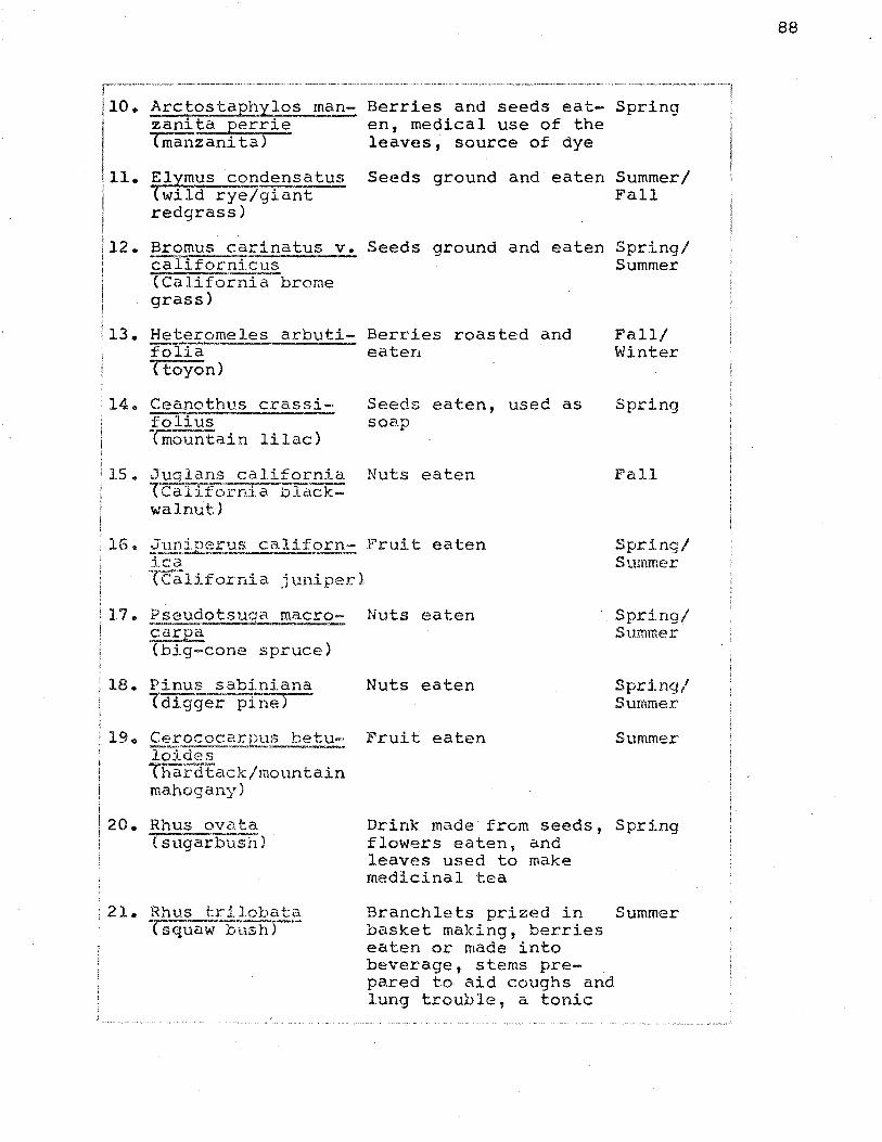
r~---~"·----~- ---·- ------ ........ ---· --- ........ ---- ...... ----- ........ ·--·-·-···. -- . - ----· ··-·· - ----. ---- _____________________ ,.. ___ ·-· --------------, 110. Arctos taph_y_los man- Berries and seeds eat- Spring 1 zanita perrie en, medical use of the
I tffianzanita) leaves, source of dye
.11. Elymus conden~?tus Seeds ground and eaten Summer/
1
1 (wild rye/giant Fall I redgrass)
112. Bromus carinatus Vo Seeds ground and eaten Spring/ i calffornicus Summer !
(California brome grass)
il3. Heteromeles arbuti- Berries roasted and folia eaten (toyon)
14~ Ceanothus crassifOT:[""us Tmountain lilac>
: 15. J£9_,±_an~ c~!i:f.£F~ Tcali.fornia blackwalnut)
Seeds eaten, used as soap
Nuts eaten
: 16 .. :J_m};};.£c~r_'£S calif2£Il..::: Fruit eaten ica Tc'alifo.rnia juniper 2
Fall/ Winter
Spring
Fall
Spri.ng/ Summer
17. Pseudotsuca macro- Nuts eaten ·- :J.
.~
·.Spring/ Summer
(big-cone spruce)
18. Pinus sabiniana Nuts eaten (digger pine)
19. Cerococarpus betu- Fruit eaten lc)Ictes -----Thardtack/mountain mahogany)
20. Rhus ovata Ts'lig-ai-bU'Sh)
;21. Rhus trilobata TS'quaw--bush 5--
Drink made from seeds, flowers eaten, and leaves used to make medicinal tea
Branchlets prized in basket making, berries eaten or made into beverage, stems prepared to aid coughs and lung trouble, a tonic
Spring/ Summer
Summer
c:: • .... pr1ng
Summer
88

,--"---·---·-·· I
22 Rhus laurina I • Tiaural sumac>
I 123. Encelia farinosa
(brittle bush)
was also made from it to aid loss of appetite
Seeds made into drink Summer
Seeds eaten Spring
i 24.
I Eriophyllum confer- Seeds eaten tiflora
Spring/ Summer
i 25. Er~2<?.i_styon californicum !
l I
ryerba-santa)
1 26. Adenostoma fasciculatum Tc'hai"nise>
2 7 .. ~'EL»~.:_ (lupin)
2Be Heliantus annus TCOmmon $UD:fiQ;ier)
29o Prunus ilicifolia
30o ~r~sp.1lus__ antise~lii {rattle-snake/loco weed)
31. ~.re~~££_~rpus s e j:igerus {turkey mullin)
32. Sambucus coerulea Teiderber rYT
33. Calochortus nutta-11~------
Tmar'iposa lily)
Nicotian~-~
Leaves used a.s medicinal tea
Spring/ Summer
Medicinal use of bark Summer and leaves
Seed pods eaten Spring
Seeds ground and eaten Throughout year
Seeds/fruit eaten
Pods were pounded and added to food as a spice
Spring/ Summer
Spring
Fish poison, and med- Spring ical use of leaves
Berries cooked into sauce, bark and flowers used medicinally
Corn eaten
Corn eaten, used as a shampoo
Smoked and chewed
Summer
Spring
Spring/ Summer
Spring/
89

{tobacco)
!36. ~~us trichp~arp~ (black cottonvJOod)
Twigs prized to make the warp sticks for twined baskets; also reported to be used as a love medicine, roots used to make baskets
Summer
Spring/ Summer
Selected medicinal plants associated with Bridgeport Flats, but which lack specific gathering seasons:
Datura meteloides (Jimson Weed or Toloache) a :liquid which was chiefly used during puberty rites because of its hallucinogenic effect was fermented from the plant's seeds. Also a liquid was brewed from the crushed root as a cure for rattlesnake and tarantula bites and the leaves were dried and smoked as a cure for asthma., (The effective use of Toloache depended upon the patient having a strong heart)@
E,!;.:::=rrtoc_~£pus .~etigen-!.s. (Turkey Mullein or Dove vleed) the whole plant was crushed and used in well-dammed streams as a fish poison. the fresh leaves were crushed into a poultice which wa~ applied as a counterirritant for internal pain or asthma, the stems were brewed into a tea for chills and a poison for arrows is also reported
;to have been made from an unknown portion of the plant.
Arbutus menziesii (Madrone) a tea was brewed from ·the root bark and -rea:Yes for colds and from the dry trunk bark for stomach-aches~
90

pealized during the months of May and June.
It is unfortunate that the archaeological resources ;
of the lower portion of the Piru Creek Drainage Basin are
hot as intact as those of the upper and middle portions i .
~ince recent field work in the Hardluck Valley has reveal-
ed a thirty site complex with much the same distribution
pattern as was found at Bridgeport Flats. The only thing
lacking in the Bridgeport Flats and Hardluck Valley site
complexes are the large village sites, however, there are
large major village sites located at each end of the
drainage basin in the area contiguous to the mouth of Piru
Creek to the south and in the vicinity of Fort Tejon to
the north~ The farthest northern boundary of the Alliklik
is thought to be on the southern shore of Quail Lake near
Tejon Pass; however, very little field work has been con
~ucted in that area so that it is presently impossible to
confirm this suspicion (Kroeber 1915)9
i ! ; . j
91

CONCLUSION
An analysis of the topography of the Piru Creek
Drainage Basin clearly indicates that the area forms a
unique environmental zone with at least two hundred years
of relatively stable climatic conditionsD However, what
is not so readily apparent is the extent of damage which
two hundred years of non-aboriginal utilization has cre
ated in the area. Over-grazing has either totally re
;placed native plant communities or forced them into mar
ginal areas of the drainage basin. Over-grazing is chief
ly responsible for most of the area's present erosion
activity. The introduction of domestic animals and the
policies of open range grazing have seriously pressured
'the areats native faunal populations to the point that al
though mosi.~ of the species vvhich were thought to have been
present in prehistoric times are still present but no
longer in the distribution and numbers which they formerly
enjoyed. The attempt to harness the flood-prone Piru
Creek is directly responsible for the loss of one of the
most important archaeological zones within the drainage
basin, since the Santa Felica Dam 1 s construction was a
county project at a time when there were no provisions for
the protection of our archaeological resources. Today
such provisions are still far from adequate, however, the
92

'two subsequent reserviors planned for the Piru Creek have
at least been preceded by salvage projects. At present
the Piru Creek Drainage Basin is still in danger mostly
as a result of urban pressures from the population centers
:of the three California counties within which it is lo
cated. There is an increasing demand upon the area to
develop more water storage facilities for agricultural and
industrial purposes and also to develop more accessible
and diversified recreational areas for these population
centers. The end result will be that undisturbed portions
ef the Piru Creek Drainage Basin which had formerly been
inaccessible to great numbers of peopl~ will be open to
.what is essentially a destructive process ..
Historically the Piru Creek Drainage Basin was one
of the first areas of Ventura County to experience long,
isustained contact with the earliest Spanish explorerso
From the journals and records of these first Europeans it
·.is evident that at the time of contact the area was occu-
pied by a stable, indigenous aboriginal population. How-
·ever, the population succumbed ver:y rapidly to the effects
of missionization so that by 1830, for all practical pur
poses, the indigenous aboriginal population had been dis
seminated into other areasG The mission records for this
period are still an untapped source of data - when they
are completely translated and organized into a workable
form they will, in all probability, show that the aborig-
93

r· .... !
inal population of the Piru Creek Drainage Basin was nev-
er as large as we have been led to believe but rather was
a very small closely related population~
Ethnographically it appears that the Piru Creek
:orainage Basin was occupied by a relatively distinct pop-
ulation, the Alliklik. Based on information collected in
other areas of Southern California it can be assumed that
the Alliklik were part of a Shoshonean-speaking invasion
.which entered through the desert regions of the state
sometime around the first century A.D~, this is evident
from Map 4 where the Alliklik form a sort of a buffer
zone between Shoshonean and non-Shoshonean-speakers. The
, area was heavily viorked by ethnographic researchers from
the 1890's to the early 1930's- who.had an opportunity
to collect information from many first hand sources ..
'HovJever, most of the material which they collected was
inever published and a good percentage has been lost~ Re-
'gardless of this loss is the fact that most of these men
.so alienated their informants that subsequent attempts
to reconstruct this early data have failed. One partie-
ularly knowledgeable informant refused to even see me
because in 1927 she had indicated to an ethnographer the
locations of various village and cemetery sites only to
later find this individual had dug up and removed her own
parents' graves. One fact upon which most early researchs
in the area seem to agree, is that the Shoshonean-speaking
94

~"' VENTURENO
'--------
I l i ~--~ I
c
I MAP 4 a -§~ 0/
Terrltorol ft({llatlonships Of Abor\iinol o/ 1 Populations Around Th9 Piru Cr~ek ~ ./ FERNANDENO .
. ~ I
i Drainaoe Basin. / : L ....•. - --·--·-·········· ........................... -.............. ···-·- -- ··--------·---------·-·-··----~----------------------------·-----······---_1
95

invasion did not replace the dominantly coastal dwelling
Hokan-speaking Chumash. Rather, they seem to feel that
the Shoshonean-speakers replaced a more archaic popula-
tion, probably members of the so-called "Milling Stone
:cultures" which have been credited with some of Calif-
ornia's earliest aboriginal occupations. It appears
fairly certain that the Chumash did not occupy the Piru
. Creek Drainage Basin until after 1830 \..Jhen the Alliklik
'had been removed as a result of missionization, and it
is also fairly certain that their occupation was shared
by members of other California aboriginal groupsw The
fact that missionization tended to give the California
,aborigine a cultural level similar to that of the Mexican
peon is important since with the breakdown of the mission
,system we also see a breakdown in aboriginal tribal organ-i
: izations. In fact, several questions which vJe can seri-
ously ask and for which at present there is little hope
·Of gaining answers are~ to what degree was the California ' -
!aborigine Hispanized) what was his legal and social status
after secularization and to what extent does Hispanization
effect aboriginal cultures. For example many informants
1 provided Spanish words for various aboriginal cultural
items and traits and also many of them gave as items and
traits of aboriginal culture i terns and traits which v-Tere
actually parts of Mexican culture. Another example was
the treatment given to Juan Jose Fustero when he appeared
96

97
in the Ventura County Court on a charge of drunkness, the
;question was not that liquor was sold or consumed by an
~Indian but rather that an individual was drunk - in fact
:even though Fustero could speak English the judge made a
special effort to arrange for a Spanish-speaking trans-
later. This incident, however, occurred rather recently
and at a time when the Fustero family were not only the
last aboriginal occupants of the Piru Creek Drainage
Basin but also very probably the last aboriginal occupants
of Ventura County.
Archaeologically the Piru Creek Drainage Basin pre-
sents information which does not clarify but actually
ifurther confuses the historical and ethnographical record~
The region has long been known as a productive area for
. "Indian artifacts" and most of the archaeologice:ll sites
in the area were nlooted 11 in one way or another before
·1940. Then after 1940 most of these same sites were des-
troyed~ so that it is impossible to adequately reconstruct
ia full picture of the area's prehistoric utilization~ We \
can, however, say that the area seems to conform to a
general Shoshonean model as seen in other parts of South-
ern California (Hanks 1971, Strong 1929). Th~s model
is characterized by a single or several large village
sites which served as ceremonial centers and semi-perma-
nent winter habitation locations. The large villages are
in turn complemented by a series of seasonal site clus-

iters, usually made up of a central base camp and numerous
I ~athering stations. It appears that the population util-
lized a well defined territory over which they moved in a I !seasonal pattern. The pattern of movement was probably
\regulated to the availability of plant and water resour! ~es. Since the territory in question was small and well
~onfined, it can be further presumed that the population
;visited certain locations more than once during the course. ! ! 'of a year. The location of the major villages at the
iconfluence of the Piru Creek and the Santa Clara River I !also indicates that another important activity of these I !villages may have been tradin9.. It is a known and vJell ! i iaccepted fact that the Santa Clara River Valley was once
:the main trading artery between the coastal and interior
'zones of this region of California. Therefore, it is not
out of the question to assume that the villages of the
1Piru fi.gured in this trade network. No excavations were ' !conducted as part of this research but considering the
;present degree of disturbance in the area, it is doubtful
!Whether they could have yielded any useful informations
:The analysis of local artifactual collections could have i
;been used to fill gaps lacking through excavation, how-
ever, most local collections lack proper provenience so
that they cannot be effectively organized into a local
.typology-.
At best this research presents nothing but specu-
98

lative conclusions based upon very fragmented informa-
tion. The degree of destruction experienced by the Piru
,Creek Drainage Basin is hopelessly complex and far beyond
,the point of the reversal or retrieval of worthwhile data. \
!The Alliklik, if the~ ever did exist or if they were ever
the prehistoric occupants of the area, are forever lost
to us save for the meager information yet to be learned
in the Mission Records.. Therefore, if anything worth~,oJhile
can be said of this research, it is that it crys out like
"a voice in the wilderness" against the insensitive and
destructive treatment of our diminishing archaeological
resourcest and it points to the need for more understand-
:ing and stronger laws to not only protect and preserve
but to explore the fragile pages of our archaeological
past ..
99

l
NO'rES
The footnoting and bibliography in this paper conform to the style established and used by American At)ti~uit~, the journal of the Society for American Archaeology.
12. Mr. Dale King, Reasoner Canyon, Piru, California.
3. Properly speaking the lower portion of the Piru Creek Drainage Basin cannot be considered historically or ethnographically outside of the context of the Santa Clara River Valley.
4. The word Beneme occurs frequently in the literature, however, its derivation and meaning at present is unknov;n.
5. This term also appears as "l'at'ap'alliklikl! in Van Valkenburg (1935:4) and as ttl'alliklik 11 in the plural in Kroeber (1925:614).
6. These answers were translated from the original Spanish Respuestas, located in the Santa Barbara Mission Archives. English trans la t.ions of these f~e~J?.}!_~stas can also be found in each of Fra Zephyrin Engelha.r:dt' s books on the California missions.
7o M. refers to meters.
8. em. refers to centimeters.
9. Clay Singer, University of California at Los Angeles Archaeological Survey~
100

~----~~~ ----·-~·----~- ··-·--···-··· ·---····· .. ~---· --~---- -----·~~----.. ·~·----.. ---------· ·- ........ _ .... ~ ..... ·--·-·--~------------------~----~----··--·-,
t
BIBLIOGRAPHY
!BOLTON, HERBERT E. (ed.)
I l I
!
1925
1926 Historical Memoirs of New California ~ :F'ra FrailcTS"co f..> a lou o.,F' .. M,, Vol. 2-. Russell and RusseTI, Nev>1 York.
1542-
i BOUL'I'ON, HENRY E ..
1930 Anza' LCalifornia Exp_edi t:}OP::§., Vol. 1 .. University of California Press, Berkeley.
i )CARMAN, MAX FLEMING, JR.
I I 1964 Geology of the Lockwood Valley Area, Kern
and Ventura Counties~ California Division 2f: Mine~ and Geo 12.9_Y~~R£'P_<2fT, No~:·~·sl" Sacramento ..
CORDOVA, SIMON
1956 Geology of the Piru Area, Ventura County? California. Unpublished Masters Thesis~ Department of Geology~ University of California7 Los Angeles~
COUES, ELLIOTT (ed.)
1900 f>_r!_lli e 'l'r ai J. of_ a -~t:'2.U.i.§Il-.~!: i ~f..:.__f r ~ Francisco de Garces, Vol. 1, E.P. Harper 1 New York. ·-=-
EDWARDS, RONALD D., DANIEL R .. RABEY AND RICHARD W .. KOVER
1970 Soil Survey of the Ventura Area, California. ~-9 ,_;?_,t_~£..12._su?..:?-rJ:..!!!,s n !.....~q£ ic: u 1 tug, Soil Conservation Serv~ceo Washington, D.C.
ELSASSER, ALBERT B .. AND ROBERT F. HEIZER
1963 The Archaeology of Bowers Cave, Los Angele~, California.. Q.n~~E~,?J:.y of C~].iforni0;...!::££hJlE~o l£?.£L~ upvs:.Y_J3;.~.E9r t.J:!~. Berke J ey ~
101

ENGELHARDT, FRA ZEPHYRIN, O.F.M.
1915
1927
1930
The Missions and Missionaries of California. James H. Barry Co., San Francisco.
San Fernando R~: 'The t.IJiss,ion of the Vall§:y. F'ranciscan Herald Press, Chicago.
San Buenaventura: The t1issi.9n by the_S~, Schauer Printing Studio, Inc,, Santa Barbara, Californiao
FORBES, JACK D.,
1966
1969
The Tongva of Tujunga to 1801, Qm.ver~i t)L of California at Lo.~An~les __ Archa~logic~! !)urvey Annual Rei?..?rt, Vol., 8 1 pp. 137-150 .. University of California, Los Angeles.
Native Americans of California and Nevada. Nab ... ~regraph Publishers' Healdsburg' caTITornia.
:FREEIV!.AN, VERNON N.
1968 PeoEl.~-Land-Water: Santa Cla:t?a .. V~}l~}tiJ.d ~~Q __ ~_yentur~~~ia.;,c• Lorrin L. Morrison, Publishers Los Angeles~
GREENWOOD, ROBERTA S. AND ROBERT 0. BROWNE
1969 A Coastal Chumash Village: Excavation of Shisholop, Ventura County, California~ Memoirs of the Southern California Ac~d~ ~~-e~ Vol., 8, Los Angeles ..
·GUINN , J AP..1ES HILLER
1901 His ~c;_~-~~~:Llli.£Sl.£~C a f- R~t;:d ._2f So~the_£n California. Chapman Publishinq Co.,, Chicago.
HANKS, HERRICK EG
1971 The Archaeological Survey of Vasquez Rocks: A Site Locality in the Upper Santa Clara River Valley Region, Los Angeles, California. Unpublished Masters Thesis. Department of Anthropology~ California State University, Northridge.
102

;HARRINGTON,
I n.d. i l
JOHN P.
Ethnographic and Linguistic Field Notes. Manuscript on file at the Smithsonian Insti-; tute, Washington, D.C.
;HERSHEY, OSCAR He
1902 'I'he Quaternary of Southern California. ~ versity of falifornia Departr:::e!lt of Geo-=. 1oqical Science Bulletin, Vol. 3, pp. 1-29.
KROEBER, ALFRED LEWIS
1904
1907
1908
1915
1925
The Languages of the Coast of California South of San Francisco. University of California Publication in~ican.Archaeo}ogyT_~nd Ethnology, Vol. 2, No. 2, ppG 29-80, Berkeley.
A Mission Record of the California Indians~ University of California Publicaticn in ~!~aeol£9.Y an~l}_o\ociv 1~Vol .. 8, No$ 1, pp. 1-27, Berkeley.
A New Shoshonean Tribe in California~ American_~lthropol~ist. Vol~ 17, pp. 773-77s:--
Handbook of the Indians of CaliforniaQ gur~2tl}t-;E_ican Eth,no~.J?ul~"l;jjl !'Io .. 78. Washington, D.C ..
,LANB, SYDNEY N ..
1964 The Classification of the Uta-Aztecan Language: A Historical Survey. gni~.£.:?tty of Cal±.fornia:.....Pub}:h_ca_lions in Linguis_t~, Vol. 34, pp. 106-125, Berkeleyo
LYNCH, HENRY B ..
1931 Rainfall and Stream Runoff in Southern California Since 1769~ Manuscript on file at Metropolitan Water District of Southern California, Los Angeles.
103

;NELSON, J.W.; W.C. DEAN; A.E. KOCHER; E,. B. WA'rSON AND i E.J. CARPENTER I I I I 1920 Soil Survey of the Ven-Eu:Fa-A;t'ea.-,-California.'
y .. s~=Department of ~ricvlt;_ure 1 Bureau of Soils Field O£erati~- Advance Sheet. Washington, D.C ..
;PRIESTLEY, HERBER'r INGRAM (trans a)
1937 A Hi~toric~l, Politi~~l and Na~ural~ tion of California by _fE;,dro ~1!=.§. t-.?olider: of s~~ University of California Press, Berkeley.
SMITH, DONALD E. AND FREDERICK J. TEGGART
1909
SMITH, NELSON
1910
Diary of Gaspar de Portola During the California Expedition of 1769-1770. Academy of Pacific Coast Historv Publicatior7£;-;-v;;r:·1, No :-3-;-'PP=--30--l o o , san- FranCISCo-:--
A Translation of the Costanso Diary of the California Expedition of 1769-1770o Unpublished fvlasters 'rhesis. Department of History. University of California, Berkeley.
STORIE 1 RAYMOND E. AND WILLIAM H .. WEIR
1941 Key T~ The Soil Series of California. University ofCalTfo-rnia Press-, Berkeley ..
STRONG, WILLIAM DUNCAN
1929 Aboriginal Society in Southern California~ ~Es~ifor_~,0 Publications in Amer~-~!l.. Arc~~~-o...;.l..£.SL'L .. .,Stnd Ethnolo_gy"~,--~· Vol. 26, Berkeley.
TROXELL, HAROLD Cw AND WALTER HOF~~NN
1954 Hydrology of the Los Angeles Region. f C!_ ~if orpi~~ v!.&.<?.n o f._.!-1i r~~ -~Bulle t:l!! No. 170. Sacramentoa
104

:WHEELER, GEORGE Me
I 1879 Repor:,t_j!por!_..!l!.!l-.i:.££._ St;_~tes q_t:ggraEbl,cal Surveys West of ;th~ ... One .Jiundredt:h_ Mer:i.flt~n, f'-J;:_S}1aeob.£S.Y.• Publication of the Uni t.ed States Army Engineer Department, Washington, D .. C.
:vAN VALKENBURG, RICHARD F·.
1935
1932 to 1936 Field Notes of Museum Activity in the Piru Region of Ventura County., Los Angeles County Museum of Natural History.
Notes on the Ethnography and Archaeology of the Ventureno Chumash Indians~ Manuscript on file at the National Anthropological Archieves, Smithsonian Institute, Washington, D.C ..
105

I:::J:::::::::::::::::J ----- rL..vvu ICO;;J·
1859-60
C1 I I I I ·~ I SEVERE DROUGHT! 1863-64 I
1869-70.
1879-80 ' I . FLOOD 1876
I I I : I -SEVERE DROUGHT 1877
1889-90
I ~. I I . I FLOOD 1886
,..----J I I I FLOOD 1890
"----·~·-----~-~
%- ·lc. "'0 ::0 "0~ IT1 -· (') .... -· c "0 -
-+ Oa ..,,... ~ -· <Do ~:I
0~ ........ Q Q -· :s Q(') cQO
C'D= C'D :
CD o . Q-+ (/) ~
-· Cl. ,::,
-4\ .... 0 3
.. <·'
-";;,·~:: .. , ··~ .. ,,
~;{t, '(<
. ::.:·~t~}::
.:~:!1; '·'{\'
,,·>~~~~

- --. -·-- -
-~ ..
(!)
z C/) - IJJ ... (!) C/) w C/)
...J (!) (!) .... I.Ll C/) 1J.J 0: (!) (!)
i= (!) Z<!> z z <[ a:: 1J.J C/) ...J z z _..
~ w n. w - - OCJ) z -z (l.' 0:: . ::l 0:: <( :EIJJ WIJJ 1- a 0 - a.._ z <t 0 0 .... 0 ....
1- N 1J.J - z z w.,_ _ .... - n.~ -<t - 0:: lL. -(f) c::t ...J - <[~ - - ....,z ..,. .... Oo - m 0 lL. (/) --~ - - N :::> tO <0 ...J 1'- Q) 0:: - IJJ
(/')(f) ...... (r to 0- J:_ 0 -:E C/) (/') ..... - 0 ..... 0::0 ...... ::::> ..... oa.. -a.. .....
(/) ..... w u.. (!) Q. a.. a.. 0 n.
396 397 80 X 210 3.0 10 .o 3.5 15.0 4.0 2.5 45.0 II. 0 6.0 POT SHERD 302 3136 ~ -·- -- -- - -·. - - -- ·- ----:---:----:::-- ~~ ----- ---~ ·- ·- ·- - -- ·- ------ -- --- - - -· -· - - -· ·--::c --:---- ----,--·-::----- - . ::- ---- -~ :- ·--:--- . .. ·- --- . - --
~ ~-,~ ·c-~~ =~~-= ~ =- --- ~~ =~===~- =---:::-:-~-;-:- ~-=-::::-~ =-""= -..
---==-:--:-::=-~-~---
HIGHLY DISTURBED 439 98 50 X 150 1.0 8.0 - 20.5 4.0 7.0 43.0 9.0 7.0 SITE 21 211 ..
.a -
393 48 - - - 10.5 8 134 25 X 200 6.5 6.0 6.0 23.0 48.0
BEDROCK MORTARS 394 97. 50 X 100 8.5 4.0 6.0 17.5 4.0 4.0 44.5 10.5 1.0 CUPULESJ OVEN 13 258
. -ANVIL
12.5 - 12.5 12.5 12.5 -18.5 .:;_ STORAGE.- PIT-... , .. ,. 6._.,.,,_.; . :.83 438 16 40 X 40 6.0 18. 5. 6.0 -·-- ., ....... - -~<;
·-
SITE 392 55 '? INVALID SAMPLE DESTROYED 20 67
- - - - - - 2 3 395 4 10 X 20 25.0 25.0 50.0
l
442 - 10 10 - - II X - - - - - - - -
443 2 15 15 - - - 50.0 - - - 50.0 2 16 X -
{
444 9 10 X 20 - - - - 55.5 - II. 0 I 36 ·' 22.0 11.0
TABLE 2 Too I Frequencies at Selected Bridgeport Flats sites. California State University, Northridge Library