Embed Size (px)
Citation preview
The Coordination Group For Meteorological Satellites
Report of the 49ʰ Meeting of
12-18 April 202119-21 May 2021
CGMS-49 | Virtual Meetings |12-28 April 2021 and 19-21 May 2021
- 2 -
REPORT OF THE 49TH PLENARY SESSION OF THE COORDINATION GROUP FOR METEOROLOGICAL SATELLITES
CGMS-49 Virtual meetings 12-28 April 2021 19-21 May 2021
CGMS-49 | Virtual Meetings |12-28 April 2021 and 19-21 May 2021
- 3 -
Report edited on behalf of CGMS by:
CGMS Secretariat
EUMETSAT
Eumetsat-Allee-1
64295 Darmstadt
Germany
www.cgms-info.org
CGMS MR 49 [DMT 21/1228133]
© EUMETSAT, 22 November 2021
CGMS-49 | Virtual Meetings |12-28 April 2021 and 19-21 May 2021
- 4 -
TABLE OF CONTENTS
TABLE OF CONTENTS .......................................................................................................................... 4
PLENARY SESSION .............................................................................................................................. 5
1. OPENING SESSION ....................................................................................................................... 5
2. AGENCY INTERVENTIONS/REPORTS........................................................................................... 6
3. WMO MATTERS FOR COORDINATION WITH CGMS SPACE AGENCIES ................................. 17
4. WORKING GROUP REPORTS ..................................................................................................... 19
5. THEMATIC SESSION: NWP IMPACT ASSESSMENT OF SATELLITE DATA ................................ 34
6. SUPPORT TO OPERATIONAL CLIMATE AND GREENHOUSE GAS MONITORING ................... 38
7. CGMS HIGH LEVEL PRIORITY PLAN (HLPP) ............................................................................... 46
8. FUTURE CGMS PLENARY SESSIONS .......................................................................................... 46
9. AOB AND CLOSING SESSION ..................................................................................................... 47
PARALLEL WORKING GROUPS .......................................................................................................... 58
WGI report ............................................................................................................................................ 59
WGII report .......................................................................................................................................... 79
WGIII report ........................................................................................................................................ 139
WGIV report ........................................................................................................................................ 162
SWCG report ........................................................................................................................................ 186
Joint WGI-WGIV-SWCG report ........................................................................................................... 205
Joint WGII-WGIII report ...................................................................................................................... 209
ANNEXES ........................................................................................................................................ 217
ANNEX I Addresses .............................................................................................................................. 218
ANNEX II: Abbreviations ..................................................................................................................... 222
ANNEX III List of participants .............................................................................................................. 225
ANNEX IV Photographs… .................................................................................................................... 244
GENERAL CGMS INFORMATION..................................................................................................... 245
CGMS-49 | Virtual Meetings |12-28 April 2021 and 19-21 May 2021
- 5 -
PLENARY SESSION
1. OPENING SESSION
Welcome addresses by CMA, the CGMS Secretariat and the WMO
Address by Dr. YU Xinwen, Deputy Administrator, China Meteorological Administration (CMA)
On behalf of the CMA Administrator, Mr. ZHUANG Guotai, Dr. YU Xinwen, Deputy Administrator of
CMA, warmly welcomed all participants to the 49th virtual plenary session of CGMS. He appreciated
the challenges associated with the pandemic and the continued virtual nature of meetings, and
thanked delegates for their flexibility and understanding.
He recalled that CGMS serves as a model for building a community with a shared future in terms of
global observations for meteorology, climate, and oceans. CGMS promotes the continuation and
complementarity of the satellite space infrastructures globally in order to enable users to access
satellite data on a sustained basis.
He informed CGMS that in the next couple of months, FengYun (FY)-4B and the long-awaited early
morning orbit satellite FY-3E will be launched to service the international community.
CGMS already addresses greenhouse gases, climate monitoring, and space weather to meet the
challenges arising from the global climate change, increased extreme weather and climate events
as well as atmospheric environmental pollution with the aim to continuously contribute to
achieving the goals of a global low-carbon level and emission reduction. In addition, he called upon
the meteorological satellite agencies and organisations worldwide to further strengthen their
cooperation, and to improve meteorological satellite data and products, in order to better serve
the global user community.
He concluded by wishing the 49th plenary session of CGMS a success and good health to all
participants.
Address by Mr. Phil Evans, Head of CGMS Secretariat and EUMETSAT Director-General
Mr. Evans welcomed all CGMS members and all participants to the 49th CGMS plenary meeting. He
explained he took over as Director-General of EUMETSAT on 1 January 2021 and consequently
became the Head of CGMS Secretariat. He confirmed his and EUMETSAT’s committed support to
CGMS including that of the CGMS Secretariat. The group is an important mechanism to keep
coordination among space agencies responding to the observation requirements of WMO.
Altogether, CGMS is committed to respond to the Vision for WIGOS 2040 and he looked forward to
the discussions.
He thanked CMA for their readiness to twice host the meeting virtually and under these particular
circumstances, and all CGMS members for their flexibility.
In addition to the working group reports, he looked forward to the dialogue with WMO in particular
regarding the evolution of the WMO Data Policy and the restructuring of GCOS - an important
programme to articulate requirements for climate observations.
CGMS-49 | Virtual Meetings |12-28 April 2021 and 19-21 May 2021
- 6 -
Evans explained that the thematic session on the impact assessment of satellite data on numerical
weather prediction (NWP) might influence the members’ responses to new observations needs or
approaches required by future global NWP models, including the planning and coordination of the
members’ future observing space infrastructures. The same could be said for the greenhouse gas
monitoring. He concluded by saying he looked forward to meeting everyone in person as soon as
circumstances permit.
Address by Prof. Petteri Taalas, WMO Secretary-General
Prof. Taalas said it was a pleasure to join the 49th plenary session of CGMS. He recalled that WMO
is undergoing significant reform within the framework of the WMO Strategic Plan 2020-2023. He
added that the key issues for WMO members include: readiness for extreme weather events,
climate monitoring, supporting decision making related to climate change, advancing the required
observational and modelling capabilities required for the implementation of the Paris agreement,
and increasing socio-economic value of environmental services. WMO is now taking a holistic Earth-
system modelling and monitoring approach, recognises that global NWP underpins most WMO
application areas. Accordingly, WMO has recently prepared a position paper on the “Satellite data
Requirements for global NWP” emphasising the need for open, free, and timely access to critical
satellite observations. In this context, WMO is working towards a new updated Data Policy that
takes into account the scientific, technical, and societal challenges, changes, and opportunities
towards a holistic data policy encompassing all WMO application areas for approval by WMO
Congress in October 2021. The new Data Policy foresees the notion of ‘core data’ – such data to be
made available openly and freely – and WMO would like to engage with the space agencies in
determining and agreeing on those data as well as to maximise the benefits for all users. Prof.
Taalas further called upon the CGMS space agencies to consider closing some of the gaps and
establish a way forward to support WMO in meeting the WIGOS Vision 2040.
Prof. Taalas concluded by informing CGMS that WMO will host CGMS-50 in 2022 in the
headquarters of WMO, Geneva.
The full addresses are provided in the Annex.
2. AGENCY INTERVENTIONS/REPORTS
Main developments since CGMS-48 and an outlook for the future
China Meteorological Administration (CMA)
Address by Dr. WANG Jingsong, CMA NSMC Director-General
Dr. WANG Jingsong informed CGMS that he was appointed Director-General of CMA NSMC a day
earlier (18 May 2021). Previously, he had held the positions of Director-General of the Department
of Integrated Observations of CMA, Deputy Director-General of CMA NSMC, and was partially
involved in the FengYun programme over past decade. He recalled that the Chinese government
attaches great importance to the development of the FengYun satellites and their international
CGMS-49 | Virtual Meetings |12-28 April 2021 and 19-21 May 2021
- 7 -
applications, and that CMA would continuously provide data and product services to global users.
He concluded by wishing everyone a fruitful session and good health.
The full address is provided in the Annex.
CGMS-49-CMA-WP-15: Status report on the current and future satellite systems by CMA
CMA is operating the FY geostationary and polar-orbiting satellite systems. Currently, six FY
satellites are on-orbit and fully operational, including four geostationary meteorological satellites
and two polar orbiting meteorological satellites. The two FY satellites series with the odd number
represent the LEO satellites, the even numbered series the GEO satellites.
The current operating LEO satellite system is the FY-3 series satellites flying on AM and PM orbits.
The latest one, FY-3D, launched on 15 November 2017, became operational in January 2019. The
observational capabilities of FY-3D include VIS, IR, and MW imaging, IR and MW atmospheric
sounding, greenhouse gas detection, radio occultation sounding, and space weather monitoring.
Four operational GEO satellites are on-orbit, including three FY-2 and one FY-4 satellites. FY-2H is
positioned at 79° especially for Indian Ocean observations. FY-2F and FY-2G are positioned at 112°E
and 99.5°E respectively. The FY-2 satellites transmit 5-channel S-VISSR imagery. FY-4A, the first in
the second-generation series, was launched on 11 December 2016. It has enhanced imaging,
sounding, lightning mapping, and space weather monitoring capabilities. FY-4B, with significant
performance improvements, was launched on 2 June 2021.
Another highlight to be mentioned is the FY-4 series GEO microwave programme expected to be
confirmed in 2021.
Centre National d’Études Spatiales (CNES)
CGMS-49-CNES-WP-01: Update on the latest programmatic news in relation with CGMS
CNES continues its cooperation with EUMETSAT on the exploitation of the three IASI instruments,
which are all operationally assimilated into several NWP models (Météo-France, Met Office UK,
ECMWF), with significant impact on the quality of weather forecast. Intensive work on IASI data for
atmospheric composition studies is also ongoing.
An increase of ammonia over Europe during the first lockdown (spring 2020) was detected, which
is an interesting example of the impact of COVID on air quality.
In parallel, the CNES-EUMETSAT development of the next generation instrument, IASI-NG,
continues, as part of the EPS-SG (Europe’s polar satellite second generation) programme. The proto
flight model instrument is planned for delivery by the end of 2021, with delays due to COVID. The
launch of EPS-SG/MetOp-SG A is targeted for 2024.
The tripartite CNES-EUMETSAT-UKSA development of the MicroCarb mission, dedicated to the
measurement of CO2, is ongoing. The targeted launch date is now set to 2022. The launch date of
Merlin, a CNES-DLR mission dedicated to CH4 measurements, has been postponed to 2026.
CGMS-49 | Virtual Meetings |12-28 April 2021 and 19-21 May 2021
- 8 -
CNES continues to cooperate with EUMETSAT and other partners on in-flight missions: Jason-3,
Sentinel-3A and -3B and Sentinel-6 Michael Freilich, launched in November 2020, whose
commissioning phase (cal/val) is ongoing.
Sentinel-6/Michael Freilich, and part of Jason-series missions, are going to be the future altimetry
reference mission by end of 2021. CNES has a key expert role to ensure the performance of these
altimetry missions. In parallel, the French space agency prepares the future wide-swath altimetry
mission SWOT. The mission is dedicated to ocean and hydrology, and tentatively planned for launch
in November 2022.
CNES is working on developing the Space Climate Observatory (SCO) initiative in collaboration with
several dozens of space agencies around the world in support of climate change adaptation. Several
projects have been facilitated through this initiative to increase the use of satellite data in
conjunction with in-situ data, socio-economic data, and models for monitoring the impact of
climate change on the environment at national and local scales. CNES is also assisting different
initiatives within CEOS and through different working groups.
China National Space Administration (CNSA)
CGMS-49-CNSA-WP-01: CNSA space activities and outlook
CNSA presented the status of its satellite programmes. CNSA has launched the following satellites
since CGMS-48:
- HY-1D ocean satellite, launched in June 2020
- ZY-3 stereo mapping satellite, launched in July 2020
- High-resolution multi-mode integrated imaging satellite, launched in July 2020
- HJ-2A/B Environmental satellite, launched in September 2020
- HY-2C ocean satellite, launched in September 2020
In June 2019, CNSA joined the CNES-initiated Space Climate Observatory (SCO). CNSA has so far
submitted 13 projects to SCO.
CNSA plans to deliver over 30 satellites for land survey, oceanic, and meteorological applications in
the 2021 to 2025 timeframe. These include:
- 3 satellites for global carbon monitoring
- 4 satellites for environmental monitoring
- 11 satellites for oceanic monitoring and science
- 7 satellites for meteorology
The upcoming launch campaigns scheduled for 2021 are:
- HY2-D, ocean dynamics satellite
- FY4-02 (FY-4B), GEO-meteorological satellite.
- FY3-05 (FY-3E), Polar-meteorological satellite.
CGMS-49 | Virtual Meetings |12-28 April 2021 and 19-21 May 2021
- 9 -
- ZY1-02E, optical land resource satellite
- GF3-02, C-band SAR satellite
European Space Agency (ESA)
CGMS-49-ESA-WP-03: ESA latest developments and plans since CGMS-48
The paper provides the current status of ESA’s Earth observation missions currently in-orbit. Two
of them, MSG and MetOp, are in cooperation with EUMETSAT.
Copernicus represents the major continuing initiative of European efforts in Earth observation. The
first Copernicus dedicated satellite (“Sentinel-1A”) was launched on 3 April 2014, followed by
Sentinel-2A in June 2015, Sentinel-3A in February 2016, Sentinel-1B in April 2016, Sentinel-2B in
April 2017, Sentinel-5P satellite in October 2017, Sentinel-3B in April 2018, and Sentinel-6 Michael
Freilich on 21 November 2020. Other Sentinels will follow in the upcoming years. Sentinel missions
are developed, launched, and operated in partnership with the European Union and EUMETSAT.
The Sentinel-4 and -5 instruments developed by ESA will fly on the MTG-S and MetOp-SG
respectively within the framework of a joint cooperation scheme between ESA and EUMETSAT.
The Earth Explorer missions currently in orbit (SMOS, CryoSat, Swarm, Aeolus) are all performing
extremely well, and the related data exploitation is based on continuous data of excellent quality.
The three missions all feature strong elements of international collaboration and a growing synergy
between them. The SMOS satellite was launched on 2 November 2009. The CryoSat-2 satellite was
launched on 8 April 2010, the Swarm satellites on 22 November 2013. Aeolus is the last Earth
Explorer satellite put into orbit on 21 August 2018 and its Doppler Wind Lidar technique used for
measuring wind profiles from space has already been fully demonstrated. The positive impact of
Aeolus data on weather forecasting has been confirmed by multiple NWP centres world-wide,
ECMWF in particular.
The Proba-V small satellite was launched on 7 May 2013. Its coarse resolution imager has, together
with Sentinel-3, continued the data acquisition of the vegetation payload onboard SPOT-4 and -5,
during the reporting period. However, from July 2020 onwards, owing to its orbital drift, Proba-V
is no longer considered as a mission fulfilling an operational role, and will instead be dedicated to
experimental activities with a reduced data acquisition scheme.
CGMS was further informed of the current status of ESA’s future Earth observation missions. Two
of them, MTG and MetOp-SG, are in cooperation with EUMETSAT.
ESA’s Living Planet Programme has three lines of implementation: Earth Explorer satellites, Earth
Watch satellites plus services, and applications demonstration. The paper describes the progress
of preparations of the forthcoming Explorer missions: EarthCARE, Biomass, FLEX, and FORUM.
FORUM was selected for implementation as Earth Explorer 9 (EE-9) on 23-25 September 2019. The
phase A/B1 for FORUM is close to completion and the bidding period for the FORUM Space
Segment ITT for the phases B2, C/D, and E1 has been extended to 18 May 2021.
The Phase A system studies are ongoing for the Earth Explorer 10 (EE-10) candidate mission,
Harmony, with two parallel system studies.
CGMS-49 | Virtual Meetings |12-28 April 2021 and 19-21 May 2021
- 10 -
On 25 May 2020, ESA issued a Call for Ideas for Earth Explorer 11 (EE-11). Fifteen proposals were
submitted and are currently under evaluation. Earth Explorer 11 is foreseen to be launched in the
2031–2032 timeframe. The decision on the mission ideas proceeding to phase 0 will be taken by
the ESA Programme Board for Earth Observation (PB-EO) at its meeting on 10 June 2021.
Following the decisions taken at Space19+ (ESA's Council at Ministerial Level), new activities related
to Aeolus Follow-On, Arctic Weather Satellite (AWS), TRUTHS, and ALTIUS are ongoing. Each of
these missions is planned to contribute to routine, operational monitoring data to improve our
understanding of the Earth system and climate change.
Looking to the future, the six Copernicus Expansion missions are currently in phase B2/C/D/E1,
addressing EU policy and gaps in Copernicus user needs, and each expanding the current
capabilities of the Copernicus space component: CHIME, CIMR, CO2M, CRISTAL, LSTM, and ROSE-
L.
CGMS is also informed of the status of the Earth Watch Programme element, Global Monitoring of
Essential Climate Variables (also known as the ‘ESA Climate Change Initiative’ or CCI). The CCI has
continued to progress very well since its inception in 2008. In 2016, a second phase of the
programme, CCI+, was approved by ESA member states, which allows to study and monitor 23
essential climate variables (ECV) derived from satellite data, fulfilling GCOS objectives. Out of these
23 ECVs, 16 have been handed over to the Copernicus Climate Change Service (C3S) for operational
use.
As a general observation, the COVID-19 pandemic has affected several activities related to the
procurement of satellites and instruments at different degrees. Thanks to appropriate measures,
the impacts on development projects have been mitigated as much as possible, while overall, the
operations of ESA satellites currently in orbit and services to users have been kept nominal.
European Organisation for the Exploitation of Meteorological Satellites (EUMETSAT)
CGMS-49-EUMETSAT-WP-18: EUMETSAT latest developments and plans since CGMS-48
EUMETSAT currently exploits eleven satellites of which seven are EUMETSAT’s own (Meteosat-8 to
-11 and MetOp-A to -C) with the remaining in partnership (Sentinel-3A/-3B and Jason-3 and
Sentinel-6A/Michael Freilich missions).
Since February 2018, Meteosat-11 provides the 0° service and Meteosat-10 at 9.5°E the 5-minute
rapid scanning service. Meteosat-9 is on standby at 3.5°E. Meteosat-8 continues to be operational
at 41.5°E to support, on a best effort, the multi-partner service for the continuation of the Indian
Ocean Data Coverage (IODC). Launched on 19 October 2006, the deorbiting and end-of-life
operations of MetOp-A will take place in the November to December 2021 timeframe. Dual-MetOp
operations with MetOp-B and MetOp-C continue nominally up until 2027.
Regarding future satellites: The development continues for the Meteosat Third Generation (MTG)
satellite system with the operational exploitation expected for the 2023-2040s timeframe. The
MTG imagery mission, MTG-I, will provide 10-minute full disc imagery and carries a lightning imager
(LI). The MTG sounding mission, MTG‐S, will carry a hyperspectral infrared sounder (IRS,
CGMS-49 | Virtual Meetings |12-28 April 2021 and 19-21 May 2021
- 11 -
temperature, and water vapour, with profiles for every 30 minutes over Europe in synergy with the
Copernicus Sentinel-4 mission. MTG-I1 and MTG-S1 are now planned for launch in 2022 and 2023
respectively.
The LEO EPS‐SG programme is under development and will provide a continuation and
enhancement of the service from the mid-morning polar orbit in the 2024-2040s timeframe. The
space segment is composed of a twin satellite in-orbit configuration with MetOp-SG A: an optical
imagery and sounding mission which also will host the Copernicus Sentinel-5 instrument for launch
in 2024 and MetOp-SG B: a microwave imaging mission, planned for launch in 2025. There will be
three successive pairs of satellites with 21 years of operations.
EUMETSAT is also preparing for the operations of Sentinel-3C and-3D in 2023 and 2028, for the
continuity of the reference ocean altimetry observations. EUMETSAT also considers supporting
CNES’s MicroCarb mission planned for launch in the 2022 timeframe, a precursor to a potential
European CO2 and GHG monitoring mission CO2M. Preliminary discussions are ongoing at a
European level for an Arctic Weather Satellite, and a follow-on Aeolus mission potentially for the
next decade.
India Meteorological Department (IMD)
CGMS-49-IMD-WP-04: Main developments since CGMS-48 and an outlook for the future
At present, two meteorological satellites, INSAT-3D and INSAT-3DR, are in operation. INSAT‐3D
located at 82°E and was launched on 26 July 2013 while INSAT-3DR locates at 74° was launched on
8 September 2016.
These are dedicated meteorological satellites and carry four payloads: imager (six channels),
sounder (19 channels), Data Relay Transponder (DRT), and satellite aided search and rescue (SAS &
R).
The imager payloads of INSAT-3D and INSAT-3DR are used in a staggered mode to achieve 15-
minute temporal resolution to provide cloud imaging.
The INSAT-3D sounder reached its end of life in September 2020, since then the INSAT-3DR sounder
is being used to collect data on an hourly basis of the Indian land region.
IMD has established the Multi-Mission Meteorological Data Receiving and Processing System
(MMDRPS) for INSAT-3D, INSAT-3DR, and the proposed satellite INSAT-3DS. The system has three
dedicated Earth station and data receiving systems. Each Earth station is receiving the data in
redundant mode from each payload (imager, sounder, and DRT) and it has a dedicated raw data
archival storage facility. MMDRPS has a very high-end processing system, which reduces the
processing time from 15 to 7 minutes and foresees to update the calibration coefficient in the
operational chain using Cal/ Val site and GISCS data. The system is capable of processing rapid scan
data of the INSAT-3DR imager payload conducted during extreme weather events. MMDRPS has
storage capacity of the order of 2.0/2.0PB (Main/Mirror) and 324TB SSD facilitating online sharing
of processed data for all Indian meteorological satellites to the registered users as per IMD data
policy. All available past satellite datasets starting from 1983 will be available online in due course.
CGMS-49 | Virtual Meetings |12-28 April 2021 and 19-21 May 2021
- 12 -
Currently, IMD has archived the Kalpana-1 satellite data from 2014 to 2017. The MMDRPS system
was declared operational on 12 November 2020.
Data exchange between IMD and other national and international agencies takes place on a real-
time basis. A dedicated link over National Knowledge Network (NKN) has been established by IMD
with ISRO and also with National Centre for Medium Range Weather Forecast (NCMRWF) for real
time transfer of INSAT-3D radiance data along with LST, winds, and GNSS-IPWV data to be
assimilated in the NWP models. INSAT-3D and -3DR wind products are being disseminated in BUFR
format through the WMO Global Telecommunication system (GTS) network for international
agencies on a real time basis. The MMDRPS has a dedicated web-based Data Supply System (DSS)
in redundant mode to cater for web-based data dissemination requirements in near real time to
both local and international users, based on the data dissemination policy of IMD.
The web based DSS which is in an advanced stage of implementation, will have a user
registration/authentication mechanism in accordance with the data dissemination policy of IMD:
metadata generation for data search; data search and order with a facility to handle band, format,
area, and temporal selection options; user administration (add, edit, delete); user order processing
system; data order workflow monitoring; report generation and data download history based on
satellite/sensor and duration; satellite, sensor parameters, data products and metadata
management (add, edit, delete). IMD has two dedicated webpages
(http://satellite.imd.gov.in/insat.htm; http://satmet.imd.gov.in/insat3d.htm) and RAPID, which
are updated every 15 minutes.
In addition, the RAPID Beta Version is also in the final stages of implementation. It will enable users
to visualise NWP, radar, and in-situ observational data on a real time basis overlaid on satellite data
with geo-referencing information and compatible to mobile users.
The INSAT-3DR imager payload was used to conduct rapid scans during four tropical cyclones,
namely: SuCS Amphan, SCS Nisarga, VSCS Gati, and CS Burevi from May 2020 to April 2021. Each
rapid scan covers 3 degrees in north-south direction (6 Blocks/240 scan lines) in 4.5 minutes. The
rapid scan data is used to track cyclones on a real time basis. The processed data are disseminated
on a dedicated webpage (http://satellite.imd.gov.in/rapid/rapid_scan.htm).
As per the demand of forecasters, several new geophysical products (imager/sounder) are being
generated operationally by MMDRPS at a pixel level with range of frequencies (half hourly, daily,
weekly, monthly, 15-day composite). These products are Net radiation, Improved INSAT
Multispectral Rainfall, Land Surface Albedo (land), Short Wave Radiation over Ocean, Total
Precipitable Water over Ocean, Potential Evapotranspiration over land, Actual Evapotranspiration
and Cloud Top Pressure, Effective Emissivity, and Cloud Top Temperature respectively. SST
derivation using 1-ID Var technique has been implemented.
Recently, new Advanced Dvorak Techniques (ADT) are implemented in MMDPRPS using INSAT-3D
and -3DR imager data and tested on an experimental basis for the two cyclones Amphan and
Nisarga. 10-day sliding composite snow maps and snow anomaly maps are generated operationally
in the public domain for mountain regions to identify the fresh snow, melting snow area, and
potentially vulnerable areas of landslide/flash flood in mountain regions.
CGMS-49 | Virtual Meetings |12-28 April 2021 and 19-21 May 2021
- 13 -
To monitor ground based real time Integrated Precipitable Water Vapour (IPWV), IMD installed 25
GNSS stations all over India as the Indian Global Navigation and Satellite System (GNSS) which is
operationally used in day-to-day weather forecasting and monitoring the convective development.
The real time GNSS IPWV estimated from the IMD network is available in the public domain as
http://gnss.imd.gov.in/TrimblePivotWeb/. In this web analysis, tools are available to plot real time,
daily, weekly, and monthly data with maximum and minimum values.
Intergovernmental Oceanographic Committee of UNESCO (IOC-UNESCO)
CGMS-49-IOC-UNESCO-WP-02: IOC Global Ocean Observing System
The IOC thanked CMA for hosting CGMS-49 and expressed its deep appreciation to EUMETSAT and
the CGMS Secretariat for the excellent arrangements in hosting meetings of the CGMS-49 Working
Groups and plenary.
The IOC Global Ocean Observing System (GOOS) is a fundamental component of the UN Decade of
Ocean Science for Sustainable Development. Of particular interest to CGMS, GOOS will provide an
integrated system of in-situ and satellite ocean observing systems to improve predictability of
ocean weather and climate and, consequently, enhance WMO services on global integrated Earth
systems. To illustrate the GOOS oversight and coordination of in-situ and satellite ocean observing
systems, ocean surface stress was chosen from the 31 GOOS Essential Ocean Variables because of
the newly established CGMS Ocean Surface Wind Task Group. To strengthen GOOS oversight and
coordination activities, GOOS is considering establishing a Satellite Data Coordinator, and IOC will
report on this at CGMS-50.
CGMS-49 actions - Plenary Session
Actionee
AGN item
Action Description Deadline Status
IOC-UNESCO
2 A49.01 IOC-UNESCO to provide CGMS-50 guidance of the Global Ocean Observing System (GOOS) for improved IOC and WMO ocean and atmosphere predictions and other services.
CGMS-50 OPEN
The CGMS Secretariat informed plenary that plenary action A47.05 had been transferred to WGII:
CGMS-46 action - Plenary Session
Actionee AGN item
Action Description Deadline Status
IOC-UNESCO
3.3 A47.05 On operational oceanography: IOC-UNESCO to provide to GCMS-48 guidance on satellite data requirement for improved coastal ocean prediction and services
CGMS-50 (CGMS-47)
OPEN
CGMS-49 | Virtual Meetings |12-28 April 2021 and 19-21 May 2021
- 14 -
CGMS-46 action - Plenary Session
Actionee AGN item
Action Description Deadline Status
Status: 2021 May 25: Transferred to WGII for further review (and reporting to plenary by WGII). Postponed to CGMS-50 (CGMS-49 being virtual again).
Indian Space Research Organisation (ISRO)
CGMS-49-ISRO-WP-09: ISRO Agency Report
ISRO is committed to developing and launching satellite instruments for meteorological and ocean
applications and providing support to Indian user agencies. The organisation maintains web portals
(MOSDAC, VEDAS, and BHUVAN) for dissemination of satellite data to the international community
and developed the Multi-Mission Data Reception and Processing System (MMDRPS) under a
Memorandum of Understanding (MoU) with IMD (MoES), which is operational at IMD New Delhi
since January 2021 for INSAT-3D/-3DR. 15 new parameters have been added compared to the old
IMDPS system.
A 1-D Var based physical retrieval algorithm has been implemented for SST from INSAT-3D/-3DR
Imager observation to mitigate the diurnal/seasonal dependency on SST biases. INSAT-3D/-3DR
radiances are monitored using the GSICS procedure. Inter-calibration of IR channels are in a
demonstration phase with IASI-A/-B and under implementation for IASI-C and CrIS. Inter-calibration
procedure Vis/SWIR channels with MODIS is under testing.
Under the ISRO Processing Platform for the International Charter: Space and Major Disasters, a
prototype for online image processing and analysis tools has been developed and is expected to
become operational soon (https://vedas.sac.gov.in).
The INSAT-3DR sounder is being used operationally however, the INSAT-3D sounder stopped
functioning in September 2020.
The re-processing of Scatsat-1 data in v1.1.4 was completed in June 2019. Due to an anomaly in the
redundant chain, data delivery is suspended since 28 February 2021. This will be replaced by
Oceansat-3 scatterometer data in October 2021.
SARAL/AltiKa, the ISRO-CNES joint mission, is in drifting mode. Crossover analysis using Jason
suggests that the bias remains more or less the same. The data sets are still useful for
oceanographic applications and very useful for Geodesy research.
Upcoming satellites:
- GISAT-1 is scheduled for launch in May 2021, at 85.5°E. Mx-VNIR and HyS-VNIR/SWIR will
have a daytime rapid scan of 500 x 500 km every 5 min for monitoring of natural disasters.
CGMS-49 | Virtual Meetings |12-28 April 2021 and 19-21 May 2021
- 15 -
- Oceansat-3 will be launched in October 2021, with 13 narrow bands OCM-3, 2 band SSTM,
Ku band scatterometer and Argos-4 (CNES).
- INSAT-3DS (ground spare) is planned for launch in mid-2022 to provide continuity to INSAT-
3D/-3DR.
- Aditya-L1, the first Indian observatory class mission for solar and heliospheric studies is
scheduled for launch in 2022.
Missions under study:
- LEO: (a) MW temperature and humidity sounder in low-inclination orbit, (b) 6-89 GHz MW
radiometer in low-inclination orbit, (c) dual frequency scatterometer, C-/Ku-band with 5
km (Regional)/25 km (global) resolution.
- GEO: INSAT 4th generation satellite with advanced imager, hyperspectral sounder, lightning
mapper.
Japan Aerospace Exploration Agency (JAXA)
CGMS-49-JAXA-WP-05: JAXA report on the status of current and future satellites systems
JAXA operates various kinds of satellite sensors and opens the products to the public. JAXA
continuously develops and improves the products to address climate and disaster issues. The major
update since CGMS-48 is the Global Observing SATellite for Greenhouse gases and Water cycle
(GOSAT-GW), which will carry the GCOM-W follow-on instrument (Advanced Microwave Scanning
Radiometer 3; AMSR3) and GOSAT-2 follow-on instrument (Total Anthropogenic and Natural
emissions mapping SpectrOmeter-3; TANSO-3). The mission is being developed and planned for
launch in the Japanese Fiscal Year (JFY) of 2023.
As for the next generation precipitation radar following the TRMM/PR and GPM/DPR, JAXA
proposed the advanced Ku-band Precipitation Radar with doppler capability and higher sensitivity.
JAXA is discussing a possible collaboration with NASA.
The mission definition review of the next generation precipitation radar in JAXA is planned to be
held in August 2021 (TBD). JAXA would like to utilise the report to be delivered by IPWG in showing
requirements from the international meteorological community. This issue was discussed in the
context of the IPWG report to the plenary, see later under 4.1.
Japan Meteorological Agency (JMA)
CGMS-49-JMA-WP-09: Main development since CGMS-48 and an outlook for the future by JMA
JMA operates two geostationary meteorological satellites, Himawari-8 and -9, equipped with
Advanced Himawari Imagers (AHI). Himawari-8 has been stably operational since July 2015, with
Himawari-9 to take on the operational phase in 2022.
In Fiscal Year 2018, JMA started considering the next geostationary satellite programme. JMA will
pursue a seamless geostationary satellite system, keeping in mind the CGMS baseline and Vision
for WIGOS in 2040.
CGMS-49 | Virtual Meetings |12-28 April 2021 and 19-21 May 2021
- 16 -
Korea Meteorological Administration (KMA)
CGMS-49-KMA-WP-05: KMA Report on the Status of Current and Future Satellite
KMA’s first GEO satellite, COMS, ended its meteorological mission at the end of March 2020 and
its follow-on, GEO-KOMPSAT-2A (GK2A), has been operational since July 2019.
In order to support early warning of severe weather events, KMA started the service of a request-
based ‘rapid scan target area observation’ for international NMHSs in February 2021.
GEO-KOMPSAT-2B for ocean and environmental mission was launched in February 2020 and the
L1B data will be public in the 2nd half of 2021.
KMA is executing the feasibility study to prepare for the follow-on of GK2A meteorological mission
in 2021.
National Aeronautics and Space Administration (NASA)
CGMS-49-NASA-WP-03: NASA Report on Current & Future Satellite Systems
The National Aeronautics and Space Administration (NASA) continues to provide operational
support for 22 Earth-observing satellites. Guided in its efforts by the recommendations of the
decadal survey “Thriving on our Changing Planet” NASA’s Earth Science Division (ESD) continues to
execute a balanced and robust programme of technology development, research, and applications.
The highlight of last year was the launch of the joint US-European satellite, Sentinel-6 Michael
Freilich. The satellite was named in honour of the late former director of NASA's ESD, Michael
Freilich, who was a pioneer in oceanography from space. Sentinel-6 Michael Freilich is the first of
two identical satellites in the Copernicus Sentinel-6/Jason-CS (Continuity of Service) mission that
will continue the uninterrupted collection of sea level measurements that began in 1992.
The RainCube mission provided the first-ever demonstration of pulse compression applied to a
spaceborne precipitation radar, which is needed to achieve high sensitivity and resolution without
high-power amplifiers.
In May 2021, NASA initiated Pre-Phase A activities that address four out of the five designated
observables prioritised by the 2017 Earth Science Decadal Survey. This transition authorises NASA
centres to establish project offices to further define the mission concepts, execute trade studies
related to architecture(s) identified during the DO studies, and continue to develop opportunities
for collaboration with international partners.
The Decadal Survey Incubation Study Teams completed white papers to inform strategy and
decisions related to the release of a research solicitation in 2021, which will accelerate the
readiness of cost-effective flight implementation of planetary boundary layer and surface
topography and vegetation targeted observables.
CGMS-49 | Virtual Meetings |12-28 April 2021 and 19-21 May 2021
- 17 -
National Oceanic and Atmospheric Administration (NOAA)
CGMS-49-NOAA-WP-01: NOAA Update: Main developments since CGMS-48 and an outlook for
the future
NOAA provided an update on the main developments since CGMS-48 and an outlook for the future,
including an emphasis on the four pillars of NOAA’s next-generation Earth observations: LEO, GEO,
Space Weather, and Common Ground Services. Dr. Volz noted that NOAA is currently planning the
LEO SounderSat Initiative to develop an operational pathfinder for the post-JPSS era, and to ensure
continued data flow from the early-morning orbit. Specifically, government and industry studies
are underway to evaluate LEO MW, IR, and RO sounders, potential mission constellations, and
potential spacecraft platforms. Moreover, NOAA is planning more frequent launches to enhance,
refresh, and augment global observations collected from Earth observation satellites, beginning in
mid-2020s with a focus on replenishing critical sounding data. Dr. Volz highlighted NOAA’s
formulation of plans for the GeoXO (Geostationary Extended Observations) programme planned
for operation over the 2030-2050s. A series of User Engagement Workshops was held in 2020 to
assess user needs, and the robust participation of our CGMS colleagues was appreciated. In
addition, Dr. Volz announced that NOAA is planning a new space weather programme to
encompass the diverse observation requirements that must be made from distributed vantage
points in LEO, GEO, HEO, L1, and off the Sun-Earth line. Currently, NOAA is building the compact
coronagraph for GOES-U, and building and preparing for NOAA’s Space Weather Follow-On L-1
Mission scheduled for launch in 2025. Finally, NOAA has begun implementing enterprise ground
services including the secure ingest of data from their partners and the private sector, using a
flexible, scalable platform. In addition, NESDIS has adopted a common services approach
integrating cloud, AI, and machine-learning capabilities to verify, calibrate, and fuse data into new
and better products and services.
ROSCOSMOS-ROSHYDROMET
CGMS-49-joint-ROSCOSMOS-ROSHYDROMET-WP-01: Status of current and future Russian
Meteorological satellites systems
Roshydromet provided the status of the current Russian satellite systems: Meteor-M N2 (2014) and
N2-2 (2019) polar-orbiting meteorological satellites, and Electro-L N2 (2015) and N3 (2019)
geostationary meteorological satellites and their respective mission objectives, payload, and
ground segment details.
Further, Roshydromet presented information on the Arctica-M project of at least two satellites at
highly elliptical orbits. The first HEO meteorological spacecraft Arctica-M N1 was launched on 28
February 2021 and is now in the commissioning phase. The launch of the second Arctica-M satellite
is scheduled for 2023. It will provide frequent observations similar to geostationary satellites, but
over the Arctic region. The payload of Arctica-M satellites is similar to those of the Electro-L series.
3. WMO MATTERS FOR COORDINATION WITH CGMS SPACE AGENCIES
3.1 WGI - Satellite systems and operations
CGMS-49 | Virtual Meetings |12-28 April 2021 and 19-21 May 2021
- 18 -
CGMS-49-WMO-WP-22: Status of the update of the WMO Data Policy (Resolution 42)
WMO updated CGMS on its activities for the establishment of the new WMO Data Policy,
Resolution 42.
The international exchange of data is a major purpose of WMO. The new unified Data Policy is one
of the most impactful pieces of work of WMO in the last 25 to 30 years. It considers all WMO Earth
system data and identifies two main categories of data, namely core and recommended. The new
Data Policy provides clear definitions of terms, specifically it defines ”free and unrestricted” to
mean “available for use, re-use and sharing without charge and with no conditions on use”. Free
and unrestricted remains the essence of the Data Policy as it has unequivocally been demonstrated
that it gives the best value for money. The benefits of the new Data Policy are:
– Enables access to a vastly increased pool of Earth system data (observations, model fields,
and other types of data) from other members and partners:
o Increased data exchange will result in improved data quality, both models and
observations;
o Opportunity for all members to improve and extend the range of their services to
national constituencies;
– Takes into account the current impact of satellite data on WMO application areas (currently
not well captured in the existing Resolution);
– Expectation of members to increase exchange of their own data with other members and
external partners;
– Gives opportunity to strengthen the national role in the coordination around acquisition
and use of Earth system data; and
– A better defined and mutually beneficial relationship between public and private sectors.
WMO noted that the term “essential data” has been removed from the resolution text because,
since 1995, the term has developed a different meaning in several communities.
WMO noted that the new resolution will not in itself immediately lead to new obligations for
members to exchange data, however the groups of users with whom data are exchanged will be
broadened significantly. It is also important to note that in the end governments will maintain the
ownership of the data and will decide through national policies on what they will commit to.
What core satellite data constitutes will have to be agreed between WMO and the space agencies,
and it is currently framed primarily in terms of importance to global NWP and will be detailed in
the technical regulations on WIGOS and GDPFS.
It was also noted that the policy does not state a position on commercial providers since WMO will
not dictate what the private sector should do.
WMO clarified the relationship between WMO Data Policy and WMO Regulatory material, noting
that whilst Congress owns both, updates to the regulatory material is simpler. Before Congress in
October 2021, the Data Policy will be discussed at the Executive Council 73 in June 2021.
CGMS-49 | Virtual Meetings |12-28 April 2021 and 19-21 May 2021
- 19 -
Following the presentation, EUMETSAT indicated it had participated in the discussions with WMO
and had had the opportunity to consult with EUMETSAT member States that are all fully behind the
new WMO Data Policy. EUMETSAT has insisted on a mechanism on agreeing between satellite
operators and WMO on what is ‘core satellite data’ and noted with appreciation this is now
addressed in the new Data Policy.
NOAA applauded the emerging way forward for a unified Data Policy and is fully supportive of the
discussion on ‘core’ or ‘recommended’ types of data. NOAA noted that all satellite data are not
necessarily ‘core’ which WMO confirmed, but the new resolution and the position paper on
requirements for NWP responds to the need for defining core data for global NWP.
WMO emphasised that it has supported international data sharing for a long time and that the
approval and discussion process was still ongoing prior to Congress approval in October 2021. It
was also noted that the Data Policy is only a framework, and this will lead to a detailed definition
of core data in the Technical Regulations. WMO thanked CGMS for its support and added that
WMO is planning a high-level consultative meeting on satellite matters, where the way forward for
the establishment of core satellite data should be addressed. Indeed resolution 40 envisaged
agreements about which satellite data should be considered core for WMO, but these agreements
were not fully formalised, and the high-level consultative meeting is a means to start this process.
In closing the session, the Chair noted that CGMS is indeed a good platform to discuss Data Policy,
core satellite data, and implications on the satellite agencies.
The following action raised at CGMS-46 is maintained and WMO is expected to report to CGMS-
50:
CGMS-46 action - Plenary Session
Actionee
AGN item
Action Description Deadline Status
WMO H A46.11 On ocean variables: In view of the anticipated reform of JCOMM, WMO to provide a report with proposals on future coordination/cooperation between JCOMM and CGMS. Status: 2021 May 16: Postponed to CGMS-50 (CGMS-49 being virtual) 2021 Apr: WMO expected to report to plenary. (JCOMM activities have been refocused following the WMO reform)
CGMS-50 (CGMS-47)
OPEN
4. WORKING GROUP REPORTS
4.1 WGI - Satellite systems and operations
CGMS-49-WGI-WP-01: Report from WGI
CGMS-49 | Virtual Meetings |12-28 April 2021 and 19-21 May 2021
- 20 -
WGI informed plenary of the status of discussions on frequency matters and the initial preparations
for the WRC-23. SFCG and WMO are, on a yearly basis, defining and refining their positions for
WRC-23, and providing CGMS with the latest status available. WGI reviews and provides its
feedback on issues of mutual interest/concern, as appropriate, and will include relevant WRC-23
issues in the HLPP. WGI will set-up a group to investigate collectively mechanisms for detection and
long-term monitoring and mapping of RFI (for example, but not limited to, from IMT-2020/5G into
the 24 GHz passive band) at satellite or instrument level, or any other means, as the knowledge
base for assessing the impact on the passive sensor measurements. WGI presented the status of
the implementation of CGMS agency best practices in support to local and regional processing of
LEO direct broadcast data. It was proposed to perform a Strengths, Weaknesses, Opportunities,
and Threats (SWOT) analysis of low latency data access from LEO meteorological spacecraft and
present the result at CGMS-50. The SWOT analysis would primarily focus on the needs of the main
user application areas, and secondarily on the possible technical implementations. The goal is to
present a coordinated view for consideration by CGMS for future data access mechanisms from
LEO meteorological satellites.
The WGI Data Collection Service (DCS) subgroup had proposed a revised simplified approach
regarding the new IDCS standard, rather than a completely new standard, looking to enhance an
existing standard taking into account user feedback and requirements. The subgroup also plans to
perform a SWOT analysis on the geostationary meteorological satellites Data Collection Services as
a basis to provide CGMS with a coordinated view on a proposed future of the service.
WGI also informed plenary on the progress within the development and operations of LEO satellite
systems with coordinated orbital phasing. The plans are to perform a broad SWOT analysis for
maximising the return/minimising the cost taking into account new mission and reference mission
concepts and associated technologies, highlighting the potential for inter-agency cooperation.
The CGMS-49 plenary endorsed the nomination of Dr. Dohyeong Kim, KMA, as the co-chair of WGI,
a long-standing vacancy.
Following an enquiry by EUMETSAT, the WGI co-chair responded that data compression aspects
will be taken into account as part of the SWOT analysis of low latency data access from LEO
meteorological spacecraft.
4.2 WGII - Satellite data and products
CGMS-49-WGII-WP-01: Report from WGII
WGII provided an overview of its activities undertaken since CGMS-48, as well as of its CGMS-49
discussions. The working group presented to plenary the updated WGII Terms of Reference for
endorsement; agency reports on highlights and issues in data and product generation; activities of
three CGMS International Science Working Groups on precipitation (IPWG), winds (IWWG), and
radio occultation (IROWG); discussions on the proposal of a new CGMS International Earth Surface
Working Group (IESWG); a proposed baseline for GEO Level-2 products; updates of the GSICS State
of the Observing System; Arctic observations; and the activities undertaken by the CEOS-CGMS
Joint Working Group on Climate and its Greenhouse Gas Task Team.
CGMS-49 | Virtual Meetings |12-28 April 2021 and 19-21 May 2021
- 21 -
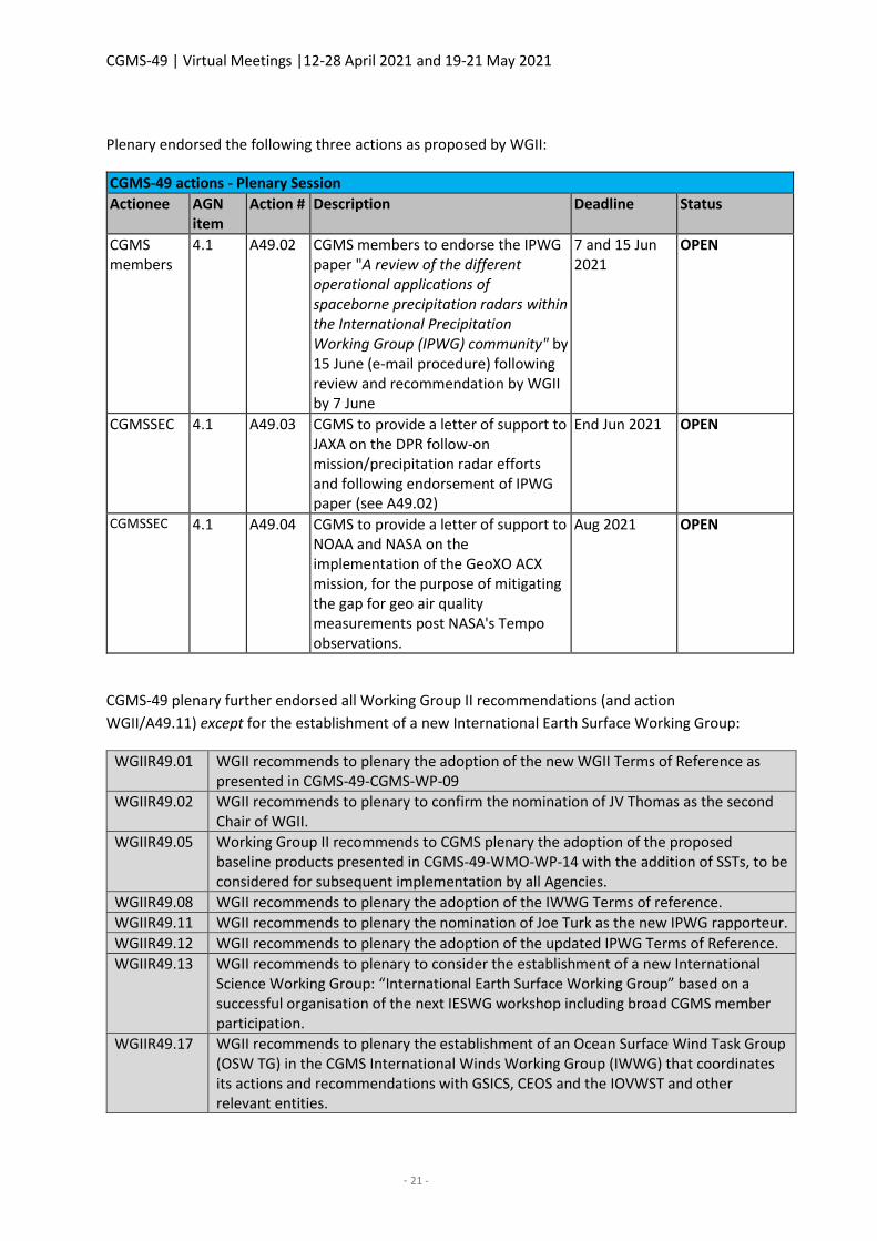
Plenary endorsed the following three actions as proposed by WGII:
CGMS-49 actions - Plenary Session
Actionee AGN item
Action # Description Deadline Status
CGMS members
4.1 A49.02 CGMS members to endorse the IPWG paper "A review of the different operational applications of spaceborne precipitation radars within the International Precipitation Working Group (IPWG) community" by 15 June (e-mail procedure) following review and recommendation by WGII by 7 June
7 and 15 Jun 2021
OPEN
CGMSSEC 4.1 A49.03 CGMS to provide a letter of support to JAXA on the DPR follow-on mission/precipitation radar efforts and following endorsement of IPWG paper (see A49.02)
End Jun 2021 OPEN
CGMSSEC 4.1 A49.04 CGMS to provide a letter of support to NOAA and NASA on the implementation of the GeoXO ACX mission, for the purpose of mitigating the gap for geo air quality measurements post NASA's Tempo observations.
Aug 2021 OPEN
CGMS-49 plenary further endorsed all Working Group II recommendations (and action
WGII/A49.11) except for the establishment of a new International Earth Surface Working Group:
WGIIR49.01 WGII recommends to plenary the adoption of the new WGII Terms of Reference as presented in CGMS-49-CGMS-WP-09
WGIIR49.02 WGII recommends to plenary to confirm the nomination of JV Thomas as the second Chair of WGII.
WGIIR49.05 Working Group II recommends to CGMS plenary the adoption of the proposed baseline products presented in CGMS-49-WMO-WP-14 with the addition of SSTs, to be considered for subsequent implementation by all Agencies.
WGIIR49.08 WGII recommends to plenary the adoption of the IWWG Terms of reference.
WGIIR49.11 WGII recommends to plenary the nomination of Joe Turk as the new IPWG rapporteur.
WGIIR49.12 WGII recommends to plenary the adoption of the updated IPWG Terms of Reference.
WGIIR49.13 WGII recommends to plenary to consider the establishment of a new International Science Working Group: “International Earth Surface Working Group” based on a successful organisation of the next IESWG workshop including broad CGMS member participation.
WGIIR49.17 WGII recommends to plenary the establishment of an Ocean Surface Wind Task Group (OSW TG) in the CGMS International Winds Working Group (IWWG) that coordinates its actions and recommendations with GSICS, CEOS and the IOVWST and other relevant entities.
CGMS-49 | Virtual Meetings |12-28 April 2021 and 19-21 May 2021
- 22 -
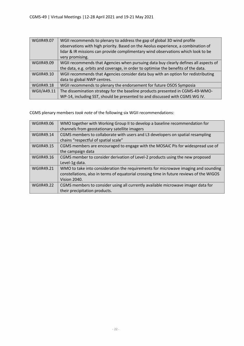
WGIIR49.07 WGII recommends to plenary to address the gap of global 3D wind profile observations with high priority. Based on the Aeolus experience, a combination of lidar & IR missions can provide complimentary wind observations which look to be very promising.
WGIIR49.09 WGII recommends that Agencies when pursuing data buy clearly defines all aspects of the data, e.g. orbits and coverage, in order to optimise the benefits of the data.
WGIIR49.10 WGII recommends that Agencies consider data buy with an option for redistributing data to global NWP centres.
WGIIR49.18 WGII recommends to plenary the endorsement for future OSOS Symposia
WGII/A49.11 The dissemination strategy for the baseline products presented in CGMS-49-WMO-WP-14, including SST, should be presented to and discussed with CGMS WG IV.
CGMS plenary members took note of the following six WGII recommendations:
WGIIR49.06 WMO together with Working Group II to develop a baseline recommendation for channels from geostationary satellite imagers
WGIIR49.14 CGMS members to collaborate with users and L3 developers on spatial resampling chains “respectful of spatial scale”
WGIIR49.15 CGMS members are encouraged to engage with the MOSAiC PIs for widespread use of the campaign data
WGIIR49.16 CGMS member to consider derivation of Level-2 products using the new proposed Level-1g data.
WGIIR49.21 WMO to take into consideration the requirements for microwave imaging and sounding constellations, also in terms of equatorial crossing time in future reviews of the WIGOS Vision 2040.
WGIIR49.22 CGMS members to consider using all currently available microwave imager data for their precipitation products.
CGMS-49 | Virtual Meetings |12-28 April 2021 and 19-21 May 2021
- 23 -
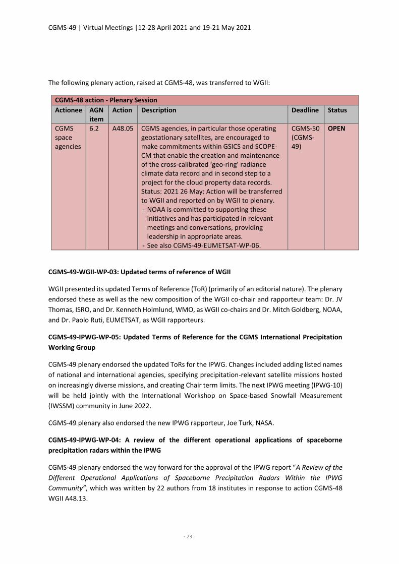
The following plenary action, raised at CGMS-48, was transferred to WGII:
CGMS-48 action - Plenary Session
Actionee AGN item
Action Description Deadline Status
CGMS space agencies
6.2 A48.05 CGMS agencies, in particular those operating geostationary satellites, are encouraged to make commitments within GSICS and SCOPE-CM that enable the creation and maintenance of the cross-calibrated ‘geo-ring’ radiance climate data record and in second step to a project for the cloud property data records. Status: 2021 26 May: Action will be transferred to WGII and reported on by WGII to plenary. - NOAA is committed to supporting these
initiatives and has participated in relevant meetings and conversations, providing leadership in appropriate areas.
- See also CGMS-49-EUMETSAT-WP-06.
CGMS-50 (CGMS-49)
OPEN
CGMS-49-WGII-WP-03: Updated terms of reference of WGII
WGII presented its updated Terms of Reference (ToR) (primarily of an editorial nature). The plenary
endorsed these as well as the new composition of the WGII co-chair and rapporteur team: Dr. JV
Thomas, ISRO, and Dr. Kenneth Holmlund, WMO, as WGII co-chairs and Dr. Mitch Goldberg, NOAA,
and Dr. Paolo Ruti, EUMETSAT, as WGII rapporteurs.
CGMS-49-IPWG-WP-05: Updated Terms of Reference for the CGMS International Precipitation
Working Group
CGMS-49 plenary endorsed the updated ToRs for the IPWG. Changes included adding listed names
of national and international agencies, specifying precipitation-relevant satellite missions hosted
on increasingly diverse missions, and creating Chair term limits. The next IPWG meeting (IPWG-10)
will be held jointly with the International Workshop on Space-based Snowfall Measurement
(IWSSM) community in June 2022.
CGMS-49 plenary also endorsed the new IPWG rapporteur, Joe Turk, NASA.
CGMS-49-IPWG-WP-04: A review of the different operational applications of spaceborne
precipitation radars within the IPWG
CGMS-49 plenary endorsed the way forward for the approval of the IPWG report “A Review of the
Different Operational Applications of Spaceborne Precipitation Radars Within the IPWG
Community”, which was written by 22 authors from 18 institutes in response to action CGMS-48
WGII A48.13.
CGMS-49 | Virtual Meetings |12-28 April 2021 and 19-21 May 2021
- 24 -
The final CGMS approval will be performed through a written (e-mail) procedure after completion
of the final WGII review by mid-June.
The report highlights three applications that need continuity of precipitation radar observations to
sustain development and/or operations:
(1) Use of precipitation radars as calibrators for precipitation retrievals from the constellation of
PMW instruments;
(2) Use of precipitation radars in NWP (model validation and data assimilation); and
(3) Use of precipitation radars as calibrators for ground radar networks. The report also includes
a recommendation section for future spaceborne precipitation radar instruments.
It was agreed that based on the final IPWG report, the CGMS Secretariat will send a letter of support
for the continuity of the precipitation radar mission to JAXA.
Concluding the discussion, plenary noted the following two actions:
CGMS-49 actions - Plenary Session
Actionee AGN item
Action Description Deadline Status
CGMS members
4.1 A49.02 CGMS members to endorse the IPWG paper "A review of the different operational applications of spaceborne precipitation radars within the International Precipitation Working Group (IPWG) community" by 29 June (e-mail procedure) following review and recommendation by WGII by 17 June
17 and 29 Jun 2021
OPEN
CGMSSEC 4.1 A49.03 CGMS to provide a letter of support to JAXA on the DPR follow-on mission/precipitation radar efforts and following endorsement of IPWG paper (see A49.02)
End Jun 2021
OPEN
CGMS-49-GUEST-WP-04: Preparations for the establishment of a new CGMS International
Science Working Group
The working paper proposed the establishment of a new CGMS International Science Working
Group (ISWG), notionally called the International Earth Surface Working Group (IESWG).
A draft set of ToR has been prepared and the objectives of the IESWG include:
CGMS-49 | Virtual Meetings |12-28 April 2021 and 19-21 May 2021
- 25 -
● Use of Earth observation (EO) data for Cryosphere and Biosphere modelling relevant to
study
processes at the land-atmosphere interactions;
● Use of EO-data for parameter optimisation including those for the land surface, vegetation,
and snow, and the resulting surface emissivity/reflectance spectra;
● Land Data Assimilation Systems (LDASs) both current state and recent developments;
sensitivity studies of surface model parameters to remotely sensed data;
● Radiative transfer and emissivity/reflectivity model development: VIS/IR/MW, review of
current parameterisation for forward modelling surface boundary; and
● Retrievals of land surface parameters: product characteristics and performances.
CGMS-49 plenary was not in a position to endorse the IESWG and requested more information on
the purpose of the working group, and in particular, the need for securing that there is no overlap
with other already existing initiatives. Plenary further tasked the IESWG and CGMS WGII members
to provide an updated proposal to CGMS-50 in 2022.
CGMS WGII will reach out to CGMS agencies to ensure broader participation for the next IESWG
meeting in April 2022 in Helsinki, Finland.
4.3 WGIII - Operational continuity and contingency planning
CGMS-49-WGIII-WP-01: Report from WGIII
Ajay Mehta, WGIII co-chair, provided the report of Working Group III (WGIII). Mr. Mehta began by noting that WGIII held the 3rd Risk Assessment Workshop in March 2021 with good participation from CGMS member agencies. The 3rd Risk Assessment Workshop focused on capturing the risk posture relative to the CGMS space agency baseline commitments.
Further, the WGIII plenary session took place virtually mid-April, followed by a joint session with WGII at the end of April.
On these occasions, WMO informed WGIII on the satellite data requirements for Global NWP, the
WMO Gap Analysis, and WMO’s efforts to update OSCAR/Space.
- WGIII analysed the satellite data requirements for Global NWP and determined that all the
”Backbone” and “Additional” sensors are covered in the CGMS baseline with the exception
of solar irradiances and some emerging sensors such as wind lidar.
- The WMO Gap Analysis resulted in 16 gap areas, and noted that most of them are
supported by the CGMS baseline, the HLPP, or open CGMS recommendations and actions
with the exception of polar ice and deep space observations.
CGMS-49 | Virtual Meetings |12-28 April 2021 and 19-21 May 2021
- 26 -
- WMO continues to maintain and evolve the technical capability of OSCAR/Space and CGMS
members are encouraged to provide accurate and timely updates to the database. WMO
continues to work to establish reliable focal points from CEOS, non-CGMS members, as well
as from commercial satellite operators to ensure completeness of OSCAR/Space.
WGIII received a report from the CGMS Socio Economic Tiger Team (SETT) noting their progress
and that the SETT Socioeconomic Pilot Study had been cancelled. Consistent with the SETT report,
WGIII recommended to the plenary that the work of the SETT can be concluded at this stage and
instead to retain an agenda item in WGIII on socioeconomic benefits with WGII to review the
scientific impact of any related studies.
The joint WGII-WGIII session looked at additional applications to include in the CGMS baseline,
including trace gases, and also under the UV and hyperspectral sounder sensors.
CGMS-49-WGIII-WP-05: CGMS risk assessment following review of the CGMS working groups
The WGIII co-chair, Ajay Mehta, provided an overview of the 3rd risk assessment undertaken
including the underlying assumptions. The focus areas of the risk assessment in 2021 included:
A long-term continuity risk for critical sensors (e. g. microwave and hyperspectral sounders and
multipurpose imagers) in the early morning orbit comes towards the end of the decade; and WGIII
identified a number of ongoing actions taken by members to address such gaps. This includes
CMA’s considerations for an FY-3E early morning orbit follow-on mission – the FY-3I.
Regarding the continuity risk for the number and geographic distribution of radio occultations,
especially in the low inclination orbits, Mr. Mehta acknowledged the earlier discussions on this
topic during both the WGIII and in plenary. He thanked the IROWG for their work, highlighted the
recommendation for CGMS members to fly RO sensors providing coverage in the low- to mid-
latitudes, and added that the WGIII plans to revisit this on the occasion of the 4th risk assessment
and CGMS baseline review.
CGMS members are also addressing the long-term continuity risk for broadband short/long wave
radiometer in the early morning orbit, and again CMA’s plans for a follow-on to FY-3E in the early
morning orbit would support this. However, WGIII took an action to consider if GEO contributions
not identified in the CGMS baseline should be included.
Regarding the lack of long-term plans for precipitation radar observations, WGIII requested that
CMA confirms its plans beyond FY-3G, and NASA and JAXA confirm their plans beyond GPM Core.
ISRO is requested to confirm its plans beyond Oceansat-3 to address the long-term continuity risk
for scatterometry in the early morning and afternoon orbits.
The biggest risks are with respect to space weather observations at L-1. The first is a gap in
coronagraph sensors in the near term until SWFO L-1 is launched in 2025. WGIII also identified risks
CGMS-49 | Virtual Meetings |12-28 April 2021 and 19-21 May 2021
- 27 -
for the energetic particle sensor, plasma analyser, and magnetometer until SWFO L-1 is launched.
To address the space weather observation requests, WGIII recommends:
SWCG to identify alternative data sources to mitigate potential unavailability of
coronagraph observations;
CGMS members to propose near-term alternative data sources for consideration as gap
mitigation in event of loss or degradation of current L1 capabilities prior to SWFO-L1 data
availability;
WGIV to consider recommended gap mitigation observation requests and develop plans to
ensure near real-time access to those data; and
SWCG to review the baseline requirements for orbital positions as opposed to number of
satellites.
Mr. Mehta highlighted the recommended new and recalled existing actions to address the risks
identified during the 3rd Risk Assessment Workshop as outlined below.
Risk assessment, recommended new actions:
- ISRO to update CGMS-50 on their plans for a hyperspectral sounder in geostationary orbit.
- CMA to confirm plans to fly a precipitation radar beyond FY-3G.
- NASA and JAXA to confirm plans to fly a precipitation radar beyond the GPM Core mission.
- EUMETSAT and ESA to report on plans for the CIMR (Copernicus Imaging Microwave
Radiometer) Mission.
- ISRO to confirm plans beyond Oceansat-3 series.
- SWCG to identify alternative data sources to mitigate potential unavailability of
coronagraph observations
- SWCG to review baseline requirements for orbital positions as opposed to number of
satellites for energetic particle observations.
Risk assessment – ongoing associated actions:
- CMA planning is underway for a follow-on to FY-3E in the early morning orbit with CMA
and WMO to establish a Tiger Team following the launch of FY-3E to assess the benefit of
the early morning orbit to support CMA’s future planning of such missions.
- NOAA and NASA to confirm plans on accommodation of a radiation budget instrument on
JPSS-3 and beyond.
- WGII/WGIII to consider whether observations from the geostationary orbit should be
added to the CGMS baseline requirements for the broadband short/long wave radiometer.
- CGMS members to continue to propose near-term alternative data sources for
consideration as a gap mitigation in the event of loss or degradation of current L1
capabilities prior to SWFO-L1 data availability;
CGMS-49 | Virtual Meetings |12-28 April 2021 and 19-21 May 2021
- 28 -
- WGIV to consider recommended gap mitigation observation requests and develop plans to
ensure near real-time access to those data.
CGMS-49-WGIII-WP-06: CGMS baseline, following CGMS working group discussions
WGIII-WP-06 presents the revised CGMS baseline for endorsement by CGMS plenary.
The WGIII co-chair, Mr. Mehta, briefly reviewed the updates to the CGMS baseline. He noted that
the baseline has a horizon of 10-12 years and includes observations needed for operations that are
made available on a full free and open basis. He noted that in addition to some editorial changes,
observations and application areas were expanded to capture support to atmospheric composition,
including specific trace gases, for the hyperspectral sounder and visible/UV spectrometer (nadir
and limb); and aerosol observations from narrow band imagers and high-resolution optical imagers.
Further, the section on Direct Broadcast Services was updated to highlight low latency objectives.
For the first time, the baseline will include CGMS member instruments to be flown on a commercial
platform when launch dates are agreed with the commercial provider, highlighting the importance
of commercial hosting as we approach a more disaggregated space segment.
EUMETSAT and NOAA endorsed the recommendations of WGIII and there were no reservations
expressed by any other CGMS members. The session Chair offered if members had specific edits to
the risk assessment or the CGMS baseline, they could submit these via email to
EUMETSAT and NOAA endorsed the nomination of Heikki Pohjola, WMO, as the rapporteur of
CGMS WGIII and there were no objections from other CGMS members.
4.4 WGIV - Data access and end user support
CGMS-49-WGIV-WP-02: Report from WGIV
WGIV presented the key issues and outcomes of the WGIV plenary session last April, which focused
on global and inter-regional data access including WMO’s Information System (WIS) and big data,
capacity building and user readiness, and cyber security and cloud services.
On data exchange: The commercial satellite broadcast system from CMA is reaching capacity limits
and is complemented by terrestrial services using high-speed networks and the internet. The
HimawariCast service by JMA is planned to optimise satellite data usage with the provision of
additional satellite derived products. NOAA’s GEONETCast Americas is still expanding and
benefitting from the migration to DVB-S2.
Presentations by IMD, IRSO, KMA, EUMETSAT, ROSHYDROMET, and CMA demonstrated that a
variety of new terrestrial data access methods are being explored and implemented for data
exchange between providers and to end users. The common goal is to provide increasing data
volumes to users at low latency, interactive, and automated. Web visualisation services using web
browsers become a standard tool following the concept of bringing the user to the data and thus
unloading the network.
CGMS-49 | Virtual Meetings |12-28 April 2021 and 19-21 May 2021
- 29 -
A gap exists in the coordination of the efforts to strengthen sustained capacity and use of EO.
Currently, multiple global networks contribute to EO capacity development. In order to close this
gap, CEOS recently endorsed the EOTEC DevNet initiation plan, which includes using a network of
networks approach between CEOS WGCapD, GEO CD-WG, CGMS VLab, WMO, and UNOOSA.
In the context of disaster service support, CMA and JMA will strengthen their capabilities, in
cooperation with CMA, JMA, and KMA. ISRO presented a web-based processing platform to better
support the International Charter on Space and Major Disasters.
In the context of user readiness for new satellite systems, NOAA presented an outlook into the
future with an Overview of GeoXO's User Engagement Process.
The VLab report highlighted that, since CGMS-48, VLab members have offered a variety of training
opportunities addressing the new generation of satellites, which continues to be the major training
need identified by VLab members. Furthermore, stronger collaboration and coordination of efforts
between VLab members resulted in increased opportunities for user training during the past year.
On a request by NOAA, WMO clarified that the VLab has two co-chairs and both were vacant.
NOAA nominated Dr. Bernadette Connell from the Cooperative Institute for Research in the
Atmosphere of Colorado State University and CMA nominated Mr. Wen Bo, from the CMA Training
Center in Beijing, for the positions of the two VLab co-chairs.
Plenary endorsed Dr. Connell as new VLab co-chair representing the CGMS space agencies, noting
that Mr. Wen Bo’s nomination shall be endorsed by WMO.
In March 2021, the first meeting of the newly created WG IV Cyber Security Expert Group was held.
The focus of the first meeting was to create and review the ToR.
The Cloud Expert Group was established in July 2020 and was formed to share cloud lessons learnt
and develop a set of best practices for each organisation to maximise interoperability. The Cloud
Expert Group has focused on agency best practices, cloud optimised data formats, and how the
group’s cloud work aligns with WIS 2.0 Strategy.
The WGIV rapporteur and the TFMI Chair roles are vacant, and WGIV members are encouraged to
nominate candidates.
4.5 IROWG-International Radio Occultation Working Group
CGMS-49-IROWG-WP-02: Key IROWG outcomes and recommendations to CGMS plenary
The paper summarises the outcome of the IROWG-8 meeting held virtually on 7-13 April 2021,
hosted by NOAA and UCAR. It covers science highlights, discussions, and community concerns.
As a result, the IROWG community raised a number of key recommendations to the CGMS plenary:
- IROWG reaffirms that all providers of radio occultation (RO) observations should classify
these as essential in the sense of WMO Resolution 40. IROWG further stresses the
CGMS-49 | Virtual Meetings |12-28 April 2021 and 19-21 May 2021
- 30 -
importance of free, timely, and unrestricted access in real time to essential RO data, and
free and unrestricted access to archived raw data including auxiliary data. (Note that this
can be updated to reflect upcoming WMO data policy changes, e. g. “essential” “core”
data, at least for the 20,000 “backbone constellation” as defined by the HLPP target);
- IROWG continues to recommend that WMO and CGMS space agencies should coordinate
any GNSS RO data purchases. Specifically, IROWG suggests convening a meeting of all
agencies considering procuring these data, in order to discuss if, how, and when the current
20,000 daily target will be met with global and full local time coverage;
- As per CGMS priority HLPP 1.1.4 (optimised system for atmospheric and ionospheric RO
observations), IROWG recommends that CGMS encourages ongoing and future GNSS RO
and non-RO missions, including potential commercial providers of RO observations, to
incorporate a complete set of ionospheric measurements;
- GNSS RFI jamming has been identified as a problem and recommended that the issue
should be addressed by CGMS (WGI) and a corresponding WGI action has been raised;
- All of the IROWG sub-groups recognised the importance of Level 0 (raw) data. Raw data
should be included in data purchase plans from commercial providers. An IROWG subgroup
will be formed to develop an exchange format for raw data;
- New RO data probe the lower troposphere better than before. An IROWG task force for
the lower troposphere will be established. RO-derived water vapour shall be further
explored as a climate variable;
- An IROWG subgroup will be formed on how best to extract profile information in the
planetary boundary layer;
- The IROWG recommends that CGMS encourages technology and retrieval developments
for improving planetary boundary layer profiling from GNSS-RO and their utilisation in NWP
data assimilation – and the further exploration of RO-derived water vapour as a climate
variable.
The IROWG stressed that Global Navigation Satellite System (GNSS) RO data with high spatial and
temporal resolution allow for unprecedented studies of atmospheric and ionospheric phenomena,
greatly improve NWP model accuracy, and help monitor climate change. The IROWG articulated
that there is a high risk of not meeting the CGMS baseline number of occultations per day after
COSMIC-2 ends its mission after 2030 or earlier. Commercial data could help fill this gap, but
challenges remain. Science highlights included the demonstration of high impact in NWP in the
lower troposphere for water vapour.
The IROWG-8 workshop minutes and the related CGMS working paper will be made available at
http://irowg.org/workshops/irowg-8/, and all IROWG-8 workshop presentations are available at
https://cpaess.ucar.edu/meetings/2021/irowg-8.
CGMS-49 | Virtual Meetings |12-28 April 2021 and 19-21 May 2021
- 31 -
CGMS-49 thanked IROWG for its work and noted that the recommendations from IROWG are
considered in the list of proposed actions/recommendations from WGII.
Further, CGMS WGIII will update the RO data availability and potential future gaps in the CGMS
baseline accordingly at the next risk assessment workshop in February 2022 (a WGIII action has
been raised accordingly).
4.6 International Winds Working Group(IWWG )
CGMS-49-IWWG-WP-02: Key IWWG outcomes and recommendations to CGMS plenary including
proposal for a Scatterometer Task Group and related ToRs
The IWWG presented its activities and recommendations to plenary since the CGMS-48 plenary
session, following the 15th IWWS on 12-16 April, and the CGMS-49 WGII meeting on 26-28 April.
Noteworthy highlights of the IWWS15 are:
• Aeolus winds (NWP impacts, validation studies, comparisons to AMVs). • NOAA stereo winds and dense optical flow. • Inter-comparison study plans with ICWG. Key areas to explore, golden day data, etc. • AMV Reprocessing within JMA, EUMETSAT. • Cloud height estimation and AMV generation with Machine Learning. • OSW error analysis and assimilation. • Use of satellite-derived winds in Numerical Weather Prediction (NWP).
The discussions resulted in a number of recommendations, all supported by WGII, for
recommendation to CGMS-49 plenary for endorsement.
Recommendation 1: For consideration by CGMS plenary the IWWG recommends space agencies
to address the gap of global 3D wind profile observations with high priority. Based on the Aeolus
experience, a combination of lidar and IR missions can provide complimentary wind observations
which look to be very promising. This is because:
o Aeolus shows significant positive impact on global NWP models as shown by ECMWF,
Météo-France, Met Office, DWD, NOAA, JMA, NCMRWF, and ECCC and is better than
expected prior to launch.
o Operational assimilation at ECMWF, Météo-France, DWD, and the Met Office.
o Strength within the entire assimilation scheme.
o Valuable as an AMV intercomparison dataset.
CGMS-49 noted that space-based lidar is addressed in the proposed revision of the HLPP.
Recommendation 2: In response to the CGMS-48 actions WGII A48.10 and plenary A48.09/A48.10,
IWWG presented the establishment of an Ocean Surface Wind Task Group (OSW TG) within the
framework of the CGMS International Winds Working Group (IWWG) that coordinates its actions
and recommendations with GSICS, CEOS, and the IOVWST.
CGMS-49 | Virtual Meetings |12-28 April 2021 and 19-21 May 2021
- 32 -
The associated related OSW TG Terms of Reference are embedded within those of the IWWG Terms
of Reference (CGMS-49-IWWG-WP-02PL), implying that any OSW TG actions and recommendation
will be reported to/from CGMS through the established IWWG mechanisms and in addition to CEOS
and IOVWST.
CGMS-49 plenary endorsed the establishment of the OSW TG with the understanding that the
IWWG reports on the progress of the OSW TG to CGMS-51 in 2023 to evaluate the activities of the
Task Group and the need for its continuity.
Recommendation 3: The IWWG presented its newly drafted Terms of Reference, including the
Terms of Reference of the Ocean Surface Winds Task Group (OSW TG), for endorsement by the
GCMS plenary.
Looking back, there have been no formal Terms of Reference since the establishment of the IWWG,
and it was therefore necessary to assure such a document exists (CGMS-49-IWWG-WP-02PL:
Revised Terms of reference for the International Winds Working Group)
CGMS-49 plenary endorsed the new IWWG Terms of Reference, and requested they be reviewed
on approximately a 5-yearly basis.
Recommendation 4: NOAA to continue operating NOAA-15, -18, and -19 as long as the sensing
instruments perform adequately and continue to produce AMVs;
CGMS-49 plenary noted the unique contributions of the remaining POES satellites due to
instrument health and their specific orbits and CGMS-49 endorsed this recommendation.
4.7 Space Weather Coordination Group (SWCG)
CGMS-49-SWCG-WP-04: Report from SWCG
Elsayed Talaat presented the SWCG Report and the status of ongoing activities. The scope of the
report covered the SWCG session as well as the joint WGI-WGIV-SWCG session.
An overview was provided of the agreed updates to the CGMS Baseline on energetic particle
monitoring as well as precision of the magnetometer commitment and definition of Sun-Earth line.
Plans for the deployment of operational services at L1 through NOAA SWFO to reduce reliance on
ageing spacecraft were highlighted. It was noted that contingency measures to mitigate a potential
gap are limited and although ISRO Aditya L1 mission (due for launch in 2022) has good potential for
coordination of data with the NOAA L1 SWFO, it is currently not planned to support operational
data latency requirements. The ESA Lagrange (L5) mission development is also proceeding well and
foreseen to embark NOAA and NASA payloads.
A white paper for the inter-calibration of energetic particle sensors in GEO is ready for presentation
to GSICS, having benefited from good cooperation and data sharing between members.
CGMS-49 | Virtual Meetings |12-28 April 2021 and 19-21 May 2021
- 33 -
Various members reported progress in deploying energetic particle sensors in GEO and LEO. ESA is
also deploying sensors as hosted payloads on commercial satellites (first is Hotbird F1, launch
2022). Preparations for deploying radiation sensors for the Lunar Gateway are ongoing.
NASA and NOAA are working under a new directive to facilitate the exchange of new observations,
models and applications between research and operations activities.
Progress is made on ensuring the correct structuring of space weather data within the WMO OSCAR
database. Further work on handling data latency commitments is ongoing.
The following points were raised in discussion:
WMO clarified that regarding the proposed new Expert Team, to continue activities previously
performed by the Inter-Programme Team on Space Weather Information, Systems and Services
(IPT SWeISS), WMO are currently drafting the related Terms of Reference, the reporting structure,
work plan, and eventual composition. WMO endorsement will be required before it can commence
work.
As for the joint WGI-WGIV-SWCG session the following points were noted:
Spacecraft anomaly reporting for the Space Weather Anomaly Database from all members is
compiled into a dedicated document, with data so far supplied by EUMETSAT and CMA. The SWCG
Task Group is making progress on defining use cases and getting historical data for analysis. Polls
will be made of members to address reasons for difficulties in supplying data to ensure the process
overcomes these points and the latter will also be extended to commercial operators.
Low latency RO provision is being improved through the COSMIC-2 mission and further measures
are in place to ensure a sub-30-minute median latency is achieved. An SWCG Task Group is also
being established to address how to meet low latency requirements through adaptions to other
existing and planned LEO missions. IROWG commented that at the recent IROWG Workshop, the
IROWG space weather subgroup raised an action to contact CGMS SWCG, in order to ensure
improved communications between the IROWG and CGMS activities and to manage any overlap
between the groups’ activities.
Potential improvements in data access are being identified as a result of interactions with the ISES
community of operational space weather prediction centres. A dedicated SWCG Task Group will
now identify pilot projects for priority implementation, with candidates including:
o Improving access to high energy particle sensor data;
o Selection of standard ionospheric RO product formats;
o Provision of metadata;
o Provision of data on GTS/WIS
There were no recommendations for endorsement raised by the SWCG.
CGMS-49 | Virtual Meetings |12-28 April 2021 and 19-21 May 2021
- 34 -
5. THEMATIC SESSION: NWP IMPACT ASSESSMENT OF SATELLITE DATA
5.1 Key notes
CGMS-49-GUEST-WP-20: The Earth-Observing Satellite Constellation, A Complex, Inter-
Connected Global System with Extensive Applications: A Review from a Meteorological
Perspective (the evolution of the observation network) – Sid Boukabara, NOAA
The global Earth-observing satellite constellation (EOSC) is a major international asset that has
developed over the past six decades with a dramatic growth in size and complexity in the recent
past. This paper takes stock and summarises, from a meteorological perspective, the current
constellation’s capabilities, highlights the complex value chain of satellite data from measurements
to decision making, and illustrates the interconnected and evolving nature of those processes.
When assessed in terms of application areas (atmosphere, oceans, land/hydrology, space weather),
the constellation is highly interdependent, robust, and the observations it provides complement
each other. EOSC is deemed a remarkable international success story that depended on effective
collaboration and coordination of international partners and on free and open exchange of critical
environmental data.
EOSC is rapidly evolving with many factors driving it, including technology, emerging data providers,
commercial sector, new capabilities, etc. In this context, EOSC optimisation to meet applications
needs (current and future) would need a concerted effort to optimise its evolution, possibly
including ground and space components. This paper offers suggestions on ways to achieve this and
on how CGMS could help in the essential coordination and in highlighting both the technical and
socio-economic benefits of EOSC.
WMO highlighted that this important presentation offered a valuable perspective on the future
Earth System Prediction and would appreciate to remain involved in further discussions.
CGMS-49-GUEST-WP-03: Future evolution of the data assimilation system – Stephen English,
ECMWF
Many requirements for global Earth System NWP could be met by the commitments and
aspirations in the CGMS baseline, the CGMS HLPP, and the Vision 2040 of WMO. The demonstrated
value of the COSMIC-2 and Spire observations in 2020 confirm the need for more GNSS data.
Duncan (2020) has demonstrated the value of microwave data from additional LEO orbits. The
Aeolus mission has demonstrated the value of wind profile data from lidar. There is a long history
of skill gains from improved atmospheric models, data assimilation, and observations.
The value of each observation needs to be determined through impact analysis studies. Mature
assimilation systems, which are increasingly coupled and run at higher resolution, use sparse and
incomplete observations better than less mature systems. Less mature systems struggle to
demonstrate the value of observations. Further, high quality observations drive increased system
maturity. Radiative transfer models and other key components of the analysis system also need to
be developed to reach a mature level.
CGMS-49 | Virtual Meetings |12-28 April 2021 and 19-21 May 2021
- 35 -
In less mature systems, effort is needed to assess the full potential of existing “interface”
observations (science) before the need for new observations can be fully assessed. The sharing of
research observations should be encouraged to accelerate the path to demonstration and maturity.
As the use of existing observations matures, some gaps may still persist, and at that stage, one can
address such gaps with new observations..
EUMETSAT noted that there is a consistency among new satellite constellations - while the previous
polar orbit satellites showed a convergence of frequencies used in measurements, recent
evolutions demonstrate that this alignment among agencies is deviating. This is a useful topic to be
discussed, especially considering the new microwave small sat constellations.
NOAA noted that in the near future dozens of new kinds of data sets are envisaged, and asked if
there is a pathway to take the new measurements into the forecasting system. In response, ECMWF
noted the importance of assimilating the Level 1 data, which makes it easier to handle such diversity
and differences as well as extending the capability of models such as RTTOV to simulate a wider
range of data (e. g. visible, active sensors).
5.2 WMO impact assessment workshop outcomes and recommendations to CGMS agencies
CGMS-49-WMO-WP-23: Outcome from the 7th Workshop on the Impact of Various Observing
Systems on NWP
The 7th WMO Workshop on the Impact of Various Observing Systems on Numerical Weather
Prediction (NWP) was organised virtually by WMO on 30 November – 3 December 2020. Some 110
participants attended including experts in data assimilation and observation impact, climate
change and seasonal forecasting, space agencies, managers of observing networks, as well as from
private industry.
During the Workshop, the results presented were reviewed in plenary discussion sessions.
Conclusions to help guide the design and evolution of components of the WIGOS for NWP were
drawn.
The impact workshop made the following recommendation relevant to CGMS:
• Space agencies to continue pursuing wind profile measurements from space;
• Effort encouraged to assess complementarities/synergies between different wind
measurement systems/technologies (e. g. Aeolus and AMV);
• Special, concerted effort should be considered to protect the MW frequencies given their
critical importance for NWP forecast skills at all scales; and
• There’s a need to sustain impact assessment studies, also for satellite data.
CGMS-49 noted that these recommendations are well addressed in the proposed revision of the
HLPP.
CGMS-49 | Virtual Meetings |12-28 April 2021 and 19-21 May 2021
- 36 -
CGMS-49-WMO-WP-20: Satellite data Requirements for Global NWP
The WMO Expert team on Space Systems and Utilization has prepared a position paper on “Satellite
Data Requirements for Global NWP”. The paper represents a user perspective on the needs for
data to ensure that global NWP models are performing at the state-of-the-art level.
During the preparation of the position paper, views from other WMO Expert Teams as well as
international expert bodies and meetings have been collected, like the Joint Expert Team on Earth
Observing System Design and Evolution, Global Data Exchange for NWP(GOIDEX-NWP), 7th
Workshop on the Impact of Various Observing Systems on NWP, and the CGMS WGII/III risk
assessment workshop.
The position paper captures a snapshot in time and will have to be reviewed and revised over time
as user requirements change. It will therefore be presented to CGMS on a regular basis, nominally
on a four-year cycle, or when significant changes to the user requirements occur. This process is
still under implementation.
The WMO Commission for Observation, Infrastructure and Information Systems decided in April
2021 to adopt the satellite data requirements for global NWP and, recognising the need for future
updates to the satellite data requirements for global NWP, to identify a mechanism to publish the
Annex of the position paper to this decision that supports future updates, and to submit it to the
next INFCOM session for consideration.
The position paper was also presented to CGMS-49 WGIII in April 2021 for consideration and
possible implications on the CGMS baseline.
Plenary took note and reiterated the need for CGMS to remain involved in the further process.
5.3 CGMS space agency NWP impact assessment updates since CGMS-48
CGMS-49-CMA-WP-14: CMA NWP impact assessment of satellite data
Dr. Zhang Peng, Deputy DG of NSMC, held a presentation titled “CMA NWP impact assessment of
satellite data” during CGMS-49 plenary. Observations from FY polar-orbiting and geostationary
satellites are assessed by CMA and the international NWP communities. Compared with the control
test, the forecast results of AGRI data are generally neutral and positive for the GRAPES assimilation
system. It is generally positive for East Asia and the Tropics, while neutral for the northern and
southern hemisphere. Assimilation of GNOS data in GRAPES produces a positive impact on global
medium range forecast. An observing system experiment shows that the FY-3 instruments jointly
contribute significantly to the forecast skill in the ECMWF system. Results from the Met Office UK
and the Swedish Meteorological and Hydrological Institute are also reported on in this
presentation.
CGMS-49-JMA-WP-02: Himawari-8/9 follow-on satellite programme and NWP impacts
assessment of hyperspectral IR sounder
CGMS-49 | Virtual Meetings |12-28 April 2021 and 19-21 May 2021
- 37 -
The Japan Meteorological Agency (JMA) has been considering the Himawari-8/9 follow-on
programme since JFY2018, keeping in mind the CGMS baseline and the Vision for WIGOS in 2040,
including in particular the deployment of hyperspectral infrared sounder (HSS) across the full GEO
ring.
In 2018, the Meteorological Operation Focusing on Science and Technology Toward 2030 was
recommended by the Meteorological Subcommittee under the Council of Transport Policy
implemented by Japan’s Ministry of Land, Infrastructure, Transport and Tourism (MLIT). The
direction was taken into account in JMA’s NWP Strategic Plan Toward 2030, which was also
established in 2018 to promote strong and steady technical development in the area of NWP as
part of social information infrastructure in disaster prevention and related fields. A Hyper Spectral
Sounding instrument on a geostationary satellite (GeoHSS) is expected to play an important role to
meet the goals in the strategy.
To consolidate the potential impacts of GeoHSS on the NWPs which were derived in the previous
study, reanalysis-based OSSEs were conducted for the typhoon and heavy rainfall events using
GDAS and RDAS. GeoHSS data with high frequency over wide area improved both synoptic and
meso scale atmospheric state, and this leads to significant improvements of typhoon track and
heavy rainfall location forecasts with a long lead-time. Even though the demonstrated results in
this study have yet to reach the goals of the JMA’s NWP Strategic Plan Toward 2030, a full utilisation
of real GeoHSS observation data with higher spatial resolution in the upgraded future NWP models
might play a critical role for achieving them.
In response to questions from EUMETSAT and NOAA, JMA explained that the GeoHSS would have
a 30 km spatial and 1-hourly temporal resolution. JMA expects to take the decision on this mission
within two years’ time with financial decisions to be taken by JFY2023.
CGMS-49-NOAA-WP-18: NOAA’s space-based commercial data activities
NOAA issued its first contracts for the purchase of commercial RO data for operational use in
November 2020. The two-year indefinite delivery indefinite quantity contracts went to GeoOptics
and Spire Global, and NOAA has issued two delivery orders to date under these contracts. NOAA
plans to begin operational use of the purchased data in May 2021 following data evaluation and
system readiness. NOAA will be evaluating the impact of the data purchased under the second
delivery order. The administration continues its Commercial Weather Data Pilot (CWDP)
programme and a Request for Information (RFI) to inform future pilots was issued in September
2020. NOAA is currently evaluating responses to this RFI and is planning to pursue a third pilot
under the CWDP programme in FY 2022.
The IROWG co-chair noted that geographic coverage and local time availability of RO data was
presented during the IROWG presentation. When the impact of data purchased is assessed, this
should be taken into consideration. The impact should in principle be higher when the purchased
data belong to a data sparse geographic region and local time zone.
ECMWF highlighted the need for using both commercial and non-commercial RO data in
operational reanalysis products, that in turn are used freely by a wide community for any purpose.
CGMS-49 | Virtual Meetings |12-28 April 2021 and 19-21 May 2021
- 38 -
NOAA indicated that their procured data are open for all users after 24 hours from data purchase
with the only restriction that the data cannot be used for commercial purposes as per its agreement
with the provider of commercial radio occultation data.
CGMS plenary noted the importance and opportunity to exploit these data for the purpose of
reanalysis and in the context of climate change analyses.
CGMS-49-CGMS-WP-30: NWP impact assessment of satellite data: guiding questions
In wrapping up the session, the discussions focused on three topics, namely the impact of NWP in
view of the new constellations planned; the need for collecting users’ experience and cases towards
a harmonised development of future missions; and the use and application of Artificial
Intelligence/Machine Learning (AI/ML) as accelerators for NWP uptake of new observations.
Regarding consistency among new satellite constellations: While the previous polar orbit satellites
showed a convergence of frequencies used in measurements, recent evolutions demonstrated that
this alignment among agencies is a bit out of focus. This would be a useful topic to be considered
in future CGMS meetings especially considering the new microwave small sat constellations.
As concerns collecting users’ experience and case studies: NOAA has developed a series of user
consultation workshops/studies for the new geostationary and polar systems. EUMETSAT will
organise these for future missions. At the same time, the CGMS agencies are working on proof of
concept analyses for small-sat microwave constellations. An effective approach would call for a
CGMS collection of users’ experience and a coordination of new proofs of concepts to avoid
reinventing the wheel (to be coordinated within the framework of CGMS WGIII).
Further, several agencies already demonstrated advanced plans (ie NOAA, CMA) and applications
of AI/ML applications to satellite products. CGMS represents an important forum for exchange of
information and coordination when it comes to L1 and L2 products (ie validation, verification of
methods).
6. SUPPORT TO OPERATIONAL CLIMATE AND GREENHOUSE GAS MONITORING
6.1 GCOS, GCOS IP, study group and conference announcement
CGMS-49-WMO-WP-21: Joint Study Group on the Global Climate Observing System - Interim
report on the GCOS evolution
WMO presented the status of activities of the Joint Study Group on GCOS. Since its establishment
in 1992, GCOS has operated for more than two decades. However, the associated MoU has
however not been updated since 1998 and therefore there is a need to review the role and
responsibilities of GCOS, the governance, and the role of the co-sponsors also taking into account
the WMO reform and the increased need for climate observations. The Study Group will review the
GCOS governance and structure and propose an optimal approach recognising GCOS as an activity
across the WMO Commissions and Research Board. In addition, relevant programmes of IOC, ISC,
and UNEP - recognising the need for strengthening inter-agency links with appropriate
representation - will be taken into account.
CGMS-49 | Virtual Meetings |12-28 April 2021 and 19-21 May 2021
- 39 -
The Study Group membership ensures an appropriate engagement across beneficiaries, users,
stakeholder programmes, and space agencies. An interim report has been produced compiling the
findings of the sub-teams, has been presented to the WMO Infrastructure Commission in April
2021, and is being discussed with the GCOS co-sponsors.
The next phase of activities will clarify the roles of the GCOS sponsors and other types of GCOS
support functions, it will look at the involvement of GCOS in the overall observing system,
engagement with funding organisations, agencies and climate science programmes such as WCRP,
and improve the connection between GCOS and UNFCCC.
It is important to ensure that the needs of the space agencies are covered and, in conclusion, the
following four questions were raised to CGMS plenary:
1) Are the agencies happy with the GCOS governance?
2) What role should CGMS have in GCOS (if any)?
3) What are the agency expectations from GCOS?
4) How could the agencies consider supporting GCOS?
NOAA noted they endorse the work of the Study Group and that they have been actively supporting
the work. NOAA is looking forward to further clarifications and delineation of the questions raised
above. The Study Group is addressing these issues and NOAA appreciates the opportunity to
participate.
WMO thanked NOAA for their active engagement and support to the GCOS Secretariat as well.
EUMETSAT also supports the work of this Joint Study Group and it would be important to discuss
and clarify the role of the co-sponsors. GCOS remains the source for the requirements for various
users and this needs to be recognised and not forgotten.
The European Commission also noted that it is important to identify how those that are
contributing to the trust fund can give guidance for future activities because they see value in what
GCOS is providing. This is valid both for the provision of support to programmes and to the
framework for collaboration.
WMO responded that this is recognised and taken into consideration by the Study Group, noting
the importance of scientific independence of GCOS and the provision of adequate products.
NASA noted the importance of the role of the sponsors and that sponsors actually contribute and
guide [direct] the work of the GCOS. Further, NASA underlined that it should be also noted that
there are various types of support, not only direct support to the trust fund, but also to the
activities, e. g. supporting the organisation of meetings, providing observations etc.
WMO confirmed the importance of recognising the different types of support, including the
provision of observations.
CGMS-49 | Virtual Meetings |12-28 April 2021 and 19-21 May 2021
- 40 -
CGMS-49-WMO-WP-01: GCOS status report
GCOS informed CGMS plenary that the ECV stewards have monitored and reported on the status
of their respective ECVs for the GCOS Status Report. The status report itself is at a fairly high level
and the details are given in the annexes. It has been out for public review and is now under
consolidation. The report focuses on the adequacy of the ECVs with respect to the key cycles water,
energy, and carbon. It further analyses the adequacy of the ECVs with regard to the three main
domains: atmosphere, ocean, and terrestrial, and gives an overview of the space component. The
main highlights of the observing system since 2016 include improvements in satellite data, type,
quality, and temporal and spatial resolution. Satellite data are generally well accessible and
curated, which is not necessarily true for the other components of the observing system. There
have been improvements in the in-situ observations, however, there is scope for improvement for
some ECVs. Further, GCOS is propagating the establishment of reference networks for in-situ
observations. One of the ongoing tasks involves developing a GCOS reference network and
improvement/definition of global climate data centres.
A number of specific findings regarding satellite data were pointed out:
- Long-term continuity of some satellite observations are not assured;
- There are some gaps in the satellite-based observations, e. g. lower tropospheric ozone
and stratospheric methane globally; and
- Quantitative assessment of anthropogenic greenhouse gas fluxes for which more
supportive observations from satellites are needed.
The presentation also gave an overview on some of the shortcomings in the in-situ observations.
In particular, it was noted that not all data are well archived or stewarded.
It was further noted that the status report is an important input to the next implementation plan
and that GCOS is preparing its input for the next global stocktake.
The GCOS/WCRP Climate Conference will be held online from 30 August – 3 September 2021. GCOS
encourages space agency contributions to the conference in order also to facilitate broader input
for the next implementation plan.
NASA noted that the term “operational” is difficult in their case with respect to funding. This is
generally the case for R&D agencies. That said, some of the so-called research networks have been
around for a long time, 30 years or more, so they are not only of a short-term nature.
GCOS noted this is understood, and the question is indeed related to some research networks
where the funding is short-term. This should be clear in the report.
WMO emphasised the importance of reference networks for supporting cal/val of satellite systems
in addition to providing independent observations.
NOAA noted that “sustained funding” would be more appropriate than “operational funding”.
NOAA further noted that in-situ and satellite observations are two halves of the same issue and it
CGMS-49 | Virtual Meetings |12-28 April 2021 and 19-21 May 2021
- 41 -
is important to look at the connections and identify where the critical breakages are between the
two e. g. for calibration or validation, impacting the other observation type.
The connectivity is essential and NOAA asked if GCOS considered this. NOAA further noted that a
weakness in one can be compensated through capabilities in the other, an important factor when
aiming at assuring the best value of the investment. GCOS responded that it is already considering
this in the status report. This will likely be more addressed in the implementation plan noting that
satellite observations will become more critical for the ECVs and the in-situ will increasingly be for
providing a calibration/validation input.
6.2 CEOS/CGMS Joint Working Group on Climate, and Greenhouse Gas activities
CGMS-49-WGII-WP-02 Agency highlights on GHG initiatives at the CGMS-49 WGII meeting
The WGII rapporteur gave an overview of the GHG monitoring session in Working Group II.
CMA/CNSA, JAXA, Roshydromet, and NASA gave an overview of their current activities and the
main focus was on the current status of products and missions. Furthermore, the presentations
gave a forward look towards improving GHG monitoring from space. Several important missions
were highlighted including EU Copernicus CO2M, JAXA GOSAT-GW, NASA GeoCarb, CNES
MicroCarb, US MethaneSat, CNES-DLR Merlin, and the private sector GHGSat. The presentation
further highlighted the synergies between different observing systems and auxiliary observations
as well as the importance of ground facilities and additional initiatives like GSICS. The key points
raised were:
- Value of international coordination across CGMS and CEOS;
- Strong integration between EO and data assimilation systems;
- Long term continuity of geostationary GHG monitoring capabilities; and
- Enhanced coordination towards Global Greenhouse Gas Reference Networks.
On the long-term continuity of geostationary GHG monitoring capabilities, it was noted that the
capabilities had been discussed at the CGMS-49 joint WGII and WGIII meeting and there is also an
associated recommendation from WGII on a letter of support to NOAA for the continuity for air
quality GHG monitoring from GEO as a follow-on of NASA’s future Tempo mission.
After the presentation, NASA noted there are many other initiatives that provide important
contributions e. g. the CarbonMapper. ESA also noted the value of the TROPOMI instrument on the
Sentinel-5p satellite.
CGMS-49-JWGCLIM-WP-01: WG Climate status report including gap analysis report and action
plan for endorsement by plenary
The population of the ECV inventory is continuously progressing. The version 4.0 will be
consolidated in the second half of 2021. The gap analysis related to inventory version 3.0 is delayed
due to the pandemic situation but will be completed by autumn 2021. The gap analysis for
inventory version 4.0 will focus on the carbon cycle, including the global stocktake aspect. This gap
analysis is planned to be carried out through a workshop at the end of 2021/beginning of 2022,
CGMS-49 | Virtual Meetings |12-28 April 2021 and 19-21 May 2021
- 42 -
preferably face-to-face circumstances permitting. JWGClimate invited CGMS space agencies to
nominate scientific experts for participation in the workshop.
The collection of use cases for Climate Data Records is a new and continuous activity of the
JWGClimate in order to i) demonstrate the value of the Climate Data Records for applications and
decision/policy making etc., and ii) provide feedback for quality improvements. All use cases will
be published on the web (climatemonitoring.info), and a special WMO report is planned for 2022
with a selection of the diverse types of use cases. To identify and collect more use cases from the
broader user community, CGMS member agencies are requested to proactively reach out and
advertise this activity within their respective data user communities.
The greenhouse gas monitoring activities continue and the CGMS WGI to WGIV have nominated
points of contact to support the implementation of a virtual operational GHG monitoring and
verification constellation (S. Burns for WGI&IV, J. Privette for WGII, and P. Zhang for WGIII). These
CGMS WGs will support the update of the GHG monitoring roadmap and its implementation.
In preparation of the COP-26, JWGClimate is drafting a statement on behalf of CGMS and CEOS.
CGMS agencies will be requested to comment on the draft statement at the end of August and to
approve it in September. The statement will be posted via the national delegation of the CEOS Chair
(NASA) to the COP-26 during the SBSTA-52 opening session.
The Earth Information Day (EID) takes place in addition to the COP meetings. Although the COP
meeting was cancelled, the JWGClimate participated in the virtual EID 2020. The JWGClimate
participated in the panel on mitigation and contributed with three posters demonstrating an
excellent participation.
During the CGMS WGII session, WGII encouraged the JWGClimate to have a closer link to the CGMS
International Science Working Groups. Representatives from IPWG, IWWG, IROWG, ITWG, and
ICWG are now included on the JWGClimate communication list and will be invited to joint sessions
during future JWGClimate meetings as necessary.
JWGClimate further addressed the link to the GCOS requirements, and explained it had addressed
differentiating ECV requirements for application cases. The relation to GCOS requirements was
brought to attention during discussion. JWGClimate explained its exchange with GCOS on
differentiating ECV requirements related to the application case. Additionally, there is an
investigation ongoing at EUMETSAT on how to map such specific requirements. It is noted that such
a detailed degree of formulating requirements is a challenging demand for the GCOS Secretariat
which may exceed its resources.
Finally, the presentation noted the following key issues for CGMS:
- The ECV inventory gap analysis support for the upcoming cycle (end 2021/beginning 2022);
- Encouraged further contributions of use cases for Climate Data Records;
- That the COP 26/SBTSA statement of space agencies is under preparation and a draft will
be circulated in late summer;
- The HLPP has been updated demonstrating the actual status (slight changes);
CGMS-49 | Virtual Meetings |12-28 April 2021 and 19-21 May 2021
- 43 -
- Recalled CGMS-47 Action 47.14 and proposed the following new action: “CGMS members
shall nominate scientific experts (not necessarily agency staff) in order to support the
upcoming ECV inventory gap analysis with respect to the Carbon Cycle ECVs, including
Global Stocktake aspects.”
WGII raised the need for the translation of the GCOS technology-neutral requirements to space
based observation requirements. JWGClimate noted that it had raised to GCOS the need for
dedicated ECV requirements per climate application cases, but also in establishing links to the
space-based observations. Additionally, there is an investigation ongoing at EUMETSAT on how to
map such specific requirements. It was noted that such a detailed degree of formulating
requirements is a challenging demand for the GCOS Secretariat which may exceed its resources.
The EC provided an example for the need for application-oriented requirements: the need to
monitor the CO2 concentration in the atmosphere over long times, whilst nevertheless detecting
emission hotspots. Both types of observations are needed in the context of the Paris Agreement
but has very different requirements which needs to be reflected in the GCOS Implementation Plan.
Recent discussions in the GCOS study group identified that this is a major task and not likely to be
executed by GCOS and its science panels alone. Thus, it is important to develop a framework and
gross standards that enable other organisations such as WCRP, CEOS, and GEO to support the
development of useful requirements that can become part of the periodically updated GCOS
Implementation Plan. In support of GCOS, and within the framework of the JWGClimate,
EUMETSAT is currently establishing such a framework and gross standards. This includes examples
for some ECVs on how requirements can be derived for different applications.
Finally, it was fully recognised that CMA is now contributing to the ECV inventory V4.
CGMS-49 actions - Plenary Session
Actionee AGN item Action Description Deadline Status
CGMS Members
6 A49.05 CGMS members to nominate scientific experts (not necessarily agency staff) in order to support the upcoming ECV inventory gap analysis with respect to the Carbon Cycle ECVs, including Global Stocktake aspects.
Aug 2021
OPEN
The following open action was also recalled:
CGMS-48 actions - Plenary Session
Actionee AGN item
Action Description Deadline Status
CGMS members
8.2 A47.11 Climate session: CGMS members to endorse (through a written procedure) the ECV inventory gap analysis report and updated coordinated action plan
Dec 2021 (Oct 2019)
ONGOING
CGMS-49 | Virtual Meetings |12-28 April 2021 and 19-21 May 2021
- 44 -
CGMS-48 actions - Plenary Session
Actionee AGN item
Action Description Deadline Status
Status: 2021 16 May: Version 3.0 expected to be published end 2021 and will be endorsed via written/e-mail procedure. (Version 4.0 is under preparation, CGMS-49-JWGCLIM-WP-01 and CGMS-49-JWGCLIM-WP-03)
CGMS-49-JWGCLIM-WP-02: Status of architecture for monitoring carbon dioxide and methane
from space and GHG Task Team activities
Within the framework of the JWGClimate, the GHG Task Team’s activities include contributions
from a vast range of colleagues. Recently, the CEOS Virtual Constellation on Atmospheric
Composition has taken on the lead of the preparation of the products required for the support of
the first global stocktake of the Paris Agreement. The GHG Monitoring Implementation Roadmap
includes activities that map out to other activities within CEOS and CGMS e. g. CEOS virtual
constellations, CGMS WGs and GSICS, in other words a truly collaborate approach.
Three main points were raised:
- Work towards the global stocktakes of the Paris Agreement;
- Work organised towards the future operational GHG system to deliver first outputs for the
second global stocktake in 2026/2027; and
- Engagement with CGMS for contributions to enable and maintain an operational system.
The CEOS/CGMS WGClimate Greenhouse Gas Task Team coordinates efforts among member
agencies. The objectives of the GHG roadmap are to:
1. Work with the atmospheric CO2 and CH4 measurement and modelling communities,
stakeholders and national inventory compilers to define requirements and plans for
atmospheric flux inventories;
2. Deliver pilot atmospheric CO2 and CH4 flux inventories in 2021 to inform the 2023 Global
Stocktake (GST);
3. Use lessons learnt from these pilot inventory products to refine requirements needed to
implement a purpose-built, operational, and atmospheric inventory system for future
global stocktakes.
For the 2023 GST, mostly research products will be provided noting that the quality of today’s top-
down inventories is limited by available space-based measurements and inverse models. Hence, it
is important to take a holistic view of the analysis. It is important to identify the requirements and
products as the overall system requires specific kinds of observations, noting that inventory
quantities are derived from surface flux products.
CGMS-49 | Virtual Meetings |12-28 April 2021 and 19-21 May 2021
- 45 -
The concept for generating carbon emission inventories is based on an overall system including
ground- and space-based observations assimilated in circulation models. Specifically, it is important
to establish an interface to the user community and inventory providers (mostly statistical national
entities that provide carbon emission data from fossil fuel burning per country). It is important to
demonstrate the mutual benefits of the traditional bottom-up inventory assessments and the top-
down assessments using space-based observations, e. g. on their validation, and ensure feedback
on prototype products. The GHG TT will also looking towards an operational implementation by
the Stocktake in 2028 and beyond and this is where CGMS contributions will become extremely
valuable.
The GHG Task Team will maintain the Roadmap and establish user interfaces, track requirements,
capabilities and deliverables, and identify additional resource needs and relevant CEOS/CGMS
agencies to dedicated, appropriate resources. The GHG TT has broad Agency participation, not only
space agencies, but also representatives from the ground-based observations and modelling
communities. The Task team has also established interfaces to the CGMS Working groups and is in
the process of detailing the potential areas where the CGMS WGs can contribute.
CGMS plenary took note.
The following open actions were also recalled:
CGMS-48 actions - Plenary Session
Actionee
AGN item
Action Description Deadline Status
Chairs of WGClimate/GHG TT
6.2 A48.07 WGClimate/GHG TT Chair together with the CGMS WG representatives to define priorities for CGMS WGI-IV contributions. Status: 2021 May 19: Partially complete. Each CGMS WG has nominated a liaison who will be invited to participate in future WGClimate meetings. Before and during the next WGClimate meeting (August/September), WGClimate will work with these representatives on priorities.
CGMS-50 (Nov 2020)
ONGOING
Co-chairs of WGI, WGII, WGIII, WGIV
6.2 A48.08 CGMS WGs I-IV to reflect the operationalisation of the GHG monitoring system and to discuss with the WGClimate GHG Task Team the roles of each WG for the implementation that becomes part of the roadmap’s work plan (deadline CGMS-49 plenary to serve as input for next WGClimate presentation) Status: 2021 21 May: To be addressed at the next GHG TT meeting
CGMS-50 (CGMS-49)
OPEN
CGMS-49 | Virtual Meetings |12-28 April 2021 and 19-21 May 2021
- 46 -
7. CGMS HIGH LEVEL PRIORITY PLAN (HLPP)
Endorsement of the CGMS High Level Priority Plan (HLPP) 2020-2024
CGMS-49-CGMS-WP-15: Revised HLPP 2021-2025 - for plenary endorsement
As part of the agreed revision cycle for the CGMS HLPP, CGMS-WP-15 presented a proposed HLPP
covering the period 2021-25. The plan is based on the following intersessional activities:
- Meetings of the International Science Working Groups
- Recommendations from of WGI, WGII, WGIII, WGIV, SWCG, and JWGClimate
WGI, WGII, WGIII, WGIV, and SWCG considered the draft revision at the WG meetings in April 2021
and proposed a number of amendments, all highlighted in this document.
The CGMS-49 plenary session endorsed the proposal for a revised HLPP covering the period 2021-
25.
Following CGMS-49, a final version of the updated HLPP will be published on the CGMS website.
8. FUTURE CGMS PLENARY SESSIONS
CGMS-49-CGMS-WP-23: Future running of CGMS plenary sessions
The CGMS Secretariat informed plenary on the lessons learnt on holding virtual plenary sessions
and there were at least three main findings:
i) On the positive side: Increased participation (numbers of participants) and lower cost (no
travel necessary);
ii) Drawbacks: The timing of the meeting – very late for the Asia/Asia Pacific region and very early
for the American region; and
iii) Generally for the future: Requests for hybrid meetings.
As for the last point, this has been the case for a few years also prior to the pandemic (WebEx
access during the face-to-face meeting) which is expected to continue.
The CGMS Secretariat will send out a post-plenary survey to complement the feedback.
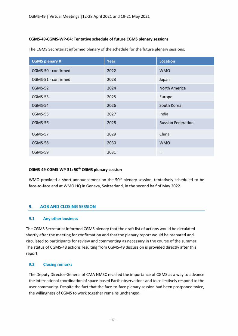
CGMS-49 | Virtual Meetings |12-28 April 2021 and 19-21 May 2021
- 47 -
CGMS-49-CGMS-WP-04: Tentative schedule of future CGMS plenary sessions
The CGMS Secretariat informed plenary of the schedule for the future plenary sessions:
CGMS plenary # Year Location
CGMS-50 - confirmed 2022 WMO
CGMS-51 - confirmed 2023 Japan
CGMS-52 2024 North America
CGMS-53 2025 Europe
CGMS-54 2026 South Korea
CGMS-55 2027 India
CGMS-56 2028 Russian Federation
CGMS-57 2029 China
CGMS-58 2030 WMO
CGMS-59 2031 …
CGMS-49-CGMS-WP-31: 50th CGMS plenary session
WMO provided a short announcement on the 50th plenary session, tentatively scheduled to be
face-to-face and at WMO HQ in Geneva, Switzerland, in the second half of May 2022.
9. AOB AND CLOSING SESSION
9.1 Any other business
The CGMS Secretariat informed CGMS plenary that the draft list of actions would be circulated
shortly after the meeting for confirmation and that the plenary report would be prepared and
circulated to participants for review and commenting as necessary in the course of the summer.
The status of CGMS-48 actions resulting from CGMS-49 discussion is provided directly after this
report.
9.2 Closing remarks
The Deputy Director-General of CMA NMSC recalled the importance of CGMS as a way to advance
the international coordination of space-based Earth observations and to collectively respond to the
user community. Despite the fact that the face-to-face plenary session had been postponed twice,
the willingness of CGMS to work together remains unchanged.
CGMS-49 | Virtual Meetings |12-28 April 2021 and 19-21 May 2021
- 48 -
He expected that CGMS will continue to coordinate and improve the meteorological satellite
constellation in order to better meet the user requirements.
CMA concluded by thanking all the participants, for their active contributions and the achievements
made and concluded by sincerely hoping for a face-to-face meeting in 2022.
The Head of the CGMS Secretariat thanked the CGMS members, the host CMA, the participants,
and the organising committee for their contributions to the 49th CGMS plenary session. Although a
remote configuration is not ideal, CGMS has discussed a broad range of topics of importance to
WMO and the space agencies, some for which the participants have taken decisions and adopted
recommendations, some of which need further addressing. It shows that the CGMS mechanisms
are alive and that the interactions between the Working Groups and plenary are working well. He
stated he was impressed by the broad support from all CGMS members to the various CGMS
groups.
He recalled the 7th WMO Impact Workshop of Various Observing Systems on NWP which further
highlighted the importance of satellite observations to guarantee high quality predictions and
downstream applications and the GHG session highlighted how CGMS might collectively respond
to the observation needs of the Paris Agreement. Moving towards an Earth system approach will
further require international coordination on how optimally to evolve and design space-based
Earth observations given the diversity of applications and systems.
He looked forward to interacting with CGMS and, circumstance permitting, to meet face-to-face
at CGMS-50 in Geneva next year.
Plenary adjourned at 16:10 on 21 May 2021.
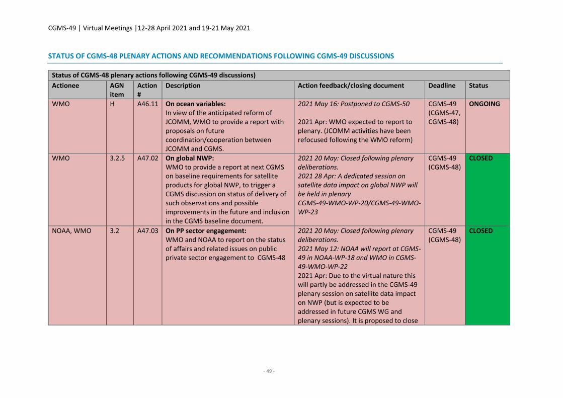
CGMS-49 | Virtual Meetings |12-28 April 2021 and 19-21 May 2021
- 49 -
STATUS OF CGMS-48 PLENARY ACTIONS AND RECOMMENDATIONS FOLLOWING CGMS-49 DISCUSSIONS
Status of CGMS-48 plenary actions following CGMS-49 discussions)
Actionee AGN item
Action #
Description Action feedback/closing document Deadline Status
WMO H A46.11 On ocean variables: In view of the anticipated reform of JCOMM, WMO to provide a report with proposals on future coordination/cooperation between JCOMM and CGMS.
2021 May 16: Postponed to CGMS-50 2021 Apr: WMO expected to report to plenary. (JCOMM activities have been refocused following the WMO reform)
CGMS-49 (CGMS-47, CGMS-48)
ONGOING
WMO 3.2.5 A47.02 On global NWP: WMO to provide a report at next CGMS on baseline requirements for satellite products for global NWP, to trigger a CGMS discussion on status of delivery of such observations and possible improvements in the future and inclusion in the CGMS baseline document.
2021 20 May: Closed following plenary deliberations. 2021 28 Apr: A dedicated session on satellite data impact on global NWP will be held in plenary CGMS-49-WMO-WP-20/CGMS-49-WMO-WP-23
CGMS-49 (CGMS-48)
CLOSED
NOAA, WMO 3.2 A47.03 On PP sector engagement: WMO and NOAA to report on the status of affairs and related issues on public private sector engagement to CGMS-48
2021 20 May: Closed following plenary deliberations. 2021 May 12: NOAA will report at CGMS-49 in NOAA-WP-18 and WMO in CGMS-49-WMO-WP-22 2021 Apr: Due to the virtual nature this will partly be addressed in the CGMS-49 plenary session on satellite data impact on NWP (but is expected to be addressed in future CGMS WG and plenary sessions). It is proposed to close
CGMS-49 (CGMS-48)
CLOSED
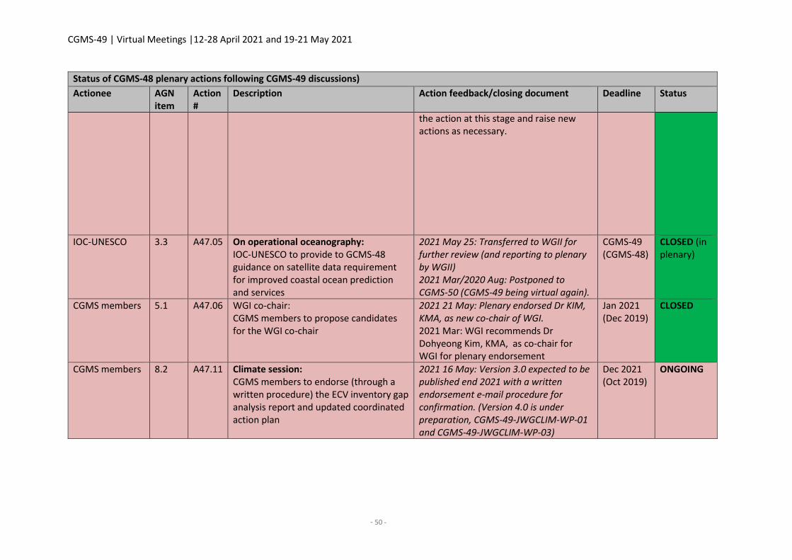
CGMS-49 | Virtual Meetings |12-28 April 2021 and 19-21 May 2021
- 50 -
Status of CGMS-48 plenary actions following CGMS-49 discussions)
Actionee AGN item
Action #
Description Action feedback/closing document Deadline Status
the action at this stage and raise new actions as necessary.
IOC-UNESCO 3.3 A47.05 On operational oceanography: IOC-UNESCO to provide to GCMS-48 guidance on satellite data requirement for improved coastal ocean prediction and services
2021 May 25: Transferred to WGII for further review (and reporting to plenary by WGII) 2021 Mar/2020 Aug: Postponed to CGMS-50 (CGMS-49 being virtual again).
CGMS-49 (CGMS-48)
CLOSED (in plenary)
CGMS members 5.1 A47.06 WGI co-chair: CGMS members to propose candidates for the WGI co-chair
2021 21 May: Plenary endorsed Dr KIM, KMA, as new co-chair of WGI. 2021 Mar: WGI recommends Dr Dohyeong Kim, KMA, as co-chair for WGI for plenary endorsement
Jan 2021 (Dec 2019)
CLOSED
CGMS members 8.2 A47.11 Climate session: CGMS members to endorse (through a written procedure) the ECV inventory gap analysis report and updated coordinated action plan
2021 16 May: Version 3.0 expected to be published end 2021 with a written endorsement e-mail procedure for confirmation. (Version 4.0 is under preparation, CGMS-49-JWGCLIM-WP-01 and CGMS-49-JWGCLIM-WP-03)
Dec 2021 (Oct 2019)
ONGOING
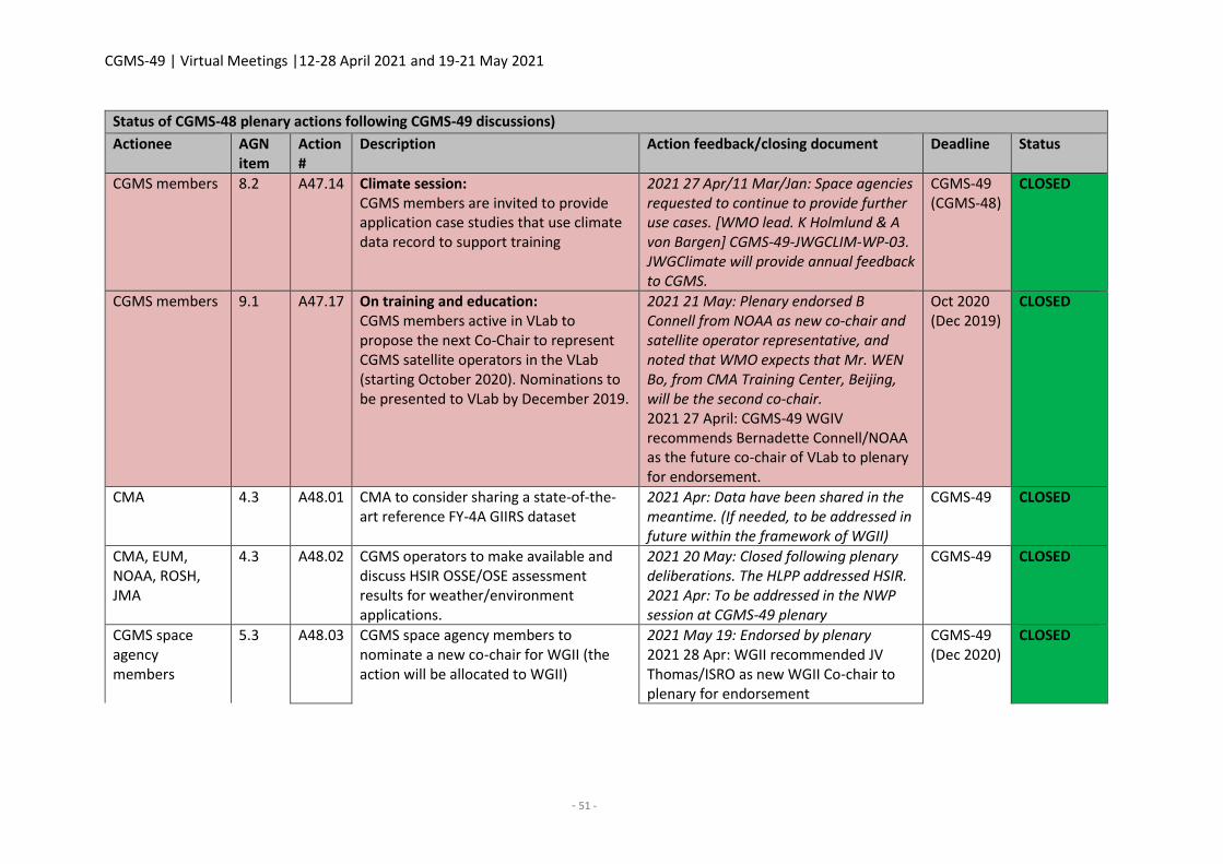
CGMS-49 | Virtual Meetings |12-28 April 2021 and 19-21 May 2021
- 51 -
Status of CGMS-48 plenary actions following CGMS-49 discussions)
Actionee AGN item
Action #
Description Action feedback/closing document Deadline Status
CGMS members 8.2 A47.14 Climate session: CGMS members are invited to provide application case studies that use climate data record to support training
2021 27 Apr/11 Mar/Jan: Space agencies requested to continue to provide further use cases. [WMO lead. K Holmlund & A von Bargen] CGMS-49-JWGCLIM-WP-03. JWGClimate will provide annual feedback to CGMS.
CGMS-49 (CGMS-48)
CLOSED
CGMS members 9.1 A47.17 On training and education: CGMS members active in VLab to propose the next Co‐Chair to represent CGMS satellite operators in the VLab (starting October 2020). Nominations to be presented to VLab by December 2019.
2021 21 May: Plenary endorsed B Connell from NOAA as new co-chair and satellite operator representative, and noted that WMO expects that Mr. WEN Bo, from CMA Training Center, Beijing, will be the second co-chair. 2021 27 April: CGMS-49 WGIV recommends Bernadette Connell/NOAA as the future co-chair of VLab to plenary for endorsement.
Oct 2020 (Dec 2019)
CLOSED
CMA 4.3 A48.01 CMA to consider sharing a state-of-the-art reference FY-4A GIIRS dataset
2021 Apr: Data have been shared in the meantime. (If needed, to be addressed in future within the framework of WGII)
CGMS-49 CLOSED
CMA, EUM, NOAA, ROSH, JMA
4.3 A48.02 CGMS operators to make available and discuss HSIR OSSE/OSE assessment results for weather/environment applications.
2021 20 May: Closed following plenary deliberations. The HLPP addressed HSIR. 2021 Apr: To be addressed in the NWP session at CGMS-49 plenary
CGMS-49 CLOSED
CGMS space agency members
5.3 A48.03 CGMS space agency members to nominate a new co-chair for WGII (the action will be allocated to WGII)
2021 May 19: Endorsed by plenary 2021 28 Apr: WGII recommended JV Thomas/ISRO as new WGII Co-chair to plenary for endorsement
CGMS-49 (Dec 2020)
CLOSED
CGMS-49 | Virtual Meetings |12-28 April 2021 and 19-21 May 2021
- 52 -
Status of CGMS-48 plenary actions following CGMS-49 discussions)
Actionee AGN item
Action #
Description Action feedback/closing document Deadline Status
EUM 5.3 A48.04 EUMETSAT to nominate a new rapporteur for WGII (the action will be allocated to WGII)
2021 19 May: Endorsed by plenary 2021 28 Apr: WGII recommends Paolo Ruti/EUMETSAT as new WGII rapporteur to plenary for endorsement
CGMS-49 (Dec 2020)
CLOSED
CGMS space agencies
6.2 A48.05 CGMS agencies, in particular those operating geostationary satellites, are encouraged to make commitments within GSICS and SCOPE-CM that enable the creation and maintenance of the cross-calibrated ‘geo-ring’ radiance climate data record and in second step to a project for the cloud property data records.
2021 26 May: Action will be transferred to WGII and reported on by WGII to plenary. 2021 19 May: NOAA is committed to supporting these initiatives and has participated in relevant meetings and conversations, providing leadership in appropriate areas. 2021 20 April: Addressed within the framework of WGII (to be referred to WGII LOA). CGMS-49-EUMETSAT-WP-06
CGMS-49 CLOSED (in plenary) open in WGII
Co-chairs of WGI, WGII, WGIII, WGIV
6.2 A48.06 CGMS WGI - WGIV co-chairs to identify a point of contact from CGMS WGI, WGII, WGIII and WGIV to become a member of the WGClimate GHG Task Team, therefore providing the interface as well as a direct reporting line back to that specific area of CGMS competence (deadline end of October 2020)
2021 24 Feb/3 Mar: Representatives from GHG TT, WGClimate, CGMS representative, CGMS Secretariat, held an initial Webex to identify initial focal points of contact: WGI and WGIV [email protected]; WGII [email protected], [email protected]; WGIII ZHANG Peng CMA
Oct-20 CLOSED
CGMS-49 | Virtual Meetings |12-28 April 2021 and 19-21 May 2021
- 53 -
Status of CGMS-48 plenary actions following CGMS-49 discussions)
Actionee AGN item
Action #
Description Action feedback/closing document Deadline Status
Chairs of WGClimate/GHG TT
6.2 A48.07 WGClimate/GHG TT Chair together with the CGMS WG representatives to define priorities for CGMS WGI-IV contributions.
2021 May 19: Partially complete. Each CGMS WG has nominated a liaison person who will be invited to participate in future WGClimate meetings. Before and during the next WGClimate meeting (August/September), WGClimate will work with these representatives on priorities. Expected to be addressed at CGMS-49 WGII and in the plenary climate session (and at the next GHG Task Team meeting)
CGMS-50 (Nov 2020)
ONGOING
Co-chairs of WGI, WGII, WGIII, WGIV
6.2 A48.08 CGMS WGs I-IV to reflect the operationalisation of the GHG monitoring system and to discuss with the WGClimate GHG Task Team the roles of each WG for the implementation that becomes part of the roadmap’s work plan (deadline CGMS-49 Plenary to serve as input for next WGClimate presentation)
2021 21 May: GHG TT meeting to take place. 2021 24 Feb: To be addressed initially on the occasion of the CGMS-49 working groups in April and at the next GHG TT meeting
CGMS-50 (CGMS-49)
OPEN
CGMS-49 | Virtual Meetings |12-28 April 2021 and 19-21 May 2021
- 54 -
Status of CGMS-48 plenary actions following CGMS-49 discussions)
Actionee AGN item
Action #
Description Action feedback/closing document Deadline Status
CGMS members 7.3 A48.09 CGMS members to provide point(s) of contact to [email protected] to be part of the SCAT task team (together with Ad Stoffelen, OSVW-VC (Co-chairs Paul Chang/NOAA, Raj Kumar/ISRO, Stefanie Linow/EUM), and IWWG (Co-chairs Regis Bordes/Steve Wanzong),
Other members to nominate pocs as necessary CMA: Dr. Fangli Du ([email protected]), Dr. Jian Shang ([email protected]) IOC-UNESCO: Dr. David Halpern ([email protected]) NASA: Ernesto Rodriguez ([email protected]) and Svetla M. Hristova-Veleva ([email protected]) WMO: Heikki Pohjola ([email protected]) (EUM, ISRO, NOAA are represented in the existing team)
Dec-20 CLOSED
SCAT task team 7.3 A48.10 SCAT task team to present the Terms of Reference, and roadmap for the work to CGMS-49 plenary for endorsement
2021 20 May: Plenary endorsed the ToRs of the SCAT TG - now named OSW (Ocean Surface Wind) Task Group within the framework of the IWWG - and requested to review the status in 2-years-time (and initially within the framework of WGII). 2021 28 Apr: CGMS-49 WGII recommended the creation of the SCAT Task Group, within the framework of the IWWG, and the related ToRs to plenary for endorsement. It will be presented to plenary in the report by the IWWG.
CGMS-49 CLOSED
CGMS-49 | Virtual Meetings |12-28 April 2021 and 19-21 May 2021
- 55 -
Status of CGMS-48 plenary actions following CGMS-49 discussions)
Actionee AGN item
Action #
Description Action feedback/closing document Deadline Status
CGMS-49-IWWG-WP-02 and CGMS-49-IWWG-WP-02PL
Status of CGMS-48 plenary recommendations following CGMS-49 discussions
Lead AGN item
Rec # Description STATUS (feedback / conclusions)
CMA, EUM, NOAA, ROSH
4.3 R48.01 CGMS operators to provide HSIR data with sufficient latency meeting NWP requirements, in particular regional NWP, through direct broadcast or other means.
COMPLETED. CGMS-49 2021 April: These aspects are now incorporated/covered by the HLPP
CMA, EUM, NOAA, ROSH
4.3 R48.02 CGMS operators to implement and distribute reduced volume HSIR datasets in NRT for NWP, using a subset of channels.
COMPLETED. CGMS-49 2021 April: These aspects are now incorporated/covered by the HLPP
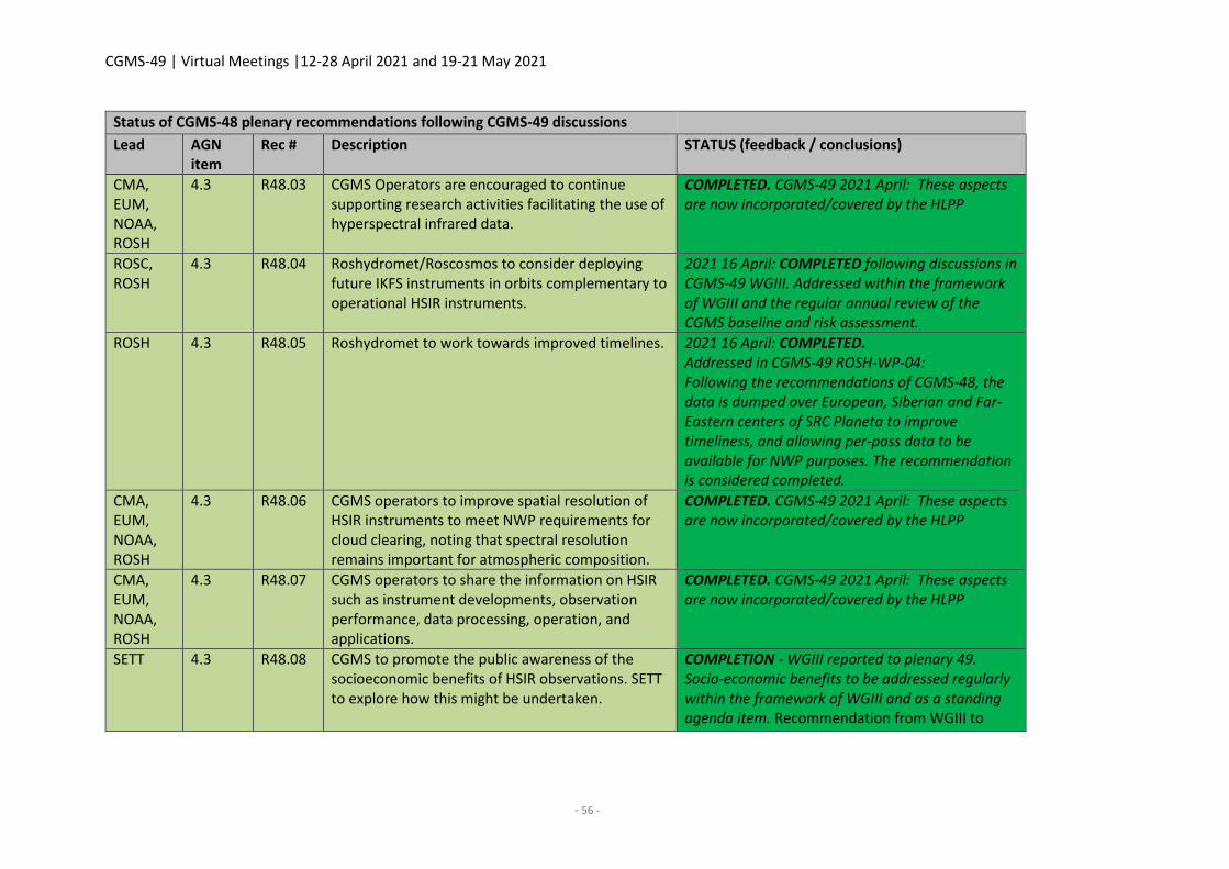
CGMS-49 | Virtual Meetings |12-28 April 2021 and 19-21 May 2021
- 56 -
Status of CGMS-48 plenary recommendations following CGMS-49 discussions
Lead AGN item
Rec # Description STATUS (feedback / conclusions)
CMA, EUM, NOAA, ROSH
4.3 R48.03 CGMS Operators are encouraged to continue supporting research activities facilitating the use of hyperspectral infrared data.
COMPLETED. CGMS-49 2021 April: These aspects are now incorporated/covered by the HLPP
ROSC, ROSH
4.3 R48.04 Roshydromet/Roscosmos to consider deploying future IKFS instruments in orbits complementary to operational HSIR instruments.
2021 16 April: COMPLETED following discussions in CGMS-49 WGIII. Addressed within the framework of WGIII and the regular annual review of the CGMS baseline and risk assessment.
ROSH 4.3 R48.05 Roshydromet to work towards improved timelines. 2021 16 April: COMPLETED. Addressed in CGMS-49 ROSH-WP-04: Following the recommendations of CGMS-48, the data is dumped over European, Siberian and Far-Eastern centers of SRC Planeta to improve timeliness, and allowing per-pass data to be available for NWP purposes. The recommendation is considered completed.
CMA, EUM, NOAA, ROSH
4.3 R48.06 CGMS operators to improve spatial resolution of HSIR instruments to meet NWP requirements for cloud clearing, noting that spectral resolution remains important for atmospheric composition.
COMPLETED. CGMS-49 2021 April: These aspects are now incorporated/covered by the HLPP
CMA, EUM, NOAA, ROSH
4.3 R48.07 CGMS operators to share the information on HSIR such as instrument developments, observation performance, data processing, operation, and applications.
COMPLETED. CGMS-49 2021 April: These aspects are now incorporated/covered by the HLPP
SETT 4.3 R48.08 CGMS to promote the public awareness of the socioeconomic benefits of HSIR observations. SETT to explore how this might be undertaken.
COMPLETION - WGIII reported to plenary 49. Socio-economic benefits to be addressed regularly within the framework of WGIII and as a standing agenda item. Recommendation from WGIII to
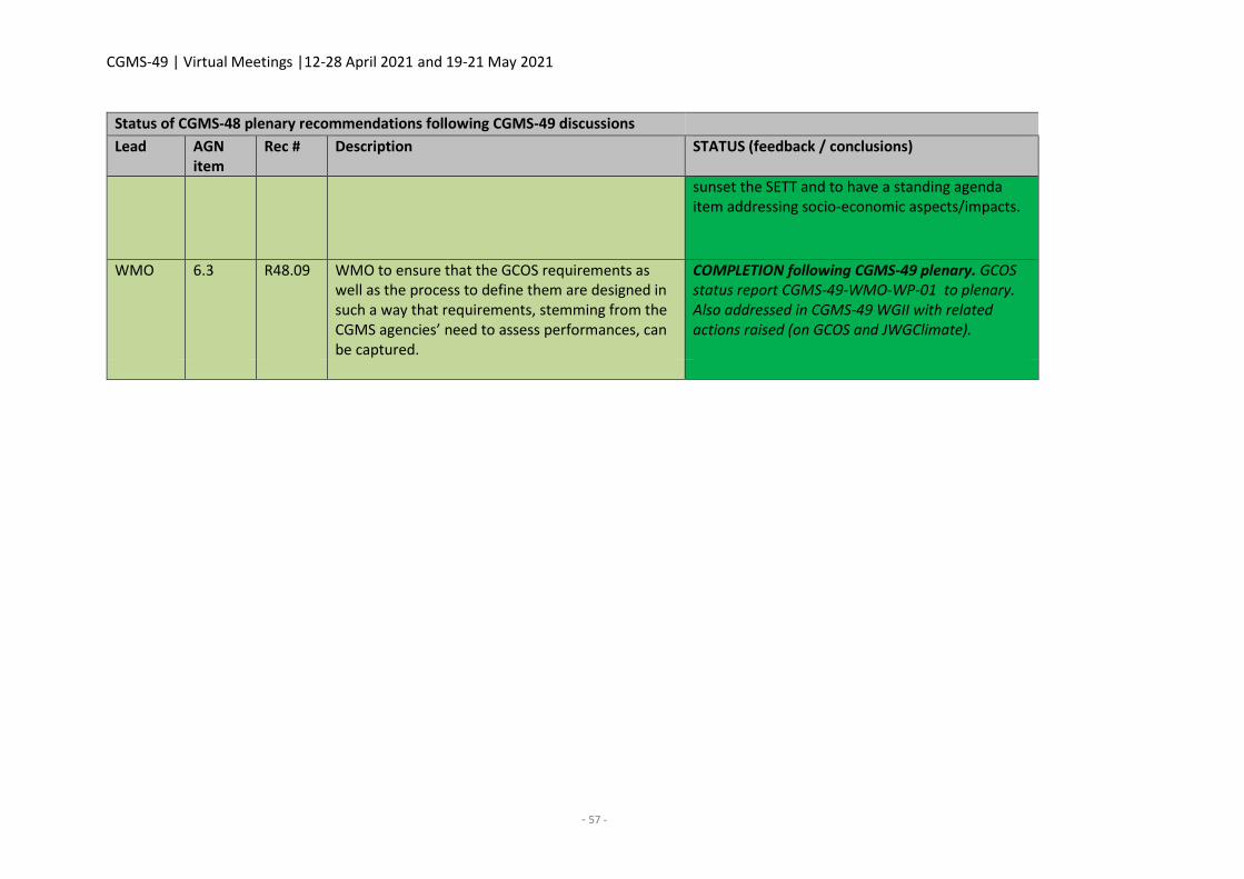
CGMS-49 | Virtual Meetings |12-28 April 2021 and 19-21 May 2021
- 57 -
Status of CGMS-48 plenary recommendations following CGMS-49 discussions
Lead AGN item
Rec # Description STATUS (feedback / conclusions)
sunset the SETT and to have a standing agenda item addressing socio-economic aspects/impacts.
WMO 6.3 R48.09 WMO to ensure that the GCOS requirements as well as the process to define them are designed in such a way that requirements, stemming from the CGMS agencies’ need to assess performances, can be captured.
COMPLETION following CGMS-49 plenary. GCOS status report CGMS-49-WMO-WP-01 to plenary. Also addressed in CGMS-49 WGII with related actions raised (on GCOS and JWGClimate).
CGMS-49 | Virtual Meetings |12-28 April 2021 and 19-21 May 2021
- 59 -
WGI REPORT
Chair: Vanessa Griffin (NOAA)
Acting Co-Chair: Dohyeong Kim (KMA)
Rapporteur: Sean Burns (EUMETSAT)
1. Welcome and review of agenda with objectives of the meeting
WGI reviewed and adopted the draft agenda proposed by the CGMS Secretariat prior to the
meeting, which is in line with the ToR for WGI.
WGI included representatives of the satellite operators from CMA, EUMETSAT, ESA, IMD, ISRO,
JMA, KMA, NASA, NICT, NOAA, ROSHYDROMET, and WMO (see CGMS report for full list of
participants).
The WGI meeting was once again conducted by WebEx.
In view of the common items of interest in relation to Space Weather, the representatives of WGI,
WGIV, and the Space Weather Coordination Group participated in the joint WGI-WGIV-SWCG
meeting
Dr Dohyeong Kim from KMA was nominated as acting co-chair for the meeting.
2. Review of actions and recommendations from previous meetings and status update
CGMS-49-CGMS-WP-01WGI: CGMS-49 list of actions and recommendations
WGI discussed the actions and recommendations from previous CGMS plenary sessions (CGMS-48
and earlier) and the final status is provided in Annex II of this report.
3. Frequency Management matters (incl. space weather matters)
3.1 Frequency management topics and WRC-19 and WRC-23
CGMS-49-CGMS-WP-17: Report from the CGMS/SFCG Liaison Officer
Due to COVID-19, SFCG-40, planned to be held in Palm Cove (Australia) in September 2020, was
moved to October 2021.
To progress the work and deal with the items that cannot wait until 2021, some work has been
carried out by correspondence.
The issues of relevance for CGMS that were discussed and progressed by correspondence are:
SFCG Objectives for WRC-23 and beyond;
Response to action 1 of SFCG Action Item 39/7.
CGMS is invited to note this report and to provide feedback and information on its activities to
SFCG-40 (October 2021) on any frequency related matter as appropriate.
CGMS-49 | Virtual Meetings |12-28 April 2021 and 19-21 May 2021
- 60 -
An action was placed on SFCG A39.07 to review the status of information on the frequency plan of
meteorological satellites recorded in OSCAR/Space and to provide guidance and a plan for updating
the missing and outdated information as identified in CGMS-48-WMO-WP-03. This was discussed
at the WMO ET-RFC meeting in February 2021, noting that OSCAR became a global reference for
sensor characteristics and therefore there is an obligation to ensure that it is accurate. Once this
first action of agreeing on the data set and format is completed, the onus is on the SFCG members
to submit their information based on the agreed format. SFCG would then merge the information
in a single SFCG Report. Such a report could then be submitted as an SFCG input to WMO for
inclusion into the OSCAR database.
CGMS-49-CGMS-WP-11: CGMS monitoring and responding to future interference challenges on
microwave sensing
In recent years, the trend towards broadband applications in commercial terrestrial and satellite-
based systems and networks, either fixed or mobile, has accelerated. The most imminent example
is IMT-2020/5G.
The necessary bandwidth for such broadband applications requires these systems to use much
higher frequencies. Unfortunately, these spectrum regions are extensively used by passive
microwave sensors.
The accommodation of such broadband systems in, or neighbouring to, frequency bands used by
passive sensors could be accompanied with some compatibility issues and the potential for radio
frequency interference (RFI) to the passive sensor measurements.
Even though regulatory conditions are established at regional and/or global (ITU) level to protect
passive sensors, their effectiveness cannot always be ensured fully, due to various reasons, leading
potentially to a steadily increasing level of RFI over time.
Especially this kind of interference, which slowly grows with the level of deployment of such
networks, is difficult to detect and monitor.
This document is aimed at triggering discussion on how CGMS agencies could collaboratively find
and establish mechanisms on how to detect and long-term monitor such kind of interference on a
global basis.
CGMS requests agencies to nominate participants to a Task Group to establish the initial ideas
about mechanisms regarding the detection, monitoring, and mapping of RFI, initially in the 24 GHz
passive band. Proposals from the Group could be presented at CGMS-50. Task Group participants
would coordinate internally with relevant experts. The initial tasks of this Group could include:
Gathering the views and ideas members already developed and activities they have already
undertaken in this context;
Exchange on members interaction with scientists and forecasters regarding ways for
extracting data from existing instruments for impact assessments;
Developing possible plans for approaching detection, monitoring, and mapping of RFI and
evaluate their feasibility;
CGMS-49 | Virtual Meetings |12-28 April 2021 and 19-21 May 2021
- 61 -
Summarising the findings of the group for presentation at CGMS-50.
WGI agreed that Simon Elliott from EUMETSAT would lead this Task Group on RFI detection,
monitoring, and mapping.
CGMS-49 ACTIONS – WGI
Actionee AGN item
Action #
Description Deadline Status
3.1 CGMS via a dedicated Task Group to investigate collectively mechanisms for detection and long-term monitoring of and mapping of RFI (for example, but not limited to, from IMT-2020/5G into the 24 GHz passive band) at satellite or instrument level, or any other means, as the knowledge base for assessing the impact on the passive sensor measurements.
CGMS-50 OPEN
CGMS-49-CGMS-WP-16: Status of Preparations for WRC-23
The preparations for the World Radiocommunication Conference 2023 (WRC-23) are in progress
already for over one year. However, due to the global pandemic the preparatory works at ITU,
regional, and national level are slowed down since complex technical and regulatory issues cannot
be discussed and negotiated effectively in virtual meetings.
The agenda for WRC-23 contains again a number of items of potential concern to CGMS members
as they could negatively affect the frequency usage of MetSat and EESS satellite systems and their
active and passive sensors. Among those are:
A number of agenda items for new frequency usage of commercial satellite systems (1.15,
1.16, 1.17, and 1.18) and also
Three agenda items (1.2, 1.4, and 9.1c) related to additional frequency bands for IMT (5G)
systems.
Thus, the preparatory works at regional and ITU-R level need to be carefully followed.
In addition, the WRC-23 agenda also contains an item of direct interest to CGMS, namely 1.14. The
objective of this agenda item is to ensure that passive microwave measurements in the frequency
range 231.5-252 GHz are protected and the required spectrum is allocated to future passive
microwave sensors, for example for the Ice Cloud Imager (ICI) instrument on MetOp-SG satellites.
Also of interest to the scientific community is WRC-23 agenda item 9.1a) aimed at gathering
information on space weather sensors/instruments/missions, and identifying their spectrum
requirements and protection needs, and ways to reflect space weather in the ITU Radio
Regulations.
CGMS-49 | Virtual Meetings |12-28 April 2021 and 19-21 May 2021
- 62 -
CGMS-49-WMO-WP-04: WMO Preliminary Position Paper for WRC-23
The WMO preliminary positions on WRC-23 agenda were initially agreed in February 2020 and have
been recently updated during the last meeting of the WMO Expert Team for Radio Frequency
Coordination (ET-RFC) held from 2-4 February 2021.
A subset of the agenda items listed in the WMO position paper, those that are of most relevance
to CGMS, were presented.
CGMS were invited to review the preliminary WMO position paper and to assist in making this
information known to its members' national and international preparation processes for WRC-23.
The HLPP was proposed to be updated to reflect the priorities outlined in the WMO position paper.
CGMS-49-WMO-WP-05: Status of OSCAR/Space including frequency matters
OSCAR/Space is a key tool and information source to support the WMO Rolling Review of
Requirements (RRR) process and WMO Gap Analysis (CGMS-48-WMO-WP-13), which are used to
monitor the compliance of satellite programmes in the implementation of the CGMS Baseline and
the space-based component of the Vision for WIGOS in 2040 (WMO-No. 1243).
WMO Space Programme Office has established and demonstrated a successful framework with a
contractor for the OSCAR/Space technical maintenance. According to the development plan in
2020, this resulted in a software release including a major technical platform update, and in the
implementation of new features.
The ongoing development phase includes work packages to make OSCAR/Space compatible with
WIGOS metadata records and implementing Gap Analysis for WIGOS Vision 2040 Subcomponents
was successfully kicked off.
The main mechanism for the WMO Space Programme Office to collect the relevant information for
the database content updating is through templates submitted to the OSCAR/Space Support Team
(O/SST) members, usually three to four times per year. The latest status of the satellites requiring
updated information was sent to all O/STT focal points in April 2021.
3.2 Frequency-related topics in support to space weather
No papers reported under this agenda item.
4. Meteorological satellites Space to Ground Interface (Direct Readout) and LHRIT Global
Spec. Global Specs (CCSDS based) and Best Practices for DR processing
4.1 CGMS agency best practices in support to local and regional processing of LEO direct
broadcast data)
The following papers present the implementation status of CGMS Agency Best Practices in support
to Local and Regional Processing of LEO Direct Broadcast data CGMS/DOC/18/1008274, v1B.
CGMS-49 | Virtual Meetings |12-28 April 2021 and 19-21 May 2021
- 63 -
CGMS-49-CMA-WP-03: Update of CGMS agency best practices for LEO direct broadcast data at
CMA
This paper presents the status of implementation at CMA of the CGMS Agency Best Practices in
support to Local and Regional Processing of LEO Direct Broadcast data for each of the FY-3D and
FY-3E LEO satellite missions.
CGMS-49-EUMETSAT-WP-02: Implementation of CGMS best practices for LEO direct broadcast
data at EUMETSAT
This paper presents the status of implementation at EUMETSAT of the CGMS Agency Best Practices
in support to Local and Regional Processing of LEO Direct Broadcast data for each of the MetOp
and MetOp-SG LEO satellite missions.
CGMS-49-NOAA-WP-03: Implementation of CGMS best practices for LEO direct broadcast data at
NOAA
This paper presents the status of implementation at NOAA of the CGMS Agency Best Practices in
support to Local and Regional Processing of LEO Direct Broadcast data for the NOAA-15, NOAA-18,
NOAA-19, S-NPP, and NOAA-20 missions.
Working Group I took note of the status of implementation of the best practices of CMA,
EUMETSAT, and NOAA.
CGMS-49-EUMETSAT-WP-04: Planned studies for future direct broadcast data rates from polar
orbiting satellites
An action had been placed on the Direct Broadcast Best Practice Working Group to agree a set of
studies to be performed by the CGMS agencies on the mechanisms that could be used to address
higher data rates from polar orbiting meteorological satellites (WGI A48.04). The group discussed
the potential studies during the Intersessional meetings and this was then outlined in the paper
‘Future Direct Broadcast Data Rates from Polar Orbiting Satellites CGMS-48- EUMETSAT-WP-15’.
In response to the continuous increase in instrument data rates, a migration from L-band (1.8 GHz)
to X-band (7.8 GHz) based direct broadcast is currently ongoing. However, even while this migration
is still ongoing, indications are that the latest generation of satellites is gradually reaching the limits
of the current conventional design of the direct broadcast downlink in X-band.
Today, a user of the direct broadcast data from the polar orbiting satellites is able, with the same
integrated reception system, to acquire data from a rich set of satellite families, operated by
different satellite agencies. This is referred to as the multi-mission capability of the direct broadcast
reception systems.
The multi-mission capability is highly valuable to the user, increasing the benefit of the investment
in the reception system and enabling a range of local and regional applications of the satellite data.
Considering this, the proposed update to the CGMS Baseline section 3.1.1 Direct Broadcast Services
includes:
CGMS-49 | Virtual Meetings |12-28 April 2021 and 19-21 May 2021
- 64 -
The core meteorological satellite systems in LEO orbits, and other operational
satellite systems where applicable, should ensure low latency data access of
imagery, sounding, and other real-time data of interest to users by means of direct
broadcast or other mechanisms.
Application areas where low latency and availability is suitable include Severe
Weather Monitoring, Nowcasting and Short- and Medium-Range Numerical
Weather Prediction. Other application areas could also benefit from very low
latency products, e. g. ionospheric monitoring. CGMS members should follow the
best practices for direct broadcast services developed by CGMS Working Group I.
Before continuing the existing action, as currently stated, it was proposed to perform a SWOT
analysis of low latency data access from LEO meteorological spacecraft and present the results at
CGMS-50.
The SWOT analysis would primarily focus on the needs of the application areas described above,
and secondarily on the possible technical implementations. Where relevant, it would take into
account CGMS-48-EUMETSAT-WP-15, Future Direct Broadcast Data Rates from Polar Orbiting
Satellites, as well as the current presentation and also any other studies that have already been
performed by member agencies. Furthermore, other technical solutions for transmitting data from
space to ground beyond DB would be considered, including the use of data relay satellites.
Subsequent to the SWOT analysis and the related discussions in WGI, the topics, priorities, and lead
agencies for any further studies would then be identified. The goal is to present a coordinated view
for consideration by CGMS for future data access mechanisms from LEO meteorological satellites.
WGI agreed to the proposal with the following action.
CGMS-49 ACTIONS - WGI
Actionee AGN item
Action #
Description Deadline Status
WGI 4.1 Perform a SWOT analysis of low latency data access from LEO meteorological spacecraft
CGMS-50 OPEN
4.2 Development of efficient standardised data handling for high-resolution imaging and
hyper-spectral instruments
CGMS-49-CGMS-WP-18: Review of status and Terms of Reference of Task Force on Satellite Data
and Codes
The CGMS Task Force on Satellite Data and Codes has been actively supporting the coordination of
work on satellite product format issues within the CGMS community and providing support to the
work of WMO’s expert teams since its first meeting in 2008. This paper reviewed the current status
of the Task Force and looks forward to its forthcoming activities.
CGMS-49 | Virtual Meetings |12-28 April 2021 and 19-21 May 2021
- 65 -
During the forthcoming intersessional period, in addition to its routine activities, the group’s focus
will be on revisiting its ToR and evaluating the use of WIGOS Station identifiers for satellite
products.
CGMS-49-CGMS-WP-07: Report on activities in Climate and Forecast (CF) conventions regarding
space data products
A WGI liaison between CGMS and the governing bodies of the netCDF Climate and Forecast (CF)
Conventions actively represents the interests of CGMS members within the CF community. This
report detailed the key developments that have taken place in this regard over the past year:
Stronger collaboration between CF and WMO
Work towards representing coordinates using interpolation zones in CF.
In addition to presenting the details of these steps, this paper also proposed goals to be pursued in
this area by CGMS-50 as agreed with the participants of the intersessional meetings on data
formats and formatting standards.
Significant progress has been made in evolving the CF Conventions to cover the needs of satellite
data producers. Efforts on the part of WMO to assist in the evolution and governance of the CF
Conventions are likely to have positive effects on the standard by providing better representation
to users from operational communities. Further involvement in the evolution of the CF Conventions
will benefit CGMS members and their users.
5. Data collection systems
5.1 DCS sub-group reports
CGMS-49-CGMS-WP-12: Report from CGMS DCS sub-group
At CGMS-46, WGI endorsed the proposal for the creation of a Data Collection Service (DCS) sub-
group dedicated to DCS activities. The main purpose of the group was to make more effective
progress with DCS activities and issues in the context of CGMS. The first task of the group has been
to address the need for and make proposals for a new IDCS DCP standard, the development of DCS
best practices for DCS data access and for DCP certification, as well as the inclusion of CGMS DCS
webpage.
The DCS sub-group, consisting of DCS Managers from each of the satellite operators, has met
virtually as part of the WGI Intersessional meetings, but also face-to-face in the context of other
already scheduled DCS-related meetings. Due to COVID, none of the planned face-to-face meetings
were possible. The last face-to-face took place in Boston as part of the AMS on 30 September and
1 October 2019.
This paper presents the status of the DCS sub-group activities and progress since CGMS-48. The
discussions of the Enhanced DCP (E-DCP) standard have continued and is a major topic for the sub-
group. The group proposed a revised approach regarding the new IDCS standard. Rather than
defining a completely new standard, the group would look at enhancing an existing standard taking
CGMS-49 | Virtual Meetings |12-28 April 2021 and 19-21 May 2021
- 66 -
into account user feedback and requirements. This would simplify the implementation of the
standard, e. g. perform firmware changes to existing platforms, improving forward error correction
and other modifiable parameters.
The group also plans to perform a SWOT analysis on the Geostationary Meteorological satellites
Data Collection Services as a basis to provide CGMS with a coordinated view on a proposed future
of the service.
CGMS-49 ACTIONS – WGI
Actionee AGN item
Action #
Description Deadline Status
5.1 Analyse existing DCP standards taking into account user feedback and requirements, and propose a common standard that could be used as a future IDCS standard. The standard could include improving forward error correction and other modifiable parameters.
CGMS-50 OPEN
5.1 Perform a SWOT analysis on the Data Collection Service from Geostationary Meteorological satellites.
CGMS-50 OPEN
CGMS-49-NOAA-WP-04: Validation of the small satellite DCS use concept project
The basic concept of the Satellite DCS Use Concept Validation project is to determine if satellites,
primarily small satellites in low earth orbit, can successfully interface with the DCS receivers and
thus provide a low-rate data (100, 300, or greater bps) service to satellite users; primarily to assist
in launch, early orbit, and anomaly (LEO&A) operations or low data required observations. Satellite
DCS users are good candidates for using the underutilised international DCS channels (IDCS). The
IDCS is designed to allow use between the various geosynchronous located DCS receivers (i. e.
GOES, METEOSAT, HIMAWARI) and thus it’s well suited for using with satellites. This would also
mean that current regional DCS users will not be crowded by the additional users. It is expected
that the satellite use of DCS may assist in minimising the risk of interference but will not eliminate
it. Additional regulatory controls and protections will continue to be needed as well.
This project is designed to be carried on two hosted satellites. The first hosted payload was
launched on 15 February 2020 and ejected from the International Space Station on 13 July 2020.
This satellite focused on and was successful in demonstrating that the concept of satellites using
the DCS is valid. Messages were successfully sent from the hosted payload through the DCS and
received by the mission operations team (the user). The second hosted payload, planned for launch
in September 2021, will focus on operational considerations, primarily if a satellite can use the
transponders at any time and access any subscribed DCS (i. e. EUMETSAT, NOAA, JMA).
While risk reduction was the original driver in identifying the opportunity, additional benefits have
also been identified. 1) Increased use of the International channels, which are currently
underutilised. 2) Low-cost enablement of scientific, educational, and development satellite using
CGMS-49 | Virtual Meetings |12-28 April 2021 and 19-21 May 2021
- 67 -
low data rate communications to respective mission centres. 3) Ability to enable LEO&A during
clustered deployments. 4) Projected demand for enabling the two-way communications
capabilities of the DCS. 5) Demonstrated continued efforts by NOAA/NESDIS to facilitate good
spectrum stewardship and efforts towards responsible sharing of spectrum resources. 6)
Development of technology and techniques applicable to sensor deployment and monitoring on
the Moon, Mars, and other planets.
5.2 Operational DCS systems – agency reports
CGMS-49-CMA-WP-07: CMA DCS status report
The paper is an updated introduction on the Chinese Data Collection System of meteorological
satellites along with DCP technical descriptions. The FY4A at 104.7°E is the first scientific
experiment satellite of the FY4 series. The FY4A is the main satellite for DCS. It has 433 channels
composed of 400 HDCP channels (750Hz spacing/600bps) and 33 international channels
(3KHz/100bps). The Chinese DCS is established based on an approach of FD (Frequency Division)
with the combination of TD (Time Division). The FY-4A DCS is operated by NSMC (National Satellite
Meteorological Center) which is one of the operational units of CMA. Currently, there are 52 HDCPs
deployed within China territory. Further satellites to be launched in the future are FY4B and FY4C.
And at least 23 cross-industry DCPs and applications will be funded.
CGMS-49-EUMETSAT-WP-03: EUMETSAT DCS status report
This paper presents the status of the EUMETSAT DCS currently supported by Meteosat-11 at 0° and
Meteosat-8 at 41.5°E IODC (Indian Ocean Data Coverage). Included are details of channel
utilisation, DCP allocation, geographical distribution, and DCP data dissemination mechanisms.
The DCS is one of the core services operated by EUMETSAT in support of meteorology and weather
prediction. It plays an important role in enabling data collection platform (DCP) operators to use
the Meteosat system to receive environmental data collected from DCP platforms.
EUMETSAT DCS, initially established with the first generation of Meteosat satellites (MFG) in 1977,
has continued and expanded with Meteosat Second Generation (MSG), and will also be embarked
on the future Meteosat Third Generation (MTG).
The EUMETSAT DCS currently supports both standard-rate (100bps) and high-rate (1200bps) DCPs.
The high-rate DCP (HRDCP) has improved capabilities and can be used for application such as
warnings of potentially devastating natural phenomena such as tsunamis. The prime IODC
application is for the Indian Ocean Tsunami Warning Network (IOTWS). As of 31 March 2021, there
are 139 DCP operators located in 77 countries (Europe, Africa, Asia). There are a total of 1523 DCPs
allocated, with 419 actively transmitting. Out of those DCPs allocated, 180 are HRDCPs transmitting
at 1200 bps (155 supported by Meteosat-11 at 0° and 25 by Meteosat-8 at 41.5°E). The remaining
1343 are Standard Rate DCPs (1195 supported by Meteosat-11 at 0° and 148 by Meteosat-8 at
41.5°E). Since March 2020, 54 new DCPs have been assigned (49 HRDCP and 5 SRDCP). The
EUMETSAT DCS has a typical reliability greater than 99%.
CGMS-49-ISRO-WP-05: ISRO DCS status report (verbal)
CGMS-49 | Virtual Meetings |12-28 April 2021 and 19-21 May 2021
- 68 -
Data Relay Transponder (DRT) payload is currently available on 3 Indian satellites – INSAT-3D,
INSAT-3DR, and GSAT-17, which provides uplink facility at 402 MHz with global coverage and
downlink at 4503 MHz with coverage over India. DRT are supporting 125 PRBS, 560 AWS, and 1350
ARGs of Indian Meteorological Departments, 592 terminals of Central Water Commission, 95
terminals of Snow and Avalanche Study Establishment, 83 terminals of the state of Andhra Pradesh,
10 ARGS of TIFC, and ~1187 AWS of ISRO.
ISRO AWS provide half-hourly measurements of surface temperature, pressure, humidity, wind
speed and direction, precipitation, and sunshine. ISRO’s present AWS are uplinked to DRT, but
additional capability of transmitting data through GSM/GPRS is under consideration. At present, 30
of these AWS are taken up for GSM/GPRS compatibility for data transfer. IMD is planning to add
550 AWSs and 2000 ARGs, and CWC is planning to add about 2000 terminals of water resource
monitoring.
CGMS-49-JMA-WP-03: Himawari-DCS's international contributions to disaster risk reduction
The Japan Meteorological Agency (JMA) has operated the DCS since its first Geostationary
Meteorological Satellite (GMS) went into operation in 1978. The system plays important roles in
collecting meteorological information as well as seismic intensity and tidal/tsunami data
collaborating with the Intergovernmental Coordination Group for the Pacific Tsunami Warning and
Mitigation System (ICG/PTWS). In Japan, more than 400 DCPs collect seismic intensity data.
Himawari-8’s DCS has been operational since July 2015, and it is planned that Himawari-9 will take
over the DCS service in 2022 and continue in this role until 2029.
JMA has no plans to change the specifications of the Himawari-8/9 DCS. The Agency is currently
considering whether the planned Himawari-10 programme set to replace Himawari-8/9 will
assume the same DCS.
CGMS-49-NOAA-WP-05: GOES DCS Overview
The GOES DCS Environmental Data Relay system supports over 669 user agencies, 2,222 individual
users operating approximately 40,000 DCPs. Over 32,000 of these DCP platforms are utilised to
collect and transmit data through either a DCS transponder hosted on either the GOES East or West
satellite. The DCS Administrative and Data Distribution System is used to manage user channel
access for distributing over 7.2 million observations made through the DCPs.
Key projects and events include ongoing spectrum sharing challenges, random reporting
documentation updates, two-way communication prototype development, and ongoing support
of the small satellite concept validation project.
CGMS-49-ROSHYDROMET-WP-01: Status of Russian data collection system
This document addressed the current status and technical specifications of the Russian data
collection system and related future plans. The DCS is established to provide collection and
distribution of meteorological data from remote areas, and to support natural hazards warning
system.
CGMS-49 | Virtual Meetings |12-28 April 2021 and 19-21 May 2021
- 69 -
Roshydromet has developed and deployed the national DCS based on Electro-L series geostationary
satellites with a backup option via Luch series communication satellite. There are 686 DCPs
currently deployed. DCPs are distributed all over the Russian territory, including 138 DCPs in hard-
to-reach areas.
Highly elliptical orbit satellite Arctica-M was launched on 28 February 2021, and is now undergoing
the flight tests and commissioning phase. It is designed to support DCP data relay over the Arctic
region.
The Russian DCS will be further complemented with the launch of the geostationary meteorological
satellite Electro-L (166º E) and the second highly elliptical orbit satellite Arctic-M. It is planned to
increase the number of platforms up to 3,000 DCP.
6. System and operations aspects
6.1 Space debris and collision avoidance. Coordination with IADC
CGMS-49-WG1-WP-03: Potential creation of working group on space debris avoidance (verbal)
The Working Group discussed the need for the Task Team and the Group agreed on the value of
creating such a group and working towards a Best Practice on Collision Avoidance. Therefore, CGMS
Action #47.09 remains open.
CGMS-49-EUMETSAT-WP-05: Best Practice for the Coordination of LEO Orbits – Progress and Next
Steps
Following on from analyses performed in previous years, the Task Group has the ultimate goal of
establishing a “Best Practice for the Coordination of LEO Orbits” whilst assessing the prototype
simulation tool’s applicability to operational and planned missions and determining whether
further work is required on that tool.
This paper reports on the status and progress of the Task Group, including within Annexes:
The Terms of Reference, refined during discussions,
A preliminary formulation of the Best Practice for information
The Task Group met four times since CGMS-48. During these meetings, the group refined its ToR,
with the latest version contained in Annex 1.Task Group membership currently comprises delegates
from CMA, EUMETSAT, JAXA, KMA, NASA, and NOAA.
i. The Task Group decided that the CGMS Best Practice shall be structured in two main sections:
a. Best Practice for the coordination of data acquisition for LEO satellite systems with
uncoordinated/variable orbital phasing; and
b. An analysis of the potential benefits and considerations to be made in the development
and operations of LEO satellite systems with coordinated orbital phasing.
CGMS-49 | Virtual Meetings |12-28 April 2021 and 19-21 May 2021
- 70 -
However, a revised proposal is made for WGI to discuss a broader approach to the TG work than
foreseen above (a), covering new mission concepts and technologies to achieve the same objective
of maximal return at minimal cost.
CGMS-49 ACTIONS - WGI
Actionee AGN item
Action #
Description Deadline Status
6.1 Coordination of LEO Orbits Task Group to issue Draft Best Practice on Coordination of Data Acquisition for LEO Satellite Systems (with uncoordinated / variable orbital phasing)
Feb 2022 OPEN
6.1 Coordination of LEO Orbits Task Group to perform a broad SWOT analysis for maximising the return / minimising the cost taking into account new mission and reference mission concepts and associated technologies, highlighting the potential for inter-Agency cooperation
CGMS-50 OPEN
7. Implementation of WGI aspects of the global contingency plan (as proposed by WGIII)
7.1 System technical aspects (sharing/rationalisation of orbits) and operational aspects on the
implementation of contingency plans
CGMS-49-WGIII-WP-02WGI: Status and outcome of the 3rd CGMS risk assessment
The objective of the Risk Assessment Workshop is to:
- Update the CGMS Baseline based on member inputs;
- Prepare a consolidated Risk Assessment against the CGMS Baseline;
- Identify contingency actions to be taken, or actions to identify in the HLPP;
- Identify ways to integrate satellite data into the CGMS Baseline and characterise CGMS’
contribution (e.g. space weather contribution was updated).
The Working Group III held a virtual workshop from 1-3 March 2021, hosted by EUMETSAT and
attended by representatives of WGII and SWCG.
WGI reviewed the draft update of the CGMS Risk Assessment.
CGMS-49-CGMS-WP-24WGI: CGMS Baseline - draft revision following the 3rd risk assessment
workshop (for recommendation to CGMS-49 plenary)
CGMS endorsed the first CGMS baseline, the commitment of observational missions synchronised
with the development of the WMO Vision for WIGOS 2040, at CGMS-46 in Bengaluru (ref. CGMS-
46 CGMS-WP-04, and -27).
The 3rd CGMS WGIII risk assessment workshop was held in EUMETSAT on 1-3 March 2021 on whose
occasion the CGMS baseline and related risk assessment was conducted. The working group
CGMS-49 | Virtual Meetings |12-28 April 2021 and 19-21 May 2021
- 71 -
reviewed the CGMS baseline and proposed revisions. The draft text of the revision of the CGMS
baseline is included in the paper.
The text was reviewed by WGI and other WGs during CGMS-49 in April 2021, in order to conclude
on a final text for endorsement by CGMS-49 plenary on 20-21 May 2021.
Following the CGMS-49 working group discussions, CGMS members are requested to recommend
the 3rd revision of the CGMS baseline to CGMS-49 plenary for endorsement (and, at that stage, for
WMO to take into account the new baseline in forthcoming updates of the Manual on the Global
Observing System and related materials).
8. Any other business
For the future, WGI agreed to rename the groups working under WGI as follows:
Current Name New Name
Direct Broadcast Best Practice Working Group Task Group on Direct Broadcast Systems
CGMS Task Force on Satellite Data and Codes Task Group on Satellite Data and Codes
Data Collection Service (DCS) sub-group Task Group on Data Collection Services
Task Group on Space Debris and Collision
Avoidance
Task Group on Space Debris and Collision Avoidance
Coordination of LEO Orbits Task Group Task Group on the Coordination of LEO Orbits
New Task Group on RFI detection, monitoring and
mapping
9. Review and updating of the HLPP
CGMS-49-CGMS-WP-03WGI: Status of implementation of CGMS High Level Priority Plan (2020-
2024)
WGI reviewed and provided inputs to the current status of the HLPP.CGMS-49-CGMS-WP-04WGI:
Proposed update to the CGMS High-Level Priority Plan (HLPP) for the period 2021-2025
WGI provided inputs for updates to the relevant sections of the HLPP.
10. Future WGI plenary sessions
10.1 Nominations and representatives at meetings (CGMS, ISWGs, VLAB - Co-chairs and
rapporteurs)
Dr Dohyeong Kim from KMA was nominated as the Co-Chair of WGI for plenary endorsement.
10.2 Decision on dates of inter-sessional activities/meetings in 2021-2022 [CGMS-49 to CGMS-
50]
Should the CGMS-50 plenary session take place virtually, a virtual WGI meeting in 2022 was
tentatively agreed to take place on 25 - 26 April 2022.
CGMS-49 | Virtual Meetings |12-28 April 2021 and 19-21 May 2021
- 72 -
The following intersessional meetings were agreed, taking place at 1200 UTC.
Working Group I
- Tuesday 14 September 2021
- Tuesday 25 January 2022
- Tuesday 22 March 2022
Task Group on Direct Broadcast System (James McNitt (NOAA) & Antoine Jeanjean (EUMETSAT)):
- Tuesday 31 August 2021
- Tuesday 16 November 2021
- Tuesday 15 February 2022
- Tuesday 26 April 2022
Task Group on Data and Codes (Simon Elliott (EUMETSAT)):
- Thursday 30 September 2021
- Thursday 24 February 2022
Task Group on Data Collection Systems: (Nick Coyne (EUMETSAT)):
- Thursday 6 May 2021
- Thursday 1 July 2021
- Thursday 2 September 2021
- Thursday 4 November 2021
- Thursday 13 January 2022
- Thursday 3 March 2022
Task Group on Space Debris and Collision Avoidance Task Group (Scott Leonard (NOAA))
- Dates will be defined following the formation of the Group
Task Group on the Coordination of LEO Orbits (Andrew Monham (EUMETSAT))
- Wednesday 8 December 2021, 12:00 UTC
11. Review of actions/conclusions, preparation of WG report for plenary
CGMS-49-CGMS-WP-01WGI: CGMS-48 status of actions and recommendations
The summary list of CGMS-48 WGI actions and recommendations resulting from CGMS-49
discussions is provided below.
CGMS-49 | Virtual Meetings |12-28 April 2021 and 19-21 May 2021
- 73 -
STATUS OF WGI CGMS-48 ACTIONS AND RECOMMENDATIONS FOLLOWING CGMS-49 DISCUSSIONS
Status of WGI CGMS-48 actions following CGMS-49 discussions
Actionee AGN item
Action # Description Action feedback/closing document Deadline Status
CGMS space agencies
WGI/1.1 WGI/A47.01 CGMS members are requested to provide nominations to the CGMS Secretariat for the position of Co-Chair of CGMS Working Group I
KMA proposed Dohyeong Kim as co-chair, recommended by WGI and endorsed by CGMS-49 plenary
Aug 2020 (Q3 2019)
CLOSED
NOAA WGI/6.2 WGI/A47.09 Form a Task Group on Space Debris and Collision Avoidance to produce a Best Practice on Collision Avoidance
Action closed - repeat of action 48.07 Aug 2020 (CGMS-48)
CLOSED
CGMS members Lead?
WGI/3.1 WGI/A48.01 WGI to review the status of information on the frequency plan of meteorological satellites recorded in OSCAR/Space and to provide guidance and a plan for updating the missing and outdated information as identified in CGMS-48-WMO-WP-03
CGMS-49: Action ongoing The action is ongoing. Status on this action was discussed at the WMO ET-RFC meeting in February 2021 It was noted during that OSCAR became a global reference for sensor characteristics and therefore there is an obligation to ensure that it is accurate. Once this first action is completed, it is on the SFCG members to submit their information based on the agreed format. SFCG would then merge the information in a single SFCG Report. Such a report could then be submitted as an SFCG input to WMO for inclusion into the OSCAR database.
CGMS-50 (CGMS-49)
ONGOING
CGMS space agencies
WGI/3.1 WGI/A48.02 CGMS is invited to review the preliminary WMO position paper and to assist in making this information known to its members' national and international preparation processes for WRC-23
The WMO positions paper is introduced in all relevant international and European including national WRC-23 preparation meetings. Therefore proposed to be closed.
CGMS-49 CLOSED
CGMS-49 | Virtual Meetings |12-28 April 2021 and 19-21 May 2021
- 74 -
Status of WGI CGMS-48 actions following CGMS-49 discussions
Actionee AGN item
Action # Description Action feedback/closing document Deadline Status
CGMS space agencies spell out ag names!
WGI/4.1 WGI/A48.03 CGMS Direct Broadcast operators to consider if the installation of processing S/W packages can be made more user friendly and if there is a potential for standardising the approach, considering the available methods and tools and report to WGI
CGMS-49: Action ongoing 2021 10 Feb IS: Remains open (NOAA completed this action and described the CSPP LEO approach in CGMS-48-NOAA-WP-03)
CGMS-50 (CGMS-49)
ONGOING
DB subgroup (ag names…)
WGI/4.1 WGI/A48.04 DB Working Group to agree a set of studies to be performed by the CGMS agencies on the mechanisms that could be used to address higher data rates from polar orbiting meteorological satellites. The CGMS agencies are invited to contribute to these studies, either as a lead entity or in support.
Following inter-sessional meetings, a paper presented at CGMS-49 outlining the list of potential studies, their priority, indicative cost, schedule. Action closed. Further actions may proposed following the SWOT analysis
CGMS-49 CLOSED
CGMS members
WGI/4.2 WGI/A48.05 CGMS Members are asked to update their nomination of experts to participate in the Task Force on Satellite Data and Codes in coordination with WGIV
Sufficient members now in the Group Lead: Simon Elliott ([email protected]) Current Members: CMA: Xu Zhe ([email protected]) EUMETSAT: Simon Elliott ([email protected]) JMA: Akihiro Shimizu ([email protected]) JMA: Kazuki Shimoji ([email protected]) KMA: Jae-Dong JANG ([email protected]) NOAA: (A.K.) Sharma ([email protected])
Aug-20 CLOSED
CGMS-49 | Virtual Meetings |12-28 April 2021 and 19-21 May 2021
- 75 -
Status of WGI CGMS-48 actions following CGMS-49 discussions
Actionee AGN item
Action # Description Action feedback/closing document Deadline Status
ROSHYDROMET: Nikita Ekimov ([email protected]) WMO: Enrico Fucile ([email protected])
DCS subgroup
WGI/5.1 WGI/A48.06 To coordinate the elaboration of the user requirements (based on potential applications), and the technical specifications, for a new DCP Standard, including the definition of the DCP format (To coordinate the elaboration of the user requirements, the technical specifications, and potential applications for a new DCP Standard and make a proposal to WGI also to include a section on DCP formats into the E-DCP Specification)
The subgroup proposes to change the goal of the action. Rather than defining a completely new standard, the group would look at enhancing an existing standard taking into account user feedback and requirements. This would make the implementation of the standard simpler, with for example firmware changes to existing platforms improving forward error correction and other modifiable parameters. The details of the proposed action have been put forward in the DCS Sub Group Report to the CGMS 49. Close this action and raise new action
CGMS-49 CLOSED
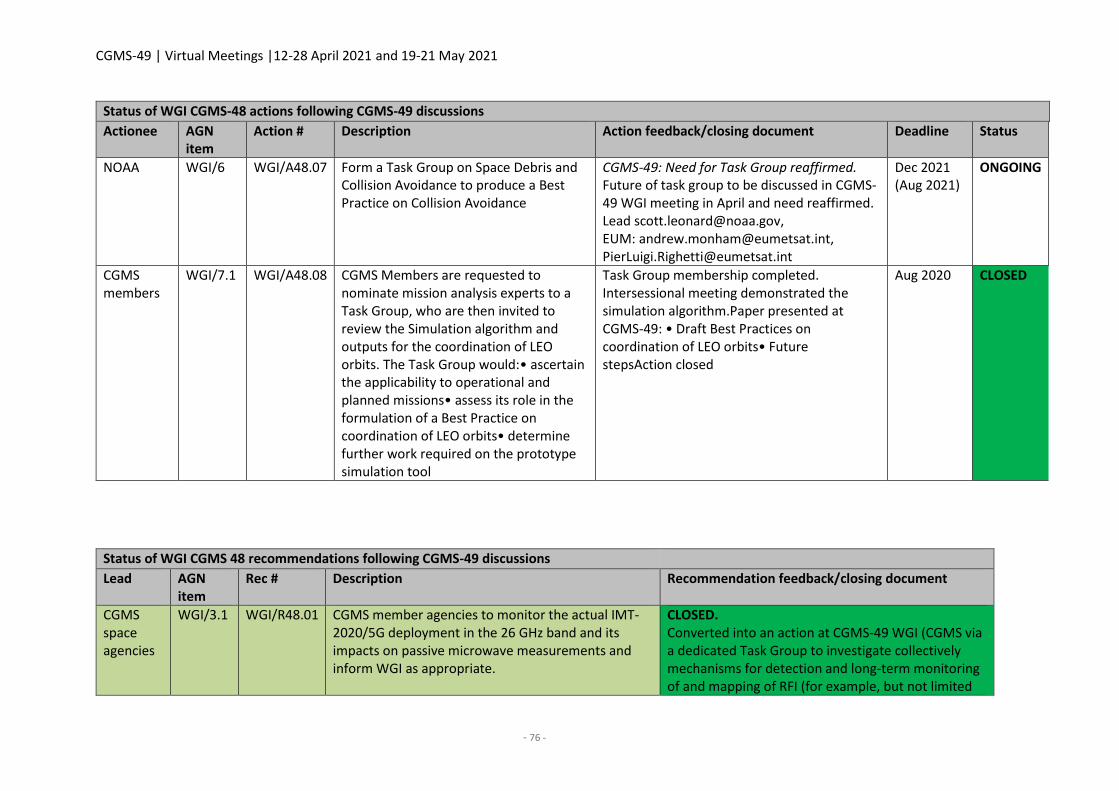
CGMS-49 | Virtual Meetings |12-28 April 2021 and 19-21 May 2021
- 76 -
Status of WGI CGMS-48 actions following CGMS-49 discussions
Actionee AGN item
Action # Description Action feedback/closing document Deadline Status
NOAA WGI/6 WGI/A48.07 Form a Task Group on Space Debris and Collision Avoidance to produce a Best Practice on Collision Avoidance
CGMS-49: Need for Task Group reaffirmed. Future of task group to be discussed in CGMS-49 WGI meeting in April and need reaffirmed. Lead [email protected], EUM: [email protected], [email protected]
Dec 2021 (Aug 2021)
ONGOING
CGMS members
WGI/7.1 WGI/A48.08 CGMS Members are requested to nominate mission analysis experts to a Task Group, who are then invited to review the Simulation algorithm and outputs for the coordination of LEO orbits. The Task Group would:• ascertain the applicability to operational and planned missions• assess its role in the formulation of a Best Practice on coordination of LEO orbits• determine further work required on the prototype simulation tool
Task Group membership completed. Intersessional meeting demonstrated the simulation algorithm.Paper presented at CGMS-49: • Draft Best Practices on coordination of LEO orbits• Future stepsAction closed
Aug 2020 CLOSED
Status of WGI CGMS 48 recommendations following CGMS-49 discussions
Lead AGN item
Rec # Description Recommendation feedback/closing document
CGMS space agencies
WGI/3.1 WGI/R48.01 CGMS member agencies to monitor the actual IMT-2020/5G deployment in the 26 GHz band and its impacts on passive microwave measurements and inform WGI as appropriate.
CLOSED. Converted into an action at CGMS-49 WGI (CGMS via a dedicated Task Group to investigate collectively mechanisms for detection and long-term monitoring of and mapping of RFI (for example, but not limited
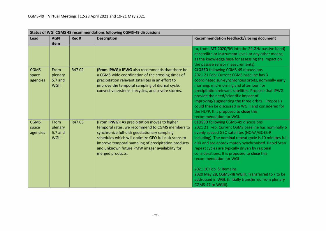
CGMS-49 | Virtual Meetings |12-28 April 2021 and 19-21 May 2021
- 77 -
Status of WGI CGMS 48 recommendations following CGMS-49 discussions
Lead AGN item
Rec # Description Recommendation feedback/closing document
to, from IMT-2020/5G into the 24 GHz passive band) at satellite or instrument level, or any other means, as the knowledge base for assessing the impact on the passive sensor measurements).
CGMS space agencies
From plenary 5.7 and WGIII
R47.02 (From IPWG): IPWG also recommends that there be a CGMS-wide coordination of the crossing times of precipitation relevant satellites in an effort to improve the temporal sampling of diurnal cycle, convective systems lifecycles, and severe storms.
CLOSED following CGMS-49 discussions. 2021 21 Feb: Current CGMS baseline has 3 coordinated sun-synchronous orbits, nominally early morning, mid-morning and afternoon for precipitation relevant satellites. Propose that IPWG provide the need/scientific impact of improving/augmenting the three orbits. Proposals could then be discussed in WGIII and considered for the HLPP. It is proposed to close this recommendation for WGI.
CGMS space agencies
From plenary 5.7 and WGIII
R47.03 (From IPWG): As precipitation moves to higher temporal rates, we recommend to CGMS members to synchronize full-disk geostationary sampling schedules which will optimize GEO full disk scans to improve temporal sampling of precipitation products and unknown future PMW imager availability for merged products.
CLOSED following CGMS-49 discussions. 2021 21 Feb: Current CGMS baseline has nominally 6 evenly spaced GEO satellites (NOAA/GOES-R including). The nominal repeat cycle is 10 minutes full disk and are approximately synchronised. Rapid Scan repeat cycles are typically driven by regional considerations. It is proposed to close this recommendation for WGI 2021 10 Feb IS: Remains 2020 May 28, CGMS-48 WGIII: Transferred to / to be addressed in WGI. (Initially transferred from plenary CGMS-47 to WGIII).

CGMS-49 | Virtual Meetings |12-28 April 2021 and 19-21 May 2021
- 79 -
WGII REPORT
Co-chairs: JV Thomas (ISRO), Kenneth Holmlund (WMO)
Rapporteurs: Mitch Goldberg (NOAA), Paolo Ruti (EUMETSAT)
1. Opening, objectives, and expected outcomes/WGII co-chair and rapporteur status and
confirmation
CGMS-49-CGMS-WP-09: Update of WGII Terms of Reference
CGMS Working Group II (WGII) held its CGMS-49 plenary meeting on 26-27 April 2021. WGII addressed
aspects of technical and scientific nature related to satellite data and products. WGII membership
consists of satellite data and products experts drawn from CGMS members and observers. WGII serves
as the link between CGMS and the CGMS International Science Working Groups (ISWGs), which
provide regular reports and feedback to CGMS through WGII:
International Clouds Working Group (ICWG)
International Precipitation Working Group (IPWG)
International Radio Occultation Working Group (IROWG)
International Satellite Winds Working Group (IWWG)
International TOVS working group (ITWG)
WGII is also the primary interface between CGMS and other relevant international initiatives, such as
the Global Space-based Inter-Calibration System (GSICS), the CEOS-CGMS Joint Working Group on
Climate (WGClimate) and user communities, such as those organised in the WMO Application Areas.
During its inter-sessional work in the 2020/2021 period, WGII reviewed its ToR as endorsed by plenary
at CGMS-48 (see CGMS-48-CGMS-WP-30). The proposed update to the ToR broadens the selection of
the second co-chair to the Asia-Pacific region.
There were no comments raised with respect to the updated ToRs during the discussion and
subsequently, WGII decided to recommend to plenary the adoption of the new ToR.
The Chair then introduced the current status of the co-chairs and rapporteurs. He noted that one of
the Chairs is to be nominated by WMO, and that WMO has nominated Ken Holmlund, Head of the
Space Systems and Utilization at WMO. He further noted that ISRO has nominated JV Thomas currently
acting co-chair for WGII as the second co-chair. Finally, he noted that Mitch Goldberg, NESDIS Chief
Scientist will continue as rapporteur and that EUMETSAT has nominated Paolo Ruti, the EUMETSAT
Chief Scientist as second rapporteur.
As there were no additional nominations for co-chair or comments raised with respect to the WMO
and EUMETSAT nominations, WGII then welcomed JV Thomas as the new co-chair for WGII. JV Thomas
thanked WGII for the confidence and accepted the nomination.
CGMS-49 | Virtual Meetings |12-28 April 2021 and 19-21 May 2021
- 80 -
CGMS-49 WGII recommendations
Actionee AGN item
Rec Description
Plenary 1 WGIIR49.01 WGII recommends to plenary the adoption of the new Terms of Reference as presented in CGMS-49-CGMS-WP-09
Plenary 1 WGII49.02 WGII recommends to plenary to confirm the nomination of JV Thomas as the second Chair of WGII.
2. CGMS agency reports on highlights and issues in dataset and product generation
CGMS-49-CMA-WP-09: CMA report on highlights and issues in dataset and products
This report highlights the current status and progress of CMA FY meteorological satellite products. The
overview of FY satellite Earth observations products from FY-3 and FY-4 satellite are introduced. Then
four products including the tropopause folding detection from FY-4, the atmospheric temperature and
humidity profiles from FY-3D, and the ocean vector wind and sea ice parameters from FY-3E are
highlighted in detail. The summaries are shown as follows.
1) The tropopause folding detection algorithm based on the FY-4 Advanced geostationary radiation
imager (AGRI) observations is introduced. The output fields of the FY-4 tropopause folding
detection product consist of tropopause pressure, tropopause folding identification, and the
depth of tropopause folding. The validations against numerical model reanalysis data are made
for the output fields of the FY-4 tropopause folding detection product. Results show that the
accuracy of the product basically meets the application needs. However, to meet the requirement
of aviation users, further validation against the in-flight turbulence observations for this product
is urgently needed.
2) The recently developed algorithm for retrieving vertical atmospheric temperature and water
vapour profiles from microwave and hyperspectral infrared sounding instruments onboard FY-3D
is introduced. The independent training set from ERA5 was used for validation. The results
demonstrate significant performance improvements over the previous operational sounding
retrievals. This new technique will be used for sounding product generation from FY-3E.
3) The ocean vector winds (OVWs) retrieval algorithm for the FY-3E satellite WindRAD has been
introduced. OVWs products retrieval algorithm has been developed and primarily validated with
a high-fidelity forward model and with CFOSAT (Chinese-French Oceanography Satellite)
operational products. The validation results show that the dual-frequency method was shown to
have the ability to acquire more accurate wind vectors than single-frequency measurements.
Further tests for the retrieval algorithm based on dual-frequency observations will be carried out
in the FY-3E on-orbit testing this year. The ocean calibration algorithm and the updated GMFs will
be developed in the same stage.
4) The FY-3E/WindRAD sea ice prototype algorithm using CFOSAT/SCAT as proxy data has been
developed and introduced. The machine learning Random Forest classification was used to
classify not only between sea and ice, but also between first-year ice and multi-year ice. The long-
CGMS-49 | Virtual Meetings |12-28 April 2021 and 19-21 May 2021
- 81 -
time series retrieved results from were evaluated and compared with NSDIC sea ice products. The
validation results show that both sea ice edge and sea ice type are well below the accuracy
requirement in different season periods, validating the robustness and accuracy of this algorithm.
Further tests for the retrieval algorithm will be carried out in the FY-3E on-orbit testing this year.
The optimal inversion algorithm of sea ice parameters based on dual-frequency fusion will be
developed in the same stage.
During the discussion, it was noted that the FY-3E WindRAD data will be a significant contribution to
the overall scatterometer constellation and WGII thanked CMA for its effort to establish the mission.
WGII also congratulated CMA for the excellent performance of HIRAS. Finally, CMA confirmed that the
tropopause folding products is still under operational implementation and has therefore not yet been
provided to aviation users for validation.
CGMS-49-EUMETSAT-WP-16: EUMETSAT highlights and issues in dataset and products
In addition to the ongoing preparations for the future EPS-SG and MTG missions, EUMETSAT has a
number of new or improved products in development, a selection of which are highlighted in this
paper. The first of these is the Sentinel-3/SLSTR Sea Surface Temperature (SST) product operationally
produced at EUMETSAT through the Copernicus delegation agreement. Evolution of the current SLSTR
SST products, which will lead to a new Day-2 product suite, is now starting, with a target for operational
implementation in 2023 and the final goal of SLSTR SST becoming the community endorsed reference
SST product. The roadmap for SST developments and additionally for new Sea-Ice Surface
Temperature products is also included. Second, the New Wave Optics for Radio Occultation missions
– a “Fast Phase Transform” based on Canonical Transform-2 Fourier Integral Operators – was also
presented. The MetOp GRAS products generated using this New Wave Optics are currently being
validated jointly with the ROM SAF with the expectation that the products will be declared operational
in the May 2021 time frame. The same processor will be used for the Sentinel 6 RO-NTC and
reprocessing of CHAMP, COSMIC, and GRACE, and also for commercial RO processing. An update was
also provided on AMV developments, in particular the status of the AMVs from the Sentinel-3/SLSTR
A&B platforms, and also on the potential for 3-D winds generation from IASI and the future MTG-S IRS
missions. An overview of Aerosol product developments was also provided. In particular, the status of
the MetOp PMAp product, but also the Sentinel-3 AOD product and the suite of missions expected to
contribute to the observation of aerosols from the EPS-SG missions. Finally, an overview of activities
for the development of a Copernicus Sentinel-3/OLCI TCWV product was presented. This product is
currently in the prototype stage, but plans are being made for future operational implementation.
During the discussion EUMETSAT clarified that the IASI 3D-winds are based on multi-satellite data.
Furthermore, it was noted that whilst many global NWP centres will more likely look at radiance
assimilation from MTG IRS, there is a potential to use IRS 3D winds in regional modelling and other
application areas. The full potential and need for 3D winds are still being explored.
CGMS-49-IMD-WP-02: IMD highlights and issues in dataset and products
At present, two INSAT Meteorological satellites are in operation, i. e. INSAT-3D and INSAT-3DR. INSAT‐
3D is India’s advanced weather satellite located at 82°E and was launched on 26 July 2013 and INSAT-
CGMS-49 | Virtual Meetings |12-28 April 2021 and 19-21 May 2021
- 82 -
3DR was launched on 8 September 2016. They are dedicated meteorological satellites and carry four
payloads: imager (six channels), sounder (19 channels), Data Relay Transponder (DRT), and satellite
aided search and rescue (SAS & R).
The imager payload of INSAT-3D and INSAT-3DR are used in a staggered mode to achieve 15-minute
temporal resolution for getting cloud imaging. INSAT-3D Sounder reached its end of life in September
2020, since than INSAT-3DR sounder is being used to collect data on hourly basis of the Indian land
region (Sector-A) twenty times and Indian Ocean Region (Sector-B) four times on hourly basis.
IMD has established the Multi-Mission Meteorological Data Receiving and Processing System
(MMDRPS) for INSAT-3D, INSAT-3DR, and INSAT-3DS. The system has three dedicated earth station
and data receiving system. Each Earth station is receiving the data in redundant mode from each
payload (Imager, Sounder, and DRT) and Raw data archival storage facility. MMDRPS have very high-
end processing system which cut down the processing time from 15 minutes to 7 minutes and has
provision to update calibration coefficient in operational chain using Cal/ Val site and GISCS data. The
system is capable to process RAPID scan data of INSAT-3DR Imager payload conducted during Extreme
weather events. MMDRPS have storage capacity of the order of 2.0/2.0PB (Main/ Mirror) and 324TB
SSD which will facilitate online sharing of processed data for all Indian meteorological satellites to the
registered users as per IMD data policy. All available past satellite datasets starting from 1983 will be
kept in online mode in due course of time. The MMDRPS system has been declared operational on
12th November 2020 and being used to receive and process the INSAT-3D and INSAT-3DR satellites
data.
IMD has started the generation of some new products such as Net radiation, Improved IMSRA(R/F),
Land surface albedo, shortwave radiation and Total Precipitable water vapour over Ocean from INSAT-
3DR Imager payload and Cloud Top temperature, Cloud Top pressure, and effective emissivity from
Sounder payload in addition current geophysical parameters. In addition to this Potential
Evapotranspiration and Actual Transpiration for agromet advisories using IMD WRF model and SEVRI
NDVI Products as inputs along with INSAT-3D/3Dr satellite data with better accuracy. Recently, IMD
has also started the generation of a state-wide snow cover variation map of the last 24 hours for six
states of mountain region along with LST (Max & Min) spatial state plot and the last six days average
LST graph. This is found very useful for identifying potential vulnerability area land slide/flash flood in
mountain regions. The new algorithm SST (1D-VAR) and ADT have been implemented in the MMDRPS
operationally. The satellite data is assimilated in NWP models and the outputs are further used to issue
short range and medium range weather forecast.
INSAT 3DR and a new set of products are integrated in both of the dedicated webpages
(http://satellite.imd.gov.in/insat.htm and http://satmet.imd.gov.in/insat3d.htm) and RAPID. The
webpages are being updated every 15 minutes. These Web sites can now be assessed using the
username “guest” and a password may be obtained through email from [email protected].
The INSAT-3DR Imager payload is used to conduct rapid scans during four Tropical Cyclones namely:
Amphan, Nisarga, Nivar, and Burevi cyclonic events during June 2020 to March 2021. Each Rapid scan
cover up to 3 degree in N-S direction (6 Blocks/240 scan lines) in 4.5 minutes. Rapid scan data has been
CGMS-49 | Virtual Meetings |12-28 April 2021 and 19-21 May 2021
- 83 -
used to track these cyclones in real time basis. The processed data is being disseminated on a
dedicated webpage (http://satellite.imd.gov.in/rapid/rapid_scan.htm).
Working Group II took note.
CGMS-49-ISRO-WP-04: ISRO highlights and issues in dataset and products
The following key points were raised in the ISRO presentation:
Developed the MMDRPS under MoU between ISRO and IMD (MoES), which is finally
commissioned at IMD New Delhi since January 2021 for INSAT-3D/3DR.
A 1-D Var based physical retrieval scheme was implemented for SST from INSAT-3D/3DR
Imager observation to mitigate the diurnal/seasonal dependency on bias and uncertainties.
Re-processing of Scatsat-1 data in v1.1.4 since 20 June 2019 completed (after main chain
TWTA failure) and data from Fairbanks station went into operational chain in August 2020. An
anomaly was observed in the on-board system of the redundant chain of Scatsat-1 since first
week of March 2021. An analysis is being carried out.
ISRO-CNES joint mission – The SARAL/AltiKa post star sensor anomaly from February 2019 is
in mis-pointing phase. Cross-over analysis carried out using Jason series of altimeter suggests
that, although the bias remains more or less same, there is relatively more error in the mis-
pointing phase as compared to exact repeat and geodetic phase.
INSAT-3D/3DR Imager/Sounder radiances are monitored using GSICS procedure. Presently,
inter-calibration of IR channels is in demo phase with IASI-A/B and being implemented for IASI-
C and CrIS. A ray-matching method was developed for inter-calibration of Vis/SWIR channels
with MODIS and is under testing.
During the discussion, it was clarified that the anomaly observed on the redundant side of SCATSAT-
1, causing full data loss, is critical and may have an impact on mission lifetime.
CGMS-49-JAXA-WP-02: JAXA Earth Observation Programme and Data Product
JAXA operates various kinds of satellite sensors and opens the products to the public. The agency keeps
developing and improving the products to address the climate issues. The major update since CGMS-
48 is the Global Observing SATellite for Greenhouse gases and Water cycle (GOSAT-GW), which will
carry the GCOM-W follow-on instrument (Advanced Microwave Scanning Radiometer 3; AMSR3) and
GOSAT-2 follow-on instrument (Total Anthropogenic and Natural emissions mapping SpectrOmeter-3;
TANSO-3), is being developed and to be launched in Japanese Fiscal Year (JFY) of 2023. In terms of the
extremes monitoring, JAXA contributes to the WMO Space-based Weather and Climate Extremes
Monitoring (SWCEM) Project by providing GSMaP rainfall product with climate normal. JAXA plans to
improve the algorithm in Spring 2021 (algorithm version 8). After the release of this version, JAXA will
reprocess the past 21-year dataset, and re-calculate the climate normal again. As for the next
generation precipitation radar following onto the TRMM/PR and GPM/DPR, the agency proposed the
advanced Ku-band Precipitation Radar with doppler capability and higher sensitivity. JAXA is discussing
the possible collaboration with NASA. The mission definition review of the next generation
precipitation radar in JAXA is planned to be held in August 2021 (TBD). JAXA would appreciate if the
CGMS-49 | Virtual Meetings |12-28 April 2021 and 19-21 May 2021
- 84 -
report that IPWG delivers is authorised in the plenary session of CGMS-49 in May 2021, which can go
a long way in showing requirements from the international meteorological community.
During the discussion, it was noted that the efforts by JAXA, in collaboration with NASA, to secure a
follow-on precipitation radar are critical and address a risk identified by the CGMS Risk analysis. It is
therefore important for CGMS to express its support to the JAXA efforts.
Concerning data access, it was noted that JAXA data is freely available over their web-service. For
access to direct readout data, JAXA requires bilateral agreements in order to enable the direct readout
over interested station operator areas. Furthermore, it has been noted that e. g. for GPM, data is
globally available in NRT using Direct Relay Satellite (DRS) systems.
CGMS-49 actions - WGII
Actionee AGN item
Action Description Deadline Status
CGMS
SEC
2
WGIIA49.01 WMO/CGMS SEC to write a letter of
support to JAXA on the GPM follow-
on/precipitation radar efforts
Jun 2021 OPEN
CGMS-49 WGII recommendations
Actionee AGN
item
Rec Description
Plenary 2 WGIIR49.03 WGII recommends to plenary that CGMS provides a
letter of support to JAXA on the GPM follow-on
mission/precipitation radar efforts
Plenary 2 WGIIR49.04 WGII recommends to plenary the adoption of the IPWG
Precipitation Radar Position Paper after WGII review
CGMS-49-JMA-WP-04: JMA highlights and issues in dataset and products
Details of radiometric calibration and image navigation performance for JMA’s Himawari-8
geostationary satellite (which started operation on 7 July 2015) are provided on the JMA/MSC website.
The monitoring pages show that the image navigation errors are within 600 m at the sub-satellite
point, while radiometric calibration biases are less than 5% in reflectivity for visible and near-infrared
bands and less than 0.3 K in brightness temperature for infrared bands.
The slope and intercept for correcting sensor sensitivity for visible and near infrared bands were
updated on 13 July 2020. In this work, a homogeneous Atmospheric Motion Vector (AMV) dataset was
produced by reprocessing past satellite data using the latest algorithm for derivation from GMS-5 to
MTSAT-2 (1995-2015). The dataset had been used as input for JMA’s long-term reanalysis project (JRA-
3Q). SST data are provided for JMA’s regional SST product, aerosol data are provided for assimilation
in JMA’s aerosol prediction model, and Convective Cloud Information (CCI) is provided for aviation
CGMS-49 | Virtual Meetings |12-28 April 2021 and 19-21 May 2021
- 85 -
safety. Verification of CCI elements shows good results for rapidly developing cumulus areas (RDCAs)
in summer, with low POD and high FAR values in winter. The English version of the Himawari RGB
Quick Guides was released in late September 2020 and translated into Russian by Roshydromet, RSHU,
and EUMETSAT. Such activities support the promotion of international usage for RGB images. The
progress of a Hyperspectral IR Sounder (HSS) Observing System Simulation Experiment (OSSE) on the
follow-on programme performed after CGMS-48 is reported here, with influences on observational
frequency. OSSE research updates have been provided at the 7th Workshop on the Impact of Various
Observing Systems on NWP (30 November – 3 December 2020) and on other occasions. Although
global NWP has clearly improved with HSS assimilation, further research is needed on regional model.
Working Group II took note.
CGMS-49-KMA-WP-02: KMA highlights and issues in dataset and products
This document describes the update and issues of GK2A products application in data assimilation,
weather forecasting, and GK2A L1B quality monitoring etc. Data assimilation results of GK2A Clear Sky
Radiance (CSR) and Atmospheric Motion Vector (AMV) on the forecast performance in the Korean
Integrated Model (KIM) system data showed a significant impact on the overall performance of the
KIM system, new KMA NWP system in Southern Hemisphere and Asian region. In addition, GK2A
products have been focused on the improvement to support the hazardous weather monitoring such
as fog, dust, and convective initiation, and provide more intuitional information such as RGB images
which help forecasters to interpret weather phenomena more easily than other products. Recently,
with AI technique, KMA has been developing the proxy night-time visible data from IR data. The
current performance is not perfect in dust and fog detection, but it is anticipated to be better with
further consistent improvement. It would also be good chance to open a new era in satellite products
application. Meanwhile, GK2A channels have been monitored in near-real time using GSICS since 25
July 2019, too. New SRF (-0.8cm-1 shifted) of CO2 channel of GK2A showed lower bias and RMSE values,
but the trend of visible channels shows seasonal variation of 5% to 10% in compared with LEOs.
Eccentric feature is found in result of SW038 channel compared with that of IASI, which has large
negative value lower than -1K at cold scene within 230K.
Working Group II noted the report.
During the discussion, WGII requested additional details about the dust detection method to support
dust monitoring. Through an evaluation using RGB composite images and ground observation data,
the algorithm was verified to be capable of distinguishing desert and dust on land, as well as fog
from dust on the ocean.
CGMS-49-NASA-WP-06: NASA highlights and issues in dataset and products
NASA is a significant contributor to global knowledge of the Earth's environment. The scientific
infrastructure supports 22 satellite missions including surface and airborne assets that allow
calibration and validation of remotely sensed imagery, Earth system model development, data
analysis, processing, delivery, and storage. Rigorous quality assurance standards ensure delivery of
high-quality data suitable for acquiring an improved quantitative understanding of Earth system
parameters and processes. This working paper presents a summary of NASA activities that may be of
interest to CGMS members. It includes highlights of NASA's ongoing work with partners, including its
CGMS-49 | Virtual Meetings |12-28 April 2021 and 19-21 May 2021
- 86 -
support for the expansion of the global in-situ ground networks, recent airborne field campaigns to
understand the physical and chemical processes that govern the transport and transformation of trace
gases and particles, and newly released techniques and datasets that reliably track changes to the
Earth system.
WGII welcomed the presentation noting the high importance of demonstrating the need for synergetic
approaches using ground-based/in-situ data with satellite data to fully understand the capabilities of
satellite data, the related science, and for validation/calibration activities.
CGMS-49-NOAA-WP-09: NOAA report on POES Data Denial Studies
At least 3 LEO orbits, nearly equally spaced, continue to be important with evidence of additional
benefits especially for nowcasting applications including tropical cyclone intensification, precipitation,
and volcanic ash monitoring. NOAA conducted a study showing the impact of removing DMSP and
POES legacy satellites which are currently in the early morning. There were significant degradations
which underscores the importance of the FY-3E early morning orbit. The NOAA study showed
statistically significant degradation in forecast skill when POES legacy satellites are removed for some
regions and atmospheric levels. However, COSMIC-2 GPS RO observations mitigated negative impacts
in the Tropics. There is an outstanding question whether more RO observations covering the mid
latitudes and polar regions mitigate the loss of skill from the POES satellites covering the early morning
orbit for NWP. But at the same time, RO cannot provide good low level moisture information needed
for NWP. Microwave and Infrared soundings are multipurpose – not just NWP; nowcasting
applications which RO cannot provide. AVHRR imagery from NOAA-15, 18, and 19 are critical for
Aviation (clouds/ash) applications in higher latitudes. Without these satellites there will be
approximately a 4-hour gap in observations. AVHRR imagery is also used for deriving atmospheric
motion vectors (AMVs) which are used in nowcasting and NWP applications. Without POES and DMSP
legacy microwave sounders, there will be significant degradations in NOAA’s satellite-based
precipitation products for several hours each day. Precipitation products are critical for assessing flood
conditions. POES legacy and DMPS microwave observations are used for estimating tropical cyclone
strength – without them there is a large degradation in wind estimates.
WGII noted that whilst the WIGOS Vision 2040 baseline, which is also reflected in the CGMS baseline,
has a primary focus on the three main orbital planes, early morning, mid-morning, and early afternoon,
there is a need and ambition to expand this to six orbital planes. WGII therefore complimented NOAA
for the efforts made to demonstrate the added value of better temporal coverage of LEO data beyond
NWP. It was noted that further cases demonstrating the benefits are required in order to advance on
a broader (than three orbital planes) constellation.
CGMS-49 actions – WGII
Actionee AGN
item
Action Description Deadline Status
CGMS
WGII
members
2 WGIIA49.02 Agencies to provide case studies
demonstrating the benefits of
additional orbital planes, beyond use
of data in NWP.
CGMS-50 OPEN
CGMS-49 | Virtual Meetings |12-28 April 2021 and 19-21 May 2021
- 87 -
CGMS-49 actions – WGII
Actionee AGN
item
Action Description Deadline Status
CGMS
WGII
members
2 WGIIA49.03 Define driving applications to
determine the temporal coverage and
spectral coverage needed as part of a
LEO constellation.
(For example – what temporal,
spectral, and spatial resolutions
needed to monitor tropical cyclones
in “all sky conditions”?)
CGMS-50 OPEN
CGMS-49-ROSHYDROMET-WP-02: Satellite Data and Products Applications in Roshydromet
The document presents an overview of operational and research activity in Roshydromet related to
the derivation and application of remote sensing products from satellite data. The sample products
are presented based on measurements of Russian LEO (Meteor-M N 2 and N 2-2) and GEO (Electro-L
N 2 and N 3) satellites.
WGII welcomed the presentation and requested further clarifications on the validation of the optical
flow method used for AMVs. Roshydromet clarified that the method is still under implementation and
validation will follow. WGII further noted that presenting the methodology and validation to the IWWG
would be beneficial and further recommended Roshydromet to engage with the new AMV
intercomparison study.
WGII also asked about the status of the recently launched Arctica mission. Roshydromet confirmed
the satellite is currently doing well and is undergoing in-orbit checkout/commissioning that should be
concluded in August 2021. Preliminary imagery examples and animations can be viewed at:
IR channel animation 5.7-7.0µm band:
http://planet.rssi.ru/news/img/arktika-m-1_2021_03_25/2.gif
IR channel animation 10.2-11.2µm band:
http://planet.rssi.ru/news/img/arktika-m-1_2021_03_25/1.gif
CGMS-49 actions - WGII
Actionee AGN
item
Action Description Deadline Status
Roshydromet 2 WGII/A
49.04
Roshydromet to present the optical
flow methodology and validation
activities to next IWWS
IWWS-
16/2023
OPEN
IWWS 2 WGII/A
49.05
IWWS to provide presentations given
at IWWS-15 on optical flow
methodologies to Roshydromet
May 2021 OPEN
CGMS-49 | Virtual Meetings |12-28 April 2021 and 19-21 May 2021
- 88 -
CGMS-49 actions - WGII
Actionee AGN
item
Action Description Deadline Status
Roshydromet 2 WGII/A
49.06
Roshydromet to consider providing
optical flow-based products for the
next IWWG intercomparison study
IWWS-
16/2023
OPEN
CGMS-49-WMO-WP-14: WMO GEO Satellite Product Survey
This Paper reports on the GEO Satellite product Survey performed by WMO as a response to action WGII
A48.11. Results of a preliminary analysis based on the survey responses received are presented together
with a proposed common baseline for products from geostationary meteorological imagers. A wide
range of data and level-2 products, containing geophysical parameters from the geostationary
meteorological satellites are provided in near-real time by the satellite operators using various
dissemination approaches including GEONETCast (and its components), direct broadcast by the
operators, GTS, and internet. The geostationary data and products are derived with various
methodologies. Intercomparison and validation activities generally assure that their quality and
performance are well characterised and consistent. However, differences remain, in particular in terms
of resolution, generation frequency, and distribution methods. Whilst a primary focus for geostationary
data is in regional applications, there are also global applications, like global NWP, that benefit from the
data. Furthermore, there are global application areas, like aviation, that require consistency of the data
across operator domains to avoid a negative impact on the downstream services. This survey therefore
aims at identifying a common set of level-2 products that should be derived by all operators and when
feasible with common resolution, generation frequency, and distribution methods in agreed formats.
Furthermore, for these products, regular intercomparisons and assessments as well as the use of
common algorithms are encouraged. Only products from the meteorological imagers have been
considered.
During the discussion, it was noted that the baseline products are Level-3 (blended products e.g.
precipitation. It was further noted that whilst NOAA does not provide GEO only volcanic ash products,
there are near real time volcanic ash products, VOLCAT, which is based on all available satellite data,
also LEO data. Furthermore, it was noted that in some instances, the volcanic ash products are only been
made available to the Volcanic Ash Advisory Centres.
It was also noted that several centres provide SSTs and that NOAA had proposed it as a baseline product.
During the discussion it was however not clear what the optimal frequency for such a product would be.
Subsequently, it was noted that the same issue on frequency may also be applicable to precipitation
products.
The importance of a baseline set of channels for the geostationary imagers were also discussed and it
was noted that there is already a large level of commonality for the new generation imagers.
Furthermore, IMD noted that there is some additional information with respect to the INSAT-3D/3DR
satellites that should be included.
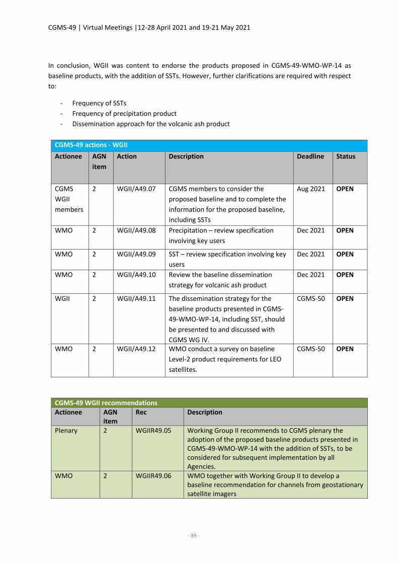
CGMS-49 | Virtual Meetings |12-28 April 2021 and 19-21 May 2021
- 89 -
In conclusion, WGII was content to endorse the products proposed in CGMS-49-WMO-WP-14 as
baseline products, with the addition of SSTs. However, further clarifications are required with respect
to:
- Frequency of SSTs
- Frequency of precipitation product
- Dissemination approach for the volcanic ash product
CGMS-49 actions - WGII
Actionee AGN
item
Action Description Deadline Status
CGMS
WGII
members
2 WGII/A49.07 CGMS members to consider the
proposed baseline and to complete the
information for the proposed baseline,
including SSTs
Aug 2021 OPEN
WMO 2 WGII/A49.08 Precipitation – review specification
involving key users
Dec 2021 OPEN
WMO 2 WGII/A49.09 SST – review specification involving key
users
Dec 2021 OPEN
WMO 2 WGII/A49.10 Review the baseline dissemination
strategy for volcanic ash product
Dec 2021 OPEN
WGII 2 WGII/A49.11 The dissemination strategy for the
baseline products presented in CGMS-
49-WMO-WP-14, including SST, should
be presented to and discussed with
CGMS WG IV.
CGMS-50 OPEN
WMO 2 WGII/A49.12 WMO conduct a survey on baseline
Level-2 product requirements for LEO
satellites.
CGMS-50 OPEN
CGMS-49 WGII recommendations
Actionee AGN item
Rec Description
Plenary 2 WGIIR49.05 Working Group II recommends to CGMS plenary the adoption of the proposed baseline products presented in CGMS-49-WMO-WP-14 with the addition of SSTs, to be considered for subsequent implementation by all Agencies.
WMO 2 WGIIR49.06 WMO together with Working Group II to develop a baseline recommendation for channels from geostationary satellite imagers
CGMS-49 | Virtual Meetings |12-28 April 2021 and 19-21 May 2021
- 90 -
3. CGMS International Science Working Groups
CGMS-49-IWWG-WP-01: Status Report of the International Winds Working Group Activities
This paper presents the ongoing activities and relevant discussion items of the International Wind
Working Group (IWWG) since the CGMS-48 meeting. This paper includes i) ToR for IWWG, ii) Ocean
Vector Winds Task Group, iii) Status of HLPPs and associated actions, iv) IWW15 summary
WMO CGMS-48 plenary (A.48.10) actioned a SCAT task team, led by Dr Ad Stoffelen, to present ToR and
a Roadmap at the CGMS-49 plenary. This is furthermore related to the action of the CGMS-48 WGII
(A.48.10) Ocean Surface Winds (OSW) team to present at next GSICS meeting the potential benefits and
issues of cross-calibration of scatterometer data. The ToR of the International Winds Working Group
(IWWG) that were drafted for CGMS-49 include “(ii) ocean surface winds derived from radar scattering
and conical-scanning microwave radiometers” and objectives “To exchange results on novel
developments regarding the use of satellite-derived winds, in particular for numerical weather
prediction (NWP)”, “To support and perform routinely scheduled wind inter-comparison activities in
close collaboration with (CGMS) scientific working groups”, “To establish agreement for standards in the
verification and validation of satellite-derived winds”, “To support the definition of user requirements
and gap analysis for atmospheric wind parameters in the framework of future Global Observing System
(WIGOS, WMO OSCAR database)” and “To make recommendations to CGMS and to national and
international agencies regarding the utilisation of current and the development of future satellite
instruments on polar satellites.”. Since these objectives in particular are not fully covered by CEOS and
the International Ocean Vector Wind Science Team (IOVWST), it is proposed to form an OSW task group
(TG) within the IWWG. This would formalise a long tradition of the representation of the scatterometer
NWP users and scatterometer wind producers at the IWWG. The CGMS and WMO are user organisations
with a strong focus on the user exploitation of satellite data. In particular, the OSW services for use in
NWP need further coordination and collaboration through the IWWG. This moreover becomes
increasingly pressing as models are coupled to the ocean. Finally, the GSICS action would be very
relevant to this OSW WG and furthermore closely linked to the CEOS Working Group on Cal/Val (WGCV)
Microwave Sensors Subgroup (MSSG). Other IWWG objectives, e. g. on methods and training, that in
parts overlap with CEOS and the IOVWST will also need coordination. Hence the OSW and SCAT task
team recommendation:
Establish an Ocean Surface Wind Task Group (OSW TG) in the CGMS International Winds Working
Group (IWWG) that coordinates its actions and recommendations with GSICS, CEOS and the IOVWST
This implies that OSW TG actions and recommendation will be reported to/from CGMS through
established IWWG mechanisms and in addition to CEOS and IOVWST.
IWWS brought the following main points for consideration to WGII:
1) For consideration by CGMS the endorsement of the IWWG ToR. Recommendation
2) For consideration by CGMS the endorsement of the Ocean Surface Winds Task Group and
associated ToR. Recommendation
3) For consideration by CGMS 49: The IWWG recommends space agencies to address the gap of
3D wind profile observations (lidar and IR missions) with a global coverage as high priority, and
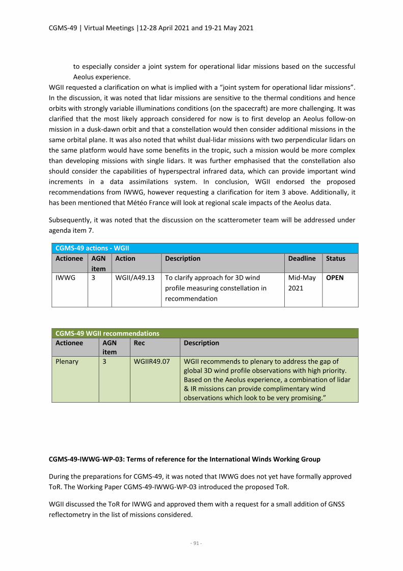
CGMS-49 | Virtual Meetings |12-28 April 2021 and 19-21 May 2021
- 91 -
to especially consider a joint system for operational lidar missions based on the successful
Aeolus experience.
WGII requested a clarification on what is implied with a “joint system for operational lidar missions”.
In the discussion, it was noted that lidar missions are sensitive to the thermal conditions and hence
orbits with strongly variable illuminations conditions (on the spacecraft) are more challenging. It was
clarified that the most likely approach considered for now is to first develop an Aeolus follow-on
mission in a dusk-dawn orbit and that a constellation would then consider additional missions in the
same orbital plane. It was also noted that whilst dual-lidar missions with two perpendicular lidars on
the same platform would have some benefits in the tropic, such a mission would be more complex
than developing missions with single lidars. It was further emphasised that the constellation also
should consider the capabilities of hyperspectral infrared data, which can provide important wind
increments in a data assimilations system. In conclusion, WGII endorsed the proposed
recommendations from IWWG, however requesting a clarification for item 3 above. Additionally, it
has been mentioned that Météo France will look at regional scale impacts of the Aeolus data.
Subsequently, it was noted that the discussion on the scatterometer team will be addressed under
agenda item 7.
CGMS-49 actions - WGII
Actionee AGN
item
Action Description Deadline Status
IWWG 3 WGII/A49.13 To clarify approach for 3D wind
profile measuring constellation in
recommendation
Mid-May
2021
OPEN
CGMS-49 WGII recommendations
Actionee AGN item
Rec Description
Plenary 3 WGIIR49.07 WGII recommends to plenary to address the gap of global 3D wind profile observations with high priority. Based on the Aeolus experience, a combination of lidar & IR missions can provide complimentary wind observations which look to be very promising.”
CGMS-49-IWWG-WP-03: Terms of reference for the International Winds Working Group
During the preparations for CGMS-49, it was noted that IWWG does not yet have formally approved
ToR. The Working Paper CGMS-49-IWWG-WP-03 introduced the proposed ToR.
WGII discussed the ToR for IWWG and approved them with a request for a small addition of GNSS
reflectometry in the list of missions considered.
CGMS-49 | Virtual Meetings |12-28 April 2021 and 19-21 May 2021
- 92 -
CGMS-49 WGII recommendations
Actionee AGN item
Rec Description
Plenary 3 WGIIR49.08 WGII recommends to plenary the adoption of the IWWG Terms of reference.
CGMS-49-IROWG-WP-01: Outcome and Recommendations from the IROWG-8 Workshop
This report summarises the IROWG-8 meeting held on 7-13 April 2021 as a virtual conference, hosted
by NOAA and UCAR. It provides the main recommendations from the four IROWG sub-groups:
Numerical Weather Prediction; Climate; Receiver Technology and Innovative Occultation Techniques;
and Space Weather. The key recommendations for CGMS – endorsed by the IROWG community at the
plenary session – are:
IROWG reaffirms that all providers of RO observations should classify these as essential in the sense
of WMO Resolution 40.
1. IROWG reaffirms that all providers of RO observations should classify these as essential in the
sense of WMO Res 40. IROWG stresses the importance of free, timely, and unrestricted access
in real time to essential RO data, and free and unrestricted access to archived raw data
(including auxiliary data).
2. IROWG continues to recommend that WMO and CGMS should coordinate any GNSS-RO data
purchases. Specifically, we suggest convening a meeting of all agencies considering procuring
these data, in order to discuss if, how, and when the current 20,000 daily target will be met
with global and full local time coverage.
3. IROWG recommends that CGMS encourages technology and retrieval developments for
improving planetary boundary layer profiling from GNSS RO and their utilisation in NWP data
assimilation – and the further exploration of RO-derived water vapour as a climate variable.
4. Per CGMS priority HLPP 1.1.4 (optimised system for atmospheric and ionospheric RO
observations), IROWG recommends that CGMS encourages ongoing and future GNSS RO and
non-RO missions, including potential commercial providers of RO observations, to
incorporate a complete set of ionospheric measurements.
Full workshop minutes and this CGMS working paper from IROWG-8 will be made available at
http://irowg.org/workshops/irowg-8/. All given workshop presentations can be found at
https://cpaess.ucar.edu/meetings/2021/irowg-8.
WGII took note of the presentation. WMO noted that it is currently preparing a new Data Policy and
that the new Data Policy proposal has now passed its first intergovernmental body review. It is planned
to have the new Data Policy approved by the WMO extraordinary Council in October 2021. WMO
further clarified that the new Data Policy includes a reference that core data (previously essential data)
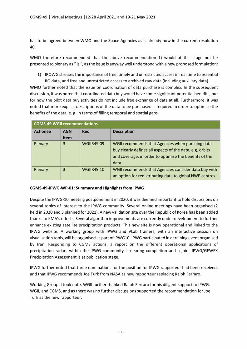
CGMS-49 | Virtual Meetings |12-28 April 2021 and 19-21 May 2021
- 93 -
has to be agreed between WMO and the Space Agencies as is already now in the current resolution
40.
WMO therefore recommended that the above recommendation 1) would at this stage not be
presented to plenary as “ is “, as the issue is anyway well understood with a new proposed formulation:
1) IROWG stresses the importance of free, timely and unrestricted access in real time to essential
RO data, and free and unrestricted access to archived raw data (including auxiliary data).
WMO further noted that the issue on coordination of data purchase is complex. In the subsequent
discussion, it was noted that coordinated data buy would have some significant potential benefits, but
for now the pilot data buy activities do not include free exchange of data at all. Furthermore, it was
noted that more explicit descriptions of the data to be purchased is required in order to optimise the
benefits of the data, e. g. in terms of filling temporal and spatial gaps.
CGMS-49 WGII recommendations
Actionee AGN
item
Rec Description
Plenary 3 WGIIR49.09 WGII recommends that Agencies when pursuing data
buy clearly defines all aspects of the data, e.g. orbits
and coverage, in order to optimise the benefits of the
data.
Plenary 3 WGIIR49.10 WGII recommends that Agencies consider data buy with
an option for redistributing data to global NWP centres.
CGMS-49-IPWG-WP-01: Summary and Highlights from IPWG
Despite the IPWG-10 meeting postponement in 2020, it was deemed important to hold discussions on
several topics of interest to the IPWG community. Several online meetings have been organised (2
held in 2020 and 3 planned for 2021). A new validation site over the Republic of Korea has been added
thanks to KMA’s efforts. Several algorithm improvements are currently under development to further
enhance existing satellite precipitation products. This new site is now operational and linked to the
IPWG website. A working group with IPWG and VLab trainers, with an interactive session on
visualisation tools, will be organised as part of IPWG10. IPWG participated in a training event organised
by Iran. Responding to CGMS actions, a report on the different operational applications of
precipitation radars within the IPWG community is nearing completion and a joint IPWG/GEWEX
Precipitation Assessment is at publication stage.
IPWG further noted that three nominations for the position for IPWG rapporteur had been received,
and that IPWG recommends Joe Turk from NASA as new rapporteur replacing Ralph Ferraro.
Working Group II took note. WGII further thanked Ralph Ferraro for his diligent support to IPWG,
WGII, and CGMS, and as there was no further discussions supported the recommendation for Joe
Turk as the new rapporteur.
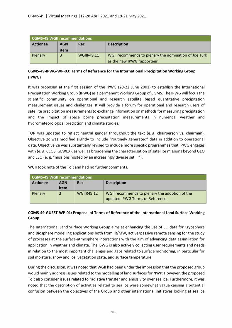
CGMS-49 | Virtual Meetings |12-28 April 2021 and 19-21 May 2021
- 94 -
CGMS-49 WGII recommendations
Actionee AGN
item
Rec Description
Plenary 3 WGIIR49.11 WGII recommends to plenary the nomination of Joe Turk
as the new IPWG rapporteur.
CGMS-49-IPWG-WP-03: Terms of Reference for the International Precipitation Working Group
(IPWG)
It was proposed at the first session of the IPWG (20-22 June 2001) to establish the International
Precipitation Working Group (IPWG) as a permanent Working Group of CGMS. The IPWG will focus the
scientific community on operational and research satellite based quantitative precipitation
measurement issues and challenges. It will provide a forum for operational and research users of
satellite precipitation measurements to exchange information on methods for measuring precipitation
and the impact of space borne precipitation measurements in numerical weather and
hydrometeorological prediction and climate studies.
TOR was updated to reflect neutral gender throughout the text (e. g. chairperson vs. chairman).
Objective 2c was modified slightly to include “routinely generated” data in addition to operational
data. Objective 2e was substantially revised to include more specific programmes that IPWG engages
with (e. g. CEOS, GEWEX), as well as broadening the characterisation of satellite missions beyond GEO
and LEO (e. g. “missions hosted by an increasingly diverse set….”).
WGII took note of the ToR and had no further comments.
CGMS-49 WGII recommendations
Actionee AGN item
Rec Description
Plenary 3 WGIIR49.12 WGII recommends to plenary the adoption of the updated IPWG Terms of Reference.
CGMS-49-GUEST-WP-01: Proposal of Terms of Reference of the International Land Surface Working Group
The International Land Surface Working Group aims at enhancing the use of EO data for Cryosphere
and Biosphere modelling applications both from IR/MW, active/passive remote sensing for the study
of processes at the surface-atmosphere interactions with the aim of advancing data assimilation for
application in weather and climate. The ISWG is also actively collecting user requirements and needs
in relation to the most important challenges and gaps related to surface monitoring, in particular for
soil moisture, snow and ice, vegetation state, and surface temperature.
During the discussion, it was noted that WGII had been under the impression that the proposed group
would mainly address issues related to the modelling of land surfaces for NWP: However, the proposed
ToR also consider issues related to radiative transfer and emissivity over sea ice. Furthermore, it was
noted that the description of activities related to sea ice were somewhat vague causing a potential
confusion between the objectives of the Group and other international initiatives looking at sea ice
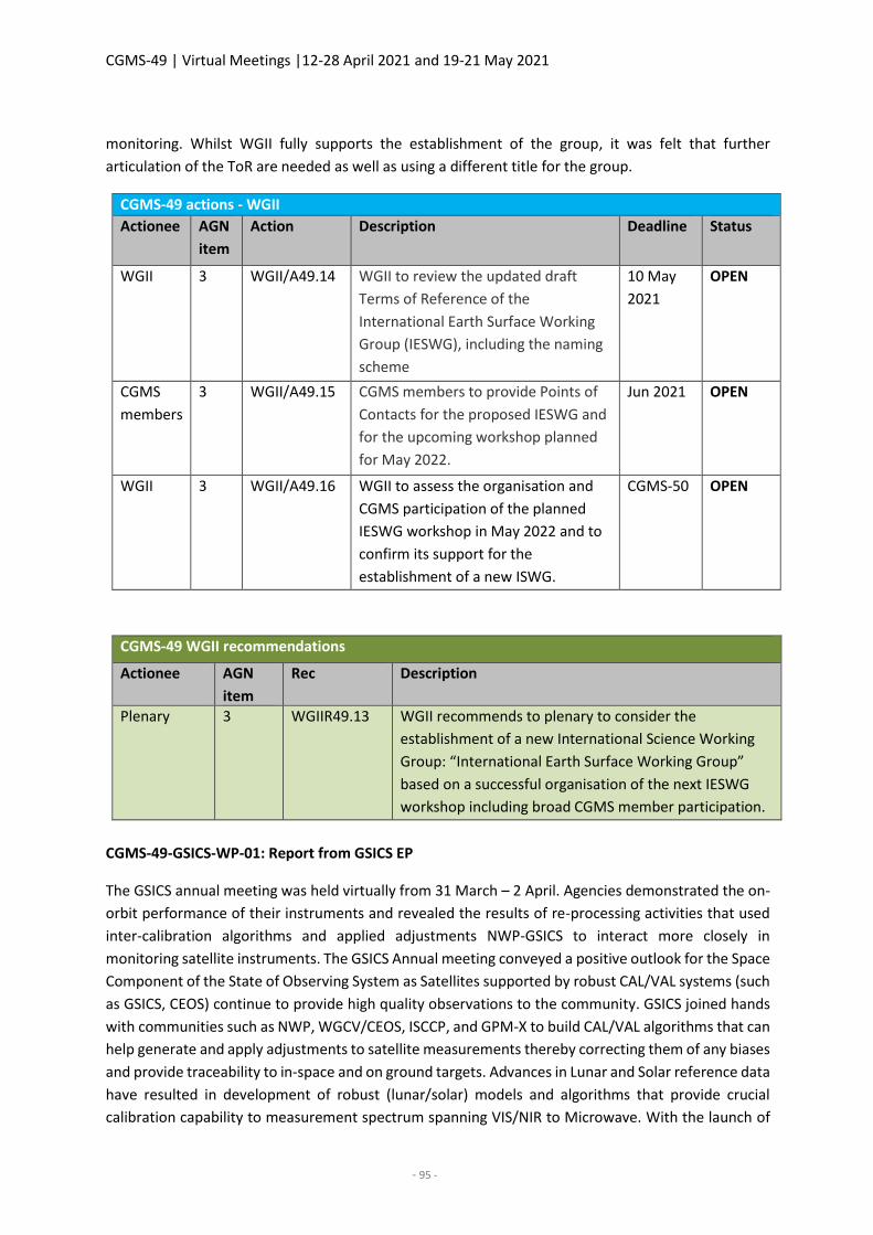
CGMS-49 | Virtual Meetings |12-28 April 2021 and 19-21 May 2021
- 95 -
monitoring. Whilst WGII fully supports the establishment of the group, it was felt that further
articulation of the ToR are needed as well as using a different title for the group.
CGMS-49 actions - WGII
Actionee AGN
item
Action Description Deadline Status
WGII 3 WGII/A49.14 WGII to review the updated draft
Terms of Reference of the
International Earth Surface Working
Group (IESWG), including the naming
scheme
10 May
2021
OPEN
CGMS
members
3 WGII/A49.15 CGMS members to provide Points of
Contacts for the proposed IESWG and
for the upcoming workshop planned
for May 2022.
Jun 2021 OPEN
WGII 3 WGII/A49.16 WGII to assess the organisation and
CGMS participation of the planned
IESWG workshop in May 2022 and to
confirm its support for the
establishment of a new ISWG.
CGMS-50 OPEN
CGMS-49 WGII recommendations
Actionee AGN
item
Rec Description
Plenary 3 WGIIR49.13 WGII recommends to plenary to consider the
establishment of a new International Science Working
Group: “International Earth Surface Working Group”
based on a successful organisation of the next IESWG
workshop including broad CGMS member participation.
CGMS-49-GSICS-WP-01: Report from GSICS EP
The GSICS annual meeting was held virtually from 31 March – 2 April. Agencies demonstrated the on-
orbit performance of their instruments and revealed the results of re-processing activities that used
inter-calibration algorithms and applied adjustments NWP-GSICS to interact more closely in
monitoring satellite instruments. The GSICS Annual meeting conveyed a positive outlook for the Space
Component of the State of Observing System as Satellites supported by robust CAL/VAL systems (such
as GSICS, CEOS) continue to provide high quality observations to the community. GSICS joined hands
with communities such as NWP, WGCV/CEOS, ISCCP, and GPM-X to build CAL/VAL algorithms that can
help generate and apply adjustments to satellite measurements thereby correcting them of any biases
and provide traceability to in-space and on ground targets. Advances in Lunar and Solar reference data
have resulted in development of robust (lunar/solar) models and algorithms that provide crucial
calibration capability to measurement spectrum spanning VIS/NIR to Microwave. With the launch of
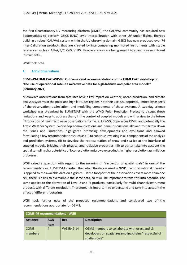
CGMS-49 | Virtual Meetings |12-28 April 2021 and 19-21 May 2021
- 96 -
the first Geostationary UV measuring platform (GMES), the CAL/VAL community has acquired new
opportunities to perform GSICS (SNO) style intercalibration with other UV under flights, thereby
building a robust CAL/VAL system within the UV observing domain. GSICS has now produced over 74
Inter-Calibration products that are created by intercomparing monitored instruments with stable
references such as IASI-A/B/C, CrIS, VIIRS. New references are being sought to span more monitored
instruments.
WGII took note.
4. Arctic observations
CGMS-49-EUMETSAT-WP-09: Outcomes and recommendations of the EUMETSAT workshop on
"the use of operational satellite microwave data for high-latitude and polar area models"
(February 2021)
Microwave observations from satellites have a key impact on weather, ocean prediction, and climate
analysis systems in the polar and high latitudes regions. Yet their use is suboptimal, limited by aspects
of the observation, assimilation, and modelling components of those systems. A two-day science
workshop was organised by EUMETSAT with the WMO Polar Prediction Project to discuss those
limitations and ways to address them, in the context of coupled models and with a view to the future
introduction of new microwave observations from e. g. EPS-SG, Copernicus CIMR, and potentially the
Arctic Weather System. Workshop communications and panel discussions allowed to narrow down
the issues and limitations, highlighted promising developments and evolutions and allowed
formulating a few recommendations such as : (i) to continue investing in all components of the analysis
and prediction systems, (ii) to develop the representation of snow and sea ice at the interface of
coupled models, bridging their physical and radiative properties, (iii) to better take into account the
spatial sampling characteristics of low-resolution microwave products in higher resolution assimilation
processes.
WGII raised a question with regard to the meaning of “respectful of spatial scale” in one of the
recommendations. EUMETSAT clarified that when the data is used in NWP, the observational operator
is applied to the available data on a grid cell. If the footprint of the observation covers more than one
cell, there is a risk to oversample the same data, so it will be important to take this into account. The
same applies to the derivation of Level-2 and -3 products, particularly for multi-channel/instrument
products with different resolution. Therefore, it is important to understand and take into account the
effect of different footprints.
WGII took further note of the proposed recommendations and considered two of the
recommendations appropriate for CGMS.
CGMS-49 recommendations - WGII
Actionee AGN
item
Rec Description
CGMS
members
4 WGIIR49.14 CGMS members to collaborate with users and L3
developers on spatial resampling chains “respectful of
spatial scale”
CGMS-49 | Virtual Meetings |12-28 April 2021 and 19-21 May 2021
- 97 -
CGMS-49 recommendations - WGII
Actionee AGN
item
Rec Description
CGMS
members
4 WGIIR49.15 CGMS members are encouraged to engage with the
MOSAiC PIs for widespread use of the campaign data
CGMS-49-NASA-WP-01: ICESat-2’s capabilities and products for the Arctic
As a result of the tight schedule, NASA combined the foreseen presentations on arctic and bathymetry capabilities of ICESat-2 into one presentation.
ICESat-2, which was launched on 15 September 2018, is carrying NASA’s next generation laser
altimeter, ATLAS (Advanced Topographic Laser Altimeter System), which is a photon-counting lidar
designed to measure changes in ice sheet height, sea ice freeboard, and vegetation canopy height.
ICESat-2 is NASA’s flagship cryospheric sciences mission that was borne out of the 2007 NAS Decadal
Survey recommendation to continue high-quality elevation measurements over Earth’s polar regions
using laser altimetry. For sea ice, ICESat-2’s primary mission objective is to estimate sea ice thickness
to examine ice-ocean-atmosphere exchanges of energy, mass, and moisture by making direct
observations of sea ice height and sea ice freeboard. All along-track height products are available for
download from the NSIDC DAAC, with ATL03 (the global geolocated photon cloud) being the primary
lower-level data product from which all upper-level data are derived. Two along-track sea ice products
are also available for download from the NSIDC DAAC (ATL07 (sea ice height) and ATL10 (sea ice
freeboard)). Additionally, two gridded/derived sea ice products from ICESat-2 are now available
(ATL20 (gridded sea ice freeboard) and ATL21 (gridded monthly sea surface height inside the sea ice
cover)). All sea ice products are generated for both the Arctic and Southern oceans.
While ICESat-2 has no requirement to generate or produce a bathymetric data product, it was
discovered shortly after launch that ATLAS was powerful enough to penetrate shallow bodies of water
and provide estimates of seafloor depth down to 40 m. Using refraction correction techniques, ICESat-
2 scientists have developed methods for calculating the depth of the seafloor in numerous near-shore
environments and are developing a near-coastal bathymetry data product.
WGII took note of the presentations and the highly interesting capabilities of ICESat-2, in particular on
ice monitoring capabilities and the measurements of seafloor depth.
CGMS-49-ECCC-WP-01: Status of plans for an Arctic Observing Monitoring mission by Canada
Canada is coordinating a whole of government strategy for Space-Based Earth Observation
(SBEO) and the Arctic Observing Mission (AOM) is a major proposed initiative of the strategy
and this potential future programme.
AOM would consist of two satellites in a Highly Elliptical Orbit (HEO) formation to make quasi-
geostationary observations of meteorological parameters, GHGs, air quality (AQ) and space
weather over northern regions (~45-90°N) addressing the current sparsity in spatial and
temporal coverage beyond the viewing range of geostationary satellites.
CGMS-49 | Virtual Meetings |12-28 April 2021 and 19-21 May 2021
- 98 -
AOM is envisioned to be implemented as a Canadian-led mission with international partners.
Discussions are underway with potential partners, and collaborative studies will begin in 2021
to mature the mission design and define the roles and contributions of each partner.
Pending formal commitments in the future, AOM would launch around 2032 with a 10-year
operational lifetime.
AOM is viewed as being highly complementary to other existing and planned international
Arctic missions.
ECCC clarified that the final approval is still two years away and targeted for 2023-24.
It was noted that for some imagery applications, like fire monitoring, resolution is important and hence
polar orbiting satellites, despite the lack of temporal coverage, provide some advantages. ECCC
responded and noted that fire monitoring would be a potential application and it has been already
demonstrated in other GEO missions. In this context spatial resolution will be a relevant factor to be
considered in the designing phase. Furthermore, it was noted that the performance and capabilities
of the imager will closely follow those of the current ABI-class of instruments.
5. Working papers on climate
CGMS-49-JWGCLIM-WP-03: Status report of WGClimate
The population of ECV inventory is continuously ongoing so that version 4.0 will be consolidated in
summer/fall 2021. The gap analysis related to version 3.0 is delayed due to the pandemic situation but
will be terminated in fall 2021, latest. The gap analysis for version 4.0 shall be focused on the carbon
cycle including the Global Stocktake aspect. This gap analysis is planned to be carried out during a
workshop end of this year/beginning of 2021, favourably in person. For that, science experts are
needed from agencies. Agencies are invited to nominate!
Use cases for Climate Data Records started as a new continuous activity of JWGClimate in order to
demonstrate the value of the Climate Data Records for applications and decision making etc., but also
in providing feedback towards quality improvements. Use cases shall be published on the web but a
special WMO report is planned for 2021 on a representative selection. There is a need for an outreach
to the broader community. CGMS member agencies are requested to advertise pro-actively this
activity!
The Global Stocktake activities are ongoing and CGMS WGs had nominated PoCs in order to support
the implementation of a virtual GHG monitoring and verification constellation (S. Burns for WGI&IV, J.
Privette for WGII, and P. Zhang for WGIII). With updating the roadmap, the WGs will be included into
the activities.
CMA was querying about the support to FCDR activities given by JWGClimate. JWGClimate clarified
that the level of support depends on available resources. Furthermore, the discussion on the
terminology FCDR/FDR is ongoing, which may also have an implication on the level of engagement of
JWGClimate in the related activities.
CGMS-49 | Virtual Meetings |12-28 April 2021 and 19-21 May 2021
- 99 -
It was also noted that during the report from IWWG, more guidance for the generation of the TCDRs
is needed. JWGClimate noted that the International Science Working Groups should be represented
on JWGClimate through their respective Chairs or Co-chairs. To date however, very little participation
from the ISWGs has been seen and the ISWG are hence encouraged to clarify their PoCs for
JWGClimate and to support the related activities.
CGMS-49 actions - WGII
Actionee AGN
item
Action Description Deadline Status
CGMS
members
5 WGII/A49.17 CGMS members shall nominate
scientific experts (not necessarily
agency staff!) in order support the
upcoming ECV inventory gap analysis
with respect to the Carbon Cycle
ECVs including Global Stocktake
aspects.
Aug 2021 OPEN
CGMS-49-WMO-WP-11: GCOS status report
The GCOS Status report is being finalised after a period of public review. It will be presented to the
UNFCCC COP this year. It summarises the status of observations for each ECV and action from the 2016
GCOS Implementation Plan, with the full details contained in annexes. A chapter on satellite
observations was contributed by the Joint CEOS/CGMS JWGClimate. Since 2016, satellite observations
have improved their coverage both spatially, temporally, and in terms of observed variables. Satellite
data are accessible and well curated.
There have been improvements due to new in situ observations while GCOS and WMO are establishing
a reference network for in situ observations (similar to GRUAN). Best practices for ocean observations,
data and meta-data were agreed and the development of improved sensors for a range of ocean ECVs.
However, the long-term continuity of some satellite observations is not assured: no continuity is
assured for cloud radar and lidar on research satellites, and only one limb sounder with similar
capabilities to the Aura Microwave Limb Sounder (MLS) is planned.
For in situ observations, sustainable and operational funding is needed. Many atmospheric
observations are made on an operational basis, with most ocean observations and terrestrial
observations supported through research funding with a typical lifetime of a few years. In situ
observations for almost all the atmospheric and terrestrial ECVs are consistently deficient over certain
regions, most notably Africa, South America, South East Asia, the Southern Ocean, and ice-covered
regions.
To support the UNFCCC Global Stocktake ECVs quantitative assessment of anthropogenic greenhouse
gas fluxes, and ECVs that track physical, chemical, and biological cycles as well as direct measures of
the ocean overturning circulation are needed. Preservation of the fundamental climate data records
is essential. While there are many successful global climate data centres, even when there is a
recognised global data repository, it is sometimes incomplete and/or inadequately supported. The
GCOS/WCRP Climate Observations conference will be held online from 30 August to 3 September 2021
(see https://www.eventsforce.net/eumetsat/27/dailyAgenda). GCOS would encourage the Satellite
CGMS-49 | Virtual Meetings |12-28 April 2021 and 19-21 May 2021
- 100 -
community to contribute, submit abstracts, and participate in this event. [NB the GCOS conference
has in the meantime been postponed to 2022 due to the pandemic].
The Status Report and the Climate Observations Conference will be key inputs into the next GCOS
Implementation Plan due in 2022. GCOS would like to ask CGMS to contribute to the development of
the Implementation Plan.
CGMS is invited to take note of the upcoming GCOS Status Report and GCOS/WCRP Climate
Observations Conference.
Proposed Action CGMS WGII: CGMS to provide input for the next GCOS Implementation Plan based
on the findings of the Status Report and Climate ConferenceWGII took note of the report. During the
discussion, the translation of technology free GCOS requirements to space-based observation
requirements was raised. Both GCOS and JWGClimate agreed that this translation of the requirements
is critical and that a formal mechanism for the translation is currently missing. It was further
considered that GCOS and JWGClimate would jointly be in the best position to consider the best way
forward towards establishment of a formal approach to achieve the objective.
CGMS-49 actions – WGII Actionee AGN
item
Action Description Deadline Status
CGMS
members
5 WGII/A49.18 CGMS to provide input for the next
GCOS Implementation Plan
Observations Conference.
TBD OPEN
GCOS/
JWGClim
ate
5 WGII/A49.19 GCOS and JWGClimate to develop a
proposal for a formal approach for the
translation of GCOS technology free
requirements to requirements for
space-based observations.
CGMS-50 OPEN
CGMS-49-CMA-WP-06: Progress of Fengyun satellite FCDRs
This document presents the progress of Fengyun satellite fundamental climate data record (FCDR)
generation. Historical sensor data records (SDR) are being reprocessed for 7 series of instruments
including 3 optical imagers (FY-1/3 VIRR, FY-3 MERSI, and FY-2 VISSSR), 1 optical sounder (FY-3 IRAS),
2 microwave sounders (FY-3 MWTS and MWHS), and 1 microwave imager (FY-3 MWRI). Three versions
dataset are planned (beta, trial, and formal) with the release times of 2019, 2020, and 2021,
respectively. The beta version (V1) datasets have been completed through the lifetime recalibration
of each instrument in 2019, using the consistent calibration framework. The trial version (V2) dataset
focuses on the improvement of the recalibration model to achieve the accuracy and stability. At
present, the trial version (V2) datasets are completed for MWRI, MWTS, and VIRR solar bands,
meanwhile others are still ongoing.
In responding to a clarification from WGII, it was noted that reprocessed outgoing LW radiation and
AMV products have been provided to the JWGClimate inventory and regarding FCDRs the issue is open
and waiting clarification of the overall engagement of JWGClimate in FCDR activities.
CGMS-49 | Virtual Meetings |12-28 April 2021 and 19-21 May 2021
- 101 -
CGMS-49-EUMETSAT-WP-06: Progress on EUMETSAT FCDRs
The presentation addresses recent progress at EUMETSAT in the preparation of Fundamental (Climate)
Data Records (FCDRs). EUMETSAT produces FCDRs for the usage in:
1. Direct exploitation for GCOS Essential Climate Variables;
2. Data assimilation schemes for global and regional reanalysis employing NWP models. Progress
has been made on a number of items with data being available at
https://navigator.eumetsat.int:
3. Date rescue, image radiometric anomaly detection, uncertainty estimation, and recalibration
for all Meteosat and Japanese (in collaboration with JMA) instruments in geostationary orbit;
4. Recalibration and improved quality flagging for HIRS-1/2/3/4 IR sounders;
5. Consistent uncertainty estimates for 183 GHz channels for MW sounders (SSM/T2, AMSU-B,
MHS, ATMS, MWHS-1/2);
6. Radio occultation data records with application of consistent wave optics algorithms for CHAMP,
GRACE, COSMIC, and MetOp GRAS;
7. Assessment of bias correction models for reanalysis for HIRS, MVIRI, SSM/T2, and SMMR
instruments.
A long-term goal is the implementation of CGMS plenary action A48.05 to generate quality controlled,
recalibrated, and uncertainty characterised Fundamental Data Records (FDRs) for each individual
geostationary platform addressing all spectral channels. Generation of a quasi-Global Fundamental
Climate Data Record (FCDR) derived from the individual FDRs. To foster activities EUMETSAT plans to
revive the SCOPE-CM IOGEO project under a new name: Geostationary ring of meteorological satellites
FCDR for Climate (GeoClim) and asks CGMS agencies for participation. This project can support the
needs of many geo ‘ring’ FCDR users for global ECV data records including the ISCCP-NG project
CMA noted that it would be important to ensure that data series go back in time as far as possible and
would welcome additional validation activities with CMA data.
With respect to Sentinel-3 reprocessing, EUMETSAT noted its responsibility for the ocean mission, so
L2 reprocessing is guaranteed, together with some L1 for the altimetry. However, the overall mission
responsibility is split between ESA and EUMETSAT, with ESA being responsible for land products and
reprocessing of those products fall on ESA. Furthermore, the level-1 reprocessing activities are joint
and the way forward for coordinated consistent reprocessing is currently under discussion.
CGMS-49 actions - WGII Actionee AGN
item
Action Description Deadline Status
EUM,
CMA
5 WGII/A49.20 EUMETSAT and CMA to consider
opportunities for intercomparison of
their reprocessed data sets.
CGMS-50 OPEN
CGMS-49-NOAA-WP-19: Use cases from NOAA CDRs
CGMS-49 | Virtual Meetings |12-28 April 2021 and 19-21 May 2021
- 102 -
NOAA has produced and extended Climate Data Records (CDRs) derived from its operational satellite
fleets for nearly two decades. CDRs typically merge data from multiple satellites extending over multi-
decadal time periods to provide the longest homogeneous and consistent time series data records
possible from historical observations. Most NOAA CDRs are global and extend from the late 1970s
through present. They provide about 200 different data fields characterising the dynamic Earth
system, from atmospheric temperature to Arctic sea ice, vegetation density and health, and solar
irradiance.
CDRs are used in a wide range of research and applications. Government, industry, and academia use
CDRs to monitor climate by putting current forecasts and observations into historical context, and to
reliably identify climate trends, patterns, anomalies, and extremes. They also support many climate
adaptation, risk-assessment, and other socioeconomic applications. Most CDRs address the Essential
Climate Variable (ECV) requirements of the Global Climate Observing System (GCOS), support global
modelling efforts and national and international assessments (e. g. Intergovernmental Panel on
Climate Change, IPCC).
In this presentation, example uses and applications of NOAA’s CDRs were described, including the
validation of climate projections, assessing agricultural droughts, and predicting domestic energy
demand.
WGII took note of the presentation, which provides important examples demonstrating the benefits
of CDRs beyond use of the products in NWP reanalysis. It was further noted that more cases are
needed and whilst the CGMS members may not themselves develop use cases, the members are
encouraged to reach out to their data users to identify additional use cases
CGMS-49 actions - WGII
Actionee AGN
item
Action Description Deadline Statu
s CGMS
members
5 WGII/A49
.21
CGMS members are requested to reach
out to the users of their respective CDRs
for additional use cases.
Dec 2021 OPEN
CGMS-49-ISCCP-WP-01: Status of the International Satellite Cloud Climatology Next Generation
(ISCCP-NG)
With the availability of MTG in 2023, the entire geostationary ring will be encircled by imagers which
offer capabilities far superior to those from the previous generation of imagers. The Next Generation
of the International Satellite Cloud Climatology Project (ISCCP-NG) is proposed as a follow-on to the
classic ISCCP to more fully exploit the new capabilities. The challenge facing ISCCP-NG is to define a
new baseline from these data and processing methods to extract meaningful information for the
scientific community in the coming decades. Since the inaugural workshop in late 2019, ISCCP-NG has
focused on its gridded Level-1 (L1g) data. L1g is meant to be the primary input into all ISCCP-NG Level-
2 and Level-3 and is an attempt to make access to these new data easy for the ISCCP-NG community.
L1g combines all of the data from all of the sensors into one standard and consistent format. Currently,
CGMS-49 | Virtual Meetings |12-28 April 2021 and 19-21 May 2021
- 103 -
L1g concepts are being prototyped and made available for testing. L1g development is relying on the
GSICS project for calibration. With L1g data available, the work on ISCCP-NG Level-2 data is beginning
and will be discussed at future International Cloud Working Group (ICWG) Workshops in the next two
years.
WGII welcomed the presentation and in particular noted the importance of connecting with GSICS as
shown. During the discussion, the importance of having consistent long-term time series was
underlined and the question was raised on how ISCCP-NG, which is based on the current generation
of satellites, can be used for older satellite data. In response, Andy Heidinger noted that reprocessing
past data is a big important topic that the group will work on. With respect to the use of the proposed
L1g for Level-2 reprocessing activities, it was confirmed that this currently is a request for cloud
products, but other products are welcomed too. Furthermore, it was noted that this is an additional
activity on top of NRT Level-2 production and nominal reprocessing activities.
CGMS-49 actions - WGII
Actionee AGN
item
Action Description Deadline Status
CGMS
members
5 WGII/A49.22 CGMS member to provide feedback
on the proposed L1g concept for
ISCCP-NG.
TBD OPEN
CGMS-49 recommendations - WGII
Actionee AGN
item
Rec Description
CGMS
members
5 WGIIR49.16 CGMS member to consider derivation of Level-2
products using the new proposed Level-1g data.
6. Agency response to the greenhouse gas initiative and applications
CGMS-49-CMA-WP-08: Space observation of greenhouse gas from China
The three instruments for greenhouse gas measurements from space are operated by China:
Atmospheric Carbon-dioxide Grating Spectroradiometer (ACGS) TanSat, GHG (GreenHouse Gases)
Absorption Spectrometer (GAS) on FengYun-3D (FY-3D) and Greenhouse-gas Monitoring Instrument
(GMI) on Gaofen-5 (GF-5). They utilise different technique to obtain high resolution spectra in near
infrared band. XCO2 and SIF products are successfully retrieved from these missions in China. But
much work is still needed to investigate in order to provide valuable products with high accuracy and
precision for monitoring the carbon cycle and climate research.
WGII congratulated CMA on their progress on the provision of space-based high-quality Greenhouse
Gas monitoring data.
CGMS-49-EUMETSAT-WP-12: Status of the CO2M mission
CGMS-49 | Virtual Meetings |12-28 April 2021 and 19-21 May 2021
- 104 -
As part of the European Copernicus Programme, ESA, together with the support of EUMETSAT and
ECMWF, are preparing the expansion of the first-generation Copernicus Space Component to include
measurements for anthropogenic CO2 emission monitoring. The greatest contribution to the increase
in atmospheric CO2 comes from emissions from the combustion of fossil fuels and cement production.
In support of well-informed policy decisions and for assessing the effectiveness of strategies for CO2
emission reduction, uncertainties associated with current anthropogenic emission estimates at
national and regional scales need to be improved.
ESA has been tasked by the European Commission to develop the space-segment and its payload, as
well as parts of the overall ground-segment of a future CO2-Monitoring (CO2M) mission. Through an
envisaged Contribution Agreement with the European Union, it is expected that EUMETSAT will be
tasked to develop the remaining parts of the overall ground-segment including the Mission Data
Ground-Processing Sub-Segment (MDGS), which facilitates the continuous processing, monitoring,
validation and, where needed, vicarious calibration of the payload data-products and their operational
dissemination to users. EUMETSAT will also undertake the routine operations of the CO2M satellites,
while ESA will perform the satellite in-orbit verification and satellite commissioning activities whilst
taking care of the satellite operations during this phase.
In the paper an overview of the mission objectives is provided, the space-segment payload and their
target requirements, as well as the main logical elements of the CO2M operational processing system
currently implemented and established as part of ESAs CO2M Phase B2/C/D/E1 and EUMETSATs CO2M
Phase A/B1 activities. Particular focus is put on giving an overview of the key parameters and products,
which can be expected from CO2M and point to specific challenges for a future operational CO2
monitoring system.
WGII noted the presented schedule is challenging in terms of actual launch, data processing, and
provision of data in time for the global stocktake in 2028. For the data to be considered, it would need
to be available latest early 2027. EUMETSAT and ESA clarified that the launch readiness review is in
quarter 4 2025 and the launch would nominally be roughly three months after the review.
Furthermore, it is currently foreseen to initially launch two satellites, with the third satellite of the
constellation being launched later. With respect to the data processing challenges, it was noted that
through international collaboration the mission can take benefit from lessons learnt by the OCO-2 and
GOSAT teams and furthermore there are several similarities with EUMETSAT EOS-SG instruments that
alleviate the challenges. However, all-in-all, it was agreed that the schedule remains challenging.
CGMS-49-JAXA-WP-04: Decade-long global GHG observation by GOSAT towards the global stocktake
The Japanese Greenhouse gases Observing SATellite (GOSAT), in orbit since 23 January 2009, monitors
carbon dioxide and methane globally every 3 days and targets large cities in over 50 locations
frequently and has been doing so for more than 12 years. Within the GOSAT mission, GOSAT-2 was
launched in 29 October 2018 and has been in normal operation. GOSAT and GOSAT-2 are equipped
with a single Fourier transform interferometer and have simultaneously observed both reflected SWIR
solar light and TIR emissions with the Thermal And Near-infrared Sensor for carbon Observation
Fourier-Transform Spectrometer (TANSO-FTS) and TANSO-FTS-2, respectively. JAXA Earth Observing
Research Center (EORC) has newly developed the retrieval method to derive the difference between
CGMS-49 | Virtual Meetings |12-28 April 2021 and 19-21 May 2021
- 105 -
the partial column-averaged dry-air mole fractions of the two individual layers of lower and upper
troposphere (LT and UT) by combining TIR and two linear polarised SWIR spectra data simultaneously,
thereby constraining the accurate total column density of XCO2 and XCH4. To contribute to the 2023
Global Stocktake, JAXA continuously provides observation data and research products to the public.
In addition, the agency tries to elucidate the local emissions though the intense target observation
dataset of GOSAT and GOSAT-2. The key for estimating the localised emission is how to identify the
background concentration with discreating sources. JAXA assumes that the upper partial column
results represent background CO2 concentrations, which are less affected by the city, while the lower
partial column results track the CO2 concentration changes within the city. In 2020, the agency
detected lower anomalies than previous years over mega cities such as Beijing and Tokyo. JAXA/EORC
products have a potential to open a state-of-the-art approach in local flux estimation. Their research
products are available at the JAXA GOSAT EORC site (https://www.eorc.jaxa.jp/GOSAT/index.html).
WGII congratulated JAXA on their progress on GHG monitoring. In response to a query from WGII,
JAXA clarified that they regularly monitor several megacities beyond those mentioned in the
presentation. It was further clarified that JAXA uses modelling and other satellite observations like
Sentinel-5p, to detect high CO2 levels and then guide the mission for target acquisition. Furthermore,
inputs from other entities are considered as well.
CGMS-49-NOAA-WP-08: NOAA report on GHG monitoring
NOAA is of the opinion that an integrated and sustained, multi-platform, surface-to-space GHG
observing system capable of tracking ecosystem, ocean, and anthropogenic emissions and removals is
needed to improve climate predictions and support mitigation efforts.
Recent studies demonstrate the complementarity of diverse satellite and in situ measurements for
tracking GHG emissions and removals.
Systematic errors in current XCO2 and XCH4 satellite datasets are large relative to key ecosystem and
anthropogenic flux signals.
Stability requirements for diagnosing processes and tracking emissions cannot be realised without a
greatly expanded and sustained Global Greenhouse Gas Reference Network of well-calibrated in situ
measurements with sufficient density and frequency to reliably correct regional, time-dependent, and
cross-platform biases.
A continuum from research to sustained operations should be maintained to ensure measurement
compatibility over decades while allowing for innovation
The paper proposes for CGMS actioning:
- Creation of a GCOS Global Greenhouse Gas Reference Network consisting of rigorously
calibrated in situ surface, aircraft, and balloon measurements to enable the reliable detection
of trends over decades to centuries.
- Creation of GCOS National and/or Regional Greenhouse Gas Reference Networks with
sufficient density and frequency to reliably detect and correct significant time-dependent
CGMS-49 | Virtual Meetings |12-28 April 2021 and 19-21 May 2021
- 106 -
regional biases in satellite GHG datasets. High priority for new observations should be focused
on data-poor regions and regions sensitive to change.
- These activities should be conducted in close collaboration with the WMO Global Atmosphere
Watch Programme and the WMO Integrated Global Greenhouse Gas Information System.
During the discussion, it was noted that CGMS is well aware of the importance of ground-based/in-
situ observations, and this has been discussed previously in this and earlier meetings. Furthermore,
whilst recognising the need for this data not only from an overall monitoring system, but also for
satellite calibration/validation activities, CGMS does not establish or operate ground-based networks.
It was further noted that the need for ground-based/in-situ observations and evolution of reference
networks should be discussed in the JWGClimate Task Team. As suggested by the paper, coordination
on the requirements for and access to reference network data are already discussed with GCOS and
GAW/IG3IS.
CGMS-49 actions - WGII
Actionee A
G
N
it
e
m
Action Description Deadline Status
JWGClimate 6 WGII/A49.23 JWGClimate GHG task team to
provide a report on the progress of
the evolution of ground-based/in-situ
GHG observations to CGMS.
CGMS-50 OPEN
WMO 6 WGII/A49.24 WMO to raise the concern on
adequacy of existing GHG reference
networks to GAW/IG3IS and GCOS
and to report on the current status of
the development of reference
networks at WMO.
Sep 2021 OPEN
7. Working papers on ocean monitoring
CGMS-49-EUMETSAT-WP-11: CGMS Ocean Vector Winds Task Team - Terms of Reference and
roadmap
WMO CGMS-48 plenary (A.48.10) actioned a SCAT task team, led by Dr Ad Stoffelen, to present ToR
and a Roadmap at the CGMS-49 plenary. This is furthermore related to the action of the CGMS-48
WGII (A.48.10) Ocean Surface Winds (OSW) team to present at the next GSICS meeting the potential
benefits and issues of cross-calibration of scatterometer data. The ToR of the International Winds
Working Group (IWWG) drafted for CGMS-49 include “(ii) ocean surface winds derived from radar
scattering and conical-scanning microwave radiometers” and objectives “To exchange results on novel
developments regarding the use of satellite-derived winds, in particular for numerical weather
prediction (NWP)”, “To support and perform routinely scheduled wind inter-comparison activities in
close collaboration with (CGMS) scientific working groups”, “To establish agreement for standards in
the verification and validation of satellite-derived winds”, “To support the definition of user
requirements and gap analysis for atmospheric wind parameters in the framework of future Global
CGMS-49 | Virtual Meetings |12-28 April 2021 and 19-21 May 2021
- 107 -
Observing System (WIGOS, WMO OSCAR database)” and “To make recommendations to CGMS and to
national and international agencies regarding the utilisation of current and the development of future
satellite instruments on polar satellites”. Since these objectives in particular are not fully covered by
CEOS and the International Ocean Vector Wind Science Team (IOVWST), it is proposed to form an OSW
task group (TG) within the IWWG. This would formalise a long tradition of the representation of the
scatterometer NWP users and scatterometer wind producers at the IWWG. The CGMS and WMO are
user organisations with a strong focus on the user exploitation of satellite data. In particular, the OSW
services for use in NWP need further coordination and collaboration through the IWWG. This
moreover becomes increasingly pressing as models are coupled to the ocean. Finally, the GSICS action
would be very relevant to this OSW WG and furthermore closely linked to the CEOS Working Group
on Cal/Val (WGCV) Microwave Sensors Subgroup (MSSG). Other IWWG objectives, e. g. on methods
and training, that in parts overlap with CEOS and the IOVWST, will also need coordination. Hence the
OSW and SCAT task team recommendation:
Establish an Ocean Surface Wind Task Group (OSW TG) in the CGMS International Winds Working
Group (IWWG) that coordinates its actions and recommendations with GSICS, CEOS, and the IOVWST
This implies that OSW TG actions and recommendation will be reported to/from CGMS through
established IWWG mechanisms and in addition to CEOS and IOVWST.
IOC welcomed the presentation and noted it is trying to organise a scatterometer task team. Vector
wind is a fundamental parameter for ocean science. IOC already started the UN ocean decade. IOC
should be involved in this discussion. IOC further expressed its interest to join and support the work
of the team.
It was further noted that as the scatterometer observations have become a fundamental part of the
operational space-based observing system, a coordination mechanism within CGMS is long overdue.
CGMS welcomed the foreseen coordination with ongoing CEOS initiatives to assure there will not be
duplication of efforts. In addition, the coordination with other international efforts is important.
In conclusion, WGII supported the creation of the dedicated Task Group:
CGMS-49 recommendations - WGII
Actionee AGN
item
Rec Description
Plenary 7 WGIIR49.17 WGII recommends to plenary the establishment of an Ocean Surface Wind Task Group (OSW TG) in the CGMS International Winds Working Group (IWWG) that coordinates its actions and recommendations with GSICS, CEOS, and the IOVWST and other relevant entities.
CGMS-49 | Virtual Meetings |12-28 April 2021 and 19-21 May 2021
- 108 -
CGMS-49-NOAA-WP-10: The value of NOAA CoastWatch/OceanWatch/PolarWatch to operational
satellite oceanography
Satellite-based ocean/water remote sensing products are being integrated into many operational
applications for routine and event-driven environmental assessments, predictions, forecasts,
research, and management decisions, providing societal and economic (“the blue economy”) benefits.
The significant potential for many more applications will be realised as satellite data
providers/agencies work with users to increase their awareness of data fit for their purposes, reduce
barriers to understanding and access, and develop new tools and analytical methods with capacities
to exploit large quantities of remotely-sensed data without the need for users to become “satellite
data experts”. Since its origins in 1987, NOAA CoastWatch/OceanWatch/PolarWatch (a.k.a.
“CoastWatch”, https://coastwatch.noaa.gov) has been connecting users and applications with ocean
and coastal satellite data, bridging gaps, and facilitating the transition from data to information.
CoastWatch serves all NOAA missions (including National Weather Service, National Marine Fisheries
Service and National Ocean Service, and the office of Oceanic and Atmospheric Research) and others
in the US or internationally, including other government agencies, academia, industry/commercial
sector, non-profit organisations, and the general public. CoastWatch data products and services
include value-added and analysis-ready data products, data portals, visualisation software, training
courses and tutorials, helpdesk and user forums as well as direct collaboration with stakeholders on
application development. In June 2019, NOAA and EUMETSAT jointly hosted the First International
Operational Satellite Oceanography Symposium (OSOS) which was held at the NOAA Center for
Weather and Climate Prediction in College Park, MD, US. The Second International Operational
Satellite Oceanography Symposium (OSOS-2) will take place virtually 25-27 May 2021 and will build
upon the outcomes and recommendations of the first, this time focusing on users and applications in
a few specific themes. One of the recommendations of the first OSOS was to engage with CGMS to
promote understanding and actions on oceanographic satellite observations and requirements. The
corresponding paper aims at familiarising CGMS with the role of NOAA CoastWatch in promoting and
facilitating the use of satellite data in ocean and coastal applications (operational satellite
oceanography). In light of the growing role of ocean satellite observations for operational applications
and “the blue economy” as well as their importance in weather and climate forecasting, CGMS is
hereby urged to consider adopting explicit ocean-related objectives and activities in the next HLPP,
leveraging the knowledge and expertise of the organising committees and the outcomes and
recommendations of the International OSOSs.
The Chair appreciates the multiple service perspective presented in this talk.
HLPP would be the place where CGMS could stress more the ocean context. The data access section
would be a suitable place for this reference. CGMS could be more specific in terms of referring to the
ocean. NOAA could provide a more specific statement to be used.
An ocean and coastal WG/Task Team could be a solution to reinforce the CGMS support to operational
oceanography. It could be a significant contribution to the UN Ocean Decade and its Global Coastal
Ocean programme (CoastPredict, coastpredict.org - Programme Document).
CGMS-49 | Virtual Meetings |12-28 April 2021 and 19-21 May 2021
- 109 -
CGMS-49 actions - WGII
Actionee
AGN item
Action Description Deadline Status
NOAA 7 WGII/A49.25 To provide specific suggestions to CGMSSEC for updated language in HLPP with respect to Oceans.
CGMS-50 OPEN
CGMSSEC
7 WGII/A49.26 CGMS SEC to suggest updates on HLPP on oceans to CGMS WG I-IV Chairs
CGMS-50 OPEN
WGII 7 WGII/A49.27 WGII to consider the value and approach for the establishment of a new Ocean and Coast Working Group as a new International Science Working Group
CGMS-50 OPEN
CGMS-49 recommendations - WGII
Actionee AGN item
Rec Description
Plenary 7 WGIIR49.18 WGII recommends to plenary the endorsement for future OSOS Symposia
OSO 7 WGIIR49.19 WGII recommends that OSOS engages with the full International community
CGMS-49-IOC-UNESCO-WP-01: Need for satellite observations for ocean monitoring and synergies
with surface-based observations satellite oceanography
The proposed presentation by IOC on “Need for satellite observations for ocean monitoring and
synergies with surface-based observations satellite oceanography” was withdrawn due to schedule
issues. IOC however proposed to WGII that such a paper would be presented at CGMS-50 and would
invite additional people to support the presentation. The paper would look at the need for satellite
observations and synergies with in-situ observations to improve predictability of weather and climate.
The expansion of the observation considerations to the entire oceans, bottom to top and coast to
coast, also fits the new WMO strategy. The theme is also very appropriate for IOC and the new UN
Decade on Ocean Science for sustainable Development. It is proposed that an action from WGII to IOC
to provide a paper at CGMS-50 is tabled.
The CGMS Secretariat noted that there is a standing action to invite IOC to CGMS to present key issues
with respect to ocean observations and hence there is no need for a new action.
8. Selected topics of high priority to members
CGMS-49-ESA-WP-02: Status of Aeolus data and products
ESA’s wind mission, Aeolus, was launched on 22 August 2018. Aeolus is an ESA Earth Explorer Core
mission, hosting a single payload – the first space-based Doppler Wind Lidar (DWL) worldwide. The
primary mission objective is to demonstrate the DWL technique for measuring wind profiles from
CGMS-49 | Virtual Meetings |12-28 April 2021 and 19-21 May 2021
- 110 -
space, intended for assimilation in NWP models. The wind observations will also be used to advance
atmospheric dynamics research and for evaluation of climate models. Mission spin-off products are
profiles of cloud and aerosol optical properties. The Aeolus data quality is less good than anticipated
before launch (random errors: 3 -6.5 m/s), but still provides a larger than expected positive impact in
global NWP models, as demonstrated by ECMWF, DWD, Météo-France, UK Met Office, NOAA, ECCC,
NCMRWF, and JMA (also reported at 15th IWWG workshop, 12-16 April 2021).
The Aeolus instrument is suffering from slowly drifting alignment causing an increase of the product
random errors with time. Mitigating activities are ongoing to allow for sufficient data quality to ensure
positive NWP impact also beyond 2021 (design lifetime: 3 years). The mission was recently extended
to the end of 2022. Follow-on DWL missions delivering improved-quality winds in the next decade are
strongly supported by the IWWG.
Public data release in May 2020:
- Distribution of L1, L2A, L2B, L2C data within 3 hours of sensing (NRT) via ESA’s Aeolus Data
Dissemination Facility (ADDF, http://aeolus-ds.eo.esa.int/oads/access/)
- Distribution of L2B BUFR formatted data NRT via EUMETSAT and DWD on EUMETCAST
- WMO GTS (to initiate GTS reception, please contact DWD)
Further algorithm baseline updates improving further on product random and systematic error
performance and classification:
- Baseline 11, implemented in near real-time-processing as of October 2020
- Baseline 12, delivered and will be implemented in NRT processing in May 2021
Data reprocessing datasets, for use e. g. in OSE and other impact experiment activities:
- Baseline 10, reprocessed dataset: July 2019 –December 2019 (initial part of Aeolus FM-B laser
dataset) available to users since October 2020. Improvements include e. g. bias correction and
improved signal processing reducing random errors
- Baseline 11, reprocessed dataset: July 2019 – to date: Reprocessing ongoing and data
scheduled for delivery to users in Q3 2021
Centres currently operationally assimilating Aeolus L2B wind observations:
- ECMWF (since January 2020)
- DWD (since May 2020)
- Météo-France (since June 2020)
- UK MetOffice (since December 2020)
- Possibly also in 2021: NCMRWF, JMA
WGII congratulated ESA on the success of Aeolus and wished them continued success with the mission
despite the challenges. WGII especially noted gratefully that ESA is considering every possible option
to maintain the mission as long as possible. ESA responded that the intention is to continue the mission
as long as the data is of value to the users.
CGMS-49 | Virtual Meetings |12-28 April 2021 and 19-21 May 2021
- 111 -
ESA also clarified that in the presence of clouds, Aeolus either measures wind at the top of cloud or
for thin clouds also in clouds. Aeolus is also exploiting gaps between the clouds to optimise coverage.
CGMS-49-JMA-WP-05: Sunshine duration product estimated from 2.5-minute Himawari-8
observation data
JMA operates a surface meteorological observation network incorporating around 1,300 stations using
automatic observation equipment collectively known as the Automated Meteorological Data
Acquisition System (AMeDAS). Stations are situated at average intervals of 17 km nationwide (with
around 1,200 unmanned), and the Weather Analysis Map (WAM) gridded weather product developed
from the data collected helps to meet user demand for 2-D meteorological information. Enhanced
Himawari-8/AHI temporal resolution enables sunshine duration analysis using 2.5-minute rapid
observation over Japan, which was added to the WAM product on 23rd September 2020. Gradient-
boosting decision-tree machine learning is used for related estimation with AMeDAS sunshine
duration observation teacher data excluding values affected by shadows from surrounding obstacles.
Himawari-8 observation data, grid point data from NWP (e. g. atmospheric transmittance) and
geometrical condition information such as sun zenith angle are used as input. Comparison of estimated
one-hour sunshine durations with AMeDAS observation data for the period from July 2018 to June
2020 shows a BIAS of 0.73 minutes and an RMSE of 8.26 minutes. The one-hour sunshine duration
product is used to monitor the latest meteorological conditions. The sunshine duration observation
role of AMeDAS stations was terminated in March 2021 in favour of the 10-minute sunshine duration
product.
WGII thanked JMA for their presentation. It was clarified that the sunshine products are already
provided to a number of users.
In response to a query on plans for a full disk product JMA clarified that the current product is mainly
targeting Japan and the development of a full disk product is not currently considered.
CGMS-49-NOAA-WP-06: Status of GEOXO plans
GOES-R series in operations now, with 2 more launches in late 2021 and 2024, and will be in operations
in the 2030s
Expected loss of an on-orbit spare in 2032 drives the need date for NOAA’s next generation
geostationary satellite series
A NOAA working group formed in early 2020 and was tasked with recommending user requirements
for the future geostationary programme, called Geostationary and Extended Orbits (GeoXO).
A series of user engagement workshops were held in 2020 to assess user needs and expected
observing requirements for the 2030-2050 time period.
Five instrument types in geostationary orbit were recommended: Imager, IR Hyperspectral Sounder,
Lightning Mapper, Atmospheric Composition, and Ocean Colour.
CGMS-49 | Virtual Meetings |12-28 April 2021 and 19-21 May 2021
- 112 -
The Chair noted that following the same presentation given at the joint WGII-WGIII meeting, the
importance of operational continuity of air quality/atmospheric composition measurements after
TEMPO, which could be provided by GEO XO ACX, was discussed. He further noted that a letter of
support in that respect to NOAA from CGMSSEC could be considered with an associated
recommendation to plenary. The proposal was supported by WGII.
In response to a query from KMA it was clarified that there are some advantages and disadvantages
of both proposed constellations. The advantage of the first constellation which also looks at payload
hosted on non-NOAA satellites is that it provides better coverage for the hyperspectral infrared
sounder data. The disadvantage is that both the sounder and imager are large instruments, leading to
a larger overall spacecraft, which is more costly to develop with a high risk. The advantage of the three
NOAA provided satellite system is the provision of the hyperspectral capabilities on a different
platform than the imager, which then leads to smaller spacecraft, cost, and reduced risk, however at
the cost of hyperspectral sounder coverage.
CGMS-49 actions - WGII
Actionee AGN item
Action Description Deadline Status
CGMS SEC
8 WGII/A49.28 WMO/CGMS SEC to write a letter of support to NOAA on the GEO XO ACX efforts.
Aug 2021 OPEN
CGMS-49 recommendations - WGII
Actionee AGN item
Rec Description
Plenary 8 WGIIR49.20 WGII recommends to plenary that CGMS provides a letter of support to NOAA on the GEO XO ACX efforts
CGMS-49-IPWG-WP-02: Precipitation Monitoring and the constellation of microwave instruments
Regarding the status of the constellation of microwave instruments, IPWG held an open online session
in June 2020 to discuss future needs for precipitation monitoring. This online session, with 120 remote
participants, paved the way for a smaller group of IPWG members led by C. Kidd (NASA) to submit a
paper summarising the observational needs for precipitation monitoring, how these needs are met
with the current constellation, as well as how these may be met with future instruments. The
presentation summarises the outcomes of this paper, recently accepted for publication in the Bulletin
of the American Meteorological Society, as well as recent efforts made on this subject within the IPWG
community.
The Chair noted that it is important to take these kinds of analysis into account, providing a more
detailed description of the requirements, when considering the WMO WIGOS Vision 2040 and for
CGMS baseline.
It was further noted that it would be useful to have additional information from IPWG to determine
detailed requirements for microwave baseline observations as an input to the gap analysis and for the
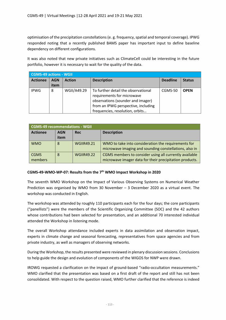
CGMS-49 | Virtual Meetings |12-28 April 2021 and 19-21 May 2021
- 113 -
optimisation of the precipitation constellations (e. g. frequency, spatial and temporal coverage). IPWG
responded noting that a recently published BAMS paper has important input to define baseline
dependency on different configurations.
It was also noted that new private initiatives such as ClimateCell could be interesting in the future
portfolio, however it is necessary to wait for the quality of the data.
CGMS-49 actions - WGII
Actionee AGN item
Action Description Deadline Status
IPWG 8 WGII/A49.29 To further detail the observational requirements for microwave observations (sounder and imager) from an IPWG perspective, including frequencies, resolution, orbits…
CGMS-50 OPEN
CGMS-49 recommendations - WGII
Actionee AGN item
Rec Description
WMO 8 WGIIR49.21 WMO to take into consideration the requirements for microwave imaging and sounding constellations, also in terms of equatorial crossing time in future reviews of the WIGOS Vision 2040.
CGMS members
8 WGIIR49.22 CGMS members to consider using all currently available microwave imager data for their precipitation products.
CGMS-49-WMO-WP-07: Results from the 7th WMO Impact Workshop in 2020
The seventh WMO Workshop on the Impact of Various Observing Systems on Numerical Weather
Prediction was organised by WMO from 30 November – 3 December 2020 as a virtual event. The
workshop was conducted in English.
The workshop was attended by roughly 110 participants each for the four days; the core participants
(“panellists”) were the members of the Scientific Organizing Committee (SOC) and the 42 authors
whose contributions had been selected for presentation, and an additional 70 interested individual
attended the Workshop in listening mode.
The overall Workshop attendance included experts in data assimilation and observation impact,
experts in climate change and seasonal forecasting, representatives from space agencies and from
private industry, as well as managers of observing networks.
During the Workshop, the results presented were reviewed in plenary discussion sessions. Conclusions
to help guide the design and evolution of components of the WIGOS for NWP were drawn.
IROWG requested a clarification on the impact of ground-based “radio-occultation measurements.”
WMO clarified that the presentation was based on a first draft of the report and still has not been
consolidated. With respect to the question raised, WMO further clarified that the reference is indeed
CGMS-49 | Virtual Meetings |12-28 April 2021 and 19-21 May 2021
- 114 -
to ground-based GPS and not to radio occultation and noted that this will be clarified for the final
report.
IROWG noted that with respect to radio-frequency and protection, there is a clear impact on RO
observations from what appears to be intentional jamming of the GPS frequency band. This has been
documented in e. g.: https://cpaess.ucar.edu/sites/default/files/meetings/2021-irowg-
8/posters/Roberts1_Detection%20copy.pdf
9. Working papers responding to or raising CGMS actions
There were no other papers addressed.
10. Any other business
During the AOB section, the updated terms of reference for IWWG and the new proposed working
group “International Land Surface Working Group” (ILSWG) were reviewed.
After an additional minor change, the ToR of IWWG were recommended to plenary for adoption (see
also agenda item 3 and recommendation (WGIIR49.08)).
Based on an Action from Session 3, ILSWG reconsidered the name of the group and proposed
“International Earth Surface Working Group” as the new name. Furthermore, an updated ToR was
presented. WGII noted that support to modelling is still the primary focus of the working group,
however as the actual activities are well defined in the updated ToR, the new proposed name of the
group is acceptable. WGII then subsequently endorsed the proposal and ToR for the new group with
an associated recommendation to plenary for adoption (see also agenda item 3 and recommendation
WGIIR49.13).
11. Review and updating of the HLPP
CGMS-49-CGMS-WP-03WGII: Status of implementation of CGMS High Level Priority Plan (2020-
2024), CGMS-49-CGMS-WP-04WGI: Proposed update to the CGMS High-Level Priority Plan (HLPP)
for the period 2021-2024
CGMSSEC introduced the subject and noted that there had not been any recorded proposed changes
to the HLPP during the meeting, however some refinements are expected with respect to ocean
monitoring. It was therefore proposed that the review of the HLPP will be done by the Chairs,
rapporteurs, and CGMSSEC separately in time for CGMS-49 Plenary.
WGII took note of and endorsed the way forward.
12. Future CGMS plenary sessions
CGMS-49-CGMS-WP-06WG11: Nominations CGMS, ISWGs, VLAB - Co-chairs and rapporteurs
There is a need to fill a number of vacancies (or upcoming ones in the near future) for co-chairs and
rapporteurs in some of the CGMS Working Groups, rapporteurs in the CGMS international science
working groups, and the co-chair position in VLab. The status is provided in the working paper
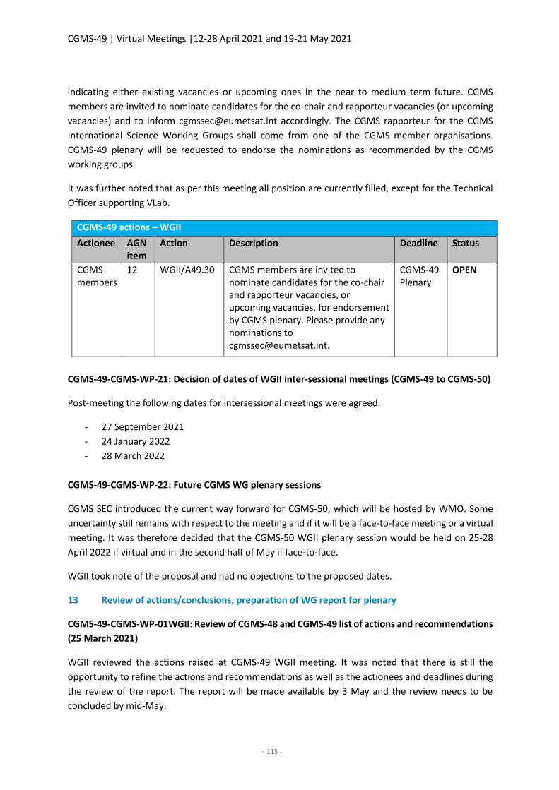
CGMS-49 | Virtual Meetings |12-28 April 2021 and 19-21 May 2021
- 115 -
indicating either existing vacancies or upcoming ones in the near to medium term future. CGMS
members are invited to nominate candidates for the co-chair and rapporteur vacancies (or upcoming
vacancies) and to inform [email protected] accordingly. The CGMS rapporteur for the CGMS
International Science Working Groups shall come from one of the CGMS member organisations.
CGMS-49 plenary will be requested to endorse the nominations as recommended by the CGMS
working groups.
It was further noted that as per this meeting all position are currently filled, except for the Technical
Officer supporting VLab.
CGMS-49 actions – WGII
Actionee AGN item
Action Description Deadline Status
CGMS members
12 WGII/A49.30 CGMS members are invited to nominate candidates for the co-chair and rapporteur vacancies, or upcoming vacancies, for endorsement by CGMS plenary. Please provide any nominations to [email protected].
CGMS-49 Plenary
OPEN
CGMS-49-CGMS-WP-21: Decision of dates of WGII inter-sessional meetings (CGMS-49 to CGMS-50)
Post-meeting the following dates for intersessional meetings were agreed:
- 27 September 2021
- 24 January 2022
- 28 March 2022
CGMS-49-CGMS-WP-22: Future CGMS WG plenary sessions
CGMS SEC introduced the current way forward for CGMS-50, which will be hosted by WMO. Some
uncertainty still remains with respect to the meeting and if it will be a face-to-face meeting or a virtual
meeting. It was therefore decided that the CGMS-50 WGII plenary session would be held on 25-28
April 2022 if virtual and in the second half of May if face-to-face.
WGII took note of the proposal and had no objections to the proposed dates.
13 Review of actions/conclusions, preparation of WG report for plenary
CGMS-49-CGMS-WP-01WGII: Review of CGMS-48 and CGMS-49 list of actions and recommendations
(25 March 2021)
WGII reviewed the actions raised at CGMS-49 WGII meeting. It was noted that there is still the
opportunity to refine the actions and recommendations as well as the actionees and deadlines during
the review of the report. The report will be made available by 3 May and the review needs to be
concluded by mid-May.
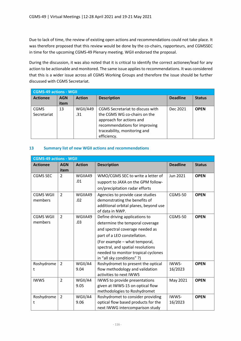
CGMS-49 | Virtual Meetings |12-28 April 2021 and 19-21 May 2021
- 116 -
Due to lack of time, the review of existing open actions and recommendations could not take place. It
was therefore proposed that this review would be done by the co-chairs, rapporteurs, and CGMSSEC
in time for the upcoming CGMS-49 Plenary meeting. WGII endorsed the proposal.
During the discussion, it was also noted that it is critical to identify the correct actionee/lead for any
action to be actionable and monitored. The same issue applies to recommendations. It was considered
that this is a wider issue across all CGMS Working Groups and therefore the issue should be further
discussed with CGMS Secretariat.
CGMS-49 actions - WGII
Actionee AGN item
Action Description Deadline Status
CGMS Secretariat
13 WGII/A49.31
CGMS Secretariat to discuss with the CGMS WG co-chairs on the approach for actions and recommendations for improving traceability, monitoring and efficiency.
Dec 2021 OPEN
13 Summary list of new WGII actions and recommendations
CGMS-49 actions - WGII
Actionee AGN item
Action Description Deadline Status
CGMS SEC 2 WGIIA49.01
WMO/CGMS SEC to write a letter of
support to JAXA on the GPM follow-
on/precipitation radar efforts
Jun 2021 OPEN
CGMS WGII members
2 WGIIA49.02
Agencies to provide case studies demonstrating the benefits of additional orbital planes, beyond use of data in NWP.
CGMS-50 OPEN
CGMS WGII members
2 WGIIA49.03
Define driving applications to
determine the temporal coverage
and spectral coverage needed as
part of a LEO constellation.
(For example – what temporal, spectral, and spatial resolutions needed to monitor tropical cyclones in “all sky conditions” ?)
CGMS-50 OPEN
Roshydromet
2 WGII/A49.04
Roshydromet to present the optical flow methodology and validation activities to next IWWS
IWWS-16/2023
OPEN
IWWS 2 WGII/A49.05
IWWS to provide presentations given at IWWS-15 on optical flow methodologies to Roshydromet
May 2021 OPEN
Roshydromet
2 WGII/A49.06
Roshydromet to consider providing optical flow based products for the next IWWG intercomparison study
IWWS-16/2023
OPEN
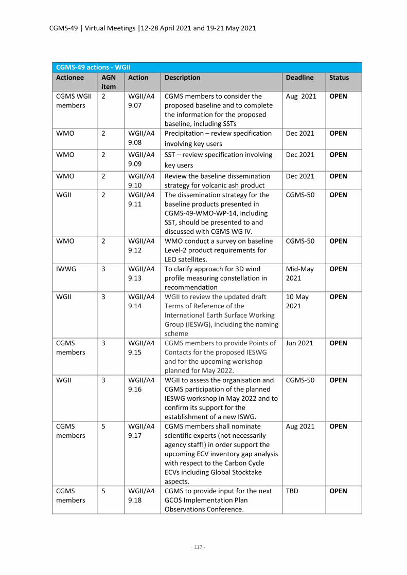
CGMS-49 | Virtual Meetings |12-28 April 2021 and 19-21 May 2021
- 117 -
CGMS-49 actions - WGII
Actionee AGN item
Action Description Deadline Status
CGMS WGII members
2 WGII/A49.07
CGMS members to consider the proposed baseline and to complete the information for the proposed baseline, including SSTs
Aug 2021 OPEN
WMO 2 WGII/A49.08
Precipitation – review specification
involving key users
Dec 2021 OPEN
WMO 2 WGII/A49.09
SST – review specification involving
key users
Dec 2021 OPEN
WMO 2 WGII/A49.10
Review the baseline dissemination strategy for volcanic ash product
Dec 2021 OPEN
WGII 2 WGII/A49.11
The dissemination strategy for the baseline products presented in CGMS-49-WMO-WP-14, including SST, should be presented to and discussed with CGMS WG IV.
CGMS-50 OPEN
WMO 2 WGII/A49.12
WMO conduct a survey on baseline Level-2 product requirements for LEO satellites.
CGMS-50 OPEN
IWWG 3 WGII/A49.13
To clarify approach for 3D wind profile measuring constellation in recommendation
Mid-May 2021
OPEN
WGII 3 WGII/A49.14
WGII to review the updated draft Terms of Reference of the International Earth Surface Working Group (IESWG), including the naming scheme
10 May 2021
OPEN
CGMS members
3 WGII/A49.15
CGMS members to provide Points of Contacts for the proposed IESWG and for the upcoming workshop planned for May 2022.
Jun 2021 OPEN
WGII 3 WGII/A49.16
WGII to assess the organisation and CGMS participation of the planned IESWG workshop in May 2022 and to confirm its support for the establishment of a new ISWG.
CGMS-50 OPEN
CGMS members
5 WGII/A49.17
CGMS members shall nominate scientific experts (not necessarily agency staff!) in order support the upcoming ECV inventory gap analysis with respect to the Carbon Cycle ECVs including Global Stocktake aspects.
Aug 2021 OPEN
CGMS members
5 WGII/A49.18
CGMS to provide input for the next GCOS Implementation Plan Observations Conference.
TBD OPEN
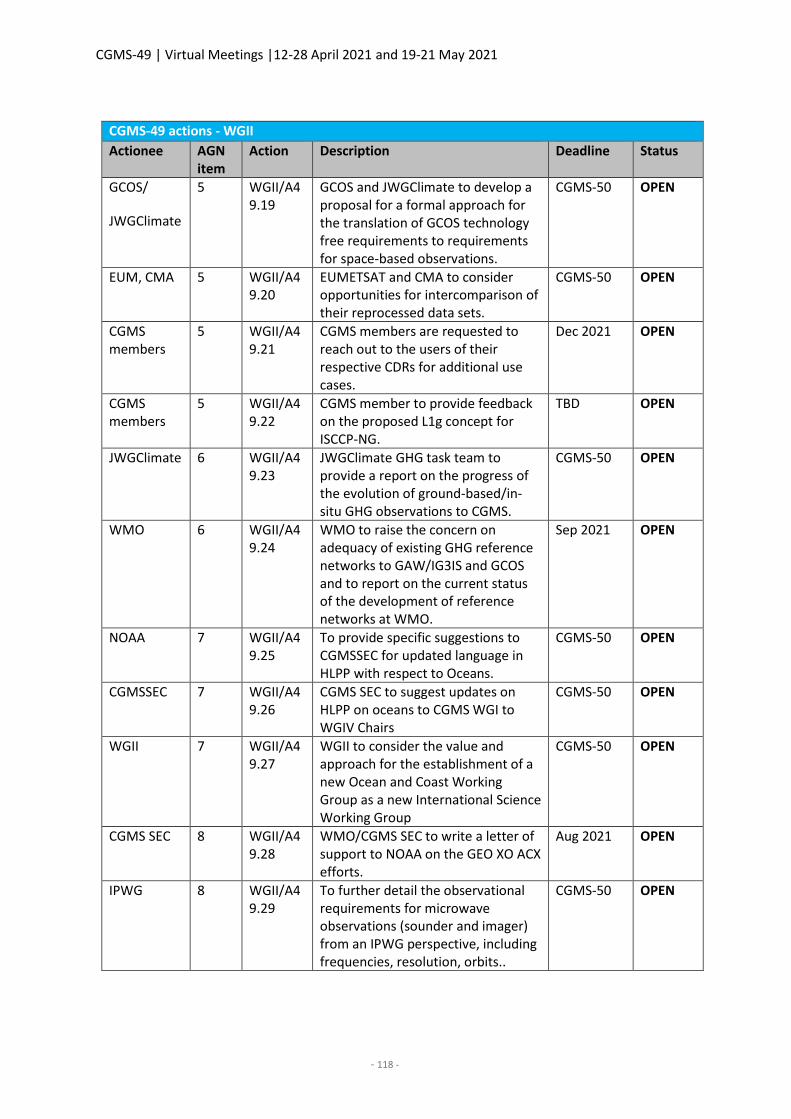
CGMS-49 | Virtual Meetings |12-28 April 2021 and 19-21 May 2021
- 118 -
CGMS-49 actions - WGII
Actionee AGN item
Action Description Deadline Status
GCOS/
JWGClimate
5 WGII/A49.19
GCOS and JWGClimate to develop a proposal for a formal approach for the translation of GCOS technology free requirements to requirements for space-based observations.
CGMS-50 OPEN
EUM, CMA 5 WGII/A49.20
EUMETSAT and CMA to consider opportunities for intercomparison of their reprocessed data sets.
CGMS-50 OPEN
CGMS members
5 WGII/A49.21
CGMS members are requested to reach out to the users of their respective CDRs for additional use cases.
Dec 2021 OPEN
CGMS members
5 WGII/A49.22
CGMS member to provide feedback on the proposed L1g concept for ISCCP-NG.
TBD OPEN
JWGClimate 6 WGII/A49.23
JWGClimate GHG task team to provide a report on the progress of the evolution of ground-based/in-situ GHG observations to CGMS.
CGMS-50 OPEN
WMO 6 WGII/A49.24
WMO to raise the concern on adequacy of existing GHG reference networks to GAW/IG3IS and GCOS and to report on the current status of the development of reference networks at WMO.
Sep 2021 OPEN
NOAA 7 WGII/A49.25
To provide specific suggestions to CGMSSEC for updated language in HLPP with respect to Oceans.
CGMS-50 OPEN
CGMSSEC 7 WGII/A49.26
CGMS SEC to suggest updates on HLPP on oceans to CGMS WGI to WGIV Chairs
CGMS-50 OPEN
WGII 7 WGII/A49.27
WGII to consider the value and approach for the establishment of a new Ocean and Coast Working Group as a new International Science Working Group
CGMS-50 OPEN
CGMS SEC 8 WGII/A49.28
WMO/CGMS SEC to write a letter of support to NOAA on the GEO XO ACX efforts.
Aug 2021 OPEN
IPWG 8 WGII/A49.29
To further detail the observational requirements for microwave observations (sounder and imager) from an IPWG perspective, including frequencies, resolution, orbits..
CGMS-50 OPEN
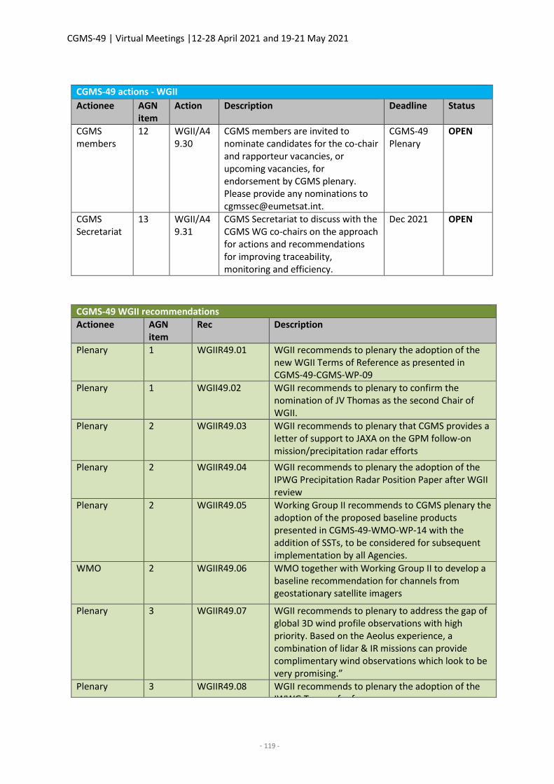
CGMS-49 | Virtual Meetings |12-28 April 2021 and 19-21 May 2021
- 119 -
CGMS-49 actions - WGII
Actionee AGN item
Action Description Deadline Status
CGMS members
12 WGII/A49.30
CGMS members are invited to nominate candidates for the co-chair and rapporteur vacancies, or upcoming vacancies, for endorsement by CGMS plenary. Please provide any nominations to [email protected].
CGMS-49 Plenary
OPEN
CGMS Secretariat
13 WGII/A49.31
CGMS Secretariat to discuss with the CGMS WG co-chairs on the approach for actions and recommendations for improving traceability, monitoring and efficiency.
Dec 2021 OPEN
CGMS-49 WGII recommendations
Actionee AGN item
Rec Description
Plenary 1 WGIIR49.01 WGII recommends to plenary the adoption of the new WGII Terms of Reference as presented in CGMS-49-CGMS-WP-09
Plenary 1 WGII49.02 WGII recommends to plenary to confirm the nomination of JV Thomas as the second Chair of WGII.
Plenary 2 WGIIR49.03 WGII recommends to plenary that CGMS provides a letter of support to JAXA on the GPM follow-on mission/precipitation radar efforts
Plenary 2 WGIIR49.04 WGII recommends to plenary the adoption of the IPWG Precipitation Radar Position Paper after WGII review
Plenary 2 WGIIR49.05 Working Group II recommends to CGMS plenary the adoption of the proposed baseline products presented in CGMS-49-WMO-WP-14 with the addition of SSTs, to be considered for subsequent implementation by all Agencies.
WMO 2 WGIIR49.06 WMO together with Working Group II to develop a baseline recommendation for channels from geostationary satellite imagers
Plenary 3 WGIIR49.07 WGII recommends to plenary to address the gap of global 3D wind profile observations with high priority. Based on the Aeolus experience, a combination of lidar & IR missions can provide complimentary wind observations which look to be very promising.”
Plenary 3 WGIIR49.08 WGII recommends to plenary the adoption of the IWWG Terms of reference.
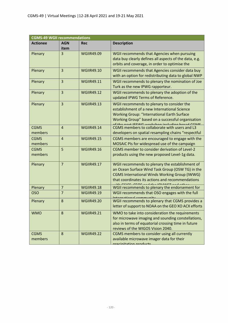
CGMS-49 | Virtual Meetings |12-28 April 2021 and 19-21 May 2021
- 120 -
CGMS-49 WGII recommendations
Actionee AGN item
Rec Description
Plenary 3 WGIIR49.09 WGII recommends that Agencies when pursuing data buy clearly defines all aspects of the data, e.g. orbits and coverage, in order to optimise the benefits of the data. Plenary 3 WGIIR49.10 WGII recommends that Agencies consider data buy with an option for redistributing data to global NWP centres. Plenary 3 WGIIR49.11 WGII recommends to plenary the nomination of Joe Turk as the new IPWG rapporteur.
Plenary 3 WGIIR49.12 WGII recommends to plenary the adoption of the updated IPWG Terms of Reference.
Plenary 3 WGIIR49.13 WGII recommends to plenary to consider the establishment of a new International Science Working Group: “International Earth Surface Working Group” based on a successful organisation of the next IESWG workshop including broad CGMS member participation.
CGMS members
4 WGIIR49.14 CGMS members to collaborate with users and L3 developers on spatial resampling chains “respectful of spatial scale” CGMS
members 4 WGIIR49.15 CGMS members are encouraged to engage with the
MOSAiC PIs for widespread use of the campaign data CGMS
members 5 WGIIR49.16 CGMS member to consider derivation of Level-2
products using the new proposed Level-1g data.
Plenary 7 WGIIR49.17 WGII recommends to plenary the establishment of an Ocean Surface Wind Task Group (OSW TG) in the CGMS International Winds Working Group (IWWG) that coordinates its actions and recommendations with GSICS, CEOS and the IOVWST and other relevant entities.
Plenary 7 WGIIR49.18 WGII recommends to plenary the endorsement for future OSOS Symposia OSO 7 WGIIR49.19 WGII recommends that OSO engages with the full International community
Plenary 8 WGIIR49.20 WGII recommends to plenary that CGMS provides a letter of support to NOAA on the GEO XO ACX efforts
WMO 8 WGIIR49.21 WMO to take into consideration the requirements for microwave imaging and sounding constellations, also in terms of equatorial crossing time in future reviews of the WIGOS Vision 2040.
CGMS members
8 WGIIR49.22 CGMS members to consider using all currently available microwave imager data for their precipitation products.
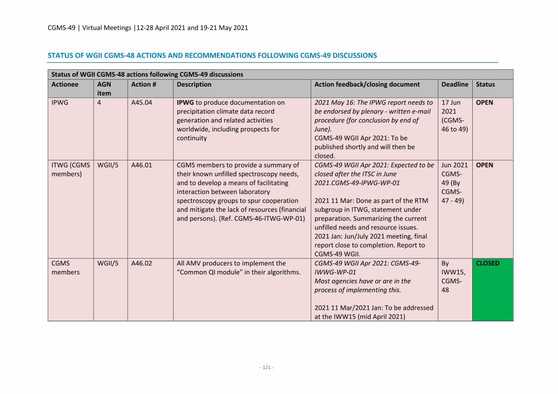
CGMS-49 | Virtual Meetings |12-28 April 2021 and 19-21 May 2021
- 121 -
STATUS OF WGII CGMS-48 ACTIONS AND RECOMMENDATIONS FOLLOWING CGMS-49 DISCUSSIONS
Status of WGII CGMS-48 actions following CGMS-49 discussions
Actionee AGN item
Action # Description Action feedback/closing document Deadline Status
IPWG 4 A45.04 IPWG to produce documentation on precipitation climate data record generation and related activities worldwide, including prospects for continuity
2021 May 16: The IPWG report needs to be endorsed by plenary - written e-mail procedure (for conclusion by end of June). CGMS-49 WGII Apr 2021: To be published shortly and will then be closed.
17 Jun 2021 (CGMS-46 to 49)
OPEN
ITWG (CGMS members)
WGII/5 A46.01 CGMS members to provide a summary of their known unfilled spectroscopy needs, and to develop a means of facilitating interaction between laboratory spectroscopy groups to spur cooperation and mitigate the lack of resources (financial and persons). (Ref. CGMS-46-ITWG-WP-01)
CGMS-49 WGII Apr 2021: Expected to be closed after the ITSC in June 2021.CGMS-49-IPWG-WP-01 2021 11 Mar: Done as part of the RTM subgroup in ITWG, statement under preparation. Summarizing the current unfilled needs and resource issues. 2021 Jan: Jun/July 2021 meeting, final report close to completion. Report to CGMS-49 WGII.
Jun 2021 CGMS-49 (By CGMS-47 - 49)
OPEN
CGMS members
WGII/5 A46.02 All AMV producers to implement the “Common QI module” in their algorithms.
CGMS-49 WGII Apr 2021: CGMS-49-IWWG-WP-01 Most agencies have or are in the process of implementing this. 2021 11 Mar/2021 Jan: To be addressed at the IWW15 (mid April 2021)
By IWW15, CGMS-48
CLOSED
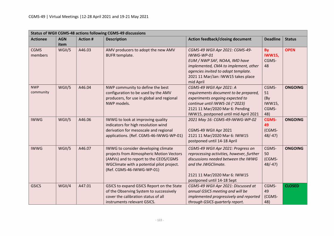
CGMS-49 | Virtual Meetings |12-28 April 2021 and 19-21 May 2021
- 122 -
Status of WGII CGMS-48 actions following CGMS-49 discussions
Actionee AGN item
Action # Description Action feedback/closing document Deadline Status
CGMS members
WGII/5 A46.03 AMV producers to adopt the new AMV BUFR template.
CGMS-49 WGII Apr 2021: CGMS-49-IWWG-WP-01 EUM / NWP SAF, NOAA, IMD have implemented, CMA to implement, other agencies invited to adopt template. 2021 11 Mar/Jan: IWW15 takes place mid April
By IWW15, CGMS-48
OPEN
NWP community
WGII/5 A46.04 NWP community to define the best configuration to be used by the AMV producers, for use in global and regional NWP models.
CGMS-49 WGII Apr 2021: A requirements document to be prepared, experiments ongoing expected to continue until IWWS-16 (~2023) 2121 11 Mar/2020 Mar 6: Pending IWW15, postponed until mid April 2021
CGMS-51 (By IWW15, CGMS-48)
ONGOING
IWWG WGII/5 A46.06 IWWG to look at improving quality indicators for high resolution wind derivation for mesoscale and regional applications. (Ref. CGMS-46-IWWG-WP-01)
2021 May 16: CGMS-49-IWWG-WP-02 CGMS-49 WGII Apr 2021 2121 11 Mar/2020 Mar 6: IWW15 postponed until 14-18 April
CGMS-49 (CGMS-48/-47)
ONGOING
IWWG WGII/5 A46.07 IWWG to consider developing climate projects from Atmospheric Motion Vectors (AMVs) and to report to the CEOS/CGMS WGClimate with a potential pilot project. (Ref. CGMS-46-IWWG-WP-01)
CGMS-49 WGII Apr 2021: Progress on reprocessing activities, however, further discussions needed between the IWWG and the JWGClimate. 2121 11 Mar/2020 Mar 6: IWW15 postponed until 14-18 Sept
CGMS-50 (CGMS-48/-47)
ONGOING
GSICS WGII/4 A47.01 GSICS to expand GSICS Report on the State of the Observing System to successively cover the calibration status of all instruments relevant GSICS.
CGMS-49 WGII Apr 2021: Discussed at annual GSICS meeting and will be implemented progressively and reported through GSICS quarterly report.
CGMS-49 (CGMS-48)
CLOSED
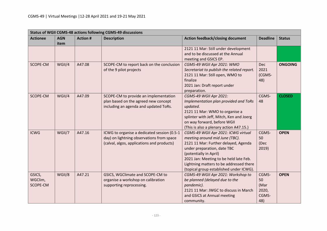
CGMS-49 | Virtual Meetings |12-28 April 2021 and 19-21 May 2021
- 123 -
Status of WGII CGMS-48 actions following CGMS-49 discussions
Actionee AGN item
Action # Description Action feedback/closing document Deadline Status
2121 11 Mar: Still under development and to be discussed at the Annual meeting and GSICS EP.
SCOPE-CM WGII/4 A47.08 SCOPE-CM to report back on the conclusion of the 9 pilot projects
CGMS-49 WGII Apr 2021: WMO Secretariat to publish the related report. 2121 11 Mar: Still open, WMO to finalize 2021 Jan: Draft report under preparation.
Dec 2021 (CGMS-48)
ONGOING
SCOPE-CM WGII/4 A47.09 SCOPE-CM to provide an implementation plan based on the agreed new concept including an agenda and updated ToRs.
CGMS-49 WGII Apr 2021: Implementation plan provided and ToRs updated. 2121 11 Mar: WMO to organise a splinter with Jeff, Mitch, Ken and Joerg on way forward, before WGII (This is also a plenary action A47.15.)
CGMS-48
CLOSED
ICWG WGII/7 A47.16 ICWG to organise a dedicated session (0.5-1 day) on lightning observations from space (calval, algos, applications and products)
CGMS-49 WGII Apr 2021: ICWG virtual meeting around mid June (TBC). 2121 11 Mar: Further delayed, Agenda under preparation, date TBC (potentially in April) 2021 Jan: Meeting to be held late Feb. Lightning matters to be addressed there (topical group established under ICWG).
CGMS-50 (Dec 2019)
OPEN
GSICS, WGClim, SCOPE-CM
WGII/8 A47.21 GSICS, WGClimate and SCOPE-CM to organise a workshop on calibration supporting reprocessing.
CGMS-49 WGII Apr 2021: Workshop to be planned (delayed due to the pandemic). 2121 11 Mar: JWGC to discuss in March and GSICS at Annual meeting community.
CGMS-50 (Mar 2020, CGMS-48)
OPEN
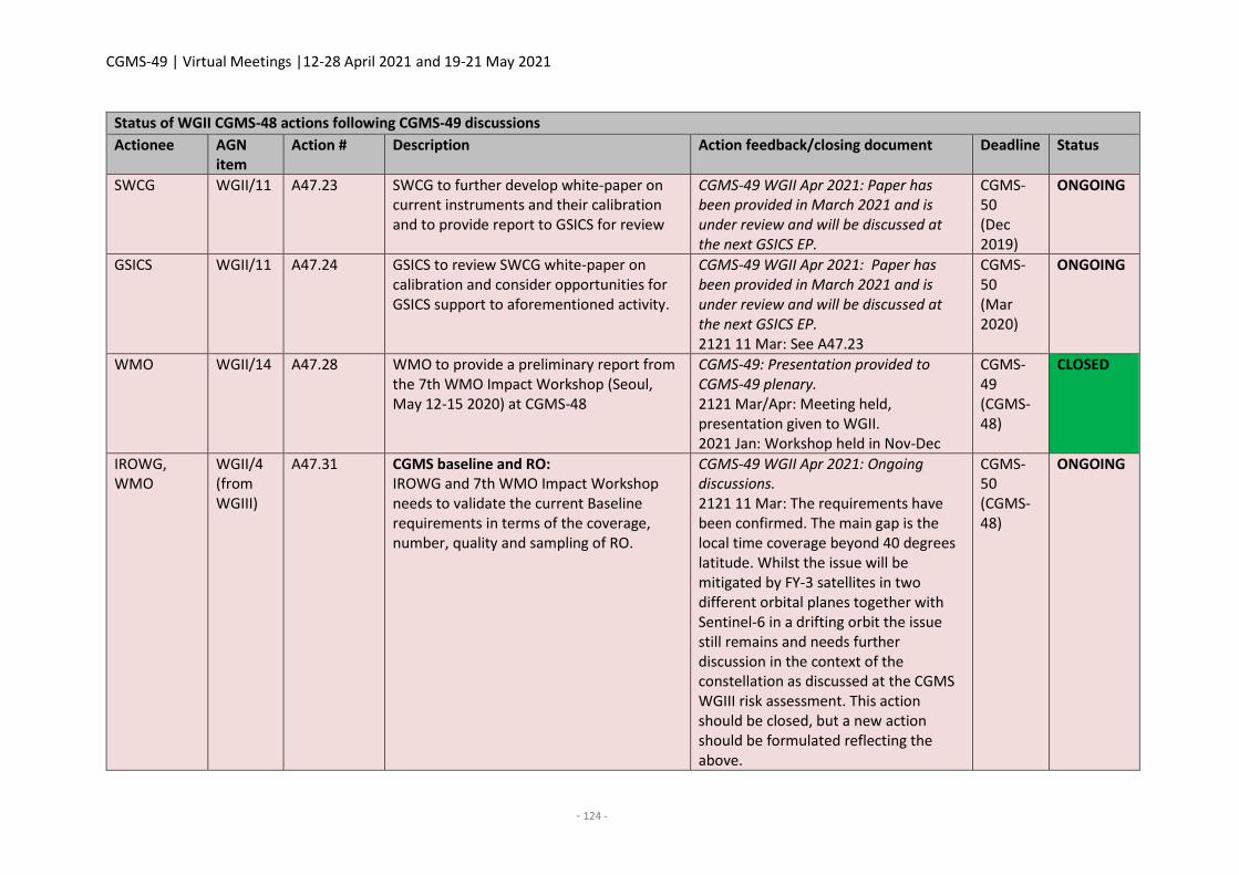
CGMS-49 | Virtual Meetings |12-28 April 2021 and 19-21 May 2021
- 124 -
Status of WGII CGMS-48 actions following CGMS-49 discussions
Actionee AGN item
Action # Description Action feedback/closing document Deadline Status
SWCG WGII/11 A47.23 SWCG to further develop white-paper on current instruments and their calibration and to provide report to GSICS for review
CGMS-49 WGII Apr 2021: Paper has been provided in March 2021 and is under review and will be discussed at the next GSICS EP.
CGMS-50 (Dec 2019)
ONGOING
GSICS WGII/11 A47.24 GSICS to review SWCG white-paper on calibration and consider opportunities for GSICS support to aforementioned activity.
CGMS-49 WGII Apr 2021: Paper has been provided in March 2021 and is under review and will be discussed at the next GSICS EP. 2121 11 Mar: See A47.23
CGMS-50 (Mar 2020)
ONGOING
WMO WGII/14 A47.28 WMO to provide a preliminary report from the 7th WMO Impact Workshop (Seoul, May 12-15 2020) at CGMS-48
CGMS-49: Presentation provided to CGMS-49 plenary. 2121 Mar/Apr: Meeting held, presentation given to WGII. 2021 Jan: Workshop held in Nov-Dec
CGMS-49 (CGMS-48)
CLOSED
IROWG, WMO
WGII/4 (from WGIII)
A47.31 CGMS baseline and RO: IROWG and 7th WMO Impact Workshop needs to validate the current Baseline requirements in terms of the coverage, number, quality and sampling of RO.
CGMS-49 WGII Apr 2021: Ongoing discussions. 2121 11 Mar: The requirements have been confirmed. The main gap is the local time coverage beyond 40 degrees latitude. Whilst the issue will be mitigated by FY-3 satellites in two different orbital planes together with Sentinel-6 in a drifting orbit the issue still remains and needs further discussion in the context of the constellation as discussed at the CGMS WGIII risk assessment. This action should be closed, but a new action should be formulated reflecting the above.
CGMS-50 (CGMS-48)
ONGOING
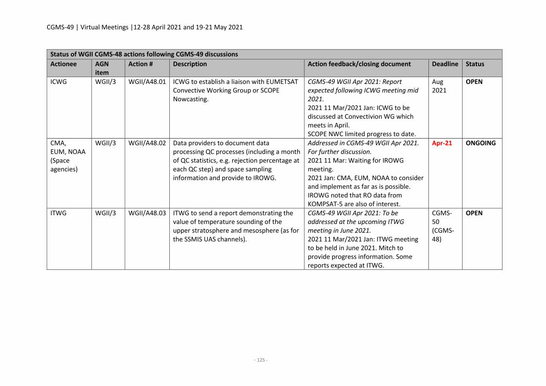
CGMS-49 | Virtual Meetings |12-28 April 2021 and 19-21 May 2021
- 125 -
Status of WGII CGMS-48 actions following CGMS-49 discussions
Actionee AGN item
Action # Description Action feedback/closing document Deadline Status
ICWG WGII/3 WGII/A48.01 ICWG to establish a liaison with EUMETSAT Convective Working Group or SCOPE Nowcasting.
CGMS-49 WGII Apr 2021: Report expected following ICWG meeting mid 2021. 2021 11 Mar/2021 Jan: ICWG to be discussed at Convectivion WG which meets in April. SCOPE NWC limited progress to date.
Aug 2021
OPEN
CMA, EUM, NOAA (Space agencies)
WGII/3 WGII/A48.02 Data providers to document data processing QC processes (including a month of QC statistics, e.g. rejection percentage at each QC step) and space sampling information and provide to IROWG.
Addressed in CGMS-49 WGII Apr 2021. For further discussion. 2021 11 Mar: Waiting for IROWG meeting. 2021 Jan: CMA, EUM, NOAA to consider and implement as far as is possible. IROWG noted that RO data from KOMPSAT-5 are also of interest.
Apr-21 ONGOING
ITWG WGII/3 WGII/A48.03 ITWG to send a report demonstrating the value of temperature sounding of the upper stratosphere and mesosphere (as for the SSMIS UAS channels).
CGMS-49 WGII Apr 2021: To be addressed at the upcoming ITWG meeting in June 2021. 2021 11 Mar/2021 Jan: ITWG meeting to be held in June 2021. Mitch to provide progress information. Some reports expected at ITWG.
CGMS-50 (CGMS-48)
OPEN
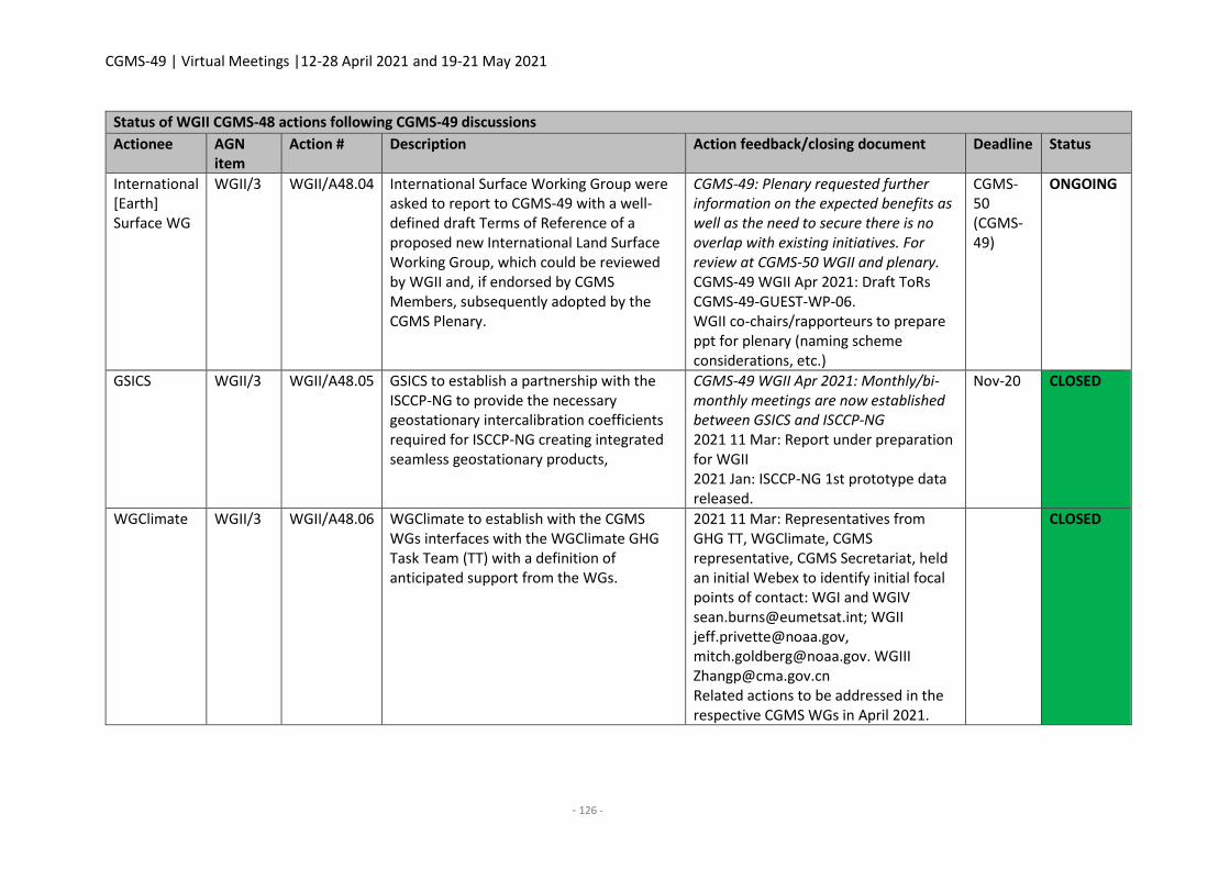
CGMS-49 | Virtual Meetings |12-28 April 2021 and 19-21 May 2021
- 126 -
Status of WGII CGMS-48 actions following CGMS-49 discussions
Actionee AGN item
Action # Description Action feedback/closing document Deadline Status
International [Earth] Surface WG
WGII/3 WGII/A48.04 International Surface Working Group were asked to report to CGMS-49 with a well-defined draft Terms of Reference of a proposed new International Land Surface Working Group, which could be reviewed by WGII and, if endorsed by CGMS Members, subsequently adopted by the CGMS Plenary.
CGMS-49: Plenary requested further information on the expected benefits as well as the need to secure there is no overlap with existing initiatives. For review at CGMS-50 WGII and plenary. CGMS-49 WGII Apr 2021: Draft ToRs CGMS-49-GUEST-WP-06. WGII co-chairs/rapporteurs to prepare ppt for plenary (naming scheme considerations, etc.)
CGMS-50 (CGMS-49)
ONGOING
GSICS WGII/3 WGII/A48.05 GSICS to establish a partnership with the ISCCP-NG to provide the necessary geostationary intercalibration coefficients required for ISCCP-NG creating integrated seamless geostationary products,
CGMS-49 WGII Apr 2021: Monthly/bi-monthly meetings are now established between GSICS and ISCCP-NG 2021 11 Mar: Report under preparation for WGII 2021 Jan: ISCCP-NG 1st prototype data released.
Nov-20 CLOSED
WGClimate WGII/3 WGII/A48.06 WGClimate to establish with the CGMS WGs interfaces with the WGClimate GHG Task Team (TT) with a definition of anticipated support from the WGs.
2021 11 Mar: Representatives from GHG TT, WGClimate, CGMS representative, CGMS Secretariat, held an initial Webex to identify initial focal points of contact: WGI and WGIV [email protected]; WGII [email protected], [email protected]. WGIII [email protected] Related actions to be addressed in the respective CGMS WGs in April 2021.
CLOSED
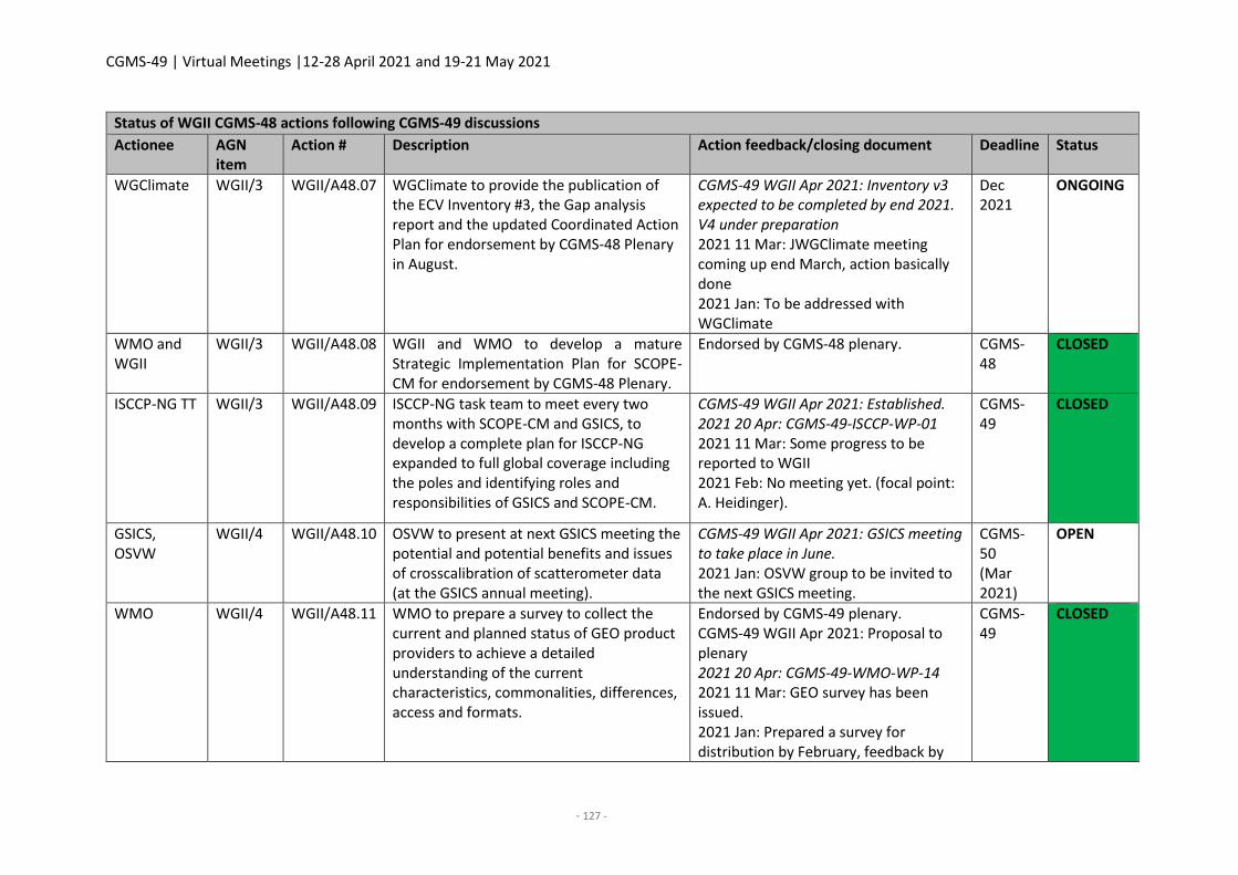
CGMS-49 | Virtual Meetings |12-28 April 2021 and 19-21 May 2021
- 127 -
Status of WGII CGMS-48 actions following CGMS-49 discussions
Actionee AGN item
Action # Description Action feedback/closing document Deadline Status
WGClimate WGII/3 WGII/A48.07 WGClimate to provide the publication of the ECV Inventory #3, the Gap analysis report and the updated Coordinated Action Plan for endorsement by CGMS-48 Plenary in August.
CGMS-49 WGII Apr 2021: Inventory v3 expected to be completed by end 2021. V4 under preparation 2021 11 Mar: JWGClimate meeting coming up end March, action basically done 2021 Jan: To be addressed with WGClimate
Dec 2021
ONGOING
WMO and WGII
WGII/3 WGII/A48.08 WGII and WMO to develop a mature Strategic Implementation Plan for SCOPE-CM for endorsement by CGMS-48 Plenary.
Endorsed by CGMS-48 plenary. CGMS-48
CLOSED
ISCCP-NG TT WGII/3 WGII/A48.09 ISCCP-NG task team to meet every two months with SCOPE-CM and GSICS, to develop a complete plan for ISCCP-NG expanded to full global coverage including the poles and identifying roles and responsibilities of GSICS and SCOPE-CM.
CGMS-49 WGII Apr 2021: Established. 2021 20 Apr: CGMS-49-ISCCP-WP-01 2021 11 Mar: Some progress to be reported to WGII 2021 Feb: No meeting yet. (focal point: A. Heidinger).
CGMS-49
CLOSED
GSICS, OSVW
WGII/4 WGII/A48.10 OSVW to present at next GSICS meeting the potential and potential benefits and issues of crosscalibration of scatterometer data (at the GSICS annual meeting).
CGMS-49 WGII Apr 2021: GSICS meeting to take place in June. 2021 Jan: OSVW group to be invited to the next GSICS meeting.
CGMS-50 (Mar 2021)
OPEN
WMO WGII/4 WGII/A48.11 WMO to prepare a survey to collect the current and planned status of GEO product providers to achieve a detailed understanding of the current characteristics, commonalities, differences, access and formats.
Endorsed by CGMS-49 plenary. CGMS-49 WGII Apr 2021: Proposal to plenary 2021 20 Apr: CGMS-49-WMO-WP-14 2021 11 Mar: GEO survey has been issued. 2021 Jan: Prepared a survey for distribution by February, feedback by
CGMS-49
CLOSED
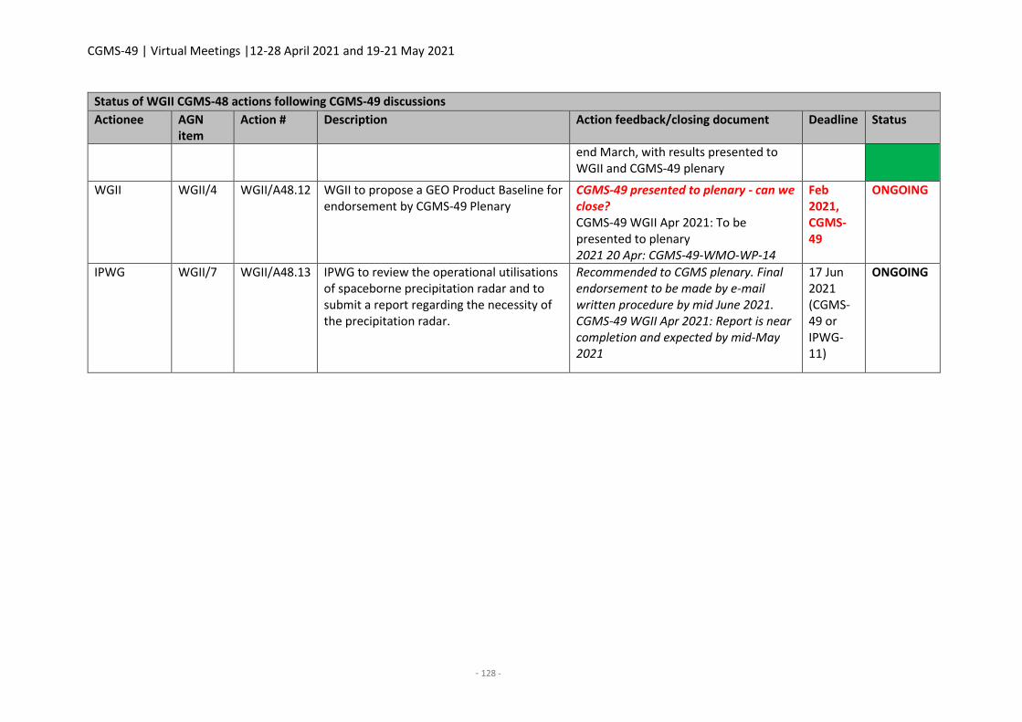
CGMS-49 | Virtual Meetings |12-28 April 2021 and 19-21 May 2021
- 128 -
Status of WGII CGMS-48 actions following CGMS-49 discussions
Actionee AGN item
Action # Description Action feedback/closing document Deadline Status
end March, with results presented to WGII and CGMS-49 plenary
WGII WGII/4 WGII/A48.12 WGII to propose a GEO Product Baseline for endorsement by CGMS-49 Plenary
CGMS-49 presented to plenary - can we close? CGMS-49 WGII Apr 2021: To be presented to plenary 2021 20 Apr: CGMS-49-WMO-WP-14
Feb 2021, CGMS-49
ONGOING
IPWG WGII/7 WGII/A48.13 IPWG to review the operational utilisations of spaceborne precipitation radar and to submit a report regarding the necessity of the precipitation radar.
Recommended to CGMS plenary. Final endorsement to be made by e-mail written procedure by mid June 2021. CGMS-49 WGII Apr 2021: Report is near completion and expected by mid-May 2021
17 Jun 2021 (CGMS-49 or IPWG-11)
ONGOING
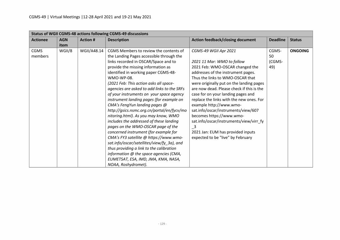
CGMS-49 | Virtual Meetings |12-28 April 2021 and 19-21 May 2021
- 129 -
Status of WGII CGMS-48 actions following CGMS-49 discussions
Actionee AGN item
Action # Description Action feedback/closing document Deadline Status
CGMS members
WGII/8 WGII/A48.14 CGMS Members to review the contents of the Landing Pages accessible through the links recorded in OSCAR/Space and to provide the missing information as identified in working paper CGMS-48-WMO-WP-08. (2021 Feb: This action asks all space-agencies are asked to add links to the SRFs of your instruments on your space agency instrument landing pages (for example on CMA’s FengYun landing pages @ http://gsics.nsmc.org.cn/portal/en/fycv/monitoring.html). As you may know, WMO includes the addressed of these landing pages on the WMO-OSCAR page of the concerned instrument (for example for CMA’s FY3 satellite @ https://www.wmo-sat.info/oscar/satellites/view/fy_3a), and thus providing a link to the calibration information @ the space agencies (CMA, EUMETSAT, ESA, IMD, JMA, KMA, NASA, NOAA, Roshydromet).
CGMS-49 WGII Apr 2021 2021 11 Mar: WMO to follow 2021 Feb: WMO-OSCAR changed the addresses of the instrument pages. Thus the links to WMO-OSCAR that were originally put on the landing pages are now dead. Please check if this is the case for on your landing pages and replace the links with the new ones. For example http://www.wmo-sat.info/oscar/instruments/view/607 becomes https://www.wmo-sat.info/oscar/instruments/view/virr_fy_3 2021 Jan: EUM has provided inputs expected to be "live" by February
CGMS-50 (CGMS-49)
ONGOING
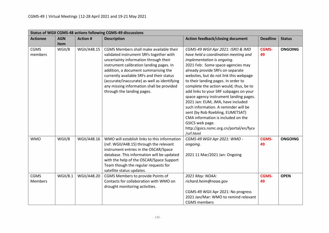
CGMS-49 | Virtual Meetings |12-28 April 2021 and 19-21 May 2021
- 130 -
Status of WGII CGMS-48 actions following CGMS-49 discussions
Actionee AGN item
Action # Description Action feedback/closing document Deadline Status
CGMS members
WGII/8 WGII/A48.15 CGMS Members shall make available their validated instrument SRFs together with uncertainty information through their instrument calibration landing pages. In addition, a document summarising the currently available SRFs and their status (accurate/inaccurate) as well as identifying any missing information shall be provided through the landing pages.
CGMS-49 WGII Apr 2021: ISRO & IMD have held a coordination meeting and implementation is ongoing. 2021 Feb: Some space-agencies may already provide SRFs on separate websites, but do not link this webpage to their landing pages. In order to complete the action would, thus, be to add links to your SRF subpages on your space agency instrument landing pages. 2021 Jan: EUM, JMA, have included such information. A reminder will be sent (by Rob Roebling, EUMETSAT) CMA information is included on the GSICS web page. http://gsics.nsmc.org.cn/portal/en/fycv/srf.html
CGMS-49
ONGOING
WMO WGII/8 WGII/A48.16 WMO will establish links to this information (ref. WGII/A48.15) through the relevant instrument entries in the OSCAR/Space database. This information will be updated with the help of the OSCAR/Space Support Team though the regular requests for satellite status updates.
CGMS-49 WGII Apr 2021: WMO - ongoing. 2021 11 Mar/2021 Jan: Ongoing
CGMS-49
ONGOING
CGMS Members
WGII/8.1 WGII/A48.20 CGMS Members to provide Points of Contacts for collaboration with WMO on drought monitoring activities.
2021 May: NOAA: [email protected] CGMS-49 WGII Apr 2021: No progress 2021 Jan/Mar: WMO to remind relevant CGMS members
CGMS-49
OPEN
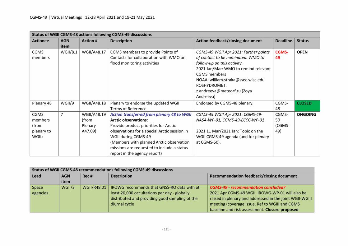
CGMS-49 | Virtual Meetings |12-28 April 2021 and 19-21 May 2021
- 131 -
Status of WGII CGMS-48 actions following CGMS-49 discussions
Actionee AGN item
Action # Description Action feedback/closing document Deadline Status
CGMS members
WGII/8.1 WGII/A48.17 CGMS members to provide Points of Contacts for collaboration with WMO on flood monitoring activities
CGMS-49 WGII Apr 2021: Further points of contact to be nominated. WMO to follow-up on this activity. 2021 Jan/Mar: WMO to remind relevant CGMS members NOAA: [email protected] ROSHYDROMET: [email protected] (Zoya Andreeva)
CGMS-49
OPEN
Plenary 48 WGII/9 WGII/A48.18 Plenary to endorse the updated WGII Terms of Reference
Endorsed by CGMS-48 plenary. CGMS-48
CLOSED
CGMS members (from plenary to WGII)
7 WGII/A48.19 (from Plenary A47.09)
Action transferred from plenary 48 to WGII Arctic observations: Provide product priorities for Arctic observations for a special Arctic session in WGII during CGMS-49 (Members with planned Arctic observation missions are requested to include a status report in the agency report)
CGMS-49 WGII Apr 2021: CGMS-49-NASA-WP-01, CGMS-49-ECCC-WP-01 2021 11 Mar/2021 Jan: Topic on the WGII CGMS-49 agenda (and for plenary at CGMS-50).
CGMS-50 (CGMS-49)
ONGOING
Status of WGII CGMS-48 recommendations following CGMS-49 discussions
Lead AGN item
Rec # Description Recommendation feedback/closing document
Space agencies
WGII/3 WGII/R48.01 IROWG recommends that GNSS-RO data with at least 20,000 occultations per day - globally distributed and providing good sampling of the diurnal cycle
CGMS-49 - recommendation concluded? 2021 Apr CGMS-49 WGII: IROWG-WP-01 will also be raised in plenary and addressed in the joint WGII-WGIII meeting (coverage issue. Ref to WGIII and CGMS baseline and risk assessment. Closure proposed
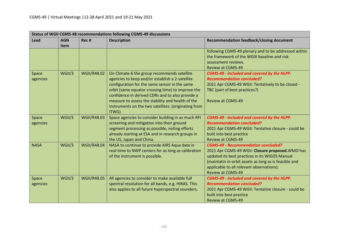
CGMS-49 | Virtual Meetings |12-28 April 2021 and 19-21 May 2021
- 132 -
Status of WGII CGMS-48 recommendations following CGMS-49 discussions
Lead AGN item
Rec # Description Recommendation feedback/closing document
following CGMS-49 plenary and to be addressed within the framework of the WGIII baseline and risk assessment reviews. Review at CGMS-49
Space agencies
WGII/3 WGII/R48.02 On Climate-6 the group recommends satellite agencies to keep and/or establish a 2-satellite configuration for the same sensor in the same orbit (same equator crossing time) to improve the confidence in derived CDRs and to also provide a measure to assess the stability and health of the instruments on the two satellites. (originating from ITWG)
CGMS-49 - included and covered by the HLPP. Recommendation concluded? 2021 Apr CGMS-49 WGII: Tentatively to be closed - TBC (part of best practices?) Review at CGMS-49
Space agencies
WGII/3 WGII/R48.03 Space agencies to consider building in as much RFI screening and mitigation into their ground segment processing as possible, noting efforts already starting at ESA and in research groups in the US, Japan and China.
CGMS-49 - included and covered by the HLPP. Recommendation concluded? 2021 Apr CGMS-49 WGII: Tentative closure - could be built into best practice Review at CGMS-49
NASA WGII/3 WGII/R48.04 NASA to continue to provide AIRS Aqua data in real-time to NWP centers for as long as calibration of the instrument is possible.
CGMS-49 - Recommendation concluded? 2021 Apr CGMS-49 WGII: Closure proposed.WMO has updated its best practices in its WIGOS Manual (maintatin in-orbit assets as long as is feasible and applicable to all relevant observations). Review at CGMS-49
Space agencies
WGII/3 WGII/R48.05 All agencies to consider to make available full spectral resolution for all bands, e.g. HIRAS. This also applies to all future hyperspectral sounders.
CGMS-49 - included and covered by the HLPP. Recommendation concluded? 2021 Apr CGMS-49 WGII: Tentative closure - could be built into best practice Review at CGMS-49
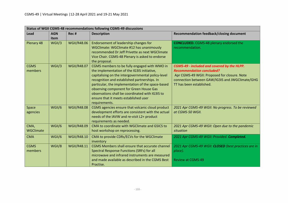
CGMS-49 | Virtual Meetings |12-28 April 2021 and 19-21 May 2021
- 133 -
Status of WGII CGMS-48 recommendations following CGMS-49 discussions
Lead AGN item
Rec # Description Recommendation feedback/closing document
Plenary 48 WGII/3 WGII/R48.06 Endorsement of leadership changes for WGClimate: WGClimate #12 has unanimously recommended Dr Jeff Privette as next WGClimate Vice Chair. CGMS-48 Plenary is asked to endorse the proposal.
CONCLUDED. CGMS-48 plenary endorsed the recommendation.
CGMS members
WGII/3 WGII/R48.07 CGMS members to be fully engaged with WMO in the implementation of the IG3IS initiative, capitalising on the intergovernmental policy-level recognition and established partnerships. In particular, the implementation of the space-based observing component for Green House Gas observations shall be coordinated with IG3IS to ensure that it meets established user requirements.
CGMS-49 - included and covered by the HLPP. Recommendation concluded? Apr CGMS-49 WGII: Proposed for closure. Note connection between GAW/IG3IS and JWGClimate/GHG TT has been established.
Space agencies
WGII/6 WGII/R48.08 CGMS agencies ensure that volcanic cloud product development efforts are consistent with the actual needs of the IAVW and re-visit L2+ product requirements as needed.
2021 Apr CGMS-49 WGII: No progress. To be reviewed at CGMS-50 WGII.
CMA, WGClimate
WGII/6 WGII/R48.09 CMA to coordinate with WGClimate and GSICS to host workshop on reprocessing.
2021 Apr CGMS-49 WGII: Open due to the pandemic situation
CMA WGII/6 WGII/R48.10 CMA to provide CDRs/ECVs for the WGClimate inventory
2021 Apr CGMS-49 WGII: Provided. Completed.
CGMS members
WGII/8 WGII/R48.11 CGMS Members shall ensure that accurate channel Spectral Response Functions (SRFs) for all microwave and infrared instruments are measured and made available as described in the CGMS Best Practise.
2021 Apr CGMS-49 WGII: CLOSED (best practices are in place). Review at CGMS-49
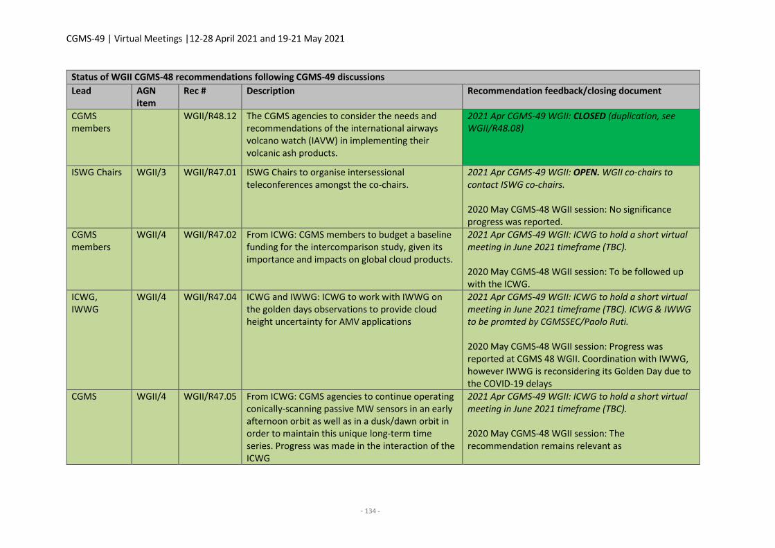
CGMS-49 | Virtual Meetings |12-28 April 2021 and 19-21 May 2021
- 134 -
Status of WGII CGMS-48 recommendations following CGMS-49 discussions
Lead AGN item
Rec # Description Recommendation feedback/closing document
CGMS members
WGII/R48.12 The CGMS agencies to consider the needs and recommendations of the international airways volcano watch (IAVW) in implementing their volcanic ash products.
2021 Apr CGMS-49 WGII: CLOSED (duplication, see WGII/R48.08)
ISWG Chairs WGII/3 WGII/R47.01 ISWG Chairs to organise intersessional teleconferences amongst the co-chairs.
2021 Apr CGMS-49 WGII: OPEN. WGII co-chairs to contact ISWG co-chairs. 2020 May CGMS-48 WGII session: No significance progress was reported.
CGMS members
WGII/4 WGII/R47.02 From ICWG: CGMS members to budget a baseline funding for the intercomparison study, given its importance and impacts on global cloud products.
2021 Apr CGMS-49 WGII: ICWG to hold a short virtual meeting in June 2021 timeframe (TBC). 2020 May CGMS-48 WGII session: To be followed up with the ICWG.
ICWG, IWWG
WGII/4 WGII/R47.04 ICWG and IWWG: ICWG to work with IWWG on the golden days observations to provide cloud height uncertainty for AMV applications
2021 Apr CGMS-49 WGII: ICWG to hold a short virtual meeting in June 2021 timeframe (TBC). ICWG & IWWG to be promted by CGMSSEC/Paolo Ruti. 2020 May CGMS-48 WGII session: Progress was reported at CGMS 48 WGII. Coordination with IWWG, however IWWG is reconsidering its Golden Day due to the COVID-19 delays
CGMS WGII/4 WGII/R47.05 From ICWG: CGMS agencies to continue operating conically-scanning passive MW sensors in an early afternoon orbit as well as in a dusk/dawn orbit in order to maintain this unique long-term time series. Progress was made in the interaction of the ICWG
2021 Apr CGMS-49 WGII: ICWG to hold a short virtual meeting in June 2021 timeframe (TBC). 2020 May CGMS-48 WGII session: The recommendation remains relevant as
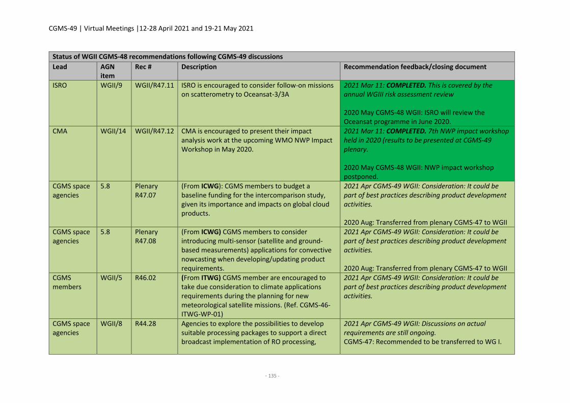
CGMS-49 | Virtual Meetings |12-28 April 2021 and 19-21 May 2021
- 135 -
Status of WGII CGMS-48 recommendations following CGMS-49 discussions
Lead AGN item
Rec # Description Recommendation feedback/closing document
ISRO WGII/9 WGII/R47.11 ISRO is encouraged to consider follow-on missions on scatterometry to Oceansat-3/3A
2021 Mar 11: COMPLETED. This is covered by the annual WGIII risk assessment review 2020 May CGMS-48 WGII: ISRO will review the Oceansat programme in June 2020.
CMA WGII/14 WGII/R47.12 CMA is encouraged to present their impact analysis work at the upcoming WMO NWP Impact Workshop in May 2020.
2021 Mar 11: COMPLETED. 7th NWP impact workshop held in 2020 (results to be presented at CGMS-49 plenary. 2020 May CGMS-48 WGII: NWP impact workshop postponed.
CGMS space agencies
5.8 Plenary R47.07
(From ICWG): CGMS members to budget a baseline funding for the intercomparison study, given its importance and impacts on global cloud products.
2021 Apr CGMS-49 WGII: Consideration: It could be part of best practices describing product development activities. 2020 Aug: Transferred from plenary CGMS-47 to WGII
CGMS space agencies
5.8 Plenary R47.08
(From ICWG) CGMS members to consider introducing multi-sensor (satellite and ground-based measurements) applications for convective nowcasting when developing/updating product requirements.
2021 Apr CGMS-49 WGII: Consideration: It could be part of best practices describing product development activities. 2020 Aug: Transferred from plenary CGMS-47 to WGII
CGMS members
WGII/5 R46.02 (From ITWG) CGMS member are encouraged to take due consideration to climate applications requirements during the planning for new meteorological satellite missions. (Ref. CGMS-46-ITWG-WP-01)
2021 Apr CGMS-49 WGII: Consideration: It could be part of best practices describing product development activities.
CGMS space agencies
WGII/8 R44.28 Agencies to explore the possibilities to develop suitable processing packages to support a direct broadcast implementation of RO processing,
2021 Apr CGMS-49 WGII: Discussions on actual requirements are still ongoing. CGMS-47: Recommended to be transferred to WG I.
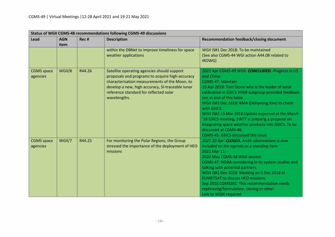
CGMS-49 | Virtual Meetings |12-28 April 2021 and 19-21 May 2021
- 136 -
Status of WGII CGMS-48 recommendations following CGMS-49 discussions
Lead AGN item
Rec # Description Recommendation feedback/closing document
within the DBNet to improve timeliness for space weather applications
WGII IS#1 Dec 2018: To be maintained (See also CGMS-44 WGI action A44.08 related to IROWG)
CGMS space agencies
WGII/8 R44.26 Satellite operating agencies should support proposals and programs to acquire high-accuracy characterisation measurements of the Moon, to develop a new, high accuracy, SI-traceable lunar reference standard for reflected solar wavelengths.
2021 Apr CGMS-49 WGII: CONCLUDED. Progress in US and China. CGMS-47: Maintain 10 Apr 2019: Tom Stone who is the leader of lunar calibration in GSICS VINIR subgroup provided feedback see at end of this table. WGII IS#1 Dec 2018: KMA (Dohyeong Kim) to check with GSICS. WGII IS#2 15 Mar 2018 Update expected at the March '18 GSICS meeting. SWTT is preparig a proposal on integrating space weather products into GSICS. To be discussed at CGMS-46. CGMS-45: GSICS discussed this issue
CGMS space agencies
WGII/7 R44.25 For monitoring the Polar Regions, the Group stressed the importance of the deployment of HEO missions
2021 20 Apr: CLOSED. Arctic observations is now included on the agenda as a standing item. 2021 Mar 11: - 2020 May CGMS-48 WGII session CGMS-47: NOAA considering in its system studies and talking with potential partners. WGII IS#1 Dec 2018: Meeting on 5 Dec 2018 at EUMETSAT to discuss HEO missions. Sep 2018 CGMSSEC: This recommendation needs rephrasing/formulation, closing or other. Link to WGIII required
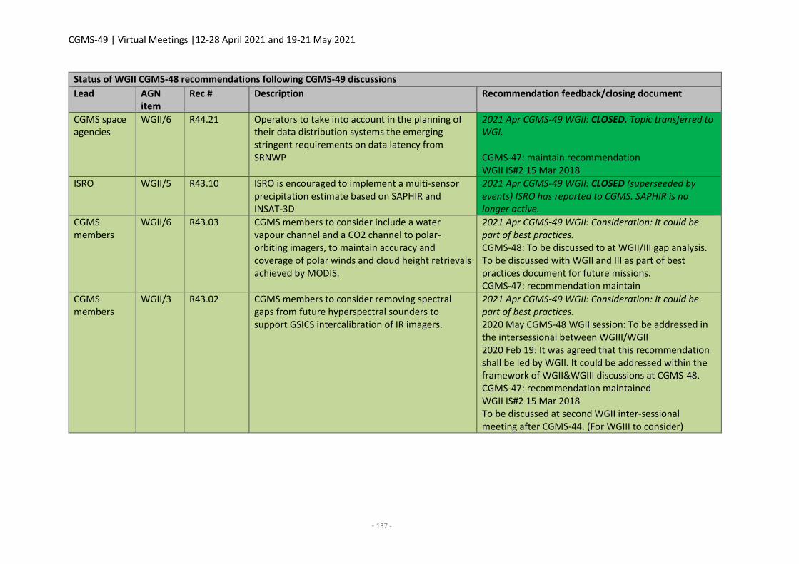
CGMS-49 | Virtual Meetings |12-28 April 2021 and 19-21 May 2021
- 137 -
Status of WGII CGMS-48 recommendations following CGMS-49 discussions
Lead AGN item
Rec # Description Recommendation feedback/closing document
CGMS space agencies
WGII/6 R44.21 Operators to take into account in the planning of their data distribution systems the emerging stringent requirements on data latency from SRNWP
2021 Apr CGMS-49 WGII: CLOSED. Topic transferred to WGI. CGMS-47: maintain recommendation WGII IS#2 15 Mar 2018
ISRO WGII/5 R43.10 ISRO is encouraged to implement a multi-sensor precipitation estimate based on SAPHIR and INSAT-3D
2021 Apr CGMS-49 WGII: CLOSED (superseeded by events) ISRO has reported to CGMS. SAPHIR is no longer active.
CGMS members
WGII/6 R43.03 CGMS members to consider include a water vapour channel and a CO2 channel to polar-orbiting imagers, to maintain accuracy and coverage of polar winds and cloud height retrievals achieved by MODIS.
2021 Apr CGMS-49 WGII: Consideration: It could be part of best practices. CGMS-48: To be discussed to at WGII/III gap analysis. To be discussed with WGII and III as part of best practices document for future missions. CGMS-47: recommendation maintain
CGMS members
WGII/3 R43.02 CGMS members to consider removing spectral gaps from future hyperspectral sounders to support GSICS intercalibration of IR imagers.
2021 Apr CGMS-49 WGII: Consideration: It could be part of best practices. 2020 May CGMS-48 WGII session: To be addressed in the intersessional between WGIII/WGII 2020 Feb 19: It was agreed that this recommendation shall be led by WGII. It could be addressed within the framework of WGII&WGIII discussions at CGMS-48. CGMS-47: recommendation maintained WGII IS#2 15 Mar 2018 To be discussed at second WGII inter-sessional meeting after CGMS-44. (For WGIII to consider)

CGMS-49 | Virtual Meetings |12-28 April 2021 and 19-21 May 2021
- 139 -
WGIII REPORT
1. Opening, objectives / WGIII rapporteur status and confirmation
Co-chairs Ajay Mehta and Peng Zhang welcomed all participants to the WGIII session. They briefly
presented the agenda and the objectives of the meeting related to the CGMS baseline and the CGMS
risk assessment.
WMO informed WGIII that Lars Peter Riishojgaard needed to step down as rapporteur and instead
proposed that Heikki Pohjola takes the role of the WGIII rapporteur. WGIII supported the change and
recommended to plenary to endorse the change of WGIII rapporteurs.
CGMS-49 actions - WGIII
Actionee AGN item
Action Description Deadline Status
WGIII 11 WGIII/A49.21 WGIII recommends to plenary to endorse H. Pohjola (WMO) as WGIII rapporteur
CGMS-49 plenary
OPEN
WGIII participants approved and adopted the agenda proposed by the CGMS Secretariat prior to the
meeting. Agenda items no. 2, Status of discussion on WMO Res 42, was moved to agenda item 5. (Day
2 of the meeting) waiting for the WMO INFCOM meeting feedback for the related working paper. The
INFCOM meeting was running at the same time with this meeting.
Participants were introduced shortly agency by agency. See the list of participants in the Annex.
2. Status of discussions on WMO Resolution 42 and WMO's satellite data exchange requirements
for global NWP
CGMS-49-WMO-WP-I6: Status of discussions on draft Unified WMO Data Policy Resolution
(presented under agenda item 5.)
K. Holmlund (for L. P. Riishojgaard) presented the status of the unified WMO data policy preparation.
The modernisation of the existing WMO data policy is combining existing resolutions 25, 40, and 60
into one draft WMO Unified Data Policy Resolution. WMO Congress 2019 requested a review of WMO
data policies as expressed in Resolutions 40 (“weather”), 25 (“hydrology”), and 60 (“Climate”). This led
to the establishment of Study Group on Data Issues and Policies (SG-DIP), which recommended that
new overarching draft Congress resolution on data policy should be developed. The SG DIP
recommendation was adopted by Executive Council and the initial drafting of the new overarching
WMO data policy resolution for Extraordinary Congress in 2021 is now completed, building also on the
outcome of the WMO Data Conference in November 2020.
The new resolution covers all WMO Earth system data (weather, climate, hydrology...). There are two
main categories of the data. The data which shall be exchanged is under category Core and the data
which should be exchanged is under category Recommended. The specifics of the data categories are
referred to Technical Regulations, primarily Manuals on WIGOS and GDPFS. The term “Free and
CGMS-49 | Virtual Meetings |12-28 April 2021 and 19-21 May 2021
- 140 -
unrestricted ” exchange is defined directly in the Resolution, which means that data is available for
use, re-use, and sharing without charge and with no conditions to use. It also covers the data exchange
between all partners, including private sector and academia etc.
A draft Unified WMO Data Policy was introduced and discussed as Doc. 5.1.5 at First Session of WMO
Infrastructure Commission (INFCOM) on April 13th in 2021. It was the first intergovernmental text of
the new draft. Three days of intense discussion resulting in some adjustments to the text, but the basic
principles of the resolution remained unchanged and it was accepted by WMO INFCOM on April 15th
in 2021.
The next major gate will be the WMO Executive Council in June 2021 followed by submission to WMO
Congress for its approval in October 2021. Regulatory material with agreement on specifics of data
exchange (what, when, where , how,..) will be supported by Global Basic Observation Network (GBON)
provisions, approved by the Infrastructure Commission in November 2020. Financial and technical
support and capacity development where needed will be facilitated under Systematic Observations
Financing Facility (SOFF) and Climate Risk and Early Warning Systems (CREWS).
WGIII Co-chair (A. Mehta) commented that the impact of data policy change needs to be reflected in
the CGMS documentation. K. Holmlund proposed that after Congress approval, the Secretary-General
of WMO could send the CGMS space agencies a letter requesting them to confirm what data are core
and what data are additional.
ESA commented that the new data policy should be also studied from the scientific consortium
perspective, which has limited open data policy not open for commercial use. K. Holmlund responded
that this is not yet clear, and it should be analysed and further studied. Further, the commercial sector
has requested more details.
ESA commented on EU’s data policy for the systems and their mission and if these are considered.
WMO responded that this is involved (for example Copernicus).
EUMETSAT commented on constrains related to WIS, which is limiting the open and restricted data to
be sent in the same data package at the moment and if the limitation remains the same related to
Core and Recommended data. K. Holmlund commented that this is not yet clear.
CGMS-49-WMO-17: Status of discussions on the WMO’s Position paper on Satellite data
Requirements for Global NWP
WMO provided the status of WMO’s Position paper on Satellite data Requirements for Global NWP.
The final document was not available for the meeting due to the INFCOM presentation and decision
happening at the same time with this meeting. The Position Paper is discussed at the WMO
Commission for Observation, Infrastructure and Information Systems (INFCOM) Session I part III and
expected to be approved upon 16th Apr 2021, formally adopting the position paper as a WMO Position
Paper. Subsequently, the full paper will be provided to CGMS.
The WMO Expert team on Space Systems and Utilization has prepared a Position paper on Satellite
data Requirements for Global NWP. The paper presents a user perspective on the needs for data to
ensure that global NWP models are performing at state-of-the-art level. During the preparation, views
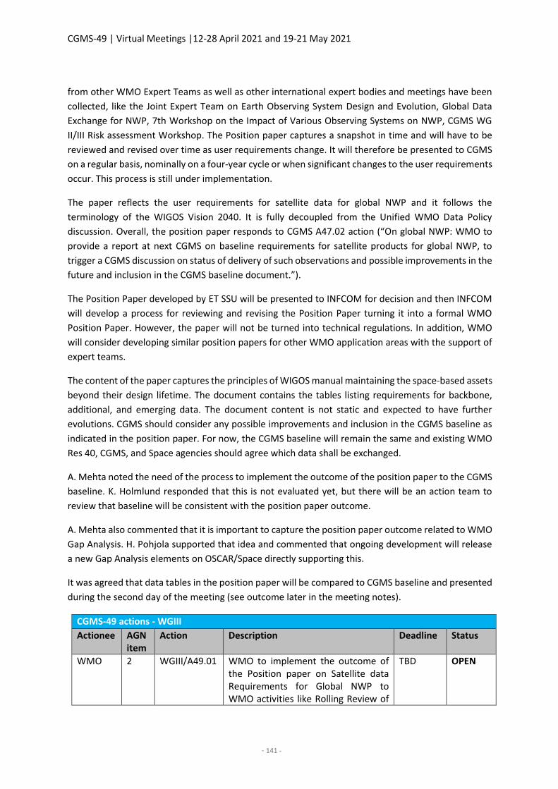
CGMS-49 | Virtual Meetings |12-28 April 2021 and 19-21 May 2021
- 141 -
from other WMO Expert Teams as well as other international expert bodies and meetings have been
collected, like the Joint Expert Team on Earth Observing System Design and Evolution, Global Data
Exchange for NWP, 7th Workshop on the Impact of Various Observing Systems on NWP, CGMS WG
II/III Risk assessment Workshop. The Position paper captures a snapshot in time and will have to be
reviewed and revised over time as user requirements change. It will therefore be presented to CGMS
on a regular basis, nominally on a four-year cycle or when significant changes to the user requirements
occur. This process is still under implementation.
The paper reflects the user requirements for satellite data for global NWP and it follows the
terminology of the WIGOS Vision 2040. It is fully decoupled from the Unified WMO Data Policy
discussion. Overall, the position paper responds to CGMS A47.02 action (“On global NWP: WMO to
provide a report at next CGMS on baseline requirements for satellite products for global NWP, to
trigger a CGMS discussion on status of delivery of such observations and possible improvements in the
future and inclusion in the CGMS baseline document.”).
The Position Paper developed by ET SSU will be presented to INFCOM for decision and then INFCOM
will develop a process for reviewing and revising the Position Paper turning it into a formal WMO
Position Paper. However, the paper will not be turned into technical regulations. In addition, WMO
will consider developing similar position papers for other WMO application areas with the support of
expert teams.
The content of the paper captures the principles of WIGOS manual maintaining the space-based assets
beyond their design lifetime. The document contains the tables listing requirements for backbone,
additional, and emerging data. The document content is not static and expected to have further
evolutions. CGMS should consider any possible improvements and inclusion in the CGMS baseline as
indicated in the position paper. For now, the CGMS baseline will remain the same and existing WMO
Res 40, CGMS, and Space agencies should agree which data shall be exchanged.
A. Mehta noted the need of the process to implement the outcome of the position paper to the CGMS
baseline. K. Holmlund responded that this is not evaluated yet, but there will be an action team to
review that baseline will be consistent with the position paper outcome.
A. Mehta also commented that it is important to capture the position paper outcome related to WMO
Gap Analysis. H. Pohjola supported that idea and commented that ongoing development will release
a new Gap Analysis elements on OSCAR/Space directly supporting this.
It was agreed that data tables in the position paper will be compared to CGMS baseline and presented
during the second day of the meeting (see outcome later in the meeting notes).
CGMS-49 actions - WGIII
Actionee AGN item
Action Description Deadline Status
WMO 2 WGIII/A49.01 WMO to implement the outcome of the Position paper on Satellite data Requirements for Global NWP to WMO activities like Rolling Review of
TBD OPEN
CGMS-49 | Virtual Meetings |12-28 April 2021 and 19-21 May 2021
- 142 -
CGMS-49 actions - WGIII
Actionee AGN item
Action Description Deadline Status
Requirements, Gap Analysis, WIGOS Vision etc.
3. Updates on significant observational missions (in response to/from a CGMS baseline/risk
assessment point of view)
3.1 Operational missions
CGMS-49-ISRO-WP-07: ISRO current missions status and future plans
J.V. Thomas reported on ISRO’s current missions and their future mission plans. Current LEO missions
are OceanSat 2, SARAL, and SCATSAT-1, which has some problems. It stopped operation on 28th
February 2021 due to redundant chain malfunction. Current GEO mission are INSAT-3D and 3DR, which
provide observations at 15-minute interval (48 images per day and sounding every hour).
The next ISRO satellite, INSAT-3D-S, will be launched 2022 to GEO ring. It is similar to INSAT-3D and
3DR. GEO Imaging Satellite is under planning: Providing multiple daily observations at any place
imaging, rapid scan 500 x 500 km in 5 mins, improved monitoring of crops, vegetation condition, water
bodies and rapid forest change, more frequent monitoring of natural disasters and flood inundation.
The next ISRO satellite to be launched to LEO ring will be OCEANSAT 1 in October 2021. It will be the
first satellite of OCEANSAT series. It has 13 channels including 5 new channels.
The missions under study phase are microwave temperature and humidity sounder to be located 35
deg inclined orbit (following SAPHIR payload), microwave radiometer (dual pol, 2 km res, low
inclination), DF-SCAT on C and Ku band, next generation INSAT with payload of VIS/NIR/SWIR imager,
hyperspectral infrared sounder and lighting mapper.
CGMS-49 actions - WGIII
Actionee AGN item
Action Description Deadline Status
ISRO 3.1 WGIII/A49.02
ISRO to update CGMS-50 on their plans for hyperspectral infrared sounder.
February 2022 CGMS-50
OPEN
CGMS-49-NOAA-WP-11: User requirement development for NOAA’s next generation of
measurements from Geostationary Extended Observations (GeoXO)
D. Lindsey presented the current status of NOAA’s GEO missions and their future plans. NOAA’s GOES-
R series of geostationary satellites currently has GOES-16 and GOES-17 in operations as GOES-East and
GOES-West with two more launches planned over the next 3-4 years. That constellation will remain in
operations into the 2030s, but by the early 2030s the need exists for a replacement on-orbit spare.
That drives the timeline for the follow-on geostationary satellite series, which NOAA calls
Geostationary and Extended Orbits. A working group was formed in early 2020 to collect the various
CGMS-49 | Virtual Meetings |12-28 April 2021 and 19-21 May 2021
- 143 -
recommendations from NOAA Satellite Observing Systems Architecture (NSOSA) and the SPRWG,
examine current NOAA observing requirements, perform user outreach to assess their future needs,
and ultimately use this information to recommend the future geostationary constellation. The
recommended instruments to comprise this constellation are Imager, Lightning Mapper, IR
Hyperspectral Sounder, Ocean Colour, and Atmospheric Composition instruments. It was also
recommended that a Day-Night-Band be included as a part of either the imager or the sounder.
Although a GEO-XO programme has not been approved, the nominal recommended constellation puts
the Imager (hurricane tracking and many other applications), Sounder (new capability, NWP, severe
storm forecasting, nowcasting), and Ocean Colour (assessment of ecosystem change, monitoring
coastal water quality and tracking harmful blooms) instruments in East and West locations, Lightning
Mappers (operational benefit for lightning safety situational awareness) on commercial hosted
payloads in the East and West locations, and an Atmospheric Composition (improved observations for
air quality on GEO) instrument on a commercial host near the centre of the Continental U.S. It should
be noted that this recommended constellation may change, and nothing is official until the programme
is approved.
During the GEO-XO presentation, D. Lindsey suggested to CGMS members that NOAA would
appreciate data sharing of relevant partner instruments (including GEMS from Korea, MTG
instruments, etc).
K. Holmlund asked what kind of AC instrument is going to be developed. D. Lindsay responded that
NASA is launching the research mission TEMPO with UV/VIS instrument payload and that will give an
idea for the GEO-XO AC instrument design.
P. Zhang asked if the GEO-XO road map is publicly available. D. Lindsey responded that the road map
will be public from September after the final review.
T. Kim commented that Ocean Colour and Atmospheric Composition instrument data is not yet ready
to be shared publicly and NOAA should contact KMA for data access.
CGMS-49 actions - WGIII
Actionee AGN
item
Action Description Deadline Status
WMO 3.1 WGIII/A49.0
3
WMO prepare a letter of support for
the GEO-XO Atmospheric Composition
instrument.
Aug 2021 OPEN
CGMS-49-CGMS-TBD - Other members' significant updates (operational missions)
P. Zhang updated CMA’s upcoming launch schedules. The second satellite of FY-4B will be launched in
May 2021 and LEO Early morning orbit FY-3E will be launched in June 2021. He also mentioned that
CMA’s final approval for GEO MW satellite is still pending. Related to CNSA missions, he also updated
that the successor for GaoFeng-5 will be launched in September 2021.
CGMS-49 | Virtual Meetings |12-28 April 2021 and 19-21 May 2021
- 144 -
3.2 Research missions
No updates.
4. Outcome and finalisation of 3rd risk assessment including mitigation actions for consideration
by plenary
CGMS-49-WGII-WP-02: Status and outcome of the 3rd CGMS risk assessment
The 3rd risk assessment workshop was held online in March 2021. The CGMS risk assessment captures
the observations and services for the CGMS contributions to Earth observation measurement
capabilities. A. Mehta introduced the preparation of the risk assessment including the assumptions
and how the outcome is reviewed for the plenary.
The 3rd CGMS risk assessment recognised the following top-level risks:
Early morning LEO due to FY-3E continuation
No planned low inclination RO observations after COSMIC-2.
Precipitation radar: continuation after FY-3G and GPM
Broad band radiometer: continuation of FY-3G
Scatterometer: risk in the early morning and afternoon orbits after FY-3E and Oceansat-3A
Coronagraph: risk of near-term gap until SWFO-L1 and GOES-U are launched
Energetic Particle Sensor, magnetometer, plasma analyser: risk of near-term gap until SWFO-
L1 is launched
The recommended actions are recorded in the table below.
A. Mehta explained that the member-owned and -operated payloads hosted on the commercial
platforms are also included when the launch dates are determined. J. Luntama commented that ESA
has two instruments on the hosted platforms. In the current operating model, the ownership of the
instruments is by a CGMS member. In the future, the ownership of the instrument can be also the
platform owner/operator.
K. Holmlund commented that the work related to action for CMA and WMO to establish a Tiger Team
following the launch of FY-3E to assess the benefit of the early morning orbit to inform CMA’s future
planning will be prepared by plenary session in May 2021 (see CGMS-49-WMO-WP-15).
JAXA commented on the plans for the next generation precipitation radar that the feasibility study
considering the support by NASA is ongoing and to be concluded by the end of the summer 2021.
Then, the mission definition plan will be delivered in IPWG. This is going to be updated in CGMS-50.
CGMS-49 | Virtual Meetings |12-28 April 2021 and 19-21 May 2021
- 145 -
CGMS-49 actions - WGIII
Actionee AGN item
Action Description Deadline Status
CMA 4 WGIII/A49.05
CMA to confirm plans to fly a precipitation radar beyond FY 3G.
Feb 2022 OPEN
NASA and JAXA
4 WGIII/A49.06
NASA and JAXA to confirm plans to fly a precipitation radar beyond the GPM Core.
Feb 2022 OPEN
EUMETSAT and ESA
4 WGIII/A49.07
EUMETSAT and ESA to report on plans for the CIMR (Copernicus Imaging Microwave Radiometer) Mission
Feb 2022 OPEN
ISRO 4 WGIII/A49.08
ISRO to confirm plans beyond Oceansat 3 series
Feb2022 OPEN
SWCG 4 WGIII/A49.09
SWCG identify alternative data sources to mitigate potential unavailability of coronagraph observations
Jan 2022 OPEN
SWCG 4 WGIII/A49.10
SWCG review baseline requirement for orbital positions as opposed to number of satellites for energetic particle observations
Jan 2022
OPEN
CGMS-49-WMO-WP-13: WMO gap analysis
H. Pohjola presented the WMO Gap Analysis 2021. He explained how the annual CGMS WGIII Risk
Assessment Workshop performs the analysis with regards to three different viewpoints: 1) the CGMS
Baseline, i. e. the scenario encompassing the satellite systems that the CGMS member and observers
commit to implement and sustain for at least the next decade, 2) the User requirements, i. e. the needs
expressed by several user communities represented by several bodies and groups belonging to or
coordinated with WMO, aiming at reviewing the actual status of observation processing capability and
observing technology, and providing guidance for developments so as to pursue convergence (Rolling
Requirements Review, RRR) and 3) the WIGOS Vision, i. e. the projected developments of the WMO
Integrated Global Observing Systems to meet long-term objectives (some two decades) of the RRR.
This working paper faces the WMO Gap Analysis mostly under the RRR viewpoint. The WMO Gap
Analysis against the RRR and WIGOS are promoted by WMO to be considered by the agencies as
reference user requirements to guide future developments for the medium (RRR) and long-term
(WIGOS).
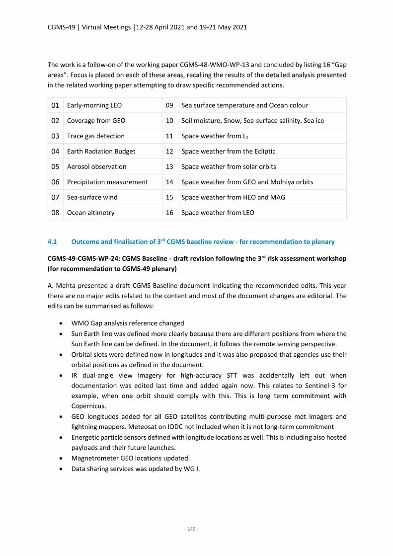
CGMS-49 | Virtual Meetings |12-28 April 2021 and 19-21 May 2021
- 146 -
The work is a follow-on of the working paper CGMS-48-WMO-WP-13 and concluded by listing 16 “Gap
areas”. Focus is placed on each of these areas, recalling the results of the detailed analysis presented
in the related working paper attempting to draw specific recommended actions.
01 Early-morning LEO 09 Sea surface temperature and Ocean colour
02 Coverage from GEO 10 Soil moisture, Snow, Sea-surface salinity, Sea ice
03 Trace gas detection 11 Space weather from L1
04 Earth Radiation Budget 12 Space weather from the Ecliptic
05 Aerosol observation 13 Space weather from solar orbits
06 Precipitation measurement 14 Space weather from GEO and Molniya orbits
07 Sea-surface wind 15 Space weather from HEO and MAG
08 Ocean altimetry 16 Space weather from LEO
4.1 Outcome and finalisation of 3rd CGMS baseline review - for recommendation to plenary
CGMS-49-CGMS-WP-24: CGMS Baseline - draft revision following the 3rd risk assessment workshop
(for recommendation to CGMS-49 plenary)
A. Mehta presented a draft CGMS Baseline document indicating the recommended edits. This year
there are no major edits related to the content and most of the document changes are editorial. The
edits can be summarised as follows:
WMO Gap analysis reference changed
Sun Earth line was defined more clearly because there are different positions from where the
Sun Earth line can be defined. In the document, it follows the remote sensing perspective.
Orbital slots were defined now in longitudes and it was also proposed that agencies use their
orbital positions as defined in the document.
IR dual-angle view imagery for high-accuracy STT was accidentally left out when
documentation was edited last time and added again now. This relates to Sentinel-3 for
example, when one orbit should comply with this. This is long term commitment with
Copernicus.
GEO longitudes added for all GEO satellites contributing multi-purpose met imagers and
lightning mappers. Meteosat on IODC not included when it is not long-term commitment
Energetic particle sensors defined with longitude locations as well. This is including also hosted
payloads and their future launches.
Magnetrometer GEO locations updated.
Data sharing services was updated by WG I.
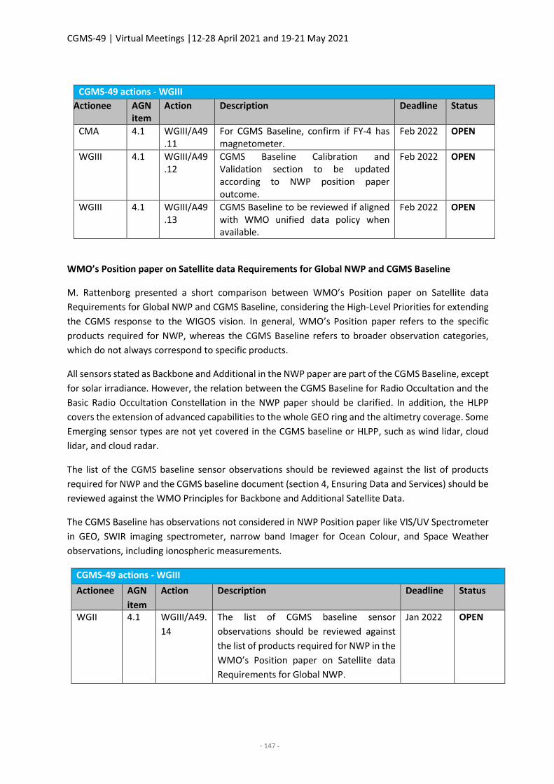
CGMS-49 | Virtual Meetings |12-28 April 2021 and 19-21 May 2021
- 147 -
CGMS-49 actions - WGIII
Actionee AGN item
Action Description Deadline Status
CMA 4.1 WGIII/A49.11
For CGMS Baseline, confirm if FY-4 has magnetometer.
Feb 2022 OPEN
WGIII 4.1 WGIII/A49.12
CGMS Baseline Calibration and Validation section to be updated according to NWP position paper outcome.
Feb 2022 OPEN
WGIII 4.1 WGIII/A49.13
CGMS Baseline to be reviewed if aligned with WMO unified data policy when available.
Feb 2022 OPEN
WMO’s Position paper on Satellite data Requirements for Global NWP and CGMS Baseline
M. Rattenborg presented a short comparison between WMO’s Position paper on Satellite data
Requirements for Global NWP and CGMS Baseline, considering the High-Level Priorities for extending
the CGMS response to the WIGOS vision. In general, WMO’s Position paper refers to the specific
products required for NWP, whereas the CGMS Baseline refers to broader observation categories,
which do not always correspond to specific products.
All sensors stated as Backbone and Additional in the NWP paper are part of the CGMS Baseline, except
for solar irradiance. However, the relation between the CGMS Baseline for Radio Occultation and the
Basic Radio Occultation Constellation in the NWP paper should be clarified. In addition, the HLPP
covers the extension of advanced capabilities to the whole GEO ring and the altimetry coverage. Some
Emerging sensor types are not yet covered in the CGMS baseline or HLPP, such as wind lidar, cloud
lidar, and cloud radar.
The list of the CGMS baseline sensor observations should be reviewed against the list of products
required for NWP and the CGMS baseline document (section 4, Ensuring Data and Services) should be
reviewed against the WMO Principles for Backbone and Additional Satellite Data.
The CGMS Baseline has observations not considered in NWP Position paper like VIS/UV Spectrometer
in GEO, SWIR imaging spectrometer, narrow band Imager for Ocean Colour, and Space Weather
observations, including ionospheric measurements.
CGMS-49 actions - WGIII
Actionee AGN
item
Action Description Deadline Status
WGII 4.1 WGIII/A49.
14
The list of CGMS baseline sensor
observations should be reviewed against
the list of products required for NWP in the
WMO’s Position paper on Satellite data
Requirements for Global NWP.
Jan 2022 OPEN
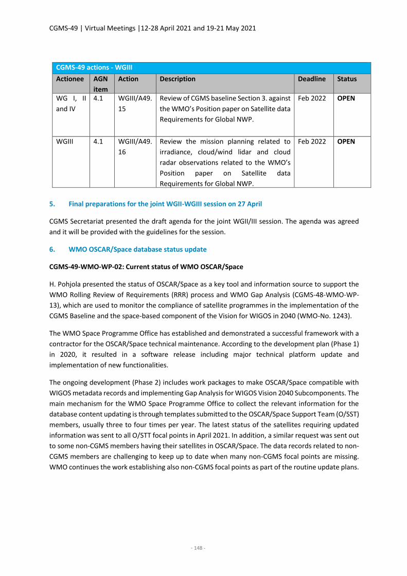
CGMS-49 | Virtual Meetings |12-28 April 2021 and 19-21 May 2021
- 148 -
CGMS-49 actions - WGIII
Actionee AGN
item
Action Description Deadline Status
WG I, II
and IV
4.1 WGIII/A49.
15
Review of CGMS baseline Section 3. against
the WMO’s Position paper on Satellite data
Requirements for Global NWP.
Feb 2022 OPEN
WGIII 4.1 WGIII/A49.
16
Review the mission planning related to
irradiance, cloud/wind lidar and cloud
radar observations related to the WMO’s
Position paper on Satellite data
Requirements for Global NWP.
Feb 2022 OPEN
5. Final preparations for the joint WGII-WGIII session on 27 April
CGMS Secretariat presented the draft agenda for the joint WGII/III session. The agenda was agreed
and it will be provided with the guidelines for the session.
6. WMO OSCAR/Space database status update
CGMS-49-WMO-WP-02: Current status of WMO OSCAR/Space
H. Pohjola presented the status of OSCAR/Space as a key tool and information source to support the
WMO Rolling Review of Requirements (RRR) process and WMO Gap Analysis (CGMS-48-WMO-WP-
13), which are used to monitor the compliance of satellite programmes in the implementation of the
CGMS Baseline and the space-based component of the Vision for WIGOS in 2040 (WMO-No. 1243).
The WMO Space Programme Office has established and demonstrated a successful framework with a
contractor for the OSCAR/Space technical maintenance. According to the development plan (Phase 1)
in 2020, it resulted in a software release including major technical platform update and
implementation of new functionalities.
The ongoing development (Phase 2) includes work packages to make OSCAR/Space compatible with
WIGOS metadata records and implementing Gap Analysis for WIGOS Vision 2040 Subcomponents. The
main mechanism for the WMO Space Programme Office to collect the relevant information for the
database content updating is through templates submitted to the OSCAR/Space Support Team (O/SST)
members, usually three to four times per year. The latest status of the satellites requiring updated
information was sent to all O/STT focal points in April 2021. In addition, a similar request was sent out
to some non-CGMS members having their satellites in OSCAR/Space. The data records related to non-
CGMS members are challenging to keep up to date when many non-CGMS focal points are missing.
WMO continues the work establishing also non-CGMS focal points as part of the routine update plans.
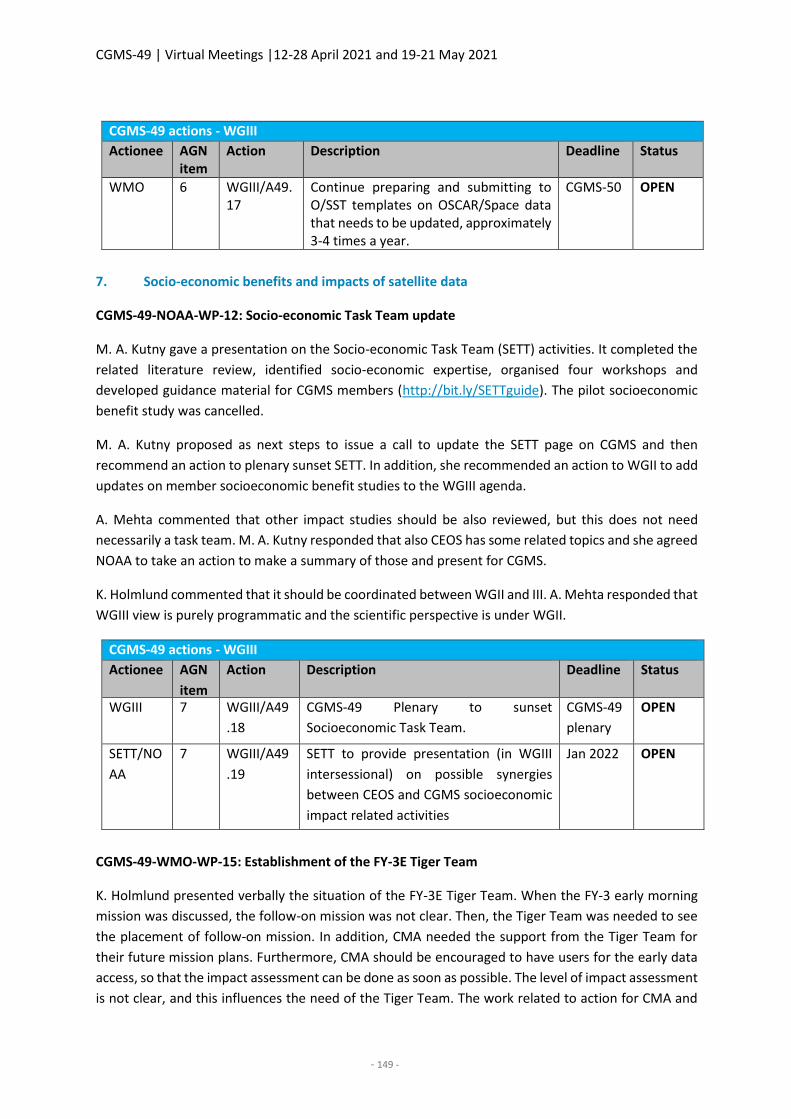
CGMS-49 | Virtual Meetings |12-28 April 2021 and 19-21 May 2021
- 149 -
CGMS-49 actions - WGIII
Actionee AGN item
Action Description Deadline Status
WMO 6 WGIII/A49.17
Continue preparing and submitting to O/SST templates on OSCAR/Space data that needs to be updated, approximately 3-4 times a year.
CGMS-50 OPEN
7. Socio-economic benefits and impacts of satellite data
CGMS-49-NOAA-WP-12: Socio-economic Task Team update
M. A. Kutny gave a presentation on the Socio-economic Task Team (SETT) activities. It completed the
related literature review, identified socio-economic expertise, organised four workshops and
developed guidance material for CGMS members (http://bit.ly/SETTguide). The pilot socioeconomic
benefit study was cancelled.
M. A. Kutny proposed as next steps to issue a call to update the SETT page on CGMS and then
recommend an action to plenary sunset SETT. In addition, she recommended an action to WGII to add
updates on member socioeconomic benefit studies to the WGIII agenda.
A. Mehta commented that other impact studies should be also reviewed, but this does not need
necessarily a task team. M. A. Kutny responded that also CEOS has some related topics and she agreed
NOAA to take an action to make a summary of those and present for CGMS.
K. Holmlund commented that it should be coordinated between WGII and III. A. Mehta responded that
WGIII view is purely programmatic and the scientific perspective is under WGII.
CGMS-49 actions - WGIII
Actionee AGN
item
Action Description Deadline Status
WGIII 7 WGIII/A49
.18
CGMS-49 Plenary to sunset
Socioeconomic Task Team.
CGMS-49
plenary
OPEN
SETT/NO
AA
7 WGIII/A49
.19
SETT to provide presentation (in WGIII
intersessional) on possible synergies
between CEOS and CGMS socioeconomic
impact related activities
Jan 2022 OPEN
CGMS-49-WMO-WP-15: Establishment of the FY-3E Tiger Team
K. Holmlund presented verbally the situation of the FY-3E Tiger Team. When the FY-3 early morning
mission was discussed, the follow-on mission was not clear. Then, the Tiger Team was needed to see
the placement of follow-on mission. In addition, CMA needed the support from the Tiger Team for
their future mission plans. Furthermore, CMA should be encouraged to have users for the early data
access, so that the impact assessment can be done as soon as possible. The level of impact assessment
is not clear, and this influences the need of the Tiger Team. The work related to action for CMA and
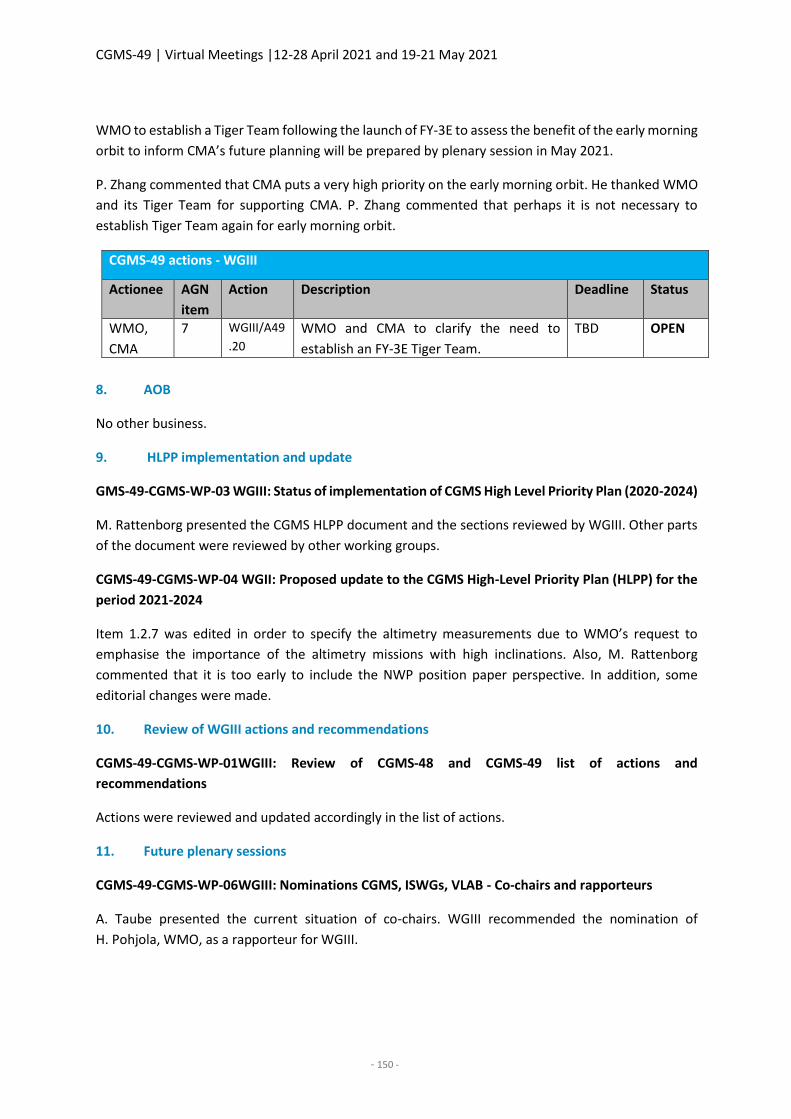
CGMS-49 | Virtual Meetings |12-28 April 2021 and 19-21 May 2021
- 150 -
WMO to establish a Tiger Team following the launch of FY-3E to assess the benefit of the early morning
orbit to inform CMA’s future planning will be prepared by plenary session in May 2021.
P. Zhang commented that CMA puts a very high priority on the early morning orbit. He thanked WMO
and its Tiger Team for supporting CMA. P. Zhang commented that perhaps it is not necessary to
establish Tiger Team again for early morning orbit.
CGMS-49 actions - WGIII
Actionee AGN
item
Action Description Deadline Status
WMO,
CMA
7 WGIII/A49
.20
WMO and CMA to clarify the need to
establish an FY-3E Tiger Team.
TBD OPEN
8. AOB
No other business.
9. HLPP implementation and update
GMS-49-CGMS-WP-03 WGIII: Status of implementation of CGMS High Level Priority Plan (2020-2024)
M. Rattenborg presented the CGMS HLPP document and the sections reviewed by WGIII. Other parts
of the document were reviewed by other working groups.
CGMS-49-CGMS-WP-04 WGII: Proposed update to the CGMS High-Level Priority Plan (HLPP) for the
period 2021-2024
Item 1.2.7 was edited in order to specify the altimetry measurements due to WMO’s request to
emphasise the importance of the altimetry missions with high inclinations. Also, M. Rattenborg
commented that it is too early to include the NWP position paper perspective. In addition, some
editorial changes were made.
10. Review of WGIII actions and recommendations
CGMS-49-CGMS-WP-01WGIII: Review of CGMS-48 and CGMS-49 list of actions and
recommendations
Actions were reviewed and updated accordingly in the list of actions.
11. Future plenary sessions
CGMS-49-CGMS-WP-06WGIII: Nominations CGMS, ISWGs, VLAB - Co-chairs and rapporteurs
A. Taube presented the current situation of co-chairs. WGIII recommended the nomination of
H. Pohjola, WMO, as a rapporteur for WGIII.
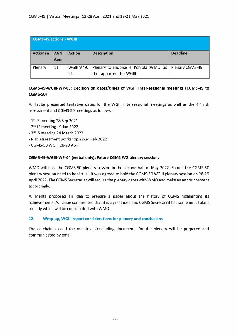
CGMS-49 | Virtual Meetings |12-28 April 2021 and 19-21 May 2021
- 151 -
CGMS-49 actions - WGIII
Actionee AGN
item
Action Description Deadline
Plenary 11 WGIII/A49.
21
Plenary to endorse H. Pohjola (WMO) as
the rapporteur for WGIII
Plenary CGMS-49
CGMS-49-WGIII-WP-03: Decision on dates/times of WGIII inter-sessional meetings (CGMS-49 to
CGMS-50)
A. Taube presented tentative dates for the WGIII intersessional meetings as well as the 4th risk
assessment and CGMS-50 meetings as follows:
- 1st IS meeting 28 Sep 2021
- 2nd IS meeting 19 Jan 2022
- 3rd IS meeting 24 March 2022
- Risk assessment workshop 22-24 Feb 2022
- CGMS-50 WGIII 28-29 April
CGMS-49-WGIII-WP-04 (verbal only): Future CGMS WG plenary sessions
WMO will host the CGMS-50 plenary session in the second half of May 2022. Should the CGMS-50
plenary session need to be virtual, it was agreed to hold the CGMS-50 WGIII plenary session on 28-29
April 2022. The CGMS Secretariat will secure the plenary dates with WMO and make an announcement
accordingly.
A. Mehta proposed an idea to prepare a paper about the history of CGMS highlighting its
achievements. A. Taube commented that it is a great idea and CGMS Secretariat has some initial plans
already which will be coordinated with WMO.
12. Wrap-up, WGIII report considerations for plenary and conclusions
The co-chairs closed the meeting. Concluding documents for the plenary will be prepared and
communicated by email.
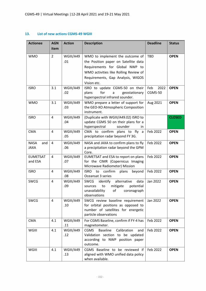
CGMS-49 | Virtual Meetings |12-28 April 2021 and 19-21 May 2021
- 152 -
13. List of new actions CGMS-49 WGIII
CGMS-49 actions - WGIII Actionee AGN
item
Action Description Deadline Status
WMO 2 WGIII/A49
.01
WMO to implement the outcome of
the Position paper on Satellite data
Requirements for Global NWP to
WMO activities like Rolling Review of
Requirements, Gap Analysis, WIGOS
Vision etc.
TBD OPEN
ISRO 3.1 WGIII/A49.02
ISRO to update CGMS-50 on their plans for a geostationary hyperspectral infrared sounder.
Feb 2022 CGMS-50
OPEN
WMO 3.1 WGIII/A49.03
WMO prepare a letter of support for the GEO-XO Atmospheric Composition instrument.
Aug 2021 OPEN
ISRO 4 WGIII/A49.04
(Duplicate with WGIII/A49.02) ISRO to update CGMS 50 on their plans for a hyperspectral sounder in geostationary orbit.
CLOSED
CMA 4 WGIII/A49.05
CMA to confirm plans to fly a precipitation radar beyond FY 3G.
Feb 2022 OPEN
NASA and JAXA
4 WGIII/A49.06
NASA and JAXA to confirm plans to fly a precipitation radar beyond the GPM Core.
Feb 2022 OPEN
EUMETSAT and ESA
4 WGIII/A49.07
EUMETSAT and ESA to report on plans for the CIMR (Copernicus Imaging Microwave Radiometer) Mission
Feb 2022 OPEN
ISRO 4 WGIII/A49.08
ISRO to confirm plans beyond Oceansat 3 series
Feb 2022 OPEN
SWCG 4 WGIII/A49.09
SWCG identify alternative data sources to mitigate potential unavailability of coronagraph observations
Jan 2022 OPEN
SWCG 4 WGIII/A49.10
SWCG review baseline requirement for orbital positions as opposed to number of satellites for energetic particle observations
Jan 2022 OPEN
CMA 4.1 WGIII/A49.11
For CGMS Baseline, confirm if FY-4 has magnetometer.
Feb 2022 OPEN
WGIII 4.1 WGIII/A49.12
CGMS Baseline Calibration and Validation section to be updated according to NWP position paper outcome.
Feb 2022 OPEN
WGIII 4.1 WGIII/A49.13
CGMS Baseline to be reviewed if aligned with WMO unified data policy when available.
Feb 2022 OPEN
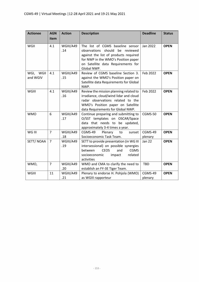
CGMS-49 | Virtual Meetings |12-28 April 2021 and 19-21 May 2021
- 153 -
CGMS-49 actions - WGIII Actionee AGN
item
Action Description Deadline Status
WGII 4.1 WGIII/A49.14
The list of CGMS baseline sensor observations should be reviewed against the list of products required for NWP in the WMO’s Position paper on Satellite data Requirements for Global NWP.
Jan 2022 OPEN
WGI, WGII and WGIV
4.1 WGIII/A49.15
Review of CGMS baseline Section 3. against the WMO’s Position paper on Satellite data Requirements for Global NWP.
Feb 2022 OPEN
WGIII 4.1 WGIII/A49.16
Review the mission planning related to irradiance, cloud/wind lidar and cloud radar observations related to the WMO’s Position paper on Satellite data Requirements for Global NWP.
Feb 2022 OPEN
WMO 6 WGIII/A49.17
Continue preparing and submitting to O/SST templates on OSCAR/Space data that needs to be updated, approximately 3-4 times a year.
CGMS-50 OPEN
WG III 7 WGIII/A49.18
CGMS-49 Plenary to sunset Socioeconomic Task Team.
CGMS-49 plenary
OPEN
SETT/ NOAA 7 WGIII/A49.19
SETT to provide presentation (in WG III intersessional) on possible synergies between CEOS and CGMS socioeconomic impact related activities
Jan 22 OPEN
WMO, 7 WGIII/A49.20
WMO and CMA to clarify the need to establish an FY-3E Tiger Team.
TBD OPEN
WGIII 11 WGIII/A49.21
Plenary to endorse H. Pohjola (WMO) as WGIII rapporteur
CGMS-49 plenary
OPEN
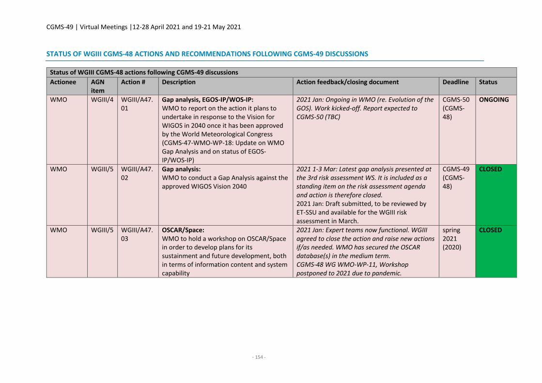
CGMS-49 | Virtual Meetings |12-28 April 2021 and 19-21 May 2021
- 154 -
STATUS OF WGIII CGMS-48 ACTIONS AND RECOMMENDATIONS FOLLOWING CGMS-49 DISCUSSIONS
Status of WGIII CGMS-48 actions following CGMS-49 discussions
Actionee AGN item
Action # Description Action feedback/closing document Deadline Status
WMO WGIII/4 WGIII/A47.01
Gap analysis, EGOS-IP/WOS-IP: WMO to report on the action it plans to undertake in response to the Vision for WIGOS in 2040 once it has been approved by the World Meteorological Congress (CGMS-47-WMO-WP-18: Update on WMO Gap Analysis and on status of EGOS-IP/WOS-IP)
2021 Jan: Ongoing in WMO (re. Evolution of the GOS). Work kicked-off. Report expected to CGMS-50 (TBC)
CGMS-50 (CGMS-48)
ONGOING
WMO WGIII/5 WGIII/A47.02
Gap analysis: WMO to conduct a Gap Analysis against the approved WIGOS Vision 2040
2021 1-3 Mar: Latest gap analysis presented at the 3rd risk assessment WS. It is included as a standing item on the risk assessment agenda and action is therefore closed. 2021 Jan: Draft submitted, to be reviewed by ET-SSU and available for the WGIII risk assessment in March.
CGMS-49 (CGMS-48)
CLOSED
WMO WGIII/5 WGIII/A47.03
OSCAR/Space: WMO to hold a workshop on OSCAR/Space in order to develop plans for its sustainment and future development, both in terms of information content and system capability
2021 Jan: Expert teams now functional. WGIII agreed to close the action and raise new actions if/as needed. WMO has secured the OSCAR database(s) in the medium term. CGMS-48 WG WMO-WP-11, Workshop postponed to 2021 due to pandemic.
spring 2021 (2020)
CLOSED
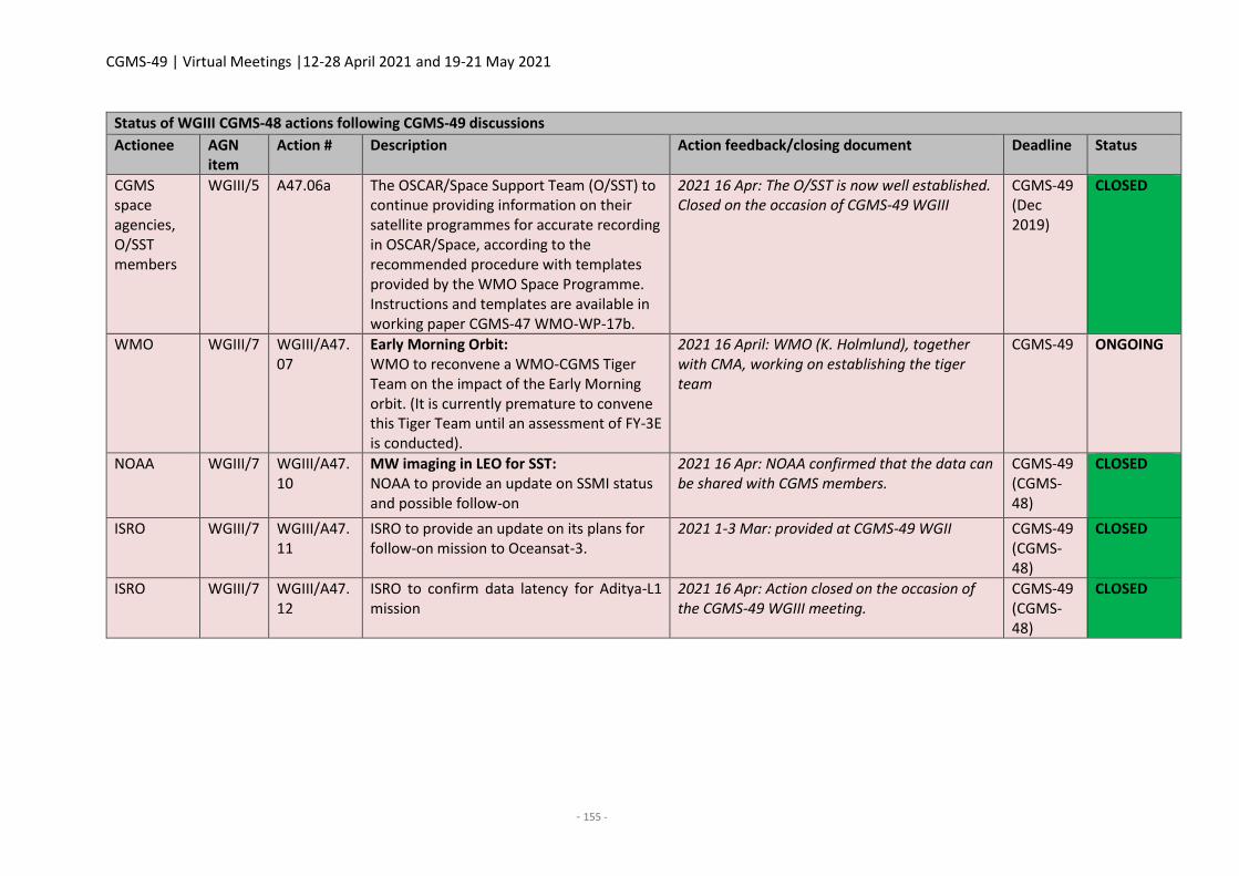
CGMS-49 | Virtual Meetings |12-28 April 2021 and 19-21 May 2021
- 155 -
Status of WGIII CGMS-48 actions following CGMS-49 discussions
Actionee AGN item
Action # Description Action feedback/closing document Deadline Status
CGMS space agencies, O/SST members
WGIII/5 A47.06a The OSCAR/Space Support Team (O/SST) to continue providing information on their satellite programmes for accurate recording in OSCAR/Space, according to the recommended procedure with templates provided by the WMO Space Programme. Instructions and templates are available in working paper CGMS-47 WMO-WP-17b.
2021 16 Apr: The O/SST is now well established. Closed on the occasion of CGMS-49 WGIII
CGMS-49 (Dec 2019)
CLOSED
WMO WGIII/7 WGIII/A47.07
Early Morning Orbit: WMO to reconvene a WMO-CGMS Tiger Team on the impact of the Early Morning orbit. (It is currently premature to convene this Tiger Team until an assessment of FY-3E is conducted).
2021 16 April: WMO (K. Holmlund), together with CMA, working on establishing the tiger team
CGMS-49 ONGOING
NOAA WGIII/7 WGIII/A47.10
MW imaging in LEO for SST: NOAA to provide an update on SSMI status and possible follow-on
2021 16 Apr: NOAA confirmed that the data can be shared with CGMS members.
CGMS-49 (CGMS-48)
CLOSED
ISRO WGIII/7 WGIII/A47.11
ISRO to provide an update on its plans for follow-on mission to Oceansat-3.
2021 1-3 Mar: provided at CGMS-49 WGII CGMS-49 (CGMS-48)
CLOSED
ISRO WGIII/7 WGIII/A47.12
ISRO to confirm data latency for Aditya-L1 mission
2021 16 Apr: Action closed on the occasion of the CGMS-49 WGIII meeting.
CGMS-49 (CGMS-48)
CLOSED
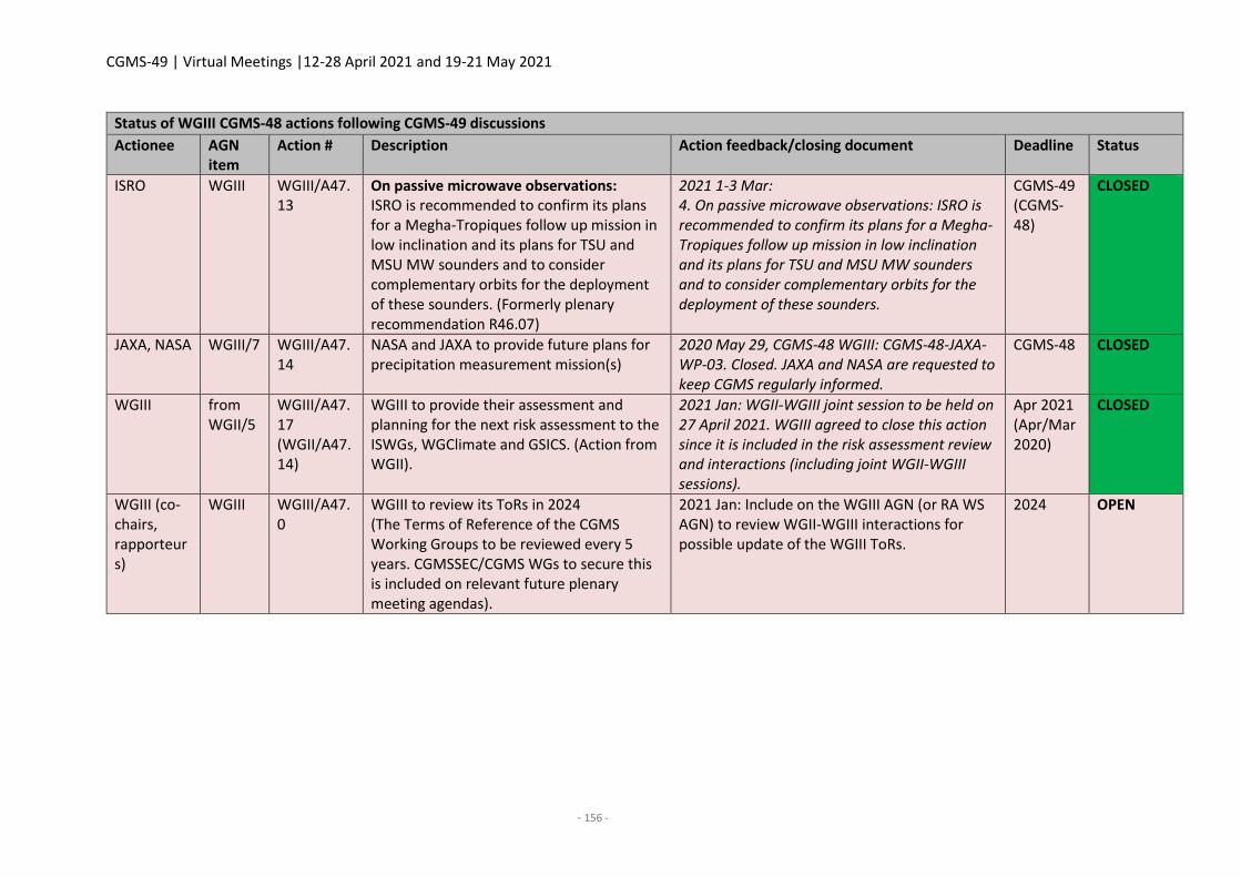
CGMS-49 | Virtual Meetings |12-28 April 2021 and 19-21 May 2021
- 156 -
Status of WGIII CGMS-48 actions following CGMS-49 discussions
Actionee AGN item
Action # Description Action feedback/closing document Deadline Status
ISRO WGIII WGIII/A47.13
On passive microwave observations: ISRO is recommended to confirm its plans for a Megha-Tropiques follow up mission in low inclination and its plans for TSU and MSU MW sounders and to consider complementary orbits for the deployment of these sounders. (Formerly plenary recommendation R46.07)
2021 1-3 Mar: 4. On passive microwave observations: ISRO is recommended to confirm its plans for a Megha-Tropiques follow up mission in low inclination and its plans for TSU and MSU MW sounders and to consider complementary orbits for the deployment of these sounders.
CGMS-49 (CGMS-48)
CLOSED
JAXA, NASA WGIII/7 WGIII/A47.14
NASA and JAXA to provide future plans for precipitation measurement mission(s)
2020 May 29, CGMS-48 WGIII: CGMS-48-JAXA-WP-03. Closed. JAXA and NASA are requested to keep CGMS regularly informed.
CGMS-48 CLOSED
WGIII from WGII/5
WGIII/A47.17 (WGII/A47.14)
WGIII to provide their assessment and planning for the next risk assessment to the ISWGs, WGClimate and GSICS. (Action from WGII).
2021 Jan: WGII-WGIII joint session to be held on 27 April 2021. WGIII agreed to close this action since it is included in the risk assessment review and interactions (including joint WGII-WGIII sessions).
Apr 2021 (Apr/Mar 2020)
CLOSED
WGIII (co-chairs, rapporteurs)
WGIII WGIII/A47.0
WGIII to review its ToRs in 2024 (The Terms of Reference of the CGMS Working Groups to be reviewed every 5 years. CGMSSEC/CGMS WGs to secure this is included on relevant future plenary meeting agendas).
2021 Jan: Include on the WGIII AGN (or RA WS AGN) to review WGII-WGIII interactions for possible update of the WGIII ToRs.
2024 OPEN
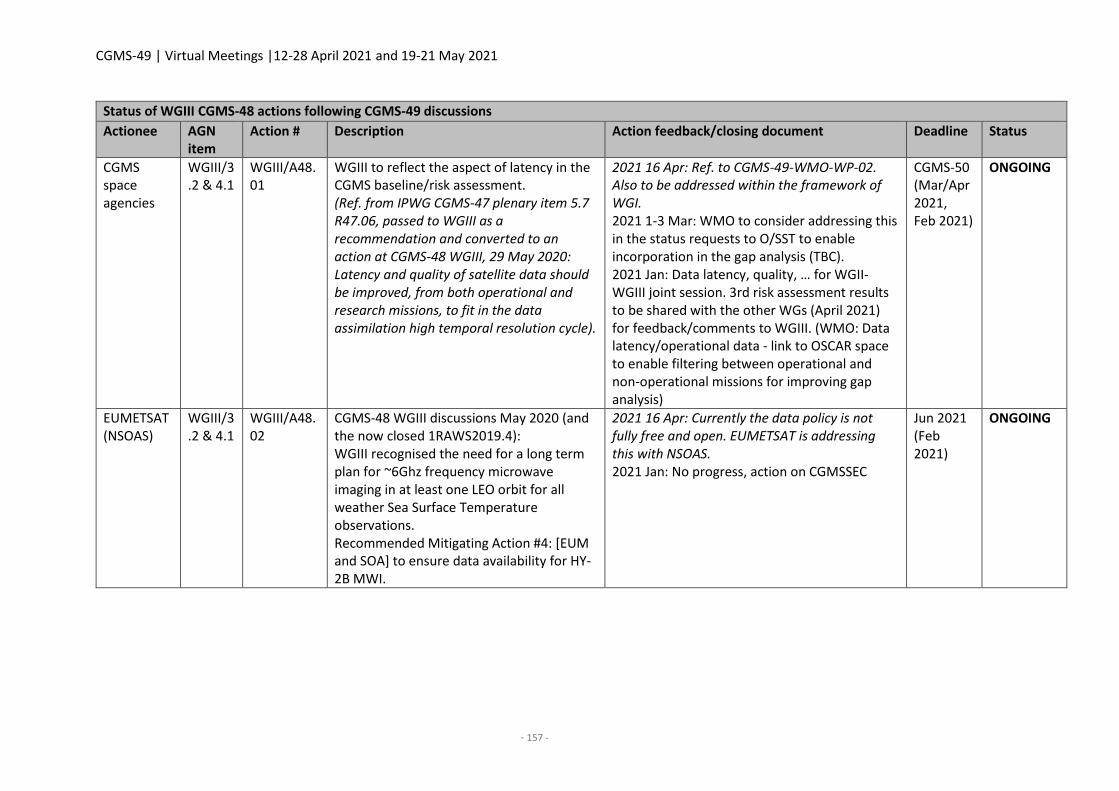
CGMS-49 | Virtual Meetings |12-28 April 2021 and 19-21 May 2021
- 157 -
Status of WGIII CGMS-48 actions following CGMS-49 discussions
Actionee AGN item
Action # Description Action feedback/closing document Deadline Status
CGMS space agencies
WGIII/3.2 & 4.1
WGIII/A48.01
WGIII to reflect the aspect of latency in the CGMS baseline/risk assessment. (Ref. from IPWG CGMS-47 plenary item 5.7 R47.06, passed to WGIII as a recommendation and converted to an action at CGMS-48 WGIII, 29 May 2020: Latency and quality of satellite data should be improved, from both operational and research missions, to fit in the data assimilation high temporal resolution cycle).
2021 16 Apr: Ref. to CGMS-49-WMO-WP-02. Also to be addressed within the framework of WGI. 2021 1-3 Mar: WMO to consider addressing this in the status requests to O/SST to enable incorporation in the gap analysis (TBC). 2021 Jan: Data latency, quality, … for WGII-WGIII joint session. 3rd risk assessment results to be shared with the other WGs (April 2021) for feedback/comments to WGIII. (WMO: Data latency/operational data - link to OSCAR space to enable filtering between operational and non-operational missions for improving gap analysis)
CGMS-50 (Mar/Apr 2021, Feb 2021)
ONGOING
EUMETSAT (NSOAS)
WGIII/3.2 & 4.1
WGIII/A48.02
CGMS-48 WGIII discussions May 2020 (and the now closed 1RAWS2019.4): WGIII recognised the need for a long term plan for ~6Ghz frequency microwave imaging in at least one LEO orbit for all weather Sea Surface Temperature observations. Recommended Mitigating Action #4: [EUM and SOA] to ensure data availability for HY-2B MWI.
2021 16 Apr: Currently the data policy is not fully free and open. EUMETSAT is addressing this with NSOAS. 2021 Jan: No progress, action on CGMSSEC
Jun 2021 (Feb 2021)
ONGOING
CGMS-49 | Virtual Meetings |12-28 April 2021 and 19-21 May 2021
- 158 -
Status of WGIII CGMS-48 actions following CGMS-49 discussions
Actionee AGN item
Action # Description Action feedback/closing document Deadline Status
EUMETSAT (NSOAS)
WGIII/3.2 & 4.1
WGIII/A48.03
CGMS-48 WGIII discussions May 2020 (and the now closed 1RAWS2019.8): WGIII recognised that there is no radar altimetry data availability in the early morning orbit in the short term and that there are no plans in the long term for coverage. Recommended Mitigating Action #8: [EUM and SOA] to ensure data availability for HY-2B ALT.
2021 16 Apr: Currently the data policy is not fully free and open. EUMETSAT is addressing this with NSOAS. 2021 Jan: No progress, action on CGMSSEC.
Jun 2021 (Feb 2021)
ONGOING
EUMETSAT (NIER)
WGIII/3.2 & 4.1
WGIII/A48.04
EUMETSAT to explore with NIER of GEO KOMPSAT 2B GEMS observations can be considered for the CGMS baseline and risk assessment.
2021 16 Apr: KMA to reach out to NIER 2021 1-3 Mar: EUMETSAT to continue reaching out to NIER (NIER expected to provide a status presentation to WGII at CGMS-49). 2021 Jan: No progress, action on CGMSSEC.
CGMS-49 (Feb 2021)
ONGOING
WMO WGIII/5 WGIII/A48.05
WMO to prepare templates on OSCAR/Space data that needs to be updated and submitting them to O/SST, approximately 3-4 times a year, for providing the missing information and to provide these to the CGMS space agencies. (Ref. CGMS-48-WMO-WP-10a)
2021 16 Apr: Closed following CGMS-49 WGIII discussions. The process is now well established. 2021 1-3 Mar: To be addressed in WGIII discussions in April and then likely closed, but needs to be recalled and noted in WMO working papers and in the meeting report(s).
Apr 2021 (01/07/2020)
CLOSED
WMO WGIII/5 WGIII/A48.06
WMO to continue efforts to establish reliable O/SST focal points from CEOS members other than CGMS members and commercial satellites operators.
2021 16 Apr: Ref CGMS-49-WMO-WP-02. CGMS agencies to provide input overall the focal points have been established. Closed on the occasion of CGMS-49 WGIII
Apr 2021 CGMS-49
CLOSED
CGMS-49 | Virtual Meetings |12-28 April 2021 and 19-21 May 2021
- 159 -
Status of WGIII CGMS-48 actions following CGMS-49 discussions
Actionee AGN item
Action # Description Action feedback/closing document Deadline Status
CGMS space agencies
WGIII/5 WGIII/A48.07
CGMS members, through their O/SST focal points, to provide accurate and timely updates on OSCAR/Space database content in response to requests made to them by the WMO Space Programme Office. (Ref. CGMS-48-WMO-WP-10a)
2021 16 Apr: Covered by the ToRs of the O/SST. See also Ref CGMS-49-WMO-WP-02. Closed on the occasion of CGMS-49 WGIII.
Apr 2021 (01/07/2020)
CLOSED
CGMSSEC, WGII co-chairs/rapporteurs
WGIII/3 WGIII/A48.08
CGMSSEC to follow up with WGII co-chairs/rapporteurs to secure their input on the CGMS Baseline
2021 11/3 Mar: Ajay Mehta, WGIII co-chair briefed WGII in the WGII intersessional meeting on 11 March. (in preparation of the CGMS-49 joint WGII-WGIII session on 27 April) 2021 Jan: To be addressed at the 3rd risk assessment WS in March and the joint WGII-WGIII session in April.
Mar-Apr 2021 (01/08/2020)
CLOSED
Status of WGIII CGMS-48 recommendations following CGMS-49 discussions
Lead AGN item
Rec # Description Recommendation feedback/closing document
CGMS space agencies
From plenary 5.7
Plenary R47.05 (From IPWG): Higher spatial and temporal (sub-hourly) resolution and higher spectral sampling in the microwave measurement of clouds and precipitation should be considered in future observing systems. [Recommendation transferred from plenary].
COMPLETED 2021 1-3 Mar: Consider concluded at this stage. To be reopened as necessary once more concrete input is available. CGMSSEC to address it with IPWG within the framework of the HLPP. 2021 Jan: Reference to WIGOS Vision. Address in WGII-WGIII joint session in April. 2020 May 28, CGMS-48 WGIII: CGMS members to take note/consider in the preparation of new programmes. Recommendation proposed to be
CGMS-49 | Virtual Meetings |12-28 April 2021 and 19-21 May 2021
- 160 -
Status of WGIII CGMS-48 recommendations following CGMS-49 discussions
Lead AGN item
Rec # Description Recommendation feedback/closing document
closed. It will be addressed within the framework of the CGMS baseline/risk assessment.
CGMS space agencies
5.8 R47.09 (From ICWG) CGMS agencies to continue operating conically-scanning passive MW sensors in an early afternoon orbit as well as in a dusk/dawn orbit in order to maintain this unique long-term time series.
COMPLETED 2021 1-3 Mar: WMO to consider this within the framework of the gap analysis. 2021 Jan: Reference to WIGOS Vision. Address in WGII-WGIII joint session in April. 2020 Aug: Transferred from plenary CGMS-47 to WGIII
CGMS-49 | Virtual Meetings |12-28 April 2021 and 19-21 May 2021
- 162 -
WGIV REPORT
Co-chairs: Kotaro BESSHO (JMA)
Rapporteur: Klaus-Peter Renner (EUMETSAT)
1. Welcome, objectives of the meeting
WGIV reviewed and adopted the draft agenda proposed by the CGMS Secretariat prior to the meeting,
which is in line with the Terms of Reference for WGIV.
Representatives of the following organisations attended the session: CMA, ESA, EUMETSAT, IMD,
ISRO, JMA, KMA, NASA, NICT, NOAA, NSSC, ROSCOSMOS, ROSHYDROMET, UK Met Office, and WMO.
The WGIV meeting was conducted via Webex.
In view of the common items of interest in relation to Space Weather, the representatives of WGI,
WGIV, and the Space Weather Coordination Group participated in the joint WGI-WGIV-SWCG meeting
to address space weather related topics.
2. Review of actions and recommendations from previous meetings and status update
The WG reviewed the actions and recommendations of past CGMS sessions related to its work. The
following 15 actions were proposed to be closed: A44.05, A45.03, A46.02, A46.04, A46.06, A46.08,
A47.03, A47.04, A47.05, A48.03, A48.04, A48.05, A48.07, A48.10, and A48.11. Six actions and three
recommendations remained open. One new action was created as a follow-up on A46.08, and one
recommendation as follow-up on A46.04.
CGMS-49 actions - WGIV
Actionee AGN item
Action Description Deadline Status
Satellite operators who launched new satellites since 2016
2 WGIV/A49.01 To provide updates for WMO "Guidelines on Best Practices for Achieving User Readiness for New Meteorological Satellites" https://library.wmo.int/doc_num.php?explnum_id=3553
CGMS-50 OPEN
CGMS-49 WGIV recommendations
Actionee AGN item
Rec Description
CGMS members
2 WGIV/R49.01
To consider an enhancement of advance notifications of processing changes as specified below and provide feedback to WG-IV. If a planned change to data processing results in a change in brightness temperature of 0.1K or 20% of NEdT (whichever is smaller), this should be made clear in notifications to users. These notifications should be made no later than 8
CGMS-49 | Virtual Meetings |12-28 April 2021 and 19-21 May 2021
- 163 -
CGMS-49 WGIV recommendations
Actionee AGN item
Rec Description
weeks before the change and test data should be provided if possible. [From the ITWG ITSC-21 Report]
3. User-provider dialogue on regional/global scales
There were no discussions under this item.
4. Implementation and evolution of sustained and coordinated communication satellite
broadcast systems
CGMS-49-CMA-WP-12: CMA Report on the Update of CMACast
This document describes the status and future plan of the CMACast system and services. In the
framework of GEONETCast, CMACast distributes data to Asia-Pacific users who use the Integrated
CMACast system to receive and process data as well as to make weather forecasts. In order to service
users better, the CMACast system will be updated in 2021. After the upgrade, CMACast can distribute
data by satellite for all users in the footprint, by meteorological broadband network for domestic users
and internet for international users. In addition, the coverage of CMACast will be further expanded to
West Asia, the Middle East, and most of Africa, with the same transponder capacity as before. The
new CMACast coverage will be available in 2022.
CGMS-49-JMA-WP-06: Data dissemination and distribution of Himawari-8/9 and their recent update
The document presents an overview of Himawari-8/9 data dissemination and distribution in JMA and
reports their recent updates. JMA provides Himawari-8/9 data via its HimawariCast and
HimawariCloud systems, with online satellite imagery improved in February 2021. New developments
such as HimawariCast enhancement and a new HimawariCloud connection method are under
consideration. A novel HpFP protocol was developed by the National Institute of Information and
Communications Technology (NICT) based on the User Datagram Protocol and enables high
throughput even with high latency and packet loss.
EUMETSAT asked if HpFP is already in use and JMA confirmed that HpFP is implemented in the
HimawariCloud system.
CGMS-49-NOAA-WP-13: NOAA Report on GEONETCast Americas (GNC-A)
The GEONETCast Americas broadcast (GNC-A) is a NOAA-funded, commercially provided broadcast
stream that has been operational since 2008, serving satellite, in-situ, and various other earth
observational data to North, Central, and South American communities via the Intelsat-21 satellite at
58° West. The GNC-A broadcast has evolved since 2018 with a larger user community, additional NOAA
Geostationary and polar orbiting products, and more external data providers. In 2020, the satellite
CGMS-49 | Virtual Meetings |12-28 April 2021 and 19-21 May 2021
- 164 -
broadcast itself has been modified with a change in the transponder that accommodates a higher data
rate change, a change in data formatting, and centre downlink frequency requiring GNC-A users to
modify ground station receiving equipment. NOAA still maintains its partnership with the Brazilian
Ministry of Science, Technology, and Innovations (INPE), which has been instrumental in end user
outreach and the open source GNC-A SHOWCast visualisation software suite.
Responding to a question from JMA on the relationship between the US and Brazil, NOAA said an
agreement is in place with INPE as full-time partner, for helpdesk and customer support covering
Portuguese and Spanish language, which also includes local support to users.
5. Global or inter-regional data circulation and access, WIS
CGMS-49-IMD-WP-03: Update on MMDRPS data access
IMD has established the Multi-Mission Meteorological Data Receiving and Processing System
(MMDRPS) for INSAT-3D, INSAT-3DR, and INSAT-3DS. MMDRPS has a very high-end processing system,
which cuts down the processing time from 15 to 7 minutes. All available past satellite datasets starting
from 1983 will be kept in online mode in due course of time. The MMDRPS system has been declared
operational on 12th November 2020 and is being used to receive and process the INSAT-3D and INSAT-
3DR satellites data. Data exchange between IMD and other national and international agencies takes
place on a real time basis. A dedicated National Knowledge Network (NKN) has been established by
IMD with ISRO and with NCMRWF. Data transmission also takes place through the Global
Telecommunication system (GTS) network for international agencies. The MMDRPS has a dedicated
Web-based Data supply System (DSS) in redundant mode to cater web-based data dissemination
requirements in near real time basis to various users (both local and remote global) based on the data
dissemination policy of IMD. In addition, the MMDRPS system is also in the final stage of implementing
the RAPID Beta Version. The new RAPID tool, along with satellite data visualisation, also ingests NWP,
radar, and in-situ observational data on a real time basis. The different types of data can be overlayed
to understand the weather patterns from various sources for improved weather forecasting.
CGMS-49-ISRO-WP-01: Meteorological and oceanographic data dissemination from MOSDAC
The paper discusses the information and products available for dissemination from Meteorological
and Oceanographic Satellite Data Archival Center (MOSDAC). It also highlights details of data
interconnect and provides an overview of data dissemination. New applications released on MOSDAC
are also introduced.
MOSDAC is a data centre of ISRO for the dissemination of data, value added products, and satellite-
derived information products related to meteorology and oceanography. Currently, these data sets
are being disseminated using well established data exchanges and data transfer protocols.
As part of data access, MOSDAC has introduced the micro services-based dissemination of information
and alerts. This services-based interface allows other uses to integrate or use services of MOSDAC on
their website or applications. Currently, beach alert, weather alert, and location-based weather
forecast are available as a service. Some new capabilities introduced in MOSDAC includes city weather,
CGMS-49 | Virtual Meetings |12-28 April 2021 and 19-21 May 2021
- 165 -
safe beach and visualisation, and the display of Automatic Weather Station (AWS) data and Interactive
Visualisation and analysis using LIVE (https://mosdac.gov.in/live).
MOSDAC provides different mechanisms for dissemination of data to its users. Users registered with
MOSDAC can log-in and place an order for archived products. The open data is available for download
to registered users, without any requirement of ordering. MOSDAC also provide access to data as WMS
layers, Email, and RSS feeds. MOSDAC-registered users can also use MOSDAC API to access data and
information.
When asked by JMA about the benefit of data access through micro services, ISRO explained that this
method is primarily for API access and the data guidelines were updated accordingly. The paper also
contains a link to the updated guidelines.
WMO pointed out similarities in the developing strategies for WIS2.0 where GTS will be phased out,
in relation to ISRO’s activities in the new test Amazon cloud, using S3 bucket, using message queuing
protocols, and working towards RSS-based feeds for message distribution.
ISRO confirmed that AWS data is freely available through MOSDAC web, but not on GTS. It is planned
to start a project for exposing this data on WIS2.0.
CGMS-49-KMA-WP-03: KMA Report on the update of GK2A data service
The GK2A satellite is operational since July 25, 2019. It produces 16 channels level 1b and many kinds
of meteorological data and is operating for rapid scan local observation at interval of 2 minutes as well
as normal observation at every 10 minutes for full disk. KMA has implemented the GK2A data service
via several ways such as real-time FTP, open API, WMO WIS DCPC, and web-based download.
In order to promote GK2A data utilisation in public and private sectors as well as the NMHS, KMA has
implemented the open API service of the GK2A data for 79 AMI products and 8 KSEM products from
this year.
When asked about a free download policy for commercial and academic users, KMA responded that
this is possible for GK2A data through the API access method.
CGMS-49-EUMETSAT-WP-10: Update on the EUMETSAT NRT Data Access Services
The presentation provides an overview and the current status of the new data access services:
EUMETView, Data Store, and Data Tailor. EUMETView is an Online Map Service that provides
visualisations of EUMETSAT products through a customisable web user interface and an enhanced set
of Open Geospatial Consortium (OGC) standard APIs. The EUMETSAT Data Store is providing access to
NRT products, historic products, and climate data records through an online web user interface and
via a suite of APIs. EUMETSAT Data Tailor (standalone or via Data Store) allows users to subset and
aggregate EUMETSAT’s data products in space and time, filter layers, generate quicklooks, re-project,
and reformat into common GIS formats. The existing EUMETCast services were enhanced, i. e. the
EUMETCast Europe non-restorable service using flexible transponder capacity from the back-up
satellite as needed, and the access to EUMETCast Terrestrial via commercial internet to complement
CGMS-49 | Virtual Meetings |12-28 April 2021 and 19-21 May 2021
- 166 -
the National Research and Education Network (NREN) access. The operational start of new terrestrial
based data services (EUMETView, Data Store, Data Tailor, and EUMETCast Terrestrial enhancements)
is planned for mid-2021, and for the EUMETCast Europe non-restorable Satellite service in 2023 to
2024.
CGMS-49-ROSHYDROMET-WP-05: Satellite data exchange in Roshydromet
Roshydromet shares satellite data with the international community in accordance with WMO
resolution 40 and the current Bilateral Agreement with EUMETSAT. Data from Russian geostationary
and polar meteorological satellites is provided to the EUMETSAT land channel for distribution to
EUMETSAT users in NRT via EUMETCast. This data includes IR sounder IKFS-2 (Meteor-M N2) and
microwave sounder MTVZA-GY (Meteor-M N2-2). Following the recommendations of CGMS-48, the
data is dumped over European, Siberian, and Far-Eastern centres of SRC Planeta to improve timeliness,
and allowing per-pass data to be available for NWP purposes. Since 2018, IKFS data is available via the
Roshydromet GSICS Processing and Research Centre website. Roshydromet has access to the data
distributed via EUMETCast and uses this data in operational practice. Roshydromet (SRC Planeta)
contributes to the EUMETSAT Advanced Retransmission Service (EARS) by provision of regional
coverage of NOAA, MetOp, and SNPP data. A dedicated landline channel between Moscow and
EUMETSAT headquarters in Darmstadt was recently updated by EUMETSAT to meet the data exchange
requirements. The Internet channels are used as a backup.
CGMS-49-WMO-WP-08: WMO Integrated Global Observing System Station identifiers
The paper examines the identification of satellites in products exchanged within the context of the
WMO Integrated Global Observing System. The use of Common Code Table C-5 from the WMO Manual
on Codes is explained, together with the concept of WIGOS station identifiers and their applicability
for satellites. The paper concludes by recommending that the CGMS Task Force on Satellite Data and
Codes works with WMO to address the use of WIGOS Station Identifiers (WSI) for satellites.
CGMS-49 actions - WGIV
Actionee AGN item
Action Description Deadline Status
CGMS Task Force on Satellite Data and Codes, WMO
5 WGIV/A49.02 The CGMS Task Force on Satellite Data and Codes to work closely with WMO on addressing the following points: i. Linking between OSCAR/Space and the WSI and/or CCT C-5 identifiers (WMO internal) ii. Potential extension of the use of the Issue Number in the WSI for satellites in order to explicitly indicate metadata which are otherwise only implicitly embedded in the Local
CGMS-50 OPEN
CGMS-49 | Virtual Meetings |12-28 April 2021 and 19-21 May 2021
- 167 -
CGMS-49 actions - WGIV
Actionee AGN item
Action Description Deadline Status
Identifier (CGMS-50) iii. Identification of when and how the WSI should be included in the satellite products exchanges in the context of the WIGOS (CGMS-50) (ref CGMS-49-WMO-WP-08)
CGMS-49-CMA-WP-11: Fengyun Satellite Data Services and Applications and Their Updates
The document describes the data policy of FY satellite data, the status, and future plans of and for the
FY satellite data distribution and services. FY satellite data are open to NMSs and other international
organisations and users for free charge via many ways. For real-time users, FY satellite data can be
accessed via direct broadcasting stations, CMA data broadcasting system (CMACast), GTS, WIS, and
public cloud. For non-real-time users, F197
Y satellite data can be accessed from the FY satellite data centre website, downloading toolkits, and
offline data services. For emergency users, FY satellite emergency support mechanism (FY_ESM) is
useful to NMSs.
JMA thanked CMA for the contribution, in particular for the RSS service as part of the emergency
support mechanism.
6. Widening of data access, to new missions/providers as well as for other user communities
CGMS-49-CEOS-WP-01: A report on the initiation of the Earth Observation Training Education and
Capacity Development (EOTEC DevNet) on behalf of CEOS WG for Capacity building and Data
Democracy (WGCapD)
The Working Paper presents the Earth Observation Training, Education, and Capacity Development
Network (EOTEC DevNet) initiation plan. A gap exists in the coordination of the efforts to strengthen
sustained capacity and use of EO to meet user needs in support of the sustainable development
agenda. Currently, multiple global networks contribute to EO capacity development. Each has
overlapping interests and existing relationships that can be further coordinated and leveraged to bring
the power of EO to more users. CEOS recently endorsed the EOTEC DevNet initiation plan, which
includes using a network of networks approach between CEOS WGCapD, GEO CD-WG, CGMS VLab,
WMO, and UNOOSA. This two-year pilot aims to improve coordination and enhancement of EO space-
based asset providers and training providers in support of key global development outcomes. Through
greater communication, EOTEC DevNet will improve strategic and ad hoc coordination of activities.
Through systematic assessment of relevant capacity development resources and current state of skills
to use them, gaps will be identified, and approaches will be developed to close the gaps, leading to
improved application of EO to meet the 2030 sustainability framework goals. By creating leadership
coordination meetings and a practitioner community among capacity building professionals that serve
as a marketplace to facilitate information and knowledge flows, greater global and regional
CGMS-49 | Virtual Meetings |12-28 April 2021 and 19-21 May 2021
- 168 -
communication will be enabled between the participants in the multiple networks. Part of the CEOS
Work Plan 2020-2022, the EOTEC DevNet initiation plan begins with a two-year pilot with WGCapD
initiating a new Task Team, called the EOTEC DevNet Task Team, to implement EOTEC DevNet tasks.
To implement EOTEC DevNet, initial actions for each of the individual network organisations are to
work within their respective governance structures to gain approval and support of participation,
prepare an estimate of effort required, and host the first official EOTEC DevNet regional meetings in
June 2021 and leadership convening in September 2021. Building off of the recent WGCapD-10 Annual
Meeting regional discussions, EOTEC DevNet will focus on floods as the initial case study for
coordination across networks.
WGIV and the VLab co-chair supported this initiative and encouraged WGIV member to participate in
regional discussions planned in June. A related action was created.
CGMS-49 actions - WGIV
Actionee AGN
item
Action Description Deadline Status
CGMS
members
6 WGIV/A49.03 To participate in the next EOTEC
DevNet regional discussions planned
in June, held online across time zones.
Invitations have been sent to WGIV
members by CGMS secretariat.
(ref CGMS-49-CEOS-WP-01)
Jul 2021 OPEN
6.1. Disaster support
CGMS-49-CMA-WP-13: CMA Report on FY_ESM
The document describes the updated information of Rapid Scan Services under the Emergency
Support Mechanism of FY Satellite (FY_ESM), including the update of the FY_ESM webpage, rapid scan
products, working flow, and suggestions on cooperation with JMA and KMA. CMA will strengthen
capabilities on disaster prevention and mitigation with FY satellites.
In response to a question from JMA, CMA confirmed that FY-3 LEO satellites are used in disaster
support cases, too, e. g. in Guatemala, Russia, and South America.
CGMS-49-ISRO-WP-08: Web-based platform for disaster data analysis
The International Charter on Space and Major Disasters is a worldwide collaboration through which
satellite data are made available for the benefit of disaster management. By combining EO assets from
different space agencies, the Charter allows resources and expertise to be coordinated for rapid
response to major disaster situations. This unique initiative is able to mobilise agencies around the
world and benefit from their know-how and their satellites through a single access point that operates
24x7 at no cost to the user. The paper presents a solution, responding to the need for web-based
online processing platforms for disaster analysis due to (i) a large number of satellites and data
products, (ii) to reduce the Turn-around-time for analysis, (iii) a non-availability of processing
resources. The Web based platform for Disaster Data Analysis is intended for project managers (PM),
CGMS-49 | Virtual Meetings |12-28 April 2021 and 19-21 May 2021
- 169 -
Value Adders (VA), and members, allowing creation and visualisation of the reports from an increasing
number of satellites and products.
ISRO explained in response to a question from JMA that the system is not depending on local data, but
is automatically downloading all required data or providing links to download.
CGMS-49-JMA-WP-07: Status of JMA HimawariRequest service
In January 2018, JMA launched a new international service “HimawariRequest”, in collaboration with
the Australian Bureau of Meteorology. The service allows NMHS users in the Himawari8/9 coverage
area to request Target Area observation covering a 1,000km x 1,000km area every 2.5 minutes. Target
Area observation supports JMA’s national/international services including the RSMC Tokyo - Typhoon
Center and the Tokyo VAAC. In response to a recommendation made at the 2015 Joint RA II/RA V
Workshop on WIGOS for Disaster Risk Reduction, JMA developed the service through the RA II WIGOS
Project to Develop Support for NMHSs in Satellite Data, Products, and Training. As of 6 April 2021, JMA
had taken registrations from 22 NMHSs in RA II and RA V, and 17 have completed preparation for their
requests. There have been 118 international requests since the commencement of the service, among
which 104 have been approved. Targets have included tropical cyclones in the South Pacific, extreme
weather and bushfires in Australia, and volcanic activity in Indonesia. JMA expects the
HimawariRequest service to support disaster risk reduction activities in the Asia Oceania region based
on the regional monitoring of extreme events such as tropical cyclones and volcanic eruptions using
the Target Area observation.
6.2 Support to the Ocean user community
There were no discussions under this item.
6.3 Support for Arctic observations
There were no discussions under this item.
6.4 Support for Hyperspectral infrared instruments
There were no discussions under this item.
7 Data formats and standards (use of open standards)
There were no discussions under this item.
8 Coordination of Metadata (incl. standards within ocean communities)
CGMS-49-EUMETSAT-WP-25: Status of metadata coordination
The presentation provides an update regarding the open actions on the Task Team on Metadata
Implementation, namely WGIV-48.03: Approach to the improvement of the WIS catalogue and the
publication of new metadata records, and WGIV-45.03: Provide documentation/information for
generating the space weather related metadata. The TFMI has produced and published guidance
CGMS-49 | Virtual Meetings |12-28 April 2021 and 19-21 May 2021
- 170 -
documents and reports on these actions with online links provided in the paper and recommends
closing the actions.
The TFMI chair, G. Aubert, also informed WGIV about his intention to step down from the role as chair
with immediate effect.
WGIV agreed with the closure of the actions, and thanked Guillaume Aubert for his long-lasting
support, the comprehensive work done, and progress achieved within the TFMI.
WGIV members are encouraged to nominate a candidate for the TFMI chair, and a related action was
created under agenda item 18.
9 User readiness for new satellite systems - WG-IV key issue
CGMS-49-NOAA-WP-14: Overview of GeoXO's User Engagement Process, Findings and Next Steps
NOAA is a service organisation that provides science data to society and advances Science technology.
It is critical to continuously advance knowledge and understanding of user needs, user capabilities and
how information fuels the decisions and actions that impact society. NOAA is planning for the
Geostationary and Extended Orbits (GEO-XO) Programme to follow the Geostationary Operational
Environmental Satellites (GOES) – R Series and Space Weather Follow-On (SWFO) missions in the 2030-
2050 timeframe. The GEO-XO Programme builds off of progress made by the NOAA Satellite Observing
Systems Architecture (NSOSA) study, which examined a wide range of space sensor and platform
options. Now in Phase A of pre-formulation, GEO-XO’s user engagement will be most active reaching
out to user communities and collecting information to develop requirements associated with GEO-XO
observations. In this report, a high-level summary of the 2020 user engagement efforts that informed
the GEO-XO instrument requirements and provide insight into the current GEO-XO User Engagement
effort and value studies is provided. GEO-XO user engagement effort leverage various communities
and builds on the legacy user knowledge in fire, weather forecasting, agriculture, human health, and
ocean life. Decision-driven discussions were used to identify current and future needs of information
that would then be translated into geophysical requirements for Geo-XO as well as all of NESDIS. The
user information captured during the 2020 workshops helped identify key needs of said user
communities and identified user requirements for GEO-XO proposed future instruments: a visible and
near IR imager, a lightning mapper, a sounder, an atmospheric composition instrument, a day/night
imager or band, and an ocean colour instrument. GEO-XO’s user engagement will continue to build
upon user information to develop value studies across specific economic sectors, that will help
quantify the value of GEO-XO for society. To do this, the programme will rely heavily on the future
SME users of GEO-XO, known as the Pathfinders, to connect the value of observations to society.
Sector expert Pathfinders will be identified and selected to tell the story for how GEO-XO data will
contribute to the evolving needs of society and quantify the return on GEO-XO investment. The paper
will summarise the process, activities, and findings of the GEO-XO user engagement efforts and give a
brief update on the next steps of the user engagement planning. It serves as an opportunity to recruit
future GEO-XO Pathfinders and prepare the public for future GEO-XO data through training and future
CGMS-49 | Virtual Meetings |12-28 April 2021 and 19-21 May 2021
- 171 -
workshops. A GEO-XO User Engagement Plan will be published in Spring 2021 explaining the user
engagement strategies and the GEO-XO Pathfinder Programme.
EUMETSAT asked about the time frames of the engagement steps up to launch.
NOAA explained that user engagement spreads over more than a decade up to launch, with initial
analysis done to better understand user needs at decision making level, then to understand the
product needs with 1-2 years of collecting information, then to understand user services and delivery.
These steps are not necessarily going on sequentially, as the information is flowing in parallel. Subject
matter experts and pathfinders are involved to help demonstrate the use of data.
VLab asked if there are international use cases. For NOAA, the current focus is the USA, but
international use cases will be considered in the context of pathfinders.
NASA invited NOAA to engage with NASA in a regional Americas perspective, NOAA is happy to follow
up.
JMA explained that it is following a similar user engagement process for the follow-on GEO satellites,
at a smaller scope, with the involvement of scientists to collect commercial and international user
requirements.
NOAA emphasised that combining information from instruments, organisations, and constellations is
more important than looking at individual satellites, therefore collaboration at international level is
essential.
CGMS-49-WMO-WP-12: VLab Progress Report 2021
The document reports on activities within the WMO-CGMS Virtual Laboratory for Education and
Training in Satellite Meteorology (VLab) in 2020. Since CGMS-48, VLab members have offered a variety
of training opportunities, with highlight to training efforts addressing the new generation of satellites,
which continues to be the major training need identified by VLab members. Furthermore, stronger
collaboration and coordination of efforts between VLab members resulted in increased opportunities
for user training during the past year. The VLab Management Group (VLMG) continued to coordinate
its activities with support from co-chairmanship representing CGMS satellite operators and VLab
Centres of Excellence. Dr Mark Higgins (EUMETSAT Training Manager) has been a VLab co-chair on
behalf of CGMS satellite operators since 2017. This co-chairmanship was initially established for a
period of up to 3 years and then a candidate for the co-chair replacement is needed. The VLab Trust
Fund continues to receive yearly contributions from NOAA/NWS, EUMETSAT, and KMA. However, a
larger number of contributing CGMS agencies is required to expand VLab activities to meet WMO-
CGMS members’ requirements and needs for training and to improve the long-term sustainability of
VLab activities. Regular financial contributions from CGMS members are critical to maintain the VLab
training activities. VLMG continued to coordinate its activities and support for training events via
regular online meetings. Due to travel restrictions caused by the COVID-19 pandemic, the tenth
meeting of the VLMG has been postponed. CGMS members active in VLab are invited to send
representation to participate in the meeting.
CGMS-49 | Virtual Meetings |12-28 April 2021 and 19-21 May 2021
- 172 -
The Vlab chair invited WGIV to make use of the VLab training calendar as resource to publicise events
to a wide number of communities.
NASA thanked VLab for the training calendar engagement, in particular the opportunity to connect
other calendars.
NOAA thanked VLab for the contribution, in particular in times when everybody is going online. NOAA
also introduced Dr. Bernadette Connell, from Cooperative Institute for Research in the Atmosphere of
Colorado State University, and nominated her for the VLab Co-chair position. She has a strong
background on VLab since its inception.
EUMETSAT/VLab supported the nomination of Dr. Bernadette Connell.
WGIV agreed to recommend Dr. Bernadette Connell (NOAA) as next VLab Co-Chair for endorsement
by CGMS‐49 Plenary.
It should be noted that a nomination by CMA for the second VLab Co-Chair was not known at the time
of the WGIV meeting and was presented directly to plenary.
10 Notification of changes (and alerts) in satellite data and/or products impacting users
There were no discussions under this item.
11 Cyber security towards end users - WG-IV key issue
CGMS-49-EUMETSAT-WP-15: Report from the expert group on cyber security including proposal for
ToR
On 17th March 2021, the first meeting of the newly created WG IV Cyber Security Expert Group was
held. The focus of the first meeting was to create and review the ToR. The subsequent meetings will
address the cyber security topics as proposed by the members.
ISRO asked if involving industry experts is planned or would add value to the discussion. The Cyber
Security Expert Group chair explained that it is not foreseen at this stage, and it would need to be
assessed if external industry participation is within the policy of the expert group.
CGMS-49 WGIV recommendations
Actionee AGN item
Rec Description
CGMS members
12 WGIV/R49.02 The WGIV Cyber Security Expert Group welcomes any other members who are not yet represented in the group, and to propose new security related topics to be addressed by the group
12 Cloud Services interoperability
CGMS-49-CMA-WP-10: The Recent Progress on the Usage of Cloud Services in CM
CGMS-49 | Virtual Meetings |12-28 April 2021 and 19-21 May 2021
- 173 -
NSMC/CMA is working on solutions for FY series meteorological satellites data service and cloud
images processing by using public cloud service. The applications are: satellite data sharing based on
Cloud Storage, satellite data processing based on Cloud Computing, NSMC/CMA Website speeding-up
based on Cloud CDN, and document sharing based on Cloud App service. By using public cloud service
for FY satellite data service, NSMC/CMA provide a new solution for the users to obtain satellite data.
The performance of the NSMC/CMA website has improved by using Cloud service. NSMC/CMA
reported the recent progress of these cloud solutions in the working paper
JMA asked who is providing the public cloud services. CMA explained that two cloud services are used,
Microsoft run by a Chinese company with data centres in China, and Alibaba with data centres also in
foreign countries, both with an open data policy for meteorological data.
JMA enquired about the purpose of the recalibration data assimilation system, and if there are plans
for data re-analysis in China. CMA’s prime intention is to make FY satellite data usable by the public
and to expand in socioeconomics, for national and international users. There are also plans to make
re-analysis data sets.
CGMS-49-NOAA-WP-15: Summary and Highlights from CGMS WGIV Cloud Service Expert Group
The Cloud Expert Group was established in July 2020 and is comprised of members from NOAA,
EUMETSAT, KMA, CMA, JMA, ISRO, and WMO. The group was formed to share cloud lessons learnt
and develop a set of best practices for each organisation to maximise interoperability. The Cloud
Expert Group’s vision is to enable an interoperable cloud services environment for the transmission
and sharing of meteorological satellite data. The cloud expert group meets quarterly to focus on cloud
computing, dissemination, and interoperability. The team has focused on agency best practices, cloud
optimised data formats, and how the group’s cloud work aligns with WMO’s Information System (WIS)
2.0 Strategy. The group’s main goals are to establish a suite of best practices and standards for
commercial cloud use and to define how to make cloud-based dissemination more interoperable.
The report concluded with a recommendation that new members are welcome to join the group. A
corresponding WGIV recommendation was created.
NOAA emphasised the expert group and WGIV should ensure that WGI is involved in the discussions.
CGMS-49 recommendations - WGIV
Actionee AGN
item
Rec Description
CGMS
members
12 WGIV/R49.03 The Cloud Expert Group welcomes any other members
who are adopting cloud services to discuss best
practices, exchange information, and identify emerging
coordination opportunities.
CGMS-49 | Virtual Meetings |12-28 April 2021 and 19-21 May 2021
- 174 -
13. Space weather matters in WGIV (see joint WGI-WGIV-SWCG meeting agenda)
This topic was discussed in the Joint WGI-WGIV-SWCG session.
14. Long term data preservation
There were no discussions under this item.
14. Aspects on the implementation of the global contingency plan from Plenary (as proposed by
WGIII)
CGMS-49-WGIII-WP-02WGIV: Status and outcome of the 3rd CGMS risk assessment
CGMS-49-CGMS-WP-24WGIV: CGMS Baseline - draft revision following the 3rd risk assessment
workshop
An overview of the status and outcome of the 3rd CGMS risk assessment and the draft revision of CGMS
baseline were presented.
One risk relevant to WGIV was identified, which is covered by an existing action: “CGMS members to
continue to propose near-term alternative data sources for consideration as gap mitigation in event
of loss or degradation of current L1 capabilities prior to SWFO-L1 data availability. WGIV to consider
recommended gap mitigation observation requests and develop plans to ensure near real-time access
to those data”.
WGIV is ready to follow up on ensuring near real-time access to those data using already existing
mechanisms, should the risk materialise.
There were no significant updates to the CGMS baseline within the scope of the working group, and
WGIV agreed to the update of the CGMS baseline.
16. Any other business
There were no discussions under this item.
17. Review and updating of the HLPP
CGMS-49-CGMS-WP-03WGIV: Status of implementation of CGMS High Level Priority Plan (2020-
2024)
CGMS-49-CGMS-WP-25: HLPP proposal 2021-2025
No targets overseen by WGIV are proposed to be considered fully achieved, therefore all existing HLPP
items remain valid. The HLPP was updated following review of WGIV related matters:
CGMS-49 | Virtual Meetings |12-28 April 2021 and 19-21 May 2021
- 175 -
Item 3.2.1 “User Readiness for New Meteorological Satellites…” was refined to reflect the lessons
learnt from the experience gained so far.
Item 3.11 “… access to … space weather data …” was refined following a proposal from SWCG.
Items 3.12 to 3.14 were revised to match the objectives of WGIV.
Two new items were added:
3.17 Develop Best Practices for Operational User Notifications
3.18 Develop Best Practices for Cloud Services Interoperability
Although assigned to WGIV, it was agreed to continue discussing item 3.18 with attendance of WGI
members, e. g. in joint WGI/IV working group meetings.
18. Future WGIV plenary sessions
CGMS-49-CGMS-WP-06WGIV: Nominations CGMS, ISWGs, VLAB - Co-chairs and rapporteurs)
WGIV discussed nominations for CGMS-50 and reconfirmed the current Co-chairs Kotaro Bessho
(JMA), Vasily Asmus (ROSHYDROMET), and the WGIV liaison contact to WGIII for contingency related
issues Sean Burns (EUMETSAT). WGIV noted that the rapporteur Klaus-Peter Renner and the TFMI
chair Guillaume Aubert stepped down and created corresponding actions on the CGMS members to
nominate candidates for the vacant positions.
CGMS-49 actions – WGIV
Actionee AGN
item
Action Description Deadline Status
CGMS
members
9 WGIV/A49.04 To nominate a candidate for the TFMI
chair.
CGMS-50 OPEN
CGMS
members
9 WGIV/A49.05 To nominate a candidate for the WGIV
rapporteur.
CGMS-50 OPEN
CGMS-49-WGIV-WP-03: Decision on inter-sessional activities in 2021-2022
The following intersessional meetings via WebEx were agreed:
‐ Cloud services expert group, led by NOAA; 13 Jul 2021, further dates to be defined by expert
group
- Cyber security expert group, led by EUMETSAT; meeting dates to be defined by the expert group.
- WGIV Intersessional meeting #1, 15 September 2021 12:00-13:00 (UTC)
Call for WGIV rapporteur
CGMS-49 | Virtual Meetings |12-28 April 2021 and 19-21 May 2021
- 176 -
Discussion on how to address working on new Best Practise by existing or new task teams,
the purpose is to convert or include WGIV recommendations in Best Practises, e. g. on the
following topics
o User notification
o Data access
o Update of metadata
- WGIV Intersessional meeting #2, 9 November 2021 12:00-13:00 (UTC)
Continued discussion addressing Best Practise by existing or new task teams,
Verbal reports from Expert Groups
Actions review
Preliminary agenda CGMS-50
- WGIV intersessional #3, 18 January 2022 12:00-13:30 (UTC)
Approval CGMS-50 agenda
Actions review
- WGIV Intersessional meeting #4, 15 March 2022 12:00-13:30 (UTC)
Preparations for CGMS-50
Verbal report from expert groups
Actions review
CGMS-49-WGIV-WP-04: Future CGMS WG plenary sessions
WMO will host the CGMS-50 plenary session in the second half of May 2022. Should the CGMS-50
plenary session need to be virtual, it was agreed to hold the CGMS-50 WGIV plenary session on 27-28
April 2022.
20. Summary list of new WGIV actions and recommendations
CGMS-49 actions - WGIV
Actionee AGN item
Action Description Deadline Status Satellite operators who launched new satellites since 2016
2 WGIV/A49.01
To provide updates for WMO "Guidelines on Best Practices for Achieving User Readiness for New Meteorological Satellites" https://library.wmo.int/doc_num.php?explnum_id=3553
CGMS-50 OPEN
CGMS-49 | Virtual Meetings |12-28 April 2021 and 19-21 May 2021
- 177 -
CGMS-49 actions - WGIV
Actionee AGN item
Action Description Deadline Status CGMS Task Force on Satellite Data and Codes, WMO
5 WGIV/A49.02
The CGMS Task Force on Satellite Data and Codes to work closely with WMO on addressing the following points: i. Linking between OSCAR/Space and the WSI and/or CCT C-5 identifiers (WMO internal) ii. Potential extension of the use of the Issue Number in the WSI for satellites in order to explicitly indicate metadata which are otherwise only implicitly embedded in the Local Identifier (CGMS-50) iii. Identification of when and how the WSI should be included in the satellite products exchanges in the context of the WIGOS (CGMS-50) (ref CGMS-49-WMO-WP-08)
CGMS-50 OPEN
CGMS members
6 WGIV/A49.03
To participate in the next EOTEC DevNet regional discussions planned in June, held online across time zones. Invitations have been sent to WGIV members by CGMS Secretariat. (ref CGMS-49-CEOS-WP-01 )
July 2021 OPEN
CGMS members
9 WGIV/A49.04
To nominate a candidate for the TFMI chair.
CGMS-50 OPEN
CGMS members
9 WGIV/A49.05
To nominate a candidate for the WGIV rapporteur.
CGMS-50 OPEN
CGMS-49 WGIV recommendations
Actionee AGN item
Rec Description
CGMS members
2 WGIV/R49.01 To consider an enhancement of advance notifications of processing changes as specified below and provide feedback to WG-IV. If a planned change to data processing results in a change in brightness temperature of 0.1K or 20% of NEdT (whichever is smaller), this should be made clear in notifications to users. These notifications should be made no later than 8 weeks before the change and test data should be provided if possible. [From the ITWG ITSC-21 Report]
CGMS members
12 WGIV/R49.02 The WGIV Cyber Security Expert Group welcomes any other members who are not yet represented in the group, and to propose new security related topics to be addressed by the group
CGMS members
12 WGIV/R49.03 The Cloud Expert Group welcomes any other members who are adopting cloud services to discuss best
CGMS-49 | Virtual Meetings |12-28 April 2021 and 19-21 May 2021
- 178 -
CGMS-49 WGIV recommendations
Actionee AGN item
Rec Description
practices, exchange information, and identify emerging coordination opportunities.
CGMS-49 | Virtual Meetings |12-28 April 2021 and 19-21 May 2021
- 179 -
STATUS OF WGIV CGMS-48 ACTIONS AND RECOMMENDATIONS FOLLOWING CGMS-49 DISCUSSIONS
Status of WGIV CGMS-48 actions following CGMS-49 discussions
Actionee AGN item Action # Description Action feedback/closing document Deadline Status
CGMSSEC, WMO, space agencies
WGIV (WGII)
A44.05 From CGMS-44 WGII: CGMS operators and WMO to work with GODEX-NWP to explore options for optimal data exchange of advanced data from next-gen GEOs.
2021 Mar 25: NOAA hosted GODEX-NWP 15-16 Oct 2020 and it was proposed to close this action.
CGMS-49 (CGMS-45/46/47/48)
CLOSED
TFMI WGIV/12.1 A45.03 CGMS satellite operators to provide documentation on the data formats for space weather observations, and to forward related space weather metadata to the WIS.
CGMS-49: closed by CGMS-49-EUMETSAT-WP-25
CGMS-48 (CGMS-46)
CLOSED
WG IV WGII/4 A45.05 Action from WGII: Ensure timely (< 1 hr) and free access to all geostationary visible, IR and water vapour data that is required to improve global hydrological prediction.
CGMS-49 Status? 2021 2 Feb: On hold
CGMS-49 OPEN
WMO WGIV/3.2 A46.02 WMO to further refine the requirement from IPWG for GEO image data, in terms of users and geographical resolution
CGMS-49: closed by CGMS-49-WMO-WP-14, which reports on a survey and the resulting proposed common minimum baseline for Level-2 products generated from geostationary imagery data, recommending implementation of the baseline. 2021 2 Feb: related activity in WGII, survey to be submitted in Feb 2021 (WMO)
CGMS-49 (CGMS-47/48)
CLOSED
CGMS-49 | Virtual Meetings |12-28 April 2021 and 19-21 May 2021
- 180 -
Status of WGIV CGMS-48 actions following CGMS-49 discussions
Actionee AGN item Action # Description Action feedback/closing document Deadline Status
CGMS satellite operators
WGIV/7 A46.04 To consider an enhancement of advance notifications of processing changes as specified below and provide feedback to WG-IV. If a planned change to data processing results in a change in brightness temperature of 0.1K or 20% of NEdT (whichever is smaller), this should be made clear in notifications to users. These notifications should be made no later than 8 weeks before the change and test data should be provided if possible. [From the ITWG ITSC-21 Report]
CGMS-49: agreed to convert into recommendation, and later include in Best Practises once available
CGMS-49 (CGMS-47/48)
CLOSED
WGIV (Plenary E.10)
A46.06 Following CGMS-46 plenary discussions related to IROWG and GCOS IP: CGMS WGIV to consider the GCOS IP actions on long-term data preservation (LTDP). Ref. GCOS IP action G 26.
2021 2 Feb: approved and published, action to be closed
Dec 2020 (Dec 2019)
CLOSED
CGMS satellite operators
IS-2 A46.08 CGMS members to review the "CGMS/WMO best practices for achieving user readiness for new meteorological satellites" (https://www.cgms-info.org/documents/CGMS-BP_user_readiness_Apr2016.pdf) and to provide feedback and make recommendations on updates.
CGMS-49: replaced by new action 2021 Mar 25: NOAA recommends closing this action and creating a new CGMS-50 Plenary action for satellite operators who launched new satellites since 2016 to provide updates for WMO "Guidelines on Best Practices for Achieving User Readiness for New Meteorological Satellites" https://library.wmo.int/doc_num.php?explnum_id=3553 2021 2 Feb: Feedback in experience on implementation of Best Practises to be provided
CGMS-49 (CGMS-48)
CLOSED
CGMS-49 | Virtual Meetings |12-28 April 2021 and 19-21 May 2021
- 181 -
Status of WGIV CGMS-48 actions following CGMS-49 discussions
Actionee AGN item Action # Description Action feedback/closing document Deadline Status
CMA, JMA, KMA, WMO
WGIV/9 A47.03 To liaise with WMO and prepare the report of RSS observation activities including user readiness and notification.
CGMS-49: closed by CGMS-49-JMA-WP-07 2021 2 Feb: Report to CGMS-49 expected CGMS-48 WGIV: CGMS-48-joint-JMA-KMA-WP-01 refers, work in progress JMA-CMA-KMA discussion held at recent AOMSUC and will report progress to next CGMS.
CGMS-48 CLOSED
NOAA WGIV/12 A47.04 To support enabling the connectivity between the OAI PMH NESDIS repository and GISC Washington, to be able to harvest metadata.
2021 2 Feb: Completed, action to be closed 2019, 10 Dec, IS WGIV: M Butler to follow up. (M Butler left NOAA).
Aug 2020 CLOSED
CGMS members
WGIV/15 A47.05 To provide a point of contact for participation in regular inter-sessional teleconferences on cyber security including related training aspects.
CGMS-49: replaced by recommendation "new members welcome" Agencies to provide pocs. NOAA: [email protected] and [email protected] EUM: [email protected] ISRO: Utkarsh Tyagi ([email protected]) Nitant Dube ([email protected]) JMA: K Bessho [email protected] KMA: TBD ROSH: Nikita Ekimov ([email protected])
Aug 2020 CLOSED
CMA, EUMETSAT
WGIV/3 WGIV/A48.01
To report on the status of data dissemination from Indian Ocean Data Coverage partners, as identified in CGMS-43-EUM-14 roadmap
CGMS-49: several related WP CGMS-49-CMA-WP-12, CGMS-49-ISRO-WP-01, CGMS-49-EUMETSAT-WP-10 EUMETSAT will compile a consolidated report
CGMS-50 (CGMS-49)
OPEN
CGMS-49 | Virtual Meetings |12-28 April 2021 and 19-21 May 2021
- 182 -
Status of WGIV CGMS-48 actions following CGMS-49 discussions
Actionee AGN item Action # Description Action feedback/closing document Deadline Status
summarising the status, taking into account changes in data access and data policy
Satellite Operators
WGIV/8 WGIV/A48.02
To provide focal points for WIS Metadata to support WMO in the review of the metadata records inserted in the WIS catalogue and to identify any gaps. The focal points (names and email address) shall be sent to CGMS Secretariat.
CGMS-49: open 2021 2 Feb: No feedback to date. CGMS agencies are requested to provide points of contact. Pocs: NOAA: [email protected] EUMETSAT: [email protected]
Aug 2021 (Dec 2020)
OPEN
TFMI WGIV/8 WGIV/A48.03
CGMS to discuss the proposed approach to the improvement of the WIS catalogue and the publication of new metadata records and to provide its feedback.
CGMS-49: closed by CGMS-49-EUMETSAT-WP-25 2021 2 Feb: Open
CGMS-49 CLOSED
CGMS members
WGIV/9 WGIV/A48.04
CGMS members active in VLab to nominate the next Co-Chair to represent CGMS satellite operators in the VLab (starting October 2020). Nominations to be presented to VLab during CGMS-48 plenary.
CGMS-49 plenary endorsed the nomination. NOAA has nominated Ms Bernadette Connell to the position of the VLab Co-Chair. TBC: WGIV recommended Ms Bernadette Connell as VLab Co-Chair to Plenary
Aug 2020 CLOSED
CGMS members
WGIV/9 WGIV/A48.05
CGMS members are invited to contact WMO to provide contributions to the WMO VLab Trust Fund to ensure the continuation of technical support to the VLab through the VLab Technical Support officer as well as to the implementation of VLab projects.
2021 2 Feb: Followed by R48.01, can be closed CGMS-49 CLOSED
CGMS-49 | Virtual Meetings |12-28 April 2021 and 19-21 May 2021
- 183 -
Status of WGIV CGMS-48 actions following CGMS-49 discussions
Actionee AGN item Action # Description Action feedback/closing document Deadline Status
CGMS members
WGIV/9 WGIV/A48.06
CGMS members active in VLab to send representation to participate in the Tenth VLab Management Group Meeting (VLMG-10) to be held in Darmstadt, Germany, 13-17 September 2021.
CGMS-49: Still valid for CGMS Members. 2021 2 Feb: Open
Aug 2021 OPEN
CGMS and VLAB
WGIV/9 WGIV/A48.07
Agencies to provide links to their training events and resources for VLAB communication.
2021 2 Feb: Closed by yearly survey performed 2020 May CGMS-48 WGII: Transferred to WGIV following intersessional and WGII discussions.
Sep 2020 CLOSED
CGMS members
WGIV/17 WGIV/A48.08
To provide a point of contact for participation in regular inter-sessional teleconferences to convert identified WGIV recommendations into Best Practises.
CGMS-49: will be addressed in intersessional meetings, starting 15 Sep 2021 2021 2 Feb: CGMS members to provide pocs ISRO: Nitant Dube ([email protected])
CGMS-50 (CGMS-48)
OPEN
WMO + EUM (CGMS space agencies)
WGIV/ WGIV/A48.09
Noting the recent conclusions of the WMO IPET-DRMM and the concurrence expressed in CGMS WGIII, WMO is encouraged to add the satellite identifier (from Common Code Table C5) and satellite instrument identifier (from Common Code Table C8) to OSCAR Space. (This action originates from WGIII discussions at CGMS-44, WGIII R44.02 and WGIII/A47.05 and discussions at CGMS-48 WGIII, May 2020)
CGMS-49: Status? Closed? 2021 22 Feb: EUMETSAT has addressed this with WMO. To be incorporated in the OSCAR space database. Action recommended for closure. 2020 May 29: Action transferred to WGIV (lead EUM/[email protected]). 2020 Feb 19: WMO now focuses on the NWP station identifiers.
CGMS-49 (CGMS-48)
OPEN
CGMS and VLAB
WGIV (WGII/4)
WGIV/A48.10 (WGII A47.12)
Agencies to provide links to their training events and resources for VLAB communication.
2021 2 Feb: Closed by yearly survey performed Aug 2020 (Dec 2019)
CLOSED
CGMS-49 | Virtual Meetings |12-28 April 2021 and 19-21 May 2021
- 184 -
Status of WGIV CGMS-48 actions following CGMS-49 discussions
Actionee AGN item Action # Description Action feedback/closing document Deadline Status
CGMS Agencies
WGII/4 WGIV/A48.11 (WGII A47.13)
Agencies to provide nominees for next VLAB co-chair starting in 2020 for three years.
2021 2 Feb: closed, duplicate. See WGIV A48.04
Aug 2020 (Dec 2019)
CLOSED
CGMS-49 | Virtual Meetings |12-28 April 2021 and 19-21 May 2021
- 186 -
SWCG report
Co-chairs: Tsutomu Nagatsuma (NICT/JMA), Elsayed Talaat (NOAA)
Rapporteur: Andrew Monham (EUMETSAT)
1. Welcome, objectives, and review of the agenda
SWCG Co-Chairs, Dr. Elsayed Talaat and Dr. Tsutomu Nagatsuma, supported by Rapporteur Mr.
Andrew Monham, welcomed the participants, consisting of representatives from CMA, ESA,
EUMETSAT, ISRO, JMA, KARI, KMA, NICT, NOAA, ROSCOSMOS, ROSHYDROMET, and WMO (see Annex
1 for full list of participants).
SWCG reviewed and adopted the draft agenda proposed by the CGMS Secretariat prior to the meeting
which is in line with the ToR for SWCG.
2. 3rd CGMS risk assessment and baseline update
CGMS-49-WGIII-WP-02SWCG: Status and outcome of the 3rd CGMS risk assessment, and
CGMS-49-CGMS-WP-24SWCG: CGMS Baseline - draft revision following the 3rd risk assessment
workshop
A. Mehta presented the status and outcome of the 3rd CGMS risk assessment workshop, held 1-3
March 2021, with particular focus on the space weather related issues. Of particular note is that
member-owned and operated payloads hosted on commercial platforms are now included when
launch dates are determined (this being the case for some ESA space weather particle sensors for
example).
The main risk continues to be the continuity of Coronagraph sensors, there is an increasing risk of a
gap until GOES-U and SWFO-L1 are launched. CGMS members are to continue to propose near-term
alternative data sources for consideration as gap mitigation in event of loss or degradation of current
L1 capabilities prior to SWFO-L1 data availability (including coronagraph, Plasma Analyser,
Magnetometer, and particle sensors) and WGIV to consider recommended gap mitigation observation
requests and develop plans to ensure near real-time access to those data.
Furthermore, proposals for redefining the categorisation of particle sensors into different orbital
positions and energy ranges were discussed and will be defined further prior to the 2021 Risk
Assessment Meeting.
A. Mehta also presented the corresponding draft revision of the CGMS Baseline. CGMS endorsed the
first CGMS baseline, commitment of observational missions synchronised with the development of the
WMO Vision for WIGOS 2040, at CGMS-46 in Bengaluru (ref. CGMS-46 CGMS-WP-04, and -27). The 2nd
CGMS WGIII risk assessment workshop was held at EUMETSAT on 19-21 February 2020. The 3rd CGMS
WGIII risk assessment was held on 1-3 March 2021. The working group reviewed the CGMS baseline
and proposed revisions. The draft text of the third revision of the CGMS baseline is included in this
paper.
CGMS-49 | Virtual Meetings |12-28 April 2021 and 19-21 May 2021
- 187 -
The text was reviewed in the SWCG meeting, in order to conclude on a final text for endorsement by
CGMS-49 plenary on 19-21 May 2021. Following the CGMS-49 working group discussions, CGMS
members are requested to recommend the 3rd revision of the CGMS baseline to CGMS-49 plenary for
endorsement (and, at that stage, for WMO to take into account the new baseline in forthcoming
updates of the Manual on the Global Observing System and related materials).
The following action was noted:
CGMS-49 actions - SWCG
Actionee AGN
item
Action Description Dead- line Status
SWCG SWC
G/2
SWCG/A49.0
1
Review the RO Capability Table
and add to CGMS website for
configuration control and confirm
content in OSCAR.
Oct 2021 OPEN
3. Update on space-based observational capabilities
CGMS-49-ISRO-WP-06: Data products and data policy of ISRO's Aditya-L1
Dr Sankaranarayanan presented that Aditya-L1 is India’s first dedicated mission to study the dynamical
events on the Sun continuously from Sun-Earth Lagrangian-1 (L1) point. It carries four remote sensing
and three in-situ payloads. The remote sensing payloads will observe the inner corona (1.1 to 3Rsun)
in imaging, spectroscopy as well as spectro-polarimetry, photosphere in broadband, and
chromospheres in selected spectral lines. Sun-as-a-star X-ray spectroscopy will continuously provide
information about flares and its energetic. The in-situ payloads observe the solar wind as well as the
strahl component of the solar wind components. The directional information of the solar wind is also
provided by these payloads along with the in-situ magnetic field variations during CMEs.
Though the mission is configured for studying the physics of the energetic events, Aditya-L1 has been
configured to obtain important space weather flags through telemetry whenever the spacecraft is
visible to the ground station. Some of the telemetry includes CME and solar flare flags, strength and
approximate location of the flare, and variation of the solar wind and Bz-component of the magnetic
field. The data from the payloads can be configured to download in about 30-minutes of the
observation when ground station visibility is available. The mission is expected to provide research
quality data for solar observations along with space weather specific observations. The science ready
data would be available from early 2023 after the payload calibration and verification phase planned
during the initial part of the mission.
CGMS-49-ESA-WP-04: ESA Lagrange L5 and D3S missions update
In 2020-2021, ESA has continued the development of the space segment of ESA's Space Weather
System within the framework of the Space Safety Programme (S2P). Implementation of the Lagrange
mission has been continued with completion of Phase B1, de-risking technology developments for the
payload instruments, and mission consolidation phase. Lagrange implementation will continue with
CGMS-49 | Virtual Meetings |12-28 April 2021 and 19-21 May 2021
- 188 -
the start of the Phase B2/C/D in 2021. The mission is now designed to be compatible with an option
for a shared launch to GTO. This provides flexibility with the launch opportunities but launch to GTO
will extend the transfer phase to L5 to 46 months. However, the mission is planned to start providing
low latency measurement data for operational applications after 30 degree separation from the Sun-
Earth line, which would be about 26 months after the foreseen launch in 2027. The Lagrange payload
instruments include a coronagraph, heliospheric imager, magnetograph, EUV imager, X-ray flux
monitor, solar wind plasma analyser, magnetometer, and a high energy particle radiation monitor. The
coronagraph will be the Compact Coronagraph (CCOR) provided by NOAA and flying also with the
SWFO-L1. ESA also continues the implementation of the Distributed Space Weather Sensor System
(D3S). Two first D3S hosted payload missions, Service Oriented Spacecraft Magnetometer (SOSMAG)
onboard the GK2A satellite and the Next Generation Radiation Monitor (NGRM), are working well and
providing high quality measurement data for space weather applications. Two new hosted payload
missions utilising ICARE-NG radiation monitors are in preparation. The first ICARE-NG unit will fly
onboard Eutelsat HotBird F1 telecommunication satellite that will be launched in early 2022. The
second ICARE-NG unit will be part of the ESA Radiation Sensor Array (ERSA) instrument package
onboard Lunar Gateway Power and Propulsion Element (PPE). The next steps of D3S are planned to
include dedicated space weather satellite missions utilising SmallSat and nanosat platforms for Auroral
imaging, radiation and plasma environment monitoring, and sensing the upper atmosphere. A
radiation monitor onboard the Lunar Pathfinder mission is also under implementation. ESA continues
to carry out technology development for future space weather missions in S2P and Technology
Programmes.
CGMS-49-EUMETSAT-WP-19: Updates on EUMETSAT space weather activities
A. Monham presented that EUMETSAT is continuing to support in-orbit energetic particle monitoring
missions from the NOAA SEM-2 instrument on the MetOp first generation satellites, and the
equivalent ESA NGRM instrument is also now in-orbit on the Sentinel-6-Michael Freilich satellite. This
instrument will also be embarked on the upcoming MetOp Second Generation satellites (operational
from 2024) and the Meteosat Third Generation (GEO) satellites, operational from 2023. EUMETSAT
also successfully tested the extension of RO measurements from MetOp first generation to the
ionosphere and operational measurements are expected to commence later in 2021. Related data
products are also under development. Regarding third party space weather data dissemination,
EUMETSAT is distributing the GOES-16 data over EUMETCast and is in discussion with other
cooperation partners to access additional space weather data for further distribution.
CGMS-49 actions - SWCG
Actionee AGN
item
Action Description Dead- line Status
EUMETSAT SWCG/
3
SWCG/A49.
02
EUMETSAT to request
expression of interest from
SWCG and ISES for the possible
MetOp GRAS RO TEC product
Sep 2021 OPEN
CGMS-49 | Virtual Meetings |12-28 April 2021 and 19-21 May 2021
- 189 -
CGMS-49-KMA-WP-04: KMA Report on the update of space weather activities
Jiyoung Kim presented the update for KMA’s space weather activities.
The cross-satellite calibration of Korean Space wEather Monitor (KSEM) particle detector (PD) data
was carried out. The result shows that electron flux of the GeoKOMPSAT-2A(GK2A) KSEM is well
correlated with those of other geostationary satellites (i. e. GOES-16 and Himawari-8). KMA will
actively participate in the intercalibration activities by the SWCG Inter-Calibration Task Group. And
KMA has a plan to develop a new space weather payload to be equipped on the GK2A Follow On
satellite. New sensors such as particle detector, magnetometer, and so on are considered to be
included in the payload.
CGMS-49-NOAA-WP-16: NOAA Space Weather Observations Update
E. Talaat presented the update for NOAA Space Weather Observations.
NOAA has moving rapidly in the last year to develop new programs and continue existing ones. These
include the ongoing preparations for the Space Weather Follow On (SWFO) programme and its
observational platforms, the delivery of products by the COSMIC-2 mission, the initiation of the new
Space Weather Observations (SWO) programme, and other projects. This update reviews this progress
with emphasis in the areas of solar/heliospheric monitoring and ionospheric effects.
Programmatic framework: The space weather mission of NOAA and several agencies has been defined
by an extensive interagency working group, the Space Weather Operations, Research and Mitigation
(SWORM) team, supported by the latest three Administrations. The PROSWIFT Act (2020) authorises
NOAA to maintain and improve space weather observations. This means observational resiliency for
continuous delivery of services, and a comprehensive capability at several vantage points for the
National Weather Service to generate timely and accurate watches, warnings, and alerts.
SWFO: NOAA/NESDIS has established this baseline operational programme and has been appropriated
funding in the NOAA budget for L1 coverage and Compact CORonagraph (CCOR) on GOES-U. The
fabrication of two CCOR units is proceeding on time. NOAA is coordinating with ESA on data sharing,
instrument hosting, and potential ground-station cooperation. The Ground Segment’s Command and
Control (C2) contract was awarded and the SWFO Antenna Network (SAN) was awarded in April 2021.
NOAA is planning for further collaborations with several international organizations on downlink
provision and data sharing by expanding the Real-Time Solar Wind network (RTSWnet).
COSMIC-2: The 6-satellite mission has provided a steady rate of ionospheric occultations (4,000+ per
day) with 30-min average data latency. The TGRS instrument has passed its Initial Operational
Capability (IOC) and the constellation is about to reach Full Operational Capability (FOC). Several data
releases have taken place over the last year (TGRS TEC, scintillation, IVM density, etc.) and several are
planned for summer 2021 (IVM drift products). JPL is working to incrementally upgrade TGRS flight
software in parallel with cal/val efforts to meet ionospheric profile requirements.
SWO: NOAA initiated planning for a broad-ranging programme in March 2020 to subsume a number
of space weather projects that have been developed individually, such as SWFO, or are currently
hosted on the agency’s GEO and LEO missions. In addition to the Programme of Record (the existing
CGMS-49 | Virtual Meetings |12-28 April 2021 and 19-21 May 2021
- 190 -
or near-term planned missions and instruments), a number of new capabilities are planned to be
added. The programme will be operational in the 2025-2040 timeframe and is envisioned to have
observational capabilities at LEO, GEO, HEO, Lagrange 1, and off the Sun-Earth line. Currently, initial
requirements have been defined and prioritised, instrument and constellation studies are underway,
and user needs assessment is continuing.
During discussion, NOAA explained they are analysing whether to continue embarking space weather
payloads on a single platform (such as GOES-R), or to use several collocated platforms.
4. Updates on space-weather activities
CGMS-49-CMA-WP-05: CMA Update on Space Weather Activities
The paper describes the recent space weather activities of CMA associated with space weather
observations, forecasts, and services. CMA has participated in the inter-calibration activities by the
SWCG Inter-Calibration Task Group and the result shows that electron flux of the FY-2G is well
correlated with those of other GOES-16 and Himawari-8. The National Center for Space Weather
(NCSW/CMA) has been providing daily space weather forecasts for more than one and half decades.
A preliminary verification analysis was applied to evaluate the performance of the NCSW forecasts of
fundamental space weather parameters such as the F10.7 radio flux, geomagnetic index, and event
probabilities of solar flare and geomagnetic storm. As the 4th of the global space weather information
centres designated by the Council of International Civil Aviation Organization (ICAO), the NMSC/CMA
and the Aviation Meteorological Center, Civil Aviation Administration of China (AMC/CAAC) are
preparing for the operation of the providing service for global customers.
CGMS-49-ESA-WP-05: ESA space weather service network: progress and next steps
The presentation described data utilisation in the context of space weather services for spacecraft
operators initially developed and tested as part of ESA's SSA Programme and now being further
developed within the Space Safety Programme.
The ESA Space Safety Programme targets coordinated development of a European space weather
system through a process of developing and federating capabilities which are provided via a
distributed network of European institutions and entities. These capabilities are structured into end-
user driven services targeting a range of user communities from spacecraft operations through to
power system operation on ground. Services for spacecraft operators aim to monitor and predict space
weather phenomena which may lead to effects such as external or internal charging, single event
effects in on-board electronics, and star-tracker disruption. Tools and facilities supporting post event
analysis are also provided. The federated approach centres on five Expert Service Centres (ESCs)
providing access to domain specific space weather expertise and assets, with first line user support
provided via a centralised helpdesk and coordination centre. These are complemented by the ESA SWE
Data Centre hosting components including the SWE portal and a supporting data repository.
Within the framework of its services for space systems, the ESA Space Weather Service Network
actively engages with stakeholders in multiple domains. Teams work closely with these stakeholders
to develop services in the form that they prefer, and the Service Network carries out both regular test
CGMS-49 | Virtual Meetings |12-28 April 2021 and 19-21 May 2021
- 191 -
campaigns together with these stakeholders and network-wide exercises to ensure that response
plans will work as efficiently as possible in the event of a major space weather event. The presentation
highlighted data utilisation in the context of ESA's space weather services for spacecraft operators, the
services' current level of maturity and development plans geared towards enabling affected user
communities to prepare for, and to react during, a significant space weather event.
During discussion, ESA stated that their radiation modelling is agile enough not to be tied to a single
data source and they are using or planning to use data from GOES, hosted ESA payloads, radiation
monitors on Galileo, as well as data from Proba V.
CGMS-49-NASA-WP-10: TBD - NASA space weather activities
J. Spann presented the NASA space weather update.
NASA supports space weather research through the Heliophysics Division. One of the Division’s
objectives is to understand the Sun and its interactions with the Earth, and the solar system, including
space weather. Mapping out this interconnected system requires a holistic study of the Sun’s influence
on space, Earth, and other planets. NASA has a fleet of spacecraft strategically placed throughout our
heliosphere. These include the Parker Solar Probe and Solar Orbiter orbiting the Sun and observing
the very start of the solar wind, to satellites around Earth such as MMS investigating the fundamental
processes of magnetic reconnection that drive the explosive accelerations that cause space weather,
and Global-scale Observations of the Limb and Disk (GOLD) and the Ionospheric and Connection
Explorer (ICON) that observe the impacts of space weather near Earth, to Voyager, the farthest
humanmade object, which is sending back observations on interstellar space. Each mission is
positioned at a critical, well-thought out vantage point to observe and understand the flow of energy
and particles throughout the solar system.
Heliophysics System Observatory: In 2020, NASA’s Heliophysics Division has had multiple highlights
relevant to space weather and supported the initiation and planning of 11 missions in formulation and
another 7 under study, representing the largest increase in missions in the history of the Division.
• Solar Orbiter: Joint ESA/NASA mission launched in February 2020. Will ultimately be the first
mission to send back images of the Sun's poles. First data was released to the public on Sep. 30,
with more discoveries to come!
• Parker Solar Probe: Completed 4th, 5th, and 6th periheliums with closest distance within 8.4 million
miles of the Sun’s surface.
o July Venus gravity assist: Cross helio/planetary/astro collaboration. Using telescopes at
Apache Point Observatory in New Mexico, Lick Observatory in California, and Keck
Observatory in Hawaii, scientists searched for Venus aurora from the ground in coordination
with Parker’s pass. An unprecedented look at the interactions between Venus and the solar
wind.
• New Missions: Heliophysics currently has 11 missions in formulation and another 7 under study,
representing the largest increase in missions in the history of the Division.
CGMS-49 | Virtual Meetings |12-28 April 2021 and 19-21 May 2021
- 192 -
o AWE: Catching waves in Earth’s upper atmosphere: From a berth on the ISS, AWE will study
gravity waves in order to understand connections within Earth’s atmosphere, and between
our atmosphere and space. Launching NET 2022.
o PUNCH: Making the Connection Between Sun and Space: PUNCH is a mission made up of four
suitcase-sized satellites that will spread out around Earth to form a planet-sized solar
telescope to provide a 360-degree view of the Sun’s outer atmosphere as it flows out to
become the solar wind. Launching NET 2023.
o TRACERS: Mapping the Magnetopause: Building on missions first launched on sounding
rockets, TRACERS will launch NET 2023 to study how magnetic fields around Earth interact
with those from the Sun.
o IMAP: Celestial Cartographer: A mission to map the physics of space, both near Earth and how
it interacts with interstellar space. To be launched on a Falcon 9 Full Thrust Rocket in February
2025.
o SunRISE: Investigating Giant Particle Storms: Six CubeSats working as a single large telescope
to study how the Sun generates and releases giant space weather storms – known as solar
particle storms – into planetary space.
o ESCAPADE: Understanding Mars’s atmosphere: This mission characterises the acceleration
processes allowing Mars’s atmosphere to escape.
o GDC: Exploring Space Weather’s Core: The Geospace Dynamics Constellation provides the first
direct global measurements of Earth’s dynamic, complex ionosphere – akin to the launch of
the first weather satellites that gave scientists the first worldwide view of weather systems.
o GLIDE: Understanding upper reaches of Earth’s atmosphere: The Global Lyman-alpha Imagers
of the Dynamic Exosphere will gather ultraviolet light emitted from hydrogen at a high rate,
with a view of the entire exosphere.
o Solar Cruiser: Sailing in the solar wind: Designed to mature solar sail technologies and
demonstrate a novel solar coronagraph for SmallSat applications.
o EUVST: Observing magnetic and plasma interactions: The Extreme Ultraviolet HighThroughput
Spectroscopic Telescope (EUVST) Epsilon Mission would observe simultaneously, for the first
time and over a wide range of the lower solar atmosphere, how magnetic fields and plasma
interact; instrument to fly on JAXA’s Solar-C mission
EZIE: Mapping auroral electrojets: Electrojet Zeeman Imaging Explorer (EZIE) would focus on
an electric current known as the auroral electrojet, which circles through the atmosphere
around 60 to 90 miles above Earth, near the poles.
Space Weather Science Application (SWxSA): The recently established Heliophysics Division Space
Weather Science Application (SWxSA) programme expands the role of NASA in space weather science
under a single budget element and supports the multi-agency Space Weather Strategy and Action Plan.
CGMS-49 | Virtual Meetings |12-28 April 2021 and 19-21 May 2021
- 193 -
It competes ideas and products, leverages existing agency capabilities, collaborates with other
agencies, and partners with user communities to facilitate the effective transition of science
knowledge to operational environments. In 2020, seventeen research proposals were selected for the
Heliophysics Space Weather Operations-to-Research element, as part of the NASA Research
Opportunities in Space and Earth Science (ROSES) solicitation. The research will improve the reliability
of numerical models and/or data utilisation techniques that could advance forecasting capabilities,
and which could also lead to improved scientific understanding. Six space weather technology
proposals were selected for Phase I in the Small Business Innovation Research (SBIR) programme and
three for Phase II. These efforts range from developing model techniques, tools to support space
weather extremes, and measurement technologies to measure radiation levels aboard aircraft. Six
proposals were selected jointly with the National Science Foundation (NSF) to quantify the
uncertainties in space weather. In total, over 60 space weather research proposals have been selected
over the last four years. NASA is working with the Department of Commerce, National Oceanic and
Atmospheric Administration (NOAA) and NSF to promote space weather operations-to-research (O2R)
activities in support of the National Space Weather Action Plan. As part of this effort, NASA and NOAA
recently developed a framework that leverages available talent and resources to accelerate and
streamline both research-to-operations, and operations-to-research activities. Other programs within
the Heliophysics Division that support space weather include instrument and technology development
activities, the Community Coordinated Modeling Center, which supports space weather modelling
efforts, and missions such as Solar Terrestrial Relations Observatory (STEREO), Advanced Composition
Explorer (ACE), Solar and Heliospheric Observatory (SOHO), Global-scale Observations of the Limb and
Disk (GOLD) and the Ionospheric and Connection Explorer (ICON) mission.
Gateway and the Artemis Programme: The Heliophysics Division is working closely with the Artemis
Programme to support the human exploration of deep space and on potential approaches to measure
the radiation environment on and around the Moon. These measurements will aid in the prediction
and validation of the radiation environment to which our astronauts will be subjected. To this end, the
Heliophysics Division is providing radiation and space weather instruments on the first element of the
Lunar Gateway, an early key component of the Artemis Programme. HERMES (Heliophysics
Environmental and Radiation Measurement Experiment Suite) is the NASA investigation chosen as one
of two external scientific payloads to fly on Gateway in support of Artemis. HERMES will measure low
energy radiation and improve our ability to forecast space weather. The ESA European Radiation
Sensors Array (ERSA) is the other external Gateway space weather relevant payload and will observe
higher energy radiation including galactic cosmic rays. The Internal Dosimeter Array (IDA), an ESA/JAXA
payload will measure the radiation levels internally on the Gateway. These three complimentary
payloads will provide a pathway for future onboard and earth-independent space environment
forecasting for deep space human exploration. In coordination with the Heliophysics two-spacecraft
mission THEMIS/ARTEMIS already in lunar orbit, the Gateway observations will initiate a heliophysics
lunar constellation to conduct science investigations not possible before. This payload will enable
meaningful science, support Artemis, and be forward looking to crewed missions to Mars.
CGMS-49 | Virtual Meetings |12-28 April 2021 and 19-21 May 2021
- 194 -
CGMS-49-NICT-WP-01: NICT Space Weather Activities
NICT Space Environment Laboratory routinely operates space weather services on 24/7 bases as a part
of ICAO’s global centers, ACFJ. The space weather information is also provided to domestic users.
Several user applications (Radio Propagation Simulator, Space Environment Customized Risk
Estimation for Satellite, and Warning System for Aviation Exposure to Solar Energetic Particle) have
been developed under PSTEP (Project for SolarTerrestrial Environment Prediction). The services of
these applications are already operated or will be operated soon. For continuation of space
environment monitoring at Japanese meridian of geostationary orbit, the feasibility study on space
environment monitor onboard the next Japanese meteorological satellite is started.
During discussion, it was explained the SECURES charging model currently focusses on surface
charging, rather than internal charging and is currently only available within Japan, but may be opened
up to other partners later. KMA offered to cooperate with the work they are performing on internal
charging.
CGMS-49-NOAA-WP-17: NOAA Space Weather Activities
The NOAA Space Weather Prediction Center continues focused efforts to bring in new observations,
new models that use those observations, and new application tools to improve the accuracy and
usefulness of our forecasts and products. Over the past year, NOAA considers to have made great
progress with the incorporation of satellite-based ionospheric observations into its operations. The
agency is also increasing its development efforts on the ground station for the Space Weather Follow-
On Programme. It continues to upgrade and add to its sun to Earth modelling suite and is excited to
be building a testbed centre where the acceleration of new observations, models, and applications
into operations can be made into operations.
During discussion, it was clarified that GOES-17 space weather data will become operational in
summer 2021.
5. International space weather data user activities
CGMS-49-GUEST-WP-02: Space Weather Services by members of the International Space Environment Service (ISES) M. Ishii, Deputy Director of ISES, presented the recent activities of ISES. First, the function and structure were introduced. In 2020, the Finnish Meteorological Institute joined ISES as Regional Warning Center (RWC) Finland resulting in 21 RWCs, one Collaborative Expert Center (CEC), ESA and 4-5 Associated Warning Centers (AWCs). As a consortium of operational space weather organisations, ISES has been discussing two essential topics: Real-time operation and long-term improvement and development. This includes in particular, related to the sharing of in-situ and satellite observations, information about modelling and simulation, as well as forecast validation and evaluation. As a core entity of operational space weather organisations, ISES remains committed to supporting international entities, UN/COPUOS, WMO, ITU, ICAO, ISWI, and ISO, as well as CGMS. During discussion, it was explained that a report will be issued on the results of the UN COPUOS survey
of space weather activities mentioned in the presentation.
CGMS-49 | Virtual Meetings |12-28 April 2021 and 19-21 May 2021
- 195 -
CGMS-49-ROSHYDROMET-WP-06: Updates to China-Russia Consortium advances towards
scheduled duty operations [paper not presented]
The China-Russia Consortium (CRC) is progressing towards entering duty as the fourth global space weather centre. Currently, each member state of the CRC utilises their own orbital observations, however, the CRC has agreed to join the effort into the highly integrated entity in the future. One of the major phases of the integration is obtaining clearances and arrangement of data sharing of both orbital and ground observations. CGMS-49-WMO-WP-06: Status on WMO Expert Team on Space Weather K. Holmlund presented for WMO that space weather activities have in the past been supported by an Inter-Programme Team on Space Weather Information, Systems and Services. During the WMO reorganisation, a review of the various WMO expert teams has been conducted and the need for continued support to WMO Space Weather activities has been confirmed. WMO will therefore (re)establish an Expert Team on Space Weather (ET-SWx), which will support the WMO Space Weather activities with an end-to-end focus, from observations to downstream services. A key focus in the medium term is to support the provision of required space weather data, ground and space-based, as foreseen by the new WMO Data Policy, particularly in support of near-real time space weather services. In addition, ET-SWx will support the overall coordination of Space Weather activities between WMO and other international programmes, like the ICAO Space Weather Services and UNCOPUOS SWEG. Next Steps:
Preparation of Terms of Reference
Preparation of Draft Work Plan
Establishment of WMO internal reporting structure, CGMS is invited take note of the information provided in the working paper and to consider the appropriate interface between CGMS SWCG and ET-SWx
6. OSCAR review for space weather
CGMS-49-WMO-WP-03: OSCAR review for space weather - Completeness and suitability of space weather related content The annual CGMS WGIII Risk Assessment Workshop performed the analysis with regards to three different viewpoints:
The CGMS baseline, i. e. the scenario encompassing the satellite systems that the CGMS member and observers commit to implement and sustain for at least the next decade;
The user requirements, i. e. the needs expressed by several user communities represented by several bodies and groups belonging to or coordinated with WMO, aiming at reviewing the actual status of observation processing capability and observing technology, and providing guidance for developments so as to pursue convergence (Rolling Requirements Review, RRR);
The WIGOS Vision, i. e. the projected developments of the WMO Integrated Global Observing Systems to meet long-term objectives (some two decades) of the RRR. This working paper faces the WMO Gap Analysis mostly under the RRR viewpoint. The WMO Gap Analysis against the RRR and WIGOS are promoted by WMO to be considered by the agencies as reference
CGMS-49 | Virtual Meetings |12-28 April 2021 and 19-21 May 2021
- 196 -
user requirements to guide future developments for the medium (RRR) and long-term (WIGOS).
The report is a follow-on of the working paper CGMS-48-WMO-WP-13 and concluded by listing 16 “Gap areas”:
01 Early-morning LEO 02 Coverage from GEO 03 Trace gas detection 04 Earth Radiation Budget 05 Aerosol observation 06 Precipitation measurement 07 Sea-surface wind 08 Ocean altimetry 09 Sea surface temperature and Ocean colour 10 Soil moisture, Snow, Sea-surface salinity, Sea ice 11 Space weather from L1 12 Space weather from the Ecliptic 13 Space weather from solar orbits 14 Space weather from GEO and Molniya orbits 15 Space weather from HEO and MAG 16 Space weather from LEO Focus is placed on each of these areas, recalling the results of
the detailed analysis and attempting to draw specific recommended actions.
CGMS-49 actions - SWCG
Actionee AGN
item
Action Description Dead- line Status
SWCG SWCG/
6
SWCG/A4
9.03
Propose improvements to the
space weather parameters in the
OSCAR DB with respect to
energetic particle energy ranges
and review WMO approach to
highlighting data latency.
Nov 2021 OPEN
SWCG SWCG/
6
SWCG/A4
9.04
Check content of OSCAR/Space
and populate with the missing
information on quarterly basis
Jul 2021 OPEN
7. Task Group on space weather calibration
CGMS-49-SWCG-WP-05: Task Group Report on Intercalibration of High Energy Electron Sensor The roles of the task group on intercalibration of high energy electron sensor are how to apply inter-calibration of energetic particle sensor onboard meteorological satellite, discussing standard method of inter-calibration, and considering products using energetic particle sensor data. After CGMS-48, the group summarised the white paper about space-based high energy electron observation for space weather forecast. It realised that not all the high energy particle data from GEO Ring could be available in near real-time. Data availability is one of the issues to be solved for producing space weather products and continuous inter-calibration.
CGMS-49 | Virtual Meetings |12-28 April 2021 and 19-21 May 2021
- 197 -
8. Any other business
There was no other business discussed.
9. Review and updating of the HLPP
CGMS-49-CGMS-WP034SWCG: Status of implementation of CGMS High Level Priority Plan (2020-2024) CGMS-49-CGMS-WP-04SWCG: Proposed update to the CGMS High-Level Priority Plan (HLPP) for the period 2020-2024 SWCG provided inputs for updates to the relevant sections of the HLPP. 10. Future SWCG inter-sessional, plenary and other meeting
CGMS-49-CGMS-WP-06SWCG: Nominations and representatives at meetings (CGMS, ISWGs, VLAB - Co-chairs and rapporteurs) SWCG noted that there were currently no changes foreseen in the SWCG. The CGMS Secretariat informed SWCG members of the status of nominations and representatives related to CGMS. CGMS-49-SWCG-WP-10: Decision on dates of inter-sessional activities/meetings in 2021-2022 (CGMS-49 to CGMS-50
The following intersessional meetings were agreed, taking place at 1200 UTC.
Space Weather Coordination Group
IS#1: Thursday 21 October 2021
IS#2: Thursday 27 January 2022
IS#3: Wednesday 23 March 2022
Dates for Task Groups:
Space Weather Inter-calibration TG
o TG#1 15 July 2021
o Remaining dates TBD
Spacecraft Space Weather Anomaly Database TG (all dates TBD)
Space Weather Data Access TG (all dates TBD)
Low Latency Ionospheric RO TG (all dates TBD)
CGMS-49-CGMS-WP-26SWCG: CGMS plenary sessions in future
WMO will host the CGMS-50 plenary session in the second half of May 2022. Should the CGMS-50
plenary session need to be virtual, it was agreed to hold the CGMS-50 SWCG session on 26-27 April
2022.
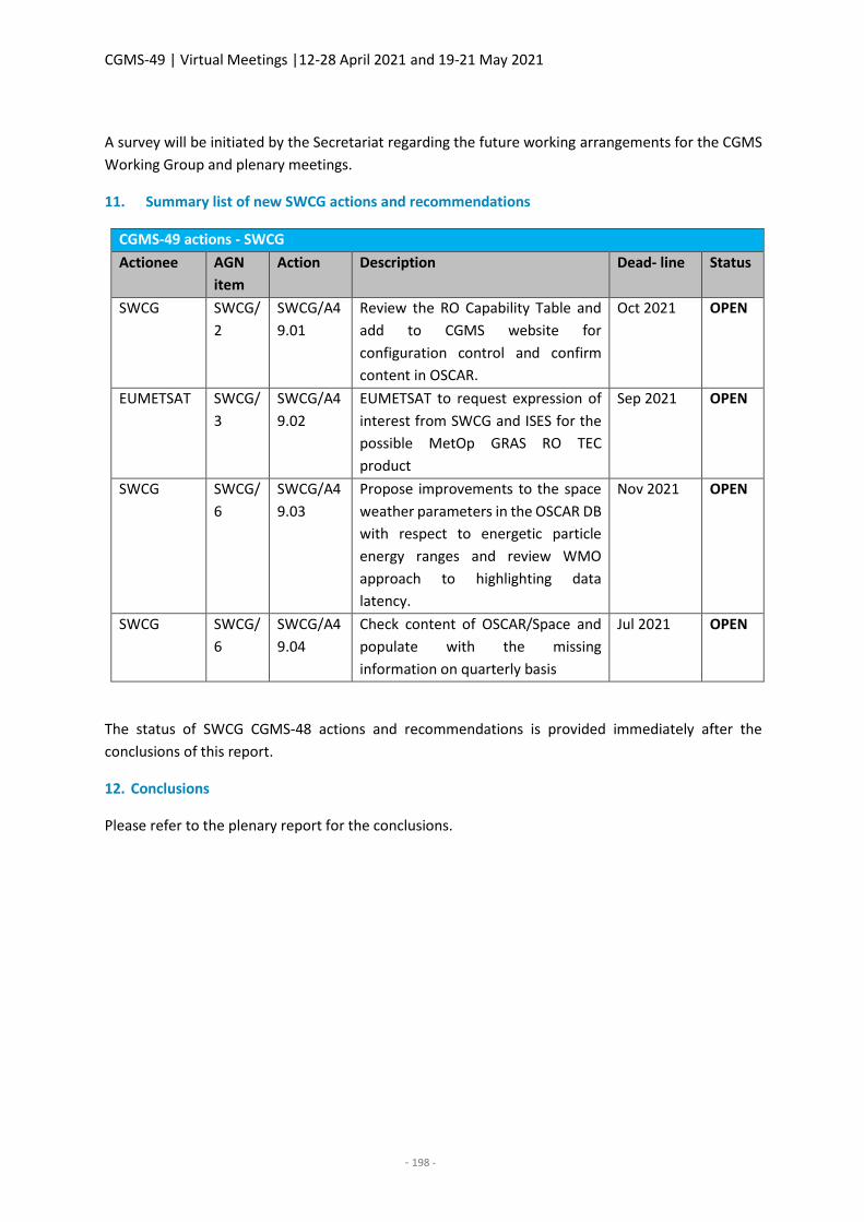
CGMS-49 | Virtual Meetings |12-28 April 2021 and 19-21 May 2021
- 198 -
A survey will be initiated by the Secretariat regarding the future working arrangements for the CGMS
Working Group and plenary meetings.
11. Summary list of new SWCG actions and recommendations
CGMS-49 actions - SWCG
Actionee AGN
item
Action Description Dead- line Status
SWCG SWCG/
2
SWCG/A4
9.01
Review the RO Capability Table and
add to CGMS website for
configuration control and confirm
content in OSCAR.
Oct 2021 OPEN
EUMETSAT SWCG/
3
SWCG/A4
9.02
EUMETSAT to request expression of
interest from SWCG and ISES for the
possible MetOp GRAS RO TEC
product
Sep 2021 OPEN
SWCG SWCG/
6
SWCG/A4
9.03
Propose improvements to the space
weather parameters in the OSCAR DB
with respect to energetic particle
energy ranges and review WMO
approach to highlighting data
latency.
Nov 2021 OPEN
SWCG SWCG/
6
SWCG/A4
9.04
Check content of OSCAR/Space and
populate with the missing
information on quarterly basis
Jul 2021 OPEN
The status of SWCG CGMS-48 actions and recommendations is provided immediately after the
conclusions of this report.
12. Conclusions
Please refer to the plenary report for the conclusions.
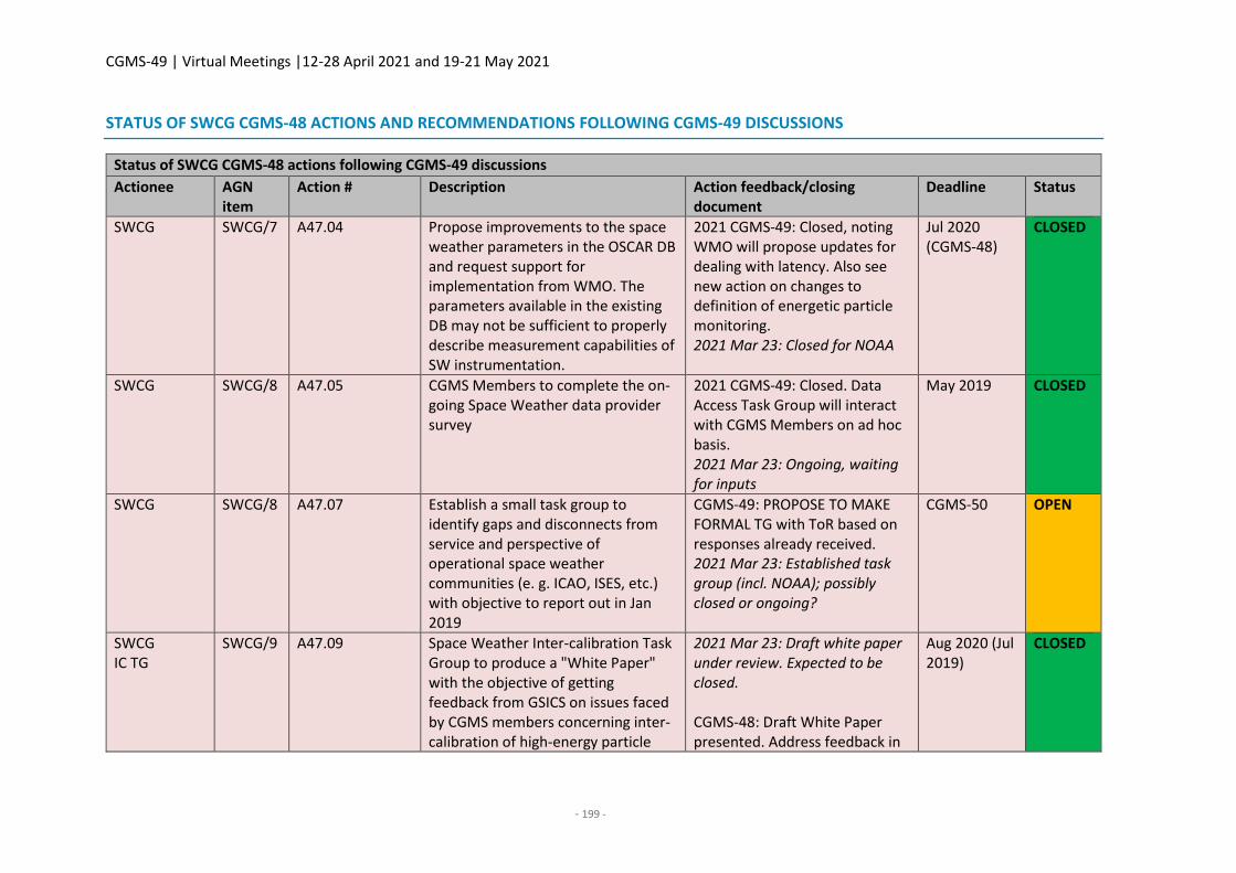
CGMS-49 | Virtual Meetings |12-28 April 2021 and 19-21 May 2021
- 199 -
STATUS OF SWCG CGMS-48 ACTIONS AND RECOMMENDATIONS FOLLOWING CGMS-49 DISCUSSIONS
Status of SWCG CGMS-48 actions following CGMS-49 discussions
Actionee AGN item
Action # Description Action feedback/closing document
Deadline Status
SWCG SWCG/7 A47.04 Propose improvements to the space weather parameters in the OSCAR DB and request support for implementation from WMO. The parameters available in the existing DB may not be sufficient to properly describe measurement capabilities of SW instrumentation.
2021 CGMS-49: Closed, noting WMO will propose updates for dealing with latency. Also see new action on changes to definition of energetic particle monitoring. 2021 Mar 23: Closed for NOAA
Jul 2020 (CGMS-48)
CLOSED
SWCG SWCG/8 A47.05 CGMS Members to complete the on-going Space Weather data provider survey
2021 CGMS-49: Closed. Data Access Task Group will interact with CGMS Members on ad hoc basis. 2021 Mar 23: Ongoing, waiting for inputs
May 2019 CLOSED
SWCG SWCG/8 A47.07 Establish a small task group to identify gaps and disconnects from service and perspective of operational space weather communities (e. g. ICAO, ISES, etc.) with objective to report out in Jan 2019
CGMS-49: PROPOSE TO MAKE FORMAL TG with ToR based on responses already received. 2021 Mar 23: Established task group (incl. NOAA); possibly closed or ongoing?
CGMS-50 OPEN
SWCG IC TG
SWCG/9 A47.09 Space Weather Inter-calibration Task Group to produce a "White Paper" with the objective of getting feedback from GSICS on issues faced by CGMS members concerning inter-calibration of high-energy particle
2021 Mar 23: Draft white paper under review. Expected to be closed. CGMS-48: Draft White Paper presented. Address feedback in
Aug 2020 (Jul 2019)
CLOSED
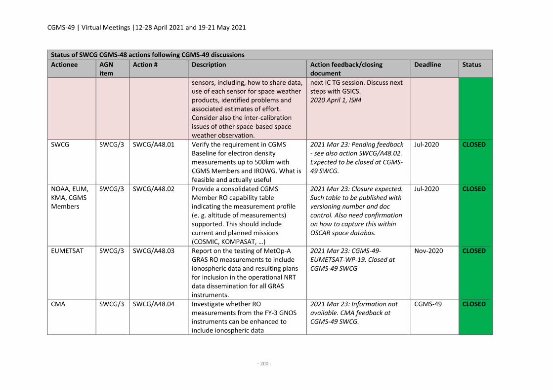
CGMS-49 | Virtual Meetings |12-28 April 2021 and 19-21 May 2021
- 200 -
Status of SWCG CGMS-48 actions following CGMS-49 discussions
Actionee AGN item
Action # Description Action feedback/closing document
Deadline Status
sensors, including, how to share data, use of each sensor for space weather products, identified problems and associated estimates of effort. Consider also the inter-calibration issues of other space-based space weather observation.
next IC TG session. Discuss next steps with GSICS. 2020 April 1, IS#4
SWCG SWCG/3 SWCG/A48.01 Verify the requirement in CGMS Baseline for electron density measurements up to 500km with CGMS Members and IROWG. What is feasible and actually useful
2021 Mar 23: Pending feedback - see also action SWCG/A48.02. Expected to be closed at CGMS-49 SWCG.
Jul-2020 CLOSED
NOAA, EUM, KMA, CGMS Members
SWCG/3 SWCG/A48.02 Provide a consolidated CGMS Member RO capability table indicating the measurement profile (e. g. altitude of measurements) supported. This should include current and planned missions (COSMIC, KOMPASAT, …)
2021 Mar 23: Closure expected. Such table to be published with versioning number and doc control. Also need confirmation on how to capture this within OSCAR space databas.
Jul-2020 CLOSED
EUMETSAT SWCG/3 SWCG/A48.03 Report on the testing of MetOp-A GRAS RO measurements to include ionospheric data and resulting plans for inclusion in the operational NRT data dissemination for all GRAS instruments.
2021 Mar 23: CGMS-49-EUMETSAT-WP-19. Closed at CGMS-49 SWCG
Nov-2020 CLOSED
CMA SWCG/3 SWCG/A48.04 Investigate whether RO measurements from the FY-3 GNOS instruments can be enhanced to include ionospheric data
2021 Mar 23: Information not available. CMA feedback at CGMS-49 SWCG.
CGMS-49 CLOSED
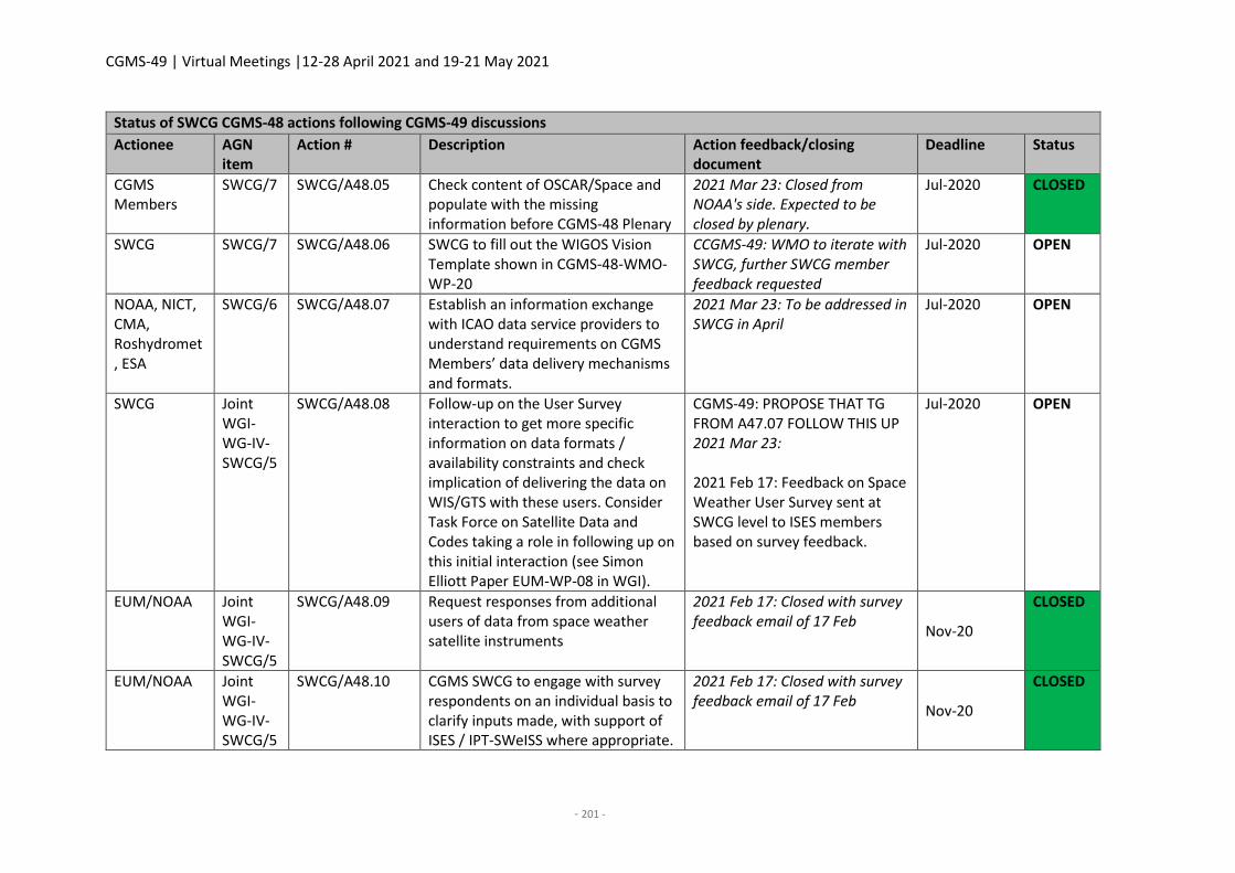
CGMS-49 | Virtual Meetings |12-28 April 2021 and 19-21 May 2021
- 201 -
Status of SWCG CGMS-48 actions following CGMS-49 discussions
Actionee AGN item
Action # Description Action feedback/closing document
Deadline Status
CGMS Members
SWCG/7 SWCG/A48.05 Check content of OSCAR/Space and populate with the missing information before CGMS-48 Plenary
2021 Mar 23: Closed from NOAA's side. Expected to be closed by plenary.
Jul-2020 CLOSED
SWCG SWCG/7 SWCG/A48.06 SWCG to fill out the WIGOS Vision Template shown in CGMS-48-WMO-WP-20
CCGMS-49: WMO to iterate with SWCG, further SWCG member feedback requested
Jul-2020 OPEN
NOAA, NICT, CMA, Roshydromet, ESA
SWCG/6 SWCG/A48.07 Establish an information exchange with ICAO data service providers to understand requirements on CGMS Members’ data delivery mechanisms and formats.
2021 Mar 23: To be addressed in SWCG in April
Jul-2020 OPEN
SWCG Joint WGI-WG-IV-SWCG/5
SWCG/A48.08 Follow-up on the User Survey interaction to get more specific information on data formats / availability constraints and check implication of delivering the data on WIS/GTS with these users. Consider Task Force on Satellite Data and Codes taking a role in following up on this initial interaction (see Simon Elliott Paper EUM-WP-08 in WGI).
CGMS-49: PROPOSE THAT TG FROM A47.07 FOLLOW THIS UP 2021 Mar 23: 2021 Feb 17: Feedback on Space Weather User Survey sent at SWCG level to ISES members based on survey feedback.
Jul-2020 OPEN
EUM/NOAA Joint WGI-WG-IV-SWCG/5
SWCG/A48.09 Request responses from additional users of data from space weather satellite instruments
2021 Feb 17: Closed with survey feedback email of 17 Feb
Nov-20
CLOSED
EUM/NOAA Joint WGI-WG-IV-SWCG/5
SWCG/A48.10 CGMS SWCG to engage with survey respondents on an individual basis to clarify inputs made, with support of ISES / IPT-SWeISS where appropriate.
2021 Feb 17: Closed with survey feedback email of 17 Feb
Nov-20
CLOSED
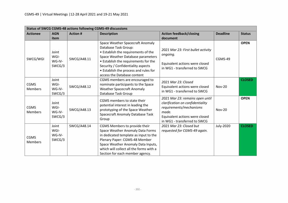
CGMS-49 | Virtual Meetings |12-28 April 2021 and 19-21 May 2021
- 202 -
Status of SWCG CGMS-48 actions following CGMS-49 discussions
Actionee AGN item
Action # Description Action feedback/closing document
Deadline Status
SWCG/WGI
Joint WGI-WG-IV-SWCG/3
SWCG/A48.11
Space Weather Spacecraft Anomaly Database Task Group: • Establish the requirements of the Space Weather Database parameters • Establish the requirements for the Security / Confidentiality aspects • Establish the process and rules for access the Database content
2021 Mar 23: First bullet activity ongoing. Equivalent actions were closed in WG1 - transferred to SWCG
CGMS-49
OPEN
CGMS Members
Joint WGI-WG-IV-SWCG/3
SWCG/A48.12
CGMS members are encouraged to nominate participants to the Space Weather Spacecraft Anomaly Database Task Group
2021 Mar 23: Closed Equivalent actions were closed in WG1 - transferred to SWCG
Nov-20
CLOSED
CGMS Members
Joint WGI-WG-IV-SWCG/3
SWCG/A48.13
CGMS members to state their potential interest in leading the prototyping of the Space Weather Spacecraft Anomaly Database Task Group
2021 Mar 23: remains open until clarification on confidentiality requirements/mechanisms made. Equivalent actions were closed in WG1 - transferred to SWCG
Nov-20
OPEN
CGMS Members
Joint WGI-WG-IV-SWCG/3
SWCG/A48.14 CGMS Members to provide their Space Weather Anomaly Data Forms in dedicated template as input to the Plenary Paper: CGMS-48 Member Space Weather Anomaly Data Inputs, which will collect all the forms with a Section for each member agency.
2021 Mar 23: Closed but requested for CGMS-49 again.
July-2020 CLOSED
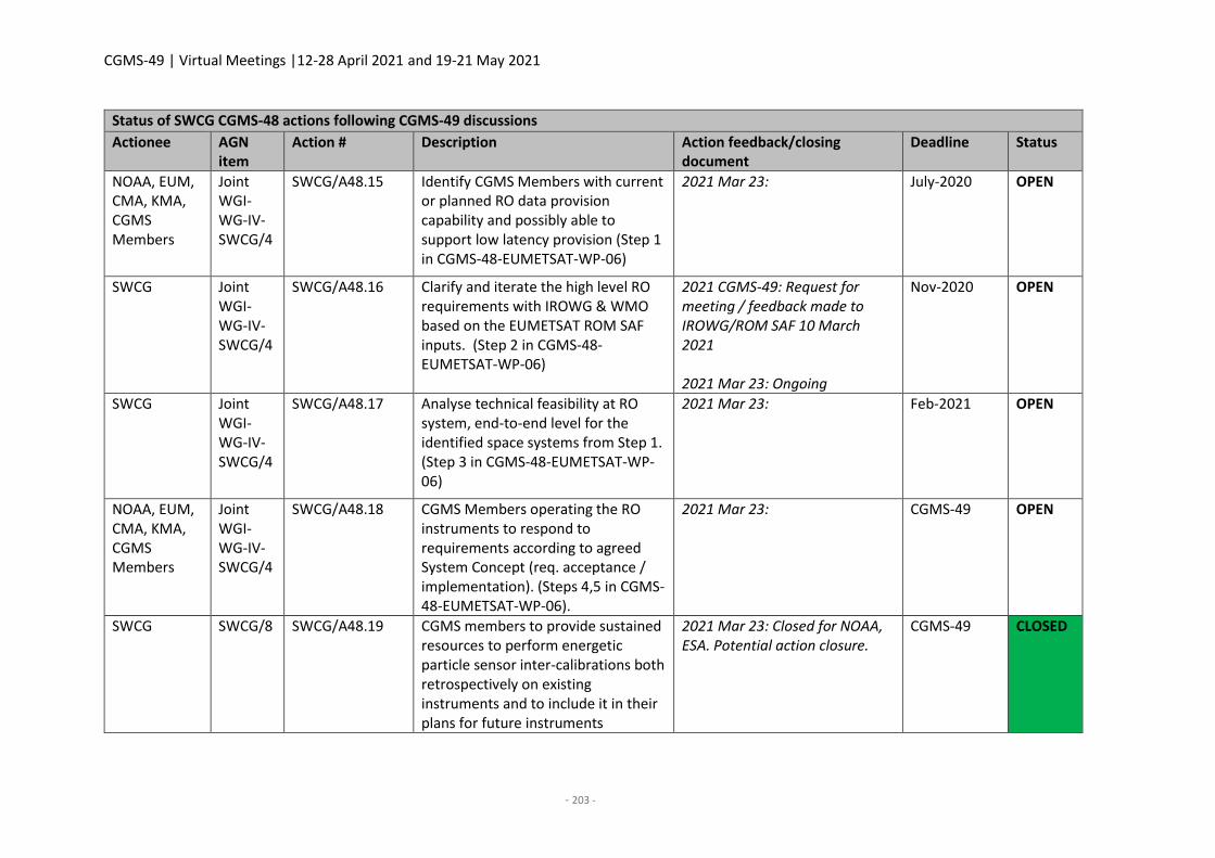
CGMS-49 | Virtual Meetings |12-28 April 2021 and 19-21 May 2021
- 203 -
Status of SWCG CGMS-48 actions following CGMS-49 discussions
Actionee AGN item
Action # Description Action feedback/closing document
Deadline Status
NOAA, EUM, CMA, KMA, CGMS Members
Joint WGI-WG-IV-SWCG/4
SWCG/A48.15 Identify CGMS Members with current or planned RO data provision capability and possibly able to support low latency provision (Step 1 in CGMS-48-EUMETSAT-WP-06)
2021 Mar 23: July-2020 OPEN
SWCG Joint WGI-WG-IV-SWCG/4
SWCG/A48.16 Clarify and iterate the high level RO requirements with IROWG & WMO based on the EUMETSAT ROM SAF inputs. (Step 2 in CGMS-48-EUMETSAT-WP-06)
2021 CGMS-49: Request for meeting / feedback made to IROWG/ROM SAF 10 March 2021 2021 Mar 23: Ongoing
Nov-2020 OPEN
SWCG Joint WGI-WG-IV-SWCG/4
SWCG/A48.17 Analyse technical feasibility at RO system, end-to-end level for the identified space systems from Step 1. (Step 3 in CGMS-48-EUMETSAT-WP-06)
2021 Mar 23: Feb-2021 OPEN
NOAA, EUM, CMA, KMA, CGMS Members
Joint WGI-WG-IV-SWCG/4
SWCG/A48.18 CGMS Members operating the RO instruments to respond to requirements according to agreed System Concept (req. acceptance / implementation). (Steps 4,5 in CGMS-48-EUMETSAT-WP-06).
2021 Mar 23: CGMS-49 OPEN
SWCG SWCG/8 SWCG/A48.19 CGMS members to provide sustained resources to perform energetic particle sensor inter-calibrations both retrospectively on existing instruments and to include it in their plans for future instruments
2021 Mar 23: Closed for NOAA, ESA. Potential action closure.
CGMS-49 CLOSED

CGMS-49 | Virtual Meetings |12-28 April 2021 and 19-21 May 2021
- 205 -
JOINT WGI-WGIV-SWCG REPORT
Co-chairs: Tsutomu Nagatsuma (NICT/JMA)
Rapporteur: Sean Burns (EUMETSAT), Andrew Monham (EUMETSAT)
1. Welcome, objectives and review of the agenda
The joint meeting Co-Chairs, Dr Tsutomu Nagatsuma and Vanessa Griffin, supported by Rapporteurs
Andrew Monham and Sean Burns, welcomed the participants, consisting of representatives from
CMA, ESA, EUMETSAT, ISRO, JMA, KARI, KMA, NICT, NOAA, ROSCOSMOS, ROSHYDROMET, and WMO
(see Annex 1 for full list of participants).
The joint meeting reviewed and adopted the draft agenda proposed by the CGMS Secretariat prior to
the meeting.
2. Review of interactions and activities between WGI, WGIV and the SWCG (incl. action review)
It was agreed that all relevant interactions and review of actions would be covered in the relevant
agenda items.
3. Benefits of space weather data usage for satellite operators and role of anomaly report
database
CGMS-49-SWCG-WP-01 - CGMS agency spacecraft space weather anomaly reports compilation
A. Monham presented the paper designed to contain a compilation of all suspected Space Weather
related anomalies on all operational missions operated by CGMS Agencies reported to CGMS-49. At
the time of this meeting, only EUMETSAT data had been received and therefore included in the
compilation document. All CGMS members performing spacecraft operations were encouraged to
submit their anomalies using the dedicated anomaly template form on the CGMS website prior to the
Plenary meeting.
CGMS-49-EUMETSAT-WP-17 - EUMETSAT Spacecraft Space Weather Anomaly Report
A. Monham highlighted that this is the EUMETSAT input to the previously described compilation
document and members should use the template available on the CGMS website to make their own
inputs. It is stressed that members do not need to be certain that anomalies reported are due to space
weather, but only that it cannot be ruled out as a factor. If in doubt, members should include the
anomaly information.
CGMS-49-SWCG-WP-02 - Report on progress of the Space Weather Spacecraft Anomaly Database Task Group A. Monham presented. The Space Weather Spacecraft Anomaly Database objective is to be the data
source for space weather actors to analyse the impact of space weather on satellite systems to further
knowledge and develop tools space weather effects, spacecraft design robustness, and operational
SpWx warnings, for example. The Task Group gained sufficient participation after CGMS-48 to allow
limited progress to be made on the objectives of securing resources to develop a prototype database,
defining the requirements of the anomaly database (with use cases), identifying feasible and reliable
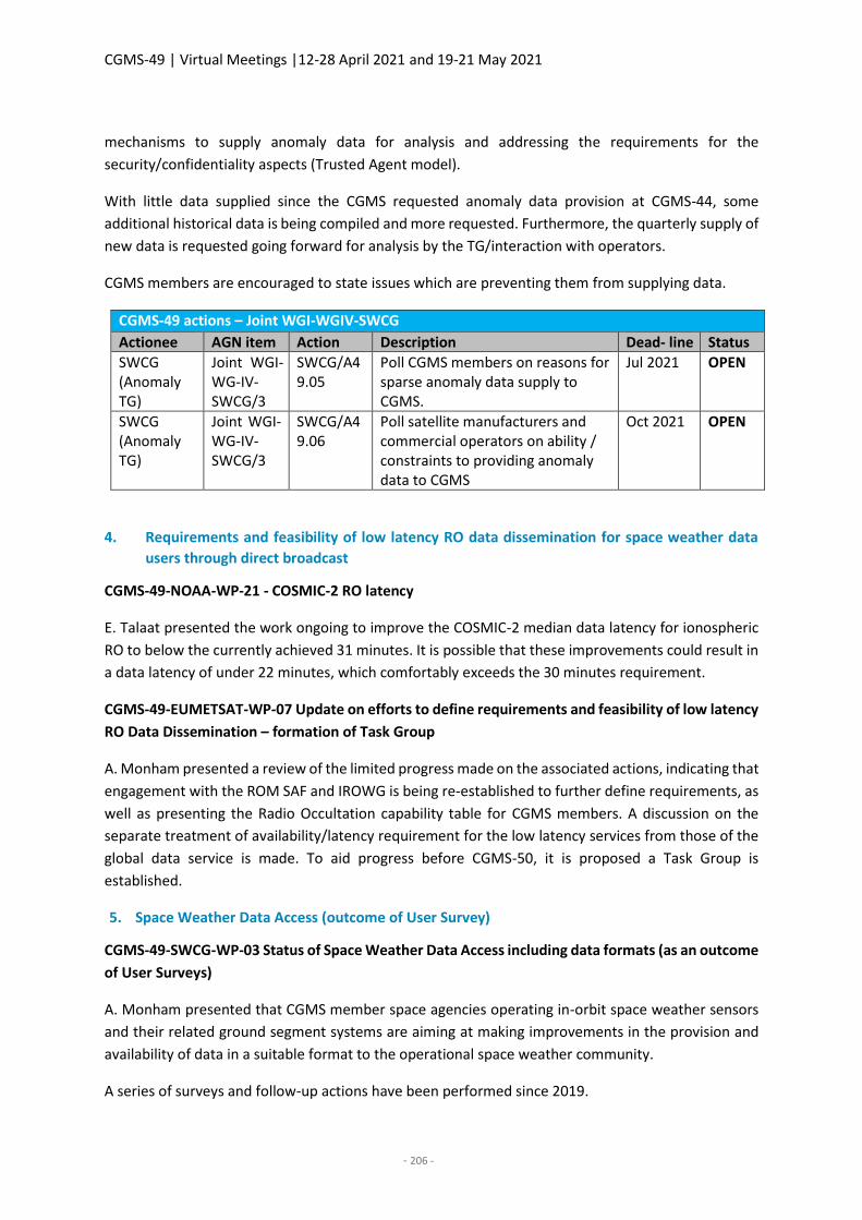
CGMS-49 | Virtual Meetings |12-28 April 2021 and 19-21 May 2021
- 206 -
mechanisms to supply anomaly data for analysis and addressing the requirements for the
security/confidentiality aspects (Trusted Agent model).
With little data supplied since the CGMS requested anomaly data provision at CGMS-44, some
additional historical data is being compiled and more requested. Furthermore, the quarterly supply of
new data is requested going forward for analysis by the TG/interaction with operators.
CGMS members are encouraged to state issues which are preventing them from supplying data.
CGMS-49 actions – Joint WGI-WGIV-SWCG
Actionee AGN item Action Description Dead- line Status
SWCG (Anomaly TG)
Joint WGI-WG-IV-SWCG/3
SWCG/A49.05
Poll CGMS members on reasons for sparse anomaly data supply to CGMS.
Jul 2021 OPEN
SWCG (Anomaly TG)
Joint WGI-WG-IV-SWCG/3
SWCG/A49.06
Poll satellite manufacturers and commercial operators on ability / constraints to providing anomaly data to CGMS
Oct 2021 OPEN
4. Requirements and feasibility of low latency RO data dissemination for space weather data
users through direct broadcast
CGMS-49-NOAA-WP-21 - COSMIC-2 RO latency
E. Talaat presented the work ongoing to improve the COSMIC-2 median data latency for ionospheric
RO to below the currently achieved 31 minutes. It is possible that these improvements could result in
a data latency of under 22 minutes, which comfortably exceeds the 30 minutes requirement.
CGMS-49-EUMETSAT-WP-07 Update on efforts to define requirements and feasibility of low latency
RO Data Dissemination – formation of Task Group
A. Monham presented a review of the limited progress made on the associated actions, indicating that
engagement with the ROM SAF and IROWG is being re-established to further define requirements, as
well as presenting the Radio Occultation capability table for CGMS members. A discussion on the
separate treatment of availability/latency requirement for the low latency services from those of the
global data service is made. To aid progress before CGMS-50, it is proposed a Task Group is
established.
5. Space Weather Data Access (outcome of User Survey)
CGMS-49-SWCG-WP-03 Status of Space Weather Data Access including data formats (as an outcome
of User Surveys)
A. Monham presented that CGMS member space agencies operating in-orbit space weather sensors
and their related ground segment systems are aiming at making improvements in the provision and
availability of data in a suitable format to the operational space weather community.
A series of surveys and follow-up actions have been performed since 2019.
CGMS-49 | Virtual Meetings |12-28 April 2021 and 19-21 May 2021
- 207 -
The main areas with potential for improvement are indicated, in particular:
• Data availability and latency
• Data format standardisation, with metadata
• Standardised data delivery mechanisms
It is recommended a dedicated Task Group identifies a priority list of tasks/pilot projects to address
these issues and initiates implementation in coordination with all CGMS Working Groups and relevant
external bodies.
CGMS-49-SWCG-WP-06 Current Availability of High Energy Particle data from GEO Ring
Dr Tsutomu Nagatsuma presented that sharing and distributing near real time and archived space
weather sensor data are key issues for CGMS members, space weather service providers, and data
users. During the meeting of the task group of high energy electron sensor intercalibration, availability
of (NRT and archived) sensor data from GEO Ring was discussed. The TG members were asked about
availability of NER and archived high energy particle data from GEO Ring. The results suggest that
Several CGMS members are already established NRT and Archived data distribution although data
format and method of data distributions depend on the agencies. However, some members
recommended to perform an official inquiry/official report to promote SW data sharing and
distribution. Thus, it is recommended to perform an inquiry into how to improve the availability of
high energy particle (NRT and Archived) data from GEO Ring operated by CGMS member space
agencies.
6. Any other business
No other business was identified.
7. Summary list of actions of the joint WGI-WGIV-SWCG session
CGMS-49 actions – Joint WGI-WGIV-SWCG
Actionee AGN item Action Description Dead- line
Status
SWCG (Anomaly TG)
Joint WGI-WG-IV-SWCG/3
SWCG/A49.05
Poll CGMS members on reasons for sparse anomaly data supply to CGMS.
Jul 2021 OPEN
SWCG (Anomaly TG)
Joint WGI-WG-IV-SWCG/3
SWCG/A49.06
Poll satellite manufacturers and commercial operators on ability/constraints to providing anomaly data to CGMS
Oct 2021
OPEN
(These actions will be monitored within the framework of SWCG)

CGMS-49 | Virtual Meetings |12-28 April 2021 and 19-21 May 2021
- 209 -
JOINT WGII-WGIII REPORT
Co-chairs: Mehta/P. Zhang (WGIII) and K. Holmlund (WGII)
Rapporteur: H. Pohjola
1. Opening
WGII and III co-chairs decided that K. Holmlund will chair this joint session. K. Holmlund welcomed all
the participants to this WGII and III joint session. He concluded that the most import topic to cover is
the risk assessment together with science questions related to which aerosol and trace gas parameters
can be committed to with the CGMS baseline instruments.
2. Status of the 3rd CGMS baseline and risk assessment (verbal)
CGMS-49-WGIII-WP-III: Status and outcome of the 3rd CGMS risk assessment A. Mehta explained shortly the top-level risk assessment and noted that additional details were
already presented to the working groups. Top level risk assessment can be summarised as follows:
Early morning LEO after FY-3E: no planned low inclination RO observations after COSMIC-2. Precipitation radar: continuation after FY-3G and GPM Broad band radiometer: continuation of FY-3G Scatterometer: risk in the early morning and afternoon orbits after FY-3E and Oceansat-3A Coronagraph: risk of near-term gap until SWFO-L1 and GOES-U are launched Energetic Particle Sensor, magnetometer, plasma analyser: risk of near-term gap until
SWFO-L1 is launched
CGMS-49-CGMS-WP-III- CGMS Baseline - draft revision following the 3rd risk assessment workshop
(verbal)
A. Mehta presented the CGMS Baseline updates which can be summarised as follows:
IR dual-angle view imagery for high-accuracy SST was accidentally left out when
documentation was changed. It is added again now. This relies for example on Sentinel-3,
when one orbit should comply with this, which is a long-term commitment with Copernicus.
Baseline shall be reviewed later if it is aligned with the WMO Position paper on Requirement
for Global NWP. Deadline is until the next risk assessment workshop 2022.
In addition, some editorial changes were made.
K. Holmlund commented that JAXA presented follow on for GPM mission in WGII session and noted
that associated actions for a support letter to JAXA have been tabled at WGII.
3. Establishment of way forward for science questions raised during baseline and risk
assessment review.
3.1 Visible/UV spectrometer - WGII to discuss UV observations in GEO, and the inclusion of trace
gases as an observation from GEO to which CGMS can commit [4'/presentation + discussions]
CGMS-49-WMO-WP-18: Satellite data needs in support of atmospheric composition monitoring
V-H. Peuch gave a presentation on Satellite data needs in support of atmospheric composition
monitoring. In recent years, EO-based atmospheric composition information services have gained
maturity and become mainstream (more a revolution than an evolution).
CGMS-49 | Virtual Meetings |12-28 April 2021 and 19-21 May 2021
- 210 -
It is at the core of the vision of the WMO Global Atmospheric Watch (GAW) programme to stimulate
this new generation of research-enabled operational monitoring and forecasting products and
services. It puts requirements on modelling, in situ and satellite observations. Indeed, satellite
observations need to be considered together with modelling/data assimilation and in-situ
measurement capabilities, rather than in isolation.
In his presentation, he discussed briefly the requirements for the space segment regarding six
application areas: air quality, atmospheric composition hazards (wildfires, dust plumes, volcanic
eruptions…), ozone layer recovery, emissions monitoring for pollutants and greenhouse gases, with a
special focus on anthropogenic CO2, atmospheric composition, and NWP.
A central requirement is the consolidatation of the space-based Global Observing System that will be
in place around 2025, with a constellation of multi-spectral instruments/missions onboard LEOs and
GEOs with spatial resolution of ~5km or better. Additional needs are mainly in the area of: vertical
profiles of aerosol, including size/speciation (lidars); stratospheric profiles of water vapour, ozone and
related tracers (limb sounding); lowermost troposphere (0-3km) at high spatial and temporal
resolution for species not covered by current planned GEO (High Resolution IR). There are also
emerging requirements for high resolution monitoring (~100m) for emissions characterisation during
campaigns or on-demand (micro satellites, High-Altitude Pseudo-Satellites, drones…), which need to
be further consolidated.
Besides these specific requirements, there are also generic ones regarding operationality (NRT, low
data outages), continuity (dependency of user services and climate monitoring),
calibration/intercalibration of instruments (use of constellations), and routine quality monitoring (not
just CAL-VAL campaigns).
The following requirements to be considered by CGMS were presented:
EO-based atmospheric composition information services have gained maturity and impact (more a
revolution than an evolution). It is at the core of the vision of GAW to stimulate a new generation of
research-enabled operational products and services. This puts requirements on modelling, in situ and
satellite observations. For the latter, these are:
Generic: operationality (NRT, low data outages), continuity (dependency of user services and
climate monitoring), calibration/intercalibration of instruments (use of constellations),
routine quality monitoring (not just CAL-VAL campaigns).
Consolidation of the space-based Global Observing System of ~2025: LEOs
UV+VIS+IR+Polarimeter, GEOs UV+VIS+(IR)
Atmospheric CO2 and anthropogenic emissions monitoring
Stratospheric profiles of water vapour, ozone, and related tracers (limb sounding)
Vertical profiles of aerosol, including size/speciation (lidars)
Lowermost troposphere (0-3km) at high spatio-temporal resolution for species not covered
by GEMS, Sentinel-4, TEMPO (High Resolution IR GEO)
New: very high resolution (100m) for emissions characterisation during campaigns or on-
demand (Drones and High-Altitude Pseudo-Satellites)
CGMS-49-EUMETSAT-WP-14: Sentinel-4, products instruments
R. Munro gave a presentation proving a short summary of the Copernicus Sentinel-4 mission to be
flown on the EUMETSAT MTG Sounding platform (MTG-S). The Copernicus Sentinel-4/UVN mission
consists of an Ultraviolet-Visible-Near-infrared (UVN) imaging spectrometer instrument embarked on
CGMS-49 | Virtual Meetings |12-28 April 2021 and 19-21 May 2021
- 211 -
the Meteosat Third Generation Sounding (MTG-S) satellite. The main objective of the Sentinel-4/UVN
mission is to monitor key air quality trace gases and aerosols over Europe in support of the Copernicus
Atmosphere Monitoring Service (CAMS) at high spatial resolution and with a frequent revisit time. The
instrument is built under the responsibility of ESA with the instruments and Level-1b prototype
processor being developed by a consortium led by ADS. The operational Level 0 – 1b processor is
developed under EUMETSAT responsibility and the Level-2 operational processor developed by a
consortium led by DLR. The expected mission lifetime is 15 years and will be operated by EUMETSAT
which will also be responsible for the provision, maintenance, and evolution of all operational product
processors. Launch is currently expected in 2023. The spatial resolution will be ~ 8 x 8 km (at a point
in central Europe) with hourly temporal resolution. The geophysical products to be provided from
Sentinel-4 include O3, NO2, SO2, HCHO, (CHOCHO), UV, AAI, AOD, and ALH.
CGMS-49 actions - Joint WGII-WGIII
Actionee AGN item
Action Description Deadline Status
WMO 3.1 JWGII-
WGIII/A49.01
WMO to explore what is the need of
establishing an international science
working group in support of the
atmospheric composition/air quality
services, taking the existing initiatives
e. g. under GAW and CEOS into
account.
CGMS-50 OPEN
CGMS-49-GUEST-WP-05: GK2B GEMS operation status and plan
J. Jong gave a presentation on GEMS operation status and plans. NIER has successfully completed the
In-Orbit Test (IOT) of about 8 months after GEMS launch and has been making efforts to stabilise the
data production system and verifying the data quality. Last year, the first GEMS data that observed air
pollutants in Asia was released and the disclose and distribute some of the verified GEMS Level 2 (L2)
product from 22 March 2021 has begun. The products currently being released are Aerosol Optical
Depth (AOD), NO2, Cloud, Ozone, and some of UVI products. Details can be found on the NESC/NIER
website. In the second half of this year, additional GEMS L2 products and original data with NetCDF
are planned for release and as well as the establishment of an FTP service considering large-capacity
data. At the moment, only image data format is available.
CGMS-49-NASA-WP-08: Tropospheric Emissions: Monitoring of Pollution (TEMPO)
B. Lefer gave a presentation on TEMPO mission. The TEMPO instrument will be integrated to a Maxar
1300 Series Spacecraft Bus on an Intelsat Commercial Satcom mission (IS40e) and launched to 91
West. Maxar Technologies holds the prime contract for hosting services and Intelsat is a sub-
contractor to provide host operations and data routing. The instrument will be shipped to Maxar in
July 2021 and then shipped to the launch site for an October 2022 launch on a SpaceX Falcon 9 rocket.
The grating spectrometer measures solar backscattered radiance from ultraviolet (UV; 290-490 nm)
to visible (540-740 nm) wavelengths with a spectral resolution (0.6 nm FWHM) and sampling every
0.2 nm at sub-urban spatial resolution of 2.0 km x 4.75 km at the centre of the Field of Regard (FOR).
It has 2 Detectors providing 2k×1k image with the full spectral range for each geospatial scene.
CGMS-49 | Virtual Meetings |12-28 April 2021 and 19-21 May 2021
- 212 -
It has nominal spatial resolution 8.4 km N/S × 4.7 km E/W at the centre of domain (can often measure
2.1 km N/S × 4.7 km E/W). Standard data products are Retrieval of aerosol and cloud parameters;
tropospheric ozone (O3); nitrogen dioxide (NO2), sulphur dioxide (SO2), formaldehyde (HCHO), glyoxal
(C2H2O2), water vapor (H2O), and UVB radiation. It will also provide enhanced sensitivity to O3 in the
lowest 2 km of the troposphere, thereby characterising boundary layer, free tropospheric, and
stratospheric O3.
In the discussion, V.-H. Peuch noted that surface observations are important because there are lots of gaps and ground-based observations cannot be replaced by satellite observations. Surface observations are however regulated in some countries. If countries are taking this seriously, they need to change the strategy to city level monitoring. B. Lefer added that it is a combination of both observations systems and also a combination of different satellites also covering different frequency ranges. He also pointed out that UVN is acceptable for daytime, but IR measurements are needed for night-time.
P. Ruti asked where the requirement/definition for the resolution of 5 km is coming from and what is then the requirement for the urban meteorology. V.-H. Peuch responded that 5 km is coming from the air quality agencies that have now been presented with that type of data and found it useful. In general, the requirements seem to be somewhere between 3 and 10 km. Use case for special events and urban modelling need higher resolution (hundred-meter scale) to be able to follow the event in time and space and may in the future warrant additional observational capabilities like High Altitude Platform Systems (HAPS).
K. Holmlund asked what the implication to CGMS agencies is. V.-H. Peuch responded that the consolidation and utilisation of new observations coming is a very important first step. Also, all continents should be covered with the same capacity, which is critical for climate change monitoring.
K. Holmlund commented that true capabilities should be understood first before new plans and see that it is important that CGMS reflects GEO and LEO capabilities. V.-H. Peuch responded that it is a golden era for LEO observations with UV, IR, and polarimetric measurements. Consolidation of those is indeed needed. Calibration is also important, as seen with Sentinel 3A/B, which have already some issues. Requirements for LEO calibration and intercalibration over GEO coverage are important. K. Holmlund commented that concreate recommendation to GSICS must be prepared.
During the discussion, it was further noted that that new geostationary capabilities are now emerging, however it is important to ensure operational continuity. It was noted that the current GEMS mission is planned until 2030 and follow-on missions are considered. However, it was noted that a follow-on mission to TEMPO has not yet been agreed, but an atmospheric composition/air quality mission is considered for the NOAA GEO XO.
K. Holmlund asked about the importance of active measurement for CO2. V.-H. Peuch responded that it is a measurement capability, which is down the line, but would provide important reference observations, also in night-time.
Atmospheric composition as well as NWP modelling group composition and communication was discussed. It was noted that today the Copernicus Atmospheric Monitoring Service (CAMS) is leading the modelling activities, however, there are also important research and modelling activities covered by WMO Global Atmospheric Watch (GAW). It was further noted that CEOS, e. g. CEOS AC-VC, activities should be considered. However, there may be a need to establish a CGMS-like international science working group bringing together the operators of the space based capabilities, the research and operational modelling community.
CGMS-49 | Virtual Meetings |12-28 April 2021 and 19-21 May 2021
- 213 -
3.2 WGII to discuss aerosol observations in GEO and LEO, and the inclusion of aerosols as an
observation from GEO and LEO to which CGMS can commit
CGMS-49-CMA-WP-04: Aerosol products from Fengyun satellite
L. Chan gave a presentation on aerosol products provided by Fengyun satellite. In the past few
decades, most of the studies of aerosol remote sensing retrieval have been carried out using polar-
orbiting satellites Terra/MODIS and Aqua/MODIS, Suomi-NPP/VIIRS, etc. With the rapid development
of remote sensing in China, the potential of FY-series satellite remote sensing data has been explored
in atmospheric environment. So far, China has launched seventeen meteorological satellites, including
polar-orbiting and geostationary satellites, and at least five instruments can observe atmospheric
aerosol properties. The aerosol retrieval algorithms using the imagery sensor on-board the satellite
over land and ocean was introduced, as well as the operational products’ formats, resolution, and
accessible methods. Using the AERONET observations and MODIS operational AOD products, the
accuracy of existing AOD datasets based on FY satellites was evaluated and compared. Aiming at the
deficiency of the operational FY AOD products, the study examines the enhanced directions in the
next stage, further improving the benefit of FY-satellite remote sensing data.
Since 2009, the China Meteorological Administration has released aerosol products over land and
ocean to the public, with a resolution of 1km/5km for polar-orbit satellite and 4km for geostationary
satellite. The future improvement plan is to ameliorate 1) identification of cloud and haze: The existing
AOD products take the service cloud identification products as the basis of cloud identification, while
the selection principle of the cloudy pixels is very strict, without distinguishing the haze scenes
separately; 2) Aerosol type classification; and 3) surface reflectance relationship over brighter pixels
when the existing algorithm mainly focus on the development and optimisation of dark target areas
with dense vegetation coverage, but there are still some limitations in the process of bright surface
areas. In the future, the processing strategy of dark blue algorithm for bright surface will be explored.
CGMS-49-EUMETSAT-WP-13: Aerosol Observations from EUMETSAT and Third-Party Missions
R. Munro gave an overview presentation of aerosol observing capabilities from EUMETSAT and third-party missions. Those missions with aerosol observing capabilities in Low Earth Orbit include MetOp GOME-2, AVHRR and IASI, which are used together to generate the Polar Multi-mission Aerosol product (PMAp), Copernicus Sentinel-3 SLSTR & OLCI, EPS-SG 3MI, Copernicus Sentinel-5, METimage, and IASI-NG, which will also be used together to provide MAP (Multi-mission Aerosol product). In the Geostationary Orbit, there are aerosol observing capabilities from the MSG SEVIRI, MTG-I FCI, and the MTG-S Copernicus Sentinel-4 and IRS.
The currently available products are AOD provided from MetOp PMAp & Copernicus Sentinel-3 SLSTR. The products are currently operational over ocean and demonstrational over land, with improvements in progress. Information about the aerosol type is also provided and aerosol sources via the Sentinel-3 SLSTR Fire Radiative Power (FRP) product. Products in development include improved AOD from MetOp PMAp and Sentinel-3 SLSTR, refined and more robust AOD from EPS-SG 3MI and MAP, aerosol model information from EPS-SG 3MI and MAP, optimised for the needs of the Copernicus Atmosphere Monitoring Service (CAMS) model (Sea Salt, Dust, Black Carbon, Sulphates, Organic matter). Aerosol layer height is expected to be provided from Sentinel-3 OLCI, EPS-SG MAP, and Copernicus Sentinel-4 and Sentinel-5. Finally, high frequency AOD information will be available from the MTG-I FCI and dust/ash information from the MTG-S IRS.
CGMS-49-JAXA-WP-03: GCOM-C and AHI aerosol product development
H. Murakami gave a presentation on JAXA’s GCOM-C and AHI aerosol product development. JAXA has developed a common algorithm to estimate aerosol optical thickness AOT, AE, and SSA applicable to
CGMS-49 | Virtual Meetings |12-28 April 2021 and 19-21 May 2021
- 214 -
both the polar orbit satellite imager, GCOM-C/SGLI, and the geostationary satellite imager, Himawari-8/AHI. JMA/MRI has developed the global aerosol model called MASINGAR assimilating the satellite AOTs. The AHI frequent observation can improve random noise, cloud screening, and increase non-cloud area in a day (Kikuchi et al. 2018). SGLI near-UV channel and polarimetry at red and NIR wavelengths can observe aerosol absorption and fine mode aerosols globally including higher latitudes by 1 km or 250 m spatial resolution. In 2020, the aerosol algorithm was revised to use the MASINGAR predicted aerosols as the initial guess, and the error of AOT, AE, and SSA were reduced by 6%, 40%, and 10%, respectively in the case of match-up comparison between the AHI estimates and AERONET measurements (Yoshida et al. 2021). The satellite aerosol products and outputs from MASINGAR are open to the public through the JAXA G-portal, Himawari Monitor, and P-Tree system. JAXA continues a more effective synthesis of the GEO and LEO data (including the vertical profile from EarthCARE) in close collaboration with the model assimilation research including JMA/MRI.
CGMS-49-NOAA-WP-20: NOAA Aerosol Capabilities
S. Kondragunta gave a presentation on NOAA’s aerosol measurement capabilities. The use of polar-
orbiting satellite-derived aerosol optical depth (AOD) in estimating surface PM2.5 concentrations has
been on the rise in the last two decades. The estimated PM2.5 values are of high accuracy when
conditions are favourable (e. g. well mixed boundary layer) and are less accurate when conditions are
not favourable (e. g. aerosols are aloft). A major limitation of using polar-orbiting satellites is one
single satellite observation in a day, which is not a true representative of daily average PM2.5,
especially when diurnal variation is significant. Additionally, the boundary layer height that is also
critical for scaling the column AOD to surface PM2.5 changes during the day.
A single satellite sensor or a pair of satellite sensors that can provide simultaneous retrievals of highly
accurate AOD, aerosol layer height, and aerosol composition (single scattering albedo, SSA) are
expected to improve the estimated surface PM2.5 from AOD. Knowledge of composition is important
because the health effects vary depending on the type of aerosol. Layer height matters because if
aerosol is closer to the surface in the boundary layer, it impacts human health. Researchers have used
Aqua Moderate Resolution Imaging Radiometer Suite (MODIS) and Aura Ozone Monitoring
Instrument (OMI) to demonstrate that AOD from MODIS can be extrapolated to UV wavelengths and
given as input to OMI UV aerosol algorithm to retrieve aerosol layer height and single scattering
albedo.
Until we have access to near real-time full vertical profile and adequate spatial coverage of aerosols
along with composition information with sensors like MetOp-SG 3MI, NOAA is proposing to expand
the technique to a constellation of geostationary satellites covering the globe, both land and ocean.
We plan to use Advanced Himawari Imager/Geostationary Environmental Monitoring Spectrometer
(AHI/GEMS) as a testbed for the development of synergistic algorithms that retrieve AOD, aerosol
layer height, and SSA covering Asia. The retrievals, once evaluated and optimised, will be used as input
to algorithms that derive surface PM2.5 by National Institute for Environmental Research (NIER) in
Korea. The new algorithms will also be applied to Advanced Baseline Imager/Tropospheric Emissions:
Measurement of Pollution (ABI/TEMPO) after TEMPO so the methodology can be applied to GeoXO
ACX and AXI.
The global constellation of geostationary satellite imagers and spectrometers will provide aerosol
information from UV to Visible. Synergistic retrievals can be attempted to optimise the aerosol
information – GEO ring for air quality. Complete aerosol characterisation from polarimeters will be in
a midmorning polar orbit. Polarimeters on PACE and ACCP, Lidar on ACCP likely in the mid-afternoon.
NASA MAIA will be a mid-morning mission targeting mega cities for PM2.5 monitoring.

CGMS-49 | Virtual Meetings |12-28 April 2021 and 19-21 May 2021
- 215 -
K. Holmlund asked about the use of aerosol product from GEO ring. V-H. Peuch commented that they
are useful and important, especially for monitoring processes with short timescales. There is also a
strong need for polarimetric products, which puts additional requirements on the accuracy and noise
of the measurements. He also emphasised that for CO2 observations collocated aerosol observations
are needed.
K. Holmlund commented that the CGMS baseline should be reflected with new capabilities and
baseline products should be included that can be derived from the CGMS baseline missions. M.
Rattenborg confirmed that this indeed was the intended approach for this suggested session and that
the updates should be agreed by mid-May for inclusion in the updated baseline for CGMS-49 Plenary.
CGMS-49 recommendations – joint WGII-WGIII
Actionee AGN item
Rec Description
CGMS member
3.2 JWGII-WGIII/R49.01
WGII recommends that CGMS Members develop aerosol products capitalising on synergies across multiple instruments
CGMS-49 actions - Joint WGII-WGIII
Actionee AGN item
Action Description Deadline Status
Presenters at CGMS-49 JWGII-III session
3.2 JWGII-WGIII/A49.02
Provide updated information on observables/species, which can be committed by CGMS constellation and added to CGMS baseline.
Jan 2022 OPEN
4. Wrap-up, WGIII report considerations for plenary and conclusions
K. Holmlund concluded the joint session and thanked for the good discussion and outcome of both,
the aerosols and the atmospheric composition topics.
5. Summary list of actions and recommendations of the joint WGII-WGIII session
CGMS-49 actions - Joint WGII-WGIII
Actionee AGN item
Action Description Deadline Status
WMO 3.1 JWGII-WGIII/A49.01
WMO to explore what is the need of establishing an international science working group in support of the atmospheric composition/air quality services, taking the existing initiatives e. g. under GAW and CEOS into account.
CGMS-50 OPEN
Presenters at CGMS-49 JWGII-III session, WGII
3.2 JWGII-WGIII/A49.02
Provide updated information on observables/species, which can be committed by CGMS constellation and added to CGMS baseline.
Jan 2022 OPEN
CGMS-49 | Virtual Meetings |12-28 April 2021 and 19-21 May 2021
- 216 -
CGMS-49 recommendations – Joint WGII-WGIII
Actionee AGN item
Rec Description
CGMS member
3.2 JWGII-WGIII/R49.02
WGII recommends that CGMS members develop aerosol products capitalising on synergies across multiple instruments
(These actions and recommendations will be monitored within the framework of WGII and WGIII)
CGMS-49 | Virtual Meetings |12-28 April 2021 and 19-21 May 2021
- 218 -
ANNEX I ADDRESSES
[The spoken word prevails]
Opening address BY Mr. YU Xinwen, Deputy Administrator of CMA
Distinguished Mr. Phil Evans, Distinguished Professor Petteri Taalas, Dear delegates of CGMS members, Ladies and Gentlemen, Good morning (good afternoon, good evening)!
First of all, on behalf of Mr. ZHUANG Guotai, Administrator of China Meteorological Administration
(CMA), I would like to extent my warm welcome to you all to attend the virtual 49th Plenary Session
of the Coordination Group for Meteorological Satellites (CGMS)! This session is hosted by CMA, and
co-organised by the National Satellite Meteorological Center of CMA and CGMS Secretariat. I
appreciate all the delegates for overcoming the time difference to attend the meeting. Meanwhile,
my thanks also goes to Mr. Evans, an old friend of CMA, and to the colleagues of CGMS Secretariat,
and I believe that with your strong support, this session will be as fruitful as ever.
CGMS serves as a model for building a community with a shared future in terms of global
meteorological satellites. As an important organisation in international earth observations, CGMS
plays an important role in coordination of satellite operations and future plans of various countries,
optimisation of global meteorological satellite observation systems, improvement of meteorological
services, and prevention and mitigation of natural disasters. It has promoted the continuation and
complementarity of the meteorological satellite space infrastructures worldwide to enable users to
access satellite data in a sustained and steady way.
Especially during COVID-19 pandemic, CGMS members jointly made excellent contributions to making
up for insufficient meteorological observation capability caused by the pandemic, and to the
prevention and mitigation of global meteorological disasters, which I think should be applauded!
The Chinese government attaches great importance to the development of meteorology and related
satellites and their international applications, and benefited a lot from the development of global
satellite observation systems. On several major international occasions, Chinese President XI Jinping
put forward the use of FY meteorological satellites and meteorological remote sensing satellite
technologies to serve the international community. CMA has actively involved in CGMS activities, and
this is the fourth time for CMA to host the CGMS plenary session. Last year, CMA celebrated the 50th
Anniversary of Fengyun Satellite Programme. Over the past 50 years, China has successfully launched
17 Fengyun meteorological satellites, with 6 in orbit, achieving the upgrade of polar and geostationary
meteorological satellite series and their continuously stable operations to persistently provide data
and product services globally. Here, I am glad to inform the Session that within the next two months,
China will launch FY-3E, an early-morning orbit meteorological satellite and FY-4B, the second new
generation geostationary one, so long awaited by the international community. These will join the
international meteorological satellite family to provide more and better data and products.
CGMS-49 | Virtual Meetings |12-28 April 2021 and 19-21 May 2021
- 219 -
Ladies and gentlemen,
Greenhouse Gases, climate monitoring and space weather are already included as CGMS’s important
coordination areas to meet the challenges arising from global climate change, increased extreme
weather and climate events as well as atmospheric environmental pollution. These are consistent with
China’s philosophy of pursuing a path of green and low-carbon development with priority given to
ecological conservation, green and low-carbon development. I hope that satellite monitoring services
will continuously contribute to achieving the goal of global low-carbon and emission reduction.
Meanwhile, I also call on the meteorological satellite agencies and organisations worldwide to further
strengthen their cooperation, and make practical efforts to improve meteorological satellite data and
products, in order to provide more and better services for various users around the world.
Finally, I wish the 49th Plenary Session of CGMS a complete success! And I also wish you all good
health!
Thank you!
Opening address by Mr. Phil Evans, Head of CGMS Secretariat and EUMETSAT Director-General
I would like to welcome all CGMS members and all participants to the 49th CGMS Plenary
meeting.
I am Phil Evans – and I took over as Director-General of EUMETSAT on 1 January 2021. Being
the new DG of EUMETSAT I also became Head of CGMS Secretariat
I have been briefed on CGMS and I can commit to support this group and to support
EUMETSAT in its role of CGMS Secretariat. I think it is an important mechanism to keep
coordination among space agencies responding to the observation requirements of WMO. All
together we are committed to respond to the Vision for WIGOS 2040 and I am looking forward
for the discussions in the three days to come.
I realised that it is the 2nd year that we have a virtual CGMS plenary meeting and I would like
to thank CGMS members for their flexibility in these difficult times. I want to address a special
thanks to CMA for their readiness to host the meeting twice under these special
circumstances. You have been very flexible and I am sure that all CGMS member appreciated
it.
We have a long agenda in front of us. On top of the reports of our Working Groups, I am
looking forward to the dialogue we will have with WMO on important matters discussed in
Geneva, i.e. with regard to the evolution of the WMO Data Policy but also with regard to the
restructuring of GCOS, which is an important programme to articulate requirements for
climate observations.
The thematic session that we have on the impact assessment of satellite data on NWP is also
particularly key – as it might influence the way we will all together respond to new
observations needs or approaches required by future global NWP models. This might
CGMS-49 | Virtual Meetings |12-28 April 2021 and 19-21 May 2021
- 220 -
influence the way we plan and coordinate our future observing space infrastructures. The
same applies to the session on Green House Gases monitoring
I am however looking forward to meeting you in person as soon as circumstances permit. I
should now like to suggest we proceed with the agenda.
Opening address by Petteri Taalas, WMO Secretary-General
It is a pleasure to join the CGMS-49 Plenary meeting
As you know WMO has undergone significant reform under the WMO Strategic Plan 2020 -
2023
Key issues for WMO members include
o readiness for extreme weather events,
o climate monitoring,
o supporting decision making related to climate change,
o advancing the required observational and modelling capabilities required for the
implementation of the Paris agreement, and
o increasing socio-economic value of environmental services.
WMO is therefore taking a holistic Earth-system modelling and monitoring approach, and
recognises that global NWP underpins most WMO application areas.
In that respect it should be noted that space-based observations are key for any state-of-the-
art NWP system and WMO has recently prepared a position paper on the ‘Satellite data
Requirements for global NWP’ emphasizing the need for open, free and timely access to
critical satellite observations.
In this context it is important also to note that WMO is working towards a new updated Data
Policy that takes into account the scientific, technical and societal challenges, changes and
opportunities towards a holistic Data Policy encompassing all WMO application areas.
The new Data Policy has now been endorsed by the first WMO intergovernmental body,
Infrastructure Commission, with a target of approval by the WMO Congress in October 2021.
The new Data Policy foresees that with respect to ‘core data’, that is data that should be made
available openly and freely, WMO should engage with the Space Agencies in determining and
agreeing those data.
I am looking forward in constructive discussions with the Space Agencies in ensuring a space-
based observation system that will maximise benefits for us all.
The aspirational future space-based observing system is detailed in the WMO Vision for
WIGOS in 2040 and WMO welcomes the CGMS contributions towards the implementation of
CGMS-49 | Virtual Meetings |12-28 April 2021 and 19-21 May 2021
- 221 -
the Vision. However, there are still critical gaps and today there is still a long way to go towards
a full implementation of the Vision. WMO therefore calls upon the Space Agencies to establish
a way forward towards fulfilling that Vision.
WMO remains committed towards the space agencies and CGMS and I am looking forward to
hearing the outcomes of this Plenary session. I also look forward to seeing you in person at CGMS-
50, when WMO would like to host this event at WMO in Geneva.
Address by Dr. WANG Jingsong, CMA NSMC Director-General
Distinguished Mr. Phil Evans, Distinguished Professor Petteri Taalas, Ladies and Gentlemen, Good morning (good afternoon, good evening)! This is WANG Jingsong, was just nominated as new DG of CMA/NSMC yesterday. Previously I was the DG of the Department of Integrated Observations of CMA, and I also served as Deputy DG of NSMC for several years. Actually I was partially involved in the FengYun Programme over last decade. It’s a great honor for me to attend this plenary session as my debut to join CGMS family. As Dr. YU expressed in his opening remarks, the Chinese government attaches great importance to the development of FengYun satellites and their international applications, and CMA will continuously provide data and product services to the global users. As a new DG of NSMC, I will do my best to support it with my team. I believe that you will get more
information about the latest progress and future programme of FengYun satellites from Dr. ZHANG
Peng’s presentation in a moment.
I believe this session will be as fruitful as ever. And I also wish you all good health!
Thank you!
CGMS-49 | Virtual Meetings |12-28 April 2021 and 19-21 May 2021
- 222 -
ANNEX II: ABBREVIATIONS
Abbreviation Meaning
ACE Advanced Composition Explorer
AMV Atmospheric Motion Vector
AOD Aerosol Optical Depth
AWS Automatic Weather Station
CAMS Copernicus Atmosphere Monitoring Service
CCI Convective Cloud Information
CCOR Compact Coronagraph
CDR Climate Data Records
CFOSAT Chinese-French Oceanography Satellite
CRC China-Russia Consortium
CSR Clear Sky Radiance
D3S Distributed Space Weather Sensor System
DCP data collection platform
DCS Data Collection Service
DRS Direct Relay Satellite
DRT Data Relay Transponder
DWL Doppler Wind Lidar
E-DCP Enhanced DCP
EARS EUMETSAT Advanced Retransmission Service
ECV essential climate variables
EO Earth Observation
EORC JAXA Earth Observing Research CenteR
EOSC Earth-observing satellite constellation
EOTEC DevNet Earth Observation Training, Education, and Capacity Development Network
ERSA ESA Radiation Sensor Array
ESA PB-EO ESA Programme Board for Earth Observation
ESC Expert Service Centres
ESD NASA’s Earth Science Division
ET-SWx Expert Team on Space Weather
EUVST Extreme Ultraviolet HighThroughput Spectroscopic Telescope
EZIE Electrojet Zeeman Imaging Explorer
FCDR fundamental climate data record
FDR Fundamental Data Records
FOC Full Operational Capability
FRP Fire Radiative Power
FY FengYun
FY_ESC Emergency Support Mechanism of FY Satellite
GAW WMO Global Atmospheric Watch
GBON Global Basic Observation Network
GEO-XO Geostationary and Extended Orbits
GeoHSS Hyper Spectral Sounding instrument on a geostationary satellite
GNC-A GEONETCast Americas broadcast
GNSS Global Navigation Satellite System
GOES Geostationary Operational Environmental Satellites
GOLD Global-scale Observations of the Limb and Disk
GSICS Global Space-based Inter-Calibration System
CGMS-49 | Virtual Meetings |12-28 April 2021 and 19-21 May 2021
- 223 -
Abbreviation Meaning
GST 2023 Global Stocktake
GTS Global Telecommunication system
HAPS High Altitude Platform Systems
HERMES Heliophysics Environmental and Radiation Measurement Experiment Suite
HSS Hyperspectral IR Sounder
ICON Ionospheric and Connection Explorer
IDA Internal Dosimeter Array
IDCS international DCS channels
INFCOM WMO Commission for Observation, Infrastructure and Information Systems
INPE Brazilian Ministry of Science, Technology, and Innovations
IOC Initial Operational Capability
IODC Indian Ocean Data Coverage
IPWV Integrated Precipitable Water Vapour
IS40e Intelsat Commercial Satcom mission
ISCCP-NG Next Generation of the International Satellite Cloud Climatology Project
ISES International Space Environment Service
KSEM Korean Space wEather Monitor
MAP Multi-mission Aerosol product
MMDRPS Multi-Mission Meteorological Data Receiving and Processing System
MODIS Moderate Resolution Imaging Radiometer Suite
MOSDAC Meteorological and Oceanographic Satellite Data Archival Center
MTG-S Meteosat Third Generation Sounding
NCMRWF National Centre for Medium Range Weather Forecast (India)
NGRM Next Generation Radiation Monitor
NKN National Knowledge Network
NREN National Research and Education Network
NSF National Science Foundation (USA)
NWP Numerical weather prediction
OGC Open Geospatial Consortium
OMI Ozone Monitoring Instrument
OSOS First International Operational Satellite Oceanography Symposium
OSSEs Observing System Simulation Experiment
OSW TG Ocean Surface Wind Task Group
OVW ocean vector winds
PMAp Polar Multi-mission Aerosol product
PSTEP Project for SolarTerrestrial Environment Prediction
RDCA rapidly developing cumulus areas
RO radio occultation
ROSES Research Opportunities in Space and Earth Science
RRR Rolling Requirements Review
RTSWnet Real-Time Solar Wind network
S2P Space Safety Programme
SAN SWFO Antenna Network
SAS & R satellite aided search and rescue
SBIR Small Business Innovation Research
SCO Space Climate Observatory
SDR sensor data records
CGMS-49 | Virtual Meetings |12-28 April 2021 and 19-21 May 2021
- 224 -
Abbreviation Meaning
SETT Socio Economic Tiger Team
SOHO Solar and Heliospheric Observatory
SOSMAG Service Oriented Spacecraft Magnetometer
SSA single scattering albedo
SST Sea Surface Temperature
STEREO Solar Terrestrial Relations Observatory
SWCEM WMO Space-based Weather and Climate Extremes Monitoring
SWFO Space Weather Follow-On
SWO Space Weather Observations
SWORM the Space Weather Operations, Research and Mitigation team
SWOT Strengths, Weaknesses, Opportunities, and Threats
SWxSA Space Weather Science Application
TANSO-FTS Thermal And Near-infrared Sensor for carbon Observation Fourier-Transform Spectrometer
TEMPO Tropospheric Emissions: Monitoring of Pollution
ToR Terms of Reference
VLab WMO-CGMS Virtual Laboratory for Education and Training in Satellite Meteorology
VLMG VLab Management Group
WIS WMO’s Information System
WSI WIGOS Station Identifiers
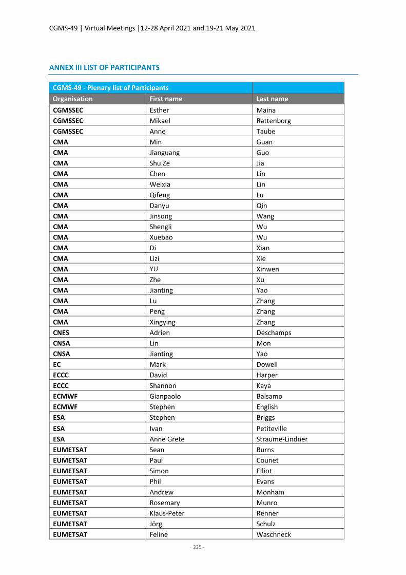
CGMS-49 | Virtual Meetings |12-28 April 2021 and 19-21 May 2021
- 225 -
ANNEX III LIST OF PARTICIPANTS
CGMS-49 - Plenary list of Participants
Organisation First name Last name
CGMSSEC Esther Maina
CGMSSEC Mikael Rattenborg
CGMSSEC Anne Taube
CMA Min Guan
CMA Jianguang Guo
CMA Shu Ze Jia
CMA Chen Lin
CMA Weixia Lin
CMA Qifeng Lu
CMA Danyu Qin
CMA Jinsong Wang
CMA Shengli Wu
CMA Xuebao Wu
CMA Di Xian
CMA Lizi Xie
CMA YU Xinwen
CMA Zhe Xu
CMA Jianting Yao
CMA Lu Zhang
CMA Peng Zhang
CMA Xingying Zhang
CNES Adrien Deschamps
CNSA Lin Mon
CNSA Jianting Yao
EC Mark Dowell
ECCC David Harper
ECCC Shannon Kaya
ECMWF Gianpaolo Balsamo
ECMWF Stephen English
ESA Stephen Briggs
ESA Ivan Petiteville
ESA Anne Grete Straume-Lindner
EUMETSAT Sean Burns
EUMETSAT Paul Counet
EUMETSAT Simon Elliot
EUMETSAT Phil Evans
EUMETSAT Andrew Monham
EUMETSAT Rosemary Munro
EUMETSAT Klaus-Peter Renner
EUMETSAT Jörg Schulz
EUMETSAT Feline Waschneck
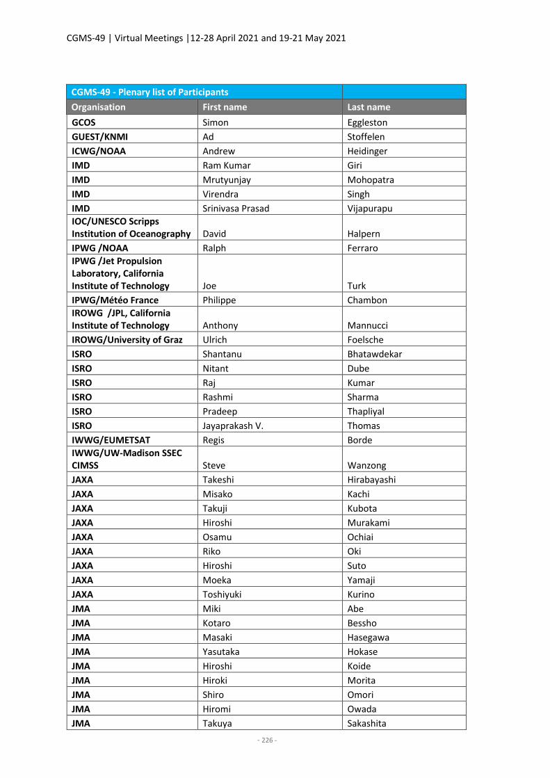
CGMS-49 | Virtual Meetings |12-28 April 2021 and 19-21 May 2021
- 226 -
CGMS-49 - Plenary list of Participants
Organisation First name Last name
GCOS Simon Eggleston
GUEST/KNMI Ad Stoffelen
ICWG/NOAA Andrew Heidinger
IMD Ram Kumar Giri
IMD Mrutyunjay Mohopatra
IMD Virendra Singh
IMD Srinivasa Prasad Vijapurapu
IOC/UNESCO Scripps Institution of Oceanography David Halpern
IPWG /NOAA Ralph Ferraro
IPWG /Jet Propulsion Laboratory, California Institute of Technology Joe Turk
IPWG/Météo France Philippe Chambon
IROWG /JPL, California Institute of Technology Anthony Mannucci
IROWG/University of Graz Ulrich Foelsche
ISRO Shantanu Bhatawdekar
ISRO Nitant Dube
ISRO Raj Kumar
ISRO Rashmi Sharma
ISRO Pradeep Thapliyal
ISRO Jayaprakash V. Thomas
IWWG/EUMETSAT Regis Borde
IWWG/UW-Madison SSEC CIMSS Steve Wanzong
JAXA Takeshi Hirabayashi
JAXA Misako Kachi
JAXA Takuji Kubota
JAXA Hiroshi Murakami
JAXA Osamu Ochiai
JAXA Riko Oki
JAXA Hiroshi Suto
JAXA Moeka Yamaji
JAXA Toshiyuki Kurino
JMA Miki Abe
JMA Kotaro Bessho
JMA Masaki Hasegawa
JMA Yasutaka Hokase
JMA Hiroshi Koide
JMA Hiroki Morita
JMA Shiro Omori
JMA Hiromi Owada
JMA Takuya Sakashita
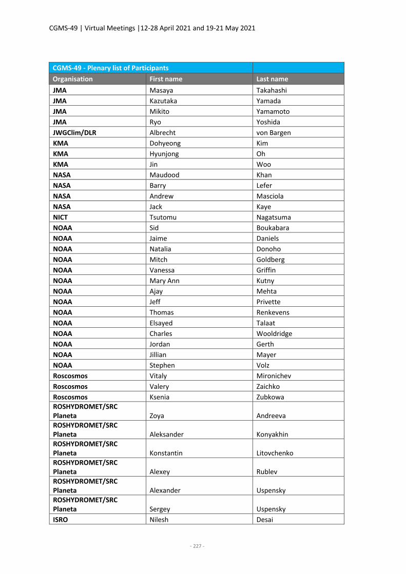
CGMS-49 | Virtual Meetings |12-28 April 2021 and 19-21 May 2021
- 227 -
CGMS-49 - Plenary list of Participants
Organisation First name Last name
JMA Masaya Takahashi
JMA Kazutaka Yamada
JMA Mikito Yamamoto
JMA Ryo Yoshida
JWGClim/DLR Albrecht von Bargen
KMA Dohyeong Kim
KMA Hyunjong Oh
KMA Jin Woo
NASA Maudood Khan
NASA Barry Lefer
NASA Andrew Masciola
NASA Jack Kaye
NICT Tsutomu Nagatsuma
NOAA Sid Boukabara
NOAA Jaime Daniels
NOAA Natalia Donoho
NOAA Mitch Goldberg
NOAA Vanessa Griffin
NOAA Mary Ann Kutny
NOAA Ajay Mehta
NOAA Jeff Privette
NOAA Thomas Renkevens
NOAA Elsayed Talaat
NOAA Charles Wooldridge
NOAA Jordan Gerth
NOAA Jillian Mayer
NOAA Stephen Volz
Roscosmos Vitaly Mironichev
Roscosmos Valery Zaichko
Roscosmos Ksenia Zubkowa
ROSHYDROMET/SRC Planeta Zoya Andreeva
ROSHYDROMET/SRC Planeta Aleksander Konyakhin
ROSHYDROMET/SRC Planeta Konstantin Litovchenko
ROSHYDROMET/SRC Planeta Alexey Rublev
ROSHYDROMET/SRC Planeta Alexander Uspensky
ROSHYDROMET/SRC Planeta Sergey Uspensky
ISRO Nilesh Desai
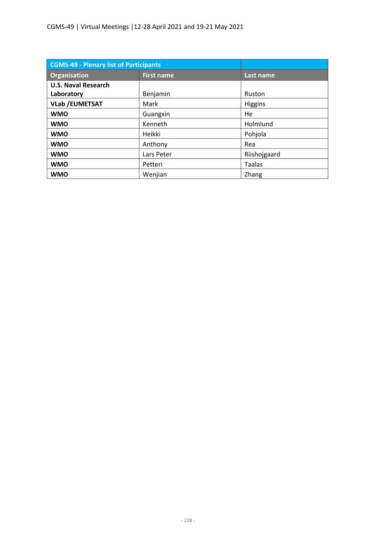
CGMS-49 | Virtual Meetings |12-28 April 2021 and 19-21 May 2021
- 228 -
CGMS-49 - Plenary list of Participants
Organisation First name Last name
U.S. Naval Research Laboratory Benjamin Ruston
VLab /EUMETSAT Mark Higgins
WMO Guangxin He
WMO Kenneth Holmlund
WMO Heikki Pohjola
WMO Anthony Rea
WMO Lars Peter Riishojgaard
WMO Petteri Taalas
WMO Wenjian Zhang
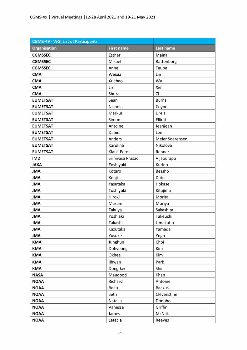
CGMS-49 | Virtual Meetings |12-28 April 2021 and 19-21 May 2021
- 229 -
CGMS-49 - WGI List of Participants
Organisation First name Last name
CGMSSEC Esther Maina
CGMSSEC Mikael Rattenborg
CGMSSEC Anne Taube
CMA Weixia Lin
CMA Xuebao Wu
CMA Lizi Xie
CMA Shuze Zi
EUMETSAT Sean Burns
EUMETSAT Nicholas Coyne
EUMETSAT Markus Dreis
EUMETSAT Simon Elliott
EUMETSAT Antoine Jeanjean
EUMETSAT Daniel Lee
EUMETSAT Anders Meier Soerensen
EUMETSAT Karolina Nikolova
EUMETSAT Klaus-Peter Renner
IMD Srinivasa Prasad Vijapurapu
JAXA Toshiyuki Kurino
JMA Kotaro Bessho
JMA Kenji Date
JMA Yasutaka Hokase
JMA Toshiyuki Kitajima
JMA Hiroki Morita
JMA Masami Moriya
JMA Takuya Sakashita
JMA Yoshiaki Takeuchi
JMA Takashi Umekubo
JMA Kazutaka Yamada
JMA Yusuke Yogo
KMA Junghun Choi
KMA Dohyeong Kim
KMA Okhee Kim
KMA Ilhwan Park
KMA Dong-kee Shin
NASA Maudood Khan
NOAA Richard Antoine
NOAA Beau Backus
NOAA Seth Clevenstine
NOAA Natalia Donoho
NOAA Vanessa Griffin
NOAA James McNitt
NOAA Letecia Reeves
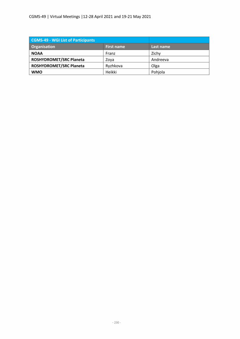
CGMS-49 | Virtual Meetings |12-28 April 2021 and 19-21 May 2021
- 230 -
CGMS-49 - WGI List of Participants
Organisation First name Last name
NOAA Franz Zichy
ROSHYDROMET/SRC Planeta Zoya Andreeva
ROSHYDROMET/SRC Planeta Ryzhkova Olga
WMO Heikki Pohjola
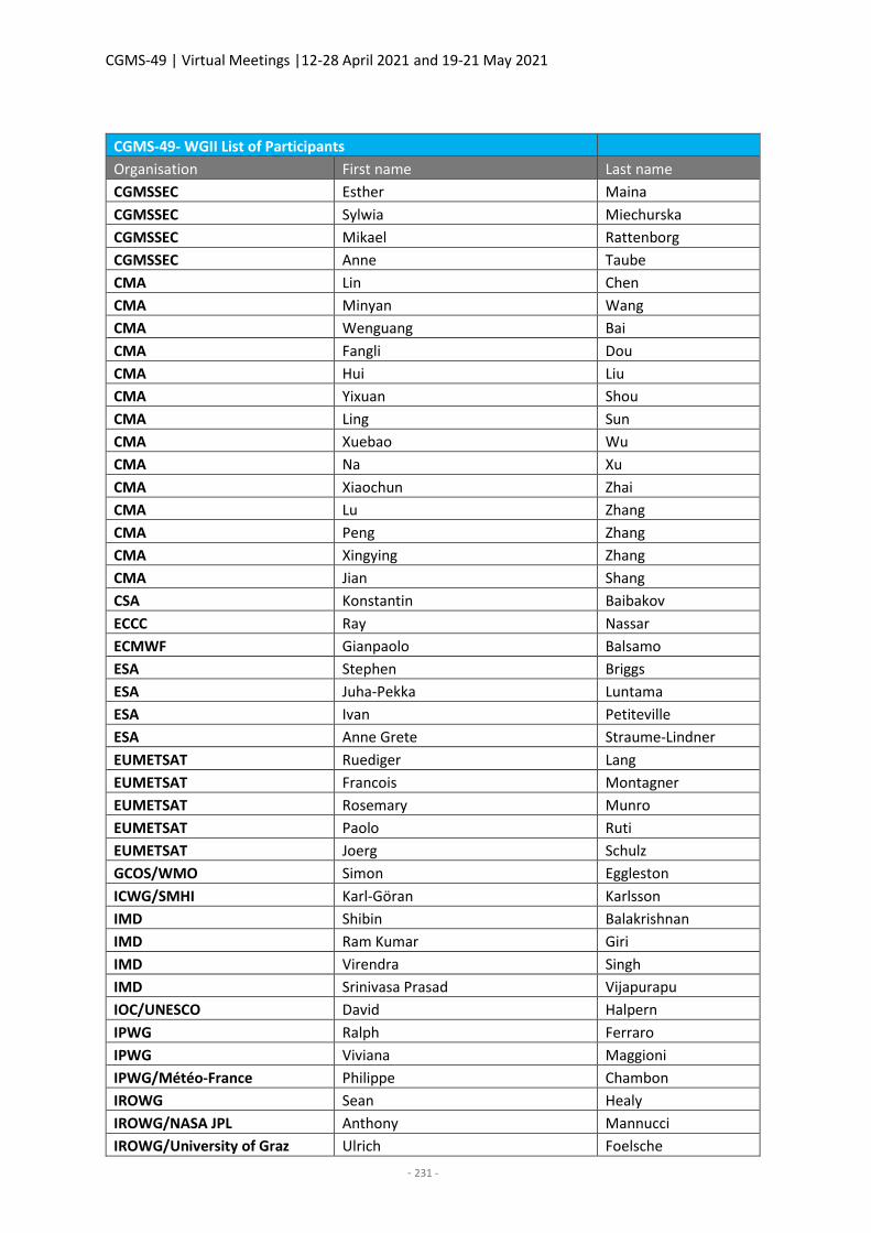
CGMS-49 | Virtual Meetings |12-28 April 2021 and 19-21 May 2021
- 231 -
CGMS-49- WGII List of Participants
Organisation First name Last name
CGMSSEC Esther Maina
CGMSSEC Sylwia Miechurska
CGMSSEC Mikael Rattenborg
CGMSSEC Anne Taube
CMA Lin Chen
CMA Minyan Wang
CMA Wenguang Bai
CMA Fangli Dou
CMA Hui Liu
CMA Yixuan Shou
CMA Ling Sun
CMA Xuebao Wu
CMA Na Xu
CMA Xiaochun Zhai
CMA Lu Zhang
CMA Peng Zhang
CMA Xingying Zhang
CMA Jian Shang
CSA Konstantin Baibakov
ECCC Ray Nassar
ECMWF Gianpaolo Balsamo
ESA Stephen Briggs
ESA Juha-Pekka Luntama
ESA Ivan Petiteville
ESA Anne Grete Straume-Lindner
EUMETSAT Ruediger Lang
EUMETSAT Francois Montagner
EUMETSAT Rosemary Munro
EUMETSAT Paolo Ruti
EUMETSAT Joerg Schulz
GCOS/WMO Simon Eggleston
ICWG/SMHI Karl-Göran Karlsson
IMD Shibin Balakrishnan
IMD Ram Kumar Giri
IMD Virendra Singh
IMD Srinivasa Prasad Vijapurapu
IOC/UNESCO David Halpern
IPWG Ralph Ferraro
IPWG Viviana Maggioni
IPWG/Météo-France Philippe Chambon
IROWG Sean Healy
IROWG/NASA JPL Anthony Mannucci
IROWG/University of Graz Ulrich Foelsche
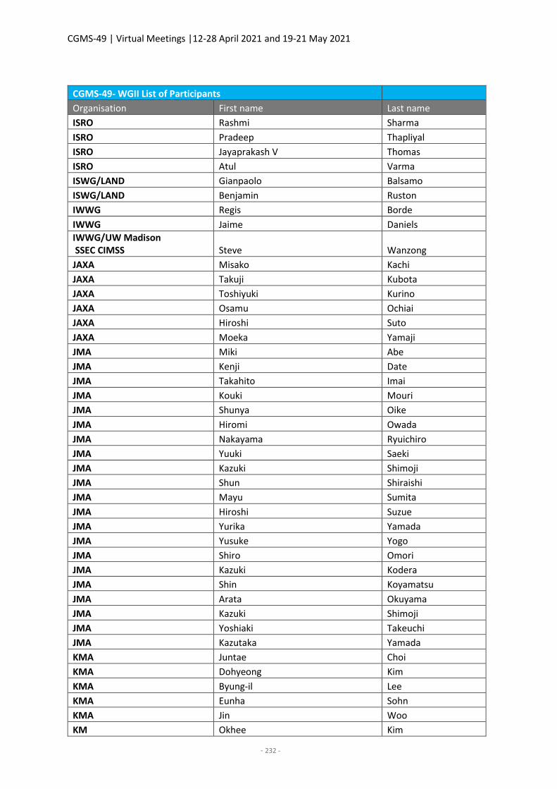
CGMS-49 | Virtual Meetings |12-28 April 2021 and 19-21 May 2021
- 232 -
CGMS-49- WGII List of Participants
Organisation First name Last name
ISRO Rashmi Sharma
ISRO Pradeep Thapliyal
ISRO Jayaprakash V Thomas
ISRO Atul Varma
ISWG/LAND Gianpaolo Balsamo
ISWG/LAND Benjamin Ruston
IWWG Regis Borde
IWWG Jaime Daniels
IWWG/UW Madison SSEC CIMSS Steve Wanzong
JAXA Misako Kachi
JAXA Takuji Kubota
JAXA Toshiyuki Kurino
JAXA Osamu Ochiai
JAXA Hiroshi Suto
JAXA Moeka Yamaji
JMA Miki Abe
JMA Kenji Date
JMA Takahito Imai
JMA Kouki Mouri
JMA Shunya Oike
JMA Hiromi Owada
JMA Nakayama Ryuichiro
JMA Yuuki Saeki
JMA Kazuki Shimoji
JMA Shun Shiraishi
JMA Mayu Sumita
JMA Hiroshi Suzue
JMA Yurika Yamada
JMA Yusuke Yogo
JMA Shiro Omori
JMA Kazuki Kodera
JMA Shin Koyamatsu
JMA Arata Okuyama
JMA Kazuki Shimoji
JMA Yoshiaki Takeuchi
JMA Kazutaka Yamada
KMA Juntae Choi
KMA Dohyeong Kim
KMA Byung-il Lee
KMA Eunha Sohn
KMA Jin Woo
KM Okhee Kim
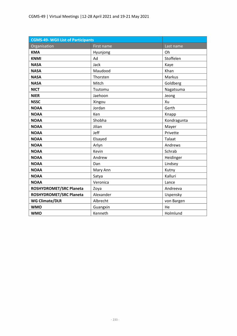
CGMS-49 | Virtual Meetings |12-28 April 2021 and 19-21 May 2021
- 233 -
CGMS-49- WGII List of Participants
Organisation First name Last name
KMA Hyunjong Oh
KNMI Ad Stoffelen
NASA Jack Kaye
NASA Maudood Khan
NASA Thorsten Markus
NASA Mitch Goldberg
NICT Tsutomu Nagatsuma
NIER Jaehoon Jeong
NSSC Xingou Xu
NOAA Jordan Gerth
NOAA Ken Knapp
NOAA Shobha Kondragunta
NOAA Jilian Mayer
NOAA Jeff Privette
NOAA Elsayed Talaat
NOAA Arlyn Andrews
NOAA Kevin Schrab
NOAA Andrew Heidinger
NOAA Dan Lindsey
NOAA Mary Ann Kutny
NOAA Satya Kalluri
NOAA Veronica Lance
ROSHYDROMET/SRC Planeta Zoya Andreeva
ROSHYDROMET/SRC Planeta Alexander Uspensky
WG Climate/DLR Albrecht von Bargen
WMO Guangxin He
WMO Kenneth Holmlund
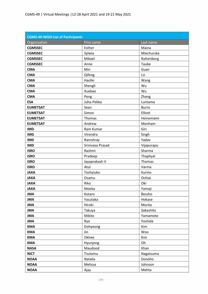
CGMS-49 | Virtual Meetings |12-28 April 2021 and 19-21 May 2021
- 234 -
CGMS-49-WGIII List of Participants
Organisation First name Last name
CGMSSEC Esther Maina
CGMSSEC Sylwia Miechurska
CGMSSEC Mikael Rattenborg
CGMSSEC Anne Taube
CMA Min Guan
CMA Qifeng LU
CMA Haofei Wang
CMA Shengli Wu
CMA Xuebao Wu
CMA Peng Zhang
ESA Juha-Pekka Luntama
EUMETSAT Sean Burns
EUMETSAT Simon Elliott
EUMETSAT Thomas Heinemann
EUMETSAT Andrew Monham
IMD Ram Kumar Giri
IMD Virendra Singh
IMD Ramshray Yadav
IMD Srinivasa Prasad Vijapurapu
ISRO Rashmi Sharma
ISRO Pradeep Thapliyal
ISRO Jayaprakash V Thomas
ISRO Atul Varma
JAXA Toshyiuko Kurino
JAXA Osamu Ochiai
JAXA Riko Oki
JAXA Moeka Yamaji
JMA Kotaro Bessho
JMA Yasutaka Hokase
JMA Hiroki Morita
JMA Takuya Sakashita
JMA Mikito Yamamoto
JMA Ryo Yoshida
KMA Dohyeong Kim
KMA Jin Woo
KMA Okhee Kim
KMA Hyunjong Oh
NASA Maudood Khan
NICT Tsutomu Nagatsuma
NOAA Natalia Donoho
NOAA Melissa Johnson
NOAA Ajay Mehta
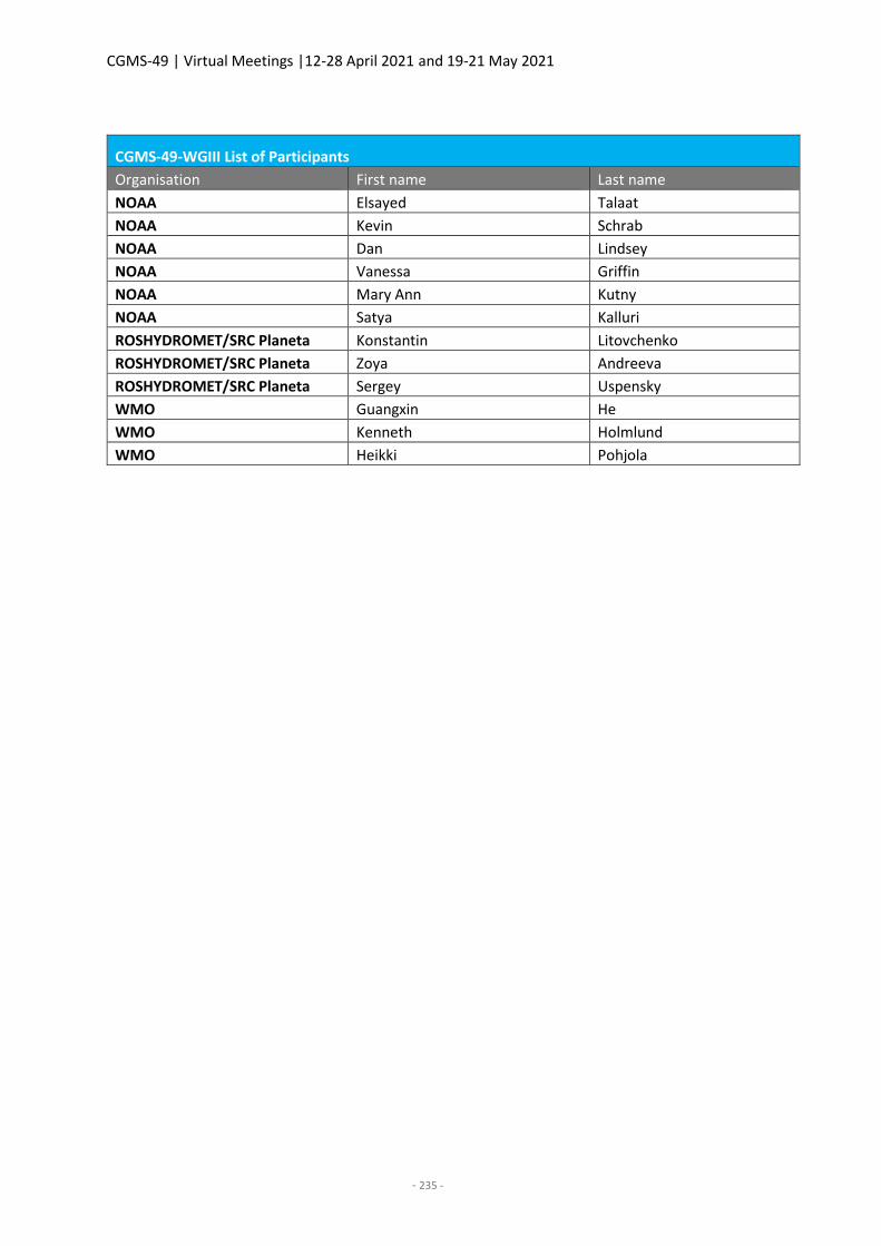
CGMS-49 | Virtual Meetings |12-28 April 2021 and 19-21 May 2021
- 235 -
CGMS-49-WGIII List of Participants
Organisation First name Last name
NOAA Elsayed Talaat
NOAA Kevin Schrab
NOAA Dan Lindsey
NOAA Vanessa Griffin
NOAA Mary Ann Kutny
NOAA Satya Kalluri
ROSHYDROMET/SRC Planeta Konstantin Litovchenko
ROSHYDROMET/SRC Planeta Zoya Andreeva
ROSHYDROMET/SRC Planeta Sergey Uspensky
WMO Guangxin He
WMO Kenneth Holmlund
WMO Heikki Pohjola
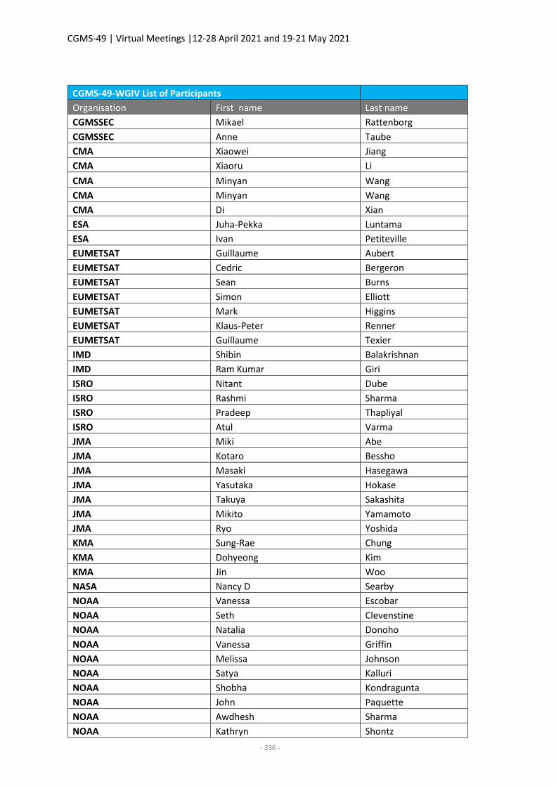
CGMS-49 | Virtual Meetings |12-28 April 2021 and 19-21 May 2021
- 236 -
CGMS-49-WGIV List of Participants
Organisation First name Last name
CGMSSEC Mikael Rattenborg
CGMSSEC Anne Taube
CMA Xiaowei Jiang
CMA Xiaoru Li
CMA Minyan Wang
CMA Minyan Wang
CMA Di Xian
ESA Juha-Pekka Luntama
ESA Ivan Petiteville
EUMETSAT Guillaume Aubert
EUMETSAT Cedric Bergeron
EUMETSAT Sean Burns
EUMETSAT Simon Elliott
EUMETSAT Mark Higgins
EUMETSAT Klaus-Peter Renner
EUMETSAT Guillaume Texier
IMD Shibin Balakrishnan
IMD Ram Kumar Giri
ISRO Nitant Dube
ISRO Rashmi Sharma
ISRO Pradeep Thapliyal
ISRO Atul Varma
JMA Miki Abe
JMA Kotaro Bessho
JMA Masaki Hasegawa
JMA Yasutaka Hokase
JMA Takuya Sakashita
JMA Mikito Yamamoto
JMA Ryo Yoshida
KMA Sung-Rae Chung
KMA Dohyeong Kim
KMA Jin Woo
NASA Nancy D Searby
NOAA Vanessa Escobar
NOAA Seth Clevenstine
NOAA Natalia Donoho
NOAA Vanessa Griffin
NOAA Melissa Johnson
NOAA Satya Kalluri
NOAA Shobha Kondragunta
NOAA John Paquette
NOAA Awdhesh Sharma
NOAA Kathryn Shontz
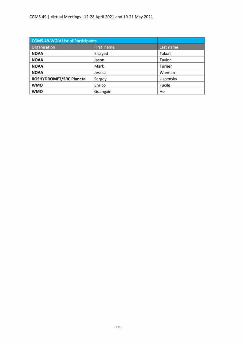
CGMS-49 | Virtual Meetings |12-28 April 2021 and 19-21 May 2021
- 237 -
CGMS-49-WGIV List of Participants
Organisation First name Last name
NOAA Elsayed Talaat
NOAA Jason Taylor
NOAA Mark Turner
NOAA Jessica Wieman
ROSHYDROMET/SRC Planeta Sergey Uspensky
WMO Enrico Fucile
WMO Guangxin He
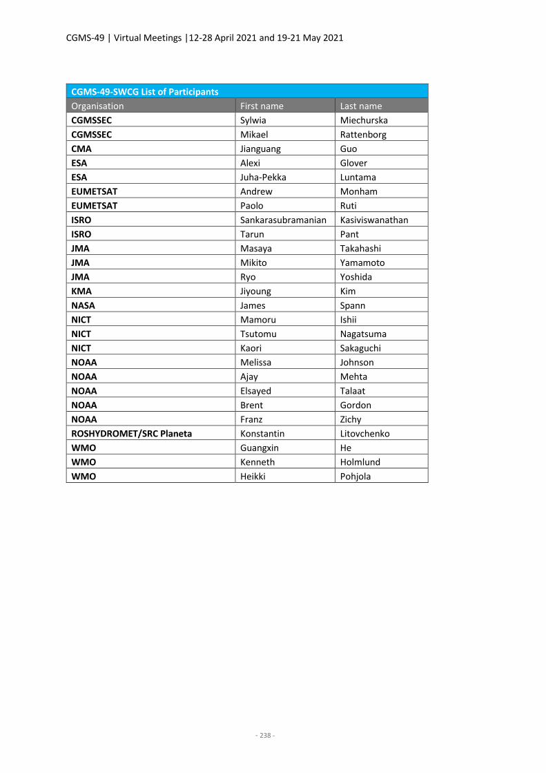
CGMS-49 | Virtual Meetings |12-28 April 2021 and 19-21 May 2021
- 238 -
CGMS-49-SWCG List of Participants
Organisation First name Last name
CGMSSEC Sylwia Miechurska
CGMSSEC Mikael Rattenborg
CMA Jianguang Guo
ESA Alexi Glover
ESA Juha-Pekka Luntama
EUMETSAT Andrew Monham
EUMETSAT Paolo Ruti
ISRO Sankarasubramanian Kasiviswanathan
ISRO Tarun Pant
JMA Masaya Takahashi
JMA Mikito Yamamoto
JMA Ryo Yoshida
KMA Jiyoung Kim
NASA James Spann
NICT Mamoru Ishii
NICT Tsutomu Nagatsuma
NICT Kaori Sakaguchi
NOAA Melissa Johnson
NOAA Ajay Mehta
NOAA Elsayed Talaat
NOAA Brent Gordon
NOAA Franz Zichy
ROSHYDROMET/SRC Planeta Konstantin Litovchenko
WMO Guangxin He
WMO Kenneth Holmlund
WMO Heikki Pohjola

CGMS-49 | Virtual Meetings |12-28 April 2021 and 19-21 May 2021
- 239 -
CGMS-49-Joint WGII-WGIII List of Participants
Organisation First name Last name
CGMSSEC Esther Maina
CGMSSEC Sylwia Miechurska
CGMSSEC Mikael Rattenborg
CGMSSEC Anne Taube
CMA Lin Chen
CMA Ling Sun
CMA Haofei Wang
CMA Shengli Wu
CMA Xuebao Wu
CMA Na Xu
CMA Xiaochun Zhai
CMA Lu Zhang
CMA Peng Zhang
CMA Xingying Zhang
CMA Xingou Xu
ECMWF Vincent-Henri Peuch
EUMETSAT Ruediger Lang
EUMETSAT Rosemary Munro
EUMETSAT Paolo Ruti
ICWG/SMHI Karl-Göran Karlsson
IMD Shibin Balakrishnan
IMD Virendra Singh
IMD Srinivasa Prasad Vijapurapu
IMD Ramashray Yadav
IOC UNESCO David Halpern
IPWG Viviana Maggioni
IROWG/NASA Anthony Mannucci
IROWG/University of Graz Ulrich Foelsche
ISRO Pradeep Thapliyal
ISRO Jayaprakash V Thomas
ISRO Atul Varma
ISWG/LAND Gianpaolo Balsamo
IWWG Regis Borde
IWWG/UW/Madison/SSEC CIMSS Steve Wanzong
JAXA Misako Kachi
JAXA Takuji Kubota
JAXA Toshiyuki Kurino
JAXA Hiroshi Murakami
JAXA Moeka Yamaji
JMA Kenji Date
JMA Takahito Imai
JMA Shin Koyamatsu
JMA Kouki Mouri
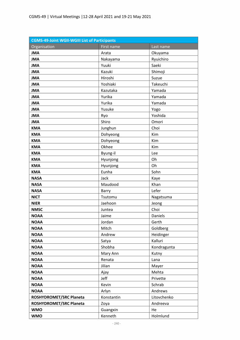
CGMS-49 | Virtual Meetings |12-28 April 2021 and 19-21 May 2021
- 240 -
CGMS-49-Joint WGII-WGIII List of Participants
Organisation First name Last name
JMA Arata Okuyama
JMA Nakayama Ryuichiro
JMA Yuuki Saeki
JMA Kazuki Shimoji
JMA Hiroshi Suzue
JMA Yoshiaki Takeuchi
JMA Kazutaka Yamada
JMA Yurika Yamada
JMA Yurika Yamada
JMA Yusuke Yogo
JMA Ryo Yoshida
JMA Shiro Omori
KMA Junghun Choi
KMA Dohyeong Kim
KMA Dohyeong Kim
KMA Okhee Kim
KMA Byung-il Lee
KMA Hyunjong Oh
KMA Hyunjong Oh
KMA Eunha Sohn
NASA Jack Kaye
NASA Maudood Khan
NASA Barry Lefer
NICT Tsutomu Nagatsuma
NIER Jaehoon Jeong
NMSC Juntea Choi
NOAA Jaime Daniels
NOAA Jordan Gerth
NOAA Mitch Goldberg
NOAA Andrew Heidinger
NOAA Satya Kalluri
NOAA Shobha Kondragunta
NOAA Mary Ann Kutny
NOAA Renata Lana
NOAA Jilian Mayer
NOAA Ajay Mehta
NOAA Jeff Privette
NOAA Kevin Schrab
NOAA Arlyn Andrews
ROSHYDROMET/SRC Planeta Konstantin Litovchenko
ROSHYDROMET/SRC Planeta Zoya Andreeva
WMO Guangxin He
WMO Kenneth Holmlund
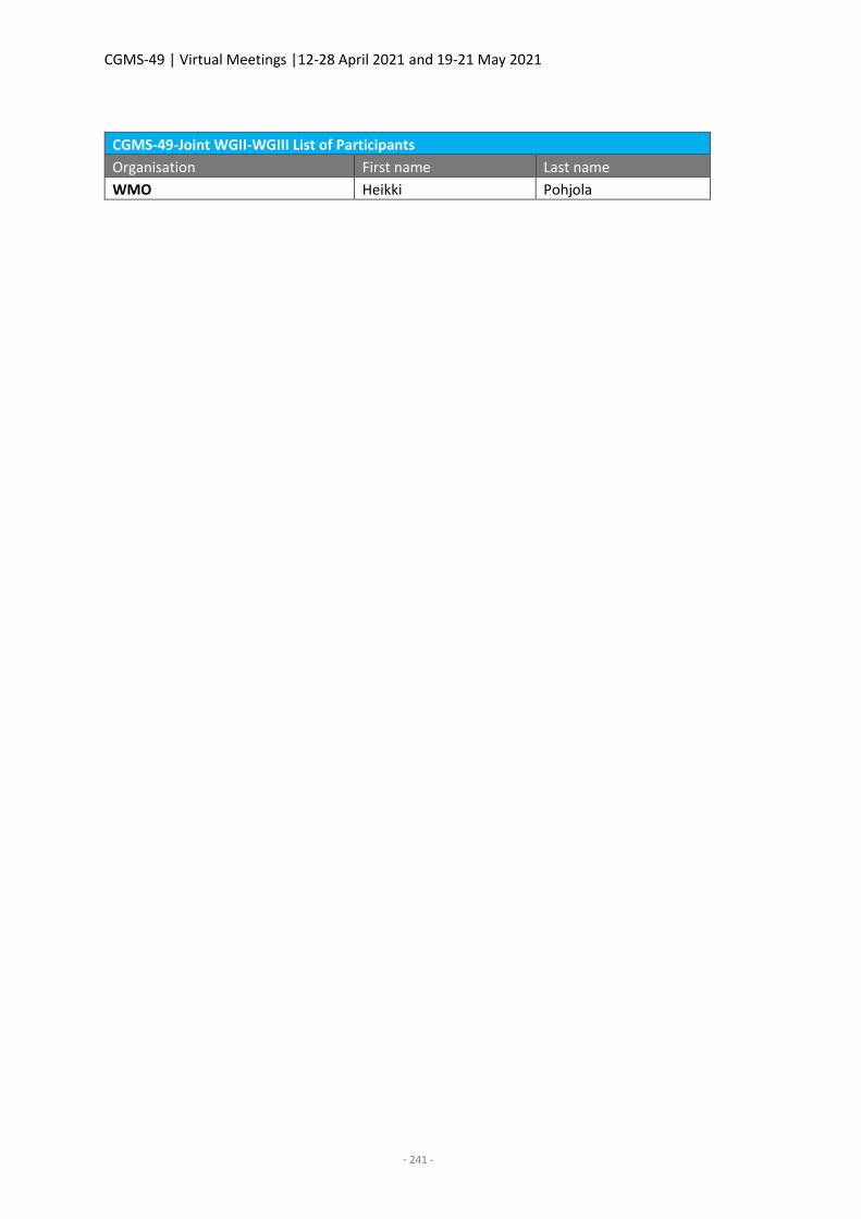
CGMS-49 | Virtual Meetings |12-28 April 2021 and 19-21 May 2021
- 241 -
CGMS-49-Joint WGII-WGIII List of Participants
Organisation First name Last name
WMO Heikki Pohjola
CGMS-49 | Virtual Meetings |12-28 April 2021 and 19-21 May 2021
- 242 -
CGMS-49 -Joint WGI-WGIV-SWCG
Organisation First name Last name
CGMSSEC Esther Maina
CGMSSEC Sylwia Miechurska
CGMSSEC Mikael Rattenborg
CGMSSEC Anne Taube
CMA Jianguang Guo
CMA Xiaowei Jiang
CMA Weixia Lin
CMA Peng Wang
CMA Lizi Xie
CMA Di Xian
ESA Juha-Pekka Luntama
ESA Ivan Petitville
EUMETSAT Sean Burns
EUMETSAT Nicholas Coyne
EUMETSAT Simon Elliott
EUMETSAT Andrew Monham
EUMETSAT Karolina Nikolova
EUMETSAT Klaus-Peter Renner
EUMETSAT Paolo Ruti
EUMETSAT Anders Meier Soerensen
EUMETSAT Michael Williams
EUMETSAT Markus Dreis
IMD Srinivasa Prasad Vijapurapu
ISRO Nitant Dube
ISRO Sankarasubramanian Kasiviswanathan
ISRO Jayaprakash V Thomas
JAXA Toshiyuki Kurino
JMA Kotaro Bessho
JMA Kenji Date
JMA Yasutaka Hokase
JMA Toshiyuki Kitajima
JMA Hiroki Morita
JMA Masami Moriya
JMA Takuya Sakashita
JMA Masaya Takahashi
JMA Yoshiaki Takeuchi
JMA Kazutaka Yamada
JMA Mikito Yamamoto
JMA Yusuke Yogo
JMA Ryo Yoshida
KMA Dohyeong Kim
KMA Jiyoung Kim
KMA Ilhwan Park
CGMS-49 | Virtual Meetings |12-28 April 2021 and 19-21 May 2021
- 243 -
CGMS-49 -Joint WGI-WGIV-SWCG
Organisation First name Last name
KMA Dong-kee Shin
NASA Maudood Khan
NASA James Spann
NICT Mamoru Ishii
NICT Tsutomu Nagatsuma
NICT Kaori Sakaguchi
NMSC Junghun Choi
NMSC Xiaoru Li
NOAA Richard Antoine
NOAA Beau Backus
NOAA Natalia Donoho
NOAA Vanessa Griffin
NOAA James McNitt
NOAA Awdhesh Sharma
NOAA Elsayed Talaat
NOAA Brent Gordon
NOAA Thomas Renkevens
ROSHYDROMET/SRC Planeta Konstantin Litovchenko
ROSHYDROMET/SRC Planeta Ryzhkova Olga
ROSHYDROMET/SRC Planeta Zoya Andreeva
UK Met Office Edmund Henley
WMO Guangxin He
WMO Heikki Pohjola
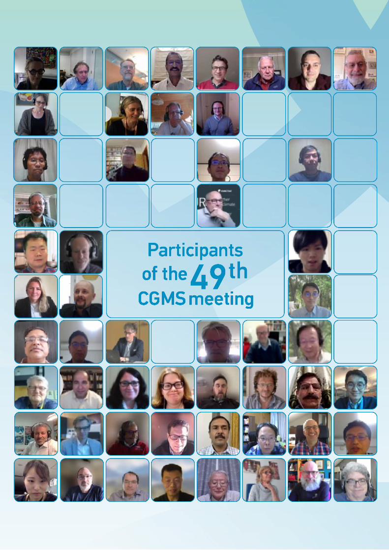
CGMS-49 | Virtual Meetings |12-28 April 2021 and 19-21 May 2021
- 245 -
GENERAL CGMS INFORMATION
CGMS Agenda and Working Papers
The agenda and Working Papers (WPs) are available at:
https://www.cgms-info.org/Agendas/agendas/CGMS-49
List of actions and recommendations
The list of actions and recommendations are kept on the related plenary session web page (see e.g.
https://www.cgms-info.org/index_.php/cgms/meeting-detail/cgms-49
CGMS members, observers and relevant actionees are requested to provide feedback as necessary to the
CGMS Secretariat ([email protected]), and when preparing Working Papers to refer to relevant
actions and recommendations if needed.
CGMS List Servers
There are currently six CGMS list servers for plenary, WGs I-IV and SWCG respectively. Information on
points of contact and list servers is available upon request from the CGMS Secretariat at
CGMS Charter, members and observers
Other information such as the CGMS Charter and the current list of members and observers are
available at http://www.cgms-info.org/index_.php/cgms/page?cat=ABOUT&page=INDEX.
General enquiries
Please contact the CGMS Secretariat at [email protected] in case of any enquiries related to
CGMS.