Embed Size (px)
Citation preview

UNITED STATES DEPARTMENT OF THE INTERIOR Harold L. Ickes, Secretary
GEOLOGICAL SURVEY W. C. Mendcnhall, Director
Bulletin 842
OF THE
GREATER HELENA MINING REGIONMONTANA
BY
J. T. PARDEE and F. C. SCHRADER
UNITED STATES
GOVERNMENT PRINTING OFFICE
WASHINGTON : 1933
For sale by the Superintendent of Documents, Washington, D.C. - Price 70 cents (Paper cover)

CONTENTS
Page"
Abstract.._______.__.___-___-___-____-__.___--.__-_-...___.__-___ ix:Introduction__ ______.._.....________-__-__-.___-_-----------_-__ 1.
Area and field work.__-.-.________-___-__-___.-_----_-----__-- 1Arrangement of the report.____________________________________ 3:Topography and geology.-__-__-____--.-___-_-_-.----------__._ 3'Ore deposits,_______--_-_._-______---_-___-_____-_-----_-_-___ 6»Bibliography.___...--______-___---_-_-_____-_-_-----------___ 8
Districts north of Helena_____..______-______._._.__--_--..-_.____ 8Field work..__.......__._____________.____ 8History and production._________-;.-___-__---__-_-_-_-__---____ 8Accessibility. __.__..-__.-.__-___-_-______-______-_..-.-_--..__ 9Topography. _ ________________________________________________ 10Geology________________1_____________________-.._-_-___._._ 11
Sedimentary rocks.....__.___._____.____-...---__-_-._____ 11Belt series (Algonkian)._______________________________ 11Paleozoic and Mesozoic rocks--______.______-.__.._.____ 12Tertiary rocks.______________--__.-_-___----_-__-_____ 14Quaternary deposits.__..__-____.-_______-_---__-__-_-_ 15
Igneous rocks____.___-____-_---_____-__-_------__---_.__ 17Diorite and gabbro.___._-________.__.___-__.-.___.____ 17Andesite ___-_____________-_-_--___-_-__---_-_.--_____ 18Granite (quartz monzonite)____.__-_______--__-_-______ 19Rhyolite.............._____.___.___.-._-.--..._ 21Porphyry dikes_________________._____________________ 21
Contact metamorphism.-___-______-___-___-_--____--___-__ 21Structure. .....................^...........--.....-..-... 22
Folds...._.-..........._.-...__._-_._..-----._..--... 22Faults.._..-----..--.._.____.___--_.-.__.... 23
Geologic history..._______________--_____-__.---_____-____ 24Ore deposits.______________________-__-_________--_------___-_ 28Ophir district.________________________________________________ 29Scratchgravel Hills and Grass Valley......__________---__--_-___ 35Austin district._.____..._..._._.____._____.____.___-.___._____ 59Marysville district.___________________________________________ 63Gould district._______________________________________________ 77Stemple area.______--_-_-_--____-_--__.______-__-_-______--._ 86Heddleston district.___________________________________________ 87Wolf Creek district.._..........__...___._________....__ 108Outlying districts_._._.._..-__..__-__-__.---_.______-__..___.. 114
Districts in the Belt Mountains..___________________________________ 119Introduction_ _____-__.-_.-___.-___-.________._.-__._________ 119History and production._______________________________________ 120Topography....................._---....__.-._..-.....__..__. 122
in
IV CONTENTS
Districts in the Belt Mountains Continued. Page.Geology.-__________________________________ 123
Sedimentary rocks________________________________________ 123Belt series_____________________________ 123
Newland limestone_________________-__-___________ 124Greyson shale..__________________________________ 125Spokane shale____________________________________ 125Empire shale and Helena limestone_______________ 126
Paleozoic rocks___-____--_-_--______-__-_____-________ 126Tertiary "lakebeds"______________________.__ 128Quaternary sediments_____---_________-_-_-_----__-___ 128
.Structure.-...___._____-_______._.___________.__ 128Folds__-___-___-_-________-__________---_____________ 128Faults________________________________ 129
Igneous rocks___________________________________________ 130Quartz diorite sills and dikes of the mountain front______ 131Quartz monzonite stocks-____._________________________ 131York group of quartz diorite dikes___-__________________ 133Quartz diorite stocks of Confederate Gulch.______________ 134Porphyry dikes_______________________-_-_____________ 135Andesite and basalt___________________________________ 135
Contact metamorphism____________________-_______________ 136Geomorphology. -_-___-___-___-_--_----_-_---___-_-___-___ 137
Ore deposits-___-_______________-_-_______-_-_-___._-_-_-_-___ 139Classification _____________________________________________ 139Gold-bearing lodes._______________________________________ 139
Distribution________________-__________________.______ 139Character. ___________________________________________ 140Composition_ _______________________________________ 141Origin..____________________.__________ 142Oxidation and enrichment____-___________-_.___-_-_-___ 143Conclusions________________-__-______-____.-_-___-___ 144
Copperlodes_______________-_____________-_______________ 145Mines and prospects..---__!__--_---_------------------_ 146Placer deposits______________________________________________ 171
Districts south of Helena.____________-_--____-_-_-_-_-_-_---_-.__ 183Area and accessibility_________-_________-___-___---_-----___ 183Field work. ____________________________________ 183History____---_-_---_-_----._________-_---__-_---_-_-_-_._ 183Production___________________________________________________ 185Topography---_-___-__-___________________.___-___.___ 187Geology..._________________________________ 187
Rocks older than the Boulder batholith._____________________ 187Quartz monzonite and aplite of the Boulder batholith_______ 190Contact metamorphism.___________________________________ 191Rocks younger than the Boulder batholith.__________________ 191
Ore deposits.____________________-__--____----_--_____--______ 192Lodes ---__-_____-__-_-.--__-____--_-______-_.-___ 192
Classification_______________________-_-_-__-_.________ 192Olderlodes_____________________________ 193
Character and composition.________________________ o 193Vertical distribution of ore bodies and zoning of metals. 195

CONTENTS V
Districts south of Helena Continued. Ore deposits Continued.
Lodes Continued.Older lodes Continued. Page
Geologic variations in mineral distribution_____...___ 197Vein 6tructure-_____---_-------__----------_--_--_ 197Origin and age____-_--_.__________________________ 198
Younger lodes.__-_-____-_-_------_---______---_-----_ 198Character and composition.________________________ 198Origin and age______-----__--_-_---_-____-----_--- 199
Ore reserves_____-_-_______..-_-________-_---______-_-____- 200Origin of the vein fractures____--_____________-_---_________ 201
Helena district.____________________________.__ 202Winston district-______________________________________ 211Clancy district...____________________._.______ 227Wickes district _..__.......__--....---..---_--.-..-.-._.._-. 232Rimini district_....._.-_-...__..._....._..._.___ 246Elliston district.____________________..-.-____ 262Zosell district..____________________.___________ 270Oro Fino district........................_....._.............._ 283Basin and Boulder districts____.--_________-_------_-__---_-_- 285Elkhorn district._______________________________ 299-Radersburg district__-..---____________._____.__________..___ 303Park district.-_______________________________ 308
Index-..._.--.____.____________________________________ 311

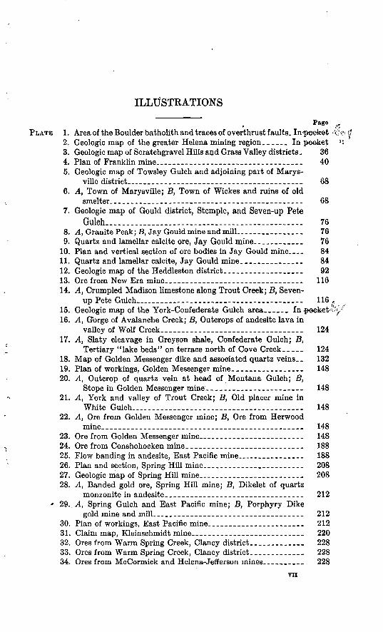
ILLUSTRATIONS
PagePLATE 1. Area of the Boulder batholith and traces of overthrust faults. In<peefcet
2. Geologic map of the greater Helena mining region. _____ In peefcet3. Geologic map of Scratchgravel Hills and Grass Valley districts. 364. Plan of Franklin mine__---_--_---___---_----___----_-_ 405. Geologic map of Towsley Gulch and adjoining part of Marys-
ville district__________-----_-__--__-__-_--__--_..___- 686. A, Town of Marysville; B, Town of Wickes and ruins of old
smelter.__..__-.__________---__-_-__--_-_-____-_--___ 687. Geologic map of Gould district, Stemple, and Seven-up Pete
Gulch................. _..____...._..-...-..-..... 768. A, Granite Peak; B, Jay Gould mine and mill..._____________ 769. Quartz and lamellar calcite ore, Jay Gould mine.-._________ 76
10. Plan and vertical section of ore bodies in Jay Gould mine.... 8411. Quartz and lamellar calcite, Jay Gould mine_______________ 8412. Geologic map of the Heddleston district.__________________ 9213. Ore from New Era mine.._-----_---_-_--__----_--_-_--__ 11614. A, Crumpled Madison limestone along Trout Creek; B, Seven-
up Pete Gulch__________________________ 11615. Geologic map of the York-Confederate Gulch area ._ In poefcet^16. A, Gorge of Avalanche Creek; B, Outcrops of andesite lava in
valley of Wolf Creek______________________ 12417. A, Slaty cleavage in Grey son shale, Confederate Gulch; B,
Tertiary "lake beds" on terrace north of Cove Creek.____ 12418. Map of Golden Messenger dike and associated quartz veins.. 13219. Plan of workings, Golden Messenger mine.________________ 14820. A, Outcrop of quartz vein at head of Montana Gulch; B,
Stope in Golden Messenger mine.-_____________-___--_- 14821. A, York and valley of Trout Creek; B, Old placer mine in
White Gulch......_...._...._________________________ 14822. A, Ore from Golden Messenger mine; B, Ore from Herwood
mine._____._--________---_---_---___-_-_------_-__-- 14823. Ore from Golden Messenger mine____-____----__---_-_-_ 14824. Ore from Conshohocken mine.___________________________ 18825. Flow banding in andesite, East Pacific mine_____________ 18826. Plan and section, Spring Hill mine________________________ 20827. Geologic map of Spring Hill mine_______________________ 20828. A, Banded gold ore, Spring Hill mine; B, Dikelet of quartz
monzonite in andesite___---_---_____--__---_--_------- 212' 29.. A, Spring Gulch and East Pacific mine; B, Porphyry Dike
gold mine and mill______-____-________-_-__-____--_- 21230. Plan of workings, East Pacific mine____-____________.___-_ 21231. Claim map, Kleinschmidt mine----_-__----_--___---__-_-_ 22032. Ores from Warm Spring Creek, Clancy district _____________ 22833. Ores from Warm Spring Creek, Clancy district. ____________ 22834. Ores from McCormick and Helena-Jefferson mines.--_______ 228
vn

VHI ILLUSTEATIONS
Page PLATE 35. Ores from Helena-Jefferson and Mount Washington mines. _. 228
36. A, Town of Corbin; B, Wolf tone vein, Rimini district. ______ 23637. A, Ore from Blue Bird mine, Wickes district; B, Ore from
Wolf tone vein, Rimini district____-__-____ _____________ 23638. Ores from Rimini district._______________---__-___--__-__ 23639. Claim map, Mount Washington and Salvail mines._________ 23640. A, Silver-gold copper ore from Minah mine; B, C, Ore from
Mount Washington mine._____________________________ 23641. Veins in Rimini district._______________________________ 25242. A, B, Ore from Black Jack mine; C, Sulphide ore from 0. H.
Bassett mine-__-°_______--__-___----____-__-__-------- 25243. Claim map, Porphyry Dike mine and vicinity._-____________ 26044. A, Structure of gold-bearing rhyolite, Pauper's Dream mine;
B, Bonanza mine, Zosell district_._______________________ 26045. Geologic map of Zosell district____________________________ 27646. Ore from Blue Eyed Maggie mine._.-___--______-_-_-_---_ 27647. A, Breccia in Bonanza mine; B, Ore from Bonanza mine_____ 276
FIGURE 1. Index map showing location of greater Helena mining region,Montana.__________________________ _ 2
2. Faulting west of Aster mine_-__-_-_-___-___-_-___________ 243. Scarp at Sieben.________._________-___--__--__--_-______ 274. Veins in the Daisy group at Ophir_______________________ 345. Vein in Golden Crown mine______________________________ 496. Faulting on Moonlight and Hopeful claims _________________ 527. Composite vein, incline 1, Hopeful claim_-______.__________ 538. Composite vein, incline 2, Hopeful claim.__________________ 549. Vein in Bonanza mine_-_______-_-_-_______--______--___- 55
10. Vein structure, Bell Boy mine._____________-_---_-_--__-- 7211. Ore of Bell Boy mine________________________ 7312. Vein in Earthquake mine_______________________________ 7613. Vein structure, Jay Gould mine.________-__-----__-_--__-_ 8314. Workings in Mike Horse mine____________i_-_______--____ 9515. Mike Horse vein._____________________ _____ 9616. Plan of adit level, Carbonate mine.-_-__ 9917. Vein in Carbonate mine_____________-___--_-___________-_ 10018. Vein in Midnight mine_________________________________ 10119. Fault zone on Milliron claims________________---_--___-. 10420. Plan of main adit level, New Era mine___________________ Ill21. Section along tunnel 2, Golden Messenger mine _ _ 14822. Plan of Topke tunnel, Golden Messenger mine____________ 14923. Geology of tunnel 1, Golden Messenger mine___._ __ 15024. Geology of tunnel 2, Golden Messenger mine.__ __ 15125. Ore body, Golden Messenger mine______________________ 15226. Plan of sublevel, Golden Messenger mine_________________ 15227. Section of vein, Argo mine._--_--___--__-----__--_---_--- 16628. Geology of Winston district.____________________ 21329. Vertical section, East Pacific mine_______________________ 21730. Vertical section, Kleinschmidt mine.______________________ 22431. Claim map, Iron Age camp_______________________________ 22632. Plan of manganese mine west of Corbin.___________________ 23433. Vertical section, Lee Mountain mine__-_______-__-_________ 25634. Vertical section, Emery mine.____________________________ 27535. Cross section of vein in Bonanza mine--.-----------.------ 28036. Cross section of Jo Dandy mine._______._______-__-_---- 307
ABSTRACT
The ore deposits described in this bulletin are distributed through a region of about 3,000 square miles surrounding the city of Helena, Mont. In general the surface of this region is mountainous, but it includes several large inter- montane valleys. Large areas in the northern and eastern parts of the region sire underlain by sedimentary rocks of the Algonkian Belt series, and on the northeast and southwest the Belt rocks are overlain without any noticeable angular unconformity by Paleozoic and Mesozoic beds. Oligocene, Miocene, and possibly Pliocene sediments, composed chiefly of volcanic ash and land waste of local origin, occupy large areas in the intermontane valleys and lie uncon- formably upon Cretaceous and older rocks. A thin veneer of Pleistocene and Recent alluvium generally overspreads the Tertiary. In the extreme northern part of the region are large deposits of glacial drift that represent two stages of the Pleistocene.
The principal igneous body of the region is the northern part of the early Tertiary or late Cretaceous Boulder batholitb of quartz monzonite. The main exposure of this body occupies an area of nearly 1,200 square miles and extends southward beyond the limits of the particular region considered. Smaller areas of similar rocks are clustered around this exposure. Most of the exposures probably represent bodies that are connected in depth to form a single mass.
The late Cretaceous and older sedimentary rocks are involved in a series of northwestward-trending folds. Along the east side of the region overthrust faults related to the great Lewis overthrust of Glacier National Park cause Belt rocks to overlie rocks of Paleozoic and Mesozoic ages. Large normal faults occur near Marysville and faults of moderate displacement near Helena. The Tertiary beds are slightly deformed by folds and faults that are unrelated to the structure of the older rock. The geologic history of the region includes two contrasting periods, the earlier of which was characterized by the accumulation of marine sediments and the later by mountain building and erosion. The later period began with folding and elevation in late Cretaceous or early Eocene time, followed by overthrust faulting and the intrusion of the Boulder batholith. Next, there ensued a period of crustal stability, during which erosion reduced the region to a surface of low relief and cut away at least 10,000 feet of strata in the area north of Helena. In Oligocene, Miocene, and Pliocene (?) time sedi ments composed of land waste and volcanic ash were deposited, and this event was followed by warping and faulting that elevated the present mountains. During Pliocene and Pleistocene time the mountains were maturely dissected, and in middle and late Pleistocene time local glaciers formed in the higher mountains and large valley glaciers invaded the extreme northern part of the region.
The ore deposits include lodes and placers that have yielded gold, silver, lead, copper, and zinc to a value of at least $176,860,000. The placers were formed mostly during interglacial stages of the Pleistocene. They have been almost entirely exhausted. Most of the lodes are classified as regards age in two groups, an older and a younger. The older lodes are related in origin to the Boulder batholith or some of the neighboring intrusive granitic bodies and
IX
X ABSTRACT
were probably formed during early Eocene time. The younger lodes were formed after dacite of probable Miocene age was erupted. They are possibly related in origin to some unexposed intrusive granitic rock.
For convenience in description the region is divided into three parts dis tricts north of Helena, districts in the Belt Mountains, and districts south of Helena.
The districts north of Helena include a 50-mile stretch of the Continental Divide that forms a broad ridge surmounted with considerable areas of flat or gently sloping surface at a general altitude of 7,000 feet. Narrow valleys 1,000 to 2,000 feet deep are cut into this surface and lead out to the neighboring wide intermontane valleys. The area is underlain mostly by shale, sandstone, and limestone of the upper part of the Belt series. Beds of Paleozoic and Mesozoic age occur south of the Belt area and extend from Helena west and northwest. The igneous rocks of the area include diorite and gabbro sills and dikes of probable Cretaceous age, extrusive andesite that is probably Oligocene or Miocene, and stocks of quartz monzonite, granodiorite, and quartz diorite, probably of Oligocene or Miocene age.
The ore deposits of the northern districts are chiefly lodes that are valuable for gold and silver but contain some lead and copper. In the Ophir district bodies of gold and silver ore occur mainly in limestone near a body of quartz monzonite. In the Scratchgravel Hills and Grass Valley districts veins of gold quartz and veins containing lead-silver ore occur in quartz monzonite and in the adjoining metamorphic rocks. In the Austin district lodes containing gold; silver, lead, and copper are found in limestone near intrusive quartz mon zonite. An unusual mineral in one of these lodes is corkite, a hydrous sul phate of lead containing arsenic. A small stock of quartz diorite in the Marysville district has invaded and domed Belt rocks. Marginal and radial fractures formed during the cooling and contraction of the igneous body be came the receptacles of gold and silver veins, one of which, the Drumlummon, has produced $16,000,000. The veins filled open fractures and are characterized by a gangue of platy calcite and quartz. Lodes in Towsley Gulch in the western part of the district contain lead in addition to gold. In the Gould district a small stock of the granodiorite has invaded the Belt rocks and caused the deposition of veins similar to those near Marysville. In the Heddleston districtlodes valuable for gold, silver, lead, and copper occur in Belt sedimentary rocks and diorite, some of them associated with porphyry dikes. In the Wolf Creek district veins in Belt rocks have produced copper ore composed mainly of chalcopyrite or chalcopyrite and tennantite accompanied by pyrite and a gangue of quartz and barite.
Placer deposits along the western slope of the Belt Mountains have produced $17,500,000 in gold. Sapphires were formerly obtained from some of these de posits. The central part of the Belt Mountains is a plateaulike area considered to be the remnant of a surface produced by erosion during Tertiary time. This surface was elevated and has been deeply trenched by narrow, transverse valleys that are bordered with remnants of low terraces in which most of the placer deposits occur. Most of the western slope of the mountains is underlain by sedimentary rocks of the Belt series. At the foot of the mountains these give place to Paleozoic rocks, and these in turn are overlain unconformably in Townsend Valley by Tertiary and later deposits. The main structural feature is a great arch called the York anticline, which occupies most of the west side of the mountains. At the west foot of the mountains this fold is bordered by a series of small synclines that are tightly squeezed, faulted, and overturned as a result of pressure exerted from the west or southwest along a

ABSTRACT * XI
fracture described as the El Dorado overthrust On another fracture called1 the Scout Camp overthrust the Belt rocks composing the western slope of the mountains are thrust eastward over Paleozoic beds. Both faults are regarded as branches of the Lewis overthrust of Glacier Park. Igneous rocks that probably range in age from early Eocene to Pleistocene are widely but sparingly distributed.' They include sills and dikes of quartz dibrite, porphyry dikes, small stocks of quartz monzonite and quartz diorite, and surface flows of andesite and basalt.
The deposits in the Belt Mountains that are of most interest at the present time are lodes that are chiefly valuable for gold. Most of them are found in the vicinity of York and Confederate Gulch. Nearly all are small quartz veins formed along fractures in diorite dikes and stocks or on bedding planes in the adjoining Belt sedimentary rocks. An exception is the Golden Messenger, a replacement deposit of large size but low grade, formed along fractures in a quartz diorite dike. Other veins in the same dike belong to the rather uncommon class called ladder veins. Many of the small veins containshoots and bunches of rich ore in their upper parts. Downward- enrichmentin gold is indicated to have occurred in some of the veins near York that lie below an old erosion surface. Elsewhere the origin of the placer deposits from erosion o'f the lodes during interglacial stages of the Pleistocene is indicated. Lodes containing chalcopyrite occupy tension fractures in the Belt shales that were produced by lateral movements of the mass composing the mountain front.
In the districts south of Helena mining began with the discovery, on July 14, 1864, of rich placer deposits at the present site of the city of Helena, on Last Chance Creek. Since then the placer and lode deposits of these districts have produced metals worth $130,000,000 or more, of which about one-third was gold, the remainder chiefly lead and zinc. Sedimentary rocks ranging in age from Algonkian to Cretaceous underlie parts of the region, and other parts are underlain by a bedded series of andesite and latite tuffs, breccias, and flows. These rocks have been intruded and severely metamorphosed by the quartz monzonite of the Boulder batholith, the exposures of which occupy a large area. Rocks later than the intrusion of the batholith are chiefly a series of late Tertiary dacites and rhyolites.
The placers of the southern districts have been almost entirely worked out. The lodes have yielded metals worth $111,600,000, but many of them are still productive. They include veins and contact-metamorphic deposits. Some of the contact deposits contain copper ore, and others contain iron ore valuable for fluxing. The veins are of two ages. The older veins have yielded most of the metallic production of the region. Their ores in general are heavy sulphide aggregates composed mainly of galena, sphalerite, and pyrite. Arsenopyrite is generally present; tetrahedrite and chalcopyrite are less common. Many of the veins are distinguished from the usual type of ore body by the occurrence of abundant tourmaline. The, metals produced are chiefly silver, lead, gold, and zinc, with some copper. The younger veins are essentially precious-metal deposits. They are mainly fissure veins but include some disseminated de posits of low grade. They are widely distributed and include several produc tive bodies. A distinguishing feature is the occurrence in the gangue of cryptocrystalline quartz and lamellar calcite. A dominant eastward trend of the vein fractures of the older group indicates them to be tension cracks in the crust block lying west of the Lewis overthrust that were produced by stretching in a direction at right angles to the thrust.

METALLIFEROUS DEPOSITS OF THE GREATER HELENA MINING REGION, MONTANA
By J. T. PAEDEE and F. C. SCHRADER
INTRODUCTION
ABEA AND FIELD WOBK
The deposits described in this report are distributed through a region of about 3,000 square miles surrounding the city of Helena, in west-central Montana. (See fig. 1.) The region extends from Helena about 35 miles north to Wolf Creek and 25 miles south to Boulder and Basin. Its greatest width from the vicinity of Deer Lodge eastward to the summit of the Belt Mountains at Confederate Gulch is about 50 miles. A large part of the region is divided among indefinitely bounded areas known as mining districts, each of which includes one or more groups of metalliferous deposits. Since the deposits were discovered more than 40 districts have received names. Among the better-known ones are Gould, Marysville, Heddleston, and Scratchgravel, north of Helena; York and Con federate Gulch, in the Belt Mountains; and Winston, Clancy, Helena, Kimini, Basin, Wickes, Elkhorn, and Radersburg, south of Helena.
The field work on which the present report is based was first under taken by the United States Geological Survey to gain information about a number of undescribed mining districts lying mostly north of Helena. Work was begun in July, 1926, by J. T. Pardee-, who,, during that season and the summer of 1927, examined the Zosell district, east of Deer Lodge, and the Scratchgravel, Heddleston, and several other districts north of Helena and began work in the York district in the Belt Mountains. In 1928, as a result of cooper ation by the city of Helena, the investigation was widened to include several districts south of that city and additional areas ia other parts of the surrounding region. Under this cooperative survey the mining areas on the west slope of the Belt Mountains- from York to Confederate Gulch were examined by Mr: Parcdeer who was assisted by Russell Gibson. The Ophir district and the districts south of Helena were examined mostly by F. C. Schraderj who was assisted part of the time by Mr. Gibson, and parts of tfte Wolf Creek, Austin, and Marysville districts north of Helena were
l

2 GREATER HELENA MINING REGION, MONTANA
examined jointly by Messrs. Pardee and Schrader. In May, 1930r Mr. Pardee made brief examinations of the Gray Eagle and Minne apolis mines, at Basin; the Jo Dandy mine, near Kadersburg; and the exploratory tunnel at Kimini being driven by the Montana Lead Co.
L30Mles
FIGCBE 1. Index map showing location of greater Helena mining region, Montana(shaded area)
During the progress of the field work the mining men of the region were found uniformly courteous and responsive to the requests for information, and to all of them the writers extend grateful acknowledgments. For the determination by microscopic and metallographic methods of many of the rock and ore minerals described herein the writers are indebted to Clarence S. Eoss, W. T. Schaller, and M. N. Short, of the Geological Survey.
INTRODUCTION O
ARRANGEMENT OF THE REPORT
The mining districts covered by this report are most convenientlyr described in three groups that occupy areas north of Helena, in the> Belt Mountains, and south of Helena. Each of these areas differs
considerably from the others in its geology and other features, andi therefore at the beginning of the report only the features that per-rt tain to the whole region are mentioned. More extended treatment
of the geography, geology, and mineral deposits is given in turnfor each area named.
TOPOGRAPHY AND GEOLOGY
- The region is mountainous in general but includes several large areas of lowland that are termed intermontane valleys. The moun tains are moderately high and not very rugged, although they are maturely dissected by narrow valleys from 1,000 to 3,000 feet deep.
* In most of the mountain groups the main summit areas are flat or gently sloping and accord in form and height with a surface of
'** moderate relief and gentle contour that formerly extended over the whole region. The most noteworthy of these summit areas are the Occidental Plateau, west of Wickes, and the upland at the head of Trout Creek in the Belt Mountains. In most places the present altitude of these upland surfaces is not far above or below 7,000 feet. Other noteworthy features of the topography are terraces developed at two or three levels and occurring mostly in the inter- montane valleys.
Large areas in the northern and eastern parts of the region are underlain by sedimentary rocks of the Algonkian Belt series, which are exposed to a total thickness of 15,000 feet or more. On the northeast and southwest the Belt rocks are overlain without any noticeable angular unconformity by Paleozoic and Mesozoic beds, including Upper Cretaceous (Colorado), that have a maxi mum aggregate thickness of 13,000 feet. Oligocene, Miocene, and Pliocene sediments, composed chiefly of volcanic ash and land waste of local origin, occupy large areas in the interment [ne valleys and lie unconformably upon the Cretaceous and older rocks. A thin veneer of Quaternary alluvium generally overspreai s the Ter-
# tiary. In the extreme northern part of the region are large deposits of glacial drift that represent two stages of the Pleistocene.
The principal igneous body of the region is the early Tertiary orlate Cretaceous Boulder batholith, a mass of quartz monzonite that
^ extends beyond the limits of the particular region considered. Theprincipal continuous exposure of this body reaches from Helenasouthwestward to the vicinity of Divide, on the Big Hole River, a
4 GEEATEE HELENA MINING BEGION, MONTANA
distance of 68 miles. (See pi. 1.) Its width ranges from 14 to 25 miles, and its area is nearly 1,200 square miles. Around this exposure but clustered mostly on the west and south are smaller areas of simi lar rocks. There is evidence that many of these bodies expand down ward, and it is probable that were the surface lowered a few thousand feet some of them would be seen to have coalesced with the main body.
Billingsley * regards all the separate areas of granitic rocks as in reality but the many exposures of a single mass, and he draws/ the western limit to include exposures near Philipsburg and Anaconda. However, between Anaconda and the main area of the great, batho- lith of central Idaho, areas of similar rocks are closely spaced, and so far as the evidence of areal distribution goes it is difficult to draw a line between the satellites of the two great igneous bodies. They are much alike in composition, and therefore, it may be true, as suggested by Knopf ,2 that the Boulder batholith is merely an outlier of the greater Idaho mass. On the other hand, Koss 8 thinks that the two bodies show some differences in composition and are probably of different age, the Idaho body being much the older (probably late Jurassic). Present information, however, gives little basis for speculation as to the probable concealed western limit of the Boulder batholith.
As shown by its main exposure the definite age limits of the Boulder batholith are late Cretaceous and Oligocene. Near Elliston the magma invaded Colorado Cretaceous rocks after they had been folded, and at Mullen Pass the solidified body was uncovered by ero sion before Oligocene sediments were laid down. From these facts it is concluded that most probably the body came to place in earlyEocene time.
Both Barrell 4 and Billingsley 5 regard the Boulder batholith as a dome-shaped mass that made room for itself by stoping and did not fold the rocks it invaded, though it probably elevated them over its central part. It is made up of relatively basic material at the border, a main mass of quartz monzonite containing 63 per cent of silica, and dikes and irregular bodies of aplite that contain 75 per cent of silica. :
1 Billingsley, Paul, The Boulder batholith of Montana: Am. Inst. Min. Eng. Trans., vol. 51, p. 33, 1915.
2 Knopf, Adolph, Ore deposits of the Helena mining region, Montana: U. S. Geol. Sur vey Bull. 527, p. 34, 1913.
8 Ross, C. P., Mesozoic and Tertiary granite rocks in Idaho: Jour. Geology, vol. 36, pp. 673-693, 1928.
* Barrell, Joseph, Geology of the Marysville mining district, Mont.: U. S. Geol. Survey Prof, Paper 57, p. 21, 1907.
8 Billingsley, Paul, The Boulder batholith of Montana: Am. Inst. Min. Eng. Trans., vol. 51, p. 39, 1915.
INTRODUCTION 5
Although the igneous mass as limited by Billingsley 6 does not compare in size with the batholith of central Idaho or with the greater intrusive bodies elsewhere, it is second to none in the extent and value of its related mineral deposits. In round figures the ore bodies related to the Boulder batholith have produced to date some 5,000,000 tons of copper, 1,000,000 tons of zinc, 100,000 tons of lead, 16,000 tons of silver, and 470 tons of gold. Of these different products nearly all the copper and zinc, most of the silver, and about one-sixth of the gold came from Butte.
Other igneous rocks in this region include diorite sills and dikes and andesite-latite flows that are older than the batholith, rhyolite and dacite that are younger, and scattered porphyry dikes of inde terminate age.
The late Cretaceous and older sedimentary rocks are all involved in a series of northwestward-trending folds. Along the east side of the region overthrust faults related to the great Lewis overthrust of Glacier National Park cause Belt rocks to overlie rocks of Paleozoic and Mesozoic age. (See pi. 2.) Large normal faults occur near Marysville, and faults of moderate displacement near Helena. The Tertiary beds are slightly deformed by folds and faults that are unrelated to the structure of the older rocks.
The geologic history of the region includes two contrasting periods, the earlier of which was characterized by the accumulation of marine sediments that range in age from Algonkian to Upper Cretaceous. The later period was one of mountain building and erosion, and its chief events are listed below.
1. Folding and elevation___________ Late Cretaceous or early Eocene.2. Overthrust faulting____________ Early Eocene.3. Extrusion of andesitic lavas south of
Helena -_____________ _ Early Eocene.4. Intrusion of Boulder batholith_____ Early Eocene.5. Period of general crustal stability and
reduction of the region by erosion to a surface of low relief ____ __ Middle Eocene to early Oligocene.
6. Intrusion of Marysville and Gould stocks and probably other granitic outliers . Early or middle Oligocene.
7. Extrusion of andesitic lavas, Stempleto Wolf Creek _____ __ Middle Oligocene.
8. Gentle warping and faulting that pro duced shallow depressions areally co extensive with present intermontane valleys. Showers of volcanic ash oc curred during the same period___ Middle Oligocene.
«BilUngsley, Paul, op. dt, p. 33. 154419 33 2

6 GREATER HELENA MINING REGION, MONTANA
9. Erosion interval. Shown in Towusend Valley.
10. Uplift of the present mountains and continued depression of the intermon- tane basins and at the same time an uplift of the general region. Extru sion of rhyolite, dacite, and basalt Miocene or Pliocene.
11. Dissection of the mountains. Develop- ment of the mountain valleys and the terraces_______________. Pliocene and Pleistocene.
12. Local glaciation in the higher moun tains and lowland glaciation in the extreme northern part of the region. Middle and late Pleistocene.
During the time occupied by events 1 to 5 erosion cut away a layer 10,000 feet or more thick and reduced the surface to low relief. Destruction of this surface began with the Miocene uplift. Rem nants of it that have escaped destruction appear as the gently sloping areas on the tops of the present mountains.
ORE DEPOSITS
The ore deposits of principal interest at present are metalliferous lodes, most of which may be placed in either an older or a younger group. The older group includes deposits valuable for gold, silver, lead, and zinc, and to a less extent, for copper, and are closely re lated in origin to the intrusive granite (quartz monzonite). Their formation was generally preceded or accompanied by the develop- ment in the wall rocks of sericite and a mixed carbonate containing chiefly calcium, iron, and magnesium. In some districts there was, in addition, an extensive development of tourmaline. The older lodes appear to have closely followed the intrusion of the Boulderbatholith, and their age, therefore, is probably early or middleEocene. The younger lodes are valuable chiefly for gold and silver and are characterized by a gangue of lamellar calcite and quartz and of fine-grained or chalcedonic quartz. Some of them are later than dacite, which is regarded as probably Miocene. Others at Marysville and Gould are associated with granodiorite stocks that may be Oligocene.
Placer mining, which was at one time the principal and in fact almost the only industry of the region, has dwindled to small-scale operations on deposits that are mainly the remnants left by the early miners.
Estimates of the total value of the metals produced in the region to the end of 1928 range from $176,860,000 to more than $280,000,000. The larger figure includes totals popularly estimated for the prin- cipal districts. The smaller figure is based mainly on available

INTRODUCTION 7
smelter records and reports in the annual volumes of Mineral Re sources of the United States. It is a minimum and is probably smaller than the true total. About $91,100,000 of the minimum total given is gold, and of this portion about $57,500,000 was derived from placer deposits and $33,600,000 from lodes. The remainder, $85,760,000, represents the value of about 72,500,000 ounces of sil ver, 148,000,000 pounds of lead, 20,000,000 pounds of copper, and 13,000,000 pounds of zinc.
The bulk of the placer gold was produced before 1875. The lode- gold production has been pretty well distributed since that date, though the peak was reached between 1890 and 1900, when the Marysville district was at the height of its activity. Most of the silver and lead were produced in the period from 1880 to 1900, in which the Wickes and Elkhorn districts were very active. The copper production has been distributed irregularly through the more recent years. Zinc is comparatively a new source of wealth in the region, the production given having been made since 1912. Owing to improved metallurgical methods, this metal, which commonly occurs in mixed ores and was formerly considered a detriment and therefore usually penalized by the smelters, has now become an asset, and its production may be expected to continue in so far as market conditions justify.
From 1912 to 1928, as reported in Mineral Resources, the combined annual production of all the metals has fluctuated between $650,000 and $2,800,000. The total for the period is about $22,300,000.
In many of the districts south of Helena the lodes become of low grade or barren within a depth of 1,000 feet below the original or contact surface of the batholith. There remain, however, in nearly every district parts of this 1,000-foot zone that have not been ex hausted of ore or completely explored. It is not possible to estimate closely the ore remaining in these parts, but its aggregate amount is probably large.
Other districts, mainly those north of Helena, have not been ex plored beyond shallow depths, and the lower limits of their ore bodies are not known. These districts promise an additional future production. In other places throughout the region are large bodies of material that contain just enough gold or other valuable metal to be, under present conditions, near the border between ore and waste. With improvements in metallurgy or other changed condi tions these bodies might become profitable to work. Although the region can not expect to regain the prestige it enjoyed while the cream of the deposits was being skimmed, it may reasonably look forward to rather long-continued mining activity on a moderate scale.

8 GREATER HELENA MINING REGION, MONTANA
BIBLIOGRAPHY
The principal reports that describe the geology and mineral de posits of the region are listed below in chronological order. Much of the material they contain that pertains to particular districts or mines is repeated in condensed form in this report.
Walcott, C. D., Pre-Cambrian fossiliferous formations: Geol. Soc. America Bull., vol. 10, pp. 199-244, 1899.
Weed, W. H., Mineral vein formation at Boulder Hot Springs, Mont.: U. S. Geol. Survey Twenty-first Ann. Kept., pt. 2, pp. 227-255, 1900.
Weed, W. H., Geology and ore deposits of the Elkhorn mining district, Jeffer son County, Mont., with an appendix on the microscopical petrography of the- district by Joseph Barrell: U. S. Geol. Survey Twenty-second Ann. Kept., pt. 2, pp. 401-^549, 1901.
Barrell, Joseph, Geology of the Marysville mining district, Montana; a study of igneous intrusion and contact metamorphism: U. S. Geol. Survey Prof- Paper 57, 1907.
Stone, R. W., Geologic relation of ore deposits in the Elkhorn Mountains,. Mont.: U. S. Geol. Survey Bull. 470, pp. 75-98, 1911.
Knopf, Adolph, Ore deposits of the Helena mining region, Mont.: U. S. Geol.. Survey Bull. 527, 1913.
Winchell, A. N., The mining districts of the Dillon quadrangle, Mont., and', adjacent areas: U. S. Geol. Survey Bull. 574, pp. 172-183, 1914.
Billingsley, Paul, The Boulder batholith of Montana: Am. Inst. Min. Eng.. Trans., vol. 51, pp. 31-56, 1915.
Billingsley, Paul, and Grimes, J. A., Ore deposits of the Boulder batholitln of Montana: Am. Inst. Min. Eng. Trans., vol. 58, pp. 284-368, 1917.
DISTRICTS NORTH OP HELENA
FIELD WORK
Most of the districts north of Helena were examined by J. T.. Pardee in 1926 and 192T. In 1928 F. C. Schrader examined the- Ophir district and parts of the Marysville district and, in company with Mr. Pardee, the Austin and Wolf Creek districts.
Available topographic base maps for the region are the Helena^ 1° map, which depicts the broader features and includes all but ai few of the northernmost districts, and the larger-scale map of" Helena and vicinity, which covers in greater detail the Helena,. Scratchgravel, and Grass Valley districts. Township plats of the General Land Office were used as base maps for the outlying dis tricts.
HISTOBY AND PRODUCTION
In the districts north of Helena, as elsewhere in the region, gold- bearing gravel constituted the first mineral deposits to be discovered' and mined. In most places these deposits were quickly exhausted,, and for the last 30 or 40 years little placer mining has been done. In some places lode deposits were discovered and worked at about

DISTRICTS NORTH OF HELENA 9
the same time as the placers; in others, not until later. The his tory of the placer-mining period is largely lost, and the evidences of occupation are fast disappearing. " Old" Lincoln and other camps, once the homes of a considerable population, now consist of only a few tumbledown cabins. The mine pits are overgrown with trees and bushes and otherwise nearly obliterated by natural proc esses. A reminder of the days when stage coaches and ox teams ivere the chief means of transportation is a small group of decrepit buildings, the remains of " old " Silver stage station, 15 miles north of Helena.
In each of the different districts lodes were discovered and worked from 40 to 60 years ago. Since then operations have been inter mittent and the scene of greatest activity has changed from one place to another.
After the World War, in these districts as elsewhere, a serious depression was suffered by mining. For a time operations practi cally ceased. In the last few years, however, activity has gradually revived, and in 1926 and 1927 a noteworthy amount of development work was in progress. Present conditions are somewhat improved over those of the past, owing chiefly to better roads, motor trucks, and the extension of electric power lines. In addition, the low price of silver is overcome somewhat by an increased value of lead. Zinc, which formerly was penalized, is now under some conditions, paid for. Gold, the most valuable product of the region, is still handicapped, however, by high mining costs.
Estimates based partly on returns from smelters and from the United States assay office and partly on credible reports from other sources show an aggregate production for the districts north of Helena of $28,500,000. Of this total, about $21,850,000 is to be credited to the placers and $6,650,000 to the lodes. Practically all of the placer production and at least three-fourths of the lode production is gold; the remainder chiefly silver and lead with a small amount of copper.
ACCESSIBILITY
All the districts mentioned herein may be reached by automobile over roads that in general are good. They are within an area that is crossed by the Northern Pacific and Great Northern Kailways and closely approached by the Chicago, Milwaukee, St. Paul & Pacific, and therefore most of them are within a few miles of a railroad shipping point. The Gould-Stemple and Heddleston dis- tricts, the most distant, are respectively 22 and 35 miles by auto mobile roads from Silver station, on the Great Northern Railway. Transportation to and from the Heddleston district includes a
10 GREATER HELENA MINING REGION, MONTANA
moderate climb over the Continental Divide. From the other dis- tricts the haul to the railroad is downhill. Electric power is avail able from the Montana Power Co., whose main transmission lines cross the eastern and central parts of the region.
TOPOGRAPHY
The region considered includes a stretch of the Continental Divide about 50 miles long that separates the Missouri River drainage from that of Clark Fork of the Columbia and its tributaries, the Little Blackfoot and Blackfoot Rivers. This stretch of the divide is a broad ridge of irregular but average northerly trend, with an aver age altitude of about 7,000 feet. It is surmounted by considerable areas of flat or gently sloping surface and is without sharp crests or many prominent summits. One is surprised when climbing the rather steep and rocky slopes 2,000 feet high to the divide west of Helena, for instance, to come upon a region of subdued topography, consisting of gently sloping hills and wide, shall6w valleys containing farms. Similar gently contoured surfaces characterize the divide and its principal lateral spurs near Towsley Gulch, Gould, and other places. A few summits, of which Mount Belmont and Granite Peak are examples, rise somewhat above the surface described, and some wide, shallow valleys, of which the valley of Gould Creek above the Hubbard mill is an example, are from 500 to 1,000 feet below it. Wind gaps, such as the pass at Stemple and Rogers Pass, are prob- ably remnants of similar valleys developed long ago and abandoned by their streams. The upland surfaces described give place abruptly at their borders to steeply descending slopes that form the sides of narrow valleys from 1,000 to 2,000 feet deep. These valleys lead out to wide intermontane valleys, of which Prickly Pear, Silver, and Hilger Valleys border the mountain mass on the east, and Deer Lodge, Avon, and Lincoln Valleys border it on the west. The mountain valleys are graded to the large intermontane valleys into which their detritus is discharged. They are being enlarged by erosion and extended head ward and are thus replacing the smoothly contoured upland surfaces. The dissection already accomplished has for the mountain mass as a whole reached a stage near maturity.
The development of these upland surfaces requires noteworthy changes to have occurred in the elevation of the region. At the present time the more vigorous streams are cutting deep and steep valleys back into the gently contoured uplands, which eventually they will completely destroy. Such upland surfaces could not have been developed at the relative altitude they now occupy. Presum- ably they were carved at a lower altitude during some former geologic period. Since then the mountain areas have been raised from 1,000

DISTRICTS NORTH OF HELENA 11
to 2,000 feet relatively to the adjacent intermontane lowlands. The geology of the region as described farther on indicates that this old upland surface had been developed by middle Tertiary time through erosion and was uplifted and dissected since Miocene lake beds were deposited in the intermontane valleys. It truncates many of the lodes.
GEOLOGY
SEDIMENTARY BOCKS
BELT SERIES (ALGONKIAN)
In the northern part of the area the mountains are composed almost entirely of shale or argillite, sandstone, and impure limestone that belong to the Algonkian Belt series. As subdivided by Wal- cott,7 the Belt series in this general region includes eight formations, of which the three lowermost have not been identified in the area north of Helena. The five formations present are, in ascending order, the Greyson shale, Spokane shale, Empire shale, Helena lime stone, and Marsh shale, the last four shown as a unit on Plate 2. In the Helena district these four uppermost formations of the series at tain a thickness of 4,800 feet, of which the Helena limestone makes up 2,400 feet. In the neighborhood of Marysville exposures of the different formations aggregate a thickness of 8,100 feet, 4,500 feet of which is the Helena limestone.
The dark-gray to black siliceous shale that crops out north of Little Prickly Pear Creek below the Gravel Range is identified by Barrell 8 as part of the Greyson shale. A thickness of about 500 feet is exposed. A dark-gray to black shale is exposed on Little Creek in the Wolf Creek district to a thickness of at least 1,000 feet that is probably to be correlated with the Greyson. Above it are alternating beds of red shale and sandstone that commonly show ripple marks and cross-bedding. Exposures along Canyon Creek and Little Prickly Pear Creek show thicknesses of 1,500 to 2,500 feet or more of beds that probably represent the Spokane. Toward the north and northwest these beds become areally very extensive and apparently much thickened. South of Little Prickly Pear Creek is grayish-green to buff soft limy shale with a few red bands aggre gating 600 feet in thickness that are thought to represent the Empire shale. Farther south, near the intrusive granite stock at Marysville, the Empire shale is transformed by contact metamorphism into a hard brown to gray banded hornstone.
The Helena limestone is predominantly an impure bluish-gray to gray limestone that weathers buff. It contains interbedded layers
7 Walcott, C. D., Pre-Cambrian fossiliferous formations: Geol. Soc. America Bull., vol. 10, p. 204, 1899.
8 Barrell, Joseph, op. cit., p. 8.
12 GREATER HELENA MINING REGION, MONTANA
of gray, green, and purple shale and in places shows oolitic and concretionary structure. The thickness ranges from 2,400 feet at Helena to 4,000 feet at Marysville. The Marsh shale, named by Walcott 9 from Marsh Creek, north of Marysville, is characterized by red shale and is of variable thickness, ranging from 75 feet on the north side of Mount Helena to 1,000 feet at Marysville, as esti mated by Barrell.10
PALEOZOIC AND MESOZOIO BOCKS
Kocks of Paleozoic and Mesozoic age form a wide belt that extends along the south side of the Algonkian area from Helena and Ellis- ton northwestward to the basin of Nevada Creek. Southwest of this belt, in the Garnet Kange, west of Avon Valley, part of another area of these rocks is mapped.
At Helena the Cambrian and Devonian rocks compose a series 2,300 feet thick that consists dominantly of limestone with some shale and quartzite. The lowest Cambrian formation, the Flathead quartzite, is a resistant rock that crops out as prominent ridges. Its exposures, as a general rule, are light reddish brown or pink. It is cross-bedded in places and ranges from 80 to 180 feet in thickness. It rests unconformably but without any very notice able angular discordance upon different members of the Belt series.
Above the Flathead quartzite are, in order, the Wolsey shale, Meagher limestone, Park shale, Pilgrim limestone, Dry Creek shale, and Yogo limestone, all of Cambrian age. The two shale formations are soft and of no great thickness. The Meagher limestone is light gray to blue and 400 feet thick, and the Pilgrim limestone is blue to dark gray, mottled at the base with yellow and gray spots, and about 300 feet thick. The Yogo limestone is light colored and thin bedded, with some pebbly, jaspery, and flaggy layers. At Helena it is from 175 to 450 feet thick.
Next above the Yogo is the Jefferson limestone, of Devonian age, a dark-colored rock showing granular and mottled textures and com monly giving off a fetid odor when hammered. It is 243 feet thick at Helena " and is succeeded by beds of shale and quartzite about 270 feet in aggregate thickness, known collectively as the Threeforks shale.
The Carboniferous Madison limestone includes thin beds of impure limestone below, light to dark gray cherty limestone in the middle^ and massive light-gray or white limestone above. Its aggregate thickness is 2,600 feet. It is of lower Mississippian age.
The Paleozoic limestones described are characterized by generally conspicuous light-colored exposures, such as the cliffs and crags along
9 Walcott, C. D., op. cit., p. 207. n Knopf, Adolph, op. cit., p. 92.10 Barrell, Joseph, op. cit., p. 9.
DISTRICTS NORTH OF HELENA 13
the streams that drain the west side of the Continental Divide north of Elliston. The intervening shales are so easily broken down by weathering that their positions are generally marked by slight de pressions and their outcrops are concealed by the surface mantle.
The Quadrant quartzite and Phosphoria formation, which lie in the order named above the Madison, complete the Paleozoic section in this region. In addition to quartzite they include beds of lime stone, sandstone, and shale, some of which is red, and a bed of rock phosphate.
The principal areas of Quadrant and Phosphoria rocks within the region of this report are north of Elliston 12 and in the Garnet Range west of Avon.18 Near Elliston the combined section is about Y20 feet thick, 640 feet of which is regarded as equivalent to the Quadrant and 80 feet to the Phosphoria, At the bottom of the Phos phoria is a 5-foot bed that contains from 60 to 70 per cent or more of tricalcium phosphate. A massive white or light-gray quartzite in the upper part of the Quadrant forms conspicuous ledges that extend for a distance of about 15 miles and trace a loop in the valley of Dog Creek north of Elliston. The phosphate occurs just above the quartzite and is commonly overlain by black cherty rock. In the Garnet Range west of Avon and north of Garrison the Quadra.nt quartzite is overlain by 50 feet or more of gray to brown chert, at the bottom of which is a 4-foot bed of rock phosphate similar in composition to that at Elliston.
In the region covered by this report Triassic rocks have not been found, and beds known as the Ellis formation, which contain Jurassic fossils, lie without noticeable angular discordance upon the Phosphoria. The Jurassic beds are in turn overlain without an apparent angular unconformity by the Cretaceous. These Mesozoic rocks occur chiefly in the neighborhood of Elliston and around the south end of the Garnet Range. At Elliston the Phosphoria is overlain by 50 feet of limestone containing marine Jurassic fossils. Higher in the section is several hundred feet of sandstone charac terized by cross-bedding and black specks of chert. Coarse-grained speckled sandstone that occurs still higher in the section is probably Cretaceous. In the Garnet Range beds of buff-weathering limy shale, limestone, and cross-bedded gray sandstone that aggregate from 400 to 650 feet in thickness are assigned to the Jurassic. Above these are beds aggregating nearly 10,000 feet in thickness that belong to the Kootenai, Colorado, and Montana divisions of the Cretaceous. The stratigraphic section as determined by measure-
13 Stone, R. W., and Bonlne, C. A., The Elliston phosphate field, Montana: U. S. Qeol. Survey Bull. 580, pp. 373-383, 1914.
"Pardee, J. T., The Garrison and Pbilipsburg phosphate fields, Montana: U. S. Geol. Survey Bull. 640, pp. 195^228. 1917.

14 GREATER HELENA MINING REGION, MONTANA
tnents made at different places includes in ascending order, 1,350 feet of purple and maroon shale, variegated sandstone, buff-weather- ing limestone and limestone containing fresh-water gastropods, all assigned to the Kootenai; 500 feet of fissile black shale and 2,300 feet of buff to brown and black sandstone, shale, and limestone, all of Colorado age; 4,800 feet of variegated sandstone and argillite thought to belong to either the Colorado or the Montana; and TOO feet or more of conglomerate and sandstone that may be late Creta ceous or Tertiary. The lower half or more of this section is exposed along the Little Blackfoot Kiver below Avon.
TERTIARY ROOKS
Sedimentary deposits of Tertiary age occupy large areas in Avon Valley and the eastern part of Prickly Pear Valley. They do not crop out in the western or central parts of Prickly Pear Valley but are indicated by boring to be present beneath a cover of later allu vium. They probably occur beneath the superficial deposits of alluvium in Silver, Lincoln, and Hilger Valleys also. The deposits referred to are generally known as Tertiary lake beds. They consist predominantly of fine terrestrial sediments, mainly waterlaid vol- canic ash, and are somewhat indurated or cemented but have not become hard rock. Vertebrate remains found in similar beds in Townsend Valley 14 indicate their age to be Oligocene.
Above the Oligocene sediments in Townsend Valley and separated from them by an erosional unconformity is 500 feet of uncon- solidated sand and gravel containing the remains of Miocene vertebrates.
The light-colored sediments occurring in the eastern part of Prickly Pear Valley are similar to the Oligocene beds described in TownsendValley and are areally almost continuous with them. Good exposures may be seen north of the road from Helena to York at a point about a mile west of Hauser Lake. There they contain yellowish- green to white beds of claylike material composed largely of the mineral bentonite. Small feldspar and quartz grains in the mass indicate it to be derived from lava or tuff having the composition of rhyolite or dacite. In Avon Valley light-yellow to brown tuffs and clays with beds of sand and volcanic ash are exposed in old placer mines along Carpenter and Ophir Gulches, on Sixmile Creek north of Ophir, and elsewhere. They are similar to the Oligocene beds in Townsend Valley, and near Ophir and south of Avon they contain thin beds of coal. A small patch of similar sediments west of Mullen Pass contains a bed of subbituminous coal that was formerly mined.
14 Pardee, J. T., Geology and ground-water resources of Townsend Valley, Mont.: U. S. Geol. Survey Water-Supply Paper 539, pp. 22 et seq., 1925.

DISTRICTS NORTH OF HELENA 15
A body of sand and gravel 500 feet thick containing stream-rounded cobbles and boulders that underlies the ridge north of Little Prickly Pear Creek, known as Gravel Eange, was regarded by Barrell 15 as probably late Miocene. It occurs several hundred feet above the present valley, but its position is relatively the same as that of gravel deposits on terraces in neighboring valleys and in the Great Plains to the northeast, described by Alden.18 The oldest of these terraces are regarded as of late Tertiary age and the next younger set of terraces as early Pleistocene. The Gravel Range deposit is not unlike the late Tertiary terrace gravel, but it may be the equivalent of the succeeding early Pleistocene deposits.
Some of the gold-bearing gravel at Helena and Montana City is reported to have yielded the remains of mammoths and other vertebrates and may therefore be as old as Pliocene. The conditions under which the fossils were found are not known, however, arid it is possible that they were originally entombed in the Tertiary " lake beds " that locally form the bedrock of the placer deposits. The position of those deposits on terraces of moderate height is similar to that of gravel in Townsend Valley, near by, that is probably early Pleistocene.17
QUATERNARY DEPOSITS
Deposits of placer gravel at Helena that may be early Pleistocene have been mentioned above. Similar gravel, except that it may not contain gold, is rather generally developed as .a veneer that over spreads the terraces in all the large intermontane valleys. As a rule these deposits are thin, though locally they may be as much as 20 feet or more deep. They contain both rough and moderately water worn cobbles and boulders derived from the rocks of the adja cent mountains. They lie on a surface eroded across the Tertiary and older rocks, and away from the mountains they become thinner and finer-textured. This gravel evidently was not deposited until after the Tertiary " lake beds " had been deformed and eroded and therefore is considerably younger than Miocene. It is correlated with deposits of similar character occurring in neighboring valleys that are closely associated with relatively old glacial drift and there- fore are regarded as early Pleistocene.
Very low terraces and the wide plains in the central parts of Prickly Pear and other intermontane valleys are composed of gravel derived from the gravel of the higher terraces, the Tertiary " lake beds," and the rocks of the mountains. This deposit is thin near themargins of the valleys but in the interior probably attains a consid- _______________________________________
18 Barrel), Joseph, op. cit, p. 11.18 Alden, W. C., Physiographic development of the northern Great Plains: Geol. Soc.
America Bull., vol. 35, pp. 400-422, 1924."Pardee, J. T., op. cit. (Water-Supply Paper 539), p. 35.

16 GREATER HELENA MINING REGION, MONTANA
erable thickness. It is not cemented or compacted and is commonly ^ open textured and the source of abundant ground water. In Avon Valley north of Ophir and in Lincoln Valley it includes the outwash of late Pleistocene glaciers and in general contains whatever materi als have been deposited since the gravel of the terraces was dissected-
Throughout most of the area described in this report glacial de posits are absent or scanty, but in Lincoln Valley they occupy a, v considerable area. The drift of at least two stages of glaciatioii may be distinguished. The older drift is a reddish-gray clayey till poorly exposed along the south side of the valley and on the foot- , hills east of Sauerkraut Gulch. It presents a subdued undulating topography without undrained hollows and contains many boulders of quartzite, red and green argillite, gray porphyry, flinty and *i jaspery quartz, and other rocks. The porphyry and the less resist ant of the other rocks are partly decomposed by weathering. Glacial striae are preserved on the red and green argillite.
Prominent moraines of a younger glaciation occur in Lincoln Valley east of Lincoln Gulch and south of Poorman Creek, where < they .form ridges several hundred feet high that are characterized ^ by humpy topography, lakes, and erratic boulders. Less conspicu ous but otherwise similar deposits appear in other parts of the valley. Along the Blackfoot River near Flesher this later drift covers much of the surface and extends up the tributary valleys that head to the north and northwest. Valleys from the east and south, including those in which Silver Camp and the road from Flesher to Helena are located, are blocked at their mouths by the morainal deposits but above those points are free from drift. The moraines are mostly composed of fresh and unweathered material and are probably of Wisconsin age. The boulders that they contain are chiefly argillite and quartzite with a sprinkling of porphyry and 1 other varieties. The high mountains to the north and northwest were the sources of this drift, and its distribution shows that at
**
their maximum the glaciers that transported it practically filled Lincoln Valley and the valley of the Blackfoot River near Flesher. Streams that flowed along the margin of the ice east and southeast of Flesher cut trenches across the fronts of the opposing mountain r spurs. One of these trenches is now occupied by the Blackfoot River where the road from Helena first crosses that stream. It is noteworthy that the workable placers of McClellan, Lincoln, and Sauerkraut Gulches are outside the glaciated area.
South of the Blackfoot drainage basin glacial deposits are of small extent and mostly confined to a few of the mountain valleys. At the east edge of Avon Valley north of Ophir is a rather prom inent moraine deposited by a glacier that descended Sixmile Creek. ^
DISTRICTS NORTH OF HELENA 17
It is of subdued contour, its materials are rather deeply weathered, and therefore it may belong to a stage earlier than the Wisconsin. It covers about 2 square miles, and below it is a considerable area of outwash. The glacier that deposited this drift had its source on the northwest side of a peak on the Continental Divide 8,400 feet high, from which it descended to an altitude of 5,200 feet. The glaciated valley is barren of placer deposits.
In the valley of the Little Blackfoot Kiver above Elliston hum- mocky drift covers an area of 3 or 4 square miles. It contains many large graniie boulders and fragments of quartzite, andesite, and other rocks and shows weathering to the depth of a foot or two. Down the valley for 3 or 4 miles beyond the drift is a deposit of coarse outwash gravel that has been trenched by the stream so that it now forms terraces from 20 to 50 feet high. The appearance of the drift suggests that it is of late Pleistocene age, probably Wisconsin. It was deposited by a glacier that had its source along the Continental Divide south of Elliston in mountains 7,000 to 7,500 feet high, from which it descended to an altitude of 5,100 feet.
On the south fork of Little Prickly Pear Creek at the junction of Lost Horse Creek hummocky drift containing quartzite and other rocks similar to those of the Continental Divide on the west covers a few acres. The deposit is rather fresh-looking and probably is late, if not the latest Pleistocene. The glacier that deposited it de scended on a northeast slope to an altitude of 4,800 feet.
At Stemple, near the head of Virginia Creek, is a small moraine at an altitude of about 6,000 feet. It was deposited by a glacier that came from a small cirque on the north side of the mountain 7,600 feet high just south of Stemple. The valley of Gould Creek at Gould contains a very small patch of drift at 6,200 feet. Farther upstream at 6,500 feet this valley has somewhat the form of a cirque, the back wall of which rises about 1,000 feet above the floor. The appearance of the drifts at Stemple and Gould suggests that they are late Pleistocene, but they may be older than Wisconsin.
IGNEOUS HOCKS
DIORITE AND GABBRO
The oldest igneous rocks of the area .are gabbro, diorite, and some related varieties that occur mostly as sills and dikes. In the Hed- dleston district the exposure of a diorite-gabbro sill about 500 feet thick occupies several square miles along the Blackfoot River. To the unaided eye it is a dark, greenish-gray crystalline rock that shows hornblende and other dark minerals in a lighter groundmass. Microscopically it ranges from a diorite composed chiefly of andesine and hornblende with lesser amounts of augite and biotite to a

18 GREATER HELENA MINING REGION, MONTANA
gabbro made up mostly of labradorite and augite. Both varieties contain accessory titanite and magnetite and small amounts, of quartz. Commonly part of the augite is altered to serpentine and part of the feldspar to sericite. More or less carbonate is present in veinlets that cut the other minerals. Near the veins the rock is more thoroughly altered; the hornblende and augite are almost com pletely changed to serpentine and the feldspar to sericite and epidote. This sill is intruded into shale and argillite that belong in the upper part of the Belt series.
Masses of coarse granular pyroxene diorite or gabbro that occur north of Little Prickly Pear Creek are described by Barrell.18 The larger bodies are 500 to 1,000 feet wide and half a mile long, and they are intruded into the Spokane shale and the Greyson shale. Dikes or sheets of a rock called by Barrell the microdiorite of Bald Butte are sparingly scattered over the Marysville district. These are from 10 to 50 feet thick and 300 to 1,000 feet long, and probably are of the same age as the diorite north of Little Prickly Pear Creek.
Along the west side of the Scratchgravel Hills is an area of gabbro-diorite composed chiefly of plagioclase (ranging from albite to anorthite) and augite. It takes the form of a sill of undeter mined thickness that is intrusive into rocks of the Belt series and is in turn cut by granite (quartz monzonite). Sills and dikes of similar rocks, not all of which are shown on the maps, occur near Stemple and at other places in the area of Belt sediments and in areas occupied by Cretaceous beds along the Little Blackfoot River below Avon. One body exposed on Hoover Creek west of the area considered in this report is a sill 400 feet thick intruded in Upper Cretaceous beds 1,500 feet above the base of the Colorado.19
Although so far as their direct local relations show the igneous bodies described may range in age from post-Algonkian to post-Cre taceous, their similarity suggests that they are all of one period. Those which take the form of sills appear to have been tilted with the beds that inclose them. As shown by the sill at Hoover Creek, they came to place after the Colorado formation had been laid down. As pointed out in succeeding pages, the folding that involved these beds was pre-Oligocene and therefore it appears that the intrusions must have occurred in late Cretaceous or early Tertiary time.
ANDESITE
An area of extrusive andesite that includes the mining district in Seven-up Pete Gulch extends from the vicinity of Stemple north ward almost to the Blackfoot River. The mass consists of flows
18 Barrell, Joseph, op. cit., p. 19.19 Pardee, J. T., The Garrison and Philipsburg phosphate fields, Mont.: U. S. Geol. Sur
vey Bull. 640, p. 212, 1917.
DISTEICTS NORTH OF HELENA 19
and breccias colored different shades of purple and gray, and the prevailing variety is a fine-grained lead-gray rock with a platy habit that causes it to resemble slate.
Patches of altered andesite north of Little Prickly Pear Creek and a small area of unaltered glassy pyroxene andesite on a hill south of the stream are described by Barrell.20 Northwest and south east of Wolf Creek andesitic tuffs, flows, and breccias occupy a large area. All the andesitic rocks mentioned are probably of the same age. They lie on surfaces eroded across the Belt rocks a fact that calls for the removal of 10,000 feet or more of Paleozoic and Mesozoic rocks before the extrusions took place. As explained on page 25. that erosion probably took place during Eocene time and required most if not all of that epoch. Therefore, the Stemple, Seven-up Pete Gulch, and Wolf Creek areas of andesitic rocks are thought to be possibly of Oligocene age.
GRANITE (QUARTZ MONZONITE)
Several bodies of closely related igneous rocks that under a more exact classification are called quartz diorite, granodiorite, and quartz monzonite are mapped on Plate 2 as quartz monzonite, which is the most abundant of the three. The largest of these bodies, the Boulder batholith, is described on pages 3-4, and 190. Its principal exposure covers an area of nearly 1,200 square miles that extends from the vicinity of Helena south to and beyond Butte (pi. 1). The rock is composed essentially of plagioclase, orthoclase, quartz, biotite, and hornblende. It is technically a quartz monzonite but is commonly known as the Butte " granite."
In the Scratchgravel Hills a body of quartz monzonite occupies an area of 9 or 10 square miles. The rock is composed chiefly of ortho clase and andesine with lesser amounts of augite, biotite, and quartz. Except for the presence of augite instead of hornblende it is much like the Butte " granite " and may be an offshoot of that mass. At the surface the two bodies are about 6 miles apart, but an under ground connection between them is suggested by a noticeable meta- morphism of the intervening sediments and the presence in them of small injected bodies of similar granitic rocks.
At Marysville an intrusive igneous body about 3 square miles in area is described by Barrell 21 as quartz diorite. It is very similar in composition to the Butte quartz monzonite, and for that reason and because it expands downward, it was thought by Barrell to be joined in depth with that mass. It lies about 7 miles north of the nearest exposure of the Boulder batholith, and the intervening area contains some small masses of similar intrusive rock.
20 Barrell, Joseph, op. cit, p. 63. a Idem, p. 54.

20 GREATER HELENA MINING REGION, MONTANA
At Granite Peak and Gould, 8 miles in a straight line northwest of the Marysville body, is an area of intrusive granodiorite 3 or 4 square miles in extent. This is a medium-textured gray granular rock composed essentially of aridesine, quartz, hornblende, and bio- tite. Near the margin it is darker colored, owing to the presence of relatively more ferromagnesium minerals. Its boundary advances in the valleys and retreats around an intervening mountain in such a manner as to show that the mass expands downward and that the top is not yet completely uncovered.
A small stock of quartz monzonite that breaks through the Paleo zoic and older sedimentary rocks at Ophir is probably of the same age and relations as those just described. Another small body of similar rock occurs on the Continental Divide at the head of McClellan Gulch.
South of Helena the Boulder batholith invades sedimentary rocks of Cretaceous age and in many places cuts the overlying andesite. West of Mullan Pass Oligocene beds lie upon its eroded surface. It followed the disturbance that folded the late Cretaceous rocks and therefore is probably early Eocene.
Of the outlying masses, the bodies at the Scratchgravel Hills and Marysville are later than the diorite sills and dikes. The one at Gould is said by Barrell to merge with diorite dikes, but this relation was not observed by the writers. Such a condition would not neces sarily mean, however, that the stock is to be correlated with the late Cretaceous diorite bodies described. The granodiorite body at Gould shows a dioritic facies at its margin, and any apophyses it sent off would likely be of that composition. The Marysville stock is appar ently regarded by both Barrell 22 and Knopf 23 as contemporaneous with the Boulder batholith and therefore early Eocene or late Cre taceous. If this is true, the Marysville stock must have come to place under the whole thickness of sediments namely, 10,000 feet or more which, as explained under the headings " Geologic history " and " Geomorphology" (pp. 24, 137), were eroded away in this area during Eocene and part of Oligocene time. It is suggested that the Marysville and Gould stocks and probably some of the other granitic outliers represent delayed phases of the general intrusive activity. This idea is supported by the results of Barrell's study of the contact zone. He concluded that the depth to the Marysville granitic body was comparatively shallow at the time of the intrusion. It was probably not until well along in the Oligocene that the sedi mentary cover had been lowered to the extent indicated. Therefore, both the Marysville and Gould stocks may have come to place as late as Oligocene time, a conclusion that is supported by the type of mineral deposits accompanying them.
22 Barrell, Joseph, op. cit., p. 21. 2S Knopf, Adolph, op. cit., p. 62.
DISTEICTS NORTH OF HELENA 21
EHYOLITE
Ehyolite flows occupy a large area along the Little Blackf oot River between Elliston and Avon. Near Avon they form clifflike outcrops several hundred feet in thickness. The rock shows various hues of pink and reddish gray and contains abundant small quartz pheno- crysts.
In the Heddleston district a dike of rhyolite on the ridge east of Pass Creek shows large rounded phenocrysts of quartz, but its other constituents have altered to aggregates of quartz and sericite. Con siderable secondary pyrite is also present.
South of Helena rhyolite rests on the eroded surface of the Boulder batholith, and a rhyolite-dacite series near Butte is contemporaneous with Tertiary " lake beds," which, according to Weed,2 * are contin uous west and south to points where upper Miocene vertebrate remains have been found.
The rhyolite near Avon appears to be of the same or greater age than the Tertiary " lake beds," in which Oligocene vertebrate remains were found by Douglass. 25 The rhyolite dike in the Heddleston dis trict cuts the diorite sill and is in turn intruded by a dike of trachyte- porphyry.
POEPHYEY DIKES
Dikes of different porphyritic rocks occur rather sparingly at Marysville and in the Heddleston district. At Marysville, dikes of a dark-gray rock showing conspicuous light-colored phenocrysts are described by Barrell 26 under the heading " Belmont porphyry." They occur most abundantly along the west and south sides of the granite area and commonly range from 10 to 100 feet in width and average several hundred feet in length. The light-colored phe nocrysts are plagioclase. Biotite and hornblende are present also, and the fine-grained groundmass consists of plagioclase, quartz, and biotite.
Small dikes of a gray porphyritic rock, probably trachyte, that are of rather general occurrence in the Heddleston district show con spicuous porphyritic crystals of a feldspar that has been altered to a mass of sericite. What were originally ferromagnesian minerals are changed to chlorite, and secondary carbonate has been introduced. One of these dikes cuts the rhyolite dike east of Pass Creek.
CONTACT METAMOBFHISM
The rocks surrounding the Boulder batholith generally show pro nounced and conspicuous contact effects that vary from place to place,
24 Weed, W. H., Geology and ore deposits of the Butte district, Mont.: U. S. Geol. Sur vey Prof. Paper 74, p. 46, 1912.
23 Douglass, Earl, Fossil Mammalia of the White River beds of Montana: Am. Philos. Soc. Trans., new ser., vol. 20, pp. 238-241, 1902.
26 Barrell, Joseph, op. cit., p. 49. 154419 33 3

22 GREATEB HELENA MINING REGION, MONTANA
chiefly as a result of differences in their original composition. The limestones are commonly changed to coarsely crystalline marble. In places much garnet is developed in them, and the mixed or impure varieties are changed to hard, tough siliceous rocks called hornfels. Sandstones are changed to quartzites and mica schists. The diorite and the lavas lose their original color, appear bleached, and in places show the development of garnet and other silicates. The contact effects of the intrusive granite at Marysville are described in great detail by Barrell.27 They include a general recrystallization of the invaded rocks, with the addition locally of much new material', resulting in a variety of banded hornfels.
The intrusive granite at Gould has changed purple and green argillite to hard, tough grayish-green banded hornstone and to rocks containing coarse-grained garnet, hornblende, and other silicates. Around the granitic body of the Scratchgravel Hills limestone and shale are changed to marble, hornstone, and quartzrmica schist. In places, particularly at the east border of the body, coarse-grained masses of garnet, hornblende, and other silicates are developed that contain more or less magnetite and copper minerals.
The diorite sills and dikes appear to have caused little or no changes in the rocks they invaded. On the hill above the Anaconda mine, in the Heddleston district, the layer of shale next above a sill 500 feet thick shows a purplish-brown banding due to the development, of fine biotite. This effect is not noticeable more than a few feet from the contact.
STRUCTURE
FOLDS
North of the latitude of Helena the sedimentary rocks older than Tertiary are involved in a series of folds whose axes trend north westward. West of Avon the southeastern part of the Garnet Kange is occupied by a rather large open anticline that plunges to the south east and disappears under the rhyolite-andesite area south of the Little Blackfoot River. This fold elevates Paleozoic rocks along its axis and brings up the thick Mesozoic section on its sides and around the end. To the northwest, beyond the area mapped in this report, the axis continues to rise until it brings Belt rocks to the sur face.28 On the sides of this fold the beds are inclined 40° to 65° from the horizontal, and around its end 20° to 40°.
East of this anticline in succession are a syncline and an anticline occupying the depression of Avon Valley. These folds are not well shown because of the superficial cover of Tertiary rocks, but the axis of the anticline appears to pass through Elliston, and its east
" Barrell, Joseph, op. cit., pp. 121-129. 28 Pardee, J. T., op. cit. (Bull. 640), pi. 8.
DISTRICTS NOETH OF HELENA 26
side is broken by faults. East of Elliston is a well-marked syncline occupying the valley of Dog Creek. Its axis rises toward the north west, as a result of which Mesozoic rocks, Paleozoic rocks, and Belt rocks are successively brought to the surface.
Northeast of the syncline at Dog Creek is an area of Belt rocks 25 miles or more wide that extends from the vicinity of Helena far to the northwest. Part of this area near Helena has been described by Knopf 29 as a dome-shaped uplift called the Prickly Pear dome. This supposed dome is described as having elevated a circular area of Belt rocks that includes Prickly Pear Valley and has its center north of the Scratchgravel Hills. According to the more complete information now available, the structure actually consists of several open folds that trend northwest and extend in that direction far beyond Prickly Pear Valley. The elevation of Belt rocks to the sur face is not due chiefly to this folding but to faults and an overthrust described below. Younger rocks appear on the southwest and north east sides of the Belt area but do not encircle it, as they should if the structure were a dome. Those on the southwest dip outward. Those on the northeast dip inward or under an overriding Belt mass.
FAULTSNortheast of Helena a great mass of Belt rocks has been thrust
upward and eastward over rocks of Paleozoic age along a fault con tinuous with the El Dorado overthrust, which crops out in the Belt Mountains between Trout Creek and Oregon Gulch (p. 130). From Trout Creek northward the trace of this fault is exposed to a point beyond the Gates of the Mountains, where it passes under an area of andesite. As observed at the mouth of Prickly Pear Creek and at the Gates of the Mountains, this fault causes Greyson shale to overlie Madison limestone. The fault plane dips 45°-60° W., and the minimum vertical displacement indicated is about 4,000 feet. To the northwest beyond the area of andesite an overthrust fault appearing on the ridge south of Little Creek (p. 109) is probably the continuation of the fault just described.
A group of fractures mapped by C. H. Clapp and others 80 in the region between Glacier Park and the Dearborn River (pi. 1) includes the southward continuation of the main Lewis overthrust, together with a number of related fractures that bound slice blocks.81 The El Dorado overthrust is probably the southward continuation of one of the slice-block fractures. The southward continuation
20 Knopf, Adolph, op. cit., p. 97.80 Clapp, C. H., Geology of a portion of the Rocky Mountains of northwestern Montana:
Montana Bur. Mines and Geology Mem. 4, pi. 1, 1932.01 Bevan, Arthur, The Rocky Mountain front In Montana: Geol. Soc. America Bull.,
vol. 40, pp. 448-449, flgs. 4, 6, 1929.
24 GREATER HELENA MINING REGION, MONTANA
Trace of fault
Outcrop of vein
Open cut or shaft
of the main fracture may be represented by the Scout Camp over- thrust, which appears near the crest of the Belt Mountain (p. 129). The Lewis overthrust was later than the Laramide folding, and south of Glacier National Park it disturbed a group of Cretaceous sediments and the St. Mary Kiver formation, which is doubtfully re ferred by Stebinger 82 to the lowermost Eocene. Its age, therefore, is probably early Eocene.
At Marysville the Belt rocks are locally elevated or domed 1,000 feet or more by the intrusive granitic body,32a which they surround in a rudely concentric manner. Two faults of west and northwest
trends displace the beds EXPLANATION considerably, and a com
plicated group of smaller faults, not shown on Plate 2, borders the in trusive mass. The west and northwest faults are earlier than the intrusion of the granitic stock. Each caused an uplift on the north of 1,000 to 3,000 feet. The smaller faults appear to have been caused by the in trusion itself. The sum of their movements is an uplift of the rock toward the igneous mass. In cluding the effects of this
faulting the intrusive body appears to have domed the strata to the extent of 1,000 to 3,000 feet. In the Scratchgravel Hills area the granite appears to have tilted the surrounding beds, which in places are considerably faulted. (See fig. 2.)
GEOLOGIC HISTORY
The geologic history of this area may be divided into two periods of strongly contrasting conditions. The earlier and vastly longer period, which is represented by beds ranging in age from pre- Cambrian to Cretaceous, was characterized by the accumulation of sediments. The later period was one of mountain building accom panied by igneous invasions and vigorous erosion and, incidentally, the formation of the metalliferous lodes and the placers.
33 Stebinger, Eugene, Oil and gas geology of the Birch Creek-Sun River area, Mon tana: U. S. Geol. Survey Bull. 691, pp. 154, 166, 171-172, 1919.
S2a Baprell, Joseph, op. cit., p. 21.
0 100 500 Feet
FIGORB 2. Faulting west of Aster mine, Scratch- gravel Hills

DISTRICTS NORTH OF HELENA 25
During the earlier period the land had occasionally emerged from the sea, but marine conditions prevailed, and such earth movements as took place were in the nature of regional elevation and depres sion, without extensive folding of the strata. During Cretaceous time there was a gradual change from marine to continental conditions.
Just beyond the west border of the area the Paleozoic and Meso- zoic beds together are about 13,000 feet thick.33 To the east and northeast in the Belt Mountains, rocks of the same age are present and appear to be of comparable thickness. It is probable, therefore, that the beds mentioned were once continuous across the intervening area and that their thickness therein was at least 10,000 feet.
The earth movements which in late Cretaceous time brought the region permanently out of the sea bent the Paleozoic and Mesozoic beds into a series of moderately compressed northwestward-trending folds, which are well shown west of Avon. The Belt rocks, where now exposed, are involved in folds having the same trend but of wider cross sections and more gentle dips. The folding was fol lowed by thrust faulting and the intrusion of granitic rocks. Lo cally the intrusive bodies still further deformed the beds by elevating or doming them.
Erosion, although active from the time the land emerged, was evidently unable at first to reduce the mountains as rapidly as they grew. Later the mountain-building forces declined and apparently died out, and during an epoch of crustal stability which followed, the region was reduced by erosion to a surface of comparatively small relief. The upland surfaces, of gentle contour occurring on the main divides (p. 10) are remnants or inheritances of this old surface, which was developed across the Laramide folds and faults, the Boul der batholith and some of its outliers. Strata aggregating at least 10,000 feet in thickness were eroded from a large area north of Helena and the debris transported outside the region. The develop ment of such a surface must have required a long time, which, so far as available evidence shows, may have included most of the Eocene and part of the Oligocene.
In Oligocene and Miocene time sedimentary deposits, known as Tertiary " lake beds," accumulated on the eroded edges of the older strata. These Tertiary beds consist largely of volcanic ash with more or less land waste, and in places they are associated with rhyo- lite and other lava flows. The sediments are thought to have accumulated in areas that became gradually depressed by earth movements which were but the beginning of more vigorous dis turbances that later on deformed the Tertiary beds and elevated the present mountains.
""Pardee, J. T., op. cit. (Bull. 640), pp. 202. 203.

26 GREATER HELENA MINING REGION, MONTANA
The larger surface features of the region namely, the mountains and the broad intermontane valleys are regarded therefore as mainly the results of late Tertiary deformation. The intermontane valleys do not consistently represent areas of soft rocks, nor do the mountains consistently represent resistant rocks. If the Tertiary and later rocks were to be removed from the intermontane valleys, extensive undrained hollows would remain which could not be re garded as formed by erosion. These facts, together with the appre ciable deformation of the Tertiary " lake beds," particularly around the margins of the valleys, indicates that the present relief is pri marily the result of warping and faulting. Evidence of this later deformation is in general not well preserved or else is obscured at critical localities, such as the margins of the valleys, by sheets of later alluvium that cover the deformed Tertiary beds. Gentle fold ing is evident, however, in many places. In Townsend Valley,34 southeast of Helena, the beds are arched and faulted, and their per sistent dip in one direction suggests a considerable post-Miocene depression along the east side of the valley. The Continental fault at Butte,35 which is later than the metal-bearing lodes, caused the depression of an area in front of the mountain mass forming the steeper side of an intermontane valley. The Curlew fault, described by Lindgren,36 has, in post-Tertiary time, dropped the block under lying Bitterroot Valley. Still more recent similar movement is indi cated by a fault scarp at the west foot of the Madison Eange. This scarp has not been described in a published report. It is from 10 to 30 feet high and is made up of several segments that aggregate about 40 miles in length. It. extends from Jack Creek to the vicinity of Reynolds Pass, cuts late Pleistocene deposits, faces Madison Valley, and represents either a downthrow of the valley or an uplift of the range.
In the area of this report little positive or direct evidence of fault ing along the boundaries between intermontane valleys and moun tains may be seen. The valleys, however, are similar in their general form and geologic relation to those in the neighboring areas men tioned. In the neighborhood of Ophir the eastward dip of the Tertiary beds suggests a fault or a sharp flexure at the west foot of the mountains, with sinking of the one or rising of the other. Faults in the Hopeful mine (p. 51), at the east foot of the Scratch-
84 Pardee, J. T., Geology and ground-water resources of Townsend Valley, Mont.: U. S. Geol. Survey Water-Supply Paper 539, pp. 30-33, 1925.
33 Weed, W. H., Geology and ore deposits of the Butte district, Mont.: U. S. Geol. Survey Prof. Paper 74, pp. 47-49, 1912. Sales, R. H., Ore deposits at Butte, Mont.: Am. Inst. Min. Eng. Trans., vol. 46, pp. 29-30, 1914.
39 Lindgren, Waldemar, A geological reconnaissance across the Bitterroot Range and Clearwater Mountains in Montana and Idaho: U. S. Geol. Survey Prof. Paper 27, pp. 48-50, 86-87, 1904.
DISTEICTS NOETH OF HELENA 27
gravel Hills, that are later than the veins, show a relative down throw toward the valley. Along the base of the mountains north of Hilger Valley, east and west of Mitchells, the slope is oversteep- ened and in places becomes clifflike. (See fig. 3.) This scarplike feature cuts obliquely across the Belt rocks, does not seem readily explainable as the result of erosion, and is thought therefore to be a modified fault scarp. The downthrow is toward the valley. The age of the supposed fault is riot definitely shown, but the preservation of its scarp indicates it to be geologically late.
The post-Miocene deformation was accompanied by a regional ele vation, as a result of which the streams carried most of the products of erosion beyond the limits of the area considered. In the Great
100 500 Feet
FIGURE 3. Scarp at Sieben. a, Red shale; b, talus
Plains east of the mountainous province the general elevation and subsequent downcutting are recorded in a series of terraces described by Alden. 37 The upward movements began in late Tertiary time and continued through the Pleistocene. Terraces that occur in the intermontane valleys are probably to be correlated with the later terraces of the plains.
According to the foregoing statements the dissection of the present mountains was accomplished since the beginning of the Pliocene. Successive stages in the downcutting of the mountain valleys or canyons are marked by small terraces such as the gold-bearing "bars " along Canyon Creek. During this period most of the metal- bearing lodes were uncovered and the placer deposits produced. From the relation between the placer deposits and the glacial drift near Ophir and elsewhere, it is concluded that in general the terrace or " bar " deposits belong to early Pleistocene interglacial stages and the gulch deposits mostly to a late stage that apparently was
87 Alden, W. C., Physiographic development of the northern Great Plains: Geol. Soc. America Bull., vol. 35, pp. 400-422, 1924.
28' GREATEB HELENA MINING EEGION, MONTANA
the one just preceding the Wisconsin. Few or no workable deposits seem to have been produced during or since the Wisconsin glacial stage.
In view of the erosional history sketched above, it appears that the youngest of the lodes had come to place before the canyons were cut and therefore are at least as old as Pliocene.
ORE DEPOSITS
The ore deposits in the districts north of Helena that are of chief interest at the present time are metal-bearing lodes. The placers, though formerly very productive, are now so largely exhausted as to be of comparatively small economic importance. Most of the lodes may be placed in either an older or a younger group. As indicated by their proximity and other relations to the intrusive granite, the older lodes were probably derived from the same magma that produced that rock. The mineralogy and other features of the younger group are similar to those of lodes elsewhere known to be of Oligocene or later age. > Possibly these lodes are derived from intrusive magmas not represented at the surface except by small dikes such as the trachyte porphyry in the Heddleston district.
The lodes of the older group include filled fissures, filled breccias, replacement deposits along fractures, mineralized shear zones, and contact-metamorphic deposits. Their principal valuable constitu ents are gold, silver, and lead. Zinc is common, and copper occurs in a few.
In the Scratchgravel Hills the older group of lodes includes con tact-metamorphic deposits and veins that are later. The contact- metamorphic deposits contain a little copper and gold and have yielded iron ore valuable for fluxing. Several of the veins compose a subgroup which is valuable chiefly for gold. This subgroup is cut by veins yielding mainly silver and lead.
Most of the lodes in the Scratchgravel Hills and at places elsewhere in the area north of Helena are somewhat arbitrarily classified with the older group. Except for the absence of tourmaline, the lodes of this group closely resemble those of an older group in the mining dis tricts south of Helena.
The wall rocks of many of the lodes show a noteworthy alteration that appears to represent a preliminary stage of the process of ore deposition. In the Heddleston district this change includes the de velopment of much sericite and the addition of a great amount of pyrite. In the Scratchgravel Hills also sericite is developed, but the most noticeable change is caused by the addition of a mixed carbonate containing two or more of the metals calcium, magnesium, iron, and manganese. The lodes at Marysville and the Jay Gould vein and

OPHIE DISTRICT 29
some other veins at Gould and Stemple form a group that is char acterized by a remarkable development of platy calcite in the gangue and other resemblances to lodes at Lowland Creek, in the Basin dis trict at DeLamar, Idaho, and other districts that are regarded as of late Tertiary age. On the basis of these resemblances Knopf 88 concluded that the Marysville lodes are late Tertiary and that their relation to the Marysville granitic stock, which he regarded as Eocene, was accidental rather than genetic.
The lodes at Gould are also associated with a granitic stock which, on the basis of its composition, occurrence, and relation to the old erosion surface, may be regarded as contemporaneous with the Marys ville stock. The occurrence of two such close associations of veins with stocks weakens the idea of accidental relationship between them suggested by Knopf and strengthens the idea of a genetic dependence.It is therefore thought most probable that the Marysville and Gould lodes were derived from their respective stocks but that the stocks, as described on page 20, are as late as Oligocene.
In the region considered most of the known lodes of economic importance are found within several indefinitely bounded areas or districts that range in size from 2 or 3 to about 10 square miles. More detailed descriptions of the deposits are given in the following pages.
OPHIR DISTRICT
LOCATION, HISTORY, AND PRODUCTION
A mining area northeast of Avon and about 25 miles west-north west of Helena known as the Ophir district includes several for merly productive placer deposits and lodes valuable for gold, silver, and copper. The district is easily accessible from Avon, on the Northern Pacific Railway, and may also be reached over roads lead ing from Helena westward by way of Marysville. It is on the west ern slope of the Continental Divide facing Avon Valley, a wide low land that is drained partly by tributaries of the Little Blackfoot River and partly by Nevada Creek.
During the later part of the period 1860-1870 and the earlier part of the succeeding decade, when many placer miners were at work in Ophir, Carpenter, and Snowshoe Gulches, Blackfoot City, now Ophir, was a thriving camp. Since then comparatively little placer mining has been done, but several lodes have been worked at different times. In 1927-28 a gold-quartz lode on the McKay claim in Deadwood Gulch was being developed by C. R. Brazier and others.
Records of the early placer production are not available. The different gulches and in particular the deposit known as Car-
88 Knopf, Adolph, op. cit, pp. 65-68.

30 GREATER HELENA MINING REGION, .MONTANA
penter Bar are said to have been very rich. A gold nugget worth $3,280, reputed to be the largest one ever taken from a placer deposit in Montana, is said to have been found on the McKay claim, in Dead- wood Gulch, a branch of Snowshoe Gulch, by a miner named Ed Kisson. The total reported placer production since 1908 is about $20,000.89 The linear extent of the deposits that were mined in Ophir, Carpenter, and Snowshoe Gulches before 1908 is at least 16 miles. Considering the methods and costs of mining at that time, together with the persistent reports of richness, it is concluded that the production of these early placer mines was at least $3,500,000. Since about 1900 several lode mines, chief among which is the Victory j operated for some years after 1909 by John A. Rowand, have produced gold, silver, and copper to the amount of $225,000.
GEOLOGY
Limestone, shale, and quartzite of lower Paleozoic age occupy most of the area. The limestone is dolomitic, fine grained, and crystalline. Locally it is brecciated, and adjacent to the intrusive bodies it is metamorphosed to a mass consisting mainly of garnet, serpentine, epidote, hornblende, diopside, chlorite, tourmaline, sericite, plagio- clase, calcite, pyrite, hematite, and limonite. East and west of Ophir Gulch are small masses of intrusive quartz monzonite. A specimen of this rock from the Fairview mine is reddish and of medium-fine grain. Its predominant feldspar is oligoclase-andesine. Biotite is relatively abundant and quartz scarce, and the rock therefore leans toward a quartz diorite. It contains considerable accessory magne tite. Rhyolite of later age than the granodiorite covers a wide area extending from Ophir southward across the valley.
Deposits of clay, sand, and volcanic ash belonging to the group known as Tertiary " lake beds " occupy large areas in Avon Valley. Along Sixmile Creek light-colored clays with some interbedded dark layers form rather prominent terraces. The beds dip gently east ward and extend north to Nevada Creek. Similar deposits compose the bedrock of the placer mines along Ophir Creek, Carpenter Creek, and other streams below the points at which they leave the moun tains. This formation is probably of Oligocene age.40
Along the principal streams terraces carved in the Tertiary beds are covered with gravel of variable thickness which, includes part of the placer deposits. The composition of the gravel indicates that it was derived chiefly from the adjacent mountains, and its relations to the Tertiary' beds and to the glacial deposits mentioned belowshow it to be early Pleistocene. if
89 Heikes, V. C., and Gerry, C. N., annual volumes of Mineral Resources. "Douglass, Earl, Fossil Mammalia of the White River beds of Montana: Am. Philos.
Soc. Trans., new ser., vol. 20, pp. 238-241, 1902.

OPHIB DISTEICT 31
A glacial moraine disproportionately large in comparison with the size of the valley down which it was transported is a prominent feature where Sixmile Creek leaves the mountains. The moraine extends to Threemile Creek, which it appears to have crowded some what south of a former course. Below the moraine along both streams there are thick deposits of outwash gravel. The glacial drift overlies the gravel of the terraces and appears to belong to a late stage of the Pleistocene, though it may be pre-Wisconsin. It is noteworthy that the glaciated stretches of these valleys do not contain workable placer deposits.
Along the streams in the unglaciated valleys there are narrow deposits of alluvium composed partly of reworked gravel from the terraces and partly of new material from the mountains. These deposits are probably in part contemporaneous with the glacialdrift and in part of later age.
The older sedimentary rocks are involved in folds that trend northwestward. The structure of the Tertiary beds is obscure, but they dip eastward toward the base of the mountains.
ORE DEPOSITS
Lodes that contain chiefly gold ore, .or gold-silver ore, occur mainly in the limestone. They are genetically related to the quartz monzonite, and some of them exhibit typical contact-metamorphic phenomena. The ore bodies are irregular, but some of them may be described as cylinders or pipes. They contain chiefly pyrite and chalcopyrite or their oxidation products in a gangue of quartz or quartz and metamorphic silicates. Tetrahedrite was observed in some of the lodes, and gold tellurides and ruby silver are reported in one.
Deposits of placer gravel occur on the terraces and benches and along the present streams. Many of the deposits in both situations have been very productive.
The terrace deposits, called "bars" by the miners, are generally not more than 2 or 3 feet thick. They were mined by sluicing. The deposits along the present streams are deeper and have been worked mainly by drifting.
Ophir Gulch has been mined for the length of 8 miles from its head to a point out in the open valley 4 miles below the foot of the mountains. In addition, Carpenter and Snowshoe Gulches have each been mined for the length of several miles. Among the richest and most productive deposits in these gulches were Prairie Bar and Carpenter Bar.
Pay gravel is found on the upper course of Threemile Creek, but on the lower part of this creek and in the adjoining glaciated valley

32 GEEATER HELENA MINING REGION, MONTANA
of Sixmile Creek the gravel is too poor to be worked by ordinary sluicing. It is possible that Threemile Creek contains a pay streak beneath the glacial outwash.
MINES AND PROSPECTS
VICTORY
The Victory mine, owned by Jack Eowand, of Helena, is 2 miles above Ophir, on the west side of Ophir Creek at an altitude of about 6,000 feet. This deposit was discovered in 1900, and between that date and 1912 it produced about $40,000. Part of the ore was shipped, but most of it was milled at the mine, much gold being later recovered by cyaniding the tailings.
The development workings include a shaft 175 feet deep, an adit 250 feet below the collar of the shaft, and a 90-foot winze sunk at the face of the adit. Work was suspended because of a large inflow of ground water.
The lode dips steeply south and is formed in the brecciated lime stone near a body of porphyritic quartz monzonite. The produc tive portion is a nearly vertical pipe from 2 to 12 feet in diameter. Another ore pipe similar to the one worked is said to be present in the flooded lower workings.
The ore is valuable for gold and silver, much of it running $40 to $100 to the ton. It consists of quartz with pyrite and chalcopy- rite or their oxidation products. A quantity of material remain ing on the dump is stained brown, yellow, and green with hematite, limonite, and malachite.
FAIRVIEW
The Fair view mine, formerly known as the Coulson, is at the foot of the mountains about half a mile north of Ophir. It is on a lode discovered in 1889 by Coulson Brothers, who in the next three years sunk a shaft 275 feet deep, from which $30,000 in silver-gold ore was reported to have been produced. Operations were suspended because of excessive amounts of underground water. A small addi tional production was made by lessees in 1909,1918, and 1919. Some of the ore is said to have contained gold telluride, ruby silver, and tetrahedrite and to have yielded as much as $800 a ton. At present the mine is idle and the hoist and other buildings are totally wrecked. The mine is said by persons familiar with it to be worth further development.
The Fairview vein dips 60° SSE. and cuts quartz monzonite and probably also a diorite porphyry, fragments of which were observed on the dump. It is said to be 4 feet wide and to continue undi- minished in the deeper part of the mine. Little was learned of its horizontal extent.
33
The dump is mostly disintegrated rock stained yellow and light brown as a result of oxidation. The ore remaining in the bin and about the mine is also yellow from oxidation of pyrite and other minerals. It shows the vein to be vuggy, crudely banded or streaked, and composed of fine-grained pyritiferous quartz and finely brec- ciated wall rock which has been largely replaced by the quartz. Much of the quartz monzonite wall rock is highly sericitized and kaolinized.
AJAXThe Ajax mine, about 3 miles northeast of Ophir, is at an alti
tude of about 6,300 feet on Cave Creek, a tributary of Ophir Creek. It was opened in 1888, was last worked in 1912, is 70 feet deep, and is reported to have produced $48,000 worth of gold ore.
The deposit, a so-called " iron pipe," is in Paleozoic limestone thatshows contact metamorphism similar to that of the Victory mine. It is an irregular cylindrical body from 6 inches to 2 feet in diam eter and in general stands vertical. It resembles common brown iron ore and consists chiefly of dark-brown and yellowish-brown magnetic hematite and magnetite with a little garnet and other metamorphic minerals. Some of it is streaked with fine-grained quartz, and some is stained green with malachite, probably derived from chalcopyrite. The cupriferous ore is said to be the richer in gold. Ore that was shipped is said to have carried about $100 to the ton.
LITTLE DAISY
The Little Daisy mine of J. W. Alien is 2 miles east of Ophir at the head of Lincoln Gulch, at an altitude of about 6,100 feet. The deposit was discovered in July, 1889, and is said to have yielded $3,000 in silver-gold ore that contained in addition a little lead and altogether yielded about $40 to the ton. The mine is now held by Fred Valiton, of Deer Lodge, under a lease.
The mine includes three or more veins (fig. 4) on or near the contact of quartz monzonite with limestone, which locally dips 30° S. The Daisy vein dips 45° SE. and is opened by a 100-foot tunnel. It is 6 inches to 3 feet wide and contains silver-lead-gold ore. The east-west Orient vein dips 60° NNW., cuts limestone, is 4 to 8 feet wide, and carries silver, copper, lead, and gold. The principal vein minerals observed are magnetite, magnetic hematite, garnet, diopside, and an arsenate of lead of undetermined mineral species. Ore from the Daisy vein contains copper glance and a little antimony.
The Price claims, which adjoin the Little Daisy mine, are said to contain promising lodes on which considerable work has been done and some of which have produced small amounts of ore.
34 GREATER HELENA MINING REGION, MONTANA
T 11 N., R. 7 W.
ipoo 2.000 Feet
FIGURE 4. Veins in the Daisy group at Ophir
OPSATA
The mine of Nels Opsata, of Ovando, Mont., at Ophir, on the east side of Ophir Creek, is said to have produced $600 worth of gold- silver ore that ran $60 to the ton. The vein dips to the northwest and is opened to the depth of 90 feet. The footwall is quartzite and the hanging wall quartz monzonite. Work was suspended because of ground water.
DENVER
The Denver mine, northeast of Ophir and east of the Fairview mine, is on a 4-foot vein which dips 58° SW. in quartzite at the quartz monzonite contact. The vein consists chiefly of country-rock breccia cemented and silicified, with pyritiferous quartz containing specks of tetrahedrite. It is opened by an adit and a shaft.
OPHIR
The Ophir mine is about half a mile southeast of Ophir, just beyond Carpenter Creek. It was worked prior to 1911 and is said to have produced about $1,000 worth of ore containing chiefly copper and a little gold. The property comprises five patented claims.
The vein, which is said to be about 15 feet wide and three-fourths of a mile long, dips toward the southwest. The footwall is quartzite and porphyry, and the hanging wall quartz monzonite. It is opened mainly by several shafts, one of which is 190 feet deep. The lode is said to promise future production.
SCRATCHGRAVEL HILLS AND GRASS VALLEY 35
McKAY
The McKay mine, owned by C. K. Brazier and others, is at an altitude of 6,600 feet, 5 miles east-northeast of Ophir, on Deadwood Gulch, the east fork of Snowshoe Gulch. It has been developed to a small extent and is said to have specimens of very rich gold ore.
The lode is about 4 feet wide, dips 40° N., and lies between quartz diorite porphyry and greenish hornstone (metamorphosed slate and limestone). It is composed mainly of altered limestone and por phyry containing contact-metamorphic minerals and gold-bearing quartz.
On Snowshoe Gulch below the McKay claim is a group of lodes including the Flagstaff, Montana, Minnie Healy, Arnold, Wall Street, and others, most of which have produced copper ore and copper-gold-silver ore to an amount reported to be about $4,000. They were worked in 1908-9 and 191&-1923. The Arnold mine was the main producer.
SCRATCHGRAVEL HILLS AND GRASS VALLEY
GEOGRAPHY
The Scratchgravel Hills occupy an area about 3 miles wide and 4 miles long from north to south that begins about 2 miles north of Helena. (See pi, 3.) They stand out prominently in the western part of Prickly Pear Valley, and except for a low ridge that extends to the foothills of the Continental Divide on the west, they are com pletely detached from the neighboring mountains. On other sides they are surrounded by the nearly level floor of Prickly Pear Valley, to which they present an abruptly rising east front. The highest summit is a peak 5,250 feet above sea level, or about 1,500 feet higher than the valley. High ridges extend for a mile or two north of this peak, and two rather low spurs project south of it. Between them is a wide valley that opens out upon a low terrace overlooking Sevenmile Creek. To the southwest across Sevenmile Creek is an area of comparatively low altitude and gentle surface contour known as Grass Valley.
There are several springs in the Scratchgravel Hills but no peren nial streams. Ground water is generally present within-120 feet or less of the surface, and a rather large flow was pumped from the Franklin and Scratch Gravel Gold mines, at the south edge of the hills.
The Great Northern Railway skirts the Scratchgravel Hills along the east and north, and the Northern Pacific Railway passes between them and Grass Valley. Nearly all the mines can be reached by automobiles.
36 GREATER HELENA MINING REGION, MONTANA
HISTORY AND PRODUCTION
Placer mining is said to have begun in Iowa Gulch, in the northern part of the Scratchgravel Hills, shortly before gold was discovered in Last Chance Gulch at Helena in 1864. The Scratchgravel de posits, though rather widespread, were not large, and their mining was intermittent and on a moderate scale. The amount of gold pro duced is not known. Placer mining ceased long ago, but it is said that in Butcher Knife Gulch, in the northeastern part of the hills, gold nuggets are still picked up occasionally after heavy rains. Con siderable areas of a thin sheet of gold-bearing gravel are said to remain in the wide valley in the southern part of the hills.
Quartz lodes were early discovered and located, as witnessed by the fact that several of the claims possess the long and narrow form characteristic of those located before 1872. Some rich ores, valuable mostly for silver and lead, were mined from the lodes, and a lot from one mine, the Lexington, is said to have been shipped to Swansea, Wales, for smelting. Except in the period 1914^1918, mining has been done intermittently and on only a small or moderate scale.
In 1914, in the course of development work by the late Thomas Cruse on the Sam Gaty lead-silver vein, an intersecting vein was discovered that contained rich gold ore. For the next three years this vein was actively exploited through the Franklin and Scratch Gravel Gold mines. In 1919, owing, it is said, to the postwar rise in the cost of supplies and labor, these mines were closed and they have since remained idle.
The aggregate net production of the Franklin and Scratch Gravel Gold mines is somewhat more than $750,000. Freight and treatment charges amounted to more than $200,000, and the gross recovery, therefore, is estimated to be nearly $1,000,000. Of this amount about90 per cent was gold and the remainder silver. Other mines in the district to the number of 15 or more report production at one time or another. Incomplete estimates of this production aggregate about $200,000, most of which was the value of the lead and the remainder gold and silver.
GEOLOGY
The northern part of the Scratchgravel Hills is underlain by shale, sandstone, and limestone of Algonkian (Belt) age. These rocks are folded, and adjacent to the granite described below they are altered to quartz-mica schist and other metamorphic products. Extremely altered patches of them along the east and south borders of the hills consist largely of contact-metamorphic silicate minerals, such as garnet, hornblende, and epidote. Along the west side of the hills is an area of dark-gray diorite-gabbro, which weathers to a dark-red or brown soil. It consists chiefly of feldspar and a black ferromag-

U. S. GEOLOGICAL SURVEY BULLETIN 842 PLATE 3
EXPLANATION
Contact metamorphic zone
Outcrop of veinVStrike and dip
Fault
Adit
xMine or prospect
Mining claim
MINES AND PROSPECTS
1. Iron.2. Elizabeth.3. Queen of the Valley.4. North Star.5. Mullin.6. Golden Crown7. General Harrison.8. Hematite Iron.9. Regina.
10. Aster.11. Wayside.12. Robinson.13. Hopeful.14. Katie.15. Bonanza.16. Silver-Copper Mining Co.17. Iridescent.18. Bluebird Co.19. Silver Bar.20. Lexington.21. Julia22. Ajax.23. Morning Star.24. Magpie Group.25. Fairview.26. Doctor Steele.27. Franklin.28. Scratch Gravel Gold.29. Rock Rose (Dandy).30. Helena.31. Looby.32. Ella.
i MileContour interval 100 feet
Datum is mean sea level
GEOLOGIC MAP OF SCRATCHGRAVEL HILLS AND GRASS VALLEY DISTRICTS
SCEATCHGEAVEL HILLS AND GEASS VALLEY 37
nesian mineral and, as determined microscopically by Clarence S. Ross,is an even-grained rock made up of about two-thirds plagioclase and one-third augite. The plagioclase is about Ab«AnM and is euhedral to subhedral. The augite in thin section is lavender in color and usually subhedral in outline. A few areas of quartz and magnetite are present, and a little biotite and chlorite are secondary to augite. Most of the plagioclase is fresh, but it con tains a few areas of sericite and is cut by numerous veinlets of carbonate. The augite is much altered to a very fine grained aggregate of carbonate.
The central and southern parts of the Scratchgravel Hills are composed of quartz monzonite, an intrusive igneous rock that is popularly known throughout the region as granite. It is a warm- gray crystalline rock appearing to the unaided eye as if made up chiefly of white and pale-pink feldspars, with scattered grains of black ferromagnesian minerals. A microscopic examination by C. S.Ross shows it to be
composed of about equal parts orthoclase and andesine, about 12 per cent augite, and a little magnetite, biotite, Utanite, apatite, and quartz. The ortho clase, biotite, and magnetite are anhedral in outline, and the plagioclase and augite are subhedral. A few large plagioclase crystals are 4 centimeters in length, but most of the mineral grains are 2 to 3 millimeters in length. The plagioclase contains very fine microperthitic intergrowths of original plagio clase and a coarser-grained secondary plagioclase. The feldspars are slightly clouded with alteration products, and the augite contains a little chlorite.
As a rule the " granite " shows two or more well-defined sets of joints, one of which, ordinarily very gently inclined, contains a cer tain group of the lodes known as the gold veins.
Except for the presence of augite instead of hornblende, this rock is so much like the Butte " granite" (quartz monzonite) exposed south and west of Helena that it may be reasonably regarded as an offshoot of that mass. It is younger than the sedimentary rocks and the diorite, which it cuts and metamorphoses, and like the parent mass is doubtless of pre-Oligocene and post-Cretaceous age.
The Grass Valley area west and southwest of the Scratchgravel Hills is underlain mainly by the Empire shale and Helena lime stone of the Belt series. These rocks are intruded and metamor phosed by several small stocks of quartz monzonite, only the largest of which is shown on Plate 3. Unconsolidated gravel and other sediments, probably of Pleistocene and Recent age, adjoin the Scratchgravel Hills on the east and south.
QBE DEPOSITS
CHARACTER AND COMPOSITION
The ore bodies in the Scratchgravel Hills may be classified as contact-metamorphic deposits and veins that have filled open frac tures and, locally, replaced more or less of the wall rock.
154419 33 4
38 GEEATEE HELENA MINING REGION, MONTANA
The contact-metamorphic deposits are characteristically irregular and are developed in the border of metamorphic rocks that surround the granite or in detached masses of such rocks that are embedded in the granite. They include several bodies of magnetic iron ore that have been mined for smelter flux, some outcrops of mixed iron oxides along the west and northwest sides of the hills, and deposits of silver- lead ore. In addition nearly all contain copper minerals. Toward the north, along the foot of the Scratchgravel Hills, considerable magnetite used for fluxing has been mined from small bodies scat tered through crystalline limestone. Others are probably to be found beneath the surface by following the joints in the limestone. In areas of metamorphic rocks near the southeast corner of the hills small bunches of magnetite associated with garnet and other meta morphic minerals are exposed in several shafts and pits. For a dis tance of at least 2 miles along the west side of the hills lodes con taining iron oxides are exposed here and there. The amount of iron- bearing material is moderately large, but it contains, in addition to iron oxides, quartz and, in places, grains of pyrite and chalcopyrite. The oxides are partly, at least, derived from the weathering of the sulphides mentioned. The lodes in the Grass Valley area are valu able chiefly for silver, gold, and lead. Several contain appreciable amounts of zinc. One of them, the Silver Coin, yields exceptionally rich silver ore composed of silver sulphide (argentite), silver chloride (cerargyrite), lead. carbonate (cerusite), a vanadate of lead, zinc, copper, and arsenic (cuprodescloizite), and a gangue of metamorphic silicates.
Chalcopyrite, malachite, and chrysocolla occur at many places in the metamorphic rocks around the borders of the main granite area of the Scratchgravel Hills, but no workable bodies of copper ore have been found. On the Wayside claim grains of malachite and chal copyrite are very sparingly scattered through a wide zone in the granite itself near the contact.
The deposits classified as veins occur in both the granite and the bordering area of metamorphic rocks. As a rule they are rather narrow tabular bodies that persist along the strike. Many are but a few inches wide. A score or more, however, range from 2 to 6 feet in width and, as shown by the development workings, extend undi- minished downward for distances of at least 50 to 500 feet.
Most of the veins fall into two groups, one of which is valuable chiefly for gold and the other for lead and silver. The Franklin, Scratch Gravel Gold, Nettie, and many others are simply gold- quartz veins with more or less iron oxides and extremely small amounts of manganese. The oxidized ore in places shows a thin film or stain of a greenish-yellow sulphate of iron. Below the oxidized
SCRATCHGRAVEL HILLS AND GRASS VALLEY 39
zone pyrite occurs generally, and in some of the veins there are scattered grains and bunches of galena and, rarely, a little sphalerite. ^Commonly, gold can be panned from the oxidized ore, and in many specimens fine particles of gold can be seen associated with iron oxides that evidently have been derived from pyrite. The veins trend in all directions, but north and northwest strikes are somewhat the more common. Some veins are nearly horizontal, and few of them exceed a dip of 30°. The horizontal and gently inclined veins are devel oped along a prominent joint system in the granite.
Shipments from the gold-bearing vein in the Franklin and Scratch Gravel Gold mines yielded about $40 a ton gross value. Exact information as to the tenor of most of the other veins is lacking, but panning tests in a few places indicate a gold content of $10 to $20 a ton. Parts of the veins rich enough to be workable range in size from a few feet long and a few inches wide to the dimensions of an ore shoot in the Franklin mine which is 1,000 feet long, from 1 to 3 feet wide, and extends from the surface down 200 feet or more on the dip. This body is richer than the material in the vein below it, and the increase in value is probably the result of the solution and removal of valueless material during the process of weathering. In places the vein contains small cavities, and in general it appears to have filled open fissures but in addition to have replaced some of the granitic wall rock.
Veins that are valuable chiefly for lead and silver form a group, referred to for convenience as the lead veins, which, as indicated by the relations of some of its members, occupy fissures somewhat younger than the gold-quartz veins. Their prevailing strike is northeast, and most of them dip southeast at moderate to steep angles. Below the oxidized zone the veins contain galena and chalco- pyrite in a gangue of quartz and carbonate. The galena varies in texture, from rather coarse to the fine-grained " steel" variety, abundant specimens of which were seen at the Drumheller mine. Pyrite is moderately plentiful, but chalcopyrite is rather scarce. Quartz predominates as a gangue mineral in most of the veins in granite, and in places, at least, it appears to be merely an unre- placed part of the country rock. The carbonate contains calcium, magnesium and iron and corresponds approximately to the mineral ankerite. It is remarkably abundant at the Drumheller mine, where it completely replaces the diorite wall rock next to the vein.
The oxidized parts of the lead veins contain cerusite (lead car bonate) and abundant iron oxides. There is usually a little copper stain, and several of the veins show films or coatings of a greenish- yellow substance determined by W. T. Schaller to be an arsenate of 'lead, probably the mineral mimetite. The amount of galena visible
40 GREATER HELENA MINING REGION, MONTANA
indicates that the sulphide ore from the lead veins contains from a small amount to as much as 50 per cent of that metal. The amount of silver present is variable. Exceptionally rich silver ore is said to have been found in the Lexington mine. Ore containing as much as 1,000 ounces a ton occurs in the Silver Coin. Ore shipped from the Helena mine contained a little more than an ounce of silver to each per cent of lead. On the other hand, sulphide ore from some of the other lead veins is low in silver.
Little or no zinc is present in the lead veins. Except cuprodescloi- zite, a vanadium-zinc-copper mineral occurring in the Silver Coin mine, no zinc minerals were seen, but the smelter returns show rela tively small amounts of zinc in ore from some of the other mines.
CONCLUSIONS
Except that they are later than the granite, the age of the veins in the Scratchgravel Hills is not shown by geologic evidence. Though not identical, the deposits are much like those of the region south of Helena, which are regarded as having been formed rather soon after the intrusion of the granite. On the other hand, they lack the distinguishing features of the younger deposits, such as the Drumlummon and others at Marysville. Because the veins are in the granite rather than in the metamorphic shell inclosing it, they may be plausibly ascribed to emanations from a deeper-seated part of the igneous mass than any now exposed.
Many of the veins in the Scratchgravel Hills look promising and worth systematic development. It appears most unlikely that the lower limit of workable ore has been reached in the comparatively shallow depths so far attained by the workings. In the gold veinsa decrease in value is to be expected below the oxidized zone, butthere is no reason to expect any similar change in the lead veins. In fact, it is probable that the ore is enriched in silver derived from the weathered upper parts of the veins, in which the best deposits may be expected below water level in a zone that has not yet been deeply explored. The scarcity of zinc in most of the lead veins is noteworthy. Its absence may to some extent be due to leaching by sulphate waters derived from the oxidation of pyrite and chal- copyrite in the upper parts of the lodes. In the Helena mine, how ever, ore from levels below the probable limit of leaching is low in zinc, and the scarcity of this metal is thus indicated to be a pri mary feature. The occurrence of galena with little or no zinc sulphide generally characterizes a zone somewhat remote from the magmatic source. Commonly such deposits are low in silver unless enriched, and it is a fair speculation that zinc, oven though absent at shallow levels; may become prominent a little deeper. The

U. S. GEOLOGICAL SURVEY
NW. Surface SE Surface
BULLETIN 842 PLATE 4
NE.
Profile of shaft No.l (Sam Gatv shaft)
0V
EXPLANATION
jm Drift on lead vein = Drift on gold vein
Stope on gold vein Drift on footwall vein Stope on footwall vein Raise- or winze Crosscut
. 9
PLAN OF FRANKLIN MINE AND PROFILES OF SHAFTS 1 AND 3 From map by William F. Word, 1917.

41
narrowness of many of the veins will, of course, limit the depth of profitable mining, but several of them are wide enough to bear development below the limits of the present workings.
MINES AND PROSPECTS
FRANKLIN
The Franklin mine is at the extreme south end of the Scratch- gravel Hills. Except for a few low rounded knobs the surround ing area is nearly flat and less than 100 feet higher than Seven- mile Creek, which is about a quarter of a mile farther south. The mine is only a short drive across the valley from Helena, and its hoist and waste dumps appear sowewhat incongruous among the 'surrounding fields of hay and grain. Quartz mining was first done on the Franklin ground about 1870, on the Sam Gaty and Doctor Steele claims. The extent and production of this early work are not known. Afterward these claims and the land surrounding them became the property of the late Thomas Cruse. In 1914, while the Sam Gaty vein was being developed, the " gold vein " was dis covered, and for about three years afterward that deposit was mined rather extensively by Cruse and his heirs. In 1919 the mine was closed and its workings allowed to fill with water. According to data supplied by T. B. Miller, the smelter net returns on 17,250 tons of ore produced by the Franklin mine in the years 1914^1918 amounted to $490,333.73. The freight and treatment charges ranged from $10 to $12 a ton, and the average gross or assay value of the ore was about $42 a ton. About 90 per cent of the returns is to be accredited to gold and the remainder to silver. The ore was treated at the East Helena plant of the American Smelting & Eefining Co.
A map of the underground workings of. the Franklin mine made by the late William F. Word (pi. 4) shows the Sam Gaty or lead vein to be developed to a depth of 405 feet by an inclined shaft known as shaft 1. There are also more than 800 feet of drifts on the vein at different levels. The Gold vein is developed by shafts 2 and 3, which are respectively 200 and 550 feet deep. In this vein are about 5,000 feet of drifts, 1,000 feet of raises and winzes, and a large area of stopes. The workings described explore the Sam Gaty vein for a length of about 300 feet and the Gold vein for about 2,000 feet. The Sam Gaty or No. 1 shaft reaches a vertical depth of 320 feet, and shaft 3, on the Gold vein, about 135 feet. A point about 20 feet deeper is reached by a winze from the east end of the lowest level on the Gold vein.
The Sam Gaty or lead vein strikes N. 50°-55° E. and dips 40°- 65° SE., the steepening of the dip beginning below the third level. The Gold vein has an average strike of about N. 45° W. and a dip of
42 GREATER HELENA MINING REGION, MONTANA
10°-20° NE. The two veins thus intersect nearly at right angles, and, according to Word, the Sam Gaty vein cuts and displaces the Gold vein 12 feet, the downthrow being on the hanging wall or southeast side. In the extreme eastern workings the Gold vein is cut and displaced a few feet by two vertical faults of easterly trend, and about 350 feet east of the main incline (shaft 3) the vein is involved in a trough or flexure 150 feet or more wide that causes the dip to increase to 20° or more. Beyond this flexure the dip de creases to about 10°.
From the report by Word referred to, it is learned that the Sam Gaty vein as exposed in the first two levels is from 2 to 4 feet wide and bounded by well-defined walls of granite and hornstone. Ore, shoots 6 to 8 inches wide carry lead, gold, silver, and a little copper. Samples of them assayed from $2.80 to $29 a ton. The remainder of the vein is crushed granite, quartz, and gouge. The vein is oxi dized near the surface, and sulphides appear below.
The Gold vein in its northwesternmost exposures is 1 foot or less wide. Near the intersection with the Sam Gaty vein and for a con siderable distance to the southeast it is wider, in places reaching 10 feet or more. Near the main or No. 3 shaft high-grade ore formed a streak from 1 to 2 feet wide that was inclosed by layers of quartz and vein matter of less value. From the surface down to the 200- foot level (50 feet vertically below the surface) the ore consisted of iron oxides and quartz. The main ore body of shipping grade ex tended along the strike for 1,000 feet or more. Below the 200-foot level the vein filling is a vitreous white quartz containing pyrite and a few grains of galena. Very little free gold is present. Samples representing this material contained from $2 to $44 in gold and 0.09 to 3 ounces of silver to the ton. In a few samples lead ranged from 0.6 to 11.5 per cent. Fragments on the dump of the main shaft on the Gold vein consist of white quartz with scattered grains of iron oxides that were evidently derived from the oxidation of pyrite. Seams in the quartz are scantily coated with iron and man ganese oxides. Another variety that probably .came from the un- oxidized part of the vein consists of dense white quartz, with scat tered grains of pyrite and here and there a grain of galena. The wall rock is granite that contains masses of quartz-mica schist, hornstone, and other products of contact metamorphism. Appar ently these bodies are included fragments of the sedimentary rocks (Belt series) which the granite has intruded. Near the vein, as shown by surface exposures, the feldspars of the granite are partly altered to sericite. In the eastern part of the Gold vein workings there is a parallel vein in the footwall from which a little ore has been stoped.

SCRATCHGRAVEL HILLS AND GRASS VALLEY 43
The horizontal persistence of both the Sam Gaty and the Gold veins suggests that they extend much deeper than the present work ings. The comparatively diminished value of the ore below the oxidized zone may be due to the fact that it has not been reduced in bulk by the leaching out of valueless material. There is appar ently no reason to think that a further decrease in value will occur within a moderate additional depth.
SCRATCH GKAVEL GOLD
The Scratch Gravel Gold mine is about half a mile southeast of the Franklin, amidst similar surroundings. The main working entry is an inclined shaft said to be 500 feet deep, from which drifts aggregating 2,500 feet or more are made in the vein. In addition there are several stopes and raises and another entry, known as the Larsen shaft, sunk on the vein at a point 1,400 feet west of the main entry. Drifts and stopes, the extent of which was not learned,'are connected to the Larsen shaft. In August, 1926, at the time of the writers' visit, water filled the workings within a few feet of the surface.
Smelter net returns tabulated by T. B. Miller for 6,117 tons of ore produced by the Scratch -Gravel Gold mine in the years 1915- 1918 amount to $261,477.19. This ore was similar in character and value to the Franklin ore and was likewise treated at the East Helena smelter.
The vein strikes N. 60°-70° W. and dips 18°-20° NE. It is said to range from 1 foot or less to 6 or 7 feet .in width and to show no signs of pinching out in depth. Its minimum longitudinal extent is indicated to be 1,500 feet, and its projected course coincides so nearly with the Franklin gold vein as to indicate that the two are either the same or very closely spaced parallel veins. Between the work ings of the two mines there is said to be a block 200 or 300 feet long that is not worked out. Specimens said to represent the vein below the oxidized zone consist of vitreous white quartz containing a little finely divided pyrite. Locally this quartz is broken and rece- mented by a second generation of quartz carrying moderate amounts of pyrite and galena and a little sphalerite. Ore from the upper workings consists of quartz and iron oxides, and much of it carried from 3 to 5 ounces of gold to a ton. Smelter certificates said to represent an average grade of ore show from iy2 to 2% ounces of gold and from 3 to 7 ounces of silver to a ton. Two small parallel veins in the footwall that are shown by open pits contain iron-stainedquartz.
MAGPIEThe Magpie group of claims, owned by Calvin Stevens, is a short
distance northeast of the Franklin mine and within the same wide
44 GREATER HELENA MINING REGION, MONTANA
valley that occupies much of the southern part of the Scratchgravel Hills. The development workings include several open cuts and pits and an inclined shaft at the west end of the Magpie claim, said to be 175 feet deep. At the time it was seen (August, 1926) the shaft was filled with water within 16 feet of the surface. It is sunk on a fault that trends north, dips 35° E., and carries about 6 inches of gouge and breccia. East of the shaft open pits distributed through a distance of 400 feet or more expose a vein from 1 to 2 feet wide that strikes N. 70° E., dips 30° S., and cuts granite. It is com posed of quartz with varying amounts of iron oxides and lead car bonate. Nodules of steel galena coated with carbonate occur in places. Northeast of this, vein is another that strikes northwest, dips 25° SW., and consists of quartz and iron oxides. It is said to carry a little gold. Its projected course crosses that of the first vein, but whether they actually intersect is not shown. A third vein or lode that crops out in the southern part of the Magpie group consists of iron oxides and jaspery quartz containing grains of chalcopyrite and galena that are coated with lead carbonate and chrysocolla. The deposit contains hornblende and other silicates that suggest a con- tact-metamorphic origin.
FAIR VIEW
Open cuts on the Fairview claim, between the Magpie group and the Franklin mine, expose a well-defined vein in granite near the contact of a mass of schist and other metamorphic rocks. The vein strikes northeast, dips 35° SE., is from 1 to 2 feet or more wide, and consists of quartz and iron oxides with more or less carbonate of lead. In places there are yellow films and fine yellow nodules determined by W. T. Schaller to be an arsenate of lead, probably the mineral mimetite.
WAYSIDE, BLUE BIRD, AND NETTIE
The Wayside, Blue Bird, and Nettie claims of J. C. Robinson are in the upper part of the valley that lies between the south spurs of the Scratchgravel Hills. On the Blue Bird claim is a shaft said to be 90 feet deep with a 40-foot crosscut at the bottom. At the time the mine was visited (July, 1926) the workings were filled with water within 16 feet of the surface. The shaft is sunk on a nearly vertical vein in granite that strikes northwest and is about 2 feet wide. The part above water consists mainly of soft iron oxides which are said to carry a small amount of lead. A lot of several tons shipped from this vein is reported to have yielded $49 a ton net and $54 a ton gross in silver and lead. The crosscut at the bottom of the shaft is said to penetrate a sheared zone in the granite that strikes northwest and dips steeply southwest. Specimens from the dump show galena and pyrite in a gangue of quartz and carbonate.

SCRATCHGRAVEL HILLS AND GRASS VALLEY 45
The country rock is a warm-gray coarse-textured granite composed chiefly of partly sericitized feldspar with a little hornblende.
Open cuts and shallow trenches on the Blue Bird and Wayside claims show that in a zone that trends northwest and is 50 feet or more wide, the granite is sheared and partly altered to a claylike material that is chiefly sericite. In places this material is stained red and brown with iron oxides. This zone is marked by a valley and a gap that crosses the southwest spur of Scratchgravel Hills.
The Nettie claim, east of the Blue Bird, is developed by several open cuts and an inclined shaft 178 feet deep, sunk on the vein. A production of 200 tons of ore that averaged about $40 a ton in gold is reported. The open cuts expose a quartz vein from 2 inches to 1 foot wide that is nearly horizontal in places but generally shows a moderate dip to the east or northeast. It is crossed by several north-south faults, each of which causes a downthrow on the east of 1 foot more or less. The vein consists of white quartz containing scattered grains of brown iron oxides, evidently derived from pyrite. In some of the grains of oxides cores of pyrite and a few specks of gold were identified. The quartz is closely broken by joints, and its surfaces commonly show greenish-yellow stains of a sulphate of iron and scattered black dendritic films of manganese oxides. Panning tests show that this ore contains appreciable amounts of free gold.
The granite wall rock contains small rounded masses of horn blende schist that are probably included and metamorphosed frag ments of a rock that was invaded by the granite. Some of them contain grains of chalcopyrite.
The Wayside claim, which lies northwest of the Nettie and Blue Bird, is developed by open cuts and shallow shafts. A double vein, the parts of which are separated by a few feet of altered granite, is developed by some short drifts and an inclined shaft 36 feet deep. The vein strikes N. 35° W. and dips 65° SW. At the bottom of the shaft it is cut and thrown a few feet westward by a nearly horizontal fault. Both the fault and the vein are cut by another fault that strikes southwest and dips 60° NW., the amount of displacement not being shown. The vein filling consists of partly crushed quartz with considerable iron oxides, and its texture shows that the wall rock has been partly replaced. The hanging-wall layer is from 2 to 6 inches thick and the footwall layer 6 inches to 2 feet. This lode is exposed at intervals for a short distance by open cuts, one of which shows it divided into several " stringers," 1 to 2 inches wide, that scatter out into the walls. At this place a fault within the lode and parallel to it shows evidence of considerable postmineral movement. Another vein, developed by a 50-foot timbered shaft, strikes about

46 GBEATER HELENA MINING EEGION, MONTANA
west and stands nearly vertical. It is 4 feet or more wide and consists of quartz and iron oxides. Samples from these veins are said by the owner to assay from $5 to $20 a ton in gold.
The northwestern part of the Wayside claim includes an outcrop known as "the porphyry dike," which appears to be in reality a finer-grained contact facies of the granite in which are some small included masses of extremely metamorphosed sedimentary rocks. For a width of 20 feet and a length of perhaps 300 feet the outcrops show green copper stain on seams and joint surfaces and scattered small crystal aggregates of malachite (copper carbonate). In addi tion the rock contains disseminated grains of brown iron oxides, some of which possess cores of unoxidized pyrite. Apparently this is a thinly disseminated deposit that contains, below the weathered zone, copper sulphides closely related in origin to contact meta- morphism.
On the Yellowstone claim open cuts about 2,000 feet northeast of the Nettie expose a vein 2 to 10 inches wide that is similar to the Nettie vein and said likewise to " pan " free gold. This vein strikes north, dips 40°-50° W., and is inclosed in granite.
ASTER
The principal workings of the Helena Silver-Lead Mining Co., known also as the Drumheller mine and the Howard mine, are on the Aster claim, at the west side of the Scratchgravel Hills about 2 miles north of Sevenmile Creek. They include a shaft 220 feet deep with drifts on the 100 and 200 foot levels. The country rocks include diorite, shale or argillite, and shaly limestone. The diorite forms a sill several hundred feet thick that has intruded the sedi mentary rocks. All have been moderately tilted, broken by faults,and invaded and noticeably metamorphosed by the intrusive granite (monzonite) of the Scratchgravel Hills, the contact of which is a short distance east of the shaft.
At the 200-foot level, drifts, which were traversed by the writer in July, 1927, extend 40 feet south and 250 feet northeast of the shaft. A short distance southeast of the. shaft these levels cut a vertical lode that trends northward and is 18 inches to 2 feet wide. It consists chiefly of sheared diorite, the original minerals of which have been largely replaced by ankerite. Scattered through the mass are grains of galena and chalcopyrite. Along the northeast drift for a distance of 40 feet the diorite contains numerous veinlets of ankerite and sparingly scattered grains and bunches of fine sul phides. This drift, at the time of the writer's visit, was being driven farther northeastward to intersect other lodes that crop out.
Ore scattered over the dump of the shaft shows abundant medium- grained and fine " steel" galena that is said to come from a vein

SCRATCHGBAVEL HILLS AND GRASS VALLEY 47
exposed on the 100-foot level, which was not accessible to the writer. Samples of this ore are said to assay as much as 50 per cent of lead and 10 ounces in silver and $5 in gold to the ton.
About 500 feet northeast of the Aster shaft a fault that trends northwest is shown by open cuts and a caved shaft distributed along a course of 200 feet. It separates the diorite from argillite and contains a breccia 6 to 10 feet wide cemented with iron oxides and a little quartz. Stains of manganese oxides are abundant, and one of the workings shows small amounts of galena and cerusite. About 300 feet farther northeast is a parallel fault that is shown by an open cut and a shaft to dip steeply southwest. It cuts green argillite of the Belt series and carries 2 to 3 feet of gouge and breccia. The dump of the shaft shows copper stains.
Still farther northeast, along the contact, is a dike of altered feldspathic rock, the seams and joints of which show blue-green coatings of chrysocolla. In places a shaly limestone next to the dike contains a little copper stain, iron oxide, and nodules of chalcopyrite.
GENERAL HAERISON
The General Harrison mine is in the northern part of the Scratch- gravel Hills, a short distance west of the main summit. Open cuts at one place show a lode 1 foot or more wide consisting of sheared granite and quartz. The lode is cut and displaced slightly by a fault, but the strike of neither is definitely shown. The country rocks are granite and a dark-gray quartz-mica schist, derived from a sedimentary rock which was invaded by the granite.
Several hundred feet south of the open cuts mentioned, shallow workings expose a gently dipping quartz vein in the granite that is 6 inches to 1 foot wide. The quartz is somewhat broken and con tains scattered grains of brown iron oxides and specks of black man ganese oxides. In places there are a few green copper stains and films of a greenish-yellow sulphate of iron. The grains of iron oxides contain specks of native gold.
SCHARRENBROICH
About half a mile west of the General Harrison mine a shaft on the claim of Peter Scharrenbroich explores a lode several feet wide con sisting of a jaspery-loofdng quartz with abundant reddish-brown iron oxides. The lode is inclosed in schist and other contact-meta- morphic rocks not far from the granite border. For a distance of a mile or more southward outcrops of similar material occur here and there under similar geologic conditions. None of these bodies have been extensively developed, and whether or not they contain gold or other valuable metals is not known. They are probably one of the effects of contact metamorphism.
48 GREATER HELENA MINING REGION, MONTANA
ELLA
The principal working of the Ella mine is a tunnel on the west side of Scratchgravel Peak about 250 feet below the summit. About 350 feet from the portal this tunnel cuts a vein that strikes north, dips 40°-600 W., and is inclosed by well-defined and regular walls. A north drift 500 feet long shows the vein to range from a few inches to 4 or 5 feet in width. It consists of quartz and altered monzonite with iron oxides and in places noteworthy amounts of manganese oxides. At one place there is a shoot of rich ore 60 feet or more in pitch length that extends above and below the drift level, its upper limit not being shown. It has somewhat the form of a flattened pipe 4 feet in greater diameter, and it consists of quartz and iron oxides in which, locally, grains and flakes of native gold can be seen. Chai- cedonic quartz forms a coating on seams and cavities. This ore is said to assay several hundred dollars in gold to the ton. In two or more other, places small bodies of crushed quartz with iron and man ganese oxides occur in the vein.
A vein having the same trend as the one described crops out on top of the mountain. Its position relative to the one below suggests that it is the same body.
East of the summit a parallel vein shown by open cuts and a short incline is 2 to 3 feet wide. It consists of quartz that in places is stained with copper and is said to assay from $2 to $30 a ton in gold.
KEGINA
On the Eegina claim of Peter Scharrenbroich, south of the General Harrison mine, a short incline exposes a vein from 2 inches to a foot wide that dips 30° W. and cuts granite. The vein consists of quartz with a little iron and manganese oxides, It is of similar appearanceto the veins containing free gold that occur in the General Harrison, Nettie, and other mines described.
GOLDEN CROWN
The Golden Crown mine is on the summit of the Scratchgravel Hills, on the main ridge just north of the highest peak (summit 5250, pi. 3). The outcrop is a streak of white quartz 2 feet or more wide that is well exposed here and there for a distance of 1,000 feet on the ridge and on the east side just below the crest.
The mine was developed and a small mill built in the decade fol lowing 1893. Considerable ore is said to have been mined and milled, but the operations were not profitable, owing to the low recovery in the milling. For several years no mining has been done, and only the upper parts of the underground workings were entered.
The main working is an inclined shaft at a point on the east side of the ridge. It is sunk on the vein and it is said to be 380 feet deep,

SCRATCHGRAVEL HILLS AND GRASS VALLEY 49
with drifts at different levels aggregating 300 feet. Water fills the workings below a depth of 220 feet.
The vein strikes N. 30°-40° E. and dips about 40° NW. The country rock is intrusive granite and schist of contact-metamorphic origin. The vein, as incompletely exposed in a large pit or " glory hole " on the top of the ridge, is made up of two parallel layers of quartz, each about 20 inches thick. Between them is altered granite with quartz stringers, the whole composing a lode at least 6^ feet wide (fig. 5). In addition, several quartz stringers branch off into the hanging wall. Associated with the quartz are iron oxides and a little green copper stain. In places there are dark streaks and spots due to the presence of a little finely divided pyrite and
10 Feet
FIGURE 5. Vein in Golden Crown mine, a, White quartz; 1), altered granite containing stringers of quartz; c, granite wall rock cut by stringers of quartz and iron oxides
tetrahedrite. The vein is somewhat broken or crushed, and at a point between the pit described and the main incline it is cut by an east ward-trending fault that has dropped the block on the north about 250 feet.
A small lot of ore from the 120-foot level is reported to have con tained $85 a ton, mostly in silver. Elsewhere the vein is valuable chiefly for gold, samples from different places being said to have assayed from $16 to $18 or more to the ton. Kicher ore occurs in streaks and bunches.
MTTLLIN
The claim of Dan Mullin, on the northeast side of the Scratch- gravel Hills, is developed by an adit level having an irregular course about 1,000 feet long. The country rock is granite (quartz monzonite). The first course of the adit is southwest about 300 feet, in which it follows a horizontal vein of quartz 2 to 6 inches wide. At the end of the course this vein joins another that is some what wider and dips about 20° SW. The level makes a right-angle turn and follows the new vein southeast about 150 feet, to the point
50 GREATER HELENA MINING REGION,'MONTANA
-where it is cut off by a vertical fault trending northeastward. Be yond this fault the level crosses a zone of crushed rock 15 feet wide, then turns southward and in the succeeding 250 feet crosses two or three small quartz veins that dip southwest, In the last 300 feet the level curves to the west and north and follows an irregular lode containing minerals of the contact-metamorphic type. In places this deposit is as much as 2 feet.wide and shows chalcopyrite and ehrysocolla in a gangue of quartz, feldspar, garnet, and other sili cates. Samples from the deposit are said to assay several dollars in gold to the ton.
NORTH STAB
The North Star claim of W. P. Abbott is at the foot of the north east slope of the Scratchgravel Hills, west of the Queen of the Valley claim. Open cuts on this claim expose in order from east to west parallel veins that are 4 feet, 1 foot, and 2 feet wide. They strike northwest, dip about 25° SW., and are thus parallel also to the vein in the Queen of the Valley claim. The first vein con sists of quartz and iron oxides with stains of manganese oxides. It is similar to the vein in the Queen of the Valley and may be part of the same body separated from it by a strike fault. On the hang ing wall of the second vein is a thin streak of iron oxides and copper carbonate that is said to assay as much as $59 in gold, $6 in silver, and $9 in copper to the ton. The third vein crops out about 500 feet southwest of the second and is similar to it in appearance and composition, a fact that suggests that the two may, like the out crops of the Hopeful vein, be parts of the same vein separated by a strike fault.
Well up on the slope south of the workings mentioned open cuts show a small irregular body of the contact-metamorphic type. Thecountry rock includes an area 20 by 50 feet of hornfels that is sur rounded by granite. A layer of the hornfels 3 to 6 feet thick con tains, in addition to the usual hornblende, epidote, and other sili cates, much limOnite and other iron oxides, some of which show forms suggesting derivation from magnetite, and more or less cop per carbonate. In a detached mass of hornstone on the slope below is a small bunch of chalcopyrite said to assay noteworthy amounts of gold. Owing to the fact that these deposits are associated with certain beds in the metamorphosed sediments they appear like veins in form; but they do not cut across the country rock and may be expected to end at the granite contact.
ELIZABETH
The Elizabeth mine of Fred Moratt is on the northeast side of the Scratchgravel Hills about half a mile west of the Great Northern Kailway. The principal working is an inclined shaft, which in
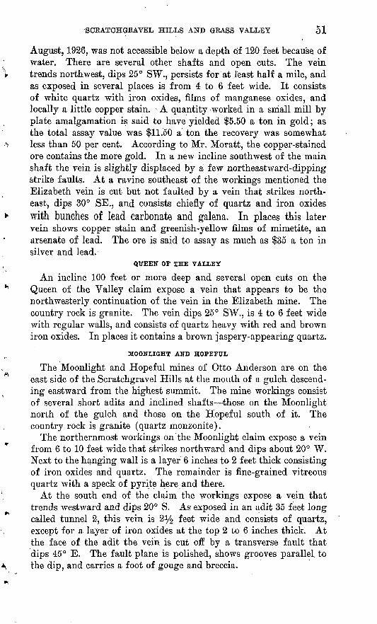
SCRATCHGRAVEL HILLS AND GRASS VALLEY 51
August, 1926, was not accessible below a depth of 120 feet because of water. There are several other shafts and open cuts. The vein trends northwest, dips 25° SW., persists for at least half a mile, and as exposed in several places is from 4 to 6 feet wide. It consists of white quartz with iron oxides, films of manganese oxides, and locally a little copper stain. > A quantity worked in a small mill by plate amalgamation is said to have yielded $5.50 a ton in gold; as the total assay value was $11.50 a ton the recovery was somewhat less than 50 per cent. According to Mr. Moratt, the copper-stained ore contains the more gold. In a new incline southwest of the main shaft the vein is slightly displaced by a few northeastward-dipping strike faults. At a ravine southeast of the workings mentioned the Elizabeth vein is cut but not faulted by a vein that strikes north east, dips 30° SB., and consists chiefly of quartz and iron oxides with bunches of lead carbonate and galena. In places this later vein shows copper stain and greenish-yellow films of mimetite, an arsenate of lead. The ore is said to assay as much as $35 a ton in silver and lead.
QUEEN OF THE VALLEY
An incline 100 feet or more deep and several open cuts on the Queen of the Valley claim expose a vein that appears to be the northwesterly continuation of the vein in the Elizabeth mine. The country rock is granite. The vein dips 25° SW., is 4 to 6 feet wide with regular walls, and consists of quartz heavy with red and brown iron oxides. In places it contains a brown jaspery-appearing quartz.
MOONLIGHT AND HOPEFUL
The Moonlight and Hopeful mines of Otto Anderson are on the east side of the Scratchgravel Hills at the mouth of a gulch descend ing eastward from the highest summit. The mine workings consist of several short adits and inclined shafts those on the Moonlight north of the gulch and those on the Hopeful south of it. The country rock is granite (quartz monzonite).
The northernmost workings on the Moonlight claim expose a vein from 6 to 10 feet wide that strikes northward and dips about 20° W. Next to the hanging wall is a layer 6 inches to 2 feet thick consisting of iron oxides and quartz. The remainder is fine-grained vitreous quartz with a speck of pyrite here and there.
At the south end of the claim the workings expose a vein that trends westward and dips 20° S. As exposed in an adit 35 feet long called tunnel 2, this vein is 2% feet wide and consists of quartz, except for a layer of iron oxides at the top 2 to 6 inches thick. At the face of the adit the vein is cut off by a transverse fault that dips 45° E. The fault plane is polished, shows grooves parallel, to the dip, and carries a foot of gouge and breccia.
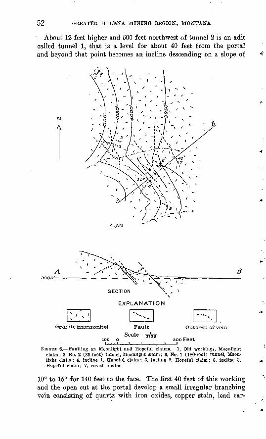
52 GEEATEE HELENA MINING EEGION, MONTANA
About 12 feet higher and 500 feet northwest of tunnel 2 is an adit called tunnel 1, that is a level for about 40 feet from the portal and beyond that point becomes an incline descending on a slope of
N
A
PLAN
EXPLANATION
Granite (monzonite)
100
Outcrop of vein
500 Feet
FIGOBE 6. Faulting on Moonlight and Hopeful claims. 1, Old workings, Moonlight claim; 2, No. 2 (35-foot) tunnel, Moonlight claim; 3, No. 1 (180-foot) tunnel, Moon light claim; 4, incline 1, Hopeful claim; 5, incline 2, Hopeful claim; 6, incline 3, Hopeful claim; 7, caved incline
10° to 15° for 140 feet to the face. The first 40 feet of this working and the open cut at the portal develop a small irregular branching vein consisting of quartz with iron oxides, copper stain, lead car-

SCRATCHGRAVEL HILLS AND GRASS VALLEY 53
d
bonate, and galena. At 20 feet from the portal this vein is upthrown about 12 feet by the fault shown in tunnel 2, and next to the fault the upthrown part contained a body said to have yielded $10,000 worth of ore valuable chiefly for silver. The vein in tunnel 2 is also upthrown and becomes the vein followed by tunnel 1 beyond the fault. This vein holds a fairly definite course, and in the last 20 feet of the working it swells to a width of 6 feet. It is mostly rather barren-looking quartz but in places shows iron oxides and a little copper stain.
The principal workings on the Hopeful claim are designated inclines 1, 2, 3 (fig. 6). These inclines range from 40 to 150 feet in length and follow a vein that strikes northwest and dips 20°-30° SW. Strike faults that dip east cut the vein and cause its outcrop to be repeated. One of the fault planes shown in in cline 3 strikes N. 70° W. and dips 45° E. It cuts the vein off sharply and is ac companied by a white gouge and breccia of the country rock. An open cut at the mouth of this incline shows the vein down- thrown on the east in short steps by three parallel fault planes that strike about north. A short in cline (not mapped) east of No. 3 shows a fault plane dipping 65° E. and bearing 1 foot of gouge and breccia. Other workings show addi tional faults.
Inclines 1, 2, and 3 show a composite lode 2 to 4 feet or more in width. In incline 1 (fig. Y) the lode consists in part of a separate layer next to the hanging wall that averages 5 or 6 inches in width and is composed of iron oxides with some carbonate of lead and galena. The remainder of the lode is quartz that has been broken and recemented with veinlets of a carbonate near ankerite in composi tion. In incline 2 the composite character of the lode is even more plainly shown (fig. 8). It is made up of an earlier white quartz vein which contains specks of pyrite and is similar to many of the gold-bearing veins elsewhere in the district and a later branching vein characterized by lead and copper minerals and a carbonate of
154419 33 5
5 Feet
FIGURE 7. Composite vein, incline 1, Hopeful claim, a, Oxide ore, " lead vein " ; 6, veinlets of carbonate; c, fragments of quartz and silicifled granite belonging to the " gold vein "; <L, gran ite country rock

54 GREATER HELENA MINING REGION, MONTANA
iron and calcium. A small amount of ore worth $45 a ton is reported mined from this later vein.
In incline 3 the lode is of similar character. The younger vein shows considerable lead carbonate and films of the yellowish-greenarsenate of lead, mimetite.
KATY
The Katy mine is on the east side of the Scratchgravel Hills, near the foot of the slope, about half a mile south of the Hopeful mine. During the last 25 or 30 years it has been worked intermit tently. Its total production is reported by the owner to have ex ceeded $75,000. In 1927 development work was being done by Otto Anderson. The principal working is a crosscut adit 175 feet
' V - ~ x" ' » / -'^ /'^'J^
Feet
FIGURE 8. Composite vein, incline 2, Hopeful claim, o, Ore [ . composed of iron oxides, etc., " lead vein " ; 6, lenticular quartz
bodies containing a few grains of pyrite, " gold vein"; c, granite country rock
long, from which a 50-foot stope extends up the slope of the vein 95 feet to other older workings. As exposed by the crosscut, the lode strikes N. 40° E. and dips 20° SE. It is inclosed in granite and consists of three closely spaced parallel veins separated by altered wall rock, the whole forming a lode that ranges from 4 to 6 feet in width. The veins contain galena, pyrite, and chalcopyrite or their oxidation products, and the ore bodies that were stoped out ranged from a few inches to several feet in thickness.
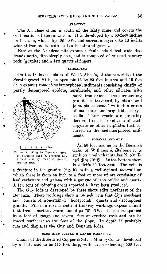
SCEATCHGRAVEL HILLS AND GRASS VALLEY 55
ARIADENE
The Ariadene claim is south of the Katy mine and covers the continuation of the same vein. It is developed by a 60-foot incline on the vein, which dips 25° SW. and carries a layer 6 to 18 inches wide of iron oxides with lead carbonate and galena.
East of the Ariadene pits expose a fault lode 4 feet wide that trends north, dips steeply east, and is composed of crushed country rock (granite) and a few quartz stringers.
IRIDESCENT
On the Iridescent claim of W. P. Abbott, at the east side of the Scratchgravel Hills, an open pit 15 by 20 feet in area and 15 feet deep exposes contact-metamorphosed sediments consisting chiefly of partly decomposed epidote, hornblende, and other silicates with
much iron oxide. The surrounding granite is traversed by shear and joint planes coated with thin crusts of malachite and bright-blue chrys- ocolla. These crusts are probably derived from the oxidation of chal- copyrite or other sulphides that oc curred in the metamorphosed sedi ments.
BONANZA AND OTIY
^n 80-f oot incline on the Bonanzao . z 3 + s Feet r, ' 'n \T .' I1 1 claim of Williams & Steltemeier isFIGURE 9. Vein in Bonanza mine. .
a, Sulphide ore; 6, crushed and Sunk on a Vein that strikes N. 50° E.altered country rock ; c, granite an£ <jips 70° g. At the bottom there country rock . ^ -p, A r\ £ j. j. rro.is a drift 40 feet east. The vein is
a fracture in the granite (fig. 9), with a well-defined footwall on which there is from an inch to a foot or more of ore consisting of lead carbonate and galena with a gangue of iron oxides and quartz A few tons of shipping ore is reported to have been produced.
The Guy lode is developed by three short adits northeast of the Bonanza. These workings show a 14-inch vein that dips southeast and consists of iron-stained " honeycomb " quartz and decomposed granite. Pits in a ravine south of the Guy workings expose a fault that trends northeastward and dips 70° NW. It is accompanied by a foot of gouge and several feet of crushed rock and can be traced northeast to the foot of the slope. In depth it probably cuts and displaces the Guy and Bonanza lodes.
BLUE BIRD COFFER & SILVER MINING CO.
Claims of the Blue Bird Copper & Silver Mining Co. are developed by a shaft said to be 175 feet deep, with levels extending 500 feet
56 GREATER HELENA MINING REGION, MONTANA
north and 200 feet south. These workings were not accessible at the time of the writer's visit. South of the shaft, open pits show a vein 1 to 2 feet wide that dips 35° NE. and consists, of quartz with iron and manganese oxide stains. North of the shaft, open cuts and a 20-foot incline expose several quartz stringers in the granite, some of which show copper stains and films of mimetite. Along one of these stringers a pocket containing several tons of rich lead- silver ore is said to have been mined.
SILVER-COPPER MINING CO.
A hoist at the shaft of the Silver-Copper Mining Co. is a con spicuous object on the southeast side of the Scratchgravel Hills 100 feet above the foot of the slope. The shaft was not accessible in 1927. It is said to be 500 feet deep. The dump contains a few tons of brown-weathering carbonate, ankerite, such as commonly occurs in veins of the lead-silver type in the neighboring areas.
AJAX
The Ajax mine of the Scratch Gravel Mining Corporation includes two inclines, 60 feet and 100 feet or more deep, on a lode that strikes east and dips 30°-40° S. In the 60-foot incline the lode is from1 to 2 feet wide and composed chiefly of quartz with iron oxides. In the deeper incline the lode is 5 feet or more wide and consists of2 to 6 inches of iron-stained quartz on the hanging wall, 1 to 2 feet of similar material on the footwall, and decomposed granite between.
Smelter records on 62 tons of ore shipped from the Ajax mine show gross returns at the rate of about $10 a ton, chiefly in gold. The ore contained 1.1 ounces of silver to a ton, and one lot showed 1.1 per cent of copper.
JTTLIA
The Julia mine, in the southern part of the Scratchgravel Hills is reported to have produced a moderate amount of ore containing lead, silver, and gold. The mine was idle and the underground workings filled with water in 1927. An open pit west of the main shaft shows a vein that strikes N. 75° E. and dips 35° N. It cuts granite, is 3 feet or more wide, and consists of iron-stained quartz and altered granite. Ore from a bin at the inclined shaft shows a little copper stain and noteworthy amounts of a yellow lead-arsenic mineral that is probably mimetite.
LEXINGTON
The Lexington mine is said to have produced prior to 1880 $250,000 worth of ore valuable for silver, lead, and gold, some of which was rich enough to stand transportation to Swansea, Wales. Since 1880 the mine has been closed. In 1927 the workings were
SCEATCHGBAVEL HILLS AND GBASS VALLEY 57
closed by caving, except those near the surface. The size of the dumps indicates that the underground workings were rather exten sive. A series of pits representing caved stopes extends for 500 feet along a northeast course. At the east end a fault is exposed that strikes N. 50°. E"., dips 60° NW., and carries 4 feet of crushed and partly decomposed granite. The fault cuts obliquely across a flat lenslike body 2 feet thick that trends east to northeast, dips 40° N., and consists chiefly of garnet-hornblende rock with more or less green copper carbonate. This body lies in the plane of a lode that is fol lowed by the workings, so far as they could be seen. It is cut by a small quartz vein of the type valuable chiefly for gold in the sur rounding region, which strikes east and dips 30° S. Farther west on the course of the lode workings on the Flynn claim expose a 4-foot vein having the same strike and dip as the small vein. This1 4-foot vein consists of crushed and decomposed granite, quartz, and iron oxides, with noteworthy amounts of manganese oxides. Apparently three successive deposits occurred here a metamorphic body, which was the oldest, followed by a gold-quartz vein, and that in turn by a silver-lead vein, which was developed in a fissure parallel to the metamorphic body.
HELENA, ROCK HOSE, AND LOOBYo
The Helena, Kock Rose (Dandy), and Looby mines, the property of the Cruse Consolidated Mining Co., are a short distance north west of Fort Harrison, in an area known as the Grass Valley district. They have been operated at times in the past 30 years and have produced a total of more than $118,000 in lead, silver, and gold. The bulk of this production came from the Helena. The mines were closed and not accessible to examination in 1927.
The area surrounding these mines is low and nearly flat and is underlain chiefly by the Empire shale, which at short distances to the north and south is invaded by granite (quartz monzonite). As shown by the mine maps, a lode that strikes N. 20° W. and dips steeply east passes through the Helena and Looby claims. The Rock Rose shaft is farther east, on a lode that is indicated to strike north west. The workings on the Helena claim include a shaft 451 feet deep with drifts at different levels aggregating about 2,000 feet. Smelter returns in the possession of J. J. Cruse, president, and F. C. Fay, manager of the company, show that ore was shipped from the Helena mine in the periods 1899-1901, 1904-1908, 1915-1918, and 1921, to an aggregate amount of 3,860 tons. Its approximate aver age content was 0.29 ounce of gold, and 14.34 ounces of silver to the ton and 13 to 14 per cent of lead. The later shipments, which presum ably came from the deeper and unoxidized parts of the lode, show a constant silver to lead ratio of 1.1 ounce to 1 per cent respectively.
58 GREATER HELENA MINING REGION, MONTANA
The gold value of the ore in general shows little variation. The amount of iron present is generally from 25 to 35 per cent or more enough to reduce the smelter rate. Insoluble matter, presumably silica, ranged from 30 per cent or more in the earlier shipments down to 20 per cent or less in the later ones. Generally the shipments contained 2 or 3 per cent of zinc, exceptionally as much as 7 per cent.
Shipments from the Kock Rose mine aggregating 403 tons were made mostly in 1908-9 and 1917-18. They show an average content of 0.11 ounce of gold and 24 ounces of silver to the ton and 18.5 per cent of lead. There is a constant silver-lead ratio of 1 to 1.2, and the gold value is variable. One sample showed 6 per cent of zinc.
Shipments from the Looby mine in 1895 and in 1916-1918 aggre gating 310 tons contained an average of 0.15 ounce of gold and 0.125 ounce of silver to the ton and 12 per cent of lead. From 4 to 10 per cent of zinc was present in most of the shipments.
SILVER COINThe Silver Coin mine, 1 mile west of Fort Harrison, has produced
a considerable amount of rich silver ore. It was operated in 1928 by Tony Maras under a lease from Owen Byrnes and others. The workings are near the top of a hill- and include two tunnels that, together with drifts and crosscuts, have an aggregate length5 of 400 feet or more. These workings explore a body of Helena limestone that is invaded by a stock of quartz monzonite. The limestone is changed by contact metamorphism to a hard, tough gray banded hornstone in which the bands represent the bedding. The pitch and strike of the banding changes abruptly from place to place as a re sult of dislocations that accompanied the invasion of the monzonite. The ore bodies are parts of certain layers of the hornstone that usu ally show a little copper stain but otherwise do not, as a rule, differ much in appearance from the barren parts of the rock. The follow ing minerals were identified in the ore by W. T. Schaller: Argen- tite, cerargyrite (horn silver), cerusite, cuprodescloizite (a vanadate of lead and zinc containing also copper and arsenic), azurite, and a yellow stain containing antimony, probably stibiconite. Chalce- donic quartz occurs in cavities, and thin films of manganese oxides are deposited in seams. In places there are seams and bunches of coarsely crystalline calcite. Fracture planes in the monzonite ex posed in the lower of the two tunnels are coated yellow with non- tronite, a hydrated silicate of iron. Probably all these minerals are secondary forms derived from the original minerals in the general process of oxidation.
The ore bodies are irregular and indefinitely bounded. Reported assays of samples run as high as 1,000 ounces or more in silver to a ton.
GREATER HELENA MINING REGION, MONTANA 59
AUSTIN DISTRICT
GEOGRAPHY AND GEOLOGY
The Austin district occupies an area of about a township lying east of the Continental Divide and surrounding Austin, a small town on the Northern Pacific Kailway 10 miles northwest of Helena. The surface is mountainous, some of it is rugged, and the altitude ranges from about 4,500 feet on the east to 6,500 feet at the divide. Nearly all the mines, however, are easy of access. Most of the area is drained by Sevenmile Creek.
The district is underlain chiefly by shales and limestones composing the upper part of the Belt series; quartzite, shale, and limestone of Cambrian and Devonian age; and the Madison limestone, of early Mississipian age. All these formations are intruded and extensively metamorphosed by the quartz monzonite of the Boulder batholith. In places, as at the Blue Jay mine, they are also intruded by a basic andesite.
PRODUCTION
Placer deposits along Sevenmile Creek and its tributaries have been mined to an aggregate length of 12 miles or more. Records of placer production are not available, but from the extent and reported rich ness of the deposits it is estimated that the total yield of placer gold was at least $1,200,000.
ORE DEPOSITS
The district contains a score or more of lode mines that have been worked at times, mostly since 1880, and are reported to have yielded a total of $300,000 in silver, copper, lead, and gold. Most of the ore produced has had an added value for fluxing because of its high content of iron. The lodes are mainly irregular pockets or pipelike bodies of different sizes found in limestone near the contact of intru sive quartz monzonite. Their chief constituents are the iron oxides, limonite and hematite. Nearly all contain a little gold. Silver-bear ing galena or its oxidation product cerusite, chrysocolla, and the cop per carbonates, malachite and azurite, are present in most of them. One deposit contains the unusual mineral corkite, a hydrous sulpho- phosphate of lead and iron containing arsenic. Corkite belongs to a group of minerals that includes alunite and beudantite.41 In Beaver County, Utah, it has resulted from the alteration of ore con taining pyrite, galena, sphalerite, chalcopyrite, and apatite.*2 Few of the deposits could be observed below the oxidized zone. In one of them pyrite, arsenopyrite, and stibnite were identified. The presence of tetrahedrite is reported in the lower workings of
« Schaller, W. T., Mineralogical notes, series 2 : U. S. Geol. Survey Bull. 509, pp. 70-76, 1912.
42 Butler, B. S., and Schaller, W>. T., Some minerals from Beaver County, Utah; Am. Jour. Sci.. 4th ser.. vol. 32, p. 423. 1911.
60 GEEATEE HELENA MINING EEGION, MONTANA
some of the lodes. The gangue minerals are quartz and calcite, of which the quartz is rather scarce. Part of the iron oxides seems to have been derived from the oxidation of pyrite and chalcopyrite; the remainder was probably derived from pyrrhotite or originally deposited as hematite and magnetite.
Large parts of the lodes consist of a low-grade ore valuable chiefly for gold, silver, and iron. The iron is suitable for fluxing. Com paratively small chambers or chimneys contain rich silver-lead ore, and some bodies are valuable for copper.
The lodes are of a type generally regarded as derived from intru sive bodies such as the quartz monzonite. They were deposited by solutions that migrated a distance from the intrusive body into the surrounding rocks, where the temperature was lower than at the contact. Their forms are characteristically irregular, and apparently the only guide to the discovery of new bodies is the fact that they have selectively replaced limestone.
Mining conditions and lode composition are both favorable to the profitable working of these low-grade deposits, and a large amount of ore probably remains to be found.
Besides the mines described below, the district includes the Fannie Parnell, Christiana, Benson-Poad, Ted Swan, London, and Scallon- Vinson, concerning which no information was obtained.
MINES AND PROSPECTS
WAR EAGLE
The War Eagle mine, owned by the R. S. Hale estate, is nearly 2 miles east of Austin, at a point just south of the public highway and the Northern Pacific Railway. It is on a lode in crystalline Madison limestone at the contact with intrusive fine-grained quartz monzonite. The main working is a shaft said to be 400 feet deep but not accessible at the time of the writer's visit. Between 1898 and 1900 this mine is reported to have produced and shipped to the East Helena smelter 75,000 tons of ore that, because of its high content of iron, was valuable mainly for fluxing. Below the 300- foot level the lode is said to have a width of 12 feet, 4 feet of which carries more or less argentiferous galena, the remainder- being iron ore that contains a little silver.
BLUE JAYThe Blue Jay mine, formerly the Red Bird, about 3 miles north of
Austin, has produced $300,000 in copper, silver, and lead, including iron that was valuable for fluxing. It was discovered in 1900 by Richard Punch and son, and the bulk of its production was made in the next three years. Since 1903 the mine has been worked inter mittently. Its present owners are Swan Bros. The ore occurs

AUSTIN DISTRICT 61
in a limestone bed, a so-called vein, of the Belt series that lies at the contact of intrusive andesite and is near a body of quartz monzonite. The ore-bearing bed dips 35°-50° W. and pitches to the south. It is developed by a 350-foot inclined shaft and openings at the sur face distributed along the outcrop for the distance, of one-eighth of a mile, in which the vertical range is 200 feet. Most of the ore pro duced occurred in large, irregular chambers or pipes found at depths of 100 to 200 feet. The ore is generally mottled and in appearance resembles copper pitch ore. It is composed mostly of hematite and limonite with more or less chrysocolla, cerusite, azurite, and mala chite. Chalcocite and manganese oxides were observed in places. The gangue includes quartz, calcite, and other minerals, which prob ably represent unreplaced parts of the country rock. Tetrahedrite is reported to be present. Some of the ore is brecciated, and some that is siliceous and porous gives evidence that pyrite, chalcopyrite, and galena were once present but have weathered out.
Study of polished sections of the ore shows it to consist chiefly of limonite with subordinate amounts of malachite and azurite in veinlets cutting the limonite. Some remnants of pyrite have sur vived the oxidizing process, and in places there are small areas of supergene chalcocite. The only hypogene mineral recognized is pyrite. Quartz and other gangue minerals are notably absent.
COFFER HILL
The Copper Hill mine of J. W. S. Corr is a mile north of Austin, within the area nearly inclosed by a bend of the Northern Pacific Railway. In the period 1910-1912 it produced $3,000 or more, and in 1930 it was being worked on a small scale. The ore produced ran $10 to the ton and was valuable principally for silver and secondarily for iron and gold. The principal mine workings are two adit levels, and in addition the lode is penetrated by a Northern Pacific Railway tunnel.
The lode is in Madison limestone at the contact with intrusive quartz monzonite. It consists mostly of hematite with a little pyrite and a red iron-stained calcite-quartz gangue. In places black manga nese oxide stains are conspicuous.
The ore appears to be sporadically distributed through a vertical range of more than 100 feet and a horizontal distance of about a quarter of a mile.
OSAGE CHIEF
The Osage Chief or Crissman mine of J. W. S. Corr is south of the Copper Hill mine, described above, to which it is geologically and mineralogically similar. Between 1910 and 1912 it produced $10,000 worth of gold-copper-iron ore that ran $20 to the ton. The

62 GREATER. HELENA MINING REGION, MONTANA
deposit was worked through a large open cut and a short inclined shaft, and all the ore produced is said to have been found within20 feet of the surface.
KING TUTThe King Tut mine of Leslie Lyle is iy2 miles northeast of Austin
and about a quarter of a mile east of the Northern Pacific Railway loop. It was discovered about 1880 or earlier, when a good ore body was disclosed by a shaft. Subsequently the lode was developed by a crosscut tunnel 200 feet long, from the face of which a winze was sunk 150 feet on a 45° slope. In 1926-27 the mine produced 2,000 tons of silver-lead ore that yielded a net return of $14,000. The lode is in Cambrian limestone and is closely associated with a small dike of quartz monzonite. The ore occurs in irregular pipes or chimneys, one of which as exposed near the bottom of the winze is 2 feet wide and 5 or 6 feet in stope length. To a depth of 40 feet the ore con sists mostly of carbonates. Below that depth it contains pyrite, galena, sphalerite, arsenopyrite, and stibnite. A shipment of ore from the bottom of the winze carried 40 per cent of lead and 120 ounces of silver to the ton.
BALDY SMITH
A mine owned by " Baldy " Smith, of Austin, is 214 miles north- northeast of the town at an altitude of 5,300 feet. The country rocks are Cambrian quartzite and Cretaceous or later andesite.
The lode deposit occurs in the quartzite and consists of a mineral ized zone several feet wide formed along a joint plane that strikes N. 20° E. and dips 45° W. It is opened by several pits and a short crosscut adit with drifts a few feet long.
The ore consists of irregular parallel bands and streaks a quarter of an inch to an inch or more wide of crushed quartzite and gray argillaceous material. The quartzite is stained yellowish brown and dark reddish brown with limonite and hematite. The argillaceous material contains very fine grained disseminated pyrite and sericite. In places the ore is black with manganese oxides. In addition a soft greenish-yellow mineral occurs in fractures and small cavities in the lode and stains much of the adjacent quartzite. Analysis of this mineral by W. T. Schaller proved it to be corkite. (See p. 59.)
PLACERS
The placer deposits in the district are said to have been very productive in the early days, Sevenmile Creek almost throughout its length being noted for- its rich gravel. Considerable workable ground is said to still remain in the Greenhorn placer of Mrs. R. L. Tostevin, which is on Sevenmile Creek at the Northern Pacific Railway bridge 2% miles northwest of Austin.

GEEATER HELENA MINING EEGION, MONTANA 63
MARYSVILLE DISTBICT
HISTORY AND PRODUCTION
Lode mining in the Marysville district closely followed the ex ploitation of the rich placer deposits of Silver Creek. In 1876 Thomas Cruse discovered the famous Drumlummon lode, which has yielded nearly $16,000,000. Other richly productive mines were the Bald Butte, Belmont, Cruse, Penobscot, Empire, and Piegan-Gloster. The total production of the district is about $31,000,000 in gold and silver. In the last 15 years mining on a comparatively small scale has been done on the Drumlummon, Calumet, Staples, O'Connell, Piegan-Gloster, M. and L., American Flag, and others. Deposits of tailings, which extend from the Drumlummon mill for many miles down Silver Creek, are being reworked at points near the mill and 3y2 miles below, with a reported recovery of about $5 to the ton. Since 1924 the Drumlummon mine has been operated by its owner, the St. Louis Mining & Milling Co., and has produced more than $500,000 in gold and silver.
A small area (pi. 5) drained by Towsley Gulch in the western part of the Marysville mining district contains several mines not mentioned in previous reports. The largest of these, the Bell Boy, has been worked at times since 1888 and has produced $500,000 or more, chiefly in gold. Production is also reported from the Nile, Towsley, Earthquake, and other mines. Lead ore occurs in several of the mines, some of which have produced small amounts. In 1926 ore from the Bell Boy mine was being treated at the Empire mill, to which it was hauled by autotruck, a distance of about 2 miles. Ore rich in galena was being produced in the course of development work at the Earthquake mine.
GEOGRAPHY AND GEOLOGY
The Marysville district is an indefinitely bounded area of 15 or 20 square miles that includes Marysville, Bald Butte, and other for merly active camps. The surface is strongly mountainous but is characterized by long sweeping slopes rather than rugged forms. Most of it is drained northward by tributaries of Little Prickly Pear Creek; the remainder is drained eastward by Silver Creek, which enters the Missouri River northeast of Helena.
Marysville and the mines in its vicinity (pi. 6, A) are reached from Helena by an excellent automobile road. The nearest rail road shipping point is Silver, on the Great Northern Railway, 6 miles from Marysville. At one time Marysville was served by two branch railroads, one from Silver and the other from a point on the Northern Pacific Railway west of Helena. Both branches were dismantled several years ago.

64 GREATER HELENA MINING REGION, MONTANA
Mines in Towsley Gulch and elsewhere in the western and north ern parts of the district are best reached by a roundabout but good automobile road that passes east and north of the mountains, fol lowing the valley of Little Prickly Pear Creek. From Silver station the distance to Towsley Gulch by this road is 21 miles. A shorter route crosses the ridge south of Mount Belmont to Marysville and thence to Silver, but the first part of this route is rather steep.
The rocks of the Marysville district include a small central stock of quartz diorite that has intruded limestone and shale of the Belt series, and in a surrounding zone from one-half to 2 miles wide has metamorphosed them to hard, dense rocks, locally called slates. These rocks are composed mainly of silicates such as diopside, wollastonite, tremolite, and biotite, but the rocks are so fine grained that the minerals as a rule are not visible to the eye. . The quartz diorite is a medium-grained granitic rock composed essentially of andesine, quartz, orthoclase, biotite, and hornblende. Younger than the quartz diorite are aplite, pegmatite, and diorite porphyry dikes, some of which seem to represent the after effects of the quartz diorite intrusion.
Barrell studied the Marysville district in 1901, and the following description of the rocks is condensed from his report.43 In addition to the matter given below the report considers the igneous intrusions and the resulting contact metamorphism in great detail and is in fact an outstanding treatise on those subjects.
The oldest visible rocks are gray sandstones and shales of the Greyson formation, of which the upper 500 feet may be exposed. The red shales and sandstones of the Spokane appear in the north east corner of the district. Their thickness has been estimated as 1,500 feet. Above these are the greenish Empire shale, which was estimated by Walcott as 600 feet thick but may be considerably thicker, and the buff to blue Helena limestone, which, as measured in Sawmill Gulch, is 4,500 feet thick. In the southeast corner deep- red Marsh shale, estimated to be 1,000 feet thick, lies above the Helena limestone. Just outside the district the Marsh shale uncon- formably underlies the Middle Cambrian (Flathead) quartzite.
Patches of Tertiary river gravel as much as 500 feet thick compose the Gravel Kange north of Little Prickly Pear Creek. This is a superficial formation of sand, gravel, and boulders of fluviatile origin. It rests upon Spokane shale and extrusive andesite, and the andesite had been extensively eroded before the gravel was deposited. The material includes boulders of pink Cambrian quartzite as much as 3 feet in diameter, the nearest outcrops of which are on the Conti-
48 Barrell, Joseph, Geology of the Marysville mining district, Mont. a study of igneous Intrusion and contact metamorphism : U. S. Geol. Survey Prof. Paper. 57, 1907.
MAKYSVILLE DISTRICT 65
nental Divide 10 miles to the west. Patches of hard conglomerate that form the summit of a hill about 500 feet high are regarded as silicified lower parts of the gravel. The silicification was caused by solutions that rose through fissures in the underlying rock and permeated the lower stratum of the gravel.
The andesite and other rocks beneath the gravel contain a few quartz veins that continue up a short distance into the gravel, where they spread out and disappear. These veins are representatives of the later of two distinct epochs of fracturing and vein filling.
The igneous rocks are, in order of age beginning with the oldest, dikes of microdiorite, intrusive bodies of gabbro, porphyry dikes and sheets, a quartz diorite stock, aplite, pegmatite, basic dikes, and lavas.
The microdiorite dikes occur in greatest abundance in the neigh borhood of Bald Butte, where they intrude the Empire shale and the Helena limestone. They are commonly from 300 to 1,000 feet long and from 10 to 50 feet thick. Their age is not definitely shown, but they are thought to be probably late Cretaceous or early Tertiary.
Irregular bodies ,of gabbro that occupy areas from 500 to 1,000 feet in width intrude the Greyson and Spokane shales in the north' ern part of the district. The age of these bodies is not definitely shown, but there are petrographic transitions between the gabbro and some of the microdiorite dikes.
Dikes showing phenocrysts of feldspar occur in the southern and western parts of the district, where they break through the Belt rocks. A group described as the Belmont porphyry dikes are ob served to cut sheets of the microdiorite. The Belmont dikes are closely related to the diorite stock mentioned below but are not simultaneous in origin with it. Whether they are older or younger is not definitely shown. Another group called the Drumlummon porphyry dikes are of no great size and are found within the Drum lummon mine. One of these dikes occurs within the granitic stock and is therefore younger than the stock. Another is cut by the Drumlummon vein.
A stock of quartz diorite called the Marysville batholith is an irregular intrusive mass 3 miles long and from y2 to 1% miles wide at the surface. It lies in the central part of the district, and its contact relations show it to broaden downward in irregular pyramidal form. For that reason, and because the two bodies are somewhat similar in composition and only 6 miles apart, the Marys ville stock and the Boulder batholith are thought to be united underground.
Small dikes of basalt younger than the batholith occur at Marys ville. Glassy pyroxene andesite forms a low hill on the east side
66 GEEATEE HELENA MINING EEGION, MONTANA
of the district near Old Stage Station, and patches of altered, bleached, or silicified lava of intermediate or basic nature occur in the northern part of the district.
The Marysville district is on the southwest side of wh'at has been called the Prickly Pear dome. As shown by Walcott, the valley of Prickly Pear Creek is occupied by a broad oval exposure of the Belt group. Around it are upturned Paleozoic and Mesozoic beds. Over the present valley of the creek erosion has turned what was originally the summit of the dome into a wide basin. Although the broad relations show that the Marysville district lies on the south western slope of the domal uplift, there is nothing in the district that would render this evident. On the contrary, the dips of the strata, instead of being southwesterly, are on the whole toward the east. In this district the relative uplift of the Belt rocks toward the northeast was due to faulting rather than simple domal folding. Before the batholith came to place a considerable relative uplift occurred on the north side of an east-west fracture that crosses the northern part of the district. Another early fault that crosses the southwestern part of the district caused an uplift of 3,600 feet, also on the north. Smaller and somewhat obscure block faults on which the side toward the batholith has been raised are thought to have immediately preceded the igneous invasion and to have been caused by the upward pressure of the granitic mass. The attitude of the strata indicates the beds to have been domed by the invading granite to the extent of 1,000 to 3,000 feet.
The vein fractures are situated in the marginal part of the batho lith and in the surrounding metamorphic zone. They stand either approximately parallel or at high angles to the contact surface and are thought to be contraction effects on the margin of the coolinggranite mass. Faults later than the vein fractures occur in the mines. Other mineralized or ore-bearing faults and fissures include silicified breccias and quartz veins north of Little Prickly Pear Creek that are younger than the Tertiary stream gravel.
Among the results of the study of the contact zone is the conclu sion that the depth to the granite was comparatively shallow at the time of the intrusion. The igneous mass appears to have come to place after the erogenic structure had been attained and the bulk of the subsequent erosion had been completed. Only a few thousand feet of postbatholithic erosion was needed to expose it in its present aspect.
Evidence as to the methods of intrusion of the Marysville and Boulder batholiths shows that both of these igneous bodies made room for themselves chiefly by the process of stoping.

MARYSVILLE DISTEICT 67
ORE DEPOSITS
GENERAL CHARACTER
The ore deposits, except those in Towsley Gulch and some other outlying parts of the district, have been described by Weed 44 and Knopf.45 Owing to the fact that practically no development work has been done since 1911, there is little to add to Knopf's description of the mines near Marysville, which is abstracted below. These deposits are steeply dipping fissure veins carrying gold and silver that occur in the metamorphic hornstones around the quartz diorite body and in the quartz diorite itself.
The veins average about 1,000 feet in length and 4 or 5 feet in thickness, but the Drumlummon vein, which is the largest, has been developed for 3,000 feet along the strike and attains a maximum width of 40 feet, although its average width is probably about 6 feet.
The ore in all the veins occurs in shoots. High-grade ore was found above the 200-foot level, but in depth the ore rapidly decreases in value until the vein is no longer workable. None of the veins in the district except the Drumlummon, which is opened to the depth of 1,600 feet, is developed more than 500 feet below the surface. Gold is the predominantly valuable metal, and the ore averages between $10 and $20 to the ton.
The gold is finely divided and not usually visible. In the ore of many mines, notably the Belmont and Empire, sulphides are absent or occur in insignificant quantities only. In the Drumlummon the gold is accompanied mainly by tetrahedrite and chalcopyrite, and in the Bald Butte by pyrite, sphalerite, and galena. The gangue, of highly characteristic composition and structure, consists of quartz, commonly of platy habit, and calcite in broad, thin plates. The calcite carries some iron and manganese, and in consequence the outcrops of some of the veins are highly manganiferous.
The lodes in Towsley Gulch are not included in Knopf's descrip tion. These bodies occupy fractures in the metamorphosed Empire shale, and most of them strike about N. TO0 E. They range from 5 or 6 feet to 20 feet or more in width, are continuous along the strike for as much as half a mile, and do not show any signs of pinching out at depths of a few hundred feet, the limit of the present development workings.
As indicated by abundant fragments of the country ro,ck within them, the veins were formed in fractures in which grinding move ments occurred between the walls. After the vein minerals had been introduced, further movements in the Bell Boy vein produced a
14 Weed, W. H., Gold mines of the Marysville district, Mont.: U. S. Geol. Survey Bull. 213, pp. 88-89, 1903.
46 Knopf, Adolph, op. cit., pp. 61-76.
68 GREATER HELENA MINING REGION, MONTANA
streak of gouge and crushed rock and in places reopened the cemented breccia and caused the development of some remarkable bodies that resemble a conglomerate with founded cobbles. Parts of the veins that are rich enough to be workable form irregular streaks, bunches, and shoots of various sizes. In the Bell Boy mine ore shoots average 3 or 4 feet in width and are at least 200 or 300 feet in stope length and pitch length. They yield ore that contains from $10 to $50 in gold and a few ounces of silver to the ton and from 8 to 30 per cent of lead.
As already indicated, brecciated wall rock forms the bulk of the vein filling. The fragments are cemented chiefly with fluorite, ceru- site, iron oxides, calamine, and green and blue carbonates of copper. In places there are remnants of unoxidized sulphides, chiefly galena and chalcopyrite, of which the galena is the younger and has replaced part of the chalcopyrite. Fluorite appears to have been one of the first minerals introduced. The carbonates and oxides and the cala mine are secondary minerals due toi oxidation of the vein. In the Bell Boy mine the ore breccia grades into a conglomeratic phase, composed chiefly of rounded bodies that look much like stream cob bles. They consist of a nucleus of one or more fragments of country rock cemented with the vein minerals mentioned and encased in a smooth greenish-gray shell of biotite and chlorite.
The vein fissures of other parts of the Marysville district are re^ garded by Barrell 46 as due to the cooling and contraction of the rocks that had been heated by the intrusive granitic mass, some of the cracks produced being parallel to the contact and some more or less radial to the intrusive body. Barrell further concludes that the vein minerals, particularly the fluorite found in the Bald Butte mine, were derived from solutions given off by the granite as it cooled and consolidated. Knopf,47 on the other hand, regards the veins, except possibly the Bald Butte vein, as more probably due to fracturing of the rocks under light load at a later date than the intrusion of the granite. Like the Bald Butte vein, the Towsley Gulch deposits con tain fluorite and, with one exception noted farther on, are without the lamellar calcite-quartz gangue that characterizes most other de posits in the district. It is not unlikely that the Bald Butte and Towsley Gulch veins are of a somewhat earlier date than the group represented by the Belmont and Drumlummon mines, this view be ing supported by the occurrence in the Bell Boy mine of a vein of lamellar calcite and quartz which appears to be younger than the other parts of the lode.
The occurrence of earlier and later vein minerals was observed only in the Bell Boy vein, but it is probably to be looked for in
48 Barrell, Joseph, op. cit., p. 105. " Knopf, Adolph, op. cit., pp. 65-68.

U. 8. GEOLOGICAL SUEVEY
EXPLANATION
BULLETIN 842 PLATE 5
R. 6 W
Outcrop of veinQuartz diorite
Con tact -metamor- phic zone
Mining claimStrike and dip
-xMine or prospect
Mt Beimont**. - . ..,!/.
/. ( .'X BELMONT DKUMLUMMON
\
GEOLOGIC MAP OF TOWSLEY GULCH AND ADJOI1TING PART OF MARYSVILLE DISTRICTGeology from Bairell.
Mines and prospects: 1, Bell Boy; 2, Towsley; 3, Nile; 4, Shakopee; 5, Mammoth; 6, Earthquake; 7, M & L; 8, American Flag.
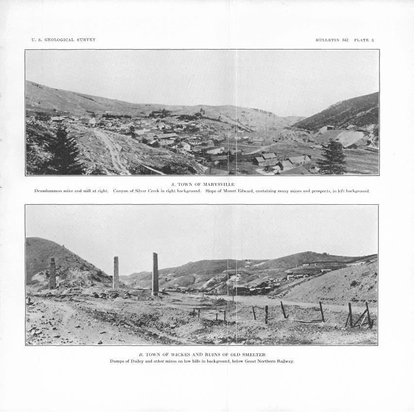
TJ. S. GEOLOGICAL SURVEY BULLETIN 842 PLATE 6
A. TOWN OF MARYSVILLE
Drumlurnmon mine and mill at right. Canyon of Silver Creek in right background. Slope of Mount Edward, containing many mines and prospects, in left background.
B. TOWN OF WICKES AND RUINS OF OLD SMELTER
Dumps of Dailey and other mines on low hills in background, below Great Northern Railway.
.... . MAEYSVILLE DISTRICT 69
the other veins near by. The earlier mineralization produced galena and other sulphides. The later is represented by platy cal- cite and quartz and therefore is.doubtless to be correlated with the principal deposits near Marysville' described by Knopf. Between the two periods the vein -was reopened and rather thoroughly crushed. The older deposit, at least, may be plausibly regarded as related to the intrusion of the granitic stock.
Most of the veins are large enough to be economically worked. Those in. Towsley Gulch contain ore running from $10 to $50 a ton in gold or in lead, zinc, and silver. Ore developed in the lodes near Marysville during the last decade commonly ranges from $10 to $20 a ton in gold and silver. Ore of still lower grade can be mined under exceptionally favorable conditions.
CONCLUSIONSFrom available information it appears that in all the mines near
Marysville except the Drumlummon the ore gave out 500 feet or less below the surface. A ready explanation of this fact does not appear. In these veins little or no development work has been done below the levels at which the ore bodies ended, and but little detailed information of the veins at those levels is available. Possibly, as suggested by the occurrence of manganese oxides in the upper parts, gold may.have been dissolved and carried down to form undiscovered shoots in some of the veins below the barren levels. Other veins may contain primary ore rich enough to work. Appar ently, however, these questions can be answered only by drilling or other exploratory work. In view of the production from their upper parts a moderate amount expended in deeper exploration would be justified.
So far as they have been developed the Towsley Gulch lodes show no signs of pinching out or becoming impoverished. Their width and horizontal dimensions are such that they may be expected to continue in depth considerably farther than the limits of the present comparatively shallow workings.
MINES AND PROSPECTS
DKTTMLUMMON
At present the Drumlummon mine is being worked on a small scale with encouraging results on the Transcontinental or 9-Hour vein on the 300-foot level and just above the 400-foot level and on the North Star vein at about 115 feet above and 80 feet north of the Maskelyne tunnel. The North Star vein as seen in the stope shows about 3 feet of ore that is mostly oxidized and contains $15 to the ton in gold and silver. This is mostly quartz with limonite, disseminated pyrite, and tetrahedrite and shows traces of a lamellar structure.
154419 33 6
70 GREATER HELENA MINING REGION, MONTANA
A specimen of rich ore from the Sampson ore shoot between the 200 A and 400-foot levels contains much visible free gold, nearly all of which is associated with dark seams or streaks of tetrahedrite that lie between different layers of quartz and between quartz and altered wall rock within the vein.
The ore in general is too siliceous for profitable treatment by smelting. A small part can be selected to run about $50 to the ton. Three carloads of such ore were shipped in 1927. One carload contained, in addition to gold, valuable amounts of copper.
CALUMET
The Calumet mine of Henry Rudio and others is half a mile northeast of Marysville in the lower south slope of Edwards Moun tain. Small shipments made from it in 1914 by Isaac Johnson yielded $18 to the ton, nearly all in gold. More recently several carloads were shipped and a quantity of the ore was milled. Con siderable $6 ore lies on the dump.
The principal working is a 1,000-foot crosscut tunnel, which cuts eight veins or leads, mostly small, that dip steeply west or south west and occur in the Helena limestone of the Belt series. The ore consists mostly of platy calcite and quartz stained with iron and manganese oxides and runs from $2 to $20 to the ton in gold. It is crudely banded and in places is porous or honeycombed, owing to the weathering and dissolving out of pyrite, calcite, and other minerals. The most westerly of the veins contains considerable manganeseoxide.
STAPLES
The Staples mine of Henry Rudio is north of the Calumet mine, to which it is geologically and mineralogically similar. It consists of a 500-foot tunnel and two 60-foot shafts, from which severalshipments of ore have been made.
< M. AND L. AND EMPIRE
The M. and L. mine of Owen Byrnes was located and formerly > owned by Mike Lynch, from whose initials the name is derived. It is in the eastward continuation of the well-known Empire vein, which strikes N. 80° W. and dips 70° S. and cuts metamorphosed Empire shale.
The collar of the M. and L. shaft is at an altitude of about 6,480 feet on the upper west steep slope of Mount Belmont. This shaft has two compartments and descends 250 feet on the slope of the vein. A drift 150 feet long is made on the 90-foot level and one 400 feet long on the 250-foot level. These workings are connected ' with the main adit of the Empire mine, which is 480 feet below the <.
MAEYSVILLE DISTRICT 71
collar of the M. and L. shaft. It is proposed to tram the M. and L. ore out through this adit and to treat it in the Empire mill, near by.
The vein is extensively developed in the Empire mine. It ranges from 1 or 2 feet to more than 20 feet in width and averages about 6 feet. Its regularity and persistence are impressively shown by the view from below of a great stope at the west side of the Empire mine that is open to the surface and thus illuminated by daylight. The vein consists mainly of quartz and crushed and altered country rock, all more or less stained brown and green with iron oxides and copper carbonate. Much of it is sugary or friable, and in general it is more or less banded or streaked.
A polished section of the ore from the 120-foot level of the M. and L. mine consists predominantly of quartz with bands of malachite, chrysocolla, and cerusite. The cerusite is unusual in that it exhibits triangular pits, indicating that it is a pseudomorphous replacement of galena.
The Empire ore mined is said to have averaged about $30 to the ton in gold, silver, copper, and lead. In the drifts in the M. and L. mine that extend beneath the west fork of Coon Gulch the vein in places narrows or is pinched as if by a fold or fault, the position of which may be marked by the gulch. Similar constrictions, however, occur also in the Empire mine, but beyond them the vein invariably widens out to its full strength. In the higher ground on the M. and L. claim the vein probably will not average as rich as it did on the Empire ground lower down the slope, because there has been less opportunity for enrichment by downward concentration. There is evidently a large ore reserve in the M. and L. ground.
From an incomplete inspection of the Empire mine made as an incident of the visit to the M. and L., it appears that much material remains in the Empire vein and in the stopes as filling that is said to be good milling ore. In addition ^the ore apparently continues below the adit level.
AMERICAN FLAG
On the American Flag claim, south of the Empire mine, John Kelly is developing a good-looking 2-foot quartz vein that is parallel to the Empire vein and is said to carry gold and silver.
BELL BOY
The Bell Boy mine is at the head of Towsley Gulch, on a north slope at an altitude of about 6,300 feet. In August, 1926, ore was being produced at the rate of 12 to 16 tons a day and treated at the Empire mill. The operations were under the general direction of Owen Byrnes, one of the owners. Gus Zimmerman was in charge of the mine.
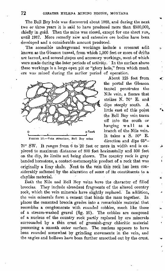
72
The Bell Boy lode was discovered about 1888, and during the next two or three years it is said to have produced more than $500,000,. chiefly in gold. Then the mine was closed, except for one short run,, until 1917. More recently new and extensive ore bodies have been developed and a considerable amount produced.
The accessible underground workings include a crosscut adit known as the Gleason tunnel, from which 1,000 feet or more of drifts are turned, and several stopes and accessory workings, most of which were made during the later periods of activity. In the surface above these workings is a large open pit or "glory hole," from which much ore was mined during the earlier period of operation.
About 125 feet from the portal the Gleason tunnel penetrates the Nile vein, a fissure that strikes N. 70° E. and dips steeply south. A. little east of this point the Bell Boy vein turns off into the south or hanging wall as a
o 3 Feet branch of the Nile vein. 1 ' ' ' ' It takes a S. 50° E.FIGURE 10. Vein structure, Bell Boy mine -,. ,. IT nrn
direction and dips 65 70° SW. It ranges from 6 to 20 feet or more in width and is ex plored to maximum distances of 800 feet horizontally and 300 feet on the dip, its limits not being shown. The country rock is gray banded hornstone, a contact-metamorphic product of a rock that was originally a limy shale. Next to the vein this rock has been con siderably softened by the alteration of some of its constituents to a. claylike material. " '
Both the Nile and Bell Boy veins have the character of filled breccias. They include abundant fragments of the altered country rock, which the vein minerals have slightly replaced. In addition, the vein minerals form a cement that binds the mass together. In places the cemented breccia grades into a remarkable material that resembles a conglomerate with rounded cobbles, much like those of a stream-washed gravel (fig. 10). The cobbles are composed of a nucleus of the country rock partly replaced by ore minerals surrounded by a thin crust of greenish-gray chloritic material possessing a smooth outer surface. The nucleus appears to have been rounded somewhat by grinding movements in the vein, and the angles and hollows have been further smoothed out by the crust.

MAEYSVILLE DISTRICT 73
One of the conglomeratic bodies occurs at the junction of the Nile and Bell Boy veins, and another in the Bell Boy several hundred feet to the southeast. Each is 200 feet or more long, its limits being in definite. Practically all these bodies may be regarded as ore shoots, though their richness varies considerably and irregularly. Large parts of them contain from $10 to $50 or more in gold and a few ounces of silver to the ton and from 8 to 30 per cent of lead. Inter vening parts of the vein consist of angular filled breccia, most of which is of too low grade to be considered ore.
Above the adit level the ore appears to be completely oxidized. The vein minerals consist of cerusite, calamine, iron oxides, blue and green carbonates of copper, and fluorite. There are alsovery small amounts of man ganese oxides. Bunches of galena and chalcopyrite occur in the southeastern conglomer atic body in the Bell Boy vein, in a winze sunk 40 feet below the adit level. The galena is the later and has replaced part of the chalcopyrite. These sul phides together with fluorite appear to have formed the original cementing material of the breccia. They are now embedded in oxidized material consisting chiefly of cerusite and iron oxides with a little of the blue and green carbonates of copper. Vein quartz is practically absent from these ore bodies. The cobblelike bodies are composed of partly oxidized ore surrounded by shells of smooth greenish-gray material consisting of fine chlorite and biotite (fig. 11) that evidently came into the vein after the filled and cemented breccia had been reopened. The sequence of events that produced this rather remarkable conglomerate appears to be as follows: First, fissuring and brecciation of the country rock; second, introduction of chalcopyrite and fluorite, followed by galena, causing cementation of the breccia and probably alteration of the wall rocks; third, reopening of the vein with grinding movements that broke the cemented breccia and partly rounded the fragments; fourth, coating of the new fragments of breccia with a paste that is now a mixture of chlorite and biotite but probably was originally all biotite; fifth, partial oxidation. The inclosing of partly oxidized ore by an unoxi-
FIGUHB 11. Ore of Bell Boy mine, a, Shell of chlorite; ft, banded ore, consisting of fluorite, carbonate, and silicate or zinc, with stains of iron and manganese oxides; c, grains of iron oxides containing specks of native gold; d>, fragments of wall rock

74 GREATER HELENA MINING REGION, MONTANA
dized shell as described is, to say the least, unusual. It is not likely that the ore was oxidized before the biotite and chlorite were depos ited, because the conditions under which biotite is known to form are not to be expected in the upper parts of veins within reach of surface waters. Apparently the biotite and chlorite came to place before oxidation had begun. Later they escaped oxidation because they are more resistant than the sulphides, which are normally attacked first. What free acid was produced during the partial oxidation may have been neutralized by carbonates. Such a reaction should have produced sulphates. No sulphates were observed, in the ore examined from the Bell Boy vein, but beaverite, a sulphate of lead, copper, and iron with water, occurs in the Nile vein, mentioned below.
Postmineral movements in other parts of the Bell Boy vein are indicated by a 6 or 8 inch layer of gouge and crushed rock on the hanging wall. In these parts of the vein the breccia is cemented chiefly with iron oxides that appear to have been derived from pyrite. The cemented mass was not broken, probably because it was stronger than in parts that contained more of the brittle vein min erals. In the lean breccia the hydrothermal alteration of the wall rock is as complete as elsewhere. Evidently it was one of the first events to follow the opening of the fissure. Vein quartz was not seen in the Bell Boy mine, except in places where it forms streaks or veins separate and distinct from the ore bodies described. This quartz is clear and contains cavities from which lamellar calcite has been dissolved. It incloses fluorite and other minerals belonging to the ore bodies described and appears to have come into the vein at a later time. The width and horizontal continuity of the Bell Boy vein is such that it may be expected to extend undiminished in size far below the present depth of exploration. Although it would3 be hazardous to predict how far the ore will extend downward, it is evident that the lower limit has not been reached. A large amount of ore also remains above the present working level.
NILE
The Nile mine, belonging to Wallace Birkhead and others, is on the south side of Towsley Gulch, west of the Bell Boy. The pro duction of several carloads of ore rich in galena is reported. The workings consist of a 90-foot shaft, with 300 feet of drifts, a 35-foot shaft, and some smaller surface workings. A crosscut adit 825 feet long, from a point on the slope about 400 feet vertically below the outcrop, is said not to have been extended far enough to cut the vein. East of these workings the vein is explored by drifts from the Gleason tunnel of the Bell Boy mine.

MABYSVILLE DISTRICT 75
The Nile vein strikes about N. 70° E., dips N. 70°-75° S., and cuts banded hornstone belonging to the contact-metamorphosed area of the Empire shale. It ranges from 3 to 10 feet in width and is in dicated by the different workings to persist for more than a quarter of a mile. It is a filled breccia composed of fragments of the softened country rock cemented with iron oxides, lead carbonate, and variable small amounts of copper carbonates. In places there are coatings of a canary-yellow mineral determined by W. T. Schal- ler as a beaverite, a sulphate of lead, copper, and iron with water. The mass is porous or cavernous, and the cavities are lined with fine quartz crystals. At the bottom of the 35-foot shaft the vein contains remnants of unoxidized galena. The drifts from the bot tom of the 90-foot shaft were under water in August, 1926. Accord ing to Mr. Birkhead, they expose several streaks and bunches of good ore containing both galena and lead carbonate.
MAMMOTH
The Mammoth claim is on the ridge south of Towsley Gulch, west of the Nile. Several open cuts and short inclines and adil levels expose a lode from 6 to 20 feet or more wide that strikes N. 50°-60° E., dips 70° SE., and cuts metamorphosed Empire shale. The lode consists of a breccia of the country rock that is cemented with iron oxides. It contains a few grains of chalcopyrite and some manganese oxides and copper stain. The course and position of this lode suggest that it is" probably an extension of the Nile vein.
EARTHQUAKE
The Earthquake mine is on the ridge south of Towsley Gulch, about a quarter of a mile west of the Nile. The main working is an adit level that extends eastward 200 feet and attains a depth of about 100 feet. On the outcrops above are several open cuts and a 30-foot shaft. The vein strikes about N. 70° E., dips 65°-70° S., and cuts gray banded hornstone (metamorphosed Empire shale). The.work ings mentioned, together with those on claims farther east, indicate the Earthquake vein to be part of a fracture generally known as the Towsley vein, which extends eastward for half a mile or more and passes through the Shakopee and Towsley claims. The 200-foot adit on the Earthquake claim exposes a part of the vein from 5 to 6 feet wide, next to the hanging wall. This part is a filled breccia composed of angular fragments of the country rock cemented to gether with a variety of minerals, including iron oxides, quartz, cer- usite, azurite, malachite, chrysocolla, and calamine. There are also coatings of canary-yellow beaverite, a hydrous sulphate of copper,, lead, and ferric iron. Next to the hanging wall are bunches and
76 GREATER HELENA MINING REGION, MONTANA
streaks of galena, which in places incloses remnants of chalcopyrite. This facies of the vein is best shown in a stope not far from the face of the adit (fig. 12), where rather large bunches of galena occur.
At the time of the writer's visit (August, 1926), several tons of ore consisting largely of galena had been taken out and piled on the dump awaiting shipment. The other workings, including the 30- foot shaft, show a filled breccia similar to that in the 200-foot adit, except that oxidation is practically complete.
3 Feet
FIGURE 12. Vein in Earthquake mine, a, Wall rock; 6, gouge; c, galena and other sulphides; d, seams lined with iron oxides; e, fragments of wall rock; f, calcite and fluorite containing scattered grains of sulphides
TOWSLEY AND SHAKOPEE
Ore shipments are reported from the Towsley and Shakopee mines, both of which are presumably on the same vein as the Earthquake. This vein is developed by shafts and is penetrated by the Nile cross cut tunnel at a depth of 140 feet. It is said to range from 8 to 30 feet in width and to be undiminished in size so far as explored. The workings were not entered. Ore on the dumps of the Nile crosscut tunnel and two shafts of the Towsley mine is of the filled-breccia type and shows valuable amounts of lead carbonate and galena with iron oxides and copper stains. In 1927 ore from the whim shaft of the Towsley mine was being sacked for shipment. At the Shakopee mine, ore was being stoped in a drift from the bottom of a 50-foot incline near the west end of the claim. The lode is wider than the drift, and the ore shoot ranges from less than 1 foot to 5 or 6 feet in width. The ore is similar to that from the Earthquake.
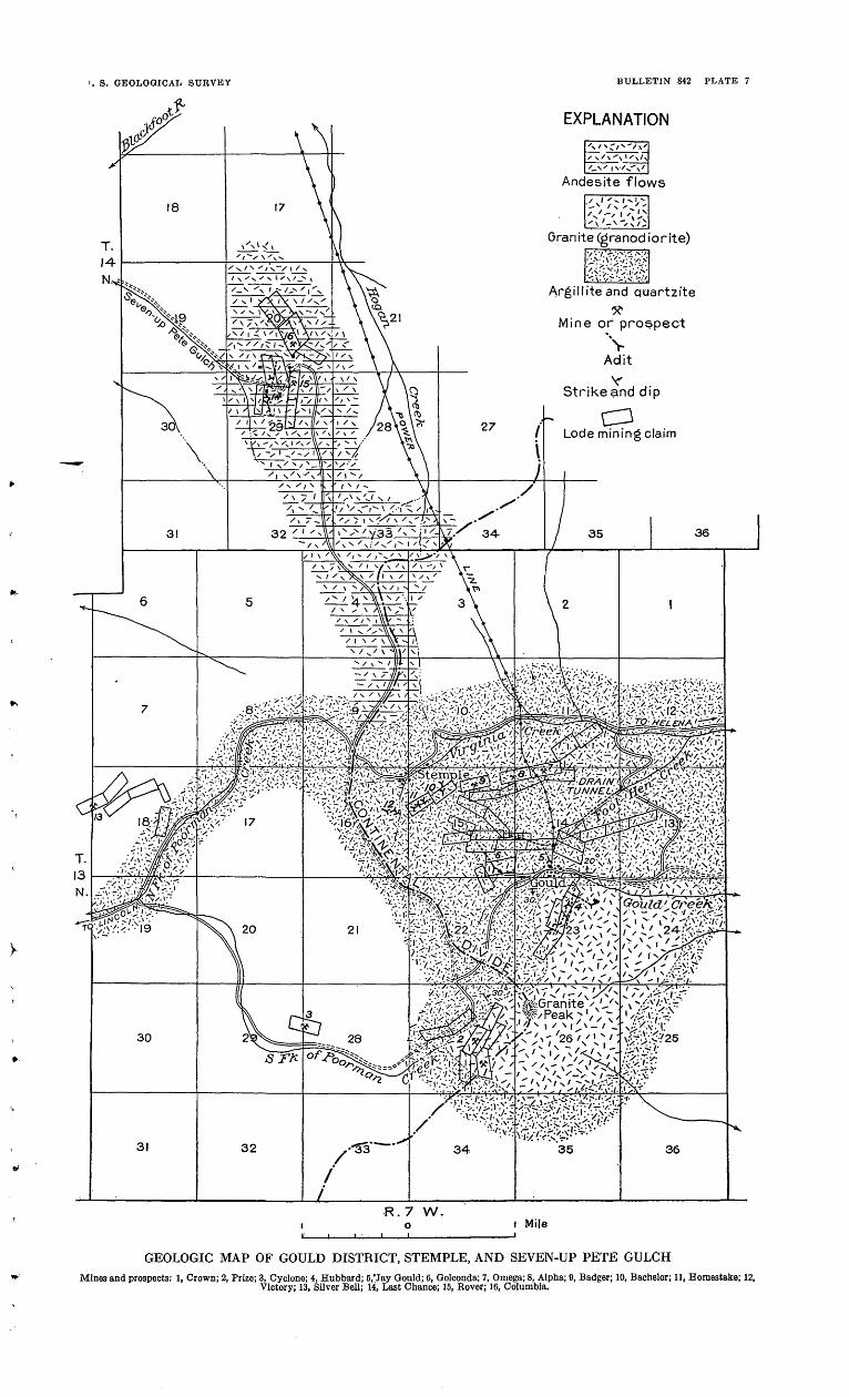
i. S. GEOLOGICAL SURVEY
rf
BULLETIN 842 PLATE 7
EXPLANATION
Andesite flows
Granite (granodiorite)
Argilhteand quartzite
Mine of prospect
\
Strikeand dip
C3Lode mining claim
>.*/ - ! :] > i. ' tA >:. :-:>'.-'.-'-'..-:<:<t-:'2^
GEOLOGIC MAP OF GOULD DISTRICT, STEMPLE, AND SEVEN-UP PETE GULCHMines and prospects: 1, Crown; 2, Prize; 3, Cyclone; 4, Hubbard; 5,'Jay Could; 6, Golconda; 7, Omega; 8, Alpha; 9, Badger; 10, Bachelor; 11, Homestake; 12,
Victory; 13, Silver Bell; 14, Last Chance; 15, Eover; 16, Columbia.
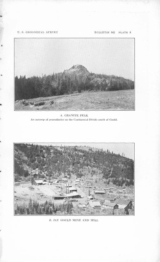
U. S. GEOLOGICAL SURVEY BULLETIN 842 PLATE 8
A. GRANITE PEAK
Ail outcrop of granodiorite oil the Continental Divide south of Gould.
B. JAY GOULD MINE AND MILL

TJ. S. GEOLOGICAL SURVEY BULLETIN 842 PLATE 9
PHOTOMICROGRAPHS OF QUARTZ AND LAMELLAR CALCITE ORE, JAY GOULD MINE
Crossed nicols. A, Shows lack of correspondence in structure of the quartz on opposite sides of a calcite blade. B, Shows granular quartz molded upon calcite blades, which inclose thinner blades of quartz; calcite of a different generation from the blades appears in the upper left corner.
GREATER HELENA MINING REGION, MONTANA 77
GOT7LD DISTRICT
HISTORY AND PRODUCTION
The Gould district (pi. 7) lies along the Continental Divide 28 miles in a straight line northwest of Helena and a short distance south of the automobile highway between that place and Lincoln. It is most easily reached by a branch road that leaves the highway about 2 miles east of the divide. By way of these roads the dis tance to Helena is 39 miles and to Silver, on the Great Northern Railway, the nearest shipping point, 23 miles.
The principal mine in the district, the Jay Gould, was discovered in 1884 and has been operated intermittently to the present time. Other mines that were formerly productive are the Hubbard and Prize. Considerable development work has been done at the Nakoma mine, formerly the Golconda, and a long crosscut adit to drain the Jay Gould workings has been nearly completed.
A production of $2,500,000, chiefly gold, prior to 1915, is reported for the Jay Gould mine. An additional amount produced by this mine since 1922 and the production of the Hubbard, Prize, and other mines were not learned by the writer. The total for the district probably amounts to at least $3,000,000.
GEOGRAPHY AND GEOLOGY
The mines are distributed through an area 2 or 3 miles long and a mile wide that includes the upper valley of Gould Creek, the ridge north of it, and Granite Peak, a mile to the south. The upper part of the Gould Creek Valley is a rather wide, shallow depression* of gentle average gradient, that hangs, as it were, on the east side of ;he divide at an altitude of 6,200 to 6,400 feet. It is made up of
two flat sections, arranged steplike, one above the other. Below these flat stretches the gradient descends steeply for 1,000 feet, and tEe valley becomes a deep V-shaped trench. The ridge north of the valley (pi. 8, B) is a smoothly contoured spur extending east from the main divide. South of the valley is a massive, round-topped iriountain, and beyond it the sharp summit known as Granite Peak(ll.8,4).
In this area the Continental Divide and its main spurs are gener ally surmounted by flat or gently sloping surfaces at altitudes of about 7,OC9 feet that cut across the rocks without regard to their compo sition or structure. These surfaces are thought to be remnants of or inheritances from an ancient surface of gentle contour that was developed at a low altitude and afterward elevated and largely cut away by the streams. The upper wide and flat part of the Gould Creek Valley is excavated but a few hundred feet below the old surface. The lower part is a deep, narrow trench, which evidently
78 GREATER HELENA MINING REGION, MONTANA
was not cut until the stream had been rejuvenated by an uplift. A bench, together with the presence of a little glacial drift near the head of the valley, indicates that glaciers slightly modified the upper part of this valley during a late stage of the Pleistocene.
The Gould district is underlain by pre-Cambrian (Belt) sedi mentary rocks, which have been intruded by granite (quartz diorite). The sedimentary rocks are well exposed along the road leading into the district. They consist chiefly of purple and greenish-gray shales or argillites that probably belong to the Spokane and Empire formations. Near the quartz diorite these rocks are altered to sili ceous gray or grayish-green hard, tough fine-grained banded or mottled varieties that may be.called hornstone. Microscopic exam ination by Clarence S. Ross of a specimen from a point along the road opposite the Hubbard mine shows it to be composed of " a fine grained aggregate of quartz, sericite, and diopside. A little un- sericitized plagioclase is present. The rock is cut by seams made up of coarser crystals of diopside and calcite." A specimen of the wall rock in the Jay Gould mine is simply " a fine-grained aggregate of quartz and sericite," and one from the surface west of the Jay Gould is " an aggregate of quartz, sericite, colorless chlorite, diopside, and calcite." In other places brown garnet is abundant. These evi dences of contact metamorphism are noticeable for distances ranging from a quarter of a mile to a mile from the border of the intrusive mass.
The quartz diorite is a gray granular rock of medium texture composed, as determined by Clarence S. Ross from a specimen collected near the Hubbard mine, " of andesine, quartz, hornblende, and a little biotite, magnetite, and titanite. The quartz forms anhe- dral grains between euhedral andesine crystals. The rock is little altered, and hornblende and andesine are nearly fresh." Near the margin it becomes a darker shade of gray, owing to the presence of more abundant ferromagnesian minerals. The area of this rock extends from Gould Creek south 2,y2 miles to the headquarters of Marsh Creek and Poorman Creek. (See pi. 7.) Its boundary pro jects down the valleys and retreats around an intervening mountain in such a manner as to show that the mass expands downward and that the top is not yet completely uncovered. It appears to have the form of a stock or cupola with a maximum diameter of about 3 miles.
The bedded rocks are tilted at moderate angles. Those composing the ridge north of Gould Creek dip 20°-30° N., or away from the granodiorite body, but whether this tilting was caused by the intru sive mass was not determined. Faults were observed only in the mine workings. These are of comparatively small throw, but a group reported in the Hubbard mine are interesting because of their ar rangement parallel to the upper surface of the granite.

GOULD DISTRICT 79
ORB DEPOSITS
CHARACTER
The ore bodies in the Gould district are veins that have filled open fissures and in some localities have also replaced the country rock. The Hubbard and Prize veins are members of a group that trends south and dips east. So far as known the group is confined to a nar row zone in the western part of the granite area. The veins are com monly 3 or 4 feet wide and persistent along the strike and dip. They are composed chiefly of quartz that shows a dense, rather coarse granular texture and possesses features that suggest a replacement of the wall rock. In the Hubbard mine an ore body from 1 to 3 feet wide that extends nearly 1,000 feet horizontally was mined to a max imum depth of 500 feet. Ore exists below that point, but so far as explored, the vein was found to be badly disturbed by faults and for that reason unprofitable to work. The ore from the southward- trending veins is, as a rule, moderately rich in gold. The pay streak is characterized by iron oxides, some of which evidently were derived from the oxidation of pyrite. Malachite and azurite (green and blue carbonates of copper) occur sparingly in the upper part of the Prize vein but in a layer that is barren of gold.
The Jay Gould vein trends west, or at right angles to the Hubbard group, dips steeply north, and cuts the contact-metamorphosed sedi mentary rocks that adjoin the granite. It greatly exceeds in size any known members of the other group and is further distinguished by the fact that it is largely composed of lamellar calcite and quartz, which together form a gangue of striking appearance. (See pi. 11.) Crusts, banding, and other structural features of the vein indicate that it has filled an open fissure.
ORIGINThe lamellar calcite and quartz gangue of the Jay Gould vein
is strikingly similar in appearance to the gangue of the DeLamar mine in Idaho,48 of deposits at Jarbidge, Nev.,40 and of the Bel- mont and other mines in the Marysville district.50 The authors cited described the quartz as a pseudomorphic replacement of lamellar calcite or some other mineral. At DeLamar and Jar bidge none of the original mineral remains. At Marysville some of the specimens contain calcite; others do not.
In the Jay Gould mine the calcite is generally present, and no pseudomorphic replacement of that mineral by quartz was observed.
48 Lindgren, Waldemar, The gold and silver veins of Silver City, DeLamar, and other mining districts in Idaho: U. S. Geol. Survey Twentieth Ann. Kept., pt. 3, pp. 166-169, 1899.
40 Schrader, F. C., The Jarbidge, Contact, and Elk Mountain mining districts, Nevada: U. S. Geol. Survey Bull. 497, pp. 52-56, 1912.
60 Knopf, Adolph, Ore deposits of the Helena mining region, Montana: U. S. Geol. Sur vey Bull. 527, pp. 54-5'8, 1913.

80 GREATER HELENA MINING REGION, MONTANA
The lamellar form of the quartz aggregrate is due not to replacement but to the fact that it was molded upon the thin calcite plates (pi. 9). If the calcite plates of the Jay Gould ore should be dissolved out and their places closed by pressing the walls together, the result would be a rock containing quartz plates made up of halves separated by a " median line" like those at DeLamar and Jarbidge. If the spaces were filled with new quartz the rock would be like that at Marysville.
The geologic relations of the Jay Gould lode do not show its age definitely except that it is post-Algonkian. Its proximity to the Granite Peak intrusive stock suggests that body as a source, which if true means that the lode probably came to place in the middle or late Tertiary. It was exposed though not deeply cut into by the erosion that developed the old upland surface described on page 10 and therefore had been formed before the end of the Terti ary period. It is noteworthy that placer deposits were not formed in Foolhen Gulch, which drains the area containing the outcrop of the lode. This fact may be interpreted to mean that very little of the lode had been cut away by erosion. The idea that the exist ing part of the lode may have been enriched below <the outcrop by gold carried down in solution is suggested by the presence of manganese but is negatived by other features, particularly the abundance of calcite. Deposits of the Jay Gould type elsewhere, such as that in the DeLamar mine of Idaho, are generally regarded as having formed under a comparatively thin cover during late Tertiary time. The fact that the Jay Gould vein was formed in an open fissure as shown by its structure and mineralogy supports the notion that it was deposited at a shallow depth and therefore did not come to place until the region had been nearly worn down to the old surface. It follows that much of the original vertical extent of the lode remains. In any event the lode shows no signs of pinching or becoming lean at a depth of TOO feet.
The quartz of the Hubbard group of veins is of a high-tempera ture type. Probably these veins were deposited soon after the granite came to place and before the Jay Gould vein was formed.
MINES AND PROSPECTS
JAY GOULD
The Jay Gould mine is on the ridge north of Gould Creek, about a mile east of the Continental Divide. The vein was discovered in 1884. A mill was built and the deposit worked until 1890. Other runs were made in the periods 1903-1907 and 1910-1914. Since 1922, except for a suspension of several months in 1927, due to flood ing, the mine has been operated continuously under the direction of

GOULD DISTRICT 81
Owen Byrnes, the ore being treated in the mill at the Hubbard mine, a mile down the creek.
The production of the Jay Gould mine to 1914 is estimated by Mr. Byrnes at $2,500,000, more than 95 per cent of which was the value of the gold, the remainder being silver. To this is to be added a considerable production made since 1922, the figures for which are not available for publication.
The vein crops out on the ridge north of Gould in a wide, shallow depression that is drained by Foolhen Creek and lies from 200 to 400 feet lower than the main summit. Except for pits and other workings the outcrop is concealed by a surface mantle several feet deep. The main working is a crosscut adit at the south base of the ridge, at an altitude of about 6,300 feet. It is driven in a direction about N, 25° W. and penetrates the vein at a distance of about 1,000 feet and at a depth of 350 feet below the outcrop. At this level drifts in the vein extend about 2,000 feet west and 800 feet east. Workings at higher levels, most of which are not now accessible, include two shafts that start from the surface and several drifts, raises, and stopes. The deeper workings include drifts at different levels down to 350 feet below the adit, They are reached through a shaft sunk from that working. The total linear extent of under ground workings, not including the stopes or the drain tunnel, is more than 12,000 feet. In the eastern part of the mine an ore shoot 6 to 14 feet wide attains a stope length of 800 feet and a pitch length of 700 feet, its lower limit not being shown. West of this body many smaller shoots occupy most of an area 1,400 feet long and 300 feet high in the plane of the vein. Some of these shoots extend within 100 feet of the surface, and the lower limits of some are not deter mined. Stopes above the 500-foot level have an aggregate area of more than 500,000 square feet. (See pi. 10.) The main ore shoot reaches the surface at the old shaft, at a point almost directly above the present working adit. It extends downward to a stope length of 800 feet at the adit level. At the 700-foot level it exceeds 600 feet, its limits not being shown. The depth exceeds 700 feet, the depth of the present workings. The shoot appears to pitch (rake) toward the west that is, as seen on looking down the vein from the footwali side, the ore body inclines toward the 1'eft.
About 350 feet east, of the adit crosscut the vein is crossed by a fault that trends N. 20° E. and stands about vertical. It displaces the vein about 35 feet horizontally, the block on the east having been moved relatively that distance to the north. Probably the fault movement included also a vertical component, but this was not ascertained as a fact.

82 GREATER HELENA MINING REGION, MONTANA
The drain tunnel is driven south westward from a point on Foolhen Gulch about 1,000 feet lower than the outcrop of the Jay Gould vein, or 300 feet below the deepest workings. When completed to an intersection with the vein it will be 4,700 feet long. In 1927 its face was in about 3,500 feet, or within 1,200 feet of the vein. At this point it receives a strong flow of water, part of which evidently comes from the mine through fissures connected with the fault described above. In ordinary seasons these channels keep the mine well drained, but an unusual flow in the spring of 1927 was more than they could carry, and as a result the lower workings were flooded for several months.
For a distance of 1,500 feet or more, beginning at the east, the Jay Gould vein varies little in strike from N. 70° W. Beyond this stretch it bends to a course that is nearly due west. It dips steeply north throughout. Several small branches split from the vein at angles of 20° or less and lead eastward or westward into the walls. For a length of at least 2,500 feet the vein is fairly regular and averages between 6 and 10 feet in width, not including the small branches. The hanging wall is smooth and lined with gouge but shows no evidence of any considerable postmineral movements. In the westernmost workings the vein becomes irregular and apparently ends in an area of small faults. Its eastern limit is not shown. On the 700-foot level it is from 10 to 14 feet wide with well-defined walls, and its lower limit apparently is nowhere near.
The wall rock is a hard, tough greenish-gray mottled or banded hornstone that dips gently north. Next to the vein it is somewhat bleached and softened, partly altered to sericite and cut by veinlets of calcite and quartz carrying small amounts of iron and manganese oxides. This alteration is more intense in fragments or " horses n of wall rock inclosed in the vein than in the walls themselves. Away from the vein it dies out within a few feet.
The vein shows rather plainly a banded structure due to the alter nation of layers of different composition and texture (fig. 13). The layers are parallel to the walls, most of them are rather coarsely crystalline, and in some the crystals stand at right angles to the walls, a result of the filling of open spaces. Locally the spaces are not quite filled, open cavities remaining into which the free ends of crystals project. These and other unfilled small cavities are suffi ciently numerous and connected to permit the vein waters to circulate freely and escape to the fissure tapped by the drain tunnel.
The vein is composed chiefly of quartz and calcite with relatively very small amounts of iron and manganese oxides, malachite, chal- copyrite, argentite, and native gold. The relations of these minerals indicate that calcite, including a mixed calcium-iron carbonate, was
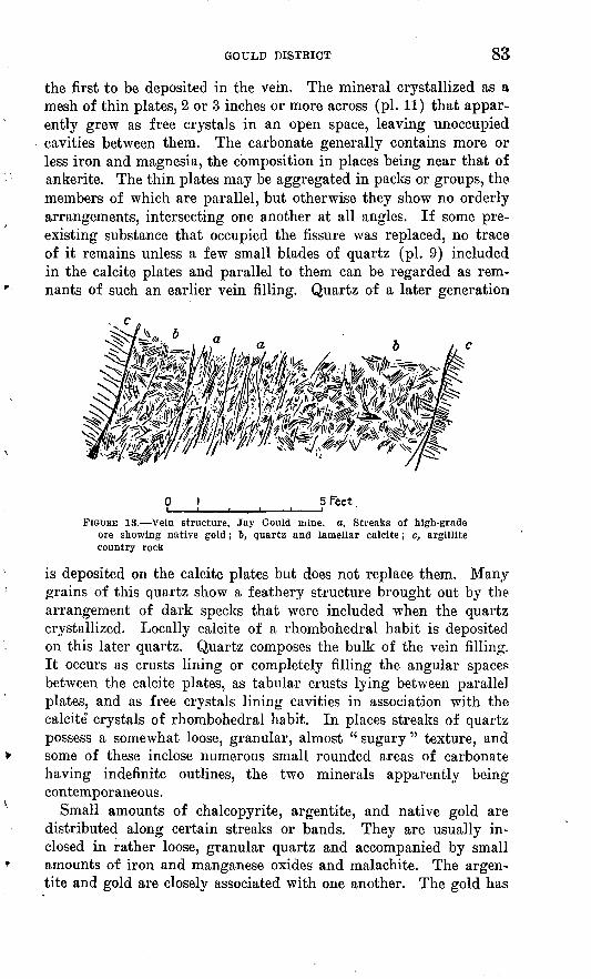
GOULD DISTRICT 83
the first to be deposited in the vein. The mineral crystallized as a mesh of thin plates, 2 or 3 inches or more across (pi. 11) that appar ently grew as free crystals in an open space, leaving unoccupied cavities between them. The carbonate generally contains more or less iron and magnesia, the composition in places being near that of ankerite. The thin plates may be aggregated in packs or groups, the members of which are parallel, but otherwise they show no orderly arrangements, intersecting one another at all angles. If some pre existing substance that occupied the fissure was replaced, no trace of it remains unless a few small blades of quartz (pi. 9) included in the calcite plates and parallel to them can be regarded as rem nants of such an earlier vein filling. Quartz of a later generation
5 FeetFIGURE 13. Vein structure, Jay Gould mine, a, Streaks of high-grade
ore showing native gold; ~b, quartz and lamellar calcite; c, argillite country rook
is deposited on the calcite plates but does not replace them. Many grains of this quartz show a feathery structure brought out by the arrangement of dark specks that were included when the quartz crystallized. Locally calcite of a rhombohedral habit is deposited on this later quartz. Quartz composes the bulk of the vein filling. It occurs as crusts lining or completely filling the angular spaces between the calcite plates, as tabular crusts lying between parallel plates, and as free crystals lining cavities in association with the calcite0 crystals of rhombohedral habit. In places streaks of quartz possess a somewhat loose, granular, almost " sugary " texture, and some of these inclose numerous small rounded areas of carbonate having indefinite outlines, the two minerals apparently being contemporaneous.
Small amounts of chalcopyrite, argentite, and native gold are distributed along certain streaks or bands. They are usually in closed in rather loose, granular quartz and accompanied by small amounts of iron and manganese oxides and malachite. The argen tite and gold are closely associated with one another. The gold has
84 GREATER HELENA MINING REGION, MONTANA
a very pale yellow color due to the presence of considerable silver. In fact, it is probably the native alloy known as electrum, which usually contains 25 per cent or more of silver.
Part of the iron oxide occurs in grains that are residual from the oxidation of chalcopyrite. Most of it, however, is distributed as a fine brown powder or dust that appears to have been derived from the carbonate. The manganese oxide occurs as scattered films and locally as grains filling open spaces. Its origin or derivation is not indicated. Possibly it also came from the carbonate.
The ore minerals accompanied by quartz and iron-bearing calcite were introduced later than the lamellar calcite and in part at least later than the quartz that was deposited on the calcite. The iron oxides and malachite were derived from the chalcopyrite and iron- bearing calcite by the action of surface waters at a later time. This oxidation is incomplete, but traces of it extend at least to the 700- foot level.
The average value of the ore was not learned. All of the vein exposed on the 700-foot level is apparently of workable grade, and considerable parts of it are evidently very rich. The gold produced in milling the ore ranges in fineness from 0.506 to 0.536, owing to the presence of alloyed silver. A flotation concentrate produced from the tailings after amalgamation contains 180 ounces of silver and 2.5 ounces of gold to the ton, 61 per cent of silica, 2 per cent of iron, and 0.2 per cent of manganese. The excess of silver in the concen trate is apparently due to argentite that was not reduced by amal gamation on the mill plates.
EUBBARD
The Hubbard mine, on the south side of Gould Creek about a mile below the Jay Gould, has been idle for a long time, and its workings were not entered. Formerly it was operated by Owen Byrnes, and it is reported to have produced a considerable amount of gold. The workings as shown by a map made by Mr. Byrnes in 1905 include a crosscut adit known as the Mill tunnel, driven westward at the foot of the slope toward the vein, which it penetrates at a distajnce of about 950 feet. At a level about 400 feet higher an adit is driven south about 1,000 feet along the vein. There are also drifts on the > vein at higher levels, the vertical range of the workings from the out crop down to the Mill tunnel being about 900 feet, and their aggregate length, including raises, not less than 7,000 feet. The country rock is granodiorite. The vein is from 2 to 6 feet wide, trends southward, dips 57° E., and consists of a rather coarse grained white quartz with a little pyrite and iron oxides. A layer of softened granite, iron oxides, and quartz lies next to the hanging wall and ranges in
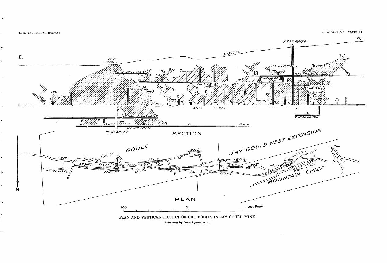
C. S. GEOLOGICAL SURVEY BULLETIN 842 PLATE 10
W.
E.
WESTRA/SE
\ I 500-F. MAIN SHAFT
PLAN AND VERTICAL SECTION OF ORE BODIES IN JAY GOULD MINEFrom map by Owen Byrnes, 1911.
U. S. GEOLOGICAL SURVEY BULLETIN 842 PLATE 11
A. QUARTZ AND LAMELLAR CALCITE, JAY GOULD MINE
Edges of clacite plates dissolved.
B. CAVERNOUS QUARTZ AND LAMELLAR CALCITE, JAY GOULD MINE
Angular spaces between calcite plates partly filled wil,h quartz of which free crystals end at cavities. Calcite of a rhombohedral habit is locally deposited on the quartz.
GOULD DISTRICT 85
width from a mere seam to 3 feet. According to Mr. Byrnes, the deposit was worked profitably to a depth of 500 feet below the out crop. At greater depths the vein was disturbed to such an extent by a series of nearly flat faults that work became unprofitable. These faults dip east or northeast and are nearly parallel to the slope of the present surface. The extent and arrangement of the stopes indicate an irregular ore shoot 1,000 feet in stope length and from 100 to 500 feet in pitch length. Reported assays of parts of the vein from 18 inches to 3 feet thick, remaining in place, show from $7 to $12 a tonin gold.
PBIZE
The Prize mine is about 2 miles south of the Jay Gould, on the west side of Granite Peak, at the head of Poorman Creek, a trib utary of the Blackfoot River. It was operated formerly by Owen Byrnes, and the ore was treated in a mill in the gulch below. A considerable amount of gold is reported to have been produced. The workings, which were not accessible in 1926, are said to include a -,haft 500 feet deep, with drifts extending 800 feet along the vein, which is 4 feet wide and strikes south. Specimens from the dumps consist of vein quartz, one variety of which contains seams of iron oxides and green and blue copper carbonates and another vari ety contains iron oxides only. The copper-stained variety is said to be barren, the gold being confined to the variety that contains ironoxides only.
CKOWN
The Crown claim of Michael Sullivan adjoins the Prrze and is developed by a shaft said to be 100 feet deep from which drifts are run. The vein is 3 feet wide and consists of iron-stained quartz and decomposed granite. The owner reports $100 in gold produced from a quantity, of the ore by panning, after it had been ground up ina hand mortar.
NAKOMAThe Nakoma mine, formerly called the Golconda, is about half
a mile west of the Jay Gould. The principal working is an adit at an altitude of about 6,550 feet that is driven northward for a distance of 2,000 feet or more. At 1,750 feet drifts are run 1,000 feet or more west and 150 feet east. Near the portal of the adit is a mill. In the first few hundred feet of its course the adit cuts several small veins. At 850 feet it passes through a vein 4 feet wide, and at 1,750 feet it penetrates a zone of crushed rock and vein quartz about 40 feet wide. This zone is developed by the drifts mentioned. The west drift shows considerable quartzose vein rock, on which stopes have been made in several places. The east drift shows an
154419 33 7

86 GREATER HELENA MINING REGION, MONTANA
open fissure that is lined with red clay and accompanied by more or less quartz.
A considerable amount of ore from the stopes along the west drift is said to have been run through the mill, but information as to the proceeds is not available.
The vein filling is chiefly quartz with more or less lamellar calcite, similar in general appearance to that in the Jay Gould and other neighboring mines. It contains open spaces or vugs lined with free quartz crystals and shows scattered small grains of iron oxides, some of which are evidently pseudomorphs after pyrite. Specimens from the east drift contain streaks of a carbonate that weathers brown owing to the presence of a little iron.
STEMPLE AREA
HISTORY AND PRODUCTION
The lodes at Stemple, which is a short distance northwest of Gould, were discovered nearly 50 years ago. The camp was named for John Stemple, who located the Homestake lode about 1878, and it should not be confused with the Stemple district, the mining area about Empire, near Marysville. Mines on the lodes at Stemple have been operated intermittently. In 1926 and 1927 practically no work except that necessary for annual assessment was being done.
The lodes at Stemple, of which the Homestake was the most pro ductive, are estimated by persons familiar with them to have produced at least $420,000, chiefly in gold.
GEOGRAPHY AND GEOLOGY
Stemple is near the head of Virginia Creek, on the main auto- mo'bile * road between Helena and Lincoln, about 37 miles fromHelena and 22 miles from Silver station, on the Great Northern Kailway. Half a mile west of Stemple the road crosses the Conti nental Divide through a wide pass at an altitude of about 6,300 feet.
The country rocks include quartzite and purple to greenish- gray argillite or slate of the Belt series, into which a small sill and several dikes of diorite are intruded. The sedimentary rocks re semble those at Gould, except that they do not show contact meta- morphism. At Stemple there is a small moraine on which stands a rambling old log house, a stage station of former days. Above that point the valley shows evidence of glaciation to its head, a mile to the south in a ridge at an altitude of 7,600 feet. The moraine is rather fresh looking and is probably of late Pleistocene age, though it may be older than Wisconsin. Below Stemple the valley is not glaciated. The unglaciated part contains placer deposits; the glaciated part none.

HEDDLESTON DISTRICT 87
ORE DEPOSITS
The Homestake, Bachelor, and several other claims are located on a group of lodes that strike northeast to east. These lodes are about half a mile northwest of the Jay Gould lode, and they crop out at about the same altitude. Most of the mine workings are adit levels, which were not accessible to examination in 1927. According to Abe Balcom, the upper adit on the Homestake is between 500 and 600 feet long. For 300 feet it follows an ore shoot 10 inches to a foot wide that was stoped out above that level and yielded more than $100 a ton in gold. An adit 150 feet lower follows the same vein but found only ore of low grade. The dumps of the Homestake and other mines of that group show lamellar calcite, quartz, and small amounts of copper carbonates and iron and manganese oxides. Chalcopyrite inclosed in quartz occurs in places. Therefore the veins are probably of the same age and origin as the Jay Gould. Doubtless the wearing away of their upper parts produced the placer deposits in Virginia Creek.
Poorman and Virginia Creeks drain the area around Gould and Stemple. Poorman Creek is on the western slope and its valley is followed by the main automobile route between Helena and Lincoln. Gravel deposits along the stream have been mined in places for placer gold, but the production is said to have been generally small.
Virginia Creek drains the eastern slope. It has been mined from Stemple to its mouth, a distance of about 8 miles. The gravel de posit was narrow, not very deep, and but moderately rich. From information furnished by Abe Balcom it is estimated that the creek yielded at least $600,000 in gold. The short stretch between Stemple and the head of the valley has not been mined and is said not to con tain workable gravel. As already mentioned, this part of the valley has been glaciated, a fact that explains its lack of placer deposits. Tarhead, Lopear, and Specimen Gulches, tributaries of Virginia Creek, have been mined and are reported to have produced a moderate amount of gold.
Low terraces or " bars " along Canyon Creek have been mined for a distance of 4 or 5 miles below Virginia Creek. They are said to have been moderately rich, but the amount they produced is not known.
HEDDLESTON DISTRICT
HISTORY AND PRODUCTION
The Heddleston district was named for William Heddleston, who in 1889, with George Padbury, discovered the Calliope lode. At that time the region was accessible only on foot or horseback. Heddleston and Padbury built an arrastre on Pass Creek in which

88 GREATER HELENA MINING REGION, MONTANA
they treated the ore from the Calliope and recovered $11,000 in gold. In a few years, however, the ore body was worked out, and no other gold deposits of consequence were found. Later on prospectors discovered several lodes containing lead and other metals, but the ore was of a type suitable only for smelting. Koads were made to the district, and a few shipments of ore were sent out. In 1919, after considerable development work had been done on different lodes, a concentrating mill was built at the Mike Horse mine. Since then the roads have been improved and considerable ore and concentrate have been shipped to smelters. In 1926 and 1927 development work at the Carbonate mine by J. A. Rowand constituted the prin cipal activity in the district. A little work was being done at some of the other mines, including the production by lessees of a small lot of ore from the Mike Horse.
The total production of the district is estimated at $120,000, of which about half was the value of the lead recovered, and the remain der chiefly in silver and gold, with a small but appreciable amount of copper. This rather small production is not necessarily a measure of the metal contents or promise of the deposits but is explained mainly by the expense of hauling ore and concentrates to the railroad.
GEOGRAPHY
In a straight line the Heddleston district is 33 miles northwest of Helena, on the west side of the Continental Divide, at the head of the Blackfoot River. It is reached by a good automobile road that branches from the Helena-Lincoln highway at Wilborn, follows up Canyon Creek, and crosses the divide at Flesher Hill. Altitudes along this route are approximately 4,600 feet at Wilborn, 6,000 feet at the summit, and 5,200 feet at Rowand's camp, in the western partof the district. Distances from Helena are, to the summit of Flesher Hill, 36 miles; to Rowand's camp, 48 miles; and to the Mike Horse mine, 51 miles. To Silver station on the Great Northern Railway, the distances are 15 miles less than to Helena. Owing to the distances and to the climb of 1,000 feet or more in crossing the divide, the transportation by autotrucks of ore and supplies to and from the railroad is expensive. The district is reached also by a road up the Blackfoot River from Lincoln.
Mountain summits within the district range from 7,000 to 7,500 feet in altitude, the slopes are steep though not rough, and the valleys are narrow and 2,000 feet or more in depth. A westward-flowing stream that forms the head of the Blackfoot River crosses the middle of the district. (See pi. 12.) Its tributaries include Pass Creek and Shoue Creek from the north and Mike Horse Creek from the south. Rowand's camp is on the north side of the main stream, below Pass Creek, and the Mike Horse mill is about a mile up the creek of the

HEDDLESTON" DISTRICT 89
same name. The main summits are flat or gently sloping areas that are interpreted as remnants of an old surface of small relief that once overspread the general region but has since been elevated and largely cut away by the streams. Rogers Pass, at the head of Pass Creek, at an altitude of about 5,900 feet, is part of an ancient stream valley sunk slightly below the old surface. The present valleys are adjusted to a much lower drainage level. The old sur faces are more fully considered on pages 10 and 137. Their develop ment began in the early Tertiary and ended with an uplift that probably began in the Miocene. The valleys of the present streams were formed mostly during the Pleistocene.
GEOLOGY
The oldest rocks in the Heddleston district (pi. 12) are argillite, usually referred to as slate, and quartzite or sandstone of the Algon- kian Belt series. These rocks are gray, green, and purple and dis tinctly bedded. Their place in the stratigraphic section is probably above the Helena limestone. Throughout the district they dip very gently northward, and at a horizon exposed along the deeper valleys they have been intruded by a sheet or sill of diorite about 500 feet thick, a dark greenish-gray crystalline rock that shows to the unaided eye dark hornblende and other ferromagnesian minerals in a feld- spathic groundmass. The prevailing type of this rock is represented by a specimen from the vicinity of the Mike Horse mine, described by Clarence S. Ross asdiorite composed of about 60 per cent andesine with about 20 per cent green hornblende and lesser amounts of augite, biotite, magnetite, titanite, and quartz in interstitial micrographic quartz and plagioclase. The augite is partly serpentinized and the plagioclase sericitized. Carbonate is present in veinlets that crosscut older minerals.
At the Carbonate mine, in the western part of the district, the rock is coarser textured and more basic in composition. Specimens repre senting this variety are described by Mr. Ross as follows:
H 99. Gabbro composed of about 50 per cent labradorite with the composition An60 , 30 per cent augite, a few per cent of magnetite or ilmenite, a little biotite, and a little quartz in interstitial micrographic quartz and plagioclase. The rock is not severely altered, but there has been some serpentinization of the augite, and a few crosscutting veinlets of serpentine are present. The biotite and part of the augite have been altered to chlorite.
H 79. About like H 99, but the dominant ferromagnesian mineral was horn blende. Both hornblende and augite have been almost completely serpentinized, and the plagioclase sericitized and epidotized.
The diorite-gabbro body is exposed along the Blackfoot River almost continuously below Mike Horse Creek and for considerable distances up tributary streams. The mass dips gently northward, like its inclosing sedimentary beds, and therefore tends to pass be-

90 GREATER HELENA MINING REGION, MONTANA
neath a cover in that direction. Toward the south it rises and its limits are not known. It thins out up Mike Horse Creek, toward the east and southeast.
Faulting along the veins has displaced the diorite and the bedded rocks somewhat, and faulting has probably elevated the mass on the ridge between Shoue Creek and Pass Creek.
Of later age than the diorite are dikes of a gray porphyritic rock of rather general occurrence. A representative specimen from a dike of this description exposed in the Mike Horse mine is described by Mr. Eoss as
much altered porphyry that probably was originally a trachyte. The feldspar has been sericitized and the ferromagnesian minerals altered to chlorite. Numerous veinlets and patches of carbonate are present.
A small dike near the Anaconda mine is a granodiorite with moderately fine grain. The ferromagnesian minerals, hornblende and biotite, are almost completely altered to chlorite, 'and the andesine is partly sericitized.
The country rock of the Calliope mine is a light-gray rhyolite that has been profoundly metamorphosed. Large rounded pheno- crysts of quartz are unaltered, but the other phenocrysts have been changed to a sericite aggregate and the groundmass to a sericite and quartz aggregate. Pyrite is abundant.
The rhyolite body is a dike several hundred feet wide and iy2 miles long that trends northeast and crosses the ridge west of Shoue Creek at the Calliope mine. A fine-grained rock similar to it occurs as a small dike in the Carbonate mine. Both dikes cut the sedi mentary series and the diorite, and on the Carbonate Hill claim another small dike of rhyolite cuts the trachyte porphyry.
In the Mike Horse mine can be seen several trachyte porphyry dikes that range from a few feet to 100 feet or more in width. They trend northwestward, or parallel to the principal veins that cut both the sedimentary rocks and the diorite, and some of them evi dently have filled fault fissures. In the Hex Beach mine a narrow dike of the same rock occupies a part of a vein fissure into which it was introduced earlier than the vein minerals. As indicated by the presence of fragments in the surface mantle, trachyte porphyry occurs in the neighborhood of most of the other mines visited.
Though the slopes are steep, the surface is generally covered with a deep mantle of loose material that conceals the underlying rocks. Comparatively few good natural exposures are to be seen, and these are limited to the diorite and the more resistant of the sedimentary beds. Stream-washed gravel underlies the flats along the Blackfoot Kiver below Mike Horse Creek.

HEDDLESTON DISTRICT 91
ORE DEPOSITS
CHARACTER AND DISTRIBUTION
The ore deposits in the Heddleston district may be described mostly as filled breccias in which more or less replacement has occurred. They have fairly regular veinlike or tabular forms, one or both of their walls being well defined. Most of them are several feet wide and continuous for at least several hundred feet hori zontally and vertically. They form a group of northwestward- trending, steeply dipping fissures that are distributed through an area 1% miles wide and 3 miles long, the longer axis of which trends northwest. In some veins, notably the Mike Horse, postmineral movements between the walls have crushed parts of the ore bodies, but the veins are not otherwise deformed by faulting.
ORE SHOOTS
Parts of the veins that are valuable as ore generally form rather definite shoots, most of which are from 1 to 5 or 6 feet wide and 100 feet or more in both stope length and pitch length. The " big stope" in the Mike Horse mine is on a shoot more than 100 feet long and from 10 to 20 feet wide. Veins in the Calliope mine containing very rich gold ore are cylindrical bodies 0 to 8 feet in diameter and 80 feet long.
The gross value of ore and concentrate shipped to the smelters has ranged from $40 to $55 a ton; the railroad and smelter charges have usually amounted to about $10 a ton. Ore of " milling grade " in the Mike Horse mine contains from $12 to $15 worth of metals or more to a ton, and material of apparently comparable grade occurs in most of the other mines.
In most of the mines silver and lead are associated in the propor tion of half an ounce of silver to a ton for each per cent of lead. A sample reported from the east vein in the Carbonate mine shows twice the.usual proportion of silver. It represents a part of the lode containing a late generation of pyrite of a radial habit. Zinc is present in all the lead-silver ore, commonly equaling lead in amount. It has heretofore been reckoned as a liability, but owing to improved metallurgical methods it may prove to be an asset. Small amounts of copper are found in most of the mines, and its occurrence is marked by increases in the amount of silver present. This fact is illustrated by a small but persistent copper-bearing streak in the Mike Horse mine, in which the silver-lead ratio is 1*4 ounces to 1 per cent and the silver-copper ratio 4% to 1. If the amount of silver normally introduced with the lead is sub tracted, the remainder is equivalent to 3 ounces brought in with each per cent of copper. The returns from the ore shipped from

92 GEEATEE HELENA MINING EEGION, MONTANA
the Midnight mine, considered in the same way, show a little more than 2 ounces of silver to a ton introduced with each per cent of copper. A sample that contains a small amount of bismuth, obtained from the copper-bearing streak in the Mike Horse mine, showed a much larger increase in silver. No other samples containing bismuth were reported. Gold commonly amounts to only $1 or $2 a ton, but it was found abundantly near the surface in the Cali- ope mine and is reported in a few samples from the Consolation and other mines in the same neighborhood.
ALTERATION OF THE WALL ROCKS
Next to the veins the diorite shows a very noticeable alteration to rather soft light-gray material locally called " gray gangue." As a rule, this change is complete in the fragments or breccia of wall rock within the lodes and also in the walls themselves for a distance of a few feet. Beyond this it dies out rather gradually. The micro scope shows that the feldspars and the hornblende and other .ferro- magnesian minerals of the original rock are mostly gone and their places taken by sericite and a carbonate of iron and calcium near ankerite in composition. A specimen from the Carbonate mine is described by Mr. Ross asa profoundly metamorphosed igneous rock. Feldspar was the dominant mineral, but this has been very completely sericitized. Biotite has been bleached, and a very fine grained aggregate of carbonate forms veinlets and cloudlike areas.
In addition the " gray gangue " is generally sprinkled with pyrite grains, which appear to have accompanied or closely followed the process of alteration. Much additional pyrite was introduced along seams, with the result that more than half of the weight of large masses of the gray gangue is pyrite.
The trachyte porphyry and the rhyolite under similar surround ings show an alteration like that described, though, because the rocks are originally light colored, the change is less noticeable. The slate or argillite next to the veins is not noticeably changed except for a slight bleaching and the introduction of pyrite.
MINERALOGY
After the wall rocks had been altered and pyritized, the following minerals were introduced into the veins: Pyrite, galena, sphalerite, tetrahedrite, bornite, chalcopyrite, arsenopyrite, quartz, rhodochro- site, and a mixed carbonate of calcium, magnesium, manganese, and iron. A specimen of the mixed carbonate was determined by W. T. Schaller to be an isomorphous mixture of about 85 per cent of dolomite, 12 per cent of rhodochrosite, and 3 per cent of siderite, with a refractive index calculated at 1.703.

U. S. GEOLOGICAL StJKVEY
T. 15 N-, R-. 6 W.
BULLETIN 842 PLATE 12
EXPLANATION
Strike and dip5?
Mine or prospect
GEOLOGIC MAP OF THE HEDDLESTON DISTRICTMines and prospects: 1, Mike Horse; 2, Kleinschmidt; 3, Anaconda; 4, Iron Hill; 5, Skyscraper; 0, Consolation; 7, Rex Beach; 8, Midnight; 9, Calliope; 10,
Milliron; 11, Carbonate Hill; 12, Carbonate; 13, Paymaster; 14, Oker; 15, Hogall; 16, Red Wing; 17, Eureka.
93
Pyrite, galena, and sphalerite compose a first generation of sul phide minerals and form the bulk of the ore in the Mike Horse and several of the other mines. These minerals replaced part of the altered wall rock. They were followed and replaced to some extent by a second generation of minerals which includes the copper- bearing sulphides. Both generations were accompanied by a little quartz. Still later most of the veins were reopened and the carbon ates came in, filling open spaces and also replacing some of the vein matter. In the one place that arsenopyrite was identified it is closely associated with the mixed carbonate.
Most of the veins have been rather completely oxidized to depths ranging from 50 to 100 feet. In this zone iron oxides are of course the most abundant minerals. In the outcrop of the Mike Horse vein is a porous " spongy " mass of iron oxides in which are many small white prismatic crystals of cerusite (lead carbonate). Cerusite was observed in several other lodes, and some of this carbonate- oxide ore is said to be rich in silver.
The copper carbonates, malachite and azurite, occur sparingly in the upper parts of some of the veins, and manganese oxides are rather common but not abundant. Specks of chrysocolla were ob served in vugs in a specimen from the Paymaster mine. Brochan- tite and chalcanthite, together with iron and manganese oxides, are at present being deposited by descending mine waters in the work ings that penetrate the sulphide zone. A recent deposit of ocherous iron oxides has been formed in the dump at the Paymaster mine by waters issuing from an adit.
GENESIS AND ECONOMIC CONSIDERATIONS
The mineral assemblages described are of the type generally re garded as having been formed at shallow to moderate depths by hot ascending solutions. Commonly such deposits are associated with bodies of intrusive granitic rocks, from which the vein mate rials are supposed to have emanated. In the Heddleston district no large intrusive mass except the diorite sill is exposed. This rock is clearly much older than the veins. The porphyry dikes also preceded the vein minerals, but they were not intruded until after the vein system of fractures had broken and dislocated the diorite. They are probably offshoots from deeply buried intrusive bodies to which the ore may be regarded as genetically related.
A noteworthy feature of the deposits is the abundance of pyrite. Some of the mine dumps consist of this mineral to the amount of at least half their weight. A similar abundance is shown in many places in the veins and altered wall rocks as exposed by the work ings. The bulk of the pyrite, as distinctly shown in the Carbonate mine, is of an earlier generation than the more valuable sulphides.
94 GREATER HELENA MINING REGION, MONTANA
Therefore its presence in quantity at any particular level does not necessarily mean that the lower limit of the ore has been reached.
The abundance of pyrite in the ore accounts for the fact that the concentrate produced by tabling or other gravity methods is of com paratively low grade. For example, the ore reserves in the Mike Horse mine, which are reported to contain 4.87 ounces of silver to a ton, 7.14 per cent of lead, and 5.88 per cent of zinc, consist of galena, sphalerite, and 50 per cent or more of pyrite, with an easily sepa rated matrix or gangue of quartz carbonate and clay minerals. Table concentration of this ore eliminates only the gangue. There fore flotation or other methods should be tried. If all the pyrite and other valueless materials were taken out the concentrate would consist of about equal amounts of galena and sphalerite and would contain in round figures 43 per cent of lead, 33 per cent of zinc, and 20 or 30 ounces of silver to a ton. If 20 per cent loss is allowed for milling and treatment, the gross value of the product, with silver at 50 cents an ounce and lead and zinc each at 7 cents a pound, would be about $100 a ton. The lead and silver together would amount to about $64 a ton. These results are mentioned merely to show what might be done with ore that is fairly typical of the dis trict. The concentration so far produced by milling is less than that indicated above, because, as already pointed out, of the non- separation of pyrite. The present costs of hauling discourage the shipping of ore and concentrate of the grade so far produced. However, a railroad may reach the Blackfoot Valley in time and thus benefit the district.
MINES AND PROSPECTS
MIKE HORSE
The Mike Horse mine, the property of the Sterling Mining & Milling Co., was discovered by Joseph Heitmiller in 1898. In the next 15 years more or less development work was done, but owing to the lack of suitable roads no large amount of ore was shipped out. A small production was reported in 1915 and again in 1917. In 1919 a mill was built and $6,000 worth of lead-silver concentrate was reported to have been produced. Since then the mine has been operated at times, its most productive years being 1923 and 1924. Except for small operations by lessees, the mine was idle in 1925 and 1926. Smelter returns for 1923 and 1924 show a little less than 1,120 tons treated, for which the net returns for ore and concentrate delivered at Silver station were $50,608, or about $46 a ton. The freight from Silver station to East Helena and the treatment charges amounted to $10 a ton, the gross yield, therefore, being about $61,000. About three-fourths of this amount was the value of the lead contained in the product, and the remainder silver. The pro-

HEDDLESTON DISTRICT 95
duction before 1923 is estimated to have been at least $15,000, and the total (gross) for the mine at $75,000. In 1926 ore and concen trate were being shipped' by Cook & West, who were operating under a lease.
The underground workings (fig. 14) include three adits spaced through a vertical range of about 300 feet and known as tunnels 1, 2, and 3, beginning with the highest. Tunnel 3 is a crosscut at an
Ore Walls300 Feet
FIGURE 14. Workings in Mike Horse mine. From map by L. S. Ropes, 1923
altitude of about 5,500 feet, driven S. 40° W. It passes through the Little Nell and Intermediate veins and reaches the Mike Horse vein at a distance of 1,130 feet. Tunnel 2 is a shorter crosscut. Drifts on the Mike Horse vein at level 3 aggregate about 300 feet; at level 2, 650 feet; and at level 1, 450 feet. The different levels are connected by raises, there are several large stopes, and the maximum depth to which the vein is explored is about 450 feet.
Mike Horse vem. The Mike Horse vein is a well-defined fissure that strikes N. 65°-70° W., dips about 75° S., and, including the

96 GREATER HELENA MINING REGION, MONTANA
Hogall, is continuous for a horizontal distance of at least 1,000 feet. The west drift from tunnel 3 shows the vein continuing downward below a depth of 400 feet. At the outcrop above tunnel 1 the vein is at least 5 or 6 feet wide. Below this point it expands in places and above level 2 reaches a maximum of 12 or 15 feet, not including a considerable thickness of altered and slightly mineralized wall rock that might be considered part of the lode. On level 3, two well-defined walls that occur about 25 feet apart may be regarded as the boundaries of the lode, the intervening space, however, being largely occupied by broken and rather sparingly mineralized country rock (fig. 15).
The vein has been broken somewhat by postmineral movements parallel to the walls, but no appreciable cross faulting has occurred in the part of the vein so far explored. As shown by the exposures
25 Feet
FIGURE 15. Mike Horse vein, section on level 3. a, Sul phide ore, broken with slip planes; ~b, silicified argillite containing scattered grains of pyrite; c, gouge-lined wall showing recent stains of iron and manganese oxides ; d, diorite ; e, argillite
on level 3, for instance, the vein itself is in a fault fissure, on which considerable displacement has occurred, but most of the movementprobably preceded the introduction of the vein minerals.
Next to the vein the wall rocks are more or less impregnated with pyrite, which occurs as fine grains introduced along seams. In ad dition the diorite is partly changed to an aggregate of quartz and sericite, and in the porphyry the feldspars are largely replaced by sericite. Locally, at least, the argillite or slate has been silicified. These alterations are nearly complete in fragments of the wall rock that are within the vein. They are noticeable usually for distances of 2 or 3 feet out into the walls.
In most places the walls are lined with a few inches of gouge that is composed of sericite and ground-up vein and country rock and evidently was produced by postmineral movements. The vein has the structure of a sheared and broken zone, in which the country rock has been partly replaced by minerals introduced from without. The replacement has occurred chiefly near one wall or the other, where cracks and seams were more numerous. Banded structures are
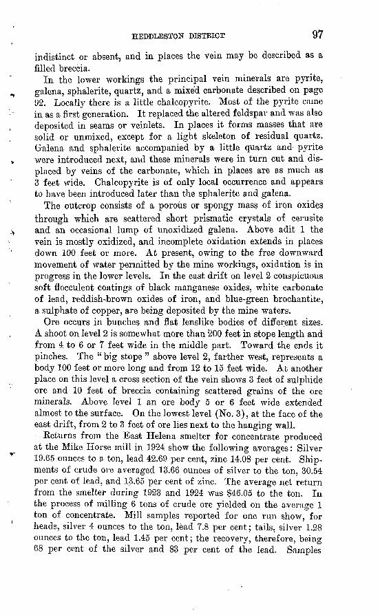
HEDDLESTON DISTRICT 97
indistinct or absent, and in places the vein may be described as a filled breccia.
In the lower workings the principal vein minerals are pyrite, galena, sphalerite, quartz, and a mixed carbonate described on page 92. Locally there is a little chalcopyrite. Most of the pyrite came in as a first generation. It replaced the altered feldspar and was also deposited in seams or veinlets. In places it forms masses that are solid or unmixed, except for a light skeleton of residual quartz. Galena and sphalerite accompanied by a little quartz and pyrite were introduced next, and these minerals were in turn cut and dis placed by veins of the carbonate, which in places are as much as 3 feet wide. Chalcopyrite is of only local occurrence and appears to have been introduced later than the sphalerite and galena.
The outcrop consists of a porous or spongy mass of iron oxides through which are scattered short prismatic crystals of cerusite and an occasional lump of unoxidized galena. Above adit 1 the vein is mostly oxidized, and incomplete oxidation extends in places down 100 feet or more. At present, owing to the free downward movement of water permitted by the mine workings, oxidation is in progress in the lower levels. In the east drift on level 2 conspicuous soft flocculent coatings of black manganese oxides, white carbonate of lead, reddish-brown oxides of iron, and blue-green brochantite, a sulphate of copper, are being deposited by the mine waters.
Ore occurs in bunches and flat lenslike bodies of different sizes. A shoot on level 2 is somewhat more than 200 feet in stope length and from 4 to 6 or 7 feet wide in the middle part. Toward the ends it pinches. The " big stope " above level 2, farther west, represents a body 100 feet or more long and from 12 to 15 feet wide. At another place on this level a cross section of the vein shows 3 feet of sulphide ore and 10 feet of breccia containing scattered grains of the ore minerals. Above level 1 an ore body 5 or 6 feet wide extended almost to the surface. On the lowest level (No. 3), at the face of the east drift, from 2 to 3 feet of ore lies next to the hanging wall.
Returns from the East Helena smelter for concentrate produced at the Mike Horse mill in 1924 show the following averages: Silver 19.65 ounces to a ton, lead 42.69 per cent, zinc 14.08 per cent. Ship ments of crude ore averaged 13.66 ounces of silver to the ton, 30.54 per cent of lead, and 1.3.65 per cent of zinc. The average net return from the smelter during 1923 and 1924 was $46.05 to the ton. In the process of milling 6 tons of crude ore yielded on the average 1 ton of concentrate. Mill samples reported for one run show, for heads, silver 4 ounces to the ton, lead 7.8 per cent; tails, silver 1.28 ounces to the ton, lead 1.45 per cent; the recovery, therefore, being 68 per cent of the silver and 83 per cent of the lead. Samples
98
reported to represent a large quantity of ore remaining in the mine contain an average of 4.87 ounces of silver to the ton, 7.14 per cent of lead, and 5.88 per cent of zinc. A sample reported from the eastern part of level 2 contained 13 ounces of silver to the ton, 2.8 per cent of copper, and 9.6 per cent of lead, and one from the east drift on level 3 contained 53 ounces of silver to the ton, 4.4 per cent of bismuth, and 63.4 per cent of lead. From these figures it ap pears that in the Mike Horse vein silver and lead are associated in about the proportion of half an ounce of silver to the ton for each per cent of lead. It is also interesting to note that the presence of either copper or bismuth is accompanied by a decided increase in the amount of silver.
Considering the size and continuity of the Mike Horse vein and the rather shallow depth to which it has been explored, it seems reasonable to expect other ore bodies beyond the horizontal and vertical limits of the present workings. A change in the general tenor of the ore is probably not to be expected in depth except pos sibly an increase in zinc and copper. The occurrence of copper and bismuth, accompanied by increased amounts of silver, suggests an ore shoot worth deeper exploration.
Little Nell and Intermediate veins. At points about 640 and 890 feet from the portal, tunnel 3 of the Mike Horse mine penetrates the Little Nell and Intermediate veins. The Little Nell vein occurs in gray porphyry, strikes N. 55° W., and dips steeply northeast or in the opposite direction from the Mike Horse vein. It is developed by drifts to the east and west aggregating about 250 feet. In the east drift the vein is disturbed by faults, but the face of a small stope above this level shows it to be about 2 feet wide. On the footwall isa 6 to 8 inch layer consisting chiefly of galena and sphalerite, with a little pyrite, which appear to have replaced the porphyry. The re mainder of the vein consists of mixed carbonate of a later generation, which was deposited in open spaces. The carbonate occurs also as veinlets cutting the sulphide minerals. Next to the vein the porphyry is softened and is sprinkled and seamed with pyrite, and its con stituent feldspars are largely altered to sericite. Above level 3 a lenslike ore body was as much as 5 feet thick. Samples of the vein remaining in place are reported to show from 1 to 9 ounces of silver to the ton, 1 to 23 per cent of lead, and 2 to 11 per cent of zinc.
The Intermediate vein strikes N. 68° W., dips steeply south, and therefore is about parallel to the Mike Horse. As shown by a very short drift, it occurs in altered porphyry and consists of 1 to 2 feet of almost solid pyrite lying next to a smooth wall.
Hogall vein. On the Hogall claim, 1,220 feet east of the Mike Horse, an adit at an altitude of 5,850 feet is driven eastward 120 feet on a vein that falls in line with the projected eastward continuation

HEDDLESTON DISTRICT 99
of the Mike Horse. The face of this working exposes somewhat broken argillite or slate. Next to a wall that dips steeply southward is from 2 to 6 inches of breccia and gouge with iron oxides, lead carbonate, and some residual .masses of pyrite and galena. Stringers of similar composition extend out into the footwall. A sample from this vein is reported to have assayed 116.5 ounces of silver to the ton and 28.9 per .cent of lead.
Red Wing vein. On the Red Wing claim, three quarters of a mile north of the Mike Horse, a 75-foot adit just below the road at an altitude of 5,350 feet follows a southward-trending vein in diorite. For most of the distance the vein is from 2 to 6 inches wide, but at the face of the adit the width is about 4 feet. There it is bounded by nearly vertical walls and consists of crushed country rock, con taining streaks and bunches of sphalerite, galena, and pyrite, named in their order of abundance. Some of the material is oxidized, one of the products being lead carbonate, which forms coatings in cavi ties. The crushed country rock has been partly altered to sericite.
FIGURE 16. Plan of adit level, Carbonate mine
CARBONATE
The workings of the Carbonate mine, in the western part of the Heddleston district, include an adit about 850 feet long which inter sects the lode 106 feet from the portal and beyond that point becomes a drift with several short crosscuts (fig. 16). About 300 feet from

100 GREATER HELENA MINING REGION, MONTANA
the portal the adit connects at a depth of 110 feet with a shaft that extends 200 feet deeper. Levels are turned from the shaft at the bottom and at a depth of 100 feet below the adit. With respect to the shaft, the adit is known as the 100-foot level, and the lower levels as the 200-foot and 300-foot.
The country rocks are a diorite sill several hundred feet thick 51 and a dike of badly decomposed fine-grained intrusive rock resem bling rhyolite that cuts the diorite at one place along the adit level. The lode trends northwest and cuts both rocks. Along most of the adit level it dips 80°-85° NE., but at the face of that working and below the 200-foot level it dips steeply in the opposite direction. It consists of a sheared zone (fig. 17) or zone of closely spaced fractures
distributed through a width of 1 foot to several feet, along which the country rock is al tered and more or less com pletely replaced by vein miner als. In addition, as shown near the shaft by crosscuts, there are several smaller subparallel veins.
Within the lode the country rock is altered to a rather soft light-gray gangue that consists largely of sericite. As a rule the gray gangue is thickly sprinkled with fine grains of
pyrite, and locally it is replaced by veins and bunches of coarser- grained pyrite, galena, and sphalerite with a gangue of quartz. Inplaces the lode is cavernous, owing to postmineral fracturing and an incomplete filling of the broken mass with pyrite. This later pyrite forms crusts of a radial structure deposited on the fragments of the other minerals. Th& sequence of events in the deposition of the lodes is rather plainly shown by alteration of the country rock along the fractures and introduction of the fine-grained pyrite; replace ment of part of the altered, pyritized material by galena, sphalerite, coarser pyrite, and quartz; and fracturing and introduction of the radial pyrite.
Parts of the lode rich enough to be classified as ore form bodies from a few inches to several feet in width. On the adit level about 150 feet northwest of the shaft a stope is begun on one of these bodies
FIGURE 17. Vein in Carbonate mine. Cross section on adit level; a, Diorite; 6, " gray gangue"; c, gouge-lined slip plane; d, " gray gangue " and sulphide ore
61 Further sinking done since the writer's visit shows, according to L. S. Ropes (personal communication), that the diorite sill is about 470 feet thick and that the lode continues downward into the shale below the sill.

HEDDLESTON DISTRICT 101
that is about 40 feet long and 3 to 4 feet wide. Drifts on the 200 and 300 foot levels show bodies as much as 6 feet wide composed largely of the sulphides mentioned, the sphalerite and galena form ing a considerable part of the mass. The " east vein " developed by a short crosscut and drift at the adit level is from 2 to 4 feet wide. It contains streaks of sulphide ore that in places are from 6 to 8 inches wide. A sample of one of these streaks is reported to have assayed 50 per cent of lead and 56 ounces of silver to the ton. Two or three narrow " west veins " as shown by a crosscut at the adit level are similar in composition to the other lodes.
On the Carbonate No. 3 claim, belonging to the group being de veloped by Mr. Kowand, is an adit level 250 feet long driven on a lode that cuts diorite, strikes N. 40° W., and stands nearly vertical. Like the body in the Carbonate mine the lode on this claim consists of sheared and altered diorite partly replaced by sulphides. It is as much as 15 feet wide and through out most of the level mentioned is partly or completely oxidized. In places considerable pyrite and some unidentified fine sulphide remain. The gangue minerals in- o ! . , , ? Feet elude a carbonate containing cal- FIGURE is. vein in Midnight mine, a,
T TJ.J.I Sulphide ore; 6. "gray gangue";cium, iron, and a little manganese. Oj
MIDNIGHT
Claims on the slope west of Shoue Creek, belonging to the Mid night Mining Co., are developed by several adits that are said to aggregate 3,000 feet in length. Most of these workings were made several years ago, but the " new tunnel," at an altitude of about 5,650 feet, was driven more recently. In 1926 and 1927 the mine was idle and entrances to some of the older workings were closed by caving.
Ore shipments are reported from the new tunnel to the amount of 25 tons that yielded somewhat more than $900 in copper and silver. This adit is driven N. 35° W. for 300 feet or more along a sheared zone in diorite. Within the zone, which is from 6 to 10 feet or more wide, the diorite is softened and altered to a light-gray material ("gray gangue") composed largely of sericite. Pyrite is thickly sprinkled through this material, and in places the mass is cut by seams and veins (fig. 18) containing pyrite, bornite, and quartz. A copper mineral that is probably chalcocite or tetrahedrite forms a black coating on some of the pyrite grains. In addition, galena and sphalerite occur in grains and bunches that are rather widely sep-
154419 33 g

102 GKEATER HELENA MINING REGION, MONTANA
arated from one another. The bulk of the pyrite appears to have been introduced first, galena and sphalerite next, and the copper min erals and quartz last.
Oxidation extends in places to a deptli of 50 feet or more from the surface, an abundant product of the process being, of course, iron oxides. Malachite occurs sparingly;, and in places considerable amounts of recently formed chalcanthite are deposited on the walls and timbers of the tunnel.
The copper minerals are largely confined to a body 200 feet or more long and from 2 to 5 feet wide from which the ore shipments were taken. The smelter returns show 0.10 ounce of gold, and 36.3 and 38.5 ounces of silver to the ton and, in percentages, lead 2.7 to 3.2, zinc 2.5 to 2.9, copper 17.0 to 18.6, silica 18.8, and iron 19.7. The gross returns ranged from $44 to $48 a ton; the net returns were $10 a ton less. A sample from a point 75 feet in from the portal of the tunnel is said to have contained 37 ounces of silver to the ton and 17 per cent of copper. Another sample from a winze 40 feet, deep as sayed 12 ounces of silver to the ton and 8 per cent of copper. The association of silver and copper is indicated in the proportion of about 2 ounces to the ton of silver to each per cent of copper.
The dump of an adit at a level about 150 feet lower consists partly of argillite or slate and partly of diorite. The argillite contains a considerable amount of fine pyrite distributed along seams, and the diorite is altered to gray gangue and partly replaced with pyrite and ankerite. Material consisting mainly of pyritized gray gangue which has been exposed to the weather on the surface of the dump is slackened to a claylike mass that in places shows a little green copper stain and films of manganese oxides.
At a level about 150 feet lower than the last-mentioned workingis an adit that for the first 400 feet is a crosscut in a northwesterly direction and beyond that point follows a north and west course for more than 1,000 feet. At 400 feet from the portal a short drift south through quartzite exposes a vein a foot wide that strikes north west and dips 60° NE. On both walls of the vein are streaks of pyrite and copper sulphides from 1 to 3 inches thick, the remainder of the vein being country rock through which small quantities of the sulphide minerals are scattered. Ten feet farther northeast is a par allel vein 2 inches wide composed of bornite and other sulphides.
CALLIOPEThe Calliope mine, north of the Midnight, on the ridge between
Shoue Creek and Pass Creek, is said to have been the first deposit worked in the district. It was discovered in 1889 by William Hed- dleston and George Padbury, who made ' : wages " the next summer carrying the ore down to the streams and washing it in a gold pan.

HEDDLESTON DISTRICT 103
Afterward they built an arrastre on Pass Creek, which they oper ated on ore from the Calliope mine at times during a period of six years, recovering about $11,000 in gold.
The workings consist of a shaft said to be 80 feet deep and an adit level about 300 feet long that connects with the shaft at about 200 feet from the portal and at a depth of 50 feet. The adit enters the slope above Shoue Creek at an altitude of about 5,700 feet, or 400 feet above the stream.
As exposed in the adit, the vein trends about north-northwest and cuts rhyolite porphyry. It is irregular and branching and in most places ranges in width from a seam to 4 or 5 inches. Near the shaft it opens into two pipelike bodies 6 to 8 feet in diameter in which the rich gold ore was found. These pipes have been worked from the surface to a depth of 20 feet below the adit, where they pinched out.
Next to the vein the porphyry is somewhat altered to sericite and sprinkled with a moderate amount of fine pyrite, which was intro duced along seams. Near the surface it is weathered to a reddish, finely porous rock. The vein filling consists of iron-stained cavernous or " honeycomb " quartz and a soft, gougelike material consisting chiefly of sericite and iron oxides. A specimen of the rich ore from the shaft in the possession of Mr. Padbury consists chiefly of vein quartz and limonite, the latter containing abundant visible small flakes and grains of gold. One flake of gold is plastered on the out side of a quartz crystal, but none is embedded in or intergrown with the quartz. The gold is deep yellow and is said to be worth $17 an ounce. It is alloyed with silver.
MILLIRONAdits and open cuts south of the Carbonate Hill claim develop a
lode on the Milliron claim that strikes N. 20° W. and dips 40°-50° W., in argillite country rock. The lode is from 6 to 18 inches wide and consists of iron oxides and ankerite with carbonate of lead and bunches of galena. It lies at one side of a crushed zone 200 feet wide (fig. 19), which trends northwest and evidently marks the position of a fault. An open cut below the workings mentioned shows the breccia to, contain small lumps of galena and other vein minerals that evidently were dragged into the fault. At a still lower level is an adit that was locked up and inaccessible at the time of the writer's visit. rThe dump of this working consists mainly of softened material containing much pyrite and similar in appearance to the gray gangue of the Midnight and other mines.
CARBONATE HILL
The Carbonate Hill claim of Joseph Oker is on the slope east of Pass Creek about a mile north of the Blackfoot River. A lode that strikes north and dips steeply west to vertical is developed by pits
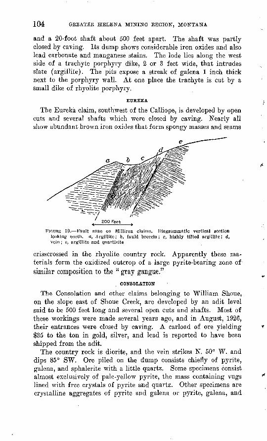
104 GREATER HELENA MINING REGION, MONTANA
and a 20-foot shaft about 500 feet apart. The shaft was partly closed by caving. Its dump shows considerable iron oxides and also lead carbonate and manganese stains. The lode lies along the west side of a trachyte porphyry dike, 2 or 3 feet wide, that intrudes slate (argillite). The pits expose a streak of galena 1 inch thick next to the porphyry wall. At one place the trachyte is cut by a small dike of rhyolite porphyry.
EUREKA
The Eureka claim, southwest of the Calliope, is developed by open cuts and several shafts which were closed by caving. Nearly all show abundant brown iron oxides that form spongy masses and seams
a
FIGURE 19. Fault zone on Milliron claims. Diagrammatic vertical section looking north, a, Argillite; t, fauld breccia; c, highly tilted argillite; d, vein; e, argillite and quartizite
crisscrossed in the rhyolite country rock. Apparently these ma terials form the oxidized outcrop of a large pyrite-bearing zone of similar composition to the " gray gangue."
CONSOLATION
The Consolation and other claims belonging to William Shoue, on the slope east of Shoue Creek, are developed by an adit level said to be 500 feet long and several open cuts and shafts. Most of these workings were made several years ago, and in August, 1926, their entrances were closed by caving. A carload of ore yielding $35 to the ton in gold, silver, and lead is reported to have been shipped from the adit.
The country rock is diorite, and the vein strikes N. 50° W. and dips 85° SW. Ore piled on the dump consists chiefly of pyrite, galena, and sphalerite with a little quartz. Some specimens consist almost exclusively of pale-yellow pyrite, the mass containing vugs lined with free crystals of pyrite and quartz. Other specimens are crystalline aggregates of pyrite and galena or pyrite, galena, and

HEDDLESTON DISTRICT 105
sphalerite. A little bornite is associated with the pyrite. These minerals have partly replaced altered diorite. The adit is said to expose three ore shoots that range from 10 to 30 inches in width and from 50 to 75 feet in length. Samples of different ore bodies are reported to have assayed as much as $38 in gold and 19 ounces of silver to the ton, 23 per cent of lead, and 6 per cent of copper.
An open cut above the adit partly exposes the vein outcrop, which consists of finely porous or cavernous iron oxides showing lustrous bronze films (peacock iron) on surfaces.
Rich silver ore is reported to have been found on the Blackfoot Belle claim at the surface.
BEX BEACH
The Rex Beach mine of the McKeesport Mining & Milling Co. is on the slope east of Shoue Creek, north of the Consolation group. The main development working is a crosscut adit about 200 feet long, with about 300 feet of drifts along two veins.
The country rock is diorite, which in or close to the veins shows the usual alteration to " gray gangue." One vein strikes N. 15° E., dips 80°-90° W., and ranges in width from a seam to 2 or 3 inches. It follows a narrow dike of gray porphyry, and in the face of the drift it is filled with a rather coarse granular intergrowth of pyrite and galena. This mineral aggregate contains numerous open spaces or vugs that are lined with free crystals. The other vein is a crushed and mineralized zone from 4 to 7 feet wide lying next to a nearly vertical wall that strikes about N. 15° W. Grains and veinlets of pyrite, galena, and sphalerite are scattered through the zone, and the rock is partly replaced by a mixed carbonate of cal cium, magnesium, and iron which was introduced later than the sulphides. The certificate of analysis of a sample from the Rex Beach mine, sent to the Bunker Hill smelter at Bradley, Idaho, shows the ore to be chiefly valuable for silver, gold, and lead, but it contains also considerable zinc and appreciable amounts of cop per, arsenic, and antimony. As might be expected, iron and sulphur are relatively abundant. Insoluble matter, presumably silica, is low. The percentage of carbonate was not determined. The value of the recoverable metals in this ore, omitting either lead or copper, is about $45 a ton.
IRON HILL AND SKYSCRAPER
The Iron Hill claim of Ben Miller, on the slope north of the Blackfoot River, is developed by an adit 400 feet or more long. The country rock is diorite, and the vein is a sheared and crushed zone 3 to 4 feet wide that strikes N. 35° E., dips 70° SE., and, as shown by the adit, continues for at least 300 feet. The rock is partly altered to sericite, and considerable pyrite and a little galena and
106 GREATER HELENA MINING REGION, MONTANA
sphalerite have been introduced into the zone. In one place the zone contains a vein of quartz 1 foot or more wide showing vugs lined with free crystals.
A 40-foot shaft on the Skyscraper claim, on the slope above the Iron Hill, shows a body containing iron oxides and galena.
ANACONDA
The Anaconda mine, on the slope north of the Blackfoot Eiver opposite Mike Horse Gulch, was rather extensively developed several years ago, and a few ore shipments were made. Certificates of the East Helena smelter for 80 tons purchased in 1920-1923 show an average of somewhat more than $40 a ton, chiefly in gold, silver, and copper. According to Fred Dickert, the manager, the total produc tion of the mine amounts to 1,000 tons of ore that yielded about $30,000 net.
The development workings include a shaft at the foot of the slope, tunnel 1 at the shaft level, tunnel 2 at a level about 200 feet higher, and an older caved shaft and adit. The newer shaft is said to be 325 feet deep with drifts at different levels that aggregate 1,700 feet in length. Tunnel 1 is said to be 900 feet long, and tunnel 2 is at least 500 feet. In August, 1926, workings below the shaft collar were under water.
The vein is a crushed zone from 3 to 5 feet or more wide with one well-defined wall that strikes N. 40° E. and dips 75° SE. In tunnel 2 it is continuous for 400 feet or more from the entrance. Beyond that distance the lode narrows to a gouge-lined seam that bends eastward. Farther on, other seams are crossed by the drift. Fault movements along the lode have downthrown the hanging wall, as shown part way in the drift, where argillite or slate has been dropped againstdiorite.
The country rocks are argillite or slate, diorite, and granodiorite porphyry. The diorite is intrusive into the slate and the porphyry into both. The shaft is reported to pass through diorite for 275 feet, below which it enters slate. The diorite continues above the shaft to a level slightly higher than tunnel 2 and has the form of a sill about 500 feet thick that dips gently northward, or into the mountain. The porphyry occurs as a dike. Close to the vein the slate is sprinkled with pyrite but otherwise shows little change. The diorite is more noticeably altered to a light-gray material (gray gangue) in which the original feldspars and ferromagnesian min erals are largely replaced by sericite.
The vein has the structure of a filled breccia in which the com ponent minerals have also partly replaced the fragments of altered country rock. In addition to the unreplaced residue of country rock it

HEDDLESTON DISTRICT 107
contains galena, sphalerite, pyrite, bornite, arsenopyrite, and a mixed carbonate that ranges from nearly pure calcite to rhodochrosite. Pyrite appears to have been introduced along with or shortly after the solutions that altered the wall rocks. It is sprinkled through the altered rock generally and in places forms a large part of the vein filling. The dump of an old and inaccessible working west of tun nel 2, evidently located on a separate lode, contains a large amount of pale-yellow pyrite, some masses of which are as much as 6 or 8 inches in diameter. The pyrite is associated with gray gangue, which weathering has caused to break down to a stiff cream-colored mud that, in drying, crusts over on the surface. More or less pyrite also accompanies each of the later generations of minerals within the vein. Galena, sphalerite, bornite, and arsenopyrite with a little quartz followed the bulk of the pyrite and replaced other parts of the brecciated, altered country rock. The galena and sphalerite are rather widely distributed and about equal in amount. Bornite is less abundant and confined to a shorter stretch of the lode, and arsenopy rite is rather uncommon. The mixed carbonate invades and replaces the minerals mentioned and composes a rather large part of the lode.
The oxidized zone is composed mainly of iron oxides and quartz with residual claylike material from the country rock. It extends perhaps1 50 feet below the surface. In tunnel 2, beyond the oxidized zone, blue copper sulphate is being deposited by the mine waters.
Tunnel 1 was not entered by the writer. Acid mine water issu ing from it has almost completely dissolved the rails of the car track. The combined dump of the tunnel and shaft shows much pyrite.
An ore shoot from 3 to 5 feet wide and 75 feet in stope length is exposed in tunnel 2, beginning at a point about 200 feet from the portal. It is said to extend upward to the surface and down nearly to tunnel 1, its total pitch length being about 300 feet. Certificates from the East Helena smelter for ore, most of which was taken from this body, show the following ranges in composition: Gold, 0.53 to 0.83 ounce to the ton; silver, 24.7 to 28.3 ounces; lead, 4.5 per cent (one lot only); copper, 3.6 to 4.7; iron, 33.4 to 35.1; zinc, 1.3 to 1.4; silica, 7.2 to 9.6; sulphur, 27.6 (one lot); manganese, 0.6 (one lot). The gross value of the ore ranged, in round figures, from $37 to $45 a ton.
Considerable amounts of lower-grade ore are said to be exposed by tunnel 1 and the levels from the shaft. Diamond drilling is said to have shown the presence of pyrite, galena, sphalerite, and chalco- pyrite in the vein at a depth of 600 feet below tunnel 1, about 275 feet below the bottom of the shaft. The country rock at that point is argillite below the diorite sill. «>

108 GREATER HELENA MINING REGION, MONTANA
PAYMASTER
The Paymaster group of claims, in the western part of the district, south of the Blackfoot Kiver, is developed by adits at the foot of the slope and at two higher levels. In August, 1927, these workings were partly closed by caving, and their appearance indicated they had not been in use for several years. They were not entered by the writer. The dumps are large and consist mainly of altered diorite, containing much pyrite. This material, where exposed to the weather, has broken down to a claylike mass streaked with iron oxides. The mine waters issuing from the dump are depositing con siderable amounts of iron oxides, which, when dry, form a fine, red dish-brown to yellowish-brown powderlike ocher. Fragments of ore found in the dumps consist chiefly of pyrite and tetrahedrite with a little galena and sphalerite. The gangue is the quartzose residue of the partly replaced country rock. .Shipments are reported of about 100 tons of ore, the returns for which are not known. The lowest adit is said to be a crosscut 900 feet long that penetrates the Paymaster vein at a distance of 500 feet and the Black Diamond vein at the end. These veins strike east and wqst and are said to be developed by several hundred feet of drifts. A 50-foot winze on the Paymaster vein is said to show ore in the bottom. The upper workings include an adit on each vein. The one on the Paymaster vein is said to have found a body of galena. The country rock is diorite, which, as shown by diamond drilling, gives place to slate at a depth of about 100 feet below the lowest adit.
ELEINSCHMIDT AND OTHER CLAIMS
Several mines and prospects within or near the Heddleston dis trict were not seen by the writer. Among these is the Kleinschmidtgroup, northwest of the Mike Horse mine, which is said to be de veloped by extensive underground workings. The ore contains pyrite, sphalerite, and galena and otherwise is typical of the district. Below the outcrop a mass of surface mantle is cemented with iron oxides.
WOLF CREEK DISTRICT
HISTORY AND PRODUCTION
Mining development in the Wolf Creek district began after the Great Northern Kailway was built through the region, about 1890, and since then has been carried on intermittently. Most of the work has been done on the Hudson and Bissonette mines, on Little Creek, and the New Era or Rosenfield mine, on Wolf Creek. Available records show a production of a little more than $25,000 worth of copper. An t additional amount of at least $15,000 in copper and $10,000 in silver is estimated.

WOLF CKEEK DISTRICT 109
GEOGRAPHY AND GEOLOGY
The Wolf Creek district is an indefinitely bounded area lying mainly south and west of Wolf Creek station on the Great Northern Railway. It includes parts of the drainage basins of Wolf Creek, Little Creek, and two or three small tributaries of Little Prickly Pear Creek from the east. In addition to the railway, the main automobile highway between Helena and Great Falls passes through the district, and branch roads extend up Wolf and Little Creeks.
The area considered is within a group of unnamed moderately elevated mountains that extend from the gorge of the Missouri River named by Lewis and Clark the "Gates of the Rocky Mountains" northwestward to the headwaters of the Blackfoot River. They are composed of ridges separated by narrow, steep-sided valleys from 1,000 to 3,000 feet deep. Their general summit altitude is 6,500 to 7,000 feet. The summits of the main ridges accord with a surface of moderate relief and gentle contour.
The principal formations of the district are shale and argillite but include many layers of sandstone or quartzite, all belonging to the Algonkian Belt series. Stratigraphically above the Belt is pinkish-gray Flathead quartzite (Cambrian), exposed chiefly on the divide between Little Creek and Wolf Creek. The Flathead quartzite forms prominent outcrops that are generally flanked by course blocky talus.
The rocks mentioned are intruded by a few sills and dikes of diorite, and on the northeast they are overlain unconformably by a great mass of volcanic rocks, chiefly andesite flows, tuffs, and breccia. Microscopic examination of the andesite shows it to be composed of plagioclase phenocrysts in a groundmass of fine plagioclase and opaque material containing much magnetite and hematite. The relation of this rock to the lodes is not shown. It is probably of middle Oligocene or later age, because it lies on a surface formed by deep erosion of the rocks after the Laramide folding. A small dike of basaltic rock exposed at a spring on the Crescent claim, on the slope north of Little Creek, consists, as shown by the microscope, of a felted mass of plagioclase with lath-shaped hornblendes of an unusually dark green color.
The sedimentary beds strike northwest and commonly dip as much as 45° SW., but on the ridge north of Little Creek they do not crop out in regular succession, owing to a fault on which dark-gray shale is thrust north and east over red, green, and gray shale and sand stone that belong higher in the Belt sequence. The total amount of movement on this fault is not shown, but the vertical displacement appears to be at least 2,000 feet and possibly is as much as 5,000 feet.

110 GREATER HELENA MINING REGION, MONTANA
This fault is older than the andesite, beneath which its trace dis appears east of Little Prickly Pear Creek.
ORE DEPOSITS
Lodes containing copper with more or less silver and gold are rather widely distributed in the area of Belt rocks. They strike northeastward and as a rule dip rather steeply to one side or the other. Most of them are rather narrow, but they appear to be per sistent in length and depth and of fairly regular tabular or veinlike form. The ore is composed mainly of chalcopyrite or of chalcopyrite and tennantite, accompanied by pyrite and a gangue of quartz and barite in varying proportions. Tetrahedrite and secondary covellite were observed in some of the lodes. The ore shoots are lenslike, and their value depends almost entirely on the primary minerals mentioned. Ore from the New Era mine, which consists mainly of chalcopyrite, yields as much as 25 per cent of copper with little or no gold or silver. Ore from the other mines containing tetrahedrite or tennantite carries more or less silver.
In the New Era mine postmineral faulting has occurred in the plane of the vein, and there are many small cross fractures, which however, do not displace the ore bodies. In fact, most of them appear to antedate the ore and have themselves been mineralized to some extent. So far as explored the cross fractures do not carry workable ore bodies, but the ore in the main vein is chiefly developed where these fractures join it.
Except for an insignificant amount of secondary covellite the cop per minerals are of deep-seated origin and should continue to be found below the present workings. Although the lodes are rather narrow, many of them appear promising for the development of profitable ore bodies.
MINES AND PROSPECTS
NEW ERA
The New Era or Kosenfield mine is on the southwest side of Wolf Creek about 5 miles from the settlement of New Era on the Great Northern Railway. It was operated at times in 1922-1926, during which a production of $25,516 chiefly in copper is shown by the smelter net returns. The amount of copper in the ore ranged, in round figures, from 7 to 25 per cent. One shipment contained 39 ounces of silver to the ton, and two others 7 ounces each. These were among the first shipments made and probably represent partly oxidized or enriched ores found near the surface. In all other ship ments the amount of silver varies little from 2 or 3 ounces to the ton and shows no relation to the amount of copper present. About half of the shipments contained 10 cents in gold to the ton; the

WOLF CREEK DISTRICT 111
others carried traces only. During the period of these shipments the price of copper was 12 to 14 cents a pound.
The main working is an adit (fig. 20) at a level a little above the stream. It follows the vein southwestward for 700 feet, and cross cuts and branches make an aggregate of 1,100 feet or more of under ground work. In addition there are several shorter adits up to levels about 300 feet higher.
FIGURE 20. Plan of main adit level, New Era mine
The main adit for a distance of 600 feet exposes a fault vein that trends about N. 35° E., dips 50°-70° NW., and cuts across beds of quartzite and slate (argillite) of the Belt series. For about 200 feet from the portal, quartzite forms both walls of the vein. Beyond that the northwest (hanging) wall is chiefly quartzite and the footwall chiefly green slate. At several places the vein contains lenslike bunches of ore from a few inches to a few feet in width. Many seams and slips, some of which carry a little ore, cross the main fracture or lead off into the walls, more commonly into the quartzite, which is more or less broken for a distance of 40 feet or more from the vein. In places the vein carries abundant gouge, and

112 GREATER HELENA MINING REGION, MONTANA
the ore and gangue minerals are more or less crushed by fault move ments. Considerable displacement of the walls is shown, most of which probably occurred before the ore was introduced.
The ore consists of chalcopyrite or its oxidation products in a gangue made up chiefly of quartz. In places there is considerable barite. Near the surface, where oxidation is practically complete, the lode consists of abundant brown iron oxides with more or less copper stain. Ore from the main tunnel level is partly oxidized and commonly shows considerable azurite. Microscopic examination of the sulphide, ore shows that alteration of the chalcopyrite begins along cracks in which supergene or secondary covellite and limonite are first developed. The chalcopyrite itself is later than some of the quartz. (See pi. 13.)
The development workings so far made show that despite the many branch slips and seams the main fracture holds well to its course and is nowhere seriously displaced. Although the branches, slips, and seams carry some ore, the principal bodies are found along the main fracture at places where the cross fractures are mostnumerous.
HERWOOD
The Herwood mine is on Gladstone Creek, a tributary of Wolf Creek from the south. It is about a mile west of the New Era mine and 6 miles from Wolf Creek settlement. In September, 1928, devel opment work was being done by Alfred A. Hansen and T. H. Woods. An adit driven southeast 200 feet in green argillite of the Belt series cuts a vein that strikes N. 60° E., dips 80° N., and ranges from an inch to a foot or more in width. The vein consists chiefly of quartz and bornite. In places there is a little ankerite and chalcopyrite. The ankerite is the oldest and is replaced by quartz, which in turn is somewhat corroded by the bornite. Microscopic examination of the sulphide ore shows the bornite to be traversed by tiny veinlets of supergene or secondary chalcocite that represents a preliminary stage in the process of sulphide enrichment related to oxidation. The ore is " frozen " to the walls, and there is no evidence of post- mineral movements within the vein. At the face of the tunnel the depth below the surface is about 85 feet.
A sample shipment of 2,700 pounds of ore is said to have yielded about $100 to the ton in copper, silver, and gold. Other parallel similar veins reported to crop out farther up the slope were notexamined.
HUDSON
Several mining claims belonging to S. C. Hudson and others are on Little Creek a short distance above its junction with Little Prickly Pear Creek and about 3 miles from Wolf Creek settlement.
WOLF OEEEK DISTRICT 113
During the last 30 or 40 years considerable development work has been done on these claims, and several lots of ore have been shipped. Workings south of the creek include three adits, the two lower of which, at the time of the writer's visit, were caved at their portals and inaccessible. An ore bin and tramway at the upper of the two show evidence of disuse for considerable time. From this working 14 carloads of ore are said to have been shipped, the records for which are not available. The highest adit is 100 feet long. It follows a vein that strikes S. 60°-70° W., dips 45° NW., and is about 4 feet wide. The walls are smooth and gouge-lined, and the vein filling is crushed argillite and quartz containing streaks and bunches of bornite with crusts of malachite on seams. Open cuts south of this adit show the outcrop of the vein in that direction to continue for 400 feet or more and to contain about a foot of copper-stained quartz.
On the north side of the creek on the Honeycomb claim an adit 240 feet long crosscuts a vein along which drifts aggregate 100 feet or more. The vein strikes N. 60° E., dips 45°-60° W., and is 4 feet wide in places. It is composed of sheared black slate country rock and quartz, with more or less copper and iron sulphides. Ore occurs in rather small bunches or pipes. Smelter returns for a shipment of 16 tons show in round figures 10 per cent of copper and 5 ounces of silver and 0.01 ounce of gold to the ton. From an adit at a level about 150 feet higher ore is said to have been shipped that carried from 10 to 20 per cent of copper and 4 to 20 ounces of silver and 60 cents in gold to the ton. Farther up the slope (northeast) shallow workings on the Montreal claim expose a small vein composed chiefly of quartz with iron oxides and copper stain. There remain, how ever, some unoxidized primary sulphides, determined by M. N. Short to be tennantite (arsenical sulphide of copper) and chalcopyrite. These minerals are largely oxidized to tenorite (black oxide of cop per) and limonite. Covellite is also present as a product of down ward sulphide enrichment during oxidation of the upper part of the lode.
BISSONETTE
The Champion and Liberty claims of 0. H. Bissonette adjoin the Hudson group on the northeast and extend beyond the divide between Little Creek and Wolf Creek. Tunnel 2, on the Little Creek slope, at an altitude of about 4,900 feet, begins in red argillite of the Belt series. In a distance of about 500 feet it crosses several slips that strike northwest, parallel to the bedding of the rocks. The tunnel was closed by caving at a point about 500 feet from the portal. Several .tons of ore piled on the dump presumably came from points farther in. It consists chiefly of barite with more or less quartz and

114 GREATER HELENA MINING REGION, MONTANA
a little tennantite and chalcopyrite. Tunnel 1, at a level about 110 feet higher than No. 2, was examined for 300 feet, beyond which it was also closed by caving. This working follows a vein that strikes northeast, dips 75° SW., and cuts across beds of red argillite. The vein ranges from a few inches to 4 or 5 feet in width and consists o-f quartz and barite with more or less of copper sulphides or their oxidation products. At one place a small stope is made on a shoot from 3 to 5 feet wide that shows chalcopyrite, tennantite, galena, and sphalerite. This ore body is said to carry considerable silver. It ends on the northeast at a transverse fault, beyond which the vein is badly crushed. The point where the adit is closed by caving is marked by another transverse fault, at which the red argillite coun try rock gives place to green argillite.
OLD SILVER, ADAMS, AND SHEEP CHEEK
On the east side of Gladstone Creek, a quarter of a mile above its mouth and about half a mile southwest of the New Era mine, are an open pit and an adit closed by caving, known as the Old Silver mine. The workings are made on a vein 4 feet wide that consists chiefly of quartz and ankerite with a little finely divided pyrite, chalcopyrite, and possibly other sulphides that are segregated in thin dark bands.
Specimens from the apex claim of O. D. Adams on the ridge south of Wolf Creek represent a small quartz vein containing barite.
On Sheep Creek about 3 miles south of Wolf Creek station are two shafts each said to be 200 feet deep that were made a few years ago to develop a copper-bearing lode on the Sheep Creek group of claims. Work ceased before the lode was discovered in depth.
OUTLYING DISTRICTS
Gold Canyon. A little placer mining was being done in . 1911 in the upper part of Gold Canyon, about 5 miles north of Elliston, by Bartholomew Feist. According to Mr. Feist, gravel deposits along the stream had during the previous 20 years yielded $95,000 in placer gold. But little workable ground remained.
Washington Gulch, Jefferson Gulch, and Buffalo Gulch. These streams, which drain part of the slope west of the Continental Di vide north of Ophir, have yielded moderate amounts of placer gold, most of which was produced prior to 1890. Since then placer min ing has been done in a small way in places. In the last 20 years a small production of gold from quartz lodes and from placers has been reported.52
Sauerkraut Gulch. Placer deposits in Sauerkraut Gulch, a small south tributary of the Blackfoot River below Lincoln, are reported
52 Mineral Resources of the United States.

OUTLYING DISTRICTS 115
to have yielded a moderate amount of gold. In 1926 Robinson & Flesher were operating a mine in this gulch at a point about 3 miles above its mouth. Below the mine is a flat, half a mile or more long, beyond which the gulch is narrow and its gradient steep. The gulch above the narrows is reached by means of a road that crosses the divide east of the flat.
The prevailing formation is a limy argillite apparently several thousand feet thick that belongs to the Belt series. It forms a rough, humpy bedrock at the Robinson & Flesher mine. Along the lower narrow stretch of the valley and over the adjoining ridges is a thick deposit of drift which evidence obtained farther afield shows to have been deposited by huge glaciers that came from the north, crossed the Blackfoot Valley, and pushed short distances up the streams from the south. This drift fills the lower part of the preglacial valley of Sauerkraut Creek. Sediments that have accumu lated above it form the flat below the Robinson & Flesher mine. The drift is of late Pleistocene age, but its degree of weathering and other features indicate it to be somewhat older than the Wisconsin stage.
The Robinson & Flesher mine is an open cut that, in August, 1926, was 1,500 feet long and 100 feet wide at the face. It exposes a gravel deposit about 15 feet deep that contains many large boulders and angular masses of argillite and quartzite. The gravel was being mined by ground sluicing with heavy rushes of water controlled by a reservoir the method known as booming. The gold is confined to a moderately coarse gravel found on higher parts of the bedrock surface. The lower part is a channel containing very coarse gravel but no gold. The sequence, of events appears to have been deposi tion of the gold-bearing gravel by a stream of moderate velocity, followed by the cutting of a new channel by a more vigorous stream that swept away part of the gold-bearing material and redeposited coarse barren gravel.
In the flat below the Robinson & Flesher mine gravel that was profitable in spots is said to have been mined years ago by drifting. The gravel composing the top of the flat is of the same period as the newer barren gravel in the Robinson & Flesher mine. It ac cumulated against the dam of glacial drift farther down. Possibly the drift buries a continuation of the gold-bearing gravel.
Lincoln Crulch. Lincoln Gulch, which joins the valley of the Blackfoot River about 4 miles west of the present town of Lincoln, was one of the richer of the gulches mined during the early days. According to Joseph Reeseman, who has been a resident of the region since 1871, the diggings were discovered about 1865 by a party composed of Richard Evans, D. W. Gulp, and others. In 1871 a hundred miners were still at work, but the camp was declining.

116 GREATER HELENA MINING REGION, MONTANA
A few years later work had practically ceased. During a period of several years, beginning in 1904, some of the undrained gravel in the lower part of the gulch was mined through shafts and a long tunnel by a company composed of Dr. 0. M. Lanstrum and others. In 1926 no work was being done, and all that remained to mark the site of the Lincoln mining camp were a few decayed log foundations.
According to information obtained from Mr. Reeseman, it is esti mated that the early-day drift miners produced nearly $7,000,000 in gold from a stretch of the gulch 7,400 feet long. The pay streak was from 50 to 300 feet wide and averaged at least $375 to a set. which was a block 4 feet wide, 4 feet high, and 10 feet long. Some spots were very rich, as much as $2,400 being yielded by a single block. Above the drifted ground the gulch was mined for about a mile by open pits or ground sluicing. The production from that stretch and from the ground worked by the Lanstrum Co. is not known.
Lincoln Gulch is a narrow, steep-sided valley that opens out into a large flat where it joins the valley at the Blackfoot River. The stream is small, and water for mining was ditched in from neighbor ing creeks. The prevailing rocks are argillite and quartzite of the Belt series. On the slope west of the gulch these rocks are cut by a diorite dike. The gulch shows no evidence of glaciation, but the ridge on the east is composed partly of drift deposited by a glacier that occupied the adjoining valley. The flat at the mouth of the gulch is, in part at least, composed of outwash gravel from this glacier.
From the Lanstrum Co.'s workings down toward the Blackfoot River there remains a considerable stretch of unworked ground in which a pay streak, if present, is rather deeply buried beneath bar ren glacial outwash. Owing to the small gradient in that part of the valley, dredging would appear to be the most suitable method of working the deposit.
The gold of Lincoln Gulch is said to have been unusually pure; it was worth about $19 an ounce. Most of it occurred as the fine par ticles called " dust," and nuggets were rare. The source of the gold was probably lodes that existed in the formations worn away during the erosion of the gulch. The diorite dike that crops out on the west side of the gulch is accompanied by a deposit of low-grade gold ore in the Blackfoot mine, described below, and a small pocket of rich gold ore is said to have been found in the diorite at a point near the upper end of the pay gravel.
The Blackfoot mine of J. A. Kowand is on the west side of Lin coln Gulch near its junction with the Blackfoot River, about 4 miles west of the town of Lincoln. It consists of a tunnel and crosscuts

TJ. S. GEOLOGICAL SURVEY BULLETIN 842 PLATE 13
A. ORE FROM NEW ERA MINE
Quartz vemlets (qtz) eaten through in places by chalcopyrite (ep). Super-gene covellite veinlets (cv) follow the earlier-formed quartz. The covelHte veinlets have a medial seam of limonite.
B. ORE FROM NEW ERA MINE
From same specimen as A. Large pyrite crystal (py) about three-fourths oxidized to limonite (Jim). Supervene covellite veinlets (cw) with a medial seam of limonite cut chalcopyrite (cp~).

U. S. GEOLOGICAL SURVEY BULLETIN 842 PLATE 14
A. CRUMI'LED MADISON LIMESTONE ALONG UPPKR TROUT CREEK
Near Scout Camp ovcrthrusL fault.
B. SKVEN-UP PETE GULCH
Timbered slopes in andesite.

OUTLYING DISTRICTS 117
said to have a total length of 2,500 feet. The country rock is light- gray diorite that is intrusive into limy argillite of the Belt series and is part of a dike extending several miles northwestward along the west side of Lincoln Gulch. A representative specimen is described by Clarence S. Boss as consisting of about 75 per cent andesine and the remainder chiefly hornblende and biotite in equal amounts. The andesine is partly sericitized, and the rock contains a little magnetite and augite that has been partly altered to hornblende. The lode occupies a shear zone that trends northward and is as much as 20 or 30 feet wide. The diorite of this zone is largely replaced by quartz and an iron-calcium carbonate near siderite in composition and sprinkled with fine grains of pyrite. The oxidized part of the lode, which extends to a moderate depth, is a finely porous or cavernous quartzose rock stained with iron oxides. The lode, which evidently contains a very large tonnage, is reported to average from $2.20 to $3 a ton in gold, assay value. Test runs in a small mill at the mine are said to have shown a high recovery.
McClelloffi Gulch. Placer deposits that were mined in McClellan Gulch between 1864 and 1875 are estimated by persons familiar with the region to have yielded $7,000,000 in gold. The deposits were very rich, a single pan (two shovelfuls) of gravel being said to have yielded $500. Since 1875 they have been profitably reworked, in places as many as two or three times. In 1926 A. J. Wood and Fred Meade were mining through an open cut at a point about 2^ miles above the mouth of the gulch, in ground that previously had been worked by drifting. In the spring of 1927 they are reported to have found a gold nugget weighing 57 ounces, worth $1,026. The largest nugget previously found in the gulch is said to have been worth $700. The total amount produced by Wood and Meade and by. others who have reworked the gulch since 1875 is not known.
McClellan Gulch is a short south tributary of Poorman Creek at a point about 8 miles south of Lincoln, on the main automobile road between Lincoln and Helena. The valley is narrow and steep sided and shows no evidence of glaciation. The prevailing rocks are argillite and quartzite belonging to the Belt series. As indicated by float or loose fragments in the surface mantle, granite (mon- zonite) and related igneous rocks occur near the head of the gulch. The placer gravel, including the more or less barren upper layers, ranges from 15 to 30 feet or more in thickness and is commonly a few rods wide. It' is of medium texture with a few large boulders. Pay streaks were found in buried channels at two levels, a lower or " gulch" channel and a higher or " bar" channel. The gold occurs mostly in grains the size of wheat or larger, and many nuggets have been found. The value of the gold, as indicated by
154419 33 9

118 GREATER HELENA MINING REGION, MONTANA
the large nugget previously mentioned, is $18 an ounce. The source of the gold was probably quartz lodes, as suggested by outcrops on the slopes at the head of the gulch. So far as they have been de veloped, these lodes are said to be of too low grade to mine. They may, however, have contained rich shoots in the parts that were worn away during the formation of the placer gravel.
&'even-up Pete Gulch. Seven-up Pete Gulch (pis. 7 and 14, B) is a deep valley that heads in a west spur from the Continental Divide at a point about 5 miles north of Stemple and discharges northeast ward into Blackfoot Valley above Lincoln. The area that includes the lodes is made up of steep slopes descending 1,000 feet or more below the summit of the spur. It is reached from Stemple by a road that, except for the last mile or so, can be traversed by automobiles.
Lodes were discovered in Seven-up Pete Gulch as early as 1886 by W. F. Howe, who in 1926 was still a resident of the district. Considerable underground work has been done on several of the lodes. In the last 10 years small lots of ore, aggregating about 12 tons, were shipped out by means of pack animals, the smelter returns for which amounted to $371, or about $60 a ton, in gold and silver. In general the lodes appear to be deposits of rather low grade gold ore. The most extensively developed ones are the Last Chance, Columbia, and Kover. According to Mr. Howe, 3,000 feet of under ground work has been done on the Last Chance. The vein trends north and is about 3 feet wide. Several assay certificates of samples reported to represent this vein show a range from $2 to $35 a ton in gold. A few others that show from $52 to $614 probably represent small streaks or pockets. The ore shipped to the smelter ranged from 1 ounce of gold arid 13 ounces of silver to the ton to 5.83 ounces of gold and 232 ounces of silver to the ton. Assays of samples reported to represent other parts of the lodes range from 0.08 to 0.9 ounce of gold and from 0.5 to 4.6 ounces of silver to the ton.
According to information obtained from the late N. J. Gould, of Helena, the Columbia mine includes an inclined shaft 300 feet deep and several hundred feet of drifts run at different levels. On the 200-foot level the lode is from 7 to 8 feet wide. Assays of samples from the different levels purporting to represent streaks from a few inches to several feet in width show from $1.60 to $7.20 in gold and from 1 to 2.6 ounces of silver to the ton. Samples from a lode 4^/2 feet wide exposed in a pit 400 feet north of the shaft assayed from $6 to $12 a ton. A mill was built a few years ago at the Last Chance mine, but the results of its operation were not learned. Very little work was being done in the district in 1926.
The country rock is andesite lava, the prevailing variety of which is fine grained, of a lead-gray color, with a platy habit that causes it

DISTKICTS IN THE BELT MOUNTAINS 119
to resemble slate. The lodes are distributed through an area about a mile wide and 2 miles long, the longer axis of which trends north- As shown by open cuts and other superficial workings, they are sheared or brecciated zones, from 1 foot to several feet in width, that strike about north and dip steeply east. The breccia is altered to a mass consisting chiefly of clay minerals and quartz and sprin kled with grains of pyrite. A later generation of quartz has partly filled open spaces and replaced much of the altered breccia. Iron oxides are rather abundant in most of the outcrops. Manganese oxides appear in places.
Gravel Range. A deposit of river gravel described by Barrell 5S that is of late Tertiary or early Pleistocene age covers the ridge north of Little Prickly Pear Creek and west of Canyon Creek. It extends more than 4 miles along the ridge, attains a thickness of 500 feet, and contains abundant cobbles and boulders of pink quartzite similar to rock in the Continental Divide, to the west. Parts of the gravel are cemented to a conglomerate by silica deposited at the same time as barren quartz veins were formed in the bedrock. The gravel contains a little gold. Years ago water was ditched in from Gould Creek and Marsh Creek in an attempt to mine it, but it proved to be too poor to pay. A little gold in gravel of later con centration was recovered from small ravines within the range.
Keep Cool and Liverpool Creeks and Stonewall Mountain. A small production of placer gold is reported from Keep Cool and Liverpool Creeks, which head in the mountains north of Lincoln in an area of Belt quartzite and argillite. The deposits are said to be irregular and of low grade.
Considerable development work has been done on copper-bearing quartz lodes on Stonewall Mountain, north of Lincoln, and in the neighboring basin of Copper Creek. A small shipment of oxidized copper ore from Stonewall Mountain was reported in 1914.64
DISTRICTS IN THE BELT MOUNTAINS
INTRODUCTION
An examination of productive gold areas on the western slope of the Belt Mountains from York to Confederate Gulch was made by J. T. Pardee in 1927 and 1928, in continuation of a study of the metalliferous region surrounding Helena, begun by the United States Geological Survey in 1926.
For information and assistance in covering the Belt Mountain area the writer is indebted to the mine owners, particularly to the owners and operators of the Golden Messenger mine. During the
63 Barrell, Joseph, op. clt., p. 10.84 U. S. Geol. Survey Mineral Resources, 1914, pt. 1. p. 784, 1916.

120 GREATER HELENA MINING REGION, MONTANA
season of 1928 the writer was assisted in the field by Russell Gibson, who did much of the areal geologic mapping. The results of a mi croscopic study of some of the rocks by Mr. Gibson are also included in this report. To W. T. Schaller, Clarence S. Ross, and M. N. Short, of the United States Geological Survey, the writer is indebted for the chemical and microscopic determination of many of the rocks and minerals.
The York district is reached by a good road that extends from Helena to York and Nelson, crossing the Missouri River (Lake Hauser) on a steel bridge at the mouth of Trout Creek. From this road or its branches most of the mines are accessible by automobile. York (pi. 21, A)) a small hamlet at the mouth of York Gulch, about 4 miles up Trout Creek, is near the center of the district. Confeder ate Gulch may be reached by automobile either directly from Town- send or from Helena by way of Canyon Ferry. From the latter route Magpie, Hellgate, Avalanche, and White Gulches are accessible over branch roads. At Canyon Ferry, on the Missouri 16 miles east of Helena, is one of the hydroelectric generating plants of the Mon tana Power Co. From this plant power-transmission lines are built to the Argo mine, in Hellgate Gulch, and the Golden Messenger mine, near York.
HISTORY AND PRODUCTION
In the early days of mining in Montana the streams that drain the western slope of the Belt Mountains from York to Confederate Gulch produced much gold and some of the terraces or bars along the Missouri River were richly productive. From the incomplete in formation available it is estimated that Confederate Gulch and its tributaries produced $12,000,000; York, Oregon, Cave, Magpie, Ava lanche, and White Gulches together yielded $3,500,000, and the Mis souri River bars $2,000,000 a total of $17,500,000 in placer gold for the region. In addition a few1 thousand dollars' worth of gem sapphires were mined in El Dorado Bar and other terraces along the river.
Patches of unworked or partly worked placer gravel remain in places, and elsewhere there are deposits which probably contain gold but for which definite information is lacking. A little mining is still being done at the head of Cement Gulch, and in 1928 preparations were being made to mine deposits remaining in the middle part of Magpie Gulch and in Confederate Gulch at the mouth of Boulder Creek.
A gold quartz lode known as the Old Amber or Golden Cloud mine was discovered in the upper part of York Gulch soon after placer mining had begun. A small mill to work ore from this deposit is said to have been built at the mouth of Rattlesnake Gulch before
DISTRICTS IN THE BELT MOUNTAINS 121
1870. About 1899 a larger mill was built, and the mine is said to have been profitably operated for the next four or five years. Finally the property was acquired by a stock company, which soon ran into debt and ceased operations. The state of dilapidation and decay shown in 192T by the mine buildings indicated that the prop erty had been idle for many years.
Outcrops of gold-bearing quartz, mainly in shale, along a dike in the ridges north of Trout Creek early attracted attention. The rich est of these, the Little Dandy, was located about 1883, the discoverer, it is said, being led to the deposit by a piece of float quartz from which he pounded out $8 in gold. Many of the numerous other veins along the dike were developed, the ore from all of them being hauled or packed down to Trout Creek or some other stream, where it was worked in small mills and arrastres. Between 1895 and 1900 the most active mines along the dike were the Little Dandy and Golden Charm, both operated by John A. Kowand, who milled the ore at a plant on Trout Creek below the Little Dandy. Other mines which were worked about this time but whose history is not other wise known include the Gold Bug, Gold Bar, Gold Speck, Last Rose of Summer, and Mollie Muck-a-Chuck. All have apparently been abandoned for a long time.
Since about 1900 the mines along the dike have been idle or prac tically idle except the Golden Messenger. The rather remarkable deposit at this mine was discovered in the course of development work along one of the many small quartz veins that cross from the shale into the dike. In contrast to the narrow and rich veins- pre viously discovered, it proved to be a low-grade body of large dimensions.
First attempts to extract the gold by the plate amalgamation process were only partly successful. Afterward the cyanide process was tried with more satisfactory results. The deposit has been rather extensively developed, and underground work by the present owner, the Golden Messenger Corporation, was continued in 1927 under the direction of W. M. Manning and in 1928 under S. P. Burr.
Considerable lode mining, the history of which is unknown, was done on quartz veins along a diorite dike that crosses York Gulch above the Old Amber mine, and for the last 40 or 50 years small but rich gold veins in two small areas in Confederate Gulch have been mined intermittently. At times before 1918 the Argo copper mine, in Hellgate Gulch, was profitably operated.
Only a few authentic records of production of gold from lodes in this region are available. Incomplete records of the Golden Messen ger, together with information of this and the Little Dandy and Golden Charm mines furnished by John A. Rowand, show a total
122 GREATER HELENA MINING REGION, MONTANA
of $200,000 produced, which was chiefly gold, the remainder silver. This amount does not include the earlier production of the Little Dandy or the yield of a score or more of smaller mines. The extent of the old workings indicates that from $150,000 to $300,000 may have come from those sources. Therefore from $350,000 to $500,000 would seem to be a reasonable estimate for the gold quartz veins along the Golden Messenger dike.
No reported figures or even guesses as to the production of the Old Amber mine were obtained. The extent of the body that was mined, however, together with the reported fact that the operations were profitable over a period of several years, indicates that the production must have been at least of the order of magnitude of $100,000 or $200,000. Other abandoned mine workings of consid erable extent are found along the dike that crosses York Gulch above the Old Amber mine. Their production is not known, and little basis exists for an estimate. Probably $100,000 has been recov ered from gold veins in the Confederate Gulch area. For the re gion, therefore, the total production of gold from lodes is between $550,000 and $800,000.
Authentic records of the Argo mine, in Hellgate Gulch, show a production of nearly 3,000,000 pounds of copper, the smelter net return for which was about $501,000.
TOPOGRAPHY
The York-Confederate Gulch region covers parts each of the Belt Mountains, the Spokane Hills, and Townsend Valley. In addition it includes a small area of foothills along the Missouri River below Townsend Valley that is separated from the Belt Mountains proper by a series of flats (pi. 15) distributed along a course that passesthrough York.
Along the northeast side of Townsend Valley the mountain front appears much like a deeply notched wall. (See pi. 16, A.) It is composed of several triangular facets, each of which is the blunt end of a mountain spur. These facets rise along a line that is broadly concave toward the valley but is regular and without sinuosities. Toward the northwest they reach heights of 1,000 to 2,000 feet above the valley. Southeastward they descend gradually and disappear beneath the valley floor near the mouth of Confederate Gulch. The altitude of the valley is about 4,000 feet.
To the northwest of Townsend Valley for a considerable distance beyond the limit of the area considered the mountain front is a similar but less conspicuous feature. It lies back of the foothills, is about 1,500 feet high, and curves northward, or in a direction the reverse of the valley segment.

DISTRICTS IN THE BELT MOUNTAINS 123
From the top of the front slope described long mountain spurs rise gradually to the main divide at an altitude of about 7,000 feet. The central part of the mountains is a broad plateaulike area whose even sky line is ordinarily not in view from the valley.
The southwest slope of the Belt Mountains is drained by several deep valleys, all of which, except Confederate Gulch, are steep and gorgelike where they notch the mountain front. Farther back they widen somewhat and their sides become smooth and their gradient less. Toward their heads the longer ones, Trout Creek Valley in particular, again become rugged gorges. Confederate Gulch is a wide valley of moderate gradient and without any gorgelike stretches comparable to its neighbors.
The Spokane Hills constitute an uneven ridge about 1,000 feet in maximum height which, together with the Belt Mountains, incloses the northwestern part of Townsend Valley. It appears as a spur detached from the Belt Mountains by the gorge of the Missouri Eiver.
Townsend Valley is a broad depression that lies between the Belt and Elkhorn Mountains. Elsewhere it is bordered by lower ridges, and except for the gorges through which the Missouri Biver enters at one end and escapes at the other it is a closed basin.
Terraces or benches described in a former report 55 occupy a con siderable part of Townsend Valley. The two highest are developed at levels respectively about 200 feet and 300 feet above the streams. Terraces corresponding to the higher level are also developed on the south side of Confederate Gulch. Terraces at the lower level occur in several of the gulches and along the Missouri River below Townsend Valley.
GEOLOGY
SEDIMENTARY ROCKS
BELT SERIES
Most of the York-Confederate Gulch region is underlain by shaly, slaty, and calcareous rocks of the Belt series (Algonkian). Except a strip along the mountain front practically all of the west side of the Belt Mountains is occupied by these rocks, and they underlie an adjacent area extending from the Spokane Hills northwestward. As a rule the areas of these rocks are characterized by smooth slopes in which outcrops are buried under a cover of fine talus or surface mantle. Exceptionally, as on some of the steeper slopes along the middle course of Trout Creek, rather subdued cliffs appear. The Belt series in this region was first described by Walcott,56 who
M Pardee, J. T., Geology and ground-water resources of Townsend Valley, Mont.: U. S. Geol. Survey Water-Supply Paper 539, pp. 6-8, 1925.
60 Walcott, C. D., Pre-Cambrian fossiliferous formation: Geol. Soc. America Bull., vol. 10. pp. 201-213, 1899.

124 GREATER HELENA MINING REGION, MONTANA
in 1898 made a general study of the pre-Cambrian rocks of the Belt Mountains and the Prickly Pear Valley, respectively southeast and northwest of Helena. He discovered that a great stratigraphic unconformity exists between the Cambrian and Belt formations, that the Belt terrane was divisible into several formations, and that fossils oocured in the Greyson shale nearly 7,000 feet beneath the highest beds of the Belt terrane.
As described by Walcott, the oldest formation of the Belt series of this general region is the Neihart quartzite, the lower 400 feet of which is pinkish-gray quartzite that appears dark and iron stained on the weathered surface and the upper part of which consists of layers of red and dark-green sandstone. This formation was named and measured on Neihart Mountain by W. H. Weed. At that locality its thickness is 700 feet. Next above the Neihart is the dark siliceous and sandy Chamberlain shale, with ripple marks, mud flows, and sun cracks in places. Its thickness southeast of Neihart is 1,500 feet. The Chamberlain shale is succeeded by the Newland limestone, Greyson shale, Spokane shale, Empire shale, Helena limestone, and Marsh shale. Beds lower in the sequence than the Newland were not identified in the area examined for the pres ent report, but it is possible that part of the Chamberlain shale is included in the Newland as mapped. The uppermost formation o,f the Belt series in this general region, the Marsh shale, was not identified in the York-Confederate Gulch area.
Newlamd limestone. From Trout Creek to Confederate Gulch beds regarded as Newland occupy a belt from 3 to 4 miles wide that is exposed along the upper courses of all the principal streams. Although designated a limestone, this formation bears no resem blance to the light-colored and easily recognized limestones of laterage that form a conspicuous belt along the mountain front. It is not in fact very different in appearance from the other formations of the Belt series, which are mostly rather dark colored slates. The Newland consists mainly of fine-grained to dense dark bluish- gray beds which characteristically appear buff or yellow on weath ered surfaces. The bedding is closely spaced and commonly obscured by a pronounced slaty cleavage. Some of the lower beds exposed along Trout Creek about 3 miles above York show remark able cleavages that cause the rock to split into wedges, plates, and prisms of rhomboidal cross section. For half a mile the slopes are mantled with a loose mass of pencil and lath forms of different sizes. Qualitative chemical tests indicate the rock to be a- very impure lime stone. In addition to calcium carbonate it contains considerable amounts of magnesia and siliceous and argillaceous sediment.

U. S. GEOLOGICAL SURVEY BULLETIN 842 PLATE 16
A. GOHGK OF AVALANCHE CHEEIv
Walls of upturned Madison limestone.
B. OUTCROPS OF ANDESITE LAVA IN VALLEY OF WOLF CREEK
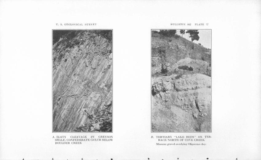
TT. S. GEOLOGICAL SURVEY
A. SLATY CLEAVAGE IN GREYSON SHALE, CONFEDERATE GULCH BELOW BOULDER CREEK
BULLETIN 842 PLATE 17
K. TERTIARY "LAKE BEDS" ON TER RACE NORTH OF COVE CREEK
Miocene gravel overlying Oligocene clay.
DISTEICTS IN THE BELT MOUNTAINS 125
The thickness of the Newland formation as exposed along Trout Creek is estimated at 4,500 feet. As previously noted this may include more or less Chamberlain shale.
Greyson shale. The Greyson shale was named by Walcott from Greyson Creek, which enters the Missouri River 4 miles south of Townsend. Beds assigned to this formation occupy a belt from 1 to 2 miles wide adjoining the Newland area on the south and underlie a considerable area along the Missouri River below the Spokane Hills. The formation is chiefly a dark-gray shale that becomes somewhat rusty brown on weathered surfaces. It appears conformable with the Newland limestone and grades into it through a zone in which beds of shale and limestone alternate. Near the bottom is a considerable thickness of slate-gray shale in which some of the lighter-colored layers are thickly peppered with brown specks that represent oxidized grains of siderite (iron carbonate). Next above the gray beds is a considerable thickness of soft, fissile light- gray to pale-buff shale, the layers of which show a pearl-gray coat ing that shimmers in the light. Commonly the layers are speckled with the rusty siderite. The light colors of these beds make them conspicuous among their prevailingly somber neighbors. They form the wall rock at the Old Amber mine and crop out on Trout Creek east of Kelley Gulch. Commonly they show a slaty cleavage, which in places is so pronounced as to obscure the bedding (pi. 17, A). The middle part of the Greyson is mostly dark-gray shale, with which many thin quartzitic layers are interbedded. Above this is several hundred feet of dark bluish-gray to brownish-gray shale that weathers rusty brown. Much of this part shows distinct bands spaced as closely as 10 or more to an inch.
The Greyson is overlain conformably by the Spokane shale, the two meeting in a transition zone about 500 feet thick that consists mostly of pale grayish-green shale with thin layers of siliceous rock. Toward the top of this zone beds of red shale from 1 to 4 feet thick appear. The dividing line is placed so as to exclude practically all the red layers from the Greyson.
As measured in White Gulch the Greyson is about 3,000 feet thick. In the sections exposed along Avalanche Creek and streams farther west it appears to be as much as 5,000 feet thick, but these sections may be affected by faulting. At Greyson Creek, 20 miles south of White Gulch, the thickness as determined by Walcott is 3,000 feet.
Spokane shale. The Spokane shale was named by Walcott from the Spokane Hills, west of Canyon Ferry. 'It consists mainly of massive deep-red shale and shaly sandstone and underlies a belt about a mile south of the main Greyson area. In its type locality, the west

126 GREATER HELENA MINING REGION, MONTANA
side of the Spokane Hills, the formation occupies a smaller area. Along Trout Creek and elsewhere it shows a well-developed slaty cleavage. It is siliceous, argillaceous, and noncalcareous, and its characteristic red color and the red color of the surface mantle derived from it make the formation easy to follow in the field. To the southeast the Spokane shale grades upward into the Empire shale. Westward beyond Magpie Gulch it is overlain unconform- ably by Cambrian quartzite. The thickness of the Spokane as meas ured by the writer in White Gulch is 2,000 feet. Walcott's estimate made at the same place is 1,500 feet.
Empire shale <md Helen® limestone. From White Gulch north west the Empire shale, named by Walcott from Empire, a mining camp near Marysville, forms a narrow band next to the Spokane. At a point west of Cave Gulch it is cut out by pre-Cambrian erosion. The Empire consists mainly of siliceous greenish-gray shale and as measured in White and Avalanche Gulches appears to be about 1,000 feet thick. .
South of the belt of Empire shale is a still narrower and shorter area occupied by the Helena limestone, so named by Walcott because of exposures at the edge of Helena. This formation consists of buff-weathering limy shale and limestone. It resembles the Newland, except that it is somewhat lighter colored, and some of the beds show deep, irregular grooves or channels on weathered surfaces that are due to the solution of bodies of comparatively pure carbonate.
At White Gulch and Avalanche Gulch the Helena is 700 or 800 feet thick. Its upper limit is an erosional unconformity at the base of the Flathead quartzite. ,
PALEOZOIC ROCKS
A strip about a mile wide along the mountain front from White Gulch northwest is underlain by rocks of Paleozoic age. To the northeast, at the edge of the region here considered, similar rocks underlie a large area along the summit of the Belt Mountains, and they occur also in the middle and southern parts of the Spokane Hills.
The Paleozoic beds lie unconfo.rmably but without any very noticeable angular discordance above the Belt series. They include hard and resistant quartzite and limestone and soft shale. The limestones give rise to strikingly prominent light-colored outcrops. Along the mountain front northwest of White Gulch they stand up as the segments of a great white wall (pi. 16, A). In the upper gorge of Trout "Creek al)ove the Boy Scout camp they form cliffs and crags that are bold and picturesque in the extreme.
The Paleozoic rocks were not studied in detail. Cursory examina tions indicate that they are similar to the Paleozoic of the neighbor-
DISTRICTS IN TUK BELT MOUNTAINS 127
ing Little Belt Mountains 5r and Three Forks 58 regions and probably include all the formations described in those areas. The lowest Paleozoic formation, the Flathead quartzite, is readily identified as forming conspicuous pinkish-gray reefs in the gorges of the mountain front and along the crest of the Spokane Hills. It consists of hard, massive gray to pink quartzite, the lowest beds of which contain small pebbles. Weathering disrupts the rock into large angular blocks.
As exposed along Trout Creek the Flathead is about 350 feet thick.
The overlying Wolsey shale may be seen along Trout Creek, where it is poorly exposed in a small cross valley just below the uppermost reef of Flathead quartzite. At that locality it consists of soft shale showing mainly muddy-gray to olive-green shades.Many of the layers contain fine scales of mica, and some are cal careous. The total thickness is 300 feet.
The Cambrian rocks above the Wolsey shale include the Meagher limestone and unidentified beds still higher in the sequence that probably correspond to the Park shale, Pilgrim limestone, Dry Creek shale, and Yogo limestone. This group forms light-gray and bluish-gray limestone cliffs and crags along the lower gorge of Trout Creek and some of the similar rugged features in Magpie, Avalanche, and other gulches. Owing to the complexity of the structure no accurate measurements of its thickness were obtained. Apparently there is at least 1,500 feet of limestone along the most accessible sections. The shales appear to be more or less pinched out by the folding.
In the gorge of Avalanche Creek adjoining the Cambrian rocks are exposures of dark-gray to brown limestone belonging to the Jefferson formation (Devonian). The Threeforks shale (also Devo nian), if present, is concealed by talus. Next above in the sequence is a great thickness of bluish-gray to white beds of the Madison limestone (early Mississippian), outcrops of which, as seen from Townsend Valley, form the conspicuous walls along the mountain front northwest of White Gulch. The combined thickness of the Jefferson limestone, Threeforks shale, and Madison limestone at Avalanche Creek is estimated at 3,000 feet.
At the mouth of White Gulch beds belonging to the Quadrant quartzite (Pennsylvanian) are partly exposed, and above these, stratigraphically, are shale and limestone of the Phosphoria (Per mian) formation, which inclose a thin bed of rock phosphate.
67 Weed, W. H., U. S. Geol. Surrey Geol. Atlas, Little Belt Mountains folio (No. 56), 1899.
M Peale, A. C., U. S. Geol. Survey Geol. Atlas, Three Forks folio (No. 24), 1896.

128 GREATER HELENA MINING REGION, MONTANA
TERTIAXY "LAKE BEDS"
Apparently Jurassic and Cretaceous beds, which occur in the neighboring regions, are not exposed in the area here considered, and at the edge of Townsend Valley and west of the Spokane Hills, the eroded surface of the rocks previously described passes beneath the fresh-water and terrestrial sediments known as Tertiary " lake beds."
The Tertiary beds of this region are described in a former report.59 They include Oligocene and Miocene beds, the two being separated by an unconformity. The Oligocene beds consist largely of moder ately hardened light-colored claylike sediments with more or less fine-textured gravel or conglomerate. The Miocene beds are chiefly unconsolidated sand and gravel. Both are exposed in old placer mine pits in the terrace north of Cave Creek. (See pi. 17, B.)
QTTATEKNAKY SEDIMENTS
Gravel that is mostly of the Pleistocene age forms a thin mantle over most of the terraces in Townsend Valley, along the Missouri River below the valley, in the gulches, and west of the Spokane Hills. It includes the gold-bearing terrace gravel described under " Placer deposits." Later alluvium that occurs along the streams includes the gold-bearing gravel in the gulch channels.
STRUCTURE
FOLDS
The main structural feature of the York-Confederate Gulch area is a great arch, the York anticline, that elevates the Belt rocks to the surface on the southwest side of the Belt Mountains. This fold trends northwestward and extends beyond the limits of the area considered. Its northeast limb is largely cut away along a break de scribed as the Scout Camp overthrust fault, and therefore most of the elevated beds now remaining are within the area of the other (south west) limb. Cross sections of the York anticline are shown by all the larger valleys of the area. At Avalanche Gulch (pi. 15) it is a rather symmetrical open arch with dips of 40° to 60° on the sides. In the Trout Creek section the beds along the axis are tightly pinched and overturned to the northeast, as the result, apparently, of their proximity to the Scout Camp overthrust. Northwest of Trout Creek the anticline plunges somewhat, with the result that the strike of the beds changes from northwest to north. Southeast of Avalanche Creek the anticline splits into a group of smaller folds that continue on in that direction to Confederate Gulch and beyond.
58 Pardee, J. T., Geology and ground-water resources of Townsend Valley, Mont.: U. S. Geol. Survey Water-Supply Paper 539, pp. 17-34, 1925.

DISTRICTS IN THE BELT MOUNTAINS 129
On the southwest the York anticline is bordered by a series of relatively small synclines that involve the belt of Paleozoic rocks along the mountain front. These folds are extremely complex, and their details have not been worked out. They are tightly squeezed, overturned, and faulted. The softer beds are pinched and the harder ones crumpled or brecciated. This condition is appar ently the result of pressure from the southwest along a fault fracture described farther on as the El Dorado overthrust. Beyond this fracture are less strongly deformed beds composing the overthrust block.
The Spokane Hills are occupied by a syncline that involves the lower formations of the Paleozoic succession and the upper part of the Belt series. This fold trends a little west of north and extends from the neighborhood of French Bar to Winston, where it dis appears beneath Tertiary sediments and lavas. Its north end is marked by prominent reefs of Flathead quartzite that because of the rising axis of the syncline have a semicircular form. Farther south the fold is tightly compressed and overturned or imsymmetrical toward the east.
A moderate deformation that affects the Tertiary beds is chiefly of post-Miocene age and, as described in a former report,00 asso ciated with the later uplift of the mountains. In the area here con sidered this structure consists of a persistent eastward monoclinal dip toward the mountains, well shown along the lower courses of Magpie and Cave Creeks. At the mountain, front the beds are bentrather sharply upward.
FAULTSThe Scout Camp overthrust, so called from a locality near its
exposure on Trout Creek, is a fracture on which a great mass of pre- Cambrian Belt rocks, including part of the York anticline, has been thrust toward the northeast, upward and over the Mississippian Madison limestone (pi. 14, A). From Trout Creek its trace extends northwestward beyond the limits of this area, and the fracture is probably a southward branch of the great Lewis overthrust of Glacier National Park (pi. 1). On Trout Creek the trace of the overthrust is marked by masses of partly cemented breccia, one of which lies on the north of the road about half a mile below the Boy Scout camp. Eastward it crosses into the upper parts of Magpie .and Ava lanche Gulches. At Trout Creek the limestone beds beneath the fracture are sharply bent and crumpled (pi. 15), and the overlying Belt rocks are overturned.
The vertical displacement along the Scout Camp overthrust in this area is at least 12,000 feet, and the horizontal movement is probably
Tardee, J. T., op. cit. (Water-Supply Paper 539), pp. 17-4:i
130 GREATER HELENA MINING REGION, MONTANA
to be measured in miles. The faulting appears to have been later than the folding previously described and, as pointed out on page 25, it probably occurred early in Tertiary time.
The fracture that borders the tightly folded Paleozoic rocks along the foot of the mountains is called the El Dorado overthrust, from El Dorado Bar, which it crosses. It is best seen on the steep slope across the Missouri River from that place. Between Oregon Gulch and El Dorado Bar the fault is marked here and there by masses of cemented breccia. Its trace across El Dorado Bar is concealed by alluvial deposits, but it crops out at Prickly Pear Creek and con tinues northwest to the Gates of the Mountains. Beyond that point it passes beneath an area of volcanic rocks but reappears for a short distance just beyond Wolf Creek. Still farther northwest appear slices of the Lewis overthrust that probably include the continuation of the El Dorado fracture. Southeast of Oregon Gulch the El Dorado overthrust is concealed by the Tertiary deposits of Town- send Valley, but it may plausibly be regarded as continuing south ward and reappearing beyond Toston as the Lombard overthrust described by Haynes.61 Within the area here considered this thrust causes Greyson shale to overlie Flathead quartzite and therefore indicates a vertical displacement of at least 6,000 feet. No definite measure of the horizontal movement appears, but a considerable displacement is indicated by the differences in structure between the blocks separated by the fracture.
At Oregon Gulch the El Dorado overthrust is cut by a small body of intrusive quartz monzonite, and farther south it is overlain by Oligocene beds.
A few faults that are comparatively small and without noteworthyeffect on the structure of the region cut and displace the lodes. They are described in connection with the different mines.
IGNEOUS BOCKS
Igneous rocks are widely but rather sparingly distributed through the York-Confederate Gulch region. They include sills, dikes, small stocks, and surface flows. The sills are probably late Creta ceous or early Tertiary. Some of the dikes are early Tertiary, and some may be later. The stocks may be as late as Oligocene. All together the intrusive bodies mentioned occupy but a small part of the total area. Because of their association with the gold-bearing lodes, however, certain of them possess an interest far in excess of their relative extent. Most of them are quartz diorite and quartz monzonite. The remainder are chiefly related porphyries. The lavas include two varieties of andesite (pi. 16, B) and a basalt.
01 Haynes, W. P., The Lombard overthrust: Jour. Geology, vol. 24, pp. 269-290, 1916.

DISTRICTS IN THE BELT MOUNTAINS 131
The andesite flows are of middle or late Tertiary and Pleistocene ages. The basalt is younger than Miocene. In addition there are rhyolitic lavas in the Oligocene and Miocene beds of the valley areas.
QUARTZ DIORITE SILLS AND DIKES OF THE MOUNTAIN FRONT
A group of sills and dikes that extends from Cave Gulch to Con federate Gulch is intruded in the Belt shales just back of the folded Paleozoic rocks of the mountain front. Similar bodies occur also at the same geologic horizon in the northern part of the Spokane Hills across the river from Cave Gulch. Most of these bodies follow steeply dipping bedding planes, but some of them break across the sedimentary layers. Individual bodies are commonly several miles long and from 200 to 500 feet wide.
The rock is massive and of medium crystalline texture. It is rather dark greenish gray where freshly broken and more or less brown on weathered surfaces. In most places it crops out more prominently than the adjoining shale and commonly is disrupted by weathering to blocky angular fragments. Locally the outcrops are subdued and the weathered product a coarse sand. The micro scope shows the rock to be composed essentially of plagioclase, augite, hornblende, and biotite. Of the ferromagnesian minerals the augite is commonly the most abundant, and the hornblende usually occurs as rather large crystals. In addition a variable but usually small amount of quartz is graphically intergrown with the feldspar.
This group of intrusive bodies has caused very little metamor- phism of the- adjoining shale and is not directly associated with any known lodes. The rock itself has undergone some hydrothermal alteration. Its plagioclase is partly changed to sericite and its biotite to chlorite, to which its greenish color is due.
In the Spokane Hills a sill belonging to this group is cut off by intrusive quartz monzonite regarded as probably of early Tertiary age.
QUARTZ MONZONITE STOCKS
A stock of quartz monzonite that intrudes Spokane and Empire shales occupies an area of 2 square miles or more on the east side of the Spokane Hills at Canyon Ferry. The rock is massive, coarsely crystalline, and of a medium to light gray color, and contains abun dant porphyritic feldspar crystals an inch or less in length. It can be quarried in large blocks and was used to build the dam and foundations of the power plant at Canyon Ferry.
In view of its size the metamorphism produced in the adjoining rock by this intrusive body seems rather insignificant. It consists mainly in a change to darker red and purple colors in the Spokane

132 GREATER HELENA MINING REGION, MONTANA
beds and a slight hardening and silicification in the Empire. The Korizek mine (p. 170) and a few rather barren-looking quartz veins that occur in the metamorphic zones described are the only known lodes associated with this stock. It is younger than the diorite sills just described and is assumed from its composition and porphyritic habit to be an outlier of the Boulder batholith of quartz monzonite, exposed about 10 miles to the southwest.
A small area of quartz monzonite exposed along the lower course of Oregon Gulch consists essentially of intergrown plagioclase and microcline, hornblende, biotite, and quartz. It has caused a slight metamorphism of the adjoining Belt rocks similar to that produced by the intrusive body at Canyon Ferry. This Oregon Gulch body is of particular interest because it interrupts the El Dorado over- thrust and thus is later than the movements that occurred on that fracture. As discussed on page 25, there is reason to think that the overthrusting took place in early Eocene time and that the intrusive body probably did not come to place before the middle Eocene. The upper age limit of the igneous mass is fixed by the fact that sediments of Oligocene age were deposited on its eroded surface.
In the high mountain at the head of Boulder Creek is an intrusive granitic mass of undetermined extent, erosion of which has supplied the abundant large boulders in the terraces along the southwest side of Confederate Gulch. The boulders consist of light-gray quartz monzonite and include two varieties, one of which is coarsely porphyritic.
YORK GROUP OF QUARTZ DIORITE DIKES
Dikes of quartz diorite that cut across different members of the Belt series crop out from a point on the ridge north of York east ward along a nearly straight line to Avalanche Gulch, a distance of about 15 miles. They stand nearly vertical and are mostly 300 or 400 feet wide, and from 2 to 4 miles long. Gold-quartz lodes and their dependent placer deposits are closely associated with them.
The westernmost member of the group, here called the Golden Messenger dike, is from 200 to 400 feet wide and 2y2 miles long. It contains the Golden Messenger mine and a large number of other gold-quartz lodes, all situated on the ridge north of Trout Creek at York. A little west of a point midway of its length, where it crosses a ridge, the dike is almost bridged by the invaded shale. This bridge or roof which lies at an altitude of about 4,600 feet appar ently marks the top of the dike. On the slope east of Kelly Gulch the top of the dike passes beneath the surface at an altitude of 4,900 feet. On the west it dips under an altitude of about 4,800 feet. Probably the intervening parts of the dike did not originally extend much above the limits given. Kelly Gulch cuts out a bite nearly 900 feet

U. S. GEOLOGICAL SURVEY BULLETIN 842 PLATE 18
N
EXPLANATION *""*-- Boundary of quartz diorite dike
:Vj:':':' Golden Messenger mineralized zone
^/^ Quartz vein showing dip
25°«\ Strikeanddipjn
Open cuts and pitsA
Adit
MAP OF GOLDEN MESSENGER DIKE AND ASSOCIATED QUARTZ VEINS

DISTRICTS IN THE BELT MOUNTAINS 133
deep. . Elsewhere the amount that erosion has lowered the original top of the dike averages apparently but a few feet.
At the different depths exposed the dike shows little variation in thickness. In places its dip is very steeply north, but in general it stands nearly vertical. Its intrusive character is shown by chilled margins and changes caused in the adjoining shale. In the Golden Messenger workings generally the contact is an irregular surface at which the dike and the shale are " frozen " together. In tunnel 3 the two are separated by a fault.
The Golden Messenger dike is a dark greenish-gray rock of rather coarse crystalline texture. It weathers to a coarse brownish sand, and its outcrops are generally subdued or even depressed. It is composed essentially of plagioclase, augite, and biotite, with considerable accessory apatite and magnetite or ilmenite. In addition the rock is characterized by quartz that is graphically intergrown with the feldspar. The quartz varies somewhat in amount but generally is abundant enough to classify the rock as a quartz diorite.
In places next to the ore bodies in the Golden Messenger mine the diorite is changed into a loose soft claylike material made up largely of sericite. In other places the rock is still firm, but much of its feldspar has gone to sericite and chlorite, its augite has partly changed to hornblende and chlorite, and its biotite partly to chlorite. In addition more or less secondary ankerite, pyrite, and hematite have been introduced. To a greater or less degree these changes have occurred throughout the dike and are the cause of its greenish color and nonresistance to weathering. The alteration extends below the oxidized zone and is the result of hydrothermal processes that both preceded and accompanied the formation of the lodes.
The other dikes of the York group are similar to the Golden Messenger dike except that on the average they show less hydrother mal alteration. Specimens from the dike that crosses York Gulch consist essentially of plagioclase and pyroxene with fairly abundant quartz that is graphically intergrown with the feldspar. The plagio clase is partly altered to sericite and the augite largely to hornblende. The dike exposed on the west side of Hellgate Gulch is composed of plagioclase, augite, biotite, and quartz that forms a coarse graphic intergrowth with the feldspar. The feldspar is partly altered to sericite and chlorite, the augites are bordered with reaction rims of hornblende, and some of the biotite has changed to chlorite. Con siderable secondary magnetite is present. In a specimen of the rock adjoining a small quartz vein no original augite remains, plagioclase is almost completely replaced by sericite, and ilmenite by leucoxene, and there is much secondary pyrite and calcite.
154419 33 10
134 GKEATEE HELENA MINING KEGION, MONTANA
A striking feature of the York group of dikes is their occurrence along a line that holds to a straight course despite changes in the strike of the rocks in its path. This line lies within the overthrust mass composing the west side of the mountains and marks the course of the fractures into which the dike magma rose. The lack of schis- tosity in the wall rocks and the physical condition of the dikes themselves suggest that they came up along tension fractures. These fractures apparently belong to the group of predominant east-west vein fractures of the general region. As described on pages 201-202, they are thought to be tension cracks developed in a large crust block that was compressed by forces causing the overthrust.
The dikes of the York group are similar in composition to the sills and dikes along the mountain front except that they show a greater degree of hydrothermal alteration and are accompanied by gold-bearing lodes. The York dikes, however, cut across the folds in the Belt rocks, whereas the other bodies generally follow bedding planes and, as shown most definitely at the north end of the Spokane Hills, appear to have been folded with the sedimentary rocks. For that reason the dikes of the York group are thought to be the younger. If, as suggested, they closely followed the overthrust faulting they are probably to be placed somewhere in the early or middle Eocene. No definite upper age limit appears except the fact that they are beveled by an erosion surface of probable Miocene age. It is possible that they are somewhat basic apophyses from the quartz monzonite magma of the Boulder batholith.
QUARTZ DIORITE STOCKS OF CONFEDERATE GULCH
Two or more bodies of an intrusive rock classified as quartz diorite crop out in the drainage basin of Confederate Creek. The largest ofthese has the form of a stock and occupies an area of a square mile or less at the head of Montana Gulch. It is a light-gray granitic rock, the weathered surface of which is more or less streaked with rust owing to the oxidation of secondary pyrite. The microscope shows it to be composed essentially of oligoclase (Ab25An75 ), quartz, and a little biotite. The feldspar has been altered to sericite along cleavage cracks. Associated with this body are a large number of lodes that have been the chief sources of the placer gold in Confed erate, White, and Benton Gulches.
A smaller body of light-gray quartz diorite having the form of a short, thick dike is exposed on the north side of Confederate Gulch opposite Boulder Creek. It shows a porphyritic texture and con sists essentially of plagioclase with very little quartz and accessory magnetite. In some specimens the quartz and feldspar show a graphic structure. The feldspar is considerably altered to sericite and carbonate, and some of the magnetite is changed to hematite. In

DISTRICTS IN THE BELT MOUNTAINS 135
addition more or less secondary carbonate, quartz, and pyrite are present. Gold quartz lodes occur in and about this body.
A rusty-brown rock that is apparently an extremely altered quartz diorite is exposed in two small areas along the upper part of Cement Gulch. It consists of quartz, iron oxides, and claylike material with a few grains of magnetite. In places a few grains of unoxidized pyrite remain.
The bodies described break up through folded Belt rocks, and the Montana Gulch stock is truncated by a Miocene erosion surface. Their composition and association with gold lodes link them with the York group of dikes, and likewise they may be related to the Boulder batholith.
PORPHYRY DIKES
Small dikes not definitely associated with any of the lodes or the intrusive bodies described are sparingly scattered through the region. Most of them are light-gray crystalline rocks of porphyritic texture. One that crops out on the west side of Bar Gulch is a greenish-gray rock with indistinct spots of darker green. It consists of hornblende phenocrysts in a fine-grained aggregate of plagioclase and horn blende and may be classified as andesite. Its greenish color is due to the presence of secondary chlorite. A group of three dikes or sills of diorite porphyry each 5 to 10 feet thick, are exposed on Avalanche Creek above Cow Gulch. They are composed essentially of plagioclase, orthoclase, and hornblende. The plagioclase forms two generations of phenocrysts, of which the later are the smaller. These are embedded in a fine-grained groundmass composed of plagioclase, orthoclase, and hornblende. The feldspar in this rock is partly changed to sericite and the hornblende partly to calcite.
Boulders of quartz diorite porphyry, found in the old placer pits in White Gulch near the mouth of Spring Gulch, consist of pink plagioclase feldspars and small green hornblendes embedded in a gray groundmass of feldspar and quartz. The plagioclase and horn blende are partly changed to epidote and chlorite. The parent ledge of these boulders was not seen. A small dike of quartz latite por phyry intrudes the Flathead quartzite north of White Gulch. This rock consists of feldspar, hornblende, biotite, and quartz pheno crysts embedded in a groundmass composed chiefly of orthoclase, plagioclase, and quartz. The feldspars are invariably partly altered to sericite and carbonate, and the hornblende and biotite are almost completely gone to chlorite, carbonate, rutile, and iron oxides.
ANDESITE AND BASALT
Extrusive andesites occupy small areas along the mountain front north and south of White Gulch and occur also within that gulch. The areas at the mountain front are gray to greenish-gray rocks
136 GEEATEE HELENA MINING REGION, MONTANA
consisting essentially of plagioclase feldspar, hornblende, and augite with accessory apatite and magnetite. The plagioclases are more or less altered to sericite and calcite, but the ferromagnesian min erals are rather fresh. Calcite occurs in vugs.
A very small patch of tuffaceous andesite or latite lies on a terrace north of White Gulch at Spring Gulch. The rock is reddish gray and shows square cross sections of white phenocrysts of feldspar. It consists essentially of plagioclase and orthoclase with a little biotite. The phenocrysts are composed of plagioclase and orthoclase arranged in zones, with the orthoclase on the outside. The ground- mass consists chiefly of plagioclase with interstitial orthoclase. Rather large grains of accessory magnetite are present. Two patches of andesite similar to that last described lie farther up on the same slope.
The two andesites described are of unlike texture and crystalline habit and probably represent different periods of igneous activity. The patches in White Gulch have contributed boulders to placer gravel of middle or late Pleistocene age. On the other hand, they lie well down in a valley that was excavated since the beginning of the Pleistocene. The andesite along the mountain front was not. extruded until folds and faults produced in late Cretaceous .time had been deeply cut away, but it may be considerably older than the andesite of the gulch.
Numerous boulders of black basalt in the placer mines along the north side of White Gulch were derived from an area of that rock on the slope above. The rock consists essentially of plagioclase and augite with much red iddingsite derived from olivine. Much acces sory magnetite is present. The basalt lies on a remnant of a Miocene- erosion surface but is probably much younger.
CONTACT METAMORPHISM
For distances ranging from a few hundred to perhaps a thousand feet away from the Golden Messenger dike the Belt shales are visibly altered. Their deep red, gray, and buff colors have given; place to brick red and brown. They are commonly streaked and mottled, generally hardened, and in places silicified. Locally numer ous stringers and veins of quartz have been introduced. Microscopic examination shows the presence of quartz, of quartz mixed with a carbonate, and of unmixed carbonate in veinlets and disseminated grains. The carbonate is an iron-bearing mineral, probably ankerite,. the weathering of which produces rusty-brown streaks and spots in the shale.
The dike in York Gulch has also caused a very noticeable alter ation of the adjoining shales. This change appears to be due chiefly to the development of ankerite. Weathering of the altered rocks.
DISTRICTS IN THE BELT MOUNTAINS 137
produces iron oxides from the ankerite, and as a result the beds are commonly peppered and streaked with brown. In the neighborhood of the old Amber mine these effects are noticeable for 1,000 feet or more from outcrops of the dike. The dike in the ridge southeast of Hellgate Creek has metamorphosed the adjoining Newland beds for a distance of 50 feet to a hard porcelainoid rock streaked and peppered with1 iron rust. Somewhat similar changes have been effected by the intrusive stocks of Confederate Gulch. The sills and dikes of the mountain front and the small scattered dikes have produced little or no contact metamorphism.
GEOMOKPHOLOGY
In generalized form the Belt Mountains northwest of Confeder ate Gulch appear as an elevated gently arched block with a steep side facing Townsend Valley. The block is composed chiefly of pre-Tertiary sedimentary rocks, its structure is anticlinal, and therefore the area it occupies must have been elevated by the early Tertiary (?) folding. There is evidence, however, that after that early uplift the mass was cut away by erosion until its surface was comparatively low. Later on it was reelevated to its present height by earth move ments in the nature of warping and block faulting that occurred chiefly in post-Miocene time.
The surface of erosion that succeeded the early Tertiary (?) moun tains is represented by flat and gently sloping surfaces on the summit of the present mountains. The altitude of these surfaces ranges from 6,000 to 7,000 feet, and in the central part of the mountains they aggregate a considerable area. The formerly continuous surface they represent cuts across the different rocks, including some of the York group of dikes and the quartz diorite stock at Montana Gulch, without regard to their attitude or structure. Its develop ment was not completed, therefore, until sometime after the early Tertiary. As described in a former report,62 there is reason to think that the upward movement which caused the streams to cut into the old surface and thus begin its destruction commenced in Miocene time but was accomplished chiefly after the Miocene. The evidences for this are briefly as follows: Oligocene sediments depos ited in the adjoining lowland of Townsend Valley contain alluvial land waste of only fine texture, indicating low gradients for the streams and consequently no considerable uplift accomplished at that time. The Miocene beds include coarser material that was derived directly from the Belt Mountain area. These later beds are folded and faulted, and therefore the principal uplift appears to have occurred after they were deposited.
83 Pardee, J. T., Geology and ground-water resources of Townsend Valley, Mont.: U. S. Geol. Survey Water-Supply Paper 539, pp. 38-43, 1925.
138
It is probable that, with respect to Townsend Valley, the elevation of the block composing the Belt Mountains was relative that part of the difference of 3,000 feet between their heights is due to sinking of the valley area. This differential elevation was, however, accom panied by a general uplift of the region, as shown by the studies of Alden.63
The present mountain valleys have been cut since the post-Miocene uplift, and a few stages in their development are recorded by the terraces. Certain high shoulders on the south side of Confederate Gulch may mark a stage comparable to the No. 1 terrace of the Great Plains region to the north described by Alden. These represent a halt in the downcutting during the Pliocene, when the valleys commonly were 1,000 feet less deep than now. In the area considered halts at later times are more definitely shown by the gold-bearing terraces described herein. The highest of these, the higher of the Boulder Bars in Confederate Gulch and bench No. 1 in Townsend Valley,64 are probably the age equivalents of the early Pleistocene No. 2 terrace of the Great Plains.65 They were developed after the streams had cut several hundred feet below No. 1. Montana Bar, the gold-bearing terraces in White Gulch and at the mouth of Cave Gulch, the " bars " along the Missouri Kiver, and the main terraces in the lower part of Townsend Valley are mostly, to be correlated with No. 3 terrace of the plains, the development of which occurred prior to the Wisconsin stage of glaciation. Commonly the present stream channels are sunk 150 to 200 feet below No. 3 terrace, this latest downcutting having been partly accomplished during the Wisconsin stage.
Placer deposits were probably formed at most if not all of thestages of valley cutting since the lodes were exposed by the Miocenepeneplanation. Apparently none of the deposits remain that were formed earlier than No. 2 terrace. The richest deposits in general are those in the still newer channels. Exceptions to this are those, such as the deposits in Boulder Creek, in which the natural concen trating or sluicing action of, the streams has been interfered with by glaciation.
A geomorphic feature whose development appears to have modi fied the gold-quartz lodes along the Golden Messenger dike is the elevated abandoned valley that lies along the foot of the Belt Moun tains proper at York and separates them from an area of foothills defined under the heading " Topography." The old valley extends from the vicinity of Oregon Gulch northwestward about 15 miles.
03 Alden, W. C., Physiographic development of the northern Great Plains: Geol. Soc. America Bull., vol. 35, pp. 404 et seq., 1924.
^Pardee, J. T., op cit. (Water-Supply Paper 539), p. 7. 65 Alden, W. C., op. cit., p. 409.

DISTRICTS IN THE BELT MOUNTAINS 139
Its floor rests on the present divides and consists of flats that are mostly 400 to 700 feet above the present streams, (See pi. 15.) This feature is of course not in view from the present valleys. It can best be seen from points at the same or a greater altitude than its floor, such as may be found along the Golden Messenger dike north of York. The west side of the old valley is a notched wall a few hundred feet high consisting of quartzite and other resistant Paleo zoic rocks. The higher east side is nearly a dip slope in shaly Belt rocks (Greyson shale), and the valley itself is cut into the some what less resistant Spokane shale. It can best be explained as the result of selective erosion which has developed a valley along the strike of relatively weak beds. Streams may have occupied it, but no evidences of any large or continuous watercourse were observed. Its relative altitude suggests a correlation with No. 2terrace. Its development evidently required a long time, during which, as described on page 144, a downward enrichment of certain gold lodes occurred.
It is obvious that the relatively narrow and wide parts of the mountain valleys are due to selective erosion on respectively harder and softer rocks. Where it crosses the resistant Paleozoic rocks at the mountain front each valley is a gorge. In the area of softer Belt rocks above, it is comparatively wide and its sides smooth. Farther up, the valleys that penetrate the summit area of Paleozoic rocks again become gorges.
ORE DEPOSITSCLASSIFICATION
The ore deposits in the Belt Mountains include both lodes and placers, of which the placers, as elsewhere in the general region, are chiefly of historic interest. They include El Dorado Bar and other terraces along the Missouri Kiver, which, in addition to gold, have produced sapphires.
Most of the lodes are valuable chiefly for gold; the remainder for copper. The ore of one deposit, the Golden Charm, is said to have contained, in addition to gold, noteworthy amounts of silver and lead. In the other gold-bearing lodes, so far as known, the amount of silver present is of little value and the amount of lead generally too small to be recoverable. The copper lodes contain a little silver but practically no gold.
GOLD-BEARING LODES
Distribution. The gold-bearing lodes are confined to three areas, one in the vicinity of York and the others in the Confederate Gulch district. The York area includes the Golden Messenger mine, the Old Amber mine, and prospects along the upper courses of Magpie,

140
Hellgate, and Avalanche Creeks. It is a rather narrow belt about 15 miles long, through the middle of which run the intrusive quartz diorite bodies described as the York group of dikes.
One of the Confederate Gulch areas of gold-bearing lodes is on Norris Hill, the ridge north of that stream at Boulder Creek. The other is on the divide at the heads of Montana, Cement, Benton, and Johnny Gulches. Each covers a square mile or less, and each contains a small stock of quartz diorite.
Character. Most of the gold-bearing lodes are small quartz veins that occur along fractures in the diorite and on bedding planes in the adjoining shale. They contain ore shoots that range from a few inches to several feet in width and from a few feet to several hundred feet in length. In most of those that have been mined, the ore appar ently gave out within depths of 50 to 100 feet. An exception is the Old Amber mine, in which ore continues to a depth of 200 feet or more.
The gold-bearing lodes in the Golden Messenger mine differ some what from the simple quartz veins. They may be classified chiefly as replacement deposits along fractures in the diorite. Otherwise they are distinguished by the fact that some of them attain a large size. Stopes in the Golden Messenger mine, which do not show the limits of the bodies, are as much as 200 feet long, 100 feet high, and 40 or 50 feet in greatest width, measured horizontally. As the ore bodies are inclined, their thickness is less than the horizontal width of stopes made in them. The maximum observed thickness is about 30 feet. The bodies are more or less irregular, though most of them, especially the smaller ones, possess definitely tabular forms. Most of them strike northward, or at right angles to the course of the dike,and dip to the west. A few are parallel to the dike and dip north ward. All possess a rather indistinct banding, which is parallel to their longer dimensions and represents fractures developed originally in the diorite. Ore and country rock tend to grade together, and the walls are therefore somewhat indefinite. The ore bodies are broken but not extensively displaced by a few widely spaced faults that trend north-northeast and dip steeply eastward.
The lodes in the Golden Messenger dike (pi. 18) belong to the rather uncommon class of deposits called " ladder veins." The best- known ladder veins are in the Woods Point district, Victoria, Australia,68 where dikes of diorite and closely related rocks are crossed by parallel veins that end either at the contacts or within short distances beyond. Similar veins in small pegmatite dikes in
68 Whitelaw, O. Q. L., The Woods Point gold field: Victoria Geol. Survey Mem. S, 1905. Junner, N. R., Geology of the gold occurrences of Victoria, Australia: Econ. Geology, vol. 16, pp. 79-123, 1921.
DISTRICTS IN THE BELT MOUNTAINS 141
Minnesota are described by Grout,67 and one which is superimposed on another vein in the Standard Mammoth mine in the Coeur d' Alene district of Idaho is described by Kansome.68 Granite dikes with lad der veins containing quartz and copper ores are found in Thele- marken, Norway.69 Lindgren 70 places most of the ladder veins mentioned under the heading " Contraction joints produced by ten sile stress in igneous rocks." The ladder veins of the Golden Messenger dike apparently come under Lindgren's classification. Their origin is further considered in the description of the Golden Messenger mine.
In the Confederate Gulch areas undeveloped bodies of altered and mineralized diorite that may prove to be low-grade gold ore are apparently of large size. Their exposures are not sufficient to show details of form, attitude, etc.
Composition. ^}^ veins consist almost entirely of quartz, but they invariably contain streaks and grains of iron oxides. A few that are exposed below the oxidized zone contain a little pyrite and, exceptionally, a few grains of galena. In some specimens of oxidized ore specks of gold are visible, and these are mostly associated with the grains of iron oxides that were derived from pyrite. Most of the ore found in the oxidized zone is understood to have been of high grade. A shoot in the Golden Charm mine which contained gold, silver, and a little lead is said to have averaged $261 a ton. Most of the other productive mines contained little else than gold. Samples from the old workings of several along the Golden Messen ger dike yield gold rather freely by panning. In depth the quartz veins are presumably lean, though few have been explored. Those cut by the Little Dandy crosscut at a depth of 300 feet or more below the surface are reported to assay from $13 to $20 or more to the ton.
The texture of the oxidized ore of the Golden Messenger bodies indicates that it consists partly of decomposed diorite. The material is heavily iron-stained and is composed largely of claylike minerals and quartz. Very small amounts of manganese oxides occur in places. The ore averages from $6 to $7 or more to the ton in gold and contains little or no silver. Unoxidized ore, which becomes general at the depth of No. 3 level, is composed mainly of altered diorite, quartz, and ankerite. The quartz and ankerite partly replace
97 Grout, P. F., Occurrences of ladder veins in Minnesota: Econ. Geology, vol. 18, pp. 494-505, 1923.
88 Ransome, F. L., The geology and ore deposits of the Coeur d'Alene district, Idaho: U. S. Geol. Survey Prof. Paper 62, p. 178, fig. 13, 1908.
59 Vogt, J. H. L., Zur Classification der Erzvorkommen: Zeltschr. prakt. Geologic, April, 1894, pp. 149-150.
70 Lindgren, Waldemar, Mineral deposits, 3d ed.i p. 166, 1928.

142 GREATER HELENA MINING REGION, MONTANAi
the altered rock and occur also in veinlets. Pyrite, mostly in fine scattered grains, occurs in both the altered rock and the veinlets. Locally it is aggregated in thin layers or bands. In places there are scattered grains and tiny bunches of galena. The micro scope shows this ore to contain pyrite and specularite of contempo raneous origin and small amounts of sphalerite, galena, and chalcocite that were introduced later. The sulphides are later than the gangue and partly replace it, but a little of the ankerite occurs as a still later generation.
Reported assays of the unoxidized ore show it to carry from $4 to $20 a ton in gold and develop the interesting fact that the gold is associated chiefly with galena. Indefinitely bounded masses of mineralized diorite in the Confederate Gulch area are said to assay from $1.50 to $2 a ton in gold.
Origin. The close association of the gold-bearing lodes with the intrusive diorite dikes and stocks is striking and doubtless signifi cant of their origin. Such a relation, if it occurred in only one or a few places, might be explained as accidental, but in this region it is not only prevalent but exclusive, and therefore the dependence of the veins upon the dikes and stocks appears certain.
Near the intrusive bodies the inclosing shale shows noteworthy changes in appearance and composition. These are caused chiefly by the presence of an iron-bearing carbonate, ankerite, not found in the unaltered shale farther away. The proportion of ankerite increases toward the igneous masses, and in the aggregate this min eral represents an addition to the shale of large amounts of carbon dioxide and more or less iron, lime, and magnesia that presumably came from the intrusive rock. In view of the relatively small size of the dike, the extent of the alteration, particularly that adjoiningthe Golden Messenger dike, is rather remarkable. It supports the idea that the dike is merely the offshoot of a larger mass.
The metamorphism described was doubtless followed by fissuring due to the cooling and consolidation of the upper parts of the dikes. Contraction fissures tend to develop normal to the trend of the dike and adjoining altered zones, and as the Golden Messenger dike trends nearly at right angles to the bedding planes of the shale and .the two rocks are firmly welded or " frozen " together, it is most probable that the spacing of contraction fissures in the dike has been controlled by the more open of the bedding planes. Further details of these fissures are given in the description of the Golden Messengermine (p. 149).
A few of the veins in the dike, however, are nearly parallel to its walls. The fractures these occupy appear to have been formed at

DISTRICTS IN THE BELT MOUNTAINS 143
the same time as the others, and all may be regarded as a group of conjugate fractures, the two sets of which tended to form at right angles to each other. The replacement veins in the Golden Messenger mine have about the same directions and dips as these fractures.
The shrinkage cracks evidently afforded openings for the escape of solutions from lower and not entirely cooled parts of the intrusive bodies. These emanations produced characteristic effects in the wall rock, of which the most noticeable is a change to a soft greenish- gray cheeselike mass in which the original feldspars and ferromag- nesian minerals are replaced by chlorite, sericite, and carbonates. These changes required the addition of considerable water and carbon dioxide. Later solutions bleached the wall rock and deposited chiefly quartz, with a little pyrite, specks of galena, and valuable amounts of gold and silver.
The deposit in the Old Amber mine appears to have had a history similar to that of the lodes along the Golden Messenger dike, allow ance being made for its situation on a bordering slope instead of beneath the floor of the ancient valley. Probably this difference permitted a deeper circulation of ground water and thus caused its enriched ore shoots to have a greater range of depth than those north of Trout Creek. Other lodes in and along the dikes that cross York Gulch and the gulches farther east are mostly simple transverse quartz veins, though they are hardly numerous enough to form well- defined ladders. The few that have been developed are similar in mineralogy to those associated with the Golden Messenger dike but contain less gold. The veins associated with the diorite stocks of the Confederate Gulch area contain chiefly quartz and iron oxides with native gold. Their ore bodies are mostly small rich pockets.
Oxidation and enrichment. In most of the mines along the Golden Messenger dike oxidation is complete to the limits of accessible workings. In the Golden Messenger mine unoxidized ore occurs generally on No. 3 level at a depth of about 200 feet. A little mois ture on this level indicates that the ground-water level is near. Toward Dry Gulch this water level, which probably stands not far from the lower limit of oxidation, passes beneath the stream channel. It rises beneath the opposite slope, as shown by a considerable flow from the Little Dandy crosscut adit at an altitude of 4,200 feet. Kelley Gulch where it crosses the dike is cut down to the zone of water-saturated rocks at an altitude of 4,150 feet. West of Dry Gulch the lack of springs on the lower slopes indicates that the water level is 200 or 300 feet deep.
Although information on many of the quartz veins is far from complete, the fact stands out that the rich ore shoots ended at shallow

144 GREATER HELENA MINING REGION, MONTANA
depths. This shallow ore zone lies near the original top of the diorite dike and for that reason may represent part or all of a zone in which the gold was originally concentrated. Another explanation is suggested by the relation of the rich zone to the old valley floor described on page 139. The two appear so closely associated (pi. 15) as to indicate that downward enrichment of the gold veins occurred during the period, presumably a long one, in which the ancient surface was being developed by erosion. The absence of placer deposits in the area surrounding the lodes supports this hypothesis to some extent.
The Golden Messenger lode has no rich upper zone, a difficult fact to explain unless the lode is considered as not having originally extended much above its present limit at an altitude of about 4,500 feet. The fractures on which this lode was developed were appar ently, as should be expected, confined to the dike, this part of which may not have reached as great a height as the neighboring parts.
Conclusions. In all the lodes associated with the York group of dikes and the stocks of Confederate Gulch the gold appears to have been originally carried by pyrite or other sulphides, and it is espe cially noteworthy that the presence of galena generally means an increase in the amount of gold. This observation is true not only of the ore bodies of the York group of dikes but also of those asso ciated with the intrusive stocks of Confederate Gulch. The source of the gold was probably some igneous body lower than present exposures of the dikes and stocks. Existing mine workings prob ably explore only a small part of the vertical zone in which the gold was deposited. As most of the quartz veins are very narrow, they probably can not be worked with profit to any great depth, and future production may be expected chiefly from large low-grade bodies such as those in the Golden Messenger mine. It is likely that other similar bodies exist in the York group of dikes and the intrusive stocks of Confederate Gulch. Because these lodes are gen erally less resistant to weathering than the inclosing diorite, their outcrops are likely to be subdued and covered with surface mantle, and such covered places may have been overlooked by prospectors in the past.
As indicated by production and development work to date the dikes nearest York and the stocks in the Confederate Gulch areas are the most promising bodies in which to search for the large low- grade deposits. Such deposits, though they may not be rich enough to mine under present conditions, nevertheless are to be classified as ore. Their size and metallic contents are such that changes or improvements in costs, methods, or other conditions may make them profitable at some future time.

DISTRICTS IN THE BELT MOUNTAINS 145
COPPER LODES
Lodes that contain copper minerals are found here and there in a belt that extends from York southeastward to White Gulch, a dis tance of 15 miles or more. This belt is parallel to the mountain front, lies from 2 to 3 miles back of it, and includes the boundary between the Greyson and Spokane shales of the Belt series.
The copper lodes are veins formed along fractures that cut the shales. They range from 1 foot to several feet in width and persist for considerable distances along the strike. They are composed of ankerite, quartz, and chalcopyrite or their oxidation products. As a rule the chalcopyrite is rather sparingly present in the outcrops. Ore shoots, as explained below, are indicated by a capping of dark- red and brown iron oxides. Oxides derived from the ankerite alone are yellow or light brown.
Only one of these copper-bearing lodes, the Argo, has produced more than small amounts of ore or is developed extensively. The Argo vein is 4 or 5 feet wide, 500 feet or more long, and at least 600 feet in pitch length. Its outcrop consists mainly of quartz and iron oxides and in places shows copper carbonates. Below the oxidized zone the vein is composed of ankerite, quartz, and chalcopyrite, which were deposited in the order named. Nearly pure chalcopyrite forms thin tabular shoots that are several hundred feet in length and depth. In addition there are bodies of low-grade " milling" ore. The vein is cut and considerably displaced by faults.
An ore shoot that extends to the surface has become oxidized to a porous or cellular mass of iron oxides that shows dark reddish- brown colors and in places contains green copper carbonates. This " iron cap " is similar to the highly porous variety of " fine limonite boxwork" described by Locke 71 as characteristic of the outcrops of lodes in which the sulphide was chalcopyrite. It contrasts with the more earthy and lighter-colored oxides in other outcrops in the same district that represent oxidized ankerite only. This fact should aid in selecting places on the undeveloped lodes to search for ore.
The copper-bearing lodes are of the type formed at moderate to shallow depths by ascending solutions, but they are not closely associated with any exposed intrusive bodies from which such solu tions might have emanated. A rather striking fact is their distri bution along a belt that is parallel to the folds of the mountain front and is placed at the boundary between the Spokane and Greyson shales. The vein fractures are obliquely transverse to the prevailing structural lines and may be interpreted as secondary breaks due to a lateral movement of the mass composing the mountain front.
71 Locke, Augustus, Leached outcrops as guides to copper ore, p. 124, Baltimore, Wil liam's & Wilkins Co., 1926.
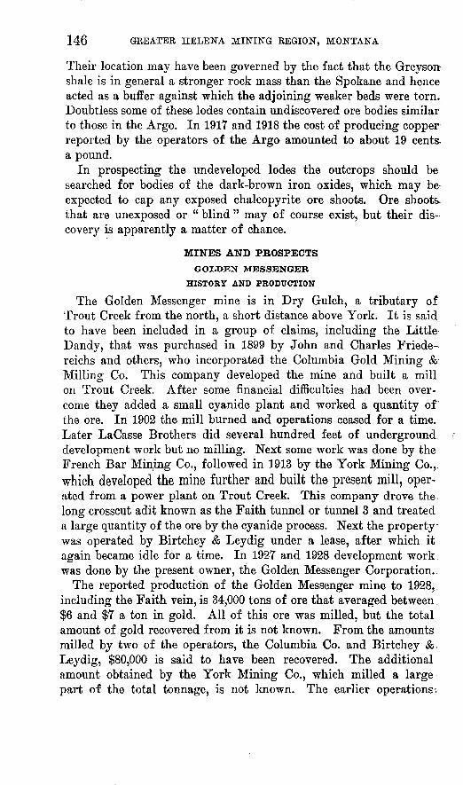
146 GREATER HELENA MINING REGION, MONTANA
Their location may have been governed by the fact that the Greyson shale is in general a stronger rock mass than the Spokane and hence acted as a buffer against which the adjoining weaker beds were torn. Doubtless some of these lodes contain undiscovered ore bodies similar to those in the Argo. In 1917 and 1918 the cost of producing copper reported by the operators of the Argo amounted to about 19 cents- a pound.
In prospecting the undeveloped lodes the outcrops should be searched for bodies of the dark-brown iron oxides, which may be expected to cap any exposed chalcopyrite ore shoots. Ore shoots. that are unexposed or " blind " may of course exist, but their dis covery is apparently a matter of chance.
GOLDEN MESSENGER
HISTORY AND PRODUCTION
The Golden Messenger mine is in Dry Gulch, a tributary of Trout Creek from the north, a short distance above York. It is said to have been included in a group of claims, including the Little Dandy, that was purchased in 1899 by John and Charles Friede- reichs and others, who incorporated the Columbia Gold Mining & Milling Co. This company developed the mine and built a mill on Trout Creek. After some financial difficulties had been over come they added a small cyanide plant and worked a quantity of the ore. In 1902 the mill burned and operations ceased for a time.. Later LaCasse Brothers did several hundred feet of underground, development work but no milling. Next some work was done by the French Bar Mining Co., followed in 1913 by the York Mining Co.,, which developed the mine further and built the present mill, oper ated from a power plant on Trout Creek. This company drove the^ long crosscut adit known as the Faith tunnel or tunnel 3 and treated
o
a large quantity of the ore by the cyanide process. Next the property was operated by Birtchey & Leydig under a lease, after which it again became idle for a time. In 192T and 1928 development work: was done by the present owner, the Golden Messenger Corporation..
The reported production of the Golden Messenger mine to 1928,. including the Faith vein, is 34,000 tons of ore that averaged between. $6 and $7 a ton in gold. All of this ore was milled, but the total amount of gold recovered from it is not known. From the amounts milled by two of the operators, the Columbia Co. and Birtchey & Leydig, $80,000 is said to have been recovered. The additional amount obtained by the York Mining Co., which milled a large part of the total tonnage, is not known. The earlier operations-.

DISTRICTS IN THE BELT MOUNTAINS 147
were more or less unprofitable, oXving to the fact that only about 35 per cent of the gold was recovered by the plate and amalgamation process then in use. Much better results were obtained by Birtchey & Leydig, who reported as much as 92 per cent of the gold extracted
.by the cyanide process.Although the mine has evidently produced a large quantity of ore,
its history so far, like that of many other mines working large low- grade deposits, has been characterized more by financial difficulties than by profits. The chief causes of these difficulties appear to have been uneconomical methods of mining, unsuitable milling processes, and lack of capital. The later milling operations, however, show a decided improvement in gold recovery.
DEVELOPMENT
The Golden Messenger mine contains 4,800 feet or more of aditsand drifts and, in addition, several hundred feet of raises and stopes. (See pi. 20, B.) It contains several lodes, known as the Golden Messenger, Faith, and veins 1 to 11. (See figs. 23, 24.) The Golden Messenger lode, the largest of the group, is developed by adits known as tunnels 1 and 2, which are located, respectively, at altitudes of 4,400 and 4,357 feet. There is also a level not extending to the sur face, 32 feet below No. 2. A shaft sunk from a point about 40 feet higher than No7. 1 gives the different levels additional connection with the surface. Stopes above these levels aggregate many thou sands of cubic feet. Most of them are irregular in form, and some are as much as 40 or 50 feet wide (fig. 21), measured horizontally. Measured at right angles to the dip the widest is about 30 feet.
The Faith vein is developed by the Topke tunnel (fig. 22), at an altitude of 4,325 feet, and by a sublevel 26 feet lower. Tunnel 3 is a crosscut adit about 1,800 feet long, at an altitude of 4,212 feet, 113 feet lower than the Topke tunnel and 145 feet lower than tunnel 2. At 1,200 feet from the portal it is connected with the Topke tunnel by a raise, which was inaccessible at the time of the writer's visit. Near the face there is a raise to the sublevel under tunnel 2.
ORE BODIESFOBM AND EXTENT
The Golden Messenger and Faith ore bodies, including their branches, may be classified as replacement veins in diorite. They are confined to the diorite dike, near the margins of which they end rather abruptly. They include, however, many small quartz veins and stringers, some of which extend across the borders of the dike and into the shale. In fact, the Golden Messenger and Faith ore bodies are said to diave been discovered as a result of the following of

m
OJKCIKIH

U. S. GEOLOGICAL SURVEY BULLETIN 842 PLATE 19
i ^ '
X:<:-:.jLc;;4/ I/flU II
EXPLANATION
Relative altitude in feet
Level I...................188Level 2....................145Sub level.................113
'.~~~ Topke level.............113::".~ Topkesub level.......87::::: Level 3.....................0
N
N>- \\\\ )\.:
i v*** ) r
" Xv\ fc"""\\ \\ \^': \\ \\*^5\ V\
^^>^ \\...*^ * rV<N \\ .^.
VN .^V./. v^xv.---^ '«* "~Tl """
BO ioo iso Feet
PLAN OF WORKINGS, GOLDEN MESSENGER MINE
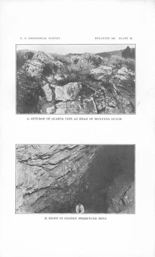
U. S. GEOLOGICAL SURVEY BULLETIN 842 PLATE 20
A. OUTCROP OF QUARTZ VEIN AT HEAD OF MONTANA GULCH
B. STOPE IN GOLDEN MESSENGER MINE

TJ. S. GEOLOGICAL SURVEY BULLETIN §42 PLATE 21
A. YORK AND VALLEY OF TROUT CHEEK
Hoist of prospecLing shaft in foreground.
H. OLD PLACER M^E IN WHITE (iULCH
On low (No. 3) terrace.

U. S. GEOLOGICAL SURVEY BULLETIN 842 PLATE 22
,4. ORK FHOM GOLDEN MESSENGER MINK
Residual areas of sphalerite (si) in galena (gri). Tongues of galena extend out into carbonate (dark area) and in part follow carbonate cleavage. The suc cession of deposition is: 1, Carbonate; 2, sphalerite; 3, galena.
B. ORK FHOM IIERWOOD MINE
Tiny veinlets of supergene chalcocite (cc) cutting hypogene bornite (bri). In part the chalcocite veinlets follow earlier-formed veiulets of a gangue mineral.
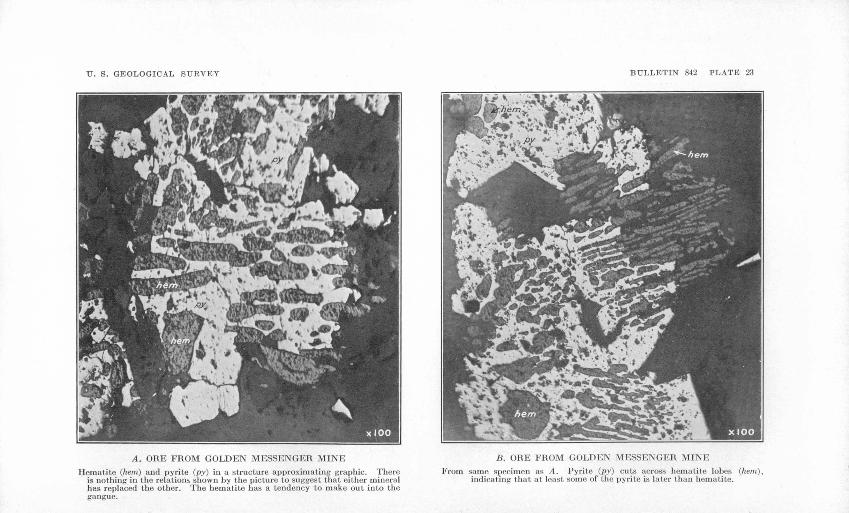
TT. S. GEOLOGICAL SURVEY BULLETIN 842 PLATE 23
A. ORE FROM GOLDEN MESSENGER MINE
Hematite (hem) and pyrite (py) in a structure approximating graphic. There is nothing in the relations shown by the picture to suggest that either mineral has replaced the other. The hematite has a tendency to make out into the gangue.
B. ORE FROM GOLDEN MESSENGER MINK
From same specimen as A. Pyrite (py) cuts across hematite lobes (hem), indicating that at least some of the pyrite is later than hematite.

DISTRICTS IN THE BEI/T MOUNTAINS 149
EXPLANATION
two such quartz stringers in the No. 1 and Topke tunnels. In the shale the deposits are mostly simple quartz veins though in places these may be spaced closely enough to form multiple veins or stringer lodes.
The workings described expose several veins that range in size from mere stringers to bodies as much as 30 feet thick and from 200 to 300 feet in their other dimensions. (See figs. 21-26.) Most of them have the northward strike and west dip that characterize the veins in general along the Golden Messenger dike. Evidently they form " rungs " in the.ladder-vein structure of tiiat dike as described. A few, including the bodies known as vein 3 and vein 4 (fig. 24), trend nearly at right angles to the others and dip north. Vein 4 varies in strike from southwest to west. It meets the Messenger vein at right angles and apparently dis places that body hori zontally about 70 feet. There is no gouge, breccia, or other sup porting evidence of faulting, however, and the two veins are re garded as occupying conjugate fractures of contemporaneous ori gin. The apparent offsetting of the part composing the Messenger vein may have been influenced by the positions of fractures that opened in the shale on opposite sides of the dike. The dike and the shale are welded together, and the positions of cross fractures or shearing zones in the dike were therefore controlled by movements that occurred along bedding planes in the shale. Projected inward these cracks or shearing zones met other fractures at right angles to them, represented by vein 4, which served to connect them in pairs across the dike, as, for example, the northern and southern parts of the Messenger vein (fig. 24). The fractures represented by vein 4 may have resulted from shrinkage or from tension produced by end wise compression consequent on the intrusion of the dike.
154419 33 11
FlOUBB 22. Plan of Topke tunnel, Golden Messenger mine
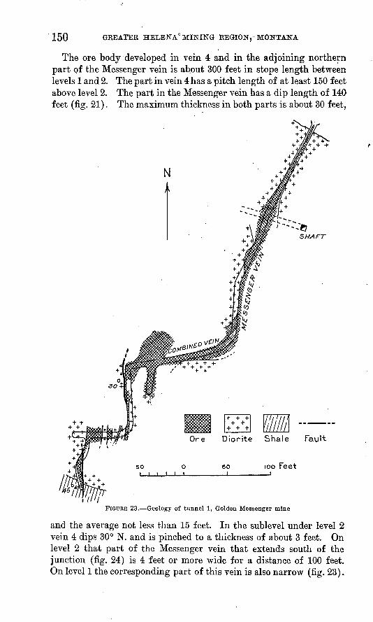
150 GREATER HELENA MINING REGION,'MONTANA
The ore body developed in vein 4 and in the adjoining northern part of the Messenger vein is ab.out 300 feet in stope length between levels 1 and 2. The part in vein 4 has a pitch length of at least 150 feet above level 2. The part in the Messenger vein has a dip length of 140 feet (fig. 21). The maximum thickness in both parts is about 30 feet,
N
SHAFT
O I i i
Ore Diorite Shale Fault
100 Feetso
FIGOEE 23. Geology of tunnel 1, Golden Messenger mine
and the average not less than 15 feet. In the sublevel under level 2 vein 4 dips 30° N. and is pinched to a thickness of about 3 feet. On level 2 that part of the Messenger vein that extends south of the junction (fig. 24) is 4 feet or more wide for a distance of 100 feet. On level 1 the corresponding part of this vein is also narrow (fig. 23).
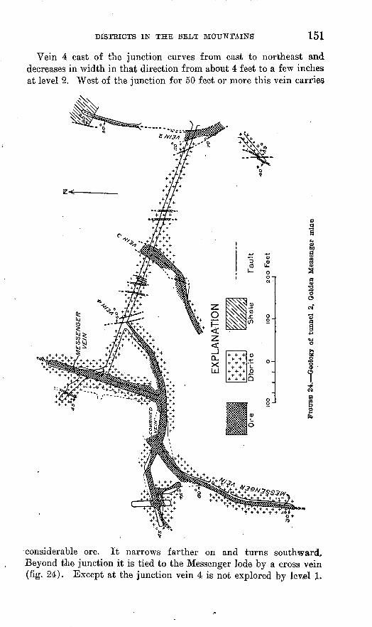
DISTRICTS IN THE BELT MOUNTAINS' 151
Vein 4 east of the junction curves from east to northeast and decreases in width in that direction from about 4 feet to a few inches at level 2. West of the junction for 50 feet or more this vein carries
considerable ore. It narrows farther on and turns southward. Beyond the junction it is tied to the Messenger lode by a cross vein (fig. 24). Except at the junction vein 4 is not explored by level 1.

152 GREATER HELENA MINING REGION, MONTANA
Vein 3 is crossed by tunnel 2 about 150 feet from the portal. A drift 120 feet to the southwest shows it to be parallel to vein 4 and from 4 to 8 feet wide. It is not explored on level 1 or on the sub-
EX PL A NATION
FIGURE 25. Ore body, Golden Messenger mine
level below level 2. If persistent it should be found on level 1 at about the second west turn (A) (fig. 23), which is near the south
end of that level. The £
existence of the turn re ferred to suggests that the direction of the work ing was changed to fol low a vein or slip. Such a vein may have passed unnoticed when the ex amination was made, be cause of mud or other coatings on the walls of the drift. Several closely spaced unnamed veins that strike north, dip west, and have an aggre-
FIGUUE 26.-Plan of sublevel, Golden Messenger mine g&te width Qf geveral f eet
are cut in the extreme southern part of tunnel 1, as shown in Figure 23. A drift on the farthest vein passes out of the diorite and into the shale, in which the vein is narrowed to a mere stringer. A simi-
Faul-t
50 L. 50 Feet
DISTRICTS IN THE BELT MOUNTAINS 153
lar pinching is shown by the Messenger vein as it passes out of the dike .on the north side.
An ore body called vein 2 is incompletely exposed at the portal of tunnel 2. It strikes north, dips west, and is as much as 8 or 10 feet wide. A similar body 4 to 8 feet wide is exposed in a short adit (fig. 24) that begins about 90 feet north of tunnel 2. The relative positions of these bodies suggest that they are parts of the same lode. The body in the short adit passes out of the dike and into the shale, in which it narrows abruptly, splits into stringers, and is lost.
The Faith vein as incompletely shown in the Topke tunnel (fig. 22) and connected workings strikes north, dips about 40° W., and ranges from a few feet to 20 feet or more in width. Stopes and a winze show it to have a dip length of at least 100 feet. At the south this vein passes out of the diorite and into shale and in so doing is, like the Messenger vein, rather abruptly narrowed to a stringer.. About 60 feet to the east the Topke tunnel, here in the shale ad joining the dike, cuts another northward-trending quartz stringer. Whether it also enters the dike and expands into an ore body is not determined. A small vein of the westward-trending group is fol lowed by the Topke tunnel up to the point at which the vein inter sects and apparently merges with the Faith vein (fig. 22).
Two parallel open cuts that extend for more than 100 feet west from the Messenger shaft are mostly in ore. Although not deep enough to show their form and direction definitely, they suggest the existence of large ore bodies west of the Messenger vein.
Tunnel 3 cuts several veins, none of which at the time of the writer's latest visit (September, 1928) were definitely shown to be part of any lode exposed in the higher workings. The tunnel begins in shale and enters the dike at an acute angle about 1,150 feet from the portal. In passing through the shale it cuts eight or more small quartz veins or stringers. Most of them are found within 300 feet of the dike, and all but three lie on bedding planes and form a group of north trend and west dip. The exceptions fill cross fractures that strike east or northeast and dip north, the two groups thus cor responding to the two groups in the upper workings.
Just within the dike an ore body is penetrated that trends north and is several feet wide. Its relative position and attitude suggest that it may be the downward continuation of the Faith vein. At the tunnel level it is cut off by a fault.
A few feet farther in the tunnel penetrates a lode called the Blind vein, along which there is a drift 200 feet long. This lode strikes almost due north, dips 45° W., and ranges from 1 to 6 feet in Avidth. Its relative position and attitude suggest that it also may be a faulted part of the Faith vein.
154 GREATER HELENA MINING REGION, MONTANA
The remaining 600 feet of tunnel 3 is within the dike. In the first 400 feet of this stretch it cuts three or four small veins .that belong to the northward-trending group. Beyond these are two larger veins of the same group called vein 9 and vein" 11. Each is 4 or 5 feet wide, and a drift on vein 9 shows it to become narrow toward the northern margin of the dike and disappear in a zone of faults.
Between vein 9 and vein 11 is a broken zone called vein 10. At the tunnel level this zone is about 40 feet wide. It is composed of broken masses of country rock with more or less ore. In one place masses of the ore are so arranged as to appear like a vein 2 or 3 feet wide that dips 15° E. This veinlike aggregate is not persistent, other masses of ore near by show different attitudes, and none of the material appears to be in place. This zone is described below under the heading " Postmineral faults."
The boundaries of the ore bodies, so far as they have been deter mined, are fairly definite, though in places there appears to be a gradual transition between diorite and ore. Except locally where slip planes separate the ore and country rock, they are " frozen " together, without any smooth walls or other definite partings.
The lodes described are grouped within a section of the diorite dike that may be called the Golden Messenger mineralized zone. So far as the development workings show, this zone is from 500 to 700 feet wide, and its length, as limited by the width of the dike, is 400 feet. Its general structural trend is north to northeast, and its dip westward.
POSTMINERAL FAULTS
Several postmineral faults are exposed by the mine workings, but none of them seem to have caused any great amount of displace ment. Those observed within the diorite compose a rather widely spaced group with a prevailing north-northeast strike and steep east dip. Vein 10, exposed in tunnel 3, is a composite fault or zone of faults in which a mass of rock that is as much as 40 feet thick has been broken into rather coarse fragments. On the tunnel level it is bounded by two well-defined slip planes that show the north strike and east dip characteristic of this fault group (fig. 21). The raise to the sublevel under tunnel 2 is made through this broken zone, which on the sublevel is also bordered on the east by a fault plane. If vein 11 continues upward above tunnel 3 it is probabl$ cut off within 40 or 50 feet by the fault plane that forms the west boundary of the broken zone. It is possible, therefore, that the ore fragments in the broken zone were dragged from vein 11 by fault movements. On the sublevel below tunnel 2 the fault plane at the east side of the

DISTRICTS IN THE BELT MOUNTAINS 155
zone interrupts vein 4. On the west side of the fault plane is a body of ore incompletely exposed, but whether it represents the con tinuation of vein 4 is not apparent.
A few faults are crossed by tunnel 2. One near the portal carries an inch of gouge and cuts off vein 2, and another cuts off vein 4. The amount of displacement of neither is shown. The second fault, however, does not extend up to the Messenger vein (fig. 21) and therefore has probably caused only a little displacement. The fact that neither vein 2 nor vein 3 is found on level 3 suggests that those veins if continuous are upthrown on the west by the faults men tioned, as indicated on Figure 21.
In tunnel 3 between the Faith raise and vein 10 are two eastward- dipping slip planes, each accompanied by several feet of broken rock. A fault at the raise cuts off an ore body supposed to be the Faith vein. This fault projected should cut the Blind vein, which may therefore be the upthrown part of the Faith vein. If this interpretation is correct the displacement amounts to 15 or 20 feet.
Between the portal and the point at which tunnel 3 enters the dike about a dozen faults are crossed, half of which belong to the northward-trending, eastward-dipping group. One which is cut at a distance of about 900 feet from the portal shows by its intersec tion with a small quartz vein that it is a distributive normal fault, causing a total displacement of about 10 feet. Another at about 400 feet carries several feet of breccia. The remainder are simple planes with little gouge or breccia, and apparently they have caused little displacement. Several other faults in the shale cut by tunnel 3 strike about west and stand nearly vertical. One of these, which forms the boundary between the dike and the shale, shows gouge and striations, but whether the movements indicated have caused any noteworthy displacement is not determined. At 650 feet from the portal several fault planes of this group cut a small quartz vein, but they displace it a trifling amount only. The comparatively small magnitude of the postmineral faults suggests them to be due to further shrinkage and fracturing with collapse of the blocks. The scarcity of gouge and breccia or other evidences of great pressure indicates normal faulting with no great displacement. These con siderations lead to the suggestion that the continuations of the Messenger and related veins may be found west of the broken zone called vein 10.
VEIN STRUCTURE
The oxidized ore bodies of the Golden Messenger mine generally show a somewhat indefinite and irregular banding. Other than this the ore appears structureless. Most of the bodies exposed in tunnel 3
156 GREATER HELENA MINING REGION, MONTANA
are unoxidized and show a distinct banding that evidently repre sents fractures developed in the diorite. The fractures are more or less aggregated into closely spaced groups and are locally irregular, but their general trend is the same as the strike of the ore bodies.
COMPOSITION
The outcrops of the ore bodies in the Golden Messenger zone do not project above the adjoining rocks and are everywhere concealed by surface mantle. As exposed by open cuts they consist mainly of rather soft material that is richly stained with iron oxides and shows more or less quartz in streaks. Throughout the workings the com position of the oxidized ore is much the same. Considerable soft iron oxide is present, but generally the mass contains enough quartz to stand without support. In places there are stains of manganese oxides. There are no noticeable differences in composition between the different ore bodies. The unoxidized ore consists of altered diorite which has been more or less replaced by quartz and carbonate and a small amount of sulphides. The carbonate contains iron, calcium, and magnesium and is therefore probably to be classified as ankerite. It was mostly introduced before the other vein minerals, but a small amount occurs in later veinlets. Pyrite is the most abundant sulphide. It occurs chiefly in small grains rather generally but sparingly scattered through the mass. Locally it is aggregated in thin layers or bands. In places scattered grains of galena are visible to the unaided eye. Microscopic examination of the ore by M. N. Short shows specularite to be associated with the pyrite, the two forming a graphic intergrowth, as if they were deposited to gether (pi. 23). A little sphalerite and, in one specimen, a speck of chalcocite were detected. Pyrite, sphalerite, and galena were de posited in the order named (pi. 22, A). In one sample a little chalco cite is associated with the galena. The sulphides are later than the gangue and for the most part have replaced it.
Sampling reported by mining engineers shows large bodies of the ore to contain from $6 to $7 or more in gold to the ton. Assays of the unoxidized ore are said to show amounts ranging from $4 to $20 to the ton. The richer samples were those containing galena. The results of a concentration test on unoxidized ore from the vein in tunnel 3 at the Faith upraise, as reported by Goodall Bros., of Helena, also indicate that the gold is closely associated with the sulphides. Two samples were treated by ordinary wet-concentration methods. The crude ore assayed $7.65 and $4.34 in gold to the ton, and each sample contained about a quarter of an ounce of silver. The concentrates from a reduction of about 8 into 1 contained prac tically all the sulphides. That from the richer sample assayed $47.13

DISTRICTS IN THE BELT MOUNTAINS . 157
in gold and $1.02 in silver to the ton, equivalent to a saving of some what more than 75 per cent of both metals. The amounts recovered in the other sample were 52 per cent of the gold and 35 per cent of the silver, the concentrate assaying $19.02 in gold and 42 cents in silver to the ton. The examination of these samples did not include tests to determine whether the metals could be extracted from the crude ore or from tailings by cyanidation or other processes.
RESERVES
Large reserves of oxidized ore in the Golden Messenger mine were estimated in 1923 by mining engineers to carry from $5 to $8 or more to the ton in gold, the estimates including materials classified under the headings " positive, probable, and possible " ore. If the results of the sampling, which there is no reason to doubt, are accepted, the estimate is well supported by the ore faces exposed. Unoxidized oreprevails on level 3. A large amount of that material is indicated to be in prospect, but no tonnage estimates are available.
OLD AMBER
The Old Amber mine, known also as the Golden Cloud, on the south side of York Gulch about 3 miles above its mouth, is on what was probably the first gold-quartz lode in the district to be discovered and worked. Before 1870 ore from this deposit is said to have been milled in York Gulch at a point near the mouth of Rattlesnake Gulch. Later a larger mill was built near the foot of the slope, directly below the mine. For a period of four or five years before 1899 the property is said to have been operated profitably. Later the owner, a stock company, failed, according to one report as a result of mismanagement and according to another because the ore became unoxidized in depth and therefore unsuited to the process of plate amalgamation then in use. In 1927 the appearance of the mine work ings and buildings indicated that the property had been idle for a long time.
No records of the gold produced were seen. To judge from the extent of the stopes, however, from $100,000 to $200,000 must have been recovered if the operations were profitable.
Details of the underground workings are .shown by a map in pos session of C. H. Helmick, a surveyor at Helena. There are five adit levels spaced about 50 feet vertically apart that range in length from 80 to 680 feet. The highest is at an altitude of about 5,250 feet, or 500 feet above York Gulch. Stopes chiefly made above, the 400, 450, and 500 levels aggregate about 32,000 square feet in area. In 1927 parts of these workings were still accessible to examination, and .apparently the removal of a few caves would permit all to be entered

158 GREATER HELENA MINING REGION, MONTANA
and explored. The mine is dry and where they could be seen the few timbers necessary to support the walls are well preserved.
The adits develop a lode that strikes about S. 70° E., dips 30° S., and follows the bedding of the shale. In most places it consists of three or more veins from half an inch to 3 or 4 inches in width dis tributed through a zone 3 or 4 feet wide. Between these veins the shale is more or less replaced by vein minerals, the whole composing a lode of the general width mentioned. In places, as indicated by the size of the stopes, the lode swells to 5 or 6 feet.
In addition to quartz the veins within the lode contain a brown- weathering carbonate, oxides of iron, and pyrite. Chemical tests in the Geological Survey laboratory show the carbonate to contain iron, magnesia, and a little lime, and it is, therefore, probably to be classi fied as ankerite. This mineral and quartz are arranged in bands parallel to the walls, the ankerite apparently having been introduced first. Iron oxides occur in streaks and in grains, some of which show the cubical form typical of pyrite. Pyrite is found mostly in the center of some of the iron-oxide grains. It is associated with both the quartz and the ankerite and is distributed in bands in the mar ginal parts of the veins. Between the quartz-ankerite veins the shale is altered to a porcelainoid stone and, in addition to closely spaced bedding planes, is broken by many small transverse cracks. Bedding planes and cracks have been filled with ankerite, with here and there a grain of pyrite. Exceptionally the cracks are so numerous that the lode has the structure of a filled breccia.
Outside the lode the shale wall rock is saturated with ankerite, which occurs chiefly in fine grains distributed along the bedding planes. Weathering causes this rock to appear peppered with brown specks, which represent oxidized grains of ankerite.
The inspection of this mine was not extensive enough to discover what its future promise may be. With the removal of a little loose material, however, a thorough examination could doubtless be easily made. According to R. C. Robinson, a sample taken shortly after the mine had closed down was treated at another mill on Trout Creek and yielded $8 to the ton on plates.
LJTTUE DANDY
The Little Dandy mine, about half a mile east of the Golden Messenger on the ridge between Dry Gulch and Kelly Gulch, is said to have worked the first gold vein exploited along the dike north of Trout Creek. A piece of quartz " float" containing $8 in gold led to the discovery of the vein. According to J. A. Rowand, who operated the mine for a few years before 1920, it was the chief source during that period of a sum aggregating $120,000, the remainder of which came from the Golden Messenger and Golden Charm mines.

DISTRICTS IN THE BELT MOUNTAINS 159
The workings include an adit level at an altitude of about 4,500 feet and several inclined shafts and adits between that level and the top of the ridge, from 60 to 150 feet above. In addition a crosscut adit about 800 feet long is driven from Dry Gulch toward the Little Dandy at an altitude of 4,200 feet, or between 400 and 500 feet below the outcrop. This adit and one of those near the top of the ridge were accessible to examination in> 1927, but the other workings were caved.
The higher workings explore a vein that crosses the diorite dike and extends several hundred feet into the shale on both sides. (See pi. 18.) This body strikes about north and dips 30°-40° W., its attitude being the same as that of the shale which incloses it. As shown by open pits and other accessible workings, the vein ranges from a few inches to 3 or 4 feet in width. It consists of milk-white quartz with moderate amounts of soft iron oxides, which occur in streaks, bunches, and grains. Some of the grains are evidently pseudomorphs after pyrite, and in places there are grains of un* altered pyrite. Specimens collected along an old stope south of the dike show a few specks of native gold embedded in iron-oxide grains. Near the surface, at least, the vein is continuous for a stppe length of 800 feet or more. The workings, it is understood, do not explore it on the dip more than 100 feet or so below the surface. If the part of the vein south of the dike continues downward without change in dip, the crosscut tunnel from Dry Gulch should inter sect it at a point between 300 and 400 feet from the portal. A small quartz vein is cut at 400 feet by this working, but whether it is the Little Dandy vein or not has not been determined. Several other veins are said to be penetrated between the point mentioned and the face. The adit ends in the dike.
The ore .from the upper workings of the Little Dandy is said to have been very rich in gold. Samples from the small veins cut in the long adit are reported to have assayed from $12 to $20 and more to the ton.
GOLDEN CHARM AND OTHER VEINS ALONG THE GOLDEN MESSENGERDIKE
In addition to the Golden Messenger and Little Dandy there are a large number of gold-bearing quartz veins along the Golden Messenger dike. These bodies range from mere stringers of quartz an inch or two wide and of short linear extent to veins several feet in maximum width and several hundred feet in length. Workings of greater or less extent expose at least 40 or 50 of these bodies (pi. 18).
A vein known as the Golden Charm, near the west end of the dike, was worked at one time by J. A. Rowand, who reports a pro*

160 GREATER HELENA MINING REGION, MONTANA
duction of $26,000 in gold and silver. Considerable ore has evidently been removed from some of the other veins, and to judge by the extent of the old workings the aggregate production of the group was probably as much as $100,000 or $200,000. Underground work ings on the Golden Charm include an adit level at an altitude of about 4,600 feet, another about 40 feet lower, and raises and stopes extending from these levels to the surface. Most of these workings were not accessible to examination in 1927. Their total vertical range is about 80 feet. That the mine has been abandoned for a long time is shown by the state of decay of the log ore bins and the growth of brush in the road leading to them. As shown by a large open stope or glory hole at the south side of the dike, the lode is inclosed between beds of shale dipping 35° W. North of this working it continues into the diorite. It is composed of several quartz veins that range from less than 1 inch to a foot or more in width and are distributed through a zone that locally is several feet wide. The veins occupy bedding planes, and the intervening shale is hardened with silica.
The parts of the veins that were observed contain, in addition to quartz, more or less soft iron oxides that occur in irregular masses, streaks, and grains, some of which show by their cubical form that they were derived from pyrite. These parts probably do not ade quately represent the ore bodies, which are said to have contained some lead. The ore mined by Kowand is reported to have averaged $261 a ton in gold and silver. Within a depth of 100 feet the ore, bodies apparently gave out.
Workings of considerable aggregate extent have been made on several lodes that are found along the dike within a distance of one- half mile east of the York-Nelson road. Old stopes from which a rather large amount of ore was probably taken are open and partly accessible in places. Elewhere their presence is indicated by settling of the surface. Another group of formerly productive lodes occurs a quarter of a mile farther east, on a low ridge at the south margin of the dike. All these bodies are of similar character. They strike north or northeast and dip west. They follow bedding planes in the shale and cut into the dike without noteworthy changes in direc tion. They are multiple veins or stringer lodes composed of quartz and iron oxides that were derived in part from pyrite and probably in part from an iron-bearing carbonate such as ankerite. In several of them small grains or colors of free gold were observed in the crude ore and in the concentrate obtained by panning. The gold is associated with the iron oxides, particularly the grains that show a form suggesting pyrite. Mining of these bodies appears to have ceased generally within depths of 50 to 75 or 100 feet.

DISTRICTS IN THE BELT MOUNTAINS 161
Elsewhere along the dike are several outcrops of similar-appear ing lodes that are less extensively developed, presumably because no ore was found in them. One of these almost at the east end of the dike contains a little galena.
VEINS EAST OF TROUT CREEK ALONG THE YORK GROUP OF DIKES
Quartz veins like those associated with the Golden Messenger dike, though they are nSt as numerous, occur along the diorite dike that crosses York Gulch above the Old Amber mine. Many pits and adits, some of them rather extensive, have been made on these lodes. All the workings are caved and show evidence of having been aban doned for many years. Their history and production were not learned. Fragments on the dumps indicate that the veins range from a few inches to 1 foot or more in width. They consist of quartz and iron oxides, and some specimens show unoxidized fine grains of pyrite and galena. The diorite next to the veins is softened by decomposition and red with iron oxides.
Similar deposits accompany the diorite dike that crosses Avalanche Creek above Thompson Gulch, a locality at which very little devel opment work has been done. Float of iron-stained quartz occurs in the surface mantle and composes a small vein exposed by a pit.
LEE MOUNTAIN
On the east side of Hellgate Gulch 3 miles above the Argo mine a lode on the Lee Mountain claim of the Ideal Mining Co., is de veloped by tunnels 50 feet and 150 feet above the creek level. The lower tunnel was closed by caving near the portal at the time of the writer's visit. The upper tunnel is about 300 feet long. It follows a steeply pitching vein that strikes N. 30° W. and is from 2 to 3 feet wide. The vein consists chiefly of iron-stained quartz and ankerite, which in places inclose a little galena and pyrite. A bunch of ore containing sphalerite is said to have been found in the lower tunnel.
WHITEThe claim of A. J. White, jr., is on top of the ridge east of Hell-
gate Creek above the workings on the Lee Mountain claim. On the east or Avalanche Creek slope short twin tunnels are driven on a lode 5 feet wide that is inclosed in limy argillite and intrusive diorite. The lode strikes N. 45° W., dips steeply eastward, and consists chiefly of sheared and altered country rock, quartz, and iron oxides. In places the quartz forms a cellular skeleton or " honeycomb," from which pyrite and probably other minerals have been dissolved in the process of weathering. The assay of a sample of this variety of quartz showed 0.7 ounce of gold and 1.8 ounces of silver to the ton. Specimens from a short winze sunk in the vein contain galena, pj-

162 GREATER HELENA MINING REGION, MONTANA
rite, and cerusite. Locally the vein is somewhat crushed and sheared, and near the entrance of the tunnel it is cut and displaced a few feet by a fault that crosses it obliquely in a N. 70° W. direction.
FINCHVILLE AND WINNIE
The Finchville claim of A. J. White and others is developed by a tunnel 700 feet long at a point on the west side of Hellgate Gulch nearly opposite the Lee Mountain workings. This tunnel penetrates a diorite dike in which more or less secondary sericite and chlorite have developed. At one place the altered rock is cut by small veins of calcite and quartz that carry a little galena and pyrite.
An open cut on the Winnie claim west of the Finchville exposes a small vein of partly oxidized quartz and chalcopyrite.
WALSTON
Several prospect pits of J. E. Walston in Bar Gulch, a north tributary of Magpie Gulch, expose small quartz veins. On the Margaret claim, on bedding planes of Greyson shale on the west side of the gulch about a mile above its mouth, a pit shows a lode composed of shale that has been partly replaced by quartz and ankerite. Locally it contains a little pyrite, and the mass is more or less cavernous and stained with iron oxides as a result of weathering. It is said to carry a little gold.
VEINS ASSOCIATED WITH THE INTRUSIVE STOCKS AT CONFEDERATE GULCH
MILLER
During the last 20 years $80,000 or more in gold is reported to have been produced from rich seams and pockets on the Slim Jim and other claims of H. O. Miller at the head of Montana Gulch. The ore is found mostly along seams and bedding planes in contact- metamorphosed shale adjoining- a body of intrusive diorite. Ore occurs also within the diorite, but as a rule it is of lower grade. The rich ore is composed of quartz or altered country rock and iron oxides with native gold. Some of the outcrops show heavy stains of manganese oxides. The average gold content reported for ore worked in a 1-stamp mill in 1923 was $143 to the ton. The develop ment workings consist of a large number of cuts, shafts, and adits, most of which reach depths of less than 100 feet.
HUMMINGBIRD
In 1917 and 1918 a production of rich gold-quartz ore was reported from the Hummingbird claim of John Buckingham, at the head of Johnny Gulch. The lode is developed by open cuts and small tun nels. It lies on a bedding plane in contact-metamorphosed shale
DISTRICTS IN THE BELT MOUNTAINS 163
and extends into the adjoining stock of intrusive diorite. In places it is as much as 1 or 2 feet wide, and it consists of cavernous or honeycomb quartz with iron oxides, py.rite, and a little chalcopyrite.
SOHABEBT
Several lodes on top of the mountain at the head of Montana Gulch, in claims formerly owned by " Blind Mike " Schabert, are developed by tunnels and shafts, most of which were obstructed by caving at the time of the writer's visit. At the caved portal of one tunnel a large pit shows a 3-foot vein that strikes N. 20° E., dips 75° E., and cuts diorite. Pronounced vertical joints in the diorite that trend southeast are accompanied by seams of iron oxides. The vein is composed of quartz with scattered bunches and grains of pyrite and dark bands composed of finely divided sulphides.
A report on these claims by J. A. Grimes describes five veins that are developed- by shallow cuts and tunnels. Samples reported .as representing the lodes or parts of them gave assay values ranging from 0.1 to 11 ounces of silver and from $1 to nearly $500 in gold to the ton. Most of the samples that consisted of quartz and pyrite or quartz and iron oxides ranged from $15 to $90 in gold and 0.1 to 3 ounces of silver to the ton. Samples of the altered diorite in the walls and in the veins carried from 60 cents to $9 a ton in gold. The sample showing nearly $500 in gold contained a little galena. The veins range from 1 to 4 feet in width, and the ore occurs as relatively small lenslike bodies that are connected to one .another by stringers. '
A diamond-drill core 800 feet long taken from the altered diorite composing the wall rock of these lodes is said to have assayed from $1.50 to $1.60 a ton in gold.
DUEANT
Small lodes developed by shallow workings on the Durant and other claims at the head of Montana Gulch (pi. 20, A) near the .Miller mine, are reported by Charles Doggett, one of the owners, to Jiave produced at least $15,000 in gold.
BAKER GROUP AND OUTLYING DEPOSITS
On the west side of Confederate Gulch opposite the mouth of Boulder Creek are several tunnels and other mine workings, most of which are within the limits of a group of patented mining claims said to be owned at present by M. A. Ellis and sons. On the Baker claim at a point about 300 feet above the creek a tunnel 30 feet long and a shaft 30 feet deep follow an ore body in diorite devel oped along a well-defined northwestward-trending wall. The ore, which is said to be rich in gold, consists of quartz with iron oxides :and a little galena and copper stain. A multitude of quartz stringers

164 GREATER HELENA MINING REGION, MONTANA
lead off into the walls, and, in addition, the wall rock is strongly altered by the development of secondary sericite. Ore, quartz stringers, and altered diorite together compose a lode with indefinite boundaries that is 15 feet or more wide.
Near the foot of the slope below the working described is a tunnel about 500 feet long that is driven northwestward arid passes from metamorphosed shale into diorite. Near the face it'cuts a vein that strikes northeast and dips 65° NW. As shown by a drift 100 feet long to the northeast this vein, exclusive of branches that lead off into the walls, ranges from a foot or so to 5 feet in width and con sists of quartz and altered diorite with more or less iron oxides. At the face of the drift it contains a little unoxidized pyrite. In formation as to its gold content is not available, and whether or not it is part of any lode exposed at the surface is not determined.
The diorite bedrock at Robinson's placer mine in Cement Gulch, and a dike of the same rock exposed along the road about a mile downstream, contain abundant iron oxides and are softened by decomposition. Locally they show quartz stringers and grains of unoxidized pyrite.
The ridge known as Norris Hill on the north side of Confederate Gulch opposite Boulder Creek contains, in addition to the Baker mine, previously described, several old workings, some of which,, to judge by the size of their dumps, are fairly extensive. One of these minecs on the northeastern part of the ridge is made on a vein a foot or less in width that was filled primarily with black calcite.. Locally the calcite has been replaced by quartz with more or less iron oxides or pyrite. Stopes have been made on the quartz bodies which commonly are about 1 foot thick and presumably were val uable for gold, The original calcite shows a crystalline structure that is normal to the walls. Its black color is due to the presence of a small amount of carbonaceous matter. The diorite dike or stock exposed on Norris Hill crosses Confederate Gulch below Boulder Creek. It is speckled with fine pyrite and along the road grade shows extensive hydrothermal alteration. For a width of 200 feet or more it is reported to carry a small but possibly profitable amount of gold.
COPPER-BEARING LODES
ABOO
The Argo mine is on the east side of Hellgate Creek about 3 miles above the mouth of the canyon. It is on a lode said to have been discovered before 1900 by Mike Finch, one of the first lode pros pectors to visit the district. Between 1902 and 1909 the mine was operated by the Eclipse-Argo Co., in 191&-1T by the Castleton Copper Co., and in 1917-18 by the Furnace Creek Oxide Copper Co. These operators reported production as follows:
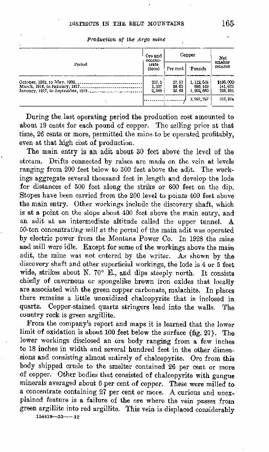
165
Production of the Argo mine
Period
October, 1902, to May, 1909 _______ . __ . ___ . ___ .
Ore and concen
trate (tons)
217.5 1,307 2,349
Copper
Per cent
27.57 26.03 25.60
....... ...,
Pounds
1, 112, 658 680, 449
1, 202, 680
2, 997, 787
Net smelter returns
$150, 000 141,073 209, 90L
500, 974
During the last operating period the production cost amounted to about 19 cents for each pound of copper. The selling price at that time, 26 cents or more, permitted the mine to be operated profitably, even at that high cost of production.
The main entry is an adit about 30 feet above the level of the stream. Drifts connected by raises are made on the vein at levels ranging from 200 feet below to 300 feet above the adit. The w'ork- ings aggregate several thousand feet in o length and develop the lode for distances of 500 feet along the strike or 600 feet on the dip. Stopes have been carried from the 200 level to points 400 feet above the main entry. Other workings include the discovery shaft, which is at a point on the slope about 400 feet above the main entry, and an adit at an intermediate altitude called the upper tunnel. A 50-ton concentrating mill at the portal of the main adit was operated by electric power from the Montana Power Co. In 1928 the mine and mill were idle. Except for some of the workings above the main adit, the mine was not entered by the writer. As shown by the discovery shaft and other superficial workings, the lode is 4 or 5 feet wide, strikes about N. 70° E., and dips steeply north. It consists chiefly of cavernous or spongelike brown iron oxides that locally are associated with the green copper carbonate, malachite. In places there remains a little unoxidized chalcopyrite that is inclosed in quartz. Copper-stained quartz stringers lead into the walls. The country rock is green argillite.
From the company's report and maps it is learned that the lower limit of oxidation is about 100 feet below the surface (fig. 27). The lower workings disclosed an ore body ranging from a few inches to 18 inches in width and several hundred feet in the other dimen sions and consisting almost entirely of chalcopyrite. Ore from this body shipped crude to the smelter contained 26 per cent or more of copper. Other bodies that consisted of chalcopyrite with gangue minerals averaged about 6 per cent of copper. These were milled to a concentrate containing 27 per cent or more. A curious and unex-. plained feature is a failure of the ore where the vein passes from green argillite into red argillite. This vein is displaced considerably
154419 3J -12
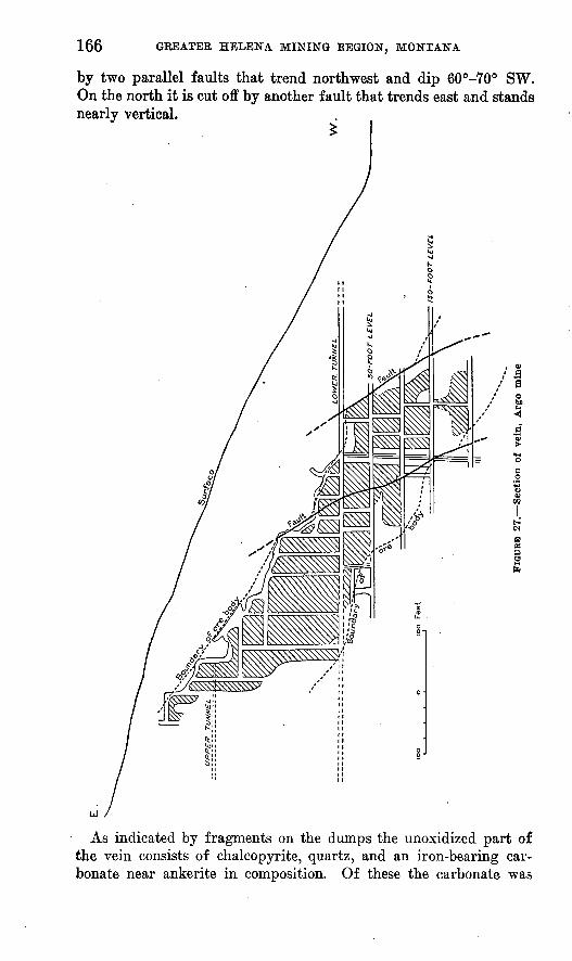
166 GEEATEE HELENA MINING EEGION, MONTANA
by two parallel faults that trend northwest and dip 60°-70° SW. On the north it is cut off by another fault that trends east and stands nearly vertical.
As indicated by fragments on the dumps the unoxidized part of the vein consists of chalcopyrite, quartz, and an iron-bearing car bonate near ankerite in composition. Of these the carbonate was

DISTRICTS IN THE BELT MOUNTAINS 167
introduced first. Later it was partly replaced by quartz and chalco pyrite, which came in together. The dump contains fragments of a soft green rock composed of chlorite, the relations of which were .not learned.
It is claimed that the ore bodies had not been exhausted when the mine was forced to close by the low price of copper after 1918. There is also a considerable amount of tailings impounded below the mill, which are said to contain an average of 12 pounds of copper to a ton.
CONSHOHOCKEN
Workings on the Conshohocken group of claims are a short dis tance upstream from the Argo mine, on the opposite side of the gulch. .Shafts on the Conshohocken claim, near the top of the slope, expose iwo parallel veins, less than 100 feet apart that strike N. 60° E., dip 80° N., cut blue slaty argillite, and are each about 3 feet wide. A .short tunnel driven toward these veins discloses a steeply inclined fault that strikes nearly at right angles to them but appears to have caused very little displacement. Both veins are composed of quartz, a brown-weathering carbonate near ankerite in composition, and chalcopyrite or its oxidation products. The carbonate is the most abundant and the earliest of the minerals to be deposited. The quartz and chalcopyrite, which appear to be contemporaneous, cut .and replace the carbonate in irregular veinlets. In the exposures .mentioned the amounts of chalcopyrite or of minerals derived from it by weathering are comparatively small. Microscopic examination of a specimen shows the chalcopyrite to be cut by numerous veinlets of limonite, which are bordered by very thin bands of chalcocite. J3oth minerals are secondary and the result of superficial processes. (See pi. 24.)
On the Mike Finch claim, next below the Conshohocken, an open cut exposes a 10-inch vein that is similar to those described. Farther down the slope the discovery pit shows a lode 4 feet wide composed of sheared argillite country rock and'veins of ankerite and quartz showing a little copper stain.
On the Hellgate claim, near the foot of the slope, about 700 feet lower than the outcrop of the highest vein on the Conshohocken claim, a crosscut tunnel in process of construction at the time of the writer's visit had not reached the vein.
IDEALClaims belonging to the Ideal Mining Co. on the north side of
JHellgate Creek opposite the Argo mine cover a steeply rising nar row mountain spur that lies between the creek and a tributary gulch. On top of the ridge, about 600 feet above the creek, is an old shaft .said to have been made on a vein that trends northeast. A small ore
168 GREATER HELENA MINING REGION, MONTANA
pile on the dump consists of cavernous quartz and chalcopyrite. The shape of some of the cavities indicates that they contained calcite or a mineral of similar crystal habit. Farther down the ridge open pits show two small veins containing quartz, ankerite, and a little copper stain:
A crosscut tunnel about 750 feet long enters the hill just above Hellgate Creek. About 100 feet from the portal it penetrates a mass of barren white quartz 15 feet wide. Farther in several quartz stringers are cut, but the vein exposed in the old shaft is not reached. The country rock is gray to green slaty argillite.
REX
A tunnel on the Kex claim, in Gabisch Gulch, is reported to be more than 700 feet long. At the time of the writer's visit it was caved at the portal and inaccessible. The dump contains vein matter composed of quartz and ankerite with chalcopyrite. The vein is said to strike northeast. The size of the fragments in the dump indi cate it to be at least 1 foot wide.
WHITMIRESeveral claims of 0. L. Whitmire are in Magpie Gulch about 2
miles above its mouth. On the west side of the gulch about 200 feet above the road an open cut and a short tunnel expose a lode, called the central vein, that strikes northeast, dips 50° NW., and cuts across buff papery shale of the Greyson formation. This vein is from 2 to 3 feet wide and consists of quartz with iron oxides and chalcopyrite. Other pits made here and there along the outcrop for a distance of 500 feet were partly filled with debris from caving of the sides, but some of them show parts of the vein which are similar to that described. In one opening the vein is displaced slightly by an overthrust fault. A crosscut adit 200 feet long from the foot of the slope had not reached the downward projection of the vein.
According to Mr. Whitmire 16 tons from an ore shoot near the surface contained, as shown by smelter returns, about 17 per cent of copper. Other lodes, called the North vein and South vein, were not examined.
The Sibyl Ann claim, in Coxie Gulch northwest of the lodes de scribed, is said to be developed by a 600-foot tunnel. Specimens reported to have come from the vein consist chiefly of quartz and ankerite with chalcopyrite.
BIG COPPERA lode known as the Big Copper, which differs somewhat from
those already described, crops out rather prominently about 800 feet north of the Golden Messenger dike at Mollie Gulch. It trends east and extends for a linear distance of 500 feet or more. Shallow

DISTRICTS IN THE BELT MOUNTAINS 169
workings show it to be from 4 to 6 feet wide and to dip 45° S. It is composed chiefly of a carbonate, apparently a variety of ankerite, together with more or less calcite, quartz, and a little brown jas- peroid material. Locally there are insignificant amounts of the copper oxide, cuprite, and the copper carbonate, malachite. An ex amination of specimens in the Geological Survey laboratory shows the chief bases of the carbonate mineral to be manganese, lime, and magnesia with a little iron. The mineral weathers to a brown ocherous material. The jasperoid is composed of fine-grained quartz clouded with iron and manganese oxides. The relations of these minerals to one another show the ankerite and calcite to have been deposited first. They are cut by a network of quartz seams, and both the quartz and the carbonates are locally replaced by the jasperoid. The copper minerals are deposited on surfaces of the other minerals. Presumably they were derived from the oxidation of sulphides, the relations of which are not known. The copper occurs in such small amounts as to discourage the expectation of valuable deposits in this lode. The mineralogy suggests that the lode was formed during the time that quantities of carbonate were being introduced into the dike and its surrounding rocks and there fore that it antedates somewhat the gold-quartz veins.
COFFEE QUEEN AND OUTLYING DEPOSIT?
A lode containing copper minerals crops out on a claim being de veloped by the Copper Queen Co. on the ridge south of York Gulch, about three-quarters of a mile west of the Old Amber mine. As shown by a 40-foot shaft, the lode is about 2 feet wide, strikes N. 70° E., dips 65° N., and cuts across green and gray shales of the Belt series. The lode consists mainly of .calcite and quartz. Irregu lar bunches of chalcopyrite occur0 here and there accompanied by iron oxides and copper carbonates. Part of the calcite weathers brown, the result, apparently, of the fact that it contains note worthy amounts of manganese. A little magnesia is present also. The relations of the calcite and quartz to one another show the cal cite to be the earlier. The chalcopyrite appears to have been intro duced with the quartz. In September, 1928, a crosscut tunnel near the foot of the slope was being driven toward the vein, which it was expected to intersect at a depth of about 800 feet. The face of this tunnel was said to be within 200 feet of the vein as projected down ward. Fifty tons of ore are said to have been shipped from a higher tunnel, but information as to the proceeds is not available.
On the west side of Avalanche Creek half a mile above Cave Gulch a tunnel, now closed by caving, is made on a small decomposed dike that is thickly speckled with iron oxides and cut by quartz veinlets. Farther upstream, for a mile or more above Cayuse Gulch,
170 GREATER HELENA MINING REGION, MONTANA
the surface mantle contains float vein rock consisting of quartz and calcite.
In Upper No. 2 Gulch, on the north side of White Gulch, a tunnel 350 feet long exposes a zone of crushed shale next to a porphyry dike. Lenses in the crushed zone consist of vein quartz and ankerite with more or less chalcopyrite. The porphyry shows the alteration of its feldspars to sericite. Several tons of ore piled on the dump evidently contains a small percentage of copper.
LODES NEAR NORTH END OF SPOKANE HILLS
KOEIZEK
The mine of William Korizek, on the slope south of French Bar, includes an open pit and a shaft that begins in the hanging wall and passes through the vein into the f ootwall a short distance below the surface. This working is said to be 100 feet deep, but no crosscuts have been made from it to the vein. A lode 18 inches wide that strikes N. 55° W., dips 60° NE., and cuts across the beds of red and green Spokane shale is exposed in the pit. These rocks are cut by a few slips parallel to the vein and altered to a dark- green material containing chlorite. The vein itself is considerably crushed by postmineral movements parallel to its walls. The vein consists chiefly of quartz but in places contains considerable barite and galena and a little pyrite and chalcopyrite. In addition there is more or less secondary cerusite, malachite, and chrysocolla. A layer next to the hanging wall shows a very noticeable olive-green coating of the mineral cuprodescloizite, a compound of vanadium, lead, copper, zinc, and arsenic. An ore pile obtained from the pit is said to assay from $60 to $97 a ton in silver, lead, and copper.
This deposit is just within the zone of slightly metamorphosed rocks that surround the quartz monzonite stock of the Spokane Hills and is the only ore body observed that appears to be related to that intrusive mass. So far as exposed it is a rather promising lode, and its mineralogy as described is somewhat unusual and interesting.
ANKERITE VEIN AND TOM LODE
An interesting deposit that is much like the Big Copper lode, described on page 168, crops out on the steep slope above the Missouri Eiver opposite French Bar. It strikes northwest, is 4 or 5 feet wide, and is composed chiefly of ankerite. In places the outcrop stands up like a wall several feet high. Quartz forms irregular streaks and a thin ragged layer at one side. Lesser amounts of calcite and hematite are present. The products of weathering include iron and manganese oxides. No copper minerals were observed. The deposit has been explored in places by open cuts

DISTRICTS IN THE BELT MOUNTAINS 171
that evidently were made many years ago. The country rock is Spokane shale.
Half a mile north of the lode just described an old pit at the head of Browns Gulch exposes a small vein known as the Tom lode that is composed of quartz with iron oxides, cerusite, and galena.
MANGANIFEROUS LODE EAST OF CANYON FERRY
A manganiferous lode at the mouth of Cave Gulch is developed by open cuts and an adit driven from a placer-mining pit in the terrace north of the stream. As exposed in the adit at a depth of 50 feet the lode trends northwest and is 6 feet wide. It consists of clay in which irregular streaks and bunches of manganese oxides are embedded. Most of the ore is jaspery and siliceous, but some of the bodies appear to be nearly pure oxides. They were probably derived from rhodonite and rhodochrosite by weathering. The country rock is Cambrian limestone.
PLACER DEPOSITS
CONFEDERATE GULCH
HISTORY OF MINING
Confederate Gulch was one of the three or four outstanding dis coveries of the gold-rush period in Montana. Although less exten sive than Alder and Last Chance Gulches, it exceeded them in rich ness, and as a result its chief mining camp, Diamond City, rose more quickly to prominence than any other boom town of that hectic period.
The placer ground is said to have been discovered by one Jack Thompson, who in the winter of 1864 found pay gravel at a point somewhat below the site of Diamond City. Among those first at tracted by Thompson's strike were a party from Virginia City known as " the Germans." They found rich gravel farther upstream and also in the tributary Montana and Cement Gulches. The next year (1866) they found on a terrace just below Montana Gulch the re markably rich deposit known as Montana Bar. For the next three years the boom was on, and Diamond City, strung along a terrace on the north side of the gulch, was known as the " mining capital of western Montana."
In the fall of 1866 a shipment of gold dust went out from Diamond City that, because of its size and the publicity surrounding its trans portation, was of unusual interest. The shipment is supposed to have represented chiefly the clean-up of a short run on Montana Bar. It weighed nearly 2 tons and amounted to about $900,000. In order to safeguard its transportation the gold 'was divided between three strong boxes, each carried in a wagon drawn by a span of mules.

172 GREATER HELENA MINING REGION, MONTANA
In this manner, accompanied by a cavalcade of armed guards, the gold was hauled 200 miles over mountains and plains to Fort Benton, whence it was carried safely by boat down the Missouri to St. Louis.
After 1869 placer mining rapidly declined. Diamond City still persisted as a place of some importance for about a decade, during part of which it was a county seat and supported a newspaper. By 1880, however, of the thousands who had once dwelt there only 64 re mained, and later its site was worked over with hydraulics and prac tically all vestiges of its former existence swept away. In 1928 there remained two log houses that apparently date well back toward the boom days one at the upper end of Montana Bar, the other to the <east across Montana Gulch.
PRODUCTIONThe placer gold produced in Confederate Gulch is popularly esti
mated to range from $10,000,000 to $30,000,000. For lack of records the exact amount can not be determined, but from the information available a reasonable approximation of the true total may be ob tained. All historians are agreed as to the unusual richness of Mon tana Bar. It is said that when water was turned off for the first clean-up the sluices were literally clogged with gold. It was not un- common to wash $1,000 from a pan (two shovelfuls) of gravel. From a trustworthy witness (Clifford Jackson, now deceased) who worked on Montana Bar in the boom days the writer learned that one pan yielded $1,400. This gravel was taken from a small fissure or crevice in the bedrock and therefore represented a very small part of the de posit. It is probable that the other large pan yields reported were obtained under similar exceptional circumstances, though no doubt the gravel deposit as a whole was unusually rich. According to Browne 72 the deposit was shallow, the gold coarse, and the best claims, 200 feet long, paid $180,000. Accepting Browne's figures and considering the extent of the area mined, the writer .estimates that- the total yield of Montana Bar was between $1,000,000 and $1,500,000. On Diamond and other " bars " an aggregate area four times that of Montana Bar was mined. These deposits are known to have been very profitable, though not as rich as Montana Bar, and they are assumed therefore to have produced in the aggregate at least as much .as that favored area.
In Cement Gulch near its mouth two claims aggregating 400 feet in length are reported to have yielded $400,000. At another place drift mining produced gold at the rate of $100 to a running foot. This gulch has been mined for a distance of 8,000 feet or more. At the smaller rate its yield would be $800,000. At an average of the
7a Browne, J. R., Mineral resources of the States and Territories west of the Rocky Mountains, 1867, p. 502, 1868.
DISTRICTS IN THE BELT MOUNTAINS 173
two it would be more than $4,000,000. ° Montana Gulch was of similar richness and for a distance of 6,000 feet is estimated to have produced at least $600,000 and possibly as much as $3,000,000. For Confederate Gulch proper even less definite data are available. About 5 miles of the gulch has been mined, and pans of gravel containing as much as $180 are said to have been obtained from it. The minimum average yield is rather arbitrarily placed at $100 a running foot. The true average may be as much as $300. The total yield therefore is esti mated to range from $2,500,000 to $7,500,000. Terraces on the south east side of Confederate Gulch known as the Boulder Bars have been mined in places. They are understood not to have been very profit able, and their total output probably ranges between $100,000 and $500,000. The foregoing figures are summarized as follows:
Estimated placer-gold prodiiction of Confederate Gulch and tributaries
?'
Minimum
$1,000,0001,000,000
100, 000800,000600, 000
2, 500, 000
6,000,000
Maximum
$1,500,0001,500,000
. 500,0004, 000, 0003, 000, 0007, 500, 000
18, 000, 000
The true total is probably not far from an average of the two esti mates, or $12,000,000.
In August, 1928, a cut was being excavated by M. O. Ellis & Sons with a hydraulic outfit in Confederate Gulch at the mouth of Boulder Creek, for the purpose of reworking a stretch of the gulch above. On the east side of Cement Gulch near its head E. B. Robison was mining in a " bar " about 100 feet above the stream. When water is available during the spring, mining is done by Herman Gogeler on a " bar " about a mile below Robison's and by John Swarbrick in Ready Cash Gulch, a tributary of Cement Gulch from the west at Robison's cabin. Considerable unworked ground remains in the terrace on which Robison is mining. On account of a scanty supply of water but a small part of the deposit can be worked each year. At the Ellis mine the profitable deposit is said to extend upstream half a mile or more. It is deeply covered with tailings. Whether un- worked pay gravel exists at the mouth of Confederate Gulch and be low in Townsend Valley was not learned. Down to the mouth of the gulch the original flood plain is buried with tailings. The situation of this ground is such that it could be worked only with dredges.
Apparently no unworked ground remains in the terraces on the northwest side of Confederate Gulch. On the other side are rather
174 GEEATER HELENA MINING REGION, MONTANA
large deposits of coarse terrace gravel that is characterized by granite boulders. This material is reported to be gold-bearing, but it is evident that attempts to work it in the past have been generally un profitable. This result may have been due in part to the expense of handling the large boulders, but it is more probably to be explained by a relative scarcity of gold. As described below, the Boulder Bars, though their gold proably came from the same source, have had a somewhat different history than the terraces north of the creek.
ORIGIN
The gold-bearing gravel of Confederate Gulch was deposited by streams at different stages in the process of excavating the valley. As more fully explained under the heading " Geomorphology " the main events in the history of Confederate Gulch and its gravel de posits are as follows: In the later part of the Tertiary period the mountains were not as high as now, and the surface generally was characterized by wide valleys and gentle slopes. The broad, flat upper valley of Beaver Creek at an altitude above 6,000 feet in the mountains north of Confederate Gulch is probably one of these an cient features. The wide gaps at the head of Cement Gulch and other places along the main divides are also regarded as existing remnants of the old valleys. The rather high shoulders or spurs that stand out prominently north and south of Boulder Creek may mark the height of the floor of Confederate Creek Valley in later Tertiary time. For convenience they are referred to as terrace 1. Between terrace 1 and the present stream channel at least three definite pauses in the downcutting are indicated. Two of these are represented by rem nants of their respective valley floors called terrace 2 and terrace 3.The third is the flood plain of the present stream. Each downcut ting was the result of an elevation of the mountains, and each plain represents a period of quiet or crustal stability during which placer deposits were formed. Terrace 2 includes the Boulder Bars, the high " bars " on the north side of Confederate Gulch, and probably also Kobison's Bar, near the head of Cement Gulch. At that stage the valley had been deepened several hundred feet below terrace 1 but still remained about 200 feet higher than the present stream channel. During the later part of stage 2 the valley was widened as much as half a mile in places by the stream cutting persistently .against its northwest side. In the course of this work the stream migrated from positions on the Boulder Bars to one represented by the high " bars " north of Diamond City. Terrace 3 is represented by Diamond and Montana Bars. This stage was of comparatively short duration. It ended with the cutting of the trench that holds the present stream channel.

DISTRICTS IN THE BELT MOUNTAINS 175
The distribution of the placer gravel points to the quartz lodes on Miller Mountain at the head of Montana Gulch as the chief if not the only source of the gold. The pay streaks in Montana, Keady Cash, and Johnny Gulches lead directly toward the quartz outcrops. Montana Bar and the terraces adjacent to it, being remnants of for merly continuous channels of the same stream, received their gold likewise. For Boulder Bars the relation is less evident. It appears, however, that at stage 2 Confederate Creek for a time occupied a position across those terraces, from which it gradually shifted side ways toward the north. The gold in Boulder Bars is therefore re garded as having been brought down by Confederate Creek during the earlier part of the period in which surface 2 was developed. The deposit became partly mixed and partly overlain with the heavy wash from the valley of Boulder Creek and thus made generally unprofit able for mining. The Boulder Creek wash also crowded Confederate Creek toward the opposite bank and was thus largely the cause of that stream's lateral migration during stage 2. Whether any gold was contributed by Boulder Creek and other streams from that side was not ascertained. If so the amount was probably small.
Below Boulder Creek small remnants of terrace 3 on both sides of the stream have been mined. A part of their gold was probably derived from quartz lodes associated with a diorite dike that is crossed by Confederate Creek near the mouth of the tributary mentioned.
The development of Confederate Gulch, including the terraces and their gravel deposits, except perhaps terrace 1, occurred during the Pleistocene or glacial epoch. The placer gravel, however, was produced chiefly during the interglacial stages of that epoch and was not, therefore, directly associated with the ice. At two stages local glaciers developed in the mountains at the head of Boulder
*' Creek. The earlier occurred when the valley was at level 2, and the later not until the creek had reached its present position. At both stages heavy barren wash was discharged from Boulder Creek. Its adverse effect on the placer gravel in Boulder Bars has been indicated. The wash of the later stage was the less abundant, but it diluted the gravel of Confederate Gulch considerably and thus gives an explanation of the fact that the gulch gravel was less rich than the unmodified gravel of the terraces.
The Pleistocene age of the placer gravel is shown also by fossil remains of a mastodon and an elephant (Elephas columbi) reported found at Diamond City.73
78 Hay, 0. P., The Pleistocene of the middle region of North America and its verte- brated animals: Carnegie Inst. Washington, Pub. 322A, p. 46, 1924.
176 GREATER HELENA MINING REGION, MONTANA
YORK AND KINGSBURY GULCHES AND TROUT CREEK
In the gold rush days York, a small settlement attractively situ ated in the valley of Trout Creek at the mouth of York Gulch, was a lively mining camp and, next to Diamond City, the largest settlement and trading center in the Belt Mountains. York is said to be a, contraction of New York, the name which the founders in anticipa tion of a city springing up there had bestowed upon the place. A few years after discovery the cream of the placer deposits had been skimmed, and most of the inhabitants had departed from the region. York soon declined to the status of a hamlet, but unlike some of its contemporary settlements it has not disappeared entirely.
Gold is said to have been first discovered in this area in 1864 by a man named Price at a point about half a mile above the mouth of York Gulch. Owing to the depth at which the pay streak lay buried it was mined at first by the process known as drifting. By 1874 practically all the ground that could be profitably worked by that expensive method had been exhausted, and for a time thereafter little placer mining of any description was done. Eventually a large part of the gulch came under the ownership of F. D. Spratt and others, who under the title of the Trout Creek Mining Co. ditched in water from Trout Creek and in the period 1888-1891 reworked York Gulch by hydraulic methods from its mouth to Kingsbury Gulch, the upper limit of their water8 supply. Since then a little drift mining has been done at times by Duncan Kobertson.
Little or no mining was done along Trout Creek in the early days. About 1890 A. N. Spratt began work near the mouth of the creek on an open cut that was projected upstream on a gradient calculated to reach pay dirt on bedrock at a point considerably below York Gulch. Before this project was completed, however, the cut was partly submerged by the rising waters of Hauser Lake, the reservoir impounded by the Montana Power Co.'s dam on the Missouri River.
Only a few authentic records of production for the York district are available, and no records of the early placer production are known. The deposits are generally reported to have been rich, but that statement affords little basis for an estimate. As much as $5,000,000 in placer gold is said to have been produced in the dis trict. Such an amount is no doubt a possible and perhaps reason able estimate, but data with which to check it are not available. For York Gulch an estimate of the yield of the drifted ground may be made from information furnished by Jack Radford, a miner who became familiar with the district rather early in its history. Accord ing to Mr. Radford, the pay streak was from 4 to 16 feet wide and yielded from $50 to $200 to a set of timbers, which ordinarily was 5 feet long. As more than 3 miles of gulch was drifted, the

DISTRICTS IN THE BELT MOUNTAINS 177
average of the yields mentioned would amount to about $400,000. Radford's recollection is that York and Kingsbury Gulches together yielded about $500,000, Kingsbury Gulch being much the less pro ductive of the two. Later hydraulic operations produced an unknown but probably fairly large amount.
Unworked deposits remaining include whatever gravel was left by the drift miners in 2 miles of York Gulch, above Kingsbury 'Gulch, and an untouched deposit along Trout Creek. In York Gnlch the drifted but otherwise unworked gravel deposit ranges from 15 to 50 feet in width and from 10 to 20 feet in depth. As a rule it is free from large boulders and easily washed, but there appears to be no supply of water available for hydraulic mining. The deposit is probably not extensive enough to warrant a dredge.
Trout Creek is underlain by a gravel deposit as much as 40 or 50 feet deep. From York Gulch down to the Missouri River, a distance of 3 miles, this deposit is reported to contain a pay streak on bedrock. As already stated, an attempt to work it several years ago by the hydraulic method was frustrated by the rise in level of Hauser Lake. The lower two-thirds of the deposit is narrow and, as shown by an open cut, very bouldery. The upper part is from 50 to 200 or 300 feet wide and fine textured. What part of it contains gold in paying quantities is not determined.
CLARK AND OREGON GULCHES
Clark Gulch and its tributary Oregon Gulch were discovered and mined in about the same period as York Gulch. No details of their early history was learned except the fact that Oregon Gulch was richer and more productive than the average. The stream channel in this gulch has been mined continuously for a distance of at least2 miles. In addition a low terrace on the north side has been worked for half a mile or more. Clark Gulch was mined for a distance of3 miles. It is estimated that Oregon Gulch produced at least $500.000 and Clark Gulch $300,000.
CAVE GULCH
Placer gold was discovered in Cave Gulch in 1866, at about the same time as in York Gulch and neighboring areas. The deposits were rich, and for a time a considerable number of miners were at work. For several years the gulch contained a mining settlement known as Cavetown, of which only the ruins of one cabin remained in 1928. During the gold rush period Cavetown was the scene of a bloody fight between miners and claim jumpers that has been made the subject of a sketch by the artist Charles M. Russell. Placer mining ceased in Cave Gulch about 1880.

178 GREATER HELENA MINING REGION, MONTANA
Below the point at which it leaves the mountains Cave Creek is bordered by terraces that correspond to the similar features in Con federate and other gulches described as terraces 2 and 3. On the west side of the creek old placer-mining pits extend along these ter races for 13/2 miles. In places the workings are several hundred feet wide, and their aggregate area is about 100,000 square yards. The minimum yield is estimated at $5 a square yard, or $500,000. The gulch channel within the mountains has been mined for about 2 miles, and its yield, said to have been comparable to that of York Gulch, is therefore estimated at $400,000.
Two miles below the point at which it issues from the mountains Cave Creek enters the Missouri Kiver. Along that course it is bor dered by an alluvial flat from 200 to 1,000 feet or more wide. Pre sumably the gravel beneath this flat contains more or less gold, but information as to whether a pay streak exists is lacking. The land is valuable for agriculture.
MAGPIE GULCH
More than 40 years ago considerable drift mining was done in Magpie Gulch along a stretch just above the gorge, and in addition a strip half a mile long in Bar Gulch, a tributary, and a small terrace at its mouth were mined through open cuts. In the period 1911-1914.a pit about half a mile long was made by dredging along the creek about 2 miles 'below the point at which it leaves the moun tains. In 1928 a little gold was being occasionally washed out along Bar Gulch by Jim Walston, and under the direction of E. I. Wall a shaft was being sunk by the Magpie Mining Co. in the main gulch at a point about half a mile above the gorge. At the time of the writer's visit the shaft had reached a depth of 60 feet, being within5 or 10 feet of bedrock. At this level the inflow of ground water amounted to about 400 gallons a minute. Electric power from the Montana (Kocky Mountain) Power Co.'s plant at Canyon Ferry was being used for hoisting and pumping.
According to Louis Heitman, who was an operator during the early mining period, drift mining0 in the stretch below the Magpie Mining Co.'s shaft produced $30,000 from a strip 350 yards long. An adjoining strip of the same length that was mined still earlier by Doctor Kotwitt is said to have been equally rich. There is evidence also that drift mining was done for nearly a mile below the mouth of Bar Gulch. Considering the costs at that time, it is estimated that this stretch must have yielded at least $150,000 to have been profitable. Probably at least $30,000 was recovered in Bar Gulch. The dredging operations below the gorge yielded an amount reported to be $50,000. The total placer gold production of Magpie and Bar Gulches is therefore at least $280,000.
DISTRICTS IN THE BELT MOUNTAINS 179
A considerable stretch of unworked placer ground is said to remain in the gulch above the shaft of the Magpie Mining Co. Along the lower course of the stream between the gorge and the dredge pit is an unworked deposit of alluvium about 2 miles long. No infor mation as to its gold content is available.
HELLGATE GULCH
No placer production has been reported from Hellgate Gulch. A few prospecting shafts have been sunk in the gravel bordering the stream, but no other evidence of mining was observed.
AVALANCHE GULCH
Placer mining has been done along a part of Avalanche Gulch beginning at a point about 6 miles above its mouth. On the north side of the gulch a low terrace, corresponding to No. 3 terrace inConfederate Gulch, has been worked for a distance of 2 miles or more. Apparently no mining was done along the stream channel The amount of gold produced was not learned. The extent of the old workings observed indicates a probable yield of at least $100,000.
The gold-bearing part of the gulch is suggestively associated with a diorite dike of the Golden Messenger group that is accompanied by more or less vein quartz. Gold doubtless occurs in the gravel beneath the stream channel, but it is assumed from the lack of mining operations that, owing to the low stream gradient and other conditions, the deposit proved to be unprofitable.
WHITE GULCH
White Gulch is said to be named for a man who first discovered gold in it in 1865. The mining period is reported to have continued for about 20 years. The deposits were rich, but no details concerning production are available. A terrace on the north side corresponding to terrace 3 in Confederate Gulch has been mined for a mile or more. (See pi. 21, B.) The gravel deposit ranges from 50 to 200 feet in width, and the aggregate area worked is about 50,000 square yards. Considering the amount of dirt that was moved, it is thought that to have made the mining profitable the minimum yield must have been $10 a square yard, or $500,000 in all. A tributary valley, Johnny Gulch, heads in the area of gold quartz lodes on Miller Mountain that also supplied the gold of Confederate Creek. Johnny Gulch has been mined for a mile or more, and below its mouth there is evidence of drift mining for a mile or more in the main gulch. A minimum yield of $50 to $100 a running foot is assumed, or $500,000 to $1,000,000, the total for White Gulch and its tributary being therefore $1,000,000 to $1,500,000. Probably the true total is near the larger amount. It is fair to assume that some gold is yet to be found in ground adjoining the old drifts, and there may be con-

180 GREATER HELENA MINING REGION, MONTANA
siderable pay dirt below'the stretch that was drifted. Except for a short time in the spring there is not sufficient water for hydraulic mining.
MISSOURI RIVER TERRACES
At about the same time that York and other productive gulches were discovered gold-bearing gravel was found in a group .of ter races that border the Missouri, River from the vicinity of Canyon Ferry downstream for 10 or 12 miles.
French Bwr. French Bar was the richest and most extensively mined of the river terraces. It is situated on the southwest side of the river at the north end of the Spokane Hills, nearly opposite Clark Gulch. For several years French Bar supported a mining camp of the same name, the site of which is shown on the plat of T. 10 N., E. 1 W., surveyed by the General Land Office in 1869. The deposit was mined by hydraulic methods, water being obtained from mountain streams through rather long and expensive ditches. The gravel-bearing channels occur at altitudes of about 200, 240, and 260 feet above the present level of the river (Hauser Lake). (See pi. 15.) The lower channel is the larger and probably is the correlative of ter race 3 of Confederate Gulch. The others are probably intermediate between that and terrace 2. These channels contained stream-washed gravel that ranged from 1 foot to 6 feet in thickness. Above the gravel was a thick deposit of sand and silt, locally mixed with hill side talus. A few large boulders were present.
The mining pits aggregate more than a mile in length and range from 50 to 400 feet in width. Their total area is about 150,000 square yards. According to generally accepted reports French Bar was as rich as the gulches of the York area, and' it is estimated therefore to have yielded at the rate of $10 a square yard, or$1,500,000.
Spokane Bar. Spokane Bar is a terrace, probably to be correlated with terrace 3 elsewhere, that is developed on the southwest side of Missouri Eiver just below Spokane Creek, or 3 miles below French Bar. Except for the fact that it was mined during or shortly after the gold-rush period, its history was not learned. The old working is a pit about 3,000 feet long, from 50 to 500 feet wide, and from 6 to 25 feet deep. The deposit is understood to have been much poorer than French Bar, and it is rather arbitrarily estimated to have produced an average of $3 to a square yard, or $550,000. The gold-bearing gravel is characterized by smooth stream-washed cob bles that are mostly less than 6 to 8 inches in diameter. It lies upon bedrock, is only a few feet thick, and is somewhat bound with a rusty red cement. Large boulders are sparingly scattered through the mass. It is covered with an overburden of fine gravel, sand, and

DISTRICTS IN THE BELT MOUNTAINS 181
soil from 5 to 20 feet thick. The ancient stream channel in which the deposit lies is about 50 feet above the present level of the Mis souri as held up by the Hauser Lake Dam, or about 100 feet above the submerged flood plain.
From the unworked gravel remaining sapphires are still recovered occasionally by Y. Peterson with a dry-washing machine.
El Dorado Bar, American Bar, GrueVs Bar, filings Bar, and Ruby Bar. These terrace remnants along the river below Spokane Bar have been mined in places. Their yield of gold is unknown, but they were much less productive than either Spokane Bar or French Bar. Probably their aggregate production was not more than $100,000. El Dorado Bar is best known as the site of a sapphire excitement that drew general attention to the occurrence of those gems in Montana. As early as 1867 the presence of sapphires in El Dorado Bar was recognized.74 In a report published in 1873 7S pebbles of corundum are described that were found scattered through a layer of gravel on bedrock. This knowledge did not create any stir at the time, but between 1890 and 1893 a sapphire boom of considerable proportions developed. Excitement ran high, and companies were formed to mine the terraces all the way from French Bar down to the mouth of Prickly Pear Creek, a distance of 20 miles. Before much work was done, however, the boom ended with the failure of the principal operator, an English corporation known as the Montana Sapphire & Ruby Co. Since then the gems have been sought for in a desultory way only, and now parts of the deposits on El Dorado and several other " bars " are submerged by Hauser Lake.
During the boom a considerable amount of sapphires was pro duced. According to Kunz 70 the value of the gems cut from Mis souri River stones amounted to about $2,000 a year. In 1893 the English company reported about $790 (£158) realized from the sale of gems.77 Minerals reported by Kunz 78 as associated with the sap phires are white topaz, ruby-red garnets, broken translucent crystals of kyanite, stream tin, limonite pseudomorphs after pyrite, chal cedony, and white calcite.
Origin of the river-terrace deposits. The fact that French Bar is opposite Clark Gulch and just below the mouth of Cave Gulch sug gests that its gold came out of those valleys before the streams had
74 Browne, J. R., Mineral resources of the States and Territories west of the Rocky Mountains for 1867, p. 502, 1868. States that the supposed diamonds found on El Dorado Bar proved to be sapphires.
75 Smith, J. L., Notes on the corundum of North Carolina, Georgia, and Montana : Am. Jour. Sci., 3d ser., vol. 6, pp. 185-186, 1873.
76 Kunz, G. F., Gems and precious stones of North America, p. 49, 1890.77 U. S. Geol. Survey Mineral Resources, 1893, p. 692, 1894.78 Kunz, G. F., U. S. Geol. Survey Mineral Resources, 1891, p. 542, 1892.
154419 33 13
182 GREATER HELENA MINING REGION, MONTANA
cut below the terrace levels. This idea is strongly supported by the fact that the gold-bearing terrace north of Cave Creek extends down nearly to the river, leaving only a comparatively small gap between that feature and French Bar to be filled so as to restore, in imagina tion, a continuous deposit. Terraces are wanting along the lower course of Clark Gulch, but remnants of them are found farther up that stream, and it is evident that at any stage Clark Gulch is even better situated than Cave Creek to supply gold to the river. There fore it is concluded that during the terrace stages the river channel, having received more or less gold from Cave Gulch, was greatly en riched by the discharge from Clark Gulch and its tributary, Oregon Gulch.
Between Clark Gulch and Trout Creek no gold-bearing streams join the river. This stretch contains Spokane Bar and the other auriferous terraces mentioned, except El Dorado Bar. It is signifi cant that these deposits become progressively poorer downstream. Their gold as well as that of French Bar is thus indicated to have come from Clark and Cave Gulches. Naturally they are leaner be cause farther from the source.
El Dorado Bar is below the mouth of Trout Creek and probably was enriched from that stream.
A source of the sapphires mentioned by Kunz 79 is a dike that cuts the slaty bedrock at Ruby Bar. The rock is described as a vesicular mica-augite andesite in which were found crystals of sapphire, py- rope garnet, and sanidine feldspar. The same author mentions also having seen specimens of a trachytic rock from a dike somewhat farther up the river in which crystals of sapphire were inclosed.80 The sapphire-bearing dikes were not found during the writer's in-vestigation. Their outcrops are probably now submerged by HauserLake.
The " bars " described are probably all to be correlated with ter race 3 of Confederate Gulch, which is thought to have been formed during an interglacial stage of the Pleistocene. A similar age is in dicated by a mastodon tusk reported by Kunz 81 to have been found embedded in the sapphire-bearing gravel on Euby Bar.
OUTLYING DEPOSITS
Several gulches that head in the divide east of Confederate Creek and discharge into the Smith Eiver are said to have yielded placer gold. In one of these, Benton Gulch, a little mining is still being done by John Swarbrick. The gold in Benton Gulch is evidently
70 Kunz, G. F., op. cit. (1891), p. 543.80 Kunz,"G F., U. S. Geol. Survey Eighteenth Ann. Kept., pt. 5 (continued), p. l^OO
1897.81 Idem, p. 1199.

DISTRICTS SOUTH OF HELENA 183
derived from the quartz lodes near the head of that valley on Miller Mountain. The production of Benton Gulch or the other gulches is not known.
DISTRICTS SOUTH OF HELENA
AREA AND ACCESSIBILITY
The area described in the following pages extends from Helena southward about 25 miles to Boulder and Basin and from the vicinity of Deer Lodge eastward about 50 miles to Winston and Radersburg. It includes parts of Broadwater, Jefferson, Powell, and Lewis and Clark Counties and is divided among the Helena, Winston, Clancy, Wickes, Kimini, Elliston, Z,osell, Basin, Elkhorn, and Radersburg mining districts.
Helena, the State capital, is at the north edge of the area. TheNorthern Pacific Railway skirts its northern, eastern, and westernborders, and the Great Northern Railway crosses its eastern and south-central parts. From the railroads and from several Federal- State highways all the districts and mining camps are easily reached. Electric power for mining and milling is available from the Montana Power Co., whose transmission lines cross the area. The plant of the American Smelting & Refining Co. at East Helena and the Washoe Smelter and other works of the Anaconda Copper Mining Co. at Butte and Great Falls afford markets for the shipping of ores.
FIELD WORK
Most of the districts south of Helena were examined by F. C. Schrader in 1928. Unfortunately many of the mines had been closed for years and could not be entered. The descriptions of the deposits are therefore based largely on examinations of the mine dumps, the surface, and the comparatively few underground workings that were found accessible. In addition, however, much trustworthy informa tion was gathered from persons who are familiar with the region.
HISTORY
Mining in this area began with the discovery, July 14, 1864, of rich placer deposits at the present site of the city of Helena, on Last Chance Creek. The discovery was made by four prospectors D. J. Miller, John CoAvan, John Crab, and Reginald or Robert Stanley who early in the spring had set out on a prospecting trip from Alder Gulch, near Virginia City. Soon after these pioneers began work others found gold on the neighboring streams, and before Avinter set in one of the larger of the mining booms peculiar to that early period was well under way. For about a decade thereafter placer mining was the chief industry of the region. Lode mining, however, began almost as soon as the placer mining, the first work be-

184 GEEATEE HELENA MINING EEGION, MONTANA
ing done in September, 1864, on the Whitlatch-Union gold vein. The discovery of that famous deposit stimulated further search for lodes throughout the region, and before the end of 1864 the Gregory lode, near Wickes, and other silver and silver-lead deposits in the neigh borhood had been found.
Owing to the fact that the upper parts of most of the gold-bear ing lodes contained free-milling ore the exploitation of these de posits was successful from the first. Many of the silver veins also contained ore near the surface so simple in composition that it could be reduced by amalgamation or so rich that it could stand shipment to distant points. Small lots of silver-lead ore were hauled by ox team to Fort Benton and shipped thence by boat to St. Louis and on to the eastern seaboard, the final destination of some lots being Swansea, Wales. Attempts were also made to work the sulphide ores in crude smelters, of which the first in the region is said to have been built at the Gregory mine in 1867. These early smelters used charcoal for fuel, and a number of old beehive ovens in which the charcoal is said to have been burned still remain at Gregory and Alhambra.
By 1875 the placer deposits had been largely depleted and the upper, more easily accessible parts of many lodes had been worked out. In 1883, however, when the Northern Pacific Railway reached the region, lode mining revived, and the next 10 or 15 years was the most active and productive period in the mining history of the region. A smelter built at Wickes became the largest ore reduction plant in the then Territory of Montana and drew custom ores from a surrounding area having a radius of about 300 miles. The Wickes smelter was shut down and dismantled in 1893, and ores were there after shipped mostly to East Helena or Butte for treatment. Since 1900 mining activity has been somewhat intermittent. Operations have included mining ore of medium and low grades that had been left in the stopes, hauling away old slag dumps for resmelting, and reworking old tailings piles.
In addition to these salvaging operations, considerable develop ment work leading to the discovery of new ore bod ies has been done at times. Noteworthy among these revivals of activity was the min ing of extensive and rich ore bodies in the Hope-Katie lode at Basin by the Jib Consolidated Mining Co. in 1924 and 1925.
In 1928 about 20 mines rather uniformly distributed through the region were being operated by owners or lessees. Among these are the Spring Hill, south of Helena; the East Pacific and Kleinschmidt, in the Winston district; the Gray Eagle, near Basin; the Jo Dandy, near Radersburg; and the Mount Washington, at Wickes. At Rimini the Montana Lead Co. was driving a 3,000-foot crosscut tun nel intended to develop several veins in depth.

DISTRICTS SOUTH OF HELENA 185
Although the placer deposits were largely exhausted by 1875, a little mining, consisting mostly of reclaiming the bedrock and work ing small remnants of gravel, has been done in several districts nearly every year.
PRODUCTION
Precious and base metals have been produced in the area south of Helena to a total value of nearly $130,000,000. Half of this amount is the value of the silver produced, and most o,f the remainder is gold, though the part contributed by the base metals, chiefly lead, is by no means small.
The total given is based partly on authentic records and partly on estimates obtained from persons familiar with the region. The least trustworthy reports are those concerning the early days of placer mining. Apparently figures of production were not as a rule set down during that hectic period but were recorded later, their accu racy therefore suffering in degree as the memory of the recorder grew hazy. However, after lode mining began and reduction works had been built, fairly complete records of costs and production were kept, and therefore by far the most of the total, particularly the part representing silver and base metals, has a trustworthy basis.
The bulk of the production of $130,000,000 was obtained before 1900. Since that year probably not more than $30,000,000 of the total has been produced. Reports for different years within the period 1904r-1911 82 show a total of a little more than $20,000,000 distributed among the districts south of Helena as follows:
Production of the districts south of Helena, Mont., 1904-1928
District
Elkhorn. ................
Years
1906-19281908-19281908-19281904-19281907-19281909-19281908-19281911-19281934-19281905-19281908-19281908-1928
Gold
$197, 498249, 877
66, 350350, 263480, 00070,00060, 0005,000
1, 672, 1701, 002, 0002, 996, 129
49, 855
7, 199, 142
Silver (ounces)
30,445173, 719347, 720
2, 136, 332310, 00080, 00070, 000
380, 0002, 115, 1274, 690, 000
180, 84225, 000
10, 539, 185
Lead (pounds)
424, 9951, 897, 272
581, 88715, 664, 137
3, 500, 0001, 700, 000
200, 000100, 000
11, 117, 7797, 097, 0005, 060, 719
433, 000
47, 776, 789
Copper (pounds)
25, 99044, 15427, 010
3, 668, 68120, 00090, 000
25, 0002, 345, 208
924, 0002, 344, 888
80, 000
9, 594, 931
Zinc (pounds)
13, 60019, 98374, 200
2, 804, 38622, 706
8, 986, 232419
13, 650210, 000
12, 145, 176
Total value
$496, 129481, 761474, 500
3, 896, 434889, 354200, 000
5, 553, 9864, 247, 2003, 821, 000
104, 204
20, 164, 628
The total production since the beginning of mining is distributed among the different districts about as follows:
81 Annual volumes of Mineral Resources of the United States, chapters on Montana by V. C. Heikes from 1906 to 1917 and by C.'N. Gerry from 1918 to 1928.

oo
Tot
al p
roduct
ion o
f di
stri
cts
sout
h o
f H
elen
a, M
ont.
, 18
64-1
988
Rim
ini_
__--
____
- -_-
----
----
---_
___-
____
___-
----
-___
__
____
____
__
____
___
Ell
isto
n-
-.._
_-_ _
____
____
____
____
_.__
-__ _
_-._
____
-___
__.
-.._
____
_
Blk
horn
__
__
_ _ _
_ _ _
__
__
_ _ _
__
_ _ _
____
___ ___ _
____
_ ...
Pla
cers
$17,
079
, 000
113,
000
25, 0
0080
, 000
20, 0
0075
, 000
50, 0
0048
, 000
514,
000
200,
000
18, 2
04, 0
00
Gol
d
Lod
es
$6, 3
04, 0
001,
990
, 000
566,
000
4, 3
25, 0
003,
900
, 000
265,
000
10, 0
00
1, 5
00, 0
004,
682
, 000
700,
000
28, 0
17, 0
00
Tota
l
$23,
383
, 000
1,99
0,00
067
9, 0
004,
350
, 000
3, 9
80, 0
001,
170
, 000
340,
000
60, 0
002
«7
q
nn
fi
1, 5
00, 0
005,
196
, 000
900,
000
46.2
21,0
00
Sil
ver
(oun
ces)
65, 0
0090
0, 0
002,
500
, 000
3, 3
10, 0
00
400,
000
300,
000
12, 5
00, 0
0016
0, 0
0075
, 000
70, 9
01, 0
00
Lea
d(p
ound
s)
1,12
0,00
06,
000
, 000
12,2
80,0
00
13, 5
00, 0
006,
700
, 000
1,40
0,00
010
0, 0
00OQ
onn
fift
f.10
, 800
, 000
5, 2
00, 0
0043
3, 0
00
145,
733
, 000
Cop
per
(pou
nds)
25, 0
00
37, 5
008,
750
, 000
20, 0
0034
0, 0
00
4, 0
60, 0
00
80, O
il
16,8
57,5
11
Zin
c(p
ound
s)
20, 0
0020
, 000
110,
000
20, 0
00
8, 9
87, 0
00
20, 0
0021
1, O
CO
12, 9
88, 0
00
$23,
500
, 000
3, 5
00, 0
0059
, 500
, 000
7, 0
00, 0
002
7cA
A
nn
8, 3
25, 0
00
1, 0
02, 2
00
129,
807
, 200

DISTRICTS SOUTH OF HELENA 187
TOPOGRAPHY
In general the area south of Helena is characterized by rounded hills and long slopes. (See pis. 2; 6, #; and 29, A.) It averages about 5,500 feet in altitude and includes in the western part a stretch of the Continental Divide, which reaches a general height of 7,000 feet. Along the east side the Elkhorn Kange is somewhat higher and more precipitous. The intervening area in a general view ap pears as a broad depression extending from Prickly Pear Valley southward beyond the limits of the region. Prickly Pear Creek and its branches drain the northern part of this depression, and a branch of the Boulder River the southern part. These streams oc cupy rather wide valleys with gentle slopes that are sunk beneath the floor of the older wider valley.
The local relief ranges from a few hundred feet to 2,000 feet or more, and in many places the slopes are very favorable for mining through adit levels.
GEOLOGY
BOCKS OLDER THAN THE BOULDER BATHOLITH
Sedimentary and igneous rocks that were formed before the in trusion of the Boulder batholith range in age from Algonkian to Cretaceous and underlie considerable areas in the Helena, Elliston, Elkhorn, and Radersburg districts.
The oldest rocks of the region are a series of limestones and shales belonging to the Belt series, the occurrences of which are virtually confined to the Helena and Elkhorn districts. At Helena the for mations present are, in ascending order, the Spokane shale, Empire shale, Helena limestone, and Marsh shale. In the Elkhorn district a metamorphosed sedimentary rock that is probably the equivalent of the Spokane shale has been called Turnley hornstone.
Unconformably above the Belt rocks is a series conformable within itself that consists dominantly of limestone with some shale and quartzite. The aggregate thickness of this series near Helena is estimated to be 2,300 feet, and ,it includes rocks of Cambrian and Devonian age. The lowest formation is the Flathead quartzite, which appears in the Helena and Elkhorn districts. It consists of a vitreous coarse quartzite, normally white but generally showing a red tint on weathered surfaces. It is conglomeratic at the bottom and .in places displays cross-bedding.
The early Carboniferous (Mississippian) Madison limestone is prominently developed, in the Helena and Elkhorn districts. Its upper thick-bedded portion is a coarsely crystalline limestone, which commonly forms bold outcrops of dazzling whiteness.
The Quadrant quartzite is a light-gray rock of dense, almost cherty texture that overlies the Madison limestone. It consists pre-

188 GREATER HELENA MINING REGION, MONTANA
dominantly of quartzite, outcrops of which show rough, hackly surfaces and form ridges in the Helena district and west of Radersburg.
Above the Quadrant quartzite .in the Elliston district is a bed of phosphate rock belonging to the Permian Phosphoria formation.
Rocks definitely determined as of Jurassic age occur at Elliston, where they overlie the Phosphoria in angular concordance. The beds described by Knopf 83 as of determined Jurassic age are buff- weathering sandy limestones and some pure limestones aggregating 50 feet .in thickness, referable to the Ellis formation. Lying above the known Jurassic rocks is a considerable thickness of coarse grained speckled sandstone that is commonly cross-bedded and almost quartzitic in appearance.
Sedimentary rocks that are probably of Jurassic and Cretaceous age occur also in the Elkhorn, Radersburg, and Helena districts. In most places, however, they have been altered to hornstones and other metamorphic rocks by the action of the intrusive quartz monzonite.
The sedimentary rocks are, as a rule, intensely deformed. In the Elkhorn and Radersburg districts they have been bent into tightly squeezed folds that trend about north. South of Helena they are steeply inclined and broken by faults.
Andesitic tuffs and breccias and andesite-latite flows of probably late Cretaceous age occupy extensive areas in the Elkhorn Mountains and in the Zosell and Wickes districts. According to Knopf,84 the
remnants of the roof of the Boulder batholith consist principally of andesitic [and latitic] rocks comprising a bedded series of lavas, breccias and tuffs, with some interstratified quartzite, shale, and lime stone. At most localities the truly volcanic portion predominates. Sedimentary rocks are found east of Thunderbolt Mountain, whereandesite, breccia, banded tuff, and hard shale are interstratified. At the mouth of the canyon of Tenmile Creek sedimentary rocks overlie the andesites. These rocks are thermally metamorphosed sediments, mainly of original arenaceous character. Near the contact of the andesitic rocks and the overlying sedimentary rocks there is appar ently an interstratification of both kinds.
On the eastern side of the batholith, at Elkhorn, the andesitic rocks dip eastward at a gentle angle away from the granite; on the west, at Cliff Mountain, they dip westward at angles of 15° to 20° away from the batholith, passing beneath the soft Tertiary deposits of Deer Lodge Valley.
On the steeper declivities the andesites generally form bold out crops, below which extend long talus slopes of angular fragments. Where, however, the latites prevail, the outcrops weather to a light
83 Knopf, Adolph, Ore deposits of the Helena mining region, Montana.: U.S. Geol. Sur vey Bull. 527, p. 77, 1913.
"Idem, pp. 23-27.

U. S. GEOLOGICAL SURVEY BULLETIN 842 PLATE 24
4. ORE FROM CONSHOHOCKEN MINKVeinlets of limonile (Urn) cutting chalcopyrile (cp). Al the boundaries between
chalcopyrite and limonite are thin seams of chalcocite (cc). The chalcocile is supergeue and is probably a transitory product in the process of oxidation of chalcopyrite. Some hematite (hem), probably pseudomorphic after pyrite (py), is also present.
B. ORE FROM CONSHOHOCKEN MINE
From same specimen as A. cc, Chalcocite; Urn, limonile; cp, chalcopyrite; py,pyrite.

U. S. GEOLOGICAL SURVEY BULLETIX 842 PLATE 25
FLOW BANDING IN ANDESITE, EAST PACIFIC MINE
From point above tunnel 2. Nearly natural size.

189
gray or white, and the exposures resemble those of the rhyolites of the region. At any one locality the andesites are found to com prise a considerable number of varieties.
An andesite from the entrance of the canyon of Tenmile Creek is a dark, heavy rock in which the pyroxene phenocrysts are prominent because weathering in relief. In thin section it is found to contain numerous phenocrysts of calcic plagioclase, ranging up to Ab30An7 o, and of augite, which are surrounded by rims of brown-green amphi- bole. A bluish-black aphanitic andesite from Thunderbolt Mountain shows a porphyritic hyalopilitic texture. The andesite with promi nent tabular feldspar crystals contains phenocrysts of plagioclase near AbjAnx and of chloritized and epidotized femic minerals in a cryptocrystalline matrix.
The latites are characterized by the occurrence of plagioclase and biotite phenocrysts in a cryptocrystalline groundmass of salic appear ance. Blue, red, and flint-gray are common colors. Streakiness and flow banding are nearly universal. The analysis is given of a latite from Thunderbolt Creek, which shows low magnesia and relatively high potash.
The andesites and latites in proximity to the quartz monzonite intrusion have undergone contact-metamorphic alteration. This has taken the form of simple recrystallization or recrystallization with the addition of material. The former is the more common. The most extensive metamorphism of the andesites has taken place on the north side of Elkhorn Peak, where the rocks, mainly breccias, have been remarkably thoroughly recrystallized. In addition the rocks are extensively injected with aplite dikes, many of which carrjr tourmaline. On the southwest flank of Elkhorn Peak a breccia of angular fragments of andesite shows patches (5f garnet and areas of fibrous tremolite, with fibers up to 2 inches in length. Garnet, pyroxene, scapolite, plagioclase, and accessory titanite and apatite are present. Knopf concludes that the andesites are of late Cretaceous age.
Southeast of Elkhorn, where they are regularly bedded, the ande- sitic rocks are reported by Stone 85 to be 1,000 feet thick. As much of the rock has been removed by erosion it is evident that the original thickness was greater.
In the Winston district, near the East Pacific mine the andesitic series remaining is estimated to be 1,600 feet thick. It includes flows, tuffs, and breccias that are mostly dark gray and are commonly sheeted or cut into large blocks by joints. The flows range in texture from massive to closely banded (pi. 25). The banding is best de-
85 Stone, R. W., Geologic relation of ore deposits in the Elkhorn Mountains, Mont.: U. S. Geol. Survey Bull. 470, p. 79, 1911.

190 GREATER HELENA MINING REGION, MONTANA
veloped in the flows of the upper part of the series and to the unaided eye is best seen on weathered surfaces. The lighter-colored and coarser-grained bands are composed predominantly of plagioclase; the darker ones are mostly hornblende, biotite, and augite. Under the microscope a typical specimen of the rocki is seen to be composed of a banded or streaked groundmass of microcrystalline plagioclase and hornblende with a subordinate amount of biotite, little or no augite, and accessory magnetite. In the groundmass are scattered small phenocrysts of calcic plagioclase, hornblende, and augite.
QUARTZ MONZONITE AND APLITE OF THE BOULDER BATHOLITH
The remainder of the region is occupied chiefly by quartz monzo- nite, commonly called Butte " granite," which forms the northern part of the Boulder batholith (pi. 1). The quartz monzonite has intruded and metamorphosed the rocks described above. According to Knopf, the prevailing rock of the Boulder batholith is a coarse granitoid composed essentially of plagioclase, orthoclase, quartz, biotite, and hornblende, in the order named. It is remarkably homo geneous in composition over a large area, and a widespread feature is a rough porphyritic habit due to the development of large imperfect phenocrysts of orthoclase. Toward the margins of the batholith the rock becomes somewhat finer grained and equigranular, as noted south of Helena, east of Boulder, and elsewhere. In some localities the rock becomes dioritic. Six analyses of samples from different parts of the batholith, including one from Butte, show that the quartz monzonite elsewhere in the batholith does not differ essentially from that at Butte, which, in fact, is practically identical with the rock from Elkhorn.
The quartz monzonite has been quarried at several places for building stone, some from a quarry at Clancy being used in the construction of the State capitol at Helena. This rock takes a high polish.
Commonly the quartz monzonite is traversed by two sets of nearly vertical joints that are spaced from 10 to 60 feet apart. As a result of weathering, the outcrops in certain areas, of which an example is found along the Great Northern Eailway between Clancy and Montana City, are characterized by knobs and an almost impassable litter of huge boulders. Areas in which the widely spaced joints do not prevail generally show comparatively smooth soil-covered surfaces.
Dikes and irregular masses of aplite closely associated with the quartz monzonite represent later intruded parts of the batholith. As described by Knopf,86 within the area of the boulder batholith
86 Knopf, Adolph, op. cit., pp. 34-35.
DISTRICTS SOUTH OF HELENA 191
and around its margin aplite forms dikes and irregular masses, some of which are measured in square miles. The largest of these is east of Corbin. Other extensive areas occur west of Jefferson and on the ridge south of Ked Mountain. As estimated roughly, the aplite forms 5 per cent of the surface exposure of the batholith. Pegmatite is rare. The aplites are fine-grained granular white rocks composed essentially of orthoclase and quartz, with minor amounts of biotite. They are commonly tourmaliniferous. The. aplite was not derived from the splitting up of a single magma into, two magmas, one salic and the other femic. It originated from the quartz monzonite magma by a process of f ractionation.
CONTACT METAMOBPHISM
As described by Knopf,87 the contact-metamorphic alteration produced by the invasion of the quartz monzonite is diverse from place to place, being dependent on the original chemical composition of the different rocks it has invaded and on the local accession of material during metamorphism. The simplest form of the contact metamorphism is the alteration of limestone to marble, as well shown south of Helena, where the metamorphosed Madison limestone has been coarsely recrystallized so that it forms conspicuous snow- white outcrops. It is noteworthy that the basal member of the Madison limestone contains a multitude of minute tremolite and tourmaline needles, although the matrix inclosing them has not recrystallized.
Along .the contact south of Helena the rocks overlying the Quad rant quartzite have been extensively recrystallized to various kinds of biotite hornfels and micaceous quartzite. Garnetization has taken place on an extensive scale west and northwest of Mullan Pass at distances of over a mile from the exposed contact. At the Spring Hill mine metamorphic minerals are developed locally and abruptly across the bedding of thinly stratified limestone. The principal contact-metamorphic change produced by the quartz monzonite in the andesite-latite series was either simple recrystallization or recrys- tallization wlith addition of material accompanied by a change in the color of the rock from dark gray to light gray or nearly white.
ROCKS YOUNGER THAN THE BOULDER BATHOLITH
Resting on the eroded surface of the batholith and the older rocks is a series of late Tertiary dacites and rhyolites occurring both as dikes and as extruded masses. As described by Knopf,88 a bedded succession of dacite lavas, tuffs, and breccias extend from areas west of Basin and Wickes southward to Butte, where they form the hill known as the Big Butte.. These rocks are light-colored porphyrites
37 Knopf, Adolph, op, cit, pp. 26-27, 31-32. »Idem, pp. 36-41.'

192 GREATER HELENA MINING REGION, MONTANA
related to rhyolite. They rest on the deeply eroded surface of the Boulder batholith. These dacites are remarkably uniform. The commonest variety is a porous ash-gray porphyry containing large phenocrysts of andesine and quartz interspersed with small brilliant black flakes of biotite in an aphanitic groundmass. The feldspars, many of which are an inch long, form half the bulk of the rock.
Rhyolites, which were erupted on a surface about as rough as that of the present, form the cap of Red Mountain, in bedrock of the " porphyry dike," and occur at many places in neighboring areas. They are light-colored rocks carrying phenocrysts of quartz and sanidine but are less prominently porphyritic than the dacites and are otherwise distinguished from them by the lack of biotite. They are probably younger than the dacite, though their relations to it are not shown. The rhyolites are mainly litho'idal lava flows but include some breccias and obsidians. They display a great variety of textures and colors, including grayish blue, red, pink, and white. Pronounced streakiness and flow banding and abundant phenocrysts of smoky quartz and of clear, glassy sanidine are typical of the flows. A platy or laminated structure parallel to the flow banding is common, causing the rhyolites to break in thin slabs. In places, as west of Elliston and on Minnehaha Creek near Rimini, there is a pronounced columnar structure.
Tertiary sedimentary rocks including some rhyolite are abundantly developed in Prickly Pear Valley on the northern border of the region, and bodies of glacial drift and alluvium of noteworthy size occur in the valley of the Little Blackfoot River above Elliston. Elsewhere Tertiary and Quaternary sedimentary rocks are rela tively scarce, though they include the placer deposits that have been very productive in the past.
ORE DEPOSITS
The ore deposits in the districts south of Helena include both placers and lodes, but all except very small remnants of the orig inally extensive placer deposits were long ago mined out. Despite the fact that during the last 50 years metals to the value of about $111,600,000 have been taken from the lodes, many productive deposits of that class still remain.
LODES
CLASSIFICATION
A classification of the lodes based on their original relations to the different igneous rocks of the region is proposed by Billingsley and Grimes.89 According to these authors the rocks concerned are,
89 Billingsley, Paul, and Grimes, J. A., Ore deposits of the Boulder batholith of Mon tana : Ant. Inst. Min. Bng. Trans., vol. 58, pp. 291-332, 1917.

DISTRICTS SOUTH OF HELENA 193
in order of age, beginning with the oldest, (1) andesitic lavas and related dikes and sills; (2) granite (quartz monzonite) of the Boul der batholith; (3) aplite; (4) rhyolite and dacite.
The intrusion of each rock is thought to have stimulated the depo sition of ore, and each time the ore deposition followed the same sequence of events namely, segregation of ore within the magma, deposition in the contact zone, and formation of veins along fractures in the cooled outer shell of the granite and the adjacent metamor phosed rocks.
According to the authors cited the great majority of the lodes in the area are veins related to the quartz monzonite and the aplite. A few deposits in the Zosell, Elliston, and Elkhorn districts are thought to have originated from the andesite, and some at Clancy, Warm Spring Creek, Kimini, and Lowland Creek from the dacite or therhyolite.
Knopf °° classifies the deposits in two main groups, older and younger. The older deposits are genetically related to the Boulder batholith and are regarded as formed soon ofter that body came to place and before the eruption of rhyolitic and dacitic lavas. They include magmatic deposits, contact-metamorphic deposits, and veins. The veins are classified according to their composition as tourma- linic or sericitic, and the tourmalinic veins are still further sub divided as silver-lead deposits, silver-copper deposits, and gold deposits.
The genetic relationship of most of the lodes to the intrusive Boulder batholith is thus recognized by the authors of both of the reports referred to, but the further classification proposed by Bill- ingsley and Grimes, based on the relationship of the lodes to different facies of the igneous bodies, requires deeper research into the problems of ore genesis than information available for the present paper admits. Knopf's simpler scheme answers many practical purposes and is used herein essentially without modification.
OLDER LODES
CHARACTER AND COMPOSITION
All but a few of the older-lode deposits in the districts south of Helena are veins, most of which belong to the. subgroup of silver- lead deposits.
The single representative of magmatic deposits reported by Knopf is the ore body of the Golden Curry mine, at Elkhorn, which consists of an intergrowth of pyrrhotite and chalcopyrite with augite. It is inclosed in quartz monzonite.
Several contact-metamorphic deposits occur throughout the region, and these are invariably situated near the contact of limestone with
00 Knopf, Adolph, op. cit., p. 42.
194 GREATER HELENA MINING REGION, MONTANA
quartz monzonite or a related granitic rock. They consist of inter- growths of ore minerals with different silicates, among which iron- bearing garnet is generally present. Deposits of this type valuable for gold, for copper, and for iron have been found. The recently productive Spring Hill mine, near Helena, is on a contact-meta- morphic gold deposit in which the ore minerals are, as usual, some what later than the silicates. Other deposits of contact-metamor- phic origin are the Dolcoath, at Elkhorn, which contains bismuth minerals and chalcopyrite, several bodies of magnetite ore at Elkhorn that have been mined for fluxing material, and the Blue Bell lode, near Elliston, which contains copper ore.
As pointed out by Knopf,91 a striking feature of the older deposits is their abundant content of tourmaline, a mineral of rather uncom mon occurrence elsewhere except in tin lodes and one that indicates high temperature as a condition under which the deposits were formed. The tourmaline-bearing deposits include gold lodes, sil ver-copper lodes, and the large and productive group of silver-lead veins, of which the Lee Mountain and Valley Forge mines, at Rimini, show most strikingly the development of the tourmalinic bodies.
These deposits are inclosed in quartz monzonite. According to Knopf,92 the ore occurs at Rimini in shoots scattered through a zone which in places attains an extreme width of 50 feet. In this zone the granite is profoundly sericitized and is strongly im pregnated with metallic sulphides. Commercial ore consists of a heavy sulphide aggregate composed principally of galena with sphal erite and pyrite. Arsenopyrite is generally present, and tetrahedrite and chalcopyrite occur rarely. The ore is more or less mixed with altered granite but not with vein quartz or other material found in fissure-filled veins. The feature that distinguishes these deposits from the usual types of ore body is that they are accompanied along one wall or the other by what is termed locally a ledge of black quartz. This ledge consists of coal-black rock composed essentially of an intergrowth of quartz and black tourmaline. It is noteworthy that the most productive lodes are accompanied by the thickest ledges, although, on the other hand, ore does not occur continuously along these ledges. The tourmalinic rock carries a varied amount of metal lic sulphides, among which arsenopyrite predominates.
The ore shoots occur alongside the tourmalinic ledge. There is, however, complete though abrupt gradation between the tourmalinic rock and the ore material. A definite tendency of the sulphides to segregate is obvious. The evidence indicates that the same solutions that carried the tourmaline-producing elements carried also the me-
91 Knopf, Adolph, op. cit., p. 45. 82 Idem, pp. 46-47.
DISTEICTS SOUTH OF HELENA 195'r
tallic sulphides, but there was a tendency of the tourmaline to de velop ahead of the sulphides.
Billingsley and Grimes 93 consider the quartz-tourmaline bodies to be segregations from aplite dikes and of an earlier generation than the ore-bearing parts of the lodes. These authors describe two types of tourmaline bodies. One is coarse grained and contemporaneous with the aplite intrusions. It occurs in the granite wall rock and definitely antedates the veins. The other is of microscopic texture and occurs in the "black quartz " parts of the lodes, which are regarded to be somewhat earlier than the productive ore bodies. These authors also call attention to the fact that the distribution of tourmaline is
-v widespread but not uniform. It is entirely lacking in several of the lodes, even in the deepest workings. It is probable that the deposi tion of the lode occupied considerable time, during which cooling de creased and.finally stopped the development of the tourmaline.
Analyses of fresh and altered wall rocks quoted by Knopf show that the changes produced during the tourmalinic alteration and mineralization were a net increase in mass of 9 per cent, due chiefly to the introduction of the metallic sulphides. There was a gain in iron as pyrite and arsenopyrite, gains in silver, lead, arsenic, zinc, and silica, and a heavy loss in all bases except potash.
VER1ICAL DISTRIBUTION OF THE ORE! BODIES AND ZONING OF THE METALS
After their examination of a large number of the lodes in the region of the Boulder batholith Billingsley and Grimes 94 concluded that so far as the vertical distribution is concerned the ore bodies are confined to the zone extending 1,000 feet or less above and below the upper contact surface of the granite. In addition these authors found evidence of a vertical zoning of the different metals within the lodes. Lead in the form of galena occurs mostly in the higher
^ parts of the ore shoots. Zinc as sphalerite is found mostly below the lead zone. Still lower iron sulphides accompanied by small amounts of copper predominate. The following statement is condensed from their report.
Most of the ore deposits are within a short distance vertically from the contact of the granite mass. Some, as at Alta and Gregory, extend upward into the intruded rock, but most, among which are the Bertha, Comet, Eva May, Crystal, Bullion, Hope, Valley Forge, Lee Mountain, Ontario, and Monarch, are within the granite at dis tances less than 1,000 feet from its upper surface. The few veins more deeply placed contain but little quartz and suggest eroded roots of veins of normal type above. Outside of Butte 110 veins have been identified as belonging to this group, and wherever possible the posi-
08 Billingsley, Paul, and Grimes, J. A., op. cit., p. 304. B4 Idem, p. 307.
196 GREATER HELENA MINING REGION, MONTANA
tion of their outcrop with reference to the granite contact has been determined. The restoration of the contact has been accomplished in many places by connecting residual fragments of cover, and in a large number of places, as in the Wickes, Comet, Basin, and Rimini districts, the contact itself is preserved and gives a definite plane for measurement. Of the 110 veins mentioned 9 could not be definitely placed with reference to the top of the granite. Of the remaining 101, 15 are contained mostly in the overlying cover, 54 lie within a distance of 500 feet below the contact, 28 crop out between 500 and 1,000 feet, and including the deep developments, only* 4 veins are known below 1,000 feet. The productive portions of these fissures are limited to a zone extending 1,000 feet above and 1,000 feet below the contact.
The primary vein filling includes quartz, rhodochrosite, rhodonite, tourmaline, calcite, siderite, and fluorite in the gangue and pyrite, arsenopyrite, galena, sphalerite, chalcopyrite, tetrahedrite, bornite, stibnite, and argentite among the sulphides. The composition of 93 veins shows that the typical vein aggregate is pyrite, galena, and sphalerite in a gangue of quartz, that pyrite and galena exceed any other combination, and that the copper, arsenic, and antimony com pounds fall considerably behind the iron, lead, and zinc. The un usual gangue minerals tourmaline and rhodochrosite were each found in about one-sixth of the veins but rarely occurred together. Tour maline is found in the regions where it is also abundant as a con stituent of the aplite.
The universal trend in the composition of these veins is an in crease with depth in the proportion of quartz to ore minerals. With out exception the vein roots exposed where the granite is deeply eroded show little but quartz. Although the total amount of sul-phides thus diminishes with depth, the proportions of the different sulphide minerals themselves vary also within the vertical range of the ore shoot. In the Valley Forge, Comet, Alta, and Eva May mines the lead content of the vein is found above and generally within 1,000 feet of the granite upper contact. Whatever zinc is present is chiefly massed just below the lead zone, which places it at a maximum distance between 1,000 and 1,200 feet from the roof. Py rite is present throughout but persists to greater depths than galena or sphalerite and below 1,200 feet is likely to be associated with pri mary copper sulphides. The evidence obtained from neighboring veins cropping out at different depths within the granite corrob orates the conclusions reached from the completely developed ore shoots in the mines mentioned. The measure of these changes varies in different veins, most markedly between large and small veins. It can be safely said, however, that little lead is found more than 1,000
DISTRICTS SOUTH OF HELENA 197
feet within the granite and but little zinc below 1,200 feet, and that copper, though often present throughout a shoot, in primary form predominates only in the depths.
GEOLOGIC VARIATIONS IN THE MINERAL DISTRIBUTION
Billingsley and Grimes ° 5 note a geographic variation in the general composition of the ore bodies. Thus, the veins of the Rimini district are characterized by an unusual amount of arsenopyrite in their upper zone. In the Comet district zinc is found in excess. In the Basin district rhodochrosite is widely present, the ores otherwise resembling those of the Comet district. There is a zone in the batho- lith, including the Wickes, Jack Mountain, and Little Boulder dis tricts, in which chalcopyrite is found throughout the veins in some what greater amount than is usual elsewhere. It is in this belt that the shallow ore bodies of secondary chalcocite occur. The greatprimary enrichment at Butte associated with the later quartz por phyry must not be confused with the processes that formed this type of ore deposits.
VEIN STRUCTURE
The veins in the district south of Helena have formed along frac tures that served as conduits for ascending mineral-bearing solutions. At some places only a single persistent fracture was formed, as illus trated by the Whitlatch-Union vein, but in many places several fractures were developed that compose a closely spaced group. The Crystal, Comet, and Baltimore veins are selected by Billingsley and Grimes as typical of the veins formed along these multiple frac tures. According to their report,96 the detailed structure of these veins indicates that no great displacement accompanied their forma tion. The Crystal vein has a total developed length of about 6 miles; its average width is about 30 feet, and it has been explored from within the andesite roof to a depth of 1,500 feet in the granite. At one section of the vein the total width of mineralization is about 50 feet, with a bordering zone of silicified and sericitized aplite on each side. Within the 50 feet bands of quartz and sulphides alternate with bands of mineralized country rock traversed by numerous stringers. The vein bands average 2 to 5 feet in width, and the intervals may run up to 10 feet. Along the course of the vein great variation is found. The several quartz-sulphide fissures terminate or pinch out, and new bodies appear in the mineralized aplite between. The richer ore ceases in one belt, to begin in another hitherto barren. In short, while the zone itself is continuous, the separate fissures and ore shoofe that compose it are not, existing only as overlapping lenses and reticulated cracks within a belt of altered country rock.
05 Billingsley, Paul, and Grimes, J. A., op. cit, p. 314. M Idem, pp. 308-309. 154419 33 14
198 GEEATEE HELENA MINING REGION, MONTANA
The zone in the Crystal vein, as elsewhere in the region, has been followed by postmineral faulting, which closely parallels the banding of the vein system.
In the Comet mine the general zone of mineralization is unusually wide, nearly 150 feet, and may be subdivided into three smaller belts. Each of these has the same characteristic features that are found in the Crystal. On the lower levels they diverge from three parallel mineral zones rather than a single wide one. The rock alteration in the Comet,is more pronounced and extensive than in the Crystal, a fact in accord with the greater fissuring and more intense mineraliza tion. The Comet vein is known for a distance of about 5 miles, with a width of 100 feet and a vertical development from the andesite contact to a depth of about 1,000 feet in the granite. The Baltimore vein illustrates the spraying, as it were, of the solutions from the main fissure into a series of smaller cracks at large angles with its cross. This structure, called " horse tail" in the copper mines at Butte, implies the presence of permeable fissures which were trav ersed by the larger vein opening and filled by the mineral solutions.
The intense alteration of the country rock in the general vein zone has produced sericite, pyrite, and secondary quartz. Occasionally needles of tourmaline are added. The limits of alteration are indefinite, the change penetrating along joints and fissures far beyond the main belt. In general, the size and intensity of mineralization of the ore deposit is directly proportional to the amount and extent of sericitic rock alteration. Chloritic alteration is common along the postmineral faults.
OBIGIN AND AGE
The older deposits occur at or near the contact of the batholith, either in the granite or in the adjoining metamorphosed rocks. Thisdistribution, together with the mineralogy, is considered ample proof that the deposits are related in origin to the intrusive body. The deposits resulting from magmatic segregation and the contact- metamorphic deposits were formed during or very shortly after the time that the intrusion came to place. The veins were formed after the outer shell of the igneous body had solidified and had been intruded by aplite and both had been fractured. The Boulder batholith, as described on page 20, probably came to place in early Eocene time, and all of its directly related lodes were probably formed within the same part of that period.
YOUNGER LODES
CHARACTER AND COMPOSITION r
Acorrding to Knopf ,97 the younger lodes are essentially precious- metal deposits. They are mainly fissure veins of branching and
07 Knopf, Adolph, op. fit., pp. 54-58.
DISTRICTS SOUTH OF HELENA 199
irregular character, but at Rimini they include some extensive deposits of disseminated low-grade gold ore in rhyolite. A promi nent feature of the deposits is the occurrence of cryptocrystalline quartz in the gangue and in places quartz that is pseudomorphic after lamellar calcite.
The alteration of wall rocks of the younger lodes is chiefly a thorough sericitization, accompanied by the introduction of carbo nates and locally the development of chlorite. The resulting product is as a rule different in appearance from the altered wall rock of the older veins. In the wall rocks of the younger veins the feldspars have been reduced to chalky white spots. The wall rocks of the older veins show a green glossy appearance due to the development of sericite flakes.
The younger ore deposits show no significant geologic distribution. They occur generally throughout the region and are inclosed in rocks of all ages. At certain localities a considerable number of produc tive veins are massed together, giving rise to mining districts of economic prominence, such as Clancy and Lowland Creek. In addi tion to the veins of these districts, however, there are a large number of widely scattered deposits. The cause of the localization of the deposits in certain districts is not clearly apparent. The most pro ductive portion of the Clancy district, that of Lump Gulch, is in the heart of the quartz monzonite area and at a considerable distance from the nearest accumulation of rhyolites. Lowland Creek is in the middle of the great dacite area, extending southward to Butte. The geologic features do not indicate why there should be a grouping of deposits in these localities.
Microscopic and chemical analyses of altered wall rocks of the 37ounger lodes show that there, has been a net loss of material amount ing to 4.23 per cent. There have been heavy gains in silica and
* potash and additions of water and carbon dioxide, but these gains do not offset the losses in alumina, ferric and ferrous iron, magnesia, lime, and soda.
The younger lodes were probably formed relatively near the sur face, and their composition and character ally them with veins in the late Tertiary lavas in other western mining States, such as occur at De Lamar, Idaho, and Jarbidge, Nev.
ORIGIN AND AGE
As pointed out by Knopf,98 the younger lodes at Lowland Creek and Rimini occur in dacite and rhyolite, and at Lump Gulch in the quartz monzonite at a considerable distance from any noteworthy accumulations of rhyolite. Dikes of dacite are present at Lump
08 Knopf, Adolph, op. cit, pp. 54-59.

200 GREATER, HELENA MINING REGION, MONTANA
Gulch, however, and it is a reasonable speculation that the deposits are related in origin to unexposed intrusive bodies, of which the dikes are offshoots and the lavas the extrusive representatives.
The rhyolites rest on the eroded surface of the quartz monzonite. The only rocks younger than the lodes are of Pleistocene age. The age of the lodes, therefore, is not shown within very close limits, but if they are related in origin to the rhyolite and dacite they must have formed soon after those rocks came to place.
ORE RESERVES
At several mines in the districts south of Helena, notably the Spring Hill mine, ore reserves are blocked out which in the aggre gate form a large tonnage. At other places there remain large amounts of material such as the mineralized rhyolite of the "por phyry dike " section that under favorable conditions may prove to be ore. There is reason to think also that undiscovered and unde veloped deposits exist in most of the districts. To attempt to esti mate them would be highly speculative, but some considerations bearing on their possibilities are perhaps worth while.
The information obtained by the investigators referred to, to gether with that added during the present examination, has estab lished rather definitely the fact that in general the ore bodies are confined to the zone pointed out by Billingsley and Grimes namely, a rock layer whose lower limit is about 1,000 feet below the original upper surface of the granite or, in other words, the granite contact. The upper limit of the ore-bearing layer was 1,000 feet above the contact. Thus the ore deposits were confined to a composite zone 2,000 feet thick. Erosion has removed most of the upper half of the zone and considerable parts of the lower half. Part of the goldcontained in the eroded material was concentrated into placers, the other metals, except the small part of silver that was alloyed with the gold, being lost. From the uneroded part of the zone metals worth $111.000,000 have been mined.
Most of the exposures of the remaining part of the zone described show more or less evidence of mineralization. It is true that in these exposures the surface has been rather thoroughly searched, and therefore the chances are rather poor that undiscovered new bodies of exposed ore remain. On the other hand, the parts of the zone that have been mined out or thoroughly explored underground form relatively small parts of the whole, and the prospects of finding new ore bodies in them are still relatively good. The general conclusion that much ore remains to be discovered seems well founded, but no basis for any definite estimate is available.
DISTRICTS SOUTH OF HELENA 201
ORIGIN OF THE VEIN FRACTURES
In nearly all the mining districts described in this report the larg est and most persistent veins trend eastward and in several of the districts south of Helena this trend is very pronounced. Outside of the Helena region the same trend is well marked, as shown, for example, at Butte and at Philipsburg (pi. 1). Veins of other trends, mostly northwest and northeast, occur in most of the districts, but with few exceptions they are less persistent than the eastward-trend ing fractures. The eastward trend of the dominant veins is most strikingly shown at Butte," where in addition to the four dominant veins or vein systems that trend eastward, there are two sets of sub ordinate fractures that trend northwest and northeast. At Marys- ville, Pony, and a few other places around the margin of the batho- lithic area strong fractures trending either northeast or northwest appear, and at Lowland Creek and one or two other places are some veins that do not coincide with any of the trends mentioned, but these exceptions serve only to emphasize the dominance throughout the region of the eastward-trending veins.
Billingsley and Grimes x recognize the prevailing eastward strike and steep dip of the dominant veins and suggest that the fractures they occupy were the result of the cooling and contraction of the batholith. According to these authors the fissures are normal in strike to the long axis of the intrusion, and their distribution suggests a common origin connected with the dynamics of that rock, such as might be caused by contraction in the outer mile of the cooling gran ite. This interpretation, however, does not fit well with the facts that the main exposure of the Boulder batholith is elongated in a northeasterly direction (pi. 1) and that the generalized outline of the mass at depth has also the same direction. The east-west strike of the veins is thus neither at right angles to the longer axis nor radial or peripheral to the mass as a whole. It is thought, there fore, that some more general cause than the contraction of the batho lith must be assigned for the east-west trend of the dominant vein fractures.
The region in which the predominating veins trend eastward is bordered on the east by the southern extension of the great Lewis overthrust (pi. 1). Evidence of the intense compression of a large crust block lying west of this overthrust and including the region here considered is shown by structural details, such as overturned folds. These folds, as well as the movement of the overthrust blocks,
"° Sales, R. H., Ore deposits at Butte, Mont.: Ain. Inst. Min. Eng. Trans., vol. 46, pp. 14-30, 1914.
1 Billingsley, Paul, and Grimes, J. A., op. cit.. p. 307.

202 GREATER HELENA MINING REGION, MONTANA
show that the compression acted in an eastward direction. The Boulder batholith and the outlying intrusive bodies, or at least most of them, came to place shortly after the rocks had been deformed and therefore after most of the compressive stresses had been relieved. It may be reasonably assumed, however, that some unrelieved stresses remained or accumulated after the thrust blocks ceased to move and after the outer shell of the batholith had solidified, and that these remaining stresses were relieved by stretching of the crust block in a direction at right angles to the line of pressure. By this means systems of tension cracks would develop, the most prominent of which would have an eastward trend. Secondary cracks oblique to the main fractures, such as the northwest and northeast veins, would also be expected to form as a result of the same dynamic forces.
HELENA DISTRICT
The Helena district includes an area extending from the city of Helena southward 6 to 10 miles to the Clancy and Kimini districts. Unionville, for years the principal mining camp, is 4 miles south of Helena. The district includes Last Chance, Grizzly, Oro Fino, Dry, and Nelson Gulches, all more or less famous in the annals of early- day placer mining.
HISTORY AND PRODUCTION
Soon after the discovery of placer gold in Last Chance Gulch, at the present site of the city of Helena, in 1864, other deposits were found in the neighboring gulches, and in the fall of that year the first discovery of lode gold in the region was made at the Whitlatch- Union mine. That discovery brought Unionville into existence and was followed by considerable activity in lode mining throughout the region. Among the other lodes that were exploited during the next10 or 15 years are the Yellow jacket, Winscott, and Big Indian. Later on the Spring Hill mine was operated.
The total production of the Helena district, including McClellan Creek, to the end of 1928 is estimated at $23,500,000. This amount is made up of the figures given by Bancroft in 1889 of $16,000,000 for the placer deposits, Knopf's figure of $6,110,000 for the Whit- latch-Union and Big Indian lodes up to 1911, an estimate of $1,000,- 000 for McClellan Creek, and $390,000, an amount derived from the annual volumes of Mineral Resources as the probable total produced since 1910.
From the incomplete data given it appears that allowing for omissions and duplications the total placer gold produced to the end of 1928 is $16,079,000, the lode gold $6,304,000, and the value of the silver and lead including a little copper and zinc that came almost entirely from lodes at Grass Valley $117,000.
HELENA DISTRICT 203
The rocks of the district are mainly limestone, shale, and sandstone or their metamorphic equivalents, such as marble, hornfels, and quartzite. They are folded and faulted and along the south and west have been intruded by the quartz monzonite of the Boulder batholith. The rocks are described in detail by Knopf,2 from whose report are compiled the following tabular section of the sedimentary formations and the succeeding summary descriptions of the igneous formations and the structure.
Section of sedimentary rocks in the Helena district, Montana
System
Quater nary.
Tertiary.
Ore ta- ceous.
Carbonif erous
Series
Pennsylva- nian.
Mississippian.
Formation
Auriferous gravel.
Hot-spring deposits.
Lake beds.
Quadrant quartzite.
Madison limestone.
Thick ness (feet)
150-190
2,600
Alluvial silt and gravel developed most extensively in the great plain north of Helena.
Regarded as of Pliocene age. Remains of the mam moth and other vertebrates have been found in the vicinity of Helena and of Montana City. The gravel is composed of materials of local origin. At Montana City there is a large proportion of andesite from the headwaters of Prickly Pear Creek, together with much vein quartz and granite. In Last Chance Gulch the gravel consists of pebbles, cobbles, and well-bedded sands composed largely of quartz mon zonite with varying amounts of limestone. Invari ably the gravel of streams that drain the contact region is gold-bearing.
Mainly large masses of chalcedony which, as shown by Plate 7 of Knopf's report, occur east and west of Prickly Pear Creek in the foothills near Montana City, 3 to 4 miles south of East Helena.
Mostly well-bedded sand, gravel, and conglomerate composed of underlying country rock, together with a large amount of rhyolite. They occur mostly in Prickly Pear Valley north of Helena and are re garded as of Miocene or Pliocene age.
A belt of rocks along the northern border of the great granite mass. This belt consisted originally of sandstones and shales, but owing to intense contact metamorphism they now consist of pyrite, hornfels and allied varieties of rocks.
Quartzite, sandstone, and some interbedded white limestone. Throughout the area much altered by contact metamorphism. These rocks compose the high hills adjoining the granite south of Helena.
The three subdivisions of Weed namely, the Paine shale at the bottom, Woodhurst limestone in the middle, and Castle limestone at the top can be recognized in a general way in the Helena district. The lowest member is thin-bedded impure blue lime stone containing crinoid stems and fragments of other fossils. A persistent bed near the base contains nee dles of black tourmaline. The middle member forms steep slopes and cliffs. It consists of light to dark gray limestone beds separated by shale partings. Much of it is cherty. The upper member is very massive light-colored limestone commonly altered to white marble in the neighborhood of Helena.
2 Knopf, Adolph, op. cit., pp. 86-98.

204 GREATER HELENA MINING REGION, MONTANA
Section of sedimentary rocks m the Helena district, Montana Continued
System
D e v o -nian.
Cambri an.
Series
Upper Devo nian.
Middle Devo nian.
Upper Cam brian.
Middle Cam brian.
Formation
Threeforks shale.
Jefferson limestone.
Yogo lime stone.
Dry Creek shale.
Pilgrim lime stone.
Park shale.
M e a g h e rlimestone.
Wolsey shale.
Flathead quartzite.
Thick ness (feet)
270-282
243
175-450
40
317
150
400
420
300
Composed essentially of black shale and alternating beds of limestone. Contains remains of Devonian brachiopods. At the top a 15-foot bed of black car bonaceous shale. This rests on light-colored calca reous shale that grades downward into earthy shale with interbedded quartzite. Occurs on the ridge west of Grizzly Gulch, where it forms low saddles between limestone knobs.
Dark-colored limestone with some light-colored beds. The dark- beds have a granular structure, are com monly mottled by light-colored patches due to metamorphosed corals, and are fetid when struck with a hammer.
Light-colored thin-bedded limestone with crinkly bands of jasper. In places the rock is composed of limestone pebbles held in a glauconitic matrix. The
east side of Oro Fino Gulch above Helena.
Light-colored brownish-yellow, red, and pink shale and calcareous sandstone. Not well exposed, as it forms sags in the high ridges and ravines on the mountain flanks.
Massive blue to dark -gray limestone. The lowest bed is a dark crystalline rock mottled with yellow and dark-gray spots. This bed is overlain by light-gray limestone which is used for making quicklime in the Grizzly Gulch kilns. The formation occurs on the very summit of Mount Helena and is also seen in bluffs above the East Side Reservoir and in a low cliff extending up Oro Fino Gulch and 2 miles above the city.
Earthy and micaceous dark-gray to green or purple shales. Not well indurated, and few good exposures are seen. In the quarry near the upper part of the city of- Helena variegated shales belonging to this formation carry abundant fossil remains of Obolella. The lower portion of the Park shale forms the flat bench on Mount Helena between the apex and the northern cliffs and covers the ridge followed by the trail.
Light-gray to blue limestone. Shale near the base grading upward into massive limestone and this into thin-bedded fossiliferous limestone, forming thetop of the series. Composes the bluffs on the north face of Mount Helena and is seen also in the cliffs below the East Side Reservoir.
Micaceous and calcareous gray to green shale with small concretions of limestone. Abundant trilobite and shell remains of Cambrian types. Formation soft and not well exposed. Tends to form ravines and gentle slopes.
Hard fine-grained massive quartzite varying to gray and yellow sandstone. The lowest stratum is peb bly in places, grading into a conglomerate at the base. Higher up in the formation are thin beds of gray, brown, and green micaceous shale. The peb bles in the basal bed consist chiefly of materials de rived from the underlying rocks. The formation is apparently conformable to the Algonkian in most places, but a slight angular unconformity is observ able east of Helena, and the Marsh shale is in places cut out so that the quartzite rests directly on the Helena limestone. The only fossils recognized are scolithus borings. The formation composes the low foothill ridges prominent on the slopes of Mount Helena. t
HELENA DISTRICT 205
Section of sedMnentary rocks in the Helena district, Montana Continued
System
Algonki- an.
Series
Belt.
Formation
Marsh shale.
Helena lime stone.
Empire shale.
Spokaneshale."
Thick ness (feet)
75-300
2,400
600
1,500
Red and yellowish-green shale and thin-bedded sand stone, 75 feet thick on the north slope of Mount Helena, but at the northwest it increases to 300 feet. The formation is cut out 1 mile southeast of Helena but reappears 2 miles southeast of the city. It un derlies the Flathead quartzite on upper Main Street in Helena.
Impure blue to gray noncrystalline limestone occur ring in beds 1 to 6 feet thick separated by thin bands of shale. The limestones are blue on fresh fracture but show a characteristic buff velvety-appearing surface on weathering. The upper beds form the ridges on the northwest foot slopes of Mount Helena.
Shale and greenish-gray slate with characteristic purple spots. Seen in the hills near the railroad from 2 to 3 miles west of East Helena.
Massive and thin-bedded siliceous shales, usually of adeep-red color, forming low hills bordering the Prickly Pear Valley on the north and west.
8 Later investigations make it appear likely that the rocks referred to here as Spokane are part of the Empire shale or some higher formation.
IGNEOUS ROCKS
Igneous rocks form the high mountains south of Helena as well as numerous lesser elevations. The oldest rocks occur only as in truded sheets or sills in the Cambrian sediments and have been faulted with them. They are of unknown age but are probably pre-Tertiary. The most abundant igneous rock is granitic and forms part of the Boulder batholith. The Miocene ingeous rocks are intrusive dikes and masses of rhyolite and lava flows and tuff beds of the same rock. They also enter into the composition of the lake beds.
Basic dikes and sheets comprise mainly dark-green to gray rocks of dense texture, commonly marked by rusty spots or holes result ing from the alteration of augite and olivine crystals. They intrude the Wolsey shale on the west side of Mount Helena and about a mile south of Lenox. Another dike cuts the Flathead quartzite in the northwestern part of the city. A sheet 40 feet thick of tough, dense green augite porphyry is exposed on the slopes east of Oro Fino Gulch, where it follows a belt of Cambrian shale for several miles. Hornblende porphyry forms a sheet 6 feet thick that in trudes the Helena limestone east of the Broadwater Hotel.
A porphyry containing altered feldspar phenocrysts intrudes the Flathead as a sheet 10 to 20 feet thick exposed on the northeast side of Mount Helena and traceable for several miles westward. A similar sheet occurs 30 to 40 feet higher in the shale.
206 GREATER HELENA MINING REGION, MONTANA
Meta-andesites (altered andesites), occur in patches east of Mon tana City and at one or two other places in the Helena district. They are mostly old volcanic tuffs and breccias baked and altered by con tact metamorphism.
In the granitic region extending southward from Helena to Butte the prevailing form of rock is a coarse-grained quartz monzonite. The greater part of the granite near Helena, however, is a finer- grained rock of slightly more basic composition.
Rhyolite breccia varying from pale red and purple to buff and white covers a considerable area southeast of Helena. A good ex posure is found in the quarry on Holmes Gulch iy2 miles west of Montana City. It is regarded as a mud flow composed essentially of volcanic dust which fell on the granitic slopes and was washed down to the lower ground. Rhyolite flows that are prevailingly red dish to purple and contain phenocrysts of quartz, biotite, and in some specimens feldspar are exposed near Montana City, one flow forming the cap of the highest hill in the region. It is evident that this rock was a lava flow covering a surface that has been much tilted since the lava was consolidated. Near Lenox rhyolite has broken up through and been thrown over the Flathead quartzite.
STRUCTURE
In the adjustment of the rocks after the intrusion of the Boulder batholith faulting occurred, but the faults are not of very great magnitude. East of Helena the bedded rocks that were broken by the force of the intrusion form a complicated mosaic of sediments and igneous rock.
The Helena district lies south of a region occupied by a series of northwestward-trending folds. Within the Helena area are a num ber of faults that cross the stratified rock nearly at right angles. These faults are marked by crushed matter, which is easily eroded, and they are, therefore, followed by the stream gulches. The West Side Reservoir fault shows an upthrow on the east with offsets of 500 feet horizontally and 290 feet vertically. Two small parallel faults near by at the north base of Mount Helena cause offsets of 60 and 40 feet horizontally and 30 and 20 feet vertically, with the downthrow on the east. A long northeast fault passing through Lenox splits at the north end into two faults 300 feet apart. The upthrow is on the west, and the fault displacements are 110 feet and 230 feet. The Mount Ascension fault, half a mile farther east, has an offset of 850 feet, corresponding to 765 feet vertical displacement. Half a mile farther east is another fault of like mangitude. The wedge between these faults has sunk. It is probable that many other faults of small displacement have not been recognized. Strike faulting probably accompanied the uplift of the sediments. One

HELENA DISTRICT 207
strike fault was recognized southeast of Lena, where the Meagher limestone rests on Pilgrim limestone, the intervening shale being cut out.
ORE DEPOSITS
The ore deposits occur chiefly along the contact belt and belong to the older group. They are characterized by contact-metamorphic silicates or tourmaline or quartz and pyrite. Except the Spring Hill, the mines were idle in 1928.
MINES AND PROSPECTS
SPRING HILL
The Spring Hill mine (pi. 26), 4 miles southwest of Helena, is on the east side of Grizzly Gulch at an altitude of 4,800 feet. The deposit was discovered before 1870 and has long been known to con tain a large volume of gold-bearing material, but until recently its exploitation was more or less unprofitable, owing to the low grade of the material and the difficulty of recovering the gold by amalga mation. Between 1885 and 1890, 23,000 tons of material, chiefly pyrrhotite, was shipped to the smelter at Wickes. This material averaged $5.34 a ton in gold and had an added value because of its fluxing properties. In 1927 and 1928, 22,000 tons of " mine run " of ore and rock together was treated in the Whitlatch mill, an addi tional 5,000 tons being left on the dump. In more recent years the mine has been operated in succession by the Spring Hill Mining Co., the Montana-Idaho Mines Corporation, and the Montana Mines Corporation. The first of these operators built a cyanide plant, and the ore was treated by that process until April, 1929, when flo tation was introduced. In 1929 about 50 men were employed, and the daily output was about 200 tons of ore. 3
During the summer of 1928, when the cyanidation process was still in use, 20,569 tons of ore was milled, from which $62,502.84 in gold was recovered. In 1929 the gold production of the Spring Hill mine was exceeded within the State only by that of the Ana conda Co.4
The property includes a tract of about 350 acres extending 1% miles along the strike of the ore deposit. The development workings include a large open pit and three adit levels, of which the upper most is known as the " 100-foot" level. Thirty feet below it is the " 200-foot" level and 60 feet below that the " 300-foot " level. At a point about 350 feet from the portal of the lowest adit a winze is sunk to a depth of 210 feet.
3 A description of milling methods and costs at the Spring Hill concentrator is given in U. S. Bur. Mines Information Circ. 6411, March, 1931.
4 Gerry, C. N., Gold, silver, copper, lead, and zinc in Montana in 1929 : U. S. Bur. Mines, Mineral Resources, 1929, pt. 1, p. 860, 1931.

208 GREATER HELENA MINING REGION, MONTANA
The ore deposit is at the contact of a small body of dark, fine grained diorite that intrudes the Madison limestone. (See pi. 27.) The diorite is probably a basic variety of the quartz monzonite. In places it has metamorphosed the limestone into a pale greenish-gray fine-grained rock, of which a specimen from the 100-foot level at No. 5 chute is shown by the microscope to have the following approxi mate composition: Medium-grained calcite, 30 per cent; diopside, mostly fine grained, 50 per cent; apple-green garnet, 10 per cent; olivine (monticellite), colorless chlorite, and other minerals, 10 per cent. A light-gray rock containing pyrite that occurs in No. 10 crosscut 40 feet east of the winze is shown by the microscope to be quartz monzonite porphyry. It appears to intrude the diorite.
The development workings show that the ore body extends 800 feet in a northeasterly direction along the contact and is at least 300 feet deep. It averages 100 feet in width, and in one place reaches 450 feet. A further extension of the ore body in depth is said to have been shown by diamond drilling. Around its margins the ore body grades into barren diorite, and its boundaries are there fore not sharply defined.
The ore-bearing material, called "pyroxenite" in local usage, is a hard, tough, dark greenish-gray rock composed mainly of the lime silicate minerals diopside and tremolite, either of which may predominate. In addition it contains pyrite and pyrrhotite and generally ankerite or chlorite or both. (See pi. 28, A.) Locally olivine, phlogopite, scapolite, garnet, titanite, leucoxene, and epidote are present. In places there are inclusions of hydrothermally altered diorite, and similarly altered diorite occurs along the margin of the ore body. A specimen representing the higher grade of ore from the open pit just above the 100-foot level is a dense iron-gray, slightly schistose rock that consists mostly of tremolite, with a mod erate amount of diopside. In addition, olivine and chlorite are present. The tremolite is fibrous, nearly colorless, and matted, much of it being disposed in vein and rosettelike forms. The so-called pyroxenite is thus seen to be really a contact-metamorphosed lime stone aiid not an igneous rock.
The pyrite and pyrrhotite occur generally as disseminated grains. In places, however, they form massive aggregates, the larger of which may contain a little chalcopyrite and galena. As shown by the microscope, pyrite, pyrrhotite, and ankerite were introduced into the rock later than the tremolite and other silicates and have replaced them. A specimen from the 100-foot level shows sulphides and ankerite to have been deposited at the same time and the aggre gate to be cut by seams of later pyrite, pyrrhotite, calcite, and quartz.
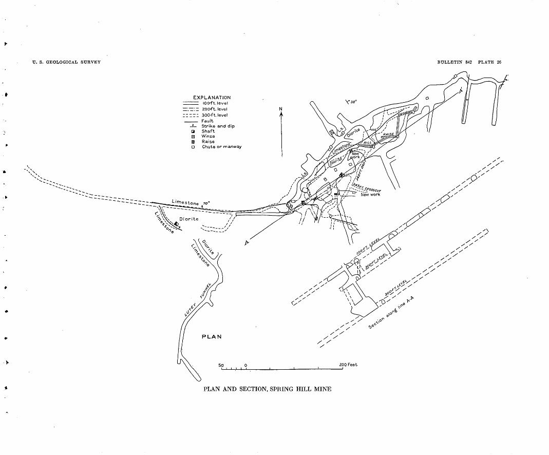
U. S. GEOLOGICAL SURVEY BULLETIN 842 PLATE 26
EXPLANATIONHI ioo-ft.level
~'.~:~ 20 Oft. level II~n 300-ft.level
FaultStrike and dipShaftWinze
IX RaiseD Chute or manway
PLAN AND SECTION, SPRING HILL MINE

0. S. GEOLOGICAL SURVEY BULLETIN 842 PLATE 27
Ore value to the ton iadoliars
Fine-grained siliceous Massive sheeting
No.3 CROSSQUT
Fracture plane 2'to4'thic
-5" Fracture plane ""
|) MAIN TUNNEL LEVEL
Sheeting 3"-6"thick Seams of jD/rite
MAIN TUNNEL
Ccv- t Sheeting
Ore mined here ran 400 dollars
GEOLOGIC MAP OF SPRING HILL MINE

HELENA DISTRICT 209
The "pyroxenite" and some of the altered diorite carry appre ciable amounts of gold, which is apparently associated with the sulphides. The fact that some of the ore fairly rich in gold con tains pyrite but no pyrrhotite supports a conclusion reached by W. L. Creden,5 a mining engineer, in 1910, that the gold came in chiefly with the.pyrite. On the 100-foot level the ore body was ob served to be cut by veinlets of calcite and quartz that contained no sulphides.
The " pyroxenite " is cut by irregular vertical joints that in places cause it to separate into large columnar blocks. In addition a nearly horizontal sheeting is developed that gives somewhat the ap pearance of bedding.
The ore carries from $2.50 to as much as $16 a ton in gold. The average of much of the ore that has been mined and milled is about $4.50. Ore recently discovered by diamond drilling is of higher average grade, and the reported value of a large quantity of ore that was milled in September, 1929, was $7.35 a ton. The flotation concentrate is said to carry about $100 in gold to the ton. In gen eral the rock showing the darker shades is the more valuable.
In addition to the silicate rock called " pyroxenite," considerable material that is plainly altered diorite carries enough ore minerals to be workable. Material of this description, however, is confined to the contact or its immediate neighborhood. Away from the contact the ore minerals decrease rapidly and the rock becomes barren.
The silicate minerals described are typical of contact metamor- phism, and the " pyroxenite" mass, the marble, and the garnet rock were evidently developed as a direct result of the intrusion of quartz diorite into limestone. The conversion of the metamorphic mass into ore was accomplished somewhat later and by a somewhat different process. Very shortly after the silicates had formed, solu tions from a deeper-seated part of the diorite or from an invading mass of the quartz monzonite rose along fractures or shear planes now represented by the seams of ore, quartz, and calcite and intro duced the pyrite, pyrrhotite, ankerite, and gold. The ore-bearing conduits were practically confined to the contact and the metamor phosed rocks next to it.
YELLOWJACKET
The Yellow jacket mine, owned by the late Colonel Hamilton, is 4 miles south of Helena in the head of Holmes Gulch. The country rock is quartz monzonite, and the mine is on two veins, one of which strikes northeast and lies mainly in Holmes Gulch, and the other extends eastward over the ridge into Clarks Gulch. Both veins
0 Unpublished report.

210 GREATER. HELENA MINING .REGION, MONTANA
were worked in early days for gold and silver by shafts and tunnels. One shaft was 100 feet deep.
The northeastward-trending vein, the only one exposed, is typical of the veins in quartz monzonite. It is 3 to 5 feet or more thick, dips 80° N., and is composed mainly of crushed and altered iron-stained granite. In places it contains broken seams* of quartz. There is another eastward-trending vein on the opposite or northwest side of Holmes Gulch about a quarter of a mile north of the Yellow jacket. Its course is shown by a row of new dumps which extends down into the gulch.
WHITLATCH-UNION "
The Whitlatch-Union lode, discovered by James W. Whitlatch in September, 1864, is the oldest quartz discovery in the region. It had produced $3,500,000 by 1872, when it was shut down because of liti gation. It has been operated intermittently since that time and is stated to have yielded in all $6,000,000 in gold. .
The mine was originally opened by a number of inclines and a vertical shaft 500 feet deep. In 1911 only some of the upper levels were accessible. The lode is 4 miles south of Helena on the low divide between Grizzly and Oro Fino Gulches. It lies in the granite just south of the contact with the Quadrant quartzite. The general course of the vein is N. 84° W. The dip averages 45° N. but is sub ject to remarkable and abrupt changes, ranging from nearly hori zontal to vertical. In width'the vein ranged from a thin seam up to 15 feet but averaged about 4 feet. The ore taken out in early days averaged from $20 to $25 a ton in gold.
BIG INDIAN
The Big Indian mine, 4 miles south of Helena, was located in 1875, and for several years thereafter a 10-stamp mill was profitably oper ated on ore taken from a huge quarry. A total of $110,000 was pro duced from ore averaging $5 a ton in gold. Later a 60-stamp mill was erected and operated by electric power, and during 1903 and 1904 the Big Indian mine was the leading gold producer in Jefferson County. It was shut down soon afterward and has remained idle ever since. Eock from the glory hole that was last operated is quartz monzonite traversed by a close-spaced system of vertical joints along which tourmaline is developed and a small amount of pyrite introduced. No quartz veinlets were observed anywhere in the ore body. The accession of tourmaline occurred after the intrusion of aplite dikes and probably after the intrusion of porphyry dikes, which are somewhat pyritized.
«The descriptions of the Whitlatch-Union, Big Indian, and Dutro mines are con densed from Knopf's report (Bull. 527). No additional information about them was obtained in 1928.
WINSTON DISTRICT . .211
DUTRO
The Old Dominion or Dutro mine, 7 .miles west of Helena, was operated in 1911 through an incline 150 feet deep at which two men were employed in getting out ore. The mine is near the end of a body of fine-grained diorite intruded into Paleozoic limestone and dolo mite. The ore occurs in irregular masses in the dolomite and consists of jasper and opal with much iron oxide. The original character of the ore is obscure. It shows specks of free gold and locally contains an iron-gray metallic mineral, determined in the laboratory of the Geological Survey to be bismuth sulphide. In addition to the minerals noted some cassiterite was detected.
WINSTON DISTRICT
GEOGRAPHY
The Winston or Beaver Creek mining district lies in BroadwaterCounty about 20 miles southeast of Helena. The nearest post office and railroad station is Winston, a small town on the Helena line of the Northern Pacific Railway.
Most of the ore deposits occur in the belt about 5 miles wide which extends from the vicinity of Winston 8 miles southwestward, up the slope of the Elkhorn Mountains. The principal mines are grouped about three localities, known as the East Pacific, Kleinschmidt, and Iron Age camps. The mill and other buildings of the East Pacific mine are on Spring Gulch near its junction with Weasel Creek, about 5 miles southwest of Winston. Near this camp are also the Freiburg, January, Sunrise, and Cabin mines, all of which are grouped in an area about 1 mile square. The Iron Age camp, the former head quarters for operation of the Iron Age and Custer mines, is at the foot of the mountains 2 miles south of Winston. The Kleinschmidt camp is the locality of the Kleinschmidt and other mines near the summit of the Elkhorn Mountains, about 8 miles southwest of Winston.
The Winston district is mountainous, but rounded rather than rugged forms prevail (pi. 29, A). The generalized surface forms a long, sweeping slope that rises at the rate of about 600 feet to a mile from an altitude of 4,500 feet at the north to 8,000 feet at the south. Near most of the mines the district is well timbered. It drains north eastward to the Missouri River, chiefly through Beaver Creek. The valley of this stream and of Weasel Creek, one of its tributaries, forms the main avenue of approach to most of the mines.
HISTORY AND PRODUCTION
The East Pacific lode was discovered by George Brooks about 186T, but systematic mining of the deposit did not begin until more than 20 years later. The periods of greatest mining activity' at the East
212 GEEATEE HELENA MINING EEGION, MONTANA
Pacific camp were 1889-1902 and 1905-6. The mines near the Iron Age camp were operated chiefly before 1906. Those at the Klein- schmidt camp were developed before 1900, but all except the Little Olga have long been idle.
The production of the Winston district to othe end of 1928 is esti mated to be at least $3,000,000. Of this amount $480,000 is the total in round figures given by the annual volumes of Mineral Resources since 1908. Records and estimates thought to be trustworthy show in 'addition about $1,500,000 for the period 1889-1908. There was also an unknown, possibly considerable production from the East Pacific and near-by lodes before 1889, and probably a rather large production from the Ouster, Iron Age, and neighboring mines, the history of which is not known. Details given in the volumes of Min eral Resources show that the district was productive from 1908 to 1918 and again from 1926 to 1928. During the first of these periods the gold produced exceeded in value the sum of the silver, lead, and copper, and the East Pacific was the chief producing mine. In the later period gold accounted for only about one-eighth of the total value, silver and lead together made up about two-thirds, and copper and zinc the remainder. The production in this period came from the East Pacific and Kleinschmidt mines and amounted to nearly $85,000. A nonproductive period from 1918 to 1925 corresponds with the postwar depression.
In 1928 the East Pacific and Kleinschmidt mines were operated by the Montana Mines Corporation, which was preparing to treat the ores from both mines in a milling plant near the East Pacific. At the Iron Age camp the Ouster and other mines known as the *" Muffly group were being reopened by the Golden Messenger Co.
GEOLOGY
The Winston district is underlain chiefly by flows, tuffs, and brec cias of the andesite-latite group. As shown by a map accompanying the report by Stone,7 who examined the geology in 1910, more than w nine-tenths of the district is occupied by andesitic porphyry, brec cia, and tuff. (See fig. 28.) At the East Pacific mine the rock is mostly a dark-gray andesite that is finely porphyritic. It occurs in relatively massive layers that show flow banding (fig. 80) and dip gently eastward. A greenish-gray variety from tunnel 1 of the East Pacific mine is an augite andesite rich in ferromagnesian minerals. y
Commonly the andesite is traversed by joints that cause it to break into rather coarse blocky fragments. In places, as at the Stray Horse mine, it shows a pronounced vertical or steeply inclined sheet ing. Next to some of the veins the rock is sheared or sheeted parallel
7 Stone, R. W.; op. cit, pi. 3.

U. S. GEOLOGICAL SURVEY BULLETIN 842 PLATE 28
A. HANDED GOLD ORE, SPRING HILL MINE
a. Ankerite containing disseminated pyrite and pyrrhotite; p, pyrite and pyrrho tite; q, quartz; c, calcile. Natural size.
B. DIKELET OF QUARTZ MONZONITE IN ANDESITE
Natural size.

TJ. S. GEOLOGICAL SURVEY BULLETIN 842 PLATE 29
A. SPRING GULCH AND EAST PACIFIC MINELooking S. 40° W. from top of Freiburg Hill, at altitude of 6,000 feet. 1, First tunnel level;
2, second tunnel level; 3, third tunnel level; 1, fourth tunnel level and East Pacific mine and mill. Valley of Weasel Creek al left.
B. Pimi'imiY DlkE GOLD MINE AND MILL
Altitude 7,450 feet. Looking S. 70° E. across Monitor Gulch. Rhyolite country rock.

U S. GEOLOGICAL SURVEY BULLETIN 842 PLATE 30
N
500 Feet_I
PLAN OF WORKINGS, EAST PACIFIC MINE
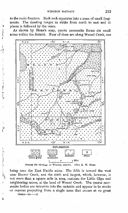
WINSTON DISTRICT 213
to the main fracture. Such rock separates into a mass of small frag ments. The sheeting ranges in strike from north to east and in places is followed by the veins.
As shown by Stone's map, quartz monzonite forms six small areas within the district. Four of them are along Weasel Creek, one
:-x
T T T f if .. + J'V'T ** ~ T T ' T -7 ^k /\ T /IX T ^V_ T VYl''~J^r r
« + » X^+ + + 4 + ^^V//* + _?>^^+ ** * * * +&&,l^\iil**j?u>-i MyoMr+ * ?/> * + *+ + * + % ®'"« * % + '/+'"-;i;t + + ++A+ +-f4
^1ml*)'
EXPLANATION
Alluvium and ench gravel
FIGURE 28 Geology of Winston district. After R. W. Stone
:being near the East Pacific mine. The fifth is toward the west near Beaver Creek, and the sixth and largest, which, however, is not more than a square mile in area, contains the Little Olga and neighboring mines, at the head of Weasel Creek. The quartz mon zonite bodies are intrusive into the andesite and appear to be stocks or cupolas projecting from a single mass that occurs at no great
154419 33 15

214 GREATER HELENA MINING REGION, MONTANA
depth. The rock is a light-gray granitoid containing stout feld spar phenocrysts that are commonly half an inch or more long. Locally, as near the intrusive contacts, the rock is fine grained and dark gray owing to the presence of much biotite and hornblende. In its different facies the rock closely resembles that of the Boulder batholith, with which it is probably connected underground.
Commonly the quartz monzonite is broken by two or more sets of joints. Near the Cynosure mines the dominant joints trend north and dip 40° W. Near the Irish Syndicate mine a set that trends west and dips 30° S. is the more pronounced.
At the January mine the intruded andesite shows pale blotches, particularly along joint planes, but in general the contact effects of the intrusion are not very noticeable.
ORE DEPOSITS
The ore deposits in the Winston district occur in veins that are commonly but a few feet wide but rather persistent in their other dimensions. Nearly all trend east or northeast, and most of them show dips steeper than 45°. The veins are found in both the andesite and the quartz monzonite. All of them are quartz veins contain ing pyrite and in addition one or more of the minerals galena, sphal- erite, and chalcopyrite or their oxidation products. Arsenopyrite and tetrahedrite are rare. In addition to quartz the gangue of most of the veins is made up largely of altered country rock. As shown by the extensive mine dumps the veins at the Iron Age camp are composed largely of pyrite, with which some sphalerite and galena are associated. Pyrite becomes increasingly abundant also in the lower levels of the East Pacific mine. Galena predominates in sev- eral ore shoots in the East Pacific that are found above the 800-foot level, and galena is the chief valuable mineral in the ore shoots of the Kleinschmidt group, so far as the rather shallow workings explore those deposits. Sphalerite is moderately abundant in the East Pacific and Kleinschmidt groups but shows no marked increase in depth.
Oxidation extends to depths that range from less than 100 feet in some of the veins at the Kleinschmidt camp to 400 feet in the East Pacific.
Gold occurs in all the veins and was the main valuable constituent in ores from the upper and oxidized parts of the East Pacific lode, the lodes at the Iron Age camp, and some of those at the Klein- pchmidt camp. In the sulphide zone gold is relatively less abundant, but it occurs in sufficient amounts to add considerable value to the ore. The predominance of gold in the oxidized ores is doubtless the result in large measure of the leaching out of other constituents.

WIFSTON DISTBICT 215
but it is also probable that gold was originally more abundant in the upper than in the lower zones. In the sulphide zone the gold appears to be carried mostly by pyrite, but its distribution is irregu lar. Although the bulk of the pyrite in the lower levels appears to be lean, some rich spots are reported.
Silver is associated mainly with the galena, and silver and lead together have been the most valuable products of the Kleinschmidt group and of the lower levels of the East Pacific. Zinc in the form of sphalerite is sufficiently abundant in most of the veins to be worth saving, and noteworthy amounts of copper occur in a few. The future of the district largely depends, therefore, on the application of flotation or other processes for the separation of the different sul phide minerals. Above levels of 500 to 800 feet considerable parts of the veins remain to be explored.
MINES AND PROSPECTS
JANUARY
The January mine is on the west side of Weasel Creek about half a mile above the mouth of Spring Gulch, at an altitude of 6,020 feet. It is said to have produced about $4,000 shortly before 1900, includ ing the value of 175 tons of ore that carried about 25 per cent of lead, 22 per cent of zinc, and 25 ounces of silver and a little gold to the ton. Because of its high zinc content this ore was penalized by the smelter, and its net value therefore amounted to only about $20 a ton.
The vein is opened by two adit levels driven westward and spaced about 70 feet apart vertically. These workings together with their branches and a winze are said to aggregate about 1,500 feet.
The mine workings are at the contact of a small area of quartz monozite porphyry that intrudes the andesite. The quartz monzonite is exposed in the lower tunnel near its entrance, and the same rock crops out on the opposite side of Weasel Creek about 70 feet below the portal of the tunnel. The intrusion of this rock has caused blotches in the andesite, especially along the joint planes.
The lower tunnel passes through two zones of crushed material containing pyrite, a little galena, and blackish streaks that are possibly zinc-bearing. A little ore is said to have occurred in a south crosscut. A vein exposed at the face of the tunnel consists of two bands 3 feet and 2 feet thick that are separated by 4 feet of country rock. The upper tunnel was not accessible in 1928. According to an unpublished report by F. G. Sizer dated October, 1899, the vein in stopes above this tunnel for a distance of 100 feet is about 6 feet wide, and half of it is filled with ore. Much of the vein remained to be explored. Sulphide ore remaining on the dump and in the ore bin in 1928 is composed of sphalerite, galena, pyrite, and quartz, together with some oxidized material.

216
SUNRISE
The Sunrise mine is on the east side of Weasel Creek nearly oppo site the January. It is said to have produced several years ago about $50,000 in free-milling gold ore that ran about $45 to the ton. The principal development workings are two tunnels. In 1928 one man was at work in the lower tunnel, but the other tunnel was not accessible. The vein follows a contact between quartz monzonite and andesite, which dips 60° NE. and appears to be a continuation of the same contact exposed at the January mine. At the Sunrise, however, the direction of the contact has changed to N. 40° W., a difference of about 50°. As observed at a point 200 feet from the portal of the lower tunnel, the vein is 2 feet wide and lies between a hard slickensided andesite footwall and a hanging wall composed of rather soft quartz monzonite seamed and stained with iron, oxides. The vein consists mainly of soft, nearly white gougelike material, containing pyrite and lumps of quartz and country rock, which also inclose grains of pyrite. Ore on the dump said to have been mined from another part of the vein contained in addition to pyrite a little galena, sphalerite, chalcopyrite, and arsenopyrite.
EAST PACIFICThe property of the East Pacific mine includes more than 18
claims, most of which are situated on the slopes of Spring Gulch, a tributary of Weasel Creek. The mill and the main or No. 4 tunnel are on the north west side of Spring Gulch at an altitude of about 6,000 feet.
Gold-bearing rock was first discovered on the East Pacific ground by George Brooks about 1867, near the top of the mountain, at the present site of tunnel 1. Above this tunnel is an outcrop of very dark brown iron-stained rock on which some work has been done. Although this outcrop is not part of the vein, its excess of iron stain probably came from the weathering of that deposit and was the clue that led to the discovery.
Production began in the early eighties from a shaft sunk at a point above tunnel 1. In 1886 the mine was purchased by John W. Kendrick and the Winston Brothers, of Minneapolis, who were con nected with the Northern Pacific Kailway. They sank a new shaft 100 feet deep and drove the tunnels known as Nos. 1, 2, and 3. (See pis. 29, A, and 30; fig. 29.) Some ore was shipped in 1887, and other shipments were made at irregular intervals from 1889 to October, 1895. During this period the net production was $573,418.65. Freight and smelter charges at that time were $12 a ton, or about twice what they amount to at present.
In June, 1896, the mine was purchased by Robert A. Bell, of Helena, who drove tunnel 4 and from a winze sunk below it drove
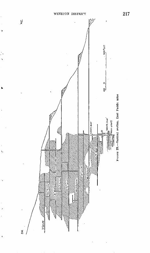
WINSTON DISTRICT 217

218
the two drifts known as the 300-foot and 500-foot levels. Bell oper ated the mine for about six years, during which he shipped ore that yielded $689,960 above freight and treatment charges.
In 1903 the mine was purchased by the East Pacific Mining Co., in which Bell was the principal owner. Since then it has been operated intermittently. This company built a 50-ton concentrator and dur ing 1905 and 1906 shipped concentrates and bullion with a net value of $103,149.85. To October 1, 1906, the total production of the mine had amounted to $1,306,528.24, of which more than $570,000 had been profit. About 1898 lessees recovered $17,000 worth of ore by jigging the waste dumps at tunnels 3 and 4.
In 1925 the present operator, the Montana Mines Corporation, pur chased the mine, and since then it has done about 3,000 feet of underground work consisting of drifts at levels below tunnel 4, together with a connecting shaft and raise§. To the end of 1927 this company produced ore worth more than $48,000, making the total for the mine to that date approximately $1,515,000.
The country rock at the East Pacific mine is predominantly dark- gray porphyritic andesite, the beds of which dip* gently eastward. A conspicuous feature observed in tunnel 1 and on some other levels is a closely spaced sheeting in andesite on each wall, extending for distances of 6 inches to 2 feet or more from the vein. This sheeting accounts, in part at least, for the unusually small size of the frag ments composing the huge waste dumps. Elsewhere the country rock, which is relatively hard and tough, generally breaks into rather coarse cubical blocks.
The underground development workings of the East Pacific mine aggregate about 4% miles. (See pi. 30.) They include four tunnels (adit levels) of which the lowest, No. 4, is the main entry. This working is a crosscut for 800 feet to the vein and a drift beyond that point. A winze is sunk from it at a point about 1,950 feet from the portal, and drifts are turned at the 500, 600, 700, and 800 foot levels. There are also a crosscut to the " south vein " and drifts along that body.
In addition to the necessary buildings, such as shops, offices, and quarters for 140 men, the mine is equipped with a 50-ton concen trating mill (pi. 29, A) built near the portal of tunnel 4. Below that level the mine is kept unwatered by pumping, the total water discharged being about 100 gallons a minute, of which 80 gallons is raised from the lower levels. Power is derived from a hydroelectric plant on Beaver Creek and an auxiliary steam plant at the mill.
The East Pacific vein occupies a fissure that strikes N. 78° E., dips 75° N., and cuts across the different .layers of andesite. The vein is well defined, contains little or no gouge, and for the most part is

WINSTON DISTRICT 219
frozen or welded to the walls, or at most separated from them by only a seam of iron stain. As seen in the accessible parts of the mine, the vein ranges from 3 inches to 5 feet or more in width. It has a known extent of 5,000 feet on the strike and nearly 2,000 feet on the dip. In general the walls are smooth and firm, but in places the vein is slightly offset by faulting.
In tunnel 1 near the top of the ridge, a remnant of the vein 6 inches to 2 feet wide and 50 feet long consists of iron-stained quartz and crushed altered andesite, which is in places leached to a soft whitish material composed mostly of clay. Some of the quartz is hard, and some is soft and sugary. Fine-grained calcite is associated with the sugary quartz.
The vein is generally streaked or banded, and parts of it are com posed of symmetrically deposited layers of comb quartz. Commonly the pyrite, sphalerite, and galena are intimately mixed and in places coarse textured, some crystals of sphalerite being as much as half an inch and some of galena as much as three-tenths of an inch across. The ore is found mostly on the footwall side of the vein, and in all the deeper levels except the sixth it occurred west of the winzel East of that working the vein, as shown on the 700-foot level, is barren and only a few inches wide. On and above the third level an ore shoot is said to have continued for about 1,500 feet along the strike, and the vein has been productive to the depth of nearly 1,000 feet on the dip. In the lower levels the ore occurs in lenses from 3 inches to several feet in thickness.
The most valuable mineral of the ore produced is galena, which, in addition to lead, carries silver and a little gold. A polished section of the rich ore from the face of the west drift shows more than 90 per cent of galena, which is streaked irregularly with small amounts of chalcopyrite, pyrite, and sphalerite. The gangue is quartz and calcite. In places this mixed sulphide ore may be rich in gold, and in places it may contain no gold, but wherever pyrite is abundant the ore contains at least a little gold. The ore from the sixth and seventh levels averaged about $60 to the ton. It carried about 40 per cent of lead, 1 per cent of copper, and 40 ounces of silver and three-quarters of an ounce of gold to the ton. In general, ore con taining the most quartz and pyrite carries also the most gold.
As shown on the intermediate level between tunnels 1 and 2, oxida tion extends to a depth of about 300 feet. Unworked remnants of the vein in the upper tunnels consist largely of iron oxides and are valuable chiefly for gold. During the earlier stages of its exploita tion, therefore, the deposit yielded much free gold and was rated as a gold mine. In the sulphide zone from the fourth level down to the eighth level there is little or no free gold. Gold occurs in small
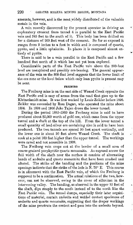
220 GREATER HELENA MINING REGION, MONTANA
amounts, however, and is the most widely distributed of the valuable metals in the vein.
A vein recently discovered by the present operator in driving an exploratory crosscut from tunnel 4 is parallel to the East Pacific vein and 345 feet to the south of it. This body has been drifted on for a distance of 200 feet west of the crosscut. So far as exposed it ranges from 2 inches to a foot in width and is composed of quartz, pyrite, and a little sphalerite. In places it is composed almost en tirely of pyrite.
There is said to be a vein parallel to the East Pacific and a few hundred feet north of it which has not yet been explored.
Considerable parts of the East Pacific vein above the 800-foot level are unexplored and possibly ore-bearing. The general appear ance of the vein on the 800-foot level suggests that the lower limit of the ore zone or the level below which only lean pyrite is present may be near.
FREIBURG
The Freiburg mine is on the east side of Weasel Creek opposite the East Pacific and is easy of access from the road that goes up to the Kleinschmidt mine. It was first worked by Louis Zeikler before 1890. Zeikler was succeeded by Koss Degan, who operated the mine about 1894. In 1898 and 1900 Jake Tujen drove the lower tunnel.
During the period 1885-1900 the Freiburg mine is said to, have produced about $5,000 worth of gold ore, which came from the upper tunnel and a shaft at the top of the hill. From the lower tunnel a small quantity of lead-silver ore containing zinc is said to have been produced. The two, tunnels are spaced 90 feet apart vertically, and the lower one is about 30 feet above Weasel Creek. The shaft is sunk at a point 160 feet higher than the upper tunnel. The workings were caved and not accessible in 1928.
The Freiburg vein crops out at the border of a small area of coarse-grained porphyritic quartz monzonite. As exposed across the full width of the shaft near the surface it consists of alternating bands of andesite and quartz monzonite that have been crushed and altered. The strike of the banding and the positions of the mine openings indicate that the strike of the lode is N. 70° E. This course is in alinement with the East Pacific vein, of which the Freiburg is supposed to be a continuation. The actual relations of the two, how ever, can not be observed, owing to the cover of alluvium in the intervening valley. The banding, as observed in the upper 15 feet of the shaft, dips steeply to the south instead of to the north like the East Pacific vein. The tunnel dumps, especially their later acquisi tions of material, contain andesite and welded contact specimens of andesite and quartz monzonite, suggesting that the deeper workings of the mine penetrate the contact and pass into the andesite beyond.
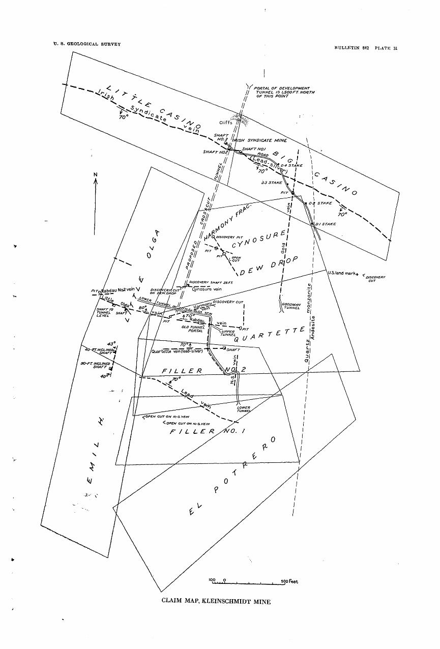
TJ. 8. GEOLOGICAL SURVEYBULLETIN 842 PLATIC 31
'/ POKTAL Of DEVELOPMENT TUNNEL 15 lfSOOfT. NORTHOF THIS POINT
50 Feet
CLAIM MAP, KLEINSCHMIDT MINE
WINSTON DISTRICT 221
The dumps also contain fragments of light-gray quartz monzonite that appear to have come from dikes, some of them not more than an inch wide, that cut the andesite. Along some of these dike contacts pyrite and other vein minerals have been deposited (pi. 28, B).
The dump of the upper tunnel is composed of brownish oxidized and iron-stained material derived from both andesite and quartz monzonite, on the joint faces of which considerable pyrite still re mains. The dump of the lower tunnel is relatively large, from which a corresponding amount of underground work may be inferred. It shows a general bluish-gray tone due mainly to the presence of considerable fine pyrite. A small quantity of ore that apparently came from this tunnel is chiefly massive pyrite in a quartz and calcite gangue. It contains grains of chalcopyrite and galena surrounded by calcite.
STRAY HORSE
The Stray Horse mine is on the steep east side of the Weasel Creek Valley a mile south of the East Pacific (fig. 28). The property comprises a group of five or more claims owned by the Amalgamated Mining & Copper Co.
Probably the Stray Horse is to be included among the mines that were productive during the early days. A second period of produc tion followed the construction of a tunnel near the top of the ridge in the fall of 1889 by Frank Ashley and Dave Cannon. Later on the mine was worked successfully by Cannon Brothers, Dave Humphrey, Sutton & Koseburg (1893-4), and the Helena Mining Co. (1896-1898). Smith & Jackson as lessees reopened the mine in 1902 and operated it for three or four years. During a period of 30 days the mine is said to have produced a carload of ore a day.
The main workings are five tunnels, which, together with several shafts and drifts, aggregate more than 4,000 feet in length. Only part of these workings were accessible in 1928.
The country rock is andesite similar to that at the East Pacific mine. In the upper workings the wall rock is crushed and heavily iron stained and in places shows cavities from which sulphides have been leached and replaced by lead carbonate. The dominant struc ture in the andesite is a sheeting that strikes about east and stands nearly vertical.
The ore is found in tAvo parallel veins spaced about 120 feet apart that crop out at an altitude of about 7,300 feet. They follow the sheeting of the andesite and are narrow but are known to extend about 4,500 feet along the strike and 800 feet along.the dip. The upper workings show altered, crushed, and heavily iron-stained andesite, some of which is cellular and coated with lead carbonate. Below the oxidized zone the principal ore minerals are silver-bearing
222 GREATER HELENA MINING REGION, MONTANA
galena, gold-bearing pyrite, and chalcopyrite. Some of the material observed on dumps contains in addition considerable sphalerite intimately associated with the other sulphides mentioned.
Although the Stray Horse ore bodies, like those of the East Pacific mine, are inclosed in the andesite, they are doubtless related in origin to the intrusive quartz monzonite, the nearest exposure of which is about a quarter of a mile to the west.
LITTLE BONANZA
The Little Bonanza mine is in a group of three claims owned by Cluson Brothers, of Bozeman. It is east of the Stray Horse mine, in an area of andesite. The vein is said to strike east and to be valuable for silver, lead, and gold.
SUNSHINEThe Sunshine mine of Mike Sullivan is on a ridge between Weasel
Creek and a tributary gulch from the east through which it is easily accessible. It is reported to have produced 100 tons of ore averaging 16.8 per cent of lead and 37 ounces of silver and 3.56 ounces of gold to the ton.
The mine workings are several short tunnels on both sides of the ridge; the lowest openings are on the Weasel Creek side. The vein strikes east, dips 10°-60° S., and is inclosed in andesite. It extends for 600 feet along the strike and nearly 500 feet on the dip and ranges from a few inches to 4 feet in thickness. It is composed chiefly of brecciated and iron-stained country rock. A little quartz is present, but any considerable increase in quartz is said to be fol lowed by a marked decrease in the value of the ore.
KLEINSCHMIDT
The property commonly referred to as the Kleinschmidt mine in cludes several claims, within which are the Irish Syndicate, Big Casino, Little Casino, Cynosure, Quartette, Emil H., Little Olga, and Champion veins. (See pi. 31.) These claims are near the top of the Elkhorn Mountains, on the divide between Beaver and White Horse Creeks at altitudes ranging from 7,300 to 7,500 feet. They are reached by a wagon road that goes up Weasel Creek. Ore and con centrates for shipment are hauled to Winston.
Most of the veins mentioned were worked as separate mines many years ago, but all except the Little Olga have been idle for the last 20 or 30 years. The Little Olga was operated by Kleinschmidt Brothers for about 18 years before 1927. Since then it has been operated by tfie Montana Mines Corporation, which in 1928 employed a force of 18 men and was producing ore at the rate of about 24 tons a day.

WINSTON DISTRICT 223
Between June 2 and September 4, 1928, the company reported the production from the Little Olga of 318 tons of concentrates having a net value of $51.68 a ton and G 1̂ tons of crude ore having a net value of $127.28 a ton. The total production of the Little Olga is estimated in round figures at $95,000 in silver, lead, and gold, but this amount included some of the production from the Gold vein and the Quartette vein. Of the total given about $25,000 was produced dur ing the early days, $35,000 during the period when the mine was oper ated by Kleinschmidt Brothers, and $35,000 since 1927 by the present operator. Of the other mines mentioned the Irish Syndicate is said to have produced $45,000, mostly in silver, and the Emil H. mine $20,000, mostly in gold.
Underground workings of this group of mines aggregate about 5.000 feet, half of which is included in two shafts, adit levels known as the upper and lower tunnels, and a crosscut tunnel 1,000 feet long on the Little Olga. The surface equipment includes, in addition to buildings for housing about 20 men, a 24-ton concentrating mill built at the Little Olga mine. Electric power and light are supplied from the hydroelectric plant at the East Pacific. The present operator is driving a tunnel designed to cross the downward projections of the Little Olga and neighboring veins at depths of as much as 500 feet.
The ore deposits in the Kleinschmidt property occur in two groups of veins. Those of one group trend north, dip at low angles, and are valuable chiefly for gold. The veins of the other group trend east, have steep dips, and are valuable chiefly for lead and silver. The silver-lead veins have been the most productive. They include the deposits previously mentioned except the Emil H., which is one of the northward-trending gold veins.
The Little Olga vein is from.^1 to 4 feet wide and has a known extent of 1,200 feet along the strike and 150 feet on the dip (fig. 30). It is inclosed in a body of quartz monzonite not far from its intrusive contact with andesite. The chief ore minerals are galena, pyrite, and chalcopyrite. The galena isi silver-bearing and in addition car ries a little gold. Both the pyrite and the chalcopyrite are gold-bear ing. Less abundant minerals are tetrahedrite, arsenopyrite, and sphalerite. So. far the sphalerite has not been abundant enough to cause the ore shipped to the smelter to be penalized for its zinc content.
The sulphide minerals, especially the galena and pyrite, show a closely banded structure which seems to be an inheritance from a schistose rock that has been replaced. As shown by the microscope, the galena commonly contains small inclusions of tetrahedrite, pyrite, and quartz that are in a definite alinement. The gangue consists of quartz and altered silicified inclusions of the wall rock. A so-called
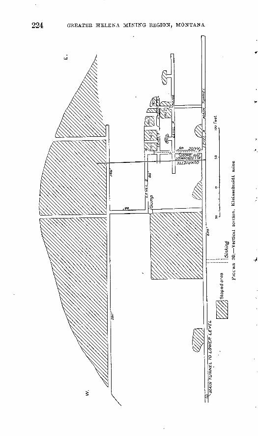
224 GREATER HELENA MINING REGION, MONTANA
WINSTON DISTRICT 225
" black rock " seen in considerable quantity in the face of a drift is quartz monzonite porphyry in which some of the pyrite has been altered to chlorite and most of the feldspars changed to calcite and sericite. In addition this rock ,is traversed by quartz veinlets.
Some of the ore, in. particular that from the western part of the vein, runs as high as 80 per cent in lead, 150 ounces in silver to the ton, and a little gold. This rich ore is bluish gray, dense, and finely banded. The microscope shows it to consist chiefly of very fine grained galena containing inclusions of tetrahedrite. The gangue is fine-grained calcite of an earlier generation. Sphalerite contain ing minute inclusions of chalcopyrite is present in small amounts. As much as 7 per cent of copper is present in some of the ore. The concentrates being produced in 1928 contained about 50 per cent of lead and 120 ounces of silver and 1 ounce of gold to a ton.
The 1,000-foot crosscut tunnel of the Little Olga mine follows for a considerable distance a vein of the northward-trending group known as the Gold vein. This lode is made up of quartz that con tains fine-grained gold-bearing pyrite.
The Cynosure vein, north of the Little Olga and at a higher alti tude, has been developed to the depth of about 100 feet. The ore in it is valued for gold and is said to run about $30 to a ton. It is com posed chiefly of coarse pyrite with a little galena and chalcopyrite.
The Emil H. vein, a short distance southwest of the Little Olga, has made a small production of gold from two shafts, one of which is 90 feet deep on the 40° slope of the vein. The ore consists chiefly of quartz with gold-bearing pyrite and small amounts of chalcopy rite and galena. It shows indistinctly a banded structure.
The Goodman vein, opened by a tunnel on the Quartette claim (pi. 31) is reported to have produced a noteworthy amount of gold ore containing pyr-ite and sphalerite. The vein extends north toward the Irish Syndicate ground, where at the road crossing an outcrop in. line with it con tains-pyrite, quartz, and chalcopyrite.
The Irish Syndicate vein extends diagonally across the northern part of the Kleinschmidt ground through the Big Casino and Little Casino claims. It strikes about N. 60° W., dips 70° S., and cuts quartz monzonite porphyry. Development workings include three shafts, one of which is 180 feet deep. The mine was last operated in 1900. Considerable rich silver ore was found near the surface, and ore shoots as much as 7 feet wide are said to occur underground.
IRON AGE AND OTHER MINES AT IRON AGE CAMP -
The Iron Age and Custer, the principal mines in the Iron Age camp (figs. 28, 31), are said to have each produced several hundred thousand dollars in gold, and noteworthy amounts are said to have been produced from eight or ten other deposits.

226
The Iron Age lode was discovered in 1879. A mill to recover gold from the ore was built on Beaver Creek, but as mining pro gressed the ore became more difficult to treat by the process then in use, and later on the mill was abandoned and the ore was shipped to smelters. At present most of the mines are owned by the Muffly Estate or by Charles Clark. In 1929 the Golden Messenger Co. was reported to be taking steps to reopen the Custer and other mines be longing to the Muffly Estate.
Anctesite
Ssc. 13
Andesite
/50°
Vein or lode
Strike and dip
ipoo
PIGUKB 31. Claim map, Iron Age camp
The country rock is andesite and andesite porphyry similar to that at the East Pacific mine. At the Martha W. mine it is sliced by a sheeting which dips 80° W. and is intruded by a small stock of monzonite and aplite.
Ore occurs in a dozen or more veins that are inclosed mainly in andesite. All except one, the Hyantha, are gold quartz veins con taining large amounts of iron oxides in their upper portions arid pyrite -below. They strike north or northeast and dip 20°-50° SE. The Hyantha is a silver-lead vein that dips west. The gold veins extend for considerable distances horizontally, but most of them are

CLANCY DISTRICT 227
said to pinch out or to become lean at depths of 200 to 400 feet. An exception is the H. H. or Ouster vein, which is said to have continued productive to a depth of 600 feet.
CLANCY DISTRICT
GEOGRAPHY
The Clancy district is in Jefferson County, 10 miles southeast of Helena. As considered herein it extends from Red Mountain east to the Elkhorn Mountains and therefore includes nearly all of the drainage basins of Clancy, Buffalo, and Warm Spring Creeks and Lump Gulch, as well as a considerable part of the valley of Prickly Pear Creek, the trunk stream. Clancy, a small town in the eastern part of this area, on the Great Northern Railway and the Butte- Helena State highway, is the principal settlement and shipping point.
As shown by the Boulder topographic map, the district is moun tainous but not rugged. The maximum relief is about 4.000 feet, and the highest points, which are on the Elkhorn Mountains, have an altitude of about 8;000 feet.
HISTORY AND PRODUCTION
Mining in the Clancy district began about 1865, the first deposits to be worked being placer gravel along Prickly Pear Creek. Soon after ward the rich silver-bearing lodes were exploited. An interesting scrap of early history is contained in a report by Raymond,8 from which it appears that the Legal Tender mine, a short distance east of Clancy, was discovered by one Joseph Fultz in 1866. In 1872 a shaft equipped with a whim hoist had been sunk 160 feet, drifts being turned from it at the 80-foot level and at the bottom. Men tion is made also of the facts that some of the ore was tested in smelting works at Helena and Jefferson City and that most of the first-class ore, which was worth from $128 to $870 a ton in silver, was hauled by wagon to Corinne, Utah (then the nearest railroad point), and shipped from that place to San Francisco and Europe.
Rich lodes found in Lump Gulch, northwest of Clancy, early gave rise to a flourishing settlement called Lump Gulch City, which has long since joined the company of " ghost" mining camps.
When the Clancy district was examined by Knopf in 1911 only one mine, the King Solomon, was being operated. In 1928 a little work was being done on some of the lodes, mainly by lessees.
The report by Raymond cited above gives the production of the Legal Tender mine in 1872 as $91,697. The production of certain other mines, of which the Liverpool was the greatest, aggregates, as
8 Raymond, R. W., Statistics of mines and mining in the States ana Territories west of the Rocky Mountains. 1872, p. 230, 1873.

228 GREATER HELENA MINING REGION, MONTANA
given by Knopf,9 $1,500,000. The report by Stone 10 records a pro duction of somewhat more than $1,000,000 by the mines up Warm Spring Creek before the end of 1907. These-figures, together with an allowance made for the placer gold, which was won mostly from low terraces along Prickly Pear Creek, and the product of lodes not already included, make a total to the end of 1907 of at least $3,000,000, of which more than half was the value of the silver and the remainder chiefly gold and lead with a little copper.
The production from 1908 to 1928, shown by somewhat incomplete reports in Mineral Resources, amounts to $466,460. Allowing for some gaps in the record, evidently for years of small production, the total for this period appears to be, in round figures, $470,000. About $66,000 of this is gold,0 the remainder chiefly silver and lead, with a moderate amount of zinc and a little copper. All but a very small part of the gold was derived from lodes. The most productive years were 1919 to 1921, during which mining was evidently stimu lated by the Government purchase of silver at $1 an ounce. The total production of the district to the end of 1928 is probably not less than $3.500,000.
GEOLOGY
The following description of the geology is condensed from the report by Knopf n :
The prevailing rock is the typical quartz monzonite of the Boulder batholith. With it is a noteworthy abundance of aplite in dikes and large masses, some of which attain an area of several square miles. Intrusions of pegmatite and granite porphyry also are com mon. Rhyolites are present in considerable quantity east and north east of Clancy. Those east of Clancy are light-colored porphyries and include flow-banded lithophysal and breccia varieties. Some dikes of rhyolite cutting the quartz monzonite occur locally. Note worthy among them are those paralleling the veins at the head of Warm Spring Creek. They commonly show margins several feet thick consisting of dark obsidian glass. West of Clancy a few dikes of dacite have been noted.
ORE DEPOSITS
Except comparatively small placer deposits worked years ago the ore deposits are lodes inclosed in the quartz monzonite. They in clude representatives of both the older and younger groups.
OLDER LODES
GENERAL FEATURES
Most of the older lodes are found near the head of Warm Spring Creek. They are nearly vertical, eastward-trending quartz veins
0 Knopf, Adolph, op. cit., pp. 103-105. " Knopf, Adolph, op. cit., pp. 102-103. 10 Stone, R. W., op. cit., p. 88.

II. S. GEOLOGICAL SUBVEY BULLETIN 842 PLATE 32
N«^ I ' » I ^^ . T ' » ' - ' *"*' '>. *
<^l I . . ' < - VV <Pl
,4. ORE FROM WARM SPRING CREEK, GLANGY DISTRICT
Quartz veinlets (qtz) cutting pyrite (py), Hoot Owl prospect.B. ORE FROM WARM SPRING CREEK, GLANGY DISTRICT
Inler^rowth of pyrito and arsenopyrite, Hoot Owl prospect. In places arseno- pyrito forms crystal boundaries against pyrite; elsewhere arsenopyrite forms small ernbaymenls in pyrite.
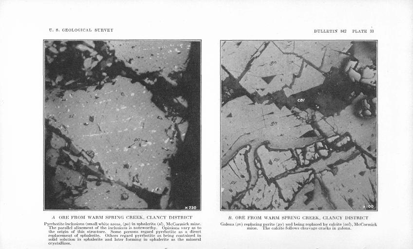
V. S. GEOLOGICAL SURVEY BULLETIN 842 PLATE 33
A ORE FROM WARM SPRING CREEK, CLANCY DISTRICT
Pyrrhotite inclusions (small white areas, (po) in sphalerite (si) , McCormick mine. The parallel alinement of the inclusions is noteworthy. Opinions vary as to the origin of this structure. Some persons regard pyrrhotite as a direct replacement of sphalerite. Others regard pyrrhotite as being contained in solid solution in sphalerite and later forming in sphalerite as the mineral crystallizes.
B. ORE FROM WARM SPRING CREEK, CLANCY DISTRICT
Galena (gn) replacing pyrite (py) and being replaced by calcite (cal), McCormick mine. The calcite follows cleavage, cracks in galena.
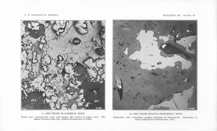
U. S. GEOLOGICAL SURVEY BULLETIN 842 PLATE 34
A. ORE FROM Mr.CORMICK MINE
Pyrile (p.v), arsenopyrite (asp), and quartz (qtz) grains in galena (gri). galena contains some tiny veinlets of supergenc covellite.
TheB. ORE FROM HELENA-JEFFERSON MINE
Alabandite (a/a) containing angular inclusions of chalcopyrite. Alabarulite 'is being replaced by rhodochrosite (r/io).

TT. S. GEOLOGICAL SURVEY BULLETIN 842 PLATE 35
A. ORE FROM HELENA-JEFFERSON MINE
Pyrite (py), sphalerite (si), and alabandite (ala) areas in rhodochrosite (r/io). Same field as Plate 34, B, with lower magnification.
B. ORE FROM MOUNT WASHINGTON MINE
Calcite veinlet (cal) cutting sphalerite (si) and galena (gn).
CLANCY DISTKICT 229
carrying pyrite and chalcopyrite with smaller amounts of galena, sphalerite, and arsenopyrite. Molybdenite occurs in the Eagles Nest vein, and a specimen said to represent a lode cropping out above the White Pine mine contains tourmaline. The ore produced is said to be worth from $15 to $30 a ton, mostly in gold.
Some of the veins are bounded on both walls by dikes of rhyolite that are bordered with dark obsidian glass. The fact that a fragment of galena was observed to be embedded in one of these glassy margins shows the vein to be older than the dikes. (See pi. 32.)
According to Stone,12 who examined an area near the head of Warm Spring Creek in 1910, the Carbonate Chief mine was opened by three tunnels, one of which was about 1,700 feet long. The Bell mine had three tunnels, 500, 3,000, and 1,200 feet long. Near them the Mocking Bird mine had a vertical shaft 250 feet deep. In 1907 these three mines produced 41,829 tons of ore which had a gross value of $952,327, mainly in gold and silver, though some copper and lead were recovered. In 1906 the yield was 1,237 tons with a value of $47,756.
Half a mile west of these mines is the Eagle's Nest group, con sisting of 27 claims on which are the B. & G., Blande, Eagle's Nest, and other mines. The B. & G. mine has an inclined shaft 250 feet deep and three levels aggregating about 1,200 feet of underground workings. The ore consists of pyrite, chalcopyrite, and galena. A 5-ton shipment of ore from the Eagle's Nest mine from a shaft 100 feet deep is said to have netted more than $40 a ton. The Mock ing Bird mine contains similar ore and is reported to have pro duced $10,000 to $12,000. The Willard group of claims, at the head of the north fork of Warm Spring Creek, contains two east-west nearly vertical quartz veins said to be from 8 to 20 feet wide. Ore amounting to 300 tons taken above water level in a shaft on the Relief claim is said to have netted more than $40 a ton, and 100 tons from a short tunnel on the same claim is said to have yielded $40 a ton. A shaft on Fritz Invay's claims, at "the head of Maupin Creek, exposes a quartz vein about a foot wide that contains sphal erite, galena, chalcopyrite, pyrite, and siderite.
No additional information for the mines mentioned was obtained during 1928.
MINES AND PROSPECTS
WHITE PINE
In 1928 Neil Sanderson and Gus Petersen, lessees, were mining in a stope above the lower level of the White Pine mine. The ore con sists mainly of galena with sphalerite and a little pyrite and chal copyrite in a quartz gangue. It was said to assay 30 ounces of silver and a little gold to the ton and 18 per cent each of lead and zinc.
12 Stone, R. W., op. cit., pp. 87-88. 154419 33 16

230 GREATER HELENA MINING REGION, MONTANA
M'CORMICK
A little work was being done in 1928 at the McCormick mine, on the east side of Warm Spring Creek Valley. Polished sections of the ore from this mine (pis. 33, 34, A) show the chief primary ore minerals to be pyrite, sphalerite, and galena, which were deposited in the order named. The sphalerite is abundant and contains small inclusions of pyrrhotite. The galena incloses grains of arsen- opyrite and quartz. Supergene covellite occurs in veinlets that cut the galena. The gangue is chiefly carbonate, which is later than the primary sulphides.
SULLIVAN
A prospect owned by M. J. Sullivan is located on the hill 250 feet north of Alhambra Hot Springs that forms the end of the spur separating Warm Spring and Prickly Pear Creeks. The country rock is the normal quartz monzonite, which has been intruded by dikes and irregular bodies of aplite, the outcrops, talus, and dumps of which give the surface a noticeably light color. The lode is closely associated with an aplite dike that ranges in trend from southwest at the mine to west on the opposite slope, across Prickly Pear Creek, where it crops out as a wall 10 to 20 feet high.
The ore deposits occur in three nearly parallel veins within a wide shear zone in the quartz monzonite adjoining the aplite dike. One of these bodies, called the middle vein, trends N. 60° E. and stands about vertical. The others, called the north and south veins, dip 70° SE. They are spaced about 35 feet from the middle vein at a depth of about 110 feet if both persist downward without change of dip. Each of the veins mentioned ranges from 1 to 5 feet in width, and each is composed mainly of crushed and altered country rock with more or less quartz. The principal development workings are an adit 40 feet long on the south vein and a shaft 75 feet deep on the middle vein. They show streaks of ore from 1 inch to 2 inches thick composed of galena and pyrite with a little chalcopyrite or the oxidation products of those minerals. The gangue is quartz. The lodes appear promising and worth further work.
YOUNGER LODES
GENERAL FEATURES
Lodes characterized by a chalcedonic quartz gangue occur near Clancy Creek in Lump Gulch and some other parts of the district. They are inclosed in quartz monzonite and carry rich silver-bearing sulphides. A feature of the district mentioned by Knopf 13 is the abundance of iron-stained chalcedonic reefs, which form large and prominent outcrops, some of them containing small amounts of
13 Knopf, Adolph, op. cit., p. 103.
CLANGY DISTRICT 231
tetrahedrite. The origin of similar reefs by the action of hot springs is discussed by Weed.14
MINES AND PROSPECTS
The following descriptions are condensed from Knopf's report.15
KING SOLOMON
The King Solomon mine, 2 miles west of Clancy, produced $100,000 between 1889, the year it was located, and 1911. It is opened by an inclined shaft sunk on the lode to a depth of 300 feet. The country rock is a coarse granite, except that a thick dike of dacite porphyry occurs along the hanging wall of the lode.
The lode is a wide shear zone traversing the granite, crossing some dikes of aplite, and in places touching the dacite dike. Adjoining the lode the granite for a distance of 20 feet has been altered in the manner characteristic of the alteration that accompanies the younger group of lodes: the soda-lime feldspars are changed to sericite, and the rock has lost alumina, ferric and ferrous iron, magnesia, lime, and soda and has gained much silica and potash and considerable water and carbon dioxide.
The ore aggregates at most a few feet in thickness and consists of narrow slabs of high-grade material trending parallel to the struc ture. The slabs are distributed through a lode or zone 25 feet wide. Their chief metallic minerals are galena, sphalerite, and tetrahedrite. Pyrite is rare, but molybdenite has locally been found in some abun dance. The sulphides are of contemporaneous and primary origin. Ore high in tetrahedrite is rich in silver. The gangue is mainly chalcedonic quartz. Veinlets of siderite occur that are later than the ore.
UTTLE NEIX
Some work consisting mainly in reworking old dumps was in progress at the Little Nell mine in 1911. The old workings attain an extreme depth of 500 feet, and smelter returns show a production of $400,000. The geologic and mineralogic features are similar to those of the King Solomon lode.
YELLOWSTONE
On the Yellowstone prospect a 90-foot shaft and a tunnel 200 feet long expose a number of widely spaced veinlets of ore in a zone or lode 25 feet wide that apparently cuts across a dike of dacite. The chief ore minerals are chalcopyrite and galena with small amounts of sphalerite and pyrjte. The gangue is mainly quartz, which in places grades into the chalcedonic variety.
14 Weed, W. H., Mineral-vein formation at Boulder Hot Springs, Mont.: U. S. Geol. Survey Twenty-first Ann. Kept., pt. 2, pp. 227-255, 1900.
15 Knopf, Adolph, op. cit., pp. 104-107.
232 GREATER HELENA MINING REGION, MONTANA
KENNEDY OB JACKSON CREEK
Rich silver sulphides are said to have been hauled from the Kennedy mine in 1872 to Fort Benton by ox teams and shipped to Swansea, Wales. The old workings are no longer accessible. The country rock is a coarse granite with dikes of aplite. Three parallel ledges occur on the property.
LEGAL TENDER
From a description by Raymond 16 written in 1873 it appears that the " ore and vein matter " was from 1 to 3 feet thick and con tained galena, sphalerite, " sulpnurets," ruby silver, oxides and car bonates of lead and other metals, and native silver. A fine blue quartzose ore predominated. The mine was developed to a depth of 160 feet. To January 1, 1873, it had produced 377 tons of ore that yielded a total of $91,697 at rates ranging from $128 to $870 a ton.
By 1911 the mine had long been idle and dismantled. The " fine blue quartzose ore " mentioned by Raymond is interpreted to be chal- cedonic quartz, and the ore body to be of the same type as the King Solomon.
WICKES DISTRICT
The Wickes district includes an area that extends from the Elkhorn Mountains west to the Continental Divide and is drained by Prickly Pear and Clancy Creeks. The town of Wickes, 20 miles south of Helena, is near the center of this area, and also within its limits are the towns of Corbin (pi. 36, A) and Jefferson and the deserted mining camps of Gregory and Comet.
HISTORY AND PRODUCTION
Lode mining began in the Wickes district about 1864, after the discovery of the Gregory lode, and has continued with some interrup tions to the present time. Certain periods of noteworthy activity in the history of the district have been associated with the production o,f certain outstanding mines the Gregory in the early eighties, the Alta in the decade 1883-1893, the Comet in 1900, and the Minah in 1900-1901. In the decade 1883-1893 the lead smelter at Wickes was the largest plant of its kind in Montana, and in addition to the product of the Alta mine treated custom ores from a large part of the surrounding country. At one time a large concentrating mill was operated at Corbin. After 1893 smelting operations were trans ferred to East Helena, and the Wickes plant was dismantled. When the district was examined by Knopf,17 in 1911, only one mine, the Blue Bird, was shipping ore, but'development work was in progress
16 Raymond, R. W., Statistics of mines and mining in the States and Territories west of the Rocky Mountains, 1872, p. 230, 1873.
17 Knopf, Adolph, op. cit., pp. 107-120.
WICKES DISTRICT 233
.at three others. Since then some of the mines have been operated intermittently. In 1912-13 considerable ore was produced from the Bertha mine and smaller amounts from three or four others, includ ing the Mount Washington. In 1917-1920 a noteworthy production was made by the Mount Washington mine, then operated by the Angelica Mining & Development Co. Several other mines were productive, and slag was shipped from the abandoned Wickes smelter for reworking. In 1925, 1926, and 1927 a large amount of tailings from the old Alta (Corbin) mill was reworked by flotation by the Jeiferson Milling Co., and in 1926 and 1927 the Mount Washington mine was operated extensively under a lease by the Elm Oiiu Mines Co., of Butte. In 1928 ore was being shipped from the Mount Wash ington, Salvail, Silver Tip, and Helena-Jefferson mines. At the Mount Washington in August, 1928, 20 men were employed and 120 tons of ore a day was being extracted and shipped. On Clancy Creek, 2 miles west of Corbin, a deposit of bog manganese ore was being developed by means of trenches and pits. (See fig. 32.)
Reported plans for future work include a 3,000-foot crosscut tun nel to be driven by the Knickerbocker Mines Co. to reopen the Alta mine, in which large bodies of silver-lead ore are believed to remain to the east of the old stopes. This company plans also to develop the north extension of the Bertha vein, the southern part of which is said to have yielded $400,000 worth of copper ore, mainly from stopes above the 500-foot level. Several veins that lie near the Bertha and are nearly parallel to the Alta vein remain to be de veloped. Some of them are known to contain ore carrying galena.
From 1866 to 1903 the Alta, Comet, Gregory, and several other mines described by Knopf produced a total amount of $55,440,000. For the period from 1904 to 1928 the district, according to the annual volumes of Mineral Eesources, produced $3,896,434. There fore, allowing for some probably unrecorded production before 1904 the total for the district to the end of 1928 is estimated at $59,500,000. Probably three-fourths of this sum represents the value of the silver produced, the remainder being mostly accounted for by lead and gold and comparatively small amounts of copper and zinc.
Of the amount produced from 1904 to 1928 about $350,000 was gold, the remainder representing 2,136,000 ounces of silver, 15,700,000 pounds of lead, 3,700,000 pounds of copper, and 2,800,000 pounds of zinc. Since 1904 the yearly production of the district has ranged from about $8,600 in 1914 to $475,000 in 1918 and has averaged about $116,000. More than average yearly production was recorded in 1912 and 1913, in which much ore was shipped from the Alta, Gregory, Bertha, Dailey, and Blue Bird mines and a large amount of concentrate was produced in the mill of the Boston-Corbin Co. Pro-

234 GREATER HELENA MINING REGION, MONTANA
duction again rose above the average in 1916-1920, owing mainly to the operation of the Mount Washington mine and the Boston- Corbin mill; and in 1925-1927, when the Mount Washington was operated by the Elm Orlu Co., of Butte, and tailings of the old Alta mill were reworked by the Jefferson Mining Co.
Slope of surface 20' and of deposit
Figures indicate thickness of
50
Trend of maximum thick ness of the deposit
The area A BCD is stripped of its overburden
100 Feet
£1.
FIGURE 32. Plan of manganese mine west of Corbin
GEOLOGY
The dominant rock of the Wickes district is the quartz monzonite, but on the east and west there are large areas of andesites which were invaded and metamorphosed by the intrusive mass. In turn the quartz monzonite was intruded by aplite. After these rocks had been considerably eroded rhyolites and dacites were extruded. According to Knopf, rocks belonging to the andesite-latite series formed the
WICKES DISTRICT 235
largest remnant of the cover under which the Boulder batholith cooled. Banded tuffs in this series show that in general the dips are flat, but steep dips and changes in strike suggest that in places the roof remnant has foundered and collapsed during the intrusion of the quartz monzonite. The granitic rock of the district is the normal quartz monzonite of the Boulder batholith, but it is intruded by unusually large masses of aplite. West of Wickes dikes of dacite showing few or no quartz phenocrysts pierce the andesite and granite, and extruded dacite porphyries rest upon the eroded surfaces of those rocks.
At a point near the electric transformer station west of Corbin is an exposure, called to the writers' attention by L. S. Kopes, of a pink to red coarse-grained porphyritic granite that locally grades into pegmatite and is associated with the aplite. The rock contains phenocrysts of pink feldspar and glassy quartz, which constitute about 50 per cent of the whole, embedded in a medium-grained pinkish groundmass of feldspar1 , quartz, muscovite, and biotite. Some of the feldspar phenocrysts are 1% inches long and 1 inch in cross section.
At the Silver Tip mine is a light-gray fine-grained vesicular rock which the microscope shows to be composed chiefly of quartz and sericite with a little feldspar and mica. The vesicles are bent and irregular but usually about 15 times as long as they are wide. The rock is profusely speckled with minute grains of pyrite and is apparently an altered flow-structured rhyolite.
ORE DEPOSITS
As shown by the workings of about 20 productive mines, the ore deposits are quartz veins of the older group. They are inclosed in altered andesite or sericitized quartz monzonite or aplite and have been formed in fissures and shear zones. They yield silver, lead, gold, copper, and zinc, the principal ore minerals being primary galena, sphalerite, pyrite, chalcopyrite, tetrahedrite, and arseno- pyrite and secondary cerusite, anglesite, bournonite, and covellite. In addition to quartz, the gangue of some veins contains abundant calcite and rhodochrosite. Tourmaline is abundantly developed in the wall rock along most of the veins and according to Knopfr accompanied the deposition of the ore, as shown by the presence of fine tourmaline needles penetrating the sulphides. Pyrite also has been introduced into the wall rocks. Polished specimens typical of the ores containing much pyrite and arsenopyrite show that these two minerals are commonly intergrown with each other and with quartz, the three having been deposited together. In the Salvail and Blue Bird mines bournonite is abundant and replaces the

236 GREATER HELENA MINING REGION, MONTANA
different sulphides (pi. 37, A). In the Mount Washington and several other mines calcite was deposited later than all the other minerals (pi. 35, B).
MINES AND PROSPECTS
MOUNT WASHINGTON
The Mount Washington mine (pi. 39) is about 2 miles west of Wickes on the north side of Mount Washington at an altitude of about 5,900 feet. It includes two veins, the Mount Washington and Blizzard, both of which were discovered before 1890 by the Kauf brothers. Most of the development work has been done on the Mount Washington vein. The present owner, the Guggenheim Mining & Developing Co., of Duluth, Minn., operated the mine from 1915 to 1919. Owing to the death of a mine manager, plans for the con struction of a mill were abandoned, and the ore was instead shipped to smelters, with a resulting loss instead of profit, owing to the low grade of the material. In 1922 a company leased the mine and built a small mill in which it treated 5,760 tons of ore that yielded $35,000 worth of concentrates, despite a considerable loss in the tailings. During 1926 and 1927 the mine was operated by Clark brothers, who made a reported production of $400,000. At the time. of visit (August, 1928) the mine was being operated by Warner Nikolla, a lessee who was producing and shipping ore to the Timber Butte mill, at Butte, at the rate of about 120 tons a month. The total pro duction of the mine to the end of 1928 is estimated at $1,100,000.
The Mount Washington vein is explored to a depth of 1,050 feet. The mine workings include drifts at 11 different levels and ag gregate more than 12,000 feet in length. The main entry is a crosscut tunnel 2,000 feet long. It penetrates the vein near its east end at the 800-foot level. The mining equipment includes shops, trams, and an electric power and light plant.
The country rock is a greenish to light-gray highly altered andesite. Dacite occurs near the top of the north slope and on the lower part of the east slope of Mount Washington.
The Mount Washington vein strikes east, dips 80° N., and is 2,500 feet long and at least 1,050 feet deep. Its average width is about 10 feet, but at several places it is from 20 to 25 feet wide, and in one place 40 feet. For a considerable distance it is split into two nearly equal parts by a dike of intrusive biotite andesite porphyry. The western part of the vein is offset 300 feet to the south along a cross fracture called the Big Fault. Faulting has also occurred on some other fractures.
Down to about the 400-foot level the vein yielded only oxide or carbonate ores. Between the 400 and 500 foot levels mixed carbonate and sulphide ores were found, and below the 500-foot level chiefly

U. S. GEOLOGICAL SURVEY BULLETIN 842 PLATE 36
A. TOWN OF COR13IN
Alta mine and Alta Mountain in background.
B. WOLFTONE VEIN (a-b), RIMINI DISTRICT
Looking west.

U. S. GEOLOGICAL SURVEY BULLETIN 842 PLATE 37
A. ORE FROM BLUE BIRD MINE, WICKES DISTRICT
Bouriionite (bnn) replacing sphalerite (si). The sphalerite shows embay men ts filled with bournonite and Liny veinlets of bournonite penetrating the sphalerite. Isolated arsenopyrite crystals (asp) occur in both bournonite and sphalerite, gn, Galena,
R. ORE FROM WOLFTONE VEIN, RIMINI DISTRICT
Arsenopyrite (asp) and pyrite (py) crystals in quart/ (qtz). Arsenopyrite has molded itself around pyrite, and in the lower center is a large pyrite crystal w" - small diamond-shaped area of arsenopyrite. This is best explained as
nent of pyriLe by arsenopyrite.

U. S. GEOLOGICAL SURVEY BULLETIN 842 PLATE 38
A. ORE FROM S. P. BASSETT MINE, RIMINI DISTRICT
Boulangerite (bl) showing well-developed prismatic cleavage and replacing pyrite (py). Some of the cleavage cracks show tiny areas of anglesite. Quartz also is alined along the cleavage cracks in boulangerite, showing that the quartz is later.
B. ORE FROM S. P. BASSETT MINE, RIMINI DISTRICTQuartz crystals (qtz) surrounded by boulangerite (bl). Quartz is molded
around a large pyrite crystal and follows cracks in the corner of the pyrite. The hexagonal cross sections indicate that the quartz grew freely in an open space, which was later filled with boulangerite.
U. 8. GEOLOGICAL SURVEY BULLETIN 842 PLATE 39
Ore 16 ft. wide rep/acing cfacite
CLAIM MAP, MOUNT WASHINGTON AND SALVAIL MINES

U. 8. GEOLOGICAL SURVEY BULLETIN 842 PLATE 40
ORES FROM WICKES DISTRICT
A. Silver-gold-copper ore from Miruih mine. B, C, Ore from 900-foot level, Mount Washington mine, showing banding and brecciation (B \vilh front light, C with reflected light), a, Arsenopyrite; p, pyrite; ?, quartz; s, sphalerite; a, galena; c, chalcopyrite; crb, carbonate. All natural size.

WICKES DISTRICT 237
sulphide ores. On the 800-foot and lower levels the vein is com posed chiefly of quartz, calcite, crushed and altered country rock, and gypsum, together with the ore minerals pyrite, galena, sphalerite, chalcopyrite, tetrahedrite, and arsenopyrite. In places on the tenth level and below the galena carries bismuth.
The ore occurs in lenslike bodies, one of which, exposed on the 800-foot level, is 8 feet thick. This body consists chiefly of sphal erite and fine-grained galena, with a little pyrite, chalcopyrite, cal cite, and quartz, and the aggregate is traversed by later calcite vein- lets (pi. 35, B}. Commonly the ore is somewhat broken by post- mineral movements. An ore shoot 18 inches thick exposed in the stope above the 800-foot level has a dull, smooth, earthy appearance and consists mainly of very fine grained galena with a little sphal erite, chalcopyrite, tetrahedrite, and arsenopyrite. In a specimen from the 900-foot level (pi. 40, 5, C) sphalerite predominates and the gangue is chiefly calcite of a later generation. Other specimens from the lower levels are chiefly mixtures of arsenopyrite with one or more of the other sulphides. Mill returns for recent shipments of the sulphide ore are reported to contain 0.14 ounce of gold and 20 ounces of silver to the ton, 8 per cent of lead, Sy2 per cent of zinc, and a little copper. In general the ore shipped from the sul phide bodies is said to have yielded on the average about $20 a ton. Considerable material that was rejected in assorting or selecting ore for shipment remains on the dumps. It consists chiefly of quartz with more or less fine-grained pyrite, galena, and sphalerite.
SALVAILThe Salvail mine is on the south side of Mount Washington, about
2 miles west of Wickes. The lode was located about 1903, but the ore produced was too high in zinc to be profitably treated at that time and work was suspended. The present operator, Dr. Salvail, began development work in November, 1927, and during 1928 he shipped several carloads of ore. The mine is on two veins, both of which strike east and are inclosed in andesite. The more north erly vein dips 72° N". and is the larger. The principal working is a tunnel 1,200 feet long that cuts this vein 800 feet from the portal. Drifts turned from the tunnel explore the vein for about 800 feet along the strike at a level about 400 feet below the outcrop. As shown by these workings, the vein averages about 5 feet in width and contains ore shoots as much as 3 feet wide. At a point 140 feet west of the tunnel the vein is offset 60 feet to the northeast along a fracture that trends in that direction.
The ore minerals are chalcocite, chalcopyrite, galena, pyrite, arsen opyrite, ruby silver, and bournonite. The pyrite and arsenopyrite,
238 GREATER HELENA MINING REGION, MONTANA
as shown by a polished section, are intergrown and so closely asso ciated with quartz that the three minerals were evidently deposited together. All are partly replaced by bournonite, which is abundant and shows incipient supergene alteration to covellite.
The south vein is crossed by the main tunnel about 250 feet from the portal. It is a shear zone 64 feet wide that contains some low- grade ore.
BLUESTONE
The Bluestone mine o,f Isaac Nyland & Bros., of Wickes, is on Woodchute Creek about half a mile above the Salvail mine. Its lower tunnel is at an altitude of 6,050 feet; 100 feet higher is another tunnel, and 250 feet above that a shaft.
The ve.in strikes northwest, dips 50° NE., and is inclosed in hard bluish to slate-colored altered andesite. It is said to be 3 feet wide in places and to average 2 feet in the upper workings. As exposed at one point in the lower tunnel it is only about 4 inches wide. The ore is valuable for silver, lead, and gold and in addition contains a little copper. Ore near the surface that was .mined through the shaft is said to have been mostly carbonate ore and to have yielded $48 to a ton.
As shown in a polished section the ore minerals occurring in the lower tunnel are chiefly arsenopyrite, pyrite, and galena, w,ith small amounts of chalcopyrite and sphalerite. The gangue is quartz. Cracks in the pyrite contain tennantite, which itself surrounds small grains of chalcopyrite, galena, and sphalerite.
HELENA-JEFFEBSON
The Helena-Jefferson mine is 3 miles northeast of Wickes and 100 feet above the Helena-Butte State highway on its west side, at an altitude of about 4,900 feet. This mine was formerly owned and operated by Mr. Hay and later by the Tom Paul Co., from which the present operator, the Helena-Jefferson Mines Co., purchased it. Es timates of the early production are not available. The Helena-Jef ferson Mines Co. began operating on a small scale in March, 1928. Since then it has made several shipments of zinc ore to Great Falls and of lead ore to East Helena.
The principal development workings are several inclined shafts, one of which is 550 feet deep, and a crosscut tunnel. The mine is equipped with trams, a shop, and a hoist.
The country rock is the quartz monzonite of the Boulder batholith, which on the east gives place to intrusive aplite.
The property contains six or more veins. The one now being mined is known as the Helena vein. This body strikes northwest, dips about 50° NE., is from 6 inches to 6 feet wide, and lies between a hanging wall of aplite and a f ootwall of quartz monzonite. It has

WICKES DISTBICT 239
been opened by a 550-foot inclined shaft sunk approximately on the dip, an adit crosscut known as the main tunnel, and drifts and stopes.
The Helena vein yields lead and zinc and a little silver. The principal ore minerals are steel galena and black sphalerite with some molybdenite in a siliceous gangue. Most of this ore has replaced quartz monzonite along the footwall of the vein, but some of it is found in the aplite of the opposite side. The molybdenite, which in some places is plentiful, occurs principally in the quartz monzonite. There is a marked tendency of the different metals to be segregated in separate bodies. The pinkish color of some of the ore-bearing aplite is due to a dust of ferric oxide disseminated through the ortho- clase and not to the presence of rhodochrosite, as is commonly supposed.
In August, 1928, ore was being mined near a point about 500 feet from the portal of the tunnel and 200 feet beyond the shaft. Just beyond this point the vein is offset about 25 feet to the south by a fault accompanied by a heavy gouge. Beyond the fault the vein and ore continue in normal position, with quartz monzonite forming the footwall and aplite the hanging wall.
At distances about 300 feet and 800 feet northwest of the Helena vein there are two other veins called the Manganese vein and the New York vein. The dumps of old shafts and a tunnel show that these veins carry considerable of the manganese carbonate, rhodochrosite, with more or less of the silicate, rhodonite, and the sulphide, alabandite. On material of this sort that has lain on the dumps exposed to the weather for a considerable time coatings of manganese oxides as much as a quarter of an inch thick have formed. Sparingly as sociated with the manganese minerals are pyrite, sphalerite, galena, chalcopyrite, quartz, and calcite. The chalcopyrite occurs as small grains included in the sphalerite. (See pis. 24, B, and 35, A.)
A particularly interesting feature of this deposit is the presence of alabandite, a manganese sulphide of rather uncommon occurrence, though it has recently been identified in several of the western dis tricts.18 Alabandite is a dark iron-gray or black mineral with dull metallic luster and may be mistaken for the blackjack variety of sphalerite. It can be readily distinguished, however, by the charac teristic dark-green streak, hardness of 3.5, and free effervescence in either cold dilute hydrochloric acid or nitric acid, with the evolution of hydrogen sulphide gas.
Alabandite occurs in the New York vein, which, like the Helena vein, dips' steeply northwestward between a footwall of quartz mon zonite and a hanging wall of aplite. As exposed near the surface the
18 Pai'dee, J. T., and Jones, E. L., jr., Deposits of manganese ore in Nevada: U. S. Geol. Survey Bull. 710, pp. 209-242, 1919. Hewett, D. F., and Rove, 0. N., Occurrence and relations of alabandite : Econ. Geology, vol. 25, No. 1, pp. 36-56, 1930.
240 GREATER HELENA. MINING REGION", MONTANA
vein is several feet thick. It is opened by an old inclined shaft and a short tunnel, which at the time of examination could be entered for only a few feet and afforded no information regarding the extent and character of the deposit in the sulphide zone. Considerable mate rial on the dump of the workings is composed of rhodochrosite 90 per cent, alabandite 5 per cent, and other minerals 5 per cent. Ala- bandite occurs as crystals and crystalline aggregates as much as 2 inches across. The microscopic examination of polished sections shows that all the sulphide minerals and the rhodonite have been replaced by rhodochrosite. This is especially true of the alabandite, in which the rhodochrosite forms conspicuous replacement veinlets and irregular bodies, particularly along cleavage planes. A little rhodonite, quartz, and calcite are associated with some of the re placing rhodochrosite, and stringers of rhodonite alternating with those of rhodochrosite occur in zones around the alabandite. The alabandite is not intimately mixed with the other sulphide minerals.
A vein on the Paris claim, northwest of the Helena vein, is com posed mainly of banded quartz and pyrite with considerablemolybdenite.
SILVER TIPThe Silver Tip mine, operated by the Montana Silver Tip Mines
Co., of Helena, is in the west base of the Elkhorn Mountains 3 miles southeast of Jefferson. Ore was discovered on this property about 1870, but no production was made until recently. A few years ago development work begun by Mr. Eedding discovered the body being exploited at present, from which a production of $10,000 is reported.
The mine is open to the depth of about 100 feet by 800 feet of irreg ular tunnels and other workings. The country rock consists chiefly of quartz monzonite and aplite of the types common to the-region. In places there is a light-gray rock, called flint and chert in local usage, that appears to be an altered fine-grained vesicular rhyolite. The feldspars of this rock have been largely altered to sericite, and in addition much very fine pyrite has been introduced.
The lode is a sheeted zone, the course of which is marked by prom inent reefs and coarse residual boulders of quartz monzonite which lie along the hanging-wall side. The zone trends north, dips about 55° W., and traverses the quartz monzonite and aplite. Most of the ore is found near the margins of the zone in stringers and veinlets and larger irregular bodies. The chief ore minerals are cerusite, anglesite, galena, pyrite, and sphalerite, of which both the " rosin " and black varieties are present. The gangue is chiefly quartz and crushed quartz monzonite and aplite that have been partly replaced by chalcedonic silica. A polished section shows the galena to be altering along cracks to anglesite and the pyrite to be altering to limonite.

WICKES DISTRICT 241
In the deeper workings veinlets of sphalerite, galena, and pyrite not only cut the quartz monzonite and aplite, but some of them extend into the altered rhyolite or " flint rock."
The ore produced has averaged in round figures 17 per cent of lead, 2 per cent of zinc, and $4 in gold and TO ounces of silver to the ton. Some of it, which was composed chiefly of cerusite and galena, carried as much as 500 ounces of silver to the ton.
MADISON (BLACK ROCK)
On the Madison homestead and the Black Rock claim, about half a mile north of the Silver Tip mine, several short tunnels and pits expose promising-looking lode material, assays of which are said to show noteworthy amounts of gold and silver. At one place galena is said to have been found at a depth of 15 feet.
The deposits occur in quartz monzonite, the dominant structure of which is a sheeting that dips 70° W. They consist of quartzose material heavily coated with manganese and iron oxides. Some of the manganese oxides show a rhombohedral form, suggesting pseudo- morphs after rhodochrosite.
BIO CHIEFThe Big Chief mine, formerly productive but idle for many years,
is about half a mile south of the Silver Tip. It is on a large vein composed mainly of quartz and pyrite with sphalerite and galena and a little stibnite. The ore is high in zinc and in addition to the metal and lead carries some gold and silver. The most abundant ore mineral in a huge dump at the mine is the iron-bearing variety of sphalerite known as marmatite or blackjack. It contains about 30 per cent of zinc and 20 per cent of iron. Years ago part of the dump was treated with jigs to recover a zinc concentrate.
OTHER MINES
The following descriptions are mostly condensed from the report by Knopf,19 who examined the district in 1911.
ALTAThe Alta mine is stated to have produced prior to 1893 about
1,250,000 tons of ore that yielded $32,000,000, mainly in lead and silver. The prevailing rock in the vicinity is a latitic andesite that at the summit of the mountain shows a pronounced streaky and flow- banded structure. Intrusive granite occurs several hundred yards east of tunnel 8, and below the mine the andesites are penetrated by dikes of aplite and dacite.
The underground workings were inaccessible, and only surface observations were made. These show that the ore body trends slightly south of west, is inclosed in andesite, and carries galena, sphalerite,
« Knopf, Adolph, op. clt., pp. 107-120.
242 GREATER HELENA MINING REGION, MONTANA
and pyrite. Material on the dumps shows that the formation of the ore was accompanied by intense tourmalinization.
The output of $32,000,000 of lead-silver ore entitles the Alta lode to rank among the world's most notable deposits of lead-silver ore occurring in noncalcareous rocks.
Billingsley and Grimes 20 state that the Alta mine is developed 800 feet below the 800-foot level. In October, 1893, the mine was practically worked out above the 800-foot level, but some ore re mained below. A total production of 997,650 tons of ore was recorded, and about $2,500,000 was distributed in dividends.
BERTHA
The Bertha mine of the Boston & Corbin Copper & Silver Mining Co. is 1 mile west of Corbin. From a point 300 feet below the discovery outcrop a shaft is sunk to a depth of 900 feet. The coun try rock is a coarse gray granite. The vein trends northeast and dips steeply northwest. Considerable ore has been blocked out in it by drifts run at different levels. The vein ranges in thickness from a few inches to a maximum of 10 feet and on the 700-foot level aver ages about 4 feet. On the 900 and 1,200 foot levels it is somewhat narrower. On the 700-foot level the vein has a ribbon structure where undisturbed, but much postmineral movement has taken place, and the quartz is brecciated along the footwall.
The ore is a coarse white quartz, carrying chalcopyrite and pyrite, and is stated to average from 2 to 3 per cent of copper, with a little silver and gold. Some of the ore carries small amounts of a sulphide of lead and bismuth answering the description of cosalite. Some bornite occurs on the 700-foot level. The bulk of the ore is clearly of primary origin.
BLIZZARD
The Blizzard mine, 3 miles west of Wickes, was operated from 1888 to 1896 and from 1899 to 1906 and produced about $150,000. Smelter returns show that the ore carried from 0.1 to 0.8 ounce of gold and 10 to 60 ounces of silver to the ton and 6 to 20 per cent of lead. Of two veins on the property only the northern one carries ore. This vein -occurs in a shear zone in andesite and ranges in thick ness from a few inches to 6 feet. The ore consists mainly of pyrite and arsenopyrite with galena, sphalerite, and rarely chalcopyrite. Practically no quartz is present. The southern vein consists of pyrite, rhodochrosite, pyrolusite, calcite, and quartz.
BLUB BIRD
The Blue Bird, 4 miles west of Wickes, is one of the old mines of the district. Its authenticated production is $175,000, but the
20 Billingsley, Paul, and Grimes, J. A., op. cit., p. 353.

WICKES DISTRICT 243
amounts taken out by lessees from time to time are believed to bring the total up to $250,000. A shoot of ore that was 350 feet long has been stoped out from the 120-foot level to the surface. This ore averaged 0.56 ounce of gold and 65 ounces of silver to the ton. The Blue Bird mine is on the western margin of a large andesitic area near the contact with intrusive quartz monzonite. The rocks consist principally of andesitic tuffs grading into hard shales that are known locally as " slates." Diorite porphyry forms extensive outcrops 800 feet north of the lode, and similar rock has been encountered on the main haulage level of the mine. Its relation to the surrounding rocks has not been determined. In drift 605 the diorite porphyry where pyritized and sericitized is light colored and where mainly tourmalinized is nearly black. Such alteration took place concur rently with the formation of the lode. A dike of dacite 50 feet wide in the footwall of the lode was injected long after the main mineralization at the Blue Bird mine had taken place.
The ore occurs in shoots along a profoundly tourmalinized zone. The rock of this zone has been so thoroughly recrystallized that its original character is no longer recognizable. Along the lode some remarkably thorough postmineral brecciation and crushing have produced round fragments of ore embedded in a clayey matrix. In the main haulageway and the two levels below it a tourmalinic breccia occurs on both sides of a granitic dike. This breccia is composed' of angular fragments of rock cemented by a black fine grained aggregrate of tourmaline and quartz. This cement is similar in composition and appearance to the " black quartz " at Eimini. The granite has undergone extreme metamorphism and now consists essentially of quartz, sericite, tourmaline, and pyrite. Arsenopyrite is found locally. The ore shipped to the smelter in 1911 was com posed principally of tetrahedrite and pyrite intergrown with tour maline. Less common constituents of the ore are sphalerite and galena. Thin prisms of tourmaline pierce the different sulphides, and all the minerals appear to be essentially contemporaneous. This ore is said to carry 10 to 25 ounces to the ton in silver, 3 to 5 per cent of copper, and small amounts of gold.
COMET
The Comet mine, 7 miles northwest of Boulder, has been one of the largest producers in the region and is popularly credited with the production of $13,000,000. For some years no systematic work has been in progress. During 1911 lessees were at work getting out ore above the tunnel levels. The mine lies near the contact of the quartz monzonite and the andesite, the country rock at the mine itself being a fairly coarse grained quartz monzonite. Altered

244 GREATER HELENA MINING REGION, MONTANA
granite exposed in a large bed on the summit of the hill east of the shaft shows a small development of tourmaline, a feature that indi cates that the Comet ore body belonged to the older tourmaline- bearing set of deposits. In confirmation of this is the fact that the ore body is cut by a dacite dike. Ore being taken out by the lessees is a solid mass of sulphides more or less oxidized, and the ore min erals are chiefly galena and sphalerite, with pyrite, chalcopyrite, and rarely arsenopyrite.
Billingsley and Grimes 21 describe the Comet vein as being known for a length of about 5 miles. It is a zone of mineralization nearly 150 feet wide. Development workings show it to extend from the andesite contact to a depth of at least 1,000 feet within the granite. On lower levels the zone is split into three parallel groups of veins and stringers carrying quartz and sulphides, alternating with belts of mineralized country rock traversed by numerous tiny stringers. A map of part of the vein shows the general trend to be about N. 80° W. and the dip of the principal planes to be steeply north. The vein is cut and considerably displaced by a northwestward-trending vertical fault. Both the fault and the vein are crossed and slightly displaced by several cross fractures. The vein is also cut by a rhyolite dike.
WICKES-CORBIN COPPER CO.
The principal piece of development work on the W.ickes-Corbin Copper Co.'s property is a tunnel about 900 feet long in Picnic Gulch, southeast of Wickes. The country rock in the vicinity of this tunnel is andesite, which is intruded by granitic rocks belonging to the Boulder batholith, including a coarsely porphyritic aplite or alaskite. An upper tunnel and drifts traverse leached andesites and are more or less coated with chalcanthite and with gypsum needles. The rocks contain disseminated cupriferous pyrite, veinlets of solid pyrite, and veinlets that also contain galena. Poorly defined irregular shear zones exposed at places are veined with discontinuous quartz string ers carrying galena, sphalerite, chalcopyrite, and pyrite.
OORBIN COPPER CO.
The property of the Corbin Copper Co., comprising about 40 claims, is situated at the head of Clancy Creek, west of Corbin. A large amount of development work has been done, and a concentrator has been built on the property. The country rocks are mainly ande- sitic tuffs and interstratified argillaceous beds. A soft, granitic- appearing rock exposed in the Bonanza tunnel is an intrusive dike in the andesite. It ,is composed of quartz, tourmaline, sericite, and pyrite, accompanied by accessory apatite and zircon. Locally masses
21 Billingsley, Paul, and Grimes, J. A., op. cit, p. 309.

WIGKES DISTRICT 245
of ore composed of galena and chalcopyrite associated with pyrite and sphalerite occur in the tourmalinic rock. A narrow vein ex posed in the Rosalie tunnel contains an oxidized pyritic ore showing considerable tourmalinization. In the Montana tunnels a pyritized conglomerate is exposed in which galena occurs rarely.
OOKBIN METALS MINING CO.
The Silver King and other lodes being developed by the Corbin Metals Mining Co. are 2 miles southeast of Corbin. Crosscuts and drifts forming a 400-foot shaft have exposed five parallel shear zones ranging in thickness from a few inches to 8 feet. They are filled with crushed granite that is slightly pyritized. The material on the dump contains pyrite, galena, a little sphalerite, and rarely molybdenite.
GREGORY
The Gregory lode was located in 1864 and is therefore one of the oldest properties in the region. From workings that are now inac cessible $8,000,000 in lead and silver is reported to have been produced. The mine is! near the contact of andesite and a tongue of diorite intrusive from the main mass of quartz monzonite. The dumps show mainly andesite, which is commonly pyritized and in places slightly tourmalinized. The ore consists of galena, sphalerite, and pyrite. According to Mr. Lindgren, who was assayer at the mine in 1883, the ore worked at that time was extremely high in zinc.
HOHSESHOE
Several hundred feet of tunnel has been opened along an irregular intrusive contact of aplite and andesite on cthe Horseshoe claim, 2 miles west of Corbin. The rocks are tourmalinized, pyritized, and sericitized. A further alteration has been superposed upon them by the action of downward-moving sulphate solutions, shown by the occurrence of gypsum. Pyrite was introduced after the intrusion of aplite and before the intrusion of dacite.
MINAH
According to popular report the Minah mine, iy2 miles northwest of Wickes, has produced $2,000,000. The property was idle in 1911, when Knopf examined it. The country rock is a highly porphy- ritic dacite. The ore bodies, however, seem to have been not in the dacite but in the underlying andesite. Such ore as could be seen in 1911 contains large amounts of arsenopyrite and also pyrite, galena, sphalerite, and a little chalcopyrite.
MINNESOTA
The Minnesota mine, on Clancy Creek west ,of the old town of Gregory, was idle during 1911. Ore occurs in small veins in
154419 33 17

246 GREATER HELENA MINING REGION, MONTANA
altered granitic rock, and the ore minerals are galena, sphalerite, pyrite, a little arsenopyrite, and rare specks of chalcopyrite in a small amount of quartz gangue.
NORTHERN PACIFIC
Ore from the Northern Pacific mine, on the west side of Alta Mountain, contains galena, pyrite, and sphalerite in a gangue of manganiferous calcite holding fragments of brecciated andesite.
RIMINI DISTRICT
HISTORY AND PRODUCTION
The Rimini district, formerly known as the Vaughn district, sur rounds the town of Rimini, 14 miles southwest of Helena. Lode mining began in this area before 1870. The Lee Mountain lode was discovered in 1864, and a tunnel was driven on the Eureka vein in 1865. Mining is said to have been the most active in the period 1885-1900, during which a branch of the Northern Pacific Railway was built from Helena to Rimini. In 1905 and 1906 two crosscut tunnels were driven into Red Mountain, one of them, the Inter- ocean tunnel, 2,000 feet long. (See pi. 41.) Considerable ore from the Pilgrim vein was mined through these tunnels. At about that time the Valley Forge mine was operated extensively. In the last 20 years the mining activity has been intermittent, consisting prin cipally of the operations of lessees at a few of the mines. At pres ent (1929) the Montana Lead Co., which recently acquired posses sion of a large number of mines and mining claims, is driving a long crosscut tunnel to explore in depth several veins that crop out on Red Mountain. «-,
The total production of the Rimini district reported in Mineral Resources for the period 1907-1928 is about $900,000. Of this amount $316,296, reported in 1907 and 1908, represents the combined value of gold, silver, and lead in ore that came mostly from the Valley Forge mine. From 1909 to 1928 metals worth about $584,000 were produced. Gold accounted for $314,000, the remainder being the value of 226,000 ounces of silver, 2,450,000 pounds of lead, 23,000 pounds of zinc, and 17,000 pounds of copper. The total includes placer gold, of which the yearly production generally ranged from a few hundred dollars to $5,000 or more. The most productive periods for the district were before 1907, for which records are not available. The grand total for the district to the end of 1928 is popularly estimated at about $7,000,000.
TOPOGRAPHY AND GEOLOGY
The Rimini district is mountainous, with rather high and sharp relief, and therefore very favorable for mining through tunnels. Red Mountain, altitude 8,207 feet, is a conspicuous landmark.
RIMINI DISTRICT 247
difference between its summit and 5,200 feet, the altitude of the valley of Tenmile Creek at Rimini, measures the total relief.
The following description of the geology is summarized from the report by Knopf . 22
The prevailing country rock is coarse-grained quartz monzonite, which, as shown by the chemical analysis of material from the Froh- ner and Valley Forge mines, coincides in composition with the gen eral rock of the Boulder batholith. A considerable body of aplite extends along the ridge from the Peerless Jennie mine to Red Moun tain, where it is covered by rhyolite. Pregranitic rocks, represented by the andesite-latite series, occur 2 miles below Rimini and extend westward along the Continental Divide. The distribution of these rocks suggests that although ba.re granite is the dominant surface rock in the district, the present surface is not far below the under surface of the cover beneath which the granite was intruded. The greatest depth is indicated at Rimini, possibly 2,000 feet. Rhyolites are a conspicuous element in the geology of the district. They cap Red Mountain and Lee Mountain, extend southward along the high summits, and form the bedrock of the well-known " porphyry dike " country. They are lithoidal porphyries but include some obsidian and some breccias.
ORE DEPOSITS
Placer gravel has been mined along some of the branches of Ten- mile Creek, and a considerable deposit is said to remain on Try Again Creek near the summit of the mountains in the southern part of the district. By far the most of the mineral wealth, however, occurs in lodes.
OLDER LODES
GENERAL FEATURES
As elsewhere in the Helena region, the lodes of the Rimini district may be classified as older and younger groups, of which the older group has so far been the most productive. The features of the older lodes are considered in detail by Knopf. 23 Altogether at least 60 veins belonging to the older group occur within iy2 miles of Rimini. These lodes conform in direction to an east-west joint system in the quartz monzonite and dip steeply south. They range from 6 inches to 8 feet in width and are persistent along the strike and dip. Many of them have yielded ore which as a rule is valu able for silver, lead, and gold. In addition some veins carry copper and in some zinc is abundant.
The oxidized zone is shallow, and its chief ore mineral is cerusite, but yellow ocher and beudantite, a hydrous lead-iron sulphate, are commonly present. Notwithstanding the high relief and the prev-
22 Knopf, Adolph, op. cit., pp. 80-81. *> Idem, pp. 46-50.

248 GREATER HELENA MINING REGION, MONTANA
alence of joints and fractures in the rocks, ground water is usually found within 100 feet of the surface. This condition is apparently due to the fact that the joints and cracks in the rocks are generally sealed with claylike material.
The chief ore mineral of the sulphide zone is galena, which is generally accompanied by sphalerite, pyrite, and arsenopyrite and rarely by chalcopyrite and tetrahedrite.
As described by Knopf ,24 most of the lodes are notably tourmaline- bearing. Among the deposits of this kind may be named the Lee Mountain, Valley Forge, East Pacific, Lady Washington, John McGrew, and Armstrong, on Minnehaha Creek. Others, such as the Election, show but little tourmaline, and still others, such as the Eureka, show none so far as this study was able to determine. Sul phide ore is found at shallow depths in the Valley Forge mine, for example, at 40 feet.
During the recent examination stibnite was observed in the O. H. Bassett mine, and boulangerite, a sulphide of lead and antimony, was found to be plentiful in the S. P. Bassett mine. The occurrence of stibnite and boulangerite, commonly regarded as minerals character istic of the shallow and low-temperature zone, in a vein of the high- temperature type is unusual. It may possibly be explained on the supposition that these minerals are later than the other parts of the vein and were deposited because of a reopening of the fissure.
A polished section of ore from the Wolf tone vein (pi. 37, B) shows pyrite to be of an earlier generation than arsenopyrite. Other specimens show sphalerite containing minute inclusions of pyrrhotite to be later than pyrite and arsenopyrite. Quartz is later than all. Crudely banded lead-silver ore from the S. P. Bassett mine consistsmostly of boulangerite that was deposited in open spaces in and around free quartz crystals (pi. 38, B). The boulangerite also re places pyrite and is in turn slightly replaced by still later quartz and anglesite (pi. 38, A). In a specimen (pi. 42, C] from the O. H. Bas sett vein at an altitude of 5,900 feet arsenopyrite and sphalerite pre dominate and are associated with galena and pyrite. The arrange ment of the minerals in layers, with the arsenopyrite next to the wall and sphalerite toward the middle of the vein, suggests deposi tion in an open space. The same process is illustrated by a specimen from the Russell vein that shows free crystals of quartz, pyrite, and arsenopyrite.
The gangue is in the main partly replaced quartz monzonite, and in most veins it is accompanied by much black tourmaline. The occurrence of the tourmaline and its relation to the ore are con sidered in detail by Knopf.25 Typically, each vein is accompanied
24 Knopf, Adolph, op. cit., p. 81. « Idem, pp. 46-50.

EIMINI DISTRICT 249
on one wall or the other by a black tabular sheet several feet thick of intergrown quartz and tourmaline. The ore occurs in shoots alongside the tourmaline. In the veins recently penetrated by the Montana Lead Co.'s crosscut tunnel at depths of 600 to 900 feet little or no tourmaline is shown. Otherwise the veins are similar to the older group, and apparently the local absence of tourmaline has no significance with respect to the occurrence of ore.
In general the remaining parts of the veins now exposed are of medium to low grade. The average of samples reported from six mines of the Red Mountain Mining Co. is about 0.21 ounce of gold and 37 ounces of silver to the ton and Sy2 per cent of lead. Ore that has been shipped averaged about 2 ounces of silver to each per cent of lead, and some of it carried as much as $11 in gold to the ton. Many of the veins appear to be too narrow to be profitably worked to any great depth, but several are fairly wide, and some of them may reasonably be expected to prove remunerative. Erosion has doubtless swept away the best parts of many of the veins, leaving only their roots. Some idea of the extent to which they have been worn down may be gained from the fact that the valley of Tenmile Creek has been cut 1,000 feet below the level attained by the outcrops of many of the veins. However, as rich ore is found in some mines, notably the Valley Forge, Eureka, and Lee Mountain, as deep as 400 to 600 feet below the present surface, it is reasonable to infer that similar ore should extend to as great depths in a considerable number of the veins not yet developed to those depths.
Most of the ores remaining are of types suitable for concentration. At present, however, the operation of a milling plant within the drainage basin of Tenmile Creek is not feasible, owing to the fact that the stream is one of the sources of the Helena city water supply.
MINES AND PROSPECTS
MONTANA LEAD CO.
At present (1929) the Montana Lead Co. is the principal operator in the Rimini district. It is said to own or control the Lee Mountain and several other mines west of Rimini, and in addition to have pur chased a long time leasehold of the Red Mountain Mining Co. on a group of 36 claims belonging to the estate of J. J. Hill. The ground embraced in this leasehold is on Red Mountain and includes the Lexington, Bunker Hill, Eureka, Teal Lake, McCawber, Hamilton, Silver Cord, and other mines.
To explore several of the veins in depth the Montana Lead'Co. is driving a crosscut called tunnel 1 into the northwest side of. Red Mountain. The portal of this working is on the east bank of Ten- mile Creek, half a mile south of Rimini, at an altitude of 5,400 feet, or 50 feet above the stream. (See pi. 41.)
250 GREATER HELENA MINING REGION, MONTANA
This tunnel was begun in June, 1928. In May, 1930, when it was briefly examined by J. T. Pardee, it had attained a length of 3,000 feet and an extreme depth of 900 feet below the surface. It cuts several veins and stringers and a large fissure that is apparently the downward continuation of the Red Mountain fault, a fracture that is exposed in other workings near the surface. Of the veins pene trated, one at a point of 2,332 feet from the portal is indicated by its relative position and attitude to be the downward continuation of either the Little Sampson or the Alta lode, exposed at the surface about 660 feet above. The vein exposed in the crosscut is about 3 feet wide, is well defined, and is composed mainly of brecciated quartz, cemented with pyrite, sphalerite, and galena. As shown by a drift, it ends Yl feet east of the tunnel at the Red Mountain fault, mentioned below. The vein matter has not been dragged into the fault, however, and there is otherwise little or no evidence of post- mineral movements. At 2,403 feet from the portal the tunnel passes through the Red Mountain fault, a vertical fissure that trends north- northeast. It is 20 feet wide and filled with a tough iron-stained clay gouge that contains fragments of crushed quartz monzonite and aplite. For a thickness of 10 feet or more the quartz monzonite adjoining the fault on the east is softened and shows a greenish-gray color, which is due to the alteration of part of its minerals to sericite and chlorite.
At a point 2,582 feet from the portal and 710 feet below the sur face the tunnel cuts a vein 8 feet wide, on which a drift is run east 65 feet. Throughout this drift the vein is composed chiefly of altered quartz monzonite and quartz with streaks and bunches from 6 inches to 2 feet wide of coarse-grained pyrite, arsenopyrite, galena, sphalerite, and chalcopyrite. Parts of the ore show banded and drusy structures. The sulphides were deposited in the order named. A specimen of the wall rock shows a replacement of the rock miner als to some extent by sulphides and quartz that were introduced by solutions penetrating along grain boundaries, seams, cleavage cracks, and joint planes. At a point about 3,000 feet from the portal the tunnel passes through another vein 3 feet wide composed mainly of crushed, soft sericitized quartz monzonite. In addition it contains partly rounded fragments of sphalerite-galena ore similar to that in the 8-foot vein just described. In April, 1931, according to Mr. P. R. Barbour, the manager, the crosscut had been extended to a length of 3,600 feet, thus reaching a depth of 1,200 feet below the surface. A specimen submitted by Mr. Barbour from a vein cut at that point shows fine-textured galena and a little chalcopyrite. A specimen from another vein penetrated by the crosscut, thought to

RIMINI DISTRICT 251
be the downward continuation of the Eureka vein, shows galena, sphalerite, pyrite, and siderite inter grown with one another. The absence of tourmaline in the veins mentioned is noteworthy, in view of the fact that tourmaline occurs in many of the lodes at less depths.
. EUBEKA
The Eureka mine (pi. 41) is about a mile south-southeast of Rim ini, on the northwest slope of Red Mountain at an altitude of 6,250 feet. It is near the end of the projected course of the Mon tana Lead Co.'s tunnel 1.
The Eureka is one of the lodes that was discovered and developed during the early days of mining in this region. According to a man uscript report written about 1900 by A. M. Esler, the superintendent at that time, the mine was first opened in 1865 by a tunnel 495 feet long. Later another tunnel 140 feet higher was driven to a length of 172 feet, and a considerable amount of high-grade ore was shipped from it to Newark, N. J., before the railroad reached this region in 1883. Considerable development work was done in 1899. At that time the lower tunnel, called the 300-foot level, had attained a length of 890 feet. Ore exposed in this working for a distance of 465 feet formed a continuous body averaging 2^2 feet in width. After this ore had been stoped out and shipped, a shaft was sunk to the 400- foot level and a drift run 642 feet eastward. Winzes sunk from this level, according to a manuscript report by J. H. C. Seward, a mining engineer, showed sufficient ore to justify sinking to the 500-foot level. If the Eureka vein continues downward it will be cut by the Mon tana* Lead Co.'s tunnel 1 at a depth of nearly 1,000 feet.
0. H. RASSETT
The 0. H. Bassett vein is west of the Eureka and appears to extend continuously through two or more claims. A pit at an altitude of 5,900 feet made by the caving of a tunnel run on this vein shows the deposit to be 8 feet wide. Along the footwall are bands of good- looking ore, including both gray copper (tetrahedrite) and lead, silver, and zinc minerals associated with quartz and arsenopyrite (pi. 42, C). Considerable stibnite was found in ore on the dump.
AMERICAN FLAG, NORTH PACIFIC, AND SOUTH PACIFIC
The American Flag, North Pacific, and South Pacific veins are in alinement and probably all occur along the same fissure. The westernmost, the North Pacific, crops out about 1% miles southeast of Rimini. If it continues downward, it will be cut at a depth of nearly 1,000 feet by the Montana Lead Co.'s tunnel. Ore shipped from it in July, 1906, is reported to have averaged 0.18 ounce of gold and 35 ounces of silver to the ton and 10.5 per cent of lead. Ore

252 GREATER HELENA MINING REGION, MONTANA
from the South Pacific vein contained nearly as much gold, a little more silver, and less than half as much lead.
The American Flag vein, which is east of the South Pacific, is opened by a shaft at an altitude of 6,300 feet near the foot of the steep rhyolite shoulder of Red Mountain. As shown in the upper part of this working, the vein is exceptional in dipping to the north, but according to L. Russell, a mine operator familiar with the dis trict, its dip changes to vertical and southward with increasing depth. Near the shaft the vein and the country rock are stained a pronounced hematite-red by iron oxides leached from the rhyolite on the slope above. Some of the richest lead-silver ore shipped in the early days from this district to Swansea, Wales, is said to have come from the American Flag vein at a point about 100 feet above the shaft and just above the flume of the Helena city water supply. Copper also is said to occur in the ore at this place. A specimen of oxidized ore from the vein, collected by Mr. Russell, shows native silver and cerargyrite (horn silver, silver chloride). The smelter returns of small shipments of ore made in October, 1889, and July, 1906, are reported to show 37 ounces of silver and 0.51 and 0.31 ounce of gold respectively to the ton. In addition the first shipment contained 8 per cent of lead and 6 per cent of zinc, and the second 6 per cent of lead.
LEXINGTON
The Lexington mine, 1% miles south of Rimini, has been rather extensively developed by several tunnels. It was leased in 1888 by the Red Mountain Mining Co., which, according to a report by its president, drove the lower tunnel 400 feet and crosscut each way from it without striking a vein. In 1888 and 1889 the company mined from upper tunnels 2,912 tons of ore, which it shipped to a smelter at Great Falls. This ore averaged about 0.21 ounce of gold and 29 ounces of silver to the ton and 10 per cent of lead, and its average assay value was about $39 a ton. Nearly half of this value was absorbed by smelter and freight costs, the total net returns being $58,912.36, or slightly more than $20 a ton. After the richest part of the ore developed had been mined out the mine was closed November 15, 1889. In 1928 the vein could be seen at a cave-in about 40 feet from the portal of one of the upper tunnels. At that point it showed ore consisting of fine-grained tourmaline and quartz, with some tetrahedrite and galena. In places the sulphides were altered to a greenish-brown material, which is shown by chemical analysis to be beudantite, a hydrous sulpharsenate of iron and lead, one of the alunite-beudantite group described by Schaller. 26
28 Schaller, W. T., Mineraloglcal notes, series 2: U. S. Geol. Survey Bull. 509, pp. 75- 76, 1912.

U. 8. GEOLOGICAL SURVEY BULLETIN 842 PLATE 41
3234
ast Pacific //> DIAMOND DRILL11 TUNNEL
VEINS IN RIMINI DISTRICT

TJ. S. GEOLOGICAL SURVEY BULLETIN Si2 PLATE 42
ORE FROM ELLISTON AND RIMINI DISTRICTS
A, B, Black Jack mine, Elliston district (A, front light; B, reflected light); C, O. H. Bassett mine, Rimini district, o, Arsenopyrite; w, quartz-tourmaline rock; m, mixed pyrite, arsenopyrite, quartz, and galena; s, sphalerite containing dis seminated specks of pyrite (white); q, quartz; g, galena. All natural size.
RIMINI-DISTRICT 253
BUNKER HILL
The Bunker Hill mine is on the east side of Tenraile Creek 1% miles south of Rimini. According to a report of the Red Mountain Mining Co. December 31, 1889, that company operated the mine from November 1, 1888, to November 15, 1889, and during that time drove the lower tunnel 400 feet along the vein. A small pay streak was found, but not enough ore for profitable mining. Just below this working, however, a larger ore body was found, from which, according to a report by W. P. Blake January 1, 1891, 1,272 tons of ore was shipped that averaged 0.22 ounce of gold and 30 ounces of silver to the ton and 11 per cent of lead, its assay value being approximately $43 a ton.
The vein is developed by a series of tunnels that are connected to one another by stopes and winzes. It is enclosed in quartz monzo- nite, dips 75° S., is from 6 inches to 4 feet wide, is well defined, and is shown by openings along the outcrop to extend at least 2,000 feet. An ore shoot exposed in an intermediate tunnel at an altitude of 5,700 feet is 10 inches in maximum width. An open cave-in along a tunnel 500 feet higher shows 4 feet of good-looking lead-silver- zinc ore. The minerals are galena, pyrite, sphalerite, and arseno- pyrite, and the gangue is altered quartz monzonite containing quartz and tourmaline.
TEAL LAKE
The Teal Lake vein is about 100 feet south of the Bunker Hill. It is developed by a tunnel that shows the presence of an arsenical sulphide ore. According to a report by W. P. Blake 14 tons of ore shipped in October, 1889, averaged 0.24 ounce of gold and 42 ounces of silver to the ton, 17 per cent of lead, 4 per cent of zinc, 16 per cent of iron, and 33 per cent of silica.
WOLFTONE
The Wolftone vein (pi. 36, Z?), about half a mile south of Rimini, is opened by a drift tunnel and is also cut by the Montana Lead Co.'s tunnel 1. At the portal of the drift tunnel the vein is composed of banded siliceous material, and in the face it shows arsenical sulphide ore. Where cut by the Montana Lead Co.'s tunnel the vein contains one or more stringers of sulphides that aggregate a few inches in width. A polished section of this ore (pi. 37, B) is described on page 248.
BETSY ROSS (1900)
The Betsy Ross or 1900 vein of the Montana Lead Co. is about 4 miles south of Rimini, in an area of six claims known as the 1900 group. The vein dips 80° N. and is inclosed in quartz monzonite. It is opened by two adit drifts, one of which, known as the lower
254 GREATER HELENA MINING REGION, MONTANA
tunnel, situated about 20 feet above Tenmile Creek, is 300 feet long. The other is about 300 feet higher. As exposed in the lower tunnel the vein consists chiefly of crushed and altered quartz monzonite with much gougelike material that has a silvery sheen due to the presence of abundant sericite. In addition the vein contains disseminated pyrite and is mottled with stains of iron and manganese oxides.
LITTLE SAMPSON, FREE SPEECH NO. 1, JOHNNY, STANTON, RUSSELL (96), M'CAWBER,
HAMLET, S. P. BASSETT, MAMMOTH, AND SILVER CORD
Good-looking ore shows in an adit on the Little Sampson vein. The Free Speech No. 1 vein, which is possibly an eastward extension of the Little Sampson, is opened by a tunnel at an altitude of 5,920 feet, from which some lead ore has been produced. As exposed along the hanging wall the vein is composed of quartz and pyrite.
The Johnny mine, on the west side of Tenmile Creek, is on a vein composed chiefly of altered rock, quartz, and tourmaline, with some galena and pyrite. According to L. S. Ropes the vein is exposed for a considerable distance in a tunnel.
The Stanton vein crosses Tenmile Creek iy± miles south of Rimini. It is opened by an adit at an altitude of 5,600 feet in which lead-zinc ore is shown.
The Russell or 96 vein, about l1/^ miles south of Rimini, is opened by a 100-foot tunnel near an altitude of 6,000 feet. Ore from this mine consists of pyrite, arsenopyrite, and quartz, with more or less sphalerite and galena of a later generation.
The McCawber vein, about 11/4 miles south of Rimini, is opened by a shaft said to have been dug in 1872 and to have produced considerable lead-silver ore. The dump contains lumps of ore as much as 18 inches in diameter that consist mainly of quartz, pyrite, and much black tourmaline.
According to W. P. Blake, the Hamlet vein, about iy2 miles south of Rimini, is similar to the McCawber. Fine-grained galena occurs in streaks and bunches, some of which are as much as 3 inches thick. Associated minerals are pyrite and arsenopyrite, and the gangue, which is siliceous, contains much black tourmaline.
Dumps at a shaft and a tunnel on the S. P. Bassett vein, 1^ miles south of Rimini, show much tourmaline and some ore consisting mainly of boulangerite with arsenopyrite, quartz, galena, chalcopy- rite, and sphalerite. A polished section of this ore is described on page 248.
Considerable ore is said to have been produced from the upper part of the Mammoth vein. Where cut by the Red Mountain tunnel this vein contains pyritic lead ore, and where penetrated by the Interocean tunnel at a depth of 600 feet it also shows sulphide ore.

BIMINI DISTRICT 255
At the mouth of a tunnel on the Silver Cord vein there is consider able ore showing galena in a gangue of iron-stained quartz. The material appears to be suitable for concentration.
LEE MOUNTAIN
The Lee Mountain mine is on a lode that was one of the first discovered in the region. The following description is condensed from the report by Knopf,27 who examined the district in 1911:
The Lee Mountain lode was discovered in 1864 by John Caplice. The mine was opened by a series of drift tunnels. The production is estimated at $1,500,000, of which $750,000 is authenticated by smelter returns. Ore shipped from the face of the lowest tunnel yielded $2 to $4 in gold and 20 ounces of silver to the ton and 10 per cent of lead; it also carried 8 per cent of zinc. This ore is a mixture of primary sulphides and indicates that the unoxidized ore of the deeper workings is of paying grade.
Most of the production mentioned by Knopf was made in the early days, and the ore came from within 200 feet of the surface. Later on, however, considerable ore was mined from deeper work ings. In 1916 the mine was operated by Dr. E. H. Barbour, of Helena, and in 1917 by the American Smelting & Kefining Co. In 1924 the area of mining ground belonging to this property was in creased so far as to extend a distance of 5,000 feet along the strike of the vein. In 1929 control of the property was gained by the Montana Lead Co.
The Lee Mountain mine (fig. 33) is opened by about 6,000 feet of underground workings that include seven drift tunnels and two shafts. The lowest tunnel, No. 7, is just above Tenmile Creek and about 600 feet below the collar of the upper shaft. It was driven about 1880 to a length of 870 feet, and in 1923 it was extended to the present face at 1,020 feet, where it passes through the south side line of the Robert E. Lee West Extension claim.
The ore deposits occur in a shear zone 60 feet wide that traverses the quartz monzonite for a mile or more. This zone strikes N. 60° E., dips 80° S., shows fairly definite boundaries, and contains inter nal or " false " walls, which were formed by postmineral movements. At the west end of the Lee Mountain ground the zone is composed mainly of sheared and brecciated, highly sericitized quartz monzo nite, with more or less black tourmaline-quartz rock, and postmin eral gouge. The ore-bearing part of the lode generally contains a ledge of tourmaline-quartz rock that in places is as much as 8 feet thick. The ore occurs in shoots that are parallel to the walls and irregularly distributed along the vein. Generally the shoots are
21 Knopf, Adolph, op. cit., pp. 83-84.

256 GREATER HELENA MINING REGION, MONTANA
composed of two or more streaks of sulphide ore from 1 to 2 feet thick, and these are separated from one another by 2 feet or more of
Along the innermost 280low-grade or barren siliceous material.
feet of the tunnel an ore shoot 12 feet wide is said to be continuous. According to a manuscript report of Preston Locke, June 2, 1917, all the ground above the first 800 feet of tunnel 7 was worked out before

RIMINI DISTRICT 257
that time, but low-grade ore remained on level 8 below the same part of tunnel 7.
A series of postmineral north-south faults that dip 80° W. have displaced the lode progressively toward the west. Each fault has caused a horizontal offset of about 20 feet. According to a report by J. Edward Berg May 29, 1924, the ore on the west side of a post- mineral fault near the face of the tunnel is a hard close-grained mixture of pyrite, arsenopyrite, quartz, and tourmaline, with irreg ular masses of galena and a little sphalerite. At the fault bunches of ore mixed with gouge occur also in sericitized quartz monzonite. According to W. P. Blake the average content of 3,000 tons of run- of-mine ore that was shipped to the smelter before 1891 was 6 per cent of lead and 0.5 ounce of gold and 11.6 ounces of silver to the ton. Its net value, with silver being reckoned at $1 an ounce and lead at,4y2 cents a pound, was $16.54 a ton, too little for profitable mining; at that time. The smelter returns of 245 tons of ore shipped to- East Helena in 1924 are reported to show an average content of 0.12 ounce of gold and 14 ounces of silver to the ton, 8 per cent of lead, 4 per cent of zinc, 5.3 per cent of arsenic, and 9.4 per cent of iron.
VALLEY FORGE
The Valley Forge mine is about half a mile northeast of Rimini and about 1,000 feet higher. The following description is condensed from Knopf.""
The Valley Forge mine is developed by a series of drift tunnels, the lowest of which is at an altitude of 5,800 feet. From this tunnel a winze was sunk 100 feet deep. The extreme depth attained below the surface is about 325 feet. All ore above the main tunnel has been stoped out. In 1911 carbonate ore from the outcrops is stated to have carried $6 in gold and 12 ounces of silver to the ton and 7 per cent of lead. Higher-grade material is said to carry as much as $11 in gold to the ton. The total production of the mine is about $200,000, and the ore ranged in value from $15 to $30 a ton in gold, silver, and lead. The gold exceeded the silver in value, and the lead ran as high as 40 per cent.
The lode trends east, dips 80° S., and averages 4 feet in width. The f ootwall consists of sericitized granite impregnated with pyrite, galena, sphalerite, and arsenopyrite. The hanging wall consists of quartz-tourmaline rock, the so-called black quartz, which in places leaches 6 feet in thickness. This rock carries a small amount of pyrite, some sphalerite, and galena. The ore consists of an aggregate of galena and pyrite, which is associated with sphalerite and rarely chalcopyrite. It occurs in shoots lying beneath the hanging wall of quartz-tourmaline- rock. The shoot on the lowest tunnel was 350
88 Knopf, Adolph, op. cit. b pp. 82-83.

258 GREATER HELENA MINING REGION, MONTANA
feet long, but for 450 feet from the portal the lode, although well defined, was barren.
At 200 feet south of the Valley Forge lode is a vein of jasperoid said to carry gold in places. It is formed along a brecciated zone of tourmalinized granite. Analysis of the heavy red material shows that it contains 43.60 per cent of ferric oxide, 49.06 per cent of silica, and 6.38 per cent of water.
No additional information was obtained during the present exam ination except that the richest ore produced is said to have come from the 500-foot level.
PEERLESS JENNIE
The Peerless Jennie mine is 4 miles south of Rimini, near the divide at the head of Tenmile Creek at an altitude of Y,500 feet. According to Knopf,29 who examined this mine in 1911, the vein occurs in granite. It is a crushed zone about 6 feet wide that dips 70° N. The workings comprise a crosscut tunnel 240 feet long and several hundred feet of drift along the vein. The depth attained is about 200 feet from the surface. The ore is chiefly pyrite, which is. embedded in quartz and associated with sphalerite and in places with cerusite. According to R. W. Raymond the surface ores were extraor dinarily rich; 50 tons averaged 900 ounces of silver to the ton, and 200 tons averaged nearly 500 ounces.
In 1925 and 1926 development work was done by lessees, who found at a depth of 130 feet considerable lead, silver, and zinc ore worth about $12 a ton.
JOHN M'GEEWAccording to Knopf,29 the John McGrew claim was located more
than 30 years ago. The development workings consist of a drift tunnel within which a winze was sunk 35 feet; at the bottom of this a drift along the vein was being driven. The lode is inclosed in granite, and the ore makes abruptly and capriciously along a ledge of black quartz-tourmaline rock. In the bottom of the drift the ore is 18 inches wide and shows a banded structure. Along the hanging wall there is 3 inches of barren black tourmaline. This merges toward the footwall into a low-grade pyrite-galena ore and becomes quartzose on the footwall.
YOUNGER LODES
GENERAL FEATURES
The younger lodes occur in a series of Tertiary rhyolite flows, tuffs, and breccias that cap the mountains in the southern part of the district and extend from Ruby Creek 2 miles or more westward across the heads of Monitor and Lake Creeks to the Powell County
29 Knopf, Adolph, op. cit, p. 84.

RIMINI DISTRICT 259
line. Probably nowhere within the gold-bearing area is the rhyolite more than 800 feet thick. It has been considerably altered by the development of sericide and kaolin.
The lodes consist of large indefinitely bounded masses of the rhyolite that contain $2 or $3 or more in gold to a ton. The gold is about 0.700 fine, equivalent to a value of about $14 an ounce. It was introduced along fractures and joint planes.
MINES AND PROSPECTS
POUl'HYKY DIKE
The property of the Porphyry Dike mine (pi. 29, B) , about 5 miles south of Rimini, includes 82 claims forming an area that extends southward across the divide at the head of Tenmile Creek and into the Basin Creek drainage basin. (See pi. 43.) This property was seen in 1911 by Knopf, from whose report 30 the following statement is condensed:
At an altitude of 7,500 feet is a pit about 50 feet in diameter and 40 feet deep from which ore was taken out and treated in a 10-stamp mill. A tunnel has been driven approximately 125 feet below the pit and is said to be 1,400 feet long. It commences in the granite on which the rhyolites rest. The country rock as exposed at the pit is a strongly flow-banded and laminated rhyolite, which is remark ably full of lithophysae (stone roses). Under the microscope the rock exhibits the usual features of rhyolites except that it has been considerably sericitized and kaolinized.
The rhyolites show some limonite derived from the oxidation of pyrite crystals. They are traversed also by limonite-stained frac tures which are said to be particularly favorable places for the occurrence of gold. Extensive sampling of the deposits both by sur face work and by diamond drilling are said to show a gold tenor of several dollars to a ton.
In 1917 the 10-stamp mill was succeeded by a 20-stamp mill, which later on was replaced at a cost said to be $600,000 by a 300- ton ball mill of a modern type operated by electric power. This plant is said to have given excellent results when in operation. Other equipment of the property includes offices, shops, and houses to accommodate 40 men and their families. The milling plant was operated at times, principally in the summer, until 1926, when it was closed finally because of complaint made by the city of Helena that the mill tailings were polluting its water supply, derived from Ten- mile Creek. The mill tailings are said to discolor the water to a point even below Helena. The pulverized rock probably remains in sus pension because of its flourlike fineness and the fact that some of
30 Knopf, Adolph, op. cit., p. 85.

260 GREATER HELENA MINING REGION, MONTANA
it is probably colloidal. To solve the difficulty the company has considered the possibility of moving the mill about a mile south across the divide that separates the drainage of Tenmile Creek from that of Basin Creek, a tributary of the Boulder Kiver. As the divide is low, there is no topographic barrier to impede such a project.
In 1928 the property was idle, but it is reported to have been re opened in the spring of 1929 by a New York syndicate.
The deposit is developed to a maximum depth of 600 feet by a tun nel 1,100 feet long with branches and crosscuts which extend under neath the large, Columbia glory hole. From these workings ten raises 400 feet or more in height have been made. In addition there are many shallow shafts, .trenches, and pits.
An irregular, broken structure of the gold-bearing rhyolite is well shown on the southeast wall of the glory hole. There the richest part of the mass is a greenish rock occurring in a vertical zone 40 feet wide in which many of the joints are stained with iron and man ganese oxides. The deposit is reported to have been thoroughly sampled by drilling, by the Anaconda Copper Mining Co. in 1896 and by White & Co., of Spokane, in 1926. The tests made by White & Co. are said to have been carried to an average depth of 200 feet and to have shown the rock to contain from northing to $18 to a ton in gold. A large amount of the material blocked out by the workings is said to range from $1 to $4 in gold to the ton and to average $2.65.
VENUS
The Venus mine is about four-fifths of a mile south of the Por phyry Dike glory hole and is on the south side of the divide, 200 feet lower than the summit. The principal development workings are a glory hole about 100 feet long, 40 feet wide, and 40 feet deep, and a shaft 70 feet deep, with about 1,000 feet of drifts, all in the altered rhyolite near the border of the mineralized zone. Ore from these workings was treated in a 10-stamp mill.
PAUPER'S DEBAM
The property of the Pauper's Dream Mining & Milling Co. (pi. 44, A) includes a large group of claims that lies across the Jefferson County-Powell County line. The principal workings are about 3,000 feet southwest of the Porphyry Dike mine at an altitude of 7,000 feet. They consist of two pits and between 500 and 600 feet of tunnels and drifts. The larger pit is about 200 feet long, 80 feet wide, and 30 feet deep. It is excavated in rhyolite tuff-breccia that is more blocky and less crushed than the rock at the Porphyry Dike. Ore from the Pauper's Dream workings treated several years ago in the mill at the Venus mine is said to have yielded $2 a ton.
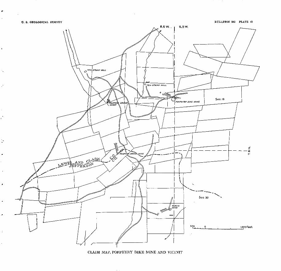
U. S. GEOLOGICAL SURVEY BULLETIN 842 PLATE 43
R.6W. . I R.5W.
1,500 Feet
CLAIM MAP, PORPHYRY DIKE MINE AND VICINIT
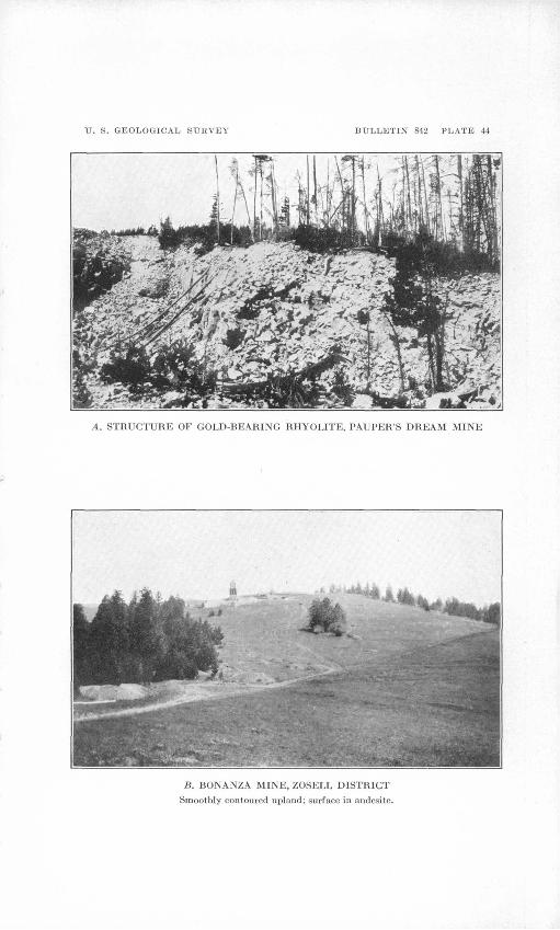
IF. S. GEOLOGICAL SURVEY BULLETIN 842 PLATE 44
A. STRUCTURE OF GOLD-HEARING RHYOLITE, PAUPER'S DREAM MINE
B. BONANZA MINE, ZOSELL DISTRICT
Smoothly contoured uplaud; surface in andesite.

KIMINI DISTRICT 261
oCARLSON
In 1928 the mine of John Carlson, a quarter of a mile west of the Pauper's Dream mine, was being worked on a small scale. The deposit is opened between altitudes of 7,750 and 8,000 feet by 1,000 feet of shafts and tunnels, one of which is 300 feet long. The best ore is found in zones that are 15 to 50 feet wide and stand vertical or dip steeply west. The richest ore is found in streaks and bands of the rhyolite that are silicified and heavily stained with yellow ocher.
PLACERS
Since the early days gold placers have been worked intermittently on the headwaters of Tenmile Creek. Their total production is not known, but it is not reported to be large. Incomplete returns in Mineral Eesources for the period 1909-1928 show a total of about $20,000. For some years only a few hundred dollars was reported. The greatest amount was $5,972, in 1912.
GOTTLD
Placer ground 4^/2 miles south of Kimini, owned, by the N. J. Gould estate, extends 1% miles along Try Again Creek. It is equip ped with a reservoir, a pipe line, and other implements for hydraulic mining that were installed before 1925 at a reported cost of $85,000. The gradient of the stream is sufficient for the deposit to be worked with the bedrock flume, and normally there is sufficient water for mining during most of the season. The gravel deposit is about 9 feet deep and rests on bedrock of softened granite. It is said to contain 1,000,000 cubic yards that is fairly rich in gold, but its min ing is expensive owing to the presence of many large boulders, some of them as much as 10 feet in diameter. . The gold occurs in particles of two general sizes of different grade. One size is fine and said to be worth only about $12 an ounce. The other is coarser and is worth $16 an ounce. The finer and lower-grade material corresponds nearly in value with the gold from the Porphyry Dike mine and other deposits in the rhyolite and is probably derived from the erosion of that deposit. Some of the richer gold is attached to fine grained vein quartz.
According to a report by C. E. Fryberger, November 27, 1915, 2,007 pounds of black sand concentrated from the Gould deposit was treated at the East Helena smelter and yielded 10.225 ounces of gold and 6.5 ounces of silver, the total value of which was $230.76. The analysis of the sand showed 45.8 per cent of iron and 31.4 per cent of insoluble material.
TRAVISGold produced at the Travis placer, on an upper west tributary
of Tenmile Creek, is said to be worth $14 an ounce. Its source in154419 33 18
262 GREATER HELENA MINING REGION, MONTANA
the. " Porphyry Dike " rhyolite is thus indicated. The gravel is as much as 40 feet deep.
ELLISTON DISTRICT
HISTORY AND PRODUCTION
The Elliston district is in Powell County, 20 miles west-southwest of Helena, on the upper west slope of the Continental Divide. It contains 15 or more mines, nearly all of which at one time or another have been productive.
Mining began in the Elliston district in the sixties, but most of its production was made between 1890 and 1908. There has been no marked activity in the last few years. The total production is estimated at $2,750,000, and the most productive mines were the Big Dick (Evening Star), Monarch, Julia, Flora, Ontario, and Twin City.
Incomplete records of production given in Mineral Kesources for the period 1909-1928 indicate a total of about $200,000, of which gold accounted for about $70,000, the remainder being the value of about 90,000 ounces of silver, 700,000 pounds of lead, and 90,000 pounds of copper.
TOPOGRAPHY AND GEOLOGY
The area is mountainous with rather strong relief. The highest point, Mount Bison, at the south, near the Monarch mine, attains an altitude of 7,243 feet. The lowest point, along the Little Black- foot River at Elliston, has an altitude of about 5,000 feet.
As described by Knopf,32 the rocks in the immediate vicinity of Elliston consist of an apparently conformable succession of lime stone, quartzite, and sandstone that range in age from Carbonifer ous to Cretaceous. The lowest formation, the Madison limestone,is overlain by the Quadrant quartzite; which in turn is succeeded by the Jurassic Ellis formation, and above that is several hundred, possibly 1,000 feet of cross-bedded sandstone, the upper portion of which is probably of Cretaceous age.
East of Elliston in the Madison limestone are the quarries and plant of the Elliston Lime Manufacturing Co., and northeast of the town, in the Phosphoria formation (Permian), previously described as the upper part of the Quadrant quartzite, is a bed of high-grade phosphate rock.33
The rocks mentioned disappear beneath rhyolites within a short distance west of Elliston. The rhyolites are present in considerable volume, and some of them differ considerably from the rhyolites common in the rest of the region. One of these varieties is a snow-
82 Knopf, Adolph, op. cit., pp. 76-77.83 Stone, R. W., and Bonlne, C. A., The Elliston phosphate field: U. S. Geol. Survey
Bull. 580, pp. 373-383, 1915.
ELLISTON DISTRICT 263
white rock containing large scattered phenocrysts of smoky quartz. Associated with the rhyolites are different basaltic rocks.
The southern and productive part of the district is underlain by the andesite-latite series of tuffs, breccias, and flows, which have been intruded by quartz monzonite of the Boulder batholith. A specimen from the Big Dick mine, which is fairly representative of the andesite-latite series in the vicinity of most of the deposits, is a dark greenish-gray breccia composed mainly of augite andesite porphyry, which contains gray feldspars, dark ferromagnesian min erals, and rare grains of sulphides. As determined by Kussell Gibson, the microscope shows the rock to be rather fine grained. It contains phenocrysts less than 1 millimeter long of pyroxene and hornblende and still smaller but more numerous phenocrysts of ao calcic feldspar near labradorite in composition, The chief original ferromagnesian mineral was a pyroxene, but most of it has been uralitized, and many crystals that retain the pyroxene shape show the characteristics of hornblende. In turn the hornblende is altered to chlorite and sericite. The feldspar also shows some alteration to chlorite and sericite. Accessory magnetite is present, and olivine and biotite are suggested by certain altered grains.
ORB DEPOSITS
Except a few placer mines formerly worked along the Little Blackfoot River at Elliston, for which no details are available, the ore deposits are in lodes belonging to the older group. They are valuable chiefly for lead and silver, but some contain appreciable amounts of gold, and in one, the Big Dick, gold leads in value. Most of the veins are in the andesite, but some are in the quartz monzonite, and all are genetically related to it.
A noteworthy feature of the deposits is the abundance of carbonate in the altered wall rocks. This is best shown at the Flora mine, described on page 268. A specimen from the footwall of this deposit that was originally a vesicular andesite is essentially a calcite-epidote rock with minor amounts of sericite and chlorite and a light sprin kling of minute grains of pyrite. The rock is dotted with bodies of shiny black calcite that are as much as three-quarters of an inch long. These were deposited as concentric layers in amygdaloidal cavites. Some of them have a central core of chalcedony, which completed the filling.
A specimen from the hanging wall is a relatively light-colored rock showing profusely disseminated crystals of light pyrite and a few specks of galena. In addition it is cut by veinlets of dark sphalerite and quartz with a little galena, of which the sphalerite is the oldest. Under the microscope some of the denser parts of these rocks can be identified as fine-grain porphyries with lathlike feld-
264 GREATER HELENA MINING REGION, MONTANA
spars and a very small amount of quartz. The feldspars, so far as shown by a few that are not completely altered, are chiefly plagioclase. Most of them are changed to sericite, carbonate, and chlorite; except a few foils of biotite no primary ferromagnesian minerals remain. Some bodies of carbonate and chlorite resemble pyroxene in shape, but no remnants of that mineral could be detected. Commonly the inner part of these bodies is carbonate and the rims chlorite. The groundmass is a mixed aggregate of carbonate and sericite with lesser amounts of chlorite, iron oxides, and rutile. A small amount of pyrite is present. The filled vesicles are irregular in shape. Commonly a carbonate of magnesium and calcium is the first mineral to be deposited in them, and the inner part is filled with chlorite. ,In some vesicles this order is reversed, and in a few carbonate has been followed by chlorite and that by a second gen eration of carbonate.
The carbonate was among the last of the minerals to be introduced. Not only has it soaked through the rock, replacing groundmass and phenocrysts, but minute veinlets of it cut indiscriminately across the altered minerals.
Tourmaline is associated with some of the deposits, but it is much less abundant than at Rimini, and so far as observed it is confined to the altered wall rock. Its relation to the carbonate was not made out
MINES AND PROSPECTS
BLUE BELL
The Blue Bell mine, 1 mile southeast of the west portal of the Mullan tunnel on the Northern Pacific Railway, was not visited in 1928, and so far as learned has been inactive for some time. In fact it had long been idle when it was examined in 1911 by Knopf,34 from whose report the following description is condensed. The develop ments consist of a shaft, surface cuts, and a tunnel about 175 feet below the collar of the shaft. It is reported that some rich copper ore was shipped from this mine. The country rock is monzonite, and the nearest intruded rock is the Madison limestone a mile distant. The ore material is mainly fine-grained garnet rock carrying dis seminated molybdenite and pyrite. There is also much rock com posed of large garnets coated with secondary minerals. In an open cut the lode is about 12 feet wide and consists of garnet rock inclosing a few thin masses of monzonite. In the vicinity of fine cracks near the garnetized zone the plagioclase feldspars of the monzonite have been converted solidly to brilliant yellowish-green aggregates of epi- dote. The garnet is a dark-brown variety whose index of refraction exceeds 1.79.- All the features of this deposit suggest that it is a vein of garnet in the monzonite.
34 Stone, R. W., and Bonine, C. A., op. cit, pp. 79-80.
ELUSION DISTRICT 265
BIG DICK (EVENING STAB)
The Big Dick mine, described by Knopf 35 as the Evening Star mine, is about 8 miles south of Elliston near the summit of Nigger Mountain at an altitude of 7,000 feet. According to Knopf it was idle in 1911. The country rock is a coarse andesitic breccia, and the ore deposit is a blanket vein that dips north at a low angle and is developed by a shaft 300 feet deep. The ore carries galena, pyrite, sphalerite, and arsenopyrite in a quartz gangue. Some of the quartz contains large columns of black tourmaline intergrown with pyrite. The ore is reported to have carried as much as 3 ounces of gold to a ton. During 1906 a gold-silver-lead ore was shipped to the East Helena smelter, and a production was maintained until 1910. In 1911 lessees were engaged in sinking a shaft near the west end line on one of the claims of the Finnish or Weston group.
Since 1911 considerable development work has been done, arid a production of $58,000 net is said to have been made during a period of 57 days in 1923. The mine was operated again in 1927, and its total production, including that prior to 1911, is said to be more than half a million dollars.
The country rock is augite andesite, which is described on page 263.The development workings include a tunnel said to be 1,000 feet
long connected to a shaft 300 feet deep by a raise 200 feet high. They explore two veins, one of which, the Big Dick vein, strikes about north and dips 40° W. The other, the Blanket vein, strikes nearly east and dips 20° N. The Blanket vein is said to cut the other and to have been the chief source of the mine's production. Some of the ore shoots are reported to have been 3^ feet thick, and some of the ore to have averaged 5 ounces of gold to the ton. A specimen collected by the writer contains lead carbonate and iron oxides.
JTTLIAThe Julia mine, owned by James Friedereichs, of Detroit, Mich.,
is 8 miles southeast of Elliston on the west side of Telegraph Creek at an altitude of 6,600 feet. The vein was discovered in 1905 by George Mack, of Elliston, and is said to have yielded $160,000 within a short time. Knopf 36 visited the mine in 1911, and tHe following description is condensed from his report. The vein is inclosed in granite and as a rule lies between exceedingly well defined walls, although the ore does not, except in a few places, fill the entire vein. The course of the vein is slightly south of east and the dip 80° S. As seen on the 200-foot level, which is 150 feet long, the vein swells and constricts abruptly, ranging in thickness from 6 inches to a maximum of 5 feet. The sulphides reach 2 or 3 feet in thickness. The granite inclosing the vein is unaltered, being only slightly py-
83 Stone, R. W., and Bonine, C. A., op. cit. p. 78. M Idem, pp. 77-78.

266
ritized for about a foot from the vein; that within the vein is greatly altered, and along the walls there is considerable gouge due to postmineral movement. The ore consists of a heavy sulphide mixture of galena, sphalerite, pyrite, and tetrahedrite, associated with subordinate quartz. The texture in places is drusy, and vugs lined with quartz crystals are common. The presence of tetrahe drite indicates a high content in silver. Sulphides consisting pre dominately of pyrite are discarded as valueless.
Since ; 1911 the development workings have been extended and considerable additional production made. On the 300-foot level the vein has been mined 300 feet west and 900 feet east to the andesite contact. Polished sections of the ore show pyrite to have been deposited first and to be partly replaced by tetrahedrite. Galena commonly occurs at quartz-tetrahedrite grain boundaries and appears to be later than either pyrite or tetrahedrite. Minute grains of sphalerite occur at the boundaries of all the minerals mentioned. The ore in general shows deposition to have taken place during two or more periods. It carries about 60 ounces of silver to the ton, with small amounts of lead and copper. The dumps contain much rela tively poor pyrite that has been discarded as waste.
TWIN CITY MINING & MILLING CO.
The mine of the Twin City Mining & Milling Co., 8 miles south of Elliston, is described by Knopf ST as developed by a shaft 85 feet deep, which was filled with water at the time of visit. The vein is inclosed in granite, trends N. 70° E., and is 18 feet wide. It is reported that 8 feet of the lode adjoining the footwall averages $3.60 to the ton, the products being gold, silver, copper, and lead. Thematerial on the dump is a black tourmaline-bearing quartz ore. Some strong tourmalinic lodes have been uncovered in the vicinity of the shaft, but they have not been found to carry any valuable constituents.
No further information concerning this property was obtained in 1928.
MONARCH
The Monarch mine is 11 miles south of Elliston, on the northwest slope of Bison Mountain at an altitude of 7,250 feet. It is most easily reached by a road that goes up Telegraph Creek. The mine is said to have beeen operated extensively about 1894, when a large production was made, and again in 1909. The last work reported is said to have been done by lessees in 1916. Definite figures of production are not available, but the total is said to be $1,000,000 or more.
The development workings aggregate about a mile in length and include two tunnels, a shaft 350 feet deep and 3,000 feet of drifts.
37 Stone, R. W., and Bonine, C. A., op. cit., pp. 78-79.
ELLIST'ON DISTRICT 267
The ore deposits are in a vein located at or near the contact between quartz monzonite and andesite. The vein strikes east, dips steeply north, and in places is 20 feet or more wide. The wall rock is altered and contains specularite and disseminated grains of sulphides. The ore consists of galena, sphalerite, pyrite, arsenopyrite, chalcopyrite, and tetrahedrite in a gangue of altered country rock and quartz.
Polished sections of the sulphide ore show that pyrite, chalcopyrite, and galena, deposited in the order named, are the chief primary metallic minerals. Associated with them are small amounts of tetra hedrite (or tennantite), and the gangue is dominantly quartz. After these primary minerals had come to place, the vein was shattered and much quartz was introduced along with smaller amounts of a second generation of the sulphides mentioned. In the course of oxidation pyrite and chalcopyrite were replaced by limonite, and covellite was also developed from the chalcopyrite. Galena was altered to anglesite but persisted longer than the other primarysulphides.
ONTARIOThe Ontario mine, near the head of Ontario Creek, is mentioned
by Knopf ,38 who visited the district in 1911, as having the reputation of being one of the largest producers in the district. It was developed by a tunnel 800 feet long, from which was sunk a shaft 320 feet deep. The country rock is granite, but ore as shown on the dumps consists of pyrite, sphalerite, and galena inclosed in quartz. No further information was obtained about this mine in 1928.
SADIEThe Sadie mine of Joe Bonneville comprises four claims 6 miles
south of Elliston, on the east side of the Little Blackfoot River at an altitude of about 650 feet. The vein was discovered before 1870 but has yielded only a small production of low-grade lead-silver ore.
The deposit is developed to a depth of 100 feet by two crosscut tunnels and a shaft that aggregate about 1,000 feet of underground work. The country rock is a dark-gray andesite, which the vein traverses for 600 feet or more in a northeast direction. The vein dips steeply southeast and in places is as much as 23 feet wide. It contains lumps and bunches of ore consisting of brecciated quartz filled mostly with pyrite and a little arsenopyrite, galena, sphalerite, and tetrahedrite. A polished section of this ore shows a fine-grained intermixture of the sulphides mentioned and in addition a little chalcopyrite. Fractures in the ore and the wall are recemented with pyrrhotite.
A pile of ore on the dump of the upper.tunnel is said to assay $20 to the ton in silver and lead, and a recent shipment of 5 tons from
88 Stone, R. W., and Bonlne, C. A., op. cit., p. 79.
268 GREATER HELENA MINING REGION, MONTANA
the lower tunnel assayed $36 a ton, of which $25 was in copper, $5 in silver, $4 in lead, and $2 in gold.
CHARTER OAK
The Charter Oak mine, owned by Fred and Kalph Hopkins, of Helena, is about five miles south of Elliston. It has been operated intermittently for many years, and the latest work was done in August, 1927. Some of the ore produced was shipped crude to the smelter, and some was treated in a small mill at the mine before shipment.
The property includes two veins known as the main or front vein and the back vein, both in andesite. Only the main 'vein was acces sible to examination in 1928. It stands about vertical or dips steeply west and is developed by a crosscut tunnel and drifts. The principal ore minerals are silver-bearing galena and boulangerite (lead- antimony sulphide). In places considerable arsenopyrite and sphal erite are present, and some of the ore was penalized at the smelter for zinc and arsenic. A polished section shows that pyrite and galena were deposited first and were followed by boulangerite. Some of the secondary lead mineral, plumbojarosite is present. Much of the crude ore produced ran about 10 per cent each in lead and zinc, with 10 ounces of silver and 0.01 ounce of gold to the ton. The back vein is said to contain lead-zinc ore.
FLORAThe Flora mine of James Best, 6 miles south of Elliston, is on a
blanket vein in andesite breccia. The vein is 2 to 3 feet thick and dips 20° or less northwest, parallel to the mountain slope, but along local " rolls " it is nearly horizontal and may even have a southwest dip. It is opened at a point about 200 feet above the Little Blackfoot River by a crosscut tunnel and a drift 500 feet long, the face of which is 200 feet beneath the surface. The mine is said to have produced considerable silver-lead ore, much of which was of high grade. In 1928 it was being operated by a lessee.
The alteration of the wall rocks of the Flora vein is described en page 263. The vein consists largely of crushed and altered country rock with streaks as much as 2 inches wide of ore, some of which are composed of silver-bearing galena, sphalerite, and quartz, and others are mainly pyrite and quartz. The ore is said to assay from $30 to $80 a ton in silver and lead, and some of it $3 or $4 in gold. Yellow ish earthy minerals, due to oxidation, extend below the tunnel level, but most of the sulphides remain unaltered.
If the vein maintains the dip shown in the mine workings, it must come to the surface below the tunnel but at a point well above the floor of the valley. On the other hand, above the tunnel level it

ELLISTON DISTRICT 269
ascends at a lower angle than the surface and therefore it may contain considerable ore in that direction.
BLACK JACK
The Black Jack mine of Frank Wye and others is nearly 8 miles south of Elliston, on the upper southwest slope of Nigger Mountain. It adjoins the Big Dick mine on the northwest but was not discovered until 10 years later.
The vein is inclosed in porphyritic andesite breccia similar to that which forms the walls of the Big Dick veins. The development workings are an adit drift 300 feet long and an inclined shaft 350 feet deep, which is situated east of the adit.
The vein is said to cut the blanket vein of the Big Dick mine. It trends south, dips 30° W., averages 3^ feet in width, and contains black sphalerite, pyrite, arsenopyrite, and galena in a gangue of calcite and quartz. (See pi. 42.) A polished section of the ore pre sents the appearance of a medium-grained breccia. The gangue is chiefly quartz. In order of abundance the ore minerals are arseno pyrite, pyrite, sphalerite, and galena. Pyrite was deposited first, followed by the others in the order named above. The mineral aggregates are elongated parallel with the vein, a fact that suggests that they have replaced the rock along shear or bedding planes. Another specimen shows abundant galena with a lesser amount of sphalerite. Tiny cubes of pyrite accompany the sphalerite, and some of them have been corroded by it. Peppered through the sphalerite are blebs of chalcopyrite so small as to be seen only with a high-powered microscope. Both the galena and sphalerite are being replaced with oxidation products. A specimen, which is chiefly coarse-grained quartz, contains very fine grained arsenopy rite and smaller amounts of calcite and pyrite. The arsenopyrite appears to have replaced the pyrite. Tourmaline occurs in the wall rock but was not observed in the ore.
BROOKLYN
The Brooklyn mine of John Malm is 7y2 miles south of Elliston, near the east side of the Little Blackfoot Kiver. The property contains several veins inclosed in andesite. The lowermost or main vein has a maximum thickness of 3 feet, dips steeply south-southeast, into the mountain, and is faulted at a point about 300 feet from the portal of a tunnel. It shows a crudely banded structure and con tains black sphalerite, pyrite, silver-bearing galena, and arsenopyrite in a gangue of calcite and quartz. After having been slightly brecciated the vein was recemented with seams and veinlets of calcite.
270 GREATER HELENA MINING REGION, MONTANA
ZOSELL (EMERY) DISTRICT
HISTORY AND PRODUCTION
The Zosell or Emery district (pi. 45') includes an area of 3 or 4 square miles on the slope west of the Continental Divide about 8 miles east-southeast of Deer Lodge. Gold-bearing gravel was dis covered in this area about 1872, and for the next 20 years placer mining was done on a moderate scale, a total of $75,000 or more being produced. Lode deposits were first developed in 1888 or 1889, and since that date a score or more of mines have been operated intermittently. One of them, the Emery, has far overshadowed all the others in extent of development work and production.
Available smelter returns, together with estimates believed to be trustworthy, show that from 1891 to 1928 the total production of the lode deposits was not less than $675,000, of which about 45 per cent represents the value of the gold, 45 per cent silver, and the remainder lead. In addition most of the ore contained a moderate amount of zinc, which was not recovered. In 1926 and 1927 the Blue Eyed Maggie mine was producing ore, considerable underground development with some ore production was going on at the Bonanza, and small amounts of development were in progress at a few other mines.
GEOGRAPHY
Most of the mines of the Zosell district are in the drainage basins of Rocker Gulch and Spring Gulch, small tributaries of the south or main fork of Cottonwood Creek. A few of the deposits are beyond the northern limits of these basins on the slope above the north fork, known also as Baggs Creek. Rocker Gulch has a south west course and a length of about 2 miles. The altitudes range from about 5,500 feet at the mouth of the gulch to about 6,500 feet on the divide at its head. The lower part of the gulch is rather narrow and steep. About half a mile above its mouth, where it is joined by a small north branch, it widens so as to contain a small flat. Above the flat is another steep and narrow stretch, at the head of which the gulch becomes a wide, shallow valley of moderate gradient. Across the divide to the east another shallow valley forms the upper part of Spring Gulch. A short distance to the north there is a steep descent to Baggs Creek and Deer Lodge Valley. The shallow upper parts of the gulches mentioned and the intervening ridges compose a rolling upland surface (pi. 44, B) that ranges from 6,200 to 6,500 feet in altitude. It is evident that under present conditions this surface, which was formerly more extensive than now, is being destroyed by the headward growth of the deeper parts of the valleys. It must have been produced at a time when the drainage level was not as low as at present.

ZOSELL (EMERY) DISTRICT 271
GEOLOGY
The district is underlain by andesite, a formation of probable late Cretaceous age that consists of flows, tuffs, and breccias and occupies large areas in the region between Helena and Butte. 39 In the Zosell district this formation consists chiefly of flows. It is a dark greenish- gray rock containing white amygdules and generally characterized by small white phenocrysts of feldspar. A specimen examined microscopically by Clarence S. Ross consists ofaltered phenocrysts of augite and plagioclase which form about one-quarter of the rock in a fine-grained groundmass of plagioclase and altered ferromagne- sian minerals. The augite of the phenocrysts has changed to an aggregate of epidote and chlorite, with a little quartz and carbonates in some places. The plagioclase contains a little sericite and epidote. Amygdules are filled with solid chlorite or concentric fillings of carbonate, chlorite, and an aggregate of clialceclonic quartz and sericite. The groundmass is partly altered to chlorite and contains many patchy areas of carbonate.
Next to the veins the andesite is altered to a light-gray rock that is commonly sprinkled with fine grains of pyrite and shows spots of pale green. The rock effervesces in cold dilute acid, owing to the presence of a carbonate calcium and iron that resembles ankerite. Under the microscope sericite is seen to have partly replaced the orig inal feldspar. The ferromagnesian minerals are partly changed to chlorite and carbonate. The green spots are apparently a silicate of iron, probably greenalite. The microscopic character of the altered andesite is determined by Mr. Ross as follows:
The andesite is a greenish-gray to nearly black rock with porphyritic struc ture. Phenocrysts of altered augite and plagioclase 2 to 4 millimeters in length form about one-third of the rock, and the groundmass is made up of plagioclase laths about 0.05 millimeter in length and altered augite. This rock is pro foundly altered. The augite of the phenocrysts has been almost completely altered to green chlorite masses which contain a little fresh residual augite and secondary carbonates. The plagioclase is partly altered to sericite. The groundmass feldspars are nearly fresh, but the ferromagnesian minerals have been changed to an aggregate of chlorite and carbonates. The whole rock is cut by numerous veins of carbonates.
West of the district, along the edge of Deer Lodge Valley, the andesite passes beneath Tertiary " lake beds" and later sedi ments. To the east, just beyond the Continental Divide, it is cut by the quartz monzonite of. the Boulder batholith commonly known as the Butte " granite." The ore deposits and, in particular, the altered wall rock in the Zosell district suggest that the monzonite or some other intrusive rock is present in depth. In addition to other substances the intrusive mass gave off large quantities of iron and carbon dioxide, which rose through the vein fissures and
89 Weed, W. H., Geology and ore deposits of the Butte district, Montana: TJ. S. Geol. Survey Prof. Paper 74, pp. 27-28. 1912.

272 GREATER HELENA MINING REGION, MONTANA
replaced much of the andesite wall rock. Several faults are shown by the mine workings. The largest of these, the fault which cuts off the Emery vein at the south, is marked on the surface by a notch and a ravine, but the amount of its displacement is not shown. As suggested by the fact that they contain much breccia, the vein frac tures themselves are probably faults.
ORE DEPOSITS
CHARACTER AND COMPOSITION
The lodes in the Zosell district are distributed through an area that extends 2 or 2^ miles in a northeasterly direction and is from 1 to V/2 miles wide. They are veins that strike northwest or north east and dip northward at angles that are generally less than 45°. Most of them have filled open spaces along fractures, chiefly the spaces between fragments of broken rock. Locally the vein minerals have partly replaced the broken rock.
Most of the veins are narrow, but they are persistent in c other dimensions, and the ore bodies are likewise fairly extensive in length and depth. In addition to the vein there is locally several feet of the wall rock that is more or less mineralized. In places this material may be rich enough to constitute ore, but an attempt to work it in the Emery mill was not profitable. Most of the ore is moderately rich, a condition that compensates somewhat for the narrowness of the veins. Shipments from the Blue Eyed Maggie and Emery mines have ranged from about $30 to $60 or more to the ton. Ore of a similar tenor is reported to have been shipped from several of the other mines.
Quartz and ankerite, a carbonate of calcium and iron with more or less manganese, usually compose the bulk of the vein filling. The principal ore minerals are pyrite, arsenopyrite, sphalerite, and galena. All are widely distributed, and pyrite, as usual, is the most widespread and on the average is perhaps the most abundant of the sulphides. Galena appears to be most plentiful in the northern and more elevated part of the district, and arsenopyrite is most common in the mines at lower altitudes. In some of the veins the relative amount of sphalerite appears to increase in depth. Stibnite was identified in the Blue Eyed Maggie ore.
As would be expected from the plentiful occurrence of pyrite in the sulphide zone, the oxidized parts of the veins contain much limonite. Other minerals commonly present in the oxidized ore are cerusite and greenish-yellow stains, some of which represent a hydrated sulphate of iron and others probably an arsenate. Man ganese stains are common, and manganese oxides are rather plentiful in oxidized ore from the Sterrett mine.
. ZOSELL (EMERY) DISTRICT 273
Among the first substances that came into the veins were iron and manganese, which were carried into the walls for some distance and, in the form of ankerite and pyrite, partly replaced the original rock minerals. After the veins had been reopened and some of the altered wall rock brecciated, the ore minerals were introduced. First came lead and zinc sulphides, accompanied by considerable carbonate and a little quartz. These filled and partly replaced the breccia and were followed by arsenopyrite and small amounts of the other sulphides, accompanied by quartz.
Oxidation is partial or complete down to a surface that rises gradually away from the natural drainage lines. This surface corresponds rather closely with the level of ground water, which, on the ridges, is found at depths of 40 to 75 feet. Exceptionally, as in the Bonanza mine, some oxidation has occurred below the water level. The oxidized ore is rich in spots but generally is somewhat poorer than the sulphide ore. No evidences were observed of downward enrichment.
ORIGIN
The veins described are similar to those generally believed to be related to granitic intrusion, and their mineralogy suggests that they were formed at a moderate to shallow depth by heated solutions. The heat and probably some or all of the metals carried by these solutions were given off by some unexposed intrusive body that came to place later than the andesite. The Boulder batholith (Butte "granite"), which is exposed a few miles east of the Zosell district, is younger than the andesite and thus may have been the source of the veins. The ore deposits of the Zosell district are much like many of those of the neighboring Elliston and Rimini districts.
In all these deposits the principal sulphide minerals are galena, sphalerite, pyrite, and arsenopyrite. The Zosell deposits differ from those of the districts mentioned in the absence of the tourmaline. As the rocks in the Zosell district show no contact metamorphism, inferences may be drawn that the igneous body which induced the mineralization is far below the present surface and that the deposits exposed are beyond the zone in which high temperatures, such as would produce tourmaline, prevailed. From these inferences iti follows that the deposits may be expected to persist to much greater depths than present explorations have gone, a conclusion in harmony with the fact that the ore from the lowest parts of the mineralized zone yet explored shows no decrease in value. The depth to which the mineralized zone is exposed by mine workings and the natural excavation of Rocker Gulch is about TOO feet. Ore from the Blue Eyed Maggie mine, at the bottom of this part of the zone, shows no decrease in value or any significant change in mineralogy from

274 GREATER HELENA MINING REGION, MONTANA
ores occurring at higher points. It should be observed, however, that the narrowness of most of the veins is unfavorable to their exploitation beyond moderate depths and also limits the scale on which they can be profitably worked, a fact which seems to have been overlooked by the "English company." Worked on a moderate scale, however, the deposits look promising.
MINES AND PROSPECTSEMERY
The Emery lode is said to have been discovered in 1888 by John Renault, a prospector. Shortly afterward the deposit was located by another prospector named Emery, who developed it to a depth of about 100 feet and extracted a considerable amount of ore. In 1890 the mine was purchased by N. J. Bielenberg and others, of Deer Lodge, and for several years thereafter it was worked profitably by the owners and by Powers & Harrington as lessees. During most of this period the operations were under the general direction of Irvine Higgins, who shares the credit for the mine's successful development with the mine foreman, T. J. Gamache. In June, 190T, the Deer Lodge Consolidated Mines Co., a corporation known as the " English company," purchased the Emery mine and spent a large sum building a concentrating mill, sinking a new shaft, and making other improvements. It also produced a quantity of ore and concen trate, but the operations were unprofitable, owing, it is said, chiefly to excessive overhead and the milling of much material that was too lean to yield a profit. In 1908 the company's creditors took pos session, and since that time the mine has been operated intermit tently by different owners, including the Emery Consolidated Co. and the Carbonate Hill Mining Co., and by lessees. The present owners are Joseph Whitworth and others, of Deer Lodge.
Smelter returns show a total of 14,550 tons of crude ore and con centrate shipped from the Emery mine within the period 1891-1923, the net proceeds of which were $464,590.53. About 46 per cent of this amount represents the value of the gold recovered, 44 per cent the silver, and 10 per cent the lead. The ratio of gold to silver by weight averaged about 1 to 30, and about 4 ounces of silver was present to each per cent of lead contained in the ore. The total net production was, in round figures, 11,000 ounces of gold, 335,000 ounces of silver, and 1,220,000 pounds of lead. The ore contained, in addition, considerable zinc, which was not recovered, but instead the shipper was usually penalized for it by the smelters.
In July, 1926, the mine was closed, and the writer did not enter the underground workings. Mine maps made by Eobert Addie, en gineer for the English company, show the main working entry, an inclined shaft sunk on the slope of the vein, to be about 1,000 feet

ZOSELL (EMERY) DISTRICT 275
deep, or to have reached a level of about 700 feet vertically lower than its collar. There is also a vertical working shaft about 500 feet deep which was sunk by the English company in the northwest or hanging-wall side of the vein. This shaft is on a lower part of the surface than the older one and therefore reaches the same level. Other workings include the Black Rock shaft, about 600 feet west of the main incline, 7,000 linear feet or more of drifts, crosscuts, and levels, and a large area of stopes. An old inclined shaft, not acces sible to examination and not shown on the maps, is sunk on the vein about 500 feet northeast of the main entry.
FIGURE 34. Vertical section, Emery mine. Levels are about 75 feet apart. Shading indicates stoped area
The vein is a persistent thin tabular body that strikes N. 30°-40° E. and dips 35°-40° NW. Workings near the surface indicate that ore was extracted along the vein for a distance of 1.200 or 1,300 feet. As shown by Mr. Addie's maps, the stoped area narrows below the 100-foot level to about 200 feet at the 800 level (fig. 34). The ore body thus worked out pitched 20° or 30° to the southwest of the line marking the maximum dip of the vein. The ore body was narrow, and therefore much waste had to be removed in mining it.
The outcrop of the vein is inconspicuous and generally concealed by surface mantle. It is traced by shallow workings along the flat- topped ridge east of Rocker Gulch for nearly half a mile. Its northern limit is not shown. The northward projection of its course would intersect the Bonanza vein. A short distance south of the main working incline the vein is slightly displaced by two or three normal

276 GREATER HELENA MINING REGION, MONTANA
faults that strike west and dip south. About 1,000 feet to the south, near the Black Rock shaft, it is cut off by a fault that strikes west and dips steeply to the north. This fault is accompanied by much fault breccia, which is locally known as a " dike." It is marked on the surface by a notch transverse to the ridge along which the Emery vein crops out. The abrupt ending of the vein at a mass of crushed country rock, or a fault breccia, is well shown by cuts and other shallow workings. Neither at the surface nor in depth has the vein been found beyond this fault. The persistence of the fault in a west- northwest direction across Kocker Gulch and to the ridge beyond is suggested by the alinement of notches and ravines. The block on the north appears to have fallen, but the amount of displacement is not shown.
Next to the vein the walls have been altered to a light-gray rock somewhat softer than the fresh andesite. This rock is sprinkled with small crystals of pyrite and marked here and there with indi stinctly bounded spots of pale-green iron silicate. In addition it is commonly cut by veinlets or stringers containing pyrite, blende, and galena in a quartz-carbonate gangue. Exposure to the weather turns this rock brown. The bulk of the waste dump consists of sim ilar material, which obviously contains small amounts of lead and zinc and doubtless also a little gold and silver. A quantity of it is said to have been milled unprofitably. Under the microscope the feld spars and ferromagnesian minerals are seen to have been partly altered to sericite and the remainder replaced by a carbonate of cal cium and iron. Much fine-grained quartz is present also in the altered rock.
The ore consists of arsenopyrite, pyrite, galena, and sphalerite in a quartz-carbonate gangue. Commonly it shows a.banded structure due to the arrangement of the sulphides more or less in layers. In some layers arsenopyrite predominates; in others galena and sphal erite. In some specimens layers consisting largely of galena and sphalerite show a fine oblique cleavage or schistosity that appar ently was caused by movements of the walls. The adjoining quartz- ose layers are not deformed. Quartz and a rather coarsely granular carbonate of manganese and calcite of varying composition make up most of the vein filling. The carbonate and most of the galena and sphalerite appear to have been deposited first and to have been followed and partly replaced by quartz and arsenopyrite. Pyrite accompanied both stages of deposition. Oxidation is partial or com plete to a depth of 100 feet or more.
During the first stage of operation, which was mostly above the 100-foot level, the ore produced netted about $26 a ton at the smelter. Later shipments from the lower levels, which represented the bulk

U. 8. GEOLOGICAL SURVEY BULLETIN 842 PLATE 45
MINES AND PROSPECTS
1. Argus.2. Hidden Hand.3. Emma Darling.4. Sterrett.5. Black Eyed May.6. BelL ' '7. Bonanza.8. Etcharren.9. Emery.
10. Kirby.11. Blue Eyed Maggie.12. William Coleman.
R. 8 W.
Andesite
Fault
Vein outcrop
Mine or prospect
Adit

U. S. GEOLOGICAL SURVEY BULLETIN 842 PLATE 46
ORE FROM BLUE KYED MAGGIE MINE
a, Rhodochrosite; b, chiefly sphalerite with needles of arsenopyrite; c, mostly pyrite; d, fine-grained sulphides; e, middle layer in which the rectangular white spots represent pyrite, other white areas are mostly ankerite, suhangular black spots are galena, and the remain der fine sulphides.

U. S. GEOLOGICAL SURVEY BULLETIN 842 PLATE 47
B
SPECIMENS FROM BONANZA MINE, ZOSELL DISTRICT
A, Breccia. Angular fragments are altered andesite wall rock. Small dark rounded areas with light rims are sphalerite surrounded by pyrite. The matrix is quartz and pyrite. Natural size. B, Ore. g, Galena; p, pyrite; s, sphalerite; q, quartz. Natural size.
ZOSELL (EMERY) DISTRICT 277
of the production, averaged about $35 a ton. Still later, during the English company's operation, the smelter returns averaged about $32 a ton. The last shipments, made in 1922 and 1923, which repre sent gleanings from former workings, yielded about $28 a ton. In the shipments made in 1923 gold ranged from 0.28 to 0.78 ounce to a ton, silver 15 to 38 ounces to a ton, lead 3 to 12 per cent, zinc 5 to 13 per cent, and arsenic 7 to 10 per cent. Considerable ore of about this composition is said to remain in the east and west stopes above the 900-foot level.
BLUE EYED MAGGIE
The Blue Eyed Maggie mine is on the north side of Rocker Gulch just below the flat. In 1926 and 1927 it was operated by James E. Higgins, one of the owners, and by lessees. The total production from 1910 to 1926 is estimated by Mr. Higgins at $85,000, of which about 50 per cent represents silver, 45 per cent gold, and the remain der lead. The principal working entry is an adit 170 feet long which inclines downward at an angle of 8° or 10°. It is driven on the vein and at the face has a depth of 50 or 60 feet vertically below the surface. From a point near the face a drift 100 feet long extends westward along the vein and northward along a fault. Other drifts at higher levels extend along the vein to maximum distances of 250 feet west and 50 feet east. The west drifts connect with two adits that are not now used.
The vein is a thin tabular body that strikes N. 40°-50° W. and dips 20°-30° NE. It ranges from an inch or two to about 1 foot in thickness but in most places is about 6 inches thick. The walls are smooth and well defined and without noteworthy amounts of gouge or other evidences of movement. About 40 feet west of the main entry the vein is upthrown 22 feet by a fault that strikes north, has vertical walls, and carries about 1 foot of gouge with fragments of ore dragged in from the vein. This fault also cuts an east-west fault that contains from 6 to 10 inches of gouge and breccia and displaces the vein about 1 foot. For the thickness of a few inches next to the vein the walls have been altered to a light-gray rock rather plentifully sprinkled with small cubes of pyrite and showing a few spots of a pale-green mineral, probably stains of an iron sili cate. As shown by the microscope, the original minerals of this rock have been largely replaced by sericite and a mixed carbonate of calcium, iron, and manganese. Considerable secondary quartz is present also, and in addition to the pyrite there is in places a little sphalerite or other sulphide. In places the vein shows a banded structure due to the incomplete segregation of the minerals in sepa rate layers. (See pi. 46.) Here and there are small open spaces
154419 33 19
278 GREATER HELENA MINING REGION, MONTANA
lined with free crystals of quartz or sulphides. In the lower work ings described the vein is unoxidized and is saturated with water. The oxidized zone has been entirely eroded at the bottom of the gulch but reaches a thickness of 40 feet or more in the slope above the face of the workings, its lower limit coinciding nearly with the ground-water level. Within this zone the vein filling consists of cavernous or " honeycomb " quartz stained with iron and manganese oxides and soft or earthy oxides of iron. More or less gold, silver, and lead are present, and in places this material is said to be very rich. In this zone the carbonate and sulphides have been mostly leached out of the layer of altered wall rock next to the vein, leaving a residue of finely porous quartz and iron oxides.
Below water level the vein consists mainly of arsenopyrite, pyrite, sphalerite, and galena in a gangue of quartz and carbonate. In places there is considerable stibnite. The relations of these minerals to one another indicate that carbonate and pyrite were the first to be introduced. They partly replaced fragments of the country rock, which were afterward surrounded with layers of carbonate carrying more or less stibnite. These minerals were followed by sphalerite and galena, and these by arsenopyrite, which partly replaced them. Much quartz came in with the arsenopyrite, and a little with the sphalerite and galena. Some carbonate accompanied the sphalerite and galena, and more or less pyrite came in with each generation of minerals.
Practically all the vein exposed by the workings described has proved to be ore. The body thus developed has a maximum stope length of about 300 feet and a dip length of 200 feet. The workings do not show its limits either horizontally or in depth. As shown by the smelter returns the ore extracted so far has contained from 1 to iy2 ounces of gold and 42 to 63 ounces of silver to the ton, and 2 to 6 per cent of lead, the net returns of the shipments ranging from $38 to $50 a ton. Other constituents of the ore shown by the smelter analysis are zinc from a trace to 6 per cent, copper 0.10 to 0.55 per cent, manganese 2 to 3.5 per cent, iron 11 to 18 per cent, and arsenic, reported as speiss, 3 to 21 per cent. Neither the zinc nor the copper was considered in computing the value of the ore. The returns given do not indicate any noteworthy differences in the amounts of gold, silver, and lead contained in ore from above and below the water level. Whether any zinc, copper, or arsenic remains in the oxidized zone was not determined. The results given below of flotation concentration tests by the Timber. Butte Milling Co., at Butte, Mont., on ore from the Blue Eyed Maggie, show that both the lead and zinc minerals can, to some degree, be separated and saved.
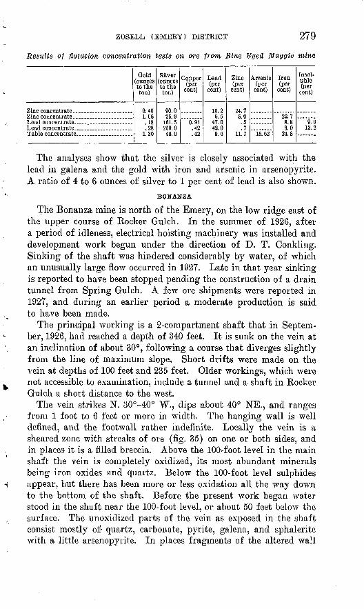
ZOSELL (EMERY) DISTRICT 279
Results of flotation concentration tests on ore from Blue Eyed Maggie mine
Gold (ounces to the ton)
0.401.06.18.28
1.30
Silver (ounces to the ton)
90.025.9
161.5250.046.0
Copper (per
cent)
0.94.42.42
Lead (per
cent)
15.26.5
47.042.09.6
Zinc (per
cent)
24.75.0.5.7
11.7
Arsenic (per
cent)
15.62
Iron (per
cent)
22.78.88.0
24.8
Insol uble (per
cent)
9.613.2
The analyses show that the silver is closely associated with the lead in galena and the gold with iron and arsenic in arsenopyrite. A ratio of 4 to 6 ounces of silver to 1 per cent of lead is also shown.
BONANZA
The Bonanza mine is north of the Emery, on the low ridge east of the upper course of Kocker Gulch. In the summer of 1926, after a period of idleness, electrical hoisting machinery was installed and development work begun under the direction of D. T. Conkling. Sinking of the shaft was hindered considerably by water, of which an unusually large flow occurred in 1927. Late in that year sinking is reported to have been stopped pending the construction of a drain tunnel from Spring Gulch. A few ore shipments were reported in 1927, and during an earlier period a moderate production is said to have been made.
The principal working is a 2-compartment shaft that in Septem ber, 1926, had reached a depth of 340 feet. It is sunk on the vein at an inclination of about 30°, following a course that diverges slightly from the line of maximum slope. Short drifts were made on the vein at depths of 100 feet and 235 feet. Older workings, which were not accessible to examination, include a tunnel and a shaft in Rocker Gulch a short distance to the west.
The vein strikes N. 30°-40° W., dips about 40° NE., and ranges from 1 foot to 6 feet or more in width. The hanging wall is well defined, and the footwall rather indefinite. Locally the vein is a sheared zone with streaks of ore (fig. 35) on one or both sides, and in places it is a filled breccia. Above the 100-foot level in the main shaft the vein is completely oxidized, its most abundant minerals being iron oxides and quartz. Below the 100-foot level sulphides appear, but there has been more or less oxidation all the way down to the bottom of the shaft. Before the present work began water stood in the shaft near the 100-foot level, or about 50 feet below the surface. The unoxidized parts of the vein as exposed in the shaft consist mostly of- quartz, carbonate, pyrite, galena, and sphalerite with a little arsenopyrite. In places fragments of the altered wall
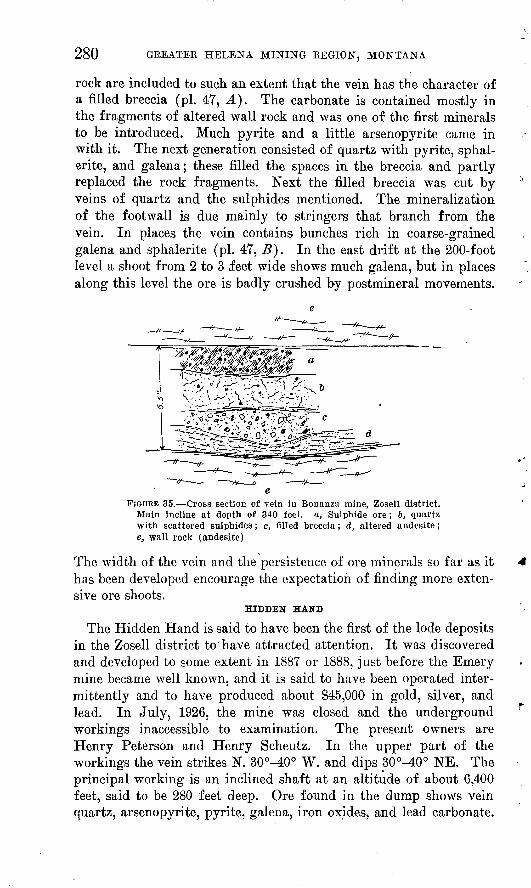
280 GREATER HELENA MINING REGION, MONTANA
rock are included to such an extent that the vein has the character of a filled breccia (pi. 47, A). The carbonate is contained mostly in the fragments of altered wall rock and was one of the first minerals to be introduced. Much pyrite and a little arsenopyrite came in with it. The next generation consisted of quartz with pyrite, sphal erite, and galena; these filled the spaces in the breccia and partly replaced the rock fragments. Next the filled breccia was cut by veins of quartz and the sulphides mentioned. The mineralization of the footwall is due mainly to stringers that branch from the vein. In places the vein contains bunches rich in coarse-grained galena and sphalerite (pi. 47, B). In the east drift at the 200-foot level a shoot from 2 to 3 feet wide shows much galena, but in places along this level the ore is badly crushed by postmineral movements.
FIGURE 35. Cross section of vein in Bonanza mine, Zosell district. Main incline at depth of 340 feet, a, Sulphide ore; 6, quartz with scattered sulphides; c, filled breccia; d, altered andesite; e, wall rock (andesite)
The width of the vein and the persistence of ore minerals so far as it has been developed encourage the expectation of finding more exten sive ore shoots.
HIDDEN HAND
The Hidden Hand is said to have been the first of the lode deposits in the Zosell district to have attracted attention. It was discovered and developed to some extent in 1887 or 1888, just before the Emery mine became well known, and it is said to have been operated inter mittently and to have produced about $45,000 in gold, silver, and lead. In July, 1926, the mine was closed and the underground workings inaccessible to examination. The present owners are Henry Peterson and Henry Scheutz. In the upper part of the workings the vein strikes N. 30°^tO° W. and dips 30°-40° NE. The principal working is an inclined shaft at an altitude of about 6,400 feet, said to be 280 feet deep. Ore found in the dump shows vein quartz, arsenopyrite, pyrite, galena, iron oxides, and lead carbonate.

ZOSELL (EMERY) DISTRICT 281
Cavities in the ore are lined with free, crystals of quartz, pyrite, galena, and sphalerite. Fragments of altered wall rock are also included in the vein.
Most of the arsenopyrite appears to be of somewhat later genera tion than the other sulphides. The ore shipped is said to have come from a shoot about 2 feet wide and 200 feet long that extended from the surface to a depth of 45 feet. This part of the vein is above the ground-water level, but it was incompletely oxidized, bunches of galena and other sulphides occurring in it up to the grass roots. The net returns from the shipments are said to have ranged from $25 to $40 a ton in gold, silver, and lead.
EMMA DARLIN&
The Emma Darling mine is on the upland at the head of Rocker Gulch, east of the Hidden Hand. At the portal of a caved adit a lode 7 feet or more wide is exposed that strikes about N. 70° W. and dips about 80° N. The walls are jointed and sheared andesite. A layer 3 feet thick consists largely of a brown-weathering carbonate of calcium, iron, and manganese with more or less quartz and iron oxides. In places considerable fine pyrite has escaped oxidation. In addition a few small grains of sphalerite, galena, and arsenopy rite was observed. The remainder of the lode consists of ^ mass of crushed wall rock filled with material similar to that of the 3- foot layer. Other workings include a shaft said to be 90 feet deep that was not accessible to examination. According to George Booth- royd, one of the owners, an ore shoot 1 to 2 feet thick exposed in the shaft shows considerable galena at places and has an assay value of $20 or more to the ton. A sample representing the 3-foot layer at the mouth of the caved adit is said to have assayed 2.5 ounces of silver and $2.40 in gold to the ton.
A short distance south of the lode described is a vein parallel to it from which small lots of ore are said to have been shipped that yielded as much as $45 a ton in silver, lead, and gold. The ore shoot has a maximum thickness of 18 inches.
AKGUSThe Argus mine is in the extreme northern part of the district,
above a steep slope facing Deer Lodge Valley. The workings consist of several inclined adits, none of which were accessible at the time of the writer's visit. Considerable ore is said to have been shipped from these workings, but the value of the product is not known. The vein crops out at an altitude of about 6,500 feet and, as shown by the workings, extends for a distance of about 1,000 feet. It strikes N. 10°-20° W. and dips 20°-30° E. Near the outcrop the vein is a foot or more wide and consists of a skeleton or " honeycomb " of
282 GREATER HELENA MINING REGION, MONTANA
quartz with more or less iron oxides and lead carbonate. Ore found in the dump of an adit at a level about 100 feet lower than the workings along the outcrop consists of quartz liberally sprinkled with pyrite, sphalerite, and galena. Arsenopyrite is abundant in some specimens. There is also present considerable brown-weather ing carbonate of an older generation than the quartz and sulphides. The vein has the structure of a breccia that was filled with carbonate and a little pyrite and later broken and invaded by quartz with more pyrite and other sulphides. The wall rock is altered andesite cut by veins of brown-weathering carbonate, which in turn is cut by quartz veinlets. Shipments to an aggregate value of $15,000 or more are reported to have been made from the Argus, most of the ore coming from streaks in the oxidized zone within depths of 40 to 100 feet. One carload is said to have averaged 60 per cent of lead and 105 ounces of silver to a ton. The present owners are Mrs. J. H. Owings, William McMullen, and William O'Neill.
STERRETT, KIRBY, BLACK EYED MAY, WILLIAM COLEMAN, AND BELL
In addition to those described above, the district contains several mines that have produced more or less ore but were inactive and inaccessible to examination in 1926. Of these the Sterrett, near the head oj: Spring Gulch, is developed by two shafts on a vein that strikes about N. 80° E. Ore rich in galena and sphalerite is scattered about the dumps. The gangue includes much calcium-manganese carbonate and the oxidized vein shows considerable manganese oxides. The fragments in an ore pile at the Kirby mine, on the north branch of Rocker Gulch, indicate a streak at least 13 inches wide composed mostly of galena, sphalerite, and pyrite. A shaft at this mine is equipped with a steam hoist and is said to be 350 feet deep. Ore shipped from a streak 8 to 10 inches wide in the Black Eyed May mine, which is near the head of Rocker Gulch, is reported to have yielded $43 a ton in gold, silver, and lead. The vein strikes about west, is vertical, and is said to be developed to a depth of 100 feet. The ore consists of galena, sphalerite, and pyrite in a quartz gangue. No carbonate was observed in the vein material, though, as elsewhere, carbonate is abundant in the wall rock.
As shown at the portal of a caved inclined shaft, the vein in the William Coleman mine, in Rocker Gulch below the Blue Eyed Maggie, is 2 feet wide, strikes west, dips 45° N., and cuts andesite. The part exposed consists of iron and manganese oxides and quartz. The hanging wall is well defined, and its rock is not much altered. The footwall, for a thickness of several feet, is broken and shows the alteration and replacement by carbonate common elsewhere in the district. Fragments of ore on the dump contain galena, sphal erite, pyrite, arsenopyrite, ankerite, and quartz.
OHO FIND DISTRICT 283
The Bell vein strikes northwest, dips northeast, and is said to 'be developed to a depth of 80 feet on the slope. Ore containing lead carbonate occurs in this part of the vein in bunches as much as 2 feet wide. A carload produced during development work about 1902 is reported by the owner, T. J. Gamache, to have yielded $16.50 a ton net in gold, silver, and lead. The workings are on the west side of Rocker Gulch, a short distance northwest of the Bonanza mine.
PLACERS
Gold-bearing gravel was discovered about 1872 in Rocker Gulch by H. L. Hoffman, who, with George Boothroyd and others, con tinued to work the deposit for about 20 years. The mining season averaged about 2% months of each year, and the diggings though not unusually rich or extensive, were profitable. Rocker Gulch was mined for half a mile along the narrow stretch below the Blue Even Maggie mine and for about three-quarters of a mile above the forks, or nearly to the head. Ruins of old workings show that the gravel deposit was generally less than 10 feet deep and from a few feet to 32 feet wide. Spring Gulch was worked also for a consid erable distance below the Sterrett mine. The ground owned by Hoffman and his partners is estimated to have yielded about $50,000, and the total placer production of Rocker and Spring Gulches was probably between $75,000 and $100,000. The gold is said to have been worth about $17.50 an ounce, equivalent to a fineness of about 0.900.
ORO FINO DISTRICT
On the western slope of the Continental Divide east of Deer Lodge Valley between Warm Springs and Deer Lodge are several placer and lode deposits that have been worked at different times in the last 50 years. Their aggregate production is estimated to be about $350,000, most of which represents the value of silver from the Champion mine.
DRY COTTONWOOD CREEK PLACER MINES
The first deposits to be exploited consisted of gold-bearing gravel along Caribou, Oro Fino, and Dry Cottonwood Creeks. The pro duction of these streams is not known, but they are not reported to have been especially rich. Dry Cottonwood Creek is noteworthy, however, because in addition to gold it has yielded sapphires. De posits along this stream were examined in 1910 by D. B. Sterrett, from whose report 40 the following statement is condensed.
During 1910 a dredge was operated by the Consolidated Gold & Sapphire Mining Co., and a little placer mining was being done by
40 U. S. Geol. Survey Mineral Resources, 1910, pt. 2, pp. 881-884, 1911.

284 GREATER HELENA MINING REGION, MONTANA
West Dodd, A. D. Hoss, and R. J. Dee. Gold and sapphires had been known to occur along this stream for the previous 30 years, during which mining for both had been done at intervals. Un- worked gravel deposits suitable for dredging remained near the head of the creek and in Grand Pre Flat. The gravel deposit ranges from less than 50 feet to more than 600 feet in width and from 3 feet to at least 15 feet in thickness. In June, 1910, at a point on the Dodd property about a quarter of a mile above the .place where a dredge had been previously operated, the gravel, as exposed by a series of trenches, was 40 feet wide and ranged from a few inches to 12 feet in thickness. The gold and sapphires were found on and near the bedrock. The country rock consists of granite or monzonite, porphyritic rocks, and rhyolite. A quartz porphyry that crops out on the creek above the placer mines contains pinkish- red garnets, some as large as peas. Sapphires were said to have been found in the garnetiferous quartz porphyry and in a granite por phyry occurring near the head of the valley. A careful examination of these rocks, however, failed to confirm these reports, and it is concluded that the source of the sapphires is not known.
Most of the sapphires are best adapted for mechanical uses, and only a few are suitable for gems. The predominant colors are deep and light aquamarine and pale yellowish green. Other colors are clear and smoky blue, light and dark topaz-yellow, straw-yellow, yellowish green like olivine, light and dark pink; some stones are nearly ruby-red, pink, lilac, and pale amethystine, and some are colorless. It is not unusual to find aquamarine-colored stones with a pink spot in the center.
Since 1910 little mining has been done on Dry Cottonwood Creek or the neighboring streams mentioned, and the production of sap phires in Montana has been practically limited to deposits on Rock Creek, in Granite County, and Yogo Gulch, in Judith Basin County, operated by the American Gem Syndicate.
LODES
CHAMPION
The Champion mine is near the Continental Divide at the head of Oro Fino Creek, about 15 miles southeast of Deer Lodge. It was first operated about 1886-1888, and a small amount of the ore was worked in a mill on Peterson Creek near Deer Lodge. Owing chiefly to the expense of hauling the crude ore a comparatively long dis tance, operation was said to have been unprofitable, and the mine was closed and remained idle for a long time. It was reopened in 1920 by the Butte-Jardine Metals Co., which built a mill for concen trating the ore by flotation and operated the property until June, 1923. The company reported 30,000 tons of flotation concentrate

BASIN AND'BOULDER DISTRICTS 285
produced in 1922 and several hundred tons of either ore or concen trate shipped in 1920, 1921, and 1923.*1 Operations are said to have ceased before 1926 because of the low price of silver.
The ore is valuable chiefly for silver. That produced when the mine was first operated consisted chiefly of quartz with small amounts of sulphides, including ruby silver. The type of ore mined during the later operations is not known.
LAST RESORT, ST. LOUIS, AND JACKPOT
Several lodes in the foothills on the east side of Deer Lodge Valley about 4 miles from Warm Springs were briefly examined by J. T. Pardee in 1911. The mineralized area ranges from 5,500 to 5,700 feet in altitude and lies just above extensive terraces that border the valley. The country rock is the Butte " granite " (quartz monzo- nite), which crops out here and there in rather prominent reefs and knobs. Between outcrops the surface is covered with a deep sandy soil derived from the granite by weathering. Fragments of float of vein quartz are scattered through the soil, but the outcrops of the veins are generally concealed.
The lodes strike about east and are developed by shafts and pits. At the time of visit Louis Stroh and Charles Jaeckel were develop ing the Last Resort claim. A shaft 30 feet deep had been sunk, exposing a well-defined vein from 3 to 5 feet wide that strikes N. 86° W. and dips 76° S. The vein was filled chiefly with earthy limonite showing stains of copper carbonates and, in addition, con taining residual bodies of partly oxidized pyrite and galena as much as 1 foot in diameter. The eastward continuation of the Last Resort vein for a quarter of a mile or more is indicated by vein matter exposed by open pits. About a third of a mile west two shafts of the St. Louis mine are on the projected course of the Last Resort vein. The St. Louis shafts were not accessible but were said to have been worked at times during the previous 30 years and to have yielded considerable ore valuable for gold, silver, lead, and copper.
The Jackpot mine, a short distance north of the St. Louis, is a shaft, the dump of which consists chiefly of altered (sericitic) granite and iron oxides, with scattered bodies showing chalcopyrite and chalcocite. Flakes of molybdenite occur on seams in the altered granite. Several other veins near by are shown by small pits.
BASIN AND BOULDER DISTRICTS
HISTORY AND PRODUCTION
The Basin and Boulder districts include most of the area drained by Boomerang, High Ore, Cataract, Basin, Lowland, and other creeks tributary to the Boulder River. Within this area, which is about
"U. S. Geol. Survey Mineral Resources, 1920-1923.

286 GREATER HELENA MINING' REGION, MONTANA
20 miles in a direct line south of Helena, are the towns of Boulder and Basin, both on the Great Northern Railway and the Butte- Helena State highway.
Lodes were discovered in this area before 1870, and since then mining has continued with varying degrees of activity. Brief notes that accompany the reports of production given in Mineral Resources since 1904 indicate that periods of more than ordinary activity, during which from 10 to 20 or more mines were operated, occurred in 1905-1908, 1916-1920, and 1924^1926. In the first two periods the most productive mine was the Comet, and in the last one the Hope-Katie mine of the Jib Consolidated Mining Co. In June, 1929, several lodes were being developed, the most extensive work being done at the Gray Eagle and Minneapolis mines. In addition, ore was being shipped from the Comet and three or four smaller properties by lessees. The East Katie Extension was being unwatered in preparation for further development work.
The Comet mine, mentioned above, is considered in Knopf's report 42 as within the Wickes district. When the railway to the town of Wickes was abandoned, however, Basin became the shipping point for this mine, and in the Mineral Resources reports referred to below it has been considered as within the Basin district.
From 1904 to 1928 the production reported by Mineral Resources for the Boulder and Basin districts, including the Comet mine, amounted to $5,555,274. In round figures $1,665,000 was in gold; the remainder represents the value of 2,311,000 ounces of silver, 2,356,000 pounds of copper, 11,130,000 pounds of lead, 8,962,000 pounds of zinc. To be strictly accurate the total given above should be reduced per haps as much as $100,000, for the reason that it includes the concen trate from tailings of the Black Rock mine, at Butte, that were shipped to Basin and treated there by flotation in 1914. The exact value of this concentrate is not given, but it is stated to make up the .larger part of $154,084j the total production of the Basin district for 1914. The total production of the Basin district since the mines were discovered, exclusive of the Comet prior to 1904, is popularly estimated to be $8,000,000. Since 1904 the Boulder district is indi cated by Mineral Resources to have produced $325,000.
GEOLOGY AND ORE DEPOSITS
The Basin district is underlain chiefly by the quartz monzonite of the Boulder batholith. In the western part is a large area of Tertiary dacite, and in the northern part smaller areas of late Cretaceous andesite (pi. 2). The monzonite intrudes the andesite and is overlain unconformably by dacite flows, and both andesite and monzonite are cut by dikes of dacite and rhyolite.
"Knopf, Adolph, op. cit, pp. 114-115.

BASIN AND BOULDER DISTRICTS 287
The ore deposits include small placers that have been worked along some of the streams, lodes of the older group that are valuable for silver, lead, and zinc and some of them for copper, and lodes of the younger group that contain chiefly gold and silver. Some repeatedly opened fissures contain composite lodes which represent both the older and younger groups.
A map of part of the Basin district by Billingsley and Grimes 48 shows 15 or more veins, all of which trend N. 60°-80° W. and dip steeply south. These authors point out a tendency toward zoning of the different metals, which is illustrated by numerous small mines on Big Limber Creek near Basin. From north to south the vein out crops in this gulch progress from the andesite down to a maximum of 750 feet within the granite and rise again to proximity with the contact at Basin. The northernmost vein, the Custer-Hiawatha, con tains tourmalinic quartz with some arsenopyrite and carries gold. Some galena appears on the 200 level. To the south, possibly 300 feet below the andesite, the Buckeye, Boston, Minneapolis, and Vir ginia veins show manganese-galena ore to a depth of 200 feet, with considerable sphalerite below this level. Still farther south and deepest within the granite the Deer Lodge and Copper King veins contain chalcopyrite, bornite, and tetrahedrite. The Copper King has no galena or sphalerite, but these minerals are present in the rel atively higher Deer Lodge mine. As the andesite cover to the south is approached, the Hope mine shows a reversion to the typical manganese-lead type of ore, with much sphalerite below the 100 level and some chalcopyrite at the lowest or 600 level. Thus, the zoning shows an upper belt of quartz, tourmaline, and arsenopyrite, a lead zone 200 to 500 feet below the andesite, a zinc zone immediately below this, and a lean lowermost zone marked by copper minerals. The small vertical ranges of the different belts are probably due to the small size and slight intensity of mineralization in the vein.
MINES AND PROSPECTS
GRAY EAGLE
The Gray Eagle mine, on Comstock Hill, about 6 miles north- east of Basin, is reached over a road that leaves the Butte-Helena State highway 2 miles east of Basin and goes 4 miles up High Ore Creek from its junction with the Boulder Kiver. Ore for shipment is hauled down this road to Fuller spur, on the Great Northern Railway, at the junction mentioned. The main working is an adit at an altitude of 6,600 feet on the slope east of Bishop Creek, a branch of High Ore Creek.
The Gray Eagle lode was located and developed 30 or 40 years ago. Records of the East Helena smelter show ore shipments before 1905
" Billingsley, Paul, and Grimes, J. A., op. cit., fig. 12, p. 348.

288
aggregating about 10,000 tons, of which the total assay value was $350,000. The gold content of the ore ranged from 40 cents to $4 a ton, silver from 15 to 63 ounces to the ton, and lead from 1.5 to 12 per cent. In addition, the ore contained from 3 to 17 per cent of zinc, which at that time was a liability instead of an asset, as at present. The production at other times is not known.
Since June, 1928, the Gray Eagle mine has been operated by the Basin-Montana Tunnel Co. Ore shipments were begun early in June, 1929, and are reported to have continued intermittently throughout the year. About 40 men were employed, and the mine was equipped with modern machinery, including electric power and light.
According to Knopf ,44 who saw the Gray Eagle in 1911, the lower or main working tunnel was 1,800 feet long, but only 1,000 feet was accessible. The tunnel traverses both granite and aplite, but a pit on the surface is in andesite. The tunnel is about 200 feet below the pit, and a shaft inside the tunnel is sunk another 200 feet. Appar ently there was one main ore shoot, which was stoped out to the surface. Half a million dollars' worth of lead-silver ore seems to be a moderate estimate of the production.
On the map by Billingsley and Grimes already cited the Gray Eagle vein is shown to be in alinement with the Comet vein. It forms the western continuation of the Comet vein, which to the east splits into two branches, the Australian and Kumley veins. The length of this vein system is nearly 4 miles.
The shaft mentioned by Knopf as sunk 200 feet below the main tunnel is at a point about 750 feet from the portal. Drifts called the 500-foot and 600-foot levels are turned from it.
The Gray Eagle lode is formed along a zone of fractures in quartz monzonite. Its width, including the highly altered and more or less mineralized rock accompanying the fractures, is from 20 to 50 feet. Workable ore bodies are exposed on the levels mentioned. Most of them consist of galena, sphalerite, and pyrite, with a gangue of quartz and a manganese-bearing carbonate that is probably ankerite. Of these minerals the sulphides and quartz are of an earlier generation than the carbonate. An ore body exposed in the shaft and also in the 400-foot level contains in addition to the sulphides mentioned considerable chalcopyrite and tetrahedrite. These copper minerals are later than the other sulphides and most of the quartz, but their relation to the carbonate is not determined.
A carload of ore shipped in June, 1929, carried 7.7 per cent of zinc, 7.5 per cent of lead, and $2.80 in gold and 16.3 ounces of silver to the ton. A lot of chalcopyrite and tetrahedrite bearing ore taken from a raise above the 500-foot level is reported to have con-
44 Knopf, Adolph, op. cit., p. 121.
BASIN AND BOULDER DISTRICTS 289
tained 1.5 per cent of copper and $4.50 in gold and 65.5 ounces of silver to the ton. Copper minerals are reported also at other points on the 400 and 500 foot levels. During the later part of 1929 the development of the South Comet vein by a drift west of the winze on the 400-foot level is said to have discovered in one place 72 feet from the beginning of the drift ore that assayed 6.5 per cent of lead, 12.5 per cent of zinc, and 13.6 ounces of silver and $2.40 in gold to the ton, and in another place 160 feet west of the winze ore that assayed 34 per cent of lead, 24 per cent of zinc, and 166 ounces of silver and $6.84 in gold to the ton.
The company has projected a long tunnel, to be driven northward from a point near the mouth of High Ore Creek, for the purpose of exploring the continuations in depth of a large number of known lodes.
MINNEAPOLIS
The Minneapolis mine, on Big Limber Creek about 3 miles north of Basin, was being operated by W. L. Creden in June, 1929. This mine is on a lode that was located 30 or 40 years ago and afterwards developed by several short tunnels and shafts, from which a consid erable production of lead-silver ore was made. Development of the lode ceased, it is said, because the amount of zinc in the ore caused its mining to be unprofitable at that time. The recent workings include a crosscut tunnel 1,400 feet long, with several drifts along different veins.
The country rock is quartz monzonite, which is intruded by a dike of light-colored rock characterized by quartz phenocrysts. The lode includes several veins formed along fractures that strike nearly east and are distributed through a zone from 40 to 80 feet wide. The veins cut the quartz monzonite and are closely associated with the. porphyry dike but do not cut it so far as exposed. In fact, the rela tion of the dike to the veins indicates that it is either contempora neous with them or somewhat younger and was intruded along one of the same fractures. The principal veins within the zone and north of the dike are known as the north and intermediate veins. Those south of the dike are known as the middle and south veins. All are of fairly definite tabular form, and, as shown by surface workings, they are from 4 to 6 feet or more thick and persist for considerable distances. From the north vein several branch veins extend north eastward. Several westward-dipping cross faults displace the veins from a few inches to a foot. A northwest fault that dips about 45° SW. and carries considerable gouge crosses the veins, the small faults mentioned, and the dike and causes a maximum horizontal displacement of 12 feet.
x In the 400-foot tunnel and connecting drifts ore bodies of workable size are exposed in the north, intermediate, and south veins. Ore

290 GREATER HELENA MINING REGION, MONTANA
from all these veins contains galena, sphalerite, and pyrite, with a quartz gangue. The returns of car-lot shipments from the north vein show 13 per cent of lead, 13 per cent of zinc, 0.5 per cent of copper, and 6 ounces of silver and 40 cents in gold to the ton. In addition to the minerals mentioned the south vein contains chalcopy- rite. Ore shipped from it carries less lead and zinc and 1 per cent more copper than ore from the north vein, and it is also higher in silver. An ore body in the intermediate vein contains tetrahedrite, and samples from this body are reported to show 20 per cent of lead, 2 per cent of zinc, and 45 ounces of silver to the ton.
The structure of the veins indicates that after a first generation of quartz and pyrite, with small amounts of sphalerite and galena, had been deposited, the veins were reopened and received a second gen eration that included most of the galena and sphalerite. The copper- bearing sulphides came in still later and apparently represent a distinct phase of the mineralization.
EAST KATIE
The lode of the East Katie mine, on lot 7, which had been devel oped by the Basin Cataract Mining Co. shortly before June, 1929, is on the north side of the Boulder River at Basin, nearly opposite the Hope-Katie mine. The lode strikes east and is formed along a fractured zone in quartz monzonite. A dike of quartz porphyry cuts the lode nearly at right angles but apparently does not displace it. The development workings include a shaft 200 feet deep with drifts that aggregate several hundred feet in length. Before June, 1929, work was temporarily suspended except that the shaft was being kept unwatered. From old workings above the 100-foot level and at levels higher than the shaft collar $20,000, mostly in gold, is said to have been produced. The lower workings were not exam ined. The ore on the dumps is quartz containing more or less pyrite and here and there a grain of chalcopyrite. Most of it is broken and recemented with chalcedonic quartz. It is valuable for gold and is chiefly to be classified as low-grade or milling ore. A streak of galena is said to be found on the 200-foot level, and rich gold ore occurs in places. The East Katie lode was determined by C. H. Clapp to be a part of the Hope-Katie lode, described in the following paragraphs, that has been displaced about 800 feet to the north by faulting.
HOPE-KATIE
The Hope-Katie lode has been mined at different times during the last 40 or 50 years. Records of its production during the earlier part of that period are not available, but the total to 1928 is estimated by persons familiar with the region to be nearly $1,000,000 in gold, silver, and lead. In 1924 and 1925 the mine was reopened and
BASIN AND BOULDER DISTRICTS 291
worked by the Jib Consolidated Mining Co., which reported smelter returns of more than $800,000, a substantial part of which was oper ating profit. The ore gave out at a depth of 500 feet. It is note worthy that these facts verify the conclusions reached in a manuscript report on the Hope-Katie lode made in 1922 by C. H. Clapp, from which the following extracts are quoted.
The Hope and Katie ore deposits occur in a well-defined vein in a marginal basic phase of the Boulder batholith. The vein has been formed by the filling and replacement of a fissure zone striking N. 89° W. and dipping 76° N. It is regular and persistent and has been developed for 2,000 feet in length and 610 feet in depth. It averages 20 feet wide. It is composed chiefly of quartz and pyrite but also contains sphalerite, galena, chalcopyrite, and tetrahedrite, which either replace the older quartz and pyrite or recement them where fractured and brecciated. Occurring usually in small irregular veinlets are still younger minerals, a telluride of gold and silver and native gold in a gangue of fine-grained, in places flinty quartz. The vein is crudely banded and in general consists of footwall, center, and hanging-wall streaks. Ore occurs in fine shoots, which are larger and extend deeper as the east end of the Katie mine is approached, where the vein is cut by a rhyolite porphyry dike.
It is concluded that the earlier almost barren quartz and pyrite were deposited following the irruption of the quartz monzonite of the Boulder batholith and that the later sphalerite, galena, chalcopyrite, and tetrahedrite were deposited, forming ore shoots, after the irruption of the aplite which forms dikes in the quartz-monzonite. * * * Development below the 600 level is not likely to encounter ore, but the ore shoots already developed almost certainly continue upward to £he weathered zone, about 80 feet below the outcrop. The telluride of gold and silver and native gold in the fine-grained quartz appear to have been the result of the enrichment of the earlier ore shoots, during a period of mineralization accompanying the intrusion of the rhyolite porphyry. The Hope-Katie vein is cut off sharply in the eastern end of the Katie mine by a large fault which has displaced the eastern extension of the vein 820 feet to the north and 85 feet upward. The prospect pits on lot 7 are in the fault extension of the vein. The fault is postmineral, and the prospective value of the extension is large.
The ore reserves in the Hope and Katie mines are estimated at $1,330,000.
This estimate evidently represented the gross value of the ore in reserve. As previously noted, the subsequent mining operations actually produced a net smelter return of more than $800,000. Allowing for the usual charges and deductions such an amount represents ore having a total content or gross value of about $1,300,000, almost exactly the amount estimated by Dr. Clapp to be in reserve.
CRYSTAL
The Crystal vein, near Jack Mountain, north of Basin, is described by Billingsley and Grimes 45 as having a total developed length of about 6 miles and an average width of 30 feet. It has been explored from a point within the andesite roof blocks to a depth of 1,500 feet in the granite. At the Crystal mine the total width of mineralized
46 Billingsley, Paul, and Grimes, J. A., op. cit., D. 308.

292 GREATER HELENA MINING REGION, MONTANA
rock is 50 feet, with a border zone on each side of silicih'ed and sericitized aplite. Within this 50 feet bands of quartz and sulphides alternate with belts of mineralized country rock traversed by numerous tiny stringers. The vein bands average 2 to 5 feet in width. The intervals may run up to 10 feet. Along the course of the vein the several quartz-sulphide fissures terminate or finger out and new bodies appear in the mineralized aplite between. The richer ore ceases in one belt, to begin in another hitherto barren. Although the zone itself is continuous, the separate fissures and ore shoots that compose it exist as overlapping lenses and reticulated cracks within a belt of altered country rock. The belt has been fol lowed by postmineral faulting, which closely parallels the banding.
LEADVILLE
A group of mines and prospects are said to be located within an area of 3 square miles on the east side of the Continental Divide at the head of the north branch of the Little Boulder River, about 12 miles north-northwest of Bernice siding on the Great Northern Railway. According to the map accompanying Weed's report on the Butte district 40 this area is underlain by andesite. It was not seen by the writers, but the following description was furnished by J. F. Upson, of Marion, Conn., who has visited the district at different times in the last 20 years.
Prospecting has been carried on intermittently for the last 35 years. About 20 years ago the Leadville Mining & Smelting Co. undertook to develop a group of 12 claims situated just below the divide, but the project failed through mismanagement and lack of capital. Since then prospectors have shipped to smelters several small lots of ore aggregating probably less than 100 tons but of very good metallic content. The ore occurs in well-defined narrow veins. Smelter returns on carbonate ore run about $50 a ton, on galena ore somewhat higher. N. Burt is now taking out galena ore from the 40-foot level at the Leadville Co.'s shaft, which was down 175 feet. The pay streak is from 3 to 12 inches wide and carries about 50 per cent lead and 20 ounces of silver and $6 in gold to the ton.
Ted Upton has four claims on the Leadville group in which there is a wide lode that carries galena.
In the middle of the district is a large dike of a chertlike rock. The prop erties mentioned are on the north side of this dike. South of it are some prospects that have shown good values in lead and silver with some gold and copper, and in places they contain also antimony. Development of the deposits is hindered by the distance from the railroad and the fact that except for the narrow streaks mentioned the lodes are of low grade.
BALTIMORE
By far the most of a production of $325,000 from 1909 to 1928 reported in Mineral Resources for the Boulder district came from the
46 Weed, W. H., Geology and ore deposits of the Butte district, Montana : U. S. Geol. Survey Prof. "Paper 74, pi. 1, 19J2.
BASIN AND BOULDER DISTRICTS 293
Baltimore mine, of which the following description is condensed from the report by Knopf ,47
At the Baltimore mine, 4% miles northwest of Boulder, a small crew of men were employed during 1911. Two separate ore bodies have been exploited. The upper one is opened by tunnels 4, 5, and 6; the lower one by tunnels 1, 2, and 3. Tunnel 1 is the only one in which work was being done at the time of the visit. The general, country rock is granite, but the principal workings are in intrusive masses of aplite. Some porphyry dikes of andesitic character, related to the dacites capping the granite, have been encountered. The ore bodies that have been mined were short, irregular veins with numerous branches but locally swelling to considerable dimen sions. In tunnel 5 there remains a large body of ore consisting mainly of black sphalerite in a white quartz gangue. Galena, pyrite, and chalcopyrite are associated sulphides. The ore body developed in the three lower tunnels has been largely stoped out from above tunnel 2. In this tunnel the vein is about 130 feet long and is termi nated at both ends by faults. The first 65 feet has been stoped out; the remainder of the vein consists of flinty gray and chalcedonic quartz. In the winze between tunnels 2 and 1, 86 feet below, the vein stands vertical and ranges in width from 6 to 8 feet. The gangue is coarse white quartz irregularly mingled with dark flinty quartz. Pyrite is the principal sulphide, and sphalerite, galena, and chalcopyrite occur in small amounts. The ore is stated to contain $7 a ton in gold.
According to Billingsley and Grimes 48 the Baltimore vein illus trates a structure called " horsetail" in the copper mines at Butte. Their map of the Baltimore mine shows two groups of veins, one of which strikes about N. 60° W. and dips steeply north; the other strikes N. 60°-80° E. and dips south. Each group includes one or more main veins from which many veinlets and stringers " spray out " into the adjoining country rock.
The northeastward-trending lode ends at a fault that lies along the footwall of the northwest lode. Both lodes are cut and slightly displaced by faults that strike N. .40°-60° E.
LEWIS
The occurrence of quicksilver in the prospect of A. G. Lewis, about half a mile north of Boulder station on the Great Northern Railway and 300 feet from the track, is mentioned in Mineral Resources for 1917, page 415. At that locality several fissures that traverse granitic rock contain chalcedonic quartz. Pits on one of
"Knopf, Adolph, op. cit., pp. 120-121. is Billingslcy, Paul, and Grimes, J. A., op. cit., p. 309.
154419 3& 20
294 GREATER. HELENA MINING REGION, MONTANA
these veins show earthy cinnabar coating fragments of the vein material. This particular vein is about 1 foot wide.
OTHER MINES
The following descriptions of mines are condensed from Knopf's report,49
UNCLE SAM
In the early days some 12,000 tons of ore was taken from the Uncle Sam mine and hauled to Wickes. This ore carried from $30 to $90 a ton. A crosscut tunnel has recently been commenced to intersect the lode at a depth of about 175 feet. The country rock is aplite, which lies between granite and a capping composed of ande- site. The vein is near the contact of the aplite and the andesite. The ledge is said to be 1,200 feet wide, and the ore minerals are galena and sphalerite with some tetrahedrite.
H.ATTIE FERGUSON
The Hattie Ferguson mine of the Western Reserve Mining Co., on Cataract Creek 6 miles from Basin, was formerly worked through a shaft 140 feet deep, but a crosscut, now more than 1,400 feet long, is being driven and is expected to cut the vein at a depth of 362 feet. The country rock is aplite. The ore minerals are galena, pyrite, and sphalerite, and 40 per cent of the value is said to be in gold.
BUTTE AND PHILADELPHIA
The Butte and Philadelphia prospect, on a flank of the group of peaks known as the Three Brothers, is reached from the south by a road extending up Basin Creek from Basin. A small amount of development work was in progress during 1911. Three parallel veins traverse the granite, one of which is developed by 250 feet of tunnel. The ore occurs in a 7 to 10 foot crushed zone in the granite, and the metallic minerals are chiefly pyrite with small amounts of galena, and sphalerite associated with very little quartz.
QUARTZ MASS
A great mass of quartz inclosed in granite 1 mile east of Basin was formerly quarried and shipped to Butte. It is 200 feet high from its top to the floor of the pit. Most of it forms a sheer face of coarse solid white quartz devoid of any metallic sulphides. On the level of the pit it is 350 feet wide. Coarse quartz monzonite surrounds the quartz mass. In a tunnel 100 feet below the pit the main rock is a coarse alaskite porphyry slightly pyritized. Only a small amount of quartz is exposed in the tunnel. Small stringers
«»Knopf, Adolph, op. cit., pp. 120-128.
BASIN AND BOULDER DISTE1CTS 295
branching from the larger masses of quartz are filled with a rock resembling a quartzose pegmatite.
The Eva May mine, 8 miles north of Basin, is developed by a shaft 1,200 feet deep with levels at every hundred feet down to the 600-foot level and also at 800 feet and 1,200 feet. The country rock is quartz monzonite cut by tourmaline-bearing aplite. The ore is coarse white quartz carrying pyrite, chalcopyrite, galena, sphalerite, and tetrahedrite. Some of the ore contains black tourmaline. The main dump shows also considerable cryptocrystalline quartz, but its relation to the tourmaline-bearing quartz ore could not be determined.
BULLION
At the Bullion mine, on the northwest side of Jack Mountain, a concentrator and smelter of 200 tons daily capacity was constructed and several thousand feet of drifts and tunnels run, but the property is now idle. The country rock is mainly quartz monzonite, intruded by small dikes of tourmaline-bearing aplite. Near the ore the rock is much altered by sericitization and pyritization and is cut by irreg ular veins carrying tourmaline, quartz, and pyrite. The ore minerals in order of decreasing abundance are pyrite, tetrahedrite, galena, sphalerite, chalcopyrite, and arsenopyrite, and are inclosed in a gangue of coarse white quartz. A later mineralization is represented by a flinty quartz carrying small amounts of metallic sulphides.
MORNING STAB
In the Morning Star mine, on the west side of Basin Creek, the ore body strikes east and consists of quartz inclosed in much altered andesite. The metallic minerals are galena, sphalerite, pyrite, and chalcopyrite in small amounts.
CUSTEB
The Ouster mine, 1 mile southeast of Basin, contains a quartz vein that in places is 30 feet wide, strikes east, and contains small, irreg ular pay streaks of a high-grade lead-silver carbonate.
ROBERT EMMETT
The Kobert Emmet mine lies at an altitude of 5,600 feet on the .south side of the Wickes-Boulder divide, near the road between those towns. It is electrically equipped, and a shaft has been sunk to a depth of 470 feet, with levels at 200 and 350 feet, but these were not accessible at the time of visit. The vein occura in the granite east of the contact of the granite and andesites. It is said to strike east and to average 5 feet in width. Ore from the upper level as seen on the dump consists of sphalerite, pyrite, chalcopyrite, and

296 GREATER HELENA MINING REGION, MONTANA
galena in a quartz gangue. The valuable constituents are silver and copper, together with a small amount of gold.
AMAZON
The Amazon mine, on the west side of Boulder Valley 4 miles north of Boulder, was closed during 1911. The country rock is granite, and the ore contains much sphalerite and galena, with a small amount of chalcopyrite and pyrite in a quartz gangue.
COPPER KING
The Copper King prospect, 3 miles northeast of Basin, is devel oped mainly by a drift tunnel 125 feet long. In 1911 the shaft was being sunk on the vein and had attained a depth of 35 feet. The ore body is a narrow vein trending east and inclosed in granite. The ore consists of quartz, with tetrahedrite and a little pyrite. The quartz is of coarse glassy character mingled with chalcedonic phases. A product containing 24 ounces of silver and $1.60 in gold to the ton and running 94 per cent silica is obtained. This ore is shipped to copper smelters for use as converter lining, and a bonus of 15 cents is paid for each unit in excess of 75 per cent silica.
ALLPORT
The main development work on the Allport Mining Co.'s prop erty, 4 miles south of Basin, consists of a shaft 110 feet deep and a number of short levels. During 1911 work was in progress on a 55- foot level, but the vein below this level was flooded with water. The country rock is granite, and on the 55-foot level the vein, which trends N. 36° E. and dips nearly vertical, is from 5 to 6 feet"wide. The wall rocks are much altered by sericitization and impregnation with pyrite. The ore is a bluish-gray cryptocrystalline quartz car rying small amounts of pyrite and some sphalerite.
RUBYThe Kuby mine is on Lowland Creek, 4 miles from its junction
with the Boulder River. The production is estimated at $1,250,000 70 per cent in gold and the remainder in silver. Rich ore netted from $17 to $302 a ton in carload lots. The mine has been oper ated intermittently. In September, 1911, the mill was started and commenced crushing a dump of some 1,200 tons of second-class ore which had accumulated during recent exploratory work. The main shaft, at an altitude of 6,750 feet, was sunk to a depth of 400 feet. A crosscut tunnel intersects the shaft 150 feet below the surface. The mine was flooded with water below the 150-foot level.
The country rock is dacite, locally known as rhyolite, that is part of the great area of dacites that extends southward to Butte and forms Big Butte at that city. At the Ruby mine the original
BASIN AND BOULDER DISTRICTS 297
thickness of the superposed succession of lavas and breccias was at least 2,500 feet. The ore-bearing zone extends several thousand feet in a general direction S. 20° E. Within this zone ore occurs in shoots or parallel veins dipping westward. The Kuby shaft was sunk on a shoot of ore which was 260 feet deep, 40 feet long, and 20 feet wide. This shoot yielded $600,000. South of the Ruby shoot another vein was found in which the productive portion was 170 feet long and 4 feet wide. The ore consists of dacite fragments cemented by quartz, calcite, and small amounts of adularia.. Sulphides, which are confined to the gangue material that cements the dacite frag ments, comprise pyrite, argentite, and possibly others. Native silver is common locally. The Columbia vein represents a zone of brec- ciation 12 feet or more wide, and the filling of the vein consists for the most part of fragments of dacite coated with crusts of quartz, Some of this quartz is identical in appearance with that of the Empire and other veins at Marysville that is, it is of lamellar habit and shows irregular pyramidal hollows lined with quartz crystals.
KIT CARSON
The Kit Carson mine, on Lowland Creek near the mill of the Ruby mine, is said to have produced $100,000 in gold and silver. The property was idle in 1911. The main development is a drift tunnel about 325 feet long. The country rock is porphyritic dacite. At the face of the tunnel is 5 feet of brecciated porphyry, in which the fragments are traversed by vienlets of chalcedonic and porcelainoid quartz. Material on the dump shows that the dacite was netted with veinlets of silica carrying pyrite. The quartz veinlets when examined microscopically are found to contain minute crystals of adularia.
MEMPHISAt the Memphis prospect, half a mile upstream from the Ruby
mill, the dacite is cut by irregular veinlets of cryptocrystalline silica carrying a little pyrite. In addition to a dark gray-blue quartz the porcelainic variety is common.
HOT-SPRING VEINS
At Boulder Hot Springs, about 2 miles south of the town of Boulder, the hot waters are forming mineral veins. The process is described by Weed,50 from whose report the following is condensed.
Throughout the granite district of Jefferson County there are scattered areas where the granite is more or less disintegrated and weathered down to smooth slopes. Many of these areas show ridges or dikes of quartz and jasper, which project above the surface and
50 Weed, W. H., Mineral-vein formation at Boulder Hot Springs, Mont.: U. S. Geol. Survey Twenty-first Ann. Kept., pt. 2, pp. 227-255, 1900.
298 GREATER HELENA MINING REGION, MONTANA
are traceable for a mile or more. In the Lump Gulch district, south of Helena, silver, lead, and ruby silver ores are found in such veins, and at other localities productive ore deposits such as the Comet and Gray Eagle are found in them. These reefs show a central core of crystalline quartz, on both sides of which is material that is in part a jasperoid but chiefly an altered granite.
Existing hot springs are found at places near the borders of the granite mass, notably at Pipestone, Helena, Alhambra, and Boulder Hot Springs. At all these localities except Boulder an examination of the springs threw no light on the question of the origin of quartz veins. At Boulder, however, veins are found whose connection with the hot springs is undoubted. The hot waters still fill fissures marked by such reefs and are now forming deposits whose weathered out crops present all the features of the ore-bearing veins, and assays of the vein filling and of the altered granite along the fissure show the presence of gold and silver in appreciable though small amounts.
At Boulder Hot Springs the hot water issues from granite at a point a few miles distant from its contact with older andesitic rocks. At two of the springs the hot waters issue from the west end of fissures marked for several hundred feet along the surface by deposits of silica and calcite. No deposits of moment are now forming. The waters are clear, colorless, and tasteless, except that there is a faint odor of hydrogen sulphide at one spring. A reported analysis of the water shows it to contain moderate amounts of dissolved chloride, sulphate, and carbonate of soda, carbonates of lime and magnesia, and a little sulphur and iron. The springs issue from fissures that have a general eastward trend but are not in accordance with the sheeting of the granite. Most of the fissures are sealed by the hot- water deposit that formed when they were filled to the level of the pres ent surface. In places the filling shows a fibrous structure and is shot through with needlelike masses of silica which give it a felty appear ance. Locally a concretionary structure is very marked. In general the deposit is hard and consists of a white or dark-gray substance mixed with more or less red jaspery material and consisting in part of a white crystalline mixture of chalcedony and stilbite. At one place the deposit is gnarled and knotted, has a concretionary struc ture, and is very dense. It appears to be in part chalcedony and in part quartz, but a large portion of it is gray calcite that contains thin films of silica traversing it in a network. Weathered specimens of this material show a cellular structure. Opaline silica is irregu larly distributed through the mass in bunches, bands, and curly lay ers. A typical jasperoid reef consists of a breccia of altered frag ments of granite cemented by dark-brown jasper, which appears to be largely brown and red oxide. Examined under the microscope the

ELKHORN DISTRICT 299
jasperlike deposit is seen to be made up of both chalcedony and opaline silica.
A deposit formed by the hot water on the walls of a tunnel consists of sodium sulphate and sodium chloride and silica. This deposit shows that the waters are leaching out soda from the granite. Examination of the granite adjoining the spring fissures show that the feldspar and quartz are being attacked and replaced by sericite and kaolinite. There are no remaining ferromagnesian minerals, their places also being taken by kaolinite and sericite. There is practically no calcite in the altered rock. The calcium carbonates derived from the soda-lime feldspars appear to have been carried out into the fissure and deposited there.
It is evident from the foregoing that the waters may derive their aluminum carbonate and silica from the leaching of the vein walls. The contents of the veins prove that the fissure filling constitutes true mineral veins. Assays of the white calcareous vein filling, the jasperoid vein filling, and the altered granite along the veins show from a trace to 0.05 ounce of gold and from 0.05 to 0.40 ounce of silver to the ton.
The brecciated character of part of the hot-spring deposit shows that this vein filling has been broken by movements since its for mation, and there is no reason to doubt that such movements are still in progress. It is probable that if lower parts of the hot-spring conduits were exposed we should find ore deposits. There is a close resemblance of the Boulder hot-spring veins to the jasperoid reefs of Clancy, Lump Gulch, and other mining districts in Jefferson County, and probably all have the same origin.
ELKHORN DISTRICT
PBODUCTION
The approximate total value of metallic products of the Elkhorn district from 1875 to 1899, calculated from figures given by Weed,51 is $9,317,000. For the period 1905 to 1928 the production as. given in the annual volumes of Mineral Resources for each year except 1908 and 1925 amounts to $3,682,000. The production of the missing years may be roughly estimated at $565,000, which together with the amounts mentioned above and a reasonable allowance for the period 1900-1904 makes a total of $14,000,000. About $1,500,000 of that amount was gold; the remainder was the value of more than 14,000,000 ounces of silver, 11,000,000 pounds of lead, and 1,000,000 pounds or more of copper. A little zinc was produced in 1926. All the pro duction reported came from lodes.
61 Weed, W. H., Geology and ore deposits of the Elkhorn mining district, Jefferson County, Mont.: U. S. Geol. Survey Twenty-second Ann. Kept., pt. 2, p. 415, 1901.

300 GREATER HELENA MINING REGION, MONTANA
Since 1911 from three to as many as sixteen different mines have been operated in a single year, but the bulk of the production has come from the Golden Curry and Swissmont mines and the rework ing of tailings of the Elkhorn mine. The Golden Curry has a record of almost continuous production of gold-bearing iron-rich fluxing ore, a large amount of which was treated by the cyanide process in 1921, 1922, and 1923. Between 1918 and 1926 large amounts of the Elk- horn tailings were treated also by the cyanide process.
In 1928 ore was shipped from the Golden Curry and two smaller mines, and in June, 1929, D. C. Walker and others reported that they were opening new ground on the west or footwall side of the Elk- horn vein through a two-compartment shaft.
GEOLOGY
The Elkhorn district, situated in the Elkhorn Mountains east of Boulder, was examined during parts of 1896, 1897, and 1899 by Weed 52 and revisited by Stone 53 in 1910 and Knopf 54 in 1911. The geology, which is more complex than in any other district in the region, is described in great detail in Weed's report, from which the following abstract is taken.
The principal mine at Elkhorn was opened about 1875 and was operated more or less continuously from that date until about 1900. The total production of this mine to the end of 1899 was 8,902,000 ounces of silver, 8,500 ounces of gold, 4,000,000 pounds of lead, and some copper. There has been a small additional produc tion from several other mines in the district.
The district lies along the western border of an area of tightly folded sedimentary rocks that extends eastward to the valley of the Missouri River. Within the district these rocks occupy a relatively small area. They include a part of the Belt series and'overlying sedimentary beds that are probably correlated with the Cambrian and other Paleozoic formations of the Belt Mountains. No Jurassic strata were identified, but a part of the great series of argillaceous beds that overlies the Carboniferous is probably Cretaceous.
The oldest rock of the district, the Turnley hornstone, is regarded as the equivalent of the Algonkian Spokane shale. At the bottom of the Paleozoic is a white quartzite which is correlated with the Middle Cambrian Flathead quartzite. Above this formation is a succession of limestones and shales ranging in age from Cambrian to Devonian, and above these is the Carboniferous Madison limestone, which at Elkhorn is 1,900 feet thick. Above the Madison is the Quadrant
52 Weed, W. H., op. cit., pp. 399-510.63 Stone, R. W., Geologic relation of ore deposits in the Elkhorn Mountains, Mont.:
TJ. S. Geol. Survey Bull. 470, pp. 75-98, 1911. 61 Knopf, Adolph, op. cit., pp. 328-139.
ELKHOEN DISTRICT 301
quartzite, and overlying the Quadrant in angular conformity are Jurassic and Cretaceous sediments that aggregate 1,680 feet in thickness.
All the sedimentary beds lie at steep angles and have a prevailing eastward dip. An anticline east of Elkhorn Creek is but one of the lesser folds of the extensive area to the east of the district in which the rocks form long anticlines with intervening synclines and in which the local topographic relief and the geologic structure in general coincide very closely. A block of sediments at Elkhorn forms the east limb of an anticline, the west limb and crest of which formerly existed in an area now occupied by granite. The axis pitched southward. Smaller crumplings developed on this fold more favorable places for the deposition of ore.
The oldest igneous rocks are gabbros, diorites, and andesitic flows, tuffs and breccias. The andesitic rocks were erupted from some vent to the west of Elkhorn. They lie on an erosion surface cut across the Cretaceous and older sediments.
The rocks named were intruded by diorite porphyry, which was followed by the intrusions of the granite (quartz monzonite) batho- lith, and that in turn by bodies of aplite granite, which are the latest igneous rocks of the district.
On Elkhorn Peak, embedded in andesite, are several masses of white marble, the largest one 125 feet thick and 3,000 feet long. These masses are regarded as blocks torn off from the underlying Madison limestone and borne to their present position by the force of the ascending magma.
The limestone and the other invaded rocks show the effects of intense hydrothermal metamorphism. The purer limestones are changed to white marble and the sandstones to quartzite. Impure or mixed varieties of these rocks and the shales generally are changed to dense hornstones composed mainly of silicate minerals. Included in the metamorphic minerals are axinite and tourmaline, which are regarded as showing that the rocks were penetrated by vapors given off by the cooling igneous magmas.
In addition the authors cited give detailed descriptions including several chemical analyses of the rocks mentioned.
Knopf 55 questions Weed's conclusion that an erosion surface existed between the Cretaceous sedimentary and the overlying ande sitic lavas. He also regards as improbable Weed's conclusion that the masses of marble embedded in the andesite of Elkhorn Peak were detached from the underlying Madison limestone and floated up by the magma. He suggests as an alternative explanation that the bodies of marble referred to are merely highly metamorphosed
60 Knopf, Adolph, op. cit, p. 129.
302 GREATER HELENA MINING REGION, MONTANA
lenses of limestone that were originally interstratified with the andesitic series.56
Knopf also calls attention to the fact that the intensity of contact metamorphism and the variety of minerals produced have been greater at Elkhorn than at any other locality in the region. The mineralogic changes induced were such as, for the most part, ap pealed to the eye, and some of them may thus be determined without microscopic aid. However, two analyses of garnet rock are given, one containing a lime-rich, the other an iron-rich garnet, and the fact is pointed out that to the unaided eye both rocks look about the same. 57
ORE DEPOSITS
The vein minerals described by "Weed 58 are classified as follows:
Ore minerals:Galena.Bournonite (antimonial sulphide of copper and lead).Tetrahedrite (antimonial sulphide of copper).Pyrite.Tetradymite (sulphide and telluride of bismuth).Bismuthite.Sphalerite.Calamine (hydrated silicate of zinc).Cerusite.Linarite (hydrated sulphate of lead and copper).Native gold.Native silver.Pyrolusite (oxide of manganese).Azurite.Malachite.Hematite.Magnetite.Limonite.Descloizite (vanadinate of lead and zinc).Aurichalcite (carbonate of zinc and copper).Smithsonite (zinc carbonate).Pyrrhotite.
Gangue minerals:Quartz.Calcite.Dolomite.Garnet.Diopside.Serpentine.Axinite (borosilicate of aluminum and other bases).Tourmaline (a silicate of aluminum, etc., containing boron).Epidote (a silicate of lime, aluminum, and iron).Wollastonite (silicate of zinc).Microcline.
50 Knopf, Adolph, op. cit., p. 130. M Weed, W. H., op. cit, pp. 459-469. "Idem, pp. 131-133.
EADEESBUKG (CEDAE PLAINS) DISTRICT 303
According to Weed,59 the ore deposits of the Elkhorn mine occur in the crushed rock found in the saddles of minor folds in dolomitic limestone beneath an overlying altered shale. The deposit was formed by a replacement of dolomite by substances brought in by ore-bearing solutions. The two main ore shoots are very irregular in shape, and their plan presents a striking resemblance to the famous caverns of the world. Both shoots are continuous from the surface down to the 1,750-foot level but decrease in size downward and pinch out. In addition to the ore shoots mentioned, the mine contained a number of detached ore bodies that occur also in the dolomite under the shale. Plans and sections of the different ore bodies show them to be from 4 to 15 feet thick.
Oxidation is complete in the upper levels, and at the greatest depth reached in the mine namely, 2,300 feet on the dip the ores are still partly oxidized. The ore deposit is younger than the granite (quartz monzonite) batholith and is thought to have been formed shortly after and as a sequel to that intrusion.
Among the other mines in the district, the Dolcoath is character ized by bismuth minerals, and two deposits on the north shoulder of Elkhorn Peak consist of magnetite associated with garnet and other contact-metamorphic silicates. A little chalcopyrite is associated with the magnetite.
RADERSBURG (CEDAR PLAINS) DISTRICT
HISTORY AND PRODUCTION
The Radersburg district, known also as the Cedar Plains district, includes an area of a township or more on the east side of the Elk- horn Mountains adjoining the town of Radersburg. Placer deposits along the stream that drains this area were discovered before 1870, and lode mining began about the same time. The following sketch is condensed from a report by Winchell,00 who examined the district in 1911.
The Keating mine was discovered in 1866 and worked continuously until 1877. A 15-stamp mill with amalgamating plates was erected at this mine in 1870. From the beginning to the present time the Keating has been the most productive mine in the district, although several other mines were discovered and worked during the sixties and seventies. During this early period the ores taken out were oxidized and the gold easily recovered by amalgamation after crush ing in small mills or arrastres. In the Keating the zone of oxida tion extends to a depth of about 175 feet and is succeeded by a 59-foot zone of partial oxidation. When these ores were exhausted in 1878
69 Weed, W. H., op. cit., pp. 470-504.«° Winchell, A. N., The mining districts of the Dillon quadrangle, Mont., and adjacent
areas: U. S. Geol. Survey Bull. 574, pp. 172-183, 1914.

304 GREATER HELENA MINING REGION, MONTANA
the mine was shut down and remained idle until the Northern Pacific Railway was built. Then a small blast furnace was constructed at Toston to treat the sulphide ores, but it was soon abandoned. After ward the ores were shipped to the larger smelters at Helena and Butte.
Some estimates of production of the lode mines at Radersburg before 1904 exceed $3,000,000, but more conservative estimates of the output of each mine in the district reduce this more than half.
Since 1911 one or more lode mines have been operated each year in the Radersburg district, and nearly every year a little placer mining also has been done. The total production reported by Min eral Resources for the period 1910-1928 amounts to approximately $3,830,000, of which $2,996,129 was gold and the remainder the value of 181,000 ounces of silver, 2,345,000 pounds of copper, 5,061,000 pounds of lead, and 13,650 pounds of zinc. Adding Winchell's esti mate namely, $1,500,000 for the lodes and $500,000 for the placers before 1904 and allowing $300,000 for the gap 1904H908 makes the total for the district to the end of 1928 about $6,130,000.
GEOLOGY AND ORE DEPOSITS
According to Winchell, the mines of the Radersburg district are in porphyritic igneous rocks which intrude Cretaceous sediments and are partly covered by Tertiary deposits. The sedimentary for mations observed or reported are, in order of age, beginning with the oldest, pre-Cambrian and Cambrian quartzites and slates; Paleozoic Madison limestone and Quadrant quartzite; and shaly sandstone and other sediments still higher in the section. The Tertiary deposits lie in very evident unconformity above the sediments mentioned. The igneous rocks are chiefly andesites formed at two or more periods, but all are older than the Tertiary deposits and younger than the Cretaceous sandstone and conglomerates. Areas of hornblende gran ite and hornblende-quartz monzonite occur south of Radersburg and west of Lone Mountain, where they penetrate the later of the pre- Tertiary rocks.
The ore deposits at Radersburg yielded mainly gold but also some silver and small amounts of other metals. They occur in narrow veins in igneous rocks of post-Cretaceous age. Near the veins the andesite is extensively altered and shows a development of calcite, chlorite, and sericite. The most valuable deposits are gold-bearing pyrite veins, which contain very little quartz or other gangue material. A shaft of the Delome Gold Mining Co. is on a vein that strikes N. 55° W., dips 75° SW., and consists of quartz with pyro- lusite and limonite. The Rena mine is on a vein that strikes N. 17° W., dips 75°W., is 1 to 3 feet wide, and contains shoots of gold- bearing pyrite and quartz accompanied by small amounts of sphaler-
RADERSBURG (CEDAK PLAINS) DISTRICT 305
ite, arsenopyrite, chalcopyrite, and galena. The country rock is silicified and mineralized near the vein. About a quarter of a mile north-northwest of the Kena shaft a contact deposit of magnetite and hematite replaces shales and slates.
The Keating mine is developed by an inclined shaft 725 feet deep and several levels, the lowest (No. 6) 550 feet vertically below the surface. The vein strikes about north, dips 65° W., and has been opened for 1,000 to 2,000 feet north and south of the shaft on four different levels. Most of the ore is massive gold-bearing pyrite, but one shoot 600 to 900 feet north of the shaft contains some ande- sitic gangue. The vein is crossed by at least three faults, each of which causes it to be offset to the west from 5 to 25 feet. The gangue, where any is present, consists of calcite and quartz.
The Ohio mine is about 1,000 feet west of the Keating on a nearly parallel vein. It is opened by an inclined shaft 200 feet deep. This vein is known for a distance of about 1,500 feet, in which it has an average thickness of 1 or 2 feet and ranges from 1 to 5 feet. The ore is very similar to that in the Keating vein.
The Black Friday mine, about 3 miles southwest of Radersburg, has an inclined shaft 500 feet deep on a vein that strikes about north and dips steeply west. The Dewdrop group includes five claims west and northwest of the Keating. On the Hidden Treasure claim a vein has been opened by a tunnel about 700 feet long. This vein has been stoped for a distance of about 400 feet from the surface to water level, although it is only from 4 to 8 inches wide. The Congress claim, south of the Black Friday, contains a vein about 2 feet wide that strikes N. 68° W. and carries galena, cerusite, wolframite, pyro- lusite, quartz, and limonite.
On the Montezuma claim, in the western part of the district, silver-bearing galena with some pyrite occurs in stringers 1 to 2 inches thick associated with quartz, calcite, and carbonates in a vein about 4 feet wide that strikes N. 16° W.
The Hard Cash vein, a short distance west of the district, strikes about N. 43° W. and is opened along the strike for 500 feet by an adit that exposes an ore shoot 250 feet long containing gold-bearing pyrite, a little sphalerite, bornite, chalcopyrite, and native copper in a quartzose gangue. The country rock is andesite.
The Rothfuss mine is 6 miles west of Radersburg in Keating Gulch. Workings in the oxidized zone have developed gold ore that contains secondary copper minerals. The ore occurs in irregu lar bodies along a contact between andesite and slate.
On the Jo Jo group, about 4% miles southwest of Radersburg, veins in quartzite probably of Quadrant age are opened by an Inclined shaft about 200 feet deep and by other workings. The veins
306 GREATER HELENA MINING REGION, MONTANA
are from 1 to 6 feet wide and contain ore in streaks from 6 to 10 inches thick that is valuable for silver and contains cerusite, wolf ramite, quartz, calcite, and iron oxides.
The Parker group, 8 miles west of Radersburg in Johnny Gulch, contains pockets and shoots of ore composed chiefly of silver-bearing galena in a gangue of carbonate, quartz, and iron maitganese oxides.
On the Rowell group, 4 miles south of Radersburg, ore shoots 2 to 5 feet thick contain pyrite, chalcopyrite, arsenopyrite, malachite, and chrysocolla at the places where a main vein is joined by stringers. The country rock is a white, partly bleached andesite.
Winchell observes that the ores of the Radersburg district are closely associated geographically with intrusions and extrusions of andesite, that the most valuable deposits are in fissure veins cutting the andesite, and that less productive deposits are found along contacts between the intrusive rock and earlier sedimentary rocks or in the sediments not far from such contacts. This mode of occurrence, he believes, indicates that the ores are genetically related to the andesite. As an alternative hypothesis the writers of the present paper suggest that the lodes are related in origin to unex- posed bodies of intrusive quartz monzonite. There are several small areas of quartz monzonite in the western and northern parts of the district (pi. 2) at no great distance from the lodes. It is a reasonable speculation that others would come to view if the surface were lowered and that some or all of them represent an underground extension or an offshoot of the Boulder batholith. Under this view the Radersburg deposits would be classified with the group of the general region called " older lodes " (p. 193), which they resemble in composition.
JO DANDY MINE
In June, 1929, the Jo Dandy mine was being operated by the Butte Copper Consolidated Mines Co. under the direction of Col. A. P. Peake. This mine is relatively new and is situated in the foothills of the Elkhorn Range about 5 miles southwest of Radersburg. Most of its development workings, aggregating about 2,500 feet, have been opened since 1925.
The net smelter returns for ore shipped from July, 1927, to June, 1929, amount to more than $108,000. The total assay content of the ore was in round figures 40,000 ounces of silver and 2,700,000 pounds of lead, the value of which was about $178,000, the difference of $70,000 representing smelter charges and disallowances.
The rocks exposed are chiefly quartzite belonging to the Quadrant formation (Pennsylvanian). The beds strike north and dip about 50° E. They form part of the east limb of a large anticline (fig. 36)

RADERSBTJRG (CEDAR PLAINS) DISTRICT 307
that includes the underlying Madison limestone (Mississippian) and the overlying Phosphoria (Permian) and Ellis (Jurassic) for mations, which are composed of limestone, sandstone, and shale. The only igneous rock observed is a dike or sill of andesite 20 feet thick that crops out a short distance south of the new shaft and is intruded near the boundary between the Quadrant and the Phosphoria.
Development workings include the new shaft, a vertical entry 600 feet deep, with drifts at different levels that aggregate 2,000 feet or more in length. These and other workings expose several lodes formed along bedding planes in the quartzite. To distinguish these from other lodes found along cross fractures they are called bedding lodes. Most of the drifts are run on one of the bedding lodes that
1.500 Feet
FIGURE 36. Cross section of Jo Dandy mine, a, Andesite dike or sill; Je, Ellls formation; Cp, Phosuhoria formation; Cq, Quadrant formation; Cm, Madison limestone
lies on the upper side of the particular quartzite beds that form the most prominent of the Quadrant outcrops. This lode is exposed continuously on the 500-foot level for a distance of 800 feet. Surface workings show it, or at least the group of which it is a member, to persist horizontally for half a mile or more. A similar lode on the under side of the quartzite beds mentioned is developed underground for a short distance, and three or four other lodes beneath that one are penetrated by a crosscut.
So far as shown the bedding lodes are regular and persistent. They range from an inch or two to a foot in width and consist mainly of iron and manganese oxides and fragments of crushed quartzite. Streaks of white secondary carbonate, mostly calcite, occur in them throughout, and they are said to assay small to moderate amounts of lead and a little silver.
At irregular intervals cross fractures occur, each of which displaces the bedding lodes slightly to the right (that is, to the east as one goes north or to the west as one goes south). Practically all the ore produced to date has come from bodies found along these cross frac-
308 GREATER HELENA MINING REGION, MONTANA
tures where they intersect the bedding lodes. These ore bodies are mostly shaped like flattened cylinders and are generally called " pipes " by the miners. Their shorter diameters range from 1 to 4 or 5 feet, and the longer from a few feet to 15 feet or more. They extend for considerable distances parallel to the dip of the cross fractures, and in fact their depth limits have not been determined. The ore is composed mostly of cerusite with more or less iron and
manganese oxides and a little calcite. Vein quartz was not observed, but silica is present in the form of fragments of quartzite. In places there remain streaks and bunches of galena which have escaped oxi dation. Specimens from one of the surface workings contain yellow translucent crystals of pyromorphite. Smelter returns from different lots of the ore shipped show the silver content to range from 10 to 25 ounces to the ton and the lead from 34 to 64 per cent. The ratio of silver to lead is generally about 1 ounce to 3 per cent. As a rule the ore contains 25 per cent of insoluble matter (quartzite), 10 per cent of iron, less than 2 per cent of sulphur, and about 1 per cent of zinc. The outcrop of the lode shows a little copper stain in places.
The workings described do not extend below the oxidized zone, but the residual galena found in the lodes indicates that sulphides were the original ore minerals. They were deposited partly as a breccia filling but mostly as a replacement of quartzite. Some of the quartzitic beds are calcareous, but the ore bodies do not seem to show any marked preference for such beds. The deposits are of deep-seated origin, but there is no exposure near by of an igneous rock to which they might be genetically related except the andesite dike. Other than its nearness there is no evidence that this dike was the source of the lodes. The persistence of the lodes encourages the belief that much ore remains to be found in their unexplored parts.
PARK (HASSEL) DISTRICT
The Park or Hassel district occupies an area on the east side of the Elkhorn Mountains between the Winston and Radersburg dis tricts. It is drained by Indian Creek and branches of Crow Creek and is reached by a road that goes west from Townsend. This dis trict was examined in 1910 by Stone,61 from whose report the fol lowing description is condensed.
The Park mines, on Indian Creek about 5 miles northwest of Hassel, were idle in 1910 and apparently had not been operated for several years. A mill and cyanide plant were once built there, but the recovery of precious metals was not successful. The ore is mostly pyrite with some arsenopyrite and galena and is valuable
81 Stone, R. W., Geologic relation of ore deposits in the Elkhorn Mountains, Mont.: U. S. Geol. Survey Bull. 470, pp. 89-91, 1911.

PABK (HASSEL) DISTEIOT 309
chiefly for gold. The Little Anna, half a mile east of the Park mines, contains, as indicated by the size of the dump, several hundred feet of underground workings. This mine has been idle since 1904. The ore is quartz carrying arsenopyrite and pyrite. The Iron Mask mine has a vertical shaft probably more than 200 feet deep on a quartz ledge containing iron oxides and galena. The Silver Wave mine is on a lode that trends N. 60° W., dips 80° N., and contains pyrite and galena. The ore is said to net $35 a ton, chiefly in gold, with some silver and lead. The shaft is 350 feet deep, and 24 men were employed in September, 1910. Other mines in the neighborhood of the Silver Wave are the New Year group and the Crosscut mine.
In the vicinity of Hassel are two intrusions of granite, which prob ably were the cause of extensive mineralization. This district first began to produce about 1870, when the placer deposits along Indian Creek were mined. Later on veins were discovered that carried gold. Open-pit mining and long tunnels on some rich mineralized bodies produced about $500,000 in gold. One tunnel 2,800 feet long is said to be in ore assaying from 80 cents to $2.50 a ton. Three stamp mills were built, and one of them is reported to have operated when water could be obtained. Open cuts on the Little Giant vein show mineralized country rock along a fracture. It is reported that this mine produced nearly $300,000, of which the present operator has smelter returns of about $200,000. Much of the gold is said to have been lost in the tailings. In 1910 the Little Giant Co. was driv ing a tunnel to crosscut the lode. A deep vertical shaft of the Blacksmith mine at Hassel is said to have produced large quantities of ores that were milled unsuccessfully, and the mine has been closed since 1905.
Reports in the annual volumes of Mineral Resources for the period 1908-1928, which probably include but little if any of the amounts given by Stone, show a total production of $49,855 in gold and, in round figures, 25,000 ounces of silver, 80,000 pounds of copper, 433,000 pounds of lead, and 211,000 pounds of zinc. In the same reports the total value of the metals produced from 1910 to 1928 is given as $89,264. The two years before 1910 probably produced $15,000 or more, and the sum total for the district, including Stone's figures and the probable yield of the early-day placer mines, is not less than $1,000,000.
154419 33 21


INDEX
Acknowledgments for assistance. 1-2 Adams claim, location of.. 114 Ajax mine (Ophir district), description of.. 33 Ajax mine (Scratchgravel Hills), description
of....... . . ............ 56Alabandite, occurrence of..... .... 239-240Algonkian series, occurrence and character
Of_____.......... 11-12,123-126,187Allport mine, description of.._.. "296 Alta mine, description of.... 241-242Amazon mine, ore of_____... 296 American Bar, placer mining on. .. 181 American Flag claim (Marysville district),
location of.. 71 American Flag vein (Rimini district), fea
tures of....__ 251-252Anaconda mine, description of... 106-107Andesite, flow banding in, sample showing., pi. 25
occurrence and character of ... 18-19,135-136,188-190
view showing outcrops of.____.- pi. 16, B Ankerite vein opposite French Bar, descrip
tion of. . . 170-171 Antimony, occurrence of._ .. 58,196 Aplite, occurrence and character of.... 190-191Argo mine, description of. ___. __ 145,165-167 Argus mine, description of___.. . 281-282 Ariadene claim, features of._ 55 Armstrong lode, location of_____... 248 Arnold mine, location of_____. __ 35 Arsenic, occurrence of...__ 58,196 Aster claim, description of.: 46-47 Austin district, geography and geology of.... 59
mines and prospects In..__........ 60-62ore deposits of 59-60 placer production from....___....... 59,62
Avalanche Creek, view of gorge of... pi. 16, A workings on__.._._ 169-170
B
B. & G. mine, features of_____._.__ 229 Bachelor claim, location of. 87 Baker mine, description of.... ...... 163-164Bald Butte mine, location of________ 63 Baldy Smith mine, description of. . .. 62 Baltimore mine, description of.______ 292-293 Bar Gulch, prospects in..__________ 162 Basalt, occurrence and character of. 136 Basin and Boulder districts, geology and ore
deposits of______._____ 286-287history and production of..._ .. 285-286mines and prospects of.________ 287-299
Bassett veins, features of....... .. 251,254Beaver Creek district, description of._... 211-227
154419 33
Page Bell Boy mine, description of___._...... 71-74Bell mine (Clancy district), workings of __ 229 Bell vein (Zosell district), description of..... 283Belmont mine, location of_ 63Belmont porphyry dikes, relations of 65Belt Mountains, geology of. ... 123-139
history of mining in.. . . 120-122location and accessibility of mines in.... 120mineral production from_______. 120-122 ore deposits of_____.... 139-145topography in.... 122-123
Belt series, occurrence and character of_.. 11-12,123-126,187
Benson-Poad mine, location of_ .. 60 Benton Gulch, placer mining in... 182 Bentonite, occurrence of. 14 Bertha mine, description of._...- . .. 242 Betsy Ross (1900) vein, features of.... .. 253-254Bibliography__.._._ 8 Big Casino claim, location of. 222 Big Chief mine, features of..'... . 241 B ig Copper lode, features of..-----.. . 168-169Big Dick (Evening Star) mine, description
of..... 265Big Indian mine, description of. 210 Big Limber Creek, mining on........ .. 289-290Bissonette claims, description of. 113-114 Black Eyed May mine, description of....... 282Black Friday mine, features of... 305 Black Jack mine, description of. 269
ore from. pi. 42 Black Rock claim, description of.. 241 Blackfoot Belle claim, ore reported found on. 105 Blackfoot City (Ophir), early mining near... 29-30 Blackfoot mine, description of 116-117 Blande mine, location of._ .229 Blizzard mine, description of.... 242Blue Bell mine, description of. 264 Blue Bird Copper & Silver Mining Co.'s
claims, description of 55-56 Blue Bird mine (Scratchgravel Hills), de
scription of.__ 44-45 Blue Bird mine (Wickes district), descrip
tion of. - - 242-243ore of.... 235-236, pi. 37, A
Blue Eyed Maggie mine, description of.... 277-279sample of ore from.... pi. 46
Blue Jay mine, description of..... . 60-61Bluestone mine, description of_... 238 Bonanza claim (Scratchgravel Hills), features
of.-. 55Bononza mine (Zosell district), description
of.-- 279-280sample of ore from...___ . pi. 47 view of_______.._...._. pi. 44, B
311
312 INDEX
Boulder Bars, placer deposits of.... 173-175Boulder batholith, description of..____ 3-4,190
map showing...___ pi. 1 (in pocket) Boulder district. See Basin and Boulder dis
tricts. Boulder Hot Springs, mineral veins forming
at............. ............. 297-299Brecciated veins, occurrence and character
Of.... ............... 67-68,72-76,91Brooklyn mine, description of.___ ... 269 Buffalo Gulch, placer mining in.._ 114 Bullion mine, description of.____........ 295Bunker Hill mine, description of.... _ 253Butcher Knife Gulch, gold in_______. 36 Butte and Philadelphia prospect, description
of . . 294Butte "granite" (quartz monzonite), occur
rence and character of. 19-20,37,190-191
Cabin mine, location of___________ 211 Calliope mine, description of..._____ 102-103 Calumet mine, description of________ 70 Cambrian rocks, occurrence of.____ 12,127,187 Canyon Creek, placer mining on..... . 87 Carbonate Chief mine, workings of. ____ 229 Carbonate Hill claim, description of.. .. 103-104 Carbonate mine, description of..__ 99-101
rocks at.._________________ 89 Carboniferous rocks, occurrence of..____ 12-13,
127,187-188Caribou Creek, gold-bearing gravel on. 283 Carlson mine, description of_______ 261 Carpenter Gulch, mining in_______ 29-30,31 Casino claims, location of ___._.-.. 222 Cataract Creek, mining on.._____ . 294 Cave Creek (tributary to Missouri River),
mining on. . 171,177-178 Cave Creek (tributary to Ophir Creek),
mining on ___________- 33 Cedar Plains district. See Radersburg dis
trict.Cement Gulch, placer mining in.___ 171,172-173Chamberlain shale, occurrence of ____... 124Champion claim, description of______ 113-114Charter Oak mine, description of______ 268Christiana mine, location of.. _______. 60Clancy district, geography of.________ 227
geology of... 228history and production of-______ 227-228mines and prospects of _______ 229-232ores of._-_...__._._______ 228-232
photomicrographs of.._____ pis. 32,33Clark Gulch, placer mining in.-.._____ 177Coal, occurrence of.....-____.___._ 14Columbia mine, description of-___ - ___ 118Comet mine, description of.________ 243-244Confederate Gulch, mining in. _______ 140,
144,162-164,171-175view of Greyson shale in_______ pi. 17, A
Conglomeratic vein structure, occurrence of. 67-68,72-76
Congress claim, vein on..._________ 305 Conshohocken claims, photomicrographs of
ore from__ ... pL 24 workings on.... .....__________ 167
Consolation claim, description of..__...... 104Contact metamorphism in the region. _.... 21-22,
136-137,191,194,302Copper, occurrence of ores containing . 6,
28,139,145-146,195-197production of.. 7,9,122,185-186
Copper Hill mine, description of.____... 61 Copper King prospect, description of. j...... 296Copper Queen claim, features of 169 Corbin, view of. . ... pi. 36, A Corbin Copper Co , claims of.______- 244-245 Corbin Metals Mining Co., claims of. __... 245 Corkite, occurrence of.._... 59 Coulson (Fairview) mine, description of._ 32-33 Cretaceous rocks, occurrence of ___ 13-14,188-189 Crissman mine, production from............ 61Crosscut mine, location of._.____.. 309 Crown claim, development on____._ 85 Cruse mine, location of... 63 Crystal mine, description of. _______ - 291-292 Custer mine (Basin district), description of 295 Custer mine (Winston district), features of. 225-227 Cynosure vein, workings on_____ . 222,225
Dacite, occurrence and character of. 191-192 Dailey mine, location of. . 233, pi. 6, B Daisy vein, features of. 33 Dandy (Rock RoseO mine, production from.. 57,58 Dead wood Gulch, mining on_____... 29-30,35 Denver mine, description of.. 34 Devonian rocks, occurrence of. 12,127 Dewdrop group, location of 305Diamond Bar, production from. . . 173 Diamond City, mining near.. 171-172 Diorite, occurrence and character of... 17-18 Dolcoath mine, minerals of. 303 Drumheller mine, description of . 46-47 Drumlummon mine, description of.___ 69-70
view of....--------.----__-----..... pi. 6, .ADrumlummon porphyry dikes, relations of.. 65 Drumlummon vein, development on.. 67 Dry Cottonwood Creek, placer mines on... 283-284 Dry Creek shale, occurrence of.. 12,127 Dry Gulch, mining in.... - _ .__ 146-157Durant claims, production from... 163 Dutro mine, description of 211
E
Eagle's Nest mine, features of. 229 Earthquake mine, description of. 75-76 East Katie mine, description of 290 East Pacific mine, description of. 216-220
plan of workings of..-- ------ pi. 30sampl? of andesite from.____ pi. 25view of._.-__ .--.- pi. 29, A
El Dorado Bar, mining on ------ -. 181El Dorado overthrust, relations of. 23,130,132Elizabeth mine, description of___... .- 50-51Elkhorn district, geology of 300-302
ore deposits of. . __.--_ .... 302-303production of.. . 289-300
Ella mine, description of_ 48 Ellis formation, occurrence of. ........ 13,188
INDEX 313
PageElliston district, geology of... . 262-263
history and production of .. - 262mines and prospects of..._______ 264-270ore deposits of.. . 263-264
samples showing character of._ . pi. 42topography of. _ 262
Emery district. See Zosell district.Emery mine, description of. 274-277Emil H. claim, workings on........... 222,223,225Emma Darling mine, description of. 281 Empire mine, description of. -. 71 Empire shale, occurrence and character of... 11,
126,187Eureka claim, features of.._______... 104 Eureka mine, description of--... 251 Eva May mine, description of. _ _..... 295Evening Star mine, description of...- -. 265
Fairview claim (Scratchgravel Hills), de scription of...._.__.__ . 44
Fairview mine (Ophir district), description of. 32-33 Fannie Parnell mine, location of. 60 Faulting in the region, general relations of.. 23-24,
26-27,129-130 Field work in the region......... 1-2,8,119-120,183Filled breccias, occurrence and character of.. 67-68,
72-76,91Finchville claim, development on... ____ 162 Flagstaff mine, location of. . 35 Flathead quartzite, occurrence of.___ 12,127,187 Flora mine, description of.________ 268-269 Folding in the region, general features of-... 22-23,
128-129Fossils found in the region_________ 175,182Franklin mine, description of________ 41-43
plan and profiles of.._ _ _ .. pi. 4Free Speech No. 1 vein, location of....- .. 264Freiburg mine, description of _ 220-221 French Bar, mining on. ___.__.._..... 180
O
Qabbro, occurrence and character of.____ 17-18 Gabisch Gulch, mining in. _________ 168 General Harrison mine, features of_ ___ 47 Geologic history of the region_ 5-6,24-28,137-139 Geologic section of sedimentary rocks in the
Helena district-......._..... 203-205Geology of the region, general features of._ 3-6,
11-28,123-139,187-192map showing..________.pi. 1 (in pocket)See also descriptions under individual dis
tricts and mines.Glacial deposits, occurrence of _____ 3,15-17,31 Gladstone Creek, mining on________ 112,114 Golconda mine, description of...__.___ 85-86 Gold, occurrence of ores containing-......... 6,
' 28-29,139-144,193-200production of............ 6-7,9,120-122,185-186See also Placer deposits.
Gold Canyon, placer mining in______. 114 Gold ve in, development on_________ 41-43 Golden Charm vein, workings on._____ 159-160 Golden Cloud mine, description of.____ 157-158 "Golden Crown mine, description of.____ 48-49
PageGolden Messenger dike, character and rela
tions of........_. 132-133map of...__________ .. pi. 18
Golden Messenger mine, history and pro duction of.. .............. 146-147
ore of 140-144,147-157photomicrographs of.- pis. 22, A, 23
plan of workings of. .____ pi. 19 slope in, view of..._______.... pi. 20, B
Goodman vein, workings on.__ . 225Gould Creek, mines on _____ .. 80-85Gould district, geography and geology of. 77-78
history and production of._ 77map of...___________..--__.. pi. 7mines and prospects of____...... 80-86ore deposits of________ .- 79-80
Gould placer deposit, description of. 261 "Granite" (quartz monzonite), occurrence
and character of...... 19-20,37,190-191Granite Peak, view of. _________- pi. 8, A Granodiorite, occurrence and character
of... 20, pi. 8, AGrass Valley, geology of._..__ .. 37, pi. 3
location of_.._.._... 35mines in_ ____,__ _____ __ _. 57-58
Gravel Range, deposits of.___.. . ... 119Gray Eagle mine, description of. _____ 287-289Greenhorn placer, location of.. 62Gregory lode, workings on_ 245Greyson shale, occurrence and character of. 11,125
view of___... ________ pi. 17, AGrizzly Gulch, miiri g in...._ _ 207-209Gruel's Bar, placer mining on... 181Guy lode, features of...... 55
Hamilton mine, location of..__. 249 Hamlet vein, features of.____ 254 Hard Cash vein, features of.__ 305 Hassel district, description of.............. 308-309Hattie Ferguson mine, description of... . 294Heddleston district, geography and geology of. 88-90
history and production of_ 87-88mines and prospects of....... 94-108
map showing.....___ .. pi. 12ore deposits of.________ 91-94
Helena, cooperation by...__.. 1Helena district, geology of. ____.. __ - 203-207
history and production of...... 202mines and prospects in..__ 207-309 section of sedimentary rocks in..... 203-205
Helena-Jefferson mine, description of..__ 238-240photomicrographs of ore from. pis. 34, B, 35, A
Helena limestone, description of __. _ 11-12,126Helena mine, description of.___ 57-58Hellgate Creek, mining on______ 164-168,179Herwood mine, description of___.__.. 112
photomicrograph of ore of._....__ pi. 22, BHidden Hand mine, description of.____ 280-281 Hidden Treasure claim, development on..... 305History of mining in the region.. 8-9,120-122,183-185 Hogall vein, description of_____._..... 98-99Holmes Gulch, mining in__________ 209-210 Homestake lode, workings on_ . 86-87 Homestake mine, description of._____... 87
314 INDEX
PageHoneycomb claim, description of ______ 113 Hope-Katie mines, description of _____ 290-291 Hopeful mine, description of___...._ 51-54 Horseshoe claim, features of..___._... 245 '' Horsetail'' structure, description of. __ 293 Hot-spring veins, description of._____. 297-299 Howard mine, description of.... 46-47 Hubbard mine, description of.._ _ 84-85 Hubbard vein, features of.____ _ 79,80 Hudson claims, description of... 112-114 Hummingbird claim, production from.. 162-163 Hyantha vein, features of_...._.. 226-227
Ideal Mining Co.'s claims, workings on_. 167-168Igneous rocks, distribution and character of. 3-5,
17-22,130-136,190-192Indian Creek, mines on . _ _. 308-309 Intermediate vein, description of... ... 98 Invay, Fritz, claims of.......-.---.--..... 229Iowa Gulch, mining in..__________ 36 Iridescent claim, features of.___.___.. 55 Irish syndicate vein, workings on___ 222,223,225 Iron, for fluxing, occurrence of___.__ 28,60,194 Iron Age mine, description of.______ 225-227 Iron Hill claim, features of.... ... 105-106Iron Mask mine, features of.. .. 309
Jackpot mine, features of..... . 285 Jackson Creek mine, features of__.___.. 232 January mine, description of.. ... .-... 215 Jay Gould mine, description of. 80-84
ore of... .......... .. 79-80,82-84photographs of_ _________ pis. 9,11 plan and section of bodies of___.. pi. 10
view of...__.......__._.____ pi. 8..BJefferson Gulch, placer mining in______ 114 Jefferson limestone, occurrence of_..__. 12,127 Jo Dandy mine, description of.__.___ 306-308 John McGrew claim, description of...__.. 258 Johnny mine, location of ____. _____ 254 Jo Jo group, veins of_____.. __ __ 305-306 Julia mine (Elliston district), description
of............ . ... .. 265-266Julia mine (Scratchgravel Hills), features of.. 56 Jurassic rocks, occurrence of.________ 13,188
Katymine, description of...._______ 54Keating mine, description of_____ 303-304,305 Keep Cool Creek, placer deposits on____ 119 Kennedy mine, features of._________ 232 King Solomon mine, description of....___ 231King Tut mine, description of.-...-,......-- 62Kingsbury Gulch, placer mining in____ 176-177 Kirby mine, description of._____..__.. 282 Kit Carson mine, description of.......__.. 297Kleinschmidt mine (Winston district), de
scription of.__________ 222-225 map showing claims of__________ pi. 31
Kleinschmidt mine (Wolf Creek district),ore of. ______.__.. 108
Korizek mine, description of..._______ 170
L Page
"Ladder veins," occurrence of...._..__ 140-141 Lady Washington lode, location of._____ 248 '' Lake beds," occurrence and character of... 14,
15,25,30,128view of, north of Cove Creek____ pi. 17, B
Last Chance Gulch, discovery of gold in__ 36 Last Chance mine, description of _. _ 118 Last Resort claim, development on_____ 285 Latite, occurrence and character of........ 188-189Lead, occurrence of ores containing_ ___ 6,
28,139,193-197production of......__...... .. 7,9,185-186
Leadville group of claims, description of 292 Lee Mountain claim (Belt Mountains), de-
0 velopment on___...__.__ 161 Lee Mountain mine (Rimini district), de
scription of___________ 255-257 Legal Tender mine, description of-. 227,232 Lewis overthrust, relation of._____.... 23-24,
129-130,201-202Lewis prospect, description of.._____ 293-294 Lexington mine (Rimini district), descrip
tion of......... ... ....... 252Lexington mine (Scratchgravel Hills), de
scription of.......... .. 56-57Liberty claim, description of__.._ 113-114 Lincoln Gulch, mining on..... --... 33,115-117Little Anna mine, location of _ 309 Little Bonanza mine, location of.. . 222 Little Casino claim, location of... .. 222 Little Creek, claims on._. ... .. 112-113 Little Daisy mine, description of... __ 33 Little Dandy mine, description of.. 158-159 Little Nell mine (Clancy district), workings
at............................... 231Little Nell vein (Heddleston district), de
scription of._-.-... 98 Little Olga vein, workings on..... ...... 222-225Little Sampson vein, location of.. 254 Liverpool Creek, placer deposits on__ 119 Liverpool mine, location of..._ - 227 Location of the area..__ . 1-2 Lodes, character and relations of. 28-29,
139-146,192-202,302London mine, location of.. ... - 60 Looby mine, production from... 58 Lopear Gulch, mining in.. ... 87 Lowland Creek, mining on...__ .- 296-297 Lump Gulch City, early mining near.. 227
M
M. and L. mine, description of... 70-71 McCawber vein, ore of.. _ _ 254 McClellan Gulch, placer deposits in 117-118 McCormick mine, ore of...-..-_... 230, pi. 34, A McKay mine, description of 35 Madison homestead, prospects on... 241 Madison limestone, occurrence of. 12,127,187
views of...________....pis. 14, A, 16, A Magpie claims, description of. 43-44 Magpie Gulch, mining in....--....--.- 168,178-179 Mammoth claim (Marysville district), de
scription of. . 75 Mammoth vein (Rimini district), ore of. 254

INDEX 315
PageManganese, occurrence of_... 28,58,156,171 Margaret claim, prospect on . 162 Marsh shale, occurrence of...... ...... 11-12,187Martha W. mine, location of._ ...-. 226 Marysville, view of ..__-_ __ pi. 6, A Marysville batholith, relations of - __. _... 65,66 Marysville district, geography and geology
of................................ 63-66history and production of....... _ 63mines and prospects of.__..____-.- 69-76
map showing. . . pi. 5ore deposits of.______--____... 67-69
Meagher limestone, occurrence of.____.. 12,127Memphis prospect, rock near_ ____ 297Mercury, occurrence of-_ 293-294Mesozoic rocks, occurrence and character of.13-14,
188Midnight mine, description of______ 101-102 Mike Finch claim, workings on____.... 167Mike Horse mine, description of. 89-99 Miller Mountain, placer gold from quartz
lodeson...... .... ... 175,182-183Milliron claim, description of._._____. 103 Minahmine, oreof..._________ 245, pi. 40 Mineral production of the region....._ 6-7,
9,120-122,185-186 See also individual districts.
Minerals of the region, classification of. 302 Mings Bar, placer mining on.. 181 Mining districts, in the Belt Mountains, ac
cessibility of. _ . 120 in the Belt Mountains, geology of. . 123-139
history of ....................... 120-122ore deposits of......_.......__ 139-146production of.. ..*... 120-122topography of..._... 122-123
north of Helena, accessibility of.__.... 9-10geology of. . ... .......... 11-28history ok__.______..___. 8-9 ore deposits of 28-29production of...___________ 8-9topography of.-__-__.. ___- 10-11
south of Helena, accessibility of.____ 183geology of.__...__.....___.. 187-192history of 183-185ore deposits of ___________ 192-202 production of _____-____ 185-186 topography of.. __-__.. __.. 187
See also individual districts.Minneapolis mine, description of...-__ 289-290 Minnehaha Creek, deposits on_..____. 248 Minnesota mine, features of.._-____ 245-246 Minnie Healy mine, location of._ __.. 35 Missouri River terraces, placer deposits of. 180-182 Mocking Bird mine, workings of._____ 229 Monarch mine, description of.._____ 266-267 Montana Bar, mining on_________ 171-175 Montana Qulch, placer mining in..___ 173,175
view of quartz vein at head of.--.__pi. 20, A Montana Lead Co., mines of..___.__ 249-251 Montana mine, location of_ _____ _ 35 Montezuma claim, minerals on______.. 305 Montreal claim, workings on. _____._ 113 Moonlight mine, description of ________ 51-53 Moraines, occurrence of.._____.__ 16-17,31 Morning Star mine, description of... ____ 295
PageMount Washington mine, description of.. 236-237
map showing claims of.- _ _ pi. 39 ore from___..____.......... pis. 35, B, 40
Mullin claim, description of. ... 49-50
N
Nakoma mine, description of 85-86 Neihart quartzite, occurrence of.. 124 Nettie claim, description of 45New Era mine, description of..._.. 110-112
ore from, photographs of ... ... pi. 13 New Year group, location of. . 309 New York vein, workings on_. __ 239-240 Newland limestone, description of. 124-125 Nile mine, description of. 74-75 9-hour vein, development on.. 69 Norris Hill, workings on... 164 North Pacific vein (Rimini district), features
of.. 251North Star claim (Scratchgravel Hills), de
scription of__.. -.. 50 North Star vein (Drumlummon mine), de
velopment on..__.___ 69 Northern Pacific mine (Wickes district), ore
from _ _ . . . . 246
O. H. Bassett vein, features of . 251 ore from_________ pi. 42
O'Connell mine, location of 63Ohio mine, features of..__ .. 305Old Amber mine, description of... _ 157-158
ore deposits of.- 143Old Dominion mine, description of __ 211Old Silver mine, workings of... 114Ontario mine, description of. 267Ophir Creek, mining on 29-30,32,34Ophir district, geology of. . 30-31
history and production of_.-.--.. 29-30location of_________-__... 29mines and prospects of 32-35ore deposits of ..... 31-35
Ophir mine, description of_.. 34Opsatamine, description of_._._ ... 34Ore deposits, age of 27-29,192-193,198,200
classification of.. 139,192-193composition of ------- 6,
28-29,139,141-145,193-197,198-199,302 distribution of. . 29,139-140,195-197,199 origin of..... 28-29,142-143,198,199-200,201-202oxidation and enrichment in_ 143-144,145-146 reserves of ore in___.. _........ 144,200structure of...... ... 140-141,197,201-202summary of.....__.._..___.-..-. 6-7zoning in.__ __...._____.... 195-197See also descriptions under districts and
individual mines.Ore reserves, probable amount of.___... 144,200 Oregon Qulch, placer mining in..__....... 177Orient vein, features of..__________ 33Origin of the mineral deposits - - _. _ - _. 29,
142-143,174-175,198-200Oro Fino district, mining in________ 283-284 Osage Chief mine, production from_____ 61
316 INDEX
p Page
Paleozoic rocks, description of..._____. 12-13, . 126-127,203-204
Paris claim, vein on._____________ 240 Park (Hassel) district, description of___ 308-309 Park shale, occurrence of.......__._.. J2,127Parker group, ore of.____________ 306 Pauper's Dream mine, structure of gold-
bearing rhyolite at_____ pi. 44, A workings of_______________ 260
Paymaster claims, description of______ 108 Peerless Jennie mine, description of.____ 258 Penobscot mine, location of._______... 63 Phosphoria formation, occurrence of _ 13,127,188 Photomicrographs of ore..___....__... pis. 9,
13,22,22-24,32-35,38 Piegan-Qloster mine, location of___....... 63Pilgrim limestone, occurrence of _____. 12,127Pilgrim vein, location of___._______ 246Placer deposits, age of._. _ 27-28,138,175
Austin district.............__......... 59,62Belt Mountains... . . 120,138,139,171-183 Clancy district-_____________ 227 Elliston district............_.-...--... 263Helena district..............___...... 202in outlying districts-___._____ 114-119 Marysville district...._________ 63Missouri River terraces________ 180-182 Ophir district..._____... .. 29-32 origin of.________________ 174-175 Oro Fino district............. ... 283-284Park (Hassel) district................... 309production from, estimates of....... _. 29-30,
. 120,172-174,186,304Badersburg (Cedar Plains) district.. 304 Rimini district....... .......... 247,261-262Scratchgravel Hills.. . 36Stemplearea...._ .. . 86,87view of old mine in White Gulch ___ pi. 21, JB Zosell (Emery) district.................. 283
Pleistocene deposits, occurrence of _.. 3,15-17,128 Poorman Creek, mining on............. 87Porphyry Dike mine, description of... 259-260
map showing claims near____........ pi. 43view of..... _._........ pi. 29, S
Porphyry dikes, occurrence and character of. 21,135 Prairie Bar, location of....-_____-__ 31Price claims, location of--.-..- .__... 33 Prickly Pear Creek, mining on........._ 227-228Prickly Pear dome, relations of. .... 66Prize mine, description of.______...... 85Prize vein, features of__................... 79Production of minerals in the region......... 6-7
in the Belt Mountains. _...... 120-122north of Helena.. 9south of Helena......... --..-----..- 185-186
Q
Quadrant quartzite, occurrence of_ 13,127,187-188 Quartette vein, workings on ________ 222 Quartz, large mass of, near Basin.... 294-295Quartz diorite, occurrence and'character of.. 131,
101 132-135 Quartz monzonite, dikelet of, in andesite,
sample showing pi. 28, B occurrence and character of...... 3-4,
19-20,37,131-132,190-191
PageQuaternary deposits, occurrence and char
acter of.;.............. 3,15-17,128,192Queen of the Valley claim, features of... _ 51 Quicksilver, occurrence of..._______ 293-294
R
Radersburg (Cedar Plains) district, geologyand ore deposits of...."......... 304-308
history and production of...._____ 303-304Red Bird mine, description of... 60-61 Red Wing vein, workings on.J'______- 99 Regina claim, features of...__.-...-..----- 48Relief claim, ore of........................... 229Rena mine, features of_________ ~ 304Rex Beach mine, description of___.. 105Rex claim, features of__ ... 168Rhyolite, occurrence and character of... 21,191-192Rimini district, geology of. 246-247
history and production of._.: ; 246lode mining in... .. - . 247-261ore of, samples showing character of. pis, 37, B,
38,42 placer mining in...- 261-262veins in, map showing_ pi. 41view of Wolftone vein... pi.36, JB
Robert Emmet mine, description of.... 295-296Robinson & Flesher mine, description of.. 115 Rock Rose mine, production from .... 58Rocker Qulch, mining in.... . 277-279,281-283Rosenfleld mine, description of. 110-112 Rothfuss mine, ore of.___ - 305 Rover mine, location of._ 118 Rowell group, ore of... 306 Ruby Bar, placer mining on 181 Ruby mine, description of_ 296-297 Russell (96) veto, ore of .......... 254
S. P. Bassett vein, ore of.-. 248,254,pi.38 Sadie mine, description of.... ------- 267-268St. Louis mine, features of. 285 Salvail mine, description of.... ------ 237-238
map showing claims of... pi. 39 Sam Oaty veto, development on 36,41-42 Sapphires, occurrence of. . 181,182,283-284 Sauerkraut Qulch, placer mining in.- 114-115 Scallon-Vinson mine, location of 60 Schabert claims, description of. 163 Scharrenbroich claim, features of. ... 47 Scout Camp overthrust, relations of. 129 Scratch Gravel Gold mine, description of.... 43 Scratchgravel Hills, geography of.. -35
geology of.... 36-37 map showing.... pi. 3
history and production of 36mines and prospects in.. 41-57ore deposits of__ .. 37-41
Seven-up Pete Gulch, mines in. .. 118-119, pi. 7view of.__.. . - pi. 14, B
Sevenmile Creek, placer deposits on 59,62 Shakopee mine, features of 76 Sheep Creek, claim on_ 114 Shoue Creek, mining on. 101-105 Sibyl Ann claim, features of 168 Silver, occurrence of ores containing.. .... 6,
28,139,193-198production of 7,9,122,185-188
INDEX 317
Page Silver Coin mine, description of..._.... 68Silver-Copper Mining Co., shaft of. 56 Silver Cord vein, ore of . . ........... 1254Silver Creek, placer mining on_______. 63 Silver Tip mine, description of... ____. 240-241 Silver Wave mine, description of... ____. .309 Skyscraper claim, features of.___........ 106Slim Jim claim, production from...____ 162 Snowshoe Gulch, mining on_______ 29-30,35 South Pacific vein, features of.... 251-252Specimen Gulch, mining in_______ 87 Spokane Bar, mining on______... 180-181 Spokane shale, occurrence and character
of..... _. 11,125-126,187Spring Gulch, mining in_.______ 216-220,283
view of..... . pi. 29, ASpring Hill mine, description of........... 207-209
geologic map of_________.. pi. 27 ore of, sample showing banding In_ pi. 28, A plan and section of..------.----..._ pi. 26
Stanton vein, location of.._________ 254Staples mine, features of_________ 70Stemple area, geography and geology of. 86
geologic map of.___._.__._..... pi. 7history and production of______... 86 ore deposits of_ .._.__ 87
Sterrett mine, description of ________ 282 Stonewall Mountain, development work on. 119 Stray Horse mine, description of_ .. 221-222 Structure of the region....... 22-24,128-130,201-202Sullivan mine, ore of...___________ 230 Sunrise mine, description of..________ 216 Sunshine mine, description of._______ 222
T
Tarhead Gulch, mining in__________ 87 Teal Lake vein, features of...________ 253 Ted Swan mine, location of__-...-..-.... 60Tenmile Creek, mining on................. 253-262Terraces, age and correlation of.. ___..... 15-17,
27-28,138,175 in Confederate Gulch.............. 138,171-175in Townsend Valley________... 123,138 in White Gulch.................. 179, pi. 21, Bnorth of Helena.............. 15-17,27-28,30-31of Missouri Kiver....--................ 180,182placer deposits of................ 30-31,171-183
Tertiary rocks, occurrence and character of.. 3-6,14-15,25-26,30,128,192
view of, north of Cove Creek__.... pi. 17, BThreemile Creek, pay gravel on.....__.. 31-32Tom lode, features of......_.______.. 171Topography of the region, general features of. 3,
10-11,122-123,187Tourmaline, occurrence of _____ 194-195,229,264 Townsend Valley, terraces in_....... 122-123,138Towsley Gulch, mines on___ 63-64,69,71-77, pi. 5 Towsley mine, features of...._______. 76Transcontinental vein, development on__ 69Travis placer, description of ________ 261-262Trout Creek, mining on.__________ 176-177
view of Madison limestone on____ pi. 14, Aview of valley of.__________ pi. 21, .4
Try Again Creek, placer mining on__. _ 261
Turnley hornstone, occurrence of.. 187,300 Twin City Mining & Milling Co.'s mine, de
scription of ____ 266
U
Uncle Sam mine, description of _ 1 294
V
Valley Forge mine, description of. 257-258 Vaughn district. See Rimini district. Veins, general character and relations of..... 28-29,
67-68,72-76,139-146,192-202,302 Venus mine, description of...__ .. 260 Victory mine, description of...__ .. 32 Virginia Creek, placer deposits on. 86,87 Volcanic ash, occurrence of.. 14,30
W
Wall Street mine, location of... 35 Walston prospects, features of.. 162 War Eagle mine, description of 60 Warm Spring Creek, mining on.. ...... 228-230
ore from, photomicrographs showing.pls. 32,33 Washington Gulch, placer mining in... 114 Wayside claim, description of.... 45-46Weasel Creek, mining on. ____ 215-216,220-222 White claim, development on..... . 161-162White Gulch, mining in............... 170,179-180
view of old placer mine in. __ _ pi. 21, B White Pine mine, ore of..____....... 229Whitlach-Union lode, mining on............ 210Whitmire claims, workings on..... 168Wickes, view of... pi. 6, B Wickes-Corbin Copper Co., development by. 244 Wickes district, geology of......-..-------. 234-235
history and production of.__......... 232-234mines and prospects of.... __... __ 236-246ore deposits of......................... 235-236
Willard claims, location of..__.. ....... 229William Coleman mine, description of...__ 282 Winnie claim, features of. 162 Winscott lode, work on_......_......... 202Winston district, geography of...... ... 211
geology of... .. . ........ 212-214history and production of. . 211-212 mines and prospects of.____....... 215-227ore deposits of....___.._. ...... 214-215
Wolf Creek, view in valley of...__._ pi. 16, B Wolf Creek district, geography and geology
of.... . 109-110history and production of__........... 108mines and prospects of..__ ...... 110-114ore deposits of.........___........... 110
Wolftone vein, features of......._-........" 253view of.______..._______._pi. 36, B
Wolsey shale, occurrence of_............. 12,127Woodchute Creek, mining on............_ 238
Yellowjacket mine, description of.___.. 209-210 Yellowstone claim (Scratchgravel Hills),
features of.______ ...__ 46
318 INDEX
PageYellowstone prospect (Clancy district), fea
tures of.... ;.-.--..-..-_. 231Yogo limestone, occurrence of.. ___- 12,127 York, view of.._____________pi. 21, A York anticline, relations of. --------- _.. 128-129York-Confederate Gulch area, geology of-. 123-139
map showing..._ _._.pi. 15 (in pocket)mining in..____-___..._._... 139-177topography of.. .. . 122-123
York group of dikes, character of.. . 132-134York Gulch, placer mining in.-..--....... 176-177
Zinc, occurrence of ores containing_ 6,28,195-197production of.______--____ 7,9,185-186
Zoning of metals in lodes, features of.___ 195-197Zosell (Emery) district, geography of... 270
geology of- . 271-272map showing_._ __ .. pi. 45
history.and production of- .. 270mines and prospects of... --__--. 274-283ore deposits of______. ______ 272-274
samples showing character of.._pis. 46,47
o