Embed Size (px)
Citation preview
278
Chapter 12River Systems
WHAT IS A RIVER SYSTEM?
Rivers have always been important to us. The trade routesof native Americans as well as the routes of exploration byEuropeans followed rivers to reach the interior of NorthAmerica. Travel by water was easier than travel by land, es-pecially where vegetation was thick, and travelers had tocarry food and supplies. Before roads were built, rivers werethe avenues of travel, trade, and communications. The earli-est European settlements were along the coastline, wherethere was access to shipping and manufactured goods. Fromcoastal cities, settlement and commerce followed waterwaysto the interior. Today, highways, railroads, and air routeshave replaced streams as our primary arteries for travel, set-tlement, and commerce. Rivers and lakes still carry somecommerce while they supply freshwater and serve as recre-ational areas.
A system is a collection of parts that contribute to a singlefunction.A river system, or stream system, consists of all thestreams that drain a particular geographic area. A stream isany flowing water, such as a brook, river, or even an ocean cur-rent. The function of a river is to transport water and sedi-ments from a specific land area to an ocean or a lake. Water

and sediments have potential energy at the beginning of theirjourney. The amount of energy depends on how high they areabove the end, or mouth, of the stream.As water and sedimentflow downhill, potential energy is changed to kinetic energy.At the end of the stream where water flows into the calmwater of a lake or ocean, potential energy has decreased be-cause water and sediments are at their lowest elevation. Ki-netic energy decreases as these materials stop moving. Forthese materials, the transporting function of the stream sys-tem has been accomplished. Figure 12-1 shows a stream thatis transporting a large load of sediment.
Watershed
The geographic area drained by a particular river or streamis its watershed, or drainage basin. All the rain, snow, andother precipitation that falls into the watershed and doesnot escape by infiltration, evaporation, or transpiration mustexit the watershed through its principal river, stream, orother body of water. (Sometimes a lake or an ocean ratherthan a river is used to define a watershed.) Drainage di-vides separate one watershed from the next. These are highridges from which water drains in opposite directions. Youcan identify watershed boundaries and trace the perimeter of
Figure 12-1 Thisbraided stream inAlaska is transport-ing so much sedi-ment that the streamspreads over its ownsediment load.
280 CHAPTER 12: RIVER SYSTEMS
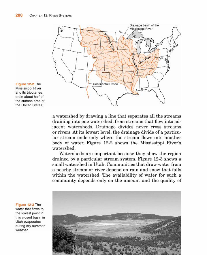
a watershed by drawing a line that separates all the streamsdraining into one watershed, from streams that flow into ad-jacent watersheds. Drainage divides never cross streamsor rivers. At its lowest level, the drainage divide of a particu-lar stream ends only where the stream flows into anotherbody of water. Figure 12-2 shows the Mississippi River’swatershed.
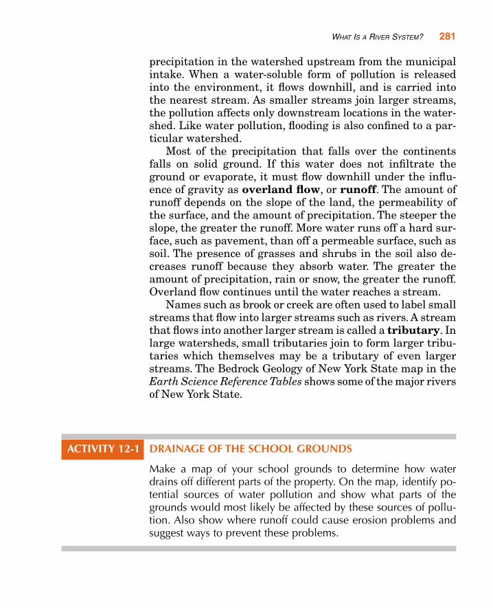
Watersheds are important because they show the regiondrained by a particular stream system. Figure 12-3 shows asmall watershed in Utah. Communities that draw water froma nearby stream or river depend on rain and snow that fallswithin the watershed. The availability of water for such acommunity depends only on the amount and the quality of
Figure 12-2 TheMississippi Riverand its tributariesdrain about half ofthe surface area ofthe United States.
Figure 12-3 Thewater that flows tothe lowest point inthis closed basin inUtah evaporatesduring dry summerweather.
precipitation in the watershed upstream from the municipalintake. When a water-soluble form of pollution is releasedinto the environment, it flows downhill, and is carried intothe nearest stream. As smaller streams join larger streams,the pollution affects only downstream locations in the water-shed. Like water pollution, flooding is also confined to a par-ticular watershed.
Most of the precipitation that falls over the continentsfalls on solid ground. If this water does not infiltrate theground or evaporate, it must flow downhill under the influ-ence of gravity as overland flow, or runoff. The amount ofrunoff depends on the slope of the land, the permeability ofthe surface, and the amount of precipitation. The steeper theslope, the greater the runoff. More water runs off a hard sur-face, such as pavement, than off a permeable surface, such assoil. The presence of grasses and shrubs in the soil also de-creases runoff because they absorb water. The greater theamount of precipitation, rain or snow, the greater the runoff.Overland flow continues until the water reaches a stream.
Names such as brook or creek are often used to label smallstreams that flow into larger streams such as rivers. A streamthat flows into another larger stream is called a tributary. Inlarge watersheds, small tributaries join to form larger tribu-taries which themselves may be a tributary of even largerstreams. The Bedrock Geology of New York State map in theEarth Science Reference Tables shows some of the major riversof New York State.
ACTIVITY 12-1 DRAINAGE OF THE SCHOOL GROUNDS
Make a map of your school grounds to determine how waterdrains off different parts of the property. On the map, identify po-tential sources of water pollution and show what parts of thegrounds would most likely be affected by these sources of pollu-tion. Also show where runoff could cause erosion problems andsuggest ways to prevent these problems.
WHAT IS A RIVER SYSTEM? 281
282 CHAPTER 12: RIVER SYSTEMS
Features of Streams
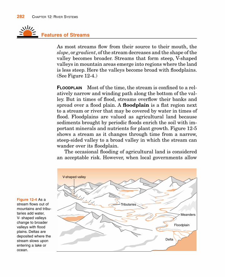
As most streams flow from their source to their mouth, theslope, or gradient, of the stream decreases and the shape of thevalley becomes broader. Streams that form steep, V-shapedvalleys in mountain areas emerge into regions where the landis less steep. Here the valleys become broad with floodplains.(See Figure 12-4.)
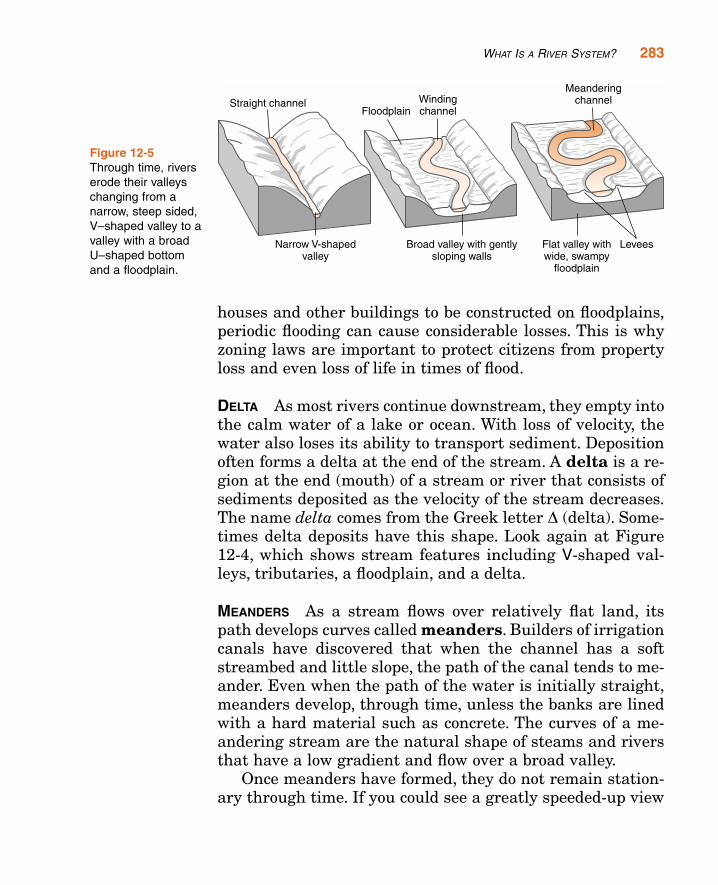
FLOODPLAIN Most of the time, the stream is confined to a rel-atively narrow and winding path along the bottom of the val-ley. But in times of flood, streams overflow their banks andspread over a flood plain. A floodplain is a flat region nextto a stream or river that may be covered by water in times offlood. Floodplains are valued as agricultural land becausesediments brought by periodic floods enrich the soil with im-portant minerals and nutrients for plant growth. Figure 12-5shows a stream as it changes through time from a narrow,steep-sided valley to a broad valley in which the stream canwander over its floodplain.
The occasional flooding of agricultural land is consideredan acceptable risk. However, when local governments allow
Figure 12-4 As astream flows out ofmountains and tribu-taries add water, V- shaped valleyschange to broadervalleys with floodplains. Deltas aredeposited where thestream slows uponentering a lake orocean.
WHAT IS A RIVER SYSTEM? 283
houses and other buildings to be constructed on floodplains,periodic flooding can cause considerable losses. This is whyzoning laws are important to protect citizens from propertyloss and even loss of life in times of flood.
DELTA As most rivers continue downstream, they empty intothe calm water of a lake or ocean. With loss of velocity, thewater also loses its ability to transport sediment. Depositionoften forms a delta at the end of the stream. A delta is a re-gion at the end (mouth) of a stream or river that consists ofsediments deposited as the velocity of the stream decreases.The name delta comes from the Greek letter D (delta). Some-times delta deposits have this shape. Look again at Figure12-4, which shows stream features including V-shaped val-leys, tributaries, a floodplain, and a delta.
MEANDERS As a stream flows over relatively flat land, itspath develops curves called meanders. Builders of irrigationcanals have discovered that when the channel has a softstreambed and little slope, the path of the canal tends to me-ander. Even when the path of the water is initially straight,meanders develop, through time, unless the banks are linedwith a hard material such as concrete. The curves of a me-andering stream are the natural shape of steams and riversthat have a low gradient and flow over a broad valley.
Once meanders have formed, they do not remain station-ary through time. If you could see a greatly speeded-up view
Figure 12-5Through time, riverserode their valleyschanging from anarrow, steep sided,V–shaped valley to avalley with a broadU–shaped bottomand a floodplain.
284 CHAPTER 12: RIVER SYSTEMS
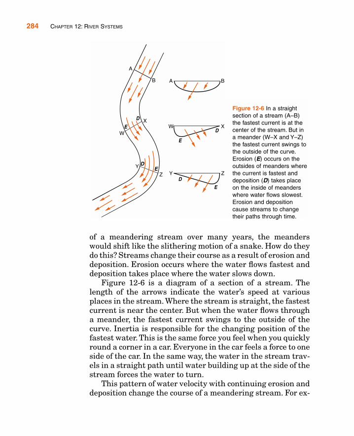
of a meandering stream over many years, the meanderswould shift like the slithering motion of a snake. How do theydo this? Streams change their course as a result of erosion anddeposition. Erosion occurs where the water flows fastest anddeposition takes place where the water slows down.
Figure 12-6 is a diagram of a section of a stream. Thelength of the arrows indicate the water’s speed at variousplaces in the stream. Where the stream is straight, the fastestcurrent is near the center. But when the water flows througha meander, the fastest current swings to the outside of thecurve. Inertia is responsible for the changing position of thefastest water. This is the same force you feel when you quicklyround a corner in a car. Everyone in the car feels a force to oneside of the car. In the same way, the water in the stream trav-els in a straight path until water building up at the side of thestream forces the water to turn.
This pattern of water velocity with continuing erosion anddeposition change the course of a meandering stream. For ex-
Figure 12-6 In a straightsection of a stream (A–B)the fastest current is at thecenter of the stream. But ina meander (W–X and Y–Z)the fastest current swings tothe outside of the curve.Erosion (E) occurs on theoutsides of meanders wherethe current is fastest anddeposition (D) takes placeon the inside of meanderswhere water flows slowest.Erosion and depositioncause streams to changetheir paths through time.
WHAT IS A RIVER SYSTEM? 285
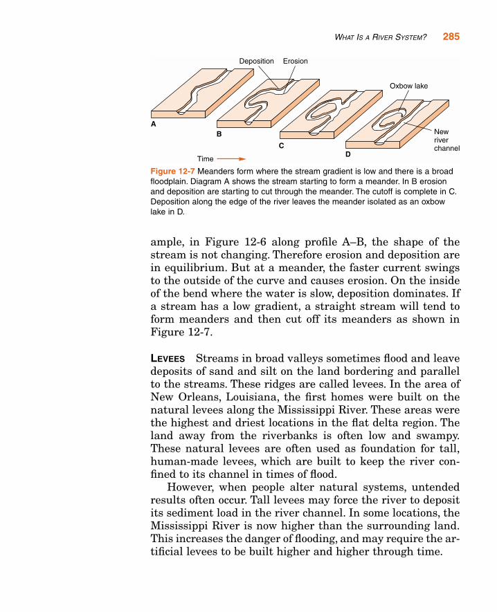
ample, in Figure 12-6 along profile A–B, the shape of thestream is not changing. Therefore erosion and deposition arein equilibrium. But at a meander, the faster current swingsto the outside of the curve and causes erosion. On the insideof the bend where the water is slow, deposition dominates. Ifa stream has a low gradient, a straight stream will tend toform meanders and then cut off its meanders as shown inFigure 12-7.
LEVEES Streams in broad valleys sometimes flood and leavedeposits of sand and silt on the land bordering and parallelto the streams. These ridges are called levees. In the area ofNew Orleans, Louisiana, the first homes were built on thenatural levees along the Mississippi River. These areas werethe highest and driest locations in the flat delta region. Theland away from the riverbanks is often low and swampy.These natural levees are often used as foundation for tall,human-made levees, which are built to keep the river con-fined to its channel in times of flood.
However, when people alter natural systems, untendedresults often occur. Tall levees may force the river to depositits sediment load in the river channel. In some locations, theMississippi River is now higher than the surrounding land.This increases the danger of flooding, and may require the ar-tificial levees to be built higher and higher through time.
Figure 12-7 Meanders form where the stream gradient is low and there is a broadfloodplain. Diagram A shows the stream starting to form a meander. In B erosionand deposition are starting to cut through the meander. The cutoff is complete in C.Deposition along the edge of the river leaves the meander isolated as an oxbowlake in D.
ACTIVITY 12-2 MODELING A STREAM SYSTEM
Materials: stream table, fine sand, or coarse silt
Observe and list characteristics and common features ofstreams that develop on a stream table. How does the path of thestream change through time? Where do erosion and depositionoccur?
HOW DO WE MEASURE STREAMS?
Two aspects of streams that scientists measure are size andvelocity. Size is more than just the length of the stream. Sev-eral factors affect the velocity of a stream.
Stream Size
The size of a stream can be measured in several ways. Onemeasure is the area of its watershed. In general, the larger thedrainage basin, the larger the stream. However, some loca-tions receive more precipitation than others. In a dry region, alarge watershed may only supply water to streams that aredry most of the year. Some watersheds receive so little rainand snow that none of the water in the stream flows out of thewatershed. Streams in these areas run into bodies of waterthat lose their water by evaporation, or the stream water mayseep into the ground before the stream reaches its lowest level.
Stream size is more often measured by finding discharge.Discharge is the amount of water flowing in a stream pasta particular place in a specified time. For example, a smallstream may have discharge of a fraction of a cubic meter persecond. However, the Amazon River in South America, whichhas the greatest discharge of any river on Earth, dischargesabout 200,000 m3 of freshwater into the Atlantic Ocean eachsecond.
286 CHAPTER 12: RIVER SYSTEMS

HOW DO WE MEASURE STREAMS? 287
To measure the discharge of a stream, you need to meas-ure the area of its cross section at a particular location, thenmultiply that value by the velocity of the stream. You can de-termine the area of the cross section by multiplying the av-erage depth of the stream by its width at that point. Area isin units such as square meters. Velocity can be expressed inmeters per second. The product of these values is thereforecubic meters per second. The formula below shows how to cal-culate discharge volume:
Discharge � area of cross section � stream velocity
ACTIVITY 12-3 MEASURING STREAM DISCHARGE
Materials: Device to measure distance, watch, or timer
Use the method in the text above to measure the discharge ofa stream near your school or home. Can you devise a differentmethod to find the discharge in order to verify the first value thatyou obtained?
Streams respond differently to rainfall depending on theirsizes. As you can see in Figure 12-8, large streams are slowerto respond than small streams. This is because the water ina large drainage basin has a greater distance to flow beforeit reaches the major stream. Streams in smaller watersheds
Figure 12-8 Maximumstream discharge occursafter the time of maximumrainfall. In general, smallstreams respond morequickly than do largerstreams because smallstreams have smallerwatersheds.
generally respond quickly because the precipitation does notflow far to reach a small stream.
Stream Velocity
How quickly water flows in a stream is a function of three fac-tors: shape of the stream channel,gradient (slope),and volumeof water. If the stream channel is straight and smooth, watercan flow quickly. But if the stream is flowing through largerocks, the rocks slow the water as it bounces from rock to rock.Many mountain streams are filled with coarse sediment suchas large cobbles and boulders that slow the stream velocity.
The gradient of a stream also determines how quicklywater moves. The force of gravity maintains flow of water.Other factors being equal, the steeper a stream channel, thefaster water will flow.
The third factor is the volume of water flowing in a stream.As the quantity of water in a stream increases, so does thepull of gravity. If the discharge of a stream increases, usuallythe weight of water increases more quickly than the resist-ance of the stream channel. Most streams are steepest at thebeginning of the stream and the gradient decreases as theyflow downstream. But many rivers flow faster as they movedownstream because the increase in the volume of the streamdominates over the reduction in slope.
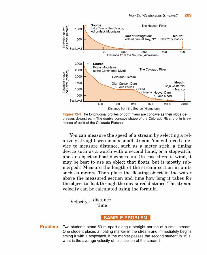
Figure 12-9 shows profiles along the length of the HudsonRiver and the Colorado River. The concave shape of these pro-files is typical of many streams: steeper near their sourcesthan they are near the end of the stream.
WATER VELOCITY
Materials: Stream table or running water and tilted trough to rep-resent a stream bed, meter stick, stop watch, or timer
Determine the influence of gradient and stream discharge onstream velocity. Measure the velocity of the water as the gradientand the discharge are changed. Use your data to explain how gra-dient and discharge affect stream velocity.
ACTIVITY ORDEMONSTRATION
12-4
288 CHAPTER 12: RIVER SYSTEMS
You can measure the speed of a stream by selecting a rel-atively straight section of a small stream. You will need a de-vice to measure distance, such as a meter stick, a timingdevice such as a watch with a second hand, or a stopwatch,and an object to float downstream. (In case there is wind, itmay be best to use an object that floats, but is mostly sub-merged.) Measure the length of the stream section in unitssuch as meters. Then place the floating object in the waterabove the measured section and time how long it takes forthe object to float through the measured distance. The streamvelocity can be calculated using the formula.
SAMPLE PROBLEM
Problem Two students stand 53 m apart along a straight portion of a small stream.One student places a floating marker in the stream and immediately beginstiming it with a stopwatch. If the marker passes the second student in 15 s,what is the average velocity of this section of the stream?
Velocity distancetime
�
HOW DO WE MEASURE STREAMS? 289
Figure 12-9 The longitudinal profiles of both rivers are concave as their slope de-creases downstream. The double concave shape of the Colorado River profile is ev-idence of uplift of the Colorado Plateau.
Solution
Notice that the solution is expressed to two digits, as are the values of timeand distance.
� Practice1. A floating marker takes 21 s to travel 88 m along a straight portion of a
stream. What is the average velocity of this section of the stream?2. The average velocity of a stream is 2.7 m/s. How far will a marker travel
in 16 s?
ACTIVITY 12-5 MEASURING STREAM VELOCITY
Materials: Device to measure distance, watch, or timer
Use the method in the text above to measure the velocity of asmall stream near your school or home. (Note: This should bedone under adult supervision to ensure safety.)
WHAT IS A DRAINAGE PATTERN?
Streams seek the lowest path as they move downhill, andthey tend to erode their beds in places where the ground isweak. Therefore, both topography and geologic structure in-fluence the path streams follow through an area, which wecall the drainage pattern. By looking at a map view of astream, you can often infer the underlying bedrock struc-tures. Figure 12-10 shows the relationship between streampattern and rock structure.
Velocity distancetime
m5 s
�
�
�
53
3 5. /m s
290 CHAPTER 12: RIVER SYSTEMS
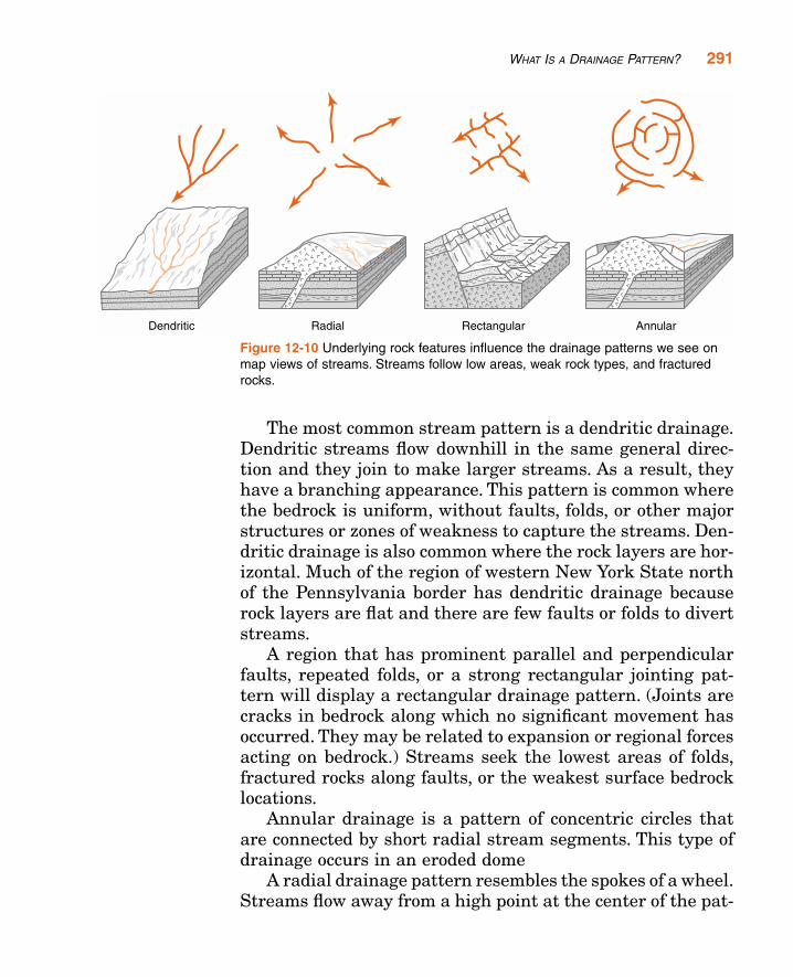
The most common stream pattern is a dendritic drainage.Dendritic streams flow downhill in the same general direc-tion and they join to make larger streams. As a result, theyhave a branching appearance. This pattern is common wherethe bedrock is uniform, without faults, folds, or other majorstructures or zones of weakness to capture the streams. Den-dritic drainage is also common where the rock layers are hor-izontal. Much of the region of western New York State northof the Pennsylvania border has dendritic drainage becauserock layers are flat and there are few faults or folds to divertstreams.
A region that has prominent parallel and perpendicularfaults, repeated folds, or a strong rectangular jointing pat-tern will display a rectangular drainage pattern. (Joints arecracks in bedrock along which no significant movement hasoccurred. They may be related to expansion or regional forcesacting on bedrock.) Streams seek the lowest areas of folds,fractured rocks along faults, or the weakest surface bedrocklocations.
Annular drainage is a pattern of concentric circles thatare connected by short radial stream segments. This type ofdrainage occurs in an eroded dome
A radial drainage pattern resembles the spokes of a wheel.Streams flow away from a high point at the center of the pat-
WHAT IS A DRAINAGE PATTERN? 291
Figure 12-10 Underlying rock features influence the drainage patterns we see onmap views of streams. Streams follow low areas, weak rock types, and fracturedrocks.
tern. Radial drainage may develop on a smooth dome or a vol-canic cone. The Adirondack Mountain region of New York dis-plays radial drainage, although rock structures such as faultsand folds in the Adirondacks alter the regional pattern andmay rake radial drainage hard to observe.
The important point is that the underlying rock typesand geologic structures influence streams, and that differentstructural features produce different patterns of drainage.
TERMS TO KNOW
delta floodplain stream systemdischarge meander tributarydrainage divide overland flow watersheddrainage pattern runoff
CHAPTER REVIEW QUESTIONS
1. Why are streams and rivers with the features of their watersheds calledsystems?
(1) All streams and rivers are the same size.(2) Streams and rivers form straight channels.(3) Different parts contribute the same outcome.(4) The features of one stream system are not found in other stream
systems
2. What name is applied to the outside boundaries of a watershed?
(1) stream channel(2) meander(3) drainage divide(4) tributary
3. Which river is a tributary of the Hudson River?
(1) Delaware River(2) Susquehanna River(3) Mohawk River(4) Genesee River
292 CHAPTER 12: RIVER SYSTEMS
4. Which condition would cause surface runoff to increase in a particularlocation?
(1) covering a dirt road with pavement(2) reducing the gradient of a steep hill(3) planting grasses and shrubs on a hillside(4) having a decrease in the annual rainfall
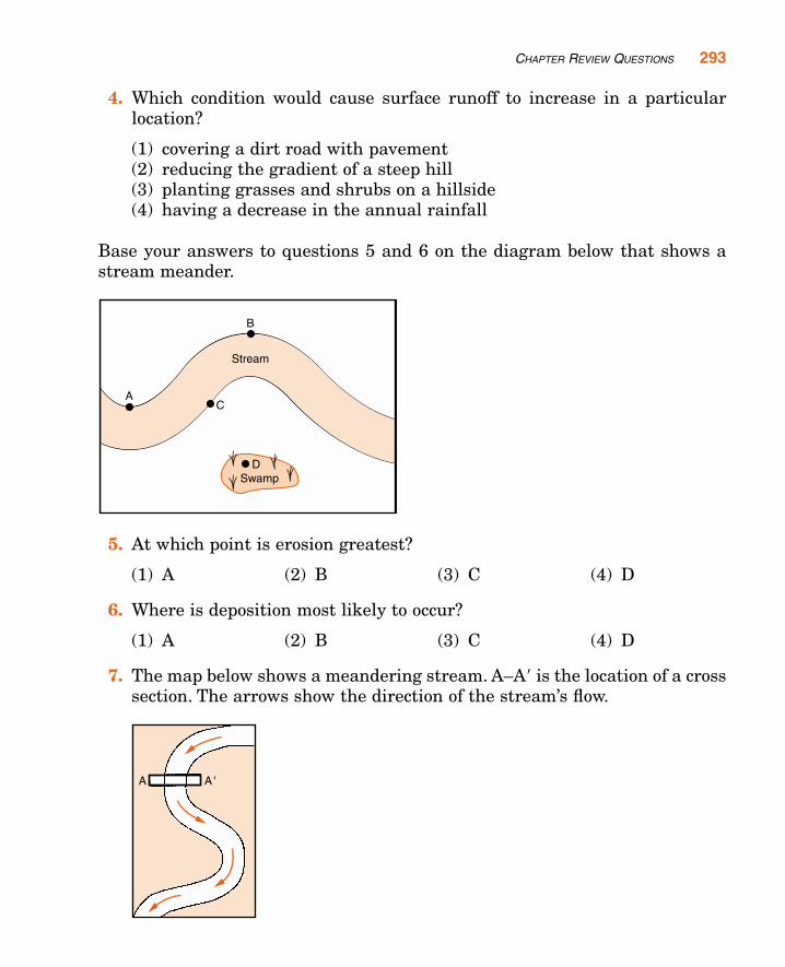
Base your answers to questions 5 and 6 on the diagram below that shows astream meander.
5. At which point is erosion greatest?
(1) A (2) B (3) C (4) D
6. Where is deposition most likely to occur?
(1) A (2) B (3) C (4) D
7. The map below shows a meandering stream. A–A� is the location of a crosssection. The arrows show the direction of the stream’s flow.
CHAPTER REVIEW QUESTIONS 293

Which diagram below best represents the shape of the river bottom atA–A�?
8. Which location along a river is the most likely place for deposition to dom-inate over erosion?
(1) the base of a waterfall(2) the outside of a meander(3) a section of the river where the gradient is steep(4) the delta where the river enters the calm water of an ocean
9. Which of the following changes will cause an increase in the amount of ero-sion in a stream?
(1) an increase in the hardness of bedrock(2) an increase in the stream discharge(3) a decrease in the gradient of the stream(4) a decrease in the average temperature
10. Which change would cause an increase in stream velocity?
(1) an increase in the concentration of dissolved solids in the water(2) an increase in the volume of water flowing in the stream(3) a decrease in the slope of the stream(4) a decrease in the temperature of the water
11. Which change would be most likely to increase velocity of water flowing ina river?
(1) a decrease in gradient (3) an increase in latitude(2) a decrease in rainfall (4) an increase in discharge
294 CHAPTER 12: RIVER SYSTEMS
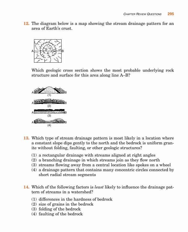
12. The diagram below is a map showing the stream drainage pattern for anarea of Earth’s crust.
Which geologic cross section shows the most probable underlying rockstructure and surface for this area along line A–B?
13. Which type of stream drainage pattern is most likely in a location wherea constant slope dips gently to the north and the bedrock is uniform gran-ite without folding, faulting, or other geologic structures?
(1) a rectangular drainage with streams aligned at right angles(2) a branching drainage in which streams join as they flow north(3) streams flowing away from a central location like spokes on a wheel(4) a drainage pattern that contains many concentric circles connected by
short radial stream segments
14. Which of the following factors is least likely to influence the drainage pat-tern of streams in a watershed?
(1) differences in the hardness of bedrock(2) size of grains in the bedrock(3) folding of the bedrock(4) faulting of the bedrock
CHAPTER REVIEW QUESTIONS 295
296 CHAPTER 12: RIVER SYSTEMS
15. Mercury was found in water wells of a small community. What was themost probable source area of the mercury?
(1) rainfall in a different watershed(2) a waste dump in a different watershed(3) a factory upstream in the same watershed(4) a housing development downstream in the same watershed
Open-Ended Questions
16. What are the principal functions of any stream system?
17. Why are low areas near rivers better suited for farmland and growingcrops than they are for use as home sites.
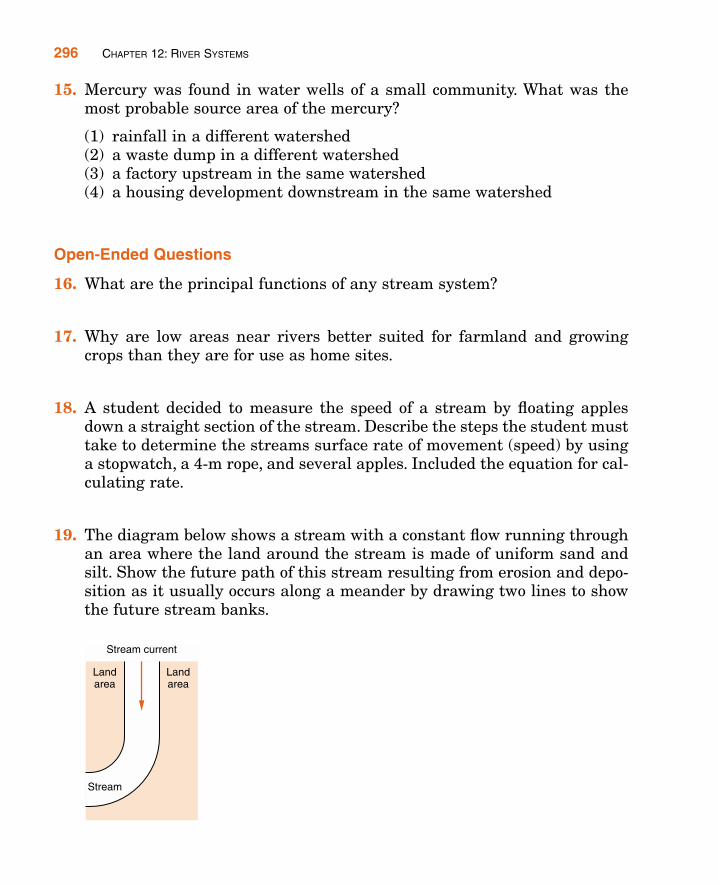
18. A student decided to measure the speed of a stream by floating applesdown a straight section of the stream. Describe the steps the student musttake to determine the streams surface rate of movement (speed) by usinga stopwatch, a 4-m rope, and several apples. Included the equation for cal-culating rate.
19. The diagram below shows a stream with a constant flow running throughan area where the land around the stream is made of uniform sand andsilt. Show the future path of this stream resulting from erosion and depo-sition as it usually occurs along a meander by drawing two lines to showthe future stream banks.
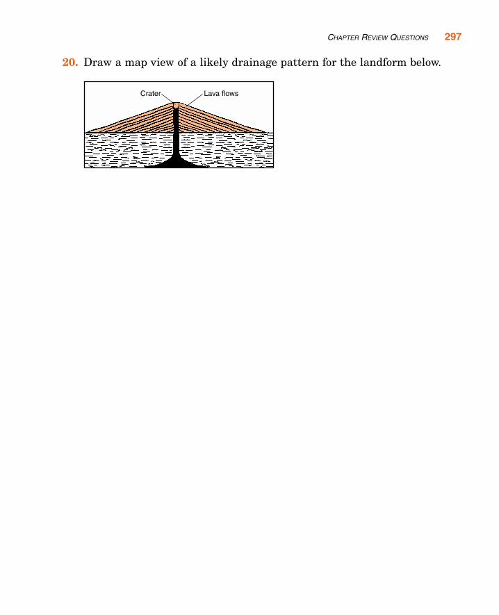
20. Draw a map view of a likely drainage pattern for the landform below.
CHAPTER REVIEW QUESTIONS 297