Embed Size (px)
Citation preview
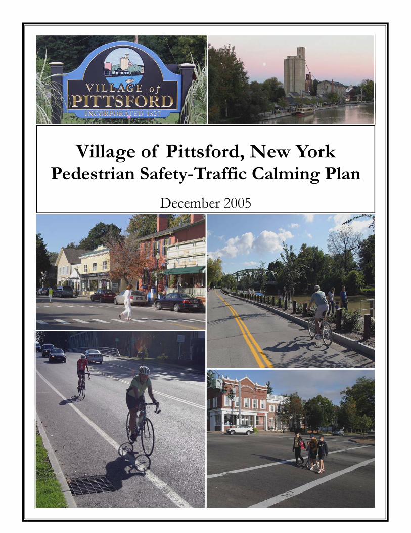
Village of Pittsford, New York Pedestrian Safety-Traffic Calming Plan
December 2005
Village of Pittsford Pedestrian Safety – Traffic Calming Plan
CONTENTS
» Introduction ……………………………………………………...…..... 1
» General Principles ……………………………………………...…..… 2
» Index Map of Study Locations ………………………………...…….... 6
» Concept Pages 1. Four Corners ……………………………………………………………. 7 2. Jefferson Road- Eastern Gateway ……………………………………… 8 3. Monroe Avenue- Western Gateway ……………………………...……. 9 4. State Street- Eastern Gateway …………………………………….…... 10 5. Jefferson Road & Sutherland Street- Western Gateway ………….…... 11 6. South Main Street & Jefferson Road ……………………………….….. 12 7. North Main Street & Washington Road …………………...…….……. 13 8. North Main Street between Washington and Schoen …………..….… 14 9. North Main Street between Schoen and north of Four Corners ….….. 16
10. Schoen Place- West End (at North Main) …………...……….……….. 18 11. Schoen Place- East End (at State) ………………………………….….. 19 12. Schoen Place- Coal Tower Area …………………………………….… 20 13. South Street …………………………………………………………….. 21 14. Boughton Avenue & South Street ……………………………………... 22 15. Washington Road …………………………………………………….... 23 Village Arterials ……………………….…………………………………….... 24 Local Residential Streets ………………………………….………………..… 25
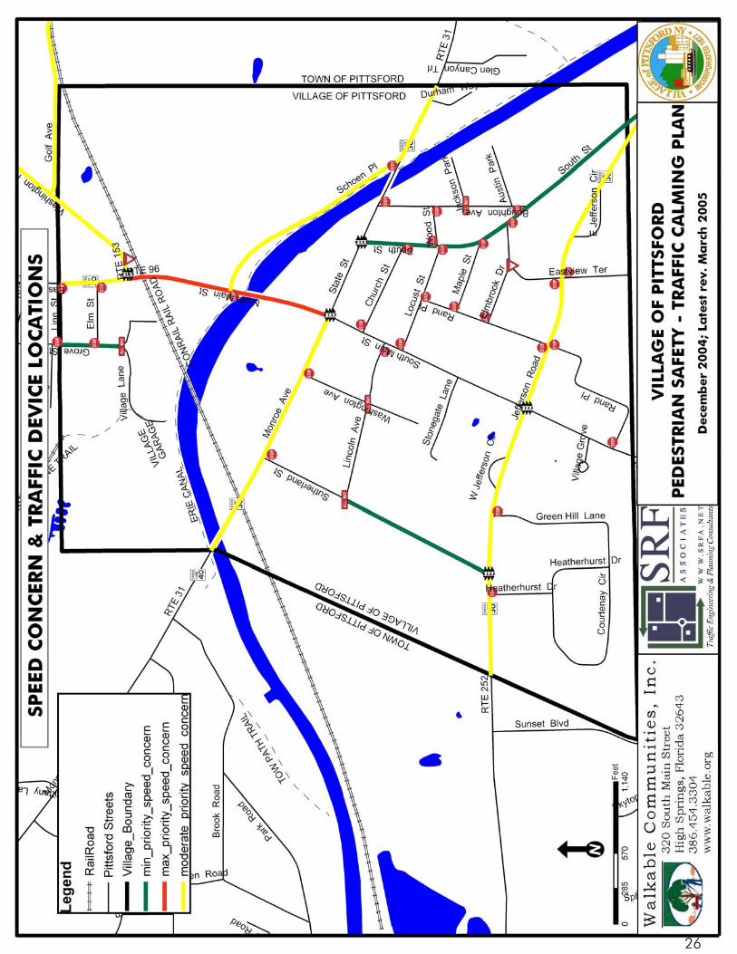
» Map of Speed Concern and Traffic Device Locations ………….….. 26
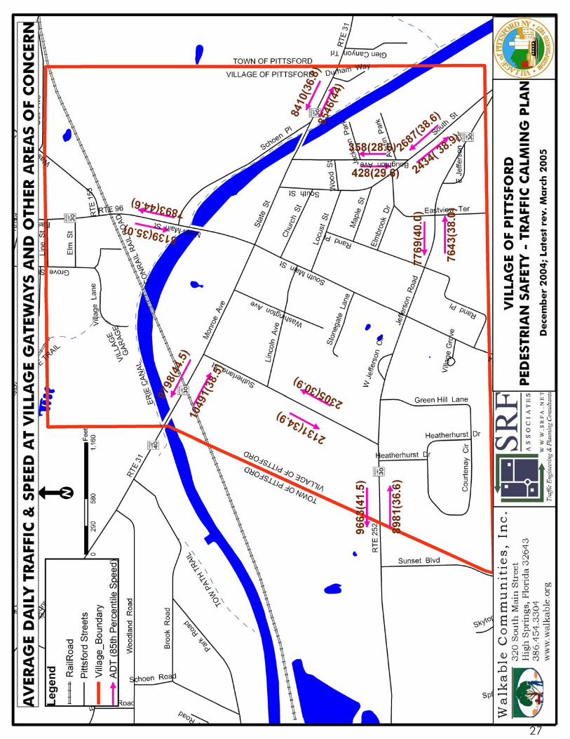
» Map of Average Daily Traffic and Speed at Village Gateways and other Areas of Concern ……………………………………..…... 27
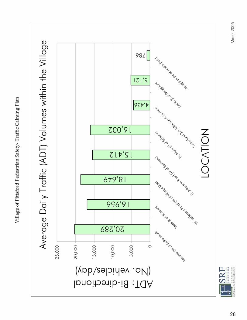
» Graph of Average Daily Traffic ……………………………...…..…. 28
» Graph of Vehicular Speed …………………………………...…...… 29
» Table of Speed Study Results …………………………………......… 30
» List of Intersection Priority Rankings ……………………………..….. 31
Traffic Calming Introduction The Village’s Comprehensive Plan, completed in 2002, identified the implementation of traffic calming measures as an important Village priority. The Village of Pittsford Board of Trustees has developed a comprehensive traffic‐calming plan for the Village of Pittsford to:
1. Improve pedestrian safety.
2. Encourage safer driver behavior.
3. Reduce vehicular speeds.
4. Enhance the walk‐ability of Village streets.
5. Restore the village’s historic visual quality and the historic functional aspect of village streets as public civic spaces accommodating a variety of uses.
6. Bolster the economic viability of the Village’s pedestrian oriented business district.
7. Improve village residents’ quality of life.
8. Stabilize and/or improve the value of real estate located along busy village streets.
9. Boost the desirability of the Village as a destination for Pittsford residents and visitors.
10. Remove areas of excessive pavement that encourage speeding.
11. Increase available on‐street parking. The Plan addresses the objectives through a variety of proven techniques to calm traffic, including changes in street alignment, landscaping, appropriate street furniture, installation of barriers and other physical measures, and improved crosswalk identification. The Plan was developed with the help of Dan Burden, a nationally recognized authority on traffic calming from Walkable Communities, Inc., High Springs, Florida and Stephen Ferranti of SRF & Associates, Rochester, New York. The public provided input at a public workshop in September 2004 and public hearings held in July and September of 2005.1 At the final hearings, over forty individual comments from residents indicated strong community support for the plan. Residents provided insightful observations about specific problem areas as well as input toward identifying the most important priorities for implementation. 1 Refer to the Village of Pittsford Board of Trustees Minutes for the meetings held on July 12, 2005 and September 13, 2005. Minutes are available for inspection at the Village of Pittsford Office located at 21 North Main Street and are also posted on the Village’s website at http://www.villageofpittsford.org.
1
General Principles The design of village streets is fundamentally different from standard suburban street design so prevalent today. The village contains an interconnected network of streets and sidewalks that disperse vehicular trips and makes human‐powered modes of travel (such as walking and biking) practical, safe, and attractive for short trips.
1. Vehicular speeds ‐ Design speeds for conventional suburban neighborhood streets range from a minimum of 25 or 30 mph to 45 mph. The design speed recognizes the type of facility (local, collector, or arterial), and it allows for a standard 5‐ or 10‐mph ʺmargin of safetyʺ above the 85th percentile speed, which is usually the posted speed. Often, the signing of wide streets for 25 to 35 mph simply results in more speed violations. It is not unusual for neighbors to complain of speeding traffic on neighborhood streets and to request actions to slow the traffic. Stop signs, speed bumps, ʺChildren at Playʺ signs, and the like may have to be used to slow vehicles from the original design speed of the street.
In a village, speeds are controlled through careful design of streets and the streetscape. Minimum street design speeds are 15 to 20 mph. On‐street parking, narrow street widths, and special design treatments help induce drivers to stay within the speed limits. At slower speeds, the frequency of vehicular accidents declines, and those that do occur are less severe. In the Village, the goal is to create more ʺactiveʺ streetscapes, involving more of the factors that slow drivers. These include parked cars; narrow street width; and eye contact between pedestrians, bicyclists, and drivers. The overall impact of these elements of design is enhancement of the mutual awareness of drivers and pedestrians. Thus, many professionals believe that in a traditional village setting, drivers are more likely to expect pedestrians and avoid them in emergency situations.
2. Street‐design ‐ In suburban neighborhoods, street type, width, and design speed are based on projected vehicle volumes and types. The larger the vehicle permitted on the street according to local regulations, the wider the street. The focus is on motorized vehicles, often to the exclusion of pedestrians, other transportation modes such as bicycles, and other considerations of the community environment.
Typical suburban lane widths per direction are 12 feet, while exclusive turn lanes may be 10 feet or less. Depending on whether or not parking is permitted, two‐lane local street widths vary from 22 to 36 feet, while two‐lane collector streets vary from 36 to 40 feet. In many suburban jurisdictions, the minimum street width must
2
accommodate cars parked on both sides, an emergency vehicle with its outriggers, and one open travel lane. These ʺpossible usesʺ instead of ʺreasonably expected usesʺ lead to a worst‐case design scenario, an excessively wide street, and probable higher travel speeds. In contrast to suburban street design, the width of village streets is determined by the projected volumes and types of all the users of the street, including pedestrians. The typical village street has two lanes, one for each direction, and space for parking on at least one side. The resulting minimum width may be as narrow as 28 to 30 feet. If the Village encourages narrower streets with parking, then vehicles will naturally slow and stop for parking maneuvers and for larger approaching or turning vehicles that may encroach on the other lane. A fundamental concept of the Village’s traffic calming plan is that drivers must be more watchful (as they usually are in central business district (CBD) areas) and, once more watchful, drivers expect to and do stop more frequently. To alert drivers to the relative change in importance between vehicles and pedestrians, they must be warned at village gateways. This warning must be more than signs. Narrower streets; buildings closer to the street; parked cars; smaller signs; and the generally smaller, much greater visual detail of a pedestrian‐scale streetscape all serve as good notice to the visitor. Curb radii in suburban neighborhoods match expected vehicle type, turning radius, and speed to help ensure in‐lane turning movements if possible. In order to accommodate the right‐hand turning movements of a tractor trailer (WB 40) and larger vehicles, no matter what their frequency of street use, suburban streets typically have minimum intersection curb radii of 25 to 35 feet. Some jurisdictions require 50 feet or more. What such large curb radii do for smaller, more predominant vehicles is to encourage rolling stops and higher turning speeds. These conditions increase the hazards for crossing pedestrians. The large curb radii effectively increase the width of the street, the pedestrian crossing time, and the exposure of pedestrians to vehicles. Village curb radii are usually in the range of 10 to 15 feet. They depend on the types of vehicles that most often use the street, not the largest expected vehicle. The impacts on pedestrians, parking spaces, and turning space for larger vehicles are also considered. The smaller the curb radii, the less exposure a crossing pedestrian has. Furthermore, an additional parking space or two may extend toward the
3
intersection with small curb radii, or if parking is prohibited, additional room for turning vehicles is created.
Many manuals detail conventional intersection design and analysis for suburban developments (AASHTO, 1990). Such intersections are designed for an environment in which the automobile is dominant. Hence, traffic engineers attempt to maximize intersection capacity, vehicle speed, and safety. They also aim to minimize vehicle delay and construction cost. As a result of the hierarchical approach to street system design, which carries traffic from narrow local streets to larger collectors and arterials, intersection size and complexity grow with the streets they serve. Drivers of these streets expect an ordered structure and any anomalous designs present safety problems.
In a village setting, the concept of connected patterns of narrow, well designed streets is intended to improve community access in spite of low design speeds. The numerous streets provide more route choices to destinations and tend to disperse traffic. In concept, the more numerous, smaller streets also mean smaller, more numerous, less congested intersections. Again, due to slower vehicular speeds, and greater driver awareness, village intersection designs are typically different from suburban designs.
3. Street Trees and Landscaping – Typical contemporary subdivision standards and roadway design practice strictly control the size and location of street trees and other plantings. Some local regulations may even prohibit trees and other plantings near the street. These guidelines originated with the precedent of the ʺforgiving roadwayʺ that arose through tort actions. They generally place trees far from the edge of high‐speed roads to reduce the chance of serious accidents if vehicles swerve off the road.
In a village setting, trees and landscaping form an essential element of the streetscape. The relationship of vertical height to horizontal width of the street is an important part of creating a properly configured space or ʺoutdoor room.ʺ While providing shade and lowering street and sidewalk temperatures, trees create a sense of closure in a vertical plane.
4. Street Lighting – Conventional current design practice calls for large, efficient luminaires on high poles spaced at relatively large distances. Their purpose is not only to illuminate the nighttime street for safer vehicle operation, but also to improve pedestrian and neighborhood security.
4
Street lighting in the village serves the same purposes as that in suburban neighborhoods. However, the intensity and location of the lights are on a more pedestrian scale and are historically compatible with the district they are located in. Smaller, less intense luminaires are often less obtrusive to adjacent properties and allow the nighttime sky to be seen. They only illuminate the streetscape as intended.
5. Sidewalk Width and Location ‐ Sidewalks in suburban neighborhoods are typically
located on one side of the street. While they may lie parallel to the street, they may also meander within the right‐of‐way or lie entirely outside of it. They may also be located adjacent to the curb.
In the Village sidewalks are intended to keep walking as convenient as possible, and this results in shorter distances when sidewalks remain parallel to the street. The focus is on a safe and pleasant walking experience. The typical minimum sidewalk width is 5 feet because this distance allows two pedestrians to comfortably walk side‐by‐side. In residential areas, particularly on busier streets, a grass median (ideally at least eight feet wide) is planted with regularly spaced shade trees. The trees and median provide an important buffer between pedestrians and moving vehicles. In the central business district, sidewalks are often wider to accommodate a greater density of pedestrians. Although the grass median may not be present, the street trees serve an important of the streetscape.
6. Parking – In today’s world, the importance of parking cannot be over‐emphasized because nearly all trips are by car. In conventional design, off‐street parking is preferred; indeed, large parking lots immediately adjacent to the street give a certain status to retail and commercial establishments.
The Village of Pittsford encourages on‐street parking. Parked vehicles enhance pedestrian activity by creating a buffer between pedestrians and moving traffic. The presence of parked cars slows moving traffic so that any accidents that do occur are less severe. Parked cars activate the streetscape and thus makes drivers more alert to pedestrians.
5
6
Village of Pittsford, New York Pedestrian Safety ‐ Traffic Calming Plan
December 2004 rev. March, April, June 2005, latest rev. Sept. 2005
1. FOUR CORNERS MONROE AVENUE, STATE STREET, NORTH MAIN, AND SOUTH MAIN STREETS
Background The “Four Corners” intersection of Monroe, State, and Main Streets North and South is a focal point of the village; it’s a cen-ter for village retail and commercial activity. Main Street (NYS Route 96) and Monroe Avenue/State Street (NYS Route 31) are also two arterial state travel routes that service local and inter-community traffic. In this role, the Four Corners intersection experiences significant and competing vehicular and pedestrian traffic. Traffic volumes on all approaches are heavy, ranging from over 20,000 vehicles per day (vpd) on Monroe Avenue to approximately 16,000 vpd on North Main Street. Parallel on-street parking is mostly available on South Main Street and State Street. No parking or minimal time-limited parking exists on North Main and Monroe Avenue, respectively.
Concerns High approach speeds for turning motorists, particularly southbound lefts on N. Main and eastbound rights on Monroe
Overall conflict between right-turns and crossing pedestrians; No Turn On Red restrictions on all approaches compound the vehicular/pedestrian conflict
Red-light running
Recommended Tools Enhanced ladder/piano key type crosswalk treatment
New mast arm traffic signal installations for improved visibility and safety
Consolidated access and shorter eastbound right-turn lane on eastbound approach of intersection
Time-limited parking on the north side of State Street
Diagonal parking on S. Main Street and a modern roundabout were considered but dismissed after further review
Estimated Cost Enhanced crosswalk treatment: $3,000
New mast arm traffic signal installations: $50,000
EXISTING PRELIMINARY CONCEPT
7
Village of Pittsford, New York Pedestrian Safety ‐ Traffic Calming Plan
December 2004 rev. March, April, June 2005, latest rev. Sept. 2005
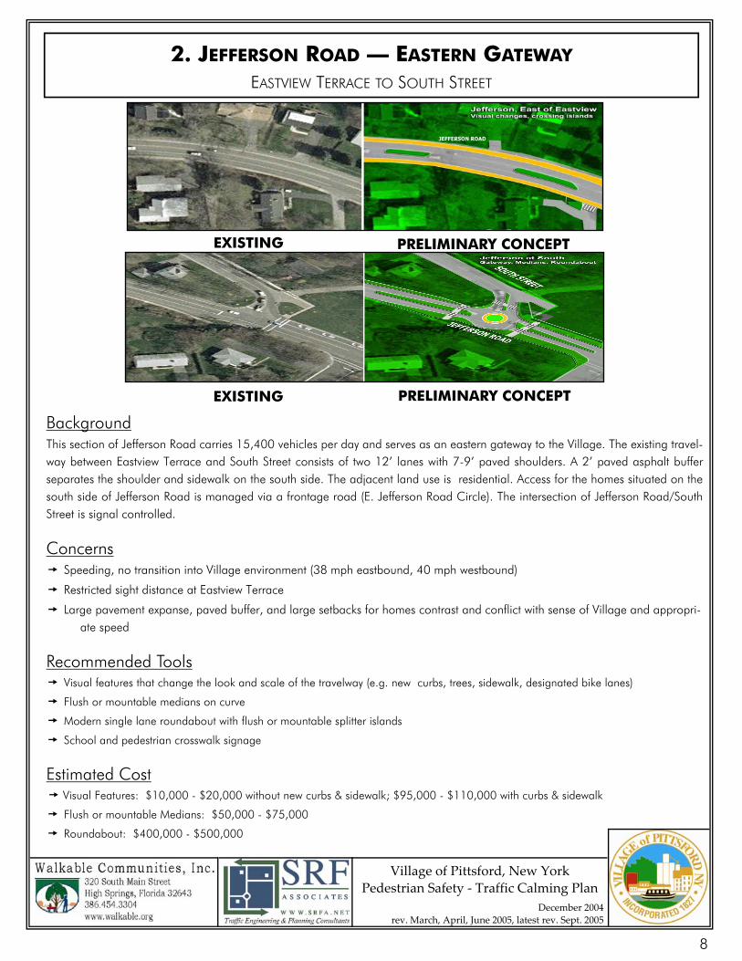
2. JEFFERSON ROAD — EASTERN GATEWAY EASTVIEW TERRACE TO SOUTH STREET
Background This section of Jefferson Road carries 15,400 vehicles per day and serves as an eastern gateway to the Village. The existing travel-way between Eastview Terrace and South Street consists of two 12’ lanes with 7-9’ paved shoulders. A 2’ paved asphalt buffer separates the shoulder and sidewalk on the south side. The adjacent land use is residential. Access for the homes situated on the south side of Jefferson Road is managed via a frontage road (E. Jefferson Road Circle). The intersection of Jefferson Road/South Street is signal controlled.
Concerns Speeding, no transition into Village environment (38 mph eastbound, 40 mph westbound)
Restricted sight distance at Eastview Terrace
Large pavement expanse, paved buffer, and large setbacks for homes contrast and conflict with sense of Village and appropri- ate speed
Recommended Tools Visual features that change the look and scale of the travelway (e.g. new curbs, trees, sidewalk, designated bike lanes)
Flush or mountable medians on curve
Modern single lane roundabout with flush or mountable splitter islands
School and pedestrian crosswalk signage
Estimated Cost Visual Features: $10,000 - $20,000 without new curbs & sidewalk; $95,000 - $110,000 with curbs & sidewalk
Flush or mountable Medians: $50,000 - $75,000
Roundabout: $400,000 - $500,000
EXISTING PRELIMINARY CONCEPT
EXISTING PRELIMINARY CONCEPT
8
Village of Pittsford, New York Pedestrian Safety ‐ Traffic Calming Plan
December 2004 rev. March, April, June 2005, latest rev. Sept. 2005
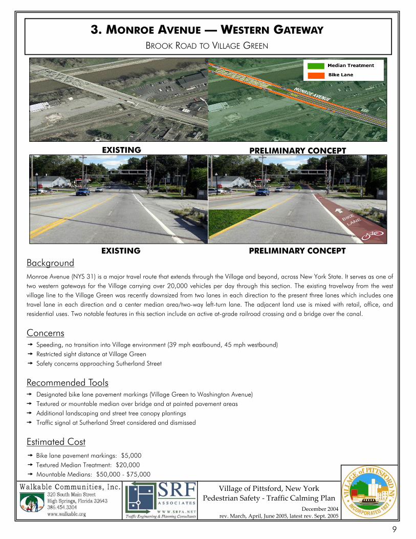
3. MONROE AVENUE — WESTERN GATEWAY BROOK ROAD TO VILLAGE GREEN
Background Monroe Avenue (NYS 31) is a major travel route that extends through the Village and beyond, across New York State. It serves as one of two western gateways for the Village carrying over 20,000 vehicles per day through this section. The existing travelway from the west village line to the Village Green was recently downsized from two lanes in each direction to the present three lanes which includes one travel lane in each direction and a center median area/two-way left-turn lane. The adjacent land use is mixed with retail, office, and residential uses. Two notable features in this section include an active at-grade railroad crossing and a bridge over the canal.
Concerns Speeding, no transition into Village environment (39 mph eastbound, 45 mph westbound) Restricted sight distance at Village Green
Safety concerns approaching Sutherland Street
Recommended Tools Designated bike lane pavement markings (Village Green to Washington Avenue) Textured or mountable median over bridge and at painted pavement areas Additional landscaping and street tree canopy plantings Traffic signal at Sutherland Street considered and dismissed
Estimated Cost Bike lane pavement markings: $5,000 Textured Median Treatment: $20,000 Mountable Medians: $50,000 - $75,000
EXISTING PRELIMINARY CONCEPT
EXISTING PRELIMINARY CONCEPT
9
Village of Pittsford, New York Pedestrian Safety ‐ Traffic Calming Plan
December 2004 rev. March, April, June 2005, latest rev. Sept. 2005
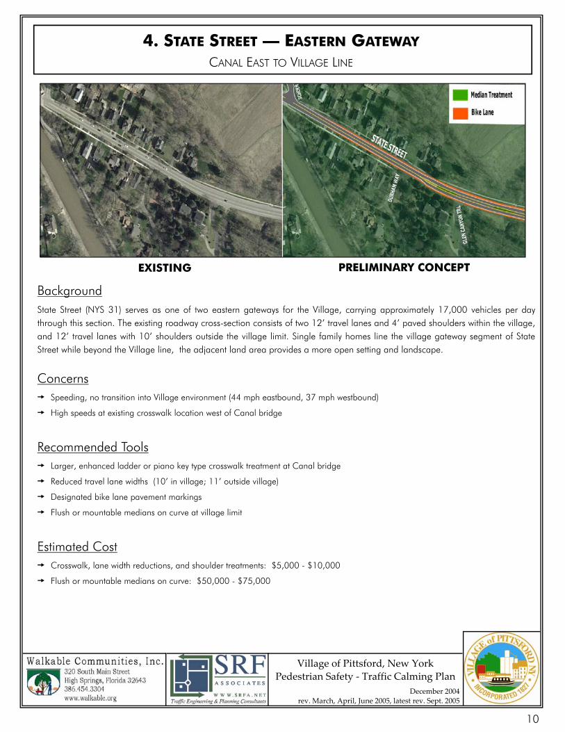
4. STATE STREET — EASTERN GATEWAY CANAL EAST TO VILLAGE LINE
Background State Street (NYS 31) serves as one of two eastern gateways for the Village, carrying approximately 17,000 vehicles per day through this section. The existing roadway cross-section consists of two 12’ travel lanes and 4’ paved shoulders within the village, and 12’ travel lanes with 10’ shoulders outside the village limit. Single family homes line the village gateway segment of State Street while beyond the Village line, the adjacent land area provides a more open setting and landscape.
Concerns Speeding, no transition into Village environment (44 mph eastbound, 37 mph westbound)
High speeds at existing crosswalk location west of Canal bridge
Recommended Tools Larger, enhanced ladder or piano key type crosswalk treatment at Canal bridge
Reduced travel lane widths (10’ in village; 11’ outside village)
Designated bike lane pavement markings
Flush or mountable medians on curve at village limit
Estimated Cost Crosswalk, lane width reductions, and shoulder treatments: $5,000 - $10,000
Flush or mountable medians on curve: $50,000 - $75,000
EXISTING PRELIMINARY CONCEPT
10
Village of Pittsford, New York Pedestrian Safety ‐ Traffic Calming Plan
December 2004 rev. March, April, June 2005, latest rev. Sept. 2005
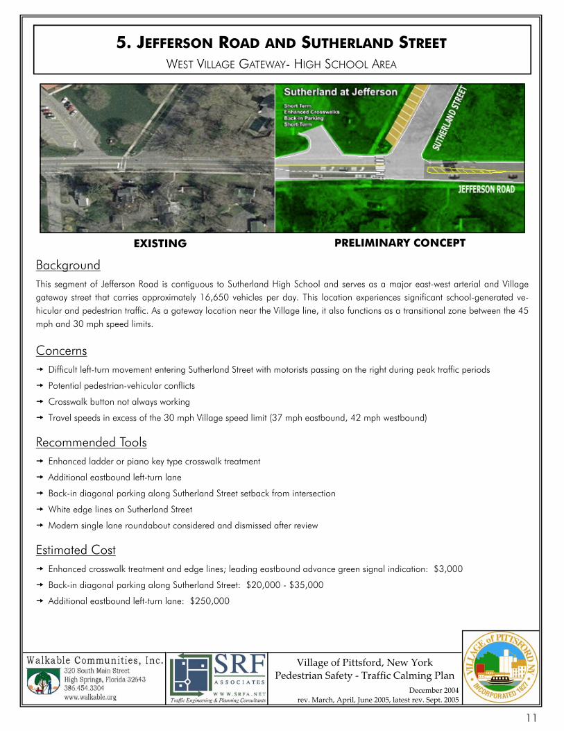
Background This segment of Jefferson Road is contiguous to Sutherland High School and serves as a major east-west arterial and Village gateway street that carries approximately 16,650 vehicles per day. This location experiences significant school-generated ve-hicular and pedestrian traffic. As a gateway location near the Village line, it also functions as a transitional zone between the 45 mph and 30 mph speed limits.
Concerns Difficult left-turn movement entering Sutherland Street with motorists passing on the right during peak traffic periods
Potential pedestrian-vehicular conflicts
Crosswalk button not always working
Travel speeds in excess of the 30 mph Village speed limit (37 mph eastbound, 42 mph westbound)
Recommended Tools Enhanced ladder or piano key type crosswalk treatment
Additional eastbound left-turn lane
Back-in diagonal parking along Sutherland Street setback from intersection
White edge lines on Sutherland Street
Modern single lane roundabout considered and dismissed after review
Estimated Cost Enhanced crosswalk treatment and edge lines; leading eastbound advance green signal indication: $3,000
Back-in diagonal parking along Sutherland Street: $20,000 - $35,000
Additional eastbound left-turn lane: $250,000
5. JEFFERSON ROAD AND SUTHERLAND STREET WEST VILLAGE GATEWAY- HIGH SCHOOL AREA
PRELIMINARY CONCEPT EXISTING
11
Village of Pittsford, New York Pedestrian Safety ‐ Traffic Calming Plan
December 2004 rev. March, April, June 2005, latest rev. Sept. 2005
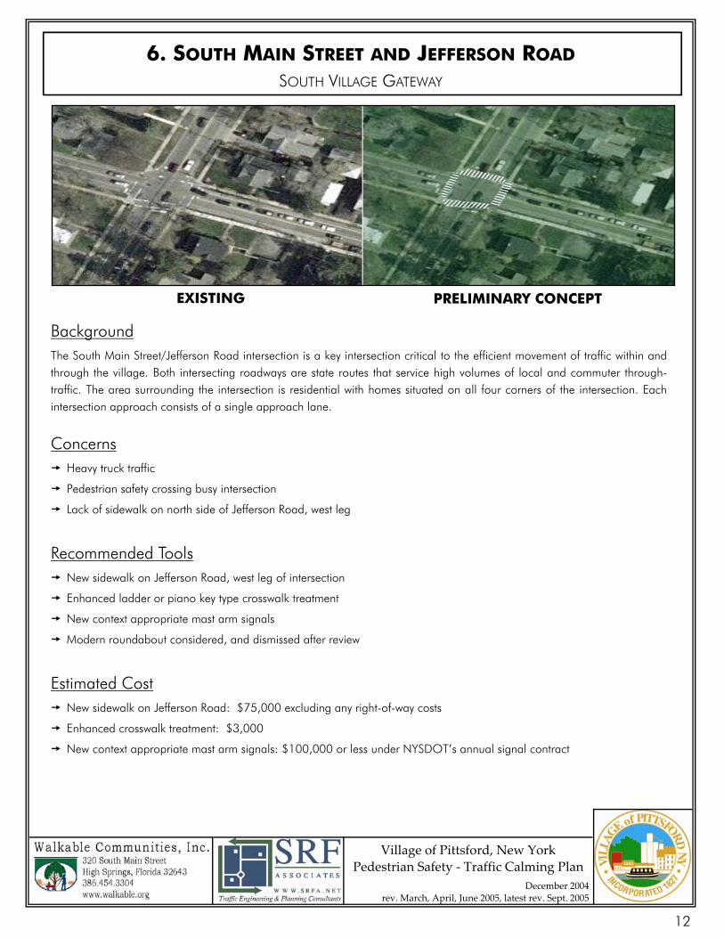
6. SOUTH MAIN STREET AND JEFFERSON ROAD SOUTH VILLAGE GATEWAY
Background The South Main Street/Jefferson Road intersection is a key intersection critical to the efficient movement of traffic within and through the village. Both intersecting roadways are state routes that service high volumes of local and commuter through-traffic. The area surrounding the intersection is residential with homes situated on all four corners of the intersection. Each intersection approach consists of a single approach lane.
Concerns Heavy truck traffic
Pedestrian safety crossing busy intersection
Lack of sidewalk on north side of Jefferson Road, west leg Recommended Tools New sidewalk on Jefferson Road, west leg of intersection
Enhanced ladder or piano key type crosswalk treatment
New context appropriate mast arm signals
Modern roundabout considered, and dismissed after review Estimated Cost New sidewalk on Jefferson Road: $75,000 excluding any right-of-way costs
Enhanced crosswalk treatment: $3,000
New context appropriate mast arm signals: $100,000 or less under NYSDOT’s annual signal contract
EXISTING PRELIMINARY CONCEPT
12
Village of Pittsford, New York Pedestrian Safety ‐ Traffic Calming Plan
December 2004 rev. March, April, June 2005, latest rev. Sept. 2005
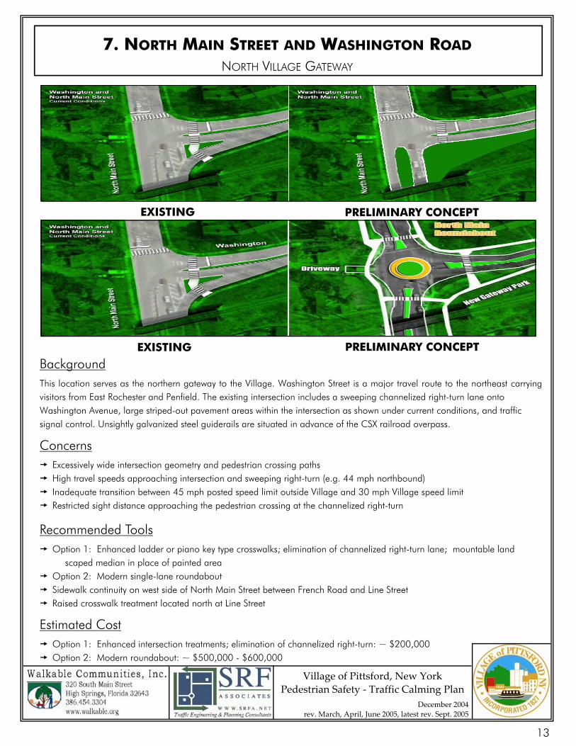
7. NORTH MAIN STREET AND WASHINGTON ROAD NORTH VILLAGE GATEWAY
Background This location serves as the northern gateway to the Village. Washington Street is a major travel route to the northeast carrying visitors from East Rochester and Penfield. The existing intersection includes a sweeping channelized right-turn lane onto Washington Avenue, large striped-out pavement areas within the intersection as shown under current conditions, and traffic signal control. Unsightly galvanized steel guiderails are situated in advance of the CSX railroad overpass.
Concerns Excessively wide intersection geometry and pedestrian crossing paths High travel speeds approaching intersection and sweeping right-turn (e.g. 44 mph northbound) Inadequate transition between 45 mph posted speed limit outside Village and 30 mph Village speed limit Restricted sight distance approaching the pedestrian crossing at the channelized right-turn
Recommended Tools Option 1: Enhanced ladder or piano key type crosswalks; elimination of channelized right-turn lane; mountable land scaped median in place of painted area Option 2: Modern single-lane roundabout Sidewalk continuity on west side of North Main Street between French Road and Line Street Raised crosswalk treatment located north at Line Street
Estimated Cost Option 1: Enhanced intersection treatments; elimination of channelized right-turn: ~ $200,000 Option 2: Modern roundabout: ~ $500,000 - $600,000
EXISTING PRELIMINARY CONCEPT
EXISTING PRELIMINARY CONCEPT
13
Village of Pittsford, New York Pedestrian Safety ‐ Traffic Calming Plan
December 2004 rev. March, April, June 2005, latest rev. Sept. 2005
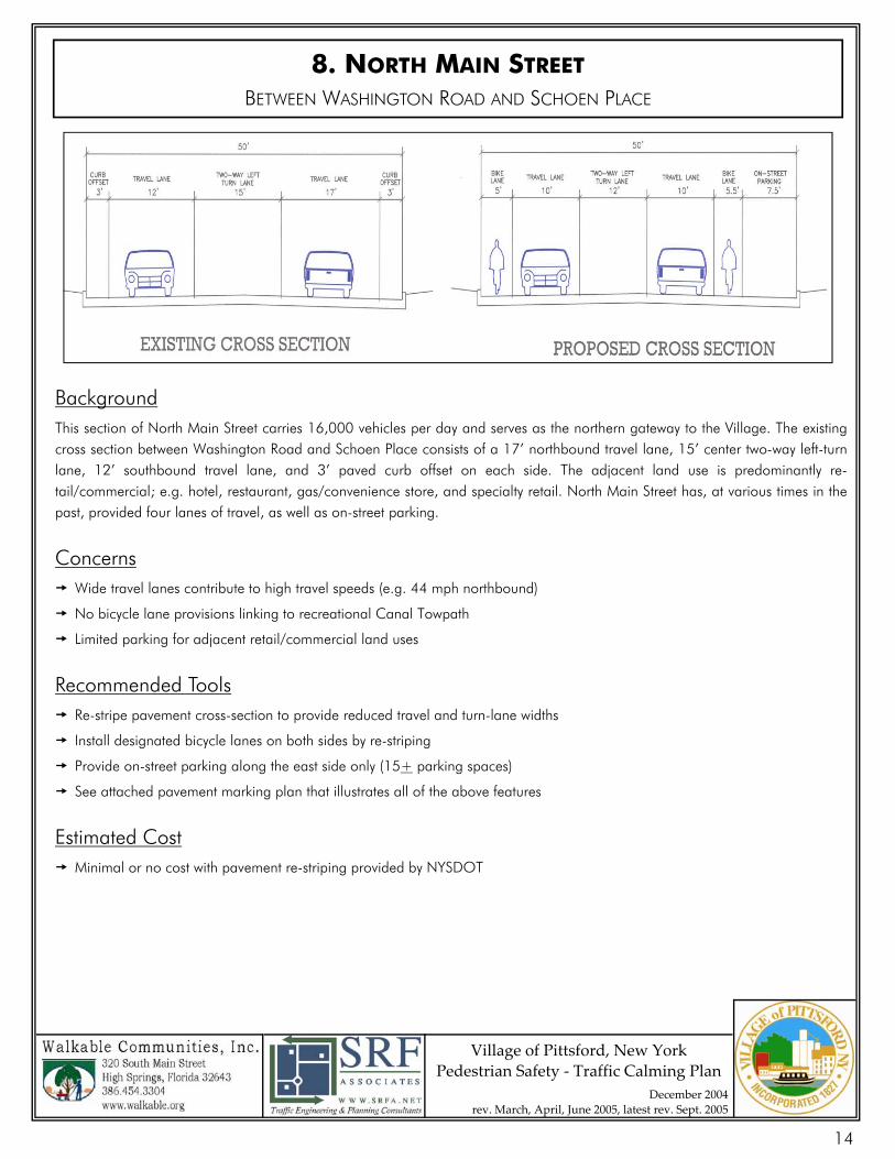
8. NORTH MAIN STREET BETWEEN WASHINGTON ROAD AND SCHOEN PLACE
Background This section of North Main Street carries 16,000 vehicles per day and serves as the northern gateway to the Village. The existing cross section between Washington Road and Schoen Place consists of a 17’ northbound travel lane, 15’ center two-way left-turn lane, 12’ southbound travel lane, and 3’ paved curb offset on each side. The adjacent land use is predominantly re-tail/commercial; e.g. hotel, restaurant, gas/convenience store, and specialty retail. North Main Street has, at various times in the past, provided four lanes of travel, as well as on-street parking.
Concerns Wide travel lanes contribute to high travel speeds (e.g. 44 mph northbound)
No bicycle lane provisions linking to recreational Canal Towpath
Limited parking for adjacent retail/commercial land uses
Recommended Tools Re-stripe pavement cross-section to provide reduced travel and turn-lane widths
Install designated bicycle lanes on both sides by re-striping
Provide on-street parking along the east side only (15+ parking spaces)
See attached pavement marking plan that illustrates all of the above features
Estimated Cost Minimal or no cost with pavement re-striping provided by NYSDOT
14

Village of Pittsford, New York Pedestrian Safety ‐ Traffic Calming Plan
December 2004 rev. March, April, June 2005, latest rev. Sept. 2005
8. NORTH MAIN STREET- PLAN VIEW
BETWEEN WASHINGTON ROAD AND SCHOEN PLACE
15
Village of Pittsford, New York Pedestrian Safety ‐ Traffic Calming Plan
December 2004 rev. March, April, June 2005, latest rev. Sept. 2005
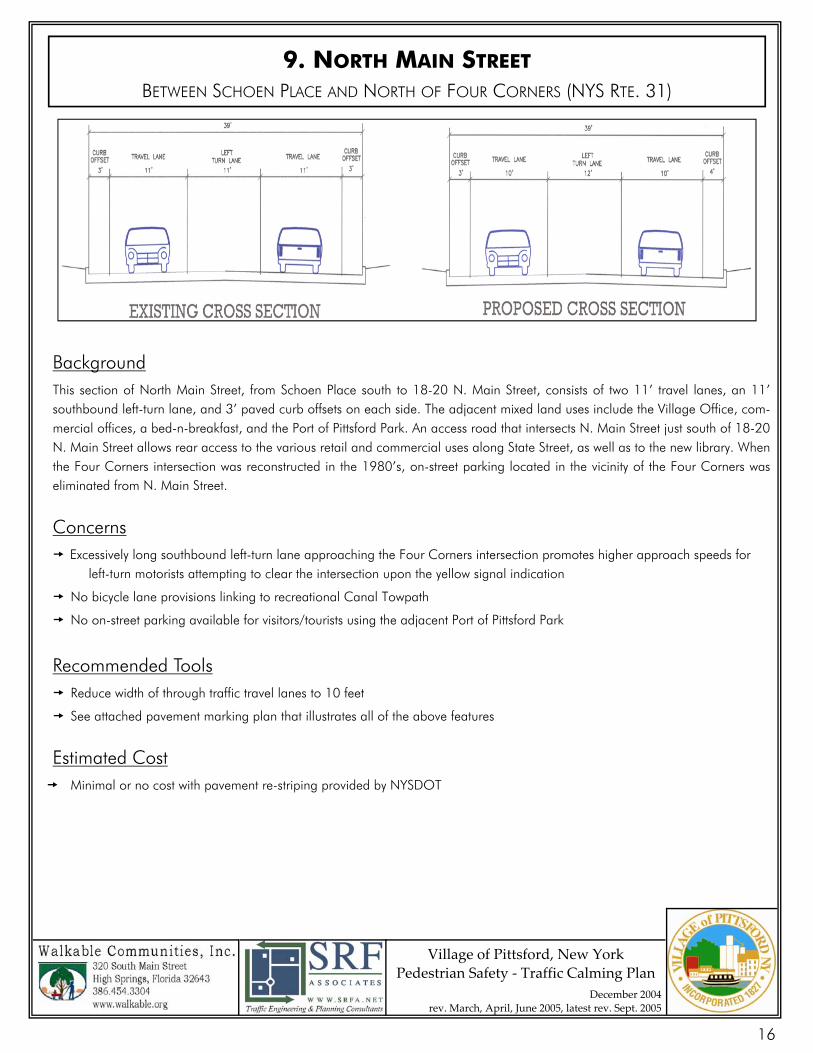
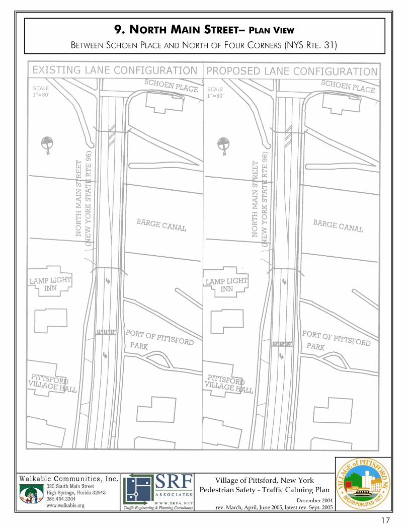
9. NORTH MAIN STREET BETWEEN SCHOEN PLACE AND NORTH OF FOUR CORNERS (NYS RTE. 31)
Background This section of North Main Street, from Schoen Place south to 18-20 N. Main Street, consists of two 11’ travel lanes, an 11’ southbound left-turn lane, and 3’ paved curb offsets on each side. The adjacent mixed land uses include the Village Office, com-mercial offices, a bed-n-breakfast, and the Port of Pittsford Park. An access road that intersects N. Main Street just south of 18-20 N. Main Street allows rear access to the various retail and commercial uses along State Street, as well as to the new library. When the Four Corners intersection was reconstructed in the 1980’s, on-street parking located in the vicinity of the Four Corners was eliminated from N. Main Street.
Concerns Excessively long southbound left-turn lane approaching the Four Corners intersection promotes higher approach speeds for left-turn motorists attempting to clear the intersection upon the yellow signal indication
No bicycle lane provisions linking to recreational Canal Towpath
No on-street parking available for visitors/tourists using the adjacent Port of Pittsford Park
Recommended Tools Reduce width of through traffic travel lanes to 10 feet
See attached pavement marking plan that illustrates all of the above features
Estimated Cost Minimal or no cost with pavement re-striping provided by NYSDOT
16
Village of Pittsford, New York Pedestrian Safety ‐ Traffic Calming Plan
December 2004 rev. March, April, June 2005, latest rev. Sept. 2005
9. NORTH MAIN STREET– PLAN VIEW BETWEEN SCHOEN PLACE AND NORTH OF FOUR CORNERS (NYS RTE. 31)
17
Village of Pittsford, New York Pedestrian Safety ‐ Traffic Calming Plan
December 2004 rev. March, April, June 2005, latest rev. Sept. 2005
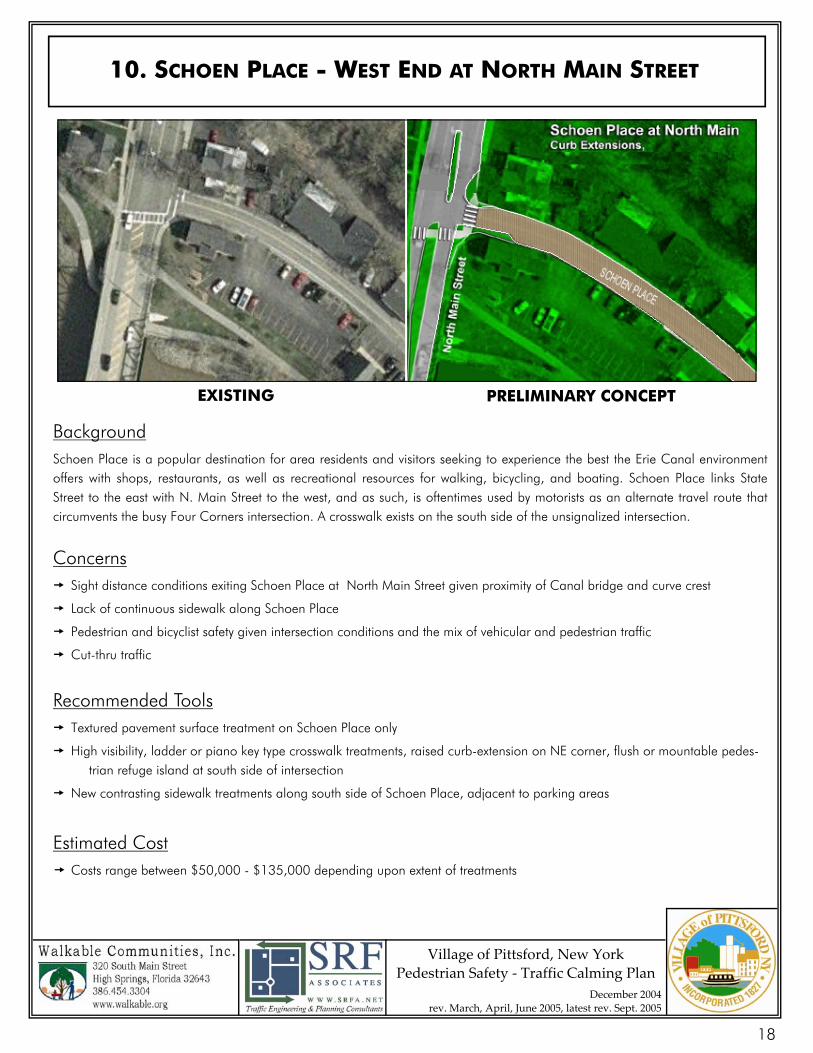
Background Schoen Place is a popular destination for area residents and visitors seeking to experience the best the Erie Canal environment offers with shops, restaurants, as well as recreational resources for walking, bicycling, and boating. Schoen Place links State Street to the east with N. Main Street to the west, and as such, is oftentimes used by motorists as an alternate travel route that circumvents the busy Four Corners intersection. A crosswalk exists on the south side of the unsignalized intersection.
Concerns Sight distance conditions exiting Schoen Place at North Main Street given proximity of Canal bridge and curve crest
Lack of continuous sidewalk along Schoen Place
Pedestrian and bicyclist safety given intersection conditions and the mix of vehicular and pedestrian traffic
Cut-thru traffic
Recommended Tools Textured pavement surface treatment on Schoen Place only
High visibility, ladder or piano key type crosswalk treatments, raised curb-extension on NE corner, flush or mountable pedes- trian refuge island at south side of intersection
New contrasting sidewalk treatments along south side of Schoen Place, adjacent to parking areas
Estimated Cost Costs range between $50,000 - $135,000 depending upon extent of treatments
10. SCHOEN PLACE - WEST END AT NORTH MAIN STREET
EXISTING PRELIMINARY CONCEPT
18
Village of Pittsford, New York Pedestrian Safety ‐ Traffic Calming Plan
December 2004 rev. March, April, June 2005, latest rev. Sept. 2005
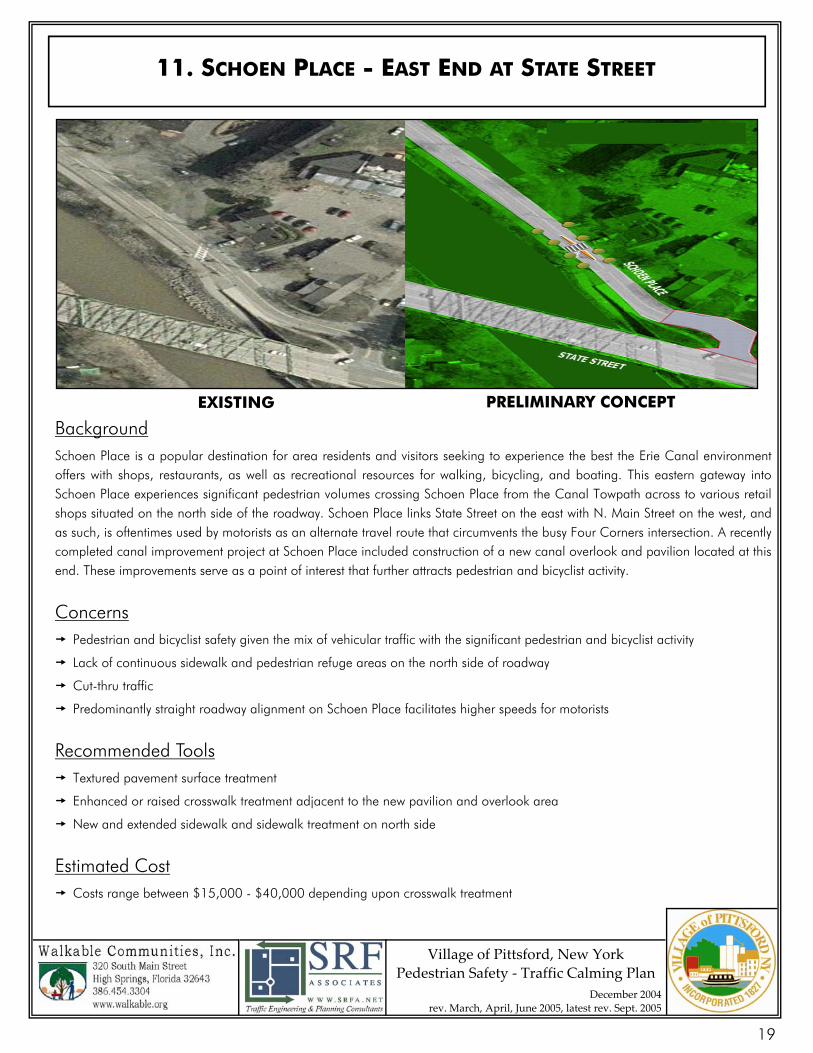
Background Schoen Place is a popular destination for area residents and visitors seeking to experience the best the Erie Canal environment offers with shops, restaurants, as well as recreational resources for walking, bicycling, and boating. This eastern gateway into Schoen Place experiences significant pedestrian volumes crossing Schoen Place from the Canal Towpath across to various retail shops situated on the north side of the roadway. Schoen Place links State Street on the east with N. Main Street on the west, and as such, is oftentimes used by motorists as an alternate travel route that circumvents the busy Four Corners intersection. A recently completed canal improvement project at Schoen Place included construction of a new canal overlook and pavilion located at this end. These improvements serve as a point of interest that further attracts pedestrian and bicyclist activity.
Concerns Pedestrian and bicyclist safety given the mix of vehicular traffic with the significant pedestrian and bicyclist activity
Lack of continuous sidewalk and pedestrian refuge areas on the north side of roadway
Cut-thru traffic
Predominantly straight roadway alignment on Schoen Place facilitates higher speeds for motorists
Recommended Tools Textured pavement surface treatment
Enhanced or raised crosswalk treatment adjacent to the new pavilion and overlook area
New and extended sidewalk and sidewalk treatment on north side
Estimated Cost Costs range between $15,000 - $40,000 depending upon crosswalk treatment
11. SCHOEN PLACE - EAST END AT STATE STREET
EXISTING PRELIMINARY CONCEPT
19
Village of Pittsford, New York Pedestrian Safety ‐ Traffic Calming Plan
December 2004 rev. March, April, June 2005, latest rev. Sept. 2005
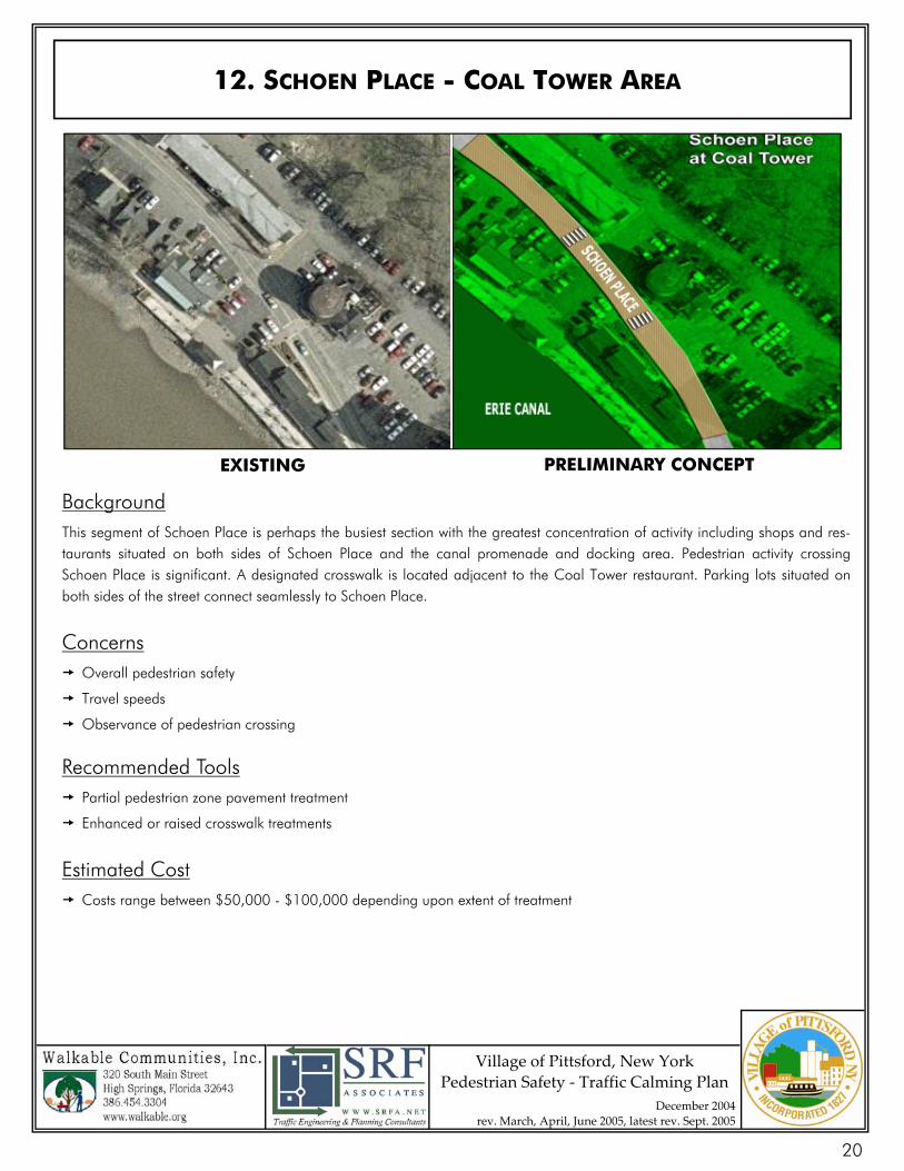
Background This segment of Schoen Place is perhaps the busiest section with the greatest concentration of activity including shops and res-taurants situated on both sides of Schoen Place and the canal promenade and docking area. Pedestrian activity crossing Schoen Place is significant. A designated crosswalk is located adjacent to the Coal Tower restaurant. Parking lots situated on both sides of the street connect seamlessly to Schoen Place.
Concerns Overall pedestrian safety
Travel speeds
Observance of pedestrian crossing
Recommended Tools Partial pedestrian zone pavement treatment
Enhanced or raised crosswalk treatments
Estimated Cost Costs range between $50,000 - $100,000 depending upon extent of treatment
12. SCHOEN PLACE - COAL TOWER AREA
EXISTING PRELIMINARY CONCEPT
20
Village of Pittsford, New York Pedestrian Safety ‐ Traffic Calming Plan
December 2004 rev. March, April, June 2005, latest rev. Sept. 2005
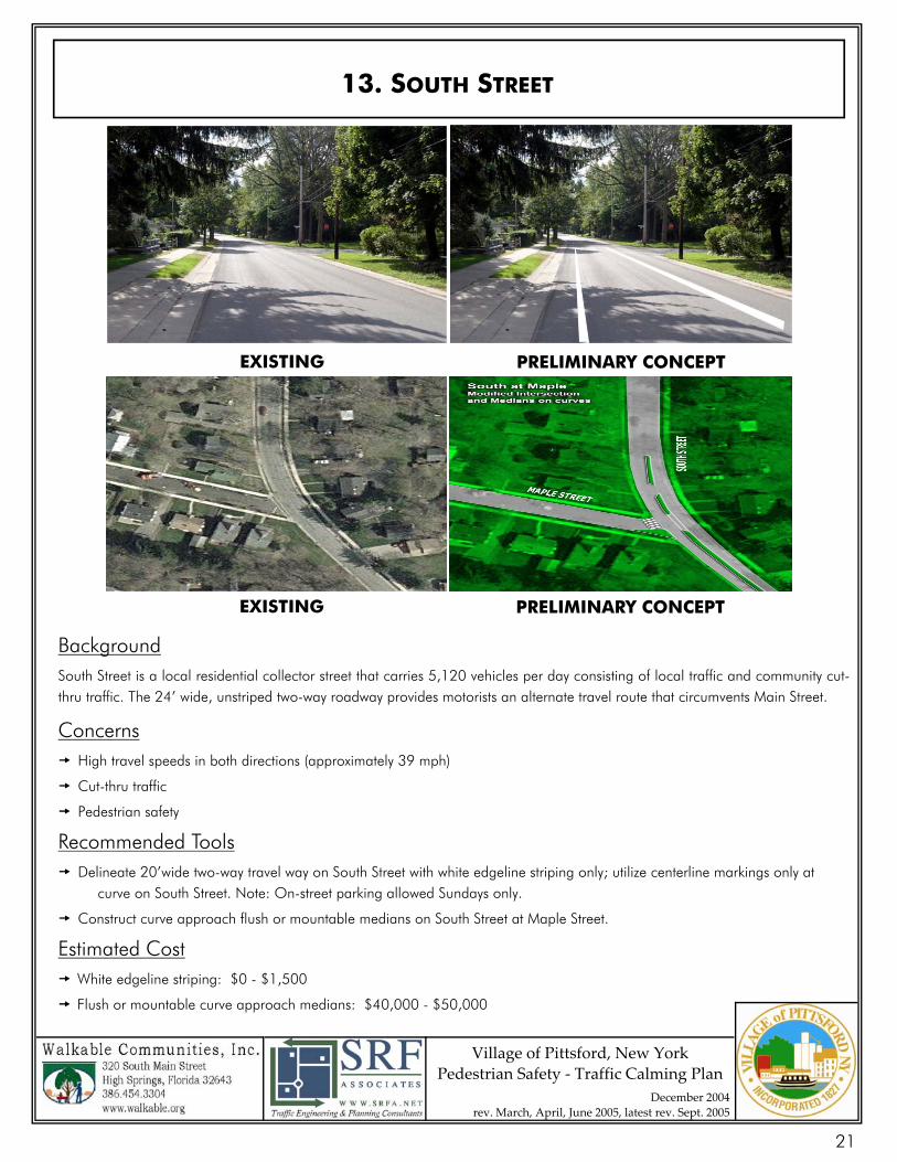
Background South Street is a local residential collector street that carries 5,120 vehicles per day consisting of local traffic and community cut-thru traffic. The 24’ wide, unstriped two-way roadway provides motorists an alternate travel route that circumvents Main Street.
Concerns High travel speeds in both directions (approximately 39 mph)
Cut-thru traffic
Pedestrian safety
Recommended Tools Delineate 20’wide two-way travel way on South Street with white edgeline striping only; utilize centerline markings only at curve on South Street. Note: On-street parking allowed Sundays only.
Construct curve approach flush or mountable medians on South Street at Maple Street.
Estimated Cost White edgeline striping: $0 - $1,500
Flush or mountable curve approach medians: $40,000 - $50,000
13. SOUTH STREET
EXISTING PRELIMINARY CONCEPT
EXISTING PRELIMINARY CONCEPT
21
Village of Pittsford, New York Pedestrian Safety ‐ Traffic Calming Plan
December 2004 rev. March, April, June 2005, latest rev. Sept. 2005
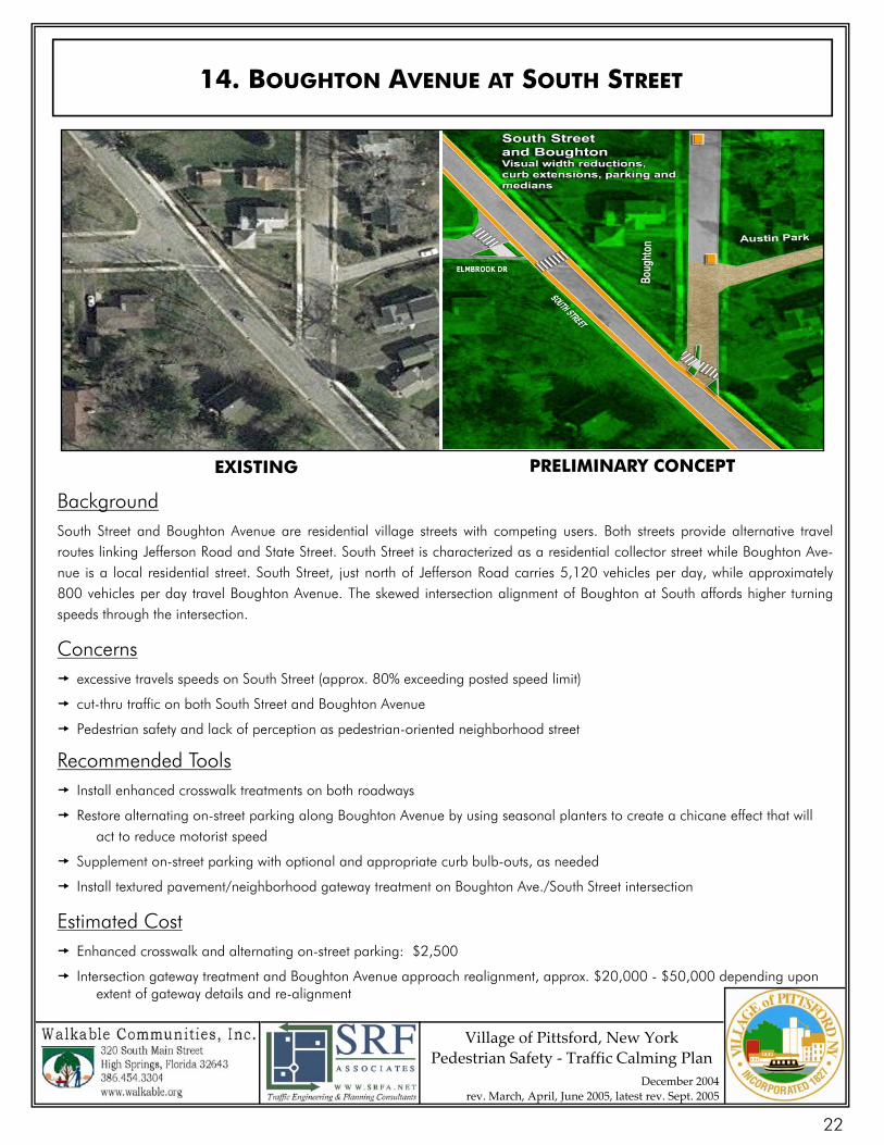
Background South Street and Boughton Avenue are residential village streets with competing users. Both streets provide alternative travel routes linking Jefferson Road and State Street. South Street is characterized as a residential collector street while Boughton Ave-nue is a local residential street. South Street, just north of Jefferson Road carries 5,120 vehicles per day, while approximately 800 vehicles per day travel Boughton Avenue. The skewed intersection alignment of Boughton at South affords higher turning speeds through the intersection.
Concerns excessive travels speeds on South Street (approx. 80% exceeding posted speed limit)
cut-thru traffic on both South Street and Boughton Avenue
Pedestrian safety and lack of perception as pedestrian-oriented neighborhood street
Recommended Tools Install enhanced crosswalk treatments on both roadways
Restore alternating on-street parking along Boughton Avenue by using seasonal planters to create a chicane effect that will act to reduce motorist speed
Supplement on-street parking with optional and appropriate curb bulb-outs, as needed
Install textured pavement/neighborhood gateway treatment on Boughton Ave./South Street intersection
Estimated Cost Enhanced crosswalk and alternating on-street parking: $2,500
Intersection gateway treatment and Boughton Avenue approach realignment, approx. $20,000 - $50,000 depending upon extent of gateway details and re-alignment
14. BOUGHTON AVENUE AT SOUTH STREET
EXISTING PRELIMINARY CONCEPT
22
Village of Pittsford, New York Pedestrian Safety ‐ Traffic Calming Plan
December 2004 rev. March, April, June 2005, latest rev. Sept. 2005
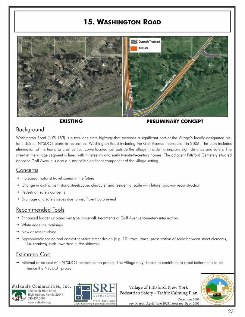
Background Washington Road (NYS 153) is a two-lane state highway that traverses a significant part of the Village’s locally designated his-toric district. NYSDOT plans to reconstruct Washington Road including the Golf Avenue intersection in 2006. The plan includes elimination of the hump or crest vertical curve located just outside the village in order to improve sight distance and safety. The street in the village segment is lined with nineteenth and early twentieth-century homes. The adjacent Pittsford Cemetery situated opposite Golf Avenue is also a historically significant component of the village setting.
Concerns Increased motorist travel speed in the future
Change in distinctive historic streetscape, character and residential scale with future roadway reconstruction
Pedestrian safety concerns
Drainage and safety issues due to insufficient curb reveal
Recommended Tools Enhanced ladder or piano key type crosswalk treatments at Golf Avenue/cemetery intersection
White edgeline markings
New or reset curbing
Appropriately scaled and context sensitive street design (e.g. 10’ travel lanes; preservation of scale between street elements, i.e. roadway-curb-lawn/tree buffer-sidewalk)
Estimated Cost Minimal or no cost with NYSDOT reconstruction project. The Village may choose to contribute to street betterments to en- hance the NYSDOT project.
15. WASHINGTON ROAD
EXISTING PRELIMINARY CONCEPT
23
Village of Pittsford, New York Pedestrian Safety ‐ Traffic Calming Plan
December 2004 rev. March, April, June 2005, latest rev. Sept. 2005
VILLAGE ARTERIALS
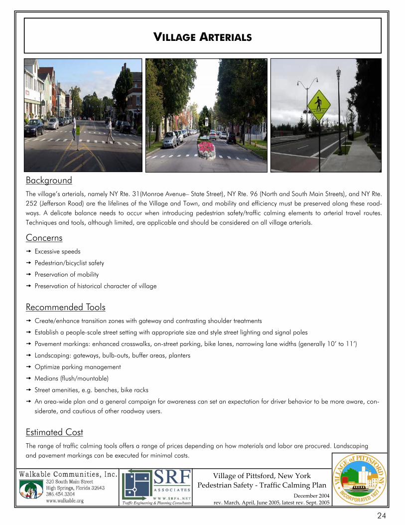
Background The village’s arterials, namely NY Rte. 31(Monroe Avenue– State Street), NY Rte. 96 (North and South Main Streets), and NY Rte. 252 (Jefferson Road) are the lifelines of the Village and Town, and mobility and efficiency must be preserved along these road-ways. A delicate balance needs to occur when introducing pedestrian safety/traffic calming elements to arterial travel routes. Techniques and tools, although limited, are applicable and should be considered on all village arterials.
Concerns Excessive speeds
Pedestrian/bicyclist safety
Preservation of mobility
Preservation of historical character of village
Recommended Tools Create/enhance transition zones with gateway and contrasting shoulder treatments
Establish a people-scale street setting with appropriate size and style street lighting and signal poles
Pavement markings: enhanced crosswalks, on-street parking, bike lanes, narrowing lane widths (generally 10’ to 11’)
Landscaping: gateways, bulb-outs, buffer areas, planters
Optimize parking management
Medians (flush/mountable)
Street amenities, e.g. benches, bike racks
An area-wide plan and a general campaign for awareness can set an expectation for driver behavior to be more aware, con-siderate, and cautious of other roadway users.
Estimated Cost The range of traffic calming tools offers a range of prices depending on how materials and labor are procured. Landscaping and pavement markings can be executed for minimal costs.
24
Village of Pittsford, New York Pedestrian Safety ‐ Traffic Calming Plan
December 2004 rev. March, April, June 2005, latest rev. Sept. 2005
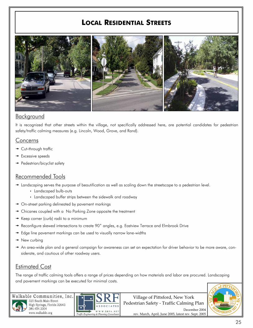
LOCAL RESIDENTIAL STREETS
Background It is recognized that other streets within the village, not specifically addressed here, are potential candidates for pedestrian safety/traffic calming measures (e.g. Lincoln, Wood, Grove, and Rand).
Concerns Cut-through traffic
Excessive speeds
Pedestrian/bicyclist safety
Recommended Tools Landscaping serves the purpose of beautification as well as scaling down the streetscape to a pedestrian level.
Landscaped bulb-outs Landscaped buffer strips between the sidewalk and roadway
On-street parking delineated by pavement markings
Chicanes coupled with a No Parking Zone opposite the treatment
Keep corner (curb) radii to a minimum
Reconfigure skewed intersections to create 90˚ angles, e.g. Eastview Terrace and Elmbrook Drive
Edge line pavement markings can be used to visually narrow lane-widths
New curbing
An area-wide plan and a general campaign for awareness can set an expectation for driver behavior to be more aware, con-siderate, and cautious of other roadway users.
Estimated Cost The range of traffic calming tools offers a range of prices depending on how materials and labor are procured. Landscaping and pavement markings can be executed for minimal costs.
25
26
27
Village of Pittsford Pe
destrian Safety‐ Traffic Calming Plan
Mar
ch 2
005
20,289
16,956
18,649
15,412
16,032
786
4,436
5,121
0
5,00
0
10,0
00
15,0
00
20,0
00
25,0
00
Monro
e (W
of Su
therla
nd)
State
(E of
Scho
en)
W. J
effers
on Ro
ad (W
of Vi
llage
Line
)
E. Je
fferso
n Roa
d (W
of Ea
stview
) N. Main
(N of
Scho
en)
Suthe
rland
(b/t
Jeffe
rson &
Linc
oln) So
uth (S
of Bo
ughto
n)
Boug
hton (
N of A
ustin
Park)
LOC
ATIO
N
ADT: Bi-directional (No. vehicles/day)
Aver
age
Dai
ly T
raffi
c (A
DT)
Vol
umes
with
in th
e Vi
llage
28
Village of Pittsford Pe
destrian Safety ‐ T
raffic Calming Plan
Mar
ch 2
005
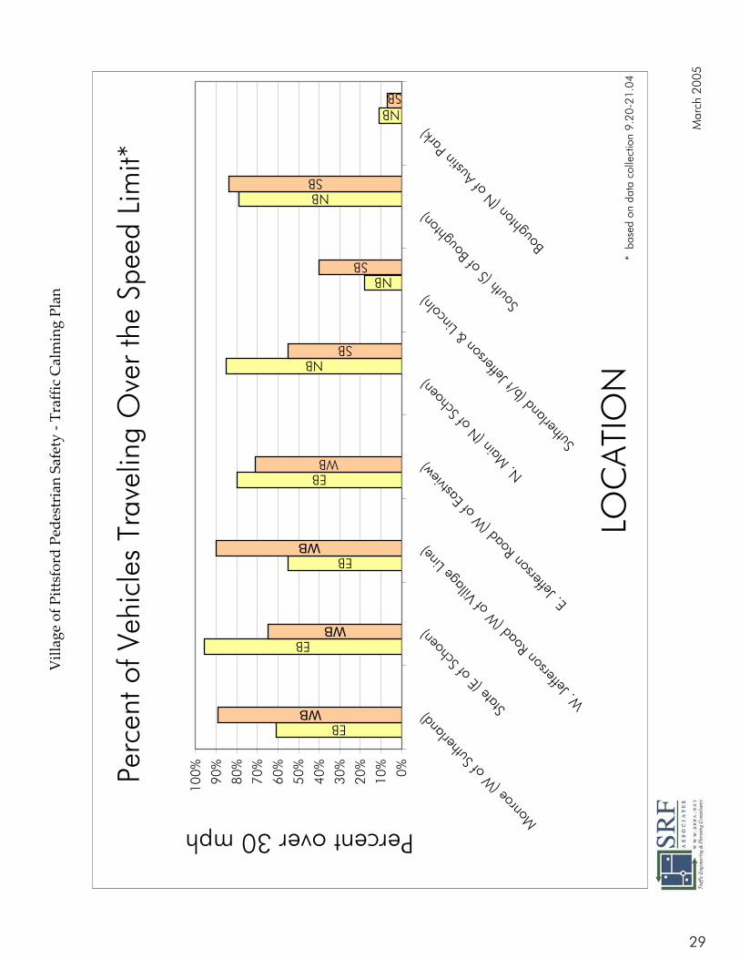
Perc
ent o
f Veh
icle
s Tr
avel
ing
Ove
r th
e Sp
eed
Lim
it*
EB
EB
EB
EB
WB
NB
NB
NB
SB
SB
SB
WB
WB
WB
NBSB
0%10%
20%
30%
40%
50%
60%
70%
80%
90%
100%
Monro
e (W
of S
utherl
and)
State
(E of
Scho
en)
W. J
effers
on Ro
ad (W
of V
illage
Line
)
E. Je
fferso
n Roa
d (W
of E
astvi
ew)
N. Main
(N of
Scho
en)
Suthe
rland
(b/t
Jeffe
rson &
Linc
oln) So
uth (S
of Bo
ughto
n)
Boug
hton (
N of A
ustin
Park)
LOC
ATIO
N
Percent over 30 mph
* b
ased
on
data
col
lect
ion
9.20
-21.
04
29
Village of Pittsford Pe
destrian Safety ‐ T
raffic Calming Plan
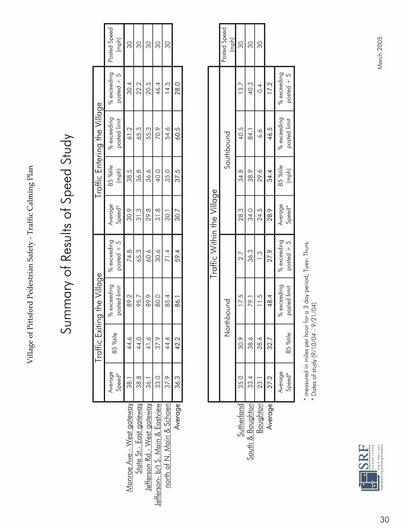
Aver
age
Spee
d*85
%til
e%
exc
eedi
ng
post
ed li
mit
% e
xcee
ding
po
sted
+ 5
Aver
age
Spee
d*85
%til
e (m
ph)
% e
xcee
ding
po
sted
lim
it%
exc
eedi
ng
post
ed +
5Po
sted
Spe
ed
(mph
)
Mon
roe
Ave.
- W
est g
atew
ay38
.144
.689
.274
.830
.938
.561
.230
.430
Stat
e St
.- E
ast g
atew
ay38
.844
.095
.765
.331
.336
.865
.322
.230
Jeffe
rson
Rd.
- W
est g
atew
ay36
.141
.689
.960
.629
.836
.655
.320
.530
Jeffe
rson
- b/
t S. M
ain
& E
astv
iew
33.0
37.9
80.0
30.6
31.8
40.0
70.9
46.4
30
north
of N
. Mai
n &
Sch
oen
37.9
44.6
85.4
71.4
30.1
35.0
54.6
14.5
30
Aver
age
36.3
42.2
86.1
59.4
30.7
37.5
60.5
28.0
Post
ed S
peed
(m
ph)
Suth
erla
nd25
.030
.917
.52.
728
.334
.840
.513
.730
Sout
h &
Bou
ghto
n33
.438
.679
.136
.334
.038
.984
.140
.330
Boug
hton
23.1
28.6
11.5
1.3
24.5
29.6
6.6
0.4
30
Aver
age
27.2
32.7
48.4
27.9
28.9
34.4
46.5
17.2
Aver
age
Spee
d*85
%til
e%
exc
eedi
ng
post
ed li
mit
% e
xcee
ding
po
sted
+ 5
Aver
age
Spee
d*85
%til
e (m
ph)
% e
xcee
ding
po
sted
lim
it%
exc
eedi
ng
post
ed +
5
* m
easu
red
in m
iles
per
hour
for
a 3
day
perio
d, T
ues-
Thu
rs.
* D
ates
of s
tudy
(9/1
0/04
- 9
/21/
04)
Sum
mar
y of
Res
ults
of S
peed
Stu
dy
Nor
thbo
und
Sout
hbou
nd
Traf
fic W
ithin
the
Villa
ge
Traf
fic E
xitin
g th
e Vi
llage
Traf
fic E
nter
ing
the
Villa
ge
Mar
ch 2
005
30
Intersection Priorities based on Public Meeting 9/27/04
and specific concerns
1. Four Corners – Monroe Ave./State St./Main St.- 12
2. Monroe Ave. Gateway (E & W of Main)-12 • speeding: no transition, road grade
• difficult for peds to cross at bridge
3. N. Main St./Schoen Place- 9 • sight distance
• bridge
• crest
4. Jefferson Rd./S. Main St.- 8 • speeding (trucks, off-peak)
• need Alternate Truck Route
5. Monroe Ave./Sutherland St.- 8 • sight distance
• delay
6. South St.- 7 • speeding (turning R from State to South, trucks, @ Church St.)
7. N. Main St./Washington St.- 6 • sight distance
• speeding
8. State St./Starbucks area- 5 • speeding
31
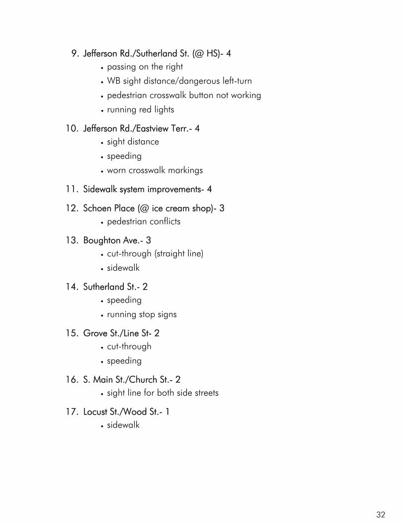
9. Jefferson Rd./Sutherland St. (@ HS)- 4 • passing on the right
• WB sight distance/dangerous left-turn
• pedestrian crosswalk button not working
• running red lights
10. Jefferson Rd./Eastview Terr.- 4 • sight distance
• speeding
• worn crosswalk markings
11. Sidewalk system improvements- 4
12. Schoen Place (@ ice cream shop)- 3 • pedestrian conflicts
13. Boughton Ave.- 3 • cut-through (straight line)
• sidewalk
14. Sutherland St.- 2 • speeding
• running stop signs
15. Grove St./Line St- 2 • cut-through
• speeding
16. S. Main St./Church St.- 2 • sight line for both side streets
17. Locust St./Wood St.- 1 • sidewalk
32