Embed Size (px)
Citation preview
Draft Report and Decisionof the Board of Inquiry into the
East West Link Proposal
Volume 1 of 2
BOARD OF INQUIRY
East West Link Proposal
Produced under Section 149Q of the Resource Management Act 1991
Volume 3 of 3: Conditions

Prepared November 2017By the Board of Inquiry into the East West Link Proposal
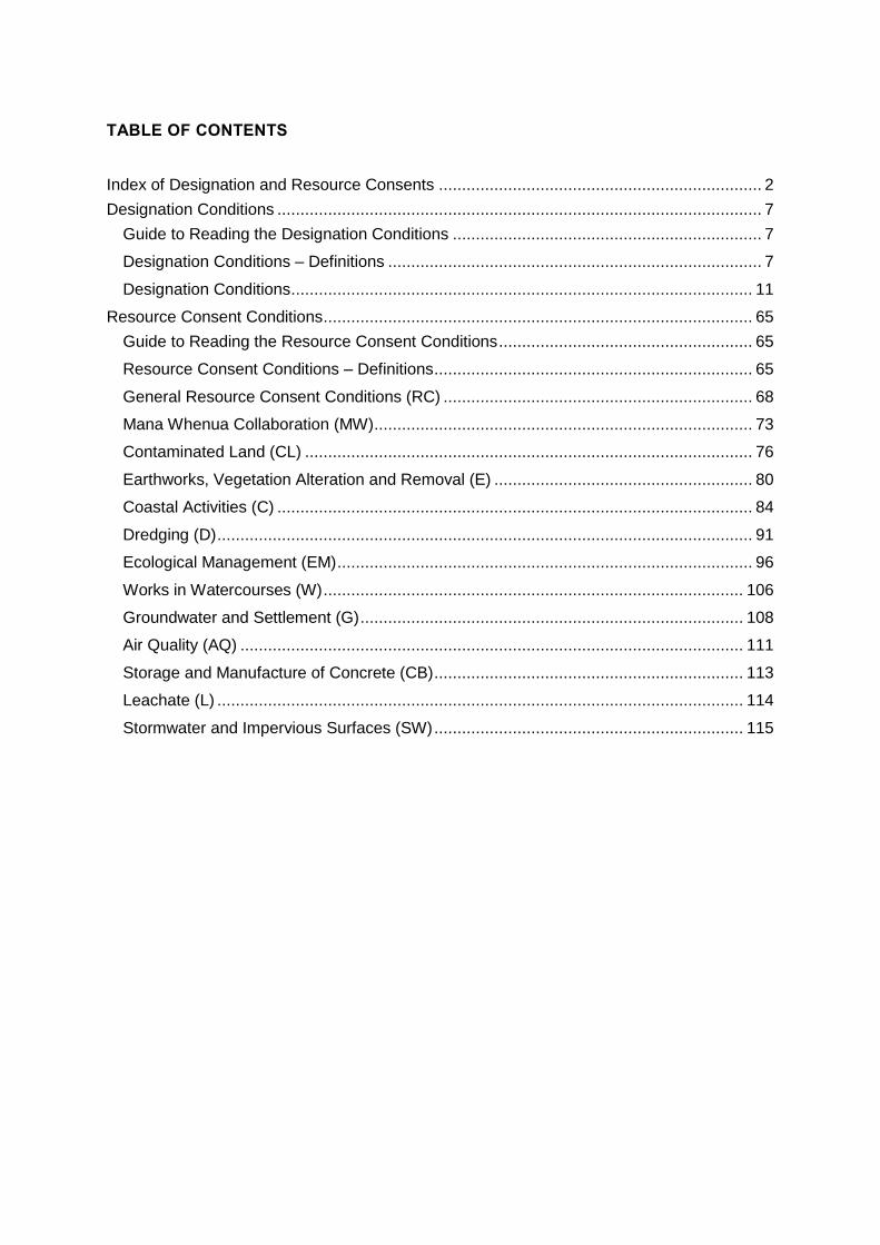
TABLE OF CONTENTS
Index of Designation and Resource Consents ...................................................................... 2
Designation Conditions ......................................................................................................... 7
Guide to Reading the Designation Conditions ................................................................... 7
Designation Conditions – Definitions ................................................................................. 7
Designation Conditions .................................................................................................... 11
Resource Consent Conditions ............................................................................................. 65
Guide to Reading the Resource Consent Conditions ....................................................... 65
Resource Consent Conditions – Definitions ..................................................................... 65
General Resource Consent Conditions (RC) ................................................................... 68
Mana Whenua Collaboration (MW) .................................................................................. 73
Contaminated Land (CL) ................................................................................................. 76
Earthworks, Vegetation Alteration and Removal (E) ........................................................ 80
Coastal Activities (C) ....................................................................................................... 84
Dredging (D) .................................................................................................................... 91
Ecological Management (EM) .......................................................................................... 96
Works in Watercourses (W) ........................................................................................... 106
Groundwater and Settlement (G) ................................................................................... 108
Air Quality (AQ) ............................................................................................................. 111
Storage and Manufacture of Concrete (CB) ................................................................... 113
Leachate (L) .................................................................................................................. 114
Stormwater and Impervious Surfaces (SW) ................................................................... 115
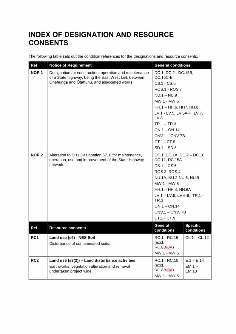
INDEX OF DESIGNATION AND RESOURCE CONSENTS
The following table sets out the condition references for the designations and resource consents.
Ref Notice of Requirement General conditions
NOR 1 Designation for construction, operation and maintenance
of a State highway, being the East West Link between
Onehunga and Ōtāhuhu, and associated works.
DC.1, DC.2 - DC.15B,
DC.15C-E
CS.1 - CS.6
ROS.1 - ROS.7
NU.1 – NU.9
MW.1 - MW.5
HH.1 – HH.6, HH7, HH.8
LV.1 - LV.5, LV.5A-H, LV.7,
LV.8
TR.1 – TR.3
ON.1 – ON.14
CNV.1 – CNV.7B
CT.1 - CT.9
SD.1 – SD.8
NOR 2 Alteration to SH1 Designation 6718 for maintenance,
operation, use and improvement of the State Highway
network.
DC.1, DC.1A, DC.2 – DC.10,
DC.12, DC.15A
CS.1 – CS.6
ROS.3, ROS.4
NU.1A, NU.2-NU.6, NU.9
MW.1 - MW.5
HH.1 – HH.4, HH.6A
LV.1 – LV.5, LV.6-8, TR.1 -
TR.3
ON.1 – ON.14
CNV.1 – CNV. 7B
CT.1 - CT.9
Ref Resource consents General
conditions
Specific
conditions
RC1 Land use (s9) - NES Soil
Disturbance of contaminated soils.
RC.1 - RC.15
(excl.
RC.8B/BA)
MW.1 - MW.5
CL.1 – CL.12
RC2 Land use (s9(2)) – Land disturbance activities
Earthworks, vegetation alteration and removal
undertaken project wide.
RC.1 - RC.15
(excl.
RC.8B/BA)
MW.1 - MW.5
E.1 – E.14
EM.1 –
EM.13

RC3 Land use (s9(2)) – Land disturbance activities
Vegetation alteration and removal for restoration and
rehabilitation works undertaken outside of the
designation within Southdown Reserve, adjacent to
Southdown Stream, Ann’s Creek Reserve, Gloucester
Park and the Manukau Foreshore Walkway.
RC.1 - RC.15
(excl.
RC.8B/BA)
MW.1 - MW.5
E.1 – E.14
EM.1 –
EM.13
RC4 Land Use (s9(3)) - Vegetation alteration, removal
Vegetation alteration, removal associated with the
restoration works and the establishment of vehicle
access and parking areas undertaken outside of the
designation within Southdown Reserve, adjacent to
Southdown Stream, Ann’s Creek Reserve, Gloucester
Park and the Manukau Foreshore Walkway.
RC.1 - RC.15
(excl.
RC.8B/BA)
MW.1 - MW.5
E.1 – E.14
EM.1 –
EM.114C
RC5 Coastal Permit (s12, s14 and s15) – Construction
activities in the CMA and temporary occupation and
associated discharge of contaminants
The works associated with the construction of the
reclamation and the Ann’s Creek Viaducts in the Māngere
Inlet and the works in Onehunga Bay associated with
public access. The works also include environmental
enhancement works at Ngarango Otainui Island.
The works will include reclamation, depositing of material
in the CMA, disposal of dredged material, CMA
disturbance, dredging, vegetation alteration/removal
(including mangroves), damming or impoundment of
coastal water, taking, use or diversion of coastal water,
parking on CMA structures, vehicle use of the foreshore
and seabed, demolition or removal of any CMA
structures, temporary CMA structures, temporary
construction activities, planting of native vegetation,
.underwater impact and vibratory piling.
RC.1 - RC.15
(excl.
RC.8B/BA)
MW.1 –
MW.10
C.1 – C.14
D.1 – D.19
EM.1 –
EM.114C
RC6 Coastal Permit (s12, s14 and s15) – Construction
activities in the CMA and temporary occupation and
associated discharge of contaminants
Works associated with the removal of the existing culvert
and replacement with a bridge and the construction of a
new bridge for State Highway 1 at Ōtāhuhu Creek.
The works will include declamation, depositing of
material in the CMA, CMA disturbance, vegetation
alteration/removal (including mangroves), damming or
impoundment of coastal water, taking, use or diversion of
coastal water, parking on CMA structures, vehicle use of
the foreshore and seabed, demolition or removal of any
CMA structures, temporary CMA structures construction
activities.
RC.1 - RC.15
(excl.
RC.8B/BA)
MW.1 –
MW.10
C.1 – C.14,
EM.1-EM.7
(Excl.
EM.1A)
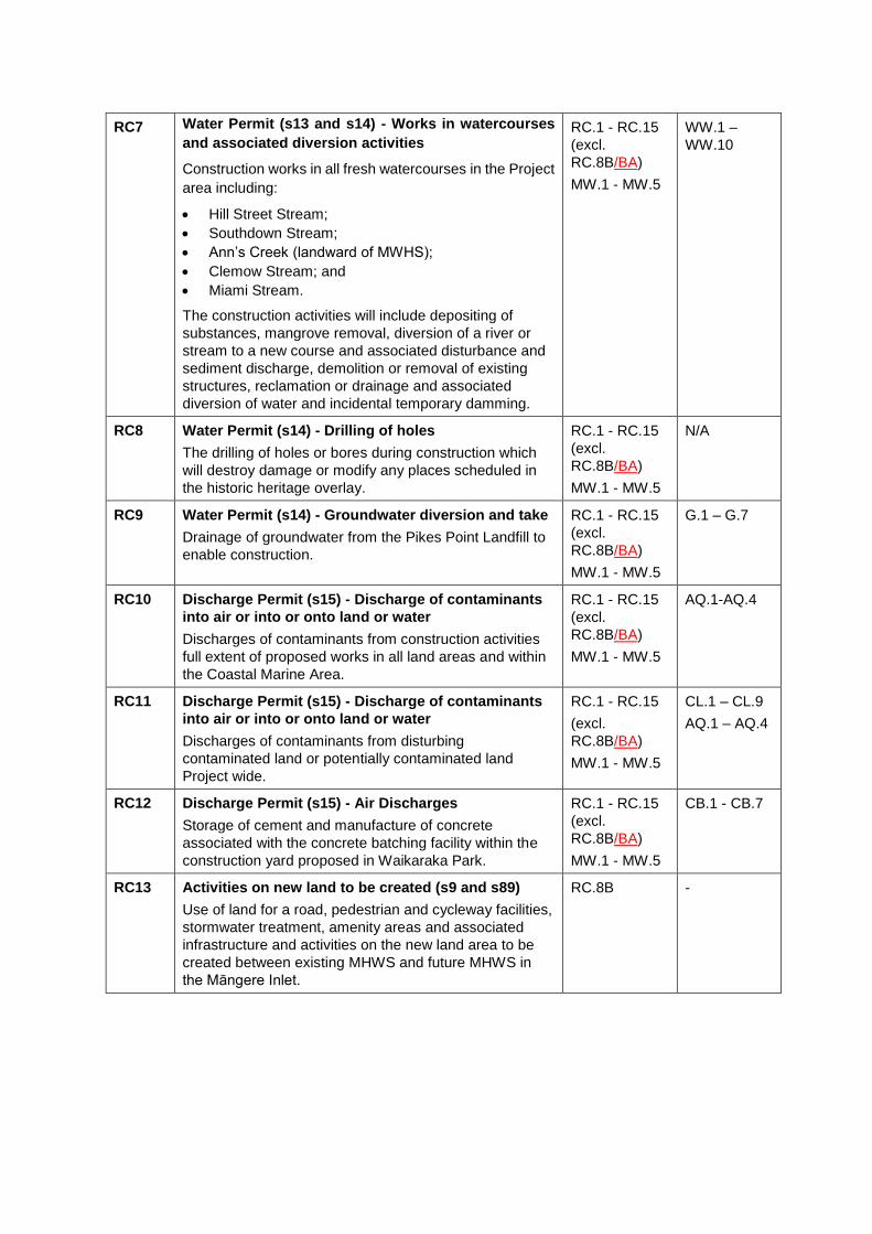
RC7 Water Permit (s13 and s14) - Works in watercourses
and associated diversion activities
Construction works in all fresh watercourses in the Project
area including:
Hill Street Stream;
Southdown Stream;
Ann’s Creek (landward of MWHS);
Clemow Stream; and
Miami Stream.
The construction activities will include depositing of
substances, mangrove removal, diversion of a river or
stream to a new course and associated disturbance and
sediment discharge, demolition or removal of existing
structures, reclamation or drainage and associated
diversion of water and incidental temporary damming.
RC.1 - RC.15
(excl.
RC.8B/BA)
MW.1 - MW.5
WW.1 –
WW.10
RC8 Water Permit (s14) - Drilling of holes
The drilling of holes or bores during construction which
will destroy damage or modify any places scheduled in
the historic heritage overlay.
RC.1 - RC.15
(excl.
RC.8B/BA)
MW.1 - MW.5
N/A
RC9 Water Permit (s14) - Groundwater diversion and take
Drainage of groundwater from the Pikes Point Landfill to
enable construction.
RC.1 - RC.15
(excl.
RC.8B/BA)
MW.1 - MW.5
G.1 – G.7
RC10 Discharge Permit (s15) - Discharge of contaminants
into air or into or onto land or water
Discharges of contaminants from construction activities
full extent of proposed works in all land areas and within
the Coastal Marine Area.
RC.1 - RC.15
(excl.
RC.8B/BA)
MW.1 - MW.5
AQ.1-AQ.4
RC11 Discharge Permit (s15) - Discharge of contaminants
into air or into or onto land or water
Discharges of contaminants from disturbing
contaminated land or potentially contaminated land
Project wide.
RC.1 - RC.15
(excl.
RC.8B/BA)
MW.1 - MW.5
CL.1 – CL.9
AQ.1 – AQ.4
RC12 Discharge Permit (s15) - Air Discharges
Storage of cement and manufacture of concrete
associated with the concrete batching facility within the
construction yard proposed in Waikaraka Park.
RC.1 - RC.15
(excl.
RC.8B/BA)
MW.1 - MW.5
CB.1 - CB.7
RC13 Activities on new land to be created (s9 and s89)
Use of land for a road, pedestrian and cycleway facilities,
stormwater treatment, amenity areas and associated
infrastructure and activities on the new land area to be
created between existing MHWS and future MHWS in
the Māngere Inlet.
RC.8B -
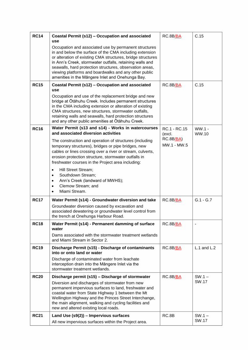
RC14 Coastal Permit (s12) – Occupation and associated
use
Occupation and associated use by permanent structures
in and below the surface of the CMA including extension
or alteration of existing CMA structures, bridge structures
in Ann’s Creek, stormwater outfalls, retaining walls and
seawalls, hard protection structures, observation areas,
viewing platforms and boardwalks and any other public
amenities in the Māngere Inlet and Onehunga Bay.
RC.8B/BA C.15
RC15 Coastal Permit (s12) – Occupation and associated
use
Occupation and use of the replacement bridge and new
bridge at Ōtāhuhu Creek. Includes permanent structures
in the CMA including extension or alteration of existing
CMA structures, new structures, stormwater outfalls,
retaining walls and seawalls, hard protection structures
and any other public amenities at Ōtāhuhu Creek.
RC.8B/BA C.15
RC16 Water Permit (s13 and s14) - Works in watercourses
and associated diversion activities
The construction and operation of structures (including
temporary structures), bridges or pipe bridges, new
cables or lines crossing over a river or stream, culverts,
erosion protection structure, stormwater outfalls in
freshwater courses in the Project area including:
Hill Street Stream;
Southdown Stream;
Ann’s Creek (landward of MWHS);
Clemow Stream; and
Miami Stream.
RC.1 - RC.15
(excl.
RC.8B/BA)
MW.1 - MW.5
WW.1 -
WW.10
RC17 Water Permit (s14) - Groundwater diversion and take
Groundwater diversion caused by excavation and
associated dewatering or groundwater level control from
the trench at Onehunga Harbour Road.
RC.8B/BA G.1 - G.7
RC18 Water Permit (s14) - Permanent damming of surface
water
Dams associated with the stormwater treatment wetlands
and Miami Stream in Sector 2.
RC.8B/BA -
RC19 Discharge Permit (s15) - Discharge of contaminants
into or onto land or water
Discharge of contaminated water from leachate
interception drain into the Māngere Inlet via the
stormwater treatment wetlands.
RC.8B/BA L.1 and L.2
RC20 Discharge permit (s15) – Discharge of stormwater
Diversion and discharges of stormwater from new
permanent impervious surfaces to land, freshwater and
coastal water from State Highway 1 between the Mt
Wellington Highway and the Princes Street Interchange,
the main alignment, walking and cycling facilities and
new and altered existing local roads.
RC.8B/BA SW.1 –
SW.17
RC21 Land Use (s9(2)) – Impervious surfaces
All new impervious surfaces within the Project area.
RC.8B SW.1 –
SW.17

RC22 Land Use (s9(2)) – High Risk ITA (Industrial or Trade
Activity)
A temporary concrete batching plant during construction
of the Project.
RC.1 - RC.15
(excl.
RC.8B/BA)
MW.1 - MW.5
M-RC1 Miami Stream: Land use (s9(3)) – Land disturbance,
and associated discharges
Earthworks and vegetation removal at Miami Stream.
RC.1 - RC.15
(excl.
RC.8B/BA)
MW.1 - MW.5
E.1 – E.14
EM.1 –
EM.13
M-RC2 Miami Stream: Land use (s9(3)) – Stormwater
Stormwater detention and retention in Miami Stream.
RC.8B/BA -
DESIGNATION CONDITIONS
GUIDE TO READING THE DESIGNATION CONDITIONS
The proposed designation conditions are numbered as follows:
Set of proposed conditions Numbering format
General Designation Conditions DC
Communication and Social CS
Recreation and Open Space ROS
Network Utilities NU
Mana Whenua Collaboration MW
Historic Heritage HH
Urban Design, Landscape and Visual LV
Trees TR
Traffic Noise (Operation) ON
Construction Noise and Vibration CNV
Construction Traffic CT
Southdown Site SD
Propert Specific PS
DESIGNATION CONDITIONS – DEFINITIONS
GENERAL
The table below defines the acronyms and terms used in the conditions. Defined terms are capitalised
throughout the conditions.
Acronym/term Definition
Acceptable or Tolerable Risk Level The Acceptable or Tolerable Risk Level is to be determined
using the Victorian Interim Risk Criteria offsite tolerability
and acceptability values for location specific individual
fatality risk for gas releases, and the societal risk criteria
(F-N) for the aggregated risks for the site.
In accordance with those values, an Acceptable Risk Level
means an offsite risk within the broadly acceptable region,
that is: Risk < 1 x 10⁻⁷ (lower than 1 in 10 million per year).
A Tolerable Risk Level means an offsite risk within the
tolerable region, that is: 1 x 10⁻⁷ < Risk < 1 x 10⁻⁵ (between
1 in 100,000 and > 1 in 10 million per year) for gas related
risks, and if all reasonably practicable control measures to
reduce the risk are undertaken.
For the aggregated risks, the risk curve or values must be in
or below the medium region, or in the low region of the F-N
criteria.
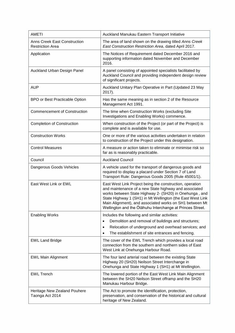
AMETI Auckland Manukau Eastern Transport Initiative
Anns Creek East Construction
Restriction Area
The area of land shown on the drawing titled Anns Creek
East Construction Restriction Area, dated April 2017.
Application The Notices of Requirement dated December 2016 and
supporting information dated November and December
2016.
Auckland Urban Design Panel A panel consisting of appointed specialists facilitated by
Auckland Council and providing independent design review
of significant projects.
AUP Auckland Unitary Plan Operative in Part (Updated 23 May
2017).
BPO or Best Practicable Option Has the same meaning as in section 2 of the Resource
Management Act 1991.
Commencement of Construction The time when Construction Works (excluding Site
Investigations and Enabling Works) commence.
Completion of Construction When construction of the Project (or part of the Project) is
complete and is available for use.
Construction Works One or more of the various activities undertaken in relation
to construction of the Project under this designation.
Control Measures A measure or action taken to eliminate or minimise risk so
far as is reasonably practicable.
Council Auckland Council
Dangerous Goods Vehicles A vehicle used for the transport of dangerous goods and
required to display a placard under Section 7 of Land
Transport Rule: Dangerous Goods 2005 (Rule 45001/1).
East West Link or EWL East West Link Project being the construction, operation
and maintenance of a new State highway and associated
works between State Highway 2- (SH20) in Onehunga , and
State Highway 1 (SH1) in Mt Wellington (the East West Link
Main Alignment), and associated works on SH1 between Mt
Wellington and the Ōtāhuhu Interchange at Princes Street.
Enabling Works Includes the following and similar activities:
Demolition and removal of buildings and structures;
Relocation of underground and overhead services; and
The establishment of site entrances and fencing.
EWL Land Bridge The cover of the EWL Trench which provides a local road
connection from the southern and northern sides of East
West Link at Onehunga Harbour Road.
EWL Main Alignment The four land arterial road between the existing State
Highway 20 (SH20) Neilson Street Interchange in
Onehunga and State Highway 1 (SH1) at Mt Wellington.
EWL Trench The lowered portion of the East West Link Main Alignment
between the SH20 Neilson Street offramp and the SH20
Manukau Harbour Bridge.
Heritage New Zealand Pouhere
Taonga Act 2014
The Act to promote the identification, protection,
preservation, and conservation of the historical and cultural
heritage of New Zealand.
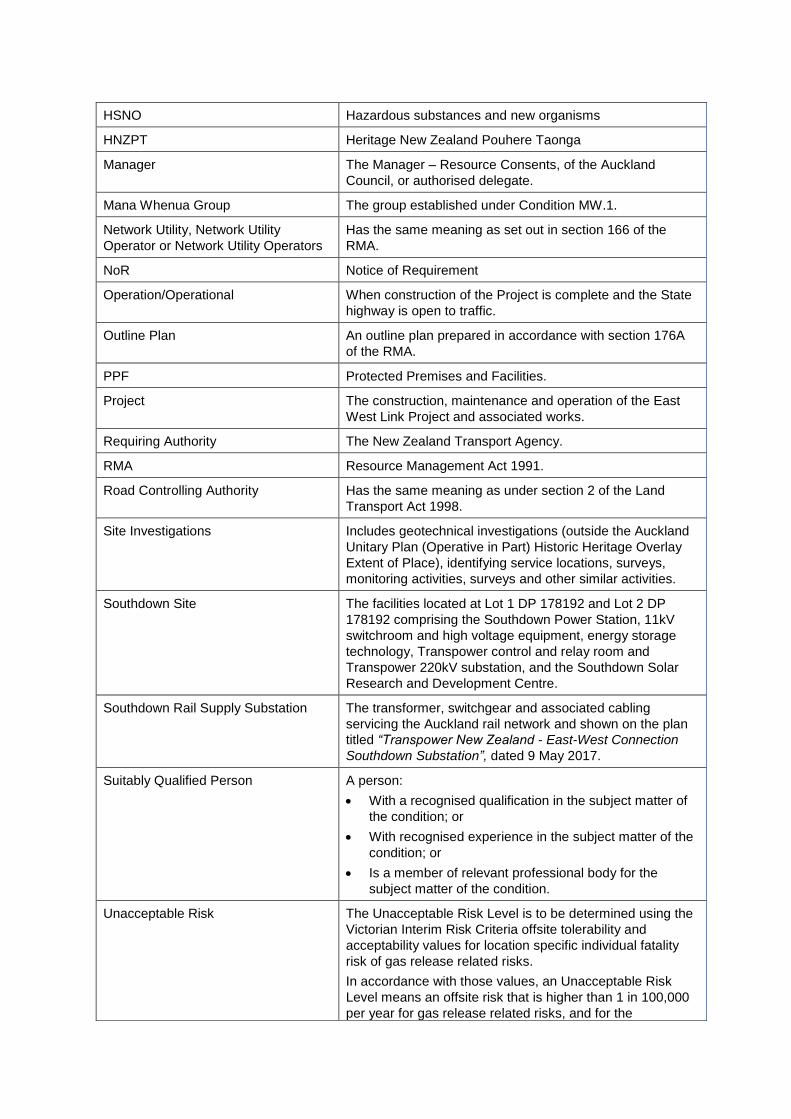
HSNO Hazardous substances and new organisms
HNZPT Heritage New Zealand Pouhere Taonga
Manager The Manager – Resource Consents, of the Auckland
Council, or authorised delegate.
Mana Whenua Group The group established under Condition MW.1.
Network Utility, Network Utility
Operator or Network Utility Operators
Has the same meaning as set out in section 166 of the
RMA.
NoR Notice of Requirement
Operation/Operational When construction of the Project is complete and the State
highway is open to traffic.
Outline Plan An outline plan prepared in accordance with section 176A
of the RMA.
PPF Protected Premises and Facilities.
Project The construction, maintenance and operation of the East
West Link Project and associated works.
Requiring Authority The New Zealand Transport Agency.
RMA Resource Management Act 1991.
Road Controlling Authority Has the same meaning as under section 2 of the Land
Transport Act 1998.
Site Investigations Includes geotechnical investigations (outside the Auckland
Unitary Plan (Operative in Part) Historic Heritage Overlay
Extent of Place), identifying service locations, surveys,
monitoring activities, surveys and other similar activities.
Southdown Site The facilities located at Lot 1 DP 178192 and Lot 2 DP
178192 comprising the Southdown Power Station, 11kV
switchroom and high voltage equipment, energy storage
technology, Transpower control and relay room and
Transpower 220kV substation, and the Southdown Solar
Research and Development Centre.
Southdown Rail Supply Substation The transformer, switchgear and associated cabling
servicing the Auckland rail network and shown on the plan
titled “Transpower New Zealand - East-West Connection
Southdown Substation”, dated 9 May 2017.
Suitably Qualified Person A person:
With a recognised qualification in the subject matter of
the condition; or
With recognised experience in the subject matter of the
condition; or
Is a member of relevant professional body for the
subject matter of the condition.
Unacceptable Risk The Unacceptable Risk Level is to be determined using the
Victorian Interim Risk Criteria offsite tolerability and
acceptability values for location specific individual fatality
risk of gas release related risks.
In accordance with those values, an Unacceptable Risk
Level means an offsite risk that is higher than 1 in 100,000
per year for gas release related risks, and for the
TR GROUP SITE
The table below defines the acronyms and terms used in the conditions. Defined terms are capitalised
throughout the conditions.
Covenants Means covenants (or similar legal mechanisms) in favour of
Auckland Council on the same terms (or substantially
similar terms) as those covenants required by the TR
Resource Consents which protect and restrict the use of the
Lava Shrubland Management Area and Wetland
Management Area and require ongoing pest plant and pest
animal control.
Lava Shrubland Management Area
and Wetland Management Area
The lava shrubland and wetland areas identified in the TR
Resource Consents
TR Resource Consents Means the following resource consents held by TR Group:
R/LUC/2008/4724 – land use (earthworks, vegetation
removal);
Permit 36055 – diversion and discharge of stormwater from
new impervious surface;
Permit 36056 – earthworks/land disturbance associated with
construction of new hardstand;
Permit 36058 – streamworks/culverting and reclamation;
and
Permit 30316 – disturbance and remediation of
contaminated land.
TR Group Land The land at 781 Great South Road (Lot 1 DP 328383, CT
115789), 785 Great South Road (Lot 2 DP 344775, 1/3 SH
Lot 5 DP 328383, CT 183736), 787 Great South Road (Lot
3 DP 328383, 1/3 SH Lot 5 DP 328383, CT 115791) and
791-793 Great South Road (SEC 1 SO 69440, CT
NA125B/43).
aggregated site risks, the region noted by the societal risk
(F-N) curves of tolerability and acceptability.
Working Day Has the same meaning as under section 2 of the Resource
Management Act 1991.
DESIGNATION CONDITIONS
Ref Applies
to:
Condition
General Designation Conditions (DC)
DC.1 NoR 1
NoR 2
Except as modified by the conditions below, and subject to final design, the
Project shall be undertaken in general accordance with the information
provided by the Requiring Authority in the Notice of Requirement dated
December 2016, and in particular, the following supporting documents:
(a) Part D: Description of the Project in Volume 1: Assessment of Effects
on the Environment Report dated December 2016;
(b) The following plan sets in Volume 2: Drawing Set:
(i) Plan Set 3: Road Alignment
(ii) Plan Set 4: Landscape
(iii) Plan Set 6: Plan and Long Section
(iv) Plan Set 7: Typical Cross Section
(v) Plan Set 8: Structural
(vi) Plan Set 12: Utilities Relocation
(c) The Key Design Principles and Sector Outcomes of the Project’s Urban
and Landscape Design Framework dated November 2016 and
Addendum dated December 2016; and
(d) The Draft Construction Traffic Management Plan Framework.
DC.1A NoR 2 For Notice of Requirement to Alter Designation 6718 (NoR 2) dated
December 2016, the conditions only apply to Construction Works described
in NoR 2 and include Construction Works on land within the existing
designation for SH1 between approximately Clemow Drive and the location
where Trenwith Street passes under SH1.
These conditions only apply to Construction Works described in the Notice
of Requirement to Alter Designation 6718 (NoR 2) dated December 2016 and
include Construction Works on land within the existing designation for SH1
between approximately Clemow Drive and the location where Trenwith Street
passes under SH1.
DC.2 NoR 1
NoR 2
Except where explicitly provided for, the construction related conditions of
this designation do not apply to works associated with on-going operation
and maintenance of the State highway following construction, such as
changes to street furniture or signage over time. The provisions of section
176A of the RMA apply to on-going operation, maintenance or other works
within the designation.
DC.3 NoR 1
NoR 2
The Project website shall include these conditions and the plans and reports
referred to in these conditions prior to and throughout Construction Works,
and a hard copy shall be available at the Project site office(s).

Ref Applies
to:
Condition
DC.4 NoR 1
NoR 2
Where there is inconsistency between:
(a) The documents listed in Condition DC.1 above and the requirements of
these conditions, these conditions shall prevail;
(b) The information and plans lodged with the NoR and further information
provided post lodgement, the most recent information and plans shall
prevail; and
(c) The draft management plans and/or management plan frameworks
lodged with the NoR and the management plans required by the
conditions of this designation and submitted through the Outline Plan
process, the requirements of the management plans as set out in the
relevant conditions shall prevail.
DC.5 NoR 1
NoR 2
As soon as practicable following Completion of Construction, the Requiring
Authority shall:
(a) Review the extent of the area designated for the Project;
(b) In consultation with the relevant landowners, identify any areas of
designated land that are no longer necessary for the on-going
operation, maintenance or mitigation of effects of the Project. For the
avoidance of doubt, this shall include the designated land on the
Onehunga Wharf to the south of the EWL Trench and shared path;
(c) Identify any areas of designated land that apply to local roads to be
vested in Auckland Council; and
(d) (d) Give notice to the Manager in accordance with section 182 of the
RMA for the removal of those parts of the designation identified in (b)
and (c) above.
DC.6 NoR 1
NoR 2
The designation shall lapse if not given effect to within 15 years from the date
on which it is included in the Auckland Unitary Plan under section 175 of the
RMA.
Outline Plan(s) - General
DC.7 NoR 1
NoR 2
An Outline Plan or Plans shall be prepared in accordance with section 176A
of the RMA.
DC.8 NoR 1
NoR 2
Any Outline Plan or Plans may be submitted in parts or in stages to address
particular activities (e.g. design or construction aspects) or to reflect the
staged implementation of the Project.
DC.9 NoR 1
NoR 2
The Outline Plan or Plans shall include the following plans for the relevant
stage(s) of the Project:
(a) Construction Noise and Vibration Management Plan (CNVMP) prepared
in accordance with Condition CNV.1;
(b) Construction Traffic Management Plan (CTMP) in accordance with
Condition CT.1;
(c) Heritage Management Plan (HMP) in accordance with Condition HH.3;
and
(d) Urban and Landscape Design Master Plan (ULDMP) in accordance with
Condition LV.1.
Ref Applies
to:
Condition
DC.10 NoR 1
NoR 2
The CNVMP, CTMP, HMP and ULDMP may be amended following
submission of the Outline Plan(s) if necessary to reflect any changes in
design, construction methods or management of effects. Any amendments
are to be discussed with and submitted to the Manager for information without
the need for a further Outline Plan process, unless those amendments once
implemented would result in a materially different outcome to that described
in the original plan.
For the avoidance of doubt, this condition does not apply to any Site Specific
Construction Noise Management Plan, Site Specific Construction Vibration
Management Plan, Site Specific Traffic Management Plan or other
management plans required by the conditiosnof these designations.
DC.11 NoR 1 As part of the Outline Plan(s) prepared under section 176A of the RMA, the
Requiring Authority shall demonstrate how the following outcomes will be
achieved for the relevant stage of the Project for which the Outline Plan has
been submitted:
(a) A local road connection via a land bridge linking Orpheus Drive and
Onehunga Harbour Road including two traffic lanes (one in each
direction), pedestrian access on both sides including a 3m (minimum)
shared pedestrian and cycle path on one side;
(b) A shared pedestrian and cycle path connection between Orpheus Drive
and the proposed new Old Māngere Bridge, providing a linkage from
Taumanu Reserve to Onehunga Wharf, with design details as set out
in Condition LV.5D;
(c) Provision for access achieving all movements for all road legal vehicles
between the local road and Onehunga Wharf;
(d) A high quality pedestrian and cycle connection providing a linkage
along Onehunga Mall to and from Onehunga Town Centre;
(e) Replacement of on-street carparks removed outside The Landing with
the same number of carparks in reasonable proximity;
(f) Provision for safe right turn movement westbound from Neilson Street
into Onehunga Mall;
(g) Operation of clearways, in the morning and evening peaks, to provide
on-street parking on Captain Springs Road (south of Neilson Street) in
off-peak times;
(h) Provision for safe turning of large vehicles and a separate public parking
area at the southern end of Hugo Johnston Drive;
(i) Provision for a safe u-turning facility for westbound vehicles (including
18m semi-trailers) on Sylvia Park Road in the vicinity of Great South
Road;
(j) Provision for a safe u-turning facility for eastbound vehicles (including
18m semi-trailers) on Sylvia Park Road in the vicinity of Pacific Rise;
(k) Separation of pedestrian and cycle facilities from general traffic on the
EWL Main Alignment;
(l) Provision for pedestrians and cyclists access from the EWL Main
Alignment into Sylvia Park Town Centre, in coordination with the
requirement for not precluding the multi-modal link road in Condition
DC.12A); and
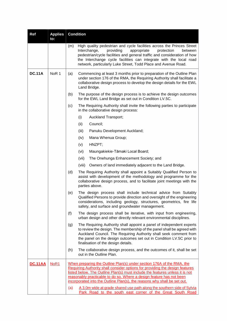
Ref Applies
to:
Condition
(m) High quality pedestrian and cycle facilities across the Princes Street
Interchange, providing appropriate protection between
pedestrian/cycle facilities and general traffic and consideration of how
the Interchange cycle facilities can integrate with the local road
network, particularly Luke Street, Todd Place and Avenue Road.
DC.11A NoR 1 (a) Commencing at least 3 months prior to preparation of the Outline Plan
under section 176 of the RMA, the Requiring Authority shall facilitate a
collaborative design process to develop the design details for the EWL
Land Bridge.
(b) The purpose of the design process is to achieve the design outcomes
for the EWL Land Bridge as set out in Condition LV.5C.
(c) The Requiring Authority shall invite the following parties to participate
in the collaborative design process:
(i) Auckland Transport;
(ii) Council;
(iii) Panuku Development Auckland;
(iv) Mana Whenua Group;
(v) HNZPT;
(vi) Maungakiekie-Tāmaki Local Board;
(vii) The Onehunga Enhancement Society; and
(viii) Owners of land immediately adjacent to the Land Bridge.
(d) The Requiring Authority shall appoint a Suitably Qualified Person to
assist with development of the methodology and programme for the
collaborative design process, and to facilitate joint meetings with the
parties above.
(e) The design process shall include technical advice from Suitably
Qualified Persons to provide direction and oversight of the engineering
considerations, including geology, structures, geometrics, fire life
safety, and surface and groundwater management.
(f) The design process shall be iterative, with input from engineering,
urban design and other directly relevant environmental disciplines.
(g) The Requiring Authority shall appoint a panel of independent experts
to review the design. The membership of the panel shall be agreed with
Auckland Council. The Requiring Authority shall seek comment from
the panel on the design outcomes set out in Condition LV.5C prior to
finalisation of the design details.
(h) The collaborative design process, and the outcomes of it, shall be set
out in the Outline Plan.
DC.11AA NoR1 When preparing the Outline Plan(s) under section 176A of the RMA, the Requiring Authority shall consider options for providing the design features listed below. The Outline Plan(s) must include the features unless it is not reasonably practicable to do so. Where a design feature has not been incorporated into the Outline Plan(s), the reasons why shall be set out.
(a) A 3.0m wide at grade shared use path along the southern side of Sylvia Park Road to the south east corner of the Great South Road

Ref Applies
to:
Condition
intersection (between chainage 5100 and 5500 as illustrated on Drawings AEE-AL-108 and AEE-AL-109); and
(b) A crossing facility for active modes between Gloucester Park Road North and destinations to the south of Neilson Street.
DC.11B NoR 1 (a) The Requiring Authority shall review and develop the design details for
the Galway Street link in consultation with Council and Auckland
Transport, and shall include consideration of layout options to connect
Onehunga Harbour Road to Galway Street directly, or via a link road.
The detailed design shall achieve the following outcomes:
(i) Efficient intersection performance to minimise queuing between
intersections on local roads and on the EWL;
(ii) High amenity for cycling and walking, particularly on the main
routes via Onehunga Harbour Road and Onehunga Mall;
(iii) Efficient and reliable bus access between SH20 and Onehunga
Town Centre;
(iv) Safe property access;
(v) Appropriate allowance for potential increase in traffic flows
associated with planned and consented local development (e.g.
at Onehunga Town Centre or at Onehunga Wharf); and
(vi) Measures to achieve compliance with Condition DC.12A (i)
relating to a future Mass Rapid Transit connection to the Auckland
International Airport.
(b) The Requiring Authority shall include the design details within the
Outline Plan prepared under section 176A of the RMA. The Outline
Plan shall detail the input and comments from Council and Auckland
Transport, describe how this has been incorporated into the design
and, where any input has not been incorporated, set out the reason
why.
DC.12 NoR 1
NoR 2
The Requiring Authority shall consult with Auckland Transport during the
preparation of the Outline Plan(s) in relation to:
(a) Local roads, including walking and cycling and public transport
facilities, and other interfaces between the State highway and local
roading networks; and
(b) The proposed Auckland Transport projects identified in Condition
DC.12A.
The Outline Plan(s) shall detail the input and comments from Auckland
Transport, describe how this has been incorporated into the design and,
where any input has not been incorporated, set out the reason why.
DC.12A NoR 1 As part of the Outline Plan(s) prepared under section 176A of the RMA, the
Requiring Authority shall demonstrate how the following proposed transport
projects are not precluded, and where practicable, are accommodated by
the Project:
(a) A future Mass Rapid Transit connection to the Auckland International
Airport, and in particular ensuring as a minimum the preferred alignment
identified in the South-West Multi-Modal Airport Rapid Transit Draft
Indicative Business Case is provided for by the Project;
Ref Applies
to:
Condition
(b) A future multi-modal link road to the Sylvia Park Town Centre as part of
the AMETI programme, in particular ensuring that the location of piers
does not preclude the alignment and any of the proposed modes; and
(c) iii) Future potential improvements to rail at the Westfield Junction
including provision for grade-separation and a new north-facing
connection between the North Island Main Trunk and the North
Auckland Line, and additional lines for freight.
Outline Plan(s) – Special Conditions: Heliport
DC.13A NoR 1 The Requiring Authority shall adopt all reasonable and practicable
measures to relocate, at the Requiring Authority's expense, the existing
Auckland Heliport Limited Partnership (AHLP) Heliport facility at 59 Miami
Parade (Part Lot 2 DP98342, NA53C/561), including constructing a
replacement building and all other existing associated facilities, to the site
shown as "Heliport Relocation Area" on the plan titled "Heliport Relocation
Area - East West Link" dated 10 July 2017 ("the Solution").
DC.13B NoR 1 Unless otherwise agreed between the Requiring Authority and AHLP, the
Requiring Authority shall not commence Construction Works on the
designated land at 59 Miami Parade unless:
(a) Either Condition DC.13D(a) or (b); and
(b) In circumstances where they have been applied, Conditions DC.13E
and DC.13F –
have been satisfied.
DC.13C NoR 1 For the purpose of Condition DC.13A (unless otherwise agreed between the
Requiring Authority and AHLP) implementation of the Solution shall include
(but is not limited to) the Requiring Authority (at the Requiring Authority's
expense):
(a) Acquiring all necessary interests in land to facilitate the Solution;
(b) Obtaining such statutory authorisations or variations to existing
resource consents or other authorisations (including under the RMA)
as are required to facilitate the Solution;
(c) Undertaking the physical and site establishment works required to
relocate the Heliport to the new site; and
(d) Implementing such design, staging and / or engineering solutions as
may be required to, as far as practicable, minimise disruption to the
Heliport's operations as a result of constructing the EWL and relocating
the Heliport.
DC.13D NoR 1 Condition DC.13A will be satisfied if:
(a) The Solution is implemented; or
(b) Following consultation with AHLP, the Requiring Authority advises in
writing (including reasons), that all reasonable and practicable
measures have been taken to achieve the requirements of Condition
DC.13A but that:
(i) The Solution cannot be achieved; and
(ii) No other reasonable and practicable measures to achieve the
Solution, or/ within the boundary of the designation, to refine the
Ref Applies
to:
Condition
EWL Main Alignment, to avoid where practicable or otherwise
reduce adverse effects on the Heliport, are available to the
Requiring Authority; and
(iii) Based on the reasons provided by the Requiring Authority, and
consultation undertaken with the Requiring Authority and AHLP, a
Suitably Qualified Person, jointly appointed by the Requiring
Authority and AHLP, confirms that they agree with the Requiring
Authority that all reasonable and practicable measures have been
taken.
DC.13E NoR 1 In the event that the Suitably Qualified Person appointed under Condition
13.D(b)(iii) does not agree with the Requiring Authority, they shall record
(as soon as practicable) in writing the reasons for their position and may
make recommendations to the Requiring Authority as to reasonable and
practicable measures that may be available to achieve the Solution.
DC.13F NoR 1 The Requiring Authority shall consider the recommendations in Condition
DC.13E above, and shall:
(a) Confirm that that it will implement the measures recommended; or
(b) Following consultation with AHLP, advise in writing that the
recommendations cannot be achieved (including reasons), in which
case the Requiring Authority shall not be required to comply with
Condition DC.13A.
DC.13G NoR 1 If relocation of the Heliport within the designated land is confirmed as
practicable, and any required authorisations are granted, the detail of the
relocated Heliport site shall be included, for information only, within the
Outline Plan prepared in accordance with Condition DC.7.
Outline Plan(s) – Special Conditions: ChemWaste
DC.14A NoR 1 As part of the Outline Plan prepared under section 176A of the RMA for the
area adjacent to the ChemWaste site at 39 Miami Parade (Lot 1 DP
135209), the Requiring Authority shall include:
(a) Written confirmation that the Requiring Authority has applied its best
endeavours, including through detailed design undertaken in
consultation with the occupier of 39 Miami Parade, to reduce and
minimise the extent of the designated area along the western half of
the southern boundary (between chainages 2825 and 2865 as shown
on Road Alignment Plan, Sheet 5, AEE-AL-05); an explanation of what
those best endeavours comprise and the consultation undertaken, and
any revised designation boundary resulting from application of those
best endeavours. If practicable, the designation boundary shall be
altered prior to Commencement of Works to reduce the area of
designated land at 39 Miami Parade, or following Completion of
Construction in accordance with Condition DC.14B below and
Condition DC.5.
(b) Subject to Condition DC.14B and C below, provision for a fire
protection wall will be of up to three metres height (above finished
ground level at the site of 39 Miami Parade), constructed of concrete,
and designed to provide a 240/240/240-minute fire resistance rating
along the full width of the northern boundary of the designated area on
the southern portion of 39 Miami Parade as determined under (a)

Ref Applies
to:
Condition
above (fire protection wall), and extending 4m into the ChemWaste site
at the western and eastern ends.
DC.14B NoR 1 The Outline Plan for the area adjacent to the ChemWaste Site may, instead
of the fire protection wall, and following consultation with the occupier of the
ChemWaste Site, provide for an alternative method which is no less
effective than the fire protection wall in ensuring that the requirements of the
Health and Safety at Work (Hazardous Substances) Regulation 2017 are
met in relation to the interface between the ChemWaste Site and any
protected or public place (as defined under those regulations) established
under the Project, including through ensuring that there is no greater
reduction in the ability to utilise the ChemWaste Site for the storage and
handling of Class 3, 4 and 6 Hazardous Substances, than for the fire
protection wall.
DC.14C NoR 1 Any Outline Plan providing for an alternative method meeting the
requirements of Condition DC14B shall be submitted along with details of
the consultation undertaken with the occupier, and any comments received
from the occupier regarding that alternative.
DC.14D NoR 1 Following completion of the permanent EWL works at 39 Miami Parade, any
areas of land that have been occupied during Construction Works and are
no longer necessary for the on-going operation, maintenance or mitigation
of effects of the Project shall be reinstated to a similar ground condition as
existed prior to Commencement of Construction, to enable ongoing use of
the land for business activities similar to those which occurred prior to
Commencement of Construction (i.e. storage and vehicle manoeuvring).
The requirements in Condition DC.5 (b) shall also apply to any areas of land
at 39 Miami Parade which are no longer necessary for the on-going
operation, maintenance or mitigation of effects of the Project.
Outline Plan(s) – Other Special Conditions
DC.15A NoR 1 The Requiring Authority shall consult with the landowner(s) during the
preparation of the Outline Plan(s) in relation to the design of the Anns Creek
viaduct access points to and from 39 and 59 Miami Parade, Pikes Point.
The Outline Plan(s) shall describe how the input and comments from the
landowner(s) has been incorporated in the design.
DC.15B NoR 1
As part of the Outline Plan prepared under section 176A of the RMA for the
area within the Anns Creek Construction Restriction Area, the Requiring
Authority shall include details of how the design has:
(a) Aligned permanent transport infrastructure (road, pedestrian and cycle
facilities) to the northern-most extent of the Restriction Area as far as
practicable;
(b) Avoided the placement of temporary and permanent piers;
(c) Avoided earthworks and vegetation removal that directly impacts on
lava shrubland and lava outcrops, and minimise any vegetation
alteration; and
(d) Minimised the footprint of temporary works required for construction of
permanent works.

Ref Applies
to:
Condition
For the avoidance of doubt, only the following activities may be undertaken
within the Anns Creek East Construction Restriction Area: weed removal,
pest plant and animal management, geological heritage restoration,
restoration planting, interpretative signage relating to cultural, ecological
and geological heritage, protective fencing, and associated earthworks to
undertake those activities.
DC.15C NoR 1 (a) The Requiring Authority shall consult with the owner of the land at 781
Great South Road (Lots 1 and 2 DP 328383) and 791-793 Great South
Road (Section 1 SO 69440) during the detailed design phase in
relation to the post-construction use of land immediately south east of
the EWL viaduct and adjacent to Great South Road (791-793 Great
South Road) (“the residual land”).
(b) If the Requiring Authority confirms that the residual land will not be
required for on-going operation, maintenance or mitigation of effects of
the Project, the Requiring Authority shall make reasonable provision
for heavy vehicle access, for the types of vehicles normally in use at
781 Great South Road, under the EWL viaduct, between 781 Great
South Road and the residual land.
(c) The access shall be located and designed to provide suitable vertical
clearance under the EWL viaduct and to minimise, to the extent
practicable, further encroachment into Anns Creek East.
(d) The Outline Plan prepared in accordance with Condition DC.7 shall
include information to demonstrate how the requirements of this
condition have been achieved.
DC.15CC NoR 1 If, after completion of the 10 year period post Completion of Construction as
set out in consent EM.3A(c), the Consent Holder receives confirmation that
the Covenants have been registered against the certificates of title for the
TR Group Land then, the Requiring Authority shall give notice to the
Manager in accordance with section 182 of the RMA for the removal of
those parts of the designation on the TR Group Land no longer necessary
for the on-going operation, maintenance or mitigation of effects associated
with the Project.
DC.15D NoR 1 (a) The Requiring Authority shall consult with the owner of the land at 430
Mt Wellington Highway (Lot 1 DP 188694) during preparation of the
Outline Plan in relation to the location and design of vehicular access
to and from the site to Mt Wellington Highway and the proposed
Auckland Transport AMETI corridor.
(b) As part of the Outline Plan prepared under section 176A of the RMA,
the Requiring Authority shall demonstrate how the following outcomes
will be achieved:
(i) Vehicular access from the land under the EWL to SH1 ramps, to
the boundary of the proposed Auckland Transport AMETI corridor;
and
(ii) Vehicular access from the land to Mt Wellington Highway.
(c) The Outline Plan shall detail the input and comments from the land
owner, describe how this has been incorporated into the design and,
where any input has not been incorporated, set out the reason why.
Ref Applies
to:
Condition
DC.15E NoR 1 As part of the Outline Plan prepared under Section 176A of the RMA, the
Requiring Authority shall demonstrate how the requirements of Conditions
SD.1, SD.2A, SD.2B and SD.3 have been achieved.
Communication and Social (CS)
Liaison person
CS.1 NoR 1
NoR 2
A Project Liaison Person shall be appointed by the Requiring Authority for
the duration of the construction phase of the Project to be the main and
readily accessible point of contact for persons affected by Construction
Works. The Requiring Authority shall take appropriate steps to advise all
affected parties of the liaison person’s contact details. This person must be
reasonably available for on-going consultation on matters of concern to
affected persons arising from Construction Works. If the liaison person will
not be available for any reason, an alternative contact shall be provided, to
ensure that a Project contact person is available by telephone 24 hours per
day/seven days per week during the construction phase of the Project.
The Requiring Authority shall inform the Manager of the Project Liaison
Person’s contact details 20 working days prior to the Commencement of
Construction and/or Enabling Works for the Project.
Communications Plan
CS.2 NoR 1
NoR 2
Prior to the Commencement of Construction and/or Enabling Works, the
Requiring Authority shall prepare and implement a Communications Plan.
The purpose of the plan is to set out procedures detailing how the public,
stakeholders, businesses and residents will be communicated with
throughout the pre-construction and construction phases of the Project.
As a minimum, the Communications Plan shall include:
(a) Details of the Project Liaison Person (Condition CS.1). The contact
details shall be on the Project website and prominently displayed at the
entrance to the site(s) so that they are clearly visible to the public at all
times;
(b) A list of stakeholders, organisations, businesses and residents who will
be communicated with;
(c) Methods to consult on and to communicate the proposed hours of
construction activities outside of normal working hours and on
weekends and public holidays, to surrounding businesses and
residential communities, and methods to deal with concerns raised
about such hours;
(d) Methods to record concerns raised about hours of construction activities
and methods to avoid particular times of day which have been identified
as being particularly sensitive for neighbours;
(e) Methods to provide early notification to businesses of construction
activities.
(f) Methods to consult with businesses to identify and implement:
(i) Measures to maximise opportunities for pedestrian and service
access to businesses that will be maintained during construction;

Ref Applies
to:
Condition
(ii) Measures to mitigate potential severance and loss of business
visibility issues by way-finding and supporting signage for
pedestrian detours required during construction;
(iii) Other measures to assist businesses to maintain customer
accessibility, including but not limited to customer information on
temporary parking or parking options for access;
(iv) Other measures to assist businesses to provide for service
delivery requirements; and
(v) The process (if any) for re-establishment and promotion of normal
business operation following construction.
(g) Any stakeholder/business specific communication plans required;
(h) Details of communications activities proposed including:
(i) Publication of newsletters, or similar, and proposed delivery
areas;
(ii) Information days, open days or other mechanisms to facilitate
community engagement;
(iii) Newspaper advertising;
(iv) Notification and consultation with business owners and operators
and individual property owners and occupiers with
premises/dwellings within 100 metres of active construction;
(v) Identify processes, mechanisms and / or specific methods to
facilitate two-way communication with those with impairments or
for those for whom English is a second language;
(vi) The use of social media tools.
(i) Details of the Project website for providing information to the public;
(j) Linkages and cross-references to communication methods set out in
other conditions and management plans where relevant (e.g.
consultation; and
(k) Details of when the Plan will be reviewed and amended.
The Communications Plan shall be provided to the Manager for information
20 working days prior to Commencement of Construction and following any
material amendments of the Plan.
Community Liaison Groups
CS.3 NoR 1
NoR 2
(a) The Requiring Authority shall establish and co-ordinate a Community
Liaison Group (CLG) in each of the following areas at least 3 months
prior to the Commencement of Construction in each of those areas:
(i) Onehunga and Penrose including the Onehunga Harbour Road
and Onehunga Mall Cul-de-Sac residential area and Māngere
Bridge; and
(ii) State Highway 1 including the Ōtāhuhu and Panama Road
residential areas.
(b) The purpose of the CLG is to provide a means for:
Ref Applies
to:
Condition
(i) Sharing information on design (including the ULDMPs prepared
under Condition LV.1), Construction Works and programme;
(ii) Reporting and responding to concerns and issues raised in relation
to Construction Works; and
(iii) Monitoring the effects on the community arising from Construction
Works in these areas.
(c) The Requiring Authority shall assist the CLG to hold regular meetings
(at least once every three months) throughout the construction period in
these areas. The CLG shall continue until six months after Completion
of Construction so that on-going monitoring information can continue to
be shared, discussed and responded to. The frequency and duration of
the meetings can be reduced where the majority of the members of the
group agree.
(d) In addition to the Project Liaison Person and representative(s) of the
Requiring Authority and its principal construction contractor,
membership of the CLG shall be open to all interested parties within the
Project area including, but not limited to representatives of the following
groups:
(i) Council, Auckland Transport and other Council Controlled
Organisation;
(ii) Department of Conservation;
(iii) Mana Whenua;
(iv) Business groups;
(v) Community/environmental/historical groups;
(vi) Transport user groups;
(vii) Local Boards;
(viii) Local residents and business owners/operators;
(ix) Representatives from those organisations identified in the
Communications Plan (as required by Condition CS.2); and
(x) Ministry of Education.
(e) The Requiring Authority shall prepare an agenda for each meeting and
prepare minutes recording actions. A copy of the minutes shall be
provided to the meeting invitees within a reasonable time following the
meeting.
(f) The Requiring Authority shall be responsible for all reasonable costs
associated with resourcing of the CLGs.
Business Forums
CS.4 NoR 1
NoR 2
(a) The Requiring Authority shall establish and coordinate Business
Forums in each of the following industrial/commercial areas, or a
combined Business Forum in two or more of those areas, at least 3
months prior to Commencement of Construction in those areas:
(i) Onehunga (including businesses on Neilson Street (east),
Onehunga Mall, Onehunga Harbour Road, Galway Street and
Gloucester Park Road);
Ref Applies
to:
Condition
(ii) Onehunga Industrial (including businesses on Neilson Street
(west), Captain Springs Road, Miami Parade and Hugo Johnston
Drive);
(iii) Sylvia Park Road (including Pacific Rise, Great South Road and
Vestey Drive); and
(iv) SH1 (including Vestey Drive, Monahan Road and Clemow Drive).
(b) In addition to the Project Liaison Person and representative(s) of the
Requiring Authority and its principal construction contractor,
membership of the Business Forum(s) shall be open to all interested
parties within the Project area including, but not limited to
representatives of the following groups:
(i) Business owners;
(ii) Land owners;
(iii) Business groups including the Onehunga Business Association;
(iv) Road carriers / freight operators in the area and NZ Heavy
Haulage Association; and
(v) Auckland Transport.
(c) The purpose of the Business Forums is to provide a forum for:
(i) Timely provision of information on the Construction Works and
programme and planned business and community activities;
(ii) Reporting and responding to concerns and issues raised in
relation to Construction Works; and
(iii) Monitoring the effects on the business community arising from
Construction Works in these areas.
(d) The Requiring Authority shall assist the Business Forum(s) to hold
regular meetings (at least once every three months) throughout the
construction period in these areas. The Business Forum(s) shall
continue until six months after Completion of Construction so that on-
going monitoring information can continue to be shared, discussed and
responded to. The frequency and duration of the forums can be reduced
where the majority of the members of the group agree.
(e) In addition to the general purpose set out in (b) above, the matters to be
considered by the Business Forums may include, but are not limited to,
the following matters:
(i) The timing of construction activities including consideration of
specific operational requirements for businesses;
(ii) Temporary traffic management including closures, detours,
parking restrictions and signage; and
(iii) Alternative access to and from businesses during construction.
(f) The Requiring Authority shall prepare an agenda for each meeting and
prepare minutes recording actions. A copy of the minutes shall be
provided to the meeting invitees within a reasonable time following the
meeting.
(g) The Requiring Authority shall be responsible for all reasonable costs
associated with the resourcing of the Business Forum.

Ref Applies
to:
Condition
Complaints Management
CS.5 NoR 1
NoR 2
At all times during Construction Works, the Requiring Authority shall maintain
a record of any complaints received in relation to the Construction Works.
The record shall include:
(a) The name and address (as far as practicable) of the complainant;
(b) Identification of the nature of the complaint;
(c) Location, date and time of the complaint and of the alleged event giving
rise to the complaint;
(d) The weather conditions at the time of the complaint (as far as
practicable), and including wind direction and approximate wind speed
if the complaint relates to air quality or noise.
(e) The outcome of the Requiring Authority’s investigation into the
complaint;
(f) Measures taken by the Requiring Authority to respond to the complaint
or confirmation of no action if deemed appropriate;
(g) Any other activities in the area, unrelated to the Project that may have
contributed to the complaint, such as non-project construction, fires,
traffic accidents or unusually dusty conditions generally; and
(h) The response provided to the complainant.
The Requiring Authority shall also keep a record of any remedial actions
undertaken.
The complaints record shall be made available to the Manager upon request.
CS.6 NoR 1
NoR 2
The Requiring Authority shall respond to a complaint related to Construction
Works as soon as reasonably practicable and as appropriate to the
circumstances.
Recreation and Open Space (ROS)
Aotea Sea Scouts Activities
ROS.1 NoR 1 The Requiring Authority shall offer to temporarily relocate the Aotea Sea
Scouts activities located at Onehunga Harbour Road for the duration of
Construction Works adjacent to the Aotea Sea Scouts Hall.
The offer shall be made no later than 3 months prior to Commencement of
Construction on Onehunga Harbour Road adjacent to the Aotea Sea Scout
Hall. The offer shall remain valid until 3 months after the Commencement of
Construction on Onehunga Harbor Road adjacent to the existing Aotea Sea
Scouts Hall. If the offer is not accepted within that timeframe, the Requiring
Authority is not required to temporarily relocate the Aotea Sea Scouts
activities.
The offer shall include as a minimum:
(a) Relocation of the activities at least 20 working days prior to
Commencement of Construction on Onehunga Harbour Road adjacent
to the existing Aotea Sea Scouts Hall; and
Ref Applies
to:
Condition
(b) Relocation of the activities until Completion of Construction affecting
Onehunga Harbour Road adjacent to the Aotea Sea Scouts Hall.
The offer of temporary relocation shall be developed in consultation with the
Aotea Sea Scouts.
Waikaraka Park (temporary facilities during construction)
ROS.2 NoR 1 (a) To address the loss of on leash dog walking and passive open space
during Construction Works, the Requiring Authority shall, subject to
agreement of the landowner, provide an alternative area of up to
6,000m2 for those activities and temporary parking for a minimum of 4
cars on the northern portion of the Waikaraka Park South future
development site at 60 Captain Springs, Onehunga.
(b) The recreation space shall be available for use prior to the permanent
closure of any part of the Manukau Foreshore Walkway located
between Onehunga Harbour Road and Hugo Johnston Drive. The
recreation space shall consist of a space suitable for on leash dog
walking and informal sports.
(c) The temporary parking in (a) shall be available for use by the public for
the period of construction requiring the removal of on road parking in
Captain Springs Road. The temporary parking will be formed from metal
or similar material reflecting its temporary use.
(d) The recreation space shall be maintained by the Requiring Authority
until such time as either:
(i) The coastal walkway located along the coastal edge of the
reclamation is open to the public; or
(ii) The shared path on the road embankment is open to the public.
(e) The temporary parking shall be maintained until such time as the
extension to Captain Springs Road is open to traffic.
Open Space Reinstatement Plans
ROS.3 NoR 1
NoR 2
Prior to any works that affect Auckland Council parks and open space, the
Requiring Authority shall prepare a register of assets and a photographic
record of the pre-construction state of the parks and open space. This shall
be provided to the Manager prior to construction commencing.
ROS.4 NoR 1
NoR 2
(a) The Requiring Authority shall prepare a Reinstatement Plan in
consultation with the landowner for the following parks and reserves
(or parts thereof) directly impacted by Construction Works:
(i) Gloucester Park North and South;
(ii) Waikaraka Park; and
(iii) Bedingfield Memorial Park.
(b) Where other areas of open space are affected by Construction Works,
the reinstatement of those areas shall be based on a like-for-like
reinstatement based on the record prepared under ROS.3.
(c) The purpose of the Reinstatement Plans is to provide details of the
reinstatement works in open space areas directly affected by
construction works.
Ref Applies
to:
Condition
(d) The Reinstatement Plans shall:
(i) Be prepared in accordance with the ULDMP for the area prepared
under Condition LV.1;
(ii) Include details for the reinstatement of land used for Construction
Works including:
Removal of structures, plant and materials associated with
construction (unless otherwise agreed with the landowner);
Replacement or reinstatement of boundary fences to the same
or similar type to that removed (as recorded through Condition
ROS.3);
Reinstatement of grassed areas to a similar condition as existed
prior to construction;
Replacement of trees and other planting removed for
Construction Works on a one-for-one basis (or as otherwise
agreed with the landowner);
Details of way finding and interpretation signage within and
adjacent to the open space.
(iii) Include record of consultation and agreement with the landowner;
and
(iv) Take account of any Council management plans prepared for the
park, reserve or area of open space.
(e) The Reinstatement Plan shall be provided to the Manager and
implemented within 3 months of Completion of Construction, or at a
later date as agreed with the landowner.
Gloucester Park Reinstatement Plan
ROS.5 NoR 1 In addition to the matters set out in Condition ROS.4, the Gloucester Park
Reinstatement Plan shall include:
(a) Details of proposed ecological enhancement to extend the existing
saltmarsh area in Gloucester Park South;
(b) Details of interpretive features for identifying geological heritage
features;
(c) Details of fencing required to manage the safe interface of SH20 and
Gloucester Park North for the current use of the park as a sportsfield;
(d) Details of the artwork referred to in Condition LV.5B; and
(e) Pedestrian and service vehicle connection points to Onehunga Harbour
Road as referred to in Condition LV.5C(c) and (d).
Waikaraka Cemetery and Waikaraka Park South Reinstatement Plan
ROS.6 NoR 1 In addition to the matters set out in Condition ROS.4, the Waikaraka
Cemetery and Waikaraka Park South Reinstatement Plan shall include:
(a) Details of proposed landscaping along the southern boundary of
Waikaraka Cemetery as referred to in Condition LV.5F. The
landscaping is to be developed in consultation with HNZPT and
Auckland Council Heritage Unit;
Ref Applies
to:
Condition
(b) Details of proposed grades and grass surfacing of Waikaraka Park
South to a standard which reasonably accommodates Council’s future
implementation of the Waikaraka Park South Development Plan; and
(c) Details of temporary construction phase carparking to be retained, and
details of proposed works to integrate this carparking with the
Waikaraka Park South Development Plan;
(c) Accessibility from Waikaraka Cemetery and Waikaraka Park South to
the recreational walkway on the foreshore and (if practicable) direct
access between the Cemetery and Waikaraka Park South.
ROS.6A NoR 1 For a period of up to 2 years following occupation of Construction Yard 3,
the Requiring Authority shall make a financial payment to Council to
reimburse any capital costs incurred by Council for works undertaken in the
Maungakiekie-Tamaki Local Board area to improve the weekly hours of
playing capacity of sportsfields, where such works are undertaken to offset
the delay in implementation of the planned sports fields in Waikaraka Park
South (arising from use of this site for Construction Yard 3).
The value of any financial support shall be agreed between the Requiring
Authority and Council, and shall be limited to the confirmed budgeted
amount of approximately $1.54M ($2017 NZD) indicated in the Draft Sports
Field Capacity Development Programme (endorsed by the Maungakiekie-
Tamaki Local Board in 2012). For clarity, the financial support will cover any
capital works expenditure but does not impose any responsibility on the
Requiring Authority for consenting or approval of such works (this remains
the responsibility of Council).
The purpose of this requirement is to ensure that Council can both improve
weekly hours of playing capacity for local sportsfields in the medium term
and retain their budgeted funds for the development of Waikaraka Park
South, so that this work can be implemented following the Requiring
Authority’s use of this site.
Coastal Access Parking Plan
ROS.7 NoR 1 The Requiring Authority shall assist Auckland Transport and Auckland
Council to prepare and promote a Coastal Access Parking Plan to identify
appropriate parking locations for universal access and recreational access
as close as is practicable to the coastal edge of the Manukau Harbour and
Māngere Inlet between Taumanu Reserve and Hugo Johnston Drive. The
Plan shall include parking at Taumanu, Onehunga Harbour Road, Captain
Springs Road and Hugo Johnston Drive.
The Plan shall be completed and made available to the public as soon as
practicable following Completion of Construction.
Network Utilities (NU)
Design – Permanent Access to Network Utilities
NU.1A NoR 1
NoR 2
The Requiring Authority shall design permanent batters, retaining walls,
crash barriers, fencing, acoustic barriers, and other such physical measures
to be constructed as part of the Project in a manner which does not prevent
practical ongoing access to existing and relocated Network Utilities during
construction and operation of the works authorised by the designation.
Ref Applies
to:
Condition
NU.1B NoR 1
NoR 2
If, prior to the Commencement of Construction, Transpower has developed
a proposal to underground any transmission line through the designated land
of a sufficient detail of design that resource consents and/or a notice of
requirement could be sought by Transpower, the Requiring Authority shall
take all reasonable measures to accommodate that work in the design and
construction of the EWL.
The measures taken to accommodate any proposed undergrounding of
transmission lines shall be set out in the Outline Plan or Plans prepared in
accordance with Condition DC.7.
Design – New Network Utilities Opportunities
NU.2 NoR 1
NoR 2
The Requiring Authority shall consult with Network Utility Operators during
the detailed design phase to identify opportunities to enable, or to not
preclude, the development of new network utility and telecommunications
facilities within the Project, where practicable to do so.
The consultation undertaken, opportunities considered, and whether or not
they have been incorporated into the detailed design, shall be summarised
in the Outline Plan or Plans prepared in accordance with Condition DC.7.
Utilities Management Plan
NU.3 NoR 1
NoR 2
(a) The Requiring Authority shall prepare and implement a Network
Utilities Management Plan (NUMP). The NUMP shall be prepared in
consultation with the Network Utility Operators who have existing
assets that are directly affected by the Project.
(b) The purpose of the NUMP is to ensure that the design and construction
of the Project takes account of, and includes measures to, address the
safety, integrity, protection and (where necessary) the relocation of
existing network utilities.
(c) The NUMP shall include methods and measures to:
(i) Ensure that network utilities can be accessed for maintenance at all reasonable times, or emergency works at all times, during construction activities;
(ii) Manage the effects of dust and any other material potentially resulting from construction activities and able to cause material damage, beyond normal wear and tear, to overhead high voltage transmission lines through the Project area ; and
(iii) Ensure that no activity is undertaken during construction that would result in ground vibrations, ground instability and/or ground settlement likely to cause material damage to network utilities.
(d) Demonstrate compliance with relevant standards and Codes of
Practice including:
i) NZECP 34:2001 New Zealand Electrical Code of Practice for
Electrical Safe Distances 2001; and
ii) AS/NZS 4853:2012 Electrical hazards on Metallic Pipelines.
(e) The NUMP shall also include the specific matters set out in Conditions
NU.5 – NU.9.
Ref Applies
to:
Condition
(f) At least 40 working days prior to commencement of Construction Works
affecting a network utility, the Requiring Authority shall provide a draft
of the NUMP to the relevant Network Utility Operatorfor review and
comment. The NUMP shall describe how the input from the Network
Utility Operator in relation to its assets has been incorporated. The
Requiring Authority shall consider any comments received from the
Network Utility Operator when finalising the NUMP.
(g) Any amendments to the NUMP related to assets of a Network Utility
Operator shall be prepared in consultation with that asset owner.
NU.4 NoR 1
NoR 2
A copy of the NUMP shall be provided to the Manager for information at
least 20 working days prior to the commencement of any Enabling Works or
Commencement of Construction where those enabling or Construction
Works impact on network utilities.
NU.5 NoR 1
NoR 2
(a) The NUMP shall include procedures, methods and measures to manage effects of the construction works on the following transmission lines:
(i) Māngere-Mt Roskill A 110 kV Line;
(ii) Penrose – Mt Roskill A 110 kV Line; and
(iii) Henderson – Ōtāhuhu A 220 kV Line.
(b) The NUMP shall include:
(i) Details of any dispensations and associated procedures, methods
and measures agreed with Transpower for construction works that
cannot meet New Zealand Electrical Code of Practice for Electrical
Safe Distances 2001 (NZECP 34:2001) or any subsequent
revision of the code;
(ii) For all other works, procedures, methods and measures to
demonstrate how construction works will meet the safe distances
within the NZECP 34:2001 or any subsequent revision of the code
and including specific measures and methods relating to:
Excavation or disturbance of the land around any Transpower
transmission support structures under Clause 2.2.3;
Building to conductor clearances under Section 3;
Depositing of material under or near overhead electric lines
under Clause 4.3.1;
Mobile plant or load to Transpower transmission lines under
Clause 5.2;
People to conductor clearances; and
Warning notices during use of mobile plant in proximity of
overhead lines under Clause 5.
(iii) Details of measures to control induction and transferred voltages
and Earth Potential Rise where use of conductive material for road
infrastructure or relocated network utilities is within 12 metres of
the outer foundations of any transmission tower or proposed tower
or monopole;
Ref Applies
to:
Condition
(iv) Details of areas within which additional management measures
are required, such as fencing off, entry and exit hurdles and the
minimum height for any hurdles;
(v) Details of contractor training for those working near transmission
lines and other assets; and
(vi) Provision for Transpower involvement in contractor briefings for
works involving the following:
Works within 12m of any Transpower overhead transmission
line support structure;
Works within the maximum extent of line swing (at maximum
operating temperature) of any Transpower overhead
transmission line; and
Works within 20m of or encroaching into the Southdown Rail
Supply Substation.
NU.6 NoR 1
NoR 2
(a) The NUMP shall include procedures, methods and measures to manage effects of the construction works on the following Watercare assets:
(i) Hunua 1 at Sylvia Park Road/Great South Road intersection;
(ii) Sylvia Park watermain;
(iii) Hunua 3 transmission watermain;
(iv) Hunua 4 transmission watermain;
(v) Eastern Interceptor Westfield Siphon;
(b) The NUMP shall:
(i) Demonstrate how construction works will meet safety procedures
required by Watercare for works within the vicinity of its assets;
and
(ii) Describe the areas within which additional management measures
are required; and
(iii) Describe the process for obtaining approval from Watercare
before works commence within close proximity to Watercare
assets under the Water Supply and Wastewater Network Bylaw
2015.
NU.7 NoR 1 (a) The NUMP shall include procedures, methods and measures to manage effects of the construction works on the First Gas East Tamaki to Taupaki Gas Pipeline.
(b) The NUMP shall demonstrate how construction works will meet First Gas operating standards and codes including:
AS2885: Pipelines – Gas and Liquid Petroleum (Part 1 for design
and Part 3 for operation and maintenance); and
New Zealand Health and Safety in Employment (Pipelines)
Regulations 1999.
NU.8 NoR 1
NoR2
The NUMP shall include procedures, methods and measures to manage effects of the construction works on Spark assets, and in particular, shall include provisions so that:
Ref Applies
to:
Condition
(a) The relocated AOHB Otāhuhu cellular site at Princes Street is fully operational prior to decommissioning of the existing AOHB Otāhuhu cellular site; and
(b) The relocated and/or reconfigured AHAM Hamlins Hill cellular site at Great South Road is fully operational before the existing AHAM Hamlins Hill site Radio Frequency coverage is impacted by the construction of the EWL Project.
NoR 1 Advice Note:
Further conditions relating to network utilities located at the Southdown Site are included in the SD conditions.
Network Utility Approvals
NU.9 NoR 1
NoR 2
The Requiring Authority shall not require Auckland Transport, Network Utility Operators with existing infrastructure within the designated land to seek written consent under section 176 of the RMA for on-going access to enable work associated with the routine construction, operation and maintenance of existing assets. To the extent that written approval is required, this condition shall constitute written approval.
NoR 1
NoR 2
Advice Note:
In addition to the RMA processes, there are other additional processes and approvals applying to any work or activity that affect network utilities. The Requiring Authority may require additional approvals from Network Utility Operators prior to any works commencing in proximity to network utilities.
Mana Whenua Collaboration (MW)
[Note: Mana Whenua Collaboration Conditions MW1-MW.5 below will also be contained in the resource consent conditions once the wording is finalised. Conditions MW.6-MW.10 are specific to the Coastal Permits and have been relocated to the resource consents]
Mana Whenua Group
MW.1 NoR 1
NoR 2
(a) Six months prior to the Commencement of Construction, the Requiring Authority shall invite mandated representatives of Mana Whenua to participate in a Mana Whenua Group (MWG).
(b) The purpose of the MWG is to facilitate engagement between the Requiring Authority and Mana Whenua in respect of the activities authorised by this designation.
(c) The group will include invited representatives from:
(i) Ngāi Tai Ki Tāmaki;
(ii) Ngāti Maru;
(iii) Ngāti Paoa;
(iv) Ngāti Tamaoho;
(v) Ngāti Te Ata Waiohua;
(vi) Ngāti Whātua Ōrākei;
(vii) Te Ahiwaru;
Ref Applies
to:
Condition
(viii) Te Ākitai Waiohua;
(ix) Te Kawerau ā Maki; and
(x) Te Rūnanga o Ngāti Whātua.
(d) The MWG will hold regular meetings (at least three monthly) throughout the construction period. The MWG shall continue until six months after Completion of Construction. The frequency and duration of the meetings can be reduced or increased where the majority of the members of the group agree.
(e) The Requiring Authority shall record the main points arising from each meeting of the MWG, and shall provide a copy of that record to the meeting invitees within a reasonable time following the meeting.
(f) The Requiring Authority shall be responsible for all reasonable costs associated with the resourcing of the MWG.
MW.2 NoR 1
NoR 2
The MWG will be provided opportunities to review and comment on the
following (amongst other things):
(a) The ULDMP, with particular reference to design elements of the following features:
i) Works in the vicinity of Te Hōpua a Rangi including how Mana Whenua artworks or design themes are incorporated and delivered into that design and nomination of an artist to design the artwork referred to in Condition LV.5B;
ii) Design of the reclamation, coastal paths and boardwalk along the Mangere Inlet.
iii) Landscape treatment (including plant species, plant sources and planting methodology), alignment and design of the recreation walkway, interpretive signage and other amenities along the Māngere Inlet foreshore recreation walkway;
iv) Aesthetic design through the upper reaches of the Māngere Inlet (Anns Creek), including reflection of the Kāretu Portage in the design of the viaduct and interpretive signage;
v) Design associated with the Kāretu Portage Path (an elevated shared path from west of Great South Road and along Sylvia Park Road), including reflection of the historic Kāretu Portage in design of this feature;
vi) Structures in the vicinity of the waahi tapu at Mt Wellington Interchange; and
vii) Design of the Ōtāhuhu Creek bridges and in particular the treatment beneath these structures to reflect and respond to the Ōtāhuhu portage.
(b) The Heritage Management Plan (as required by designation Condition HH.3) including details of Mana Whenua construction monitoring for sites identified as having significance to the Mana Whenua Group (including but not limited to Te Hōpua a Rangi, Anns Creek and foreshore, Mt Wellington Interchange area, Ōtāhuhu Creek);
(c) Accidental Discovery Protocol (as required by designation Condition HH.2);
Ref Applies
to:
Condition
(d) The ECOMP (as required by consent Condition EM.1) including the detail of ecological restoration planting along the northern shoreline of the Māngere Inlet, Anns Creek and Ōtāhuhu Creek;
(e) The CEMP and Coastal Works CEMP (as required by consent Conditions RC.10 and C.4), including details on site inductions, training programme(s) and tikanga for construction works (particularly for works in sensitive areas such as Te Apunga o Tainui at Mt Wellington Interchange) to respond to matters of significance to Mana Whenua; and
(f) Results of environmental monitoring prior to and during construction as required by conditions of the designation and related resource consents (e.g. water and leachate design performance monitoring under Condition C.1H and the scientific analysis of material of geological interest from the cut into the Te Hōpua a Rangi tuff ring under Condition HH.8), including information to support cultural monitoring requirements.
Cultural Monitoring Plan (Construction)
MW.3 NoR 1
NoR.2
Prior to the Commencement of Construction, a Cultural Monitoring Plan or
plans shall be prepared by a person endorsed by the Mana Whenua Group.
MW.4 NoR 1
NoR.2
The purpose of the Cultural Monitoring Plan is to set out the agreed cultural
monitoring requirements and measures to be implemented during
construction activities, to acknowledge the historic and living cultural values
of the area to Mana Whenua and to minimise potential adverse effects on
these values.
MW.5 NoR 1
NoR 2
The Cultural Monitoring Plan shall include (but not be limited to):
(a) Requirements for formal dedication or cultural interpretation to be undertaken prior to works commencing in areas identified as having significance to Mana Whenua (including but not limited to Te Hōpua a Rangi, Anns Creek and foreshore, Mt Wellington Interchange area, Ōtāhuhu Creek):
(b) Requirements and protocols for cultural inductions;
(c) Identification of sites and areas where cultural monitoring is required during particular Construction Works;
(d) Identification of any other specific activities requiring cultural monitoring (e.g. implementation of spill contingency measures or specific works in the CMA);
(e) Identification of personnel nominated by Mana Whenua to undertake cultural monitoring, including any geographic definition of their responsibilities;
(f) Details of personnel nominated by the Requiring Authority and Mana Whenua to assist with management of any issues identified during cultural monitoring, including implementation of the Accidental Discovery Protocol developed under Condition HH.2;
(g) Identification of any opportunities and intent from Mana Whenua to reuse excavated natural material from the EWL Trench at Te Hōpua a Rangi, and if so, proposed measures to achieve this; and
Ref Applies
to:
Condition
(h) Details of any pre-construction monitoring that may assist Mana Whenua in their monitoring role (e.g. avifauna monitoring, baseline water quality monitoring)
Historic Heritage (HH)
Archaeology
HH.1 NoR 1
NoR 2
Where the Requiring Authority holds an Archaeological Authority for pre-1900
archaeological sites under the Heritage New Zealand Pouhere Taonga Act
2014, the conditions set out below shall not apply to the activities authorised
by the Archaeological Authority.
HH.2 NoR 1
NoR 2
For activities and areas of the Project not covered by an Archaeological
Authority, tThe Requiring Authority shall prepare an Accidental Discovery
Protocol for any accidental archaeological discoveries which occur during
Construction Works.
The Accidental Discovery Protocol shall be consistent withAuckland Unitary
Plan Accidental Discovery Rule in Standard E.11.6.1, and E.126.1.
The Accidental Discovery Protocol shall be prepared in consultation with the
Mana Whenua Group and modified to reflect the site specific Project detail.
The Accidental Discovery Protocol shall be implemented throughout the
Construction Works.
Heritage Management Plan
HH.3 NoR 1
NoR 2
(a) Prior to Commencement of Construction, the Requiring Authority shall prepare and implement a Heritage Management Plan (HMP).
(b) The purpose of the HMP is to identify procedures and practices to be adopted to protect, as far as reasonably practicable, historic heritage and remedy and mitigate any residual effects.
(c) The HMP will be prepared for the management of historic heritage, excluding any areas covered by an Archaeological Authority granted by HNZPT.
(d) The HMP shall be provided to the Manager prior to Commencement of Construction.
(e) The HMP shall be implemented throughout Construction Works other than where the conditions of an Archaeological Authority obtained under the Heritage New Zealand Pouhere Taonga Act 2014, or the archaeological works plans or site instructions approved under that Authority, require otherwise.
HH.4 NoR 1
NoR 2
The HMP shall be prepared by a Suitably Qualified Person in consultation
with Council, HNZPT and Mana Whenua, and shall identify:
(a) Known historic heritage within the designation boundary;
(b) Any pre-1900 areas covered by an Archaeological Authority under the Heritage New Zealand Pouhere Taonga Act 2014;
(c) Roles, responsibilities and contact details of personnel and/or relevant agencies (including but not limited to Auckland Council, New Zealand Police, Heritage New Zealand Pouhere Taonga, and mana whenua
Ref Applies
to:
Condition
representatives) involved with historic heritage matters including surveys and monitoring of conditions;
(d) Methods for identifying avoiding, protecting and/or minimising effects on historic heritage during construction where practicable in line with internatiuonal best practice for example the fencing off of archaeologically sensitive areas to protect them from damage during construction, and including construction methods that minimise vibration;
(e) Details for recording and salvage prior to removal of the historic railway bridge and tunnel located adjacent to Onehunga Harbour Road. The recording and salvage shall be aligned, as appropriate, with the Salvage and Conservation Heritage Plan for the proposed removal of the 1875/1915 Old Māngere Bridge (being part of a separate works project planned by the NZ Transport Agency).
(f) Training requirements for contractors and subcontractors on historic heritage areas/features within the designation boundary and any accidental discovery protocols. The training shall be undertaken under the guidance of a Suitably Qualified Person and representatives of the Mana Whenua Group;
(g) Cultural inductions for site/places of importance to Mana Whenua;
(h) Proposed methodology for assessing the condition of historic heritage, conditionand the means to mitigate any adverse effects (if any) on the built heritage features listed in Condition HH.5, including allocation of resources and the timeframe for implementing the proposed methodology in accordance with Heritage New Zealand guideline AGS 1A: Investigation and Recording of Buildings and Standing Structures for assessing and recording built heritage dated 4 July 2014 (or any subsequent revision); and
Proposed methodology for documentation of post-1900 historic heritage exposed during construction and the recording of these sites in the Auckland Council Cultural Heritage Inventory. (www.chi.net/Home.aspx). Site records shall be updated by the Suitably Qualified Person within 20 working days of the completion of on-site earthworks.
HH.4A NoR 1
NoR 2
Electronic copies of all historic heritage reports relating to historic heritage investigations (evaluation, excavation and monitoring etc.), including interim reports, shall be submitted by the Suitably Qualified Person to the Manager and to the Auckland Council Cultural Heritage Inventory as soon as they are produced
NoR 1
NoR 2
Advice note:
Heritage New Zealand Pouhere Taonga Act 2014 The Heritage New Zealand Pouhere Taonga Act 2014 (hereafter referred to as the Act) provides for the identification, protection, preservation and conservation of the historic and cultural heritage of New Zealand. All archaeological sites are protected by the provisions of the Act (section 42). It is unlawful to modify, damage or destroy an archaeological site without prior authority from Heritage New Zealand Pouhere Taonga. An Authority is required whether or not the land on which an archaeological site may be present is designated, a resource or building consent has been granted, or the activity is permitted under Unitary, District or Regional Plans. According to the Act (section 6) archaeological site means, subject to section 42(3) –
Ref Applies
to:
Condition
a) any place in New Zealand, including any building or structure (or part of a building or structure), that –
i. was associated with human activity that occurred before 1900 or is the site of the wreck of any vessel where the wreck occurred before 1900; and ii. provides or may provide, through investigation by archaeological methods, evidence relating to the history of New Zealand; and
b) includes a site for which a declaration is made under section 43(1)
It is the responsibility of the Requiring Authority to consult with Heritage New Zealand Pouhere Taonga about the requirements of the Act and to obtain the necessary Authorities under the Act should these become necessary, as a result of any activity associated with the consented proposals. For information please contact the Heritage New Zealand Pouhere Taonga Northern Regional Archaeologist – 09 307 0413 / [email protected]
The archaeological requirements of the Project shall be undertaken in compliance with any conditions of an archaeological authority issued by HNZPT under the Heritage New Zealand Pouhere Taonga Act 2014.
The Requiring Authority shall seek advice from a Suitably Qualified Person
in advance of any Site Investigations or Enabling Works on the potential need
for an Archaeological Authority under the Heritage New Zealand Pouhere
Taonga Act 2014 for those works. If the Suitably Qualified Person identifies
that an Archaeological Authority may be required, the Requiring Authority
shall engage with Heritage New Zealand Pouhere Taonga.
Built Heritage Features – Condition Survey
HH.5 NoR 1 (a) Subject to receiving the owners written approval, a building condition survey shall be undertaken by a Suitably Qualified Person for the following built heritage structures prior to the Commencement of Construction in the vicinity of those structures:
(i) The Aotea Sea Scouts Hall at 1 Orpheus Drive and stone walls including an inventory and photographic survey of the interior fittings;
(ii) The Landing at 2 Onehunga Harbour Road;
(iii) The Extent of Place as identified in the Auckland Unitary Plan (Operative in Part) and any contributing buildings on Onehunga Wharf at 55 Onehunga Harbour Road;
(iv) The Waikaraka Park stone walls in the following locations:
along the southern boundary between Waikaraka Park and
the EWL Main Alignment;
along the western boundary at Alfred Street; and
along the eastern boundary at Captain Springs Road.
(v) The Waikaraka Park stone caretakers’ cottage on Captain Springs Road.
(b) The purpose of the survey is to determine the pre-construction condition, context and physical features of the built heritage structures to form the basis of construction monitoring.

Ref Applies
to:
Condition
(c) The outcome of the survey shall be provided to the building owner within 20 working days following completion of the survey and a copy shall be provided to the Manager.
(d) Regular visual inspections of the built heritage structures shall also be undertaken during periods of construction activity that have the potential to result in significant vibration. The visual inspection shall be undertaken at a frequency appropriate to the nature and duration of the construction activity.
(e) A post-construction condition survey shall be undertaken within 3 months following Completion of Construction in the vicinity of the built heritage feature. The outcome of the survey shall be provided to the building owner following completion of the survey and a copy shall be provided to the Manager.
(f) If any damage occurs that is verified as attributable to the Construction Works, the Requiring Authority shall (with the agreement of the building owner and subject to any additional approval required) make good the damage and advise the Manager of the work undertaken.
HH.6 NoR 1 The Requiring Authority is deemed to have complied with Condition HH.5 if:
(a) The Requiring Authority has written to the building owner offering the structural condition survey and the owner did not accept the Requiring Authority’s offer within three months of the date of the Requiring Authority’s written offer; or
(b) The built heritage feature owner cannot, after reasonable enquiry, be found.
HH.6A NoR2 Prior to the removal of the houses at 69 Panama Road and 31 Frank Grey
Place, the houses shall be photographically recorded and the record shall be
provided to the Manager.
Aotea Sea Scout Hall – Conservation Plan
HH.7 NoR1 The Requiring Authority shall update the Conservation Plan for the Aotea Sea
Scout Hall contained in the document titled Aotea Sea Scouts Building
Conservation Plan, 19 February 2007, Revision: FINAL DRAFT, MHX
REF:X025.
The update shall consider the following:
(a) Any changes to history and narrative as a result of new information;
(b) Statements of heritage value;
(c) Review current condition including any changes, deterioration or loss of
heritage fabric;
(d) Document any maintenance or repairs undertaken; and
(e) Review of policy regarding use of the building.
The updated Conservation Plan shall also include:
(i) A structural and condition survey, a schedule of recommended prioritised conservation repair and maintenance work, and preliminary cost estimates; and
(ii) An assessment of works required to provide a wastewater connection.
Ref Applies
to:
Condition
The updated Conservation Plan shall be submitted to the Manager for
information at the same time as the submission of the Heritage Management
Plan prepared under Condition HH.3.
HH.7A NoR1 (a) The recommendations of the updated Conservation Plan shall be discussed with the landowner(s), building owner, HNZPT and Auckland Council’s Heritage Unit.
(b) The Requiring Authority, in consultation with the parties identified in (a) above shall identify which recommendations of the updated Conservation Plan will be implemented (in part or in full) as part of the Project. For example, this could include prioritised conservation repair and maintenance works and / or a wastewater connection.
(c) Subject to the agreement of the building owner and/or the landowner(s), and the grant of any required statutory approvals, the Requiring Authority shall implement any works identified in (b) above, prior to or within 12 months of Completion of Construction.
Geological Heritage
HH.8 NoR1 The Requiring Authority shall engage a Suitably Qualified Person to record
the geology of the proposed cut into the Te Hōpua a Rangi tuff ring that will
be undertaken to form the EWL Trench on Onehunga Harbour Road. The
record may include information obtained in advance of construction (e.g.
borehole logs), and / or information obtained as the cut progresses.
Provision shall be made for sampling of materials of geological interest and
suitable scientific analysis. The site records and finding of further geological
analysis shall be prepared in a manner which enables the information to
contribute to the geological knowledge of Auckland’s volcanic heritage, and
shall be provided in a report to the Manager.
Subject to compliance with site health and safety requirements, the Requiring
Authority shall provide an opportunity for a Council representative with
specialist interest in geological heritage to view the cutting at an appropriate
time during excavations, whilst exposed natural material is visible.
Urban Design, Landscape and Visual (LV)
LV.1 NoR 1
NoR 2
The Requiring Authority shall prepare an Urban and Landscape Design
Master Plan (ULDMP) for the Project. The ULDMP may be submitted in
sectors or in parts.
The ULDMP shall be included in the Outline Plan submitted prior to the
Commencement of Construction of permanent works.
A ULDMP is not required for Enabling Works and Site Investigations.
LV.2 NoR 1
NoR 2
The purpose of the ULDMP is to:
(a) Integrate the Project’s permanent works into the surrounding landscape and urban context and to illustrate the urban and landscape design elements of the Project.
(b) Outline the requirements for the Project’s permanent landscape mitigation works; and
Ref Applies
to:
Condition
(c) Outline the maintenance and monitoring requirements for planting undertaken as part of the ULDMP.
LV.3 NoR 1
NoR 2
The ULDMP shall be prepared in consultation with:
i) Council for areas of the Project to become Council assets;
ii) Auckland Transport for areas within and adjoining local roads;
iii) the Mana Whenua Group;
iv) HNZPT;
v) Landowners ;
vi) Adjacent landowners in relation to noise barriers on their boundary;
vii) Auckland Council Heritage Unit for works within AUP Historic Heritage
Overlay Extent of Place and/or affecting AUP Historic Heritage Overlay
and Schedule items; and
viii) Panuku Development Auckland for works adjacent to Onehunga Wharf.
Any comments and inputs received from the parties listed above shall be
summarised within the ULDMP or supporting document, along with
explanation of where any comments or suggestions have not been
incorporated and the reasons why.
LV.4 NoR 1
NoR 2
The ULDMP shall be prepared by a Suitably Qualified Person and shall:
(a) Reflect the Key Design Principles and Sector Outcomes of the Project’s Urban and Landscape Design Framework dated November 2016 and the Addendum dated December 2016 (hereafter referred to as the ULDF);
(b) Be prepared in general accordance with the following (or equivalent update):
i) NZ Transport Agency’s Urban Design Guidelines: Bridging the Gap (2013); and
ii) NZ Transport Agency Landscape Guidelines (final draft dated 2014); and NZ Transport Agency’s P39 Standard Specification for Highway Landscape Treatments, 2013; and
(c) Be integrated with the ULDMP for the areas of the Project within the Coastal Marine Area, and, where relevant, the Ecological Management Plan, both plans to be prepared in accordance with conditions of the
resource consents granted for the Project.
LV.5 NoR 1
NoR 2
The ULDMP shall demonstrate how the Sector-Specific Outcomes in Chapter
5 of the ULDF have been incorporated and shall include the following:
(a) Design that describes and illustrates the overall urban and landscape design concept, and explains the rationale for the landscape and urban design proposal if different from the ULDF concepts;
(b) Developed design details for the urban and landscape design features. These shall cover the following:
i) Roadside furniture – elements such as lighting, sign gantries and signage, guard rails, fences and median barriers;
Ref Applies
to:
Condition
ii) Architecture and landscape treatment of all major structures, including bridges, structures, underpasses and retaining walls;
iii) Architecture and landscape treatment of noise barriers;
iv) Land use re-instatement following construction;
v) Landscape treatment of permanent stormwater management wetlands and swales;
vi) Integration of passenger transport facilities;
vii) Pedestrian and cycle facilities including paths, road crossings and dedicated pedestrian/ cycle bridges or underpasses;
viii) Features (such as interpretive signage) for the purpose of
identifying and interpreting cultural heritage, built heritage,
archaeology, geological heritage and ecology in the Project area;
ix) Proposed maintenance boundaries;
x) Consideration of:
Crime Prevention Through Environmental Design (CPTED)
principles;
Safety in Design (SID) requirements;
Maintenance requirements and anti-graffiti measures; and
Protected viewshafts, character areas and protected heritage
sites, structures or features, as identified in the Auckland Unitary
Plan.
The ULDMP shall also describe how road design elements such as median
width and treatment, roadside width and treatment, and earthworks
contouring, have taken into account the Sector-Specific Outcomes in Chapter
5 of the ULDF.
LV.5A NoR 1
The ULDMP shall include the following information in relation to works in the
vicinity of the Aotea Sea Scouts Building:
(a) Design details for the area surrounding the Aotea Sea Scout Building to achieve the design outcomes set out in Section 5.1 of the ULDF. These shall cover the following:
(i) Continued vehicular access to the building from Orpheus Drive,
with sufficient curtilage for parking to support ongoing use of the
building;
(ii) Retaining uninterrupted views towards the building from public
areas along the Manukau Harbour edge;
(iii) Acknowledgement and interpretation of the history of the building;
(iv) Design treatment of the retaining walls immediately opposite to
acknowledge or recall the history of the building;
(v) Interpretive signage as required by LV.5(b)(viii);
(vi) Landscaping to soften interface with the road environment; and
(vii) Detailing / finish of walls to respond to heritage context.
(b) Identified opportunities for public parking on Onehunga Harbour Road within proximity to the Aotea Sea Scouts Building. The design of any
Ref Applies
to:
Condition
new parking areas shall be integrated with the outcomes to be achieved in Condition LV.5C.
LV.5B NoR1 (a) The ULDMP shall include developed design details for a commissioned artwork that is to highlight the circular form of the Te Hōpua a Rangi crater and emphasise Te Hōpua a Rangi as a landmark. The artwork:
i) Shall not compromise the use of the park for sports fields;
ii) Shall respond to opportunities to recognise the cultural values of the site as identified by the Mana Whenua Group; and
iii) Shall accentuate the legibility of the natural landform, and avoid modification of the natural ground in the area identified in the Auckland Unitary Plan as Outstanding Natural Feature. For the avoidance of doubt, this does not exclude excavation for foundations and the like into areas that have been landfilled or otherwise modified;
(b) Subject to agreement of the landowner(s) for the artwork to be located
on land outside of the designation, the Requiring Authority shall install
the artwork within 12 months of Completion of Construction in this sector.
In the event that the landowner does not agree to the artwork, the
Requiring Authority shall develop design details and implement an
alternative artwork which best emphasises Te Hōpua a Rangi as a
landmark.
LV.5C NoR 1
The ULDMP shall include developed design details for the EWL Trench and EWL Land Bridge and immediately adjacent land to achieve the following outcomes:
(a) Provide a generous connection between the vicinity of The Landing (2 Onehunga Harbour Road) and Onehunga Wharf, with the length of the EWL Land Bridge (i.e. the distance between its western and eastern end) to be a minimum of 80m and a maximum of 110m. In determining the appropriate length of the Land Bridge, the Requiring Authority shall take account of the outcomes in (b) to (f) below, along with the following technical considerations:
(i) design to retain the vertical alignment of the EWL trench, maintaining appropriate gradients between the trench and the bridge over SH20 (to the west) and Galway Street intersection (to the east);
(ii) design to avoid Dangerous Goods Vehicles from being prevented from using the EWL trench;
(iii) design to avoid the trench being classified as a tunnel to the extent that forced ventilation / deluge systems / active monitoring or similar would be required, with the design input to include a Fire Life Safety Assessment;
(iv) retention of Onehunga Harbour Road in its current (or similar) vertical alignment to maintain appropriate gradients of the local road;
(v) design to minimise ongoing operation and maintenance requirements; and
(vi) minimise visual severance on either side of the land bridge, including between Onehunga Harbour Road and the harbour and
Ref Applies
to:
Condition
wharf, and between Gloucester Park South and the rim of Te Hōpua a Rangi.
(b) Provide for local traffic over the EWL Trench accessing Onehunga Wharf, including heavy vehicle access;
(c) Enhance pedestrian and cycle access, including to Old Māngere Bridge, Onehunga Wharf, Taumanu, EWL, and Onehunga town centre;
(d) Incorporate appropriate parking facilities and service vehicle access to Gloucester Park South;
(e) Incorporate appropriate vehicle crossings and driveways to maintain
access to private land on Onehunga Harbour Road;
(f) Respond to the historic context of the former Manukau Tavern (now The Landing at 2 Onehunga Harbour Road) and the Onehunga Wharf, aligning the land bridge between the two to reference their historic relationship and heritage values including interpretive signage as required by LV.5(b)(viii) ;
(g) Where practicable, acoustic treatment within the EWL Trench (e.g.
surface treatment on the trench walls) to manage operational noise
effects from traffic in the EWL Trench on pedestrians, cyclists and users
of adjacent public areas.
(h) Not preclude and where practicable accommodate a bus lane from the
SH20 northbound off-ramp connecting to Onehunga Harbour Rd in the
vicinity of The Landing.
The design details for the EWL Land Bridge shall be developed in a
collaborative design process in accordance with Condition DC.11A.
LV.5D NoR 1
The ULDMP shall include developed design details for the pedestrian and cycle connection between Onehunga Wharf and the eastern extent of Taumanu Reserve to achieve the following outcomes:
(a) A minimum of 4m width, with occasional wider sections where practicable for amenity features such as lookouts or seating; and
(b) Planting or other landscape treatment where practicable, to soften hard
edges and integrate with the coastal environment.
LV.5E NoR 1
The ULDMP shall include developed design details for the pedestrian and cycle connection between Onehunga Mall and Onehunga Harbour Road / Old Māngere Bridge (including the existing or replacement Old Māngere Bridge) to achieve the following outcomes:
(a) A primary route by way of Onehunga Mall and an underpass beneath SH20, that is:
(i) Legible as the primary route;
(ii) As direct as possible, and has sightlines as open as possible;
(iii) Incorporates a high amenity streetscape in Onehunga Mall;
(iv) Addresses amenity and CPTED matters in the underpass; and
(v) Incorporates a minimum 5m wide bridge over the EWL Trench, with design details that provide a sense of separation from the EWL Main Alignment;
Ref Applies
to:
Condition
(b) An alternative route adjacent to Onehunga Harbour Road that addresses
amenity and CPTED matters beneath the SH20 bridge.
LV.5F NoR 1
The ULDMP shall include developed design details for works at the southern
boundary of Waikaraka Cemetery and Waikaraka Park South to achieve the
following outcomes:
(a) A high quality urban design and landscape treatment between the EWL
Main Alignment and Waikaraka Cemetery and Waikaraka Park South to:
i) Soften views of the EWL Main Alignment from within the Cemetery
and Park;
ii) Maintain a sense of separation from the EWL Main Alignment;
iii) Incorporate elevated areas or features from which views are
available over Māngere Inlet;
iv) Reflect the built and landscape features of the historic heritage within
the Extent of Place (such as existing rock walls and pohutukawa) and
include interpretive signage as required by LV.5(b)(viii);
v) Incorporate measures to mitigate operational noise effects from
traffic on the EWL Main Alignment on visitors to the Cemetery with a
target to achieve 50 dB LAeq when measured within the boundary of
the Cemetery unless impracticable to do so in which case achieve
Best Practicable Option taking into account the outcomes in (i) to (iv)
above.
(b) Integrated urban design and landscape treatment which takes into
account engineering considerations such as groundwater and
stormwater management;
(c) Integration with pedestrian and cycle connections to the west and east
of the Cemetery and Park, and along and across the EWL Main
Alignment; and
(d) Integration with parking to be retained in Waikaraka Cemetery.
The design details shall take into account the future sports fields to be
developed by Council in Waikaraka Park South, and shall integrate with any
works forming part of the Waikaraka Park Reinstatement Plan prepared in
accordance with Condition ROS.6
LV.5G NoR 1
The ULDMP shall include the following developed design details in relation
to the EWL Main Alignment along the Māngere Inlet foreshore:
(a) Design details for the section of the EWL Main Alignment along the
Māngere Inlet foreshore between Galway Street to mid-way between
Captain Springs Road and Ports Link Road, with the purpose of those
details being to ensure the design for this section of the road has an
urban arterial character, and differs in character from the balance of
EWL recognising its urban harbour frontage. This outcome could be
achieved by incorporating design elements such as:
(i) Different road surface material;
(ii) No median barrier;
(iii) 60 kph posted speed limit;
Ref Applies
to:
Condition
(iv) A succession of elements on either side of the EWL Main
Alignment, perpendicular to the highway, to create a visual
transition to a slower speed environment (gateway structures);
(v) Wide promenade footpath on the outer edge;
(vi) Distinctive footpath details;
(vii) Bespoke street furniture;
(viii) Street trees; and
(ix) City street lights.
(b) The design details shall integrate with proposed road embankment,
landscape and amenity features, access, and stormwater treatment
areas to be constructed in the Coastal Marine Area as part of the
Project and as authorised by coastal permits granted for the Project.
LV.5H NoR 1
The ULDMP shall include design details for the Kāretu Portage Path (an
elevated shared path from west of Great South Road and along Sylvia Park
Road), which achieve the design outcomes set out in Section 5.3 and 5.4 of
the ULDF Addendum dated December 2016.
LV.6 NoR 1
NoR 2
The ULDMP shall include the following planting details:
(a) Identification of vegetation to be retained (including trees identified in accordance with Condition TR.1), protection measures, and planting to be established along cleared edges;
(b) Details of the sourcing of native plants. Any planting using native plants shall use plants genetically sourced from the Tamaki Ecological District where possible or otherwise shall use plants that have been genetically sourced from within the Auckland Ecological Region;
(c) Proposed planting including plant species, plant/grass mixes, spacing/densities, sizes (at the time of planting) and layout and planting methods including trials;
(d) Planting programme – the staging of planting in relation to the construction programme which shall, as far as practicable, include provision for planting within each planting season following completion of Construction Works in each stage of the Project;
(e) Detailed specifications for landscape planting relating to (but not limited to) the following:
i) Weed control and clearance;
ii) Pest animal management;
iii) Ground preparation (topsoiling and decompaction);
iv) Mulching; and
v) Plant sourcing and planting, including hydroseeding and grassing;
(f) The detailed specifications above are to be consistent with the ECOMP required by Condition EM.1 and with planting plans for the stormwater treatment wetlands required by Condition SW.1.
(g) For any landscape planting, a maintenance regime including monitoring and reporting requirements, which is to apply for the 2 years following that planting being undertaken; and
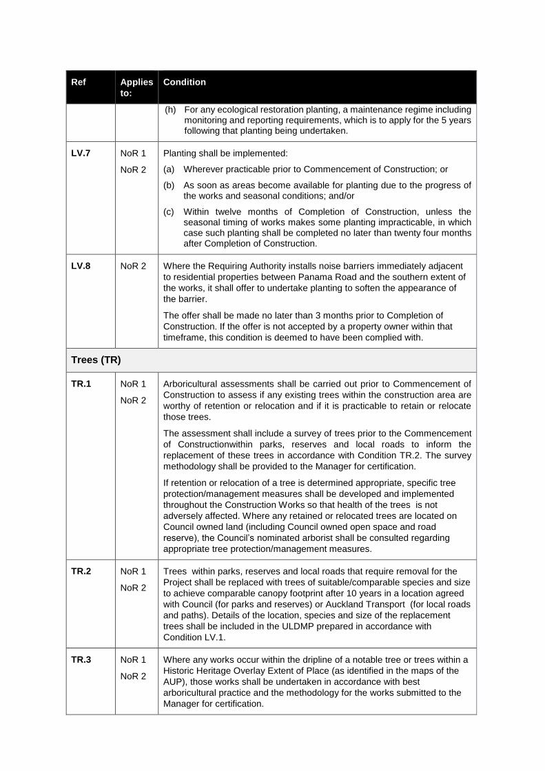
Ref Applies
to:
Condition
(h) For any ecological restoration planting, a maintenance regime including monitoring and reporting requirements, which is to apply for the 5 years following that planting being undertaken.
LV.7 NoR 1
NoR 2
Planting shall be implemented:
(a) Wherever practicable prior to Commencement of Construction; or
(b) As soon as areas become available for planting due to the progress of the works and seasonal conditions; and/or
(c) Within twelve months of Completion of Construction, unless the seasonal timing of works makes some planting impracticable, in which case such planting shall be completed no later than twenty four months after Completion of Construction.
LV.8 NoR 2 Where the Requiring Authority installs noise barriers immediately adjacent
to residential properties between Panama Road and the southern extent of
the works, it shall offer to undertake planting to soften the appearance of
the barrier.
The offer shall be made no later than 3 months prior to Completion of
Construction. If the offer is not accepted by a property owner within that
timeframe, this condition is deemed to have been complied with.
Trees (TR)
TR.1 NoR 1
NoR 2
Arboricultural assessments shall be carried out prior to Commencement of
Construction to assess if any existing trees within the construction area are
worthy of retention or relocation and if it is practicable to retain or relocate
those trees.
The assessment shall include a survey of trees prior to the Commencement
of Constructionwithin parks, reserves and local roads to inform the
replacement of these trees in accordance with Condition TR.2. The survey
methodology shall be provided to the Manager for certification.
If retention or relocation of a tree is determined appropriate, specific tree
protection/management measures shall be developed and implemented
throughout the Construction Works so that health of the trees is not
adversely affected. Where any retained or relocated trees are located on
Council owned land (including Council owned open space and road
reserve), the Council’s nominated arborist shall be consulted regarding
appropriate tree protection/management measures.
TR.2 NoR 1
NoR 2
Trees within parks, reserves and local roads that require removal for the
Project shall be replaced with trees of suitable/comparable species and size
to achieve comparable canopy footprint after 10 years in a location agreed
with Council (for parks and reserves) or Auckland Transport (for local roads
and paths). Details of the location, species and size of the replacement
trees shall be included in the ULDMP prepared in accordance with
Condition LV.1.
TR.3 NoR 1
NoR 2
Where any works occur within the dripline of a notable tree or trees within a
Historic Heritage Overlay Extent of Place (as identified in the maps of the
AUP), those works shall be undertaken in accordance with best
arboricultural practice and the methodology for the works submitted to the
Manager for certification.
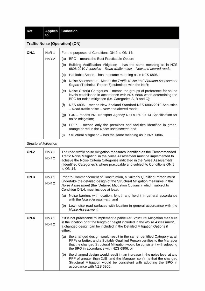
Ref Applies
to:
Condition
Traffic Noise (Operation) (ON)
ON.1 NoR 1
NoR 2
For the purposes of Conditions ON.2 to ON.14:
(a) BPO – means the Best Practicable Option;
(b) Building-Modification Mitigation – has the same meaning as in NZS 6806:2010 Acoustics – Road-traffic noise – New and altered roads;
(c) Habitable Space – has the same meaning as in NZS 6806;
(d) Noise Assessment – Means the Traffic Noise and Vibration Assessment Report (Technical Report 7) submitted with the NoR;
(e) Noise Criteria Categories – means the groups of preference for sound levels established in accordance with NZS 6806 when determining the BPO for noise mitigation (i.e. Categories A, B and C);
(f) NZS 6806 – means New Zealand Standard NZS 6806:2010 Acoustics – Road-traffic noise – New and altered roads;
(g) P40 – means NZ Transport Agency NZTA P40:2014 Specification for noise mitigation;
(h) PPFs – means only the premises and facilities identified in green, orange or red in the Noise Assessment; and
(i) Structural Mitigation – has the same meaning as in NZS 6806.
Structural Mitigation
ON.2 NoR 1
NoR 2
The road-traffic noise mitigation measures identified as the ‘Recommended
Traffic Noise Mitigation’ in the Noise Assessment must be implemented to
achieve the Noise Criteria Categories indicated in the Noise Assessment
(‘Identified Categories’), where practicable and subject to Conditions ON.3
to ON.14.
ON.3 NoR 1
NoR 2
Prior to Commencement of Construction, a Suitably Qualified Person must
undertake the detailed design of the Structural Mitigation measures in the
Noise Assessment (the ‘Detailed Mitigation Options’), which, subject to
Condition ON.4, must include at least:
(a) Noise barriers with location, length and height in general accordance with the Noise Assessment; and
(b) Low-noise road surfaces with location in general accordance with the Noise Assessment.
ON.4 NoR 1
NoR 2
If it is not practicable to implement a particular Structural Mitigation measure
in the location or of the length or height included in the Noise Assessment,
a changed design can be included in the Detailed Mitigation Options if
either:
(a) the changed design would result in the same Identified Category at all PPFs or better, and a Suitably Qualified Person certifies to the Manager that the changed Structural Mitigation would be consistent with adopting the BPO in accordance with NZS 6806; or
(b) the changed design would result in an increase in the noise level at any PPF of greater than 2dB and the Manager confirms that the changed Structural Mitigation would be consistent with adopting the BPO in accordance with NZS 6806.
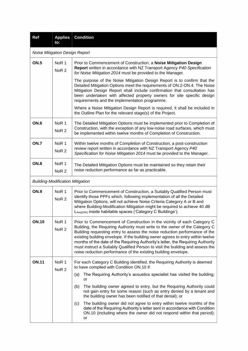
Ref Applies
to:
Condition
Noise Mitigation Design Report
ON.5 NoR 1
NoR 2
Prior to Commencement of Construction, a Noise Mitigation Design
Report written in accordance with NZ Transport Agency P40 Specification
for Noise Mitigation 2014 must be provided to the Manager.
The purpose of the Noise Mitigation Design Report is to confirm that the
Detailed Mitigation Options meet the requirements of ON.2-ON.4. The Noise
Mitigation Design Report shall include confirmation that consultation has
been undertaken with affected property owners for site specific design
requirements and the implementation programme.
Where a Noise Mitigation Design Report is required, it shall be included in
the Outline Plan for the relevant stage(s) of the Project.
ON.6 NoR 1
NoR 2
The Detailed Mitigation Options must be implemented prior to Completion of
Construction, with the exception of any low-noise road surfaces, which must
be implemented within twelve months of Completion of Construction.
ON.7 NoR 1
NoR 2
Within twelve months of Completion of Construction, a post-construction
review report written in accordance with NZ Transport Agency P40
Specification for Noise Mitigation 2014 must be provided to the Manager.
ON.8 NoR 1
NoR 2
The Detailed Mitigation Options must be maintained so they retain their
noise reduction performance as far as practicable.
Building-Modification Mitigation
ON.9 NoR 1
NoR 2
Prior to Commencement of Construction, a Suitably Qualified Person must
identify those PPFs which, following implementation of all the Detailed
Mitigation Options, will not achieve Noise Criteria Category A or B and
where Building-Modification Mitigation might be required to achieve 40 dB
LAeq(24h) inside habitable spaces (‘Category C Buildings’).
ON.10 NoR 1
NoR 2
Prior to Commencement of Construction in the vicinity of each Category C
Building, the Requiring Authority must write to the owner of the Category C
Building requesting entry to assess the noise reduction performance of the
existing building envelope. If the building owner agrees to entry within twelve
months of the date of the Requiring Authority’s letter, the Requiring Authority
must instruct a Suitably Qualified Person to visit the building and assess the
noise reduction performance of the existing building envelope.
ON.11 NoR 1
NoR 2
For each Category C Building identified, the Requiring Authority is deemed
to have complied with Condition ON.10 if:
(a) The Requiring Authority’s acoustics specialist has visited the building; or
(b) The building owner agreed to entry, but the Requiring Authority could not gain entry for some reason (such as entry denied by a tenant and the building owner has been notified of that denial); or
(c) The building owner did not agree to entry within twelve months of the date of the Requiring Authority’s letter sent in accordance with Condition ON.10 (including where the owner did not respond within that period); or
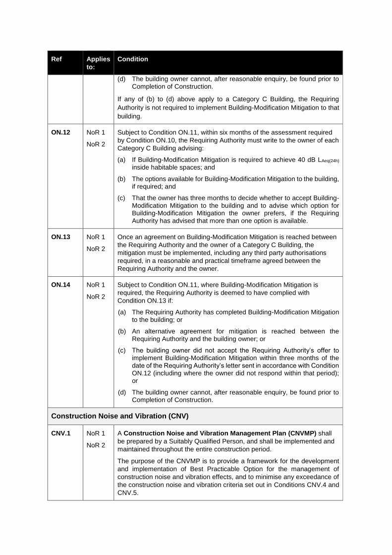
Ref Applies
to:
Condition
(d) The building owner cannot, after reasonable enquiry, be found prior to Completion of Construction.
If any of (b) to (d) above apply to a Category C Building, the Requiring
Authority is not required to implement Building-Modification Mitigation to that
building.
ON.12 NoR 1
NoR 2
Subject to Condition ON.11, within six months of the assessment required
by Condition ON.10, the Requiring Authority must write to the owner of each
Category C Building advising:
(a) If Building-Modification Mitigation is required to achieve 40 dB LAeq(24h) inside habitable spaces; and
(b) The options available for Building-Modification Mitigation to the building, if required; and
(c) That the owner has three months to decide whether to accept Building-Modification Mitigation to the building and to advise which option for Building-Modification Mitigation the owner prefers, if the Requiring Authority has advised that more than one option is available.
ON.13 NoR 1
NoR 2
Once an agreement on Building-Modification Mitigation is reached between
the Requiring Authority and the owner of a Category C Building, the
mitigation must be implemented, including any third party authorisations
required, in a reasonable and practical timeframe agreed between the
Requiring Authority and the owner.
ON.14 NoR 1
NoR 2
Subject to Condition ON.11, where Building-Modification Mitigation is
required, the Requiring Authority is deemed to have complied with
Condition ON.13 if:
(a) The Requiring Authority has completed Building-Modification Mitigation to the building; or
(b) An alternative agreement for mitigation is reached between the Requiring Authority and the building owner; or
(c) The building owner did not accept the Requiring Authority’s offer to implement Building-Modification Mitigation within three months of the date of the Requiring Authority’s letter sent in accordance with Condition ON.12 (including where the owner did not respond within that period); or
(d) The building owner cannot, after reasonable enquiry, be found prior to Completion of Construction.
Construction Noise and Vibration (CNV)
CNV.1 NoR 1
NoR 2
A Construction Noise and Vibration Management Plan (CNVMP) shall
be prepared by a Suitably Qualified Person, and shall be implemented and
maintained throughout the entire construction period.
The purpose of the CNVMP is to provide a framework for the development
and implementation of Best Practicable Option for the management of
construction noise and vibration effects, and to minimise any exceedance of
the construction noise and vibration criteria set out in Conditions CNV.4 and
CNV.5.
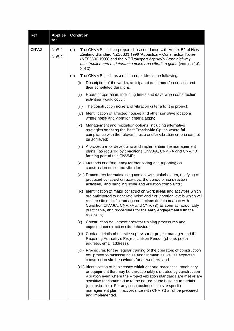
Ref Applies
to:
Condition
CNV.2 NoR 1
NoR 2
(a) The CNVMP shall be prepared in accordance with Annex E2 of New
Zealand Standard NZS6803:1999 ‘Acoustics – Construction Noise’
(NZS6806:1999) and the NZ Transport Agency’s State highway
construction and maintenance noise and vibration guide (version 1.0,
2013).
(b) The CNVMP shall, as a minimum, address the following:
(i) Description of the works, anticipated equipment/processes and
their scheduled durations;
(ii) Hours of operation, including times and days when construction
activities would occur;
(iii) The construction noise and vibration criteria for the project;
(iv) Identification of affected houses and other sensitive locations
where noise and vibration criteria apply;
(v) Management and mitigation options, including alternative
strategies adopting the Best Practicable Option where full
compliance with the relevant noise and/or vibration criteria cannot
be achieved;
(vi) A procedure for developing and implementing the management
plans (as required by conditions CNV.6A, CNV.7A and CNV.7B)
forming part of this CNVMP;
(vii) Methods and frequency for monitoring and reporting on
construction noise and vibration;
(viii) Procedures for maintaining contact with stakeholders, notifying of
proposed construction activities, the period of construction
activities, and handling noise and vibration complaints;
(ix) Identification of major construction work areas and activities which
are anticipated to generate noise and / or vibration levels which will
require site specific management plans (in accordance with
Condition CNV.6A, CNV.7A and CNV.7B) as soon as reasonably
practicable, and procedures for the early engagement with the
receivers;
(x) Construction equipment operator training procedures and
expected construction site behaviours;
(xi) Contact details of the site supervisor or project manager and the
Requiring Authority’s Project Liaison Person (phone, postal
address, email address);
(xii) Procedures for the regular training of the operators of construction
equipment to minimise noise and vibration as well as expected
construction site behaviours for all workers; and
(xiii) Identification of businesses which operate processes, machinery
or equipment that may be unreasonably disrupted by construction
vibration even where the Project vibration standards are met or are
sensitive to vibration due to the nature of the building materials
(e.g. asbestos). For any such businesses a site specific
management plan in accordance with CNV.7B shall be prepared
and implemented.
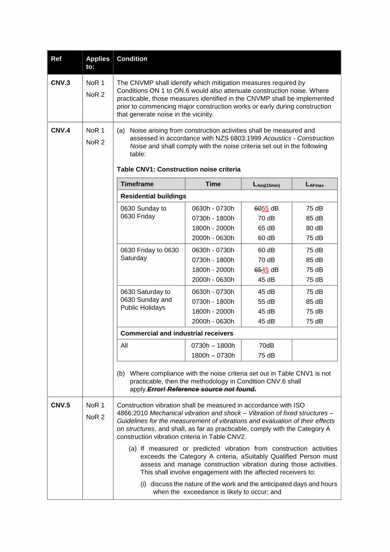
Ref Applies
to:
Condition
CNV.3 NoR 1
NoR 2
The CNVMP shall identify which mitigation measures required by
Conditions ON 1 to ON.6 would also attenuate construction noise. Where
practicable, those measures identified in the CNVMP shall be implemented
prior to commencing major construction works or early during construction that generate noise in the vicinity.
CNV.4 NoR 1
NoR 2
(a) Noise arising from construction activities shall be measured and
assessed in accordance with NZS 6803:1999 Acoustics - Construction
Noise and shall comply with the noise criteria set out in the following
table:
Table CNV1: Construction noise criteria
Timeframe Time LAeq(15min) LAFmax
Residential buildings
0630 Sunday to
0630 Friday
0630h - 0730h
0730h - 1800h
1800h - 2000h
2000h - 0630h
6055 dB
70 dB
65 dB
60 dB
75 dB
85 dB
80 dB
75 dB
0630 Friday to 0630
Saturday
0630h - 0730h
0730h - 1800h
1800h - 2000h
2000h - 0630h
60 dB
70 dB
6545 dB
45 dB
75 dB
85 dB
75 dB
75 dB
0630 Saturday to
0630 Sunday and
Public Holidays
0630h - 0730h
0730h - 1800h
1800h - 2000h
2000h - 0630h
45 dB
55 dB
45 dB
45 dB
75 dB
85 dB
75 dB
75 dB
Commercial and industrial receivers
All 0730h – 1800h
1800h – 0730h
70dB
75 dB
(b) Where compliance with the noise criteria set out in Table CNV1 is not
practicable, then the methodology in Condition CNV.6 shall
apply.Error! Reference source not found.
CNV.5 NoR 1
NoR 2
Construction vibration shall be measured in accordance with ISO
4866:2010 Mechanical vibration and shock – Vibration of fixed structures –
Guidelines for the measurement of vibrations and evaluation of their effects
on structures, and shall, as far as practicable, comply with the Category A
construction vibration criteria in Table CNV2.
(a) If measured or predicted vibration from construction activities
exceeds the Category A criteria, aSuitably Qualified Person must
assess and manage construction vibration during those activities.
This shall involve engagement with the affected receivers to:
(i) discuss the nature of the work and the anticipated days and hours
when the exceedance is likely to occur; and
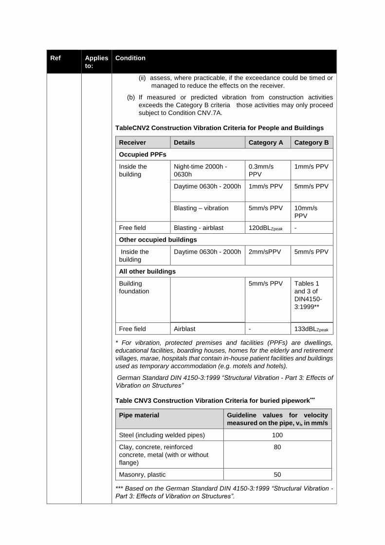
Ref Applies
to:
Condition
(ii) assess, where practicable, if the exceedance could be timed or
managed to reduce the effects on the receiver.
(b) If measured or predicted vibration from construction activities
exceeds the Category B criteria those activities may only proceed
subject to Condition CNV.7A.
TableCNV2 Construction Vibration Criteria for People and Buildings
Receiver Details Category A Category B
Occupied PPFs
Inside the
building
Night-time 2000h -
0630h
0.3mm/s
PPV
1mm/s PPV
Daytime 0630h - 2000h
1mm/s PPV 5mm/s PPV
Blasting – vibration 5mm/s PPV 10mm/s
PPV
Free field Blasting - airblast 120dBLZpeak -
Other occupied buildings
Inside the
building
Daytime 0630h - 2000h 2mm/sPPV 5mm/s PPV
All other buildings
Building
foundation
5mm/s PPV Tables 1
and 3 of
DIN4150-
3:1999**
Free field Airblast - 133dBLZpeak
* For vibration, protected premises and facilities (PPFs) are dwellings,
educational facilities, boarding houses, homes for the elderly and retirement
villages, marae, hospitals that contain in-house patient facilities and buildings
used as temporary accommodation (e.g. motels and hotels).
German Standard DIN 4150-3:1999 “Structural Vibration - Part 3: Effects of
Vibration on Structures”
Table CNV3 Construction Vibration Criteria for buried pipework***
Pipe material Guideline values for velocity
measured on the pipe, vi, in mm/s
Steel (including welded pipes) 100
Clay, concrete, reinforced
concrete, metal (with or without
flange)
80
Masonry, plastic 50
*** Based on the German Standard DIN 4150-3:1999 “Structural Vibration -
Part 3: Effects of Vibration on Structures”.
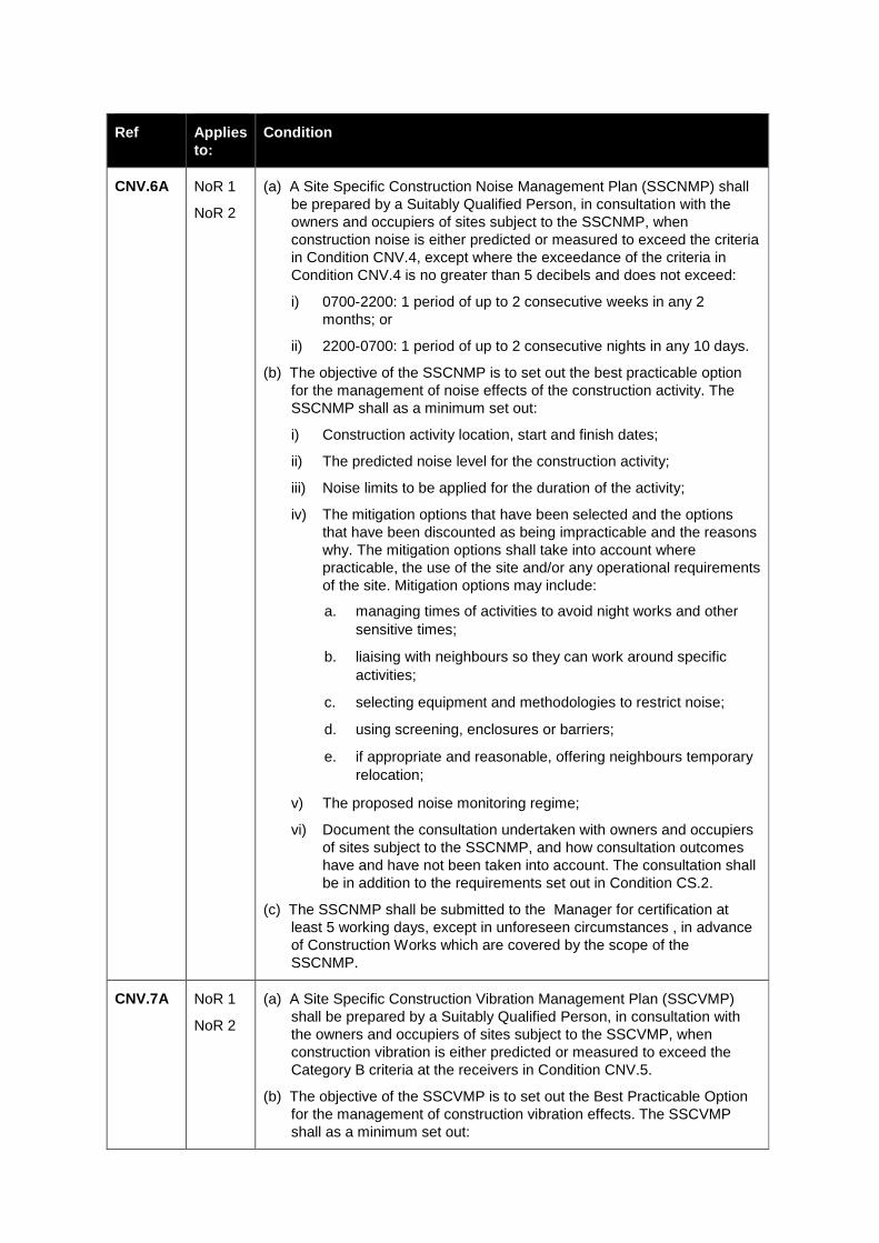
Ref Applies
to:
Condition
CNV.6A NoR 1
NoR 2
(a) A Site Specific Construction Noise Management Plan (SSCNMP) shall
be prepared by a Suitably Qualified Person, in consultation with the
owners and occupiers of sites subject to the SSCNMP, when
construction noise is either predicted or measured to exceed the criteria
in Condition CNV.4, except where the exceedance of the criteria in
Condition CNV.4 is no greater than 5 decibels and does not exceed:
i) 0700-2200: 1 period of up to 2 consecutive weeks in any 2
months; or
ii) 2200-0700: 1 period of up to 2 consecutive nights in any 10 days.
(b) The objective of the SSCNMP is to set out the best practicable option
for the management of noise effects of the construction activity. The
SSCNMP shall as a minimum set out:
i) Construction activity location, start and finish dates;
ii) The predicted noise level for the construction activity;
iii) Noise limits to be applied for the duration of the activity;
iv) The mitigation options that have been selected and the options
that have been discounted as being impracticable and the reasons
why. The mitigation options shall take into account where
practicable, the use of the site and/or any operational requirements
of the site. Mitigation options may include:
a. managing times of activities to avoid night works and other
sensitive times;
b. liaising with neighbours so they can work around specific
activities;
c. selecting equipment and methodologies to restrict noise;
d. using screening, enclosures or barriers;
e. if appropriate and reasonable, offering neighbours temporary
relocation;
v) The proposed noise monitoring regime;
vi) Document the consultation undertaken with owners and occupiers
of sites subject to the SSCNMP, and how consultation outcomes
have and have not been taken into account. The consultation shall
be in addition to the requirements set out in Condition CS.2.
(c) The SSCNMP shall be submitted to the Manager for certification at
least 5 working days, except in unforeseen circumstances , in advance
of Construction Works which are covered by the scope of the
SSCNMP.
CNV.7A NoR 1
NoR 2
(a) A Site Specific Construction Vibration Management Plan (SSCVMP)
shall be prepared by a Suitably Qualified Person, in consultation with
the owners and occupiers of sites subject to the SSCVMP, when
construction vibration is either predicted or measured to exceed the
Category B criteria at the receivers in Condition CNV.5.
(b) The objective of the SSCVMP is to set out the Best Practicable Option
for the management of construction vibration effects. The SSCVMP
shall as a minimum set out:
Ref Applies
to:
Condition
i) Construction activity location, start and finish dates;
ii) The predicted vibration level for the construction activity;
iii) An assessment of each building and any pipe work to determine
susceptibility to damage from vibration and define acceptable
vibration limits that the works must comply with to avoid damage;
iv) The mitigation options that have been selected and the options
that have been discounted as being impracticable and the reasons
why. The mitigation options shall take into account where
practicable, the use of the site and/or any operational requirements
of the site. Mitigation options may include:
a. Phasing of vibration-generating activities;
b. Avoiding impact pile driving and vibratory rollers where
possible in vibration-sensitive areas;
c. Liaising with neighbours so they can work around specific
vibration-generating activities;
d. Selecting equipment and methodologies to minimise
vibration;
v) The proposed vibration monitoring regime;
vi) The consultation undertaken with owners and occupiers of sites
subject to the SSCVMP, and how consultation outcomes have and
have not been taken into account. The consultation shall be in
addition to the requirements set out in Condition CS.2; and
vi). The pre-condition survey of buildings which document their current
condition and any existing damage.
(c) The SSCVMP shall be submitted to the Council for certification at least
5 working days, except in unforeseen circumstances, in advance of
Construction Works which are covered by the scope of the SSCVMP.
CNV.7B NoR 1 (a) In addition to the matters in CNV.7A, a SSCVMP shall also be
required in circumstances when construction vibration is predicted to
adversely affect commercial activities located within 50m of
Construction Works that are verified by a Suitably Qualified Person as
being uniquely sensitive to construction vibration due to the nature of
specialised equipment and/or the nature of the building materials (e.g.
asbestos). At a minimum, a SSCVMP shall be prepared for:
(i) Stratex Group Limited site, 19 – 21 Sylvia Park Road; and
(ii) Fonterra Tip Top site, 113 Carbine Road. With respect to this site,
"activities" in condition CNV7.B(b) includes:
underground wet services (including stormwater drainage and
wastewater);
earthenware pipes;
underground cabling (including 11kV and 400V power cables
and associated switchboxes);
ducted services; and

Ref Applies
to:
Condition
other core underground infrastructure which the landowner
has confirmed to the Requiring Authority, in writing, prior to
Commencement of Construction.
(b) In addition to the requirements of CNV.7A, the SSCVMP shall include,
with respect to those vibration sensitive commercial activities:
i) Informed by consultation with the owners and/or occupiers of sites,
identification of the processes, machinery or equipment which are
uniquely sensitive to construction vibration, and the reasons why;
ii) An assessment of the sensitivity of the processes, machinery or
equipment to construction vibration;
iii) Construction vibration criteria for the vibration sensitive
commercial activities;
iv) A process for dealing with any disagreement which may arise,
particularly in relation to the determination of the vibration limits,
and
v) Procedures and methods for monitoring compliance with the
vibration criteria established under (iii) above.
Construction Traffic (CT)
Construction Traffic Management Plan
CT.1 NoR 1
NoR 2
A Construction Traffic Management Plan (CTMP) shall be prepared by a
Suitably Qualified Person and in consultation with Auckland Transport.
The purpose of the CTMP is to manage the various traffic management,
safety and efficiency effects associated with Construction Works to:
(a) Protect public safety including the safe passage of and connectivity for pedestrians and cyclists, particularly for school students travelling to and from school;
(b) Minimise increases to existing delay to road users, public transport services, pedestrians and cyclists;
(c) Minimise interruption to property access;
(d) Inform the public about any potential impacts on the road network;
(e) Minimise disruptions on the arterial road network and rail network; and
(f) Manage the effects on and/or any changes required to existing Over Dimension and Over Weight routes.
CT.2 NoR 1
NoR 2
The CTMP shall:
(a) Identify how Condition CT.1 will be achieved;
(b) Be in general accordance with the Draft Construction Traffic
Management Plan Framework listed in DC.1;
(c) Where road capacity may be significantly affected by temporary traffic
management, identify potential effects of the capacity reduction, and
proposed measures to minimise delays. Traffic Impact Assessment
(with possible inclusion of traffic modelling) may be required,
particularly where the arterial network is affected;
Ref Applies
to:
Condition
(d) Include measures to avoid road closures and restrictions on vehicle,
bus, cycle and pedestrian movements;
(e) Identify site access routes and access points for heavy vehicles;
(f) Identify possible temporary changes to bus routes and bus stops,
whether these can be safely accommodated on the relevant roads and
the considerations to maintain service to key destinations and minimise
of levels of service reduction;
(g) Where road closures or restrictions cannot reasonably be avoided, the particular vulnerabilities and sensitivities of pedestrian diversions and reduced conditions shall be taken into account in the planning of any closures or restrictions;
(h) Confirm that a safe alternative shared cycle/pedestrian path connection between Onehunga Harbour Road and Old Māngere Bridge or the New Old Māngere Bridge (if constructed) is available at all times during the Construction Works;
(i) Identify proposed measures to minimise the duration of closure of the existing shared path facility along the Māngere Inlet, and proposed measures to stage works and / or provide detours to minimise inconvenience. Detours shall be sign posted, and shall where practicable, minimise the increase in length relative to the existing facility, the increase in vertical ascent, and minimise the duration of the construction period. The alternate route shall have an appropriate surface maintained throughout its period of use; a; and
(j) Include the process for rail closures, including how scheduled block-of-lines are to be utilised and the timing of any closures to avoid or minimise level of service reduction to passenger rail services at peak commuter times and rail freight services; and
(k) Identify any changes required to Over Dimension and Over Weight routes and how impacts on these routes, including alternate diversion routes, will be managed during construction so as to minimise the impact of any changes (both temporary and permanent) on Over Dimension and Overweight vehicles.
CT.3 NoR 1
NoR 2
At least 40 working days prior to commencement of Construction Works the
Requiring Authority shall provide a draft of the CTMP to Auckland Transport
for comment.
The CTMP shall summarise the input and comments from Auckland
Transport, describe how this has been incorporated and, where any input has
not been incorporated, set out the reason why.
Any amendments to the CTMP shall be prepared in consultation with
Auckland Transport prior to submission in accordance with Condition DC.10.
Site/Activity Specific Traffic Management Plans
CT.4 NoR 1
NoR 2
(a) Site/activity specific Traffic Management Plans (TMPs) shall be
prepared where any Project construction activity varies the normal traffic
conditions of any public road.
(b) The TMP shall be reviewed by an engineer with a minimum of a current
Level 2/3 Site Traffic Management Supervisor Non-Practicing
qualification. Any comments and inputs received from the reviewer shall
be clearly documented.
Ref Applies
to:
Condition
(c) The Requiring Authority shall provide the TMP to the relevant Road
Controlling Authority for approval.
(d) The purpose of the TMP is to identify specific construction methods to
address the particular circumstances, local traffic and community travel
demands within the area covered by the TMP. The TMP shall describe
the measures that will be taken to manage the traffic effects associated
with Construction Works within the area covered by the TMP.
(e) In particular the TMP shall describe:
(i) Temporary traffic management measures required to manage impacts on road users during proposed working hours;
(ii) Temporary effects on on-street parking and proposed measures to minimise those effects;
(iii) Delay calculations associated with the proposed closure/s and detour routes;
(iv) The capacity of any proposed detour route(s) and their ability to carry the additional traffic volumes and any known safety issues associated with the detour route, including any mitigation measures the Requiring Authority proposes to put in place to address any identified safety issues;
(v) Individual traffic management plans for intersections of the Project with arterial roads;
(vi) Measures to maintain, subject to health and safety requirements, existing vehiclular access to adjacent properties and businesses to accommodate the types of vehicles normally accessing the site during normal working hours for that site unless alternative access arrangements are agreed;
(vii) Measures to maintain 24 hour per day access for road legal vehicles from Onehunga Harbour Road to Onehunga Wharf for existing businesses and for emergency vehicles. If any particular access point cannot be maintained or reconfigured, appropriate alternative arrangements for continued access to the wharf are to be made where practicable. Short term closures of access to the wharf may occur only after prior consultation with existing business operators regarding the timing and duration of the proposed closure. Unless otherwise agreed with existing business owners, no closure of access to the wharf shall exceed a duration of 4 hours within any 24 hour period;
(viii) Measures to minimise the temporary effects of Construction Works on on-site parking on directly affected properties and opportunities to provide alternative temporary parking where practicable to do so;
(ix) Measures to maintain, where practicable, safe and clearly identified pedestrian and cyclist access on roads and footpaths adjacent to the Construction Works. Where detours are necessary to provide such access the Requiring Authority shall provide, as far as practicable, the shortest and most convenient detours;
(x) Consideration of over dimension and overweight routes including any feedback received from established organisations representing the freight industry;
(xi) Any proposed temporary changes in speed limit;
Ref Applies
to:
Condition
(xii) Provision for safe and efficient access of construction vehicles to and from construction site(s);
(xiii) The measures that will be undertaken by the Requiring Authority to communicate traffic management measures to affected road users, cyclists and pedestrian and other stakeholders;
(xiv) The measures that will be undertaken by the Requiring Authority (e.g. instructions to contractors) to restrict Project-related heavy vehicles using residential streets and the section of Onehunga Mall north of Neilson Street; and
(xv) The consultation undertaken with CLGs, business forums and affected properties owners/occupiers in relation to proposed temporary traffic management and measures that will be undertaken to address issues raised.
CT.4A NoR 2 Any contractors carrying out works on, beneath, or in close proximity to, the
existing tanker truck turning circle at the western edge of Fonterra's Tip Top
Site at 113 Carbine Road, shall adopt and implement construction techniques
that do not impact on the use of that turning circle, unless otherwise agreed
with the landowner.
Construction traffic - general requirements
CT.5 NoR 1
NoR 2
The CTMP and TMP(s) shall be consistent with the version of the NZ
Transport Agency Code of Practice for Temporary Traffic Management or the
Auckland Transport Auckland Transport Code of Practice (which applies at
the time the CTMP or the relevant TMP is prepared.
CT.6 NoR 1
NoR 2
The site/activity specific TMP(s) shall be prepared following consultation with
the following key stakeholders (as relevant):
(a) Auckland Transport (where local roads and paths will be affected);
(b) National Road Carriers Incorporated and NZ Heavy Haulage Association;
(c) Public transport providers (where public transport services will be affected);
(d) Emergency services (police, fire and ambulance); and
(e) Schools and childcare centres with frontage or access to roads within which works in relation to the relevant part of the Project will take place; and
(f) Directly affected property and business owners and operators, including (for the relevant works) the Onehunga Business Association and the rediedents of Onehunga Mall Cul-de-Sac..
CT.7 NoR 1
NoR 2
The Requiring Authority shall implement each TMP for the duration of the
Construction Works to which the particular TMP applies.
CT.9 NoR 1
NoR 2
Any damage to a local road or arterial road which is verified by a Suitably
Qualified Person as being directly attributable to heavy vehicles entering or
exiting construction sites shall be repaired within two weeks or within an
alternative timeframe to be agreed with Auckland Transport. All repairs shall
be undertaken by the Requiring Authority in accordance with the Auckland
Transport Code of Practice.
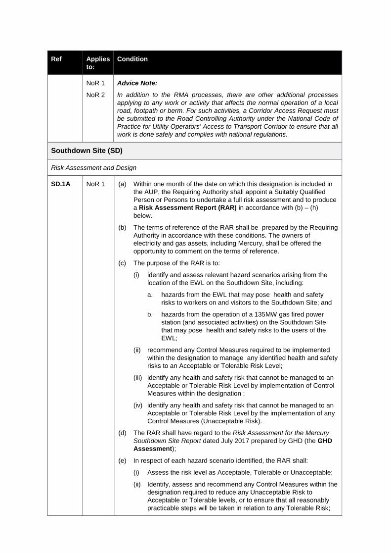
Ref Applies
to:
Condition
NoR 1
NoR 2
Advice Note:
In addition to the RMA processes, there are other additional processes
applying to any work or activity that affects the normal operation of a local
road, footpath or berm. For such activities, a Corridor Access Request must
be submitted to the Road Controlling Authority under the National Code of
Practice for Utility Operators' Access to Transport Corridor to ensure that all
work is done safely and complies with national regulations.
Southdown Site (SD)
Risk Assessment and Design
SD.1A NoR 1 (a) Within one month of the date on which this designation is included in
the AUP, the Requiring Authority shall appoint a Suitably Qualified
Person or Persons to undertake a full risk assessment and to produce
a Risk Assessment Report (RAR) in accordance with (b) – (h)
below.
(b) The terms of reference of the RAR shall be prepared by the Requiring
Authority in accordance with these conditions. The owners of
electricity and gas assets, including Mercury, shall be offered the
opportunity to comment on the terms of reference.
(c) The purpose of the RAR is to:
(i) identify and assess relevant hazard scenarios arising from the
location of the EWL on the Southdown Site, including:
a. hazards from the EWL that may pose health and safety
risks to workers on and visitors to the Southdown Site; and
b. hazards from the operation of a 135MW gas fired power
station (and associated activities) on the Southdown Site
that may pose health and safety risks to the users of the
EWL;
(ii) recommend any Control Measures required to be implemented
within the designation to manage any identified health and safety
risks to an Acceptable or Tolerable Risk Level;
(iii) identify any health and safety risk that cannot be managed to an
Acceptable or Tolerable Risk Level by implementation of Control
Measures within the designation ;
(iv) identify any health and safety risk that cannot be managed to an
Acceptable or Tolerable Risk Level by the implementation of any
Control Measures (Unacceptable Risk).
(d) The RAR shall have regard to the Risk Assessment for the Mercury
Southdown Site Report dated July 2017 prepared by GHD (the GHD
Assessment);
(e) In respect of each hazard scenario identified, the RAR shall:
(i) Assess the risk level as Acceptable, Tolerable or Unacceptable;
(ii) Identify, assess and recommend any Control Measures within the
designation required to reduce any Unacceptable Risk to
Acceptable or Tolerable levels, or to ensure that all reasonably
practicable steps will be taken in relation to any Tolerable Risk;
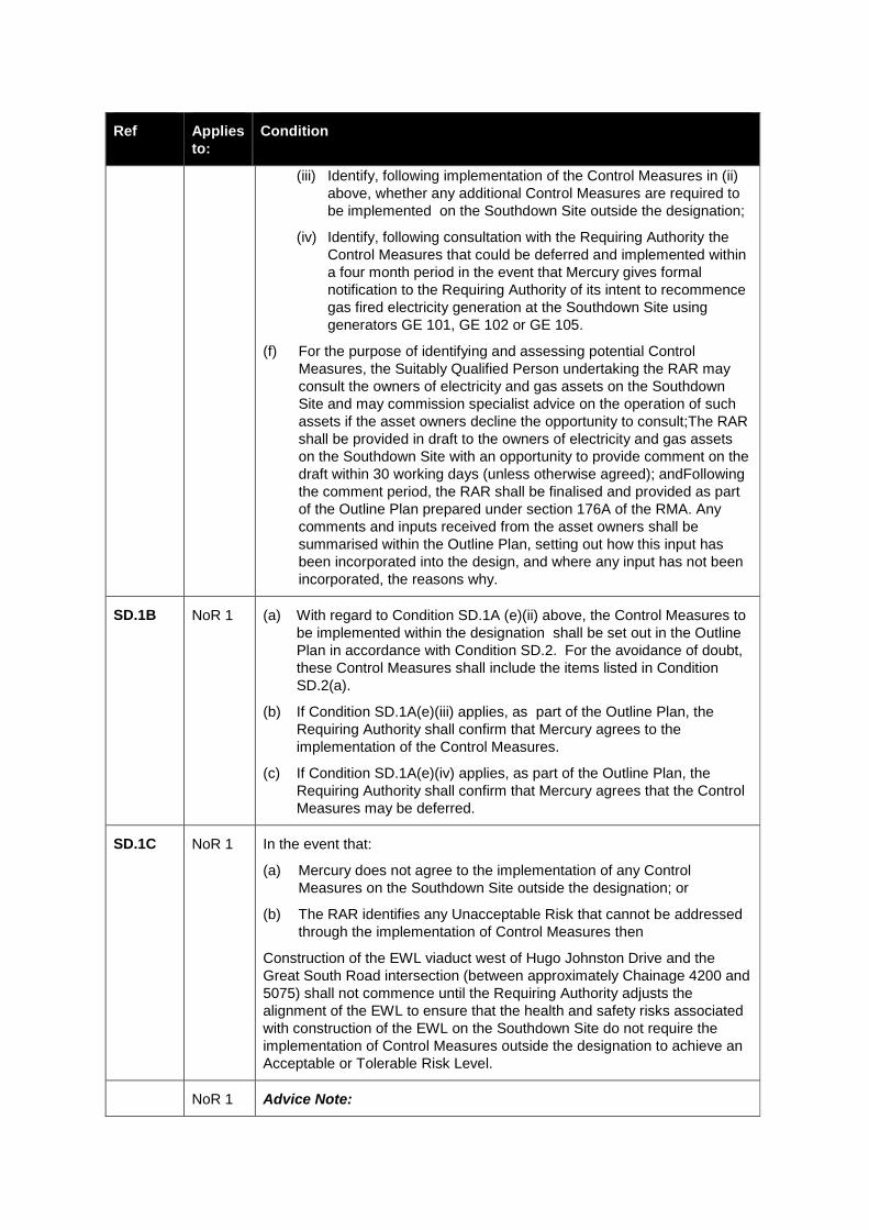
Ref Applies
to:
Condition
(iii) Identify, following implementation of the Control Measures in (ii)
above, whether any additional Control Measures are required to
be implemented on the Southdown Site outside the designation;
(iv) Identify, following consultation with the Requiring Authority the
Control Measures that could be deferred and implemented within
a four month period in the event that Mercury gives formal
notification to the Requiring Authority of its intent to recommence
gas fired electricity generation at the Southdown Site using
generators GE 101, GE 102 or GE 105.
(f) For the purpose of identifying and assessing potential Control
Measures, the Suitably Qualified Person undertaking the RAR may
consult the owners of electricity and gas assets on the Southdown
Site and may commission specialist advice on the operation of such
assets if the asset owners decline the opportunity to consult;The RAR
shall be provided in draft to the owners of electricity and gas assets
on the Southdown Site with an opportunity to provide comment on the
draft within 30 working days (unless otherwise agreed); andFollowing
the comment period, the RAR shall be finalised and provided as part
of the Outline Plan prepared under section 176A of the RMA. Any
comments and inputs received from the asset owners shall be
summarised within the Outline Plan, setting out how this input has
been incorporated into the design, and where any input has not been
incorporated, the reasons why.
SD.1B NoR 1 (a) With regard to Condition SD.1A (e)(ii) above, the Control Measures to
be implemented within the designation shall be set out in the Outline
Plan in accordance with Condition SD.2. For the avoidance of doubt,
these Control Measures shall include the items listed in Condition
SD.2(a).
(b) If Condition SD.1A(e)(iii) applies, as part of the Outline Plan, the
Requiring Authority shall confirm that Mercury agrees to the
implementation of the Control Measures.
(c) If Condition SD.1A(e)(iv) applies, as part of the Outline Plan, the
Requiring Authority shall confirm that Mercury agrees that the Control
Measures may be deferred.
SD.1C NoR 1 In the event that:
(a) Mercury does not agree to the implementation of any Control
Measures on the Southdown Site outside the designation; or
(b) The RAR identifies any Unacceptable Risk that cannot be addressed
through the implementation of Control Measures then
Construction of the EWL viaduct west of Hugo Johnston Drive and the
Great South Road intersection (between approximately Chainage 4200 and
5075) shall not commence until the Requiring Authority adjusts the
alignment of the EWL to ensure that the health and safety risks associated
with construction of the EWL on the Southdown Site do not require the
implementation of Control Measures outside the designation to achieve an
Acceptable or Tolerable Risk Level.
NoR 1 Advice Note:
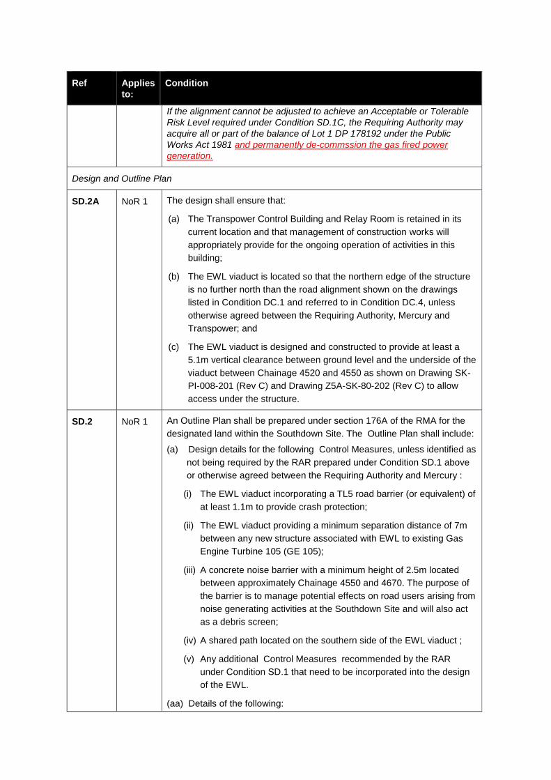
Ref Applies
to:
Condition
If the alignment cannot be adjusted to achieve an Acceptable or Tolerable
Risk Level required under Condition SD.1C, the Requiring Authority may
acquire all or part of the balance of Lot 1 DP 178192 under the Public
Works Act 1981 and permanently de-commssion the gas fired power
generation.
Design and Outline Plan
SD.2A NoR 1 The design shall ensure that:
(a) The Transpower Control Building and Relay Room is retained in its
current location and that management of construction works will
appropriately provide for the ongoing operation of activities in this
building;
(b) The EWL viaduct is located so that the northern edge of the structure
is no further north than the road alignment shown on the drawings
listed in Condition DC.1 and referred to in Condition DC.4, unless
otherwise agreed between the Requiring Authority, Mercury and
Transpower; and
(c) The EWL viaduct is designed and constructed to provide at least a
5.1m vertical clearance between ground level and the underside of the
viaduct between Chainage 4520 and 4550 as shown on Drawing SK-
PI-008-201 (Rev C) and Drawing Z5A-SK-80-202 (Rev C) to allow
access under the structure.
SD.2 NoR 1 An Outline Plan shall be prepared under section 176A of the RMA for the
designated land within the Southdown Site. The Outline Plan shall include:
(a) Design details for the following Control Measures, unless identified as
not being required by the RAR prepared under Condition SD.1 above
or otherwise agreed between the Requiring Authority and Mercury :
(i) The EWL viaduct incorporating a TL5 road barrier (or equivalent) of
at least 1.1m to provide crash protection;
(ii) The EWL viaduct providing a minimum separation distance of 7m
between any new structure associated with EWL to existing Gas
Engine Turbine 105 (GE 105);
(iii) A concrete noise barrier with a minimum height of 2.5m located
between approximately Chainage 4550 and 4670. The purpose of
the barrier is to manage potential effects on road users arising from
noise generating activities at the Southdown Site and will also act
as a debris screen;
(iv) A shared path located on the southern side of the EWL viaduct ;
(v) Any additional Control Measures recommended by the RAR
under Condition SD.1 that need to be incorporated into the design
of the EWL.
(aa) Details of the following:
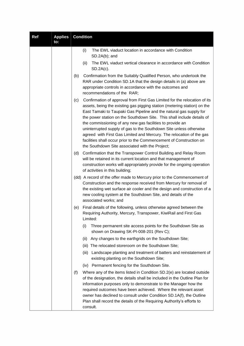
Ref Applies
to:
Condition
(i) The EWL viaduct location in accordance with Condition
SD.2A(b); and
(ii) The EWL viaduct vertical clearance in accordance with Condition
SD.2A(c).
(b) Confirmation from the Suitably Qualified Person, who undertook the
RAR under Condition SD.1A that the design details in (a) above are
appropriate controls in accordance with the outcomes and
recommendations of the RAR;
(c) Confirmation of approval from First Gas Limited for the relocation of its
assets, being the existing gas pigging station (metering station) on the
East Tamaki to Taupaki Gas Pipeline and the natural gas supply for
the power station on the Southdown Site. This shall include details of
the commissioning of any new gas facilities to provide an
uninterrupted supply of gas to the Southdown Site unless otherwise
agreed with First Gas Limited and Mercury. The relocation of the gas
facilities shall occur prior to the Commencement of Construction on
the Southdown Site associated with the Project;
(d) Confirmation that the Transpower Control Building and Relay Room
will be retained in its current location and that management of
construction works will appropriately provide for the ongoing operation
of activities in this building;
(dd) A record of the offer made to Mercury prior to the Commencement of
Construction and the response received from Mercury for removal of
the existing wet surface air cooler and the design and construction of a
new cooling system at the Southdown Site, and details of the
associated works; and
(e) Final details of the following, unless otherwise agreed between the
Requiring Authority, Mercury, Transpower, KiwiRail and First Gas
Limited:
(i) Three permanent site access points for the Southdown Site as
shown on Drawing SK-PI-008-201 (Rev C);
(ii) Any changes to the earthgrids on the Southdown Site;
(iii) The relocated storeroom on the Southdown Site;
(iii) Landscape planting and treatment of batters and reinstatement of
existing planting on the Southdown Site;
(iv) Permanent fencing for the Southdown Site.
(f) Where any of the items listed in Condition SD.2(e) are located outside
of the designation, the details shall be included in the Outline Plan for
information purposes only to demonstrate to the Manager how the
required outcomes have been achieved. Where the relevant asset
owner has declined to consult under Condition SD.1A(f), the Outline
Plan shall record the details of the Requiring Authority’s efforts to
consult.
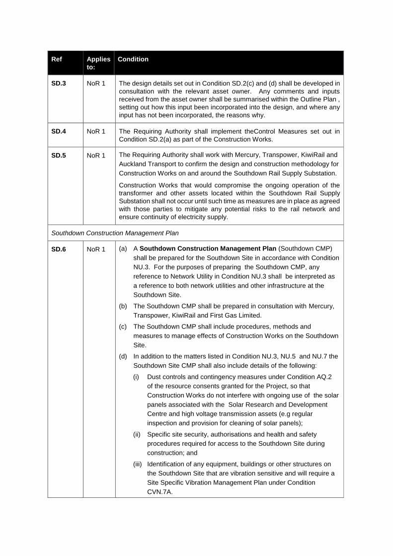
Ref Applies
to:
Condition
SD.3 NoR 1 The design details set out in Condition SD.2(c) and (d) shall be developed in
consultation with the relevant asset owner. Any comments and inputs
received from the asset owner shall be summarised within the Outline Plan ,
setting out how this input been incorporated into the design, and where any
input has not been incorporated, the reasons why.
SD.4 NoR 1 The Requiring Authority shall implement theControl Measures set out in
Condition SD.2(a) as part of the Construction Works.
SD.5 NoR 1 The Requiring Authority shall work with Mercury, Transpower, KiwiRail and
Auckland Transport to confirm the design and construction methodology for
Construction Works on and around the Southdown Rail Supply Substation.
Construction Works that would compromise the ongoing operation of the
transformer and other assets located within the Southdown Rail Supply
Substation shall not occur until such time as measures are in place as agreed
with those parties to mitigate any potential risks to the rail network and
ensure continuity of electricity supply.
Southdown Construction Management Plan
SD.6 NoR 1 (a) A Southdown Construction Management Plan (Southdown CMP)
shall be prepared for the Southdown Site in accordance with Condition
NU.3. For the purposes of preparing the Southdown CMP, any
reference to Network Utility in Condition NU.3 shall be interpreted as
a reference to both network utilities and other infrastructure at the
Southdown Site.
(b) The Southdown CMP shall be prepared in consultation with Mercury,
Transpower, KiwiRail and First Gas Limited.
(c) The Southdown CMP shall include procedures, methods and
measures to manage effects of Construction Works on the Southdown
Site.
(d) In addition to the matters listed in Condition NU.3, NU.5 and NU.7 the
Southdown Site CMP shall also include details of the following:
(i) Dust controls and contingency measures under Condition AQ.2
of the resource consents granted for the Project, so that
Construction Works do not interfere with ongoing use of the solar
panels associated with the Solar Research and Development
Centre and high voltage transmission assets (e.g regular
inspection and provision for cleaning of solar panels);
(ii) Specific site security, authorisations and health and safety
procedures required for access to the Southdown Site during
construction; and
(iii) Identification of any equipment, buildings or other structures on
the Southdown Site that are vibration sensitive and will require a
Site Specific Vibration Management Plan under Condition
CVN.7A.
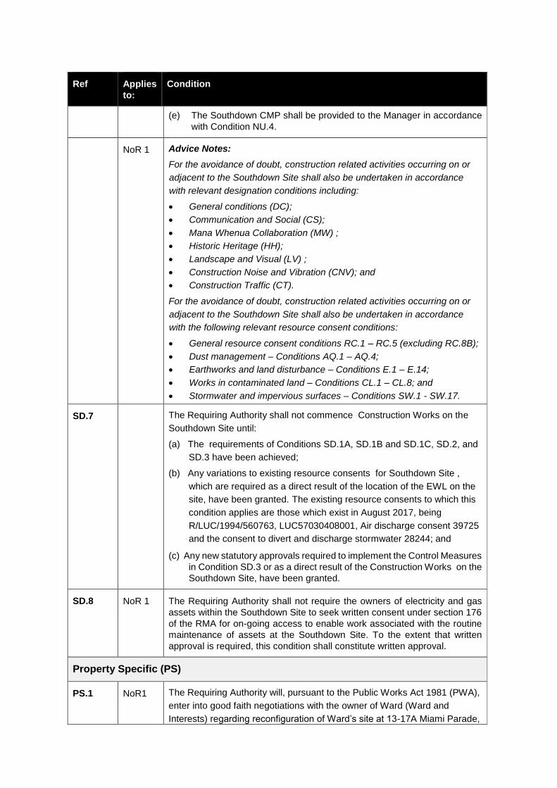
Ref Applies
to:
Condition
(e) The Southdown CMP shall be provided to the Manager in accordance
with Condition NU.4.
NoR 1 Advice Notes:
For the avoidance of doubt, construction related activities occurring on or
adjacent to the Southdown Site shall also be undertaken in accordance
with relevant designation conditions including:
General conditions (DC);
Communication and Social (CS);
Mana Whenua Collaboration (MW) ;
Historic Heritage (HH);
Landscape and Visual (LV) ;
Construction Noise and Vibration (CNV); and
Construction Traffic (CT).
For the avoidance of doubt, construction related activities occurring on or
adjacent to the Southdown Site shall also be undertaken in accordance
with the following relevant resource consent conditions:
General resource consent conditions RC.1 – RC.5 (excluding RC.8B);
Dust management – Conditions AQ.1 – AQ.4;
Earthworks and land disturbance – Conditions E.1 – E.14;
Works in contaminated land – Conditions CL.1 – CL.8; and
Stormwater and impervious surfaces – Conditions SW.1 - SW.17.
SD.7 The Requiring Authority shall not commence Construction Works on the
Southdown Site until:
(a) The requirements of Conditions SD.1A, SD.1B and SD.1C, SD.2, and
SD.3 have been achieved;
(b) Any variations to existing resource consents for Southdown Site ,
which are required as a direct result of the location of the EWL on the
site, have been granted. The existing resource consents to which this
condition applies are those which exist in August 2017, being
R/LUC/1994/560763, LUC57030408001, Air discharge consent 39725
and the consent to divert and discharge stormwater 28244; and
(c) Any new statutory approvals required to implement the Control Measures
in Condition SD.3 or as a direct result of the Construction Works on the
Southdown Site, have been granted.
SD.8 NoR 1 The Requiring Authority shall not require the owners of electricity and gas
assets within the Southdown Site to seek written consent under section 176
of the RMA for on-going access to enable work associated with the routine
maintenance of assets at the Southdown Site. To the extent that written
approval is required, this condition shall constitute written approval.
Property Specific (PS)
PS.1 NoR1 The Requiring Authority will, pursuant to the Public Works Act 1981 (PWA),
enter into good faith negotiations with the owner of Ward (Ward and
Interests) regarding reconfiguration of Ward’s site at 13-17A Miami Parade,

Ref Applies
to:
Condition
at the cost of the Requiring Authority, to reduce the impact on Ward’s
operations resulting from the 715m2 permanent and 99m2 temporary land
requirement
PS.2 NoR1 NZTA shall use its best endeavours to legally formalise vehicular access,
including for heavy goods vehicles, between 8 Sylvia Park Road and
Pacific Rise, prior to the date on which right turns into and out of 8 Sylvia
Park Road frontage are no longer possible.
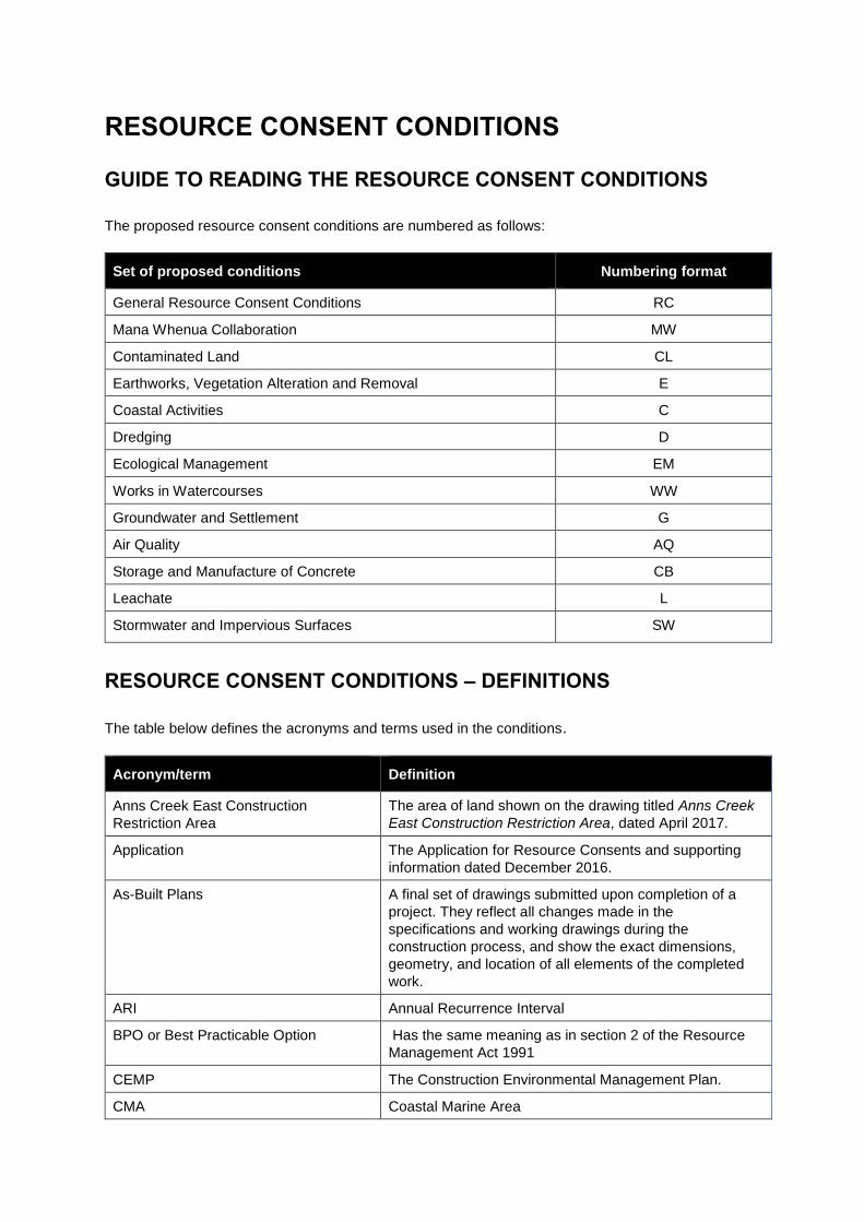
RESOURCE CONSENT CONDITIONS
GUIDE TO READING THE RESOURCE CONSENT CONDITIONS
The proposed resource consent conditions are numbered as follows:
Set of proposed conditions Numbering format
General Resource Consent Conditions RC
Mana Whenua Collaboration MW
Contaminated Land CL
Earthworks, Vegetation Alteration and Removal E
Coastal Activities C
Dredging D
Ecological Management EM
Works in Watercourses WW
Groundwater and Settlement G
Air Quality AQ
Storage and Manufacture of Concrete CB
Leachate L
Stormwater and Impervious Surfaces SW
RESOURCE CONSENT CONDITIONS – DEFINITIONS
The table below defines the acronyms and terms used in the conditions.
Acronym/term Definition
Anns Creek East Construction
Restriction Area
The area of land shown on the drawing titled Anns Creek
East Construction Restriction Area, dated April 2017.
Application The Application for Resource Consents and supporting
information dated December 2016.
As-Built Plans A final set of drawings submitted upon completion of a
project. They reflect all changes made in the
specifications and working drawings during the
construction process, and show the exact dimensions,
geometry, and location of all elements of the completed
work.
ARI Annual Recurrence Interval
BPO or Best Practicable Option Has the same meaning as in section 2 of the Resource
Management Act 1991
CEMP The Construction Environmental Management Plan.
CMA Coastal Marine Area
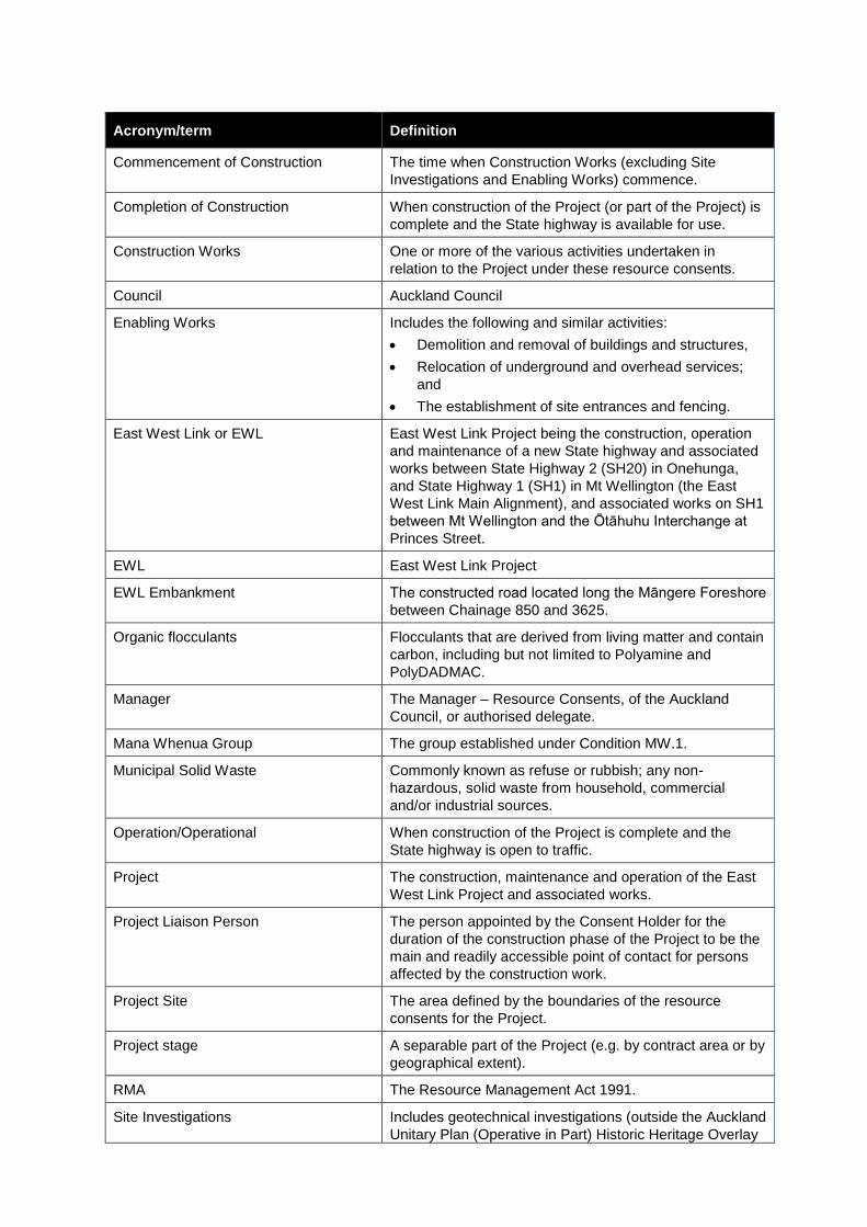
Acronym/term Definition
Commencement of Construction The time when Construction Works (excluding Site
Investigations and Enabling Works) commence.
Completion of Construction When construction of the Project (or part of the Project) is
complete and the State highway is available for use.
Construction Works One or more of the various activities undertaken in
relation to the Project under these resource consents.
Council Auckland Council
Enabling Works Includes the following and similar activities:
Demolition and removal of buildings and structures,
Relocation of underground and overhead services;
and
The establishment of site entrances and fencing.
East West Link or EWL East West Link Project being the construction, operation
and maintenance of a new State highway and associated
works between State Highway 2 (SH20) in Onehunga,
and State Highway 1 (SH1) in Mt Wellington (the East
West Link Main Alignment), and associated works on SH1
between Mt Wellington and the Ōtāhuhu Interchange at
Princes Street.
EWL East West Link Project
EWL Embankment The constructed road located long the Māngere Foreshore
between Chainage 850 and 3625.
Organic flocculants Flocculants that are derived from living matter and contain
carbon, including but not limited to Polyamine and
PolyDADMAC.
Manager The Manager – Resource Consents, of the Auckland
Council, or authorised delegate.
Mana Whenua Group The group established under Condition MW.1.
Municipal Solid Waste Commonly known as refuse or rubbish; any non-
hazardous, solid waste from household, commercial
and/or industrial sources.
Operation/Operational When construction of the Project is complete and the
State highway is open to traffic.
Project The construction, maintenance and operation of the East
West Link Project and associated works.
Project Liaison Person The person appointed by the Consent Holder for the
duration of the construction phase of the Project to be the
main and readily accessible point of contact for persons
affected by the construction work.
Project Site The area defined by the boundaries of the resource
consents for the Project.
Project stage A separable part of the Project (e.g. by contract area or by
geographical extent).
RMA The Resource Management Act 1991.
Site Investigations Includes geotechnical investigations (outside the Auckland
Unitary Plan (Operative in Part) Historic Heritage Overlay
Acronym/term Definition
Extent of Place), identifying service locations, surveys,
monitoring activities, surveys and other similar activities.
Suitably Qualified Environmental
Practitioner
In relation to contaminated land, as set out in the
Resource Management (National Environmental Standard
for Assessing and Managing Contaminants in Soil to
Protect Human Health) Regulations 2011.
Suitably Qualified Person A person:
With a recognised qualification in the subject matter of
the condition; or
With recognised experience in the subject matter of
the condition; or
Is a member of relevant professional body for the
subject matter of the condition.
Working day Has the same meaning as under section 2 of the
Resource Management Act 1991.

GENERAL RESOURCE CONSENT CONDITIONS (RC)
These general conditions apply to all resource consents unless specified otherwise. Additional
conditions which apply to specific resource consents are set out in following pages.
Ref Condition
General and Administration
RC.1 Except as modified by the conditions below, and subject to final design, the Project shall
be undertaken in general accordance with information provided by the Consent Holder in
the Application for Resource Consents dated December 2016, and in particular, the
following supporting documents:
(a) Part D: Description of the Project in Volume 1: Assessment of Effects on the Environment Report dated December 2016;
(b) The following plan sets in Volume 2: Drawing Set:
(i) Plan Set 3: Road Alignment
(ii) Plan Set 4: Landscape
(iii) Plan Set 5: Coastal Occupation
(iv) Plan Set 6: Plan and Long Section
(v) Plan Set 7: Typical Cross Section
(vi) Plan Set 8: Structural
(vii) Plan Set 9: Stormwater
(viii) Plan Set 10: Erosion and Sediment Control
(c) The Key Design Principles and Sector Outcomes of the Project’s Urban and Landscape Design Framework dated November 2016 and Addendum dated December 2016.
(d) The Draft Contaminated Land Management Plan.
These conditions shall apply to all that land identified in the schedule contained in the Application for Resource Consents dated December 2016 unless specified otherwise in a specific condition.
RC.2 The Project website shall include these conditions and the plans and reports referred to in
these conditions prior to and throughout Construction Works, and a hard copy shall be
available at the Project site office(s).
RC.3 Where there is inconsistency between:
(a) The documents listed in Condition RC.1 above and these conditions, these conditions shall prevail;
(b) The information and plans lodged with the Application and further information provided post lodgement, the most recent information and plans shall prevail; and
(c) The draft management plans and/or management plan frameworks lodged with the Application and the management plans required by the conditions of these resource consents, the requirements of the management plans as set out in the relevant conditions shall prevail.
RC.4 The Consent Holder shall provide regular updates on construction activities and
programme to the Manager, and shall also include a summary of this information on the
Project website.
Ref Condition
Pre-construction Administration
RC.5 The Consent Holder shall notify the Manager in writing of the proposed date of
Commencement of Construction at least 20 working days prior to the proposed start date.
RC.6 Within 15 working days prior to Commencement of Construction, the Consent Holder shall
arrange and conduct a prestart meeting that:
(a) Is located on the subject site;
(b) Is scheduled not less than five days before the anticipated Commencement of Construction;
(c) Includes Council representatives;
(d) Includes representation from the contractors who will undertake the works; and
(e) Includes an invitation to Mana Whenua.
The pre-commencement meeting shall discuss the works methodology and shall ensure
all relevant parties are aware of and are familiar with the conditions of the resource
consents.
In the case that any of the invited parties, other than the representative of the Consent
Holder, does not attend this meeting, the Consent Holder will have been deemed to have
complied with this condition, provided reasonable notice is given to the parties listed
above.
Annual Monitoring Report
RC.7 The Consent Holder shall provide to the Manager by either 30 June each year, or on an
alternative date as otherwise agreed to by the Manager, an Annual Monitoring Report.
The purpose of this report is to provide an overview of the monitoring and reporting work
undertaken, and any environmental issues that have arisen during Construction Works.
As a minimum this report shall include:
(a) All monitoring data required in accordance with the conditions of this consent;
(b) Any reasons for non-compliance or difficulties in achieving compliance with the conditions of this resource consent;
(c) Measure taken to address compliance issues;
(d) Any works that have been undertaken to improve the environmental performance of the site or that are proposed to be undertaken in the coming year;
(e) Recommendations on alterations to the monitoring required; and
(f) Any other issues considered important by the Consent Holder.
Consent Lapse and Expiry
RC.8A Pursuant to section 125(1) of the RMA, the consents shall lapse 15 10 years from the date
of the commencement of the consent (in accordance with section 116 of the RMA) unless
they have been given effect, surrendered or been cancelled at an earlier date.
RC.8AA Pursuant to section 123 of the RMA, the consents shall expire 15 years from the date of
the commencement of the consent.
Ref Condition
RC.8B Pursuant to section 125(1) of the RMA, the consents shall lapse 3510 years from the date
of the commencement of the consent (in accordance with section 116 of the RMA) unless
they have been given effect, surrendered or been cancelled at an earlier date.
RC.8BA Pursuant to section 123 of the RMA, the consents shall expire 35 years from the date of
the commencement of the consent.
Management Plan Certification Process
RC.9 (a) Conditions (b) to (e) below shall apply to all management plans required by these
conditions.
(b) All management plans shall be prepared in consultation with Council and submitted
to the Manager to certify compliance and consistency with the applicable
requirements of these conditions at least 20 working days prior to Commencement
of Construction (excluding Site Investigations and Enabling Works).
(c) Any certified Management Plan may be amended if necessary to reflect any changes
in design, construction methods or management of effects. Any amendments are to
be discussed with and submitted to the Manager for information, unless those
amendments once implemented would result in a materially different outcome to that
described in the original plan.
(d) Any material changes to a certified management plan shall be submitted to the
Manager for certification. Any material change must be consistent with the purpose
of the relevant management plan and the requirements of the relevant conditions of
these consents. Where a management plan was prepared in consultation with
affected parties, any material changes to that plan shall be prepared in consultation
with those same parties.
(e) All works shall be carried out in accordance with the certified management plans.
RC.9A Management Plans may be submitted in parts or in stages to address particular activities
or to reflect the staged implementation of the Project. Management Plans submitted shall
clearly show the integration with adjacent stages and interrelated activities.
Construction Environmental Management Plan (CEMP)
RC.10 (a) The Consent Holder shall prepare a Construction Environmental Management
Plan (CEMP) or Plans for the relevant Project stage (excluding Site Investigations
and Enabling Works), and submit this to the Manager in accordance with the process
set out in RC.9.
(b) The purpose of the CEMP is to set out the management procedures and construction
methods to be undertaken in order to avoid, remedy or mitigate potential adverse
effects arising from construction activities.
RC.11 The CEMP shall be prepared in accordance with the NZ Transport Agency’s Guideline
for preparing Environmental and Social Management Plans (dated April 2014) and
include:
(a) Confirmation of the proposed staging and sequence of construction;
(b) An outline construction programme;
(c) Contact details of the site supervisor or project manager and the Consent Holder’s
Project Liaison Person (phone, postal address, email address);
Ref Condition
(d) Methods and systems to inform and train all persons working on the site of potential
environmental issues and how to avoid remedy or mitigate any potential adverse
effects;
(e) The proposed hours of work;
(f) Measures to be adopted to maintain the land affected by the works in a tidy condition
in terms of disposal / storage of rubbish, storage and unloading of construction
materials and similar construction activities;
(g) Location of construction site infrastructure including site offices, site amenities,
contractors’ yard access, equipment unloading and storage areas, contractor car
parking and security;
(h) Procedures for controlling sediment run-off, dust and the removal of soil, debris,
demolition and construction materials (if any) from public roads or places adjacent to
the work site;
(i) Procedures for ensuring that residents, network utility operators, road users and
businesses in the immediate vicinity of construction areas are given prior notice of
the Commencement of Construction and are informed about the expected duration
and effects of the work;
(j) Means of providing for the health and safety of the general public;
(k) Proposed temporary or permanent fencing or other structures along the boundary of
the designation with adjacent sites in order to delineate site boundaries, maintain site
security, prevent unauthorised access, ensure the safe and practical operation of
adjacent sites, and to avoid intrusion of Construction Works beyond the designated
land;
(l) Measures to manage the potential impacts of construction on Council trees and
vegetation;
(m) Methods and measures to avoid, remedy and mitigate adverse effects on landscape amenity during the construction phase of the Project;
(n) Procedures for the refuelling of plant and equipment;
(o) Measures to address the storage of fuels, lubricants, hazardous and/or dangerous
materials, along with contingency procedures to address emergency spill
response(s) and clean up;
(p) Procedures for the maintenance of machinery to avoid discharges of fuels of
lubricants to watercourses and/or the Coastal Marine Area (CMA);
(q) Procedures for responding to complaints about construction activities; and
(r) Procedures for incident management.
RC.12 The CEMP shall incorporate or refer to the following management plans:
(a) Contaminated Land Management Plan (refer to Condition CL.1);
(b) Coastal Work CEMP (refer to Condition C.4);
(c) Groundwater and Settlement Management Plan (refer to Condition G.1);
(d) Construction Air Quality Management Plan (refer to Condition AQ.2);
(e) Ecological Management Plan (refer to Condition EM.2) including the Lizard Management Plan (refer to Condition EM.4);
The CEMP shall:
(i) Demonstrate how the incorporated or referenced management plans will be jointly
implemented to achieve integrated management of construction effects; and
Ref Condition
(ii) Describe for information purposes how those plans integrate with management plans
provided by the NZ Transport Agency as part of the Outline Plan process for
Construction Works within the designation for the Project.
If a CEMP is submitted in part or for a Project stage, it shall only incorporate or refer to the
management plans relevant to the part or stage.
RC.13 Where Enabling Works or Site Investigations are to be undertaken prior to commencement
of the main construction works, a site-specific CEMP commensurate with the scale and
effects of the proposed works, shall be submitted for the certification of the Manager.
In some cases, with the approval of the Manager, a site-specific CEMP may not be
required.
RC.14 Any material changes to the management plans shall remain consistent with the overall
intent of the relevant management plan and shall be consistent with the requirements of
the relevant conditions of this consent. The Consent Holder shall advise the Manager of
any amendments made, and any material changes shall be submitted to the Manager for
approval in accordance with the process set out in Condition RC.9 above.
Review of Conditions
RC.15 The Council may review any or all conditions of this consent by giving notice of its intention
to do so in accordance with section 128 of the RMA, at any time within six months of the
first, third, fifth and tenth anniversaries of the date of Commencement of Construction to
deal with any unforeseen adverse effects on the environment, which may arise from the
exercise of this consent, and which it is appropriate to deal with at a later date.
MANA WHENUA COLLABORATION (MW)
Ref Condition
MW.1 –
MW.10
The Mana Whenua conditions MW.1 to 5 will also apply to the resource consents and will be included here once the wording is finalised with any amendments agreed prior to a decision on the applications. Condition MW.6-10 are specific to the Coastal Permits and have been relocated from the designations]
Monitoring and Management Plan for the Māngere Inlet [Coastal Permit conditions]
MW.6 NoR 1 Prior to the Commencement of Construction, a Monitoring and Management Plan (MMP) for the Māngere Inlet shall be prepared by a person endorsed by the Mana Whenua Group. The MMP shall be prepared in consultation with the Mana Whenua Group and Council, and shall be provided to the Manager for information.
MW.7 NoR 1 The purpose of the MMP is:
(a) To assess the contribution the Project makes to the enhancement of the Māngere Inlet; and
(b) To identify potential opportunities for further enhancement of the Māngere Inlet that could be pursued by other organisations with interests in the Māngere Inlet.
With regard to (a) above, the MMP shall set out how the Project will
contribute to the following Desired Outcomes as set out in “A Vision for the
Māngere Inlet” included in the EWL Cultural Values Report (February
2017):
(i) “Mana Whenua expectations and understanding will form part of how organisations operate”;
(ii) “To achieve a quality of water that sustains diverse and balanced life”;
(iii) “To rehabilitate and improve local and regional connections for people and the environments”; and
(iv) “A connected community that is thriving and nurturing – a place that is valued”.
MW.8 NoR 1 (a) The MMP shall:
(i) Identify long-term indicators of enhanced mauri (well-being) of
the Māngere Inlet; and how those indicators can be measured;
(ii) Set out the proposed methods to be undertaken by the Consent
Holder to measure the identified indicators; and
(iii) Set out the proposed timeframe to implement those methods,
with those timeframes to occur within a period not later than 5
years after Completion of Construction.
(b) The long-term indicators shall include (unless agreed otherwise by the Mana Whenua Group and the Consent Holder):
(i) Indicators to demonstrate expression of cultural values in
respect of the Māngere Inlet, for example:
Cultural values awareness for personnel involved in
construction and implementation of the consents for the
Project; and
Ref Condition
Inclusion of measures in the ULDMP (e.g. interpretative
signage and design elements).
(ii) Indicators to measure water quality in the Māngere Inlet.
(iii) Indicators of biological health of the Māngere Inlet, including
presence of avifauna species and benthic fauna of cultural
significance to mana whenua.
(iv) Indicators of cultural wellbeing of the wai, such as ability for
spiritual and traditional practices to be undertaken.
(v) Indicators of improvements to connections for people and biota,
indicators, for example:
Green corridor connectivity in areas of ecological restoration;
Increased public access to the Māngere Inlet; and
Measures implemented to demonstrate the heritage
connections in the Māngere Inlet (e.g. portages).
(c) The proposed methods to measure long-term indicators may include:
(i) Monitoring undertekan for the resource consents including:
a. Monitoring of sediment deposition (Condition D.16);
b. Monitoring of benthic ecology in subtidal dredging areas
(Condition D.20);
c. Monitoring ofAvifauna nesting activity (Condition EM.6);
d. The outcomes of ecological restoration, habitat
enhancement, pest animal and pest plant management
(EM.3);
e. The outcomes of ecological research (Condition EM.10);
f. Salt marsh planting (Condition EM.4A and B); and
g. Stormwater and leachate monitoring (Condition C.1H).
(ii) Monitoring undertaken by Council and Council Controlled
Organisations, and any other established organisations with
monitoring programmes in the Māngere Inlet; and
(iii) Other methods, for example users surveys of the walkway,
cycleway and open space connections.
MW.9 NoR 1 The development of the MMP shall:
(a) integrate with relevant provisions of the Ecological Management Plan prepared in accordance with resource consents granted for the Project; and
(b) take into account existing or planned monitoring programmes undertaken by Council and Council Controlled Organisations, and any other established organisations with monitoring programmes in the Māngere Inlet and shall integrate with those programmes as far as practicable.
MW.10 NoR 1 Five years after Completion of Construction, the Consent Holder shall
update the MMP to:
(a) Collate and assess the collective results of post-construction monitoring undertaken in accordance with conditions of resource consents granted

Ref Condition
for the Project, and other measurements of long-term indicators; and, based on that information;
(b) Record how the Project has contributed to the enhancement of the Māngere Inlet; and
(c) Identify potential opportunities for further long-term enhancement of the Māngere Inlet that could be pursued by other organisations with interests in the Māngere Inlet.
The updated MMP shall be provided to the members of the Mana Whenua Group.
CONTAMINATED LAND (CL)
Ref Condition
Contaminated Land Management Plan
CL.1 Prior to excavation in areas of known or potentially contaminated land, the Consent
Holder shall engage a Suitably Qualified Environmental Practitioner (SQEP) to prepare
a Contaminated Land Management Plan (CLMP).
The purpose of the CLMP is to detail the measures to manage health, safety, and environmental risk associated with works in contaminated material in the Project area, including closed landfills, during construction.
The preparation of the CLMP shall include consultation with the owners and operators of the affected land.
CL.2 The CLMP shall be in general accordance with the draft Contaminated Land
Management Plan listed in Condition RC.1, and shall include :
(a) Any soil, groundwater and landfill gas investigations undertaken in closed landfills
and uncontrolled fill at Gloucester Park North and South to characterise potential
hazards associated with works in those areas and to inform development of the
CLMP;
(b) The measures to be undertaken in the handling, storage and disposal of all
contaminated material excavated during Construction Works;
(c) The soil validation testing that will be undertaken;
(d) The soil verification testing that will be undertaken to determine the nature of any contamination in excavated spoil and the potential reuse or disposal options for that spoil;
(e) Measures to be undertaken in the event of unexpected contamination being identified during construction activities, including measures to:
i) Assist with identification of unknown contaminated material;
ii) Stop work or isolate the area once any such material is identified;
(f) The measures to be undertaken to manage contaminated land to:
i) Protect the health and safety of workers and the public;
ii) Control stormwater run-on and run-off;
iii) Remove or manage any contaminated soil.
(g) The measures to be undertaken to manage asbestos to:
i) Identify any suspected asbestos;
ii) Identify the type of asbestos and confirm the appropriate means by which it shall be removed;
iii) Handle asbestos containing material;
iv) Implement appropriate health and safety measures to maintain the safety of workers and the public; and
v) Remove the asbestos and dispose of it to an appropriately licensed facility.
CL.3 The CLMP shall be submitted to the Manager for certification in accordance with the
process set out in Condition RC.9.
Ref Condition
CL.4 All sampling and testing of contamination on the site shall be overseen by a Suitably
Qualified Person. All sampling shall be undertaken in accordance with Contaminated
Land Management Guidelines No. 5 Site Investigation and Analysis of Soils (Revised
2011).
CL.5 Excess soil or waste materials removed from the subject site shall be deposited at a
disposal site that holds a resource consent to accept the relevant level of
contamination.
CL.6 Where contaminants are identified that have not been anticipated by the CLMP, works
in the area containing the unexpected contamination shall cease until the contingency
measures outlined in the approved CLMP have been implemented, and the discovery
and contingency measures undertaken have been notified to the Manager.
CL.8 To protect the health of workers on the site during excavations, works shall be
managed to minimise the generation of dust on the site and be carried out in
accordance with the approved CLMP.
CL.9 Where the Construction Works require the removal of existing Auckland Council closed
landfill groundwater monitoring bores, the Consent Holder shall relocate the monitoring
bores (and associated access infrastructure) in consultation with Council. The
relocation shall provide for the progressive decommissioning and replacement of the
bores and, as far as is practicable, continuity in monitoring data. As part of this, a
programme of progressive decommissioning and replacement of monitoring points
shall be provided to Council in advance of Construction Works within closed landfills.
The Consent Holder shall provide access to the Council or its agent to the relocated
monitoring bores for the duration of Construction Works, subject to health and safety
requirements. Where existing or relocated monitoring bores or monitoring points fall
within the construction area, and health and safety requirements prevent access by
Council or its agent, the Consent Holder shall undertake, on behalf of the Council,
monitoring required by conditions of the Council’s discharge consents for the closed
landfills, and shall provide these records to Council.
CL.10 The design for the EWL Embankment along the Māngere Inlet foreshore shall:
(a) Be in general accordance with the drawings and mitigation measures outlined in
the documents listed in Condition RC.1 and referred to in Condition RC.3;
(b) Minimise the impact of the EWL Embankment on:
(i) Upstream groundwater levels;
(ii) The potential for development of preferential flow paths along existing
stormwater infrastructure; and
(iii) The potential for groundwater contamination and/or leachate seepage in
relation to the closed landfills.
CL.11 (a) The Consent Holder shall consult with Council during detailed design of the
leachate interception drain and associated pipework. The detailed design shall
achieve the following outcomes:
(i) Provide best practicable interception of leachate from the Pikes Point West
and East Closed Landfills, at least to the existing level of interception
collection;

Ref Condition
(ii) Provide for conveyance of the collected leachate to the stormwater
treatment system with contingency measures in place to allow discharge to
trade waste;
(iii) Allow for monitoring of leachate quality and quantity as set out in Condition
L.2 of the associated discharge consent;
(b) The leachate interception drain and associated pipework shall be designed for
durability, ease of maintenance and access, and minimise ongoing operation and
maintenance requirements.
CL.12 If Municipal Solid Waste material remains beneath the EWL Embankment and the
replacement Pikes Point Closed Landfill interception drain does not capture leachate
from that material then:
(a) Up to three groundwater wells shall be installed beneath the EWL Embankment
for monitoring purposes;
(b) The water levels in the wells shall be monitored at 6 monthly intervals for a
minimum of 2 years following Completion of Construction;
(c) If water is detected in the wells, samples shall be analysed for total ammoniacal
nitrogen (NH4N) and the result compared with the trigger level established under
(d) below;
(d) The trigger level NH4N concentration shall be derived from the Australian and
New Zealand Environmental Conservation Council, Australian Guidelines for
Fresh and Marine Waters, 2000 (ANZECC 2000) marine water quality guideline,
90% level of protection (1.2 mg/L) allowing for attenuation downgradient of the
EWL Embankment and reasonable mixing in the receiving water;
(e) The trigger level established under (d) above and the actions to be taken to comply with the requirements of (e) and (f) below shall be documented by the consent holder and provided to and obtain the approval of the Manager prior to being implemented.
(fe) If a trigger level exceedance occurs, then further monitoring of the water quality
in the marine receiving environment shall be undertaken to identify if an adverse
effect is occurring;
(gf) If the monitoring indicates that an adverse effect is occurring and is verified by a
Suitably Qualified Person as being directly attributable toassociated with the
Municipal Solid Waste material which remains beneath the EWL Embankment, a
Remedial Action Rlan shall be developed in consultation with Council and
implemented to mitigate that adverse effect. This may include, for example,
extraction of leachate from the wells until such time as NH4N drops below the
trigger level;
(hg) If there are no trigger level exceedances over the 2 year period then monitoring
shall be discontinued; and
(ih) In the event of a trigger level exceedance, the monitoring shall be extended for 6
months from the date of the last exceedance.
The results of the monitoring shall be provided to the Manager on request and (if
required) the Remedial Action Plan shall be provided to the Manager.
CL.13 Unless otherwise agreed with the landowner, any damage caused to the existing clay
cap on the closed landfill located at 39 and 59 Miami Parade during construction of the

Ref Condition
Project shall be fully reinstated by the Requiring Authority as soon as practicable
following completion of land disturbance activities, such that the land outside of the
designation boundary can continue to be used for industrial purposes.
EARTHWORKS, VEGETATION ALTERATION AND REMOVAL (E)
Ref Condition
Erosion and Sediment Control
E.1 During construction the Consent Holder shall take all practicable measures to minimise
erosion and prevent the discharge of sediment beyond the boundaries of the site.
E.2 Erosion and sediment control measures shall be implemented throughout Construction
Works. They shall be constructed and maintained so as to operate and perform in
accordance with Auckland Council GD2016/005: Erosion Sediment Control Guide for
Land Disturbing Activities in the Auckland Region and any amendments to this
document, except where a higher standard is detailed in the conditions below in which
case the higher standard shall apply.
Site Specific Erosion and Sediment Control Plans – Design
E.3 Prior to the Commencement of Construction for each specific area and/or activity, a
Construction Erosion and Sediment Control Plan (CESCP) or plans shall be
prepared by a Suitably Qualified Person.
The purpose of the CESCP is to set out the measures to be implemented during
construction to minimise erosion and the discharge of sediment beyond the boundaries
of the site.
Unless agreed otherwise with the Manager, the CESCPs shall include, but not be
limited to the following information as appropriate to the scale, location and type of
earthworks:
(a) Contour information at suitable intervals;
(b) Erosion and sediment controls including specific design (location, dimensions, capacity);
(c) Supporting calculations and design drawings;
(d) Catchment boundaries for the sediment controls;
(e) Location of the works, and cut and fill operations;
(f) Details of measures for contaminated land as identified in the CLMP under Condition CL.1;
(g) Details of construction methods to be employed, including timing and duration;
(h) A programme for managing exposed area, including progressive stabilisation considerations;
(i) Identification of the Suitably Qualified Persons to manage the environmental issues on site;
(j) Identification of the persons who have clearly defined roles and responsibilities to monitor compliance with the CESCP;
(k) Details of the chain of responsibility for managing environmental issues and details of responsible personnel; and
(l) Monitoring and maintenance requirements.
Ref Condition
E.4 The Consent Holder shall submit the CESCP to the Manager for certification at least 10
working days prior to Commencement of Construction associated with each specific area
and/or activity.
No earthworks activity on the subject site shall commence until written approval is
received from the Manager.
Flocculation Treatment Plan
E.5 Where flocculant treatment is proposed for use on site, the CESCP shall include a
Flocculation Treatment Plan which shall include as a minimum:
(a) Specific design details of the flocculation treatment system based on a rainfall activated and manual batch dosing methodology for the site's Sediment Retention Ponds (SRPs), Decanting Earth Bunds (DEBs) and any other sediment detention or flow device systems as may be employed on site;
(b) Monitoring, maintenance (including post storm) and contingency programme (including a record sheet) for the flocculation treatment system;
(c) Consideration of the use of organic flocculants where practicable, provided that the most effective flocculent in terms of sediment removal shall be selected based on (e) below;
(d) Details of optimum dosage (including assumptions);
(e) Results of any initial treatment trials;
(f) A spill contingency plan;
(g) Details for the checking and calibration of dosing and monitoring equipment; and
(h) Details of the person or bodies that will hold responsibility for the operation and maintenance of the flocculation treatment system.
The Flocculation Treatment Plan shall be submitted to the Manager for certification in accordance with the process set out in Condition E.4.
Erosion and Sediment Control Device Requirements
E.6 Unless otherwise agreed with the Manager, the Consent Holder shall design, construct
and maintain all erosion and sediment control devices to achieve compliance with the
documents set out in Condition E.2 and also with the following design requirements
(some of which do not form part of those documents):
(a) All erosion and sediment control devices shall be located outside the 20 year ARI flood level, unless no other viable location exists;
(b) Clean and dirty water diversion channels, shall be sized to accommodate the flow from a 100 year ARI storm event where practicable, and at a minimum, the flow from a 20 year ARI storm event and an additional 300mm freeboard;
(c) All temporary stream crossings and temporary culverts shall be sized to accommodate the flow from a 20 year ARI storm event and include a stabilised overland flow path for runoff exceeding the flow expected in a 20 year ARI storm event;
(d) At all practical times, streamworks activities and associated works shall be undertaken with stream diversions in place to accommodate up to the 20 year ARI rain event. All stream flows above the 20 year ARI rain event shall be diverted, via systems (such as overland flow paths) capable of conveying the 100 year ARI rain event flow around the works area;
Ref Condition
(e) Pumping of all sediment laden runoff and groundwater during Construction Works shall be to SRPs, DEBs, grass buffer zones or temporary sediment retention devices such as container impoundment systems;
(f) All DEBs and SRPs that serve a catchment area greater than 500m2 shall be treated via a rainfall activated flocculation treatment system. SRPs shall each have two flocculation sheds (or equivalents) installed;
(g) All DEB volumes are to be designed based on 2% of the contributing catchment area and all DEBs shall be fitted with floating decants that are designed to discharge at a rate of 3 litres/sec/ha;
(h) All construction yard areas shall achieve the detention requirements as detailed within the NZ Transport Agency’s Erosion and Sediment Control Guidelines for State Highway Infrastructure (2014);
(i) All SRP volumes are to be designed based on 3% of the contributing catchment area and will contain reverse slopes in the base of ponds, baffles and decant pulley systems and a forebay with a volume of 10% of the pond volume;
(j) All dirty water diversion channels shall be designed and constructed with sediment sumps at locations specified in the CESCP with a minimum volume of 2m3 per sump; and
(k) The erosion and sediment control for the site shall include the installation of a last line of defense, which shall include protection of the freshwater receiving environments with additional bunding, silt fence, super silt fence or alternative as defined in the CESCP for that particular stage.
As-Built Certification
E.7 Prior to earthworks commencing (excluding the construction of the erosion and
sediment controls), a certificate signed by an Suitably Qualified Person shall be
submitted to the Manager, to certify that the erosion and sediment controls have been
constructed in accordance with Condition E.2.
Certified controls shall include sediment retention ponds, flocculation treatment
systems, decanting earth bunds, super silt fences, silt fences and diversion
channels/bunds.
E.8 The operational effectiveness and efficiency of all erosion and sediment control
measures specifically required as a condition of resource consent or by the CESCP
referred to in Condition E.3 shall be maintained throughout the duration of earthworks
activity, or until the site is permanently stabilised against erosion.
Inspection and Monitoring
E.9 There shall be no deposition of earth, mud, dirt or other debris on any road or footpath
beyond the boundary of the site resulting from earthworks activity on the subject site. In
the event that such deposition does occur, it shall immediately be removed. In no
instance shall roads or footpaths be washed down with water without appropriate
erosion and sediment control measures in place to prevent contamination of the
stormwater drainage system, watercourses or receiving waters.
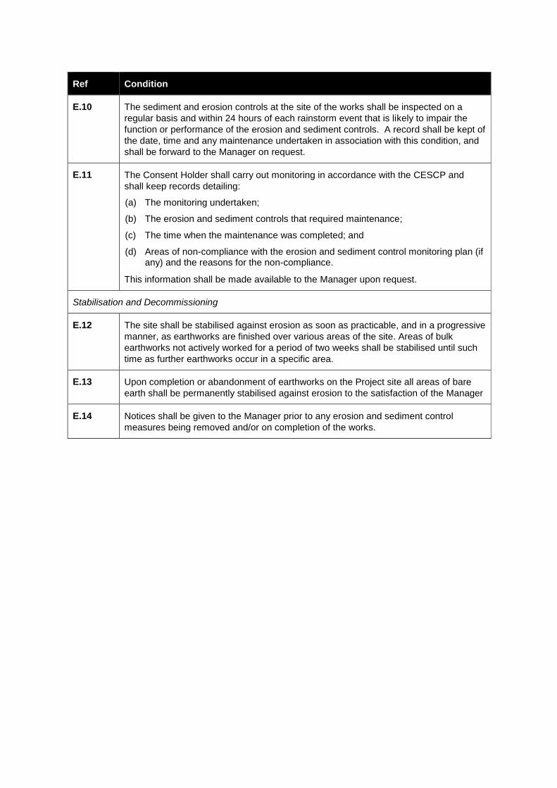
Ref Condition
E.10 The sediment and erosion controls at the site of the works shall be inspected on a
regular basis and within 24 hours of each rainstorm event that is likely to impair the
function or performance of the erosion and sediment controls. A record shall be kept of
the date, time and any maintenance undertaken in association with this condition, and
shall be forward to the Manager on request.
E.11 The Consent Holder shall carry out monitoring in accordance with the CESCP and
shall keep records detailing:
(a) The monitoring undertaken;
(b) The erosion and sediment controls that required maintenance;
(c) The time when the maintenance was completed; and
(d) Areas of non-compliance with the erosion and sediment control monitoring plan (if any) and the reasons for the non-compliance.
This information shall be made available to the Manager upon request.
Stabilisation and Decommissioning
E.12 The site shall be stabilised against erosion as soon as practicable, and in a progressive
manner, as earthworks are finished over various areas of the site. Areas of bulk
earthworks not actively worked for a period of two weeks shall be stabilised until such
time as further earthworks occur in a specific area.
E.13 Upon completion or abandonment of earthworks on the Project site all areas of bare
earth shall be permanently stabilised against erosion to the satisfaction of the Manager
E.14 Notices shall be given to the Manager prior to any erosion and sediment control
measures being removed and/or on completion of the works.

COASTAL ACTIVITIES (C)
Ref Condition
Detailed Engineering Designs and Drawings - Coastal
C.1 At least 20 working days prior to Commencement of Construction in the CMA (excluding Site Investigations and Enabling Works), the Consent Holder shall submit to the Manager for l certification the following documentation to be prepared in general accordance with the documents listed in Condition RC.1 and referred to in Condition RC.3:
(a) Detailed engineering designs and drawings (including dimensioned cross sections, elevations, site plans of all areas of reclamation, declamation, permanent and temporary structures);
(b) A ULDMP for the areas of the Project within the CMA which reflects the Key Design Principles and Sector Outcomes of the Project’s ULDF for those areas; with the ULDMP to be prepared in consultation with Council and the Mana Whenua Group; and
(c) Specifications for the works authorised by this consent.
C.1A All permanent structures within the CMA shall be designed for long-term durability, ease of maintenance access, and to minimise ongoing operation and maintenance requirements.
Design Details – Reclamation and Boardwalk
C.1B The total reclamation area and footprint of permanent occupation in the Māngere Inlet
for the road embankment, landscape and amenity features, access, and stormwater
treatment areas is not to exceed the area identified in the documents listed in
Condition RC.1, but with the modification and consequential reduction is area required
by Condition C.1BB below.
C.1BB The headlands of reclamation Landforms 2 and 3 shall be deleted or modified (in the
form of islands) to maximise tidal flows past the landforms and minimise sediment
accumulation rates between the headlands and the between the landforms.
C.1C The design details for the reclamation, coastal paths and boardwalk shall:
(a) Be prepared in consultation with Council and the Mana Whenua Group;
(b) Be in general accordance with the drawings listed in Condition RC.1 and referred to in Condition RC.3;
(c) Give effect to the ULDMP referred to in Condition C.1(b);
(d) Give effect to the relevant outcomes of the Ecological Management Plan prepared in accordance with Condition EM.1;
(e) Integrate with the design of the stormwater treatment system developed in accordance with Condition C.1F;
(f) Be developed as part of an integrated design process which includes input from a range of technical experts to achieve the outcomes in Conditions C.1D to C.1F; and
(g) Include consideration of:
i) Crime Prevention Through Environmental Design principles; and
ii) Safety in Design requirements.
Ref Condition
C.1D The detailed design of the shape and form of the reclamation shall achieve the following outcomes:
(a) Integration of the road embankment, landscape and amenity features, access, and stormwater treatment areas in a manner which minimises the required area of reclamation, particularly in the area identified in the Auckland Unitary Plan as Significant Ecological Area;
(b) A landform profile which incorporates a variety of landscape features in an aesthetically coherent design which:
i) References natural features and patterns such as lava flows of the original Māngere Inlet northern shoreline, estuarine wetlands, and scoriaceous gravel banks and beaches;
ii) Includes a varied vertical profile to appear as part of the Māngere Inlet, for example, an outer bund (i.e. gravel banks) lower than the EWL Main Alignment, and elevated headlands higher than the EWL Main Alignment;
iii) Minimises adverse effects on coastal processes such as water flow patterns or potential for increased sedimentation;
iv) Incorporates design refinements to minimise temporary and permanent adverse effects on avifauna; and
v) Incorporates opportunities for habitat enhancement and bird roosting areas.
C.1E The detailed design of the coastal path on the reclamation and the boardwalk in the CMA shall achieve the following outcomes:
(a) Enhanced public access to and along the coastal edge for pedestrians and cyclists;
(b) Enhanced recreational experience of Māngere Inlet for users of the path and boardwalk including a meandering alignment, varied landscape features and incidents and a sequence of views;
(c) Opportunities for pausing and passive recreation adjacent to the path;
(d) Contouring of the landforms to provide separation of the coastal path from the EWL Main Alignment, where practicable;
(e) Sufficient separation between the boardwalk and EWL Main Alignment to maintain amenity for users of the boardwalk, whilst also seeking to minimise adverse effects on avifauna and encroachment into intertidal areas;
(f) Where practicable, design features to achieve aural amenity (such as low walls along the EWL Main Alignment), whilst maintaining visibility to the Māngere Inlet;
(g) Regular connections between the coastal path and boardwalk (at approximately 200m intervals tailored to access points across the EWL Main Alignment) to enhance user choice and safety;
(h) Discourage public access to parts of the eastern most landform to minimise potential adverse effects on avifauna; and
(i) Fit for purpose gradient and surfacing to provide for universal access.
Design Details – Stormwater System
C.1F The Consent Holder shall consult with Council during detailed design of the stormwater treatment system to be located within the reclamation. The design shall be in general accordance with the drawings listed in Condition RC.1 and referred to in Condition RC.3. The design shall take account of the outcomes to be achieved in Condition C.1D and shall achieve the following outcomes:
Ref Condition
(a) Achieve an average annual removal efficiency of at least 75% Total Suspended Solid levels (TSS) taking account of the outcomes to be achieved in Condition C.1D above and (b) to (i) below;
(b) Minimise salt water intrusion into the stormwater treatment system;
(c) Future proof to enable adaptation to climate change effects including sea level rise;
(d) Design of stormwater outfalls to take account of predicted changes in sea bed level;
(e) Consistency with desired outcomes of Council’s Auckland Stormwater Network Discharge Consent (if granted by the time of detailed design for the Project);
(f) Integrate with the design of the reclamation, coastal paths and boardwalk developed in accordance with Condition C.1C;
(g) Ability to treat leachate from the Pikes Point Closed Landfill interception drain; and
(h) Design for long-term durability, ease of maintenance access, and to minimise ongoing operation and maintenance requirements.
C.1G A Stormwater Operation and Maintenance Plan shall be submitted to the Manager for certification 20 working days prior to commencement of the operation of the stormwater treatment system. The Stormwater Operation and Maintenance Plan shall include, but not be limited to:
(a) A commissioning plan for the stormwater treatment system including introduction of leachate from the replacement Pikes Point Closed Landfill interception drain;
(b) Details of the person or organisation that will hold responsibility for operation and maintenance of the stormwater treatment system on commissioning and in the long-term, including any processes for changing responsibilities as required;
(c) A programme for regular maintenance and inspection of the stormwater treatment system;
(d) A programme for the collection and disposal of debris and sediment collected by the stormwater management devices or practices;
(e) Procedures for post storm inspection and maintenance;
(f) A programme for inspection and maintenance of the outfalls;
(g) General inspection checklists for all aspects of the stormwater treatment system, including visual checks;
(h) A programme for inspection and maintenance of vegetation associated with the stormwater management devices; and
(i) Details of the monitoring to be undertaken in accordance with Condition C.1H.
C.1H (a) The Consent Holder shall assess the performance of the stormwater treatment
system located within the reclamation for a period of 5 years following Completion
of Construction of the reclamation.
(b) The purpose of the assessment is to confirm that the stormwater treatment
system is operating as designed and as such is expected to achieve the
outcomes in Condition C.1F(a) and (g).
(c) The assessment shall include monitoring of the foreshore stormwater treatment
system consisting of:
(i) Annual monitoring of vegetation cover with a performance target of greater
than 95% coverage;
Ref Condition
(ii) Annual monitoring of weed cover with a performance target of less than 5%
coverage;
(iii) Annual monitoring of saturated hydraulic conductivity of biofiltration with a
performance target of greater than 150mm/hr;
(iv) Annual measurement of sediment build up within the forebay, wetland and
surface of the biofiltration devices;
(v) Quarterly measurement of TSS concentration following storm events from
wetland and biofiltration outlets and comparing measured TSS to predicted
modelled TSS. This will be conducted on two of the treatment devices;
(vi) Monthly during dry weather (October to March) and then quarterly
measurement of the leachate concentrations at wetland inlets and outlets
during dry weather and comparison to the leachate design trigger value for
Ammonical Nitrate. This will be conducted on two of the treatment devices.
(d) If the monitoring undertaken under (c) indicates a lower level of performance
compared to the designed performance, the Consent Holder shall review the
Stormwater Operations and Maintenance Plan prepared under Condition C.1G
and update the Plan to include measures to improve performance to align with the
design intent.
(e) A review of the Stormwater Operations and Maintenance Plan prepared under
Condition C.1G shall be conducted on an annual basis for a period of 5 years
following Completion of Construction of the reclamation.
(f) Any updates to the Stormwater Operations and Maintenance Plan shall be
provided to the Manager.
Temporary Occupation of the CMA
C.3 The right to temporarily occupy part of the CMA during construction is limited to the
areas and structures identified in the documents listed in Condition RC.1.
Coastal Works CEMP
C.4 (a) Prior to Commencement of Construction in the CMA (excluding Site
Investigations and Enabling Works), the Consent Holder shall submit a Coastal
Works CEMP to the Manager in accordance with the process set out in
Condition RC.9 to certify compliance and consistency with the conditions of this
consent relating to works in the CMA.
(b) The purpose of the Coastal Works CEMP is to confirm the proposed
methodology for construction works within the CMA and to set out the specific
management procedures and construction methods to be undertaken in order to
avoid, remedy or mitigate potential adverse effects arising from those works.
(c) In addition to the details required by Condition RC.11 the Coastal Works CEMP
shall include the following information:
(i) Confirmation of the construction methodology, including:
a. The nature of reclamation fill material and the method(s) by which these materials will be deposited;
b. The process for demolition and removal of existing structures, including the methodology to minimise discharges to the CMA;
c. Finalised details of the temporary structures in the CMA (e.g. silt fence);

Ref Condition
d. Methods to remedy disturbance resulting from the works.
(ii) Proposed staging of reclamation activities in the Māngere Inlet to minimise
exposed areas;
(iii) Programme of works to minimise the duration of disturbance in the CMA;
(iv) Erosion and sediment control measures and perimeter controls for foreshore
works and bridge construction;
(v) Monitoring of sediment discharges from dredging, declamation and
reclamation works;
(vi) Trigger event criteria for undertaking additional monitoring of sediment
discharges and the process to review, and if necessary, modify the works
methodology where there is an exceedance of the criteria;
(vii) Contingency plans in case of unexpected sediment discharges to the CMA
during works;
(viii) Site management, including details of:
a. Site access;
b. Methods to be used to minimise the need for refuelling, maintenance and storage of equipment or machinery in the CMA;
c. Methods to ensure that barges and equipment used in the CMA is clean and certified as free of invasive species identified by the Ministry of Primary Industries;
d. Procedures for refuelling, maintenance and storage of equipment or machinery in any part of the CMA if this is required, and measures to avoid discharges of contaminants during cleaning, refuelling, and maintenance activities in the CMA;
e. Plant and animal pest management during construction;
f. Methods to achieve compliance with the Project construction noise and vibration standards as set out in Conditions CNV.4 and CNV.5 of the designation;
g. Site clean-up following works completion
(ix) Details of all temporary structures in the CMA and their associated
construction methodology including the expected duration of occupation;
(x) Identification of all construction access points to the CMA and along the
foreshore;
(xi) Details of the quantities, sources and physical (textural and geological) and
chemical (bulk chemistry and leaching potential) characteristics of
reclamation fill materials; and
(xii) Details of all other practicable steps to be taken to minimise disturbance of
the seabed during the Construction Works.
(d) The Coastal Works CEMP shall be consistent with the ECOMP prepared under
Condition EM.1.
C.4A (a) The Consent Holder shall undertake the following enhancement works in the
foreshore area adjacent to Orpheus Drive and Onehunga Harbour Road identified
in the Auckland Unitary Plan as Outstanding Natural Feature:
(i) Remove rubbish, concrete debris and broken disused pipes from the
Outstanding Natural Feature ; and

Ref Condition
(ii) To the immediate north of the Aotea Sea Scouts Building remove loose
boulders from the base of the sea wall to improve visibility of the intertidal
volcanic tuff exposure.
(b) The debris removal shall be carried out under the guidance of a Suitably Qualified
Person and in a manner which does not damage the ONF or compromise the
structural integrity of the existing seawall.
(c) The methodology for this work shall be described in the Coastal Works CEMP and
shall be undertaken in accordance with the relevant Permitted Activity standards
in F2.21 of the Proposed Auckland Unitary Plan.
C.4B The Consent Holder shall identify and assess options for construction of the
reclamation which minimise the extent of intertidal dredging required in the Māngere
Inlet. For example, this may include options for sequencing of inner and outer bund
construction, use of sheetpiling, or other methods to create a coffer dam. The options
shall be identified and assessed in consultation with Council, and the confirmed
methodology shall be described in the Coastal Works CEMP to be prepared in
accordance with Condition C.4.
C.4C The Consent Holder shall construct a new tidal channel to replace the existing
secondary tidal channel that feeds into Anns Creek near the eastern end of the
reclamation. The new channel shall be designed and constructed with similar
dimensions and geometry to minimise morphological changes in this part of the
Māngere Inlet. The proposed construction methodology shall be developed in
consultation with Council, and the confirmed methodology shall be described in the
Coastal Works CEMP to be prepared in accordance with Condition C.4.
C.5 Where mangrove removal is required, the vegetation shall be removed and disposed of
at an approved facility as soon as practicable in order to avoid potential adverse effects
arising from decaying vegetation on remaining habitat.
C.6 The Consent Holder shall notify the Manager in writing of the proposed date of
Commencement of Construction in the CMA, at least 20 working days prior to the
proposed start date.
C.7 Within 40 days following Completion of Construction in the CMA, the Consent Holder
shall remove all erosion and sediment control measures, construction materials and
temporary staging from the CMA in accordance with the approved Coastal Works
CEMP under Condition C.4.
Notification – Harbour Master
C.8 The Consent Holder shall notify the Auckland Harbour Master in writing of the
proposed date of Commencement of Construction in the CMA, including dredging
operations, at least 20 working days prior to the proposed start date.
C.9 The Consent Holder shall consult the Auckland Harbour Master in regard to any
lighting or navigational aids required for the temporary and/or permanent structures in
the CMA.
Permanent Occupation of the Coastal Marine Area
C.10 The right to permanently occupy part of the coastal marine area is limited to the areas
and structures identified in the documents listed in Condition RC.1.
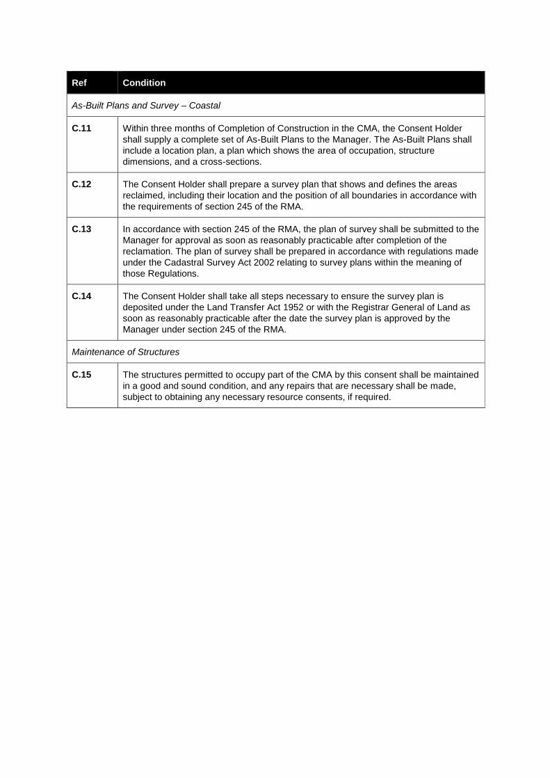
Ref Condition
As-Built Plans and Survey – Coastal
C.11 Within three months of Completion of Construction in the CMA, the Consent Holder
shall supply a complete set of As-Built Plans to the Manager. The As-Built Plans shall
include a location plan, a plan which shows the area of occupation, structure
dimensions, and a cross-sections.
C.12 The Consent Holder shall prepare a survey plan that shows and defines the areas
reclaimed, including their location and the position of all boundaries in accordance with
the requirements of section 245 of the RMA.
C.13 In accordance with section 245 of the RMA, the plan of survey shall be submitted to the
Manager for approval as soon as reasonably practicable after completion of the
reclamation. The plan of survey shall be prepared in accordance with regulations made
under the Cadastral Survey Act 2002 relating to survey plans within the meaning of
those Regulations.
C.14 The Consent Holder shall take all steps necessary to ensure the survey plan is
deposited under the Land Transfer Act 1952 or with the Registrar General of Land as
soon as reasonably practicable after the date the survey plan is approved by the
Manager under section 245 of the RMA.
Maintenance of Structures
C.15 The structures permitted to occupy part of the CMA by this consent shall be maintained
in a good and sound condition, and any repairs that are necessary shall be made,
subject to obtaining any necessary resource consents, if required.
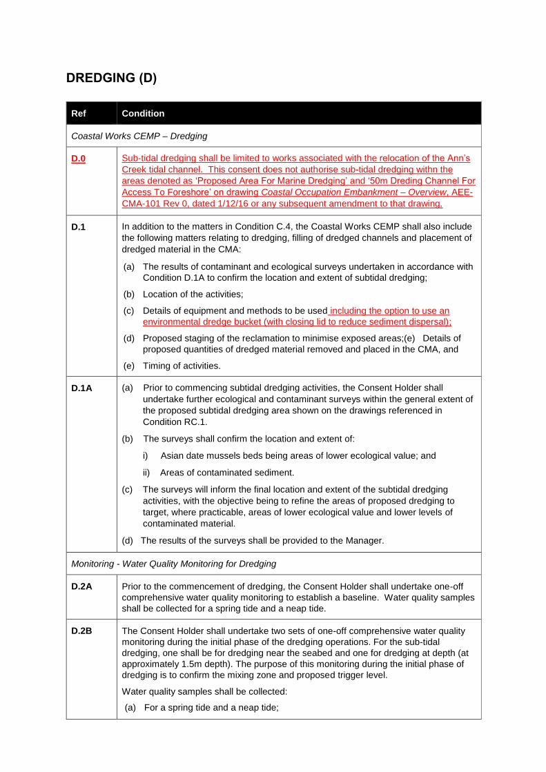
DREDGING (D)
Ref Condition
Coastal Works CEMP – Dredging
D.0 Sub-tidal dredging shall be limited to works associated with the relocation of the Ann’s
Creek tidal channel. This consent does not authorise sub-tidal dredging withn the
areas denoted as ‘Proposed Area For Marine Dredging’ and ‘50m Dreding Channel For
Access To Foreshore’ on drawing Coastal Occupation Embankment – Overview, AEE-
CMA-101 Rev 0, dated 1/12/16 or any subsequent amendment to that drawing.
D.1 In addition to the matters in Condition C.4, the Coastal Works CEMP shall also include
the following matters relating to dredging, filling of dredged channels and placement of
dredged material in the CMA:
(a) The results of contaminant and ecological surveys undertaken in accordance with
Condition D.1A to confirm the location and extent of subtidal dredging;
(b) Location of the activities;
(c) Details of equipment and methods to be used including the option to use an
environmental dredge bucket (with closing lid to reduce sediment dispersal);
(d) Proposed staging of the reclamation to minimise exposed areas;(e) Details of
proposed quantities of dredged material removed and placed in the CMA, and
(e) Timing of activities.
D.1A (a) Prior to commencing subtidal dredging activities, the Consent Holder shall
undertake further ecological and contaminant surveys within the general extent of
the proposed subtidal dredging area shown on the drawings referenced in
Condition RC.1.
(b) The surveys shall confirm the location and extent of:
i) Asian date mussels beds being areas of lower ecological value; and
ii) Areas of contaminated sediment.
(c) The surveys will inform the final location and extent of the subtidal dredging
activities, with the objective being to refine the areas of proposed dredging to
target, where practicable, areas of lower ecological value and lower levels of
contaminated material.
(d) The results of the surveys shall be provided to the Manager.
Monitoring - Water Quality Monitoring for Dredging
D.2A Prior to the commencement of dredging, the Consent Holder shall undertake one-off
comprehensive water quality monitoring to establish a baseline. Water quality samples
shall be collected for a spring tide and a neap tide.
D.2B The Consent Holder shall undertake two sets of one-off comprehensive water quality
monitoring during the initial phase of the dredging operations. For the sub-tidal
dredging, one shall be for dredging near the seabed and one for dredging at depth (at
approximately 1.5m depth). The purpose of this monitoring during the initial phase of
dredging is to confirm the mixing zone and proposed trigger level.
Water quality samples shall be collected:
(a) For a spring tide and a neap tide;
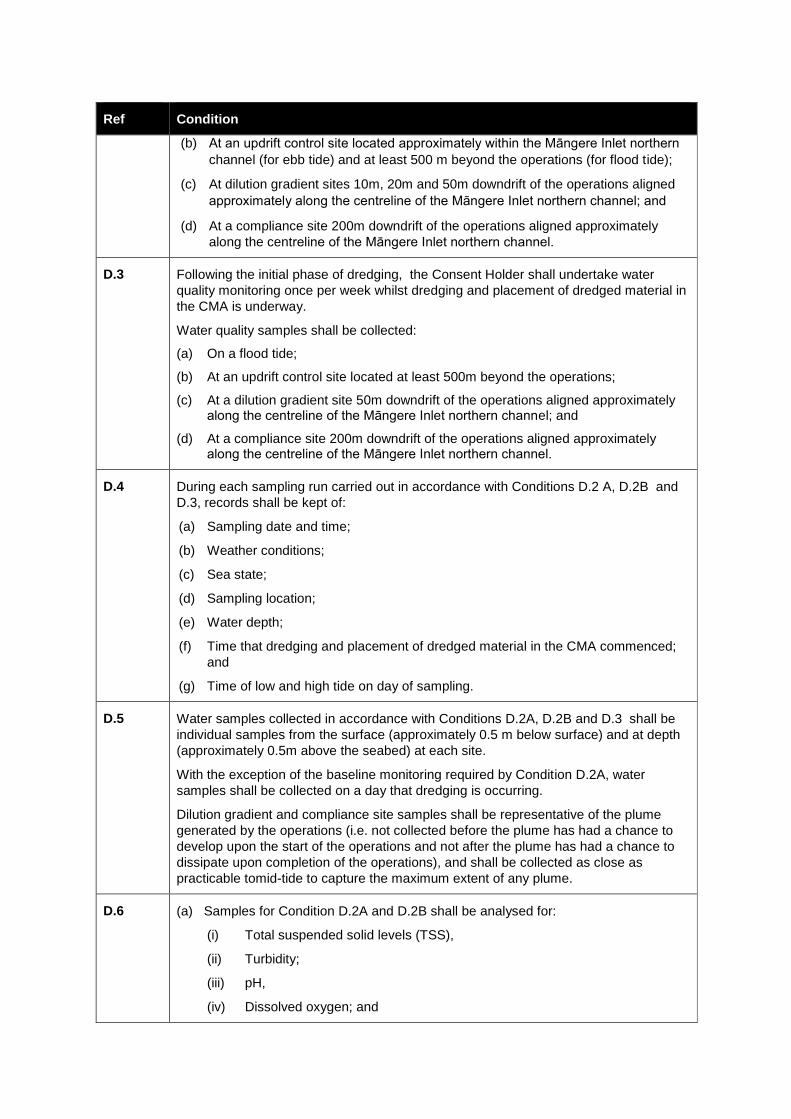
Ref Condition
(b) At an updrift control site located approximately within the Māngere Inlet northern
channel (for ebb tide) and at least 500 m beyond the operations (for flood tide);
(c) At dilution gradient sites 10m, 20m and 50m downdrift of the operations aligned
approximately along the centreline of the Māngere Inlet northern channel; and
(d) At a compliance site 200m downdrift of the operations aligned approximately
along the centreline of the Māngere Inlet northern channel.
D.3 Following the initial phase of dredging, the Consent Holder shall undertake water
quality monitoring once per week whilst dredging and placement of dredged material in
the CMA is underway.
Water quality samples shall be collected:
(a) On a flood tide;
(b) At an updrift control site located at least 500m beyond the operations;
(c) At a dilution gradient site 50m downdrift of the operations aligned approximately along the centreline of the Māngere Inlet northern channel; and
(d) At a compliance site 200m downdrift of the operations aligned approximately along the centreline of the Māngere Inlet northern channel.
D.4 During each sampling run carried out in accordance with Conditions D.2 A, D.2B and
D.3, records shall be kept of:
(a) Sampling date and time;
(b) Weather conditions;
(c) Sea state;
(d) Sampling location;
(e) Water depth;
(f) Time that dredging and placement of dredged material in the CMA commenced;
and
(g) Time of low and high tide on day of sampling.
D.5 Water samples collected in accordance with Conditions D.2A, D.2B and D.3 shall be
individual samples from the surface (approximately 0.5 m below surface) and at depth
(approximately 0.5m above the seabed) at each site.
With the exception of the baseline monitoring required by Condition D.2A, water
samples shall be collected on a day that dredging is occurring.
Dilution gradient and compliance site samples shall be representative of the plume
generated by the operations (i.e. not collected before the plume has had a chance to
develop upon the start of the operations and not after the plume has had a chance to
dissipate upon completion of the operations), and shall be collected as close as
practicable tomid-tide to capture the maximum extent of any plume.
D.6 (a) Samples for Condition D.2A and D.2B shall be analysed for:
(i) Total suspended solid levels (TSS),
(ii) Turbidity;
(iii) pH,
(iv) Dissolved oxygen; and
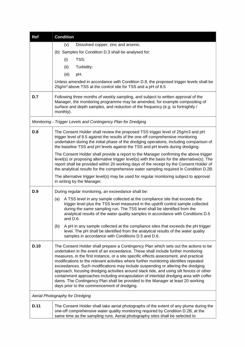
Ref Condition
(v) Dissolved copper, zinc and arsenic.
(b) Samples for Condition D.3 shall be analysed for:
(i) TSS;
(ii) Turbidity;
(iii) pH.
Unless amended in accordance with Condition D.8, the proposed trigger levels shall be
25g/m3 above TSS at the control site for TSS and a pH of 8.5
D.7 Following three months of weekly sampling, and subject to written approval of the
Manager, the monitoring programme may be amended, for example compositing of
surface and depth samples, and reduction of the frequency (e.g. to fortnightly /
monthly).
Monitoring - Trigger Levels and Contingency Plan for Dredging
D.8 The Consent Holder shall review the proposed TSS trigger level of 25g/m3 and pH
trigger level of 8.5 against the results of the one-off comprehensive monitoring undertaken during the initial phase of the dredging operations, including comparison of
the baseline TSS and pH levels against the TSS and pH levels during dredging.
The Consent Holder shall provide a report to the Manager confirming the above trigger
level(s) or proposing alternative trigger level(s) with the basis for the alternative(s). The
report shall be provided within 20 working days of the receipt by the Consent Holder of
the analytical results for the comprehensive water sampling required in Condition D.2B.
The alternative trigger level(s) may be used for regular monitoring subject to approval
in writing by the Manager.
D.9 During regular monitoring, an exceedance shall be:
(a) A TSS level in any sample collected at the compliance site that exceeds the
trigger level plus the TSS level measured in the updrift control sample collected
during the same sampling run. The TSS level shall be identified from the
analytical results of the water quality samples in accordance with Conditions D.5
and D.6.
(b) A pH in any sample collected at the compliance sites that exceeds the pH trigger
level. The pH shall be identified from the analytical results of the water quality
samples in accordance with Conditions D.5 and D.6.
D.10 The Consent Holder shall prepare a Contingency Plan which sets out the actions to be
undertaken in the event of an exceedance. These shall include further monitoring
measures, in the first instance, or a site specific effects assessment, and practical
modifications to the relevant activities where further monitoring identifies repeated
exceedances. Such modifications may include suspending or altering the dredging
approach, focusing dredging activities around slack tide, and using silt fences or other
containment approaches including encapsulation of intertidal dredging area with coffer
dams. The Contingency Plan shall be provided to the Manager at least 20 working
days prior to the commencement of dredging.
Aerial Photography for Dredging
D.11 The Consent Holder shall take aerial photographs of the extent of any plume during the
one-off comprehensive water quality monitoring required by Condition D.2B, at the
same time as the sampling runs. Aerial photography sites shall be selected to
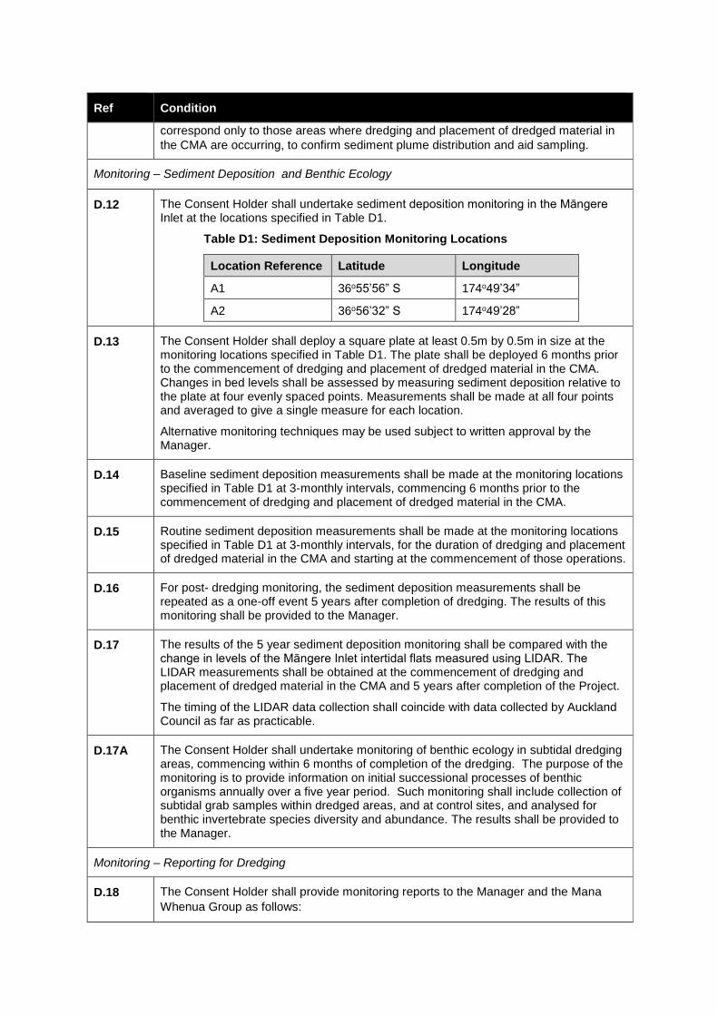
Ref Condition
correspond only to those areas where dredging and placement of dredged material in
the CMA are occurring, to confirm sediment plume distribution and aid sampling.
Monitoring – Sediment Deposition and Benthic Ecology
D.12 The Consent Holder shall undertake sediment deposition monitoring in the Māngere Inlet at the locations specified in Table D1.
Table D1: Sediment Deposition Monitoring Locations
Location Reference Latitude Longitude
A1 36o55’56” S 174o49’34”
A2 36o56’32” S 174o49’28”
D.13 The Consent Holder shall deploy a square plate at least 0.5m by 0.5m in size at the monitoring locations specified in Table D1. The plate shall be deployed 6 months prior to the commencement of dredging and placement of dredged material in the CMA. Changes in bed levels shall be assessed by measuring sediment deposition relative to the plate at four evenly spaced points. Measurements shall be made at all four points and averaged to give a single measure for each location.
Alternative monitoring techniques may be used subject to written approval by the Manager.
D.14 Baseline sediment deposition measurements shall be made at the monitoring locations specified in Table D1 at 3-monthly intervals, commencing 6 months prior to the commencement of dredging and placement of dredged material in the CMA.
D.15 Routine sediment deposition measurements shall be made at the monitoring locations specified in Table D1 at 3-monthly intervals, for the duration of dredging and placement of dredged material in the CMA and starting at the commencement of those operations.
D.16 For post- dredging monitoring, the sediment deposition measurements shall be repeated as a one-off event 5 years after completion of dredging. The results of this monitoring shall be provided to the Manager.
D.17 The results of the 5 year sediment deposition monitoring shall be compared with the change in levels of the Māngere Inlet intertidal flats measured using LIDAR. The LIDAR measurements shall be obtained at the commencement of dredging and placement of dredged material in the CMA and 5 years after completion of the Project.
The timing of the LIDAR data collection shall coincide with data collected by Auckland Council as far as practicable.
D.17A The Consent Holder shall undertake monitoring of benthic ecology in subtidal dredging areas, commencing within 6 months of completion of the dredging. The purpose of the monitoring is to provide information on initial successional processes of benthic organisms annually over a five year period. Such monitoring shall include collection of subtidal grab samples within dredged areas, and at control sites, and analysed for benthic invertebrate species diversity and abundance. The results shall be provided to the Manager.
Monitoring – Reporting for Dredging
D.18 The Consent Holder shall provide monitoring reports to the Manager and the Mana
Whenua Group as follows:
Ref Condition
(a) At completion of the one-off comprehensive water quality monitoring as required by Conditions D.2A and D.2B ; and
(b) Every six months for the duration of dredging and placement of dredged material in the CMA for routine water quality monitoring and sediment deposition monitoring as required by Condition D.3; and
(c) Following completion of the post-dredging monitoring required by Conditions D.16, D.17 and D.17A.
Notification of completion
D.19 The Consent Holder shall notify the Manager in writing of the date of completion of
dredging and placement of dredged material in the CMA within 10 working days of
completion of the last activity.
On completion, the Consent Holder shall provide the Manager with the best available estimate of the in-situ volume of material dredged and the in-situ volume placed in the CMA.
ECOLOGICAL MANAGEMENT (EM)
Ref Condition
Ecological Management Plan - General
EM.1A (a) The Consent Holder shall prepare and submit an Ecological Management Plan
(ECOMP) to the Manager in accordance with the process set out in Condition RC.9.
(b) The purpose of the ECOMP is to set out the specific management procedures,
construction methods, mitigation and monitoring to be undertaken in order to
achieve the following outcomes:
(i) Avoid or minimise the extent of effect on valued ecological and geological
areas within the Project site ;
(ii) Avoid or minimise the extent of effect on the mosaic of lava shrubland,
saltmarsh and wetland habitat in Anns Creek East in accordance with
Designation Condition DC.15 (Anns Creek Construction Restriction Area);
(iii) Ensure that valued ecological and geological areas, or parts of those areas,
which are to be avoided are clearly delineated (e.g. by secure fencing) to
protect them during construction;
(iv) For those valued ecological and geological areas which cannot be avoided, but
where complete loss of the ecosystem, vegetation, habitat, or geological
feature is not required, reduce the impact on those areas as far as practicable
(e.g. minimising the construction footprint within those areas and placement of
construction material outside of those areas); and
(v) To avoid, remedy or mitigate potential adverse effects arising from construction
activities on terrestrial ecology (including Herpetofauna), freshwater ecology,
marine ecology and avifauna.
(c) The ECOMP shall be prepared by a Suitably Qualified Person and in collaboration
with the development of the Urban Landscape and Design Management Plan to be
prepared for the Project by the NZ Transport Agency.
EM.1B (a) The ECOMP shall be prepared in consultation with:
(i) Council;
(ii) Department of Conservation;
(iii) The Mana Whenua Group; and
(iv) Owners of land in which any ecological mitigation works are proposed to be
undertaken.
(b) Any comments and inputs received from the parties listed above shall be
summarised within the ECOMP or supporting document, along with explanation of
where any comments or suggestions have, or have not been incorporated and, if
not incorporated, the reasons why.
EM.1C The ECOMP shall include:
(a) The specific management procedures, construction methods, mitigation and
monitoring to be undertaken in order to achieve the outcomes in Condition EM.1A;
(b) The matters set out in Condition EM.2B relating to Māngere Inlet Foreshore, Anns
Creek Estuary and Anns Creek West;
(c) The matters set out in Condition EM.2C relating to Anns Creek East;
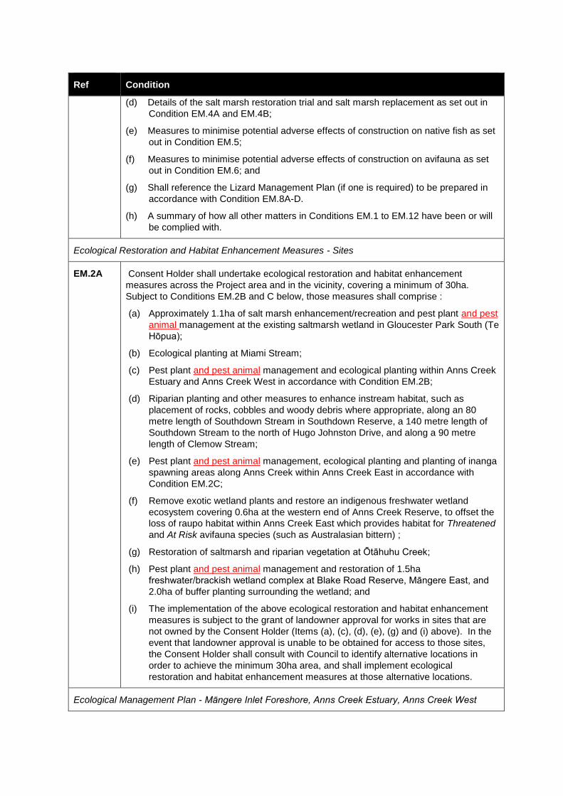
Ref Condition
(d) Details of the salt marsh restoration trial and salt marsh replacement as set out in
Condition EM.4A and EM.4B;
(e) Measures to minimise potential adverse effects of construction on native fish as set
out in Condition EM.5;
(f) Measures to minimise potential adverse effects of construction on avifauna as set
out in Condition EM.6; and
(g) Shall reference the Lizard Management Plan (if one is required) to be prepared in
accordance with Condition EM.8A-D.
(h) A summary of how all other matters in Conditions EM.1 to EM.12 have been or will
be complied with.
Ecological Restoration and Habitat Enhancement Measures - Sites
EM.2A Consent Holder shall undertake ecological restoration and habitat enhancement
measures across the Project area and in the vicinity, covering a minimum of 30ha.
Subject to Conditions EM.2B and C below, those measures shall comprise :
(a) Approximately 1.1ha of salt marsh enhancement/recreation and pest plant and pest
animal management at the existing saltmarsh wetland in Gloucester Park South (Te
Hōpua);
(b) Ecological planting at Miami Stream;
(c) Pest plant and pest animal management and ecological planting within Anns Creek
Estuary and Anns Creek West in accordance with Condition EM.2B;
(d) Riparian planting and other measures to enhance instream habitat, such as
placement of rocks, cobbles and woody debris where appropriate, along an 80
metre length of Southdown Stream in Southdown Reserve, a 140 metre length of
Southdown Stream to the north of Hugo Johnston Drive, and along a 90 metre
length of Clemow Stream;
(e) Pest plant and pest animal management, ecological planting and planting of inanga
spawning areas along Anns Creek within Anns Creek East in accordance with
Condition EM.2C;
(f) Remove exotic wetland plants and restore an indigenous freshwater wetland
ecosystem covering 0.6ha at the western end of Anns Creek Reserve, to offset the
loss of raupo habitat within Anns Creek East which provides habitat for Threatened
and At Risk avifauna species (such as Australasian bittern) ;
(g) Restoration of saltmarsh and riparian vegetation at Ōtāhuhu Creek;
(h) Pest plant and pest animal management and restoration of 1.5ha
freshwater/brackish wetland complex at Blake Road Reserve, Māngere East, and
2.0ha of buffer planting surrounding the wetland; and
(i) The implementation of the above ecological restoration and habitat enhancement
measures is subject to the grant of landowner approval for works in sites that are
not owned by the Consent Holder (Items (a), (c), (d), (e), (g) and (i) above). In the
event that landowner approval is unable to be obtained for access to those sites,
the Consent Holder shall consult with Council to identify alternative locations in
order to achieve the minimum 30ha area, and shall implement ecological
restoration and habitat enhancement measures at those alternative locations.
Ecological Management Plan - Māngere Inlet Foreshore, Anns Creek Estuary, Anns Creek West
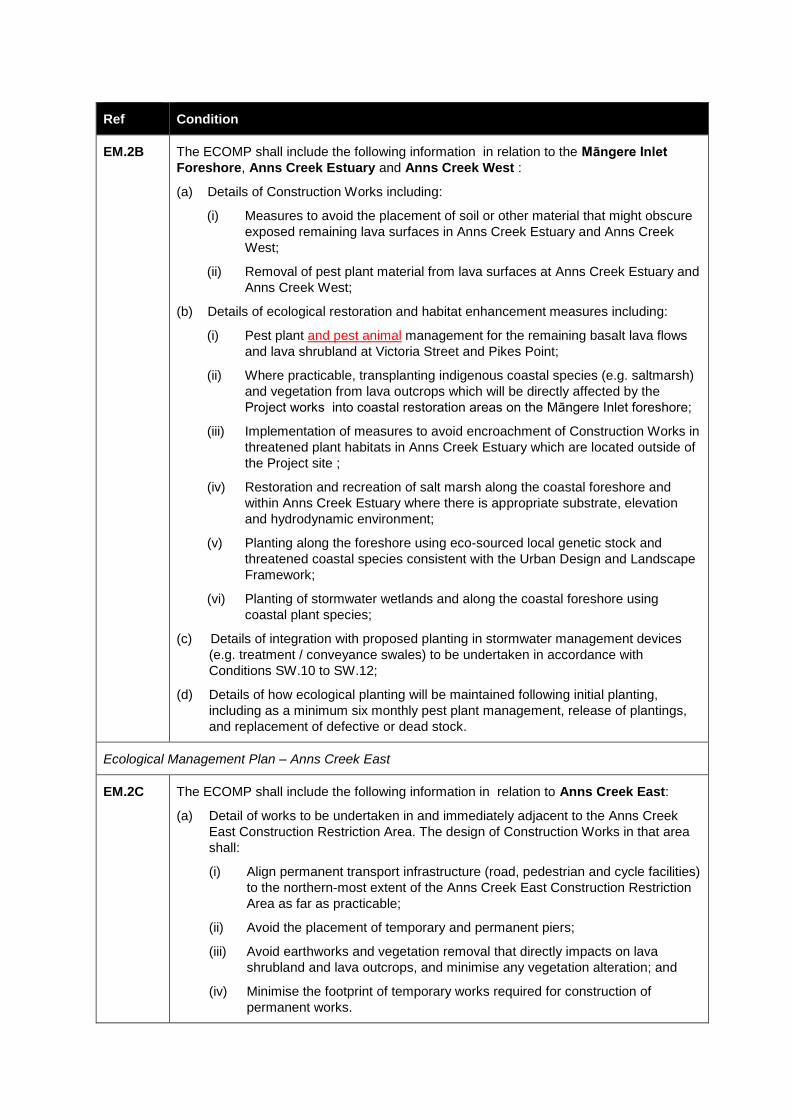
Ref Condition
EM.2B The ECOMP shall include the following information in relation to the Māngere Inlet
Foreshore, Anns Creek Estuary and Anns Creek West :
(a) Details of Construction Works including:
(i) Measures to avoid the placement of soil or other material that might obscure
exposed remaining lava surfaces in Anns Creek Estuary and Anns Creek
West;
(ii) Removal of pest plant material from lava surfaces at Anns Creek Estuary and
Anns Creek West;
(b) Details of ecological restoration and habitat enhancement measures including:
(i) Pest plant and pest animal management for the remaining basalt lava flows
and lava shrubland at Victoria Street and Pikes Point;
(ii) Where practicable, transplanting indigenous coastal species (e.g. saltmarsh)
and vegetation from lava outcrops which will be directly affected by the
Project works into coastal restoration areas on the Māngere Inlet foreshore;
(iii) Implementation of measures to avoid encroachment of Construction Works in
threatened plant habitats in Anns Creek Estuary which are located outside of
the Project site ;
(iv) Restoration and recreation of salt marsh along the coastal foreshore and
within Anns Creek Estuary where there is appropriate substrate, elevation
and hydrodynamic environment;
(v) Planting along the foreshore using eco-sourced local genetic stock and
threatened coastal species consistent with the Urban Design and Landscape
Framework;
(vi) Planting of stormwater wetlands and along the coastal foreshore using
coastal plant species;
(c) Details of integration with proposed planting in stormwater management devices
(e.g. treatment / conveyance swales) to be undertaken in accordance with
Conditions SW.10 to SW.12;
(d) Details of how ecological planting will be maintained following initial planting,
including as a minimum six monthly pest plant management, release of plantings,
and replacement of defective or dead stock.
Ecological Management Plan – Anns Creek East
EM.2C The ECOMP shall include the following information in relation to Anns Creek East:
(a) Detail of works to be undertaken in and immediately adjacent to the Anns Creek
East Construction Restriction Area. The design of Construction Works in that area
shall:
(i) Align permanent transport infrastructure (road, pedestrian and cycle facilities)
to the northern-most extent of the Anns Creek East Construction Restriction
Area as far as practicable;
(ii) Avoid the placement of temporary and permanent piers;
(iii) Avoid earthworks and vegetation removal that directly impacts on lava
shrubland and lava outcrops, and minimise any vegetation alteration; and
(iv) Minimise the footprint of temporary works required for construction of
permanent works.
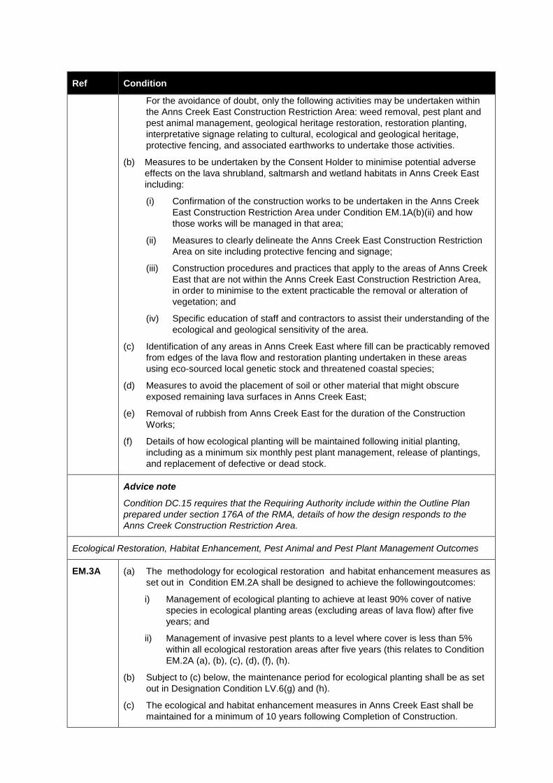
Ref Condition
For the avoidance of doubt, only the following activities may be undertaken within
the Anns Creek East Construction Restriction Area: weed removal, pest plant and
pest animal management, geological heritage restoration, restoration planting,
interpretative signage relating to cultural, ecological and geological heritage,
protective fencing, and associated earthworks to undertake those activities.
(b) Measures to be undertaken by the Consent Holder to minimise potential adverse
effects on the lava shrubland, saltmarsh and wetland habitats in Anns Creek East
including:
(i) Confirmation of the construction works to be undertaken in the Anns Creek
East Construction Restriction Area under Condition EM.1A(b)(ii) and how
those works will be managed in that area;
(ii) Measures to clearly delineate the Anns Creek East Construction Restriction
Area on site including protective fencing and signage;
(iii) Construction procedures and practices that apply to the areas of Anns Creek
East that are not within the Anns Creek East Construction Restriction Area,
in order to minimise to the extent practicable the removal or alteration of
vegetation; and
(iv) Specific education of staff and contractors to assist their understanding of the
ecological and geological sensitivity of the area.
(c) Identification of any areas in Anns Creek East where fill can be practicably removed
from edges of the lava flow and restoration planting undertaken in these areas
using eco-sourced local genetic stock and threatened coastal species;
(d) Measures to avoid the placement of soil or other material that might obscure
exposed remaining lava surfaces in Anns Creek East;
(e) Removal of rubbish from Anns Creek East for the duration of the Construction
Works;
(f) Details of how ecological planting will be maintained following initial planting,
including as a minimum six monthly pest plant management, release of plantings,
and replacement of defective or dead stock.
Advice note
Condition DC.15 requires that the Requiring Authority include within the Outline Plan
prepared under section 176A of the RMA, details of how the design responds to the
Anns Creek Construction Restriction Area.
Ecological Restoration, Habitat Enhancement, Pest Animal and Pest Plant Management Outcomes
EM.3A (a) The methodology for ecological restoration and habitat enhancement measures as
set out in Condition EM.2A shall be designed to achieve the followingoutcomes:
i) Management of ecological planting to achieve at least 90% cover of native
species in ecological planting areas (excluding areas of lava flow) after five
years; and
ii) Management of invasive pest plants to a level where cover is less than 5%
within all ecological restoration areas after five years (this relates to Condition
EM.2A (a), (b), (c), (d), (f), (h).
(b) Subject to (c) below, the maintenance period for ecological planting shall be as set
out in Designation Condition LV.6(g) and (h).
(c) The ecological and habitat enhancement measures in Anns Creek East shall be
maintained for a minimum of 10 years following Completion of Construction.
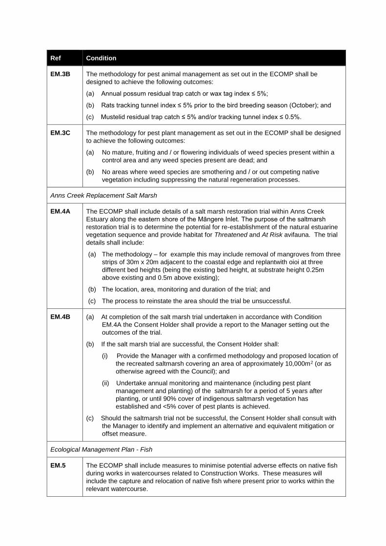
Ref Condition
EM.3B The methodology for pest animal management as set out in the ECOMP shall be
designed to achieve the following outcomes:
(a) Annual possum residual trap catch or wax tag index ≤ 5%;
(b) Rats tracking tunnel index ≤ 5% prior to the bird breeding season (October); and
(c) Mustelid residual trap catch ≤ 5% and/or tracking tunnel index ≤ 0.5%.
EM.3C The methodology for pest plant management as set out in the ECOMP shall be designed
to achieve the following outcomes:
(a) No mature, fruiting and / or flowering individuals of weed species present within a
control area and any weed species present are dead; and
(b) No areas where weed species are smothering and / or out competing native
vegetation including suppressing the natural regeneration processes.
Anns Creek Replacement Salt Marsh
EM.4A The ECOMP shall include details of a salt marsh restoration trial within Anns Creek
Estuary along the eastern shore of the Māngere Inlet. The purpose of the saltmarsh
restoration trial is to determine the potential for re-establishment of the natural estuarine
vegetation sequence and provide habitat for Threatened and At Risk avifauna. The trial
details shall include:
(a) The methodology – for example this may include removal of mangroves from three
strips of 30m x 20m adjacent to the coastal edge and replantwith oioi at three
different bed heights (being the existing bed height, at substrate height 0.25m
above existing and 0.5m above existing);
(b) The location, area, monitoring and duration of the trial; and
(c) The process to reinstate the area should the trial be unsuccessful.
EM.4B (a) At completion of the salt marsh trial undertaken in accordance with Condition
EM.4A the Consent Holder shall provide a report to the Manager setting out the
outcomes of the trial.
(b) If the salt marsh trial are successful, the Consent Holder shall:
(i) Provide the Manager with a confirmed methodology and proposed location of
the recreated saltmarsh covering an area of approximately 10,000m2 (or as
otherwise agreed with the Council); and
(ii) Undertake annual monitoring and maintenance (including pest plant
management and planting) of the saltmarsh for a period of 5 years after
planting, or until 90% cover of indigenous saltmarsh vegetation has
established and <5% cover of pest plants is achieved.
(c) Should the saltmarsh trial not be successful, the Consent Holder shall consult with
the Manager to identify and implement an alternative and equivalent mitigation or
offset measure.
Ecological Management Plan - Fish
EM.5 The ECOMP shall include measures to minimise potential adverse effects on native fish
during works in watercourses related to Construction Works. These measures will
include the capture and relocation of native fish where present prior to works within the
relevant watercourse.
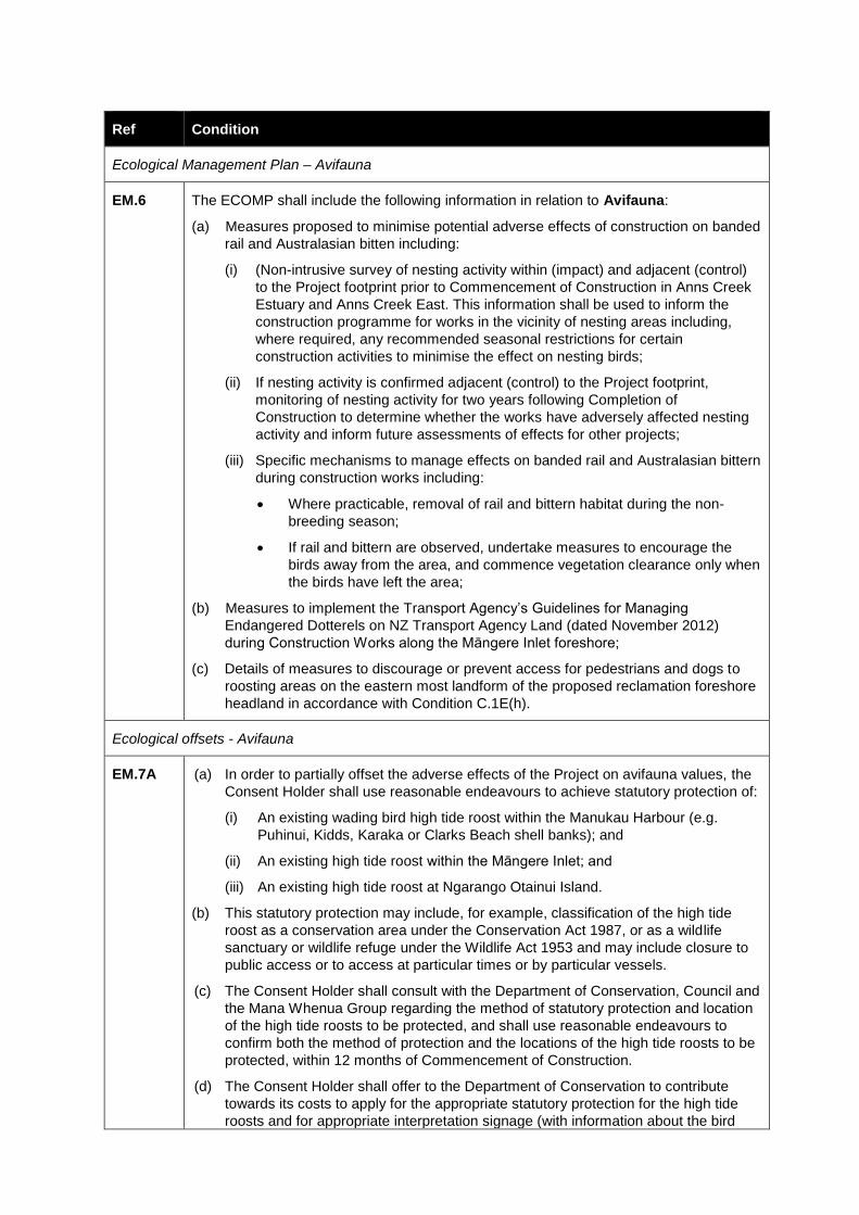
Ref Condition
Ecological Management Plan – Avifauna
EM.6 The ECOMP shall include the following information in relation to Avifauna:
(a) Measures proposed to minimise potential adverse effects of construction on banded
rail and Australasian bitten including:
(i) (Non-intrusive survey of nesting activity within (impact) and adjacent (control)
to the Project footprint prior to Commencement of Construction in Anns Creek
Estuary and Anns Creek East. This information shall be used to inform the
construction programme for works in the vicinity of nesting areas including,
where required, any recommended seasonal restrictions for certain
construction activities to minimise the effect on nesting birds;
(ii) If nesting activity is confirmed adjacent (control) to the Project footprint,
monitoring of nesting activity for two years following Completion of
Construction to determine whether the works have adversely affected nesting
activity and inform future assessments of effects for other projects;
(iii) Specific mechanisms to manage effects on banded rail and Australasian bittern
during construction works including:
Where practicable, removal of rail and bittern habitat during the non-
breeding season;
If rail and bittern are observed, undertake measures to encourage the
birds away from the area, and commence vegetation clearance only when
the birds have left the area;
(b) Measures to implement the Transport Agency’s Guidelines for Managing
Endangered Dotterels on NZ Transport Agency Land (dated November 2012)
during Construction Works along the Māngere Inlet foreshore;
(c) Details of measures to discourage or prevent access for pedestrians and dogs to
roosting areas on the eastern most landform of the proposed reclamation foreshore
headland in accordance with Condition C.1E(h).
Ecological offsets - Avifauna
EM.7A (a) In order to partially offset the adverse effects of the Project on avifauna values, the
Consent Holder shall use reasonable endeavours to achieve statutory protection of:
(i) An existing wading bird high tide roost within the Manukau Harbour (e.g.
Puhinui, Kidds, Karaka or Clarks Beach shell banks); and
(ii) An existing high tide roost within the Māngere Inlet; and
(iii) An existing high tide roost at Ngarango Otainui Island.
(b) This statutory protection may include, for example, classification of the high tide
roost as a conservation area under the Conservation Act 1987, or as a wildlife
sanctuary or wildlife refuge under the Wildlife Act 1953 and may include closure to
public access or to access at particular times or by particular vessels.
(c) The Consent Holder shall consult with the Department of Conservation, Council and
the Mana Whenua Group regarding the method of statutory protection and location
of the high tide roosts to be protected, and shall use reasonable endeavours to
confirm both the method of protection and the locations of the high tide roosts to be
protected, within 12 months of Commencement of Construction.
(d) The Consent Holder shall offer to the Department of Conservation to contribute
towards its costs to apply for the appropriate statutory protection for the high tide
roosts and for appropriate interpretation signage (with information about the bird
Ref Condition
roosts and any access restrictions) to be installed once the statutory protection is in
place. The value of that contribution shall be agreed between the Consent Holder
and the Department of Conservation.
EM.7B (a) In order to partially offset the adverse effects of the Project on avifauna values, the
Consent Holder shall take reasonable steps to construct a suitable single purpose
high tide wading bird roost in Māngere Inlet.
(b) The Consent Holder shall consult with the Department of Conservation, Council and
the Mana Whenua Group regarding the location and design of the high tide roost to
be constructed.
(c) Subject to obtaining any necessary property rights and resource consents, the
Consent Holder shall construct the high tide roost as part of the Construction
Works, and maintain the high tide roost in a suitable state of repair for five years
following the Completion of Construction.
EM.7C (a) In order to partially offset the adverse effects of the Project on avifauna values, the
Consent Holder shall, no less than six months prior to the Commencement of
Construction, offer to the Department of Conservation to contribute towards its
management programmes at South Island breeding sites along the major braided
rivers (e.g. Rakaia and Waiau), of avifauna species affected by the Project.
(b) The value of that contribution shall be agreed between the Consent Holder and the
Department of Conservation. The contribution shall be sufficient to support pest
animal control over a river length of at least 20km (or equivalent), continuing for the
construction period of the reclamation within the Māngere Inlet plus five years after
the Completion of Construction.
Herpetofauna (Lizards)
EM.8A Prior to the commencement of vegetation removal for Construction Works in areas
identified as potential high and moderate quality habitat in Technical Report 16:
Ecological Impact Assessment (dated November 2016), the Consent Holder shall
provide to the Manager, information from a Suitably Qualified Person that identifies
whether there are sufficient numbers of native lizards present within the area to trigger a
requirement for a Lizard Management Plan (LMP).
The information submitted shall include the results of a lizard survey undertaken to
confirm the presence, or otherwise, of native lizards. The lizard survey shall be based on
industry best practice survey methods and shall include all areas identified as potential
high and moderate quality habitat within the Project footprint and shall be overseen by a
Suitably Qualified Person.
EM.8B A LMP is required if the lizard survey results in the detection of:
(a) 1 or more individuals of a threatened or at-risk native lizard species within the
survey area; or
(b) 3 or more individuals of a not threatened native lizard species within a survey area
as per the New Zealand Threat Classification series 17 ‘Conservation Status of
New Zealand Reptiles’, dated 2015.
EM.8C The purpose of the LMP is to achieve the following objectives:
(a) The population of each species of native lizard present on the site at which
vegetation clearance is to occur is maintained or enhanced, either on the same site
or at an appropriate alternative site; and
Ref Condition
(b) The habitat(s) that lizards are transferred to (either on site or at an alternative site,
as the case may be) will support viable native lizard populations for all species
present pre-development.
The LMP shall be prepared by a Suitably Qualified Person and shall address the
following (where relevant):
(a) Timing of implementation of the LMP;
(b) A description of methodology for survey, trapping and relocation of lizards rescued
including but not limited to: salvage protocols, relocation protocols (including
method used to identify suitable relocation site(s)), nocturnal and diurnal capture
protocols, supervised habitat clearance/transfer protocols, artificial cover object
protocols, and opportunistic relocation protocols;
(c) A description of the relocation site(s); including discussion of:
provision for additional refugia, if required e.g. depositing salvaged logs, wood
or debris for newly released native skinks that have been rescued;
any protection mechanisms (if required) to ensure the relocation site is
maintained (e.g.) covenants, consent notices etc.; and
any pest plant and pest animal management to ensure the relocation site is
maintained as appropriate habitat.
(d) Monitoring methods, including but not limited to: baseline lizard surveys within the
affected site (pre-translocation survey), surveys to identify potential translocation
release sites, monitoring to evaluate translocation success (post-translocation
monitoring), and monitoring of any pest control; and
(e) A post-vegetation clearance search for remaining lizards.
EM.8D If a LMP is required under Condition EM.8A, this shall be submitted to the Manager for
certification in accordance with Condition RC.9 prior to the commencement of any
vegetation removal in areas of potential high and moderate quality.
Advice note:
The capture, handling and relocation of native lizards may require a Wildlife Permit under
the Wildlife Act 1953.
Supervision during construction
EM.9 The Consent Holder shall engage a Suitably Qualified Person during Construction Works
to advise on day-to-day measures to achieve the outcomes in Condition EM.1A(b) and to
oversee ecological planting in the areas set out in Condition 2.B to ensure that this is
implemented in accordance with best practice. The Suitably Qualified Person shall also
advise on the landscape planting to be undertaken along the northern Māngere Inlet as
part of the Project.
Ecological research
EM.10 (a) The Consent Holder shall implement research (e.g. through scholarships or a
specific project) to increase scientific knowledge of succession and recolonisation
of intertidal soft and hard shore food sources for foraging birds in the Māngere Inlet.
(b) The research shall commence following Completion of Construction within the
Māngere Inlet.
(c) Unless otherwise agreed between the Consent Holder and the Manager, the
research shall involve:
Ref Condition
(i) Monitoring the recolonisation of intertidal soft sediment organisms within
areas of disturbed sediment annually, at the same time of year, for five
years. The research shall comprise collection of replicate core samples
within areas of disturbed intertidal sediment and at similar sites where
sediment is not disturbed (control sites), sieving sediment using a 0.5mm
mesh and analysis of benthic invertebrate community composition in the
residual fraction. Community composition, species abundance and
diversity shall be analysed among years; and
(ii) Monitoring the natural recolonisation of newly created artificial intertidal
hard shore substrate by marine invertebrate species over a three-year
period. The research shall compare natural recolonisation of hardshore
species to new artificial hardshore to similar areas where organisms are
experimentally transplanted in order to determine if recolonisation
processes can be accelerated. A range of hardshore species (including
snails and limpets) shall be experimentally transplanted and confined within
structures. Community composition, species diversity and abundance or
percentage cover shall be analysed among years. Comparison to existing
similar artificial hardshore areas within the inlet should also be undertaken
if possible.
(d) In the event that the Consent Holder and the Manager agree to an amended
research methodology, the amended methodology shall be designed to achieve the
purpose in (a) above.
(e) The research shall be undertaken in conjunction with a suitable tertiary institution
and with supervision from a Suitably Qualified Person. The outcomes of the
research shall be provided to Council and the Department of Conservation within 12
months of Completion of Construction, unless otherwise agreed with the Manager,
and submitted to a relevant scientific journal if appropriate to do so.
Anns Creek East Management Area
EM.11A The Consent Holder shall use its best endeavours to establish and facilitate a working
group to identify proposed measures for long term integrated environmental
management of the Anns Creek East area, being the area in the immediate vicinity of
Section 1 SO 69440 at Anns Creek East.
EM.11B (a) The following parties shall be invited to participate in the Anns Creek Working
Group :
(i) The owners of land in the Anns Creek East area;
(ii) Department of Conservation;
(iii) Auckland Council;
(iv) Auckland Transport;
(v) KiwiRail; and
(vi) The Mana Whenua Group.
(b) The Requiring Authority shall be responsible for all reasonable costs associated
with administrative support to the Anns Creek Working Group.
EM.11C The purpose of the Anns Creek Working Group is, in relation to the Anns Creek East
area, to:

Ref Condition
(a) Identify opportunities to integrate mitigation works associated with the Project with
any other environmental enhancement activities being undertaken on land or in the
CMA adjoining the boundary of the Project site;
(b) Identify opportunities to provide long term integrated environmental management
and legal protection of mitigation works associated with the Project and adjacent
high value habitat including plant habitats and the mosaic of lava, saltmarsh and
freshwater ecosystems; and
(c) Identify the mechanisms to deliver the opportunities identified in (b) above.
EM.11D The Consent Holder shall provide a report to the Manager on the activities and outcomes
of the working group, including any agreed measures for long term integrated
environmental management, within 12 months of Commencement of Works, and a
further progress report on the implementation of those measures within 24 months of
Commencement of Works.
Ngarango Otainui Island
EM.12A (a) The ECOMP shall include the following information related to habitat enhancement
at Ngarango Otainui Island:
(i) pest plant and pest animal control,
(ii) planting for bird roosting; and
(iii) erosion stabilisation with a preference for soft engineering solutions
(b) The detail of those or other measures to be developed in accordance with Condition
EM.12B.
(c) The purpose of the habitat enhancement of the island is primarily to provide long
term protection of safe high tide roost sites in the Māngere Inlet post-construction
for species such as royal spoonbill, shags and herons.
EM.12B In relation to Ngarango Otainui Island, the Consent Holder shall engage with Department
of Conservation, Council and the Mana Whenua Group to:
(a) Develop outcomes for long-term integrated ecological management of the island;
(b) Undertaken site investigations to characterise habitat type and to identify ecological
issues and opportunities for restoration and habitat enhancement; and
(c) Prepare and implement an ecological management strategy and plan with
outcomes, responsibilities, timeframes for implementation, and ongoing annual
management and monitoring.

WORKS IN WATERCOURSES (W)
Ref Condition
Construction Design Approval
WW.1 At least 20 working days prior to commencement of streamworks within Southdown
Stream, Anns Creek, Clemow Stream and Miami Stream, the Consent Holder shall
submit construction design details for stream realignment and installation of culverts or
other structures within watercourses to the Manager for approval. The details shall
include, but not be limited to:
(a) Detailed design of the proposed streamworks including long sections and cross
sections, proposed riparian planting, and any other proposed freshwater habitat
improvements; and
(b) Erosion and sediment control in accordance with WW.5.
Construction of Streamworks
WW.2 The Consent Holder shall forward a detailed streamworks construction programme and
methodology to the Manager for approval at least 10 working days prior to the
commencement of those streamworks, and shall provide regular updates during the
streamworks. The information provided shall include details of:
(a) The commencement date and expected duration of the streamworks;
(b) The location of any works and structures in relation to the streamworks;
(c) Procedures for the capture and relocation of fish associated with temporary and
permanent stream diversions; and
(d) Dates for the implementation of erosion and sediment controls.
WW.3 Once approved under Condition WW.2, any material amendments to the streamworks
construction programme and methodology shall be submitted to the Manager for
approval prior to any amendment being implemented.
WW.4 Streamworks shall be carried out only during periods when all flows, up to the 24 hour 20
year return period storm event, can be diverted around the area of works. During periods
of flow greater than the capacity of the diversion, up to the 100 year flood event, a
stabilised flowpath shall be provided to ensure no scour or erosion occurs and so that
flows can pass safely around or through the area of works with minimum nuisance,
damage and sediment generation or discharge.
WW.5 All erosion and sediment controls associated with the streamworks shall be constructed
and installed in accordance with Auckland Council’s GD2016/005: Erosion Sediment
Control Guide for Land Disturbing Activities in the Auckland Region.
WW.6 The Consent Holder shall ensure that any temporary dam structure built within the
stream shall be constructed from non-erodible material (such as sandbags or sheet
piles).

Ref Condition
WW.7 The Consent Holder shall ensure that when dewatering the in-stream works area, no
sediment-laden water shall be discharged directly into a watercourse. Any sediment-
laden water must be treated in an appropriate sediment treatment device in accordance
with Auckland Council’s GD2016/005: Erosion Sediment Control Guide for Land
Disturbing Activities in the Auckland Region.
WW.8 All machinery shall be maintained and operated in a way which ensures that spillages of
fuel, oil and similar contaminants are prevented, particularly during refuelling and
machinery servicing.
WW.9 Within three months of completion of the works, the Consent Holder shall submit to the
Manager As-Built Plans certified by an Suitably Qualified Person to confirm that the
works have been carried out in accordance with the approved design under Condition
WW.1.
WW.10 The Consent Holder shall implement the riparian planting approved under Condition
WW.1 within 12 months of Completion of Construction.

GROUNDWATER AND SETTLEMENT (G)
Ref Condition
Groundwater and Settlement Management Plan
G.1 A Groundwater and Settlement Management Plan (GSMP) shall be prepared by a
Suitably Qualified Person and submitted to the Manager for certification in accordance
with the process set out in Condition RC.9 prior to Commencement of Construction with
potential groundwater and settlement effects.
The purpose of the GSMP is to outline the measures to be adopted to monitor and
respond to any changes in groundwater beyond the boundary of the Project site arising
from construction activities.
The GSMP shall incorporate the matters in Conditions G.2 to G.7 including:
(a) Details of groundwater monitoring including:
i) A schedule of groundwater monitoring bores identifying piezometer depth and geological unit;
ii) Details of final bore construction and piezometer installation;
iii) The location of the groundwater monitoring bores and monitoring cross sections;
iv) The methods and frequency of groundwater level and groundwater quality monitoring;
v) The groundwater trigger levels (level and quality); and
vi) Procedures to follow in the event of trigger levels being exceeded.
(b) Details for ground settlement monitoring including:
i) The predicted total estimated settlement and building damage categories;
ii) A schedule of ground settlement monitoring markers confirmed in Condition G.5;
iii) The methods and frequency of ground settlement monitoring;
iv) Alert and alarm levels where Alert = 75% of the theoretical or agreed level and Alarm = 100% of the theoretical or agreed value with due consideration of the seasonal range of ground movement and tidal influence of groundwater identified by pre-construction monitoring; and
v) Procedures to follow in the event of trigger levels being exceeded.
(c) Reporting requirements.
G.1A The Consent Holder shall install a borehole to a depth of 0.5 m below the planned depth
of the proposed stormwater pipeline on the site at 19-21 Sylvia Park Road (Lot 1 DP
65735) to confirm the nature of the fill and the depth to groundwater. If groundwater is
encountered, the hole shall be completed with a standpipe piezometer and groundwater
level monitored in the borehole during construction of the stormwater pipeline within the
site.
G.2 The Consent Holder shall monitor groundwater levels and quality in the groundwater
monitoring bores confirmed in Condition G.1 and keep records of the water level
measurement and corresponding date. Where exceedances occur these shall be
reported to the Manager within 3 working days.
G.3 All monitoring data obtained in accordance with Condition G.2 shall be compared to the
predicted groundwater level for each borehole. Where groundwater levels are exceeded,
Ref Condition
the appropriate actions as set out in the GSMP shall be undertaken and the Manager
shall be notified advising of the exceedance and details of the action taken.
Groundwater Level Monitoring
G.4 (a) The Consent Holder shall install and maintain groundwater level monitoring boreholes for a period starting at least 6 months prior to Commencement of Construction and concluding 6 months following Completion of Construction.
(b) As a minimum the groundwater monitoring boreholes shall include sites:
i) Upgradient and down gradient of the EWL Trench adjacent to Onehunga Harbour Road;
ii) Upgradient of the EWL embankment at the Galway Street closed landfill; and
iii) Within the Waikaraka Cemetery.
Settlement Monitoring
G.5 The Consent Holder shall establish a series of ground settlement monitoring markers to monitor potential settlement in relation to the construction of the EWL Trench. The survey markers shall be located generally as follows subject to agreement of the owners of land in which the survey markers are proposed to be located:
(a) Along the EWL Trench out to a maximum of 40m either side of the trench from the centreline;
(b) On or around the following buildings or features:
(i) The Landing at 2 Onehunga Harbour Road;
(ii) The residential building(s) at 2 Onehunga Harbour Road;
(iii) The building at 6 Onehunga Harbour Road;
(c) The location of the markers shall be confirmed in the GSMP.
(d) The location of markers may be updated to reflect detailed analysis and interpretation of monitoring results as construction works progress. Any changes shall be included in the GSMP.
G.6 The Consent Holder shall survey the settlement monitoring markers at the following frequency:
(a) At monthly intervals starting at least 12 months prior to excavation of the EWL Trench;
(b) At 3 monthly intervals following completion of excavation of the EWL Trench for a period of 6 months.
For the purpose of this condition, excavation of the EWL Trench is complete when the permanent wall supports are in place.
G.7 If the ground settlement alert or alarm levels in Condition G.1(b)(iv) are exceeded, the
trigger marker shall be resurveyed within 24 hours. If the resurvey indicates that a
building has increased its damage category from that confirmed in the GSMP, then this
shall be considered to be an Alert Level and additional specific assessment of the
building shall be carried out by the Consent Holder to confirm this resurvey within 72
hours.
If the additional assessment following resurvey confirms the increase in damage
category, this shall be considered to be an Alarm Level and the property owner and
occupier(s) will be notified within 48 hours. Following consultation with the property
owner and occupier(s); subsequent actions may include increased frequency and/or

Ref Condition
extent of monitoring, modification to the construction methodology or mitigation works to
the affected building (subject to building owner approval and any additional statutory
approvals required).
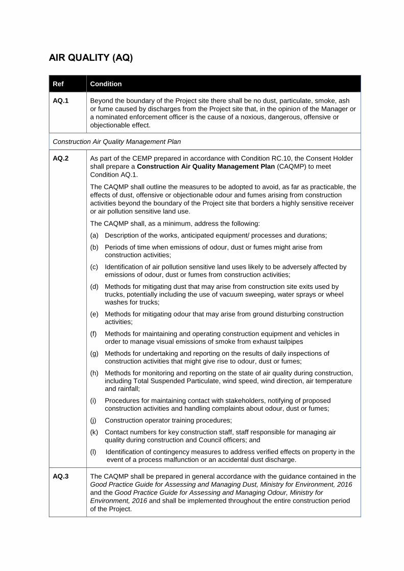
AIR QUALITY (AQ)
Ref Condition
AQ.1 Beyond the boundary of the Project site there shall be no dust, particulate, smoke, ash
or fume caused by discharges from the Project site that, in the opinion of the Manager or
a nominated enforcement officer is the cause of a noxious, dangerous, offensive or
objectionable effect.
Construction Air Quality Management Plan
AQ.2 As part of the CEMP prepared in accordance with Condition RC.10, the Consent Holder
shall prepare a Construction Air Quality Management Plan (CAQMP) to meet
Condition AQ.1.
The CAQMP shall outline the measures to be adopted to avoid, as far as practicable, the
effects of dust, offensive or objectionable odour and fumes arising from construction
activities beyond the boundary of the Project site that borders a highly sensitive receiver
or air pollution sensitive land use.
The CAQMP shall, as a minimum, address the following:
(a) Description of the works, anticipated equipment/ processes and durations;
(b) Periods of time when emissions of odour, dust or fumes might arise from construction activities;
(c) Identification of air pollution sensitive land uses likely to be adversely affected by emissions of odour, dust or fumes from construction activities;
(d) Methods for mitigating dust that may arise from construction site exits used by trucks, potentially including the use of vacuum sweeping, water sprays or wheel washes for trucks;
(e) Methods for mitigating odour that may arise from ground disturbing construction activities;
(f) Methods for maintaining and operating construction equipment and vehicles in order to manage visual emissions of smoke from exhaust tailpipes
(g) Methods for undertaking and reporting on the results of daily inspections of construction activities that might give rise to odour, dust or fumes;
(h) Methods for monitoring and reporting on the state of air quality during construction, including Total Suspended Particulate, wind speed, wind direction, air temperature and rainfall;
(i) Procedures for maintaining contact with stakeholders, notifying of proposed construction activities and handling complaints about odour, dust or fumes;
(j) Construction operator training procedures;
(k) Contact numbers for key construction staff, staff responsible for managing air quality during construction and Council officers; and
(l) Identification of contingency measures to address verified effects on property in the event of a process malfunction or an accidental dust discharge.
AQ.3 The CAQMP shall be prepared in general accordance with the guidance contained in the
Good Practice Guide for Assessing and Managing Dust, Ministry for Environment, 2016
and the Good Practice Guide for Assessing and Managing Odour, Ministry for
Environment, 2016 and shall be implemented throughout the entire construction period
of the Project.

Ref Condition
AQ.4 The Consent Holder shall undertake all works in accordance with the CAQMP for the
duration of Construction Works.
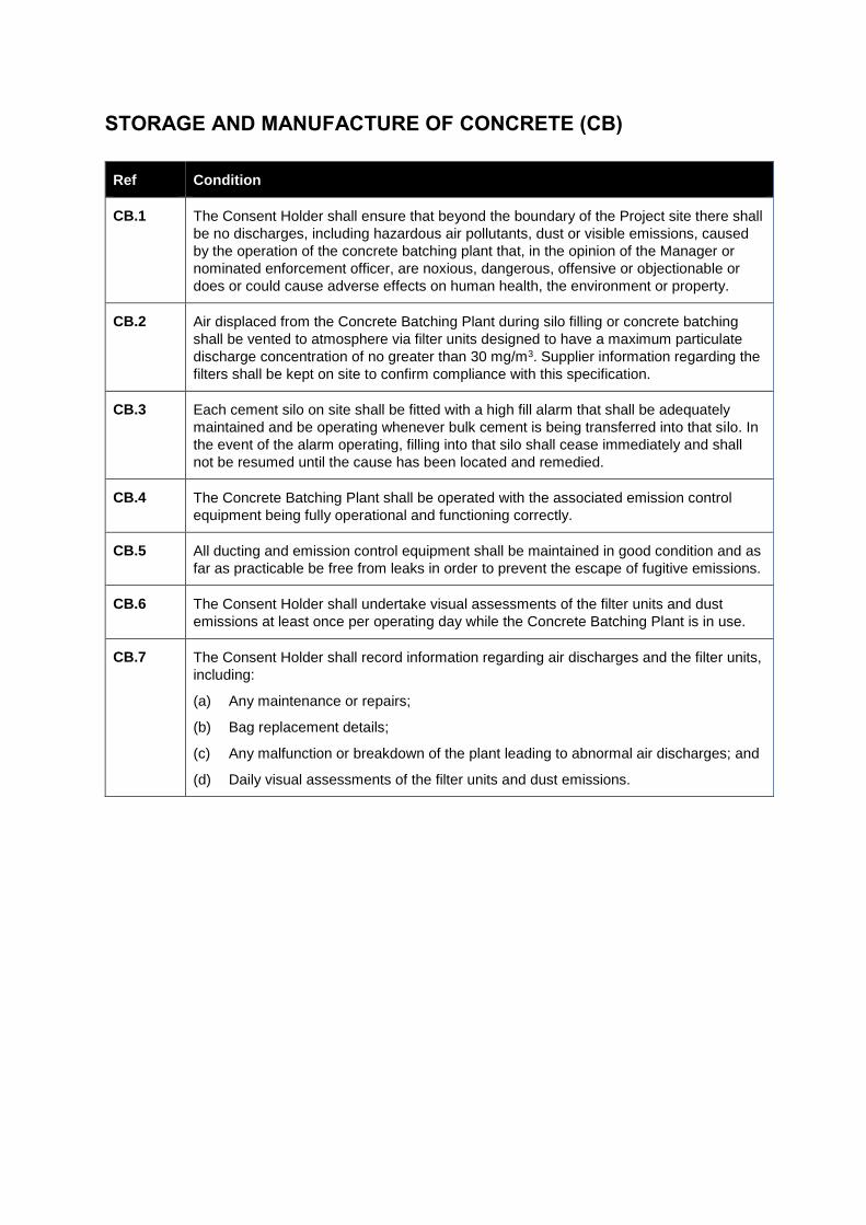
STORAGE AND MANUFACTURE OF CONCRETE (CB)
Ref Condition
CB.1 The Consent Holder shall ensure that beyond the boundary of the Project site there shall
be no discharges, including hazardous air pollutants, dust or visible emissions, caused
by the operation of the concrete batching plant that, in the opinion of the Manager or
nominated enforcement officer, are noxious, dangerous, offensive or objectionable or
does or could cause adverse effects on human health, the environment or property.
CB.2 Air displaced from the Concrete Batching Plant during silo filling or concrete batching
shall be vented to atmosphere via filter units designed to have a maximum particulate
discharge concentration of no greater than 30 mg/m3. Supplier information regarding the
filters shall be kept on site to confirm compliance with this specification.
CB.3 Each cement silo on site shall be fitted with a high fill alarm that shall be adequately
maintained and be operating whenever bulk cement is being transferred into that silo. In
the event of the alarm operating, filling into that silo shall cease immediately and shall
not be resumed until the cause has been located and remedied.
CB.4 The Concrete Batching Plant shall be operated with the associated emission control
equipment being fully operational and functioning correctly.
CB.5 All ducting and emission control equipment shall be maintained in good condition and as
far as practicable be free from leaks in order to prevent the escape of fugitive emissions.
CB.6 The Consent Holder shall undertake visual assessments of the filter units and dust
emissions at least once per operating day while the Concrete Batching Plant is in use.
CB.7 The Consent Holder shall record information regarding air discharges and the filter units,
including:
(a) Any maintenance or repairs;
(b) Bag replacement details;
(c) Any malfunction or breakdown of the plant leading to abnormal air discharges; and
(d) Daily visual assessments of the filter units and dust emissions.
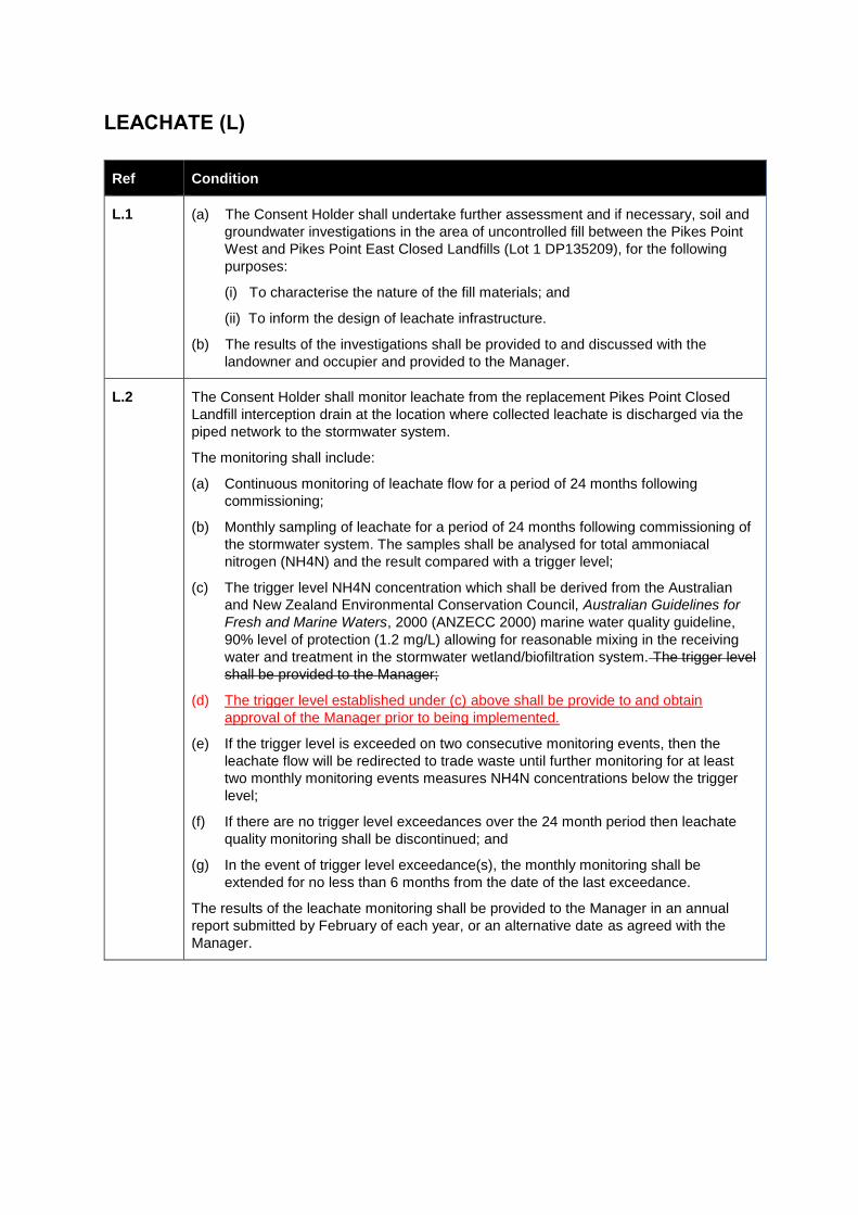
LEACHATE (L)
Ref Condition
L.1 (a) The Consent Holder shall undertake further assessment and if necessary, soil and
groundwater investigations in the area of uncontrolled fill between the Pikes Point
West and Pikes Point East Closed Landfills (Lot 1 DP135209), for the following
purposes:
(i) To characterise the nature of the fill materials; and
(ii) To inform the design of leachate infrastructure.
(b) The results of the investigations shall be provided to and discussed with the
landowner and occupier and provided to the Manager.
L.2 The Consent Holder shall monitor leachate from the replacement Pikes Point Closed
Landfill interception drain at the location where collected leachate is discharged via the
piped network to the stormwater system.
The monitoring shall include:
(a) Continuous monitoring of leachate flow for a period of 24 months following
commissioning;
(b) Monthly sampling of leachate for a period of 24 months following commissioning of
the stormwater system. The samples shall be analysed for total ammoniacal
nitrogen (NH4N) and the result compared with a trigger level;
(c) The trigger level NH4N concentration which shall be derived from the Australian
and New Zealand Environmental Conservation Council, Australian Guidelines for
Fresh and Marine Waters, 2000 (ANZECC 2000) marine water quality guideline,
90% level of protection (1.2 mg/L) allowing for reasonable mixing in the receiving
water and treatment in the stormwater wetland/biofiltration system. The trigger level
shall be provided to the Manager;
(d) The trigger level established under (c) above shall be provide to and obtain
approval of the Manager prior to being implemented.
(e) If the trigger level is exceeded on two consecutive monitoring events, then the
leachate flow will be redirected to trade waste until further monitoring for at least
two monthly monitoring events measures NH4N concentrations below the trigger
level;
(f) If there are no trigger level exceedances over the 24 month period then leachate
quality monitoring shall be discontinued; and
(g) In the event of trigger level exceedance(s), the monthly monitoring shall be
extended for no less than 6 months from the date of the last exceedance.
The results of the leachate monitoring shall be provided to the Manager in an annual
report submitted by February of each year, or an alternative date as agreed with the
Manager.

STORMWATER AND IMPERVIOUS SURFACES (SW)
Ref Condition
Stormwater Design
SW.1 The Consent Holder shall design the stormwater management devices and systems in
general accordance with the stormwater drawings referred to in Condition RC.1.
The Consent Holder may make modifications to the stormwater management devices
and systems shown on those drawings, including the use of alternative Council approved
stormwater management devices, provided that the equivalent performance and
compliance as set out in Table SW.1 is achieved.
SW.2 The stormwater management devices shall be designed and constructed to achieve the
design requirements as set out in Table SW1:
Table SW1: Design requirements
Project Catchment Receiving Environment
Design Requirements
Total Project Road Area (upgraded and new) to be treated (ha)
Peak flow attenuation to pre-development flow rates at the receiving environment (with climate change adjustment to 2121)
Wharangi Street to Galway Street
Mankuau Harbour 9.4ha to 75% TSS removal
Not required
Galway Street to Anns Creek Viaducts
Māngere Inlet 12.2ha to 75% TSS removal
Not required
Anns Creek Viaducts to Hugo Johnston Drive
Southdown Wetland Reserve
1.9ha to 75% TSS removal
2 year ARI
10 year ARI
100 year ARI
Hugo Johnston Drive to SH1 Mt Wellington
Anns Creek 8.3ha to 75% TSS removal
Not required
SH1 Mt Wellington to Panama Road
Clemow Stream 7.0ha to 75% TSS removal
Not required
Panama Road to Princes Street
Ōtāhuhu Creek 4.9ha to 75% TSS removal
Not required
Princes Street to southern extent of Project
Tributary of the Tamaki River
3.8ha to 75% TSS removal
2 year ARI
10 year ARI
100 year ARI
SW.3 The Consent Holder shall ensure that the design of stormwater management devices
does not result in any increase of flooding levels greater than 50mm within areas
immediately adjacent to the Project or the downstream receiving environment.
SW.4 The design of stormwater outfalls shall include erosion prevention devices to minimise
the occurrence of bed scour and bank erosion in receiving environments.
SW.5 Where existing stormwater management devices are proposed to be removed, the
equivalent treatment, detention and attenuation shall be provided in the proposed
stormwater management devices.
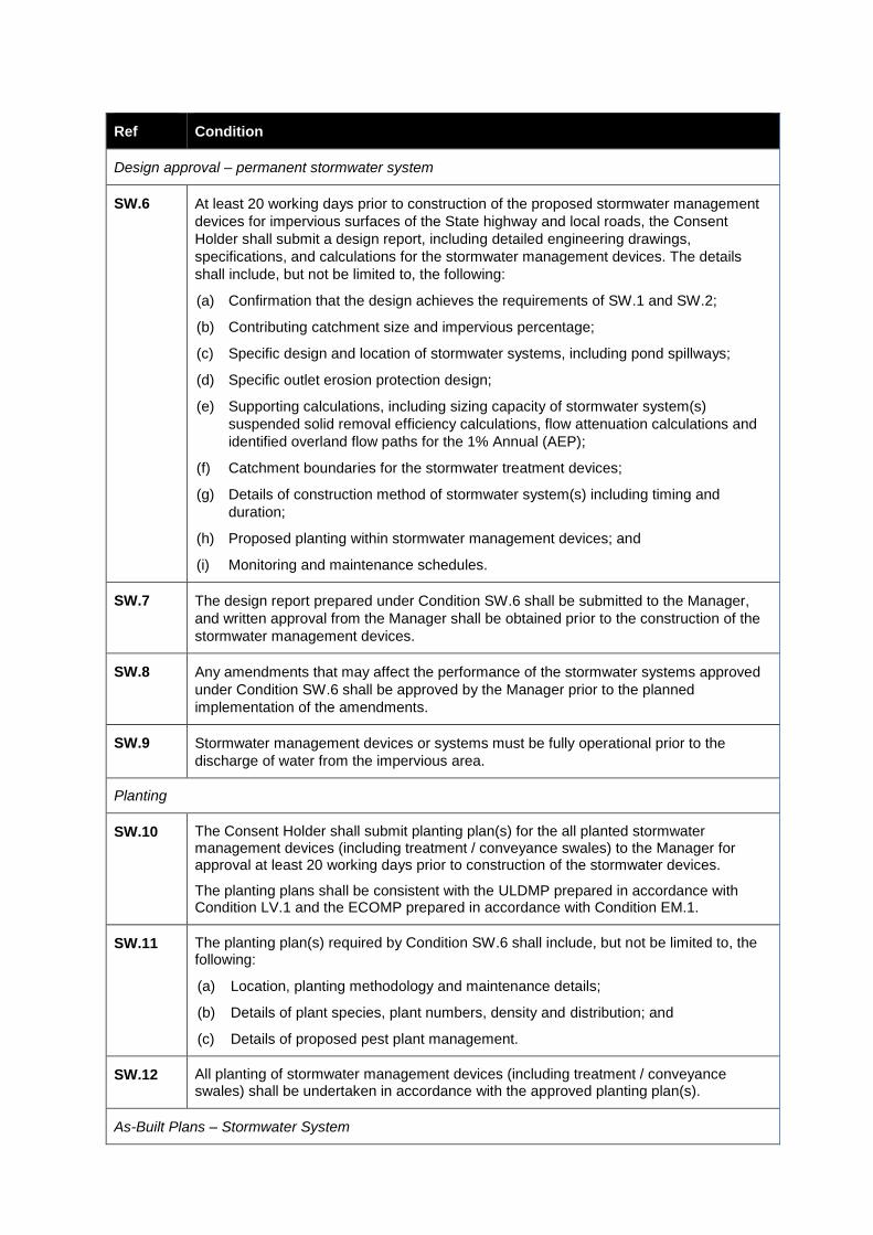
Ref Condition
Design approval – permanent stormwater system
SW.6 At least 20 working days prior to construction of the proposed stormwater management
devices for impervious surfaces of the State highway and local roads, the Consent
Holder shall submit a design report, including detailed engineering drawings,
specifications, and calculations for the stormwater management devices. The details
shall include, but not be limited to, the following:
(a) Confirmation that the design achieves the requirements of SW.1 and SW.2;
(b) Contributing catchment size and impervious percentage;
(c) Specific design and location of stormwater systems, including pond spillways;
(d) Specific outlet erosion protection design;
(e) Supporting calculations, including sizing capacity of stormwater system(s)
suspended solid removal efficiency calculations, flow attenuation calculations and
identified overland flow paths for the 1% Annual (AEP);
(f) Catchment boundaries for the stormwater treatment devices;
(g) Details of construction method of stormwater system(s) including timing and
duration;
(h) Proposed planting within stormwater management devices; and
(i) Monitoring and maintenance schedules.
SW.7 The design report prepared under Condition SW.6 shall be submitted to the Manager,
and written approval from the Manager shall be obtained prior to the construction of the
stormwater management devices.
SW.8 Any amendments that may affect the performance of the stormwater systems approved
under Condition SW.6 shall be approved by the Manager prior to the planned
implementation of the amendments.
SW.9 Stormwater management devices or systems must be fully operational prior to the
discharge of water from the impervious area.
Planting
SW.10 The Consent Holder shall submit planting plan(s) for the all planted stormwater management devices (including treatment / conveyance swales) to the Manager for approval at least 20 working days prior to construction of the stormwater devices.
The planting plans shall be consistent with the ULDMP prepared in accordance with Condition LV.1 and the ECOMP prepared in accordance with Condition EM.1.
SW.11 The planting plan(s) required by Condition SW.6 shall include, but not be limited to, the following:
(a) Location, planting methodology and maintenance details;
(b) Details of plant species, plant numbers, density and distribution; and
(c) Details of proposed pest plant management.
SW.12 All planting of stormwater management devices (including treatment / conveyance swales) shall be undertaken in accordance with the approved planting plan(s).
As-Built Plans – Stormwater System
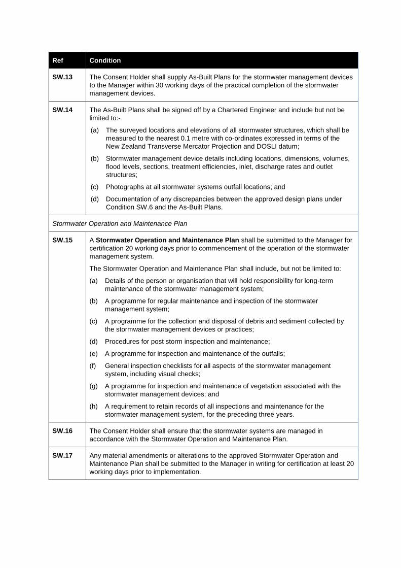
Ref Condition
SW.13 The Consent Holder shall supply As-Built Plans for the stormwater management devices
to the Manager within 30 working days of the practical completion of the stormwater
management devices.
SW.14 The As-Built Plans shall be signed off by a Chartered Engineer and include but not be
limited to:-
(a) The surveyed locations and elevations of all stormwater structures, which shall be
measured to the nearest 0.1 metre with co-ordinates expressed in terms of the
New Zealand Transverse Mercator Projection and DOSLI datum;
(b) Stormwater management device details including locations, dimensions, volumes,
flood levels, sections, treatment efficiencies, inlet, discharge rates and outlet
structures;
(c) Photographs at all stormwater systems outfall locations; and
(d) Documentation of any discrepancies between the approved design plans under
Condition SW.6 and the As-Built Plans.
Stormwater Operation and Maintenance Plan
SW.15 A Stormwater Operation and Maintenance Plan shall be submitted to the Manager for
certification 20 working days prior to commencement of the operation of the stormwater
management system.
The Stormwater Operation and Maintenance Plan shall include, but not be limited to:
(a) Details of the person or organisation that will hold responsibility for long-term
maintenance of the stormwater management system;
(b) A programme for regular maintenance and inspection of the stormwater
management system;
(c) A programme for the collection and disposal of debris and sediment collected by
the stormwater management devices or practices;
(d) Procedures for post storm inspection and maintenance;
(e) A programme for inspection and maintenance of the outfalls;
(f) General inspection checklists for all aspects of the stormwater management
system, including visual checks;
(g) A programme for inspection and maintenance of vegetation associated with the
stormwater management devices; and
(h) A requirement to retain records of all inspections and maintenance for the
stormwater management system, for the preceding three years.
SW.16 The Consent Holder shall ensure that the stormwater systems are managed in
accordance with the Stormwater Operation and Maintenance Plan.
SW.17 Any material amendments or alterations to the approved Stormwater Operation and
Maintenance Plan shall be submitted to the Manager in writing for certification at least 20
working days prior to implementation.