Embed Size (px)
Citation preview
COMMSLOST COMMSLOST COMMSLOST
COMMSLOST COMMSLOST COMMSLOST
COMMS
LOST
COMMS
LOST
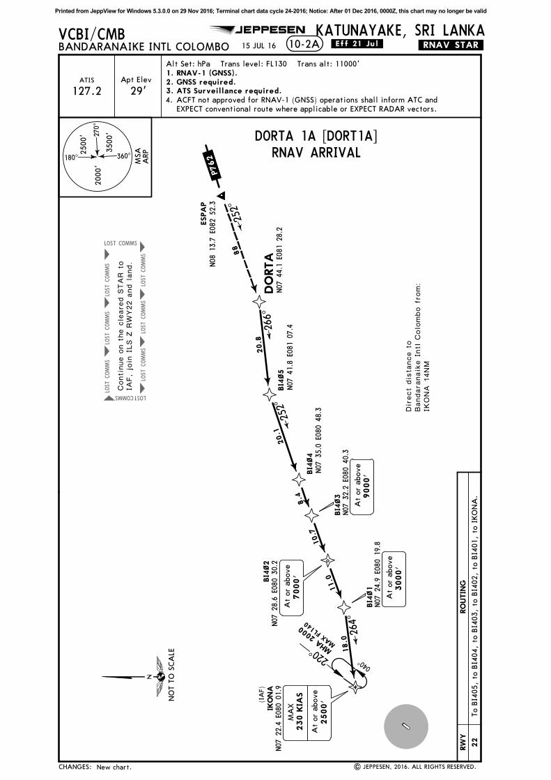
10-2
JEPPESEN
| JEPPESEN, 2016. ALL RIGHTS RESERVED.
Apt Elev
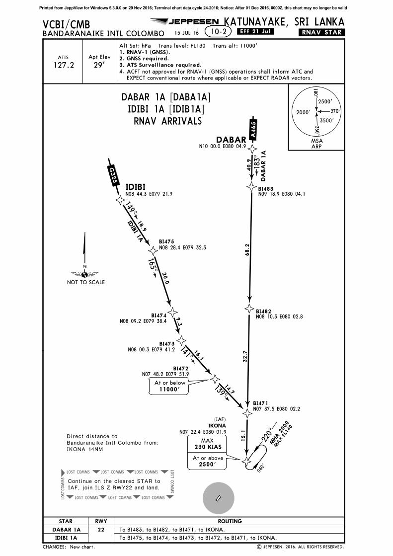
VCBI/CMBBANDARANAIKE INTL COLOMBO
KATUNAYAKE, SRI LANKA.RNAV.STAR.
29'ATIS
New chart.
15 JUL 16 .Eff.21.Jul.
18 0^
270^
360^
2500'
3500'
2000'
2. GNSS required.3. ATS Surveillance required.
BI471N07 37.5 E080 02.2
IKONAN07 22.4 E080 01.9
15.1
BI472N07 48.2 E079 51.9
BI473N08 00.3 E079 41.2
BI474N08 09.2 E079 38.4
BI475N08 28.4 E079 32.3
IDIBIN08 44.3 E079 21.9
BI482N08 10.3 E080 02.8
BI483N09 18.9 E080 04.1
DABARN10 00.0 E080 04.9
IDIBI 1
A
DA
BA
R 1
A
40.9
68. 2
32. 7
183^
18.9
20.0
9.3
16.1
14.7
149^
165^
141^
139^
At or below
11000'
Direct distance toBandaranaike Intl Colombo from:IKONA 14NM
At or above
2500'
MAX
230 KIAS
Alt Set: hPa Trans level: FL130 Trans alt: 11000'
127.2ACFT not approved for RNAV-1 (GNSS) operations shall inform ATC and
EXPECT conventional route where applicable or EXPECT RADAR vectors.
4.
1. RNAV-1 (GNSS).
(IAF)
A465
G325
MSAARP
NOT TO SCALE
CHANGES:
RWY
22
ROUTINGSTAR
DABAR 1A To BI483, to BI482, to BI471, to IKONA.
IDIBI 1A To BI475, to BI474, to BI473, to BI472, to BI471, to IKONA.
DABAR 1A [DABA1A]IDIBI 1A [IDIB1A]RNAV ARRIVALS
Continue on the cleared STAR toIAF, join ILS Z RWY22 and land.
220^
040^
MHA 2
000
MAX FL1
40
Printed from JeppView for Windows 5.3.0.0 on 29 Nov 2016; Terminal chart data cycle 24-2016; Notice: After 01 Dec 2016, 0000Z, this chart may no longer be valid
COMMS
LOST
COMMS
LOST
COMMS
LOST
COMMS
LOST
COMMS
LOST
COMMS
LOST
COMMSLOST
COMMS LOST
JEPPESEN
| JEPPESEN, 2016. ALL RIGHTS RESERVED.
VCBI/CMBBANDARANAIKE INTL COLOMBO
KATUNAYAKE, SRI LANKA.RNAV.STAR.
New chart.
15 JUL 16 .Eff.21.Jul.10-2A
ESPA
PN08
13.7
E082
52.3
DO
RTA
N07
44.1
E081
28.2
BI4
~5
N07
41.8
E081
07.4
BI4
~4
N07
35.0
E080
48.3
BI4
~3
N07
32.2
E080
40.3
BI4
~2
N07
28.6
E080
30.2
BI4
~1
N07
24.9
E080
19.8
IKO
NA
N07
22.4
E080
01.9
At
or
above
7000'
Direct
dis
tance t
oBandara
naik
e I
ntl C
olo
mbo f
rom:
IKONA 1
4NM
At
or
above
3000'
At
or
above
9000'
20.8
20.1
8.4
10.7
11.0
18.0
264^
252^
266^
88
252^
At
or
above
2500'
MA
X
230 K
IAS
Apt Elev
29'ATIS 2. GNSS required.
3. ATS Surveillance required.
Alt Set: hPa Trans level: FL130 Trans alt: 11000'
127.2ACFT not approved for RNAV-1 (GNSS) operations shall inform ATC and
EXPECT conventional route where applicable or EXPECT RADAR vectors.
4.
180^
270^
360^
2500'
3500'
2000'
1. RNAV-1 (GNSS).
(IA
F)
P762
MSA
ARP
CHANGES:
DORTA 1A [DORT1A]RNAV ARRIVAL
RW
Y
22
RO
UTIN
G
To B
I405,
to B
I404,
to B
I403,
to B
I402,
to B
I401,
to I
KO
NA
.
220^
040^
MHA
200
0
MAX
FL14
0
NO
T T
O S
CA
LE
Continue o
n t
he c
leare
d S
TAR t
oIA
F, jo
in I
LS Z
RW
Y22 a
nd land.
Printed from JeppView for Windows 5.3.0.0 on 29 Nov 2016; Terminal chart data cycle 24-2016; Notice: After 01 Dec 2016, 0000Z, this chart may no longer be valid
COMMS
LOST
COMMS
LOST
COMMS
LOST
COMMS
LOST
COMMS
LOST
COMMS
LOST
COMMSLOST
COMMS LOST
JEPPESEN
| JEPPESEN, 2016. ALL RIGHTS RESERVED.
VCBI/CMBBANDARANAIKE INTL COLOMBO
KATUNAYAKE, SRI LANKA.RNAV.STAR.
New chart.
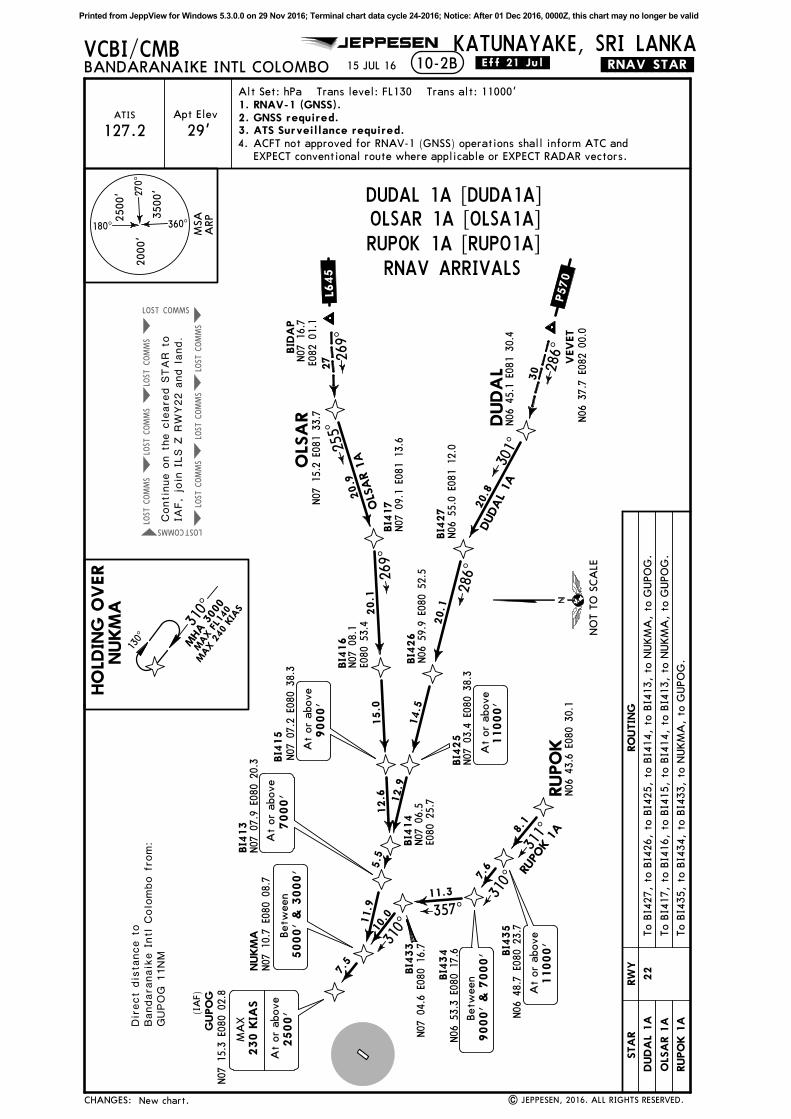
15 JUL 16 .Eff.21.Jul.10-2B
OLS
AR
N07
15.2
E081
33.7
VEVET
N06
37.7
E082
00.0
RUPO
KN06
43.6
E080
30.1
NUKM
AN07
10.7
E080
08.7
GUPO
GN07
15.3
E080
02.8
BI4
33
N07
04.6
E080
16.7
BI4
34
N06
53.3
E080
17.6 BI4
35
N06
48.7
E080
23.7
BI4
13
N07
07.9
E080
20.3
BI4
14
BI4
15
N07
07.2
E080
38.3 B
I416
BI4
17
N07
09.1
E081
13.6
BI4
25
N07
03.4
E080
38.3
BI4
26
N06
59.9
E080
52.5
BI4
27
N06
55.0
E081
12.0
DUDA
LN06
45.1
E081
30.4
BID
AP
At
or
above
2500'
MA
X
230 K
IAS
Direct
dis
tance t
oBandara
naik
e I
ntl C
olo
mbo f
rom:
GUPOG 1
1NM
8.1
311^
310^7.
6
11.3
357^
310^10
.0
Betw
een
5000'
& 3
000'
7.5
At
or
above
7000'
Betw
een
9000'
& 7
000'
At
or
above
11000'
N07
06.5
E080
25.7
At
or
above
9000'
N07
08.1
E080
53.4
N07
16.7
E082
01.1
20.9
20.1
15.0
12.6
5.5
11.9
20.8
20.1
14.5
12.9
286^
301^
269^
255^
At
or
above
11000'
OLS
AR 1
A
DUDAL
1A
HO
LDIN
G O
VER
NUKM
AApt Elev
29'ATIS 2. GNSS required.
3. ATS Surveillance required.
Alt Set: hPa Trans level: FL130 Trans alt: 11000'
127.2ACFT not approved for RNAV-1 (GNSS) operations shall inform ATC and
EXPECT conventional route where applicable or EXPECT RADAR vectors.
4.
180^
270^
360^
2500'
3500'
2000'
30 28
6^
27 26
9^
1. RNAV-1 (GNSS).
(IA
F)
RUPO
K 1
AP570
L645
MSA
ARP
CHANGES:
DUDAL 1A [DUDA1A]
Continue o
n t
he c
leare
d S
TAR t
oIA
F, jo
in I
LS Z
RW
Y22 a
nd land.
RW
Y
22
RO
UTIN
GSTA
R
DUDA
L 1A
OLS
AR 1
A
RUPO
K 1
A
To B
I427,
to B
I426,
to B
I425,
to B
I414,
to B
I413,
to N
UKM
A,
to G
UPO
G.
To B
I417,
to B
I416,
to B
I415,
to B
I414,
to B
I413,
to N
UKM
A,
to G
UPO
G.
To B
I435,
to B
I434,
to B
I433,
to N
UKM
A,
to G
UPO
G.
OLSAR 1A [OLSA1A]RUPOK 1A [RUPO1A]
NO
T T
O S
CA
LE
130^
310^
MHA 3
000
MAX FL1
40
MAX 2
40 K
IAS
RNAV ARRIVALS
Printed from JeppView for Windows 5.3.0.0 on 29 Nov 2016; Terminal chart data cycle 24-2016; Notice: After 01 Dec 2016, 0000Z, this chart may no longer be valid
COMMSLOST COMMSLOST COMMSLOST
COMMSLOST COMMSLOST COMMSLOST
COMMS
LOST
COMMS
LOST
JEPPESEN
| JEPPESEN, 2016. ALL RIGHTS RESERVED.
VCBI/CMBBANDARANAIKE INTL COLOMBO
KATUNAYAKE, SRI LANKA.RNAV.STAR.
New chart.
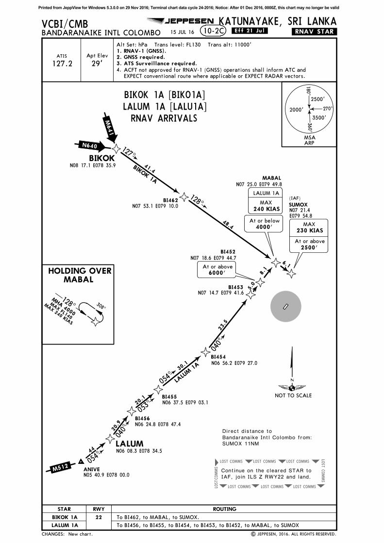
15 JUL 16 .Eff.21.Jul.
Direct distance toBandaranaike Intl Colombo from:SUMOX 11NM
10-2C
BIKOKN08 17.1 E078 35.9
BI462N07 53.1 E079 10.0
BI452N07 18.6 E079 44.7
BI453N07 14.7 E079 41.6
BI454N06 56.2 E079 27.0
BI455N06 37.5 E079 03.1
BI456N06 24.8 E078 47.4
LALUMN06 08.3 E078 34.5
ANIVEN05 40.9 E078 00.0
MABALN07 25.0 E079 49.8
SUMOX
127^
128^
41.4
48.4
BIKOK 1A
6000'At or above
At or above
2500'
MAX
230 KIAS
N07 21.4E079 54.8
HOLDING OVERMABAL
6.1
20.9
20.1
30.1
23.5
5.0
8.1
040^
053^
054^
040^
LALU
M 1
A
44
054^
Apt Elev
29'ATIS
18 0^
270^
360^
2500'
3500'
2000'
2. GNSS required.3. ATS Surveillance required.
Alt Set: hPa Trans level: FL130 Trans alt: 11000'
127.2ACFT not approved for RNAV-1 (GNSS) operations shall inform ATC and
EXPECT conventional route where applicable or EXPECT RADAR vectors.
4.
MAX
240 KIAS
LALUM 1A
At or below
4000'
1. RNAV-1 (GNSS).
(IAF)
M512
N640
M641
MSAARP
NOT TO SCALE
CHANGES:
RWY
22
ROUTINGSTAR
BIKOK 1A
LALUM 1A
BIKOK 1A [BIKO1A]LALUM 1A [LALU1A]RNAV ARRIVALS
Continue on the cleared STAR toIAF, join ILS Z RWY22 and land.
To BI462, to MABAL, to SUMOX.
To BI456, to BI455, to BI454, to BI453, to BI452, to MABAL, to SUMOX
128^ 308^
MHA 4000
MAX FL140
MAX 240 KIAS
Printed from JeppView for Windows 5.3.0.0 on 29 Nov 2016; Terminal chart data cycle 24-2016; Notice: After 01 Dec 2016, 0000Z, this chart may no longer be valid
COMMSLOST COMMSLOST COMMSLOST
COMMSLOST COMMSLOST COMMSLOST
COMMS
LOST
COMMS
LOST
JEPPESEN
| JEPPESEN, 2016. ALL RIGHTS RESERVED.
Apt Elev
VCBI/CMBBANDARANAIKE INTL COLOMBO
KATUNAYAKE, SRI LANKA.RNAV.STAR.
29'ATIS
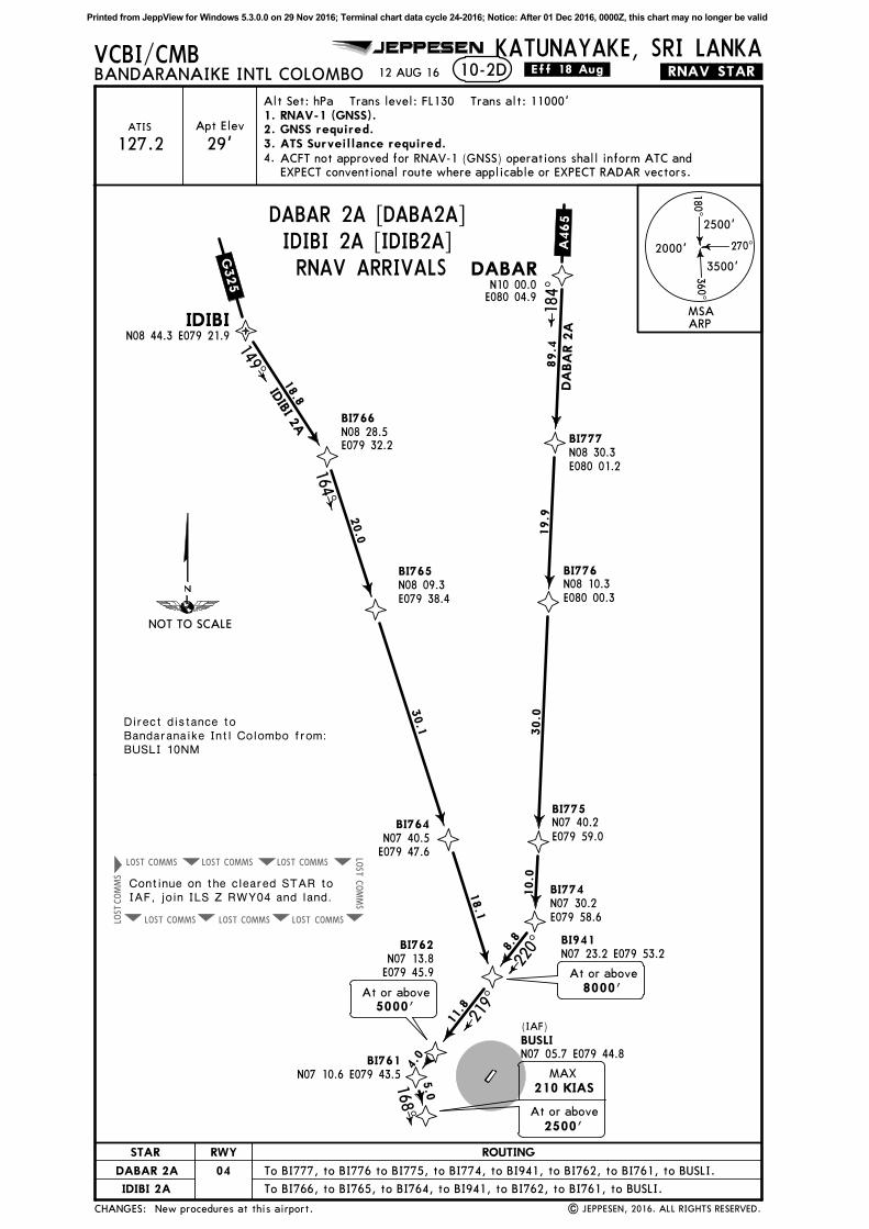
12 AUG 16 .Eff.18.Aug.
18 0^
270^
360^
2500'
3500'
2000'
2. GNSS required.3. ATS Surveillance required.
IDIBIN08 44.3 E079 21.9
DABAR
Direct distance toBandaranaike Intl Colombo from:BUSLI 10NM
Alt Set: hPa Trans level: FL130 Trans alt: 11000'
127.2ACFT not approved for RNAV-1 (GNSS) operations shall inform ATC and
EXPECT conventional route where applicable or EXPECT RADAR vectors.
4.
1. RNAV-1 (GNSS).
BI766N08 28.5E079 32.2
BI765N08 09.3E079 38.4
BI764N07 40.5E079 47.6
BI941BI762N07 13.8E079 45.9
BI761
BUSLI
BI777N08 30.3E080 01.2
BI776N08 10.3E080 00.3
BI775N07 40.2E079 59.0
BI774N07 30.2E079 58.6
18.8
20.0
30.1
18.1
11.8
4.0
5.0
89.4
19.9
30.0
10.0
8.8
DA
BA
R 2
A18
4^
220^
219^
168^
149^
164^
N07 10.6 E079 43.5
N07 05.7 E079 44.8
IDIB
I 2A
10-2D
N10 00.0E080 04.9
At or above
2500'
MAX
210 KIAS
N07 23.2 E079 53.2
At or above
8000'At or above
5000'
(IAF)
New procedures at this airport.
A465
G325
MSAARP
NOT TO SCALE
CHANGES:
RWY
04
ROUTINGSTAR
DABAR 2A
IDIBI 2A
DABAR 2A [DABA2A]IDIBI 2A [IDIB2A]RNAV ARRIVALS
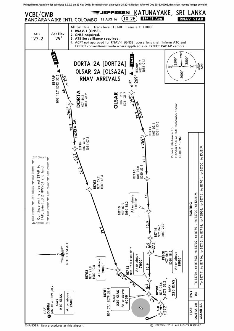
Continue on the cleared STAR toIAF, join ILS Z RWY04 and land.
To BI777, to BI776 to BI775, to BI774, to BI941, to BI762, to BI761, to BUSLI.
To BI766, to BI765, to BI764, to BI941, to BI762, to BI761, to BUSLI.
Printed from JeppView for Windows 5.3.0.0 on 29 Nov 2016; Terminal chart data cycle 24-2016; Notice: After 01 Dec 2016, 0000Z, this chart may no longer be valid
COMMS
LOST
COMMS
LOST
COMMS
LOST
COMMS
LOST
COMMS
LOST
COMMS
LOST
COMMSLOST
COMMS LOST
JEPPESEN
| JEPPESEN, 2016. ALL RIGHTS RESERVED.
VCBI/CMBBANDARANAIKE INTL COLOMBO
KATUNAYAKE, SRI LANKA.RNAV.STAR.12 AUG 16 .Eff.18.Aug.10-2E
ESPA
PN08
13.7
E082
52.3
DO
RTA
Direct
dis
tance t
oBandara
naik
e I
ntl C
olo
mbo f
rom:
DUBIM
10NM
88
252^
Apt Elev
29'ATIS 2. GNSS required.
3. ATS Surveillance required.
Alt Set: hPa Trans level: FL130 Trans alt: 11000'
127.2ACFT not approved for RNAV-1 (GNSS) operations shall inform ATC and
EXPECT conventional route where applicable or EXPECT RADAR vectors.
4.
180^
270^
360^
2500'
3500'
2000'
1. RNAV-1 (GNSS).
BI7
~4
N07
41.9
E081
07.5
BI7
~3
N07
35.2
E080
48.4
BI7
~2
N07
21.8
E080
10.8
BI7
~1
BI7
~~
N07
01.6
E079
55.2
DUBIM
OLS
AR
N07
15.2
E081
33.7
BI7
17
N07
09.1
E081
13.6
BI7
16
N07
08.0
E080
53.4
BI7
15
N07
07.2
E080
38.2
BI7
14
N07
06.5
E080
25.7
PEBG
I
BI7
12
20.7
20.0
39.7
18.4
6.9
5.0
20.9
20.1
15.1
12.5
7. 0
12.9
6. 2
255^
269^
273^
219^
272^
252^
266^
DO
RTA
2A
OLS
AR 2
A
1
1
269^
BID
AP
N07
16.7
E082
01.1
27
At
or
above
9000'
N07
07.0
E080
05.7
At
or
above
7000'
N07
07.1
E079
59.4
At
or
above
2500'
MA
X
N07
01.6
E079
50.2
N07
44.1
E081
28.2
At
or
above
11000'
(IA
F)
New procedures at this airport.
8000'
At
or
above
N07
06.7
E080
18.6
MA
X
220 K
IAS
MA
X
230 K
IAS
At
or
above
6000'
210 K
IAS
P762
L645
MSA
ARP
CHANGES:
OLSAR 2A [OLSA2A]
RW
Y
04
RO
UTIN
G
To B
I704,
to B
I703,
to B
I702,
to B
I701,
to B
I700,
to D
UBIM
.
NO
T T
O S
CA
LE
Continue o
n t
he c
leare
d S
TAR t
oIA
F, jo
in I
LS Z
RW
Y04 a
nd land.
To B
I717,
to B
I716,
to B
I715,
to B
I714,
to P
EBG
I, t
o B
I712,
to B
I701,
to B
I700,
to D
UBIM
.
RNAV ARRIVALS
DORTA 2A [DORT2A]
STA
R
DO
RTA
2A
OLS
AR 2
A
Printed from JeppView for Windows 5.3.0.0 on 29 Nov 2016; Terminal chart data cycle 24-2016; Notice: After 01 Dec 2016, 0000Z, this chart may no longer be valid
COMMS
LOST
COMMS
LOST
COMMS
LOST
COMMS
LOST
COMMS
LOST
COMMS
LOST
COMMSLOST
COMMS LOST
JEPPESEN
| JEPPESEN, 2016. ALL RIGHTS RESERVED.
VCBI/CMBBANDARANAIKE INTL COLOMBO
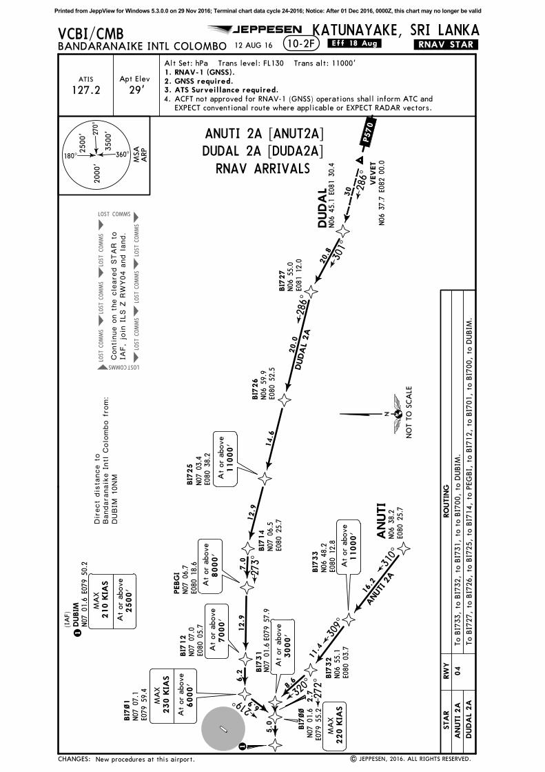
KATUNAYAKE, SRI LANKA.RNAV.STAR.12 AUG 16 .Eff.18.Aug.10-2F
VEVET
N06
37.7
E082
00.0
ANUTI
DUDA
LN06
45.1
E081
30.4
Direct
dis
tance t
oBandara
naik
e I
ntl C
olo
mbo f
rom:
DUBIM
10NM
Apt Elev
29'ATIS 2. GNSS required.
3. ATS Surveillance required.
Alt Set: hPa Trans level: FL130 Trans alt: 11000'
127.2ACFT not approved for RNAV-1 (GNSS) operations shall inform ATC and
EXPECT conventional route where applicable or EXPECT RADAR vectors.
4.
180^
270^
360^
2500'
3500'
2000'
30 28
6^
1. RNAV-1 (GNSS).
N06
38.2
E080
25.7
BI7
33
N06
48.2
E080
12.8
BI7
32
N06
55.1
E080
03.7
BI7
31
N07
01.6E0
79 5
7.9
BI7
27
N06
55.0
E081
12.0
BI7
26
N06
59.9
E080
52.5
BI7
25
N07
03.4
E080
38.2
BI7
14
N07
06.5
E080
25.7
PEBG
IN07
06.7
E080
18.6
BI7
12
N07
07.0
E080
05.7
BI7
~1
N07
07.1
E079
59.4
16.2
11.4
8.6
2.7
5.0
20.8
20.0
14.6
12.9
7.0
12. 9
6.2
6.9
At
or
above
11000'
At
or
above
3000'
E079
55.2
BI7
~~
N07
01.6
1
DUBIM
1
At
or
above
2500'
MA
X
N07
01.6
E079
50.2
301^
286^
310^
309^
320^
273^
219^ 27
2^
At
or
above
11000'
At
or
above
8000'
At
or
above
7000'
At
or
above
6000'
MA
X
DUDA
L 2A
ANUTI 2
A
(IA
F)
New procedures at this airport.
210 K
IAS
230 K
IAS
MA
X
220 K
IAS
P570
MSA
ARP
CHANGES:
DUDAL 2A [DUDA2A]
Continue o
n t
he c
leare
d S
TAR t
oIA
F, jo
in I
LS Z
RW
Y04 a
nd land.
RW
Y
04
RO
UTIN
GSTA
R
DUDA
L 2A
ANUTI 2A [ANUT2A]
NO
T T
O S
CA
LE
RNAV ARRIVALS
To B
I727,
to B
I726,
to B
I725,
to B
I714,
to P
EG
BI,
to B
I712,
to B
I701,
to B
I700,
to D
UBIM
.
To B
I733,
to B
I732,
to B
I731,
to t
o B
I700,
to D
UBIM
.A
NUTI 2A
Printed from JeppView for Windows 5.3.0.0 on 29 Nov 2016; Terminal chart data cycle 24-2016; Notice: After 01 Dec 2016, 0000Z, this chart may no longer be valid
COMMSLOST COMMSLOST COMMSLOST
COMMSLOST COMMSLOST COMMSLOST
COMMS
LOST
COMMS
LOST
JEPPESEN
| JEPPESEN, 2016. ALL RIGHTS RESERVED.
VCBI/CMBBANDARANAIKE INTL COLOMBO
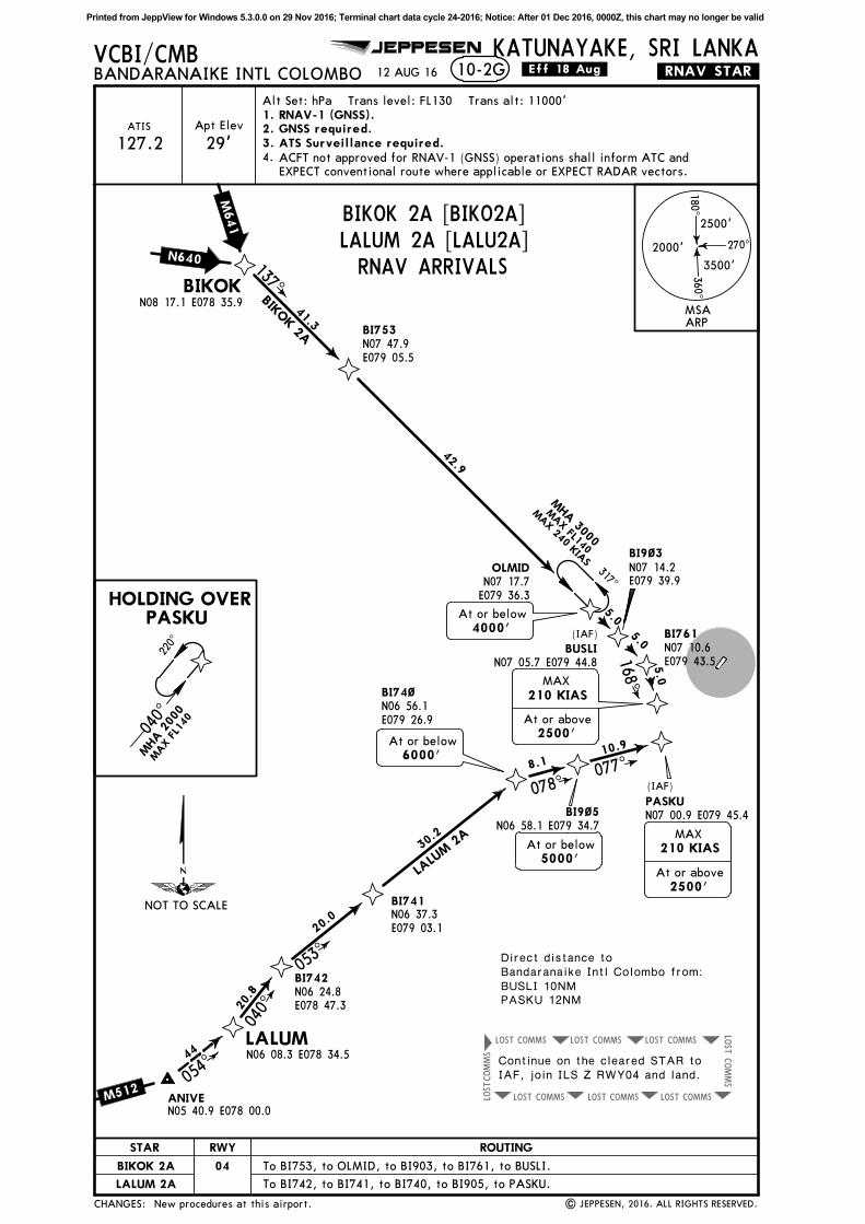
KATUNAYAKE, SRI LANKA.RNAV.STAR.12 AUG 16 .Eff.18.Aug.10-2G
BIKOKN08 17.1 E078 35.9
LALUMN06 08.3 E078 34.5
ANIVEN05 40.9 E078 00.0
HOLDING OVERPASKU
44
054^
Apt Elev
29'ATIS
18 0^
270^
360^
2500'
3500'
2000'
2. GNSS required.3. ATS Surveillance required.
Alt Set: hPa Trans level: FL130 Trans alt: 11000'
127.2ACFT not approved for RNAV-1 (GNSS) operations shall inform ATC and
EXPECT conventional route where applicable or EXPECT RADAR vectors.
4.
1. RNAV-1 (GNSS).
(IAF)
BI753N07 47.9E079 05.5
OLMIDN07 17.7E079 36.3
BI9~3N07 14.2E079 39.9
BI761N07 10.6E079 43.5
BUSLI
BI742N06 24.8E078 47.3
BI741N06 37.3E079 03.1
BI74~N06 56.1E079 26.9
BI9~5PASKU
41.3
137^000^
42.9
5.05.0
5.0
20.8
20.0
30.2
8.1
040^
000^
10.9
040^
053^
078^077^
137^
168^
At or below
4000'
N07 05.7 E079 44.8
N06 58.1 E079 34.7
5000'At or below
6000'At or below
At or above
2500'
MAX
N07 00.9 E079 45.4
At or above
2500'
MAX
BIKOK 2A
LALU
M 2
A
Direct distance toBandaranaike Intl Colombo from:BUSLI 10NMPASKU 12NM
(IAF)
210 KIAS
210 KIAS
New procedures at this airport.
M512
N640
M641
MSAARP
NOT TO SCALE
CHANGES:
RWY
04
ROUTINGSTAR
BIKOK 2A
LALUM 2A
BIKOK 2A [BIKO2A]LALUM 2A [LALU2A]RNAV ARRIVALS
Continue on the cleared STAR toIAF, join ILS Z RWY04 and land.
040^
220^
MHA
200
0
MAX
FL14
0
317^
MHA
3000
MAX FL140
MAX 240 KIA
S
To BI753, to OLMID, to BI903, to BI761, to BUSLI.
To BI742, to BI741, to BI740, to BI905, to PASKU.
Printed from JeppView for Windows 5.3.0.0 on 29 Nov 2016; Terminal chart data cycle 24-2016; Notice: After 01 Dec 2016, 0000Z, this chart may no longer be valid
COMMSLOST COMMSLOST COMMSLOST
COMMS
LOST
COMMSLOSTCOMMSLOST COMMSLOST
COMMS
LOST
COMMS
LOST
COMMS
LOST
COMMS
LOST LOST
COMMS
LOST
COMMS
LOST
BI611
BI622N07 17.4 E079 51.7
SUMOX
BI624
BI645
BI646N07 51.8 E079 55.6
BI647N08 10.7 E079 52.0
ATETAN09 19.1 E079 38.9
BI625N07 35.9 E079 49.1
BI626N07 54.0 E079 32.5
BI627
DEMONN08 33.5 E078 56.4
10-3
JEPPESEN
| JEPPESEN, 2016. ALL RIGHTS RESERVED.
Apt Elev
VCBI/CMBBANDARANAIKE INTL COLOMBO
KATUNAYAKE, SRI LANKA
29'
12 AUG 16
18 0^
270^
360^
2500'
3500'
2000'
2. GNSS required.3. ATS Surveillance required.
.RNAV.SID.
Trans level: FL130 Trans alt: 11000'
6.0% V/V (fpm) 456 608 911 1215 1519 1823
5.3% V/V (fpm) 403 537 805 1073 1342 1610
Gnd speed-KT 75 100 150 200 250 300
These SIDs require minimum climb gradientsofATETA 1D:
5.3% up to 5000'.6.0% up to FL130.
039^8.
3
5.0
5.9
10.3
10.3
004^
At or above
FL130
14.0
351^19.2
N08 03.3E079 24.0
328^
24.4
320^69.3
12.6
40.4
BI453N07 14.7 E079 41.6
N07 37.7E079 55.2
At or above
5000'
PASKUN07 00.9 E079 45.4
KADIR
1
N07 21.4 E079 54.8
N07 18.4E079 58.8
1
N07 10.8 E079 46.6
500'At
DERbut not before
N07 27.3 E079 55.0
MAX
240 KIAS
BANK
20^
1
1
ACFT not approved for RNAV-1 (GNSS) operations shall inform ATC and
EXPECT conventional route where applicable or EXPECT RADAR vectors.
4.
Direct distance fromBandaranaike Intl Colombo to:BI611 6NM
1. RNAV-1 (GNSS).
ATETA
1D
ATETA 1D: Available only for ACFT proceeding to VOTR and/or ACFT
via TTR to other destinations. ACFT shall flight plan via ATETA - T4 -
TTR.
5.
DEMON 1D:
SID IDIBI 1D withdrawn; procedure note ATETA 1D.
DEMON 1D
R461
T4
MSAARP
NOT TO SCALE
CHANGES:
ATETA 1D [ATET1D]
RNAV DEPARTURES
RWY
22
ROUTINGSID
ATETA 1D
From BI624 to BI625, to BI626, to BI627, to DEMON.
From BI624 to BI645, to BI646, to BI647, to ATETA.
INITIAL CLIMB
DEMON 1D
Continue on SID to cruising level.If ACFT return to VCBI:
Climb on 220^ track to 500', after crossing DER turn RIGHT to BI611, to BI622, to SUMOX, to BI624.
DEMON 1D [DEMO1D]
- Before SUMOX:Continue on SID to SUMOX. JoinILS Z RWY22.- After SUMOX:Join STAR IDIBI 1A (ATETA 1D) or STAR BIKOK 1A(DEMON 1D). Join ILS Z RWY22.- If landing land on RWY22.- If holding/fuel dumping: FromKADIR track to PASKU hold at orabove 6000'. For landing track toBI453 and join STAR LALUM 1A.Join ILS Z RWY22.
Printed from JeppView for Windows 5.3.0.0 on 29 Nov 2016; Terminal chart data cycle 24-2016; Notice: After 01 Dec 2016, 0000Z, this chart may no longer be valid
COMMS
LOST
COMMS
LOST
COMMS
LOST
COMMS LOST
COMMS
LOST
COMMS
LOST
COMMS
LOST
COMMS LOST COMMS LOST
COMMSLOSTCOMMS
LOST
LOST
COMMSLOST COMMSLOST
JEPPESEN
| JEPPESEN, 2016. ALL RIGHTS RESERVED.
VCBI/CMBBANDARANAIKE INTL COLOMBO
KATUNAYAKE, SRI LANKA12 AUG 16 .RNAV.SID.10-3A
180^
270^
360^
2500'
3500'
2000'
BI5
51
N07
04.7
E079
54.6
BI5
52
N07
11.3
E079
59.7
BI5
54
N07
16.6
E080
26.2
BI5
55
N07
21.6
E080
40.3
BI5
56
BI5
57
N07
32.4
E081
10.7
DO
RTA
N07
44.1
E081
28.2
ESPA
PN08
13.7
E082
52.3
GUPO
GN07
15.3
E080
02.8
BI5
65
N07
17.2
E080
38.3
BI5
66
N07
18.4
E081
00.4
BI5
67
N07
19.1
E081
13.2
OLS
AR
N07
15.2
E081
33.7
BID
AP
PA
SKU
BI4
53
1
1
KA
DIR
N07
18.4
E079
58.8
1
N07
14.7
E079
41.6
N07
00.9
E079
45.4
MA
X
240 K
IAS
BA
NK
20^
8.3
5.0
039^
23.3
089^
1
500'
At
DER
but
not
befo
re
6.5
% u
p t
o 6
000'.
6.5
% V
/V (
fpm
)494
658
987
1316
1646
1975
Gnd s
peed-K
T75
100
150
200
250
300
These S
IDs r
equire a
min
imum c
limb g
radie
nt
of
N07
25.6
E080
51.6
At
or
above
9000'
12.0
22.0
12.7
20.8
14.9
11.9
20.1
21.0
072^
OLS
AR 1
D
DORTA 1
D
058^
At
or
above
8000'
DO
RTA
1D
At
or
above
6000'
Apt Elev
29'2. GNSS required.3. ATS Surveillance required.
Trans level: FL130 Trans alt: 11000'
4. ACFT not approved for RNAV-1 (GNSS) operations shall inform ATC and EXPECT
conventional route where applicable or EXPECT RADAR vectors.
N07
16.7
E082
01.1
88
072^
27
089^
At
or
above
7000'
At
or
above
FL1
50
OLSA
R 1
D
103^
Direct
dis
tance f
rom
Bandara
naik
e I
ntl C
olo
mbo t
o:
BI5
51 6
NM
1. RNAV-1 (GNSS).
None.
P762
L645
MSA
ARP
CHANGES:
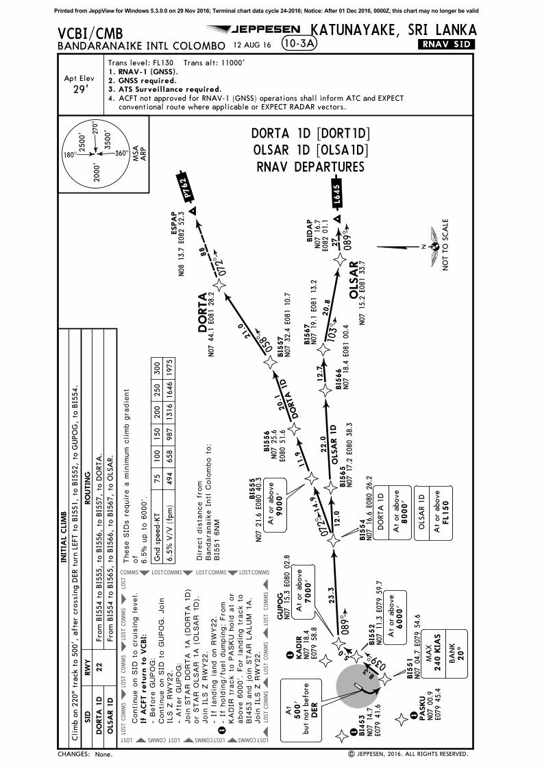
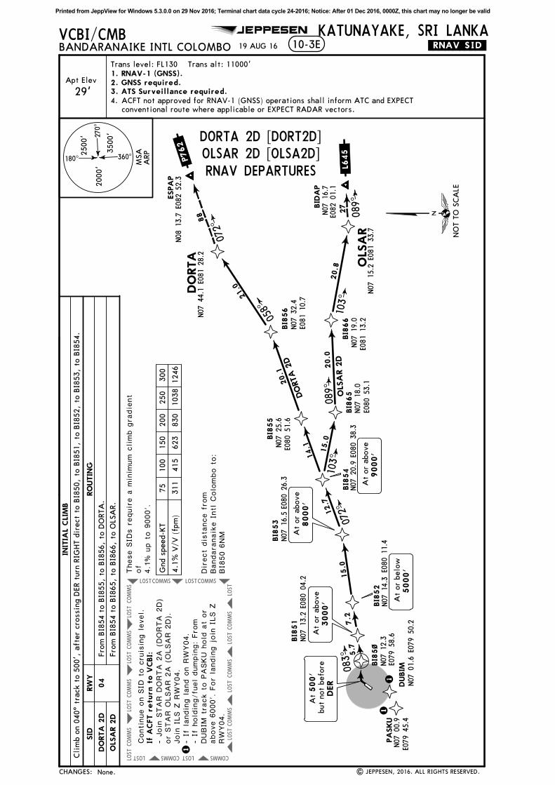
DORTA 1D [DORT1D]OLSAR 1D [OLSA1D]RNAV DEPARTURES
RW
Y
22
RO
UTIN
GSID
DO
RTA
1D
Fro
m B
I554 t
o B
I565,
to B
I566,
to B
I567,
to O
LSA
R.
Fro
m B
I554 t
o B
I555,
to B
I556,
to B
I557,
to D
ORTA
.
INIT
IAL
CLI
MB
OLS
AR 1
D
Continue o
n S
ID t
o c
ruis
ing level.
- Befo
re G
UPOG:
Continue o
n S
ID t
o G
UPOG. Join
ILS Z
RW
Y22.
- Aft
er
GUPOG:
Join
STAR D
ORTA 1
A (
DORTA 1
D)
or
STAR O
LSAR 1
A (
OLSAR 1
D).
Join
ILS Z
RW
Y22.
- If
landin
g land o
n R
WY22.
- If
hold
ing/fu
el dumpin
g: Fro
mKADIR
tra
ck t
o P
ASKU h
old
at
or
above 6
000'. F
or
landin
g t
rack t
oBI4
53 a
nd join
STAR L
ALUM 1
A.
Join
ILS Z
RW
Y22.
NO
T T
O S
CA
LE
Cli
mb o
n 2
20^ t
rack t
o 5
00',
aft
er
cro
ssin
g D
ER t
urn
LEFT t
o B
I551,
to B
I552,
to G
UPO
G,
to B
I554.
If A
CFT r
etu
rn t
o V
CBI:
Printed from JeppView for Windows 5.3.0.0 on 29 Nov 2016; Terminal chart data cycle 24-2016; Notice: After 01 Dec 2016, 0000Z, this chart may no longer be valid
COMMS
LOST
COMMS
LOST
COMMS LOST
COMMS
LOST
COMMS
LOST
COMMS
LOST
COMMS LOST
COMMSLOST
LOST
COMMSLOST
COMMS
LOST
COMMS
LOST
LOST
LOST
JEPPESEN
| JEPPESEN, 2016. ALL RIGHTS RESERVED.
VCBI/CMBBANDARANAIKE INTL COLOMBO
KATUNAYAKE, SRI LANKA
New chart.
15 JUL 16 .Eff.21.Jul. .RNAV.SID.10-3B
1
BI5
82
BI5
83
N06
48.2
E080
12.8
BI5
72
N06
59.6
E080
12.3
BI5
73
N06
55.2
E080
29.8
BI5
74
N06
50.3
E080
49.8
BI5
75
N06
45.4
E081
09.4
DUDA
LN06
45.1
E081
30.4
VEVET
N06
37.7
E082
00.0
ANUTI
N06
38.2
E080
25.7
BI5
51
N07
04.7
E079
54.6
PA
SKU
BI4
53
1
1
KA
DIR
N07
18.4
E079
58.8
1
N07
14.7
E079
41.6
N07
00.9
E079
45.4
500'
At
DER
but
not
befo
re
These S
IDs r
equire m
inim
um c
limb g
radie
nts
of
ANUTI 1D:
4.3
% u
p t
o 3
000'.
DUDA
L 1D:
6.5
% u
p t
o 1
0000'.
18.3
17.9
20.5
20.1
20.9
16.2
18.2
6.2
130^
134^
135^
108^
106^
093^
ANUT
I 1D
DUDA
L 1D
N07
00.5
E079
59.3
At
or
above
3000'
At
or
above
6000'
30
106^
180^
270^
360^
2500'
3500'
2000'
Apt Elev
29'2. GNSS required.3. ATS Surveillance required.
Trans level: FL130 Trans alt: 11000'
4. ACFT not approved for RNAV-1 (GNSS) operations shall inform ATC and EXPECT
conventional route where applicable or EXPECT RADAR vectors.
Direct
dis
tance f
rom
Bandara
naik
e I
ntl C
olo
mbo t
o:
BI5
51 6
NM
6.5
% V
/V (
fpm
)494
658
987
1316
1646
1975
4.3
% V
/V (
fpm
)327
435
653
871
1089
1306
Gnd s
peed-K
T75
100
150
200
250
300
At
or
above
10000'
At
or
above
11000'
MA
X
240 K
IAS
DUD
AL 1
D
1. RNAV-1 (GNSS).
P570
MSA
ARP
CHANGES:
ANUTI 1D [ANUT1D]DUDAL 1D [DUDA1D]RNAV DEPARTURES
RW
Y
22
RO
UTIN
GSID
ANUTI 1D
INIT
IAL
CLI
MB
DUDA
L 1D
Continue o
n S
ID t
o c
ruis
ing level.
NO
T T
O S
CA
LE
Fro
m B
I551 t
o B
I582,
to B
I583,
to A
NUTI.
Fro
m B
I551 t
o B
I572,
to B
I573,
to B
I574,
to B
I575,
to D
UD
AL.
- Join
STAR D
UDAL 1
A (
DUDAL 1
D)
or
STAR R
UPOK 1
A (
ANUTI
1D).
Join
ILS Z
RW
Y22.
- If
landin
g land o
n R
WY22.
- If
hold
ing/fu
el dumpin
g: Fro
mKADIR
tra
ck t
o P
ASKU h
old
at
or
above 6
000'. F
or
landin
g t
rack t
oBI4
53 a
nd join
STAR L
ALUM 1
A.
Join
ILS Z
RW
Y22.
If A
CFT r
etu
rn t
o V
CBI:
Cli
mb o
n 2
20^ t
rack t
o 5
00',
aft
er
cro
ssin
g D
ER t
urn
LEFT t
o B
I551.
Printed from JeppView for Windows 5.3.0.0 on 29 Nov 2016; Terminal chart data cycle 24-2016; Notice: After 01 Dec 2016, 0000Z, this chart may no longer be valid
COMMSLOST COMMSLOST COMMSLOST
COMMS
LOST
COMMSLOSTCOMMSLOST COMMSLOST
COMMS
LOST
COMMS
LOST
COMMS
LOST
COMMS
LOST LOST
COMMS
LOST
COMMS
LOST
COMMS
LOST
COMMS
LOST
LOST
COMMS
LOST
COMMS
LOST
BI613N07 16.7 E079 37.0BI614
N07 34.4 E078 57.4
BASUR
BI6~1N06 53.3 E079 39.5
BI6~2N06 29.6 E079 09.4
BI6~3N06 17.1 E078 53.6
LALUMN06 08.3 E078 34.5
ANIVEN05 40.9 E078 00.0
JEPPESEN
| JEPPESEN, 2016. ALL RIGHTS RESERVED.
VCBI/CMBBANDARANAIKE INTL COLOMBO
KATUNAYAKE, SRI LANKA
New chart.
15 JUL 16 .Eff.21.Jul. .RNAV.SID.
1
10-3C
BI611
BI453N07 14.7 E079 41.6
PASKUN07 00.9 E079 45.4
KADIR
1
N07 18.4E079 58.8
1
1
500'At
DERbut not before
N07 10.8E079 46.6
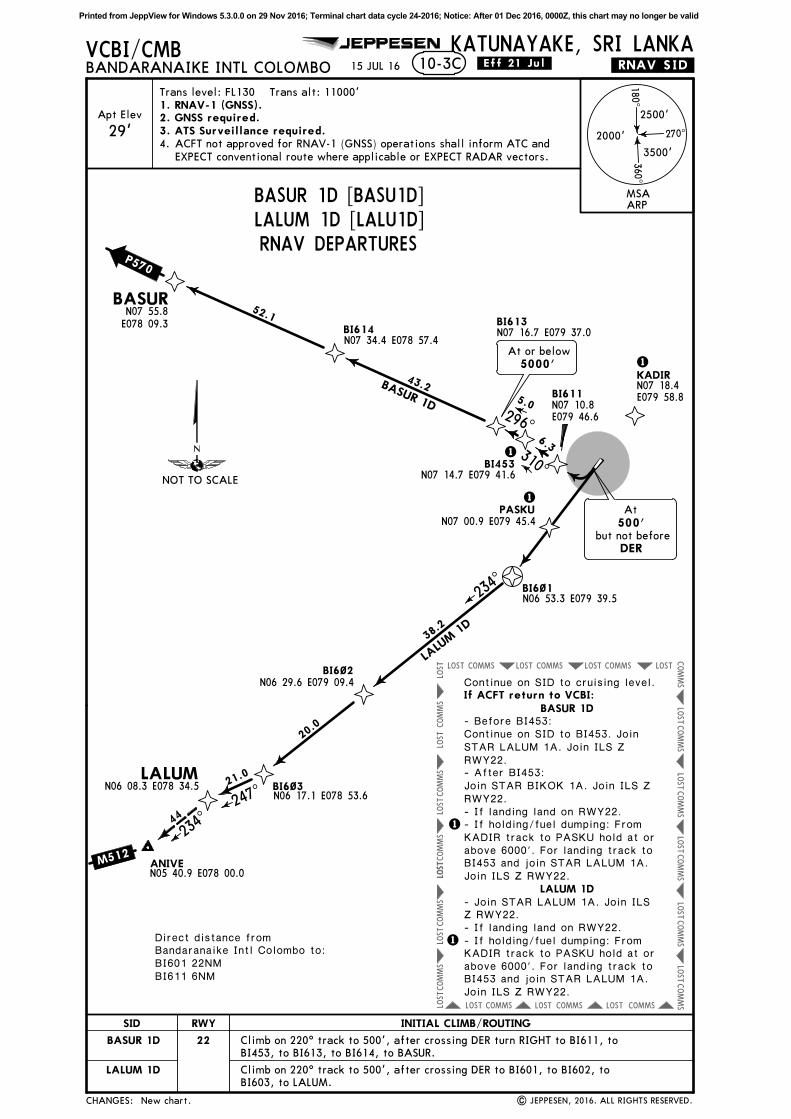
Direct distance fromBandaranaike Intl Colombo to:BI601 22NMBI611 6NM
38.2
234^
LALU
M 1
D
20.0
21.0
247^
44
234^
6.3
5.0
43.2
52.1
296^
310^
BASUR 1D
At or below
5000'
1
Apt Elev
29'
18 0^
270^
360^
2500'
3500'
2000'
2. GNSS required.3. ATS Surveillance required.
Trans level: FL130 Trans alt: 11000'
ACFT not approved for RNAV-1 (GNSS) operations shall inform ATC and
EXPECT conventional route where applicable or EXPECT RADAR vectors.
4.
N07 55.8E078 09.3
1. RNAV-1 (GNSS).
M512
P570
MSAARP
NOT TO SCALE
CHANGES:
BASUR 1D [BASU1D]LALUM 1D [LALU1D]RNAV DEPARTURES
RWY
22
SID
BASUR 1D
LALUM 1D
Continue on SID to cruising level.
BASUR 1D- Before BI453:Continue on SID to BI453. JoinSTAR LALUM 1A. Join ILS ZRWY22.- After BI453:Join STAR BIKOK 1A. Join ILS ZRWY22.- If landing land on RWY22.- If holding/fuel dumping: FromKADIR track to PASKU hold at orabove 6000'. For landing track toBI453 and join STAR LALUM 1A.Join ILS Z RWY22.
LALUM 1D- Join STAR LALUM 1A. Join ILSZ RWY22.- If landing land on RWY22.- If holding/fuel dumping: FromKADIR track to PASKU hold at orabove 6000'. For landing track toBI453 and join STAR LALUM 1A.Join ILS Z RWY22.
If ACFT return to VCBI:
INITIAL CLIMB/ROUTING
Climb on 220^ track to 500', after crossing DER turn RIGHT to BI611, to
BI453, to BI613, to BI614, to BASUR.
Climb on 220^ track to 500', after crossing DER to BI601, to BI602, to
BI603, to LALUM.
Printed from JeppView for Windows 5.3.0.0 on 29 Nov 2016; Terminal chart data cycle 24-2016; Notice: After 01 Dec 2016, 0000Z, this chart may no longer be valid
COMMSLOST COMMSLOST COMMSLOST
COMMSLOSTCOMMSLOST COMMSLOST
COMMS
LOST
COMMS
LOST
LOST
COMMS
LOST
COMMS
LOST
COMMS
LOST
COMMS
LOST
LOST
COMMS
LOST
COMMS
LOST
COMMS
LOST
COMMS
ATETAN09 19.1 E079 38.9
DEMONN08 33.5 E078 56.4
JEPPESEN
| JEPPESEN, 2016. ALL RIGHTS RESERVED.
Apt Elev
VCBI/CMBBANDARANAIKE INTL COLOMBO
KATUNAYAKE, SRI LANKA
29'
19 AUG 16
18 0^
270^
360^
2500'
3500'
2000'
2. GNSS required.3. ATS Surveillance required.
.RNAV.SID.
Trans level: FL130 Trans alt: 11000'
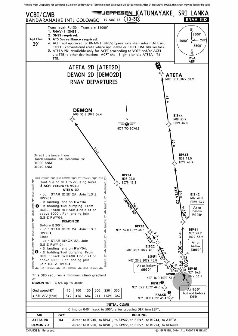
This SID requires a minimum climb gradientof
4.5% up to 4000'.
ACFT not approved for RNAV-1 (GNSS) operations shall inform ATC and
EXPECT conventional route where applicable or EXPECT RADAR vectors.
4.
1. RNAV-1 (GNSS).
10-3D
BI941N07 23.2E079 53.2
BI942N07 41.0E079 53.2
BI943N08 11.0E079 48.9
BI944N08 30.9E079 46.0
BI9~1
BI922
BI923
BI924N08 00.8E079 19.3
6. 6
17.7
30.2
20.0
48.4
BI9~~N07 16.0E079 51.2
7.8
11.0
BI9~~N07 16.0E079 51.2
6.4
30.0
39.5
BI9~~
BI94~N07 16.6E079 53.1
500'At
DERbut not before
003^
310^
N07 16.0 E079 51.2
336^
328^
DEM
ON 2
D
ATETA
2D
002^354^
N07 20.8 E079 45.0
4.5% V/V (fpm) 342 456 684 911 1139 1367
Gnd speed-KT 75 100 150 200 250 300
N07 36.0 E079 36.5
N07 30.7 E079 40.1
At or below
4000'
3000'
At orbelow
7000'
At orbelow
DEMON 2D:
5. ATETA 2D: Available only for ACFT proceeding to VOTR and/or ACFT
via TTR to other destinations. ACFT shall flight plan via ATETA - T4 -
TTR.
Direct distance fromBandaranaike Intl Colombo to:BI900 6NMBI940 6NM
PASKU1
BUSLIN07 05.7 E079 44.8
N07 00.9 E079 45.4
1
1
1
Reissued.
T4
MSAARP
NOT TO SCALE
CHANGES:
ATETA 2D [ATET2D]DEMON 2D [DEMO2D]RNAV DEPARTURES
RWY
04
ROUTINGSID
ATETA 2D
INITIAL CLIMB
DEMON 2D
Climb on 040^ track to 500', after crossing DER turn LEFT,
direct to BI940, to BI941, to BI942, to BI943, to BI944, to ATETA.
direct to BI900, to BI901, to BI922, to BI923, to BI924, to DEMON.
Continue on SID to cruising level.
ATETA 2D
DEMON 2D
If ACFT return to VCBI:
- Join STAR IDIBI 2A. Join ILS ZRWY04.- If landing land on RWY04.- If holding/fuel dumping: FromBUSLI track to PASKU hold at orabove 6000'. For landing joinILS Z RWY04.
Before BI901:- Join STAR IBIDI 2A. Join ILS Z RWY04.Else:- Join STAR BIKOK 2A. Join ILS Z RWY 04.- If landing land on RWY04.- If holding/fuel dumping: FromBUSLI track to PASKU hold at orabove 6000'. For landing join.Join ILS Z RWY04.
Printed from JeppView for Windows 5.3.0.0 on 29 Nov 2016; Terminal chart data cycle 24-2016; Notice: After 01 Dec 2016, 0000Z, this chart may no longer be valid
COMMS
LOST
COMMS
LOST
COMMS LOST
COMMS
LOST
COMMS
LOST
COMMS
LOST
COMMS
COMMSLOST
LOST
COMMSLOST
COMMS
LOST
COMMS
LOST
LOST
JEPPESEN
| JEPPESEN, 2016. ALL RIGHTS RESERVED.
VCBI/CMBBANDARANAIKE INTL COLOMBO
KATUNAYAKE, SRI LANKA19 AUG 16 .RNAV.SID.10-3E
180^
270^
360^
2500'
3500'
2000'
DO
RTA
N07
44.1
E081
28.2
ESPA
PN08
13.7
E082
52.3
OLS
AR
N07
15.2
E081
33.7
BID
AP
4.1
% u
p t
o 9
000'.
These S
IDs r
equire a
min
imum c
limb g
radie
nt
of
Apt Elev
29'2. GNSS required.3. ATS Surveillance required.
Trans level: FL130 Trans alt: 11000'
4. ACFT not approved for RNAV-1 (GNSS) operations shall inform ATC and EXPECT
conventional route where applicable or EXPECT RADAR vectors.
N07
16.7
E082
01.1
88
072^
27
089^
Direct
dis
tance f
rom
Bandara
naik
e I
ntl C
olo
mbo t
o:
BI8
50 6
NM
1. RNAV-1 (GNSS).
BI8
5~
N07
12.3
E079
58.6
BI8
51
N07
13.2E0
80 0
4.2
BI8
53
N07
16.5E0
80 2
6.3
BI8
54
N07
20.9E0
80 3
8.3
BI8
65
N07
18.0
E080
53.1
BI8
66
N07
19.0
E081
13.2
20.8
BI8
52
N07
14.3
E080
11.4
BI8
55
N07
25.6
E080
51.6
BI8
56
N07
32.4
E081
10.7
5.7
7.2
15.0
12.7
15.0
20.0
14.1
20.1
21.0
083^
072^
058^
103^
089^
103^
DORTA 2
D
OLS
AR 2
D
500'
At D
ER
but
not
befo
reA
t or
above
3000' A
t or
belo
w
5000'
At
or
above
8000'
At
or
above
9000'
4.1
% V
/V (
fpm
)311
415
623
830
1038
1246
Gnd s
peed-K
T75
100
150
200
250
300
1PA
SKU1
N07
00.9
E079
45.4
DUBIM
N07
01.6
E079
50.2
1
None.
P762
L645
MSA
ARP
CHANGES:
DORTA 2D [DORT2D]OLSAR 2D [OLSA2D]RNAV DEPARTURES
RW
Y
04
RO
UTIN
GSID
DO
RTA
2D
INIT
IAL
CLI
MB
OLS
AR 2
D
NO
T T
O S
CA
LE
Cli
mb o
n 0
40^ t
rack t
o 5
00',
aft
er
cro
ssin
g D
ER t
urn
RIG
HT d
irect
to B
I850,
to B
I851,
to B
I852,
to B
I853,
to B
I854.
Fro
m B
I854 t
o B
I855,
to B
I856,
to D
ORTA
.
Fro
m B
I854 t
o B
I865,
to B
I866,
to O
LSA
R.
Continue o
n S
ID t
o c
ruis
ing level.
If A
CFT r
etu
rn t
o V
CBI:
- Join
STAR D
ORTA 2
A (
DORTA 2
D)
or
STAR O
LSAR 2
A (
OLSAR 2
D).
Join
ILS Z
RW
Y04.
- If
landin
g land o
n R
WY04.
- If
hold
ing/fu
el dumpin
g: Fro
mDUBIM
tra
ck t
o P
ASKU h
old
at
or
above 6
000'. F
or
landin
g join
ILS Z
RW
Y04.
Printed from JeppView for Windows 5.3.0.0 on 29 Nov 2016; Terminal chart data cycle 24-2016; Notice: After 01 Dec 2016, 0000Z, this chart may no longer be valid
COMMS
LOST
COMMS LOST
COMMS
LOST
COMMS
LOST
COMMS
LOST
COMMS
COMMSLOST
LOST
COMMSLOST
COMMS
LOST
COMMS
LOST
LOST
COMMS
JEPPESEN
| JEPPESEN, 2016. ALL RIGHTS RESERVED.
VCBI/CMBBANDARANAIKE INTL COLOMBO
KATUNAYAKE, SRI LANKA19 AUG 16 .RNAV.SID.10-3F
1
DUDA
LN06
45.1
E081
30.4
VEVET
N06
37.7
E082
00.0
RUPO
K
4.1
% u
p t
o 1
1000'.
30
106^
180^
270^
360^
2500'
3500'
2000'
Apt Elev
29'2. GNSS required.3. ATS Surveillance required.
Trans level: FL130 Trans alt: 11000'
4. ACFT not approved for RNAV-1 (GNSS) operations shall inform ATC and EXPECT
conventional route where applicable or EXPECT RADAR vectors.
Direct
dis
tance f
rom
Bandara
naik
e I
ntl C
olo
mbo t
o:
BI8
50 6
NM
1. RNAV-1 (GNSS).N07
12.3
E079
58.6
BI7
12
N07
07.0
E080
05.7
BI8
73
N07
00.6
E080
08.0
BI8
74
N06
57.6E0
80 2
0.2 B
I875
N06
55.2
E080
29.8
BI8
76
N06
50.2
E080
49.8
BI8
77
N06
45.3
E081
09.4
BI8
5~
BI8
84
N06
53.0
E080
18.0
BI8
85
N06
46.9
E080
25.9
N06
43.6
E080
30.1
8.9
6.7
12.5
9.8
20.6
20.1
12.5
10.0
5.3
20.9
129^
162^
130^
131^
106^
092^
RUPO
K 2
DDUDA
L 2D
4.1
% V
/V (
fpm
)311
415
623
830
1038
1246
Gnd s
peed-K
T75
100
150
200
250
300
At
or
above
9000'
At
or
above
11000'
At
or
above
11000'
500'
At D
ER
but
not
befo
re
1
3000'
& 5
000'
Betw
een
These S
IDs r
equire a
min
imum c
limb g
radie
nt
of
MA
X240 K
IAS
2
2
At
or
above
9000'
Betw
een
4000'
& 6
000'
N07
00.9
E079
45.4
PA
SKU
DUBIM
N07
01.6
E079
50.2
2
Reissued.
P570
MSA
ARP
CHANGES:
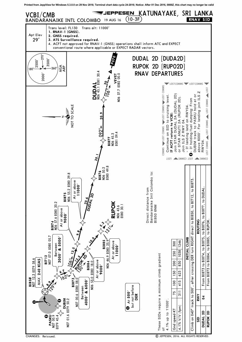
RUPOK 2D [RUPO2D]DUDAL 2D [DUDA2D]
RNAV DEPARTURES
RW
Y
04
RO
UTIN
GSID
RUPO
K 2
D
INIT
IAL
CLI
MB
DUDA
L 2D
Continue o
n S
ID t
o c
ruis
ing level.
NO
T T
O S
CA
LE
Fro
m B
I873 t
o B
I884,
to B
I885,
to R
UPO
K.
Fro
m B
I873 t
o B
I874,
to B
I875,
to B
I876,
to B
I877,
to D
UD
AL.
If A
CFT r
etu
rn t
o V
CBI:
Cli
mb o
n 0
40^ t
rack t
o 5
00',
aft
er
cro
ssin
g D
ER t
urn
RIG
HT d
irect
to B
I850,
to B
I712,
to B
I873.
- If
landin
g land o
n R
WY04.
- If
hold
ing/fu
el dumpin
g: Fro
mDUBIM
tra
ck t
o P
ASKU h
old
at
or
above 6
000'. F
or
landin
g join
ILS Z
RW
Y04.
Join
STAR D
UDAL 2
A (
DUDAL 2
D)
or
STAR A
NUTI
2A (
RUPOK 2
D).
Join
ILS Z
RW
Y 0
4.
Printed from JeppView for Windows 5.3.0.0 on 29 Nov 2016; Terminal chart data cycle 24-2016; Notice: After 01 Dec 2016, 0000Z, this chart may no longer be valid
COMMSLOST COMMSLOST COMMSLOST
COMMSLOSTCOMMSLOST COMMSLOST
COMMS
LOST
COMMS
LOST
LOST
COMMS
LOST
COMMS
LOST
COMMS
LOST
COMMS
LOST
LOST
COMMS
LOST
COMMS
LOST
COMMS
LOST
COMMS
BASUR
LALUMN06 08.3 E078 34.5
ANIVEN05 40.9 E078 00.0
JEPPESEN
| JEPPESEN, 2016. ALL RIGHTS RESERVED.
VCBI/CMBBANDARANAIKE INTL COLOMBO
KATUNAYAKE, SRI LANKA19 AUG 16 .RNAV.SID.10-3G
44
234^
Apt Elev
29'
18 0^
270^
360^
2500'
3500'
2000'
2. GNSS required.3. ATS Surveillance required.
Trans level: FL130 Trans alt: 11000'
ACFT not approved for RNAV-1 (GNSS) operations shall inform ATC and
EXPECT conventional route where applicable or EXPECT RADAR vectors.
4.
N07 55.8E078 09.3
1. RNAV-1 (GNSS).
BI9~1
BI9~2
BI9~3N07 14.2E079 39.9
BI9~4
BI915N07 17.0E079 23.6
BI916N07 31.3E078 56.3
BI9~6N06 48.2E079 33.1
BI9~7N06 29.4E079 09.3
BI9~8N06 16.9E078 53.5
7.8
14.8
30.6
52.5
3.4
4.9
5.1
12.1
10.0
30.2
20.1
20.8
BI900N07 16.0E079 51.2
N07 20.8 E079 45.0
219^
N07 18.1 E079 42.9
N07 10.1 E079 36.8
192^
300^
234^
233^
248^
LALU
M 2
D
BASUR 2D
BI9~5N06 58.1 E079 34.7
At or above
7000'
Direct distance fromBandaranaike Intl Colombo to:BI900 6NM
At or below
4000'
MAX
BANK 20^
4.5% up to 5000'.
4.5% V/V (fpm) 342 456 684 911 1139 1367
Gnd speed-KT 75 100 150 200 250 300
500'At
DERbut not before
1
1
These SIDs require a minimum climb gradientof
235 KIAS
310^
2BUSLI
PASKU2
At or above
5000'
N07 00.9E079 45.4
N07 05.7E079 44.8
11000'At or above
2
2
None.
M512
P570
MSAARP
NOT TO SCALE
CHANGES:
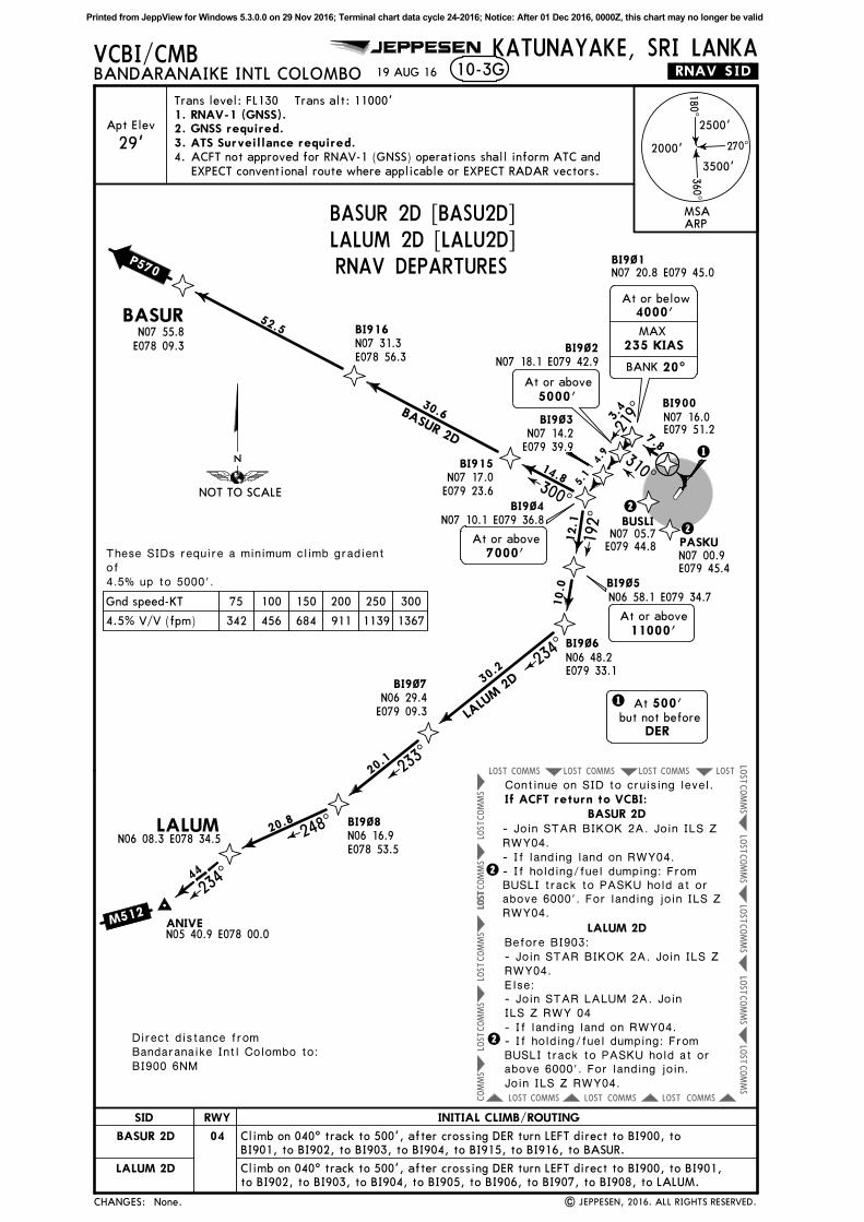
BASUR 2D [BASU2D]LALUM 2D [LALU2D]RNAV DEPARTURES
RWY
04
SID
BASUR 2D
LALUM 2D
Continue on SID to cruising level.
BASUR 2D
LALUM 2D
If ACFT return to VCBI:
- Join STAR BIKOK 2A. Join ILS ZRWY04.- If landing land on RWY04.- If holding/fuel dumping: FromBUSLI track to PASKU hold at orabove 6000'. For landing join ILS Z RWY04.
INITIAL CLIMB/ROUTING
Climb on 040^ track to 500', after crossing DER turn LEFT direct to BI900, to
BI901, to BI902, to BI903, to BI904, to BI915, to BI916, to BASUR.
Before BI903:- Join STAR BIKOK 2A. Join ILS Z RWY04.Else:- Join STAR LALUM 2A. Join ILS Z RWY 04- If landing land on RWY04.- If holding/fuel dumping: FromBUSLI track to PASKU hold at orabove 6000'. For landing join.Join ILS Z RWY04.
Climb on 040^ track to 500', after crossing DER turn LEFT direct to BI900, to BI901,
to BI902, to BI903, to BI904, to BI905, to BI906, to BI907, to BI908, to LALUM.
Printed from JeppView for Windows 5.3.0.0 on 29 Nov 2016; Terminal chart data cycle 24-2016; Notice: After 01 Dec 2016, 0000Z, this chart may no longer be valid
COMMSLOST COMMSLOST COMMSLOST
COMMS
LOST
COMMSLOSTCOMMSLOST COMMSLOST
COMMS
LOSTLO
ST
COMMS
LOST
COMMSLOST
COMMSLOST
JEPPESEN
| JEPPESEN, 2016. ALL RIGHTS RESERVED.
VCBI/CMBBANDARANAIKE INTL COLOMBO
KATUNAYAKE, SRI LANKA12 AUG 16 .Eff.18.Aug.10-3H
KATUNAYAKE
114.1 KATKATN07 09.7 E079 52.1
D
18 0^
270^
360^
2500'
3500'
2000'
.SID.
Apt Elev
29'132.4
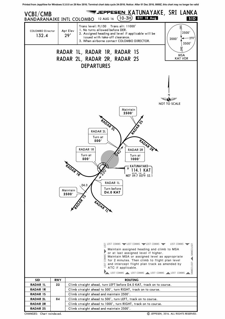
1. No turns allowed before DER.
2. Assigned heading and level if applicable will be
issued with take-off clearance.
Trans level: FL130 Trans alt: 11000'
040^
RADAR 2LRA
DAR
2SRADAR 2R
RADAR 1R
RADAR
1S
RADAR 1L
D4.0
Maintain
2500'
Maintain
2500'
COLOMBO Director
3. When airborne contact COLOMBO DIRECTOR.
Turn before
D4.0 KAT
RADAR 1L
500'Turn at
RADAR 1R
500'Turn at
RADAR 2L
Turn at
1000'
RADAR 2R
Chart reindexed.
MSAKAT VOR
220^
NOT TO SCALE
CHANGES:
RWY
22
ROUTINGSID
RADAR 1L
RADAR 1L, RADAR 1R, RADAR 1SRADAR 2L, RADAR 2R, RADAR 2S
DEPARTURES
Climb straight ahead, turn LEFT before D4.0 KAT, track on to course.
RADAR 1R
RADAR 1S
RADAR 2L
RADAR 2R
RADAR 2S
04
Climb straight ahead and maintain 2500'.
Climb straight ahead to 500', turn LEFT, track on to course.
Climb straight ahead to 1000', turn RIGHT, track on to course.
Climb straight ahead and maintain 2500'.
Maintain assigned heading and climb to MSAor at last assigned level if higher.Maintain MSA or assigned level as appropriatefor 2 minutes. Then climb to flight plan leveland intercept flight plan track as amended byATC if applicable.
Climb straight ahead to 500', turn RIGHT, track on to course.
Printed from JeppView for Windows 5.3.0.0 on 29 Nov 2016; Terminal chart data cycle 24-2016; Notice: After 01 Dec 2016, 0000Z, this chart may no longer be valid
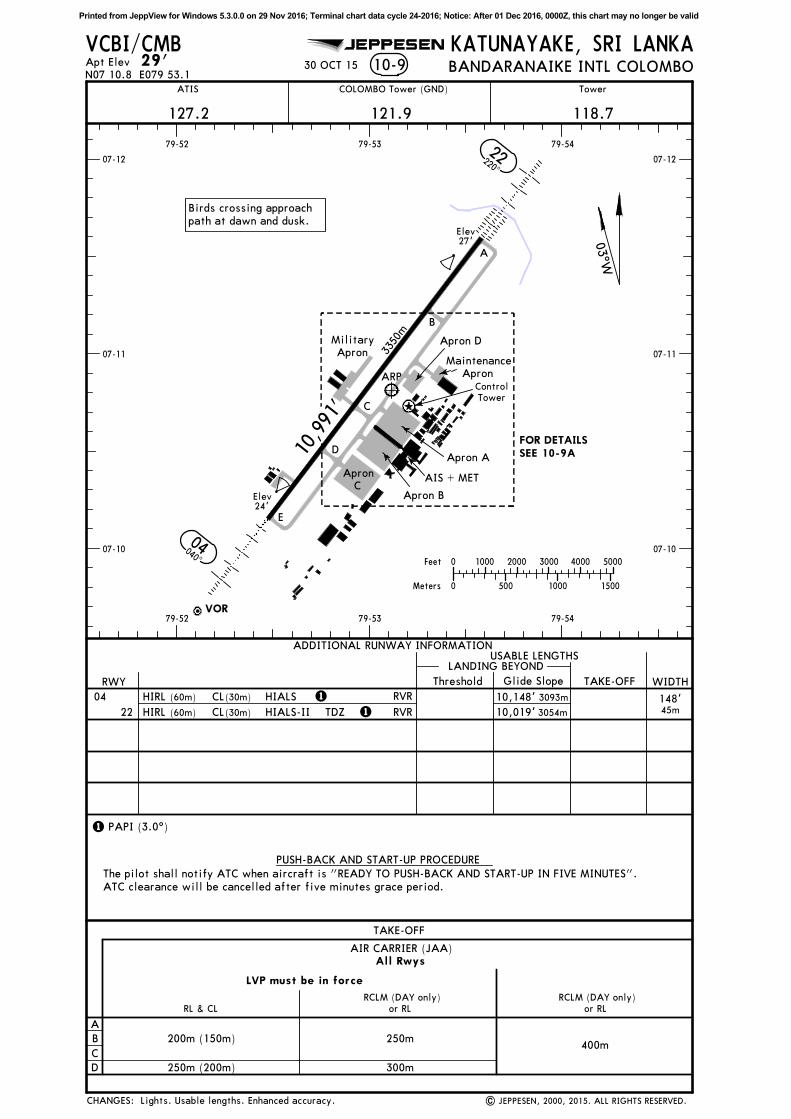
VOR
Apt Elev 29' 10-9N07 10.8 E079 53.1
121.9
Tower
118.7
RWY
04
22
RVR
RVR
400m
TAKE-OFF
A
B
C
D
All Rwys
LVP must be in force
250m
300m
RCLM (DAY only)
or RL
RCLM (DAY only)
or RL
200m (150m)
250m (200m)
RL & CL
AIR CARRIER (JAA)
VCBI/CMB
HIRL CL HIALS
TDZ
(30m)
HIRL CL(30m)
KATUNAYAKE, SRI LANKA
COLOMBO Tower (GND)
07-10 07-10
07-11 07-11
07-12 07-12
79-52
79-52
79-53
79-53
79-54
79-54
HIALS-II
10,991'
3350
m
Elev24'
Elev27'
ARP
A
B
C
D
E
AIS + MET
Birds crossing approach
path at dawn and dusk.
Apron A
Apron D
Apron B
BANDARANAIKE INTL COLOMBO
Military
Apron
127.2
ATIS
Maintenance
Apron
| JEPPESEN, 2000, 2015. ALL RIGHTS RESERVED.
JEPPESEN
22220^
040^
04
03^W
Apron
C
Control
Tower
30 OCT 15
PAPI (3.0^)
11
1
(60m)
(60m)
Lights. Usable lengths. Enhanced accuracy.
FOR DETAILSSEE 10-9A
0
0
1000
500
2000 3000 4000 5000
15001000Meters
Feet
CHANGES:
Threshold
LANDING BEYONDUSABLE LENGTHS
WIDTHTAKE-OFFGlide Slope
148'45m3054m
ADDITIONAL RUNWAY INFORMATION
The pilot shall notify ATC when aircraft is "READY TO PUSH-BACK AND START-UP IN FIVE MINUTES".
ATC clearance will be cancelled after five minutes grace period.
PUSH-BACK AND START-UP PROCEDURE
3093m10,148'
10,019'
Printed from JeppView for Windows 5.3.0.0 on 29 Nov 2016; Terminal chart data cycle 24-2016; Notice: After 01 Dec 2016, 0000Z, this chart may no longer be valid
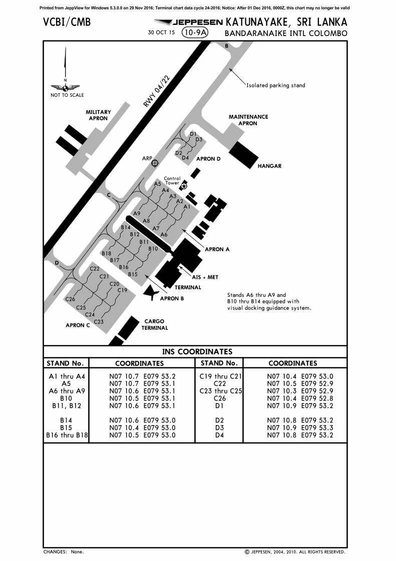
INS COORDINATES
COORDINATESSTAND No. STAND No. COORDINATES
VCBI/CMB KATUNAYAKE, SRI LANKA10-9A
MAINTENANCEAPRON
HANGAR
Isolated parking stand
BANDARANAIKE INTL COLOMBO
MILITARYAPRON
A1 thru A4A5
A6 thru A9B10
B11, B12
B14B15
B16 thru B18
N07 10.7 E079 53.2N07 10.7 E079 53.1N07 10.6 E079 53.1N07 10.5 E079 53.1N07 10.6 E079 53.1
N07 10.6 E079 53.0N07 10.4 E079 53.0N07 10.5 E079 53.0
C23
C24
C25
APRON C
TERMINAL
C
ARP
AIS + MET
D
ControlTowerA5
B18
B17
B15
APRON A
APRON B
A4A3
A2A1
A9
A8
A7A6
B10
B11
B12
B14
B16
C26
D1D3
D2D4 APRON D
C22
C21
C20
C19
CARGOTERMINAL
C19 thru C21C22
C23 thru C25C26D1
D2D3D4
N07 10.4 E079 53.0N07 10.5 E079 52.9N07 10.3 E079 52.9N07 10.4 E079 52.8N07 10.9 E079 53.2
N07 10.8 E079 53.2N07 10.9 E079 53.3N07 10.8 E079 53.2
| JEPPESEN, 2004, 2010. ALL RIGHTS RESERVED.
JEPPESEN
Stands A6 thru A9 and
B10 thru B14 equipped with
visual docking guidance system.
None.
NOT TO SCALE
30 OCT 15
B
CHANGES:
RWY 0
4/22
Printed from JeppView for Windows 5.3.0.0 on 29 Nov 2016; Terminal chart data cycle 24-2016; Notice: After 01 Dec 2016, 0000Z, this chart may no longer be valid
| JEPPESEN SANDERSON, INC., 2007. ALL RIGHTS RESERVED.
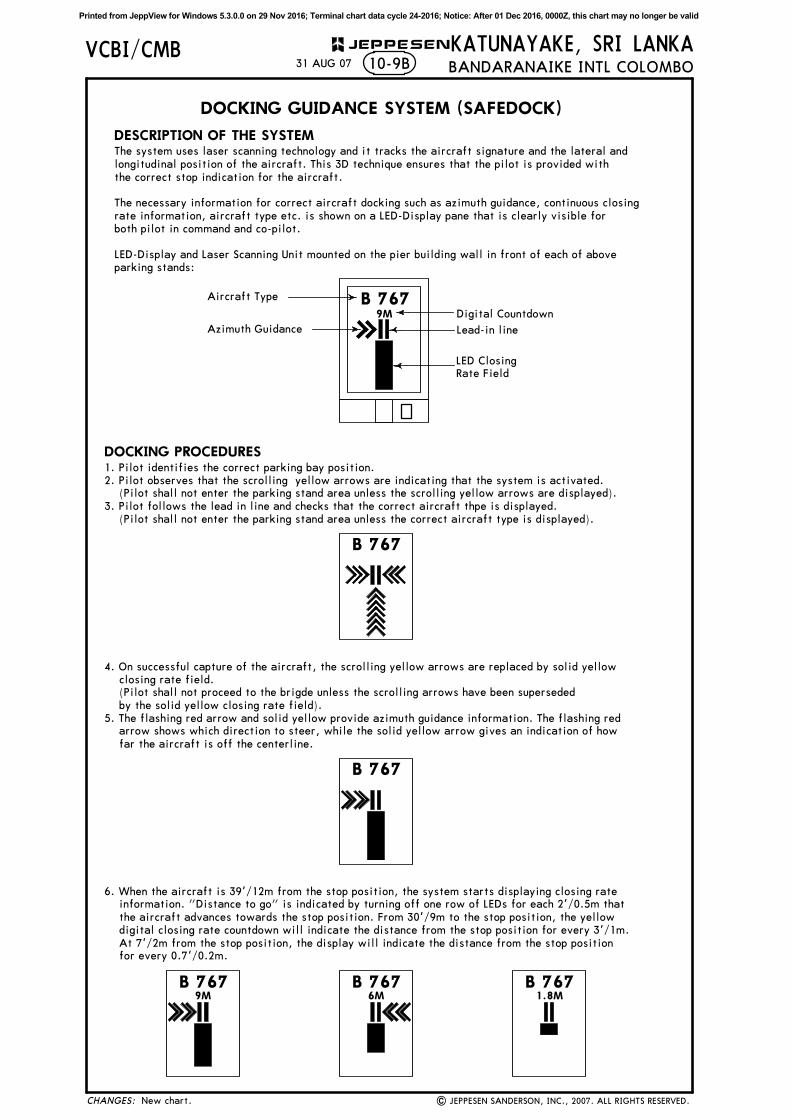
DOCKING GUIDANCE SYSTEM (SAFEDOCK)
DESCRIPTION OF THE SYSTEM
B 767Aircraft Type
Azimuth Guidance
Digital Countdown
Lead-in line
LED Closing
Rate Field
DOCKING PROCEDURES
B 767
B 767
B 767 B 7676M9M
9M
B 7671.8M
KATUNAYAKE, SRI LANKABANDARANAIKE INTL COLOMBO
VCBI/CMB10-9B31 AUG 07
New chart.
1. Pilot identifies the correct parking bay position.
2. Pilot observes that the scrolling yellow arrows are indicating that the system is activated.
(Pilot shall not enter the parking stand area unless the scrolling yellow arrows are displayed).
3. Pilot follows the lead in line and checks that the correct aircraft thpe is displayed.
(Pilot shall not enter the parking stand area unless the correct aircraft type is displayed).
6. When the aircraft is 39'/12m from the stop position, the system starts displaying closing rate
information. "Distance to go" is indicated by turning off one row of LEDs for each 2'/0.5m that
the aircraft advances towards the stop position. From 30'/9m to the stop position, the yellow
digital closing rate countdown will indicate the distance from the stop position for every 3'/1m.
At 7'/2m from the stop position, the display will indicate the distance from the stop position
for every 0.7'/0.2m.
The system uses laser scanning technology and it tracks the aircraft signature and the lateral and
longitudinal position of the aircraft. This 3D technique ensures that the pilot is provided with
the correct stop indication for the aircraft.
The necessary information for correct aircraft docking such as azimuth guidance, continuous closing
rate information, aircraft type etc. is shown on a LED-Display pane that is clearly visible for
both pilot in command and co-pilot.
LED-Display and Laser Scanning Unit mounted on the pier building wall in front of each of above
parking stands:
4. On successful capture of the aircraft, the scrolling yellow arrows are replaced by solid yellow
closing rate field.
(Pilot shall not proceed to the brigde unless the scrolling arrows have been superseded
by the solid yellow closing rate field).
5. The flashing red arrow and solid yellow provide azimuth guidance information. The flashing red
arrow shows which direction to steer, while the solid yellow arrow gives an indication of how
far the aircraft is off the centerline.
CHANGES:
JEPPESEN
Printed from JeppView for Windows 5.3.0.0 on 29 Nov 2016; Terminal chart data cycle 24-2016; Notice: After 01 Dec 2016, 0000Z, this chart may no longer be valid
| JEPPESEN SANDERSON, INC., 2007. ALL RIGHTS RESERVED.
DOCKING GUIDANCE SYSTEM (SAFEDOCK)
KATUNAYAKE, SRI LANKABANDARANAIKE INTL COLOMBO
VCBI/CMB10-9C31 AUG 07
New chart.
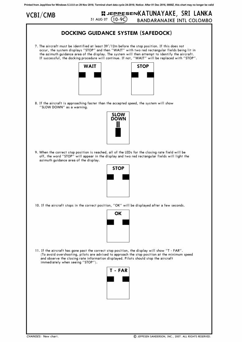
STOPWAIT
SLOWDOWN
STOP
10. If the aircraft stops in the correct position, "OK" will be displayed after a few seconds.
OK
T - FAR
7. The aircraft must be identified at least 39'/12m before the stop position. If this does not
occur, the system displays "STOP" and then "WAIT" with two red rectangular fields being lit in
the azimuth guidance area of the display. The system will then attempt to identify the aircraft.
If successful, the docking procedure will continue. If not, "WAIT" will be replaced with "STOP".
8. If the aircraft is approaching faster than the accepted speed, the system will show
"SLOW DOWN" as a warning.
9. When the correct stop position is reached, all of the LEDs for the closing rate field will be
off, the word "STOP" will appear in the display and two red rectangular fields will light the
azimuth guidance area of the display.
11. If the aircraft has gone past the correct stop position, the display will show "T - FAR".
(To avoid overshooting, pilots are advised to approach the stop position at the minimum speed
and observe the closing rate information displayed. Pilots should stop the aircraft
immediately when seeing "STOP").
CHANGES:
JEPPESEN
Printed from JeppView for Windows 5.3.0.0 on 29 Nov 2016; Terminal chart data cycle 24-2016; Notice: After 01 Dec 2016, 0000Z, this chart may no longer be valid
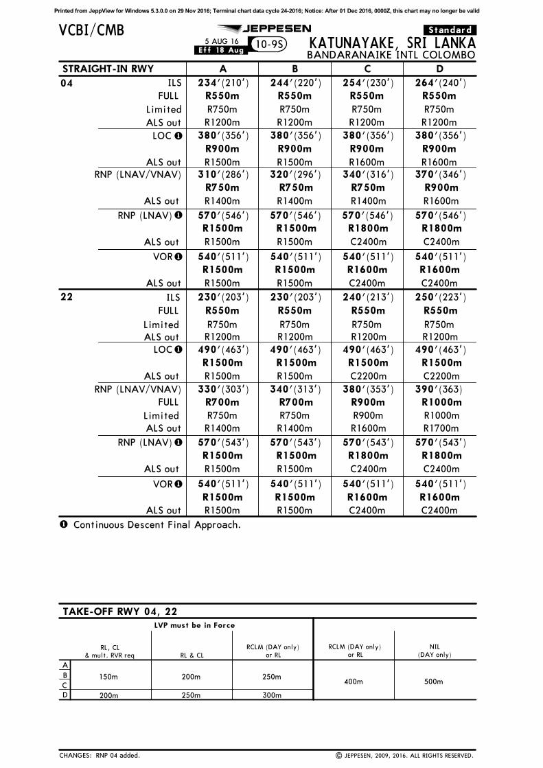
.Standard.10-9S
JEPPESEN
| JEPPESEN, 2009, 2016. ALL RIGHTS RESERVED.
1
1
.Eff.18.Aug.
A
B
C
D
RCLM (DAY only)
250m
300m
400m 500m
NIL
(DAY only)
RCLM (DAY only)
RL & CL
200m
250m
& mult. RVR req
150m
200m
RL, CLor RL or RL
LVP must be in Force
1
1
1
1
RNP 04 added.
5 AUG 16
1
CHANGES:
STRAIGHT-IN RWY DCBA
VCBI/CMB
ALS out
234'(210')
R1200m
R550m244'(220')
R550m
R1200m
(230')
R550m
R1200m
(240')
R550m
R1200m
264'254'
ALS out
LOC 380'(356')
R1500m
R900m380'(356')
R900m
R1500m
380'(356')
R900m
R1600m
(356')
R900m
R1600m
380'
ALS out
540'(511')
R1500m
R1500m540'(511')
R1500m
R1500m
(511')
R1600m
C2400m
(511')
R1600m
C2400m
540'540'
ILS04
KATUNAYAKE, SRI LANKABANDARANAIKE INTL COLOMBO
22
VOR
Limited R750m R750m R750m R750m
330'(303')
R700m340'(313') 380'(353') 390'(363)
ALS out R1400m R1600m R1700m
ALS out
540'(511') 540'(511') (511') (511')540'540'VOR
R1500m
R1500m R1500mR1500m
R1600mC2400m
R1600mC2400m
TAKE-OFF RWY 04, 22
R1400m
Continuous Descent Final Approach.
R700m R900m R1000m
FULL
230'(203')
R550m
230'(203') (213') (223')250'240'
R550m R550m R550m
Limited R750m R750m R750m R750m
ALS out R1200m R1200m R1200m R1200m
FULL
LOC 490'(463')
R1500m490'(463') 490'(463') 490'(463')
ALS out R1500m C2200m C2200mR1500m
R1500m R1500m R1500m
RNP (LNAV/VNAV)
570'(543')
R1500m570'(543') 570'(543') 570'(543')
ALS out R1500m C2400m C2400mR1500m
R1500m R1800m R1800mRNP (LNAV)
ILS
310'(286')
R750m320'(296') 340'(316') 370'(346')
ALS out R1400m R1400m R1600mR1400m
R750m R750m R900mRNP (LNAV/VNAV)
570'(546')
R1500m
ALS out R1500m C2400m C2400mR1500m
R1500m R1800m R1800mRNP (LNAV) 570'(546') 570'(546') 570'(546')
Limited R750m R750m R900m R1000m
FULL
Printed from JeppView for Windows 5.3.0.0 on 29 Nov 2016; Terminal chart data cycle 24-2016; Notice: After 01 Dec 2016, 0000Z, this chart may no longer be valid
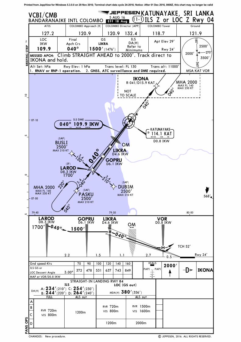
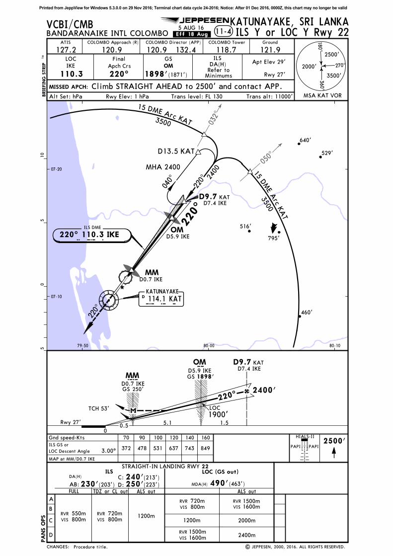
11-1
Gnd speed-Kts 70 90 100 120 140 160
372 478 531 637 743 849
2000'PAPI PAPI
HIALS
05
510
DA(H)A:
B: D:
C:
ILS LOC (GS out)
FULL
ILS Z or LOC Z Rwy 04
3.00^
VCBI/CMB
040^ 109.9 IKWI K WILS DME
OM
07-00
07-10
79-40 79-50 80-00
BANDARANAIKE INTL COLOMBO
D0.8 IKW
JEPPESEN
ILS GS or
LOC Descent Angle
BRIE
FIN
G S
TRIP
TM
MSA KAT VOR
270^
180^360^
2000'
2500'
3500'
COLOMBO Approach (R) COLOMBO Tower
118.7
Ground
121.9
LOC
IKW
109.9
Final
Apch Crs
040^ 1500'(1476')
DA(H)
Alt Set: hPa Rwy Elev: 1 hPa Trans level: FL 130 Trans alt: 11000'
GS ILS
Refer toMinimums
MISSED APCH:
120.9 132.4
COLOMBO Director (APP)
120.9127.2
ATIS
568'
Apt Elev 29'
Rwy 24'
.Eff.18.Aug.5 AUG 16
KATUNAYAKE, SRI LANKA
LIKRA
Climb STRAIGHT AHEAD to 2000'. Track direct toIKONA and hold.
GNSS, ATC surveillance and DME required.RNAV or RNP-1 operation.1. 2.
114.1 KAT
LIKRAD4.6 IKW
GOPRUD6.1 IKW
LARODD8.3 IKW
(IF)
BUSLI
DUBIM
(IAF)
(IAF)
2500'
2500'
MAX 210 KT
MAX 210 KTPASKU(IAF)
2500'MAX 210 KT
3.4
3.4
130^
310^
040^3.4
IKONA
040^
220^
MAX FL 140MAX 230 KT
R-041/D15.9 KAT
040^
MAX FL 140MAX 230 KT
NOT
TO SCALE
D0.8 IKW
Rwy 24'
D4.6 IKWLIKRAGOPRU
D6.1 IKWLARODD8.3 IKW m
1700'
IKONAD
New procedure. | JEPPESEN, 2016. ALL RIGHTS RESERVED.
MAP at VOR/D0.8 IKW
040^
PA
NS O
PS
CHANGES:
A
B
C
D
STRAIGHT-IN LANDING RWY
ALS out
04
1200m
MDA(H) 380'(356')
1200m
(220')244' (240')264'(230')254'(210')234'
ALS out
RVR
2000m
RVR 1500m
1600mVIS
720m
VIS 800mRVR 720m
VIS 800m
040^
DK A TKATUNAYAKE
MHA 2000
MHA 2000
1500'
TCH 52'
0.51.52.2
040^
1700' 040^
VOR
1.1 2.7
OM
Printed from JeppView for Windows 5.3.0.0 on 29 Nov 2016; Terminal chart data cycle 24-2016; Notice: After 01 Dec 2016, 0000Z, this chart may no longer be valid
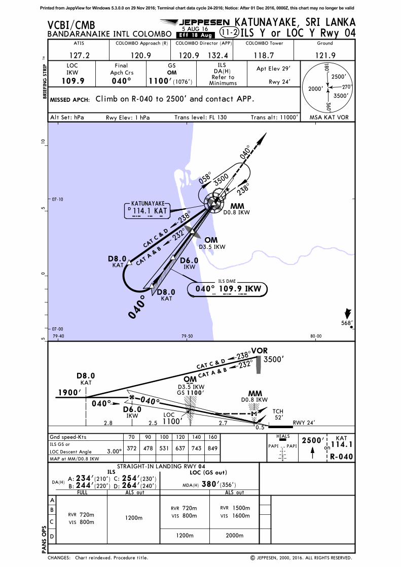
11-2
Gnd speed-Kts 70 90 100 120 140 160
372 478 531 637 743 849 on2500'
PAPI PAPI
HIALS
05
510
DA(H)A:
B: D:
C:
ILS LOC (GS out)
FULL
ILS Y or LOC Y Rwy 04
3.00^
KAT
R-040
114.1
KAT
IKWTCH52'
GS 1100'
m
LOC
040^
VCBI/CMB
OM
040^
114.1 KAT
232^
CAT C
& D
CAT A &
B
IKWKAT
KAT
040^ 109.9 IKWI K WILS DME
OMD3.5 IKW
D3.5 IKW
07-00
07-10
79-40 79-50 80-00
BANDARANAIKE INTL COLOMBO
MMD0.8 IKW
MMD0.8 IKW
MAP at MM/D0.8 IKW
| JEPPESEN, 2000, 2016. ALL RIGHTS RESERVED.
JEPPESEN
ILS GS or
LOC Descent Angle
1900'
BRIE
FIN
G S
TRIP
TM
MSA KAT VOR
270^
180^360^
2000'
2500'
3500'
COLOMBO Approach (R) COLOMBO Tower
118.7
Ground
121.9
LOC
IKW
109.9
Final
Apch Crs
040^ 1100'(1076')
DA(H)
Alt Set: hPa Rwy Elev: 1 hPa Trans level: FL 130 Trans alt: 11000'
GS ILS
Refer toMinimums
MISSED APCH: Climb on R-040 to 2500' and contact APP.
120.9 132.4
COLOMBO Director (APP)
120.9
OM
127.2
ATIS
568'
Apt Elev 29'
Rwy 24'
RWY 24'
.Eff.18.Aug.5 AUG 16
KATUNAYAKE, SRI LANKA
Chart reindexed. Procedure title.
040^
PA
NS O
PS
CHANGES:
A
B
C
D
STRAIGHT-IN LANDING RWY
ALS out
04
1200m
MDA(H) 380'(356')
1200m
(220')244' (240')264'(230')254'(210')234'
ALS out
RVR
2000m
RVR 1500m
1600mVIS
720m
VIS 800mRVR 720m
VIS 800m
3500'VOR
2.7
D6.0
D8.0
2.50.5
2.8
D6.0
040^
058^
238^
238^
3500
DK A TKATUNAYAKE
D8.0
D8.0
238^
CAT C & D232^
CAT A & B
1100'
Printed from JeppView for Windows 5.3.0.0 on 29 Nov 2016; Terminal chart data cycle 24-2016; Notice: After 01 Dec 2016, 0000Z, this chart may no longer be valid
ILS DME
I K E220^ 110.3 IKE
07-10
07-20
79-50
80-00 80-10
D0.7 IKE
D4.6 IKE
529'
795'
460'
516'
640'
220^
IGNIL
ONIKOD6.2 IKE
KADIR(IF)
SUMOX
GUPOG
2500'
2500'
1600'
(IAF)
MAX 230 KT
MAX 230 KT
(IAF)
IKONA(IAF)
2500'MAX 230 KT
5.0
5.0
5.0
130^
310^
220^
040^
MAX FL 140MAX 230 KT
05
510
BRIE
FIN
G S
TRIP
TM
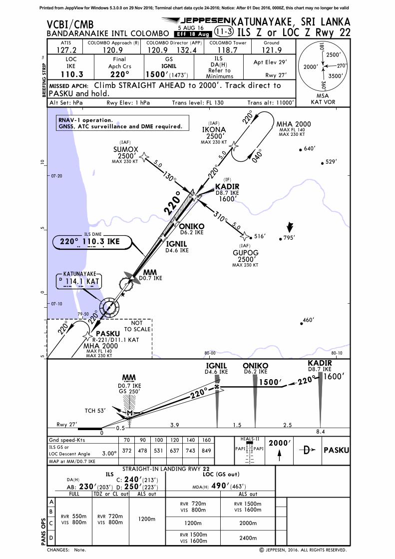
11-3
270^
180^360^
2000'
2500'
3500'
IKE
110.3 220^ 1500'(1473')
MISSED APCH:
Alt Set: hPa Rwy Elev: 1 hPa Trans level: FL 130 Trans alt: 11000'
VCBI/CMB KATUNAYAKE, SRI LANKABANDARANAIKE INTL COLOMBO
LOC Final
Apch Crs
GS
127.2ATIS
121.9Ground
118.7COLOMBO TowerCOLOMBO Director (APP)
120.9COLOMBO Approach (R)
JEPPESEN
120.9 132.4
Refer toMinimums
DA(H)ILS
Apt Elev 29'
Rwy 27'
.Eff.18.Aug. ILS Z or LOC Z Rwy 22
IGNIL
STRAIGHT-IN LANDING RWY
A
B
C
D
22LOC (GS out)
MDA(H) 490'(463')
ILS
ALS out
Gnd speed-Kts 70 90 100 120 140 160
3.00^372 478 531 637 743 849
c
2000'PAPI PAPI
HIALS-II
ILS GS or
LOC Descent Angle
DA(H)
D:
C:
FULL
MAP at MM/D0.7 IKE
D0.7 IKE
TDZ or CL out
Rwy 27'
PASKU and hold.Climb STRAIGHT AHEAD to 2000'. Track direct to
MSAKAT VOR
D4.6 IKEIGNIL ONIKO
D6.2 IKE
KADIR
PASKU
MAX FL 140MAX 230 KT
220^
NOTTO SCALE
| JEPPESEN, 2016. ALL RIGHTS RESERVED.
D8.7 IKE
AB:
D8.7 IKE
GNSS, ATC surveillance and DME required.
R-221/D11.1 KAT
D PASKU
5 AUG 16
RNAV-1 operation.
Note.
220^
MHA 2000
220^
D 114.1 KATKATUNAYAKE
K A TMM
PA
NS O
PS
CHANGES:
1200m
RVR
VIS 800m720m RVR 1500m
VIS 1600m
0
3.9
MM1500'
TCH 53'
GS 250'
(223')250'(213')240'
(203')230'ALS out
1200m2000m
RVR
VIS
1500m1600m
2400m
0.5
RVR
VIS 800m720mRVR
VIS 800m550m
1.5 2.58.4
220^
1600'220^
MHA 2000
Printed from JeppView for Windows 5.3.0.0 on 29 Nov 2016; Terminal chart data cycle 24-2016; Notice: After 01 Dec 2016, 0000Z, this chart may no longer be valid
050^
032^
ILS DME
I K E220^ 110.3 IKE
BRIE
FIN
G S
TRIP
TM
11-4
270^
180^360^
MSA KAT VOR
2000'
2500'
3500'
IKE
110.3 220^ 1898'(1871')
MISSED APCH:
Alt Set: hPa Rwy Elev: 1 hPa Trans level: FL 130 Trans alt: 11000'
05
510
STRAIGHT-IN LANDING RWY
A
B
C
D
22LOC (GS out)
MDA(H) 490'(463')
ILS
ALS out
Gnd speed-Kts 70 90 100 120 140 160
3.00^372 478 531 637 743 849
1900'LOC
c GS 1898'
2500'PAPI PAPI
VCBI/CMB KATUNAYAKE, SRI LANKA
07-10
07-20
79-50 80-00 80-10
HIALS-II
BANDARANAIKE INTL COLOMBO
OMLOC Final
Apch Crs
GS
127.2ATIS
121.9Ground
118.7COLOMBO TowerCOLOMBO Director (APP)
120.9COLOMBO Approach (R)
| JEPPESEN, 2000, 2016. ALL RIGHTS RESERVED.
JEPPESEN
ILS GS or
LOC Descent Angle
120.9 132.4
Refer toMinimums
DA(H)ILS
D7.4 IKE
D7.4 IKE
DA(H)
D:
C:
FULL
Climb STRAIGHT AHEAD to 2500' and contact APP.
MAP at MM/D0.7 IKE
D0.7 IKE
D0.7 IKE
TDZ or CL out
D5.9 IKE
D5.9 IKE
529'
795'
460'
516'
640'
220^
040^
Rwy 27'
Apt Elev 29'
Rwy 27'
D13.5 KAT
2400
.Eff.18.Aug.
Procedure title.
m
AB:
5 AUG 16ILS Y or LOC Y Rwy 22
220^
15DM
EArc
KA
T15 DME Arc KAT
MHA 2400
PA
NS O
PS
CHANGES:
1200m
RVR
VIS 800m720m RVR 1500m
VIS 1600m
0
5.1
MM
220^2400'
TCH 53'
1.5
GS 250'
220^
OM
OM
D 114.1 KATKATUNAYAKE
K A T
KATD9.7
KATD9.7
(203')230' (223')250'(213')240'
ALS out
1200m2000m
RVR
VIS
1500m1600m
2400m
0.5
MM
RVR
VIS 800m720mRVR
VIS 800m550m
35003500
Printed from JeppView for Windows 5.3.0.0 on 29 Nov 2016; Terminal chart data cycle 24-2016; Notice: After 01 Dec 2016, 0000Z, this chart may no longer be valid
IKONAMAX FL 140MAX 230 KT
GNSS required.RNP-1 operation.
Minimum temperature for Baro-VNAV approaches 15^C. The temperature at
which the effective VPA will exceed 3.5^ is 50^C.
(SM
A 1
200)
(SMA 1200)
BUSLI
220^
130^1300'
DUBIM
220^
310^
2800'
1600'
15
25PASKU
130^
310^25
2200'
25
LIKRA
LAROD
1700'
(IF)
LARODLAROD(IF)
BUSLI(IAF)
2500'MAX 210 KT 3.4130^
310^
3.4
DUBIM(IAF)
2500'MAX 210 KT
040^3.
4
PASKU(IAF)
2500'MAX 210 KT04
0^
220^
MAX FL 140MAX 230 KT
MAX 190 KT
RW~4
(SMA 1200)
21
1 2
07-00
07-10
79-40 79-50 80-00
BRIE
FIN
G S
TRIP
TM
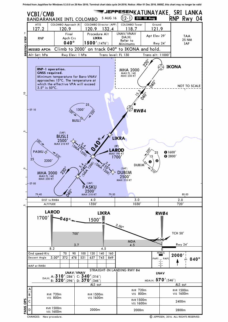
12-1
040^ 1500'(1476')
MISSED APCH:
Alt Set: hPa Rwy Elev: 1 hPa Trans level: FL 130 Trans alt: 11000'
VCBI/CMB KATUNAYAKE, SRI LANKABANDARANAIKE INTL COLOMBO
RNP
Final
Apch Crs
127.2ATIS
121.9Ground
118.7COLOMBO TowerCOLOMBO Director (APP)
120.9COLOMBO Approach (R)
JEPPESEN
120.9 132.4
Refer toMinimums
DA(H) Apt Elev 29'
Rwy 24'
.Eff.18.Aug.
LIKRA
RNP Rwy 04
TAA
25 NMIAF
Climb to 2000' on track 040^ to IKONA and hold.
LNAV/VNAVProcedure Alt
5 AUG 16
STRAIGHT-IN LANDING RWY
A
B
C
D
04
MDA(H) 570'(546')
ALS out
Gnd speed-Kts 70 90 100 120 140 160
3.00^ 372 478 531 637 743 8492000'
DA(H)D:
C:
Rwy 24'
LIKRALAROD
| JEPPESEN, 2016. ALL RIGHTS RESERVED.New procedure.
RW~4
MDA
MAP at RW~4
Descent Angle
LNAVLNAV/VNAV
B:
A:
3.00^
on 040^
05
510
700'
PAPI PAPI
HIALS
040^
220^
NOT TO SCALE
MHA 2000
ALTITUDE
2.0DIST to RW~4 4.0
1030'
3.0
040^
MHA 2000
040^15
.3
1350' 720'
PA
NS O
PS
CHANGES:
RVR
VIS 800m720m RVR 1500m
VIS 1600m
0
4.5
1500'
TCH 50'
(346')370'(316')340'
(296')320'ALS out
2400m
2800m
3.78.2
1700' 040^
(286')310'
2000m
RVR 1500mVIS 1600m
RVR
VIS 800m720m RVR 1500m
VIS 1600m
2000mRVR 1500mVIS 1600m
4.5
Printed from JeppView for Windows 5.3.0.0 on 29 Nov 2016; Terminal chart data cycle 24-2016; Notice: After 01 Dec 2016, 0000Z, this chart may no longer be valid
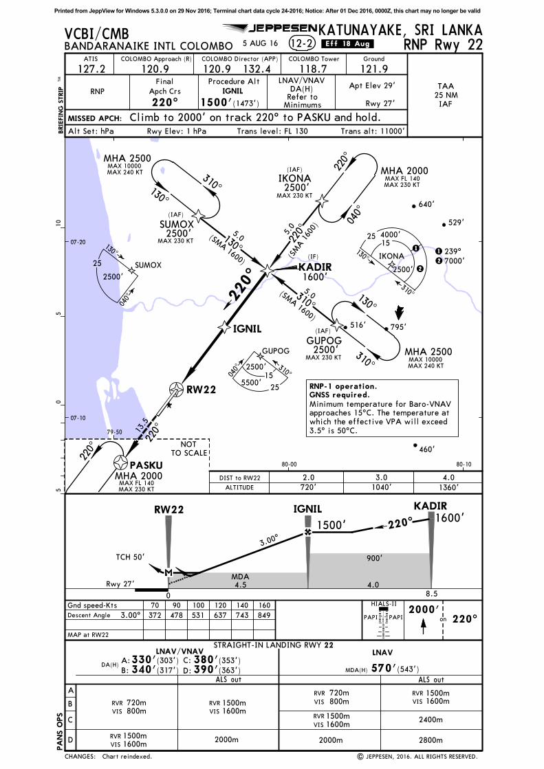
07-10
07-20
79-50
80-00 80-10
529'
795'
460'
516'
640'
220^
IGNIL
KADIR(IF)
SUMOX
GUPOG
2500'
2500'
1600'
(IAF)
MAX 230 KT
MAX 230 KT
(IAF)
IKONA(IAF)
2500'MAX 230 KT
5.0
5.0
5.0
130^
310^
220^
040^
MAX FL 140MAX 230 KT
05
510
BRIE
FIN
G S
TRIP
TM
12-2
220^ 1500'(1473')
MISSED APCH:
Alt Set: hPa Rwy Elev: 1 hPa Trans level: FL 130 Trans alt: 11000'
VCBI/CMB KATUNAYAKE, SRI LANKABANDARANAIKE INTL COLOMBO
RNP
Final
Apch Crs
127.2ATIS
121.9Ground
118.7COLOMBO TowerCOLOMBO Director (APP)
120.9COLOMBO Approach (R)
JEPPESEN
120.9 132.4
Refer toMinimums
DA(H) Apt Elev 29'
Rwy 27'
.Eff.18.Aug.
IGNIL
STRAIGHT-IN LANDING RWY
A
B
C
D
22
MDA(H) 570'(543')
ALS out
Gnd speed-Kts 70 90 100 120 140 160
3.00^ 372 478 531 637 743 8492000'
PAPI PAPI
HIALS-II
DA(H)D:
C:
Rwy 27'
IGNIL KADIR
PASKU
MAX FL 140MAX 230 KT
220^
NOTTO SCALE
| JEPPESEN, 2016. ALL RIGHTS RESERVED.
RNP Rwy 22
TAA
25 NMIAF
Climb to 2000' on track 220^ to PASKU and hold.
GNSS required.RNP-1 operation.
Minimum temperature for Baro-VNAV approaches 15^C. The temperature at which the effective VPA will exceed
3.5^ is 50^C.
310^
130^
MAX 10000MAX 240 KT
MAX 10000MAX 240 KT
130^
310^
RW22
LNAV/VNAV
900'
MDA
(SMA 1
600)
(SMA 1600)
(SMA 1600)
MAP at RW22
Descent Angle
LNAVLNAV/VNAV
B:
A:
3.00^
Procedure Alt
SUMOX
040^
130^
2500'
GUPOG
040^ 310^
5500'
2500'15
25
IKONA130^
2500'
310^
25154000'
7000'
1
221 239^
25
on 220^
5 AUG 16
Chart reindexed.
220^
MHA 2000
220^
PA
NS O
PS
CHANGES:
RVR
VIS 800m720m RVR 1500m
VIS 1600m
0
4.5
1500'
TCH 50'
(363')390'(353')380'
(317')340'ALS out
2400m
2800m
4.08.5
1600'220^
MHA 2000
MHA 2500
MHA 2500
RW22
13.5
(303')330'
2000m
ALTITUDE
4.0
1360'
DIST to RW22 2.0
720' 1040'
3.0
RVR 1500mVIS 1600m
RVR
VIS 800m720m RVR 1500m
VIS 1600m
2000mRVR 1500mVIS 1600m
Printed from JeppView for Windows 5.3.0.0 on 29 Nov 2016; Terminal chart data cycle 24-2016; Notice: After 01 Dec 2016, 0000Z, this chart may no longer be valid
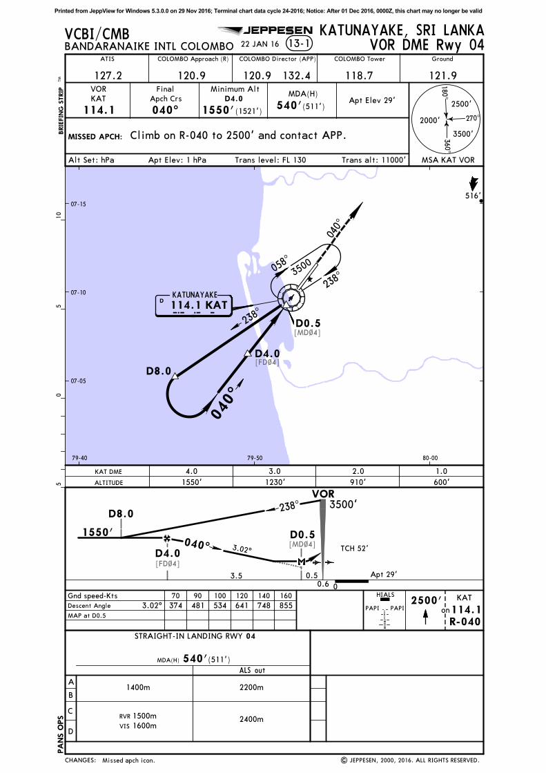
[FD~4]
[MD~4]
[FD~4]
[MD~4]
MISSED APCH:
BRIE
FIN
G S
TRIP
TM
13-1 VOR DME Rwy 04
MSA KAT VOR
270^
180^360^
2000'
2500'
3500'
VOR
KAT
114.1
Final
Apch Crs
040^
Minimum Alt
D4.0
1550'(1521')
MDA(H)
540'(511')
Climb on R-040 to 2500' and contact APP.
Alt Set: hPa Apt Elev: 1 hPa Trans level: FL 130 Trans alt: 11000'
Gnd speed-Kts
MAP at D0.5
70 90 100 120 140 160
on2500'
PAPI PAPI
HIALS
05
510
VCBI/CMB KATUNAYAKE, SRI LANKA
07-10
79-40 79-50 80-00
07-15
07-05
3.02^ 374 481 534 641 748 855
R-040
KAT
114.1
COLOMBO Approach (R) COLOMBO Tower
118.7
Ground
121.9120.9 132.4
COLOMBO Director (APP)
120.9127.2
ATIS
BANDARANAIKE INTL COLOMBO
| JEPPESEN, 2000, 2016. ALL RIGHTS RESERVED.
JEPPESEN
Descent Angle
TCH 52'3.02^
516'
Apt Elev 29'
Apt 29'
22 JAN 16
Missed apch icon.
D4.0
D0.5
D8.0
040^
040^
058^
238^
238^
3500
D K A TKATUNAYAKE
114.1 KAT
PA
NS O
PS
CHANGES:
A
B
C
D
STRAIGHT-IN LANDING RWY
ALS out
04
2400m
MDA(H) 540'(511')
RVR 1500m
VIS 1600m
2200m1400m
ALTITUDE
KAT DME 4.0 3.0 2.0 1.0
1550' 1230' 910' 600'
3500'
0
VOR238^
D0.5
3.5 0.50.6
D4.0
D8.0
1550'040^
Printed from JeppView for Windows 5.3.0.0 on 29 Nov 2016; Terminal chart data cycle 24-2016; Notice: After 01 Dec 2016, 0000Z, this chart may no longer be valid
[MD22]
[FD22]
[FD22]
[MD22]
BRIE
FIN
G S
TRIP
TM
13-2 VOR DME Rwy 22
MSA KAT VOR
VOR
KAT
114.1
Final
Apch Crs
220^
Minimum Alt
D8.4
2000'(1971')
MDA(H)
540'(511')
Alt Set: hPa Apt Elev: 1 hPa Trans level: FL 130 Trans alt: 11000'
MISSED APCH: Climb on runway heading to 2500' and contact APP.
05
510
Gnd speed-Kts
MAP at D3.5
70 90 100 120 140 160
on2500'
hdgPAPI PAPI
270^
180^360^
2000'
2500'
3500'
VCBI/CMB
Rwy
KATUNAYAKE, SRI LANKA
07-10
07-20
79-50 80-00
HIALS-II
BANDARANAIKE INTL COLOMBOTM
COLOMBO Approach (R) COLOMBO Tower
118.7
Ground
121.9120.9 132.4
COLOMBO Director (APP)
120.9127.2
ATIS
| JEPPESEN, 2000, 2015. ALL RIGHTS RESERVED.
JEPPESEN
3.01^Descent Angle 373 479 532 639 745 852
TCH 53' 3.01^
539'
516'
Apt Elev 29'
Apt 29'
22 JAN 16
None.
022^
202^
220^
D8.8
D8.4
D3.5
3500
PA
NS O
PS
CHANGES:
ALTITUDE
KAT DME 4.0 5.0 6.0 7.0 8.4
880'590' 1230' 1550' 2000'
022^
220^2000'
3500'
1.1
VOR
D3.5
D8.4
D8.8
4.9
A
B
C
D
STRAIGHT-IN LANDING RWY
ALS out
2222
2400m
MDA(H) 540'(511')
RVR
VIS 800m
720m
RVR 1500m
VIS 1600m
RVR 1500m
VIS 1600m
022^
D K A TKATUNAYAKE114.1 KAT
Printed from JeppView for Windows 5.3.0.0 on 29 Nov 2016; Terminal chart data cycle 24-2016; Notice: After 01 Dec 2016, 0000Z, this chart may no longer be valid