Embed Size (px)
Citation preview
SARPY COUNTY PLANNING & BUILDING DEPARTMENT
RECOMMENDATION REPORT
CHANGE OF ZONE (CZ 20-008), PRELIMINARY PLAT (PP 20-004), FINAL PLAT (FP 20-005)
NIELSEN POINTE
CHANGE OF ZONE FROM AG (AGRICULTURE FARMING DISTRICT) TO RE2 (RESIDENTIAL ESTATES II ACRES - MINIMUM TWO ACRES) PRELIMINARY AND FINAL PLAT OF
SUBDIVISION TO BE KNOWN AS LOT 1 AND OUTLOT A, NIELSEN POINTE APPLICANT: RHONDA S. MILLER AS ATTORNEY IN FACT FOR ORVILLE O. NIELSEN
PLANNING COMMISSION HEARING OF: JUNE 16, 2020 I. GENERAL INFORMATION
A. APPLICANT: Rhonda S. Miller as attorney in fact for Orville O. Nielsen 17616 Adams Cir Omaha, NE 68142
B. PROPERTY OWNER:
Orville O. Nielsen c/o Rhonda S. Miller 17616 Adams Cir Omaha, NE 68135
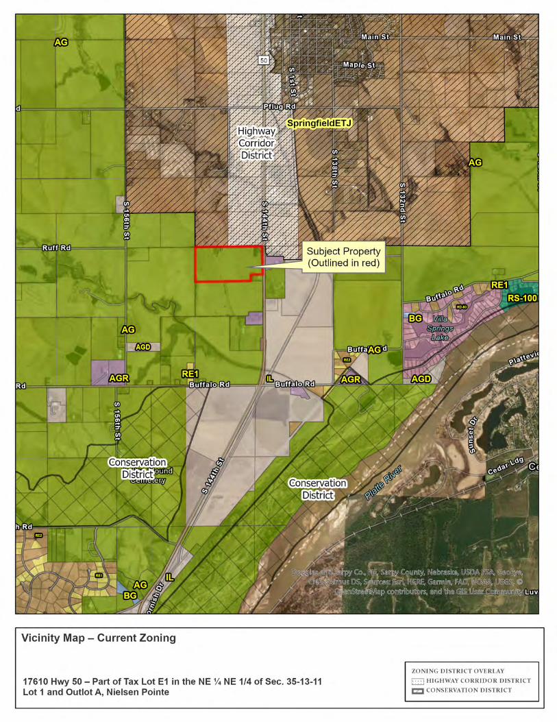
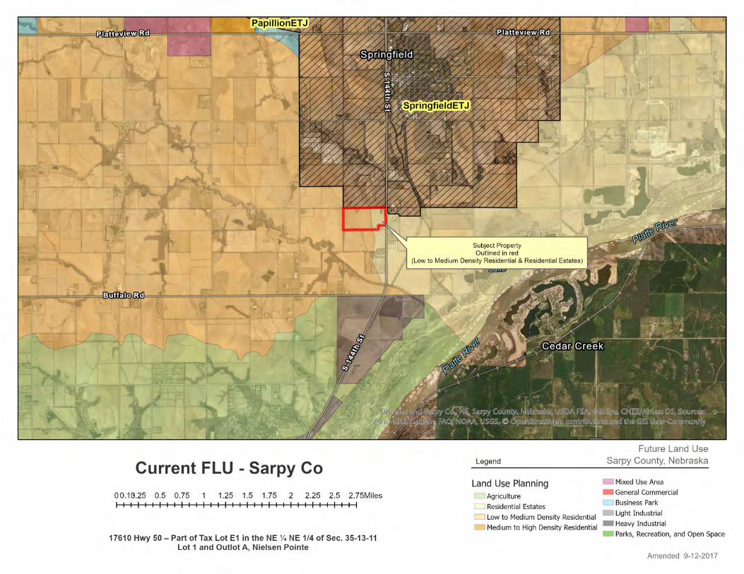
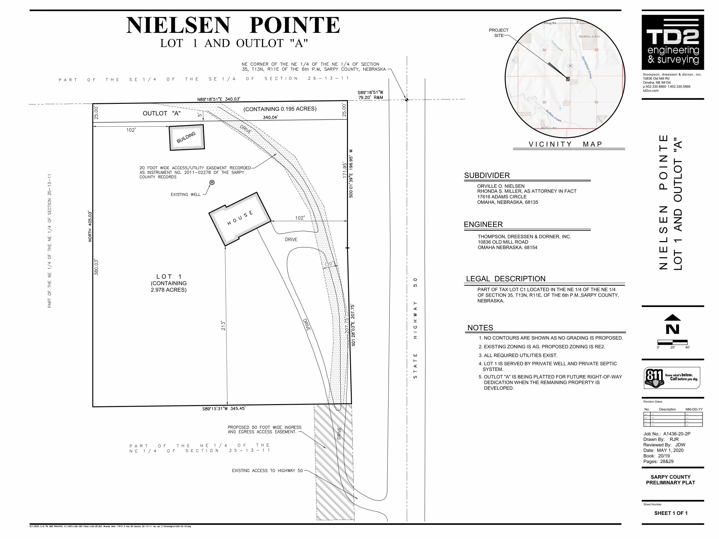
C. SUBJECT PROPERTY LOCATION: Generally addressed as 17610 Hwy 50; Northwest of Hwy 50 and Buffalo Road.
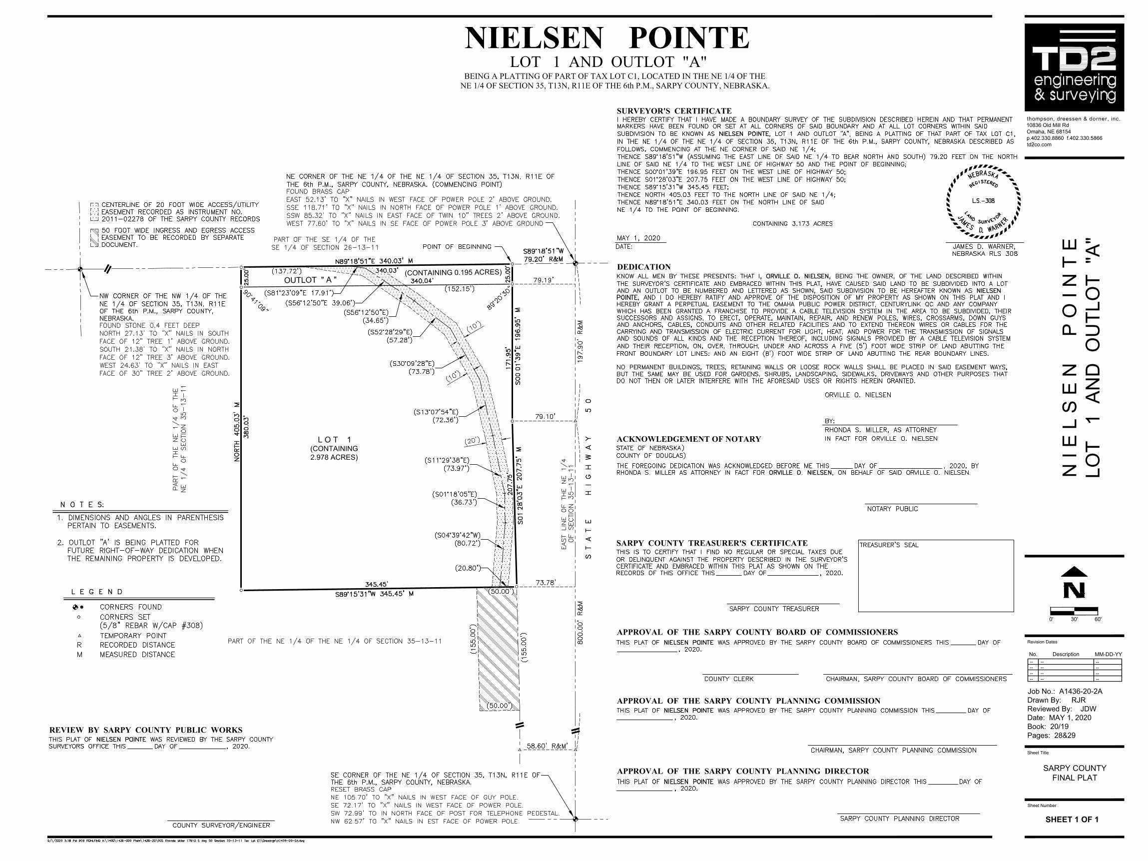
D. LEGAL DESCRIPTIONS: PART OF TAX LOT E1 IN THE NW1/4 NE1/4, LOCATED IN SECTION 35, TOWNSHIP 13 NORTH, RANGE 11 EAST OF THE 6TH P.M., SARPY COUNTY, NEBRASKA.
E. SUBJECT PROPERTY SIZE: Approximately 3 acres. F. EXISTING FUTURE LAND USE AND ZONING DESIGNATIONS: Future Land Use Designation: Residential Estates (RE) Zoning: AG - Agricultural Farming District
G. REQUESTED ACTION(S): To approve a Change of zone from AG (Agricultural Farming) to RE2 (Residential
Estates II – minimum two acres) Preliminary and Final Plat of a residential subdivision known as Lot 1 and Outlot A,
Nielsen Pointe.
II. BACKGROUND INFORMATION
A. EXISTING CONDITION OF SITE: Existing farmstead with residence and accessory building.
B. GENERAL VICINITY – FUTURE LAND USE (FLU) AND CURRENT ZONING (CZ)
DIRECTION FROM
SUBJECT PROPERTY
FUTURE LAND USE
DESIGNATION (reference
attached map)
CURRENT ZONING
DESIGNATION (reference
attached map)
SURROUNDING DEVELOPMENT
NORTH Springfield Jurisdiction
Springfield Farmstead w/ Agricultural land
SOUTH
LMDR - Low to Medium Density Residential and RE - Residential
Estates
AG Undeveloped Agricultural land
EAST LMDR - Low to Medium Density
Residential AG Undeveloped Agricultural land
WEST Springfield Jurisdiction
Springfield Farmsteads w/ Agricultural land
AG = Agricultural (20 plus acres) AGR = Agricultural Residential (5 plus acres)
C. RELEVANT CASE INFORMATION
Development will be served with utilities as follows: Private Well, Private Septic, and electrical power by OPPD.
The existing accessory structure located on the north side of the proposed property will become a legal non-conforming structure with the approval of the Final Plat. The structure will be allowed to remain, but will not be able to be enlarged and, if damaged more than 50% of the market value, will have to be brought into compliance with current regulations.
III. APPLICABLE REGULATIONS
A. SARPY COUNTY COMPREHENSIVE PLAN
CHAPTER 3: Land Use & Growth Management Future Land Use – Map 12 Future Land Use Map classifies this site as Residential Estates. The Residential Estate land use area is intended to accommodate large lot residential development. It is intended to accommodate continued low-density development in rural areas. Generally, these areas are not currently served by municipal utilities, and are not planned to be served in the future. As current conditions provide, these areas are best served with individual wells and septic systems. Residential Estate areas are generally located along the periphery of communities and the county where land use is less dense, sharing similar qualities with neighboring Agricultural land use areas. Characteristics of the RE category include:
Appendix A – Zoning Relationship to the Future Land Use Plan lists the proposed zoning for this site, RE2, as a compatible zoning district under the Residential Estates Use designation.
- Future Land Use – Growth Management Zones– Map 13 designates this site as being within the Residential Estates Growth Management Zone. The Residential Estate land use area is intended to accommodate large lot residential development. It is intended to accommodate continued low-density development in rural areas. Generally, these areas are not currently served by municipal utilities, and are not planned to be served in the future. As current conditions provide, these areas are best served with individual wells and septic systems. Residential Estate areas are generally located along the periphery of communities and the county where land use is less dense, sharing similar qualities with neighboring Agricultural land use areas.
- Development Density – Figure 19 Residential Development Decision Matrix allows densities of 3-5 acres per unit when Community Utility Systems (either water or sewer) are provided. Due to the close proximity to the Urban Reserve Growth Management Zone, the Unified Wastewater Agency has requested that Sarpy County limit the size of the parcels to less than 3 acres or more than 20 acres to allow for larger areas for urban density development in the future.
- Conservation Provisions – Map 14 Environmentally Sensitive Areas identifies portions of this site as Environmentally Sensitive. Environmentally sensitive areas include: Water bodies and watercourses Wetlands 100-year floodplains Tree canopy, individual specimen trees, or small stands of significant trees Aquifer recharge areas and areas with highly permeable (“excessively drained”)
soils Significant wildlife habitat areas Historic, archaeological or cultural features listed (or eligible to be listed) on the
National Register of Historic Places, or on inventories developed by the Nebraska State Historical Society
Slopes of a gradient higher than 15% Land with soils that do not support residential development Native or original growth prairie
- Map 14 identifies this site as having a small portion of environmentally sensitive area. The high point on the property is the top of the drainage area so the small portion of environmentally sensitive area is where the drainage way begins on the northwest half of Outlot A.
CHAPTER 4 – Infrastructure
- Wellhead Protection Area – Map 16 Sarpy County Wellhead Protection Areas While these areas do not severely impact the types of land use that can be allowed in them, care should be taken to ensure the protection of the wells from possible contamination due to development.
CHAPTER 5 – Transportation - Federal Roadway Functional Classification – Map 17 Sarpy County Federal
Roadway Functional Classification identifies this stretch of 144th St (HWY 50) as a Minor Arterial roadway.
- Anticipated Full Buildout Street Network – Map 21 Sarpy County Anticipated Full Buildout Street Network shows Hwy 50 as 4-lane divided roadways with 100’ right-of-way in this area.
- Implement a Through-Route Policy to set standards to allow direct and continuous neighborhood access to adjacent arterial streets. Each mile section should have three through local or collector routes in the north/south and east/west direction generally at the ½ and ¼ mile points. Local roadways should also be designed to provide connection and access to adjacent developments through subdivision regulations. The proposed development includes an outlot on the north side of the property,
on the section line, for future right of way access to future development of the property to the west. This property will use the existing access from Hwy 50 and an easement will be recorded prior to or with this plat.
B. SARPY COUNTY ZONING REGULATIONS
SECTION 12, RE2 (Residential Estates II District – 2 acre minimum lot size) - 12.1.8 – Single family dwellings, as proposed by this application, are a Principal
Permitted Use - 12.4.1 – Single family dwelling development must meet the following minimum
requirements: • Lot Area – 2 acres • Lot Width – 100 foot (measured at the front yard setback line) • Front Yard Setback – 35 feet • Side Yard Setback – 10 feet • Side Yard Street Setback – 25 feet • Rear Yard Setback – 25 feet • Maximum Height – 35 feet
- The existing accessory structure located on the north side of the proposed property will become a legal non-conforming structure with the approval of the Final Plat. The structure will be allowed to remain, but will not be able to be enlarged and, if damaged more than 50% of the market value, will have to be brought into compliance with current regulations.
C. SARPY COUNTY SUBDIVISION REGULATIONS
- The proposed subdivision complies with the Sarpy County Subdivision Regulations. IV. ANALYSIS
A. COMPREHENSIVE PLAN POLICY STATEMENTS: This development application, and the requirements placed on it, support the following policies of the Sarpy County Comprehensive Plan (see Comprehensive Plan Chapter 9 Goals & Implementation):
Land Use and Growth Management - 1.a An Urban Development Zone will be established to facilitate urban-scale growth
in areas that can be served immediately by public utility extensions prior to, or in conjunction with, new development.
The Urban Development Zone is to be created to facilitate the urban growth demands of Sarpy County These zones are established in accordance with the South Sarpy County Sanitary Sewer Study and represent areas currently served by urban services.
By guiding urban scale growth to these areas, the County is promoting compact, contiguous growth and the most efficient provision of infrastructure and utilities.
- 2.c Sarpy County should not approve a development or subdivision that is: • inconsistent with the County's adopted Comprehensive Plan, detailed area plans,
infrastructure and utility plans, or long-range transportation corridor plans or studies; • inconsistent with the County's right-of-way standards, or standards established in
long-range transportation corridor plans or studies; • lacking necessary local paved road plans, approved by the County, to
serve the subdivision or development within a timeframe consistent with development, or does not conform to roadway policies;
• lacking adequate sanitary sewer and potable water capabilities; • lacking adequate storm water drainage, storm water treatment
facilities, or storm water management either within the development site or downstream;
• inconsistent with any other standards addressed in adopted zoning regulations, subdivision regulations, or design standards;
• inconsistent with other adopted decision criteria; • inconsistent with the Comprehensive Plan unless the proposed
development or subdivision furthers another more important Comprehensive Plan objective. In which case, the County should, for good planning purposes, allow development that is different than the Comprehensive Plan might call for in certain areas.
• inconsistent with the Comprehensive Plan unless there have been substantial legal, physical, or infrastructure changes that formed the basis for the Comprehensive Plan, in which case the Comprehensive Plan should be amended so as to allow for an support the change.
The County shall maintain clear standards for approval of development and subdivision plans in order to implement the vision of its Comprehensive Plan.
3.b Developments should be built and designed in a manner that contributes to and enhances the quality of life in Sarpy County.
5.a Ensure that Sarpy County, along with local jurisdictions within, provide diverse options in relation to lot size, density, and type for all land uses.
Sarpy County and the municipalities located within the county represent a primary area of residential growth for the Omaha-Council Bluffs MSA. However, a public priority lies in preserving the unique environmental resources found in the area, including agriculture production. Offering a range of development options in a managed fashion will result in a more diverse, well-balanced, and prosperous region.
Transportation 2.f Sarpy County should not approve a development or subdivision that is:
• inconsistent with the County’s right-of-way standards, or standards established in long-range transportation corridor plans or studies.
An additional 50 feet of right-of-way is being dedicated for Buffalo Road with this plat.
B. OTHER AGENCY REVIEW/COMMENTS: The applications were sent to various jurisdictional agencies and departments within Sarpy County that may have an interest. Comments received are attached for your review. Should additional comments be received, they will be provided to you at the public hearing.

V. STAFF COMMENTS AND RECOMMENDATION
Staff recommends APPROVAL of the Change of Zone from AG (Agricultural Farming District) to RE2 (Residential Estates II) for Lot 1 and Outlot A Nielsen Pointe, to be effective with the recording of the Final Plat, as it meets the intent of the Sarpy County Comprehensive Plan and Zoning Regulations.
Staff recommends APPROVAL of the Preliminary Plat of a subdivision to be known as Lot 1 and Outlot A Nielsen Pointe, as it meets the intent of the Sarpy County Comprehensive Plan and Subdivision Regulations.
Staff recommends APPROVAL of the Final Plat of a subdivision to be known as Lot 1 and Outlot A Nielsen Pointe, as it meets the intent of the Sarpy County Comprehensive Plan and Subdivision Regulations.
VI. PLANNING COMMISSION RECOMMENDATION
MOTION: CHANGE OF ZONE MOTION: PRELIMINARY PLAT MOTION: FINAL PLAT
VII. ATTACHMENTS TO REPORT
1. Preliminary Plat Exhibit 2. Final Plat Exhibit 3. Comments received
- Sarpy County Public Works 4. Current Zoning Map (showing subject property area) 5. Future Land Use Map of the Sarpy County Comprehensive Plan (showing subject property
area)
VIII. COPIES OF REPORT SENT TO
1. Rhonda S. Miller (as attorney in fact for Orville O. Nielsen) 2. Jim Warner, TD2 (applicant’s agent) 3. Public Upon Request
Revision Dates
SHEET 1 OF 1
No. Description MM-DD-YY
Job No.: A1436-20-2P
Drawn By: RJR
Reviewed By: JDW
Date: MAY 1, 2020
Book: 20/19
Pages: 28&29
Sheet Number
-- -- --
-- -- --
-- --
-- -- --
--
thompson, dreessen & dorner , inc.
10836 Old Mill Rd
Omaha, NE 68154
p.402.330.8860 f.402.330.5866
td2co.com
Know what'sbelow.
Callbeforeyou dig.
0' 20' 40'
N I E
L
S
E
N
P
O
I N
T
E
LO
T 1
A
ND
O
UT
LO
T "A
"
SARPY COUNTY
PRELIMINARY PLAT
V I C I N I T Y M A P
PROJECT
SITE
LOT 1 AND OUTLOT "A"NIELSEN POINTE
3. ALL REQUIRED UTILITIES EXIST.
2. EXISTING ZONING IS AG. PROPOSED ZONING IS RE2.
1. NO CONTOURS ARE SHOWN AS NO GRADING IS PROPOSED.
OMAHA NEBRASKA. 68154
10836 OLD MILL ROAD
THOMPSON, DREESSEN & DORNER, INC.
OMAHA, NEBRASKA. 68135
17616 ADAMS CIRCLE
ORVILLE O. NIELSEN
LEGAL DESCRIPTION
NOTES
ENGINEER
SUBDIVIDER
PART OF TAX LOT C1 LOCATED IN THE NE 1/4 OF THE NE 1/4
OF SECTION 35, T13N, R11E, OF THE 6th P.M.,SARPY COUNTY,
NEBRASKA.
4. LOT 1 IS SERVED BY PRIVATE WELL AND PRIVATE SEPTIC
SYSTEM.
RHONDA S. MILLER, AS ATTORNEY IN FACT
L O T 1
(CONTAINING
2.978 ACRES)
OUTLOT "A"
5. OUTLOT "A" IS BEING PLATTED FOR FUTURE RIGHT-OF-WAY
DEDICATION WHEN THE REMAINING PROPERTY IS
DEVELOPED.
(CONTAINING 0.195 ACRES)
Sheet Title
Sheet Number
thompson, dreessen & dorner , inc.
10836 Old Mill Rd
Omaha, NE 68154
p.402.330.8860 f.402.330.5866
td2co.com
N I E
L S
E
N
P
O
I N
T
E
LO
T 1 A
ND
O
UT
LO
T "A
"
SARPY COUNTY
FINAL PLAT
SHEET 1 OF 1
Revision Dates
No. Description MM-DD-YY
Job No.: A1436-20-2A
Drawn By: RJR
Reviewed By: JDW
Date: MAY 1, 2020
Book: 20/19
Pages: 28&29
-- -- --
-- -- --
-- --
-- -- --
--
0' 30' 60'
DEDICATION
SURVEYOR'S CERTIFICATE
BEING A PLATTING OF PART OF TAX LOT C1, LOCATED IN THE NE 1/4 OF THENE 1/4 OF SECTION 35, T13N, R11E OF THE 6th P.M., SARPY COUNTY, NEBRASKA.
LOT 1 AND OUTLOT "A"NIELSEN POINTE
ACKNOWLEDGEMENT OF NOTARY
SARPY COUNTY TREASURER'S CERTIFICATE
APPROVAL OF THE SARPY COUNTY BOARD OF COMMISSIONERS
APPROVAL OF THE SARPY COUNTY PLANNING COMMISSION
APPROVAL OF THE SARPY COUNTY PLANNING DIRECTOR
REVIEW BY SARPY COUNTY PUBLIC WORKS
L O T 1
(CONTAINING
2.978 ACRES)
OUTLOT " A "
(CONTAINING 0.195 ACRES)
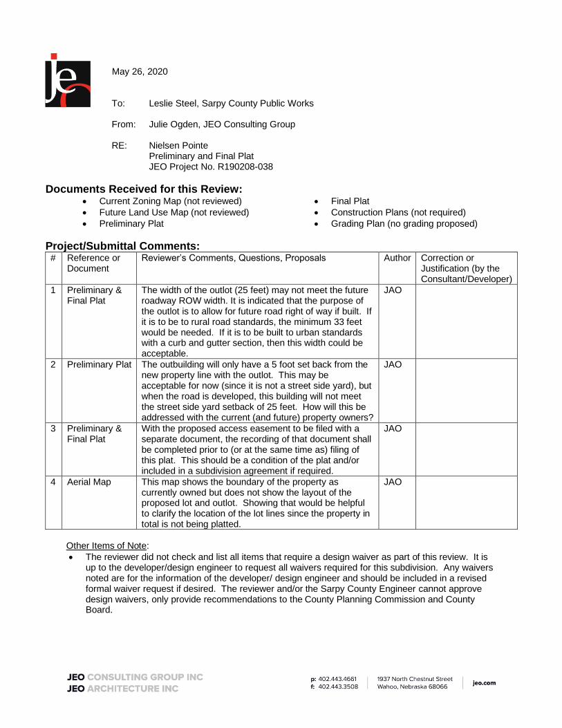
May 26, 2020 To: Leslie Steel, Sarpy County Public Works From: Julie Ogden, JEO Consulting Group RE: Nielsen Pointe Preliminary and Final Plat JEO Project No. R190208-038
Documents Received for this Review: • Current Zoning Map (not reviewed) • Future Land Use Map (not reviewed) • Preliminary Plat
• Final Plat • Construction Plans (not required) • Grading Plan (no grading proposed)
Project/Submittal Comments: # Reference or
Document Reviewer’s Comments, Questions, Proposals Author Correction or
Justification (by the Consultant/Developer)
1 Preliminary & Final Plat
The width of the outlot (25 feet) may not meet the future roadway ROW width. It is indicated that the purpose of the outlot is to allow for future road right of way if built. If it is to be to rural road standards, the minimum 33 feet would be needed. If it is to be built to urban standards with a curb and gutter section, then this width could be acceptable.
JAO
2 Preliminary Plat The outbuilding will only have a 5 foot set back from the new property line with the outlot. This may be acceptable for now (since it is not a street side yard), but when the road is developed, this building will not meet the street side yard setback of 25 feet. How will this be addressed with the current (and future) property owners?
JAO
3 Preliminary & Final Plat
With the proposed access easement to be filed with a separate document, the recording of that document shall be completed prior to (or at the same time as) filing of this plat. This should be a condition of the plat and/or included in a subdivision agreement if required.
JAO
4 Aerial Map This map shows the boundary of the property as currently owned but does not show the layout of the proposed lot and outlot. Showing that would be helpful to clarify the location of the lot lines since the property in total is not being platted.
JAO
Other Items of Note: • The reviewer did not check and list all items that require a design waiver as part of this review. It is
up to the developer/design engineer to request all waivers required for this subdivision. Any waivers noted are for the information of the developer/ design engineer and should be included in a revised formal waiver request if desired. The reviewer and/or the Sarpy County Engineer cannot approve design waivers, only provide recommendations to the County Planning Commission and County Board.