Embed Size (px)
Citation preview
42E13NW8352 63.3860 CASTLEWOOD LAKE 010
GEOLOGICAL REPORT
ON
ONAMAN GROUP OF CLAIMS
ONAMAN LAKE, JELLICOE AREA
THUNDER BAY MINING DIVISION
December, 1972 H. Petak
INTRODUCTION
A geological survey was conducted on September 7, 1972 by the
writer on four (4) contiguous claims called the Onaman Group, held by
Am ax Exploration, Inc. The purpose of the survey was a detailed
geological napping of the property to assist in checking out an AEM
conductor and ground EM conductors. The ground EM conductors were
located by a Radetn VI. P survey executed by Araax prior to the geologicalf - i
survey.
LOCATION AND ACCESS
The property is located on the south end of Onaman Lake, about
17 miles north of Jellicoe, NW Ontario. (see accompanying map) Access
is provided by aircraft only. Ontario Northern Airways Ltd. with two
seaplane bases located several miles west of Jellicoe, offer charter
services with Cessna 180 and Reaver aircraft. Minimum charter rate for
Beaver is 520/25 rolled.
PROPERTY
The Onaman Group of claims consists of four (4) unsurveyed contiguous
claims numbered 3350^9, 335060, 335061 and 335062. Comprising an area of
approximately 160 acres or 0.2S aq, miles, this claim group was staked
and recorded in April 1972, and is since owned by Amax Exploration, Inc.,
Suite 1302, 7 King St. East, Toronto l, Ontario. The property is covered by
claim map M-1850.
PREVIOUS WORK
Other than a very old claim post, there is no indication of any
ground work prior to the ground acquisition by Amax Exploration, and there
is no assessment work on file at the Mining Recorder's office.
2.
After staking In April 1^72, Amax Exploration completed 19,400 ft.
(3.5 Hnc miles') o*" 1inecuttlng (Hnc spacing is 400') and the same
amount of ground marnetics and Radem Survey. Geophysics was followed
up by a geochemical soil sampling program of which results are not yet
on hand. Geophysical readings or soil samples respectively w*re generally
taken on 100' station*) and In some cases, on 50" stations.
GENSRAL GaOLOGY
The property IB located In a belt of chiefly volcanic rocks com
prising lavas of basic to acid composition, related Intrusive*, and
tuffs. Sediments representing a minor p.roup In the regional 11thol oglcal
picture however, may dominate In some parts over rock* of volcanic origin
(e.g. Cow Greek area). These sediments are conglomerates, quartzite,
greywacke and slate. They are velieved to be generally younger than the
suite of volcanics (W.W. Moorhouse, OOM Report Vol. XLVII, Part VIII, 1938,
page 4). A series of granitic Intrusions within the volcanic - sedimentary
belt are younger than the volcanic rocks. Their age relation to the sedi
ments however, Is uncertain. A few diabase dikes cut all the previously
described units .md thus represent the youngest known of the Precambrian
basement rocks In the region.
Varying In thickness, unconsolidated glacis), lake, stream, and i
swamp sediment H cover lar^a areas of Precambrian rocks and create un
fortunately all too often, extremely poor outcrop conditions.
Grade of metamorphism changes strongly from one place to another,
affecting mainly the volcanic - sedimentary sequences. Strong silicific
ation can be noticed almost everywhere.
W.W. Moorhouse, (page 15, 1038), mainly for reasons of structural
analogies existing amongst other Keewatin and Timiskaming regions In the
Canadian shield, believed the gross structure in the South Onaman area
3.
to be a "faulted, synclinal zone". Vany outcrops exhibit drag folding
caused by faulting, which In some Instances, (e.g. dost to the boundary
of the belt), become* very Intensive. The regional strike of the belt
is NW- SE with mostly vertical to steep northerly dips.
DETAILED GF. O LO??
Most of the property Is covered by t'ocensol idated glacial, Jake
nnd 3vamp sediments, Precambrian basement rocks are exposed only in
two outcrops. One occurs on the west shore of Onaman Lake in the NE
corner of claim No. 335062. The other ono is traversed by BL-0 from
l -'60!*. to 3-'-60!S, In the .SV corner of claim No. 335059, The following
rock types were
LO'VED (?) ANDES TT;; (ip)
Brownish-grey on the weathered surface and dark greenish-grey on
the fresh surface, this very fine-grained rock is composed of the
minerals chlorite, biotite, hornblende (?) and very Jittl* plagioclase.
Some traces of very fine disseminated gulf idea (py?) can be noted here
and there. Generally, the rock looks very massive. In some places,
the weathered surface shows structures which possibly are distorted
pillows. They however, did not allow top determinations.
This rock type forms t*ic centre, outcrop on the lakeshore. Its
colours are dar!f hrowninh-grey on the weathered surface and dark green
on the fresh. The rock Is f Ine-prained nnd consists of chlorite, horn
blende and sore pi sftloclflsf!. The tuffaceous texture is visible only on
the weathered surface,
GRBYWACKE (2)
Light grey on both weathered and fresh turface, this rock is
fin* to medium grained and consists of plagioclase, quarts, biotite, some
hornblende (?) , chlorite (?) and sericite. On the weathered surface
plagioclase and quart* occur as unsorted angular to sub-rounded frag
ments with grain sice of coarse sand, and occasionally slightly coarser.
TONALITE (3)" . *- -i
Light grey to pinkish on the fresh surface, this medium to coarse
grained, massive rock weathers with light grey colour. Its mineralogical
composition consists of feldspar (both plagioclase and K-feldspar),
quarts, biotite, and aotne hornblende.
STRUCTURAL GEOLOGY
The volcanic-sedimentary series outcropping in the SW corner of
claim No. 335059, strikes and dips with 160/70W. A local fault with
the same strike direction bisects this series into an eastern portion
with predominantly volcanic rocks and a western part with a higher ratio
of sediments to volcanics. Small conformable intrusions of tonalite
occur in both parts.
The well developed schistosity in the basic tuffs outcropping on
the lakeshore strikes 700 and dips 65O to the NNE. The structural re
lationship of these tuffs to the rocks previously mentioned is unknown.
The very close vicinity of the claim group to a regional granitic con
tact, illustrated in Pig. l, however, is suggestive of rather complex
structures.
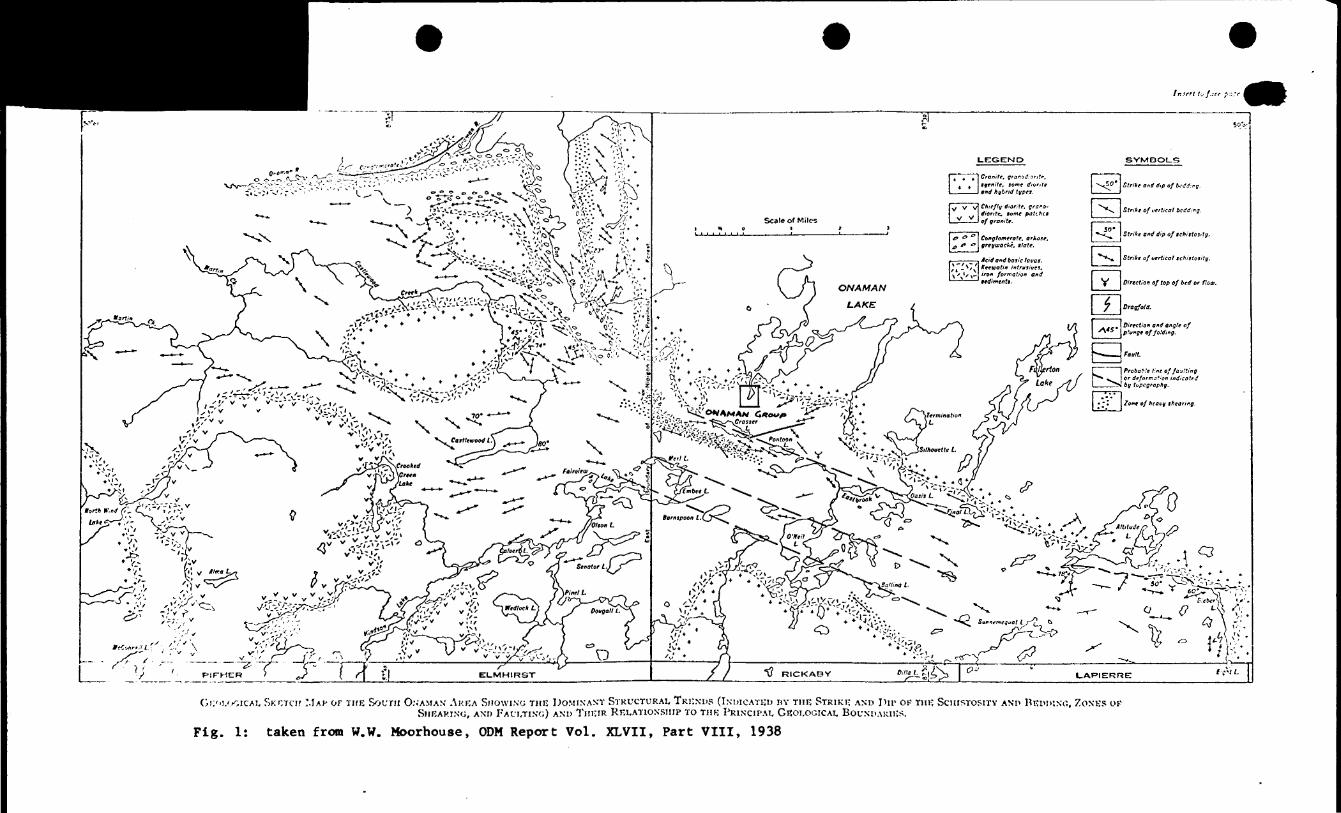
Gi;''i.'.)OiCAi. SKETCH MAf OF THE SOUTH O:;AMAS; AREA SHOWING THE DOMINANT STRUCTURAL TRENDS (INDICATED HY THE STRIKE AND IMP OK THE SCHISTOSITY AND REDDING, ZONES OFSHEARING, AND FAULTING) AND THEIR RELATIONSHIP TO THE PRINCIPAL GEOLOGICAL BOUNDARIES.
Fig. 1: taken from W.W. Moorhouse, ODM Report Vol. XLVII, Part VIII, 1938
CONCLUSIONS
(1) Unconsolidated glacial, lake and swamp sediments cover
nearly 1007, of the property, masking most of the t-recambrian bedrock
geology.
(2) For that sane reaaon, neither the ARM conductor* nor the
Radem conductors could be explained as a result of this geological
survey.
RECOMMENDATIONS
No definite recommendations regarding further work can be made
at this stage. They depend on results of a complete data compilation
which l* not yet possible since peochenical results have not been
received.
Horst Petak.
STATEMENT OF QUALIFICATIONS
I hereby state that I have graduated from Karl-Franzen"s
University, Graz, Austria, with the degree of Ph.D. in Geology,
and that I have been practising my profession for four (4) years
in Canada.
Horst W. Petak

111 Illllll II Hill.,. ——. -.__42E13NW8352 63.3860 CASTLEWOOD LAKE 030
GEOLOGICAL REPORT
ON
ALTITUDE GROUP OP CLAIMS
ALTITUDE LAKE, JELLICOE AREA
THUNDER BAY MINING DIVISION
December, 1972 H. Petak
INTRODUCTION
A geological survey was conducted on September 9th and 10th, 1972,
by the writer on six (6) contiguous claims called the Altitude Group,
held by Amax Exploration, Inc. The purpose of the survey was a detailed
geological mapping of the property to assist in checking out two AEM
conductors and ground EM conductors. The ground KM conductors were
located by a Radeto VLF survey executed by Amax prior to the geologicalt. -
survey. '
LOCATION AND ACCESS
The property is located about one mile west of Altitude Lake,
and approximately IP miles to the NNE of Jellicoe, Northwestern Ontario.
Access Is provided by aircraft only. Ontario Northern Airways Ltd.,
with two seaplane bases located several miles west of Jellicoe, offer
charter services with Cessna l BO and Beaver aircraft. Minimum charter
rat* for Beaver Is 520/25 miles.
PROPERTY
The Altitude Group of claims consists of six (6) unsurveyed con
tiguous claims, numbered 335081, 335082, 335083, 335084, 335085, and
335086. Approximately 1/3 of the property, (i.e. parts of the claims
335084, 335085 and 335086), is under water, while the othtr 2/3 are on
land. Comprising an area of approximately 240 acres or 0.375 sq. miles,
this claim group was staked and recorded In April 1972 and Is since
owned by Amax Exploration, Inc., Suite 1302, 7 King St. East, Toronto 1,
Ontario. The property is covered by the claim map M-1850.
An old campsite located on 1,122, 17-120N, on an old 400' spaced
grid with the base line running E-W, and two diamond drill set-ups
were found by the writer and are indicative of rather intensive
previous exploration activity at least in the eastern half of the
property. From drill core (site A Q'.l le/t on one of the sites (150*
south of L28E, 23), this hole is estimated to be at least 3SO 1 Ion.;.t-"~-
Drilled to the north, this helicopter-supported hole has the number
B-5 and intersected basic to intermediate lavas and tuffs. Sulfide
mineralisation, consisting of very little and finely disseminated py,
is insignificant and insufficient to explain the conductors. However,
the possibility exists that eventual better intersections have been
removed. The only information obtained concerning the other hole is
its location, which Is about 200* W of Mo. l claim post of claim
335084, in the NE corner of the property.
Despite all work performed on that ground, there Is no assessment
work on file at the Mining Recorder's office.
After staking in April 1972, Aniax Exploration completed 22,300 ft.
(4.2 line miles) of linecutting, (line spacing is 400') and the same
amount of ground magnetics and Radem survey. Geophysics was followed
up by a geochemical soil sampling program. However, at the time of
writing, results of the survey are not available. Geophysical readings
a* well as soil samples were generally taken on 100' stations and in some
Instances, on ^0' stations.
GENERAL GEOLOGY
The property la located In a belt of chiefly volcanic rocks
coapriaing lavaa of basic to acid composition, related Intrusives,
and tuffa. Sediments representing a minor group in the regional
llthological picture however, may dominate in some parts over rocks
of volcanic origin (e.g. Cow Creek area). Theae sediments are con
glomerates, quartzite, greywacke and slate. They are believed to be* tgenerally younger than the suite of volcanics (W.W. Moorhouse, ODM
Report Vol. XLVII, Part VIII, 1938, page 4). A series of granitic
intrusions within the volcanic - sedimentary belt are younger than the
volcanic rocks. Their age relation to the sediments however is uncertain.
A few diabase dikes cut all the previously described units and thus re-
present the youngest known of the Precambrian basement rock* in the
region.
Varying in thickness, unconsolidated glacial, lake, stream, and
swamp sediments cover large areas of Precambrian rocks and create un
fortunately all too often, extremely poor outcrop conditions.
Grade of metamorphism change! strongly froot one place to another,
affecting mainly the volcanic - sedimentary sequences. Strong silicific
ation can be noticed almost everywhere.
W.W. Moorhouse (page 15, 1938), mainly for reaaona of structural
analogiea existing amongst other Keewatin and Timiskaming reglona in
the Canadian Shield, believed the gross structure In the South Onaman
area to be a "faulted, synclinal tone". Many outcrops exhibit drag
folding caused by faulting, which In some instances, (e.g. close to the
boundary of the belt), becomes very intensive. The regional strike of the
belt is NW-SE with mostly vertical to ateep northerly dips.
DETAILED GEOLOCT
Precambrian rocks are only exposed in the southeastern part
of the property with the exception of one outcrop found In the
northwestern portion of the property. The estimated outcrop ratio
for the whole claim group is around 101. For the southeast part
alone, it is considerably higher.
Unconsolidated glacial, lake, stream and swamp sediments cover**~i
9OX of the property, masking the underlying Precambrian rocks.
Although varying in thickness, the overburden coverage is generally
expected to be shallow.
The following classification and description of the Precambrian
rocks is baaed on macroscopic observations only.
v
BASIC VOLCANIC ROCKS (1)
MASSIVE ANDESITE (l np
The bulk of this rock type was found on L20E, between 19N and 22N.
Slightly west of L16E, between the stations 25N and 27N, the same rock
type was found interbedded with basic tuffs (It ). A small outcrop
composed entirely of massive andesite (1m) is located on BL 0400, east
of L12E. As surrounding outcrops to the ME suggest, it represents a
basic flow (1m) intercalated in basic tuffs (It). Weathering dark green
ish grey, and dark green on the fresh surface, this rock is very fine
grained and consists mainly of hornblende and chlorite and occasionally
minor amounts of plagioclase.
BASIC TUFF (It)
Besides the two locations as mentioned above, where basic tuff
(It) was found to be associated with massive andesite (Im), an isolated
outcrop of basic tuff (It) occurs slightly west of the north end of
LAW. The tuff weathers dark greenish-grey, whereas on fresh surface,
4.
it is dark green. The tuffaceous texture Is best visible on the
weathered surface exhibiting a well developed lamination or banding.
The tuffaceous fragments are less than l mm In slse. Their shape
Is angular. The mineral composition of the tuff consists mainly of
fine grained chlorite, some hornblende, and little plagioclase.
INTERMEDIATE VOLCANIC ROCKS (2)
Intermediate phases seen to make up the majority of the volcanic
rocks, at least in the area SE of the lake.
INTERMEDIATE MASSIVE FLOWS (2m)
Closely associated with tuffs of the same composition (2t) , an
intermediate flow is exposed in a large outcrop located at the north
end of L24E. This exposure, forming a high ridge, extends to the east
beyond the property boundary. Three smaller elongated outcrops,
roughly located on a line from L20E, 12N, to L24E, 17N, most likelyN
represent one flow. There is a chance that this flow la the offset
western extension of the one mentioned above. However, no tuffs were
found in direct contact with them, which of course could be due to lack
of outcrop.
This rock type weathers light grey to brownish-grey, with light
"* green td medium greenish-grey colour on the fresh aurface. Very fine
plagioclase and quarts, with approximately equal proportion of mafic
to felsic components. Traces of finely disseminated pyrite are not
uncommon.
INTERMEDIATE TUFF (2Q
The bulk of intermediate tuff outcrops in the extreme aouthwest
corner of the claim group (i.e. southern half of claim 335083).
Light grey to brownish-grey on the weathered aurface, and light
green to medium greenish-grey on the fresh, these tuffs are usually
very fine grained and thinly bedded. They are composed of chlorite,
plagioclase and quartz in about equal proportions, plus some horn
blende. Traces of finely disseminated pyrite can be observed in
many hand specimens.
INTERMEDIATE FRAGMENTAL TUFF (2f)
Outcrops exposing this rock type were found 'around the north end
of L12E and the SE corner of the claim group. The rocks in the latter
area suggest a slight facies change from the fine clastic variety (2t)
to a coarse fragmental variety (2f) from east to west. "Fragmental"
refers to fragments of over 4 cm in diameter. The matrix looks the
same as the tuff described aa (2t). The fragments either subrounded
or lens-shaped average 6" x 4" and weather slightly lighter than the
matrix. On the fresh surface, however, there is no difference.
ACID VOLCANIC ROCKS (3)
The volcanic series underlying the claim group seems to be
characterised by a atrong deficiency in acid phases. Li68 around 17N
traverses the only outcrop encountered in the area exposing this group.
The rock type is classified as:
ACID PRACMKNTAL TUFF (3.f j
The matrix weathers light grey to white. The fresh surface is
buff to greyish. The weathered surface exhibits a laminated to thinly
bedded granular texture, whereas the fresh surface is extremely fine
grained t rather massive, and very siliceous in appearance. This matrix
surrounds generally subrounded to lens-shaped fragments, averaging
4" to 6" in aiie. Fragments and matrix are of the aaaa composition
which makes it impossible to differentiate them from each other on
the fresh surface. A slight difference in weathering and massive texture
even on the weathered surface makes them easy to recognise on the outcrop.
BASIC ROCKS OF UNCERTAIN ORIGIN (4)
A medium to coarse crystalline basic rock composes several out
crops sporadically distributed over the SB portion of the property,
weathering dark brownish to grey, the colours on the fresh surface
are dark to medium greenish-grey. The highly crystalline rock is
medium to coarse grained and very massive in appearance, with
granitoid texture. Its Mineral assemblage comprises hornblende,
plagioclase and possibly pyroxene, with ratios indicative for gab
broic composition. The relationship of thll rock type to the sur
rounding basic and Intermediate volcinica is in all but one outcrop,
doubtful. In this one particular case, (N end of L24E), however, a
gradatlonal contact shows that the questionable rock is a coarse
crystalIced phase of a basic volcanic flow grading into a tuffaceousV
Intermediate phase. For the others, an intrusive relationship is also
possible. The outcrop located on TL13N, 23E, has to be included here.
The exposed contact is a shear contact and does not reflect the true
primary relationship between the two rock types on each side.
STRUCTURAL GEOLOGY
The most significant structural features in this area are strong
faulting, folding, and consequently, shearing.
A strong fault Kona occurs SE of the lake between the lines 16B
and 20B, and is possibly identical to the northwest extension of the
fault south of Altitude Lake, as presumed by W. W. Moorhouse * , (page 15,
1938). Fig. l illustrates the location of the Altitude group of claims
in relation to this fault system,
(1) W.W. Moorhouse, 1938: Geology of the South Onaman Area, ODMReport Vol. XLVII, Part VIII, 1938
Folding which is the strongest on both aides and in the clove
vicinity to aforementioned fault zone, appears to be drag folding
caused by both lateral and vertical movements along the fault zone.
All the fold axes observed plunge SW with a 45 to 500 dip.
Moderate shearing can be observed in many outcrops. A strong shear
cone crossing TL13N between the lines 20E and L24E, strikes 90O .
ECONOMIC GEOLOGY f~"
Besides trace amounts of finely disseminated pyrite, no signific
ant sulfide mineralization was noticed.
CONCLUSIONS
(1) The presence of an environment generally considered favour
able for massive sulfide typo of base metal deposits could be proved
for a large part of the claim group. It consists of a series of vol
canic rocks of intermediate composition,
(2) Although no significant salfides have been found to date,
more prospecting, including some trenching, particularly in contact
ones, could change that situation.
(3) Surface geology failed to explain AEM and Radem conductors.
RECOMMENDATIONS
No definite recommendations regarding further work can be made
at this stage. They depend on results of a complete data compilation
which Is not yet possible since geochemical results are not presently
available.
Horst Petak.
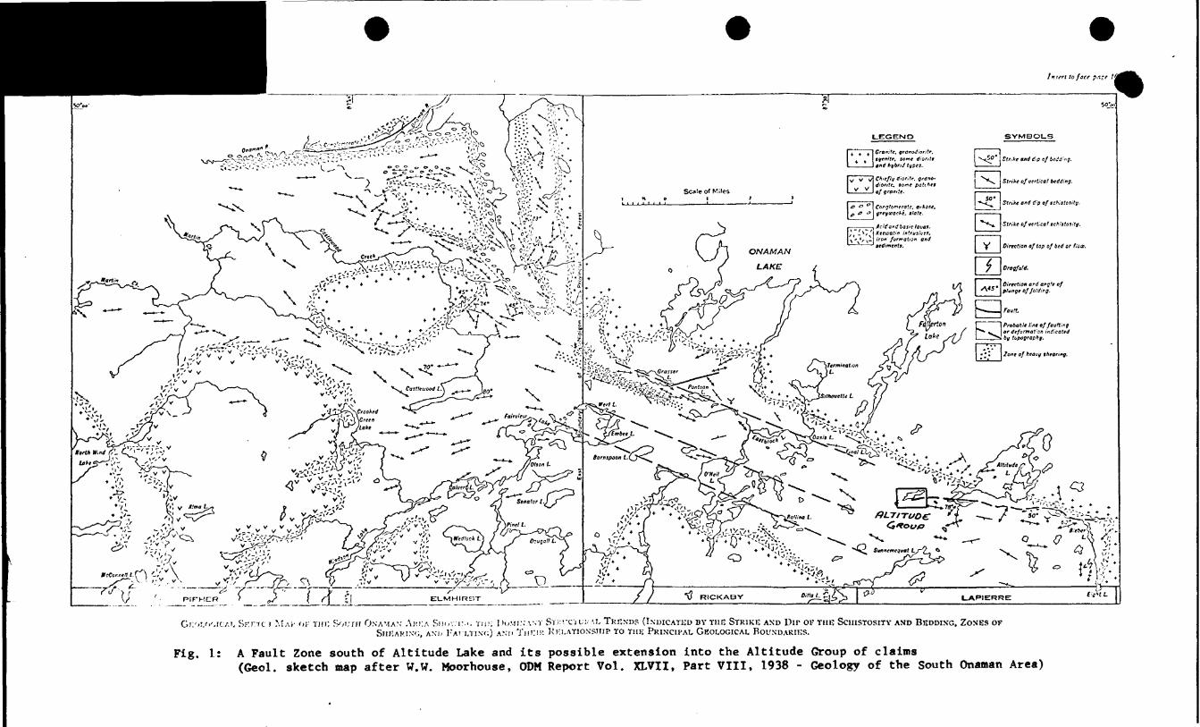
Gii'-i.c-oic/.i, SKrrc r MAI- or Tin: S'yurir ONAMAN- AHI:A Sm.v. i-.'. Tiii; DOMI.-.-AST STKVC'IUHAI, TREND? (INDICATED BY THE STRIKE AND Du1 OF THE SCHISTOSITY AND BEDDING, ZONES OFSHEARING, AND KA' J.TINX;) AND THKIK KI-I.ATIONSIIIP TO THE PRINCIPAL GKOLOGICAI, BOUNDARIES.
Fig. 1: A Fault Zone south of Altitude Lake and its possible extension into the Altitude Group of claims(Geol. sketch map after W.W. Moorhouse, ODM Report Vol. XLVII, Part VIII, 1938 - Geology of the South Onaman Area)
• II l l BIB II II 1 M .. .. ,. __. -.--
•42E13NW8352 63.3868 CASTLEWOOD LAKE 030
GEOLOGICAL REPORT
ON
LAPIERRE GROUP OP CLAIMS
LAPIERRE TOWNSHIP, JELLICOE AREA
THUNDER BAY MINING DIVISION
December, 1972 H. Petak
INTRODUCTION
A geological survey waa conducted on September 12th and 14th,
1972, by the writer on thirteen (13) out of fifteen (15) contiguous
claims called the Lapierre Group, held by Anax Exploration, Inc.
The purpose of the survey was a detailed geological mapping of the
property to assist in checking out ground EM conductors located by
a Radem VLP survey executed by Amax prior to the geological survey.*~ t
LOCATION AND ACCESS
The property is located near the south boundary of Lapierre Twp. ,
NE of Jellicoe, Ntf Ontario. It is accessible from Highway 11 via good
gravel road (logging road), located about 8 miles E of Jellicoe.
PROPERTY
The Lapierre Group of claims consists of fifteen (15) unsurveyed
contiguous claims with the numbers 32A243 to 324253 inclusive, and
329592 to 329595 inclusive, Two of these claims, namely 329592 and
329593, are almost totally under water and are excluded from this
geological survey. Comprising a total of approximately 2,100 acres, or
9.94 square miles, this claim group was staked and recorded in April,
1972, and is since owned by Amax Exploration, Inc., suite 1302, 7 King
St. E., Toronto l, Ontario. The property is covered by claim map M-1791,
PREVIOUS WORK
A very old drill site (no core]), located about 50' W of L-44E,
3450S and line-cutting (about 2 to 3 years old) paralleling the Amax
grid, indicate that at least part of the area has been worked in the
past. However, there Is no assessment work on file at the Mining
Recorder's office.
After staking in April 1972, Amax Exploration completed 80,800 ft.
(15.4 lin* eolith) of Hneeuttlng with a line spacing of 400 ft, and the
game amount of ground magnetics and Radem Survey. Geophysics was followed
up by a geochemical soil sampling program of which results are not yat
on hand. Geophysical readings or soil samples respectively, were gener
ally taken on 100 ft. stations and in some cases, on 50 ft. stations.
GENERAL GEOLOGY~ "' ,- t-—-t
The property is located in a belt of chiefly volcanic rocks com
prising lavas of basic to acid composition, related intrugives, and
tuffs. Sediments representing a minor group in the regional lltholog-
icai picture however, may dominate In some parts over rocks of volcanic
origin (e.g. Cow Creek area). These sediments are conglomerates,
quartcite, greywacke and alate. They are believed to be generally
younger than the suite of volcanics (W.W. Moorhouse, ODN Report Vol.
XLVII, Part VIII, 1938, page 4). A series of granitic intrusions within
the volcanic - sedimentary belt are younger than the volcanic rocks.
Their age relation to the sediments however is uncertain. A few diabase
dikes cut all the previously described units and thus represent the
youngest known of the Precambrian basement rocks in the region.
Varying in thickness, unconsolidated glacial, lake, stream, and
swamp sediments cover large areas of Precambrian rocks and create un
fortunately all too often, extremely poor outcrop conditions.
Grade of metamorphism changes strongly from one place to another,
affecting mainly the volcanic - sedimentary sequences. Strong silicific
ation can be noticed almost everywhere.
W.W. Moorhouse (Page 15, 1938), mainly for reasons of structural
analogies existing amongst other Keewatin and Timiskaming regions in
the Canadian Shield, believed the gross structure In the South Onaman
area to be a "faulted, synclinal cone". Many outcrops exhibit drag
folding caused by faulting, which in some instances, (e.g. close to
the boundary of the belt), becomes very intensive. The regional strike
of the belt is HW-SE with noatly vertical to steep northerly dips.
f..-
DETAILED GEOLOGY
In the entire property, the Precambrian basement is exposed only in
one location, namely on L36E, 78, in the southwest part of claim No. 324250.
PILLOWED ANDESITE (Ip) comprises an outcrop forming a small and very
narrow E-W striking, moss-covered ridge. Brownish-grey on the weathered v
surface and dark greenish-grey on the fresh surface, this very fine
grained rock Is of homogeneous composition. Microscopically visible
are the minerals hornblende, chlorite (T), plagioclase, quartt, (mostly
a product of secondary silicification), and traces of extremely fine
disseminated sulfldes (pyt).
The weathered surface of the outcrop exhibits pillow structures,
Stretched and sheared the pillows are 2 to 4 ft, long and up to l foot
wide. Top determinations were negative. Foliation which parallels the
stretch axes of the pillows, was 85-900 .
CONCLUSIONS
(l) Unconsolidated glacial, lake and swamp sediments were found
to cover nearly 1001 of the property. This most unfortunate fact mini
mised the possibility to gain detailed information concerning the Pre
cambrian basement geology during this survey.
(2) For the same reason, all EM conductor* remain unexplained.
(3) The old DDH found on 50'W of L44E, 3+50S la collared between
150' to 200* south of an Aaiax multiline Raden conductor. This position
ing suggests very strongly that this hole was designed to teat that
sane conductor. Whether or not it really intersected it is not known
due to lack of any core. To test that target from that given collar
the hole would have had to be 350* long and drilled with 45O Inclination
to the north. *~"
RgCOMMENDATIONS
No definite recommendations regarding further work can be made
at this stage. They depend on results of a complete data compilation
which is not yet possible since geochemical results are not back.
Horst Petak.
42E13NW8353 63.3060 CASTLEWOOD LAKE040
GBOLOGICAL REPORT
ON
CASTLEWOOD CROUP OF CLAIMS
CASTLEWOOD LAKE, JBLLICOE AREA
THUNDER BAY MINING DIVISION
December, 1972 H. Petak
INTRODUCTION
A geological survey was conducted on September 17th and 18th,
1972, by the writer on eight (8) contiguous claims called the
Castlewood Croup, held by Amax Exploration, Inc. The purpose of
the survey was a detailed geological mapping of the property to
assist in checking out ground EM conductors located by a Radem VLF
survey, executed by Amax prior to the geological survey.t-* i
LOCATION AND ACCESS
The property is located north of Castlewood Lake, about 18 miles
to the NNW of Jelllcoe, Northwestern Ontario. It is easily accessible
by road (Highway li, gravel road to Auden, Northwestern Ontario, and
private logging roads).v
PROPERTY
The Castlewood Group of claims consists of eight (8) unsurveyed,
contiguous claims numbered 335054 to 335058, inclusive, and 329596 to
329598, inclusive. Comprising a total of approximately 320 acres or
1/2 square mile, this claim group was staked and recorded in April, 1972
and is since owned by Amax Exploration, Inc., Suite 1302, 7 King St. E.,
Toronto l, Ontario. The property ia covered by claim map M-1839.
PREVIOUS WORK
Part of the property is covered by two different previous grids.
One, with lines cut approximately N-S, seems to be older than another
on* that parallels the present Amax grid, A diamond drill hole with
core (site AQ) left on the site, has been drilled to the SW. it was
collared on a line of the younger grid.- The location in reference to
the Amax grid is 30 feet East of L-8E, 7470S. The core does not show
any conductive material and apparently intersected tuffaceous sequences
of basic to Intermediate composition throughout the hole. Mo
assessment work is on file at the Mining Recorder's office.
After staking in April, 1972* Amax Ixploretion completed
39*200 feet (7.4 line milea) of llnecuttIng (line specing Is 400')
and the same amount of ground magnetics and ladem survey. Geophysics
was followed up by a geochemical soil sampling program* reaults of
which are not available at the present time. Geophysical readings or
soil samples respectively were generally taken at 100* atationa and
in seme cases st 50* stations.
The property is located in a belt of chiefly volcanic rocka com
prising lavas of basic to acid composition* related intrusive** and"V
tuffs. Sediment* representing a minor group in the regional litholog-
ieal picture however, may dominate in some parts over rock* of volcanic
origin (*.g. Cow Gr**k ar*a), Th*** **dim*nts are conglom*r*t*a*
fuaruit** gr*ywack* and slat*. Th*y at* believed to b* g*n*r*lly
younger than th* suit* of voleaniea (W.W. Noorhou**, ODH loport fol.
Kuril t Part fZZX, 1938, pat* *). A serl** of granitic intrusions within
the volcanic - **dim*ntary belt are younger than the volcanic rocks.
Their age relation to th* sediments how*v*r, i* uncertain. A few diabase
dik*s cut all the previously described units and thus represent the
youngest known of the Precambrian basement rocks in the region.
varying in thickness, unconsolidated glacial, lake, stream, and
swamp sediments cover large areas of Precambrian rocks and create, un
fortunately all too often, extremely poor outcrop conditions.
Ored* of metamorphism changes strongly from on* plae* to another,
affecting mainly the voleenic - **dim*nt*ry sequences. Strong slliclflc-
*tion can b* noticod Almost *v*rywh*r*.
W.V. Noorhouaa, (Pago 15* 1938), Minly for raaaont of
atruetural analogic* exiating among* t othor Keewatin and Timiakaming
ragiona in tha Canadian Shiald, baliavad th* grot* atruetura in tha
South Onaman araa to ba a "faulted, ayaclinal tone", Many outcrop*
axhibit drag folding caoaad by faulting, which in aome inatanoaa,
(a. g. cloaa to tha boundary of tba halt), baco*a vary intanaiva.
Tha regional atriko of tha bait ia HW- gf with moatly vortical to ttaapr-northarly dip*.
PtjAIUD CTOLOGT
Precambrian rocka ara axpoaad along tha gravol road eroaaing tha
proparty in HW- gf diraction north of baaaliaa 0+00, and in tha aouth-
cantral and touthaatt part of tha claim group. Tho outcrop ratio iax.
estimated to ba roughly batvaan 5 and 101. Unconsolidated glacial
aedimcnt* (cand, graval, and bouldara) and swamp sediment* cover* 901
to 951 of tha property, Making tha underlying Precambrian rocka.
Although varying in thiekaaaa* tha overburden coverage ia generally ex
pected to ba very (hallow.
Tha following clarification and daacription of tha Precambrian
rook* it baaed on macroscopic observation* only.
IASIC VOLCAMIC ROMS (1)
AMUglTB (Im)
Thia rock type outcropa in aaveral placaa on both K aide* along tha
gravel road north of baaaliaa 0+00. It occura aa 2* vida band* Inter
calated ia tuff a. Vaathariag dark graeniah-grey, and dark green on tha
Iraah aurfaea, thia rock ia vary fine trained and eoaalata chiafly of
horablaada and chlorite, aad minor plagioclase. A tuffacaoua variety
outcropa in the *outhw*at corner of the claim group on tho northweat
id* of tht road on both sides of th* lin* 81* The tuffaceous
character it viaibla only on the weathered surf act,
i)
This rook type was found only in on* outcrop located 150* east
of lin* 12E and 100' K of BL 0400.
Microscopically th* Mineralogy does not differ fro* the en* ob
served in the Massive type deacribed above. The pillows are stretched
to an extent that makes top determinations impossible.
BA11C TUfT (It)
The very fine elastic variety of this rock type was observed
only in on* exposure located at L-0, 3M. Th* tuffaceous sequence in
this outcrop is intercalated with a 2* thick massive andesltlc flow,
Th* tuff* weather dark greenish-trey. The fresh aurfac* is dark green.
Th* tuffaceous character la best vlslbl* on th* weathered eurfaee, *x-
hlbltlng a well developed lamination as beading. Th* tuffaceous frag-N
ments average laaa than l mm In slie. The mineral compoaition of the
tuffs conslata mainly of fin* grained chlorite, aom* hornblende and
little plagioclase.
BASIC ntAOMCTTAl. TOFFS (If)
This form la uaed for tuffa containing fragments larger than 4 em
in di ami ter. They were encountered at two different placeai
(1) on L8B, around 6+50H
(2) on the linea L20B and 2 AE, around 114508 and 13S respectively
Averaging around 6 inches, eome of the fragment* reach a diameter
of l foot. They are either well rounded or ellipsoidal in outline. In
their mineralogy, they differ little from the matrix la which they 11*
and it makes them generally impossible to recognise on the fresh surface,
5.
The fragmental character, however, la usually well documented on the
weathered surface.
Dark greenish to brownish-grey on the weathered surface and dark
green on the fresh, the rock is generally very fine grained, It la
composed of the nlnerals chlorite, sons hornblende and little plagio*
claae. In hand specimens, these fragmental tuffs are very difficult
to distinguish from the regular baalc tuffa (It) described before.
BASIC LAPILLI TUFF (It)
Bsslc lapilli tuff la exposed In several outcrops occurring on
both aides of the road northeast of BL 0400. A very fine grained matrix
weathers light grey to medium greenish-grey, and Is of dark grey colour
on the fresh surface. On the weathered surface, the thinly layered
character of this tuff Is well preserved. Chlorite making up over 801
of the mineralogy of the matrix gives It a schistose appearance on the
fresh surface. Minor minerals are plagioclase and quarts, and possibly•i
some local hornblende. Generally of much more felsic composition than
the matrix, the lapilli are easy to recognise on the weathered and fresh
surfsee. They sverege in sice around 2 mm, the largeat onea range up
to 2 cm. They occur in all aorta of ahapes from rounded to angular.
Oval or otherwise elongated-shaped fragments ere usually well oriented
in the bedding planes.
IKTERMSDIATE VOLCANIC KOCK8 (2)
In the field mainly two criteria were used to classify these rocks
aa a sepsrate groupi (1) degree of silicification in compariaon to the
most basic aa well as most felsic volcanic rocka observed In the area;
(2) colour on weathered and freah surface.
6.
INTERMEDIATE TUFF (2t)
Thia rock typa was found to ba exposed In thraa outcrops on tha
north and aaat side of a ridga croaaad by L4E, north of BL 0400,
and In aavaral outcrops In tha SB cornar of tha proparty (on Una* 20K,
24E. 28B, and on BL 0400 between L28B and L32E). A narrow band of
such tuff Is axposad on L16K, 4+BON (Just north of tha road). That
same band appears to grada into a coarsa fragmental tuff further to* *
tha aast. An Isolated outcrop exposing intemediate tuff occurs on
tha TL168 just aast of L-0.
In addition to thasa exposures composed antiraly of intermediate
volcanics, there ara quite a few outcrops in which bands of inter
mediate tuffa alternate with ones of acid composition. The width of
thasa bands varias but usually ranges from l" to 3".
Weathering light gray to brownish-gray, with light graan to medium
greenish-grey colour on the frash surface, these intermediate tuffs
ara usually very fine grained. They ara generally thinly budded and
consist of the same minerals as tha more baaic phases. Tha ratios
though ara different, baing chloritai (plagioclase 4- quart*) -lil
with plagioclaaa somawhat higher than quart*.
ItmtKHEDIATE FKAQHSMTAL TUFF (2f)
Tha biggest outcrop exposing this rock typa is located on tha
south boundary of the property, slightly aast of claim post Ho. 3 of
claim 329598. "fragmental", as dascribad under basic fragmental tuff,
(If) - again rafars to fragments of A cm or more in diameter. Tha
matrix looks the seme as the tuff described ss (2t). The fragments
either subrounded or lens-shaped average 6" x 4" and weather slightly
lighter than the matrix. On tha fresh surface however, they are very
difficult to differentiate.
ACID VOLCANIC ROCKS (3)
Their exposure* form two parallel Bones. On* outcropa along
the road north of BL 0400, and the other one l* located along and
south of TL16S. In decreasing order of abundance, thla group comprises
the rock types fragmental tuffa (3f), regular tuffa (3t) , and rhyolite
(3-).
RHTOLITE (3m)f-— - l
A. Massive flow of rhyolite, approximately 10 ft. wide, was found
in only one outcrop located on LSI, 64-8011 (north of the road). It la
in sharp contact with the basic fragmental tuff in the 8V. To the Ht
the rhyolite grades into an acid fragmental tuff.
ACID TUFF (3t)
A band about 60 ft. wide of add tuff was delineated north of the
road paralleling BL 0400. The tuff la bounded by a thin layer of basic
flow In the south and by basic lapilli tuff in the north. Ixpoaed from
line 161 to 201 its full strike length is not known. While it is com
pletely open to the 91, it is not expected to continue much more than
a couple of 100 feet to the HW.
la moat of the other outcrops exposing acid phases of tuffs, they
ware found closely associated with tuffs of Intermediate composition,
Both phases form bands of l" to 3" in width alternating with each
other, weathering light grey to white, the acid tuffa are originally
thinly bedded. Thla primary texture la well documented on the weathered
surface. On the fresh surface however, the rock la buff to greyish,
extremely fine grained, rather massive, and very siliceous.
ACID FKAOgJTCAL TUFF Of)
The bolt exposures of this variety of acid tuff outcrops on both
Id** of tb* road jugt v**t of ci*t* 335058, and south of claim 335054
ID axtansion of TL168 to tha SK. Both locations ara outslda tha
proparty boundarias.
In tha Matrix tha fragmental tuff doas not diffar fro* tha ragular
acid tuff dascribad bafora. Tha fragments avaraga about 4" to 6" andf-— iara generally subroundad and lens-shaped. Thay ara difficult to ident-
ify on tha frash surfaca. On tha weathered surfaca however, thay show
up wall.
BASIC ROCKS PT UKCBRTAIH ORIGIH (4)
A medium to coarsa crystal l ina-basic rock cosipriaas aa vara l out*
crops locatad along a bait slightly MB of TL16S paralleling tha lina.
350 ft. to 400 ft. vida in tha HW portion, this bait l* thinning out
towards tha SI.
weathering dark brownish to gray, tha colours on tha frash surfaca
ara dark to medium graaniah-gray. Tha highly crystallin* rock is
medium to coarsa grainad and vary massive in appaaraoca, with granitoid
taxtura. Its mineral aasemblage comprises hornblanda, plagioelasa
and possibly pyroxana with ratios indicative for gabbroic coaiposition.
Rocks outcropping on both sidas and intaraactad in a DDi ME of tha
bait ara of dafinita volcanic origin. Thay ara tuffs of intermediate
and acid composition in the SW and baaic in tha tt. Unfortunately,
however, no contact against the gabbroic rock was found to assist in
establishing the relationship between the gabbroic rock and the volcanics
on either side.
At laaat two poaalbllltiea offar thaaaalvaa for conaldoratlont
(1) tha questionable rock i* part of tba volcanic aaquanca
and repreaenta a coaraa cryatallisad phaaa of a basic
volcanic flow;
(2) wa ara looking at a trua gabbro and tha ralatlonahlp
la of an Intrualva natura
mPCTUlAL OROLOGY J*
tha Precambrian rocka undarlying tba Caatlawood Group of
clalaa eoBpriae a aariaa of volcanic rocka of pradeailnantly tuff-
acaoua character, vbloh atrika batvaan 110O and 100O (avaraga 1200),
with dip varying froai vartical to SOOMB (avaraga 7SO IB), Although
not confirmed in individual outcropa (top dataminationa vara impoaalble),
it la fait that in general, tha atratlgraphie top of tha volcanic aa
quanca of thla araa la in tha IB, while tha lower portlona occur to
tha SW. Tha corralation of outcropa along atrika la In *oat eaaaa
axtreattly difficult. Tha aa*a roek typaa do not aaaai to ba eontlnooua
ovar long diataneaa. Thla could probably ba dua to rapid atratabound
faeiaa changaa. Tba poaaibllity of vary tight iaoclinal folding alao
exleta, contributing ita ahara to tha atructural complexity of tha araa.
A daflntta change in tha allica ratio can ba notad in atratlgraphloally
vartical diractlon. Fro* tha aouthweat baaic volcanica grade ^Lnto acid
phaaaa around TLl6g. IB of thla Una a naw aaquanca atarta with baaic
rocka changing to a predominantly acid aaaemblage outcropping on both
aidaa of tha road north of BL 0400. Located between tha baaic aide of
thia northeaatern volcanic aaquanea and tha acid and of tha aouthvaatam
one, liaa the belt of gabbroic roeka. Thia particular eetting auggeata
an interpretation aa a coarae cryatallisad phaae of u baaic volcanic
flow initiating tha northeaatern aequence, rather than an Intrusion.
10,
Shaaring vaa found to ba vary Minor aa4 of vary raatriatad loaal
iaaofftanaa. tha aawi ia trua far faulting. A abort loaal fault
i, atrikin* 1000 , la travaraad by Una 28E on atatloa 4*508.
aaidaa aaaw aaoradia traoa avauata of fiaaly diaaaainatad
pyrita, aa alfalfltaat awlfida aiiaaralUatioo waa aotiaad.
(1) At laaat tvo-thirda of tha proparty la undarlain by volcaaie
roaka. Vor oa*-tblrd aoaariaiaf alaiai 3293W aad tba ME aan of alaia
DSOM, tbta awrvay failad U tatalaa lafomatloa aa to tha aatuva of
ita badrock taalofy* dna to lade af autaroa,
(t) tha volaaaia roaka* baair to aetd ia aoafoaitton, raaja fro*
aaalva fIowa to aoaraa fragaaatal tuffa* thua arovidiftf a haaiaally
favourabla aaviroaaunt for haaa atttala*
(9) Onfortuaataly! outerafa U coataet ftanaa* baiag tba atoat
iataraatinf portioaa* ara axtraaaly rara*
(4) tadaai Vtr eoaduatara aaaaot ha axalalaad vith aay aonfidaMoa
by tha raaulta of thia aurvay.
m dafUita rainaajiaiatioaa ratardUf futfhar work oaa ha vada
at thia ataja. thay dafaad an raaulta af a caaflata data aoaollatiaa
idiiah ia not yat aoaaihla aiaaa gaathaalaal raaulta hava not haaa
racaivod.
iorat fatal.
43E13NW8352 63.31860 CASTLEWOOD LAKE 0B0
GEOLOGICAL REPORT
ON
ATIGOGAMA CLAIM GROUP
LAPIERRE TWP.
THUNDER BAT MINING DIVISION, ONTARIO
March, 1973 J.E. Steers
INTRODUCTION
A geological survey was carried out over four (4) contiguous t
unpatented mining claims registered In the name of Amax Exploration,
Inc., Suite 1302, 7 King St., Toronto, Ontario.
LOCATION AND ACCESS
The property is located in the northwest portion of Lapierre
Twp., Thunder Bay Mining Division, some eight miles north of Highway 11.
The property is readily accessible from Hwy. 11, via a Domtar haulage
road and a quarter-mile winter road.
PROPERTY
The property consists of four (4) contiguous mining claims
numbered TB 335050-335052, inclusive. The claim group was acquired to
cover a weak, single line ASM response.
PREVIOUS WORK
No record Is available of previous exploration carried out on
the property.
GENERAL GEOLOGY
The property is located on the northeast limb of a southeasterly
trending anticlinorium. Government compilation maps indicate that the
bulk of the rocks in the area should be intermediate to felsic volcanic
rocks.
PROPERTY GEOLOGY
Only one outcrop area was found on the property. The rocks
were massive, fine grained, dark green, somewhat chloritic andesite.
2.
TOPOGRAPHY AND OVERBURDEN
The whole area is generally low-lying. The northern half
of the group is a low sand plain where young second growth jackpine
predominate. The rest of the group is a very wet spruce or cedar
swamp most difficult to traverse.
CONCLUSIONS
No conclusions could be drawn from geological observations
as to the cause of the AEM anomaly.
X
42E13NWB352 63.3860 CASTLEWOOD LAKE 060
SUMMARY REPORT
FOR
M8R MAJESTY TUB QUEEN IH RIGHT OF OITTARIO
AS REPRESENTED BY THE MIKISTRR OP NATURAL RKSOORCES
SCOVERINO COHTRACT fOB-2t
#GB-30
tout*. Exploration, Inc. , Roc* 204 - 231 Arthur 3t. Thunder Bay (P). Onturlo. P7B 1A7
J.E. Stft*rt, FOAC, P.Entr. Dlttrtct Geologist:, March 20, 1973.
t
INTRODUCTION
The following report encompasses a ground exploration program
carried out under Contracts #GB-21 s GB-30 of the Government Assistance
Program.
The purpose of the vork carried out was to examine the economic
potential of seven (7) claim groups acquired following an airborne mag
netic and electromagnetic survey carried out over an area north of
Jellicoe, Ontario.
In general, the program consisted of linecutting, electromagnetic
and magnetic surveying, geological mapping and soil sampling with minor
variations from group to group.
SUMMARY AND CONCLUSIONS
One claim group, (Eight Lake Group), was eliminated from further
consideration after a re-flight by the A.E.M. Contractor. It was deter
mined that the anomalies originally detected were caused by instrument
malfunction.
Of the six (6) remaining groups, drill targets were outlined
on five (5) of the six groups.
A total of seven (7) drill holes were drilled to test the
anomalies. All anomalies were found to be caused by non-economic sulphide
mineralization and/or graphite.
Some additional geophysical work was performed on five (5)
groups prior to drilling.
GENERAL
The individual claim groups will be discussed separately.
Individual geological reports have been prepared for each group; however,
geophysical and geochemical reports have not.
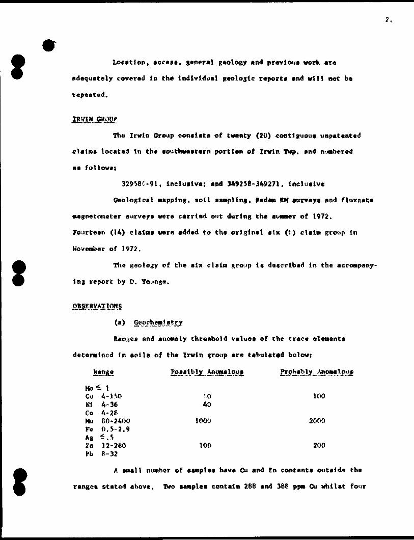
f Locution, access, general geology and previous work ara
adequately covered in the Individual geologic report a and will not be
repeated.
The Irwin Group cone i tt a of twenty (20) contiguous uapatented
claim* located in th* southwestern portion of Irwin Twp. and numbered
aa follow* i
329586-91, inclusive; and 349258*349271, inclusive
Geological napping, aotl saatpling , Rede* BM survey a and fluxgate
•agnetomster fturvays were carried out during the aomser of 1972.
Fourteen (14) clalns were added to the original alx (6) claim group in
Movember of 1972.
Hie geology of the six claim sro'p it described in the accompany
ing report by O. Youtnga.
OjStgKRVATIONJ
Ranges end anomaly threshold values of the trace elements
determined in soils of the Irwin group are tabulated below:
f
Ho-1 lCu 4-1 SO ?fO 100Kl 4-36 40Co 4-2tfHu 60-2400 1000 2000P* 0.5-2.9Ag "^.5Z& U-260 100 200Pb 8-32
A email number of samples have Cu and Zn contents outside the
ranges stated above. Two samples contain 2BB and 366 ppn Cu whilst four
Ccurry 520, 570, f20 and 3600 n* Zn respectively. A general covariance
is evident between Cu and Kl although sew* moderately anomalouti Cv values
ar* associated with only background HI, The majority of the mor*? prcwln-
*nt En anova11 ea are associated with enhanced (1000*2000 ppa) Mn,
A prominent 7,n anomaly la p r a cent in t ha west of the area
lyiiu- mainly within claims 329S89 and 329590. The pattern t* elongated
roughly LW and includes peak values of 470*520 ppm Zn. A Moderate Cu *
weak Ni Anomaly partly coincides with this En pattern; Ou values range
front M3-W ppw.
A weak Cu anomaly, partially supported by Zn, la present fring-
ing a drainage channel in the south of the area (data 329191). A Moderate
Cu anooMty (140-2M ppei), this tine unsupported by Kn, occur* n short
distance to the NE of the prominent En anomaly deacrihod above.
with the exception of a few weak Cu values (^0-76 ppat) aoils
from the two eastern claims (3295R* and 329587) return only background
•etal values.
The tone of exploration interest ta clear from the geochemical
data, i.e., a little over one claim in the west of the area, the 7n values
obtained here are clear!y anomalous and merit preliminary follow-up.
However, the absence of Pb and Ag in anomalous quant11 lew is a negative
feature. Similarly, the general enhancement of Cu and Ni with the anomalous
7,n is suggestive of a metal source other than mineral i cat f on. These values
c (xi Id, quite probably, he obtained from an unml netallied carbonaceous and
sulphur bearing argillaceous rock (e.g., a graphite carrying barren Fe
sulphide*). Weaker Cu anomalies in low*lying swampy ground ara likely to
reflect metal accumulation in organic toils and hence be of no exploration
significance.
f(b) .
TVo very veil defined radet* anomalies exist on t h* northern
for** of thtf property.
Both are probably du* to the comb In* d effect* of shear tones
and/or lake hot toot condactfve aoiiine-nt*.
In general, th* other a nema H ea are reflected by t ho dip angle*
profile only and are therefore to be vi owed vfth suspicion. However,
anomalies ' A' , "B" and 'C" lie in an ara* of interfingering f*laic t, mafic
volcanic rocks. Hit* general ar*a alao display* enhanced trace eleaent
value*.
(c) Majnjitjc dajta
Maximum magnetic relief In th* area i* If .780 gamut; however,
if one reading on Una 288 at 6*5011 la ignored, the relief ia only
7,620 gaoata*. It J a suggested that thi* particular a tat ion be ignored
as the reading wa* probably taken over a aMt^oatlte bearing boulder.
The general background of 700 to l ,000 gamia* probably reflect*
dontnantly felsic to interned tato rock* whila the areaft where readings
in eccoss of 1,000 (^anna* vara obtained, are area* underlain by dotefnantly
mafic lavas and/or mafic intrusive rock* probably occurring a* din-
continuous all la.
It ia reeoMtended that additional detailed napping and pros
pecting be carried out in the area* where anoaalou* trace element value*
were obtained and l ri the area* where culphide miner* H** 1 1 on wa* en
countered in the cour*e of t h* original napping.
During th* auajaer of 1973 geological napping and geochemical
•ampling ahould be carried out over the *ixt*en (H) ci ala)* not covered.
5.
The Atigogana Group c on* l t t* of four (4) contiguous on-
petented wining claim located in Northwestern Lapierre Twp.
Geological Mapping, partial soil sampling, RadsM BM and
magnetic surveys vara carried out over the group.
SBS&SM&XiSi
Cu, ph, Zn and Ag values ara uniformly low. Many of the P*
values are low, suggesting a virtually barren exotic overburden; (e.g.
fi uvio- glacial aand) that precludes the application of conventional
surface soil geochemistry.
O*) Ma&QftJLc*
Tha mafneeic background is low and Mxlsmsi relief only 930
tf AflMftAflt B**™"""""*
TWo features ara obvious. The first is a narrow linear
feature with a northerly strike which is probably a Mf le dike.
The rocks underlying the northern quarter of the property have
considerably nore roiief than the southern portions. In the absence
of concrete geological data, the northern portion i* probably underlain
by a mafic unit containing slightly store Magnetite than the southern
portions.
Three (3) weak, nebulous conductive cones were detected which
lack significant fluid strength anomalies. These sones are probably
surficial conductors.
the AIM anomaly located on the property is probably du* to
surficial effect*. No further work i* recoamended on the property.
Pb, ?n And An content* of th* tolls of this group fall well
within background ranges. A swill nustber of aaiaplea have anoiialoue CM
contents; (60-220 ppn, with s peak of 340 ppsi) , which are generally
associated with enhanced (21-56) ppn Hi.
These data do not suggest the occurrence of significant near*
surface Mineral t E* t ion.
00
Magnetic relief in the area is relatively high, appxoxiauitely
26,700 gamut t. The individual features have relatively stron? aaiplitude
but stull wavelength, suggestive of narrow bands of conductive or sewi-
conductive materiel, probably pyrrhotite and/or aom* magnetite.
The area was covered by a Radarn survey and later with a JKH
aurvay to try to sort out the SMUiy Raden conductor*.
The Raden VLK survey indicated a nuaiber of abort, dlscontinuoita
conductive features which had direct Mgnetic coincidence or flanked
magnetic anosuiliea.
Later JEM surveys indicated two cones, each of which has
three (3) probable conductors. Integrated interpretations indicate
they are narrow, vnrtical to steeply dipping bodies of fair conductivity.
Two (2) hoi** were apotted to teat t h* Major aooaa of con
ductivity. Theae were aa follows:
AL -l Una 241. USOS, ~4SO Or l d M - 250* At -2 Una 4W, 5*7511, -450 Grid K - 500*
Conductivity in tiolo on* vat found to b* du* to (1) a pyrrhotite
network in iMta-andeaitea and (2) a aulphld* iron formation.
Conductive tones in hoi a two vara cauaad by pyrrhotite con-
cantrationa in graphitic aedtaentary rocka.
No economically significant concent ra t i ona vara encountered.
Mo further work la warranted on thia property.
Cu, Pb, ?n and Ag valuea are uniformly background. Many of
the Pe valuaa are extremely low auggeating a virtually barren exotic overburdan
(e.g. fluvioglacial sand), that precludea the application of conventional
aurface aoil gaocheaitatry.
Magnetic relief ia generally low, ma* taw M* relief being 4000
. The Magnetic features and available geological data auggeat a
aeriea of intermediate to felaic volcanic rocka which have a aoutheeaterly
strike.
Only the linear anomaly in the south -central part of the area i a
considered to be significant.
The initial radea survey waa not i|rfinitive, aince it indicated
several surficial conductive von* a In t ha northern portion of the
area and en anomaly in the eouth*central portion having Magnetic
correlation but a very peculiar electromagnetic expression.
A JIM aurvey w* a then carried out which indicated only one
anoaialy in the south-central portion of the area.
Thia anomaly ia atrike li*! ted, narrow* direct magnetic
coincidence and a conductivity-thickness product of about 24 Mho a.
One hole was spotted to teat this anoetaly.
A tone of 10-131 pyrrhotite Mineral i tattoo over a core
length of 23 ft. was encountered in en Intermediate tuff.
Mo further work ia recoBaended aince the conduct lv* cone
haa been adequately teated and no economically aignificant mineral!*
at ion watt encountered.
A few positive, or weakly anomalous, Zn valuea are preaent
(80-140 pptn) but no Cu, pb or Ag anomaliea occur, f e valuea ere "norwal"
•uggeating that barren exotic overburden ia unlikely to he a aifnificant
factor. The*** data do not auggeat that the area poaeenaee amy obvious
Hineral potential.
fieveral narrow, atrike limited, anoattliea are evident.
M*xlBi'im relief on cho property i a 3610 gamut.
The contoured data ere euggeative of narrow form* t Ion* l
tone* weakly Mineral ited with pyrrhotite.
The Hade* Survey yielded several anowalies which are dif
ficult to correlate Iron lin* to line. All either flank Magnetic
BoofMlie* or have direct Magnetic coincidence.
The JEN aurvey carried out utilising a 300- foot coil aepar-
ation and a frequency of 1630 H* failed to conflm the anoMHe*.
Prior to drilling selected line* were run using A !KX)*foot
coil separation and 5010 HE. The awin, aouth*rnmo*t Aiumaly wu a COB-
firmed. It i a likely that the other* could be detected ueinjf 5010 Wx
tind a 200 -foot coil separation.
DIAHOW) MELLING
One hole waa apotted to teat the ctrongeat anoawly. Three
narrow aoite* containing pyrrhotite were encountered. Host rock* were
mafic to andealtic volcanic rock*.
No further work i* warranted on thl* property.
With the exception of a few acattered weakly poaitlv* 9En
values, (70-85 ppw), only background level* are evident. Many of the
fe value* are extremely tow *ugge*tini a barren exotic overburden,
probably fluvioglacial cand.
lo.
00Maximta relief in the area i* 8960 gam* e.
Four, relatively narrow gone* having Moderate magnetic
relief and en easterly strike are evident. It ia likely that form-
atlonal pyrrhotite is the cause of the anomalies.
The Radem survey indicated the praaence of four (4) conductora.
However, only vary weak field strength anomalies were detected.
Prior to drilling, lines 20K ft 48B were read using a Crone
CRM unit utilising a 300-foot coil separation and frequencies of 1830
am) 390 Hs to obtain dip and conductivity data.
Three (3) holes were drilled to test the anomalies. All
holes encountered pyrrhotite and pyrite mineralization and/or graphite.
No further work is recommended for this property.
Respectfully submitted,
APPENDIX l
t
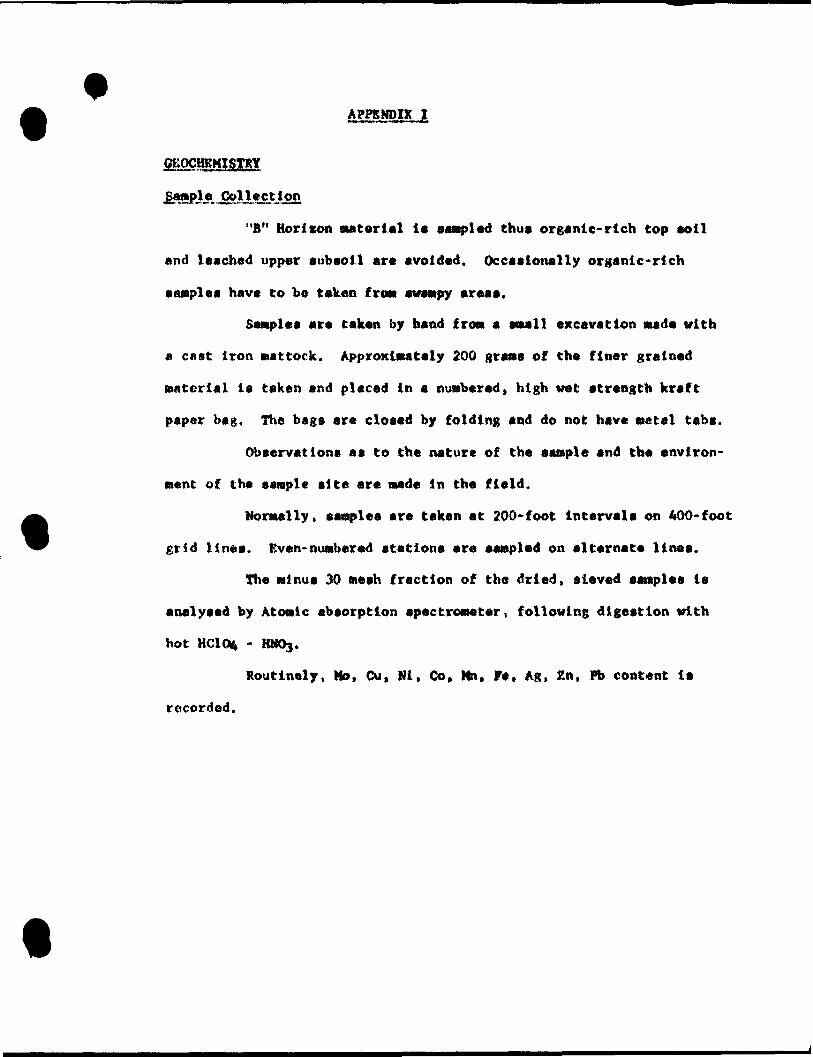
"B" Horicon material i* sampled thus organic- rich top soil
and leached upper subsoil arc avoided. Occasionally organic-rich
samples have to be taken frost swampy areas.
Sasiples are taken by hand Iron a SIM 11 excavation wade with
a cast iron mattock. Approximately 200 grans of the finer grained
material is taken and placed in a numbered, high wet strength kraft
paper bag. The bsgs are closed by folding and do not have setal tabs.
Observations as to the nature of the sample and the environ
ment of the sample site are made In the field.
Normally, samples are taken at 200-foot intervals on 400-foot
grid lines. Even- numbered stations are sampled on alternate lines.
The minus 30 mesh fraction of the dried, sieved samples is
analysed by Atomic absorption spectrometer, following digestion with
hot HC104 - HNOg.
Routinely, Mo, Cu, Mi, Go, Mn, Fe, Ag, Zn, Pb content is
recorded.
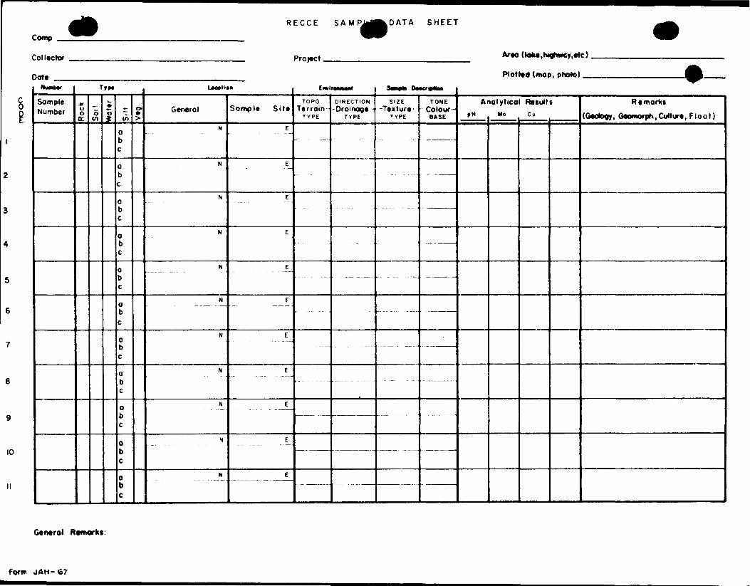
Comp
Collector
Dote ——
RECCE SAMPJrf^DATA SHEET
Project, ATM doke.highwcy.etc).
Plotted (mop, photo) —NvMW
SompleNumber
T
M Oo tt
o tn
it*
\~ o ±
0b
o b
0b c
0b c
0b c
0b c
0b c
0bc
o b c
o b c
0bc
o >
Lxvti**
General
N
N
N
N
N
H
N
N
N
N
N
Sample Site
E
E
E
E
E
E
E
E
E
E
E
CwlnMMrt
TOPOTerroin-
T YPE
— -
DIRECTION-Drainage-
TYPE
S*-** DMcr*NM
SIZE— Texture -
TYPE
-
TONE- Coloor-
BASE
- - — ———
. . ————
-— - ———
ArPH
lalyticol ResultsMo t Cu
Remarks
(Otology, GtomorpK, Culture , Float)8 i
10
General Remorks:
Form JAH-67
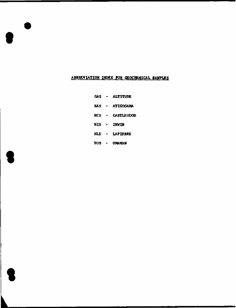
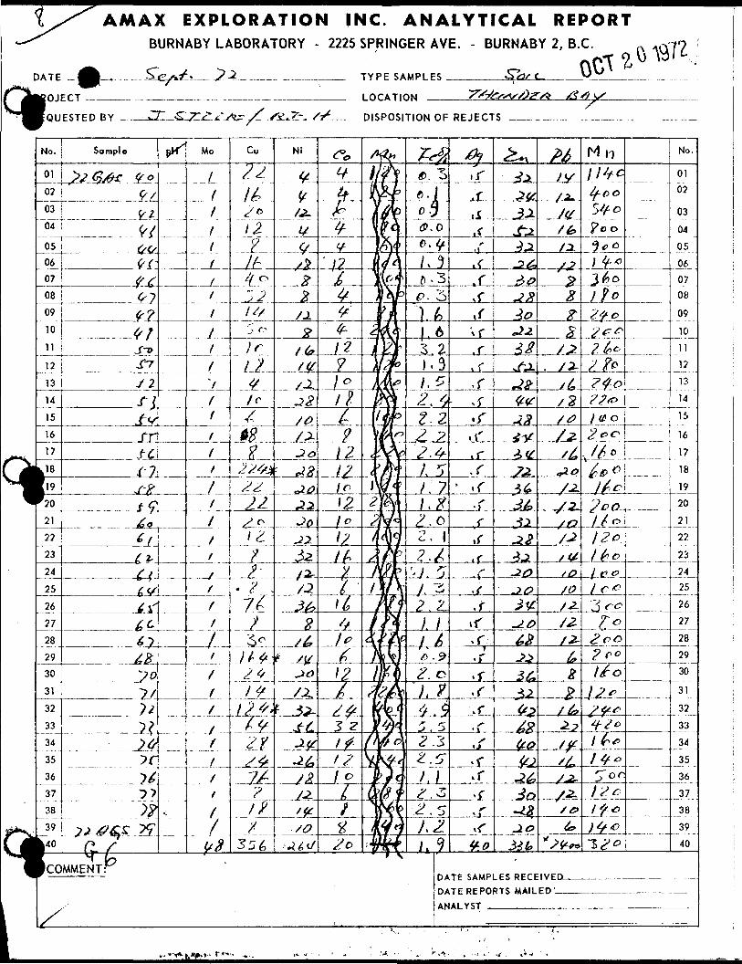
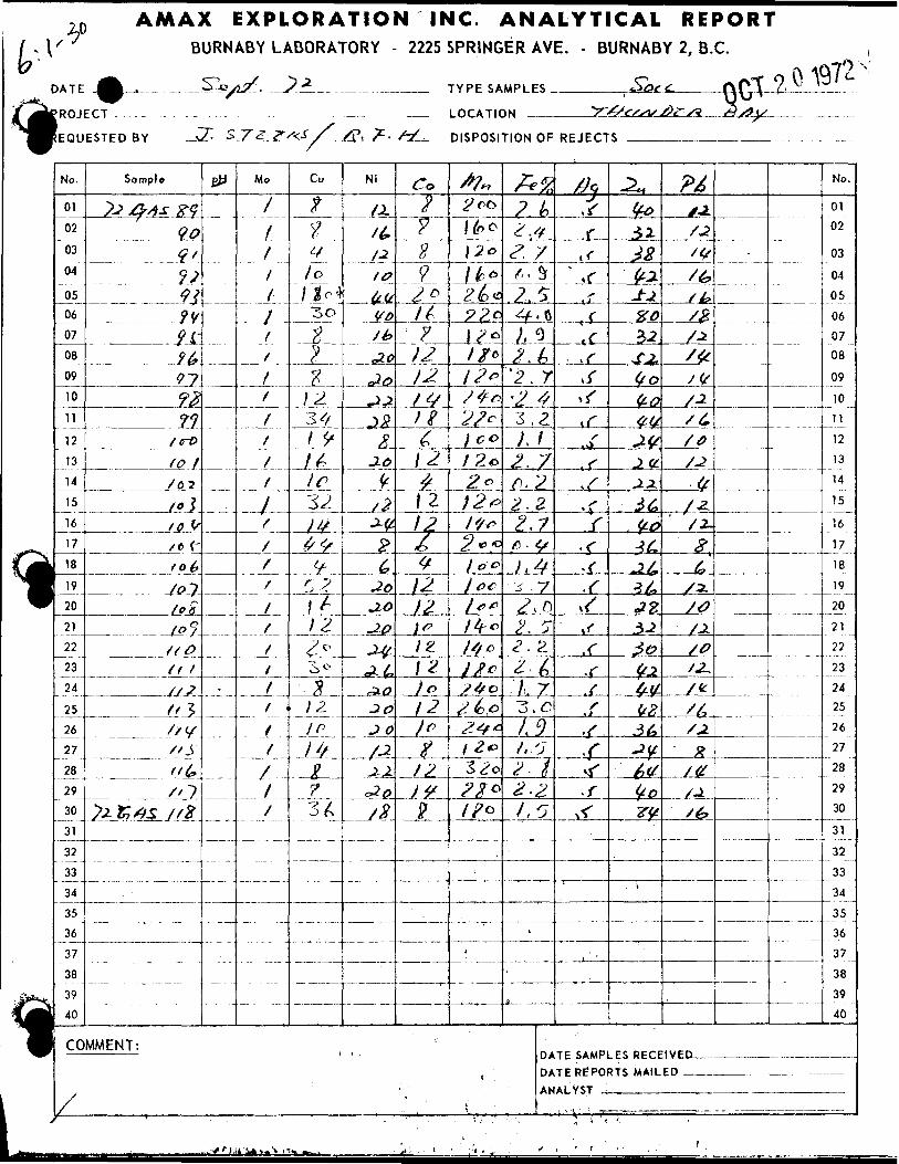
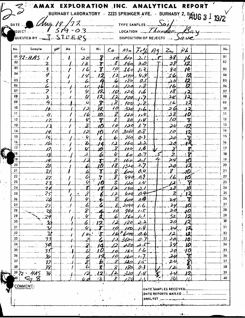
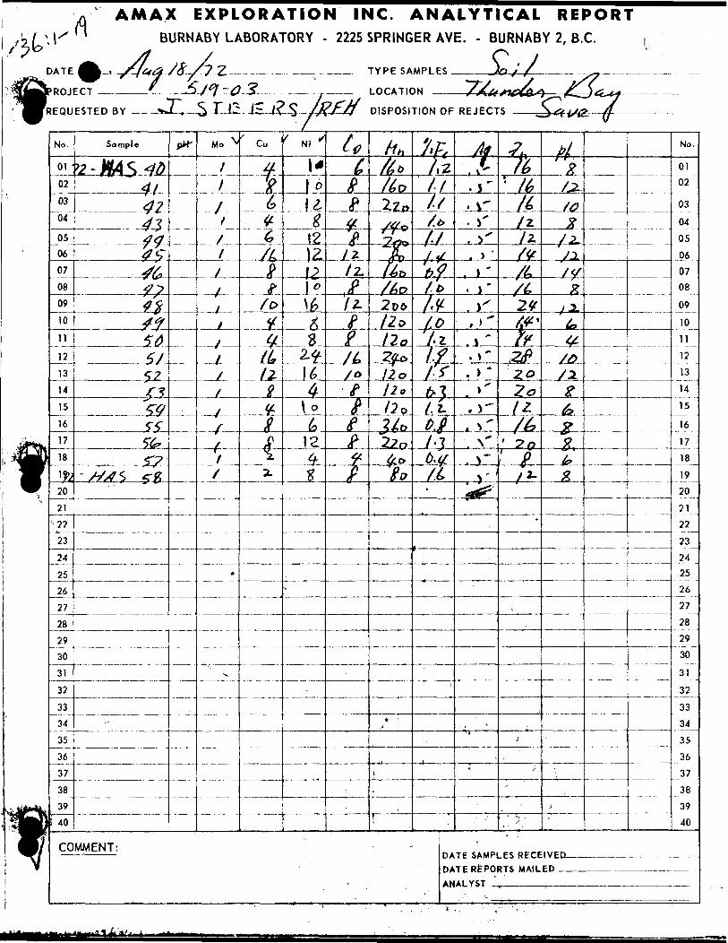
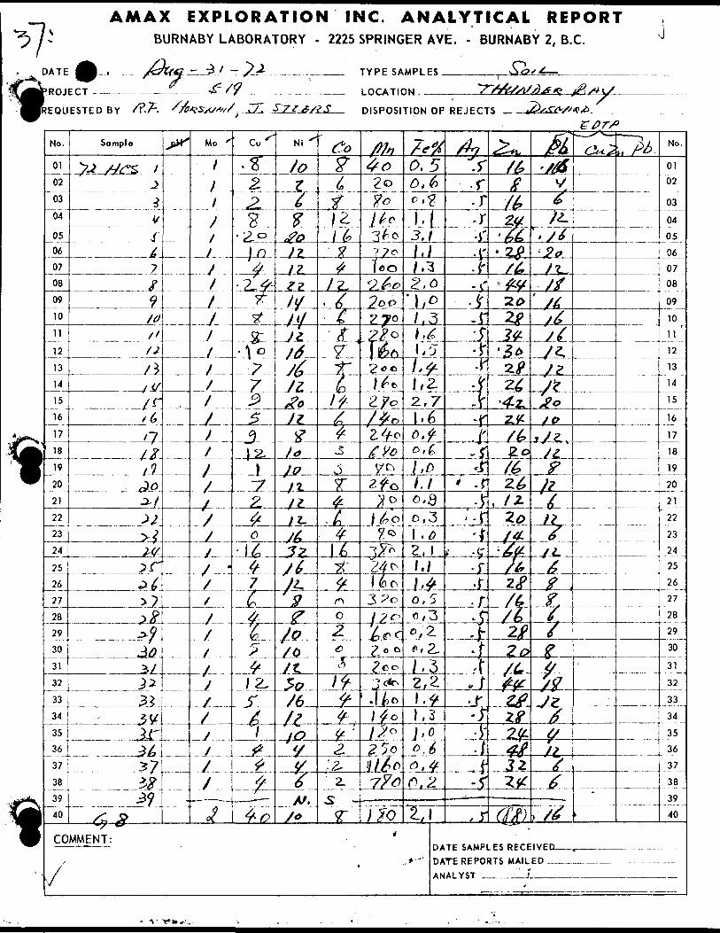
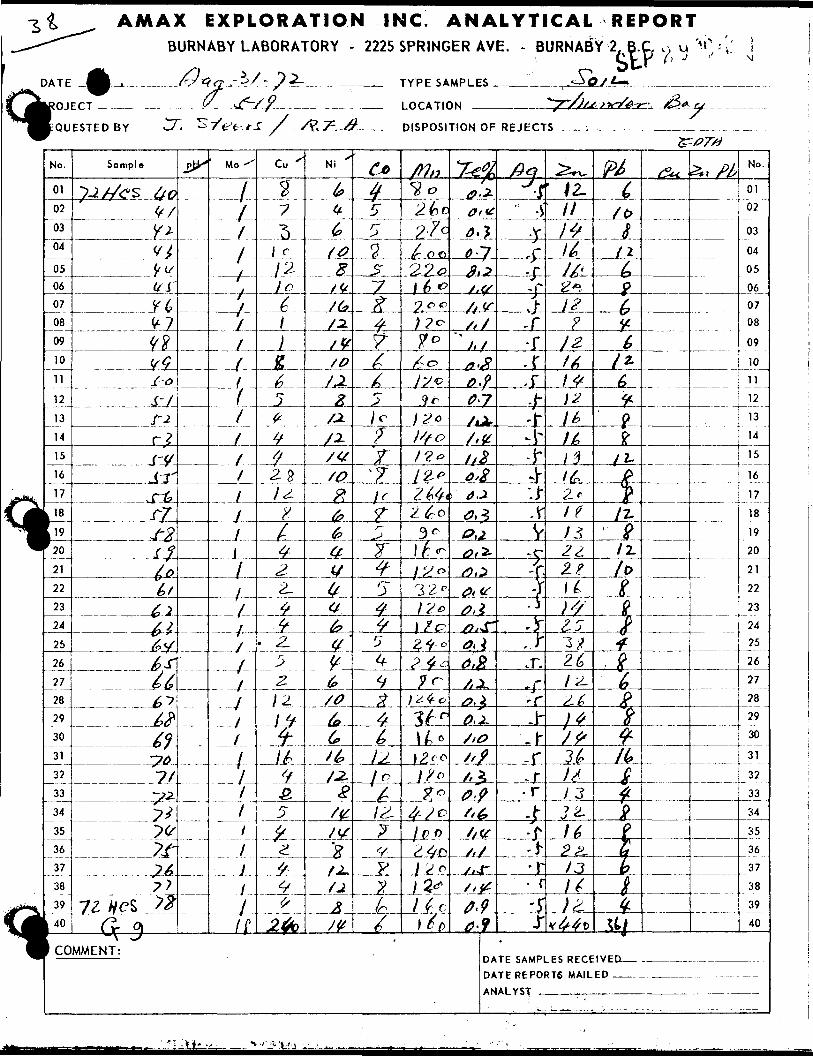
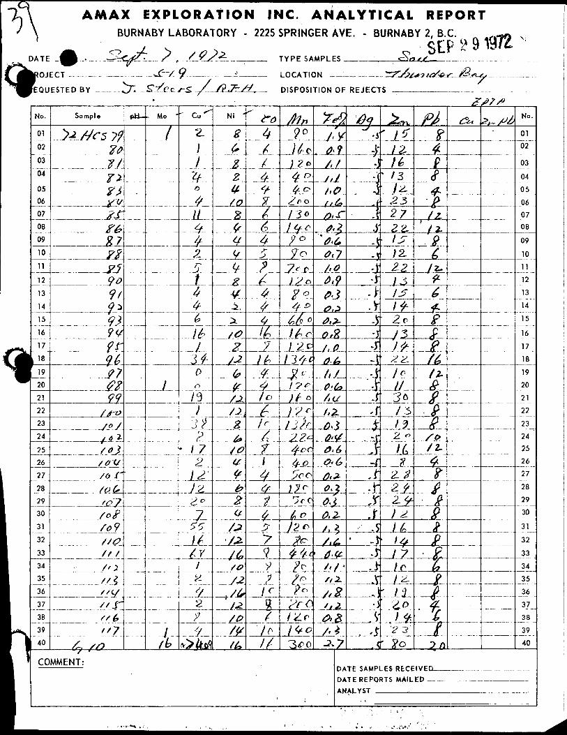
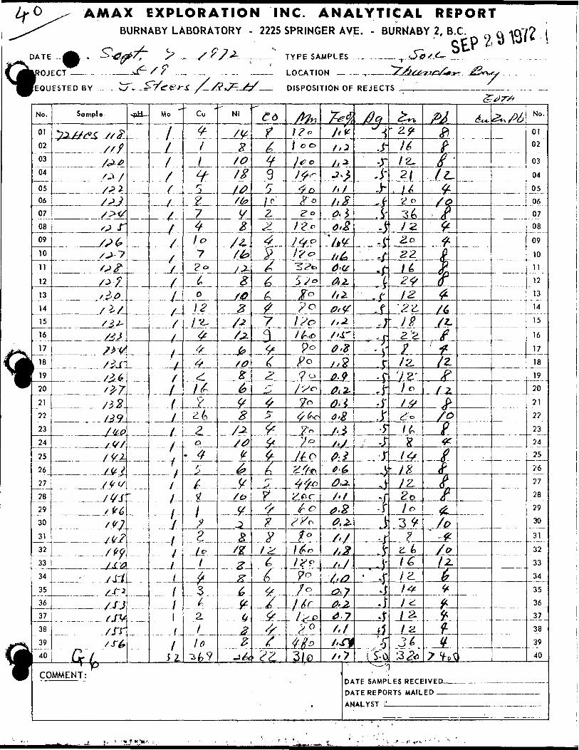
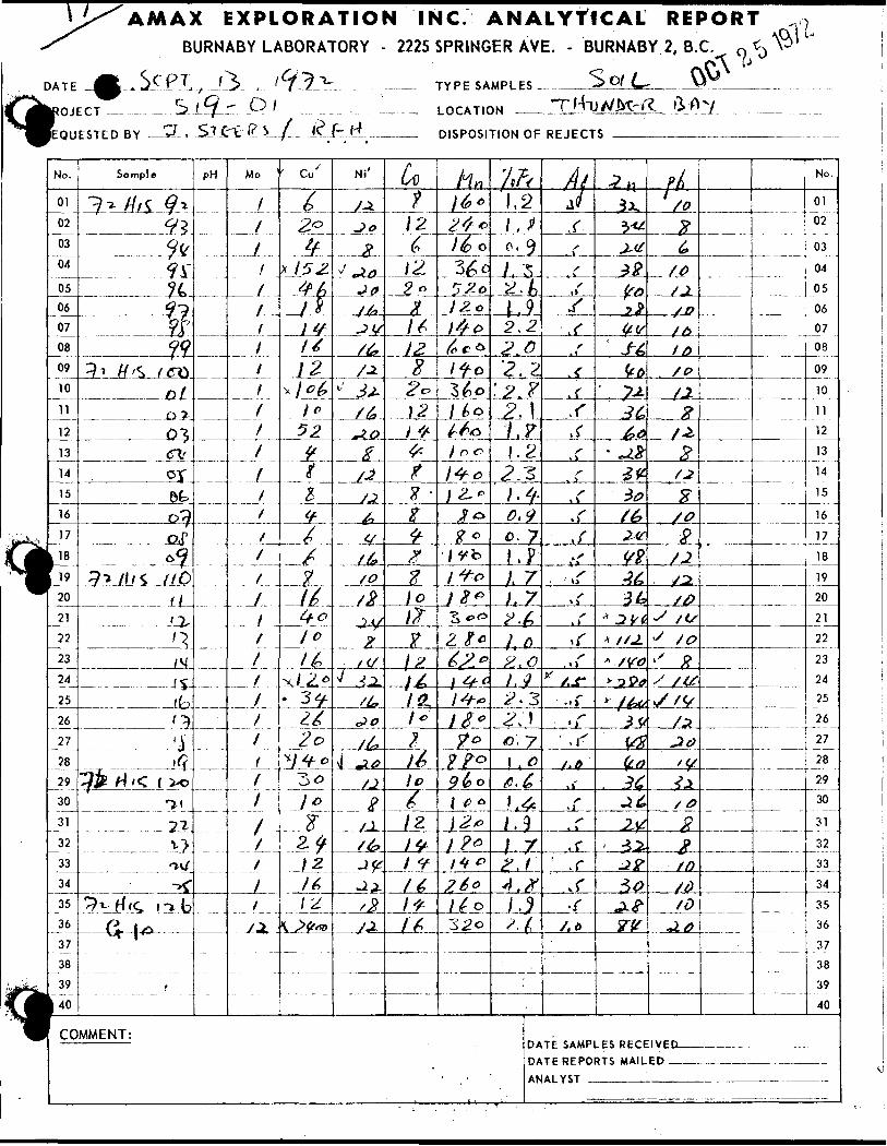
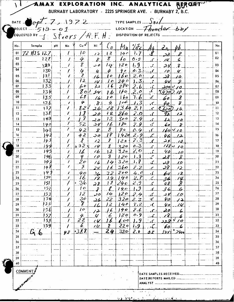
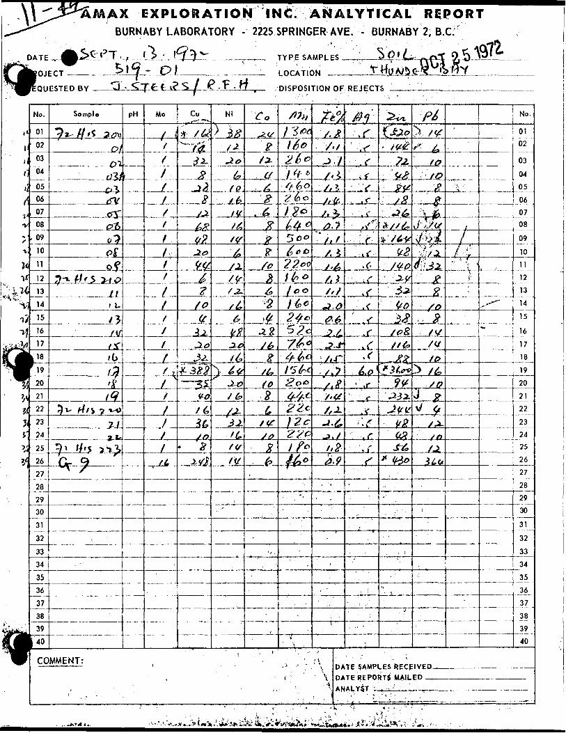
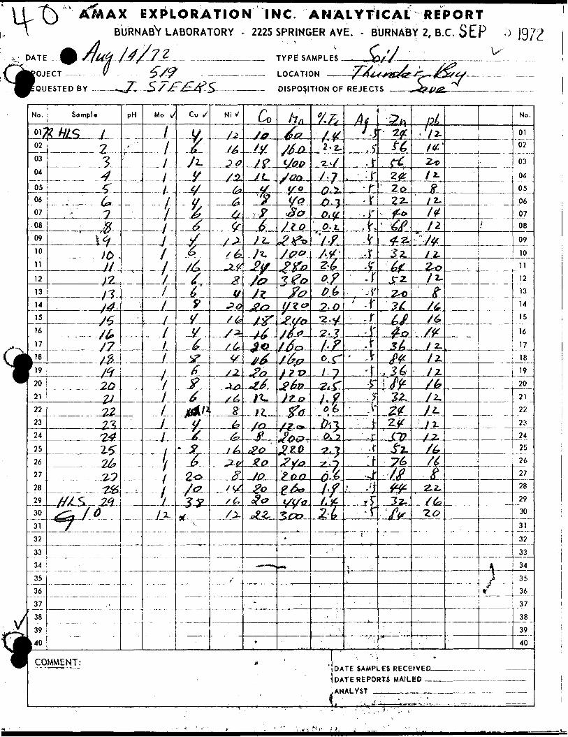
tABBREVIATION INDEX FOR CBQCBPMICAL SAMPLES
GAS - ALTITUDE
HAS - ATIGOGAMA
HCR - CASTLEWOOD
HIS - IRWIK
HLS - LAPIERRE
HOS - ONAMAN
t
t
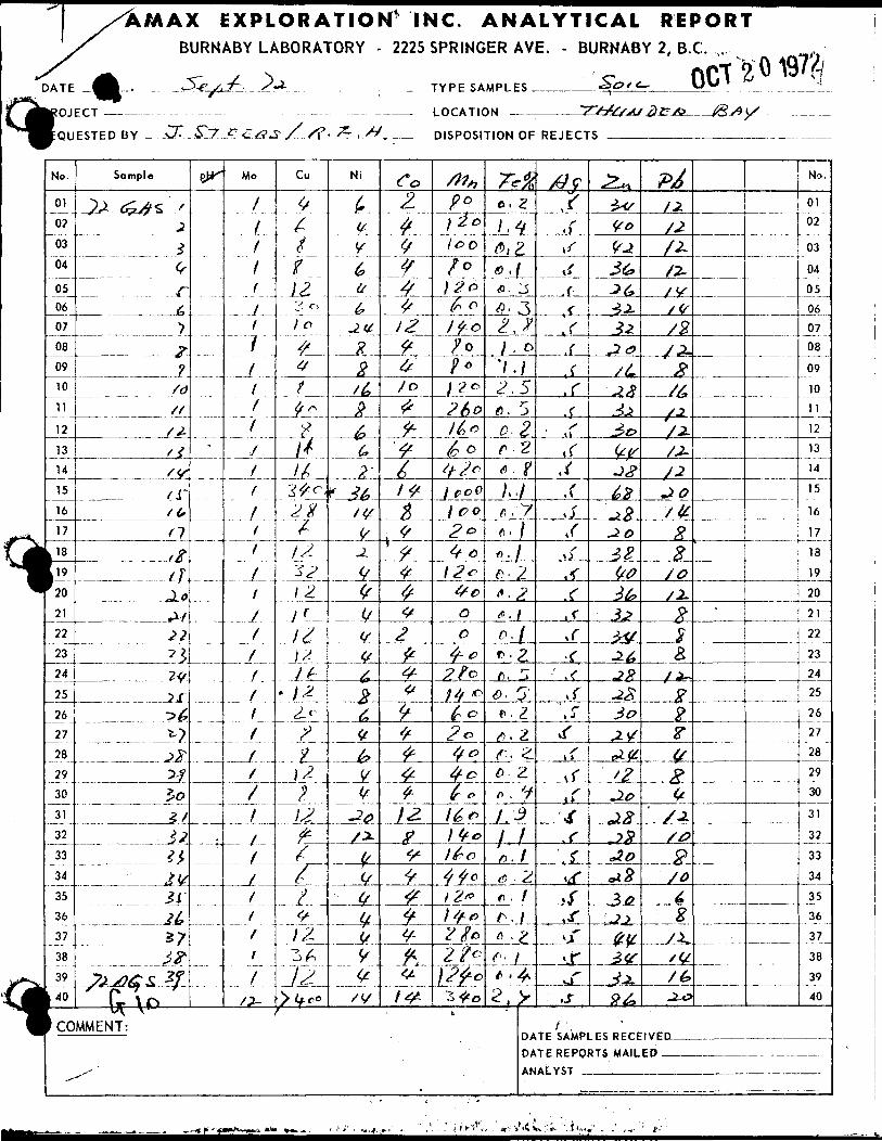
AMAX EXPLORATION INC. ANALYTICAL REPORTBURNABY LABORATORY - 2225 SPRINGER AVE. - BURNABY 2, B.C.
OCT2' 0197?/IROJpQU
No.
01
02
03
04
0506
07
08
09
10
11
12
13
14
15
16
17
r 2021
22
23
24
25
26
27
28
29
30
31
32
33
34
35
36
37
38
39
L 40
k CO
FTT
ESTED BY —-C7r.^L7
Sample
j)j, ^;^s ,z.j^^~^1F?/d/f
S±' t'Y
/r.
n'#
.. — , tt
A/12?^?#?r5^**-)
J&i?loZ/
2}
^^31J&5?^^
-,fej84aS 2f
— u^ \^* — —MMENT:
^
W
-
-— -
^C^J
Mo
f
11
1
/ff
i
J
i
f
lf
f
f
f
j
f
f
f
f
f
(
. J .
i
XtJ
...7...
/'ffr
.. f
P /S?
Cu
^^^ir12."^ o
lo^f
yffy ^
14it
2 X6
IS.~3J
l 2.j r1^\2
* j ~-
^?y\2}12.p.{f^^12-
- O f~i
. ^, /y
Ni
^y(S
b#
-Jb-
_
24eg6?
"f
K M-
^j.(^(^tyjjJ26^6^bj^if
•20jrz.
if
(ff/ij
96/V
t
Co2.
ftfy4
12?
/oje
P
^1 f-
tfy
^
^
^fj
2
fi4-V^^
-^ ^
±2L
*S^^^
fr
f^
LOCATIC
DISPOSI
/^
P?
) 2*loo
/oJ 2o"~ ^ o
jfo/o? 0l ^ 0?t)0
l&c
6 D4?o1 ecO1 co2*4 c12*4coc
4-c
1/fJ?^ o2 G
tfO
4et*
J^
)fc44c)2*) Sfj)2/02?cW*
)N ~7~S-JSsji/ s)?^A3 fi*.A(S
TION OF REJECT
refto. Z
1 -4#, za .x*- 3fl. ^l Jf , o'l.)
2.57~
o-2r V6 f/•yf" /w./o- 2*-2f- 1D.I
c. 2,r. 5
0' 5'f. Z^. 2r- 2~() . 2ft - y/.^il
i
(f 2j
f J
•"•J* . 4-2, V
f ' b '
DA DA AN
/#?^•rjf.f.f,rs
,r,ft /jr \i
s
j,r•r.
vf
t rs
,J-,r^f1 ^vfiftfif^j-,j-
S .
-^*l
3*sVe^36*3(*H.J2^t?/LJA3±^0^vJ#
&Z^B3..0
18
163^2V-2^-??-28JO
^ytj-V-'2Jio^8,0
Jo**8
l-i±^^
j±
y - TE SAMPLES RECE TE REPORTS MAIL AtYST
rt/Z-/2/Z
/y/sj 8/^-^
/2~/J-
JOs fcxr?
/O/i.
Q-
^3
/•*-
^^5"
y
g(^
/±
/0
P
4
__ /J.
/^^0
IVED —— FP
-
No.
01 02
03
04
05
06
0708
09
10
11
12
13
14
15
16
17
18
19
20
21
22
23
2425
26
27
28
29
30
31
32
33
34
35
36
37
38
39
40
—— .. ———— .
AMAX EXPLORATION INC. ANALYTICAL REPORTBURNABY LABORATORY - 2225 SPRINGER AVE. - BURNABY 2, B.C.
TYPE SAMPLES
LOCATION —-
-
DISPOSITION OF REJECTS
DATE SAMPLES RECEIVEC DATE REPORTS MAILED-
ANALYST __________
1
)ATE
'ROJ
:EQU
No.
01
02
03
04
0506
07
08
09
10
11
12
13
14
15
16
17
JlJ*.
20
21
22
23
24
25
26
27
28
2930
31
32
33
34
35
36
37
38
39
40
CO
AMAX EXPLORATION IhBURNABY LABORATORY - 2225
m . s^y. ;^wECT
E S TED BY ~ 3~- S
Somple
^i J&4S g*}30q/
?J^...^ 91
.n~i . . 97
.33.
L fO j
/O?
___ (0}
to ^/6(-
fO 6(o~?
foe
/(Of f tf/ ?ft 5//V'"SuJe/O
?± x^y/g
MMENT:
7
fit*
—— -
— ...
7,W^
Mo
/
l
{
J Jf
f
ff
ff
ff
-4-t^rifttff 'ftjfV-'-
Cu
gyVloIt**
30 jt
^) 2.34/ 9-
^1 6le32J#{/t.
t/.r 7J^
^ e3s 0
^J3~12jf)
1 fy
?3^,
&F.
Ni
^
/^
12.
(0
^Vo
J.O
c&L^j^
-)#
^Jd
(f
3-ty.
g
^Jojj.
^2p
-Lfc
^(n
JO~'Ao*4L
/8
^Co
2ygy
2 0'h' ?1212UJn
g1 2t
12-6^j2)2-l*12.\*i
-L2-
f12j?P
1C. ,SPRING
TYPE SA
LOCATK
DISPOSI
ft*^00
ItoO
\2o1k*2l*?Zvj ^0
//o
/^/^^^/r) C O
1 2ogo12&l'/ f*2*?
1 do
j ff
/o*
///c
i t*
jAe.1 2-**3,?o^/o//'o
.
ANAER AV
MPLES-
)N
LYTICAL REPORTE. - BURNABY 2, B.C.
^ ^9,01972
TION OF REJECT
^effc
f- kl ,/f
^, 7fi- ^2. 5^V-.ft;, 92 ^'2. r*2 43.2;, f
^. 7
2.2Z*7fi - *f;,^^ 7
^ . 52 .2
L^ ^
/. 73. aO/.-'J2 - t2-2J, 5
'
11 DA , DA
AN
^9~f
.r
' .r .y-
^tf
^^
^f^
fs^
Ir-r•r•r|f-.r-r
/^^p.r^
s
VJV-tisZy
-^1
fa
^J O
^G
— fc*J-Jt
ZO3-2
*T-fc^0
^^?
*i^^^a^J^^^^^.2^.^^a?E
3^3of"-*^^^•?j^^Kfat/fyoVp
, t
TE SAMPLES RECE TE REPORTS MAIL ALYST : ,.
PA^/-?y^/t,/l*/S
/fe;v/-2/d/^/^
^/^/2-
#
6
St?/-^/f/2~/{C
/^/-2
g/#^-i/^.
1VED —— EP
— -- -
No.
01 02
03
04
05
06
0708
09
10
11
12
' 13
14
15
L16
17
18
U 19
' 20
21
22
23
2425
26
27
28
29
30
31
32
33
34
35
36
37
38
39
40
iy
^4 f Mil* ** V t -a*. ^ -
AMAX EXPLORATION INC. ANALYTICAL REPORTBURNABY LABORATORY - 2225 SPRINGER AVE. - BURNABY 2, l
TYPE SAMPLES
LOCATION
DISPOSITION OF REJECTS
DATE'SAMPLES RECEIVED- DATE REPORTS MAILED —J ANALYST -———^-^i——i-
\\ f\ AMAX EXPLORATION INC. ANALYTICAL REPORTBURNABY LABORATORY - 2225 SPRINGER AVE. - BURNABY 2, B.C.
DATE ^P~: -y^^v^f-VV-Z----—-—- __7 ___ TYPE SAMPLES _____JO f f
ROJECT —-————V - JS./^ ~i? 3^ — ___ LOCATION ————?^V^ff^'Q ,
REQUESTED BY __ -^i^--S.J!-i^-4i-l?-S-V^^/ DISPOSITION OF REJECTS Q*?
AMAX EXPLORATION INC. ANALYTICAL REPORTBURNABY LABORATORY - 2225 SPRINGER AVE. - BURNABY 2, B.C.
TYPE SAMPLES
LOCATIONROJECT ____
EQUESTED BY - DISPOSITION OF REJECTS
AMAX EXPLORATION INC. ANALYTICAL REPORTBURNABY LABORATORY - 2225 SPRINGER AVE. - BURNAB*Y 2,
^. TYPE SAMPLES
__ LOCATION
DISPOSITION OF REJECTSQUESTED BY
AMAX EXPLORATION INC. ANALYTICAL REPORTBURNABY LABORATORY - 2225 SPRINGER AVE. - BURNABY 2, B.C.
" * > /^i - SEpy-—-C^ - .X , .. f-Jf-jS^ . __ TYPESAMPLES _____,
^-^1972
DISPOSITION OF REJECTS
COMMENT:DATE SAMPLES RECEIVEC
DATE REPORTS MAILED -
AMAX EXPLORATION INC. ANALYTICAL REPORTBURNABY LABORATORY - 2225 SPRINGER AVE. - BURNABY 2, B.C.
TYPE SAMPLES
LOCATION ——
l
DISPOSITION OF REJECTS
DATE SAMPLES RECEIVEC DATE REPORTS MAILED -ANALYST i!_________
AMAX EXPLORATION INC ANALYTICAL REPORTBURNABY LABORATORY
~? -
2225 SPRINGER AVE. - BURNABY 2, B.C. rlSEP 2 9
DATE
ROJECT ——.
EQUESTED BY
TYPE SAMPLES
LOCATION
DISPOSITION OF REJECTS
AMAX EXPLORATION INC. ANALYTICAL REPORTBURNABY LABORATORY - 2225 SPRINGER AVE. - BURNABY 2, B.C.
' lTYPE SAMPLES ____-J^f ;
"T~JLOCATION __-
QUESTED BY DISPOSITION OF REJECTS
X ^X' AMAX EXPLORATION INC. ANALYTICAL REPORTBURNABY LABORATORY - 2225 SPRINGER AVE. - BURNABY 2,\ B.C. ' ^ Td? 4
y ' ^ * 7 " "31/72 .——-.—-____- TYPE SAMPLES______^Q) i L______—7^—___--
- T"/ ^ /V____ LOCATION _____^ Afc4 MC/g. (T ———Zj&l
DATE SAMPLES RECEIVEC DATE REPORTS MAILED -ANALYST -i_____-^J
3li'i-'
t/)
'
m
)ATE
|ROJ
^QU
No.
01
02
03
04
0506
07
08
09
10
11
12
13
14
15
16
17
k 18
k
22
23
24
25
26
27
28
•**A AMAX 1 BURN
U-- LltsbECT - -i ,- '
ESTED BY -K.!.'- /T*\
Sample
# A//5 - 79-@r
*}l
fc5S4ft**
_ 3;i? ^ji?
Ci f\
tills ^L6) 6
J*
29
30 i
31 l
32
33
34
35
36
37
38 "39
j 40
1 CO
•~-~- -T-MMENT:
EXPLABYL/
?/^
Mo^
yj rfiiiiii/i
J'J
- —
--—
ORATION IhMORATORY - 2225r
12
\ ^^X- Sd
c^
?/o(f4*1 Z6
^t ^
g/^//f
3^0
.
NX/^gg6
/-zi.
.^6,—/^/^x
-^fi-
-^
Wr5
C,^^^?
jt
JLI^
fif)2.
It*22
1C. ,SPRING
TYPE SA
LOCATIC
DISPOSI
^
tf?**-
^0
p?cf t*
23 c(40/2"/**J^o/oT
/ 2.C&32f
ANER J
MPLE •)N
TION
ALYTIWE. - B
"S
//(^M
OF REJECT
JL~"^
-i.*9/y/
.2^/'^X"?A 0
0^,J"
'//.r/•^^j
•?
tJ ^/'9
i^:* '
DA DA AN
J?r, rvr,^^^*r*-rtC.-r.r^r
, xf
*.r
..
-M-
ICALURNAB
Vio/^-r-
S -^ ^^
REPORTY 2, B.C.
vJbiiY
r J^c^r*
— Ut^T ~rr\T ~'"~1197?
^J^,
/^
JL0
JLO
3?
JL&
(rg
jj^36**P
S&Jl^
tfV
}ii/
TE SAMPLES RECE
TE REPORTS MAIL
AI.YST
Ayj.
/±X
y .2L
^0(Sf\
/O
r Ss/o/t,
jl
'
——— ,
r* i ?K pf No.
01 02
03
04
05
06
0708
09
10
11
12
13
14
15
16
17
18
19 20
21
22
23
2425
26
27
28
29
30
31
32
33
34
35
36
37
38
39
40
IVEDED
——
i
i j i
OJECT -—-
iEQUESTED BY
EXPLORATION INC. ANALYTICAL REPORTBURNABY LABORATORY - 2225 SPRINGER AVE. - BURNABY 2, B.C. o ^
rvC*^(3 , 'T^1":^—-.___ TYPE SAMPLES _____^?L*?LL^__ J^.,. -———
" O /. _ ^^ LOCATION T f-TTJ A/JVC-it ft A v/ ___
CHL ? V A iC.f-.tL.-___ DISPOSITION OF REJECTS -—————^—-.——^—
No. Sample PH Mo Mn /f No.
01
^2
0304"
-0A0A
^J?l09
10
jnJ2
Jl1115
J6
l7.
.li 19
-?9.1L i223
, 2Jo c
12±3. .A —
X
Gf
-03
X-,/'.L
jt7i
-2*L
Ux/\2
JL1.1.2
JL c- 7..-J!A. JJ:
-ut
-^
24
-?i 2627^
il29^
30
-? 1
32
33
J3
J^iJ-S
H K t
\5
xx
-../. x^"/. xXXxJ^x L-L
...-X-^^L
/o A 7O^Z
1ST.r
2.3 .-11l* It*
-^,l .0
/g 9&Q f. (,^ -J^ .r /a
J.2 JL- -X^L
LX^-J-w?-.r j^yja..-
-^
^i^2
03
04
05
06
07
08
09
10
11
12
13
14
15
16
1Z J L)5L
JO
2 122
23
24
J5
26
2L 28W30
31
32
33^
34
.4L-JL6±. -JLO •r /O 35
36
37
38
39
40
DATE SAMPLES RECEIVEL DATE REPORTS MAILED -
ANALYST __________
.MAX EXPLORATION INC. ANALYTICALBURNABY LABORATORY - 2225 SPRINGER AVE. - BURNABY 2~B.C
TYPE SAMPLES
LOCATION
EQUESTED BY DISPOSITION OF REJECTS
- # t.
~AMAX EXPLORATION INC. ANALYTICALBURNABY LABORATORY - 2225 SPRINGER AVE. - BURNABY 2, B.C.
DATE .^.^•*O.JV....L - j 1.^ .:-. 't
OJECT ——————-?-
QUESTED BY
TYPE SAMPLES
LOCATION ——
DISPOSITION OF REJECTS
DATE SAMPLES RECEIVED- DATE REPORTS MAILED -~
AMAX EXPLORATION INC. ANALYTICAL REPORTBURNABY LABORATORY - 2225 SPRINGER AVE. - BURNABY 2, B.C. SEP -)
_ TYPE SAMPLES
LOCATION —— ~^^———
DISPOSITION OF REJECTS
No.
01;02
03
04
0506
07
08
09
10
11
12
13
14
15
16
17
Lie rT9
20
[zT
22
23
24
25
26
27
28
29
30
31
32
33
34
35
36
37
38
k40
| CO
Sampla
l HIS 17
—3..
^C*
" ?
H—j/
s?-J3/4
~J6^J7
- tf-tf2O?j
J2Z-1-1
- -24,. . . 2-5:
..J2b.79
. .. ^i-M^rP-4^ 6^
f t
MMENT:
P H
^. ~±~
Mo ^
1
yjy7yj..
-7--7-
y7S(
—lli-*r1i1^-
:t— -f
'r/z.
Cu S
yf/i.yf/ukC)if
Z
f-6-r-
fcf^p
/i/6*6V6
J&J1f/5* ^4
^oJ*2^~f —
-3JLj(.
Ni ^
y ±
-j*J
/tL
6s.
(fyjL
ft^
P^
/^
/^
/2JL^S
-VA
*
-.—^.- ^
/^
^^/5"/^
. /^../i-
s
Co/a
l/^Tift
f
VJL^/t^/^x?j^r— /-3 —y/— ^ —-*5-j/A
-^2-
^/t.
i?
HS1-,f
cf(?^0
/f#?
^^^.
~- '""*
, -
f"
^/l
^0Up
C/c?/?
j 0QyoY*
/t o*?tf*/&0
9tf0vtff)fa^L*
f*/*?74^./^O-
y^-' t1^^EL#foJ? o
tffi-te~-/CO-3*0Zj&y- too2^**~-yy*-"5.C*y
'
M**
^
2. z.^ji/y. 7^ ^^ 3Q L
0*t."/•fZ-&o.?
2-0-Z^
2.?
^z•o.r'7
r•7 f•t * yj, foi
hA ?~^-?-^9-
(7.^y ^-t*f- '•ti2-1
" : '
a , DA
DA
, ANi
At
/.j
rf• r• f-r
••r
.^-r-V.rr; .r
,r-r•-.t-* -r
•r.y•.^
•".t-.j-•r:i-
•-J-' .'t
rT;T
t
s .
^f)•' 2^T
/-^
r^^-.2^1
2o
f-oA i^
^2.^2.
' &Z
JT2.2^0
3^-(j.-*?Z&H
, ^61A
22.2f^2f^.^T^JL
-J?^/^^^— ±t~f^-72-
TV
TE SAMPLES RECE TEREPORU MAIL
Al YST
/?xi 7 2-/tf'z*f*.Rf d
fi
1 2.ZoX 2-
K
^ /^
W/Z-
/i
/^
/^/2-
JL./2-
-V^-fcKS
2-2-
/^/z^
* '
IVED —— FP
'
No.
0102
03
04
05
06
0708
09
10
11
12
13
14
15
16
17
18
i 19
-4—fy
20
21
22
23
24
25
26
27
28
29
30
31
32
33
34
35
36
37
38
39
40
f ' *- -i '-
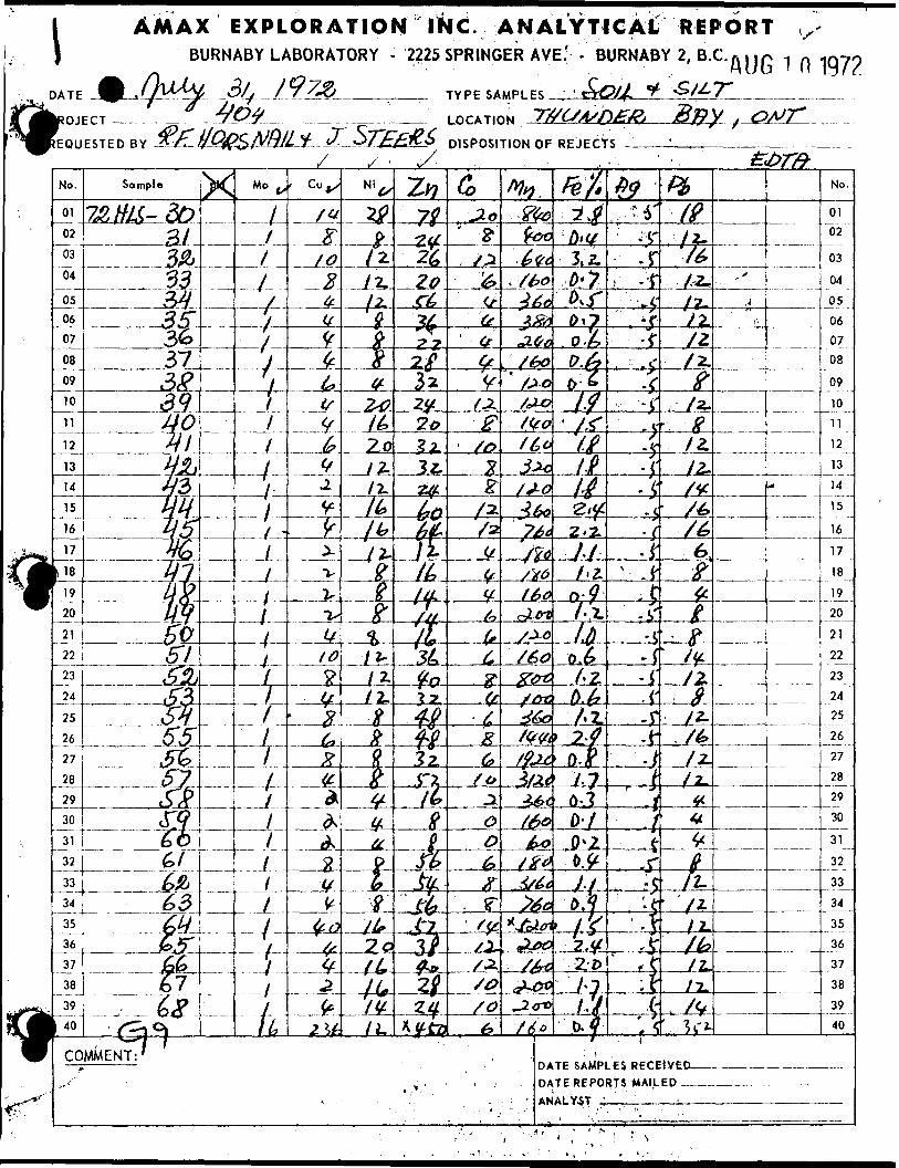
l AMAX EXPLORATION INC ANALYTICAL REPORTBURNABY LABORATORY - 2225 SPRINGER AVE.' - BURNABY 2, B.C. AUG 1 O 1972
TYPE SAMPLES- " '
LOCATION
DISPOSITION OF REJECTSEQUESTED BY
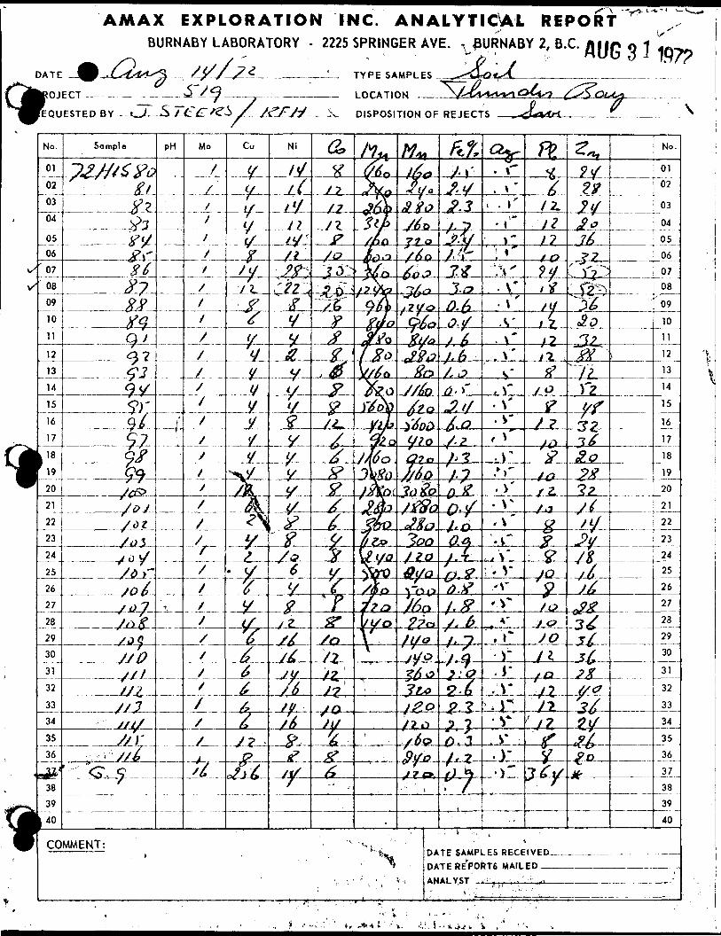
AMAX EXPLORATION INC. ANALYTICAL REPORTBURNABY LABORATORY - 2225 SPRINGER AVE. , 0URNABY 2, B.C.
DISPOSITION OF REJECTS
'* j** \
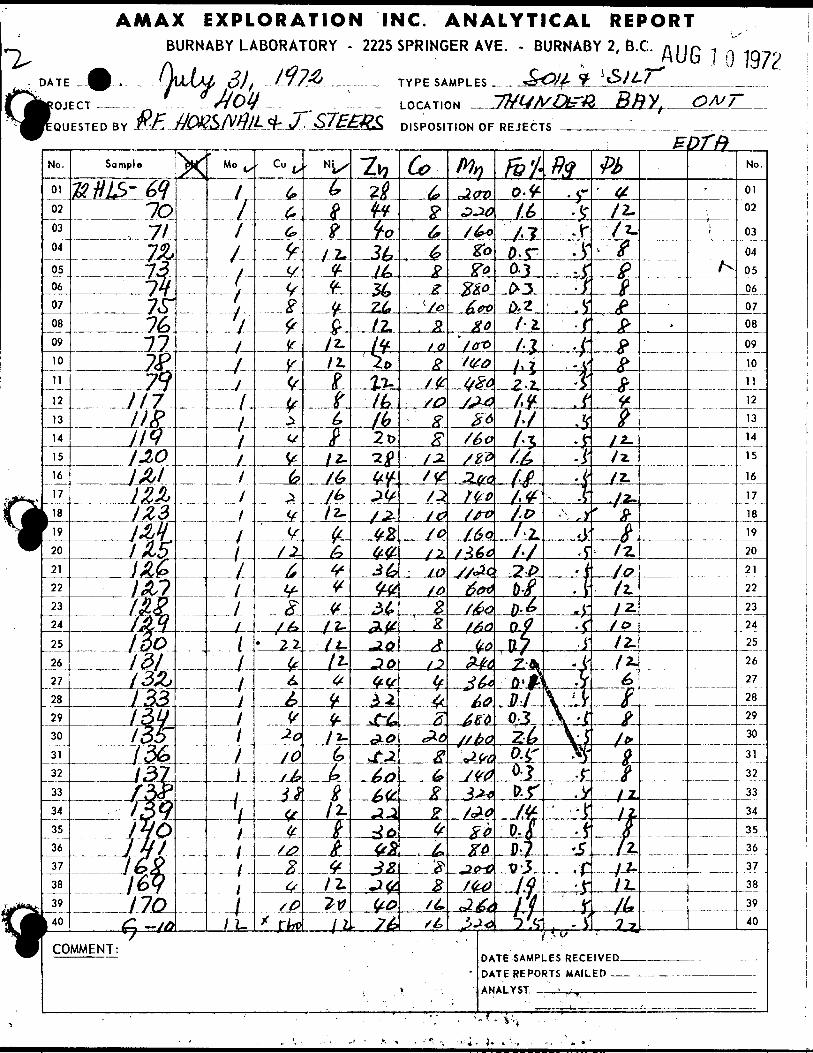
AMAX EXPLORATION INC. ANALYTICAL REPORTBURNABY LABORATORY - 2225 SPRINGER AVE. - BURNABY 2, B.C. AUG I O 1.97?
TYPE SAMPLES
LOCATION
DISPOSITION OF REJECTS
DATE SAMPLES RECEIVED- DATE REPORTS MAILED — ANALYST, —-x^,_____
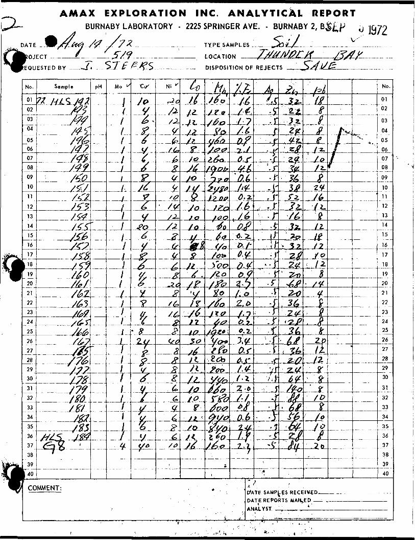
AMAX EXPLORATION INC. ANALYTICAL REPORTBURNABY LABORATORY - 2225 SPRINGER AVE. - BURNABY 2, B^^
DATE . /7/f^ /# f 7Z - __ __-^^--™-. TYPE SAMPLES Jib// ___________
OJECT ____^——-57?-——-——— LOCATION -
EQUESTEDBY ———^*-- ^T^^-^S —————— DISPOSITION OF REJECTS
DWTE SAMPLES RECEIVED- DATE REPORTS MANNED — ANALYST .', ., i . t ...J——
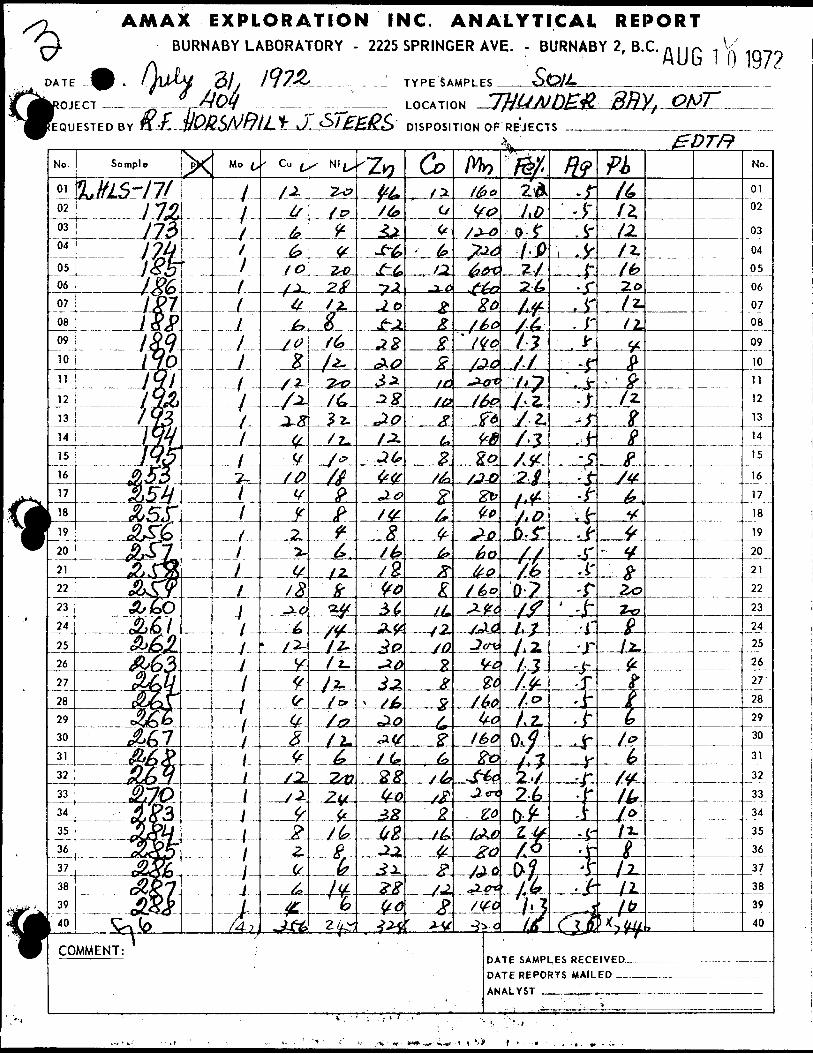
AMAX EXPLORATION INC. ANALYTICAL REPORTBURNABY LABORATORY - 2225 SPRINGER AVE. - BURNABY 2, B.C.
DATE -W ...-i/U-W-- OJ t J.y2Q—...- ——____' TYPESAMPLES
?OJECT -—. —-^-.-—,-^ri/Y __ ____ LOCATION
REQUESTED BY
AUG 1 f) 197?
DISPOSITION Of REJECTS' b "
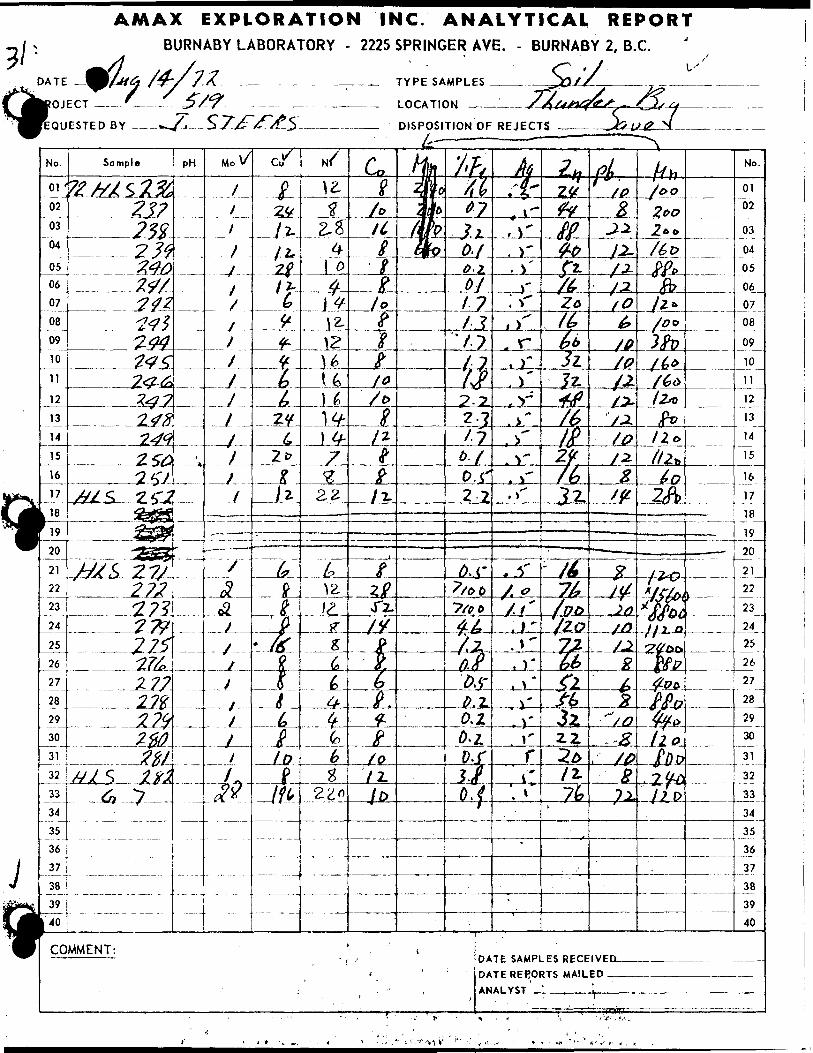
AMAX EXPLORATION INC. ANALYTICAL REPORTBURNABY LABORATORY - 2225 SPRINGER AVE. - BURNABY 2, B.C.
TYPE SAMPLES
LOCATION
DISPOSITION OF REJECTS L
DATE SAMPLES RECEIVEC DATE REPORTS MAILED.
ANALYST ' , \
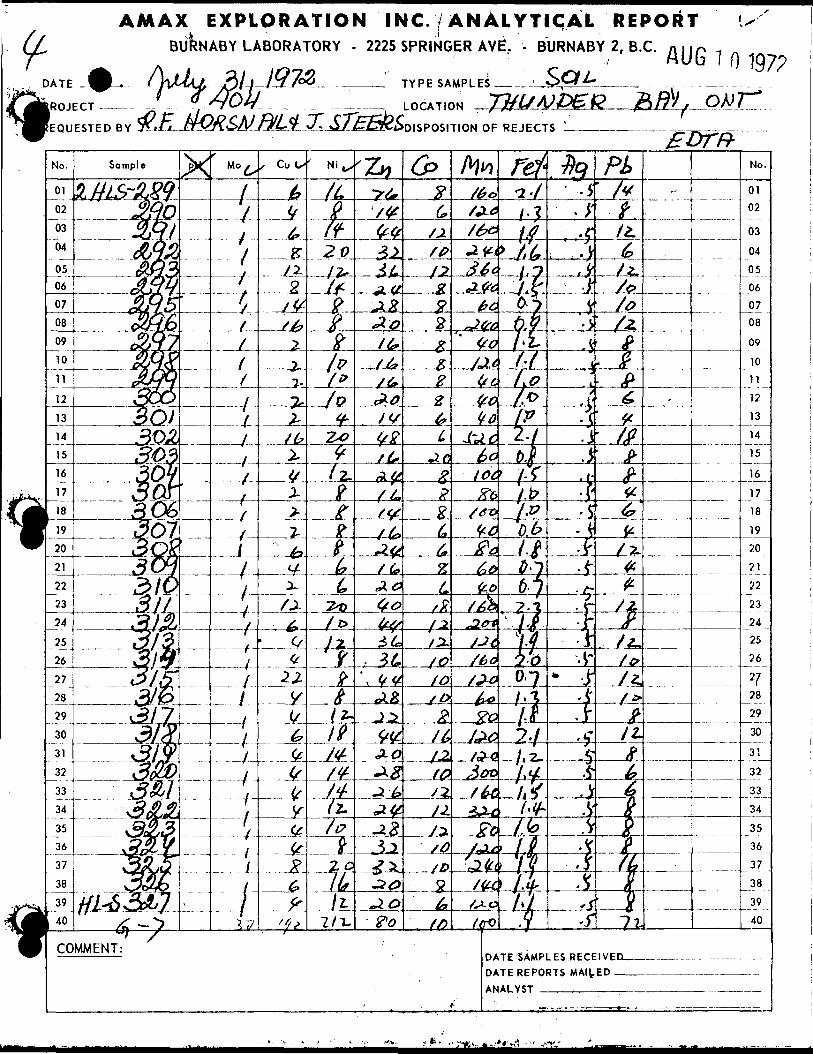
? EXPLORATION INC. ANALYTICAL REPORT \SBURNABY LABORATORY - 2225 SPRINGER AVE;. - BURNABY 2, B.C. n.,p ,- AUG 1 o W)
A 11 ZLI IQ7V *-—. ' w{\\MAJ, gijjyjxL J ^4by
TYPE SAMPLE
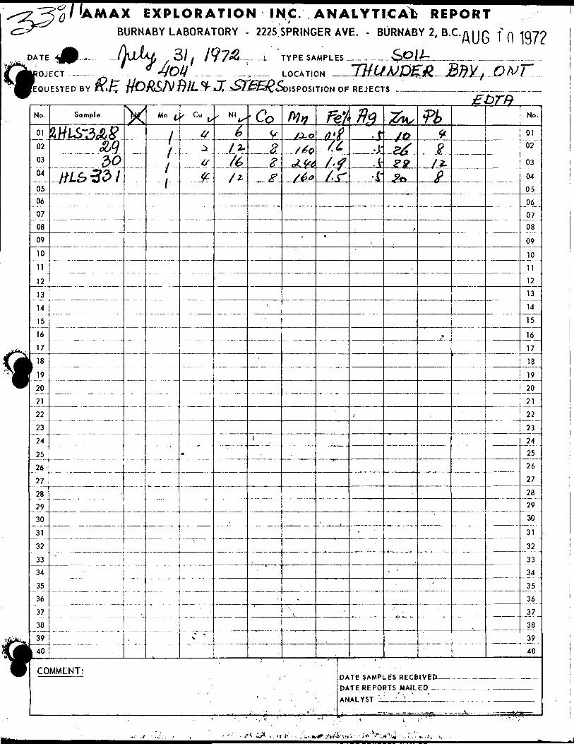
/UMAX EXPLORATION INC. ANALYTICAL REPORTBURNABY LABORATORY - 2225 SPRINGER AVE. - BURNABY 2, B.C.n i ir -f
DATE •^•L,. IrJJUJ, .., S) t Jy7fQ—— .-j- TYPE SAMPLES.————
OJECT -——.
EQUESTED BY
197?
LOCATION
ISPOSITION OF REJECTS
No.
01
02
03
04
0506
07
08
09
10
11
12
13
14
15
16
17
, 18h-20
21
22
23
24
25
26
27
28
29
30
31
32
33
34
35
36
37
38
3,
WCO
Sample
MlS~3olj8Q Q?)O
#LS331
MMENT:
X
•— -
-— --
,
Mo ^
Y-1-
1
— - - -
--- - -
s Cujy
y^t/*
.
V
' N.^b
/2-
/^
y*
- — —
— —
-Co9
2g
•*.
'
tyyju~oj ' &Q
\J /^y c^** Y~ty
S&&
~.
mO'ti(6t'f/.r
*
, DA DA
' - . . : ' \ AN
flfl.j--P-V
i'
-
fa,
,0
PJ?
22?**
,
•^ -
TE SAMPLES RECE TE REPORTS MAIL Al VST ' ' ' '
fk*t^f*
j,
'
No.
01
02
03
04
05
06
0708
09
10
11
12
13
14
15
16
17
18
19
20
21
22
23
24 25
26
27
28
29
30
31
32
33
34
35
36
37
38
39
40
1 V E D ___________ —— _ - ED
S t-fto
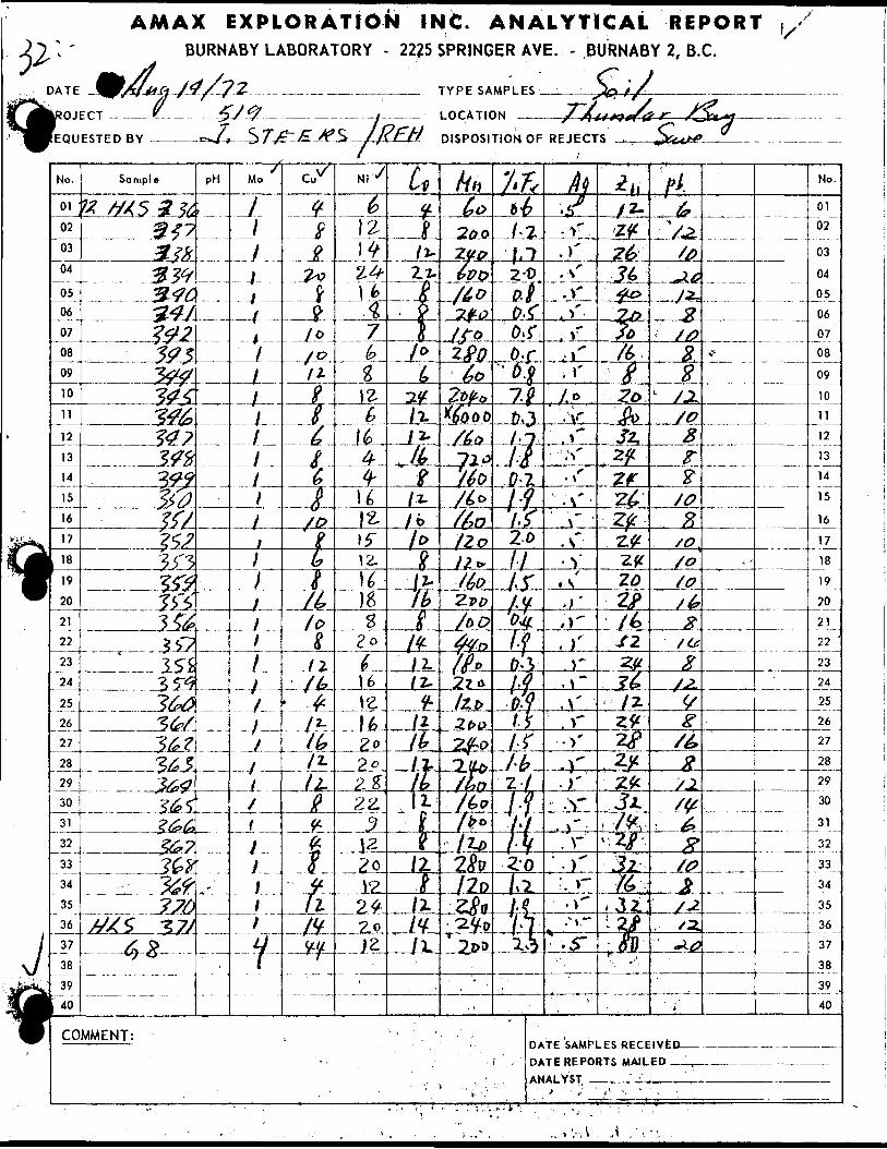
AMAX EXPLORATION INC. ANALYTICAL REPORTBURNABY LABORATORY - 2225 SPRINGER AVE. - BURNABY 2, B.C.
T&4-TYPE SAMPLES
-..-y.--...-- LOCATION
lj?FH-Z4*
D1SPOSITIOHOF REJECTS
DATE SAMPLES RECEIVEC DATE REPORTS MAILED -

AMAX EXPLORATION INC. ANALYTICAL REPORTBURNABY LABORATORY - 2225 SPRINGER AVE. T BURNABY 2, B.C.
4fc^' ^ /^ S? J CVDATE ^JMfafr/y/SA ^. . .^ ______ TYPE SAMPLES—±_____^^//L-
OJECT ———.-__- — y^ - . ..J___ LOCATION —T--—
EQUESTED BY — , ^^/^t^ 3 J ^^/^^J /JZLjj DISPOSITION OF REJECTS
DATE SAMPLES RECEIVED- DATE REPORTS' MAILED ^~ANAL,YST ,.., "- ——*——
,~:t'
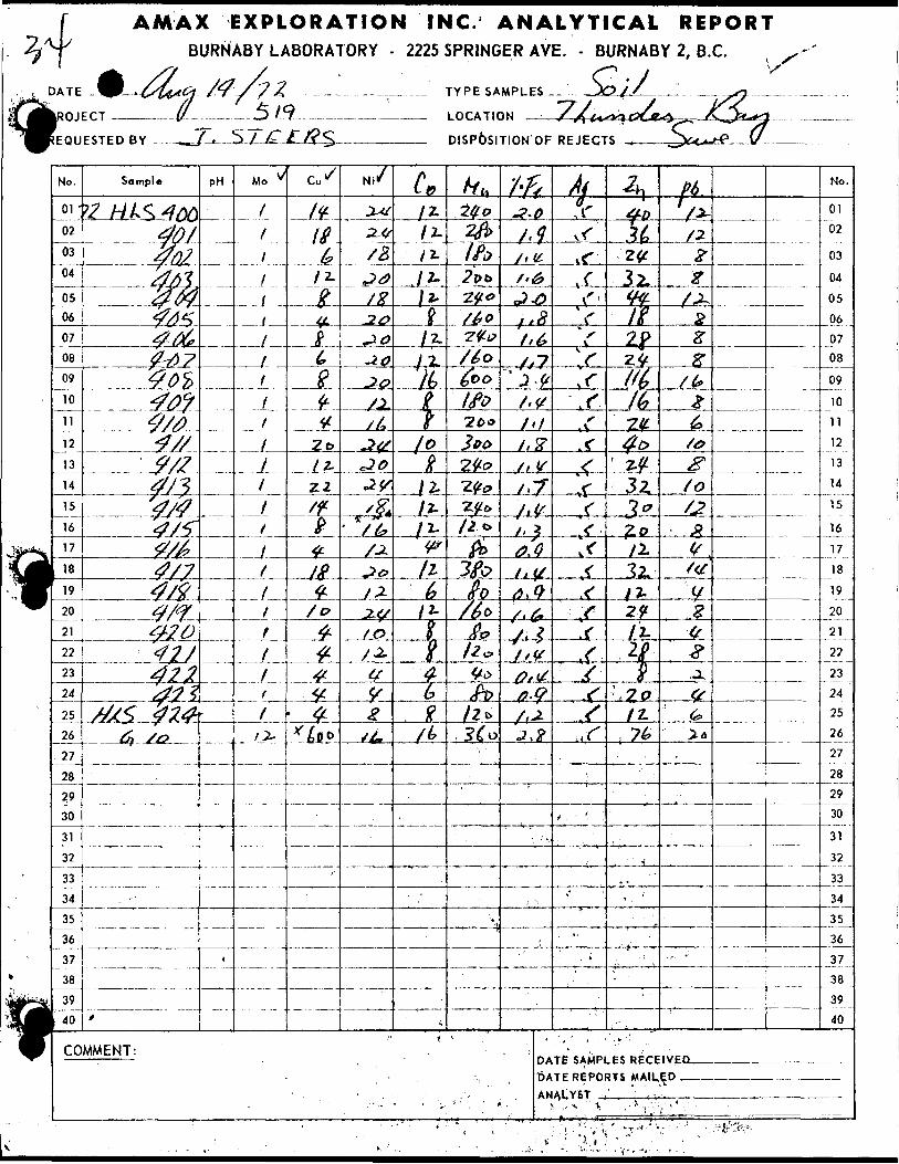
AMAX EXPLORATION INC. ANALYTICAL REPORTBURNABY LABORATORY - 2225 SPRINGER AVE. - BURNABY 2, B.C.
TYPE SAMPLES
LOCATION
DISPbSITION OF REJECTS
DATE SAMPLES RECEIVED, tiATE REPORTS MAILED —
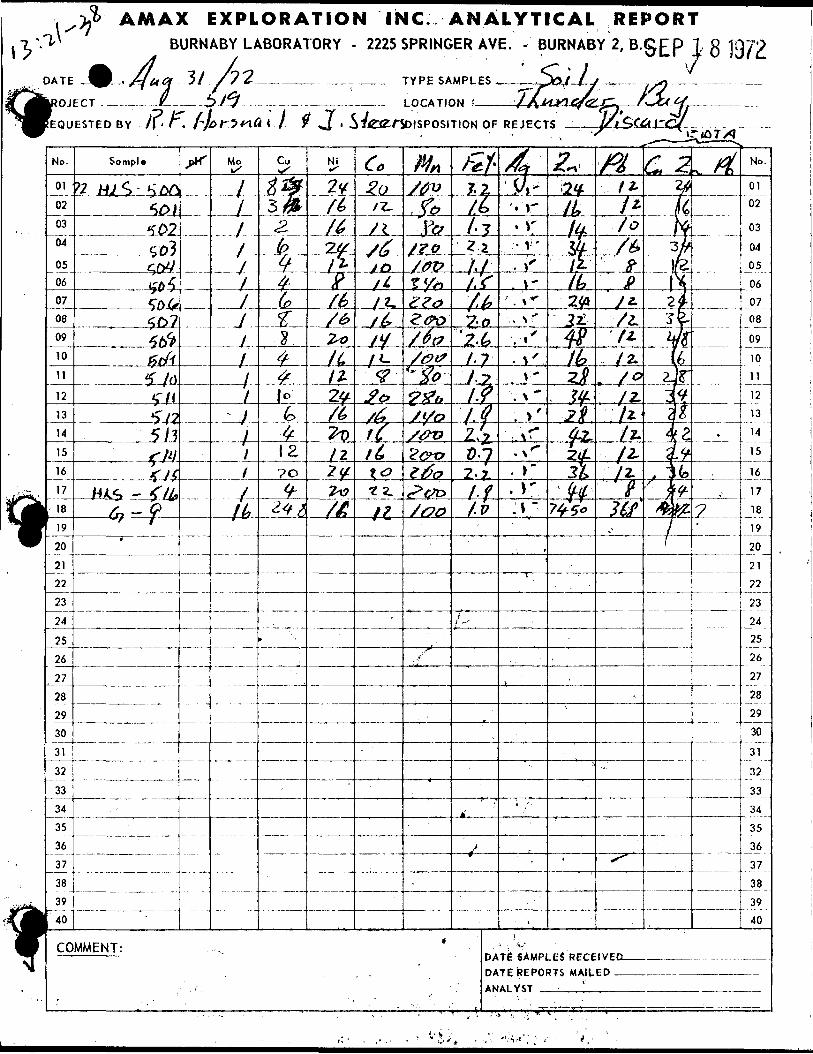
3 AMAX EXPLORATION INC. ANALYTICAL REPORTBURNABY LABORATORY - 2225 SPRINGER AVE. - BURNABY 2, B.0^p l g
TYPE SAMPLES.
LOCATION
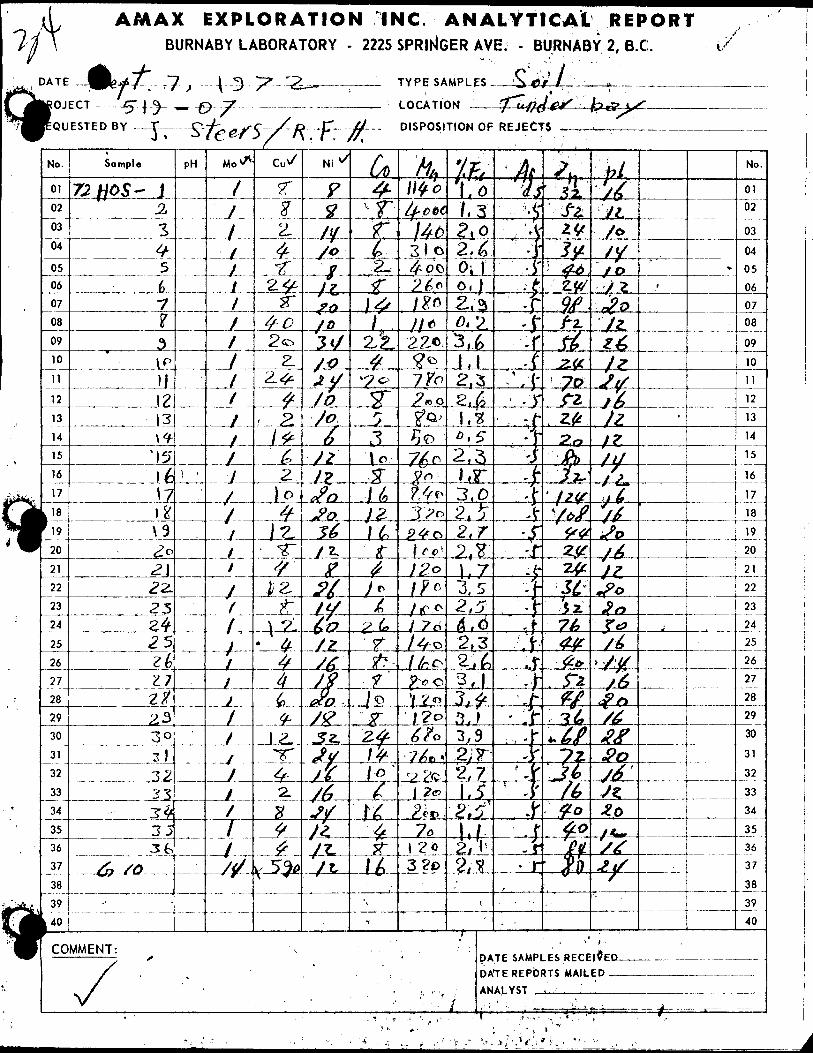
AMAX EXPLORATION INC. ANALYTICAL REPORTBURNABY LABORATORY - 2225 SPRINGER AVE. - BURNABY 2, B.C.
TYPE SAMPLES
LOCATION
S If l
DISPOSITION OF REJECTS -
DATE SAMPLES RECEI^ED- DATE REPORTS MAILED —ANALYST . .y.., . ,.'—--——
,.~ v,.v;-.V;i* L- - "- '•--
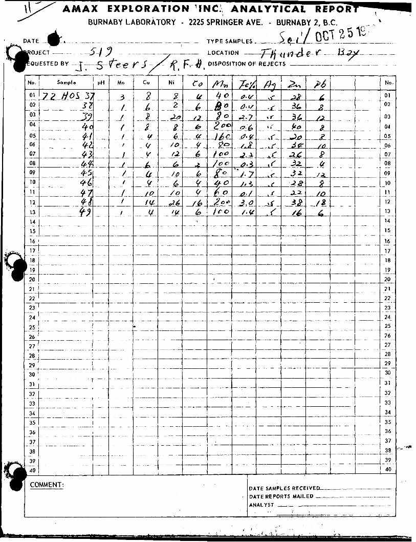
AMAX EXPLORATION INC ANALYTICALBURNABY LABORATORY - 2225 SPRINGER AYE. - BURNABY
REPOR12, B.C.
ft ^Jfy
— LOCATION
DISPOSITION OF REJECTS
No.
01
02
03
04
0506
07
08
09
10
11
12
13
14
15
16
17
k ' 8
f 191 "
1"22
23
24
25
26
27
28
29
30
31
32
33
34
35
36
37
38
39
L 40
Sample
72 HO^ 3;S?j;j^-0
4" f-j^
tt-*f\4-54-b
W- Jtl
--— — --
I COMMENT:
PH
i
-
Mo
3
f
J
yfj
-L A
tt 1fff
Cu
2/^sjfy
M
_ _
if
APLV
A
•— ——
Ni
2 \2
J-0
2
so/2.
6*/o4-/o
^6^L
C*
ut.t?tf(f(y^(0(f(f
f ' fe A
b'
. ———
/*7wbcto*
2. 0**-JMs-
^0
t 00
j oc(T0f"
Jro
:
T-'/.a.ts-2.7O'-tf
0'^/r 2
-?'±
0,±
/- 7S**
3.0/•v
DA
- DA
AN
th
-r
,,-^J-
iff(f
*f{
-^
^
3/if**
-5 O3p3-63.2.Jz^*?.12.
3^/^
TE SAMPLES RECE TE REPORTS MAIL Al Y^T
^^^
_ ^^/o
__^_^xi^/o
^
No.
01 "02
03
04
05
06
07
08
09
10
11
12
13
14
15
16
17
18
19
20
21
22
23
24
25
26
27
28
29
30
31
32
33
34
35
36
37
38
39
40
IVEDED . .
.. , .
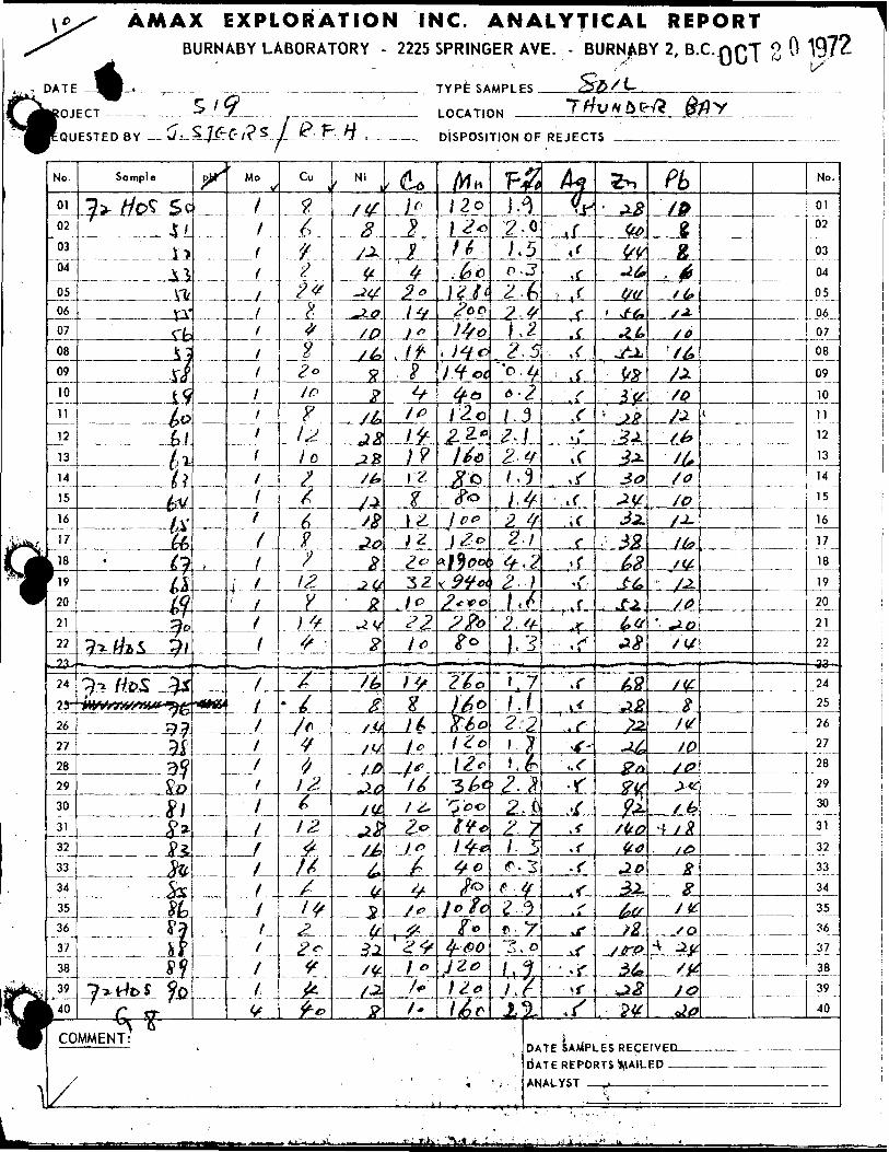
AMAX EXPLORATION INC. ANALYTICAL REPORTBURNABY LABORATORY - 2225 SPRINGER AYE. - BURNABY 2, B.C.nQj g O 197^
TYPE SAMPLES ——
DISPOSITION OF REJECTS
DATE SAMPLES RECEIVED- D'ATE REPORTS RAILED —ANALYST —-._____:__
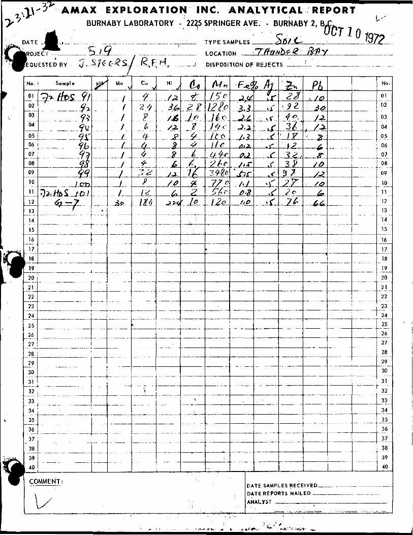
7-V
Cj•.
;i
H
^
)ATE
LROJ
!EQU
No.
01
02
03
04
0506
07
08
09
10
11
12
13
14
15
16
17
l 18! 19
20
21
22
23
24
25
26
27
28
29
30
31
32
33
34
35
36
37
38
39- 40
1 ————————————————
'3" AMAX EXPLORATION IFBURNABY LABORATORY - 222,5
EC r t? 1 yk - ^~-
ESTED BY —s/ —
Sample
QTU ffoS 9lQ^Cf^
?Ua^ay
??fjhq
1 PT*HiuffcS /D/
^7 *~/1'^ f
COMMENT:
\X
S/f C-^?S 1 R F H (j- -——. 1 ——r
P*
-• ——
.
- ————
————
- ———
—————
Mo
f
f
/
1
i
f
-J -
L1
Cu ^^
2 ^p
^/r — *#^-—
f-
22P1^Itf/i
\
Ni J
LZ3^
S3.Fgx^
/j-/0
6*
dog-
2 fi
f^^^^IrfiZ' l0
s
— , —
1C. .SPRING
TYPESA
LOCATK
DISPOSI
A/H
/5cIZlpj^^ol^f-fl^(\If sif-^r'S kc34-fa77 ctt P1 2o
.
ANER/
MPLE
IN
TION
F.
ALYTICAL REPORTWE. - BURNABY 2, BX^ U '
• c . . WTlOiqns ^15/C W?
.Tfftwbe-G'' fcfl-yOF REJECT
e*5
^tf^
/.4*'
J ^
?
0.1
y/^'./7ir
/•XP'%/,o
DA
DA
AN
l faf r
:. .\\
.—**L Y
^^^•r,f
^ " - i' '
^22
'. 9 Z.4*3/.' /r
.-3 23^9f^x'^^?e
7^
TE SAMPLES RECE TE REPORTS MAIL AI.XST . , . ,.
Pi. /o^0/.iX-^-
; ^,
ffso/^/^^
66*
IVED —— F D
No.
01
02
03
04
05
06
0708
09
1011
12
13
14
15
16
17
18
19
20
21
22
23
2425
26
27
28
29
30
31
32
U33
34
35
36
37
38
39
40
"
i 1
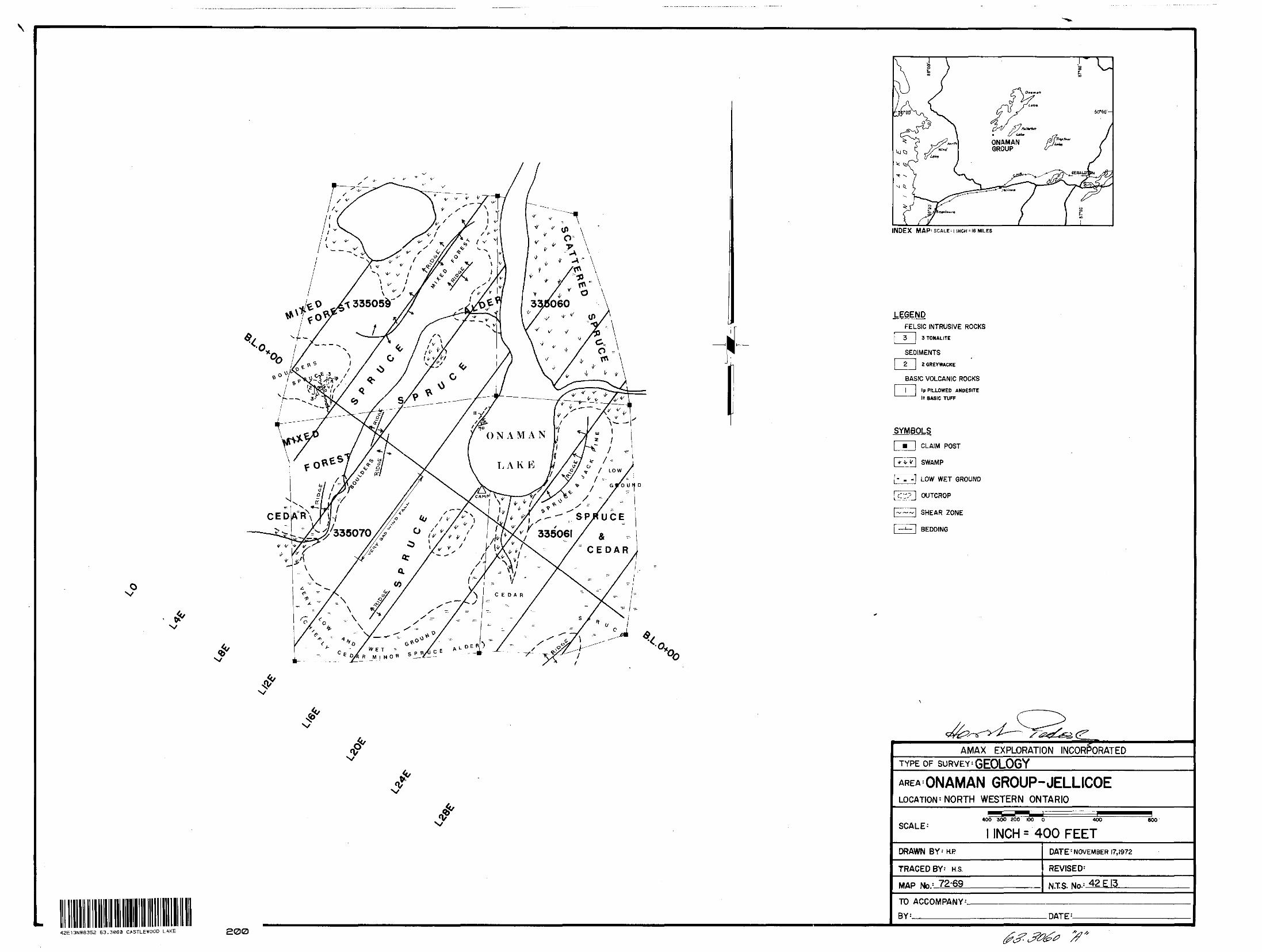
\
ox/
a•o. iOo l
INDEX MAP ! SCALE M INCH :I6 MILES
LEGENDFELSIC INTRUSIVE ROCKS
3 TONALITE
SEDIMENTS
2 j 2 GREYWACKE
BASIC VOLCANIC ROCKS
Ip PILLOWED ANDESITE
It BASIC TUFF
SYMBOLS
l m l CLAIM POST
|TvT| SWAMP
FV~-1 LOW WET GROUND
l c:? l OUTCROP
|~~~| SHEAR ZONE
i —*— \ BEDDING
42E13NW6352 63.3063 CASTLEWOOD LAKE 200
f AMAX EXPLORATION INCORPORATEDTYPE OF SURVEY' GEOLOGY
GROUP-JELLICOELOCATION 1 NORTH WESTERN ONTARIO
SCALE'400 300 200 CO O 400
l INCH s 400 FEET800
DRAWN BY-'KP
TRACED BY: H.S.
MAP No.; 72-69
DATE"'NOVEMBER 17,1972
REVISE D:
NTS. No-:
TO ACCOMPANY^
BY-—^—^^ DATE :-
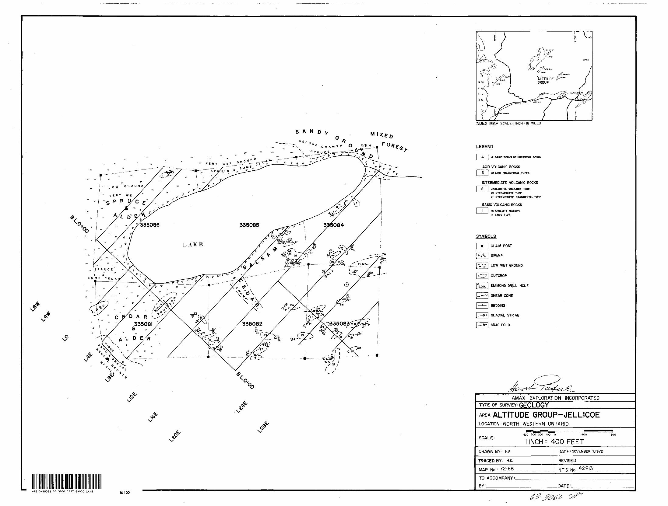
S A N o y
S6Co * 0" G R O Vi t
t
Mixeo Fo*^
42E13NW8352 63.3060 CASTLEWOOD LAKE 210
INDEX MAP SCALE.) INCH - 16 MILES
LEGEND
4 BASIC ROCKS OF UNCERTAIN ORIGIN
LI
3f ACID FRAGMENTAL TUFFS
INTERMEDIATE VOLCANIC ROCKS2m MASSIVE VOLCANIC ROCK21 INTERMEDIATE TUFF
2f INTERMEDIATE FRAGMENTAL TUFF
BASIC VOLCANIC ROCKS
Im ANDESITE MASSIVE
H BASIC TUFF
SYMBOLS
CLAIM POST
SWAMP
LOW WET GROUND
OUTCROP
DIAMOND DRILL HOLE
SHEAR ZONE
BEDDING
GLACIAL STRIAE
DRAG FOLD
AMAX EXPLORATION INCORPORATEDTYPE OF SURVEY^ GEO LOG Y
GROUP-JELLICOELOCATION 1 NORTH WESTERN ONTARIO
SCALE'400 300 200 100 0 400 BOO
INCH S 400 FEETDRAWN BY : H.P
TRACED BY: H.S.
MAP No. : 72-60,
DATE NOVEMBER 17,1972
REVISED'
NT. S. No- :
TO ACCOMPANY
DATE 1—
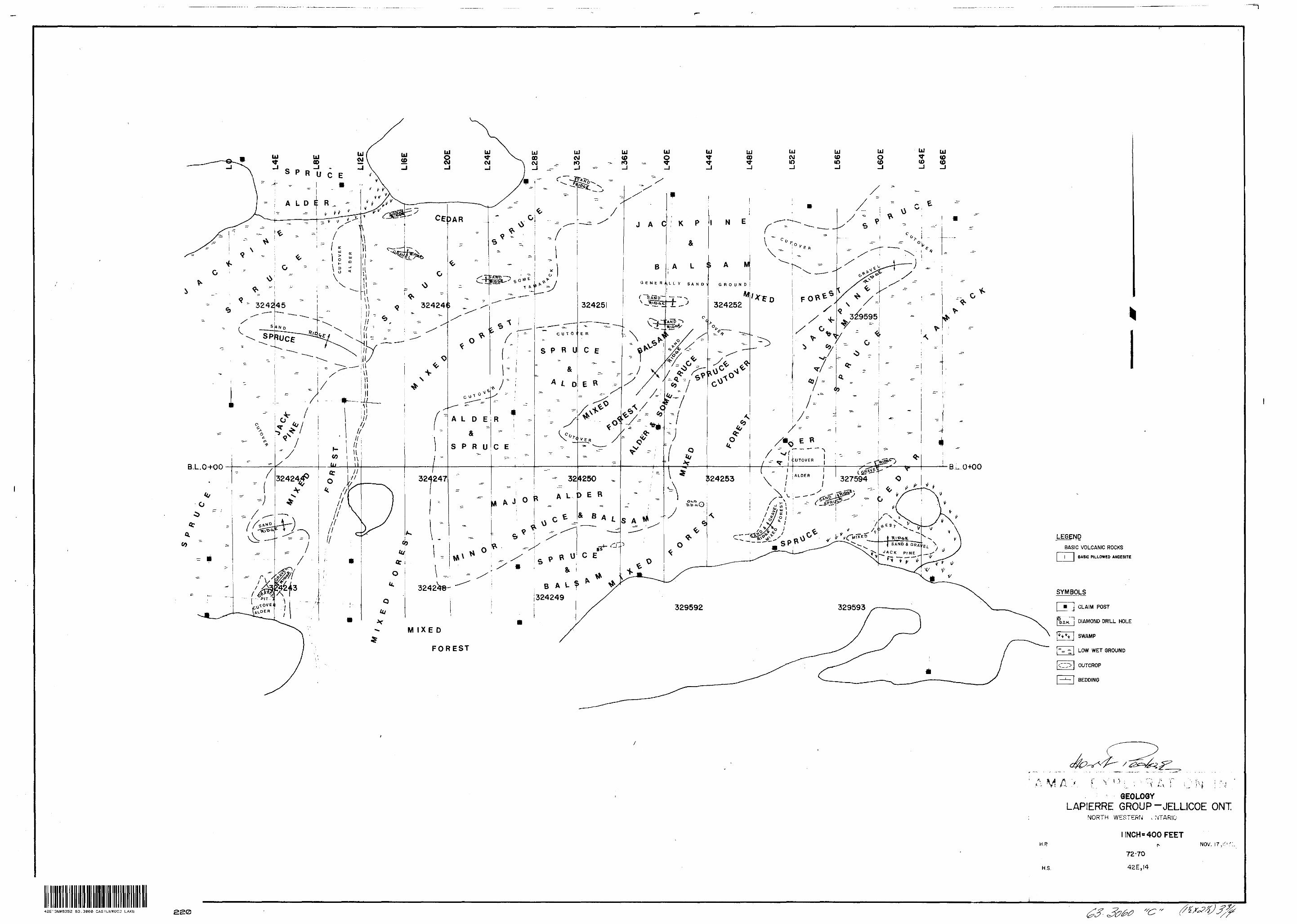
SPRUCE
LEGEND
BASIC VOLCANIC ROCKS
BASIC PILLOWED ANDESITE
SYMBOLS
[""•"~| CLAIM POST
DIAMOND DRILL HOLE
SWAMP
LOW WET GROUND
OUTCROP
BEDDING
42E13NW8352 63.3060 CASTLEWOOD LAKE 220
\ r- *f M . .
GEOLOGYLAPIERRE GROUP-JELLICOE ONT
NORTH WESTERN , NTARIO
H.P
H.S.
l INCH " 400 FEETp-
72-70
42E,I4
NOV. 17, i
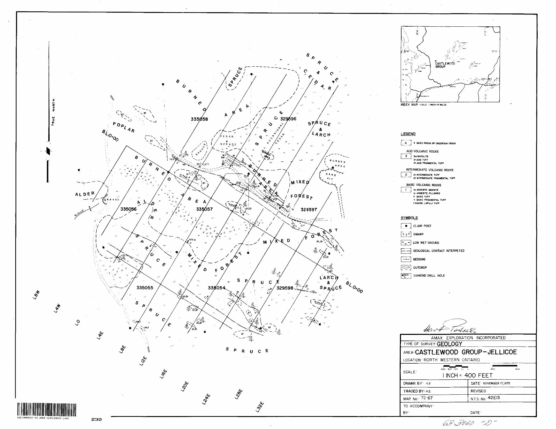
w3ne
R U C E
INDEX MAP SCALE l INCH'16 MILES
LEGEND
4 BASIC ROCKS OF UNCERTAIN ORIGIN
ACID VOLCANIC ROCKS
3m RHYOLITE 3t ACID TUFF 3f ACID FRAGMENTAL TUFF
INTERMEDIATE VOLCANIC ROCKS
Zt INTERMEDIATE TUFF21 INTERMEDIATE FRAGMENTAL TUFF
BASIC VOLCANIC ROCKSl j tm ANDESITE MASSIVE
Ip ANDESITE PILLOWED It BASIC TUFF [f BASIC FRAGMENTAL TUFF l ItBASIC LAPILLI TUFF
SYMBOLS
l m~~\ CLAIM POST
SWAMP
LOW WET GROUND
GEOLOGICAL CONTACT INTERPETED
BEDDING
OUTCROP
DIAMOND DRILL HOLE.J
42E13NW8352 63.3060 CASTLEWOOD LAKE
AMAX EXPLORATION INCORPORATEDTYPE OF SURVEY'GEOLOGY
AREA CASTLEWOOD GROUP-JELLICOELOCATION ; NORTH WESTERN ONTARIO
SCALE: 400 30C ?00
INCH ^ 400 FEETDRAWN B Y : H. P
TRACED BY' H.s.
MAP No. ;
DATE 1 NOVEMBER 17,1972
REVISED :
TO ACCOMPANY- BY : DATE :
230
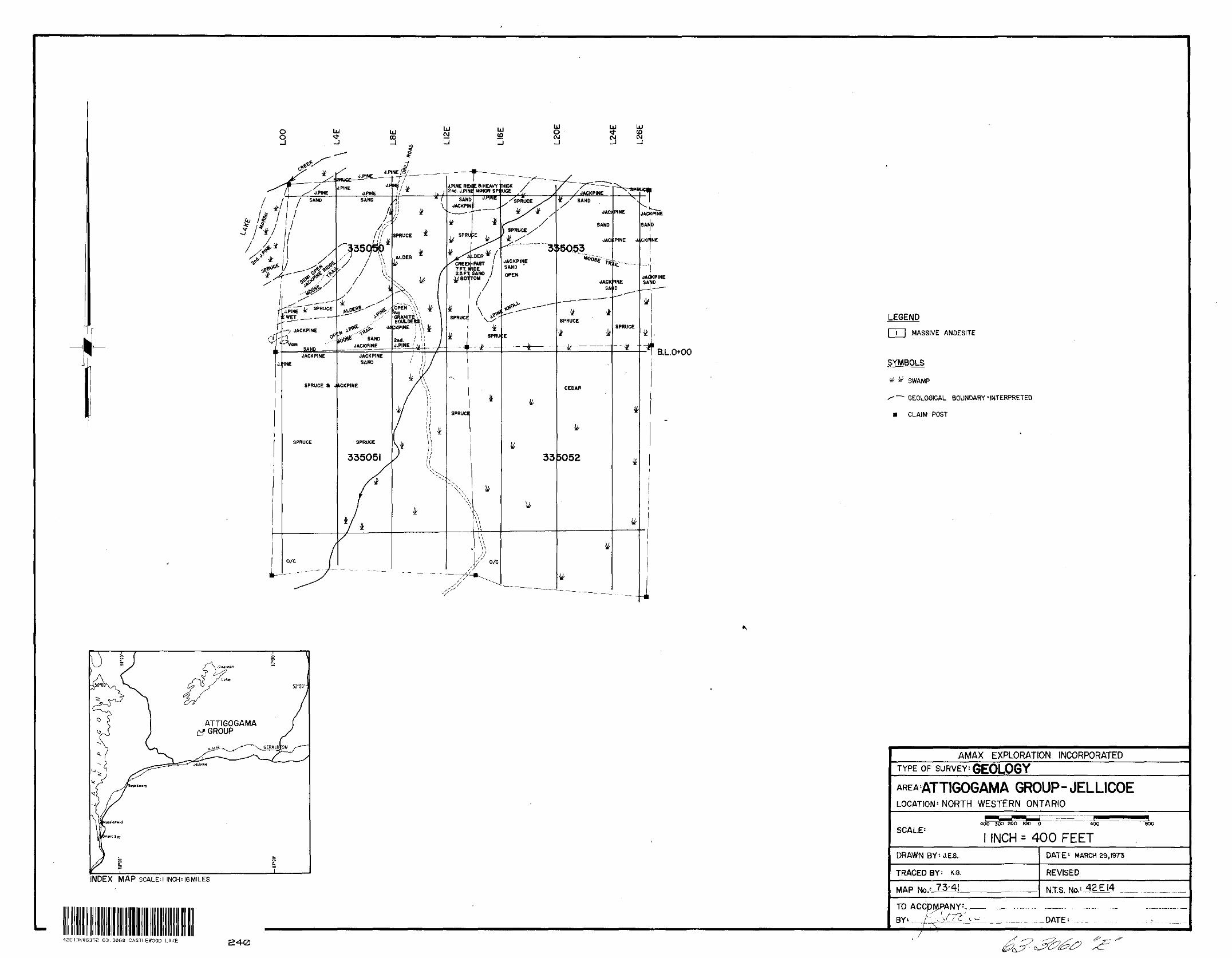
i.L.0+00
LEGEND
l l j MASSIVE ANDESITE
SYMBOLS
tf ^ SWAMP
^-~^ GEOLOGICAL BOUNDARY'INTERPRETED
m CLAIM POST
ATTIGOGAMA GROUP
INDEX MAP SCALEM INCH^I6M1LES
42E13NW8352 63.3060 CASTLEWOOD LAKE 240
AMAX EXPLORATION INCORPORATEDTYPE OF SURVEY: GEOLOGY
AREA'ATTIGOGAMA GROUP-JELLICOELOCATION - NORTH WESTERN ONTARIO
SCALE 14OO 30O 200 MO O 400
l INCH = 400 FEET800
DRAWN BY:J.E3.
TRACED BY: K.G.
MAP No.- 73-41
DATE 1 MARCH 29,1973
REVISED
NTS.
TO
BY .DATE J
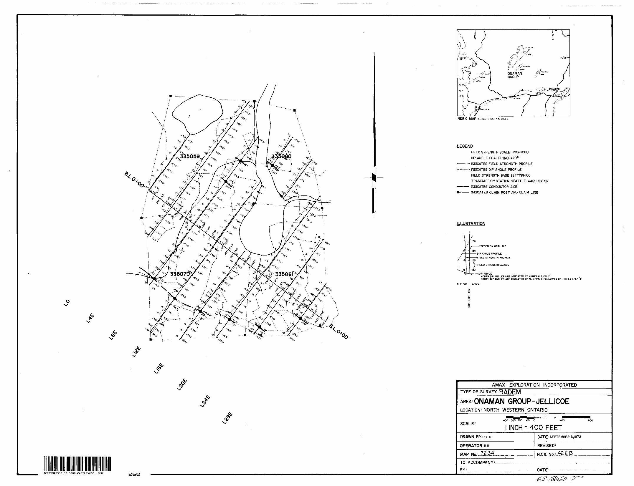
INDEX MAP' SCALE M INCH -\6 MILES
LEGENDFIELD STRENGTH SCALE'llNCH^OO
DIP ANGLE SCALE:|INCH:200 .————. INDICATES FIELD STRENGTH PROFILE .———.. INDICATES DIP ANGLE PROFILE
FIELD STRENGTH BASE SETTING'100TRANSMISSION STATION:SeATTLE,WASH1NGTON
———— iNDICATES CONDUCTOR AXIS m——— INDICATES CLAIM POST AND CLAIM LINE
ILLUSTRATION
- 130
ei -
N.+ 100
-STATION ON GRID LINE
•DIP ANGLE PROFILE•FIELD STRENGTH PROFILE
125
V FIELD STRENGTH VALUES
120-DIP ANGLE
NORTH DIP ANGLES ARE INDICATED BY NUMERALS ONLYSOUTH DIP ANGLES ARE INDICATED BY NUMERALS FOLLOWED BY THE LETTER S
S.-100
4?
42E13N*B352 63.3060 CASTLEWOOD LAKE 250
AMAX EXPLORATION INCORPORATEDTYPE OF SURVEY-'RADEM
AREA ONAMAN GROUP-JELLICOELOCATION 1 NORTH WESTERN ONTARIO
SCALE-400 300 200 100 O 4OO
INCH : 400 FEETDRAWN BY'KCG.
OPERATOR^R-H
MAP No. : 72-34.
800
DATE : SEPTEMBER 6,1972
REVISED 1
NT. S. No- !
TO ACCOMPANY
DATE ; -
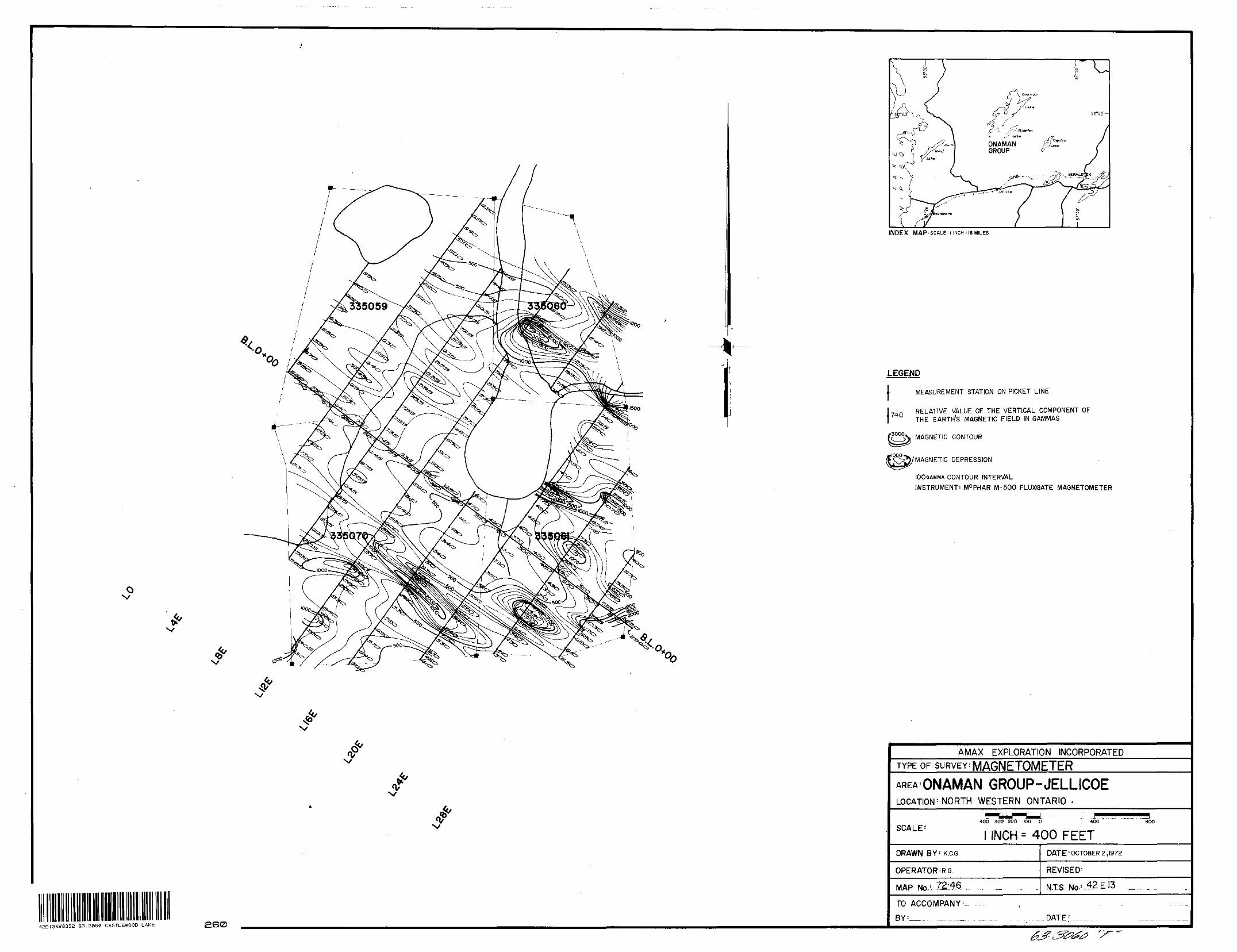
r
INDEX MAP'SCALEH INCH;|6MILES
LEGEND
l MEASUREMENT STATION ON PICKET LINE
RELATIVE VALUE OF THE VERTICAL COMPONENT OF740
flOOO
THE EARTHS MAGNETIC FIELD IN GAMMAS
MAGNETIC CONTOUR
MAGNETIC DEPRESSION
100GAMMA CONTOUR INTERVALINSTRUMENT: MC PHAR M-500 FLUXGATE MAGNETOMETER
42EI3NWS352 63.3060 CASTLEWOOD LAKE 260
AMAX EXPLORATION INCORPORATEDTYPE OF SURVEY^ MAGNETOMETERAREA'ONAMAN GROUP-JELLICOELOCATION'-NORTH WESTERN ONTARIO -
SCALE: 400 300 200 100 O 40O
INCH = 400 FEETDRAWN BY-K.C.G.
OPERATOR : R.G.
MAP No. !-T2-46
DATE : OCTOBER 2,1972
REVISED 1
NTS- No- : ~42E!3
TO ACCOMPANY
BY :_ —--^ DATE :-f * t— *-
80O
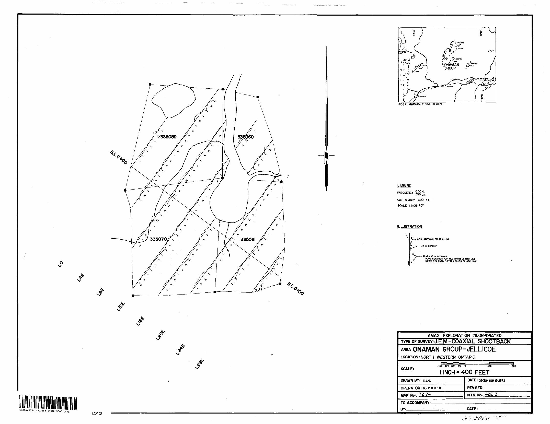
42E13NW8352 63.3060 CASTLEWOOD LAKE
f
50*00'-
, ^ ^ONAMAN
GROUP
INDEX MAP: SCALE'1 INCH 'WHILES
LEGEND
FREQUENCY!390 Lo.
COIL SPACING: 300 FEET
SCALE-
ILLUSTRATION
\"—t&M. STATIONS ON GRID t-1 HE
JE.M PROFILE
READINGS IN DEGREESPLUS READINGS PLOTTED NORTH OF GRID LINE MINUS READINGS PLOTTED SOUTH OF GRID LINE
AMAX EXPLORATION INCORPORATEDTYPE OF SURVEY J.E.M "COAXIAL SHQOTBACK AREA.ONAMAN GROUP-JELLICOELOCATION: NORTH WESTERN ONTARIO
SCALE'400 300 200 DO O 400 800
l INCH s 400 FEETDRAWN BY' K CG
OPERATOR 1 R.J.PaR.D.M.
MAP Na*..72-74
DATE: DECEMBER 13,1972
REVISED-
42EI3
TO ACCOMPANY'.
BY*———————. DATE:.
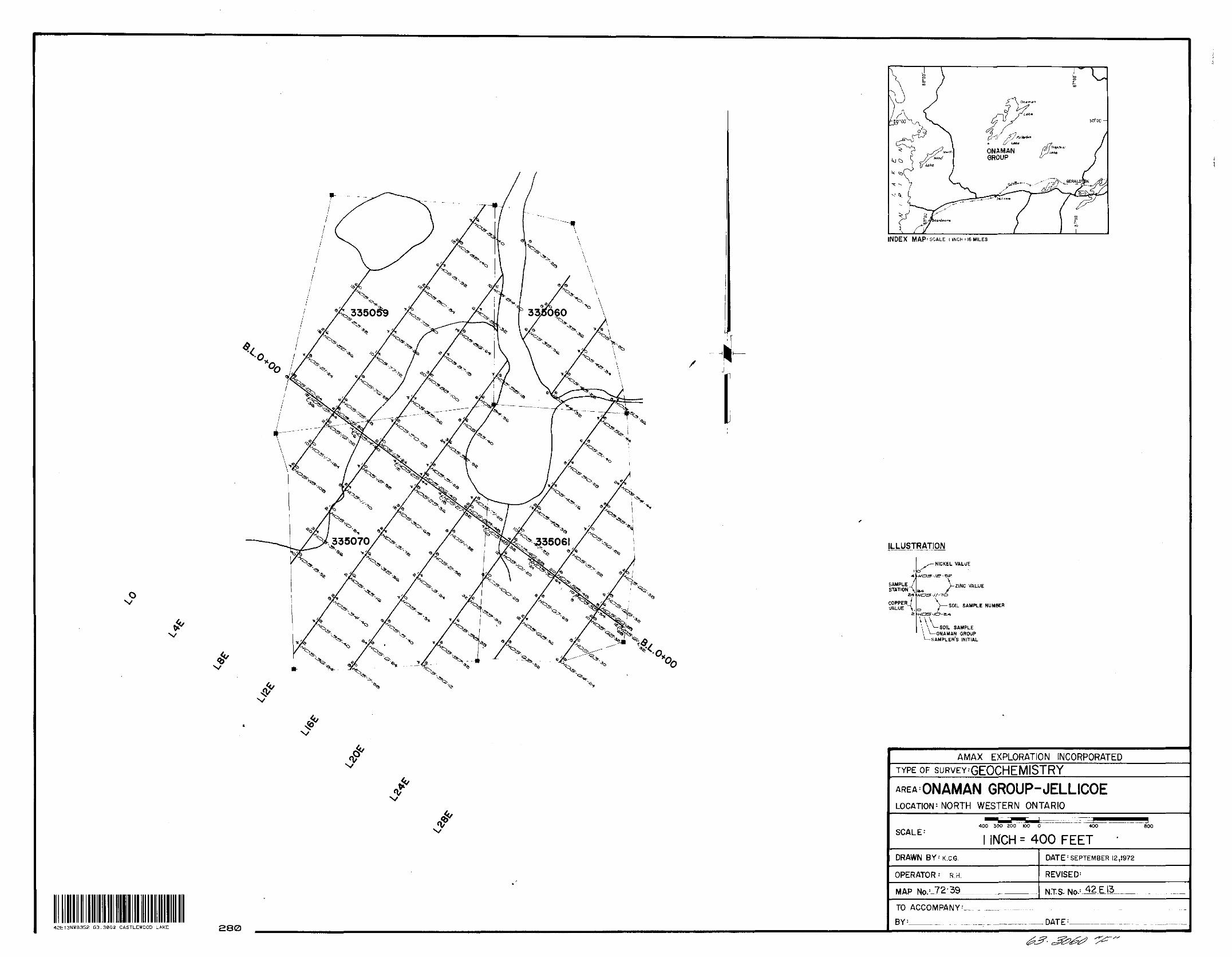
O x/
INDEX M AP : SCALE: i INCH: 16 MILES
ILLUSTRATION
SAMPLE t STATION A
COPPERVALUE V
•NICKEL VALUE
VziNC VALUE S
SOIL SAMPLE NUMBERHCJS-/O-S.-+
SOIL SAMPLE —ONAMAN GROUP SAMPLER'S INITIAL
42E13NW8352 63.3060 CASTLEWOOD LAKE 280
AMAX EXPLORATION INCORPORATEDTYPE OF suRVEY'GEOCHEMISTRYAREA ONAMAN GROUP-JELLICOELOCATION - NORTH WESTERN ONTARIO
SCALE-' 400 300 200 100 O 400 800
INCH s 400 FEETDRAWN BY-K.C.G.
OPERATOR-' R.H.
MAP No. !-12l39-
DATE ! SEPTEMBER 12,1972
REVISED 1
N.T.S. No- :
TO ACCOMPANY^
BY :____^. . , . DATE ; -
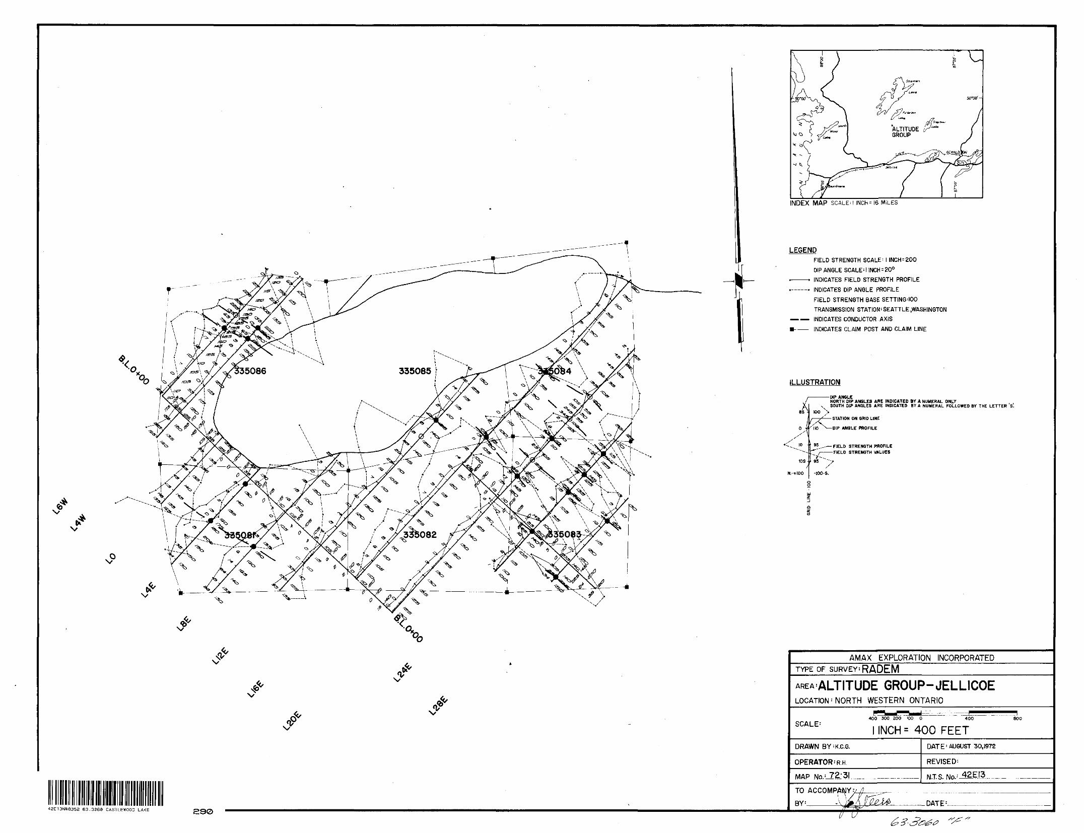
f?offALTITUDE J?" GROUP
INDEX MAP SCALED INCH^6 MILES
N?
4^E13NWa352 63.3060 CASTLEWOOD LAKE 290
LEGENDFIELD STRENGTH SCALE' l INCH * 200
DIP ANGLE SCALE* l INCH : 20OINDICATES FIELD STRENGTH PROFILEINDICATES DIP ANGLE PROFILEFIELD STRENGTH BASE SETTING'100TRANSMISSION STATION - SEATTLE .WASHINGTON
INDICATES CONDUCTOR .AXIS
INDICATES CLAIM POST AND CLAIM LINE
ILLUSTRATION
as :
10 - l 95
IDS
N.-HOO
•DIP ANGLENORTH DIP ANGLES ARE INDICATED BY A NUMERAL ONLY SOUTH DIP ANGLES ARE INDICATED BY A NUMERAL FOLLOWED BY THE LETTER S.
100i——7^—— STATION ON QRID LINE
IK) ^-DIP ANGLE PROFILE
FIELD STRENGTH PROFILE FIELD STRENGTH VALUES
95f
-lOO-S.
AMAX EXPLORATION INCORPORATEDTYPE OF SURVEY^ RADEM
AREA'ALTITUDE GROUP-JELLICOELOCATION ' NORTH WESTERN ONTARIO
400 300 200 IOO 0 400 800
INCH - 400 FEETDRAWN BY : K.C.G.
OPERATOR - R.H.
MAP No. :-Z2;3!
DATE 1 AUGUST 30,1972
REVISED-
NT.S. No. : -42E13.
TO
— DATE 1 -
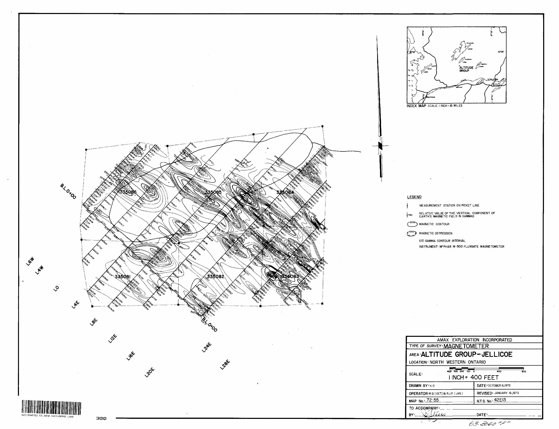
42EI3NW83SE 63.30G0 CASTLEWOOD LAKE300
INDEX MAP SCALE'1 INCH -- 16 MILES
LEGEND
f MEASUREMENT STATION ON PICKET LINE
l TArt RELATIVE VALUE OF THE VERTICAL COMPONENT OF T 740 EARTHS MAGNETIC FIELD IN GAMMAS
MAGNETIC CONTOUR
MAGNETIC DEPRESSION
100 GAMMA CONTOUR INTERVAL
INSTRUMENT- MC PHAR M-500 FLUXGATE MAGNETOMETER
AMAX EXPLORATION INCORPORATEDTYPE OF SURVEY: MAGNETOMETERAREA'ALTITUDE GROUP-JELLICOELOCATION' NORTH WESTERN ONTARIO
SCALE :400 3OO 2OO 100 O 400
l INCH = 400 FEET800
DRAWN BY: K G
OPERATOR : R.G.(OCT)aRJP {JAN.
MAP No. ! 72-55
DATE'OCTOBER 6,1972
REVISED- JANUARY 19,1973
N.T.S.TO BY : DATE 1.
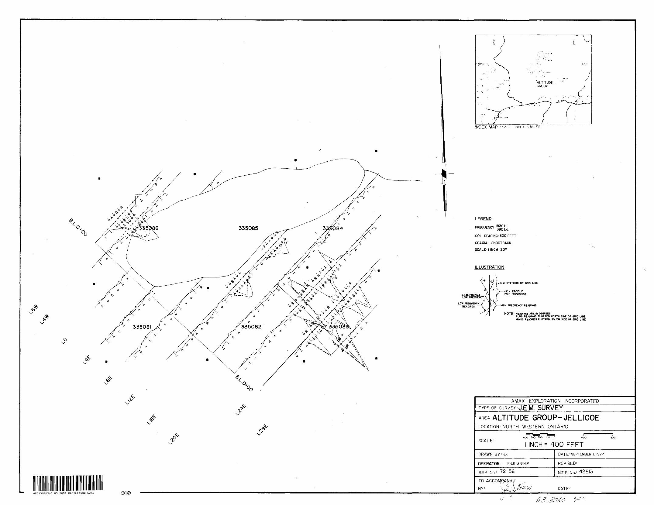
v
MtLEGEND
FREQUENCY:
COIL SPACING'300 FEET
COAXIAL SHOOTBACK
SCALE'l INCH:200
ILLUSTRATION
-5
J.E.M. PROFILE __/A LOW FREQUENCY^
LOW FREQUENCY READINGS
"S—/-J.E.M. STATIONS ON GRID LINE
/-rvi )——J.E.M. PROFILE
-4 - 1
-5 .J s
l/ HIGH FREQUENCY
HIGH FREQUENCY READINGS
NOTE : READINGS ARE IN DEGREESPLUS READINGS PLOTTED NORTH SIDE OF GRID LINE MINUS READINGS PLOTTED SOUTH SIDE OF GRID LINE
42E13NW8352 63.3060 CASTLEWOOD LAKE 310
AMAX EXPLORATION INCORPORATEDTYPE OF SURVEY'J.EM SURVEY
AREA ALTITUDE GROUP-JELLICOELOCATION : NORTH WESTERN ONTARIO
SCALE-400 30O 200 100 O 800
INCH- 400 FEETDRAWN BY ; J.F
OPERATOR^ R.J.PaG.H.P
MAP No. : 72-56
D AT E : SEPTEMBER 1,1972
REVISED'
N.TS. No. ; 42EI3
DATE-'
\J
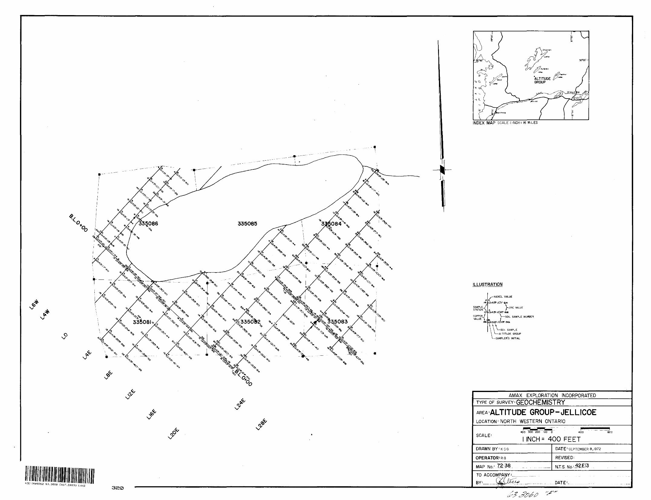
INDEX MAP SCALE, l INCH : 16 MILES
r
V
42E13N*835a 63.3060 CASTLEWOODLAKE 320
ILLUSTRATION
SAMPLE/STATIONS,
icfCOPPER/ VALUE \ ,
se
NICKEL VALUE
.-*V-2121MC VALUE
J —— SOIL SAMPLE NUMBER
—SOIL SAMPLE-ALTITUDE GROUP
-SAMPLER'S INITIAL
AMAX EXPLORATION INCORPORATEDTYPE OF suRVEY'GEOCHEMISTRY
GROUP-JELLICOELOCATION ' NORTH WESTERN ONTARIO
SCALE- ____ - -....--
400 300 200 100 0 400 800
INCh^ 400 FEETDRAWN BY'KCG
OPERATOR' R.G.
MAP
DATE 1 SEPTEMBER 8,1972
REVISED'
NTS. No.-42.EI3
TO ACCOMPANY
DATE 1
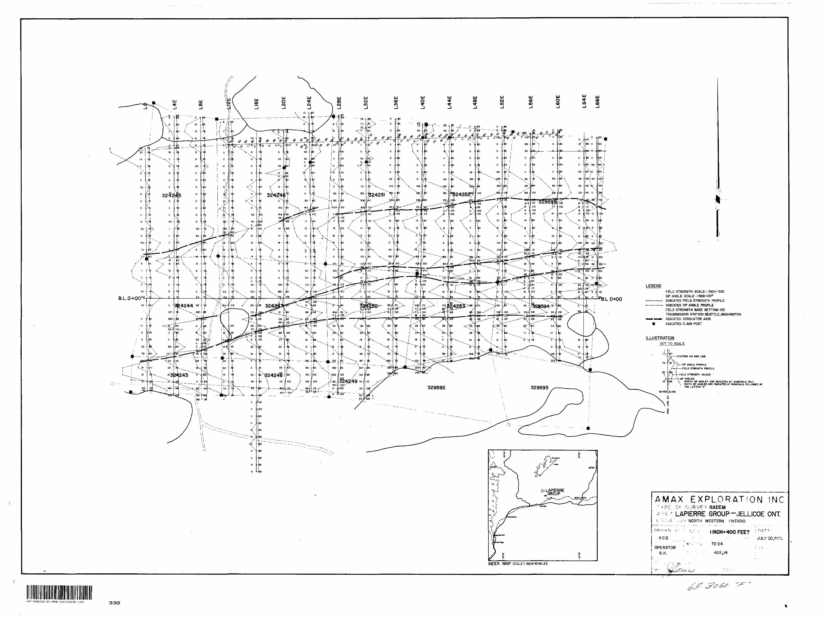
" J r^. i"a?ZS*^^ f^S'-^S
- —-Mh ——
FIELD STRENGTH SCALE: l INCH - 200 DIP ANGLE SCALE: j INCH^O0 INDICATES FIELD STRENGTH PROFILE INDICATES DIP ANGLE PROFILE FIELD STRENGTH BASE SETTING'100 TRANSMISSION STATION' SE ATT LE, WASHINGTON INDICATES CONDUCTOR AXIS INDICATES CLAIM POST
STATIONS ON GRID LINE
DIP ANGLE PROFILE FIELD STRENGTH PROFILE
FIELD STRENGTH VALUES '
r-DIP ANGLESNORTH DIP ANGLES ARE INDICATED BY NUMERALS ONLY
\ SOUTH DIP ANGLES ARE INDICATED BY NUMERALS FOLLOWED BY THE LETTER "s"
EXPLORATIOo p SURVEY RADEMLAPIERRE GROUP -JELLICOE ONT
'./N NORTH WESTERN ONTARIO
K.C.G.
OPERATOR R.H.
l INCH"400 FEET OATfJULY 20,107;
72-24 i '-' \42E,I4
INDEX MAP SCALE'1 INCH^I6 MILES
42E13NW8352 63.3060 CASTLEWOOD LAKE 330
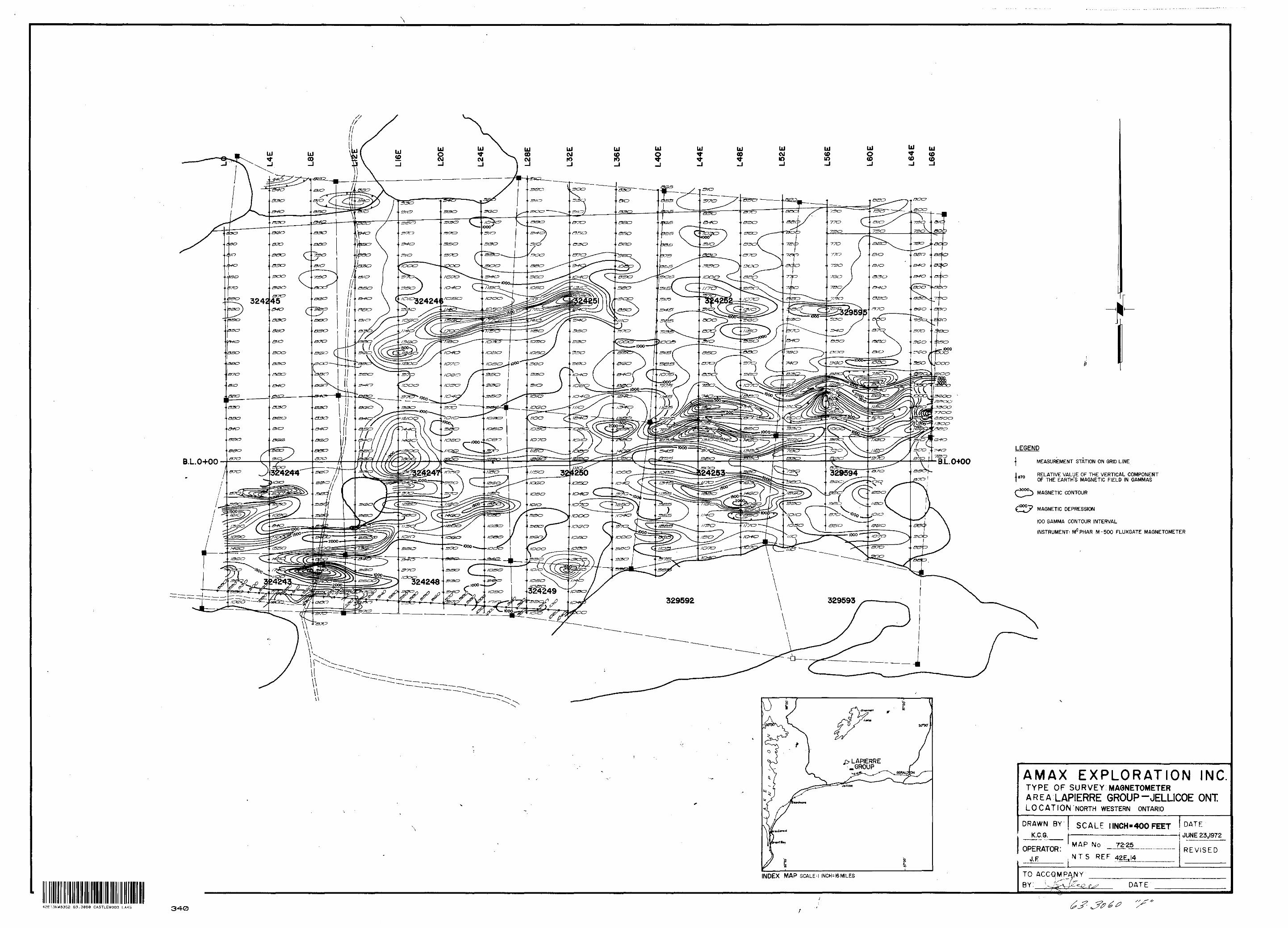
-VO nt (S-tt?
LEGEND
j MEASUREMENT STATION ON GRID LINEB.L.0+00 B.L.0+00&CX3
324244OF THE EARTH S MAGNETIC FIELD IN GAMMAS
MAGNETIC CONTOUR
MAGNETIC DEPRESSION
LAPIERRE .GROUP
100 GAMMA CONTOUR INTERVAL
INSTRUMENT: MC PHAR M-500 FLUXGATE MAGNETOMETER
AMAX EXPLORATION INCTYPE OF SURVEY: MAGNETOMETERAREA LAPIERRE GROUP-JELUCOE ONTLOCATION^NORTH WESTERN ONTARIO
DRAWN BY K.C.G.
SCALE l INCH-400 FEET DATE-i JUNE 33t l972
OPERATOR: J. F
MAP No 72-25
; NTS REF 42EJ4.REVISED
INDEX MAP SCALED INCH: 16MILES TO ACCQMPANYBY: vJCv/fc^ DATE
42E13NW3352 63.3060 CASTLEWOOD LAKE 340/s
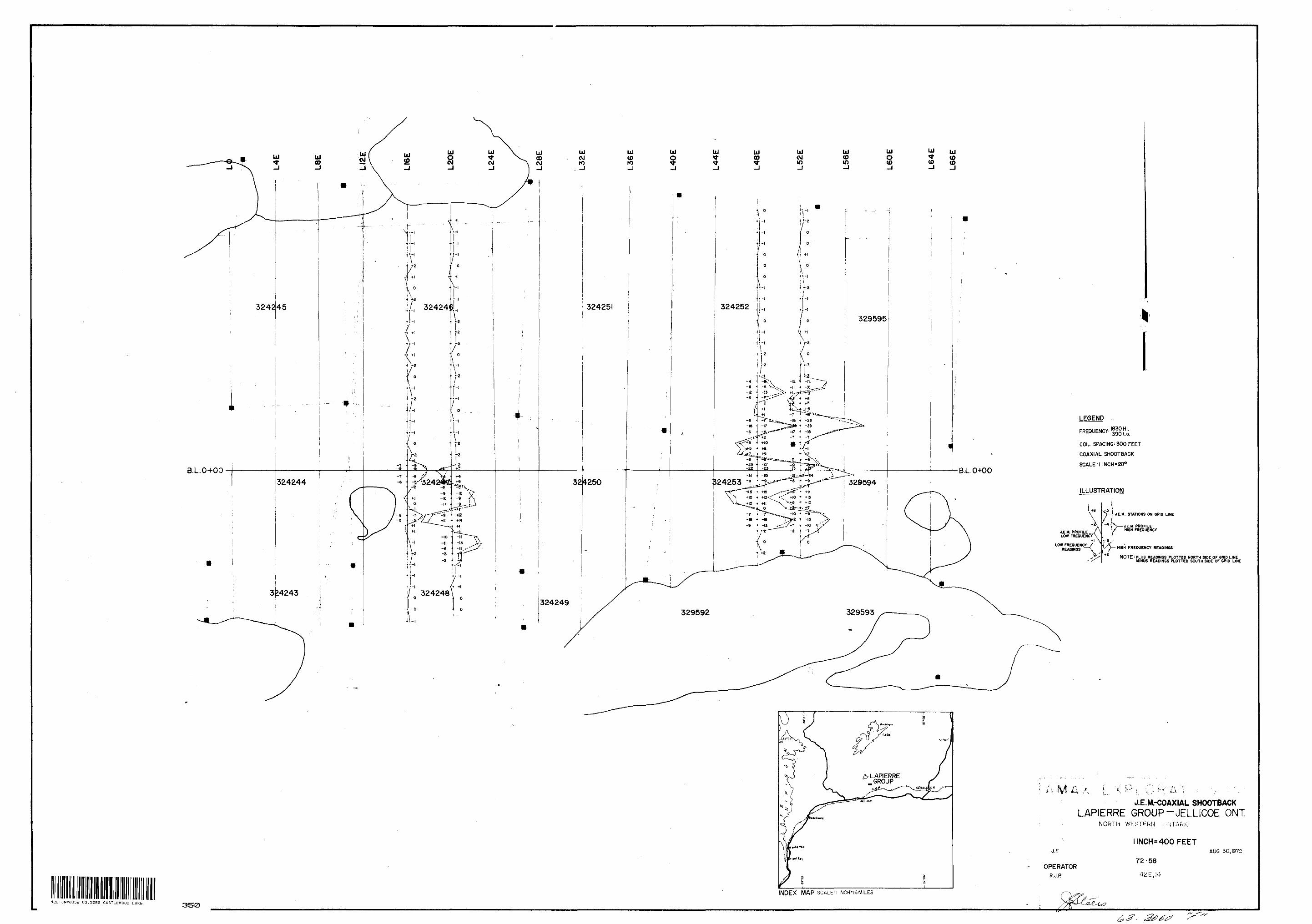
LEGENDFREQUENCY: 1830 Hi.
COIL SPACING' 300 FEET
COAXIAL SHOOTBACK
SCALE-l INCH:200
ILLUSTRATION
J.E.M. PROFILE —/\ LOW FREQUENCY^.
LOW FREQUENCY/ READINGS ——\
V
J.E.M. STATIONS ON GRID LINE
'O——AE.M. PROFILE l/ HIGH FREQUENCY
W- HIGH FREOUENCY READINGS
NOTE-PLUS READINGS PLOTTED NORTH SIDE OF GRID LINE MINUS READINGS PLOTTED SOUTH SIDE OF GRID LINE
J.E.M.-COAXIAL SHOOTBACKLAPIERRE GROUP-JELLICOE ONT
NORTH WESTERN "ARK'.
J.F
OPERATORR.J. P
INCH" 400 FEET
72*58AUG. 30,1972
INDEX MAP SCALE:
42E13NW8352 63.3060 CASTLEWOOD LAKE 350
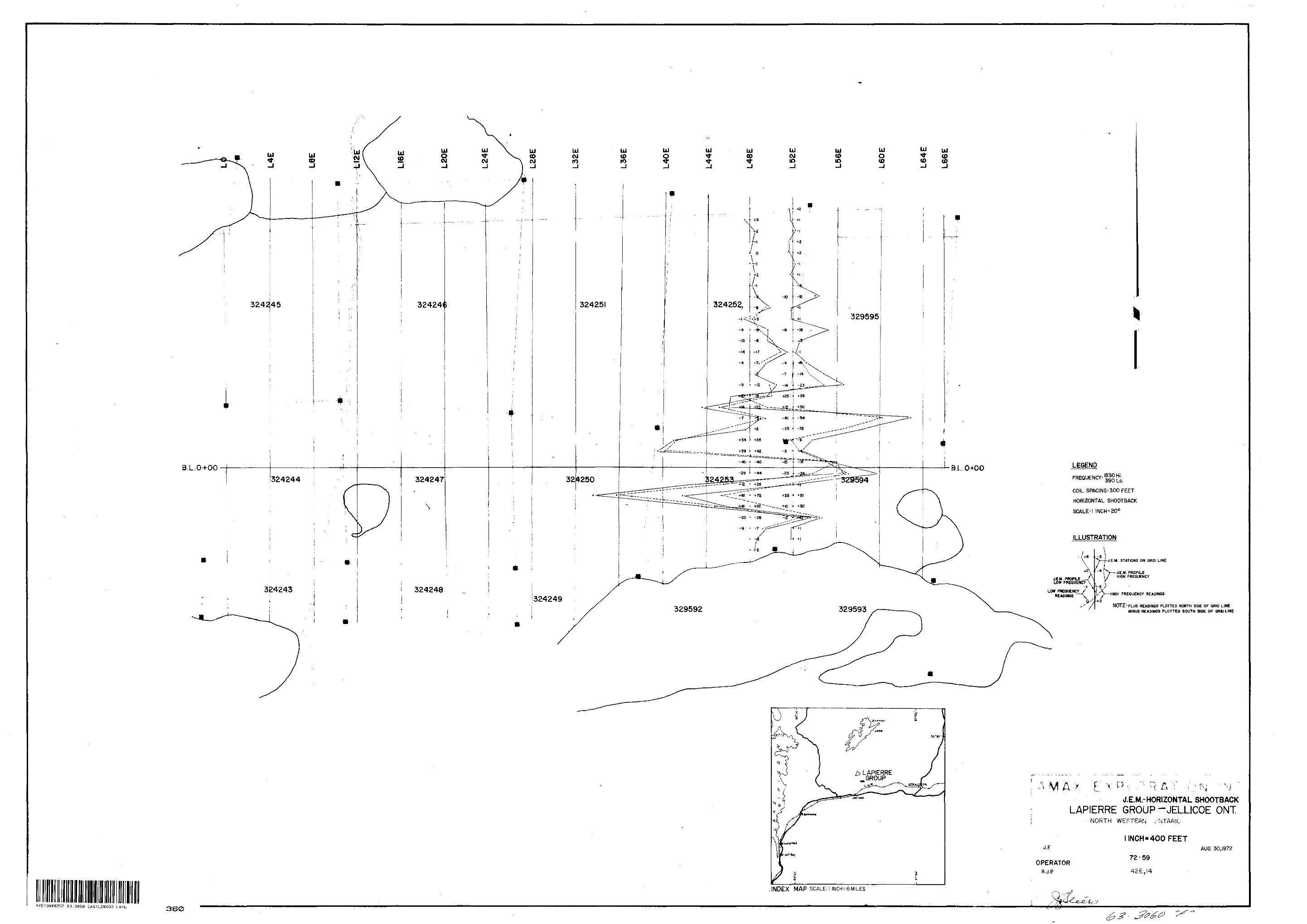
LEGEND
FREQUENCY:
COIL SRftCING'300 FEET
HORIZONTAL SHOOTBACK
SCALE'1 INCH* 20*
ILLUSTRATION
A.+21-
J.EJJ. PROFILE —A LOW FREQUENCY^
LOW FREQUENCY ' READINGS
. STATIONS ON GRID LINE
~ 4J.E.M. PROFILE
\y HIGH FREQUENCY
} — HIGH FREQUENCY READINGS
NOTE 1 PLUS READINGS PLOTTED NORTH SIDE OF GRID LINE MINUS READINGS PLOTTED SOUTH SIDE OP GRID LINE
y T \ P ; " P ^ "j" , . f\; ' \i i,.... ' . ' *~ . fj ^J.E.M.-HORIZONTAL SHOOTBACK
LAPIERRE GROUP-JELLICOE ONTNORTH WESTERN v'NTARIO
J. F
OPERATORR.J-P
l INCH "400 FEET
72-59AUG. 30,1972
.INDEX MAP SCALE:] INCH-IGMILES
42E13NW83S2 63.3060 CASTLEWOOD LAKE 3B0
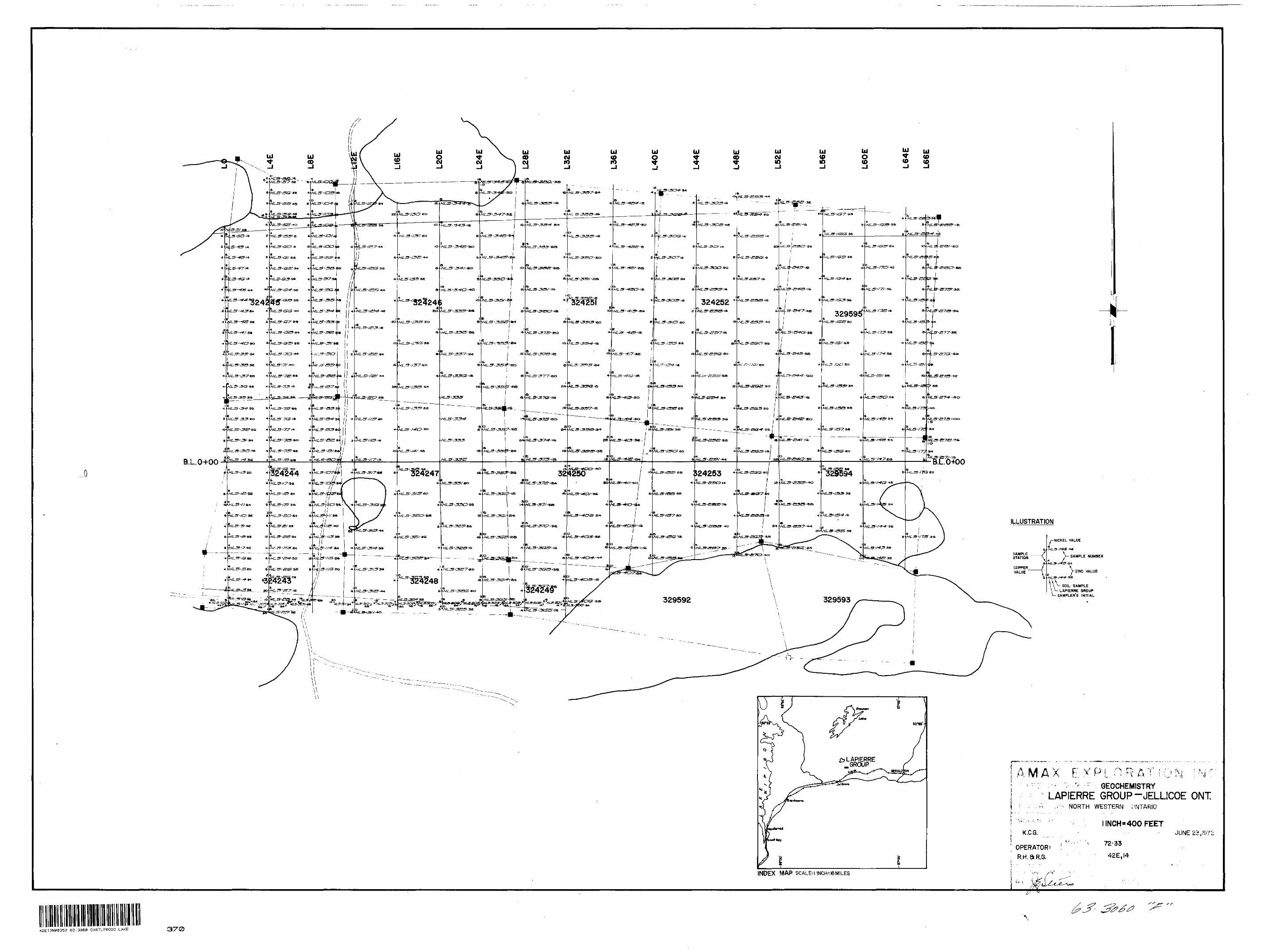
OPERATOR^ R.H. S R.G.
INDEX MAP SCALER INCH^MILES
SAMPLE NUMBER
MLS-t+5 S+
Y ZINC VALUE
SOIL SAMPLELAPIERRE GROUP
SAMPLER'S INITIAL
iAMAX EXPLORATION ;N': GEOCHEMISTRY
LAPIERRE GROUP-JELLICOE ONT.; - NORTH WESTERN ONTARIO
l INCH H 400 FEET
72-33
42E,I4
42E13NW8352 63.3360 CASTLEWOOD LAKE 370
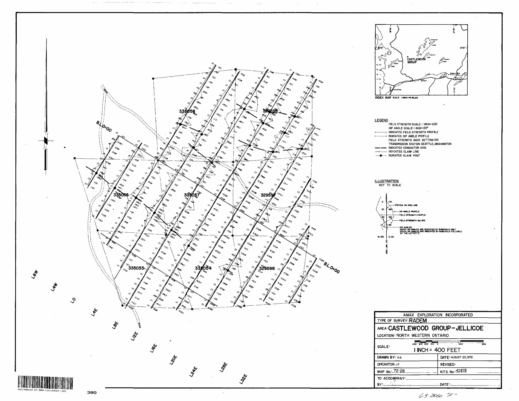
O x/
42EI3NW3352 63.3060 CASTLEWOOD LAKE
INDEX MAP SCALE l INCH "WHILES
LEGENDFIELD STRENGTH SCALE 1 1 INCH = 200 DIP ANGLE SCALE* I INCH E 200 INDICATES FIELD STRENGTH PROFILE INDICATES DIP ANGLE PROFILE FIELD STRENGTH BASE SETTING'100 TRANSMISSION STATION:SEATTLE,WASHINGTON INDICATES CONDUCTOR AXIS INDICATES CLAIM LINE
— m—— INDICATES CLAIM POST
ILLUSTRATION NOT TO SCALE
3S
-,6S -\
ft* 100
170
- STATION ON GRID LINE
-——DIP ANGLE PROFILE
- FIELD STRENGTH PROFILE
FIELD STRENGTH VALUES
•DIP ANGLESNORTH DIP ANGLES ARE INDICATED BY NUMERALS ONLY SOUTH DIP AN6LES.ARE INDICATED BY NUMERALS FOLLOWED BY THE LETTER^.
S.-IOO
AMAX EXPLORATION INCORPORATEDTYPE OF SURVEY: RADEM
AREA'CASTLEWOOD GROUP-JELLICOELOCATION -'NORTH WESTERN ONTARIO
SCALE! 400 300 200 100 0 400
1 INCH s 400 FEETBOO
DRAWN BY' KG
OPERATOR^ F
MAP No.' 72-28
DATE : AUGUST 23, 1972
REVISED:
N.T.S. No- i42E|3
TO ACCOMPANY'
BY- ^ DATE'-
380
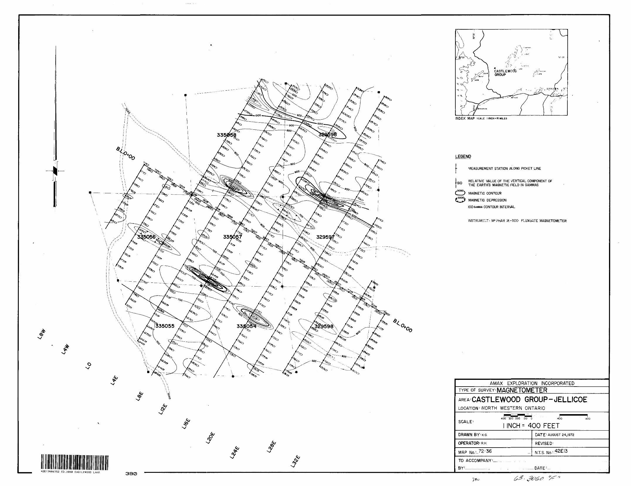
X/
tk/
INDEX MAP SCALE l INCH-W MILES
LEGEND
-810
MEASUREMENT STATION ALONG PICKET LINE
RELATIVE VALUE OF THE VERTICAL COMPONENT OFTHE EARTHS MAGNETIC FIELD IN GAMMAS
C22!) MAGNETIC CONTOUR
MAGNETIC DEPRESSION
100 GAMMA CONTOUR INTERVAL
ENT' MC ?HAR M-500 FLUXGATE MAGNETOMETER
42E13NW8352 63.3060 CASTLEWOOD LAKE330
AMAX EXPLORATION INCORPORATEDTYPE OF SURVEY: MAGNETOMETERAREA:CASTLEWOOD GROUP-JELLICOELOCATION ; NORTH WESTERN ONTARIO
SCALE: 400 300 200 .00 0 400 800
INCH: 400 FEETDRAWN BY'K.G
OPERATOR^ R.H.
MAP No. :-72-36
DATE : AUGUST 24,1972
REVfSED :
NTS. No- :
TO ACCOMPANY
BY :______-..- DATE : -
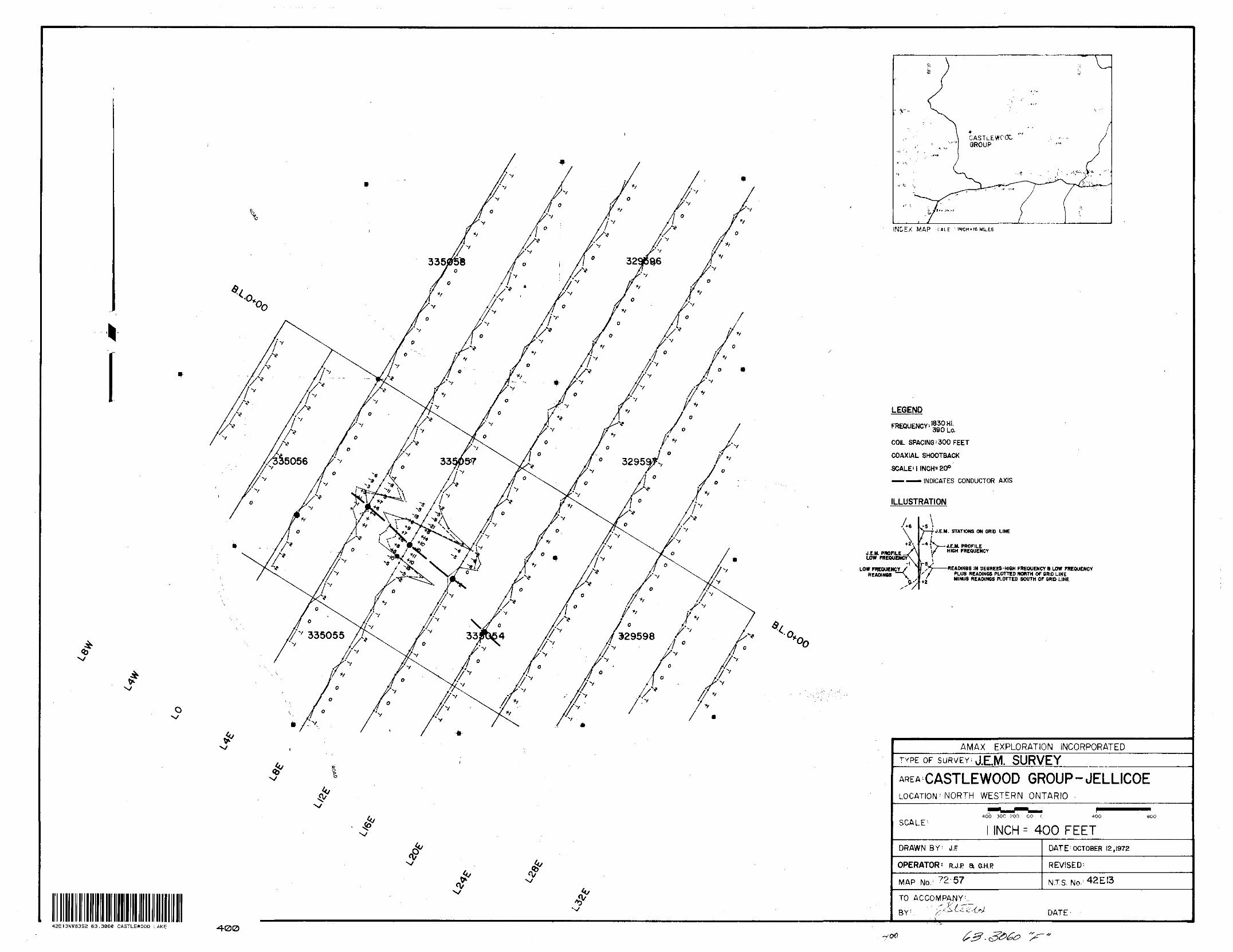
a
INC.EX MAP -CALE llNCH'l6MtLES
J.E.M. PROFILE LOW FREQUENCY
LOW FREQUENCYREADINGS
LEGEND
FREQUENCY;'ffg [^
COIL SPACING ' 300 FEET
COAXIAL SHOOTBACK
SCALE'l INCH'200
—— ^— INDICATES CONDUCTOR AXIS
ILLUSTRATION
. STATIONS ON GRID LINE
J.E.H PROFILE l HIGH FREQUENCY
-4
r 5 ,READINGS IN DE8REES-HIGH FREQUENCY B LOW FREQUENCY
PLUS READINGS PLOTTED NORTH OF BRIO LINE MINUS READINGS PLOTTED SOUTH OF ORO LINE
1' l
ft/ s*0 1^
X/
- N/
^
^ ^ ^
^ *,vx/
AMAX EXPLORATION INCORPORATEDTYPE OF SURVEY J.E.M. SURVEY
AREA CASTLEWOOD GROUP -JELLICOELOCATION ' NORTH WESTERN ONTARIO
^^M ^^^ ^^^^^^^^^^^^~
400 300 ^00 00 C 400
SCALE: 1 INCH -- 400 FEETaoo
DRAWN BY : J.F OATE : OCTOBER 12,1972
OPERATOR: R.J.P a G.H.P REVISED'
MAP No/ 72 57 NTS- No- :42EI3
TO ACCOMPANY'.- " ^'i r~; ,BY : - x+^^t-W DATE : '
V
42EI3NW8352 63.30EC CASTLEWOOD LAKE 400'QO
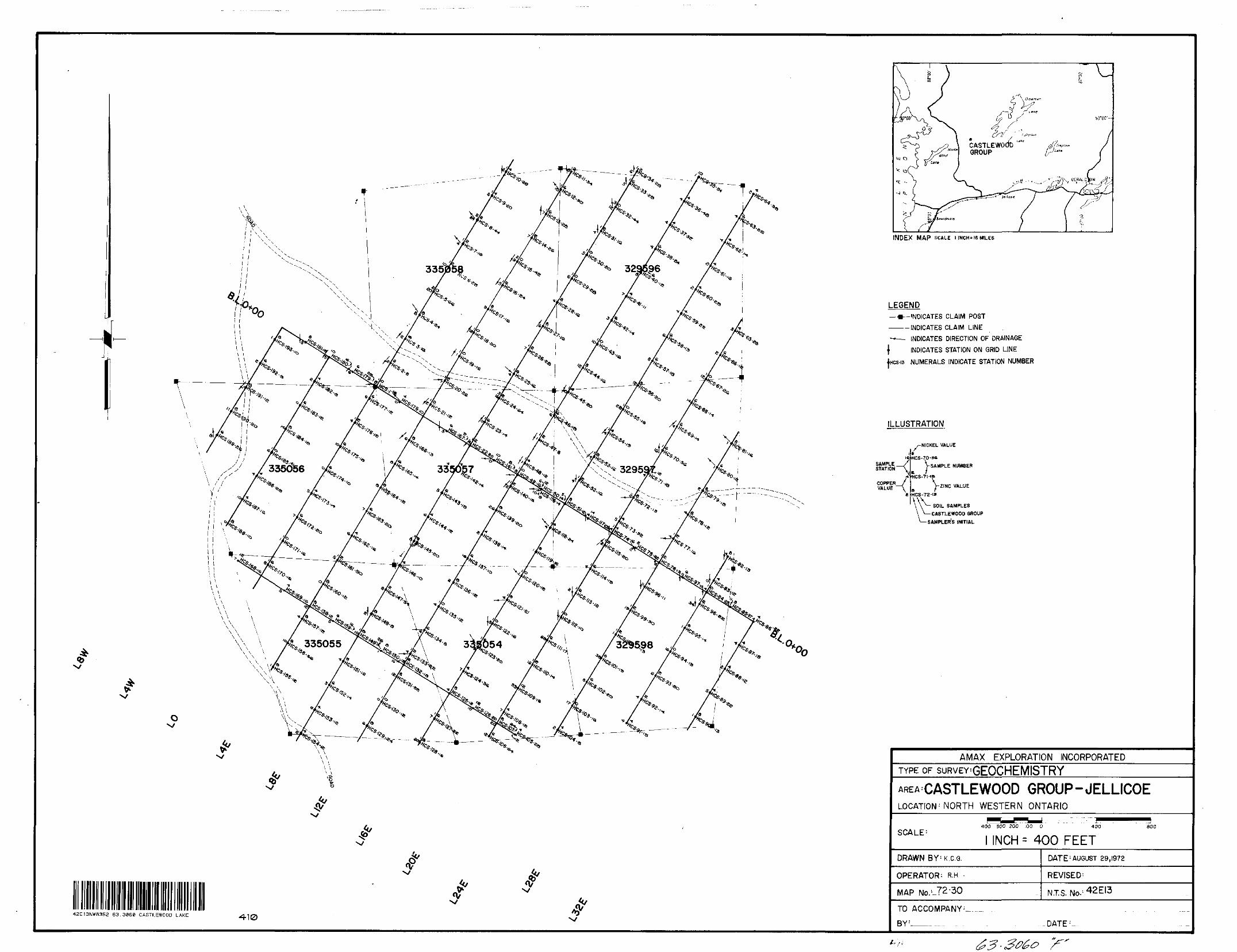
™
INDEX MAP SCALE l INCH'16 MILES
LEGEND— •—INDICATES CLAIM POST———— INDICATES CLAIM LINE—— INDICATES DIRECTION OF DRAINAGE
\ INDICATES STATION ON GRID LINE
incs-13 NUMERALS INDICATE STATION NUMBER
ILLUSTRATION
SAMPLE __y STATION V
COPPER,/ VALUE ~"A
/-NICKEL VALUE
BHCS-70-sa
VSAMPLE NUMBERe f HCS-7HS
. V ZINC VALUEHCS-72-is
^- SOIL SAMPLES— CASTLEWOOD GROUP•SAMPLER'S INITIAL
^/*5^— — —— - i **., J \ **^L *c'Ss^ -- ^*rs^m —— *A. ^v ^-^-•^--^—-^^ ^^5 V\ *". s
f t ^^
X/
^^ 4f1 Illlil Illilll Illllllll III III ^ ^42EI3NWS352 63.3860 CASTLEWOOD LAKE 410 '
AMAX EXPLORATION INCORPORATEDTYPE OF suRVEY'GEOCHEMISTRYAREA'CASTLEWOOD GROUP -JELLICOELOCATION 1 NORTH WESTERN ONTARIO
^^^400 300 200 .00 0 400 800
SCALE: 1 INCH - 400 FEETDRAWN BY'K.c.G.
OPERATOR: R.H- -
MAP No.'-?2-30
DATE : AUGUST 29,1972
REVISED^
NTS. No. ;42EI3
TO ACCOMPANY :—.- . ....
BY : DATE :
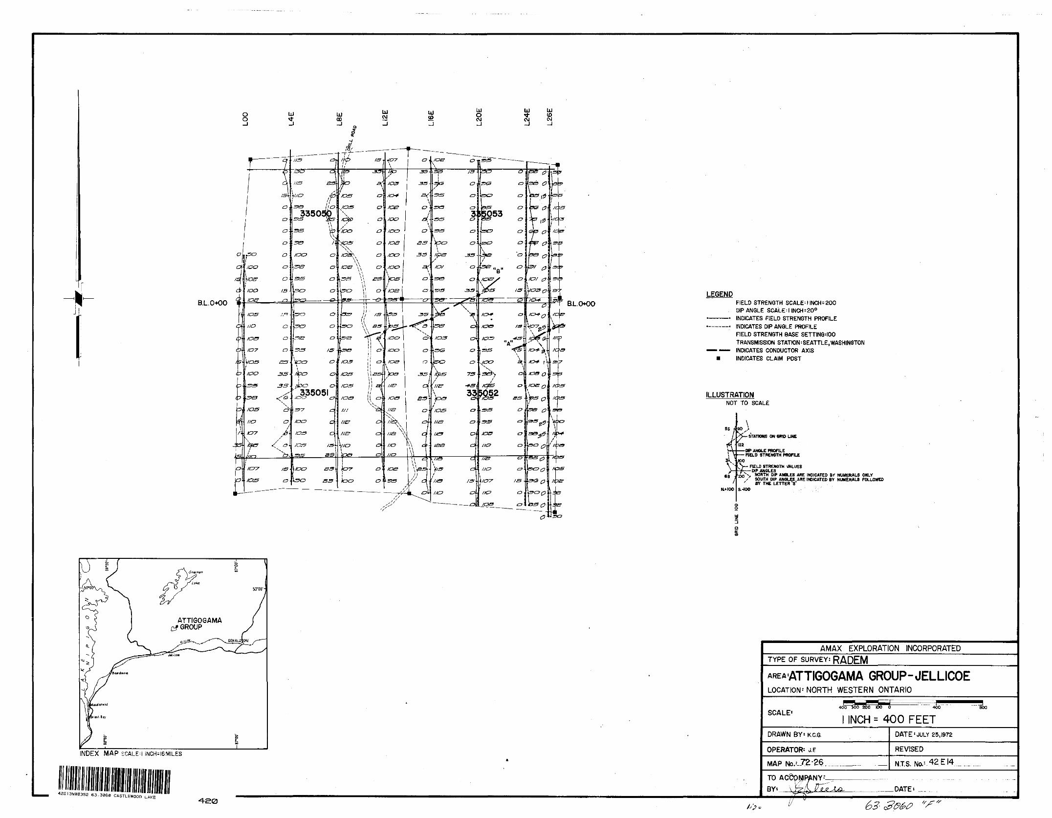
B.L.0+00 RL.O*00LEGEND
FIELD STRENGTH SCALE -l INCH - 200 DIP ANGLE SCALE-l INCH = 200 INDICATES FIELD STRENGTH PROFILE INDICATES DIP ANGLE PROFILE FIELD STRENGTH BASE SETTINGMOO TRANSMISSION STATION' SEATTLE,WASHINGTON INDICATES CONDUCTOR AXIS INDICATES CLAIM POST
ILLUSTRATIONNOT TO SCALE
"l68
K* i oo
noSTATIOMS ON WU? UNE
-Oft* ANGLE PROFILE HELD STRENGTH PROFILE
KX)FIELD STRENGTH VALUES
DIP ANGLESNORTH DIP ANGLES ARE INDICATED BY NUMERALS ONLY SOUTH DIP ANGLES .ARE INDICATED BY NUMERALS FOLLOWED BY THE LETTERS
S.-100
ATTIGOGAMA GROUP
INDEX MAP SCALE:! INCH^6MILES
42E13NW6352 63.3060 CASTLEWOODLAKE
AMAX EXPLORATION INCORPORATEDTYPE OF SURVEY: RADEM
GROUP-JELLICOELOCATION' NORTH WESTERN ONTARIO
SCALE'400 500 ZOO 100 O 400
l INCH = 400 FEET800
DRAWN BY t K.C.G.
OPERATOR' J. F
MAP No.-- 72-26
DATE'JULY 25,1972
REVISED
NTS. Na--42-EJ4
TO BY: DATE*
63-3060
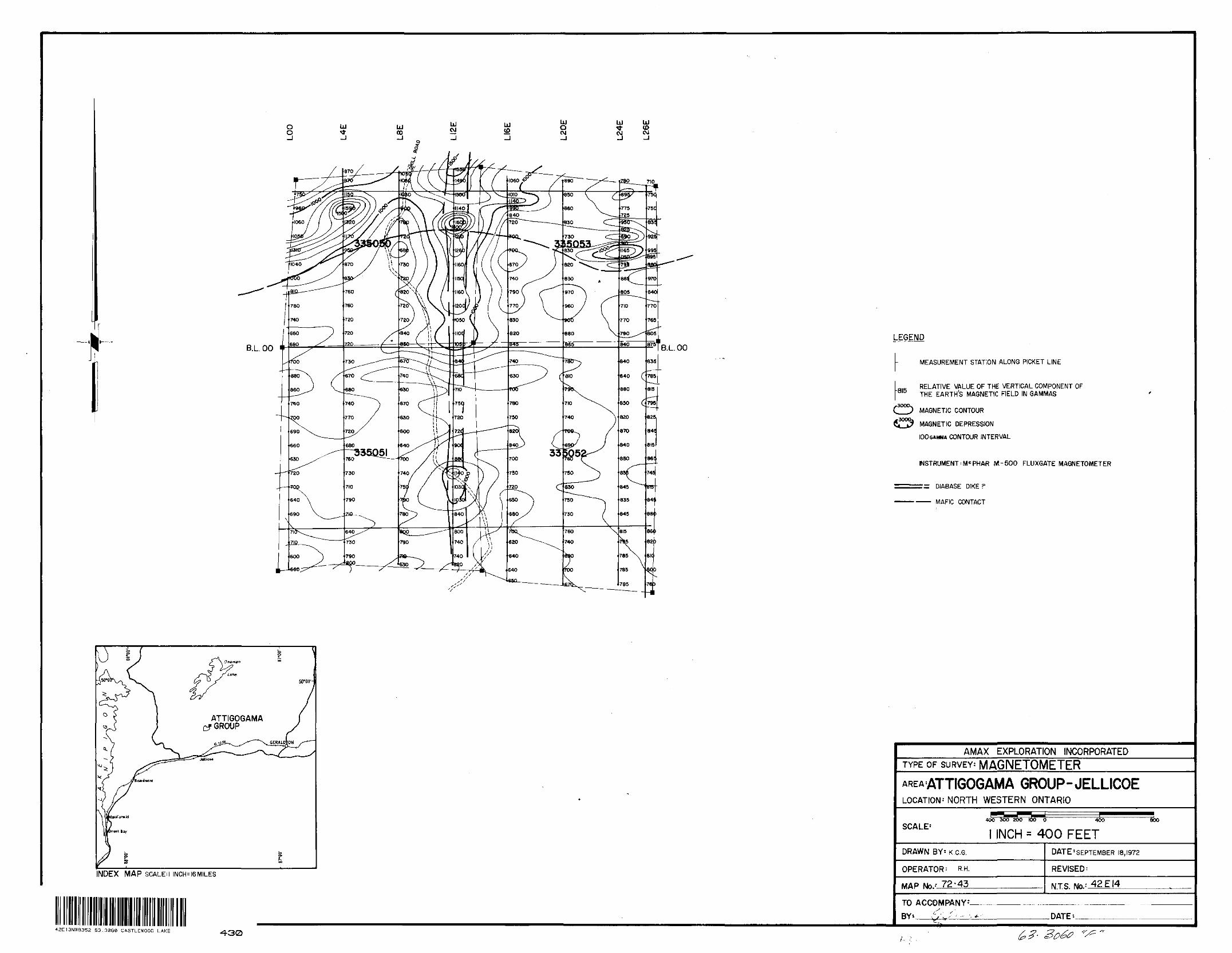
^-——355Q5I ^760 ^~~~——- TOO
LEGEND
MEASUREMENT STATION ALONG PICKET LINE
RELATIVE VALUE OF THE VERTICAL COMPONENT OF THE EARTH'S MAGNETIC FIELD IN GAMMAS
MAGNETJC CONTOUR MAGNETIC DEPRESSION100 GAMMA CONTOUR INTERVAL
INSTRUMENT' M*PHAR M.-500 FLUXGATE MAGNETOMETER
:s DIABASE DIKE P
—— MAFIC CONTACT
ATTIGOGAMA GROUP
INDEX MAP SCALEM INCH^SMILES
42E13NW3352 63.3060 CASTLEWOOD LAKE 430
AMAX EXPLORATION INCORPORATEDTYPE OF SURVEY: MAGNETOMETER
AREA'ATTIGOGAMA GROUP-JELLICOELOCATION' NORTH WESTERN ONTARIO
SCALE'l INCH = 400 FEET
DRAWN BY-K.c.G.
OPERATOR: R-H.
MAP No.-' 72-45
DATE'SEPTEMBER 18,1972
REVISED^
NTS. Ng:42EI4
TO ACCOMPANY^.DATE*.
f sz 'f
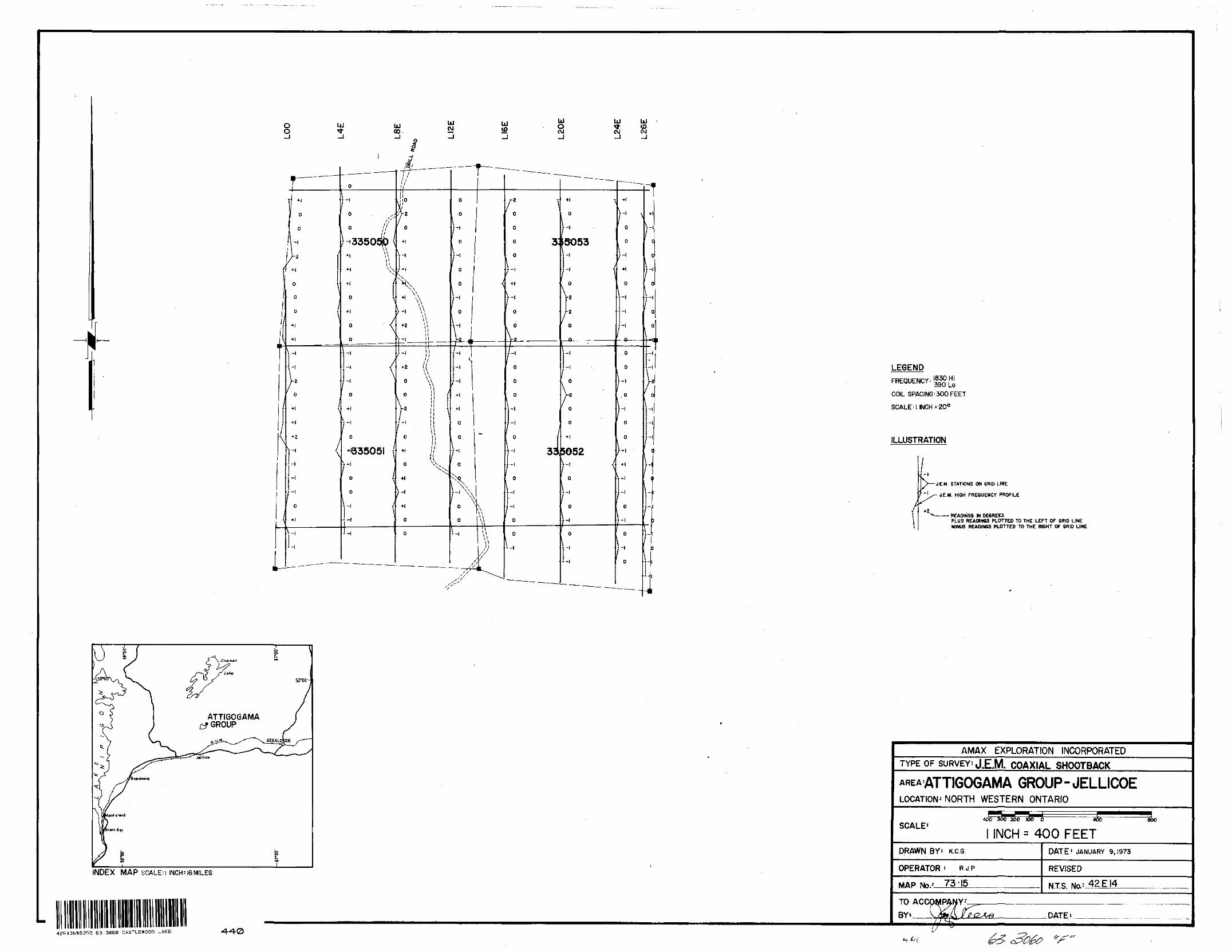
LEGENDFREQUENCY:
COIL SPACING^ 300 FEET
SCALE 'l INCH'200
ILLUSTRATION
J.E.M. STATIONS ON GRID LINE
- JE.M. HIGH FREQUENCY PROFILE
READINGS IN DEGREESPLUS READINGS PLOTTED TO THE LEFT OF GRID LINEMINUS READINGS PLOTTED TO THE RIGHT OF GRID LINE
ATTIGOGAMA GROUP
INDEX MAP SCALE:i INCH^6M!LES
42EI3NW8352 63.3060 CASTLEWOOD LAKE -4-40
AMAX EXPLORATION INCORPORATEDTYPE OF SURVEY: J.E.M. COAXIAL SHOOTBACK
GROUP-JELLICOELOCATION' NORTH WESTERN ONTARIO
SCALE*4O0300 206
l INCHO 406
400 FEETaoo
DRAWN BY'- K.C.G.
OPERATOR : R J P
MAP No.-' 73-15
DATE 1 JANUARY 9,1973
REVISED
N.T.S.
DATE*.
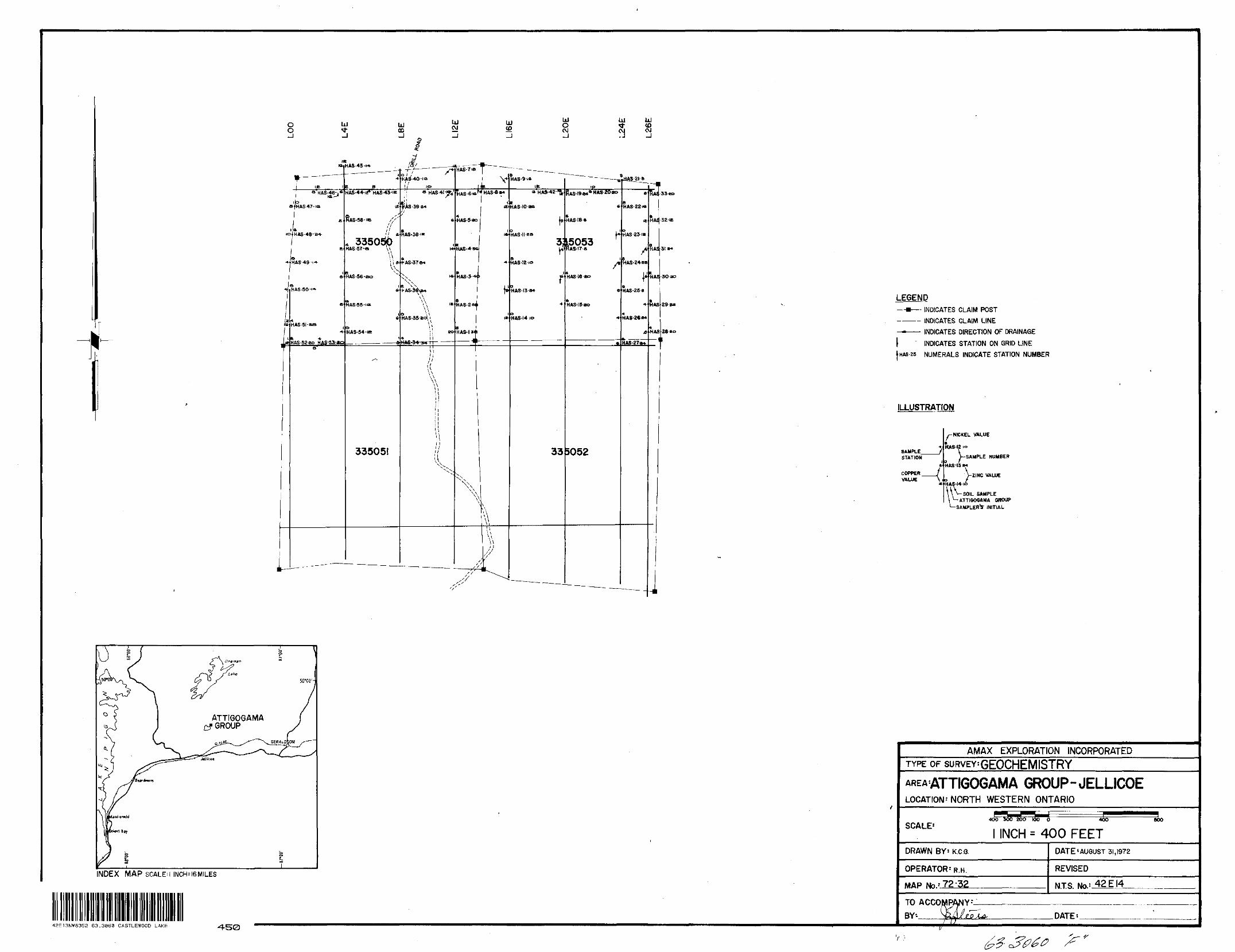
OoUJ UJ
00-JUJ CM
LJ (O
o
S
UJoPJ -J
UJ hJ
.J
*
i
^
m
l ie 'aHAS-46-j*L rapa^HAS47-is
fii a
o HAS-48-B4-
c
e * HAS'49"'-*
i
t HAS. 50-"*
a
' HAS'51-RB
1 K X.eHAS-52-eo HaS-53-jeoa"
— — — -
HAS45-M*
e aHAS-44'rf* HAS-43-IE
i(t
L, 3350^)HAS-37-a \\
\*
^AS-56-ao
iA
*
6
HA8-54-IE i
•~
335051
/^^^ ______ -41
o j y ^HAS-40-ia
rf 'Pj *HAS4I-ifV
(i AS -39 B4'i f
e
^AS-58'iK
w
S AS -3T-*i
NV *
K NN
h AS- 36^*
\ -
HAS-35^
HA6-34 J4 M ———
l 1a\u\\l! 1 1i i
||!
^"^
- —— ——————— .
HAS-7IB
HAS-6-ift'
HAS- 5 40
HAS-45*
HAS-3*
A HAS- E W i
HAS-lsn
X~\^
^
^s Sf s
**- — — -
VH HAS-8*t
iat
iA
4
J:
II
\ ^\
^
\\
1 l//'
^
^\f,'V "^ s'*'
8 —— HAS-9-t*
IK* HA8-42'Tt
US -10 -aa
f'HAS-II ee
3i
HAS -12 10
rHAS-I3'B4
4
HftS-14-io
33
' ~ — — — — ~-
~ — — - . _ __ i •P
RAS-19***""' 20'*0
6
H AS 18 6
15053 **RAS-17a
^
B
HAS-I5-BO
^
5052
^^-— — — .
6
H AS -22 w
IB
H AS -23i*
H AS -24*0
1'HAS-258
^
HAS-26**
4
——— — ,
-H
RA;
HAS
HA!
HA!
HAS
HAS
HI
133*o
•32'ie
31 a*
-30ao
29 B*
ae *oi
LEGEND—B—- INDICATES CLAIM POST
———— INDICATES CLAIM LINE——— INDICATES DIRECTION OF DRAINAGE
l INDICATES STATION ON GRID LINE JHAS-25 NUMERALS INDICATE STATION NUMBER
ILLUSTRATION
SAMPLE- STATION
COPPER VALUE
y-NICKEL VALUE
HA8-I2 .o
V-SAMPLE NUMBER
a H AS-13 M
K HAS-J4 ic
ZINC VALUE
V\ SOIL SAMPLE ATTIOOOAMA GROUP
SAMPLER'S- INITIAL
ATTIGOGAMAGROUP
INDEX MAP SCALEM INCf^ 16 MILES
42E13NWS352 63.3060 CASTLEWOOD LAKE
AMAX EXPLORATION INCORPORATEDTYPE OF suRVEY'GEOCHEMISTRY
GROUP-JELLICOELOCATION-NORTH WESTERN ONTARIO
SCALE1INCH = 400 FEET
DRAWN BY- K.C.G.
OPERATOR-R.H.
MAP No.--72'32
DATE'AUGUST 31,1972
REVISED
NTS. Ma* 42 E14.
TO ACCOMPANY BY'- DATE:
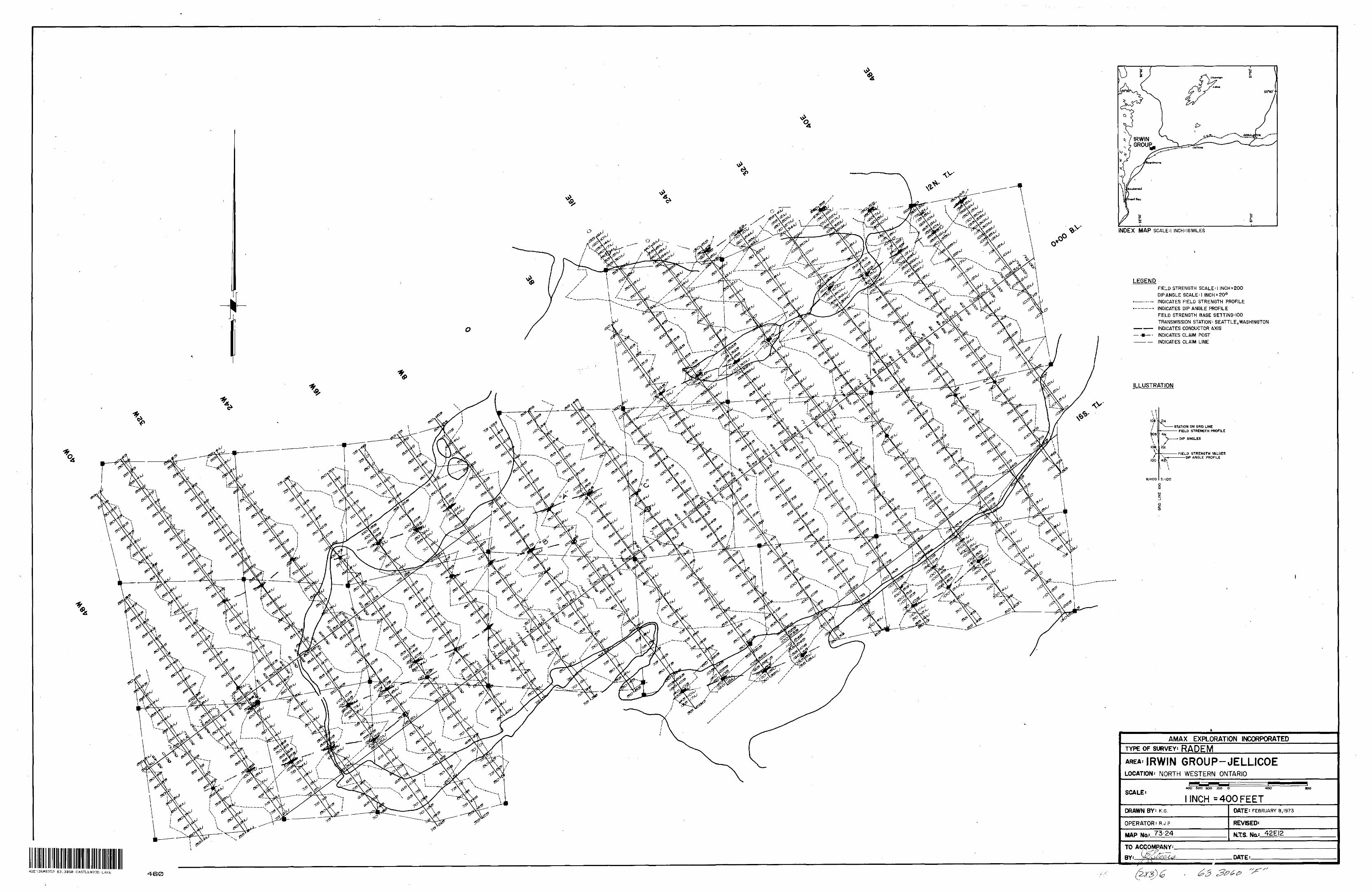
\
INDEX MAP SCALE:l INCH^6MILES
LEGENDFIELD STRENGTH SCALE' l INCH^200 DIP ANGLE SCALE M INCHED0 INDICATES FIELD STRENGTH PROFILE INDICATES DIP ANGLE PROFILE FIELD STRENGTH BASE SETTING'IOO TRANSMISSION STATION- SEATTLE.WASHINGTON INDICATES CONDUCTOR AXIS INDICATES CLAIM POST INDICATES CLAIM LINE
ILLUSTRATION
(OBt l
ioe
ZHSTATION ON GRID LINE
— FIELD STRENGTH PROFILE
100
N.+100 S.-100
DIP ANGLES
FIELD STRENGTH VALUES———DIP ANGLE PROFILE
AMAX EXPLORATION INCORPORATEDTYPE OF SURVEY: RADEM
AREA: IRWIN GROUP-JELLICOELOCATION^ NORTH WESTERN ONTARIO
SCALE*4OO 30O 2OO IOO O 4OO
l INCH * 400 FEETDRAWN BY: K.G
OPERATOR: R.J.P
MAP Na.1 73-24
DATE- FEBRUARY 8,1973
REVISED:
N.TS. ^TO ACCOMPANY: BY'. DATE:.
42E13NW8352 63.3050 CASTLEWOOD LAKE 460
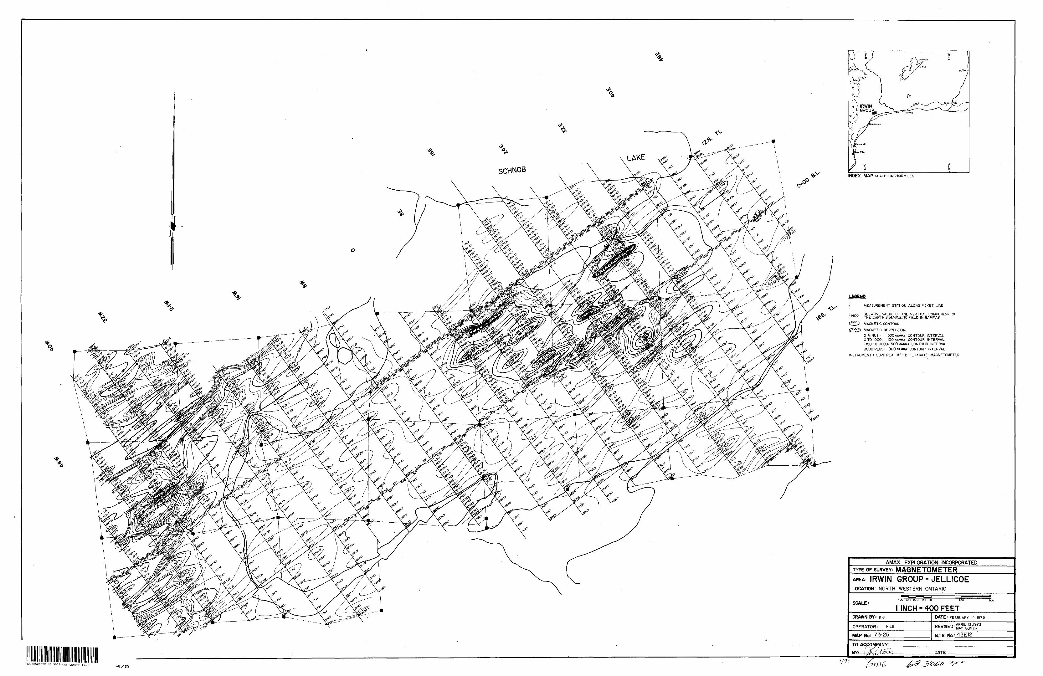
\
V INDEX MAP SCALED INCH^ISMILES
LEGEND
MEASUREMENT STATION ALONG PICKET LINE
RELATIVE VALUE OF THE VERTICAL COMPONENT OF THE EARTH'S MAGNETIC FJELD IN GAMMAS
MAGNETIC CONTOUR
MAGNETIC DEPRESSION-
O MINUS: 500 GAMMA CONTOUR INTERVAL O TO 1000 i 100 GAMMA CONTOUR INTERVAL 1000 TO 3000: 500 GAMMA CONTOUR INTERVAL 3000 PLUS : 1000 GAMMA CONTOUR INTERVAL
INSTRUMENT : SCINTREX MF- 2 FLUXGATE MAGNETOMETER
AMAX EXPLORATION INCORPORATEDTYPE OF SURVEY^ MAGNETOMETERAREA: IRWIN GROUP-JELLICOELOCATION^ NORTH WESTERN ONTARIO
SCALE'4OO 3OO 200 100 O 400
l INCH ' 400 FEET800
DRAWN
OPERATOR - R.J.P
MAP No: 75-25
DATE* FEBRUARY 14,1973
: APRILI3 ' 1973 - MAY |
N.TS. No.f 42EI2
TO
BY: DATE'.
42E13NW835S 63.3360 CASTLEWOOD LAKE470
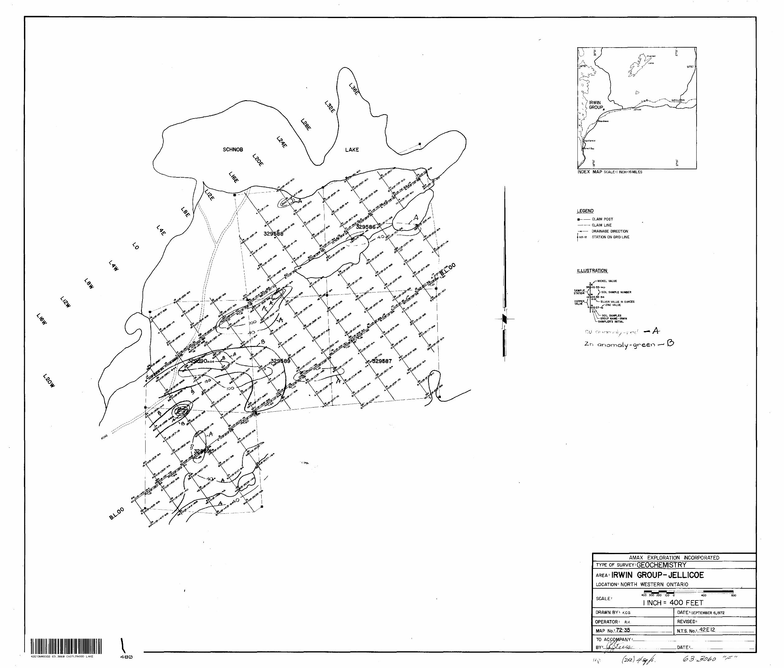
^
\
<.
INDEX MAP SCALED INCH^6MILES
LEGEND
CLAIM POST———— CLAIM LINE
-*-—— DRAINAGE DIRECTION
l His-iz STATION ON GRID LINE
ILLUSTRATION
SAMPLE^/ STATION
COPPER VALUE
^^NICKEL VALUE
HIS-55-*o
>SOIL SAMPLE NUMBER
HIS-56-5* o.o
'"— SILVER VALUE IN OUNCES a, --ZINC VALUE HIS-57-iS\v. SAMPLES
GROUP NAME-IRWIN SAMPLER'S INITIAL
anomaly-
i42E13NW8352 63.3860 CASTLEWOOD LAKE •480
AMAX EXPLORATION INCORPORATEDTYPE OF suRVEY'GEOCHEMISTRYAREA: IRWIN GROUP-JELLICOELOCATION 1 NORTH WESTERN ONTARIO
SCALE-400 300 200 100 O 4OO 800
INCH - 400 FEETDRAWN BY'- K.C.G.
OPERATOR' R H
MAP
DATE'-SEPTEMBER 6,1972
REVISED-
N.T.S. No.* 12
TO ACCOMPANY
BYV .DATE :-
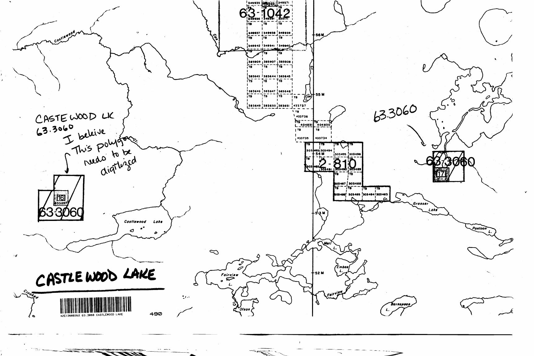
ss
34*937 134*93*94*939~~ ~ |TB '
^^ J349942 134994M 349940^
j3*990* (3*9907 9*990*fr* I7s~Tfi
3*3643 l 3*3*44 l 383*49
- ,.-
193)303494•54 M j303499 30349*
. ITBl l
1094**' 8034*9 3034*41*034*3
42EI3NW8352 63.3868 CASTLEWOOD LAKE
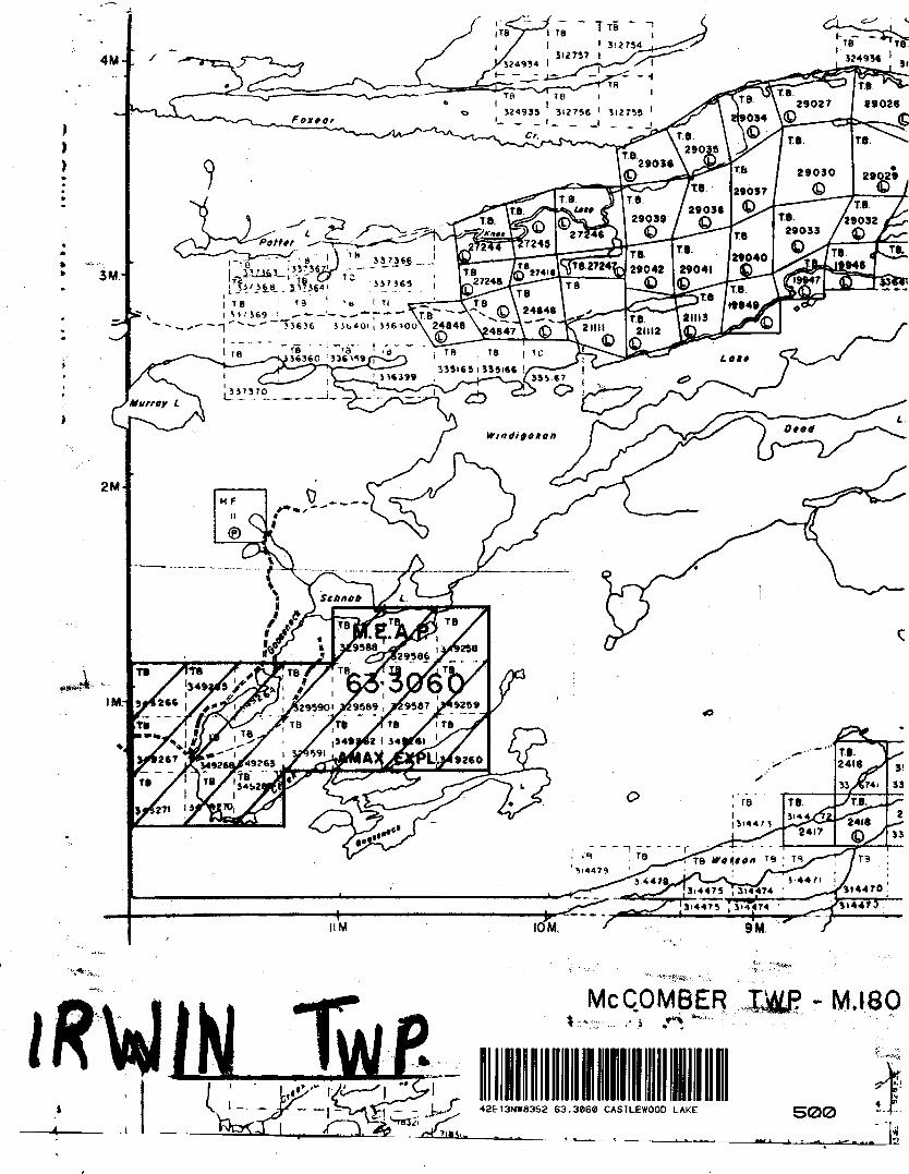
T8
IRWIN MCCOMBER
..i42E13NW8353 63.3860 CASTLEWOOD LAKE
- M jso
IT,
500
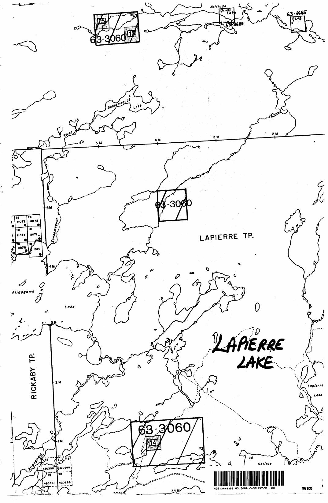
Id l"
5 M4 M
3M2M
-5M
f?Lakt
-30!
LAPIERRE TP.
42E13NW8352 63.3060 CASTLEWOOD LAKE