Embed Size (px)
Citation preview
Open File Report 89-2 – Page 1 of 30
BEDROCK GEOLOGY OF THE REANY LAKE AREA, MARQUETTE COUNTY, MICHIGAN
By Mary L. MacLellan and Theodore J. Bornhorst
Department of Geological Engineering, Geology and Geophysics
Michigan Technological University Houghton, Michigan 49931
1989
Michigan Geological Survey
Open File Report Geological Survey Division Michigan
Department of Natural Resources
Michigan Geological Survey Division
OFR 89-2 124 pages, 1 plates
This report is made from the best available copy. It is a preliminary, unedited for editorial standards, information release subject to revision.
If this report is formally published it will no longer be available as an Open File Report.
A list of Open File Reports and Maps is also available from the Geological Survey Division upon request. This report is printed by the State of Michigan and may be purchased from:
Geological Survey Division Michigan Department of Natural Resources P O Box 30028 Lansing, Michigan 48909
Reproduction of Michigan Geological Survey Division publications may be done if proper credit is given to the Michigan Department of Natural Resources, Geological Survey Division and, where appropriate, the author(s).
TABLE OF CONTENTS Abstract ............................................................................. 2 Introduction........................................................................ 3
Location and Accessibility ............................................. 3 Field Procedures ........................................................... 3 Laboratory Procedures .................................................. 4 Acknowledgements ....................................................... 4 Previous Work ............................................................... 4
Geological Setting ............................................................. 4 Regional Geological Setting .......................................... 4 Reany Lake Area........................................................... 4 Structure ........................................................................ 5
Rock Units ......................................................................... 6 Volcanics of Silver Mine Lakes...................................... 6
Pillowed Basalt Member ..........................................6 Normal Variety..............................................................6 Altered Basalt Variety ...................................................7 Highly Altered and Foliated Basalt Variety ...................7
Breccia Member of Bismark Creek.......................... 8 Breccia Member of Reany Lake .............................. 9 Iron-Formation Member......................................... 10 Age and Origin....................................................... 10
Gabbro of Clark Creek .................................................10 Altered Variety ....................................................... 11 Age and Origin....................................................... 11
Rhyolite Intrusive of Fire Center Mine..........................11 Granodiorite of the Dead River Pluton .........................12 Undifferentiated Foliated Pillowed Basalt and Rhyolite12 Highly Foliated Rhyolite ...............................................14 Reany Creek Formation ...............................................14
Basal Conglomerate .............................................. 15 Slates..................................................................... 15 Undifferentiated ..................................................... 16 Age and Origin....................................................... 16
Michigamme Formation................................................16 Keweenawan Diabase .................................................16
Correlation of Rock Units.................................................17 Metamorphism .................................................................18 Mineralization...................................................................18
Historical Activity ..........................................................18 Gold Assay Data ..........................................................18 Character of Mineralization ..........................................19 Age of Mineralization....................................................20
Geochemistry...................................................................21 Introduction...................................................................21 Chemical Classification of Reany Lake Samples.........21 Basalt Stratigraphy.......................................................22 Comparison Between Gabbros and Basalts ................23 Comparison of Granodiorites .......................................24 Rhyolite Intrusive of Fire Center Mine..........................25 Conclusion....................................................................26
Geological History............................................................26 Appendix A.......................................................................27 References.......................................................................29
LIST OF FIGURES FIGURE 1. Regional geology and location map of the Reany
Lake Area.........................................................................4
FIGURE 2. Generalized stratigraphic column (left) of the Archean and Proterozoic rock units in the Reany Lake Area .................................................................................5
FIGURE 3. Location map of the major faults in the Reany Lake Area.........................................................................5
FIGURE 4. Detailed (1:1200) map of the Undifferentiated Foliated Pillowed Basalt and Rhyolite unit, NE quarter of Section 7, T48N, R26W..................................................13
FIGURE 5. Plot of plagioclase vs. quartz phenocryst abundances for the Rhyolite Intrusive of Fire Center Mine, the Rhyolite Porphyry of Fire Center Mine and the Foliated and Highly Foliated Rhyolites. ..........................14
Open File Report 89-2 – Page 2 of 30
FIGURE 6. Plot of plagioclase vs. quartz phenocryst abundances for the Rhyolite Intrusive of Fire Center Mine and the Arkoses of the Undifferentiated member of the Reany Creek Formation. ................................................16
FIGURE 7. Comparison of nomenclature used in this study with previous nomenclature. ...........................................17
FIGURE 8. Correlation chart for the members of the Volcanics of Silver Mine Lakes in the Reany Lake Area.................18
FIGURE 9. Location map of samples which yielded background values of gold content, Reany Lake Area. ..19
FIGURE 10. Location map of samples which yielded anomalous values of gold content, Reany Lake Area.....20
FIGURE 11a. The total alkali silica (TAS) diagram showing the Reany Lake Area samples. ............................................21
FIGURE 11b. The total alkali-silica (TAS) diaqra. showing the 17 root names (Le Bas, et.al., 1986). .............................21
FIGURE 12a. Jensen cation plot of the Reany Lake area samples ..........................................................................22
FIGURE 12b. Jensen cation plot with field names (Grunsky, 1981). .............................................................................22
FIGURE 13. Plot of TiO2 vs Zr for the Upper, Lower and Lowest Basalts. ..............................................................22
FIGURE 14a. Plot of Zr/TiO2 vs Ni/Cr for the Upper, Lower and Lowest Basalts. .......................................................23
FIGURE 14b. Plot of Zr/TiO2 vs Nb/Y for the Upper, Lower and Lowest Basalts. .......................................................23
FIGURE 15a. Plot of TiO2 vs Zr for the Basalts and the Gabbros..........................................................................24
FIGURE 15b. Plot of Zr/TiO2 vs Ni/Cr for the Basalts and the Gabbros..........................................................................24
FIGURE 15c. Plot of TiO2/Al2O3 vs Nb/Y for the Basalts and the Gabbros....................................................................24
FIGURE 16. Plot of Zr/TiO2 vs Nb/Y for the Granodiorites....25
FIGURE 17a. Plot of TiO2 vs Zr for the Rhyolites. ................26
FIGURE 17b. Plot of Zr/TiO2 vs Nb/Y for the Rhyolites. ........26
FIGURE A1. Location of samples included in this study........27
LIST OF TABLES TABLE 1. Petrographic description of samples from the
Pillowed Basalt Member of the Volcanics of Silver Mine Lakes................................................................................6
TABLE 2. Petrographic descriptions of several samples from the Highly Altered and Foliated Basalt Variety of the Volcanics of Silver Mine Lakes.........................................7
TABLE 3. Petrographic descriptions of samples from the Breccia Member of Bismark Creek of the Volcanics of Silver Mine Lakes. ............................................................8
TABLE 4 Petrographic descriptions of samples from the Breccia Member of Reany Lake of the Volcanics of Silver Mine Lakes. ......................................................................9
TABLE 5. Petrographic descriptions of samples from the Gabbro of Clark Creek....................................................10
TABLE 6. Petrographic descriptions of samples from the Altered Variety of the Gabbro of Clark Creek. ................11
TABLE 7. Petrographic description of samples from the Rhyolite Intrusive of Fire Center Mine. ...........................12
TABLE 8. Petrographic descriptions of a sample from the Granodiorite of the Dead River Pluton. ..........................12
TABLE 9. Petrographic descriptions of samples from the Undifferentiated Foliated Pillowed Basalt and Rhyolite. .13
TABLE 10. Petrographic desriptions of a sample from the Highly Foliated Rhyolite..................................................14
TABLE 11. Petrographic descriptions of samples of Arkose and Graywacke from the Reany Creek Formation. ........15
TABLE 12. Petrographic descriptions of samples from the Keweenawan Diabase. ..................................................17
TABLE 13. Background gold analyses from the Reany Lake area. ...............................................................................19
TABLE 14. Anomalous gold analyses from the Reany Lake area. ...............................................................................20
TABLE 15. Average geochemical values and standard deviations of the Upper, Lower and Lowest Basalts.......23
TABLE 16. Average geochemical values and standard deviations of the Gabbros and the Basalts.....................24
TABLE 17. Average geochemical values and standard deviations of the Granodiorite of Rocking Chair Lakes (RCL), the Granodiorite of the Dead River Pluton (DRP) and the Granodiorite Phase of the Dead River Pluton (DR Pluton)............................................................................25
TABLE 18 a). Average geochemical values of textural varieties of Rhyolites.. ....................................................25
TABLE 18 b). Standard deviations of rhyolites from Table 18 a), with more than one sample. ......................................26
TABLE A1. Table of samples analyzed for whole rock geochemistry and for petrographic description...............27
TABLE A2. Geochemical values of Reany Lake Area samples........................................................................................27
TABLE A3. Geochemical values of Upper, Loner and Lowest Basalts ...........................................................................28
TABLE A4. Geochemical values of the Gabbros...................28
TABLE A5. Geochemical values of the Granodiorites...........28
TABLE A6. Geochemical values of the Rhyolites..................28
ABSTRACT During the summer of 1987 the bedrock geology of a 5 mi2 (13 km2) area of the Marquette Greenstone Belt was mapped at a scale of 1:6000. This area includes Section 36, T49N, R27W, Section 31, T49N, R26W, Section 1, T48N, R27W, and Sections 6, 7, T48N, R26W. This study constitutes an eastward extension of previous mapping by Baxter (1988), Johnson (1987) and Owens (1986).
The Reany Lake Area is comprised primarily of Archean volcanic and intrusive rocks. The oldest rocks in the area are the Archean Pillowed Basalt Member with two
Open File Report 89-2 – Page 3 of 30
interbedded breccia units, the Breccia Member of Bismark Creek and the Breccia Member of Reany Lake, which are interpreted to be volcaniclastic breccias, and an Iron-Formation Member. These rocks are collectively termed the Volcanics of Silver Mine Lakes. The volcanics have been intruded by the Gabbro of Clark Creek which in turn have both been intruded by the Archean Rhyolite Intrusive of Fire Center Mine and the Granodiorite of the Dead River Pluton.
To the south, the Archean volcanics and intrusives are unconformably overlain by the Reany Creek Formation. This formation is of Archean or Lower Proterozoic age and is composed of a basal conglomerate, a middle unit of fine slate and an upper unit of interbedded arkoses, graywackes and conglomerates. To the south of the Reany Creek Formation is an upfaulted block of Archean rock composed of an undifferentiated unit of alternating pillowed basalts and foliated rhyolites and a separate unit of highly foliated rhyolite. The Lower Proterozoic Michigamme Formation crops out to the south and to the extreme north-west of the Archean rocks. All of the preceding rocks have been cut by Keweenawan diabase dikes.
The overall stratigraphic positions of pillowed basalts can be determined using geochemistry. The gabbros can be geochemically similar to the basalts but have some slight differences which allow them to be distinguished. The geochemical differences between the various basalts and between the gabbros and basalts are interpreted as primary and igneous in origin.
All pre-Keweenawan rocks have been metamorphosed to greenschist facies. The Archean units typically have a foliation which strikes N70°W and is near vertical to steeply north dipping. The gabbro and rhyolite dikes commonly parallel this strike. Several generations of faults are evident in the Reany Lake area. The older (Archean) faults tend to parallel the strike of foliation and are marked by 10-100 foot (3-30 m) wide zones of strong foliation and abundant alteration. A few occurrences of crenulated foliation and crenulation cleavage are found adjacent to these older, NW-SE trending, faults. The older faults are sometimes truncated or off-set by later (Archean with possible reactivation during the Lower Proterozoic) N-S trending faults. These younger faults are reflected by 10-20 foot (3-7 m) wide zones of moderate to strong foliation and are frequently marked by distinct ravines.
Mineralization occurs primarily as disseminated sulfides within altered country rocks. There are very few quartz-carbonate-sulphide veins of the type which are abundant in the areas to the west. Mineralization is most abundant adjacent to the major NW-SE trending shear zones and adjacent to or within the rhyolite dikes. Metallic minerals generally consist of disseminated pyrite and widely scattered chalcopyrite.
INTRODUCTION This project was undertaken as part of an active research program to provide detailed geologic maps and information on the Marquette Greenstone Belt in Marquette County, Michigan (designated as Kitchi Schist and Mona Schist of Figure 1). This project constitutes an eastward extension of previous mapping by Owens (1986). The major rock units in the area were mapped at a scale of 1:6000 (Plate I).
LOCATION AND ACCESSIBILITY OF THE AREA The area of this report is located along the shore of the Dead River Storage Basin in Marquette County, Michigan (latitude 87°33' and longitude 47°35'). It is contained within the Negaunee 15 minute topographic quadrangle map and includes: section 36, T49N, R27W; section 31, T49N, R26W; section 1, T48N, R27W and sections 6 and 7, T48N, R26W. Sections 36 and 31 are accessible approximately 6 to 7 miles (10 to 12 km) north on County Road 510, from County Road 502 (Fig. 1). Highway 510 is paved for the first 4 to 6 miles (7-10 km). Several unmarked old logging roads lead to the interior of these sections. Sections 1, 6 and the north half of section 7 can be reached by driving 1.5 to 4 miles (2.5 to 6.0 km) west along North Basin Drive from the intersection with County Road 510. North Basin Drive is paved for approximately 2 miles (3 km) and then becomes a single lane gravel road. Access to sections 1 and 6 is hampered by an approximately 100 foot (30 m) high cliff which parallels North Basin Drive across much of the area. The south half of section 7 can be reached by boat or by several unmarked gravel roads that lead to it from County Road 510.
FIELD PROCEDURES Field work was conducted during the summer of 1987. Sections 1 and 6 were mapped by the pace and compass method from a taped base line on the northern section boundary with N-S traverse lines spaced every 500 feet. Section 36 was mapped making use of an existing cut grid, line spacings were generally 400 feet. Section 31 was mapped by pace and compass method with more widely spaced traverse lines whose orientation was selected in order to intersect as much of the limited outcrop as possible. Section 7 was primarily mapped on the shore of the Dead River Storage Basin since there was little, if any, outcrop located away from the lake.
Contacts were inferred between outcrops except where outcrop density was sufficient to allow accurate contact location. Some very small outcrops were enlarged on the map in order to show geologic relationships and some clusters of small outcrops are shown as single large outcrops. Some large outcrops were not mapped in their entirety and are left open on the map (Plate I).
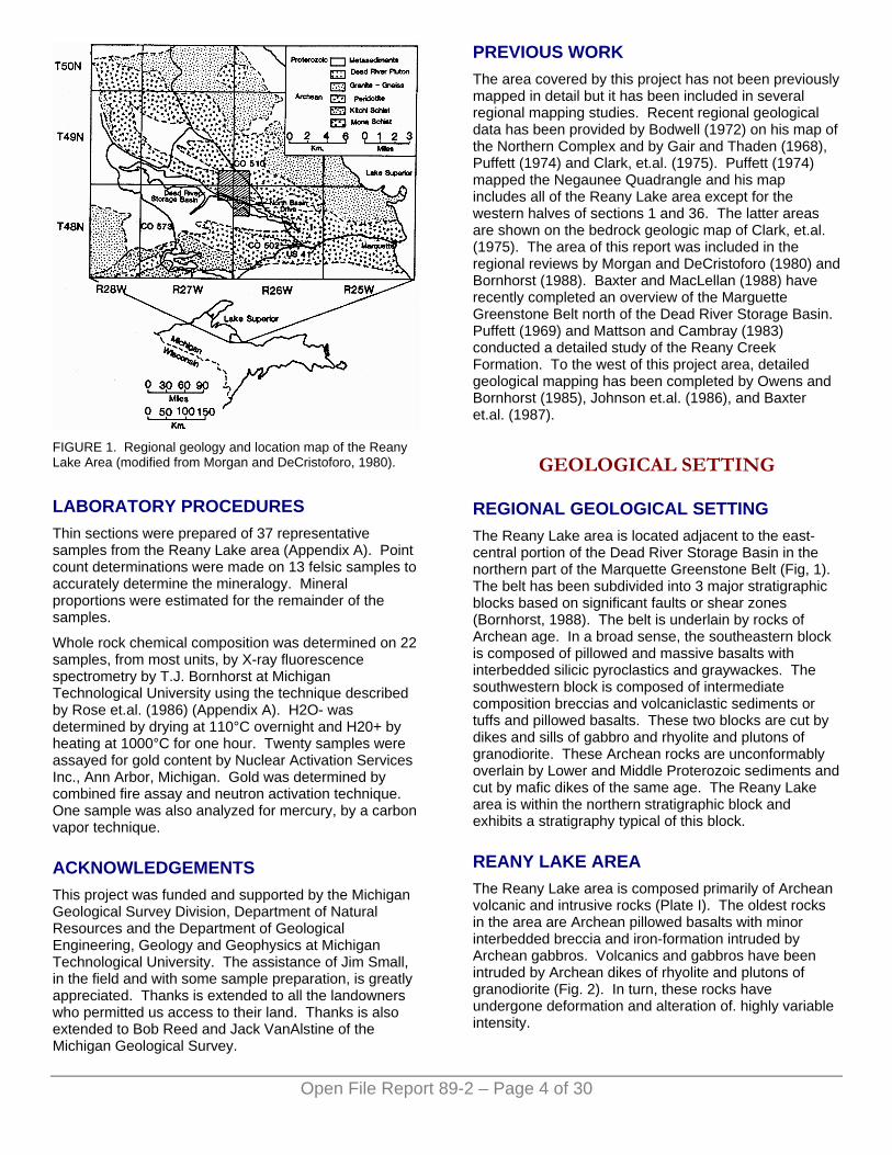
FIGURE 1. Regional geology and location map of the Reany Lake Area (modified from Morgan and DeCristoforo, 1980).
LABORATORY PROCEDURES Thin sections were prepared of 37 representative samples from the Reany Lake area (Appendix A). Point count determinations were made on 13 felsic samples to accurately determine the mineralogy. Mineral proportions were estimated for the remainder of the samples.
Whole rock chemical composition was determined on 22 samples, from most units, by X-ray fluorescence spectrometry by T.J. Bornhorst at Michigan Technological University using the technique described by Rose et.al. (1986) (Appendix A). H2O- was determined by drying at 110°C overnight and H20+ by heating at 1000°C for one hour. Twenty samples were assayed for gold content by Nuclear Activation Services Inc., Ann Arbor, Michigan. Gold was determined by combined fire assay and neutron activation technique. One sample was also analyzed for mercury, by a carbon vapor technique.
ACKNOWLEDGEMENTS This project was funded and supported by the Michigan Geological Survey Division, Department of Natural Resources and the Department of Geological Engineering, Geology and Geophysics at Michigan Technological University. The assistance of Jim Small, in the field and with some sample preparation, is greatly appreciated. Thanks is extended to all the landowners who permitted us access to their land. Thanks is also extended to Bob Reed and Jack VanAlstine of the Michigan Geological Survey.
PREVIOUS WORK The area covered by this project has not been previously mapped in detail but it has been included in several regional mapping studies. Recent regional geological data has been provided by Bodwell (1972) on his map of the Northern Complex and by Gair and Thaden (1968), Puffett (1974) and Clark, et.al. (1975). Puffett (1974) mapped the Negaunee Quadrangle and his map includes all of the Reany Lake area except for the western halves of sections 1 and 36. The latter areas are shown on the bedrock geologic map of Clark, et.al. (1975). The area of this report was included in the regional reviews by Morgan and DeCristoforo (1980) and Bornhorst (1988). Baxter and MacLellan (1988) have recently completed an overview of the Marguette Greenstone Belt north of the Dead River Storage Basin. Puffett (1969) and Mattson and Cambray (1983) conducted a detailed study of the Reany Creek Formation. To the west of this project area, detailed geological mapping has been completed by Owens and Bornhorst (1985), Johnson et.al. (1986), and Baxter et.al. (1987).
GEOLOGICAL SETTING
REGIONAL GEOLOGICAL SETTING The Reany Lake area is located adjacent to the east-central portion of the Dead River Storage Basin in the northern part of the Marquette Greenstone Belt (Fig, 1). The belt has been subdivided into 3 major stratigraphic blocks based on significant faults or shear zones (Bornhorst, 1988). The belt is underlain by rocks of Archean age. In a broad sense, the southeastern block is composed of pillowed and massive basalts with interbedded silicic pyroclastics and graywackes. The southwestern block is composed of intermediate composition breccias and volcaniclastic sediments or tuffs and pillowed basalts. These two blocks are cut by dikes and sills of gabbro and rhyolite and plutons of granodiorite. These Archean rocks are unconformably overlain by Lower and Middle Proterozoic sediments and cut by mafic dikes of the same age. The Reany Lake area is within the northern stratigraphic block and exhibits a stratigraphy typical of this block.
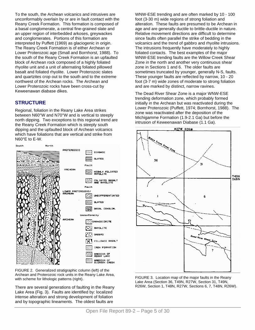
REANY LAKE AREA The Reany Lake area is composed primarily of Archean volcanic and intrusive rocks (Plate I). The oldest rocks in the area are Archean pillowed basalts with minor interbedded breccia and iron-formation intruded by Archean gabbros. Volcanics and gabbros have been intruded by Archean dikes of rhyolite and plutons of granodiorite (Fig. 2). In turn, these rocks have undergone deformation and alteration of. highly variable intensity.
Open File Report 89-2 – Page 4 of 30
To the south, the Archean volcanics and intrusives are unconformably overlain by or are in fault contact with the Reany Creek Formation. This formation is composed of a basal conglomerate, a central fine-grained slate and an upper region of interbedded arkoses, greywackes and conglomerates. Portions of this formation are interpreted by Puffett (1969) as glaciogenic in origin. The Reany Creek Formation is of either Archean or Lower Proterozoic age (Small and Bornhorst, 1988). To the south of the Reany Creek Formation is an upfaulted block of Archean rock composed of a highly foliated rhyolite unit and a unit of alternating foliated pillowed basalt and foliated rhyolite. Lower Proterozoic slates and quartzites crop out to the south and to the extreme northwest of the Archean rocks. The Archean and Lower Proterozoic rocks have been cross-cut by Keweenawan diabase dikes.
STRUCTURE Regional, foliation in the Reany Lake Area strikes between N60°W and N70°W and is vertical to steeply north dipping. Two exceptions to this regional trend are the Reany Creek Formation which is steeply south dipping and the upfaulted block of Archean volcanics which have foliations that are vertical and strike from N60°E to E-W.
FIGURE 2. Generalized stratigraphic column (left) of the Archean and Proterozoic rock units in the Reany Lake Area, with scheme for lithologic patterns (right).
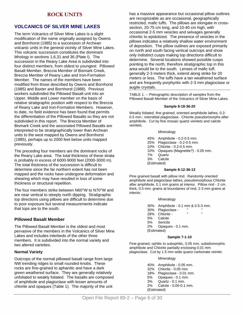
There are several generations of faulting in the Reany Lake Area (Fig. 3). Faults are identified by: localized intense alteration and strong development of foliation and by topographic lineaments. The oldest faults are
WNW-ESE trending and are often marked by 10 - 100 foot (3-30 m) wide regions of strong foliation and alteration. These faults are presumed to be Archean in age and are generally ductile to brittle-ductile in nature. Relative movement directions are difficult to determine since faults often parallel the strike of bedding in the volcanics and the trend of gabbro and rhyolite intrusions. The intrusions frequently have moderately to highly foliated contacts. The best examples of the major WNW-ESE trending faults are the Willow Creek Shear Zone in the north and another very continuous shear zone in Sections 1 and 6. The older faults are sometimes truncated by younger, generally N-S, faults. These younger faults are reflected by narrow, 10 - 20 foot (3-7 m) wide zones of moderate to strong foliation and are marked by distinct, narrow ravines.
The Dead River Shear Zone is a major WNW-ESE trending deformation zone, which probably formed initially in the Archean but was reactivated during the Lower Proterozoic (Puffett, 1974; Bornhorst, 1988). The zone was reactivated after the deposition of the Michigamme Formation (1.9-2.1 Ga) but before the intrusion of Keweenawan Diabase (1.1 Ga).
FIGURE 3. Location map of the major faults in the Reany Lake Area (Section 36, T49N, R27W, Section 31, T49N, R26W, Section 1, T48N, R27W, Sections 6, 7, T48N, R26W).
Open File Report 89-2 – Page 5 of 30
Open File Report 89-2 – Page 6 of 30
ROCK UNITS
VOLCANICS OF SILVER MINE LAKES The term Volcanics of Silver Mine Lakes is a slight modification of the name originally assigned by Owens and Bornhorst (1985) to a succession of Archean volcanic units in the general vicinity of Silver Mine Lakes. This volcanic succession constitutes the dominant lithology in sections 1,6,31 and 36 (Plate I). The succession in the Reany Lake Area is subdivided into four distinct members, from oldest to youngest: Pillowed Basalt Member, Breccia Member of Bismark Creek, Breccia Member of Reany Lake and Iron-Formation Member. The names of the members have been modified from those described by Owens and Bornhorst (1985) and Baxter and Bornhorst (1988). Previous workers subdivided the Pillowed Basalt unit into an Upper, Middle and Lower member on the basis of relative stratigraphic position with respect to the Breccia of Reany Lake and Iron-Formation Members. However, to date, no field evidence has been found that permits the differentiation of the Pillowed Basalts so they are not subdivided in this report. The Breccia Member of Bismark Creek and the associated Pillowed Basalts are interpreted to be stratigraphically lower than Archean units to the west mapped by Owens and Bornhorst (1985), perhaps up to 2000 feet below units mapped previously.
The preceding four members are the dominant rocks of the Reany Lake area. The total thickness of these strata is probably in excess of 6000-9000 feet (2000-3000 m). The total thickness of the succession is difficult to determine since the far northern extent has not been mapped and the rocks have undergone deformation and shearing which may have resulted in loss of some thickness or structural repetition.
The four members strike between N60°W to N70°W and are near vertical to steeply north dipping. Stratigraphic top directions using pillows are difficult to determine due to poor exposure but several measurements indicate that tops are to the south.
Pillowed Basalt Member The Pillowed Basalt Member is the oldest and most pervasive of the members in the Volcanics of Silver Mine Lakes and includes interbeds of the other three members. It is subdivided into the normal variety and two altered varieties.
Normal Variety
Outcrops of the normal pillowed basalt range from large NW trending ridges to small rounded knobs. These rocks are fine-grained to aphanitic and have a dark green weathered surface. They are generally relatively unfoliated to weakly foliated. The basalts are composed of amphibole and plagioclase with lesser amounts of chlorite and opaques (Table 1). The majority of the unit
has a massive appearance but occasional pillow outlines are recognizable as are occasional, geographically restricted, mafic tuffs. The pillows are elongate in cross-section, 20-75 cm long, and 10-40 cm high, with occasional 2-5 mm vesicles and selvages generally chloritic to epidotized. The presence of vesicles in the pillows indicates a relatively shallow water environment of deposition. The pillow outlines are exposed primarily on north and south facing vertical outcrops and show only indistinct cusps making top directions difficult to determine. Several locations showed possible cusps pointing to the north, therefore stratigraphic top in this area would be to the south. Lenses of mafic tuff, generally 2-3 meters thick, extend along strike for 20 meters or less. The tuffs have a tan weathered surface and are frequently porphyritic with 2-3 mm plagioclase or augite crystals.
TABLE 1. -- Petrographic description of samples from the Pillowed Basalt Member of the Volcanics of Silver Mine Lakes.
Sample 8-18-36-20
Weakly foliated, fine grained, oriented amphibole lathes, 0.2-0.5 mm.; interstitial plagioclase. Chlorite pseudomsorphs after amphibole. Cut by fine mosaic quartz veinlets and calcite veinlets.
Mineralogy
45% Amphibole - 0.2-0.5 mm. 25% Plagioclase - 0.2-0.5 mm. 10% Chlorite - 0.2-0.5 mm. 10% Opaques (Magnetite?) - 0.05 mm. 7% Quartz 3% Calcite (Estimated)
Sample 8-12-36-13
Pine grained basalt with pillow rind. Randomly oriented amphibole and plagioclase lathes, pseudomorphous Chlorite after amphibole, 0.1 mm grains at interior. Pillow rind - 2 cm. thick, 0.5 mm. grains at boundaries of rind, 2-3 mm grains at interior.
Mineralogy
30% Amphibole - 0.1 mm & 0.5-3 mm. 30% Plagioclase - " " 28% Chlorite - " " 5% Calcite 5% Sericite 2% Opaques - 0.1 mm. (Estimated)
Sample 7-1-10
Fine-grained, ophitic to subophitic, 0.05 mm, subidiomorphic amphibole and Chlorite partially enclosing 0.01 mm plagioclase. Cut by 1.5 mm wide quartz-carbonate veinlet.
Mineralogy
40% Amphibole - 0.05 mm. 32% Chlorite - 0.05 mm. 18% Plagioclase - 0.01 mm. 5% Opaques - 0.1 mm. 3% Quartz - 0.1 mm. 2% Calcite - 0.05-0.1 mm. (Estimated)
Open File Report 89-2 – Page 7 of 30
The regional foliation is poorly developed in these basalts but generally trends N70°W and dips from 55°N to vertical. The basalts sometimes have crenulated foliation with a very shallow northerly dip and crenulation cleavage that has a steep northerly dip. The trend of the crenulations and the strike of crenulation cleavage parallels the strike of the regional foliation. Shear zones are often marked by development of strong foliation, increased alteration and some brecciation of the basalts. The alteration is especially marked in the southern portion of the volcanic succession near the unconformable contact with the overlying Reany Creek Formation where two additional varieties of the Pillowed Basalt Member have been recognized: the Altered Basalt Variety and the Highly Altered and Foliated Basalt Variety.
Altered Basalt Variety
The Altered Basalt Variety is in gradational contact with the Pillowed Basalt Member. This Variety is massive to moderately foliated, fine-grained and weakly to highly sericitized with no recognizable pillow structures. The unit has a green to gray weathered surface and often contains abundant calcite and occasional biotite. Samples from this unit frequently fizz when tested with HCl, indicating the presence of carbonate.
The Altered Basalt is found primarily in the 100-500 foot (30-160 meter) wide region paralleling the contact with the Reany Creek Formation. Additional zones of altered basalt, generally too small to map, are found along the margins of narrow shear zones.
Highly Altered and Foliated Basalt Variety
The Highly Altered and Foliated Basalt Variety is a very narrow, discontinuous unit. It is located along the fault or shear zone in the southern part of the Volcanics of Silver Mine Lakes. Where the unit is enclosed by gabbro it has a distinctly fragmental appearance with up to 80%, 1-5 cm, lensoidal clasts and 20% interstitial chlorite. Several types of clasts are recognizable in polished slabs of this unit. Some clasts are very fine grained to aphanitic with a pale green to white weathered surface whereas others are finegrained and very dark green. The clasts have undergone abundant chlorite, sericite and calcite alteration and the interstices have been highly chloritized (Table 2).
Where the unit is not enclosed by the gabbro, it has a layered or banded appearance with alternating fine sericite and plagioclase-rich layers and darker chlorite-rich layers (Table 2). The chlorite-rich layers are commonly crenulated and occasionally the finer layers have developed crenulation cleavages. The layers generally have shallow northerly dips while the crenulation cleavages are near vertical to steeply north dipping. The layers are sometimes pinched showing incipient boudinage.
The fragmental outcrops may be hyaloclastite or pillow breccia or they may have been brecciated during deformation. The outcrops having the layered
appearance closely resembles the Laminated Schist Member described by Owens and Bornhorst (1985). Occasional outcrops along the margin between the Reany Lake Area and the Fire Center Mine area and within the Laminated Schist Member (Owens and Bornhorst, 1985) show possible remnants of pillow outlines (observed during a regional reconnaissance) suggesting that these rocks are very highly strained pillowed basalts. Thus, the Laminated Schist Member of Owens and Bornhorst (1985) is now considered to be part of the Highly Altered and Foliated Basalt Variety of the Pillowed Basalt Member.
TABLE 2. -- Petrographic descriptions of several samples from the Highly Altered and Foliated Basalt Variety of the Volcanics of Silver Mine Lakes.
Sample 11-4-1-40
Layered or fragmental rock with fine-grained, weakly folded, layers/fragments and coarser, chlorite-rich layer/matrix. The thin section is 70% fine-grained layer and 30% chlorite-rich layer.
Fine-grained layer/clast - Fine, 0.01-0.02 mm, sericite, chlorite, plagioclase and quartz showing very weak crenulated cleavage of chlorite and sericite and slight crenulation cleavage. Abundant calcite veinlets.
Mineralogy
35% Sericite - 0.01 mm. 30% Plagioclase - 0.01 mm. 15% Chlorite - 0.01-0.02 mm. 10% Quartz - 0.02 mm. 5% Calcite 5% Opaques (Estimated)
Chlorite-rich layer/matrix - Abundant calcite and, 0.1 mm, crenulated chlorite with deep purple to brown birefringence.
Mineralogy
35% Calcite - 0.1-0.5 mm. 30% Chlorite - 0.05-0.1 mm 20% Quartz - 0.05 mm. 10% Plagioclase - 0.05 mm. 5% Opaques - 0.05 mm. (Estimated)
Sample 7-15-15
Layered sample with crenulated foliation marked by crenulated chlorite having gray to purple birefringence. Layers distinguishable by amounts of chlorite and overall grain size.
Mineralogy
Layer 1 - 50% Chlorite - 0.03 mm. 30% Quartz - 0.01 mm. 16% Calcite - 0.05-0.5 mm. 4% Opaques - 0.01-0.5 mm. (Estimated)
With crenulation cleavage perpendicular to foliation, spaced every 0.3-0.6 mm, marked by fine sericite and aligned chlorite.
Layer 2 - 35% Plagioclase - 0.01-0.02 mm. 25% Sericite - 0.01 mm. 20% Chlorite - 0.02 mm. 15% Quartz - 0.03 mm.
Open File Report 89-2 – Page 8 of 30
5% Opaques - 0.01 mm. (Estimated)
Chlorite crenulated and forming highly tortuous outlines around plagioclase and quartz rich zones. Almost fragmental appearance. Sericite rich interior of the layer showing signs of pinching and boudinage.
Layer 3 - 35% Plagioclase - 0.001-0.005 mm. 33% Sericite - " 23% Chlorite - “ 5% Quartz - 0.001-0.005 mm. 4% Opaques (Estimated) Foliated and somewhat crenulated.
Sample 6-4-3
Sample with fine grained lenses (fragments?) and interlens chlorite. Lens/fragment - 0.02-0.05 mm., plagioclase, quartz and sericite cut by carbonate veinlets. Interlens - 0.1 mm, pale green chlorite, with dark brown to purple birefringence, and sericite
Mineralogy
Lens Interlens
30% Plagioclase 25% Chlorite 20% Sericite 10% Quartz 10% Calcite 5% Semi-opaques Tr Opaques (Estimated)
50% Chlorite 30% Sericite 10% Calcite 10% Opaques (Estimated)
Breccia Member of Bismark Creek The Breccia Member of Bismark Creek is generally 300 feet (100 meters) thick and strikes N70°W with a near vertical dip. The member is located along the Willow Creek Shear Zone and has a fragmental appearance. The member contains several types of clasts, the most conspicuous of which are stretched and broken white clasts. These clasts have a rhyolitic to dacitic composition, based on classification according to Streckeisen (1980), and vary in shape from lensoidal, or fine stringers, to large and elongate (the latter are up to 10-15 cm in width to 1-2 meters in length). In several locations these clasts resemble flattened and broken rhyolite dikes. These clasts are commonly porphyritic and have a pinkish to white weathered surface. They have a groundmass of mosaic quartz, feldspar and chlorite and contain 15-20%, 0.02-2 mm, feldspar phenocrysts (Table 3). The feldspar is probably mostly plagioclase with up to 40% microcline, but the fine grain size and alteration makes more accurate identification difficult. The groundmass of these clasts contains more plagioclase than the Rhyolite Intrusive of Fire Center Mine so they are probably not directly related to those rhyolites (see Tables 3 and 7). This supports the interpretation of this member as a volcaniclastic breccia which was subsequently deformed. There are also a minor number of granodiorite clasts. The granodioritic clasts are porphyritic with 25-40%, relatively fresh,
plagioclase phenocrysts in a fine grained quartz, plagioclase and chlorite groundmass (Table 3).
TABLE 3. -- Petrographic descriptions of samples from the Breccia Member of Bismark Creek of the Volcanics of Silver Mine Lakes.
Sample 8-31-31-11 Rhyolitic? clast.
Porphyroblastic, 20%, xenomorphic, 0.5-2 mm, plagioclase phenocrysts, highly altered to coarse sericite. Matrix - 0.04 mm, mosaic quartz and plagioclase, scattered sericite.
Mineralogy
42% Quartz - 0.04 mm. 30% Feldspar— 0.04 mm. 16% Plagioclase Phenocrysts - 0.5-2 mm. 5% Muscovite - 0.2 mm. 3% Chlorite - 0.1 mm. 3% Opaques - 0.1 mm 1% Calcite Modal Analysis - 500 Points
Sample 9-1-36-30 Rhyolitic? clast.
Porphyroblastic, weakly foliated, 20%, subidiomorphic to xenomorphic, 0.2-1 mm., plagioclase phenocrysts, weakly to moderately altered to sericite and calcite. Groundmass - 0.04 mm, mosaic quartz and plagioclase with oriented, 0.05 mm, chlorite.
Mineralogy
45% Quartz - 0.04 mm. 26% Feldspar - 0.04 mm. 17% Plagioclase Phenocrysts - 0.2-1 mm. 9% Chlorite - 0.05 mm. 1% Quartz - 0.2-1 mm. 1% Calcite 1% Opaques - 0.01-0.03 mm. Modal Analysis - 526 Points
Sample 8-31-31-10 Granodioritic? clast.
Porphyroblastic, 40%, idiomorphic to subidiomorphic, 0.2-2 mm, plagioclase phenocrysts, 5%, subidiomorphic, 0.4 mm, amphibole phenocrysts altering to chlorite. Groundmass - 0.05 ma, mosaic quartz and interstitial chlorite.
Mineralogy
32% Quartz -0.05 mm. 24% Plagioclase Phenocrysts - 0.2-2 mm. 23% Feldspar - 0.1 mm. 13% Chlorite - 0.05 mm. 6% Amphibole - 0.4 mm. 1% Calcite 1% Opaques - 0.05 mm. Modal Analysis - 521 Points
Sample 8-31-31-6 Granodioritic? clast.
Porphyritic, medium-grained groundmass, 0.5-6 mm, subidiomorphic plagioclase phenocrysts in a, 0.1 mm, quartz mosaic and chlorite groundmass. Some alteration of plagioclase to sericite. Occasional scattered zircon.
Mineralogy
32% Quartz - 0.1 mm. 35% Plagioclase Phenocrysts - 0.5-6 mm. 15% Feldspar - 0.1 mm. 10% Chlorite - 0.1 mm.
4% Amphibole - 0.1 mm. 3% Opaques - 0.1 mm 1% Calcite - Tr Zircon - 0.1 mm. Modal Analysis - 525 Points
Sample 8-31-31-8 Gabbroic? clast.
Ophitic to subophitic, medium-grained, 0.3 mm, subidiomorphic amphibole and chlorite with abundant interstitial, 0.04-0.08 mm, muscovite and plagioclase, also, 3-6 mm, aggregates of muscovite (altered phenocrysts of plagioclase?).
Mineralogy
41% Muscovite - 0.04-0.08 mm. 27% Amphibole - 0.3 mm. 18% Chlorite - 0.3 mm. 9% Plagioclase - 0.04 mm. 4% Magnetite - 0.1 mm. 1% Calcite (Estimated)
Sample 8-31-31-7 Matrix with rhyolitic? clast.
Matrix - weak to moderate foliation, ophitic?, 0.1 mm., subidiomorphic amphibole lathes, some altered to chlorite. Clast-Porphyroblastic, 20%, 0.5-1 mm., xenomorphic, plagioclase phenocrysts in 0.05 mm., mosaic quartz matrix.
Mineralogy
Matrix Clast
55% Amphibole 33% Plagioclase 11% Chlorite 1% Opaques (Estimated)
69% Quartz 20% Plagioclase 5% Sericite 3% Opaques 3% Calcite (Estimated)
Sample 8-31-36-21 Tuff unit in Mudflow
Moderately foliated, porphyroblastic, 0.1-0.4 mm, amphibole, plagioclase, quartz matrix with, 0.4 mm, subidiomorphic plagioclase phenocrysts and occasional altered, 1 mm., augite? phenocyrsts. Pseudomorphous chlorite after px/amph.
Mineralogy
35% Plagioclase - 0.05-0.1 mm. 18% Plagiolcase Phenocrysts - 0.4 mm 25% Amphibole - 0.1 mm. 15% Chlorite - 0.1 mm. 3% Opaques - 0.05 mm. 2% Augite? - 1 mm. 2% Calcite (Estimated)
In addition to the silicic (rhyolite and granodiorite) clasts, there are gabbroic or tuffaceous clasts, that commonly occur immediately adjacent to the silicic clasts. The gabbroic clasts are flattened with feathery outlines and a mottled green and white surface. These varied clast types represent further evidence of a volcaniclastic origin for this breccia. The matrix of the breccia is basaltic in composition with abundant epidote alteration. Both the matrix of the breccia and the rhyolite clasts often contain abundant granular pyrite.
One outcrop contains a tuffaceous unit interbedded with the breccia. This tuff is porphyritic with up to 20%, 1-3
mm, augite phenocrysts in a fine grained amphibole, plagioclase and quartz groundmass. The gabbroic clasts resemble this unit.
The Breccia Member of Bismark Creek pinches out to the west or is truncated by a gabbro intrusive. Puffett (1974), recognized this member in the Reany Lake Area and other similar outcrops in Section 4, T48N, R26W, along the extension of the Willow Creek Shear Zone. He interpreted these outcrops as fragments of a once continuous felsic body enclosed in amphibolite rock. This member is interpreted here as a volcaniclastic breccia deposit which was subsequently deformed.
Breccia Member of Reany Lake The Breccia Member of Reany Lake is equivalent to the Pyroclastic Member of Owens and Bornhorst (1985), and the Mudflow Member of Baxter and Bornhorst (1987). The member strikes approximately N60°W and pinches out and swells in several locations.
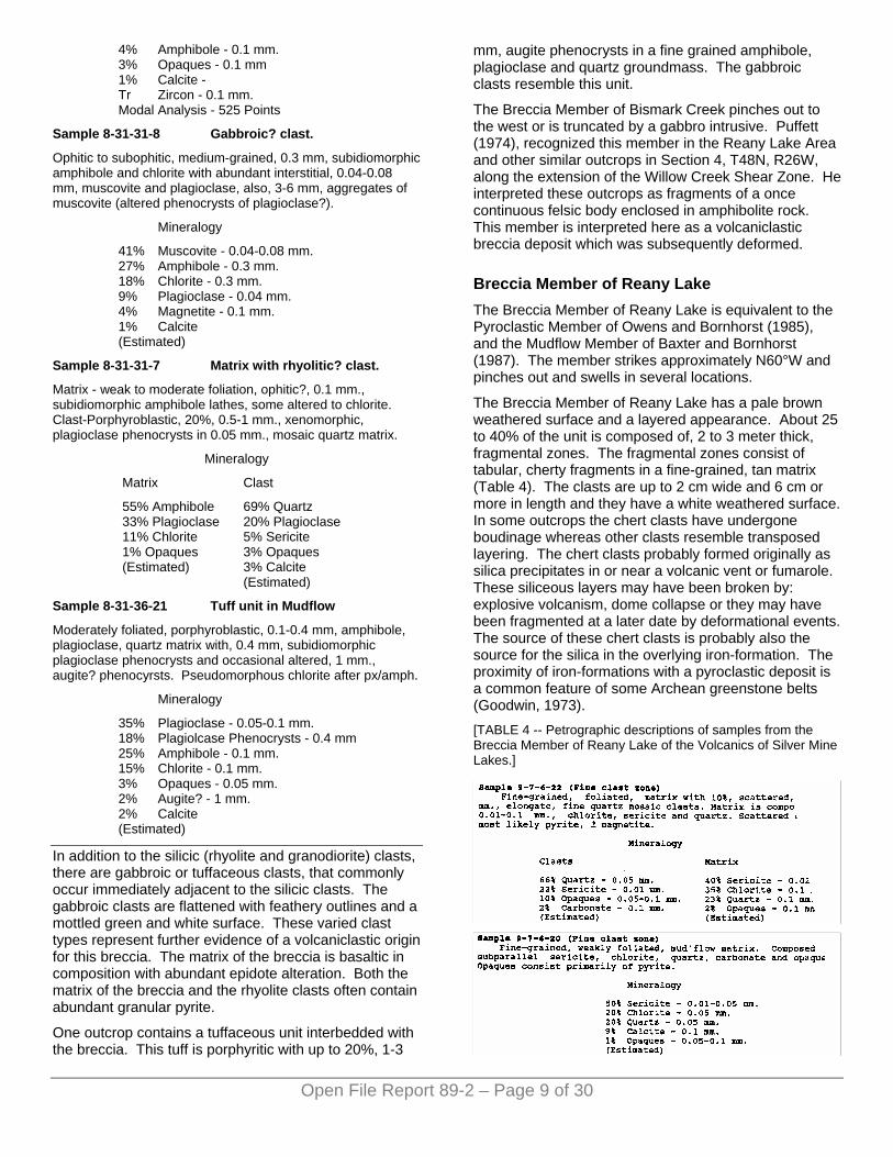
The Breccia Member of Reany Lake has a pale brown weathered surface and a layered appearance. About 25 to 40% of the unit is composed of, 2 to 3 meter thick, fragmental zones. The fragmental zones consist of tabular, cherty fragments in a fine-grained, tan matrix (Table 4). The clasts are up to 2 cm wide and 6 cm or more in length and they have a white weathered surface. In some outcrops the chert clasts have undergone boudinage whereas other clasts resemble transposed layering. The chert clasts probably formed originally as silica precipitates in or near a volcanic vent or fumarole. These siliceous layers may have been broken by: explosive volcanism, dome collapse or they may have been fragmented at a later date by deformational events. The source of these chert clasts is probably also the source for the silica in the overlying iron-formation. The proximity of iron-formations with a pyroclastic deposit is a common feature of some Archean greenstone belts (Goodwin, 1973). [TABLE 4 -- Petrographic descriptions of samples from the Breccia Member of Reany Lake of the Volcanics of Silver Mine Lakes.]
Open File Report 89-2 – Page 9 of 30
To the north and south of the fragmental zones are fine ash and lapilli layers. Some of these layers are clast free while others contain small, <5 cm, quartz mosaic clasts (see Table 4). The matrix of the unit is foliated and chloritic with 1-2%, fine pyrite.
The Breccia Member of Reany Lake is intruded by gabbro to the north and is in contact with the iron formation to the south. In some locations the iron-formation does not crop out or there is rhyolite intrusive located between the breccia and iron-formation.
Iron-Formation Member The Iron-Formation Member persists to the east and west of the Reany Lake Area (Owens and Bornhorst, 1985, Baxter and Bornhorst, 1987). The member is located within a topographic low and commonly does not crop out but it can be traced for long distances by magnetic survey (Puffett, 1974; Baxter, 1988). Outcrops are found within Section 6 and in the east half of Section 1.
Open File Report 89-2 – Page 10 of 30
The iron-formation is highly magnetic, thin and discontinuous. It is generally comprised of banded (1 cm wide) chert and magnetite. The chert layers consist of fine-grained, massive, dark grey, cherty quartz containing less than 1% magnetite. The magnetite layers are black, fine grained, massive magnetite. The amount of magnetite is variable from outcrop to outcrop with some outcrops containing only the cherty layers. There is little pyrite contained within the chert-magnetite rock itself but at the margins of the Iron-Formation Member there are occasional chloritic schists which contain up to 5% pyrite. The almost complete absence-of sulphides in the iron-formation itself suggests that this is a shallow water facies (Goodwin, 1973). The Iron-Formation Member is intruded by gabbro to the south and is in contact with the Breccia Member of Reany Lake to the north.
Age and Origin The Volcanics of Silver Mine Lakes represents sub-aqueously deposited volcanics. The Pillowed Basalt Member is interpreted to be a subagueously deposited
succession of basalt lava flows. The Breccia Member of Bismark Creek is interpreted to be a sheared volcaniclastic breccia. The deposition of the Breccia Member of Reany Lake is considered to represent one or more pyroclastic flow deposits or mudflow breccias. The Iron-Formation Member was deposited as an exhalite during a short quiescent period. The overlying Altered Basalt and Highly Altered and Foliated Basalt are both varieties of the pillowed basalt resulting from post-emplacement alteration and deformation.
GABBRO OF CLARK CREEK The name Gabbro of Clark Creek is a slight modification of the original name by Owens and Bornhorst (1985). Outcrops occur as small to large rounded knobs of varying topographic relief. In the Reany Lake Area, the Gabbro of Clark Creek consists of two to three, medium- to coarse-grained, metamorphosed Archean gabbro dikes and sills. They trend parallel to the bedding and foliation of the area and range from 100 to 1000 feet (33 to 330 m) wide. The bodies of gabbro are tabular with finger-like projections in some locations. Near the top of the Volcanics of Silver Mine Lakes, the gabbro is highly altered and foliated as are the volcanic rocks.
The gabbro bodies are commonly weakly to moderately foliated along their margins. There can be a fairly sharp grain size increase from the margin to the interior across individual gabbro bodies. The Gabbro of Clark Creek is brown to green with a mottled ophitic appearance and is composed of subidiomorphic green amphibole, chlorite and white plagioclase (Table 5). The gabbro generally contains less than 1% pyrite.
TABLE 5. -- Petrographic descriptions of samples from the Gabbro of Clark Creek.
Sample 6-16-20 (near contact)
Ophitic to subophitic, fine to medium grained, subidiomorphic amphibole lathes, 0.5-1 mm.; pseudomorphic chlorite after amphibole; interstial plagioclase lathes, 0.1-0.5 mm.
Mineralogy
37% Amphibole 28% Chlorite 30% Plagioclase 5% Opaques (Estimated)
Sample 6-16-18 (interior)
Ophitic to subophitic, coarse grained, 4-5 mm., subidiomorphic, prismatic amphibole; chlorite pseudomorphs after amphibole; interstitial plagioclase, poikiloblastic sericite in the plagioclase.
Mineralogy
35% Amphibole 30% Plagioclase 23% Chlorite 5% Sericite 5% Calcite 2% Opaques (Estimated)
Open File Report 89-2 – Page 11 of 30
Sample 9-1-36-24 (interior)
Porphyritic, groundmass - 0.01-0.05 mm, plagioclase, sericite and chlorite with 1-3 mm, broken amphibole phenocrysts altering to chlorite and 0.1 mm plagioclase phenocrysts.
Mineralogy
25% Plagioclase - 0.01-0.05 mm. 25% Amphibole - 1-3 mm. 15% Chlorite - 1-3 mm. 15% Sericite - 0.01-0.05 mm. 10% Chlorite - 0.01-0.05 mm. 10% Plagioclase - 0.1 mm. Tr Opaques (Estimated)
Sample 8-6-36-7
Subophitic, medium- to coarse-grained, 0.5-2 mm, xenomorphic amphibole and chlorite, after augite?, 0.5-2 mm., interstitial plagioclase lathes and scattered, 0.01-0.05 mm, semi-opaque mineral.
Mineralogy
50% Plagioclase - 0.5-2 mm. 25% Amphibole - 0.5-2 mm. 20% Chlorite - 0.5-2 mm. 4% Semi-opaque - 0.01-0.05 mm. 1% Opaques - 0.01 mm. (Estimated)
Sample 7-28-1-6
Ophitic to subophitic, medium- to coarse-grained, 0.4-1 mm, subidiomorphic amphibole, some altered to chlorite, and, 0.4-2 mm, subidiomorphic plagioclase, slight alteration to sericite. Scattered epidote and calcite.
Mineralogy
40% Plagioclase - 0.4-2 mm. 30% Amphibole - 0.4-1 mm. 20% Chlorite - 0.4-1 mm. 5% Opaque (Pyrite?) 4% Epidote - 0.05 mm. 1% Calcite (Estimated)
Altered Variety The Altered Variety of the Gabbro of Clark Creek tends to be located adjacent to a major shear zone in the middle of Sections 1 and 6. The altered gabbros are weakly to strongly foliated and have undergone abundant chloritization and variable sericitization (Table 6). They are generally fine-grained, have a black to green weathered surface and contain up to 2% pyrite and commonly show some iron staining along fracture surfaces.
Age and Origin The Gabbro of Clark Creek is of Archean age (Owens and Bornhorst, 1985). The gabbros cut the Volcanics of Silver Mine Lakes and are in turn cut by the Rhyolite Intrusive of Fire Center Mine. The gabbros are truncated by the unconformity with the Reany Creek Formation in one location so they predate that formation.
The gabbros are dike to sill-like mafic intrusive bodies. In a genetic sense, they may have been related to the magmatism that produced the Volcanics of Silver Mine Lakes (see Geochemistry section).
RHYOLITE INTRUSIVE OF FIRE CENTER MINE The Rhyolite Intrusive of Fire Center Mine, name retained from Johnson et.al. (1986), includes many E-W to NW-SE trending rhyolite dikes which approximately parallel the strike of the bedding and foliation in the Reany Lake Area. Outcrops are generally small, less than 20 meters wide, and are commonly found along the sides of ravines. The dikes are tabular to lenticular and range in thickness from less than 2 m to 100 m, with most being less than 20 m thick.
TABLE 6. -- Petrographic descriptions of samples from the Altered Variety of the Gabbro of Clark Creek.
Sample 7-27-1-1
Schistose, fine grained, aligned chlorite flakes with interstitial quartz, plagioclase and calcite.
Mineralogy
50% Chlorite - 0.2-0.3 mm. 20% Quartz - 0.1 mm. 15% Calcite - 0.1-0.2 mm. 10% Plagioclase 0 0.1 mm. 5% Opaques - (Magnetite and reddish??) Tr. Sericite (Estimated)
Sample 8-18-1-22 (small gabbro pod).
Subophitic to porphyritic, highly degraded, 0.02-0.05 mm, plagioclase, quartz, sericite and chlorite matrix with 0.5-2 mm, highly altered hornblende and chlorite phenocrysts (?).
Mineralogy
30% Amphibole - 0.02-0.05 mm. 25% Plagioclase - 0.5-2 mm. 15% Chlorite - 0.5-2 mm. 10% Chlorite - 0.02-0.05 mm. 9% Quartz - 0.02-0.05 mm. 5% Sericite 5% Calcite - 0.2 mm. 1% Opaques - 0.1 mm. (Estimated)
Sample 7-1-11
Ophitic, medium-grained, 0.4-3 mm, highly degraded amphibole altering to chlorite enclosing, 0.02-0.05 mm., plagioclase and quartz. Scattered epidote.
Mineralogy
40% Amphibole - 0.4-3 mm. 25% Chlorite - 0.4-3 mm. 13% Plagioclase - 0.02-0.05 mm. 7% Quartz - 0.02-0.2 mm. 5% Epidote - 0.2 mm. 5% Calcite 5% Opaques - 0.2 mm. (Estimated)
Open File Report 89-2 – Page 12 of 30
These dikes generally have a white weathered surface and an almost cherty appearance on fresh surfaces. Most of the dikes contain 10-30% plagioclase and quartz phenocrysts set in a groundmass of fine-grained mosaic quartz (Table 7). Some of the dikes contain up to 5-10% chlorite. The dikes can be moderately to highly foliated and sometimes contain up to 5% pyrite. The more foliated dikes contain abundant sericite and are commonly richer in sulphides.
The rhyolite dikes cut the gabbro and basalt units and so are definitely younger than these units. There were no good outcrop exposures of the rhyolite and the granodiorite unit together so it was not possible to determine the relative age relationship of these two units.
GRANODIORITE OF THE DEAD RIVER PLUTON The Granodiorite of the Dead River Pluton is named for a few outcrops of granodiorite in Sections 6 and 1. The granodiorite is probably associated with the Dead River Pluton which is located at the east end of the Dead River Storage Basin (Puffett, 1974). The granodiorite in the Reany Lake Area is similar in texture and composition with the Granodiorite of Rocking Chair Lakes described by Johnson (1987) and Baxter and Bornhorst (1987).
TABLE 7. -- Petrographic description of samples from the Rhyolite Intrusive of Fire Center Mine.
Sample 9-1-36-31
Porphyritic/porphyroblastic, groundmass - 0.05-0.1 mm, xenomorphic quartz with 0.05 mm. chlorite and sericite. Phenocrysts -0.5-1 mm., subidiomorphic plagioclase, occasional, 1 mm, quartz having undulose extinction. Scattered calcite.
Mineralogy
64% Quartz - 0.05-0.1 mm. 15% Plagioclase Phenocrysts - 0.5-1 mm. 10% Sericite - 0.05-0.5 mm. 4% Chlorite - 0.05 mm. 4% Quartz Phenocrysts - 0.5-1 mm. 2% Calcite. 1% Opaques - 0.1 mm. Modal Analysis - 572 Points
Sample 8-18-1-17
Porphyritic, 0.2-3 mm, subidiomorphic plagioclase phenocrysts and, 0.4-4 mm, anhedral quartz in a, 0.01 mm, quartz mosaic groundmass.
Mineralogy
53% Quartz - 0.01 mm. 29% Plagioclase Phenocrysts - 0.2-3 mm. 7% Sericite - 0.01 mm. 6% Quartz Phenocrysts - 0.4-4 mm. 4% Chlorite - 0.01 mm. 1% Opaques - 0.04 mm. Modal Analysis - 542 Points
Outcrops of the Granodiorite of the Dead River Pluton are restricted to several small, 2 to 20 m, outcrops in Sections 6 and 1. The granodiorite is fine- to medium-grained and contains about 70% plagioclase and K-feldspar, 20% quartz and <10% mafic minerals (including amphibole and chlorite) (Table 8). Several hand samples also contain a small amount of muscovite.
This unit is probably the youngest of the clearly Archean units and is interpreted to be associated with the Dead River Pluton that is located at the south east end of the Dead River Storage Basin (Puffett, 1974). It is part of a regional granitoid plutonic event.
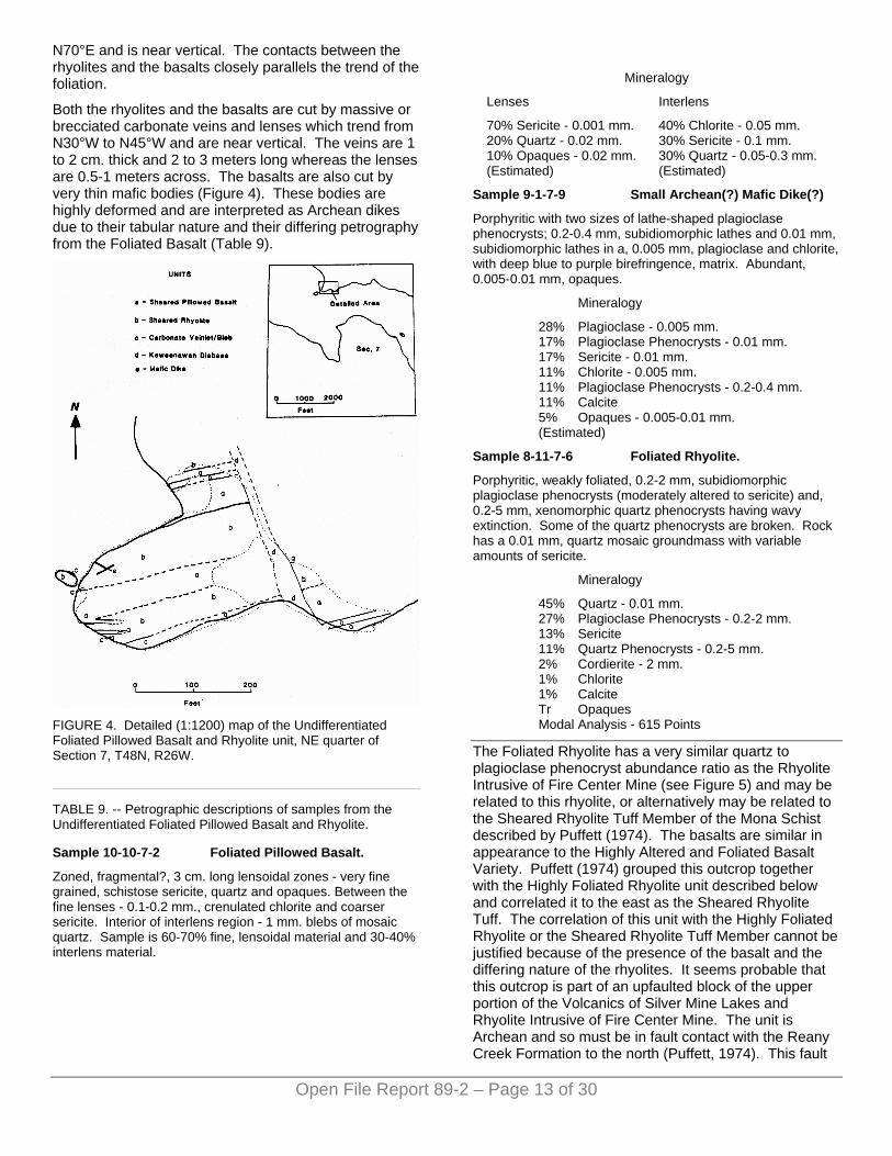
UNDIFFERENTIATED FOLIATED PILLOWED BASALT AND RHYOLITE Rocks designated as the Undifferentiated Foliated Pillowed Basalt and Rhyolite crop out in the NE quarter of Section 7. These rocks occur as a single large outcrop which covers almost the entire peninsula located on the north shore of the Basin in Section 7 (Plate 1). This unit is composed of alternating layers of highly foliated pillowed basalt and moderately foliated rhyolite. It is cut by a Keweenawan dike at the eastern edge of the outcrop. Petrology and geochemistry indicates that these rocks are of Archean age. Figure 4 is a detailed map of the peninsula showing the fine scale relationships of the basalts and the rhyolites; these variations were to small to show on Plate 1 except as undifferentiated.
TABLE 8. -- Petrographic descriptions of a sample from the Granodiorite of the Dead River Pluton.
Sample 7-28-1-8
Granoblastic, fine- to medium-grained, 0.4-4 mm, subidiomorphic, plagioclase; 0.1-1 mm, xenomorphic quartz; 0.4-2 mm, xenomorphic, microcline; 0.4 mm, subidiomorphic, chlorite; 0.4 mm, felty, amphibole, and rare, 0.8 mm, allanite? Cut by chlorite-filled fracture.
Mineralogy
44% Plagioclase - 0.4-4 mm. 23% Microcline - 0.4-2 mm. 22% Quartz - 0.1-1 mm. 6% Chlorite - 0.4 mm. 3% Amphibole - 0.4 mm. 2% Calcite Tr Opaques Modal Analysis - 595 Points
The layers of pillowed basalt vary from 3 to 60 feet (30 cm to 20 m) in width and are very fine-grained with abundant sericite and carbonate alteration. The pillows have been highly strained and generally show a greater than 5 to 1 length to width ratio. The basalts alternate with 10 to 40 feet (3 to 15 m) wide, foliated, rhyolites that have a white to pale brown weathered surface and are moderately to strongly foliated. The rhyolites contain 10-40% stretched quartz and plagioclase phenocrysts and abundant amounts of sericite (Table 9). The foliation in the rhyolites and basalts trend between N60°E and
N70°E and is near vertical. The contacts between the rhyolites and the basalts closely parallels the trend of the foliation.
Both the rhyolites and the basalts are cut by massive or brecciated carbonate veins and lenses which trend from N30°W to N45°W and are near vertical. The veins are 1 to 2 cm. thick and 2 to 3 meters long whereas the lenses are 0.5-1 meters across. The basalts are also cut by very thin mafic bodies (Figure 4). These bodies are highly deformed and are interpreted as Archean dikes due to their tabular nature and their differing petrography from the Foliated Basalt (Table 9).
FIGURE 4. Detailed (1:1200) map of the Undifferentiated Foliated Pillowed Basalt and Rhyolite unit, NE quarter of Section 7, T48N, R26W.
Open File Report 89-2 – Page 13 of 30
TABLE 9. -- Petrographic descriptions of samples from the Undifferentiated Foliated Pillowed Basalt and Rhyolite.
Sample 10-10-7-2 Foliated Pillowed Basalt.
Zoned, fragmental?, 3 cm. long lensoidal zones - very fine grained, schistose sericite, quartz and opaques. Between the fine lenses - 0.1-0.2 mm., crenulated chlorite and coarser sericite. Interior of interlens region - 1 mm. blebs of mosaic quartz. Sample is 60-70% fine, lensoidal material and 30-40% interlens material.
Mineralogy
Lenses Interlens
70% Sericite - 0.001 mm. 20% Quartz - 0.02 mm. 10% Opaques - 0.02 mm. (Estimated)
40% Chlorite - 0.05 mm. 30% Sericite - 0.1 mm. 30% Quartz - 0.05-0.3 mm. (Estimated)
Sample 9-1-7-9 Small Archean(?) Mafic Dike(?)
Porphyritic with two sizes of lathe-shaped plagioclase phenocrysts; 0.2-0.4 mm, subidiomorphic lathes and 0.01 mm, subidiomorphic lathes in a, 0.005 mm, plagioclase and chlorite, with deep blue to purple birefringence, matrix. Abundant, 0.005-0.01 mm, opaques.
Mineralogy
28% Plagioclase - 0.005 mm. 17% Plagioclase Phenocrysts - 0.01 mm. 17% Sericite - 0.01 mm. 11% Chlorite - 0.005 mm. 11% Plagioclase Phenocrysts - 0.2-0.4 mm. 11% Calcite 5% Opaques - 0.005-0.01 mm. (Estimated)
Sample 8-11-7-6 Foliated Rhyolite.
Porphyritic, weakly foliated, 0.2-2 mm, subidiomorphic plagioclase phenocrysts (moderately altered to sericite) and, 0.2-5 mm, xenomorphic quartz phenocrysts having wavy extinction. Some of the quartz phenocrysts are broken. Rock has a 0.01 mm, quartz mosaic groundmass with variable amounts of sericite.
Mineralogy
45% Quartz - 0.01 mm. 27% Plagioclase Phenocrysts - 0.2-2 mm. 13% Sericite 11% Quartz Phenocrysts - 0.2-5 mm. 2% Cordierite - 2 mm. 1% Chlorite 1% Calcite Tr Opaques Modal Analysis - 615 Points
The Foliated Rhyolite has a very similar quartz to plagioclase phenocryst abundance ratio as the Rhyolite Intrusive of Fire Center Mine (see Figure 5) and may be related to this rhyolite, or alternatively may be related to the Sheared Rhyolite Tuff Member of the Mona Schist described by Puffett (1974). The basalts are similar in appearance to the Highly Altered and Foliated Basalt Variety. Puffett (1974) grouped this outcrop together with the Highly Foliated Rhyolite unit described below and correlated it to the east as the Sheared Rhyolite Tuff. The correlation of this unit with the Highly Foliated Rhyolite or the Sheared Rhyolite Tuff Member cannot be justified because of the presence of the basalt and the differing nature of the rhyolites. It seems probable that this outcrop is part of an upfaulted block of the upper portion of the Volcanics of Silver Mine Lakes and Rhyolite Intrusive of Fire Center Mine. The unit is Archean and so must be in fault contact with the Reany Creek Formation to the north (Puffett, 1974). This fault
is half of the pair of faults that form the Dead River Shear Zone in this region. No field evidence was found for this fault but according to a density model proposed by Victor Weeks (1987) for an area just to the east, the Reany Creek Formation forms a pie-shape wedge juxtaposed against the Sheared Rhyolite Tuff Member along a fault having a vertical displacement of about 1800 feet (600 m). It would appear that in the Reany Lake Area this fault also cuts a portion of the Volcanics of Silver Mine Lakes.
HIGHLY FOLIATED RHYOLITE The Highly Foliated Rhyolite is located in Section 7 along the south shore of the Dead River Storage Basin. The unit is essentially a porphyritic quartz-sericite schist (Table 10). It is highly foliated and contains abundant sericite. Consequently the rock characteristically breaks along the foliation surfaces. Quartz and plagioclase phenocrysts and lensoidal quartz mosaic clasts occur parallel to the foliation. The foliation strikes E-W, vertically dipping and is sometimes folded with fold hinges trending N30°W.
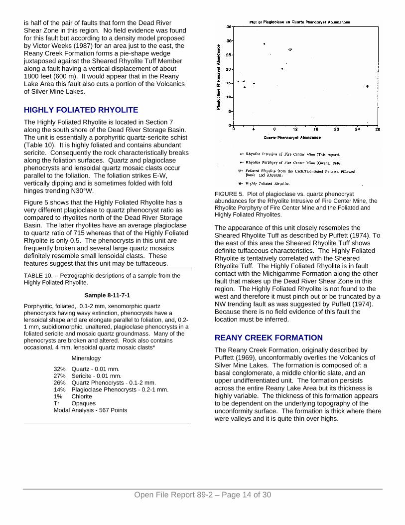
Figure 5 shows that the Highly Foliated Rhyolite has a very different plagioclase to quartz phenocryst ratio as compared to rhyolites north of the Dead River Storage Basin. The latter rhyolites have an average plagioclase to quartz ratio of 715 whereas that of the Highly Foliated Rhyolite is only 0.5. The phenocrysts in this unit are frequently broken and several large quartz mosaics definitely resemble small lensoidal clasts. These features suggest that this unit may be tuffaceous.
Open File Report 89-2 – Page 14 of 30
TABLE 10. -- Petrographic desriptions of a sample from the Highly Foliated Rhyolite.
Sample 8-11-7-1
Porphyritic, foliated,. 0.1-2 mm, xenomorphic quartz phenocrysts having wavy extinction, phenocrysts have a lensoidal shape and are elongate parallel to foliation, and, 0.2-1 mm, subidiomorphic, unaltered, plagioclase phenocrysts in a foliated sericite and mosaic quartz groundmass. Many of the phenocrysts are broken and altered. Rock also contains occasional, 4 mm, lensoidal quartz mosaic clasts*
Mineralogy
32% Quartz - 0.01 mm. 27% Sericite - 0.01 mm. 26% Quartz Phenocrysts - 0.1-2 mm. 14% Plagioclase Phenocrysts - 0.2-1 mm. 1% Chlorite Tr Opaques Modal Analysis - 567 Points
FIGURE 5. Plot of plagioclase vs. quartz phenocryst abundances for the Rhyolite Intrusive of Fire Center Mine, the Rhyolite Porphyry of Fire Center Mine and the Foliated and Highly Foliated Rhyolites.
The appearance of this unit closely resembles the Sheared Rhyolite Tuff as described by Puffett (1974). To the east of this area the Sheared Rhyolite Tuff shows definite tuffaceous characteristics. The Highly Foliated Rhyolite is tentatively correlated with the Sheared Rhyolite Tuff. The Highly Foliated Rhyolite is in fault contact with the Michigamme Formation along the other fault that makes up the Dead River Shear Zone in this region. The Highly Foliated Rhyolite is not found to the west and therefore it must pinch out or be truncated by a NW trending fault as was suggested by Puffett (1974). Because there is no field evidence of this fault the location must be inferred.
REANY CREEK FORMATION The Reany Creek Formation, originally described by Puffett (1969), unconformably overlies the Volcanics of Silver Mine Lakes. The formation is composed of: a basal conglomerate, a middle chloritic slate, and an upper undifferentiated unit. The formation persists across the entire Reany Lake Area but its thickness is highly variable. The thickness of this formation appears to be dependent on the underlying topography of the unconformity surface. The formation is thick where there were valleys and it is quite thin over highs.
Basal Conglomerate The Basal Conglomerate is polymictic with variable amounts of clasts. Clasts are subrounded to angular and vary in size from 1 cm to 20 cm. The matrix of the conglomerate appears to be of the same composition as the slates. The clasts are of slaty, gabbroic, rhyolitic, and granitic lithologies and have no preferred orientation except in one outcrop where there is an E-W trending shear zone.
Slates Overlying the Basal Conglomerate is a 50 to 500 foot (16-160 meter) thick slate unit. This unit is generally pale green and very fine grained with a strong foliation trending N70°W and dipping 50°-70° toward the south. Within this unit there are scattered 3-8 cm, pink, granitic clasts which have been interpreted as drop stones, suggesting a glaciogenic origin (Puffett, 1969; Puffett, 1974).
One outcrop of the slates contains a large body of sericitized rhyolite (Table 11) (located about 1875 feet north and 2940 feet east of the southwest corner of section 1). This body is 3 to 5 feet (1 to 2 m) wide and approximately 10 feet (3 m) long. The long dimension of the body trends N30°E which is nearly perpendicular to the trend of the bedding and foliation in the Reany Creek Formation. The rhyolite body has undergone sericite alteration of the plagioclase phenocrysts and the groundmass. The sericite alteration makes identification difficult, but it appears that the plagioclase and quartz contents in the rhyolite body are similar to those in the dikes of the Rhyolite Intrusive of Fire Center Mine (Fig. 6). Thus, composition of this rhyolite body is consistent with it being an Archean rhyolite. This rhyolite body may have one of several modes of origin. The body may be a very large drop stone, or it may be a high point on the unconformity surface or, finally, it may be a rhyolite dike which intrudes the slates. This rhyolite body is much larger than any of the alleged drop stones in the area and its orientation appears to be inconsistent with it being a drop stone. It is impossible to unequivocally conclude if this rhyolite intrudes the Reany Creek Formation, if it is a clast or topographic high. Since there are no known rhyolite dikes younger than Archean age in the Marquette Greenstone Belt and if the body is a rhyolite dike, then it would ascertain that the age of the Reany Creek Formation is Archean. The Reany Creek Formation has been studied in greater detail by Small and Bornhorst (1988) who conclude that the age of the Reany Creek Formation is equivocal, either Early Proterozoic or Archean in age.
TABLE 11. -- Petrographic descriptions of samples of Arkose and Graywacke from the Reany Creek Formation.
Sample 7-1-3 Arkose.
Porphyritic with 35%, 0.5 mm., subidiomorphic plagioclase phenocrysts with poikiloblastic sericite. Plagiolcase altering to sericite. Groundmass - 0.01 mm, mosaic quartz with chlorite.
Mineralogy
54% Quartz - 0.01 mm. 28% Plagioclase Phenocrysts - 0.5 mm. 11% Chlorite - 0.01-0.1 mm. 5% Calcite 1% Sericite 1% Quartz Phenocrysts - 0.5 mm. Tr Opaques Modal Analysis - 576 Points
Sample 8-18-1-28 Arkose.
Porphyritic with 40%, 0.5-1 mm, subidiomorphic plagioclase phenocrysts with poikiloblastic sericite. Groundmass- 0.05 mm., mosaic quartz with interstitial sericite, chlorite and calcite.
Mineralogy
45% Quartz - 0.05 mm. 32% Plagioclase Phenocrysts - 0.5-1 mm. 13% Sericite - 0.01-0.25 mm. 8% Chlorite - 0.05-0.1 mm. 1% Quartz Phenocrysts - 0.5-1 mm. 1% Calcite Tr Opaques Modal Analysis - 567 Points
Sample 8-19-1-29 Graywacke.
Granoblastic, fine grained, aligned chlorite flakes with interstitial quartz, plagioclase and calcite.
Mineralogy
35% Chlorite - 0.1 mm. 30% Plagioclase - 0.4 mm. 20% Sericite - 0.5-1 mm. 10% Opaques - 0.1 mm. 5% Quartz - 0.02-0.1 mm. (Estimated)
Sample 8-19-1-30 Rhyolite body in slate
Porphyroblastic, weakly foliated. Very strong sericite alteration. 20-40%, subidiomorphic to xenoraorphic, highly seritized, plagioclase, 0.5-1 mm., phenocrysts, difficult to distinguish from sericitic groundmass. 5%, 0.2-0.5 mm., quartz phenocrysts. Groundmass, 0.05 mm., equigranular quartz and sericite.
Mineralogy
53% Sericite 29% Quartz - 0.05 mm. 13% Plagioclase Phenocrysts - 0.5-1 mm. 2% Quartz Phenocrysts - 0.2-0.5 mm. 2% Chlorite 1% Opaques - 0.05 mm. Modal Analysis - 546 Points
Open File Report 89-2 – Page 15 of 30
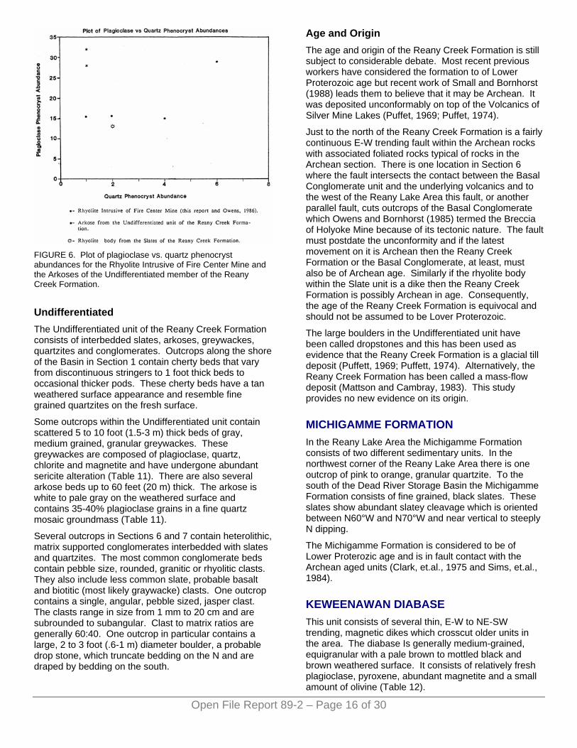
FIGURE 6. Plot of plagioclase vs. quartz phenocryst abundances for the Rhyolite Intrusive of Fire Center Mine and the Arkoses of the Undifferentiated member of the Reany Creek Formation.
Undifferentiated The Undifferentiated unit of the Reany Creek Formation consists of interbedded slates, arkoses, greywackes, quartzites and conglomerates. Outcrops along the shore of the Basin in Section 1 contain cherty beds that vary from discontinuous stringers to 1 foot thick beds to occasional thicker pods. These cherty beds have a tan weathered surface appearance and resemble fine grained quartzites on the fresh surface.
Some outcrops within the Undifferentiated unit contain scattered 5 to 10 foot (1.5-3 m) thick beds of gray, medium grained, granular greywackes. These greywackes are composed of plagioclase, quartz, chlorite and magnetite and have undergone abundant sericite alteration (Table 11). There are also several arkose beds up to 60 feet (20 m) thick. The arkose is white to pale gray on the weathered surface and contains 35-40% plagioclase grains in a fine quartz mosaic groundmass (Table 11).
Several outcrops in Sections 6 and 7 contain heterolithic, matrix supported conglomerates interbedded with slates and quartzites. The most common conglomerate beds contain pebble size, rounded, granitic or rhyolitic clasts. They also include less common slate, probable basalt and biotitic (most likely graywacke) clasts. One outcrop contains a single, angular, pebble sized, jasper clast. The clasts range in size from 1 mm to 20 cm and are subrounded to subangular. Clast to matrix ratios are generally 60:40. One outcrop in particular contains a large, 2 to 3 foot (.6-1 m) diameter boulder, a probable drop stone, which truncate bedding on the N and are draped by bedding on the south.
Age and Origin The age and origin of the Reany Creek Formation is still subject to considerable debate. Most recent previous workers have considered the formation to of Lower Proterozoic age but recent work of Small and Bornhorst (1988) leads them to believe that it may be Archean. It was deposited unconformably on top of the Volcanics of Silver Mine Lakes (Puffet, 1969; Puffet, 1974).
Just to the north of the Reany Creek Formation is a fairly continuous E-W trending fault within the Archean rocks with associated foliated rocks typical of rocks in the Archean section. There is one location in Section 6 where the fault intersects the contact between the Basal Conglomerate unit and the underlying volcanics and to the west of the Reany Lake Area this fault, or another parallel fault, cuts outcrops of the Basal Conglomerate which Owens and Bornhorst (1985) termed the Breccia of Holyoke Mine because of its tectonic nature. The fault must postdate the unconformity and if the latest movement on it is Archean then the Reany Creek Formation or the Basal Conglomerate, at least, must also be of Archean age. Similarly if the rhyolite body within the Slate unit is a dike then the Reany Creek Formation is possibly Archean in age. Consequently, the age of the Reany Creek Formation is equivocal and should not be assumed to be Lover Proterozoic.
The large boulders in the Undifferentiated unit have been called dropstones and this has been used as evidence that the Reany Creek Formation is a glacial till deposit (Puffett, 1969; Puffett, 1974). Alternatively, the Reany Creek Formation has been called a mass-flow deposit (Mattson and Cambray, 1983). This study provides no new evidence on its origin.
MICHIGAMME FORMATION In the Reany Lake Area the Michigamme Formation consists of two different sedimentary units. In the northwest corner of the Reany Lake Area there is one outcrop of pink to orange, granular quartzite. To the south of the Dead River Storage Basin the Michigamme Formation consists of fine grained, black slates. These slates show abundant slatey cleavage which is oriented between N60°W and N70°W and near vertical to steeply N dipping.
The Michigamme Formation is considered to be of Lower Proterozic age and is in fault contact with the Archean aged units (Clark, et.al., 1975 and Sims, et.al., 1984).
KEWEENAWAN DIABASE This unit consists of several thin, E-W to NE-SW trending, magnetic dikes which crosscut older units in the area. The diabase Is generally medium-grained, equigranular with a pale brown to mottled black and brown weathered surface. It consists of relatively fresh plagioclase, pyroxene, abundant magnetite and a small amount of olivine (Table 12).
Open File Report 89-2 – Page 16 of 30
The Keweenawan diabase is the youngest unit in the area and is considered to be of Middle Proterozoic age (Baxter and Bornhorst, 1988; Puffett,1974). The Keweenawan dikes are a product of Keweenawan rifting and magmatism.
Open File Report 89-2 – Page 17 of 30
TABLE 12. -- Petrographic descriptions of samples from the Keweenawan Diabase.
Sample 6-29-9
Diabasic, medium grained; subidiomorphic plagioclase, partly embayed lathes, 1-2 mm; xenomorphic augite (amphibole?) interstial to the plagioclase, 0.5-1 mm; subhedral (subidiomorphic) magnetite, 0.05-0.5 mm; xenomorphic chlorite, interstitial to plagioclase, altered from augite, olivine?
Mineralogy
55% Plagioclase - 1-2 mm. 30% Pyroxene - 0.5-1 mm. 10% Magnetite - 0.05-0.5 mm. 5% Chlorite - 0.1 mm. (Estimated)
Sample 8-4-6-2
Diabasic, medium- to coarse-grained, 1-3 mm, subidiomorphic plagioclase lathes; 1-2 mm, xenomorphic augite interstitial to the plagioclase, augite altering to chlorite, occasional olivine.
Mineralogy
50% Plagioclase - 1-3 mm. 25% Pyroxene - 1-2 mm. 10% Chlorite - 0.5-1 mm. 10% Magnetite -> 0.2-1.0 mm. 3% Olivine - 1 mm. 2% Quartz (Estimated)
CORRELATION OF ROCK UNITS A comparison of the nomenclature of rock units in the Reany Lake Area in relation to those of Puffett (1974), and Ovens and Bornhorst (1985) is shown in Figure 7. The Volcanics of Silver Mine Lakes are equivalent to the Metavolcanics of Silver Mine Lakes of Owens and Bornhorst (1985), Johnson (1987), and Baxter, et.al. (1987). Figure 8 shows the correlation of the members of the Volcanics of Silver Mine Lakes with those of the preceding authors. The Reany Lake Area extends nearly 2000 feet (650 m) stratigraphically deeper than the previous detailed mapping. Therefore the Breccia Member of Bismark Creek is not correlative with any of the members of the previous studies. The Volcanics of Silver Mine Lakes are correlative with what Puffett (1974) and Clark, et.al. (1975) mapped as Mona Schist north of the Dead River Storage Basin. However, stratigraphic correlation of the Volcanics of Silver Mine Lakes with Mona Schist to the south is not made because of the intervening regional Dead River Shear Zone (Bornhorst, 1988). The Gabbro of Clark Creek is equivalent to the Metagabbro of Clark Creek of Owens and Bornhorst (1985), Johnson et.al. (1986) and Baxter, et.al. (1987) and it is correlative with the metagabbro of Clark, et.al. (1975).
The Rhyolite Intrusive of Fire Center Mine is equivalent to those of Johnson et.al. (1986) and Baxter, et.al.(1987) and to the Rhyolite Porphyry of Fire Center Mine of Owens and Bornhorst (1985) and it is correlative with the felsic intrusive of Clark, et.al. (1975). Johnson et.al. (1986) modified the original name of Owens and Bornhorst (1985) in order to include several textural varieties of rhyolite observed in the Silver Creek to Island Lake area. These varieties are porphyritic (most common), aphanitic, and granular (rare) rhyolite. In Johnson's area, the porphyritic rhyolites are primarily quartz porphyry. In the Reany Lake Area the rhyolite intrusives are almost exclusively quartz and feldspar porphyries, similar to those described by Owens and Bornhorst (1985). Granular and aphanitic varieties are absent. The emplacement of the Rhyolite Intrusive of Fire Center Mine may have been contemporaneous with the intrusion of the Granodiorite of the Dead River Pluton (Johnson, et.al., 1986; Baxter, et.al., 1987). The Granodiorite of the Dead River Pluton is probably correlative with the Dead River Pluton described by Puffett (1974) and may be age correlative with the Granodiorite of Rocking Chair Lakes of Johnson (1987), and Baxter, et.al. (1987).
FIGURE 7. Comparison of nomenclature used in this study with previous nomenclature.
The Reany Creek Formation is correlative with that of Puffett (1974) and with the Breccia of Holyoke Mine and the Slates of the Dead River Storage Basin of Owens and Bornhorst (1985). At this point the age of the Reany Creek is still in question, it may be Lower Proterozoic or Archean. The Michigamme Formation is equivalent to that of Clark, et.al. (1975), Owens and Bornhorst (1985), and Baxter, et.al. (1987) and is correlative with the Michigamme Slate of Puffett (1974). The Keweenawan Diabase is equivalent to those mapped by Clark, et.al. (1975), Owens and Bornhorst (1985), Johnson et.al. (1986), and Baxter, et.al. (1987).
The Undifferentiated Foliated Pillowed Basalt and Rhyolite and the Highly Foliated Rhyolite were not included in Figure 7 because of the uncertainty of their correlation with other rocks in the area. The Undifferentiated Foliated Pillowed Basalt and Rhyolite may be a faulted up sliver from the top of the Volcanics of Silver Mine Lakes. The Highly Foliated Rhyolite, on the other hand, is almost certainly correlative with the Sheared Rhyolite Tuff Member of the Mona Schist (Puffett, 1974).
FIGURE 8. Correlation chart for the members of the Volcanics of Silver Mine Lakes in the Reany Lake Area.
METAMORPHISM All of the Lower Proterozoic rocks in the Reany Lake Area have undergone at least one period of metamorphism whereas the Archean rocks have probably undergone at least two. The first metamorphic event would have occurred in the Archean. This event was responsible for the pervasive green-schist facies metamorphism of the Archean rocks. Relict igneous textures are still preserved in the Archean rocks with the basalts retaining a relict felty texture of the plagioclase microlites and the gabbros showing an ophitic to sub-ophitic texture.
The Archean metamorphic fabric was overprinted by a second metamorphic fabric during the Penokean Orogeny (1,770 -1,880 Ma) (Sims and Peterman, 1983). James (1955) delineated 3 regional metamorphic nodes associated with this orogeny. These nodes range in intensity from sillimanite grade at the center to chlorite grade around the periphery. The Reany Lake Area lies within the chlorite isograd on the northeast flank of the Republic node. This Penokean event resulted in greenschist facies metamorphism of the Lower Proterozoic rocks, but had little effect on the Archean rocks since they had already been metamorphosed to Lower Green-schist to Lower Amphibolite facies.
Archean metamorphism is indicated by the alteration of primary pyroxene to secondary hornblende with variable amounts of retrograde alteration to chlorite. The chlorite may be a product of other local post-metamorphic
hydrothermal activity or regional Proterozoic metamorphism. Chlorite can become the dominant mineral in the more schistose rocks such as the Highly Altered and Foliated Basalt Variety and the highly altered and foliated gabbros. However, this chlorite is more likely to be due to more local hydrothermal activity rather than regional metamorphism. The stratigraphically lowest several thousand feet of Pillowed Basalts have been metamorphosed to Lower Amphibolite grade as indicated by the presence of epidote. In the gabbros and the rhyolites, sericite is commonly found replacing plagioclase, but it is not certain whether or not the sericite is hydrothermal or metamorphic. The metamorphism to Lower Greenschist facies in the Michigamme Formation and the Reany Creek Formation is indicated by recrystallization of the quartzites and by abundant sericite replacing both K-feldspar and plagioclase in other rock types.
MINERALIZATION
HISTORICAL ACTIVITY Regional exploration activity for base and precious metals in northern Marquette County has been ongoing sporadically since the late 1800's. The majority of this exploration activity has been concentrated to the west of the Reany Lake Area where numerous prospects have been located. To date, no prospects have been identified in the Reany Lake Area.
The Reany Lake Area was included in the large exploration program undertaken by the Norgan Gold Mining Company during the mid 1930's (Kelly, 1936). This exploration included geologic mapping along the northern limb of the Marguette Greenstone Belt, sampling, trenching and a 12 hole drilling program. Exploration in this area has been very sporadic since that time, until recently. At present, exploration in the Reany Lake and surrounding areas is being actively undertaken by: Callahan Mining Corporation and Kerr-McGee Corporation. This exploration activity includes geological mapping, sampling and drilling.
GOLD ASSAY DATA Twenty samples were analyzed for gold content. The samples having background gold values are listed in Table 13 and are located on Figure 9. Samples with an anomalous gold content are listed in Table 14 and are located on Figure 10.
Anomalous gold content was considered to be any value above 10 parts per billion (Kwong and Crocket, 1978). Nearly all of the samples which yielded anomalous gold values contain relatively abundant sulphide minerals, primarily pyrite with rare chalcopyrite.
Open File Report 89-2 – Page 18 of 30
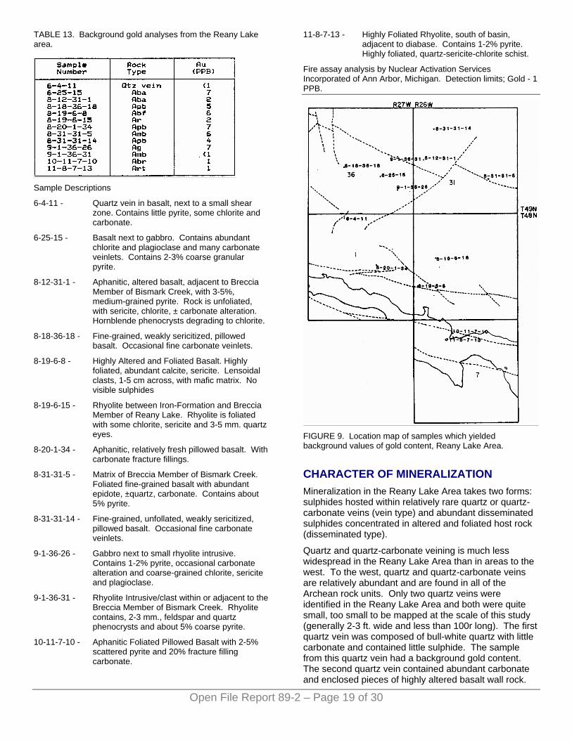
TABLE 13. Background gold analyses from the Reany Lake area.
Open File Report 89-2 – Page 19 of 30
Sample Descriptions
6-4-11 - Quartz vein in basalt, next to a small shear zone. Contains little pyrite, some chlorite and carbonate.
6-25-15 - Basalt next to gabbro. Contains abundant chlorite and plagioclase and many carbonate veinlets. Contains 2-3% coarse granular pyrite.
8-12-31-1 - Aphanitic, altered basalt, adjacent to Breccia Member of Bismark Creek, with 3-5%, medium-grained pyrite. Rock is unfoliated, with sericite, chlorite, ± carbonate alteration. Hornblende phenocrysts degrading to chlorite.
8-18-36-18 - Fine-grained, weakly sericitized, pillowed basalt. Occasional fine carbonate veinlets.
8-19-6-8 - Highly Altered and Foliated Basalt. Highly foliated, abundant calcite, sericite. Lensoidal clasts, 1-5 cm across, with mafic matrix. No visible sulphides
8-19-6-15 - Rhyolite between Iron-Formation and Breccia Member of Reany Lake. Rhyolite is foliated with some chlorite, sericite and 3-5 mm. quartz eyes.
8-20-1-34 - Aphanitic, relatively fresh pillowed basalt. With carbonate fracture fillings.
8-31-31-5 - Matrix of Breccia Member of Bismark Creek. Foliated fine-grained basalt with abundant epidote, ±quartz, carbonate. Contains about 5% pyrite.
8-31-31-14 - Fine-grained, unfollated, weakly sericitized, pillowed basalt. Occasional fine carbonate veinlets.
9-1-36-26 - Gabbro next to small rhyolite intrusive. Contains 1-2% pyrite, occasional carbonate alteration and coarse-grained chlorite, sericite and plagioclase.
9-1-36-31 - Rhyolite Intrusive/clast within or adjacent to the Breccia Member of Bismark Creek. Rhyolite contains, 2-3 mm., feldspar and quartz phenocrysts and about 5% coarse pyrite.
10-11-7-10 - Aphanitic Foliated Pillowed Basalt with 2-5% scattered pyrite and 20% fracture filling carbonate.
11-8-7-13 - Highly Foliated Rhyolite, south of basin, adjacent to diabase. Contains 1-2% pyrite. Highly foliated, quartz-sericite-chlorite schist.
Fire assay analysis by Nuclear Activation Services Incorporated of Ann Arbor, Michigan. Detection limits; Gold - 1 PPB.
FIGURE 9. Location map of samples which yielded background values of gold content, Reany Lake Area.
CHARACTER OF MINERALIZATION Mineralization in the Reany Lake Area takes two forms: sulphides hosted within relatively rare quartz or quartz-carbonate veins (vein type) and abundant disseminated sulphides concentrated in altered and foliated host rock (disseminated type).
Quartz and quartz-carbonate veining is much less widespread in the Reany Lake Area than in areas to the west. To the west, quartz and quartz-carbonate veins are relatively abundant and are found in all of the Archean rock units. Only two quartz veins were identified in the Reany Lake Area and both were quite small, too small to be mapped at the scale of this study (generally 2-3 ft. wide and less than 100r long). The first quartz vein was composed of bull-white quartz with little carbonate and contained little sulphide. The sample from this quartz vein had a background gold content. The second quartz vein contained abundant carbonate and enclosed pieces of highly altered basalt wall rock.
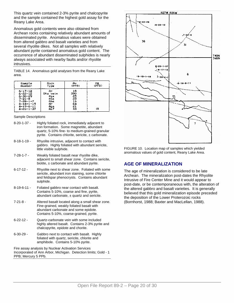
This quartz vein contained 2-3% pyrite and chalcopyrite and the sample contained the highest gold assay for the Reany Lake Area.
Anomalous gold contents were also obtained from Archean rocks containing relatively abundant amounts of disseminated pyrite. Anomalous values were obtained from altered gabbro and basalt varieties and from several rhyolite dikes. Not all samples with relatively abundant pyrite contained anomalous gold content. The occurrence of abundant disseminated sulphides is nearly always associated with nearby faults and/or rhyolite intrusives.
Open File Report 89-2 – Page 20 of 30
TABLE 14. Anomalous gold analyses from the Reany Lake area.
Sample Descriptions
8-20-1-37 - Highly foliated rock, immediately adjacent to iron formation. Some magnetite, abundant quartz, 5-10% fine- to medium-grained granular pyrite. Contains chlorite, sericite, ± carbonate.
8-18-1-19 - Rhyolite intrusive, adjacent to contact with gabbro. Highly foliated with abundant sericite, little visible sulphide.
7-28-1-7 - Weakly foliated basalt near rhyolite dike, adjacent to small shear zone. Contains sericite, biotite, ± carbonate and abundant pyrite.
6-17-12 - Rhyolite next to shear zone. Foliated with some sericite, abundant iron staining, some chlorite and feldspar phenocrysts. Contains abundant sulphide.
8-19-6-11 - Foliated gabbro near contact with basalt. Contains 5-10%, coarse and fine, pyrite, abundant carbonate, ± quartz and sericite.
7-21-8 - Altered basalt located along a small shear zone. Fine-grained, weakly foliated basalt with abundant carbonate and some epidote. Contains 5-10%, coarse-grained, pyrite.
6-22-12 - Quartz-carbonate vein with some included highly altered basalt. Contains 2-3% pyrite and chalcopyrite, epidote and chorite.
6-30-29 - Gabbro next to contact with basalt. Highly foliated with quartz, sericite, chlorite and amphibole. Contains 5-10% pyrite.
Fire assay analysis by Nuclear Activation Services Incorporated of Ann Arbor, Michigan. Detection limits; Gold - 1 PPB; Mercury 5 PPb.
FIGURE 10. Location map of samples which yielded anomalous values of gold content, Reany Lake Area.
AGE OF MINERALIZATION The age of mineralization is considered to be late Archean. The mineralization post-dates the Rhyolite Intrusive of Fire Center Mine and it would appear to post-date, or be contemporaneous with, the alteration of the altered gabbro and basalt varieties. It is generally believed that this gold mineralization episode preceded the deposition of the Lower Proterozoic rocks (Bornhorst, 1988; Baxter and MacLellan, 1988).
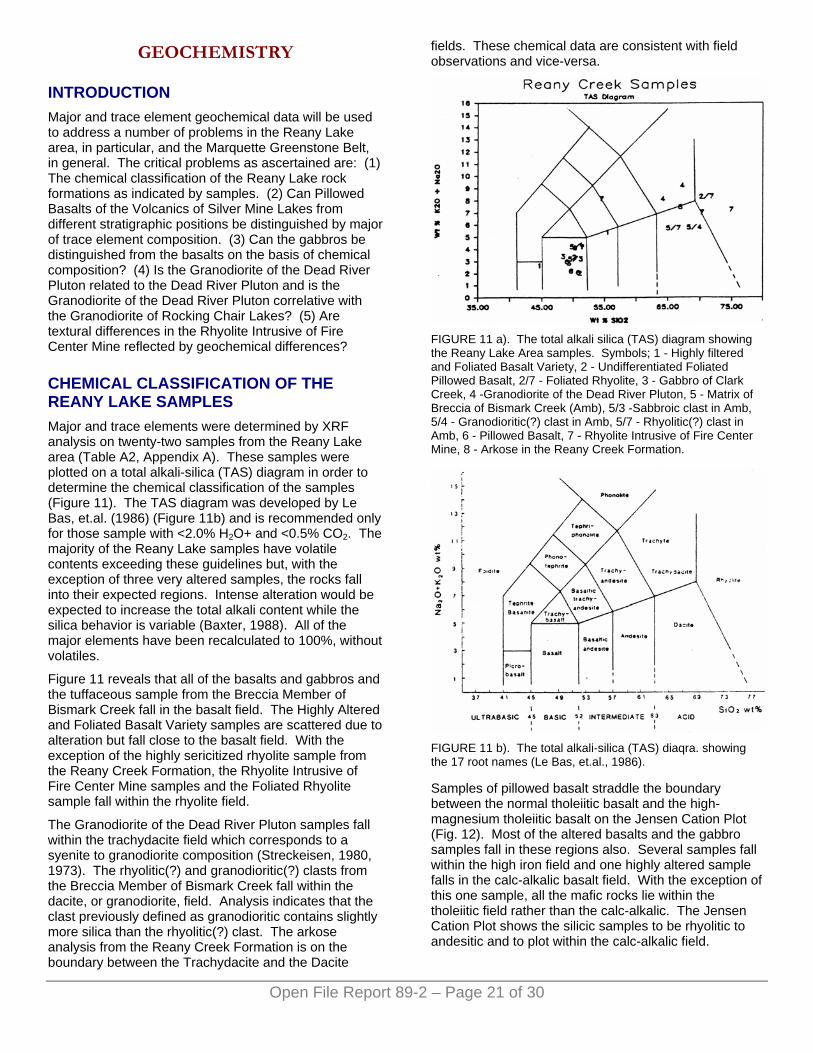
GEOCHEMISTRY
INTRODUCTION Major and trace element geochemical data will be used to address a number of problems in the Reany Lake area, in particular, and the Marquette Greenstone Belt, in general. The critical problems as ascertained are: (1) The chemical classification of the Reany Lake rock formations as indicated by samples. (2) Can Pillowed Basalts of the Volcanics of Silver Mine Lakes from different stratigraphic positions be distinguished by major of trace element composition. (3) Can the gabbros be distinguished from the basalts on the basis of chemical composition? (4) Is the Granodiorite of the Dead River Pluton related to the Dead River Pluton and is the Granodiorite of the Dead River Pluton correlative with the Granodiorite of Rocking Chair Lakes? (5) Are textural differences in the Rhyolite Intrusive of Fire Center Mine reflected by geochemical differences?
CHEMICAL CLASSIFICATION OF THE REANY LAKE SAMPLES Major and trace elements were determined by XRF analysis on twenty-two samples from the Reany Lake area (Table A2, Appendix A). These samples were plotted on a total alkali-silica (TAS) diagram in order to determine the chemical classification of the samples (Figure 11). The TAS diagram was developed by Le Bas, et.al. (1986) (Figure 11b) and is recommended only for those sample with <2.0% H2O+ and <0.5% CO2. The majority of the Reany Lake samples have volatile contents exceeding these guidelines but, with the exception of three very altered samples, the rocks fall into their expected regions. Intense alteration would be expected to increase the total alkali content while the silica behavior is variable (Baxter, 1988). All of the major elements have been recalculated to 100%, without volatiles.
Figure 11 reveals that all of the basalts and gabbros and the tuffaceous sample from the Breccia Member of Bismark Creek fall in the basalt field. The Highly Altered and Foliated Basalt Variety samples are scattered due to alteration but fall close to the basalt field. With the exception of the highly sericitized rhyolite sample from the Reany Creek Formation, the Rhyolite Intrusive of Fire Center Mine samples and the Foliated Rhyolite sample fall within the rhyolite field.
The Granodiorite of the Dead River Pluton samples fall within the trachydacite field which corresponds to a syenite to granodiorite composition (Streckeisen, 1980, 1973). The rhyolitic(?) and granodioritic(?) clasts from the Breccia Member of Bismark Creek fall within the dacite, or granodiorite, field. Analysis indicates that the clast previously defined as granodioritic contains slightly more silica than the rhyolitic(?) clast. The arkose analysis from the Reany Creek Formation is on the boundary between the Trachydacite and the Dacite
fields. These chemical data are consistent with field observations and vice-versa.
FIGURE 11 a). The total alkali silica (TAS) diagram showing the Reany Lake Area samples. Symbols; 1 - Highly filtered and Foliated Basalt Variety, 2 - Undifferentiated Foliated Pillowed Basalt, 2/7 - Foliated Rhyolite, 3 - Gabbro of Clark Creek, 4 -Granodiorite of the Dead River Pluton, 5 - Matrix of Breccia of Bismark Creek (Amb), 5/3 -Sabbroic clast in Amb, 5/4 - Granodioritic(?) clast in Amb, 5/7 - Rhyolitic(?) clast in Amb, 6 - Pillowed Basalt, 7 - Rhyolite Intrusive of Fire Center Mine, 8 - Arkose in the Reany Creek Formation.
FIGURE 11 b). The total alkali-silica (TAS) diaqra. showing the 17 root names (Le Bas, et.al., 1986).
Samples of pillowed basalt straddle the boundary between the normal tholeiitic basalt and the high-magnesium tholeiitic basalt on the Jensen Cation Plot (Fig. 12). Most of the altered basalts and the gabbro samples fall in these regions also. Several samples fall within the high iron field and one highly altered sample falls in the calc-alkalic basalt field. With the exception of this one sample, all the mafic rocks lie within the tholeiitic field rather than the calc-alkalic. The Jensen Cation Plot shows the silicic samples to be rhyolitic to andesitic and to plot within the calc-alkalic field.
Open File Report 89-2 – Page 21 of 30
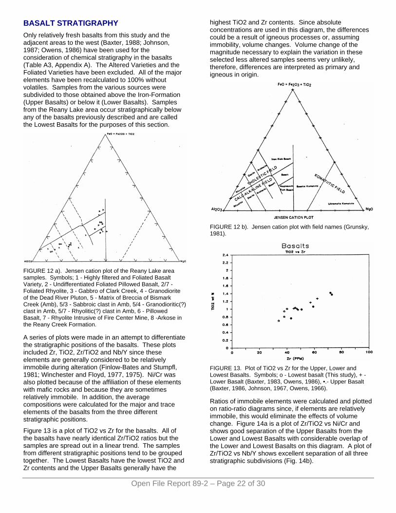
BASALT STRATIGRAPHY Only relatively fresh basalts from this study and the adjacent areas to the west (Baxter, 1988; Johnson, 1987; Owens, 1986) have been used for the consideration of chemical stratigraphy in the basalts (Table A3, Appendix A). The Altered Varieties and the Foliated Varieties have been excluded. All of the major elements have been recalculated to 100% without volatiles. Samples from the various sources were subdivided to those obtained above the Iron-Formation (Upper Basalts) or below it (Lower Basalts). Samples from the Reany Lake area occur stratigraphically below any of the basalts previously described and are called the Lowest Basalts for the purposes of this section.
FIGURE 12 a). Jensen cation plot of the Reany Lake area samples. Symbols; 1 - Highly filtered and Foliated Basalt Variety, 2 - Undifferentiated Foliated Pillowed Basalt, 2/7 - Foliated Rhyolite, 3 - Gabbro of Clark Creek, 4 - Granodiorite of the Dead River Pluton, 5 - Matrix of Breccia of Bismark Creek (Amb), 5/3 - Sabbroic clast in Amb, 5/4 - Granodioritic(?) clast in Amb, 5/7 - Rhyolitic(?) clast in Amb, 6 - Pillowed Basalt, 7 - Rhyolite Intrusive of Fire Center Mine, 8 -Arkose in the Reany Creek Formation.
A series of plots were made in an attempt to differentiate the stratigraphic positions of the basalts. These plots included Zr, TiO2, Zr/TiO2 and Nb/Y since these elements are generally considered to be relatively immobile during alteration (Finlow-Bates and Stumpfl, 1981; Winchester and Floyd, 1977, 1975). Ni/Cr was also plotted because of the affiliation of these elements with mafic rocks and because they are sometimes relatively immobile. In addition, the average compositions were calculated for the major and trace elements of the basalts from the three different stratigraphic positions.
Figure 13 is a plot of TiO2 vs Zr for the basalts. All of the basalts have nearly identical Zr/TiO2 ratios but the samples are spread out in a linear trend. The samples from different stratigraphic positions tend to be grouped together. The Lowest Basalts have the lowest TiO2 and Zr contents and the Upper Basalts generally have the
highest TiO2 and Zr contents. Since absolute concentrations are used in this diagram, the differences could be a result of igneous processes or, assuming immobility, volume changes. Volume change of the magnitude necessary to explain the variation in these selected less altered samples seems very unlikely, therefore, differences are interpreted as primary and igneous in origin.
FIGURE 12 b). Jensen cation plot with field names (Grunsky, 1981).
FIGURE 13. Plot of TiO2 vs Zr for the Upper, Lower and Lowest Basalts. Symbols; o - Lowest basalt (This study), + - Lower Basalt (Baxter, 1983, Owens, 1986), •.- Upper Basalt (Baxter, 1986, Johnson, 1967, Owens, 1966).
Ratios of immobile elements were calculated and plotted on ratio-ratio diagrams since, if elements are relatively immobile, this would eliminate the effects of volume change. Figure 14a is a plot of Zr/TiO2 vs Ni/Cr and shows good separation of the Upper Basalts from the Lower and Lowest Basalts with considerable overlap of the Lower and Lowest Basalts on this diagram. A plot of Zr/TiO2 vs Nb/Y shows excellent separation of all three stratigraphic subdivisions (Fig. 14b).
Open File Report 89-2 – Page 22 of 30
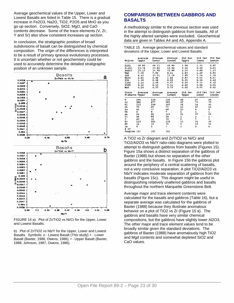
Average geochemical values of the Upper, Lower and Lowest Basalts are listed in Table 15. There is a gradual increase in Fe2O3, Na2O, TiO2, P2O5 and MnO as you go up section. Conversely, SiO2, MgO, and CaO contents decrease. Some of the trace elements (V, Zr, Y and Sr) also show consistent increases up section.
In conclusion, the stratigraphic position of broad subdivisions of basalt can be distinguished by chemical composition. The origin of the differences is interpreted to be a result of primary igneous evolutionary processes. It is uncertain whether or not geochemistry could be used to accurately determine the detailed stratigraphic position of an unknown sample.
Open File Report 89-2 – Page 23 of 30
FIGURE 14 a). Plot of Zr/TiO2 vs Ni/Cr for the Upper, Lower and Lowest Basalts.
b). Plot of Zr/TiO2 vs Nb/Y for the Upper, Lower and Lowest Basalts. Symbols; o - Lowest Basalt (This study) + - Lower Basalt (Baxter, 1988, Owens, 1986), • - Upper Basalt (Baxter, 1988, Johnson, 1987, Owens, 1986).
COMPARISON BETWEEN GABBROS AND BASALTS A methodology similar to the previous section was used in the attempt to distinguish gabbros from basalts. All of the highly altered samples were excluded. Geochemical data are given in Tables A4 and A5, Appendix A.
TABLE 15. Average geochemical values and standard deviations of the Upper, Lower and Lowest Basalts.
A TiO2 vs Zr diagram and Zr/TiO2 vs Ni/Cr and TiO2/Al2O3 vs Nb/Y ratio-ratio diagrams were plotted to attempt to distinguish gabbros from basalts (Figures 15). Figure 15a shows a distinct separation of the gabbros of Baxter (1988) but shows no separation of the other gabbros and the basalts. In Figure 15b the gabbros plot around the periphery of a central scattering of basalts, not a very conclusive separation. A plot TiO2/Al2O3 vs Nb/Y indicates moderate separation of gabbros from the basalts (Figure 15c). This diagram might be useful in distinguishing relatively unaltered gabbros and basalts throughout the northern Marquette Greenstone Belt.
Average major and trace element contents were calculated for the basalts and gabbros (Table 16), but a separate average was calculated for the gabbros of Baxter (1988) because they illustrate anomalous behavior on a plot of TiO2 vs Zr (Figure 15 a). The gabbros and basalts have very similar chemical compositions, but the gabbros have slightly lower Al2O3. The other major and trace element values tend to be broadly similar given the standard deviations. The gabbros of Baxter (1988) have anomalously high TiO2 and Mgd contents and somewhat depleted SiO2 and CaO values.
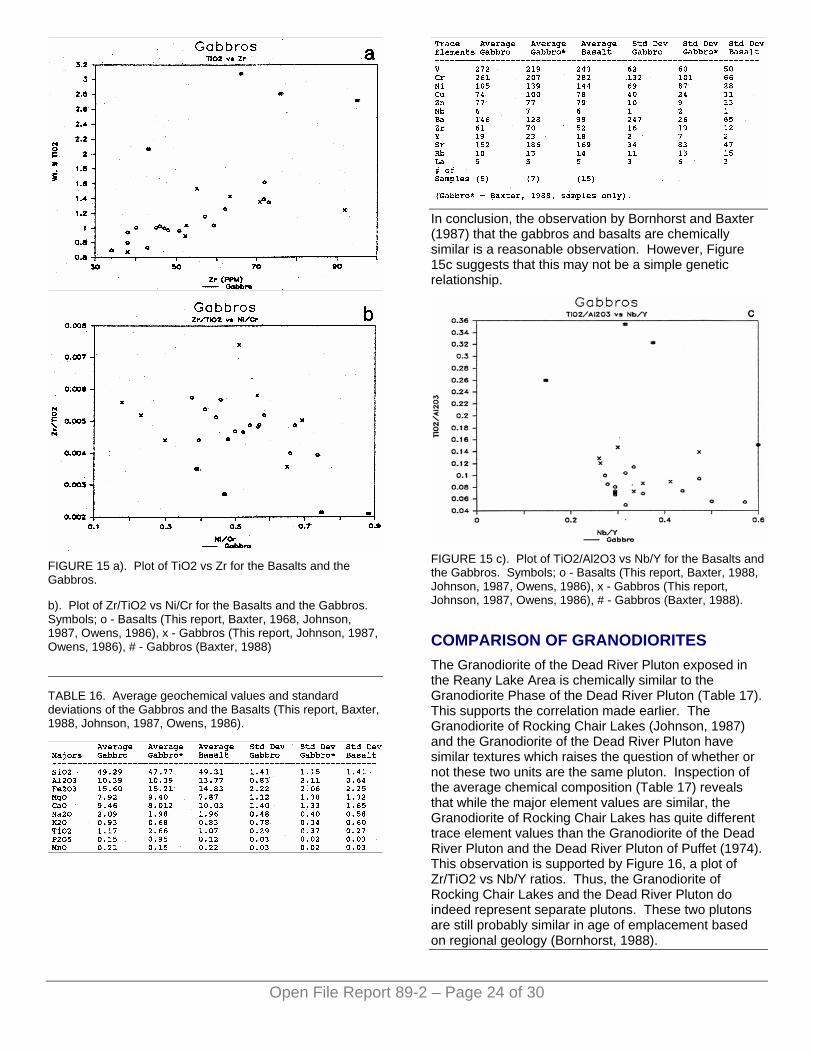
FIGURE 15 a). Plot of TiO2 vs Zr for the Basalts and the Gabbros.
b). Plot of Zr/TiO2 vs Ni/Cr for the Basalts and the Gabbros. Symbols; o - Basalts (This report, Baxter, 1968, Johnson, 1987, Owens, 1986), x - Gabbros (This report, Johnson, 1987, Owens, 1986), # - Gabbros (Baxter, 1988)
Open File Report 89-2 – Page 24 of 30
TABLE 16. Average geochemical values and standard deviations of the Gabbros and the Basalts (This report, Baxter, 1988, Johnson, 1987, Owens, 1986).
In conclusion, the observation by Bornhorst and Baxter (1987) that the gabbros and basalts are chemically similar is a reasonable observation. However, Figure 15c suggests that this may not be a simple genetic relationship.
FIGURE 15 c). Plot of TiO2/Al2O3 vs Nb/Y for the Basalts and the Gabbros. Symbols; o - Basalts (This report, Baxter, 1988, Johnson, 1987, Owens, 1986), x - Gabbros (This report, Johnson, 1987, Owens, 1986), # - Gabbros (Baxter, 1988).
COMPARISON OF GRANODIORITES The Granodiorite of the Dead River Pluton exposed in the Reany Lake Area is chemically similar to the Granodiorite Phase of the Dead River Pluton (Table 17). This supports the correlation made earlier. The Granodiorite of Rocking Chair Lakes (Johnson, 1987) and the Granodiorite of the Dead River Pluton have similar textures which raises the question of whether or not these two units are the same pluton. Inspection of the average chemical composition (Table 17) reveals that while the major element values are similar, the Granodiorite of Rocking Chair Lakes has quite different trace element values than the Granodiorite of the Dead River Pluton and the Dead River Pluton of Puffet (1974). This observation is supported by Figure 16, a plot of Zr/TiO2 vs Nb/Y ratios. Thus, the Granodiorite of Rocking Chair Lakes and the Dead River Pluton do indeed represent separate plutons. These two plutons are still probably similar in age of emplacement based on regional geology (Bornhorst, 1988).
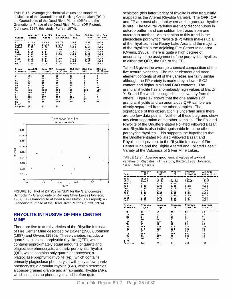
TABLE 17. Average geochemical values and standard deviations of the Granodiorite of Rocking Chair Lakes (RCL), the Granodiorite of the Dead River Pluton (DRP) and the Granodiorite Phase of the Dead River Pluton (DR Pluton). (Johnson, 1987, this study, Puffett, 1974).
Open File Report 89-2 – Page 25 of 30
FIGURE 16. Plot of Zr/TiO2 vs Nb/Y for the Granodiorites. Symbols; * - Granodiorite of Rocking Chair Lakes (Johnson, 1987), + - Granodiorite of Dead River Pluton (This report), o - Granodiorite Phase of the Dead River Pluton (Puffett, 1974).
RHYOLITE INTRUSIVE OF FIRE CENTER MINE There are five textural varieties of the Rhyolite Intrusive of Fire Center Mine described by Baxter (1988), Johnson (1987) and Owens (1986). These varieties include: a quartz-plagioclase porphyritic rhyolite (QFP), which contains approximately equal amounts of quartz and plagioclase phenocrysts; a quartz porphyritic rhyolite (QP), which contains only quartz phenocrysts; a plagioclase porphyritic rhyolite (Fp), which contains primarily plagioclase phenocrysts with only a few quartz phenocrysts; a granular rhyolite (GR), which resembles a coarse-grained granite and an aphanitic rhyolite (AR), which contains no phenocrysts and is often quite
schistose (this latter variety of rhyolite is also frequently mapped as the Altered Rhyolite Variety). The QFP, QP and FP are most abundant whereas the granular rhyolite is rare. The textural varieties are very discontinuous in outcrop pattern and can seldom be traced from one outcrop to another. An exception to this trend is the plagioclase porphyritic rhyolite (FP) which makes up all of the rhyolites in the Reany Lake Area and the majority of the rhyolites in the adjoining Fire Center Mine area (Owens, 1986). There is quite a high degree of uncertainty in the assignment of the porphyritic rhyolites to either the QFP, the QP, or the FP.
Table 18 gives the average chemical composition of the five textural varieties. The major element and trace element contents of all of the varieties are fairly similar although the FP variety is marked by a lower SiO2 content and higher MgO and CaO contents. The granular rhyolite has anomalously high values of Ba, Zr, Y, Sr and Rb which distinguishes this variety from the others. Figure 17 shows that the one analysis of granular rhyolite and an anomalous QFP sample are clearly separated from the other samples. The significance of this observation is uncertain since there are too few data points. Neither of these diagrams show any clear separation of the other samples. The Foliated Rhyolite of the Undifferentiated Foliated Pillowed Basalt and Rhyolite is also indistinguishable from the other porphyritic rhyolites. This supports the hypothesis that the Undifferentiated Foliated Pillowed Basalt and Rhyolite is equivalent to the Rhyolite Intrusive of Fire Center Mine and the Highly Altered and Foliated Basalt Variety of the Volcanics of Silver Mine Lakes.
TABLE 18 a). Average geochemical values of textural varieties of Rhyolites. (This study, Baxter, 1988, Johnson, 1987, Owens, 1986).
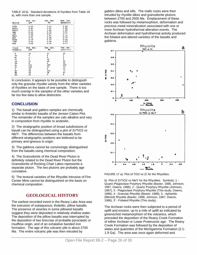
TABLE 18 b). Standard deviations of rhyolites from Table 18 a), with more than one sample.
In conclusion, it appears to be possible to distinguish only the granular rhyolite variety from the other varieties of rhyolites on the basis of one sample. There is too much overlap in the samples of the other varieties and far too few data to allow distinction.
CONCLUSION 1) The basalt and gabbro samples are chemically similar to tholeiitic basalts of the Jensen Cation Plot. The remainder of the samples are calc-alkaline and vary in composition from rhyolitic to andesitic.
2) The stratigraphic position of broad subdivisions of basalt can be distinguished using a plot of Zr/TiO2 vs Nb/Y. The differences between the basalts from different stratigraphic positions are believed to be primary and igneous in origin.
3) The gabbros cannot be convincingly distinguished from the basalts using chemical composition.
4) The Granodiorite of the Dead River Pluton is definitely related to the Dead River Pluton but the Granodiorite of Rocking Chair Lakes represents a separate pluton. The two plutons are probably age correlative.
5) The textural varieties of the Rhyolite Intrusive of Fire Center Mine cannot be distinguished on the basis on chemical composition.
GEOLOGICAL HISTORY The earliest recorded event in the Reany Lake Area was the extrusion of subaqueous, tholeiitic, pillow basalts. The presence of vesicles in some pillowed basalts suggest they were deposited in relatively shallow water. The deposition of the pillow basalts was interrupted by the deposition of two breccias of probable pyroclastic or mudflow origin, and of an exhalative banded iron formation. The age of this volcanic pile is about 2700 Ma. The entire volcanic pile was then intruded by
gabbro dikes and sills. The mafic rocks were then intruded by rhyolite dikes and granodiorite plutons between 2700 and 2500 Ma. Emplacement of these rocks was followed by metamorphism, deformation and precious metal mineralization associated with one or more Archean hydrothermal alteration events. The Archean deformation and hydrothermal activity produced the foliated and altered varieties of the basalts and gabbros.
FIGURE 17 a). Plot of TiO2 vs Zr for the Rhyolites.
b). Plot of Zr/TiO2 vs Nb/Y for the Rhyolites. Symbols; 1 - Quartz-Plagioclase Porphyry Rhyolite (Baxter, 1986, Johnson, 1987, Owens, 1986), 2 - Quartz Porphyry Rhyolite (Johnson, 1987), 3 - Plagioclase Porphyry Rhyolite (This study, Owens, 1986), 4 - Granular Rhyolite (Baxter, 1988), 5 - Aphanitic (filtered) Rhyolite (Baxter, 1988, Johnson, 1987, Owens, 1986), 3' - Foliated Rhyolite (This study).
The Archean rocks were then subjected to a period of uplift and erosion, up to a mile of uplift as indicated by greenschist metamorphism of the volcanics, which preceded the deposition of the Reany Creek Formation of either Archean or Lower Proterozoic age. The Reany Creek Formation was followed by the deposition of slates and quartzites of the Michigamme Formation (2.1-1.9 Ga). The area was once again deformed and
Open File Report 89-2 – Page 26 of 30
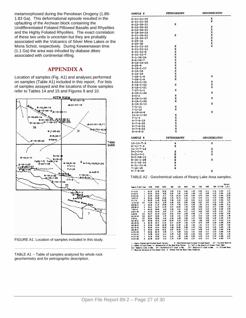
metamorphosed during the Penokean Orogeny (1.89-1.83 Ga). This deformational episode resulted in the upfaulting of the Archean block containing the Undifferentiated Foliated Pillowed Basalts and Rhyelites and the Highly Foliated Rhyolites. The exact correlation of these two units is uncertain but they are probably associated with the Volcanics of Silver Mine Lakes or the Mona Schist, respectively. During Keweenawan time (1.1 Ga) the area was intruded by diabase dikes associated with continental rifting.
APPENDIX A Location of samples (Fig. A1) and analyses performed on samples (Table A1) included in this report. For lists of samples assayed and the locations of those samples refer to Tables 14 and 15 and Figures 9 and 10.
FIGURE A1. Location of samples included in this study.
Open File Report 89-2 – Page 27 of 30
TABLE A1 -- Table of samples analyzed for whole rock geochemistry and for petrographic description.
TABLE A2 - Geochemical values of Reany Lake Area samples.
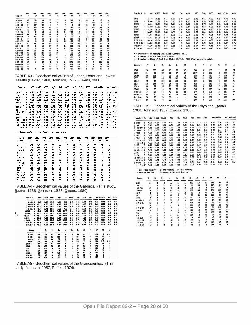
TABLE A3 - Geochemical values of Upper, Loner and Lowest Basalts (Baxter, 1988, Johnson, 1987, Owens, 1986).
TABLE A4 - Geochemical values of the Gabbros. (This study, Baxter, 1988, Johnson, 1S87, Owens, 1986).
TABLE A5 - Geochemical values of the Granodiorites. (This study, Johnson, 1987, Puffett, 1974).
TABLE A6 - Geochemical values of the Rhyolites (Baxter, 1988, Johnson, 1987, Owens, 1986).
Open File Report 89-2 – Page 28 of 30
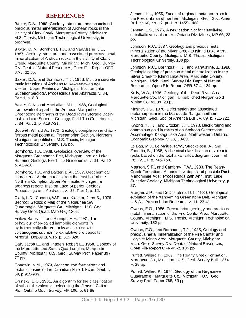
Open File Report 89-2 – Page 29 of 30
REFERENCES Baxter, D.A., 1988, Geology, structure, and associated precious metal mineralization of Archean rocks in the vicinity of Clark Creek, Marquette County, Michigan: M.S. Thesis, Michigan Technological University, in progress.
Baxter, D. A., Bornhorst, T.J., and VanAlstine, J.L., 1987, Geology, structure, and associated precious metal mineralization of Archean rocks in the vicinity of Clark Creek, Marquette County, Michigan: Mich. Geol. Survey Div. Dept. of Natural Resources, Open File Report OFR 87-8, 62 pp.
Baxter, D.A., and Bornhorst, T.J., 1988, Multiple discrete mafic intrusions of Archean to Keweenawan age, western Upper Peninsula, Michigan: Inst. on Lake Superior Geology, Proceedings and Abstracts, v. 34, Part 1, p. 6-8.
Baxter, D.A., and MacLallan, M.L., 1988, Geological framework of a part of the Archean Marquette Greenstone Belt north of the Dead River Storage Basin: Inst. on Lake Superior Geology, Field Trip Guidebooks, v. 34, Part 2, p. A19-A31.
Bodwell, Willard A., 1972, Geologic compilation and non-ferrous metal potential, Precambrian Section, Northern Michigan: unpublished M.S. Thesis, Michigan Technological University, 106 pp.
Bornhorst, T.J., 1988, Geological overview of the Marquette Greenstone Belt, Michigan: Inst. on Lake Superior Geology, Field Trip Guidebooks, v. 34, Part 2, p. A1-A18.
Bornhorst, T.J., and Baxter, D.A., 1987, Geochemical character of Archean rocks from the east half of the Northern Complex, Upper Peninsula, Michigan: a progress report: Inst. on Lake Superior Geology, Proceedings and Abstracts, v. 33, Part 1, p. 12.
Clark, L.D., Cannon, W.F., and Klasner, John S., 1975, Bedrock Geologic Map of the Negaunee SW Quadrangle, Marquette Co., Michigan: U.S. Geol. Survey Geol. Quad. Map G-Q-1206.
Finlow-Bates, T., and Stumpfl, E.F., 1981, The behaviour of so-called immobile elements in hydrothermally altered rocks associated with volcanogenic submarine-exhalative ore deposits, Mineral. Deposita, v.16, p. 319-328.
Gair, Jacob E., and Thaden, Robert E., 1968, Geology of the Marquette and Sands Quadrangles, Marquette County, Michigan: U.S. Geol. Survey Prof. Paper 397, 77 pp.
Goodwin, A.M., 1973, Archean iron-formations and tectonic basins of the Canadian Shield, Econ. Geol., v. 68, p.915-933.
Grunsky, E.G., 1981, An algorithm for the classification of subalkalic volcanic rocks using the Jensen Cation Plot, Ontario Geol. Survey, MP 100, p. 61-65.
James, H.L., 1955, Zones of regional metamorphism in the Precambrian of northern Michigan: Geol. Soc. Amer. Bull., v. 66, no. 12, pt. 1, p. 1455-1488.
Jensen, L.S., 1976, A new cation plot for classifying subalkalic volcanic rocks, Ontario Div. Mines, MP 66, 22 pp.
Johnson, R.C., 1987, Geology and precious metal mineralization of the Silver Creek to Island Lake Area, Marquette County, Michigan: M.S. Thesis, Michigan Technological University, 138 pp.
Johnson, R.C., Bornhorst, T.J., and VanAlstine, J., 1986, Geologic setting of precious metal mineralization in the Silver Creek to Island Lake Area, Marquette County, Michigan: Mich. Geol. Survey Div. Dept. of Natural Resources, Open File Report OFR-87-4, 134 pp.
Kelly, W.A., 1936, Geology of the Dead River Area, Marquette Co., Michigan: Unpublished Norgan Gold Mining Co. report, 29 pp.
Klasner, J.S., 1978, Deformation and associated metamorphism in the Marquette Range, northern Michigan, Geol. Soc. of America Bull., v. 89, p. 711-722.
Kwong, Y.T.J., and Crocket, J.H., 1978, Background and anomalous gold in rocks of an Archean Greenstone Assemblage, Kakagi Lake Area, Northwestern Ontario: Economic Geology, v. 73, 50-63.
Le Bas, M.J., Le Maitre, R.W., Streckeisen, A., and Zanettin, B., 1986, A chemical classification of volcanic rocks based on the total alkali-silica diagram, Journ. of Pet., v. 27, p. 745-750.
Mattson, S.R., and Cambray, F.W., 1983, The Reany Creek Formation: A mass-flow deposit of possible Post-Menominee Age: Proceedings 29th Ann. Inst. Lake Superior Geology, Michigan Technological University, p. 27.
Morgan, J.P., and DeCristoforo, D.T., 1980, Geological evolution of the Xshpeming Greenstone Belt, Michigan, U.S.A.: Precambrian Research, v. 11, 23-41.
Owens, E.O., 1986, Precambrian geology and precious metal mineralization of the Fire Center Area, Marquette County, Michigan: M.S. Thesis, Michigan Technological University, 152 pp.
Owens, E.O., and Bornhorst, T.J., 1985, Geology and precious metal mineralization of the Fire Center and Holyoke Mines Area, Marquette County, Michigan: Mich. Geol. Survey Div. Dept. of Natural Resources, Open File Report OFR-85-2, 105 pp.
Puffett, Willard P., 1969, The Reany Creek Formation, Marquette Co., Michigan: U.S. Geol. Survey Bull. 1274-F, 25 pp.
Puffett, Willard P., 1974, Geology of the Negaunee Quadrangle , Marquette Co., Michigan: U.S. Geol. Survey Prof. Paper 788, 53 pp.
Open File Report 89-2 – Page 30 of 30
Rose, W.I., Bornhorst, T.J., and Sivonen, S.J., 1986, Rapid, high-quality major and trace element analysis of powdered rock by X-ray fluorescence spectrometry: X-ray Spectrometry, v. 15, p. 55-60.
Sims, P.K., Peterman, Z.E., Prinz, W.C., and Benedict, F.C., 1984, Geology, geochemistry, and age of Archean and Early Proterozoic Rocks in the Marenisco-Watersmeet Area, Northern Michigan: U.S. Geol. Survey Prof. Paper 1292-A, 41 pp.
Sims, P.K., and Peterman, Z.E., 1983, Evolution of Penokean foldbelt, Lake Superior region, and its tectonic environment: Geol. Soc. of America Memoir 160, p. 3-14.
Small, J., and Bornhorst, T.J., 1988, The Reany Creek Formation, northern Marquette County, Michigan: Archean or Proterozoic?: Inst. on Lake Superior Geology, Proceedings and Abstract, v. 34, Part 1, p. 104-105.
Streckeisen, A.L., 1980, Classification and nomenclature of volcanic rocks, lamprophyres, carbonatites and melitic rocks, IUGS Subcommission on the Systematics of Igneous Rocks, Geologishe Rundschau, v. 69, p. 194-207.
Streckeisen, A.L., 1973, Plutonic rocks, Classification and Nomenclature recommended by the IUGS Subcommission of the Systematics of Igneous Rocks, Geotimes, p. 26-30.
Weeks, V.L., 1987, Gravity and magnetic investigation in the south-central part of the Ishpeming Greenstone Belt, Marquette County, Michigan: M.S. Thesis, Michigan Technological University, Houghton, MI, 61 pp.
Winchester, J.A., and Floyd, P.A., 1977, Geochemical discrimination of different magma series and the differentiation products using immobile elements, Chemical Geology, v. 20, p. 325-343.
Winchester, J.A., and Floyd, P.A., 1975, Magma type and tectonic setting discrimination using immobile elements, Earth and Planetary Sci. Letters, v. 27, p. 211-218.


![Marquette Range: [specimens] 25197-25284. No. 147 1893](https://img.pdfslide.net/doc/110x75/63399bbe84c389ae670c13fc/marquette-range-specimens-25197-25284-no-147-1893.jpg)