Embed Size (px)
Citation preview
THESE TERMS GOVERN YOUR USE OF THIS DOCUMENT
Your use of this Ontario Geological Survey document (the “Content”) is governed by the terms set out on this page (“Terms of Use”). By downloading this Content, you (the
“User”) have accepted, and have agreed to be bound by, the Terms of Use.
Content: This Content is offered by the Province of Ontario’s Ministry of Northern Development and Mines (MNDM) as a public service, on an “as-is” basis. Recommendations and statements of opinion expressed in the Content are those of the author or authors and are not to be construed as statement of government policy. You are solely responsible for your use of the Content. You should not rely on the Content for legal advice nor as authoritative in your particular circumstances. Users should verify the accuracy and applicability of any Content before acting on it. MNDM does not guarantee, or make any warranty express or implied, that the Content is current, accurate, complete or reliable. MNDM is not responsible for any damage however caused, which results, directly or indirectly, from your use of the Content. MNDM assumes no legal liability or responsibility for the Content whatsoever. Links to Other Web Sites: This Content may contain links, to Web sites that are not operated by MNDM. Linked Web sites may not be available in French. MNDM neither endorses nor assumes any responsibility for the safety, accuracy or availability of linked Web sites or the information contained on them. The linked Web sites, their operation and content are the responsibility of the person or entity for which they were created or maintained (the “Owner”). Both your use of a linked Web site, and your right to use or reproduce information or materials from a linked Web site, are subject to the terms of use governing that particular Web site. Any comments or inquiries regarding a linked Web site must be directed to its Owner. Copyright: Canadian and international intellectual property laws protect the Content. Unless otherwise indicated, copyright is held by the Queen’s Printer for Ontario. It is recommended that reference to the Content be made in the following form: <Author’s last name>, <Initials> <year of publication>. <Content title>; Ontario Geological Survey, <Content publication series and number>, <total number of pages>p. Use and Reproduction of Content: The Content may be used and reproduced only in accordance with applicable intellectual property laws. Non-commercial use of unsubstantial excerpts of the Content is permitted provided that appropriate credit is given and Crown copyright is acknowledged. Any substantial reproduction of the Content or any commercial use of all or part of the Content is prohibited without the prior written permission of MNDM. Substantial reproduction includes the reproduction of any illustration or figure, such as, but not limited to graphs, charts and maps. Commercial use includes commercial distribution of the Content, the reproduction of multiple copies of the Content for any purpose whether or not commercial, use of the Content in commercial publications, and the creation of value-added products using the Content. Contact:
FOR FURTHER INFORMATION ON PLEASE CONTACT: BY TELEPHONE: BY E-MAIL:
The Reproduction of Content
MNDM Publication Services
Local: (705) 670-5691 Toll Free: 1-888-415-9845, ext.
5691 (inside Canada, United States)
The Purchase of MNDM Publications
MNDM Publication Sales
Local: (705) 670-5691 Toll Free: 1-888-415-9845, ext.
5691 (inside Canada, United States)
Crown Copyright Queen’s Printer Local: (416) 326-2678 Toll Free: 1-800-668-9938
(inside Canada, United States)
LES CONDITIONS CI-DESSOUS RÉGISSENT L'UTILISATION DU PRÉSENT DOCUMENT.
Votre utilisation de ce document de la Commission géologique de l'Ontario (le « contenu ») est régie par les conditions décrites sur cette page (« conditions d'utilisation »). En
téléchargeant ce contenu, vous (l'« utilisateur ») signifiez que vous avez accepté d'être lié par les présentes conditions d'utilisation.
Contenu : Ce contenu est offert en l'état comme service public par le ministère du Développement du Nord et des Mines (MDNM) de la province de l'Ontario. Les recommandations et les opinions exprimées dans le contenu sont celles de l'auteur ou des auteurs et ne doivent pas être interprétées comme des énoncés officiels de politique gouvernementale. Vous êtes entièrement responsable de l'utilisation que vous en faites. Le contenu ne constitue pas une source fiable de conseils juridiques et ne peut en aucun cas faire autorité dans votre situation particulière. Les utilisateurs sont tenus de vérifier l'exactitude et l'applicabilité de tout contenu avant de l'utiliser. Le MDNM n'offre aucune garantie expresse ou implicite relativement à la mise à jour, à l'exactitude, à l'intégralité ou à la fiabilité du contenu. Le MDNM ne peut être tenu responsable de tout dommage, quelle qu'en soit la cause, résultant directement ou indirectement de l'utilisation du contenu. Le MDNM n'assume aucune responsabilité légale de quelque nature que ce soit en ce qui a trait au contenu. Liens vers d'autres sites Web : Ce contenu peut comporter des liens vers des sites Web qui ne sont pas exploités par le MDNM. Certains de ces sites pourraient ne pas être offerts en français. Le MDNM se dégage de toute responsabilité quant à la sûreté, à l'exactitude ou à la disponibilité des sites Web ainsi reliés ou à l'information qu'ils contiennent. La responsabilité des sites Web ainsi reliés, de leur exploitation et de leur contenu incombe à la personne ou à l'entité pour lesquelles ils ont été créés ou sont entretenus (le « propriétaire »). Votre utilisation de ces sites Web ainsi que votre droit d'utiliser ou de reproduire leur contenu sont assujettis aux conditions d'utilisation propres à chacun de ces sites. Tout commentaire ou toute question concernant l'un de ces sites doivent être adressés au propriétaire du site. Droits d'auteur : Le contenu est protégé par les lois canadiennes et internationales sur la propriété intellectuelle. Sauf indication contraire, les droits d'auteurs appartiennent à l'Imprimeur de la Reine pour l'Ontario. Nous recommandons de faire paraître ainsi toute référence au contenu : nom de famille de l'auteur, initiales, année de publication, titre du document, Commission géologique de l'Ontario, série et numéro de publication, nombre de pages. Utilisation et reproduction du contenu : Le contenu ne peut être utilisé et reproduit qu'en conformité avec les lois sur la propriété intellectuelle applicables. L'utilisation de courts extraits du contenu à des fins non commerciales est autorisé, à condition de faire une mention de source appropriée reconnaissant les droits d'auteurs de la Couronne. Toute reproduction importante du contenu ou toute utilisation, en tout ou en partie, du contenu à des fins commerciales est interdite sans l'autorisation écrite préalable du MDNM. Une reproduction jugée importante comprend la reproduction de toute illustration ou figure comme les graphiques, les diagrammes, les cartes, etc. L'utilisation commerciale comprend la distribution du contenu à des fins commerciales, la reproduction de copies multiples du contenu à des fins commerciales ou non, l'utilisation du contenu dans des publications commerciales et la création de produits à valeur ajoutée à l'aide du contenu. Renseignements :
POUR PLUS DE RENSEIGNEMENTS SUR VEUILLEZ VOUS
ADRESSER À : PAR TÉLÉPHONE : PAR COURRIEL :
la reproduction du contenu
Services de publication du MDNM
Local : (705) 670-5691 Numéro sans frais : 1 888 415-9845,
poste 5691 (au Canada et aux États-Unis)
l'achat des publications du MDNM
Vente de publications du MDNM
Local : (705) 670-5691 Numéro sans frais : 1 888 415-9845,
poste 5691 (au Canada et aux États-Unis)
les droits d'auteurs de la Couronne
Imprimeur de la Reine
Local : 416 326-2678 Numéro sans frais : 1 800 668-9938
(au Canada et aux États-Unis)
Ministry of Mines and Northern Development Minerals and Mines Division
Ontario
Summary of Field Work and Other Activities 1988
Ontario Geological Survey Miscellaneous Paper 141
edited by A.C. Colvine, M.E. Cherry, Burkhard O. Dressler, P.C. Thurston, C.L. Baker, R.B. Barlow, and Chris Riddle
1988
1988 Queen's Printer for Ontario ISSN 0704-2752 (Series) Printed in Ontario, Canada ISSN 0829-8203 (Sub-series)
Publications of the Ontario Geological Survey and the Ministry of Northern De velopment and Mines are available from the following sources. Orders for publi cations should be accompanied by cheque or money order payable to the Treas urer of Ontario.
Reports, maps, and price lists (personal shopping or mail order): Public Information Centre, Ministry of Natural Resources Room 1640, Whitney Block, Queen's Park Toronto, Ontario M7A 1W3
Reports and accompanying maps only (personal shopping): Ontario Government Bookstore Main Floor, 880 Bay Street Toronto, Ontario M7A 1N8
Reports and accompanying maps (mail order or telephone orders):Publications Services Section, Ministry of Government Services5th Floor, 880 Bay StreetToronto, Ontario M7A 1N8Telephone (local calls), 965-6015Toll-free long distance, 1-800-268-7540Toll-free from area code 807, O-ZENITH-67200
Every possible effort is made to ensure the accuracy of the information contained in this report, but the Ministry of Northern Development and Mines does not assume any liability for errors that may occur. Source references are included in the report and users may wish to verify critical information.
If you wish to reproduce any of the text, tables or illustrations in this report, please write for permission to the Director, Ontario Geological Survey, Ministry of Northern Development and Mines, lith Floor, 77 Grenville Street, Toronto, Ontario M7A 1W4.
Parts of this publication may be quoted if credit is given. It is recommended that reference be made in the following form:
Thurston, P.C., and Stott, G.M.1988: Northwestern Superior Province; p. 12-17 in Summary of Field Work
and Other Activities 1988, by the Ontario Geological Survey, edited by A.C. Colvine, M.E. Cherry, Burkhard O. Dressler, P.C. Thurston, C.L. Baker, R.B. Barlow, and Chris Riddle, Ontario Geological Sur vey, Miscellaneous Paper 141, 498p.
Scientific Editor: Guy Kendrick 3000-88-Maracle
FOREWORD
During 1988, the Ontario Geological Survey carried out a large number of inde pendent geoscience studies. In addition, studies were undertaken in cooperation with regional geological staff, personnel from universities, and private consulting firms. Special Geoscience programs were also undertaken in several areas under the Canada-Ontario Mineral Development (COMDA-ERDA) Agreement and with Northern Development Fund support. Project involvement by the various participants is summarized in the individual reports. Separate funding for a num ber of regional stimulation projects was provided and funding acknowledgements are included in the individual summaries.
The locations of the areas investigated are compiled on two maps of the prov ince at the beginning of this report. Preliminary results of field work and other research are outlined in this summary, which contains reports prepared by leaders and principal investigators for each of the projects. In these reports, some em phasis has been placed on the economic mineral resource aspects of the different investigations. The aim of the Ontario Geological Survey in producing this sum mary immediately following the field season, is to provide quick access to new information for mineral resource evaluation of these areas, which will be of value in current mineral exploration and resource planning. In addition, the wide spec trum of research in this report is of interest to the geoscience community as a whole.
Survey geoscientists will conduct more detailed research and analysis of the field work data through the winter and will be preparing reports on these investi gations for publication. In the interim, uncoloured preliminary geoscience maps with comprehensive marginal notes will be released for distribution, mainly during the winter of 1988-1989. Notices of the releases will be mailed to all persons or organizations on the Mineral Resources Group publication release notification list, and will be published in the technical journals and other media.
V.G. Milne
DirectorOntario Geological Survey
in

IV
Contents
Foreword . . . . . . . . . . . . . . . . . . . . . . . . . . . . . . . . . . . . . . . . . . . . . . . . . . . . . . . . . . . . . . . . . . . . . . . iii
Metric Conversion Table . . . . . . . . . . . . . . . . . . . . . . . . . . . . . . . . . . . . . . . . . . . . . . . . . . . . . . . . . . ix
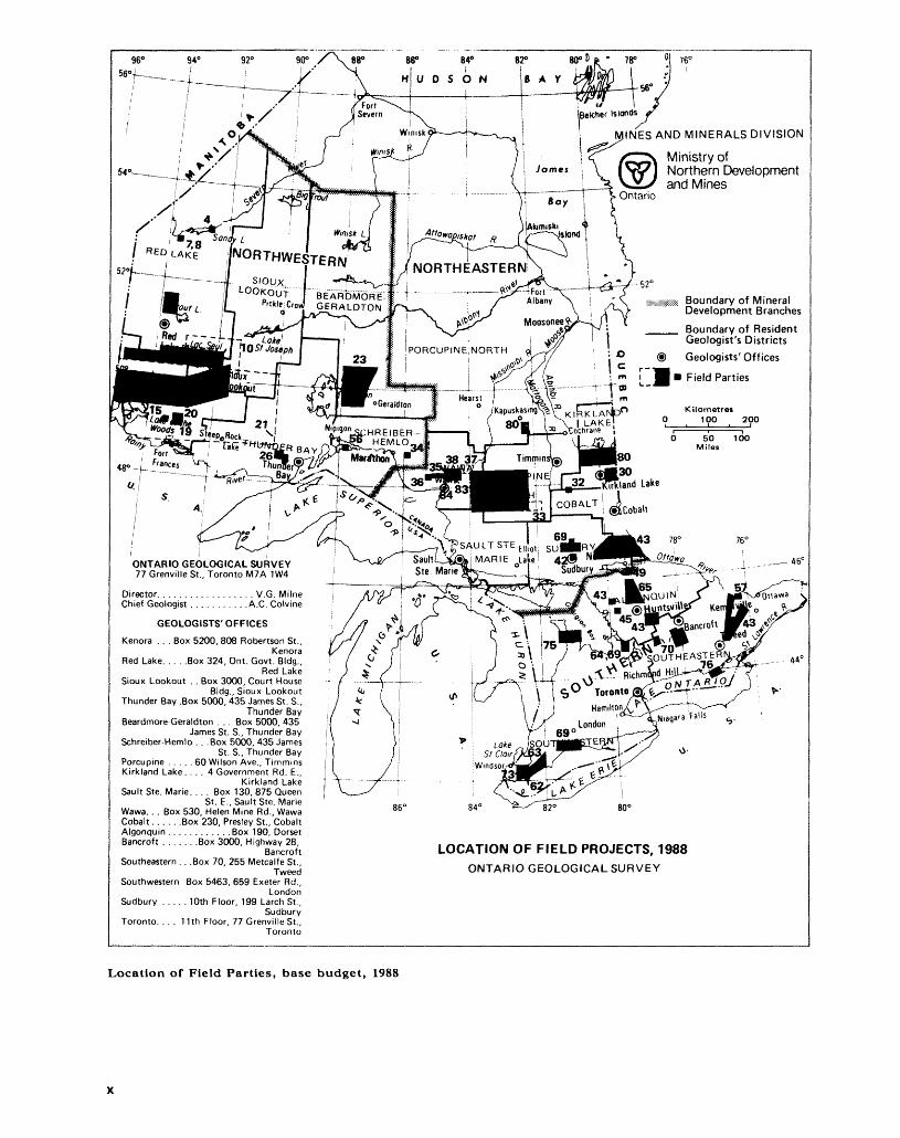
Location of Field Parties, base budget 1988 . . . . . . . . . . . . . . .. . . . . . . . . . . . . . . . . . . . . . . . . . . . x
Location of Field Parties, jointly funded projects 1988 . . . . . . . . . . . . . . . . . . . . . . . . . . . . . . . . . . xi
PRECAMBRIAN GEOLOGY PROGRAMS
1. Summary of Activities 1988, Precambrian Geology Section A.C. Colvine . . . . . . . . . . . . . . 2
2. Project Number 88-23. Geology of Ontario: An Update P.C. Thurston . . . . . . . . . . . . . . . 5
Northwestern Ontario
3. Northwestern Superior Province P.C. Thurston and G.M. Stott . . . . . . . . . . . . . . . . . . . . . . 12
4. Project Number 88-10. Geology of the Keewaywin Supracrustal Sequence;Sandy Lake Greenstone Belt, Northwestern Ontario A.L. Cortis . . . . . . . . . . . . . . . . . . . . . 18
5. Project Number 88-10. A Geological Re-evaluation of Northwestern Greenstone BeltsA.L. Cortis, G.M. Stott, LA. Osmani, B. Atkinson, and P.C. Thurston . . . . . . . . . . . . . . . . . 25
6. Project Number 88-23A. Regional Scale Shear Zones in Sachigo Subprovince and TheirEconomic Significance I.A. Osmani and G.M. Stott . . . . . . . . . . . . . . . . . . . . . . . . . . . . . . . 53
7. Project Number 88-23. Preliminary Study of the Geochemistry of Alteration inVolcanic Rocks Hosting the Zahavy Mine, Favourable Lake Belt, Sachigo SubprovinceG.R. Edwards and L.D. Ayres . . . . . . . . . . . . . . . . . . . . . . . . . . . . . . . . . . . . . . . . . . . . . . . . . . . 68
8. Project Number 88-23. Occurrence of Komatiites in the Favourable Lake GreenstoneBelt, Northwestern Ontario L.D. Ayres . . . . . . . . . . . . . . . . . . . . . . . . . . . . . . . . . . . . . . . . . . 71
9. Project Number 88-34. Geology of the Berens Subprovince: Nungesser Lake Area,District of Kenora Denver Stone . . . . . . . . . . . . . . . . . . . . . . . . . . . . . . . . . . . . . . . . . . . . . . . 75
10. Project Number 88-23B. Geology of the Eastern Lac Seul Granulite-Amphibolite FaciesTransition Zone F.W. Breaks . . . . . . . . . . . . . . . . . . . . . . . . . . . . . . . . . . . . . . . . . . . . . . . . . 81
11. Project Number 88-23B. The Petrunka W-Be Property An Archean Holmquistite-bearingGreisen System F.W. Breaks . . . . . . . . . . . . . . . . . . . . . . . . . . . . . . . . . . . . . . . . . . . . . . . . . . 89
12. Project Number 88-21. Geology of the Tectonic Boundary Zone Between the English Riverand Winnipeg River Subprovinces, Northwestern Ontario Mary Sanborn-Barrie . . . . . . . . . 98
13. Project Number 88-7. The Wabigoon-Winnipeg River Subprovince Boundary ProblemG. P. Beakhouse ............................................................... 108
14. Project Number 87-17. Preliminary Investigations of the Structure of the Slate Lake Area,Uchi Subprovince H.R. Williams . . . . . . . . . . . . . . . . . . . . . . . . . . . . . . . . . . . . . . . . . . . . . . . 116
15. Project Number 88-33. Stratigraphy and Structure of Archean Metasediments and Metavolcanics in the Thompson and James Bay Areas (Pipestone Lake), Wabigoon Subprovince G.R. Edwards and M.R. Stauffer . . . . . . . . . . . . . . . . . . . .. . . . . .. . . . . . . . . 120
Wabigoon Subprovince
16. Geological Studies in the Wabigoon Subprovince, Superior Province G.W. Johns . . . . . . . . 124
17. Project Number 86-21. Gold Studies in the Manitou Lakes-Stormy Lake Belt, Districts ofKenora and Rainy River J.R. Parker and M. Perrault .. ... . .... ....... . .. ........ ... 126
18. Project Number 88-16. Geology of the Falcon Island Area, Lake of the Woods, District ofKenora J.A. Ayer . . . . . . . . . . . . . . . . . . . . . . . . . . . . . . . . . . . . . . . . . . . . . . . . . . . . . . . . . . . 132
19. Project 88-14. Geology of the Vista Lake Area, Districts of Rainy River and KenoraP. Mark Smith and Clive D. Stephenson . .... . . ... .. ... ... . . ....... . ... .. . . . .. . . . . . 138
20. Project Number 88-15. Geology of the Manitou Stretch Area, District of KenoraBen Berger . . . . . . . . . . . . . . . . . . . . . . . . . . . . . . . . . . . . . . . . . . . . . . . . . . . . . . . . . . . . . . . . . . . 145
21. Project 88-7. Reconnaissance Investigations of Granitoid Rocks in the WabigoonSubprovince G.P. Beakhouse . . . . . . . . . . . . . . . . . . . . . . . . . . . . . . . . . . . . . . . . . . . . . . . . . . 149
22. Project Number 86-43. Geological Synopsis in the Dinorwic-Sioux Lookout Area The Sandybeach Lake Area, Northwestern Ontario Lesley Chorlton .................. 153
23. Project Number 88-23. A Stratigraphic Reconnaissance of the Eastern WabigoonSubprovince C.E. Blackburn and G.W. Johns . . . . . . . . . . . . . . . . . . . . . . . . . . . . . . . . . . . . 163
24. Project Number 87-17. Geological Studies in the Wawa, Quetico, and WabigoonSubprovinces, with Emphasis on Structure and Tectonic Development H,R. Williams . . . . 169
25. Project Number 88-13. Seagram Lake Area, District of Thunder BayD. U. Kresz and Borys Zayachivsky . . . . . . . . . . . . . . . . . . . . . . . . . . . . . . . . . . . . . . . . . . . . . . . . 173
26. Project Number 87-16. Alkalic Rocks of the Thunder Bay Area M.W. Carter . . . . . . . . . 179
Abitibi Subprovince
27. Abitibi Subprovince Studies R.H. Sutcliffe . . . . . . . . . . . . . . . . . . . . . . . . . . . . . . . . . . . . . . . 186
28. Project Number 88-08. Plutonic Rocks of the Abitibi SubprovinceA.R. Smith and R.H. Sutcliffe . . . . . . . . . . . . . . . . . . . . . . . . . . . . . . . . . . . . . . . . . . . . . . . . . . . 188
29. Project Number 87-15. Geology of Tisdale and Northern Whitney TownshipsD. W. Piroshco and K. Kettles . . . .'. . . . . . . . . . . . . . . . . . . . . . . . . . . . . . . . . . . . . . . . . . . . . . . 197
30. Project Number 88-33. The Abitibi Greenstone Belt Near Larder Lake: Structural andStratigraphic Studies S.L. Jackson . . . . . . . . . . . . . . . . . . . . . . . . . . . . . . . . . . . . . . . . . . . . . . 206
31. Project Number 87-01. Relationships Between Lithological, Alteration, and Structural Features and Precious-Metal Occurrences in the Temagami Greenstone Belt, District of Nipissing J.A. Fyon, R.B. Hrabi, and W.M. Maitland . . . . . . . . . . . . . . . . . . . . . . . . . . . . . 212
32. Project Number 88-23. Field Investigations at the United Asbestos Deposit, MidlothianTownship, District of Timiskaming D.S. O'Hanley . . . . . . . . . . . . . . . . . . . . . . . . . . . . . . . . . 219
33. Project Number 88-06. Geological Setting of Gold Mineralization in the Southern SwayzeBelt G.M. Siragusa . . . . . . . . . . . . . . . . . . . . . . . . . . . . . . . . . . . . . . . . . . . . . . . . . . . . . . . . . . 222
34. Project Number 83-50. Hemlo Tectono-Stratigraphic Study, District of Thunder BayT.L. Muir . . . . . . . . . . . . . . . . . . . . . . . . . . . . . . . . . . . . . . . . . . . . . . . . . . . . . . . . . . . . . . . . . . . . 226
Wawa Area
35. Project Number 87-14. Geology of the Kabenung Lake Area, District of AlgomaR.P. Sage . . . . . . . . . . ....... . . . . . . . . . . ...... . . . . . . . . . . . ....... . . . . . . . . . . . . . .... 242
36. Project Number 88-09. Geology of the Iron Lake Area, District of Algoma B.A. Reilly . . 249
37. Project Number 87-3. The Geological and Structural Setting of Gold Mineralization in the Missanabie-Renabie District of the Michipicoten Greenstone Belt, Wawa, Ontario K.B. Heather and Shane Buck . . . . . . . . . . . . . . . . . . . . . . . . . . . . . . . . . . . . . . . . . . . . . . . . . . . 257
38. Project Number 88-20. Digital Integration of Remote-Sensing Data into a Geoscience Data Base for the Goudreau-Lochalsh Study Area, Michipicoten Greenstone Belt R.S. Mussakowski and N.F. Trowell . . . . . . . . . . . . . . . . . . . . . . . . . . . . . . . . . . . . . . . . . . . . . . 271
Proterozoic
39. Proterozoic Geology Studies, Southern and Grenville Provinces R.M. Easton . . . . . . . . . . . 278
40. Project 88-12. Geology of the Bay Lake Area, District of TimiskamingP. Born and M.W. Hitch . . . . . . . . . . . . . . . . . . . . . . . . . . . . . . . . . . . . . . . . . . . . . . . . . . . . . . . 281
41. Project Number 86-44. Regional Geology and Sedimentology of the Lorrain Formation,Cobalt Plain: Southeastern and Southern Outliers Randy J. Rice . . . . . . . . . . . . . . . . . . . . . 288
42. Breccias of the Sudbury Structure, District of SudburyM.E. Avermann and V. Mueller-Mohr . . . . . . . . . . . . . . . . . . . . . . . . . . . . . . . . . . . . . . . . . . . . 297
vi
43. Project Number 88-05. Regional Mapping and Stratigraphic Studies, Grenville Provincewith some Notes on Mineralization Environments R.M. Easton . . . . . . . . . . . . . . . . . . . . . . 300
44. Project Number 88-11. Geology of the Manitouwabing Lake Area, District of Parry SoundG.D. McRoberts, R.I. Macfie, and D.J. Hammar . . . . . . . . . . . . . . . . . . . . . . . . . . . . . . . . . . . 309
45. Project 88-11. Preliminary Investigation of the Parry Sound-Seguin Domain BoundaryR.I. Macfie . . . . . . . . . . . . . . . . . . . . . . . . . . . . . . . . . . . . . . . . . . . . . . . . . . . . . . . . . . . . . . . . . . 315
46. Industrial Minerals, Rare-earth Elements, and Building Stonein the Districts of Muskoka, Parry Sound, and Nipissing, and the County of HaliburtonC. Marmont, P.M. Zuberec, and W.D. Conrod . . . . . . . . . . . . . . . . . . . . . . . . . . . . . . . . . . . . . 319
47. Project Number 88-17. Remote Sensing Study of Curvilinear, Structural Features in the ParrySound Domain, Grenville Province M.L. Tremblay . . . . . . . . . . . . . . . . . . . . . . . . . . . . . . . . 326
48. Project 86-42. The Precambrian-Paleozoic Unconformity in Southeastern Ontario andAssociated Mineralization G. Di Frisco . . . . . . . . . . . . . . . . . . . . . . . . . . . . . . . . . . . . . . . . . 330
49. Project Number 88-35. Hematitized Fault Zones in the North Bay Area J.S. Springer . . . 335
50. Stratigraphy and Sedimentation of Marbles and Associated Metasedimentary Rocks of theGrenville Supergroup in Southeastern Ontario Hans D. Meyn . . . . . . . . . . . . . . . . . . . . . . . 339
51. Pegmatites of the Bancroft Area, Southeastern Ontario B.E. Goad . . . . . . . . . . . . . . . . . . . 342
52. Geology of the Egan Chutes Provincial Park and Adjacent Areas, Bancroft W.T. Grant . . 347
53. Geology and Beneficiation of Talc in the Tudor Formation, Southeastern OntarioP.S. LeBaron . . . . . . . . . . . . . . . . . . . . . . . . . . . . . . . . . . . . . . . . . . . . . . . . . . . . . . . . . . . . . . . . . 351
54. Major Graphite Occurrences Within the Frontenac Axis, Southeastern OntarioS.J. Black and A. MacKinnon . . . . . . . . . . . . . . . . . . . . . . . . . . . . . . . . . . . . . . . . . . . . . . . . . . . 359
55. Structural Geology of the Madoc Fluorite Area, Southern OntarioL.G.D. Thompson and D.A. Williams . . . . . . . . . . . . . . . . . . . . . . . . . . . . . . . . . . . . . . . . . . . . . 363
56. Project Number 87-17. Geology of the St. Ignace Island Volcanic-Plutonic ComplexR.H. Sutcliffe and A.R. Smith . . . . . . . . . . . . . . . . . . . . . . . . . . . . . . . . . . . . . . . . . . . . . . . . . . . 368
Special Studies
57. Project 88-35. Plant Spectral Signatures Versus Geochemical Values in Soil and Leaf Ash;Arnprior, Eastern Ontario J. S. Springer, V. Singhroy, and F. Kenny . . . . . . . . . . . . . . . . . . 374
58. Project Number 88-32. Field Implementation of a Developmental Computer-Based DigitalMapping and Data Storage System B. Brodaric and J.A. Fyon . . . . . . . . . . . . . . . . . . . . . . 378
59. Project Number 88-31. Petrographic Characteristics of Archean Granitoid RocksJ.A. Fyon and K. J. Wheatley . . . . . . . . . . . . . . . . . . . . . . . . . . . . . . . . . . . . . . . . . . . . . . . . . . . . 381
60. Project 85-20. Geochemical Classification of Archean Volcanic RocksR.M. Easton, E.C. Grunsky, P.C. Thurston, L.S. Jensen, and J.M. Howe . . . . . . . . . . . . . . . 384
ENGINEERING AND TERRAIN GEOLOGY PROGRAMS
61. Summary of Activities of the Engineering and Terrain Geology Section 1988 C.L. Baker . 396
62. Project Number 88-4. Quaternary Geology of Essex County, Southern OntarioT.F. Morris . . . . . . . . . . . . . . . . . . . . . . . . . . . . . . . . . . . . . . . . . . . . . . . . . . . . . . . . . . . . . . . . . . 399
63. Project Number 88-26. Quaternary Geology of the Wheatley Area, Southern OntarioR.I. Kelly . . . . . . . . . . . . . . . . . . . . . . . . . . . . . . . . . . . . . . . . . . . . . . . . . . . . . . . . . . . . . . . . . . . . 402
64. Project Number 86-13. Quaternary Geology of the Eastern Half of the Elmvale Area, SimcoeCounty P.J. Barnett . . . . . . . . . . . . . . . . . . . . . . . . . . . . . . . . . . . . . . . . . . . . . . . . . . . . . . . . . 405
65. Project Number 86-16. Quaternary Geology of the Sundridge-Burk's Falls Area, CentralOntario P.S.G. Kor . . . . . . . . . . . . . . . . . . . . . . . . . . . . . . . . . . . . . . . . . . . . . . . . . . . . . . . . . . 407
66. Project Number 86-20. Quaternary Geology of the Shining Tree Area, Districts of Sudburyand Timiskaming P.W. Alcock ................................................. 411
vii
67. Project Number 86-21. Quaternary Geology and Overburden Exploration in theBeardmore-Geraldton-Longlac Area, District of Thunder Bay F. J. Kristjansson . . . . . . . . 414
68. Project Number 86-22. Reconnaissance Till Sampling in the Fort Frances-Rainy River Area,Rainy River District A.F. Bajc . . . . . . . . . . . . . . . . . . . . . . . . . . . . . . . . . . . . . . . . . . . . . . . . . 417
69. Project Number 82-27. An Evaluation of Airborne Radar for Quaternary StudiesV.H. Singhroy and P. J. Barnett . . . . . . . . . . . . . . . . . . . . . . . . . . . . . . . . . . . . . . . . . . . . . . . . . . 421
70. Project Number 83-41. Aggregate Resources Inventory in Peterborough County and VictoriaCounty C. Joan Dawson and Steve Szoke . . . . . . . . . . . . . . . . . . . . . . . . . . . . . . . . . . . . . . . . 424
71. Project Number 86-19. Aggregate Resources Inventory of the Towns of Bracebridge andGravenhurst, District Municipality of Muskoka R.G. Gorman and Steve Szoke . . . . . . . . . . 427
72. Project 86-23. Aggregate Resources Inventory Northwest of Fort Frances, District of RainyRiver G.R. Jones and Steve Szoke . . . . . . . . . . . . . . . . . . . . . . . . . . . . . . . . . . . . . . . . . . . . . . 430
73. Project Number 88-19. The Delineation of Buried Aggregate Resources in the Pinehurst and Leamington Areas of Southwestern Ontario Using Electromagnetic Conductivity Douglas G. Vanderveer and Steve Szoke . . . . . . . . . . . . . . . . . . . . . . . . . . . . . . . . . . . . . . . . . . . . . . . . . . . . . 433
74. Project Number 88-37. Paleozoic Geology of the Gypsum Deposits in the James BayLowland R.K. Bezys and M.P. Bradshaw . . . . . . . . . . . . . . . . . . . . . . . . . . . . . . . . . . . . . . . . 442
75. Project Number 88-2. Paleozoic Geology of the Central Bruce Peninsula D.K. Armstrong 446
76. Project Number 88-36. Detailed Structural Geology Investigations of Prince Edward County,Southern Ontario. G.H. McFall, Owen L. White, and A. Allam . . . . . . . . . . . . . . . . . . . . . 454
GEOPHYSICS/GEOCHEMISTRY PROGRAMS
77. Summary of Activities 1988, Geophysics/Geochemistry Section R.B. Barlow . . . . . . . . . . . 458
78. Project.Numbers 88-26 and 88-29. Recent Airborne Electromagnetic-Magnetic Surveys inNorthern Ontario R.B. Barlow . . . . . . . . . . . . . . . . . . . . . . . . . . . . . . . . . . . . . . . . . . . . . . . . . 460
79. Project Number 87-24. The Detection and Mapping of Basement Conductors Under Areas Covered by Thick Huronian Sedimentary Rocks, District of Timiskaming James E. Hanneson and Ronald S. Huxter . . . . . . . . . . . . . . . . . . . . . . . . . . . . . . . . . . . . . . . . . 464
80. Project Number 88-38. Lithoprobe Gravity Profiles Chapleau, Kapuskasing, andKirkland Lake Areas R.B, Barlow and D.R. Wadge . . . . . . . . . . . . . . . . . . . . . . . . . . . . . . . 470
81. Project Number 87-29. Reconnaissance Till Sampling Program, Matheson-Lake Abitibi Area,District of Cochrane K.G. Steele .. . . . . . . . . . . . . . .. .. . . . . . .. ..... .... . . ... . . . . . . . 472
82. Project Number 87-25. A Regional Geochemical Survey of Part of the Batchawana GreenstoneBelt, District of Algoma John A.C. Fortescue . . . . . . . . . . . . . . . . . . . . . . . . . . . . . . . . . . . . 478
83. Project Number 87-26. The Use of the Geochemistry of Long Lake Sediment Cores for Verification of Regional Geochemical Results: Goudreau Lake Area, District of Algoma John A.C. Fortescue . . . . . . . . . . . . . . . . . . . . . . . . . . . . . . . . . . . . . . . . . . . . . . . . . . . . . . . . . . . 482
84. Project Number 88-31. A Regional Geochemical Survey of the Magpie River Area,District of Algoma John A.C. Fortescue and Arthur Nakashima . . . . . . . . . . . . . . . . . . . . . 489
GEOSCIENCE LABORATORIES PROGRAMS
85. Summary of Activities 1988, Geoscience Laboratories Section Chris Riddle . . . . . . . . . . . . 494
86. Project 88-01. The Determination of Trace Concentrations of Rare Earth Elements at theGeoscience Laboratories, Ontario Geological Survey Anthony Vander Voet . . . . . . . . . . .. . 498
VIII
CONVERSION FACTORS FOR MEASUREMENTS IN ONTARIO GEOLOGICAL SURVEY PUBLICATIONS
Conversion from SI to Imperial
SI Unit Multiplied by Gives
Conversion from Imperial to SI
Imperial Unit Multiplied by Gives
1 mm1 cm1 m1 m1 km
1 cm21 m21 km21 ha
1 cm31 m31 m3
1 L1 L1 L
1 g1 g1 kg1 kg1 t1 kg1 t
1 g/t
1 g/t
0.039 370.393 703.280 840.049 709 70.621 371
0.155 010.763 90.386 102.471 054
0.061 0235.314 71.308 0
1.759 7550.879 8770.219 969
0.035 273 960.032 150 752.204 620.001 102 31.102 3110.000 984 210.984 206 5
0.029 166 6
0.583 333 33
LENGTH
AREAsquare inches l square inch square feet l square foot square miles l square mileacres l acre
VOLUMEcubic inches l cubic inch cubic feet l cubic foot cubic yards l cubic yard
pintsquartsgallons
CAPACITYl pint l quart l gallon
MASS
6.451 60.092 903 042.589 9880.404 685 6
16.387 0640.028 316 850.764 555
0.568 2611.136 5224.546 090
cm* m2
km2 ha
mj m3
L L L
ounces (avdp) l ounce (avdp) 28.349 523ounces (troy) l ounce (troy) 31.103 476 8pounds (avdp) l pound (avdp) 0.453 592 37tons (short) l ton (short) 907.184 74tons (short) l ton (short) 0.907 184 74tons (long) l ton (long) 1016.046 908 8tons (long) l ton (long) 1.016 046 908 8
CONCENTRATIONounce (troy)/ l ounce (troy)/ 34.285 714 2 ton (short) ton (short) pennyweights/ l pennyweight/ 1.714 285 7 ton (short) ton (short)
g g
kgkg
tkg
t
g/t
g/t
OTHER USEFUL CONVERSION FACTORSl ounce (troy) per ton (short) 20.0 pennyweights per ton (short) l pennyweight per ton (short) 0.05 ounces (troy) per ton (short)
Note: Conversion factors which are in bold type are exact. The conversion factors have been taken from or have been derived from factors given in the Metric Practice Guide for the Canadian Min ing and Metallurgical Industries, published by the Mining Association of Canada in cooperation with the Coal Association of Canada.
IX
78"
-56o ys SIslands
INES AND MINERALS DIVISION
Ministry ofNorthern Developmentand Mines
Boundary of Mineral Development Branches
Boundary of Resident Geologist's Districts
Geologists' Offices
Field Parties
ONTARIO GEOLOGICAL SURVEY77 Grenville St., Toronto M7A 1W4
Director. . . . . . . . . . . . . . . . . . V.G. MilneChief Geologist . . . . . . . . . . .A.C. Colvine
Kenora . . . Box 5200, 808 Robertson St.,Kenora
Red Lake. . . . .Box 324, Ont. Govt. Bldg.,Red Lake
Sioux Lookout . . Box 3000, Court HouseBldg., Sioux Lookout
Thunder Bay .Box 5000, 435 James St. S.,Thunder Bay
Beardmore-Geraldton . . . Box 5000, 435James St. S., Thunder Bay
Schreiber-Hemlo . . .Box 5000, 435 JamesSt. S., Thunder Bay
Porcupine . . . . . 60 Wilson Ave., TimminsKirkland Lake. . . . 4 Government Rd. E.,
Kirkland Lake Sault Ste. Marie. . . . Box 130, 875 Queen
St. E., Sault Ste. Marie Wawa. . . Box 530, Helen Mine Rd., Wawa Cobalt. . . . . .Box 230, Presley St., CobaltAlgonquin . . . . . . . . . . . .Box 190, DorsetBancroft . . . . . . .Box 3000, Highway 28,
BancroftSoutheastern . . .Box 70, 255 Metcalfe St.,
TweedSouthwestern Box 5463, 659 Exeter Rd.,
LondonSudbury . . . . . 10th Floor, 199 Larch St.,
Sudbury Toronto. . . . 11th Floor, 77 Grenville St.,
Toronto
440
86 80"
LOCATION OF FIELD PROJECTS, 1988ONTARIO GEOLOGICAL SURVEY
Location of Field Parties, base budget, 1988
.etcher Islands J
INES AND MINERALS DIVISION
Ministry ofNorthern Developmentand Mines
Boundary of Mineral Development Branches
Boundary of Resident Geologist's Districts
Geologists' Offices
Field Parties
SIOUX.
LOOKOUT j BEARDMORE Pickle. Crow1 GERALDTON
ONTARIO GEOLOGICAL SURVEY77 Grenville St., Toronto M7A 1W4
Director. . . . . . . . . . . . . . . . . . V.G. MilneChief Geologist . . . . . . . . . . .A.C. Colvine
Kenora . . . Box 5200, 808 Robertson St..Kenora
Red Lake. . . . .Box 324, Ont. Govt. Bldg.,Red Lake
Sioux Lookout . . Box 3000, Court HouseBldg., Sioux Lookout
Thunder Bay .Box 5000, 435 James St. S.,Thunder Bay
Beardmore-Geraldton . . . Box 5000, 435James St. S., Thunder Bay
Schreiber-Hemlo . . .Box 5000, 435 JamesSt. S., Thunder Bay
Porcupine . . . . . 60 Wilson Ave., TimminsKirkland Lake. . . . 4 Government Rd. E.,
Kirkland Lake Sault Ste. Marie. . . . Box 130, 875 Queen
St. E., Sault Ste. Marie Wawa. . . Box 530, Helen Mine Rd., Wawa Cobalt. . . . . .Box 230, Presley St., CobaltAlgonquin . . . . . . . . . . . .Box 190, DorsetBancroft . . . . . . .Box 3000, Highway 28,
BancroftSoutheastern . . .Box 70, 255 Metcalfe St.,
TweedSouthwestern Box 5463, 659 Exeter Rd.,
LondonSudbury . . . . . 10th Floor, 199 Larch St.,
Sudbury Toronto. . . . 11th Floor, 77 Grenville St.,
Toronto
44"
86" 84" '^-^ 820 80LOCATION OF JOINTLY FUNDED FIELD PROJECTS*!, 1988
MINISTRY OF NORTHERN DEVELOPMENT AND MINES ENERGY, MINES AND RESOURCES CANADACanada1 Ontario
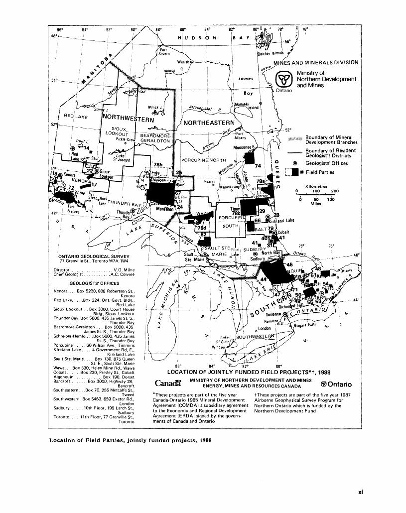
*These projects are part of the five year Canada-Ontario 1985 Mineral Development Agreement (COMDA) a subsidiary agreement to the Economic and Regional Development Agreement (ERDA) signed by the govern ments of Canada and Ontario
tThese projects are part of the five year 1987 Airborne Geophysical Survey Program for Northern Ontario which is funded by the Northern Development Fund
Location of Field Parties, jointly funded projects, 1988
Xi

XII

Precambrian Geology Programs
1. Summary of Activities, 1988, Precambrian Geology Section
A.C. Colvine
Chief Geologist, Precambrian Geology Section, Ontario Geological Survey, Toronto.
As reported last year, several new major initiatives are underway in the Precam brian Geology Section. In each of these initiatives, interdisciplinary working groups have been established, principally to conduct field-based mapping re search as a means to better understand fundamental geological problems in the Precambrian Shield. These constitute both geological-geographic groups, such as that in the Wabigoon Subprovince, and thematic groups, such as those investigat ing gold mineralization and major structures throughout the Shield in Ontario. For ease of reference, the work of these groups is presented in this volume on a geographic basis. The first paper in each section includes a summary of the work in that area. External funding sources are identified for applicable projects.
The most comprehensive initiative is the "Geology of Ontario" project, which encompasses the work of all Sections of the OGS. This project will synthesize our present knowledge of the geology of the Province and will result in a publication scheduled for release in 1991, the centennial of the OGS and its predecessors. Accompanying the volume will be a set of maps, at a scale of 1:1 000 000, cover ing bedrock geology, tectonics, metallogeny, magnetics, gravity, and Quaternary geology. The bedrock geology map is presently partially completed and is sched uled for release in 1989. It reflects the significant advances in our understanding over the last twenty years, since the release of the current l inch to 16 mile geology map of Ontario. While the volume and maps will be important refer ences, the project will also have a second important result: a comprehensive reap praisal of both strengths and weaknesses of our knowledge of the Province's geol ogy and mineral resources. As such, it will influence future project planning.
Activities in Northwestern Ontario during the 1988 field program in particular reflect this reappraisal. This area constitutes more than one-third of the Archean Shield in Ontario, but much of it is relatively inaccessible and therefore expensive to map. Some areas are covered by recent detailed mapping, but much is only covered by old reconnaissance mapping. This year's mapping projects had two objectives: firstly, to provide data on specific areas of interest, and secondly, to contribute to a reappraisal of the geological framework of the Northwestern Shield in order to identify priority areas for mapping and to establish the appro priate scale for this work. Three principal subjects of study are apparent in the summaries that follow:1. large-scale structures or deformation zones, which are the principal host to
gold mineralization. In addition, these form the boundaries of subprovinces which represent terrains of different geological style and mineral potential.
2. discrimination of platformal volcanic and sedimentary sequences in greenstone belts. From this work, it has become clear that greenstone se quences are composites of several ages and environments of volcanism, each with different mineral potential. In addition, this work is elucidating the early evolution of the Archean crust.
3. regional study of granitic rocks, to subdivide them by age and composition. While the "pink rocks" are generally considered of low mineral potential, they might better be considered of "unknown" potential. While detailed mapping of such rocks is not justified, mapping of larger areas at 1:100 000 scale can readily subdivide them and identify smaller areas of higher poten tial.Further mapping in Northwestern Ontario will focus on specific favourable
structures or greenstone belts, and will include regional mapping of granitic ter rains.
A. C. COLVINE
The western part of the Wabigoon Subprovince has benefited from extensive detailed mapping over the last five years, as described in this and preceding Sum maries of Field Work. We are now in a position to use this data base in the preparation of synoptic reports on the Rowan-Kakagi and Lake of the Woods greenstone belts, and of 1:100 000 belt-scale maps. Other mapping projects in the Wabigoon Subprovince continued in 1988, with a focus on the Beardmore- Geraldton tectonic belt and the Dinorwic-Sioux Lookout area.
The Abitibi Greenstone Belt is the largest exposed Archean greenstone belt in the world. To date, the Ontario portion of this belt has been responsible for gold and base-metal production approaching S100 billion in current dollars, and extensive exploration for new deposits continues. While many areas of the Abitibi Belt have been mapped, by many different geologists, there are still gaps in our knowledge. In addition, the following new data indicate that it is now appropriate to re-investigate the main Abitibi Greenstone Belt.
1. High precision geochronology indicates that belt-wide stratigraphic correla tions of similar volcanic types cannot be assumed. Consideration must be given to a tectonic assembly of the belt, rather than a simple intact stratig raphy.
2. A short, deep crustal seismic transect across the belt, supported by the OGS as an addition to the Kapuskasing Lithoprobe traverse, has identified low angle discontinuities beneath the Blake River and Kinojevis groups, possibly representing tectonic rather than conformable boundaries.
3. Recently acquired, detailed gravity and high resolution magnetic and electro magnetic data are available for large portions of the belt.
Further mapping in the Abitibi will be targeted not only at filling gaps in map coverage, but also at improving our understanding of the major structures, which host gold mineralization, and of the stratigraphy and structure of volcanic se quences, which host base-metal deposits.
Detailed mapping in the Hemlo area continued this year, as reported in an extended summary. Preparation of an interim report and maps from this work is in progress.
The Wawa area has been the focus of detailed mapping over the past ten years. Since 1985, this program has been supplemented by mapping in the Mishibishu Lake Belt. This work will be proceeding to a synoptic report and map of the western part of the Michipicoten greenstone belt. Mapping of the eastern part of the belt is less recent, and therefore, the available geological data base is being supplemented by structural and alteration studies to assist further gold ex ploration.
The Proterozoic holds potential for a large variety of metallic and industrial mineral deposits, and this is reflected in the variety of mapping and commodity- specific projects undertaken this year. Extensive mapping of the Central Metasedimentary Belt of the Grenville Province over several years is leading to preparation of a series of 1:50 000 compilation maps. Detailed mapping in the Parry Sound area is contributing to our understanding of the very complex geol ogy of the Grenville Province. This understanding is essential if we are to success fully target areas of high mineral potential.
Several additional topics are also reported in this volume. The Petroch geochemical data base is now sufficiently large and accessible to be a significant resource. Some of its applications are reported. Classification of volcanic rocks, discrimination of alteration associated with mineralizing systems, and characteri zation of intrusions related to gold mineralization are but three uses of Petroch currently being investigated. The computerized field note system has been ex panded to encompass computerized map display, which will enhance data cap ture, improve efficiency of field mapping, and result in more efficient rapid pro duction of published maps. Applications of both satellite imagery and side scan radar are being investigated as aids to mapping.
Computerized map representation and geophysical, geochemical, and remote sensing data highlight the need for better means of taking advantage of the wealth
PRECAMBRIAN (1)
of existing data which is currently available. The Wawa data integration project is one of several pilot projects underway to investigate ways of using all types of existing data to increase efficiency and provide the highest quality in new map ping projects.
As first reported last year in the summary of Section activities, revision of the 1:250 000 scale compilation maps is underway. This map series has consistently been widely used by the mineral exploration industry. The revised maps will in corporate advances in our geological data base, and will show enhanced mineral occurrence information. Release of the first such revised map the Atikokan- Lakehead sheet - is planned for 1989.
During 1988, the Section continued to play a strong role in the Provincial, National, and International geoscience community. Seminars and workshops were presented throughout the Province, in order to highlight our continuing work. Selected scientific papers were presented at several national and interna tional meetings.
2. Project Number 88-23. Geology of Ontario: An Update
P.C. Thurston
Geologist, Precambrian Geology Section, Ontario Geological Survey, Toronto.
The geology of Ontario project is to provide an up- to-date summary of the geology of the Province, with the goal of producing all material by the centen nial of the OGS in 1991. The project will be carried out in several stages over the next three years, and will involve personnel from the Precambrian, Engi neering and Terrain, and Geophysics and Geochem istry sections within the OGS.
The summary will consist of a map series por traying major facets of the geology of the Province, and an accompanying descriptive volume. The maps, at a scale of 1:1 000 000, include: 1) a geo logical map; 2) a tectonic map; 3) a metallogenic map; 4) a Pleistocene geological map; 5) a magnetic map; and 6) a gravity map. The volume will deal with the whole Province from Archean to Pleisto cene and is intended to include: an introduction and history (5 percent), a descriptive summary of the ge ology of the Province (40 percent), a thematic sec tion (40 to 50 percent), and a summary with a tec tonic emphasis (5 percent). The descriptive section will examine the nature of major rock types and stratigraphic units on a subprovince by subprovince basis in the Archean, and a similar plan will be fol lowed in the Grenville, Paleozoic, and Mesozoic. The thematic section will provide an up-to-date de scription of the major areas of OGS activity, for ex ample: gold metallogeny, the assessment of mineral potential in felsic volcanic sequences, neotectonics and engineering geology, and hydrogeology. The summary will allow examination of large-scale ques tions, for example: how the Superior Province was assembled, were there multiple episodes of gold mineralization and do they vary in terms of chemical signature, and whether reactivation of Grenville structures is causing current movement of faults in the sedimentary platform of Southern Ontario.
At present, the legend is complete for the geo logical map, and editing of the map prior to submis sion for printing will be complete by early 1989. The tectonic map will be in manuscript form by late 1989, and the other maps mentioned above will fol low in sequence. Writing of sections of the volume will commence this winter.
LEGEND FOR THE NEW GEOLOGICAL MAP
The legend for the 1:1 000 000 geological map (Ta ble 2.1) was prepared in late 1987 and consists of a
total of 51 units. The philosophy in development of the legend was to portray the advances in our knowl edge of lithologic associations and their distribution, and to classify them in a manner that would allow the geological map to be the factual base for a tec tonic interpretation. Geological interpretation of most of the Superior Province is complete and is progressing rapidly on the Grenville and the Paleo- zoic/Mesozoic. Major features which have come out of the legend design process and the compilation thus far are discussed below.
GREENSTONE SEQUENCES
The Superior Province is subdivided into granite- greenstone, sedimentary, gneissic, and plutonic sub- provinces. Most subprovinces have rock units of similar age range, structural style and trend, and generally define a block bounded by large-scale shear zones.
The granite-greenstone subprovinces, based upon a compilation by Card and Ciesielski (1986) are, from north to south, the Sachigo, Uchi, Bird River, Wabigoon, and the Abitibi. Thurston and Chivers (in press) have recently subdivided greenstone sequences into four types, two of which are distinct packages and form separated units within the legend. They are described as follows:
1. Platform sequences consist of a basal quartz arenite overlain by iron formation and ultramafic to mafic volcanics, and are shown as unit l in the legend. Based upon the presence of abundant shallow water depositional structures, the association of quartz arenite and sedimen tary carbonate, and the presence of stroma tolites, these sequences are considered to repre sent shallow water sequences, comparable with platform sequences at passive margins. The quartz-rich character of the sediments and petrographic evidence of a granitoid provenance suggests erosion from widespread granitic areas. As platform sequences are greater than 2.85 Ga and perhaps approaching 3 Ga, they suggest the existance of a pre-2.7 Ga orogenic event. These sequences unconformably overlie -3 Ga green stones (Donaldson and deKemp 1987) and granitic rocks (Davis and Jackson 1988), and are concentrated in the Sachigo Subprovince and the Wabigoon Diapiric Axis (Thurston et al. 1987).
PRECAMBRIAN (2)
TABLE 2.1. LEGEND FOR GEOLOGICAL MAP.
LEGEND Ontario Geological Map
PHANEROZOIC
MESOZOIC51 Jurassic and Cretaceous
Middle Jurassic and Lower CretaceousKaolinitic clay, clay, sand, lignite
PALEOZOICDevonian50 Upper Devonian
Shale49 Middle Devonian
Limestone, dolostone, shale48 Lower Devonian
Sandstone, dolostone, limestoneSilurian47 Upper Silurian
Limestone,-dolostone, shale, sand stone, gypsum, salt
46 Lower and Middle SilurianSandstone, shale, dolostone, siltstone
Ordovician 45 Upper Ordovician
Shale, limestone, dolostone, siltstone 44 Middle Ordovician
Limestone, shale 43 Lower Ordovician
Dolostone, sandstone Cambrian42 Conglomerate, sandstone, shale,
dolostone
PRECAMBRIANPROTEROZOIC
EARLY TO LATE PROTEROZOIC
41 Carbonatite-Alkaline Intrusive Suite3Carbonatite, nepheline and alkalic syenites, ijolite, fenite, and associ ated mafic and ultramafic rocks
40 Early to Late Mafic Igneous RocksbDiabase, gabbro, diorite, ultramafic rocks and granophyre
39 Late Felsic Igneous RocksGranite, syenite
GRENVILLE PROVINCE
MIDDLE TO LATE PROTEROZOICCentral Metasedimentary Belt
38 Late Felsic Plutonic RocksGranodiorite, granite, syenite, peg matite, alkaline granites
37 Mafic and Ultramafic Plutonic Rocks Diorite, gabbro, peridotite, pyroxenite, anorthosite, and derived metamorphic rocks
36
35
Alkaline Plutonic RocksNepheline and alkaline syenites, fenite, associated mafic, ultramafic and carbonatitic rocks
Early Felsic Plutonic RocksGranodiorite, trondhjemite, monzo and syenogranites, derived gneisses and migmatites
Metasediments Grenville Supergroup and Flinton Group0
34 Carbonate MetasedimentsMarble, calc-silicate rocks, skarn
33 Clastic MetasedimentsConglomerate, greywacke, quartz arenite, arkose, siltstone, chert, mi nor iron formation and metavolcanics
32 MetavolcanicsMafic to Felsic Metavolcanics
Flows, tuff, breccia, minor iron for mation and metasediments. Includes reworked pyroclastic units.
MIDDLE PROTEROZOIC
Central Gneiss Belt
31 Felsic Igneous RocksGranodiorite, monzonite, granite, syenite, derived gneisses
30 Alkaline Igneous RocksNepheline and alkaline syenites
29 Anorthositic RocksAnorthosite, gabbro and derivedgneisses
28 Mafic Igneous RocksAmphibolite, gabbro, tonalite, dio rite, derived gneisses and migmatites
27 MetasedimentsMarble, marble breccia, quartzite, quartzofeldspathic gneiss of metasedimentary origin?
SUPERIOR AND SOUTHERN PROVINCES
LATE PROTEROZOIC
26 Post Keweenawan Sediments Jacobsville and Oronto Groups
Sandstone, shale, conglomerate
MIDDLE PROTEROZOIC25 Keweenawan Volcanic and Sedimentary
RocksBasalt, rhyolite tuff, quartz porphyry, conglomerate and arkose
24 Mafic and related Intrusive RocksGabbro, diabase and granophyre (Logan Type)
23 Sibley Group SedimentsConglomerate, sandstone,-shale, car bonate rocks
TABLE 2.1. CONTINUED.
P.C. THURSTON
EARLY PROTEROZOIC
22 Sudbury Igneous ComplexNorite, gabbro, and granophyre
Animikie GroupdGreywacke, shale, iron formation, limestone, argillite
Whitewater Group6Fragmental rocks, mudstone, wacke
Mafic and Related Intrusive RocksGabbro, diabase (Nipissing type)
Huronian Supergroup Cobalt Groupf Conglomerate, greywacke, quartzarenite, siltstone, argillite
Huronian Supergroup Elliot Lake, HoughLake, andQuirke Lake Groups
Conglomerate, greywacke, arkose, quartz arenite argillite, limestone, dolomite, basalt
Huronian Metavolcanics (Elliot Lake Group)Basalt, rhyolite
Mafic and Ultramafic Intrusive Rocks
21
20
19
18
17
16
15Gabbro, anorthositic gabbro, and anorthosites
ARCHEAN
SUPERIOR PROVINCE
MIDDLE TO LATE ARCHEAN
14 Diorite-nepheline Syenite Suite0Pyroxenite-diorite-monzonite- syenite-nepheline syenite (saturated to undersaturated suite)
13 Massive Granodiorite to GraniteMassive to foliated granodiorite to granite
12 Diorite-monzonite-granodiorite Suite0 Diorite-tonalite-monzonite- granodiorite-syenite and hypabyssal equivalents (saturated to over saturated suite)
11 Muscovite-bearing Granitic Rocks0Two mica granite, granodiorite- tonalite
10 Foliated Tonalite Suite0Foliated to massive tonalite- granodiorite
9 Gneissic Tonalite Suite0Gneissic to foliated tonalite- granodiorite with minor supracrustal inclusions
8 Mafic and Ultramafic Rocks0Gabbro, anorthosite, and ultramafic rocks
Late Metavolcanics and MetasedimentsS
7 Clastic MetasedimentsCoarse to fine clastic metasediments, with minor mafic to felsic (flows, tuffs and breccias) metavolcanics (saturated to undersaturated)
Metavolcanics and Metasediments 0
6 Migmatized Supracrustal RocksMainly metavolcanics and minor metasediments with minor granitic gneisses
5 MetasedimentsWacke, arkose, argillite, slate, con glomerate, marble, chert, iron for mation, derived migmatites, and mi nor volcanics
Metavolcanics
4 Felsic to Intermediate MetavolcanicsRhyolite, rhyodacite, dacite and an desite (flows, tuffs and breccias) chert, iron formation, minor metasediments and intrusiverocks, and related migmatites; selected alkalic mafic to felsic metavolcanics
3 Mafic MetavolcanicsBasalt, andesite (flows, tuffs and breccias) chert, iron formation, mi nor metasediments and intrusive rocks, and related migmatites
2 Ultramafic MetavolcanicsKomatiite-bearing mafic metavol canics, minor metasediments and pyroclastics
l Clastic Metasediments and Mafic Metavolcanics
Quartz arenite, coarse clastic metasediments, iron formation, komatiite, mafic metavolcanics, mi nor felsic metavolcanics and marble
NOTES
a) May be in part post-Precambrian.b) A generalized distribution of diabase dikes is
shown.c) Rocks in these groups are subdivided lithologi-
cally. The order does not imply age relationship within or among groups.
d) Includes Gunflint and Rove formations.e) Includes Chelmsford, Onwatin, and Onaping for
mations.f) Includes Gowganda, Lorrain, Gordon Lake, Bar
River formations.g) Formerly classified as Timiskaming.
PRECAMBRIAN (2)
2. "Timiskaming" type sequences consist of fluviatile to shallow marine sediments and alkalic to calcalkalic volcanics deposited in fault-bounded basins spatially associated with large-scale shear zones (Stott 1986; Poulsen 1984; Thurston and Chivers, in press), and are shown in the legend as unit 7. The fact that these basins developed after the early deforma tion of greenstone belts and during the second deformation related to the horizontal movement along subprovince boundaries has lead to them being compared to pull-apart basins in the mod ern environment (Stott 1986; Poulsen 1984).Mafic sequences and mafic to felsic cyclical vol
canism are the other two greenstone sequences de scribed by Thurston and Chivers (in press), how ever, they do not form distinct lithologic packages that can be defined (separated?) by this legend.
Each of the above greenstone belt types displays distinct metallogenic patterns which will be dealt with more thoroughly on the metallogenic map. However, the newly defined platform sequence at Sakami Lake contains detrital uranium and gold (Roscoe and Donaldson 1988), and iron formations are found at Steeprock Lake (Joliffe 1955) and North Spirit Lake (Wood 1980).
GRANITOIDS
Since the most recent edition of the geological map of Ontario was produced (Ayres et al. 1971), the l inch to 4 mile reconnaissance of the Province has
been completed. This work outlined all major greenstone belts and allowed for the additional sub division of granitic rocks of the Superior Province. Granitoid rocks of both plutonic and granite- greenstone subprovinces have been subdivided into four major units as follows: (a) Gneissic Tonalite Suite; (b) Foliated Tonalite Suite; (c) Diorite-Mon- zonite-Granodiorite Suite; and (d) Massive Granodiorite to Granite (units 9, 10, 12, and 13, respectively, Table 2.1). These units are supple mented by muscovite-bearing granitic rocks and mafic and ultramafic intrusions (units 11 and 8, Ta ble 2.1). The above major units may allow subdivi sion, upon completion of additional mapping and geochronology, into pre-greenstone units versus syn- to post-kinematic units. The recognition of these packages of granitic rocks will permit the iden tification of blocks of pre-greenstone crust and gneissic subprovinces, such as the Winnipeg River gneisses. Recognition of these packages of older granitic rocks will aid in the identification of granitic rocks with high mineral potential, for example, the mineralized portion of the Marmion tonalite (Patter son et al. 1986).
In a sample area shown in Figure 2.1, the new granitoid legend has been used with some geochro nology, mapping of limited areas (Breaks et al. 1985), and field checking of the subdivision this field season, to provide an improved understanding of the area. The new interpretation allows separation of the anomalously auriferous mus'covite-bearing
LEGEND
L'.'l carbonatite - alkaline Intrusive suite
•- + -H massive granodiorite to granite
l. 1 foliated tonalite suite
r + 1 gneissic tonalite suite
ESSS mafic 4 ultramafic rocks
i-iv'&'a metasediments
1=1 felsic to intermediate metavolcanics
li 111 mafic metavolcanics
clastic metasediments A mafic metavolcanics
20 40
kilometres
Figure 2.1. Sample area from northwestern Ontario showing geology at a scale of 1:1 000 000. Units correspond to those in the legend shown in Table 2.1.
P. C. THURSTON
granites, and distinction of the post-tectonic granitoids which host uranium mineralization.
SEDIMENTARY SUBPROVINCES
The previous edition of the provincial geological map (Ayres et al. 1971) showed the sedimentary subprovinces of the Superior Province (English River and Quetico subprovinces) in a general fashion. Mapping programs since then (summarized by Breaks et al. 1978; Percival and Williams 1988) have demonstrated that:
1. These subprovinces consist of large expanses of wackes in the central part of the subprovinces, with some conglomeratic units on the northern margins of both Quetico and English River sub provinces.
2. The Quetico Subprovince continues across the Ontario part of the Superior Province from the Minnesota border to the Quebec border.
3. The southern contact of the Quetico Sub province with the Abitibi Subprovince is a major shear zone marked by the presence of fault- bounded slices of mafic metavolcanics and intru sions.
4. The Quetico Subprovince is separated from the Wabigoon Subprovince in the Beardmore- Geraldton area by a series of major east-trend ing strike-parallel shear zones.
5. The English River Subprovince as defined by Ayres e t al. (1971) consists of a southern gneissic part, the Winnipeg River Subprovince (largely gneissic), and a northern part, the Eng lish River Subprovince, largely wackes (cf. Card and Ciesielski 1986).
6. The sedimentary subprovinces have been inter preted (Williams, this volume) as accretionary prisms of deep water sediments formed south of the Wabigoon and Uchi subprovinces, respec tively.
STRUCTURAL/TECTONIC STUDIES
Reinterpretation of large parts of the Superior Prov ince using aeromagnetic data and remote sensing im ages has resulted in the recognition of several new major shear zones (Osmani and Stott, this volume; Mussakowski and Trowell, this volume). These ob servations coupled with gold-related structural stud ies (Stott and Smith 1988), indicate that many addi tional major shear zones should appear on this edi tion of the provincial map. Some of these newly de lineated shear zones crosscut the Uchi-Sachigo Sub province boundary, suggesting that modifications are also necessary to Subprovince boundaries and no menclature.
Contact strain aureoles are in some cases signifi cant enough to display at the 1:1 000 000 scale, par ticularly in parts of the Uchi Subprovince. The sub- province-bounding shear zones produced during late transpression events young irregularly southward from the southern boundary of the Uchi Sub province (Stott et al. 1987). This sort of situation is readily interpretable in terms of an accretionary tec tonic scenario.
Implied in the above observations and modifica tions are major changes in the complexion of the provincial map. The Abitibi and parts of the eastern (cf. Blackburn and Johns, this volume) and western Wabigoon Subprovince may represent separate ter- ranes within the overall framework of the Wabigoon Subprovince as classically defined. Similar subdivi sions of the Uchi and Abitibi subprovinces are envi sioned. In fact, Marmont and Corfu (in press) show that the age of the last deformation in the Detour Mine area in the external zone of the Abitibi Sub province is about 2720 Ma, whereas the last defor mation in the internal zone is less than 2700 Ma. From this, it is concluded that part of the external zone, i.e. the Detour Lake belt, probably represents part of the Wabigoon Subprovince, rather than the Abitibi.
In summary, major changes in the shape of indi vidual greenstone belts, the level of detail displayed in granitoid areas, and the character and extent of individual subprovinces will make this synthesis a worthwhile update.
REFERENCESAyres, L.D., Lumbers, S.B., Milne V.G., and Robeson,
D.W. 1971: Ontario Geological Map; Ontario Department of
Mines and Northern Affairs, Map 2196, scale1:1 013 760 or l inch to 16 miles.
Breaks, F.W., Bartlett, J.R., Osmani I.A., Finamore, P.P., and Wallace, H.
1985: Opapimiskan Lake Project: Precambrian and Quater nary Geology of the North Caribou Lake Area, Dis trict of Kenora, Patricia Portion; p.268-276 in Sum mary of Field Work 1985, Ontario Geological Survey, edited by John Wood, Owen L. White, R.B. Barlow, and A.C. Colvine, Ontario Geological Survey, Mis cellaneous Paper 126, 351p.
Breaks, F.W., Bond, W.D., and Stone, D.1978: Preliminary Geological Synthesis of the English River
Subprovince, Northwestern Ontario and its Bearing Upon Mineral Exploration; Ontario Geological Sur vey, Miscellaneous Paper 72, 55p.
Card, K.D., and Ciesielski, A.1986: DNAG #1 Subdivisions of the Superior Province of the
Canadian Shield; Geoscience Canada, Volume 13, p.5-13.
Davis, D.W., and Jackson, M.C.1988: Geochronology of the Lumby Lake Greenstone Belt: A
3 Ga Complex Within the Wabigoon Subprovince, Northwest Ontario; Geological Society of America Bulletin, Volume 100, Number 6, p.818-824.
PRECAMBRIAN (2)
Donaldson, J.A., and deKemp, E.1987: The Komatiite-Quartz Arenite Association in Pre
cambrian Terranes: An Archean Example From the Superior Province; Geological Association of Canada/ Mineralogical Association of Canada, Program with Abstracts, Volume 12, p.37.
Joliffe, A.W.1955: Geology and Iron Ores of Steep Rock Lake; Economic
Geology, Volume 50, Number 4, p.373-398.
Marmont, S., and Corfu, F.In Press: Timing of Gold Introduction in the Late Archean
Tectonic Framework of the Canadian Shield: Evi dence from U-Pb Zircon Geochronology of the Abitibi Subprovince; Economic Geology.
Patterson, G.C., Scott, J.F, Mason, J.K., Schnieders, B.R., MacTavish, A.D., Dutka, R.J.A., Kennedy, M.C., White, G.D., and Hinz, P.
1986: Thunder Bay Resident Geologist's Area, North Cen tral Region; p.72-127 in Report of Activities 1986, Regional and Resident Geologists, edited by C.R. Kustra, Ontario Geological Survey, Miscellane ous Paper 134, 322p.
Percival, J.A., and Williams, H.R.In Press: The Late Archean Quetico Accretionary Complex,
Superior Province, Canada; Geology.
Poulsen, K.H.1984: Archean Tectonics and Mineralization at Rainy Lake,
Northwestern Ontario; Unpublished Ph.D. Thesis, Queens University, Kingston, Ontario, 342p.
Roscoe, S.M., and Donaldson, J.A.1988: Uraniferous Pyritic Quartz Pebble Conglomerate and
Layered Ultramafic Intrusions in a Sequence of Quartzite, Carbonate, Iron Formation and Basalt of Probable Archean Age at Lac Sakami, Quebec; p.117-121 in Current Research Part C, Geological Survey of Canada, Paper 88-1C.
Stott, G.M.
1986: A Structural Analysis of the Central Part of the Ar chean Shebandowan Greenstone Belt and a Crescent- shaped Granitoid Pluton, Northwestern Ontario; Un published Ph.D. Thesis, University of Toronto, Toronto, Ontario, 285p.
Stott, G.M., Sanborn-Barrie, M., and Corfu, F.
1987: Major Transpression Events Recorded Across Ar chean Subprovince Boundaries in Northwestern On tario; Geological Association of Canada, Yellowknife '87, Program with Abstracts.
Stott, G.M., and Smith, P.M.
1988: Development of Gold-bearing Structures in the Ar chean: The Role of Granitic Plutonism; Bicentennial Gold 88 Extended Abstracts Poster Program, Geologi cal Society of Australia, Melbourne, Volume l, p.48-50.
Thurston, P.C., and Chivers, K.M.
In Press: Secular Variation in Greenstone Sequence Develop ment Emphasizing Superior Province, Canada; Pre cambrian Research.
Thurston, P.C., Cortis, A.L., and Chivers, K.M.
1987: A Reconnaissance Re-Evaluation of a Number of Northwestern Greenstone Belts: Evidence for an Early Archean Sialic Crust; p.4-24 in Summary of Field Work and Other Activities 1987, by the Ontario Geo logical Survey, edited by R.B. Barlow, M.E. Cherry, A.C. Colvine, Burkhard O. Dressler, and Owen L. White, Ontario Geological Survey, Miscellaneous Paper 137, 429p.
Wood, J.
1980: Geology of the Hewitt Lake Area, District of Kenora, Patricia Portion; Ontario Geological Survey, Report 186, 122p. Accompanied by Map 2408, scale l inch to 1/2 mile.
10

Northwestern Ontario
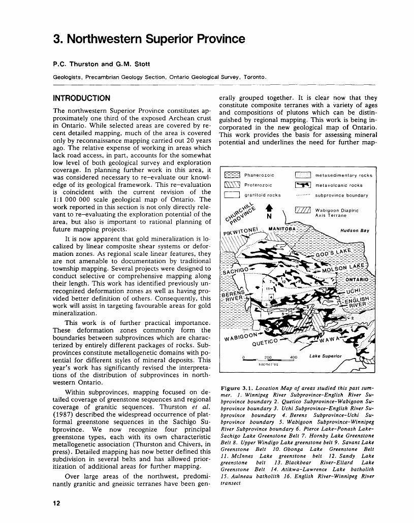
3. Northwestern Superior Province
P.C. Thurston and G.M. Stott
Geologists, Precambrian Geology Section, Ontario Geological Survey, Toronto.
INTRODUCTION
The northwestern Superior Province constitutes ap proximately one third of the exposed Archean crust in Ontario. While selected areas are covered by re cent detailed mapping, much of the area is covered only by reconnaissance mapping carried out 20 years ago. The relative expense of working in areas which lack road access, in part, accounts for the somewhat low level of both geological survey and exploration coverage. In planning further work in this area, it was considered necessary to re-evaluate our knowl edge of its geological framework. This re-evaluation is coincident with the current revision of the 1:1 000 000 scale geological map of Ontario. The work reported in this section is not only directly rele vant to re-evaluating the exploration potential of the area, but also is important to rational planning of future mapping projects.
It is now apparent that gold mineralization is lo calized by linear composite shear systems or defor mation zones. As regional scale linear features, they are not amenable to documentation by traditional township mapping. Several projects were designed to conduct selective or comprehensive mapping along their length. This work has identified previously un recognized deformation zones as well as having pro vided better definition of others. Consequently, this work will assist in targeting favourable areas for gold mineralization.
This work is of further practical importance. These deformation zones commonly form the boundaries between subprovinces which are charac terized by entirely different packages of rocks. Sub provinces constitute metallogenetic domains with po tential for different styles of mineral deposits. This year's work has significantly revised the interpreta tions of the distribution of subprovinces in north western Ontario.
Within subprovinces, mapping focused on de tailed coverage of greenstone sequences and regional coverage of granitic sequences. Thurston et al. (1987) described the widespread occurrence of plat- formal greenstone sequences in the Sachigo Su- bprovince. We now recognize four principal greenstone types, each with its own characteristic metallogenetic association (Thurston and Chivers, in press). Detailed mapping has now better defined this subdivision in several belts and has allowed prior- itization of additional areas for further mapping.
Over large areas of the northwest, predomi nantly granitic and gneissic terranes have been gen
erally grouped together. It is clear now that they constitute composite terranes with a variety of ages and compositions of plutons which can be distin guished by regional mapping. This work is being in corporated in the new geological map of Ontario. This work provides the basis for assessing mineral potential and underlines the need for further map-
Phanerozoic
Proterozoic
granitoid rocks
metasedimentary rocks
metavolcanic rocks
subprovince boundary
Wabigoon Diapiric Axis Terrane
Figure 3.1. Location Map of areas studied this past sum mer. 1. Winnipeg River Subprovince-English River Su bprovince boundary 2. Quetico Subprovince-Wabigoon Su bprovince boundary 3. Uchi Subprovince-English River Su bprovince boundary 4. Berens Subprovince-Uchi Su bprovince boundary 5. Wabigoon Subprovince-Winnipeg River Subprovince boundary 6. Pierce Lake-Ponash Lake- Sachigo Lake Greenstone Belt 7. Hornby Lake Greenstone Belt 8. Upper Windigo Lake greenstone belt 9. Savant Lake Greenstone Belt 10. Obonga Lake Greenstone Belt 11. Mcinnes Lake greenstone belt 12. Sandy Lake greenstone belt 13. Blackbear River-Ellard Lake Greenstone Belt 14. Atikwa-Lawrence Lake batholith 15. Aulneau batholith 16. English River-Winnipeg River transect
P. C. THURSTON AND G.M. STOTT
ping coverage. In addition, the improved under standing of pluton evolution assists in the re-ap praisal of the tectonic framework of the Superior Province.
SUBPROVINCE BOUNDARY RELATIONSHIPS
Subprovince boundaries are delineated by lithologi- cal, metamorphic, or structural discontinuities. They are often marked by the development of regional scale dextral shear zones. Some represent a shift in PT conditions from the greenschist to subgreenschist conditions of granite-greenstone subprovinces to the amphibolite to granulite conditions of sedimentary and gneissic subprovinces. The major shears them selves and secondary splays are a major control on the locus of Archean lode gold deposits (Colvine et al. 1988). Therefore, in an effort to accurately lo cate the major subprovince boundaries and assess their mineral potential, projects were established to examine the following areas:
1. The English River-Winnipeg River Subprovince boundary (Sanborn-Barrie, this volume) (Fig ure 3.1) has been known as a prominent lithologic boundary between metasediments of the English River Subprovince and intrusive, gneissic, and granitoid rocks of the Winnipeg River Subprovince, but was not previously iden tified as a structural discontinuity (Breaks et al. 1978; Beakhouse 1985). The present project has shown that the boundary is a major defor mation zone which apparently extends for sev eral hundred kilometres. Along its length, meta morphic and structural styles vary. Amphibolite facies conditions with steep dips prevail in the west at Separation Lake, while areas of recum bent folding subjected to granulite facies condi tions are found at the eastern part of Lac Seul. The presence of the remains of the Separation Lake Greenstone Belt through the length of the shear zone suggests the Winnipeg River Su bprovince may be a deep level granite- greenstone subprovince rather than a plutonic terrane. As well, the Bird River granite- greenstone subprovince of Card and Ciesielski (1986) may be a higher erosional level of the Winnipeg River Subprovince.
2. The Quetico-Wabigoon Subprovince boundary in the eastern Wabigoon Subprovince at Beardmore-Geraldton (Figure 3.1) has been the object of a structural-metallogenic study (cf. Williams 1987). This work, in addition to identi fying major controls of gold mineralization asso ciated with the major shear system separating the two subprovinces, has resulted in the devel opment of a new tectonic model for the Quetico Subprovince as an accretionary prism (Percival and Williams, in press).
3. The boundary between the Uchi Subprovince and the English River Subprovince (Figure 3.1) to the south is the locus of the Sydney Lake- Lake St. Joseph Fault Zone first described by Stone (1981); the zone extends from Lake Win nipeg through to Lake St. Joseph (Stott 1985). Reconnaissance examination of this feature re vealed a similar structural regime to that devel oped for the Winnipeg River-English River boundary. This regime comprises moderately to vertically plunging lineations on steep fabrics in domain one, which, in a second domain, are ro tated to shallower plunging attitudes by later de formation along the shear zone. Again, the structures and lithologies suggest juxtaposition late in the deformation history of the sedimen tary terrane against the Uchi Subprovince.
4. The Berens Subprovince (Card and Ciesielski 1986) is a plutonic subprovince north of the Uchi granite-greenstone Subprovince. Investiga tions by Stone (this volume) and Cortis et al. (this volume) suggest that there is no conven tional shear zone boundary between these two domains (Figure 3.1). The distribution.of meta morphic grade and structures and geometry of the plutonic rocks suggests that the Berens Su bprovince may represent a deeper crustal level of a granite-greenstone subprovince. The north- trending stratigraphy and elongation of plutons is most directly related to the trend of the Sachigo and northern Uchi Subprovince greenstone belts.
5. The Wabigoon-Winnipeg River Subprovince boundary (Figure 3.1) zone was examined in the area of Sioux Lookout (Beakhouse, this vol ume) where out-of-sequence stratigraphy and the heterogeneous distribution of strain within supracrustal sequences suggests this boundary zone includes allochthonous stratigraphy.
GREENSTONE BELTS
In last year's volume, Thurston and co-workers (1987) described a new type of greenstone sequence containing basal quartz arenites overlain by iron for mation and komatiites which are compared to mod ern shallow water platform sequences. These se quences occur in every major greenstone belt in Sachigo Subprovince leading to the suggestion that the Sachigo Subprovince forms a sialic nucleus around which the subprovinces to the south accumu lated. The platform sequences are older than the mafic to felsic cyclical volcanics and contain a com pletely different assemblage of mineralization (Thurston and Chivers, in press). The quartz arenites have potential for detrital uranium and gold (Roscoe and Donaldson 1988), the iron formations contain iron and potential manganese deposits (e.g. Steeprock Lake (Joliffe 1955)), and the overlying volcanics have potential for volcanogenic nickel de posits (Naldrett and Gasparrini 1971). Therefore,
13
PRECAMBRIAN (3)
several greenstone belts which have not been mapped recently were examined in the search for possible platform sequences (Cortis et al., this vol ume) in order to
1. develop stratigraphic models for complex belts (e.g. Savant Lake-Thurston et al. 1987)
2. locate possible older greenstone belts given the ^.85 Ga age of all dated platform sequences (Thurston and Chivers, in press)
3. ascertain whether the Berens Subprovince is dis tinct from the Uchi and Sachigo subprovinces in terms of greenstone stratigraphy
The results of these studies are as follows:
1. Quartz arenite bearing platform sequences were found at Sachigo Lake and Hornby Lake in the Sachigo and Berens subprovinces respectively (Figure 3.1).
2. A quartz arenite and conglomerate-bearing red bed sequence indicative of subaerial oxidizing conditions was found in the Jutten Group, the lower stratigraphic unit of the Savant Lake Greenstone Belt (Trowell 1986) (Figure 3.1).
3. In the Obonga Greenstone Belt (Thurston 1967) south of Armstrong within the Wabigoon Diapiric Axis (Thurston and Davis 1985) (Fig ure 3.1), an unconformity between the basal ba saltic flows of the greenstone belt and the under lying granitoid rocks was discovered. By com parison with the Steeprock Group within the Wabigoon Diapiric Axis, which lies unconfor- mably upon ~3 Ga granitoids (Davis and Jack son 1988), there is a possibility this sequence is older than 2.7 Ga.
4. The Mcinnes Lake Greenstone Belt (Figure 3.1) was remapped by Cortis et al. (this vol ume) . While platform sequences were not recog nized, the mapping showed that the belt consists of three mafic to felsic volcanic cycles. The vol ume of rhyolitic material and coarse nature of the pyroclastics suggests possible base-metal mi neralization potential.
5. Reconnaissance of the Swan Lake and Black bear River-Ellard Lake greenstone belts (Figure 3.1) revealed basaltic and minor rhyolitic metavolcanics with no platformal association (Osmani and Stott, this volume). The belts are complexly folded and are cut by shearing, re lated to the southeast-trending Kenyon Struc ture (Wilson 1971), and the Stull Lake - Wun nummin Lake Fault Zone at Swan Lake (Os mani and Stott, this volume).
Several conclusions can be drawn from the greenstone investigations:
1. Platform sequence greenstones prevail in the Sachigo, Berens, and Wabigoon Diapiric Axis suggesting these areas represent older blocks
and may all represent independent sub provinces.
2. The northerly trend of plutonic units and greenstone remnants in the Berens Subprovince and northern part of the Uchi Subprovince and the lack of a discrete shear boundary between the Berens and Uchi subprovinces suggests the Berens Subprovince may simply be a deeper crustal level of a granite-greenstone su- bprovince. Substantial revisions to Subprovince boundaries may be required.
3. The prevalence of platform sequences with an entirely different metallogeny suggests explora tion ought to concentrate on platform sequence deposit types: gold, uranium, tungsten, barium, boron, iron, manganese, and nickel. The indi cated older age of these sequences suggests more than one age of shear-related gold deposits may be present. If so, the later shear zones may tran sect old granitoid units as well as supracrustal.
4. The coarse rhyolitic pyroclastics in the Mcinnes Lake Greenstone Belt may have volcanogenic massive sulphide potential.
GRANITOID ROCKS
Granitic rocks in Precambrian shields throughout the world consist of pretectonic gneissic and foliated tonalites succeeded by syntectonic to posttectonic tonalites to monzonites and finally posttectonic potassic granitoids. Field relations in the Superior Province are consistent with this pattern. We are generally able to erect a field-based chronology of granitoid rocks, but we cannot at this time substanti ate this progression with chemical and geochronologic data. We are attempting to provide this type of documentation for granitoids in granite- greenstone subprovinces, plutonic subprovinces, and sedimentary subprovinces. To facilitate this, Beak house (this volume) concentrated upon the Atikwa- Lawrence and Aulneau batholiths (Figure 3.1) in the Western Wabigoon Subprovince and the granitoids of part of the Winnipeg River Su bprovince. Breaks (this volume) examined a tran sect through the English River and Winnipeg River subprovinces (Figure 3.1) which included granitoid rocks of gneissic and metasedimentary terranes.
In metasedimentary subprovinces particularly, the succession of granitoid types is well established (Breaks e t al. 1978), but we cannot relate intrusive events to the chronology of metamorphic events which give rise to peraluminous granites. Breaks de scribes multiple metamorphic pulses and three epi sodes of emplacement of peraluminous S-type gran ites within the English River Subprovince. These granites occur at a variety of crustal levels from catazonal to mesozonal. Anomalous background gold concentrations have been observed within S- type granites in a metasedimentary gneiss in Sachigo Subprovince (Breaks et al. 1986). Therefore, given
14
P.O. THURSTON AND G.M. STOTT
the anomalous gold environment and the demon strated rare metal and uranium potential of this suite (Breaks et al. 1978), it is important to know which generation of granite is most likely to be mineralized and which crustal level is most favourable.
Within the granite-greenstone subprovinces, the following new observations were made:
1. Early granitoid units in the Wabigoon Diapiric Axis, such as the Marmion complex (Davis and Jackson 1988), are more extensive than be lieved previously. Given the gold association with this rock type (Patterson et al. 1986), fol low up work on any potential shear zones within tonalites in areas such as at Upsala (Beakhouse, this volume) may be warranted.
2. Magma mixing textures are associated with plati num group element deposits at Lac des Iles (Sutcliffe" 1986). These textures have been noted in the Atikwa-Lawrence batholith (Davis and Edwards 1985; Beakhouse, this volume). Therefore, gabbroic bodies related to large late granitoid complexes in the western Wabigoon Subprovince have potential for this type of mi neralization.
The ages of granitoids in the Winnipeg River Su bprovince do not correspond with known ages of volcanism or plutonism in the Uchi and Wabigoon subprovinces save for the latest episodes (Corfu 1988). The oldest unit, a gneissic tonalite 3170 Ma in age in the Cedar Lake Dome, contains inclusions of metavolcanics. Therefore, the oldest lithologies in this subprovince have not yet been delineated. In fact, Breaks (this volume) indicates that the Decep tion Bay Gneissic Complex may be older than the dated 3 Ga gneisses (Krogh et al. 1976) at Sen Bay. Given the competence of tonalitic rocks, identifica tion of old tonalites is critical from evolutionary and metallogenic perspectives. The old tonalites form an excellent host for shear-related lode gold, e.g. the 3 Ga Marmion Lake Batholith (Patterson et al. 1986). Therefore, development of methods for identification of large blocks of old granitoids is use ful in pointing toward areas worthy of exploration attention. As well, knowledge of age relationships in tonalitic areas will lead to recognition of any shear systems through identification of discontinuities in age and rock type.
These studies must also address whether specific ages of granitoids at particular crustal levels are pro spective for given styles of mineralization such as high-level plutons within greenstones for porphyry copper-molybdenum.
SHEAR ZONES
In addition to subprovince boundaries, shear zones occur in the following settings:
1. as major boundaries within greenstone belts, e.g. the Kirkland-Larder Lake Break
2. near pluton boundaries as a result of contact strain during pluton emplacement or collisional events (Stott and Smith 1988)
3. as late sigmoidal structures transecting the Uchi, Berens, and Sachigo subprovinces described by Osmani and Stott (this volume)
All of the above shear zone types control gold mi neralization in various parts of the Superior Prov ince. However, the last type of shear zone is most important because this type is quite large and rela tively unexplored. Examples of deposits hosted by sigmoidal shear zones are the Golden Patricia De posit and the Sachigo River Mine, which provide ample demonstration of the importance of these late shear zones as a structural type controlling a new class of gold deposits.
Shear zones corresponding to major tectonic boundaries between subprovinces are probably the most important type of shears from both an evolu tionary and metallogenic standpoint. These struc tures separate blocks with different metallogeny, li thology, and age. The shear zones represent varying ages of development (Stott et al. 1987), younging more or less systematically southward across the Su perior Province. Subdivision of the shield on a geochronological basis will allow better overall un derstanding resulting in some ability to do predictive metallogenic work.
SUBPROVINCIAL SUBDIVISION OF SUPERIOR PROVINCEThe programs described in the following section of this volume have brought about several changes in the large scale subdivision of the Superior Province. The follow-up work on platform sequences and re connaissance of the Berens Subprovince have sug gested the Berens Subprovince may not be a con ventional fault-bounded subprovince with distinct li thologies, structures, and distribution of ages. The Winnipeg River Subprovince may be more appropri ately considered as a granite-greenstone terrane in that no southern tectonic boundary to the Separa tion Lake Greenstone Belt has been found, which should be the case if the belt is part of the fault- bounded Bird River Subprovince. This brings into question the independent existence of the Bird River Subprovince of Card and Ciesielski (1986).
SUMMARYThis group of projects has identified new lithostratigraphic associations in the greenstone envi ronment with distinctive metallogeny. Future work will involve seeking indications of tungsten, boron, and barium mineralization in platform sequences.
The granitoid work will allow characterization of plutonism in granite-greenstone and gneissic blocks.
The concentration upon subprovince boundaries will lead toward a terrane-based analysis of the Su-
15
PRECAMBRIAN (3)
perior Province. The major blocks will be subdivided into a variety of terrane types now that distinct greenstone and sedimentary belt environments have been identified. Assessment of the scale of the strain pattern over large greenstone belts will provide a clearer picture of the association of the late defor mation with major shear zones. An irregular south ward younging of the second deformation has been proposed (Stott et al. 1987). Upon completion of terrane analysis, this age progression will perhaps permit discussion of the Superior Province assembly in terms of terrane amalgamation and major colli sion of subprovinces. This is of critical importance in gold metallogeny for it may disclose the presence of multiple gold mineralizing events.
REFERENCES
Beakhouse, G.P.1985: The Relationship of Supracrustal Sequences to a
Basement Complex in the Western English River Su- bprovince; p. 169-178 in The Evolution of Archean Supracrustal Sequences, edited by L.D. Ayres, P.C. Thurston, K.D. Card, and W. Weber, Geologi cal Association of Canada, Special Paper 28.
Breaks, F.W., Bond, W.D., and Stone, D.1978: Preliminary Geological Synthesis of the English River
Subprovince, Northwestern Ontario and its Bearing upon Mineral Exploration; Ontario Geological Sur vey, Miscellaneous Paper 72, 55p.
Breaks, F.W., Osmani, I.A., and deKemp, E.A.
1986: Opapimiskan Lake Project: Precambrian Geology of the Opapimiskan-Forester Lakes Area, District of Kenora, Patricia Portion; p.368-378 in Summary of Field Work and Other Activities 1986, by the Ontario Geological Survey, edited by P.C. Thurston, Owen L. White, R.B. Barlow, M.E. Cherry, and A.C. Col vine, Ontario Geological Survey, Miscellaneous Paper 132, 435p. Accompanied by l Chart.
Card, K.D., and Ciesielski, A.1986: DNAG #1: Subdivisions of the Superior Province of
the Canadian Shield; Geoscience Canada, Volume13, p.5-13.
Colvine, A.C., Fyon, J.A., Heather, K.B., Marmont, S., Smith, P.M., and Troop, D.G.
1988: Archean Lode Gold Deposits in Ontario; Ontario Geological Survey, Miscellaneous Paper, 139, 136p.
Corfu, F.
1988: Differential Response of U-Pb Systems in Coexisting Accessory Minerals, Winnipeg River Subprovince, Canadian Shield: Implications for Archean Crustal Growth and Stabilization; Contributions to Mineralogy and Petrology, Volume 98, Number 3, p.312-325.
Davis, D.W., and Edwards, G.R.1985: The Petrogenesis and Metallogenesis of the Atikwa-
Lawrence Volcanic-Plutonic Terrain; p. 101-111 in Geoscience Research Grant Program, Summary of Re search 1984-1985, edited V.G. Milne, Ontario Geo logical Survey Miscellaneous Paper 127, 246p.
Davis, D.W., and Jackson, M.C.1988: Geochronology of the Lumby Lake Greenstone Belt: A
3 Ga Complex Within the Wabigoon Subprovince, Northwest Ontario; Geological Society of America Bulletin, Volume 100, Number 6, p.818-824.
Jolliffe, A.W.1955: Geology and Iron Ores of Steep Rock Lake; Economic
Geology, Volume 50, Number 4, p.3-398.
Krogh, T.E., Harris, N.B.W., and Davis, G.L.1976: Archean Rocks from the Eastern Lac Seul Region of
the English River Gneiss Belt, Northwestern Ontario, Part 2. Geochronology; Canadian Journal of Earth Sciences, Volume 13, p. 1212-1215.
Naldrett, A.J., and Gasparrini, E.L.1971: Archaean Nickel Sulphide Deposits in Canada: their
Classification, Geological Setting and Genesis with Some Suggestions as to Exploration; p.201-226 in Special Publication 3, Geological Society of Australia, edited by J.E. Glover.
Patterson, G.C., Scott, J.F., Mason, J.K., Schnieders, B.R., MacTavish, A.D., Dutka, R.J.A., Kennedy, M.C., White, G.D., and Hinz, P.
1986: Thunder Bay Resident Geologist's Area, North Cen tral Region; p.72-127 in Report of Activities 1986, Regional and Resident Geologists, edited by C.R. Kustra, Ontario Geological Survey, Miscellane ous Paper 134, 322p.
Percival, J.A., and Williams, H.R.In Press: The Late Archean Quetico Accretionary Complex,
Superior Province, Canada; Geology.
Roscoe; S.M., and Donaldson, J.A.1988: Uraniferous Pyritic Quartz Pebble Conglomerate and
Layered Ultramafic Intrusions in a Sequence of Quartzite, Carbonate, Iron Formation and Basalt of Probable Archean Age at Lac Sakami, Quebec; in Current Research Part C, Geological Survey of Can ada, Paper 88-1C, p.117-121.
Stone, D.1981: The Sydney Lake Fault zone in Ontario and
Manitoba, Canada; Unpublished Ph.D. Thesis, Uni versity of Toronto, Ontario, 146p.
Stott, G.M.1985: Regional Stratigraphy and Structure of the Lake St.
Joseph Area, Central Uchi Subprovince; p.26-35 in Summary of Field Work and Other Activities 1985, Ontario Geological Survey, edited by John Wood, Owen L. White, R.B. Barlow, and A.C. Colvine, Ontario Geological Survey, Miscellaneous Paper 126, 351p.
Stott, G.M., Sanborn-Barrie, M., and Corfu, F.1987: Major Transpression Events Recorded Across Ar
chean Subprovince Boundaries in Northwestern Ont ario; Geological Association of Canada, Yellowknife '87, Program with Abstracts.
Stott, G.M., and Smith, P.M.1988: Development of Gold-bearing Structures in the Ar
chean: the Role of Granitic Plutonism; Bicentennial Gold 88, Extended Abstracts Poster Program, 1:48-50, Geological Society of Australia, Melbourne.
Sutcliffe, R.H.1986: Regional Geology of the Lac des Iles Area, District of
Thunder Bay; p.70-75 in Summary of Field Work
16
P. C. THURSTON AND G.M. STOTT
and Other Activities 1986, by the Ontario Geological Survey, edited by P.C. Thurston, Owen L. White, R.B. Barlow, M.E. Cherry, and A.C. Colvine, Ont ario Geological Survey, Miscellaneous Paper 132, 435p. Accompanied by l Chart.
Thurston, P.C.1967: Obonga-Leigh Lakes Area, (West Half), District of
Thunder Bay; p.29-31 in Summary of Field Work 1967, edited by E.G. Pye, Geological Branch, Ont ario Department of Mines, Miscellaneous Paper 11, 73p.
Thurston, P.C., and Chivers, K.M.In Press: Secular Variation in Greenstone Sequence Develop
ment Emphasizing Superior Province, Canada; Pre cambrian Research.
Thurston, P.C., Cortis, A.L., and Chivers, K.M.1987: A Reconnaissance Re-evaluation of a Number of
Northwestern Greenstone belts: Evidence for an Early Archean Sialic Crust; p.4-24 in Summary of Field Work and Other Activities 1987, by the Ontario Geo logical Survey, edited by R.B. Barlow, M.E. Cherry, A.C. Colvine, B.O. Dressler, and O.L. White, Ont ario Geological Survey Miscellaneous Paper 137,
- 429p.
Thurston, P.C., and Davis, D.W.1985: The Wabigoon Diapiric Axis as a Basement Complex;
p. 138-142 in Summary of Field Work 1985, Ontario Geological Survey, edited by John Wood, Owen L. White, R.B. Barlow, and A.C. Colvine, Ontario Geological Survey, Miscellaneous Paper 126, 351p.
Trowell, N.F.1986: Geology of the Savant Lake Area, Districts of Kenora
and Thunder Bay; Ontario Geological Survey, Open File Report 5606, 18Ip, 15 figures, 17 tables, and 2 maps.
Williams, H.R.1987: Structural Studies in the Beardmore-Geraldton Belt
and in the Quetico and Wawa Subprovinces; p.90-92 in Summary of Field Work and Other Activities 1987, by the Ontario Geological Survey, edited by R.B. Bar low, M.E. Cherry, A.C. Colvine, B.O. Dressler, and O.L. White, Ontario Geological Survey, Miscel laneous Paper 137, 429p.
Wilson, H.D.B.1971: The Superior Province in the Precambrian of
Manitoba; in Geoscience Studies in Manitoba, edited by A.C. Turnock, Geological Association of Canada, Special Paper 9, p.41-49.
17
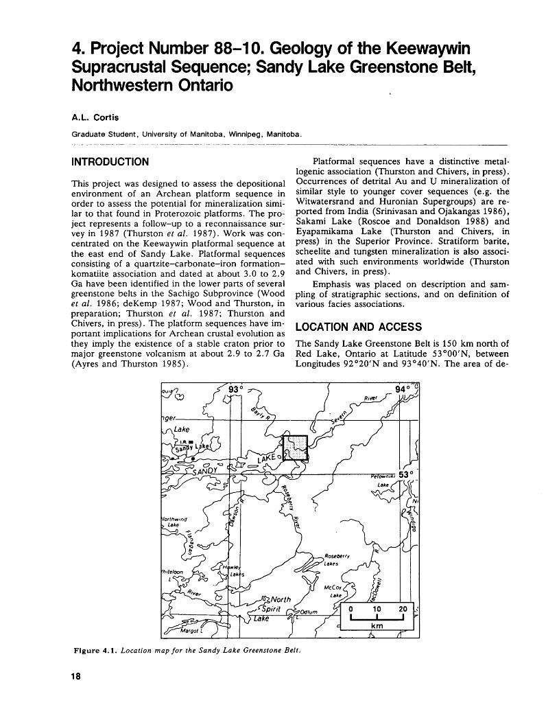
4. Project Number 88-10. Geology of the Keewaywin Supracrustal Sequence; Sandy Lake Greenstone Belt, Northwestern Ontario
A. L. Cortis
Graduate Student, University of Manitoba, Winnipeg, Manitoba.
INTRODUCTION
This project was designed to assess the depositional environment of an Archean platform sequence in order to assess the potential for mineralization simi lar to that found in Proterozoic platforms. The pro ject represents a follow-up to a reconnaissance sur vey in 1987 (Thurston et al. 1987). Work was con centrated on the Keewaywin platformal sequence at the east end of Sandy Lake. Platformal sequences consisting of a quartzite-carbonate-iron formation- komatiite association and dated at about 3.0 to 2.9 Ga have been identified in the lower parts of several greenstone belts in the Sachigo Subprovince (Wood et al. 1986; deKemp 1987; Wood and Thurston, in preparation; Thurston et al. 1987; Thurston and Chivers, in press). The platform sequences have im portant implications for Archean crustal evolution as they imply the existence of a stable craton prior to major greenstone volcanism at about 2.9 to 2.7 Ga (Ayres and Thurston 1985).
Platformal sequences have a distinctive metal logenic association (Thurston and Chivers, in press). Occurrences of detrital Au and U mineralization of similar style to younger cover sequences (e.g. the Witwatersrand and Huronian Supergroups) are re ported from India (Srinivasan and Ojakangas 1986), Sakami Lake (Roscoe and Donaldson 1988) and Eyapamikama Lake (Thurston and Chivers, in press) in the Superior Province. Stratiform barite, scheelite and tungsten mineralization is also associ ated with such environments worldwide (Thurston and Chivers, in press).
Emphasis was placed on description and sam pling of stratigraphic sections, and on definition of various facies associations.
LOCATION AND ACCESS
The Sandy Lake Greenstone Belt is 150 km north of Red Lake, Ontario at Latitude 53 0 00'N, between Longitudes 92 0 20'N and 93 0 40'N. The area of de-
Figure 4.1. Location map for the Sandy Lake Greenstone Belt.
18
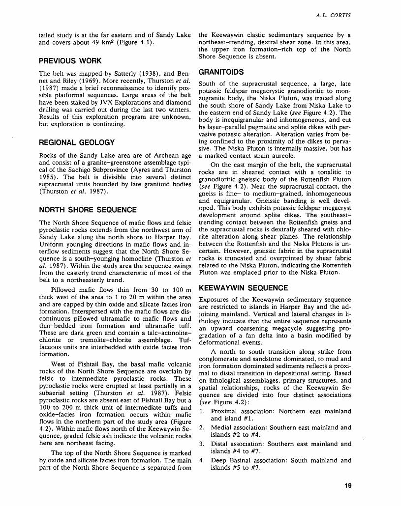
A.L. CORTIS
tailed study is at the far eastern end of Sandy Lake and covers about 49 km2 (Figure 4.1).
PREVIOUS WORK
The belt was mapped by Satterly (1938), and Ben net and Riley (1969). More recently, Thurston et al. (1987) made a brief reconnaissance to identify pos sible platformal sequences. Large areas of the belt have been staked by JVX Explorations and diamond drilling was carried out during the last two winters. Results of this exploration program are unknown, but exploration is continuing.
REGIONAL GEOLOGY
Rocks of the Sandy Lake area are of Archean age and consist of a granite-greenstone assemblage typi cal of the Sachigo Subprovince (Ayres and Thurston 1985). The belt is divisible into several distinct supracrustal units bounded by late granitoid bodies (Thurston et al. 1987).
NORTH SHORE SEQUENCE
The North Shore Sequence of mafic flows and felsic pyroclastic rocks extends from the northwest arm of Sandy Lake along the north shore to Harper Bay. Uniform younging directions in mafic flows and in terflow sediments suggest that the North Shore Se quence is a south-younging homocline (Thurston et al. 1987). Within the study area the sequence swings from the easterly trend characteristic of most of the belt to a northeasterly trend.
Pillowed mafic flows thin from 30 to 100 m thick west of the area to l to 20 m within the area and are capped by thin oxide and silicate facies iron formation. Interspersed with the mafic flows are dis continuous pillowed ultramafic to mafic flows and thin-bedded iron formation and ultramafic tuff. These are dark green and contain a talc-actinolite- chlorite or tremolite-chlorite assemblage. Tuf faceous units are interbedded with oxide facies iron formation.
West of Fishtail Bay, the basal mafic volcanic rocks of the North Shore Sequence are overlain by felsic to intermediate pyroclastic rocks. These pyroclastic- rocks were erupted at least partially in a subaerial setting (Thurston et al. 1987). Felsic pyroclastic rocks are absent east of Fishtail Bay but a 100 to 200 m thick unit of intermediate tuffs and oxide-facies iron formation occurs within mafic flows in the northern part of the study area (Figure 4.2). Within mafic flows north of the Keewaywin Se quence, graded felsic ash indicate the volcanic rocks here are northeast facing.
The top of the North Shore Sequence is marked by oxide and silicate facies iron formation. The main part of the North Shore Sequence is separated from
the Keewaywin clastic sedimentary sequence by a northeast-trending, dextral shear zone. In this area, the upper iron formation-rich top of the North Shore Sequence is absent.
GRANITOIDS
South of the supracrustal sequence, a large, late potassic feldspar megacrystic granodioritic to mon- zogranite body, the Niska Pluton, was traced along the south shore of Sandy Lake from Niska Lake to the eastern end of Sandy Lake (see Figure 4.2). The body is inequigranular and inhomogeneous, and cut by layer-parallel pegmatite and aplite dikes with per vasive potassic alteration. Alteration varies from be ing confined to the proximity of the dikes to perva sive. The Niska Pluton is internally massive, but has a marked contact strain aureole.
On the east margin of the belt, the supracrustal rocks are in sheared contact with a tonalitic to granodioritic gneissic body of the Rottenfish Pluton (see Figure 4.2). Near the supracrustal contact, the gneiss is fine- to medium-grained, inhomogeneous and equigranular. Gneissic banding is well devel oped. This body exhibits potassic feldspar megacryst development around aplite dikes. The southeast- trending contact between the Rottenfish gneiss and the supracrustal rocks is dextrally sheared with chlo rite alteration along shear planes. The relationship between the Rottenfish and the Niska Plutons is un certain. However, gneissic fabric in the supracrustal rocks is truncated and overprinted by shear fabric related to the Niska Pluton, indicating the Rottenfish Pluton was emplaced prior to the Niska Pluton.
KEEWAYWIN SEQUENCE
Exposures of the Keewaywin sedimentary sequence are restricted to islands in Harper Bay and the ad joining mainland. Vertical and lateral changes in li thology indicate that the entire sequence represents an upward coarsening megacycle suggesting pro gradation of a fan delta into a basin modified by deformational events.
A north to south transition along strike from conglomerate and sandstone dominated, to mud and iron formation dominated sediments reflects a proxi mal to distal transition in depositional setting. Based on lithological assemblages, primary structures, and spatial relationships, rocks of the Keewaywin Se quence are divided into four distinct associations (see Figure 4.2):1. Proximal association: Northern east mainland
and island #1.2. Medial association: Southern east mainland and
islands #2 to #4.3. Distal association: Southern east mainland and
islands #4 to #7.4. Deep Basinal association: South mainland and
islands #5 to #7.
19
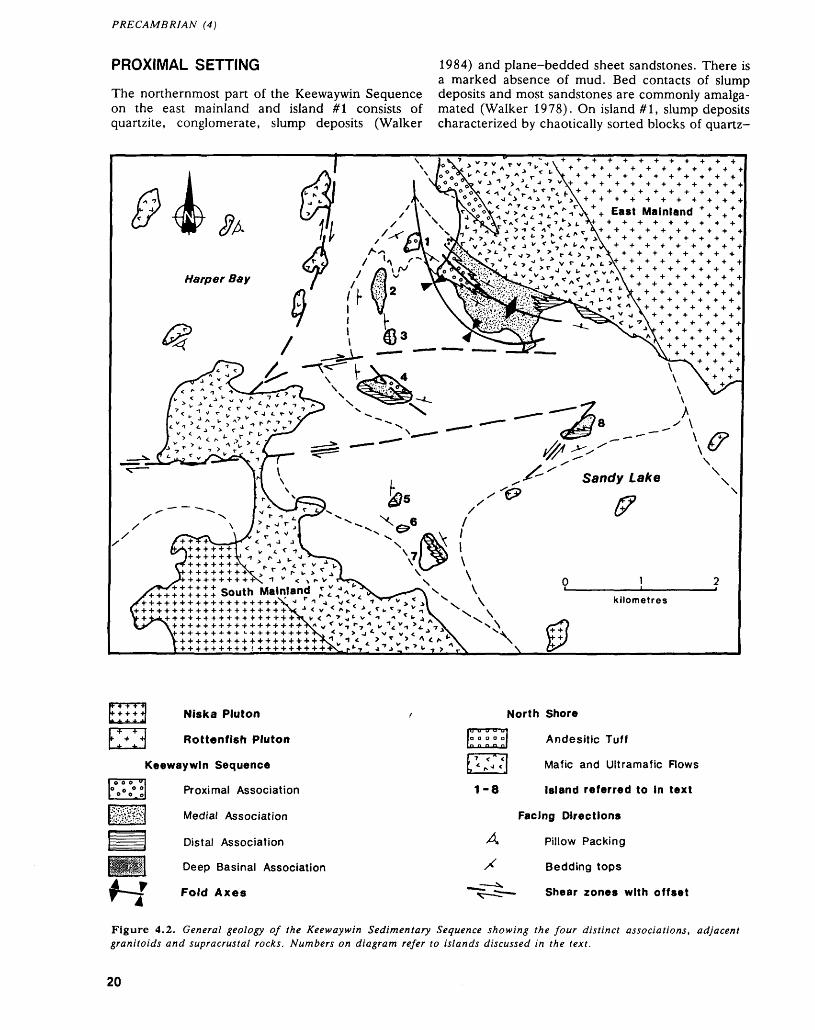
PRECAMBRIAN (4)
PROXIMAL SETTING 1984) and plane-bedded sheet sandstones. There isa marked absence of mud. Bed contacts of slump
The northernmost part of the Keewaywin Sequence deposits and most sandstones are commonly amalga- on the east mainland and island #1 consists of mated (Walker 1978). On island #1, slump deposits quartzite, conglomerate, slump deposits (Walker characterized by chaotically sorted blocks of quartz-
t East Mainland * ** *
Niska Pluton
Rottenfish Pluton
Keewaywin Sequence
Proximal Association
Medial Association
Distal Association
Deep Basinal Association
Fold Axes
1-8
A
North Shore
Andesitic Tuff
Mafic and Ultramafic Flows
Island referred to in text
Facing Directions
Pillow Packing
Bedding tops
Shear zones with offset
Figure 4.2. General geology of the Keewaywin Sedimentary Sequence showing the four distinct associations, adjacent granitoids and supracrustal rocks. Numbers on diagram refer to islands discussed in the text.
20
A.L. CORTIS
rich sediment supported by a quartz-arenite matrix form about 50 percent of the sequence. Massive sandstones with amalgamated beds form about 40 percent, and well defined sheet sandstones 10 per cent. Conglomeratic units are locally present as coarse pebbly horizons in massive sandstones. In contrast, on the east mainland, late dikes occupy up to 60 percent of the rock and sediments only 40 per cent. Slump deposits and sheet sandstones are ab sent.
Sandstones range from quartz-arenite to sub litharenite with lesser litharenites and feldspathic litharenites. Sand-sized lithic grains form at most 15 to 25 percent of the framework. Lithic clasts in the sandstones include: mudstone, aphyric and por phyritic felsic volcanics, chert and vein quartz. Rare, fine-grained plagioclase and chlorite-rich clasts of mafic metavolcanics are present. Framework grains are subrounded to subangular and poorly sorted. Grain size varies from granule to medium sand with rare pebbles and cobbles of vein quartz and chert. Grading is usually absent or only poorly developed. Three types of sandstone units are recognized:
1. quartzarenites associated with conglomerates
2. sheet sandstones associated with slump deposits
3. thick-bedded and massive sandstones
The most mature sands are quartzarenites asso ciated with conglomerates on the east mainland. Quartzarenite sands are buff white and consist of framework quartz with ^ percent sericite matrix ce ment. Bedding thickness ranges from 10 to 100 cm but bedding planes are obscured by amalgamation and deformation. This deformation has resulted in local recrystallization. Beds of quartzarenite are as sociated with litharenites on the east mainland. These quartzarenites have a bimodal texture with two framework quartz populations: well rounded with high sphericity, and angular and immature. Al though primary structures are absent, some quartzarenite beds associated with conglomerates contain a very subtle internal cleavage at about 10 0 to 30 0 to bed planes which may represent subtle cross beds. (L.D. Ayres, Professor, Department of Geology, University of Manitoba, personal commu nication, 1988).
Sheet sandstones are fine to medium sand with well-defined bed planes. Bedding thickness is usu ally 20 to 30 cm but may vary from 5 to 50 cm. Contacts are planar and scours largely absent. Typi cally, fine upper graded portions to beds are absent, although in one locality, beds repeatedly exhibit grading from coarse sand to silt. Usually sheet sand stones form discrete sets of beds up to 10 m thick separating thick slump deposits. However, rare indi vidual thin sandstone beds can separate several metres of slump deposits or discrete conglomerate beds. Primary structures other than faint planar lamination are not observed in these sheet sand stones.
Thick-bedded and massive sandstone units form the bulk of the sandstones. They are distinguished from sheet sandstones by coarser grain size (coarse to granule sand) and amalgamation of most bed con tacts. Average bed thickness is 60 to 70 cm. Sorting is poorly developed, therefore, top determination is difficult. Generally they tend to form monotonous units tens of metres thick. Rarely, a thick bed of very coarse sandstone is interbedded with sheet sandstones or conglomerates. Some beds exhibit a red staining of the matrix, usually toward the base, probably indicative of enrichment of iron-bearing detrital heavy minerals (L.D. Ayres, Professor, De partment of Geology, University of Manitoba, per sonal communication, 1988).
Slump deposits are extremely thickly bedded, poorly sorted units in which clasts and blocks of quartz-rich sediment are supported by a quartz arenite matrix. These units occur randomly through out the section on the northernmost island in the study area, but are not seen elsewhere. Commonly, slumps are laterally discontinuous and 2 to 30 m thick. As slump units may contain horizons with dis tinct clast sizes, the thicker slump units may repre sent amalgamation of several deposits. Clast types and the quartzarenite matrix of the slump deposits are similar to adjacent unslumped sandstones de scribed above. The fragments are matrix-supported quartzwackes and quartzarenites, usually with ^5 percent framework grains. The matrix of the frag ments is a very fine-grained chlorite or carbonate- chlorite assemblage. The enclosing sandstone is ^5 percent framework grains in a well-developed con tact framework. This matrix difference reflects a pri mary difference in diagenetic processes and suscepti bility to alteration.
Although conglomerates occur throughout the sedimentary sequence, only in the proximal setting do they form discrete units. Two types of conglomer ate are recognized in the proximal setting;1. conglomeratic sandstones2. bedded conglomerates
1. Poorly sorted, pebble to cobble conglomeratic sandstones are intercalated with sheet sands and slump deposits on island #1. They form ^ percent of the sequence and are randomly distributed. Clast lithologies are identical to lithic components in the associated sandstones. They are distinguished from pebbly sandstones (Walker 1984) by the presence of ^ percent cobble-sized clasts and the lack of grad ing within the beds. Large clasts rarely exceed 10 percent of the rock. Beyond a coarser average grain size (very coarse granule sand), the sand-sized grains are identical to adjoining massive sandstones. The coarser grained nature of the conglomerates relative to the sandstones simply reflects a higher en ergy of deposition for these beds.
2. Bedded conglomerates are dominant, forming a ^0 to -ciO m wedge on the east mainland. The wedge lies within generally ungraded, medium- to
21
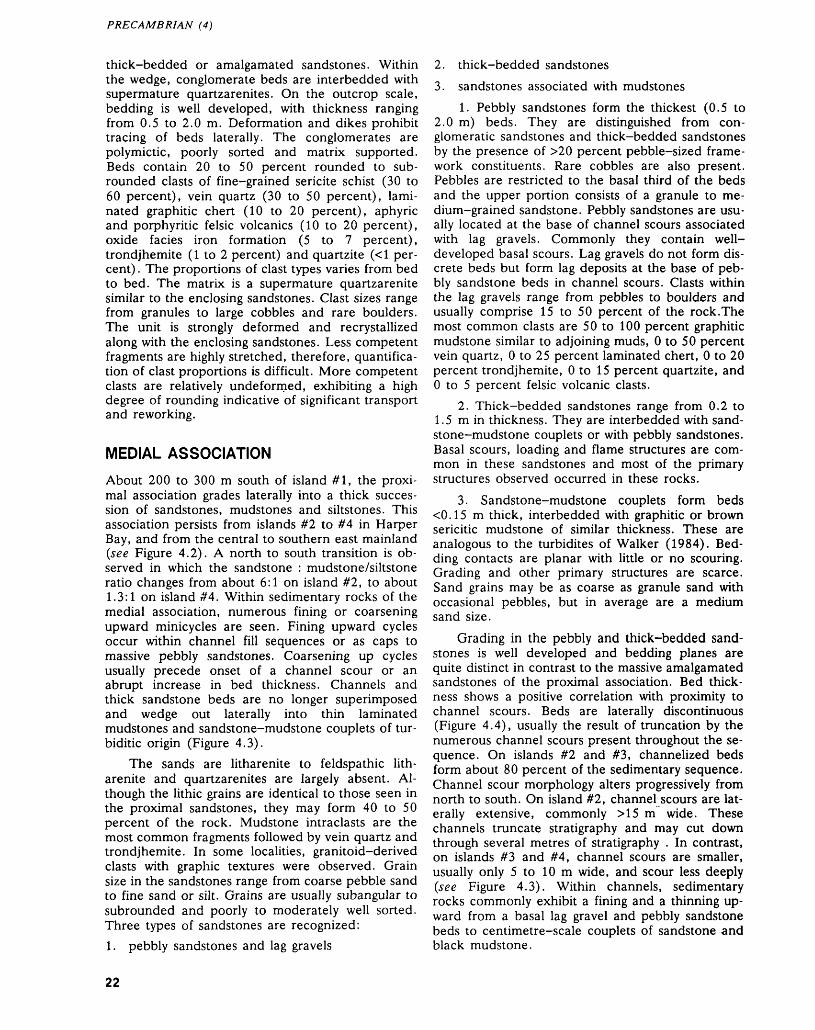
PRECAMBRIAN (4)
thick-bedded or amalgamated sandstones. Within the wedge, conglomerate beds are interbedded with supermature quartzarenites. On the outcrop scale, bedding is well developed, with thickness ranging from 0.5 to 2.0 m. Deformation and dikes prohibit tracing of beds laterally. The conglomerates are polymictic, poorly sorted and matrix supported. Beds contain 20 to 50 percent rounded to sub rounded clasts of fine-grained sericite schist (30 to 60 percent), vein quartz (30 to 50 percent), lami nated graphitic chert (10 to 20 percent), aphyric and porphyritic felsic volcanics (10 to 20 percent), oxide facies iron formation (5 to 7 percent), trondjhemite (l to 2 percent) and quartzite (*:1 per cent) . The proportions of clast types varies from bed to bed. The matrix is a supermature quartzarenite similar to the enclosing sandstones. Clast sizes range from granules to large cobbles and rare boulders. The unit is strongly deformed and recrystallized along with the enclosing sandstones. Less competent fragments are highly stretched, therefore, quantifica tion of clast proportions is difficult. More competent clasts are relatively undeformed, exhibiting a high degree of rounding indicative of significant transport and reworking.
MEDIAL ASSOCIATION
About 200 to 300 m south of island #1, the proxi mal association grades laterally into a thick succes sion of sandstones, mudstones and siltstones. This association persists from islands #2 to #4 in Harper Bay, and from the central to southern east mainland (see Figure 4.2). A north to south transition is ob served in which the sandstone : mudstone/siltstone ratio changes from about 6:1 on island #2, to about 1.3:1 on island #4. Within sedimentary rocks of the medial association, numerous fining or coarsening upward minicycles are seen. Fining upward cycles occur within channel fill sequences or as caps to massive pebbly sandstones. Coarsening up cycles usually precede onset of a channel scour or an abrupt increase in bed thickness. Channels and thick sandstone beds are no longer superimposed and wedge out laterally into thin laminated mudstones and sandstone-mudstone couplets of tur- biditic origin (Figure 4.3).
The sands are litharenite to feldspathic lith arenite and quartzarenites are largely absent. Al though the lithic grains are identical to those seen in the proximal sandstones, they may form 40 to 50 percent of the rock. Mudstone intraclasts are the most common fragments followed by vein quartz and trondjhemite. In some localities, granitoid-derived clasts with graphic textures were observed. Grain size in the sandstones range from coarse pebble sand to fine sand or silt. Grains are usually subangular to subrounded and poorly to moderately well sorted. Three types of sandstones are recognized:
1. pebbly sandstones and lag gravels
2. thick-bedded sandstones
3. sandstones associated with mudstones
1. Pebbly sandstones form the thickest (0.5 to 2.0 m) beds. They are distinguished from con glomeratic sandstones and thick-bedded sandstones by the presence of ^0 percent pebble-sized frame work constituents. Rare cobbles are also present. Pebbles are restricted to the basal third of the beds and the upper portion consists of a granule to me dium-grained sandstone. Pebbly sandstones are usu ally located at the base of channel scours associated with lag gravels. Commonly they contain well- developed basal scours. Lag gravels do not form dis crete beds but form lag deposits at the base of peb bly sandstone beds in channel scours. Clasts within the lag gravels range from pebbles to boulders and usually comprise 15 to 50 percent of the rock.The most common clasts are 50 to 100 percent graphitic mudstone similar to adjoining muds, O to 50 percent vein quartz, O to 25 percent laminated chert, O to 20 percent trondjhemite, O to 15 percent quartzite, and O to 5 percent felsic volcanic clasts.
2. Thick-bedded sandstones range from 0.2 to 1.5 m in thickness. They are interbedded with sand stone-mudstone couplets or with pebbly sandstones. Basal scours, loading and flame structures are com mon in these sandstones and most of the primary structures observed occurred in these rocks.
3. Sandstone-mudstone couplets form beds *c0.15 m thick, interbedded with graphitic or brown sericitic mudstone of similar thickness. These are analogous to the turbidites of Walker (1984). Bed ding contacts are planar with little or no scouring. Grading and other primary structures are scarce. Sand grains may be as coarse as granule sand with occasional pebbles, but in average are a medium sand size.
Grading in the pebbly and thick-bedded sand stones is well developed and bedding planes are quite distinct in contrast to the massive amalgamated sandstones of the proximal association. Bed thick ness shows a positive correlation with proximity to channel scours. Beds are laterally discontinuous (Figure 4.4), usually the result of truncation by the numerous channel scours present throughout the se quence. On islands #2 and #3, channelized beds form about 80 percent of the sedimentary sequence. Channel scour morphology alters progressively from north to south. On island #2, channel scours are lat erally extensive, commonly M5 m wide. These channels truncate stratigraphy and may cut down through several metres of stratigraphy . In contrast, on islands #3 and #4, channel scours are smaller, usually only 5 to 10 m wide, and scour less deeply (see Figure 4.3). Within channels, sedimentary rocks commonly exhibit a fining and a thinning up ward from a basal lag gravel and pebbly sandstone beds to centimetre-scale couplets of sandstone and black mudstone.
22
A.L. CORTIS
Fine laminated mudstone .units
Thin bedded sandstone, siltstone and mudstone-sandstone couplets
CHANNEL SCOUR
-^^^SiiS^^S
Thick to medium bedded coarse sandstone beds
Pebbly sandstone
Dextrally sheared mafic dikes
Figure 4.3. Detailed geology of outcrops on island #4 (see Figure 4.2), showing sedimentary cycles, channel scouring and lateral transitions in lithology.
Grading, plane stratification, trough and planar cross stratification, channel scours and basal scours are common throughout the sequence and indicate abundant traction during current motion. Dish struc tures (Lowe 1975) and hummocky cross-stratifica tion (HCS) are observed. Progressively southward, HCS occurrences exhibit a decrease in amplitude, wavelength, angle of dip of hummock foresets, de gree of basal scouring, and average grain size of the sand. Corresponding to this, an increase in the amount of mud and silt associated with the HCS, and in the relative lateral continuity of the beds is also observed. These changes reflect a progressive proximal to distal transition (Brenchley e t al. 1986).
Mudstones are also prominent in the medial set ting. Two types were recognized: a brown sericite-
rich and a black graphitic mud. These are commonly interlayered on a fine scale but can also form distinct units. Usually mudstone forms distinct units up to 1.5 m thick but they are more frequently present as sandstone-mudstone couplets or as the graded tops of beds. Discrete mudstone beds are uncommon on island #2 but are present on island #3 and south ward.
DISTAL ASSOCIATION
The precise boundary between the medial and distal associations is arbitrary, and based on the appear ance of a 1:1 sand to mud ratio. The distal associa tion is present from island #4 southward to island #7. On island #4, rocks of the medial association grade downward into distal association sedimentary
23
PRECAMBRIAN (4)
PROXIMAL ASSOCIATION
Slump deposits
Conglomerates
Massive A sheet sandstones
MEDIAL ASSOCIATION
Interbedded sandstone lenses, muds and turbidites (Transitional to Distal Association, suprafan lobes)
DISTAL ASSOCIATION
Muds A associated turbidite sands
Strongly channelized pebbly sandstone 4 mudstones (not to scale)
600-1
400
DEEP BASINAL ASSOCIATION
HI-U-: Silicate IF, pelites, muds and mafic tuffs
NORTH SHORE SEQUENCE
Pillowed A massive metavolcanics ( andesitic tuff* IF)
m E
- 200-
Figure 4.4. Schematic cross-section of Keewaywin Sequence, showing proximal to distal transition within 500 m vertically and 5000 to 8000 m laterally, suggesting a moderate size fan (Walker 1984). IF-lron Formation.
rocks. On the south shore of the east mainland, rocks of the medial association grade laterally into the distal association.
Lithologies and primary structures in the distal association are essentially identical to those in the medial association. Conglomerates are absent in the distal setting except for discontinuous concentrations of pebbles at the base of beds filling poorly devel oped scour channels. Pebbly sandstones are largely restricted to thick-bedded sequences. Mudstone- sandstone couplets form up to 80 percent of the se quence and form units up to 80 m thick. Syn sedimentary slumps with irregular folding and de tachment planes are present, especially where muds are spatially associated with sandstone lenses.
On islands #5 and #7, vertical and lateral sec tions reveal a coarsening upward trend from west to east, and south to north in the distal association. The transition from distal to basinal setting is arbi trarily marked by the first appearance of non-pe lagic terrigenous clastic detritus forming thin siltstone and less common sandstone lenses. Over the next
80 m upward, these sandstone layers become in creasingly prominent, from *cl percent to 10 to 15 percent. A corresponding decrease in the proportion of chemical sediment to about 10 percent is ob served. In the lower part of the first 80 m of section, the non-pelagic terrigenous units form lenses of thin-bedded Bouma DE and BDE sequences (Bouma 1962). About 40 m up the section Bouma ABBE and then ABD cycles occur. Usually, Bouma E muds are pelitic, exhibiting a garnet-biotite assem blage. At the base of the 80 m zone, the clastic lenses are enclosed within deep basinal pelagic and chemogenic sediments. Chemical sedimentary rocks disappear entirely about 20 m up section and the bulk of the sedimentary rocks enclosing the sand stone lenses is pelagic mud of the lower fan. About 60 m up the 80m section, the sandstone units begin to coalesce and form relatively continuous sheet-like units interlayered with thick units of laminated mudstones and siltstones. The first channel scours are found here as well as the first occurrence of pla nar cross-bedded sands.
24
A.L. CORTIS
DEEP BASINAL ASSOCIATION
Deep basinal sediments occur on the south mainland and on the west side of islands #5 and #7 (see Figure 4.2). They comprise an interlayered sequence of sili cate-facies iron formation, thinly laminated gra phitic pelagic mudstones, garnet-biotite mudstones, diopside-rich carbonate units and granular tremolite-actinolite-rich laminae (mafic-ultramafic tuff?) or dolomitic mudstone. On the south main land, sedimentary units of the basinal association are interlayered with massive mafic flows. On islands #5 and #7 a monotonous sequence of basinal sedimen tary rocks is about 300 m thick.
STRUCTURAL GEOLOGY
The Keewaywin Sequence and adjoining North Shore volcanic rocks have been subjected to two major phases of deformation and a late shear event.
Early synsedimentary deformation is locally de veloped, .commonly manifested as normal faulting restricted to discrete intervals of stratigraphy, but in several cases, soft sediment deformation of mud stones and iron formation has produced highly con torted folding patterns with distinct detachment planes.
Structural mapping indicates that the early inter pretation of the sequence as a syncline (Thurston et al. 1987) is inadequate. The east and west bounding shear zones show dextral movement, but are related to separate granitoid bodies. Opposed facing direc tions and bedding orientations in the north part of the sequence, and adjoining North Shore Sequence volcanic rocks suggest the presence of an early northwest-trending, southeast-plunging syncline with a minor anticline and syncline developed on the east limb (see Figure 4.2). The west limb of the syn cline extends southward to island #7 whilst the east limb trends roughly eastward. Fabric within sedi ments is largely controlled by proximity to the shear zones. On the east limb of the syncline, foliation is roughly parallel to bedding. On the west limb, folia tion is parallel to S-fabric within the west shear zone and the contact strain aureole of the Niska Pluton. Lineations plunge steeply 60 0 to 70 0 south to south- east with local reversals adjacent to late shear zones.
The early folding has been modified by shearing and associated buckle folding along east-west-trend ing shear zones. This late shearing does not affect rocks north of island #4 however. Axial planar shear has also resulted in local rotation of large segments of stratigraphy. Warping of bed plane orientation from islands #5 to #7 (see Figure 4.2) suggest that megascopic structures adjacent to shear zones ex hibit similar deformation patterns.
On islands #2 to #4, bedding rotates systemati cally from north-south to east-west by incremental changes in strike across intermediate dikes. These
dikes trend parallel to right-lateral fault planes on island #4 and are intensely sheared while the host rock is essentially undeformed. Two S-fabrics are seen within these dikes. The first strikes roughly par allel to the dike walls, and the second strikes parallel to regional S-fabric in the adjoining sediments. The faults and dikes cut across stratigraphy and have acted as the locus for dextral shear. Abrupt changes in lithology across these dikes indicate that signifi cant movement has occurred along them. This con sistent dextral movement has juxtaposed upper stratigraphy with units of the lower stratigraphy.
Late northwest- to northeast-trending sinistral shears have caused further disruption of stratigraphy with up to 650 m of lateral offset (see Figure 4.2, island #8).
CONCLUSIONS
Supracrustal rocks of the Eastern Sandy Lake area represent progressive development and filling of an Archean basin. The abundant listric normal faults and sheared dikes within the Keewaywin and North Shore Sequences suggest extensional tectonics within a fault-bounded trough or on a continental margin.
The basin was floored by mafic and ultramafic volcanic rocks and associated chemogenic sediments of the North Shore Sequence. This interpretation is supported by:1. Uniformly southeast structural facing directions
in the North Shore and Keewaywin Sequences. Both sequences are folded around the north- trending syncline at the east end of Harper Bay. In this area, no shear zone separates the two units and a continuous stratigraphy is present.
2. Lithologies and the stratigraphic sequence in the North Shore Sequence and the basal volcanic unit of the Keewaywin Sequence are essentially identical. Pillowed mafic flows of the North Shore Sequence give way upward to massive flows and tuffs capped by iron formation. In the volcanic rocks of the Keewaywin Sequence, stratigraphy is identical except that the upper chemical sediments are in turn overlain by clas tic sediments.Pillowed flows, lack of abundant pyroclastic
rocks and abundant intercalated pelitic sediments and iron formation throughout the North Shore Se quence suggests a calm, submarine setting. The felsic ignimbritic caldera fill on the west end of the North Shore Sequence shows evidence of partial subaerial deposition (Thurston e t al. 1987). This suggests that at least in the west, subsidence did not match depo sition. In the study area, mafic volcanic rocks floored the basin into which the Keewaywin sedi mentary rocks were transported. However, the lack of volcanic rock in the terrigenous sediment suggest a hiatus in volcanism. A later magmatic event is sug gested by the dikes. Lack of extrusive equivalents of the dikes prevents any further inferences.
25
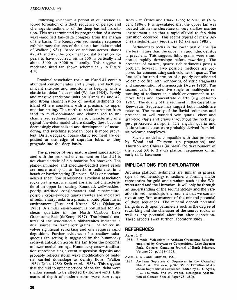
PRECAMBRIAN (4)
Following volcanism a period of quiescence al lowed formation of a thick sequence of pelagic and chemogenic sediments of the deep basinal associa tion. This was terminated by progradation of a storm wave-modified fan-delta complex from the margin of the basin. The Keewaywin sedimentary sequence exhibits most features of the classic fan-delta model of Walker (1984). Based on sections across islands #7, #4 and #2, the proximal to distal transition ap pears to have occurred within 500 m vertically and about 5000 to 8000 m laterally. This suggests a moderate sized fan shown schematically in Figure 4.4.
Proximal association rocks on island #1 contain abundant conglomerates and slumps, and lack sig nificant siltstone and mudstone in keeping with a classic fan delta facies model (Walker 1984). Pebbly and massive sandstone units on islands #1 and #2, and strong channelization of medial sediments on island #2 are consistent with a proximal to upper mid-fan setting. The north to south transition from sand to mud-dominated and channelized to un- channelized sedimentation is also characteristic of a typical fan-delta model where distally, flows become decreasingly channelized and development of mean dering and switching suprafan lobes is more preva lent. Distal wedges of coarse clastic sediment are de posited at the edge of suprafan lobes as they prograde into the deep basin.
The presence of very mature sheet sands associ ated with the proximal environment on island #1 is not characteristic of a submarine fan however. The plane-laminated and medium-bedded sheet sands are more analogous to foreshore sediments in a beach or barrier setting (Reinson 1984) or nonchan- nelized sheet flow sandstones. Proximal association rocks on the east mainland are also not characteris tic of an upper fan setting. Rounded, well-bedded, poorly stratified conglomerates and supermature, possibly cross-bedded quartzarenites are indicative of sedimentary rocks in a proximal braid plain fluvial environment (Rust and Koster 1984; Ojakangas 1985). A similar environment is postulated for Ar chean quartzite in the North Caribou Lake Greenstone Belt (deKemp 1987). The bimodal tex tures of the associated sublitharenites indicates a dual source for framework grains. One source in volves significant reworking and one requires rapid deposition. Further evidence of a shallow suba queous fan setting is suggested by the hummocky cross-stratification across the fan from the proximal to lower medial settings. Hummocky cross-stratifica tion represents single event suspension deposits and probably reflects storm wave modification of mate rial carried downslope as density flows (Walker 1984; Duke 1985; Swift e t al. 1986). This suggests that the mid to upper portions of the fan-delta were shallow enough to be affected by storm events. Esti mates of depth of modern storm wave base range
from 2 m (Eyles and Clark 1986) to MOO m (Vin cent 1986). It is speculated that the upper fan was located within the shoreface or very shallow marine environment such that a rapid alluvial to fan delta transition occurred. This seems typical .of many Ar chean sedimentary sequences (Ojakangas 1985).
Sedimentary rocks in the lower part of the fan are less mature than the upper fan and lithic detritus is prevalent. This suggests lithic grains were trans ported rapidly downslope before reworking. The presence of mature, quartz-rich sediments poses a problem however. Two possible methods are pro posed for concentrating such volumes of quartz. The first calls for rapid erosion of a poorly consolidated volcanic edifice with winnowing of vitric fragments and concentration of phenocrysts (Ayres 1983). The second calls for extensive single or multicycle re working of sediment in a shelf environment to re move fines and concentrate quartz (e.g. deKemp 1987). The duality of the sediment in the case of the Keewaywin Sequence may suggest both models are relevant. The maturity of the fluvial sediments and presence of well-rounded vein quartz, chert and granitoid clasts and grains throughout the rock sug gest protracted transport. The angular quartz and felsic volcanic clasts were probably derived from fel sic volcanic complexes.
Such a model is compatible with that proposed by Wood and Thurston (in preparation) and Thurston and Chivers (in press) for development of the about 3.0 to 2.9 Ga platform sequences on an early sialic basement.
IMPLICATIONS FOR EXPLORATION
Archean platform sediments are similar in general type of sedimentology to sediments forming major repositories for gold and uranium such as the Wit- watersrand and the Huronian. It will only be through an understanding of the sedimentology and the vari ation in sedimentologic environment that we can ar rive at any firm assessment of the mineral potential of these sequences. The mineral deposit potential hangs directly upon parameters such as the degree of reworking and the character of the source rocks, as well as any potential alteration after deposition. These aspects await further laboratory study.
REFERENCESAyres, L.D.1983: Bimodal Volcanism in Archean Greenstone Belts Ex
emplified by Greywacke Composition, Lake Superior Park, Ontario; Canadian Journal of Earth Sciences, Volume 20, p. 1168-1194.
Ayres, L.D., and Thurston, P.C.1985: Archean Supracrustal Sequences in the Canadian
Shield: An Overview; p.343-380 in Evolution of Ar chean Supracrustal Sequences, edited by L.D. Ayres, P.C. Thurston, and W. Weber, Geological Associa tion of Canada Special Paper 28, 380p.
26
A.L. CORTIS
Bennet, G., and Riley, R.A.1969: Operation Lingman Lake, District of Kenora, Patricia
Portion, Ontario; Ontario Department of Mines Mis cellaneous Paper 27, 52p.
Bouma, A.M.1962: Sedimentology of Some Flysch Deposits; Elsevier,
Amsterdam, 168p.
Brenchley, P.J., Romano, M., and Guiterrez-Marco, J.C. 1986: Proximal and Distal Hummocky Cross-Stratified
Facies on a Wide Ordovician Shelf in Iberia;p.241-255 in Shelf Sands and Sandstones, edited byR.J. Knight, and J.R. McLean, Canadian Society ofPetroleum Geology Memoir II.
deKemp, E.A.1987: Stratigraphy, Provenance and Geochronology of Ar
chean Supracrustal Rocks of Western Eyapamikama Lake Area, Northwestern Ontario; Unpublished M.Se. Thesis, Carleton University, Ottawa, Ontario, 98p.
Duke, W.L.1985: Hummocky Cross-Stratification, Tropical Hurri
canes, and Intense Winter Storms; Sedimentology, Volume 32, p. 167-194.
Eyles, N., and Clark, B.M.1986: Significance of Hummocky and Swaley Cross-Stratifi
cation in Late Pleistocene Lacustrian Sediments of the Ontario Basin, Canada; Geology, Volume 14, p.679-682.
Lowe, D.R.1975: Water Escape Structures in Coarse Grained Sedi
ments; Sedimentology, Volume 22, p. 157-204.
Ojakangas, R.W.1985: Review of Archean Clastic Sedimentation, Canadian
Shield: Major Felsic Volcanic Contributions to Tur bidite and Alluvial Fan-Fluvial Facies Associations; p.23-47 in Evolution of Archean Supracrustal Se quences, edited by L.D. Ayres, P.C. Thurston, and W. Weber, Geological Association of Canada Special Paper 28, p.23-47.
Reinson, G.E.1984: Barrier Island and Associated Strand-Plain Systems;
p. 119-140 in Facies Models, Second Edition, edited by R.G. Walker, Geosciences Canada Reprint Series l, 211p.
Roscoe, S.M., and Donaldson, J.A.1988:*" Uraniferous Pyritic Quartz Pebble Conglomerate and
Layered Ultramafic Intrusions in a Sequence of Quartzite, Carbonate, Iron Formation and Basalt of Probable Archean Age at Lac Sakami, Quebec; p.117-121 in Current Research Part C, Geological Survey of Canada Paper 88-1C, 372p.
Rust, B.R., and Koster, E.H.1984: Coarse Alluvial Deposits; p.53-69 in Facies Models,
Second Edition, edited by R.G. Walker, GeoscienceCanada Reprint Series l, 21 Ip.
Satterley, J.1938: Geology of the Sandy Lake Area, District of Kenora,
Patricia Portion; Ontario Department of Mines An nual Report for 1938, Volume 47, Part 7, p. 1-43, Accompanied by Map 47f, scale 1:63 360 or l inch to l mile.
Srinivasan, R., and Ojakangas, R.W.
1986: Sedimentology of Quartz Pebble Conglomerates and Quartzites of the Archean Bababudan Group, Dhar- war Craton, South India: Evidence for Early Crustal Stability; Journal of Geology, Volume 94, p. 199-214.
Swift, D.J., Thorne, J.A., and Oertel, G.F.
1986: Fluid Processes and Sea Floor Response on a Modern Storm-Dominated Shelf: Middle Atlantic Shelf of North America. Part II: Response of the Shelf Floor; p. 191-211 in Shelf Sands and Sandstones, edited by R.J. Knight and J.R. McLean, Canadian Society of Petroleum Geology Memoir II.
Thurston, P.C., and Chivers, K.M.In Press: Secular Variations in Greenstone Sequence Develop
ment Emphasizing Superior Province, Canada; Pre cambrian Research.
Thurston, P.C., Cortis, A.L., and Chivers, K.M.1987: A Reconnaissance Re-evaluation of a Number of
Northwestern Greenstone Belts: Evidence for an Early Archean Sialic Crust; p.4-24 in Summary of Field Work and Other Activities 1987, edited by R.B. Bar low, M.E. Cherry, A.C. Colvine, Burkhard O. Dressler and Owen L. White, Ontario Geological Survey Miscellaneous Paper 137, 429p.
Vincent, C.E.
1986: Processes Affecting Sand Transport on a Storm Domi nated Shelf; p. 121-132 in Shelf Sands and Sand stones, edited by R.J. Knight and J.R. McLean, Ca nadian Society of Petroleum Geology Memoir II.
Walker, R.G.1978: Deep Water Sandstone Facies and Ancient Submarine
Fans: Models for Exploration of Stratigraphic Traps; American Association of Petroleum Geologists Bulle tin, Volume 62, p.932-966.
1984: Turbidites and Associated Coarse Clastic Deposits; p.171-188 in Facies Models, Second Edition, edited by R.G. Walker, Geosciencs Canada Reprint Series l, 211p.
Wood, J., and Thurston, P.C.In Prep.: Archean Platform Sequences in the Superior Prov
ince of the Canadian Shield; Earth and Planetary Sci ence Letters.
Wood, J., Thurston, P.C., Corfu, F, and Davis, D.W.1986: Ancient Quartzites and Carbonates in Northwestern
Ontario: Evidence for Early (Archean) Crustal Stabil ity?; p.146 in G.A.C./M.A.C. Program with Ab stracts, Volume 11, 158p.
27
5. Project Number 88-10. A Geological Re-evaluation of Northwestern Greenstone Belts
A.L. Cortis 1 , G.M. Stott2 , LA. Osmani2 , B. Atkinson3 , and P.C. Thurston2
1 Graduate Student, University of Manitoba, Winnipeg, Manitoba.
2GeoIogist, Precambrian Geology Section, Ontario Geological Survey, Toronto.
3 Resident Geologist, Mines and Minerals Division, Ministry of Northern Development and Mines, Red Lake.
INTRODUCTION
Revision of the Geological Map of Ontario under the Geology of Ontario program has included a recon naissance investigation of a number of poorly known areas. Several greenstone belts in northwestern On tario were examined in the 1987 field season (Thurston e t al. 1987) in the Wabigoon Diapiric Axis and the Sachigo Subprovince. This examina tion showed that all major greenstone belts in these areas contained a new lithostratigraphic association; namely, the platform sequence, which consists of quartzarenites, iron formation, and komatiite in as cending stratigraphic order. These sequences are im portant in a stratigraphic and a tectonic sense. They differ in paleoenvironment from mafic to felsic cycli cal volcanism as they represent continuous shallow- water deposition. Platform sequences, based on the few dated examples (Corfu and Wood 1986; deKemp 1987; Davis and Jackson 1988) are ^.85 Ga and may approach 3 Ga. Therefore they are older than most examples of mafic to felsic cycli cal volcanics. The age relationship makes platform sequences the oldest greenstones in the Superior Province. They provide, in their quartz-rich charac ter and granitoid provenance of the sediments, evi dence of the widespread occurrence of granitoid units early in Superior Province history. The prove nance and stable setting suggest the presence of orogenic events at about 2.8 and 3.0 Ga (Thurston and Chivers, in press).
In the light of the distribution of the platform sequences in every major greenstone belt of the Sachigo Subprovince and the Wabigoon Diapiric Axis, follow-up work in 1988 was directed to the reconnaissance of belts not examined within these areas in 1987. Localities examined are shown on Figure 5.1.
Within the Sachigo Subprovince only the west ern end of the Ponask-Sachigo Greenstone Belt was examined in 1987. Therefore, the eastern end of the belt on Sachigo Lake was examined this year. While the Horseshoe Lake Greenstone Belt was mapped (Jensen 1987), no recent information was available on the Windigo Greenstone Belt. In the God's Lake domain, i.e. the northern part of the Sachigo Sub
province, only the Stull Lake Volcanic Belt was ex amined to verify the lack of platform sequences last year. Therefore, brief visits were made to Ellard Lake, Swan Lake, and the Nemeigusabins Lake arm of the Big Trout Lake Greenstone Belt (see Figure 5.1). As platform sequences occur throughout Sachigo Subprovince the character of greenstone
K------^ Phanerozoic
Proterozoic
granitoid rocks
V
^
metasedimentary rocks
metavolcanic rocks
Subprovince boundary
Wabigoon Diapiric Axis Terrane
Hudson Bay
Figure 5.1. Location Map showing the western part of the Superior Province. Subprovince and domain boundaries are shown by dotted lines. Note the revisions to the extent of the Sachigo Subprovince. Greenstone belts examined for platform sequences or mentioned in the text are numbered: 1) Obonga Greenstone Belt, 2) Savant Lake Greenstone Belt, 3) Mcinnes Lake Greenstone Belt, 4) Windigo Greenstone Belt, 5) Hornby Lake Greenstone Belt, 6) Ponask-Sachigo Greenstone belt.
28
A. L. CORTIS ET AL.
remnants in the Berens Subprovince is of impor tance. Therefore visits were made to the Mcinnes Lake belt and the Hornby Lake belt. Within the Wabigoon Diapiric Axis, last year's mapping dis closed shallow-water sequences in most greenstone belts. However, the Obonga Greenstone Belt was not examined because the abundant felsic metavolcanics at the western end of the belt (Thurston 1967) sug gested that platform sequences would not be pre sent. However, further analysis suggested the se quence along the southern margin of the belt was relatively poor in felsic metavolcanics and contained sediments relatively low in the stratigraphy. There fore this sequence was examined this season.
Results of this project are to be incorporated di rectly into the 1:1 000 000 Geological Map of On tario. Therefore, descriptions within this summary are of sufficient detail to encourage exploration and serve as a record of major findings until publication of the Geology of Ontario volume. The data will also be used in the planning of further mapping projects in this area.
OBONGA LAKE GREENSTONE BELT
INTRODUCTION
The Obonga Lake Greenstone Belt, located 30 miles southwest of the town of Armstrong, is traceable continuously from the Kashishibog River in the west to Obonga Lake in the east where it is covered by Keweenawan igneous intrusive sheets (Figure 5.2).
Mapping in the area followed basic field map ping carried out by Thurston (1967) and concen trated on delineating and interpreting the nature of the southern granite-greenstone contact in the area between Muller Lake and Lake "Z2" in the west, and between Silk Lake and Goosander Creek in the
+ ** FIGURE 3 V
Diabase
Metasediment*
Intermediate to felsic metavolcanics
Mafic to intermediate metavolcanics
Tonalite to trondhjemite
Figure 5.2. Location map showing the Obonga Greenstone Belt and the part examined for unconformable relation ship.
east (Figure 5.2). Access to this area is by means of float-equipped aircraft. Virtually the whole belt is covered by an extensive seven-year old burn which, while resulting in excellent outcrop exposure, makes movement extremely difficult.
Based on observations made during this study, the granite-greenstone contact can be divided into two portions separated by a large, late diabase stock. These zones comprise the following:1. from Badour Lake west to the western end of
Muller Lake2. the area east of Badour Lake to south of Silk
Lake
1.BADOUR LAKE AND WESTWARD
In this area, the granite-greenstone contact trends approximately eastward and is sharp and planar. All lithologies exhibit strong dextral shearing with a steeply (7O 0 to 8O 0 ) northwest-plunging lineation. This intense fabric is developed pervasively through out the supracrustal, but gradually diminishes in in tensity in the granitoids over a 4 to 5 km range south from the granite-greenstone contact.
At the contact, fine- to medium-grained, mas sive to gneissic and schistose mafic metavolcanics are found adjacent to a tonalite to trondhjemite gneiss. In places, the gneiss is granodioritic as a re sult of pervasive potassic metasomatic alteration along fractures and veins resulting in in situ growth of potassic feldspar megacrysts. This potassic altera tion also decreases in intensity southward in con junction with the decrease in the degree of shear. The supracrustal are usually too schistose for reten tion of primary fabric, but in one outcrop north of Badour Lake, strongly stretched pillowed mafic metavolcanic rocks were observed in contact with sheared felsic pyroclastic rocks. All mafic volcanic rocks are plagioclase-phyric. The size and propor tion of plagioclase phenocrysts varies from flow to flow. Phenocrysts can form from l to 40 percent of the rock and range from 5 to 30 mm in size. This variation is useful for delineating flow boundaries, even in areas where deformation is quite intense. The supracrustal rocks are also intruded by numer ous mafic dikes with highly variable orientation. Some dikes closely follow flow boundaries or lithological contacts and are commonly virtually in distinguishable from some coarser-grained mafic flows. Other dikes cut across flows at high angles. All dikes are plagioclase-phyric and are essentially iden tical to the mafic extrusives in which they are hosted. Due to the intense deformation, no facing directions were distinguishable in the supracrustal across the map area.
On the northern shore of Badour Lake at the eastern margin of the area, the granite-greenstone contact is not simply planar. Intrusive, foliated trondhjemite dikes cut the adjacent mafic metavol canic rocks and, in places, thin granitoid dikelets are so common as to produce a network of intrusive ma-
29
PRECAMBRIAN (5)
terial hosting angular blocks of mafic metavolcanics. Also of note is a complex interleaving of granitoid and mafic rock at the creek at the northern edge of Badour Lake. In places tongues and dikes of trondhjemite cut the mafic metavolcanics, but, in other outcrops, dikes, or very large laterally continu ous inclusions of mafic metavolcanics, are found within the granitoids. Late, undeformed, very fine grained pink felsite dikes cut all units. This zone possibly represents a continuation of the eastern granite-greenstone contact area described below.
2.BADOUR LAKE AND EASTWARD
The granite-greenstone contact in this area is com plex and confusing given the limited outcrop, but ap pears to comprise a deformed granitoid regolith or altered unconformity overlain by mafic metavolcanic rocks and intruded by later granitoid dikes (Figure 5.3).
At the western end of the area (see Figure 3, locality 1), the granite-greenstone contact is sharp and planar. Both the mafic metavolcanics and the trondhjemite are highly schistose with a moderately northwest-plunging (48 0 to 60 0 ) lineation. Supra crustal rocks consist of schistose, fine-grained, am phibolite gneiss. Gneissic banding on a millimetre to centimetre scale is defined by plagioclase segrega tions. Larger plagioclase phenocrysts up to 2 cm in
diameter are randomly dispersed throughout the gneiss. Small pods and lenses of epidote-quartz-pla- gioclase are also randomly interspersed. In some places about 10 percent of the volume of the rock is taken up by numerous fabric-parallel quartz veins and lenses. Trondhjemite dikes up to 2 m wide cut this gneiss. These dikes have planar boundaries and contain no apparent assimilation of mafic material. They consist of a medium-grained, homogeneous, and equigranular quartz-plagioclase-biotite assem blage. Plagioclase crystals are relatively unaltered and only exhibit minor alteration. The dikes cut the supracrustal with about a 10 0 discordance. A subtle difference in preservation of plagioclase is noted be tween the dikes in the mafic metavolcanics and the granitoid to the south of the contact. The main granitoid body is coarse- to medium-grained, homo geneous and equigranular, but contains highly saus- suritized feldspars, in contrast to the unaltered pla gioclase of the dikes. None of these dikes were seen intruding the body to the south, however. This makes the discrimination of the dikes and the main body of the granitoid as separate phases difficult.
About 150 m farther east, the contact is marked by a long (100 m) scarp (see Figure 5.3, locality 2). Numerous mafic dikes, sills, and stocks cut the granitoids at angles to the contact which range from O 0 to 90 0 . These bodies are mineralogically and tex-
pelltlc conglomerate bed with altered trondhjemite cobble* and pebble*
plagioclase phyrlc. highly foliated, massive mafic volcanics
unaltered trondhjemite dike
hematlzed, anastamoslng
fractures
bulbous feeder dike with wallrock assimilation
plagioclase phyrlc mafic sill* (discordant to 8-fabrlc)
zone of 'pink* trondhjemite (all feldspar altered to micas)
coarse grained metagabbro body (plagioclase phyrlc)
Interfolded volcanic* and trondhjemlte(?)
feldspar phyrlc tuffs (In mafic metavolcanics in granitoids)
100 200 300
metres
(i) Geochron sample site
{:i:;:j:;:;:;x|:;| Zone of "pink" trondhjemite
Figure 5.3. Detailed map of the southern part of the Obonga Greenstone Belt. The volcanic-granitoid contact is shown as the heavy dot-dash line. Mafic sills in the trondhjemite are shown in solid black. The area underlain by metavolcanics is shown in the "v" pattern; the trondhjemite in dots. The area of the unconformity is at locality 2.
30
A.L. CORTIS ET AL.
turally identical to mafic volcanic rocks along the length of the granite-greenstone contact, but are clearly intrusive into the granitoid. The width of in dividual bodies is highly variable given the irregular nature of the contacts. The larger, contact-parallel bodies (sills) are up to 5 m wide "and laterally con tinuous for about 150 m. A large ovoid body of metagabbro about 20 by 30 m was seen on one out crop within the trondhjemite. Although it is coarser grained than the dikes, sills, and flows, it is mineralogically identical and also contains pheno- crysts of plagioclase similar to those in the other mafic bodies. This metagabbro is inferred to repre sent the lateral continuation of one of the sills. In contrast, dikes (i.e. contact-discordant bodies) range from 0.05 to 0.5 m thick and are only con tinuous for 5 to 15 m. In two areas (see Figure 5.2) dikes with irregular, bulbous contacts were observed leading from the sills and the metagabbro into the overlying mafic metavolcanics. Where these feeder dikes pass beyond the upper contact of the granitoid and into the supracrustal, they exhibit a fountaining effect with a lateral spreading of the dike material into flows. Similar fountaining of dikes into flows are seen in recent basalts of the Snake River Plain, Idaho (Greeley et al. 1977).
Some of the dikes and sills appear to be zoned, with an outer quartz-rich margin contaminated by stoping and melting assimilation of the trondhjemite wall rock, and an inner, uncontaminated zone lack ing inclusions of granitoid or any modal quartz. In clusions of trondhjemite in the outer zones of these dikes are up to l to 3 m in diameter and often ex hibit diffuse boundaries with the mafic material.
The trondhjemite cut by these dikes is highly saussuritized with nearly complete conversion of feldspars to mica. The top 5 to 10 m of the body near the contact is pink hued, with the intensity of the hue increasing toward the contact. A similar pig mentation of the trondhjemite is also noted adjacent to a large sill and feeder dike system and extends about 2 to 3 m into the wall rock (see Figure 5.3, locality 2). This colour is apparently caused by the presence of finely disseminated hematite within the rock. Within this "pink" trondhjemite zone the original coarse- to medium-grained equigranular texture is totally lost. Instead, the rock assumes an inequigranular form, with very fine-grained mica and coarser, unaltered quartz aggregates. Within this oxidized zone are numerous anastomosing fractures oriented essentially normal to the contact. These are the loci of especially intense hematite oxidation, with haloes commonly extending up to 20 to 30 cm into the surrounding rock. In several localities, these fractures were seen to enclose large (0.1 to 1.0 m) angular blocks of pink trondhjemite. Where closely spaced, this fracture system forms a network, im parting a rubbly appearance to the rock.
Immediately above the contact, mafic metavol- canic rocks are very fine grained to hornblende por
phyroblastic but ubiquitously plagioclase phyric. They appear identical to the mafic metavolcanics seen in the western area, and to the dikes and sills in the adjacent trondhjemite. Where recognizable, mafic flows are generally l to 2 m wide, and mas sive. Some -s:! m thick, felsic to intermediate, fine grained to plagioclase-phyric tuff horizons occur be tween some flows. A single 2 to 3 m wide sedimen tary horizon was also found interbedded with the mafic flows (see Figure 5.3, locality 3). This unit consists of a polymictic, very fine grained, matrix- supported, pebble to cobble (and rarely boulder) conglomerate. Angular cobbles to pebbles of altered trondhjemite, similar in size, shape, and appearance to fracture-bounded blocks in the regolith, are sup ported by a pelitic matrix. The matrix comprises about 60 percent of the rock and consists of a fine grained garnet-biotite assemblage. Between 10 to 15 percent of the clast population consists of rounded to angular, vein quartz and aphyric felsic volcanic pebbles and cobbles.
About 500 m farther eastward and in a small outcrop southeast- of the contact, the relationship of granitoids and supracrustal is not as clear. In the small outcrop (see Figure 5.3, locality 4), the trondhjemite and the supracrustal appear to be in- terfolded. The contact here is sharply planar, lacks any type of alteration, and trends roughly normal to that of the contact to the north. The supracrustals appear to form a wedge-shaped body enclosed within sheets of trondhjemite, but lack of sufficient exposure precludes resolution of this problem. To the east, mafic rocks and trondhjemite exhibit abun dant, conflicting crosscutting relationships. Mafic dikes are found crosscutting trondhjemites, and trondhjemite dikes are seen to cut mafic units. The exact locality of the contact is uncertain given the highly variable proportions and trends of the dikes of both lithologies. More detailed mapping is re quired to ascertain the exact nature of the contact in this zone.
CONCLUSIONS
The granite-greenstone contact to the west of Badour Lake exhibits features suggesting an intrusive relationship between the trondhjemite gneiss and the supracrustal rocks. The contact is planar, and dikes of trondhjemite are seen to intrude the supracrustal in numerous places. No evidence was found to sug gest that the granitoids predate the volcanic rocks.
The contact east of Badour Lake exhibits con flicting evidence for the presence of older sialic rocks. The trondhjemite body exhibits many textural and mineralogical features similar to those in the tonalite-trondhjemite body to the west; however, the granitoid in the west is gneissic whereas that in the east is not. Furthermore, the body in the east is cut by numerous mafic dikes and sills. These clearly postdate the granitoid and exhibit the effects of con tamination imparted by assimilation of the wall rock.
31
PRECAMBRIAN (5)
Several features of these dikes suggest that they are subvolcanic bodies emplaced in a pre-existing granitoid basement.
1. The textural and mineralogical similarities be tween the dikes and the volcanic rocks suggest that they are derived from the same magma body. This is especially indicated by the ubiqui tous occurrence of large plagioclase phenocrysts in all the mafic units.
2. The fact that dikes can be traced from some sills into flows suggest that the intrusive bodies were shallow subvolcanic feeders. The fountaining textures exhibited at the interface of the dike and the flow is similar to that found in recent volcanic rocks of the Snake River Plain, Idaho (Greeley et al. 1977).
3. The hematitization haloes within the trondh jemite adjacent to the larger sills and feeder dikes and along the granite-greenstone contact suggest that the granitoid was subsequently modified by intrusion/extrusion of the mafic ig neous rocks (i.e. older sialic rocks). The par ticularly intense alteration along fractures nor mal to the contact suggest that this is due to a mixed thermal and chemical effect imparted by movement of gasses from the subvolcanic bodies to the surface.
The presence of granitoid dikes clearly postdat ing the mafic volcanism conflicts with the above con clusions. The fact that these dikes appear relatively unaltered while the granitoids adjacent to the con tact are highly altered suggest that these dikes may in fact be part of a later event. Lack of crosscutting relationships in the granitoids poses some problems. Similarly, the intertonguing supracrustal-granitoid relationships seen to the east and south also suggest that a simple contact is not present. Further work is required to solve these problems.
The granitoid-supracrustal boundary is not a true unconformity in that a true erosional boundary is not discernible. Alternatively, the contact is also neither a regolith nor a paleoweathering profile in that a soil horizon is not developed along the con tact. However, the fact that erosional equivalents of the granitoid are found in a conglomerate within sev eral metres of the contact suggests that in some places the granitoid was subjected to weathering. The hematitization adjacent to the contact is accom panied by an intense saussuritization of the plagio- clases in the trondhjemite. The zone of saussuritiza tion is wider than that of the hematite staining and increases in intensity toward the contact. Possibly this represents an in situ weathering or alteration profile imparted either by climatic effects or by vol canism. Beyond the presence of a few pillowed flows several hundred metres above the contact, it is un certain as to what type of environment the volcanism occurred in. No evidence for a shallow-water setting is evident here; however, adjacent greenstone belts
in the Wabigoon Diapiric Axis contain evidence for shallow water or subaerial volcanism and sedimenta tion (Thurston and Davis 1985; Thurston et al. 1987), and thus it is possible that a similar environ ment existed here.
SAVANT LAKE GREENSTONE BELT
INTRODUCTION
Mapping in the Savant Lake area followed recon naissance work north of Kashaweogama Lake last year (Thurston et al. 1987) in which ^2.780 Ga) Jutten Volcanic Group rocks were found to host two chert to banded iron formation horizons and minor quartzose siltstones, but lacked any platformal asso ciation. This year, mapping focused on a thin unit of sedimentary rock contained within massive and pil lowed mafic volcanic rocks of the Jutten Group north of Savant Lake (Figure 5.4) as reported by Trowell (1986). Although some unresolved struc tural complexity has affected these rocks, they ap pear to form a generally northwest-facing medial to distal fan which is the equivalent (Walker 1984) of a typical alluvial to shallow marine platform setting (Ojakangas 1985). This sedimentary unit is hence forth referred to as the Jutten sedimentary se quence.
GENERAL GEOLOGY
Although a classic platform association of quartzite- carbonate iron formation-komatiites-felsic volcanics (Wood and Thurston, in press) was not observed in its entirety, the limited exposure suggests such a se quence may be present. Mature sandstones, con glomeratic sandstones, and conglomerates intimately associated with a fuchsite-chert chemical-meta- sedimentary horizon and a sheared, fine-grained, possibly ultramafic unit were found in the southern portion of the Northeast Arm of Savant Lake (Fig ure 5.5, locality 1).
At this locality, a south-facing sequence of sheared fine-grained, and massive, mafic to ultramafic flows is overlain with some stratigraphic discontinuity by a highly deformed chemical and clastic metasedimentary unit. This unit is M5 m thick and contains millimetre- to centimetre-scale banded fuchsitic chert and white chert that is inter- layered with minor, thinly to medium-bedded (5 to 20 cm), medium-grained quartzwacke to quartz arenite beds. All beds exhibit identical deformation and resultant recrystallization. These beds are in turn overlain, with some stratigraphic discontinuity, by a wedge of sediments grading upward from thick ly to very thickly bedded boulder to cobble, and cobble to pebble, conglomerates. These conglomer ates have a quartz matrix and are massive to graded, with some sandstone interbeds. This sequence ex hibits a series of fining-upward cycles over a dis tance of 7 m (Figure 5.6). Commonly, these fining- upward cycles have an upper unit of fine sand,
32
A. L. CORTIS ET AL.
Kashaweogama Lake ^.
JUTTEN GROUP
Jutten Group Volcanics
Jutten Sedimentary Sequence
Savant Lake Greenstone Belt
Granitoids
Figure 5.4. The Savant Lake Greenstone Belt. Geology after Trowell (1986) with the area of Jutten Group metasediment! shown in solid black.
wacke, or mudstone, indicating periodic hiatuses in sediment supply. The sequence is capped by 4 cm of chlorite- and biotite-bearing, graded, thinly- to me dium-bedded wackes and rare mudstone with occa sional conglomeratic beds (see Figure 5.5, locality 2). Several hundred metres farther south, a series of outcrops suggests intertonguing of sandstone and conglomerate with wacke-mudstone couplets which are predominant to the south and east. This may possibly reflect a medial- to distal-fan transition. The conglomerates are polymictic, containing a wide assortment of lithological clast types including ultra mafic and mafic metavolcanics, vein quartz, fine- to medium-grained tonalite and trondhjemite, clastic metasediments, fuchsitic chert and a high amount of
felsic to intermediate volcanic clasts, most notably aphyric grey to white rhyolite and rhyodacite clasts. Also present are rare banded iron formation and quartz-plagioclase-phyric porphyry clasts.
A notable dichotomy in clast angularity is seen across the Jutten sedimentary sequence, with fuch sitic chert and volcanic clasts being mostly angular, and the white chert, vein quartz, and granitoid clasts exhibiting a markedly high degree of rounding. This may possibly reflect a dual source for the sediment as is also indicated by cannibalization of pre-existing sedimentary units.
Midway through the sequence (see Figure 5.5, locality 3), a series of outcrops indicates the possible
33
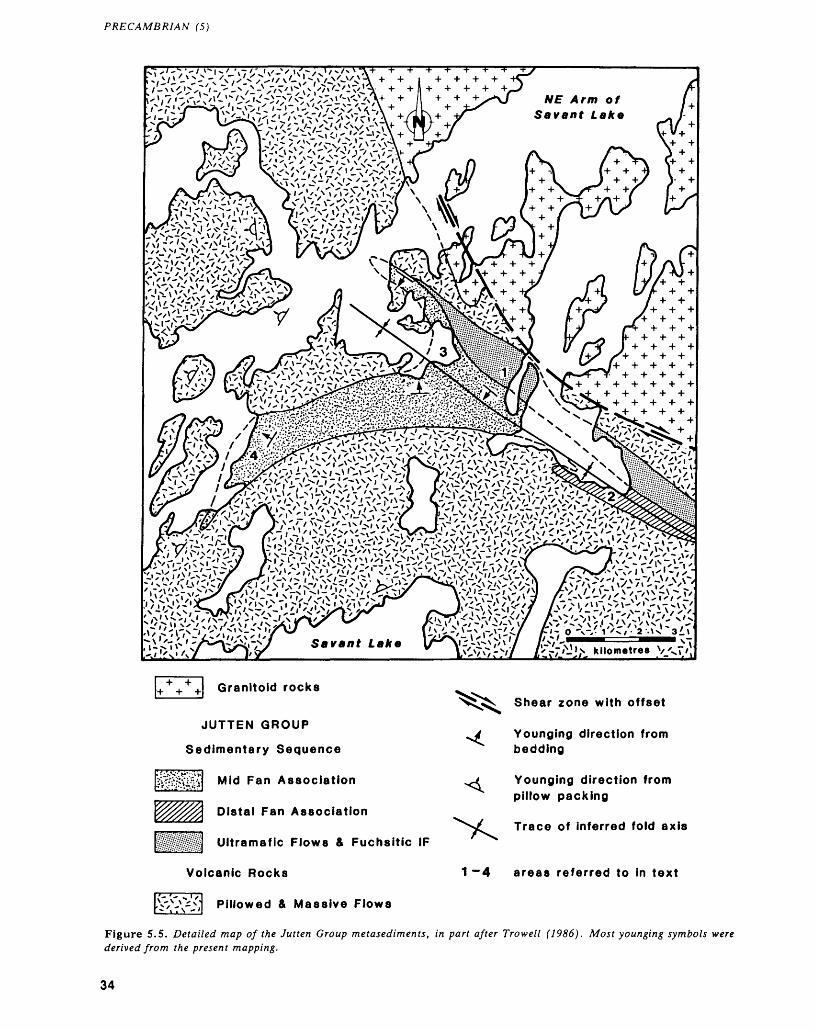
PRECAMBRIAN (5)
x \ ' t si** — *7 /\!\'— '
Arm of Savant Lake
Ir/'^J^ Kilometres V/xT/,
Granitoid rocks
JUTTEN GROUP
Sedimentary Sequence
Mid Fan Association
Distal Fan Association
Ultramafic Flows ft Fuchsitic IF
Volcanic Rocks
Pillowed 4 Massive Flows
Shear zone with offset
Younging direction from bedding
Younging direction from pillow packing
Trace of inferred fold axis
areas referred to in text
Figure 5.5. Detailed map of the Jutten Group metasediments, in part after Trowell (1986). Most younging symbols were derived from the present mapping.
34
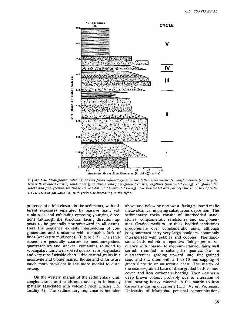
A.L. CORTIS ET AL.
To 11.0 m*tr**
9.0,CYCLE
8.0
oJ~ 6.0,
IV
III
r^-'jt- . . ' :N-:V.'- ••.•.•:o'-'-:'.-~-!:'q':.'::.-.'••- '*.''- ; \ ••'l*:^i :(i: :;-?;-j::\^f.::i:'. : -.'*.:\;-;^o^---:'':\
4.0. :*-;?;^i*;^:^.;@^^^^Ma^iiMM^
3.0.
2.0
1.0
12 8 40-4-8 -12 Maximum Grain Size Diameter (in phi (Q) units)
Figure 5.6. Stratigraphic columns showing fining-upward cycles in the Jutten metasediments: conglomerates (coarse pat tern with rounded clasts), sandstones (fine stipple with finer-grained clasts), argillites (horizontal ruling), conglomeratic wacke and fine-grained sandstone (mixed dots and horizontal ruling). The horizontal axis portrays the grain size of indi vidual units in phi units ("(j)) with grain size increasing to the right.
presence of a fold closure in the sediments, with dif ferent exposures separated by massive mafic vol canic rock and exhibiting opposing younging direc tions (although the structural facing direction ap pears to be generally northwestward in all cases). Here the sequence exhibits interbedding of con glomerates and sandstone with a notable lack of fines (wackesto mudstones) (Figure 5.7). The sand stones are generally coarse- to medium-grained quartzarenites and wackes, containing rounded to subangular, fairly well sorted quartz, rare plagioclase and very rare fuchsitic chert-lithic detrital grains in a muscovite and biotite matrix. Biotite and chlorite are much more prevalent in the more medial to distal setting.
On the western margin of the sedimentary unit, conglomerates and sandstones are again intimately spatially associated with volcanic rock (Figure 5.5, locality 4). The sedimentary sequence is bounded
above and below by northwest-facing pillowed mafic metavolcanics, implying subaqueous deposition. The sedimentary rocks consist of interbedded sand stones, conglomeratic sandstones and conglomer ates. Graded medium- to thick-bedded sandstones predominate over conglomeratic units, although conglomerates carry very large boulders, commonly interspersed with pebbles and cobbles. The sand stone beds exhibit a repetitive fining-upward se quence with coarse- to medium-grained, fairly well sorted, rounded to subangular quartzwackes to quartzarenites grading upward into fine-grained sand and silt, often with a l to 10 mm capping of green fuchsitic or muscovitic chert. The matrix of the coarse-grained base of these graded beds is mus covite and iron-carbonate-bearing. They weather a deep brown colour, probably due to alteration of iron-bearing heavy minerals in the matrix to iron carbonate during diagenesis (L.D. Ayres, Professor, University of Manitoba, personal communication,
35
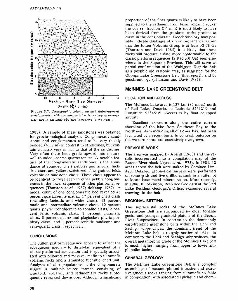
PRECAMBRIAN (5)
12 8 4 o-4 Maximum Grain Size Diameter
(in phi ((^)) units)
Figure 5.7. Stratigraphic column through fining-upward conglomerates with the horizontal axis portraying average clast size in phi units (fy)(size increasing to the right).
1988). A sample of these sandstones was obtained for geochronological analysis. Conglomeratic sand stones and conglomerates tend to be very thickly bedded (M.5 m) in contrast to sandstones, but con tain a matrix very similar to that of the sandstones. Very often these beds grade upward into mature, well rounded, coarse quartzarenites. A notable fea ture of the conglomeratic sandstones is the abun dance of rounded chert pebbles and angular fuch- sitic chert and yellow, sericitized, fine-grained felsic volcanic or mudstone clasts. These clasts appear to be identical to those seen in other pebbly conglom erates in the lower sequences of other platformal se quences (Thurston et al. 1987; deKemp 1987). A modal count of one conglomeratic bed revealed 46 percent quartzarenite matrix, 17 percent chert clasts (including fuchsitic and white chert), 13 percent mafic and intermediate volcanic clasts, 10 percent quartz phyric trondhjemite to tonalite clasts, 2 per cent felsic volcanic clasts, 2 percent ultramafic clasts, 8 percent quartz and plagioclase phyric por phyry clasts, and l percent sericitic mudstone and vein-quartz clasts, respectively.
CONCLUSIONS
The Jutten platform sequence appears to reflect the subaqueous medial- to distal-fan equivalent of a classic platformal association and is spatially associ ated with pillowed and massive, mafic to ultramafic volcanic rocks and a laminated fuchsitic-chert unit. Analyses of clast populations in the conglomerate suggest a multiple-source terrace consisting of granitoid, volcanic, and sedimentary rocks subse quently reworked downslope. Although a significant
proportion of the finer quartz is likely to have been supplied to the sediment from felsic volcanic rocks, the coarser fraction (M mm) is most likely to have been derived from the granitoid rocks present as clasts in the conglomerate. Geochronology may pos sibly indicate dual ages of zircon provenance. Given that the Jutten Volcanic Group is at least ^.78 Ga (Thurston and Davis 1985) it is likely that these rocks will produce a date more conformable to the classic platform sequences (2.9 to 3.0 Ga) seen else where in the Superior Province. This will serve as partial confirmation of the Wabigoon Diapiric Axis as a possible old cratonic area, as suggested for the Obonga Lake Greenstone Belt (this report), and by geochronology (Thurston and Davis 1985).
MCINNES LAKE GREENSTONE BELTLOCATION AND ACCESS
The Mcinnes Lake area is 137 km (85 miles) north of Red Lake, Ontario, at Latitude 52 0 12'N and Longitude 93 0 45'W. Access is by float-equipped aircraft.
Excellent exposure along the entire eastern shoreline of .the lake from Southeast Bay to the Northwest Arm including all of Power Bay, has been facilitated by a recent burn. In contrast, outcrops on the western shore are extensively overgrown.
PREVIOUS WORK
The area was mapped by Averill (1968) and the re sults incorporated into a compilation map of the Berens River block (Ayres et al. 1973). In 1981, 12 areas across the belt were staked by Cominco Lim ited. Detailed geophysical surveys were performed on some grids and five drillholes sunk in an attempt to locate base metal mineralization. More recently, in 1986, B. Atkinson, Resource Geologist at the Red Lake Resident Geologist's Office, examined several showings in the belt.
REGIONAL SETTING
The supracrustal rocks of the Mcinnes Lake Greenstone Belt are surrounded by older tonalite gneiss and younger granitoid plutons of the Berens River Subprovince. In contrast to the dominantly east-trending greenstone belts within the Uchi and Sachigo subprovinces, the dominant trend of the Mcinnes Lake belt is roughly northward. Also, in contrast to the Uchi and Sachigo subprovinces, the overall metamorphic grade of the Mcinnes Lake belt is much higher, ranging from upper to lower am phibolite facies.
GENERAL GEOLOGY
The Mcinnes Lake Greenstone Belt is a complex assemblage of metamorphosed intrusive and extru sive igneous rocks ranging from ultramafic to felsic in composition, with associated epiclastic and chemi-
36
A.L. CORTIS ET AL.
cal metasedimentary units. Based on lithological as semblages, marker horizons, limited facing direc tions, and structural considerations, it has been pos sible to subdivide the supracrustal rocks into three cycles (Figure 5.8). Although approximate thick nesses of units are given, these are only apparent thicknesses. The presence of numerous shear zones within stratigraphic units and thrust faults at the mar gin of the belt suggests possibly that units are tectoni- cally thickened by imbrication and repetition of stratigraphy.
Cycle l
Cycle I comprises volcanic and sedimentary rocks, and forms the dominant unit in the belt (see Figure 5.8). It is a simple mafic to felsic volcanic cycle with about 80 percent of the rocks comprising intermedi ate tuffs and tuffaceous metasediments. It is the most extensive of the three cycles and is traceable across the entire belt. It is divided into two parts, a lower mafic metavolcanic unit of limited extent, and an upper felsic to intermediate pyroclastic and epiclastic unit.
In the northern part of the belt, limited top indi cators suggest a uniform east-facing direction for the cycle. In the south, top indicators are lost except for one graded unit which is west facing. The cycle is divisible into two parts; a thin basal mafic metavol canic unit, and a laterally extensive thick upper unit dominated by dacitic tuffs.
Basal mafic metavolcanics of Cycle I are re stricted to the northern part of the belt on the north west arm of the lake. They form a southeast-striking unit, about 300 m thick. No facing directions were preserved in this unit. Due to its proximity to the granite-greenstone boundary, most exposures of the unit are usually strongly sheared and/or contain hornblende porphyroblastics such that most primary fabric is overprinted. However, in places massive flows averaging 2 m in thickness are seen. Epidote pods and lenses in some sheared outcrops may sug gest that they were originally pillowed. Mafic flows persist throughout the cycle, but form less than 2 to 3 percent of the upper unit.
The upper unit of Cycle I is composed almost entirely of dacitic and andesitic tuffs and flows. Tuffs are generally fine grained and thinly bedded or gneissic. Most tuffs contain from O to 20 percent, l to 10 mm, rounded plagioclase and/or quartz phenocrysts. In the central part of the lake, the pro portion of phenocrysts can reach 50 to 60 percent, forming thick-bedded crystal tuff units. Grading is not well developed in most of the tuffs, and facing directions are difficult to obtain. Coupled with this, deformation and high metamorphic grade have re sulted in overprinting of most primary structures.
Pyroclastic rocks on the main body of Mcinnes Lake, immediately west of Power Bay (see Figure 5.8), are much coarser grained than the bulk of the
tuffs in Cycle I. They are composed of well-bedded and normally graded tuffs, lapilli-tuffs, and tuff- breccias. Beds range from 0.3 to 2.5m thick and are laterally continuous over tens of metres. Beds con tain up to 40 percent quartz and plagioclase pheno crysts ranging from l to 20 mm in diameter. Lithic fragments include both essential fragments and ac cessory fragments of mafic metavolcanic rock, range from ash to bomb sized, and exhibit well developed normal grading. Pumiceous fragments are uncom mon. Where observed, they are highly stretched and are usually located at the top of beds. They consist of fine-grained quartz-feldspar aggregates l to 10 mm long which exhibit only slight retention of primary vesicularity.
On the northern part of the lake, west of Power Bay, Cycle I rocks are intruded by numerous east- striking mafic dikes. The dikes vary in width from 0.5 to 3 m and are restricted to an approximately 1.5 km wide zone on the western shore where they comprise up to 40 percent of the outcrops. They ex hibit planar, unsheared boundaries normal to the trend of Cycle I lithologies, and intrusion seems to have been along simple dilational fractures; Both the dike rocks and the wall rocks are cut by the same deformation fabric. The dikes exhibit a fine-grained hornblende-plagioclase assemblage which appears texturally and mineralogically identical to mafic metavolcanic rocks of Cycle II.
A series of late peridotite sills are seen to intrude Cycle I rocks across the entire length of the belt (see Figure 5.8). These ultramafic intrusive bodies are unique to Cycle I and are generally emplaced paral lel to primary layering, although some discordance up to about 15 0 was seen. Although the sills form a series of discrete sheets, each several hundred metres long, they appear to have been intruded roughly at the same stratigraphic level in the upper unit of Cycle I. They are variably very coarse grained to medium grained, equigranular, and ho mogeneous. Primary olivine-pyroxene mineralogy is pseudomorphically altered to talc, tremolite-ac- tinolite, and serpentine. The rocks are cut by the same deformation fabric as the enclosing Cycle I rocks. Close to and along the Cycle I-Cycle II boundary, numerous gabbroic sills and small intru sive bodies are present. These are variably sheared to massive, and are coarse to medium grained. The bodies can range from small sills to large laterally continuous sheets and stocks. Some of the bodies are plagioclase phyric, and texturally and mineral ogically resemble Cycle II mafic volcanic rocks.
Intimately associated with Cycle I pyroclastic rocks in the central Mcinnes Lake area are epiclas tic sedimentary units. These comprise sandstone- mudstone couplets of probable turbiditic origin, quartzose and quartzo-feldspathic sandstones, and conglomerates.
Sandstone-mudstone couplets are found inter bedded with fine-grained tuffs and conglomerates
37
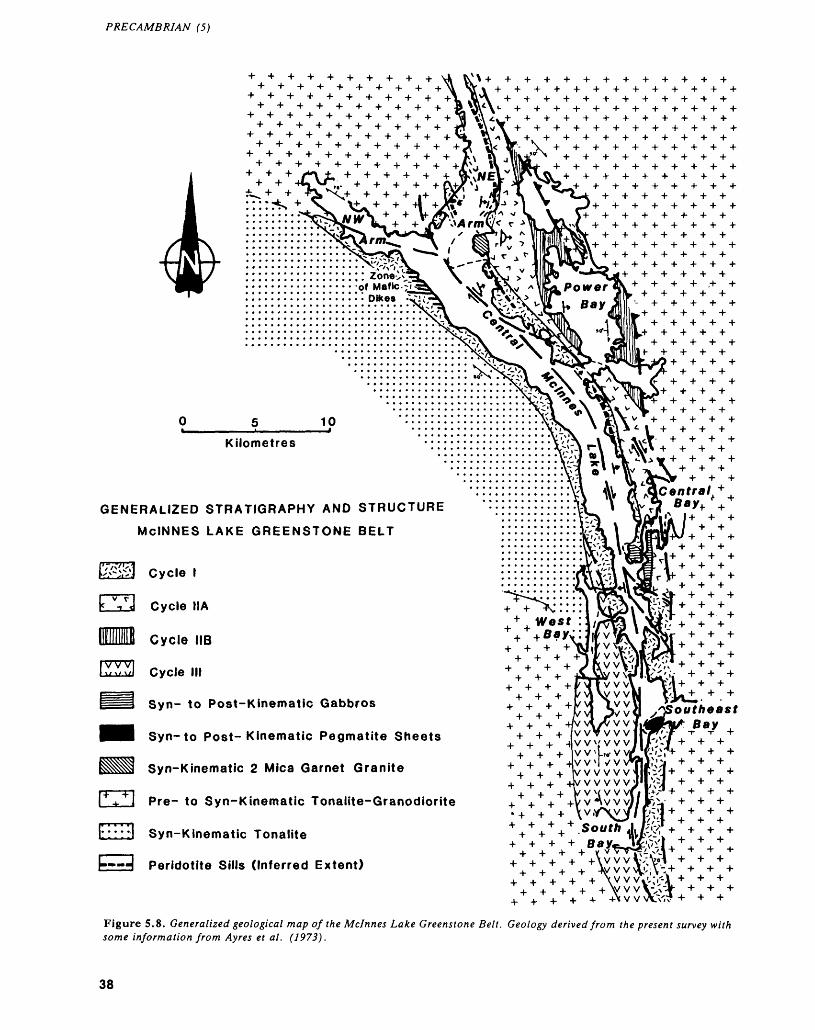
PRECAMBRIAN (5)
GENERALIZED STRATIGRAPHY AND STRUCTURE MCINNES LAKE GREENSTONE BELT
Cycle l
Cycle IIA
Cycle IIB
IV V VIl ^ w v/l Cycle III
Syn- to Post-Kinematic Gabbros
Syn-to Post-Kinematic Pegmatite Sheets
Syn-Kinematic 2 Mica Garnet Granite
Pre- to Syn-Kinematic Tonalite-Granodiorite
i* * * * *i1:::::i Syn-Kinematic Tonalite
"-H Peridotite Sills (Inferred Extent)
Figure 5.8. Generalized geological map of the Mcinnes Lake Greenstone Belt. Geology derived from the present survey with some information from Ayres et al. (1973).
38
A. L. CORTIS ET AL.
near the entrance to Power Bay and on the western shore of the lake. They consist of alternating, thinly bedded, black, cordieritic mudstones and fine grained tuffaceous sandstone beds. Beds exhibit pla nar contacts with little evidence of scour. Com monly, sandstones exhibit upward grading into mud stone that is marked by a reverse grading of post kinematic cordierite. The lithologies exhibit well de veloped Bouma BDE and BE sequences. No cross- laminated units were observed. Such structures are typical of "classical" turbidites (Walker 1984).
Sandstones are poorly sorted and usually range from litharenite to lithic wacke in composition. They are interbedded with dacitic crystal-rich tuffs of the upper unit of Cycle I. Beds range from 0.5 to l m thick and usually contain 70 to 90 percent suban gular to subrounded grains of quartz and plagioclase identical in size, but better rounded than pheno- crysts in adjoining pyroclastic units. In one area, sandstone beds were seen to pass laterally over about 100 m into crystal-rich tuffs. This transition is marked by progressive winnowing of fine-grained, sericitic felsic ash and a change in the degree of rounding of phenocrysts. No primary sedimentary or volcanic features were seen. Several discrete beds of quartzarenite to quartzwacke are present within this sequence. These are clearly epiclastic in origin, how ever, and likely also grade laterally into pyroclastic rocks.
Polymictic conglomerate beds l to 2 m thick are intimately associated with turbiditic units. They are chaotically sorted and consist of 10 to 30 percent clasts supported in a fine-grained garnet-biotite- bearing siltstone matrix. Clasts are variably suban gular to rounded, and range in size from pebble to boulder. Identified clast lithologies include 80 to 90 percent reworked felsic to intermediate pyroclastic rocks, 5 to 10 percent mafic metavolcanic clasts, and -"^1 percent mudstone intraclasts.
Cycle II
Cycle II rocks form a mafic to felsic cycle similar to that of Cycle I; however, given the greater thick nesses of units, the cycle was divided into three parts. These are as follows:
1. a 30 m thick basal chemical sediment/pelite ho rizon (not shown on Figure 5.8)
2. up to 800 or 900 m of pillowed and massive mafic volcanic flows termed Cycle Ha; rare komatiite flows are present at the base of the unit
3. about 1000 m of felsic pyroclastic rocks and mi nor lenses of mafic volcanic rocks these are re ferred to as Cycle lib rocks
The base of Cycle II is marked along most of the length of the belt by a 20 to 30 m thick unit of inter bedded pelitic wackes, iron formation and interme diate flows. This unit is traced from the Northeast
Arm to Central Bay of Mcinnes Lake forming a dis tinctive marker horizon separating the two cycles. In the central part of the lake, this unit overlies Cycle I tuffs and sediments with an apparently conformable contact; however, in the northern end of the lake, the upper felsic unit of Cycle I is absent and the sedimentary horizon directly overlies the basal mafic metavolcanic unit of Cycle I. The iron formation in this unit is laterally continuous. In the north, it forms a thinly laminated chert-magnetite oxide-facies unit. This passes laterally into a garnet-actinolite- chlorite-chert silicate-facies unit in the central part of the lake. The transition from oxide- to silicate- facies iron formation takes place over about l km. This is marked first by the appearance of pods of silicate iron formation in the chert-magnetite unit. These become increasingly prevalent southward. Magnetite correspondingly becomes less prevalent until it finally disappears. Pelitic wackes and mud stones are interbedded with the iron formation. These contain either a garnet-biotite-plagioclase- quartz or a garnet-biotite-sillimanite assemblage. Commonly, beds are less than 20 cm thick but ex hibit good primary grading. This allows reliable east to southeast younging directions to be obtained across the base of Cycle II.
Cycle Ha is a 50 to 800 m thick unit dominated by mafic metavolcanic rocks. The unit attains a maximum width between Power Bay and the North east Arm but thins rapidly northward and southward where it is only 50 to 100 m thick. In the Power Bay area, the thick sequence of pillowed and massive flows gives southeastward to eastward structural fac ing directions. The thickest part of Cycle Ila vol canic rocks here are directly west of the mafic dike swarm which cuts Cycle I rocks on the western shore of the lake. Flows are up to 40 m thick and usually pillowed. Pillows are commonly very large and can exceed 2 m in diameter. They commonly have well developed selvedges up to 15 cm thick and abun dant interpillow hyaloclastite breccias have been ob served. Most flows also contain up to 30 percent, l to 2 cm sized varioles which commonly cluster to ward the rims of pillows. Mafic flows of Cycle Ila are commonly hornblende porphyroblastic, similar to the dike swarm in Cycle I. Some flows are also pla- gioclase-phyric, containing l to 5 percent of 5 to 7 mm sized, saussuritized plagioclase laths. In the Central Bay area, several variolitic ultramafic flows are seen immediately above the basal sedimentary unit. These 2 to 5 m thick flows contain a fine grained tremolite-chlorite-talc assemblage. No pri mary flow textures, such as spinifex or polysuturing, were found. Mafic flows of Cycle Ila grade upward into intermediate and felsic pyroclastics in the Power Bay area and into massive intermediate flows in the Central Bay area.
Cycle lib (Figure 5.8) rocks consist dominantly of felsic to intermediate pyroclastic rocks with minor lenses of mafic metavolcanics. As with Cycle I,
39
PRECAMBRIAN (5)
pyroclastics here exhibit very well developed bed ding and normal grading. All top indicators suggest a uniform east- to southeast-younging direction. Beds are usually from 0.1 to 10 m thick, and a positive correlation of bed thickness to grain size is observed. Multiple fining-upward sequences are present in the sequence. Commonly they consist of coarse pyroclastic breccia or tuff-breccia bases grading up ward to finely laminated white tuff over about 30 m. Lithic fragments are both essential and accessory in origin. About 80 to 90 percent of these lithics are essential, but 10 to 20 percent consist of fragments derived from the underlying Cycle I and Cycle Ha volcanic rocks. The coarsest association and the thickest part of the sequence is once again located in the Power Bay area where lapilli-tuff to tuff-breccia dominate the pile. Laterally to the south, these give way to crystal tuffs and ash beds. The crystal tuffs are bedded on a 5 to 20 m scale and contain up to 70 percent angular quartz phenocrysts. Some flows also are plagioclase phyric. Pyroclastic rocks disap pear entirely in the central area of Mcinnes Lake and Cycle lib rocks consist entirely of thick (MO m), massive intermediate flows.
Tuff beds are white to grey in colour and usually very fine grained. Although fine horizontal lamina tion is present in most beds, no surge or flow struc tures were observed. Tuff units vary from 0.1 to 1.0m thick and are the first felsic rocks observed as discrete interbeds in the upper part of Cycle Ha.
Pelitic interbeds are common within the pyroclastic sequence, as are several units of tur- biditic association. However, distinct sedimentary units such as occur in Cycle I are not present.
Toward the eastern margin of the greenstone belt, minor lenses of mafic rock were reported by Averill (1968) as gabbroic lenses. Cominco Limited subsequently reclassified these as of volcanic origin. These were not visited during this study and no fur ther inferences are made.
Cycle III
On the southern part of the lake, a package of vol canic rocks consisting dominantly of felsic pyroclas tics and minor mafic horizons is tentatively labelled as Cycle III. This unit is separated from Cycle I by well developed dextral shear zones (Figure 5.8) and contains a markedly different lithological makeup to that of Cycle I. However, Cycle III rocks are similar to those of Cycle lib and, in the southern part of the belt, Cycle I and Cycle III rocks are west facing. This might suggest Cycle III may in fact be equiva lent to Cycle lib. The cycle is divisible into two units. These are a basal 800 to 1000 m thick domi nantly felsic pyroclastic rock, and about 200 to 300 m of massive mafic flows and ash.
The basal unit of felsic pyroclastic rock is poorly preserved and only one west-younging top indicator was obtained. The felsic rocks are very fine grained,
quartz and feldspar phyric, and thinly to very thickly bedded tuffs and crystal tuffs. Minor massive mafic flows and intermediate plagioclase-phyric ash flows are also present, but the bulk of the lower unit is of felsic composition.
An approximately 200 to 300 m thick unit of massive mafic volcanic flows and finely laminated mafic ash horizons conformably overlies this se quence. Unfortunately, penetrative deformation has destroyed much primary fabric and as with the un derlying unit, only one facing direction was ob tained.
Felsic Intrusive Rocks
Four distinct types of felsic bodies, variably pre- to late synkinematic, were seen in the study area (Fig ure 5.8). They are as follows:1. Two bodies of deformed older tonalite to
granodiorite gneiss located to the north, east, and southwest of the belt.
2. A synkinematic (two-mica)-garnet granite body and associated sheets located in the northern to central parts of the belt.
3. A relatively young body of synkinematic tonalite located on the western margin of the belt.
4. A small body of late synkinematic to postkinematic coarse-grained granite pegmatite located at the entrance to South Bay.
l. The granitoids bounding the belt to the north and east are both strongly deformed bodies. To the north they are interfolded with the supracrustal rocks, and to the south they have acted as a basement upon which the supracrustal rocks have been thrusted. Both bodies are potassic feldspar megacrystic to varying degrees. The intensity of potassic feldspar megacryst development is commonly related to prox imity to granite, pegmatite, and aplite dikes injected parallel to gneissosity. These develop potassic metasomatic haloes which appear responsible for de velopment of the megacrystic texture.
The body to the north is a distinctive in- homogeneous potassic feldspar megacrystic biotite monzogranite to granodiorite and exhibits a com plexly interfolded boundary with the supracrustal rocks (Figure 5.8). Usually this body exhibits lit- par-lit injection into gneissic supracrustal rocks, which is then deformed and isoclinally folded by a subsequent event. As with all the local granitoids, potassic feldspar megacrysts appear to have been de veloped in a syntectonic to post-tectonic late-stage setting and are related to potassic metasomatism.
To the east, a large, potassic feldspar megacrys tic to equigranular tonalite to granodiorite orthog- neiss is interfolded with, and sheared along with, ad joining supracrustal rocks. In the Power Bay area, the body is gneissic, defined by biotite-hornblende segregations, and is strongly foliated to sheared with a dextral sense of movement. Late aplite and peg-
40
A. L. CORTIS ET AL.
matite dikes cutting the body are also strongly af fected by this fabric. Thrusting along the contact in this area is strongly suggested by shallow, southwest- to west-dipping schistosity and downdip lineations. Farther south in the Central Bay and Southeast Bay areas, the body is strongly gneissic, with an intense isoclinal, north-oriented, similar style Z-folding of the fabric. Lit-par-lit injection of the body within the supracrustals as well as the supracrustal them selves, also exhibits a tight, north-oriented, Z-fold ing. Once again schistosity and parallel axial-planar fabric dips quite shallowly westward and lineations are downdip. Throughout the body, potassic feldspar megacrysts appear, at latest, syntectonic and contain many valuable kinematic indicators.
On the southwestern shore of West Bay, Mcinnes Lake, a similar type of body was observed. This also exhibits early gneissosity and late potassic feldspar megacryst development; however, fabric within this body is imposed by intrusion of the later tonalite immediately to the north of it. As a result, the relationship of this body to other older granitoids is uncertain.
2. In the centre of the triple junction of the northern part of the belt and along the eastern boundary of the belt, a small stock and associated sheets of very coarse grained (two-mica)-garnet granite pegmatite were observed. This small body in the triple junction is undeformed beyond a slight S-fabric develop ment, and lineations within the enclosing supracrus tals plunge toward it, suggesting a possible late tec tonic emplacement. Sheets and dikes of similar ma terial are found in the northeastern portion of the belt on the Power Bay narrows where they are in tensely deformed by thrust fault imposed fabric. Other undeformed dikes of the same material are found close to the eastern and western margin of the belt, as far south as central West Bay (see Figure 5.8). These rocks contain a coarse quartz-potassic feldspar-plagioclase matrix assemblage with radial aggregates of muscovite-quartz-garnet-biotite infill ing fractures and seams. Garnets appear randomly dispersed throughout the matrix as well as in associa tion with the radial mica aggregates.
3. To the west, a relatively young body of biotite- hornblende tonalite to granodiorite intrudes the supracrustals, imposing a near-vertical fabric on all rock types. The body itself is only weakly deformed, and partially potassic feldspar megacrystic as the re sult of dike-induced potassic alteration. It is in truded by two-mica- (i.e. biotite-muscovite) garnet trondhjemite dikes. This young intrusion appears to enclose an older, metamorphosed, garnetiferous, potassic feldspar megacrystic body on the southern part of West Bay. This deformed body is essentially identical to granitoids bounding the belt to the east and contains strongly saussuritized plagioclase and chloritized hornblende.
4. In the Southeast Bay area, a lensoidal, roughly pear-shaped, undeformed, pegmatitic sheet contains multiple zonations of aplitic and graphitic pegmatitic bodies with l to 4 cm wide radial muscovite -l- tour maline -t- actinolite (?) clusters in a granitic matrix. The body cuts across all regional fabric and is as sumed to be postkinematic to late synkinematic.
METAMORPHISM
The Mcinnes Lake belt, on average, exhibits a sig nificantly higher metamorphic grade than similar supracrustal belts in adjoining subprovinces. The dominant facies is lower to middle amphibolite, with mafic and intermediate bodies commonly containing a hornblende H- plagioclase -i- garnet assemblage, and pelites containing a quartz + sericite -i- garnet -H biotite assemblage. In the Power Bay area, Cycle I pelites were found to contain a garnet + biotite as semblage in the lower coarse-grained portions of beds and cordierite in the upper fine-grained por tions.
The metamorphic grade appears to increase sharply adjacent to major shear zones and on the western margins of the belt, where pelites and fine grained felsics contain garnet + biotite -l- sillimanite. On Central Bay, an enigmatic body possibly demon strates migmatism with light-grey quartz + biotite -l- garnet restite (?) zones enclosed by anastomosing, white garnet -l- biotite + sillimanite paleosome (?) zones. Laterally, the sillimanite-rich zones become less prominent and only occur as pods and lenses of in situ mobilizate in bedded quartzites and pelites at the top of Cycle I. In the South Bay area, fine grained felsic volcanic rocks adjacent to the main shear zone contain staurolite in addition to garnet + biotite 4- sericite.
STRUCTURAL GEOLOGY
The supracrustals and most adjacent granitoid rocks of the Mcinnes Lake area have been subjected to polyphase deformation and shearing (Table 5.1). Three distinct folding events are recognized, the first and most intensely developed of which involved isoclinal folding around north-trending axial planes. This FT event appears to have been produced by an intense northeast-oriented shortening which also gave rise to the low-angle thrusting of supracrustals onto granitoids on the western edge of the belt. Dex tral movement along this shear is suggested by rolled potassic feldspars, bookshelf-type fracturing of potassic feldspars, dextral-shear bands, sinistral back rotation of boudinaged dikes, and by sinistral kinking. This, coupled with west to southwest, very shallowly (as low as 8 0 ) dipping S-fabric and downdip lineations, gives a reverse (hanging wall up) sense of movement, indicative of thrusting. In some cases an earlier S-fabric was seen folded around FT folds in the supracrustals, and this, along with the folding of early gneissic fabric in the northern and eastern granitoids, seems to suggest that an earlier deformation had occurred.
41
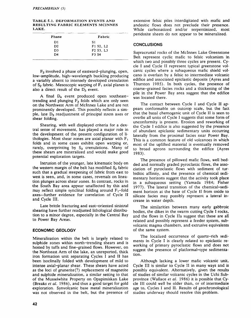
PRECAMBRIAN (5)
TABLE 5.1. DEFORMATION EVENTS AND RESULTING FABRIC ELEMENTS MCINNES LAKE.
Phase
DID2D3D4
Fabric
SIFI S2, L2F2 S3, L3F3 S4
F2 involved a phase of eastward-plunging, open, low-amplitude, high-wavelength buckling producing a variably absent to intensely developed crenulation of S2 fabric. Mesoscopic warping of F-, axial planes is also a direct result of the D3 event.
A final D4 event produced open southeast- trending and plunging F3 folds which are only seen on the Northwest Arm of Mcinnes Lake and are not prominently developed. This possibly reflects a sim ple, late D3 readjustment of principal stress axes or shear folding.
Shearing, with well displayed criteria for a dex tral sense of movement, has played a major role in the development of the present configuration of li- thologies. Most shear zones are axial planar with FI folds and in some cases exhibit open warping or, rarely, overprinting by S3 crenulations. Many of these shears are mineralized and would make good potential exploration targets.
Intrusion of the younger, late kinematic body on the western margin of the belt has modified S2 fabric such that a gradual steepening of fabric from east to west is seen, and, in some cases, reversals on linea tion plunges across shear zones. In contrast, rocks in the South Bay area appear unaffected by this and may reflect simple synclinal folding around FT-fold axes further evidence for correlation of Cycle II and Cycle III.
Late brittle fracturing and east-oriented sinistral shearing have further readjusted lithological distribu tion to a minor degree, especially in the Central Bay to Power Bay Areas.
ECONOMIC GEOLOGY
Mineralization within the belt is largely related to sulphide zones within north-trending shears and is hosted by tuffs and fine-grained flows. However, on the Northeast Arm of the lake, an unreported, thick iron formation unit separating Cycles I and II has been isoclinally folded with development of mild to intense axial-planar shear. These shears have acted as the loci of grunerite(?) replacement of magnetite and sulphide mineralization, a similar setting to that of the Musselwhite Property on Opapimiskan Lake (Breaks et al. 1986), and thus a good target for gold exploration. Synvolcanic base metal mineralization was not observed in the belt, but the presence of
extensive felsic piles interdigitated with mafic and andesitic flows does not preclude their presence. While carbonatized and/or serpentinized, most peridotite sheets do not appear to be mineralized.
CONCLUSIONS
Supracrustal rocks of the Mcinnes Lake Greenstone Belt represent cyclic mafic to felsic volcanism in which two and possibly three cycles are present. Cy cle I and Cycle II represent typical greenstone vol canic cycles where a subaqueous mafic shield vol cano is overlain by a felsic to intermediate volcanic edifice and associated epiclastic deposits (Ayres and Thurston 1985). In both cycles, the presence of coarse-grained facies rocks and a thickening of the pile in the Power Bay area suggest that the edifice was located there.
The contact between Cycle I and Cycle II ap pears conformable on outcrop scale, but the fact that the basal chemogenic unit of Cycle II is seen to overlie all units of Cycle I suggests that some form of unconformity is present. Erosion and reworking of the Cycle I edifice is also suggested by the presence of abundant epiclastic sedimentary units occurring laterally from the proximal facies near Power Bay. This is a common feature of old volcanoes in which most of the uplifted material is eventually removed to broad aprons surrounding the edifice (Ayres 1983).
The presence of pillowed mafic flows, well bed ded and normally graded pyroclastic flows, the asso ciation of pyroclastic flows with sediment of tur- biditic affinity, and the presence of chemical sedi mentary horizons suggest that the activity took place in a subaqueous setting (Yamada 1984; Fisher 1977). The lateral transition of the chemical-sedi ment horizon at the base of Cycle II from oxide to silicate facies may possibly represent a lateral in crease in water depth.
The similarities between many early gabbroic bodies, the dikes in the swarm cutting Cycle I rocks, and the flows in Cycle Ila suggest that these are all related and possibly represent a feeder system, sub volcanic magma chambers, and extrusive equivalents of the same system.
The localized occurrence of quartz-rich sedi ments in Cycle I is clearly related to epiclastic re working of primary pyroclastic flows and does not suggest the presence of platformal-type sedimenta tion.
Although lacking a lower mafic volcanic unit, Cycle III is similar to Cycle II in many ways and is possibly equivalent. Alternatively, given the results of studies of similar volcanic cycles in the Uchi Sub- province (Wallace et al. 1986) it is possible that Cy cle III could well be older than, or of intermediate age to, Cycles I and II. Results of geochronological studies underway should resolve this problem.
42
A.L. CORTIS ET AL.
UPPER WINDIGO LAKE GREENSTONE BELT
LOCATION AND ACCESS
The Upper Windigo Greenstone Belt is located near the southern flank of the Sachigo Subprovince ap proximately 150 km northwest of the town of Pickle Lake and in the vicinity of Latitude 52 0 30' and Longitude 91 0 30'. Access can be made either by float plane from Pickle Lake or by road (Highway 808) to Windigo Lake and thence upstream over a short section of rapids to Upper Windigo Lake.
PREVIOUS WORK
The presence of the Upper Windigo Lake belt was originally reported by J.B. Tyrrell (1913), and sub sequently mapped in 1938 by G.M. Robson (Sat terly 1941). Modifications to the map were made during subsequent reconnaissance surveys (Thurston et al. 1979; Sage and Breaks 1982).
GENERAL GEOLOGY
The greenstone belt rocks are adequately exposed in the western half of the belt to define the main units. The eastern half of the belt is poorly exposed owing to the presence of the Agutua Moraine overburden. The greenstone belt is dominantly composed of mas sive to pillowed basalt with interbedded units of iron formation apparent from linear magnetic patterns on aeromagnetic map 7013G (Ontario Department of Mines-Geological Survey of Canada 1963). Of the pillow lavas observed, only one exposure on an is land in Upper Windigo Lake (Figure 5.9) provided a reliable determination of stratigraphic younging di rection. Other younging determinations made from pillows, as previously reported by Thurston et al. (1979) and Sage and Breaks (1982) are not reliable. Two other units are described here: an intermediate to felsic pyroclastic unit and an epiclastic conglomer ate unit. All rocks are metamorphosed from at least middle-greenschist to lower-amphibolite facies.
Intermediate to felsic metavolcanics
The pyroclastic unit (see Figure 5.9) was previously reported as epiclastic by both Satterly (1941) and Sage and Breaks (1982). This unit is tabular in form, extending for at least 22 km along strike, and is 500 to 750 m in width. It is principally composed of dacitic tuff to lapilli-tuff. The lapilli-tuff beds comprise ellipsoidal, angular clasts of chert and rhyolite in a dacitic matrix. Clasts are typically about 5 cm in length with some blocks up to 17 cm. The medium- to fine-grained tuff is consistently graded to the south or southeast. The lapilli-tuff shows both normal and reverse grading of clast size. Lapilli-tuff beds locally form well developed scours into under lying fine-grained tuff and confirm the southward- facing attitude of this stratigraphic unit.
The eastern end of this unit, on the northern shore of Upper Windigo Lake, is composed of sharply bedded quartz-plagioclase-phyric dacitic to andesitic tuff, lapilli-tuff, and volcanic conglomer ate. One can observe both normal grading of grains in the tuff beds and reverse grading of chloritic clasts (possibly collapsed pumice). The massive conglom erate beds comprise a heterogeneous assemblage of clasts including dacite, rhyolite, chert, vein quartz, and gabbro and are interpreted as tuffaceous, ma trix-supported to clast-supported, resedimented mass-flow units.
Clastic metasediments
Exposed on several islands along the length of Up per Windigo Lake is a clastic sedimentary unit flanked to the north and south by basaltic flows. This epiclastic package extends for over 7 km along the lake and may continue farther eastward under the overburden. It is dominantly composed of thinly to thickly bedded conglomerate with lesser wacke and arenite. The sedimentary sequence is probably less than 600 m thick. Figure 5.10 shows stratigraphic sections for three of the islands (see Figure 5.8) to illustrate the typical facies that char acterize the entire sedimentary package and to illus trate the variation in dominant grain size or clast size between beds. The major facies are as follows:
1. massive, ungraded, sandy, matrix-supported to clast-supported conglomerate
2. graded, matrix- to clast-supported conglomer ate
3. normally and lesser amounts of reversely graded bedded, clast- to matrix-supported conglomer ate transitional to arenite or wacke
4. massive, ungraded sandstone (arenite or wacke)
5. normally and lesser amounts of reversely graded bedded arenite or wacke
An additional minor facies is laminated to massive siltstone/mudstone occurring on top of some sand stone beds.
The stratigraphic sections reveal sharply bedded conglomerate separated by thinner beds of sand stone (arenite or wacke) or beds grading transition- ally from basal conglomerate to sandstone. Minor siltstone lies sharply above some arenite beds; in places, thin tabular siltstone clasts can be observed in the basal or mid-level portions of the coarser grained clastic units and may represent pieces of a former siltstone bed ripped up by rapid deposition of the new bed. Some of the sandstone beds taper out along strike and may be products of shallow chan nels. The conglomerate dominantly comprises angu lar to subangular clasts of various material, as shown by the modal analyses in Table 5.2. The clasts gen erally form approximately 30 to 70 percent of the rock in beds ranging from pebbly sandstones to con-
43
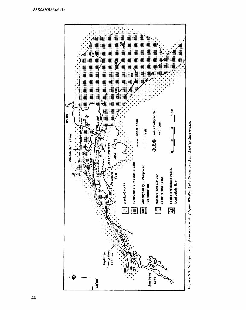
PRECAMBRIAN (5)
/iiiiiiiii^iiiiiiiiiiiiiii.iiiiiiiiiiiiiiiiiiiJJJJJiJJs T f ^
4- ^^^*a*****c***^x**^u*****.**.tu^*.^c**t***^*^*ct***ri ^ *^ -t^*c.u
H —lHIHfHylf-f'L^'V""IJtAtlV^ * * '.,.,.,/Lv * * * *
l
44
A.L. CORTIS ET AL.
TABLE 5.2. MODAL ANALYSES OF SANDSTONES.
Location 2Ve
MatrixWhite ChertRed ChertBlack ChertRhyoliteDaciteAndesiteBasaltSchistQuartz AreniteQuartz PorphyryQuartz Feldspar PorphyryFeldspar PorphyryVein QuartzTrondhjemite
3130
58
1212
3222
2
100 r.
Location 3
292127
323
1
51
35
10096
glomerates. The poor sorting of both matrix and clasts within individual conglomerate and sandstone beds and the angularity of the clasts define the tex tural immaturity of these rocks.
Bedding planes are flat with little evidence for channel gouging. In all three sections, the presence of grain-size grading in sandstone beds is variable and no cross-stratification is observed. Any original imbrication of clasts in conglomerate has been lost to rotation of clasts into a tectonic cleavage plane that is oblique to bedding.
In two outcrops on Upper Windigo Lake (l and 2 of Figure 5.9), one can observe rare cobble and boulder size clasts (Photo 5.1) of mineralogically mature and texturally mature quartzarenite within conglomerate beds. The quartz grains in these clasts are rounded, coarse- to fine-grained sand size. At least one clast preserves the original grading of the quartz sand grains oblique to the long axis of the clast.
Similar internally graded quartzarenite cobbles were observed on the northeastern shore of Sachigo Lake in the Ponask-Sachigo Lakes Belt. The pres ence of these quartzarenite clasts in each belt sug gests that a shallow-water depositional environment was exposed to erosion, either subaerial or subma rine, the latter involving direct erosion by suba queous channelling of the platform sequence.
DEPOSITIONAL ENVIRONMENT: DISCUSSION
This stratigraphic assemblage of coarse-grained clas tic deposits can be compared with models of either alluvial fans and braided fluvial plains. (Rust and Koster 1984) or deep-water resedimented conglom erates associated with turbidites (Walker 1975). The 15 m sections in Figure 5.10 provide only a limited,
two-dimensional window, but some pertinent com ments are in order. In the easternmost sections (Section 1), thick, ungraded, disorganized conglom erate beds are most prominent with a greater occur rence of cobble and boulder size clasts than in the other two sections (i.e. 2 and 3). There is also a more common occurrence of inverse grading. Each of the sections features apparent cyclic sequences of conglomerate, sandstone, and siltstone. Relicts of the siltstone beds may be the rip-up clasts contained in the overlying conglomerate bed.
The facies represented in the stratigraphic sec tions appear to represent mass flow (debris flow) and channel deposits. The massive conglomerate and sandstone beds are due to rapid transport so that no traction developed to produce cross-stratifi cation.
The stratigraphic assemblage comprises un graded, disorganized, and inversely to normally graded beds with lack of cross-stratification, flat bedding planes, and the presence of laterally dis rupted mudstone interbeds to form apparent tur bidite couplets. This suggests that -the sedimentary package developed within a channelway in the upper or proximal part of a submarine fan.
STRUCTURAL GEOLOGY
The Upper Windigo Lake (UWL) belt is a vertically dipping but consistently southward-facing panel of supracrustal rocks bounded to the north and south by granitic plutons. The southeasternmost extent of the belt has been determined from aeromagnetic patterns (Ontario Department of Mines-Geological Survey of Canada 1963) to extend discontinuously across a trondhjemitic pluton rich in amphibolite in clusions to the Horseshoe Lake belt. The western end of the Upper Windigo Lake belt appears to be on strike with and is probably correlatable with the McCoy Lake belt.
Right-handed, transcurrent shear zones are known to flank the Horseshoe Lake belt along its northern and southern margins (L. Jensen, Geolo gist, Ontario Geological Survey, personal communi cation, 1987). These shear zones appear to con verge westward to form a zone that can be traced westward across the Pipestone River. This zone is interpreted to continue northwestwards and may fol low at least part of the southern margin of the Upper Windigo Lake Greenstone Belt.
A protomylonitic shear zone at the northern end of Shinbone Lake occurs within trondhjemite close to the southwestern end of the Upper Windigo Lake Greenstone Belt. Another shear zone occurs on the southern shore of Upper Windigo Lake and hosts a l m wide quartz vein at the granite-greenstone con tact. We have observed no other prominent shear zones within the Upper Windigo Lake Greenstone Belt.
45
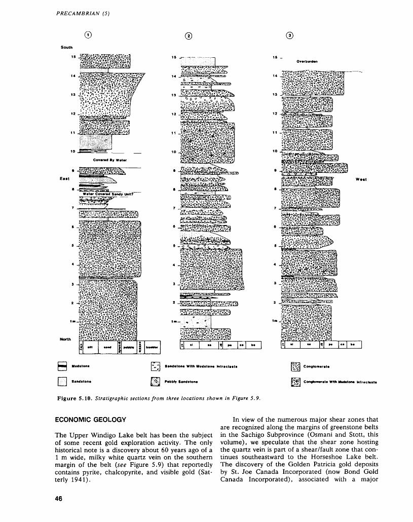
PRECAMBRIAN (5)
0South
Eatt
North
e
'^•/.r;r.''^"g0-?.^^
i^g^^a
Covered By Water
Sentfstone Wild Mudstone Intreclett*
Pebbly Sendtloive
12 ••^f^lf'iS^f Ajgjfpg A o,i j?j—jiVSi r* y* ~
frV-rvj;!,?!,TIT " ajV* a "''^
"N^S^S^^^^TT-^^?^^g.8?als^pSMeg}
fv'^.o?o^.v!'?jsis'***
sj^gisi^
Weit
L'Vd Conglomerelei o o^
EtW Coovtomer.t. With Muctetone Intraclait*
Figure 5.10. Stratigraphic sections from three locations shown in Figure 5.9.
ECONOMIC GEOLOGY
The Upper Windigo Lake belt has been the subject of some recent gold exploration activity. The only historical note is a discovery about 60 years ago of a l m wide, milky white quartz vein on the southern margin of the belt (see Figure 5.9) that reportedly contains pyrite, chalcopyrite, and visible gold (Sat terly 1941).
In view of the numerous major shear zones that are recognized along the margins of greenstone belts in the Sachigo Subprovince (Osmani and Stott, this volume), we speculate that the shear zone hosting the quartz vein is part of a shear/fault zone that con tinues southeastward to the Horseshoe Lake belt. The discovery of the Golden Patricia gold deposits by St. Joe Canada Incorporated (now Bond Gold Canada Incorporated), associated with a major
46
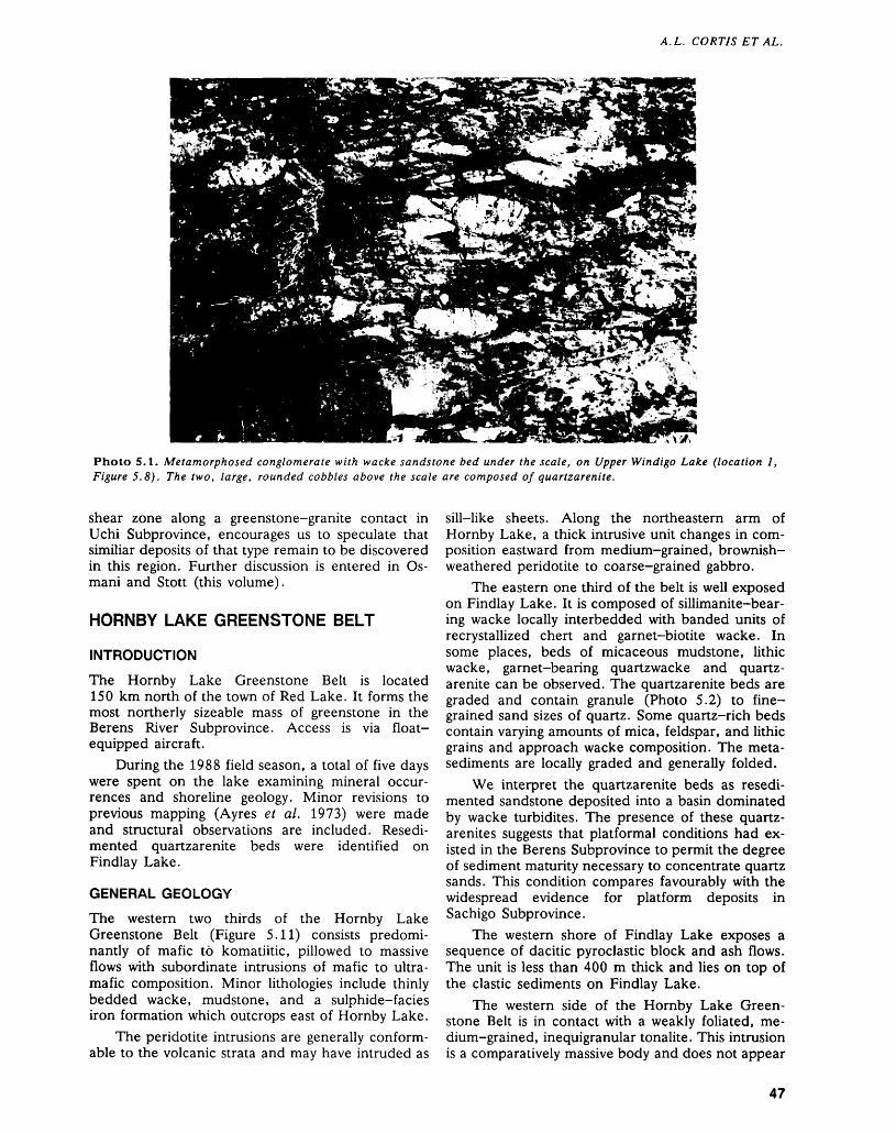
A. L. CORTIS ET AL.
Photo 5.1. Metamorphosed conglomerate with wacke sandstone bed under the scale, on Upper Windigo Lake (location l, Figure 5.8). The two, large, rounded cobbles above the scale are composed of quartzarenite.
shear zone along a greenstone-granite contact in Uchi Subprovince, encourages us to speculate that similiar deposits of that type remain to be discovered in this region. Further discussion is entered in Os mani and Stott (this volume).
HORNBY LAKE GREENSTONE BELT
INTRODUCTION
The Hornby Lake Greenstone Belt is located 150 km north of the town of Red Lake. It forms the most northerly sizeable mass of greenstone in the Berens River Subprovince. Access is via float- equipped aircraft.
During the 1988 field season, a total of five days were spent on the lake examining mineral occur rences and shoreline geology. Minor revisions to previous mapping (Ayres et al. 1973) were made and structural observations are included. Resedi mented quartzarenite beds were identified on Findlay Lake.
GENERAL GEOLOGY
The western two thirds of the Hornby Lake Greenstone Belt (Figure 5.11) consists predomi nantly of mafic to komatiitic, pillowed to massive flows with subordinate intrusions of mafic to ultra mafic composition. Minor lithologies include thinly bedded wacke, mudstone, and a sulphide-facies iron formation which outcrops east of Hornby Lake.
The peridotite intrusions are generally conform able to the volcanic strata and may have intruded as
sill-like sheets. Along the northeastern arm of Hornby Lake, a thick intrusive unit changes in com position eastward from medium-grained, brownish- weathered peridotite to coarse-grained gabbro.
The eastern one third of the belt is well exposed on Findlay Lake. It is composed of sillimanite-bear- ing wacke locally interbedded with banded units of recrystallized chert and garnet-biotite wacke. In some places, beds of micaceous mudstone, lithic wacke, garnet-bearing quartzwacke and quartz arenite can be observed. The quartzarenite beds are graded and contain granule (Photo 5.2) to fine grained sand sizes of quartz. Some quartz-rich beds contain varying amounts of mica, feldspar, and lithic grains and approach wacke composition. The meta- sediments are locally graded and generally folded.
We interpret the quartzarenite beds as resedi mented sandstone deposited into a basin dominated by wacke turbidites. The presence of these quartz - arenites suggests that platformal conditions had ex isted in the Berens Subprovince to permit the degree of sediment maturity necessary to concentrate quartz sands. This condition compares favourably with the widespread evidence for platform deposits in Sachigo Subprovince.
The western shore of Findlay Lake exposes a sequence of dacitic pyroclastic block and ash flows. The unit is less than 400 m thick and lies on top of the clastic sediments on Findlay Lake.
The western side of the Hornby Lake Green stone Belt is in contact with a weakly foliated, me dium-grained, inequigranular tonalite. This intrusion is a comparatively massive body and does not appear
47
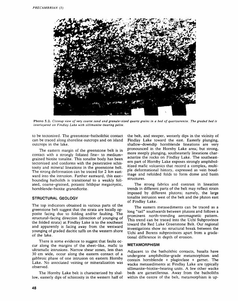
PRECAMBRIAN (5)
Photo 5.2. Closeup view of very coarse sand and granule-sized quartz grains in a bed of quartzarenite. The graded bed is interlayered on Findlay Lake with sillimanite-bearing pelite.
to be tectonized. The greenstone-batholithic contact can be traced along shoreline outcrops and on island outcrops in the lake.
The eastern margin of the greenstone belt is in contact with a strongly foliated fine- to medium- grained biotite tonalite. This tonalite body has been tectonized and conforms with the penetrative schis tosity and mineral lineations in the greenstone belt. The strong deformation can be traced for 2 km east ward into the intrusion. Farther eastward, this east- bounding batholith is transitional to a weakly foli ated, coarse-grained, potassic feldspar megacrystic, hornblende-biotite granodiorite.
STRUCTURAL GEOLOGY
The top indicators obtained in various parts of the greenstone belt suggest that the strata are locally op posite facing due to folding and/or faulting. The structural-facing direction (direction of younging of the folded strata) at Findlay Lake is to the southeast and apparently is facing away from the westward younging of graded dacitic tuffs on the western shore of the lake.
There is some evidence to suggest that faults oc cur along the margins of the sheet-like, mafic to ultramafic intrusions. Narrow shear zones, less than 30 cm wide, occur along the eastern contact of a gabbroic phase of one intrusion on eastern Hornby Lake. No associated veining or mineralization was observed.
The Hornby Lake belt is characterized by shal low, easterly dips of schistosity in the western half of
the belt, and steeper, westerly dips in the vicinity of Findlay Lake toward the east. Easterly plunging, shallow-downdip hornblende lineations are very pronounced in the Hornby Lake area; but strong, more steeply plunging, southeasterly lineations char acterize the rocks on Findlay Lake. The southeast ern part of Hornby Lake exposes strongly amphibol- itized mafic volcanics that record a complex, multi ple deformational history, expressed as vein boud inage and refolded folds to form dome and basin structures.
The strong fabrics and contrast in lineation trends in different parts of the belt may reflect strain imposed by different plutons; namely, the large tonalite intrusion west of the belt and the pluton east of Findlay Lake.
The eastern metasediments can be traced as a long "tail" southwards between plutons and follows a prominent north-trending aeromagnetic pattern. This trend can be traced into the Uchi Subprovince toward the Red Lake Greenstone Belt. Our regional investigations show no structural break between the Uchi and Berens subprovinces apart from a grada- tional difference in depth of erosion.
METAMORPHISM
Adjacent to the batholithic contacts, basalts have undergone amphibolite-grade metamorphism and contain hornblende -i- plagioclase + garnet. The wacke metasediments at Findlay Lake are typically sillimanite-biotite-bearing units. A few other wacke beds are garnetiferous. Away from the batholiths within the centre of the belt, metamorphism is up-
48
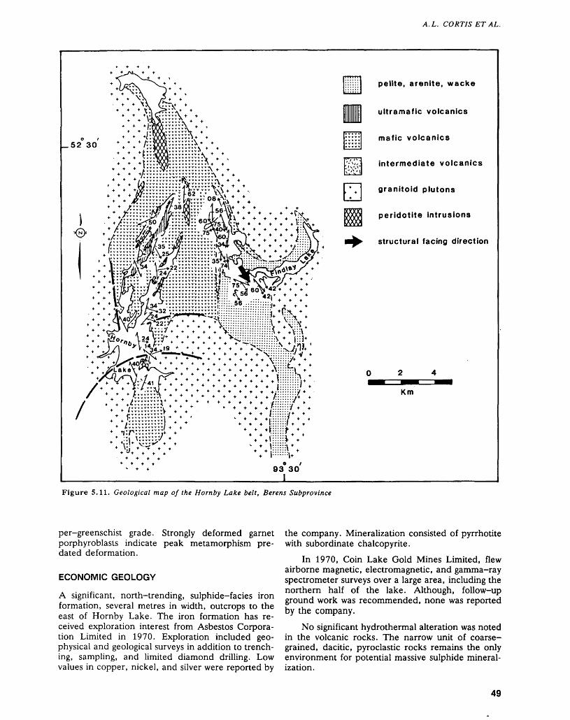
A.L. CORTIS ET AL.
O l - v y VAA/f y y y y y y y y '
52 3o * * *7y:yQ95::::,.y.\* *O ^ O U 4 * 'yy ir/X l yyyyyyyyy* 4 4
\\*^:5ftS::::::::::Jv\** * *t:.:Syyy...y..y v ..*4**'
* * * :::::.v.':::::....:;yy\ * *
T T CC^ ' j -*.y./ 44444 *:::::::: ::::::;::\ 4 4V::\*. '.a.^ \^:j". *. -. -. -. * .^mpiiiiiv. ill!*.* * *)j(\ ^3^'9 l * - * . * * * * **^:':::::':'::^T*
* * J/X^C-O ^ * * *** * * * * ^ * ^ * - * - * .^'•'•••'•L'* ^ * , \\^Lake\. yifi *-\ \
pelite, arenite, wacke
ultramafic volcanics
mafic volcanics
intermediate volcanics
granitoid plutons
peridotite intrusions
structural facing direction
Km
Figure 5.11. Geological map of the Hornby Lake belt, Berens Subprovince
per-greenschist grade. Strongly deformed garnet porphyroblasts indicate peak metamorphism pre dated deformation.
ECONOMIC GEOLOGY
A significant, north-trending, sulphide-facies iron formation, several metres in width, outcrops to the east of Hornby Lake. The iron formation has re ceived exploration interest from Asbestos Corpora tion Limited in 1970. Exploration included geo physical and geological surveys in addition to trench ing, sampling, and limited diamond drilling. Low values in copper, nickel, and silver were reported by
the company. Mineralization consisted of pyrrhotite with subordinate chalcopyrite.
In 1970, Coin Lake Gold Mines Limited, flew airborne magnetic, electromagnetic, and gamma-ray spectrometer surveys over a large area, including the northern half of the lake. Although, follow-up ground work was recommended, none was reported by the company.
No significant hydrothermal alteration was noted in the volcanic rocks. The narrow unit of coarse- grained, dacitic, pyroclastic rocks remains the only environment for potential massive sulphide mineral ization.
49
PRECAMBRIAN (5)
PONASK-SACHIGO LAKES GREENSTONE BELT
GENERAL GEOLOGY AND STRUCTURE
The eastern end of the Ponask-Sachigo Lakes Greenstone Belt is composed of two lithostrati graphic sequences of metamorphosed sandstone and conglomerate exposed on the northern and southern shores of Sachigo Lake. These sequences are each enveloped to the north and south by massive to pil lowed basaltic flows.
The metasediments generally comprise thickly bedded, massive, ungraded units of sandstone and conglomerate. The lithic/wacke sandstone beds of fine to medium and coarse sand sized grains are typically 3 to 6 m thick. They are interbedded with pebbly sandstone and conglomerate. Conglomerate beds vary in thickness from less than l m to more than 25 m thick. Clasts are subangular to sub rounded and of dominantly pebble to cobble size. There is no clear size grading observed in the units. Local concentrations of tabular mudstone clasts oc cur within some conglomerate beds which may have been ripped up from interbedded mudstone units. The conglomerate beds typically contain clasts of chert, felsic and intermediate volcanics, felsic por phyry, minor granodiorite, quartz-feldspar arenite, and quartzarenite. The arenite clasts are cobble to pebble sized. One quartzarenite clast preserves within it an original bedding plane separating con trasting grain sizes of quartz. The few quartzarenite clasts are associated with felsic volcanic and quartz porphyry clasts. There are few granitic clasts.
Several units of mudstone and siltstone were ob served. One is a dark-grey slate, 6 m thick and in terbedded with conglomerate, occurring on the southern shore of Sachigo Lake.
The axis of a central anticline strikes east-south eastward along the length of the lake. This anticline separates the two metasedimentary sequences. The facing direction of the vertically dipping strata on the hinge of this anticline is to the west. The bedding dips vertically to steeply away from the axial plane of the anticline.
The schistosity strikes northeastward at an angle counterclockwise to the bedding on both the north ern and southern limbs of the anticline. This schis tosity therefore transects the anticline and is not symmetrical to it.
Mineral lineations and conglomerate clast elon gations plunge typically 40 0 to 75 0 east-northeast ward. The lineations plunge at angles oblique to the near-vertical hinge of the anticline and thus are nei ther parallel nor orthogonal to the regional fold axis.
The schistosity may reflect a regional-flattening event that postdates the anticlinal fold. Alterna tively, it may reflect a northwesterly directed, trans pressional deformation that produced both folding
and the transecting schistosity. Evidence for north west-directed shortening is widely observed as a late regional deformation in all subprovinces (Stott et al. 1987). Thus it becomes important to eventually es tablish the timing of regional folding and transecting schistosity and determine whether such deformation within the greenstone belts is related to the late northwest-trending shear zones observed along granite-greenstone contacts.
The typically thick, massive, ungraded beds of conglomerate and sandstone, with minor mudstone interlayers, comprise a general assemblage that closely resembles a similar sequence which may be observed at Upper Windigo Lake (see section "Up per Windigo Lake Greenstone Belt", this paper). We interpret the metasedimentary package to have been deposited by rapid transport in a channelway on the upper part of a submarine fan. The clastic material, apparently deposited by debris flow, was largely derived from felsic to intermediate volcanic sources and metasediments. The presence of quartzarenite cobbles in the massive conglomerate beds suggest part of the source area for clasts in cluded a shallow-water platformal environment.
SUMMARY AND CONCLUSIONS
Major revisions to the boundaries of subprovinces of the Superior Province are becoming increasingly likely as a result of investigations of northern greenstone belts. The Sachigo Subprovince of Card and Ciesielski (1986) has been subdivided (W. Weber, Geologist, Manitoba Department of En ergy and Mines, Winnipeg, personal communica tion, 1987) as follows:1. Gods Lake domain: a granite-greenstone ter
rane extending from the Oxford Lake-Knee Lake-Gods Lake Belt east to the Big Trout- Nemeigusabins Belt in Ontario.
2. Molson Lake domain: granitoid and migmatitic rocks lying south of the Gods Lake domain. The block extends from Molson Lake to Winisk Lake, including the region between Stull Lake and Ponask Lake. The south boundary of the zone is the Ponask Lake Shear Zone (Osmani and Stott, this volume).
3. Island Lake domain: This granite-greenstone subprovince has been termed the Sachigo Sub province by Ayres et al. (1971).The speculation that the Gods Lake domain dif
fers from the Island Lake domain by virtue of the absence of platform sequences has been strength ened by confirmation of the absence of platformal sequences at Ellard Lake and Swan Lake north and east of Stull Lake (Osmani and Stott, this volume).
The platform sequences within the Sachigo Sub province are yet more widespread than was docu mented by Thurston et al. (1987), with new occur rences at Windigo Lake and the eastern part of Sachigo Lake. In the near future, we may be able to
50
A. L. CORTIS ET AL.
subdivide the platform-sequence-bearing green stones into two types:
1. Sedimentary sequences derived from erosion of platform sequences such as the Keewaywin se quence, Sanborn Bay sequence (Thurston et al. 1987), and the Hornby Lake and Windgo Lake occurrences.
2. Platform sequences sensu stricto, such as the Keeyask sequence and the Zeemel-Pipestone- Heaton clastic sequence, both in the North Cari bou Lake area (Bartlett et al. 1985; Breaks et al. 1986).
Platform sequences in the modern environment consist of shallow-water carbonates and quartzites (Sheridan 1974). The platform sequences of the Sachigo Subprovince are largely quartzarenite-bear- ing sedimentary packages. The most essential ele ment of these packages is that they represent contin ued shallow-water deposition of basal quartzarenites and carbonates and probable shallow-water deposi tion of iron formation and overlying volcanic rocks i.e. deposition kept pace with subsidence. This is in contrast to the mafic to felsic cyclical vol canism that is most common in greenstone belts (Ayres and Thurston 1985) where subsidence in itially exceeds deposition. This relationship of subsi dence versus depositional rate has led to speculation that carbonate sediments in the Uchi Subprovince represent platformal sequences (e.g. at Confedera tion Lake (Thurston and Chivers, in press)). We then have older greenstones in the Uchi, Berens River, and Sachigo subprovinces representing plat formal deposition. There is some indication that there is no shear zone separating the Uchi and Berens River subprovinces; therefore, both struc tural and stratigraphic evidence suggests that the Berens River Subprovince may be a deeper erosional level of the Uchi Subprovince. More definitive evi dence will be provided through geobarometric inves tigation.
REFERENCESAverill, S.A.1968: Geology of the Mcinnes Lake Area; Private Report to
L.D. Ayres.
Ayres, L.D.1983: Bimodal Volcanism in Archean Greenstone Belts Ex-
ernplified by Greywacke Composition, Lake Superior Park, Ontario; Canadian Journal of Earth Sciences, Volume 20, p. 1168-1194.
Ayres, L.D., Lumbers, S.B., Milne, V.G., and Robeson,D.W.
1971: Ontario Geological Map; Ontario Department ofMines and Northern Affairs, Map 2196, scale1:1 013 760 or l inch to 16 miles.
Ayres, L.D., Raudsepp, M., Averill, S.A., and Edwards, G.R.
1973: Favourable Lake-Berens Lake, Geological Compila tion Series Map; Ontario Geological Survey, Map
2262, 1:253 440 or l inch to 4 miles. Compilation 1968-1972.
Ayres, L.D., and Thurston, P.C.1985: Archean Supracrustal Sequences in the Canadian
Shield: An Overview; p.343-380 in Evolution of Ar chean Supracrustal Sequences, edited by L.D. Ayres, P.C. Thurston, and W. Weber, Geological Associa tion of Canada, Special Paper 28.
Bartlett, J.R., Breaks, F.W., DeKemp, E.A., and Shields, H.N.
1985: Precambrian Geology of Eyapamikama Lake Area (Opapimiskan Lake Project), Kenora District (Patricia Portion); Ontario Geological Survey Map, P.2834, Geological Series-Preliminary Map, scale l inch to 1/2 mile or 1:31 680. Geology 1984.
Breaks, F.W., Osmani, I.A., and deKemp, E.A.1986: Opapimiskan Lake Project: Precambrian Geology of
the Opapimiskan-Forester Lakes Area, District of Kenora, Patricia Portion; p.368-378 in Summary of Field Work and Other Activities 1986, by the Ontario Geological Survey, edited by P.C. Thurston, Owen L. White, R.B. Barlow, M.E. Cherry, and A.C. Colvine, Ontario Geological Survey, Miscella neous Paper 132, 435p. Accompanied by l Chart.
Card, K.D., and Ciesielski, A.1986: DNAG #1 Subdivisions of the Superior Province of the
Canadian Shield; Geoscience Canada Volume 13,p.5-13.
Corfu, F., and Wood, J.1986: U-Pb Zircon Ages in Supracrustal and Plutonic
Rocks, North Spirit Lake Area, Northwestern On tario; Canadian Journal of Earth Sciences, Volume 23, p.967-977.
Davis, D.W., and Jackson, M.C.1988: Geochronology of the Lumby Lake Greenstone Belt: A
3 Ga Complex Within the Wabigoon Subprovince, Northwest Ontario; Geological Society of America Bulletin, Volume 100, Part 6, p.818-824.
deKemp, E.A.1987: Stratigraphy, Provenance and Geochronology of Ar
chean Supracrustal Rocks of Western Eyapamikama Lake Area, Northwestern Ontario; Unpublished M.Se. Thesis, Carleton University, Ottawa, Ontario, Canada, 98p.
Fisher, R.V.1977: Subaqueous Pyroclastic Flow Deposits: A review.
(Modified Manuscript Submitted for Publication);Penrose Conference Field Trip, November 30, 1977.
Greeley, R., Pheilig E., and King, J.S.1977: Guide to the Geology of Kings Bowl Lava Field;
p.171-188 in Volcanism of the Eastern Snake River Plain, Idaho: a Comparative Planetary Geological Guide Book, edited by R. Greeley and J.S. King, Pre pared for the Office of Planetary Geology, NASA, Washington, D.C..
Jensen, L.S.1987: Geology of the Horseshoe Lake Greenstone Belt, Dis
trict of Kenora; p. 104-108 in Summary of Field Work and Other Activities 1987, by the Ontario Geological Survey, edited by R.B. Barlow, M.E. Cherry, A.C. Colvine, Burkhard O. Dressler, and Owen L. White, Ontario Geological Survey Miscellaneous Paper 137, 429p.
51
PRECAMBRIAN (5)
Ojakangas, R.W.1985: Review of Archean Clastic Sedimentation, Canadian
Shield: Major Felsic Contributions to Turbidite and Alluvial Fan Fluvial Facies Associations; p.23-47 in Evolution of Archean Supracrustal Sequences, edited by L.D. Ayres, P.C. Thurston, and W. Weber, Geo logical Association of Canada, Special Paper 28.
Ontario Department of Mines Geological Survey of Canada1963: North Caribou Lake, Ontario; Geophysical Map
7013G, Aeromagnetic Series, scale 1:253 440 or linch to 4 miles. Survey and compilation 1959 to 1960.
Rust, B.R., and Koster, E.H.1984: Coarse Alluvial Deposits; p.53-69 in Facies Models,
Second Edition, edited by R.G. Walker, GeoscienceCanada Reprint Series l.
Sage, R.P., and Breaks, F.W.1982: Geology of the Cat Lake-Pickle Lake Area, Districts
of Kenora (Patricia Portion) and Thunder Bay; On tario Geological Survey Report 207, 238p. Accompa nied by map 2218, scale 1:253 440 or l inch to 4 miles.
Satterly, J.1941: Geology of the Windigo-North Caribou Lakes Area;
Ontario Department of Mines, Annual Report for 1939, Volume 48, Part 9, 32p. Accompanied by Colour Maps 48h, scale 1:63 360 or l inch to l mile, and 48j, scale 1:126 720 or l inch to 2 miles.
Sheridan, R.E.1974: Atlantic Continental Margins of North America;
p.391-408 in The Geology of Continental Margins, edited by C.A. Burk, and C.L. Drake, New York, Springer-Verlag.
Stott, G.M., Sanborn-Barrie, M., and Corfu, F.1987: Major Transpression Events Recorded Across Ar
chean Subprovince Boundaries in Northwestern On tario; Geological Association of Canada, Yellowknife '87, Program with Abstracts.
Thurston, P.C.1967: Obonga-Lleigh Lakes Area, (West Half), District of
Thunder Bay; p.29-31 in Summary of Field Work 1967 by the Geological Branch, edited by E.G. Pye, Ontario Department of Mines, Miscellaneous Paper 11, 73p.
Thurston, P.C., and Chivers, K.M.In Press: Secular Variation in Greenstone Sequence Develop
ment Emphasizing Superior Province, Canada; Pre cambrian Research.
Thurston, P.C., Cortis, A.L., and Chivers, K.M.1987: A Reconnaissance Re-evaluation of a Number of
Northwestern Greenstone Belts: Evidence for an Early Archean Sialic Crust; p.4-24 in Summary of Field
Work and Other Activities 1987, R.B. Barlow, M.E. Cherry, A.C. Colvine, Burkhard O. Dressler, and Owen L. White, Ontario Geological Survey Mis cellaneous Paper 137. 429p.
Thurston, P.C., and Davis, D.W.
1985: The Wabigoon Diapiric Axis as a Basement Complex; in Summary of Field Work and Other Activities 1985, Ontario Geological Survey, edited by John Wood, Owen L. White, R.B. Barlow, and A.C. Colvine, Ontario Geological Survey Miscellaneous Paper 126, 351p.
Thurston, P.C., Sage, R.P., and Siragusa, G.M.
1979: Geology of the Winisk Lake Area, District of Kenoraz, Patricia Portion; Ontario Geological Survey Report 193, 169p. (With appendix by R.A. Riley). Accompanied by Maps 2287 and 2292, scale 1:253 440 or l inch to 4 miles, and coloured charts A and B.
Trowell, N.F.1986: Geology of the Savant Lake Area, Districts of Kenora
and Thunder Bay; Ontario Geological Survey, Open File Report 5606, 181p., 15 figures, 17 tables, and 2 maps in back pocket.
Tyrrell, J.B.1913: Hudson Bay Exploring Expedition 1912; Ontario Bu
reau of Mines, Annual Report for 1913, Volume 22, Part l, p.161-209.
Walker, R.G.1975: Generalized Facies Models for Resedimented Con
glomerates of Turbidite Association; Geological Soci ety of America Bulletin, Volume 86, p.737-748.
1984: Turbidites and Associated Coarse Clastic Deposits; p. 171-188 in Facies Models, Second Editon, edited by R.G. Walker, Geoscience Canada Reprint Series 1.
Wallace, H., Thurston, P.C., and Corfu, F.1986: Developments in Stratigraphic Correlation: Western
Uchi Subprovince; p.88-102 in Volcanology and Mineral Deposits, edited by John Wood, and Henry Wallace, Ontario Geological Survey, Miscellaneous Paper 129, 183p.
Wood, J., and Thurston, P.C.In Press: Archean Platform Sequences in the Superior Prov
ince of the Canadian Shield; Earth and Planetary Sci ence Letters.
Yamada, E.1984: Subaqueous Pyroclastic Flows: Their Development
and Their Deposits; p.29-35 in Marginal Basin Geol ogy, edited by B.P. Kokelaar, and M.P. Howells, Geological Society of America, Special Publication 16.
52
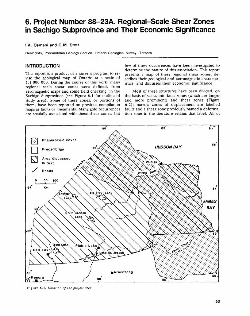
6. Project Number 88-23A. Regional-Scale Shear Zones in Sachigo Subprovince and Their Economic Significance
l.A. Osmani and G.M. Stott
Geologists, Precambrian Geology Section, Ontario Geological Survey, Toronto.
INTRODUCTION
This report is a product of a current program to re vise the geological map of Ontario at a scale of 1:1 000 000. During the course of this work, many regional scale shear zones were defined, from aeromagnetic maps and some field checking, in the Sachigo Subprovince (see Figure 6.1 for outline of study area). Some of these zones, or portions of them, have been reported on previous compilation maps as faults or lineaments. Many gold occurrences are spatially associated with these shear zones, but
few of these occurrences have been investigated to determine the nature of this association. This report presents a map of these regional shear zones, de scribes their geological and aeromagnetic character istics, and discusses their economic significance.
Most of these structures have been divided, on the basis of scale, into fault zones (which are longer and more prominent) and shear zones (Figure 6.2); narrow zones of displacement are labelled faults and a shear zone previously named a deforma tion zone in the literature retains that label. All of
Phanerozoic cover
Precambrian
IL outLake v Pickle Lake
l Red Lake
Figure 6.1. Location of the project area.
53
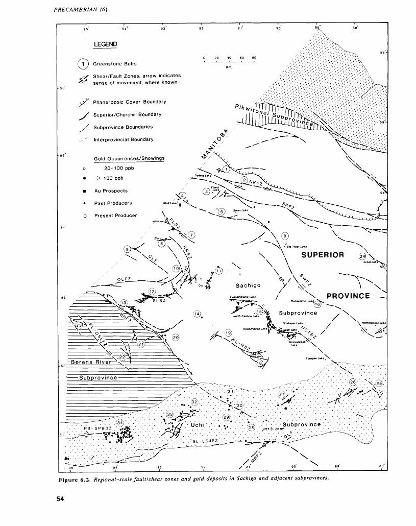
PRECAMBRIAN (6)
0
55'
LEGEND
Greenstone Belts
,/X Shear/Fault Zones; arrow indicates '^ sense of movement, where known
yr Phanerozoic Cover Boundary
S Superior/Churchill Boundary
S Subprovince Boundaries
^ ' Interprovincial Boundary
Gold Occurrences/Showings
o 20-100 ppb
* > 100 ppb
m Au Prospects
4 Past Producers
D Present Producer
\
OUfZ___.
©V
\ \ SUPERIOR
X \ \,^/\\
Sachigo y ^^
^\^ **^ iC^M^I
4-^-vr5"^.-.-.-.-.^ ^i-.-.-.-.:::: . . . . . . . . . . . . . . o•.-.•.•.•.•.•.•.- V '" ^•.•.•.•.•.-.^.•.•-•.•.•sL-LSJF2V.^..V uiV1\-.^. JJ,Xj^J^
Figure 6.2. Regional-scale fault/shear zones and gold deposits in Sachigo and adjacent subprovinces.
54
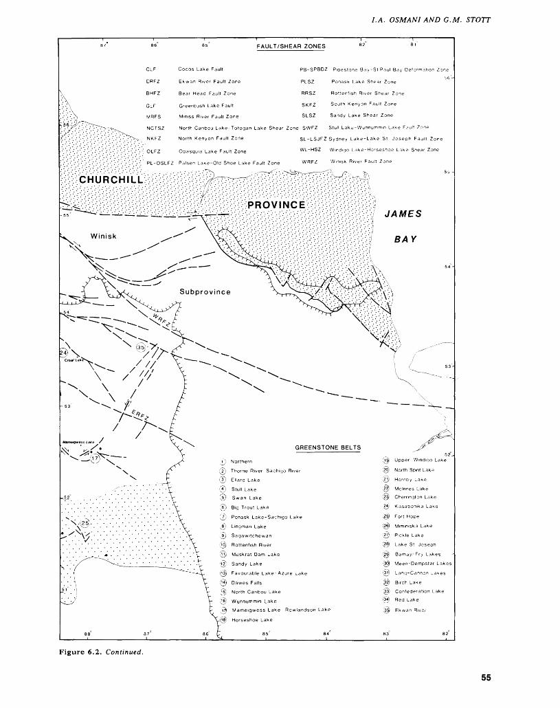
LA. OSMANI AND G.M. STOTT
FAULT/SHEAR ZONES
Cocos Lake Fault
Ekwan River Fault Zone
Bear Head Fault Zone
Greenbush Lake Fault
Miniss River Fault Zone
PB-SPBDZ Pipestone Bay-St Paul Bay Deformation Zone
PLSZ Ponask Lake Shear Zone
RRSZ Rottenfish River Shear Zone
SKFZ South Kenyon Fault Zone
SLSZ Sandy Lake Shear Zone
North Caribou Lake-Totogan Lake Shear Zone SWFZ Stull Lake-Wunnummm Lake Fault Zone
North Kenyon Fault Zone SL-LSJFZ Sydney Lake-Lake St Joseph Fault Zone
Opasquia Lake Fault Zone WL-HSZ Windigo Lake-Horseshoe Lake Shear Zone
Winisk River Fault ZonePL-OSLFZ Palsen Lake-Old Shoe Lake Fault Zone
CHURCHILL
PROVINCE
Subprovince
GREENSTONE BELTS
Upper Windigo Lake
North Spirit Lake
Hornby Lake
Mcinnes Lake
Cherrington Lake
Kasabonika Lake
Fort Hope
Miminiska Lake
Pickle Lake
Lake St Joseph
~ amaji-Fry Lakes
Meen-Dempster Lakes
Lang-Cannon Lakes
Birch Lake
Confederation Lake
Red Lake
Ekwan River
Northern
Thorne River-Sachigo River
Ellard Lake
Stull Lake
Swan Lake
Big Trout Lake
Ponask Lake-Sachigo Lake
Lingman Lake
Sagawitchewan
Rottenfish River
Muskrat Dam Lake
Sandy Lake
Favourable Lake-Azure Lake
Dawes Falls
North Caribou Lake
Wunnummin LakeMameigwess Lake- Rowlandson Lake
Horseshoe Lake
Figure 6.2. Continued.
55
PRECAMBRIAN (6)
these zones are referred to as regional shear zones for ease of discussion. Many, if not all, have re corded both brittle and ductile displacements, but few have been the subject of detailed analysis (e.g. Stone 1981).
PREVIOUS WORK
Some of the shear zones were recognized many years ago. More recent workers, such as Park (1981) and Schwerdtner et al. (1979), have noted that these zones reflect an important northwesterly directed regional compression during the late Ar chean. They determined the orientation of the prin cipal stress directions from the orientation of the shear zones and the displacements along them.
METHODOLOGY
Several shear zones not previously recorded in the Sachigo Subprovince have been identified, and the lengths of many others have been extended (Figure 6.2). This reinterpretation is based in part on recent mapping (Thurston et al. 1987; deKemp 1987; Wil son 1987; Breaks and Bartlett et al. 1986; Breaks et al. 1986, 1987; Bartlett et al. 1984; Stott 1985, 1986; Stott and Janes 1985); helicopter reconnais sance (Sage and Breaks 1982; Thurston et al. 1979; Bennett and Riley 1969); geochronology (deKemp 1987; Corfu and Wood 1986; Corfu et al. 1985); and some field checking by the authors during the 1988 field season. Interpretation of airborne mag netic (ODM-GSC 1963a to 1963g inclusive, 1967a to 1967i inclusive, 1968a, 1968b, 1969a to 1969e inclusive, 1970a, 1970b; OGS 1985) and gamma ray spectrometry maps (OGS-GSC 1977a, 1977b, 1978a to 1978d inclusive, 1979a, 1979b) was also used in this work.
The major features of the reinterpretation are 1) revision of the extent of some greenstone belts; 2) definition of new lithostratigraphic associations in some greenstone belts, i.e. an older (2850 to 3023 Ma) shallow water sequence and relatively younger (2750 to 2700 Ma) mafic to felsic volcanic cycles (Thurston et al. 1987; deKemp 1987; Wood et al. 1986); 3) recognition of new subdivisions of Archean granitoid rocks, based on a revised legend for a new edition of the geological map of Ontario (see Thurston, this volume); and 4) recognition of several large scale shear zones, which are potentially important targets for gold mineralization in the area.
Federal/Provincial aeromagnetic maps of the study area (ODM-GSC 1963a to 1963g inclusive, 1967a to 1967i inclusive, 1968a, 1968b, 1969a to 1969e inclusive, 1970a, 1970b; OGS 1985) show large scale magnetic features (compare Figures 6.2 and 6.3) that highlight: the correlation of chains of greenstone belts separated by plutons rich in am phibolite inclusions; the contrasting phases of differ
ent plutons; and most notably, faults and shear zones.
Shear zones are recognized by: 1) contrasts in magnetic patterns on either side of a linear anomaly; 2) truncation of lithological units and magnetic anomalies; 3) rotation of magnetic anomaly trends (which are comparable to foliation trajectories); and 4) long, linear zones of either low or high magnetic intensity. On the basis of these magnetic features, several shear zones of regional significance were identified (Osmani, in preparation). Some of these structures have been recently verified by field map ping by the authors; other structures remain to be checked in the future.
BEAR HEAD FAULT ZONEThe Bear Head Fault Zone (BHFZ) (Ayres et al. 1973) is approximately 515 km long and can be traced from near Lake Winnipeg in Manitoba east ward into Ontario, where it terminates along the northern boundary of the Meen-Dempster Lakes Greenstone Belt (Number 31, Figure 6.2).
The extent of this fault zone was recognized dur ing the 1988 field season. The fault zone is charac terized on the aeromagnetic maps by a narrow linear zone of high magnetic intensity. Several lake and river transects were examined across this zone be tween North Spirit Lake (Number 20, Figure 6.2) and the Meen-Dempster Lakes Greenstone Belt. Where the zone crosses plutons of hornblende-bear ing potassic feldspar megacrystic monzogranite to granodiorite, the linear signature of high magnetic intensity is most pronounced. The hornblende has been altered during the deformation to magnetite, chlorite, and epidote. These rocks have been de formed to protomylonites with local very fine grained mylonite bands. Mineral lineations and the long axes of mineral aggregates are subhorizontal near MacDowell Lake, southeast of North Spirit Lake. Along the shear zone towards the Meen- Dempster Lakes belt, the lineations typically plunge 5 to 30 0 to the southeast. The detailed geometry, on a horizontal surface, of the protomylonite (Photo 6.1) shows a progressive clockwise rotation of the schistosity plane (S) towards the shear plane (C). These structures, which are reliable shear crite ria (Berte et al. 1979), demonstrate a right-handed sense of shear. In addition, ductile shear bands and asymmetric pressure shadows of porphyroclastic potassic feldspar megacrysts complement this inter pretation.
This fault zone is approximately 3 km in width on MacDowell Lake and southeast towards Cat Lake, and narrows progressively toward Meen Lake. North of Meen Lake, it appears to consist of several shear zones. Further southeast, the zone varies in width from l km on Wright Lake to 500 m on Kawinogans Lake (Stott and Wilson 1986).
In several locations within the Meen-Dempster Lakes Greenstone Belt, notably near Meen Lake
56
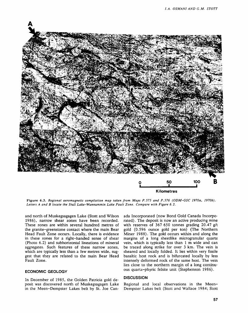
LA. OSMANI AND G.M. STOTT
Kilometres
Figure 6.3. Regional aeromagnetic compilation map taken from Maps P. 575 and P. 576 (ODM-GSC 1970a, 1970b). Letters A and B locate the Stull Lake-Wunnummin Lake Fault Zone. Compare with Figure 6.2.
and north of Muskegsagagen Lake (Stott and Wilson 1986), narrow shear zones have been recorded. These zones are within several hundred metres of the granite-greenstone contact where the main Bear Head Fault Zone occurs. Locally, there is evidence in these zones for a right-handed sense of shear (Photo 6.2) and subhorizontal lineations of mineral aggregates. Such features of these narrow zones, which are typically less than a few metres wide, sug gest that they are related to the main Bear Head Fault Zone.
ECONOMIC GEOLOGY
In December of 1985, the Golden Patricia gold de posit was discovered north of Muskegsagagen Lake in the Meen-Dempster Lakes belt by St. Joe Can
ada Incorporated (now Bond Gold Canada Incorpo rated) . The deposit is now an active producing mine with reserves of 367 650 tonnes grading 20.47 g/t gold (0.596 ounce gold per ton) (The Northern Miner 1988). The gold occurs within and along the margins of a long sheetlike microgranular quartz vein, which is typically less than l m wide and can be traced along strike for over 3 km. The vein is sheared and locally folded. It lies within very fissile basaltic host rock and is bifurcated locally by less intensely deformed rock of the same host. The vein lies close to the northern margin of a long continu ous quartz-phyric felsite unit (Stephenson 1986).
DISCUSSION
Regional and local observations in the Meen- Dempster Lakes belt (Stott and Wallace 1984; Stott
57
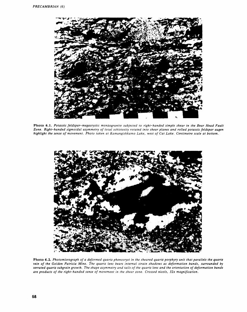
PRECAMBRIAN (6)
Photo 6.1. Potassic feldspar-megacrystic monzogranite subjected to right-handed simple shear in the Bear Head Fault Zone. Right-handed sigmoidal asymmetry of local schistosity rotated into shear planes and rolled potassic feldspar augen highlight the sense of movement. Photo taken at Kamungishkamo Lake, west of Cat Lake. Centimetre scale at bottom.
Photo 6.2. Photomicrograph of a deformed quartz phenocryst in the sheared quartz porphyry unit that parallels the quartz vein of the Golden Patricia Mine. The quartz lens bears internal strain shadows as deformation bands, surrounded by serrated quartz suberain growth. The shape asymmetry and tails of the quartz lens and the orientation of deformation bands are products of the right-handed sense of movement in the shear zone. Crossed nicols, 32x magnification.
58
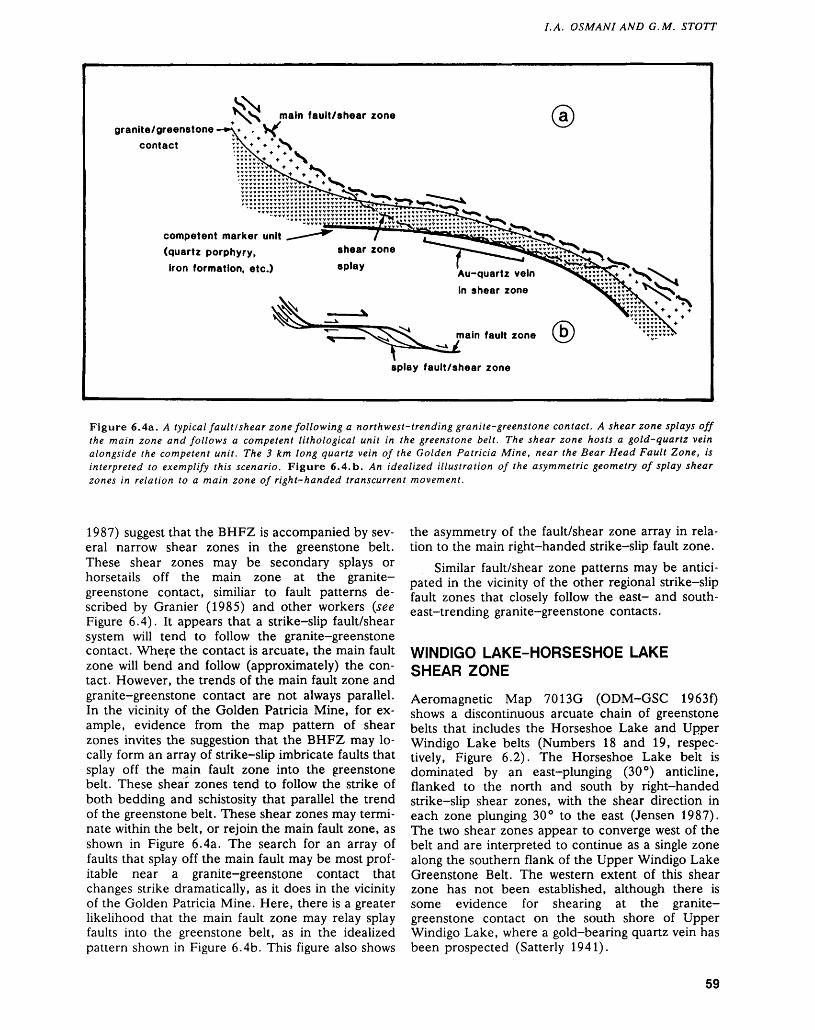
LA. OSMANI AND G.M. STOTT
main fault/shear zonegranite/greenstone
contact
Au-quartz vein In shear zone
competent marker unit (quartz porphyry, iron formation, etc.)
main fault zone i
splay fault/shear zone
Figure 6.4a. A typical fault/shear zone following a northwest-trending granite-greenstone contact. A shear zone splays off the main zone and follows a competent lithological unit in the greenstone belt. The shear zone hosts a gold-quartz vein alongside the competent unit. The 3 km long quartz vein of the Golden Patricia Mine, near the Bear Head Fault Zone, is interpreted to exemplify this scenario. Figure 6.4.b. An idealized illustration of the asymmetric geometry of splay shear zones in relation to a main zone of right-handed transcurrent movement.
1987) suggest that the BHFZ is accompanied by sev eral narrow shear zones in the greenstone belt. These shear zones may be secondary splays or horsetails off the main zone at the granite- greenstone contact, similiar to fault patterns de scribed by Granier (1985) and other workers (see Figure 6.4). It appears that a strike-slip fault/shear system will tend to follow the granite-greenstone contact. Wher,e the contact is arcuate, the main fault zone will bend and follow (approximately) the con tact. However, the trends of the main fault zone and granite-greenstone contact are not always parallel. In the vicinity of the Golden Patricia Mine, for ex ample, evidence from the map pattern of shear zones invites the suggestion that the BHFZ may lo cally form an array of strike-slip imbricate faults that splay off the main fault zone into the greenstone belt. These sheaf zones tend to follow the strike of both bedding and schistosity that parallel the trend of the greenstone belt. These shear zones may termi nate within the belt, or rejoin the main fault zone, as shown in Figure 6.4a. The search for an array of faults that splay off the main fault may be most prof itable near a granite-greenstone contact that changes strike dramatically, as it does in the vicinity of the Golden Patricia Mine. Here, there is a greater likelihood that the main fault zone may relay splay faults into the greenstone belt, as in the idealized pattern shown in Figure 6.4b. This figure also shows
the asymmetry of the fault/shear zone array in rela tion to the main right-handed strike-slip fault zone.
Similar fault/shear zone patterns may be antici pated in the vicinity of the other regional strike-slip fault zones that closely follow the east- and south east-trending granite-greenstone contacts.
WINDIGO LAKE-HORSESHOE LAKE SHEAR ZONE
Aeromagnetic Map 7013G (ODM-GSC 1963f) shows a discontinuous arcuate chain of greenstone belts that includes the Horseshoe Lake and Upper Windigo Lake belts (Numbers 18 and 19, respec tively, Figure 6.2). The Horseshoe Lake belt is dominated by an east-plunging (30 0 ) anticline, flanked to the north and south by right-handed strike-slip shear zones, with the shear direction in each zone plunging 30 0 to the east (Jensen 1987). The two shear zones appear to converge west of the belt and are interpreted to continue as a single zone along the southern flank of the Upper Windigo Lake Greenstone Belt. The western extent of this shear zone has not been established, although there is some evidence for shearing at the granite- greenstone contact on the south shore of Upper Windigo Lake, where a gold-bearing quartz vein has been prospected (Satterly 1941).
59
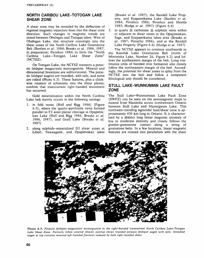
PRECAMBRIAN (6)
NORTH CARIBOU LAKE-TOTOGAN LAKE SHEAR ZONE
A shear zone may be revealed by the deflection of regional magnetic trajectory lines into the shear zone direction. Such changes in magnetic trends are noted between Obabigan and Totogan lakes. West of Obabigan Lake, this structure converges into the shear zones of the North Caribou Lake Greenstone Belt (Bartlett et al. 1984; Breaks et al. 1986, 1987, in preparation; Piroshco 1986) to form the "North Caribou Lake—Totogan Lake Shear Zone" (NCTSZ).
On Totogan Lake, the NCTSZ transects a potas sic feldspar megacrystic monzogranite. Mineral and dimensional lineations are subhorizontal. The potas sic feldspar augens are rounded, with tails, and some are rolled (Photo 6.3). These features, plus a clock wise rotation of schistosity into the shear planes, confirm that transcurrent right-handed movement has occurred.
Gold mineralization within the North Caribou Lake belt mainly occurs in the following settings:1. in fold noses (Hall and Rigg 1986) (Figure
6.5), where the quartz-pyrrhotite veins formed parallel to F2 axial planar cleavage at Opapimis kan Lake (Hall and Rigg 1986; Breaks et al. 1986, 1987), and Graff Lake (Breaks et al. 1987)
2. along sulphide-mineralized D2 shear zones at Libert, Neawagank, and Opapimiskan lakes
(Breaks et al. 1987), the Randall Lake Prop erty, and Eyapamikama Lake (Bartlett et al. 1984; Piroshco 1986; Piroshco and Shields 1985; Hodge et al. 1987) (Figure 6.6)
3. in quartz ± carbonate db sulphide veins within or adjacent to shear zones in the Opapimiskan, Sage, and Eyapamikama lakes area (Breaks et al. 1987; Piroscho 1986), and at the Randall Lake Property (Figure 6.6) (Hodge et al. 1987) The NCTSZ appears to continue southwards to
the Keezhik Lake Greenstone Belt (north of Miminiska Lake, Number 26, Figure 6.2) and fol lows the northeastern margin of the belt. Long con tinuous units of banded iron formation also closely follow the northeastern margin of the belt. Accord ingly, the potential for shear zones to splay from the NCTSZ into the belt and follow a competent lithological unit should be considered.
STULL LAKE-WUNNUMMIN LAKE FAULT ZONEThe Stull Lake-Wunnummin Lake Fault Zone (SWFZ) can be seen on the aeromagnetic maps to extend from Manitoba across northwestern Ontario between Stull Lake and Mameigwess Lake. This northwest-trending sigmoidal fault/shear zone is ap proximately 430 km long in Ontario. It is character ized by a distinct long linear magnetic anomaly of low to moderate intensity and closely follows the granite-greenstone contact along a string of greenstone belts. In a few locations, linear magnetic features are rotated into parallelism with the shear
Photo 6.3. Potassic feldspar-megacrystic monzogranite in the right-handed transcurrent North Caribou Lake-Totogan Lake Shear Zone. Partially lichen covered (black) outcrop shows rounded potassic feldspar augen with tails. Stretched augen at top contains reversed left-handed fractures induced by bulk right-handed shear.
60
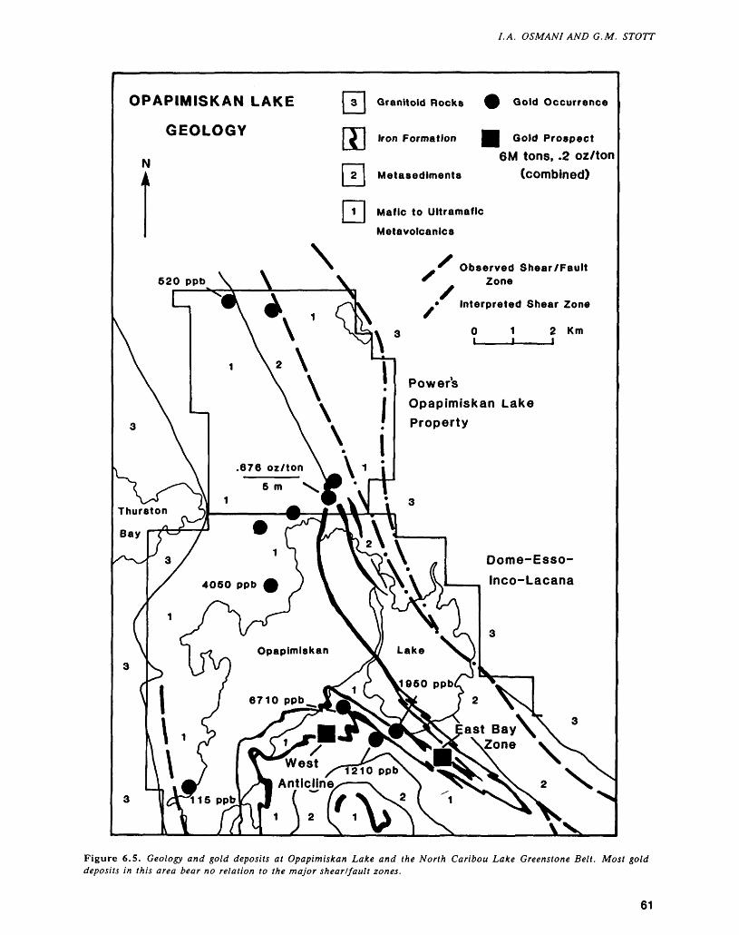
LA. OSMANI AND G.M. STOTT
OPAPIMISKAN LAKE
GEOLOGY
N1 1
Granitoid Rocks (
Iron Formation |
Metasediments
Mafic to Ultramafic
Metavolcanics
x
f Ooid Occurrence
l Gold Prospect 6M tons, .2 oz/ton
(combined)
520 ppbObserved Shear/Fault
Zone
* Interpreted Shear Zone
O 1 2 Km
Power's
Opapimiskan Lake Property
Dome-Esso-
Inco-Lacana
Figure 6.5. Geology and gold deposits at Opapimiskan Lake and the North Caribou Lake Greenstone Belt. Most gold deposits in this area bear no relation to the major shear/fault zones.
61
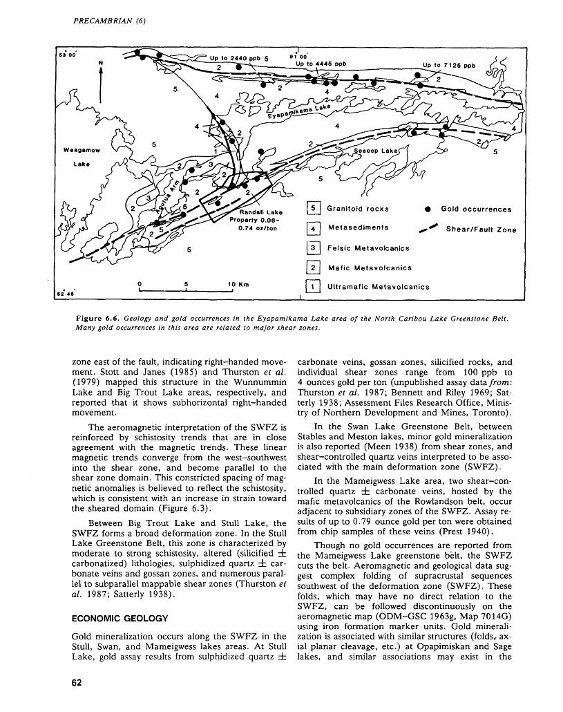
PRECAMBRIAN (6)
Weagamow
Lake
Granitoid rocks Gold occurrences
Shear/Fault Zone
Randall Lake Property 0.06-
0.74 oz/ton Metasediments
Felsic Metavolcanics
Mafic Metavolcanics
Ultramafic Metavolcanics
Figure 6.6. Geology and gold occurrences in the Eyapamikama Lake area of the North Caribou Lake Greenstone Belt. Many gold occurrences in this area are related to major shear zones.
zone east of the fault, indicating right-handed move ment. Stott and Janes (1985) and Thurston et al. (1979) mapped this structure in the Wunnummin Lake and Big Trout Lake areas, respectively, and reported that it shows subhorizontal right-handed movement.
The aeromagnetic interpretation of the SWFZ is reinforced by schistosity trends that are in close agreement with the magnetic trends. These linear magnetic trends converge from the west-southwest into the shear zone, and become parallel to the shear zone domain. This constricted spacing of mag netic anomalies is believed to reflect the schistosity, which is consistent with an increase in strain toward the sheared domain (Figure 6.3).
Between Big Trout Lake and Stull Lake, the SWFZ forms a broad deformation zone. In the Stull Lake Greenstone Belt, this zone is characterized by moderate to strong schistosity, altered (silicified dr carbonatized) lithologies, sulphidized quartz ± car bonate veins and gossan zones, and numerous paral lel to subparallel mappable shear zones (Thurston et al. 1987; Satterly 1938).
ECONOMIC GEOLOGY
Gold mineralization occurs along the SWFZ in the Stull, Swan, and Mameigwess lakes areas. At Stull Lake, gold assay results from sulphidized quartz ±
carbonate veins, gossan zones, silicified rocks, and individual shear zones range from 100 ppb to 4 ounces gold per ton (unpublished assay data from: Thurston et al. 1987; Bennett and Riley 1969; Sat terly 1938; Assessment Files Research Office, Minis try of Northern Development and Mines, Toronto).
In the Swan Lake Greenstone Belt, between Stables and Meston lakes, minor gold mineralization is also reported (Meen 1938) from shear zones, and shear-controlled quartz veins interpreted to be asso ciated with the main deformation zone (SWFZ).
In the Mameigwess Lake area, two shear-con trolled quartz ± carbonate veins, hosted by the mafic metavolcanics of the Rowlandson belt, occur adjacent to subsidiary zones of the SWFZ. Assay re sults of up to 0.79 ounce gold per ton were obtained from chip samples of these veins (Prest 1940).
Though no gold occurrences are reported from the Mameigwess Lake greenstone belt, the SWFZ cuts the belt. Aeromagnetic and geological data sug gest complex folding of supracrustal sequences southwest of the deformation zone (SWFZ). These folds, which may have no direct relation to the SWFZ, can be followed discontinuously on the aeromagnetic map (ODM-GSC 1963g, Map 7014G) using iron formation marker units. Gold minerali zation is associated with similar structures (folds, ax ial planar cleavage, etc.) at Opapimiskan and Sage lakes, and similar associations may exist in the
62
LA. OSMANI AND G.M. STOTT
Mameigwess Lake greenstone belt. The SWFZ, and the area to the southwest, warrant prospecting for possible gold mineralization.
SOUTH KENYON AND NORTH KENYON FAULT ZONES
Other important magnetic features in the northern most part of the Superior Province are two subparal- lel west-northwest-trending long linear anomalies of low to moderate intensity. These anomalies have been interpreted to form the boundaries of the Kenyon Structural Zone. The linear anomalies are two faults termed the "North Kenyon Fault Zone" (NKFZ) and the "South Kenyon Fault Zone" (SKFZ) (Figure 6.2).
The SKFZ is traceable east-southeastwards from the Ontario-Manitoba border for approximately 480 km (Figure 6.2). It branches just northwest of the "C" shaped portion of the Kasabonika Greenstone Belt into two subzones. These subzones further branch into subsidiary zones. One branch passes southeast ward along the north flank of the Kasabonika belt, and transects the belt east of Croal Lake. The sec ond subzone, which transects the greenstone belts between the Asheweig and Ekwan rivers, continues east-southeastward, eventually disappearing under the Paleozoic cover.
The western portion of the NKFZ transects the Thorne River-Sachigo River Greenstone Belt. It is identified by deflections of schistosity and the pres ence of minor shear zones, which are generally sub- parallel to the major structure. A clockwise rotation of magnetic trend lines in one of these belts probably resulted from rotation along a southeast-trending subsidiary fault, suggesting right-handed transcur rent movement along the fault. During the 1988 field season, the presence of the NKFZ was con firmed by locating an approximately l km wide protomylonite to mylonite zone within granodiorite at Yelling Lake, near the Ontario-Manitoba border. The rock matrix is extensively altered to chlorite and epidote. Feldspar augen are intensely saussuritized. Some of the feldspar is angular and the quartz is typically in the form of flat ribbons. Asymmetric quartz aggregates with subhorizontal long axes in the granodiorite suggest right-handed strike-slip move ment. Approximately 25 percent of the NKFZ is un derlain, to the southeast, by Phanerozoic cover.
ECONOMIC GEOLOGY
Although no known gold mineralization occurs along the NKFZ or its subsidiaries, a few small shear zones and quartz veins containing pyrite and chalcopyrite have been reported (Bennett and Riley 1969; Meen 1938) adjacent to the zone, in the Thorne River- Sachigo River belt.
South of the SKFZ, the Ellard Lake Greenstone Belt hosts a few shear zones. These structures may be splays off the SKFZ. Meen (1938) reported shearing, adjacent to the greenstone-granite con tact, and abundant quartz-veining throughout the eastern part of the belt. Two subparallel gold-bear ing quartz veins parallel the belt's margin and the SKFZ. These veins were mined by the Sachigo Ex ploration Company, and produced 52 560 ounces of gold and 6126 ounces of silver from 46 457 tons of ore (Bennett and Riley 1969).
WINISK RIVER FAULT
The northwest-trending Winisk River Fault (WRF) is found in the northeasternmost portion of the study area (Figure 6.2). It is characterized by a distinct long linear magnetic signature of low to high inten sity. The broad right-handed deflection of the east ward magnetic trend lines is a characteristic signa ture of a right-handed transcurrent ductile fault zone. The fault zone obliquely crosscuts the east- to southeast-trending Archean structures (Figures 6.2 and 6.3). The most striking feature northeast of the fault (Latitude 53 0 40' to 54 0 15') is the unique pat tern of small oval closely spaced magnetic highs and lows, described as "birds-eye maple" pattern by Bell (1971), which characterize a unique porphyritic pyroxene-bearing granitic rock (Riley 1979). The overall magnetic relief northeast of the fault is higher (up to 1700 gammas) than in the area southwest of the fault. To the southwest, linear and broad diffuse anomalies of generally lower magnetic relief (300 gammas) correspond to supracrustal and gran itic rocks, respectively. A few local magnetic anoma lies (up to 1800 gammas) in the area represent iron formation intercalated with the metavolcanics and metasediments. The WRF is mainly covered by Phanerozoic sediments (Figure 6.2).
Aeromagnetic data, in conjunction with avail able geological information, suggest that the WRF truncates the Pikwitonei Subprovince to the north west, and forms the boundary between the predomi nantly plutonic Archean Winisk Subprovince to the northeast, and the volcano-plutonic Sachigo Su bprovince southwest of the fault (Osmani, in prepa ration; Card and Ciesielski 1986). Aeromagnetic patterns further indicate that the northwestern end of the fault connects with the east-trending Chur chill-Superior Provincial boundary, and that the southeastern end appears to be truncated by the north-northeast-trending Kapuskasing Zone, west of James Bay (Ontario) (Osmani, in preparation).
ECONOMIC GEOLOGY
During the 1960s and early 1970s, geophysical sur veys and diamond drilling programs were carried out in the vicinity of WRF (Assessment Files Research Office, Ministry of Northern Development and Mines, Toronto). No economic mineralization was found.
63
PRECAMBRIAN (6)
NORTHEAST-TRENDING FAULTS
A few regional-scale northeast-trending faults occur in the study area. These faults have weak aeroma gnetic expressions. In some areas, these structures have been traced aeromagnetically, in conjunction with geological and topographical evidence. Exam ples identified in the eastern part of the study area include a northeast-trending fault approximately 122 km long, extending south westward from the Ek wan River Greenstone Belt to just north of the Rowlandson Lake belt. This fault is characterized by a long weak magnetic lineament which, in part, coin cides with topographic features (lakes, rivers). The fault appears to offset, by left-lateral movement, the Ekwan River metavolcanic belt (Thurston et al. 1979) to the north, and granitic gneisses to the south. Based on the distribution of the shear zone- related gold occurrences in the area, these north east-trending structures are unlikely sites for gold mineralization. They might be of local significance if they crosscut northwest- or east-trending shear zones.
RECOMMENDATIONS
In view of the apparent genetic association of the Golden Patricia gold deposit in the Meen-Dempster Lakes belt with the Bear Head Fault Zone, prospec tors should be encouraged to consider the many fault/shear zones that trend southeast and closely follow the granite-greenstone contacts. These strike-slip faults probably developed local splays or horsetail shear zones that transmitted the fault movement into the adjacent greenstone belts. They may have preferentially followed a lithological con tact with such units as sheetlike felsic porphyry or banded iron formation. These units could localize the initial fault rupture and provide competent sur faces along which hydrothermal fluid transfer and continued shearing might focus. An example of such a setting may be found along the northeastern mar gin of the Keezhik Lake belt, where structural and stratigraphic conditions are suspected to be similar to those of the Golden Patricia Mine in the Meen- Dempster Lakes Greenstone Belt.
The narrow shear zone that hosts the Golden Patricia Deposit demonstrates that these targets may be elusive, and require careful mapping for their dis covery. Nevertheless, prospectors should take note of the compelling abundance of long continuous fault/shear zones in the Sachigo Subprovince, and the example of the Golden Patricia Mine on a shear zone that apparently splayed off the Bear Head Fault Zone.
REFERENCESAyres, L.D., Raudsepp, M., Averill, S.A., and Ed
wards, G. R.1973: Favourable Lake-Berens Lake; Geological Compila
tion Series, Ontario Division of Mines, Map 2262, scale 1:253 440 or l inch to 4 miles.
Bartlett, J.R., Breaks, F.W., deKemp, E.A., and Shields, H.N.
1984: Precambrian Geology of Eyapamikama Lake Area (Opapimiskan Lake Project), Kenora District (Patricia Portion); Ontario Geological Survey, Map P.2834, Geological Series-Preliminary Map, scale 1:31 680 or l inch to 1/2 mile. Geology 1984.
Bell, C.K.1971: Boundary Geology, Upper Nelson River Area,
Manitoba and Northwestern Ontario; Geological As sociation of Canada, Special Paper 9, p.11-39.
Bennett, G., and Riley, R.A.1969: Operation Lingman Lake, District of Kenora (Patricia
Portion); Ontario Department of Mines, Miscellane ous Paper 27, 52p.
Berte, D., Choukroune, P., and Jegouzo, P.1979: Orthogneiss, Mylonite and Non-Coaxial Deformation
of Granites: The Example of the South Armorican Shear Zone; Journal of Structural Geology, Volume l, p.31-42.
Breaks, F.W., Bartlett, J.R., deKemp, E.A., and Os mani, LA.
1986: Precambrian Geology of the Doubtful-Akow Lakes Area (Opapimiskan Lake Project), District of Kenora (Patricia Portion); Ontario Geological Survey, Map P.2965, Geological Series-Preliminary Map, scale 1:31 680 or l inch to 1/2 mile. Geology 1985.
Breaks, F.W., Osmani, LA., and deKemp, E.A.1986: Opapimiskan Lake Project: Precambrian Geology of
the Opapimiskan-Forester Lakes Area, District of Kenora (Patricia Portion); p.368-378 in Summary of Field Work and Other Activities 1985, by the Ontario Geological Survey, edited by P.C. Thurston, O.L. White, R.B. Barlow, M.E. Cherry and A.C. Colvine, Ontario Geological Survey, Miscella neous Paper 132, 435p.
1987: Precambrian Geology of the Opapimiskan- Neawagank Lakes Area (Opapimiskan Lake Project), District of Kenora (Patricia Portion); Ontario Geo logical Survey, Maps P.3080 and P.3081, Geological Series-Preliminary Map, scale 1:31 680 or l inch to 1/2 mile.
In Prep.: Precambrian Geology of North Caribou Lake Area, District of Kenora (Patricia Portion); Ontario Geo logical Survey, Geological Report.
Card, K.D., and Ciesielski, A.1986: Subdivisions of the Superior Province of the Canadian
Shield (DNAG#1); Geoscience Canada, Volume 13,Number l, p.5-13.
Corfu, F., Krogh, T.E., and Ayres, L.D.1985: U-Pb Zircon and Sphene Geochronology of a Com
posite Archean Granitoid Batholith; Favourable Lake Area, Northwestern Ontario; Canadian Journal of Earth Sciences, Volume 22, p. 1436-1451.
64
LA. OSMANI AND G.M. STOTT
Corfu, F., and Wood, J.1986: U-Pb Zircon Ages in Supracrustal and Plutonic
Rocks; North Spirit Lake Area, Northwestern Ont ario; Canadian Journal of Earth Sciences, Volume 23, p.969-977.
deKemp, E.A.1987: Stratigraphy, Provenance, and Geochronology of Ar
chean Supracrustal Rocks of Western Eyapamikama Lake Area, Northwestern Ontario; Unpublished M.Se. Thesis, Carleton University, Ottawa, 98p.
Granier, T.1985: Origin, Damping, and the Pattern of Development of
Faults in Granite; Tectonics, Volume 4, p.721-737.
Hall, R.S., and Rigg, D.M.1986: Geology of the West Anticline Zone, Musselwhite
Prospect, Opapimiskan Lake, Ontario, Canada; p. 124-136 in Proceedings of Gold'86: An Interna tional Symposium on the Geology of Gold, edited by A.J. MacDonald, Toronto, 1986, 517p.
Hodge, H.J., Newman, P.S., and North, J.W.1987: Gold Exploration and Development: Pickle Lake-
Opapimiskan Lake Areas; Unpublished Report, Toronto Geological Discussion Group Seminar, Toronto, November 30, 1987.
Jensen, L.S.1987: Geology of the Horseshoe Lake Greenstone Belt, Dis
trict of Kenora; p. 104-108 in Summary of Field Work and Other Activities 1987, by the Ontario Geological Survey, edited by R.B. Barlow, M.E. Cherry, A.C. Colvine, Burkhard O. Dressler, and Owen L. White, Ontario Geological Survey, Miscellaneous Paper 137, 429p.
Meen, V.B.1938: Geology of the Sachigo River Area; Ontario Depart
ment of Mines, Annual Report for 1937, Volume 46, Part 4, p.32-59.
ODM-GSC1963a: Miminiska, Ontario; Geophysical Map 7009G,
Aeromagnetic Series, scale 1:253 440 or l inch to 4 miles. Survey and Compilation 1959 to 1960.
1963b: Lake St. Joseph, Ontario; Geophysical Map 7010G, Aeromagnetic Series, scale 1:253 440 or l inch to 4 miles. Survey and Compilation 1959 to 1960.
1963c: Trout Lake, Ontario; Geophysical Map 7011G, Aeromagnetic Series, scale 1:253 440 or l inch to 4 miles. Survey and Compilation 1959 to 1960.
1963d: North Spirit Lake, Ontario; Geophysical Map 7012G, Aeromagnetic Series, scale 1:253 440 or l inch to 4 miles. Survey and Compilation 1959 to 1960.
1963f: North Caribou Lake, Ontario; Geophysical Map 7013G, Aeromagnetic Series, scale 1:253 440 or l inch to 4 miles. Survey and Compilation 1959 to 1960.
1963g: Wunnummin Lake, Ontario; Geophysical Map 7014G, Aeromagnetic Series, scale 1:253 440 or l inch to 4 miles. Survey and Compilation 1959 to 1960.
1967a: Carroll Lake, Ontario; Geophysical Map 7266G, Aeromagnetic Series, scale 1:253 440 or l inch to 4 miles. Survey and Compilation 1965.
1967b: Deer Lake, Manitoba-Ontario; Geophysical Map 7267G, Aeromagnetic Series, scale 1:253 440 or l inch to 4 miles. Survey and Compilation 1965.
1967c: Makoop Lake, Ontario; Geophysical Map 7272G, Aeromagnetic Series, scale 1:253 440 or l inch to 4 miles. Survey and Compilation 1965 to 1966.
1967d: Opasquia Lake, Manitoba-Ontario; Geophysical Map 7273G, Aeromagnetic Series, scale 1:253 440 or l inch to 4 miles. Survey and Compilation 1965 to 1966.
1967e: Island Lake, Manitoba-Ontario; Geophysical Map 7274G, Aeromagnetic Series, scale 1:253 440 or l inch to 4 miles. Survey and Compilation 1965.
1967f: Thorne River, Manitoba-Ontario; Geophysical Map 7279G, Aeromagnetic Series, scale 1:253 440 or l inch to 4 miles. Survey and Compilation 1965 to 1966.
1967g: Stull Lake, Manitoba-Ontario; Geophysical Map 7280G, Aeromagnetic Series, scale 1:253 440 or l inch to 4 miles. Survey and Compilation 1965 to 1966.
1967h: Dickey River, Ontario; Geophysical Map 7284G, Aeromagnetic Series, scale 1:253 440 or l inch to 4 miles. Survey and Compilation 1965 to 1967.
1967i: Sturgeon Lake, Manitoba-Ontario; Geophysical Map 7285G, Aeromagnetic Series, scale 1:253 440 or l inch to 4 miles. Survey and Compilation 1965 to 1966.
1968a: Asheweig River, Ontario; Geophysical Map 7271G, Aeromagnetic Series, scale 1:253 440 or l inch to 4 miles. Survey and Compilation 1965 to 1967.
1968b: Fawn River, Ontario; Geophysical Map 7278G, Aeromagnetic Series, scale 1:253 440 or l inch to 4 miles. Survey and Compilation 1965 to 1967.
1969a: Winiskisis Channel, Ontario; Geophysical Map 7270G, Aeromagnetic Series, scale 1:253 440 or l inch to 4 miles. Survey and Compilation 1966 to 1968.
1969b: Sutton Lake, Ontario; Geophysical Map 7276G, Aeromagnetic Series, scale 1:253 440 or l inch to 4 miles. Survey and Compilation 1966 to 1968.
1969c: Clendenning River, Ontario; Geophysical Map 7277G, Aeromagnetic Series, scale 1:253 440 or l inch to 4 miles. Survey and Compilation 1966 to 1968.
1969d: Winisk, Ontario; Geophysical Map 7282G, Aeroma gnetic Series, scale 1:253 440 or l inch to 4 miles. Survey and Compilation 7966 to 1968.
1969e: Fort Severn, Ontario; Geophysical Map 7283G, Aeromagnetic Series, scale 1:253 440 or l inch to 4 miles. Survey and Compilation 1966 to 1968.
1970a: Sachigo River, Kenora District; Aeromagnetic Compi lation Map P.575, scale 1:1 013 760 or l inch to 16 miles.
1970b: Ekwan River, Kenora, and Cochrane Districts; Aeromagnetic Compilation Map P. 576, scale 1:1 013 760 or l inch to 16 miles.
OGS1985: Airborne Electromagnetic and Total Intensity Mag
netic Survey, Opapimiskan Lake Area, District of Kenora, Patricia Portion; by Aerodat Limited for the Ontario Geological Survey, Geophysical/Geochemical Series, Maps 80 716 to 80 753 inclusive, scale
65
PRECAMBRIAN (6)
1:20 000. Survey and Compilation March to July 1985.
OGS-GSC1977a: Airborne Gamma-Ray Spectrometry Survey, Potas
sium 9fc Contours, Deer Lake Sheet, District of Kenora (Patricia Portion); Ontario Geological Survey, Preliminary Map P. 1251, Geophysical Series, scale 1:250 000. Survey and Compilation 1976.
1977b: Airborne Gamma-Ray Spectrometry Survey, Potas sium Jo Contours, Carroll Lake Sheet, District of Kenora (Patricia Portion); Ontario Geological Survey Preliminary Map P. 1286, Geophysical Series, scale 1:250 000. Survey and Compilation 1976.
1978a: Airborne Gamma-Ray Spectrometry Survey, Potas sium 9fc Contours, Stull Lake Sheet, District of Kenora (Patricia Portion); Ontario Geological Survey Preliminary Map P. 1840, Geophysical Series, scale 1:250 000. Survey and Compilation 1977.
1978b: Airborne Gamma-Ray Spectrometry Survey, Potas sium 7o Contours, Island Lake Sheet, Kenora District (Patricia Portion); Ontario Geological Survey Prelimi nary Map P. 1873, Geophysical Series, scale 1:250 000. Survey and Compilation 1977.
1978c: Airborne Gamma-Ray Spectrometry Survey, Potas sium 9fc Contours, Opasquia Lake Sheet, Kenora Dis trict (Patricia Portion); Ontario Geological Survey Preliminary Map P. 1906, Geophysical Series, scale 1:250 000. Survey and Compilation 1977.
1978d: Airborne Gamma-Ray Spectrometry Survey, Potas sium 9fc Contours, North Spirit Lake Sheet, Kenora District (Patricia Portion); Ontario Geological Survey Preliminary Map P. 1939, Geophysical Series, scale 1:250 000. Survey and Compilation 1977.
1979a: Airborne Gamma-Ray Spectrometry Survey, Potas sium 9fc Contours, Makoop Lake Sheet, Kenora Dis trict (Patricia Portion); Ontario Geological Survey, Map 80 033, Geophysical/Geochemical Series, scale 1:250 000. Survey and Compilation 1978.
1979b: Airborne Gamma-Ray Spectrometry Survey, Potas sium Jo Contours, North Caribou Lake Sheet, Kenora District (Patricia Portion); Ontario Geological Survey, Map 80 068, Geophysical/Geochemical Series, scale 1:250 000. Survey and Compilation 1978.
Osmani, LA.In Prep.: An Integrated Aeromagnetic-Geological Study of
Regional Scale Shear Zones in Northern Ontario; in Geology of Ontario, Ontario Geological Survey, Spe cial Volume.
Park, R.G.1981: Shear-Zone Deformation and Bulk Strain in Granite-
Greenstone Terrain of the Western Superior Province, Canada; Precambrian Research, Volume 14, p.31-47.
Piroshco, D.W.1986: Structural Geology and Gold Mineralization of the
Eyapamikama Lake Area of the North Caribou Lake Greenstone Belt, District of Kenora (Patricia Por tion); p. 379-385 in Summary of Field Work and Other Activities 1986, by the Ontario Geological Sur vey, edited by P.C. Thurston, O.L. White, R.B. Barlow, M.E. Cherry, and A.C. Colvine, Ont ario Geological Survey, Miscellaneous Paper 132, 435p.
Piroshco, D.W., and Shields, H.1985: Geology and Gold Mineralization of the Eyapamikama
Lake Area of the North Caribou Lake Greenstone Belt, District of Kenora (Patricia Portion); p.277-286 in Summary of Field Work and Other Activities 1985, by the Ontario Geological Survey, edited by J. Wood, O.L. White, R.B. Barlow, and A.C. Colvine, Ont ario Geological Survey, Miscellaneous Paper 126, 351p.
Prest, V.K.1940: Geology of Rowlandson Lake Area; Ontario Depart
ment of Mines, Annual Report for 1940, Volume 49, Part 8, p. 1-9. Accompanied by Colour Map 49N, scale 1:126 720 or l inch to 2 miles.
Riley, R.A.1979: Hudson Bay Lowland Area (Appendix); p. 149-156 in
Geology of the Winisk Lake Area, District of Kenora (Patricia Portion), Ontario Geological Survey, Geo logical Report 193, 169p. Accompanied by Maps 2287 and 2292, scale 1:253 440 or l inch to 4 miles, and coloured charts A and B.
Sage, R.P., and Breaks, F.W.1982: Geology of the Cat Lake-Pickle Lake Area, District of
Kenora and Thunder Bay; Ontario Geological Survey, Report 207, 238p. Accompanied by Map 2218, scale 1:253 440 or l inch to 4 miles.
Satterly, J.1938: Geology of the Stull Lake Area; Ontario Department
of Mines, Annual Report for 1937, Volume 46, Part 4, p. 1-31. Accompanied by Colour Map 46C.
1941: Geology of the Windigo-North Caribou Lakes Area; Ontario Department of Mines, Annual Report for 1939, Volume 48, Part 9, 32p. Accompanied by Colour Maps 48M and 48J.
Schwerdtner, W.M., Stone, D., Osadetz, K., Morgan, J., and Stott, G.M.
1979: Granitoid Complexes and the Archean Tectonic Re cord in the Southern Part of Northwestern Ontario; Canadian Journal of Earth Sciences, Volume 16, p.1965-1977.
Stephenson, J.1986: Grassroots Gold; The Northern Miner, September
1986, Volume l, Number 9, p.29-31, 60-61.Stone, D.1981: The Sydney Lake Fault Zone in Ontario and
Manitoba, Canada; Unpublished Ph.D. Thesis, Uni versity of Toronto, 146p.
Stott, G.M.1985: Regional Stratigraphy and Structure of the Lake St.
Joseph Area, Central Uchi Subprovince; p. 17-22 in Summary of Field Work and Other Activities 1985, by the Ontario Geological Survey, edited by J. Wood, O.L. White, R.B. Barlow, and A.C. Colvine, Ont ario Geological Survey, Miscellaneous Paper 126, 351p.
1986: Regional Geology and Structure of the Pickle Lake Metavolcanic Belt, District of Kenora (Patricia Por tion); p.9-14 in Summary of Field Work and Other Activities 1986, by the Ontario Geological Survey, ed ited by P.C. Thurston, O.L. White, R.B. Barlow, M.E. Cherry, and A.C. Colvine, Ontario Geological Survey, Miscellaneous Paper 132, 435p.
1987: Controls on Gold Mineralization in the Pickle Lake Region, Ontario; A Presentation Given at The Pros-
66
LA. OSMANI AND G.M. STOTT
pectors and Developers Association Annual Conven- Thurston, P.C., Cortis, A.L., and Chivers, K.M.tion, March 1987. 1987: Reconnaissance Re-Evaluation of a Number of
Stott, G.M., and Janes, D.A. Northwestern Greenstone Belts: Evidence for an Early1985: Reconnaissance Evaluation of the Wunnummin Lake Archean Sialic Crust; p.4-24 in Summary of Field
Belt, District of Kenora (Patricia Portion); p.23-25 in Work and Other Activities 1987, by the Ontario Geo-Summary of Field Work and Other Activities 1985, by Io8ical Survev - edited by R ' B - Barlow - M - E - CherrV'the Ontario Geological Survey, edited by J. Wood, A - C - Colvine - B - 0 ' Dressler, and O.L. White, Ont-O.L. White, R.B. Barlow, and A.C. Colvine, Ont- ario Geological Survey, Miscellaneous Paper 137,ario Geological Survey, Miscellaneous Paper 126, 429p.35lp. Thurston, P.C., Sage, R.P., and Siragusa, G.M.
Stott, G.M., and Wallace, H. 1979: Geology of the Winisk Lake Area, District of Kenora1984: Regional Stratigraphy and Structure of the Central (Patricia Portion); Ontario Geological Survey, Geo-
Uchi Subprovince: Meen Lake-Kasagiminnis Lake logical Report 193, 169p. (With appendix byand Pashkokogan Lake Sections; p.7-13 in Summary R - A - Riley). Accompanied by Maps 2287 and 2292,of Field Work 1984, by the Ontario Geological Sur- scale 1:253 440 or l inch to 4 miles ' and Colourvey, edited by John Wood, Owen L. White, Charts A and B.R.B. Barlow, and A.C. Colvine, Ontario Geological Wilson, B.C.Survey, Miscellaneous Paper 119, 309p. 1M7 . 'Geo,ogy Qf ^ UnffMn Lake Area , District of
Stott, G.M., and Wilson, A.C. Kenora (Patricia Portion); Ontario Geological Survey,1986: Precambrian Geology of the Muskegsagagen-Bancroft Geological Report 244, 42p. Accompanied by Map
Lakes Area, District of Kenora (Patricia Portion); 2511, scale 1:50 000.Ontario Geological Survey, Map P.3049, Geological Wood( j ? Thurstorii p.c., Corfu, F., and Davis, D.W.Series-Preliminary Map, scale 1:50 000. Geology ,. 0 , . . 4 - t . t , ^ , t . KT t ,-.noA 1986: Ancient Quartzites and Carbonates in Northwestern
Ontario: Evidence for Early (Archean) Crustal Stabil-The Northern Miner ity ? ; Program with Abstracts, Geological Association1988: First Gold Bar for Bond Int'l; The Northern Miner of Canada/Mineralogical Association of Canada,
September 26, 1988, Volume 74, Number 29, p.24. Volume 11, p. 146.
67
7. Project Number 88-23. Preliminary Study of the Geochemistry of Alteration in Volcanic Rocks Hosting the Zahavy Mine, Favourable Lake Belt, Sachigo Subprovince
G. R. Edwards 1 and L. D. Ayres2
Department of Geological Sciences, University of Saskatchewan, Saskatoon, Saskatchewan.
Department of Earth Sciences, University of Manitoba, Winnipeg, Manitoba.
INTRODUCTION
The Zahavy Mine (formerly the Berens River Mine) is about 200 km north of Red Lake in the eastern part of the Favourable Lake supracrustal belt, Sachigo Subprovince, Ontario. The location of the area is shown in Figure 7.1 and can be accessed by a gravel air strip at the mine site. The mine produced 157 341 ounces of gold, 5 676 486 ounces of silver, 6 105 872 pounds of lead, and l 797 091 pounds of zinc, with an average grade over the life of the mine of 0.29 ounce per ton gold and 11.9 ounces per ton silver.
Detailed mapping of the host rocks in the vicin ity of the mine by L.D. Ayres (1969) and by P.S. Buck (1978), an M.Se. student of L.D. Ayres, provides the geological base for the present work. Additional M.Se. Thesis work on the precious metal veins at the mine was done by G.W. Adams (1976). The previous stratigraphic work done in the mine area concentrated on the physical description of the host rocks and their mode of deposition with a pre liminary examination of their chemistry (Ayres 1969, 1977; Buck 1978).
Figure 7.1. Location map for the Favourable Lake Belt of the Sachigo Subprovince.
The objective of this project is to characterize the geochemistry of caldera-related volcanic rocks associated with mineralization in the Favourable Lake greenstone belt.
GENERAL GEOLOGY
Five metamorphosed volcanic cycles have been rec ognized by Ayres (1977) in the eastern part of the Favourable Lake supracrustal belt. The mine is hosted in the second cycle, in a stratigraphically co herent sequence of steeply-dipping intermediate to felsic pyroclastic rocks and flows, informally termed formation H by Buck (1978) (see Figure 7.2). This formation is interpreted by Buck (1978) to be of subaqueous to subaerial vent facies occupying a paleo-caldera structure or paleo-volcanic graben. According to Buck (1978) formation H differs te- xturally, mineralogically, and chemically from other metavolcanic rocks in the area because it has a) poorer preservation of primary textures, b) greater biotite content, c) local garnet, d) widespread pyrite and pyrrhotite, e) muscovite-rich (buff) alteration zones, and f) greater metasomatic changes in major element compositions, relative to surrounding for mations. He also concludes that formation H under went pervasive synvolcanic metamorphism and metasomatism in the form of hot-spring and fumarolic activity, prior to the regional greenschist metamorphic event.
The caldera sequence of formation H is host to vein silver-lead mineralization at the Berens River Mine which had a production history from 1939 to 1948. The belt has since had an exploration history involving re-examination of the mineralization at the Berens River Mine by many companies, the most recent being Zahavy Mines Limited in 1987 (Lavigne and Atkinson 1988). Although production from the mine in the early years was exclusively from zone l, present exploration has focused on other zones in addition to zone 1. In 1982, 601 500 tons grading 0.19 ounce per ton gold and 4.4 ounce per ton silver were delineated in zone 3. Minerali zation in all zones appears to be related to silicifica tion, with quartz-actinolite veins hosting pyrite-py- rrhotite, galena, sphalerite, tetrahedrite, chalcopy-
68
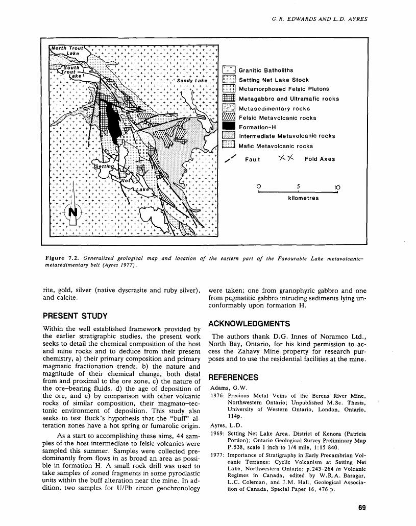
G.R. EDWARDS AND L.D. AYRES
North Trout lake
l * 4 Granitic Batholiths
E."" "l Setting Net Lake Stock
tftttl Metamorphosed Felsic Plutons
[III11|| Metagabbro and Ultramafic rocks
pjla Metasedimentary rocks
[/////\ Felsic Metavolcanic rocks
Ml Formation-HIntermediate Metavolcanic rocks
F---J Mafic Metavolcanic rocks
Fault Fold Axes
1O
kilometres
Figure 7.2. Generalized geological map and location of the eastern part of the Favourable Lake metavolcanic- metasedimentary belt (Ayres 1977).
rite, gold, silver (native dyscrasite and ruby silver), and calcite.
PRESENT STUDY
Within the well established framework provided by the earlier stratigraphic studies, the present work seeks to detail the chemical composition of the host and mine rocks and to deduce from their present chemistry, a) their primary composition and primary magmatic fractionation trends, b) the nature and magnitude of their chemical change, both distal from and proximal to the ore zone, c) the nature of the ore-bearing fluids, d) the age of deposition of the ore, and e) by comparison with other volcanic rocks of similar composition, their magmato-tec- tonic environment of deposition. This study also seeks to test Buck's hypothesis that the "buff" al teration zones have a hot spring or fumarolic origin.
As a start to accomplishing these aims, 44 sam ples of the host intermediate to felsic volcanics were sampled this summer. Samples were collected pre dominantly from flows in as broad an area as possi ble in formation H. A small rock drill was used to take samples of zoned fragments in some pyroclastic units within the buff alteration near the mine. In ad dition, two samples for U/Pb zircon geochronology
were taken; one from granophyric gabbro and one from pegmatitic gabbro intruding sediments lying un- conformably upon formation H.
ACKNOWLEDGMENTS
The authors thank D.G. Innes of Noramco Ltd., North Bay, Ontario, for his kind permission to ac cess the Zahavy Mine property for research pur poses and to use the residential facilities at the mine.
REFERENCESAdams, G.W.1976: Precious Metal Veins of the Berens River Mine,
Northwestern Ontario; Unpublished M.Se. Thesis, University of Western Ontario, London, Ontario, 114p.
Ayres, L.D.1969: Setting Net Lake Area, District of Kenora (Patricia
Portion); Ontario Geological Survey Preliminary Map P.538, scale l inch to 1/4 mile, 1:15 840.
1977: Importance of Stratigraphy in Early Precambrian Vol canic Terranes: Cyclic Volcanism at Setting Net Lake, Northwestern Ontario; p.243-264 in Volcanic Regimes in Canada, edited by W.R.A. Baragar, L.C. Coleman, and J.M. Hall, Geological Associa tion of Canada, Special Paper 16, 476 p.
69
PRECAMBRIAN (7)
Buck, P.S.1978: A Caldera Sequence in the Early Precambrian,
Favourable Lake Volcanic Complex, Northwestern Ontario. Unpublished Ph.D. Thesis, University of Manitoba, Winnipeg, Manitoba, 140p.
Lavigne, M.J. Jr., and Atkinson, B.T.1988: Red Lake Resident Geologist's Area-1987; p.41-60
in Report of Activities 1987, Resident Geologists, ed ited by R.C. Kustra, Ontario Geological Survey, Mis cellaneous Paper 138, 367p.
70
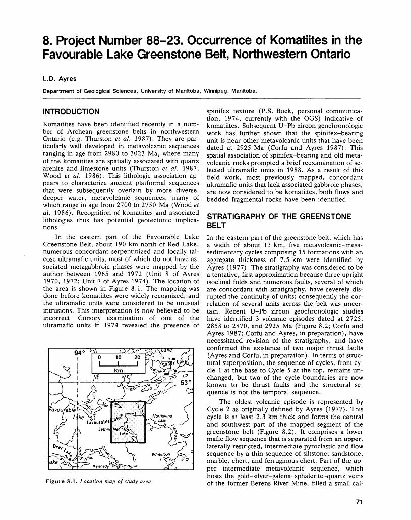
8. Project Number 88-23. Occurrence of Komatiites in the Favourable Lake Greenstone Belt, Northwestern Ontario
L. D. Ayres
Department of Geological Sciences, University of Manitoba, Winnipeg, Manitoba.
INTRODUCTION
Komatiites have been identified recently in a num ber of Archean greenstone belts in northwestern Ontario (e.g. Thurston et al. 1987). They are par ticularly well developed in metavolcanic sequences ranging in age from 2980 to 3023 Ma, where many of the komatiites are spatially associated with quartz arenite and .limestone units (Thurston e t al. 1987; Wood et al. 1986). This lithologic association ap pears to characterize ancient platformal sequences that were subsequently overlain by more diverse, deeper water, metavolcanic sequences, many of which range in age from 2700 to 2750 Ma (Wood et al. 1986). Recognition of komatiites and associated lithologies thus has potential geotectonic implica tions.
In the eastern part of the Favourable Lake Greenstone Belt, about 190 km north of Red Lake, numerous concordant serpentinized and locally tal cose ultramafic units, most of which do not have as sociated metagabbroic phases were mapped by the author between 1965 and 1972 (Unit 8 of Ayres 1970, 1972; Unit 7 of Ayres 1974). The location of the area is shown in Figure 8.1. The mapping was done before komatiites were widely recognized, and the ultramafic units were considered to be unusual intrusions. This interpretation is now believed to be incorrect. Cursory examination of one of the ultramafic units in 1974 revealed the presence of
Figure 8.1. Location map of study area.
spinifex texture (P.S. Buck, personal communica tion, 1974, currently with the OGS) indicative of komatiites. Subsequent U-Pb zircon geochronologic work has further shown that the spinifex-bearing unit is near other metavolcanic units that have been dated at 2925 Ma (Corfu and Ayres 1987). This spatial association of spinifex-bearing and old meta volcanic rocks prompted a brief reexamination of se lected ultramafic units in 1988. As a result of this field work, most previously mapped, concordant ultramafic units that lack associated gabbroic phases, are now considered to be komatiites; both flows and bedded fragmental rocks have been identified.
STRATIGRAPHY OF THE GREENSTONE BELT
In the eastern part of the greenstone belt, which has a width of about 13 km, five metavolcanic-mesa- sedimentary cycles comprising 15 formations with an aggregate thickness of 7.5 km were identified by Ayres (1977). The stratigraphy was considered to be a tentative, first approximation because three upright isoclinal folds and numerous faults, several of which are concordant with stratigraphy, have severely dis rupted the continuity of units; consequently the cor relation of several units across the belt was uncer tain. Recent U-Pb zircon geochronologic studies have identified 3 volcanic episodes dated at 2725, 2858 to 2870, and 2925 Ma (Figure 8.2; Corfu and Ayres 1987; Corfu and Ayres, in preparation), have necessitated revision of the stratigraphy, and have confirmed the existence of two major thrust faults (Ayres and Corfu, in preparation). In terms of struc tural superposition, the sequence of cycles, from cy cle l at the base to Cycle 5 at the top, remains un changed, but two of the cycle boundaries are now known to be thrust faults and the structural se quence is not the temporal sequence.
The oldest volcanic episode is represented by Cycle 2 as originally defined by Ayres (1977). This cycle is at least 2.3 km thick and forms the central and southwest part of the mapped segment of the greenstone belt (Figure 8.2). It comprises a lower mafic flow sequence that is separated from an upper, laterally restricted, intermediate pyroclastic and flow sequence by a thin sequence of siltstone, sandstone, marble, chert, and ferruginous chert. Pan of the up per intermediate metavolcanic sequence, which hosts the gold-silver-galena-sphalerite-quartz veins of the former Berens River Mine, filled a small cal-
71
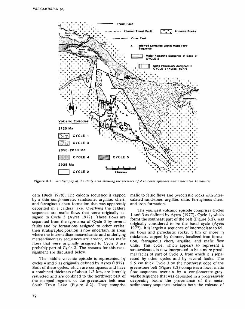
PRECAMBRIAN (8)
Thrust Fautt
Inferred Thrust Fautt
Other Fautt
Intrusive Rocks
Inferred KomatMte within Mafic Flow Sequence
Major Komatiite Sequence at Base of CYCLE 2
Units Previously Assigned to CYCLE 3 (Ayres. 1977)
2725 Ma
CYCLE 1
CYCLE 3
2858-2870 Ma
____ CYCLE 5
2925 Ma
l j CYCLE 2
Figure 8.2. Stratigraphy of the study area showing the presence of 4 volcanic episodes and associated komatiites.
dera (Buck 1978). The caldera sequence is capped by a thin conglomerate, sandstone, argillite, chert, and ferruginous chert formation that was apparently deposited in a caldera lake. Overlying the caldera sequence are mafic flows that were originally as signed to Cycle 3 (Ayres 1977). These flows are separated from the type area of Cycle 3 by several faults and by formations assigned to other cycles; their stratigraphic position is now uncertain. In areas where the intermediate metavolcanic and underlying metasedimentary sequences are absent, other mafic flows that were originally assigned to Cycle 3 are probably part of Cycle 2. The reasons for this reas signment are discussed below.
The middle volcanic episode is represented by cycles 4 and 5 as originally defined by Ayres (1977). Both of these cycles, which are contiguous and have a combined thickness of about 1.2 km, are laterally restricted and are confined to the northwest part of the mapped segment of the greenstone belt near South Trout Lake (Figure 8.2). They comprise
mafic to felsic flows and pyroclastic rocks with inter calated sandstone, argillite, slate, ferruginous chert, and iron formation.
The youngest volcanic episode comprises Cycles l and 3 as defined by Ayres (1977). Cycle l, which forms the southeast part of the belt (Figure 8.2), was originally considered to be the basal cycle (Ayres 1977). It is largely a sequence of intermediate to fel sic flows and pyroclastic rocks, 3 km or more in thickness, capped by thinner, localized iron forma tion, ferruginous chert, argillite, and mafic flow units. This cycle, which appears to represent a strata volcano, is now interpreted to be a more proxi mal facies of part of Cycle 3, from which it is sepa rated by other cycles and by several faults. The 2.5 km thick Cycle 3 on the northwest edge of the greenstone belt (Figure 8.2) comprises a lower mafic flow sequence overlain by a conglomerate-grey- wacke sequence that was deposited in a progressively deepening basin; the provenance of the meta sedimentary sequence includes both the volcano of
72
L.D. AYRES
Cycle l and 2950 Ma granitoid rocks similar to those presently exposed north of the greenstone belt (Corfu e t al. 1985; Corfu and Ayres in preparation; Gordanier 1982; Hillary and Ayres 1980).
Thrust faults have been identified between Cycle l, which is part of the youngest volcanic episode, and the structurally overlying Cycle 2, the oldest vol canic episode; and between cycle 3 which is the other part of the youngest volcanic episode, and the structurally overlying Cycle 4, part of the middle vol canic episode (Figure 8.2; Ayres and Corfu in preparation). Both faults were mapped by Ayres (1970, 1972, 1974), but the structural significance of the faults was not known.
KOMATIITES
The ultramafic units that are now defined as komatiites occur either in Cycle 2 or within mafic flows that were previously assigned to Cycle 3. Two areas were briefly examined during the 1988 field season: a thick unit at the base of Cycle 2, and sev eral thin units intercalated with mafic flows that were previously assigned to Cycle 3.
In Cycle 2, the oldest volcanic episode, the ex amined komatiites form a northwest-trending, wedge-shaped unit up to 640 m thick at the base of the cycle. This komatiite unit is overlain by mafic flows, but the base is a thrust fault which here ap pears to be slightly discordant; the unit has been traced laterally for 4 km, and it is truncated on the south by granitoid rocks of the Setting Net Lake Batholith (Figure 8.2; Ayres 1972). Where exam ined, this unit is a sequence of flows. The flows range in thickness from about l to 5 m and com prise both pillowed and non-pillowed units; lateral extents of flows are undefined. Pillows were rela tively rare and range in thickness from 0.3 to 0.5 m and in length from 0.5 to l m. Some of the non-pil lowed flows have well developed upper spinifex zones up to 2 m thick underlain by cumulate oli- vine-rich zones. Flows tops vary from brecciated to unbrecciated and are slightly undulating; the bound ary between spinifex and cumulate zones is also un dulating but the amplitude of the undulations is greater and is up to 0.5 m. Although no primary minerals were preserved in the few samples exam ined petrographically, textures are well preserved by pseudomorphs.
Elsewhere in Cycle 2, lenticular, concordant, ultramafic units that are generally less than 20 m thick and 0.5 km long occur locally within se quences of mafic flows (Figure 8.2). One of these units northeast of the former Berens River Mine site was examined by G.R. Edwards (Professor, Univer sity of Saskatchewan, Saskatoon, Saskatchewan, personal communication, 1988) who observed flow contacts but no spinifex texture. In the same area, the author has previously observed layered ultra mafic units that locally contain cross-stratification;
these are now interpreted to be komatiitic tuff, pos sibly of hyaloclastic origin. Although the other ultra mafic units were not examined, they are all inter preted to be komatiites because of the lack of associ ated metagabbro, and similarity in size and external morphology to units that that were examined in mafic flow sequences previously assigned to Cycle 3.
On the northwest shore of Setting Net Lake, lenticular, concordant, ultramafic units that range in thickness from 20 to 120 m and in length from 0.2 to 1.5 km are intercalated with mafic flows that were previously assigned to Cycle 3 (Figure 2). The ultramafic units comprise 30 to 509& of a 300 m thick interval in the core of a syncline. Several of these ultramafic units were examined and they in clude both spinifex-textured flows and bedded units that are probably hyaloclastite tuff. One of the bed ded units is 60 m thick and contains beds ranging in thickness from 0.2 to 30 cm although most beds are 0.5 to l cm thick. Low angle crossbedding was lo cally observed in this unit. Beds are defined by tex tural variations, and, although textures are poorly preserved, particles generally appear to be less than 2 mm in size.
DISCUSSION AND CONCLUSIONS
The mafic-ultramafic flow sequence immediately northwest of Setting Net Lake was originally assigned to Cycle 3 because underlying flows contain interca lated sandstone units that were correlated with the sandstone at the top of Cycle 2 (Ayres 1970, 1977). However, this stratigraphic assignment was uncertain because intermediate metavolcanic rocks, which elsewhere define the upper part of Cycle 2, are ab sent here, and the mafic sequence is separated from the type area of Cycle 2 by a fault and by Setting Net Lake. This stratigraphic assignment is now believed to be erroneous.
Elsewhere in the mapped part of the greenstone belt, concordant ultramafic units that are interpreted to be komatiites are almost entirely restricted to the mafic parts of Cycle 2. These Cycle 2 mafic-ultra mafic sequences are very similar to the sequence that was previously assigned to Cycle 3. Conse quently, on the basis of the occurrence of abundant intercalated komatiites, this sequence is reassigned to Cycle 2.
With this stratigraphic revision, which will be documented elsewhere (Ayres and Corfu, in prepa ration; Corfu and Ayres, in preparation), komatiites in the mapped part of the Favourable Lake Greenstone Belt are thus largely within Cycle 2, the oldest volcanic episode (Figure 8.2). The komatiites form both a thick sequence, 640 m or more, at the apparent base of the cycle, and thinner intercalated units within the overlying 2.5 km thick mafic- ultramafic sequence. The apparent restriction of komatiites to the 2925 Ma volcanic sequence is comparable to that found, or inferred, in many
73
PRECAMBRIAN (8)
other greenstone belts in northwestern Ontario (Thurston et al. 1987).
ACKNOWLEDGMENTS
The reexamination of the ultramafic units was insti gated by Phil Thurston who accompanied the author in the field and arranged logistic support. Other re search expenses were covered by a grant to the author from NSERC.
REFERENCESAyres, L.D.1970: Setting Net Lake Area, District of Kenora (Patricia
Portion); Ontario Department of Mines, PreliminaryGeological Map P.538 (Revised), scale 1:15 840.
1972: Northwind Lake Area, District of Kenora (PatriciaPortion); Ontario Division of Mines, Preliminary MapP.756, scale 1:15 840.
1974: Geology of the Trout Lakes Area, District of Kenora (Patricia Portion); Ontario Division of Mines, Geo logical Report 113, 197p. Accompanied by Map 2270, scale 1:31 680.
1977: Importance of Stratigraphy in Early Precambrian Vol canic Terranes: Cyclic Volcanism at Setting Net Lake, Northwestern Ontario; p.243-264 in Volcanic Regimes in Canada, edited by W.R.A. Baragar, L.C. Coleman, and J.M. Hall, Geological Associa tion of Canada, Special Paper 16, 476p.
Buck, P.S.1978: A Caldera Sequence in the Early Precambrian,
Favourable Lake Volcanic Complex, Northwestern Ontario; Unpublished M.Se. Thesis, University of Manitoba, 140p.
Corfu, F., and Ayres, L.D.1987: U-Pb Geochronology of Polycyclical Volcanism and
Felsic Plutonism, Favourable Lake Greenstone Belt, Northwestern, Ontario; Geological Association of Canada-Mineralogical Association of Canada, Pro gram with Abstracts, Volume 12, p. 35
Corfu F., Krogh T.E., and Ayres, L.D.1985: U-Pb Zircon and Sphene Geochronoly of a Composite.
Archean Granitoid Batholith, Favourable Lake Area, Northwestern Ontario; Canadian Journal of Earth Sciences, Volume 22, Number 10, p. 1436-1451.
Gordanier, W.D.1982: Sedimentology and Relationship to Volcanology of
Formation K, Favourable Lake Metavolcanic- Metasedimentary Belt, Northwestern Ontario; Un published M.Se. Thesis, University of Manitoba, Winnipeg, Manitoba, 90p.
Hillary, E.M., and Ayres, L.D.1980: Trondhjemitic Basement Enclave near the Archean
Favourable Lake Volcanic Complex, Northwestern Ontario, Canada; Canadian Journal of Earth Sci ences, Volume 17, p.652-667.
Thurston, P.C., Cortis, A.L., and Chivers, K.M.1987: A Reconnaissance 'Re-evaluation of a Number of
Northwestern Greenstone Belts: Evidence for an Early Archean Sialic Crust: p.4-24 in Summary of Field Work and Other Activities 1987, Ontario Geological Survey, edited by R.B. Barlow, M.E. Cherry, A.C. Colvine, Burkhard O. Dressler, and Owen L. White, Ontario Geological Survey, Miscel laneous Paper 137, 429p.
Wood, J., Thurston, P.C., Corfu, F., and Davis, D.W.1986: Ancient Quartzites and Carbonates in Northwestern
Ontario—Evidence for Early (Archean) Crustal Sta bility?; Geological Association of Canada/Minera- logical Association of Canada/Canadian Geophysical Union, Program with Abstracts, Volume 11, p. 146.
74
9. Project Number 88-34. Geology of the Berens Subprovince: Nungesser Lake Area, District of Kenora
Denver Stone
Geologist, Precambrian Geology Section, Ontario Geological Survey, Toronto.
INTRODUCTION
The Berens Subprovince in northwestern Ontario comprises an extensive, but largely unmapped plutonic terrane north of the Red Lake and Birch— Uchi metavolcanic belts of the Uchi Subprovince (Ayres et al. 1971). The relationship of the Berens to the Uchi is uncertain and no clear Subprovince boundary has been observed separating the two sub- provinces.
The trend of lithological units and structures in most of the Superior Province is largely east-west. The Berens Subprovince, however, has a north- south fabric defined by small supracrustal belts (Ayres et al. 1973) and north-trending aeromagne tic elements which cannot be clearly explained by the existing reconnaissance mapping (Donaldson 1969).
The supracrustal belts of the Berens Su bprovince in general are smaller and higher in meta morphic rank than the supracrustal sequences in the adjacent subprovinces, yet they contain complex stratigraphy (Cortis et al., this volume). Large-scale
sigmoidal west- to northwest-trending shear zones with associated gold occurrences (Osmani and Stott, this volume) cut across extensive sections of the Uchi and Sachigo subprovinces. These shear zones have not been observed in the Ontario segment of the Berens Subprovince.
The mineral potential of the Berens Subprovince is poorly known: sulphide occurrences appear to be characterized by higher concentrations of lead than elsewhere in the Superior Province (c.f. Sangster 1972; Assessment Files, Assessment Files Research Office, Ontario Geological Survey, Toronto). Ura nium occurs widely (Bond and Breaks 1978).
The present reconnaissance investigations are the basis for future mapping of the general geology, structure, and mineralization environments of the Berens Subprovince. The 1988 field work of ap proximately one-month duration characterizes the main lithological elements and the structural style of the Nungesser Lake area north of Red Lake (Fig ures 9.1 and 9.2). This area, of approximately 2000 km2 in size, is located approximately 50 km north of Red Lake and includes map sheets 52 N/5
Figure 9.1. Location map for the Nungesser Lake area.
75
PRECAMBRIAN (9)
51*45
5f15
^::::^::::\:::ND7::S:-':\\- Xf4444\J4444 \4 4 4 ̂ Ll^-4 4 4 -L" - ' - t\~--M*i 4^4 *r* + 4A44+A4444 f+4 + 44 4H^ -V 4^
51 45
Biotite Leucogranite-Granodiorite
Porphyritic Granodiorite - Granite
Biotite Tonalite ~ Granodiorite
Hornblende Tonalite-Granodiorite
Tonalite Gneiss
Supracrustal Remnants
Foliation, Gneissosity jX" Inclined
Vertical
Unknown
Defbrmation Zone
51'15
Figure 9.2. Geology of the Nungesser-Berens Lake area, compiled in part from Horwood (1940) and Donaldson (1969). NDZ is Nungesser Deformation Zone.
and 52 N/12 of the National Topographic System. Access to the area is by means of the Nungesser Lake Road and float-equipped plane.
PREVIOUS WORK AND MINERAL EXPLORATION
Reconnaissance mapping (Donaldson 1969) showed that the area is underlain by a variety of massive and foliated plutonic rocks and paragneiss. The bounda ries and internal fabric of these lithological elements define an overall northerly structural trend.
The small curved belt of supracrustal rocks, which extends into the southeastern corner of the
area shown in Figure 9.2, was the subject of detailed mapping by Horwood (1940). Between 1977 and 1980, Dome Exploration Limited carried out an air borne magnetic survey, ground magnetic and electri cal surveys, and diamond drilling south of Nugesser Lake (Assessment Files, Resident Geologist's Office, Ministry of Northern Development and Mines, Red Lake). Drill targets were mainly geophysical anoma lies with minor pyrite and pyrrhotite in supracrustal rocks and the Nungesser Deformation Zone.
LITHOLOGYSix lithological units are distinguished on the basis of primary features, texture, and mineralogy. These in clude metavolcanic and metasedimentary remnants,
76
DENVER STONE
tonalite gneiss that may be of mixed supracrustal and plutonic origin, and a suite of sodic to potassic intru sive rocks. Igneous rocks are classified according to Streckeisen (1976).
SUPRACRUSTAL REMNANTS
Metamorphosed supracrustal rocks of both volcanic and sedimentary parentage occur within a thin, curved discontinuous belt that extends north through the area (Figure 9.2). Most remnants consist of am- phibole-bearing gneisses and biotite migmatites.
The predominant lithological component is a grey, moderately leucocratic (15 to 30 percent mafic minerals) amphibolide gneiss. This rock is transi tional to black hornblende gneiss within which at tenuated pillows are recognized southeast of Coli Lake. Volcanic clasts of mainly intermediate compo sition are noted within amphibolitic gneisses east of Berens Lake. The clasts show aspect ratios on the order of 100 to l and indicate high levels of strain in the supracrustal belt.
Metasedimentary migmatites occur east of Berens Lake and north of Nungesser Lake. The migmatites show a lit-par-lit arrangement of fine grained biotite melanosome and coarse, white gran ite leucosome. Metasedimentary migmatites north of Nungesser Lake show biotite-garnet and possibly cordierite-bearing assemblages.
Dikes and irregular masses comprising several phases of felsic plutonic rocks transect the supra crustal belt. Contacts are mainly intrusive.
TONALITIC GNEISSES
Supracrustal remnants at Berens Lake and at two localities east of the map area are in gradational con tact with grey tonalitic gneisses. Like the supracrustal rocks, tonalitic gneisses are highly deformed, and occupy thin curved belts.
The grey gneissic rocks are composed of me dium-grained plagioclase, quartz, and biotite with lesser potash feldspar and amphibole. A prominent compositional layering is defined mainly by variation in the abundance of mafic minerals (typically from 10 to 40 percent). Amphibole is abundant in mafic layers making mafic varieties of tonalitic gneiss tran sitional to amphibolitic gneiss. At the felsic end of the spectrum, tonalitic gneisses loose their promi nent compositional layering and are transitional to biotite tonalite.
HORNBLENDE TONALITE-GRANODIORITE
Hornblende tonalite-granodiorite is both a wide spread and distinctive unit. The large irregular pluton at Coli Lake is in contact with the Red Lake greenstone belt to the south and is of unknown lat eral dimensions. Hornblende tonalite-granodiorite also extends beyond the northwestern corner of the
area and underlies most of Pikangikum Lake and northern Berens Lake.
The tonalite is coarse grained, foliated grey -to white weathering, and contains 15 to 25 percent blocky and prismatic aggregates of hornblende and biotite. Biotite dominates over hornblende in leucocratic and well-foliated varieties. Potash feld spar megacrysts are common, particularily in the Lit tle Vermilion Lake area where hornblende tonalite is transitional to porphyritic granodiorite. Adjacent to the Red Lake belt, the unit is transitional to quartz diorite and contains abundant xenoliths of amphibolite.
Most outcrops contain small (10 cm scale) mafic lenses and are transected by pink leucocratic granodiorite dikes. Pods of coarse-grained hornb lendite and amphibolite, up to a kilometre in size, are found at scattered localities.
BIOTITE TONALITE-GRANODIORITE
Biotite tonalite-granodiorite underlies a large region in the north-central part of the map area and occurs as thin conformable units in tonalitic gneisses and supracrustal remnants. Hand specimens show a me dium grain size and are leucocratic (5 to 10 percent biotite and accessory amphibole) compared to horn blende tonalite. Several phases of biotite tonalite, some of which are transitional to granodiorite in composition, are recognized on the basis of grain size, texture, and mineralogy. Dikes of potash-en riched varieties are youngest in age and transect hornblende tonalite, tonalite gneiss, and supracrustal remnants.
PORPHYRITIC GRANODIORITE-GRANITE
A coarse grain size and abundant blocky megacrysts of potash feldspar are distinguishing features of this unit. Biotite and accessory amphibole comprise from 10 to 20 percent of the mineral constituents.
Porphyritic granodiorite-granite has intruded adjacent to the belt of supracrustal remnants and oc curs extensively in southeastern parts of the map area. Textural changes including decreased grain size and development of a prominent foliation occur adjacent to other units. Depletion of potash feldspar and enrichment of hornblende yields a compo sitional gradation to hornblende tonalite in the Little Vermilion Lake area.
BIOTITE LEUCOGRANITE-GRANODIORITE
Biotite leucogranite-granodiorite is the youngest ma jor lithological unit and comprises a large oblate in trusion central in the area as well as dikes, which transect all other lithologies. Rocks of this unit dis play a characteristic pink colour and are made up of subequal volumes of quartz, plagioclase, and potash feldspar with usually less than 10 percent biotite and accessory amphibole. A uniform, medium grain size is noted at Nungesser Lake, but elsewhere the unit is
77
PRECAMBRIAN (9)
inequigranular with isolated potash-feldspar mega- crysts and pegmatitic zones. Mafic schlieren and variably assimilated xenoliths of other units can be found in most outcrops.
MAFIC DIKES
Dikes of fine-grained amphibolite, typically 0.1 to 1.0 m wide, transect biotite tonalite and hornblende tonalite in the northwestern corner of the area. Ori entations are variable but mainly subvertical (Table9.1). These dikes are folded and boudinaged and the filling materials show a prominent foliation. Mafic dikes have not been identified in the biotite leucogranite, possibly indicating that they predate the latest stages of felsic plutonism.
AGE RELATIONS
Relative ages of most major units, particularly the younger varieties, are readily established from cross cutting relations. The highly deformed and intruded remnants of supracrustal rocks and gneisses are clearly among the oldest units in- the area (Table9.2).
The relative age of biotite tonalite-granodiorite is enigmatic at present. Several phases, some of which post-date supracrustal remnants, are included in this unit, however, other phases that occupy con formable lenses within the gneisses and supracrustal rocks are of undefined relative age.
Hornblende tonalite-granodiorite, which con tains abundant gneissic and metavolcanic xenoliths, intrudes supracrustal remnants as well as metavol canic rocks of the Red Lake Belt where it has a U-
TABLE 9.1. ORIENTATIONS OF MAFIC DIKES.
Strike
111030170070015
Dip
9090529028
TABLE 9.2. RELATIVE AGES OF PLUTONIC AND SUPRACRUSTAL ROCKS IN THE NUNGESSER LAKE AREA.
Young biotite leucogranite-granodiorite mafic dikes porphyritic granodiorite-granite
biotite hornblende tonalite-granodiorite
tonalite Old supracrustal remnants, tonalite gneiss
grano-diorite
Pb zircon age of 2731 Ma (Andrews et al. 1986). Although porphyritic granodiorite-granite is compo- sitionally gradational to hornblende tonalite-grano diorite, it contains xenoliths of the latter and prob ably comprises a distinct plutonic event. Mafic dikes and biotite leucogranite-granodiorite are the young est intrusive rocks.
Although absolute age determinations have not been made in this area, extensive isotopic studies on similar lithologies elsewhere in the Berens and Uchi subprovinces (e.g. Ermanovics and Wanless 1983) indicate mainly late Archean ages. For example, fel sic plutons were emplaced within and adjacent to the Red Lake belt at 2731 to 2700 Ma, however, the Red Lake belt contains metavolcanic sequences that range in age from 2733 to 2992 Ma (Andrews et 'al. 1986). This suggests that supracrustal and gneissic units in the adjacent Berens Subprovince can be possibly as much as several hundred Ma older than the majority of plutonic rocks.
METAMORPHISMWith the exception of biotite leucogranite-grano diorite, all units are foliated and recrystallized and show mineralogy indicating that they have been both deformed and metamorphosed. The assemblage hornblende-plagioclase-quartziepidote is wide spread in amphibolide gneisses of metavolcanic ori gin. Metasedimentary remnants have undergone partial melting and assemblages of garnet-biotite and possibly cordierite-biotite are present north of Nun gesser Lake. Evidently, much of the area was meta morphosed at amphibolite facies conditions.
Epidote and chlorite are noted locally in frac tures, small faults, and the Nungesser Deformation Zone indicating that late brittle deformation of the region may have occurred under greenschist facies conditions.
STRUCTURE
SHAPE OF UNITS AND STRUCTURAL TRENDS
Lithological units show distinctive shapes that partly reflect their age and extent of deformation. Young undeformed intrusions, such as the biotite leuco granite-granodiorite pluton central in the map area, are crudely elliptical in plan view and characterized by convex outward extensions.
Intrusions of intermediate age can retain an overall elliptical shape but contain concave embay- ments, usually occupied by younger intrusions. The biotite tonalite-granodiorite pluton is an example of this type. Oldest units show evidence of high strain and occupy thin curved belts.
Mineral foliations and gneissosity tend to be more intensely developed in old rocks. Foliation tra jectories are mainly subparallel to adjacent bounda ries of plutonic bodies and show an overall north to
78
DENVER STONE
northwesterly trend in the map area and central Berens Subprovince.
FOLDS AND LINEATIONS
Outcrops of tonalite gneiss and supracrustal rem nants show mesoscopic folds. East of Berens Lake, these structures are tight to isoclinal and, together with mineral lineations, plunge moderately to the southwest (Table 9.3a). Mafic gneiss layers tend to form parallel folds, some of which have ruptured hinge zones and boudinaged limbs. Intervening felsic layers are thickened at fold closures.
Folds and lineations are not readily identified in felsic plutonic rocks with the exception of horn blende tonalite-granodiorite, which shows a promi nent westerly plunging mineral lineation adjacent to supracrustal remnants at Coli Lake.
FAULTS AND FRACTURES
A l km wide zone of schistose, mylonitized, and fractured plutonic rocks underlies central Nungesser Lake (Figure 9.2). This deformation zone, the Nun gesser Deformation Zone, trends approximately 330 0 and foliation surfaces within it dip westerly 50 0 to 80 0 . A contact of the hornblende tonalite-grano diorite pluton undergoes a sinistral strike separation of 2 km across the zone, however, mineral linea tions show highly variable orientation (Table 9.3b) such that the direction of slip and displacement can not be estimated. Further mapping is required to de fine both the extent and kinematics of this deforma tion zone.
All units are transected by subhorizontal and two or more sets of sub vertical fractures. Spacing of these fractures is typically l to 3m. In the Nun-
TABLE 9.3A. MINOR FOLD AXES AND MINERAL LINEATIONS IN SUPRACRUSTAL REMNANTS EAST OF BERENS LAKE.
Trend
250225230210
Plunge
22212548
TABLE 9.3B. MINERAL LINEATIONS IN THE NUNGESSER DEFORMATION ZONE.
Trend285150150220170275
Plunge501360703256
gesser Lake area, subvertical fractures trend mainly 20 0 to 40 0 and 160 0 to 180 0 .
Fractures with red alteration zones and epidote and chlorite filling materials are common in the hornblende tonalite-granodiorite. Evidently, this and other units were affected by late brittle deforma tion.
SUBPROVINCE BOUNDARY
Subdivisions of the Superior Province (e.g. Card and Ciesielski 1986; Thurston e t al. 1987) locate the east-northeast trending boundary of the Berens and Uchi subprovinces within southern parts of the pre sent map area. Here, foliation trajectories are sub- parallel to the postulated boundary, however, there does not appear to be a sharp lithological, structural, or metamorphic discontinuity. For example, the large hornblende tonalite-granodiorite pluton ex tends from the Red Lake Belt across the boundary. The main lithological basis on which to distinguish the subprovinces at this locality seems to be the pres ence of considerably less supracrustal rocks in the Berens Subprovince than in the Uchi Subprovince.
SUMMARY
Although dominated by late potassic intrusions, some of which may attain batholithic proportions, the Nungesser Lake area also hosts early sodic plutons, gneisses, and both metavolcanic and meta- sedimentary remnants. In this respect, the mapped segment of the Berens Subprovince contains the same lithological elements as neighbouring volcano- plutonic and metasedimentary subprovinces, but has a much higher proportion of felsic intrusions.
This segment of the Archean crust records em placement of at least four distinct phases of igneous rocks. Enrichment in potash feldspar and quartz and depletion in ferromagnesian minerals occurred in successive magmas as compositions changed from tonalite and granodiorite to granite. Early plutons were indented and compressed by late intrusions. Fi nal stages of crustal evolution include diking, faulting on the Nungesser Deformation Zone, and pervasive but mild fracturing.
REFERENCESAndrews, A.J., Hugon, H., Durocher, M., Corfu, F., and
Lavigne, M.J.1986: The Anatomy of a Gold-bearing Greenstone Belt: Red
Lake, Northwestern Ontario, Canada; p.3-22 in Pro ceedings of Gold '86, an International Symposium on the Geology of Gold; Toronto, 1986, edited by A.J. Macdonald, 517p.
Ayres, L.D., Lumbers, S.D., Milne, V.G., and Robeson, D.W.
1971: Explanatory Text, Legend, Scale for Ontario Geologi cal Map; Ontario Department of Mines and Northern Affairs, Map 2196, Compilation 1970.
79
PRECAMBRIAN (9)
Ayres, L.D., Raudsepp, M., Averill, S.A., and Edwards, G.R.
1973: Favourable Lake-Berens Lake; Ontario Geological Survey, Map 2262, Geological Compilation Series, scale l inch to 4 miles. Compilation 1972.
Bond, W.D., and Breaks, F.W.1978: Ground Evaluation of Airborne Radiometric Anoma
lies in Northwestern Ontario; p.22-27 in Summary of Field Work 1978, by the Ontario Geological Survey, edited by V.G. Milne, O.L. White, R.B. Barlow, and J.A. Robertson, Ontario Geological Survey, Mis cellaneous Paper 82, 235p.
Card, K.D., and Ciesielski, A.1986: DNAG No. l Subdivisions of the Superior Province of
the Canadian Shield; Geoscience Canada, Volume13, p.5-13.
Donaldson, J.A.1969: Geology, Trout Lake Ontario; Geological Survey of
Canada, Map 1200A, scale 1:253 440.Ermanovics, I.F., and Wanless, R.K.1983: Isotopic Age Studies and Tectonic Interpretation of
Superior Province Manitoba; Geological Survey ofCanada, Paper 82-12, 22p.
Horwood, H.C.
1940: Bateman Township-Coli Lake-Trout Lake Area; Ontario Department of Mines, Map 49c, scale 1:31 680.
Sangster, D.F.
1972: Precambrian Volcanogenic Massive Sulfide Deposits in Canada: A Review; Geological Survey of Canada, Paper 72-22, 44p.
Streckeisen, A.
1976: To Each Plutonic Rock Its Proper Name; Earth Sci ence Reviews, Volume 12, p. l-33.
Thurston, P.C., Cortis, A.L., and Chivers, K.M.
1987: A Reconnaissance Re-evaluation of a Number of Northwestern Greenstone Belts: Evidence for an Early Archean Sialic Crust; p.4-24 in Summary of Field Work 1987, Ontario Geological Survey, edited by R.B. Barlow, M.E. Cherry, A.C. Colvine, Burkhard O. Dressler, and Owen L. White, Ontario Geological Survey, Miscellaneous Paper 137, 429p.
80
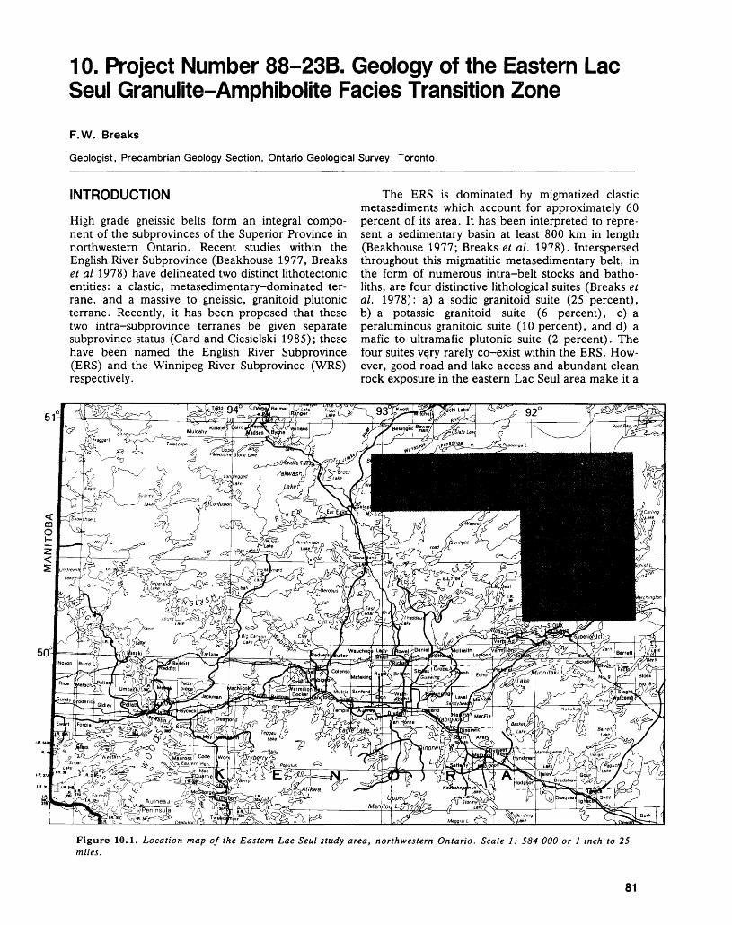
10. Project Number 88-23B. Geology of the Eastern Lac Seul Granulite-Amphibolite Facies Transition Zone
F. W. Breaks
Geologist, Precambrian Geology Section, Ontario Geological Survey, Toronto.
INTRODUCTION
High grade gneissic belts form an integral compo nent of the subprovinces of the Superior Province in northwestern Ontario. Recent studies within the English River Subprovince (Beakhouse 1977, Breaks et al 1978) have delineated two distinct lithotectonic entities: a clastic, metasedimentary-dominated ter rane, and a massive to gneissic, granitoid plutonic terrane. Recently, it has been proposed that these two intra-subprovince terranes be given separate subprovince status (Card and Ciesielski 1985); these have been named the English River Subprovince (ERS) and the Winnipeg River Subprovince (WRS) respectively.
The ERS is dominated by migmatized clastic metasediments which account for approximately 60 percent of its area. It has been interpreted to repre sent a sedimentary basin at least 800 km in length (Beakhouse 1977; Breaks et al. 1978). Interspersed throughout this migmatitic metasedimentary belt, in the form of numerous intra-belt stocks and batho- liths, are four distinctive lithological suites (Breaks et al. 1978): a) a sodic granitoid suite (25 percent), b) a potassic granitoid suite (6 percent), c) a peraluminous granitoid suite (10 percent), and d) a mafic to ultramafic plutonic suite (2 percent). The four suites very rarely co-exist within the ERS. How ever, good road and lake access and abundant clean rock exposure in the eastern Lac Seul area make it a
51
Figure 10.1. Location map of the Eastern Lac Seul study area, northwestern Ontario. Scale 1: 584 000 or l inch to 25 miles.
81
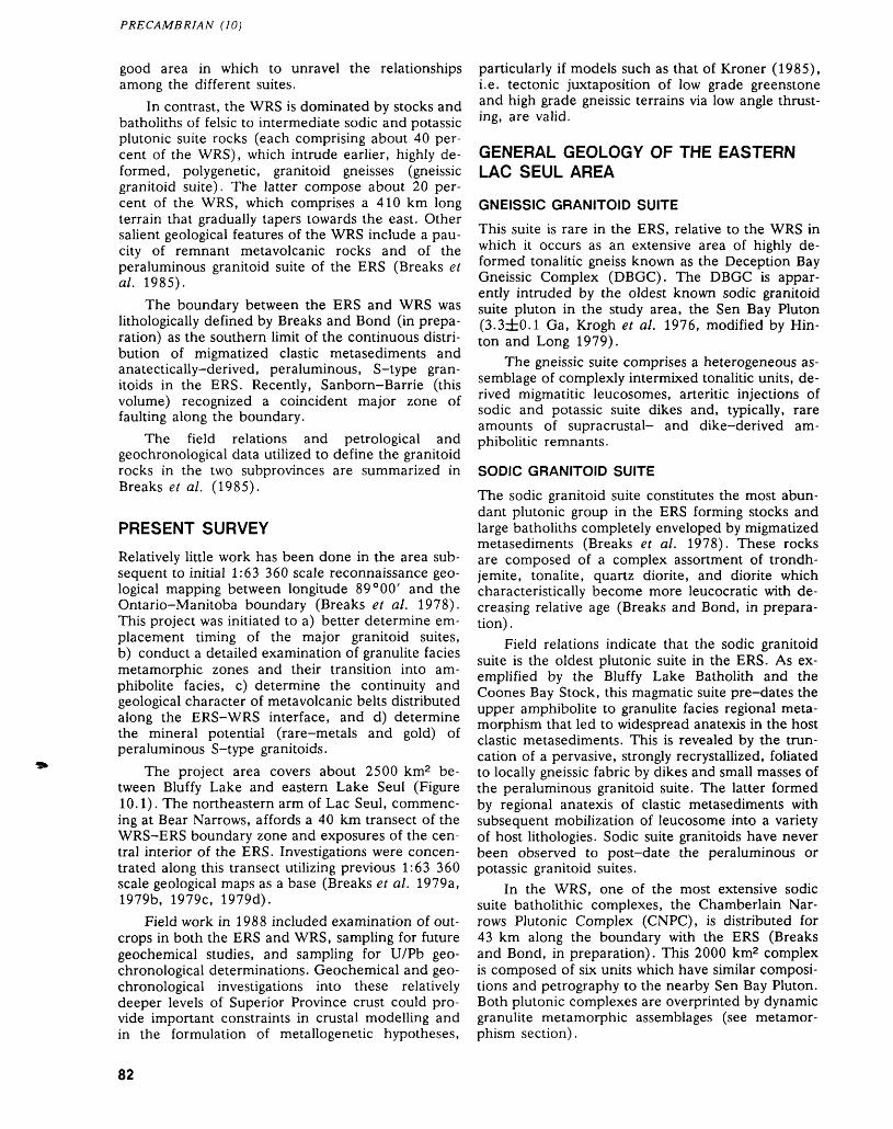
PRECAMBRIAN (10)
good area in which to unravel the relationships among the different suites.
In contrast, the WRS is dominated by stocks and batholiths of felsic to intermediate sodic and potassic plutonic suite rocks (each comprising about 40 per cent of the WRS), which intrude earlier, highly de formed, polygenetic, granitoid gneisses (gneissic granitoid suite). The latter compose about 20 per cent of the WRS, which comprises a 410 km long terrain that gradually tapers towards the east. Other salient geological features of the WRS include a pau city of remnant metavolcanic rocks and of the peraluminous granitoid suite of the ERS (Breaks et al. 1985).
The boundary between the ERS and WRS was lithologically defined by Breaks and Bond (in prepa ration) as the southern limit of the continuous distri bution of migmatized clastic metasediments and anatectically-derived, peraluminous, S-type gran itoids in the ERS. Recently, Sanborn-Barrie (this volume) recognized a coincident major zone of faulting along the boundary.
The field relations and petrological and geochronological data utilized to define the granitoid rocks in the two subprovinces are summarized in Breaks et al. (1985).
PRESENT SURVEY
Relatively little work has been done in the area sub sequent to initial 1:63 360 scale reconnaissance geo logical mapping between longitude 89 0 00' and the Ontario-Manitoba boundary (Breaks et al. 1978). This project was initiated to a) better determine em placement timing of the major granitoid suites, b) conduct a detailed examination of granulite facies metamorphic zones and their transition into am phibolite facies, c) determine the continuity and geological character of metavolcanic belts distributed along the ERS-WRS interface, and d) determine the mineral potential (rare-metals and gold) of peraluminous S-type granitoids.
The project area covers about 2500 km2 be tween Bluffy Lake and eastern Lake Seul (Figure 10.1). The northeastern arm of Lac Seul, commenc ing at Bear Narrows, affords a 40 km transect of the WRS-ERS boundary zone and exposures of the cen tral interior of the ERS. Investigations were concen trated along this transect utilizing previous 1:63 360 scale geological maps as a base (Breaks et al. 1979a, 1979b, 1979c, 1979d).
Field work in 1988 included examination of out crops in both the ERS and WRS, sampling for future geochemical studies, and sampling for U/Pb geo chronological determinations. Geochemical and geo chronological investigations into these relatively deeper levels of Superior Province crust could pro vide important constraints in crustal modelling and in the formulation of metallogenetic hypotheses,
particularly if models such as that of Kroner (1985), i.e. tectonic juxtaposition of low grade greenstone and high grade gneissic terrains via low angle thrust ing, are valid.
GENERAL GEOLOGY OF THE EASTERN LAC SEUL AREA
GNEISSIC GRANITOID SUITE
This suite is rare in the ERS, relative to the WRS in which it occurs as an extensive area of highly de formed tonalitic gneiss known as the Deception Bay Gneissic Complex (DBGC). The DBGC is appar ently intruded by the oldest known sodic granitoid suite pluton in the study area, the Sen Bay Pluton (3.3±0.1 Ga, Krogh et al. 1976, modified by Hin ton and Long 1979).
The gneissic suite comprises a heterogeneous as semblage of complexly intermixed tonalitic units, de rived migmatitic leucosomes, arteritic injections of sodic and potassic suite dikes and, typically, rare amounts of supracrustal- and dike-derived am phibolide remnants.
SODIC GRANITOID SUITE
The sodic granitoid suite constitutes the most abun dant plutonic group in the ERS forming stocks and large batholiths completely enveloped by migmatized metasediments (Breaks et al. 1978). These rocks are composed of a complex assortment of trondh jemite, tonalite, quartz diorite, and diorite which characteristically become more leucocratic with de creasing relative age (Breaks and Bond, in prepara tion) .
Field relations indicate that the sodic granitoid suite is the oldest plutonic suite in the ERS. As ex emplified by the Bluffy Lake Batholith and the Coones Bay Stock, this magmatic suite pre-dates the upper amphibolite to granulite facies regional meta morphism that led to widespread anatexis in the host clastic metasediments. This is revealed by the trun cation of a pervasive, strongly recrystallized, foliated to locally gneissic fabric by dikes and small masses of the peraluminous granitoid suite. The latter formed by regional anatexis of clastic metasediments with subsequent mobilization of leucosome into a variety of host lithologies. Sodic suite granitoids have never been observed to post-date the peraluminous or potassic granitoid suites.
In the WRS, one of the most extensive sodic suite batholithic complexes, the Chamberlain Nar rows Plutonic Complex (CNPC), is distributed for 43 km along the boundary with the ERS (Breaks and Bond, in preparation). This 2000 km2 complex is composed of six units which have similar composi tions and petrography to the nearby Sen Bay Pluton. Both plutonic complexes are overprinted by dynamic granulite metamorphic assemblages (see metamor phism section).
82
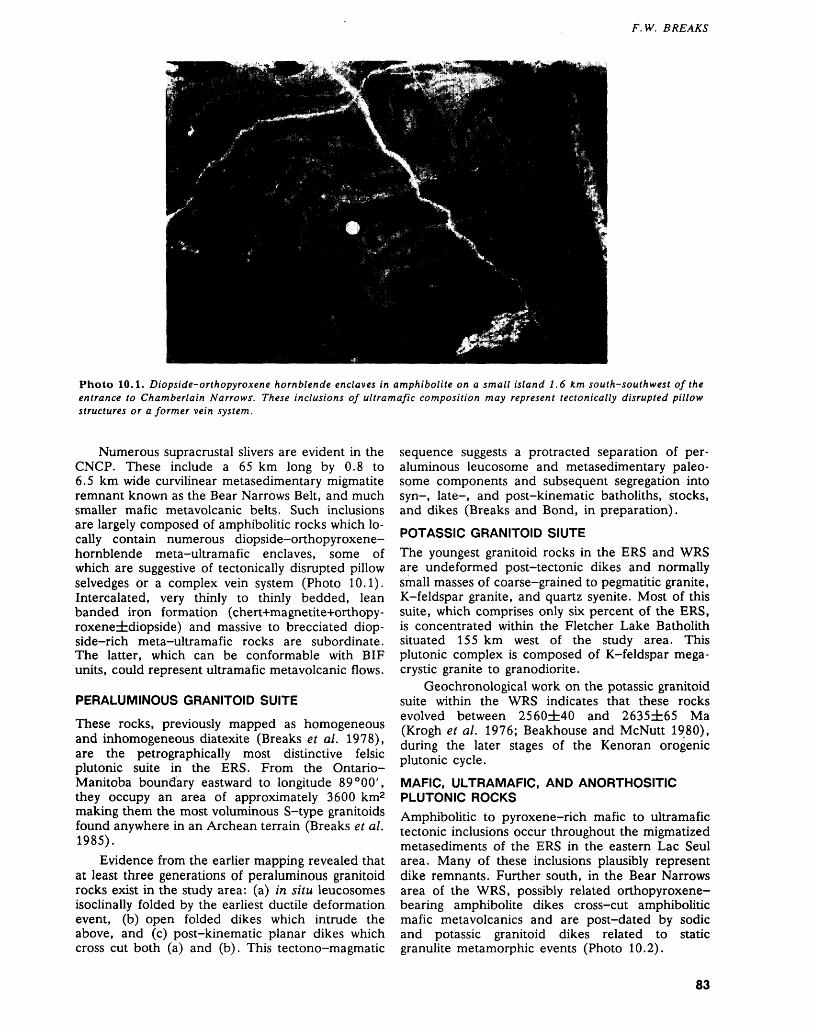
F. W. BREAKS
Photo 10.1. Diopside-orthopyroxene hornblende enclaves in amphibolite on a small island 1.6 km south-southwest of the entrance to Chamberlain Narrows'. These inclusions of ultramafic composition may represent tectonically disrupted pillow structures or a former vein system.
Numerous supracrustal slivers are evident in the CNCP. These include a 65 km long by 0.8 to 6.5 km wide curvilinear metasedimentary migmatite remnant known as the Bear Narrows Belt, and much smaller mafic metavolcanic belts. Such inclusions are largely composed of amphibolitic rocks which lo cally contain numerous diopside-orthopyroxene- hornblende meta-ultramafic enclaves, some of which are suggestive of tectonically disrupted pillow selvedges or a complex vein system (Photo 10.1). Intercalated, very thinly to thinly bedded, lean banded iron formation (chert+magnetite+orthopy- roxeneidiopside) and massive to brecciated diop side—rich meta—ultramafic rocks are subordinate. The latter, which can be conformable with BIF units, could represent ultramafic meta volcanic flows.
PERALUMINOUS GRANITOID SUITE
These rocks, previously mapped as homogeneous and inhomogeneous diatexite (Breaks et al. 1978), are the petrographically most distinctive felsic plutonic suite in the ERS. From the Ontario- Manitoba boundary eastward to longitude 89 0 00', they occupy an area of approximately 3600 km2 making them the most voluminous S-type granitoids found anywhere in an Archean terrain (Breaks et al. 1985).
Evidence from the earlier mapping revealed that at least three generations of peraluminous granitoid rocks exist in the study area: (a) in situ leucosomes isoclinally folded by the earliest ductile deformation event, (b) open folded dikes which intrude the above, and (c) post-kinematic planar dikes which cross cut both (a) and (b). This tectono-magmatic
sequence suggests a protracted separation of per aluminous leucosome and metasedimentary paleo some components and subsequent segregation into syn-, late-, and post-kinematic batholiths, stocks, and dikes (Breaks and Bond, in preparation).POTASSIC GRANITOID SIUTE
The youngest granitoid rocks in the ERS and WRS are undeformed post-tectonic dikes and normally small masses of coarse-grained to pegmatitic granite, K-feldspar granite, and quartz syenite. Most of this suite, which comprises only six percent of the ERS, is concentrated within the Fletcher Lake Batholith situated 155 km west of the study area. This plutonic complex is composed of K-feldspar mega- crystic granite to granodiorite.
Geochronological work on the potassic granitoid suite within the WRS indicates that these rocks evolved between 2560±40 and 2635±65 Ma (Krogh et al. 1976; Beakhouse and McNutt 1980), during the later stages of the Kenoran orogenic plutonic cycle.MAFIC, ULTRAMAFIC, AND ANORTHOSITE PLUTONIC ROCKS
Amphibolitic to pyroxene-rich mafic to ultramafic tectonic inclusions occur throughout the migmatized metasediments of the ERS in the eastern Lac Seul area. Many of these inclusions plausibly represent dike remnants. Further south, in the Bear Narrows area of the WRS, possibly related orthopyroxene- bearing amphibolite dikes cross-cut amphibolitic mafic metavolcanics and are post-dated by sodic and potassic granitoid dikes related to static granulite metamorphic events (Photo 10.2).
83
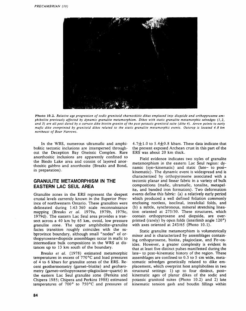
PRECAMBRIAN (10)
Photo 10.2. Relative age progression of sodic granitoid charnockite dikes emplaced into diopside and orthopyroxene am phibolite previously affected by dynamic granulite metamorphism. Dikes with static granulite metamorphic selvedges (1,2, and 3) are all post dated by a curvate dike biotite granite of the post potassic granitoid suite (dike 4). Arrow points to early mafic dike overprinted by granitoid dikes related to the static granulite metamorphic events. Outcrop is located 4.8 km northeast of Bear Narrows.
In the WRS, numerous ultramafic and amphi bolide tectonic inclusions are interspersed through out the Deception Bay Gneissic Complex. Rare anorthositic inclusions are apparently confined to the Bindo Lake area and consist of layered anor- thositic gabbro and anorthosite (Breaks and Bond, in preparation).
GRANULITE METAMORPHISM IN THE EASTERN LAC SEUL AREA
Granulite zones in the ERS represent the deepest crustal levels currently known in the Superior Prov ince of northwestern Ontario. These granulites were delineated during 1:63 360 scale reconnaissance mapping (Breaks et al. 1979a, 1979b, 1979c, 1979d). The eastern Lac Seul area provides a tran sect across a 40 km by 65 km, ovoid, low pressure granulite zone. The upper amphibolite-granulite facies transition roughly coincides with the su- bprovince boundary, although small "nodes" of or- thopyroxene+diopside assemblages occur in mafic to intermediate bulk compositions in the WRS at dis tances up to 13 km south of the boundary.
Breaks et al. (1978) estimated metamorphic temperatures in excess of 770 0 C and load pressures of 4 to 6 kbars for granulite zones of the ERS. Re cent geothermometry (garnet-biotite) and geobaro metry (garnet-orthopyroxene-plagioclase-quartz) in the eastern Lac Seul granulite zone (Perkins and Chipera 1985; Chipera and Perkins 1988) estimated temperatures of 700 0 to 750 0 C and pressures of
4.7±1.0 to 5.4±0.8 kbars. These data indicate that the present exposed Archean crust in this part of the ERS was about 20 km thick.
Field evidence indicates two styles of granulite metamorphism in the eastern Lac Seul region: dy namic (syn-kinematic) and static (late- to post kinematic) . The dynamic event is widespread and is characterized by orthopyroxene associated with a tectonic planar and linear fabric in a variety of bulk compositions (mafic, ultramafic, tonalite, metapel- ite, and banded iron formation). Two deformation events define this fabric: (a) a relatively early period which produced a well defined foliation commonly enclosing rootless, isoclinal, intrafolial folds, and (b) a subtle, synchronous, mineral stretching linea tion oriented at 275/30. These structures, which contain orthopyroxene and diopside, are over printed (rarely) by open folds (interlimb angle 120 0 ) with axes oriented at 243/65 (Photo 10.1).
Static granulite metamorphism is volumetrically minor and is characterized by assemblages contain ing orthopyroxene, biotite, plagioclase, and Fe-ox- ides. However, a greater complexity is evident in that at least five distinct pulses manifested during the late- to post-kinematic history of the region. These assemblages are confined to 0.5 to 5 cm wide, meta somatic selvedges genetically related to dike em placement, which overprint host amphibolites in two structural settings: 1) up to four distinct, post kinematic ages of planar dikes of the sodic and potassic granitoid suites (Photo 10.2) and 2) late kinematic tension gash and boudin fillings within
84
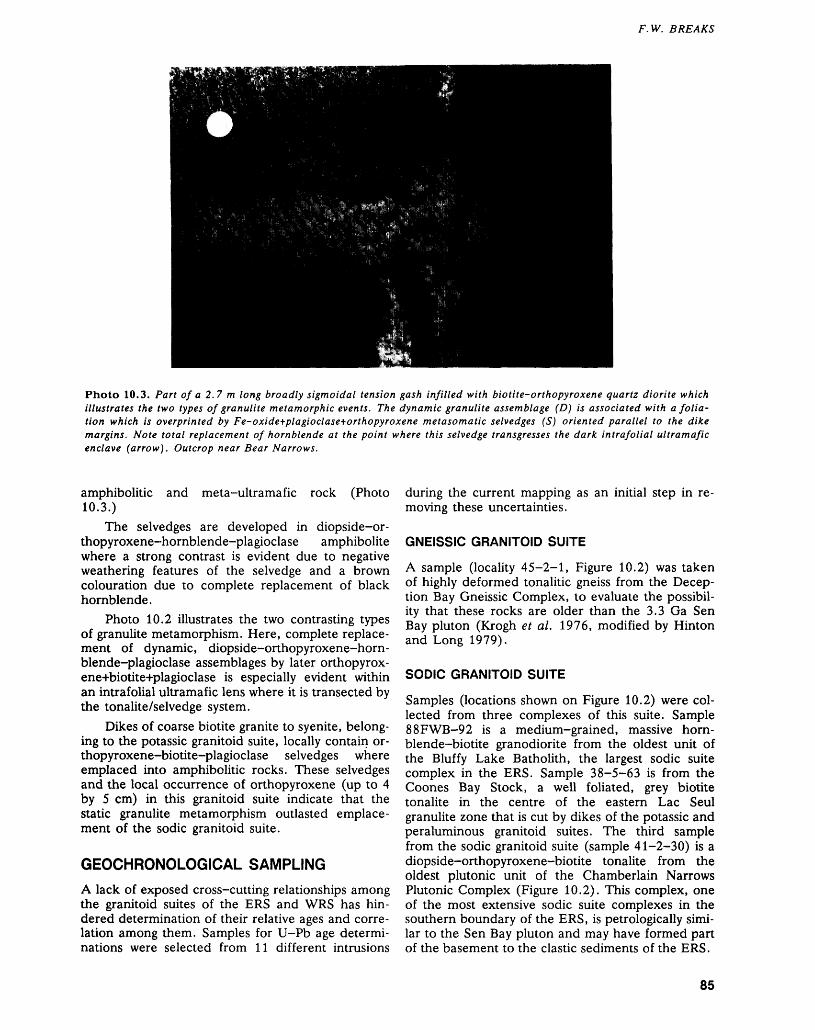
F. W. BREAKS
Photo 10.3. Part of a 2.7 m long broadly sigmoidal tension gash infilled with biotite-orthopyroxene quartz diorite which illustrates the two types of granulite metamorphic events. The dynamic granulite assemblage (D) is associated with a folia tion which is overprinted by Fe-oxide+plagioclase+orthopyroxene metasomatic selvedges (S) oriented parallel to the dike margins. Note total replacement of hornblende at the point where this selvedge transgresses the dark intrafolial ultramafic enclave (arrow). Outcrop near Bear Narrows.
amphibolide and meta-ultramafic rock (Photo 10.3.)
The selvedges are developed in diopside-or- thopyroxene-hornblende-plagioclase amphibolite where a strong contrast is evident due to negative weathering features of the selvedge and a brown colouration due to complete replacement of black hornblende.
Photo 10.2 illustrates the two contrasting types of granulite metamorphism. Here, complete replace ment of dynamic, diopside-orthopyroxene-horn- blende-plagioclase assemblages by later orthopyrox- ene+biotite+plagioclase is especially evident within an intrafolial ultramafic lens where it is transected by the tonalite/selvedge system.
Dikes of coarse biotite granite to syenite, belong ing to the potassic granitoid suite, locally contain or- thopyroxene-biotite-plagioclase selvedges where emplaced into amphibolide rocks. These selvedges and the local occurrence of orthopyroxene (up to 4 by 5 cm) in this granitoid suite indicate that the static granulite metamorphism outlasted emplace ment of the sodic granitoid suite.
GEOCHRONOLOGICAL SAMPLING
A lack of exposed cross-cutting relationships among die granitoid suites of the ERS and WRS has hin dered determination of their relative ages and corre lation among them. Samples for U-Pb age determi nations were selected from 11 different intrusions
during the current mapping as an initial step in re moving these uncertainties.
GNEISSIC GRANITOID SUITE
A sample (locality 45-2-1, Figure 10.2) was taken of highly deformed tonalitic gneiss from the Decep tion Bay Gneissic Complex, to evaluate the possibil ity that these rocks are older than the 3.3 Ga Sen Bay pluton (Krogh e t al. 1976, modified by Hinton and Long 1979).
SODIC GRANITOID SUITE
Samples (locations shown on Figure 10.2) were col lected from three complexes of this suite. Sample 88FWB-92 is a medium-grained, massive horn- blende-biotite granodiorite from the oldest unit of the Bluffy Lake Batholith, the largest sodic suite complex in the ERS. Sample 38-5-63 is from the Coones Bay Stock, a well foliated, grey biotite tonalite in the centre of the eastern Lac Seul granulite zone tiiat is cut by dikes of the potassic and peraluminous granitoid suites. The third sample from the sodic granitoid suite (sample 41-2-30) is a diopside-orthopyroxene-biotite tonalite from the oldest plutonic unit of the Chamberlain Narrows Plutonic Complex (Figure 10.2). This complex, one of the most extensive sodic suite complexes in the southern boundary of the ERS, is petrologically simi lar to the Sen Bay pluton and may have formed part of the basement to the clastic sediments of the ERS.
85
PRECAMBRIAN (10)
PERALUMINOUS GRANITOID SUITE
As described previously (see General Geology of Eastern Lac Seul Area), at least three generations of peraluminous granitoids are known for the study area. To date, only one absolute age (2681zfc20 Ma; U-Pb zircon, Krogh et al. 1976) is available for this suite. Four samples were collected during the cur rent project. Sample 39-2-35 is from leucosomes of in situ orthopyroxene-biotite granite to quartz syenite with orthopyroxene-cordierite-biotite mel anosome selvedges. This sample should provide the age of initial anatexis in the eastern Lac Seul granulite zone. Sample 38-5-61 is from a cor- dierite-biotite-garnet granite dike that was appar ently generated in the second anatexis. Sample 88FWB-83 is from the Churchill Lake Batholith. This is the largest S-type granite in the ERS; the age of the sample will date the most extensive anatexis event in the ERS, and will provide an upper age limit for the potassic granitoid suite. The last sample (88FWB-84), from a post-kinematic pegmatitic
granite dike, will yield the age of the youngest rocks in the peraluminous suite. The dike contains a rudi mentary core of blocky K-feldspar, quartz, and tourmaline and may also provide an estimate of the timing of rare-metal pegmatite dike swarms that are distributed along the northern boundary of the ERS in the Root Lake area, some 25 km to the north west.
POTASSIC GRANITOID SUITE
Three samples of this suite were collected. Sample 41-2-52 is an undeformed biotite granite dike con taining local orthopyroxene. It may represent the youngest charnockitization related to the static granulite metamorphism. Sample 88FWB-86 is from an undeformed biotite pegmatite dike that cross cuts orthopyroxene-garnet-biotite clastic metasedi- ments. Sample 88FWB-89 (not shown in Figure 10.2) is from a yellow-brown weathered, ortho- pyroxene-bearing zone in the Fletcher Lake Batho lith, which is situated in the Umfreville Lake-Coni fer Lake granulite zone (Breaks et al. 1978). The
r: .SUBPROVINCE
Gneissic granitoid suite
^^^1 Mafic and intermediate metavolcanics
f (J/Pb Geochronological sampling site
"* Subprovince boundary
Potassic granitoid suite
Peraluminous granitoid suite
Sodic granitoid suite
Mafic and ultramafic plutonic rocks
Metasedimentary migmatite
Deception Bay
Gneissic Complex
Geology compiled from Breaks et al. 11
Figure 10.2. General geology of the Eastern Lac Seul area, showing the locations of samples discussed in the text.
86
F. W. BREAKS
age obtained from this sample will establish the age of the batholith and an upper age limit for charnock- itic metamorphism, and will allow comparison with similar processes active in the eastern Lac Seul area.
MAFIC, ULTRAMAFIC, AND ANORTHOSITE PLUTONIC ROCKS
Sample 45-5-23 was taken from an inclusion of anorthositic gabbro in the Deception Bay Gneissic Complex at Bindo Lake. This sample may yield the age of the early sialic crust of the study area, analo gous to recently reported anorthositic rocks (3730± 6 Ma) from the Narryer Gneiss Complex in the Yil- garn Craton of Western Australia (Myers 1988a, 1988b; Kinney et al. 1988).
RECOMMENDATIONS FOR MINERAL EXPLORATION
Granulite zones of gneissic belts such as the ERS have been postulated to represent possible primary sources of gold, arsenic, tin, carbon dioxide, and various large ion lithophile metals. These metals are variably concentrated in gold deposits of nearby greenstone-dominated subprovinces (Colvine et al. 1988). Dehydration mineral reactions leading to re placement of hornblende by orthopyroxene have episodically developed in granulite zones of the ERS and parts of the WRS. Late to postkinematic elimi nation of hornblende in metasomatic selvedges bor dering orthopyroxene-bearing tonalite to quartz dio rite dikes is indicative of incipient charnockitization, which likely developed in response to a carbon diox ide-rich fluid phase (Touret and Dietvorst 1983; Holt and Wightman 1983). Such dike systems could also have performed as conduits, facilitating egress of these volatiles and metals to higher crustal levels. Egress may also have been aided by nearby shear zones (e.g. Lake St. Joseph Fault, Miniss River Fault, ERS-WRS boundary fault). It would thus be useful to examine these fault systems for zones of carbonatization and hematitization as a guide to gold mineralization which may reflect streaming of oxi dized, carbon dioxide-rich fluids (Cameron 1988) from the granulite zones.
Rare-metal mineralization in fertile granites, consanguineous pegmatites, and possible exogreisen vein zones genetically linked with the peraluminous granitoid suite should also be considered in the ERS-Uchi interface zone. This area has been poorly explored for such mineralization (lithium, cesium, beryllium, rubidium, tantalum, gallium) even though rare-metal pegmatites (Root Lake Field) are known within this zone (Breaks and Bond, in preparation).
CONCLUSIONS
The absolute timing of magmato-tectonic events in high grade gneissic belts such as the ERS in north western Ontario remains poorly understood, despite
reasonably well understood geological relationships (Beakhouse 1977; Breaks et al. 1978). This study has examined new exposures in the contact zone be tween the ERS and the WRS that reaffirm earlier relative age relationships among granitoid suites of the two subprovinces. The geochronological frame work that will result from sampling completed in 1988 will lead to a better understanding of Archean crustal evolutionary processes and mineralization events characteristic of high grade gneissic belts.
REFERENCESBeakhouse, G.P.1977: A Subdivision of the Western English River Su-
bprovince; Canadian Journal of Earth Sciences, Vol ume 14, p.1481-1489.
Beakhouse, G.P., and McNutt, R.H.1980: Rb-Sr Isotopic Systematics of Granitoid Rocks from
the English River Subprovince at Redditt, N.W. Ont ario (Abstract); Geological Association of Canada, Program with Abstracts, Volume 5, p.48.
Breaks, F.W., and Bond, W.D.In Prep.: The English River Subprovince-an Archean
Gneissic Belt: Geology, Geochemistry, and Associ ated Mineral Deposits; Ontario Geological Survey, Geological Report.
Breaks, F.W., Bond, W.D., and Stone, Denver 1978: Preliminary Geological Synthesis of the English River
Subprovince, Northwestern Ontario and its Bearing upon Mineral Exploration; Ontario Geological Sur vey, Miscellaneous Paper 72, 54p. Accompanied by Map P.1972, scale 1:253 440.
1981: Precambrian Geology of the English River-Mar- chington Lake Area, Kenora District (Patricia Por tion); Ontario Geological Survey, Preliminary Map P.2293, Geological Series, Scale 1:63 360 or l inch to l mile. Geology 1977.
Breaks, F.W., Bond, W.D., Stone, D., and Desnoyers, D.W.
1979a: Root Lake Sheet, Operation Miniss-Tully Lakes; Ontario Geological Survey, Preliminary Map P.2215, Geological Series, scale 1:63 360 or l inch l to mile. Geology 1969.
1979b: Miniss Lake Sheet, Operation Miniss-Tully Lakes, Ontario Geological Survey, Preliminary Map P.2216, Geological Series, scale 1:63 360 or l inch to l mile. Geology 1969.
1979c: Chamberlain Narrows (Lac Seul) Sheet, Operation Miniss-Tully Lakes; Ontario Geological Survey, Pre liminary Map P. 2217, Geological Series, scale 1:63 360 or l inch to l mile. Geology 1976.
1979d: Hooker-Fitchie Lakes Sheet, Operation Miniss-Tully Lakes; Ontario Geological Survey, Preliminary Map P.2218, Geological Series, scale 1:63 360 or l inch to l mile. Geology 1976.
Breaks, F.W., Cherry, M.E., and Janes, D.A.1985: Metallogeny of Archean Granitoid Rocks of the Eng
lish River Subprovince, Superior Province, Ontario, Canada: A Review; P. 9-13 in Conference Proceed ings, High Heat Production Granites, Hydrothermal Circulation and Ore Genesis, The Institution of Min ing and Metallurgy, London, 593p.
87
PRECAMBRIAN (10)
Cameron, E.M.1988: Archean Gold: Relation to Granulite Formation and
Redox Zoning in the Crust; Geology, Volume 16,p.109-112.
Card, K.D., and Ciesielski, A.1986: DNAG #1 Subdivisions of the Superior Province of the
Canadian Shield; Geoscience Canada, Volume 13,Number l, p.5-13.
Chipera, S.J., and Perkins, Dexter1988: Garnet-Orthopyroxene-Plagioclase-Quartz Barome-
try: Refinement and Application to the English River Subprovince and the Minnesota River Valley; Contri butions to Mineralogy and Petrology, Volume 89, p.69-80.
Colvine, A.C., Fyon, J.A., Heather, K.B., Marmont, Sous- san, Smith, P.M., and Troop, D.G.
1988: Archean Lode Gold Deposits in Ontario. Part I. A Depositional Model. Part II. A Genetic Model; Ont ario Geological Survey, Miscellaneous Paper 139, 136p.
Hinton, R.W., and Long, J.V.P.1979: High-Resolution lon-Microprobe Measurement of
Lead Isotopes: Variations within Single Zircons from Lac Seul, Northwestern Ontario; Earth Planetary Sci ences Letters, Volume 45, p.309-325.
Holt, R.W., and Wightman, R.T.1983: The Role of Fluids in the Development of a Granulite
Facies Transition Zone in South India; Journal of Geological Society London, Volume 140, p.651-656.
Kinney, P.D., Williams, I.S., Froude, D.O., Ireland, T.R.,and Compston, W.
1988: Early Archean Zircon Ages from Orthogneiss andAnorthosites at Mount Narryer, Western Australia;Precambrian Research, Volume 38, p.325-341.
Krogh, T.E., Harris, N.B.W., and Davis, G.L.1976: Archean Rocks from the Eastern Lac Seul Region of
the English River Gneiss Belt, Northwestern Ontario, Part 2. Geochronology; Canadian Journal of Earth Sciences, Volume 13, Number 9, p. 1212-1215.
Kroner, Alfred1985: Evolution of the Archean Continental Crust; Annual
Review, Earth Planetary Sciences, Volume 13,p.49-74.
Myers, J.S.1988a: Early Archean Narryer Gneiss Complex, Yilgarn
Craton, Western Australia; Precambrian Research, Volume 38, Number 4, p.297-324.
1988b: Oldest Known Terrestrial Anorthosite at Mount Nar ryer, Western Australia; Precambrian Research, Vol ume 38, Number 4, p.325-342.
Perkins, Dexter, and Chipera, S.J.1985: .Evaluation of Biotite-Garnet Geothermometers: Ap
plication to the English River Subprovince, Ontario; Contributions to Mineralogy and Petrology, Volume 98, p.40-48.
Touret, J., and Dietvorst, P.1983: Fluid Inclusions in High Grade Anatectic Metamor-
phites; Geological Society of London Journal, Volume140, p.635-649.
88
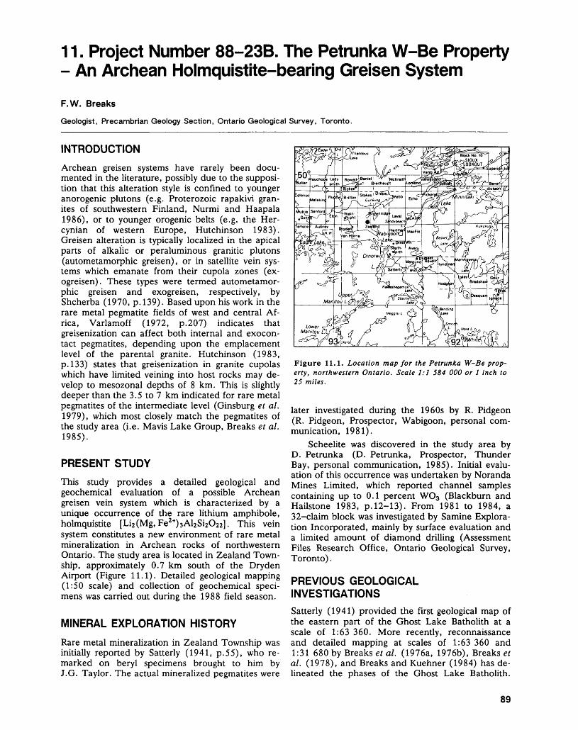
11. Project Number 88-23B. The Petmnka W-Be Property - An Archean Holmquistite-bearing Greisen System
F. W. Breaks
Geologist, Precambrian Geology Section, Ontario Geological Survey, Toronto.
INTRODUCTION
Archean greisen systems have rarely been docu mented in the literature, possibly due to the supposi tion that this alteration style is confined to younger anorogenic plutons (e.g. Proterozoic rapakivi gran ites of southwestern Finland, Nurmi and Haapala 1986), or to younger orogenic belts (e.g. the Her cynian of western Europe, Hutchinson 1983). Greisen alteration is typically localized in the apical parts of alkalic or peraluminous granitic plutons (autometamorphic greisen), or in satellite vein sys tems which emanate from their cupola zones (ex- ogreisen). These types were termed autometamor phic greisen and exogreisen, respectively, by Shcherba (1970, p. 139). Based upon his work in the rare metal pegmatite fields of west and central Af rica, Varlamoff (1972, p.207) indicates that greisenization can affect both internal and exocon- tact pegmatites, depending upon the emplacement level of the parental granite. Hutchinson (1983, p. 133) states that greisenization in granite cupolas which have limited veining into host rocks may de velop to mesozonal depths of 8 km. This is slightly deeper than the 3.5 to 7 km indicated for rare metal pegmatites of the intermediate level (Ginsburg et al. 1979), which most closely match the pegmatites of the study area (i.e. Mavis Lake Group, Breaks et al. 1985).
PRESENT STUDY
This study provides a detailed geological and geochemical evaluation of a possible Archean greisen vein system which is characterized by a unique occurrence of the rare lithium amphibole, holmquistite [Li2 (Mg,Fe2*)3Al2Si2O22]. This vein system constitutes a new environment of rare metal mineralization in Archean rocks of northwestern Ontario. The study area is located in Zealand Town ship, approximately 0.7 km south of the Dryden Airport (Figure 11.1). Detailed geological mapping (1:50 scale) and collection of geochemical speci mens was carried out during the 1988 field season.
MINERAL EXPLORATION HISTORY
Rare metal mineralization in Zealand Township was initially reported by Satterly (1941, p.55), who re marked on beryl specimens brought to him by J.G. Taylor. The actual mineralized pegmatites were
Figure 11.1. Location map for the Petrunka W-Be prop erty, northwestern Ontario. Scale 1:1 584 000 or l inch to 25 miles.
later investigated during the 1960s by R. Pidgeon (R. Pidgeon, Prospector, Wabigoon, personal com munication, 1981).
Scheelite was discovered in the study area by D. Petrunka (D. Petrunka, Prospector, Thunder Bay, personal communication, 1985). Initial evalu ation of this occurrence was undertaken by Noranda Mines Limited, which reported channel samples containing up to 0.1 percent WO3 (Blackburn and Hailstone 1983, p. 12-13). From 1981 to 1984, a 32-claim block was investigated by Samine Explora tion Incorporated, mainly by surface evaluation and a limited amount of diamond drilling (Assessment Files Research Office, Ontario Geological Survey, Toronto).
PREVIOUS GEOLOGICAL INVESTIGATIONS
Satterly (1941) provided the first geological map of the eastern part of the Ghost Lake Batholith at a scale of 1:63 360. More recently, reconnaissance and detailed mapping at scales of 1:63 360 and 1:31 680 by Breaks et al. (1976a, 1976b), Breaks et al. (1978), and Breaks and Kuehner (1984) has de lineated the phases of the Ghost Lake Batholith.
89
PRECAMBRIAN (11)
Breaks et al. (1978) hypothesized that rare metal pegmatites in the Mavis Lake area were geochemi- cally fractionated apophyses originating from this batholith.
GEOLOGICAL SETTING
The greisen vein system is located at the southeast ern contact of the Ghost Lake Batholith, a highly evolved, S-type, peraluminous granitoid complex (Breaks et al. 1985). The alteration zone is devel oped in amphibolitized mafic metavolcanics (Central Volcanic Belt of the Wabigoon Subprovince; Trowell et al. 1980), which correspond to the beryl zone of the regionally-zoned Mavis Lake rare metal pegma tite group (Breaks et al. 1985). The Zealand occur rence appears to fall within the "amphibolite greisen formation" of Shcherba's classification of greisens (1970, p.250).
The greisen vein system is mostly conformable to host rock foliations and is traceable for at least 0.65 km eastwards from the contact between the
metavolcanics and the Ghost Lake Batholith. It var ies from 1.5 to 10 m in width. Figure 11.2 is a de tailed (1:50 scale), geological map of the well-ex posed westernmost part of the vein system, where direct linkage with the Ghost Lake Batholith can be observed.
GEOLOGICAL AND GEOCHEMICAL FEATURES OF ASSOCIATED PEGMATITIC GRANITIC ROCKS
The pegmatitic granites exposed on, and near, the Petrunka property form the most geochemically ad vanced and lithologically diverse portion of the en tire Ghost Lake Batholith. Geochemical evolution is illustrated by the inter-element ratios of potassic feldspars from potassic pegmatites: K/Rb = 43 to 59, K/Cs = 121 to 341, K/Ba ~ 4650 to ^050, Rb/Sr - 60 to 84, and Ba/Rb = 0.014 to ^.0046 (Breaks, in preparation). The lithological diversity is illustrated by Table 11.1, which lists the primary and replace ment units identified on the property. Modal analy ses of most of these units are given in Table 11.2.
4 + 4- 4** * * 4* + I444-444 + 438.04 -d
+ + 44-4444-44-+4 4 4444-4 4- 4
. 4- 4- 3a,b,c,d 4- 4-1-4-44-4-4-4- '44-4-44-4-4-
GREISEN VEIN SYSTEM
P y rite -t our ma line-muse o vite and pyrite-holmquistite- tourmaline-muscovite- biotite zones
Actinolite-biotite- tourmaline zone
Mineral stretching lineation with plunge
GHOST LAKE BATHOLITH
4 j . Peraluminous Granitic RocksO 4-
± -t- ,
a. Pegmatitic leucogranite b. Fine-grained leucogranite c. Potassic pegmatite d. Muscovite-rich potassic
pegmatite e. Banded aplite
f. Orbicular aplite g. Beryl-tourmaline
albitic dykes
^Tl Actinolite-plagioclasei.-.-;-l; mafic metavolcanics
5280
Hornblende-plagioclase l.r-.J.-'.l mafic metavolcanics
"" Granitic dykes
Foliation with dip
Figure 11.2. Detailed geology of the exogreisen vein system at the Petrunka Property.
90
F. W. BREAKS
TABLE 11.1. MINERALOGY OF PRIMARY AND REPLACEMENT UNITS OF THE GHOST LAKE BATHOLITH ON THE PETRUNKA PROPERTY. TERMINOLOGY OF THE PRIMARY UNITS IS MODIFIED FROM CERNY ET AL. (1981, p.50), AND TERMINOLOGY OF THE REPLACEMENT UNITS IS BASED IN PART ON SHCHERBA (1970).
UNIT
Pegmatitic Leucogranite Fine-grained Leucogranite Muscovite-rich Potassic Pegmatite* Banded Aplite Orbicular Aplite**
AutometamorphicGreisenAlbitized PotassicPegmatiteAlbitic DikesMarginal Exogreisen
MINERAL ASSEMBLAGE
PRIMARY UNITS
tourmaline-muscovite-albite-quartz-K-feldspargarnet-tourmaline-K-feldspar-quartz-albitegarnet-tourmaline-muscovite-albite-K-feldspar-quartztourmaline-garnet-muscovite-quartz-albitetourmaline-muscovite-K-feldspar-quartz albite
REPLACEMENT UNITS
cassiterite-chrysoberyl-albite-beryl-muscovitegarnet-tourmaline-quartz-albite
quartz-beryl-tourmaline-albite quartz-albite-actinolite-biotite-tourmaline
* BO-35% muscovite in the matrix, between single crystals and aggregates of blocky K-feld spar.** a type of primary aplite, characterized by ovoid, proto-orbicules (Leveson 1966) of fine grained tourmaline-green muscovite- albite in a coarse matrix of K-feldspar-albite-green muscovite.
TABLE 11.2. MODAL ANALYSES OF PRIMARY AND REPLACEMENT UNITS OF THE GHOST LAKE BATHOLITH ON THE PETRUNKA PROPERTY. SEE TABLE 11.1 FOR DEFINITION OF UNITS.
PRIMARY UNITS REPLACEMENT UNITS
Pegmatitic
Leucogranite 1
Quartz i31.5Plagioclase 19.2 K-Feldspar 42.5 Muscovite 5.5Tourmaline 1 . 4GarnetBeryl CassiteriteChrysoberyl
Muscovite-
rich
Potassic
Pegmatite 1
35.222.7 27.3 13.6
1.1X
Fine
grained
Leuco
granite2
28.657.4 11.4 0.42.2X
Potassic
Pegmatite 1
23.830.8 41.3
1.4
X
Autometa
morphic
Griesen 1
5.0
85.0
10.0 XX
Granitic
Pegmatite
Dike 1
3.556.5
8.2
31.8
Albitized
Potassic
Pegmatite 1
21.673.1
0.54.9X
Albitized, Fine
grained
Leuco
granite2
26.448.5 20.9 0.53.8X
X - present in trace amounts^Analyses done on clean fresh outcrop surfaces covering a 3 by 3 m area and 5 cm grid spacing for the coarse-grained pri mary units and 0.5 by 0.5 m area and l cm grid spacing for the relatively finer-grained replacement units.2Thin section modal analysis.
Incipient development of albitization replace ment units in the pegmatitic granites was observed in two settings: a) along contacts between the batholith and amphibolitized mafic metavolcanics; and b) in
an exocontact dike network. In the first setting, re placement occurs as a 10 to 100 cm wide garnet- muscovite-tourmaline-quartz-albite border unit containing about 73 percent albite. Textures indicate
91
PRECAMBRIAN (11)
Photo 11.1. Transition from albite-beryl-muscovite autometamorphic greisen (G) into bifurcating beryl-tour- maline-albite exocontact dikes (D) at Locality B in Figure 11.2.
a progressive degradation of blocky potassic feldspar in a beryl-tourmaline-muscovite potassic pegmatite as the batholith contact is approached. This disap pearance of potassic feldspar is complemented by a biotite-rich halo in the adjacent amphibolide host rocks, which also suggests a metasomatic origin for this albite-rich unit. The exocontact dikes (Photo 11.1) are 10 to 30 cm wide, and are abundant in one locality (B, Figure 11.2). These rocks normally consist of a tourmaline-quartz-albite assemblage which can grade along strike into berylliferous al bitite (Table 11.2), or can interconnect with pyrite- tourmaline-quartz veins, locally containing small pods (up to 50 cm by 100 cm) of approximately 90 percent beryl. Skeletal tourmaline intergrowth^ with albite are another notable textural feature on the property, and can occur in albitized marginal plutonic units of the Ghost Lake Batholith or in tourmaline-albite exocontact dikes.
Apparently, fluids emanating from these re placement units interacted chemically with am phibolide mafic metavolcanic host rocks, resulting in complementary l to 5 cm wide, brown weathering selvedges enriched in K2O, Li, Rb, Cs, F, and Sn
(Table 11.3). However, most fluids were probably channeled in the host rocks to locality A in Figure 11.2, which represents the beginning of the greisen vein system.
AUTOMETAMORPHIC GREISEN
Autometamorphic greisens occur as local lenses up to 4.5 m by 0.42 m, as at locality B (Figure 11.2, Photo 11.1). These units are enclosed within, and are gradational into, a small exocontact pegmatitic granite lens (3 m by 14 m) composed of albitized, muscovite-rich potassic pegmatite which envelopes a core of fine-grained leucogranite. The eastern end of a muscovite-rich potassic pegmatite unit grades into albite-rich dikes with black tourmaline sel vedges. These dikes also contain appreciable beryl (Table 11.2). The western end of this pegmatitic granitic pod grades into a similar muscovite-rich greisen, which contains appreciable pyrite, tourma line, and biotite.
The greisen pods are strongly foliated and lineated, fine to coarse grained, and yellow-green due to the presence of 85 percent muscovite. They contain appreciable beryl, which occurs as white and light grey, euhedral to subhedral crystals up to 1.2 cm long (normal to c-axis) and 0.7 cm by 2.5 cm (parallel to c-axis). Lesser amounts of an hedral albite and accessory chrysoberyl and cas siterite are also present (Table 11.2). Chrysoberyl (Al2BeO4), which occurs as l to 2 mm yellow-green anhedral grains, is a relatively rare mineral in peg matitic rocks and is apparently restricted to desili- cated or contaminated pegmatites (Burt 1982, p.139).
EXOGREISEN VEIN SYSTEM
The exogriesen forms a bifurcating vein system which is in contact with the pegmatitic granite at two points (localities A and B, Figure 11.2). The vein system mainly straddles the lithological contact be tween black, hornblende-plagioclase amphibolites, and green, mafic to intermediate, actinolite-plagio- clase—bearing metavolcanics. A subordinate branch crosses the metavolcanics, establishing a direct link with the pegmatitic granites at locality A. The miner alogy of this branch changes systematically with in creasing distance from the batholithic contact: from a) biotite ± actinolite d: tourmaline i: quartz ± al bite (CI 90 to 95); to b) albite + quartz + tourmaline (CI 80 to 90); to c) tourmaline + pyrite -l- albite + holmquistite + chlorite + actinolite -t- biotite (CI 70); and finally to d) tourmaline * chlorite + albite + chlorite + pyrite (CI 50 to 60).
The exogriesen vein system begins as a 60 m long by 2 to 3 m wide, highly mafic, actinolite- biotite-tourmaline zone (Unit 4, Figure 11.2, and Photo 11.2), which is tangential to the batholithic contact at Locality A. However, most of the vein system is a tourmaline-pyrite-muscovite unit (Unit
92
H tdS uO w05 0h tdhJ ^
< ls^i— i m05 ™
H S
IS JZ ^
S Q05 td0 HQ Uf-' NN^ Qc/) ZW ~O UQ 22
a wu
*** M*
OHH
S u
IIw zs 2u j^ d< S HH ^ Z Z 05 Q O W o;u eu ofe w Ho H -32*(A l*/* *p^ z wZ Q "
j H U
TIAL GEOCHEMIC, PERTY. CONCENTF ONTARIO GEOLOl
05 Q w^ 05 Wk fc 2fi ^ O^ M H ~ Z 3W P 05J 05 O ea H ea ^ w ^h cu J
OCM (0z
OCM
^̂
aH
Z
Clw
i)CQ
wU
•Q05
J
b
6Zo"a
ECO
cuH
ATION
05U H U•^t,
tS tS. 18. tS. tS. t^ 1& ^ tS.CO 00 vonoOO*OTtrN*o ^r ^o oo c^^ \o oo "i ^r0 n cOtStNCOcOnO
rtr- Tt io"oooot~o\oTtcN r^ oonooTtvo
oo o o oooooooo1/1*0 lo *o *oio*o*o*o*o*oiovv v v vvvvvvvv
OrH rH O OOOOOOOO
V V VVVVVVVV
r^fN VO r? V^V^V V^
ON CO CO ON VO .0
t~~ lO o CNrNfNni— icOcNCSTt VO Tt *O Tt
ri Tt n
t^O O *0 CS(SCNCN04riO\von n O CS V
O
CN*O *O O OOOO*OVO*O*OCO ON ON f^ r~^ C^- Tt c^ CO C^ n *OC^IO n vo r- iricOcNCS ONt^
VOO O IO OOOOOOOONOOr-vo c~- n escsr^o\nvoiovoCS fN CO n n n
OO CO O OOOOOOOOO
oOTt CO O OscOTtOTtnfMTt
OO O OOOOOObgtg CO CO CO *O CO C*^ C^ ON *O VIs CT^
Tt (S n co r-ri n
^ 0 Tt <CQ•<<PQc^^^;rn ' ' ' ' ' ' ' ' ' rrt 'Wrt oo oo oooooooooooo CL1 Tt^00 OO 00 OOOOOOOOOOOO^OO
^CQ OQ CQ PQcQpapaCQCQ^CQ
Zo O O O OOOOOOwO
U wO Z OT^y* [Tj CTj ,--
H ^-?"o ^.^ "^ ^ 0 i .2 &D 8 S ^| ul S as 5 g gO HH cj G. r- .r > a i 1/3 ffi i i - - o oj .0 S ^ -ri c o '2 a "G3 2(U(uCUfvS-^ 5 o 2S OT.^oooooi'Ut'J'o ^40 e3"r!/*" "O "O TT iO *JJ .^ o'^2 ^OS
Pd^^^o 001 ~inJ i(u'3) ,— d) cu i^^cuiJ ^jC- -S *^ t!S WOT ^s--'? Uo(u "3 '5 c L-SS Ho?;o w 'C .3 e .2 CS??"i8gS8-g it-•^ 3 IS 2 -c 2 g 05 J3 g* 2 .t: -™H 1 ^ O.Si'3 ! O^S^i '"o^
oil P 1 8 t S 111 I'HU<:< ^UooaTtdC^-g <<6
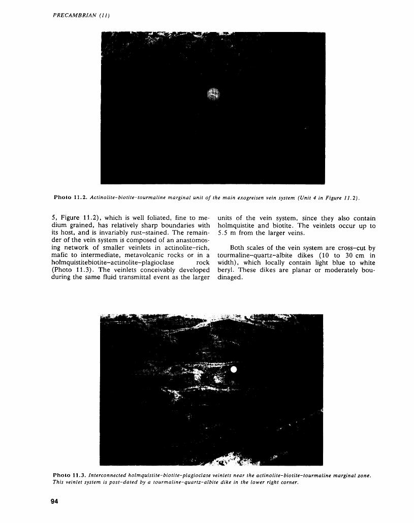
PRECAMBRIAN (11)
Photo 11.2. Actinolite-biotite-tourmaline marginal unit of the main exogreisen vein system (Unit 4 in Figure 11.2).
5, Figure 11.2), which is well foliated, fine to me dium grained, has relatively sharp boundaries with its host, and is invariably rust-stained. The remain der of the vein system is composed of an anastomos ing network of smaller veinlets in actinolite-rich, mafic to intermediate, metavolcanic rocks or in a holmquistitebiotite-actinolite-plagioclase rock (Photo 11.3). The veinlets conceivably developed during the same fluid transmittal event as the larger
units of the vein system, since they also contain holmquistite and biotite. The veinlets occur up to 5.5 m from the larger veins.
Both scales of the vein system are cross-cut by tourmaline-quartz-albite dikes (10 to 30 cm in width), which locally contain light blue to white beryl. These dikes are planar or moderately bou- dinaged.
Photo 11.3. Interconnected holmquistite-biotite-plagioclase veinlets near the actinolite-biotite-tourmaline marginal zone. This veinlet system is post-dated by a tourmaline-quartz-albite dike in the lower right corner.
94
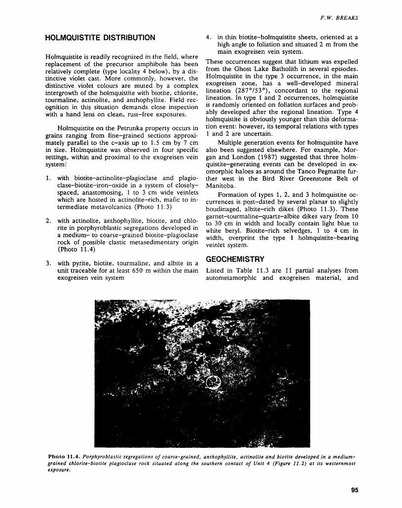
F. W. BREAKS
HOLMQUISTITE DISTRIBUTION
Holmquistite is readily recognized in the field, where replacement of the precursor amphibole has been relatively complete (type locality 4 below), by a dis tinctive violet cast. More commonly, however, the distinctive violet colours are muted by a complex intergrowth of the holmquistite with biotite, chlorite, tourmaline, actinolite, and anthophyllite. Field rec ognition in this situation demands close inspection with a hand lens on clean, rust-free exposures.
Holmquistite on the Petrunka property occurs in grains ranging from fine-grained sections approxi mately parallel to the c-axis up to 1.5 cm by 7 cm in size. Holmquistite was observed in four specific settings, within and proximal to the exogreisen vein system:
1. with biotite-actinolite-plagioclase and plagio- clase-biotite-iron-oxide in a system of closely- spaced, anastomosing, l to 3 cm wide veinlets which are hosted in actinolite-rich, mafic to in termediate metavolcanics (Photo 11.3)
2. with actinolite, anthophyllite, biotite, and chlo rite in porphyroblastic segregations developed in a medium- to coarse-grained biotite-plagioclase rock of possible clastic metasedimentary origin (Photo 11.4)
3. with pyrite, biotite, tourmaline, and albite in a unit traceable for at least 650 m within the main exogreisen vein system
4. in thin biotite-holmquistite sheets, oriented at a high angle to foliation and situated 2 m from the main exogreisen vein system.
These occurrences suggest that lithium was expelled from the Ghost Lake Batholith in several episodes. Holmquistite in the type 3 occurrence, in the main exogreisen zone, has a well-developed mineral lineation (287 0 753 0 ), concordant to the regional lineation. In type l and 2 occurrences, holmquistite is randomly oriented on foliation surfaces and prob ably developed after the regional lineation. Type 4 holmquistite is obviously younger than this deforma tion event: however, its temporal relations with types l and 2 are uncertain.
Multiple generation events for holmquistite have also been suggested elsewhere. For example, Mor gan and London (1987) suggested that three holm- quistite-generating events can be developed in ex omorphic haloes as around the Tanco Pegmatite fur ther west in the Bird River Greenstone Belt of Manitoba.
Formation of types 1,2, and 3 holmquistite oc currences is post-dated by several planar to slightly boudinaged, albite-rich dikes (Photo 11.3). These garnet-tourmaline-quartz-albite dikes vary from 10 to 30 cm in width and locally contain light blue to white beryl. Biotite-rich selvedges, l to 4 cm in width, overprint the type l holmquistite-bearing veinlet system.
GEOCHEMISTRYListed in Table 11.3 are 11 partial analyses from autometamorphic and exogreisen material, and
Photo 11.4. Porphyroblastic segregations of coarse-grained, anthophyllite, actinolite and biotite developed in a medium- grained chlorite-biotite plagioclase rock situated along the southern contact of Unit 4 (Figure 11.2) at its westernmost exposure.
95
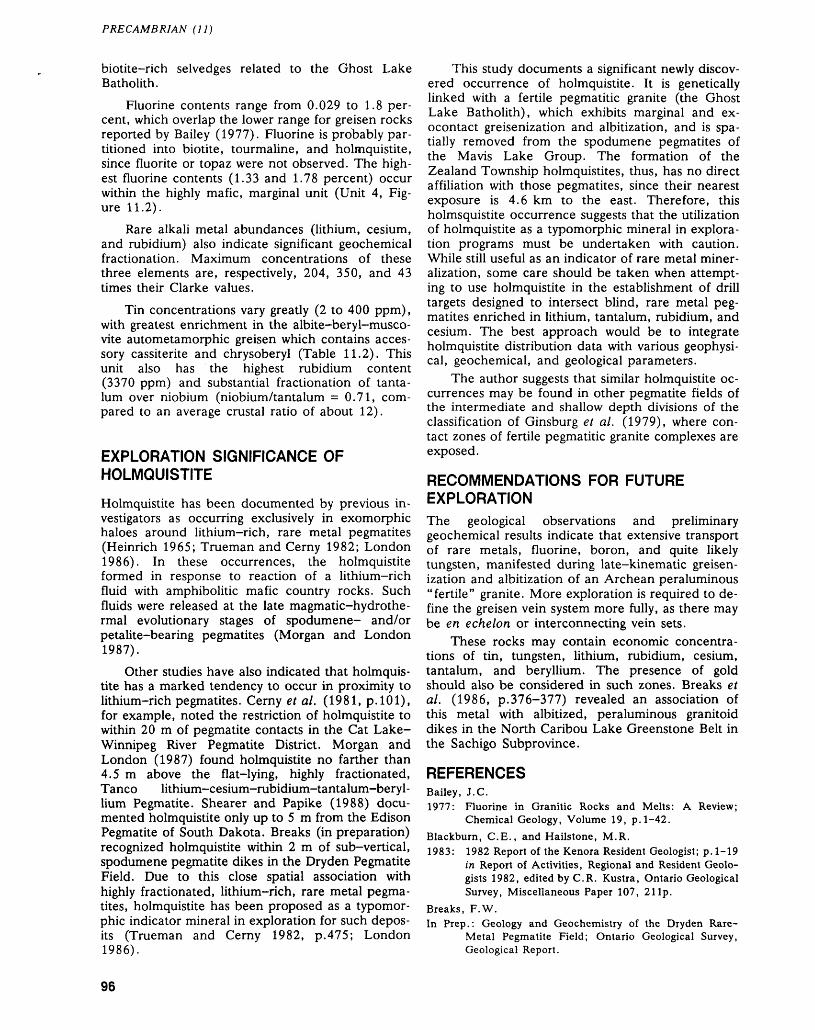
PRECAMBRIAN (11)
biotite-rich selvedges related to the Ghost Lake Batholith.
Fluorine contents range from 0.029 to 1.8 per cent, which overlap the lower range for greisen rocks reported by Bailey (1977). Fluorine is probably par titioned into biotite, tourmaline, and holmquistite, since fluorite or topaz were not observed. The high est fluorine contents (1.33 and 1.78 percent) occur within the highly mafic, marginal unit (Unit 4, Fig ure 11.2).
Rare alkali metal abundances (lithium, cesium, and rubidium) also indicate significant geochemical fractionation. Maximum concentrations of these three elements are, respectively, 204, 350, and 43 times their Clarke values.
Tin concentrations vary greatly (2 to 400 ppm), with greatest enrichment in the albite-beryl-musco- vite autometamorphic greisen which contains acces sory cassiterite and chrysoberyl (Table 11.2). This unit also has the highest rubidium content (3370 ppm) and substantial fractionation of tanta lum over niobium (niobium/tantalum = 0.71, com pared to an average crustal ratio of about 12).
EXPLORATION SIGNIFICANCE OF HOLMQUISTITE
Holmquistite has been documented by previous in vestigators as occurring exclusively in exomorphic haloes around lithium-rich, rare metal pegmatites (Heinrich 1965; Trueman and Cerny 1982; London1986). In these occurrences, the holmquistite formed in response to reaction of a lithium-rich fluid with amphibolitic mafic country rocks. Such fluids were released at the late magmatic-hydrothe- rmal evolutionary stages of spodumene- and/or petalite-bearing pegmatites (Morgan and London1987).
Other studies have also indicated that holmquis tite has a marked tendency to occur in proximity to lithium-rich pegmatites. Cerny et al. (1981, p. 101), for example, noted the restriction of holmquistite to within 20 m of pegmatite contacts in the Cat Lake- Winnipeg River Pegmatite District. Morgan and London (1987) found holmquistite no farther than 4.5 m above the flat-lying, highly fractionated, Tanco lithium-cesium-rubidium-tantalum-beryl lium Pegmatite. Shearer and Papike (1988) docu mented holmquistite only up to 5 m from the Edison Pegmatite of South Dakota. Breaks (in preparation) recognized holmquistite within 2 m of sub-vertical, spodumene pegmatite dikes in the Dryden Pegmatite Field. Due to this close spatial association with highly fractionated, lithium-rich, rare metal pegma tites, holmquistite has been proposed as a typomor phic indicator mineral in exploration for such depos its (Trueman and Cerny 1982, p.475; London 1986).
This study documents a significant newly discov ered occurrence of holmquistite. It is genetically linked with a fertile pegmatitic granite (the Ghost Lake Batholith), which exhibits marginal and ex- ocontact greisenization and albitization, and is spa tially removed from the spodumene pegmatites of the Mavis Lake Group. The formation of the Zealand Township holmquistites, thus, has no direct affiliation with those pegmatites, since their nearest exposure is 4.6 km to the east. Therefore, this holmsquistite occurrence suggests that the utilization of holmquistite as a typomorphic mineral in explora tion programs must be undertaken with caution. While still useful as an indicator of rare metal miner alization, some care should be taken when attempt ing to use holmquistite in the establishment of drill targets designed to intersect blind, rare metal peg matites enriched in lithium, tantalum, rubidium, and cesium. The best approach would be to integrate holmquistite distribution data with various geophysi cal, geochemical, and geological parameters.
The author suggests that similar holmquistite oc currences may be found in other pegmatite fields of the intermediate and shallow depth divisions of the classification of Ginsburg et al, (1979), where con tact zones of fertile pegmatitic granite complexes are exposed.
RECOMMENDATIONS FOR FUTURE EXPLORATIONThe geological observations and preliminary geochemical results indicate that extensive transport of rare metals, fluorine, boron, and quite likely tungsten, manifested during late-kinematic greisen ization and albitization of an Archean peraluminous "fertile" granite. More exploration is required to de fine the greisen vein system more fully, as there may be en echelon or interconnecting vein sets.
These rocks may contain economic concentra tions of tin, tungsten, lithium, rubidium, cesium, tantalum, and beryllium. The presence of gold should also be considered in such zones. Breaks et al. (1986, p.376-377) revealed an association of this metal with albitized, peraluminous granitoid dikes in the North Caribou Lake Greenstone Belt in the Sachigo Subprovince.
REFERENCESBailey, J.C.1977: Fluorine in Granitic Rocks and Melts: A Review;
Chemical Geology, Volume 19, p. l-42.Blackburn, C.E., and Hailstone, M.R.1983: 1982 Report of the Kenora Resident Geologist; p. 1-19
in Report of Activities, Regional and Resident Geolo gists 1982, edited by C.R. Kustra, Ontario Geological Survey, Miscellaneous Paper 107, 21 Ip.
Breaks, F.W.In Prep.: Geology and Geochemistry of the Dryden Rare-
Metal Pegmatite Field; Ontario Geological Survey, Geological Report.
96
F. W. BREAKS
Breaks, F.W., Bond, W.D., and Stone, Denver 1978: Preliminary Geological Synthesis of the English River
Subprovince, Northwestern Ontario and its Bearing upon Mineral Exploration; Ontario Geological Sur vey, Miscellaneous Paper 72, 54p. Accompanied by Geological Map P. 1972, scale 1:253,440.
Breaks, F.W., Bond, W.D., Stone, Denver, and Desnoyers, D.W.
1976a: Operation Kenora-Ear Falls, Dryden-Vermillion Bay Sheet; Ontario Division of Mines, Preliminary Map, P. 1203, Geological Series, scale l inch to l mile or 1:63 360. Geology 1975.
1976b: Operation Kenora-Ear Falls, Sandy Beach-Route Lakes Sheet; Ontario Division of Mines, Preliminary Map, P. 1204, Geology Series, scale l inch to l mile or 1:63 360. Geology 1975.
Breaks, F.W., Cherry, M.E., and Janes, D.A.1985: Metallogeny of Archean Granitoid Rocks of the Eng
lish River Subprovince, Superior Province, Ontario, Canada: A Review; p.9-31 in High Heat Production Granites, Hydrothermal Circulation and Ore Genesis, The Institution of Mining and Metallurgy, 593p.
Breaks, F.W. and Kuehner, S.1984: Precambrian Geology of the Eagle River-Ghost Lake
Area, Kenora District; Ontario Geological Survey, Map P.2623, Geological Series-Preliminary Map, scale 1:31 680. Geology 1980, 1983.
Breaks, F.W., Osmani, I.O., and deKemp, E.A.1986: Opapimiskan Lake Project: Precambrian Geology of
the Opapimiskan-Forester Lakes Area, District of Kenora, Patricia Portion; p.368-378 in Summary of Field Work and Other Activities 1986, by the Ontario Geological Survey, edited by P.C. Thurston, Owen L. White, R.B. Barlow, M.E. Cherry, and A.C. Colvine, Ontario Geological Survey, Miscella neous Paper 132, 435p. Accompanied by l Chart.
Burt, D.B.1982: Minerals of Beryllium; p. 135-148, in Granitic Peg
matites in Science and Industry; edited by P.C. Cerny, Mineralogical Association of Canada, Short Course Handbook, Volume 8, 555p.
Cerny, P., Trueman, D.L., Ziehlke, D.V., Good, B.E., and Paul, B.J.
1981: The Cat Lake Winnipeg River and Wekusko Lake Pegmatite Fields, Manitoba; Manitoba Mineral Re sources Division, Economic Geology Report ER80-1, 240p.
Ginsburg, A.I., Timofeyev, I.N., and Feldman, L.G.1979: Principles of Geology of the Granitic Pegmatites;
Nedra, Moscow, 296p. (In Russian).
Heinrich, E.W.1965: Holmquistite and Pegmatitic Lithium Exomorphism;
Indian Mineralogist, Volume 6, p. l-l 3.Hutchinson, C.S.1983: Economic Deposits and their Tectonic Setting; John
Wiley and Sons, 365p.Leveson, D.J.1966: Orbicular Rocks: A Review; Geological Society of
America, Volume 77, p.409-426.London, David1986b: Holmquistite as a Guide to Pegmatitic Rare Metal De
posits; Economic Geology, Volume 81, p.704-712.Morgan, G.B., and London, David.1987: Alteration of Amphibolitic Wallrocks Around the
Tanco Rare-Element Pegmatite, Bernic Lake, Manitoba; American Mineralogist, Volume 72, p.1097-1121.
Nurmi, P.A., and Haapala, Ilmari.1986: The Proterozoic Granitoids of Finland: Granite Types,
Metallogeny and Relation to Crustal Evolution; Geo logical Society of Finland, Bulletin, Volume 58, Part l, p.203-233.
Satterly, Jack1941: Geology of the Dryden-Wabigoon Area; Ontario De
partment of Mines, Volume 50, Part 2, p.l-57. Ac companied by Map 50e, scale 1:63 360 or l inch to l mile.
Shcherba, G.N.1970: Greisens; International Geological Review, Volume
12, Part, 2, p.114-150 and Volume 12, Part 3,p.239-255.
Shearer, C.K., and Papike, J.J.1988: Pegmatite-Wallrock Interaction; Holmquistite-Bear-
ing Amphibolite, Edison Pegmatite, Black Hills, South Dakota; American Mineralogist, Volume 73, p. 324-337.
Trowell, N.F., Blackburn, C.E., and Edwards, G.R.1980: Preliminary Geological Synthesis of the Savant Lake-
Crow Lake Metasedimentary Belt, Northwestern Ont ario, and its Bearing upon Mineral Exploration; Ont ario Geological Survey, Miscellaneous Paper 89, 30p.
Trueman, D.L., and Cerny, P.1982: Exploration for Rare-Element Pegmatites; p.463-493
in Granitic Pegmatites in Science and Industry, edited by P.C. Cerny, Geological Association of Canada, Short Course Handbook, Volume 8, 555p.
Varlamoff, N.1972: Central and West African Rare-Metal Granitic Peg
matites, Related Aplites, Quartz Veins and Mineral Deposits; Mineralogica Deposita, Volume 7, p.202-216.
97
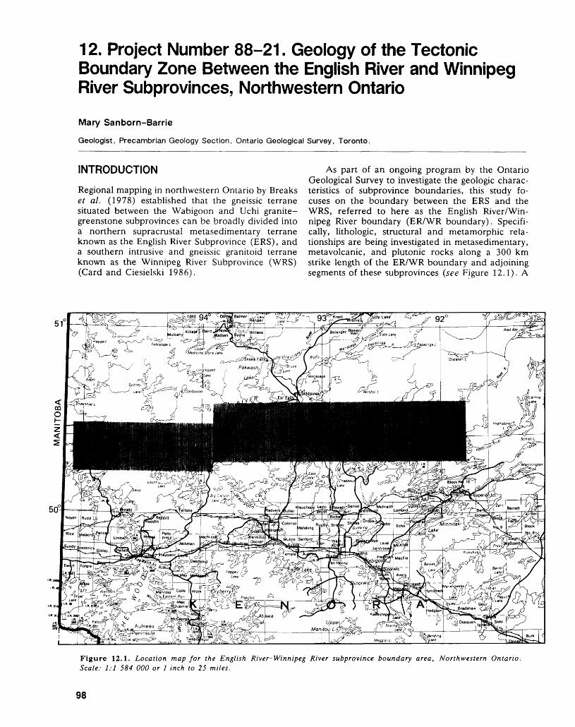
12. Project Number 88-21. Geology of the Tectonic Boundary Zone Between the English River and Winnipeg River Subprovinces, Northwestern Ontario
Mary Sanborn-Barrie
Geologist, Precambrian Geology Section, Ontario Geological Survey, Toronto.
INTRODUCTION
Regional mapping in northwestern Ontario by Breaks et al. (1978) established that the gneissic terrane situated between the Wabigoon and Uchi granite- greenstone subprovinces can be broadly divided into a northern supracrustal metasedimentary terrane known as the English River Subprovince (ERS), and a southern intrusive and gneissic granitoid terrane known as the Winnipeg River Subprovince (WRS) (Card and Ciesielski 1986).
As part of an ongoing program by the Ontario Geological Survey to investigate the geologic charac teristics of Subprovince boundaries, this study fo cuses on the boundary between the ERS and the WRS, referred to here as the English River/Win nipeg River boundary (ER/WR boundary). Specifi cally, lithologic, structural and metamorphic rela tionships are being investigated in metasedimentary, metavolcanic, and plutonic rocks along a 300 km strike length of the ER/WR boundary and adjoining segments of these subprovinces (see Figure 12.1). A
51
Figure 12.1. Location map for the English River-Winnipeg River Subprovince boundary area, Northwestern Ontario. Scale: 1:1 584 000 or J inch to 25 miles.
98
MARY SANBORN-BARRIE
major aim of this study is to understand the struc tural history and boundary conditions of the ERS and the WRS, and in so doing, to increase under standing of large-scale tectonics in rocks of Archean age. An equally important goal is to contribute to the geologic data base for this part of northwestern Ont ario by outlining previously unknown volcanic stratigraphy, and by providing a structural frame work in which to consider local and regional struc tures (such as folds, fabrics, and shear zones). As well, a re-evaluation of the mineral potential of this structurally complex region focuses on stratiform base metal potential in the Separation Lake metavol- canics, and the potential for gold mineralization within the transpressional tectonic regime of the ER/ WR boundary, a structural setting not dissimilar to those of major gold camps elsewhere in the Superior Province (Colvine et al. 1988; Sibson et al. 1988).
The study area is bounded by latitudes 50 0 15'N and 50 0 35'N and longitudes 91 0 40'W and 95 0 05'W. Access to the area is gained primarily by the English River water system, extending from Umfreville Lake in the west, to the eastern part of Lac Seul. Most lakes along this water system are ac cessible by road. In addition, several northerly trending roads transect the study area. These in clude the English River Road (north from the com munity of Redditt), the Jones Road (north from the Kenora airport) and the Red Lake Road (Highway 105). Mapping was carried out at a scale of 1:100 000.
PREVIOUS WORK
The English River and Winnipeg River subprovinces were previously examined during a five-year, recon naissance mapping program initiated in 1973 by the Ontario Geological Survey. From this program, pre liminary geological maps were completed at scales of 1:126 720 (Operation Ignace-Armstrong, Sage et al. 1974) and 1:63 360 (Operation Kenora-Ear Falls, see Breaks et al. 1978).
GENERAL GEOLOGY
The general geology of the area is shown in Figure 12.2 and is taken from a compilation by Breaks et al. (1978) and Breaks and Bond (in preparation).
THE ENGLISH RIVER SUBPROVINCE (ERS)
The ERS consists primarily of a migmatized se quence of feldspathic wacke and pelite. All degrees of migmatization, as classified by Brown (1973), are present; however, metatexite (10 percent to 70 per cent mobilizate) is the most common migmatite type in the ERS. At most localities, migmatization does not obscure the thickness of individual sedimentary beds. Feldspathic wacke is typically thickly to very thickly bedded (40 cm to 1.5 m), whereas pelitic horizons are generally thin to medium bedded (4 cm
to 40 cm). Determinations of the younging direction of bedding at numerous localities throughout the southern part of the ERS indicate overall younging to the north.
The mineralogy of wacke/pelite metatexite throughout the ERS reflects changes in metamorphic grade, which varies from amphibolite to granulite facies. In addition to an ubiquitous assemblage of plagioclase -i- quartz -l- biotitedrmuscovite, commonly observed metamorphic minerals include garnet, cor dierite, sillimanite, and, less commonly, clinopyrox ene and orthopyroxene. Aspects of the thermal his tory and metamorphic conditions of the ERS are dis cussed by Breaks et al. (1978), Chipera and Perkins (1988), Breaks and Bond (in preparation), and Breaks (this volume).
Several occurrences of thickly bedded, polymic tic conglomerate up to 40 m wide occur at, and close to, the southern margin of the ERS. Three ma jor occurrences, north of Separation Lake, at Oak Lake, and at Perrault Lake, are indicated in Figure 12.2. At each locality, the conglomerate incorpo rates clasts derived from lithologic units exposed to the immediate south. Clast types include mafic, in termediate, and felsic volcanics, homogeneous, mas sive to foliated granitoids, oxide- and silicate-facies ironstone, and minor quartzose wacke and chert. Units of massive, ungraded, quartzose and feld spathic wacke (10 cm to 50 cm wide) are inter bedded with the conglomerate.
Intrusive rocks within the ERS include granites and pegmatites with the chemical and mineralogical attributes of S-type granites generated by anatexis of metasedimentary rocks (Breaks et al. 1978). Depos its of tantalum, lithium, and beryllium are associated with some of these intrusions (Figure 12.2).
SEPARATION LAKE GREENSTONE BELT
Metavolcanic rocks and subordinate mafic intrusive rocks are locally exposed along the ER/WR bound ary and appear to form a discontinuous screen that separates the two subprovinces (Figure 12.2). The Separation Lake Greenstone Belt (SLGB) is one of the largest segments of this discontinuous metavol- canic screen and is considered part of the WRS in this study. This belt attains a strike length of some 50 km, a horizontal width of 5 km, and is the east ern extension of the Bird River Greenstone Belt (McRitchie and Weber 1971) in Manitoba (Figure 12.2). The SLGB comprises predominantly massive to pillowed mafic volcanics, commonly with inter bedded oxide- or silicate-facies ironstone. Interme diate and felsic volcanics are subordinate and gener ally occur along the northern margin of the belt.
Mafic and intermediate volcanic rocks occur sporadically along the ER/WR boundary to western Lac Seul, a distance of nearly 100 km (Figure 12.2). These units are interpreted as remnants of the SLGB. In areas where these metavolcanic rocks occur, the boundary between the ERS and the WRS
99
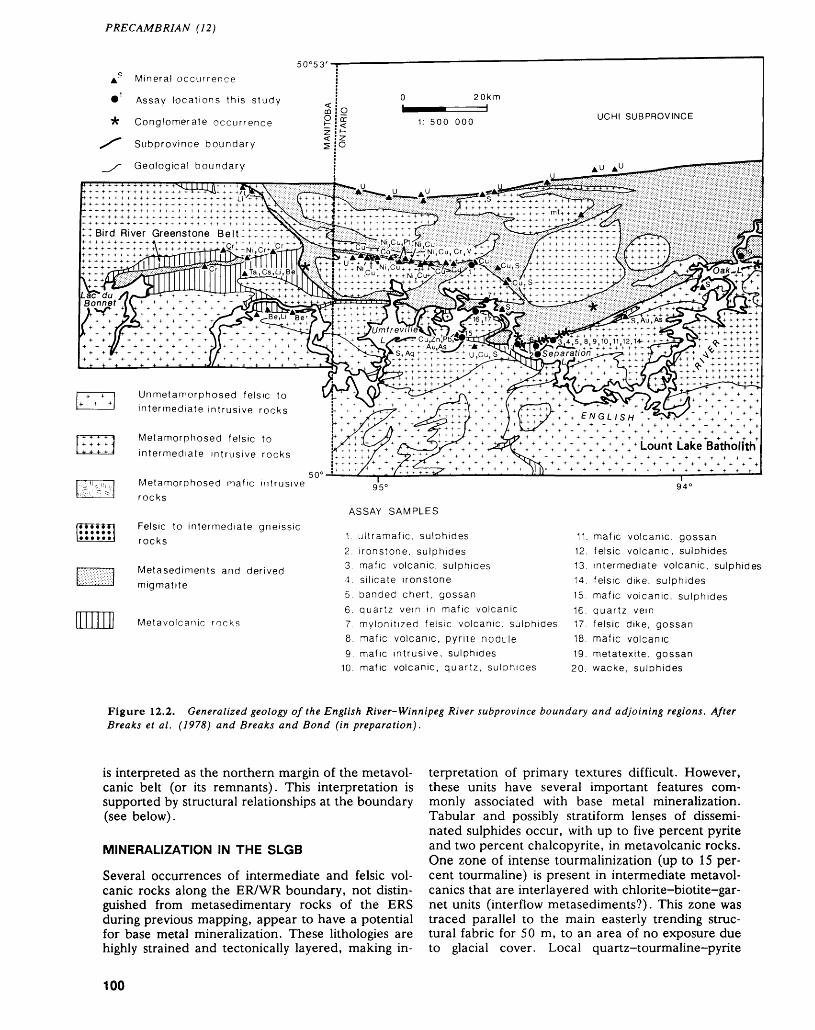
PRECAMBRIAN (12)
Mineral occurrence
O 20km ^
1: 500 000
Assay locations this study
Conglomerate occurrence
Subprovince boundary
Geological boundary
UCHI SUBPROVINCE
Bird River Greenstone Bel
Unmetamorphosed felsic to intermediate intrusive rocks
Metamorphosed felsic to intermediate intrusive rocks
Lount Lake Batholith
Metamorphosed mafic intrusive rocks
Felsic to intermediate gneissic rocks
Metasediments and derived migmatite
Metavolcanic rocks
ASSAY SAMPLES
1. ultramafic, sulphides2. ironstone, sulphides3. mafic volcanic, sulphides4. silicate ironstone5. banded chert, gossan6. quartz vein in mafic volcanic
94 C
11. mafic volcanic, gossan12. felsic volcanic, sulphides13. intermediate volcanic, sulphides14. felsic dike, sulphides15. mafic volcanic, sulphides16. quartz vein
7. mylonitized felsic volcanic, sulphides 17. felsic dike, gossan8. mafic volcanic, pyrite nodule 18. mafic volcanic9. mafic intrusive, sulphides 19. metatexite, gossan
10. mafic volcanic, quartz, sulphides 20. wacke, sulphides
Figure 12.2. Generalized geology of the English River-Winnipeg River subprovince boundary and adjoining regions. After Breaks et al. (1978) and Breaks and Bond (in preparation).
is interpreted as the northern margin of the metavol- canic belt (or its remnants). This interpretation is supported by structural relationships at the boundary (see below).
MINERALIZATION IN THE SLGB
Several occurrences of intermediate and felsic vol canic rocks along the ER/WR boundary, not distin guished from metasedimentary rocks of the ERS during previous mapping, appear to have a potential for base metal mineralization. These lithologies are highly strained and tectonically layered, making in
terpretation of primary textures difficult. However, these units have several important features com monly associated with base metal mineralization. Tabular and possibly stratiform lenses of dissemi nated sulphides occur, with up to five percent pyrite and two percent chalcopyrite, in metavolcanic rocks. One zone of intense tourmalinization (up to 15 per cent tourmaline) is present in intermediate metavol- canics that are interlayered with chlorite-biotite-gar- net units (interflow metasediments?). This zone was traced parallel to the main easterly trending struc tural fabric for 50 m, to an area of no exposure due to glacial cover. Local quartz-tourmaline-pyrite
100
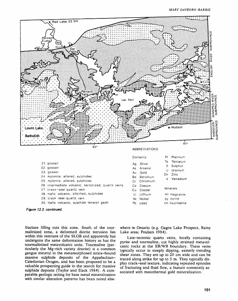
MARY SANBORN-BARRIE
* Batholith ^x::?ii::^::y?
21. gossan22. gossan23. gossan24. mylonite, altered, sulphides25. mylonite, altered, sulphides26. intermediate volcanic, tectonized, quartz veins27. crack-seal quartz vein28. mafic volcanic, silicified, sulphides29. crack-seal quartz vein30. mafic volcanic, sulphide tension gash
ABBREVIATIONS
Elements
Ag SilverAs ArsenicAu GoldBe BerylliumCr ChromiumCs CesiumCu Copper
Li LithiumNi NickelPb Lead
92 c
Pt PlatinumTa Tantalum
S SulphurU Uranium
Zn ZincV Vanadium
Minerals
mt magnetitepy pyritetm tourmaline
Figure 12.2. continued.
fracture filling cuts this zone. South of the tour- malinized zone, a deformed diorite intrusion lies within this remnant of the SLOB and apparently has undergone the same deformation history as has the tourmalinized metavolcanic units. Tourmaline (par ticularly the Mg-rich variety dravite) is a common gangue mineral in the metamorphosed strata-bound massive sulphide deposits of the Appalachian- Caledonian Orogen, and has been proposed to be a valuable prospecting guide in the search for massive sulphide deposits (Taylor and Slack 1984). A com parable geologic setting for base metal mineralization with similar alteration patterns has been noted else
where in Ontario (e.g. Gagne Lake Prospect, Rainy Lake area; Poulsen 1984).
Late-tectonic quartz veins, locally containing pyrite and tourmaline, cut highly strained meta vol canic rocks at the ER/WR boundary. These veins typically occur in steeply dipping, easterly trending shear zones. They are up to 20 cm wide and can be traced along strike for up to 3 m. They typically dis play crack-seal texture, indicating repeated episodes of fracturing and fluid flow, a feature commonly as sociated with mesothermal gold mineralization.
101
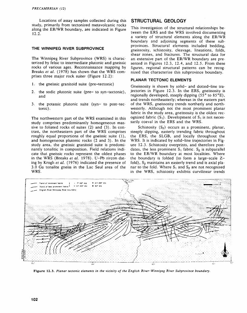
PRECAMBRIAN (12)
Locations of assay samples collected during this study, primarily from tectonized metavolcanic rocks along the ER/WR boundary, are indicated in Figure 12.2.
THE WINNIPEG RIVER SUBPROVINCE
The Winnipeg River Subprovince (WRS) is charac terized by felsic to intermediate plutonic and gneissic rocks of various ages. Reconnaissance mapping by Breaks et al. (1978) has shown that the WRS com prises three major rock suites (Figure 12.2):
1. the gneissic granitoid suite (pre-tectonic)
2. the sodic plutonic suite (pre- to syn-tectonic), and
3. the potassic plutonic suite (syn- to post-tec tonic) .
The northwestern part of the WRS examined in this study comprises predominantly homogeneous mas sive to foliated rocks of suites (2) and (3). In con trast, the northeastern part of the WRS comprises roughly equal proportions of the gneissic suite (1), and homogeneous plutonic rocks (2 and 3). In the study area, the gneissic granitoid suite is predomi nantly tonalitic in composition. Field relations indi cate that gneissic rocks represent the oldest phases in the WRS (Breaks et al. 1978). U-Pb zircon dat ing by Krogh et al. (1976) indicated the presence of 3.0 Ga tonalite gneiss in the Lac Seul area of the WRS.
STRUCTURAL GEOLOGY
This investigation of the structural relationships be tween the ERS and the WRS involved documenting a variety of structural elements along the ER/WR boundary and adjoining segments of these sub- provinces. Structural elements included bedding, gneissosity, schistosity, cleavage, lineations, folds, shear zones, and fractures. The structural data for an extensive part of the ER/WR boundary are pre sented in Figures 12.3, 12.4, and 12.5. From these figures, regional structural patterns can be recog nized that characterize this subprovince boundary.
PLANAR TECTONIC ELEMENTS
Gneissosity is shown by solid- and dotted-line tra jectories in Figure 12.3. In the ERS, gneissosity is regionally developed, steeply dipping (55 0 to 85 0 E), and trends northeasterly; whereas in the eastern part of the WRS, gneissosity trends northerly and north westerly. Although not the most prominent planar fabric in the study area, gneissosity is the oldest rec ognized fabric (St). Development of ST is not neces sarily coeval in the ERS and the WRS.
Schistosity (S2) occurs as a prominent, planar, steeply dipping, easterly trending fabric throughout the ERS, the SLGB, and locally throughout the WRS. It is indicated by solid-line trajectories in Fig ure 12.3. Schistosity overprints, and therefore post dates, the less prominent ST fabric. S2 is subparallel to the ER/WR boundary at most localities. Where the boundary is folded (to form a large-scale Z- fold), S2 maintains an easterly trend and is axial pla nar to the fold. Where ST and S2 are not recognized in the WRS, schistosity exhibits curvilinear trends
Trend of dominant fabric
^— English River/Winnipeg River boundary
Figure 12.3. Planar tectonic elements in the vicinity of the English River-Winnipeg River Subprovince boundary.
102
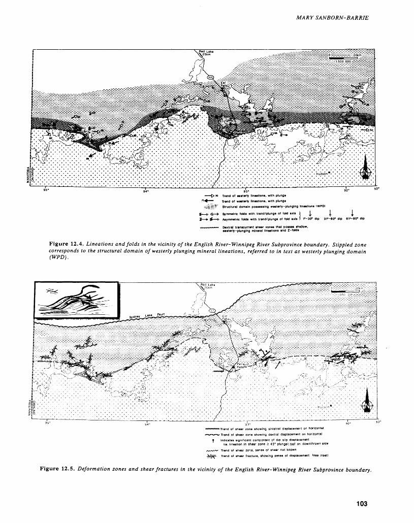
MARY SANBORN-BARRIE
Trend of easterly lineation*, with plunge
Trend of westerly lineation*, with plunge
Structural domain possessing westerly-plunging llneations (WPO)
Symmetric folds with trend/plunge of fold axis t ^ l l
Asymmetric folds with trend/plunge of fold axis f f-SCT dip 31--60- dip 61--90- dip
Dextral transcurrent shear zones that posses shallow, easterly-plunging mineral llneations and Z-folds
Figure 12.4. Lineations and folds in the vicinity of the English River-Winnipeg River Subprovince boundary. Stippled zone corresponds to the structural domain of westerly plunging mineral lineations, referred to in text as westerly plunging domain (WPD).
mt on horizontal
^^*^* Trend of shear zone showing dextral displacement on horizontal
e Indicates significant component of dip slip displacementlie. lineation in shear zone 2 45' plunge!; ball on downthrown side
*s~~ Trend of shear zone, sense of shear not known
Figure 12.5. Deformation zones and shear fractures in the vicinity of the English River-Winnipeg River Subprovince boundary.
103
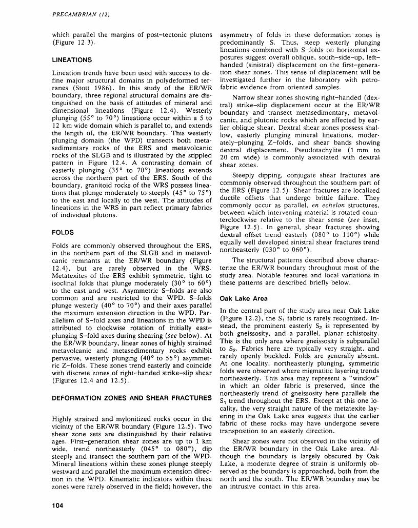
PRECAMBRIAN (12)
which parallel the margins of post-tectonic plutons (Figure 12.3).
LINEATIONS
Lineation trends have been used with success to de fine major structural domains in polydeformed ter- ranes (Stott 1986). In this study of the ER/WR boundary, three regional structural domains are dis tinguished on the basis of attitudes of mineral and dimensional lineations (Figure 12.4). Westerly plunging (55 0 to 70 0 ) lineations occur within a 5 to 12 km wide domain which is parallel to, and extends the length of, the ER/WR boundary. This westerly plunging domain (the WPD) transects both meta- sedimentary rocks of the ERS and metavolcanic rocks of the SLOB and is illustrated by the stippled pattern in Figure 12.4. A contrasting domain of easterly plunging (35 0 to 70 0 ) lineations extends across the northern part of the ERS. South of the boundary, granitoid rocks of the WRS possess linea tions that plunge moderately to steeply (45 0 to 75 0 ) to the east and locally to the west. The attitudes of lineations in the WRS in part reflect primary fabrics of individual plutons.
FOLDS
Folds are commonly observed throughout the ERS, in the northern part of the SLOB and in metavol canic remnants at the ER/WR boundary (Figure 12.4), but are rarely observed in the WRS. Metatexites of the ERS exhibit symmetric, tight to isoclinal folds that plunge moderately (30 0 to 60 0 ) to the east and west. Asymmetric S-folds are also common and are restricted to the WPD. S-folds plunge westerly (40 0 to 70 0 ) and their axes parallel the maximum extension direction in the WPD. Par allelism of S-fold axes and lineations in the WPD is attributed to clockwise rotation of initially east- plunging S-fold axes during shearing (see below). At the ER/WR boundary, linear zones of highly strained metavolcanic and metasedimentary rocks exhibit pervasive, westerly plunging (40 0 to 55 0 ) asymmet ric Z-folds. These zones trend easterly and coincide with discrete zones of right-handed strike-slip shear (Figures 12.4 and 12.5).
DEFORMATION ZONES AND SHEAR FRACTURES
Highly strained and mylonitized rocks occur in the vicinity of the ER/WR boundary (Figure 12.5). Two shear zone sets are distinguished by their relative ages. First-generation shear zones are up to l km wide, trend northeasterly (045 0 to OSO 0 ), dip steeply and transect the southern part of the WPD. Mineral lineations within these zones plunge steeply westward and parallel the maximum extension direc tion in the WPD. Kinematic indicators within these zones were rarely observed in the field; however, the
asymmetry of folds in these deformation zones is predominantly S. Thus, steep westerly plunging lineations combined with S-folds on horizontal ex posures suggest overall oblique, south-side-up, left- handed (sinistral) displacement on the first-genera tion shear zones. This sense of displacement will be investigated further in the laboratory with petro fabric evidence from oriented samples.
Narrow shear zones showing right-handed (dex tral) strike-slip displacement occur at the ER/WR boundary and transect metasedimentary, metavol canic, and plutonic rocks which are affected by ear lier oblique shear. Dextral shear zones possess shal low, easterly plunging mineral lineations, moder ately-plunging Z-folds, and shear bands showing dextral displacement. Pseudotachylite (l mm to 20 cm wide) is commonly associated with dextral shear zones.
Steeply dipping, conjugate shear fractures are commonly observed throughout the southern part of the ERS (Figure 12.5). Shear fractures are localized ductile offsets that undergo brittle failure. They commonly occur as parallel, en echelon structures, between which intervening material is rotated coun terclockwise relative to the shear sense (see inset, Figure 12.5). In general, shear fractures showing dextral offset trend easterly (OSO 0 to HO 0 ) while equally well developed sinistral shear fractures trend northeasterly (030 0 to 060 0 ).
The structural patterns described above charac terize the ER/WR boundary throughout most of the study area. Notable features and local variations in these patterns are described briefly below.
Oak Lake Area
In the central part of the study area near Oak Lake (Figure 12.2), the ST fabric is rarely recognized. In stead, the prominent easterly S2 is represented by both gneissosity, and a parallel, planar schistosity. This is the only area where gneissosity is subparallel to S2 . Fabrics here are typically very straight, and rarely openly buckled. Folds are generally absent. At one locality, northeasterly plunging, symmetric folds were observed where migmatitic layering trends northeasterly. This area may represent a "window" in which an older fabric is preserved, since the northeasterly trend of gneissosity here parallels the S-i trend throughout the ERS. Except at this one lo cality, the very straight nature of the metatexite lay ering in the Oak Lake area suggests that the earlier fabric of these rocks may have undergone severe transposition to an easterly direction.
Shear zones were not observed in the vicinity of the ER/WR boundary in the Oak Lake area. Al though the boundary is largely obscured by Oak Lake, a moderate degree of strain is uniformly ob served as the boundary is approached, both from the north and the south. The ER/WR boundary may be an intrusive contact in this area.
104

MARY SANBORN-BARRIE
Western Lac Seul Area
In this area an obliquity between ST and S2 fabrics is most apparent (Figure 12.3). For instance, in the ERS, ST is 50 0 counterclockwise to S2 , while in the WRS, ST is 40 0 to 90 0 clockwise to S2 (Figure 12.3). These relationships suggest the ST fabric in the ERS did not form under the same stress conditions as the S-i fabric in the WRS, and provide evidence to sug gest that early fabrics in these two subprovinces formed independently or were not coeval.
In the southwestern part of Lac Seul, folds are observed in the WRS in strongly foliated to gneissic tonalite. These folds are symmetric W-folds that plunge moderately to the east and northeast (Figure12.4).
Shear fractures are not commonly observed in this area. Where observed, sinistral shear fractures trend northeasterly, which is consistent with the re gional pattern. However, shear fractures showing dextral offset here trend northwesterly (Figure12.5).
Eastern Lac Seul Area
The eastern part of Lac Seul is characterized by shallowly dipping planar fabrics, and shallowly plunging linear elements. In the ERS for instance, northeasterly trending gneissosity dips 10 0 E to 40 0 SE; and in the WRS, northerly and northwest erly trending gneissosity dips 15 0W to 30 0 E. The overprinting, easterly trending S2 schistosity in this area dips moderately (25 0 S to 50 0 S) in the ERS, and steeply (70 0 S to 85 0 S) in the WRS. The trend of S2 here is notably oblique (15 0 counterclockwise) to the ER/WR boundary.
Lineations in the WPD plunge between 15 0W and 25 0 W, which is much shallower than observed elsewhere along the boundary. North of the WPD, lineations plunge moderately to shallowly eastward at 10 0 to 50 0 . South of the ER/WR boundary, granitoid rocks of the WRS possess shallow (20 0 to 30 0), easterly plunging mineral lineations.
In the eastern part of Lac Seul, dextral shear zones are not restricted to the ER/WR boundary. At two localities north of the ER/WR boundary (at 10 km and 40 km), easterly trending dextral strike- slip shear zones (40 cm wide) were observed.
In the eastern Lac Seul area, shear fractures dis playing both sinistral and dextral displacement are observed. Sinistral shear fractures dominate and trend OSO 0 , while dextral shear fractures trend 045 0 and 100 0 (Figure 12.5). These attitudes deviate from the orientation of shear fractures throughout the study area, where dextral shear fractures trend easterly, and conjugate sinistral shear fractures trend northeasterly.
DISCUSSION OF TECTONIC IMPLICATIONS
The regional structural patterns described above provide constraints concerning the tectonic history of the ERS and the WRS. For instance, contrasting trends of ST in the ERS (northeasterly) relative to the WRS (north to northwesterly), suggest that the earliest deformation event (D-|) recognized in these belts did not take place under similar stress condi tions. This would imply either that these two belts were initially deformed independently (of one an other), or that the earliest recognized event in each of these belts was not coeval.
In contrast, the prominent, easterly trending S2 schistosity that transects both the ERS and parts of the WRS (particularly the SLOB), reveals that these belts were involved together in a second deformation event (D2), the effects of which are most intense along the boundary between the ERS and the SLOB. The easterly striking fabric (S2) generated during this event indicates that the D2 event involved a component of north-south compression. Easterly plunging lineations on S2 planes in the northern part of the ERS reveal that extension during D2 compres sion was easterly. Westerly plunging lineations on S2 planes straddling the boundary reveal that maximum extension in this area during D2 plunged moderately to steeply westward. The pattern of lineations south of the WPD reveals that the D2 event is not a prod uct of pluton emplacement in the WRS, since the extension direction in granitoids of the WRS is vari able, and rarely to the west.
First-generation shear zones adjacent to the ER/ WR boundary possess westerly plunging lineations that parallel the lineations in the WPD. Parallel lin ear fabrics suggest the first-generation shear zones were initiated during the D2 event. It would there fore appear that the D2 event, in addition to north- south compression, involved oblique, south-side-up, sinistral shear (of the WRS relative to the ERS).
Overprinting relationships reveal that dextral strike-slip shear post-dated the D2 event, and repre sents D3 . The distribution of dextral shear zones sug gests that dextral shear affected the entire length of the ER/WR boundary, but was more localized than earlier D2 shearing. Easterly plunging mineral linea tions in dextral shear zones suggest that dextral shearing did not take place under the same stress conditions as D2 shearing (where steep, westerly ex tension prevailed). Attitudes of conjugate shear frac tures across the study area suggest that these struc tures developed during northwesterly directed transpression during D3 .
Variations in structural style in the eastern Lac Seul area may be the product of deformation related to the Miniss River Fault Zone (MRFZ), a major northeasterly trending, sinistral, strike-slip fault which lies roughly 40 km east of Lac Seul. Where the MRFZ cuts the ERS and the WRS, these belts
105
PRECAMBRIAN (12)
are considerably more narrow and are displaced in a left-handed fashion. Consequently, the Savant Lake Greenstone Belt of the Wabigoon Subprovince is ex posed to the east of the MRFZ, on strike with the ERS and WRS.
At this early stage of investigation, interpreta tions of the tectonic evolution of this part of the Su perior Province are tentative. With this in mind, structural data from this area indicate the following:1. Contrasting structural trends of ST in the ERS
and the WRS suggest that these terranes were formed and initially deformed as separate blocks or belts; or that the earliest recognized event in each of these belts was not coeval.
2. The attitudes and widespread distribution of structures related to D2 suggest the ERS and WRS were deformed together during a second deformation event which involved north-south compression and oblique shearing. Oblique, south-side-up shearing suggests overriding of the WRS eastward onto the ERS. The sinistral component of movement may reflect westward "squeezing" of metasedimentary rocks of the ERS due to impingement of the WRS from the south during regional north-south compression.
3. Relatively late-stage (D3), subhorizontally di rected, oblique convergence (transpression) from the northwest resulted in dextral strike-slip shear along the ER/WR boundary.
CONCLUSIONS
The boundary between the English River and the Winnipeg River subprovinces corresponds to a lithologic, structural, and local metamorphic discon tinuity. Structural data along the boundary and from adjoining segments of the subprovinces record at least three regional deformation events which have implications regarding the tectonic evolution of this part of the Superior Province. Contrasting structural trends of D^ suggest that the ERS and WRS evolved as separate belts which were deformed initially in different stress regimes, or that the earliest recog nized event in each of these belts was not coeval. A second deformation event (D2) affected the ERS and parts of the WRS, and involved north-south compression and oblique shearing. A preliminary in terpretation of south-side-up, sinistral displacement on D2 shear zones north of the ER/WR boundary suggests overriding of the WRS onto the ERS. Rela tively late-stage (D3) northwesterly directed transpression resulted in localized dextral strike-slip shearing at the boundary between the ERS and the WRS.
The transpressive tectonic regime recognized at the ER/WR boundary is indicative of a favourable structural setting for gold mineralization. In addi tion, metavolcanic units adjacent to the boundary
show potential for base metal mineralization. Assay results and lithogeochemical analyses (of unaltered metavolcanics) should aid further assessment of the mineral potential of this area.
REFERENCESBreaks, F.W., and Bond, W.D.In Prep.: The English River Subprovince-an Archean
Gneissic Belt: Geology, Geochemistry and Associated Mineral Deposits; Ontario Geological Survey, Geo logical Report.
Breaks, F.W., Bond, W.D., and Denver Stone 1978: Preliminary Geological Synthesis of the English River
Subprovince, Northwestern Ontario and its Bearing Upon Mineral Exploration; Ontario Geological Sur vey, Miscellaneous Paper 72, 55p. Accompanied by Map P.1972, scale 1:253 440.
Brown, M.1973: The Definition of Metatexis, Diatexis, and Mig
matite; Proceedings of the Geologists' Association (London), Volume 84, Part 4, p.371-382.
Card, K.D., and Ciesielski, A.1986: DNAG #1. Subdivisions of the Superior Province of
the Canadian Shield; Geoscience Canada, Volume13, p.5-13
Chipera, S.J., and Perkins, Dexter1988: Evaluation of Biotite-Garnet Geothermometers: Ap
plication to the English River Subprovince, Ontario; Contributions to Mineralogy and Petrology, Volume 98, p.40-48.
Colvine, A.C., Fyon, J.A., Heather, K.B., Marmont, S.,Smith, P.M., and Troop, D.G.
1988: Archean Lode Gold Deposits in Ontario; OntarioGeological Survey, Miscellaneous Paper 139, 136p.
Krogh, T.E., Harris, N.B.W., and Davis, G.L.1976: Archean Rocks from the Eastern Lac Seul Region of
the English River Gneiss Belt, Northwestern Ontario, Part 2. Geochronology; Canadian Journal of Earth Sciences, Volume 13, p. 1212-1215.
McRitchie, W.D., and Weber, W.1971: Metamorphism and Deformation in the Manigotagan
Gneissic Belt, Southwestern Manitoba; p.235-284 in Geology and Geophysics of the Rice Lake Region, Southeastern Manitoba (Project Pioneer), edited by W.D. McRitchie and W. Weber, Manitoba Depart ment of Mines and Natural Resources, Mines Branch Publication 71-1, 430p.
Poulsen, K.H.1984: The Geological Setting of Mineralization in the Mine
Centre—Fort Frances area, District of Rainy River;Ontario Geological Survey, Open File Report 5512,126p.
Sage, R.P., Breaks, F.W., Stott, G., Mcwilliams, G., and Bowen, R.P.
1974: Operation Ignace-Armstrong, Pashkokogan-Caribou Lakes Sheet, District of Thunder Bay; Ontario Divi sion of Mines, Preliminary Map P.962, Geological Series, scale 1:126 720 or l inch to 2 miles. Geology 1973.
106
MARY SANBORN-BARRIE
Sibson, R.H., Robert, F., and Poulsen, K.H. Shaped Granitoid Pluton, Northwestern Ontario; Un- 1988: High-Angle Reverse Faults, Fluid Pressure Cycling, published Ph.D. Thesis, University of Toronto, 285p.
and Mesothermal Gold-Quartz Deposits; Geology,Volume 16, p.551-555. Taylor, B.E., and Slack, J.F.
1984: Tourmalines from Appalachian-Caledonian MassiveStott, G.M. Sulphide Deposits: Textural, Chemical, and Isotopic 1986: A Structural Analysis of the Central Part of the Ar- Relationships; Economic Geology, Volume 79,
chean Shebandowan Greenstone Belt and a Crescent- p. 1703-1726.
107
13. Project Number 88-7. The Wabigoon-Winnipeg River Subprovince Boundary Problem
G. P. Beakhouse
Geologist, Precambrian Geology Section, Ontario Geological Survey, Toronto.
INTRODUCTION
Approximately one month was devoted to examina tion of some critical areas relevant to the boundary relationships between the Wabigoon Subprovince (WSP) and Winnipeg River Subprovince (WRSP). Most of this time was spent in the Sioux Lookout area (Figure 13.1). This study contributes to a better understanding of the stratigraphy, structure, and tec tonic history of the Superior Province in northwest ern Ontario. An understanding of the relationships between subprovinces is critical to achieving this goal. The aim of this summer's field work was to
further test a working hypothesis for one subprovin- cial boundary as outlined below.
A second objective was to evaluate the metal logeny of the subprovince boundary area. Several major faults have been interpreted to occur along lithological contacts in the Sioux Lookout area (Johnston 1972) and gold and sulphide mineraliza tion occurs along some of these contacts. Dissemi nated Mo-Cu mineralization occurs in stocks south- west of the Sioux Lookout area and rare metal peg matite deposits in the Dryden area occur in rocks correlative with those in the Sioux Lookout area.
51
Figure 13.1. Location map for the Sioux Lookout area. Scale: 1:1 584 000 or l inch to 25 miles.
108
G.P. BEAKHOUSE
WABIGOON-WINNIPEG RIVER SUBPROVINCE RELATIONSHIPS-A WORKING HYPOTHESIS
The WSP and WRSP contrast sharply with respect to lithologies, structural style, age, and origin. The WSP consists of predominantly low metamorphic grade, bimodal (mafic and intermediate/felsic) vol canic sequences that face away from elliptical to amoeboid granitoid complexes that are coeval with at least some of these volcanic rocks (Blackburn et al. 1985; Thurston et al. 1985). Available U-Pb geochronology indicates that these rocks were erupted and intruded between 2775 and 2700 Ma (Davis et al. 1982; Davis and Edwards 1986). There is no evidence either from the geochemical charac teristics of plutonic rocks (Beakhouse and McNutt 1985) or presence of inherited zircons (Davis and Edwards 1986) to suggest that older sialic crust was involved in the generation of these rocks.
In contrast, the WRSP consists mainly of plutonic and metaplutonic rocks. The metaplutonic rocks are significantly older (2830 to 3170 Ma, Krogh et al. 1976; Beakhouse 1983; Corfu 1988; Davis et al. 1988) than WSP volcanism. The late plutonic rocks of the WRSP are generally younger than WSP volcanism (2700 to 2660 Ma), but have geochemical and isotopic signatures that indicate they were derived by partial melting of the older metaplutonic rocks (Beakhouse 1983; Beakhouse and McNutt 1986). There is a notable paucity of igneous activity in the WRSP at the time of wide spread volcanic and plutonic activity in the WSP. Taken together, these data suggest that the WRSP existed as an independent block of sialic crust prior to widespread igneous activity in the western Wabigoon Subprovince (Beakhouse 1985).
These and other lines of evidence have led sev eral authors to conclude that the WSP is an en simatic volcanic arc that developed independently of an older sialic terrane (WRSP) until approximately 2700 to 2710 Ma when they were coupled in an arc-continent collision (Blackburn 1980; Beakhouse and McNutt 1986; Davis et al. 1988). An area re ferred to herein as the Sioux Lookout terrane is in terpreted to be the collision zone within which ele ments of the WSP, WRSP, and intervening ocean or back-arc basin were juxtaposed and deformed by thrusting, transcurrent faulting, and buckling. The generalized extent of this terrane is portrayed in Fig ure 13.2, although certain elements that define the terrane may extend beyond the bounds shown on the figure.
SIOUX LOOKOUT AREA
In the Sioux Lookout area, a sequence of alternating predominantly volcanic and predominantly sedimen tary lithostratigraphic units, that are typically 3000 to 6000 m thick can be traced laterally for many tens
of kilometres (Figure 13.2). All of the supracrustal rocks in the area have undergone low grade regional metamorphism and the prefix "meta" is omitted in the subsequent discussion. The major units illus trated in Figures 13.2 and 13.3 are briefly described* below.
NORTHERN METAPLUTONIC COMPLEX
This unit consists of strongly deformed, metaplutonic rocks that occur within the WRSP. Tonalitic and leucotonalitic compositions predomi nate with lesser amounts of granodioritic, granitic, and gabbroic phases being widespread and locally abundant. These gneisses are intruded by mafic dikes which crosscut some of the gneissic fabric, but are strongly transposed into the orientation of the regional gneissic fabric and are themselves locally gneissic.
NORTHERN VOLCANIC BELT
This sequence is a southeast-younging homoclinal succession of massive and pillowed basalt flows and associated gabbro sills together with minor chert and magnetite ironstone and rare carbonate interflow sedimentary rocks. Several thin (less than 10 cm) beds of quartz arenite, occurring together with car bonate and chert-magnetite ironstone in a thin in terflow sedimentary horizon, were identified in one outcrop near the base of this sequence. The intensity of deformation as estimated from the degree of flat tening of pillows and intensity and pervasiveness of fabric development decreases gradually from the base of the sequence toward the top. Near the base of the sequence, pillows are deformed with typical axial ratios of 10:4:1 with the maximum axis ori ented down the dip of the foliation. In the upper third of the sequence, strain is very low with com mon preservation of delicate primary structures and very weak fabric development. In the middle third of the sequence, strain is locally strong, though not as intense as that characterizing the base of the se quence, and deformation is heterogeneously distrib uted with the greatest strain and fabric intensity oc curring within pillow breccia, hyaloclastite, and in terflow sedimentary units.
NORTHERN SEDIMENTARY BELT
The northern sedimentary belt is a southeast-facing homoclinal succession that includes a basal, mixed sedimentary and volcanic sequence (the Patara sedi ments, Pettijohn 1935), overlain by a predominantly sedimentary sequence (the Abram Group). The Abram Group is further subdivided, in ascending stratigraphic order, into the Ament Bay, Daredevil, and Little Vermilion formations (Turner and Walker 1973).
The Patara sedimentary rocks and associated volcanic rocks overlie the northern volcanic belt. Al though the contact was not observed, the absence of appreciable strain or fabric development within a
109
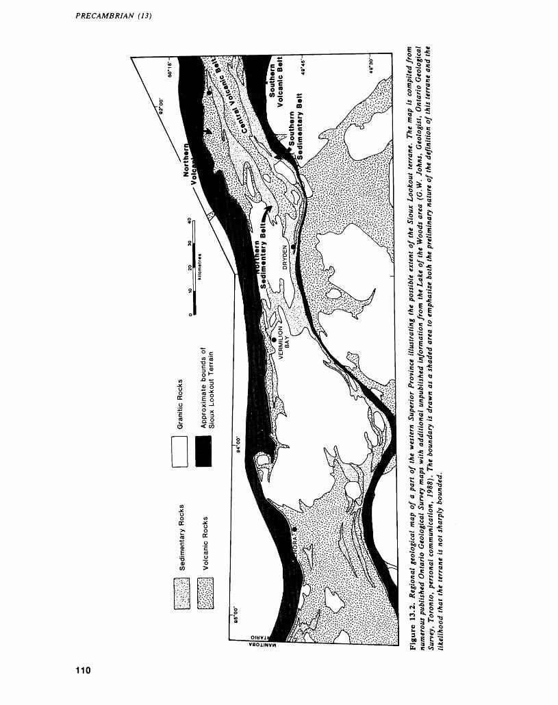
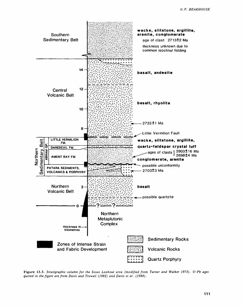
G. P. BEAKHOUSE
Southern Sedimentary Belt
14
Central 12 ~ Volcanic Belt
CDm - ^fZ ft
O CD Z E
CD CO
LITTLE VERMILION FM.
DAREDEVIL FM.
AMENT BAY FM.
PATARA SEDIMENTS, VOLCANICS 4 PORPHYRY
Northern Volcanic Belt
wacke, siltstone, argillite, arenite, conglomerate
age of clast: 2713±2 Mathickness unknown due to common isoclinal folding
basalt, andesite
basalt, rhyolite
2733 1 Ma
Little Vermilion Fault
wacke, siltstone, argillite,
quartz-feldspar crystal tuffages of clasts j 2903±16 Ma
l 269814 Maconglomerate, arenite
possible unconformity 2703±3 Ma
basalt
possible quartzite
thickness in- kilometres
Northern Metaplutonic
Complex
Zones of Intense Strain and Fabric Development
Sedimentary Rocks
Volcanic Rocks
Quartz Porphyry
Figure 13.3. Stratigraphic column for the Sioux Lookout area (modified from Turner and Walker 7973). U-Pb ages quoted in the figure are from Davis and Trowell (1982) and Davis et al. (1988).
111
PRECAMBRIAN (13)
few metres of the contact suggests that no fault is present. The Patara sedimentary rocks exhibit a gen eral fining upward trend that is well displayed in ex posures along Highway 116. Here, the basal unit is a clast-supported, oligomictic conglomerate that ex hibits little internal stratification and is composed of poorly sorted, subangular to subrounded mafic vol canic clasts within a mafic matrix. Rarely, the frag ments are recognizable as pillow fragments partly bounded by selvage material. This unit pinches out along strike and grades upward into similar conglom erates that are interbedded with sandstones, which are in turn succeeded by sandstone without coarse fragmental interbeds and, finally, fine-grained sand stone and argillite. This sequence is interpreted to represent a slope-wash deposit on top of the north ern volcanic belt mafic plain or shield volcano. Topographic depressions infilled with locally derived mafic breccia created a more uniformly gently dip ping depositional surface upon which progressively finer debris derived from the erosion of the mafic shield could be deposited.
The Patara sedimentary rocks are locally over lain by felsic volcanic rocks and perhaps by mafic volcanic rocks, although intense deformation at the contacts of the latter on Vermilion Lake make it dif ficult to rule out the possibility that the Patara sedi mentary rocks are not tectonically juxtaposed with these rocks. A unit described as a quartz porphyry (Johnston 1972), that has been critical in decipher ing regional stratigraphic relationships, also occurs at the top of the Patara sedimentary rocks. The unit has a U-Pb zircon age of 2703±3 Ma (Davis et al. 1988). The porphyry is strongly deformed and most of the contacts are either strongly tectonized or be neath the waters of Vermilion Lake. Most workers have regarded the unit as having an intrusive origin (Johnston 1972; Turner and Walker 1973; Davis et al. 1988), but in the absence of clear intrusive rela tionships and diagnostic textural evidence, it is equally probable that the unit represents a felsic dome that may be related to felsic metavolcanic rocks that occur elsewhere at this stratigraphic level.
The Abram Group has been interpreted to un- conformably overlie the Patara sedimentary rocks, associated volcanic rocks, and the porphyry de scribed above largely on the basis of a profound and abrupt change in the provenance of the sedimentary rocks (Turner and Walker 1973). The Patara sedi ments have a predominantly volcanic provenance, whereas the abundance of granitoid boulders and the higher quartz content of the sandstones in the Abram Group indicates a significant granitoid prove nance component. Turner and Walker (1973) favoured the interpretation that the granitoid com ponent originated from plutons that intruded and uplifted the volcanic sequence and that significant erosion preceded deposition of the Abram Group but acknowledged the possibility that the source of the detritus could have been prevolcanic sialic crust.
Examination of the clast population within the Abram Group reveals many similarities with the Winnipeg River terrane which lies to the north of, and is interpreted to be significantly older than, any known volcanism in the Wabigoon Subprovince. This is consistent with a U-Pb zircon age of 2903±16 Ma for a tonalite clast from the Abram Group (Davis et al. 1988).
Much of the northern sedimentary belt is char acterized by low strain and very weak fabric devel opment. Exceptions to this generalization include the Patara-Abram contact and the Abram-central volcanic belt contact where zones that are typically less than 100 m wide have been intensely strained. Both of these contacts have been inferred to be faults (Johnston 1972).
CENTRAL VOLCANIC BELT
The central volcanic belt is a predominantly south east-facing sequence of mafic to felsic volcanic rocks. The base of this sequence is interpreted to be in fault contact with the underlying northern sedi mentary belt (Johnston 1972). South of'Sioux Look out, this sequence has been interpreted to consist of a lower, bimodal tholeiitic basalt + subordinate dacite/rhyolite interval succeeded by a mixed basalt- andesite interval (Page and Clifford 1977; Page e t al. 1978). A generally similar subdivision of the cen tral volcanic belt has also been recognized in the Beartrack Lake area located approximately 40 km southwest of Sioux Lookout (Berger 1987; Chorlton 1987). A felsic tuff from the lower part of the cen tral volcanic belt has a U-Pb zircon age of 2733±1 Ma (Davis and Trowell 1982).
Limited observations made in this belt are con sistent with these generalizations and suggest an overall low degree of strain except near the basal contact with the Abram Group. A distinctive por phyry unit occuring near the stratigraphic top of this belt is similar to that occurring beneath the Abram Group.
SOUTHERN SEDIMENTARY BELT
Exposures of this belt in East Bay of Minnitaki Lake consist exclusively of sedimentary rocks. To the southwest in the same belt, subordinate felsic vol canic rocks are interlayered with the sedimentary rocks (Berger 1986). Unlike the three belts de scribed above, this belt is deformed into numerous shallowly plunging, upright isoclinal folds. Neverthe less, these rocks appear to overlie the central vol canic belt and the general southeastward facing of the regional stratigraphy described above persists into the southern sedimentary belt. Rock types en countered within this belt during this field work in clude wacke, siltstone, argillite, arenite, and con glomerate. The distinctive foliated to gneissic tonalite and megacrystic granodiorite clasts of the Abram Group conglomerates that are interpreted to be derived from the WRSP are lacking in the con-
112
G. P. BEAKHOUSE
glomerates of the southern volcanic belt. Here, the sediments appear to be derived primarily from greenstone lithologies and related subvolcanic intru sive rocks.
SOUTHERN VOLCANIC BELT
This belt was not examined. Previous work suggests it is a mafic volcanic sequence with subordinate in termediate to felsic volcanic rocks and a minor sedi mentary component and lacks a consistent facing di rection (Trowell et al. 1980a, 1980b). The contact between the southern volcanic and southern sedi mentary belts has been interpreted to be a fault (Johnston 1972). The stratigraphic position of this belt relative to those discussed above and its possible inclusion in the Sioux Lookout terrane remain un certain.
INTERRELATIONSHIPS OF STRATIGRAPHY, STRUCTURE, AND ALTERATION IN THE NORTHERN VOLCANIC BELT
The recognition of a strain gradient within the stratigraphically and lithologically monotonous northern volcanic belt permitted some observations relevant to the potential relationships between stratigraphy and various deformational and altera tion features. Within the weakly to very weakly de formed part of this sequence, it is possible to recog nize lithologic dissimilarities between relatively un- deformed zones (gabbro, massive and pillowed flows) and those exhibiting a greater degree of strain and intensity of fabric development (interflow sedi mentary rocks, hyaloclastite, and pillow breccia). Furthermore, these more highly strained units are loci for quartz veining and carbonate alteration. With greater amounts of strain and alteration, many of the primary structures and textures that identify the origin of these zones are obliterated. In many outcrops, chert and recrystallized quartz veins are distinguished with difficulty and at one locality a pure, milky quartz vein was observed to grade later ally into a laminated chert-magnetite bed. Based on the progressive changes described above, the occa sional incorporation of distinctive compositions (eg. magnetite ironstone) and similarities in spacing of structures, it is concluded that many of the more highly strained and altered zones occurring within the basal part of the northern volcanic belt also originated as stratigraphic units.
METALLOGENY OF THE SIOUX LOOKOUT TERRANE
A preliminary review of the types and distribution of mineral occurrences (Ferguson et al. 1970; Breaks 1979; Blackburn 1981) within the Sioux Lookout terrane suggests that it is characterized by a distinc
tive metallogeny. Types of mineralization present in clude:1. Au - These deposits are hosted in a wide variety
of rock types and many are spatially related to faults.
2. Base-metal sulphide mineralization - Cu and/or Zn dominated sulphide mineralization are pre dominantly volcanic hosted.
3. Rare Metal Pegmatites - These deposits which are enriched in Li, Ta, Nb, Cs, and Be are asso ciated with pegmatites occurring within mafic volcanic rocks near the margins of granitoid in trusions (Breaks and Kuehner 1984).
4. Uranium mineralization occurs within two ge netic types of pegmatites that originated from the partial melting of sedimentary rocks and the fractionation of potassic granitic plutons (Breaks 1982).
5. Molybdenum, with or without associated Cu and Au mineralization, is associated with granitic stocks.In comparison to that part of the WSP lying to
the south of the Sioux Lookout terrane, types l and 2 appear to occur in both terranes, types 3 and 4 are restricted to the Sioux Lookout terrane, and type 5 occurs in both but may be more common in the Sioux Lookout terrane.
IMPLICATIONS
Some preliminary conclusions concerning the signifi cance of observations from the Sioux Lookout area for the working hypothesis outlined above are:1. The northern volcanic and sedimentary belts re
cord a transition from volcanism to volcaniclas tic sedimentation to epiclastic sedimentation. Older continental crust contributed detritus to the Abram Group, and the presence of quartz arenite near the base of the northern volcanic belt suggests that older granitoid units may have been adjacent to this sequence throughout its development.
2. The central volcanic belt and southern sedimen tary belt similarly record a volcanic to sedimen tary transition; however, detritus appears to have been derived from the volcanic rocks and related subvolcanic intrusions with no evidence for a significant contribution from older sial.
3. The stratigraphic asymmetry, distribution of strain, and evidence of older rocks overlying younger rocks suggests that the Sioux Lookout terrane represents an imbricate thrust stack.
4. The nature and diversity of lithologies suggests that the sequences in the Sioux Lookout terrane are more closely analogous to island arcs or back-arc basins than oceanic crust, although the northern volcanic belt may have some attributes of the latter.
113
PRECAMBRIAN (13)
5. The Sioux Lookout terrane contains Au and base-metal deposits similar to those occurring elsewhere in the WSP, but U and rare metal pegmatite mineralization is peculiar to the Sioux Lookout terrane.
SUMMARY
Observations and interpretations discussed above suggest that an area referred to informally as the Sioux Lookout terrane is composed of allochthonous volcanic/sedimentary sequences, the emplacement of which is related to the interaction between the WRSP and WSP. The allochthonous terrane in cludes areas that have hitherto been included in both subprovinces and points to the need to rethink the concept and definition of subprovinces and their boundaries. These relationships and interpretations suggest that, in this case, the concept of a sharp, discrete subprovince boundary should be abandoned in favour of the concept of a boundary terrane.
The Sioux Lookout terrane may be metallogeni- cally distinct from the remainder of the WSP. In ad dition to gold and base-metal mineralization, there is also potential for the discovery of uraniferous and rare element pegmatites
REFERENCESBeakhouse, G.P.1983: Geological, Geochemical and Rb-Sr and U-Pb Zircon
Geochronological Investigations of Granitoid Rocks from the Winnipeg River Belt, Northwestern Ontario and Southeastern Manitoba; Unpublished Ph.D. The sis, McMaster University, Hamilton, Ontario, 376p.
1985: The Relationship of Supracrustal Sequences to a Basement Complex in the Western English River Sub province; p. 169-178 in Evolution of Archean Supracrustal Sequences, edited by L.D. Ayres, P.C. Thurston, K.D. Card, and W. Weber, Geologi cal Association of Canada, Special Paper 28, 380p.
Beakhouse, G.P., and McNutt, R.H.1986: Geochemistry of Granitoid Rocks from the Western
Superior Province - Evidence for 2- and 3-Stage Crustal Evolution Models; p.23-26 in Workshop on Early Crustal Genesis: The World's Oldest Rocks, ed ited by L.D. Ashwal, LPI Technical Report 86-04, Lunar and Planetary Institute, Houston, 185p.
Berger, B.R.1986: Melgund Lake Area, District of Kenora; p.61-65 in
Summary of Field Work and Other Activities 1986, by the Ontario Geological Survey, edited by P.C. Thurston, Owen L. White, R.B. Barlow, M.E. Cherry, and A.C. Colvine, Ontario Geological Survey, Miscellaneous Paper 132, 435p.
1987: Laval and Hartman Townships Area, District of Kenora; p.84-89 in Summary of Field Work and Other Activities 1987, by the Ontario Geological Sur vey, edited by R.B. Barlow, M.E. Cherry, A.C. Col vine, Burkhard O. Dressler, and Owen L. White, Ontario Geological Survey, Miscellaneous Paper 137, 429p.
Blackburn, C.E.1980: Towards a Mobilist Tectonic Model for Part of the
Archean of Northwestern Ontario; Geoscience Can ada, Volume 7, p.64-72.
1981: Kenora-Fort Frances Sheet, Kenora, and Rainy River Districts, Ontario; Ontario Geological Survey, Map 2443, Geological Compilation Series, scale 1:253 440 or l inch to 4 miles. Compilation 1973-197&.
Blackburn, C.E., Bond, W.D., Breaks, F.W., Davis, D.W., Edwards, G.R., Poulsen, K.H., Trowell, N.F., and Wood, J.
1985: Evolution of Archean Volcanic-Sedimentary Se quences in the Western Wabigoon Subprovince and Its Margins: A Review; p.89-116 in Evolution of Ar chean Supracrustal Sequences, edited by L.D. Ayres, P.C. Thurston, K.D. Card, and W. Weber, Geologi cal Association of Canada, Special Paper 28, 380p.
Breaks, F.W.1979: Sioux Lookout-Armstrong; Ontario Geological Sur
vey, Map 2442, Geological Compilation Series, scale l inch to 4 miles.
1982: Uraniferous Granitoid Rocks from the Superior Prov ince of Northwestern Ontario; p.61-69 in Uranium in Granites, edited by Y.T. Maurice, Geological Survey of Canada, Paper 81-23, 173p.
Breaks, F.W., and Kuehner, S.1984: Precambrian Geology of the Eagle River-Ghost Lake
Area, Kenora District; Ontario Geological Survey, Map P.2623, Geological Series-Preliminary Map, scale 1:31 680 or l inch to 1/2 mile. Geology 1980, 1983.
Chorlton, L.B.1987: Stratigraphy, Structural Development and Auriferous
Mineralization in the Crossecho-Troutfly Lake Area, Northern Wabigoon Greenstone Belt, Northwestern Ontario; p.72-83 in Summary of Field Work and Other Activities 1987, by the Ontario Geological Sur vey, edited by R. B. Barlow, M.E. Cherry, A.C. Col vine, Burkhard O. Dressler, and Owen L. White, Ontario Geological Survey, Miscellaneous Paper 137, 429p.
Corfu, F.1988: Differential Response of U-Pb Systems in Coexisting
Accessory Minerals, Winnipeg River Subprovince, Canadian Shield: Implications for Archean Crustal Growth and Stabilization; Contributions to Mineralogy and Petrology, Volume 98, p.312-325.
Davis, D.W., Blackburn, C.E., and Krogh, T.E.1982: Zircon U-Pb Ages from the Wabigoon-Manitou
Lakes Region, Wabigoon Subprovince, Northwest Ontario; Canadian Journal of Earth Sciences, Volume 19, p.254-266.
Davis, D.W., and Edwards, G.R.1986: Crustal Evolution of Archean Rocks in the Kakagi
Lake Area, Wabigoon Subprovince, Ontario, as In terpreted from High-precision U-Pb Geochronology; Canadian Journal of Earth Sciences, Volume 23, p.182-192.
Davis, D.W., Sutcliffe, R.H., and Trowell, N.F.1988: Geochronological Constraints on the Tectonic Evolu
tion of a Late Archaean Greenstone Belt, Wabigoon Subprovince, Northwest Ontario, Canada; Precam brian Research, Volume 39, p.171-191.
114
G. P. BEAKHOUSE
Davis, D.W., and Trowell, N.F.1982: U-Pb Zircon Ages from the Eastern Savant Lake-
Crow Lake Metavolcanic-Metasedimentary Belt, Northwest Ontario; Canadian Journal of Earth Sci ences, Volume 19, p.868-877.
Ferguson, S.A., Brown, D.D., Davies, J.C., and Pryslak, A.P.
1970: Red Lake-Birch Lake Sheet, Kenora District; Ontario Department of Mines, Map 2175, Geological Compi lation Series, scale l inch to 4 miles.
Johnston, F.J.1972: Geology of the Vermilion-Abram Lakes Area, District
of Kenora; Ontario Division of Mines, Geological Re port 101, 56p. Accompanied by Maps 2242 and 2243, scale l inch to 1/2 mile.
Krogh, T.E., Harris, N.B.W., and Davis, G.L.1976: Archean Rocks from the Eastern Lac Seul Region of
the English River Gneiss Belt, Northwestern Ontario; Canadian Journal of Earth Sciences, Volume 13, p.1212-1215.
Page, R.O., and Clifford, P.M.1977: Physical Volcanology of an Archean Vent Complex,
Minnitaki Lake Area, Northwestern Ontario; p.441-443 in Report of Activities, Part A, Geological Survey of Canada, Paper 77-1A, 527p.
Page, R.O., McNutt, R.H., and Clifford, P.M.1978: Geochemistry of the Archean Basalt-Andesite Suite of
Minnitaki Lake, Northwestern Ontario; Geological Association of Canada, Abstracts with Program, Vol ume 3, p.467.
Pettijohn, F.J.1935: Stratigraphy and Structure of
District of Kenora, Ontario;Vermilion Township, Geological Society of
America Bulletin, Volume 46, p. 1891-1908.Thurston, P.C., Ayres, L.D., Edwards, G.R., Gelinas, L.,
Ludden, J.N., and Verpaelst, P.1985: Archean Bimodal Volcanism; p.7-21 in Evolution of
Archean Supracrustal Sequences, edited by L.D. Ayres, P.C. Thurston, K.D. Card, and W. Weber, Geological Association of Canada, Spe cial Paper 28, 380p.
Trowell, N.F., Bartlett, J.R., and Sutcliffe, R.H.1980a: Flying Loon Lake Area, Parnes Lake Sheet, District
of Kenora; Ontario Geological Survey, Preliminary Map P.2350, Geological Series, scale 1:15 840.
1980b: Flying Loon Lake Area, Loggers Lake Sheet, District of Kenora; Ontario Geological Survey, Preliminary Map P.2351, Geological Series, scale 1:15 840.
Turner, C.C., and Walker, R.G.1973: Sedimentology, Stratigraphy and Crustal Evolution of
the Archean Greenstone Belt near Sioux Lookout, Ontario; Canadian Journal of Earth Sciences, Volume 10, p.817-845.
115
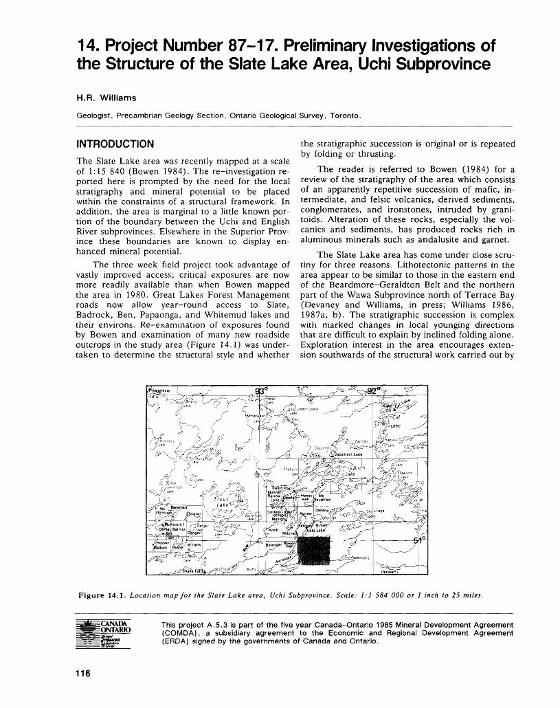
14. Project Number 87-17. Preliminary Investigations of the Structure of the Slate Lake Area, Uchi Subprovince
H.R. Williams
Geologist, Precambrian Geology Section, Ontario Geological Survey, Toronto.
INTRODUCTION
The Slate Lake area was recently mapped at a scale of 1:15 840 (Bowen 1984). The re-investigation re ported here is prompted by the need for the local stratigraphy and mineral potential to be placed within the constraints of a structural framework. In addition, the area is marginal to a little known por tion of the boundary between the Uchi and English River subprovinces. Elsewhere in the Superior Prov ince these boundaries are known to display en hanced mineral potential.
The three week field project took advantage of vastly improved access; critical exposures are now more readily available than when Bowen mapped the area in 1980. Great Lakes Forest Management roads now allow year-round access to Slate, Badrock, Ben, Papaonga, and Whitemud lakes and their environs. Re-examination of exposures found by Bowen and examination of many new roadside outcrops in the study area (Figure 14.1) was under taken to determine the structural style and whether
the stratigraphic succession is original or is repeated by folding or thrusting.
The reader is referred to Bowen (1984) for a review of the stratigraphy of the area which consists of an apparently repetitive succession of mafic, in termediate, and felsic volcanics, derived sediments, conglomerates, and ironstones, intruded by grani toids. Alteration of these rocks, especially the vol canics and sediments, has produced rocks rich in aluminous minerals such as andalusite and garnet.
The Slate Lake area has come under close scru tiny for three reasons. Lithotectonic patterns in the area appear to be similar to those in the eastern end of the Beardmore-Geraldton Belt and the northern part of the Wawa Subprovince north of Terrace Bay (Devaney and Williams, in press; Williams 1986, 1987a, b). The stratigraphic succession is complex with marked changes in local younging directions that are difficult to explain by inclined folding alone. Exploration interest in the area encourages exten sion southwards of the structural work carried out by
Figure 14.1. Location map for the Slate Lake area, Uchi Subprovince. Scale: 1:1 584 000 or l inch to 25 miles.
This project A.5.3 is part of the five year Canada-Ontario 1985 Mineral Development Agreement (COMDA), a subsidiary agreement to the Economic and Regional Development Agreement (ERDA) signed by the governments of Canada and Ontario.
116
H. R. WILLIAMS
Fyon and Lane (1986) in the Uchi-Confederation- Woman lakes area. The following is a resume of the investigations of the domainal structure, contact re lationships, fabric development, and stratigraphic or dering within the belt. This information provides a regional structural perspective for exploration pro jects.
STRUCTURAL DOMAINS
The two structural domains defined by Fyon and Lane (1986) in the Uchi-Confederation-Woman lakes area have also been recognized in the Slate Lake study area, along with a third domain which corresponds to the migmatitic metasediments of the English River Subprovince.
Domain I is characterized by steeply dipping to vertical planar fabrics which are decorated by a moderately southwest to vertically plunging mineral lineation and stretching fabric. Folds, usually con fined to strongly anisotropic lithologies such as cherty ironstones and clastic metasediments or al tered material containing quartz veining, have steep plunges and are tight to isoclinal in form with axial surfaces generally parallel with the dominant planar fabric. Locally, towards the Uchi-English River Sub province boundary, these minor structures have been overprinted by structures characteristic of Do main II and by a subsequent, static, thermally in duced, metamorphic recrystallization producing gar benschiefer texture.
Domain II is also characterized by steep to verti cal planar fabrics, but these are decorated by mod erately southwest-plunging to subhorizontal mineral lineations and fold axes. Development of these structures is by rotation and intensification of the structures produced and preserved in Domain I and the development of entirely new fabrics. Without ex ception, Domain II fabrics indicate a process of dex tral, ductile, simple shear along nearly vertical, east- northeasterly oriented surfaces. The sense of motion across these surfaces is indicated by numerous, asymmetric, Z-style folds; extensional crenulation fabrics; asymmetric boudinage and discrete vein dis placement. In the most deformed portions of Do main II, near the trace of the Lake St. Joseph-Syd ney Lake Fault Zone, all primary sedimentary struc tures are replaced by those typical of mylonites, such as loss of lithological continuity, the occurrence of listric structures nearly parallel with layering, intense fabric development, alteration and veining. Massive granitoid rocks such as the West Badrock Lake Pluton are affected only by brittle shear zones, chloritic veining and pseudotachylytes in this do main. Domain II structures occur within the south ern portion of the area, spatially associated with the subprovincial boundary, but are also found within areas of especially deformable rock such as iron stone-bearing sequences within Domain I. Domain II links the previously separate Lake St. Joseph and
Sydney Lake deformation zones as one continuous, dextral-sense structure.
Domain III occurs south of the major shear zone that produced Domain II structures. In this domain, migmatitic metasediments and attendant granitoids, such as the Bluffy Lake and Papaonga plutons, char acteristically exhibit sinistral sense of motion indica tors and a moderate to steeply east-plunging linea tion on vertical to south-dipping foliations. Imbri cate structures developed during deformation indi cate a sinistral sense of shear when viewed on hori zontal surfaces, but the dominant sense of shear is probably steeply plunging and south side down.
Whilst the relative timing of structure develop ment within Domains I and II is clear, the original orientation of Domain I structures prior to the impo sition of Domain II structures is unknown; progres sive steepening of originally flat-lying structures may be a characteristic of Domain I, or a period of up right folding may have separated the development of the two domains. The timing of Domain III is un clear, but it probably pre-dates Domain II since similar structures examined by Sahborn-Barrie (this volume) within the English River Subprovince at Separation Lake, some 100 km southwest of Slate Lake, are clearly cross-cut by Domain II dextral- sense structures.
An understanding of the geometry and develop ment of the structures contained within the contrast ing domains is necessary to predict the distribution and three dimensional shape of mineralized zones. It is likely that individual ore bodies are elongate along the stretching fabric. Some zones of high shear strain are coincident with alteration and veining.
CONTACT RELATIONSHIPS BETWEEN UNITS
Contacts between lithological units were rarely ob served except in Slate Lake itself where exposures of boundaries between volcanics and sediments of vari ous types were examined and found to be zones of high strain, sometimes with carbonate alteration and quartz veining. Contacts exhibit strongly developed schistosity and an associated, steeply plunging linear fabric.
In no case was an intact conformable boundary recognized; one result of this observation is that a continuous stratigraphic sequence in the area cannot reasonably be assumed. The ramifications of this statement are considerable. Unexpected lithologies within a stratigraphic sequence or repetition of units may both be a consequence of near layer-parallel shearing.
FABRIC DEVELOPMENT
Domain I fabrics consist of original stratification (or its transposed equivalent in zones of high strain) that is locally deformed into folds, with a corresponding
117
PRECAMBRIAN (14)
development of an axial planar fabric. An earlier phase of folding, locally seen as isoclinal, intrafolial folding of bedding, appears as rare precursors to Do main I folding and causes Domain I folds to exhibit both northeast and southwest structural facing direc tions. Domain I folds are steeply plunging in the north, becoming tighter southwards; this general in tensification of Domain I folds and a general shal lowing of lineation plunge southwards may in part be due to Domain II reworking and in part to regional variation.
Domain II structures usually refold Domain I structures and fabrics. Where Domain I and II folds are coaxial, which is the case in the central part of the area, separating the two phases is difficult be cause the flattening fabrics forming as a result of the Domain II dextral shear system are parallel to the general Domain I fabric orientation. Further south, near the main focus of the dextral deformation around the Papaonga-Whitemud lakes system, Do main I fabrics are rotated into the main easterly shearing direction so that Domain II flattening fab rics such as Z-style folds and associated axial planar cleavage can be seen crossing the earlier Domain I fabrics. Domain II planar fabrics are usually vertical and contain a variety of steep to shallow to sub- horizontal lineations, depending on the intensity of shearing, the lithology and the rotation of Domain I structures.
Too little is known of Domain III fabrics to be able to assess their timing and mode of production. Intense shearing along layer surfaces is clear from both the production of sheath-folded veins and sin- istral-sense imbrication of sections of the stratig raphy after the production of the dominant foliation.
Fabric development in zones of high strain and at lithological contacts is not solely responsible for alteration patterns in the area; lithological control of alteration to aluminous mineral assemblages is asso ciated with the distribution of felsic and mafic metavolcanic rocks. It is clear, however, that these altered rocks are susceptible to subsequent deforma tion processes.
STRATIGRAPHIC ORDERING
Rather few of the way-up indicators recorded for specific localities by previous mappers could be sub stantiated. Recognition of pervasive planar deforma tion fabrics and associated folding and of a high strain state, especially within metasediments, was not fully appreciated previously. The use of deformed pillows in mafic volcanics and grain size gradation in wackes and volcanics was found to be equivocal, considering the new planar fabrics imprinted upon the primary features. Indeed, in many of the rocks within Slate Lake itself, few primary features were recognized. The concept of a system of southwest oriented, moderately plunging folds (Bowen 1984, p.60) to explain the sequence and repetition of the
regional-scale stratigraphy was not substantiated; in deed, using symmetry principles, the structural de velopment of the area must result from at least two deformations. The near vertical orientation of some fold axes and lack of consistent stratigraphic facing indicators suggest that structural geometry is exceed ingly complex within mappable stratigraphic units such as wackes. Considering the strike length of the belt to be approximately 30 km as a minimum and the lack of stratigraphic continuity along the belt, use of a single phase of vertically or steeply plunging folds to explain the regional stratigraphic ordering of this belt is unwise. Folds could, however, develop on this scale with a recumbent orientation and then un dergo reoriention towards vertical during intense shear. Evidence of this strong deformation is best displayed in Slate Lake itself. There, sheath fold- generated minor structures, high intensity of erect planar and linear fabric development, and a focuss- ing of alteration effects, occur within a narrow zone of deformation herein defined as the Slate Lake De formation Zone.
The stratigraphy of the area is in a highly tec- tonized state. Deformation within lithological units and the recognition of high strains at their mutual contacts suggest that these rocks do not exhibit origi nal relationships or sequences. This statement should not be seen as discouragement, but as a call for thoughtful interpretation of these complex rocks.
DISCUSSION
This short project has demonstrated that the Slate Lake area contains both mildly and highly tec- tonized rocks that can be separated into domains of characteristic structure. An unbroken stratigraphic sequence within domains is unlikely; repetition may be tectonically induced by both folding and thrust ing.
ACKNOWLEDGMENTS
Constructive criticism and technical assistance by M. Dolan are appreciated.
REFERENCESBowen, R.P.1984: Geology of the Slate Lake Area, District of Kenora
(Patricia Portion); Ontario Geological Survey, OpenFile Report 5471, 163p.
Devaney, J.R., and Williams, H.R.In Press: Evolution of an Archean Subprovince Boundary: A
Sedimentological and Structural Study of Part of the Wabigoon-Quetico Boundary in Northern Ontario; Canadian Journal of Earth Sciences.
Fyon, J.A., and Lane, L.1986: Assessment of the Gold Potential in the Uchi-Confed-
eration-Woman Lakes Area: Preliminary Results, District of Kenora (Patricia Portion); Ontario Geo logical Survey, Map P.2989, Mineral Deposits Series- Preliminary Map, scale 1:50 000. Geology 1985.
118
H. R. WILLIAMS
Williams, H.R. port 5668, 163p.1986: Structural Studies in the Beardmore-Geraldton Belt, I987b: Structural Studies in the Beardmore-Geraldton Belt
Northern Ontario; p. 138-146 in Geoscience Research and in the Quetico and Wawa Subprovinces; p.90-92Grant Program, Summary of Research 1985-86, ed- ,- n Summary of Field Work and Other Activities 1987,ited by V.G. Milne, Ontario Geological Survey, Mis- by the Ontario Geological Survey, edited by R.B. Bar-cellaneous Paper 130, 235p. low, M.E. Cherry, A.C. Colvine, B.O. Dressler and
1987a: Structural Studies in the Wabigoon and Quetico Sub- O.L. White, Ontario Geological Survey, Miscellane-provinces; Ontario Geological Survey, Open File Re- ous Paper 137, 429p.
119
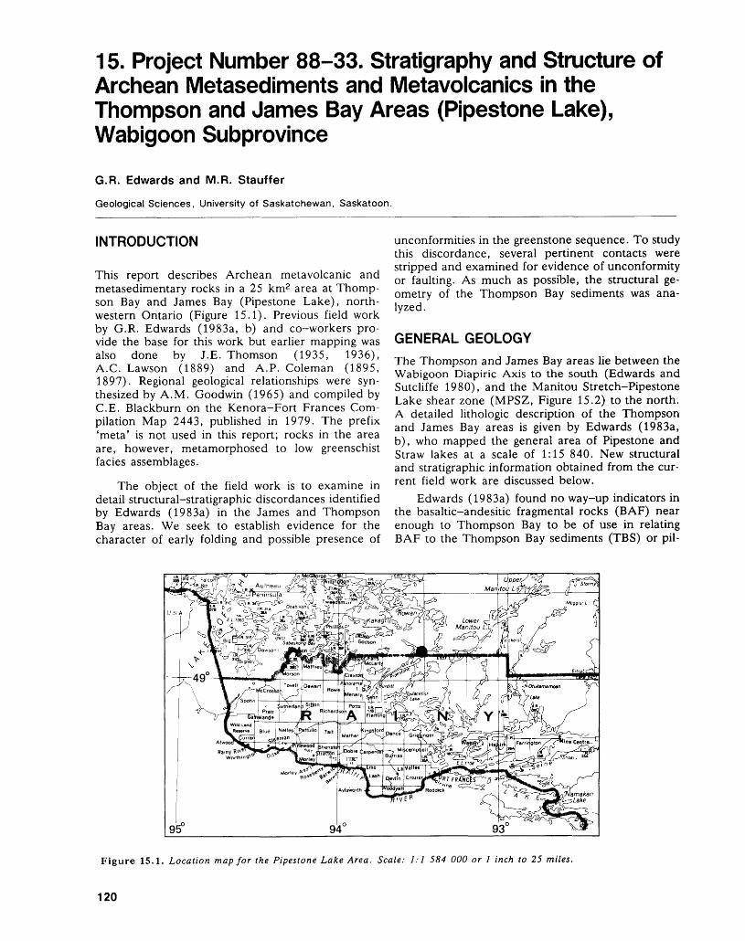
15. Project Number 88-33. Stratigraphy and Structure of Archean Metasediments and Metavolcanics in the Thompson and James Bay Areas (Pipestone Lake), Wabigoon Subprovince
G.R. Edwards and M.R. Stauffer
Geological Sciences, University of Saskatchewan, Saskatoon.
INTRODUCTION
This report describes Archean metavolcanic and metasedimentary rocks in a 25 km2 area at Thomp son Bay and James Bay (Pipestone Lake), north western Ontario (Figure 15.1). Previous field work by G.R. Edwards (1983a, b) and co-workers pro vide the base for this work but earlier mapping was also done by I.E. Thomson (1935, 1936), A.C. Lawson (1889) and A.P. Coleman (1895, 1897). Regional geological relationships were syn thesized by A.M. Goodwin (1965) and compiled by C.E. Blackburn on the Kenora-Fort Frances Com pilation Map 2443, published in 1979. The prefix 'meta' is not used in this report; rocks in the area are, however, metamorphosed to low greenschist facies assemblages.
The object of the field work is to examine in detail structural-stratigraphic discordances identified by Edwards (1983a) in the James and Thompson Bay areas. We seek to establish evidence for the character of early folding and possible presence of
unconformities in the greenstone sequence. To study this discordance, several pertinent contacts were stripped and examined for evidence of unconformity or faulting. As much as possible, the structural ge ometry of the Thompson Bay sediments was ana lyzed.
GENERAL GEOLOGY
The Thompson and James Bay areas lie between the Wabigoon Diapiric Axis to the south (Edwards and Sutcliffe 1980), and the Manitou Stretch-Pipestone Lake shear zone (MPSZ, Figure 15.2) to the north. A detailed lithologic description of the Thompson and James Bay areas is given by Edwards (1983a, b), who mapped the general area of Pipestone and Straw lakes at a scale of 1:15 840. New structural and stratigraphic information obtained from the cur rent field work are discussed below.
Edwards (1983a) found no way-up indicators in the basaltic-andesitic fragmental rocks (BAF) near enough to Thompson Bay to be of use in relating BAF to the Thompson Bay sediments (TBS) or pil-
Figure 15.1. Location map for the Pipestone Lake Area. Scale: 1:1 584 000 or l inch to 25 miles.
120
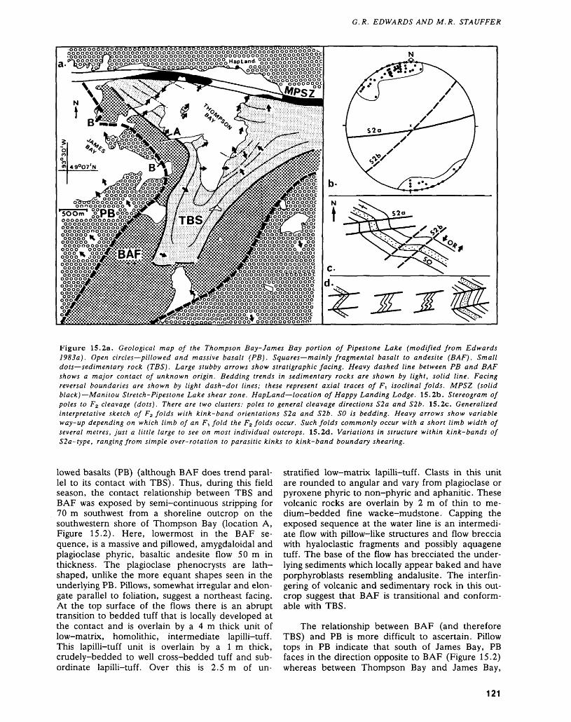
G. R. EDWARDS AND M. R. STAUFFER
S#3S#^^^00 0̂ 0̂ ^ Hapland. ^o^o^o^o^c
oo
O O O Ooooo oooooo
OOOOOOOOOOOOO(oooooooooooooo0000OOOOOOOO00(ooooooooooooooo
ooooooooooooooocO0000OOOO
OOOOOOO00OOOOOOO0000Op(p op o ooooooo ooo.o oo o op o o POPooooooooooooooooooooooooooopppppoopp ooOOPPoppopppppppo000000000000000OOOOOOOOOOOOOOooooooooooooc
Figure 15.2a. Geological map of the Thompson Bay-James Bay portion of Pipestone Lake (modified from Edwards 1983a). Open circles—pillowed and massive basalt (PB). Squares—mainly fragmental basalt to andesite (BAF). Small dots—sedimentary rock (TBS). Large stubby arrows show stratigraphic facing. Heavy dashed line between PB and BAF shows a major contact of unknown origin. Bedding trends in sedimentary rocks are shown by light, solid line. Facing reversal boundaries are shown by light dash-dot lines; these represent axial traces of F, isoclinal folds. MPSZ (solid black)—Manitou Stretch-Pipestone Lake shear zone. HapLand—location of Happy Landing Lodge. 15.2b. Stereogram of poles to F2 cleavage (dots). There are two clusters: poles to general cleavage directions S2a and S2b. 15.2c. Generalized interpretative sketch of F2 folds with kink-band orientations S2a and S2b. SO is bedding. Heavy arrows show variable way-up depending on which limb of an F, fold the F2 folds occur. Such folds commonly occur with a short limb width of several metres, just a little large to see on most individual outcrops. 15.2d. Variations in structure within kink-bands of S2a-type, ranging from simple over-rotation to parasitic kinks to kink-band boundary shearing.
lowed basalts (PB) (although BAF does trend paral lel to its contact with TBS). Thus, during this field season, the contact relationship between TBS and BAF was exposed by semi-continuous stripping for 70 m southwest from a shoreline outcrop on the southwestern shore of Thompson Bay (location A, Figure 15.2). Here, lowermost in the BAF se quence, is a massive and pillowed, amygdaloidal and plagioclase phyric, basaltic andesite flow 50 m in thickness. The plagioclase phenocrysts are lath- shaped, unlike the more equant shapes seen in the underlying PB. Pillows, somewhat irregular and elon gate parallel to foliation, suggest a northeast facing. At the top surface of the flows there is an abrupt transition to bedded tuff that is locally developed at the contact and is overlain by a 4 m thick unit of low-matrix, homolithic, intermediate lapilli-tuff. This lapilli-tuff unit is overlain by a l m thick, crudely-bedded to well cross-bedded tuff and sub ordinate lapilli-tuff. Over this is 2.5 m of un
stratified low-matrix lapilli-tuff. Clasts in this unit are rounded to angular and vary from plagioclase or pyroxene phyric to non-phyric and aphanitic. These volcanic rocks are overlain by 2 m of thin to me dium-bedded fine wacke-mudstone. Capping the exposed sequence at the water line is an intermedi ate flow with pillow-like structures and flow breccia with hyaloclastic fragments and possibly aquagene tuff. The base of the flow has brecciated the under lying sediments which locally appear baked and have porphyroblasts resembling andalusite. The interfin gering of volcanic and sedimentary rock in this out crop suggest that BAF is transitional and conform able with TBS.
The relationship between BAF (and therefore TBS) and PB is more difficult to ascertain. Pillow tops in PB indicate that south of James Bay, PB faces in the direction opposite to BAF (Figure 15.2) whereas between Thompson Bay and James Bay,
121
PRECAMBRIAN (15)
strikes obtained from pillows suggest that PB trends perpendicular to BAF and TBS. The contact be tween BAF and PB has not been found in outcrop, however, near the inferred contact at two locations (Bs on Figure 15.2), there is an unusual fractured massive mafic flow. The fractures are up to l cm wide and are normally filled by comminuted mafic material, although some are occupied by calcite. The resulting rock is an incomplete breccia of cen timetre size fragments. This rock may be fault brec cia; if it is, then there is the suggestion that BAF and PB are in fault contact or alternatively, the breccia could be a feature of paleo-weathering at an uncon formity on PB. More work is required to determine the nature of this unusual rock and to elucidate the contact relationship between BAF and PB.
STRUCTURAL GEOLOGY
Strata between the Wabigoon Diapiric Axis and the Manitou Stretch-Pipestone Lake shear zone (MPSZ, Figure 15.2) are complexly folded and faulted. The interpretation of the structure is also encumbered by the paucity of way-up criteria in some areas and by the added complexity due to the competency contrast between the sediments (TBS) and volcanics (BAF and PB). Edwards (1983a) in terpreted that TBS and apparently BAF were folded into a tri-lobed synclinal structure, complicated in the sediments by parasitic folds of short wavelength. Based on the current field work, this preliminary in terpretation can now be augmented as follows.
Two fold phases are present in TBS: F^ a series of vertical, isoclinal folds whose axial traces define the facing direction boundaries shown on Figure 15.2a; and F2 , a moderately developed, conjugate, micro- to meso-scale group of folds whose geomet ric features are shown on Figures 15.2b to 15.2d. Mapping and analysis of folds are not yet complete in the sediments and structural analysis has not yet begun in the volcanic rocks.
We tentatively conclude that the Thompson Bay sediments (TBS) and immediately underlying basal- tic-andesitic fragmental rocks and subordinate flows (BAF) seem to have been deposited, in part, on an inverted series of pillowed basalts (PB).
SUGGESTIONS FOR FURTHER WORK
The present knowledge of the structure of supracrus tal belts in the Wabigoon Subprovince is inadequate. Without a comprehensive understanding of the na ture of the deformation, there can be little under standing of Archean tectonism. This work seeks to clarify some of the local elements of strata and struc ture that may have wide tectonic significance. The immediate goals of further field work should be to identify and examine the contact between BAF and PB to determine if it is a fault contact or an uncon formity, with the younger rocks overlying upside-
down strata. Dominant and parasitic folds, cleavage, and fracturing in TBS and BAF should be studied further and contrasted with similar features in PB for regional strain analysis.
More broadly, future work should aim at under standing crustal evolution in this part of the Wabi goon Subprovince. For example, if PB were inverted before BAF and TBS were deposited, then what were the tectonic processes that resulted in the early overturning of the strata and the subsequent tri- lobed folding of TBS? What was the relative timing of the deformational events? Can the deformational events be related to similar events elsewhere in Wabigoon Subprovince or Superior Province?
REFERENCESColeman, A.P.1895: Gold in Ontario: Its Associated Rocks and Minerals;
Ontario Bureau of Mines, Annual Report for 1894, Volume 4 Section 2, p.35-100. Accompanied by Maps 4a and 4b, scale l inch to 2 miles.
1897: Third Report on the West Ontario Gold Region; On tario Bureau of Mines, Annual Report for 1896, Vol ume 6 Section 2, p.71-124. Accompanied by Map 6a, scale l inch to 2 miles.
Edwards, G.R.1983a: Geology of the Straw Lake Area, Districts of Kenora
and Rainy River; Ontario Geological Survey, Report 222, 67p. Accompanied by Map 2463, scale 1:31 680 or l inch to 1/2 mile.
1983b: Geology of the Bethune Lake Area, Districts of Kenora and Rainy River; Ontario Geological Survey, Report 201, 59p. Accompanied by Map 2430, scale 1:31 680 or l inch to 1/2 mile.
Edwards, G.R., and Sutcliffe, R.H.1980: Archean Granitoid Terranes of the Western Superior
Province, Ontario; Geological Association of Canada/ Mineralogical Association of Canada Program with Abstracts, Volume 5, p.50.
Goodwin, A.M.1965: Preliminary Report on Volcanism and Mineralization
in the Lake of the Woods-Manitou Lake-Wabigoon Region of Northwestern Ontario; Ontario Department of Mines, Preliminary Report 1965-2, 63p. Accom panied by maps.
Lawson, A.C.1889: Report on the Geology of the Rainy Lake Region;
Geological and Natural History Survey of Canada, Annual Report 1887-1888 (New Series), Volume 3, Report F, 183p.
Thomson, J.E.1935: Geology of the Straw-Manitou Lakes Area Districts of
Rainy River and Kenora; Ontario Department of Mines, Annual Report for 1934, Volume 43, Part 4, 32p. Accompanied by Map 43a, scale l inch to l mile.
1936: Geology of the Rowan-Straw Lakes Area, Districts of Rainy River and Kenora; Ontario Department of Mines, Annual Report for 1935, Volume 44, Part 4, p. 1-28. Accompanied by Map 44e, scale l inch to l mile.
122

Wabigoon Subprovince
16. Geological Studies in the Wabigoon Subprovince, Superior Province
G.W. Johns
Geologist, Precambrian Geology Section, Ontario Geological Survey, Toronto.
Systematic geological investigations of the greenstone-granite terrains in the Wabigoon Sub province are designed to provide a quality data base for the Ontario mineral industry. Emphasis is put on detailed mapping at a scale of 1:15 840. These tra ditional quarter mile maps form the basis for mineral exploration, synoptic mapping, mineral deposit stud ies and research on greenstone belt development.
Over the last few years the Ontario Geological Survey has conducted several projects mainly in the Lake of the Woods, the Sioux Lookout-Dinorwic, and the Lower Manitou Lake areas: a) mapping completed in the Monument Bay area in 1987 by Morrice and MacMaster (1987) discovered previ ously unknown gold mineralization (the area has subsequently attracted much attention); b) continu ing work by John Ayer in the Lake of the Woods area has resulted in several new gold showings since 1982, as well as a better understanding of the vol canic stratigraphy; c) detailed mapping and special studies conducted in the Sioux Lookout-Dinorwic area by Ben Berger and Leslie Chorlton have re- evaluated the structural and stratigraphic controls to mineralization.
This year seven projects were carried out within the subprovince; four in the western Wabigoon and three in the eastern Wabigoon. The emphasis has been to fill the gaps in the present data base and complete ongoing special studies.
The detailed mapping of the Lake of the Woods Greenstone Belt is now almost complete at the 1:15 840 scale (Ayer this volume) and the remain ing gaps in mapping will be filled during the synoptic study that will subsequently be carried out. The lack of up-to-date information that existed between the Straw Lake area (Edwards 1983) and the Upper Manitou-Lower Manitou Lakes area (Blackburn 1982) was filled in this year by the mapping of Ber ger (this volume) and Smith (this volume). Leslie Chorlton (this volume) completed the structural and metallogenic study in the Sioux Lookout-Dinorwic area.
In the eastern Wabigoon Subprovince east of Lake Nipigon, Kresz and Zayachivsky (this volume) have presently completed 1:15 840 scale mapping in the Beardmore-Geraldton belt. The Long Lac area (Kresz and Zayachivsky 1987) and the Seagram Lake area (Kresz and Zayachivsky, this volume) are east of the Geraldton gold camp and a high potential
for gold mineralization is indicated by this recent mapping. Howard Williams' examination (this vol ume) of the boundary between the Quetico and the Wabigoon Subprovinces has implications for the de velopment of subprovince boundaries and gold mineralization possibly associated with these boundaries.
Work by Carter (this volume) and Sutcliffe and Smith (this volume) while not directly involved with the Wabigoon Subprovince are in geographic prox imity and hence are included in this section of the Summary of Field Work.
The 1988 field season resulted in significant new information coming to light as the result of the de tailed mapping projects. John Ayer mapping in the west-central Lake of the Woods area (Falcon Island area) has traced the Monument Bay shear system, that contains several gold occurrences (Morrice and MacMaster 1987), into the northern portion of the Falcon Island area. As well, highly metamorphosed felsic volcanics, previously thought to be part of the Sabaskong Batholith (Blackburn 1981), were out lined in the southern portion of the area.
Ben Berger mapping in the Manitou Stretch area has been able to correlate volcanic lithology between the Straw Lake area (Edwards 1983) and the Upper Manitou-Lower Manitou Lakes area (Blackburn 1982). Several previously unknown rock units and alteration zones with gold potential have been out lined. The map area to the south examined by Mark Smith (Vista Lake area) contains several previously unknown deformation zones that have potential for gold mineralization. Smith also outlined a previously unknown series of pyroclastic rocks.
Leslie Chorlton has made note of the base- metal potential in the central volcanic complex of the Neepawa Group in the Sandybeach Lake area. As well, she determined that gold mineralization is controlled by stage three shear zones, folds, and fracture zones.
In the Seagram Lake area east of Long Lac, Dave Kresz and Borys Zayachivsky (this volume) have outlined previously unknown deformation zones that are along strike with those zones hosting the gold mineralization in Geraldton.
The Wabigoon Subprovince is one of the best exposed granite-greenstone terrains in Ontario and significant portions of it have been covered by recent geological mapping. Several areas have also been covered by regional synoptic studies (Trowell 1983;
124
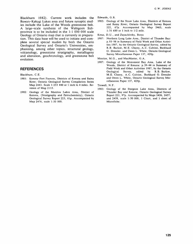
G. W. JOHNS
Blackburn 1982). Current work includes the Rowan-Kakagi Lakes area and future synoptic stud ies include the Lake of the Woods greenstone belt. A large-scale synthesis of the Wabigoon Sub- province is to be included in the 1:1 000 000 scale Geology of Ontario map that is currently in prepara tion. This data base will be used to initiate and com plete several special studies by both the Ontario Geological Survey and Ontario's Universities, em phasizing, among other topics, structural geology, volcanology, greenstone stratigraphy, metallogeny and alteration, geochronology, and greenstone belt evolution.
REFERENCES
Blackburn, C.E.1981: Kenora-Fort Frances, Districts of Kenora and Rainy
River; Ontario Geological Survey Compilation Series Map 2443. Scale 1:253 440 or l inch to 4 miles. Re vision of Map 2115.
1982: Geology of the Manitou Lakes Area, District of Kenora, (Stratigraphy and Petrochemistry); Ontario Geological Survey Report 223, 6Ip. Accompanied by Map 2476, scale 1:50 000.
Edwards, G.R.1983: Geology of the Straw Lake Area, Districts of Kenora
and Rainy River; Ontario Geological Survey Report 222, 67p. Accompanied by Map 2463, scale 1:31 680 or l inch to 1/2 mile.
Kresz, D.U., and Zayachivsky, Borys1987: Northern Long Lake Area, District of Thunder Bay:
p.93-98 in Summary of Field Work and Other Activi ties 1987, by the Ontario Geological Survey, edited by R.B. Barlow, M.E. Cherry, A.C. Colvine, Burkhard O. Dressler, and Owen L. White, Ontario Geological Survey Miscellaneous Paper 137, 429p.
Morrice, M.G., and MacMaster, G.A.1987: Geology of the Monument Bay Area, Lake of the
Woods, District of Kenora: p.39-44 in Summary of Field Work and Other Activities 1987, by the Ontario Geological Survey, edited by R.B. Barlow, M.E. Cherry, A.C. Colvine, Burkhard O. Dressler and Owen L. White, Ontario Geological Survey Mis cellaneous Paper 137, 429p.
Trowell, N.F.1983: Geology of the Sturgeon Lake Area, Districts of
Thunder Bay and Kenora; Ontario Geological Survey Report 221, 97p. Accompanied by Maps 2456, 2457, and 2458, scale 1:50 000, l Chart, and l sheet of Microfiche.
125
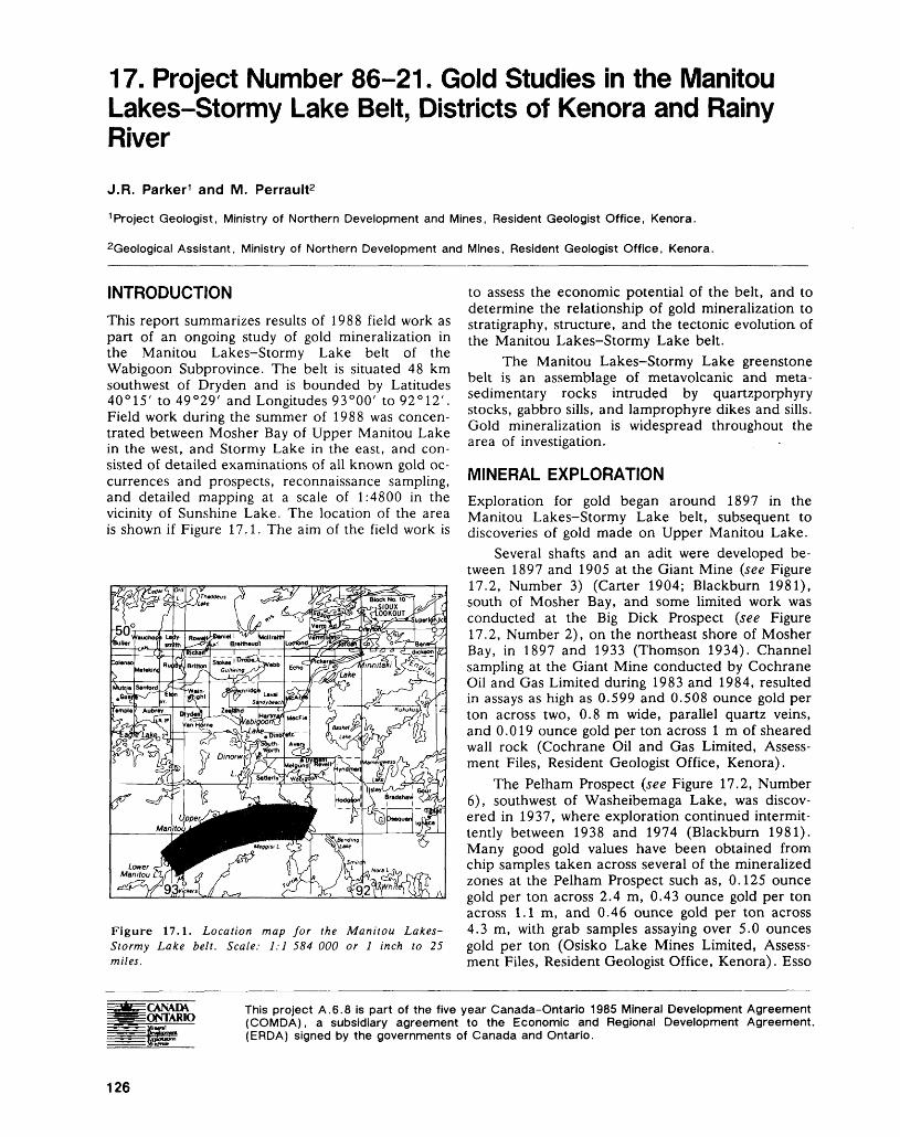
17. Project Number 86-21. Gold Studies in the Manitou Lakes-Stormy Lake Belt, Districts of Kenora and Rainy River
J.R. Parker 1 and M. Perrault2
1 Project Geologist, Ministry of Northern Development and Mines, Resident Geologist Office, Kenora.
2Geological Assistant, Ministry of Northern Development and Mines, Resident Geologist Office, Kenora.
INTRODUCTION
This report summarizes results of 1988 field work as part of an ongoing study of gold mineralization in the Manitou Lakes-Stormy Lake belt of the Wabigoon Subprovince. The belt is situated 48 km southwest of Dryden and is bounded by Latitudes 40 0 15' to 49 0 29' and Longitudes 93 0 00' to 92 0 12'. Field work during the summer of 1988 was concen trated between Mosher Bay of Upper Manitou Lake in the west, and Stormy Lake in the east, and con sisted of detailed examinations of all known gold oc currences and prospects, reconnaissance sampling, and detailed mapping at a scale of 1:4800 in the vicinity of Sunshine Lake. The location of the area is shown if Figure 17.1. The aim of the field work is
Figure 17.1. Location map for the Manitou Lakes- Stormy Lake belt. Scale: 1:1 584 000 or l inch to 25 miles.
to assess the economic potential of the belt, and to determine the relationship of gold mineralization to stratigraphy, structure, and the tectonic evolution, of the Manitou Lakes-Stormy Lake belt.
The Manitou Lakes-Stormy Lake greenstone belt is an assemblage of metavolcanic and meta- sedimentary rocks intruded by quartzporphyry stocks, gabbro sills, and lamprophyre dikes and sills. Gold mineralization is widespread throughout the area of investigation.
MINERAL EXPLORATIONExploration for gold began around 1897 in the Manitou Lakes-Stormy Lake belt, subsequent to discoveries of gold made on Upper Manitou Lake.
Several shafts and an adit were developed be tween 1897 and 1905 at the Giant Mine (see Figure 17.2, Number 3) (Carter 1904; Blackburn 1981), south of Mosher Bay, and some limited work was conducted at the Big Dick Prospect (see Figure 17.2, Number 2), on the northeast shore of Mosher Bay, in 1897 and 1933 (Thomson 1934). Channel sampling at the Giant Mine conducted by Cochrane Oil and Gas Limited during 1983 and 1984, resulted in assays as high as 0.599 and 0.508 ounce gold per ton across two, 0.8 m wide, parallel quartz veins, and 0.019 ounce gold per ton across l m of sheared wall rock (Cochrane Oil and Gas Limited, Assess ment Files, Resident Geologist Office, Kenora).
The Pelham Prospect (see Figure 17.2, Number 6), southwest of Washeibemaga Lake, was discov ered in 1937, where exploration continued intermit tently between 1938 and 1974 (Blackburn 1981). Many good gold values have been obtained from chip samples taken across several of the mineralized zones at the Pelham Prospect such as, 0.125 ounce gold per ton across 2.4 m, 0.43 ounce gold per ton across 1.1 m, and 0.46 ounce gold per ton across 4.3 m, with grab samples assaying over 5.0 ounces gold per ton (Osisko Lake Mines Limited, Assess ment Files, Resident Geologist Office, Kenora). Esso
CANADA ONTARIO
This project A.6.8 is part of the five year Canada-Ontario 1985 Mineral Development Agreement (COMDA), a subsidiary agreement to the Economic and Regional Development Agreement. (ERDA) signed by the governments of Canada and Ontario.
126
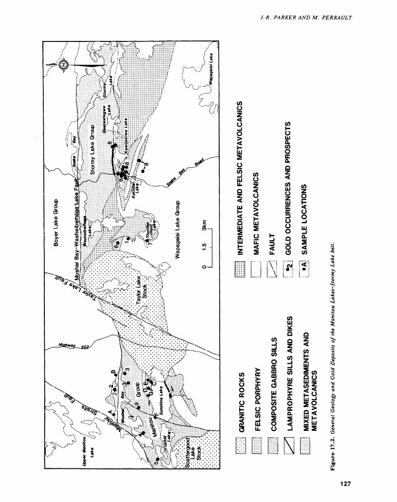
COlil5 Og i "
S - s2 d Sb^ m to i tol s s sys. o SE w iDC lil i 2 OO t Q. C J^ to o s oO O tt Q ^*d l l stu. O -J S 5
o -
3Mh
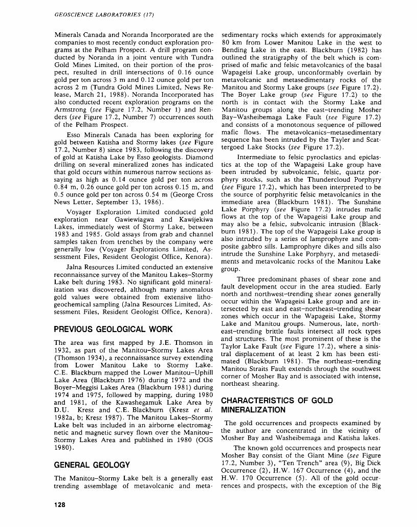
GEOSCIENCE LABORATORIES (17)
Minerals Canada and Noranda Incorporated are the companies to most recently conduct exploration pro grams at the Pelham Prospect. A drill program con ducted by Noranda in a joint venture with Tundra Gold Mines Limited, on their portion of the pros pect, resulted in drill intersections of 0.16 ounce gold per ton across 3 m and 0.12 ounce gold per ton across 2 m (Tundra Gold Mines Limited, News Re lease, March 21, 1988). Noranda Incorporated has also conducted recent exploration programs on the Armstrong (see Figure 17.2, Number 1) and Ren ders (see Figure 17.2, Number 7) occurrences south of the Pelham Prospect.
Esso Minerals Canada has been exploring for gold between Katisha and Stormy lakes (see Figure 17.2, Number 8) since 1983, following the discovery of gold at Katisha Lake by Esso geologists. Diamond drilling on several mineralized zones has indicated that gold occurs within numerous narrow sections as saying as high as 0.14 ounce gold per ton across 0.84 m, 0.26 ounce gold per ton across 0.15 m, and 0.5 ounce gold per ton across 0.54 m (George Cross News Letter, September 13, 1986).
Voyager Exploration Limited conducted gold exploration near Gawiewiagwa and Kawijekiwa Lakes, immediately west of Stormy Lake, between 1983 and 1985. Gold assays from grab and channel samples taken from trenches by the company were generally low (Voyager Explorations Limited, As sessment Files, Resident Geologist Office, Kenora).
Jalna Resources Limited conducted an extensive reconnaissance survey of the Manitou Lakes-Stormy Lake belt during 1983. No significant gold mineral ization was discovered, although many anomalous gold values were obtained from extensive litho geochemical sampling (Jalna Resources Limited, As sessment Files, Resident Geologist Office, Kenora).
PREVIOUS GEOLOGICAL WORK
The area was first mapped by J.E. Thomson in 1932, as part of the Manitou-Stormy Lakes Area (Thomson 1934), a reconnaissance survey extending from Lower Manitou Lake to Stormy Lake. C.E. Blackburn mapped the Lower Manitou-Uphill Lake Area (Blackburn 1976) during 1972 and the Boyer-Meggisi Lakes Area (Blackburn 1981) during 1974 and 1975, followed by mapping, during 1980 and 1981, of the Kawashegamuk Lake Area by D.U. Kresz and C. E. Blackburn (Kresz e t al. 1982a, b; Kresz 1987). The Manitou Lakes-Stormy Lake belt was included in an airborne electromag netic and magnetic survey flown over the Manitou- Stormy Lakes Area and published in 1980 (OGS 1980).
GENERAL GEOLOGY
The Manitou-Stormy Lake belt is a generally east trending assemblage of metavolcanic and meta-
sedimentary rocks which extends for approximately 80 km from Lower Manitou Lake in the west to Bending Lake in the east. Blackburn (1982) has outlined the stratigraphy of the belt which is com prised of mafic and felsic metavolcanics of the basal Wapageisi Lake group, unconformably overlain by metavolcanic and metasedimentary rocks of the Manitou and Stormy Lake groups (see Figure 17.2). The Boyer Lake group (see Figure 17.2) to the north is in contact with the Stormy Lake and Manitou groups along the east-trending Mosher Bay-Washeibemaga Lake Fault (see Figure 17.2) and consists of a monotonous sequence of pillowed mafic flows. The metavolcanics-metasedimentary sequence has been intruded by the Tayler and Scat- tergoed Lake Stocks (see Figure 17.2).
Intermediate to felsic pyroclastics and epiclas- tics at the top of the Wapageisi Lake group have been intruded by subvolcanic, felsic, quartz por phyry stocks, such as the Thundercloud Porphyry (see Figure 17.2), which has been interpreted to be the source of porphyritic felsic metavolcanics in the immediate area (Blackburn 1981). The Sunshine Lake Porphyry (see Figure 17.2) intrudes mafic flows at the top of the Wapageisi Lake group and may also be a felsic, subvolcanic intrusion (Black burn 1981). The top of the Wapageisi Lake group is also intruded by a series of lamprophyre and com posite gabbro sills. Lamprophyre dikes and sills also intrude the Sunshine Lake Porphyry, and metasedi- ments and metavolcanic rocks of the Manitou Lake group.
Three predominant phases of shear zone and fault development occur in the area studied. Early north and northwest-trending shear zones generally occur within the Wapageisi Lake group and are in tersected by east and east-northeast-trending shear zones which occur in the Wapageisi Lake, Stormy Lake and Manitou groups. Numerous, late, north east-trending brittle faults intersect all rock types and structures. The most prominent of these is the Taylor Lake Fault (see Figure 17.2), where a sinis tral displacement of at least 2 km has been esti mated (Blackburn 1981). The northeast-trending Manitou Straits Fault extends through the southwest corner of Mosher Bay and is associated with intense, northeast shearing.
CHARACTERISTICS OF GOLD MINERALIZATION
The gold occurrences and prospects examined by the author are concentrated in the vicinity of Mosher Bay and Washeibemaga and Katisha lakes.
The known gold occurrences and prospects near Mosher Bay consist of the Giant Mine (see Figure 17.2, Number 3), "Ten Trench" area (9), Big Dick Occurrence (2), H.W. 167 Occurrence (4), and the H.W. 170 Occurrence (5). All of the gold occur rences and prospects, with the exception of the Big
128
J. R. PARKER AND M. PERRAULT
Dick Occurrence, are hosted by meta-arenites, wackes and polymictic conglomerates of the Manitou group. The Giant Mine, H.W. 167, and H.W. 170 Occurrences are situated within east- northeast-trending shear zones hosting sheared por phyritic, felsic dikes. The metasediments and dikes are fissile, sericitized, and iron carbonatized and generally contain less than 2 percent disseminated pyrite. Quartz veins are shear zone hosted and/or hosted by northwest-trending tension fractures and rarely contain more than l percent pyrite. At the occurrence named the "Ten Trench" area by Jalna Resources, southwest of Mosher Bay, the meta- arenite host rocks are not sheared, but contain abundant l to 5 cm wide, tension fracture-hosted quartz veinlets, which strike in a general north- northeast direction.
The Big Dick Occurrence (see Figure 17.2, Number 2), on the north shore of Mosher Bay, con sists of a strong, narrow, northeast-trending shear zone, extending through the contacts of an intensely altered gabbro with a coarse-grained quartz-feldspar porphyry dike. The gabbro is fissile, intensely iron carbonatized, pyritic, and chloritized. Quartz veins are shear zone and tension fracture-hosted and con tain altered fragments of wall rock, disseminated py rite, arsenopyrite, and minor chalcopyrite.
The author sampled all the occurrences and prospects described above, however, most of the samples analyzed yielded only slightly anomalous gold values. The best result was from a sample taken from a sheared felsic dike in the vicinity of the H.W. 167 Occurrence, which contained 1495 ppb gold. A grab sample of pyritic meta-arenite taken from a pit at the "Ten Trench" area contained 1470 ppb gold. A grab sample of pyritic, quartz vein material taken from the adit at the Giant Mine had 1300 ppb gold, and a sample of a pyritic, quartz-feldspar porphyry dike at the adit contained 1385 ppb gold (Geos cience Laboratories, Ontario Geological Survey, Toronto).
The author also sampled silicified, pyritic, amyg daloidal, massive and pillowed mafic flows at the northwest corner of Mosher Bay, indicated on geo logical Map 2437 (Blackburn 1981). The mafic flows along the lakeshore are sheared, fissile, car bonatized, dark green to pale green-gray, and vari ably silicified along hairline fractures. Abundant seams of disseminated pyrite occur throughout the mafic flows. Two grab samples of the pyritic mafic flows analyzed had 85 ppb gold and 1640 ppb gold (see Figure 17.2; Location A). A grab sample of epidotized, pyritic, mafic flows, taken on the north east shore of Mosher Bay, contained 60 ppb gold (see Figure 17.2; Location B) (Geoscience Labora tories, Ontario Geological Survey, Toronto).
Abundant sulphide mineralization, alteration, and structural disruption is relatively minimal at Sun shine Lake; however, grab samples taken by the
author during mapping at Sunshine Lake, did yield anomalous and low gold values. A pyritic metasedi ment analyzed yielded 50 ppb gold (see Figure 17.2, Location C), a sample of intermediate crystal tuff hosting pyrite and chalcopyrite contained 39 ppb gold (see Figure 17.2, Location D), a sample of pyritic, carbonatized gabbro yielded 130 ppb gold (see Figure 17.2, Location E), a pyritic, dacitic flow contained 210 ppb gold (see Figure 17.2, Location F), and a sample of pyritic, carbonatized mafic flows, taken from a small point on the north shore of Sunshine Lake, assayed 0.19 ounce gold per ton (see Figure 17.2, Location G) (Geoscience Labora tories, Ontario Geological Survey, Toronto).
The gold occurrences and prospects in the vicin ity of Washeibemaga and Katisha lakes commonly occur in the vicinity of the Thundercloud Porphyry at Washeibemaga Lake, and within composite gab bro sills which intrude the calc-alkalic, felsic and in termediate, pyroclastic sequence at the top of the Wapageisi Lake group (see Figure 17.2).
The Snake Bay Prospect (see Figure 17.2, Num ber 8), near Katisha Lake, consists of thirteen gold- bearing zones discovered by Esso Minerals Canada geologists. The most significant mineralized zones are hosted by l to 15 m wide, north, and northwest- trending shear zones, in magnetite-bearing, compos ite gabbro sills. The shear zones have been perva sively and intensely iron carbonatized, and host car bonate veins up to 5 m in width. The carbonate al teration is postdated by pervasive silicification and quartz veining associated with abundant pyrite, ar senopyrite, and gold mineralization. The silicified zones are narrow, pod-shaped, and concentrated in flexures and wider sections of the shear zones. A second stage of silicification, consisting of irregular, barren quartz stockworks, overprints the carbonate veining and first stage of silicification.
All of the mineralized zones at the Snake Bay Prospect were sampled by the author, with assay val ues ranging from 5 ppb gold to 0.5 ounce gold per ton and with arsenic as high as 10.5 percent (Geos cience Laboratories, Ontario Geological Survey, Toronto).
Biotite- and pyroxene-phyric lamprophyre dikes are hosted by the mineralized shear zones and the east-trending shear zones. A carbonatized, ve sicular, lamprophyre dike at the Twilight Zone inter sects the silicified, mineralized zones. Although some of the lamprophyre dikes are sheared and car bonatized, it is clear that they were intruded late in the structural development of the shear zones and postdate the gold mineralizing event.
The geology of the Pelham Prospect (see Figure 17.2, Number 6), southwest of Waheibemaga Lake, has been described by Blackburn (1981) as a com plex succession of mafic flows and pyroclastics alter nating with lenses of felsic flows, ash flows, coarse pyroclastic rocks and very minor epiclastics. The gold-bearing zones are hosted by a coarse-grained,
129
GEOSCIENCE LABORATORIES (17)
magnetite-bearing, gabbro sill intruded by the Taylor Lake Stock to the west, and the Thunder cloud porphyry to the east. The gold-bearing zones have various widths, trend northeast, northwest, and east, and consist of complex networks of micro-frac tures. Alteration consists of pervasive silicification, biotitization, epidotization associated with variable amounts of disseminated pyrite, pyrrhotite, chalco pyrite, and gold. Epidote is closely associated with the mineralized zones, and commonly occurs in nu merous crisscrossing veinlets which form extensive "spider web" textures in weathered outcrop sur faces.
The Armstrong Occurrence (see Figure 17.2, Number 1) consists of a poorly sorted, heterolithic tuff breccia intercalated with pillowed, mafic flows and felsic, porphyritic, pyroclastic rocks associated with the Thundercloud Porphyry, east of the occur rence. The breccia and mafic flows are silicified, gossan-stained, epidotized, and contain dissemi nated pyrite. The mafic flows contain abundant crisscrossing epidote veinlets similar to those at the Pelham Prospect. Gold mineralization is associated with pyrite in the altered tuff-breccia and mafic flows. No obvious structural disruption or quartz veining was observed by the author. Chip samples taken across the zone gave assay values ranging be tween 0.08 ounce gold per ton across 0.9 m, and 0.32 ounce gold per ton across l m (Fornieri Op tion, Assessment Files, Resident Geologist Office, Kenora). A grab sample of the pyritic, heterolithic tuff-breccia, taken by the author, yielded 1870 ppb gold, while two samples of the epidotized, pyritic, mafic flows contained 520 ppb gold and 725 ppb gold (Geoscience Laboratories, Ontario Geological Survey, Toronto).
RECOMMENDATIONS FOR EXPLORATION
Gold mineralization is widespread throughout the Manitou Lakes-Stormy Lake belt. Within the area under discussion, gold is associated with shear zone—and fracture-hosted quartz veins in meta- sedimentary rocks, and with pervasively silicified shear and fracture zones in gabbro sills. Alteration predominantly consists of intense iron carbonatiza tion overprinted by silicification and sulphide mineralization, or intense epidote veining, biotitiza tion, and sulphidation.
Detailed prospecting should be conducted in the vicinity of Mosher Bay and Sunshine Lake, where results of the author's sampling indicate that anoma lous and low grade gold mineralization occurs in a variety of variably altered, pyritic rock types.
Exploration should be conducted between Gawiewiagwa and Stormy lakes in search of mineral ized zones similar to those at the Snake Bay and Pelham prospects. The metasedimentary rocks of the Manitou and Stormy Lake groups should also be
more thoroughly examined for shear zone and/or fracture-hosted, gold-bearing quartz veins.
CONCLUSION
The gold deposits within the upper part of the Wapageisi Lake group (i.e. the Snake Bay and Pel ham prospects), are spatially and genetically related to a major tectonic zone that was the focus for shear development, and intrusive and hydrothermal activ ity. The stratigraphic succession suggests that there was an evolution from deepwater, mafic, tholeiitic, submarine flows, with little or no clastic sedimenta tion, to more violent, felsic, calc-alkalic pyroclastic volcanism, some of which was subaerial. Clastic metasediments, associated with felsic volcanic rocks, are of proximal, alluvial fan to fluvial facies, which grades both laterally and upward into distal subma rine fan facies. The thick, mafic flow sequences probably formed during rifting of an early, undeter mined basement (Blackburn 1980). Blackburn (1980) suggested a model whereby subsequent calc- alkalic volcanism resulted from subduction of the early mafic flows, accompanied by proximal sedi mentation on the flank of rising, felsic, volcanic arcs, and distal sedimentation in adjacent troughs possibly above subduction zones. According to this model, the Mosher Bay Waheibemaga Lake Fault may represent a reactivated, synvolcanic basin-mar gin fault.
Shear zones at the Snake Bay Prospect were de veloped after both calc-alkalic, felsic volcanism but before flanking sedimentation. This shearing was fol lowed by carbonate veining and alteration (Moreton and Gerber 1985). Later silicification accompanied by arsenopyrite, pyrite, and gold, overprinted the carbonate-bearing zones. Lamprophyre sills and dikes were intruded late in the development of the shear zones and postdate gold mineralization.
REFERENCESBlackburn, C.E.1976: Geology of the Lower Manitou-Uphill Lakes Area,
District of Kenora; Ontario Division of Mines, Geo logical Report 142, 81p. Accompanied by Map 2320, scale 1:31 680 (l inch to 1/2 mile).
1980: Towards a Mobilist Tectonic Model for Part of the Archean of Northwestern Ontario; Geoscience Can ada, Volume 7, Number 2, p.64-72.
1981: Geology of the Boyer Lake-Meggisi Lake Area, Dis trict of Kenora; Ontario Geological Survey, Geological Report 202, 107p. Accompanied by Maps 2437 and 2438, scale 1:31 680 (l inch to 1/2 mile) and 3 charts.
1982: Geology of the Manitou Lakes Area, District of Kenora, (Stratigraphy and Petrochemistry); Ontario Geological Survey, Geological Report 223, 61p. Ac companied by Map 2476, scale 1:50 000.
Carter, W.E.H.1904: Mines of Western Ontario; Ontario Bureau of Mines,
Volume 13, Part l, p.58-87.
130
J. R. PARKER AND M. PERRAULT
Kresz, D.U., Blackburn, C.E., and Fraser, F.B.1982a: Precambrian Geology of the Kawashegamuk Lake
Area, Western Part, Kenora District; Ontario Geo logical Survey, Map P.2569, Geological Series, Pre liminary Map, scale 1:15 840 or l inch to 1/4 mile. Geology 1980, 1981.
1982b: Precambrian Geology of the Kawashegamuk Lake Area, Eastern Part, Kenora District; Ontario Geologi cal Survey, Map P.2570, Geological Series, Prelimi nary Map, scale 1:15 840 or l inch to 1/4 mile. Geol ogy 1980, 1981.
Kresz, D.U.1984: Evolution of an Archean Greenstone Belt in the
Stormy Lake-Kawashegamuk Lake Area (Stratig raphy, Structure, and Geochemistry), Western Wabigoon Subprovince, Northwest Ontario; Unpub lished M.Se. Thesis, Brock University, 262p.
1987: Geology of the Kawashegamuk Lake Area, Kenora District; Ontario Geological Survey, Open File Report 5659, 201p., 14 figures, 13 tables, 18 photos, 3 ap pendices, and 3 maps in back pocket.
Moreton, E.P., and Gerber, R.1985: Stratigraphy and Hydrothermal Alteration in an Ar
chean Structural Zone, the Katisha Lake Area, Wabigoon Subprovince, Northwestern Ontario; p.59 in Technical Sessions and Abstracts, edited by C.E. Blackburn, Institute on Lake Superior Geology, 31st Annual Meeting, Kenora, Ontario, 121p.
OGS
1980: Airborne Electromagnetic and Total Intensity Mag netic Survey, Manitou-Stormy Lakes Area, District of Kenora, by Kenting Earth Sciences Limited for On tario Geological Survey, Geophysical-Geochemical Series, scale 1:20 000, Survey and Compilation, No vember, December 1979 and January, February 1980.
Thomson, J.E.1934: Geology of the Manitou-Stormy Lakes Area; Ontario
Department of Mines, Annual Report for 1933, Vol ume 42, Part 4, p. 140. Accompanied by Map 42c, scale 1:63 360 (l inch to l mile).
131
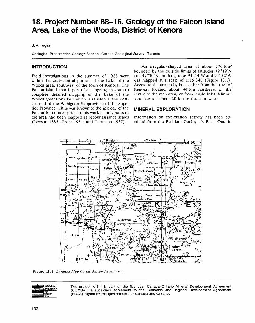
18. Project Number 88-16. Geology of the Falcon Island Area, Lake of the Woods, District of Kenora
J.A. Ayer
Geologist, Precambrian Geology Section, Ontario Geological Survey, Toronto.
INTRODUCTION
Field investigations in the summer of 1988 were within the west-central portion of the Lake of the Woods area, southwest of the town of Kenora. The Falcon Island area is part of an ongoing program to complete detailed mapping of the Lake of the Woods greenstone belt which is situated at the west ern end of the Wabigoon Subprovince of the Supe rior Province. Little was known of the geology of the Falcon Island area prior to this work as only parts of the area had been mapped at reconnaissance scales (Lawson 1885; Greer 1931; and Thomson 1937).
An irregular-shaped area of about 270 km2 bounded by the outside limits of latitudes 49 0 19'N and 49 0 30'N and longitudes 94 0 34'W and 94 0 52'W was mapped at a scale of 1:15 840 (Figure 18.1). Access to the area is by boat either from the town of Kenora, located about 40 km northeast of the centre of the map area, or from Angle Inlet, Minne sota, located about 20 km to the southwest.
MINERAL EXPLORATION
Information on exploration activity has been ob tained from the Resident Geologist's Files, Ontario
Figure 18.1. Location Map for the Falcon Island area.
CAN/MX ONTARIO
This project A.6.1 is part of the five year Canada-Ontario Mineral Development Agreement (COMDA), a subsidiary agreement to the Economic and Regional Development Agreement (ERDA) signed by the governments of Canada and Ontario.
132
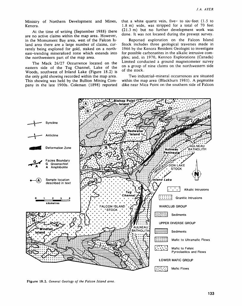
J.A. AYER
Ministry of Northern Development and Mines, Kenora.
At the time of writing (September 1988) there are no active claims within the map area. However, in the Momument Bay area, west of the Falcon Is land area there are a large number of claims, cur rently being explored for gold, staked on a north east-trending mineralized zone which extends into the northwestern part of the map area.
The Mack 26/27 Occurrence located on the eastern side of the Tug Channel, Lake of the Woods, southwest of Inland Lake (Figure 18.2) is the only gold showing recorded within the map area. This showing was held by the Bullion Mining Com pany in the late 1900s. Coleman (1898) reported
that a white quartz vein, five- to six-feet (1.5 to 1.8 m) wide, was stripped for a total of 70 feet (21.3 m) but no further development work was done. It was not located during the present survey.
Reported exploration on the Falcon Island Stock includes three geological traverses made in 1966 by the Kenora Resident Geologist to investigate for possible carbonatites in the alkalic intrusive com plex; and, in 1970, Kennco Explorations (Canada) Limited conducted a ground magnetometer survey on a group of nine claims on the northwestern side of the stock.
Two industrial-mineral occurrences are situated within the map area (Blackburn 1981). A pegmatite dike near Mica Point on the southern side of Falcon
Bishop Point Island^1
^AULNEAU Aulneau •ts* BATHOLITHDeformation Zone
Facies Boundary G Greenschist A Amphibolite DON LAKE
STOCK
Sample location described in text
01234IIZ^Z^^Mkilometres
FALCON ISLAND STOCK
AULNEAU BATHOLITH
Alkalic Intrusions
Granitic Intrusions
WARCLUB GROUP
^j&v&j Sediments
UPPER DIVERSE GROUP
Sediments
Mafic to Ultramafic Flows
Mafic to Felsic Pyroclastics and Flows
LOWER MAFIC GROUP
;Y-x-\Cr] Mafic Flows
Figure 18.2. General Geology of the Falcon Island area.
133
PRECAMBRIAN (18)
Island was mined for mica in 1885. During 1926-1927, it was quarried for feldspar by the Win nipeg Roofing Company with a production of a few hundred tons. In 1975, F. Thorgrimson (Prospec tor, Keewatin) excavated a small opencut on talcose soapstone southeast of Coste Island and a small amount was used for decorative carvings (Storey 1986).
GENERAL GEOLOGY
Parts of the present map area (Figure 18.2) are in cluded in maps produced by Lawson (1885), Greer (1931), and Thomson (1937). The map area ad joins the Western Peninsula area (Davies 1983) to the north, the Monument Bay area (Morrice and MacMaster 1988) to the west, and the Chisholm Is land area (Ayer et al. 1988) to the east.
The area is underlain by Archean supracrustal and intrusive rocks within the western portion of the Wabigoon Subprovince. Supracrustal rocks consist of volcanic, sedimentary, and subvolcanic intrusive rocks metamorphosed to greenschist facies in the north and amphiboloite facies in the central and southern parts of the map area. The supracrustal succession is intruded by several large granitoid bod ies. The Archean rocks are intruded by northwest- trending, Early Proterozoic diabase dikes.
The supracrustal rocks are subdivided into three major stratigraphic units designated the Lower Mafic group (LMG), the Upper Diverse group (UDG), and the Warclub Group (WG) (Figure 18.2). These stratigraphic units are correlative with the Chisholm Island area to the east (Ayer et al. 1987).
LOWER MAFIC GROUP
Rocks of this group are at the basal portion of the exposed stratigraphic section. They occur in an originally continuous horizon up to l km wide in truded and separated into northern and southern portions by the Aulneau Batholith (Figure 18.2). The LMG can be traced eastward into Snake Bay, Lake of the Woods, on the eastern side of the Aul neau Batholith where the group is up to 10 km thick (Johns 1987). Therefore within the map area only the uppermost part of the group is preserved. Geochemical analyses of rocks of the LMG from the Chisholm Island area (east of the current map area) indicate that the upper portion of this group consists of high-iron tholeiitic basalts (Ayer and Buck, in preparation).
Within the map area, the LMG is within the contact strain aureole of the Aulneau Batholith and thus the rocks of this group are highly deformed am- phibolites. They consist of fine- to medium-grained, aphyric mafic flows with locally recognizable pillow selvages and variolites. Horizons of plagioclase- megaphyric amphibolite with highly flattened, coarse-grained plagioclase phenocrysts were ob
served to be up to 5 m thick at two locations; one in the northern and one in the southern portions of the LMG.
UPPER DIVERSE GROUP
Rocks of this group conformably overlie the LMG and are the most abundant of the supracrustal suc cessions within the map area. They are a strati- graphically and structurally complex interdigitation of three subgroups: subgroup l (mafic to felsic pyroclastics and flows); subgroup 2 (mafic to ultra mafic flows); and subgroup 3 (intervolcanic sedi ments) (Figure 18.2).
Subgroup l of the UDG (Figure 18.2) consists of a lithologically and texturally diverse intermixture of mafic to felsic volcanic rocks ranging from pyroclastics to flows. They are predominantly por phyritic with plagioclase and/or amphibolitized clino pyroxene phenocrysts in the mafic to intermediate varieties and with or without quartz phenocrysts in the felsic varieties. Pyroclastics of debris-flow origin predominate and they range from tuff-breccias to lapilli-tuffs, and tuffs and locally grade into bedded tuffs and siltstones. The volcanic fragments are heterolithic, mafic to felsic, and are set in a fine grained, crystal-rich matrix. Mafic to intermediate flows are subordinate to the debris flows and are in timately interdigitated with the fragmentals. Flows are commonly pillowed and amygdaloidal with asso ciated pillow breccias and flow breccias occurring lo cally. Massive flows are rare.
At the present time there is some controversy with regard to the geochemical nature of the mafic to felsic volcanics (subgroup 1) of the UDG. Mor rice and MacMaster (1987, 1988) indicate high K2O values for the mafic to intermediate volcanics of this subgroup from the Monument Bay area (west of the Falcon Island area) and therefore have an alkalic (shoshonitic) affinity. However, analytical results of this subgroup from the Chisholm Island Area east of the current map area display calc-alkalic trends with low K2O values (Ayer and Buck, in preparation). The results of geochemical analyses of rocks of this subgroup collected from the Falcon Island area this summer may help to resolve this discrepancy of ob servations.
Rocks of subgroup 2 of the UDG (Figure 18.2) are relatively monotonous, pillowed to massive flows ranging from mafic to ultramafic in composition. The flows are fine- to medium-grained, locally variolitic, and only rarely amygdaloidal. Mafic flows are most abundant and are dark green in colour on fresh and weathered surfaces whereas ultramafic flows are volumetrically subordinate and tremolitic to talcose with a grey fresh surface and an orange- brown weathered surface. Geochemical analyses of the mafic to ultramafic flows (subgroup 2) from out side the current map area indicate that they-are magnesium tholeiitic basalt to komatiitic basalt in
134
J.A. AYER
composition (Morrice and MacMaster 1987, 1988; Ayer and Buck, in preparation).
Subgroup 3 of the UDG consists of horizons of fine-grained, thin to thickly bedded, quartz-poor, feldspathic and tuffaceous wackes interbedded with thinly laminated siltstones. Felsic to intermediate tuff-breccias and lapilli-tuffs are locally interbedded with these sediments.
WARCLUB GROUP
Sediments of the Warclub group are thickly bedded turbidites with beds ranging from 10 cm to 2 m in thickness. They are commonly normally graded from medium- to fine-grained, quartz-bearing, feldspathic wackes at the base to very fine grained mudstones at the top. AE Bouma sequences are common but all A to E divisions of the Bouma se quence may be present in some of the thicker beds. Minor intercalations of heterolithic debris flows con taining volcanic and sedimentary clasts occur in the northern horizon of the WG (Figure 18.2).
INTRUSIVE ROCKS
Metamorphosed ultramafic to felsic subvolcanic sills and dikes (not shown on Figure 18.2) intrude all the supracrustal rocks. Mafic intrusions are most abun dant and generally occur as gabbro sills from less than l m up to l km thick. Ultramafic intrusions up to 100 m thick range from peridotite to pyroxenite and rarely occur as differentiated sills which grade into gabbro in the upper portions. Intermediate to felsic synvolcanic dikes and sills up to 100 m thick are typically porphyritic with phenocrysts of plagio clase, with or without quartz, and feromagnesian minerals.
The Aulneau Batholith delineates much of the eastern margin of the Falcon Island area (Figure 18.2). It consists of a pretectonic, strongly foliated, medium-grained granodiorite. The northern part of the Aulneau granodiorite has been intruded by late- tectonic, weakly foliated, medium-grained mon zodiorite to diorite. These later phases form a dis crete, 9 km long by 4 km wide stock (the Don Lake Stock) within the Aulneau Batholith. Much of this stock is located south and east of the map area (Blackburn 1981). The various phases of the Don Lake Stock are distinctively magnetic and quartz un dersaturated and thus bear more similarity to the Falcon Island Stock (described below) than to the Aulneau Batholith.
The Falcon Island Stock is an oval-shaped pluton about 15 km long by 6 km wide. It is a com plex of predominately pink, medium- to coarse- grained, magnetic syenite to alkali syenite in its cen tral, northern, and northwestern portions; and grey, fine- to medium-grained, nonmagnetic monzonite in its southern and eastern portions (Figure 18.2). Coarse-grained, tabular, alkali feldspar phenocrysts, locally aligned in a primary igneous foliation are
common in both phases. Isolated bodies of coarse- grained pyroxenite to monzogabbro up to several hundred metres thick grade into or cut the syenide core. The stock is generally unstrained in the central portions and moderatly foliated at the margins.
A third pluton of unknown dimensions occurs in the southwestern part of the map area. It consists of unrecrystallized, medium-grained granite indicating a post-tectonic origin.
Foliated to massive, biotite-bearing lampro phyre dikes occur throughout the map area. Some of these range in composition from gabbro to pyroxenite which are very similar to those rocks of the Falcon Island Stock.
STRUCTURE, METAMORPHISM, AND ALTERATION
The Falcon Island area has a complex multiphase history of deformation which involves both folding and shearing. Bedding and foliations are generally steeply dipping to vertical. Foliations generally strike northeast, north of the Falcon Island Stock, and strike southeast, south of the stock. Folds are indi cated by numerous reversals of top indicators (Fig ure 18.2) and by minor folds which are commonly tight to isoclinal and steeply plunging. In one locality in the northern part of the map area, a type three interference (Ramsay 1967) of two phases of folding was observed, and in many places two cleavages are visible.
A large first-phase syncline is the predominant structure in the northern map area (Figure 18.2). Facing directions are generally to the northwest, away from the Aulneau Batholith and toward the syncline axis situated south of Bishop Point Island. Several second-phase folds cause local top reversals. South of the Falcon Island Stock, repetition of UDG lithologies and facing directions outline a first-phase syncline trending southeast. However, this also ap pears to be complicated by overprinting of second- phase folding.
Discrete high-strain zones, as defined by strong schistosity, with or without carbonatization, chlori tization, amphibolitization, and sulphidization altera tion, occur throughout the map area in minor zones up to 10 m thick. A major deformation zone up to several hundred metres wide trends northeast across the northeastern part of the map area (Figure 18.2). This zone extends to the east for a total length of about 25 km to where it merges with the Pipestone- Cameron Deformation Zone in the Chisholm Island area (Ayer et al. 1988). Another deformation zone up to 100 m wide and 5 km long trends north near the contact between the Aulneau Batholith and the Falcon Island Stock.
Amphibolite-facies assemblages occur in supra crustal lithologies throughout most of the map area with the amphibolite-greenschist transition boundary trending easterly across the northern part of the map
135
PRECAMBRIAN (18)
area (Figure 18.2). In mafic rocks, actinolite por- phyroblasts are locally evident on the greenschist- facies side of the boundary and hornblenderbgarnet porphyroblasts are sporadically present on the am- phibolite-facies side. Pelitic sediments may contain garnet, staurolite, andalusite, and/or sillimanite on the amphibolite-facies side of the transition.
Ferromagnesian alteration unrelated to defor mation has affected much of the UDG volcanics in the north-central part of the map area. It is most evident in pyroclastic units where much of the fine matrix is replaced by ferromagnesian minerals in crosscutting alteration zones. The alteration varies from intense and pervasive to minor along fractures. This feature was also described by Morrice and MacMaster (1987, 1988) from the Monument Bay area west of the current map area. Within the am phibolite-facies terrane, the alteration assemblage is hornblendedbgarnetdicarbonate. In greenschist- facies terrane, the alteration assemblage is ac- tinolitedzchloriteitbiotiteihcarbonate.
ECONOMIC GEOLOGY
The potential for gold mineralization is highest in the northern part of the map area. A northeast-trending shear zone within the Monument Bay area is cur rently the focus of much exploration activity follow ing the reporting of numerous high gold-assay values by Morrice and MacMaster (1987, 1988). This mineralized trend extends into the UDG in the northwestern part of the Falcon Island area (Figure 18.2). Of about fifty grab samples collected by mem bers of the field party from various gossans and veins from the Falcon Island area, the only two which contain anomalous gold values (greater than 30 ppb gold) are from this area. Both are from small quartz-carbonate veins with minor disseminated sul phides. Sample A contained 290 ppb gold and sam ple B contained 530 ppb gold (Figure 18.2). All samples were assayed by the Geoscience Laboratory, Ontario Geological Survey.
Another possible area of potential gold mineralization is the deformation zone extending into the northeastern side of the map area from the Chisholm Island area (Figure 18.2). Within the Chisholm Island area this highly strained and altered deformation zone is associated with the Deadbroke Island Gold Occurrence and several anomalous gold assays were discovered from grab samples obtained along its length (Ayer e t al. 1988).
REFERENCESAyer, J.A., and Buck, S.In Prep.: Geology of the Chisholm Island Area, Lake of the
Woods, District of Kenora; Ontario Geological Sur vey, Open File Report.
Ayer, J.A., Macfie, R.I., and Buck, S.1987: Geology of the Chisholm Island Area, Lake of the
Woods, District of Kenora: p.28-32 in Summary of Field Work and Other Activities 1987, by the Ontario Geological Survey, edited by R.B. Barlow, M.E. Cherry, A.C. Colvine, Burkhard O. Dressler, and Owen L. White, Ontario Geological Survey, Mis cellaneous Paper 137, 429p.
1988: Precambrian Geology of the Chisholm Island Area, Lake of the Woods, District of Kenora; Ontario Geo logical Survey, Map P.3121, Geological Series-Pre liminary Map, scale 1:15 840 or l inch to 1/4 mile. Geology 1987.
Blackburn, C.E.1981: Kenora-Fort Frances, Kenora and Rainy River Dis
tricts; Ontario Geological Survey, Map 2443, Geo logical Compilation Series, scale 1:253 440 or l inch to 4 miles. Revision of Map 2115.
Coleman, A.P.1898: Fourth Report on the West Ontario Gold Region; On
tario Bureau of Mines, Annual Report for 1898, Vol ume 7, Part 2, p. 109-145.
Davies, J.C.1983: Western Peninsula, District of Kenora; Ontario Geo
logical Survey, Preliminary Map 2423, Geological Se ries, scale 1:31 680 or l inch 1/2 mile. Geology 1968, 1969.
Greer, L.1931: Geology of the Shoal Lake (West) Area, District of
Kenora; Ontario Department of Mines, Annual Re port for 1930, Volume 39, Part 3, p.42-56. Accom panied by Map 39e, scale 1:63 360 or l inch to l mile.
Johns, G.W.1987: Geology of the Long Bay-Lobstick Bay Area, District
of Kenora; Ontario Geological Survey, Open File Re port 5626, 222p., 22 figures, 16 tables, 19 photos, and 4 maps in back pocket.
Lawson, A.C.1885: Report on the Geology of the Lake of the Woods Re
gion with Special Reference to the Keewatin (Huronian?) Belt of the Archean Rocks; Geology and Natural History Survey of Canada, Annual Report for 1885, Volume l, Part CC, 151p.
Morrice, M.G., and MacMaster, G.A.1987: Geology of the Monument Bay Area, Lake of the
Woods, District of Kenora; p.39-44 in Summary of Field Work and Other Activities 1987, by the Ontario Geological Survey, edited by R.B. Barlow, M.E. Cherry, A.C. Colvine, Burkhard O. Dressler, and Owen L. White, Ontario Geological Survey, Mis cellaneous Paper 137, 429p.
1988: Precambrian Geology of the Monument Bay Area, Lake of the Woods, District of Kenora; Ontario Geo logical Survey, Map P.3120, Geological Series-Pre liminary Map, scale 1:15 840 or l inch to 1/4 mile. Geology 1987.
Ramsay, J.P.1967: Folding and Fracturing of Rocks; McGraw-Hill Incor
porated, New York, U.S.A., 568p.Storey, C.C.1986: Building and Ornamental Stone Inventory in the Dis
tricts of Kenora and Rainy River; Ontario Geological Survey, Mineral Deposit Circular 27, 168p.
136
Thomson, J.E.1937: Geology of the North Central Part of the Lake of the
Woods; Ontario Department of Mines, Annual Re port for 1936, Volume 45, Part 3, p. 1-43. Accompa nied by Map 45b, scale 1:63 360 or l inch to l mile.
137
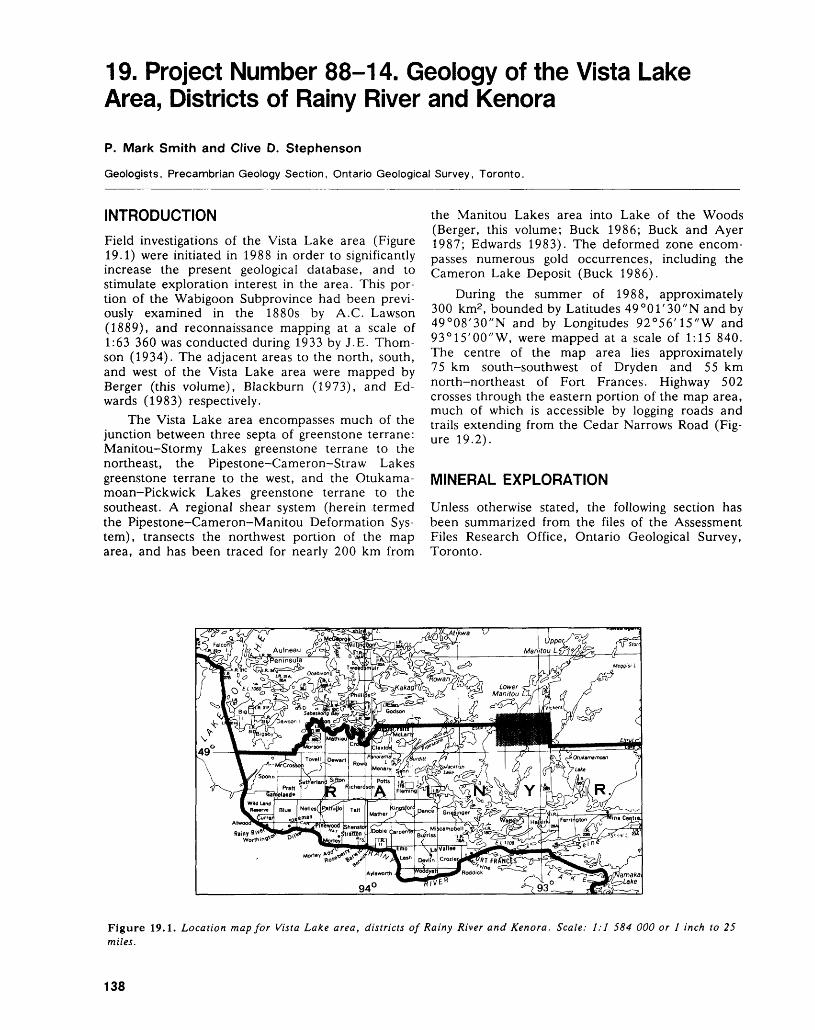
19. Project Number 88-14. Geology of the Vista Lake Area, Districts of Rainy River and Kenora
P. Mark Smith and Clive D. Stephenson
Geologists, Precambrian Geology Section, Ontario Geological Survey, Toronto.
INTRODUCTION
Field investigations of the Vista Lake area (Figure 19.1) were initiated in 1988 in order to significantly increase the present geological database, and to stimulate exploration interest in the area. This por tion of the Wabigoon Subprovince had been previ ously examined in the 1880s by A.C. Lawson (1889), and reconnaissance mapping at a scale of 1:63 360 was conducted during 1933 by J.E. Thom son (1934). The adjacent areas to the north, south, and west of the Vista Lake area were mapped by Berger (this volume), Blackburn (1973), and Ed wards (1983) respectively.
The Vista Lake area encompasses much of the junction between three septa of greenstone terrane: Manitou-Stormy Lakes greenstone terrane to the northeast, the Pipestone-Cameron-Straw Lakes greenstone terrane to the west, and the Otukama- moan-Pickwick Lakes greenstone terrane to the southeast. A regional shear system (herein termed the Pipestone-Cameron-Manitou Deformation Sys tem), transects the northwest portion of the map area, and has been traced for nearly 200 km from
the Manitou Lakes area into Lake of the Woods (Berger, this volume; Buck 1986; Buck and Ayer 1987; Edwards 1983). The deformed zone encom passes numerous gold occurrences, including the Cameron Lake Deposit (Buck 1986).
During the summer of 1988, approximately 300 km2 , bounded by Latitudes 49 0 01'30"N and by 49 0 08'30"N and by Longitudes 92 0 56'15"W and 93 0 15'00"W, were mapped at a scale of 1:15 840. The centre of the map area lies approximately 75 km south-southwest of Dryden and 55 km north-northeast of Fort Frances. Highway 502 crosses through the eastern portion of the map area, much of which is accessible by logging roads and trails extending from the Cedar Narrows Road (Fig ure 19.2).
MINERAL EXPLORATION
Unless otherwise stated, the following section has been summarized from the files of the Assessment Files Research Office, Ontario Geological Survey, Toronto.
Figure 19.1. Location map for Vista Lake area, districts of Rainy River and Kenora. Scale: 1:1 584 000 or l inch to 25 miles.
138
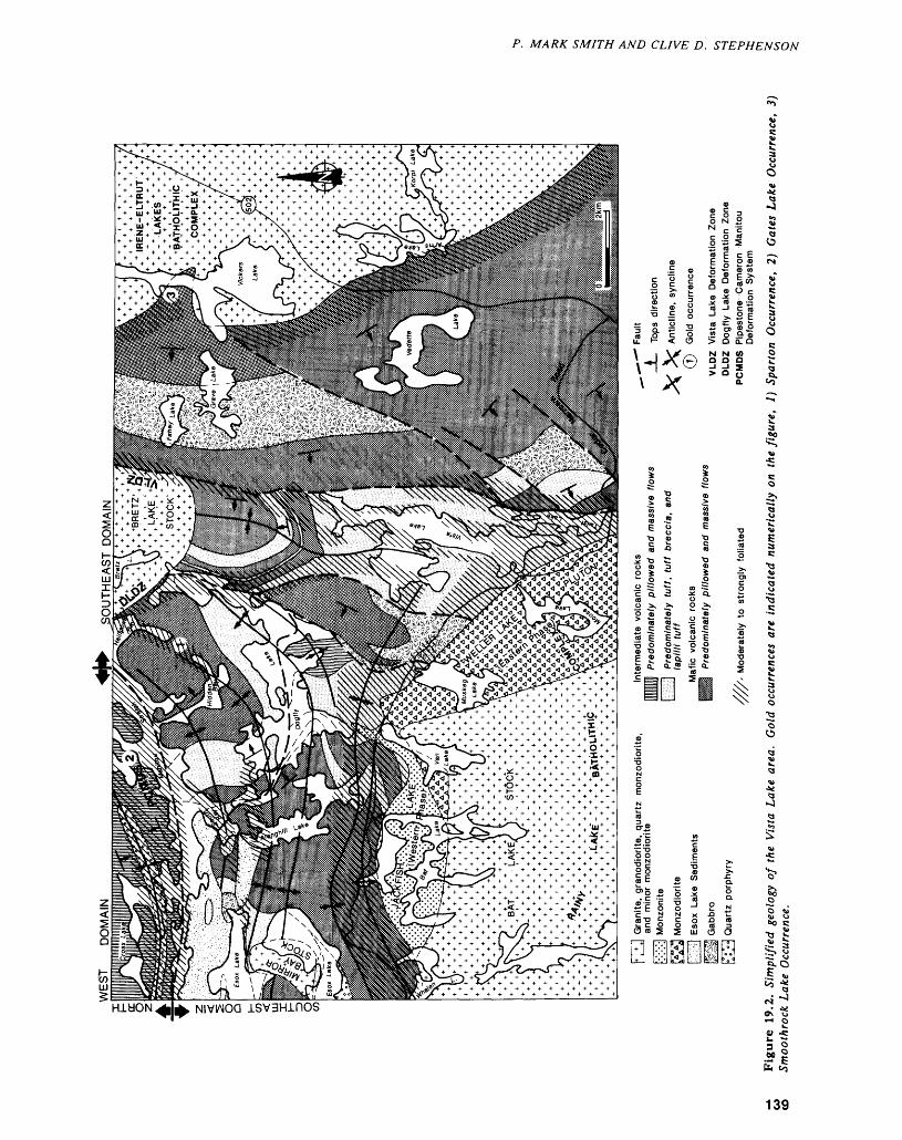
P. MARK SMITH AND CLIVE D. STEPHENSON
2O *u1) O 00 C
•9 ?
HldON
4) -C3 oM 0
139
PRECAMBRIAN (19)
As of September 8th, 1988, there are 62 claims in good standing within the study area (Mike Hail stone, Staff Geologist, Resident Geologist's Office, Kenora, personal communication, 1988), most of which are near the Manitou Stretch.
Gold with associated molybdenite-chalcopyrite mineralization was first reported near Smoothrock Lake (now known as Vickers Lake) by Parsons (1911), and little exploration work has been done since.
Reconnaissance base-metal exploration was conducted during the late 1960s and early 1970s when Canadian Nickel Company Limited diamond drilled eleven holes. Drill logs indicate mainly gra phitic- or pyrrhotite-pyrite-bearing zones were in tersected.
Gold exploration has been focused in the Manitou Stretch and Grave Lake-Vickers Lake ar eas (Figure 19.2). Two main showings have been identified close to Manitou Stretch (Figure 19.2). Between Hailstone and Hidden Bays, southeast of the Manitou Stretch, holes, diamond drilled by Sparton Resources Incorporated, intersected anoma lous gold values in a highly carbonatized shear zone with local zones of quartz stockwork. The best inter section assayed 6.19 g/t gold over 0.37 m. At the Gates Lake Occurrence near Gates Lake, gold and antimony values have been reported (Berger, this volume). Only six short diamond drillholes have tested the property, and these were drilled in 1942 when antimony was the target mineral. The Smoothrock Lake Occurrence, west of Vickers Lake (Figure 19.2), was assessed by Northair Mines Lim ited in 1984. Seven short diamond drillholes tested the mineralized shear zone, and the best drill inter section assayed 13.9 g/t gold over 0.76 m.
GENERAL GEOLOGY
All of the supracrustal and intrusive rocks in the Vista Lake area are interpreted to be Archean in age. The supracrustal rocks have been subject to at least greenschist-facies metamorphism, and hence forth the prefix meta is not used.
The oldest rocks in the area are the volcanic rocks and synvolcanic sills that are locally interca lated with volcanogenic sediments. This succession is unconformably overlain by immature sedimentary rocks in the vicinity of Esox Lake (Figure 19.2). The supracrustal rocks have been intruded by the Rainy Lake Batholithic Complex, the Irene-Eltrut Batholithic Complex (Blackburn 1981), and by two small stocks, herein referred to as the Bretz Lake stock and the Mirror Bay stock (Figure 19.2).
The area is structurally complex, having been subjected to several folding, faulting, and shearing events. The regional-scale Pipestone-Cameron- Manitou deformation system (PCMDS) trends east- northeast through the northwestern portion of the
map area (Figure 19.2). As is the case in the Straw Lake area (Edwards 1983), and in the Lower Manitou Lake area (Blackburn 1976), it is not pos sible to correlate across the PCMDS (see Structural Geology). Thus the supracrustal rocks to the north west and southeast of the deformation system are subdivided below into two distinct domains.
SUPRACRUSTAL ROCKS
Southeast Domain
Much of the area to the southeast of the PCMDS, herein defined as the Southeast Domain (Figure 19.2), is underlain by intermediate and mafic vol canic rocks.
Mafic volcanics comprise massive and pillowed aphyric and feldspar-phyric (leopard rock) mafic flows and sills (Figure 19.2). Feldspar-phyric units (not shown on Figure 19.2) provide excellent marker units that allow fold axes to be accurately defined in the western portion of the domain (Figure 19.2). Mafic volcanic rocks, which occupy the core of the syncline north of Vista Lake and occur north of Dogfly Lake, are locally variolitic and slightly lighter-coloured than those in the south-central, eastern, and western portions of the domain. It is possible that these basaltic rocks are calc-alkalic rather than tholeiitic. Such relationships are critical, as the authors suspect that the rocks exposed in the vicinity of Vista Lake occupy a similar stratigraphic position as those in the Dogfly area, and reflect fault repetition.
Intermediate volcanics rocks comprise flows, tuffs, lapilli tuffs, and tuff breccias. In general, the intermediate rocks are moderately to strongly foli ated, and weakly to strongly carbonatized. Extensive accumulations of intermediate flows and pyroclastic rocks, together with minor mafic rocks, occur near Dogfly and Vista lakes (Figure 19.2). Narrower units of intermediate volcanic rock, several of which are shown in Figure 19.2, occur intercalated with the predominantly mafic sequence and can be utilized as additional marker horizons.
In the extreme western portion of the Southeast Domain, a synvolcanic quartz porphyry unit (Figure 19.2) is autobrecciated along its flanks. There has been some discussion as to its genesis, and both in trusive and extrusive models have been suggested (Edwards 1983; Birk 1978).
A thick hornblende-gabbro sill consisting of nematoblastic, ophitic, equigranular, and glomero- crystic phases extends southwards from Fahey Lake (Figure 19.2). Other subvolcanic intrusions compris ing discordant gabbro, feldspar-phyric gabbro, quartz gabbro, and peridotite sills, occur near the north end of Dogfly Lake.
Immature wackes and cherts are locally interca lated with both intermediate and mafic volcanic se quences. Sediments also occur along the contacts of, and as inclusions within the hornblende gabbro sill.
140
P. MARK SMITH AND CLIVE D. STEPHENSON
Near Esox Lake, the volcanic rocks are uncon- formably overlain by immature sandstones, silt- stones, and mudstones (Figure 19.2). The nature of the thinly bedded to laminated Esox Lake sediments (Edwards 1983) is suggestive of Bouma-cycle tur- bidites. Windows of the underlying volcanic rock are exposed at numerous locations, and east-trending sediment-volcanic contacts are at a high angle to the volcanic stratigraphy (Figure 19.2). The unconfor mity with the underlying older sequence is well ex posed at several sites on Esox Lake, where clast- supported breccias with a calcareous matrix contain clasts of, and overlie, rusty-weathered, fractured quartz porphyry. The authors interpret these rocks to be paleotalus, thus indicating a high-relief, irregu lar paleosurface. As these sediments occur only along the southern side of the PCMDS, the authors suspect that they may be the product of fault-scarp erosion.
Northwest Domain
Only a small region of the Northwest Domain, herein defined as the region north of the PCMDS, is exposed in the map area (Figure 19.2). A consider ably larger area to the north has been mapped by Berger (this volume). Much of the rock within this domain is highly foliated and altered (cf. Edwards 1983), so that the identification of the protolith must be inferred by extrapolation from adjacent, less- strained lithologies.
Intermediate pillowed and massive flows, inter calated with thick sequences of pillow breccia, lapilli-tuff, and tuff-breccia comprise much of the northwestern domain exposed within the map area (Figure 19.2). These rocks are light coloured, gen erally carbonatized, and locally the presence of am phibole and plagioclase phenocrysts was noted. Al though these rocks have been herein designated as having an intermediate composition, it is possible that much of the domain actually consists of altered calc-alkalic basalt.
An enigmatic, highly foliated, felsic quartz-por phyry unit extends west from Gates Lake south of Cross Lake (Figure 19.2). It was not possible to de termine whether the unit was extrusive or intrusive.
SYN- AND LATE-TECTONIC INTRUSIONS
Rainy Lake Batholithic Complex
Within the map area, the Rainy Lake Batholithic Complex comprises northeastern portions of two phases of the Jackfish Lake-Weller Lake Pluton (Blackburn 1981), and the northern portion of a later biotite-granite intrusion, herein defined as the Bat Lake stock.
Jackfish Lake-Weller Lake Pluton
The Jackfish Lake-Weller Lake Pluton is a large diorite-monzonite intrusion which forms a conform
able sheet about the northern margin of the Rainy Lake Batholithic Complex (Sutcliffe and Fawcett 1979; Sutcliffe 1980; Blackburn 1981). Within the map area, two phases can be identified, both.of which display igneous foliations, locally overprinting tectonic fabrics, and gradational contacts with the supracrustal rocks.
The eastern phase (Figure 19.2) consists of ho mogeneous, medium-grained monzodiorite which contains abundant xenoliths of volcanic rock along its eastern and northern margins. Many of these xenoliths are partly assimilated.
The western phase (Figure 19.2), which com prises potassium-feldspar-megacrystic monzonite, also contains abundant volcanic xenoliths. The xenoliths have been assimilated to varying degrees, and in many cases have undergone potassium meta somatism. Towards the northern contact, lampro phyric rocks are present; however, it is not clear whether the lamprophyres are intrusive, a phase separation of the alkalic magma, or a highly potas sium metasomatized mafic volcanic rock. Dikes of this phase are common within the host volcanic rocks to the north.
The contact between the two phases is exposed near Van Lake, where dikelets of megacrystic mon zonite are found within the medium-grained phase.Bat Lake StockBoth phases of the Jackfish Lake-Weller Lake Pluton are intruded by the Bat Lake stock (Figure 19.2). Igneous layering is locally developed within the potassium-feldspar megacrystic, biotite granite intrusion, and fine-grained dikes of the granite in trude some distance into the Jackfish Lake-Weller Lake Pluton.
Irene-Eltrut Batholithic Complex
The western phase of the Irene—Eltrut Batholithic Complex, which is exposed in the eastern portion of the study area, consists of homogeneous, medium- grained granodiorite (Figure 19.2). The contact with the supracrustal rocks is sharp, and granodiorite near the contact is generally fine-grained and sheared. In the vicinity of Vickers Lake and Arms Lake, large blocks of mafic volcanics are present as rafts within the intrusion.
Bretz Lake Stock
The Bretz Lake stock is an ovoid intrusion (Figure 19.2), consisting of potassium-feldspar-megacrystic monzodiorite along its southern margin, with quartz content increasing to give quartz monzodiorite and granodiorite towards the north. Xenoliths are fairly common along the intrusion's margins, where a weak igneous foliation parallels the contacts. The in trusion is sheared along the western contact, and sinistral shearing is also evident along the eastern contact north of the map area (see Berger, this vol ume).
141
PRECAMBRIAN (19)
Mirror Bay Stock
The Mirror Bay stock is an curved, oblong intrusion (Figure 19.2) of medium-grained granodiorite, within which small mafic xenoliths and aplite dikelets are found locally. The stock intrudes the Esox Lake sediments as well as volcanic rocks. Con tacts with the supracrustal rocks are sharp, although several dikes penetrate the supracrustal succession, and one cuts a lamprophyre dike. A weak igneous foliation parallels the contacts but no tectonic fabric was observed within the stock.
STRUCTURAL GEOLOGY
Folds
A regional, north-trending, shallowly plunging syn cline is centred on Vista Lake (Figure 19.2). Rocks occupying the core of this fold have a strong, north- trending foliation, and are interpreted to be the youngest volcanic rocks in the Southeast Domain; not withstanding the presence of a contiguous west- facing, fault-bounded block of mafic volcanic rock west of Vista Lake (Figure 19.2).
Easterly trending, steeply plunging folds domi nate the western half of the map area (Figure 19.2). These are accompanied by the development of an easterly trending, axial-planar foliation which in creases in intensity towards the batholith. Towards the east, the fold axes flex northward, becoming ap proximately parallel to the eastern shore of Dogfly Lake. In this vicinity, earlier foliations are folded, and folds are non-cylindrical with shallow-plunging lineations which diverge on opposing limbs. Such folds may represent sheath folds.
Smaller-scale folds (not shown on Figure 19.2) occur as parasitic folds to larger-scale folds, but are also common within shear zones. Facing reversals in the Esox Lake sediments are common and abrupt and do not appear continuous with those within the underlying volcanic rocks. On closer examination many of these reflect tight, low-amplitude, "S" or "Z" folds.
Deformation Zones
The most prominent structural element in the map area is the Pipestone-Cameron-Manitou Deforma tion System which subdivides the Vista Lake area into two separate structural-stratigraphic domains (Figure 19.2). A distinct "break" follows the Manitou Stretch; however, the shear system is also characterized by numerous, sub-parallel, discrete shear zones separated by lithons of relatively un- deformed volcanic rocks. Splays extending from the main deformation zone extend southwest through Hailstone and South bays. Foliations and lineations are subvertical within the main deformation zone, indicative of vertical strain. Drag folds express north-side-up displacement within sheared Esox
Lake sediments, and are consistent with these linea tions. Most of the rocks in the northwest domain are highly foliated and may be included as part of the deformation system. The curvilinear nature of the PCMDS is roughly parallel to the southern margin of the Atikwa Lake Batholith, located north of the map area, throughout most of its strike length.
Two northerly trending, deformed zones, the Vista Lake Deformation Zone (VLDZ) and the Dogfly Lake Deformation Zone (DLDZ), extend north from Vista Lake and diverge about the Bretz Lake stock (Figure 19.2). It should be noted that these are not necessarily simple shear zones. The discontinuous, anastomosing, deformed zones con sist of highly stretched and strongly foliated volcanic rocks, but they occur along the limbs of a major syn^ cline, and much of this strain could be attributed to that folding. Lineations within the deformed zones are relatively shallow and several small-scale kinematic indicators record sinistral shear within the VLDZ. The Bretz Lake stock has apparently been subjected to sinistal shear within an extension of the VLDZ north of the study area (see Berger, this vol ume). The western margin of the stock is also sheared, but kinematics were not determined.
A contact-strain aureole extends more than 2 km out from the Rainy Lake Batholithic Complex and is a deformation zone in its own right. Rocks within that domain are moderately to highly foliated, and stretched fragments are rod-like and subvertical near the intrusion's margins. The contact aureole surrounding the Irene-Eltrut Batholithic Complex is much less impressive, extending only several hun dred metres.
Numerous smaller shear zones are located throughout the map area, and many of these parallel lithological contacts.
Faults
Within the Southeast Domain, interpreted faults (Figure 19.2) trend slightly oblique to lithological contacts and define the margins of lithologically and structurally distinct blocks. In most cases neither the amount nor the direction of offset is evident, al though within an area of low strain near Vedette Lake, apparent horizontal displacement is indicated (Figure 19.2). Such structural sub-domains make stratigraphic correlation tenuous.
ALTERATION AND METAMORPHISM
All of the supracrustal rocks in the map area have been subject to at least greenschist-facies metamor phism. Rocks adjacent to the syn- and late-tectonic intrusions have been metamorphosed to amphibolite facies, and subsequently weakly to strongly epid- otized. About the smaller stocks, and the Irene- Eltrut Batholithic Complex, the amphibolite facies aureole is narrow, extending less than l km into the supracrustal rocks, while along the margins of the
142
P. MARK SMITH AND CLIVE D. STEPHENSON
Jackfish Lake-Weller Lake Pluton the amphibolite facies contact aureole extends more than 2 km into the surrounding rocks.
Much of the intermediate volcanic rocks in the area are carbonatized, and calcite is the dominant mineral phase. Intense ferroan carbonate alteration, localized along the PCMDS, encompasses regions of known gold mineralization.
ECONOMIC GEOLOGY
The authors believe several areas represent potential targets for gold exploration.
The silicified and carbonatized arsenopyrite-py- rite- stibnite-bearing Gates Lake Occurrence near Gates Lake warrants additional work, particularly as Sparton Resources Incorporated intersected a gold- bearing shear system along strike over l km to the northeast in Peep Bay (see Berger, this volume). The association of antimony and gold is indicated in numerous deposits (Colvine e t al. 1988), and may prove to be a useful pathfinder element in the Manitou Stretth area. Further exploration work may also be warranted on the Sparton Resources Incor porated arsenopyrite-pyrite-gold-bearing occur rence in the Hailstone and Hidden Bay area, al though considerable drilling has been done to date.
Numerous small molybdendite- and chalcopy- rite-bearing quartz veins were noted in the vicinity of Grave and Fahey lakes during the field season. Quartz vein samples taken to the north of the map area (Berger, this volume) returned highly anoma lous gold values. These, combined with the presence of known gold mineralization at the Smoothrock Lake Occurrence, indicate the Fahey—Grave-Vick- ers Lakes area has potential for gold mineralization.
The DLDZ and the VLDZ present untested po tential gold exploration targets. Indeed, a highly silicified segment of the Dogfly Lake Deformation zone crops out between Vista Lake and Dogfly Lake. This material was sampled by the field party but analyses are still pending.
Shear zones developed in regions of differential strain along the margins of folded discordant mafic and ultramafic sills present potential gold targets (Colvine et al. 1988). Fold noses and boudinaged portions of a discordant ultramafic sill in the Dogfly Lake area (Figure 19.2) are highly sheared and car bonatized, with abundant quartz veins throughout. However, the analysis of several samples of quartz and its carbonatized host rock taken by the field party returned a maximum of 14 ppb gold. The authors were later informed that numerous samples taken earlier by Mike Hailstone (Staff Geologist, Resident Geologist's Office, Kenora, personal com munications, 1988) returned no more than 6 ppb gold.
REFERENCESBirk, W.D.1978: The Nature and Timing of Granitoid Plutonism in the
Wabigoon-Volcanic-Plutonic Belt, Northwestern On tario; Unpublished Ph.D. Thesis, University of Manitoba, Winnipeg, Manitoba, 496p.
Blackburn, C.E.1973: Geology of the Otukamamoan Lake Area, Districts of
Rainy River and Kenora; Ontario Division of Mines, Geological Report 109, 42p.
1976: Geology of the Lower Manitou-Uphill Lakes Area, District of Kenora; Ontario Division of Mines, Geos cience Report 142, 81p.
1981: Kenora-Fort Frances: Ontario Geological Survey, Geological Compilation Series, Map 2443.
Buck, S.1986: Metallogenetic Studies in the Kakagi-Rowan Lakes
Area, District of Kenora: p.261-265 in Summary of Field Work and Other Activities 1986, by the Ontario Geological Survey, edited by P.C. Thurston, O.L. White, R.B. Barlow, M.E. Cherry, and A.C. Colvine; Ontario Geological Survey, Miscella neous Paper 132, 435p.
Buck, S., and Ayer, J.A.1987: Structural and Metallogenetic Studies, Lake of the
Woods area, District of Kenora: p.33-38 in Summary of Field Work and Other Activities 1987, by the On tario Geological Survey, edited by R.B. Barlow, M.E. Cherry, A.C. Colvine, B.O. Dressler, and O.L. White; Ontario Geological Survey, Miscellane ous Paper 137, 429p.
Colvine, A.C., Fyon, J.A., Heather, K.B., Marmont S., Smith, P.M., and Troop, D.G.
1988: Archean Lode Gold Deposits, Ontario Geological Sur vey, Miscellaneous Paper 139, 136p.
Edwards, G.R.1983: Geology of the Straw Lake Area, Districts of Kenora
and Rainy River; Ontario Geological Survey Report222, 67p.
Lawson, A.C.1889: Report on the Geology of the Rainy Lake Region;
Geological and Natural History Survey of Canada, Annual Report 1887-1888 (New Series), Volume 3, Report F, 183p.
Parsons, A.L.1911: Gold Fields of Lake of the Woods, Manitou and
Dryden; p. 158-198 in Twentieth Report of the On tario Bureau of Mines, Ontario Bureau of Mines, Volume 20, Part l, 301p.
Sutcliffe, R.H.1980: Evolution of the Rainy Lake Granitoid Complex,
Northwestern Ontario; Unpublished M.Se. Thesis, University of Toronto, Toronto, Ontario, 242p.
Sutcliffe, R.H., and Fawcett, J.J.1979: Petrological and Geochronological Studies on the
Rainy Lake Granitoid Complex, Northwestern On tario: a Progress Report; p.377-380 in Current Re search, Part A, Geological Survey of Canada, Paper 79-1A.
143
PRECAMBRIAN (19)
Thomson, J.E.1934: Geology of the Straw-Manitou Lakes Area, Forty-
third Annual Report of the Ontario Department of Mines, Volume 4, Part 4, p. 1-31. Accompanied by Map 43a.
144
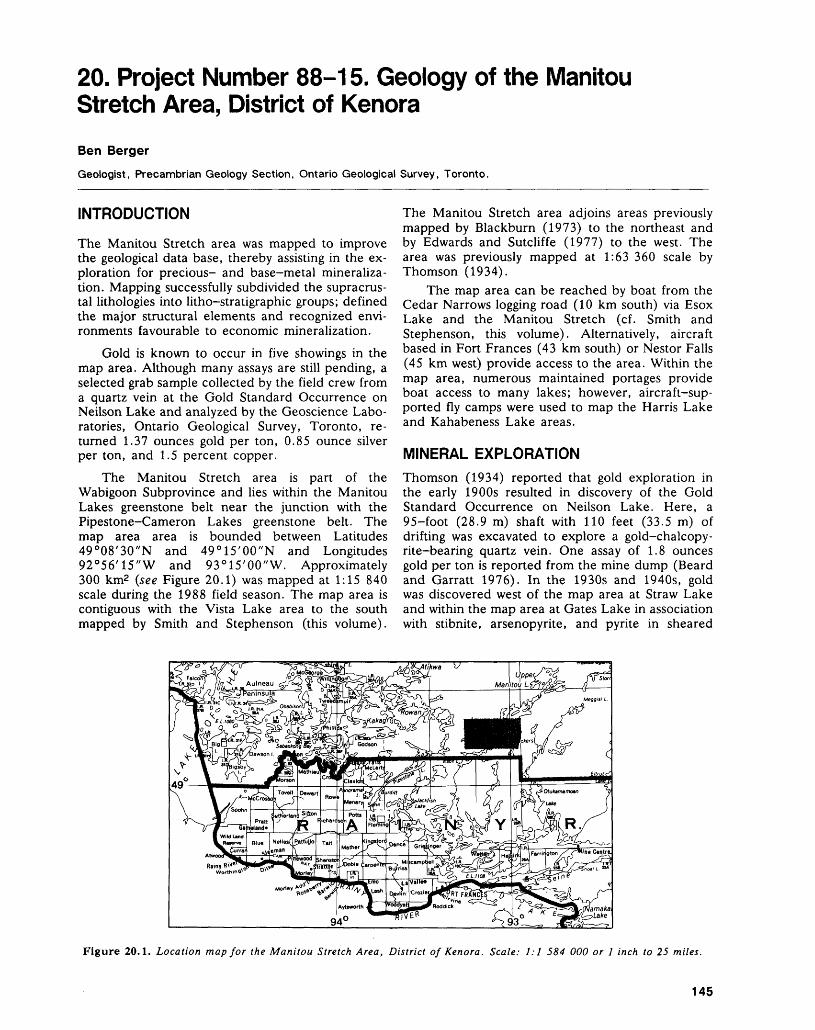
20. Project Number 88-15. Geology of the Manitou Stretch Area, District of Kenora
Ben Berger
Geologist, Precambrian Geology Section, Ontario Geological Survey, Toronto.
INTRODUCTION
The Manitou Stretch area was mapped to improve the geological data base, thereby assisting in the ex ploration for precious- and base-metal mineraliza tion. Mapping successfully subdivided the supracrus tal lithologies into litho-stratigraphic groups; defined the major structural elements and recognized envi ronments favourable to economic mineralization.
Gold is known to occur in five showings in the map area. Although many assays are still pending, a selected grab sample collected by the field crew from a quartz vein at the Gold Standard Occurrence on Neilson Lake and analyzed by the Geoscience Labo ratories, Ontario Geological Survey, Toronto, re turned 1.37 ounces gold per ton, 0.85 ounce silver per ton, and 1.5 percent copper.
The Manitou Stretch area is part of the Wabigoon Subprovince and lies within the Manitou Lakes greenstone belt near the junction with the Pipestone-Cameron Lakes greenstone belt. The map area area is bounded between Latitudes 49 0 08'30"N and 49 0 15'00"N and Longitudes 92 0 56'15"W and 93 0 15'00"W. Approximately 300 km2 (see Figure 20.1) was mapped at 1:15 840 scale during the 1988 field season. The map area is contiguous with the Vista Lake area to the south mapped by Smith and Stephenson (this volume).
The Manitou Stretch area adjoins areas previously mapped by Blackburn (1973) to the northeast and by Edwards and Sutcliffe (1977) to the west. The area was previously mapped at 1:63 360 scale by Thomson (1934).
The map area can be reached by boat from the Cedar Narrows logging road (10 km south) via Esox Lake and the Manitou Stretch (cf. Smith and Stephenson, this volume). Alternatively, aircraft based in Fort Frances (43 km south) or Nestor Falls (45 km west) provide access to the area. Within the map area, numerous maintained portages provide boat access to many lakes; however, aircraft-sup ported fly camps were used to map the Harris Lake and Kahabeness Lake areas.
MINERAL EXPLORATIONThomson (1934) reported that gold exploration in the early 1900s resulted in discovery of the Gold Standard Occurrence on Neilson Lake. Here, a 95-foot (28.9 m) shaft with 110 feet (33.5 m) of drifting was excavated to explore a gold-chalcopy- rite-bearing quartz vein. One assay of 1.8 ounces gold per ton is reported from the mine dump (Beard and Garratt 1976). In the 1930s and 1940s, gold was discovered west of the map area at Straw Lake and within the map area at Gates Lake in association with stibnite, arsenopyrite, and pyrite in sheared
Figure 20.1. Location map for the Manitou Stretch Area, District of Kenora. Scale: 1:1 584 000 or l inch to 25 miles.
145
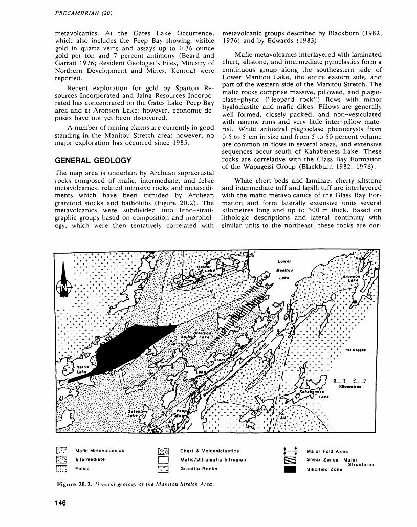
PRECAMBRIAN (20)
metavolcanics. At the Gates Lake Occurrence, which also includes the Peep Bay showing, visible gold in quartz veins and assays up to 0.36 ounce gold per ton and 7 percent antimony (Beard and Garratt 1976; Resident Geologist's Files, Ministry of Northern Development and Mines, Kenora) were reported.
Recent exploration for gold by Sparton Re sources Incorporated and Jalna Resources Incorpo rated has concentrated on the Gates Lake-Peep Bay area and at Aronson Lake; however, economic de posits have not yet been discovered.
A number of mining claims are currently in good standing in the Manitou Stretch area; however, no major exploration has occurred since 1985.
GENERAL GEOLOGY
The map area is underlain by Archean supracrustal rocks composed of mafic, intermediate, and felsic metavolcanics, related intrusive rocks and metasedi- ments which have been intruded by Archean granitoid stocks and batholiths (Figure 20.2). The metavolcanics were subdivided into litho-strati- graphic groups based on composition and morphol ogy, which were then tentatively correlated with
metavolcanic groups described by Blackburn (1982, 1976) and by Edwards (1983).
Mafic metavolcanics interlayered with laminated chert, siltstone, and intermediate pyroclastics form a continuous group along the southeastern side of Lower Manitou Lake, the entire eastern side., and part of the western side of the Manitou Stretch. The mafic rocks comprise massive, pillowed, and plagio- clase-phyric ("leopard rock") flows with minor hyaloclastite and mafic dikes. Pillows are generally well formed, closely packed, and non-vesiculated with narrow rims and very little inter-pillow mate rial. White anhedral plagioclase phenocrysts from 0.5 to 5 cm in size and from 5 to 50 percent volume are common in flows in several areas, and extensive sequences occur south of Kahabeness Lake. These rocks are correlative with the Glass Bay Formation of the Wapageisi Group (Blackburn 1982, 1976).
White chert beds and laminae, cherty siltstone and intermediate tuff and lapilli tuff are interlayered with the mafic metavolcanics of the Glass Bay For mation and form laterally extensive units several kilometres long and up to 300 m thick. Based on lithologic descriptions and lateral continuity with similar units to the northeast, these rocks are cor-
Mafic Metavolcanics
Intermediate
Felsic
fc'.*';\| Chert A Volcaniclastics
|| Mafic/Ultramafic Intrusion
f. "M Granitic Rocks
Major Fold Axes
Shear Zones - MajorStructures
Silicified Zone
Figure 20.2. General geology of the Manitou Stretch Area.
146

BEN BERGER
relative with the Etta Lake Formation of the Wapageisi Group (Blackburn 1982, 1976).
Mafic metavolcanics immediately west of Lower Manitou Lake along the northern boundary of the map area are composed of massive, medium- grained to gabbroic textured flows with minor plagio- clase-phyric flows and mafic to intermediate pil lowed and pillow brecciated flows. These rocks are tentitively correlated with the Pincher Lake Group (Blackburn 1982, 1976).
Intermediate to felsic rocks in the Calder Lake area overlie the mafic rocks described above and are composed of massive to well-bedded pyroclastic and epiclastic deposits, some of which are interpreted by the author to have been deposited by ash flows. They are correlative with the Upper Manitou Lake Group (C.E. Blackburn, Resident Geologist, Minis try of Northern Development and Mines, Kenora, personal communication, 1988).
Intermediate to mafic flows and fragmentals comprise a distinctive rock group which underlies the southwest, central, and north-central part of the map area (Figure 20.2). Among the characteristic features which permit easy field identification of these rocks are large, in places over 3 m, pillows with thick interpillow material (5 cm plus), abun dant and large (up to 5 cm) vesicles and gas cavities and prominent amphibole and plagioclase pheno- crysts. Fragmental units composed of pillow breccia and pillow breccia mixed with pyroclastic material are commonly interlayered with the flows and form up to 100 m thick deposits in the Grant Lake area (Figure 20.2). These rocks are contiguous with in termediate, calc-alkalic metavolcanics described by Edwards (1983) west of the map area, and are mor phologically similar to calc-alkalic metavolcanics de scribed by Berger (1987) in the Sandybeach Lake area and by Morrice and MacMaster (1987) in the Lake of the Woods area.
The supracrustal rocks are intruded by mafic to ultramafic sills and dikes. A gabbroic sill on Calder Lake is intrepreted by the author to be synvolcanic, whereas a pyroxenide dike on Harris Lake appears to be post to late syntectonic in origin.
The supracrustal rocks are intruded by three Ar chean granitoid intrusions. A late syntectonic to post tectonic tonalitic to granodioritic phase of the Irene- Eltrut Lakes Batholithic Complex intrudes along the eastern boundary of the supracrustal rocks (Figure 20.2). Monzonitic to granodioritic rocks of the Bretz Lake late syntectonic to post tectonic stock intrude along the southern part of the map area and extend into the Vista Lake area (see Smith and Stephenson, this volume). A part of the Lawrence Lake Batholith intrudes the supracrustal rocks along the northwest ern boundary of the map area and is composed of tonalite, quartz diorite, diorite, and migmatite. This
intrusion is syntectonic and is commonly foliated and locally sheared.
STRUCTURE AND METAMORPHISM
The major structural feature in the map area is a northeast-trending shear zone system that extends from the northeast through the Grant Lake-Manitou Stretch area to the Gates Lake area (Figure 20.2). This system is composed of several discreet, sub- parallel shear zones, each of which is characterized by a predominant vertical component and a late stage sinistral component of movement. The shear zone system is a regional feature extending to the northeast (Manitou Straits Fault, Blackburn 1982, 1976) and to the west of the map area (Pipestone- Manitou Stretch Fault, Edwards 1983). Smith and Stephenson (this volume) refer to the latter fault as the Pipestone-Cameron-Manitou deformation sys tem and indicate that movement was predominantly vertical. The shear zone system divides the map area into western and eastern structural domains.
West of the shear zone system, numerous rever sals in stratigraphic facings define several northeast- trending fold axes and indicate that stratigraphy is not homoclinal. In several places, the northeast structures were observed to sinistrally rotate and lo cally transpose an earlier formed fabric. This earlier fabric is east-northeast-trending and is subparallel to bedding.
East of the shear zone system, northeast-trend ing structures predominate and are subparallel to stratigraphy which is generally northwest facing. Folding only occurs near the contact with the Irene- Eltrut Lakes Batholithic Complex. The east-north east-trending structures observed in the western structural domain are either poorly preserved or ab sent in this eastern domain.
Within the shear zone system, stratigraphy is commonly transposed and sinistrally rotated to the extent that correlation between the two domains is uncertain. Stratigraphic correlation is further com plicated by late stage north- to northwest-trending faults which sinistrally offset earlier structures, the supracrustal rocks, and the granitoid intrusions.
The supracrustal rocks have attained lower to middle greenschist facies metamorphism as indicated by the development of chlorite, epidote, and ac tinolite in the metavolcanics. Amphibolite facies metamorphic aureoles are developed around the granitoid intrusions as indicated by the development of hornblende and biotite in the metavolcanics. A narrow, up to 500 m wide, amphibolite aureole oc curs around the Irene-Eltrut Lakes intrusion and the Bretz Lake Stock. The "granite-greenstone" contact is abrupt and well defined around both of these intrusions. An amphibolite aureole up to 2 km is developed around the Lawrence Lake Batholith, and there is a gradational contact with the supracrus tal rocks.
147
PRECAMBRIAN (20)
ECONOMIC GEOLOGY
There is good potential for gold and fair to poor po tential for base-metal mineralization in the map area. At the Gates Lake and Peep Bay (Figure 20.2) showings, gold is associated with pyrite, ar senopyrite, and stibnite in quartz veins, and in silicified and carbonatized zones in sheared mafic metavolcanics. Gold values up to 0.4 ounce per ton over about l m are reported by previous workers (Resident Geologist's Files, Ministry of Northern Development and Mines, Kenora), and mineraliza tion is open along strike at both showings. Both showings occur within the northeast-trending shear zone system, yet at both showings mineralization ap pears more closely associated with east-northeast structures. This area is considered by the author to be a highly favourable exploration target.
The Gold Standard Occurrence on Neilson Lake (Figure 20.2) contains gold in a pyritic and chal- copyritic quartz vein. The northeast-striking vein is up to 2 m wide, boundinaged, and pinches out along strike. The vein is hosted by deformed intermediate metavolcanics; however, shearing is not evident. Gold values up to 1.8 ounces per ton were reported (Beard and Garratt 1984) from the sulphide-bearing phase of the vein. Quartz and carbonate veins were observed by the author along strike on the northern shore of Napanee Lake 2.8 km southwest of the Gold Standard Occurrence, which indicates this en tire area is a potential exploration target.
On the northern shore of Aronson Lake (Figure 20.2), trenches sunk by Jama Resources Incorpo rated (Resident Geologist's Files, Ministry of North ern Development and Mines, Kenora) in graphitic and pyritic cherty beds of the Etta Lake Formation were discovered and sampled by the author. Gold has not previously been reported from these rocks; however, one grab sample collected by the author returned 730 ppb gold and 2 ppm silver over 30 cm from sheared and pyritic chert. There appears to be potential for economic gold mineralization in this environment.
South of Kahabeness Lake, pyritic and chal- copyritic quartz pods hosted by amphibolitized mafic metavolcanics were discovered and sampled by the field crew. An assay of 685 ppb gold and 2 ppm sil ver was returned from one sample, which indicates this area warrants further prospecting. This part of the map area is contiguous with the Fahey-Grave lakes area where auriferous chalcopyrite-molyb- denite quartz veins were previously discovered (Smith and Stephenson, this volume).
Previous unsuccessful base-metal exploration appears to have concentrated on testing the potential of parts of the Etta Lake chert-epiclastic formation and parts of the mafic metavolcanics correlative with the Pincher Lake Group (Resident Geologist's Files, Ministry of Northern Development and Mines,
Kenora). Although there may still be targets here, it appears these rocks have low economic potential.
The felsic-intermediate metavolcanics in the Calder area are untested, and mapping indicates that hydrothermally altered and fuchsitic rocks are pre sent. Another potential gold-base metal target oc curs in the Harris Lake area where intermediate pyroclastic deposits on a number of the islands and part of the mainland are partly to totally silicified. The silicified zone is extensive and in a few places disseminated pyrite and pyrrhotite were observed.
REFERENCESBeard, Richard C., and Garratt, Glen L.1976: Gold Deposits of the Kenora-Fort Frances Area, Dis
tricts of Kenora and Rainy River; Ontario Division of Mines, Mineral Deposits Circular 16, 46p. Accompa nied by Chart A, scale 1:253 440 or l inch to 4 miles.
Berger, Ben1987: Laval and Hartman Townships Area, District of
Kenora; p.84-89 in Summary of Field Work and Other Activities 1987, by the Ontario Geological Sur vey, edited by R.B. Barlow, M.E. Cherry, A.C. Col vine, Burkhard O. Dressler, and Owen L. White, Ontario Geological Survey, Miscellaneous Paper 137, 429p.
Blackburn, C.E.1973: Lower Manitou-Uphill Lakes Area, District of
Kenora; Ontario Division of Mines, Preliminary Map P.816, Geological Series, scale l inch to 1/4 mile. Geology 1972.
1976: Geology of the Lower Manitou-Uphill Lakes Area, District of Kenora; Ontario Division of Mines, Geos cience Report 142, 81p. Accompanied by Map 2320, scale l inch to 1/2 mile.
1982: Geology of the Manitou Lakes Area, District of Kenora (Stratigraphy and Petrochemistry); Ontario Geological Survey, Report 223, 61p. Accompanied by Map 2476, scale 1:50 000.
Edwards, G.R.1983: Geology of the Straw Lake Area, Districts of Kenora
and Rainy River; Ontario Geological Survey, Report 222, 67p. Accompanied by Map 2463, scale 1:31 680 or l inch to 1/2 mile.
Edwards, G.R., and Sutcliffe, R.H.1977: Straw Lake Area, Districts of Rainy River and
Kenora; Ontario Geological Survey, Preliminary Map P. 1243, Geological Series, scale 1:15 840 or l inch to 1/4 mile. Geology 1976.
Morrice, M.G., and MacMaster, G.A.1987: Geology of the Monument Bay Area, Lake of the
Woods, District of Kenora; p.39-44 in Summary of Field Work and Other Activities 1987, by the Ontario Geological Survey, edited by R.B. Barlow, M.E. Cherry, A.C. Colvine, Burkhard O. Dressler, and Owen L. White, Ontario Geological Survey, Mis cellaneous Paper 137, 429p.
Thomson, J.E.1934: Straw-Manitou Lakes Area, Districts of Kenora and
Rainy River; Map 43a, scale 1:63 360 or l inch to l mile. Accompanies Ontario Department of Mines, Annual Report for 1934, Volume 43, Part 4, 32p.
148
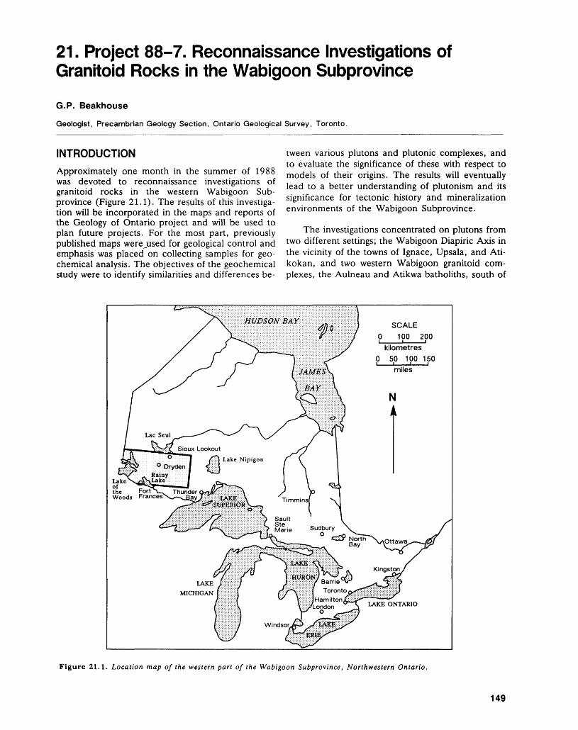
21. Project 88-7. Reconnaissance Investigations of Granitoid Rocks in the Wabigoon Subprovince
G.P. Beakhouse
Geologist, Precambrian Geology Section, Ontario Geological Survey, Toronto.
INTRODUCTIONApproximately one month in the summer of 1988 was devoted to reconnaissance investigations of granitoid rocks in the western Wabigoon Sub province (Figure 21.1). The results of this investiga tion will be incorporated in the maps and reports of the Geology of Ontario project and will be used to plan future projects. For the most part, previously published maps were^used for geological control and emphasis was placed on collecting samples for geo chemical analysis. The objectives of the geochemical study were to identify similarities and differences be
tween various plutons and plutonic complexes, and to evaluate the significance of these with respect to models of their origins. The results will eventually lead to a better understanding of plutonism and its significance for tectonic history and mineralization environments of the Wabigoon Subprovince.
The investigations concentrated on plutons from two different settings; the Wabigoon Diapiric Axis in the vicinity of the towns of Ignace, Upsala, and Ati kokan, and two western Wabigoon granitoid com plexes, the Aulneau and Atikwa batholiths, south of
Lakeof ^ -. — the Fort A— Thunder Woods "
SCALE O 100 200
kilometres O 50 100 150
LAKE ONTARIO
Figure 21.1. Location map of the western part of the Wabigoon Subprovince, Northwestern Ontario.
149
PRECAMBRIAN (21)
the towns of Kenora and Dryden, respectively (Fig ure 21.2).
THE WABIGOON DIAPIRIC AXIS
The western and eastern parts of the Wabigoon Sub- province are separated by an areally extensive granitoid terrane that has been referred to as the Wabigoon Diapiric Axis (hereafter referred to as WDA; Edwards and Sutcliffe 1980). This area con sists primarily of foliated to gneissic tonalite together with foliated to massive granodiorite to granite (Per cival 1987a, 1987b, 1987c, 1987d). Metavolcanic rocks underlie less than ten percent of the WDA, and occur as thin, predominantly mafic septa and, less commonly, as thicker, more heterolithic belts (e.g. Lumby Lake; Jackson 1982, 1983).
The U-Pb zircon concordia intercept and 207Pb7206Pb ages for the Marmion Lake Granitoid Complex and adjacent Lumby Lake Greenstone Belt range from 2929 to 2999 Ma, indicating that at least some of the plutonic and metavolcanic rocks in the WDA are significantly older than those occurring in the Western Wabigoon Subprovince (Davis and Jackson 1985). These results, together with certain field evidence have led to the interpretation of the WDA as 3 Ga basement complex abutting against a 2.7 to 2.75 Ga volcano-plutonic assemblage in the western Wabigoon Subprovince (Thurston and Davis 1985; Wilks et al. 1986). This interpretation is analogous in many respects to that made for the Winnipeg River Subprovince which lies to the north of the western Wabigoon Subprovince and is charac terized by older (2.83 to 3.16 Ga) tonalitic rocks and younger (2.65 to 2.7 Ga) granodioritic to granitic plutons (Beakhouse 1985; Corfu 1988). The younger plutons in the Winnipeg River Subprovince have a distinctive geochemical and isotopic charac
ter (high large ion lithophile elements (LILE) and yttrium, low calcium, and elevated initial strontium isotope ratios) relative to western Wabigoon plutonic rocks which suggests that the former are products of the partial fusion of the older tonalites (Beakhouse 1983; Beakhouse and McNutt 1986). The sampling of granitoid rocks from the WDA was designed to test this analogy and further evaluate the involve ment and extent of older crust in the evolution of the WDA.
Field observations made during the course of this reconnaissance were consistent with existing geological mapping in the area (Percival 1987a, 1987b, 1987c, 1987d). Foliated to gneissic tonalitic rocks are intruded by elliptical to irregularly shaped granodioritic to granitic plutons. Development of gneissic fabrics in the tonalitic rocks is commonly spatially associated with amphibolites derived from mafic metavolcanic rocks that occur as laterally con tinuous narrow belts or septa, or in inclusion-rich zones that are concordant to the gneissic stratig raphy. The development of gneissosity is interpreted to be a consequence of deformation in lithologically heterogeneous zones accompanied by an aqueous fluid phase that promoted metamorphic differentia tion and local partial melting in these zones. The fluid phase may be concentrated in these zones either because it was derived in situ through dehy dration reactions in the mafic metavolcanic rocks or because heterogeneous deformation enhanced po rosity that focused fluid migration from depth.
Mafic dikes within tonalites have been reported from the Marmion Lake tonalite in the Lumby Lake area (Jackson 1983). During this investigation, mafic dikes were encountered further to the east in the same plutonic complex in the vicinity of the town of Upsala, but were not seen elsewhere in the WDA.
WINNIPEG RIVER SUBPROVINCE
QUETICO SUBPROVINCE
Figure 21.2. Geological compilation map of a portion of the Wabigoon Subprovince illustrating the location of granitoid complexes (G.C.) discussed in the text.
150
G. P. BEAKHOUSE
Plutons intruding the tonalites are predomi nantly of granodioritic composition, although some of the smaller plutons are granitic or syenide. Micro cline megacrysts are very common in granodioritic phases. These rocks typically are massive to weakly foliated.
WESTERN WABIGOON GRANITOID COMPLEXES
The Aulneau and Atikwa granitoid complexes which lie within the western Wabigoon Subprovince were briefly examined and sampled. The former was mapped by Ziehlke (1974). Most of the northeast ern lobe of the Atikwa Batholith has been mapped by the author at a scale of 1:50 000. This mapping indicates that both complexes contain similar litholo- gies although their proportions differ.
Massive to foliated to gneissic tonalites and granodiorites that megascopically resemble those in the WDA are the predominant rock types. Two other lithologic associations also characterize these batholiths; marginal intermediate to mafic to ultramafic intrusions, and fine-grained dikes. These associations are present in both the Aulneau and Atikwa batholiths, but are more common in the lat ter.
The marginal intermediate to ultramafic intru sions include: a) quartz dioritic to gabbroic com plexes that are gradational into tonalitic phases, and appear to be integral parts of the batholiths; and b) discrete mafic to ultramafic intrusions. The former are commonly full of mafic to ultramafic clots and are extremely heterogeneous. Much of the internal variability within the quartz dioritic to gabbroic com plexes is provisionally attributed to magma mixing (see also Davis and Edwards 1985). The discrete mafic to ultramafic intrusions may be the unmixed, mafic end member involved in the association dis cussed above.
Fine-grained, aphyric to porphyritic, mafic to felsic dike phases are common in the Niven Lobe of the Atikwa Batholith, especially near the eastern contact and several dikes were also noted during the brief examination of the Aulneau Batholith. At one location in the Atikwa Batholith, an intermediate dike was observed to have adjacent, compositionally and texturally similar, pillow shaped pods suggesting that some of the medium-grained phases of the batholith were partially molten at the time of dike emplacement.
Available high precision U-Pb geochronology indicates that these batholiths are coeval with the metavolcanic rocks that surround them (Davis et al. 1982; Davis and Edwards 1986) and, at least in the case of the Atikwa Batholith, with mafic intrusions along their margins (Morrison et al. 1985). The abundance of dikes in the eastern portion of the Niven Lobe of the Atikwa Batholith suggests that the
present erosional level exposes a comparatively shal low, oblique section through a subvolcanic plutonic complex.
SUMMARY
Observations made during the course of this investi gation are consistent with the interpretation that some of the large granitoid complexes occurring within the western Wabigoon Subprovince represent subvolcanic magma chambers. No field evidence (e.g. mafic dikes, unconformities) was encountered to suggest that the antiquity of the Marmion Lake Granitoid Complex can be applied to the WDA as a whole. Planned geochemical and isotopic studies will address this problem further.
REFERENCESBeakhouse, G.P.1983: Geological, Geochemical and Rb-Sr and U-Pb Zircon
Geochronological Investigations of Granitoid Rocks from the Winnipeg River Belt, Northwestern Ontario and Southeastern Manitoba; Unpublished Ph.D. The sis, McMaster University, Hamilton, Ontario, 376p.
1985: The Relationship of Supracrustal Sequences to a Basement Complex in the Western English River Sub province; p. 169-178 in Evolution of Archean Supracrustal Sequences, edited by L.D. Ayres, P.C. Thurston, K.D. Card, and W. Weber, Geologi cal Association of Canada, Special Paper 28, 380p.
Beakhouse, G.P. and McNutt, R.H.1986: Geochemistry of Granitoid Rocks from the Western
Superior Province - Evidence for 2- and 3-stage Crus tal Evolution Models; p.23-26 in Workshop on Early Crustal Genesis: The World's Oldest Rocks, edited by L.D. Ashwal, Lunar and Planetary Institute Techni cal Report 86-04, 185p.
Corfu, F.1988: Differential Response of U-Pb Systems in Coexisting
Accessory Minerals, Winnipeg River Subprovince, Canadian Shield: Implications for Archean Crustal Growth and Stabilization; Contributions to Mineralogy and Petrology, Volume 98, p.312-325.
Davis, D.W., Blackburn, C.E. and Krogh, T.E.1982: Zircon U-Pb Ages from the Wabigoon - Manitou
Lakes Region, Wabigoon Subprovince, Northwest Ontario; Canadian Journal of Earth Sciences, Volume 19, p.254-266.
Davis, D.W. and Edwards, G.R.1985: The Petrogenesis and Metallogenesis of the Atikwa-
Lawerence Volcanic - Plutonic Terrain; p. 101-111, in Geoscience Research Grant Program, Summary of Research 1984-1985, edited by V.G. Milne, Ontario Geological Survey, Miscellaneous Paper 127, 246p.
1986: Crustal Evolution of Archean Rocks in the Kakagi Lake Area, Wabigoon Subprovince, Ontario, as In terpreted from High-precision U-Pb Geochronology: Canadian Journal of Earth Sciences, Volume 23, p.182-192.
Davis, D.W. and Jackson, M.C.1985: Preliminary U-Pb Zircon Ages from the Lumby Lake
- Marmion Lake Area, Districts of Kenora and Rainy
151
PRECAMBRIAN (21)
River; p. 135-137 in Summary of Field Work 1985, by the Ontario Geological Survey, edited by John Wood, O.L. White, R.B. Barlow and A.C. Colvine, On tario Geological Survey, Miscellaneous Paper 126, 351p.
Edwards, G.R., and Sutcliffe, R.H.
1980: Archean Granitoid Terrains of the Western Superior Province, Ontario; Geological Association of Canada, Program with Abstracts, Volume 5, p.50.
Jackson, M.C.
1982: Geology of the Lumby Lake Area (Eastern Half), Districts of Kenora and Rainy River; p.57-60 in Sum mary of Field Work 1982, by the Ontario Geological Survey, edited by John Wood, O.L. White, R.B. Barlow and A.C. Colvine, Ontario Geological Survey, Miscellaneous Paper 106, 235p.
1983: Geology of the Lumby Lake Area (Western Half), Districts of Kenora and Rainy River; p.57-60 in Sum mary of Field Work 1983, by the Ontario Geological Survey, edited by John Wood, O.L. White, R.B. Barlow and A.C. Colvine, Ontario Geological Survey, Miscellaneous Paper 116, 313p.
Morrison, D.A., Davis, D.W., Wooden, J.L., Bogard, D.D., Maczuga, D.E., Phinney, W.C., and Ash- wal, L.D.
1985: Age of the Mulcahy Lake Intrusion, Northwest On tario, and Implications for the Evolution of Greenstone Granite Terrains; Earth and Planetary Science Letters, Volume 73, p.306-316.
Percival, J.A.1987a: Geological Compilation of Quetico (52B), Geological
Survey of Canada Open File Map 1480. Scale1:250 000.
1987b: Geological Gompilation of International Falls (52C),Geological Survey of Canada Open File Map 1481.Scale 1:250 000.
1987c: Geological Compilation of Dryden (52F), GeologicalSurvey of Canada Open File Map 1484. Scale1:250 000.
1987d: Geological Compilation of Ignace (52G), GeologicalSurvey of Canada Open File Map 1485. Scale1:250 000.
Thurston P.C., and Davis, D.W.1985: The Wabigoon Diapiric Axis as a Basement Complex;
p. 138-142 in Summary of Field Work 1985, by the Ontario Geological Survey, edited by John Wood, O.L. White, R.B. Barlow and A.C. Colvine, On tario Geological Survey, Miscellaneous Paper 126, 351p.
Wilks, M.E., Nisbit, E.G., and Edwards, G.R.1986: Proposals for Revision of the Stratigraphy of the Steep
Rock Group and the Identification of a 3 Ga Basement Terrane; p.66-68 in Summary of Field Work 1986, by the Ontario Geological Survey, edited by P.C. Thurston, O.L. White, R.B. Barlow, M.E. Cherry and A.C. Colvine, Ontario Geological Survey, Miscellaneous Paper 132, 435p.
Ziehlke, D.V.1974: The Aulneau Batholith Project: Geology and Petrol
ogy; Centre for Precambrian Studies, 1974 Annual Report, p. 150-184.
152
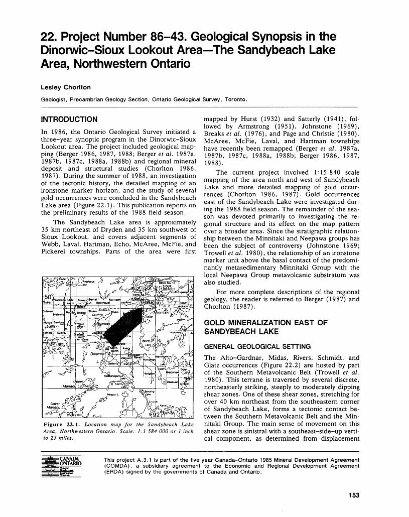
22. Project Number 86-43. Geological Synopsis in the Dinorwic-Sioux Lookout Area The Sandybeach Lake Area, Northwestern Ontario
Lesley Chorlton
Geologist, Precambrian Geology Section, Ontario Geological Survey, Toronto.
INTRODUCTION
In 1986, the Ontario Geological Survey initiated a three-year synoptic program in the Dinorwic-Sioux Lookout area. The project included geological map ping (Berger 1986, 1987, 1988; Berger et al. 1987a, 1987b, 1987c, 1988a, 1988b) and regional mineral deposit and structural studies (Chorlton 1986, 1987). During the summer of 1988, an investigation of the tectonic history, the detailed mapping of an ironstone marker horizon, and the study of several gold occurrences were concluded in the Sandybeach Lake area (Figure 22.1). This publication reports on the preliminary results of the 1988 field season.
The Sandybeach Lake area is approximately 35 km northeast of Dryden and 35 km southwest of Sioux Lookout, and covers adjacent segments of Webb, Laval, Hartman, Echo, McAree, McFie, and Pickerel townships. Parts of the area were first
Figure 22.1. Location map for the Sandybeach Lake Area, Northwestern Ontario. Scale: 1:1 584 000 or l inch to 25 miles.
mapped by Hurst (1932) and Satterly (1941), fol lowed by Armstrong (1951), Johnstone (1969), Breaks et al. (1976), and Page and Christie (1980). McAree, McFie, Laval, and Hartman townships have recently been remapped (Berger et al. 1987a, 1987b, 1987c, 1988a, 1988b; Berger 1986, 1987, 1988).
The current project involved 1:15 840 scale mapping of the area north and west of Sandybeach Lake and more detailed mapping of gold occur rences (Chorlton 1986, 1987). Gold occurrences east of the Sandybeach Lake were investigated dur ing the 1988 field season. The remainder of the sea son was devoted primarily to investigating the re gional structure and its effect on the map pattern over a broader area. Since the stratigraphic relation ship between the Minnitaki and Neepawa groups has been the subject of controversy (Johnstone 1969; Trowell e t al. 1980), the relationship of an ironstone marker unit above the basal contact of the predomi nantly metasedimentary Minnitaki Group with the local Neepawa Group metavolcanic substratum was also studied.
For more complete descriptions of the regional geology, the reader is referred to Berger (1987) and Chorlton (1987).
GOLD MINERALIZATION EAST OF SANDYBEACH LAKE
GENERAL GEOLOGICAL SETTING
The Alto-Gardnar, Midas, Rivers, Schmidt, and Glatz occurrences (Figure 22.2) are hosted by part of the Southern Metavolcanic Belt (Trowell et al. 1980). This terrane is traversed by several discrete, northeasterly striking, steeply to moderately dipping shear zones. One of these shear zones, stretching for over 40 km northeast from the southeastern corner of Sandybeach Lake, forms a tectonic contact be tween the Southern Metavolcanic Belt and the Min nitaki Group. The main sense of movement on this shear zone is sinistral with a southeast-side-up verti cal component, as determined from displacement
CANADA ONTARIO
This project A.3.1 is part of the five year Canada-Ontario 1985 Mineral Development Agreement (COMDA), a subsidiary agreement to the Economic and Regional Development Agreement (ERDA) signed by the governments of Canada and Ontario.
153
stocks
TDo'Era
n
Crossecho Lake Stock Gardnar Lake Stock Hartman Lake Stock Sandybeach Lake Stoc
M M MMU OX M
ro, metapyroxenite
fifiraO)raOD
oE ^a0. M TD ffi
.2 Sffi E1 •x ra u ra ^rlaeSi .a
Group: metamorphosed i wacke, feldspath
JCra'cc
ainly pyroclastic
E
line metavolcanic rocks,
rajera0ra
ilcanic complex)
u>
Neepawa Group central
*—
®
l-
0'z
tnn o o
ocra0o> ra *ZE0at ffi
TDCto oloEo
ffioe.
hern Volcanic Belt)
3
S\
mCO
ci3 oO ra SraQ.ffi ffiZ
herulitic, and subvolcar adiorite sheets with
a -5
1a metabasalt.locally metagabbro and rr
u0
fi3 in
TDc ra5z
3
subordinate felsic rhyodacite (SVB) o
oTD
ffi"o
C.cc
fi
D
?
1c Feldspathic ashflo'
S 3 rf — *" "*r -^";* 3 3 E5 33 55 E2ra ^ 5 - c ^ lO w T3 o c ^
Q) ^^
S 5o j:
R gb]
l
tt•*:
f Qtott*
ift. Q
S
l O tt 00
t3 tt
S "S. E
rM 34) U
l lOD "o
mi
I si1 " o g o e c P osl 8 *5lA JI * 5•*i nil fi ? s18 |EaS |S ! Ss5 25SS 55 t t
fi l fS l
"5. g 8 4t-c
•5•ii
J"o
l I-o v v. "CQ Q
o 8^•5 c;c o4s ^~ 21
SI
5 8.^5 oS?^ NSJ ^ •c ^
SI*
PRECAMBRIAN (22)
senses on narrow Riedel shears, sigmoidally folded en echelon vein sets, and steep to moderately south- west- or southeast-plunging lineations on steep phyl- lonitic foliations. The shear zone and its structures are overprinted by local Z-folding, and localized shearing and dextral faulting, both especially evident around the southern end of Sandybeach Lake where the shear zones and regional grain flex. Northeast erly striking shear zones with the same structural fabric geometries continue southwest into northeast erly striking zones of shear and ankerite alteration passing through Dinorwic Lake.
ALTO-GARDNAR OCCURRENCE
The Alto-Gardnar Occurrence (Figure 22.2) con sists of a quartz-minor ankerite vein system entirely enclosed in a 10 m wide shear zone overprinting metabasalt and an irregular network of small, sub volcanic dacite or trondhjemite intrusions. The mafic metavolcanic rocks are transformed into chlo- rite-ankerite schists, some of which were periodi cally flooded with Fe-carbonate and ankerite- quartz stringers during the duration of the shearing. In several trenches, these schists are locally bleached and rusty, containing fine disseminations of pyrite. The subvolcanic dacite, in various stages of transformation into sericite schist, is rarely pyritized. The larger veins of the system are composed domi- nantly of quartz accompanied by minor ankerite. Py rite is the main sulphide vein mineral, in places ac companied by chalcopyrite or galena. Berger e t al. (1987b) reported an assay of 3460 ppb Au and 301 ppm Cu from one of the largest quartz veins. A grab sample of the rusty schist yielded 350 ppb Au (Geoscience Laboratories, Ontario Geological Sur vey, Toronto).
The system of quartz and carbonate veins and deformed subvolcanic dacite bodies in the Alto- Gardnar shear zone is exceptionally complex (Figure 22.3), and the indicators of its initial sense of dis placement may have been obscured by the strong imprint of later deformation. Steeply southeasterly to northwesterly dipping phyllonitic foliations and strong lineations plunging either steeply southwest or east-southeast to southeast, depending on the dip direction of the main foliation, are characteristic of this shear zone. The main foliation is folded by small-scale, gently to steeply northeast-plunging S- folds and moderately southwest-plunging Z-folds. Two large-scale Z-folds, accompanied by several minor, shear parallel faults, affect the shear zone and vein system as a whole (Figure 22.3). The late quartz veins strike counterclockwise to, and dip southeast of the main, phyllonitic foliations of the shear zone, and are sigmoidally folded about gently northeasterly plunging hinges with an S-asymmetry on both the horizontal plane and on the vertical plane looking northeast. Consideration of all data favours the interpretation that, after an uncertain early history, there was a major period of predomi
nantly southeast-side-up, subordinately sinistral shear followed by a late period of deformation which produced the Z-folds and late faults.
MIDAS OCCURRENCE
The Midas Occurrence (Figure 22.2), where two shafts were sunk, is composed of a chlorite-ankerite schist zone up to 5 m wide cut by metre scale quartz veins (site of the western shaft), bordered to the east by profusely quartz veined, variably foliated, car- bonatized metabasalt (site of the eastern shaft). Py rite is the main sulphide mineral in the quartz veins, accompanied by chalcopyrite, malachite, and ankerite. A grab sample of vein from the western shaft assayed 2350 ppb Au and 208 ppm Cu, and a similar vein sample from the eastern shaft assayed 590 ppb Au and 320 ppm Cu (Geoscience Labora tories, Ontario Geological Survey, Toronto). Berger et al. (1987a) reported an assay of 1030 ppb Au and 345 ppm Cu for a vein sample from the eastern shaft. Pyrite is disseminated locally in the car- bonatized wall rock, especially in the western, schis tose zone. Tourmaline (schorl) occurs in the altered wall rock and replaces mafic xenoliths in the veins.
Two quartz veins exposed on the walls of the western shaft dip southeast of the phyllonitic folia tions, the later one shallowly, and are sigmoidally folded with S-asymmetry on the plane of northeast vertical wall of the shaft. The phyllonitic fabrics of the schists dip moderately to steeply southeast with a southeast-plunging, down-dip lineation. Both struc tural relationships support a predominantly south east-side-up displacement sense.
RIVERS OCCURRENCE
The Rivers Occurrence (Figure 22.2) is hosted by massive and pillowed metabasalt cut by subvolcanic dacite or trondhjemite bodies. These rocks are mod erately to mildly foliated, with a few localized zones of intense foliation and faint steeply southwest- plunging lineation. Numerous, planar to mildly cur viplanar quartz veins infiltrated the northeasterly striking, steep foliation and north-northeasterly to northerly striking fractures. Inconsistent crosscutting relationships suggest that both foliation and fracture planes were opened and filled nearly simultaneously. The array of structural observations suggests that the Rivers vein system may be situated in a structural panel or horse adjacent to major shear zones similar to the Midas and Alto-Gardnar shears, and that the quartz veins and mineralization infiltrated already existing foliations and fractures upward and laterally from these shears.
These veins consist of quartz, rarely accompa nied by ankerite, and contain pyrite, sphalerite, ga lena, and chalcopyrite as sulphide minerals. A grab sample of vein assayed 5510 ppb Au and 0.32 ounce per ton Ag (Geoscience Laboratories, Ontario Geological Survey, Toronto). The metabasalts are heavily calcified, and locally pyritized and silica-
156
LESLEY CHORLTON
flooded next to veins, especially at contacts with fel sic intrusive rocks. Ankeritization of wall rock is un common.
SCHMIDT OCCURRENCE
The Schmidt Occurrence (Figure 22.2) is hosted by metabasalt and felsite displaying intense iron car bonatization, and abundant veins in phyllonitic schists with subvertical lineations and local steeply plunging folds of the strong foliation. Ankeritized wall rock and numerous quartz and ankerite veins contain abundant sphalerite, galena, and pyrite. Grab samples of sulphide-bearing quartz vein yielded 0.82 and 0.39 ounce per ton Au, and car- bonatized felsite yielded 3.57 ounces per ton Au (Geoscience Laboratories, Ontario Geological Sur vey, Toronto). The metabasalt is brecciated and cal cified beside the ankeritized zone.
GLATZ OCCURRENCE
Mafic metavolcanic rocks at the Glatz Occurrence (Figure 22.2) were fractured and veined with quartz before the intrusion of fine feldspar-phyric granitoid rock. Both rocks were subsequently ankeritized and pyritized. On the northwestern side of the occur rence, a mafic dike intruded rebrecciated, ankeritized granitoid rock. Assays of 3090 ppb Au and 4330 ppb Au (Geoscience Laboratories, On tario Geological Survey, Toronto) were obtained from grab samples of pyritized metabasalt and granitoid rock, respectively. A relatively minor, northeasterly striking shear zone with southwesterly plunging lineations is located southeast of the occur rence.
SUMMARY
Gold mineralization in all of the occurrences de scribed above is related to northeasterly striking shear zones. At the Alto-Gardnar, Midas, and Schmidt occurrences, quartz veining and alteration was focused syntectonically along individual shear zones. Vein mineralization at the Rivers Occurrence occurred during activity on a neighbouring shear zone, which may have been the main hydrothermal conduit. At the Glatz Occurrence, quartz veining, followed by granitoid emplacement, preceded the carbonatization and pyritization associated with gold, and the shear zone is located to one side. The brecciation prominent at both Schmidt and Glatz oc currences may have enhanced the focusing of mineralization.
CHARACTER AND SETTING OF THE BASAL IRONSTONE
GENERAL GEOLOGICAL SETTING
The ironstone occupies the boundary between the metavolcanic Neepawa Group and the mainly
metasedimentary Minnitaki Group (Figure 22.2). The Minnitaki Group in this area is composed mainly of metagreywacke, with numerous interbeds of quartzofeldspathic volcanogenic sandstone, crys tal-lithic tuff, and feldspathic ashflow deposits, and less common flows and dikes of metaandesite to metabasalt. The Neepawa Group in this area is com posed of a lower division consisting of tholeiitic metabasalt with subordinate metarhyodacite and metarhyolite, and an upper division consisting of metamorphosed calcalkalic dacite, andesite, and ba salt with a large proportion of pyroclastic rocks in a central volcanic complex concentrated between Crossecho and Beartrack lakes (Figure 22.2). Where juxtaposed, the Minnitaki Group overlies rocks of the lower division of the Neepawa Group, an extensive dacitic ashflow in the northern part of the area, and mafic with subordinate felsic metavol canic rocks in the south. The relative ages of the upper Neepawa central volcanic complex and the Minnitaki Group are uncertain. All units have been subjected to multi-phase deformation and greenschist to amphibolite facies metamorphism.
MAGNETITE-CHERT IRONSTONE
The ironstone consists of recrystallized magnetite- chert ironstone throughout most of the area. Cen timetre-scale banding and millimetre-scale lamina tion are marked by variable amounts of fine grained, wispy magnetite and amphibole. A distinc tive intraformational breccia interbed, composed of flaggy chert fragments in a magnetite-rich am phibolide matrix, can be traced throughout the northern half of the area. The northern exposure of ironstone at the Standon Occurrence on San- dybeach Lake (Figure 22.2) is relatively magnetite rich, and shows only millimetre-scale laminations.
The upper contact of the magnetite-chert iron stone with the metasedimentary rocks is clearly tran sitional. In the southern half of the region, it consists of magnetitic chert bands interbedded with meta- greywacke, and, in places, amphibolite or am phibolide wacke. Massively bedded, rusty weather ing, feldspathic wacke, and rarely, banded argillite, both with local chert bands, overlie the ironstone north of Sandybeach Lake and west of Laval Lake. One or more sill-like bodies of fine-grained meta- gabbro with local metapyroxenite were emplaced along the Minnitaki Group-lower Neepawa Group contact zone mainly above the ironstone (Figure 22.2). Diamond-drill records (Assessment Files, Resident Geologist's Office, Ministry of Northern Development and Mines, Sioux Lookout) and sur face exposures suggest that the metagabbro may have intruded the ironstone and the underlying metavolcanic rocks west of Pickerel Arm.
The lower contact of the magnetite-chert iron stone with the lower Neepawa Group metavolcanic rocks is abrupt, although the underlying dacitic ashflow locally shows alteration near the contact
157
PRECAMBRIAN (22)
which may be linked to the presence of the iron stone. Near the Golden Rod shaft (Figure 22.2), the dacitic ashflow below the ironstone exhibits patches of intense sericitization surrounded by nebulous patches enriched in amphibole, chlorite, and por phyroblastic magnetite. At the northern end of San dybeach Lake, this ashflow locally shows similar patchy sericitization, in both sharp and diffuse con tact with lenses, patches, and even bands, of gar netiferous, variably pyrrhotitic amphibolite (Photo 22.1).
Around the northern perimeter of Sandybeach Lake, these altered ashflow tuffs were locally strongly foliated premetamorphically (Stage l defor mation outlined below), resulting in tectonically banded feldspathic gneiss consisting of variably gar netiferous quartzofeldspathic bands with local layers enriched in coarse amphibole porphyroblasts, in both gradational and sharp contact with bands of garnet-rich amphibolite. The porphyroblasts of gar net and amphibole overprint the Stage l foliation, and were likely the products of peak metamorphic recrystallization (Stage 2) of an pre-existing chloritic, sericitic, and/or carbonaceous alteration, which must have post-dated Stage l because altered patches showed no specific localization along the Stage l fabrics and high strain zones. Although metamorphically recrystallized, the composition and uneven distribution of the mafic alteration are remi niscent of the broadly distributed regional alteration zones reported underneath or surrounding alteration pipes associated with base-metal massive sulphide deposits (Franklin e t al. 1981).
PYRRHOTITIC IRONSTONE
The banded magnetite-chert ironstone can be fol lowed from the north-central part of the area for at least 2 km southwest of Tablerock Lake, into the
southeastern side of a prominent north-northeast erly striking shear zone which follows the contact with metavolcanic rocks. Four kilometres to the southwest, another type of ironstone appears within and along the northwestern side of the shear zone. This ironstone consists of thickly bedded to massive felsic volcaniclastic rock in which a dark, pyrrhotite- rich matrix surrounds felsic spherulites and cobble- sized rhyolite breccia fragments. Smaller siliceous breccia fragments show up indistinctly on fresh sur faces of the matrix, which may contain up to 40 per cent pyrrhotite. Porphyroblastic garnet is developed locally. Diamond drilling of airborne geophysical anomalies along the Minnitaki Group-Neepawa Group contact encountered pyrrhotite facies iron stone southwest of Gardnar Lake (Berger et al. 1988a). Bedded spherulitic rocks exposed to the west of the Gardnar Lake Stock also contain minor pyrrhotite. Structural attitudes suggest that they could all be part of the same horizon.
Along the northwestern side of the pyrrhotitic ironstone, pillowed and massive metabasalt show in- homogeneously developed patches of grey-white sericitic alteration contrasting with dark green chlo- rite-actinolite rich seams and patches. This is also reminiscent of the alteration broadly distributed around base-metal deposits described by Franklin et al. (1981). Sulphide-bearing interpillow material in one of the outcrops of pillowed metabasalt near the pyrrhotitic ironstone horizon yielded 1180 ppm Cu, 6750 ppm Zn, and 50 ppb Au (Berger et al. 1988a), and a grab sample of pyrrhotitic ironstone gave an assay of 149 ppm Cu, 1680 ppm Pb, and 410 ppm Zn (Geoscience Laboratories, Ontario Geological Survey, Toronto). It is tentatively pro posed that the alteration of the metabasalt and the formation and/or sulphide mineralization of this
Photo 22.1. Metamorphosed (garnetized) patchy chloritic and/or carbonaceous, pyrrhotitic alteration of dacitic ashflow north of Sandybeach Lake.
158
LESLEY CHORLTON
ironstone are products of hydrothermal activity po tentially related to base-metal mineralization.
Attention should be drawn here to the overall configuration of the ironstones, the alteration, and the central calcalkalic volcanic complex, which field relations permit to be equivalent in age to deposition of sediments and volcanics in the Minnitaki basin. If this timing is correct, the alteration style described above on the flanks of a domed or collapsed vol canic centre should indicate potential for more sub stantial massive sulphide mineralization (Franklin et al. 1981; Knuckey et al. 1982).
GOLD POTENTIAL OF THE IRONSTONE
Although no anomalous gold values have yet been obtained from the pyrrhotitic ironstone, anomalous gold values have been reported in samples of the magnetite-chert ironstone which contain minor py rite and arsenopyrite. Pyrite and arsenopyrite re place fine-grained magnetite adjacent to quartz veinlets in the ironstone at the Standon Occurrence from which Berger et al. (1987a) collected a gf ab sample yielding 1620 ppb Au. Johnstone (1969) ob tained an assay of 0.01 ounce per ton Au from a grab sample taken from the dump of the Golden Rod shaft, where minor porphyroblastic pyrite par tially replaces fine-grained magnetite.
In general, the pyrite appears as nodular con centrations, and as fracture, parting, and foliation plane fillings, especially where the ironstone is tightly folded. Underlying rocks may be sporadically pyritized in a similar fashion, for example at Tom Chief Lake. South of Franciscan Lake, sulphide oc curs along fractures in the metagreywacke above the ironstone. In a late fault zone at Tablerock Lake, ironstone is almost completely pyritized, and only tiny, relict, magnetite-chert ironstone chips are still recognizable.
From its modes of occurrence, the pyrite in the magnetite chert ironstone appears to have been in troduced during the later stages of deformation. Be cause the same late stage deformation controlled gold mineralization in the metavolcanic terrane (Chorlton 1987), the presence of pyrite might be used as a favourable indicator in exploring the iron stone for gold.
TECTONIC DEVELOPMENT
DEFORMATION STAGES
The results of this and previous work during this pro ject suggest that the tectonic development post-dat ing volcanism and sedimentation occurred in four major stages, each responsible for a variety of struc tural effects. These stages and their effects are sum marized as follows:
Stage 1 - Premetamorphic Deformation1—This stage resulted in the inhomogeneous devel opment of gently to moderately dipping foliations, and localized shear zones, the latter being most prominent between Gardnar and Troutfly Lakes, and around the northwestern end of Sandybeach Lake. It is not known whether regional lineations were formed during the first deformation. Stage l foliations show only slight inclination to bedding and lithological contacts for the most part, and are axial planar to several fold hinges defined by the Min- nitaki-Neepawa Group contact and the ironstone at northeasterly plunging northeastern end of a later doubly plunging antiform in the Stage l foliation (Figure 22.2, arrows).
Stage 2 - Deformation Related to Emplacement of Plutons2—The emplacement of the Crossecho Lake, Gardnar Lake, Hartman Lake, and Sandybeach Lake granitoid stocks produced localized structural effects on the country rocks. Narrow, steep contact dynamothermal aureoles were formed around the smaller Crossecho and Gardnar Lake stocks, and wide contact zones and thermal aureoles about the larger Sandybeach Lake and Hartman Lake stocks. Broad-scale differential rotation probably occurred outside the dynamothermal aureoles of all of the stocks. Mineral lineation may have formed at this stage, which coincided with the attainment of meta morphic peak temperatures and recrystallization. The predominant regional southwesterly trends of the lineations in the country rock are similar to the lineations defined by hornblende in the Sandybeach Lake Stock. Extension lineations could have been either formed, or modified from Stage l lineations.
Stage 3 - Southeast-Northwest Regional Shortening and Concomitant Oblique-Slip3a—During the third stage of deformation, earlier primary markers and tectonic fabrics were deformed into large amplitude folds and isoclinal parasitic folds. The doubly plunging antiform-synform in the early fabrics, nearly coincident with the dome and saddle structure defined by the ironstone and the metasedimentary-metavolcanic contact in the north ern half of the area (Figure 22.2), belongs to this deformational event. The large-scale folds are fairly open due to the buttressing effect of the Sandybeach Lake Stock; similarly, rolls in earlier foliation are relatively open in the lee of the Gardnar Lake Stock. Elsewhere in the area, Stage 3 folds are es sentially isoclinal, and commonly display a large variation in plunge. Overprinting or modification of both extension and mineral lineations may have oc curred during this stage, during which peak meta morphic conditions persisted.3b—The folding coincided with the development of steep, northeasterly striking shear zones which are primarily sinistral in horizontal component. An
159
PRECAMBRIAN (22)
equal to predominant southeast-side-up vertical shear characterizes the main stages of shear on the shear zones east of Sandybeach Lake. West of San dybeach Lake, the main shear zones are broadly spaced, and local rotated porphyroclasts and en echelon arrays of sigmoidal extension gashes suggest a greater lateral component of shear.3c—Fracturing and quartz vein emplacement, ac companied locally by carbonatization and albitiza tion related to gold mineralization, occurred during ongoing development of shear zones, rotation and shear strain of the terrane between shear zones, and tightening of the Stage 3 folds.
Stage 4 - Further Regional Shortening and Oblique-Slip4a—During Stage 4, Stage 3 foliations, shear zones, earlier folds and lithological contacts were over printed by small- and medium-scale folds about northeasterly to north-northeasterly striking axial planes and crenulations. Because the regional grain prior to Stage 4 was predominantly clockwise to these planes, they are predominantly Z-folds. Where the prior fabrics were acutely counterclock wise or perpendicular, the folds show S- or M- asymmetry, respectively.4b—Late, northwesterly to westerly striking shear zones of short strike length overprinted earlier shear zones, folds, and fabrics. Their displacement sense was dextral with an unknown vertical component. Minor conjugate, northwesterly and northerly to north-northeasterly striking shear fractures are also common.
INFLUENCE ON THE MAP PATTERN
The superposition of Stage 3 folds and shear zones, folded or refolded by subordinate Stage 4 folds, on
the moderately to gently dipping envelope of the stratigraphy (and early foliations) are the main con trols on the map pattern. In the northern part of the area, the traces of the main metasedimentary-meta- volcanic contact, the ironstone, and the metagabbro intrusions define a doubly plunging, upright anti- cline-syncline pair which roughly coincides with a Stage 3 antiform-synform in the early, premetamor- phic foliation (Figure 22.2). Parasitic to this an tiform-synform structure are local isoclinal folds, most prominent at Tom Chief Lake and the Golden Rod Shaft, and responsible for outliers of meta- sedimentary rock in shallowly plunging, synformal keels south of Tom Chief Lake.
South and southwest of Sandybeach Lake, ir regular metasedimentary wedges and bands appear to interdigitate with mafic metavolcanic rocks on the map. Based on the assumption that they were all south-facing, Satterly (1941) defined these bands, as well as the Neepawa Group, as four individual stratigraphic formations: Brownridge volcanics, Thunder Lake sediments, Thunder River volcanics, and Zealand sediments. However, the metasedimen tary rocks are identical to those of the Minnitaki Group, and the metavolcanic rocks resemble am- phibolitized mafic flows of the lower Neepawa Group. Numerous Stage 3 isoclinal S-, M- or W-, and Z-folds, refolded more openly by Z-folds, were observed within all of the metasedimentary tracts (Figure 22.2 and Photo 22.2). Reversals in facing are thus clearly indicated. The interfingering on the map plane is therefore interpreted as the result of the Stage 3 isoclinal folding of a single, originally moderately or gently dipping, metasedimentary- metavolcanic contact. Variations in plunge probably produced the beginning of a dome and basin pat tern. Stage 4 Z-folds and shear zones accentuated
Photo 22.2. Open Stage 4 Z-folding of Stage 3 isoclinal folding of feldspathic beds in metagreywacke and a strong earlier foliation in a metasedimentary inlier west of Hartman Lake.
160
LESLEY CHORLTON
the pronounced variations in plunge of the earlier folds and the irregularities of the contact pattern.
SIGNIFICANCE TO MINERAL EXPLORATION
Four major points may be useful to those engaged in mineral exploration:1. This study provides further support for the base-
metal potential of the lower Neepawa Group sur rounding the central volcanic complex northwest of Sandybeach Lake, particularly in the vicinity of spherulitic tuff horizons, the pyrrhotitic iron stone, and the contact zone between the Neepawa Group and the Minnitaki Group. The pyrrhotitic ironstone itself locally shows indica tions of base-metal mineralization, and altered rocks underlying both the pyrrhotitic and mag netite-chert ironstones may also be worthy of in vestigation for base metals.
2. The doubly plunging, antiform-synform struc tures, the local tight parasitic folds, and potential outliers of younger rocks in saddles or crests may be factors to consider in exploration, not only in searching for structural settings favour able for gold, but for investigating specific strati graphic horizons, positioning diamond-drill holes, and interpreting core logs. Attention should be paid to the pattern defined by the nearest contacts with the metasedimentary tracts when exploring metavolcanic rocks. The geome try of mesoscale folds visible in those meta sedimentary tracts, although admittedly com plex, might also prove useful.
3. Gold mineralization is mainly controlled by Stage 3 shear zones, folds, and fracture zones. Outside of the terrane intruded by major grani toid stocks, most of the gold occurrences are found along shear zones. In the northeast-strik ing shear zones east of the Sandybeach Lake Stock, gold occurs in major systems of quartz veining, iron carbonatization, and sulphide mineralization. To the northwest of the stocks, auriferous mineralization is also clearly focused along steep shear zones at Beartrack Lake (Chorlton 1987). In the area intruded by the granitoid stocks west of Sandybeach Lake, the most important gold occurrences to date (Cam- reco-Goldlund Mine) accompany transverse vein sets and stockworks hosted mainly by sub volcanic intrusive sheets fractured during Stage 3 folding, rotation, and unfocused shear, rather than being focused along discrete shear zones themselves (Chorlton 1987). Throughgoing shear zone development may have been inhib ited by the presence of the large stocks. How ever, a carbonatized shear zone, quartz vein style of potentially auriferous mineralization re sumes to the northeast around Pickerel Arm.
4. The ironstone may host gold mineralization, particularly where pyritized in and around Stage 3 isoclinal fold hinges and shear zones.
ACKNOWLEDGMENTSJaroslav Yaworsky, Chris Bath, and Kathy Proctor are thanked for their able assistance in the field. The author is extremely grateful to Althea George and her family for their kindness and wonderful ac commodation.
REFERENCESArmstrong, H.S.1951: Geology of Echo Township; Ontario Department of
Mines, Annual Report for 1950, Volume 59, Part 5, 40p. Accompanied by Map 1950-1, scale 1:12 000.
Berger, B.R.1986: Melgund Lake Area, District of Kenora; p.61-65 in
Summary of Field Work and Other Activities 1986, by the Ontario Geological Survey, edited by P.C. Thurston, Owen L. White, R.B. Barlow, M.E. Cherry, and A.C. Colvine, Ontario Geological Survey, Miscellaneous Paper 132, 435p. Accompa nied by l Chart.
1987: Laval and Hartman Townships Area, District of Kenora; p.84-89 in Summary of Field Work and Other Activities 1987, by the Ontario Geological Sur vey, edited by R.B. Barlow, M.E. Cherry, A.C. Col vine, Burkhard O. Dressler, and Owen L. White, Ontario Geological Survey, Miscellaneous Paper 137, 429p.
1988: Geology of the Melgund Lake Area, District of Kenora; Ontario Geological Survey, Open File Report 5680, 184p. Accompanied by Maps P.3068-P.3070.
Berger, B.R,, McMillan, D., and Butler, G.1987a: Precambrian Geology of the Melgund Lake Area,
McAree Township, Kenora District; Ontario Geologi cal Survey, Map P. 3068, Geological Series-Prelimi nary Map, scale 1:15 840 or l inch to 1/4 mile. Geol ogy 1986.
1987b: Precambrian Geology of the Melgund Lake Area, MacFie Township, Kenora District; Ontario Geologi cal Survey, Map P.3069, Geological Series-Prelimi nary Map, scale 1:15 840 or l inch to 1/4 mile. Geol ogy 1986.
1987c: Precambrian Geology of the Melgund Lake Area, Avery Township, Kenora District; Ontario Geological Survey, Map P.3070, Geological Series-Preliminary Map, scale 1:15 840 or l inch to 1/4 mile. Geology 1986.
Berger, B.R., Stephenson, C., and Jeffrey, D.S.1988a: Precambrian Geology of Laval Township, District of
Kenora; Ontario Geological Survey, Map P.3108, Geological Series-Preliminary Map, scale 1:15 840 or l inch to 1/4 mile. Geology 1987.
1988b: Precambrian Geology of Hartman Township, District of Kenora; Ontario Geological Survey, Map P.3109, Geological Series-Preliminary Map, scale 1:15 840 or l inch to 1/4 mile. Geology 1987.
Breaks, F.W., Bond, W.D., Harris, N., Westerman, C.J.,and Desnoyers, D.W.
1976: Operation Kenora-Ear Falls, Sandybeach RouteLakes Sheet, District of Kenora; Ontario Division of
161
PRECAMBRIAN (22)
Mines, Preliminary Map P. 1204, Geological Series, scale 1:63 360 or l inch to l mile.
Chorlton, L.B.1986: Regional Setting of the Goldlund Mine, and Other
Gold Occurrences in the Cross Echo Lake Area, Northwestern Ontario; p.276-282 in Summary of Field Work and Other Activities 1986, by the Ontario Geological Survey, edited by P.C. Thurston, Owen L. White, R.B. Barlow, M.E. Cherry, and A.C. Colvine, Ontario Geological Survey, Miscella neous Paper 132, 435p. Accompanied by l Chart.
1987: Stratigraphy, Structural Development and Auriferous Mineralization in the Cross-Echo-Troutfly Lake Area, Northern Wabigoon Greenstone Belt, North western Ontario; p.72-83 in Summary of Field Work and Other Activities 1987, by the Ontario Geological Survey, edited by R.B. Barlow, M.E. Cherry, A.C. Colvine, Burkhard O. Dressler, and Owen L. White, Ontario Geological Survey, Miscellaneous Paper 137, 429p.
Franklin, J.M., Lydon, J.W, and Sangster, D.F.1981: Volcanic-associated Massive Sulphide Deposits; Eco
nomic Geology, 75th Anniversary Volume, 1981, p.485-627.
Hurst, M.E.1932: Geology of the Sioux Lookout Area; Ontario Depart
ment of Mines, Annual Report for 1932, Volume 41, Part 6, p. 1-33. Accompanied by Map 41h, scale 1:42 240 or 2 inches to 3 miles.
Johnstone, F.J.1969: Geology of the Western Minnitaki Lake Area, District
of Kenora; Ontario Department of Mines, Geological Report 75, 28p. Accompanied by Map 2155, scale 1:31 680 or l inch to 1/2 mile.
Knuckey, M.J, Comba, C.D.A., and Riverin, G.1982: Structure, Metal Zoning, and Alteration at the Mil-
lenbach Deposit, Noranda, Quebec; p.255-295 in Precambrian Sulphide Deposits, H.S. Robinson Me morial Volume, edited by R.W. Hutchinson, C.D. Spence, and J.M. Franklin, Geological Asso ciation of Canada, Special Paper 25, 791p.
Page, R.O., and Christie, B.J.1980: Lateral Lake (East Half), District of Kenora; Ontario
Geological Survey, Preliminary Map P.2372, Geologi cal Series, scale 1:15 840 or l inch to 1/4 mile. Geol ogy 1979.
Satterly, J.1941: Geology of the Dryden-Wabigoon Area, Kenora Dis
trict; Ontario Department of Mines, Annual Report for 1941, Volume 50, Part 2, 1941, p. 1-67. Accom panied by Map No. 50e, scale 1:63 360 or l inch to l mile.
Trowell, N.F., Blackburn, C.E., and Edwards, G.R.1980: Preliminary Geological Synthesis of the Savant Lake-
Crow Lake Metavolcanic-Metasedimentary Belt, Northwestern Ontario, and its Bearing upon Mineral Exploration; Ontario Geological Survey, Miscellane ous Paper 89, 30p. Accompanied by Chart A.
162
23. Project Number 88-23. A Stratigraphic Reconnaissance of the Eastern Wabigoon Subprovince
C.E. Blackburn 1 and G.W. Johns2
1 Resident Geologist, Ministry of Northern Development and Mines, Kenora.
2Geologist, Precambrian Geology Section, Ontario Geological Survey, Toronto.
PURPOSE
In order to gather data for the maps and reports of the Geology of Ontario compilation and plan further studies, a five day reconnaissance survey of the east ern Wabigoon Subprovince was made in early July 1988 (Figure 23.1). The internal parts of the su- bprovince were briefly examined to ascertain the major stratigraphic and structural relationships. This examination will allow the authors to compare and contrast the western and eastern Wabigoon Su bprovince. The area north of Highway 11 between Beardmore and Jellicoe was visited. The area of in terest adjoins the southern boundary of the Wabigoon Subprovince with the Quetico Sub
province, and is being studied by Williams (1986, this volume).
REGIONAL TERRANESFor the purpose of discussion it is convenient to in formally divide the area into terranes that constitute individual geologic entities with distinct rock types, structures, and possibly ages. Three regional subdivi sions can be made on the basis of structural and lithologic characteristics (Figure 23.2). It has been recognized that the east-trending Geraldton-Beard- more terrane is distinctly different from the two ter ranes to the north, and that the Paint Lake Fault (Figure 23.3) forms the north boundary of this ter-
\ Timers s-——' _,L j JwComSKr-—
yEva /BeardcQe (Vincent
Figure 23.1. Location map for the eastern Wabigoon Subprovince.
163
PRECAMBRIAN (23)
English River Subprovince *
O'SULLIVAN TERRANE
± Ombabika Batholith "*" , "*" ± OBOSHKEGAN-KOWKASH
EsVf -i- * 4- "*"Onaman Lake Batholith , "*"^S. "J l "t" T T
^Conglomerate Lake + + + conglomerate + + +
TASHOTA-+ ONAMAN 4-TERRANE +
+ + + + + ++ + + + +
+ + + + ++ + + +
+ + + ++ + +
+ + + ++ + +
+ + ++ +
GERALDTON-BEARDMORE
TERRANEkilometres
7^ i. ^4. "'"Quetico Subprovince *±*
Figure 23.2. Subdivision of the eastern Wabigoon Subprovince into terranes between Lake Nipigon and Geraldton. See Figure 23.3 for a complete legend.
rane (Devaney and Williams, in press). That part of the Wabigoon Subprovince to the north of the Paint Lake Fault has been here subdivided into the Tashota-Onaman terrane; and to the north of this, the Marshall-O'Sullivan terrane, which is marginal to the English River Subprovince. Most of the dis cussion herein is concerned with the Tashota- Onaman terrane.
GERALDTON-BEARDMORE TERRANE
The Geraldton-Beardmore terrane lies south of the Paint Lake Fault and north of the Quetico Su bprovince and comprises an east-trending sequence of three fault blocks consisting of mafic volcanic units and clastic sediment units intercalated with ironstones. This terrane is commonly considered to be the boundary zone between the Wabigoon and Quetico subprovinces. Currently, these units are in terpreted to be a northward-thrust sequence, with a component of dextral strike-slip movement, as cribed to northwest-southeast transpression (Wil liams 1986).
TASHOTA-ONAMAN TERRANE
The Tashota-Onaman terrane is similar to the west ern Wabigoon Subprovince in that it is predomi nantly a volcanic-plutonic terrane in which large crescentic areas of supracrustal rocks lie between ovoid granitic batholiths. Two such areas, the Elmhirst-Castlewood domain in the south and the Oboshkegan-Kowkash domain in the north (Figure 23.2) make up most of the terrane. They are joined by a narrow belt of volcanic rocks called the Onaman River Belt (Figure 23.2). Each domain is characterized by a major felsic volcanic centre, sur rounded by large areas of more mafic volcanic rocks, intruded by granitic to gabbroic stocks (Fig ure 23.3). Although the stratigraphic and structural relationship between the three parts of the terrane have not been interpreted at this time, a U-Pb age of 2764 +6/-S Ma for a felsic tuff in the Onaman River Belt (Osterberg e t al. 1987) indicates that these rocks may predate some of the rocks in the surrounding domains.
164
C.E. BLACKBURN, AND G. W. JOHNS
MARSHALL LAKE VOLCANIC
"~' GZOWSKI-OBOSHKEGAN 'VOLCANIC CENTRETerrane boundary
......" Domain boundary
—i— Stratigraphic tops
—4——t— Antiform, synform
ELMHIRST-RICKABY VOLCANIC CENTRE
x'v^-l Mafic with minor intermediate volcanics
Mafic, intermediate and felsic volcanics
Felsic volcanics
i^&S?;] Wacke, siltstone, chert and conglomerate
Gabbro and diorite
Granitoids
l l External ——— ' batholiths
10 20
kilometres
Figure 23.3. Generalized geology of the eastern Wabigoon Subprovince between Lake Nipigon and Geraldton.
MARSHALL-O'SULLIVAN TERRANE
The west-trending supracrustal sequence centred on Marshall Lake has been here designated the Mar- shall-O'Sullivan terrane (Figure 23.2). The north ern boundary of this terrane with the English River Subprovince is defined by a sequence of predomi nantly clastic sedimentary rocks and intercalated ironstones that define an east-trending belt north and east of the Marshall Lake volcanic centre (Fig ure 23.3) (Amukun 1985). Similar sedimentary se quences occur at Melchett Lake within the English River Subprovince to the north; and may have origi nally formed part of the Marshall-O'Sullivan ter rane.
TASHOTA-ONAMAN TERRANEThe reconnaissance work was confined to the south ern two thirds of this terrane, with access being pro vided by the Kinghorn Road and its subsidiary roads, and Highway 801. The Elmhirst-Castlewood do main and Onaman River Belt were examined across
several sections. Only a small portion of the south ern part of the Oboshkegan-Kowkash domain was visited, but some critical observations were made in this area which bear on the stratigraphic succession of felsic and mafic sequences.
A major consideration of this study was the stratigraphic relationship of surrounding mafic vol canics to the felsic volcanic centres in the Elmhirst- Castlewood domain and the Oboshkegan-Kowkash domain (Figure 23.2).
In the western Wabigoon Subprovince, volumi nous, platformal, lower mafic flow sequences are overlain by mixed mafic flow to felsic pyroclastic se quences, which in turn, are overlain in some places by another mafic flow sequence (Trowell et al. 1980). These relationships have been clearly docu mented by a multitude of facing criteria, substantial geochemical data, and geochronological data. In spection of previous Ontario Geological Survey re ports and maps of the Tashota-Onaman terrane sug gests that facing criteria are less readily available here than in the western Wabigoon Subprovince: to
165
PRECAMBRIAN (23)
date it has not been demonstrated that, in the Tashota-Onaman terrane, large areas of platformal mafic volcanics underlie the felsic volcanic centres.
ELMHIRST-CASTLEWOOD DOMAIN
The southwestern portion of this domain is underlain by a mafic volcanic sequence, synvolcanic gabbro, and an extensive accumulation of felsic volcanic rocks (Elmhirst-Rickaby felsic centre; Figure 23.3) into which three granitoid bodies have been intruded (Figure 23.2 and Figure 23.3). Top determinations by Mackasey and Wallace (1978) in the felsic vol canics in Pifher and Rickaby townships indicate that the felsic rocks are locally underlain by a mixed se quence of andesitic to basaltic flows, porphyries, and pyroclastic rocks interlayered with a lesser amount of more intermediate debris flows, porphyries, and flows. The abundance of amygdules, gas cavities, pil low breccia, and hyaloclastite indicate that these units were deposited mainly in a shallow water envi ronment. The felsic volcanic centre is mainly com posed of monolithologic quartz-feldspar porphyry and feldspar porphyry pyroclastic flows and lava flows. A highly spherulitic felsic flow in Rickaby Township is indicative of supercooled magma that may have erupted subaerially. This felsic volcanic centre is cut by mafic dikes that may be feeders for overlying flows.
In Lapierre Township, east of the Elmhirst- Rickaby felsic volcanic centre, large gas cavities, amygdules, and the lack of pillows within the mafic to intermediate flows indicate that this sequence was emergent. Here this sequence faces south; its stratigraphic relationship to the felsic volcanic centre in Elmhirst and Rickaby townships however, is not clear.
The mixed sequence of rocks underlying the fel sic volcanic centre is similar in its overall nature to the Upper Diverse Units found by the writers in the western Wabigoon Subprovince. We could not clearly demonstrate the presence of an extensive Lower Mafic Unit which is present in the western Wabigoon Subprovince (Trowell e t al. 1980).
In the Elmhirst-Castlewood domain, the mixed sequence of shallow water, mafic, and intermediate volcanics was intruded by several subcircular dioritic to gabbroic stocks. The Crooked Green Lake Stock (Figure 23.2), the only one checked by the authors, has imparted a pronounced foliation to the sur rounding volcanics, but is not itself foliated, suggest ing that it is syntectonic. Moorhouse (1939) inter preted the presence of large xenoliths in the stock as roof pendants and suggested that these stocks repre sent the upper portions of a deep-seated, unex- humed granitoid batholith.
At the north edge of the domain, a unique (to the eastern Wabigoon Subprovince) assemblage of clastic sediments overlies the volcanics at Conglom erate Lake (Figure 23.2). The sedimentary accumu
lation consists of conglomerate with sandstone in- terbeds, some of which contain crossbedding. The heterolithic conglomerate contains clasts representa tive of underlying volcanic rocks, including quartz- feldspar porphyries, cherty ironstones, and rocks de rived from the adjacent Onaman Batholith. It is clearly a post-volcanic accumulation and is possibly representative of a Timiskaming-type pull-apart ba sin.
Because of the paucity of facing criteria, little can be said of the fold pattern; but the emplacement of sub-rounded dioritic to gabbroic stocks suggests gentle doming rather than tight, isoclinal folding (Figure 23.3). At the eastern edge of the domain, a strong flattening foliation in pillow lavas and brec cias, parallel to the contact with the Onaman Batho lith, suggests compression by batholithic emplace ment in addition to doming.
ONAMAN RIVER BELT
The Onaman River Belt is a narrow, tightly-folded sequence of mafic flows, felsic pyroclastics, and ironstones forming a bridge between the Elmhirst- Castlewood domain and the Oboshkegan—Kowkash domain (Figure 23.2). Numerous top determinations by Thurston (1980) and by the authors during these investigations, suggest tight isoclinal folding about several northeast-trending fold-axes (Figure 23.3). The distribution of chert-rich ironstones near the northwest and southeast edges of the belt, suggests a synclinal structure for the belt. This structure, ex tended to the southwest, joins the synclinal axes of the sediments on Conglomerate Lake (Figure 23.2) in a triple-syncline junction (Figure 23.3).
OBOSHKEGAN-KOWKASH DOMAIN
A review of the literature (Mackasey and Wallace 1978; Amukun 1977, 1979, 1980a, 1980b, 1985, 1987; Kresz and Zayachivsky 1988) suggests that this domain is similar in many respects to the Elmhirst-Castlewood domain; the structural style is broad open folds with a felsic volcanic centre (the Gzowski-Oboshkegan volcanic centre; Figure 23.3). Relatively mature sediments, derived from the felsic and mafic volcanic rocks, cherts, and chert breccias (Amukun 1980a) appear to overlie the volcanic rocks.
The Gzowski-Oboshkegan felsic volcanic centre (Figure 23.3) is interpreted by the authors on the basis of available mapping (Amukun 1980a), to comprise volcanic domes with flanking talus or crumble breccia that give way to primary pyroclastic flows. In the southwest portion of the domain, the felsic volcanics are monolithic with matrix-sup ported feldspar to quartz-feldspar porphyry clasts in thick, massive beds. As little bedding was observed, these pyroclastic flows were interpreted to have been deposited rapidly in a proximal environment.
The syenodioritic to dioritic Deeds Lake Stock (Figure 23.3) bears a similarity to the Crooked
166
C.E. BLACKBURN, AND G. W. JOHNS
Green Lake Stock and other dioritic stocks in the Elmhirst-Castlewood domain, whereas other more felsic stocks are similar to those intruding the Elmhirst-Rickaby felsic volcanic centre.
Top determinations made during this reconnais sance work in the southwest corner of the domain indicate that mafic volcanics on either side of a felsic pyroclastic unit face away from that unit. This indi cates that an east-northeast-trending anticlinal structure is cored by the felsic rocks and the mafic volcanis overlie them (Figure 23.3). Opposing top determinations made by Amukun (1980a) in the clastic sediments in this area indicate a similar east- northeast-trending syncline in those rocks (Figure 23.3). Map patterns on map 2354 (Amukun 1977) suggest that by extension of the anticlinal axis through the felsic volcanics, that this axis has been refolded about a syncline (Figure 23.3). This series of interpretations contradicts a number of top deter minations in the pillowed volcanics made by Amukun (1977); however, it should be noted that top determinations made by the present authors in the road section at two separate localities also con tradict those determinations made at the same lo calities by Amukun (1977).
Observations outlined in the foregoing paragraph suggest that at least some of the mafic volcanics in the Oboshkegan-Kowkash domain overlie the felsic sequences.
STRATIGRAPHIC SUCCESSION, AND COMPARISON WITH THE WESTERN WABIGOON SUBPROVINCE
The shortage of unequivocal top determinations, coupled with low outcrop density, hinders the corre lation of units. Also, the lack of precise geo- chronological data makes stratigraphic analysis tenu ous. The evidence presented in the previous sections suggests that mafic volcanic sequences underlie and overlie the mafic and felsic to intermediate pyroclas tic and flow sequences within the Tashota-Onaman terrane. This mixed mafic and intermediate to felsic flow and pyroclastic sequence may also be similar to Upper Diverse units, and in these respects, the ter rane resembles the internal terranes of the western Wabigoon Subprovince. However, evidence for ex tensive basal mafic flow successions, similar to those found in the western Wabigoon Subprovince, is lack ing in the Tashota-Onaman terrane.
Late, post-volcanic clastic sediments with appar ent unconformities at their bases are present at both Conglomerate Lake (Amukun 1980b), and possibly at Knucklethumb Lake (Amukun 1977). Their lim ited extent is in sharp contrast to the western Wabigoon Subprovince, where the Manitou group and correlative sediments occur along a linear zone in excess of 100 km long (Blackburn 1982).
FELSIC PLUTONSDuring this reconnaissance work, little attention was given to the batholiths that occur along the margin of the Tashota-Onaman terrane. However, a few ob servations and comments are in order.
Three batholiths are external to the terrane: the Onaman Lake Batholith, the Ombabika Batholith (Lamaune Batholith (McCrank et al. 1981)) and the North Wind Lake Batholith (Figure 23.2). The latter was not visited during this reconnaissance study.
ONAMAN LAKE BATHOLITHClasts similar in texture and composition to phases of this batholith were observed in the conglomerates at Conglomerate Lake, indicating that the batholith was emplaced prior to deposition of the sediments.
A porphyry that occurs along the southern edge of the Onaman River Belt, in the vicinity of the Tashota Mine (Thurston 1980) appears to be a sub volcanic phase of the batholith. A traverse across the transition from the porphyry to the biotite granodiorite or trondhjemite of the batholith re vealed no sharp contact.
OMBABIKA (LAMAUNE) BATHOLITHThe Jackson Lake Stock, which is part of the Om babika (Lamaune) Batholith, and was observed along the road north of the Onaman River, is an unmetamorphosed quartz monzonite to grano diorite. There is no indication on Thurston's (1980) or Amukun's (1977) maps of marginal porphyry phases, as there is with the Onaman Lake Batholith. Ombabika (Lamaune) Batholith is therefore prob ably of later age than the Onaman Lake Batholith, and late tectonic rather than post-tectonic.
REFERENCESAmukun, S.E.1977: Geology of the Tashota Area, District of Thunder
Bay; Ontario Geological Survey, Report 167, 90p. Accompanied by Map 2354, scale 1:31 680 or l inch to 1/2 mile.
1979: Geology of the Willet Lake Area, District of Thunder Bay, Ontario Geological Survey, Report 183, 72p. Accompanied by map 2415, scale 1:31 680 or l inch to 1/2 mile.
1980a: Geology of the Gledhill Lake Area, District of Thun der Bay; Ontario Geological Survey, Report 198, 78p. Accompanied by Map 2412, scale 1:31 680 or l inch to 1/2 mile.
1980b: Geology of the Conglomerate Lake Area, District of Thunder Bay; Ontario Geological Survey, Report 197, lOlp. Accompanied by Map 2429, scale 1:31 680 or l inch to 1/2 mile.
1985: Geology of the Little Marshall Lake Area, District of Thunder Bay; Ontario Geological Survey, Open File Report 5561, 189p., 13 tables, 11 figures, 9 photos, and l map in back pocket.
1987: Geology of the Howard Falls Area, District of Thun der Bay, Ontario Geological Survey, Open File Report
167
PRECAMBRIAN (23)
5641, 115p., 7 figures, 11 tables, 15 photographs and Moorhouse, W.W.2 maps in back pocket. 1939: Geology of the South Onaman Area; Ontario Depart
ment of Mines, Annual Report for 1938, Volume 47, Blackburn, C.E. Part ^ 3Qp Accompanied by Map 47ht scale j inch1982: Geology of the Manitou Lakes Area, District of to l mile.
Kenora, (Stratigraphy and Petrochemistry); Ontario ^ A , 0 A **. r. r j r- i i- i**^ , . , o n ^^o ^- * - j T. Osterberg, S.A., Morton, R.L., and Franklin, J.M.Geological Survey, Report 223, olp. Accompanied byMap 2476, scale 1:50 000. 1987: Hydrotnermal Alteration and Physical Volcanology of
Archean Rocks in the Vicinity of the Headway-CouleeDevaney, J.R., and Williams, H.R. Massive Sulfide Occurrence, Onaman Area, North- In Press: Evolution of an Archean Subprovince Boundary: A western Ontario; Eco™™c G^logy, Volume 82,
Sedimentological and Structural Study of Part of the p. 1505 1520.Wabigoon-Quetico Boundary in Northern Ontario; Thurston, P.C.Canadian Journal of Earth Science. 1980: Geology of the North Onaman Lake Area, District of
Thunder Bay; Ontario Geological Survey, Report 208, Kresz, D.U., and Zayachivsky, B. 81p Accompanied by Map 2411, scale 1:31 680 or l1988: Geology of Barbara, Meader and Pifher Townships, inch to 1/2 mile.
District of Thunder Bay, Ontario Geological Survey, Tf Blackburn, C.E., and Edwards, G.R. Open File Report 5679, 240p., 23 figures, 14 tables, ^ ^05f , . Z . ' . ' . 6 , . 1980: Preliminary Synthesis of the Savant Lake-Crow Lake 28 photographs and 2 maps m back pocket. ,, , ~Metavolcamc-Metasedimentary Belt, Northwestern
Mackasey, W.O., and Wallace, H. Ontario, and its Bearing upon Mineral Exploration;irno /"i t ci i.- . j n- i u T u- T-V t - 4 Ontario Geological Survey, Miscellaneous Paper 89,1978: Geology of Elmhirst and Rickaby Townships, District . rt 6 . . , ^," A *
, rT,, 6' . n ~ - ^ i - i c. T, . 30P- Accompanied by Chart A.of Thunder Bay; Ontario Geological Survey, Report f r168, lOlp. Accompanied by Map 2373, scale Williams, Howard, R.1:31 680 or l inch to 1/2 mile. 1986: Structural Studies in the Beardmore-Geraldton Belt,
Northern Ontario: Grant 242; p.138-146 in Geos-McCrank, G.F.D., Misiura, J.D., and Brown, P.A. dence Research Grant program, Summary of Re- 1981: Plutonic Rocks in Ontario, Geological Survey of Can- search, 1985-1986, edited by V.G. Milne, Ontario
ada Paper 80-23, 171p. Geological Survey Miscellaneous Paper 130, 235p.
168
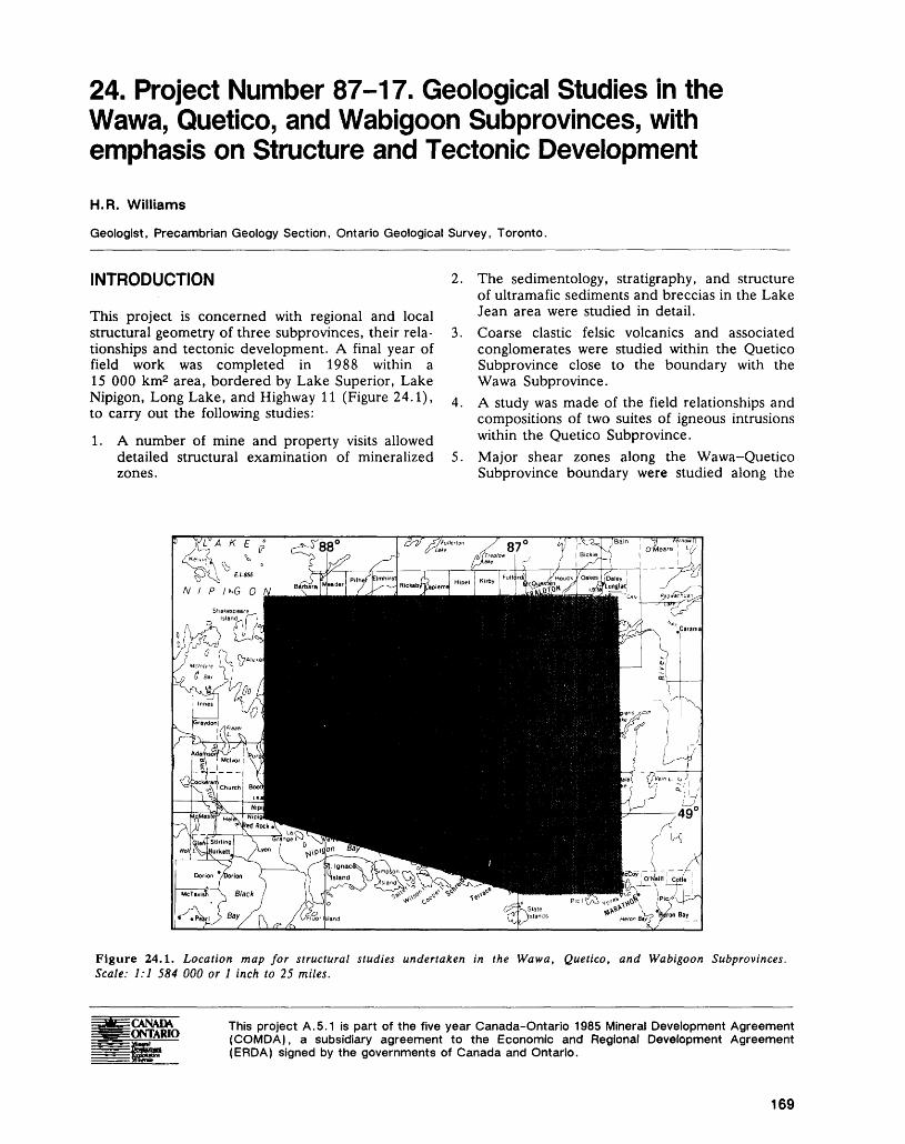
24. Project Number 87-17. Geological Studies in the Wawa, Quetico, and Wabigoon Subprovinces, with emphasis on Structure and Tectonic DevelopmentH.R. Williams
Geologist, Precambrian Geology Section, Ontario Geological Survey, Toronto.
INTRODUCTION
This project is concerned with regional and local structural geometry of three subprovinces, their rela tionships and tectonic development. A final year of field work was completed in 1988 within a 15 000 km2 area, bordered by Lake Superior, Lake Nipigon, Long Lake, and Highway 11 (Figure 24.1), to carry out the following studies:
1. A number of mine and property visits allowed detailed structural examination of mineralized zones.
The sedimentology, stratigraphy, and structure of ultramafic sediments and breccias in the Lake Jean area were studied in detail.Coarse clastic felsic volcanics and associated conglomerates were studied within the Quetico Subprovince close to the boundary with the Wawa Subprovince.A study was made of the field relationships and compositions of two suites of igneous intrusions within the Quetico Subprovince.Major shear zones along the Wawa-Quetico Subprovince boundary were studied along the
Figure 24.1. Location map for structural studies undertaken in the Wawa, Quetico, and Wabigoon Subprovinces. Scale: 1:1 584 000 or l inch to 25 miles.
CANADA ONTARIO
This project A.5.1 is part of the five year Canada-Ontario 1985 Mineral Development Agreement (COMDA), a subsidiary agreement to the Economic and Regional Development Agreement (ERDA) signed by the governments of Canada and Ontario.
169
PRECAMBRIAN (24)
Gravel River and Quetico Faults to determine kinematics and width of expression.
The newly acquired data has been incorporated into the tectonic scheme set out by Williams (1987) and Devaney and Williams (in press). A final report with accompanying geological maps at a scale of 1:250 000 will be completed in 1989.
GEOLOGY
MINE VISITS
The following four mine visits were made: the Ateba-Roxmark Property at the town of Geraldton, the Pan-Empire Joint Venture at the town of Beardmore, the Minnova Mine at Winston Lake (Schreiber), and the Geco Mine at the town of Manitouwadge.
The Roxmark Mine was visited to inspect the subsurface expression, continuity, and geometry of west-plunging asymmetric fold structures and associ ated veining characteristic of the Barton Bay Defor mation Zone. The observed changes in fold plunge and amplitude are commonly found in high-strain zones and demonstrate that the absence of poten tially ore-bearing fold structures at surface is an un reliable guide to deep subsurface structure.
At the Pan-Empire Mine within the Beardmore-Geraldton Belt, thin ^1 m) layers of ironstone within the southern mafic volcanic belt fo cus shearing to form complex fold geometries, in cluding sheaths that imply considerable strain. De spite fold thickening and complementary thinning by shearing, there is a remarkable continuity of iron stone layers demonstrable by geophysical means (A. Stearman, Geologist, A.C.A. Howe Interna tional Ltd., Toronto, personal communication, 1988). Considerable deformation was partitioned into the ironstone-bearing layers, leaving adjacent mafic volcanics relatively undeformed.
At the Winston Lake Mine, the schistose con tact between the hanging wall gabbro, ore zone, and altered footwall volcanics was examined and found to be highly sheared, with slip directions generally downdip of the schistosity. The sheared contact likely forms part of a zone of intense deformation, discontinuously preserved between Winston Lake and the town of Manitouwadge along the northern margin of the Wawa Subprovince.
The Geco Mine visit allowed lithological and structural complexities to be examined, especially for evidence of multiple deformation and its controls on ore orientation and location. Sulphide ore ap pears to be elongated along an early linear feature that is refolded by the Manitouwadge Synform. Sericitic alteration thought to be associated with ore deposition has focused later shearing, making ore/ structure relationships complex.
ULTRAMAFIC AND RELATED CHLORITIC SEDIMENTS
These were studied in detail in the Lake Jean and Namewaminikan River sections (Williams 1987), partly in conjunction with P.W. Fralick of the De partment of Geology, Lakehead University. On Lake Jean, feldspathic graded wackes pass upwards into pale- to medium-green chloritic arenites con taining evidence of climbing ripples, scours, and cross-lamination, succeeded by massive to graded chloritic wackes bedded on a decimetre scale. These are overlain by several tens-of-metres of ungraded, often massive, poorly stratified, ultramafic to ex tremely chlorite-rich sediments and breccias, con taining clasts of pale quartzitic sandstone. Vein-style alteration of the most chloritic rocks gives rise to a centimetre-scale lacework of quartz-carbonate veins. Within the chloritic ultramafic rocks, bedding is often tightly folded, atypical of the feldspathic wackes in the immediately surrounding rocks. Simi lar lithologies and stratigraphic relationships were found in the Namewaminikan River section.
The mafic and ultramafic sediments are thought to represent locally derived detritus developed from erosion of ultramafic protrusions within the Quetico sedimentary package. The magnesian composition of these rocks renders them difficult to detect other than by field methods. They do not appear on high- resolution magnetic maps.
SHEAR ZONES
Within the confines of the Quetico and Wawa Sub- provinces, two shear zones, the Gravel River Fault and the Killala Lake-Big Duck Lake Shear Zone, were investigated in detail. In addition, the Quetico Fault to the west of Lake Nipigon was recognized east of Dog Lake on the "Thunder Bay to Armstrong" Road (Highway 527).
The Gravel River Fault was mapped in the Dick ison Lake area, where additional evidence for sinis tral kinematics, such as asymmetric folds, crenula tion fabrics, and displacement of quartz veins, was found. The fault was active at least until during or after the migmatization of the metasedimentary rocks that are predominant in the area. Mylonitized, white, biotite granite and associated pegmatites attest to movement at least of late-Archean age on the fault. Lineations on the new planar fabrics within the zone of shearing are shallow plunging, both to the east and west. There is some evidence locally that grades of metamorphism in the surrounding meta- sediments are lower to the southeast of the fault than to the northwest. Initial oblique-reverse slip on a shallow, north-dipping precursor fault allowed it to be progressively rotated into verticality to be reacti vated as a purely sinistral transcurrent structure. A preliminary estimate of the amount of displacement on the fault is of the order of 70 km, as determined from offset of ironstone markers.
170
H. R. WILLIAMS
The Killala Lake Shear Zone was examined at Killala Lake, where it consists of a zone of highly strained supracrustal and felsic intrusive rocks on the southeastern side of the lake (Coates 1970). This zone of high strain is traceable eastwards along the northern edge of the Wawa Subprovince into the Manitouwadge area, and westwards into the Big Duck Lake Shear Zone. The zone broadly corre sponds with the most northerly outcrop of mafic rocks in the Wawa Subprovince. In addition, pre liminary data suggest that repetition of the greenstone supracrustal stratigraphy along the north ern margin of the Wawa Subprovince is in part due to imbrication by this nearly strata-parallel shear zone. The spatial association between mineralization and the high-strain zones occurring at and adjacent to this major tectonic boundary is in large part con trolled by lithology and alteration.
As part of a regional study of faults and shear zones, an expression of the eastward continuation of the Quetico Fault in the area east of Dog Lake (Kennedy 1984) was sought. Outcrops along the "Thunder Bay to Armstrong" Road (Highway 527) indicate a zone of high strain within both metasedimentary migmatites and orthogneisses. A strong foliation, oriented roughly east-west, and a complementary subhorizontal mineral and stretching lineation occur in conjunction with unambiguous kinematic indicators, such as extensional crenulation fabrics and asymmetric augen structures, demon strating that motion was predominantly dextral. Far ther east, the Quetico Fault, although hidden by Proterozoic sediments and intrusions, joins with the Wawa-Quetico Subprovince boundary in the area now occupied by St. Ignace Island, and might be the controlling tectonic factor for the location of Proterozoic igneous complexes (see Sutcliffe and Smith, this volume) in that area.
QUETICO GRANITOIDS
Two suites of granitoid intrusions within the Quetico Subprovince were studied and sampled for geo chemical and geochronological studies. The older suite is considered by Percival and Williams (in press) to be I-type; the younger, S-type, based on their petrological and geochemical similarity to rocks elsewhere in the Quetico Subprovince (Percival, in press; Kissin et al. 1986). It is anticipated that mi neralization associated with these granitoids would be of a different character.
The older suite consists of hornblende-biotite- magnetite-bearing, quartzo-feldspathic rocks that occur as steeply dipping, concordant sheets within the highest-grade portions of the Quetico Sub province. Some sheets have a narrow magnetic ex pression that coincides with their position and width; others occur within a complex pattern of regional magnetic linears which overemphasizes their width. Some bodies are insufficiently magnetic or extensive
across strike to develop a characteristic magnetic ex pression and were found only by detailed mapping in the inhomogeneous metasedimentary migmatite ter rane.
The younger suite of granitoids consists pre dominantly of biotite granite, with late aplitic and pegmatitic evolved phases. These may contain, as accessories, one or more of muscovite, tourmaline, garnet, apatite, and beryl. Occurrences of spodu mene, beryl, and rare-earth-bearing minerals within these granites might be expected in discordant, late- stage, geochemically evolved members of this suite. In the northern part of the Quetico Subprovince, these granites are discordant, hydrous, high-level in trusions, becoming increasingly concordant, de formed, and migmatized as the central high-grade core of the Subprovince is approached.
VOLCANICS AND ASSOCIATED CONGLOMERATES IN THE QUETICO SUBPROVINCE
Within 3 km north of the Wawa-Quetico Su bprovince boundary, just west of the "Terrace Bay to Geraldton" Road, a suite of conglomeratic rocks was discovered (Williams 1987) which lies along strike of some mapped by Coates (1970) in the Kil lala Lake area. North of the town of Terrace Bay, these rocks consist of several, metre-scale, generally monomictic conglomerates, mostly interbedded with arenaceous rocks. Some conglomerates, however, contain decimetre-sized clasts of uniform composi tion in a homogeneous, isotropic matrix that con tains more biotite and feldspar than the matrix of the conglomerates that are interbedded with arenite.
In the Killala Lake area, Coates (1970) mapped highly deformed conglomerate on both sides of an antiformal structure. These rocks are identical in ap pearance to those farther west, but the distinction between volcanic rock and derived sediment is not possible because of the strain and metamorphic re crystallization that they have suffered.
These conglomeratic rock suites are considered to be examples of proximal-facies volcanics and de rived sediments. Their presence indicates that the positioning of the stratigraphic boundary between the Wawa and Quetico Subprovinces at the north ernmost mafic unit detracts from the fact that poten tially mineralized lithologies occur north of this boundary.
DISCUSSIONField work, in association with ongoing laboratory studies, has enabled the erection of a model to ex plain the development of the belt-like subprovincial structure of this hitherto little-known region. The in terplay of lithology and structure, and their com bined relationship with mineralization, can now be placed within the context of a regional-scale tec tonic model of volcanic arc accretion. This model
171

PRECAMBRIAN (24)
may be compared with Phanerozoic and Proterozoic analogues, within which the distribution and devel opment of mineralization are well known.
ACKNOWLEDGMENTSConstructive criticism, and logistical and technical assistance by M. Dolan (Ontario Geological Survey, Toronto) and B. Schnieders (Ministry of Northern Development and Mines, Thunder Bay) are appreci ated.
REFERENCESCoates, M.E.1970: Geology of the Killala-Vein Lakes Area; Ontario De
partment of Mines, Geological Report 81, 35p. Ac companied by Colour Maps 2191 and 2192, scale 1:63 360 or l inch to l mile.
Devaney, J.R., and Williams, H.R.In Press: Evolution of an Archean Subprovince Boundary: A
Sedimentological and Structural Study of Part of the Wabigoon-Quetico Boundary in Northern Ontario; Canadian Journal of Earth Sciences.
Kennedy, M.C.1984: The Quetico Fault in the Superior Province of the
Southern Canadian Shield; Unpublished M.Se. The sis, Lakehead University, Thunder Bay, 280p.
Kissin, S.A., Zayachivsky, B., and Branscombe, L.A.
1986: Genesis of Pegmatites in the Quetico Gneiss Belt of Northwestern Ontario-Granitoids, "Barren" Pegma tites, and Metasediments, with Additional Data on Rare-Element Pegmatites, From the Georgia Lake Pegmatite Field; p.65-78 in Geoscience Research Grant Program, Summary of Research 1985-1986, edited by V.G- Milne, Ontario Geological Survey, Miscellaneous Paper 130, 235p.
Percival, J.A.
In Press: A Regional Perspective of the Quetico Belt, Superior Province, Canada; Canadian Journal of Earth Sci ences.
Percival, J.A., and Williams, H.R.
In Press: The Late Archean Quetico Accretionary Complex, Superior Province, Canada; Geology.
Williams, H.R.
1987: Structural Studies in the Beardmore-Geraldton Belt and in the Quetico and Wawa Subprovinces; p.90-92 in Summary of Field Work and Other Activities 1987, by the Ontario Geological Survey, edited by R.B. Bar low, M.E. Cherry, A.C. Colvine, Burkhard O. Dressler, and O.L. White, Ontario Geological Survey, Miscellaneous Paper 137, 429p.
172
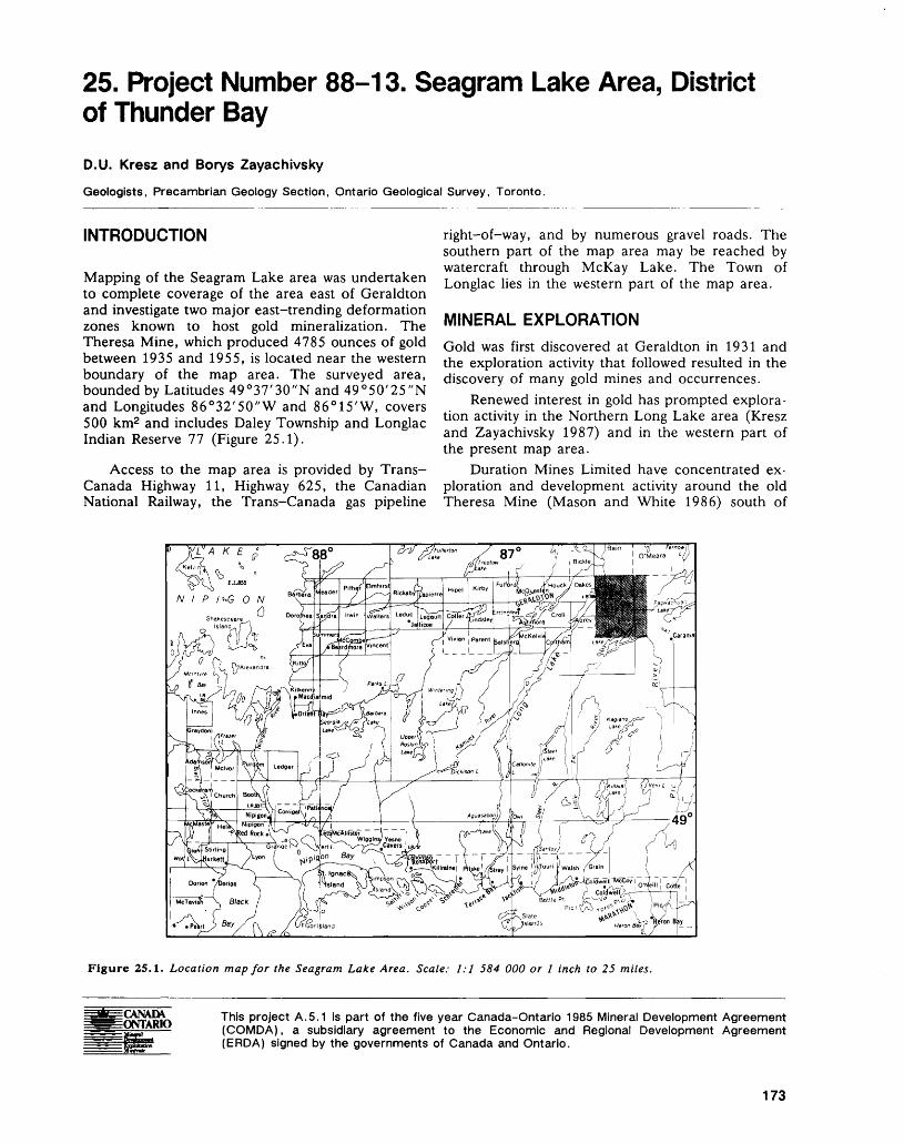
25. Project Number 88-13. Seagram Lake Area, District of Thunder BayD.U. Kresz and Borys Zayachivsky
Geologists, Precambrian Geology Section, Ontario Geological Survey, Toronto.
INTRODUCTION
Mapping of the Seagram Lake area was undertaken to complete coverage of the area east of Geraldton and investigate two major east-trending deformation zones known to host gold mineralization. The Theresa Mine, which produced 4785 ounces of gold between 1935 and 1955, is located near the western boundary of the map area. The surveyed area, bounded by Latitudes 49 0 37'30"N and 49 0 50'25"N and Longitudes 86 0 32'50"W and 86 0 15'W, covers 500 km2 and includes Daley Township and Longlac Indian Reserve 77 (Figure 25.1).
Access to the map area is provided by Trans- Canada Highway 11, Highway 625, the Canadian National Railway, the Trans-Canada gas pipeline
right-of-way, and by numerous gravel roads. The southern part of the map area may be reached by watercraft through McKay Lake. The Town of Longlac lies in the western part of the map area.
MINERAL EXPLORATIONGold was first discovered at Geraldton in 1931 and the exploration activity that followed resulted in the discovery of many gold mines and occurrences.
Renewed interest in gold has prompted explora tion activity in the Northern Long Lake area (Kresz and Zayachivsky 1987) and in the western part of the present map area.
Duration Mines Limited have concentrated ex ploration and development activity around the old Theresa Mine (Mason and White 1986) south of
Figure 25.1. Location map for the Seagram Lake Area. Scale: 1:1 584 000 or l inch to 25 miles.
This project A.5.1 is part of the five year Canada-Ontario 1985 Mineral Development Agreement (COMDA), a subsidiary agreement to the Economic and Regional Development Agreement (ERDA) signed by the governments of Canada and Ontario.
173
PRECAMBRIAN (25)
Longlac. Surface and underground diamond drilling followed the dewatering of the main shaft in 1987.
Discovery West Corporation holds a large claim block south and west of the Duration Mines Limited property. A power stripping, trenching, and sam pling program, mainly outside the present map area, was in progress in 1988.
Following the discovery of visible gold in quartz veins in Oakes Township by Bill and Rachel Brink- low (Prospectors, Manitouwadge, personal commu nication, 1987), Gold Crest Minerals Incorporated have acquired a claim block north of Longlac in 1988.
In 1958 and 1959, Can-Fer Mines Limited fol lowed by Hanna Mining Company and the Algoma Steel Corporation Limited in the 1960s examined the iron formations in the eastern part of the map area.
GENERAL GEOLOGY
The area (Figure 25.2) has been previously mapped by Fairbairn (1938) and Macdonald (1938). The area to the west was mapped by Kresz and Zayachivsky (1987), to the east by Amukun (1984), and to the south by Coates (1968). The map area is covered by aeromagnetic Maps 2150G Geraldton (ODM-GSC 1962a), 2151G Longlac (ODM-GSC 1962b), 2160G Pagwachuan Lake (ODM-GSC 1962c), and 2161G Castlebar Lake (ODM-GSC 1962d). Most of the map area is part of the eastern Beardmore-Geraldton Metavolcanic-Metasedimen- tary Belt (Mackasey 1970) and is situated within the eastern Wabigoon Subprovince, while the southeast ern part is within the northern Quetico Subprovince. The supracrustal rocks consist of metavolcanics and clastic metasediments. In Daley Township, several felsic to intermediate volcaniclastic units occur within mafic metavolcanics.
SUPRACRUSTAL ROCKS
Kresz and Zayachivsky (1987) have informally sub divided the supracrustal rocks into the northern, central, and southern volcanic units and the inter vening northern, central, and southern sedimentary units. These units are laterally continuous into the Seagram Lake area (Figure 25.2) with the exception of the northern sedimentary unit in the Northern Long Lake area that extends into Bickle Township.
The northern volcanic unit (Figure 25.2), meta morphosed to hornblende schists, consists of pil lowed basalts with interbedded intermediate to fel sic, heterolithic, lapilli-tuff and tuff-breccia.
The southern part of the central volcanic unit (Figure 25.2) consists largely of massive amyg daloidal basalt flows, whereas the northern part comprises mafic ash and plagioclase crystal tuff, and heterolithic lapilli-tuff and tuff-breccia.
The southern volcanic unit consists of pillowed basalt flows metamorphosed to hornblende schist.
Medium- to coarse-grained mesocratic synvol- canic gabbro dikes and sills intrude the volcanic units.
The southern sedimentary unit is continuous throughout the entire map area (Figure 25.2), while the central sedimentary unit is only exposed in Daley Township.
The central sedimentary unit consists of fine grained turbidites that develop a gneissic texture where they terminate in a granitic intrusion.
The southern sedimentary unit (Figure 25.2) consists of conglomerate, well-bedded massive to graded quartzofeldspathic arenite and wacke' that are characteristic of the resedimented associations found in submarine fans (cf. Walker 1984). Cen timetre to decimetre thick bands of magnetite iron formation intercalated with wacke, siltstone or arenite appear to have lateral continuity (ODM- GSC 1962a, 1962c). In the northwestern part of Seagram Lake, quartz arenite to quartz-rich arkose is associated with polymictic conglomerate. This polymictic conglomerate is found in several places along the northern part of the southern sedimentary unit. The southern part of the southern sedimentary unit consists of a monotonous sequence of locally garnetiferous wacke and siltstone.
South of McKay Lake, the sediments have been metamorphosed to coarse-grained mica schist and paragneiss with abundant granitic leucosome layers and form part of the Quetico sedimentary terrane (Figure 25.2). One northeast-trending band of iron formation has been found in coarse mica schist south of McKay Lake (Figure 25.2).
INTRUSIVE ROCKS
Within the volcanics, mafic intrusive rocks are typi cally represented by layer-parallel sills or dikes of mesocratic medium- to coarse-grained gabbro be lieved to be the intrusive equivalents of the mafic volcanics.
Mafic to ultramafic rocks are found as lenticular bodies associated with the southern sedimentary unit. These rocks consist of coarse-grained pyrox enite, pyroxene-phyric gabbro, medium-grained gabbro, and plagioclase-rich gabbro commonly found within a single lenticular body as a layered sequence. The discontinuous nature of these small bodies suggests they represent a dismembered lay ered sequence.
Quartz-feldspar and feldspar porphyry dikes and fine-grained aphyric felsic dikes are mainly found near Rockyshore Lake (Figure 25.2).
An irregular, metamorphosed granitic body within the central volcanic unit is composed mainly of diorite and quartz diorite intruded by tonalite and trondhjemite.
174
D. U. KRESZ AND BORYS ZAYACHIVSKY
Metavolcanics and related intrusions
Metasediments
Coat e-grained mica schists
Metamorphosed granitic rocks
Syenite
Syn- to post-tectonic granitic rocks
Burrows River Deformation Zone3ankfield-7bmbi!l Deformation ZoneNorthern volcanic unit Central volcanic unit Southern volcanic unit
Figure 25.2. Geological map of the Seagram Lake area.
CS Central sedimentary unit
SS Southern sedimentary unit
^** Iron formation
— — Fault
Stratigraphic facing
Stratigraphic facing with overturned beds
Syncline axis
Deformation zone boundary
A Gold occurrence
175
PRECAMBRIAN (25)
North of McKay Lake, an elliptical intrusion of pink syenite contains rafts of supracrustal rocks. The syenite, dominated by alkali feldspar, contains vari ous amounts of hornblende, biotite and magnetite, and is characterized by a strong magnetic anomaly (ODM-GSC 1962c). Around Seagram Lake (Figure 25.2), the supracrustal rocks have been injected by numerous veinlets and dikes of syenite and in places alkali feldspar has grown in clots. The syenide stock has foliated margins.
Four massive to foliated granodiorite and quartz monzonite intrusions occur within the map area.
Numerous north-, northwest-, and northeast- trending diabase dikes, some locally plagioclase por phyritic, crosscut all Archean rocks. Crosscutting re lationships among the diabase dikes have not been observed. One north-trending diabase dike has a high olivine phenocryst content.
Several small unmetamorphosed lamprophyre dikes and a carbonatized mica peridotite dike were found in the map area.
STRUCTURE AND METAMORPHISMThe overall structure of the map area is similar to that of the Northern Long Lake area (Kresz and Zayachivsky 1987) consisting of east-trending, steeply dipping metavolcanic and metasedimentary units that characterize the Beardmore-Geraldton Belt (Pye et al. 1966).
Reliable stratigraphic facing indicators have been found within graded turbidite sequences of the southern sedimentary unit. In the southern part of the southern sedimentary unit, north-facing beds have been overturned and have steep southerly dips. Opposing stratigraphic tops within the northern part of the southern sedimentary unit indicate that it is, at least in part, folded into a syncline (Figure 25.2).
Regional structural studies by Williams (1987) indicate that the Beardmore-Geraldton Belt and the northern part of the Quetico sedimentary terrane is an assemblage of generally north-facing supracrustal lithologies.
Two regional scale east-trending ductile shear zones (BRDZ and BTDZ, Figure 25.2) exhibiting dextral senses of displacement, representing east ward extensions of gold-bearing structures in the Geraldton area (Kresz and Zayachivsky 1987, in preparation), were traced into the map area. The southernmost deformation zone (BTDZ, Figure 25.2), associated with the east-trending Bankfield- Tombill Fault, continues eastward through Seagram Lake parallel to the northern part of the southern sedimentary unit. The Burrows River Deformation Zone (BRDZ, Figure 25.2) is parallel to and within the northern volcanic unit. A third deformation zone occurs on Longlac Indian Reserve 77 and is parallel to the northern part of the central volcanic unit. These are zones of high strain characterized by
the presence of conspicuous linear fabric elements in rocks having a well-developed schistosity, disrupted layering, transposed bedding and mineral veins, and asymmetric folds. These high strain zones range from l to 3 km in width. Extensional and mineral lineations within the three high strain zones plunge westward at moderate to steep angles. In addition to highly strained rocks, the Bankfield-Tombill Defor mation Zone (BTDZ, Figure 25.2) also has large- scale mappable folds. The presence of numerous discontinuous mafic to ultramafic bodies which out crop over a distance of at least 70 km suggests con siderable movement along the Bankfield-Tombill Fault. At Seagram Lake, the presence of mature quartz-rich arenites with polymictic orthoconglom- erates associated with turbidites suggests possible tec tonic imbrication along the Bankfield-Tombill Fault.
The Gravel River Fault (Williams 1987) under lies McKay Lake. The abrupt transition from fine grained feldspathic wacke north of McKay Lake to coarse-grained mica schist and gneiss injected with granites south of the lake suggests that McKay Lake is underlain by a fault along which some degree of vertical motion has taken place. The southern side of the lake has been uplifted relative to the northern side.
Several alkalic complexes including the Port Coldwell, Killala Lake, and Chipman Lake alkalic complexes, as well as several diatremes (Sage 1985) are aligned along a pronounced regional north- trending lineament that passes through the map area. The lineament is marked by a string of lakes and extensive sand deposits.
The supracrustal rocks within the map area have been metamorphosed to upper greenschist to am phibolite conditions. Metamorphic grades are high est within the northern volcanic unit and south of McKay Lake where the sediments have been sub jected to the initial stages of migmatization. Retro grade metamorphism producing chlorite schist ap pears to have taken place within high strain zones.
Areas of metasomatism are characterized by the presence of garnet, biotite, alkali feldspar, sul phides, as well as zones of silicification and carbon atization. These occur near discrete, ductile shear zones and in association with brittle fractures.
ECONOMIC GEOLOGY
GOLDThe map area lies east of the Geraldton gold camp. Within the map area, the Theresa Mine (Figure 25.2) produced 4785 ounces of gold between 1935 and 1955 (Mason and Mcconnell 1982). The mine is located near the southern contact of a metamor phosed dioritic to tonalitic intrusion with mafic metavolcanics. Gold mineralization is in quartz and quartz-tourmaline veins within a discrete northeast- trending shear zone that parallels the southern con-
176
D. V. KRESZ AND BORYS ZAYACHIVSKY
tact of the intrusion with the volcanics. A grab sam ple of quartz containing pyrite and minor chalcopy rite from the dump at the western shaft contained 93.7 ppm gold (analysis by the Geoscience Labora tories, Ontario Geological Survey, Toronto). A grab sample of quartz-tourmaline vein material crosscut by secondary glassy quartz with minor chalcopyrite obtained from a trench near the central (main) shaft assayed 20.3 ppm gold (analysis by the Geoscience Laboratories, Ontario Geological Survey, Toronto). At the eastern shaft, discontinuous quartz veins with minor pyrite occur along a sheared contact between diorite and feldspar porphyry. A grab sample of quartz vein material assayed 77.1 ppm gold (analysis by the Geoscience Laboratories, Ontario Geological Survey, Toronto).
Two ductile shear zones (BRDZ and BTDZ, Figure 25.2) provide a structural control for gold mineralization (Kresz and Zayachivsky 1987). The Burrows River Deformation Zone (BRDZ) (Kresz and Zayachivsky, in preparation) in Daley Township is characterized by strongly deformed mafic to felsic volcanics which host small quartz veins, some of which carry minor chalcopyrite and rare molyb denite. The Bankfield-Tombill Deformation Zone (BTDZ) crosses the entire map area from west to east and is confined to the southern sedimentary unit and southern volcanic unit (Figure 25.2). Nu merous gold occurrences are present along the BTDZ at Geraldton (Horwood and Pye 1955) and the Northern Long Lake area (Kresz and Zayachivsky 1987). Within the present map area, no known gold showings occur along the BTDZ, al though small discrete shears with quartz veining and disseminated sulphides were noted by the field party in the Seagram-Little McKay Lakes area and east of Highway 625. Within the BTDZ, a zone of car bonatization and silicification with disseminated sul phides characterizes a contact of the southern sedi mentary unit with the southern volcanic unit (Figure 25.2). The zone is up to 100 m wide and extends eastward from Seagram Lake through the map area.
SUGGESTIONS FOR MINERAL EXPLORATIONTwo regional scale deformation zones, the Burrows River Deformation Zone and the Bankfield-Tombill Deformation Zone, described previously in the Northern Long Lake area (Kresz and Zayachivsky 1987, in preparation) extend into the present map area. They should be explored for gold mineraliza tion.
Gold mineralization was observed to be associ ated with sulphide replacement of iron formation in the Northern Long Lake area (Kresz and Zayachivsky, in preparation) and at Geraldton (Macdonald 1983). The iron formations in the pre sent map area should be investigated for sulphide replacement of magnetite.
Areas of hornblende schist locally rich in sul phides occurring along the Trans-Canada gas pipe line right-of-way north of Longlac warrant further attention.
Massive to porphyritic syenite at the eastern end of Seagram Lake and the large masses of homogene ous massive granodiorite in the map area may have potential for building stone.
ACKNOWLEDGMENTPart of the Longlac Indian Reserve No. 77 lies in the present map area. The authors express their appre ciation for permission to map on the reserve.
REFERENCESAmukun, S.E.1984: Geology of the Klob Lake Area, District of Thunder
Bay; Ontario Geological Survey, Report 235, 78p. Accompanied by Map 2469, scale 1:31 680.
Coates, M.E.1968: Geology of Stevens-Kagiano Lake Area, District of
Thunder Bay; Ontario Department of Mines, Geologi cal'Report 68, 22p. Accompanied by Maps 2140 and 2141, scale l inch to l mile.
Fairbairn, H.W.1938: Geology of the Northern Long Lake Area, Thunder
Bay District; Ontario Department of Mines, Annual Report for 1937, Volume 46, Part 3, p. l-22. Accom panied by Map 46b, scale 1:63 360 or l inch to l mile.
Horwood, H.C., and Pye, E.G.1955: Geology of Ashmore Township, Thunder Bay District;
Ontario Department of Mines, Annual Report for 1951, Volume 60, Part 5, 105p. Accompanied by Map 1951-2, scale 1:12 000 or l inch to 1000 feet.
Kresz, D.U., and Zayachivsky, B.1987: Northern Long Lake Area, District of Thunder Bay;
p.93-98 in Summary of Field Work and Other Activi ties 1987, by the Ontario Geological Survey, edited by R.B. Barlow, M.E. Cherry, A.C. Colvine, Burkhard O. Dressler, and Owen L. White, Ontario Geological Survey, Miscellaneous Paper 137, 429p.
In Prep.: Geology of the Northern Long Lake Area, District of Thunder Bay; Ontario Geological Survey, Open File Report.
Macdonald, A.J.1983: The Iron Formation - Gold Association: Evidence
from Geraldton Area; p.75-83 in The Geology of Gold in Ontario, edited by A.C. Colvine, Ontario Geological Survey, Miscellaneous Paper 110, 278p.
Macdonald, R.D.1938: Geology of the Pagwachuan Lake Area, Thunder Bay
District; Ontario Department of Mines, Annual Re port for 1937, Volume 46, Part 3, p.23-40. Accom panied by Map 46b, scale 1:63 360 or l inch to l mile.
Mackasey, W.O.1970: The Beardmore-Geraldton Belt; p.71-75 in 16th In
stitute on Lake Superior Geology Guidebook.Mason, J., and Mcconnell, C.D.1982: Gold Mineralization in the Beardmore-Geraldton
Area; p.84-97 in The Geology of Gold in Ontario,
177
PRECAMBRIAN (25)
edited by A.C. Colvine, Ontario Geological Survey, Miscellaneous Paper 110, 278p.
Mason, J., and White, G.1986: Gold Occurrences, Prospects and Deposits of the
Beardmore-Geraldton Area, Districts of Thunder Bay and Cochrane; Ontario Geological Survey, Open File Report 5630, 630p.
Ontario Department of Mines-Geological Survey of Canada (ODM-GSC)
1962a: Geraldton, Thunder Bay District; Ontario Department of Mines, Geological Survey of Canada, Aeromag netic Series, Map 2150G, scale 1:63 360 or l inch to l mile.
1962b: Longlac, Thunder Bay and Cochrane Districts; On tario Department of Mines, Geological Survey of Can ada, Aeromagnetic Series, Map 2151G, scale 1:63 360 or l inch to l mile.
1962c: Pagwachuan Lake, Thunder Bay District; Ontario Department of Mines, Geological Survey of Canada, Aeromagnetic Series, Map 2160G, scale 1:50 000.
1962d: Castlebar Lake, Thunder Bay and Cochrane Districts; Ontario Department of Mines, Geological Survey of Canada, Aeromagnetic Series, Map 2161G, scale 1:50 000.
Pye, E.G., Harris, F.R., Fenwick, K.G., and Baillie, J.1966: Tashota-Geraldton Sheet, Thunder Bay and
Cochrane Districts; Ontario Department of Mines, Map 2102, scale 1:253 440 or l inch to 4 miles.
Sage, R.P.1985: Geology of Carbonatite-Alkalic Rock Complexes in
Ontario: Chipman Lake Area, Districts of Thunder Bay and Cochrane; Ontario Geological Survey, Study 44, 44p.
Walker, R.G.1984: Turbidites and Associated Coarse Clastic Deposits in
Facies Models, edited by Roger G. Walker; Geos cience Canada, Reprint Series l, p. 171-188.
Williams, H.R.1987: Structural Studies in the Wabigoon and Quetico Sub-
provinces; Ontario Geological Survey, Open File Re port 5668, 163p., and 83 figures.
178
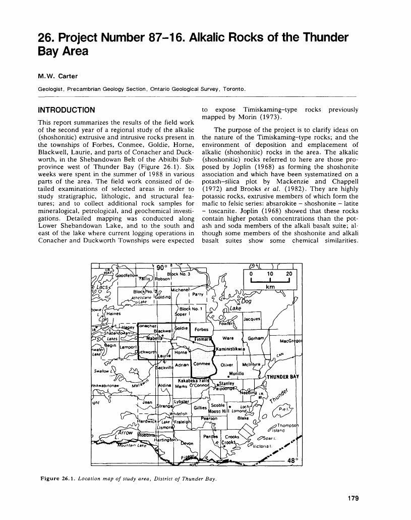
26. Project Number 87-16. Alkalic Rocks of the Thunder Bay Area
M.W. Carter
Geologist, Precambrian Geology Section, Ontario Geological Survey, Toronto.
INTRODUCTIONThis report summarizes the results of the field work of the second year of a regional study of the alkalic (shoshonitic) extrusive and intrusive rocks present in the townships of Forbes, Conmee, Goldie, Horne, Blackwell, Laurie, and parts of Conacher and Duck worth, in the Shebandowan Belt of the Abitibi Sub- province west of Thunder Bay (Figure 26.1). Six weeks were spent in the summer of 1988 in various parts of the area. The field work consisted of de tailed examinations of selected areas in order to study stratigraphic, lithologic, and structural fea tures; and to collect additional rock samples for mineralogical, petrological, and geochemical investi gations. Detailed mapping was conducted along Lower Shebandowan Lake, and to the south and east of the lake where current logging operations in Conacher and Duckworth Townships were expected
to expose Timiskaming-type rocks previously mapped by Morin (1973).
The purpose of the project is to clarify ideas on the nature of the Timiskaming-type rocks; and the environment of deposition and emplacement of alkalic (shoshonitic) rocks in the area. The alkalic (shoshonitic) rocks referred to here are those pro posed by Joplin (1968) as forming the shoshonite association and which have been systematized on a potash-silica plot by Mackenzie and Chappell (1972) and Brooks et al. (1982). They are highly potassic rocks, extrusive members of which form the mafic to felsic series: absarokite - shoshonite - latite - toscanite. Joplin (1968) showed that these rocks contain higher potash concentrations than the pot ash and soda members of the alkali basalt suite; al though some members of the shoshonite and alkali basalt suites show some chemical similarities.
Figure 26.1. Location map of study area, District of Thunder Bay.
179
PRECAMBRIAN (26)
Lamprophyric intrusive equivalents are referred to as minettes, kersantites, vogesites, and spessartites (Joplin 1968; Middlemost 1985).
MINERAL EXPLORATIONMineral exploration was being actively carried out during the summer by Inco Gold Company Limited in the area underlain by alkalic breccia and a high- level quartz-monzonite-diorite stock in Conmee Township; in areas underlain by Timiskaming-type alkalic metavolcanic rocks and metasediments in Conacher and Duckworth townships; and in an area underlain by Keewatin-type calc-alkalic and alkalic metavolcanics in Laurie Township. Noranda Explo ration Company Limited was carrying out explora tion work for gold in central Conacher Township in Keewatin-type rocks and in Blackwell Township.
GENERAL GEOLOGYThe general geology of the study area, which strad dles the Quetico-Abitibi (Shebandowan Belt Sec tion) Subprovince boundary, has been described previously (Carter 1987a). During the 1988 season, the study area was extended westward into Conacher Township where the area south of Lower Sheban dowan Lake was mapped.
The results of this summer's work confirm the occurrence of alkalic (shoshonitic) volcanic rocks in two areas in the upper part of an emergent Keewatin-type volcanic sequence where the alkalic (shoshonitic) rocks are interlayered with calc-alkalic and potassium-rich calc-alkalic rocks. The alkalic (shoshonitic) rocks also occur in the Timiskaming- type sequence in two sub-environments: a) as two volcanic centres comprising vent and proximal facies complexes in proximity to a bounding fault of a graben structure in a continental alluvial-fan-fluvial environment with associated flows, pyroclastic flows, and lamprophyre dikes in a northern belt; and b) in a suggested near-shore continental margin-type sedimentary-volcanic environment, as flows and pyroclastics in a southern belt (Carter 1987a).
In the upper part of the Keewatin-type sequence in southwestern Duckworth Township, a 3 km northeast-trending section was studied leading northeast from Gold Creek to an area in southwest ern Laurie Township studied previously (Carter 1987b). This sequence consists of grey and whitish- grey rhyolitic flows and pyroclastic rocks inter layered with, and passing upward into, mafic and in termediate alkalic (shoshonitic) rocks which are dark mauve and brick-red respectively. No Timis kaming-type sediments were found interstratified with these rocks, and there is no reason to consider these rocks as belonging to the Timiskaming-type sequence. Also, at outcrops in northeastern and central Conmee Township, tholeiitic, calc-alkalic, and shoshonitic rocks as defined earlier, were seen
in contact. These contacts appear to the writer to be conformable and suggest that these shoshonitic rocks are part of the Keewatin-type komatiitic, tholeiitic, and calc-alkalic rock sequence. Because of these observations, these shoshonitic rocks, which litho- logically, petrographically, and on the basis of chemical data so far obtained, are identical to those observed interlayered with the later Timiskaming- type rocks described below, are grouped as part of the earlier Keewatin-type rocks.
The northern belt of Timiskaming-type rocks exposed in Blackwell Township straddles the Keewatin-Quetico Subprovince boundary. Quetico- type metasedimentary clasts are absent in the polymictic conglomerates of this belt, but such rocks would be expected if an upland, positive, pre-Timis- kaming scarp block existed to the north. It is there fore suggested that the Timiskaming-type rocks ex tend northward beyond the Keewatin-Quetico Sub province boundary rather than being confined by it as a northern boundary to the graben. In contrast, the polymictic conglomerates at the southern bound ary of this belt contain clasts of the Keewatin-type rocks exposed immediately to the south. It is there fore suggested that the northern belt of this Timis kaming-type sequence is probably a graben structure (Frostic and Reid 1987) with a boundary fault form ing its southern border. These polymictic conglomer ates together with interlayered arkoses, wackes, and mudstones exposed at the southern boundary are in terpreted by the author as an alluvial fan sequence (Rust and Koster 1984) with a southern Keewatin- type provenance. These conglomeratic rocks are un- pigmented, grey and green, white-weathering rocks containing jasper clasts. The arkoses, wackes, and mudstones are also unpigmented. The significance of using the presence or absence of jasper clasts in distinguishing Timiskaming-type conglomerates from Timiskaming-type tuff breccias (carrying both angu lar and rounded clasts), used empirically previously by the author, can now be understood. These frag mental rocks are of different provenance: the jasper clasts are derived from the Keewatin-type rocks and are present in the Timiskaming-type conglomerates, whereas they are absent in the Timiskaming-type tuff breccias and pyroclastic debris flows, these being of direct volcanic origin.
Red, red-brown, and mottled red and green fragmental rocks referred to as oligomictic conglom erates by Morin (1973) and as breccio-conglomer- ates (Shegelski 1980; Brown 1985) are considered by this author to be alkalic (shoshonitic) tuff brec cias and pyroclastic debris flows (lahars) of the vent-proximal facies of a volcanic centre environ ment. These centres border, and are immediately north of, the southern boundary fault of the graben structure extending from Conacher Township in the west, to Ware Township to the east where identical rocks and associations were observed at Strawberry Hill on Highway 102. The rocks consist of angular
180
M. W. CARTER
and rounded clasts of alkalic (shoshonitic) metavol- canics and minor mafic metavolcanics that are well exposed along the Inco Limited mine road south and east of Lower Shebandowan Lake. South of the lake, the breccias are associated with hornblende and hornblende-feldspar porphyry bodies, some of which are intrusive. This combination of tuff brec cia, subvolcanic intrusives, and flows forming clearly defined areas, suggest that they represent a volcanic centre. The rocks to the east of the lake are similar, but no flows or subvolcanic intrusives were observed in the area mapped. This eastern area is also inter preted as a Timiskaming-type volcanic centre.
The association of red pigmentation due to hematization and high potassium content is a nota ble characteristic of these rocks and suggests a sig nificant temporal-lithogeochemical association. In creased oxidation of volcanic rocks of a magmatic suite in the more evolved members of the suite has been described by Rittmann (1973). This also ex plains the association of high potassium content and red colour so obvious in the latites and toscanites of the area, as well as in the minettes. Future work will evaluate this association.
The intervening area between these east-north east-trending centres along the central part of the south shore of Lower Shebandowan Lake is occu pied by Timiskaming-type sedimentary rocks con taining coarse cobble and boulder polymictic con glomerate interlayered with wacke-siltstone and mudstone of the alluvial fan sequence. These rocks are folded about arcuate convex-north axes. South of this Timiskaming-type sequence is a Keewatin- type sequence consisting of spinifex-textured koma- tiitic flows interlayered with tholeiitic mafic metavol canics and calc-alkalic pillowed mafic to felsic metavolcanics. The map pattern indicates that these rocks trend east-west. During the 1988 season, the Timiskaming-Keewatin boundary was located in two areas, with only l m of intervening cover, but the two sequences were not observed in actual contact. The trace of the Timiskaming-Keewatin boundary is sinuous and trends east-northeast.
The second area where Timiskaming-type alkalic (shoshonitic) metavolcanic rocks occur is in a southern belt (Carter 1987a) consisting of mudstone, wacke, arkose, and conglomerate with laminated magnetite-jasper, magnetite-clastic meta sediment ironstone. The boundary of this sequence with the Keewatin-type sequence is sinuous and ir regular. The ironstone unit extends from west-cen tral Horne Township to Lamport Township - a dis tance of about 27 km. The ironstone has been de scribed as a true taconite (Halet 1972) and the ex tensive linear form and rock association suggests a near-shore continental type of marine environment for deposition of ironstone similar to the Superior Type of banded ironstone of Gross (1965), Dimroth (1979), and Stanton (1972). This suggests that the Timiskaming-type sequence in this southern belt is
not a fanglomerate-alluvial-fan-fluvial sequence as in the north. No major volcanic centres similar to those in the northern belt have been located, but red alkalic flows and pyroclastics occur interstratified with the sediments. The occurrence of hematite- stained rocks in the volcanic centres of the northern belt and red hematized tuffs and flows in the south ern belt suggests that the iron for the ironstone units in the southern belt is exhalatively-derived from the tuffaceous alkalic Timiskaming-type centres to the north. A suggested source for the iron of Superior Type ironstone, which is restricted in time to this general stratigraphic level, may thereby be ex plained, avoiding the transportation problem of the continental erosion theory (Stanton 1972).
STRUCTURAL GEOLOGYThe major structural features of the study area were described in (Carter (1987a), where it was noted that the Timiskaming-type rocks occur in a northern and southern belt.
In the northern belt, during the 1988 season, contacts between the Keewatin-type and Timiskam ing-type rocks were closely examined. In Conacher Township, slickensides on Keewatin-type rocks at the contact indicate a downthrow to the north of the Timiskaming-type rocks on a faulted contact with the Keewatin-type rocks. The generally easterly trend of the Timiskaming-type clastic rocks of allu- vial-fan-fluvial-type observed in the study area, the occurrence of normal faulting at the Timiskaming- Keewatin contact suggests a graben structure with a faulted Timiskaming-Keewatin contact for the southern boundary, and an unconformable Timis kaming versus Keewatin-Quetico contact for its northern boundary. The association with alkalic (shoshonitic) volcanism suggests, on the basis of the Phanerozoic plate-tectonic model, that the rocks of the northern Timiskaming-type belt represent a pos sible failed-arm graben structure of an intracon tinental rift zone representing incipient rifting (Selley 1975; Park 1983) caused by domal uplift.
Within the conglomerates along the Inco Lim ited mine road in Conacher Township considerable shearing was observed indicating that tectonic activ ity was also active after deposition of the Timiskam ing-type rocks.
In the southern belt at Middle Falls on the Matawin River in Laurie Township, a faulted contact was observed between the Timiskaming-type and Keewatin-type rocks with breccia or conglomerate developed. No conglomerate was observed in the Timiskaming-type sediments nearby and the breccia is interpreted as a fault breccia associated with a northeast-trending fault mapped previously in the area (Carter 1987b). The general irregular contact of the Timiskaming-type rocks with the underlying Keewatin-type rocks in the study area suggests an unconformable contact, hence this basin is not a graben, but a continental shelf zone.
181
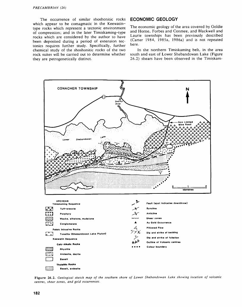
PRECAMBRIAN (26)
The occurrence of similar shoshonitic rocks which appear to be comagmatic in the Keewatin- type rocks which represent a tectonic environment of compression; and in the later Timiskaming-type rocks which are considered by the author to have been deposited during a period of extension tec tonics requires further study. Specifically, further chemical study of the shoshonitic rocks of the two rock suites will be carried out to determine whether they are petrogenetically distinct.
ECONOMIC GEOLOGYThe economic geology of the area covered by Goldie and Horne, Forbes and Conmee, and Blackwell and Laurie townships has been previously described (Carter 1984, 1985a, 1986a) and is not repeated here.
In the northern Timiskaming belt, in the area south and east of Lower Shebandowan Lake (Figure 26.2) shears have been observed in the Timiskam-
CONACHER TOWNSHIP
A AAA AAAAAAAAZ
A A A AAAAAAAA A A A AA AA A AA -fi
AA AAAAAAAAA AAAAAAAAAAA4
A A AA A A A A A A A ALower shebandowan
ARCHEAN Timiskaming Sequence
a a a a o a a a
Tuff-oreccia
Porphyry
Wacke, siltstone, mudstone
J Conglomerate
Felsic Intrusive Rocks
J Tonalite (Shebandowan Lake Pluton)
Keewatin Sequence
Calc-Alkallc Rocks
j Rhyolite
] Andesite, dacite
] Basalt
Tholeiitic Rocks
l Basalt, andesite
Fault (spot Indicates downthrow)
Syncline
Anticline
Shear zones
Au Ooid Occurrence
Pillowed Flow
Dip and strike of Bedding
Dip and strike of foliation
Outline of Volcanic centres
Colour boundary
Figure 26.2. Geological sketch map of the southern shore of Lower Shebandowan Lake showing location of volcanic centres, shear zones, and gold occurrences.
182
M. W. CARTER
ing-type conglomerates, and at the Timiskaming- Keewatin boundary, trending on average 100 0 with a steep dip of 70 0 to 80 0 north, south, or vertical. A strong shear trending 070 0 with a steep dip of 85 0 northwest, and a mineral lineation which plunges 70 0 to the west-southwest, were observed in the Timiskaming-type alkalic tuff breccia in the eastern volcanic centre described above. During mapping in 1988, in Conacher Township, grab samples were collected from shears in the Timiskaming-type metasediments and metavolcanics. In east-south east-trending shears, a grab sample taken from a malachite-stained quartz vein 3 cm wide trending 095 0 which was emplaced in a 2 m wide band of polymictic Timiskaming-type conglomerate mineral ized with nodules of pyrite or marcasite, assayed 0.02 ounce gold per ton (Geoscience Laboratories, Ontario Geological Survey, Toronto). Samples from other shear zones yielded *c0.01 ounce gold per ton (Geoscience Laboratories, Ontario Geological Sur vey, Toronto).
SUGGESTIONS TO PROSPECTORS
On the basis of the model put forward for the depo sition of Timiskaming-type rocks in the northern belt, gold exploration for syngenetic and epigenetic deposits can be recommended.
In the case of syngenetic deposits in the Timis kaming-type rocks, mapping has shown that along the southern part of the Timiskaming-Keewatin boundary in the northern belt, occurrences of gold are found in Keewatin-type rocks: e.g. in northeast ern Conmee Township and southeastern Dawson Road Lots at Sistonens Corners (Carter 1985a, 1986b); at the Bylund and West occurrences in the south-central part of the Dawson Road Lots (Carter 1984, 1985b); and at the Hayne and Kaspar Occur rences in northeastern Laurie and southeastern Blackwell townships respectively (Carter 1986a, 1987b, 1987c). The clast population of the Timis kaming-type rocks indicate derivation of the sedi ments from the Keewatin-type rocks to the south. If these deposits were formed prior to the formation of the Timiskaming-type rocks, the possibility exists of paleochannel in the alluvial fan deposits and for detrital gold occurrences in paleoplacers which oc cur in such deposits (Gross 1968; Johnson 1972a, 1972b, 1973; Minter 1981; Pretorius 1974). Similar studies should be carried out in the conglomerates of the southern belt. However, because of the imma turity of the sediments, the potential for the discov ery of auriferous paleoplacers is not considered high.
For epigenetic deposits in the Timiskaming-type rocks, attention should be paid to east-southeast- and east-northeast-trending shear zones (Figure 26.2) cutting Timiskaming-type meta volcanic and metasedimentary rocks, especially the conglomerates in Conacher Township. One of the shear zones in the conglomerates is mineralized with gold (Figure
26.2), as was determined during the current survey by assay by the Geoscience Laboratories, Ontario Geological Survey, Toronto. The best gold prospects in these shears are where pyrite or copper minerals occur. Specifically, the mineralized auriferous shear shown on Figure 26.2, and located on the Inco Lim ited mine road, should be prospected further. Al though shears were not well developed in the Timis kaming-type alkalic tuff breccia volcanic centres, joints in the centre to the southwest show 2 cm wide alteration zones suggestive of primary fumarolic zones. Two shears were mapped in the eastern metavolcanic centre and an assay sample from the strong shear near the eastern part of the centre as sayed ^.01 ounce gold per ton. These centres, which are composed of coarse tuff breccia, should be prospected for signs of hydrothermal activity. The occurrence of coarse breccias is favourable for pro viding depositional sites for mineralization. The two Timiskaming-type alkalic volcanic centres are out lined in Figure 26.2. Prospecting for gold in the Timiskaming-type ironstone of the southern belt, where it is cut by quartz veins or mineralized with pyrite and arsenopyrite, has already been recom mended (Carter 1987b).
REFERENCESBrooks, C., Ludden, J., Pigeon, Y., and Hubregtse,
J.J.M.W.1982: Volcanism of Shoshonite to High-K Andesite Affinity
in an Archean Arc Environment, Oxford Lake, Manitoba; Canadian Journal of Earth Sciences, Vol ume 19, p.55-67.
Brown, G. Heather1985: A Structural and Stratigraphic Study of the Keewatin-
type and Shebandowan-type Rocks West of Thunder Bay, Ontario; Unpublished M.Se. Thesis, Lakehead University, Thunder Bay, Ontario, Canada, 135p.
Carter, M.W.1984: Goldie and Horne Townships, District of Thunder
Bay; p.41-45 in Summary of Field Work 1984, On tario Geological Survey, edited by John Wood, Owen L. White, R.B. Barlow, and A.C. Colvine, Ontario Geological Survey, Miscellaneous Paper 119, 309p.
1985a: Forbes and Conmee Townships, District of Thunder Bay; p.60-66 in Summary of .Field Work and Other Activities 1985, Ontario Geological Survey, edited by John Wood, Owen L. White, R.B. Barlow and A.C. Colvine, Ontario Geological Survey, Miscella neous Paper 126, 351p.
1985b: Precambrian Geology of Horne Township, Thunder Bay District; Ontario Geological Survey, Map P.2856, Geological Series-Preliminary Map, scale 1:15 840 or l inch to 1/4 mile. Geology 1984.
1986a: Blackwell and Laurie Townships, District of Thunder Bay; p.85-89, in Summary of Field Work and Other Activities 1986, by the Ontario Geological Survey, ed ited by P.C. Thurston, Owen L. White, R.B. Bar low, M.E. Cherry, and A.C. Colvine, Ontario Geo logical Survey, Miscellaneous Paper 132, 435p. Ac companied by l Chart.
1986b: Precambrian Geology of Forbes and Conmee Town ships Area, North Half, Thunder Bay District; On-
183
PRECAMBRIAN (26)
tario Geological Survey, Map P.2990, Geological Se ries-Preliminary Map, scale 1:15 840 or l inch to 1/4 mile. Geology 1985.
1987a: Alkalic Rocks of the Thunder Bay Area; p. 109-116 in Summary of Field Work and Other Activities 1987, by the Ontario Geological Survey, edited by R.B. Bar low, M.E. Cherry, A.C. Colvine, Burkhard O. Dressler, and Owen L. White, Ontario Geological Survey, Miscellaneous Paper 137, 429p.
1987b: Precambrian Geology of Laurie Township, Thunder Bay District; Ontario Geological Survey, Map P.3083, Geological Series-Preliminary Map, scale 1:15 840 or l inch to 1/4 mile. Geology 1986.
1987c: Precambrian Geology of Blackwell Township, Thun der Bay District; Ontario Geological Survey, Map P.3082, Geological Series-Preliminary Map, scale 1:15 840 or l inch to 1/4 mile. Geology 1986.
Dimroth, Erich1979: Models of Physical Sedimentation of Iron Formations;
p. 175-182 in Facies Models, 1979, edited by Roger G. Walker, Geoscience Canada, Reprint Series l, 211p.
Frostic, Lynne, and Reid, lan1987: A New Look" at Rifts; Geology Today, Volume 3,
Number 4, p. 122-126.
Gross, G.A.1965: Geology of Iron Deposits in Canada, Volume l, Gen
eral Geology and Evaluation of Iron Deposits; Geo logical Survey of Canada, Economic Geology Report 22, 181p. Accompanied by Map 1187A, scale l inch to 120 miles.
Gross, W.H.1968: Evidence for a Modified Placer Origin for Auriferous
Conglomerates, Canavieiras Mine, Jacobina, Brazil;Economic Geology, Volume 63, Number 3,p.271-276.
Halet, R.A.1972: Report on the Properties of Monpre Iron Mines Lim
ited, Duckworth and Laurie Townships, 20p. Assess ment Files Research Office, Ontario Geological Sur vey, Toronto.
Johnson, M.G.1972a: Placer Gold Deposits of New Mexico; United States
Geological Survey Bulletin 1348, 46p.1972b: Placer Gold Deposits of Arizona; United States Geo
logical Survey Bulletin 1355, 103p.1973: Placer Gold Deposits of Nevada; United States Geo
logical Survey Bulletin 1356, 118p.
Joplin, G.A.1968: The Shoshonite Association: A Review; Journal of the
Geological Society of Australia, Volume 15, Number2, p.275-294.
Mackenzie, D.E., and Chappell, B.W.1972: Shoshonitic and Calc-alkaline Lavas from the High
lands of Papua, New Guinea; in Contributions to Mineralogy and Petrology, Volume 35, p.50-62.
Middlemost, Eric A.K.1985: Magmas and magmatic rocks; Longman Incorpo
rated, New York, 266p.Minter, W.E.L.1981: Examples that Illustrate Sedimentological Aspects of
the Proterozoic Placer Model on the Kaap-Vaal Craton, Witwatersrand, South Africa, United States Geological Survey Professional Paper 1161-E, P.E1-E6.
Morin, J.A.1973: Geology of the Lower Shebandowan Lake Area, Dis
trict of Thunder Bay; Ontario Division of Mines, Geological Report 110, 45p. Accompanied by Map 2267, scale 1:31 680 or l inch to 1/2 mile.
Park, R.G.1983: Foundations of Structural Geology; Blackie and Son
Limited, Glasgow, Chapman and Hall, New York,135p.
Pretorius, D.A.1974: Gold in the Proterozoic Sediments of South Africa-
Systems, Paradigms, and Models; Witwatersrand University, Economic Geology Research Unit, Infor mation Circular 87, 22p.
Rittmann, Alfred1973: Stable Mineral Assemblages of Igneous Rocks; Sprin-
ger-Verlag, New York, 262p.Rust, Brian R., and Koster, Emlyn H.1984: Coarse Alluvial Deposits; p.53-69 in Facies Models,
1984, edited by Roger G. Walker, Geoscience Can ada, Reprint Series 1.
Selley, R.C.1975: An Introduction to Sedimentology; Academic Press,
New York, 408p.Shegelski, Roy J.1980: Archean Cratonization, Emergence and Red Bed De
velopment, Lake Shebandowan Area, Canada; Pre cambrian Research, Volume 12, p.331-347.
Stanton, R.L.1972: Ore Petrology; McGraw-Hill Book Company, New
York, 713p.
184

Abitibi Subprovince
27. Abitibi Subprovince Studies
R.H. Sutcliffe
Geologist, Precambrian Geology Section, Ontario Geological Survey, Toronto.
INTRODUCTIONThe Abitibi Greenstone Belt is one of the most ex tensive exposures of late Archean supracrustal rocks in the world and accounts for a significant propor tion of Ontario's mineral production. Previous geo logical mapping and investigations have produced an understanding of the lithological framework of the Abitibi Belt but a model for the tectonic framework and evolution of the Belt is not well developed. The Precambrian Geology Section of the Ontario Geo logical Survey has established a working group to carry out a comprehensive geological study of the Abitibi Belt. This group will continue systematic mapping of the Abitibi Belt and develop a model to describe its evolution.
Supracrustal rocks of the Abitibi Belt have been subdivided into dominantly komatiitic, tholeiitic, calc-alkaline, alkaline, and sedimentary lithos- tatigraphic units (Jensen and Langford 1985), which have been thought to represent a stratigraphic con tinuum. It is now recognized, on the basis of geochronological studies (Corfu et al., in press, Marmont and Corfu 1988) and structural studies (Toogood and Hodgson 1985, Hamilton 1986), that structural discontinuities form some boundaries be tween repeated stratigraphic sequences or out-of-se- quence supracrustal packages. A major aim of geo logical mapping in the Abitibi program is to elucidate the relationships within and between these stratigraphic packages or lithostructural domains. In view of the significance of these domain boundaries in localizing mineralization, this goal has important implications for mineral exploration.
CURRENT FIELD WORK
During 1988, several field studies within the Abitibi program were carried out. These focused on detailed mapping and structure of supracrustal rocks, particu larly in areas of mineralization; mapping and petro- logical studies of plutonic rocks; and regional geo physical studies.
D.W. Piroshco and K. Kettles (this volume) completed a two-year mapping project in Whitney and Tisdale townships. In 1988, field work was con centrated on establishing the timing of structural and mineralization events in the area north of the Des- tor-Porcupine Deformation Zone. Preliminary re sults suggest that two ages of gold-mineralized quartz veins are present. These veins can be related to two distinct late deformational events.
S.L. Jackson (this voloume) initiated a detailed mapping project in the Mcvittie Township area east of Kirkland Lake. His project has the aim of deter mining the structure and stratigraphy within and be tween lithostructural domains in this economically important area of gold mineralization. The work has focused on timing of structural events in the vicinity of the Kirkland Lake-Larder Lake Deformation Zone. It has also provided new evidence for a depo sitional contact between the Kinojevis and Timis kaming Groups. Preliminary evidence also points to a previously unreported zone of deformation sepa rating the Kinojevis and Blake River Groups.
Granitoid rocks constitute a significant propor tion of the Abitibi Subprovince and are an important component in the evolution of the belt. As well, some of these rocks have a close spatial and possibly genetic association with gold deposits. However, lim ited data currently exist on their nature. A.R. Smith and R.H. Sutcliffe (this volume) initiated mapping and petrological studies of plutonic rocks in the Abitibi Belt to provide data on the nature of mag matism associated with late Archean crustal stabili zation. Initial work indicates that both the late tec tonic tonalite-granodiorite and alkaline suites are as sociated with coeval, mantle-derived mafic mag matism. This finding has important implications for understanding the origin of these felsic plutonic rocks. Additional studies, also in progress, will de termine the relationships between layered mafic in trusions and mafic volcanic rocks.
Seismic-reflection profiling has provided excit ing new geophysical data on the nature of the crust beneath the Abitibi Belt. This research is being car ried out in co-operation with G.F. West, Professor, Department of Physics, University of Toronto, and is being coordinated with the Canadian Lithoprobe Program. In late 1987, data was collected along two Abitibi Belt profiles in Ontario. A regional profile was recorded to sixteen seconds (corresponding to approximately 48 km depth) from Lake Abitibi to Catherine Township south of Larder Lake. A de tailed profile was recorded to eight seconds in Mcvittie, Katrine, and Ben Nevis townships.
Preliminary results of this seismic survey were available for the 1988 field season. Geological map ping was carried out in areas where seismic events extrapolate to the surface. The detailed profile indi cates a north-dipping seismic reflector projecting to the surface approximately where the Monocle Lake Deformation Zone crops out (see Jackson, this vol ume) . The regional profile is dominated by a south—
186
R. H. SUTCLIFFE
dipping seismic event, recorded at two to four sec onds (approximately 6 to 12 km depth), which is present under most of the section. Field work and further geophysical studies will attempt to discrimi nate among possible explanations for this event. These may include a basal thrust zone, a basal nor mal shear zone, and an intrusive contact.
Field work was also carried out in areas of the Abitibi Subprovince which are not part of the main Abitibi Belt. These studies concentrated on estab lishing the nature and timing of deformation events and the relationship between deformation, altera tion, and gold mineralization. J.A. Fyon and B. Hrabi (this volume) completed detailed mapping in the Temagami Greenstone Belt and T.L. Muir (this volume) continued detailed mapping which will form the basis of a synthesis of the Hemlo gold-mo lybdenum deposit. G.M. Siragusa (this volume) conducted a study of several gold deposits in the Swayze belt. These and continuing studies in the Michipicoten belt near the community of Wawa are reported elsewhere in this volume.
CONCLUDING REMARKSInitial field work in the Abitibi program has concen trated on aspects of the geology of the Belt which have not been emphasized in previous mapping. A focus of the work has also been along a north-south transect in the eastern part of the Ontario segment of the Abitibi Belt. This transect provides an oppor tunity to examine the relationships across several lithostructural domains.
Lithological and structural patterns in domains of the Abitibi Belt invite a comparison with modern accretionary terranes. Studies of the structure and origin of discontinuities between domains are essen
tial to understand how these sequences were assem bled and their relationships to mineralization. Inte gration of previous work, new field observations, geochemical data, and geophysical data will provide a framework on which to construct and test an evo lutionary model for the Abitibi Greenstone Belt.
REFERENCESCorfu, F., Krogh, T.E., Kwok, Y.Y., Marmont, S., and
Jensen, L.S. In Press: U-Pb Geochronology in the South-Western Abitibi
Greenstone Belt, Superior Province; Canadian Journalof Earth Sciences.
Hamilton, J.V.1986: The Structural and Stratigraphic Setting of Gold
Mineralization in the Vicinity of Larder Lake, South- central Abitibi Greenstone Belt, Northeastern On tario; Unpublished M.Se. Thesis, Queen's Univer sity, Kingston, Ontario.
Jensen, L.S., and Langford, F.F.1985: Geology and Petrogenesis of the Archean Abitibi Belt
in the Kirkland Lake Area, Ontario; Ontario Geologi cal Survey, Miscellaneous Paper 123, 130p. Accom panied by Maps P.2434 and P.2435, scale 1:63 360 or l inch to l mile, and l sheet of microfiche.
Marmont, S., and Corfu, F.1988: Timing of Gold Introduction in the Late Archean Tec
tonic Framework of the Canadian Shield: Evidence from U-Pb Zircon Geochronology of the Abitibi Sub province; p.45-50 in Extended Abstracts, Bicenten nial Gold '88, Geological Society of Australia, Ab stracts, Volume 22.
Toogood, D.J., and Hodgson, C.J.1985: A Structural Investigation between the Kirkland Lake
and Larder Lake Gold Camps; p.200-205 in Geos cience Research Grant Program, Summary of Re search 1984-1985, edited by V.G. Milne, Ontario Geological Survey, Miscellaneous Paper 127, 246p.
187
28. Project Number 88-08. Plutonic Rocks of the Abitibi Subprovince
A.R. Smith and R.H. Sutcliffe
Geologists, Precambrian Geology Section, Ontario Geological Survey, Toronto.
INTRODUCTIONThis summary presents preliminary results of geo logical mapping of Archean plutonic rocks in the eastern part of the Ontario segment of the Abitibi Subprovince. During the 1988 field season, regional mapping (1:50 000 scale) was completed on the Abitibi Batholith and the Otto Stock, and detailed mapping (1:15 840 scale) was completed on the Ghost Range Sill. The purpose of this project is to determine the lithological distribution, tectonic set ting, and characteristic mineralization of the major intrusions in the Abitibi Greenstone Belt. The cur rent field work is the initial part of a project to ex amine late Archean magmatic events as they pertain to the evolution of the Abitibi Greenstone Belt.
Jensen and Langford (1985) have described the stratigraphy in the Kirkland Lake area of the Abitibi Greenstone Belt, to which the reader is referred for more detailed information. In this area, several Ar chean volcanic sequences with associated sediments and plutonic rocks are preserved between major, east-trending fault zones.
ABITIBI BATHOLITH
LOCATION AND ACCESS
The Abitibi Batholith crops out north of Lake Abitibi between Latitudes 48 0 40'N and 48 0 58'N, and between Longitudes 79 0 23'W and 80 0 03'W (NTS 32D/12 and 13). The batholith is located 50 km east of Matheson and 60 km north-north east of Kirkland Lake, and covers parts of Bonis, Berry, Sargeant and Steele townships (Figure 28.1). Approximately 15 percent of the batholith lies east of the Ontario border in Desmeloizes Township, Quebec.
The batholith is most easily accessed from Lake Abitibi, on which boats may be launched at Ghost River Bay and Eades in Ontario, and at La Reine in Quebec. Road access may be gained from the Trans- limit Road, which extends from Iroquois Falls in On tario to La Reine in Quebec, traversing the northern part of the area mapped in 1988. A network of log ging roads extending south of the Translimit Road provides access to the centre of the batholith.
Figure 28.1. Locations of plutonic rocks mapped in the current project.
188
A. R. SMITH AND R.H. SUTCLIFFE
MINERAL EXPLORATION
Exploration interest in the Lake Abitibi area has been primarily for gold. Exploration work has fo cused on quartz veins hosted in amphibolite grade mafic metavolcanic rocks along the northeastern edge of the Abitibi Batholith. Chromite and asbestos occurrences, hosted in narrow zones of serpen- tinized ultramafic metavolcanic flows, have received some exploration interest (Kretschmar and Kretsch mar 1986). The batholith has undergone little explo ration work, and only one gold occurrence has been outlined in the area mapped during this study.
Gold was first discovered in the area in 1906, on Shaft Island, situated west of the batholith. Surface trenching and a 97 foot exploration shaft were used to examine the quartz vein-hosted mineralization. From 1906 to 1925, numerous claims were staked along the shoreline of Northeast Bay to investigate other large quartz veins for gold. The Shaft Island Prospect was resampled in 1933 by P.E. Hopkins (Resident Geologist's Files, Ontario Ministry of Northern Development and Mines, Kirkland Lake), and geological mapping and diamond drilling (24 drillholes, 3502 feet or 1068 m) were completed on the same occurrence by Candore Explorations Lim ited during 1958 and 1959. Gold values up to 1.2 ounce per ton (41.1 gms) over 9 inches (23 cm) were obtained.
Exploration programs were conducted along the eastern shore of Northeast Bay and on numerous is lands within the bay between 1965 and 1986. Com panies active in this exploration included West Hill Copper Mines Limited, Canadian Occidental Petro leum Limited, Rio Tinto Canadian Exploration Lim ited, Cominco Resources International Limited, Asarco Exploration Company of Canada Limited, Gold Island Resources Limited, Silver Sceptre Re sources Limited, Del Norte Chrome Corporation, Cream Silver Mines Limited, and Utah Mines Lim ited. Numerous prospectors also explored in the area during this period.
Airborne magnetic and electromagnetic (VLF) surveys were completed in the majority of explora tion programs, with follow-up diamond drilling to test predominantly northeast-trending and east- trending conductors and anomalies. Geophysical re sponses were obtained from diabase dikes, magnet ite-rich mafic and ultramafic metavolcanic units, magnetite-bearing diorite intrusions, and faults. The most recent exploration work was carried out by Golden Trio Minerals Limited, in the vicinity of Shaft Island. A ground electromagnetic survey out lined 32 east-striking conductors, while a ground IP survey detected four anomalies. Despite this abun dant exploration activity, economic deposits have not been outlined in the Abitibi Batholith or in its immediate host rocks.
GEOLOGY
Geological mapping of the Abitibi Batholith has been done on a reconnaissance scale (l indigo 2 miles (1:126 720)) by Baker (1909). The extreme northern part of the batholith, exposed in Bonis and Sargeant townships and in Northeast Bay of Lake Abitibi, was mapped in 1959 and 1960, at a scale of l inch to 1/2 mile (1:31 680) (Lumbers 1962, 1963). The southern edge of the batholith was mapped in 1973 at a scale of l inch to 1/4 mile (1:15 840) (Jensen 1982a, b). The area is included on ODM Geological Compilation Map 2205 (Pye et al. 1971) and on MERQ-OGS Map 2484 (Ministere de 1'Energie et des Ressources, Quebec-Ontario Geological Survey 1983).
The batholith is approximately circular in shape, extending for 34 km north-south and 50 km east- west (Figure 28.2). It intrudes calc-alkalic metavol canic rocks of the Hunter Mine Group (Lower Su pergroup), and tholeiitic to komatiitic metavolcanic rocks of the Stoughton-Roquemaure Group (Upper Supergroup) (Jensen and Langford 1985). Precise U-Pb geochronology yielded ages of 2713±2 Ma and 2714±2 Ma for calc-alkalic rocks of the Hunter Mine Group and for rhyolite at the base of the mafic-ultramafic Stoughton-Roquemaure Group, respectively (Corfu et al., in press). A por phyritic granodiorite from the northeastern edge of the Abitibi Batholith yielded a younger age (2689 +1.71-2.3 Ma) than the volcanic rocks (Mortensen 1987).
Calc-alkalic rocks exposed in Northeast Bay and on islands south of MacDougal Point in Lake Abitibi are andesite and dacite flows and rhyolite tuff-breccia. Rocks of the Stoughton-Roquemaure Group, exposed on the mainland north of the batho lith and on numerous islands in Lake Abitibi, consist predominantly of magnesium-rich tholeiite basalt flows, with minor peridotite and basaltic komatiite flows. These rocks are highly deformed in close proximity to the batholith, resulting in schistose to gneissic textures, and are of amphibolite metamor phic grade.
A south-facing metasedimentary sequence con sisting of meta-greywacke and hornblende schist borders the north-facing Stoughton-Roquemaure Group to the north. This reversal in attitude between metavolcanic and metasedimentary units, along with the high degree of deformation and carbonatization, suggests the contact may be a fault (Lumbers 1962).
North-trending Matachewan dikes (quartz- bearing diabase) cut both the Abitibi Batholith and its host rocks. Northeast-trending, Middle Protero zoic Abitibi (Keweenawan) dikes, consisting of oli- vine-bearing diabase and gabbro, are the youngest rocks in the map area.
Four separate lithologic/structural phases have been outlined in the batholith by the current map ping, defining it as a composite intrusion. These
189
PRECAMBRIAN (28)
Olivine Diabase
Quartz Diabase
Gabbro, Gabbronorite
Lake Abitibi Batholith
Massive Tonalite, Granodiorite
Gneissic Tonalite
Megacrystic Granodiorite
Diorite, Quartz Diorite
Foliated Tonalite, Granodiorite
* Au A Au
Intermediate to Felsic Metavolcanic Rocks
Mafic, Ultramafic Metavolcanic Rocks
Metasedimentary Rocks
Gold Occurrence
Anomalous Gold
Anomalous PlatinumFoliation, SchistosityLayeringPillow TopsBedding, with facing directionFault
Figure 28.2. Generalized geology of the Abitibi Batholith.
190
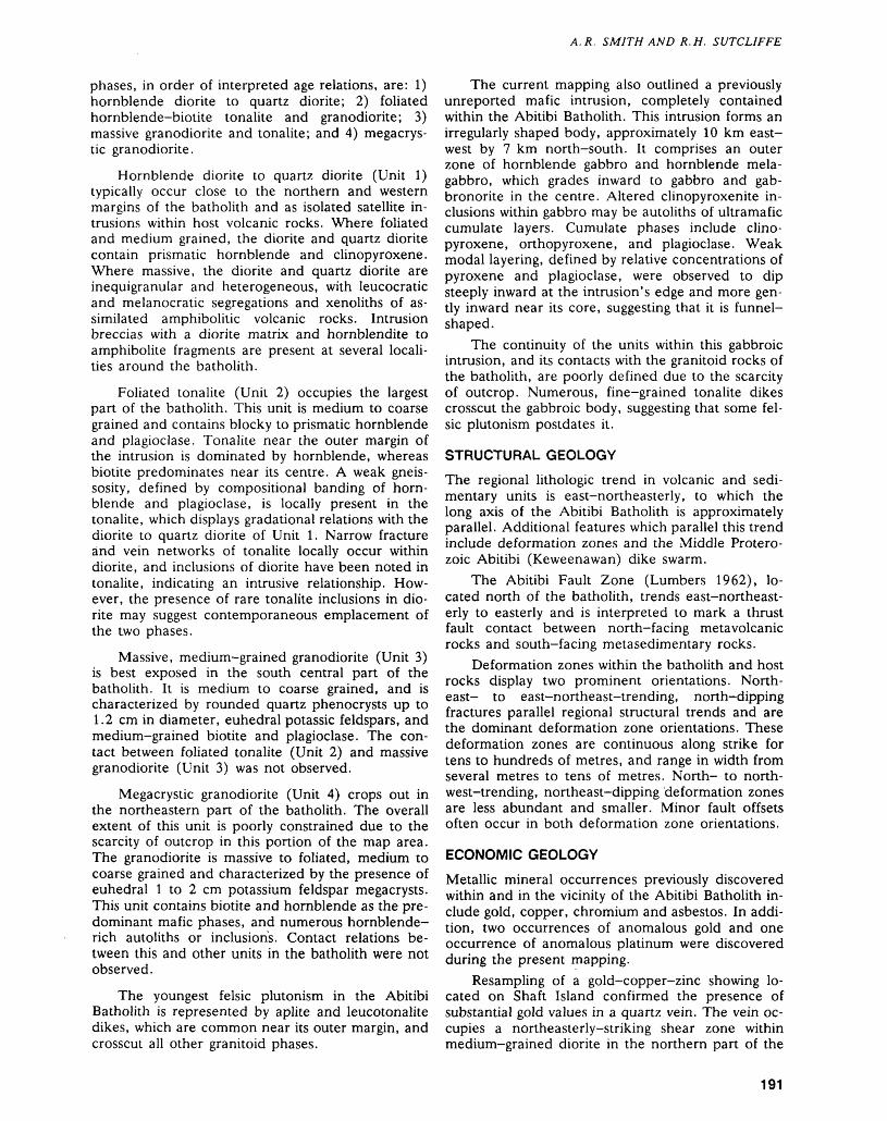
A. R. SMITH AND R.H. SUTCLIFFE
phases, in order of interpreted age relations, are: 1) hornblende diorite to quartz diorite; 2) foliated hornblende-biotite tonalite and granodiorite; 3) massive granodiorite and tonalite; and 4) megacrys- tic granodiorite.
Hornblende diorite to quartz diorite (Unit 1) typically occur close to the northern and western margins of the batholith and as isolated satellite in trusions within host volcanic rocks. Where foliated and medium grained, the diorite and quartz diorite contain prismatic hornblende and clinopyroxene. Where massive, the diorite and quartz diorite are inequigranular and heterogeneous, with leucocratic and melanocratic segregations and xenoliths of as similated amphibolitic volcanic rocks. Intrusion breccias with a diorite matrix and hornblendite to amphibolite fragments are present at several locali ties around the batholith.
Foliated tonalite (Unit 2) occupies the largest part of the batholith. This unit is medium to coarse grained and contains blocky to prismatic hornblende and plagioclase. Tonalite near the outer margin of the intrusion is dominated by hornblende, whereas biotite predominates near its centre. A weak gneis sosity, defined by compositional banding of horn blende and plagioclase, is locally present in the tonalite, which displays gradational relations with the diorite to quartz diorite of Unit 1. Narrow fracture and vein networks of tonalite locally occur within diorite, and inclusions of diorite have been noted in tonalite, indicating an intrusive relationship. How ever, the presence of rare tonalite inclusions in dio rite may suggest contemporaneous emplacement of the two phases.
Massive, medium-grained granodiorite (Unit 3) is best exposed in the south central part of the batholith. It is medium to coarse grained, and is characterized by rounded quartz phenocrysts up to 1.2 cm in diameter, euhedral potassic feldspars, and medium-grained biotite and plagioclase. The con tact between foliated tonalite (Unit 2) and massive granodiorite (Unit 3) was not observed.
Megacrystic granodiorite (Unit 4) crops out in the northeastern part of the batholith. The overall extent of this unit is poorly constrained due to the scarcity of outcrop in this portion of the map area. The granodiorite is massive to foliated, medium to coarse grained and characterized by the presence of euhedral l to 2 cm potassium feldspar megacrysts. This unit contains biotite and hornblende as the pre dominant mafic phases, and numerous hornblende- rich autoliths or inclusions. Contact relations be tween this and other units in the batholith were not observed.
The youngest felsic plutonism in the Abitibi Batholith is represented by aplite and leucotonalite dikes, which are common near its outer margin, and crosscut all other granitoid phases.
The current mapping also outlined a previously unreported mafic intrusion, completely contained within the Abitibi Batholith. This intrusion forms an irregularly shaped body, approximately 10 km east- west by 7 km north-south. It comprises an outer zone of hornblende gabbro and hornblende mela- gabbro, which grades inward to gabbro and gab bronorite in the centre. Altered clinopyroxenite in clusions within gabbro may be autoliths of ultramafic cumulate layers. Cumulate phases include clino pyroxene, orthopyroxene, and plagioclase. Weak modal layering, defined by relative concentrations of pyroxene and plagioclase, were observed to dip steeply inward at the intrusion's edge and more gen tly inward near its core, suggesting that it is funnel- shaped.
The continuity of the units within this gabbroic intrusion, and its contacts with the granitoid rocks of the batholith, are poorly defined due to the scarcity of outcrop. Numerous, fine-grained tonalite dikes crosscut the gabbroic body, suggesting that some fel sic plutonism postdates it.
STRUCTURAL GEOLOGY
The regional lithologic trend in volcanic and sedi mentary units is east-northeasterly, to which the long axis of the Abitibi Batholith is approximately parallel. Additional features which parallel this trend include deformation zones and the Middle Protero zoic Abitibi (Keweenawan) dike swarm.
The Abitibi Fault Zone (Lumbers 1962), lo cated north of the batholith, trends east-northeast erly to easterly and is interpreted to mark a thrust fault contact between north-facing metavolcanic rocks and south-facing metasedimentary rocks.
Deformation zones within the batholith and host rocks display two prominent orientations. North east- to east-northeast-trending, north-dipping fractures parallel regional structural trends and are the dominant deformation zone orientations. These deformation zones are continuous along strike for tens to hundreds of metres, and range in width from several metres to tens of metres. North- to north west-trending, northeast-dipping deformation zones are less abundant and smaller. Minor fault offsets often occur in both deformation zone orientations.
ECONOMIC GEOLOGY
Metallic mineral occurrences previously discovered within and in the vicinity of the Abitibi Batholith in clude gold, copper, chromium and asbestos. In addi tion, two occurrences of anomalous gold and one occurrence of anomalous platinum were discovered during the present mapping.
Resampling of a gold-copper-zinc showing lo cated on Shaft Island confirmed the presence of substantial gold values in a quartz vein. The vein oc cupies a northeasterly-striking shear zone within medium-grained diorite in the northern part of the
191
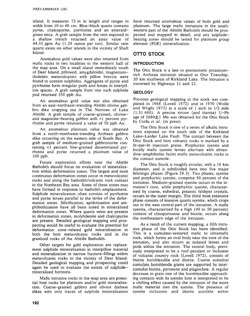
PRECAMBRIAN (28)
island. It measures 72 m in length and ranges in width from 10 to 40 cm. Blue-black quartz contains pyrite, chalcopyrite, pyrrhotite and an emerald- green mica. A grab sample from the vein exposed in a shallow trench returned an assay value of 44.55 ppm Au (1.29 ounce per ton). Similar vein quartz exists on other islands in the vicinity of Shaft Island.
Anomalous gold values were also returned from mafic rocks in two localities in the western half of the map area. On a small island immediately south of Deer Island, pillowed, amygdaloidal, magnesium- tholeiitic metavolcanics with pillow breccia were found to contain sulphides. Aggregates of pyrite and pyrrhotite form irregular pods and lenses in interpil- low spaces. A grab sample from one such sulphide pod returned 350 ppb Au.
An anomalous gold value was also obtained from an east-northeast-trending Abitibi olivine gab bro dike cropping out in The Narrows of Lake Abitibi. A grab sample of coarse-grained, olivine- and magnetite-bearing gabbro with -ci percent pyr rhotite and pyrite returned a value of 50 ppb Au.
An anomalous platinum value was obtained from a north-northwest-trending Archean gabbro dike occurring on the eastern side of South Bay. A grab sample of medium-grained gabbronorite con taining •ci percent fine-grained disseminated pyr rhotite and pyrite returned a platinum value of 100 ppb.
Future exploration efforts near the Abitibi Batholith should focus on evaluation of mineraliza tion within deformation zones. The largest and most continuous deformation zones occur in metavolcanic rocks and along the batholith/volcanic rock contact in the Northeast Bay area. Some of these zones may have formed in response to batholith emplacement. Sulphide mineralization often consists of pyrrhotite and pyrite lenses parallel to the strike of the defor mation zones. Silicification, epidotization and am phibolitization have all been noted in mineralized deformation zones. Where quartz veins are present in deformation zones, molybdenite and chalcopyrite are present. Detailed geological mapping and pros pecting would be useful to evaluate the potential for deformation zone-related gold mineralization in both the host metavolcanic rocks and in the granitoid rocks of the Abitibi Batholith.
Other targets for gold exploration are replace ment sulphide mineralization in interpillow material and mineralization in narrow fracture-fillings within metavolcanic rocks in the vicinity of Deer Island. Detailed geological mapping and prospecting could again be used to evaluate the extent of sulphide- mineralized horizons.
Mafic intrusive rocks in the map area are poten tial host rocks for platinum and/or gold mineraliza tion. Coarse-grained gabbro and olivine diabase dikes with only traces of sulphide mineralization
have returned anomalous values of both gold and platinum. The large mafic intrusions in the south western part of the Abitibi Batholith should be pros pected and mapped in detail, and any sulphide- bearing zones should be tested for platinum group element (PGE) mineralization.
OTTO STOCK
INTRODUCTION
The Otto Stock is a late to posttectonic potassium- rich Archean intrusion situated in Otto Township, 20 km southwest of Kirkland Lake. The intrusion is traversed by Highways 11 and 12.
GEOLOGY
Previous geological mapping in the stock was com pleted in 1968 (Lovell 1972) and in 1970 (Wolfe and Wright 1971) at a scale of l inch to 1/2 mile (1:31 680). A precise zircon (and titanite) U-Pb age of 2680d:l Ma was obtained for the Otto Stock by Corfu et al. (in press).
The Otto Stock is one of a series of alkalic intru sions exposed on the south side of the Kirkland Lake-Larder Lake Fault. The contact between the Otto Stock and host volcanic rocks is marked by a lit-par-lit injection gneiss. Porphyritic syenite and locally mafic syenite lenses alternate with alman dine-amphibolite facies mafic metavolcanic rocks in the contact aureole.
The Otto Stock is roughly circular, with a 10 km diameter, and is subdivided here into five major lithologic phases (Figure 28.3). Two phases, syenite and porphyritic syenite, comprise 80 percent of the intrusion. Medium-grained syenite occurs in the in trusion's core, while porphyritic syenite, character ized by coarse, euhedral, potassic feldspar crystals, occurs in the outer margin. The third most extensive phase consists of massive quartz syenite, which crops out in the west central part of the intrusion. A mafic syenite, characterized by a high (40 to 50 percent) content of clinopyroxene and biotite, occurs along the northeastern edge of the intrusion.
As a result of the current mapping, a fifth intru sive phase of the Otto Stock has been identified. This is a cumulate-textured mafic to ultramafic rock, which forms an oval body near the core of the intrusion, and also occurs as isolated lenses and pods within the intrusion. The central body, previ ously interpreted to be a roof pendant or inclusion of volcanic country rock (Lovell 1972), consists of biotite hornblendite and diorite. Coarse euhedral cumulate hornblende grains are supported by inter cumulus biotite, pyroxene and plagioclase. A regular decrease in grain size of the hornblendite approach ing contacts with its syenite host is interpreted to be a chilling effect caused by the intrusion of the more mafic material into the syenite. The presence of syenite inclusions and diorite autoliths within
192
A. R. SMITH AND R.H. SUTCLIFFE
vvvvvvvvvvvvvvvvvvvvvvvvvvvvvvvvvvv vvvvvvvvvv i w v v v v v v v v v v v v vV W VVVVVV V i W WWW W WWW Vvvvvvvvvvv Ivvvvvvvvvvvvvvvvvv' vvwvv w wSw v v wwwwvwww' vvvwwv vly wvwvvvvwwvwwwvwwvi
VVVVVV /MN W W WWW WWW WWW W VI l V ^ V V V V V 4-I - W V W V\fr**Tl — " * ' V V '/-^.WV V W W VV^VVVW V V V ^PIV V V V V V Ww v vii vvvvvvvvj
vvvwwwwwvwvvwvwV VVWWVWVWVWW
V VVVVVVVVVVVVVVVvvvvwvvvwyxTv
VWWVW V/v f Vv v w w v r J1 v
w VVVV
VVV^VW V V V Vif v V.V
v'^Zi
w v .V V W W^y V W V V V WV V VWVVVVV
vvvvX V W V V
V V V V V X W Vvvvv vvvv
W V V W V W W V V W W V V V V
vvvv vvvv vvvv vvvv vvvv vvvv
V V W V V V W V W V Wvvvv vvvv
vrvvvv v ir v v w
V Vi V V Ww4 w v
V Ww
+ t + 4 + 4 4+ + + + + + 44
+ + + + + + + + + 4+ + 4 + + + 4 + 4 +
+ + + + + + + 4 + + V
+ + + +
+444
+ + + 4 4 4 4 4 4
+ + + + + + 4. 4 4 4 4 4 4
+ 44 + + 4 + + 4+ + + + + + + + 4 +
W VWWW VVVVVVvvvvvvv vvvvvvv^VVVVVV WV VVVVvvwvv
WV W W V V V + + + + + +
+ + 4 + 4 + 4 4 + +
+ + + + + 4 + + * t + 4 Round Lake4 4- 4^ 4- 4 44- 4 4- 4- 4- 4- 4- 4-
44-4-4-4- 4- 4 4- 4 4 4 44-4-
VVVV V V Vvvvv
x xX Xx x
OTTO STOCK
Syenite
Quartz syenite
Mafic syenite
Porphyritic syenite
Hornblendite, diorite
A Anomalous Au occurrence
— — Faults
—"-* Foliation, schistosity
-A- Gneissosity
Figure 28.3. Generalized geology of the Otto Stock.
ROUND LAKE BATHOLITH
Granite, granodiorite, tonalite
Felsic -intermediate metavolcanics
Mafic metavolcanics ft metasediments
~.~... Late mafic dikes, diabase
nmimni Biotite-lamprophyre dikes
......, Mlcrosyenite, mafic syenite
Glacial striatlons
Layering Felsic
193
PRECAMBRIAN (28)
hornblendite is additional evidence of the late intru sive nature of the ultramafic-mafic phase.
A sequence exposed on the northern shore of Round Lake consists of biotite hornblendite and het erogeneous melanocratic diorite interlayered with mafic syenite, leucocratic monzonite, and quartz syenite. The presence of hornblendite in this layered sequence is consistent with a magmatic origin for the ultramafic to mafic phase.
ECONOMIC GEOLOGY
Several different types of sulphide mineralization were observed in the Otto Stock during the current mapping. These include: 1) disseminated pyrite and pyrrhotite in hematitized syenite; 2) interstitial pyrite and chalcopyrite in coarse-grained, skeletal amphi- bole-bearing mafic syenite; 3) pyrite and molyb denite aggregates in quartz veins hosted in deforma tion zones; 4) chalcopyrite-bornite—pyrite-bearing fractures in aplite dikes; and 5) fine-grained, dis seminated pyrite and pyrrhotite within lamprophyre dikes.
An anomalous gold value was obtained from a sulphide mineral occurrence of type 4. A grab sam ple from an aplite dike containing chalcopyrite in fractures returned values of 5800 ppm Cu and 165 ppb Au. The other mineral occurrence types listed above have been sampled, but assay results are not yet available.
These sulphide mineral occurrences may repre sent exploration targets for gold mineralization. In addition, interstitial chalcopyrite was outlined locally in the intrusive hornblendite core, and may repre sent an exploration target for PGE mineralization.
GHOST RANGE SILL
INTRODUCTION
The Ghost Range Sill is a layered ultramafic-mafic Archean body located south of the Abitibi Batholith, 45 km north of Kirkland Lake and 45 km east of Matheson at the intersection of Lamplugh, Frecheville, Holloway and Harker townships. The intrusion lies immediately north of Highway 101 and may be accessed via a network of logging roads ex tending to the north.
GEOLOGY
Previous geological mapping on the Ghost Range Sill was completed, at a variety of scales, between 1952 and the present (Satterly 1952, 1954; MacRae 1969; Jensen 1982c, d). As a result of this mapping, different interpretations have arisen as to the form and petrogenesis of the body. Satterly (1952b, 1954) concluded that the body is a layered sill, folded into a doubly-plunging syncline. MacRae (1969) identified a 760 m thick cumulate sequence of peridotite, pyroxenite and gabbro. Jensen and
Langford (1985) suggested that the rocks probably represent the basal sequences of the Stoughton-Ro- quemaure Group and comprise thick, flat-lying lava flows resting unconformably on older, folded, vol canic rocks.
For this project, the Ghost Range. Sill was mapped at a scale of 1:15 840 to examine its stratig raphy, to determine if the cumulus stratigraphy can be related to a complementary volcanic succession, and to assess the potential for economic PGE mineralization.
The Ghost Range Sill forms an elongate ridge, measuring 10 km east-west by 2 km north-south, and consists of coarse-grained mafic to ultramafic rocks. Topographically lower ground surrounding the ridge is underlain by calc-alkalic, felsic metavol- canic rocks of the Hunter Mine Group. Contact re lations are poorly constrained; however, steep dips occur in both the volcanic rocks and on unit con tacts and layers in the sill. Steep inward dips occur on both the northern and southern edges of the body, which is interpreted in this study to be a lopolith, with a gently north-dipping, flat top.
The units outlined during this mapping project, in stratigraphic order from base to top, include lher zolite (4- dunite), clinopyroxenite, gabbronorite (-l- gabbro) and hornblende gabbro. The lherzolite at the base is medium-grained, composed predomi nantly of serpentinized olivine, and is characterized by oikocrystic pyroxenes and asbestos veinlets. Where pyroxene is locally absent, the rock is com- positionally a dunite. This medium-grained clino pyroxenite unit is not laterally continuous, and was found only in zones of short strike length. It is ^0 m in width and has a sharp contact with gab bronorite stratigraphically above.
The upper, mafic section of the sill has been subdivided into gabbronorite and hornblende gab bro. The gabbronorite unit is medium- to coarse- grained and is characterized by the presence of blocky orthopyroxene grains of variable grain size and abundance. Wispy layering, defined by variable orientations of orthopyroxene, clinopyroxene and plagioclase, is locally present. The hornblende gab bro is medium grained and is characterized by the presence of irregular quartz and magnetite-bearing pegmatitic gabbro patches. Uralitization and epidoti zation are more intense in the hornblende gabbro than in the underlying gabbronorite. Skeletal amphi bole crystals are present within some pegmatitic patches.
ECONOMIC GEOLOGY
Previous exploration activity on the Ghost Range Sill outlined numerous asbestos occurrences within the ultramafic, basal portion of the intrusion.
Sulphide mineral occurrences are rare within the sill, and were detected at only two localities during the current mapping. Mineralization consists of dis-
194
A. R. SMITH AND R. H. SUTCLIFFE
seminated pyrite in medium-grained hornblende gabbro. Samples from a section across the strati graphic thickness of the intrusion are currently being assayed for platinum group elements.
CONCLUDING REMARKSThe geological mapping upon which this report is based serves to better define the geology of the in trusive bodies examined. It has discovered mafic plutonic rocks closely associated with both the Abitibi Batholith and the Otto Stock. In the Abitibi Batholith, gabbronorite and gabbro intrusions ex hibit textures indicative of near contemporaneous emplacement with the host tonalite. In addition, a continuum of lithologies, from hornblende gabbro to diorite and quartz diorite, in bodies fringing the batholith suggests a substantial degree of differenta- tion has occurred during this magmatism.
Ultramafic to mafic rocks were also discovered in alkalic felsic to intermediate rocks of the Otto Stock. Coarse hornblendite in the core of the stock, containing autoliths of diorite and syenite, was ob served to have chilled contacts with the host syenite. This evidence, along with the presence of hornblen dite within a layered mafic sequence, is consistent with a magmatic origin for this ultramafic rock.
Magmatic sulphide mineralization was identified in mafic/ultramafic rocks associated with the Abitibi Batholith, the Otto Stock, and, in addition, with the Ghost Range Sill. This presents a new exploration target for platinum group elements.
REFERENCESBaker, M.B.1909: Lake Abitibi Area; Ontario Bureau of Mines, Annual
Report, Volume 18, p.263-283. Accompanied by Map 18d, scale l inch to 2 miles or 1:126 720.
Corfu, F., Krogh, T.E., Kwok, Y.Y., Marmont, S., andJensen, L.S.
In Press: U-Pb Geochronology in the South-western AbitibiGreenstone Belt, Superior Province; Canadian Journalof Earth Sciences.
Geological Survey of Canada195la: Aylen River, District of Cochrane, Ontario; Canada
Department of Mines and Technical Surveys, Geo logical Survey of Canada, Map 48G, scale 1:63 360 or l jnch to l mile.
1951b: Lightning River, District of Cochrane, Ontario; Can ada Department of Mines and Technical Surveys, Geological Survey of Canada, Map 45G, scale 1:50 000.
Jensen, L.S.1982a: Precambrian Geology of the Mistaken Islands Area,
Lightning River Area, Cochrane District; Ontario Geological Survey, Map P.2430, Geological Series - Preliminary Map, scale 1:15 840 or l inch to 1/4 mile. Geology 1978.
1982b: Precambrian Geology of the Partridge Point Area, Lightning River Area, Cochrane District; Ontario
Geological Survey, Map P.2429, Geological Series - Preliminary Map, scale 1:15 840 or l inch to 1/4 mile. Geology 1973.
1982c: Precambrian Geology of the Ghost Range Area, Light ning River Area, Cochrane District; Ontario Geologi cal Survey, Map P.2431, Geological Series - Prelimi nary Map, scale 1:15 840 or l inch to l /4 mile. Geol ogy 1973.
1982d: Precambrian Geology of the Lightning Mountain Area, Cochrane District; Ontario Geological Survey, Map P.2432, Geological Series Preliminary Map, Scale 1:15 840 or l inch to 1/4 mile. Geology 1973.
Jensen, L.S., and Langford, F.F.1985: Geology and Petrogenesis of the Archean Abitibi Belt
in the Kirkland Lake Area, Ontario; Ontario Geologi cal Survey, Miscellaneous Paper 123, 130p.
Kretschmar, U., and Kretschmar, D.1986: Talc, Magnesite, and Asbestos Deposits of the
Kirkland Lake Timmins Area, Districts of Timiskam ing and Cochrane; Ontario Geological Survey, Study 28, lOOp.
Lovell, H.L.1972: Geology of the Eby and Otto Area, District of Timis
kaming; Ontario Department of Mines and Northern Affairs, Geological Report 99, 30p. Accompanied by Map 2239, scale 1:31 680 or l inch to 1/2 mile.
Lumbers, S.B.1962: Geology of Steele, Bonis and Scapa Townships, Dis
trict of Cochrane; Ontario Department of Mines, Geological Report 8, 50p. Accompanied by Map 2018, scale 1:31 680 or l inch to 1/2 mile. Geology 1961.
1963: Geology of South Patten River Area, District of Cochrane; Ontario Department of Mines, Geological Report 14, 40p. Accompanied by Map 2025, scale 1:31 680 or l inch to 1/2 mile. Geology 1960.
MacRae, N.D.1969: Ultramafic Intrusions of the Abitibi Area, Ontario;
Canadian Journal of Earth Sciences, Volume 6,p.281-303.
Ministere de 1'Energie et des Ressources, Quebec-Ontario Geological Survey (MERQ-OGS)
1983: Lithostratigraphic Map of the Abitibi Subprovince; Ministere de 1'Energie et des Ressources, Quebec- Ontario Geological Survey; edited by P.C. Thurston, Catalogued as "Map 2484" in Ontario and "DV83-16" in Quebec, scale 1:500 000.
Mortensen, J.K.1987: Preliminary U-Pb Zircon Ages for Volcanic and
Plutonic Rocks of the Noranda-Lac Abitibi Area, Abitibi Subprovince, Quebec; p.581-590, in Current Research, Part A, Geological Survey of Canada, Pa per 87-1A, 946p.
Pye, D.R., Ayres, L.D., and Innes, D.G.1971: Timmins-Kirkland Lake Geological Compilation Se
ries, Districts of Sudbury, Cochrane and Timiskam ing, Ontario; Ontario Department of Mines, Colour Map 2205, scale 1:253 440 or l inch to 4 miles.
Satterly, D.1952: Geology of Harker Township; Ontario Department of
Mines, Annual Report for 1951, Volume 60, Part 7,47p.
195
PRECAMBRIAN (28)
1954: Geology of the North Half of Holloway Township; Ontario Department of Mines, Annual Report for 1953, Volume 62, Part 7, 38p.
Wolfe, W.J., and Wright, G.R.1971: Geochemical Distribution of Acid Soluble Molybde
num in Felsic Plutonic Rocks, Otto Township and Parts of Eby, Marquis, and Boston Townships, Dis trict of Timiskaming; Ontario Department of Mines, Preliminary Map P.719, Geochemical Series. Accom panied by geological and aeromagnetic maps.
196
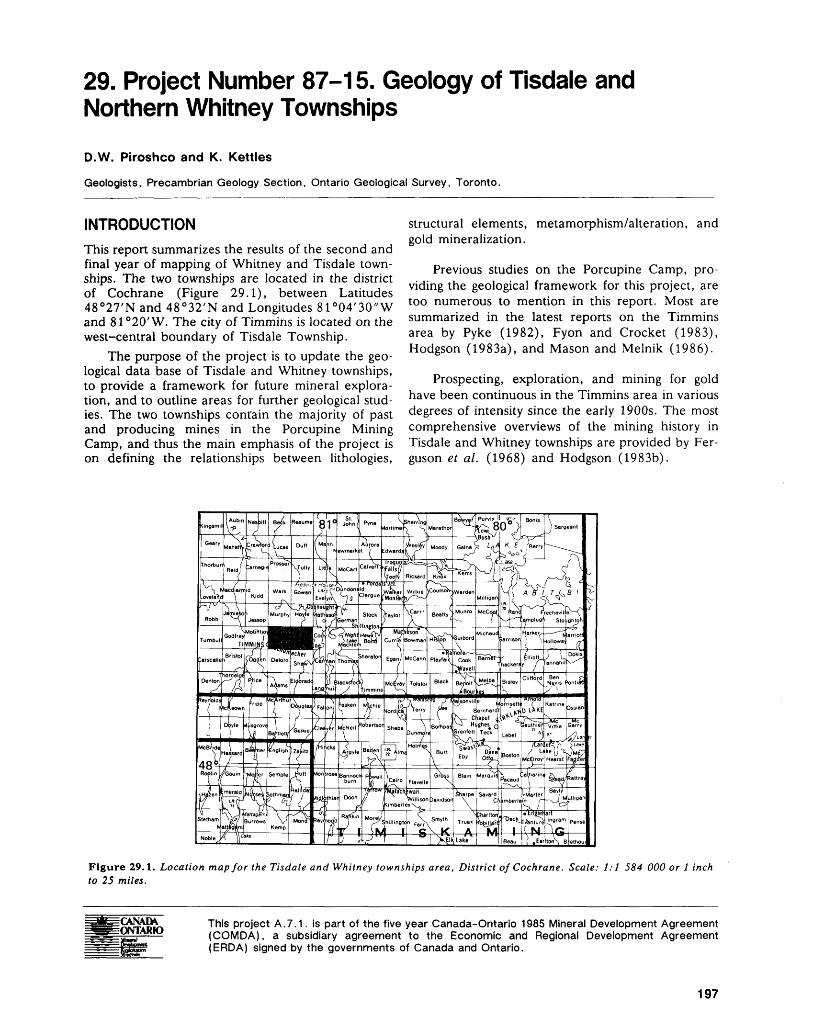
29. Project Number 87-15. Geology of Tisdale and Northern Whitney Townships
D.W. Piroshco and K. Kettles
Geologists, Precambrian Geology Section, Ontario Geological Survey, Toronto.
INTRODUCTIONThis report summarizes the results of the second and final year of mapping of Whitney and Tisdale town ships. The two townships are located in the district of Cochrane (Figure 29.1), between Latitudes 48 C 27'N and 48 C 32'N and Longitudes 81 0 04'30"W and 81 0 20'W. The city of Timmins is located on the west-central boundary of Tisdale Township.
The purpose of the project is to update the geo logical data base of Tisdale and Whitney townships, to provide a framework for future mineral explora tion, and to outline areas for further geological stud ies. The two townships contain the majority of past and producing mines in the Porcupine Mining Camp, and thus the main emphasis of the project is on defining the relationships between lithologies,
structural elements, metamorphism/alteration, and gold mineralization.
Previous studies on the Porcupine Camp, pro viding the geological framework for this project, are too numerous to mention in this report. Most are summarized in the latest reports on the Timmins area by Pyke (1982), Fyon and Crocket (1983), Hodgson (1983a), and Mason and Melnik (1986).
Prospecting, exploration, and mining for gold have been continuous in the Timmins area in various degrees of intensity since the early 1900s. The most comprehensive overviews of the mining history in Tisdale and Whitney townships are provided by Fer guson et al. (1968) and Hodgson (1983b).
Figure 29.1. Location map for the Tisdale and Whitney townships area, District of Cochrane. Scale: 1:1 584 000 or l inch to 25 miles.
CANAM ONTARIO
This project A.7.1. is part of the five year Canada-Ontario 1985 Mineral Development Agreement (COMDA), a subsidiary agreement to the Economic and Regional Development Agreement (ERDA) signed by the governments of Canada and Ontario.
197
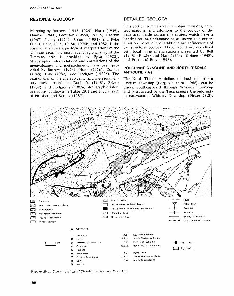
PRECAMBRIAN (29)
REGIONAL GEOLOGY
Mapping by Burrows (1915, 1924), Hurst (1939), Dunbar (1948), Ferguson (1959a, 1959b), Carlson (1967), Leahy (1971), Roberts (1981) and Pyke (1970, 1972, 1975, 1978a, 1978b, and 1982) is the basis for the current geological interpretations of the Timmins area. The most recent regional map of the Timmins area is provided by Pyke (1982). Stratigraphic interpretations and correlations of the metavolcanics and metasediments have been pro vided by Burrows (1924), Hurst (1936), Dunbar (1948), Pyke (1982), and Hodgson (1983a). The relationship of the metavolcanic and metasedimen- tary rocks, based on Dunbar's (1948), Pyke's (1982), and Hodgson's (1983a) stratigraphic inter pretations, is shown in Table 29.1 and Figure 29.1 of Piroshco and Kettles (1987).
DETAILED GEOLOGYThis section summarizes the major revisions, rein- terpretations, and additions to the geology of the map area made during this project which have a bearing on the understanding of known gold miner alization. Most of the additions are refinements of the structural geology. These results are correlated with local mine interpretations presented by Bell (1948), Hawley and Hart (1948), Holmes (1948), and Price and Bray (1948).
PORCUPINE SYNCLINE AND NORTH TISDALE ANTICLINE (D0)
The North Tisdale Anticline, outlined in northern Tisdale Township (Ferguson et al. 1968), can be traced southeastward through Whitney Township and is truncated by the Timiskaming Unconformity in east-central Whitney Township (Figure 29.2).
PI Diatreme
|c' ."l Quartz-feldspar porphyry
t! 111 Granodiorite
f; ;1 Peridotite intrusions
| c o| Younger sediments
[ -1 Older sediments
l///) Iron formation
l l Intermediate to felsic flows
HB V8 Variolitic Fe tholeiite marker unit
l r.-r) Tholeiitic flows
[gggj Komatiitic flows
Fault
Pillow tops
Syncline
Anticline
Geological contact
Unconformable contact
A MINESITES
Pamour 1HallnorArmstrong-Me GibbonConiarumHollingerPaymasterPreston East DomeDomeVedron
K.S. Kayorum SynclineS. T.A. South Tisdale Anticline
P.S. Porcupine SynclineN.T.A. North Tisdale Anticline
D.F. Dome FaultD.P.F. Destor-Porcupine Fault
S.G. South Greenstones
9 F '9- 7-15.2
l j Fig- 7-15.3
Figure 29.2. General geology of Tisdale and Whitney Townships.
198
D. W. PIROSHCO AND K. KETTLES
The axial surface of the fold is interpreted to inter sect the unconformity near the Hallnor minesite, based on the presence of opposing pillow facings northeast and southwest of this location (Figure 29.2). Similarly, the axial surface of the Porcupine Syncline (Ferguson et al. 1968) can be extrapolated to intersect the unconformity in eastern Tisdale Township. The truncation of the axial surfaces of these folds along the unconformity indicates that they pre-date the deposition of the Younger Sedi ments and therefore represent the earliest recogniz able structures in the map area, designated D0 in this study.
YOUNGER SEDIMENTS-DOME FAULT-PORPHYRY INTRUSIONS (D,)
Following deposition, the Younger Sediments were truncated and rotated into a subvertical, south-fac ing attitude along the southeast-dipping Dome Fault (Hodgson 1983a). At the same time, movement along the Dome Fault juxtaposed the Younger Sedi ments against the Tisdale Group volcanic rocks to the south (the South Greenstones, see Figure 29.2). The Dome Fault is best defined in southeastern Tis dale Township in the vicinity of the Preston East Dome minesite (Figure 29.2), where it swings north- south and is referred to as the "footwall fault" (Hawley and Hart 1948). At this location, the South Greenstones face eastward, as opposed to the north west-facing rocks of the Greenstone Nose (Ferguson et al. 1968).
Direct evidence for the kinematics of the Dome Fault was not obtained in this study, but the appar
ent older-on-top-of-younger relationship demon strated by the Younger Sediments and South Greenstones suggests the fault is a thrust or reverse fault. There is indirect supportive evidence for this interpretation at a roadcut outcrop in the South Greenstones (Figure 29.2), where turbidites are in tercalated with southwest-facing mafic flows. De tailed examination of the lithological contacts at this outcrop reveals that, in at least one instance, a clear discordancy exists between bedding and the lithological contacts (Figure 29.3). The contacts are therefore interpreted as faults. Within the western most turbidite unit (Figure 29.3), north-inclined, open- to chevron-style folds plunging shallowly (10 0 to 30 0 ) northeast are present (Photo 29.1), with a steeply north-dipping, axial planar foliation (S^. These folds are interpreted as drag folds developed, as a result of reverse faulting.
Porphyry intrusions were emplaced both into brittle, east-trending fractures and along the Dome Fault during this deformation episode. This interpre tation would imply that the porphyry intrusions are younger than, or the same age as, the Younger Sedi ments, but crosscutting relationships were not ob served to confirm or disprove this.
SOUTH TISDALE ANTICLINE-KAYORUM SYNCLINE (D2 )These folds, which plunge northwestward and are overturned to the southwest (Ferguson et al. 1968), are accompanied by an axial planar foliation which trends 100 0 to 130 0 and dips steeply to moderately northeastward (S2). This foliation is locally devel oped throughout Tisdale Township and is dominant
•'J- outcrop 1 tholeiitic mafic volcanic rocks pillows; tops known, unknown a pillowedbedding; tops known, unknownfoliation; inclined, vertical 2 metasedimentary rocks
trend and plunge of foldsfault
a state and siltstone
^^
r*
Figure 29.3. Geology of the Dome Extension road outcrop (South Greenstones).
199
PRECAMBRIAN (29)
Photo 29.1. Outcrop (Dome Extension road) showing near upright, chevron-style folds in turbidites.
in southern Tisdale Township, but is rarely recog nized in Whitney Township. It cuts the Tisdale Group rocks, Older Sediments, Younger Sediments, and porphyries. In addition, the folds and foliation deform and crosscut the Dome Fault, outlined by the apparent folding of the porphyry intrusions at the Vedron Property. This deformation is also asso ciated with locally developed sets of gold-minerali zed, extensional quartz veins that trend 100 0 to 130 0 and dip 25 0 to 60 0 southwest. These veins are particularly well developed at the Armstrong- McGibbon Property in northeastern Tisdale Town ship (Map 2075 of Ferguson et al. 1968), where they occur as an en echelon set within a massive, east-trending mafic flow.
EAST-NORTHEAST-TRENDING FABRIC (D3a)
Superimposed on the northwest-trending foliation in southern Tisdale Township is a locally well devel oped planar fabric (S3a), trending 070 0 to 090 0 and dipping steeply north to south (Photo 29.2). This fabric is recognized throughout the map area and is dominant in the northern half of Tisdale and Whit ney townships. In southern Tisdale Township, the intersection of this fabric with the northwest-trend ing foliation plunges 40 0 to 60 0 northeastward to eastward, parallel with the trend and plunge of stretched varioles and conglomerate clasts in this area. In eastern Whitney Township away from the influence of the northwest-oriented structures, stretching lineations are absent and the east-north
east planar fabric is recognized as a bedding-parallel flattening of conglomerate clasts in the Dome For mation.
Well developed sets of gold-mineralized, exten sional quartz veins trending 020 0 to 050 0 and dip ping 40 0 southeastward (Photo 29.3) are also associ ated with this flattening fabric. This vein style is dominant in the ore zones developed in polymictic conglomerate and turbidite units at the Pamour l Mine (Price and Bray 1948). Another set of gold mineralized veins, that trend parallel with the earlier northwest-trending foliation (S2), is dominant at the Vedron Prospect in southern Tisdale Township and is also interpreted to have formed during this defor mation.
Moderately northeast-plunging, 'S'-shaped folds (up to 30 m in scale), which are best devel oped within the turbidites of the Dome Formation, are spatially related to the planar fabric and vein sets. The folds are exposed in both Tisdale and Whitney townships and are shown in underground geological plans of the Hallnor and Pamour l mines. They typically display a well developed, northwest- dipping, axial planar foliation and limb shears, show ing a left-handed rotation of earlier cleavage.
The orientation of planar fabrics, folds, and vein elements, described above and termed Daa in this study, provides consistent kinematic evidence for left-handed reverse movement along northeast- trending faults described in the Hallnor Mine by Bell (1948) and in the Pamour l Mine by Price and Bray
200
D. W. PIROSHCO AND K. KETTLES
Photo 29.2. Outcrop, located at the Vedron Property, illustrating the crosscutting relationship between the northwest (120 0 —S^) and east-northeast-(80 0 —S2 )-trending foliations in carbonatized tholeiitic volcanic rocks of the Tisdale Group.
Photo 29.3. Photograph of the south wall of the No. 3 Pit at the Pamour l Mine, showing well developed, shallowly southeast-dipping extensional quartz veins crosscutting turbidites of the Dome Formation.
201
PRECAMBRIAN (29)
(1948). These faults host the steeply to moderately dipping, mineralized vein systems of these mines.
NORTHEAST-TRENDING FABRIC (D3a)
A fourth planar fabric recognized in the map area is a 030 0 to 060 0-trending crenulation cleavage (833) which cuts the northwest-trending cleavage in the turbidites of the Dome Formation and the east- northeast-trending fabric in the tholeiitic rocks at the Hollinger Mine. In the turbidites exposed near the Dome Mine, right-handed, bedding-parallel slip (060 0-trending) is observed, as demonstrated by a 'Z'-shape-folded quartz vein, and offset of the vein. The orientation and kinematics of these slip surfaces and the orientation of the foliation (030 0 ) are consistent with their formation in a single defor mation episode, termed Daa in this study.
LATE STRUCTURES
Northwest-trending, right-handed faults and north east-trending, left-handed faults with mapped off sets of up to 40 m postdate the penetrative folia tions. These brittle faults are typically characterized by subhorizontal slickensides and narrow (l to 5 cm wide) zones of fault gouge. North-trending, verti cally dipping, gash-like extension veins, which are barren of gold, are locally developed in the map area and are interpreted to be related to this late deformation. The latest structural feature are north- to northwest-trending diabase dykes, which com
monly are closely spatially related to ore bodies in the mines.
FRAGMENTAL ROCKS AT THE DOME MINE-SEDIMENTARY TROUGH(?)
The Sedimentary Trough is a 300 to 400 m long, west-tapering wedge or tongue of fragmental rock and slate/siltstone that cuts across the Tisdale Group rocks (Ferguson et al. 1968 and Figure 29.4) and has yielded approximately 50 percent of the gold re covered from the Dome Mine (Holmes 1948). The structure extends vertically to the 3900-foot level of the Dome Mine (Chart D, E, and F in Ferguson et al. 1968) and shows a consistent, intimate spatial relationship with the Paymaster Porphyry on its east ern margin. It is approximately 150 m wide at its thickest part to the east, where it swings northeast ward, around a structure referred to as the "Greenstone Nose" (Holmes 1948). Ferguson et al. (1968) described the rocks within the structure as Younger Sediments and interpreted it as a deep val ley or fracture in the Tisdale Group rocks. The in terpretation of the rocks as sediments was based on the apparent intercalation of slate/siltstone units with the fragmental rock and the correlation of the frag mental rock with the conglomerates of the Younger Sediments.
Detailed (1:100) mapping was carried out in a restricted area (400 m by 800 m) at the Dome minesite in order to examine the Sedimentary Trough in detail (Figure 29.4). The fragmental rock
S Diabase
4 Ultramafic intrusive rocks a carbonatized-brecciated
3 Felsic intrusive rocks a quartz-porphyry b diatreme breccia
2 Metasedimentsa slate and siltstone
1 Tholeiitic mafic volcanic rocks a massive b variolitic
outcroppillows, tops determinedfoliationstretching lineation
Figure 29.4. Geology of the eastern portion of the Dome Mine (Sedimentary Trough area). The legend is modified after Ferguson et al. (1968).
202
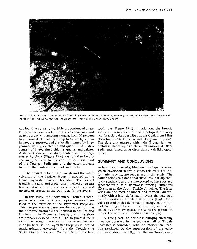
D. W. PIROSHCO AND K. KETTLES
Photo 29.4. Outcrop, located at the Dome/Paymaster minesites boundary, showing the contact between tholeiitic volcanic rocks of the Tisdale Group and the fragmental rocks of the Sedimentary Trough.
was found to consist of variable proportions of angu lar to subrounded clasts of mafic volcanic rock and quartz porphyry in amounts ranging from 20 percent to 70 percent. The clasts are up to 50 cm by 20 cm in size, are unsorted and are locally rimmed by fine grained, dark-grey chlorite and quartz. The matrix consists of fine-grained chlorite, quartz, and calcite. A slate/siltstone unit in sharp contact with the Pay master Porphyry (Figure 29.4) was found to be dis cordant (northwest trend) with the northeast trend of the Younger Sediments and the east-northeast trend of the Tisdale Group volcanic rocks.
The contact between the trough and the mafic volcanics of the Tisdale Group is exposed at the Dome-Paymaster minesites boundary. The contact is highly irregular and gradational, marked by in situ fragmentation of the mafic volcanic wall rock and dikelets of breccia in the wall rock (Photo 29.4).
In this study, the Sedimentary Trough is inter preted as a diatreme or breccia pipe genetically re lated to the intrusion of the Paymaster Porphyry. This interpretation is based on the recognition that the porphyry fragments are identical in texture and lithology to the Paymaster Porphyry and therefore are probably derived from it. The fragmental rocks within the Trough, therefore, cannot be sedimentary in origin because the Paymaster Porphyry is located stratigraphically up-section from the Trough (the South Greenstones and Younger Sediments face
south, see Figure 29.2). In addition, the breccia shows a marked textural and lithological similarity with breccia dykes described at the Coniaurum Mine (Piroshco 1983; Piroshco and Hodgson, in press). The slate unit mapped within the Trough is inter preted in this study as a structural enclave of Older Sediments, based on its discordancy with lithological trends.
SUMMARY AND CONCLUSIONSAt least two stages of gold-mineralized quartz veins, which developed in two distinct, relatively late, de formation events, are recognized in this study. The earlier veins are extensional structures that dip shal- lowly southwest and are interpreted to have formed synchronously with northwest-trending structures (D2 ) such as the South Tisdale Anticline. The later veins are the most dominant and formed synchro nously with a later deformation event characterized by east-northeast-trending structures (Daa). Most veins related to this deformation occupy east-north east-trending faults and fractures but, in one in stance (Vedron Prospect), the veins are parallel to the earlier northwest-trending foliation
A strong east- to northeast-plunging stretching lineation observed in the southern half of Tisdale Township is coincident with the intersection linea tion produced by the superposition of the east- northeast structures (Daa) on the northwest struc-
203
PRECAMBRIAN (29)
lures (D2). In eastern Whitney Township where northwest-oriented structures are poorly developed, this stretching lineation is absent.
At the Dome Mine, a unit previously interpreted as Younger Sediment (the Sedimentary Trough) is reinterpreted as a diatreme breccia genetically re lated to the intrusion of the Paymaster Porphyry. This lithology is host to approximately 50 percent of the ore mined at the Dome Mine and therefore rep resents a new, preferred host lithology for gold mi neralization around porphyry intrusions in the Por cupine Camp.
REFERENCESBell, A.M.1948: Hallnor Mine; p.547-553 in Structural Geology of
Canadian Ore Deposits, edited by M.E. Wilson, Ca nadian Institute of Mining and Metallurgy Sympo sium, Volume l, 948p.
Burrows, A.G.1915: The Porcupine Gold Area, Third Report; Ontario Bu
reau of Mines, Annual Report for 1915, Volume 24, Part 3, p. 1-57. Accompanied by Maps 24d and 24e, scale 1:24 000 or l inch to 2000 feet.
1924: The Porcupine Gold Area, District of Cochrane; Ont ario Department of Mines, Annual Report for 1924, Volume 33, Part 2, p. 1-112. Accompanied by Map 33a, scale 1:24 000 or l inch to 2000 feet.
Carlson, H.D.1967: Geology of Ogden, Deloro, and Shaw Townships,
District of Cochrane; Ontario Department of Mines, Open File Report 5012, 117p. Accompanied by Maps P.341, P.342, and P.343, scale 1:15 840 or l inch to 1/4 mile.
Dunbar, W.R.1948: Structural Relationships of the Porcupine Ore Depos
its; p.442-456 in Structural Geology of Canadian Ore Deposits, edited by M.E. Wilson, Canadian Institute of Mining and Metallurgy Symposium, Volume l, 948p.
Ferguson, S.A.1959a: Whitney Township, Northwest Quarter, District of
Cochrane; Ontario Department of Mines, Map P.9,scale 1:6000 or l inch to 500 feet.
1959b: Whitney Township, Northeast Quarter, District ofCochrane; Ontario Department of Mines, Map P. 10,scale 1:6000 or l inch to 500 feet.
Ferguson, S.A., Buffam, B.S.W., Carter, O.F., Griffis, A.T., Holmes, T.C., Hurst, M.E., Jones, W.A., Lane, H.C., and Longley, C.S.
1968: Geology and Ore Deposits of Tisdale Township, Dis trict of Cochrane; Ontario Department of Mines, Geological Report 58, 177p. Accompanied by Map 2075, scale 1:12 000 or l inch to 1000 feet, and 12 charts.
Fyon, J. Andy, and Crocket, J.H.1983: Gold Exploration in the Timmins Area, Using Field
and Lithogeochemical Characteristics of Carbonate Alteration Zones; Ontario Geological Survey, Study 26, 56p. Accompanied by 2 Charts and 2 Maps.
Hawley, J.E., and Hart, R.C.1948: Preston East Dome Mine; p.529-538 in Structural
Geology of Canadian Ore Deposits, edited by M.E. Wilson, Canadian Institute of Mining and Met allurgy Symposium, Volume l, 948p.
Hodgson, C.J.1983a: The Structure and Geological Development of the Por
cupine Camp—A Re-Evaluation; p.211-225 in The Geology of Gold in Ontario, edited by A.C. Colvine, Ontario Geological Survey, Miscellaneous Paper 110, 278p.
1983b: Preliminary Report on the Timmins-Kirkland Lake Area Gold Deposits File; Ontario Geological Survey, Open File Report 5467, 434p., 17 tables, 40 figures, 9 appendices, and 11 maps.
Holmes, T.C.1948: Dome Mine; p.539-547 in Structural Geology of Ca
nadian Ore Deposits, edited by M.E. Wilson, Cana dian Institute of Mining and Metallurgy Symposium, Volume l, 948p.
Hurst, M.E.1936: Recent Studies in the Porcupine Area; Canadian Insti
tute of Mining and Metallurgy Transactions, Volume 39, p.448-458.
1939: Porcupine Area, District of Cochrane; Ontario De partment of Mines, Map 47a, Scale 1:24 000 or l inch to 2000 feet.
Jensen, L.S.1981: Gold Mineralization in the Kirkland Lake-Larder
Lake Areas; p.59-65 in Genesis of Archean, Vol canic-Hosted Gold Deposits, Symposium Held at the University of Waterloo, March 7, 1980, edited by E.G. Pye and R.G. Roberts, Ontario Geological Sur vey, Miscellaneous Paper 97, 175p.
Leahy, E.J.1971: Geology of the Night Hawk Lake Area, District of
Cochrane; Ontario Department of Mines and North ern Affairs, Geological Report 96, 74p. Accompanied by Map 2222, scale 1:31 680 or l inch to 1/2 mile.
Mason, R., and Melnik, N.1986: The Anatomy of an Archean Gold System—The
Mclntyre-Hollinger Complex at Timmins, Ontario, Canada; p.40-55 in Proceedings of Gold '86, an In ternational Symposium on the Geology of Gold, edited by A.J. Macdonald, 517p.
Piroshco, D.1983: A Re-appraisal of the Geology of the Coniaurum
Mine, Tisdale Township; p. 185-187 in Summary of Field Work 1983, by the Ontario Geological Survey, edited by John Wood, Owen L. White, R.B. Barlow, and A.C. Colvine, Ontario Geological Survey, Mis cellaneous Paper 116, 313p.
Piroshco, D., and Hodgson, C.J.In Press: Relationship of Hydrothermal Alteration to Structure
and Stratigraphy at the Coniaurum Gold Mine, North eastern Ontario; Canadian Journal of Earth Sciences.
Piroshco, D., and Kettles, K.1987: Geology of South Whitney Township With Emphasis
on Structural Geology and Gold Potential, District of Cochrane; p. 165-174 in Summary of Field Work and Other Activities 1987, by the Ontario Geological Sur vey, edited by R.B. Barlow, M.E. Cherry, A.C. Col vine, Burkhard O. Dressler, and Owen L. White,
204
D, W. PIROSHCO AND K. KETTLES
Ontario Geological Survey, Miscellaneous Paper 137, 429p.
Price, P., and Bray, R.C.E.1948: Pamour Mine; p.558-565 in Structural Geology of
Canadian Ore Deposits, edited by M.E. Wilson, Ca nadian Institute of Mining and Metallurgy Sympo sium, Volume l, 948p.
Pyke, D.R.1970: Geology of Langmuir and Blackstock Townships, Dis
trict of Timiskaming; Ontario Department of Mines, Geological Report 86, 65p. Accompanied by Map 2206, scale 1:31 680 or l inch to 1/2 mile.
1972: Geology of Fallon and Fasken Townships, District of Timiskaming; Ontario Division of Mines, Geological Report 104, 31p. Accompanied by Map 2253, scale 1:31 680 or l inch to 1/2 mile.
1975: Geology of Adams and Eldorado Townships, District of Cochrane; Ontario Division of Mines, Geological Report 121, 51p. Accompanied by Map 2274, scale 1:31 680 or l inch to 1/2 mile.
1978a: Geology of the Peterlong Lake Area, Districts of Timiskaming and Sudbury; Ontario Geological Sur vey, Report 171, 53p. Accompanied by Map 2345, scale 1:50 000.
1978b: Geology of the Redstone River Area, District of Timiskaming; Ontario Division of Mines, Geological Report 161, 75p. Accompanied by Maps 2363 and 2364, scale 1:31 680 or l inch to 1/2 mile.
1982: Geology of the Timmins Area, District of Cochrane; Ontario Geological Survey, Report 219, 141p. Ac companied by Map 2455, scale 1:50 000, 3 charts, and l sheet microfiche.
Roberts, R.G.1981: The Volcanic-Tectonic Setting of Gold Deposits in the
Timmins Area, Ontario; p. 16-28 in Genesis of Ar chean, Volcanic-Hosted Gold Deposits, Symposium Held at the University of Waterloo, March 7, 1980, edited by E.G. Pye and R.G. Roberts, Ontario Geo logical Survey, Miscellaneous Paper 97, 175p.
205
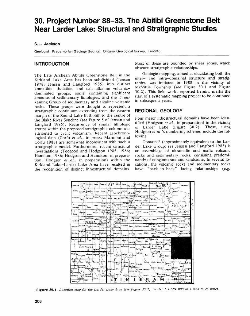
30. Project Number 88-33. The Abitibi Greenstone Belt Near Larder Lake: Structural and Stratigraphic Studies
S.L. Jackson
Geologist, Precambrian Geology Section, Ontario Geological Survey, Toronto.
INTRODUCTION
The Late Archean Abitibi Greenstone Belt in the Kirkland Lake Area has been subdivided (Jensen 1978; Jensen and Langford 1985) into distinct komatiitic, tholeiitic, and calc-alkaline volcanic- dominated groups, some containing significant amounts of sedimentary lithologies, and the Timis kaming Group of sedimentary and alkaline volcanic rocks. These groups were thought to represent a stratigraphic continuum extending from the eastern margin of the Round Lake Batholith to the centre of the Blake River Syncline (see Figure 5 of Jensen and Langford 1985). Recurrence of similar lithologic groups within the proposed stratigraphic column was attributed to cyclic volcanism. Recent geochrono- logical data (Corfu et al., in press; Marmont and Corfu 1988) are somewhat inconsistent with such a stratigraphic model. Furthermore, recent structural investigations (Toogood and Hodgson 1985, 1986; Hamilton 1986; Hodgson and Hamilton, in prepara tion; Hodgson et al., in preparation) within the Kirkland Lake-Larder Lake Area have resulted in the recognition of distinct lithostructural domains.
Most of these are bounded by shear zones, which obscure stratigraphic relationships.
Geologic mapping, aimed at elucidating both the inter- and intra-domainal structure and stratig raphy, was initiated in 1988 in the vicinity of Mcvittie Township (see Figure 30.1 and Figure 30.2). This field work, reported herein, marks the start of a systematic mapping project to be continued in subsequent years.
REGIONAL GEOLOGYFour major lithostructural domains have been iden tified (Hodgson et al., in preparation) in the vicinity of Larder Lake (Figure 30.2). These, using Hodgson et al. 's numbering scheme, include the fol lowing.
Domain 2 (approximately equivalent to the Lar der Lake Group; see Jensen and Langford 1985) is an assemblage of ultramafic and mafic volcanic rocks and sedimentary rocks, consisting predomi nantly of conglomerate and sandstone. In several lo cations, the volcanic rocks and sedimentary rocks have "back-to-back" facing relationships (e.g.
Figure 30.1. Location map for the Larder Lake Area (see Figure 30.2). Scale: 1:1 584 000 or l inch to 25 miles.
206

S.L. JACKSON
FOLD AXES — AXIAL SURFACE
Figure 30.2. Lithostructural domains (modified after Hodgson et al., in preparation) in the Larder Lake Area. Numbered domains, except Domain l (see Hodgson et al., in preparation), are discussed in text. Open diamonds rep resent calc-alkaline volcanic rocks; open triangles represent mafic volcanic rocks; dots represent sandstones and con glomerates; filled triangles represent ultramafic and mafic volcanic rocks; thin lines represent feldspar porphyry and syenite; thick lines represent gabbroic rocks; thick curvilin ear lines represent faults; dashed line labelled M represents the Monocle Lake Deformation Zone; P stands for Proterozoic rocks; L stands for Larder Lake; and F stands for the fault referred to in the text. See text for further in formation.
Thomson 1949, Hearst Township Map, 0.5 km east of Sharp Creek). It is unclear if the "back-to-back" relationships are due to a major unconformity or tectonic juxtaposition of distinct lithological assem blages, or both. Corfu et al. (in press) and Marmont and Corfu (1988) obtained an age of 2705 Ma from a tuff that is intercalated with ultramafic flows. Structurally, this zone is characterized by map-scale fold interference patterns (e.g. Thomson 1949, Hearst Township Map).
Domain 4, the Kirkland Lake-Larder Lake De formation Zone (KLDZ) (Hamilton 1986), sepa rates Domains 2 and 7. It is underlain predomi nantly by the Timiskaming Group sedimentary and alkaline volcanic rocks, and lesser amounts of feld
spar and quartz-feldspar porphyritic intrusions, car- bonate+quartzifuchsite schists, talc-chlorite schists, and mafic to ultramafic rocks. The KLDZ is ap proximately east-striking, l to 3 km wide, and, in Ontario, over 60 km long. Steeply dipping planar fabrics (principally schistosities, cleavages, fractures, shear planes, and foliations defined by flattened and/or elongated clasts and fragments) are of vari able, but generally east-west, orientation. Clast and fragment elongation directions and fold axes are generally steeply plunging. However, shallowly plunging folds are also present.
This domain is clearly the most important from an economic perspective, since most major gold mines (past and present producers) in the area are located within it. Many workers have drawn atten tion to the association of gold, deformation zones, carbonate alteration, and felsic intrusions within this domain (e.g. Hamilton 1986; Hodgson et al., in preparation, and references therein).
Domain 7 includes both the tholeiitic basalt suite of the Kinojevis Group and the calc-alkaline, frag mental suite of the Gauthier Group. These groups, and the younging directions obtained from them, de fine the east-southeast-plunging Spectacle Lakes Anticline (Thomson 1949). Penetrative fabrics are only locally developed in this domain.
Domain 8 is composed of the 2701 Ma (Mar mont and Corfu 1988) calc-alkaline suite of vol canic rocks belonging to the Blake River Group. Penetrative fabrics are generally absent from this zone. However, near major faults (e.g. Fault "F", Figure 30.2), steeply dipping cataclastic foliations, flattened pillows, and weak penetrative foliations are observed.
SUMMARY OF RESULTSSome of the principal results of the 1988 field work are:1. In southernmost Domain 4 (KLDZ) are folds
with variable plunges, but constant axial surface orientations that parallel the KLDZ. The forma tion of these folds is correlated with the forma tion of the KLDZ.
2. Based on orientation and apparent relative tim ing, at least three sets of shear zones are recog nized within the KLDZ (Domain 4).
3. Depositional contacts between basaltic rocks of the Kinojevis Group (Domain 7) and sedimen tary rocks of the younger Timiskaming Group are exposed on both the northern and southern limbs of the Spectacle Lakes Anticline. At other localities, the Kinojevis-Timiskaming contact is highly strained.
4. A zone, approximately l km wide, of anoma lously high strain is present south of the Crosby Sill (Figure 30.3) along the northern side of the Spectacle Lakes Anticline. This zone is herein
207
PRECAMBRIAN (30)
FELDSPAR PORPHYRY/SYENITE
TRACHYTE/AGGLOMERATE
SANDSTONE/CONGLOMERATE
GABBRO
n* -DIORITIC- BASALT
INTERMEDIATE VOLCANIC ROCKS
YOUNGING DIRECTION
FAULT
1 km
Figure 30.3. Geology of Mcvittie Township (modified after Thomson 1943). SLA stands for Spectacle Lakes Anticline. Numbered dots refer to locations discussed in the text. B, C, L, and M stand for Beaverhouse, Crosby, Larder, and Mon ocle lakes, respectively.
referred to as the Monocle Lake Deformation MESOSCOPIC FOLDS IN THE SOUTHERN PART Zone (Figure 30.2). Interpretation of fabric ge- OF THE KIRKLAND LAKE-LARDER LAKE ometry within the zone indicates a predomi- DEFORMATION ZONEnantly sinistral sense of displacement. Where observed to date (e.g. location 3, Figure
30.3), these open to isoclinal folds vary from sub-
208
S.L. JACKSON
79053' 790 30'48O 16' 30"
43-01'
1O km
Figure 30.4. Equal area plot of fold axes and the ap proximate axial planes of folds from location 3 of Figure 30.3.
horizontal to steeply plunging within a few metres, but have consistent, steeply dipping, east-trending axial surface orientations (Figure 30.4). Axial sur faces, axial planar schistosity, and sheared limbs of the folds all parallel the trend of the KLDZ. This parallelism suggests that the folds and the KLDZ are related. No fabric oblique to the trend of the fold axes was observed. Therefore, the variation in
plunge direction of the folds is attributed to a single phase of deformation involving the progressive rota tion of early-formed, uniformly plunging fold axes. There is considerable potential for gaining insight into the kinematics of the KLDZ by unravelling the deformation history of the sediments in and immedi ately south of it.
KIRKLAND LAKE-LARDER LAKE DEFORMATION ZONE (KLDZ)
Three different shear zones (or sets thereof) are rec ognized on the basis of orientation. The inferred relative timing of these, from oldest to youngest, is: 1) east-southeast-trending shear zones; 2) north- trending shear zones; and 3) east-northeast to east- trending shear zones. Fabrics and structures from the KLDZ have been described in detail by Hamil ton (1986). At present, it remains unclear whether the different shear zones represent discrete events (e.g. Hodgson e t al., in preparation), or different stages of development of one continuous event. Fur ther work is required to resolve both this problem and the problem of developing a kinematic model for fabric development with the KLDZ (see for ex ample Toogood and Hodgson 1985, p.201).
KINOJEVIS GROUP-TIMISKAMING GROUP CONTACTS
Depositional contacts (locations l and 2, Figure 30.3; Photo 30.1) between, and relative positions of, the Kinojevis tholeiitic basalts and Timiskaming sedi mentary rocks exposed on the southern and north-
Photo 30.1. Timiskaming Group conglomerate (top left) in contact with Kinojevis Group basalts (bottom right). Photo from location 2 of Figure 30.3.
209
PRECAMBRIAN (30)
ern limbs of the Spectacle Lakes Anticline, are con sistent with an anticlinal structure cored by the older Kinojevis Group. The southern contact dips moder ately to the south. There, large boulders and cobbles of basalt at the very base of the Timiskaming are similar to the underlying basalt. There is no evidence of displacement, high strain, or faulting at the con tact. In addition, narrow fractures in the basalt unit are filled with conglomerate. The contact on the northern limb of the anticline is more strained, but displays features similar to those found at the south ern contact. At other localities (e.g. location 4, Fig ure 30.3), high strain has concealed the original na ture of the contact. Furthermore, rocks near the high strain zones have experienced weak to intense carbonate alteration (location 4, Figure 30.3; see also Mcvittie Township Map of Thomson 1943).
It is clear that the Timiskaming was deposited, at least in part, on top of the Kinojevis Group basalts, and that subsequent deformation modified the origi nal nature of the contact. It is unclear, however, to what extent the angular discordance between the two groups (e.g. Mcvittie Township Map, Thomson 1943) is due to deformation and/or an angular un conformity (see Thomson 1946; Toogood and Hodgson 1986; Hamilton 1986).
MONOCLE LAKE DEFORMATION ZONE
The Monocle Lake Deformation Zone (see Figure 30.2 for location) is a zone of high strain that sepa rates massive gabbroic rocks of the Crosby Sill from massive basalts of the Kinojevis Group. The full ex
tent of the zone and its tectonic significance are, as yet, unknown. Some rocks within the zone exhibit slight to moderate degrees of carbonate alteration. This zone is also associated with feldspantquartz porphyry intrusions and some gold mineralization (e.g. the Ker-Vit Mine).
Fabrics and structures found within the zone in clude: spaced (mm to cm scale) fractures in pillowed basalt, folded pillow selvages with penetrative axial planar schistosity, highly flattened conglomerate clasts, pressure solution cleavage in sandstone layers, and well-developed schistosities in both metasedi- ments and metabasaltic rocks. These fabrics are, generally, east- to southeast-trending and steeply to moderately north-dipping. However, a limited zone, just northwest of Monocle Lake, of shallowly dip ping to subhorizontal schistosity is present.
The flattened clasts, schistosities, and pressure solution cleavages within this deformation zone are west-northwest-trending and are deflected by a "later", east-trending, moderately to steeply north- dipping spaced crenulation to fracture cleavage. This "later" fabric deflects the earlier fabrics to yield a geometry consistent with a sinistral displacement sense (Photo 30.2). It is possible that the "later" fabric developed synchronously with the compressive fabrics, and would therefore represent "c" fabrics of a sinistral shear system.
One kilometre east of Monocle Lake, in a Timiskaming sandstone-conglomerate sequence, the "later" (or "c") fabrics are subparallel to lithological contacts. This sugguests that layer-parallel displace ment (of unknown magnitude) occurred during de-
Photo 30.2. Highly flattened and sheared Timiskaming conglomerate. Note that flattened clasts are deflected into a "Z' asymmetry, indicating a sinistral displacement sense. Photo taken l km east of the northern end of Monocle Lake.
210
S.L. JACKSON
formation, and that at least some lithologic contacts in the deformation zone are tectonic contacts.
Northwest of Monocle Lake, on northern Beaverhouse Lake within Mcvittie Township, ba salts of the Kinojevis Group display flattened pillows, local penetrative schistosity, and spaced fractures, all of which are steeply dipping and west-northwest- trending. The deformation in this area may be re lated to the deformation near Monocle Lake.
A 30 0 to 40 0 north-dipping seismic reflector (G. West, Geophysicist, University of Toronto, per sonal communication, 1988) projects to the surface approximately where the Monocle Lake Deforma tion Zone crops out. Furthermore, where studied to date, this zone separates rocks of the Kinojevis Group from the Crosby Sill and the Blake River Group to the north. Other deformation zones, such as the northwest-trending carbonated shear zone in Morrissette Township (Rupert and Lovell 1970), oc cur along strike from the Monocle Lake Deforma tion Zone. The shear zone in Morrissette Township is, like the Monocle Lake Deformation Zone, asso ciated with Timiskaming Group sedimentary rocks, carbonate alteration, and gold mineralization, and occurs near the boundary of the Kinojevis Group and Blake River Group. The available evidence indi cates that the Monocle Lake Deformation Zone is an important regional structure that controls the dis tribution of major lithologic assemblages.
CLOSING REMARKSThis preliminary study has provided new observa tions regarding the structures within, and the nature of the contacts between, some of the lithostructural domains in the Kirkland Lake-Larder Lake area. Systematic mapping and related studies will be car ried out within this area in subsequent years. In ad dition to producing updated maps, this work should clarify our understanding of: 1) the internal struc ture, stratigraphy, and absolute ages of the lithostructural domains; 2) the structural-strati- graphic relationship between domains; and 3) the relationship between the metamorphic e vent (s), de formation, alteration, mineralization, and mag matism.
ACKNOWLEDGMENTSG. Grabowski and G. Meyer (Resident Geologist's Office, Ministry of Northern Development and Mines, Kirkland Lake), are thanked for useful dis cussions related to the geology of the Kirkland Lake area.
REFERENCESCorfu, F., Krogh, T.E., Kwok, Y.Y., Marmont, Soussan,
and Jensen, L.S. In Press: U-Pb Geochronology in the Southwestern Abitibi
Greenstone Belt, Superior Province; Canadian Journalof Earth Sciences.
Hamilton, J.V.1986: The Structural and Stratigraphic Setting of Gold
Mineralization in the Vicinity of Larder Lake, South- central Abitibi Greenstone Belt, Northeastern On tario; Unpublished M.Se. Thesis, Queen's Univer sity, Kingston, 156p.
Hodgson, C.J., and Hamilton, J.V.In Prep.: Lithotectonic Environment of Gold Mineralization
in the Abitibi Greenstone Belt: End Stage Result of Archean Collisional Tectonics?; Bicentennial Gold '88, Geological Society of Australia.
Hodgson, C.J., Hamilton, J.V., and Guimond, R.P.In Prep.: Relationship Between Gold Deposits and the Tec
tonic Framework of the Abitibi Greenstone Belt in the Kirkland Lake-Larder Lake Area; Ontario Geological Survey, Open File Report.
Jensen, L.S.1978: Regional Stratigraphy and Structure of the Timmins-
Kirkland Lake Area, Districts of Cochrane and Timiskaming; p.67-72 in Summary of Field Work 1978, by the Ontario Geological Survey, edited by V.G. Milne, Owen L. White, R.B. Barlow, and J.A. Robertson, Ontario Geological Survey, Miscella neous Paper 82, 235p.
Jensen, L.S., and Langford, F.F.1985: Geology and Petrogenesis of the Archean Abitibi Belt
in the Kirkland Lake Area, Ontario; Ontario Geologi cal Survey, Miscellaneous Paper 123, 130p.
Marmont, Soussan, and Corfu, F.1988: Timing of Gold Introduction in the Late Archean Tec
tonic Framework of the Canadian Shield: Evidence from U-Pb Zircon Geochronology of the Abitibi Sub- province; p.45-50 in Extended Abstracts, Bicenten nial Gold '88, Geological Society of Australia, Vol ume 22.
Rupert, R.J., and Lovell, H.L.1970: Geology of Bernhardt and Morrisette Townships, Lar
der Lake Area; Ontario Department of Mines, Geo logical Report 84, 27p.
Thomson, J.E.1943: Geology of McGarry and Mcvittie Townships, Larder
Lake Area; Ontario Department of Mines, Annual Report for 1941, Volume 50, Part 7, 99p.
1946: The Keewatin-Timiskaming Unconformity in the Kirkland Lake District; Royal Society of Canada, Transactions, Section IV, p.113-124.
1949: Geology of Hearst and McFadden Townships, Timis kaming District; Ontario Department of Mines, An nual Report for 1947, Volume 56, Part 8, 34p.
Toogood, D.J., and Hodgson, C.J.1985: A Structural Investigation Between the Kirkland Lake
and Larder Lake Gold Camps; p.200-204 in Sum mary of Field Work 1984, Ontario Geological Survey, edited by John Wood, Owen L. White, R.B. Barlow, and A.C. Colvine, Ontario Geological Survey, Mis cellaneous Paper 119, 309p.
1986: Relationship Between Gold Deposits and the Tectonic Framework of the Abitibi Greenstone Belt in the Kirkland Lake-Larder Lake Area; p.79-86 in Geos cience Research Grant Program, Summary of Re search 1985-1986, edited by V.G. Milne, Ontario Geological Survey, Miscellaneous Paper 130, 235p.
211
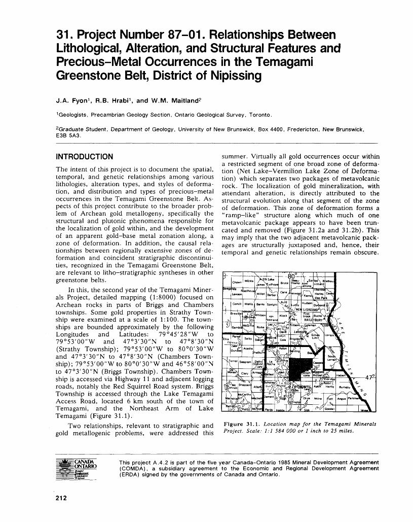
31. Project Number 87-01. Relationships Between Lithological, Alteration, and Structural Features and Precious-Metal Occurrences in the Temagami Greenstone Belt, District of Nipissing
J.A. Fyon 1 , R.B. Hrabi 1 , and W.M. Maitland2
1 Geologists, Precambrian Geology Section, Ontario Geological Survey, Toronto.
2Graduate Student, Department of Geology, University of New Brunswick, Box 4400, Fredericton, New Brunswick, E3B 5A3.
INTRODUCTIONThe intent of this project is to document the spatial, temporal, and genetic relationships among various lithologies, alteration types, and styles of deforma tion, and distribution and types of precious-metal occurrences in the Temagami Greenstone Belt. As pects of this project contribute to the broader prob lem of Archean gold metallogeny, specifically the structural and plutonic phenomena responsible for the localization of gold within, and the development of an apparent gold-base metal zonation along, a zone of deformation. In addition, the causal rela tionships between regionally extensive zones of de formation and coincident stratigraphic discontinui ties, recognized in the Temagami Greenstone Belt, are relevant to litho-stratigraphic syntheses in other greenstone belts.
In this, the second year of the Temagami Miner als Project, detailed mapping (1:8000) focused on Archean rocks in parts of Briggs and Chambers townships. Some gold properties in Strathy Town ship were examined at a scale of 1:100. The town ships are bounded approximately by the following Longitudes and Latitudes: 79 0 45'28"W to 79 0 53'00"W and 47 0 3'30"N to 47 0 8'30"N (Strathy Township); 79 0 53'00"W to 80 0 0'30"W and 47 0 3'30"N to 47 0 8'30"N (Chambers Town ship); 79 0 53'00"W to 80 0 0'30"W and 46 0 58'00"N to 47 0 3'30"N (Briggs Township). Chambers Town ship is accessed via Highway 11 and adjacent logging roads, notably the Red Squirrel Road system. Briggs Township is accessed through the Lake Temagami Access Road, located 6 km south of the town of Temagami, and the Northeast Arm of Lake Temagami (Figure 31.1).
Two relationships, relevant to stratigraphic and gold metallogenic problems, were addressed this
summer. Virtually all gold occurrences occur within a restricted segment of one broad zone of deforma tion (Net Lake-Vermilion Lake Zone of Deforma tion) which separates two packages of metavolcanic rock. The localization of gold mineralization, with attendant alteration, is directly attributed to the structural evolution along that segment of the zone of deformation. This zone of deformation forms a "ramp-like" structure along which much of one metavolcanic package appears to have been trun cated and removed (Figure 31.2a and 31.2b). This may imply that the two adjacent metavolcanic pack ages are structurally juxtaposed and, hence, their temporal and genetic relationships remain obscure.
Figure 31.1. Location map for the Temagami Minerals Project. Scale: 1:1 584 000 or l inch to 25 miles.
CANADA ONTARIO
This project A.4.2 is part of the five year Canada-Ontario 1985 Mineral Development Agreement (COMDA), a subsidiary agreement to the Economic and Regional Development Agreement (ERDA) signed by the governments of Canada and Ontario.
212
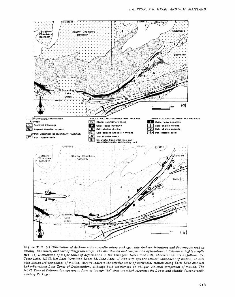
J.A. FYON, R.B. HRABI, AND W.M. MAITLAND
r \\ V, V,Stock *\ VBRIGGS
l l Proterozoic.unsubdivided Archean
Layered tholeiitic intrusion
UPPER VOLCANO-SEDIMENTARY PACKAGE ] Iron tholeiite basalt
MIDDLE VOLCANO-SEDIMENTARY PACKAGE Clastic sedimentary rocks Oxide facies ironstone
l 0 j Calc-alkaline rhyoliteCalc-alkaline andesite - rhyolite Iron tholeiite basaltUltramafic fragmental rock and associated clastic sedimentary rock
LOWER VOLCAN O-SEDIMENTARY PACKAGE Oxide facies ironstone Calc-alkaline rhyolite
"-'| Calc-alkaline andesite [r A, "J Iron tholeiite basalt
mn
(b)
Figure 31.2. (a) Distribution of Archean volcano-sedimentary packages, late Archean intrusions and Proterozoic rock in Strathy, Chambers, and part of Briggs townships. The distribution and composition of lithological divisions is highly simpli fied, (b) Distribution of major zones of deformation in the Temagami Greenstone Belt. Abbreviations are as follows: TL Tasse Lake; NLVL Net Lake-Vermilion Lake; LL Link Lake; U-side with upward vertical component of motion; D-side with downward component of motion. Arrows indicate the relative sense of horizontal motion along Tasse Lake and Net Lake-Vermilion Lake Zones of Deformation, although both experienced an oblique, sinistral component of motion. The NLVL Zone of Deformation appears to form as "ramp-like" structure which separates the Lower and Middle Volcano-sedi mentary Packages.
213
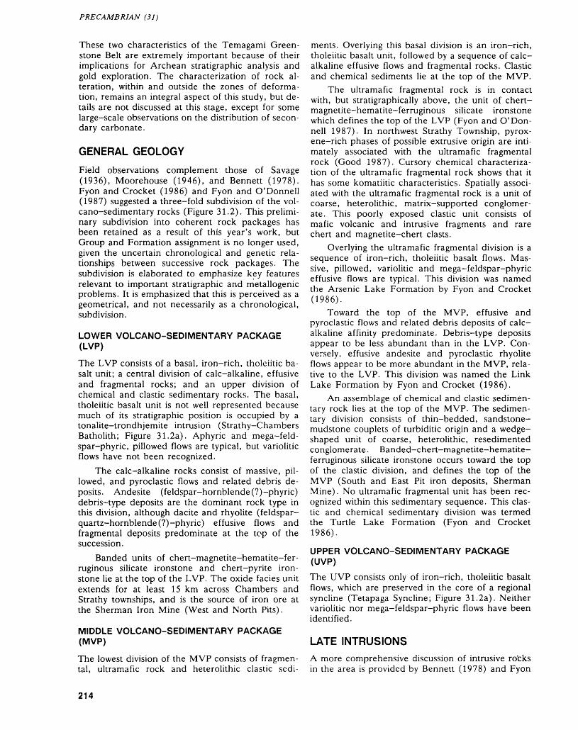
PRECAMBRIAN (31)
These two characteristics of the Temagami Green stone Belt are extremely important because of their implications for Archean stratigraphic analysis and gold exploration. The characterization of rock al teration, within and outside the zones of deforma tion, remains an integral aspect of this study, but de tails are not discussed at this stage, except for some large-scale observations on the distribution of secon dary carbonate.
GENERAL GEOLOGY
Field observations complement those of Savage (1936), Moorehouse (1946), and Bennett (1978). Fyon and Crocket (1986) and Fyon and O'Donnell (1987) suggested a three-fold subdivision of the vol cano-sedimentary rocks (Figure 31.2). This prelimi nary subdivision into coherent rock packages has been retained as a result of this year's work, but Group and Formation assignment is no longer used, given the uncertain chronological and genetic rela tionships between successive rock packages. The subdivision is elaborated to emphasize key features relevant to important stratigraphic and metallogenic problems. It is emphasized that this is perceived as a geometrical, and not necessarily as a chronological, subdivision.
LOWER VOLCANO-SEDIMENTARY PACKAGE (LVP)
The LVP consists of a basal, iron-rich, tholeiitic ba salt unit; a central division of calc-alkaline, effusive and fragmental rocks; and an upper division of chemical and clastic sedimentary rocks. The basal, tholeiitic basalt unit is not well represented because much of its stratigraphic position is occupied by a tonalite-trondhjemite intrusion (Strathy-Chambers Batholith; Figure 31.2a). Aphyric and mega-feld- spar-phyric, pillowed flows are typical, but variolitic flows have not been recognized.
The calc-alkaline rocks consist of massive, pil lowed, and pyroclastic flows and related debris de posits. Andesite (feldspar-hornblende(?)-phyric) debris-type deposits are the dominant rock type in this division, although dacite and rhyolite (feldspar- quartz-hornblende (?)-phyric) effusive flows and fragmental deposits predominate at the top of the succession.
Banded units of chert-magnetite-hematite-fer ruginous silicate ironstone and chert-pyrite iron stone lie at the top of the LVP. The oxide facies unit extends for at least 15 km across Chambers and Strathy townships, and is the source of iron ore at the Sherman Iron Mine (West and North Pits).
MIDDLE VOLCANO-SEDIMENTARY PACKAGE (MVP)
The lowest division of the MVP consists of fragmen tal, ultramafic rock and heterolithic clastic sedi
ments. Overlying this basal division is an iron-rich, tholeiitic basalt unit, followed by a sequence of calc- alkaline effusive flows and fragmental rocks. Clastic and chemical sediments lie at the top of the MVP.
The ultramafic fragmental rock is in contact with, but stratigraphically above, the unit of chert- magnetite-hematite-ferruginous silicate ironstone which defines the top of the LVP (Fyon and O'Don nell 1987). In northwest Strathy Township, pyrox ene-rich phases of possible extrusive origin are inti mately associated with the ultramafic fragmental rock (Good 1987). Cursory chemical characteriza tion of the ultramafic fragmental rock shows that it has some komatiitic characteristics. Spatially associ ated with the ultramafic fragmental rock is a unit of coarse, heterolithic, matrix-supported conglomer ate. This poorly exposed clastic unit consists of mafic volcanic and intrusive fragments and rare chert and magnetite-chert clasts.
Overlying the ultramafic fragmental division is a sequence of iron-rich, tholeiitic basalt flows. Mas sive, pillowed, variolitic and mega-feldspar-phyric effusive flows are typical. This division was named the Arsenic Lake Formation by Fyon and Crocket (1986).
Toward the top of the MVP, effusive and pyroclastic flows and related debris deposits of calc- alkaline affinity predominate. Debris-type deposits appear to be less abundant than in the LVP. Con versely, effusive andesite and pyroclastic rhyolite flows appear to be more abundant in the MVP, rela tive to the LVP. This division was named the Link Lake Formation by Fyon and Crocket (1986).
An assemblage of chemical and clastic sedimen tary rock lies at the top of the MVP. The sedimen tary division consists of thin-bedded, sandstone- mudstone couplets of turbiditic origin and a wedge- shaped unit of coarse, heterolithic, resedimented conglomerate. Banded-chert-magnetite-hematite- ferruginous silicate ironstone occurs toward the top of the clastic division, and defines the top of the MVP (South and East Pit iron deposits, Sherman Mine). No ultramafic fragmental unit has been rec ognized within this sedimentary sequence. This clas tic and chemical sedimentary division was termed the Turtle Lake Formation (Fyon and Crocket 1986).
UPPER VOLCANO-SEDIMENTARY PACKAGE (UVP)
The UVP consists only of iron-rich, tholeiitic basalt flows, which are preserved in the core of a regional syncline (Tetapaga Syncline; Figure 31.2a). Neither variolitic nor mega-feldspar-phyric flows have been identified.
LATE INTRUSIONSA more comprehensive discussion of intrusive rocks in the area is provided by Bennett (1978) and Fyon
214
J.A. FYON, R.B. HRABI, AND W.M. MAITLAND
and O'Donnell (1987). Only some characteristics of the post-volcanic intrusions, relevant to the struc tural chronology, are presented.
TONALITE-TRONDHJEMITE
The Strathy-Chambers Batholith, located in north ern Chambers and Strathy townships, appears to be a single phase tonalite-trondhjemite intrusion, which contains minor amounts of pegmatite and aplite. An amphibolite facies contact metamorphic aureole sur rounds the intrusion and the trend of the metavol- canic stratigraphy parallels the margin of the intru sion. A flattening fabric (So/S^. attributed to the earliest regional deformation, is developed in the outer margin of the intrusion (see below).
TRONDHJEMITE-GRANODIORITE
The Iceland Lake Stock, located in Briggs and Strathcona townships, is a composite trondhjemite- granodiorite pluton, consisting of chlorite trondh jemite, hornblende quartz diorite and hornblende trondhjemite phases (Bennett 1978). The trend of metavolcanic units in Briggs and Strathcona town ships is parallel to the intrusion contact. A flattening fabric (S07S-|), attributed to the earliest deformation of the greenstone belt, is present in the outer margin of the intrusion (see below).
MICROCLINE MEGACRYSTIC GRANITE
The Spawning Lake Stock carries up to 50 percent microcline megacrysts, 2 to 3 cm in diameter. This intrusion truncates a regional fold axis (Tetapaga Syncline) and a zone of deformation (western exten sion of the Net Lake-Vermilion Lake Zone of De formation), but bears none of the related deforma tion fabrics. It is grossly discordant to lithological layering.
BIOTITE LAMPROPHYRE DIKES
Several dikes of this kindred were observed within zones of deformation. This meagre data base sug gests that biotite lamprophyre dikes are preferen tially localized within or adjacent to zones of defor mation; however, there are exceptions where lamprophyre dikes occur outside zones of high strain. Lamprophyre dikes have two preferential strike orientations (OOO 0 and 300 0 ; Bennett 1978, p.44), parallel to some deformation zones and Proterozoic diabase dikes. Biotite lamprophyre dikes cut the outer margins of the Iceland Lake and the Spawning Lake stocks.
STRUCTURAL FEATURESDescribed below, chronologically and in terms of in creasing scale, are the regional deformation charac teristics of the greenstone belt. Two styles of folding and four zones of ductile deformation can be related to three discrete penetrative foliations.
EARLY FOLIATION
The notation SQ/ST is used to designate this foliation, because the distinction between transposed primary layering (bedding?) and a tectonic foliation is not possible in some zones of high strain. This foliation is generally east-trending in Chambers and Strathy townships and has a steep dip. Its strike is parallel to bedding, major stratigraphic units, and the margins of the Strathy-Chambers and Iceland Lake intru sions. Changes in foliation strike are generally sym pathetic with changes in bedding strike. The mineral and fragment dimensional elongation developed on this foliation plane is steeply plunging.
SHEAR FOLIATION (S2 )
A shear foliation (S2) is developed in two shear zones: the Net Lake-Vermilion Lake (NLVL) and the Tasse Lake Zones of Deformation. It has a steep dip, with a steeply plunging mineral and fragment dimensional elongation. The consistent left-handed displacement of some quartz veins, lithological units and dikes, and the development of apparent S-C fabric relationships along the NLVL Zone of Defor mation are evidence consistent with a sinistral com ponent of motion. No shallowly plunging mineral or fragment dimensional elongation was observed.
LATE FOLIATION (S3 )
This is a north-trending foliation which is recognized in all metavolcanic and metasedimentary rocks and in the Strathy-Chambers Batholith. It has a steep dip, but mineral lineations were rarely observed. This foliation is axial planar to open folds having a wavelength and amplitude of 10 to 40 cm where ob served on individual outcrops, and 10s to 100s m where inferred on a township scale. Both S0 7S-| and S2 appear to be folded by S3 , although examples of unequivocal overprint relationships between S2 and 83 are few.
TETAPAGA SYNCLINE
The Tetapaga Syncline is the largest recognizable re gional fold (Bennett 1978). Its axial plane has an east trend across the southern part of Strathy and Chambers townships, parallel to S07S-| and the stratigraphic attitudes of the metavolcanic and metasedimentary units. Rocks of the MVP are re peated on either side of the Tetapaga Syncline and the iron-rich tholeiitic basalts of the UVP occupy the core of the syncline in Strathy and Chambers townships. The thickness of the UVP within the syn clinal core increases toward eastern Strathy Town ship and toward western Briggs Township, with the minimum thickness corresponding approximately with the Strathy-Briggs Township junction. This im plies that the Tetapaga Syncline is doubly plunging on a regional scale.
The Spawning Lake Stock truncates the fold ax ial surface. East of the Spawning Lake Stock, minor
215
PRECAMBRIAN (31)
folds have a shallow easterly plunge, while mineral lineations and clast elongation plunge steeply to the southeast. West of the Spawning Lake Stock, min eral lineations plunge westerly. This doubly plunging aspect of the fold, adjacent to the Spawning Lake Stock, may be related to doming associated with the intrusion emplacement. The Spawning Lake Stock appears to be unaffected by the strain associated with the development of the Tetapaga Syncline.
ZONES OF DEFORMATION
Four major zones of ductile shear are defined on the basis of intense foliation development: Link Lake, Northeast Arm, Net Lake-Vermilion Lake, and Tasse Lake Zones of Deformation (Bennett 1978; Fyon and O'Donnell 1987). Several narrower zones of high strain occur outside the major zones of de formation.
Link Lake and Northeast Arm Zones of Deformation
The Link Lake and Northeast Arm Zones of Defor mation are characterized by a very strongly devel oped flattening foliation and a strong vertical dimen sional elongation of fragments. Foliation has an east erly trend with a vertical to subvertical dip, approxi mately parallel to bedding attitudes, to the surface trace of the Tetapaga Syncline axial plane and to the regional SQ/ST foliation. Additional characteristics of these zones are described by Fyon and O'Donnell (1987). No gold showings having proven tonnage oc cur within either of these zones.
Net Lake-Vermilion Lake Zone of Deformation
In western Strathy Township, the S2 shear foliation has a 030 0 trend, oblique to the regional bedding. In southern Chambers Township, the attitude of the shear foliation is west to northwest, approximately subparallel to bedding units. The zone of intense fabric development is approximately l km in width, and coincides with the contact zone between the LVP and MVP. Small-scale asymmetric kinematic indicators are consistent with a dominant, oblique, subvertical component of motion, with a lesser, sin istral, horizontal component. In western Strathy Township, regional bedding and the SQ/ST foliation (OSO 0 ) are rotated into parallelism with the 030 0 shear foliation. The sense of this rotation, observed at a township scale, is also consistent with a compo nent of sinistral horizontal translation.
Many of the gold occurrences that have proven grade and tonnage occur within the northeast seg ment in this zone of deformation, between Vermil ion and Net lakes (Bennett 1978), although none occur within the western segment.
In southern Chambers-northern Briggs town ships, the shear zone is localized along a unit of fel sic metavolcanic rock (middle of MVP). Minor S—
folds, kink structures, and crenulations are well de veloped and have steeply plunging fold axes, parallel to mineral and clast elongation. The developmental chronology of these minor structures remains equivocal, in part because this segment of the zone of deformation may reflect the superposition of the NLVL Zone of Deformation upon the pre-existing, westward extension of the Link Lake Zone of De formation.
Tasse Lake Zone of DeformationThis zone of deformation extends from the western boundary of central Chambers Township, easterly through Tasse Lake, approximately parallel to vol canic layering. It is at least 0.5 km in width, and has been traced for about 3 km along strike. It is not certain if, or how far, this zone extends to the east of Tasse Lake, although it does not extend to the eastern boundary of Chambers Township.
Kinematic asymmetry is consistent with a domi nant oblique, south-side-up sense of displacement, and a sinistral horizontal component. This kinematic sense is similar to parts of the NLVL Zone of Defor mation, with which this zone of deformation may be related. No gold occurrences have been found in this zone.
STRUCTURAL CHRONOLOGY
In western Strathy Township, the early S0IS-\ folia tion (OSO 0 ) is rotated adjacent to and is therefore older than the 030 0 shear fabric of the NLVL shear zone. The NLVL Zone of Deformation cuts and therefore post-dates the intrusion of the outer mar gin of the Strathy-Chambers Batholith. Feldspar- phyric dikes, possibly representing early expressions of Spawning Lake Stock magmatism, are deformed in the NLVL Zone of Deformation, although the main mass of the Spawning Lake Stock appears un- deformed. When observed within the NLVL Zone of Deformation, biotite booklets within late lamprophyre dikes are aligned parallel to the shear foliation. These biotite lamprophyre dikes cut the outer margin of the Spawning Lake Stock. Thus, the lamprophyre dikes and Spawning Lake Stock may have been intruded late in the deformation history, but were emplaced into an existing stress field. Ap parent differences in strain intensity between the dikes and the main mass of the Spawning Lake Stock may be related to differences in rheology.
STRUCTURAL INTERPRETATIONS
The identification of "events" to which the develop ment of the foliations can be attributed must be done cautiously, given the scale of observation.
Early SQ IS^ Foliation and Tetapaga SynclineThe SQ/ST foliation is interpreted to represent the earliest regional flattening of the volcano-sedimen tary lithologies, and developed in response to north-
216
J.A. FYON, R.B. HRABI, AND W.M. MAITLAND
south shortening. The parallelism between S07S-| and the axial planar foliation of the Tetapaga Syncline implies that the Tetapaga Syncline also formed con temporaneously with the early foliation.
Link Lake and Northeast Arm Zones of DeformationThe Link Lake and Northeast Arm Zones of Defor mation are interpreted to represent paired high strain zones which are developed on either side of the Tetapaga Syncline. The deformation fabrics are symmetrical, suggesting an overall coaxial (irrota tional) strain. The parallelism between the flattening foliation (So/S-,) within and outside the zones of de formation and the axial planar foliation to the Tetapaga Syncline is consistent with the contempo raneous development of the these two zones of de formation in response to north-south compression, contemporaneously with the development of the Tetapaga Syncline. This "event" may have resulted from progressive diapirism during the intrusion of the Strathy-Chambers and Iceland Lake intrusions.
S2 and Tasse Lake and Net Lake-Vermilion Lake (NLVL) Zones of Deformation
Based on the consistent asymmetric kinematic rela tionships within these zones of deformation, regard less of the orientation of the zone, it is concluded that these are zones of simple shear, which formed in response to north-south directed stress. However, it is not possible to establish unequivocally if the Tasse Lake-NLVL and Link Lake Northeast Arm Zones of Deformation developed contemporane ously, in response to progressive deformation. As a tentative working hypothesis, the SQ/ST and S2 folia tions, and related zones of high strain, appear to have developed at different times.
The development of the north-trending foliation re flects east-west shortening. The doubly plunging na ture of the Tetapaga Syncline may also be a larger scale manifestation of this shortening. However, un derstanding of the scale and significance of this event is still limited.
STRUCTURAL REPETITION ALONG THE NLVL ZONE OF DEFORMATIONThe distribution of lithologies suggests the presence of three volcano-sedimentary sequences. The LVP and MVP are grossly similar in their internal succes sion and chemical affinity of rock types. These three volcano-sedimentary packages may represent a sim ple layer-cake stratigraphy, or may reflect the struc tural juxtaposition of lithologies. Three working hy potheses are consistent with the empirical field data: 1) the three volcano-sedimentary packages are stratigraphically independent, but represent a simple
layer-cake stratigraphy constructed by successive volcanic eruptions; 2) the lithological packages rep resent a set of structurally stacked "slices" derived from one original, relatively simple volcano-sedi mentary succession; and 3) the lithological packages represent a set of structurally stacked "slices" de rived from "exotic" terrains.
Although it is not possible, at present, to dis criminate unequivocally among the three working hypotheses, in part because precise geochronological data are lacking, some field evidence points to local ized thrusting and structural repetition along the NLVL Zone of Deformation. The ultramafic frag mental and adjacent oxide-facies ironstone repre sent a "regional", distinctive lithological marker cou ple, which is exposed along a 15 km strike length (Figure 31.2a). However, in northwest Strathy Township, two units of ultramafic fragmental rock are exposed. A more pyroxene-rich (extrusive?) phase lies on the hanging wall of a thin oxide facies ironstone along the eastern shore of Net Lake. The second exposure, consisting of both olivine- and pyroxene-bearing extrusive phases, is located 600 m to the east along the eastern contact of a layered tholeiitic intrusion (locality described in more detail by Good 1987). The presence of oxide facies iron stone, 200 m along strike to the southwest from the tholeiitic intrusion-ultramafic fragmental unit con tact, suggests that, even at this locality, the iron- stone-ultramafic fragmental rock dyad is preserved. As discussed, this is the only locality along a 15 km strike length where the ultramafic fragmental unit is exposed at more than one stratigraphic horizon.
An east-dipping (50 0 ) shear zone defines the contact between the ultramafic fragmental rock unit and the layered tholeiitic intrusion at the one locality where this contact is exposed (Canada Vein-INCO Limited). The kinematics of this shear are consistent with a reverse, east-side-up component (thrust) along this shear zone. Thus, structural repetition of the ultramafic fragmental rock is highly probable along at least one segment of the NLVL Zone of Deformation.
The observation that structural repetition of the ultramafic fragmental rock has taken place, at least locally, along the NLVL Zone of Deformation is not sufficient evidence to conclude that the entire NLVL Zone of Deformation has been the locus of structural juxtaposition of lithological packages. However, these empirical structural relationships sig nificantly strengthen that hypothesis.
NLVL ZONE OF DEFORMATION AS A RAMP STRUCTURE
The geometrical relationship between metavolcanic lithologies within the LVP and MVP suggests that the NLVL Zone of Deformation represents a ramp- like structure, along which two volcano-sedimentary packages have been juxtaposed. In northwest
217
PRECAMBRIAN (31)
Strathy Township, a wedge of iron-rich tholeiitic ba salt (lower part of the MVP) is in contact with the ironstone at the top of the LVP, whereas in south- central Chambers Township, rhyolitic rock (inter preted to lie toward the top of the MVP) is in con tact with the ironstone marker (Figure 31.2b). Thus, it is apparent that the NLVL Zone of Deformation cuts across, and removes a significant part of, the volcanic "stratigraphy" from the MVP, where juxta posed against the ironstone marker at the top of the LVP.
LOCALIZATION OF GOLD OCCURRENCES IN AN EXTENSIONAL BENDBennett (1978) pointed out a high frequency of gold occurrences along the northeast-trending segment of the NLVL Zone of Deformation. Given the continu ity of this zone of deformation for a minimum of 15 km, the localization of such an abundance of gold occurrences along such a restricted part of the structure is problematical. However, given the kine matic analysis of this shear zone (sinistral horizontal component), the northeast-trending segment would have behaved as a dilational jog, and experienced a component of extension. The western segment of this zone of deformation would not have been sub jected to such a component of extension. Thus, the localization of the large number of gold occurrences in this segment of the NLVL Zone of Deformation is a consequence, at least in part, of the tectonic evo lution along this zone.
ROCK ALTERATIONThe general distribution of secondary mineral as semblages in the Temagami Greenstone Belt has been addressed by Bennett (1978), Beswick and James (1984), Fyon and Crocket (1986), and Fyon and O'Donnell (1987). During the course of this two-year study, approximately 60 levels of subdivi sion for alteration categories were recognized. The distribution of some secondary minerals does not correspond with the surface trace of the zones of deformation (e.g. habits of albitization); alterna tively, the distribution of other secondary minerals (e.g. ferroan carbonate) corresponds closely with zones of deformation.
It is significant to note that while ferroan car bonate is present in all zones of deformation, its in troduction along the NLVL Zone of Deformation was most intense in the northeast-trending segment in western Strathy Township, coincident with the concentration of gold occurrences. That is, the same zone of extension which is the locus of most of the gold occurrences is also the locus of hydrothermal carbonate input.
SUMMARYThe Net Lake-Vermilion Lake Zone of Deforma tion forms a ramp-like structure which separates the
Lower and Middle Volcano-sedimentary Packages, along which the lower part of the Middle Volcano- sedimentary Package is apparently removed. This may imply that the Lower and Middle Volcano- sedimentary Packages are structurally juxtaposed and, hence, their temporal and genetic relationships remain obscure. Virtually all gold occurrences occur within the northeast-trending segment of the Net Lake-Vermilion Lake Zone of Deformation in west ern Strathy Township. This segment of the deforma tion zone is interpreted as a dilational jog, which ex perienced a component of extension during simple shear. These two characteristics of the Temagami Greenstone Belt have important implications for Ar chean stratigraphic analysis and gold exploration.
REFERENCESBennett, G.1978: Geology of Northeast Temagami Area, District of
Nipissing; Ontario Geological Survey, Report 163, 128p. Accompanied by Maps 2323 and 2324, scale l inch to 1/2 mile (1:31 680), and l chart.
Beswick, A.E., and James, R.S.1984: The Metamorphic Mineralogy and Chemical Altera
tion of the Temagami Greenstone Belt, Sudbury-Tim- mins-Algoma Mineral Program (STAMP) Project 4B; Geological Survey of Canada, Open File 1091, 82p., l map.
Fyon, J.A., and Crocket, J.H.1986: Exploration Potential for Base and Precious Metal
Mineralization in Part of Strathy Township, Temagami Area; Ontario Geological Survey, Open File Report 5591, 46p., 5 figures, and 7 maps in back pocket.
Fyon, J.A., and O'Donnell, L.1987: Metallogenic Studies in the Temagami Greenstone
Belt, District of Nipissing; p. 190-197 in Summary of Field Work and Other Activities 1987, by the Ontario Geological Survey, edited by R.B. Barlow, M.E. Cherry, A.C. Colvine, Burkhard O. Dressler, and Owen L. White, Ontario Geological Survey, Mis cellaneous Paper 137, 429p.
Good, D.J.1987: Platinum Group Studies: The Abitibi Greenstone Belt;
p.271-275 in Summary of Field Work and Other Ac tivities 1987, by the Ontario Geological Survey, edited by R.B. Barlow, M.E. Cherry, A.C. Colvine, Burkhard O. Dressler, and Owen L. White, Ontario Geological Survey, Miscellaneous Paper 137, 429p.
Moorehouse, W.W.1946: The Northeastern Portion of the Temagami Lake
Area; Ontario Department of Mines, Annual Report for 1942, Volume 51, Part 6, 46p. Accompanied by Map 51e, scale l inch to l mile.
Savage, W.S.1936: Part of Strathy Township; Ontario Department of
Mines, Annual Report for 1935, Volume 44, Part 7, p.48-56.
218
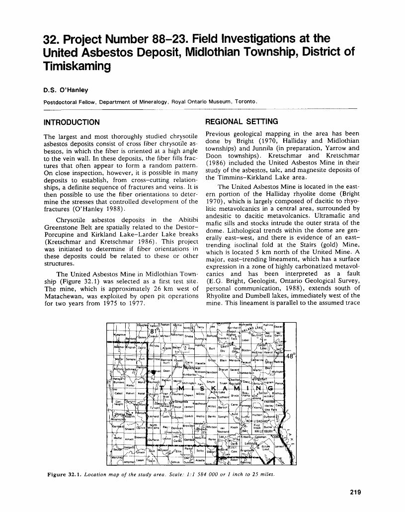
32. Project Number 88-23. Field Investigations at the United Asbestos Deposit, Midlothian Township, District of TimiskamingD.S. O'hanleyPostdoctoral Fellow, Department of Mineralogy, Royal Ontario Museum, Toronto.
INTRODUCTION
The largest and most thoroughly studied chrysotile asbestos deposits consist of cross fiber chrysotile as bestos, in which the fiber is oriented at a high angle to the vein wall. In these deposits, the fiber fills frac tures that often appear to form a random pattern. On close inspection, however, it is possible in many deposits to establish, from cross-cutting relation ships, a definite sequence of fractures and veins. It is then possible to use the fiber orientations to deter mine the stresses that controlled development of the fractures (O'Hanley 1988).
Chrysotile asbestos deposits in the Abitibi Greenstone Belt are spatially related to the Destor- Porcupine and Kirkland Lake-Larder Lake breaks (Kretschmar and Kretschmar 1986). This project was initiated to determine if fiber orientations in these deposits could be related to these or other structures.
The United Asbestos Mine in Midlothian Town ship (Figure 32.1) was selected as a first test site. The mine, which is approximately 26 km west of Matachewan, was exploited by open pit operations for two years from 1975 to 1977.
REGIONAL SETTINGPrevious geological mapping in the area has been done by Bright (1970, Halliday and Midlothian townships) and Junnila (in preparation, Yarrow and Doon townships). Kretschmar and Kretschmar (1986) included the United Asbestos Mine in their study of the asbestos, talc, and magnesite deposits of the Timmins-Kirkland Lake area.
The United Asbestos Mine is located in the east ern portion of the Halliday rhyolite dome (Bright 1970), which is largely composed of dacitic to rhyo- litic metavolcanics in a central area, surrounded by andesitic to dacitic metavolcanics. Ultramafic and mafic sills and stocks intrude the outer strata of the dome. Lithological trends within the dome are gen erally east-west, and there is evidence of an east- trending isoclinal fold at the Stairs (gold) Mine, which is located 5 km north of the United Mine. A major, east-trending lineament, which has a surface expression in a zone of highly carbonatized metavol canics and has been interpreted as a fault (E.G. Bright, Geologist, Ontario Geological Survey, personal communication, 1988), extends south of Rhyolite and Dumbell lakes, immediately west of the mine. This lineament is parallel to the assumed trace
Figure 32.1. Location map of the study area. Scale: 1:1 584 000 or l inch to 25 miles.
219
PRECAMBRIAN (32)
of the Kirkland Lake Break beneath Huronian metasedimentary rocks south of the mine.
GEOLOGY OF THE UNITED ASBESTOS MINE
The United Asbestos Mine occurs within a differen tiated mafic/ultramafic complex that is surrounded by dacite flows (Kretschmar and Kretschmar 1986). Kretschmar and Kretschmar proposed the name Lloyd Lake Complex for this rock suite, and that name is used in this report. The Lloyd Lake Com plex strikes east-west and dips steeply north on the northern side of Lloyd Lake.
Two east-trending orebodies were defined from interpretation of diamond-drill core (Kretschmar and Kretschmar 1986). The north body consists of the east, north, and west zones, with the north zone situated between the west and east zones. The east and north zones were quarried when the mine was operating, but only trenches were dug in the west zone. The south body, or south ore zone, extends underneath Lloyd Lake, but can be seen in outcrop south of the north ore zone on the northern shore of Lloyd Lake. No mining occurred in the south ore zone.
Exposures in the east and north zone quarries were used for this preliminary investigation. The vegetation had been cleared from the west zone, but it became apparent during the study that the rock has been intensively weathered into spheroidal blocks. As a result, most of the rock is not useful for structural studies, although lithologies could still be recognized from freshly broken samples.
The Lloyd Lake Complex consists of at least two differentiation cycles. The lower cycle consists of a lower dunite; an upper dunite, which contains peridotite pods ranging from 2 by 10 cm to 10 by 50 cm in size; and a peridotite with sporadic, 2 to 3 cm pyroxene megacrysts enclosing olivine. The upper cycle contains a dunite with oriented pyrox ene laths; a peridotite with 2 to 3 mm ortho- pyroxenes that impart a "salt and pepper" texture to the peridotite; and a gabbro unit with pods of pyrox enite that comprise the top of the second cycle and the top of the Complex. This sequence was found throughout the north orebody; therefore, the Lloyd Lake Complex is intact on the northern shore of the lake. No investigations were carried out on the southern shore.
Shear zones can be differentiated from spheroidal weathering surfaces because slip surfaces have some type of slickensides on them: either slick- ensides, striations, or slickenfiber. The shear zones cause only minor disruption of the Complex. East- trending, north-dipping faults were found in the east and west ore zones, whereas north- to northeast- trending, northwest-dipping faults were found in the
north ore zone. Both sets of faults exhibit evidence, based on cleavage relationships, of reverse motion.
VEIN SETS AT THE UNITED ASBESTOS MINESeveral types of veins were found during this study based on appearance and mineralogy. Magnetite veins are 0.5 to 1.0 cm wide and consist predomi nantly of magnetite. Green veins consist of an ap ple-green serpentine. Magnetite/green veins consist of both magnetite and green serpentine. Wispy as bestos veins are generally 0.01 to 0.5 cm wide. They occur as clusters of veins l to 2 cm wide and spaced 2 to 3 cm apart. Asbestos/magnetite veins are 0.3 to 1.5 cm wide and consist of asbestos with magnetite partings generally in the middle of the vein.
The wispy asbestos veins, which are found in the basal dunite, are the oldest vein set based on cross cutting relationships. They are cut by north-trending magnetite veins and by northeast-trending, north west-dipping asbestos/magnetite veins. Cross-cutting relationships among the asbestos/magnetite veins in dicate that the oldest asbestos/magnetite veins can be assigned to the wispy asbestos vein set based on location and orientation. However, they appear to be spatially related to faults, whereas the wispy veins do not. The asbestos/magnetite veins are found in the upper part of the dunite and the peridotite of the lower cycle. No asbestos veins were found in the up per cycle. The ore zone corresponds to the distribu tion of the asbestos/magnetite veins based on the geological map of Kretschmar and Kretschmar (1986). The ore zone, which is bounded by faults, includes some of the wispy veins as well. The wispy veins disappear just south of the mine road, south of the east ore zone quarry, and then reappear in out crop that corresponds to the south ore zone.
The model that describes asbestos vein forma tion identifies the asbestos veins as pinnate fractures (Hancock 1985) associated with the faults (O'Han- ley 1988). Using maxima for asbestos/magnetite vein orientations (veins: 291 0 754 0 ; fault: 258 0 751 0 ) in the east ore zone, and for magnetite/green veins (veins: 214 0 753 0 ; fault: 217 0 764 0 ) in the north ore zone, and an angle of internal friction of 30 0 for serpentinite (Raleigh and Paterson 1965) yields the orientation of the local stress field. In these cases, the orientations are a^l06 0 716 0 ; ovp357 0 750 0 ; o^202 0 736 0 , and cr^325 0 736 0 ; c^204 0 736 0 ; 0-3=112 0 753 0 . These results suggest that the asbes tos/magnetite veins formed during a northwest- southeast compression, with cr-i closer to the horizon tal than to the vertical.
CONCLUSIONSThe United Asbestos Mine is located in a differenti ated sill, called the Lloyd Lake Complex. Early wispy asbestos veins pre-date virtually all other vein sets, and are spatially restricted to a portion of the
220
D.S. O'HANLEY
lower dunite in the Complex. The asbestos/magnet- Hancock, P.ite veins are genetically related to fault motion. 1985: Brittle Microtectonics: Principles and Practices; Jour-Chrysotile fiber and vein orientations indicate that nal of Structural Geology, Volume 7, p.437-457.the veins formed in a northwest-southeast stress Junnila, R.M.field, with o^ closer to horizontal than to vertical. In Prep.: Reconnaissance Investigation of the Geology of Yar-
rr.. , . r . , f . row and Doon Townships, District of Timiskaming, This brief reconnaissance suggests that cross fi- With Emphasis on the Huronian Supergroup; Ontariober orientations m chrysotile asbestos deposits m the Geological Survey, Open File Report. Abitibi greenstone belt may be useful in indicatingthe stress fields related to major structures in the Kretschmar - u - and Kretschmar, D. belt. However, before this technique can be more 1986: ™c ' Magnesite and Asbestos Deposits of the
. , , i-ii i i - /-i i - Kirkland Lake - Timmins Area, Districts of Timis- widely applied, the relationships of the deposits to k and Cochrane; Ontario Geological survey,these major structures must be better defined. study 28 lOOp
O'Hanley, D.S.1988: The Origin of Alpine Peridotite-Hosted Cross-Fiber
Chrysotile Asbestos Deposits; Economic Geology, Bright, E.G. Volume 83, p.256-265. 1970: Geology of Halliday and Midlothian Townships; Ont- Raleigh, C.B., and Paterson, M.
ario Department of Mines, Geological Report 79, 1965: Experimental Deformation of Serpentinite and its 33p. Accompanied by Map 2187, scale 1:31 680 or l Tectonic Implications; Journal of Geophysical Re- inch to 1/2 mile search, Volume 70, p.3965-3985.
221
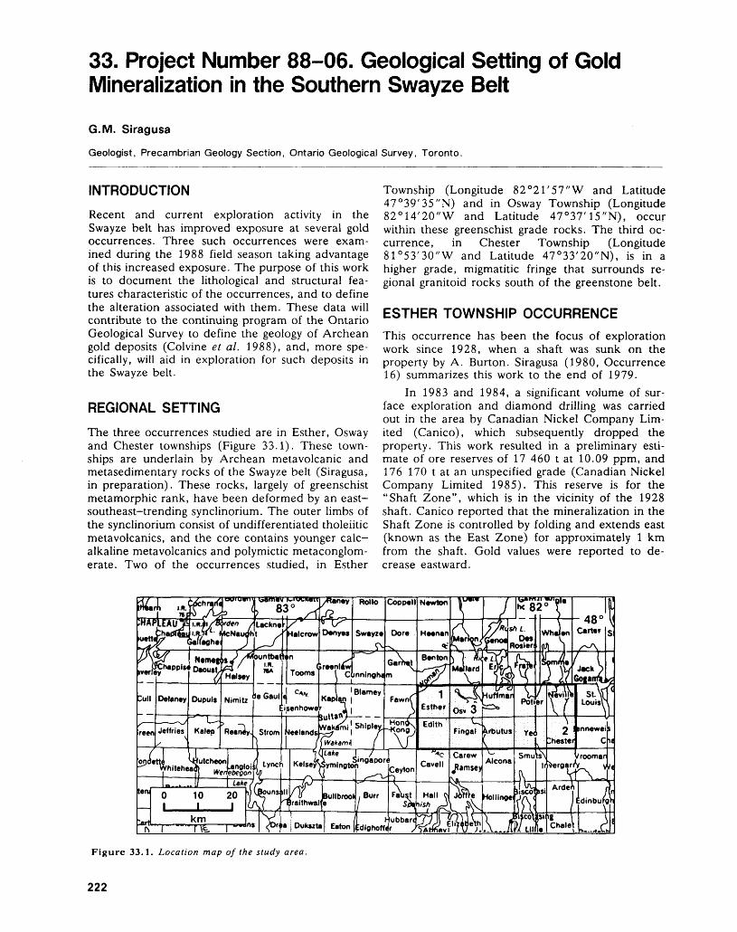
33. Project Number 88-06. Geological Setting of Gold Mineralization in the Southern Swayze Belt
G.M. Siragusa
Geologist, Precambrian Geology Section, Ontario Geological Survey, Toronto.
INTRODUCTION
Recent and current exploration activity in the Swayze belt has improved exposure at several gold occurrences. Three such occurrences were exam ined during the 1988 field season taking advantage of this increased exposure. The purpose of this work is to document the lithological and structural fea tures characteristic of the occurrences, and to define the alteration associated with them. These data will contribute to the continuing program of the Ontario Geological Survey to define the geology of Archean gold deposits (Colvine et al. 1988), and, more spe cifically, will aid in exploration for such deposits in the Swayze belt.
REGIONAL SETTING
The three occurrences studied are in Esther, Osway and Chester townships (Figure 33.1). These town ships are underlain by Archean metavolcanic and metasedimentary rocks of the Swayze belt (Siragusa, in preparation). These rocks, largely of greenschist metamorphic rank, have been deformed by an east- southeast-trending synclinorium. The outer limbs of the synclinorium consist of undifferentiated tholeiitic metavolcanics, and the core contains younger calc- alkaline metavolcanics and polymictic metaconglom- erate. Two of the occurrences studied, in Esther
Township (Longitude 82 0 21'57"W and Latitude 47 0 39'35"N) and in Osway Township (Longitude 82 0 14'20"W and Latitude 47 0 37'15"N), occur within these greenschist grade rocks. The third oc currence, in Chester Township (Longitude 81 0 53'30"W and Latitude 47 0 33'20"N), is in a higher grade, migmatitic fringe that surrounds re gional granitoid rocks south of the greenstone belt.
ESTHER TOWNSHIP OCCURRENCEThis occurrence has been the focus of exploration work since 1928, when a shaft was sunk on the property by A. Burton. Siragusa (1980, Occurrence 16) summarizes this work to the end of 1979.
In 1983 and 1984, a significant volume of sur face exploration and diamond drilling was carried out in the area by Canadian Nickel Company Lim ited (Canico), which subsequently dropped the property. This work resulted in a preliminary esti mate of ore reserves of 17 460 t at 10.09 ppm, and 176 170 t at an unspecified grade (Canadian Nickel Company Limited 1985). This reserve is for the "Shaft Zone", which is in the vicinity of the 1928 shaft. Canico reported that the mineralization in the Shaft Zone is controlled by folding and extends east (known as the East Zone) for approximately l km from the shaft. Gold values were reported to de crease eastward.
Figure 33.1. Location map of the study area.
222
G.M. SIRAGUSA
The Shaft Zone and the East Zone are presently well exposed because of the extensive stripping done by Canico. The mineralization in both zones is hosted by carbonatized and, to a lesser extent, silicified mafic metavolcanics. It consists of dissemi nated to massive arsenopyrite, pyrite, and pyr rhotite, found mainly in quartz.
In the Shaft Zone, the mineralized quartz oc curs in folds plunging westward at shallow angles. Folding near the Shaft Zone is also indicated by the pattern of two intersecting cleavages in unmineral- ized basalt. One cleavage (S-|) is pervasive and de fines the folds; the second (S2) is an axial planar cleavage which variably offsets or truncates S 1( but does not obliterate it.
The East Zone is linear, narrower than the Shaft Zone, and characterized by a stronger development of S2 . Drawn-out folds of mineralized quartz, or remnants of such folds, occur in parts of the zone, but outcrops in which plunge attitude can be meas ured are rare. In two cases, the plunge was found to be shallow easterly. Incipient transposition of bed ding was noted in metasediments in contact with ba salt at the southern edge of the East Zone. Details such as attenuation of folded beds to a thickness of a few millimetres are preserved in the metasediments, in contrast with the obliteration of primary features in the nearby basalt.
OSWAY TOWNSHIP OCCURRENCE (JEROME MINE)
Gold was discovered at this property in 1938 by Bert Jerome. Subsequent exploration and develop ment (summarized in Siragusa 1980, Occurrence 1) culminated in the production of 56 878 ounces of gold and 15 104 ounces of silver (Brown 1948) from the Jerome Mine during the period from 1941 to 1943. When operations ceased in 1945, the ore re serve was 344 000 tons averaging 0.19 ounce gold per ton after dilution (Canadian Mines Handbook 1946, p.159).
An exploration program, comprising mine reha bilitation and surface diamond drilling, is currently being carried out by Muscocho Explorations Limited in joint venture with Jerome Gold Mines Corpora tion. In September 1988, the headframe, shaft, and hoist were operational and dewatering was com pleted to a depth of 525 feet. Diamond drilling totalled 45 000 feet (J. Mallard, Exploration Geolo gist, Muscocho Explorations Limited, Jerome Mine site, personal communication, 1988).
The presently known gold mineralization on this property comprises two zones: 1) the North or Main Zone, and 2) the South Zone which extends a few hundred feet south of the North Zone. The under ground workings are in the North Zone. The South
Zone has long been known, but until now, has re ceived no significant exploration. Most of the cur rent drilling has been concentrated on the South Zone, and drill sections indicate that it consists of three subzones. Data released in June 1988 indicate that drilling as of then had increased the known ore reserve on the property to 437 320 tons grading 0.193 ounce gold per ton (Jerome Gold Mines Cor poration, 1988 Semi-annual Report to Sharehold ers).
The best ore found in the area is auriferous blue quartz (Brown 1948; Moorhouse 1951), which is colloquially referred to at the mine site as "the deep blue". In the North Zone, this quartz occurs at, or close to, sheared and altered contacts of clastic metasediments with fine-grained syenite. Moor house (1951) named this syenite the Jerome Por phyry. He described the different alteration proc esses that had affected the metasediments and re ferred to their effect as "porphyritization". The North Zone is also affected by two sets of post-vein faults and by a later silicification which occurs as white quartz. These features, their temporal rela tionships, and economic implications were also de scribed in detail by Brown (1948).
Only the 200-foot level of the underground workings was examined during the present study. At this level, the dark blue, almost black, quartz occurs as solid, 4 to 8 inch thick veins, and as abundant inclusions in a matrix of white replacement quartz containing little carbonate. These two modes occur adjacent to each other, with the second type appar ently comprising most of the thickness of the result ing unit. Only minor disseminations of sulphide mineralization (pyrite and chalcopyrite) were noted. Molybdenite is reportedly present in the blue quartz (M. Rosatelli, Geologist, Muscocho Explorations Limited, Jerome Mine site, personal communica tion, 1988).
A unit of dark quartz, composed of both the vein and inclusion types, occurs 60 feet east of the crosscut leading to the shaft on the 200-foot level. This unit trends southeast, dips steeply southwest, and has an exposed thickness o-f up to 3 feet. It can be seen in the west wall of a raise from the 350-foot level to extend downward, with uniform thickness, for at least 35 feet. Further below, the raise merges with one of the main stopes between the 200- and 350-foot levels, indicating that a significant volume of this dark quartz unit was mined. It is, therefore, presumably representative of the ore in the North Zone and was sampled for geochemical and petrological studies.
The Jerome Porphyry is exposed in the hanging wall of the quartz unit approximately 30 feet west of the raise opening. Here, the porphyry is sheared, contains specularite (which is locally conspicuous), and shows slickensides that dip shallowly eastward.
223
PRECAMBRIAN (33)
CHESTER TOWNSHIP OCCURRENCEThis occurrence is along strike from the (former) Strathmore Shaft, a gold prospect where limited un derground work was done in the 1930s and 1940s. Data available for these occurrences to 1980 are summarized in Siragusa (1981).
Both surface and underground exploration is presently being carried out by Chesbar Resources In corporated in joint venture with Murgold Resources Incorporated. The estimated ore reserve as of June 1988 was 423 546 tons averaging 0.223 ounce gold per ton (Murgold Resources Incorporated, News Re lease, June 23, 1988). The current underground ex ploration is utilizing a decline, the portal of which is located about 600 feet north of a small lake locally known as Arethusa Lake. The decline is 16 feet wide, 10 feet high, and has a gradient of 12.5 per cent. There are two ramps, one to the southeast (3500 feet long) and one to the northwest (2000 feet long), which are connected by a semicircular ramp extending 1900 feet from the portal. At present, the shorter ramp ends at a depth of 515 feet below the portal and the longer ramp ends 150 feet east of, and 300 feet below, the (former) Strathmore Shaft. To date, most drifting and crosscutting has been done at the 150-, 200-, and 400-foot levels in the western half of the decline and between the two ramps.
Development at the 150- and 400-foot levels is mainly in mafic rocks which vary from fine-grained chlorite schist near the mineralization to medium- grained gabbroic-textured amphibolite some dis tance from the mineralization. The amphibolite is in both sharp and gradational contact with granitic rocks on the 200-foot level and in an outcrop on the eastern side of the portal at surface. The am phibolite is locally known as the "gabbro-diorite" or "gabbro-diorite complex". It is interpreted in this study to be a large mafic enclave in the migmatitic fringe bordering the metavolcanic belt of greenschist rank north of the property. The soft chlorite schist is attributable to retrograde metamorphism of the am phibolite.
Mineralization consists of disseminated to mas sive chalcopyrite and pyrrhotite, dominantly in quartz veins. Visible gold was seen in drill core. Mineralized quartz veins are a few inches to about one foot thick, trend east-southeast, and dip steeply north. They occupy the centres of narrow linear shear zones and can be affected by pinch and swell structures or boudinage. However, exceptionally straight veins of virtually constant thickness are also present (e.g. Drift 7 East, 200-foot level).
CONCLUSIONSThe geology of each of the three gold occurrences presents problems that will be addressed in continu ing studies.
At the Esther Township occurrence, the ST and S2 cleavages are interpreted to result from a single event, i.e. progressive deformation resulting from re gional shortening of the belt along the northeast trend. ST is dominant in the Shaft Zone and S2 is dominant in the East Zone. If the author's interpre tation is correct, ore grades developed during early deformation (Shaft Zone) could have been affected by later deformation (East Zone). This possibility is consistent with the eastward decrease in gold grades reported by Canico (1985).
The origin of the blue quartz at the Jerome Mine remains unknown. Brown (1948) reported that the blue quartz occurs at the contact of the Jerome Porphyry with metasediments; this observa tion is supported by the limited field evidence seen during the 1988 study.
The vein system being explored at the Chester Township occurrence has a remarkable lateral conti nuity. It comprises silicified shear fractures that ex tend through both leucocratic and melanocratic do mains of the host migmatites. Shearing and silicifica tion are virtually unaffected by changes in lithology of the migmatites. The ore, however, appears to oc cur mainly where the veins intersect the "gabbro- diorite". This could imply that the economically sig nificant gold mineralization is, at least in part, lithologically controlled
ACKNOWLEDGMENTSJ. Perry (Project Geologist, Canadian Nickel
Mines Limited) and C. Me Alpine (President, Mur gold Resources Incorporated, Toronto) provided data on the occurrences in Esther and Chester town ships, respectively. D. Lebenin (Surveyor), R. Hill (Mine Geologist) and D. O'Suillebhain (Surface Ge ologist) of Chesbar Resources Incorporate provided substantial assistance in the field, as did J. Mallard (Exploration Geologist) and M. Rosatelli (Geologist) of Muscocho Explorations Limited.
REFERENCESBrown, W.L.1948: Jerome Mine; p.438-441 in Structural Geology of Ca
nadian Ore Deposits, edited by M.E. Wilson, Cana dian Institute of Mining and Metallurgy Symposium, Volume l, 948p.
Canadian Nickel Company Limited1985: 1984 Annual Report of Activities, Canico-Golden
Hope Agreement; File 63-4493, Geoscience Data Centre, Ontario Geological Survey, Toronto.
Colvine, A.C., Fyon, J.A., Heather, K.B., Marmont, Sous-san, Smith, P.,M., and Troop, D.G.
1988: Archean Lode Gold Deposits in Ontario; OntarioGeological Survey, Miscellaneous Paper 139, 136p.
Moorhouse, W.W.1951: Geology of Osway Township; Annual Report for
1950, Ontario Department of Mines, Volume 43, Part5, p.1-25.
224
G.M. SIRAGUSA
Siragusa, G.M. and Parts of Neville and Potier Townships, District of.-,,. , . /,,, x ^. . r r, ,, ^ . Sudbury; Ontario Geological Survey, Preliminary Map1980: Jerome Area (West), District of Sudbury; Ontario D ....} ' , . 10 . , , Ve o^n -* u.v ' 3 P.2449, Geological Series, scale 1:15 840 or l inch to
Geological Survey, Preliminary Map P.2369, Geologi- JM mile Geology 1980cal Series, Scale 1:15 840 or l inch to 1/4 mile. Ge- TT, ^ , ,^ m . ,. . f ,^, *. ~In Prep.: Geology and Mineralization of the Southern Margin
' of the Swayze Belt; Ontario Geological Survey, Open 1981: Precambrian Geology of Chester and Yeo Townships, File Report.
225
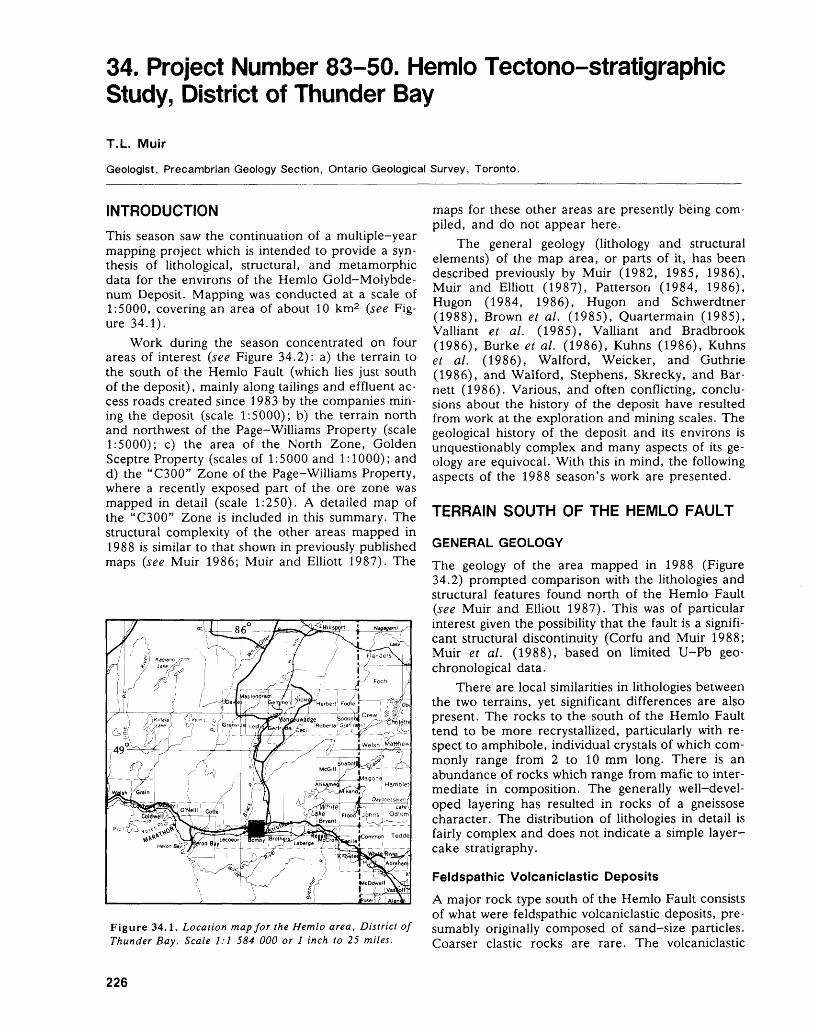
34. Project Number 83-50. Hemlo Tectono-stratigraphic Study, District of Thunder Bay
T.L. Muir
Geologist, Precambrian Geology Section, Ontario Geological Survey, Toronto.
INTRODUCTIONThis season saw the continuation of a multiple-year mapping project which is intended to provide a syn thesis of lithological, structural, and metamorphic data for the environs of the Hemlo Gold-Molybde num Deposit. Mapping was conducted at a scale of 1:5000, covering an area of about 10 km2 (see Fig ure 34.1).
Work during the season concentrated on four areas of interest (see Figure 34.2): a) the terrain to the south of the Hemlo Fault (which lies just south of the deposit), mainly along tailings and effluent ac cess roads created since 1983 by the companies min ing the deposit (scale 1:5000); b) the terrain north and northwest of the Page-Williams Property (scale 1:5000); c) the area of the North Zone, Golden Sceptre Property (scales of 1:5000 and 1:1000); and d) the "C300" Zone of the Page-Williams Property, where a recently exposed part of the ore zone was mapped in detail (scale 1:250). A detailed map of the "C300" Zone is included in this summary. The structural complexity of the other areas mapped in 1988 is similar to that shown in previously published maps (see Muir 1986; Muir and Elliott 1987). The
Figure 34.1. Location map for the Hemlo area, District of Thunder Bay. Scale 1:1 584 000 or l inch to 25 miles.
maps for these other areas are presently being com piled, and do not appear here.
The general geology (lithology and structural elements) of the map area, or parts of it, has been described previously by Muir (1982, 1985, 1986), Muir and Elliott (1987), Patterson (1984, 1986), Hugon (1984, 1986), Hugon and Schwerdtner (1988), Brown et al. (1985), Quartermain (1985), Valliant et al. (1985), Valliant and Bradbrook (1986), Burke et al. (1986), Kuhns (1986), Kuhns et al. (1986), Walford, Weicker, and Guthrie (1986), and Walford, Stephens, Skrecky, and Bar nett (1986). Various, and often conflicting, conclu sions about the history of the deposit have resulted from work at the exploration and mining scales. The geological history of the deposit and its environs is unquestionably complex and many aspects of its ge ology are equivocal. With this in mind, the following aspects of the 1988 season's work are presented.
TERRAIN SOUTH OF THE HEMLO FAULT
GENERAL GEOLOGY
The geology of the area mapped in 1988 (Figure 34.2) prompted comparison with the lithologies and structural features found north of the Hemlo Fault (see Muir and Elliott 1987). This was of particular interest given the possibility that the fault is a signifi cant structural discontinuity (Corfu and Muir 1988; Muir et al. (1988), based on limited U-Pb geo- chronological data.
There are local similarities in lithologies between the two terrains, yet significant differences are also present. The rocks to the south of the Hemlo Fault tend to be more recrystallized, particularly with re spect to amphibole, individual crystals of which com monly range from 2 to 10 mm long. There is an abundance of rocks which range from mafic to inter mediate in composition. The generally well-devel oped layering has resulted in rocks of a gneissose character. The distribution of lithologies in detail is fairly complex and does not indicate a simple layer- cake stratigraphy.
Feldspathic Volcaniclastic DepositsA major rock type south of the Hemlo Fault consists of what were feldspathic volcaniclastic deposits, pre sumably originally composed of sand-size particles. Coarser clastic rocks are rare. The volcaniclastic
226
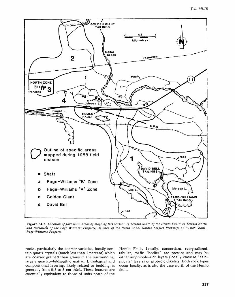
T. L. MUIR
GOLDEN GIANT TAILINGS
NORTH ZONE !""|V Q
HEMLO FAULT
Outline of specific areas mapped during 1988 field season
DAVID BELL ': TAILINGS*
m Shaft
a Page-Williams "B" Zone
Page-Williams A Zone
Golden Giant
David Bell
PAGE-WILLIAMS \TAILINGS
Figure 34.2. Location of four main areas of mapping this season: 1) Terrain South of the Hemlo Fault; 2) Terrain North and Northwest of the Page-Williams Property; 3) Area of the North Zone, Golden Sceptre Property; 4) "C300" Zone, Page-Williams Property.
rocks, particularly the coarser varieties, locally con tain quartz crystals (much less than l percent) which are coarser grained than grains in the surrounding, largely quartzo-feldspathic matrix. Lithological and compositional layering, likely related to bedding, is generally from 0.5 to 5 cm thick. These features are essentially equivalent to those of units north of the
Hemlo Fault. Locally, concordant, recrystallized, tabular, mafic "bodies" are present and may be either amphibole-rich layers (locally know as "calc- silicate" layers) or gabbroic dikelets. Both rock types occur locally, as is also the case north of the Hemlo fault.
227
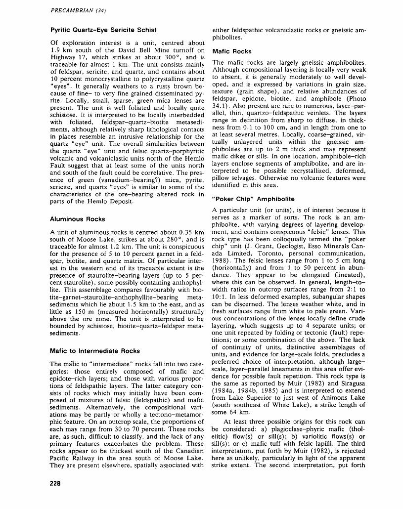
PRECAMBRIAN (34)
Pyritic Quartz-Eye Sericite Schist
Of exploration interest is a unit, centred about 1.9 km south of the David Bell Mine turnoff on Highway 17, which strikes at about 300 0 , and is traceable for almost l km. The unit consists mainly of feldspar, sericite, and quartz, and contains about 10 percent monocrystalline to percrystalline quartz "eyes". It generally weathers to a rusty brown be cause of fine- to very fine grained disseminated py rite. Locally, small, sparse, green mica lenses are present. The unit is well foliated and locally quite schistose. It is interpreted to be locally interbedded with foliated, feldspar-quartz-biotite metasedi ment^, although relatively sharp lithological contacts in places resemble an intrusive relationship for the quartz "eye" unit. The overall similarities between the quartz "eye" unit and felsic quartz-porphyritic volcanic and volcaniclastic units north of the Hemlo Fault suggest that at least some of the units north and south of the fault could be correlative. The pres ence of green (vanadium-bearing?) mica, pyrite, sericite, and quartz "eyes" is similar to some of the characteristics of the ore-bearing altered rock in parts of the Hemlo Deposit.
Aluminous Rocks
A unit of aluminous rocks is centred about 0.35 km south of Moose Lake, strikes at about 280 0 , and is traceable for almost 1.2 km. The unit is conspicuous for the presence of 5 to 10 percent garnet in a feld spar, biotite, and quartz matrix. Of particular inter est in the western end of its traceable extent is the presence of staurolite-bearing layers (up to 5 per cent staurolite), some possibly containing anthophyl lite. This assemblage compares favourably with bio- tite-garnet-staurolite-anthophyllite-bearing meta- sediments which lie about 1.5 km to the east, and as little as 150 m (measured horizontally) structurally above the ore zone. The unit is interpreted to be bounded by schistose, biotite-quartz-feldspar meta- sediments.
Mafic to Intermediate Rocks
The ma'fic to "intermediate" rocks fall into two cate gories: those entirely composed of mafic and epidote-rich layers; and those with various propor tions of feldspathic layers. The latter category con sists of rocks which may initially have been com posed of mixtures of felsic (feldspathic) and mafic sediments. Alternatively, the compositional vari ations may be partly or wholly a tectono-metamor- phic feature. On an outcrop scale, the proportions of each may range from 30 to 70 percent. These rocks are, as such, difficult to classify, and the lack of any primary features exacerbates the problem. These rocks appear to be thickest south of the Canadian Pacific Railway in the area south of Moose Lake. They are present elsewhere, spatially associated with
either feldspathic volcaniclastic rocks or gneissic am- phibolites.
Mafic Rocks
The mafic rocks are largely gneissic amphibolites. Although compositional layering is locally very weak to absent, it is generally moderately to well devel oped, and is expressed by variations in grain size, texture (grain shape), and relative abundances of feldspar, epidote, biotite, and amphibole (Photo 34.1). Also present are rare to numerous, layer-par allel, thin, quartzo-feldspathic veinlets. The layers range in definition from sharp to diffuse, in thick ness from 0.1 to 100 cm, and in length from one to at least several metres. Locally, coarse-grained, vir tually unlayered units within the gneissic am phibolites are up to 2 m thick and may represent mafic dikes or sills. In one location, amphibole-rich layers enclose segments of amphibolite, and are in terpreted to be possible recrystallized, deformed, pillow selvages. Otherwise no volcanic features were identified in this area.
"Poker Chip" Amphibolite
A particular unit (or units), is of interest because it serves as a marker of sons. The rock is an am phibolite, with varying degrees of layering develop ment, and contains conspicuous "felsic" lenses. This rock type has been colloquially termed the "poker chip" unit (J. Grant, Geologist, Esso Minerals Can ada Limited, Toronto, personal communication, 1988). The felsic lenses range from l to 5 cm long (horizontally) and from l to 50 percent in abun dance. They appear to be elongated (lineated), where this can be observed. In general, length-to- width ratios in outcrop surfaces range from 2:1 to 10:1. In less deformed examples, subangular shapes can be discerned. The lenses weather white, and in fresh surfaces range from white to pale green. Vari ous concentrations of the lenses locally define crude layering, which suggests up to 4 separate units; or one unit repeated by folding or tectonic (fault) repe titions; or some combination of the above. The lack of continuity of units, distinctive assemblages of units, and evidence for large-scale folds, precludes a preferred choice of interpretation, although large- scale, layer-parallel lineaments in this area offer evi dence for possible fault repetition. This rock type is the same as reported by Muir (1982) and Siragusa (1984a, 1984b, 1985) and is interpreted to extend from Lake Superior to just west of Animons Lake (south-southeast of White Lake), a strike length of some 64 km.
At least three possible origins for this rock can be considered: a) plagioclase-phyric mafic (thol eiitic) flow (s) or sill (s); b) variolitic flows (s) or sill(s); or c) mafic tuff with felsic lapilli. The third interpretation, put forth by Muir (1982), is rejected here as unlikely, particularly in light of the apparent strike extent. The second interpretation, put forth
228
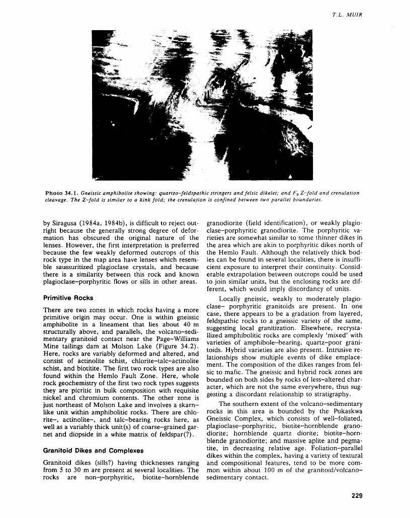
T. L. MUIR
Photo 34.1. Gneissic amphibolite showing: quartzo-feldspathic stringers and felsic dikelet; and F3 Z-fold and crenulation cleavage. The Z-fold is similar to a kink fold; the crenulation is confined between two parallel boundaries.
by Siragusa (1984a, 1984b), is difficult to reject out right because the generally strong degree of defor mation has obscured the original nature of the lenses. However, the first interpretation is preferred because the few weakly deformed outcrops of this rock type in the map area have lenses which resem ble saussuritized plagioclase crystals, and because there is a similarity between this rock and known plagioclase-porphyritic flows or sills in other areas.
Primitive Rocks
There are two zones in which rocks having a more primitive origin may occur. One is within gneissic amphibolite in a lineament that lies about 40 m structurally above, and parallels, the volcano-sedi mentary granitoid contact near the Page-Williams Mine tailings dam at Molson Lake (Figure 34.2). Here, rocks are variably deformed and altered, and consist of actinolite schist, chlorite-talc-actinolite schist, and biotitite. The first two rock types are also found within the Hemlo Fault Zone. Here, whole rock geochemistry of the first two rock types suggests they are picritic in bulk composition with requisite nickel and chromium contents. The other zone is just northeast of Molson Lake and involves a skarn- like unit within amphibolide rocks. There are chlo rite-, actinolite-, and talc-bearing rocks here, as well as a variably thick unit (s) of coarse-grained gar net and diopside in a white matrix of feldspar(?).
Granitoid Dikes and Complexes
Granitoid dikes (sills?) having thicknesses ranging from 5 to 30 m are present at several localities. The rocks are non-porphyritic, biotite-hornblende
granodiorite (field identification), or weakly plagio clase-porphyritic granodiorite. The porphyritic va rieties are somewhat similar to some thinner dikes in the area which are akin to porphyritic dikes north of the Hemlo Fault. Although the relatively thick bod ies can be found in several localities, there is insuffi cient exposure to interpret their continuity. Consid erable extrapolation between outcrops could be used to join similar units, but the enclosing rocks are dif ferent, which would imply discordancy of units.
Locally gneissic, weakly to moderately plagio clase- porphyritic granitoids are present. In one case, there appears to be a gradation from layered, feldspathic rocks to a gneissic variety of the same, suggesting local granitization. Elsewhere, recrysta- llized amphibolitic rocks are complexly 'mixed' with varieties of amphibole-bearing, quartz-poor grani toids. Hybrid varieties are also present. Intrusive re lationships show multiple events of dike emplace ment. The composition of the dikes ranges from fel sic to mafic. The gneissic and hybrid rock zones are bounded on both sides by rocks of less-altered char acter, which are not the same everywhere, thus sug gesting a discordant relationship to stratigraphy.
The southern extent of the volcano-sedimentary rocks in this area is bounded by the Pukaskwa Gneissic Complex, which consists of well-foliated, plagioclase-porphyritic, biotite-hornblende grano diorite; hornblende quartz diorite; biotite-horn blende granodiorite; and massive aplite and pegma tite, in decreasing relative age. Foliation-parallel dikes within the complex, having a variety of textural and compositional features, tend to be more com mon within about 100 m of the granitoid/volcano- sedimentary contact.
229
PRECAMBRIAN (34)
STRUCTURAL GEOLOGY
In comparing structural features in this area with those north of the Hemlo Fault, various attributes were considered, including the style, orientation, and generation of structures observed. The selection of these attributes was based largely on the work re ported by Muir and Elliott (1987) and Muir (1986). The salient features were: a) local, small-scale fold ing (F-i) of lithological layering and/or bedding; b) moderately steep, west-plunging mineral, dimension (elongation), and S-j7S2 intersection lineations that parallel, and correspond to, F2 fold axes, with devel opment of an axial planar cleavage or differentiated layering (S2), possibly related to a sinistral shear sys tem; c) shallow to moderately steep, lineated, east- plunging porphyroblasts and S27S3 intersection linea tions that correspond to F3 fold axes having "Z" asymmetry, with development of a preferred dimen sional orientation of micas, and/or a crenulation cleavage (S3) related to a dextral shear system, and later, layer-parallel breccias and pseudotachylites; and d) north-northwest- to north-northeast-trend ing conjugate fractures/faults.
The strike of lithological and compositional lay ering (S-,) ranges from 280 0 in the northwestern part of this area, southwest of Moose Lake, to 305 0 in the southeastern part, at Molson Lake. This reflects the variation in the curvature of the volcano-sedi mentary rocks about the Pukaskwa Gneissic Com plex. Dips range in the northern part of the area from about 70 0 N, to about 45 0 N in the southern part near the Pukaskwa Gneissic Complex. Locally, dips change abruptly and are as shallow as about 20 0 N.
There are several layer-parallel to subparallel lineaments present, some of which are major; they roughly parallel the volcanosedimentary/granitoid (Pukaskwa Gneissic Complex) contact. Some appear to mark lithological changes on either side, but oth ers do not. No simple model attributing these lithological changes to faults that repeat stratigraphy can be proposed at this stage.
The S2 cleavage was relatively rarely observed in these rocks. Collectively, orientations both clockwise and counterclockwise to S-i layering were found, which indicates F2 folds are present. Just south of the Hemlo Fault, S2 is clockwise to S-\, as it is to the north of the fault. Cross—sections of units, in trenches blasted for tailings or effluent pipelines, show homoclinal rolls in the layering about generally west- to north-west trending, shallowly plunging axes. These structures explain the locally shallow dips, the general lack of recognized S2 cleavage, and the similarly plunging mineral and intersection linea tions found throughout much of the area. Locally, shallow east-plunging axes and lineations are pre
sent. Small-scale, shallowly plunging, S-shaped folds were also locally observed.
The development of the S3 foliation, with ac companying crenulation of the S2 fabric, and associ ated Z folds is very common in the mafic rocks, in cluding many dikes and amphibole-rich (calc-sili cate) layers. The feldspathic rocks largely appear unaffected. The S3 cleavage orientation ranges from about 240 0 to 300 0 but is generally from 260 0 to 280 0 , with dips ranging from 80 0 N to 80 0 S. The F3 axes plunge east-northeast from 10 0 to 50 0 . The crenulation fabric in gneissic amphibolites is locally so strongly developed and has such sharp interlimb angles, that an incipient compositional layering is lo cally developed parallel to S3 . Elsewhere, the cren- ulations are essentially confined between parallel boundaries and are similar to large-scale kink folds (Photo 34.1). These zones of ductile crenulation/ kink folding locally terminate by pinching out. How ever, their distribution throughout the outcrop sug gests an en echelon development. Locally, Z-shaped (F3 ?) folds with an amplitude of about l m show well-developed, S-shaped, parasitic folds on the short limb. Notwithstanding this development of F3 S-folds, there are other S folds that appear to be of an F2 generation.
There are numerous quartzo-feldspathic dike- lets (partial melts?) within the gneissic amphibolites, some of which display tight S-shaped folds (F2?) and more open Z-shaped F3 folds. Locally, layering in the amphibolites also shows refolded folds. The above features are most evident in the mafic rocks that are within 150 m of the contact with the Pukaskwa Gneissic Complex. A heterogeneous granitoid dike swarm within this zone formed after the refolded folds and dikelets, and before develop ment of F3 . There is a possibility that the rocks in this zone have undergone a somewhat different structural history than those farther north. Alterna tively, because dikelets bordering the Cedar Lake Pluton and Cedar Creek Stock also display refolded folds, it may be that progressive, differentiated movement, localized along volcano-sedimentary/ granitoid interfaces, can produce these features. However, well away from the Pukaskwa Gneissic Complex can be seen Z-shaped folds with apparent parasitic folds on the larger-scale fold overprinting a smaller, earlier fold, and thus remain enigmatic.
The marginal zone of the Pukaskwa Gneissic Complex is also laden with foliation-parallel grani toid dikes, and locally displays features similar to brittle-ductile F3 folds/fault structures with dextral offset, described previously by Muir (1985) and Hugon (1986), which are also common throughout the supracrustal rocks.
Later conjugate fault sets trending north- northwest and north-northeast, with dextral and sin istral offset respectively, occur locally.
230
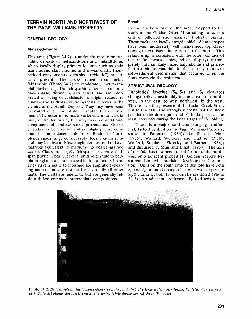
T. L. MUIR
TERRAIN NORTH AND NORTHWEST OF THE PAGE-WILLIAMS PROPERTY
GENERAL GEOLOGY
Metasediments
This area (Figure 34.2) is underlain mostly by tur- biditic deposits of metasandstone and metasiltstone, which locally display primary features such as grain size grading, clast grading, and rip-up clasts. Inter bedded conglomeratic deposits (turbiditic?) are lo cally present. The rocks range from highly feldspathic (Photo 34.2) to moderately biotite/am- phibole-bearing. The feldspathic varieties commonly have sparse, distinct, quartz grains, and are inter preted as being volcaniclastic in origin, related to quartz- and feldspar-phyric pyroclastic rocks in the vicinity of the Hemlo Deposit. They may have been deposited in a more distal, turbidite fan environ ment. The other more mafic varieties are, at least in part, of similar origin, but may have an additional component of undetermined provenance. Quartz crystals may be present, and are slightly more com mon in the rudaceous deposits. Biotite to horn blende ratios range considerably; locally either min eral may be absent. Metaconglomerates tend to have matrixes equivalent to medium- to coarse-grained wacke. Clasts are largely feldspar- or quartz-feld- spar-phyric. Locally, several units of granule to peb ble conglomerate are traceable for about 0.4 km. They have a mafic to intermediate amphibole-bear- ing matrix, and are distinct from virtually all other units. The clasts are heterolitic but are generally fel sic with less common intermediate compositions.
BasaltIn the northern part of the area, mapped to the south of the Golden Giant Mine tailings lake, is a unit of pillowed and 'massive' tholeiitic basalts. These rocks are locally amygdaloidal. Where shapes have been moderately well maintained, top direc tions give consistent indications to the north. This relationship is consistent with the lower contact of the mafic metavolcanics, which displays incom pletely but intimately mixed amphibolite and garnet- feldspar-biotite material, in that it may represent soft-sediment deformation that occurred when the flows overrode the sediments.
Lithological layering (S0 , S-i) and S2 cleavages change strike considerably in this area from north west, in the east, to west-northwest, in the west. This reflects the presence of the Cedar Creek Stock just to the east, and strongly suggests that the stock postdated the development of F2 folding, or, at the least, intruded during the later stages of F2 folding.
There is a major northwest-plunging, antifor mal, F2 fold centred on the Page-Williams Property, shown in Patterson (1984); described in Muir (1985), Walford, Weicker, and Guthrie (1986), Walford, Stephens, Skrecky, and Barnett (1986); and discussed in Muir and Elliott (1987). The axis of this fold has now been traced further to the north west onto adjacent properties (Golden Sceptre Re sources Limited, Interlake Development Corpora tion) . Units on the south limb of this fold have both S2 and S3 oriented counterclockwise with respect to SQ/S-I. Locally, both fabrics can be identified (Photo 34.2). An adjacent, synformal, F2 fold axis to the
Photo 34.2. Bedded volcaniclastic metasediments on the south limb of a large scale, west-closing, F2 fold. View shows SQ (S t ), S2 (axial planar cleavage), and S3 (flattening fabric during dextral shear (F3) event).
231
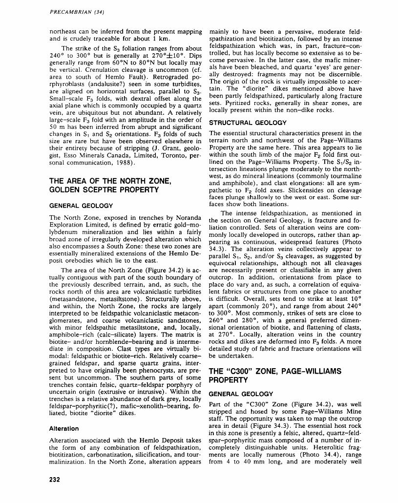
PRECAMBRIAN (34)
northeast can be inferred from the present mapping and is crudely traceable for about l km.
The strike of the S3 foliation ranges from about 240 0 to 300 0 but is generally at 270 0±10 0 . Dips generally range from 60 0 N to 80 0N but locally may be vertical. Crenulation cleavage is uncommon (cf. area to south of Hemlo Fault). Retrograded po- rphyroblasts (andalusite?) seen in some turbidites, are aligned on horizontal surfaces, parallel to S3 . Small-scale F3 folds, with dextral offset along the axial plane which is commonly occupied by a quartz vein, are ubiquitous but not abundant. A relatively large-scale F3 fold with an amplitude in the order of 50 m has been inferred from abrupt and significant changes in ST and S2 orientations. F3 folds of such size are rare but have been observed elsewhere in their entirety because of stripping (J. Grant, geolo gist, Esso Minerals Canada, Limited, Toronto, per sonal communication, 1988).
THE AREA OF THE NORTH ZONE, GOLDEN SCEPTRE PROPERTY
GENERAL GEOLOGY
The North Zone, exposed in trenches by Noranda Exploration Limited, is defined by erratic gold-mo lybdenum mineralization and lies within a fairly broad zone of irregularly developed alteration which also encompasses a South Zone: these two zones are essentially mineralized extensions of the Hemlo De posit orebodies which lie to the east.
The area of the North Zone (Figure 34.2) is ac tually contiguous with part of the south boundary of the previously described terrain, and, as such, the rocks north of this area are volcaniclastic turbidites (metasandstone, metasiltstone). Structurally above, and within, the North Zone, the rocks are largely interpreted to be feldspathic volcaniclastic metacon- glomerates, and coarse volcaniclastic sandstones, with minor feldspathic metasiltstone, and, locally, amphibole-rich (calc-silicate) layers. The matrix is biotite- and/or hornblende-bearing and is interme diate in composition. Clast types are virtually bi modal: feldspathic or biotite-rich. Relatively coarse- grained feldspar, and sparse quartz grains, inter preted to have originally been phenocrysts, are pre sent but uncommon. The southern parts of some trenches contain felsic, quartz-feldspar porphyry of uncertain origin (extrusive or intrusive). Within the trenches is a relative abundance of dark grey, locally feldspar-porphyritic(?), mafic-xenolith-bearing, fo liated, biotite "diorite" dikes.
Alteration
Alteration associated with the Hemlo Deposit takes the form of any combination of feldspathization, biotitization, carbonatization, silicification, and tour malinization. In the North Zone, alteration appears
mainly to have been a pervasive, moderate feld spathization and biotitization, followed by an intense feldspathization which was, in part, fracture-con trolled, but has locally become so extensive as to be come pervasive. In the latter case, the mafic miner als have been bleached, and quartz 'eyes' are gener ally destroyed: fragments may not be discernible. The origin of the rock is virtually impossible to acer- tain. The "diorite" dikes mentioned above have been partly feldspathized, particularly along fracture sets. Pyritized rocks, generally in shear zones, are locally present within the non-dike rocks.
STRUCTURAL GEOLOGYThe essential structural characteristics present in the terrain north and northwest of the Page-Williams Property are the same here. This area appears to lie within the south limb of the major F2 fold first out lined on the Page-Williams Property. The S-\iS2 in tersection lineations plunge moderately to the north west, as do mineral lineations (commonly tourmaline and amphibole), and clast elongations: all are sym pathetic to F2 -fold axes. Slickensides on cleavage faces plunge shallowly to the west or east. Some sur faces show both lineations.
The intense feldspathization, as mentioned in the section on General Geology, is fracture and fo liation controlled. Sets of alteration veins are com monly locally developed in outcrops, rather than ap pearing as continuous, widespread features (Photo 34.3). The alteration veins collectively appear to parallel S-\, S2 , and/or S3 cleavages, as suggested by equivocal relationships, although not all cleavages are necessarily present or classifiable in any given outcrop. In addition, orientations from place to place do vary and, as such, a correlation of equiva lent fabrics or structures from one place to another is difficult. Overall, sets tend to strike at least 10 0 apart (commonly 20 0), and range from about 240 0 to 300 0 . Most commonly, strikes of sets are close to 260 0 and 280 0 , with a general preferred dimen sional orientation of biotite, and flattening of clasts, at 270 0 . Locally, alteration veins in the country rocks and dikes are deformed into F3 folds. A more detailed study of fabric and fracture orientations will be undertaken.
THE "C300" ZONE, PAGE-WILLIAMS PROPERTY
GENERAL GEOLOGY
Part of the "C300" Zone (Figure 34.2), was well stripped and hosed by some Page-Williams Mine staff. The opportunity was taken to map the outcrop area in detail (Figure 34.3). The essential host rock in this zone is presently a felsic, altered, quartz-feld- spar-porphyritic mass composed of a number of in completely distinguishable units. Heterolitic frag ments are locally numerous (Photo 34.4), range from 4 to 40 mm long, and are moderately well
232
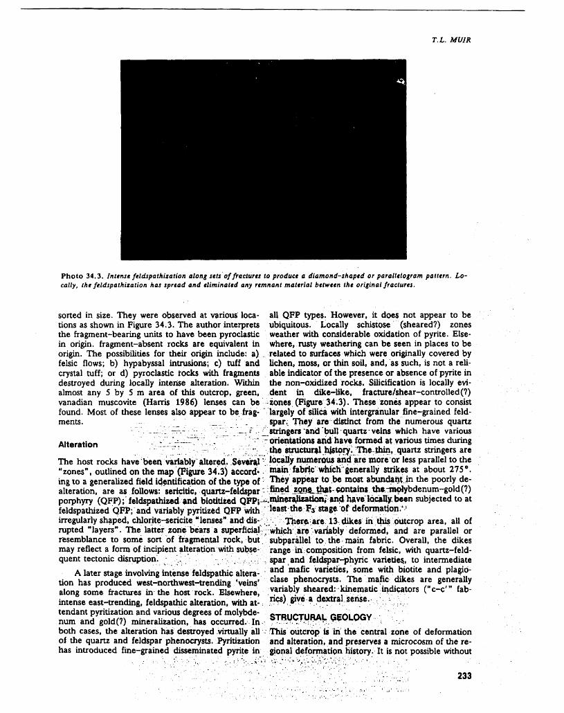
T. L. MUIR
Photo 34.3. Intense feldspathization along sets of fractures to produce a diamond-shaped or parallelogram pattern. Lo cally, the feldspathization has spread and eliminated any remnant material between the original fractures.
sorted in size. They were observed at various loca tions as shown in Figure 34.3. The author interprets the fragment-bearing units to have been pyroclastic in origin, fragment-absent rocks are equivalent in origin. The possibilities for their origin include: a) felsic flows; b) hypabyssal intrusions; c) tuff and crystal tuff; or d) pyroclastic rocks with fragments destroyed during locally intense alteration. Within almost any 5 by 5 m area of this outcrop, green, vanadian muscovite (Harris 1986) lenses can be found. Most of these lenses also appear to be frag ments. : .
Alteration r.--in— - ^ ^ .!
The host rocks have been variably altered. Several "zones", outlined on the map (Figure 34.3) accord* ing to a generalized field identification of the type of alteration, are as follows: sericitic, quartz-feldspar porphyry (QFP); feldspathized and biodtized QFP; feldspathized QFP; and variably pyritized QFP with irregularly shaped, chlorite-sericite "lenses" and dis rupted "layers". The latter zone bears a superficial-, resemblance to some sort bf fragmental rock, but. may reflect a form of incipient alteration with subse quent tectonic disruption. :.; ' - v .-', V
A later stage involving intense feldspathic altera tion has produced west-northwest-trending 'veins' along some fractures in the host rock. Elsewhere, intense east-trending, feldspathic alteration, with at tendant pyritization and various degrees of molybde num and gold(?) mineralization, has occurred. In both cases, the alteration has destroyed .virtually all of the quartz and feldspar phenocryst. Pyritization has introduced fine-grained disseminated pyrite in
all QFP types. However, it does not appear to be ubiquitous. Locally schistose (sheared?) zones weather with considerable oxidation of pyrite. Else where, rusty weathering can be seen in places to be related to surfaces which were originally covered by lichen, moss, or thin soil, and, as such, is not a reli able indicator of the presence or absence of pyrite in the non-oxidized rocks. Silicification is locally evi dent in dike-like, fracture7shear-controlled(?) zones (Figure 34.3). These zones appear to consist largely of silica with intergranular fine-grained feld spar.: They are distinct from the numerous quartz stringers 'and 'bull quartz - veins which have various orientations and have formed at various times during the stmctural history. The thin, quartz stringers are locally numerous and are more or less parallel to the main fabric' which 'generally strikes at about 275 0 . They appear to be most abundant in the poorly de- fined ZQne^ that contains thfcrmoiybdenum-gold (?)
.minerajixatiory and have locally, been subjected to at least the Fa stage of deformation."
J;. Ther^-are. 13 dikes iri this outcrop area, all of which are; variably deformed, and are parallel or subparallel to. the main fabric. Overall, the dikes range in composition from felsic, with quartz-feld spar and feldspar-phyric varieties., to intermediate and mafic varieties, some with biotite and plagio clase phenocryst*. The mafic dikes are generally variably sheared: kinematic indicators ("c-c"' fab rics) give a dextral sense.- - ,;
STRUCTURALThis outcrop is in the central zone of deformation and alteration, and preserves a microcosm of the re gional deformation history. It is not possible without
233
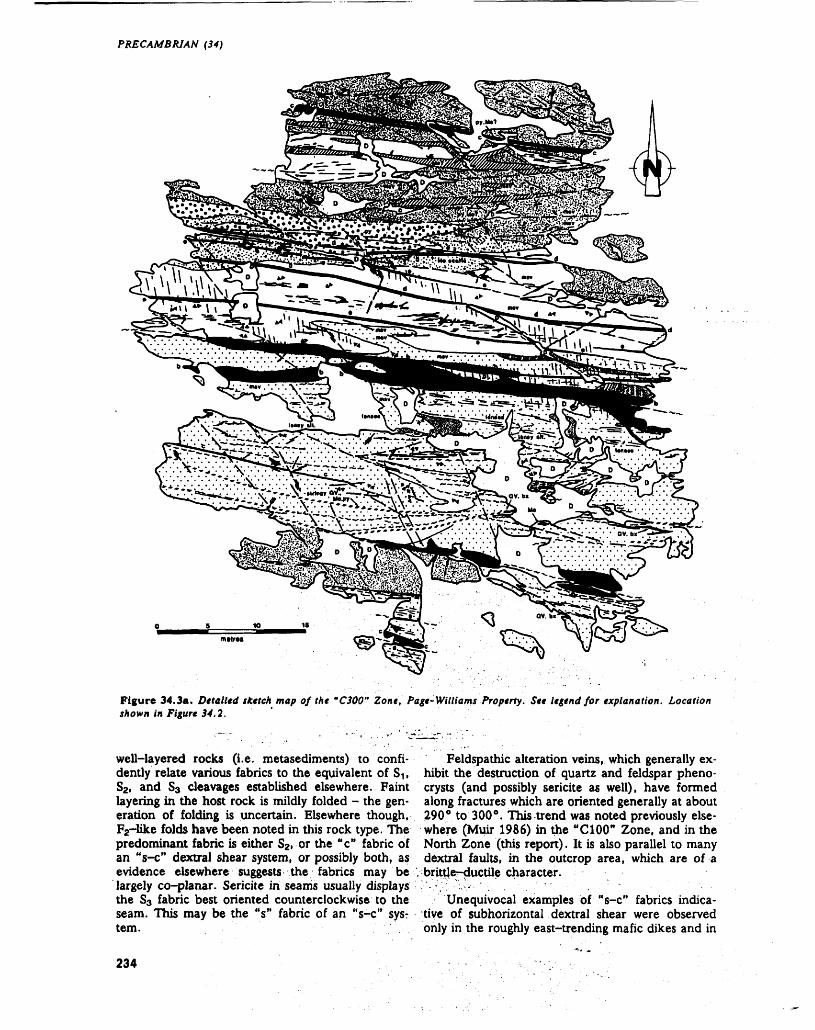
PRECAMBRIAN (34)
Figure 34.3a. Detailed sketch map of the "C300" Zone, Page-Williams Property. See legend for explanation. Location shown in Figure 34.2.
well-layered rocks (i.e. metasediment^) to confi dently relate various fabrics to the equivalent of S1f S2 , and 83 cleavages established elsewhere. Faint layering in the host rock is mildly folded - the gen eration of folding is uncertain. Elsewhere though, F2-like folds have been noted in this rock type. The predominant fabric is either S2. or the "c" fabric of an "s-c" dextral shear system, or possibly both, as evidence elsewhere suggests the fabrics may be largely co-planar. Sericite in seams usually displays the S3 fabric best oriented counterclockwise to the seam. This may be the "s" fabric of an "s-c" sysr tem.
Feldspathic alteration veins, which generally ex hibit the destruction of quartz and feldspar pheno- crysts (and possibly sericite as well), have formed along fractures which are oriented generally at about 290 0 to 300 0 . This trend was noted previously else where (Muir 1986) in the "C100" Zone, and in the North Zone (this report). It is also parallel to many dextral faults, in the outcrop area, which are of a brittje--ductile character.
Unequivocal examples of "s-c" fabrics indica tive of subhorizontal dextral shear were observed only in the roughly east-trending mafic dikes and in
234
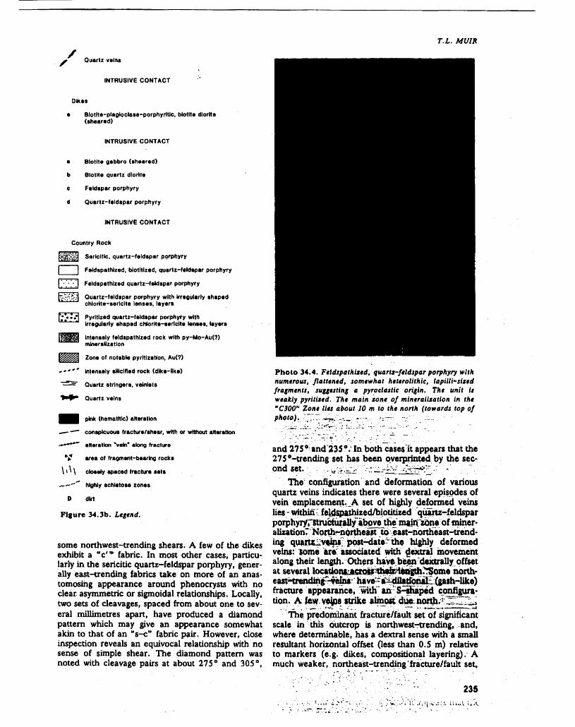
T.L. MUIR
* Quartz veins
INTRUSIVE CONTACT
Dikes
e Blotlte-plaflioclase-porphyritlc. biotite diorite (sheared)
INTRUSIVE CONTACT
e Biotite gabbro (sheared)
b Biotite quartz diorite
e Feldspar porphyry
d Quartz-feldspar porphyry
INTRUSIVE CONTACT
Country Rock
f^stitsi Sericitic, quartz-feldspar porphyry
l l Feldspathlzed. blotltized, quartz-feldspar porphyry
['•'•'•'J Feldspathlzed quartz-feldspar porphyry
Quartz-feldspar porphyry with Irregularly shaped chlorlte-serlclte lenses, layers
Pyrltlzed quartz-feldspar porphyry with Irregularly shaped chlorlte-serlcite lenses, layers
Intensely feldspathlzed rock with py-Mo-Au(?) mineralization
Zone of notable pyritization, Au(?)
Intensely silicified rock (dike-Hke)
Quartz stringers, velnlels
Quartz veins
m pink (hematltte) alteration
—- -— conspicuous fracture/shear, with or without alteration
-******" alteration "vein* along fracture
V area of fragment-bearing rocks
I'M closely spaced fracture sets
^-—"" highly schistose zones
D dirt
Figure 34.3b. Legend.
some northwest-trending shears. A few of the dikes exhibit a "c"* fabric. In most other cases, particu larly in the sericitic quartz-feldspar porphyry, gener ally east-trending fabrics take on more of an anas tomosing appearance around phenocryst with no clear asymmetric or sigmoidal relationships. Locally, two sets of cleavages, spaced from about one to sev eral millimetres apart, have produced a diamond pattern which may give an appearance somewhat akin to that of an "s-c" fabric pair. However, close inspection reveals an equivocal relationship with no sense of simple shear. The diamond pattern was noted with cleavage pairs at about 275 p and 305 0 ,
Photo 34.4. Feldspathixed. quartz-feldspar porphyry with numerous, flattened, somewhat heterolithic, lapilli-sized fragments, suggesting a pyroclastic origin. The unit is weakly pyrit'ued. The main zone of mineralization in the "C300" Zone lies about JO m to the north (towards top of photo). ;;~r - -^"~:~ ~-"v ''i—- :r ' - -—~ ' '
and 275 0 and 235". In both cases it appears that the 275 "-trending set has been overprinted by the sec ond set.
The configuration and deformation of various quartz veins indicates there were several episodes of vein emplacement. A set of highly deformed veins lies within feldspathired/biotitized quartz-feldspar porphyryrstructurally~above the main zone of miner alization? Norths-northeast :toeast-northeast-trend ing quftrtzJ2veinX post-date~the highly deformed veins: *ome areVassociated with gextral movement along their length. Others have been dextrally offset at several locaUortfcjwaoi*^their^ength?!T5ome north- east^ttericUng^ems have-i^ fracture appearance; with" an S-shaped configura tion. A lew velps strike almost chte north. ~^.,^
The predominant fracture/fault set of significant scale in this outcrop is northwest-trending, and, where determinable, has a dextral sense with a small resultant horizontal offset (less than 0.5 m) relative to markers (e.g. dikes, compositional layering). A much weaker, northeast-trending'fracture/fault set.
235
PRECAMBRIAN (34)
where de terminable, shows sinistral offset of fabrics and/or compositional markers. Closely spaced frac ture sets trending from 350 0 to 360 0 have formed locally along northwest-trending dextral shear zones. Coupled with a spaced cleavage trending in a roughly easterly direction, these sets produce an al most shattered appearance in the rock, except that the fractures are regularly oriented. Other, possibly later, conjugate fracture sets with north-northwest and north-northeast trends have minor, dextral and sinistral offsets respectively.
Using the results of experimental shear, reported by Skempton (1966) and Ramsay and Huber (1987), a cursory examination of orientation and sense of shear suggests that the northwest-trending feldspathic veins/fractures/shears may be equivalent to "R" shears, and the closely spaced 'shatter* frac tures may be equivalent to "R"' shears. However, such a designation does not provide a ready expla nation for the orientation of quartz veins, many dex tral and sinistral shears, and, most importantly, the dextral brittle-ductile faults associated with small- scale F3 folds. The simplistic assumptions required to draw the above analogy will require closer scrutiny and may be invalid, given the polyphase deformation history of the area.
DISCUSSIONThis section considers a number of items or chal lenges that have become evident this field season or have been modified or clarified from previous sea sons. Most of them involve metamorphism (i.e. re gional), hydrothermal alteration (i.e. deposit scale), deformation, and their timing or relative geochro nology.1. The determination of top directions is possible
in few units. So far, almost all field interpreta tions are based on grading, with an assumption that normal processes were operative. Coarse clastic rocks pose little problem where they are relatively undeformed. However, problems were noted with meta-arenites and metasiltstones. Because of the mid-amphibolite-facies meta morphism in the map area, metamorphic recry stallization and resultant grain-size reversals must be taken into account. Commonly, the beige to grey-brown, quartzo- feldspathic parts of turbidites have remained finer grained than the presently coarser-grained and darker- coloured, biotite- and/or amphibole-bearing parts. It was noted in some cases that presently coarser-grained parts of units, containing feld spar and quartz crystals as well as biotite/amphi- bole, form the bottom of a bed which has a lighter coloured, fine-grained top. Elsewhere, reasonably good control for top determinations was possible, and it was observed that coarser- grained feldspar, along with biotite/amphibole, defines the upper part of some units, suggesting
that the feldspar is metamorphic, If this is so, it serves only to further reduce the reliability of top determinations in arenaceous rocks, which, by far, account for the majority of rocks in this area.
2. Evidence continues to corroborate the observa tions and conclusions obtained previously (Muir 1986; Muir and Elliott 1987) that the majority of the area is structurally underlain by medium- and small-scale, S-shaped, F2 folds. This sug gests that the F2 generation of folds was formed during a period of sinistral shear. One cannot, without detailed mapping of a significantly larger, regional-size area, distinguish between a case where a relatively small area, such as the present map area, is underlain by a long limb of a regional S fold (overall sinistral sense), or the short limb of a Z fold (overall dextral sense). Both cases would produce S-shaped parasitic folds during regional folding. It is of interest though, that a large-scale S fold was outlined by Muir (1982) along the west side of Mussy Lake, about 16 km to the southwest of the Hemlo De posit. The author thinks that this supports a re gional sinistral event for the F2 folds.
3. Evidence for dextral shear (Hugon 1984, 1986; Hugon and Schwerdtner 1988), such as "s- c-c'" fabrics, that resulted, in part, in the for mation of F3 Z-folds, is incontrovertible. How ever, the extent to which dextral shearing has produced real or so-called mylonites, schists, in tense flattening of clasts or folds, and dimen sional elongation of clasts can be questioned.One problem relates to the recognition of "s-c"
fabrics. Although "s-c" fabrics may be considered to be specific cases of a crenulation cleavage rela tionship that is formed during progressive deforma tion, they must be distinguished from: a) weak to mild development of crenulation of an older fabric by a younger one, in the traditional sense; b) partly similar-looking relationships which may be pro duced by two distinct ages of flattening fabrics to form a "deflector" fabric paired with a "deflectee" fabric, as suggested by fabric relationships in the Temagami greenstone belt (e.g. J.A. Fyon et al. t this volume); or c) closely spaced cleavage sets which, when further deformed, particularly if phenocrysts or small clasts are present, produce a real or apparent anastomosing pattern essentially during pure shear as suggested by fabric relationships in the Wawa greenstone belt (e.g. Heather and Buck, this volume). Taking these possibilities into account! there are few rocks in the map area which display unequivocal "s-c" fabrics by field identifica tion.
Another problem relates to the recognition of stretching lineations produced in an essentially sim ple shear system, and dimensional elongation linea tions produced during regional folding (buckling) where clast (and other primary feature) elongation,
236
T. L. MUIR
some mineral lineations, and layering/axial planar cleavage intersection lineations all parallel the fold axes, as seems to be the case for this map area. Slickensides and crinkle lineations in the map area are generally subhorizontal and are roughly orthogo nal to "s-c" intersections. They are also almost or thogonal to the dimensional elongations discussed above. Unequivocal stretching lineations appear to be rare in the map area (cf. Hugon 1984; Hugon and Schwerdtner 1988).4. The establishment of the timing of events rela
tive to the formation of the deposit is important and continues to be somewhat elusive. Muir and Elliott (1987) reported retrograded po- rphyroblasts (andalusite?) in metasediments in the vicinity of the deposit, which were aligned in the S3 foliation plane and crudely lineated paral lel to F3 axes. Similar porphyroblasts were ob served this season well away from the deposit and any of its recognizable related hydrothermal alteration (see section on Terrain North and Northwest of the Page-Williams Property). This prompts the author to suggest that regional metamorphism may have coincided with the dextral shear event.The problem of the timing of alteration and mi
neralization relative to regional folding, diking, and dextral shearing remains. A vast array of rock types in this tightly folded terrain, as seen in large trenches on the Golden Sceptre Property, have been altered. This includes at least some dikes which appear to be parallel to the S2 cleavage and hence have likely used the existing fabric weakness during intrusion. Other dikes, not displaying obvious alteration ef fects, are considerably less deformed and pyritized than the country rock. Rheological differences aside, the dikes appear to be post-mineralization. Of the ore zone dikes sampled for U-Pb geochronology (Corfu and Muir 1988) all have what are interpreted to be muscovite poikiloblasts. Although this suggests that their intrusion may have preceded deposit al teration, this is not clear by their overall appearance. There is still the possibility that the poikiloblasts ac tually formed during a regional metamorphic event in which these unaltered dikes were lying within an already altered, mineralized, potassic-rich environ ment. Fluids circulating during the metamorphism would have been responsible for the incipient potas sic alteration of the dikes (i.e. poikiloblast develop ment) .
In summary, then, it is possible that alteration was pre-, or syn-, early dextral shear. A complicat ing factor, as reported last year (Muir and Elliott 1987), is that the main plunge of the orebody is roughly parallel to the F2 folds in the vicinity, based on published vertical projection longitudinal sections of the orebody. However, these sections are based on early "ore grade" delineations from exploration diamond drilling intersections. There is a real or ap parent secondary lineation of the orebody to the
northeast, roughly-parallel to F3 . As of now, infor mation is lacking regarding whether the David Bell West Zone is linked to the East Zone by sub-ore grade mineralization, and whether the Page-Wil liams Property "Heritage" outcrop mineralized zone is linked to the "B" Zone, and, if so what configura tion would result.
There is no unequivocal or even reasonably reli able evidence to show the orebody is folded about an F2 fold. The author has not observed any F2 (west-plunging) folds in the orebody underground. All folds observed were east-plunging "Z" folds which appeared to be F3 folds. Therefore, if the de posit formed prior to the F3 gold generation, the movement of fluids was at least partly controlled by an axial-planar shear zone set up after most F2 fold ing had taken place. If such was the case, the altera tion mineralization would have taken place during a sinistral shear event. Such evidence is lacking in the ore, although it may have been destroyed during the dextral shear event. Alternatively, if the fluids passed through the rocks after F2 folding, but before F3 folding, they would have to have been largely controlled by existing fabrics in order to explain the orebody plunge; but they would not necessarily in corporate evidence of sinistral shear.
Another alternative explanation would have de posit-related fluids contemporaneous with early dex tral shear (F3). Evidence seemingly in support of this is locally found on the extremities of the alteration/ shear zone where the later, intense feldspathization as 'veins' is structurally controlled and locally re lated to fractures and dextral shear planes. How ever, these 'veins' overprint an earlier alteration which appears to involve feldspathization and bio titization as well as the introduction of gold and/or molybdenum (Muir et al. (1988), and were them selves locally deformed during the F2 event. Some specimens from the ore zone alteration system reveal that a fine-grained, microclinized, quartz-feldspar porphyritic rock had later been altered to a very fine-grained, quartz-feldsparmicrocline-sericite rock along zones which are essentially anastomosing, and have resulted in a pseudo-fragmental-looking rock. Therefore, there are several stages of altera tion, but principal episodes and hiatuses have not been defined.
Previously, various authors, subject to specific qualifications, favoured mineralization and related alteration to have: a) predated much deformation and regional metamorphic recrystallization (Burke et al. (1986); Kuhns et al. (1986); or b) been syn chronous with tectonism, and post-peak metamor phism (Hugon 1986; Walford, Stephens, Skrecky, and Barnett (1986b)).
The above points serve to caution readers about using selected points of observation/interpretation without considering them as part of the whole. The "whole" is still, in the author's opinion, clearly sup portive of an epigenetic deposit, but not yet precisely
237
PRECAMBRIAN (34)
defined in terms of the various geological compo nents.
ACKNOWLEDGMENTSThe author greatly appreciated the assistance of Mark Paoli in the field, and discussions with Bernie Schneiders and Mark Smyk (Ontario Ministry of Northern Development and Mines, Thunder Bay). The following are thanked for their co-operation and helpful discussions during the field season: Jerry Grant (Esso Minerals Canada Limited, Toronto); Bob Kusins, Paul Johnson, and Peter Brown (Hemlo Gold Mines Incorporated, Hemlo); Bob Weicker and Al Guthrie (Lac Minerals Limited, Hemlo), and Paul Bankes (Teck-Corona Operating Corporation, Hemlo).
REFERENCESBrown, P., Carson, D., Cooper, P., Farr, E., Gibson, J.,
Harvey, J., Hogg, W., Maclsaac, N., Mackie, B., Nash, W., and Pierce, G.
1985: Golden Giant Joint Venture Properties - Hemlo; p.58-65 in Gold and Copper-Zinc Metallogeny: Hemlo - Manitouwadge - Winston Lake, Ontario, Canada, edited by R.H. McMillan and D.J. Robin son, a Joint Publication of the Mineral Deposits Divi sion, Geological Association of Canada, and Geology Division, The Canadian Institute of Mining and Met allurgy, 9 Ip.
Burke, R., Hodgson, C.J., and Quartermain, R.A.1986: The Geological Setting of the Teck-Corona Au-Mo-
Ba Deposit, Hemlo, Ontario, Canada; p. 311-326 in Proceedings of Gold '86, an International Symposium on the Geology of Gold: Toronto, 1986, edited by A.J. Macdonald, 5l7p.
Corfu, F., and Muir, T.L.1988: U-Pb Geochronology for Magmatism, Metamor
phism, and Mineralization in the Hemlo Belt, Supe rior Province, NW Ontario; p.A25 in Program with Abstracts, Geological Association of Canada Minera logical Association of Canada Canadian Society of Petroleum Geologists, Joint Annual Meeting, Volume 13, 139p.
Harris, D.C.1986: Mineralogy and Geochemistry of the Main Hemlo
Gold Deposit, Hemlo, Ontario, Canada; p.297-310 in Proceedings of Gold '86, an International Sympo sium on the Geology of Gold, Toronto, 1986, edited by A.J. Macdonald, 517p.
Hugon, Herv61984: The Hemlo Deposit: Gold Mineralization Within a
Dextral Shear Zone; p.212-216 in Summary of Field Work 1984, by the Ontario Geological Survey, edited by John Wood, Owen L. White, R.B. Barlow, and A.C. Colvine, Ontario Geological Survey, Miscella neous Paper 119, 309p.
1986: The Hemlo Gold Deposit, Ontario, Canada: A Cen tral Portion of a Large Scale, Wide Zone of Heteroge neous Ductile Shear; p.379-387 in Proceedings of Gold '86, an International Symposium on the Geology
of Gold, Toronto, 1986, edited by A.J. Macdonald, 517p.
Hugon, Herve, and Schwerdtner, W.M.1988: Ontario Geoscience Research Grant Program, Grant
No. 149, Structural Signature and Tectonic History of Deformed Gold- Bearing Rocks in Northwestern Ont ario; Ontario Geological Survey, Open File Report 5666, 113p.
Kuhns, R.J.1986: Alteration Styles and Trace Element Dispersion Asso
ciated with the Golden Giant Deposit, Hemlo, Ont ario, Canada; p.340-354 in Proceedings of Gold '86, an International Symposium on the Geology of Gold, Toronto, 1986, edited by A.J. Macdonald, 517p.
Kuhns, R.J., Kennedy, P., Cooper, P., Brown, P., Mackie, B., Kusins, R., and Friesen, R.
1986: Geology and Mineralization Associated with the Golden Giant Deposit, Hemlo, Ontario, Canada; p.327-339 in Proceedings of Gold '86, an Interna tional Symposium on the Geology of Gold, Toronto, 1986, edited by A.J. Macdonald, 517p.
Muir, T.L.1982: Geology of the Hemlo Area, District of Thunder Bay;
Ontario Geological Survey, Geological Report 217, 65p. Accompanied by Map 2452, scale 1:31 680 or l inch to 1/2 mile.
1985: Hemlo Tectono-stratigraphic Study; p.71-74 in Sum mary of Field Work and Other Activities 1985, Ont ario Geological Survey, edited by John Wood, Owen L. White, R.B. Barlow, and A.C. Colvine, Ontario Geological Survey, Miscellaneous Paper 126, 351p.
1986: Hemlo Tectono-stratigraphic Study; p.95-106 in Summary of Field Work and Other Activities 1986, by the Ontario Geological Survey, edited by P.C. Thurston, Owen L. White, R.B. Barlow, M.E. Cherry, and A.C. Colvine, Ontario Geological Survey, Miscellaneous Paper 132, 435p.
Muir, T.L., and Elliott, C.G.1987: Hemlo Tectono-stratigraphic Study, District of Thun
der Bay; p. 117-129 in Summary of Field Work and Other Activities 1987, by the Ontario Geological Sur vey, edited by R.B. Barlow, M.E. Cherry, A.C. Col vine, Burkhard O. Dressler, and Owen L. White, Ontario Geological Survey, Miscellaneous Paper 137, 429p.
Muir, T.L., Elliott, C.G., and Corfu, F.1988: The Tectono-stratigraphic Setting of the Hemlo Au-
Mo Deposit, Ontario, Canada; p.95-97 in Bicenten nial Gold 88, Extended Abstracts Poster Programme, Volume l, Geological Society of Australia, Abstracts Number 23, 369p.
Patterson, G.C.1984: Field Trip Guidebook to the Hemlo Area: Ontario
Geological Survey, Miscellaneous Paper 118, 33p.1986: Regional Field Guide to the Hemlo Area; p. l-28 in
The Hemlo Gold Deposits, Ontario; Field Trip 4, ed ited by D.C. Harris, Guidebook, Geological Associa tion of Canada - Mineralogical Association of Can ada Canadian Geophysical Union, 74p.
Quartermain, R.1985: Road Guide to the Geology of the Teck-Corona Mine
at Hemlo, Ontario; p.39-46 in Gold and Copper- Zinc Metallogeny, Hemlo - Manitouwadge - Winston
238
Lake, Ontario, Canada, edited by R.H. McMillan Valliant, R., Guthrie, A., Bradbrook, C., Motzok, A.,and D.J. Robinson, a Joint Publication of Mineral Mcilveen, D., Kent, J., MacMillan, G., Skrecky,Deposits Division, Geological Association of Canada, G., Wingfield, T., and Sheehan, D.G.and Geology Division, the Canadian Institute of Min- 1985: Field Guide to Geological Setting of Lac Mineralsing and Metallurgy, 9Ip. Limited Pyritic Gold Orebodies, Hemlo, Ontario;
p.47-57 in Gold and Copper-Zinc Metallogeny,Ramsay, J.G., and Huber, M.I. Hemlo - Manitouwadge - Winston Lake, Ontario, 1987: The Techniques of Modern Structural Geology, Vol- Canada, edited by R.H. McMillan and D.J. Robin-
ume 2, Folds and Fractures; Academic Press Inc. son, a Joint Publication of Mineral Deposits Division, (London) Limited, 700p. Geological Association of Canada, and Geology Divi
sion, the Canadian Institute of Mining and Metal- Siragusa, G-M. lurgy, 9Ip.1984a: Precambrian Geology of the White Lake Area, West- Valliant, R.I., and Bradbrook, C.J.
ern Part, Thunder Bay District; Ontario Geological 1986: Relationship Between Stratigraphy, Faults and GoldSurvey, Map P.2701, Geological Series - Preliminary Deposits, Page-Williams Mine, Hemlo, Ontario,Map, scale 1:15 840 or l inch to 1/4 mile. Canada; p.355-361 in Proceedings of Gold '86, an
1984b: Precambrian Geology of the White Lake Area, East- International Symposium on the Geology of Gold,ern Part, Thunder Bay District; Ontario Geological Toronto, 1986, edited by A.J. Macdonald, 517p.Survey, Map P.2702, Geological Series - Preliminary Walford, P., Stephens, J., Skrecky, G., and Barnett, R.Map, scale 1:15 840 or l inch to 1/4 mile. i 98 6 : The Geology of the 'A' Zone, Page-Williams Mine,
1985: Precambrian Geology of the White Lake Area, Hemlo, Ontario, Canada; p.362-378 in ProceedingsAnimons Lake Section, Thunder Bay District; Ont- of Gold'86, an International Symposium on the Geol-ario Geological Survey, Map P.2739, Geological Se- ogy of Gold, Toronto, 1986, edited by A.J. Mac-ries - Preliminary Map, scale 1:15 840 or l inch to donald, 517p.1/4 mile. Walford, P.C., Weicker, R., and Guthrie, R.
1986: The Page-Williams Property; p.53-62 in The HemloSkempton, A.W. Gold Deposits, Ontario: Field Trip 4, edited by1966: Some Observations on Tectonic Shear Zones; 1st D.C. Harris, Guidebook, Geological Association of
Congress, International Society of Rock Mechanics Canada Mineralogical Association of Canada - Cana-Proceedings, Lisbon, Volume l, p.329-335. dian Geophysical Union, 74p.
239


Wawa Area
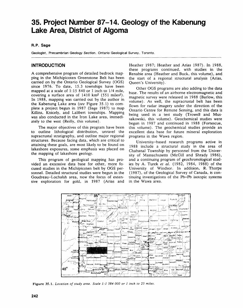
35. Project Number 87-14. Geology of the Kabenung Lake Area, District of Algoma
R.P. Sage
Geologist, Precambrian Geology Section, Ontario Geological Survey, Toronto.
INTRODUCTION
A comprehensive program of detailed bedrock map ping in the Michipicoten Greenstone Belt has been carried on by the Ontario Geological Survey (OGS) since 1976. To date, 15.3 townships have been mapped at a scale of 1:15 840 or l inch to 1/4 mile, covering a surface area of 1410 km2 (551 miles2). In 1988, mapping was carried out by the author in the Kabenung Lake area (see Figure 35.1) to com plete a project begun in 1987 (Sage 1987) to map Killins, Knicely, and Lalibert townships. Mapping was also conducted in the Iron Lake area, immedi ately to the west (Reilly, this volume).
The major objectives of this program have been to outline lithological distribution, unravel the supracrustal stratigraphy, and outline major regional structures. Because facing data, which are critical to attaining these goals, are most likely to be found on lakeshore exposures, some emphasis was placed on the mapping of lakeshore geology.
This program of geological mapping has pro vided an extensive data base for other, more fo cused studies in the Michipicoten belt by OGS per sonnel. Detailed structural studies were begun in the Goudreau-Lochalsh area, now the focus of exten sive exploration for gold, in 1987 (Arias and
Heather 1987; Heather and Arias 1987). In 1988, these programs continued, with studies in the Renabie area (Heather and Buck, this volume), and the start of a regional structural analysis (Arias, Queen's University).
Other OGS programs are also adding to the data base. The results of an airborne electromagnetic and magnetic survey were released in 1988 (Barlow, this volume). As well, the supracrustal belt has been flown for radar imagery under the direction of the Ontario Centre for Remote Sensing, and this data is being used in a test study (Trowell and Mus sakowski, this volume). Geochemical studies were begun in 1987 and continued in 1988 (Fortescue, this volume). The geochemical studies provide an excellent data base for future mineral exploration programs in the Wawa region.
University-based research programs active in 1988 include a structural study in the area of Chabanal Township by personnel from the Univer sity of Massachusetts (McGill and Shrady 1986), and a continuing program of geochronological stud ies by A. Turek et al. (1982, 1984, 1988) of the University of Windsor. In addition, R. Thorpe (1987), of the Geological Survey of Canada, is con tinuing investigations of the Pb-Pb isotopic systems in the Wawa area.
Figure 35.1. Location of study area. Scale 1:1 584 000 or l inch to 25 miles.
242
R. P. SAGE
Access to large areas of Killins, Knicely, and Lalibert townships is via extensive lake and river sys tems or logging skid roads. The northwestern corner of Killins Township, the southwestern corner of Lalibert Township, and the southeastern corner of Knicely Township are easily accessible by helicopter.
MINERAL EXPLORATIONThe area was extensively explored for iron around the turn of the century, with isolated limited activity as late as 1966. The Francis-Brotherton, Brant Lake, Betty Lake, and Morse Mountain iron ranges have all been extensively prospected, unsuccessfully, for iron.
Killins, Knicely, and Lalibert townships have been subjected to a number of regional exploration programs, principally for base metals. The first re gional program was that of Acme Gas and Oil Com pany Limited, in 1969. In 1971, Union Miniere Ex plorations and Mining Corporation Limited com pleted an extensive program of ground investigation of airborne-indicated electromagnetic and magnetic anomalies throughout the region. In 1980, Amax Minerals Exploration Limited examined existing data from previous programs and re-investigated a number of geophysically anomalous areas.
The only base metal deposit of significance within the map area is the Heart Lake copper occur rence. In 1962, this showing was drill-tested by Fal conbridge Nickel Mines Limited, Jon Smith Mines Limited, and Dickenson Mines Limited.
The entire map area is currently under the con trol of International Corona Resources Limited, which has completed airborne electromagnetic and magnetic surveys, ground investigations, and limited diamond drilling in search of gold and base metals.
GENERAL GEOLOGY
METAVOLCANIC ROCKS
The general geology of the area is complex (Figure 35.2). Intermediate to mafic massive to pillowed vol canics are widespread in distribution. Intermediate to mafic tuffs and breccias are not common, being only of local distribution and occurring between the much more-common flow rocks. Massive to pillowed intermediate to mafic volcanics occur in the north ern and southern portions of Lalibert Township, in southern Knicely Township, and in the southern and northwestern portions of Killins Township (Figure 35.2). Amygdules may be common in the intermedi ate to mafic metavolcanics in some areas, and vary up to a maximum size of 10 mm. On the basis of amygdule size, the flows were rich in gas or extruded into a low pressure (shallow water) environment.
Intermediate to felsic metavolcanics are also widespread. They consist of coarse oligomictic to
polymictic breccias, lapilli tuffs, quartz-feldspar crystal tuffs, feldspar crystal tuffs, and massive to bedded tuffs. The most extensive area of intermedi ate to felsic metavolcanics extends to the southwest away from the margin of the Dickenson Lake Stock, in southern Lalibert Township (Figure 35.2), and is indicated as sediment on older compilation maps (Milne et al. 1971). Only volumetrically minor, thin units of argillite, siltstone and wacke occur within these intermediate to felsic metavolcanics.
Within the coarse fragmental volcanics, the ma trix is commonly much more mafic than the clasts. These felsic clast mafic matrix breccias are very common within the southeast-striking band of inter mediate to felsic metavolcanics in Lalibert Town ship.
A large area of massive bedded intermediate to felsic tuff occurs northwest of Dickenson Lake in Knicely Township. These felsic metavolcanics are enclosed within the fold structure outlined by the Betty Lake and Elmo Lake iron ranges.
Along the south flank of the Jimmy Kash Lake Iron Range, a relatively continuous band of interme diate to felsic breccias, tuffs, and quartz-feldspar crystal tuffs is present. These intermediate to felsic metavolcanics extend from south-central Knicely Township to near the western boundary of Killins Township.
A thick sequence of quartz-feldspar crystal tuff occurs on the west side of the iron formation at the Morse Mountain Iron Range.
Massive to bedded fine-grained tuffs and crystal tuffs occur west of the University River in Killins Township. A laminated chert horizon locally sepa rates these intermediate to felsic metavolcanics from clastic metasediments to the south.
CLASTIC METASEDIMENTS
Clastic metasediments form a major lithological package in central Lalibert Township, and occur near Paint and Kabenung lakes and along the north ern edge of Knicely Township. They form a wide band through the central portion of Knicely Town ship, and are common in the northeastern part of that township (Figure 35.2).
The metasediments in Lalibert Township consist of a south- facing sequence of massive to thin-bed ded argillite, siltstone, wacke, and subarkose. The metasediments along Paint and Kabenung lakes in Killins and Knicely Townships are wacke, siltstone, and conglomerates. The conglomerates on Paint Lake and those on the northern border of Killins Township on Kabenung Lake contain rare granitic clasts and are Dore-type conglomerates (Collins and Quirke 1926). The metasediments in central Killins Township consist of wacke and siltstone, north and south of a central band of Dore-type conglomerate. In northern Killins Township, a thick conglomerate unit contains few, if any, granitic clasts, but does lie
243
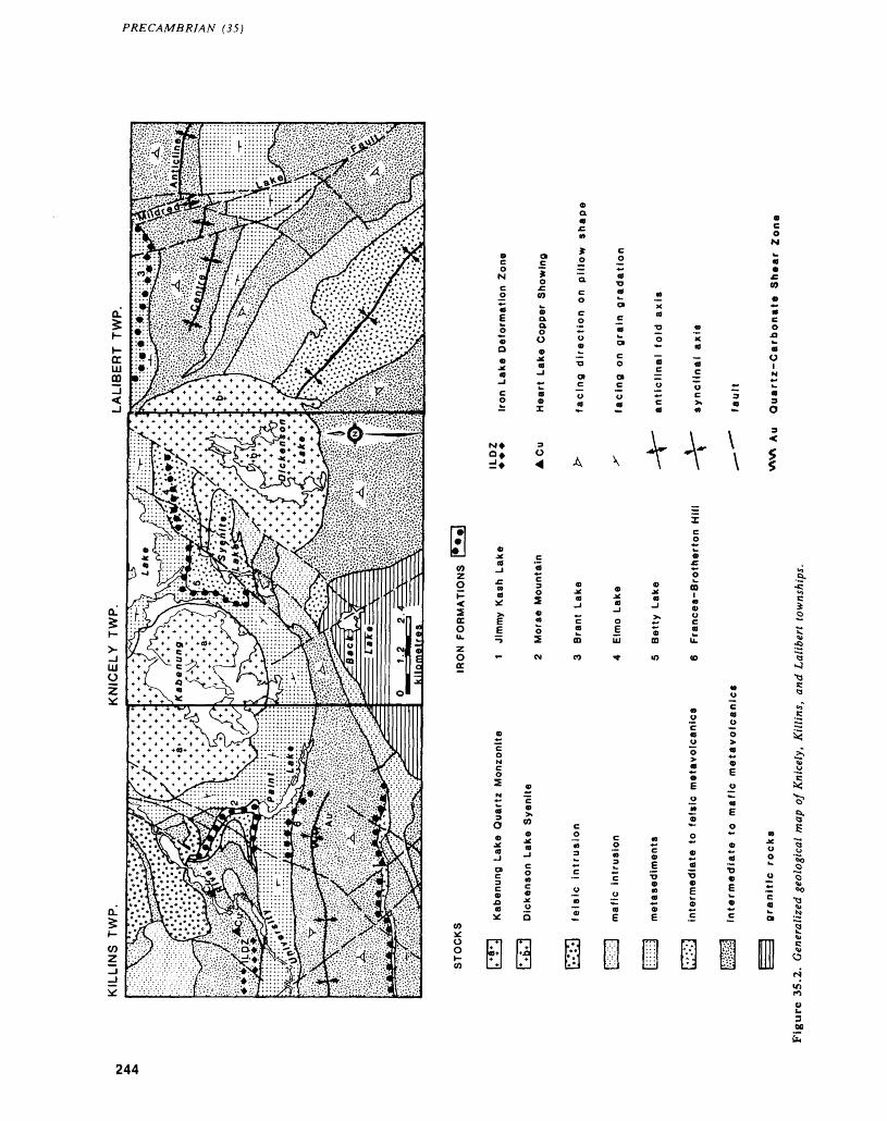
PRECAMBRIAN (35)
a. o O
i: AA-\
244
R. P. SAGE
on strike with conglomerates that do contain granitic clasts further east in Knicely Township.
Graded bedding is common in the wackes and is the principal feature for determining stratigraphic facing directions in the map area.
CHEMICAL METASEDIMENTS
Iron formation ranges are abundant in the map area. These are known as the Morse Mountain (or Mount Raymond), Jimmy Kash Lake, Brant Lake, Elmo Lake, Betty Lake and Francis-Brotherton iron ranges (Figure 35.2). They commonly crop out as ridges, and consist dominantly of banded to lami nated chert. Magnetite and iron sulphide are com mon accessory minerals. The iron ranges form the best geological and geophysical markers within the supracrustal rocks.
INTRUSIVE ROCKS
Felsic intrusive rocks are common within the project area. They are dominated by the Kabenung Lake monzonite to quartz monzonite stock and the Dick- enson Lake syenite stock (Figure 35.2).
In central Knicely Township, a small syenite to granodiorite body occurs between Syenite and Dick- enson lakes. In north- central Killins Township, a small granitic body occurs east and west of the Uni versity River. Northwest of the University River, massive porphyritic and nonporphyritic granodiorite bodies occur that are enclosed within supracrustal rocks. These supracrustal rocks range in metamor phic grade from upper greenschist to lower am phibolite.
Kabenung Lake Stock
The Kabenung Lake Stock consists of massive me dium- to coarse-grained inequigranular seriate por phyritic monzonite to quartz monzonite. The quartz content varies widely between outcrops. High hills and ridges in central Killins and Knicely townships are underlain by rocks of this stock, which is en closed within a contact metamorphic aureole 0.5 to 1.0 km wide.
Dickenson Lake Stock
The Dickenson Lake Stock consists of medium- to coarse-grained equigranular massive grey syenite. Only locally can trace amounts of quartz be found. A large block of medium- to coarse-grained gabbro occurs within the central portion of the stock, and may be a roof pendant completely enclosed within the intruding syenite magma. The eastern side of the Dickenson Lake Stock has a contact metamorphic aureole 1.0 km or more in width. The western side is in fault contact with the supracrustal rocks and a recognizable aureole is not apparent.
Mafic Intrusive RocksIntermediate to mafic intrusive rock is common throughout the supracrustal package, and. lot ally composes more than 50 percent of the stratigraphic section (Figure 35.2). The intermediate to mafic in trusions appear sill-like locally, but regionally some display crosscutting relationships. The intrusions vary from fine to coarse grained and commonly are difficult to distinguish from the metavolcanic rocks.
In central Killins Township, a gabbroic anor thosite to anorthositic gabbro body was outlined. This unit consists of 80 to 90 percent plagioclase, in crystals up to 2 cm in size. The body is sill-like in outline, but the occurrence of dike-like bodies of similar rock cutting the enclosing metavolcanics es tablishes its intrusive nature.
Diabase DikesDiabase dikes are abundant in the map area, and represent northwest- and northeast-trending sets. The dikes appear to be a conjugate set and typically display alteration to a greenschist grade of regional metamorphism. The dikes pinch and swell along strike, can be composite in nature, and can vary from porphyritic to nonporphyritic along strike. The metamorphosed nature of most of the dikes makes them difficult to distinguish from other mafic intru sive rocks in the field conditions encountered, and suggests that most are probably Archean in age. The rather consistent strike of most suggests that only mi nor deformation has occurred since Archean time.
A magnetic northeast-trending diabase dike 100 m wide cuts across Lalibert Township. This dike is very fresh in appearance and is likely Proterozoic in age.
STRUCTURAL GEOLOGY
FOLDING
The regional Centre Anticline (Sage 1987) extends from Leclaire Township into Lalibert Township (Fig ure 35.2). The position of the fold axis is uncertain, but lies north of the south-facing metasedimentary band that strikes northwest across Lalibert Town ship. The fold axis terminates east of the Dickenson Lake Stock, where the north limb of the fold is sheared out and highly attenuated. The Centre Anti cline is an east-plunging synformal anticline.
A regional synclinal axis occurs within the inter mediate to felsic metavolcanics that strike northwest across the southern half of Lalibert Township (Fig ure 35.2). The fold is defined by a south-facing sec tion exposed along Highway 17, and a north-facing (based on pillow shape) section in southwestern Lalibert Township. The position of the fold axis is not precisely known due to the lack of facing data within the intermediate to felsic metavolcanics in which it lies. This fold is terminated in the west by the Dickenson Lake Stock.
245
PRECAMBRIAN (35)
A third regional fold occurs in the southern half of Killins Township (Figure 35.2). This fold is a syn cline whose axis lies within metavolcanics and metasediments. Southeast of Paint Lake, the fold could not be traced east into Knicely Township but it can be extended west towards Iron Lake (Reilly, this volume). The syncline is defined by a north-facing volcanic section in southern Killins Township and a south-facing metavolcanic and metasedimentary section in central Killins Township.
A minor fold is outlined in the Syenite Lake area by the distribution of the Betty Lake and Elmo Lake iron ranges (Figure 35.2). It is open to the east and encloses a dominantly intermediate to felsic metavolcanic assemblage. In less deformed parts of the Michipicoten belt, intermediate to felsic metavolcanics occur at the stratigraphic base of the iron formations. If this observation holds for this area, this fold is an anticline.
A second minor fold occurs in central Killins Township, outlined by the Morse Mountain Iron Range (Figure 35.2). This fold opens to the west; from the observed position of the intermediate to felsic metavolcanic rocks with respect to the iron formation, it is an anticlinal structure.
The two minor folds may be related to the em placement of the Kabenung Lake Stock.
FAULTING
Faulting is of two types, strike-slip and transverse. Lithological contacts are commonly sheared, imply ing that movement along contacts occurred during folding of the supracrustal rocks. The lack of marker horizons transverse to the stratigraphy prevents de termining the relative amount of movement along these strike-slip faults. A pronounced zone of shear ing and deformation in west-central Killins Town ship may be the eastern continuation of the Iron Lake Deformation Zone (ILDZ), recognized by Reilly (this volume) in the adjoining area. At least locally, this zone is conformable with stratigraphy. It may bend northward and join with shear zones along the Heart Lake University River system, where shearing is transverse to lithological trends.
In central Killins Township, a quartz-carbonate shear zone up to 40 feet in width was traced for 1000 feet. The zone displays alteration typical of some gold-bearing shear zones in the Wawa area. The lateral extent of the shear is unknown.
Evidence of deformation is common along the southern greenstone-granite contact. Trondhjemites and quartz diorites commonly are foliated and lineated, and display good cataclastic textures on weathered surfaces. Granodiorites may also display cataclastic textures, but deformation textures are poorly developed in these rocks. Some outcrops of granodiorite in the Back Lake area displayed little evidence of significant deformation. Large blocks of
supracrustal rocks along the external granite- supracrustal contact, combined with the presence of deformation textures, suggests that granite intrusion preceded deformation.
Transverse faults are abundant in the map area and usually display left-lateral offset. Only the major transverse faults are discussed here. In central Lalibert Township, a major north- to northwest- striking diabase-filled fault offsets the metasedimen tary rocks in a left-lateral manner. This fault is the northern extension of the Mildred Lake Fault (Sage 1980). A northwest-striking diabase-filled unnamed fault immediately east of the Dickenson Lake Stock truncates the metasedimentary band that strikes northwest across Lalibert Township.
The western side of the Dickenson Lake,Stock is the site of a northeast-striking fault zone, which is represented by sheared fissile rocks, linear topo graphic features, brecciation of the stock, and hyd rothermal alteration. A western faulted extension of the stock could not be found, perhaps suggesting that the fault predates the main phase of the intru sion, controlled syenite magma emplacement, and was later reactivated.
Left-lateral offset between the Betty Lake and Elmo Lake iron ranges suggests a north- to north west-striking fault in central Knicely Township.
Most of the diabase dikes occupy shear or fault zones, even though offset may not always be readily apparent. The diabase- filled fault zones commonly are represented by one major dike, and there may be numerous narrower dikes subparallel to it. Some of these minor dikes may also occupy minor faults which offset the stratigraphy.
ECONOMIC GEOLOGYThe iron formations of the area are silica-rich, and contain only minor amounts of magnetite, pyrite, siderite, or hematite. Their iron content is too low to be of immediate or near future value, and prospect ing for iron deposits of commercial value appears unwarranted. However, they are commonly folded, faulted, and fractured, and would thus make a good target for the gold prospector.
Shearing is abundant in the project area but rock alteration and silicification associated with shearing, which characterize gold deposits in the Wawa area, appear to be developed best in south western Knicely Township and in southern Killins Township. These shear zones occur in all lithologies and locally appear to follow lithological trends.
Except for the Heart Lake copper occurrence, base metal mineralization is largely unknown within the area. The Heart Lake showings occur in a linear pattern within sheared rocks, as disseminated grains and massive lenses in association with pyrite. The shearing may be related to the eastern extension of the Iron Lake Deformation Zone. One trenched
246
R. P. SAGE
showing of chalcopyrite was located this season on the southeastern corner of Heart Lake.
Bennett and Thurston (1977) described the Heart Lake occurrence as being in sheared mafic metavolcanics, close to the metavolcanic-meta- sedimentary contact. The showings described by Bennett and Thurston (1977) were not visited, but two detailed stratigraphic sections were completed starting 2 km west along strike from the main show ings. From the stratigraphic bottom to top, the sec tions comprise intermediate to mafic tuffs and flows, intermediate to felsic tuffs and crystal tuffs, lami nated chert, siltstone-argillite, and siltstone-wacke. The Iron Lake Deformation Zone lies within felsic and mafic metavolcanics just below the chert hori zon. Fine-grained sugary quartz (recrystallized chert) is common in some of the Heart Lake copper samples examined by the author, and may be the lateral equivalent to the chert unit found in the stratigraphic section to the west. While the Heart Lake occurrences are in a zone conformable with stratigraphy, this mineralization is also closely associ ated with shearing. Alteration that could be analo gous to an alteration pipe below a massive sulphide deposit was not encountered.
RECOMMENDATIONS TO PROSPECTORSShear zones with associated silicification, carbon atization, sulphidization, and potassic alteration should be examined for gold. The recognition of shear zones with silicification and carbonate altera tion in southwestern Knicely Township and southern Killins Township suggests that this area may have gold potential. Evidence of potassic alteration (bio tite or sericite) or the development of sulphide mi neralization (pyrite or pyrrhotite) was not noted to be extensively developed in these shears, but this may be a function of the limited availability of out crop. The quartz-carbonate shear zone found by the mapping party in south-central Killins Township is up to 40 feet wide and 1000 feet long, and open at
TABLE 35.1: GOLD CONTENT OF GRAB SAMPLES FROM QUARTZ-CARBONATE SHEAR ZONE, KILLINS TOWNSHIP. DETERMINATIONS BY THE GEOSCIENCE LABORATORIES, ONTARIO GEOLOGICAL SURVEY, TORONTO.
SampleW739-56W739-61W739-62W739-63W739-65W739-66W73972AW73972B
Fire Assay0. 01-CO. 01•CO. 01
0.01•CO. 010. 01•CO. 01•CO. 01
ppb Au4
•C2^
11021•C2•C2^
both ends. It lies along or close to a regional syncli nal axis, and may have a considerable extent along strike. Table 35.1 gives the gold content of grab samples collected along this shear. The values indi cate subeconomic but geochemically anomalous gold contents. Intermediate to mafic rocks of the Wawa area generally have a background gold content of l to 3 ppb (Sage, unpublished data). Routine pros pecting of this shear is warranted. There was no evi dence of prospecting of the shear at the time of mapping.
The Heart Lake copper occurrence needs re- examination. The close association of shearing with this copper mineralization is encouraging for gold mineralization. This mineralization occurs over a strike length of 2 km, indicating a lengthy zone for examination. Mapping and sampling east and west along the extrapolated extension of this zone are recommended.
REFERENCESArias, Z.G., and Heather, K.B.1987: Regional Structural Geology Related to Gold Minerali
zation in the Goudreau-Lochalsh Area, District of Al goma; p. 146-157 in Summary of Field Work and Other Activities 1987, by the Ontario Geological Sur vey, edited by R.B. Barlow, M.E. Cherry, A.C. Col vine, Burkhard O. Dressler, and Owen L. White, Ontario Geological Survey, Miscellaneous Paper 137, 429p.
Bennett, G., and Thurston, P.C.1977: Geology of the Pukaskwa River-University River
Area, Districts of Algoma and Thunder Bay; Ontario Division of Mines, Geological Report 153, 60p. Ac companied by Maps 2332 and 2333, scale 1:63 360 or l inch to l mile, and l chart.
Collins, W.H., and Quirke, T.T.1926: Michipicoten Iron Ranges; Geological Survey of Can
ada Memoir 147, 175p.
Heather, K.B., and Arias, Z.G.1987: Geological Setting of Gold Mineralization in the
Goudreau-Lochalsh Area, District of Algoma; p. 155-162 in Summary of Field Work and Other Ac tivities 1987, by the Ontario Geological Survey, edited by R.B. Barlow, M.E. Cherry, A.C. Colvine, Burkhard O. Dressler, and Owen L. White, Ontario Geological Survey, Miscellaneous Paper 137, 429p.
McGill, G., and Schrady, C.M.1986: Evidence for a Complex Archean Deformational His
tory, Southwestern Michipicoten Greenstone Belt, Ontario; Proceedings of the Seventeenth Lunar and Planetary Science Conference, Part I, Journal of Geo physical Research, Volume 91, Number B13, p.E281-E289.
Milne, V.G., Giblin, P.E., Bennett, G., Thurston, P.C.,Wolfe, W.J., Giguere, J.F., Leahy, E.J., andRupert, R.J.
1971: Manitouwadge-Wawa Sheet, Geological CompilationSeries; Ontario Division of Mines, Map 2220, scale1:253 440 or l inch to 4 miles.
247
PRECAMBRIAN (35)
Sage, R.P.1980: Wawa Area, District of Algoma; p.47-50 in Sum
mary of Field Work 1980, by the Ontario Geological Survey, edited by V.G. Milne, R.B. Barlow, J.A. Robertson, and A.C. Colvine, Ontario Geologi cal Survey Miscellaneous Paper 96, 201p.
1987: Geology of Goudreau-Lochalsh and Kabenung Lake Areas, District of Algoma; p. 134-137 in Summary of Field Work and Other Activities 1987, by the Ontario Geological Survey, edited by R.B. Barlow, M.E. Cherry, A.C. Colvine, Burkhard O. Dressler, and Owen L. White, Ontario Geological Survey, Mis cellaneous Paper 137, 429p.
Thorpe, R.I.1987: Lead Isotope Data; p.46-55 in Field Trip Guidebook,
Geology and Stratigraphy of the Michipicoten Iron
Formation, Institute on Lake Superior Geology, Thirty Third Annual Meeting, Volume 33, Part 3, 93p.
Turek, A., Smith, P.E., and Van Schmus, W.R.1982: Rb-Sr and U-Pb Ages of Volcanism and Granite Em
placement in the Michipicoten Belt—Wawa, Ontario; Canadian Journal of Earth Sciences, Volume 19, p.1608-1626.
1984: U-Pb Zircon Ages and the Evolution of the Michipicoten Plutonic-Volcanic Terrane of the Supe rior Province, Ontario; Canadian Journal of Earth Sciences, Volume 21, p.457-464.
1988: Extended Volcanism in the Michipicoten Greenstone Belt, Wawa, Ontario; Program with Abstracts, Geo logical Association of Canada-Mineralogical Asso ciation of Canada Joint Annual Meeting, Volume 13, p.127.
248
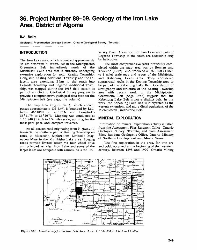
36. Project Number 88-09. Geology of the Iron Lake Area, District of AlgomaB.A. Reilly
Geologist, Precambrian Geology Section, Ontario Geological Survey, Toronto.
INTRODUCTION
The Iron Lake area, which is centred approximately 45 km northwest of Wawa, lies in the Michipicoten Greenstone Belt immediately north of the Mishibishu Lake area that is currently undergoing extensive exploration for gold. Keating Township, along with Keating Additional Township and the ad jacent area extending 2 km to the south into Legarde Township and Legarde Additional Town ship, was mapped during the 1988 field season as part of an Ontario Geological Survey program to provide a comprehensive geological data base for the Michipicoten belt (see Sage, this volume).
The map area (Figure 36.1), which encom passes approximately 135 km2 , is bounded by Lati tudes 48 0 10'N to 48 0 17'N and Longitudes 85 0 11'W to 85 0 20'W. Mapping was conducted at 1:15 840 (l inch to 1/4 mile) scale, utilizing, for the most part, pace-and-compass traverses.
An all-season road originating from Highway 17 transects the southern part of Keating Township en route to Muscocho Explorations Limited's Mag- nacon Mine in the Mishibishu Lake area. Logging roads provide limited access via four-wheel drive and off-road vehicles. Iron Lake and some of the larger lakes are navigable with canoes, as is the Uni
versity River. Areas north of Iron Lake and parts of Legarde Township to the south are accessible only by helicopter.
The most comprehensive work previously com pleted within the map area was by Bennett and Thurston (1977), who produced a 1:63 360 (l inch to l mile) scale map and report of the Mishibishu and Kabenung Lakes area. They considered supracrustal rocks in the Keating Township area to be part of the Kabenung Lake Belt. Correlation of stratigraphy and structure of the Keating Township area with recent work in the Michipicoten Greenstone Belt (Sage 1986) suggests that the Kabenung Lake Belt is not a distinct belt. In this work, the Kabenung Lake Belt is interpreted as the western extension, and more distal equivalent, of the Michipicoten Greenstone Belt.
MINERAL EXPLORATIONInformation on mineral exploration activity is taken from the Assessment Files Research Office, Ontario Geological Survey, Toronto, and from Assessment Files, Resident Geologist's Office, Ontario Ministry of Northern Development and Mines, Wawa.
The first exploration in the area, for iron ore and gold, occurred at the beginning of the twentieth century. Between 1898 and 1902, Ontario Mining
Figure 36.1. Location map for the Iron Lake Area. Scale: 1:1 584 000 or l inch to 25 miles.
249
PRECAMBRIAN (36)
Company completed a considerable amount of sur face work, which included stripping, test pits and shafts, on a wide band of iron formation located ap proximately l km west of Iron Lake. The Minnesota Mining Company also did some work on the same iron formation immediately west of Minnesota Bay of Iron Lake between 1900 and 1903. The Clergue Company drilled one diamond-drill hole the follow ing year, which revealed only small pockets of hema tite.
In 1902, the Lake Superior Company purchased from the Ontario Mining Company 17 claims, com prising 623 acres, extending from west of the Keat ing Additional Township boundary to the edge of Iron Lake. Between 1909 and 1911, five diamond- drill holes totaling 1094 m were drilled through the iron formation and revealed two 7 m sections con sisting of 39 percent Fe and 46 percent Fe, respec tively.
In 1946, Algoma Ore Properties Limited (now Algoma Steel Corporation Limited, Algoma Ore Di vision) staked a group of claims which adjoined the easterly end of the Lake Superior Company property and extended in a northeast direction for 4 km, in cluding Minnesota Bay. They also made an arrange ment with Algoma Central Railway which gave Al goma Ore Properties Limited the exclusive prospect ing rights for a total of five townships, including Keating. During 1947 and 1948, they conducted a magnetometer survey and drilled nine diamond-drill holes for a total of 2118 m. One quartz vein measur ing 4 m wide ran 0.13 ounce gold per ton over l m. Nevertheless, the drilling did not prove sufficient mi neralization to warrant further exploration.
From the 1930s to the 1960s, geological map ping and sampling were completed by a series of mining companies including: O'Brien Gold Mines Limited and Algoma Central Railway (1936 to 1937); Jalore Mining Company Limited (1952); Jalore Mining Company Limited, Algoma Central Railway and Algoma Ore Properties Limited (1955); Canadian Pacific Railway Company (1957), and Al goma Central Railway (1963).
In 1967, Acme Gas and Oil Company Limited contracted Canadian Aero Mineral Surveys Limited to fly a magnetometer, electromagnetic and radio metric survey of all Algoma Central Railway town ships including Keating. Umex Corporation Limited followed with a ground magnetometer and electro magnetic survey in Keating Township in 1974. They drilled two diamond-drill holes for a total of 193 m. Between 1978 and 1983, Noranda Exploration Lim ited completed a ground magnetometer, electromag netic, and induced polarization survey and drilled four diamond-drill holes (total 414 m) in Keating Additional Township, north of Yaskovitch Lake. Amex Minerals Exploration Limited conducted electromagnetic surveys and drilled one diamond- drill hole during 1979 and 1980.
In 1982, International Corona Resources Lim ited obtained the exploration rights for 13.5 town ships, including Keating, from Algoma Central Rail way. In 1983, they contracted Dighem Surveys and Processing Incorporated to fly an electromagnetic, magnetometer and resistivity survey. Manwa'Explo ration Services Limited operated the exploration program, which included geological mapping, soil and rock geochemistry, and a ground magnetometer and electromagnetic survey. In 1984, they drilled nine diamond-drill holes for a total of 914 m. Drill ing concentrated on the footwall of the Iron Lake Iron Formation, where a weakly auriferous zone of quartz veining is hosted by felsic volcanic rocks, fel sic dikes and sediments.
Tundra Gold Mines Limited contracted Aerodat Limited to fly an electromagnetic and magnetometer survey in 1983. The following year they conducted a soil sampling survey and prospecting in the south eastern corner of the township and in the area far ther to the west, where they are currently involved in surface exploration.
GENERAL GEOLOGY
METAVOLCANIC ROCKS
Mafic to Intermediate Metavolcanic RocksMafic to intermediate volcanic rocks comprise the most abundant lithology in the map area (Figure 36.2). Massive flows are predominant; however, pri mary features present include pillows, pillow breccia, and vesicles commonly infilled with quartz and car bonate. Plagioclase crystal tuff units, locally contain ing lapilli and bomb-size fragments, are less com mon. Typically, individual flow and pyroclastic de posits were not delineated during the mapping, due to the paucity of continuous outcrop and limited de velopment of primary structures. Metavolcanic rocks with abundant l to 2 cm plagioclase phenocrysts serve as excellent stratigraphic marker horizons which define an approximately east-striking stratig raphy.
Pillow stacking within flows and graded bedding within tuffs indicate that the metavolcanic rocks in the northern part of the map area young to the south and that the metavolcanic rocks in the south young to the north. Thus, the stratigraphy is divided into a south-younging Northern Terrane and a north- younging Southern Terrane (Figure 36.2). Prelimi nary field observations suggest that within each ter rane, a lower Fe-rich sequence (tholeiitic?) is over lain by a plagioclase-phyric sequence (calc-alka- line?).
Felsic to Intermediate Metavolcanic RocksFelsic to intermediate metavolcanic rocks are much less voluminous than mafic to intermediate metavol canic rocks. Pyroclastic tuff breccias are dominant
250
B.A. REILLY
^:S^q^j^:C^fe^o-P^aS.-^
+ + *• + + + + + + + + + + +- + + + +I+ + + + + + + + + + + -?^A. +
J.U. L J. . .4. 4- 4. ..4- -t-* * -l- 4-^A- 4-
"*" ' Granitoid intrusion
Diorite
Polymictic conglomerate
Wacke, argillite
Iron formation
Felsic to intermediate metavolcanics
j___j Mafic to intermediate metavolcanics
Figure 36.2. Generalized geology of the Iron Lake Area.
Tops from bedding
Tops from pillows
Iron Lake Iron Deposit
251
PRECAMBRIAN (36)
and consist of lenticular fragments which range in size from ash to bombs. Fragments are monolithic and more felsic in composition than matrix material. Quartz crystal tuffs are less common and may be dif ficult to discern from concordant quartz porphyritic intrusions. Rare, massive, aphanitic flow rocks are also present.
Individual felsic to intermediate metavolcanic units are thin, ranging from 5 to 50 m, and are con centrated stratigraphically above the mafic to inter mediate metavolcanic sequence.
METASEDIMENTARY ROCKS
Chemical Metasedimentary RocksA Michipicoten-type iron formation (Goodwin 1962) strikes through the map area in an east-west orientation. It forms a prominent ridge, over 60 m in height, which is best exposed on the northern shore of Minnesota Bay. Field mapping, supported by recent Airborne Electromagnetic Survey Maps 81004 and 81014 (Ontario Geological Survey 1987), indicates that the Iron Lake Iron Formation is con tinuous across the township, measures up to 350 m in thickness, and becomes much thinner laterally to the east and west. Several thin iron formations crop out immediately north of the main iron formation. Generally, they measure less than 10 m in thickness and are discontinuous in strike length.
The main iron formation is located stratigraphi cally above the felsic to intermediate metavolcanic rocks. It is predominantly oxide facies and consists of very thinly bedded magnetite-hematite and chert (jasper is locally present). A systematic stratigraphic sequence is observed within the iron formation and consists of a carbonate facies base, which is only lo cally present and composed of variably weathered siderite interbedded with chert, chert-magnetite lay ers which grade into chert-hematite layers, and a cap of massive to brecciated chert.
Clastic Metasedimentary RocksOverlying the iron formation and the metavolcanic rocks is a clastic metasedimentary sequence com prising wacke, polymictic conglomerate, and inter bedded wacke and argillite. Clasts within the polymictic conglomerate range in composition from mafic to intermediate metavolcanic rocks, felsic to intermediate metavolcanic rocks, iron formation, chert, granitoids, felsic porphyry, and quartz. A gra dation in grain size and texture is observed from clast-supported, cobble-size clasts in the north to matrix-supported, pebble-size clasts in the south. Thus, a proximal sedimentary facies grades into a more distal facies, indicating a source to the north.
Interbedded wacke and argillite crop out south of the conglomeratic rocks. Graded bedding within the wacke/argillite sequence generally indicates tops to the south, which is consistent with the younging
direction interpreted from sedimentary facies within the conglomerate. Local bedding reversals indicated by a few beds which grade to the north may be ex plained by observed tight to isoclinal folding. A thin (less than 100 m) unit of south-younging wacke beds located immediately north of the conglomerate is believed to be part of the proximal sedimentary facies. The conglomerate/wacke/argillite sequence is correlative with the Dore sediments (Cooke 1937) in the core of the Michipicoten Greenstone Belt.
INTRUSIVE ROCKS
Early Mafic Intrusions
Mafic to intermediate metavolcanic rocks are in truded by fine- to medium-grained mafic sills. The average thickness of the mafic intrusions is typically less than 5 m. Bennett and Thurston (1977) recog nized the intrusive nature of these rocks by their massive and homogeneous texture and blocky joint ing. Contacts of the intrusive rocks are generally sheared and concordant with the stratigraphy; how ever, thin apophyses may intrude the country rocks. Although present within the mafic to intermediate metavolcanic rocks of the Southern Terrane, mafic sills are more abundant in the Northern Terrane where they are estimated to constitute up to 50 per cent of the stratigraphy.
The mafic sills possess a metamorphic mineral assemblage and weak foliation, which are similar to those developed in the mafic to intermediate metavolcanic rocks. The sills have, therefore, prob ably been subjected to the same regional metamor phic and deformational event. The spatial and tem poral association with the mafic to intermediate metavolcanic rocks suggests that the mafic sills may have served as a feeder system to the metavolcanic sequence.
Early Felsic IntrusionsPlagioclase and/or quartz porphyritic rocks of felsic composition intrude both the metavolcanic and metasedimentary sequences. The phenocrysts, which range in size from less than l mm to l cm and con stitute up to 75 percent of the rock, are enclosed by an aphanitic to medium-grained matrix. The felsic porphyries have an average thickness of less than 5 m and possess contacts which are sharp and con cordant with stratigraphy. Like the mafic sills de scribed above, these early felsic sills exhibit a similar metamorphic grade and foliation as the felsic metavolcanic rocks and are interpreted as synvol- canic intrusions.
Late Mafic IntrusionsA large mafic intrusion, measuring approximately 32 km2 , crops out in the Wilder Lake area and was named the Wilder Lake Complex by Bennett and Thurston (1977). The Wilder Lake Complex is pre dominantly of dioritic composition and consists of
252

B.A. REILLY
hornblende and plagioclase with minor pyroxene, biotite, and quartz. Rocks of the complex are me dium to coarse grained with local pegmatitic and hornblende porphyritic phases. Amphibolide inclu sions and granitic intrusions of variable composition are included as part of the Wilder Lake Complex.
Field investigations during 1988 also delineated a second intrusion of similar composition and tex ture. This mafic intrusion extends west of Wilder Lake to Confederation Lake and has been named the Washout Lake Complex. The Washout Lake Complex has an oval shape with an estimated sur face area of 16 km2 .
Both complexes are expressed as positive aeromagnetic anomalies on Total Intensity Magnetic Survey Maps 81003 and 81004 (Ontario Geological Survey 1987) and extend north of Keating Town ship. Smaller mafic intrusions of gabbroic composi tion are found throughout the map area.
Granitoid Intrusions
The granitoid intrusion south of the greenstone belt consists of foliated to gneissic tonalite to quartz dio rite. Local phases of granodiorite composition are present. The tonalite to quartz diorite is generally medium grained and texturally variable, ranging from equigranular to plagioclase porphyritic. The mafic mineral content ranges from 5 to 25 percent, and biotite, if present, is typically less abundant than hornblende. The contact between the southern granitoid and the greenstone belt is marked by a transition zone of aplitic-textured granitoid; felsic apophyses, which are locally pegmatitic; rafted inclu sions of amphibolitized country rock, and mafic in trusions. An amphibolite facies metamorphic aure ole extends for up to l km into the country rock. The northern granitoid intrusion which crops out at Confederation Lake is similar in composition and texture to the southern granitoid intrusion, and also exhibits a contact metamorphic and strain aureole.
Diabase Dikes
Late Archean diabase dikes crosscut all lithologies in the map area. Two major trends were observed, pro ducing a conjugate set at 025 0 and 340 0 . East- and north-striking dikes are less common. The dikes contain variable proportions of plagioclase, pyroxene, olivine, hornblende, and quartz. They are massive, aphanitic to medium grained, and locally plagioclase porphyritic. Dike thickness ranges from less than l m up to 100 m. Contacts are sharp and may exhibit offsets, especially when a competency contrast due to a change in lithology occurs along intrusion paths. The smaller dikes possess a thin chilled margin, typically less than 2 cm thick; how ever, the larger dikes may bake country rocks, pro ducing a zone up to 5 m thick. Epidote and quartz veining are abundant within many of the dikes. Diabase dikes may occupy early ductile or brittle
structures. Typically, outcrops form lineaments rep resented as topographic highs and positive aeroma gnetic anomalies.
STRUCTURAL GEOLOGY
FOLIATIONS AND LINEATIONS
All supracrustal rocks in the map area (excluding the amphibolite grade metamorphic aureoles pro duced by the granitoid intrusions to the south and at Coronation Lake) possess a weakly to moderately developed penetrative foliation and have been sub jected to greenschist facies metamorphism. This pla nar fabric is defined by the parallel growth of platy and acicular minerals, such as chlorite, actinolite, and sericite (hornblende is found within the meta morphic aureoles). The regional foliation strikes ap proximately east and dips steeply to the north in the Southern Terrane and steeply to the south in the Northern Terrane (Figure 36.3). Generally, foliation parallels or lies at a low angle to bedding.
Lineations associated with this regional penetra tive fabric are typically weakly developed to indis tinct, except along lithological contacts. A stretching lineation is defined by the linear alignment of platy and acicular minerals, plagioclase, and quartz grains, and, when present, by primary structures such as clasts, fragments, phenocrysts, and amygdules. The regional lineation plunges moderately to the west and visual estimates of the lineation:foliation (L:S) ratio (the relative prominence of the stretching lineation (L) in comparison to the foliation (S) (Schwerdtner et al. 1977)) is typically L less than S. Locally, subvertical crinkle and crenulation linea- tions appear to overprint the west-plunging regional lineation.
FOLDING
Minor FoldsMinor folding is present but not common in the map area. Two types of minor folds (metre scale) were mapped: 1) asymmetric drag folds produced during shearing, with fold axes perpendicular to shear di rection; and 2) symmetric folds spatially associated with lithological contacts, with fold axes parallel to shear direction. Development of the latter type of fold suggests that folding was not a product of shear ing but pre-dated it, with the fold limb subsequently yielding to shearing. These fold axes are not only parallel to the stretching direction in the shear zones, but coaxial with the regional stretching linea tion.
Major FoldsBennett and Thurston (1977) interpreted the rever sal of younging directions in the Northern and Southern terranes to reflect a major synclinal struc ture and placed the synclinal axis symmetrically
253
PRECAMBRIAN (36)
Foliation, with dip direction indicated
Local high strain zone
Broad high strain zone (Iron Lake Deformation Zone)
Amphibolite-greenschist facies boundary
Figure 36.3. Structural geology of the Iron Lake Area.
For geological legend, see Figure 36.2.
254
B.A. REILLY
within the conglomeratic package. This interpreta tion is problematical because the sedimentary se quence as a whole exhibits a proximal-distal, north to south relationship, with an overall south-younging direction. Although a major upright synclinal struc ture may account for differences in stratigraphic younging direction between the two terranes, an al ternative explanation envisages the juxtaposition of opposite younging terranes during tectonic move ment.
HIGH STRAIN ZONES
High strain zones are recognized as highly strained rocks exhibiting a penetrative foliation, which be comes more intensely developed from boundary to centre of the zone. These zones are typically strata- parallel and concentrated along lithological bounda ries, and deformation is brittle-ductile. Original li- thologies are difficult to identify within high strain zones as deformation and associated hydrothermal alteration often obscure and obliterate primary min eralogies and textures, locally producing a tectonic banding.
Two types of high strain zones were recognized in the map area: 1) local zones exhibiting oblique- slip movement; and 2) a broad zone exhibiting strike-slip movement, named the Iron Lake Defor mation Zone (ILDZ).
The first type of high strain zone are local zones which measure less than 25 m in width and typically are composed of only one brittle-ductile shear. Strong stretching lineations (1^=8) plunge moderately to the west, indicating oblique movement along the zones. Kinematic indicators were not observed. The contact between the southern granitoid intrusion and the greenstone belt is also highly strained. Deforma tion along this contact is similar to the local zones within the supracrustal rocks, and a strong stretching lineation which plunges moderately to the west is ob served. Shearing penetrates the external granitoid to at least the southern margin of the mapping.
The Iron Lake Deformation Zone (ILDZ) is the best example of the second type of high strain zone. It consists of an anastomosing series of brittle-duc tile shear zones which envelope relatively un- deformed lithons. The ILDZ transects Iron Lake in an east-west orientation across Keating Township, with a minimal width of 300 m. It occurs at the top of the metavolcanic sequence in the Northern Ter rane and below the Iron Lake Iron Formation; how ever, it may be slightly discordant to stratigraphy.
Stretching lineations near the boundary of the ILDZ are subhorizontal; however, near the centre of the zone, a subvertical crinkle/crenulation lineation overprints the subhorizontal linear feature. This is interpreted as a late stage phenomenon in which the zone locks during the waning phases of predomi nantly subhorizontal ductile deformation, producing crinkles and crenulations perpendicular to the shear
transport direction. Subvertically plunging, asymmet ric folds are consistent with subhorizontal move ment. Kinematic indicators include Z-folds and fo liation fish which give a consistent dextral sense of displacement.
Two discordant zones located north of the ILDZ are comparable in size to the local high strain zones, yet exhibit subhorizontal dextral displacement, based on C-C'-fabric relationships, similar to the ILDZ.
ECONOMIC GEOLOGYArchean lode gold deposits throughout the Superior Province of Canada are associated with deformation zones (Colvine et al. 1988). To date, gold occur rences in the Wawa Gold Camp have been restricted to deformation zones. The ILDZ is favourably lo cated between the Goudreau-Lochalsh Deformation Zone to the east and the Mishibishu Deformation Zone to the southwest.
Carbonatization is coincident with the highly strained rocks enveloped by the ILDZ. A broad cal cite alteration is dominant near the boundary of the zone, whereas ankerite is present near the centre. Locally, primary mineral assemblages control some types of alteration assemblages observed within the zone. Protoliths of felsic composition exhibit sericitization and rocks of more mafic composition yield to chloritization.
Quartz veins emplaced within the ILDZ are gen erally folded, boudinaged, and rotated, suggesting a pre- to syn-tectonic temporal relationship with the development of the zone. Pyrite is the dominant sul phide mineral and, when present, is typically found as fine-grained, disseminated cubes. An exception to this habit are pods of massive pyrite within car bonate facies iron formation which crops out on a small lake due north of Minnesota Bay. Here, the carbonate iron formation, which is as a distinct body separate from the main oxide iron formation, is af fected by the ILDZ and is host to quartz-tourmaline veining. Cellular textures present within the carbon ate facies iron formation are a result of preferential weathering of disseminated pyrite crystals.
Field observations indicate that most of the iron formation is relatively undeformed; however, be cause of the anastomosing geometry of the ILDZ, the base of the main iron formation and the underly ing subordinate iron formations may be transected by the ILDZ.
Local high strain zones, although smaller in size than the ILDZ, exhibit similar deformation and al teration characteristics. The loci of the these zones are typically concentrated along lithological contacts where a competency contrast exists. The tectonic permeability produced in the zones enhances the passage of hydrothermal fluids. These zones are typically carbonatized (calcite and/or ankerite), with variable degrees of sericitization and chloritization.
255
PRECAMBRIAN (36)
Quartz veining and sulphide mineralization are simi lar to the ILDZ but less extensive.
Felsic pyroclastic metavolcanic rocks, concen trated at the stratigraphic top of the metavolcanic sequence in both the Northern and Southern ter- ranes, are potential hosts for volcanic-associated, base-metal, massive sulphide mineralization. No such mineralization, however, was observed during the field work.
The Wilder Lake Complex and the Washout Lake Complex warrant testing for platinum group elements; however, magmatic sulphides or sulphides associated with pegmatitic phases were not found during the field season.
The main iron formation consists predominantly of alternating magnetite-hematite and chert layers. This deposit is thinner and much leaner than the Michipicoten-type iron ore deposits in the central part of the Michipicoten Greenstone Belt. Neverthe less, the iron formation serves as a favourable host for gold mineralization where transected by the ILDZ.
Based on observed deformation and alteration characteristics mapped at 1:15 840 scale and com parison of these features with known gold occur rences within the Wawa Gold Camp, the economic potential for gold mineralization, especially within the ILDZ and local high strain zones, warrants fur ther systematic detailed mapping.
ACKNOWLEDGMENTSThe author would like to acknowledge the personnel of the following companies and government minis tries for their cooperation and assistance provided during the field season: Flanagan McAdam Re sources Incorporated; Granges Explorations Lim ited; Ministry of Natural Resources, Wawa; Mus- cocho Explorations Limited; the Wawa and Sault Ste. Marie Resident Geologists' Offices; Tundra Gold Mines Limited; and Viking Helicopters Lim
ited. Special thanks are extended to Jane Howe, David Evans, Michele Cote, and Robert Dufton, who provided able field assistance.
REFERENCESBennett, G., and Thurston, P.C.1977: Geology of the Pukaskwa River-University River
Area, Districts of Algoma and Thunder Bay; Ontario Division of Mines, Geoscience Report 153, 60p. Ac companied by Maps 2332 and 2333, scale 1:63 360 or l inch to l mile.
Colvine, A.C., Fyon, J.A., Heather, K.B., Marmont, Sous-san, Smith, P.M., and Troop, D.G.
1988: Archean Lode Gold Deposits in Ontario; OntarioGeological Survey, Miscellaneous Paper 139, 136p.
Cooke, H.C.1937: Structure of the Dore Series, Michipicoten District,
Ontario; Transactions of the Royal Society of Can ada, Section IV, p.69-80.
Goodwin, A.M.1962: Structure, Stratigraphy and Origin of Iron Formations,
Michipicoten Area, Algoma District, Ontario, Can ada; Geological Society of America Bulletin, Volume 73, Number 5, p.561-586.
Ontario Geological Survey1987: Airbourne Electromagnetic and Total Intensity Sur
vey, Wawa Area, Districts of Algoma, Sudbury and Thunder Bay; by Dighem Surveys and Processing Inc. for Ontario Geological Survey, Geophysical/ Geochemical Series, Maps 81003, 81004, and 81014, scale 1:20 000. Survey and Compilation, April 1987 to February 1988.
Sage, R.P.1986: Stratigraphic Correlation in the Wawa Area; p.62-68,
in Volcanology and Mineral Deposits, edited by John Wood and Henry Wallace, Ontario Geological Sur vey, Miscellaneous Paper 129, 183p.
Schwerdtner, W.M., Bennett, P.J., and Janes, T.W.1977: Application of 1^=8 Fabric Scheme to Structural Map
ping and Paleostrain Analysis; Canadian Journal of Earth Sciences, Volume 14, p. 1021-1032.
256
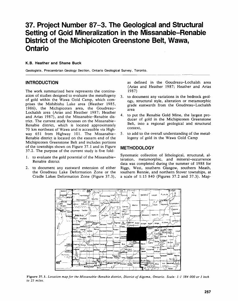
37. Project Number 87-3. The Geological and Structural Setting of Gold Mineralization in the Missanabie-Renabie District of the Michipicoten Greenstone Belt, Wawa, Ontario
K.B. Heather and Shane Buck
Geologists, Precambrian Geology Section, Ontario Geological Survey, Toronto.
INTRODUCTION
The work summarized here represents the continu ation of studies designed to evaluate the metallogeny of gold within the Wawa Gold Camp, which com prises the Mishibishu Lake area (Heather 1985, 1986), the Michipicoten area, the Goudreau- Lochalsh area (Arias and Heather 1987; Heather and Arias 1987), and the Missanabie-Renabie dis trict. The current study focusses on the Missanabie- Renabie district, which is located approximately 70 km northeast of Wawa and is accessible via High way 651 from Highway 101. The Missanabie- Renabie district is located on the eastern end of the Michipicoten Greenstone Belt and includes portions of the townships shown on Figure 37. l and in Figure 37.2. The purpose of the current study is five fold:1. to evaluate the gold potential of the Missanabie-
Renabie district2. to document any eastward extension of either
the Goudreau Lake Deformation Zone or the Cradle Lakes Deformation Zone (Figure 37.3),
as defined in the Goudreau-Lochalsh area (Arias and Heather 1987; Heather and Arias 1987)
3. to document any variations in the bedrock geol ogy, structural style, alteration or metamorphic grade eastwards from the Goudreau-Lochalsh area
4. to put the Renabie Gold Mine, the largest pro ducer of gold in the Michipicoten Greenstone Belt, into a regional geological and structural context,
5. to add to the overall understanding of the metal logeny of gold in the Wawa Gold Camp
METHODOLOGYSystematic collection of lithological, structural, al teration, metamorphic, and mineral-occurrence data was completed during the summer of 1988 for Riggs, West, southern Glasgow, southern Meath, southern Rennie, and northern Stover townships, at a scale of 1:15 840 (Figures 37.2 and 37.3). Map-
Figure 37.1. Location map for the Missanabie-Renabie district, District of Algoma, Ontario. Scale: 1:1 584 000 or l inch to 25 miles.
257
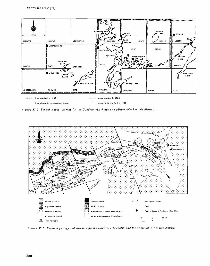
PRECAMBRIAN (37)
Area studied in 1967
Area shown in succeeding figures
Area studied in 1988
Area lo be studied in 1989
Figure 37.2. Township location map for the Goudreau-Lochalsh and Missanabie-Renabie districts.
Olivine Gabbro
Nepheline Syenite
Internal Granitoid
External Granitoid
Iron Formation
Metasediments
Mafic Intrusion
Intermediate to Felsic Metavolcanic
itavolcanicl__| Mafic to Intermediate Meta
x^~^ Geological Contact
' Past or Present Producing Gold Mine
10 km l
Figure 37.3. Regional geology and structure for the Goudreau-Lochalsh and the Missanabie-Renabie districts.
258
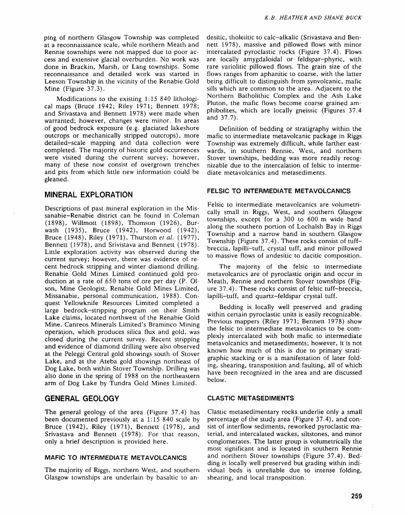
K. B. HEATHER AND S H AN E BUCK
ping of northern Glasgow Township was completed at a reconnaissance scale, while northern Meath and Rennie townships were not mapped due to poor ac cess and extensive glacial overburden. No work was done in Brackin, Marsh, or Lang townships. Some reconnaissance and detailed work was started in Leeson Township in the vicinity of the Renabie Gold Mine (Figure 37.3).
Modifications to the existing 1:15 840 lithologi- cal maps (Bruce 1942; Riley 1971; Bennett 1978; and Srivastava and Bennett 1978) were made when warranted; however, changes were minor. In areas of good bedrock exposure (e.g. glaciated lakeshore outcrops or mechanically stripped outcrops), more detailed-scale mapping and data collection were completed. The majority of historic gold occurrences were visited during the current survey; however, many of these now consist of overgrown trenches and pits from which little new information could be gleaned.
MINERAL EXPLORATION
Descriptions of past mineral exploration in the Mis- sanabie-Renabie district can be found in Coleman (1898), Willmott (1898), Thomson (1926), Bur wash (1935), Bruce (1942), Horwood (1942), Bruce (1948), Riley (1971), Thurston et al. (1977), Bennett (1978), and Srivistava and Bennett (1978). Little exploration activity was observed during the current survey; however, there was evidence of re cent bedrock stripping and winter diamond drilling. Renabie Gold Mines Limited continued gold pro duction at a rate of 650 tons of ore per day (P. Ol son, Mine Geologist, Renabie Gold Mines Limited, Missanabie, personal communication, 1988). Con quest Yellowknife Resources Limited completed a large bedrock-stripping program on their Smith Lake claims, located northwest of the Renabie Gold Mine. Canreos Minerals Limited's Braminco Mining operation, which produces silica flux and gold, was closed during the current survey. Recent stripping and evidence of diamond drilling were also observed at the Peleggi Central gold showings south of Stover Lake, and at the Ateba gold showings northeast of Dog Lake, both within Stover Township. Drilling was also done in the spring of 1988 on the northeastern arm of Dog Lake by Tundra Gold Mines Limited.
GENERAL GEOLOGY
The general geology of the area (Figure 37.4) has been documented previously at a 1:15 840 scale by Bruce (1942), Riley (1971), Bennett (1978), and Srivastava and Bennett (1978). For that reason, only a brief description is provided here.
MAFIC TO INTERMEDIATE METAVOLCANICS
The majority of Riggs, northern West, and southern Glasgow townships are underlain by basaltic to an-
desitic, tholeiitic to calc-alkalic (Srivastava and Ben nett 1978), massive and pillowed flows with minor intercalated pyroclastic rocks (Figure 37.4). Flows are locally amygdaloidal or feldspar-phyric, with rare variolitic pillowed flows. The grain size of the flows ranges from aphanitic to coarse, with the latter being difficult to distinguish from synvolcanic, mafic sills which are common to the area. Adjacent to the Northern Batholithic Complex and the Ash Lake Pluton, the mafic flows become coarse grained am- phibolites, which are locally gneissic (Figures 37.4 and 37.7).
Definition of bedding or stratigraphy within the mafic to intermediate metavolcanic package in Riggs Township was extremely difficult, while farther east wards, in southern Rennie, West, and northern Stover townships, bedding was more readily recog nizable due to the intercalation of felsic to interme diate metavolcanics and metasediments.
FELSIC TO INTERMEDIATE METAVOLCANICS
Felsic to intermediate metavolcanics are volumetri- cally small in Riggs, West, and southern Glasgow townships, except for a 300 to 600 m wide band along the southern portion of Lochalsh Bay in Riggs Township and a narrow band in southern Glasgow Township (Figure 37.4). These rocks consist of tuff- breccia, lapilli-tuff, crystal tuff, and minor pillowed to massive flows of andesitic to dacitic composition.
The majority of the felsic to intermediate metavolcanics are of pyroclastic origin and occur in Meath, Rennie and northern Stover townships (Fig ure 37.4). These rocks consist of felsic tuff-breccia, lapilli-tuff, and quartz-feldspar crystal tuff.
Bedding is locally well preserved and grading within certain pyroclastic units is easily recognizable. Previous mappers (Riley 1971; Bennett 1978) show the felsic to intermediate metavolcanics to be com plexly intercalated with both mafic to intermediate metavolcanics and metasediments; however, it is not known how much of this is due to primary strati graphic stacking or is a manifestation of later fold ing, shearing, transposition and faulting, all of which have been recognized in the area and are discussed below.
CLASTIC METASEDIMENTS
Clastic metasedimentary rocks underlie only a small percentage of the study area (Figure 37.4), and con sist of interflow sediments, reworked pyroclastic ma terial, and intercalated wackes, siltstones, and minor conglomerates. The latter group is volumetrically the most significant and is located in southern Rennie and northern Stover townships (Figure 37.4). Bed ding is locally well preserved but grading within indi vidual beds is unreliable due to intense folding, shearing, and local transposition.
259
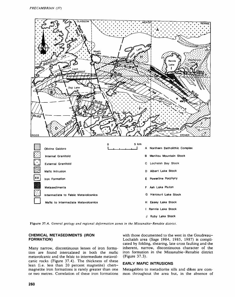
PRECAMBRIAN (37)
4- 4- 4- 4- * ++ + -I. + + 4. + + + * * J.-1-*. '|-.-f-4- 4- H- 4- 4- f +A- 4- 4- 4- 4- 4- 4- 4- ^ ^.^j.*., o.
4. 4. 4- 4- 4- 4-4- M * + + + + -H + + + + + 4-4-
Olivine Gabbro
Internal Granitoid
External Granitoid
Mafic Intrusion
Iron Formation
Metasediments
Intermediate to Felsic Metavolcanics
Mafic to Intermediate Metavolcanics
5 km l A Northern Batholithic Complex
B Manitou Mountain Stock
C Lochalsh Bay Stock
D Albert Lake Stock
E Powerline Porphyry
F Ash Lake Pluton
G Harcourt Lake Stock
H Easey Lake Stock
l Rennie Lake Stock
J Ruby Lake Stock
Figure 37.4. General geology and regional deformation zones in the Missanabie-Renabie district.
CHEMICAL METASEDIMENTS (IRON FORMATION)
Many narrow, discontinuous lenses of iron forma tion are found intercalated in both the mafic metavolcanic and the felsic to intermediate metavol- canic rocks (Figure 37.4). The thickness of these lean (i.e. less than 20 percent magnetite) chert- magnetite iron formations is rarely greater than one or two metres. Correlation of these iron formations
with those documented to the west in the Goudreau- Lochalsh area (Sage 1984, 1985, 1987) is compli cated by folding, shearing, late cross faulting and the inherent, narrow, discontinuous character of the iron formation in the Missanabie-Renabie district (Figure 37.3).
EARLY MAFIC INTRUSIONSMetagabbro to metadiorite sills and dikes are com mon throughout the area but, in the absence of
260
K. B. HEATHER AND SHANE BUCK
crosscutting relationships, are difficult to distinguish from coarse-grained, mafic metavolcanic flows. With the exception of a large, sickle-shaped body west of the Albert Lake Stock, the early mafic intru sions have been left off the general geology map (Figure 37.4) for simplicity.
EXTERNAL GRANITOIDS
Wide areas north, south and east of the Missanabie- Renabie district are underlain by extensive external granitoid complexes (Figures 37.3 and 37.4). During the current study, the Northern Batholithic Complex was examined in a reconnaissance style in the north ern part of Glasgow Township. The Ash Lake Pluton (ALP) in West and Stover townships (Srivastava and Bennett 1978; Bennett 1978) was examined in more detail.
For the most part, the external granitoid rocks consist of medium- to coarse-grained biotiteithorn- blende tonalite to trondhjemite. These rocks are moderately to strongly foliated, with local zones of granitic and granitic-amphibolitic gneiss. Large rafts of amphibolitic volcanic rocks are common in both the Northern Batholithic Complex and the ALP. Adjacent to these rafts and along the main grani- toid-supracrustal contact, the tonalite-trondhjemite appears to be contaminated by the amphibolitized rocks, producing local zones of hybrid quartz dio rite.
The original external granitoid-supracrustal con tact has been modified and displaced in several loca tions by northwest-trending structures such as the Meath Lake Fault (Figure 37.4).
INTERNAL GRANITOIDS
Six distinct granitoid stocks and numerous irregular dikes and bodies of feldspar and quartz-feldspar porphyry occur within the supracrustal rocks of the Missanabie-Renabie district (Figure 37.4). These internal granitoid rocks have been mapped in detail by Riley (1971), Srivastava and Bennett (1978), and Bennett (1978). The lithological terminology of these authors has been retained for this preliminary report.
The Lochalsh Bay Stock is a massive, un- foliated, potassium feldspar-megacrystic granodior ite with phenocrysts up to 5 cm in size. The only other similar internal granitoid, the Ruby Lake Stock, was not visited during the current study. However, the Ruby Lake Stock is described by Ben nett (1978) as a massive, unfoliated, microcline- phyric, quartz monzonite, with phenocrysts up to 2 cm in size. The Rennie Lake and Easey Lake stocks consist of potassium feldspar-phyric grano diorite, but differ from the Lochalsh Bay and Ruby Lake stocks in that they are weakly foliated and their feldspar phenocrysts are much smaller (less than 3 mm). The Harcourt Lake Stock consists of massive, faintly foliated granodiorite-syenite-syeno-
diorite. The Albert Lake Stock consists of massive, faintly foliated, biotite trondhjemite to granodiorite and is surrounded by a weakly foliated border phase of feldspar and quartz-feldspar porphyry. Irregular dikes and bodies of feldspar and quartz-feldspar porphyry are common throughout central Riggs and northern West townships. These intrusions consist of medium- to fine-grained feldsparitquartz pheno crysts in a weakly to strongly foliated, fine-grained matrix.
LATE MAFIC TO ULTRAMAFIC INTRUSIONS
Rocks of this type in the study area include numer ous diabase, lamprophyre, and ultramafic dikes, and a large olivine gabbro stock (Manitou Mountain Stock, Figure 37.4). Due to the density and extent of diabase dikes in the study area, they have been left off the general geology maps shown in Figures 37.3 and 37.4.
STRUCTURAL GEOLOGYThe following discussion summarizes the main struc tural observations made during the current study. This aspect of the study focused on the recognition and mapping of regional deformation zones, using the criteria established by Arias and Heather (1987). Stated simply, deformation zones define ar eas within which there is a greater density of discrete shear zones and the rocks collectively exhibit a higher degree of deformation than those outside the zone. This is not to say that rocks exhibiting little or no deformation can not occur within that zone. A qualitative scale of strain intensity, defined by Arias and Heather (1987), was used during the current study.
The recognition of a continuum in deformation style between brittle and ductile end members in the Goudreau-Lochalsh area (Arias and Heather 1987; Heather and Arias 1987) necessitated the systematic recording of brittle, brittle-ductile, and ductile shear zones as well as brittle fracturing in the current study area. The definitions of brittle, brittle-ductile, and ductile are consistent with those used in the Goudreau-Lochalsh area by Arias and Heather (1987), which were based on Ramsay (1980). Exter nal markers such as veins, dikes or bedding are not present in most of the brittle shear zones in the study area; therefore, it is difficult to document displace ment within the zone, as required for the definition of a brittle shear zone (Ramsey 1980). However, in most cases there are, within the immediate vicinity, subparallel, ductile shear zones where displacement can be documented. The brittle zones appear to be related to the ductile shear zones and hence are called brittle shear zones.
Lineations referred to in this summary are di mensional (e.g. elongation of clasts, lapilli frag ments, or mineral aggregates, etc.) or mineral linea- tions (e.g. long axis of quartz, feldspar, or amphi-
261
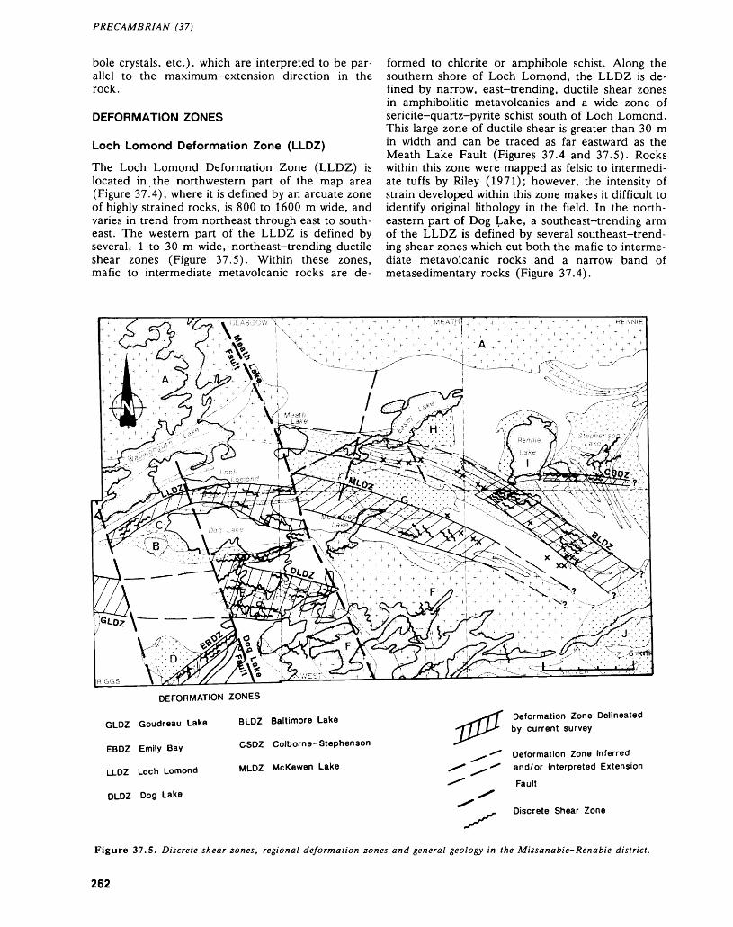
PRECAMBRIAN (37)
bole crystals, etc.), which are interpreted to be par allel to the maximum-extension direction in the rock.
DEFORMATION ZONES
Loch Lomond Deformation Zone (LLDZ)
The Loch Lomond Deformation Zone (LLDZ) is located in the northwestern part of the map area (Figure 37.4), where it is defined by an arcuate zone of highly strained rocks, is 800 to 1600 m wide, and varies in trend from northeast through east to south- east. The western part of the LLDZ is defined by several, l to 30 m wide, northeast-trending ductile shear zones (Figure 37.5). Within these zones, mafic to intermediate metavolcanic rocks are de
formed to chlorite or amphibole schist. Along the southern shore of Loch Lomond, the LLDZ is de fined by narrow, east-trending, ductile shear zones in amphibolitic metavolcanics and a wide zone of sericite-quartz-pyrite schist south of Loch Lomond. This large zone of ductile shear is greater than 30 m in width and can be traced as far eastward as the Meath Lake Fault (Figures 37.4 and 37.5). Rocks within this zone were mapped as felsic to intermedi ate tuffs by Riley (1971); however, the intensity of strain developed within this zone makes it difficult to identify original lithology in the field. In the north eastern part of Dog Lake, a southeast-trending arm of the LLDZ is defined by several southeast-trend ing shear zones which cut both the mafic to interme diate metavolcanic rocks and a narrow band of metasedimentary rocks (Figure 37.4).
GLDZ
EBDZ
LLDZ
DLDZ
DEFORMATION ZONES
Goudreau Lake BLDZ Baltimore Lake
Emily Bay CSDZ Colborne-Stephenson
Loch Lomond MLDZ McKewen Lake
Dog Lake
Deformation Zone Delineated by current survey
Deformation Zone Inferred and/or Interpreted Extension
Fault
Discrete Shear Zone
Figure 37.5. Discrete shear zones, regional deformation zones and general geology in the Missanabie-Renabie district.
262
K. B. HEATHER AND S H AN E BUCK
Outside the discrete shear zones within the LLDZ, the rocks are moderately to strongly de formed, with a well developed foliation which gener ally strikes parallel to the shear zones. Lineations within the LLDZ vary from moderately east-plung ing in the western part to steeply east- to southeast- plunging in the eastern part (Figure 37.6). Linea tions within the southeastern arm of the LLDZ plunge steeply toward the northeast (Figure 37.6).
Within the southeastern arm of the LLDZ, steep northeast-plunging lineations and kinematic indica tors, such as shear folds and S-C shear fabrics, indi cate a dextral, south-side-up sense of oblique dis placement. Kinematic indicators are not well devel oped within the main part of the LLDZ, but the presence of moderately to steeply plunging lineations may indicate that movement within the LLDZ was dominantly dip slip.
Emily Bay Deformation Zone (EBDZ)
The Emily Bay Deformation Zone (EBDZ) is lo cated on the western side of Dog Lake in southern Riggs Township (Figure 37.4). The EBDZ is a 500 m wide, east-northeast-trending (060 0 to
070 0 ) zone of intense ductile shearing and weakly to strongly strained rocks. The EBDZ can be traced up to 4 km to the southwest of Dog Lake, but cannot be traced to the eastern side of Dog Lake (Figure37.5).
The EBDZ is localized within massive to pil lowed mafic metavolcanics (Figure 37.4), that are deformed to chlorite-calcite and chlorite-iron car bonate schists within several discrete ductile shear zones. These shear zones are northeast-trending and vary in width from l m to greater than 30 m. A second set of narrow, brittle to ductile, northwest- trending (340 0 ) shear zones is also observed within the EBDZ, especially in the vicinities of the Emily Bay and Bankfield gold occurrences (Figure 37.5). Brittle shear zones and brittle fracturing, oriented at 060 0 to 070 0 , are well developed in rocks that ex hibit weak to moderate ductile deformation.
Lineations within the EBDZ are moderately southwest-plunging in the discrete shear zones and moderately southeast-plunging in rocks outside the discrete shear zones (Figure 37.6). No reliable mesoscopic kinematic indicators were observed within the EBDZ.
Near vertical lineation
Figure 37.6. Foliations, lineations, regional deformation zones and general geology in the Missanabie-Renabie district.
263
PRECAMBRIAN (37)
Dog Lake Deformation Zone (DLDZ)
The Dog Lake Deformation Zone (DLDZ) is lo cated in the central part of Riggs and West town ships, where it is defined by a 1.5 to 2.0 km wide, southeast-trending zone of moderately to strongly strained rocks (Figure 37.4). The DLDZ is charac terized by both ductile and brittle-ductile shear zones which occur in two dominant orientations: 090 0 to 100 0 , and HO 0 to 120 0 (Figure 37.5). Shear zones at these orientations within the mafic to intermediate metavolcanic rocks are defined by l to 50 m of chlorite-calcite and, rarely, chlorite-iron carbonate schists. Shear zones within feldspar and quartz-feldspar-porphyry intrusions are defined by quartz-sericite schist. Narrow, northeast (060 0 to 070 0 ) and northwest-trending (340 0 ), brittle and brittle-ductile shear zones are also observed within the DLDZ (Figure 37.5). Brittle fracturing is well developed throughout the DLDZ, with the the great est density of fracturing occurring in orientations parallel to ductile shear zones.
Foliation in rocks outside the discrete shear zones within the DLDZ is moderately to strongly de veloped, and in general strikes parallel to the dis crete shear zones. Lineations plunge subvertically to both the northwest and southeast (Figure 37.6). Al though kinematic indicators are not well developed in the DLDZ, the dominance of subvertical linea- tions may indicate that movement within the DLDZ occurred as dip-slip displacement. Rare shear band (C') structures observed in the western part of the DLDZ indicate that there may also have been a dex tral strike-slip component of displacement.
In the northern part of Dog Lake, a 500 m wide, northeast- to east-trending zone of deforma tion is included as part of the DLDZ (Figure 37.4). The eastern part of this zone is defined by a well developed, northeast-trending foliation in mafic to intermediate and felsic to intermediate metavol- canics. Shear zones in this part of the deformation zone are rarely greater than l m in width and occur at various orientations, including OSO 0 , 090 0 , 250 0 , 290 0 , and 310 0 (Figure 37.5). Lineations in the eastern part of the arm of deformation plunge steeply to the northeast (Figure 37.6).
The western pan of this arm of deformation is much more structurally complex. Foliation is well developed, but varies in orientation with proximity to several 20 to 30 m wide shear zones at orienta tions of 070 0 and 090 0 (Figure 37.5). Shear folding and crenulation cleavage are well developed in this part of the deformation zone, but vary irregularly in orientation, asymmetry, and degree of plunge. Lineations within the shear zones have shallow plunges toward the southwest (Figure 37.6). This structurally complex portion of the DLDZ is poorly understood and may reflect the intersection of two or more major shear zones.
McKewen Lake Deformation Zone (MLDZ)The McKewen Lake Deformation Zone (MLDZ) is a 1.5 km wide, southeast-trending zone of strongly deformed mafic to intermediate and felsic to inter mediate metavolcanic rocks, which can be traced from McKewen Lake, in the northern part of West Township, southeastwards to the northwestern cor ner of Stover Township (Figure 37.4). Outcrops of the Harcourt Lake Stock mapped during the current study did not exhibit a strong strain intensity. How ever, the MLDZ has been shown cutting the stock (Figure 37.4), based on the presence of copper- bearing shear zones which are reported to be cutting the stock (Srivastava and Bennett 1978) at orienta tions subparallel to the MLDZ.
Foliation trending HO 0 to 120 0 is well devel oped within the MLDZ, both as a schistosity and also as a tectonic layering. Lineations within this zone plunge moderately to steeply towards the southeast, except in outcrops adjacent to the Ash Lake Pluton where lineations plunge steeply towards the northwest (Figure 37.6).
Although discrete, 120 0-to 130 0-trending duc tile shear zones are common throughout the MLDZ, only a small number of shear zones greater than l m in width were observed (Figure 37.5). Kinematic in dicators in those zones with northwest-plunging lineations indicate a sinistral, south-side-up sense of displacement, whereas kinematic indicators in shear zones with southeast-plunging lineations indicate a dextral, south-side-up sense of displacement. Other ductile shears within the MLDZ strike at 060 0 to 070 0 (Figure 37.5) sinistrally displacing foliation and, in some cases, southeast-trending shear zones. Although brittle fracturing is not as common as was observed in the DLDZ, the greatest density of frac turing occurs at orientations subparallel to the 060 0- to 070 0 -striking shear zones.
Baltimore Lake Deformation Zone (BLDZ)The Baltimore Lake Deformation Zone (BLDZ) is located in northwestern Stover Township (Figure 37.4), where it is defined by a 1.2 km wide, south east-trending zone of folding, transposition, and shearing. The BLDZ can be traced for approxi mately 6 km southeastward across Stover Township (Figure 37.4). Extensions of the BLDZ to the south- east and northwest, as shown in Figure 37.4, are speculative and await verification by further detailed mapping. The BLDZ is localized within a heterolithic package of rocks which includes massive and pillowed mafic flows, felsic crystal and lapilli- tuffs and wacke-argillite metasediments (Figure 37.4). Both the felsic tuffs and the metasediments are finely bedded and, therefore, locally record much of the complex folding and shearing. The BLDZ is characterized by rootless isoclinal folds (i.e. intrafolial folds) of bedding/schistosity, sinistral and dextral shear folds, transposition, and ductile shear zones axial planar to the folds.
264
K. B. HEATHER AND S H AN E BUCK
Lineations within the BLDZ plunge at 60 0 to 65 0 to the southeast, except in the immediate vicin ity of the Rennie Lake Stock (Figures 37.4 and 37.6) where shear zones become more east-trending and lineations become steeper and eventually plunge northwest at 55 0 . Kinematic indicators within the BLDZ are ambiguous; however, much of the data indicates a dextral, south-side-up sense of oblique displacement.
Colborne-Stephenson Lakes Deformation Zone (CSDZ)
The Colborne-Stephenson Lakes Deformation Zone (CSDZ) is located in southern Rennie Township (Figure 37.4), where it is defined by a 300 m wide zone of ductile shearing and moderately to strongly deformed rocks. The CSDZ can be traced for at least 4 km, is open to the east, and has not been traced westward of the Rennie Lake Stock (Figure 37.4), which may truncate or deflect the zone.
The CSDZ is localized in felsic to intermediate pyroclastic rocks with minor mafic metavolcanic in tercalations (Figure 37.4). Within the CSDZ there are several ductile shear zones where the rocks are deformed to sericite-chlorite-quartzdbcarbonate schists. These shear zones trend from 085 0 to 110 0 and range in width from less than l m to 10 m (Fig ure 37.5). Although brittle fracturing is observed in the vicinity of the CSDZ, it is poorly developed and relatively weak. Throughout most of the CSDZ, lineations plunge toward the west at 60 0 to 70 0 ; however, in the Rennie Lake area, lineations steepen to 70 0 to the west (Figure 37.6). Kinematic indicators are poorly developed and give ambiguous senses of displacement.
Other Shear Zones
Although deformation in the Missanabie-Renabie district appears to be concentrated in deformation zones within the volcano-sedimentary rocks (Figure 37.4), evidence of deformation is also observed in the external granitoid rocks. This is best represented by the Ash Lake Pluton (ALP). Discrete ductile and brittle-ductile shear zones within faintly to weakly deformed rocks are relatively common throughout most parts of the ALP; however, collectively the de formation intensity and density of shear zones are not sufficient to define deformation zones. The dis crete shear zones observed within the ALP vary in width from less than l cm to greater than 20 m and occur in relatively consistent orientations, including 060 0 to 070 0 , 090 0 to 100 0 , 120 0 , 130 0 to 140 0 , and 160 0 to 170 0 (Figure 37.6). This range of shear zone orientations is very similar to those observed within the volcano-sedimentary rocks.
Brittle fracturing is also common within the pluton and, like fracturing observed in the volcano- sedimentary rocks, occurs with greatest density in orientations subparallel to discrete shear zones. A
good example of such a zone of brittle fracturing within the ALP occurs west of the community of Missanabie, where a 3 m wide zone of intense brittle fracturing, striking 100 0 , cuts a well developed, north-trending foliation. It is suspected that zones of fracturing such as this one, and observed elsewhere within the ALP, may change progressively along strike from brittle to ductile shear zones.
REGIONAL FOLDINGRiley (1971) and Srivastava and Bennett (1978) have defined several major east- to southeast-trend ing, anticlinal and synclinal fold structures within the study area. The best defined of these folds is the southeast-trending, "isoclinally folded Baltimore Lake Syncline" (Riley 1971), which is coincident with the BLDZ delineated during this study. Early regional isoclinal folding is evident in the Baltimore Lake area; however, superimposed/progressive shear folding, transposition, and ductile shearing charac teristic of the BLDZ modify earlier synformal-an- tiformal geometries such that they may now be im possible to delineate. An anticlinal structure south- west of the "Baltimore Lake Syncline" (Riley 1971) is also coincident with a regional deformation zone- the MLDZ—which is characterized by shear folding and strong to intense ductile shearing.
Folding is evident outside the regional deforma tion zones and is suspected to be parasitic to regional folding; however, insufficient data exist to delineate these regional folds. Regional folding is vague within the relatively homogeneous mafic metavolcanic rocks, west of the Meath Lake Fault (Figure 37.4), due to the lack of distinctive marker horizons or bedded units.
LATE FAULTINGTwo prominent fault trends, 020 0 to060 0 , and 32O 0 to 350 0 , have been defined in the area by Riley (1971) and Srivastava and Bennett (1978). The 320 0 to 35O 0 group is more prevalent and best ex emplified by the Meath Lake Fault (Figure 37.4). This fault is of regional extent and offsets all geologi cal features (including major deformation zones de lineated during the current study) by at least 0.8 km sinistrally (Srivastava and Bennett 1978). However, the apparent horizontal offset of the Ash Lake Pluton is closer to 4.5 km (Figure 37.4). The amount of vertical offset is not known, but the di chotomous character of the supracrustal stratigraphy and structural style across the fault suggests a signifi cant vertical component. A parallel, northwest- trending structure referred to here as the Dog Lake Fault (Figures 37.4 and 37.5) is suspected to cause a northwest-trending foliation in the Dog Lake area outcrops (Figure 37.6), and possibly marks the east ern limit of the EBDZ (Figure 37.5). No significant displacement is documented on the Dog Lake Fault. The Maskinonge Lake Fault (Figure 37.3), in the Goudreau-Lochalsh area, is another of these north west-trending faults.
265
PRECAMBRIAN (37)
The northwest-trending faults appear to have lo calized diabase dikes, as, to a lesser degree, have the northeast-trending faults. The northwest-trend ing faults are dominantly sinistral, while the north east set are dextral; however, there are local excep tions to this pattern (Riley 1971; Srivastava and Ben nett 1978).
KINK BANDS
Kinks bands recorded during the current study can be grouped into two sets: a northwest-trending, sin istral set and a northeast-trending, dextral set.
ALTERATION
REGIONAL METAMORPHIC GRADE
Archean volcano-sedimentary lithologies in the study area are of middle-greenschist metamorphic grade, except adjacent to the Northern Batholithic Complex and the Ash Lake Pluton, where alman dine-amphibolite and hornblende-hornfels meta morphic grades are attained, respectively (Figures 37.4 and 37.7) (Riley 1971; Srivastava and Bennett 1978; Bennett 1978).
ALTERATION WITHIN THE DEFORMATION ZONES
Alteration within the deformation zones is variable, depending on the host-rock composition. The ma jority of the zones are characterized by the introduc tion of variable amounts of chlorite, calcite, minor sericite, pyrite, epidote, iron-carbonate (locally), and silica (Figure 37.7).
Chlorite, calcite, and epidote are ubiquitous in strained mafic metavolcanic rocks throughout the study area. Iron-carbonate is only found locally in individual shear zones within some of the deforma tion zones, such as the DLDZ or the EBDZ (Figure 37.7). Iron-carbonate is less prevalent in the MLDZ and the BLDZ, although it is locally present (Figure 37.7). Sericite, an important alteration mineral in many gold deposits elsewhere in the Archean (Col vine et al. 1988), is developed sporadically within the study area (Figure 37.7). In most of the locali ties where it is present, sericite is a product of shear ing and feldspar breakdown in felsic metavolcanic rocks or feldspar-quartz-porphyry intrusions, and is not necessarily due to potassium metasomatism (i.e. potassium addition), which is a process integral to many gold deposits (Colvine et al. 1988). Minor po tassium metasomatism is associated with some of the known gold occurrences; however, this metasom atism is on a much less extensive scale than was documented in the Goudreau-Lochalsh area to the west (Heather and Arias 1987). Pyrite is a common secondary mineral in all of the deformation zones, usually as disseminations or stringers associated with quartz veins. Locally, pyrite occurs in massive con
centrations within narrow shear zones, such as those south of Loch Lomond (Occurrence 3, Figure 37.7) or at the Maisondor Occurrence (Occurrence 10, Figure 37.7).
ALTERATION OUTSIDE THE DEFORMATION ZONES
Alteration outside the deformation zones is more difficult to categorize due to the regional green- schist-grade metamorphism. Chlorite, calcite, and epidote are the most commonly observed alteration minerals; however, it is not clear in the majority of cases whether these represent early, synvolcanic al teration, greenschist metamorphism, or both. Epi dote and hematite are ubiquitous throughout the Ash Lake Pluton, the Northern Batholithic Com plex, and several of the internal granitoid stocks. Garnet was found in three localities (Figure 37.7): one on Colborne Lake and one on Stephenson Lake, spatially associated as halos on quartz veins within greenschist-grade, felsic to intermediate, tuffs and crystal tuffs; and one on Loch Lomond in Glas gow Township, associated with amphibolites. The first two occurrences are thought to be metasomatic in origin while the origin of the third is indetermi nate.
METALLOGENY
GOLD OCCURRENCES
Descriptions of many of the gold occurrences can be found in various government reports (Burwash 1935; Bruce 1942, 1948; Horwood 1942; Riley 1971; Bennett 1978; Srivastava and Bennett 1978), university theses (Kilias 1984; Callan and Spooner 1987), and government assessment files (Assess ment Files Research Office, Ontario Geological Sur vey, Toronto).
The following summarizes the general character istics of gold mineralization in the study area. All the gold occurrences, except the White Occurrence, are found within discrete brittle, brittle-ductile, or duc tile shear zones within regional zones of deformation (Figure 37.7). Gold occurs in all rock types within the area, including the external granitoids (Occur rence 13, Figure 37.7) and a diabase dike (Occur rence 2, Figure 37.7). The majority of the occur rences are found within mafic metavolcanic rocks spacially associated with felsic feldspar-quartz por phyry dikes and/or stocks (e.g. Occurrences l, 6, and 8, Figure 37.7). Gold is also found in sheared magnetite-bearing iron formation (e.g. Occurrence 12, Figure 37.7), intermediate to felsic pyroclastics (e.g. Occurrences 14 and 15, Figure 37.7), and is spatially related to a lamprophyre dike (e.g. Occur rences 14 and 15, Figure 37.7).
Most of the known gold occurrences are small, discontinous, single quartz veins or vein arrays hosted by discrete shear zones. There are three
266
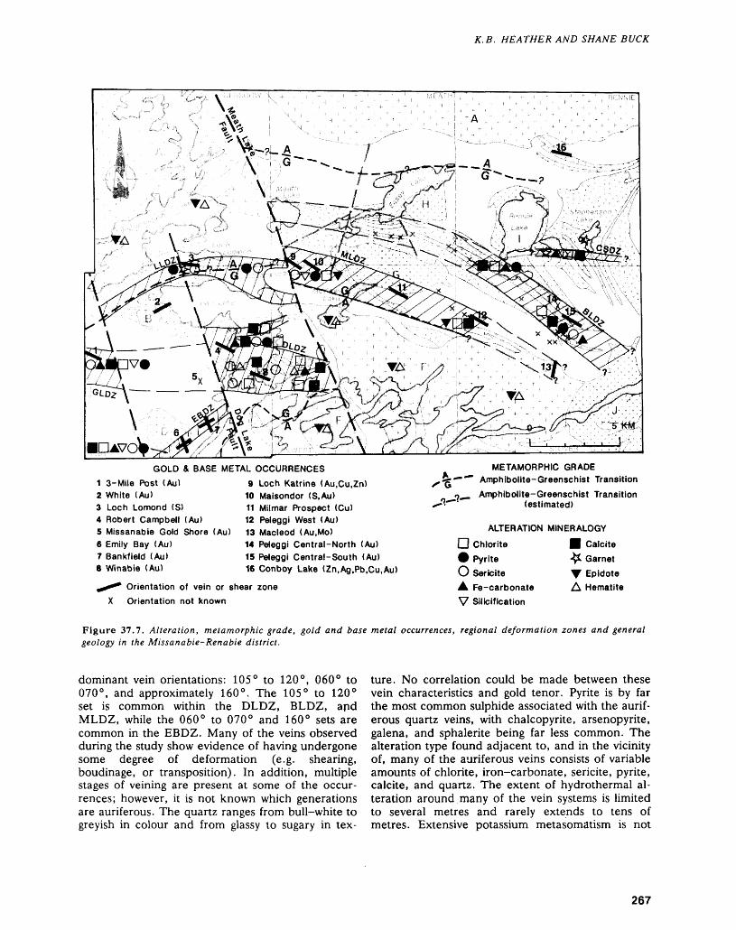
K.B. HEATHER AND SHANE BUCK
GOLD1 3-Mile Post (Au)2 White (Au)3 Loch Lomond (S)4 Robert Campbell (Au)5 Missanabie Gold Shore (Au)6 Emily Bay (Au)7 Bankfield (Au)8 Winabie (Au)
BASE METAL OCCURRENCES9 Loch Katrine (Au.Cu.Zn)
10 Maisondor (S,Au)11 Milmar Prospect (Cu)12 Peleggi West (Au)13 Macleod (Au.Mo)14 Peleggi Central-North (Au)15 Peleggi Central-South (Au)16 Conboy Lake (Zn.Ag.Pb.Cu.Au)
^ Orientation of vein or shear zone X Orientation not known
METAMORPHIC GRADE —""" Amphibolite-Greenschist Transitiono^ Amphibolite-Greenschist Transition
(estimated)
ALTERATION MINERALOGY
D Chlorite O Pyrite O Sericite A Fe-carbonate V Silicification
B Calcite •^1 Garnet T Epidote A Hematite
Figure 37.7. Alteration, metamorphic grade, gold and base metal occurrences, regional deformation zones and general geology in the Missanabie-Renabie district.
dominant vein orientations: 105 0 to 120 0 , 060 0 to 070 0 , and approximately 160 0 . The 105 0 to 120 0 set is common within the DLDZ, BLDZ, and MLDZ, while the 060 0 to 070 0 and 160 0 sets are common in the EBDZ. Many of the veins observed during the study show evidence of having undergone some degree of deformation (e.g. shearing, boudinage, or transposition). In addition, multiple stages of veining are present at some of the occur rences; however, it is not known which generations are auriferous. The quartz ranges from bull-white to greyish in colour and from glassy to sugary in tex
ture. No correlation could be made between these vein characteristics and gold tenor. Pyrite is by far the most common sulphide associated with the aurif erous quartz veins, with chalcopyrite, arsenopyrite, galena, and sphalerite being far less common. The alteration type found adjacent to, and in the vicinity of, many of the auriferous veins consists of variable amounts of chlorite, iron-carbonate, sericite, pyrite, calcite, and quartz. The extent of hydrothermal al teration around many of the vein systems is limited to several metres and rarely extends to tens of metres. Extensive potassium metasomatism is not
267
PRECAMBRIAN (37)
found at any of the gold occurrences shown on Fig ure 37.7.
All the gold occurrences in the area are thought to be of Archean age except the White Occurrence, which is hosted by 060 0-trending quartz veins that occupy brittle fractures within both the potassium feldspar megacrystic Lochalsh Bay Stock and a 340 0-trending diabase dike. Gold mineralization is confined to that portion of the quartz-fluorite-mag- netite-pyrite vein system occurring within the diabase dike (Srivastava and Bennett 1978). The mineralization is spatially and possibly genetically re lated to the nearby, Proterozoic-aged Manitou Mountain olivine gabbro stock (Figures 37.4 and 37.7).
BASE METAL MASSIVE SULPHIDE MINERALIZATION
The Conboy Lake zinc-silver-(lead-copper-gold) occurrence is the only significant surface showing of base metals in the Missanabie-Renabie district (Fig ure 37.6). The genetic origin of this deposit is equivocal, as it has characteristics of volcanogenic massive sulphide mineralization but also lies within intensely "sheared sericitic metatuff" (Riley 1971). The orientation of the Conboy Lake Occurrence is 110 0 to 120 0 which is identical to the orientation of the majority of gold occurrences (Figure 37.7). Py- rite-pyrrhotite sulphide occurrences are found in the area associated with iron formation or shear zones.
DISCUSSION
Of the six major deformation zones outlined in the Missanabie-Renabie district during this study, four (DLDZ, EBDZ, MLDZ, and BLDZ) host all of the known gold occurrences. The remaining two defor mation zones (LLDZ and CSDZ) have structural and alteration characteristics similar to the gold bearing ones and hence are favourable exploration targets. The DLDZ is characterized by the presence of both ductile and brittle-ductile shearing trending between 090 0 and 120 0 , as well as a large degree of brittle fracturing. Similar features are documented immediately to the west, within the eastern domain of the Goudreau Lake Deformation Zone (Arias and Heather 1987; Heather and Arias 1987). Therefore, the DLDZ may represent an eastward extension of the Goudreau Lake Deformation Zone (Figure 37.3). Furthermore, the following observa tions indicate that the MLDZ may be an eastward extension of the DLDZ, despite being separated and sinistrally offset by the Meath Lake Fault (Figures 37.3 and 37.4):1. Similar intrusions of feldspar and feldspar-
quartz porphyry are found in the eastern portion of the DLDZ and in the western portion of the MLDZ.
2. West-plunging lineation? are found in the east ern portion of the DLDZ and in the western portion of the MLDZ (Figure 37.6).
3. The northern margin of the Ash Lake Pluton is offset sinistrally from south of the DLDZ to south of the MLDZ (Figure 37.4).
Although the MLDZ has a more ductile structural style than the DLDZ, this difference could be ex plained by an unknown amount of vertical displace ment along the Meath Lake Fault. Vertical displace ment along the Meath Lake Fault may also account for the distinct change from a massive, mafic metavolcanic-dominated stratigraphy west of the fault to a diverse, metavolcanic-metasedimentary stratigraphy east of the fault (Figure 37.4).
The locations of the MLDZ and BLDZ, as out lined during the current study, are coincident with regional fold traces interpreted by earlier mappers (Riley 1971; Srivastava and Bennett 1978). At an outcrop scale, small-scale folds, possibly parasitic to larger folds, are cut and transposed by shearing par allel to their axial traces. This relationship indicates that folding and shearing may be related and may have been produced during progressive deformation.
Other regional structures within the Missanabie- Renabie district include northwest-trending struc tures similar to the Meath Lake Fault (Figure 37.5) and northeast-trending structures, interpreted by earlier mappers (Riley 1971; Srivastava and Bennett 1978), that may be related to similarily oriented de formation zones, such as the EBDZ and the north ern arm of the DLDZ (Figure 37.5). Although the temporal relationships between these structures are not clearly understood, field observations suggest that the 060 0-trending EBDZ is truncated by an in terpreted, 340 0-trending structure, referred to here as the Dog Lake Fault (Figure 37.5). This suggests that the northwest structures postdate the northeast structures. Timing relationships between the 060 0-trending structures and the other major defor mation zones are not clear.
ECONOMIC POTENTIALPotential for volcanogenic massive sulphide miner alization is low; however, the origin of the Conboy Lake base metal occurrence is ambiguous at present and this occurrence may represent synvolcanic mi neralization.
All the known gold occurrences consist of quartz vein systems hosted by narrow ductile, brittle-duc tile, and brittle shear zones within regional zones of deformation. Favourable alteration consists of seri cite, iron-carbonate, calcite, sulphides, and chlorite within any of the rock types in the area. All of the deformation zones delineated during this study are favourable exploration targets, especially extensions of these zones into areas where the access is poor, or the glacial cover is thick, or there are no known gold occurrences.
268
K.B. HEATHER AND SHANE BUCK
The Renabie Gold Mine is hosted by quartz veins within a brittle-ductile shear zone in the exter nal granitoids. Therefore, exploring and prospecting are warranted in areas where the regional deforma tion zones or discrete shear zones occur in either external or internal granitoids.
ACKNOWLEDGMENTSThe authors would like to thank the staff of the Wawa Resident Geologist's Office, Ministry of Northern Development and Mines for all their assis tance over the course of the summer. Phil Olson and Alex Kusic, mine geologists at the Renabie Gold Mine, are thanked for introducing the authors to the underground and surface geology of the Renabie Mine, as well as for providing stimulating discussions on aspects of the regional geology. Danielle Speth mann and Ed van Hees (Geologists, Ed van Hees Geological Consultants, Timmins) are thanked for providing a tour and information on the Smith Lake claims of Conquest Yellowknife Resources. Finally, David Aikin, Scan McGowan, and Paul Cameron provided competent and conscientious field assis tance.
REFERENCESArias, Z.G., and Heather, K.B.1987: Regional Structural Geology Related to Gold Minerali
zation in the Goudreau-Lochalsh Area, District of Al goma; p. 146-154 in Summary of Field Work and Other Activities 1987, Ontario Geological Survey, ed ited by R.B. Barlow, M.E. Cherry, A.C. Colvine, Burkhard O. Dressler and Owen L. White, Ontario Geological Survey, Miscellaneous Paper 137, 429p.
Bennett, Gerald1978: Geology of the Crooked Lake Area, District of Sud
bury; Ontario Geological Survey, Report 172, 46p. Accompanied by Maps 2380 and 2381, scale 1:31 680 or l inch to 1/2 mile.
Bruce, E.L.1942: Geology of the Rennie-Leeson Area; Ontario Depart
ment of Mines, Volume 51, Part 8, p. 1-26. Published 1944. Accompanied by Map 51g, scale 1:31 680 or l inch to 1/2 mile.
1948: The Renabie Gold Mine; p.436-438 in Structural Ge ology of Canadian Ore Deposits: A Symposium, Ca nadian Institute of Mining and Metallurgy, edited by M.E. Wilson, 948p.
Burwash, E.M.1935: The Michipicoten-Missanabie Area; Ontario Depart
ment of Mines, Annual Report for 1935, Volume 44, Part 8, p. 1-26.
Callan, N.J., and Spooner, E.T.C.1987: Gneissose Trondhjemite/Tonalite Hosted Au-Quartz
Vein Mineralization, Renabie Mine Area, Wawa: Geological Characteristics and Shear Zone Control; p. 153-175 in Geoscience Research Grant Program, Summary of Research, 1986-1987, edited by V.G. Milne, Ontario Geological Survey, Miscellane ous Paper 136, 241p.
Coleman, A.P.1898: Fourth report on the West Ontario Gold Region; Ont
ario Bureau of Mines, Annual Report for 1898, Vol ume 7, Part 2, p. 109-145.
Colvine, A.C., Fyon, J.A., Heather, K.B., Marmont, Sous-san, Smith, P.M., and Troop, D.G.
1988: Archean Lode Gold Deposits in Ontario; OntarioGeological Survey, Miscellaneous Paper 139, 136p.
Heather, K.B.1985: Gold Showings of the Mishibishu Lake Area, Thunder
Bay District; p.83-89 in Summary of Field Work and Other Activities 1985, Ontario Geological Survey, ed ited by John Wood, Owen L. White, R.B. Barlow and A.C. Colvine, Ontario Geological Survey, Mis cellaneous Paper 126, 351p.
1986: Mineralization of the Mishibishu Lake Greenstone Belt; p.283-291 in Summary of Field Work and Other Activities 1986, by the Ontario Geological Survey, ed ited by P.C. Thurston, Owen L. White, R.B. Bar low, M.E. Cherry, and A.C. Colvine, Ontario Geo logical Survey, Miscellaneous Paper 132, 435p. Ac companied by l chart.
Heather, K.B., and Arias, Z.G.1987: Geological Setting of Gold Mineralization in the
Goudreau-Lochalsh Area, District of Algoma; p. 155-162 in Summary of Field Work and Other Ac tivities 1987, Ontario Geological Survey, edited by R.B. Barlow, M.E. Cherry, A.C. Colvine, Burkhard O. Dressler, and Owen L. White, Ontario Geological Survey, Miscellaneous Paper 137, 429p.
Horwood, H.C.1942: Geology and Mineralization in the Northern Part of
Stover Township; Ontario Department of Mines, Vol ume 51, Part 8, p.27-42. Published 1944.
Kilias, S.1984: Genesis of Gold Deposits, Renabie Area, Sudbury
District, Ontario; Unpublished M.Se. Thesis, Uni versity of Ottawa, Ottawa, Ontario, Canada, 21 Op.
Ramsay, J.G.1980: Shear Zone Geometry: A Review; Journal of Struc
tural Geology, Volume 2, p.83-89.Riley, R.A.1971: Geology of Glasgow, Meath, and Rennie Townships,
Districts of Algoma and Sudbury; Ontario Department of Mines and Northern Affairs, Geological Report 90, 55p. Accompanied by Map 2210, scale 1:31 680 or l inch to 1/2 mile.
Sage, R.P.1984: Josephine-Goudreau Area, District of Algoma;
p.56-61 in Summary of Field Work 1984, Ontario Geological Survey, edited by John Wood, Owen L. White, R.B. Barlow, and A.C. Colvine, Ontario Geological Survey, Miscellaneous Paper 119, 309p.
1985: Goudreau-Lochalsh Area, District of Algoma; p.90-94 in Summary of Field Work and Other Activi ties 1985, Ontario Geological Survey, edited by John Wood, Owen L. White, R.B. Barlow and A.C. Col vine, Ontario Geological Survey, Miscellaneous Paper 126, 351p.
1987: Geology of Goudreau-Lochalsh and Kabenung Lake areas, District of Algoma; p. 134-137 in Summary of Field Work and Other Activities 1987, Ontario Geo logical Survey, edited by R.B. Barlow, M.E. Cherry,
269
PRECAMBRIAN (37)
A.C. Colvine, Burkhard O. Dressler, and Owen Michipicoten Iron Ranges, Geological Survey of Can-L. White, Ontario Geological Survey, Miscellaneous ada, Memoir 147.Paper 137, 429p. Thurston, P.C., Siragusa, G.M., and Sage, R.P.
1977: Geology of the Chapleau Area, Districts of Algoma, Srivastava, P., and Bennett, G. 0 ,, , ~ , ~ . . ~. . . , .,.Sudbury, and Cochrane; Ontario Division of Mines,1978: Geology of Riggs and West Townships, District of Al- Geological Report 157, 293p. Accompanied by Maps
goma; Ontario Geological Survey, Report 174, 56p. 2351 and 2352, scale 1:250 000, and Map 2221,Accompanied by Map 2353, scale 1:31 680 or l inch scale 1:253 440 or l inch to 4 miles.to 17 2mile. Wilmott, A.B.
1898: Michipicoten Mining Division; Ontario Bureau ofThomson, E. Mines, Annual Report for 1898, Volume 7, Part 2,1926: Part 2, Missinaibi Map Area; p. 143-175 in p. 184-206.
270
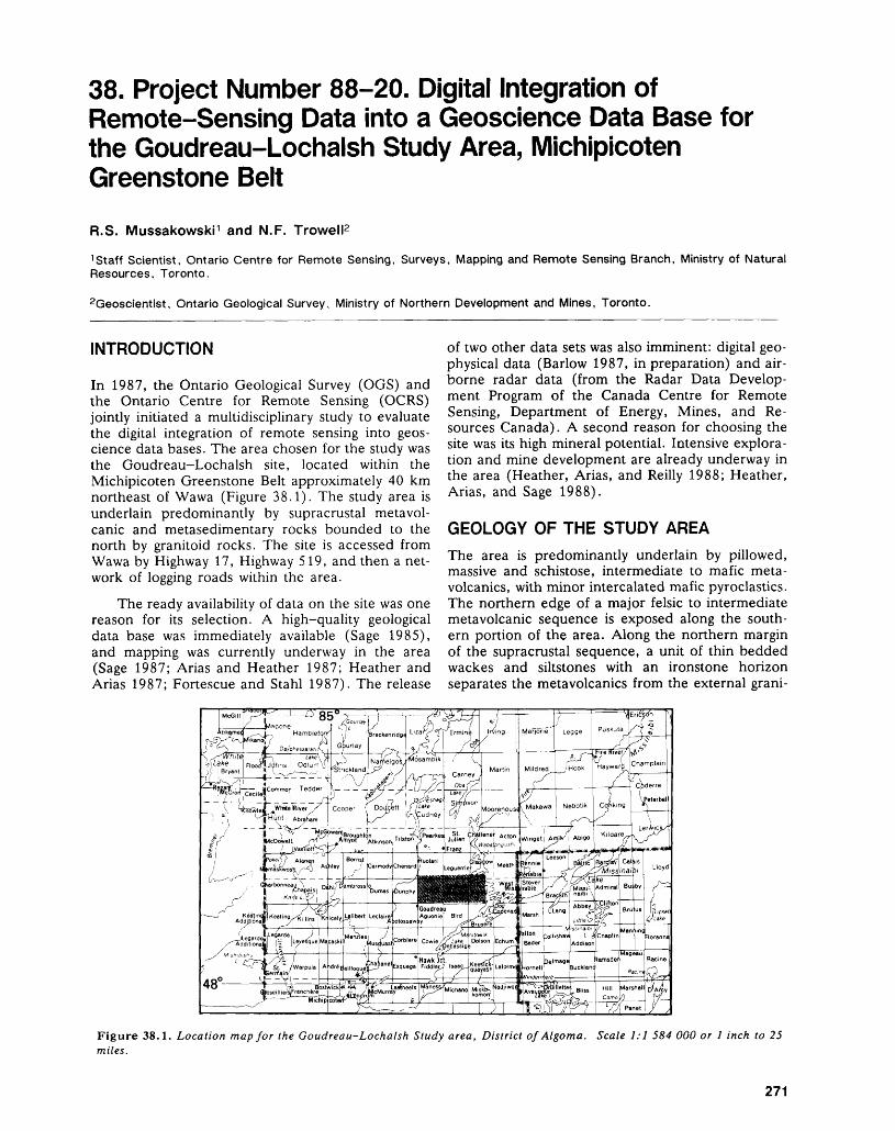
38. Project Number 88-20. Digital Integration of Remote-Sensing Data into a Geoscience Data Base for the Goudreau-Lochalsh Study Area, Michipicoten Greenstone BeltR.S. Mussakowski 1 and N.F. Trowell2
1 Staff Scientist, Ontario Centre for Remote Sensing, Surveys, Mapping and Remote Sensing Branch, Ministry of Natural Resources, Toronto.
2Geoscientist, Ontario Geological Survey, Ministry of Northern Development and Mines, Toronto.
INTRODUCTION
In 1987, the Ontario Geological Survey (OGS) and the Ontario Centre for Remote Sensing (OCRS) jointly initiated a multidisciplinary study to evaluate the digital integration of remote sensing into geos cience data bases. The area chosen for the study was the Goudreau-Lochalsh site, located within the Michipicoten Greenstone Belt approximately 40 km northeast of Wawa (Figure 38.1). The study area is underlain predominantly by supracrustal metavol- canic and metasedimentary rocks bounded to the north by granitoid rocks. The site is accessed from Wawa by Highway 17, Highway 519, and then a net work of logging roads within the area.
The ready availability of data on the site was one reason for its selection. A high-quality geological data base was immediately available (Sage 1985), and mapping was currently underway in the area (Sage 1987; Arias and Heather 1987; Heather and Arias 1987; Fortescue and Stahl 1987). The release
of two other data sets was also imminent: digital geo physical data (Barlow 1987, in preparation) and air borne radar data (from the Radar Data Develop ment Program of the Canada Centre for Remote Sensing, Department of Energy, Mines, and Re sources Canada). A second reason for choosing the site was its high mineral potential. Intensive explora tion and mine development are already underway in the area (Heather, Arias, and Reilly 1988; Heather, Arias, and Sage 1988).
GEOLOGY OF THE STUDY AREA
The area is predominantly underlain by pillowed, massive and schistose, intermediate to mafic meta- volcanics, with minor intercalated mafic pyroclastics. The northern edge of a major felsic to intermediate metavolcanic sequence is exposed along the south ern portion of the area. Along the northern margin of the supracrustal sequence, a unit of thin bedded wackes and siltstones with an ironstone horizon separates the metavolcanics from the external grani-
Figure 38.1. Location map for the Goudreau-Lochalsh Study area, District of Algoma. Scale 1:1 584 000 or l inch to 25 miles.
271
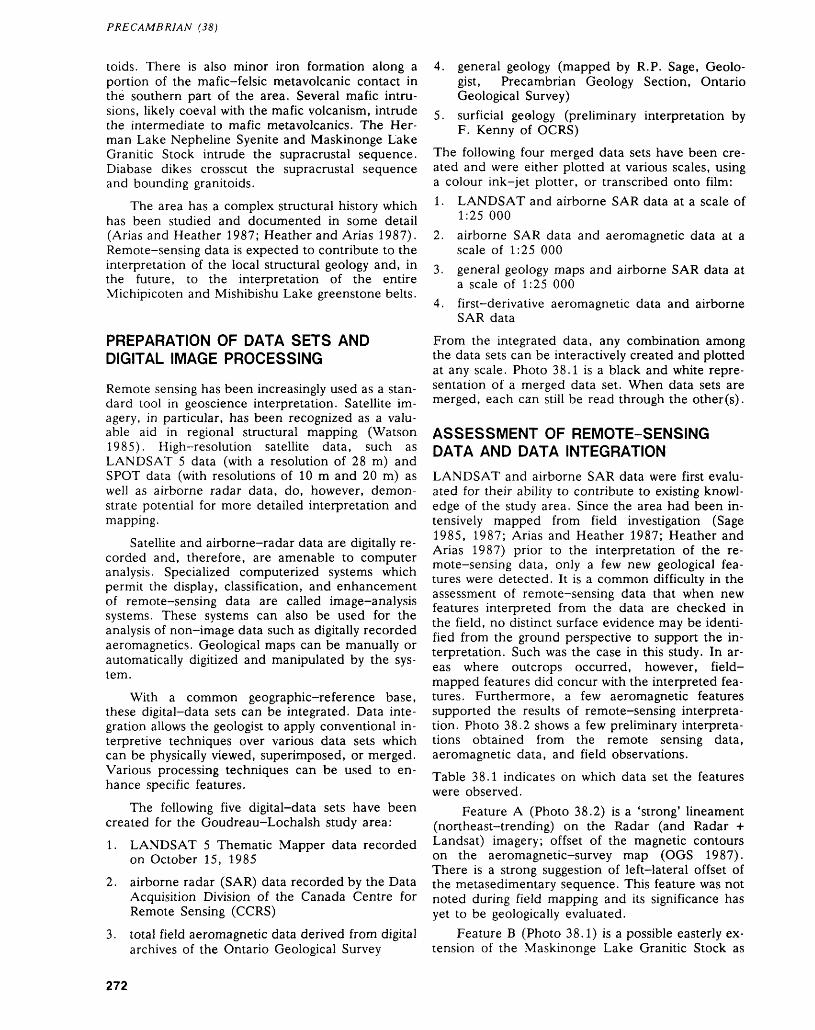
PRECAMBRIAN (38)
toids. There is also minor iron formation along a portion of the mafic-felsic metavolcanic contact in the southern part of the area. Several mafic intru sions, likely coeval with the mafic volcanism, intrude the intermediate to mafic metavolcanics. The Her man Lake Nepheline Syenite and Maskinonge Lake Granitic Stock intrude the supracrustal sequence. Diabase dikes crosscut the supracrustal sequence and bounding granitoids.
The area has a complex structural history which has been studied and documented in some detail (Arias and Heather 1987; Heather and Arias 1987). Remote-sensing data is expected to contribute to the interpretation of the local structural geology and, in the future, to the interpretation of the entire Michipicoten and Mishibishu Lake greenstone belts.
PREPARATION OF DATA SETS AND DIGITAL IMAGE PROCESSING
Remote sensing has been increasingly used as a stan dard tool in geoscience interpretation. Satellite im agery, in particular, has been recognized as a valu able aid in regional structural mapping (Watson 1985). High-resolution satellite data, such as LANDSAT 5 data (with a resolution of 28 m) and SPOT data (with resolutions of 10 m and 20 m) as well as airborne radar data, do, however, demon strate potential for more detailed interpretation and mapping.
Satellite and airborne-radar data are digitally re corded and, therefore, are amenable to computer analysis. Specialized computerized systems which permit the display, classification, and enhancement of remote-sensing data are called image-analysis systems. These systems can also be used for the analysis of non-image data such as digitally recorded aeromagnetics. Geological maps can be manually or automatically digitized and manipulated by the sys tem.
With a common geographic-reference base, these digital-data sets can be integrated. Data inte gration allows the geologist to apply conventional in terpretive techniques over various data sets which can be physically viewed, superimposed, or merged. Various processing techniques can be used to en hance specific features.
The following five digital-data sets have been created for the Goudreau-Lochalsh study area:1. LANDSAT 5 Thematic Mapper data recorded
on October 15, 19852. airborne radar (SAR) data recorded by the Data
Acquisition Division of the Canada Centre for Remote Sensing (CCRS)
3. total field aeromagnetic data derived from digital archives of the Ontario Geological Survey
4. general geology (mapped by R.P. Sage, Geolo gist, Precambrian Geology Section, Ontario Geological Survey)
5. surficial geology (preliminary interpretation by F. Kenny of OCRS)
The following four merged data sets have been cre ated and were either plotted at various scales, using a colour ink-jet plotter, or transcribed onto film:1. LANDSAT and airborne SAR data at a scale of
1:25 0002. airborne SAR data and aeromagnetic data at a
scale of 1:25 0003. general geology maps and airborne SAR data at
a scale of 1:25 0004. first-derivative aeromagnetic data and airborne
SAR dataFrom the integrated data, any combination among the data sets can be interactively created and plotted at any scale. Photo 38.1 is a black and white repre sentation of a merged data set. When data sets are merged, each can still be read through the other(s).
ASSESSMENT OF REMOTE-SENSING DATA AND DATA INTEGRATIONLANDSAT and airborne SAR data were first evalu ated for their ability to contribute to existing knowl edge of the study area. Since the area had been in tensively mapped from field investigation (Sage 1985, 1987; Arias and Heather 1987; Heather and Arias 1987) prior to the interpretation of the re mote-sensing data, only a few new geological fea tures were detected. It is a common difficulty in the assessment of remote-sensing data that when new features interpreted from the data are checked in the field, no distinct surface evidence may be identi fied from the ground perspective to support the in terpretation. Such was the case in this study. In ar eas where outcrops occurred, however, field- mapped features did concur with the interpreted fea tures. Furthermore, a few aeromagnetic features supported the results of remote-sensing interpreta tion. Photo 38.2 shows a few preliminary interpreta tions obtained from the remote sensing data, aeromagnetic data, and field observations.Table 38.1 indicates on which data set the features were observed.
Feature A (Photo 38.2) is a 'strong' lineament (northeast-trending) on the Radar (and Radar -H Landsat) imagery; offset of the magnetic contours on the aeromagnetic-survey map (OGS 1987). There is a strong suggestion of left-lateral offset of the metasedimentary sequence. This feature was not noted during field mapping and its significance has yet to be geologically evaluated.
Feature B (Photo 38.1) is a possible easterly ex tension of the Maskinonge Lake Granitic Stock as
272
R. S. MUSSAKOWSKI AND N.F. TROWELL
! 1.0 km
Photo 38.1. Mosaic of the Gondreau-Lochalsh study area panels comprising from left to right (west to east): 1. Digitized geology, 2. Radar Imagery, 3. Radar and Aeromagnetic Integrated Imagery, 4. Landsat (Thematic Mapper) Imagery.
indicated by the 'texture' on the Radar (and Radar + Landsat) imagery. Evidence on the aeromagnetic map (OGS 1987) is equivocal. This postulated inter pretation was 'ground truthed' in the summer of 1988 (R.P. Sage, Geologist, Precambrian Geology Section, Ontario Geological Survey, personal com munication, 1988).
"Problem
Radar t Landsat imagery suggested the possibility that the contact of the Maskinonge Lake Granitic Stock extended some distance east of the Maskinonge Lake Fault.
Method of Attack
Two one-way-traverse lines were run eastward from a series of swamps located near the Maskinonge Lake Fault to the Goudreau-Lochalsh access road.
Results
The two lines involved nearly 20 000 feet of traverse and resulted in a total of seven outcrops being observed. All out crops were external to the Radar * Landsat inferred contact and are composed of supracrustal or related rocks.
The Radar * Landsat inferred contact marks a break be tween deciduous and coniferous trees and a transition between well drained and more poorly drained topography. The re cently released airborne geophysical survey map does not offer conclusive proof for the extension of the contact beyond its present interpreted limits.
Conclusion
Ground checking has failed to extend the Maskinonge Lake Granitic Stock contact farther eastward on the basis of outcrop data. The curvilinear pattern displayed on Radar * Landsat imagery reflects a transition from a dominantly de ciduous to coniferous forest cover. This in turn reflects soil conditions more likely those of glacial than of bedrock origin. Radar and Landsat imagery reflect surface phenomena requir ing ground checking to establish any correlation between sur
face and bedrock. In areas of extensive glacial cover, surface phenomena may mask underlying bedrock structures."
The final interpretation is still geologically inconclu sive.
Feature C (Photo 38.2) is a north- to north- northeast-trending lineament (plus splays) that is apparent on the Radar (and Radar + Landsat) im agery. There is some indication of portions of the feature on the aeromagnetic-survey map (OGS 1987) but evidence is generally inconclusive. The feature was not noted entirely during field mapping and has yet to be geologically evaluated.
The general conclusion reached was that digital data integration techniques served to make the inter pretation process easier.
Planned Continuation of the ProjectThe results obtained to date indicate that remote- sensing data can provide valuable new geological in formation. To fully demonstrate its effectiveness, however, the data should be acquired and inter preted before comprehensive field investigation is carried out. The data for the Goudreau-Lochalsh area was acquired after field investigation had been completed, so it did not contribute significantly to existing knowledge of the site.
New airborne radar and LANDSAT data were acquired during the 1988 field season. This coverage includes the entire Wawa Greenstone Belt from Pukaskwa on Lake Superior to Missinaibi Lake. Data integration similar to that completed for the Goudreau-Lochalsh site will be undertaken for all of the new area, and the site will be incorporated into the Ontario Geological Survey's schedule of current mapping activities.
273
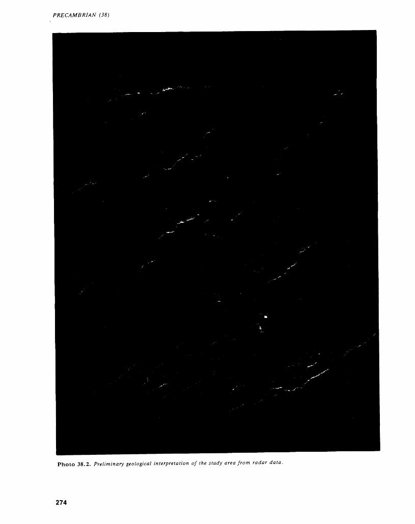
PRECAMBRIAN (38)
Photo 38.2. Preliminary geological interpretation of the study area from radar data.
274
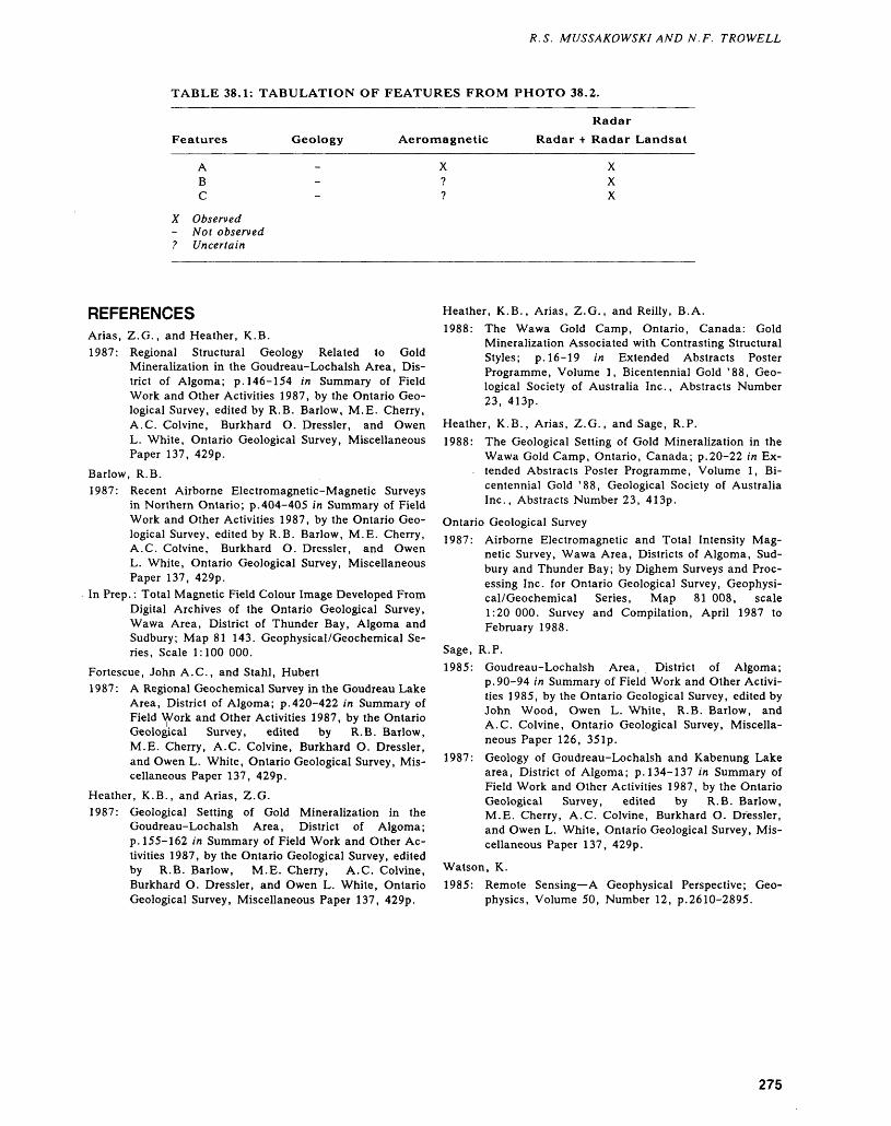
R. S. MUSSAKOWSKI AND N.F. TROWELL
TABLE 38.1: TABULATION OF FEATURES FROM PHOTO 38.2.
Radar
Features Geology Aeromagnetic Radar -t- Radar Landsat
X-?
A XB ?C - ?
ObservedNot observedUncertain
XXX
REFERENCESArias, Z.G., and Heather, K.B.1987: Regional Structural Geology Related to Gold
Mineralization in the Goudreau-Lochalsh Area, Dis trict of Algoma; p. 146-154 in Summary of Field Work and Other Activities 1987, by the Ontario Geo logical Survey, edited by R.B. Barlow, M.E. Cherry, A.C. Colvine, Burkhard O. Dressler, and Owen L. White, Ontario Geological Survey, Miscellaneous Paper 137, 429p.
Barlow, R.B.1987: Recent Airborne Electromagnetic-Magnetic Surveys
in Northern Ontario; p.404-405 in Summary of Field Work and Other Activities 1987, by the Ontario Geo logical Survey, edited by R.B. Barlow, M.E. Cherry, A.C. Colvine, Burkhard O. Dressler, and Owen L. White, Ontario Geological Survey, Miscellaneous Paper 137, 429p.
In Prep.: Total Magnetic Field Colour Image Developed From Digital Archives of the Ontario Geological Survey, Wawa Area, District of Thunder Bay, Algoma and Sudbury; Map 81 143. Geophysical/Geochemical Se ries, Scale 1:100 000.
Fortescue, John A.C., and Stahl, Hubert1987: A Regional Geochemical Survey in the Goudreau Lake
Area, District of Algoma; p.420-422 in Summary of Field Work and Other Activities 1987, by the Ontario Geological Survey, edited by R.B. Barlow, M.E. Cherry, A.C. Colvine, Burkhard O. Dressler, and Owen L. White, Ontario Geological Survey, Mis cellaneous Paper 137, 429p.
Heather, K.B., and Arias, Z.G.1987: Geological Setting of Gold Mineralization in the
Goudreau-Lochalsh Area, District of Algoma; p. 155-162 in Summary of Field Work and Other Ac tivities 1987, by the Ontario Geological Survey, edited by R.B. Barlow, M.E. Cherry, A.C. Colvine, Burkhard O. Dressler, and Owen L. White, Ontario Geological Survey, Miscellaneous Paper 137, 429p.
Heather, K.B., Arias, Z.G., and Reilly, B.A.1988: The Wawa Gold Camp, Ontario, Canada: Gold
Mineralization Associated with Contrasting Structural Styles; p. 16-19 in Extended Abstracts Poster Programme, Volume l, Bicentennial Gold '88, Geo logical Society of Australia Inc., Abstracts Number 23, 413p.
Heather, K.B., Arias, Z.G., and Sage, R.P.1988: The Geological Setting of Gold Mineralization in the
Wawa Gold Camp, Ontario, Canada; p.20-22 in Ex tended Abstracts Poster Programme, Volume l, Bi centennial Gold '88, Geological Society of Australia Inc., Abstracts Number 23, 413p.
Ontario Geological Survey1987: Airborne Electromagnetic and Total Intensity Mag
netic Survey, Wawa Area, Districts of Algoma, Sud bury and Thunder Bay; by Dighem Surveys and Proc essing Inc. for Ontario Geological Survey, Geophysi cal/Geochemical Series, Map 81 008, scale 1:20 000. Survey and Compilation, April 1987 to February 1988.
Sage, R.P.1985: Goudreau-Lochalsh Area, District of Algoma;
p.90-94 in Summary of Field Work and Other Activi ties 1985, by the Ontario Geological Survey, edited by John Wood, Owen L. White, R.B. Barlow, and A.C. Colvine, Ontario Geological Survey, Miscella neous Paper 126, 351p.
1987: Geology of Goudreau-Lochalsh and Kabenung Lake area, District of Algoma; p. 134-137 in Summary of Field Work and Other Activities 1987, by the Ontario Geological Survey, edited by R.B. Barlow, M.E. Cherry, A.C. Colvine, Burkhard O. Dressler, and Owen L. White, Ontario Geological Survey, Mis cellaneous Paper 137, 429p.
Watson, K.1985: Remote Sensing—A Geophysical Perspective; Geo
physics, Volume 50, Number 12, p.2610-2895.
275


Proterozoic
39. Proterozoic Geology Studies, Southern and Grenville ProvincesR.M. Easton
Geologist, Precambrian Geology Section, Ontario Geological Survey, Toronto.
INTRODUCTION
Proterozoic rocks underlie fifteen percent of the Province of Ontario, and have long contributed to the mineral wealth of the Province, most notably uranium from the Huronian Supergroup, cobalt in association with the Nipissing Intrusions, nickel from the Sudbury Structure, and a variety of metallic- and nonmetallic-mineral deposits from the Grenville Province. Despite many years of study there are still large tracts of Ontario underlain by Proterozoic rocks which have not been mapped in detail or ex tensively prospected, or both. The goal of the Proterozoic Working Group of the Ontario Geologi cal Survey is to improve both mapping coverage of Proterozoic terranes in Ontario and our understand ing of the mineral deposits associated with these ter ranes.
SOUTHERN PROVINCE
Most of the 1988 field program in the Southern Province focused on the study of the Huronian Su pergroup in the Cobalt Plate, and was funded under the Canada-Ontario Mineral Development Agree ment (COMDA) which concludes in 1989.
Born (this volume) continued detailed mapping in the area southwest of the town of Cobalt. This area is underlain by Archean metavolcanic and plutonic rocks overlain by the Proterozoic Gowganda Formation, with Nipissing Intrusions injected along the unconformity and into the overlying Gowganda Formation. Potential mineralization in both the Ar chean and Proterozoic rocks is discussed in his re port. Rice (this volume) completed the final year of a three-year project to investigate the sedimentology of the Huronian Lorrain Formation, begun with the intent of evaluating the paleoplacer-gold potential of the formation.'Sedimentary textures present within the Lorrain Formation are for the most part equivo cal with respect to depositional setting for the Lor rain Formation; however, the present consensus is that the Lorrain Formation in the Cobalt Plate was deposited in a shallow-marine rather than in a flu vial setting.
Avermann and Mueller-Mohr (this volume) re port on an ongoing study of the breccias of the Sud bury Structure, this year focusing on the Sudbury breccias and the Onaping Formation. Their study is the result of a co-operative project between the On
tario Geological Survey and the University of Muenster, West Germany and forms part of the re quirements for Ph.D. theses.
We are currently re-evaluating our mapping program in the Southern Province in order to deter mine which areas should receive priority over the next several years.
GRENVILLE PROVINCEMany of Ontario's first mines were located in the Grenville Province, and in the past few years, a re surgence of exploration activity has occurred in the Grenville, particularly for gold, and for a variety of industrial minerals such as graphite, talc, and wollas tonite. However, although easily accessible, much of the Grenville Province has not undergone detailed mapping (scales of 1:50 000 or less). To assist me tallic- and nonmetallic-mineral exploration in the Grenville Province, the Ontario Geological Survey's program is threefold: a) it involves detailed mapping at 1:15 840 scale in selected areas, with priority given to areas of greatest mineral potential or explo ration interest; b) production of 1:50 000 scale com pilation maps, particularly in the Central Metasedimentary Belt; and c) detailed studies to ad dress specific problems and to improve our knowl edge of mineral deposits within the Grenville Prov ince. Over the next few years, emphasis will be given to the preparation of 1:50 000 scale compilation maps for the Bancroft, Elzevir, and Sharbot Lake Terranes of the Central Metasedimentary Belt; preparation of 1:250 000 scale compilation maps for the entire Grenville Province in Ontario; a review of lithostratigraphic nomenclature and a compilation of geochemical data in preparation of the Geology of Ontario volume; and continuing studies on the geo logical setting and genesis of Grenville Province me tallic- and nonmetallic-mineral deposits with the goal of developing improved exploration models.
The 1988 mapping program included projects of all three types. As part of the Geology of Ontario program and related map compilation projects, Eas ton (this volume) undertook a number of directed studies within the Grenville Province. These in cluded an attempt to delineate lithotectonic domains in the North Bay area; additional studies to trace the extent of the Robertson Lake Mylonite Zone (RLMZ), a major geologic feature in southeastern Ontario that hosts several gold prospects; and studies of the Frontenac/Sharbot Lake Terrane Boundary
278
R.M. EASTON
which had not been previously studied in detail. This work has lead to the recognition that additional, hitherto unexplored, settings exist for gold mineral ization in the Central Metasedimentary Belt, and to the discovery of a diopside occurrence along High way 7 that may have industrial mineral applications. Further work along the RLMZ ties in with the un conformity study of DiPrisco (this volume) in that post-Grenville weathering may have locally concen trated gold along the RLMZ. In fact, the synergism of the various field programs was a common theme throughout the 1988 season, and highlights the fact that small, apparently unrelated projects can con tribute to a better understanding of the geological framework and mineral potential of the Grenville Province.
Much of the 1988 field program in the Grenville was funded by the Canada-Ontario Mineral Devel opment Agreement (COMDA). Because little de tailed mapping is available for the Central Gneiss Belt, a three-year bedrock geology mapping project (1:15 840 scale) was begun in 1986 in the Parry Sound region. This work continued in 1988, and was extended south into the main part of the Parry Sound Domain. As reported by McRoberts e t al. (this volume), rocks in this area are less deformed in relative terms than those mapped to the north in 1986-1987 (Bright 1987; McRoberts and Tremblay 1988), and, consequently, the dominantly metaig- neous nature of this region has been confirmed. It also appears that the domain consists of two halves: a mafic metaigneous and metasedimentary western half, and a mainly metadioritic eastern half. The reason for this lithological distinction is not yet un derstood, but obviously has a bearing on the type of mineral exploration programs conducted in the Parry Sound Domain. Macfie (this volume) who served as senior assistant on the Parry Sound Pro ject, has undertaken a thesis project at Queen's Uni versity examining the nature of the lithotectonic ter rane boundaries in the western Central Gneiss Belt. The preliminary results of this study, which compli ments the work of McRoberts et al. (this volume), indicates that domain boundaries are not always characterized by the presence of major tectonite zones, particularly when examined at detailed map scales. In conjunction with bedrock mapping of the Parry Sound Region, Chris Marmont, working out of the Dorset Resident Geologist's Office, has been in vestigating the industrial-mineral potential of the Parry Sound region, including, but not restricted to, the areas mapped in detail by Bright (1987), McRoberts and Tremblay (1988), and McRoberts et al. (this volume). Marmont (this volume) reports on his 1988 field work which elaborates upon some of his preliminary work (Marmont 1988a, 1988b; Mar mont and Johnston 1987) on the mineral potential of anorthosite, feldspar, and building stone in the Parry Sound region. Tremblay (this volume) per formed a lineament analysis of remote-sensing data
for the Parry Sound region. Although in a broad sense, the remote-sensing data could be correlated with the regional geology, interpretation was more difficult at finer scales (less than 1:250 000), and, other than for reconnaissance investigations, use of remote-sensing data for this part of the Grenville Province has limited application. Tremblay's analysis did confirm the apparent absence of a major tec tonic zone in the area studied by Macfie (this vol ume).
Di Prisco (this volume) continued his study of the Precambrian—Paleozoic unconformity in south ern Ontario. Many historic mineral occurrences, particularly hematite producers, are related to weathering at this unconformity, which has also caused local supergene enrichment of Precambrian mineral deposits. This is applicable to mineral explo ration programs and to the interpretation of soil geochemical anomalies. Springer (this volume) stud ied Precambrian—Paleozoic fault systems in the city of North Bay area which are locally hematized. This work is broadly related to DiPrisco's study.
In addition to the work done out of the Toronto office of the Ontario Geological Survey, the Resident Geologist's and Mineral Specialist's offices of the Ministry of Northern Development and Mines in southern Ontario have also contributed to the 1988 field program in the Grenville Province, particularly with respect to the examination of industrial miner als in the Central Metasedimentary Belt. From the Bancroft Mineral Specialist's Office, Hans Meyn (this volume) continued his study of the sedimentol ogy of carbonate and intercalated rocks in the Madoc area. This work is part of a long-term study to understand the depositional and mineralization environments of carbonate rocks in the Central Metasedimentary Belt. Goad (this volume), also of the Bancroft Mineral Specialist's Office, continued work on a Canada-Ontario Mineral Development Agreement (COMDA) funded-project studying the pegmatites in the Central Metasedimentary Belt and the Central Gneiss Belt. Although in general the pegmatites are not favourable targets for rare-ele ment mineralization, the pegmatites locally may be of value as sources of feldspar and quartz.
Three Canada-Ontario Mineral Development Agreement (COMDA) Projects were conducted out of the Tweed Resident Geologist's Office. Lebaron (this volume) continued his study of talc-bearing rocks in the Tudor Formation. Black and MacKin- non (this volume) examined major graphite occur rences in the Frontenac Terrane. Thompson and Williams (this volume) continued their study of the structural geology of the Madoc fluorite area. Grant (this volume), of the Drill Core Library in the town of Bancroft, which is administered from the Tweed Resident Geologist's Office, produced a geological map of Egan Chutes Provincial Park, which will be of interest to mineral collectors and the general pub lic.
279
PRECAMBRIAN (39)
Although extremely varied in nature, the Gren ville mapping projects in 1988 have led to a much better understanding of the geological framework and geological history of parts of the Grenville Prov ince, and have enhanced our knowledge of metallic and nonmetallic mineralization in the Central Metasedimentary Belt. The results of this work will assist in preparation of a synthesis of the geology of the Grenville Province which will be beneficial to both the academic and the explorationist.
REFERENCESBright, E.G.1987: Precambrian Geology of the Whitestone Lake Area,
District of Parry Sound; Ontario Geological Survey, Map P.3095, Geological Series-Preliminary Map, scale 1:15 840 or l inch to 1/4 mile. Geology 1986.
Marmont, C.1988a: Feldspar in the Parry Sound-Huntsville-Haliburton
Area; Ontario Geological Survey, Open File Report 5686, 133p., 7 figures, 7 tables, 22 photos, 6 appen dices, and 4 maps in back pocket.
1988b: Limestone (Crystalline Marble) in the Parry Sound- Huntsville Area; Ontario Geological Survey, Open File Report 5687, 71p., 4 figures, 3 phots, l table, 7 appendices, and 2 maps in back pocket.
Marmont, C., and Johnston, M.1987: Mineral Deposits Studies in the Huntsville-Parry
Sound-Powassan Area—A Progress Study; Ontario Geological Survey, Open File Report 5647, 271p., 9 tables, 30 figures, 12 photos, and 5 charts in back pocket.
McRoberts, G., and Tremblay, M.L.1988: Precambrian Geology of the Ferrie River Area, Dis
trict of Parry Sound; Ontario Geological Survey, Map P.3123, Geological Series-Preliminary Map, scale 1:15 840 or l inch to 1/4 mile. Geology 1987.
280
40. Project Number 88-12. Geology of the Bay Lake Area, District of Timiskaming
P. Born 1 and M.W. Hitch2
1 Geologist, Precambrian Geology Section, Ontario Geological Survey, Toronto.
2Graduate Student, Ottawa-Carleton Geoscience Centre, University of Ottawa, Ottawa, Ontario.
INTRODUCTIONThe map area (240 km2) consists of the western part of Coleman Township and most of the southern two-thirds of Gillies Limit Township (Figure 40.1). It is located in the District of Timiskaming some 8 km southwest of Cobalt, 20 km north of Temagami, and 120 km north of North Bay, and bounded by Latitudes 47 0 13'00"N and 47 0 23'00"N, and Longitudes 79 0 55'00"W and 79 0 38'00"W.
Excellent access was provided by Highway 11 and a series of connected secondary lumber roads, and by Bay Lake and the Montreal River. Entry by float-plane into Island, Second Justin, Coleman, Hound Chute, and Roosevelt lakes provided water access to the remainder of the area.
Figure 40.1. Location map of the Bay Lake area, District of Timiskaming. Scale 1:1 584 000 or l inch to 25 miles.
The study area is underlain by Proterozoic metasedimentary rocks of the Cobalt Group of the Huronian Supergroup. Archean plutonic and metavolcanic rocks are exposed as relatively small inliers. Copper, cobalt, silver, and gold minerali zation is known to occur in the area of investigation.
MINERAL EXPLORATIONLocal silver and cobalt exploration began following the -discovery of silver in the Cobalt area in 1904. The Bay Lake map area is located some 8 km to the south of the town of Cobalt.
Over fifty companies and individuals have car ried out extensive mineral exploration in the map area between 1906 and 1983. This work has in cluded the sinking of 16 shafts with approximately 900 m of underground development; the completion of approximately 22 000 m of diamond drilling in 245 holes; and the blasting of numerous trenches and test pits on mineralized surface showings. A list of previous exploration work is too lengthy for this report but will be included in the marginal notes of preliminary maps resulting from the study of the area.
GENERAL GEOLOGYThe earliest geological mapping in the area was done on a reconnaissance scale by Barlow (1899), DeLury (1913), Miller (1913), and Todd (1926). Subsequent and more detailed mapping in adjacent areas to the north of the Bay Lake area was done by Thomson (1963a, 1963b, 1963c) and Johns (1985). Lorrain Township to the east was mapped by Lovell and de Grijs (1978). Banting and Best townships to the west were mapped by Smyk and Oswiacki (1986). Born and Burbidge (1987) surveyed adja cent Brigstocke and Kittson townships.
Underlying the map area are Archean supra crustal and plutonic rocks, Early Proterozoic supra crustal and intrusive rocks, and Middle Proterozoic diabase and lamprophyre dikes (Figure 40.2).
CANAD\ ONTARIO This project A.4.3 is part of the five year Canada-Ontario 1985 Mineral Development Agreement
(COMDA), a subsidiary agreement to the Economic and Regional Development Agreement (ERDA) signed by the governments of Canada and Ontario.
281
PRECAMBRIAN (40)
+I Lorrain Formation
Firstbrook Member
Coleman Member
Figure 40.2. General Geology of the Bay Lake Area, District of Timiskaming. Properties: (1) Shakt-Davis Mine; (2) Portage Bay Occurrence; (3) Borden Lake Occurrence.
282
P. BORN AND M. W. HITCH
ARCHEAN ROCKS
Archean rocks underlie the southwestern and north eastern parts of the map area, and consist mainly of felsic plutonic and migmatitic rocks with lesser amounts of mafic metavolcanics.
Mafic metavolcanic rocks occur as two distinct types. The first type is characterized by fine- to me dium-grained amphibolites which exhibit varying de grees of migmatization including agmatic (breccia), phlebitic (vein), and ptygmatic structures (Mehnert 1971). Similar rocks have been described in areas to the west of the study area by Smyk and Oswiacki (1986) and by Born and Burbidge (1987). The am phibolites occur in the southwestern part of the study area as volcanic enclaves within felsic plutonic rocks. The second type are well-preserved, greenschist- facies mafic volcanic rocks which underlie the north eastern corner of the map area. They consist of both pillowed and plagioclase-phyric basalts.
Minor felsic pyroclastic rocks are intercalated with the well-preserved metavolcanics southeast of the Schumann Lake area and with amphibolites near Highway 11, directly to the east of Island Lake. The presence of some disseminated sulphides in the pyroclastic rocks makes them an exploration target.
The felsic plutonic rocks in the southwestern corner of the area are a continuous with similar basement rocks described from Brigstocke and Kit tson townships by Born and Burbidge (1987). They consist of a heterogeneous assemblage of both biotite- and hornblende-bearing tonalite, quartz diorite, mafic diorite, and diorite. Cross-cutting re lationships indicate granodiorite and granite are the younger rock types. Also present are local mig matitic structures. Rare north- and northwest-trend ing, fine-grained Archean diabase dikes intrude the Archean felsic plutonic rocks. They generally range in width from 10 to 100 cm but may be up to 10 m wide. In the northeastern corner of the area near Chopin Lake, the felsic plutonic rocks are more ho mogeneous and consist only of a single lithology which is a reddish coarse-grained biotite-bearing granite also referred to as the Lorrain Granite (Lovell and de Grijs 1978).
PROTEROZOIC ROCKS
Early Proterozoic rocks of the Huronian Super group, namely the metasedimentary rocks of the Gowganda and overlying Lorrain formations under lie large parts of the map area. Subdivisions and de scriptions of the individual units are similar to those reported for the adjacent area to the west by Born and Burbidge (1987). The Gowganda Formation consists of a lower unit, the Coleman Member, and an upper unit, the Firstbrook Member.
Rocks of the Coleman Member locally have a maximum thickness of 430 m. They occur as a blan ket which unconformably drapes the Archean base
ment rocks. The member consists of a local basal conglomerate or basement regolith overlain by poorly sorted diamictites containing mud-, sand-, and gravel-sized constituents (Mustard 1985; Mus tard and Donaldson 1987). Both massive and strati fied matrix-supported diamictites occur and are be lieved to represent extensive debris flows. The strati fication is probably indicative of reworking prior to the deposition of overlying debris flows. Trough cross-bedding is common in many of these rock types.
Clast-supported conglomerates and both pebbly and non-pebbly shaley mudstones with inter laminated siltstone and very fine sandstone are other common lithologies of the Coleman Member. Disap pearance of the thin lenticular sandstone beds marks the upper limit of the Coleman Member. Meta sedimentary rocks of the Coleman Member are characterized by rapid lateral lithofacies changes and the presence of "dropstones", all indicative of deposition in a glaciomarine environment at the edge of a continental ice shelf (Miall 1985).
The Firstbrook Member has an maximum thick ness of about 260 m. It consists of a single, coarsen ing-upward sequence of fine-grained rocks (mud, silt, and minor very-fine sand FI and Fr lithofacies (explained below); Miall 1978; Rust 1978a, 1978b).
These sediments overlie the Coleman Member and occur as a northwest-trending unit in the west ern part of Coleman and Gillies Limit townships. The sequence is divisible into a lower, middle, and upper unit following the criteria of Rainbird (1985) and Born and Burbidge (1987), although the upper most unit is thin, poorly exposed, or absent in some parts of the map area. Interlaminated shaley mud stone and siltstone occur in the lower unit with silt making up ^0 percent of the rock. Disseminated sulphides are locally present in this unit. In the mid dle unit, siltstone constitutes over 50 percent of the rock whereas in the upper unit the proportion of sandstone to siltstone plus shaley mudstone makes up more than 50 percent. Rare herringbone cross- laminations indicate a north-northeast/south-south west bipolar paleocurrent direction for the Firstbrook Member.
The base of the Lorrain Formation is' placed, following the criteria of Johns (1985), Rainbird (1985), and Born and Burbidge (1987) at the base of the lowermost medium or thickly bedded arkose unit.
Rocks of the lower Lorrain Formation locally have a maximum thickness of 650 m and underlie much of the southern and northwestern parts of the map area. The lowermost unit consists of a well- sorted, generally horizontally-laminated, very fine and fine-grained, thickly bedded arkose. Character istic of this unit are local shaley rip-up clasts and some shallow scours. Commonly present are Sh (horizontally laminated sand), Sr (rippled sand) and SI (low-angle trough cross-bedded sand) facies
283
PRECAMBRIAN (40)
types (Miall 1978). Overlying this are thin local units of laminated shaley mudstones, siltstones, and very fine-grained sandstones. These represent FI (lami nated fine-grained mud) and Fr (rhythmically lami nated fine-grained mud) lithofacies. Although these are not widespread, they are similar to parts of the Lorrain stratigraphic section found to the west in Brigstocke and Kittson townships (Born and Bur bidge 1987). It is also similar in appearance to rocks of the upper and middle Firstbrook Member of the Gowganda Formation and suggests deposition in a similar deltaic environment.
Elsewhere, the uppermost exposed part of the coarsening-upwards cycles of the Lorrain Formation consists of a moderately to poorly sorted, medium- grained arkose with common planar and trough cross-beds. These represent St (trough cross-bed ded sand) and Sp (planar cross-bedded sand) lithofacies (Miall 1978). Also present locally are some intercalated finer capping units (FCU) as de scribed by Rice (1986, 1987, this volume) and Born(1986). These 510 cm arkose beds are mica-rich and consist of fine to very fine grained sand with common planar cross-beds.
The sediments of the Firstbrook Member (Gow ganda Formation) and the Lorrain Formation repre sent a southward-prograding and coarsening-up wards marine wedge fed by a braided fluvial system. Upward facies transitions represent sedimentary en vironments ranging from prodelta through deltaslope and foreslope (Rainbird 1985; Rainbird and Donaldson 1988)) to tidal flat and channel; overlain by topset beds indicating braided stream sediments. Alternatively, the facies arrangements could indicate a delta to shallow marine transition. Marine deposi tional environments for the Lorrain Formation have been proposed by Hadley (1968) and by Rice (1986, 1987; this volume).
Early Proterozoic Nipissing diabase forms sev eral east-trending sills (500 m thick maximum) which intrude all of the older lithologies. Contact metamorphism of the Proterozoic sediments resulted in chlorite spotting and epidotization in arkoses of the Lorrain Formation and shaley mudstones of the Gowganda Formation.
Coarse-grained quartz diabase and hypersthene gabbro are the main lithologies in the lower parts of the main diabase sill in the area. Along the lower contact of one of the sills for example, the diabase is fine grained, epidotized, and exhibits characteristic polygonal, columnar jointing. Coarse-grained varied textured gabbro is the main lithology of the upper portions of the sills and granophyre occurs sporadi cally along the upper contact of the sill where it is in contact with arkoses of the Lorrain Formation. Re search by Conrod (1988) and Lightfoot et al.(1987) on the Nipissing Diabase sill at Portage Bay has provided a more detailed petrographic and geochemical interpretation for the petrogenesis of these sills.
The youngest Precambrian rocks in the area are represented by dikes of two lithologies.
Northwest-trending dikes of the Sudbury Swarm make up the first type, and have characteristic l to 2 cm plagioclase phenocryst^ in an olivine-rich groundmass and are generally from 3 to 30 m wide. In the study area these dikes are only locally trace able.
The second type of dike found in the area is composed of lamprophyre. They consist of a coarse- grained biotite and muscovite matrix containing 5 to 30 percent rounded accidental clasts of Archean rocks. The vertical dikes are 10 to 30 m wide and generally trend in a northerly direction. Although not common in the Bay Lake area, they are similar to dikes in adjacent Brigstocke Township (Born and Burbidge 1987). The age of the dikes is uncertain and probably Middle Proterozoic or younger. They could be related to tectonic events associated with the Timiskaming Rift System (Lovell and Caine 1970).
STRUCTURAL AND METAMORPHIC GEOLOGY
Archean plutonic and metavolcanic rocks are gener ally weakly foliated with a near vertical east- to southeast-trending fabric. Brittle deformation and brecciation with some associated chloritization and quartz veining occurs locally along at least one south-southeast-trending shear which transects the Archean basement.
The Latchford Fault is probably part of the Timiskaming Rift Valley (Lovell and Caine 1970). It is a prominent northwest-trending fault which cuts across the central part of the map area. The Montreal River Fault is one of several additional northwest-trending faults and/or lineaments which are prominent throughout the map area. Displace ment along these faults appears to be minor, and the local Huronian stratigraphic sequence is essentially intact with no apparent major horizontal or vertical displacements.
Sedimentary rocks of the Gowganda and Lor rain formations are undeformed in most places. They have undergone some folding (gentle flexure) during the Penokean Orogeny along several gently plunging (lO 0 ), subhorizontal, west- and east- trending fold axes. Only a few synclinal and an ticlinal folds were observed. Some of the changes in the strike and dip of the strata may reflect faulting and subsequent tilting.
Locally extensive, post-depositional breccias oc cur mainly within rocks of the Gowganda Formation. The majority of the breccias are confined to vertical to sub-horizontal zones composed of angular 3 mm to 4 cm sized sedimentary clasts and 3 m blocks which show little or no internal deformation. Nu merous local compressional kink bands occur in the adjacent host rocks of the breccias and are usually
284
P. BORN AND M. W. HITCH
oriented in an easterly direction, commonly parallel to local fold axes. No extensional kink bands were observed. Similar breccias in Brigstocke and Kittson townships have been described by Born and Bur bidge (1987). Field evidence in both areas suggested that the breccias were not caused by sedimentary slump failure but rather are related to the intrusion of Nipissing diabase. Steam or water escape proc esses, or both, were probable causes of the breccia tion.
Another type of unusual breccia consists of sub rounded and essential 2 to 4 cm clasts of arkose in a fine-grained sand matrix. They were found at one locality within rocks of the Lorrain Formation. These breccia bodies appear to be vertically ori ented, and on horizontal ourcrop surfaces occur as irregularly-shaped isolated patches (10 to 30 cm di ameter) within the sediments. Similar breccias occur to the west of the study area in Brigstocke and Kit tson townships and have been described by Born and Burbidge (1987). Elsewhere in the Temagami (Burbidge, graduate student, University of Ottawa, 1987, personal communication) and Maple Moun tain areas (Card et al. 1973) similar breccias also contain Nipissing diabase fragments. These breccias may represent gas escape features and/or may be re lated to lamprophyre dikes that commonly occur parallel to north- and northeast-trending structural lineaments. These types of breccias are referred to as Lake Temagami-type breccias (Born and Bur bidge 1987).
The grade of regional metamorphism in the area varies from sub-greenschist facies in Middle Proterozoic age or younger olivine diabase and lamprophyre dikes, to lower greenschist facies in the Huronian sedimentary rocks, to amphibolite facies in the Archean metavolcanic and migmatitic/meta- plutonic rocks.
ECONOMIC GEOLOGY AND RECOMMENDATIONS FOR FUTURE EXPLORATION
Copper, cobalt, silver, and gold mineralization is re lated to Nipissing diabase dikes and sills.
Located on the northeastern shore of Kitt Lake, the Shakt-Davis Mine has been developed at a de posit which consists of several major calcite veins hosted in a fractured and faulted zone within Nipiss ing diabase. The diabase intrudes arkoses of the Lorrain Formation and laminated shaley mudstones of the Firstbrook Member of the Gowganda Forma tion.
This fracture zone strikes 60 0 , parallel to a 120 m thick, vertical diabase dike. The Main Vein ranges in width from l to 7 m whereas the parallel Chimney Vein is from l to 3 m wide. Both are verti cally oriented and contain smaltite, cobaltite, gersdorffite, erythrite (cobalt bloom), annabergite
(nickel bloom), pyrite, chalcopyrite, and niccolite. Assays and analyses indicated 1.5 percent cobalt and minor silver over a width of 1.37 m, wjth select grab samples indicating up to 4 percent cobalt, and others with up to 2.72 ounces gold per ton. A fur ther test of hand-picked ore indicated values of 0.87 ounce gold per ton, 0.25 ounce silver per ton, 7.92 percent cobalt, and 7.72 percent nickel; an other smaltite ore sample returned 97 ounces silver per ton, 0.336 percent cobalt, and 0.18 percent nickel (Assessment Files, Resident Geologist Office, Cobalt). Grab samples collected by the author from the mine dump in 1987 yielded assay values of 0.10 ounce gold per ton and *c0.10 ounce silver per ton, and analysis values of 2480 ppm cobalt, 580 ppm copper, and 7520 ppm nickel. Samples collected in 1988 indicated values of 5300 ppm cobalt, 53 ppm copper, and 7520 ppm nickel (Geoscience Labora tories, Ontario Geological Survey, Toronto).
The nearby Edison Mine is located 1.2 km to the east of the study area, at a deposit which hosts several mineralized calcite veins. Grab samples yielded values of-940 ppb gold, 17 ppm silver, 3.09 percent copper, and 3556 ppm cobalt (Geoscience Laboratories, Ontario Geological Survey, Toronto). This location is some 1.5 km to the south of the Co- balt-Kittson Mine in adjacent Kittson Township (Born and Burbidge 1987). Thus, the same narrow (70 m wide) Nipissing diabase dike hosts all three deposits.
Another area of extensive previous mineral ex ploration is the Portage Bay area. The best assay and analysis results were 7.95 percent copper and 1.96 ounces gold per ton from a drill intersection dating from 1952. Grab samples taken from several old pits yielded values of 480 ppb gold, 7 ppm silver, 1.48 copper, 6550 ppm cobalt, and 1740 ppm nickel (Geoscience Laboratories, Ontario Geological Sur vey, Toronto).
The Chopin Lake area is an area of extensive exploration located to the southeast of Schumann Lake. Here, Nipissing Diabase cuts basement Ar chean mafic volcanic rocks. Past exploration indi cates the presence of some native silver and minor disseminated sulphides in several surface pits and in numerous drillhole intersections. Assays indicate maximum values which range from 2.4 ounces silver per ton over 18 cm to 90 ounces silver per ton over 5 cm. Samples taken from surface showings in the area by the authors during the 1988 fields season, however, yielded negligible results. Borden Lake, lo cated further to the south of Schumann Lake, was also an area of concentrated exploration. The best results indicated cobaltite in some surface pits with 10 to 6 percent cobalt and some minor drilling indi cated chalcopyrite, pyrite, galena, hematite, and py rrhotite mineralization.
Scattered minor sulphide-bearing veins are also hosted in the Nipissing diabase at several localities along the upper contact of the sill in the vicinity of
285

PRECAMBRIAN (40)
Johnson Lake. Previous minor drilling and trenching indicated chalcopyrite, pyrite, galena, hematite, an nabergite, and malachite mineralization with maxi mum silver values of 0.11 ounce silver per ton. Grab samples taken during 1988 indicated 1.41 copper with negligible gold and silver values. Another nearby sample from a road cut had values of 750 ppb gold with 6950 ppm copper. The deposit located on the Last Chance Mining property is hosted in the upper part of the sill along the railway north of Latchford. Sampling of the sulphide-bear ing calcite vein material resulted in values of 780 ppm copper, 3800 ppm cobalt, and 600 ppm nickel (Geoscience Laboratories, Ontario Geological Survey, Toronto).
At several locations, mineralization consisting of disseminated pyrite and minor chalcopyrite occurs either within Archean plutonic/migmatitic and mafic metavolcanic rocks, or within quartz veins hosted by these lithologies. Previous diamond drilling and trenching west of Johnson Lake in Archean mafic volcanics outlined some minor chalcopyrite, pyrite, galena, hematite, annabergite, and malachite miner-' alization with maximum values of 2.4 ounces silver per ton and .02 percent copper over 24 cm. Grab samples taken in 1988 from a south-southeast- trending, pyrite-bearing shear zone gave assay val ues of 0.04 ounce gold per ton and -cO.lO ounce silver per ton (Geoscience Laboratories, Ontario Geological Survey, Toronto).
The Rib Lake-Whitney Lake area straddles and extends south of the map sheet. Previous work out lined minor drilling and trenching, and indicated disseminated to massive pyrite, pentlandite, chalco pyrite, galena, and pyrrhotite mineralization. Maxi mum assay and analysis values included 0.01 to 5.3 ounces silver per ton, 0.004 to 0.01 ounce gold per ton, 0.03 to 0.38 percent copper (over an unknown width); and 0.2 to 1.3 ounces gold per ton over 1.7 m, and 0.05 to l percent nickel over 1.5 m.
Although many of these showings are minor, further prospecting could result in the discovery of more significant silver, gold, and/or base metal oc currences. The geological environment of the Bay Lake area is analogous to the Cobalt Camp (Legun 1986; Andrews e t al. 1986) and thus further pros pecting and exploration for Cobalt-type minerali zation is recommended in this area.
The three potential areas for finding cobalt, cop per it silver, and gold-bearing veins are along the upper and lower contacts of the main east-west- trending diabase sill or along several north- and northeast-trending narrow (70 to 140 m wide) dikes in Kittson and Coleman townships. The presence of mineralized veins is structurally controlled. The veins occur in parallel fracture zones near margins of the diabase body. As a general rule, values of cobalt, silver, copper, and gold are usually higher in calcite rather than quartz veins. Gold values of more than l
ounce gold per ton are associated with several co balt-copper showings hosted in the Nipissing dia base. These are the Portage Bay occurrence in Coleman Township; the Shakt-Davis Mine in Kit tson and Coleman townships; the Sugarloaf Island occurrence in Brigstocke Township (Born and Bur bidge 1987); and the Temagami-Lorrain occurrence in nearby Cassels Township (Born 1986). The high est silver values are reported from drill data and in dicate values of 90 ounces silver per ton over a width of 5 cm. These holes were drilled directly to the west of Chopin Lake in the northeastern corner of the map area. Several high gold values were also re ported for sheared and sulphide-bearing Archean mafic volcanics in the Rib Lake and Whitney Lake areas. These values are 1.3 ounce gold per ton over 1.7 m (Assessment files, Resident Geologist Office, Cobalt).
All these occurrences are good indications of base and precious metal mineralization and make the study area and neighbouring areas promising ex ploration targets.
REFERENCESAndrews, A.J., Owsiacki, L., Kerrick, R., and Strong, D.F.1986: The Silver Deposits at Cobalt and Gowganda, Ont
ario. I: Geology, Petrology and Whole Rock Geo chemistry; Canadian Journal of Earth Science, Vol ume 23, p.1480-1506.
Barlow, A.E.1899: Geology and Natural Resources of the Nipissing and
Timiskaming Map Sheets; Annual Report of the Geo logical Survey of Canada; Volume 10, Report I, p.172-174.
Born, P.1986: Geology of Cassels and Riddell Townships, District of
Nipissing; p.111-115 in Summary of Field Work and Other Activities 1986, by the Ontario Geological Sur vey, edited by P.C. Thurston, Owen L. White, R.B. Barlow, M.E. Cherry, and A.C. Colvine, Ont ario Geological Survey, Miscellaneous Paper 132, 435p. Accompanied by l Chart.
Born, P., and Burbidge, G.H.1987: Geology of Brigstocke and Kittson Townships, District
of Timiskaming; p. 198-204 in Summary of Field Work and Other Activities 1987, by the Ontario Geo logical Survey, edited by R.B. Barlow, M.E. Cherry, A.C. Colvine, Burkhard O. Dressler, and Owen L. White, Ontario Geological Survey, Miscellaneous Paper 137, 429p.
Card, K.D., Mcilwaine, W.H., and Meyn, H.D.1973: Geology of the Maple Mountain Area, Operation Ma
ple Mountain, District of Timiskaming, Nipissing, and Sudbury; Ontario Division of Mines, Geological Report 106, 160p. Accompanied by maps 2256, 2257, 2258, 2259, scale 1:63 360 or l inch to one mile, and map 2260, scale 1:31 680 or l inch to 1/2 mile.
Conrod, D.M.1988: Petrology, Geochemistry and Platinum Group Element
Potential of the Portage Bay, Cross Lake and Bonanza
286

P. BORN AND M. W. HITCH
Lake Nipissing Intrusions of Northern Ontario; Un published M.Se. Thesis, University of Toronto, 494p.
DeLury, J.S.1913: Other Timiskaming Cobalt Areas, Area West of Bay
Lake on Montreal River; Ontario Bureau of Mines,Volume XVI, Part 2, p.138-146.
Hadley, D,G,1968: The Sedimentology of the Huronian Lorrain Forma
tion, Ontario and Quebec, Canada; Unpublished Ph.D. Thesis, Johns Hopkins University, Baltimore, Maryland, U.S.A., 301p.
Johns, G.W.1985: Geology of the Firstbrook and Parts of Surrounding
Townships Area, District of Timiskaming; Ontario Geological Survey Report 237, 59p. Accompanied by Map 2474, scale 1:31 680 (l inch to 1/2 mile).
Legun, A.1986: Huronian Stratigraphy and Sedimentation in the Co
balt Area; Ontario Geological Survey, Miscellaneous Paper 124, 26p. Accompanied by 3 charts.
Lightfoot, P.C., Conrod, D.M., Naldrett, A.J., and Even sen, N.M.
1987: Petrologic, Chemical, Isotopic, and Economic Poten tial Studies of the Nipissing Diabase, Grant 230; p.87-106 in Geoscience Research Grant Program, Summary of Research 1986-1987, edited byV.G. Milne, Ontario Geological Survey, Miscellane ous Paper 136, 24Ip.
Lovell, H.L., and Caine, T.W.1970: Lake Timiskaming Rift Valley in Ontario; Ontario
Department of Mines, Miscellaneous Paper 39, 16p.Lovell, H.L., and de Grijs, Jan1978: Lorrain Township, Southern Part, Concessions I to
VI, District of Timiskaming; Ontario Geological Sur vey, Preliminary Map P. 1559, Geological Series, scale 1:15 840 or l inch to 1/4 mile. Geology 1973, 1974.
Mehnert, K.R.1971: Migmatites and the Origin of Granitic Rocks; Elsevier
Publishing Company, Amsterdam, 405p.Miall, A.D.1978: Lithofacies Type and Vertical Profile Models in
Braided River Deposits: A Summary; p.597-604 in Fluvial Sedimentology, edited by A.D. Miall, Cana dian Society of Petroleum Geologists, Memoir 5.
1985: Sedimentation on an Early Proterozoic Continental Margin Under Glacial Influence: the Gowganda For mation (Huronian), Elliot Lake Area, Ontario, Can ada; Sedimentology, Volume 32, p.763-788.
Miller, W.G.1913: The Cobalt-Nickel Arsenides and Silver Deposits of
Temiskaming; Ontario Bureau of Mines Annual Re port, Volume 19, part II, p. 1-132. Accompanied by Map 19e, scale 1:63 360 or l inch to l mile.
Mustard, P.J.1985: Sedimentation of the Lower Gowganda Formation.
Coleman Member (Early Proterozoic) at Cobalt, Ont ario; Unpublished M.Se. Thesis, Carleton University, Ottawa, Ontario, 143p.
Mustard, P.J., and Donaldson, J.A.1987: Early Proterozoic Ice-proximal Glaciomarine Deposi
tion: The Lower Gowganda Formation at Cobalt,
Ontario; Geological Society of America Bulletin, Vol ume 98, p.373-387
Rainbird, R.H.1985: Sedimentology and Geochemistry of the Firstbrook
Member of the Gowganda Formation in the Eastern Cobalt Basin, Ontario; Unpublished M.Se. Thesis Carleton University, Ottawa, Ontario, 157p.
Rainbird, R.H., and Donaldson, J.A.1988: Nonglaciogenic Deltaic Deposits in the Early
Proterozoic Gowganda Formation, Cobalt Basin, Ont ario; Canadian Journal of Earth Science, Volume 25, 5, p.710-725.
Rice, R.J.1986: Regional Sedimentology of the Lorrain Formation
(Aphebian), Northern Cobalt Embayment; p.297-303 in Summary of Field Work and Other Ac tivities 1986, by the Ontario Geological Survey, edited by P.C. Thurston, Owen L. White, R.B. Barlow, M.E. Cherry and A.C. Colvine, Ontario Geological Survey, Miscellaneous Paper 132, 435p. Accompa nied by l Chart.
1987: Regional Sedimentology of the Lorrain Formation (Aphebian), Central Cobalt Embayment; p.210-216 in Summary of Field Work and Other Activities 1987, by the Ontario Geological Survey, edited by R.B. Bar low, M.E. Cherry, A.C. Colvine, Burkhard O. Dressler and Owen L. White, Ontario Geological Survey, Miscellaneous Paper 137, 429p.
Rust, B.R.1978a: A Classification of Alluvial Channel Systems;
p. 187-198 in Fluvial Sedimentology, edited by A.D. Miall, Canadian Society of Petroleum Geolo gists, Memoir 5.
1978b: Depositional Models for Braided Alluvium; p. 605-625 in Fluvial Sedimentology, edited by D. Miall, Canadian Society of Petroleum Geologists, Memoir 5.
Smyk, M.C., and Owsiacki L.1986: Geology of Banting Township and the Western Part of
Best Township, District of Nipissing, p.292-296 in Summary of Field Work and Other Activities 1986, by the Ontario Geological Survey, edited by P.C. Thurston, Owen L. White, R.B. Barlow, M.E. Cherry and A.C. Colvine, Ontario Geological Survey, Miscellaneous Paper 132, 435p. Accompa nied by l Chart.
Thomson, Robert1963a: Cobalt Silver Area, Northern Sheet, Timiskaming
District, Ontario; Ontario Department of Mines, Map2050. scale 1:12 000 or l inch to 1000 feet.
1963b: Cobalt Silver Area, Southwestern Sheet, Timiskaming District, Ontario; Ontario Department of Mines, Map2051. scale 1:12 000 or l inch to 1000 feet.
1963c: Cobalt Silver Area, Southeastern Sheet, Timiskaming District, Ontario; Ontario Department of Mines, Map2052. scale 1:1 2000 or l inch to 1000 feet.
Todd, E.D.1926: The Anima-Nipissing Lake Area; Ontario Bureau of
Mines Annual Report, Volume 35, part II, p.79-106.Accompanied by Map 35C, Scale 1:63 360 or l inchto l mile.
287
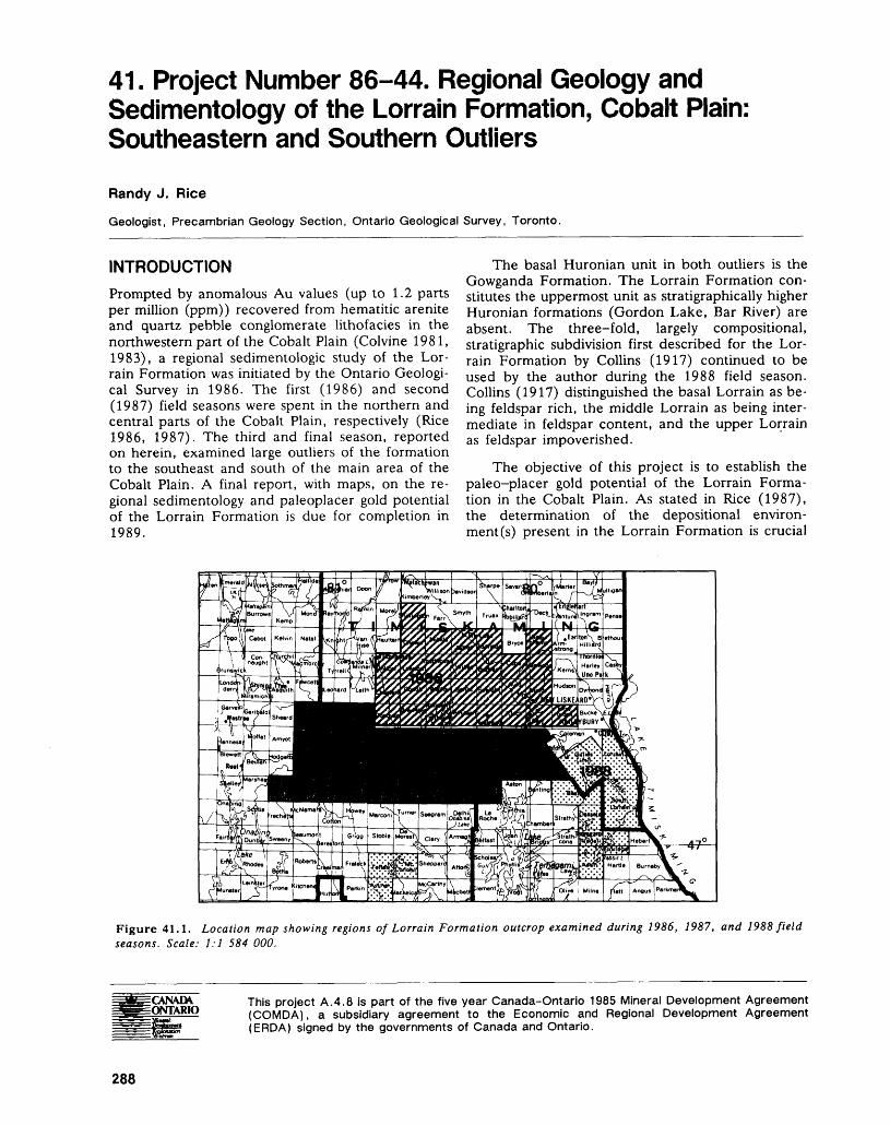
41. Project Number 86-44. Regional Geology and Sedimentology of the Lorrain Formation, Cobalt Plain: Southeastern and Southern Outliers
Randy J. Rice
Geologist, Precambrian Geology Section, Ontario Geological Survey, Toronto.
INTRODUCTIONPrompted by anomalous Au values (up to 1.2 parts per million (ppm)) recovered from hematitic arenite and quartz pebble conglomerate lithofacies in the northwestern part of the Cobalt Plain (Colvine 1981, 1983), a regional sedimentologic study of the Lor rain Formation was initiated by the Ontario Geologi cal Survey in 1986. The first (1986) and second (1987) field seasons were spent in the northern and central parts of the Cobalt Plain, respectively (Rice 1986, 1987). The third and final season, reported on herein, examined large outliers of the formation to the southeast and south of the main area of the Cobalt Plain. A final report, with maps, on the re gional sedimentology and paleoplacer gold potential of the Lorrain Formation is due for completion in 1989.
The basal Huronian unit in both outliers is the Gowganda Formation. The Lorrain Formation con stitutes the uppermost unit as stratigraphically higher Huronian formations (Gordon Lake, Bar River) are absent. The three-fold, largely compositional, stratigraphic subdivision first described for the Lor rain Formation by Collins (1917) continued to be used by the author during the 1988 field season. Collins (1917) distinguished the basal Lorrain as be ing feldspar rich, the middle Lorrain as being inter mediate in feldspar content, and the upper Lorrain as feldspar impoverished.
The objective of this project is to establish the paleo-placer gold potential of the Lorrain Forma tion in the Cobalt Plain. As stated in Rice (1987), the determination of the depositional environ ment (s) present in the Lorrain Formation is crucial
Figure 41.1. Location map showing regions of Lorrain Formation outcrop examined during 1986, 1987, and 1988 field seasons. Scale: 1:1 584 000.
CVNADX ONTARIO
This project A.4.8 is part of the five year Canada-Ontario 1985 Mineral Development Agreement (COMDA), a subsidiary agreement to the Economic and Regional Development Agreement (ERDA) signed by the governments of Canada and Ontario.
288
RANDY J. RICE
to this evaluation. If the Formation is predominantly or entirely fluvial, then heavy mineral accumulations and conglomerates should be the best exploration targets. Alternatively, if the Formation represents a siliciclastic shelf environment, it would be unusual for an economic concentration of a heavy mineral to develop given the dispersive effect of the interacting current regimes that characterize an open shelf set ting. Recently, however, placer accumulations have been reported from more restricted marine environ ments and attributed to intense sediment reworking in part due to storms (Rein and Syvitski 1988; Emory-Moore et al. 1988).
This report summarizes 1988 field work and presents 1987 analytical data (Au values) which could not be incorporated into Rice (1987). Ten sections were measured during the 1988 field sea son. In every instance, they were near vertical expo sures which were only workable through the safe ap plication of aid climbing techniques.
SUMMARY OF OBSERVATIONSThe Lorrain Formation was examined in two regions during the 1988 field season. A southeastern area, roughly bounded between Lady Evelyn Lake on the west and Lake Timiskaming on the east, incorpo rated several outliers of the Formation. A single, large, outlier of the Formation lying immediately north and northeast of Wanapitei Lake constitutes the second area investigated (Figure 41.1).
SOUTHEASTERN REGION
Lorrain Formation exposures in Kittson, Gillies Limit, Best, Cassels, Riddell, Askin, Eldridge, South Lorrain, and Lorrain townships were examined in this region. The work in Lorrain Township included reconnaissance (Ontario and Quebec shores) and section measuring along the Lake Timiskaming shoreline. One section was measured inland in Que bec, near Ville Marie. Exposures of both the basal and middle member of the Formation were exam ined in the southeastern region.
Basal Member
Lithofacies Description
Basal Conglomerate A basal Lorrain conglomerate unit has been previously described from Lorrain Township by Lovell and de Grijs (1976). During the past field season, this conglomerate was found at the granitic basement (Lorrain Granite, Thomson 1960) - Lorrain contact at three locations in Lorrain Township:1. on a northwest-southeast-trending ridge located
ea. 2 km south of Paradis Bay, Lake Timiskam ing
2. approximately l km north of Latour Lake
3. on the northeastern shore of Pine LakeThis unit is lithologically similar at all three loca
tions. It is a pink-green-grey-weathering, closed- work conglomerate that displays predominantly clast, and only local, matrix support. The percentage of matrix is variable but averages ea. 15 to 20 per cent. Matrix in the conglomerate is a pale green weathering, commonly poorly sorted, fine- to very coarse grained feldspathic arenite. Clasts are almost in all places subround to well rounded and range in size from pebble to boulder. Clast shape is predomi nantly subequant with a significant number of pro late clasts. Four lithic clast types are recognized at the Paradis Bay locality; in descending order of abundance they are:1. Pink-weathering granitic clasts ranging from
pebble to boulder size; these are round to well rounded, commonly have diffuse boundaries with the adjacent matrix, occasionally display weathering rinds, and are much more abundant than all other clast types combined.
2. Pale tan to greenish weathering, fine- to me dium-grained feldspathic arenite clasts; these are commonly in the pebble to cobble size range and are usually subround to round.
3. Maroon-weathering, subangular to well- rounded siltstone clasts commonly in the pebble size range (siltstone of the Firstbrook Member of the Gowganda Formation?).
4. Black-weathering (locally greenish), subroundto round ultramafic volcanic clasts commonly inthe pebble size range.The exposures north of Latour Lake and on
Pine Lake are not as clean as the Paradis Bay local ity. Although it is not clear that at these northern localities the variety of clast types is present, it is clear that granitic lithics also predominate at these locations.
Very little organization is displayed by the con glomerate. Clast grading and imbrication are absent. However, occasional lenses (several tens of cen timetres in length and ea. 5 to 20 cm thick) and thicker intervals (several tens of centimetres thick) of arenaceous matrix were observed, that in a few places display heavy mineral laminae and rippling.
The amount of matrix decreases toward the basement, as observed at Paradis Bay. The stratigraphically lowest exposures consist of large boulder size clasts of pink granitic basement display ing very diffuse margins with only thin stringers of intervening matrix. No organization is displayed at this stratigraphic level.
At the Paradis Bay locality, the contact between the basal conglomerate and the overlying Lorrain arenites is not exposed. However, a transitional arenite containing lenses and horizons of pebble size granitic lithics is present along a power line running between exposures of the basal conglomerate and overlying arenite. It is therefore inferred that the
289
PRECAMBRIAN (41)
contact is transitional and conformable. Lovell and de Grijs (1976, p.6) described the contact as con formable and either transitional or sharp at other lo calities. The basal Lorrain conglomerate unit ap pears to be widespread in Lorrain Township.
Arenite The arenite portion of the basal member of the Lorrain Formation is commonly encountered throughout the southeastern region of the Cobalt Plain, and is consistent in its lithological makeup. It is composed of a predominantly pink- to grey- weathering, locally pale greenish weathering, grey or occasionally green-grey, principally fine- to me dium-grained, locally very fine or coarse-grained, locally poorly sorted or moderate to well sorted, variably feldspathic arenite. While sedimentary structures are commonly encountered, significant ar eas of many exposures are non-stratified. Lamina tion and ripple cross-lamination, commonly accen tuated by heavy minerals, are the most common sedimentary structures. Less common sedimentary features are: granule to pebble lag accumulations as pockets, lenses, and horizons that are commonly only several centimetres or less thick; isolated gran ules and pebble size clasts of quartz and feldspar; variably well-defined normally graded units that are 5 to 20 cm thick; trough and planar tabular cross- bedding; rare grey siltstone rip-up clast horizons of several centimetres maximum thickness; rare convo luted stratification. No representative sequence of primary sedimentary structures could be established for arenite units defined in the basal Lorrain Forma tion.
The lithofacies sequence reported previously by Rice (1986, 1987) for the Lorrain Formation in the northern and central part of the Cobalt Plain is also present in the basal Lorrain in the southeastern re gion. Arenite units in this area are commonly ten centimetres to several metres thick and characteristi cally separated by either a usually greenish weather ing, slightly micaceous, finer grained arenite/coarse siltstone lens that is centimetres to several tens of centimetres thick and commonly several metres in length, or separated by an amalgamation surface representing the erosional removal of the finer grained lens during the emplacement of the overly ing arenite body. These finer grained lenses have been previously referred to as finer grained capping units (feu) by Rice (1986, 1987), since the character of their basal contact with the underlying coarser arenite is most commonly either gradational or sharp while that of their upper contact is usually erosional. The feu are characteristically featureless but occa sionally will display ripple cross-lamination or iso lated quartz and feldspar granules. The feu were not always present in the basal Lorrain arenite. They were absent along the eastern shore of Rib Lake and Rabbit Lake, at Crowrock Bay on Anima Nipissing Lake, and along the northeastern shore of Pine Lake. While their absence on Pine Lake may only be apparent due to the poor nature of the exposures,
their absence at the other localities may be a func tion of the proximity to the contact with the Firstbrook Member of the Gowganda Formation. The section measured on Rabbit Lake and at Crowrock Bay on Anima Nipissing Lake were both in the Firstbrook-Lorrain transition zone and. the Rib Lake exposures were proximal to this zone as well. It may be that Lorrain depositional conditions need to be fully established before this lithofacies sequence develops. However, it appears that the ra pidity of the development of such conditions was variable since feu are present in the basal Lorrain arenite within several metres of the contact with the Firstbrook at the Kit Ravine locality in Kittson Township.
Middle MemberLithofacies Description
Arenite The middle Lorrain arenite is common throughout the southeastern region of the Cobalt Plain. In general, it is less feldspathic and coarser grained than the basal arenite. The middle arenite is predominantly green-white to green-grey on both weathered and fresh surfaces. Weathered surfaces can also be grey-white or pinkish-white and fresh surfaces will locally display a grey or green colour. It is dominantly medium to coarse grained, but locally contains finer or coarser sand sized detritus. Sorting is commonly poor, but moderate to well-sorted ex posures are also present.
Sedimentary structures are more abundant in the middle arenite than they are in the basal arenite. Again, no characteristic assemblage was identified. The most common sedimentary features encoun tered are: isolated quartz and feldspar clasts; lenses or horizons of granule to lower pebble size quartz and feldspar lag occasionally containing slightly smaller jasper clasts or granitic lithics; variably well- defined normally graded units commonly 5 to 20 cm thick; ripple cross-lamination; and heavy mineral lamination. Less commonly encountered sedimen tary structures or features include: planar tabular and trough cross-bedding; foreset grading; and siltstone clasts.
The lithofacies sequence described above for the basal arenite is also present in the middle arenite (Photo 41.1). The feu in the middle arenite tend to be darker green in colour and to display more sedi mentary features; these include: isolated quartz and feldspar granules; lenses of coarser grained sand sized detritus; heavy mineral lamination; ripple cross-lamination; asymmetrical waveforms along the top contact with the overlying coarser arenite; nor mally graded units several centimetres thick; and rare small-scale planar tabular cross-strata. The ge ometry and scale of the feu in the middle arenite are similar to that reported for the basal arenite. Feu are present at all exposures of the middle arenite exam ined during the 1988 field season. A measured sec tion from the middle member arenite in Lorrain
290
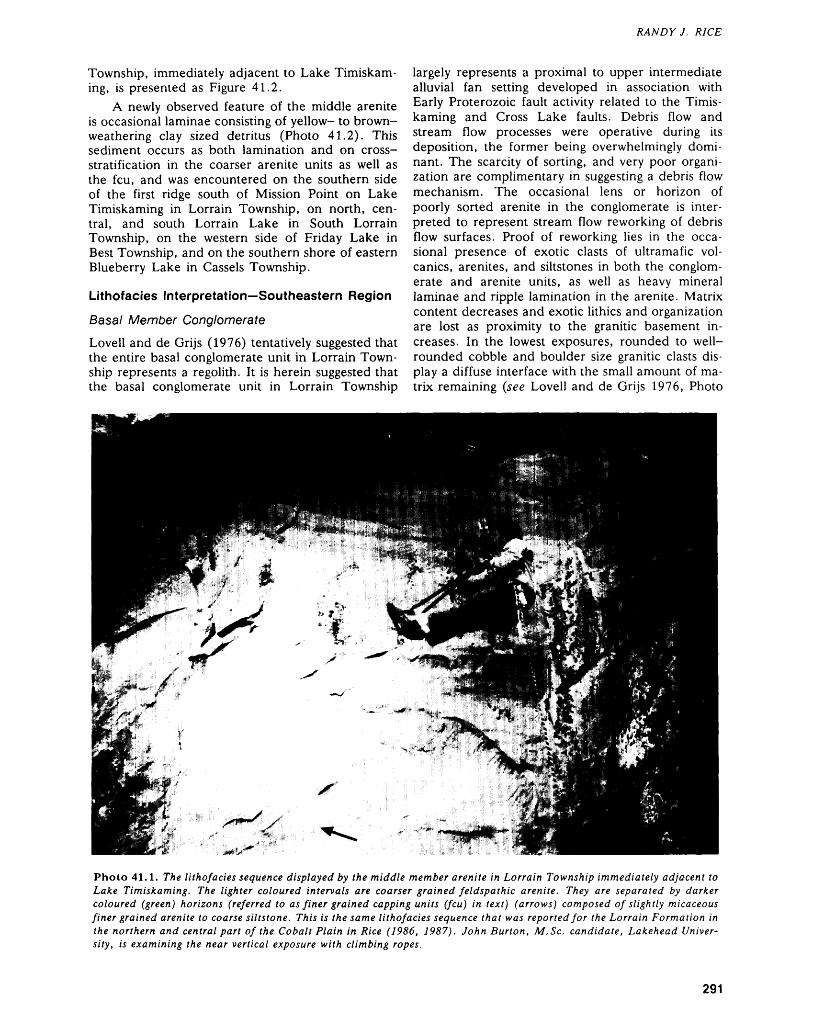
Township, immediately adjacent to Lake Timiskam ing, is presented as Figure 41.2.
A newly observed feature of the middle arenite is occasional laminae consisting of yellow- to brown- weathering clay sized detritus (Photo 41.2). This sediment occurs as both lamination and on cross- stratification in the coarser arenite units as well as the feu, and was encountered on the southern side of the first ridge south of Mission Point on Lake Timiskaming in Lorrain Township, on north, cen tral, and south Lorrain Lake in South Lorrain Township, on the western side of Friday Lake in Best Township, and on the southern shore of eastern Blueberry Lake in Cassels Township.
Lithofacies Interpretation—Southeastern Region
Basal Member Conglomerate
Lovell and de Grijs (1976) tentatively suggested that the entire basal conglomerate unit in Lorrain Town ship represents a regolith. It is herein suggested that the basal conglomerate unit in Lorrain Township
RANDY J. RICE
largely represents a proximal to upper intermediate alluvial fan setting developed in association with Early Proterozoic fault activity related to the Timis kaming and Cross Lake faults. Debris flow and stream flow processes were operative during its deposition, the former being overwhelmingly domi nant. The scarcity of sorting, and very poor organi zation are complimentary in suggesting a debris flow mechanism. The occasional lens or horizon of poorly sorted arenite in the conglomerate is inter preted to represent stream flow reworking of debris flow surfaces. Proof of reworking lies in the occa sional presence of exotic clasts of ultramafic vol canics, arenites, and siltstones in both the conglom erate and arenite units, as well as heavy mineral laminae and ripple lamination in the arenite. Matrix content decreases and exotic lithics and organization are lost as proximity to the granitic basement in creases. In the lowest exposures, rounded to well- rounded cobble and boulder size granitic clasts dis play a diffuse interface with the small amount of ma trix remaining (see Lovell and de Grijs 1976, Photo
Photo 41.1. The lithofacies sequence displayed by the middle member arenite in Lorrain Township immediately adjacent to Lake Timiskaming. The lighter coloured intervals are coarser grained feldspathic arenite. They are separated by darker coloured (green) horizons (referred to as finer grained capping units (feu) in text) (arrows) composed of slightly micaceous finer grained arenite to coarse siltstone. This is the same lithofacies sequence that was reported for the Lorrain Formation in the northern and central part of the Cobalt Plain in Rice (1986, 1987). John Burton, M.Se. candidate, Lakehead Univer sity, is examining the near vertical exposure with climbing ropes.
291
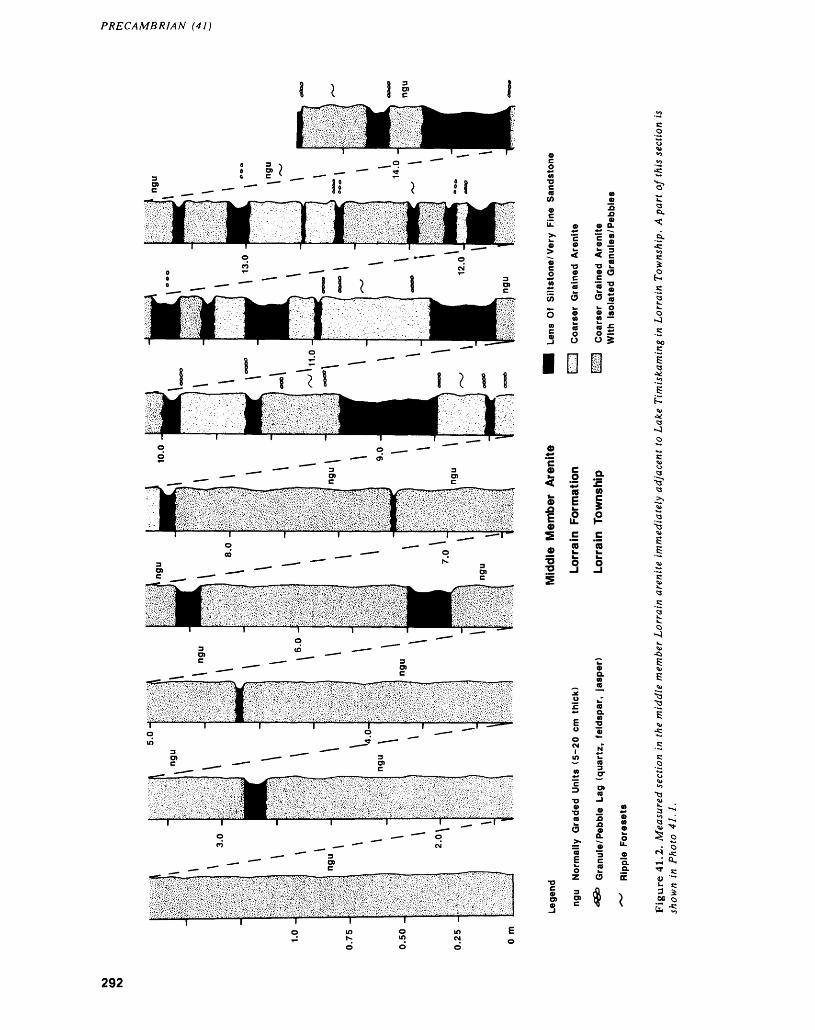
PRECAMBRIAN (41)
C -*" 2
1 -s2 M55 o
o 2
•o o
™ o O S
O 2205
lil
III. ra w o5 E E-Q *- 5
^ oTS J
S o-
M Q
292
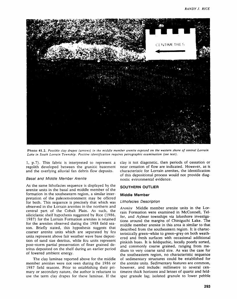
RANDY J. RICE
Photo 41.2. Possible day drapes (arrows) in the middle member arenite exposed on the western shore of central Lorrain Lake in South Lorrain Township. Positive identification requires petrographic examination (see text).
l, p.7). This fabric is interpreted to represent a regolith developed between the granitic basement and the overlying alluvial fan debris flow deposits.
Basal and Middle Member Arenite
As the same lithofacies sequence is displayed by the arenite units in the basal and middle member of the formation in the southeastern region, a similar inter pretation of the paleoenvironment may be offered for both. This sequence is precisely that which was observed in the Lorrain arenites in the northern and central part of the Cobalt Plain. As such, the siliciclastic shelf hypothesis suggested by Rice (1986, 1987) for the Lorrain Formation arenites is retained for the arenites observed during the 1988 field sea son. Briefly stated, this hypothesis suggests that coarser arenite units which are separated by feu units represent above fair weather wave base deposi tion of sand size detritus, while feu units represent post-storm partial preservation of finer grained de tritus deposited on the shelf during an earlier period of lowered ambient energy.
The clay laminae reported above for the middle member arenites were not seen during the 1986 or 1987 field seasons. Prior to establishing their pri mary or secondary nature, the author is reluctant to use the term clay drapes for these laminae. If the
clay is not diagenetic, then periods of cessation or near cessation of flow are indicated. However, as is characteristic for Lorrain arenites, the identification of this depositional process would not provide diag nostic evironmental evidence.
SOUTHERN OUTLIER
Middle MemberLithofacies Description
Arenite Middle member arenite units in the Lor rain Formation were examined in Mcconnell, Tel fer, and Aylmer townships via lakeshore investiga tions around the margins of Chiniguchi Lake. The middle member arenite in this area is similar to that described from the southeastern region. It is charac teristically green-white to green-grey on both weath ered and fresh surfaces with occasional additional pinkish hues. It is feldspathic, locally poorly sorted, and commonly coarse grained, ranging from me dium to very coarse sand size. As was the case for the southeastern region, no characteristic sequence of sedimentary structures could be established for the arenite units. Sedimentary features are common, however, and include: millimetre to several cen timetre thick horizons and lenses of quartz and feld spar granule lag; isolated granule to lower pebble
293
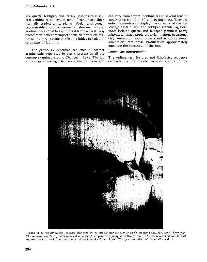
PRECAMBRIAN (41)
size quartz, feldspar, and, rarely, jasper clasts; sev eral centimetre to several tens of centimetre thick normally graded units; planar tabular and trough cross-stratification occasionally showing foreset grading; occasional heavy mineral laminae; relatively uncommon penecontemporaneous deformation fea tures; and rare granitic or siltstone lithics in isolation or as part of lag units.
The previously described sequence of coarser arenite units separated by feu is present in all the outcrop examined around Chiniguchi Lake. The feu in this region are light to dark green in colour and
can vary from several centimetres to several tens of centimetres (to 40 to 50 cm) in thickness. They are either featureless or display one or more of the fol lowing: basal quartz and feldspar granule lag hori zons; isolated quartz and feldspar granules; heavy mineral laminae; ripple cross-lamination; occasional clay laminae on ripple foresets and as subhorizontal lamination; rare cross stratification approximately equalling the thickness of the feu.
Lithofacies Interpretation
The sedimentary features and lithofacies sequence displayed by the middle member arenite in the
Photo 41.3. The lithofacies sequence displayed by the middle member arenite on Chiniguchi Lake, McConnell Township. The recessive weathering units (arrows) represent finer grained capping units (feu in text). This sequence is similar to that observed in Lorrain Formation arenites throughout the Cobalt Plain. The upper recessive unit is ea. 45 cm thick.
294
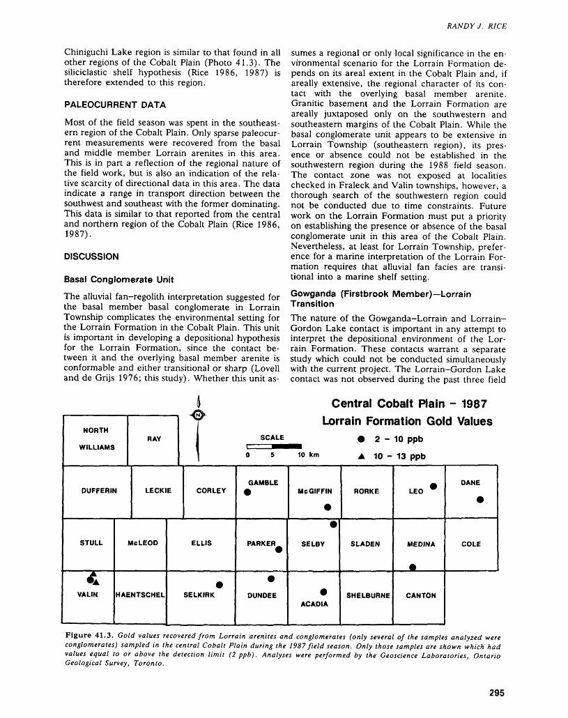
Chiniguchi Lake region is similar to that found in all other regions of the Cobalt Plain (Photo 41.3). The siliciclastic shelf hypothesis (Rice 1986, 1987) is therefore extended to this region.
PALEOCURRENT DATA
Most of the field season was spent in the southeast ern region of the Cobalt Plain. Only sparse paleocur rent measurements were recovered from the basal and middle member Lorrain arenites in this area. This is in part a reflection of the regional nature of the field work, but is also an indication of the rela tive scarcity of directional data in this area. The data indicate a range in transport direction between the southwest and southeast with the former dominating. This data is similar to that reported from the central and northern region of the Cobalt Plain (Rice 1986, 1987).
DISCUSSION
Basal Conglomerate Unit
The alluvial fan-regolith interpretation suggested for the basal member basal conglomerate in Lorrain Township complicates the environmental setting for the Lorrain Formation in the Cobalt Plain. This unit is important in developing a depositional hypothesis for the Lorrain Formation, since the contact be tween it and the overlying basal member arenite is conformable and either transitional or sharp (Lovell and de Grijs 1976; this study). Whether this unit as-
RANDY J. RICE
sumes a regional or only local significance in the en vironmental scenario for the Lorrain Formation de pends on its areal extent in the Cobalt Plain and, if areally extensive, the regional character of its con tact with the overlying basal member arenite. Granitic basement and the Lorrain Formation are areally juxtaposed only on the southwestern and southeastern margins of the Cobalt Plain. While the basal conglomerate unit appears to be extensive in Lorrain Township (southeastern region), its pres ence or absence could not be established in the southwestern region during the 1988 field season. The contact zone was not exposed at localities checked in Fraleck and Valin townships, however, a thorough search of the southwestern region could not be conducted due to time constraints. Future work on the Lorrain Formation must put a priority on establishing the presence or absence of the basal conglomerate unit in this area of the Cobalt Plain. Nevertheless, at least for Lorrain Township, prefer ence for a marine interpretation of the Lorrain For mation requires that alluvial fan facies are transi tional into a marine shelf setting.
Gowganda (Firstbrook Member)—Lorrain TransitionThe nature of the Gowganda-Lorrain and Lorrain- Gordon Lake contact is important in any attempt to interpret the depositional environment of the Lor rain Formation. These contacts warrant a separate study which could not be conducted simultaneously with the current project. The Lorrain-Gordon Lake contact was not observed during the past three field
Central Cobalt Plain - 1987
NORTH
WILLIAMS
DUFFERIN
STULL
^VALIN
RAY
LECKIE
MCLEOD
HAENTSCHEL
' Lorrain Formation Gold ValuesSCALE * 2-10 ppb
0 5 10 km A 10 - 13 ppb
CORLEY
ELLIS
9SELKIRK
GAMBLE*
PARKER
9
DUNDEE
MCGIFFIN
t
0
SELBY
9
ACADIA
RORKE
SLADEN
SHELBURNE
LEO *
MEDINA
*
CANTON
DANE
ft
COLE
Figure 41.3. Gold values recovered from Lorrain arenites and conglomerates (only several of the samples analyzed were conglomerates) sampled in the central Cobalt Plain during the 1987 field season. Only those samples are shown which had values equal to or above the detection limit (2 ppb). Analyses were performed by the Geoscience Laboratories, Ontario Geological Survey, Toronto.
295
PRECAMBRIAN (41)
seasons in the Cobalt Plain. The Gowganda-Lorrain contact was observed in the southeastern outlier at three locations: Kit Ravine - Kittson Township; Crowrock Bay of Anima Nipissing Lake - Kittson Township; and Rabbit Lake — Eldridge Township. On Crowrock Bay and on Rabbit Lake, the contact is conformable and transitional. At Kit Ravine, the contact is transitional as well, with some erosion due to a flow event which occurred in early Lorrain time locally eroding down into the Firstbrook Member of the Gowganda Formation. The transitional nature of this contact is herein considered more supportive of a marine rather than a fluvial depositional setting for the Lorrain Formation in light of the current marine deltaic depositional model suggested for the Firstbrook Member of the Gowganda Formation (Junnila 1986; Rainbird and Donaldson 1988). Rainbird and Donaldson (1988) used the transi tional contact to suggest that the overlying Lorrain Formation is the subaerial braidplain pan of a del taic wedge. However, it is here suggested that a lat eral facies shift in association with subsidence re sulted in a Lorrain shelf overlying a Firstbrook ma rine delta. Since the Firstbrook delta had to have prograded onto a shelf, it is just as reasonable to suggest the presence of laterally equivalent shelf facies as it is for Rainbird and Donaldson (1988) to suggest laterally equivalent subaerial deltaic facies. Born and Burbidge (1987) presented evidence of apparent interfingering of Firstbrook and Lorrain facies on Anima Nipissing Lake in Brigstocke Town ship.
LABORATORY RESULTS
The results of analyses for gold by the Geoscience Laboratories, Ontario Geological Survey, Toronto, on samples collected during the 1987 field season are presented in Figure 41.3. This figure indicates that values range only between 2 and 13 ppb. While most of the samples analyzed were arenites, several quartz granule-pebble conglomerate samples are also represented in this figure.
REFERENCESBorn, P., and Burbidge, G.H.1987: Geology of Brigstocke and Kittson Townships, District
of Timiskaming; p. 198-204 in Summary of Field Work and Other Activities 1987, by the Ontario Geo logical Survey, edited by R.B. Barlow, M.E. Cherry, A.C. Colvine, Burkhard O. Dressler, and Owen L. White, Ontario Geological Survey, Miscellaneous Paper 137, 429p.
Collins, W.H.1917: Onaping Map-Area; Canada Department of Mines,
Geological Survey Memoir 95, 157p. Accompanied by Map 179A, scale 1:253 440 or l inch to 4 miles.
Colvine, A.C.1981: Reconnaissance of the Lorrain Formation, Northern
Cobalt Embayment; p. 187-189 in Summary of Field Work 1961, by the Ontario Geological Survey, edited by John Wood, Owen L. White, R.B. Barlow, and A.C. Colvine, Ontario Geological Survey, Miscella neous Paper 100, 255p.
1983: Mineral Deposit Studies in the Huronian Supergroup; p.235-255 in Summary of Field Work 1983, by the Ontario Geological Survey, edited by John Wood, Owen L. White, R.B. Barlow, and A.C. Colvine, Ontario Geological Survey, Miscellaneous Paper 116, 313p.
Emory-MNoore, M., Barrie, J.V., and Solomon, S.1988: Modelling of Two Heavy Mineral Placer Deposits on
the Canadian Continental Shelf; Geological Associa tion of Canada, Mineralogical Association of Can ada, Canadian Society of Petroleum Geologists, Joint Annual Meeting, 1988, Program with Abstracts, Vol ume 13, p.A37.
Hein, F.J., and Syvitski, James P.M.1988: Evolution of Sept. Iles Delta Complexes and Shallow
Marine Placer, North Shore of Gulf of St. Lawrence, Quebec; Geological Association of Canada, Minera logical Association of Canada, Canadian Society of Petroleum Geologists, Joint Annual Meeting, 1988, Program with Abstracts, Volume 13, p.A54.
Junnila, R.1986: Stratigraphy and Sedimentology of the Upper Gow
ganda Formation near Whitefish Falls, Ontario; Un published M.Se. Thesis, The University of Western Ontario, London, Ontario, 168p.
Lovell, H.L., and de Grijs, J.W.1976: Lorrain Township, Southern Part, Concessions I to
VI, District of Timiskaming; Ontario Division of Mines, Miscellaneous Paper 51, 16p. Accompanied by Chart A, scale 1:15 840 or l inch to 1/4 mile.
Rainbird, R.H., and Donaldson, J.A.1988: Nonglaciogenic Deltaic Deposits in the Early
Proterozoic Gowganda Formation, Cobalt Basin, Ont ario; Canadian Journal of Earth Sciences, Volume 25, p.710-724.
Rice, R.J.1986: Regional Sedimentology of the Lorrain Formation
(Aphebian), Northern Cobalt Embayment; p.297-303 in Summary of Field Work and Other Ac tivities 1986, by the Ontario Geological Survey, edited by P.C. Thurston, Owen L. White, R.B. Barlow, M.E. Cherry, and A.C. Colvine, Ontario Geological Survey, Miscellaneous Paper 132, 435p.
1987: Regional Sedimentology of the Lorrain Formation (Aphebian), Central Cobalt Embayment; p.210-216 in Summary of Field Work and Other Activities 1987, by the Ontario Geological Survey, edited by R.B. Bar low, M.E. Cherry, A.C. Colvine, Burkhard O. Dressler, and Owen L. White, Ontario Geological Survey, Miscellaneous Paper 137, 429p.
Thomson, R.1960: Preliminary Report on the Geology of the North Part
of Lorrain Township (Concessions VII to XII) District of Timiskaming; Ontario Department of Mines, Pre liminary Report 1960-1, 60p.
296
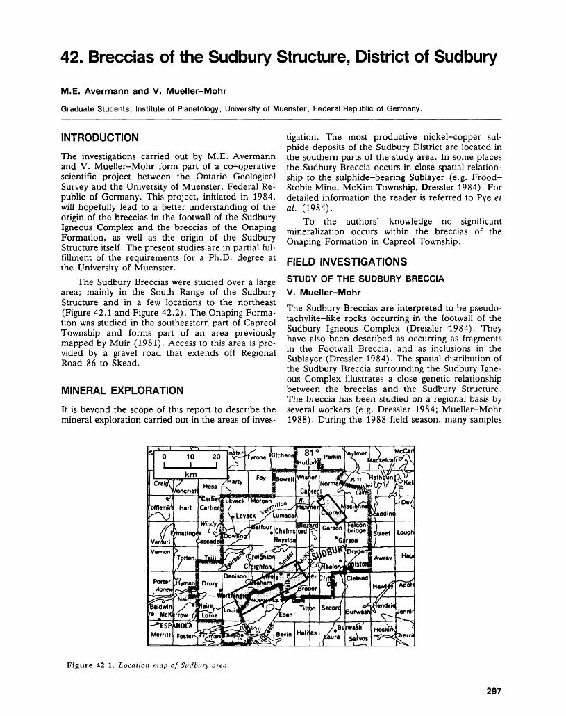
42. Breccias of the Sudbury Structure, District of Sudbury
M.E. Avermann and V. Mueller-Mohr
Graduate Students, Institute of Planetology, University of Muenster, Federal Republic of Germany.
INTRODUCTIONThe investigations carried out by M.E. Avermann and V. Mueller-Mohr form part of a co-operative scientific project between the Ontario Geological Survey and the University of Muenster, Federal Re public of Germany. This project, initiated in 1984, will hopefully lead to a better understanding of the origin of the breccias in the footwall of the Sudbury Igneous Complex and the breccias of the Onaping Formation, as well as the origin of the Sudbury Structure itself. The present studies are in partial ful fillment of the requirements for a Ph.D. degree at the University of Muenster.
The Sudbury Breccias were studied over a large area; mainly in the South Range of the Sudbury Structure and in a few locations to the northeast (Figure 42.1 and Figure 42.2). The Onaping Forma tion was studied in the southeastern part of Capreol Township and forms part of an area previously mapped by Muir (1981). Access to this area is pro vided by a gravel road that extends off Regional Road 86 to Skead.
MINERAL EXPLORATIONIt is beyond the scope of this report to describe the mineral exploration carried out in the areas of inves
tigation. The most productive nickel-copper sul phide deposits of the Sudbury District are located in the southern parts of the study area. In some places the Sudbury Breccia occurs in close spatial relation ship to the sulphide-bearing Sublayer (e.g. Frood- Stobie Mine, McKim Township, Dressler 1984). For detailed information the reader is referred to Pye et al. (1984).
To the authors' knowledge no significant mineralization occurs within the breccias of the Onaping Formation in Capreol Township.
FIELD INVESTIGATIONSSTUDY OF THE SUDBURY BRECCIA V. Mueller-MohrThe Sudbury Breccias are interpreted to be pseudo- tachylite-like rocks occurring in the footwall of the Sudbury Igneous Complex (Dressler 1984). They have also been described as occurring as fragments in the Footwall Breccia, and as inclusions in the Sublayer (Dressler 1984). The spatial distribution of the Sudbury Breccia surrounding the Sudbury Igne ous Complex illustrates a close genetic relationship between the breccias and the Sudbury Structure. The breccia has been studied on a regional basis by several workers (e.g. Dressler 1984; Mueller-Mohr 1988). During the 1988 field season, many samples
Figure 42.1. Location map of Sudbury area.
297
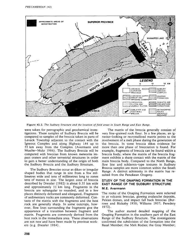
PRECAMBRIAN (42)
HURONIAN SUPER GROUP AND NIPISSING GABBRO
Figure 42.2. The Sudbury Structure and the location of field areas in South Range and East Range.
were taken for petrographic and geochemical inves tigations. These samples of Sudbury Breccia will be compared to samples of the breccia taken in parts of Levack Township adjacent to the contact with the Igneous Complex and along Highway 144 up to 55 km away from the Complex (Avermann and Mueller-Mohr 1986). The Sudbury Breccia will be compared with breccias from known meteorite im pact craters and other terrestrial structures in order to gain a better understanding of the origin of both the Sudbury Breccia and the Sudbury Structure.
The Sudbury Breccias occur as dikes or irregular shaped bodies that range in size from a few mil limetres wide and tens of millimetres long to zones tens of metres in size. The largest zone of breccia described by Dressler (1982) is about 0.35 km wide and approximately 11 km long. Fragments in the breccia are subangular to rounded, and in a few places distinctly deformed and elongated. Fragments of sedimentary rocks are commonly deformed. Con tacts of the matrix with the fragments and the host rock are generally sharp. In some outcrops, how ever, flow lines surrounding the fragments give the appearance of a transition between fragment and matrix. Fragments are commonly derived from the host rock in the immediate area. These observations are not new and have been made by previous work ers (e.g. Dressler 1984).
The matrix of the breccia generally consists of very fine-grained rock flour. In a few places, an ig neous-looking or recrystallized matrix points to the involvement of a melt phase during the generation of the breccia. In some breccia dikes evidence for more than one phase of brecciation is found. For example, fragments of breccia can be found within a breccia body; where the matrix of the breccia frag ment exhibits a sharp contact with the matrix of the main breccia body. Compared to the North Range, flow line and schlieren-type textures in Sudbury Breccia samples are more common within the South Range. A distinct schistosity in the matrix has re sulted from the Penokean Orogeny.
STUDY OF THE ONAPING FORMATION IN THE EAST RANGE OF THE SUDBURY STRUCTUREM.E. AvermannThe rocks of the Onaping Formation were referred to as volcanic breccias, glowing avalanche deposits, Pelean domes, and impact fall back breccias (Bur rows and Rickaby 1930; Williams 1957; Peredery 1972).
The author started detailed mapping of the Onaping Formation in the southern part of the East Range of the Sudbury Structure. The investigations confirmed the subdivision of the formation into the Basal Member; the Melt Bodies; the Gray Member;
298
M.E. AVERMANN AND V. MUELLER-MOHR
and the Black Member (Peredery 1972; Muir and Peredery 1984).
The contacts of the Basal Member with the granophyre of the Upper Zone of the Sudbury Igne ous Complex and with the plagioclase-rich grano phyre are intrusive, but in places gradational. Due to the contact metamorphic overprinting by the Sud bury Igneous Complex, the matrix of the Basal Member has a pinkish-gray colour, and some leuco cratic fragments (such as granitic and arkosic frag ments) readily show contact metamorphic features.
Attempts were made to characterize the frag ment population; the abundance and size of frag ments in each mappable unit of the Onaping Forma tion; and to compare the rock fragments with the footwall rocks of the Sudbury Structure.
Shock metamorphic features were recognized within both the Melt Bodies and the Gray and Black members. Within the Gray Member, contacts were noted and were traceable over short distances (Muir and Peredery 1984). The contact between the Black Member and the Gray Member is not easy to define everywhere. The chlorite shard horizon (Muir and Peredery 1984) is poorly developed or absent within the study area. Both fragment size and the abun dance of country rock fragments decrease upwards in the Black Member. The carbon content, how ever, increases and is responsible for the dark colour of this breccia unit (Muir and Peredery 1984). The contact between the Onaping Formation and the overlying mudstones of the Onwatin Formation is gradational, as has been described at other places within the Sudbury Structure (Pye et al. 1984). Dur ing the field work, a large number of specimens were taken for petrographic and geochemical investiga tion. The study of shock metamorphic features, and the geochemistry of breccia matrices and fluidal glasses will be of interest.
The authors gratefully acknowledge the assis tance obtained during the field investigations from the management and the geological staff of Fal conbridge Limited and Inco Limited.
Avermann, M.E., and Mueller-Mohr, V.1986: Contact Metamorphism of the Footwall Rocks and
Sudbury Breccias in Levack and Cartier Townships, District of Sudbury; p. 125-126 in Summary of Field Work and Other Activities 1986, Ontario Geological Survey, edited by P.C. Thurston, Owen L. White, R.B. Barlow, M.E. Cherry, and A.C. Colvine, On
tario Geological Survey, Miscellaneous Paper 132, 436p.
Burrows, A.G., and Rickaby, H.C.1930: Sudbury Basin Area; Ontario Department of Mines,
Annual Report for 1929, Volume 38, Part 3, p. 1-51.Dressler, B.O.1982: Footwall of the Sudbury Igneous Complex, District of
Sudbury; p.73-75 in Summary of Field Work 1982, by Ontario Geological Survey, edited by John Wood, Owen L. White, R.B. Barlow, and A.C. Colvine, Ontario Geological Survey, Miscellaneous Paper 106, 235p.
1984: The Effects of the Sudbury Event and the Intrusion of the Sudbury Igneous Complex on the Footwall Rocks of the Sudbury Structure; p.97-136 in The Geology and Ore Deposits of the Sudbury Structure, edited by E.G. Pye, A.J. Naldrett, and P.E. Giblin, Ontario Geological Survey, Special Volume l, 603p. Accom panied by Map 2491, at a scale of 1:50 000, Map ML-16/17 - AM Sudbury, at a scale of 1:1 000 000, and 3 charts.
Mueller-Mohr, V.1988: Geologische Kartierung im zentralen Teit von Levack
Township, Sudbury-Distrikt (Ontario/Kanada), und die Untersuchung der Sudbury Breccie im Norden der Sudbury-Struktur; Petrographic und Verbreitung entlang eines Profils in der North Range der Struktur; M.Se. Thesis, University of Muenster, Muenster, 44 * 62p.
Muir, T.L.1981: Geology of the Capreol Area, District of Sudbury; On
tario Geological Survey, Open File Report 5344, 168p.
Muir, T.L., and Peredery, W.V.1984: The Onaping Formation; p. 139-210 in The Geology
and Ore Deposits of the Sudbury Structure, edited by E.G. Pye, A.J. Naldrett, and P.E. Giblin, Ontario Geological Survey, Special Volume l, 603p. Accom panied by Map 2491, at a scale of 1:50 000, Map NL-16/17 - AM Sudbury, at a scale of 1:1 000 000, and 3 charts.
Peredery, W.V.1972: The Origin of Rocks at the Base of the Onaping For
mation, Sudbury, Ontario; Unpublished Ph.D. The sis, University of Toronto, Toronto, 366p.
Pye, E.G., Naldrett, A.J., and Giblin, P.E. (editors) 1984: The Geology and Ore Deposits of the Sudbury Struc
ture, Ontario Geological Survey, Special Volume l, 603p. Accompanied by Map 2491, scale 1:50 000, Map NL-16/17 - AM Sudbury, scale 1:1 000 000, and 3 Charts.
Williams, Rowell1957: Glowing Avalanche Deposits of the Sudbury Basin;
Ontario Department of Mines, Annual Report for1956, Volume 65, Part 3, p.57-89.
299
43. Project Number 88-05. Regional Mapping and Stratigraphic Studies, Grenville Province with some Notes on Mineralization Environments
R.M. Easton
Geologist, Precambrian Geology Section, Ontario Geological Survey, Toronto.
INTRODUCTION
A geological synthesis of the Grenville Province in Ontario is being undertaken as part of the Geology of Ontario project. This synthesis involves both the preparation of a series of 1:50 000 and 1:250 000 scale geological maps of the Grenville Province in Ontario, as well as a synthesis of the geology of the Grenville Province, particularly with respect to con trols on mineralization. Fieldwork in 1988 involved mapping related to the preparation of several 1:50 000 and 1:250 000 scale compilation maps, in addition to some regional studies that examined sev eral poorly known areas and structural features of the Grenville Province (Figure 43.1).
COMPILATION MAPPING
About a week was spent mapping in the McKellar area, in order to correlate lithologies and major structures within the northern part of the Parry Sound Domain. The McKellar area was originally mapped by Lacy (1960), and this field work will as sist in the preparation of a 1:50 000 scale compila tion map of the northern half of the Parry Sound Domain, incorporating the mapping of Bright (1987) and McRoberts and Tremblay (1988) of the Ontario Geological Survey and Davidson and co-workers at the Geological Survey of Canada (Davidson et al. 1982).
One week was spent mapping in the Tomiko- North Bay area in conjunction with the preparation of 1:250 000 scale compilation maps of the area. This area has been well-mapped at 1:63 360 scale by Lumbers (197la, 197Ib, 197le, 1973, 1975). No significant changes have been made to Lumbers' maps; however, the pattern of lithological units, structural trends, and location of major deformation zones in the area is analogous to the patterns present in the Parry Sound area, and a preliminary attempt was made to subdivide the Tomiko-North Bay area into a number of lithotectonic domains (Figure 43.2). Additional work is needed to define these do mains on a finer scale, and to study the nature of their boundaries more fully, particularly as some of the boundaries have been re-activated during fault ing associated with the Nippissing-Ottawa Valley Rift, whereas others are narrower than terrane
boundaries described in the Parry Sound area (Davidson et al. 1982).
In the River Valley and Tomiko areas, Lumbers (1971b, 1971c, 1973, 1978) defined the Red Cedar Lake Formation. This unit occurs as a band, up to 15 km wide, that lies immediately south of, and par allel to, the Grenville Front from River Valley to the Ottawa River (Figure 43.2). Lumbers (1978) inter preted this unit as an Early Proterozoic, con glomeratic greywacke sequence, possibly represent ing a turbidite fan system that developed on Ar chean basement at the edge of an Early Proterozoic continental margin. The unit was subsequently meta morphosed and deformed during the Grenville Orogeny.
The Red Cedar Lake Formation is a distinctive unit, best described as a granular gneiss. In places it appears to represent a series of deformed augen gneisses probably derived from deformed meta- plutonic rocks. Elsewhere, it can be termed a por phyroclastic gneiss (Davidson et al. 1982), derived from an undetermined protolith. Although Lumbers (1978) may indeed be correct in his interpretation of this unit, due to the extreme deformation and metamorphism, the protolith of these granular gneisses is for the most part problematic. However, the unit is distinctive, and mappable, and it is sug gested that the term Red Cedar Lake Formation be retained, but redefined as the Red Cedar Lake Gneiss, with reference sections on Red Cedar Lake, on Highway 805 and the CPR railway 0.5 km south of River Valley, and on Highway 11 between Mar ten River and Opechee Creek.
Field Work was also conducted for compilation of 1:50 000 scale maps of NTS areas 31C/10 (Tich- bourne), 31C/11 (Kaladar), 31C/14 (Mazinaw Lake), 31 EI l (Wilberforce), 31E/2 (Haliburton), and 31F/3 (Denbigh).
FRONTENAC-SHARBOT LAKE TERRANE BOUNDARYAbout ten days were spent mapping the Frontenac- Sharbot Lake Terrane Boundary in the area be tween Tichborne and Carleton Place (Figure 43.3) in order to better delineate this boundary, and to determine if units could be correlated across it. Al though this boundary separates granulite-facies
300
R. M, EASTON
Figure 43.1. Location map of study area in the Grenville Province.
metasedimentary rocks of the Frontenac Terrane to detailed study of this boundary had been previouslythe south from amphibolite-facies metasedimentary undertaken.and metavolcanic rocks of the Sharbot Lake Ter- The character of the boundary varies consider-rane to the north; and the approximate position of ablVj and the following discussion describes each ofthe boundary could be inferred from existing geo- three segments of the boundary; namely, the Tich-logic maps that included part of the boundary (Wolff1985; Wilson and Dugas 1961; Reinhardt 1973); no
301
PRECAMBRIAN (43)
GRENVILLE PROV. Proterozoic plutonic rocks unsubdivided Grenville gneisses Red Cedar Lake Gneiss
Grenville Front Boundary Fault
Archean and Proterozoic plutonic rocks
River valley Anorthosite Complex Archean plutonic rocks
SUPERIOR and SOUTHERN PROV.\TOMIKO
DOMAINunsubdivided Archean and
Proterozoic rocks
NEPEWASSI DOMAIN
LAKE: NIPISSING
Figure 43.2. Distribution of the Red Cedar Lake Gneiss and probable lithotectonic domains in the northern Grenville Province in Ontario. Distribution of Red Cedar Lake Gneiss after Lumbers (1978).
bourne-Sharbot Lake segment; the Maberly- Lanark segment, and the Carleton Place segment.
TICHBOURNE-SHARBOT LAKE SEGMENT
Between Tichbourne and Sharbot Lake, the bound ary is marked by a north-trending, 250 to 300 m wide zone of mafic to intermediate straight and irregularly layered gneisses, that dip 60 0 to 70 0 to the east. These gneisses separate a zone of upper amphibolite-grade marble and quartzofeldspathic gneisses of the Sharbot Lake Terrane to the west from granulite-grade marbles, gabbros, and grani toid augen gneisses of the Frontenac Terrane to the east. These straight gneisses are well exposed on Highway 38 between Parham and Tichbourne. In the vicinity of Sharbot Lake, a number of late, weakly deformed granodiorites and monzogranites cut across the straight gneiss zone, obscuring the boundary, although, as to the south, it appears to be a narrow band of straight and irregular gneisses that separate two distinct lithological sequences. North east of Sharbot Lake, a series of layered am phibolide rocks of the Sharbot Lake Terrane is jux taposed against a package of augen gneisses and gab broic to anorthositic rocks of the Lanark-Oso Gab
bro Body. Here again, the zone of intense deforma tion characterized by the presence of straight and porphyroclastic gneisses seems to be no more than 250 m wide, dipping 60 0 to 70 0 to the east-south east. Some of the layered amphibolites could be mis taken for straight gneisses, but similar rocks occur well to the west of the boundary in the Sharbot Lake Terrane, and as inclusions in the Lavant Gabbro Complex, suggesting that these rocks were layered before development of the Frontenac-Sharbot Lake Terrane boundary.
As noted by Wolff (1985), in the area between Sharbot Lake and Maberly, a number of fine- to medium-grained granodiorite to monzogranite bod ies have intruded the Frontenac-Sharbot Lake Ter rane boundary in a l to 2 km wide swath. These granitoid rocks appear to be less deformed than other rocks in the boundary zone; they cut across the straight gneisses, and are probably syn- to slightly post-tectonic.
MABERLY-LANARK SEGMENT
In the Maberly-Lanark segment, the Frontenac Terrane side of the boundary zone consists of a package of augen gneisses, marble breccia, diorites,
302
R. M. EASTON
Figure 43.3. Frontenac-Sharbot Lake Terrane Boundary between Tichbourne and Carleton Place, Grenville Province, eastern Ontario.
and quartzofeldspathic to quartzitic paragneisses, preserving granulite-facies assemblages. The Shar bot Lake Terrane side of the boundary zone consists mainly of calcitic marbles, with a few thin bands of rusty-weathering metasedimentary gneisses present locally near the contact with the Frontenac Terrane.
The boundary zone is only exposed at Maberly and at Fallbrook in this segment. At Maberly, straight gneisses are exposed both in Maberly and on Highway 7. The straight gneisses are mafic to inter mediate in composition, and locally contain rounded blocks of less-deformed anorthosite, gabbroic anor
thosite, and gabbro. These blocks are best observed in the outcrop in Maberly. The straight gneiss zone is only about 250 m wide, and seems to be derived mainly from rocks of the Frontenac Terrane. In Maberly, the straight gneisses of the boundary zone are in sharp (probably thrust-faulted) contact with rusty-weathering metasedimentary rocks of the Sharbot Lake Terrane along the Fall River.
Metamorphic and deformational effects appar ently related to the boundary, extend several kilometres into the Sharbot Lake Terrane. About 3 km north of the contact, bedding and sedimentary
303
PRECAMBRIAN (43)
features are preserved in marbles. As the boundary is approached, bedding is transposed into layering, and grain size increases. At l to 1.5 km from the contact, the marbles become massive, coarse- grained, and granoblastic. Secondary shear zones re lated to the boundary do not seem to carry far into the Sharbot Lake Terrane however, as a gabbro body located north of Maberly on Lanark County Road 12 only 500 m north of the boundary is un- deformed, and does not contain any small-scale shears or other structural features that could be at tributed to the boundary.
About l km east of McGowan Lake on High way 7 (UTM 1ST, E383050, N4967025), in an area of the Frontenac Terrane underlain by a mixture of marble, tectonic breccia, and more massive marble, is a band of almost pure, massive, white diopside, about 1.5 m wide, exposed over an outcrop length of 20 M. Identification of this material has been confirmed by X-ray diffraction at the Geoscience Laboratories, Ontario Geological Survey. Diopside is a valuable industrial mineral; a source of fibrous rock material that can be used in plastics, cements, and refractory products. Diopside is mined in Que bec near Wakefield (Easton et al. 1986); there is no producer in Ontario.
CARLETON PLACE SEGMENT
Between Lanark and Carleton Place, the boundary again changes. Here it runs through a wide band of marbles, and because of poor exposure, it is difficult to precisely define the boundary, although it is prob ably no more than 250 to 500 m wide. On Ramsay Township Concession Road 6 (UTM 1ST, E406000, N500975), mafic and felsic straight gneisses, and a small granitic augen gneiss unit are exposed along the trace of the boundary. The mafic straight gneiss may be derived from gabbroic and amphibolitic rocks of the Sharbot Lake Terrane, and the augen gneiss resembles the augen gneisses found along the boundary between Maberly and Lanark. Within the Sharbot Lake Terrane, bedding in the marbles is well preserved 2 to 3 m north of the boundary. As the boundary is approached, bedding in the marbles is transposed into a weak layering, grain size in creases, and within l km of the boundary, the mar bles are massive and granoblastic. In the am- phibolites, relict gabbroic textures gradually become obliterated toward the boundary, and layering be comes more prominent. Marbles on the Frontenac side of the boundary are more graphitic and phlogopitic than those present to the north, and are interbedded with quartz arenites and quartzo- feldspathic gneisses, both of which are absent north of the boundary.
SUMMARY
As the result of this study, a few general statements can be made about the Frontenac-Sharbot Lake Terrane boundary:
1. The boundary with the Sharbot Lake Terrane is sharp, and deformation along the contact is mainly restricted to a zone roughly 250 m wide. This zone consists of straight and irregular gneisses (annealed mylonites).
2. Metamorphic effects cross the zone, and may extend several kilometres into the Sharbot Lake Terrane. Granulite-facies metamorphism seems to be contained mainly in the Frontenac Ter rane. This may indicate the boundary developed prior to peak metamorphism.
3. The boundary juxtaposes two distinct lithological sequences.
4. Locally, the zone is cut by syn- to post-tectonic granitic intrusions.
5. At present, no lithologies can be correlated across the boundary.
EXTENSION OF THE ROBERTSON LAKE MYLONITE ZONESmith (1958) initially defined the Robertson Lake Shear Zone as a deformation zone present near Robertson Lake in eastern Ontario. Subsequent workers, notably Jackson (1980), Carter (1981), and Pauk (1984a, 1984b) extended this zone to the north and south of Robertson Lake, and docu mented several copper-gold-antimony occurrences along the zone. Easton and deKemp (1987) traced the zone further north to White Lake, and renamed the zone the Robertson Lake Mylonite Zone (RLMZ), reflecting the presence of proto- and ultramylonites along the zone which were unaffected by Grenvillian metamorphism. About one week was spent tracing the RLMZ north to the Quebec bor der, and south from Dalhousie Lake to Highway 7 and to the Paleozoic unconformity (Figure 43.4). Extensive assay sampling was also conducted along part of the zone in an attempt to determine if miner alization was localized in the Robertson-White Lake area, or if it extended along the zone.
WHITE LAKE-ARNPRIOR AREA
Although not exposed on Highway 417 north of Arnprior, the effects of the Robertson Lake Mylon ite Zone are readily observed. Between Arnprior and Scheel Road (8 km west of Arnprior), several outcrops expose medium-grained, grey, bedded cal citic marbles typical of the Sharbot Lake Terrane. The grain size and preservation of bedding suggest that these marbles are at upper greenschist to lower amphibolite grade. Folding of the marbles increases to the west along the Highway, and near the Scheel Road/Highway 417 junction (UTM 1ST, E386350, N503245), bedding becomes less distinct. The next outcrop west of this junction along the highway (UTM 1ST, E384990, N5032925) consists of coarse-grained, weakly layered dolomitic and cal citic marbles, cut by a series of 25 to 75 cm wide marble mylonite zones that dip to the southeast at
304
R. M. EASTON
ELZEVIR TERRANE
Figure 43.4. Extent of the Robertson Lake Mylonite Zone (RLMZ) in eastern Ontario, showing known gold and hematite occurrences. Abbreviations: LGC - Lavant Gabbro Complex; SLT Sharbot Lake Terrane.
about 30 0 , spaced at 2 to 3 m intervals. These mylonite zones are not present in outcrops further west, and the coarse-grained, layered nature of the marbles suggest upper amphibolite metamorphic grade. These mylonites are probably subsidiary to the main RLMZ, which probably lies in the creek valley between this outcrop and Scheel Road. The dolomitic marbles in the outcrop may not be pri mary, but may have been dolomitized by fluids asso ciated with the nearby Paleozoic cover rocks.
Although outcrop exposure in the area between White Lake and Arnprior is locally poor due to the presence of Champlain Sea deposits, sufficient out crop exists to trace the RLMZ southwest from Scheel Road to Stewartville, and then south to White Lake. Throughout this area, the RLMZ is bounded on either side by marble; the marbles north of the zone being white, calcitic, coarse-grained, and rela tively massive, those to the south being grey, me dium-grained, and thinly to medium-bedded cal citic marbles.
DiPrisco (this volume) examined a number of historic hematite deposits that occur on the east shore of White Lake. These deposits lie due east of the RLMZ. Assay samples collected by the author from two of these deposits show considerable enrich ment in zinc, and elevated levels of antimony (Sam ples 88RME-379, 88RME-380, Table 43.1). About 3 km to the south, in the Darling area, a gold occur
rence on the west shore of Darling Long Lake is hosted in hematized dolomitic marbles (Easton and deKemp 1987). Logging roads established in the last nine months south of White Mountain along the RLMZ, have exposed tills rich in large, dolomitic boulders containing hematite-rimmed breccias and hematite stringers, similar to those present along the east shore of White Lake. Assay samples from out crop and float along this road are locally enriched in gold and copper (Samples 88RME-409, 88RME-410, Table 43.1). In the Darling-White Lake area there appears to be an association of hematitization with the eastern flank of the RLMZ, hematization which has locally concentrated other elements as well. Sample 88RME-300 (Table 43.1) from the RLMZ on Highway 7, is also enriched in copper, and is associated with a possible pre-Paleo- zoic weathering zone. Thus, it appears that the RLMZ may have been a locus for weathering prior to deposition of Paleozoic strata in the area (Figure 43.4), weathering which locally concentrated exist ing mineralization. Mapping of such weathering may be a useful exploration tool.
HIGHWAY 7 AREA
The RLMZ is well defined in the Dalhousie Lake area (Pauk 1984b), but is less well defined south of the southern edge of the Lavant Gabbro Complex. Also, in this area, the Addington Pluton changes from south-trending to southwest-trending. Map ping revealed that the main part of the RLMZ con tinues trending almost due south in this area, inter secting Highway 7 about l km west of White Lake. Here, the RLMZ is characterized mainly by the presence of pyrite-bearing, blue-grey, cloudy, fine grained dolomitic marbles and schistose mafic rocks. Samples collected from the zone in this area (Table 43.1) show local evidence of mineralization, with the highest values coming from areas which may have been affected by pre-Paleozoic weathering. South of Highway 7, the trace of the zone is not clearly de fined at present, but the zone appears to split into several branches. Only the main branch of the RLMZ south of Highway 7 is shown on Figure 43.4.
GRENVILLE FRONT STUDIES
The Grenville Front was examined in the Killarney, Sudbury, River Valley, and Tomiko areas this sum mer as part of an Ar^/Ar40 sampling program across the front. The nature of the Grenville Front in the Killarney area has been well documented by David son (1986), and van Breemen and Davidson (1988).
STRATIGRAPHIC STUDIESAlthough not fully completed in 1988, a survey of stratigraphic nomenclature within the Grenville Province was begun in order to determine which
305
PRECAMBRIAN (43)
TABLE 43.1: ASSAY RESULTS FROM SELECTED SAMPLES FROM THE ROBERTSON LAKE MYLONITE ZONE. ANALYSES BY THE GEOSCIENCE LABORATORIES, ONTARIO GEOLOGICAL SURVEY, TORONTO.
Sample Number UTM CoordinatesHighway 7 Area88RME-297A E357800, N495750088RME-297B " " "88RME-298B E359500, N495740088RME-300A E359775, N495760088RME-300B88RME-300C88RME-300E88RME-300F88RME-300G88RME-356B " " "White Lake Area88RME-379A E381500, N501615088RME-379B88RME-380A E381400, N501502588RME-380B88RME-380C88RME-380DDarling Area88RME-409A E372500, N500210088RME-409B " " "88RME-409C88RME-409D " " "88RME-409E88RME-410 E372000, N5003300
Au(ppb)
9^
219
256
2905014
222225
^^^
155^*3.
Cu(ppm)
746770
545550585920
70
21^
949
910
15^^^81
198
Zn(ppm)
30730
3722141422
78
2380-CIO
4175395020304980
267112
•CIO3055
Other*
0.1 Sb0.1 Sb,86 Co3.5 Ag,
225 Ni,180 Co,
0.6 Sb
25 Sb0.2 Sb1 Sb9 Sb, 354 Sb, 269 Sb, 61
136 Ni
74 Ni
(ppm)
27 Pb
81 Ni
80 Pb280 Ni
PbPbPb
*Other elements represent abundances at or above detection limits of 0. l ppm for Sb, 5 ppm for Ni, 10 ppm for Pb, 0,3 ppm Ag, 5 ppm Co. Detection limit for Au is 2 ppb, ^ ppm for Cu, and <10 ppm for Zn. Background levels in area are generally close to detection limits.
stratigraphic terms were worth retaining (or needed revision or abandonment) for use in the Geology of Ontario project and to produce a lexicon of formal stratigraphic terms in use in the Grenville Province in Ontario.
GOLD MINERALIZATION WITHIN THE GRENVILLE PROVINCEHistorically, three main types of gold mineralization have been noted in the Grenville Province in Ont ario:1. gold in quartz/carbonate veins near the
greenschist/amphibolite metamorphic transition in the Elzevir Terrane in the Madoc area
2. gold in quartz/carbonate veins associated with the Flinton Group in the Elzevir Terrane in the Kaladar-Plevna area,
3. gold associated with copper and antimony in the Robertson Lake Mylonite Zone in the Lavant- Darling area.
Visits to the New Calumet gold deposit in Quebec, adjacent to the Ontario border and the Archean Hemlo deposits, suggest that potential exists for
other types of gold mineralization in the Central Metasedimentary Belt in Ontario. These two other types of gold mineralization are described briefly be low.
4. Gold associated with high-grade metavolcanic rocks and massive sulphide deposits — the New Calumet gold deposit (Villeneuve 1987), located on Grande Isle de Calumet in the Ottawa River in Quebec, occurs structurally below the Calu met zinc-lead-silver massive sulphide deposit, and is hosted by a garnet-cordierite-rich am phibolite. The deposit lies near the interface be tween volcanic and carbonate rocks in the area, and a variety of volcaniclastic rocks are present near this transition. The setting of the deposit is similar to the Mountauban Deposit, located fur ther east in the Central Metasedimentary Belt in Quebec (Gauthier et al. 1985, Jourdain e t al. 1987). Rocks similar to those hosting the Calu met Island Deposit are found in the easternmost Elzevir Terrane in Ontario in the area between Plevna and Renfrew. Much of this area has not been mapped in detail. Exploration for this type of gold association in Ontario should focus on the volcanic/carbonate rock interface near the
306
R. M. EASTON
upper part of the volcanic succession, and in ar eas where known massive sulphide deposits have been reported (e.g. the Blithfield Pyrite Mine in the Darling area (Easton and deKemp 1987)).
5. Gold associated with volcaniclastic metased- imentary rocks — several days were spent exam ining the Archean Hemlo deposit near Mara thon with Tom Muir of the Ontario Geological Survey. The Hemlo gold deposits are hosted in a series of deformed, intermediate to felsic vol caniclastic to pyroclastic rocks that are lithologi- cally identical to the Apsley Formation of the Central Metasedimentary Belt (Easton 1986). South of the Hemlo Fault, a sequence of mafic and intermediate to felsic volcanic and vol caniclastic rocks is found which is similar to the "hornblende-rich metasediment^" common in many Grenville volcanic sequences, particularly at the volcanic/sediment interface. A variety of factors control gold mineralization in the Hemlo Camp, most importantly specific deformation events as well as lithology (see Muir, this vol ume). Although similar volcano-sedimentary environments are present in the Grenville Prov ince, it is not yet clear that similar deformation conditions existed. Thus, it remains to be seen if potential exists for similar types of minerali zation in the Grenville Province. At present, ex ploration should focus on areas in the Grenville where volcaniclastic rocks are found in conjunc tion with deformation zones.
Easton (1986) suggested that the volcaniclastic rocks of the Apsley Formation had potential for gold mi neralization, albeit for other reasons.
REFERENCESBright, E.G.1987: Precambrian Geology of the Whitestone Lake Area,
District of Parry Sound; Ontario Geological Survey, Map P. 3095, Geological Series-Preliminary Map, scale 1:15 840 or l inch to 1/4 mile.
Carter, T.R.1981: Copper- Antimony-Gold-Silver Deposits of the
Lavant-Darling Area, Southeastern Ontario: Geol ogy, Genesis, and Metallogenic Significance; Unpub lished M.Se. Thesis, University of Toronto, 203p.
Davidson, A.1986: A New Look at the Grenville Front in Ontario; Geo
logical Association of Canada-Mineralogical Asso ciation of Canada Joint Annual Meeting, Ottawa '86, Field Trip 15: Guidebook, 3Ip.
Davidson, A., Culshaw, N.G., and Nadeau, L.1982: A Tectono-Metamorphic Framework for Part of the
Grenville Province, Ontario; p. 175-190 in Current Research, Part A, Geological Survey of Canada, Pa per 81-1A, 404p.
Easton, R.M.1986: Paleoenvironment and Facies of the Apsley Forma
tion, Peterborough County; p.141-151 in Summary of
Field Work and Other Activities 1986, by the Ontario Geological Survey, edited by P.C. Thurston, O.L. White, R.B. Barlow, M.E. Cherry and A.C. Colvine; Ontario Geological Survey Miscellane ous Paper 132, 435p.
Easton, R.M., Carter, T.R., and Springer, J.S.1986: Mineral Deposits of the Central Metasedimentary
Belt, Grenville Province, Ontario and Quebec; Geo logical Association of Canada-Mineralogical Asso ciation of Canada, Joint Annual Meeting, Ottawa '86, Guidebook, Field Trip Number 35, 55p.
Easton, R.M., and deKemp, E.A.1987: Darling Area, Lanark and Renfrew Counties;
p.220-228 in Summary of Field Work and Other Ac tivities 1987, by the Ontario Geological Survey, edited by R.B. Barlow, M.E. Cherry, A.C. Colvine, B.O. Dressler, and O.L. White; Ontario Geological Survey Miscellaneous Paper 137, 429p.
Gauthier, M., Morin, G., and Marcoux, P.1985: Mineralization Auriferes de la Parte Centrale de la
Province de Grenville, Bouclier Canadien; Canadian Institute of Mining and Metallurgy Bulletin, Volume 78, Number 874, p.60-69.
Jackson, V.A.1980: Geologic Setting of Mylonitic Rocks in the White
Mountain Area, Grenville Province, Southeastern Ontario; Unpublished B.Se. Thesis, Carleton Univer sity, Ottawa, Ontario, 65p.
Jourdain, V., Roy, D.W., and Simard, J-M.1987: Stratigraphy and Structural Analysis of the North Gold
Zone at Montauban-les-mines, Quebec; Canadian Institute of Mining and Metallurgy Bulletin, Volume 80, Number 906, p.61-66.
Lacy, W.C.1960: Geology of the Dunchurch Area, Ontario; Geological
Society of America Bulletin, Volume 71,p.1713-1718.
Lumbers, S.B.1971a: Geology of the North Bay Area; Ontario Department
of Mines and Northern Affairs, Report 94, 104p. Ac companied by Map 2216, scale l: 126 720 or l inch to 2 miles.
1971b: Geology of the Tomiko Area (West Half), Nipissing District; Ontario Department of Mines and Northern Affairs, Preliminary Map P.678, Geological Series, scale 1:63 360 or l inch to l mile.
1971c: Geology of the Tomiko Area (East Half), Nipissing District; Ontario Department of Mines and Northern Affairs, Preliminary Map P.679, Geological Series, scale 1:63 360 or l inch to l mile.
1973: River Valley area, Nipissing and Sudbury Districts; Ontario Division of Mines, Preliminary Map P.844, Geological Series, scale 1:63 360, or l inch to l mile.
1975: Geology of the Burwash area; Ontario Division of Mines, Geological Report 116, 160p, accompanied by Map 2271, scale 1:126 720.
1978: Geology of the Grenville Front Tectonic Zone in Ont ario; p.347-361 in Toronto '78 Field Trips Guide book, edited by A.L. Currie and W.O. Mackasey, Geological Society of America-Geological Association of Canada-Mineralogical Association of Canada Joint Annual Meeting, 361p.
307
PRECAMBRIAN (43)
McRoberts, G., and Tremblay, M.L.1988: Precambrian Geology of the Ferrie River Area, Dis
trict of Parry Sound; Ontario Geological Survey, Map P.3123, Geological Series-Preliminary Map, scale 1:15 840 or l inch to 1/4 mile.
Pauk, L.1984a: Geology of the Lavant Area, Lanark and Frontenac
Counties; Ontario Geological Survey, Open File Re port 5519, 129p. Accompanied by Preliminary Map P.2610, scale 1:15 840.
1984b: Geology of the Dalhousie Lake Area, Lanark and Frontenac Counties; Ontario Geological Survey, Open File Report 5517, 116p. Accompanied by Preliminary Map P.2533, scale 1:15 840.
Reinhardt, E.W.1973: Geology, Carleton Place; Geological Survey of Can
ada Map 1362A, scale 1:50 000.Smith, B.L.1958: Geology of the Clarendon-Dalhousie Area; Ontario
Department of Mines, Annual Report for 1956, Vol
ume 65, Part 7, p. 1-47. Accompanied by Map 1956-4, scale 1:63 360 or l inch to l mile.
van Breemen, O., and Davidson, A.1988: Northeast Extension of Proterozoic Terranes of Mid-
continental North America; Geological Society of America Bulletin, Volume 100, p.630-638.
Villeneuve, D.1987: The Calumet Project; p.35-42 in Livert-Guide Excur
sion Giles metalliferes dans le sud du Grenville Quebecois, edited by A. Vallieres, Ministere de 1'energie et des ressources de Quebec.
Wilson, M.E., and Dugas, J.1961: Geology, Perth, Ontario; Geological Survey of Can
ada Map 1089A, scale 1:63 360 or l inch to l mile.
Wolff, J.M.1985: Geology of the Sharbot Lake Area; Ontario Geological
Survey Report 228, 70p. Accompanied by Map 2471, scale 1:31 680 or l inch to 1/2 mile.
308
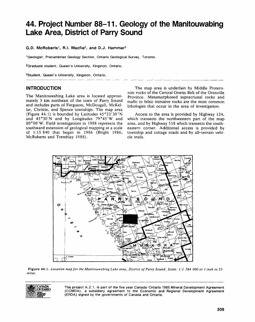
44. Project Number 88-11. Geology of the Manitouwabing Lake Area, District of Parry SoundG.D. McRoberts 1 , R.I. Macfie2 , and D.J. Hammar3
1 Geologist, Precambrian Geology Section, Ontario Geological Survey, Toronto.
2Graduate student, Queen's University, Kingston, Ontario.
3Student, Queen's University, Kingston, Ontario.
INTRODUCTIONThe Manitouwabing Lake area is located approxi mately 3 km northeast of the town of Parry Sound and includes parts of Ferguson, McDougall, McKel- lar, Christie, and Spence townships. The map area (Figure 44.1) is bounded by Latitudes 45 0 22'30"N and 45 0 30'N and by Longitudes 79 0 45'W and 80 0 00'W. Field investigations in 1988 represent the southward extension of geological mapping at a scale of 1:15 840 that began in 1986 (Bright 1986; McRoberts and Tremblay 1988).
The map area is underlain by Middle Protero zoic rocks of the Central Gneiss Belt of the Grenville Province. Metamorphosed supracrustal rocks and mafic to felsic intrusive rocks are the most common lithologies that occur in the area of investigation.
Access to the area is provided by Highway 124, which transects the northwestern part of the map area, and by Highway 518 which transects the south eastern corner. Additional access is provided by township and cottage roads and by all-terrain vehi cle trails.
Figure 44. 1. Location map for the Manitouwabing Lake area, District of Parry Sound. Scale: 1:1 584 000 or l inch to 25 miles.
iONTARIO This project A.2.1. is part of the five year Canada-Ontario 1985 Mineral Development Agreement (COMDA), a subsidiary agreement to the Economic and Regional Development Agreement (ERDA) signed by the governments of Canada and Ontario.
309
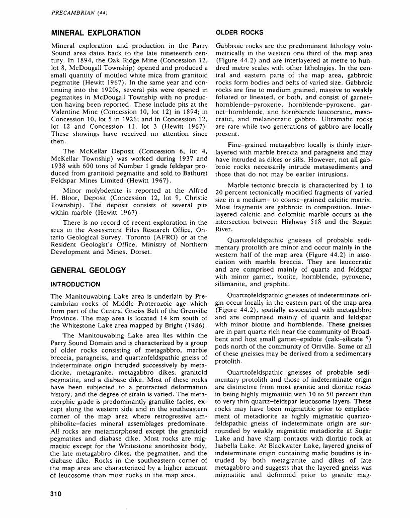
PRECAMBRIAN (44)
MINERAL EXPLORATIONMineral exploration and production in the Parry Sound area dates back to the late nineteenth cen tury. In 1894, the Oak Ridge Mine (Concession 12, lot 8, McDougall Township) opened and produced a small quantity of mottled white mica from granitoid pegmatite (Hewitt 1967). In the same year and con tinuing into the 1920s, several pits were opened in pegmatites in McDougall Township with no produc tion having been reported. These include pits at the Valentine Mine (Concession 10, lot 12) in 1894; in Concession 10, lot 5 in 1926; and in Concession 12, lot 12 and Concession 11, lot 3 (Hewitt 1967). These showings have received no attention since then.
The McKellar Deposit (Concession 6, lot 4, McKellar Township) was worked during 1937 and 1938 with 600 tons of Number l grade feldspar pro duced from granitoid pegmatite and sold to Bathurst Feldspar Mines Limited (Hewitt 1967).
Minor molybdenite is reported at the Alfred H. Bloor, Deposit (Concession 12, lot 9, Christie Township). The deposit consists of several pits within marble (Hewitt 1967).
There is no record of recent exploration in the area in the Assessment Files Research Office, On tario Geological Survey, Toronto (AFRO) or at the Resident Geologist's Office, Ministry of Northern Development and Mines, Dorset.
GENERAL GEOLOGY
INTRODUCTION
The Manitouwabing Lake area is underlain by Pre cambrian rocks of Middle Proterozoic age which form part of the Central Gneiss Belt of the Grenville Province. The map area is located 14 km south of the Whitestone Lake area mapped by Bright (1986).
The Manitouwabing Lake area lies within the Parry Sound Domain and is characterized by a group of older rocks consisting of metagabbro, marble breccia, paragneiss, and quartzofeldspathic gneiss of indeterminate origin intruded successively by meta- diorite, metagranite, metagabbro dikes, granitoid pegmatite, and a diabase dike. Most of these rocks have been subjected to a protracted deformation history, and the degree of strain is varied. The meta morphic grade is predominantly granulite facies, ex cept along the western side and in the southeastern corner of the map area where retrogressive am- phibolite-facies mineral assemblages predominate. All rocks are metamorphosed except the granitoid pegmatites and diabase dike. Most rocks are mig- matitic except for the Whitestone anorthosite body, the late metagabbro dikes, the pegmatites, and the diabase dike. Rocks in the southeastern corner of the map area are characterized by a higher amount of leucosome than most rocks in the map area.
OLDER ROCKS
Gabbroic rocks are the predominant lithology volu- metrically in the western one third of the map area (Figure 44.2) and are interlayered at metre to hun dred metre scales with other lithologies. In the cen tral and eastern parts of the map area, gabbroic rocks form bodies and belts of varied size. Gabbroic rocks are fine to medium grained, massive to weakly foliated or lineated, or both, and consist of garnet- hornblende-pyroxene, hornblende-pyroxene, gar net-hornblende, and hornblende leucocratic, meso cratic, and melanocratic gabbro. Ultramafic rocks are rare while two generations of gabbro are locally present.
Fine-grained metagabbro locally is thinly inter layered with marble breccia and paragneiss and may have intruded as dikes or sills. However, not all gab broic rocks necessarily intrude metasediments and those that do not may be earlier intrusions.
Marble tectonic breccia is characterized by l to 20 percent tectonically modified fragments of varied size in a medium- to coarse-grained calcitic matrix. Most fragments are gabbroic in composition. Inter layered calcitic and dolomitic marble occurs at the intersection between Highway 518 and the Seguin River.
Quartzofeldspathic gneisses of probable sedi mentary protolith are minor and occur mainly in the western half of the map area (Figure 44.2) in asso ciation with marble breccia. They are leucocratic and are comprised mainly of quartz and feldspar with minor garnet, biotite, hornblende, pyroxene, sillimanite, and graphite.
Quartzofeldspathic gneisses of indeterminate ori gin occur locally in the eastern part of the map area (Figure 44.2), spatially associated with metagabbro and are comprised mainly of quartz and feldspar with minor biotite and hornblende. These gneisses are in part quartz rich near the community of Broad- bent and host small garnet-epidote (calc-silicate ?) pods north of the community of Orrville. Some or all of these gneisses may be derived from a sedimentary protolith.
Quartzofeldspathic gneisses of probable sedi mentary protolith and those of indeterminate origin are distinctive from most granitic and dioritic rocks in being highly migmatitic with 10 to 50 percent thin to very thin quartz-feldspar leucosome layers. These rocks may have been migmatitic prior to emplace ment of metadiorite as highly migmatitic quartzo feldspathic gneiss of indeterminate origin are sur rounded by weakly migmatitic metadiorite at Sugar Lake and have sharp contacts with dioritic rock at Isabella Lake. At Blackwater Lake, layered gneiss of indeterminate origin containing mafic boudins is in truded by both metagranite and dikes of late metagabbro and suggests that the layered gneiss was migmatitic and deformed prior to granite mag-
310
G.D. MCROBERTS, R.I. MACFIE, AND D. J. HAMMAR
Metagabbro
Mainly gabbroic rocks interlayered with minor dioritic, granitic and quartzofekJspathic rocks
Marble and marble breccia
Quartzofeldspathic gneisses of sedimentary protolith
Quartzofeldspathic gneisses of indeterminate origin
Dioritic rocks
Qranodioritic rocks
Mainly dioritic rocks interlayered with minor gabbroic and granitic rocks.
l" v "" "l Strongly deformed dioritic rocks with |Q c p i Q| mafic layers
r + ^ + J Granitic Rocks
l," t "lF*"*"-*J Whitestone Anorthosite Bodyt * * * -lr j
Heterogeneous migmatites
Figure 44.2. Generalized geological map of the Manitouwabing Lake area.
matism. This gneiss may also have been intruded by older gabbroic rocks as marble and paragneiss have.
YOUNGER ROCKS
Rocks of the dioritic suite range in composition from tonalite to granite with diorite being predominant. Although occurring throughout the map area, they are volumetrically most abundant in the central and eastern parts (Figure 44.2). They intrude gabbroic rocks and commonly contain xenoliths of the older units. Intrusive relationships are preserved near the communities of Hurdville and Broadbent where dioritic veins emanating from metadiorite cut gab broic rocks. Dioritic rocks with 10 to 70 percent xenoliths occur adjacent to metagabbroic bodies in the eastern part of the map area while those with less
than 10 percent occur randomly. Layered dioritic and gabbroic rocks at Manitouwabing Lake (Figure 44.2) are interpreted as highly strained dioritic rocks containing gabbroic xenoliths and gabbroic layers. Dioritic rocks in the map area are correlated with the McKellar Gneiss north of the map area. An U- Pb age of intrusion of 1425±75 Ma has been re ported for the McKellar Gneiss (van Breemen et al. 1986).
A distinctive pink to grey body of meta-quartz monzonite to granite-granodiorite occurs near High way 518 and the eastern map boundary (Figure 44.2). Its relationship to the dioritic group of rocks is unclear. It is cut by metagranite.
Metagranite occurs as relatively narrow dike- like bodies throughout the map area. They are 5 cm
311
PRECAMBRIAN (44)
to 30 m thick except in the southeastern corner where they are up to 100 m wide. A small part of an extensive tract of granitic rock south and southeast of the map area (Seguin Domain of Davidson et al. 1982) is exposed in the extreme southeastern corner of the map area. Metagranite is not found in the Whitestone anorthositic body and is probably older than it.
The Whitestone anorthositic body is exposed in the southwestern and northwestern corners of the map area and consists of two phases: an older leuco cratic to mesocratic phase, and a younger anor thositic to gabbroic anorthosite phase. Subophitic and oikocrystic textures are widely preserved. It is not clear whether the Whitestone anorthositic body was tectonically or magmatically emplaced (with sub sequent tectonic modification) into its present posi tion. For the Whitestone body, van Breemen et al. (1986) report a U-Pb age of crystallization of 1350±50 Ma.
Thin metagabbro dikes occur locally throughout the map area and cut earlier gneissic layering at low angle in all rocks except the Whitestone anorthositic body. However, mafic dikes observed in the Arn- stein and Raganooter Lake anorthositic bodies (McRoberts and Tremblay 1988) to the north likely belong to the same set of metagabbro dikes, and these locally cut foliation.
Granitoid pegmatites, locally foliated or dis rupted, occur throughout the map area but are most common in areas completely or nearly completely retrogressed from granulite to amphibolite facies.
A diabase dike is exposed sporadically along the Seguin River and has contact-metamorphosed neighboring host rocks. The dike was intruded fol lowing regional metamorphism and tectonism and probably belongs to the group of east-trending dia base dikes known as the Grenville Dikes (Fahrig and West 1986) with a K-Ar age of emplacement of roughly 575 Ma.
STRUCTURAL GEOLOGYMost rocks in the map area have been subjected to more than one period of deformation. The earliest deformation predates emplacement of dioritic and granitic rocks and is recognized at Isabella Lake where gneissic metagabbro xenoliths are hosted by nonfoliated metadiorite and at Blackwater Lake where metagranite cuts a more deformed quartzo- feldspathic gneiss of indeterminate origin. The sec ond period of deformation occurred prior to em placement of mafic dikes and is recognized on the basis of massive to weakly foliated or lineated mafic dikes at an angle to gneissic layering in metagranites. The third, fourth, and fifth periods of deformation postdate emplacement of the mafic dikes.
The first period of deformation is characterized by transposition of leucosome and disruption of
mafic layers at Blackwater Lake. The second period of deformation is characterized by a straightening of lithological contacts, flattening of metagabbroic xen oliths in metadiorite, and attenuation of mafic layers in metagranite. A fine foliation or lineation is not associated with either period of deformation and this may be the result of later mineralogical annealing.
Outcrop-scale isoclinal folds with steeply plung ing fold axes are common in layered quartzo- feldspathic gneisses and may be related to one or both of the early deformational events.
The third deformational event is commonly characterized by a fine mineral foliation, vague flat tening of mafic clots and/or a fine stretching linea tion. Lineation is southeast- to east-plunging where unaffected by later folding. The fine foliation is par allel to, or at an angle to earlier formed fabrics. More intensely deformed rocks are characterized by strong lineations, highly foliated to mylonitic zones, considerable straightening and thinning of composi tional layering and disruption of pegmatites. Rocks intensely deformed during this period of deforma tion are widespread in the westernmost 20 percent of the map area and in the central part of the map area at Manitouwabing Lake (Figure 44.3) but also occur in relatively narrow zones elsewhere. This pe riod of deformation is likely related chronologically to deformation preserved in the Parry Sound Shear Zone as both deformations disrupt and attenuate leucosome and pegmatites. Highly deformed rocks in the southwest corner of the map area are part of a package of rocks which includes rocks within the Parry Sound Shear Zone.
Mineral foliation and gneissic layering are gener ally northerly trending with oval structures present in the central and eastern parts of the map area (Fig ure 44.3). Heterogeneity in foliation trends are at tributed to folding during the third deformational phase. Good road exposures reveal a spatial rela tionship between open to tight outcrop-scale folds and narrow shear zones. The shear zones predate the folding in one place and postdate it in another.
Oval and circular structures are the dominant megascopic feature in the map area and result from the variation in plunge of the fold axes of northerly trending folds. These structures, formed during the fourth period of deformation, fold the regional lineation resulting in local west-plunging lineations. One oval structure at Dell Lake is a basin and is similar to basins which occur sporadically throughout the western Central Gneiss Belt (Schwerdtner 1987). Several tight, upright antiformal and synfor mal structures in the map area may be related to this period of deformation.
Very narrow (l mm to l cm wide) steeply dip ping mylonite zones occur locally throughout the map area. They are at a high angle to the regional mineral foliation and the gneissic layering in contrast to wider mylonitic zones formed during the third pe riod of deformation which parallel the regional fab-
312
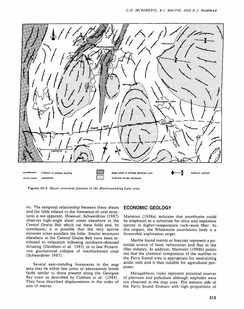
G.D. MCROBERTS, R.I. MACFIE, AND D. J. HAMMAR
Foliation or gneissic layering
Lineaments
Wide zones of strongly deformed rock
Oval and circular structures
Antiform, synform
Figure 44.3. Major structural features in the Manitouwabing Lake area.
ric. The temporal relationship between these shears and the folds related to the formation of oval struc tures is not apparent. However, Schwerdtner (1987) observes high-angle shear zones elsewhere in the Central Gneiss Belt which cut these folds and, by correlation, it is possible that the very narrow mylonite zones postdate the folds. Similar structures elsewhere in the Central Gneiss Belt have been at tributed to relaxation following northwest-directed thrusting (Davidson et al. 1985) or to late Protero zoic gravitational collapse of overthickened crust (Schwerdtner 1987).
Several east-trending lineaments in the map area may be either late joints or alternatively brittle faults similar to those present along the Georgian Bay coast as described by Culshaw et al. (1988). They have described displacements in the order of tens of metres.
ECONOMIC GEOLOGY
Marmont (1988a) indicates that anorthosite could be employed as a substitute for silica and nepheline syenite in higher-temperature rock-wool fiber. In this respect, the Whitestone anorthositic body is a favourable exploration target.
Marble found mainly as breccias represent a po tential source of basic refractories and flux in the filler industry. In addition, Marmont (1988b) points out that the chemical composition of the marbles in the Parry Sound area is appropriate for neutralizing acidic soils and is thus suitable for agricultural pur poses.
Metagabbroic rocks represent potential sources of platinum and palladium although sulphides were not observed in the map area. The western side of the Parry Sound Domain with high proportions of
313
PRECAMBRIAN (44)
metagabbroic rocks is the most favourable explora tion target for this type of mineralization.
Minor disseminated pyrite occurs rarely in rusty biotite-quartzofeldspathic gneiss, in thin quartzose or quartz-rich layers in metagabbro, and in fractures within metadiorite. Assay results for gold are still pending.
REFERENCESBright, E.G.1986: Whitestone Lake Area, District of Parry Sound;
p. 131-135 in Summary of Field Work and Other Ac tivities 1986, by the Ontario Geological Survey, edited by P.C. Thurston, Owen L. White, R.B. Barlow, M.E. Cherry, and A.C. Colvine, Ontario Geological Survey, Miscellaneous Paper 132, 435p. Accompa nied by l Chart.
Culshaw, N.G., Corrigan, D., Drague, J., and Wallace, P.1988: Georgian Bay Geological Synthesis: Key Harbour to
Dillon, Grenville Province of Ontario; p. 129-133 in Current Research, Part C, Geological Survey of Can ada, Paper 88-1C.
Davidson, A., Culshaw, N.G., and Nadeau, L.1982: A Tectono-Metamorphic Framework for Part of the
Grenville Province, Ontario; p. 175-190 in Current Research, Part A, Geological Survey Canada, Paper 81-1A.
Davidson, A., Nadeau, L., Grant, S.M., and Pryer, L.L. 1985: Studies in the Grenville Province of Ontario;
p.463-483 in Current Research, Part A, GeologicalSurvey of Canada, Paper 85-1A.
Fahrig, W.F., and West, T.D.1986: Diabase Dike Swarms of the Canadian Shield; Geo
logical Survey of Canada, Map 1627A, scale 1:4 873 900.
Hewitt, D.F.1967: Geology and Mineral Deposits of the Parry Sound—
Huntsville Area; Ontario Department of Mines, Geo logical Report 52, 65p. Accompanied by Map 2118, Scale 1:126 520 or l inch to 2 miles.
Marmont, C.1988a: Feldspar in the Parry Sound-Huntsville-Haliburton
Area; Ontario Geological Survey, Open File Report 5686, 133p., 7 figures, 7 tables, 22 photos, 6 appen dices, and 4 maps in back pocket.
1988b: Limestone (Crystalline Marble) in the Parry Sound- Huntsville Area; Ontario Geological Survey, Open File Report 5687, 71p., 4 figures, 3 photos, l table, 7 appendices, and 2 maps in back pocket.
McRoberts, G., and Tremblay, M.L.1988: Precambrian Geology of the Ferrie River Area, Dis
trict of Parry Sound; Ontario Geological Survey, Map P.3123, Geological Series-Preliminary Map, Scale 1:15 840 or l inch to 1/4 mile. Geology 1987.
Schwerdtner, W.M.1987: Interplay Between Folding and Ductile Shearing in the
Proterozoic Crust of the Muskoka-Parry Sound Re gion, Central Ontario; Canadian Journal of Earth Sci ences, Volume 24, p. 1507-1527.
van Breemen, O., Davidson, A., Loveridge, W.D., and Sul livan, R.W.
1986: U-Pb Zircon Geochronology of Grenville Tectonites, Granulites and Igneous Precursors, Parry Sound, On tario; p. 181-207 in Grenville Province, edited by J.M. Moore, A. Davidson, and A.J. Baer, Geologi cal Association of Canada, Special Paper 31, 358p.
314
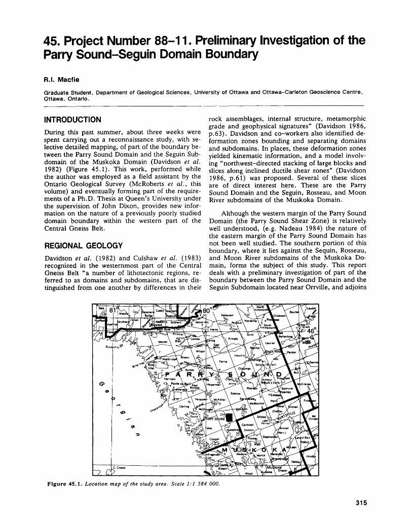
45- Project Number 88-11. Preliminary Investigation of the Parry Sound-Seguin Domain Boundary
R.I. Macfie
Graduate Student, Department of Geological Sciences, University of Ottawa and Ottawa-Carleton Geoscience Centre, Ottawa, Ontario.
INTRODUCTIONDuring this past summer, about three weeks were spent carrying out a reconnaissance study, with se lective detailed mapping, of part of the boundary be tween the Parry Sound Domain and the Seguin Sub- domain of the Muskoka Domain (Davidson et al. 1982) (Figure 45.1). This work, performed while the author was employed as a field assistant by the Ontario Geological Survey (McRoberts et al., this volume) and eventually forming part of the require ments of a Ph.D. Thesis at Queen's University under the supervision of John Dixon, provides new infor mation on the nature of a previously poorly studied domain boundary within the western part of the Central Gneiss Belt.
REGIONAL GEOLOGYDavidson et al. (1982) and Culshaw et al. (1983) recognized in the westernmost part of the Central Gneiss Belt "a number of lithotectonic regions, re ferred to as domains and subdomains, that are dis tinguished from one another by differences in their
rock assemblages, internal structure, metamorphic grade and geophysical signatures" (Davidson 1986, p.63). Davidson and co-workers also identified de formation zones bounding and separating domains and subdomains. In places, these deformation zones yielded kinematic information, and a model involv ing "northwest-directed stacking of large blocks and slices along inclined ductile shear zones" (Davidson 1986, p.61) was proposed. Several of these slices are of direct interest here. These are the Parry Sound Domain and the Seguin, Rosseau, and Moon River subdomains of the Muskoka Domain.
Although the western margin of the Parry Sound Domain (the Parry Sound Shear Zone) is relatively well understood, (e.g. Nadeau 1984) the nature of the eastern margin of the Parry Sound Domain has not been well studied. The southern portion of this boundary, where it lies against the Sequin, Rosseau, and Moon River subdomains of the Muskoka Do main, forms the subject of this study. This report deals with a preliminary investigation of part of the boundary between the Parry Sound Domain and the Seguin Subdomain located near Orrville, and adjoins
Figure 45.1. Location map of the study area. Scale 1:1 584 000.
315
PRECAMBRIAN (45)
the southeastern corner of the Manitouwabing Lake area mapped by McRoberts et al. (this volume).
GENERAL GEOLOGY
PARRY SOUND DOMAIN AND THE SEGUIN SUBDOMAIN
The Parry Sound Domain consists of "dark rocks- predominantly mafic and intermediate, layered, pyroxene-bearing gneisses with minor marble and other metasedimentary types, intruded by plutonic rocks ranging in composition from gabbro to granodiorite and all deformed together" (Davidson 1986, p.64). Ovoid bodies of dioritic to tonalitic rock show evidence of plutonic origin, and tec- tonized gabbro bodies occur in association with supracrustal rocks (McRoberts et al., this volume; Davidson 1982). Most rocks of the Parry Sound Do main show evidence of granulite facies metamor phism, locally retrograded. Structural orientation is generally northerly, although deflected around the plutonic masses (Davidson et al. 1982; McRoberts et al., this volume).
The Seguin Subdomain, on the other hand, is synformal with its major axis lying northwest, and consists mostly of lighter-coloured migmatite gneisses, many of tectonic origin (Davidson et al. 1982). This subdomain's metamorphic grade is pre dominantly amphibolite, although evidence of granulite facies metamorphism is found in places (Davidson et al. 1985). The Seguin Subdomain is thought to have been thrust onto the Parry Sound Domain, and a major deformation zone should lie between them. Published details relevant to the identification of the above domains and subdomains are found in Davidson et al. (1982) and Davidson (1986).
NEW OBSERVATIONS
The reconnaissance mapping of Davidson et al. (1982) placed the boundary between the Parry Sound Domain and the Seguin Subdomain in the general area of Orrville, Ontario (Figure 45.2).
Medium-grained dioritic to tonalitic hornblende orthogneisses, largely preserved at granulite facies and characteristic of the Parry Sound Domain, lying northwest of Orrville give way to Seguin-type am phibolite facies migmatitic and heterogeneous gneisses, mostly of unknown protolith, around, and to the east of, Orrville (Figure 45.2). As a package, these amphibolite grade gneisses are more leucocratic and more siliceous than the higher grade rocks to the west, and unlike those gneisses, are characterized by medium-grained sugary annealed textures with biotite as the dominant mafic mineral. The Seguin-type amphibolite grade terrane is richer
in pegmatite and quartz veins, and noticeably poorer in amphibolite and metagabbro.
This lithological change is accompanied by a change in structural trends in the area which show a synclinal structural entrant in the east juxtaposed against a terrane having a predominantly northerly structural orientation (Figure 45.2). Although the location of the boundary is not readily apparent in the Orrville area, it does coincide more or less with a set of major lineaments truncating typical north- trending Parry Sound structural features and with lithological changes between the Parry Sound Do main and the Seguin Subdomain. However, no sin gle, spectacular high strain zone, nor any major swarm of high strain zones, is present in the Orrville area. Kinematic indicators are rare and provide no consistent sense of tectonic transport direction.
Reconnaissance traversing from the Orrville area eastward into areas well within the Seguin Sub domain demonstrates that the migmatite gneisses of the Orrville area are continuous with similar rocks found well within the Seguin Subdomain, and share compositional, metamorphic, and structural charac teristics with those rocks.
DISCUSSIONIn the Orville area, the Parry Sound Domain-Seguin Subdomain boundary is characterized by the pres ence of highly deformed rocks. In places, Seguin- type migmatites, usually phlebitic, have straightened and sheared leucosome layers. Also present within this part of the Seguin Subdomain are fine- to me dium-grained leucocratic and mesocratic gneisses of unknown protolith with only minor leucosome, which, although granular and annealed-looking at present, show textures characteristic of tectonities (c.f. Davidson et al. 1982). These include por- phyroclasts derived from degradation of pegmatites, boudinaged layers, and straight layering and flat tened leucosome layers. Parry Sound Domain rocks in the boundary area typically retain recognizable or- thogneissic textures and show less evidence of perva sive deformation. High—strain zones do exist on the Parry Sound side, yet are narrow (metre-wide in scale) and generally retain evidence and textures characteristic of mylonitization.
A picture emerges of pervasively deformed am- phibolite-facies migmatitic gneisses of the Seguin Subdomain lying adjacent to granulite facies orthog neisses which have been deformed mainly along nar row, discrete shear zones. Within the small area ex amined in detail during the past summer, the bound ary is not sharply defined, and strongly deformed rocks are common both to the east and west of the presumed boundary. Further, although lithological packages on either side of the boundary area are compatible with the Parry Sound Domain and Seguin Subdomain as defined by Davidson et al. (1982), increasing amounts of migmatitic granitoid gneiss similar to that found in the Seguin Subdomain
316
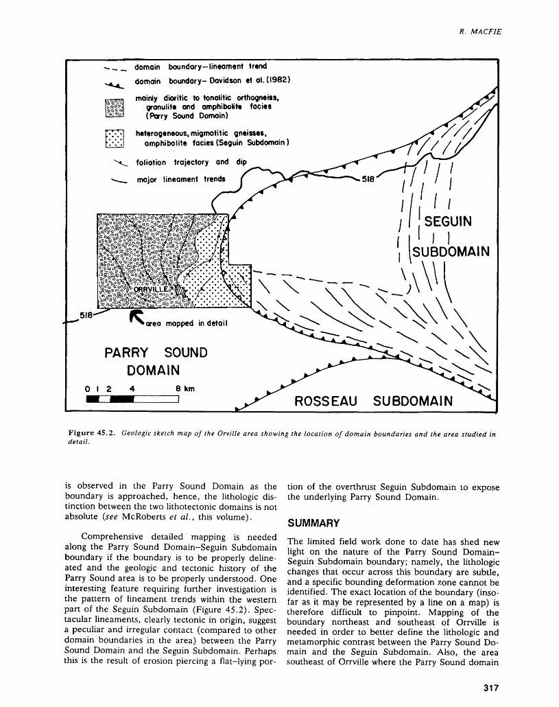
R. MACFIE
• -.^ domain boundary-lineament trenddomain boundary-Davidson et al. (1982)
mainly dioritic to tonalitic orthogneiss, granulite and amphibolite facies (Parry Sound Domain)
heterogeneous, migmatitic gneisses, amphibolite facies (Seguin Subdomain)
foliation trajectory and dip
major lineament trends
PARRY SOUND DOMAIN
O l 2 8 kmSUBDOMAIN
Figure 45.2. Geologic sketch map of the Orville area showing the location of domain boundaries and the area studied in detail.
is observed in the Parry Sound Domain as the boundary is approached, hence, the lithologic dis tinction between the two lithotectonic domains is not absolute (see McRoberts et al., this volume).
Comprehensive detailed mapping is needed along the Parry Sound Domain-Seguin Subdomain boundary if the boundary is to be properly deline ated and the geologic and tectonic history of the Parry Sound area is to be properly understood. One interesting feature requiring further investigation is the pattern of lineament trends within the western part of the Seguin Subdomain (Figure 45.2). Spec tacular lineaments, clearly tectonic in origin, suggest a peculiar and irregular contact (compared to other domain boundaries in the area) between the Parry Sound Domain and the Seguin Subdomain. Perhaps this is the result of erosion piercing a flat-lying por
tion of the overthrust Seguin Subdomain to expose the underlying Parry Sound Domain.
SUMMARY
The limited field work done to date has shed new light on the nature of the Parry Sound Domain- Seguin Subdomain boundary; namely, the lithologic changes that occur across this boundary are subtle, and a specific bounding deformation zone cannot be identified. The exact location of the boundary (inso far as it may be represented by a line on a map) is therefore difficult to pinpoint. Mapping of the boundary northeast and southeast of Orrville is needed in order to better define the lithologic and metamorphic contrast between the Parry Sound Do main and the Seguin Subdomain. Also, the area southeast of Orrville where the Parry Sound domain
317
PRECAMBRIAN (45)
and the Rosseau and Seguin subdomains are in mu- Davidson, A., Culshaw, N., and Nadeau, L. tual contact needs to be Studied in detail. 1982: A Tectonometamorphic Framework for Part of the
Grenville Province, Parry Sound Region, Ontario; in QCCCDCMf^CC Current Research, Geological Survey of Canada, Pa-ntrtntiNuts per 82-1A p 175. 190Culshaw, N., Davidson, A., and Nadeau, L.1983: Structural Subdivisions of the Grenville Province in the Davidson, A., Nadeau, L., Grant, S.M., and Pryer, L.L.
Parry Sound-Algonquin Region, Ontario; in Current 1935: Studies in the Grenville Province of Ontario; in Cur- Research, Geological Survey of Canada, Paper rent Research, Part A, Geological Survey of Canada, 83-1B, p.155-163. Paper 85-1A, p.463-483.
Davidson, A.1986: New Interpretations in the Southwestern Grenville Nadeau, L.
Province; in The Grenville Province, edited by 1984: Deformation of Leucogabbroic Rocks at Parry Sound, J. Moore, A. Davidson, and A. Baer, Geological Ontario; Unpublished M.Se. Thesis, Carleton Uni- Association of Canada, Special Paper 31, p.61-74. versity, Ottawa, Ontario.
318
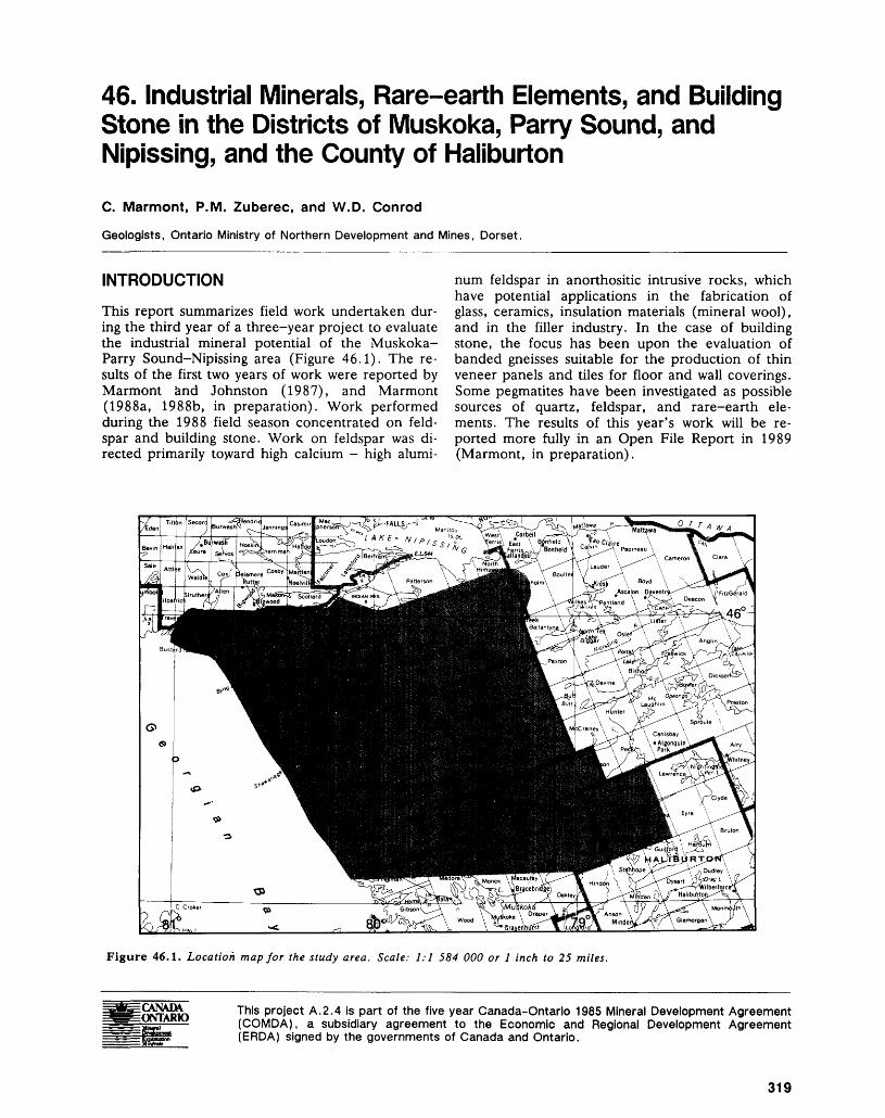
46. Industrial Minerals, Rare-earth Elements, and Building Stone in the Districts of Muskoka, Parry Sound, and Nipissing, and the County of Haliburton
C. Marmont, P.M. Zuberec, and W.D. Conrod
Geologists, Ontario Ministry of Northern Development and Mines, Dorset.
INTRODUCTION
This report summarizes field work undertaken dur ing the third year of a three-year project to evaluate the industrial mineral potential of the Muskoka- Parry Sound-Nipissing area (Figure 46.1). The re sults of the first two years of work were reported by Marmont and Johnston (1987), and Marmont (1988a, 1988b, in preparation). Work performed during the 1988 field season concentrated on feld spar and building stone. Work on feldspar was di rected primarily toward high calcium - high alumi
num feldspar in anorthositic intrusive rocks, which have potential applications in the fabrication of glass, ceramics, insulation materials (mineral wool), and in the filler industry. In the case of building stone, the focus has been upon the evaluation of banded gneisses suitable for the production of thin veneer panels and tiles for floor and wall coverings. Some pegmatites have been investigated as possible sources of quartz, feldspar, and rare-earth ele ments. The results of this year's work will be re ported more fully in an Open File Report in 1989 (Marmont, in preparation).
Figure 46.1. Location map for the study area. Scale: 1:1 584 000 or l inch to 25 miles.
This project A.2.4 is part of the five year Canada-Ontario 1985 Mineral Development Agreement (COMDA), a subsidiary agreement to the Economic and Regional Development Agreement (ERDA) signed by the governments of Canada and Ontario.
319
PRECAMBRIAN (46)
MINERAL EXPLORATIONThe history of mining and mineral exploration in the study area has been described by Marmont and Johnston (1987). Local activity in the industrial minerals field is focused mainly on graphite (Gar land 1987a, 1987b). North Coast Industries is en gaged in a feasibility study of its Maria Township crystalline flake graphite property, and Cal Graphite Corporation's flake graphite property in Butt Town ship is under development. Some interest has been expressed in using local marble as agricultural lime stone. Cal Graphite Corporation may utilize local marble for tailings pond neutralization. Test pits have been opened on flagstone occurrences near Magnetawan and Dorset. Several mafic to ultramafic bodies are being explored for platinum (Garland 1987c).
GENERAL GEOLOGYThe study area is located in the Central Gneiss Belt of the Grenville Province (Moore et al. 1986). It is a structurally complex area of ortho- and paragneisses metamorphosed to upper amphibolite and granulite facies. A brief overview of the geology of the area is presented in Marmont and Johnston (1987). During 1988, mapping programs were conducted in the Parry Sound area of Georgian Bay by N.G. Culshaw of Dalhousie University, Halifax (a contribution to the Canada-Ontario Mineral Development Agree ment), and east of Parry Sound by G.D. McRoberts of the Ontario Geological Survey (McRoberts and MacFie, this volume).
CURRENT PROGRAM
FELDSPAR
Industrial mineral operations are generally founded upon minerals or rock types possessing some unique physical and/or chemical characteristic (s). Industrial mineral deposits are commonly monomineralic, or contain minerals which can be cheaply mined and beneficiated. At present, there appears to be no ma jor industrial operation which exploits the large vol umes of almost monomineralic plagioclase feldspar found in anorthosite bodies. Such "lime" feldspar is high in calcium (12 percent CaO) and alumina (28 to 30 percent). In the past, anorthosites have been considered as possible sources of alumina, but they cannot compete with bauxite, of which there is cur rently an abundant supply. Lime feldspar would be an acceptable component in certain glass and ce ramic applications, as well as in the mineral wool and filler industries. These currently use potash and/ or soda spar derived from pegmatite, aplite and alas kite deposits, or nepheline syenite. It is unlikely that lime feldspar will make significant inroads into these well established markets in the near future. Develop ment of anorthosite will probably depend upon the
recognition of applications based on the peculiar chemical composition of its feldspar, or on physical characteristics such as its higher melting point. These are avenues of research which may warrant investigation.
Several large anorthosite bodies occur in the Parry Sound and Haliburton areas (Figure 46.2). Previous work (Marmont 1988a, 1988b) indicated that parts of the Whitestone and Moon River bodies consist of "clean" anorthosite containing less than l percent Fe2O3 . The iron is contained mainly within clinopyroxene, amphibole, garnet, and magnetite-il- menite which aggregate from 2 to 7 percent by vol ume of the cleaner anorthosite, depending upon the relative proportions of the iron-bearing minerals. All are minerals which can be readily separated by com mercial electromagnetic methods.
It was also noted that some apparently very clean anorthosites (colour index less than 2) contain large amounts of silicate and oxide inclusions in the plagioclase, whereas others contain only minor in clusions. This property is likely to affect the recovery of a clean lime feldspar product during mineral dressing.
The colour of the feldspar and the amount of mineral inclusions within it are functions of recrystal lization and grain size reduction produced during pe riods of ductile deformation: primary igneous feld spar is dark grey to black and replete with oxide in clusions, but upon recrystallization the inclusions are expelled and the feldspar becomes paler grey or white.
The field work performed during 1988 was di rected towards determining the distribution of clean anorthosite within the several anorthositic to gab broic bodies in the study area, and to determine which anorthosites contain mineral inclusions in the feldspar, which may adversely affect beneficiation in any future development.
Of the anorthosite bodies indicated in Figure 46.2, seven are of a size capable of containing po tentially economic volumes of rock. In the Parry Sound area, these include the Moon River, Parry Island, Whitestone, Arnstein, and Raganooter bod ies; and in the Haliburton area, the Allsaw and Percy Lake bodies. The remaining anorthosites form thin, commonly disrupted sheets, only a few metres or tens of metres thick. The bodies in the Parry Sound area probably have a bulk composition of gabbroic anorthosite (perhaps 15 to 20 percent mafic minerals), whereas the Allsaw and Percy Lake bodies consist predominantly of anorthosite with lesser amounts of more mafic material. Each body exhibits distinctive characteristics.
The Whitestone Anorthosite exhibits a crudely concentric zonation, being more mafic and increas ingly deformed and retrograded towards the mar gins. Oikocrysts of clinopyroxene up to 0.3 m in di ameter give the rock a characteristic leopard-spot ted appearance in the dominantly gabbroic anor-
320
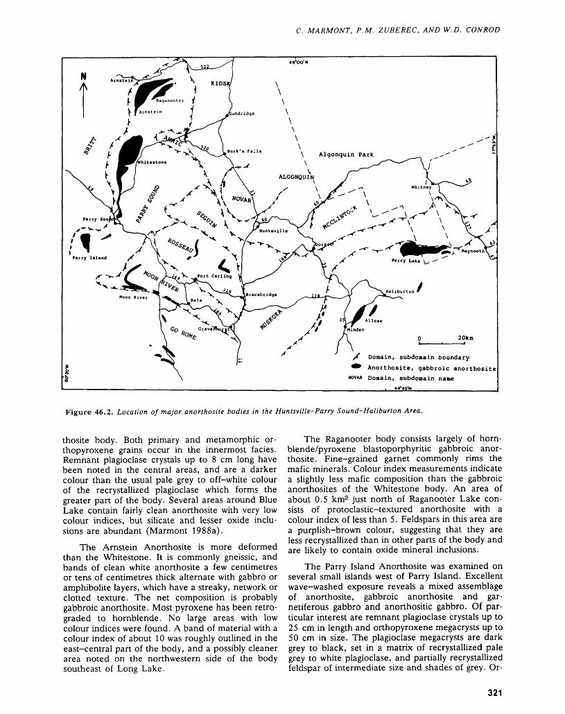
C. MARMONT, P.M. ZUBEREC, AND W.D. CONROD
Algonquin Park
Perry Island /f
X Domain, subdomain boundary
^^ Anorthosite, gabbroic anorthosite
NOVA* Domain, subdomain name
Figure 46.2. Location of major anorthosite bodies in the Huntsville-Parry Sound-Haliburton Area.
thosite body. Both primary and metamorphic or thopyroxene grains occur in the innermost facies. Remnant plagioclase crystals up to 8 cm long have been noted in the central areas, and are a darker colour than the usual pale grey to off-white colour of the recrystallized plagioclase which forms the greater part of the body. Several areas around Blue Lake contain fairly clean anorthosite with very low colour indices, but silicate and lesser oxide inclu sions are abundant (Marmont 1988a).
The Arnstein Anorthosite is more deformed than the Whitestone. It is commonly gneissic, and bands of clean white anorthosite a few centimetres or tens of centimetres thick alternate with gabbro or amphibolite layers, which have a streaky, network or clotted texture. The net composition is probably gabbroic anorthosite. Most pyroxene has been retro graded to hornblende. No large areas with low colour indices were found. A band of material with a colour index of about 10 was roughly outlined in the east-central part of the body, and a possibly cleaner area noted on the northwestern side of the body southeast of Long Lake.
The Raganooter body consists largely of horn blende/pyroxene blastoporphyritic gabbroic anor thosite. Fine-grained garnet commonly rims the mafic minerals. Colour index measurements indicate a slightly less mafic composition than the gabbroic anorthosites of the Whitestone body. An area of about 0.5 km2 just north of Raganooter Lake con sists of protoclastic-textured anorthosite with a colour index of less than 5. Feldspars in this area are a purplish-brown colour, suggesting that they are less recrystallized than in other parts of the body and are likely to contain oxide mineral inclusions.
The Parry Island Anorthosite was examined on several small islands west of Parry Island. Excellent wave-washed exposure reveals a mixed assemblage of anorthosite, gabbroic anorthosite and gar netiferous gabbro and anorthositic gabbro. Of par ticular interest are remnant plagioclase crystals up to 25 cm in length and orthopyroxene megacrysts up to 50 cm in size. The plagioclase megacrysts are dark grey to black, set in a matrix of recrystallized pale grey to white plagioclase, and partially recrystallized feldspar of intermediate size and shades of grey. Or-
321
PRECAMBRIAN (46)
thopyroxene megacrysts can be seen in various stages of disaggregation and alteration, ultimately forming highly flattened lenses and wisps composed of clinopyroxene and/or hornblende. In places, a remnant core of orthopyroxene remains in these mafic clots. This evidence suggests that the horn blende-rich clots and streaks in more deformed bodies such as the Arnstein Anorthosite may well be derived from primary pyroxene megacrysts. It is speculated that further deformation may disag gregate these clots to produce parallel bands of dis seminated hornblende and biotite such as are found in the Moon River Anorthosite and other, thin, highly attenuated anorthositic bodies.
The Moon River Anorthosite lies within the Moon River Subdomain (Davidson et al. 1982), whereas the four bodies described above lie within the Parry Sound Domain. The Moon River Anor thosite is mainly composed of gabbroic anorthosite, but has significant areas of clean white anorthosite with a colour index of less than 5. The body is char acteristically layered on a centimetre to decimetre scale, with alternating bands of almost pure anor thosite (colour index less than 2) and anorthosite/ gabbroic anorthosite with a colour index of 8 to 20. Biotite and hornblende are the major mafic miner als, with minor garnet, epidote, chlorite, and mag netite. The plagioclase is commonly sericitized and is free from inclusions other than a dusting of unidenti fied micron-sized particles.
The Allsaw Anorthosite lies within the Central Metasedimentary Belt Boundary Zone, and is envel oped by a tectonic marble breccia (Easton 1987). It contains some gabbroic anorthosite, but is mostly a clean white anorthosite. Unfortunately, from a po tential economic point of view, it is riddled with granitic pegmatite and carbonate veins (including possible carbonatitic material), which would likely complicate mineral dressing procedures and ad versely affect the recovery of a lime-feldspar con centrate.
The Percy Lake Anorthosite is largely anor thositic, with lesser amounts of gabbroic anorthosite. The feldspar is very white, with biotite, hornblende, and muscovite erratically disseminated throughout, and forming weakly defined bands which dip gently to over 30 0 to the south. In only one location were good remnant plagioclase crystals noted, being up to 6 cm long and a medium-dark grey colour. Irregu lar, thin granitic pegmatite dikes can be found in most outcrops. Relief in the area is in the order of 60 to 80 m. At the base of almost all outcrops, and, to a lesser extent, within outcrops, there occur duc tile shear zones, which range in thickness from l m to possibly as much as several tens of metres. The shears largely consist of granitic pegmatite material exhibiting various degrees of dissaggregation and comminution. The most deformed varieties are a medium-grained, pink, gneissic granite, containing small remnant potash feldspar crystals. Some shears
contain an equigranular, medium-grained, pink granitic or monzonitic rock which may be either a distinct intrusive phase or a recrystallized, sheared pegmatite. Above the shears, the anorthosite com monly exhibits a lenticular structure on a scale of 0.3 to 1.0 m produced by millimetre- to centimetre- wide anastomosing shears of comminuted anor thosite. In places, rotated blocks of anorthosite can be discerned within a finer grained anorthosite ma trix. This grades up into parallel-foliated anorthosite which in turn grades up into the regular massive white anorthosite. Locally, a sheared hornblende or biotite gneiss, sometimes containing disaggregated pegmatite and feldspar porphyroclast^, underlies the pegmatite. The presence of these numerous shear zones suggests that the body may be relatively thin, and that its outcrop width, from l to 3 km, may re sult from imbricate stacking of thrust slices. The peg matitic and mafic shear zone material constitute per haps 5 percent of the body by volume, which would have to be separated in any future attempt to re cover a lime-feldspar concentrate.
At the time of writing, field work is continuing. Over the winter, samples will be analyzed, and petrographic studies undertaken in order to assess the purity of anorthosite in the various bodies de scribed above, and to evaluate any adverse effects which the mineralogy and mineral inclusions might have on mineral dressing procedures. At the present time, it appears that relatively uniform areas of clean anorthosite occur in several of the anorthositic bod ies in the Parry Sound and Haliburton areas. Be cause outcrop exposure is incomplete, and features such as scattered oikocrysts and mafic clots make representative surface sampling very difficult, proper assessment of the grade and volume of clean anor thosite will require "stratigraphic" drill programs and bulk core sampling.
BUILDING STONEThe building stone component of the project has fo cused on gneisses. The objective of the program is to determine whether gneisses exist comparable to those currently marketed by Brazil, India, and else where as panels and tiles suitable for wall and floor coverings. Most attention has been directed to or- thogneiss units delineated by Davidson et al. (1982) (Figure 46.3). The program, which is ongoing at the time of writing, consists of three parts: 1) reconnais sance: examination of roadside outcrops, and large outcrops within a short distance of the road identi fied from aerial photographs; 2) follow-up: detailed surveying of large outcrop areas which reconnais sance surveys indicated contained a low joint den sity, uniformity of lithology, grain size, texture, and colour, and which contain minimal amounts of dele terious minerals such as sulphides or seams of mica; and 3) extraction of small blocks (0.5 m by 0.5 m by 0.5 m) for sawing and polishing into twelve-inch tiles in order to assess their appearance and durabil ity.
322
C. MARMONT, P.M. ZUBEREC, AND W.D. CONROD
79*00'
bonfield Batholith
Trout CreelJ )
-^1
\ Subdonain Boundaries r*TGeological WContacts
1 Orthogneiss
2 Anorthosite
Unsubdivided
Huntsville Huntsville Subdomain
Moon River Subdomain
Figure 46.3. Orthogneiss units in the Huntsville-Parry Sound Area.
The major constraint upon dimensional stone prospects is the density of joints and fractures. Most outcrops examined display three or four closely spaced joint sets, which preclude the possibility of extracting large quarry blocks. On the basis of work performed to date, two building stone prospects in the study area appear to have some potential as sources of dimensional stone (Figure 46.3). An area astride Highway 69 in Carling Township contains
large exposures of gneiss which locally have only one or two joint sets at a low density (greater than 5 m). Access is good and the area is undeveloped. In Bur ton Township, west of Ardbeg, an area along the power lines is well exposed. It is moderately jointed (1.5 to 3.0 m), and lies in an undeveloped area. Both of these occurrences are migmatitic grano- dioritic gneisses, part of Davidson et al.'s (1982) or- thogneiss unit 9 in the Britt Domain.
323
PRECAMBRIAN (46)
Small blocks will be extracted from these two sites in the fall of 1988 to test their sawing and pol ishing characteristics, and strength of the gneisses.
Similar migmatites also occur west of Rosseau in the Rosseau Subdomain. Locally, these appear to be only moderately jointed, and some may be candi dates for the extraction of small blocks, but the gneisses are not as well exposed as those in Burton and Carling townships.
Many attractive rock types have been noted in the course of roadside reconnaissance, but the den sity of joints in all but a very few outcrops precludes the possibility of recovering quarry blocks of eco nomic size. Some of these occurrences may be capa ble of sustaining small operations to supply material for monument stone, ashlar, or decorative stone. One example of such stone is the augen-textured biotite granodiorite found between Huntsville and Dwight (Lehman Quarry, Sinclair Township, conces sion l, lot 18). Another attractive rock is flagstone of the type quarried at Mill Lake Quarry, Parry Sound. When cut perpendicular to the foliation planes (along which the rock splits readily) and pol ished, the resulting pattern resembles that of petri fied wood, with knots represented by feldspar por- phyroclasts. Mylonites with this texture can be found in many of the ductile shear zones shown on Figure 46.3. Obviously, the thinly splitting nature of the flagstones precludes their use as dimensional stone, but, locally, the distinctive ribbon lineation may be more widely spaced, permitting extraction of blocks suitable for monuments or decorative stone.
At the time of writing, reconnaissance work is continuing, with the objective of identifying addi tional sites suitable for extraction and testing during the late fall of 1988. This includes the examination of coronitic metagabbros previously described by Marmont and Johnston (1987).
PEGMATITE
Evaluation of pegmatites as a source of silica, feld spar, and rare-earth elements is continuing, but the small size of most bodies limits their economic po tential.
ACKNOWLEDGMENTS
Mike Harris and Karen Haynes are thanked for their enthusiastic assistance in the field. S.B. Lum bers kindly provided a map showing the disposition of the Percy Lake Anorthosite which greatly facili tated the field work.
SELECTED REFERENCESBright, E.G.1987: Precambrian Geology of the Whitestone Lake Area,
District of Parry Sound; Ontario Geological Survey,
Map P.3095, Geological Series-Preliminary Map, scale 1:15 840 or l inch to 1/4 mile. Geology 1986.
Culshaw, N.G., Davidson, A., and Nadeau, L.1983: Structural Subdivisions of the Grenville Province in the
Parry Sound-Algonquin Region, Ontario; p.243-252 in Current Research, Part B, Geological Survey of Canada, Paper 83-1B, 456p.
Culshaw, N.G., Corrigan, D., Drage, J., and Wallace, P.1988: Georgian Bay Geological Synthesis: Key Harbour to
Dillon, Grenville Province of Ontario; p. 129-133 in Current Research, Part C, Geological Survey of Can ada, Paper 88-1C, 372p.
Davidson, A., Culshaw, N.G., and Nadeau, L.1982: A Tectono-metamorphic Framework for Part of the
Grenville Province, Ontario; p. 175-190 in Current Research, Part A, Geological Survey of Canada, Pa per 82-1A, 449p.
Davidson, A., and Grant, S.M.1986: Reconnaissance Geology of Western and Central Al-
gonquin Park and Detailed Study of Coronitic Olivine Metagabbro, Central Gneiss Belt, Grenville Province of Ontario; p.837-848 in Current Research, Part B, Geological Survey of Canada, Paper 86-1B, 884p.
Easton, R.M.1987: Geology of the Lochlin Area, County of Haliburton;
Ontario Geological Survey, Open File Report 5678, 251p., 27 figures, 15 tables, 14 photos, 5 appendices, and Map P.3071 in back pocket.
1988: Anorthosite Types Within the Grenville Province of Ontario; Extended Abstract, Symposium on Middle Proterozoic Crustal Evolution of the North American and Baltic Shields, Geological Association of Canada, St. John's, Newfoundland, 23-25 May, 1988.
Garland, M.I.1987a: Graphite in the Central Gneiss Belt of the Province of
Ontario; Ontario Geological Survey, Open File Report 5649, 222p., 33 figures, 5 tables, 13 photos, and 6 maps in back pocket.
1987b: A Detailed Petrological Study of the Cal Graphite Limited Graphite Deposit in Butt Township, Central Ontario; p.332-334 in Summary of Field Work and Other Activities 1987, by the Ontario Geological Sur vey, edited by R.B. Barlow, M.E. Cherry, A.C. Col vine, Burkhard O. Dressler, and Owen L. White, Ontario Geological Survey, Miscellaneous Paper 137, 429p.
1987c: Platinum Group and Precious Metals in the Muskoka- Parry Sound Area of the Central Gneiss Belt of the Grenville Province; p.292-293 in Summary of Field Work and Other Activities 1987, by the Ontario Geo logical Survey, edited by R.B. Barlow, M.E. Cherry, A.C. Colvine, Burkhard O. Dressler, and Owen L. White, Ontario Geological Survey, Miscellaneous Paper 137, 429p.
Marmont, C.1988a: Feldspar in the Parry Sound-Huntsville-Haliburton
Area; Ontario Geological Survey, Open File Report 5686, 133p., 7 figures, 22 photos, 6 appendices, and 4 maps in back pocket.
1988b: Limestone (Crystalline Marble) in the Parry Sound- Huntsville Area; Ontario Geological Survey, Open File Report 5687, 71p., 4 figures, 3 photos, l table, 7 appendices, and 2 maps in back pocket.
324
C. MARMONT, P.M. ZUBEREC, AND W.D. CONROD
In Prep.: Building Stone in the District of Parry Sound and and Abstracts, Friends of the Grenville, Gananoque,Parts of the Districts of Muskoka and Nipissing; On- Ontario, March 4-6, 1988, 18p.tario Geological Survey, Open File Report. x . T . . ,~ . . . , D . , ,c , N6 /'f f Moore, J.M., Davidson, A., and Baer, A.J. (Eds).
Marmont, C., and Johnston, M. 1986: The Grenville Province; Geological Ass6ciation of1987: Mineral Deposits Studies in the Huntsville-Parry Canada, Special Paper 31, 358p.
Sound-Powassan Area—A Progress Report; OntarioGeological Survey, Open File Report 5647, 271p., 9 Van Kranendonk, M.tables, 30 figures, 12 photos, and 5 charts in back 1985: Anorthosite Studies: Muskoka District, Haliburtonpocket. and Victoria Counties; p. 127-130 in Summary of
m , n , ^^ jrT, ,, ,. r Field Work and Other Activities 1986, by the OntarioMcRoberts, G.D., and Tremblay, M.L. /- i - i e A-. A v. i u \i/ A /-i7 Geological Survey, edited by John Wood, Owen1988: Precambrian Geology of the Ferrie River Area, Dis- L WhitCi R B BarloWi and A . c . Colvine, Ontario
trict of Parry Sound; Ontario Geological Survey, Map Geological Survey, Miscellaneous Paper 126, 351p.P.3123, Geological Series-Preliminary Map, scale inoo - . . , ^, ., ,, O . n ,., ,,. ., ^ ,,r.oo 1988: Deformation History and Origin of Thin Anorthosite1:15 840 or l inch to 1/4 mile. Geology 1987. IT . . . T,. , ' , . e . , 0 4 . - ,0} Units in the Fishog Subdomam of Southern Central
Moecher, D.P., Essene, E.J., and Valley, J.W. Gneiss Belt, Grenville Province, Ontario; p.18 in1988: The Whitestone Anorthosite Revisited: Isotopic Con- Grenville Workshop, Program and Abstracts, Friends
straints on Fluid Sources and Extent of Country Rock of the Grenville, Gananoque, Ontario, March 4-6,Interaction; p.15 in Grenville Workshop, Program 1988, 18p.
325
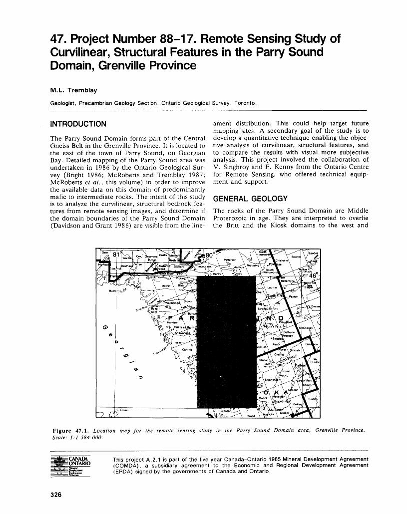
47. Project Number 88-17. Remote Sensing Study of Curvilinear, Structural Features in the Parry Sound Domain, Grenville Province
M.L. Tremblay
Geologist, Precambrian Geology Section, Ontario Geological Survey, Toronto.
INTRODUCTION
The Parry Sound Domain forms part of the Central Gneiss Belt in the Grenville Province. It is located to the east of the town of Parry Sound, on Georgian Bay. Detailed mapping of the Parry Sound area was undertaken in 1986 by the Ontario Geological Sur vey (Bright 1986; McRoberts and Tremblay 1987; McRoberts et al., this volume) in order to improve the available data on this domain of predominantly mafic to intermediate rocks. The intent of this study is to analyze the curvilinear, structural bedrock fea tures from remote sensing images, and determine if the domain boundaries of the Parry Sound Domain (Davidson and Grant 1986) are visible from the line
ament distribution. This could help target future mapping sites. A secondary goal of the study is to develop a quantitative technique enabling the objec tive analysis of curvilinear, structural features, and to compare the results with visual more subjective analysis. This project involved the collaboration of V. Singhroy and F. Kenny from the Ontario Centre for Remote Sensing, who offered technical equip ment and support.
GENERAL GEOLOGYThe rocks of the Parry Sound Domain are Middle Proterozoic in age. They are interpreted to overlie the Britt and the Kiosk domains to the west and
Figure 47.1. Location map for the remote sensing study in the Parry Sound Domain area, Grenville Province. Scale: 1:1 584 000.
CANADA ONTARIO
This project A.2.1 is part of the five year Canada-Ontario 1985 Mineral Development Agreement (COMDA), a subsidiary agreement to the Economic and Regional Development Agreement (ERDA) signed by the governments of Canada and Ontario.
326
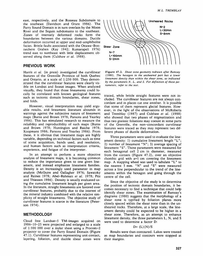
M.L. TREMBLAY
east, respectively, and the Rosseau Subdomain to the southeast (Davidson and Grant 1986). The Parry Sound Domain is in turn overlain by the Moon River and the Seguin subdomains to the southeast. Zones of intensely deformed rocks form the boundaries between the various domains. Ductile deformation occurred at upper and mid-amphibolite facies. Brittle faults associated with the Ottawa-Bon- nechere Graben (Kay 1942; Kumarapeli 1976) trend east to northeast with little displacement ob served along them (Culshaw et al. 1988).
PREVIOUS WORKHarris et al. (in press) investigated the curvilinear features of the Grenville Province of both Quebec and Ontario, at a scale of 1:250 000. They demon strated that the curvilinear features were clearly vis ible on Landsat and Seasat images. When analyzed visually, they found that those lineaments could lo cally be correlated with known geological features such as tectonic domain boundaries, shear zones, and folds.
However, visual interpretation may yield argu able results, and lineament literature abounds in warnings against the subjective nature of lineament maps (Burns and Brown 1978; Parsons and Yearley 1986). This has stimulated rese.arch to measure the reliability and reproducibility of such maps (Burns and Brown 1978; Huntington and Raiche 1978; Koopmans 1986; Parsons and Yearley 1986). From these, it is obvious that lineament maps are highly variable, depending on technical factors such as time of scene acquisition, bands used, and resolution, and human factors such as interpretation criteria, experience, and fatigue of the interpreter.
In an attempt to perform a more objective analysis of lineament maps, it is becoming common to reduce the importance given to one given line ament, and instead emphasize lineament families. Density is an increasingly used parameter in map analysis (McGuire and Gallagher 1976; Sawatzky and Raines 1978; Abel-Rahman et al. 1978; Pitz and Thiessen 1986). Density is usually evaluated us ing the cumulative lineament length per given area. In the literature, straight lineaments are favored over curvilinear features, probably due to the interest of the mineral industry combined with the relative sim plicity of straight lineaments. The objective study of curvilinear features is scarce in the literature (Peter son 1974).
METHODOLOGYCloud free Landsat-5 TM-images acquired on 1986-10-25 were projected and enlarged to a scale of 1:100 000 over a mylar sheet using a Procom-2 projector to cover the Parry Sound Domain (Figure 47.1). Curvilinear features representing unit contact, layering, foliation, and ductile shear zones were
Unsheared RocksN-2 L'3 S=8mm
L-100mm 8=2111171
Figure 47.2. Shear zone geometry redrawn after Ramsay (1980). The hexagon in the unsheared part has a lower lineament density than within the shear zone, as indicated by the parameters N, L, and S. For definition of those pa rameters, refer to the text.
traced, while brittle straight features were not in cluded. The curvilinear features are not always con cordant and in places cut one another. It is possible that some of them represent glacial features. How ever, in the light of the observations of McRoberts and Tremblay (1987) and Culshaw et al. (1988) who showed that two phases of migmatization and thus two gneissic foliations may coexist in some parts of the Grenville, the non-concordant curvilinear features were traced as they may represent two dif ferent phases of ductile deformation.
Three parameters were used to evaluate the line ament density: 1) cumulative lineament length "L"; 2) number of lineament "N"; 3) average spacing of lineament "S". Those parameters were measured for each hexagonal cell 2 cm in diameter, measured from the corners (Figure 47.2), over an objective rhombic grid with 3=1 cm covering the lineament map. A mapping wheel was used to tabulate "L" to the nearest 5 mm. "N" and "S" were measured across a line perpendicular to the trend of the line aments within the hexagon and going through the centre of the cell.
Since the objective of the study is to determine the position of tectonic domain boundaries, it be comes necessary to find a technique that could help identify shear zones. The examination of Ramsay's diagrams (1980) suggests that the morphology of a shear zone is typified by foliation planes more closely spaced within the shear zone than in the un sheared rocks. Therefore, at a large scale, the line ament density could be expected to be higher in a shear zone. Therefore, as an attempt to enhance lineament density, the three parameters L, N, and S were used to determine a factor D:
D= (L)(N)7SResults were than contoured. Lakes were treated
as map boundaries and contours were stopped at their margins.
327
PRECAMBRIAN (47)
RESULTS
In order to identify domain boundaries, the inter pretation of the lineament map was carried on using the same criteria used by Harris et al. (in press): truncation relationships and continuous belts of line aments juxtaposed to zones of contrasting lineament distribution. Using those parameters, it appears that the western boundary of the Parry Sound Domain correlates well with the geological boundaries as de termined by Davidson and Grant (1986) and McRoberts and Tremblay (1988). The northern boundary is more vague, while the eastern boundary is not defined by a continuous lineament belt but appears as a gradual boundary between zones of contrasting lineament density. The absence of line ament belt is supported by the recent field investiga tions of Macfie (this volume), who found that no specific shear zone was defining the eastern bound ary of the Parry Sound Domain.
The correlation between the lineament map and the contoured density map is relatively poor. In the density map, areas of high lineament density may locally parallel the trend of the foliation, but are more commonly oriented at an angle apparently un related to the structure. Although those areas are representative of high lineament density on the map, they cannot readily be used for structural interpreta tion.
When compared to the geological data, the den sity map shows a good level of correlation with the eastern boundary of the Parry Sound Domain. In this zone, very low and high lineament densities are sharply juxtaposed. The northern boundary is more vaguely defined and the western boundary appears intermittently as zones of high lineament density. In the northern and the western boundaries, the orien tation of the high density zones parallels the trend of the lineaments. However, the presence of other high density zones apparently randomly distributed throughout the area makes the identification of the domain boundary difficult.
Correlation between the density map and aeromagnetic data (Map 1486G and 1498G at 1:63 360, Geological Survey of Canada 1965) yields more interesting results. Correlation between line ament density and aeromagnetic readings commonly corresponds in location and extent. Locally, high density zones may correspond to high or low aeromagnetic readings. Correlation is coarse and subject to interpretation, but can hardly be fortui tous.
DISCUSSION AND CONCLUSION
As previously determined by Harris et al. (in press), the lineament pattern can be used to define tectonic domain boundaries with a fair degree of correlation
with known geological data. It can be used as a re connaissance tool before field investigation.
The density map correlates moderately well with geological data,- but agrees better with the aeroma gnetic map. The reason for this is unknown. One can speculate that aeromagnetic signatures depend on rock types, which in turn will display characteris tic textures in a Landsat image. One of the factors influencing the textural variation is the lineament distribution. This may explain the correlation but re mains to be demonstrated.
The distribution of high density zones in the density map appears greatly affected by the presence of swamps, lakes, rivers, overburden, and cultivated areas. These usually correspond to zones of low line ament density, and offset the pattern attributable to geological factors. One way to compensate for this problem is to interpolate data in the low density zones (Frank Kenny, Ontario Centre for Remote Sensing, Toronto, personal communication, 1988), or to treat swamps, lakes etc. as map borders, and not generate data for these zones. In this map, these zones were found to be too numerous to apply any of the two solutions, as the map would have con sisted of 50 percent interpolated data, or 50 percent holes. At this stage, this problem is not solved, and remains central if one aims to use density maps for structural purposes.
REFERENCESAbel-Rahman, M.A., Hussein, A.A.A., and El-Etr, H.A.1978: A Statistical Study of the Relations Between Basement
Fractures, Aeromagnetic Lineaments, and Tectonic Patterns, South Eastern Desert, Egypt; p. 103-118 in Proceedings of the Third International Conference on Basement Tectonics, edited by D.W. O'Leary and J.L. Earle, 404p.
Bright, E.G.1986: Whitestone Lake Area, District of Parry Sound;
p. 131-135 in Summary of Field Work and Other Ac tivities 1986, by the Ontario Geological Survey, edited by P.C. Thurston, Owen L. White, R.B. Barlow, M.E. Cherry, and A.C. Colvine, Ontario Geological Survey, Miscellaneous Paper 132, 435p. Accompa nied by l Chart.
Burns, K.L., and Brown, G.H.1978: The Human Perception of Geological Lineaments and
Other Discrete Features in Remote Sensing Imagery: Signals Strengths, Noise Levels and Quality; Remote Sensing of Environment, Volume 7, p. 163-176.
Culshaw, N.G., Corrigan, D., Drague, J., and Wallace, P.1988: Georgian Bay Geological Synthesis: Key Harbour to
Dillon, Grenville Province of Ontario; p.129-133 in Current Research, Part C, Geological Survey of Can ada, Paper 88-1C, 372p.
Davidson, A., and Grant, S.M.1986: Reconnaissance Geology of Western and Central Al-
gonquin Park and Detailed Study of Coronitic Olivine Metagabbro, Central Gneiss Belt, Grenville Province of Ontario; p.837-848 in Current Research, Part B, Geological Survey of Canada, Paper 86-1B, 880p.
328
M.L. TREMBLAY
Geological Survey of Canada1965: Golden Valley, Ontario; Geological Survey of Can
ada, Aeromagnetic Map 1486G and 1498G, scale 1:63 360 or l inch to l mile. Survey 1960.
Harris, J., Graham, D., Newton, A.R., Yatabe, S., and Miree, H.
In Press: Regional Structural Reconnaissance of the South western Grenville Province Using Remotely Sensed Imagery; in the 7th International Conference on Base ment Tectonics, Queen's University, Kingston, Ont ario, August 17-21, 1987, edited by Bob Mason.
Huntington, J.F., and Raiche, A.P.1978: A Multi-attribute Method for Comparing Geological
Lineament Interpretations; Remote Sensing of Envi ronment, Volume 7, Number 2, p. 145-161.
Kay, G.M.1942: Ottawa-Bonnechere-Graben and Lake Ontario
Homocline; Bulletin of the Geological Society of America, Volume 53, p.585-646.
Koopmans, B.N.1986: A Comparative Study of Lineament Analysis from
Different Remote Sensing Imagery Over Areas in the Benue Valley and Jos Plateau Nigeria; International Journal of Remote Sensing, Volume 7, Number 12, p.1763-1771.
Kumarapeli, P.S.1976: The St-Lawrence Rift System, Related Metallogeny
and Plate Tectonic Models of Appalachian Evolution; Geological Association of Canada, Special Paper 14, p.301-319.
McGuire, M.J., and Gallagher, J.J., Jr.1976: Techniques for Computer-aided Analysis of Line
aments; p.528-541 in Proceedings of the Second In ternational Conference on Basement Tectonics, edited by M.H. Podwysocki and J.L. Earle, 595p.
McRoberts, G.C., and Tremblay, M.L.1987: Ferrie River Area, Parry Sound District; p.234-239 in
Summary of Field Work and Other Activities 1987, by the Ontario Geological Survey, edited by R.B. Bar low, M.E. Cherry, A.C. Colvine, Burkhard O. Dressler, and Owen L. White, Ontario Geological Survey, Miscellaneous Paper 137, 429p.
1988: Precambrian Geology of the Ferrie River Area, Dis trict of Parry Sound; Ontario Geological Survey, Map P.3123, Geological Series-Preliminary Map, scale 1:15 840 or l inch to 1/4 mile. Geology 1987.
Parsons, A.J., and Yearley, R.J.1986: An Analysis of Geologic Lineaments Seen on Landsat
MSS Imagery; International Journal for Remote Sens ing, Volume 7, Number 12, p. 1773-1782.
Peterson, R.M.1974: Curvilinear Features Visible on Small Scale Imagery
as Indicators of Geologic Structures; p.618-625 in Proceedings of the First International Conference on the New Basement Tectonics, edited by R.A. Hodgson, S.P. Gay Jr., and J.Y. Benjamin, 636p.
Pitz, C.H., and Thiessen R.L.1986: Lineament Analysis and Structural Mapping of the
Trans-Idaho Discontinuity and Their Implications for Regional Tectonic Models; p. 16-24 in Proceedings of the Sixth International Conference of Basement Tec tonics, edited by M.J. Aldrich Jr. and A.W. Laugh- lin, 208p.
Ramsay, J.G.1980: Shear Zone Geometry: A Review; Journal of Struc
tural Geology, Volume 2, Number 1/2, p.83-99.Sawatzky, D.L., and Raines, G.L.1978: Geologic Uses of Linear-feature Maps Derived from
Small-scale Images; p.91-100 in Proceedings of the Third International Conference on Basement Tec tonics, edited by D.W. O'Leary and J.L. Earle, 404p.
329
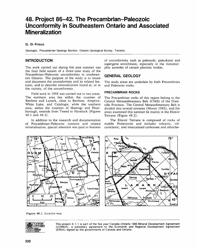
48. Project 86-42. The Precambrian-Paleozoic Unconformity in Southeastern Ontario and Associated Mineralization
G. DI Frisco
Geologist, Precambrian Geology Section, Ontario Geological Survey, Toronto.
INTRODUCTION
The work carried out during this past summer was the final field season of a three-year study of the Precambrian-Paleozoic unconformity in southeast ern Ontario. The purpose of the study is to locate and document the unconformity and its related fea tures, and to describe mineralization found at, or in the vicinity, of the unconformity.
Field work in 1988 was carried out in two areas. The northern area lies within the counties of Renfrew and Lanark, close to Renfrew, Arnprior, White Lake, and Calabogie, while the southern area, within the counties of Hastings and Peter borough, extends from Tweed to Havelock (Figures 48.1 and 48.2).
In addition to the research and documentation of Precambrian-Paleozoic contacts and related mineralization, special attention was paid to features
of unconformity such as paleosols, paleokarst and supergene enrichment, especially in the metamor phic aureoles of certain plutonic bodies.
GENERAL GEOLOGYThe study areas are underlain by both Precambrian and Paleozoic rocks.
PRECAMBRIAN ROCKS
The Precambrian rocks of this region belong to the Central Metasedimentary Belt (CMB) of the Gren ville Province. The Central Metasedimentary Belt is divided into several terranes (Moore 1982), and the areas examined this summer lie mainly in the Elzevir Terrane (Figure 48.2).
The Elzevir Terrane is composed of rocks of middle Proterozoic and includes volcanic, vol caniclastic, and intercalated carbonate and siliciclas-
Drummond Ys \ Smith's
Figure 48.1. Location map.
GVN\D\ ONTARIO
This project A. 1.1 is part of the five year Canada-Ontario 1985 Mineral Development Agreement (COMDA), a subsidiary agreement to the Economic and Regional Development Agreement (ERDA) signed by the governments of Canada and Ontario.
330
G. DI P RI SC O
Paleozoic Rocks m Study Areas R.L.M.Z. - Robertson Lake
Figure 48.2. Structural subdivisions of the Central Meta- sedimentary Belt, Grenville Province, Ontario (from Moore 1982; Easton, in press).
tic sedimentary rocks (Grenville Supergroup), all in truded by several plutonic suites. The Flinton Group, which is interpreted to overlie the Grenville Supergroup (Moore and Thompson 1972), consists of carbonate and clastic sedimentary rocks.
The Elzevir and adjacent terrane were subjected to two phases of metamorphism during the middle Proterozoic (Easton 1986). Most of the southern area preserves greenschist facies rocks, while in the northern area amphibolite facies rocks are common.
PALEOZOIC ROCKS
The Paleozoic rocks overlie the Precambrian base ment south and northeast of the Central Meta- sedimentary Belt. According to Liberty (1963), the Paleozoic succession in the study area begins with the clastic sediments of the Shadow Lake Formation of lower Ordovician age, followed by the carbonate sediments of the Gull River and Bobcaygeon forma tions. The Verulam and Lindsay formations, out cropping farther south, were not observed in the study areas.
RENFREW-ARNPRIOR-CALABOGIE AREAThis study area is located in the northern part of the Elzevir Terrane at the border of the Sharbot Lake Terrane. The Robertson Lake Mylonite Zone sepa rates the two terranes (Figures 48.2 and 48.3). Work in this area had three goals:1. to find and examine exposures of the unconfor
mity2. to study the relationship between mineralized
veins and the unconformity
Paleozoic rocks 2 Con. XI, Lot 23,
PRECAMBRIAN /'j Biotite-diorite ~f Gold anomaly
3 Culhane MineMetasediments
Undifferentiated 5 Williams MinePrecambrianrocks Precambrian -
Paleozoic contact
1 Dempsey Lake Mine
O 1 2 3 4 5km
Figure 48.3. Synoptic geological map of the Renfrew-Arnprior-White Lake-Calabogie area (from Carter et al. 1980; Lum bers 1982).
331
PRECAMBRIAN (48)
TABLE 48.1. ASSAY RESULTS FROM SELECTED SAMPLES FROM THE 1988 STUDY AREAS (ANALYSES BY THE GEOSCIENCE LABORATORIES, ONTARIO GEOLOGICAL SURVEY, TORONTO).
Sample Number Location Au/ppb
Renfrew-Arnprior-Calabogie Area (iron skarn deposits, supergene zone)
G.D.P 88 -09 Culhane deposit, Bagot Township 13366500mE 5021930mN (31 F/7)
G.D.P 88 -10 Lerond deposit, Bagot Township 21363410mE 5020635mN (31 F/7)
G.D.P 88 -11 Williams deposit, Bagot Township 21361990mE 5018940mN (31 F/7)
Tweed-Madoc-Marmora-Havelock Area (iron skarn deposits, supergene zone)
G.D.P 88 -17 Knob Mine, West, Madoc Township 13295250mE 4938850mN (31 C/12)
G.D.P 88 -18 Knob Mine, West, Madoc Township 20295250mE 4938850mN (31 C/12)
G.D.P 88 -20 Hobson Mine, East, Madoc Township 32295880mE 4939182mN (31 C/12)
G.D.P 88 -21 Hobson Mine, East, Madoc Township 40295880mE 4939182mN (31 C/12)
G.D.P 88 -34 Madoc West, Madoc Township 17301760mE 4930420mN (31 C/ll)
G.D.P 88 -36 Highway 7, West of Madoc, Madoc 20Township 298950mE 4930500mN (31 C/5)
G.D.P 88 -37 Dominion Mine, Madoc Township 30297920mE 4929450mN (31 C/5)
G.D.P 88 -38 Deloro North, Marmora Township 16291415mE 4934195mN (31 C/12)
3. to examine the features of the unconformity in Finally, selected iron skarn deposits were visitedthe metasomatic aureoles of various plutonic to search for potential secondary supergene recon-bodies centration (Figure 48.3). Assays of samples from
these deposits indicate a slight gold enrichment in Outcrops exposing Precambrian-Paleozoic con- the weathered zones of the occurrences (Table
tacts are not common in this area, and with the ex- 48.1).ception of a few localities (Figure 48.3), contacts areobscured by overburden. TWEED-MADOC-MARMORA-HAVELOCK
Several historic mines of carbonate, sulphide, AREAsulphate, and oxide metallic mineralization were vis- This area lies in the southern part of the Elzevir Ter-ited. In most, mineralization is hosted in fractures rane and is overlapped to the south by Paleozoicthat cut both the Precambrian and Paleozoic rocks, rocks Several outliers of Paleozoic rocks outcrop inand which is most likely related to a late tectonic front of the main Precambrian-Paleozoic boundaryevent - (Figure 48.4).
However, a clear genetic interpretation is not A more detailed study of previously identifiedapparent for the carbonate-sulphate ore deposit at unconformities (Springer 1985; Di Pnsco 1986,Dempsey Lake, Bagot Township, or the hematite 1987) has been carried out in this area - Precambrianmine on lot 23, concession XI, Darling Township paleosols and paleokarsts with associated mineraliza-(Figure 48.3). Both occurrences are situated in Pre- tion underneath the Paleozoic rocks, were examinedcambrian carbonate metasediments and show a m ^ner detail (Figure 48.4).brecciated mineralized habit which is interpreted to Previous work (Di Prisco 1986, 1987) showsrepresent mineralization of karst collapse structures that the most interesting and promising unconfor-that developed along the Precambrian surface. mity-related features are located in the metasomatic
332

G. DI FRISCO
aureoles surrounding plutonic bodies belonging to the biotite-diorite suite of Lumbers (1967). There fore, research focused on this environment, particu larly around the Deloro Batholith in Madoc and Marmora townships where many skarn ore deposits outcrop. Supergene reconcentrations at the Precam brian surface, above iron and sulphide deposits, were examined and sampled. Preliminary assays in dicate a slight gold enrichment in the weathered zones of certain of these skarn ore deposits (Table 48.1).
ECONOMIC IMPLICATIONS OF THEPRECAMBRIAN-PALEOZOICUNCONFORMITYExposed for a long period of time in a subaerial en vironment and under semi-arid climatic conditions, the Precambrian land surface was subjected to weathering processes. Dissolution, transportation, and redeposition of minerals and fragments of the weathered Precambrian basement occurred. As a re sult, paleosols, paleokarsts, supergene alteration, and supergene reconcentration of existing mineral ization formed. Metal reconcentration in some places was sufficient to form secondary ore deposits at the Precambrian land surface, some of which
were mined (Wallbridge Iron Mine, Coe Mine). Nevertheless, the secondary reconcentration is usu ally not wide-scale enough to allow mining. How ever, these widespread discrete supergene alterations can indicate geochemical anomalies associated with ore deposits in the immediately underlying Precam brian rocks. Thus, the recognition of weathering fea tures related to the unconformity can be used as an exploration tool for the survey of precious and base metals in the Precambrian basement.
Exploration of buried Precambrian ore deposits can benefit from the observation of earliest Paleo zoic sediments. As noted previously (Di Prisco 1986, 1987), mechanically reconcentrated ore fragments are only found in the basal Paleozoic clastic units in close proximity to Precambrian ore deposits. There fore, the presence of ore clasts in the basal Paleozoic units would suggest the presence of a nearby Pre cambrian ore deposit.
In the Central Metasedimentary Belt, gold has been found in weathered horizons of historic Pre cambrian skarn deposits, i.e. Richardson Gold Mine (Vernor 1870), Cordova Mine (Blue 1894), Sofia Mine (Slaght 1898). More recently, gold enrich ment has been observed at the Precambrian land surface, in the same geological context by Di Prisco and Springer (1988). Therefore, study of supergene
[Hill Paleozoic rocksPRECAMBRIAN
tt + j Unsubdividedplutonic rocks
|:',-,vj Biotite-dioriteplutonic rocks
,['•V;vl Carbonate
metasedlments
| __ l UnsubdividedPrecambrian series
A Unconformity features observedat:
1 Canada TalcQuarry, Madoc
2 Wallbridge IronMine
3 Dufferin Mine
4
*
5
6
7
S
g
10
Blairton IronMine
Gold anomaly
Madoc westHWY. 7, westof Madoc
Dominion Mine
Hobson-Knob Mine, east
Hobson-KnobMine, west
Deloro, north
Figure 48.4. Simplified geological map of the Tweed-Madoc-Marmora-Havelock area (from Kingston et al. 1985).
333
PRECAMBRIAN (48)
reconcentration so far has been oriented toward the investigation of metasomatic aureoles surrounding plutonic bodies in which skarn ore deposits are wide spread and abundant.
Ore deposits other than those related to meta somatic processes would also have been affected by Precambrian weathering. Hence, this weathering may prove to be a useful exploration tool for ore deposits as varied as the volcanogenic massive-sul phide, polymetallic stratabound, and fault-related deposits common in the Grenville Province in south eastern Ontario. Special attention should also be paid to exploration of gold along weathered horizons of the Robertson Lake Mylonite Zone and to gold associated with weathering in volcanogenic massive sulphide of Montauban or New Calumet type ore de posits (see Easton, this volume).
SUMMARY
During the late Proterozoic, the Precambrian land surface remained exposed in a subaerial environ ment for several hundred million years. This surface was subjected to weathering processes which lead to metal reconcentration at the Precambrian surface. Therefore, the recognition of features related to the Precambrian-Paleozoic unconformity can help in the exploration for precious and base metals.
Study of these weathering features in the meta somatic aureoles of Grenville plutonic rocks has pro vided information about metal reconcentration above skarn deposits and has shown the utility of this approach in exploration. It is felt that this method may prove to be a useful tool in exploration for various mineral deposits hosted in Precambrian rocks in southeastern Ontario.
REFERENCESBlue, A.1894: The Gold Fields of Ontario; Ontario Bureau of Mines,
Annual Report for 1893, Volume 3, p.47-51.
Carter, T.R., Colvine, A.C., and Meyn, H.D.1980: Geology of Base Metal, Precious Metal, Iron and Mo
lybdenum Deposits in the Pembroke-Renfrew Area; Ontario Geological Survey, Mineral Deposit Circular 20, 186p.
Di Prisco, G.1986: The Paleozoic-Precambrian Unconformity and Asso
ciated Mineralization in the Madoc Area (Eastern Ontario); p.335-340 in Summary of Field Work and Other Activities 1986, by the Ontario Geological Sur vey, edited by P.C. Thurston, Owen L. White, R.B. Barlow, M.E. Cherry, and A.C. Colvine, On tario Geological Survey, Miscellaneous Paper 132, 435p. Accompanied by l Chart.
1987: The Precambrian-Paleozoic Unconformity in Eastern Ontario and Associated Mineralization; p.240-244 in Summary of Field Work and Other Activities 1987, by the Ontario Geological Survey, edited by R.B. Bar
low, M.E. Cherry, A.C. Colvine, Burkhard O. Dressler, and Owen L. White, Ontario Geological Survey, Miscellaneous Paper 137, 429p.
Di Prisco, G., and Springer, J.S.1988: Gold Enrichment at the Precambrian-Paleozoic Un
conformity; Geological Association of Canada, Pro gram with Abstracts, Volume 13, p.A33.
Easton, R.M.1986: Geochronology of the Grenville Province; p. 127-173
in The Grenville Province, edited by J.M. Moore, A. Davidson, and A.J. Baer, Geological Association of Canada, Special Paper 31, 358p.
In Press: Middle Proterozoic Evolution of the North American and the Baltic Shields, edited by C.F. Gower, A.B. Ryan, and T. Rivers; Geological Association of Canada, Special Paper.
Kingston, P.W., Papertizian, V.C., and Williams, D.A.1985: Geology and Mineral Deposits of the Kingston Area,
Southern Ontario; Ontario Geological Survey, Map P.2611, Compilation Series-Preliminary Map, scale 1:125 000. Compilation 1978 to 1982.
Liberty, B.A.1963: Geology of Tweed, Kaladar and Bannockburn Map
Areas, Ontario; Geological Survey of Canada, Paper 63-14, 15p.
Lumbers, S.B.1967: Stratigraphy, Plutonic Activity and Metamorphism of
the Ottawa River Remnant in the Bancroft-Madoc Area of the Grenville Province of Southeastern On tario; Princeton University, Unpublished Ph.D. The sis, 331p.
1982: Summary of Metallogeny, Renfrew County Area; On tario Geological Survey, Report 212, 58p. Accompa nied by Maps 2459, 2460, 2461, and 2462, scale 1:100 000.
Moore, J.M.1982: Stratigraphy and Tectonics of the Grenville Orogen in
Eastern Ontario; Grenville Workshop, 1982, Programand Abstracts, p. 14.
Moore, J.M., and Thompson, P.H.1972: The Flinton Group, Grenville Province, Eastern On
tario, Canada; 24th International Geological Con gress, Section l, Precambrian Geology, Montreal, p.221-229.
Slaght, A.1898: Mines of Eastern Ontario; Ontario Bureau of Mines,
Annual Report for 1898, Volume 7, Part l,p.85-100.
Springer, J.S.1985: Colour Clues to Concentration of Iron Pigments and
Gold at the Paleozoic-Precambrian Unconformity; p.253-256 in Summary of Field Work and Other Ac tivities 1985, Ontario Geological Survey, edited by John Wood, Owen L. White, R.B. Barlow, and A.C. Colvine, Ontario Geological Survey, Miscella neous Paper 126, 351p.
Vennor, H.G.1870: Report of Mr. Henry G. Vennor on Hastings County;
Geological Survey of Canada, Report for 1866-69,p.143-171.
334
49. Project Number 88-35. Hematitized Fault Zones in the North Bay AreaJ.S. Springer
Geologist, Precambrian Geology Section, Ontario Geological Survey, Toronto.
INTRODUCTION
Paleozoic, post-Ordovician faulting and fracturing of both the Grenvillian and Paleozoic rocks in south eastern Ontario have been the focus of investigations since the early 1980s (Williams et al. 1984). Lead- zinc, minor silver (Carter 1984), and barium-stron tium-fluorine mineralization (Williams 1982) are lo cally associated with the fracturing and warrant ex ploration.
The study of post-Ordovician fractures and faults could indirectly lead to the discovery of miner alization related to the Precambrian-Paleozoic un conformity investigated by Springer (1985), Chur cher (1986), and Di Prisco (1986, 1987). It is known from the work of these researchers that weathering of Precambrian rocks can lead to ore en richment, for example, the concentration of high- grade hematite ore, which locally may be exploitable as quality pigment. It now appears that weathering at the unconformity was especially strong at Precam brian fault and fracture zones, several of which were active during the Paleozoic. Therefore the study of fracture and fault systems in southeastern and cen tral Ontario contributes to the understanding of the geological history and has some significance to con centration of mineralization.
The author selected two known hematite occur rences, which are associated with faulting, for de
tailed investigations. These two occurrences are among many which are scattered in central Ontario close to the Paleozoic-Precambrian unconformity. Locality l is south of Lake Nipissing in Nipissing Township; locality 2 is on Highway 11, 3.9 km south of the town of Powassan in South Himsworth Town ship.
LOCALITY 1South of Lake Nipissing (Figure 49.1), a small out lier of Paleozoic rocks bounded to the south by an east-trending fault has been described by Satterly (1942) and Lumbers (1971). Lumbers calls this east-trending fault the Nipissing Fault and infers that it marks the southern margin of the Ottawa- Bonnechere Graben. The limestones which make up the bulk of the section are richly fossiliferous and thus can be placed in the upper Middle Ordovician Rockland stage of the Champlanian Series (Williams and Telford 1986).
Hematite occurs along the Nipissing Fault, and Lumbers (1971, p.76) described the occurrence as follows:
"In lot 218, Concession A, Nipissing Township, hema tite-enriched, silicified, brecciated granitic rocks of the Powassan batholith, exposed in the Nipissing Fault at the base of a talus slope on the south side of the Paleozoic outlier about 1.7 miles west of Nipissing, have been explored for iron. The main showing is about 800 feet south of the road
Figure 49.1. Location map for the North Bay study area. Numbers l and 2 refer to localities discussed in this report.
335
PRECAMBRIAN (49)
leading west from Nipissing and was explored in 1941 by a 300-foot diamond drill hole put down by W. Holder, and in 1951 and 1952, by gravimetric and geological surveys com pleted for J.H. Dumouchel (assessment work files, Resident Geologist, Ontario Department of Mines and Northern Af fairs, Toronto). This work failed to disclose economic con centrations of iron".
When Satterly (1942, p.47) visited the occurrence exposure was better:
"The hematite deposit is at the base of a talus slope 12 chains from the road. Between the deposit and the road, Pa leozoic dolomite is exposed from l to 6 chains south of the road. The talus cliff is 50 feet high, and the talus consists of fragments of granite gneiss stained with a red film of hema tite. Examination of the cliff face shows a granite gneiss brec cia with a cement of reddish-brown hematite. This cliff peters out westward. As no outcrops east or west of the exposures mentioned were found, it is not known how big an area is underlain by the dolomite.
At the time of the writer's visit on July 26, 1941, no new work had been done on the deposit, and nothing could be seen in a partially caved-in timbered pit at the base of the talus. The only hematite seen was on the dump. This material is a hard, fine-grained, grey and brown hematite containing dis seminated glassy quartz."
Lumbers (1971, p.76) further reports that:"A grab sample collected by Satterly (1942, p.41) from
the dump near the old pit gave upon assay 55.65 percent Fe, 18.73 percent SiO2 and 0.10 percent S. The diamond drill hole intersected l- and 3-foot sections that gave upon assay 41.26 and 34.62 percent iron respectively."
In recent years a quarry has been opened along the fault by Mr. Stanley Moore, Powassan, to pro vide fill and road metal from the Precambrian bed rock. Quarrying has uncovered the fault, as well as the unconformity of Paleozoic on the Grenvillian rocks (Figure 49.2). Several generations of fractur ing, associated with different fault-fill materials can be seen. The east-trending Nipissing Fault is obvi ously a younger structure which cuts older mylonite zones. The following observations were made by the author:1. The Precambrian gneisses have been crushed
and form a red, flinty mylonite along northwest- oriented fracture planes. This deformation is pre-Middle Ordovician in age, as the nearby Or dovician rocks are not affected by it.
2. Both the gneisses and the mylonite zones have been fragmented and weathered to rounded cobbles.
3. The cobbles, in part, have been incorporated into a yellow-green, matrix-supported conglom erate that forms the base of the Paleozoic se quence. The fine fraction of this conglomerate contains very well rounded quartz grains.
4. The later, east-trending Nipissing Fault is marked by a green, chloritic fault gouge. The fault has affected both the Precambrian and Pa leozoic rocks. The Paleozoic limestone beds are cut by faults that parallel the main fault. The Paleozoic limestones step down northwards on
\f\South Bay
WADE'S LANDING
Precambrian gneiss
Middle Ordovician dolomite
CHAPMAN'S LANDING
S. Moore s Stone Quarry NIPISSING FAULT
Cobbles of older faultgouge and Precambrian gneiss in basal
Middle Ordovician conglomerate
older fault gouge, red,fragmental, glassy
Basal Middle Ordovician: cobbles of weathered Precambrian gneiss in yellow-green quartzite, calcareous cement
Younger fault gouge,green chloritic
downthrow on fault
bedding, dip in e
fault, vertical
Figure 49.2. Fault relationships on the Nipissing Fault (Locality l, Moore's Quarry).
336
J. S. SPRINGER
these later fault lines. The dip of the beds steep ens from almost horizontal to 30 0 close to the fault and strikes become subparallel to the fault. The fragments in the fault gouge are loosely ce mented by a vuggy framework of encrusting cal cite and pyrite.
5. Present activity at the fault zone includes a spring that arises along it and is tapped by local cottages. Hydraulic water flow on the fault line is depositing tufa, and redistributing iron hydrox ides so that fragments of the gneisses and the basal conglomerate are becoming recemented and coated with limonite and hematite. This ap pears to be the hematite ore reported by Satterly (see above).
LOCALITY 2Previous work by Lumbers (1971; p.66) identified this locality on Highway 11, 3.9 km south of the town of Powasson in South Himsworth Township where a fault breccia in monzonite is cemented with a hematite-rich matrix.
For the greater North Bay area, Lumbers (1971) has clearly pointed to the long, complex his tory of the fracture systems that strike west- northwest. He deduces that this system has con trolled the emplacement of both diabase and lamprophyre dikes; that their age spans the Late Proterozoic to Early Paleozoic; and that the Cambrian alkalic intrusions (565 Ma old, Gittins et al. 1967) are intimately connected to the formation of the Ottawa-Bonnechere Graben.
At locality 2 (Figure 49.1, Figure 49.3) the fol lowing observations were made:
43
^3Lamprophyre dike
with chill margin
253
xDextrel shear on ir hematized fractures
Sinistral shear on 5-10 cm wide zones of dark red
flinty mylonite
-™— Strike, dip of dike
-^^- Strike of vertical fracture plane
Figure 49.3. Structural relationships, Highway 11, 3.5 km south of Powassan (Locality 2).
1. North-northwest-trending fracture planes (about 330 0 to 340 0 ) are filled with dark-red flinty mylonite and show a sinistral sense of mo tion.
2. Fracture and fault zones control the intrusion of lamprophyre dikes, whose margins are chilled against the Precambrian monzonite gneiss. The dikes, striking about 030 0 , thin within the my lonite zones but are not disrupted.
3. Later hematized fracture planes striking about 250 0 to 260 0 displace the lamprophyre dikes with a dextral sense of motion.Lumbers (1971) has argued a Cambrian age for
the lamprophyre dikes, regarding them as accompa nying the 565 Ma old, alkalic intrusive event in the Lake Nipissing area. Present observations confirm that a north-northwest-oriented fracture event, marked by flinty mylonite, took place before the deposition of the Paleozoic rocks. The lamprophyre dikes, controlled by the north-northwest-directions, must be coeval with or later than this fracture event. Later hematitized fault planes, striking eastward, postdate both the mylonite and the lamprophyres.
At this locality, there is no evidence that hematitization is related to the Paleozoic unconfor mity. The hematitized fault zones are probably post- Cambrian, but cannot be dated precisely.
CONCLUSIONSSeveral hematite occurrences in southeastern and central Ontario are related to strong alteration in fault and breccia zones. Both Precambrian and Pa leozoic faulting can be responsible for the alteration and, in places, Precambrian weathering appears to be especially strong at Precambrian fault zones (see Easton, this volume; Di Prisco, this volume). Thus, these fault and fracture zones have potential for high quality pigment and possibly for gold.
REFERENCESCarter, T.R.1984: Metallogeny of the Grenville Province, Southeastern
Ontario; Ontario Geological Survey, Open File Report5515, 422p.
Churcher, P. L.1986: The Precambrian-Paleozoic Unconformity and Miner
alization in the Madoc-Bannockburn Area, Eastern Ontario; p.341-346 in Summary of Field Work and Other Activities 1986, by the Ontario Geological Sur vey, edited by P.C. Thurston, Owen L. White, R.B. Barlow, M.E. Cherry and A.C. Colvine, Ont ario Geological Survey, Miscellaneous Paper 132, 435p. Accompanied by l chart.
Colquhoun, D.J.1958: Stratigraphy and Palaeontology of the Nipissing-Denx
Rivieres Outliers; Geological Association of CanadaProceedings, Volume 10, p.83-93.
Di Prisco, G.1986: The Paleozoic-Precambrian Unconformity and Asso
ciated Mineralization in the Madoc Area (Eastern
337
PRECAMBRIAN (49)
Ontario); p.335-340 in Summary of Field Work and Other Activities 1986, by the Ontario Geological Sur vey, edited by P.C. Thurston, Owen L. White, R.B. Barlow, M.E. Cherry and A.C. Colvine, Ont ario Geological Survey, Miscellaneous Paper 132, 435p. Accompanied by l Chart.
1987: The Precambrian-Paleozoic Unconformity in Eastern Ontario and Associated Mineralization; p.240-244 in Summary of Field Work and Other Activities 1987, by the Ontario Geological Survey, edited by R.B. Bar low, M.E. Cherry, A.C. Colvine, Burkhard O. Dressler, and Owen L. White, Ontario Geological Survey, Miscellaneous Paper 137, 429p.
Gittins, J., Macintyre, H.M., and York, D.1967: The Ages of Carbonatite Complexes in Eastern Can
ada; Canadian Journal of Earth Sciences, Volume 4, Number 4, p.651-655.
Lumbers, S.B.1971: Geology of the North Bay Area, Districts of Nipissing
and Parry Sound; Ontario Department of Mines and Northern Affairs, Geological Report 94, 104p. Ac companied by Map 2216, scale l: 126 720 or l inch to 2 miles.
Satterly, J.1942: Mineral Occurrences in Parry Sound District; Ontario
Department of Mines, Annual Report for 1942, Vol
ume 51, Part 2, 86p. Accompanied by Map 51a, scale 1:126 720 or l inch to 2 miles.
Springer, Janet1985: Colour Clues to Concentration of Iron Pigments and
Gold at the Paleozoic-Precambrian Unconformity; p.253-256 in Summary of Field Work and Other Ac tivities 1985, Ontario Geological Survey, edited by John Wood, Owen L. White, R.B. Barlow, and A.C. Colvine, Ontario Geological Survey, Miscella neous Paper 126, 351p.
Williams, D.A1982: Industrial Minerals in Post-Ordovician Vein Deposits
in Eastern Ontario; in Proceedings of Eastern Re gional Industrial Minerals Seminar, Ottawa, 1982, Convened by M. A. Klugman, l Op.
Williams, D.A., and Telford, P.G.1986: Paleozoic Geology of the Ottawa Area; Geological As
sociation of Canada-Mining Association of Canada- Canadian Geophysics Union, Joint Annual Meeting, Ottawa, 1986, Field Trip 8 Guidebook, 26p.
Williams, D.A., Wolf, R.R., and Rae, A.M.1984: Paleozoic Geology of the Arnprior-Quyon Area,
•Southern Ontario; Ontario Geological Survey Map P.2726, Geological Series-Preliminary Map, scale 1:50 000. Geology 1982.
338
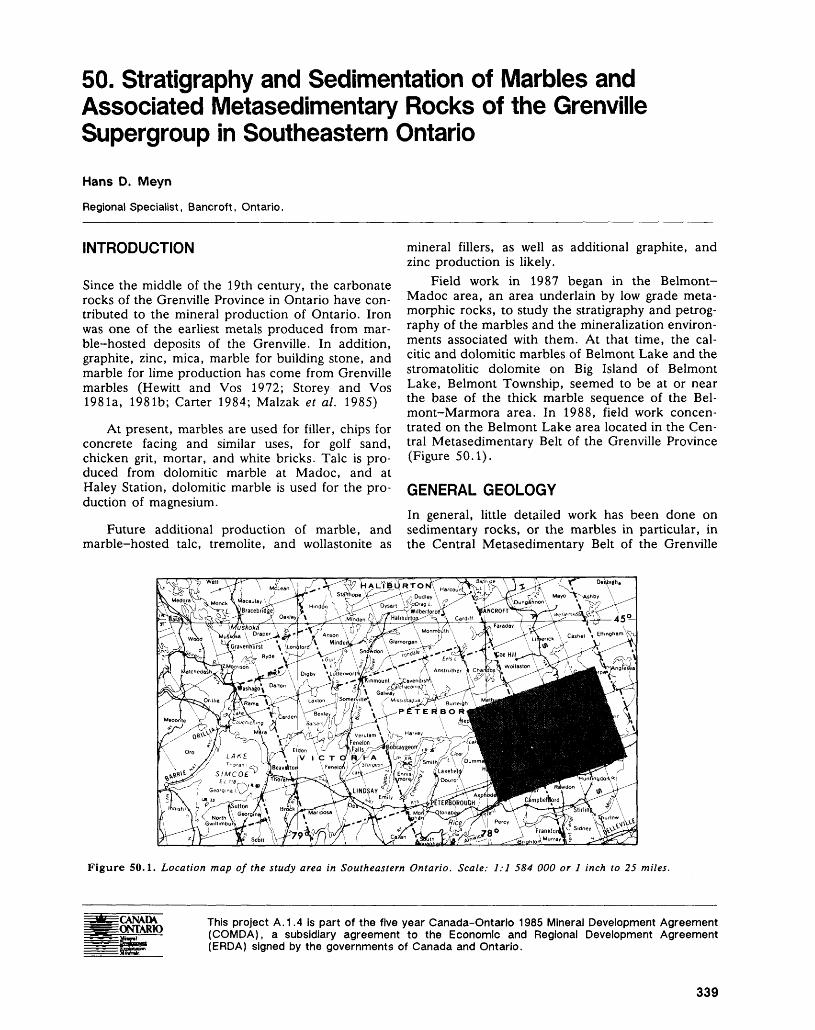
50. Stratigraphy and Sedimentation of Marbles and Associated Metasedimentary Rocks of the Grenville Supergroup in Southeastern OntarioHans D. Meyn
Regional Specialist, Bancroft, Ontario.
INTRODUCTION
Since the middle of the 19th century, the carbonate rocks of the Grenville Province in Ontario have con tributed to the mineral production of Ontario. Iron was one of the earliest metals produced from mar ble-hosted deposits of the Grenville. In addition, graphite, zinc, mica, marble for building stone, and marble for lime production has come from Grenville marbles (Hewitt and Vos 1972; Storey and Vos 1981a, 1981b; Carter 1984; Malzak et al. 1985)
At present, marbles are used for filler, chips for concrete facing and similar uses, for golf sand, chicken grit, mortar, and white bricks. Talc is pro duced from dolomitic marble at Madoc, and at Haley Station, dolomitic marble is used for the pro duction of magnesium.
Future additional production of marble, and marble-hosted talc, tremolite, and wollastonite as
mineral fillers, as well as additional graphite, and zinc production is likely.
Field work in 1987 began in the Belmont- Madoc area, an area underlain by low grade meta morphic rocks, to study the stratigraphy and petrog raphy of the marbles and the mineralization environ ments associated with them. At that time, the cal citic and dolomitic marbles of Belmont Lake and the stromatolitic dolomite on Big Island of Belmont Lake, Belmont Township, seemed to be at or near the base of the thick marble sequence of the Bel- mont-Marmora area. In 1988, field work concen trated on the Belmont Lake area located in the Cen tral Metasedimentary Belt of the Grenville Province (Figure 50.1).
GENERAL GEOLOGYIn general, little detailed work has been done on sedimentary rocks, or the marbles in particular, in the Central Metasedimentary Belt of the Grenville
^V5P^S^ssssT. - fft*- - ^ to* H,II ,A*1 ^ \^r^r ^ . v
Figure 50.1. Location map of the study area in Southeastern Ontario. Scale: 1:1 584 000 or l inch to 25 miles.
This project A.1.4 is part of the five year Canada-Ontario 1985 Mineral Development Agreement (COMDA), a subsidiary agreement to the Economic and Regional Development Agreement (ERDA) signed by the governments of Canada and Ontario.
339
PRECAMBRIAN (50)
Province in Ontario. Among the earliest workers were Adams and Barlow (1910) who recognized am phibolite layers in marble as metasediments, and Miller and Knight (1914) who synthesized the Pre cambrian geology of Southeastern Ontario. A more general overview of the local and regional metasedimentary geology is given by Lumbers (1964) and Hewitt (1968). Recent detailed mapping by Bartlett and Moore (1985) and several university theses associated with that project (Murray 1982; Bartlett 1983; Pilon 1981; deKemp 1984) produced 1:15 840 scale maps of Belmont and Marmora townships with an emphasis on the volcanology of the area. At about the same time, field work on a similar project to this author's commenced by Bourque (Bourque 1981, 1982; Bourque et al. 1982) and some of the results of that study are con tained in Bartlett and deKemp (1987).
BELMONT LAKE FORMATION
Bartlett and co-workers created a separate map unit for the predominantly epiclastic rocks present in southern Belmont Lake (Bartlett et al. 1982), which was subsequently named the Belmont Lake Forma tion.
The Belmont Lake Formation is first defined in Bartlett (1983, p.52): "Named for its areal restric tion to the east shore and some islands of Belmont Lake, this formation comprises polymictic granule to cobble (rarely boulder) conglomerate with subordi nate sandstone, mudstone and dolomitic marble."
The relationship of this formation to the under lying, overlying, and laterally equivalent rocks is not clearly defined. Bartlett (1983) considered the Bel mont Lake Formation to be a lateral equivalent of the Marmora Formation (Bartlett 1983, p.48), which is exposed in northern Belmont Lake and northeast of Belmont Lake. A detailed description of the Belmont Lake Formation is given in Bartlett and Moore (1985), and the reader is referred to this publication for further information. Some features described by Bartlett and Moore (1985) do not ap ply to all parts of the formation equally.
A pervasive schistosity is developed in all of the rocks of the Belmont Lake area. In much of the Bel mont Lake Formation, the strike of the schistosity is parallel to the strike of the sedimentary units and in some instances, the dips are parallel as well, but this is not typical. The schistosity has affected the car bonate units to varying degrees. Some boudinaging of calc-silicate layers and aligning of calc-silicate fragments into layers parallel to schistosity/bedding is common. This feature is best developed near the base of the carbonate sequence where shearing along the contact between the volcanics and the marble may have taken place.
Sedimentary structures such as bedding, includ ing very finely laminated mudstones and dolostones, cross-bedding, and graded bedding are well pre
served. Strike direction is generally just east of north. Stratigraphic tops are consistently eastward (up). Bedding is locally vertical to overturned but dips are generally between 30 and 70 degrees east. Indication of paleocurrent direction from cross-bed ding is typically eastward.
This summer's field work suggests that the Bel mont Lake Formation is composed of a series of fin ing upward cycles.
A typical fining upward cycle on Belmont Lake starts with conglomerate, followed by cross-bedded sandstone and pebbly sandstone. The sandstone in turn is overlain by ever finer sandstone, grading up ward into siltstone and culminating with laminated mudstones. Where conditions were suitable, the clastic sequence is topped by stromatolitic dolomite.
Few complete fining upward cycles have been observed in any single section because of lack of continuous outcrop. Further, each cycle is not al ways complete in every instance, nor were condi tions favourable for deposition of the stromatolitic dolomite at the top of each cycle or along the whole strike length of a cycle.
There occurs on Belmont Lake clastic rocks other than those included in the fining upward cy cles. Bartlett and Moore (1985) seem to have in cluded some, but not all, of these rocks in the Bel mont Lake Formation. This author hopes to deter mine the relationship of these rocks to the Belmont Lake Formation as this study progresses.
DISCUSSIONThis summer it was recognized that the sequence of clastic rocks centred on Big Island, Belmont Lake, Belmont Township, essentially the same suite of rocks included in Bartlett's (1983) definition of the Belmont Lake Formation, consists of fining upward cycles.
The depositional environment of this clastic se quence is not yet resolved. Bartlett and Moore (1985, p. 107) state: "Detailed facies analysis of the predominantly sedimentary Vansickle, Marmora and Belmont Lake formations is not attempted in this report." They go on to say (Bartlett and Moore, 1985, p.109): "The authors' data are presently in sufficient to determine the exact nature of sedimen tary processes responsible for the deposition of the Belmont Lake Formation. Fluvial processes were important, as evidenced by cross-bedding and scour channels, however, lahars may have contributed sig nificantly, as may have alluvial processes. Whatever the mechanism, the spatial distribution of the Bel mont Lake Formation relative to the Cordova Lake Formation suggests that the material was primarily transported down the east flank of the source vol cano."
The author of the present study believes that a general model for the environment encountered at
340
HANS D. MEYN
Belmont Lake might be a volcanic island or chain of islands surrounded by a relatively narrow, shallow water carbonate shelf on which carbonate deposition takes place whenever clastic or volcanic/pyroclastic events do not predominate. Such an environment would allow all of the observed volcanic and sedi mentary facies to co-exist in close proximity.
Further study will increase the understanding of the paleoenvironment of the carbonate and clastic metasediments in the Central Metasedimentary Belt of the Grenville Province in Ontario and the mineralization environments associated with these rocks.
REFERENCESAdams, F.D., and Barlow, A.E.1910: Geology of the Haliburton and Bancroft Areas, Prov
ince of Ontario; Geological Survey of Canada, Mem oir Number 6, 419p.
Bartlett, J.R.1983: Stratigraphy, Physical Volcanology and Geochemistry
of the Belmont Lake Metavolcanic Complex, South eastern Ontario; Unpublished M.Se. Thesis, Carleton University, 218p.
Bartlett, J.R., and DeKemp, E.A.1987: Lithofacies, Stromatolite Localities, Metallic Mineral
Occurrences, and Geochemical Anomalies Associated with Carbonate Metasediments of the Burleigh Falls- Bancroft-Madoc Area, Southern Ontario; Ontario Geological Survey, Map P. 3079, Geological Series- Preliminary Map, scale 1:126 720. Geology 1981, 1982, 1985.
Bartlett, J.R., and Moore, J.M., Jr.1985: Geology of Belmont, Marmora, and Southern
Methuen Townships, Peterborough and Hastings Counties; Ontario Geological Survey, Open File Re port 5537, 236p., 11 tables, 16 figures, 16 photos, and 3 maps in back pocket.
Bartlett, I.R., Moore, J.M., and Murray, M.J.1982: Geology of Belmont and Southern Methuen Town
ships, Peterborough County; Ontario Geological Sur vey, Open File Report 5372, 37p., 2 tables, l figure, and l map.
Bourque, M.S.1981: Stratigraphy and Sedimentation of Carbonate
Metasediments within the Grenville Supergroup; p.77-79 in Summary of Field Work 1981, by the On tario Geological Survey, edited by John Wood, O.L. White, R.B. Barlow, and A.C. Colvine, On tario Geological Survey, Miscellaneous Paper 100, 255p.
1982: Stratigraphy and Sedimentation of Carbonate Metasediments within the Grenville Supergroup in Havelock-Madoc-Bancroft Area, p. 89-91 in Sum mary of Field Work 1982, by the Ontario Geological Survey, edited by John Wood, Owen L. White, R.B. Barlow, and A.C. Colvine, Ontario Geological Survey, Miscellaneous Paper 106, 235p.
Bourque, M.S., Crosby, C.A., Donaldson, J.A., and Moore, J.M. Jr.
1982: Algal Stromatolites in the Grenville Supergroup of Eastern Ontario; p.39 in Program with Abstracts, Geological Association of Canada and Mineralogical Association of Canada, Joint Annual Meeting, Win nipeg, 95p.
Carter, T.R.1984: Metallogeny of the Grenville Province, Southeastern
Ontario; Ontario Geological Survey, Open File Report5515, 422p.
deKemp, E.A.1984: Geology of the Belmont Lake Meta-Carbonate Com
plex and the Development of the Thermal Aureole of the Cordova Metagabbro, N.E. Belmont Township, Ontario; Unpublished B.Se. Thesis, Memorial Uni versity of Newfoundland, 12Ip.
Hewitt, D.F.1968: Geology of Madoc Township and the North part of
Huntingdon Township; Ontario Department of Mines, Geological Report 73, 45p. Accompanied by Map 2154, scale 2 inches to l mile.
Hewitt, D.F., and Vos, M.A.1972: The Limestone Industries of Ontario; Ontario Divi
sion of Mines, Industrial Mineral Report 39, 79p.
Lumbers, S.B.1964: Preliminary Report on the Relationship of Mineral De
posits to Intrusive Rocks and Metamorphism in Part of the Grenville Province of Southeastern Ontario; On tario Department of Mines, Preliminary Report 1964-4, 37p.
Malzak, J., Carter, T.R., and Springer, J.S.1985: Base Metal, Molybdenum, and Precious Metal De
posits of the Madoc-Sharbot Lake Area, Southeastern Ontario; Ontario Geological Survey, Open File Report 5548, 374p., Map P.2737 in back pocket.
Miller, W.G., and Knight, C.W.1914: The Pre-Cambrian Geology of Southeastern Ontario;
Ontario Bureau of Mines, Annual Report for 1913, Volume 22, part II, 151p. Accompanied by Maps 22A to 22F and 22O.
Murray, M.J.1982: The Structure, and Metamorphism of Precambrian
Rocks in Belmont and Southern Methuen Townships, Southeastern Ontario, Unpublished B.Se. Thesis, Carleton University, Ottawa, 128p.
Pilon, P.E.1981: Petrography and Geology of the Belmont Lake Con
glomerate, Belmont Township, Ontario; Unpublished B.Se. Thesis, McMaster University, Hamilton, 78p.
Storey, C.C., and Vos, M.A.198la: Industrial Minerals of the Pembroke-Renfrew Area,
Part 1: Marble; Ontario Geological Survey, Mineral Deposits Circular 21, 132p. Accompanied by Prelimi nary Map P. 1980, scale 1:126 720.
1981b: Industrial Minerals of the Pembroke-Renfrew Area, Part 2; Ontario Geological Survey, Industrial Minerals Circular 22, 214p. Accompanied by Preliminary Map P.2209, scale 1:126 720.
341
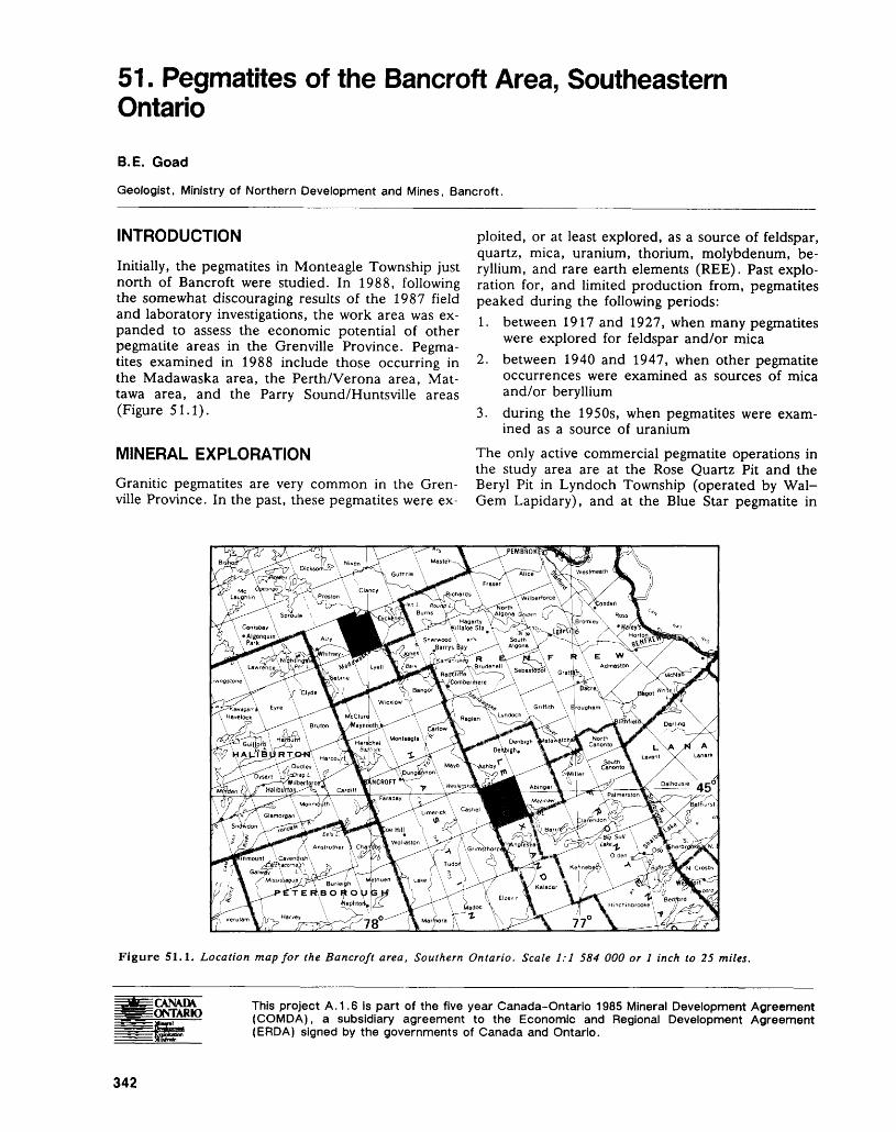
51. Pegmatites of the Bancroft Area, Southeastern OntarioB. E. Goad
Geologist, Ministry of Northern Development and Mines, Bancroft.
INTRODUCTION
Initially, the pegmatites in Monteagle Township just north of Bancroft were studied. In 1988, following the somewhat discouraging results of the 1987 field and laboratory investigations, the work area was ex panded to assess the economic potential of other pegmatite areas in the Grenville Province. Pegma tites examined in 1988 include those occurring in the Madawaska area, the Perth/Verona area, Mat tawa area, and the Parry Sound/Huntsville areas (Figure 51.1).
MINERAL EXPLORATION
ploited, or at least explored, as a source of feldspar, quartz, mica, uranium, thorium, molybdenum, be ryllium, and rare earth elements (REE). Past explo ration for, and limited production from, pegmatites peaked during the following periods:1. between 1917 and 1927, when many pegmatites
were explored for feldspar and/or mica2. between 1940 and 1947, when other pegmatite
occurrences were examined as sources of mica and/or beryllium
3. during the 1950s, when pegmatites were exam ined as a source of uranium
The only active commercial pegmatite operations in the study area are at the Rose Quartz Pit and the
Granitic pegmatites are very common in the Gren- Beryl Pit in Lyndoch Township (operated by Wal- ville Province. In the past, these pegmatites were ex- Gem Lapidary), and at the Blue Star pegmatite in
Figure 51.1. Location map for the Bancroft area, Southern Ontario. Scale 1:1 584 000 or l inch to 25 miles.
This project A. 1.6 is part of the five year Canada-Ontario 1985 Mineral Development Agreement (COMDA), a subsidiary agreement to the Economic and Regional Development Agreement (ERDA) signed by the governments of Canada and Ontario.
342
B. E, GOAD
Chapman Township. These are all operated solely for collection of mineral specimens. In 1976 and 1977, the Comet Quartz pegmatite in Murchison Township and the International Quartz pegmatite in Mcclintock Township produced quartz but opera tions are inactive at present.
PRESENT STUDY
GENERAL BACKGROUND
The present study was initiated in 1987 to study the pegmatites occurring north of Bancroft in the Gren ville Province of Southern Ontario. This study was designed to geochemically classify the pegmatites based on their trace element content and if possible, to relate the pegmatites to parental granitic intru sions. The final goal of the investigations is to pro vide the mineral industry with a practical tool for pegmatite exploration. Previous studies by Storey and Vos (1981), Masson and Gordon (1981), and Hewitt (1967) classified the pegmatites into groups solely on a descriptive or geographic basis.
During the study, all examined pegmatites were sampled and if adequately exposed, were mapped at a 1:200 scale. Maps of many of these showings do not exist in the literature. Emphasis was put on the mapping of the well known mineral collecting sites in Monteagle Township.
Pegmatites are generally considered to have crystallized from fluids somewhat enriched in incom patible (including lithophile) elements (e.g. Rb, Cs, Li, Tl, Pb, and B), which are not readily accepted into the crystal structure of most rock-forming min erals. These elements tend to concentrate in the melt until the final stages of crystallization. The crys tal structure of muscovite and potassium feldspar provide a suitable host for the incompatible ele ments. Muscovite, however, unlike potassium feld spar, is not ubiquitous in all the pegmatites. In frac tionated granitic pegmatites, as the concentration of these elements increases in the late melts, it also in creases in the potassium feldspar that crystallizes from these late melts.
Comparison of the level of fractionation attained by various pegmatites should allow for the definition of distinct pegmatite fields or districts. This frac tionation level can be assessed by the study of the concentration of the trace elements within the potas sium feldspar crystal structure (Cerny 1982a). Coarse "megacrystic" potassium feldspar was studied because it is a mineral ubiquitous in granitic pegma tites and can be readily sampled and cleaned for analysis. The outer edge of the coarse blocky potas sium feldspar in the intermediate (blocky potassium feldspar+quartz) zone was sampled. Potassium feld spars sampled from this position have the most ele vated trace element abundances of any potassium feldspar obtained from a fractionated pegmatite
(Jahns 1982). Thus, feldspars from this zone are well suited for the comparison of the fractionation level of pegmatites.
CURRENT PROGRESS
During 1988, sampling of the Perth/Verona area pegmatites was completed as was sampling and map ping of pegmatites in Murchison and Effingham townships. A cursory examination and concurrent sampling of the larger pegmatites in the Huntsville/ Parry Sound and Mattawa areas was also under taken. (Not all areas investigated in 1988 are shown on the location map). Approximately 200 potassium feldspar samples were submitted for geochemical analysis. No results have yet been received for any of these samples.
GEOCHEMISTRY
Geochemical results have been received for pegma tites examined during 1987 when pegmatites in Monteagle, Cardiff, Faraday, Dungannon, Mon mouth, Miller, Bathurst, and Bedford townships were investigated.
Geochemical indicators such as K/Rb (mean value: 301), K/Cs (mean value: 8600), Rb/Cs (mean value: 36), and K/Ba (mean value: 395) suggest that extremely low levels of fractionation were attained by the pegmatites. Abundances of Li, Cs, and Rb are also extremely low making any subdivision of the various pegmatite fields quite arbitrary.
The pegmatites generally fall within the "Mica- Ceramic Bearing-Pegmatite Area" of Gordiyenko (1976) (Figure 51.2), defined by very high K/Cs ra tios and a wide range of Na2O values in the blocky potassium feldspar. Use of these diagrams requires reliable determinations of both high K and Cs values (Trueman and Cerny 1982). The extremely low Cs concentration in the feldspar of the present study area possibly makes this diagram somewhat unreli able; however, in conjunction with the low Li, Rb, and Ba content of the blocky potassium feldspar, the examined pegmatites appear to belong to Type IB, i.e. the barren pegmatites of the mica-bearing prov inces of Gordiyenko (1971) (Figure 51.3, 51.4, 51.5, and 51.6).
Figures 51.3 to 51.6 are based on Gordiyenko (1971) who published a series of plots which charac terizes five pegmatite types based on the Cs, Rb, Li, and Ba content of the potassium feldspar and mus covite. The pegmatite types indicated are as follows:IB barren pegmatites of the mica-ceramic-bearing
provinces1 A barren pegmatites of rare element-bearing prov
inces2 muscovite-feldspar pegmatites with Ba, Nb, Ta3 spodumene-bearing pegmatites with Li, Be, Ta,
(Nb, Sn)
343
PRECAMBRIAN (51)
CLASSIFICATION OF PRECAMBRIAN PEGMATITES
K/C s VS. No 2 0
10000,
1000;
K XCs 100
10-
2(o)o o\
He)
Kb) ^
Ka)
1.0 1.5 2.0 2.5 3.0 3.5 4.0
No 2o twt. v.)
Figure 51.2. Classification of Precambrian Pegmatites(Trueman and Cerny 1982) after Gordiyenko (1976) usingKlCs versus Na^O composition of K-feldspar from graniticpegmatites. Key to pegmatite types shown in Figure 51.2:3-Mica-Ceramic (barren) pegmatites2(c)-Barren, rare element-bearing pegmatites2(b)-Beryl-bearing rare-element pegmatites2(a)-Spodumene-bearing rare-element pegmatitesl (d)-Li, Be, Ta-bearing rare element pegmatites withoutpollucitel (c), l (b), l(a)-Li, Rb, Cs, Be, Ta-bearing rare elementpegmatites with pollucitel(e)-Cs-bearing, barren pegmatitesDots: Results from present study.Open circles: Results from samples obtained at the Wal-Gem pegmatite in Lyndoch Township.
4 spodumene and lepidolite-bearing pegmatites with Li, Cs, Ta, Be, (Nb, Sn)
Lines ending at + mark in Figures 51.3 to 51.6 indi cate range of arithmetic means with a 959k confi dence level (Trueman and Cerny 1982).
DISCUSSION
The pegmatites occur as both zoned and unzoned intrusions. This development of a distinct and re- peatable pattern of mineral assemblages or zones that occurs in pegmatites has been described by Cameron et al. (1949) and subsequently refined by Norton (1983). Most of the pegmatites in the pro
ject area are composed of the following rudimentary zones:1. Border Zone-plagioclase+potassium feld-
spar+quartzitbiotiterhmuscovite2. Wall Zone-plagioclase+potassium feld-
spar+quartz3. Intermediate Zone-potassium feldspar+quartz4. Core Zone-quartz 1 (possibly very minor potas
sium feldspar)1 In highly differentiated granitic pegmatites, the
quartz zone is commonly not at the "core" of the pegmatite (Norton 1983); however, in the pegmatites in the study area, the quartz zone if present or exposed, always forms at the centre of the intrusion.
Zoning in all of the pegmatites, where evident, is irregular and difficult to trace.
Contacts of many pegmatites, where exposed, vary anywhere from sharp intrusive contacts showing no sign of reaction (i.e. the Monteagle Township and Verona/Perth area pegmatites) to those that are distinctly gradational suggesting assimilation of the country rock along the contact of the pegmatites (i.e. the Dubblestein Showing in Bangor Township, Comet Quartz Occurrence in Murchison Township).
Pegmatites from within both the Central Meta- sedimentary Belt and the Central Gneiss Belt have been examined. The degree of metamorphism of the host rock does not appear to have any effect on the trace element composition of potassium feldspar in the pegmatites. It should be noted however, that the author studied an area of the Central Metasedimen- tary Belt where the metamorphic grade only attains greenschist facies metamorphism and where pegma tite occurrences are not common. Most of the peg matites show no sign of deformation suggesting that they are post kinematic, however some, including the Fraser prospect in Glamorgan Township and possibly several of the syenite pegmatites in Cardiff Township, show signs of shearing and brecciation suggesting that they are possibly very late kinematic.
Ginsburg et al. (1979) suggests that barren, ce ramic or monazite or allanite-bearing pegmatites or both (his so called "Pegmatites of Maximal Depth Formation") hosted in terranes of granulite facies metamorphism appear to be only controlled by metamorphic processes, such as partial melting. Cerny (1982b) expands these "maximal depth for mation pegmatites" to cover pegmatites in upper am phibolite and granulite facies metamorphic terrains. The REE, Th, U, Nb, Ti, Zr-bearing pegmatites of southeastern Ontario appear to have formed by par tial melting as suggested by the extremely low trace element content of the potassium feldspar, the lack of "exotic" Nb/Ta oxide minerals, lithium-bearing minerals etc., and accessory minerals typical of peg matites occurring in high grade terranes of granulite
344
B. E. GOAD
Li CONTENT OF K-FELDSPAR Rb CONTENT OF K FELDSPAR
1000:
100-
1tJ.O-J
.
—i—p—i—i—i—i—i—i—i—i—i—i—i—i—r— ABCDEFGHJKLMNOP
PEGMATITE AREAS/TYPES
1b lo 2 3 4
10000:
p 1000;
100-
ABCDEFGHJKLMNOP 1b 1o 2 3 4
PEGMATITE AREAS/TYPES
Figure 51.3. Li content of K-Feldspar; of the 425 K- Feldspar samples analyzed, most contain less than 10 ppm Li and plot well within the area of Type IB pegmatites (Trueman and Cerny 1982).
Figure 51.5. Cs Content of K-Feldspar; Cs of K-Feldspar from pegmatites in mica-ceramic-bearing provinces contain less than 50 ppm Cs (Trueman and Cerny 1982). Most of the current data are well within this area.
Cs CONTENT OF K FELDSPAR Bo CONTENT OF K-FELDSPAR
1000:
'00;
10-
ABCDEFGHJKLMNOP 1b 1a 2 3 4
PEGMATITE AREAS/TYPES
Figure 51.4. Rb Content of K-Feldspar; Rb has a some what wider range; however, most of the samples contain less than 1000 ppm Rb and thus fall within the range of Type IB pegmatites (Trueman and Cerny 1982).
1000t
' l l .
ABCDEFGHJKLMNOP 1 2
Figure 51.6. Ba Content of K-Feldspar; Gordiyenko (1976) indicates that Ba content of K-Feldspar is a reliable distinguishing indicator of pegmatite provinces. Rare-ele ment-bearing provinces have less than 150^.50 ppm Ba. Mica-ceramic-bearing pegmatites contain more than 150±50 ppm Ba (Trueman and Cerny 1982). Most of the current data are within the mica-ceramic-bearing pegmatite range.
345
PRECAMBRIAN (51)
to upper amphibolite facies metamorphism (quartz+feldsparipyrite, tourmaline and beryl).
ECONOMIC POTENTIALThe simple mineralogy of the pegmatites, i.e. quartz, plagioclase, potassium feldspar (dipyrite, tourma line) and negligible to low and then only extremely local, REE, Ba, Nb, and Ta mineralization, the ap parent lack of suitable adjacent "fertile" parent granitic intrusions, and the geochemistry of the po tassium feldspar, all suggest that the pegmatites stud ied can be classified as ceramic and mica-bearing pegmatites (Gordiyenko 1971). These occur in high grade amphibolite to granulite metamorphic terranes and as such are not promising for potential rare-ele ment (Nb, Ta, Rb, Cs, Li, Ba etc.) mineralization. Presently, the potential of these pegmatites as sources of feldspar, quartz, or uranium or as sources of thorium and REE is limited. This is because of their low content of allanite, uraninite, euxenite, monazite, and 'Nb/Ta oxide and because of their small size and irregular shape.
RECOMMENDATIONS FOR FUTURE MINERAL EXPLORATIONAll of the pegmatites visited during this study are small and contain very sporadic REE, U, Th, and Ba mineralization; consequently, the prospects of devel oping significant reserves of these elements appear to be limited.
Several of the larger pegmatites, such as at the Richardson Mine, and Bathurst Mine, were devel oped prior to the advent of modern flotation tech nology. A re-evaluation of these occurrences is per haps warranted despite the expenditures required to rehabilitate the existing pits.
The small size and lack of significant accessory mineralization renders most of the pegmatites of the Grenville of little interest to the mineral collectors. Several of the larger, better exposed and developed pegmatites, such as the MacDonald and Woodcox mines in Monteagle Township, are well known min eral collecting sites. There is good potential of find ing additional sites of interest to the mineral collec tor.
REFERENCESCameron, E.N., Jahns, R.H., McNair, A.M., and Page,
L.R. 1949: Internal Structures of Granitic Pegmatites, Economic
Geology, Monograph 2, 115p.
Cerny 1982a
P.Anatomy and Classification of Granitic Pegmatites; p. l-39 in Granitic Pegmatites in Science and Indus try, edited by P. Cerny, Mineralogical Association of Canada, Short Course Handbook, Volume 8, 555p.
1982b: Petrogenesis of Granitic Pegmatites, p.405-465 in Granitic Pegmatites in Science and Industry, edited by P. Cerny, Mineralogical Association of Canada, Short Course Handbook, Volume 8, 555p.
Ginsburg, A.I., Timofeyev, I.N., and Feldman, L.G.1979: Principles of Geology of the Granitic Pegmatites;
Nedra Moscow, 296p; (in Russian).
Gordiyenko, V.V.1971: Concentration of Li, Rb, and Cs in Potash Feldspar
and Muscovite as Criteria for Assessing the Rare- Metal Mineralization in Granitic Pegmatites; Interna tional Geology Review, Volume 13, p.134-142.
1976: Diagrams for Prognostic Evaluation of Rare-Element Mineralization in Granitic Pegmatites Utilizing Compositional Variations in Potassium Feldspars; Doklady Academy Science, U.S.S.R., Volume 228, p.442-444; (in Russian).
Hewitt, D.F.
1967: Pegmatite Mineral Resources of Ontario; Ontario De partment of Mines, Industrial Mineral Report 21, 83p.
Jahns, R.H.1982: Internal Evolution of Granitic Pegmatites; p.293-327
in Granitic Pegmatites in Science and Industry, edited by P. Cerny, Mineralogical Association of Canada, Short Course Handbook, Volume 8, 555p.
Masson, S.L, and Gordon, J.B.1981: Radioactive Mineral Deposits in the Pembroke-
Renfrew Area; Ontario Geological Survey, Mineral Deposits Circular 23, 155p. Accompanied by Map P.2210, scale 1:126 720 or l inch to 2 miles.
Norton, J.J.1983: Sequence of Mineral Assemblages in Differentiated
Granitic Pegmatites; Economic Geology, Volume 78, p.854-874.
Storey, C.C., and Vos, M.A.1981: Industrial Minerals of the Pembroke-Renfrew Area,
Part 2; Ontario Geological Survey, Mineral Deposits Circular 23, 155p. Accompanied by Map P.2209, scale 1:126 720 or l inch to 2 miles.
Trueman, D.L., and Cerny, P.1982: Exploration for Rare-Element Granitic Pegmatites; in
Granitic Pegmatites in Science and Industry, edited by P. Cerny, Mineral Association of Canada, Short Course Handbook 8, p.463-493.
346
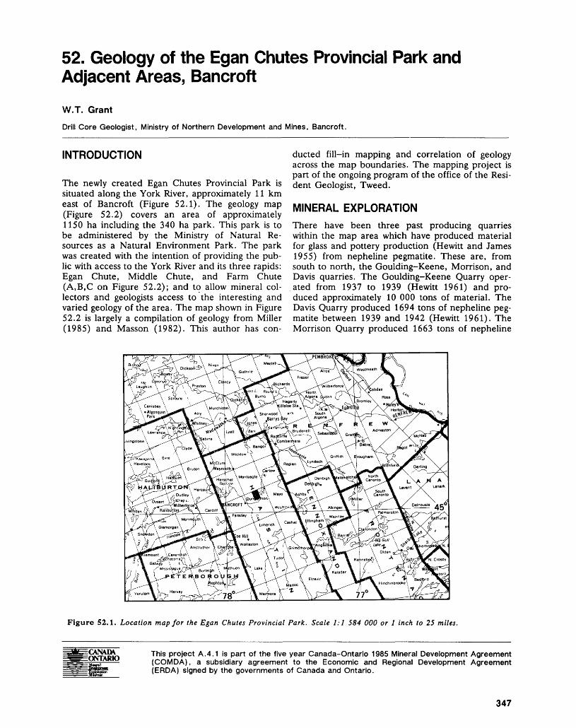
52. Geology of the Egan Chutes Provincial Park and Adjacent Areas, BancroftW.T. Grant
Drill Core Geologist, Ministry of Northern Development and Mines, Bancroft.
INTRODUCTION
The newly created Egan Chutes Provincial Park is situated along the York River, approximately 11 km east of Bancroft (Figure 52.1). The geology map (Figure 52.2) covers an area of approximately 1150 ha including the 340 ha park. This park is to be administered by the Ministry of Natural Re sources as a Natural Environment Park. The park was created with the intention of providing the pub lic with access to the York River and its three rapids: Egan Chute, Middle Chute, and Farm Chute (A,B,C on Figure 52.2); and to allow mineral col lectors and geologists access to the interesting and varied geology of the area. The map shown in Figure 52.2 is largely a compilation of geology from Miller (1985) and Masson (1982). This author has con
ducted fill-in mapping and correlation of geology across the map boundaries. The mapping project is part of the ongoing program of the office of the Resi dent Geologist, Tweed.
MINERAL EXPLORATIONThere have been three past producing quarries within the map area which have produced material for glass and pottery production (Hewitt and James 1955) from nepheline pegmatite. These are, from south to north, the Goulding-Keene, Morrison, and Davis quarries. The Goulding-Keene Quarry oper ated from 1937 to 1939 (Hewitt 1961) and pro duced approximately 10 000 tons of material. The Davis Quarry produced 1694 tons of nepheline peg matite between 1939 and 1942 (Hewitt 1961). The Morrison Quarry produced 1663 tons of nepheline
Figure 52.1. Location map for the Egan Chutes Provincial Park. Scale 1:1 584 000 or l inch to 25 miles.
EONTARIO This project A.4.1 is part of the five year Canada-Ontario 1985 Mineral Development Agreement (COMDA), a subsidiary agreement to the Economic and Regional Development Agreement (ERDA) signed by the governments of Canada and Ontario.
347
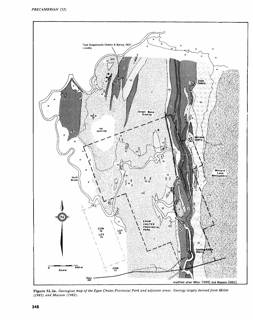
PRECAMBRIAN (52)
•: ••"••'••: TSWWKWiWi* Y ' ' "' V" "''" '•'•'•^•"-^'~ '' ••-"'-
modified offer Miller (1965) and Masson (1982)
Figure 52.2a. Geological map of the Egan Chutes Provincial Park and adjacent areas. Geology largely derived from Miller (1985) and Masson (1982).
348
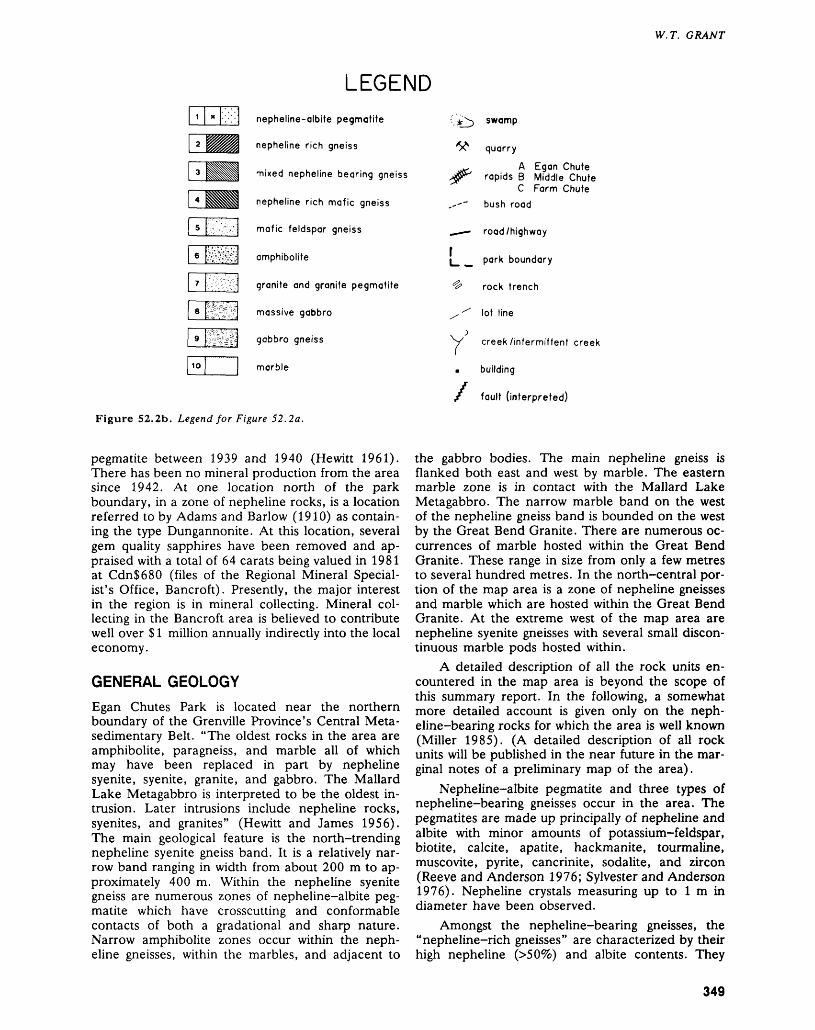
W. T. GRANT
LEGENDnepheline-albite pegmatite
2 nepheline rich gneiss
mixed nepheline bearing gneiss
nepheline rich mafic gneiss
mafic feldspar gneiss
amphibolite
granite and granite pegmatite
ps-vf^'SE^^'^J massive gabbro
gabbro gneiss
marble
*I^ swamp
^ quarry
^g, A Egan Chute jjr' rapids B Middle Chute
C Farm Chute,~-~ bush road
-*—- road/highway
L ^ park boundary
^ rock trench
/^ lot line
~y creek/intermittent creek
m building
f fault (interpreted)
Figure 52.2b. Legend for Figure 52.2a.
pegmatite between 1939 and 1940 (Hewitt 1961). There has been no mineral production from the area since 1942. At one location north of the park boundary, in a zone of nepheline rocks, is a location referred to by Adams and Barlow (1910) as contain ing the type Dungannonite. At this location, several gem quality sapphires have been removed and ap praised with a total of 64 carats being valued in 1981 at CdnS680 (files of the Regional Mineral Special ist's Office, Bancroft). Presently, the major interest in the region is in mineral collecting. Mineral col lecting in the Bancroft area is believed to contribute well over S l million annually indirectly into the local economy.
GENERAL GEOLOGYEgan Chutes Park is located near the northern boundary of the Grenville Province's Central Meta- sedimentary Belt. "The oldest rocks in the area are amphibolite, paragneiss, and marble all of which may have been replaced in part by nepheline syenite, syenite, granite, and gabbro. The Mallard Lake Metagabbro is interpreted to be the oldest in trusion. Later intrusions include nepheline rocks, syenites, and granites" (Hewitt and James 1956). The main geological feature is the north-trending nepheline syenite gneiss band. It is a relatively nar row band ranging in width from about 200 m to ap proximately 400 m. Within the nepheline syenite gneiss are numerous zones of nepheline-albite peg matite which have crosscutting and conformable contacts of both a gradational and sharp nature. Narrow amphibolite zones occur within the neph eline gneisses, within the marbles, and adjacent to
the gabbro bodies. The main nepheline gneiss is flanked both east and west by marble. The eastern marble zone is in contact with the Mallard Lake Metagabbro. The narrow marble band on the west of the nepheline gneiss band is bounded on the west by the Great Bend Granite. There are numerous oc currences of marble hosted within the Great Bend Granite. These range in size from only a few metres to several hundred metres. In the north-central por tion of the map area is a zone of nepheline gneisses and marble which are hosted within the Great Bend Granite. At the extreme west of the map area are nepheline syenite gneisses with several small discon tinuous marble pods hosted within.
A detailed description of all the rock units en countered in the map area is beyond the scope of this summary report. In the following, a somewhat more detailed account is given only on the neph- eline-bearing rocks for which the area is well known (Miller 1985). (A detailed description of all rock units will be published in the near future in the mar ginal notes of a preliminary map of the area).
Nepheline-albite pegmatite and three types of nepheline-bearing gneisses occur in the area. The pegmatites are made up principally of nepheline and albite with minor amounts of potassium-feldspar, biotite, calcite, apatite, hackmanite, tourmaline, muscovite, pyrite, cancrinite, sodalite, and zircon (Reeve and Anderson 1976; Sylvester and Anderson 1976). Nepheline crystals measuring up to l m in diameter have been observed.
Amongst the nepheline-bearing gneisses, the "nepheline-rich gneisses" are characterized by their high nepheline ^509fc) and albite contents. They
349
PRECAMBRIAN (52)
generally have less than 159& mafic mineral content which may be made up of amphibole (hastingsite), biotite, garnet, magnetite, and pyroxene. They may also contain minor amounts of zircon, potassium- feldspar, scapolite, corundum, vesuvianite, titanite, muscovite, tourmaline, apatite, sodalite, cancrinite, hydronepheline, calcite, fluorite, and zeolite (Hewitt and James 1956).
"Mixed nepheline gneisses" consist of felsic gneisses interlayered with mafic gneisses; both varie ties contain up to 50*26 nepheline. Corundum and sapphire have been found associated with these gneisses. The mafic minerals of these rocks are am phibole, biotite, garnet, and a number of minerals also observed in the "nepheline-rich gneisses" de scribed above.
"Nepheline-rich mafic gneiss" contains approxi mately 30 to 509& nepheline and about 209& plagio clase. Mafic minerals are those described under "nepheline-rich gneisses" and make up about 309fc of the rock.
GEOLOGICAL INTERPRETATIONThe planned preliminary map is intended mainly as a guide for geologists and mineral collectors visiting the park. However, a short discussion of the various theories concerning the origin of the alkalic rocks is included for general interest.
There are two main theories for the formation of the nepheline-bearing gneisses in the map area. It was believed by Daly (1910) that these rocks were formed by metasomatism. By assimilation of carbon ates in a subalkaline magma, a material results either abnormally rich in alkalies or one that has been desilicated to yield feldspathoids. Others since that time have proposed that the nepheline syenite gneiss originated from an igneous intrusion, possibly in a sill-like body (Miller 1985). Whatever hypothesis is favoured, one must consider several factors. The theory must explain the layered nature of the gneissic unit as defined by Baragar (1953). Baragar was able to divide the north-trending unit into mem bers based on mineralogy, texture, and structure. Proponents of the metasomatic theory believe this to be evidence of layering in the original rock which was replaced.
At the present stage of his investigations, the author is not in a position to argue for or against any of the hypotheses on the origin of the alkalic rocks
in the map area or the Bancroft area in general. The recent field investigations and the forthcoming pre liminary geological map will hopefully lead to a re newed interest in the lithologies of the area by explo ration companies and university departments.
The author will prepare for publication a gener alized geological map of the Egan Chute Park indi cating locations of interest to the mineral collectors.
REFERENCESAdams, F.D., and Barlow, A.E.1910: Geology of the Haliburton and Bancroft Areas, Prov
ince of Ontario; Geological Survey of Canada, Mem oir 6, 419p. Accompanied by Map 770, scale 1:126 720 or l inch to 2 miles.
Baragar, W.R.A.1953: Nepheline Gneisses of York River, Ontario; in Pro
ceedings of the Geological Association of Canada, Volume 6, Part l, p.83-115.
Daly, R.A.1910: Origin of the Alkaline Rocks; Bulletin of the Geologi
cal Society of America, Volume 21, p.87-118.Hewitt, D.F.1961: Nepheline Syenite Deposits of Southern Ontario; Ont
ario Department of Mines, Annual Report for 1960, Volume 69, Part 8, 194p. Accompanied by Map 1960e, scale 1:31 680 or l inch to 1/2 mile.
Hewitt, D.F., and James, W.1956: Geology of Dungannon and Mayo Townships; Ontario
Department of Mines, Annual Report for 1955, Vol ume 64, Part 8, p. 1-65. Accompanied by Map 1955-8, scale 1:31 680 or l inch to 1/2 mile.
Masson, S.L.1982: Geology and Mineral Deposits of the Bancroft Area,
Eastern Part, Southern Ontario; Ontario Geological Survey, Map P.2524, Geological Series-Preliminary Map, scale 1:10 000. Geology 1978, 1979, 1980.
Miller, R. R.1985: Age and Petrological Relationships of Some Igneous
Textured and Gneissic Alkaline Rocks in the Halibur- ton-Bancroft Area; Unpublished Ph.D. Thesis, Uni versity of Toronto, Toronto, 350.p.
Reeve, E.J., and Anderson, G.M.1976: The Goulding-Keene Nepheline Pegmatite near
Bancroft, Ontario; Canadian Journal of Earth Sci ence, Volume 13, p.237-248.
Sylvester, G.C., and Anderson, G.M.1976: The Davis Nepheline Pegmatite and Associated
Nepheline Gneisses near Bancroft, Ontario; Canadian Journal of Earth Science, Volume 13, p.249-265.
350
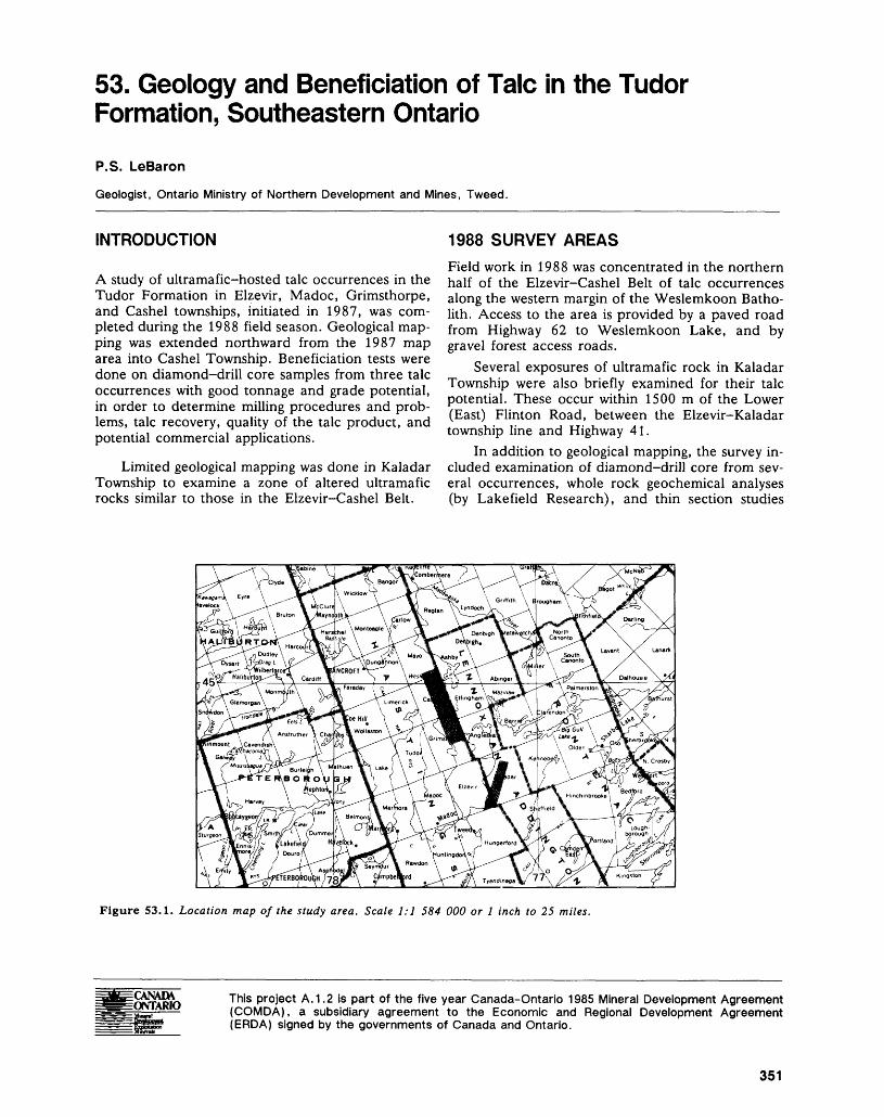
53. Geology and Beneficiation of Talc in the Tudor Formation, Southeastern Ontario
P.S. LeBaron
Geologist, Ontario Ministry of Northern Development and Mines, Tweed.
INTRODUCTION
A study of ultramafic-hosted talc occurrences in the Tudor Formation in Elzevir, Madoc, Grimsthorpe, and Cashel townships, initiated in 1987, was com pleted during the 1988 field season. Geological map ping was extended northward from the 1987 map area into Cashel Township. Beneficiation tests were done on diamond-drill core samples from three talc occurrences with good tonnage and grade potential, in order to determine milling procedures and prob lems, talc recovery, quality of the talc product, and potential commercial applications.
Limited geological mapping was done in Kaladar Township to examine a zone of altered ultramafic rocks similar to those in the Elzevir-Cashel Belt.
1988 SURVEY AREASField work in 1988 was concentrated in the northern half of the Elzevir-Cashel Belt of talc occurrences along the western margin of the Weslemkoon Batho lith. Access to the area is provided by a paved road from Highway 62 to Weslemkoon Lake, and by gravel forest access roads.
Several exposures of ultramafic rock in Kaladar Township were also briefly examined for their talc potential. These occur within 1500 m of the Lower (East) Flinton Road, between the Elzevir-Kaladar township line and Highway 41.
In addition to geological mapping, the survey in cluded examination of diamond-drill core from sev eral occurrences, whole rock geochemical analyses (by Lakefield Research), and thin section studies
Figure 53.1. Location map of the study area. Scale 1:1 584 000 or l inch to 25 miles.
This project A. 1.2 is part of the five year Canada-Ontario 1985 Mineral Development Agreement (COMDA), a subsidiary agreement to the Economic and Regional Development Agreement (ERDA) signed by the governments of Canada and Ontario.
351
PRECAMBRIAN (53)
(by Hugh deSouza, Mineralogist, Ontario Geological Survey, Toronto).
REGIONAL GEOLOGYThe study areas lie within the Hastings Basin, a sub division of the Central Metasedimentary Belt of the Grenville Province (Figure 53.1). The general geol ogy of the Hastings Basin is described in LeBaron et al. (1987).
Geological maps covering parts of the study ar eas have been produced by Meen and Harding (1942), Hewitt and James (1955), Hewitt (1964), Lumbers (1968), and Wolff (1982).
MINERAL EXPLORATIONMineral exploration in the area dates from the late 1800s, when iron, gold, copper, lead, and talc were discovered in Madoc Township. The level of explo ration activity in the area has risen sharply over the past several years as a result of increased demand for industrial filler minerals such as wollastonite, talc, calcite, and mica, and new gold discoveries such as the Mono Gold Mines deposit in Madoc Township and the Noranda Exploration Company Limited property in Marmora Township.
GEOLOGY OF THE GRIMSTHORPE-CASHEL STUDY AREA
GENERAL GEOLOGY
The Grimsthorpe-Cashel map area (Figure 53.2) lies along the western margin of the Weslemkoon Batholith, a large trondhjemite-granodiorite body with a narrow, gabbroic to dioritic rim formed by assimilation of mafic volcanics by the intruding granitic magma (Lumbers 1968).
The metavolcanics which underlie northwestern Grimsthorpe Township and extend as a narrow (2 to 4 km wide) belt through central Cashel Township are dominated by mafic flows of the Tudor Forma tion. Felsic flows and pyroclastics of the Oak Lake Formation are interlayered with the mafic metavol canics toward the western edge of the belt. Meta sedimentary rocks, consisting of quartz-chlorite- biotite-amphibole assemblages, and rusty pyritic schists, occur throughout the metavolcanic se quence. Overlying the metavolcanics in western Cashel Township are clastic and chemical metasedi- ments of the Mayo Group, predominantly marbles and calcareous sandstones and siltstones.
Although regional metamorphic grade in the Hastings Basin is greenschist facies, the study area lies within the amphibolite facies thermal metamor phic aureole of the Weslemkoon Batholith.
The area of interest is a zone about 300 m wide, within the mafic metavolcanics along the western
margin of the batholith. Within this zone are several occurrences of ultramafic rock, altered to various as semblages of talc, serpentine, anthophyllite, chlorite, and carbonate. Some of these contain sufficient con centrations of talc (20 to 60 percent) to be consid ered potential talc ore. The mafic metavolcanics were classified in the field as tholeiitic basalt, koma- tiitic basalt, and ultramafic komatiite, based on al teration mineralogy, as described in LeBaron et al. (1987). A Jensen Cation Plot of 34 whole rock analyses from the map area supports the field classi fication of talc-anthophyllite-carbonate rocks as ultramafic komatiites within a predominantly iron- rich, tholeiitic volcanic sequence. Several samples plot as Mg-tholeiites and one as basaltic komatiite, but these are not traceable units at the scale of this survey.
The metavolcanics strike sub-parallel to the margin of the Weslemkoon Batholith and dip away from it to the west at 50 0 to 80 0 . The most promi nent structure in the area is the Cashel Syncline, which probably developed during intrusion of the northern and southern lobes of the batholith. Small scale drag folding, locally prominent near the granodiorite contact, may also be related to the in trusion.
DESCRIPTION OF THE TALCOSE ZONES
Most of the talc occurrences are located north of the axis of the Cashel Syncline, as shown on Figure 53.2. Descriptions of the geology and previous ex ploration for several of the occurrences are given by Lumbers (1968) and by Dillon and Barron (1985).
The talcose zones vary in width from 5 to 30 m, averaging 15 to 40 percent talc, with the remainder being composed of varying proportions of anthophyl lite, carbonate, chlorite, serpentine, and magnetite. Dimensions are difficult to determine because the talcose rocks generally form negative relief features, and are exposed intermittently along the sides of outcrop ridges bordering linear swamps. (A concen tration of talcose boulders adjacent to a swamp along the axis of the Cashel Syncline north of Dafoe Lake may indicate talc mineralization in bedrock below the swamp.) Exposed widths of 15 m and lengths of 50 to 75 m are common, and the true extent of mineralization may be considerably greater. For example, the talc zone at the McMur- ray Occurrence (Location 2, Figure 53.2) was traced in outcrop for a strike length of 300 m before disap pearing into swampy ground; a true width of about 40 m is indicated by diamond drilling.
The McMurray Occurrence offers the best ex posure of a talcose zone within the map area. An area about 25 m by 7 m has been stripped and washed, and diamond drilling totaling 304 m in 17 holes over a 200 m strike length was done by David McMurray in 1982. The following description is based upon examination of the surface showing and
352
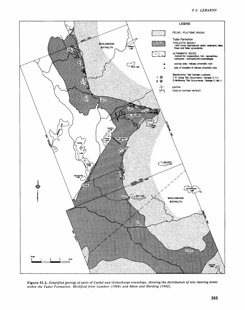
P. S. LEBARON
FELSIC - PLUTONIC ROCKS
Tudor Formation THOLEIITIC BASALT
-with minor interlayered clastic sediments, felsicflows and felsic pyroclastics
^ESLEMKOON ^7'fiATHOLITH
ULTRAMAFIC ROCKS -komatiitic composition, talc - serpentine- carbonate - anthophyllite assemblages
outcrop area - talcose ultramafic rock area of boulders of talcose ultramafic rock
Beneficiation Test Sample LocationsC.R. Young Talc Occurrence -Sample C-Y-D McMurray Talc Occurrence - Sample C-Mc
synclinefoliation (inclined vertical)
WESLEMKOON BATHOLITH
Figure 53.2. Simplified geology of parts of Cashel and Grimsthorpe townships, showing the distribution of talc-bearing zones within the Tudor Formation. Modified from Lumbers (1968) and Meen and Harding (1942).
353
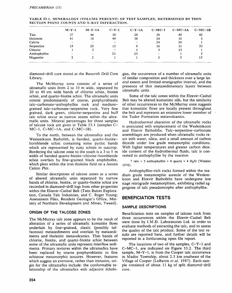
PRECAMBRIAN (53)
TABLE 53.1. MINERALOGY (VOLUME PERCENT) OF TEST SAMPLES, DETERMINED BY THIN SECTION POINT COUNTS AND X-RAY DIFFRACTION.
TalcDolomiteCalciteSerpentineChloriteAnthophylliteMagnetite
M-Y-1
3741-
191-2
M-Y-1A
4618-
295-2
C-Y-1
1849-
11-
211
C-Y-1A
2838-91
231
C-MC-1
30242416
3-3
C-MC-1A
4010201113
15
C-MC-1B
4251
3313
15
diamond-drill core stored at the Bancroft Drill Core Library.
The McMurray zone consists of a series of ultramafic units from 2 to 10 m wide, separated by 20 to 40 cm wide bands of chlorite schist, biotite schist, and quartz-biotite schist. The ultramafic units consist predominantly of coarse, porphyroblastic talc-carbonate-anthophyllite rock and medium- grained talc-carbonate-serpentine rock. Very fine grained, dark green, chlorite-serpentine and buff talc schist occur as narrow seams within the ultra mafic units. Mineral percentages for three samples of talcose rock are given in Table 53.1 (samples C- MC-1, C-MC-1 A, and C-MC-1B).
To the north, between the ultramafics and the Weslemkoon Batholith, is banded, quartz-biotite- hornblende schist containing some pyritic bands which are represented by rusty schists in outcrop. Bordering the talcose zone to the south is a 3 to 5 m width of banded quartz-biotite-chlorite-hornblende schist overlain by fine-grained black amphibolite, which plots within the iron tholeiite field on a Jensen Cation Plot.
Similar descriptions of talcose zones as a series of altered ultramafic units separated by narrow bands of chlorite, biotite, or quartz-biotite schist are recorded in diamond-drill logs from other properties within the Elzevir-Cashel Belt (Twin Buttes Explora tion, Canada Talc Industries, and C. Roger Young; Assessment Files, Resident Geologist's Office, Min istry of Northern Development and Mines, Tweed).
ORIGIN OF THE TALCOSE ZONES
The McMurray talc zone appears to be the result of alteration of a series of ultramafic komatiite flows underlain by fine-grained, clastic (possibly tuf faceous) metasediments and overlain by metasedi- ments and tholeiitic metavolcanics. Thin bands of chlorite, biotite, and quartz-biotite schist between some of the ultramafic units represent interflow sedi ments. Primary textures within the ultramafics have been replaced by coarse porphyroblastic to fine schistose metamorphic textures. However, features which suggest an extrusive, rather than intrusive, ori gin for the ultramafics include: the conformable re lationship of the ultramafics with adjacent litholo-
gies, the occurrence of a number of ultramafic units of similar composition and thickness over a large lat eral extent and limited stratigraphic interval, and the presence of thin metasedimentary layers between ultramafic units.
Some of the talc zones within the Elzevir-Cashel Belt may be altered komatiitic sills, but the similarity of other occurrences to the McMurray zone suggests that komatiitic flows are locally present throughout the belt and represent an extensive lower member of the Tudor Formation meta volcanics.
Hydrothermal alteration of the ultramafic rocks is associated with emplacement of the Weslemkoon and Elzevir Batholiths. Talc-serpentine-carbonate assemblages are produced when ultramafic rocks re act with water, silica, and a small amount of carbon dioxide under low grade metamorphic conditions. With higher temperatures and greater carbon diox ide content of the hydrothermal fluids, talc is con verted to anthophyllite by the reaction
7 talc = 3 anthophyllite t 4 quartz t 4 H2O (Winkler 1976).
Anthophyllite-rich rocks formed within the me dium grade metamorphic aureole of the Weslem koon and Elzevir Batholiths have undergone late stage retrograde metamorphism, exhibiting radial ag gregates of talc pseudomorphs after anthophyllite.
BENEFICIATION TESTS
SAMPLE DESCRIPTIONS
Beneficiation tests on samples of talcose rock from three occurrences within the Elzevir-Cashel Belt were done by I.M.D. Laboratories Ltd. in order to evaluate methods of extracting the talc, and to assess the quality of the talc product. Some of the test re sults are reported here, and further details will be reported in a forthcoming open file report.
The locations of two of the samples, C-Y-1 and C-MC-1, are indicated on Figure 53.2. The third sample, M-Y-1, is from the Cooper talc occurrence in Madoc Township, about 2.5 km southeast of the Village of Cooper (LeBaron et at. 1987). Each sam ple consisted of about 11 kg of split diamond-drill core.
354
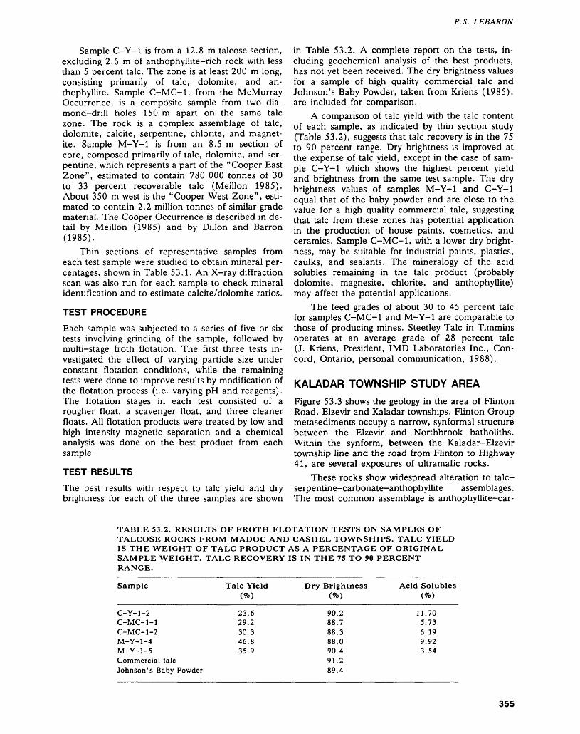
P. S. LEBARON
Sample C-Y-1 is from a 12.8 m talcose section, excluding 2.6 m of anthophyllite-rich rock with less than 5 percent talc. The zone is at least 200 m long, consisting primarily of talc, dolomite, and an thophyllite. Sample C-MC-1, from the McMurray Occurrence, is a composite sample from two dia mond-drill holes 150 m apart on the same talc zone. The rock is a complex assemblage of talc, dolomite, calcite, serpentine, chlorite, and magnet ite. Sample M-Y-1 is from an 8.5 m section of core, composed primarily of talc, dolomite, and ser pentine, which represents a part of the "Cooper East Zone", estimated to contain 780 000 tonnes of 30 to 33 percent recoverable talc (Meillon 1985). About 350 m west is the "Cooper West Zone", esti mated to contain 2.2 million tonnes of similar grade material. The Cooper Occurrence is described in de tail by Meillon (1985) and by Dillon and Barron (1985).
Thin sections of representative samples from each test sample were studied to obtain mineral per centages, shown in Table 53.1. An X-ray diffraction scan was also run for each sample to check mineral identification and to estimate calcite/dolomite ratios.
TEST PROCEDURE
Each sample was subjected to a series of five or six tests involving grinding of the sample, followed by multi-stage froth flotation. The first three tests in vestigated the effect of varying particle size under constant flotation conditions, while the remaining tests were done to improve results by modification of the flotation process (i.e. varying pH and reagents). The flotation stages in each test consisted of a rougher float, a scavenger float, and three cleaner floats. All flotation products were treated by low and high intensity magnetic separation and a chemical analysis was done on the best product from each sample.
TEST RESULTS
The best results with respect to talc yield and dry brightness for each of the three samples are shown
in Table 53.2. A complete report on the tests, in cluding geochemical analysis of the best products, has not yet been received. The dry brightness values for a sample of high quality commercial talc and Johnson's Baby Powder, taken from Kriens (1985), are included for comparison.
A comparison of talc yield with the talc content of each sample, as indicated by thin section study (Table 53.2), suggests that talc recovery is in the 75 to 90 percent range. Dry brightness is improved at the expense of talc yield, except in the case of sam ple C-Y-1 which shows the highest percent yield and brightness from the same test sample. The dry brightness values of samples M-Y-1 and C-Y-1 equal that of the baby powder and are close to the value for a high quality commercial talc, suggesting that talc from these zones has potential application in the production of house paints, cosmetics, and ceramics. Sample C-MC-1, with a lower dry bright ness, may be suitable for industrial paints, plastics, caulks, and sealants. The mineralogy of the acid solubles remaining in the talc product (probably dolomite, magnesite, chlorite, and anthophyllite) may affect the potential applications.
The feed grades of about 30 to 45 percent talc for samples C-MC-1 and M-Y-1 are comparable to those of producing mines. Steetley Talc in Timmins operates at an average grade of 28 percent talc (J. Kriens, President, IMD Laboratories Inc., Con cord, Ontario, personal communication, 1988).
KALADAR TOWNSHIP STUDY AREAFigure 53.3 shows the geology in the area of Flinton Road, Elzevir and Kaladar townships. Flinton Group metasediments occupy a narrow, synformal structure between the Elzevir and Northbrook batholiths. Within the synform, between the Kaladar-Elzevir township line and the road from Flinton to Highway 41, are several exposures of ultramafic rocks.
These rocks show widespread alteration to talc- serpentine-carbonate-anthophyllite assemblages. The most common assemblage is anthophyllite-car-
TABLE 53.2. RESULTS OF FROTH FLOTATION TESTS ON SAMPLES OF TALCOSE ROCKS FROM MADOC AND CASHEL TOWNSHIPS. TALC YIELD IS THE WEIGHT OF TALC PRODUCT AS A PERCENTAGE OF ORIGINAL SAMPLE WEIGHT. TALC RECOVERY IS IN THE 75 TO 90 PERCENT RANGE.
Sample
C- Y- 1-2C-MC-1-1C-MC-1 -2M-Y-1-4M-Y-1-5Commercial talcJohnson's Baby Powder
Talc YieldW
23.629.230.346.835.9
Dry BrightnessW
90.288.788.388.090.491.289.4
Acid SolublesW
11.705.736.199.923.54
355
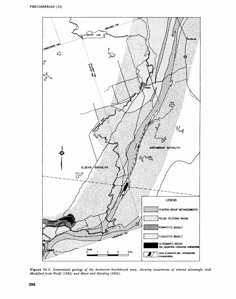
PRECAMBRIAN (53)
Figure 53.3. Generalized geology of (A* Actinolite-^ orthbrook area, showing occurrences of altered ultramafic rock. Modified from Wolff (1982) and Meen and Harding (1942).
356
P. S. LEBARON
bonate, in which 80 percent coarse rosettes of an thophyllite occur in a grey dolomite groundmass. Talc is pseudomorphic after anthophyllite, locally al most completely replacing the amphibole. Samples taken by Wolff (1982) and Verschuren et al. (1986) contain 78 and 60 percent talc, respectively.
Wolff (1982) correlates the ultramafic rocks with mafic volcanic rocks in the area, stating that the ultramafics may represent one of the oldest mem bers of the Tudor Formation. They are similar in appearance and composition to ultramafic koma- tiites in Elzevir and Cashel townships. Diamond-drill core from a talc-anthophyllite-carbonate zone in lot 13, concession II, Kaladar Township (drilled by C.R. Young in 1981) shows that the zone consists of two ultramafic units about 7 m wide, separated by a 7 m wide section of chlorite-biotite and feldspar- biotite schist: a sequence similar to that observed at the McMurray Occurrence in Cashel Township.
The position of the ultramafic rocks within younger Flinton Group metasediments suggests tec tonic emplacement. Thompson (1972) reports my lonite and strained quartz in adjacent metasediments as evidence of faulting along the margins of the ultramafic bodies. Linear swamps along the contact areas are additional evidence of possible faulting and should be considered as potential targets for talc mi neralization within sheared margins of the ultra mafics.
The ultramafic outcrop areas range in width from 5 m at the northernmost exposure on Figure 53.3, to 300 m near the Elzevir-Kaladar township line. The strike extent is obscured by overburden and may be more continuous than indicated on pre vious geological maps by Wolff (1982) and Thompson (1972).
SUMMARY1. Altered ultramafic rocks in Elzevir, Madoc,
Grimsthorpe, and Cashel townships locally con tain sufficient amounts of talc to be of interest as potential talc ore.
2. The talc zones appear to be the result of altera tion of ultramafic komatiite flows which repre sent one of the oldest members of the Tudor Formation. Komatiitic and tholeiitic basalts have also been identified within the metavolcanic se quence.
3. Preliminary results of beneficiation tests on sam ples from three talc zones within the Tudor For mation suggest that talc products of moderate to high quality can be obtained by multi-stage froth flotation.
4. A zone of altered ultramafic rocks in Kaladar Township, similar to those in the Elzevir-Cashel Belt, has potential for talc mineralization and should be considered as a talc exploration tar get.
ACKNOWLEDGMENTSThe author would like to thank C. Roger Young, prospector, and Tim Beesley, geological consultant for Gateford Resources, for providing diamond-drill core for beneficiation test samples.
REFERENCESDillon, E.P., and Barron, P.S.1985: Talc in the Tudor Formation, Grenville Supracrustal
Series, Southeastern Ontario; Ontario Geological Sur vey, Open File Report 5530, 69p., 6 figures, 7 tables and 5 photos.
Hewitt, D. F.1964: Geological Notes for Maps Nos. 2053 and 2054,
Madoc-Gananoque Area; Ontario Department of Mines, Geological Circular 12, 33p. Accompanied by Maps 2053 and 2054, scale l inch to 2 miles.
Hewitt, D.F., and James, W.1955: Geology of Dungannon and Mayo Townships; Ontario
Department of Mines, Annual Report for 1954, Vol ume 64, Part 8, 65p. Accompanied by Map 1955-8, scale 1:31 680 or l inch to 1/2 mile.
Kriens, J.1985: Production of Talc Concentrates by Froth Flotation,
Project 90071; Unpublished Report Prepared For Twin Buttes Exploration Inc., Resident Geologist's Files, Ontario Ministry of Northern Development and Mines, Tweed, 19p.
LeBaron, P.S., MacKinnon, A., and Kingston, P.W.1987: Komatiite-hosted Talc in the Tudor Formation, El
zevir, Madoc and Grimsthorpe Townships, Southeast ern Ontario; p.301-306 in Summary of Field Work and Other Activities 1987, by the Ontario Geological Survey, edited by R.B. Barlow, M.E. Cherry, A.C. Colvine, Burkhard O. Dressler, and Owen L. White, Ontario Geological Survey, Miscellaneous Paper 137, 429p.
Lumbers, S.B.1968: Geology of Cashel Township; Ontario Department of
Mines, Geological Report 71, 54p. Accompanied byMap 2142, scale 1:31 580.
Meen, V.B., and Harding, W.D.1942: Grimsthorpe-Kennebec Area, Counties of Hastings,
Lennox and Addington, and Frontenac, Ontario;Ontario Department of Mines, Map 51 D, scale l inchto l mile.
Meillon, J.J.1985: Twin Buttes Exploration Inc. Cooper-Queensborough
Talc Deposits, Technical Progress Report No. 1; Un published Report, Resident Geologist's Files, Ontario Ministry of Northern Development and Mines, Tweed, 32p.
Thompson, P.H.1972: Stratigraphy, Structure, and Metamorphism of the
Flinton Group in the Bishop Corners-Madoc Area, Grenville Province, Eastern Ontario; Unpublished Ph.D. Thesis, Carleton University, Ottawa, Ontario, 268p.
Verschuren, C.P., Papertzian, V.C., Kingston, P.W., andVillard, D.J.
1986: Reconnaissance Survey of Building Stones of Easternand Central Ontario; Ontario Geological Survey,
357
PRECAMBRIAN (53)
Open File Report 5585, 302p, 4 figures, 2 tables, 147 photos, and l map in back pocket.
Winkler, H.G.F.1976: Petrogenesis of Metamorphic Rocks, Fourth Edition;
Springer-Verlag, New York, 334p.Wolff, J.M.1982: Geology of the Kaladar Area, Frontenac, and Lennox
and Addington Counties; Ontario Geological Survey, Report 215, 94p. Accompanied by Map 2432, scale 1:31 680 or l inch to 1/2 mile.
358
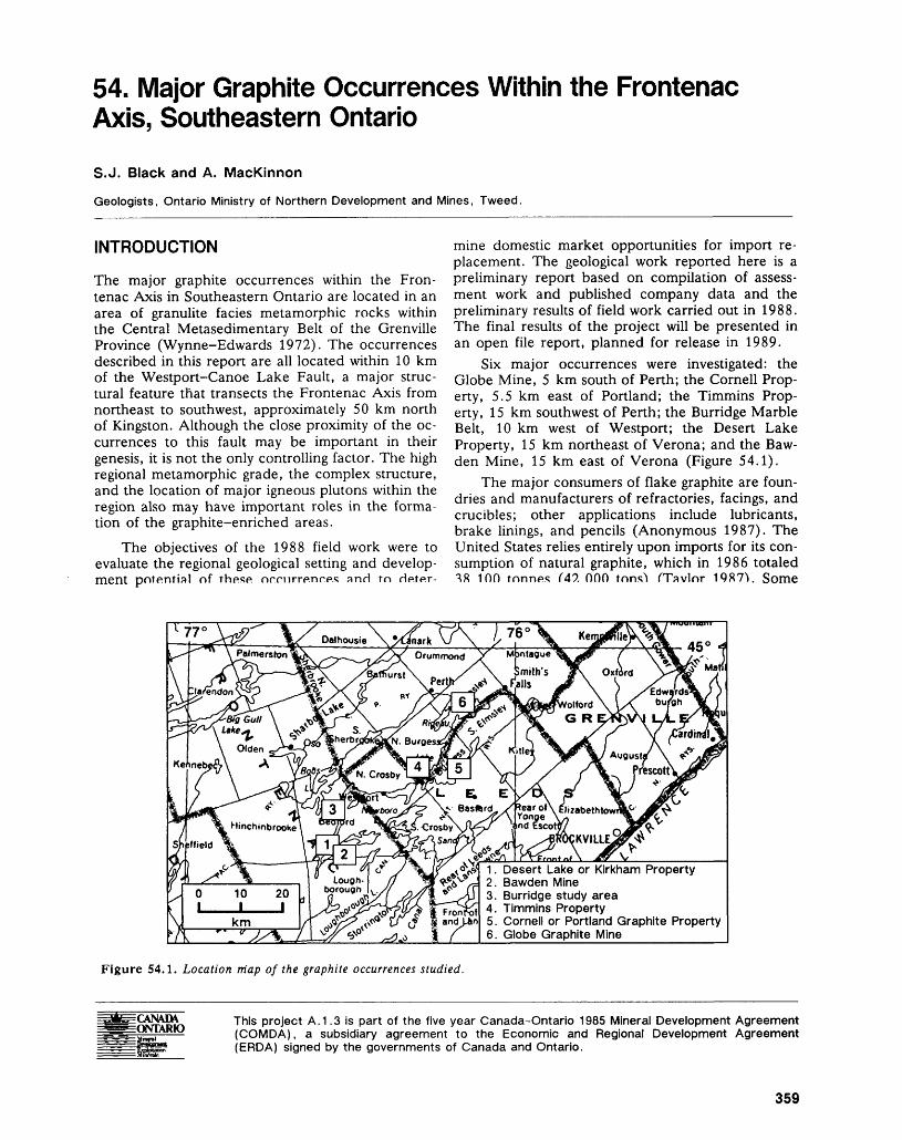
54. Major Graphite Occurrences Within the Frontenac Axis, Southeastern OntarioS.J. Black and A. MacKinnon
Geologists, Ontario Ministry of Northern Development and Mines, Tweed.
INTRODUCTION
The major graphite occurrences within the Fron tenac Axis in Southeastern Ontario are located in an area of granulite facies metamorphic rocks within the Central Metasedimentary Belt of the Grenville Province (Wynne-Edwards 1972). The occurrences described in this report are all located within 10 km of the Westport-Canoe Lake Fault, a major struc tural feature that transects the Frontenac Axis from northeast to southwest, approximately 50 km north of Kingston. Although the close proximity of the oc currences to this fault may be important in their genesis, it is not the only controlling factor. The high regional metamorphic grade, the complex structure, and the location of major igneous plutons within the region also may have important roles in the forma tion of the graphite-enriched areas.
The objectives of the 1988 field work were to evaluate the regional geological setting and develop ment potential of these, nrnirrenr.es and to He.te.r-
mine domestic market opportunities for import re placement. The geological work reported here is a preliminary report based on compilation of assess ment work and published company data and the preliminary results of field work carried out in 1988. The final results of the project will be presented in an open file report, planned for release in 1989.
Six major occurrences were investigated: the Globe Mine, 5 km south of Perth; the Cornell Prop erty, 5.5 km east of Portland; the Timmins Prop erty, 15 km southwest of Perth; the Burridge Marble Belt, 10 km west of Westport; the Desert Lake Property, 15 km northeast of Verona; and the Baw den Mine, 15 km east of Verona (Figure 54.1).
The major consumers of flake graphite are foun dries and manufacturers of refractories, facings, and crucibles; other applications include lubricants, brake linings, and pencils (Anonymous 1987). The United States relies entirely upon imports for its con sumption of natural graphite, which in 1986 totaled 18 100 tonnes C47. 000 tons'* fTavlor 1987V Some
1 - Desert Lake or Kirkham Property
Figure 54.1. Location map of the graphite occurrences studied.
CANAD\ ONTARIO
This project A.1.3 is part of the five year Canada-Ontario 1985 Mineral Development Agreement (COMDA), a subsidiary agreement to the Economic and Regional Development Agreement (ERDA) signed by the governments of Canada and Ontario.
359
PRECAMBRIAN (54)
of this, to a value of S2 681 000 (M.A. Boucher, Analyst, Mineral Policy Sector, Department of En ergy, Mines and Resources, Ottawa, personal com munication, 1988), was then exported to Canada as graphite concentrate. Canada only produces graph ite on an intermittent basis from a mine operated by Asbury Graphite Quebec Inc. located near Notre- Dame-du-Laus, Quebec (Prud'homme 1986).
Natural graphite occurs in three basic forms which are distinguished by their degree of crystal linity: amorphous, crystalline flake, and high crystal line (vein type). All occurrences examined during the present investigation are of the crystalline flake variety. There are, however, significant differences in the style, quality, and quantity of graphite in each deposit. The deposits can roughly be categorized into two groups: those with predominantly equi dimensional flake graphite, and those characterized by significant concentrations of acicular flake (i.e. graphite flake with an aspect ratio of approximately 3:1 or 4:1) as well as of equidimensional flake. The Timmins, Burridge, Desert Lake, and Bawden prop erties fall into the first category, while the Globe and Cornell properties fall into the latter. Other differ ences and similarities among the deposits include host material, possible heat sources, confining mech anisms, and distribution of mineralized zones.
PROPERTY DESCRIPTIONS
GLOBE GRAPHITE MINE
The Globe Graphite Mine, located 5 km south of Perth, was first worked in 1870, and is the earliest worked graphite occurrence in the province. Since then, it has been operated by several companies. The mine was last worked in 1919, when it was de veloped to a depth of approximately 76 m (250 feet). Several companies have since completed exploratory work, the last being Black Gregor Explo rations Ltd. which conducted diamond drilling and geophysics in 1984. Bell (1942) suggests that no more than 18 200 tonnes (20 000 tons) of graphite ore was mined from this deposit. Spence (1920) quotes the average graphite content of the ore milled from 1915 to 1918 as 8 percent. Bowdidge (1984) estimated that approximately 45 400 tonnes (50 000 tons) of approximately 7 percent graphite remain in the deposit below the mined-out portion to the 91m (300 feet) level. He suggested if the mine were extended to the 305 m (1000 feet) level, an eco nomic deposit might be proved.
The Globe deposit is located within an inlier of Grenville Supergroup rocks surrounded by Paleozoic Nepean sandstone. The deposit is hosted in crystal line marble and calc-silicates, and is in close prox imity to quartzofeldspathic gneisses and granite. Lack of exposure, except in old mine openings, makes the construction of a detailed surface geologi cal map very difficult. Bell (1942) described the
graphite as associated primarily with siliceous zones within the marble, with the higher grade portions forming two lens-like bodies. The east lens had a strike length of 76 m (250 feet) and an average width of about 2.3 m (7.5 feet). The greatest ex posed width was 3 m (10 feet), excepting the nearly 12 m (40 feet) thick intersection at the crest of an easterly plunging antiform at the eastern end of the pit. To the west, the zone narrowed to about 1.2 m (4 feet) for a distance of 21 m (70 feet),and then bulged to 2.4 m (8 feet) for a distance of 27 m (90 feet).
The graphite occurs in pyroxene- and amphi- bole-bearing marbles, and forms a band which is well-exposed in the main open pit, striking more or less east-west (Bowdidge 1984). The zone south of the pit is structurally complex, and at present re mains poorly understood. Bowdidge (1984) reported that "drilling on the down-plunge extension of the main graphite zone has indicated that mineralization extends to a vertical depth of at least 91 m (300 feet). The thickness and grade is somewhat less that at the surface, where up to 12m (40 feet) of 15 percent graphite was reported from the old workings".
Geophysical work suggests the possibility of ad ditional nearby graphitic zones. Drilling of a geo physical anomaly a short distance to the south of the old workings confirmed the presence of several nar row, graphitic-bearing zones; however, they appear to have little economic value (Bowdidge 1984).
TIMMINS GRAPHITE PROPERTYThe Timmins Mine, located 15 km southwest of Perth, was operated on a small scale from 1917 to 1923 by Noah Timmins (Hawley 1988). Low de mand after World War I resulted in closure of the mine. Sporadic exploration was carried out by sev eral companies during 1942, 1951, and 1984. The most extensive work was that of Frobisher Limited in 1951, when 20 diamond-drill holes totaling 1231 m (4040 feet) were drilled on two graphite lenses 91 m (300 feet) and 137 m (450 feet) long, averaging 3.7 m (12 feet) in width. At that time, proven reserves were estimated at 227 000 tonnes (250 000 tons) of 8 percent graphite, with an addi tional 681 000 tonnes (750 000 tons) of probable reserves (R.G. Hawley, Field Manager, Lodi Metals Inc., personal communication, 1988).
The property is located in a geologically complex portion of the Central Metasedimentary Belt. The graphite is hosted in both crystalline calcitic and dolomitic marbles and in small areas of calc-silicate gneisses. This area of carbonate rock is bounded to the east and west by two large granitic plutons: the Westport and Rideau plutons. Small tectonic slices of granitic material are found in close association with the graphite-rich marbles throughout the prop erty. The property is bounded to the north by a large
360
S. J. BLACK AND A. MACKINNON
area of migmatitic gneisses, indicative of the high re gional temperatures attained in the rocks of this re gion. The graphite-rich zones consist predominantly of flake graphite hosted in crystalline marbles, al though finer graphite in lenses in the marble locally grades up to 15 percent.
Recent mapping by Lodi Metals Inc. has identi fied several parallel zones of graphitic marble both south and north of the previously known deposit, and has extended the deposit a considerable dis tance to the east. The strike length of the deposit now totals at least 3000 m (10 000 feet) from east to west, with several individual zones totaling 610 m (2000 feet). The true width of the deposit, including country rock separating zones, is at least 1200 m (4000 feet). The zones of graphite-enriched marble are commonly 7.6 to 15.2 m (25 to 50 feet) wide, and usually have a vertical or near vertical dip.
This property may contain a considerably higher tonnage than was originally estimated by Frobisher Limited. However, this must still be confirmed by drilling.
Beneficiation problems encountered by Frobisher Limited in 1951, when samples of the Timmins ore were sent to the Black Donald Mill for testing (Hewitt 1965; Papertzian and Kingston 1982), could not be substantiated by Lodi Metals Inc. Hawley (1988) reported that no complicating factors, i.e. mica, were present in the graphite ore tested. The Timmins deposit is certainly worthy of further work, as it appears that a substantial deposit may be present.
CORNELL GRAPHITE PROPERTY
The Cornell Property, located 5.5 km northeast of Portland, was first discovered by John J. Cornell in 1934. Exploration activity on the site has been spo radic. The known deposit consists of a mineralized zone, in siliceous marble (Hewitt 1965), that has an average width of 31 m (100 feet) over a strike length of 580 m (1900 feet). The dip of the deposit is steep to vertical, with a grade of 10 percent over large parts of the mineralized zone (Papertzian and Kingston 1982). Locally, this grade could be as high as 20 percent. The country rock surrounding the de posit is characterized by siliceous marbles and parag- neiss. The possibility of additional parallel zones of graphite-enriched marble is currently being investi gated by the present operator of the site, Victoria Graphite Ltd.
The graphite occurs as disseminated flakes aver aging 1/8 inch in size (Hewitt 1965). Some of this flake has a high aspect ratio, i.e. 4:1; however, it appears that this will readily break down to a finer equidimensional flake during milling. The grade and possible extent of this deposit warrant further explo ration.
BURRIDGE MARBLE BELT
The Burridge marble belt is located approximately 15 km northeast of Godfrey, and 10 km west of Westport. This is a large area of crystalline marble that extends over a distance of at least 10 km. The present investigation involved geologic reconnais sance mapping (at 1:10 000 scale) of the southern half of the belt, covering an area approximately 5 km2 . There has been to date no active exploration for graphite in this area, although several promising occurrences have been noted (Sabina 1983). This region is characterized by a very clean, coarse, crys talline, calcitic marble with a low graphite content, commonly less than l percent. In the southwestern part of this region, however, several zones of graph ite-enriched calcitic crystalline marble were noted. The grade varies, but is commonly 3 to 5 percent graphite. Several occurrences of large, equidimen sional flake, up to 6 to 8 mm in diameter, were ob served. This could be due to the influence of granitic gneiss, a short distance to the west, as well as to faulting, which could act as a concentrating mecha nism for the graphite. Elsewhere in the belt, these features are lacking, possibly explaining the lower graphite grades.
Insufficient work has been completed to date on this belt to accurately assess its potential; however, the presence of large flake over a large area is prom ising.
DESERT LAKE AND BAWDEN PROPERTIESThese properties are located approximately 15 km east of Verona; both are currently being investigated by Stewart Lake Resources Inc. The Desert Lake Property is located near the northern end of Desert Lake, and the Bawden Property is on the northern shore of Birch Lake, 2.5 km to the southeast. The present survey involved reconnaissance mapping (at 1:10 000 scale) of an area approximately 2 km2 be tween Desert and Birch lakes. The purpose of this work was to obtain a greater understanding of the geological structure and thus enhance development opportunities for graphite in the region.
The Desert Lake deposit was first worked by Frobisher Limited in 1952 (Edwards 1953), when 30 diamond-drill holes totaling 3000 m (9860 feet) were drilled and two lenses of graphite minerali zation were outlined. Hewitt (1965) described the graphite as occurring "in a synclinal structure in the Grenville marble-paragneiss-quartzite sequence. The syncline plunges northeast at 25 degrees and is overturned to the west so that the west arm dips eastward at about 45 degrees, and the overturned east arm dips eastward to about 70 degrees. The graphite flake occurs in a highly silicated marble at the contact with the overlying siliceous paragneiss and quartzite. Pyritic quartzite and paragneisses form the centre of the syncline which is underlain by
361
PRECAMBRIAN (54)
silicated marble. The graphitic ore zone occurs in marble at the quartzite-marble contact of both arms of the syncline."
Papertzian and Kingston (1982) noted that "the deposit occurs no more than 152 m (500 ft.) from the Canoe Lake-Desert Lake Fault Zone, which is a major transcurrent (thrust) Precambrian fault. Gran ite or granitized sediments occur on the opposite side of the fault and the immediate area of high grade mineralization is cut by pegmatite stringers". The close proximity of the Canoe Lake-Desert Lake Fault is evident from the underground workings at the Desert Lake property. Large areas of marble breccia were observed along the boundaries of the ore zones. Exploration work completed by Stewart Lake Resources Inc. has partially delineated three mineralized zones and identified 12 other geophysi cal anomalies which are as yet untested. The main zone, which is open at both ends and at depth, con tains 4.5 million tonnes (5 million tons) of drill-indi cated reserves, averaging 7.6 percent graphite (The Northern Miner 1988).
The Bawden Mine may be considered an east ern extension of one of these zones; however, the mineralization does not appear to be extensive. The property was first worked in 1890. The graphite oc curs as disseminated flakes within a crystalline mar ble. The ore grades up to 20 percent graphite (Papertzian and Kingston 1982); however, the over all average grade is about 5 to 8 percent.
CONCLUSIONS
Six major graphite occurrences near the Westport- Canoe Lake-Desert Lake Fault were examined dur ing the 1988 field season. Of these, four are cur rently undergoing active exploration. The Timmins, Burridge, Desert Lake, and Bawden occurrences all contain significant quantities of flake graphite hosted in crystalline marble and calc-silicates. The Globe and Cornell properties are hosted in siliceous mar bles, and have appreciable quantities of "needle" graphite as well as equidimensional flake. The struc tural styles of the deposits differ markedly. The Globe, Bawden, and Desert Lake deposits are found in close association with tightly folded (synformal) structures. The Cornell and Burridge properties are found within a large series of parallel marble bands. The Timmins property is unique in that it is close to two major plutons. These factors could all have a bearing on the style of deposit and the grade of the graphite. All of the deposits can be considered to be of economic interest.
REFERENCESAnonymous1987: Graphite: An Appraisal of Minerals Availability for
34 Commodities; United States Bureau of Mines, Bul letin 692, p. 117-125.
Bell, A.M.1942: Report on Graphite Showings in North Elmsley and
Buckingham Townships; Canada Department of En ergy, Mines and Resources, Mineral Policy Sector, Resource File 1670G2-2-5.
Bowdidge, C.R.1984: Report on 1984 Exploration Self-Potential Survey and
Diamond Drilling Programme, Port Elmsley Graphite Property, North Elmsley Township, Ontario, Black Gregor Explorations Ltd.; Resident Geologist's Files, Ontario Ministry of Northern Development and Mines, Tweed, 5p.
Edwards, E.G.1953: A Treatise on the Graphite Project (Kirkham Graph
ite), Frobisher Ltd.; Resident Geologist's Files, Ont ario Ministry of Northern and Mines, Tweed, 42p.
Hawley, R.G.1988: Summary Report on the Timmins Graphite Project of
Lodi Metals Inc., Oso Exploration Services Ltd.; Resident Geologist's Files, Ontario Ministry of North ern Development and Mines, Tweed, 65p.
Hewitt, A.F.1965: Graphite in Ontario; Ontario Department of Mines,
Industrial Mineral Report 20, 66p.Papertzian, V.C., and Kingston, P.W.1982: Graphite Development Potential in Eastern Ontario;
Ontario Geological Survey, Open File Report 5377,89p., 26 figures, 6 tables.
Prud'homme, M.1986: Graphite; Canadian Minerals Yearbook 1985,
p.29.1-29.13.Sabina, A.1983: Rocks and Minerals for the Collector, Kingston, Ont
ario to Lac St. Jean, Quebec; Geological Survey of Canada, Miscellaneous Paper 33, p. 130.
Spence, H.S.1920: Graphite; Canada Department of Mines, Mines
Branch, Report 511, p.29-35.Taylor, H.A.1987: Graphite; Mineral Commodity Summaries 1987,
United States Bureau of Mines, p.64-65.The Northern Miner1988: Steward Lake Eyes Top End of Market for its Graph
ite; The Northern Miner, June 27, 1988, p. 1-2.Wynne-Edwards, H.R.1972: The Grenville Province; p.204-334 in Variations in
Tectonic Styles in Canada, edited by R.A. Price and R.J.W. Douglas, Geological Association of Canada, Special Paper 11, 688p.
362
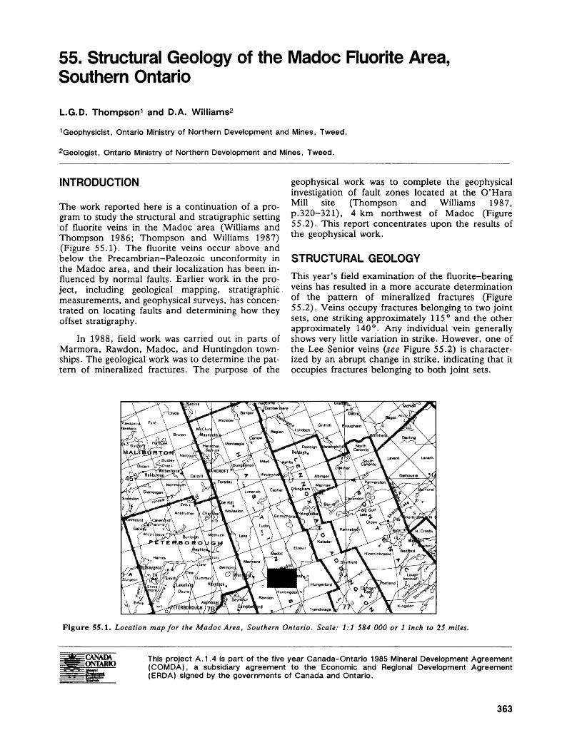
55. Structural Geology of the Madoc Fluorite Area, Southern Ontario
L.G.D. Thompson 1 and D.A. Williams2
Geophysicist, Ontario Ministry of Northern Development and Mines, Tweed.
2Geologist, Ontario Ministry of Northern Development and Mines, Tweed.
INTRODUCTION
The work reported here is a continuation of a pro gram to study the structural and stratigraphic setting of fluorite veins in the Madoc area (Williams and Thompson 1986; Thompson and Williams 1987) (Figure 55.1). The fluorite veins occur above and below the Precambrian-Paleozoic unconformity in the Madoc area, and their localization has been in fluenced by normal faults. Earlier work in the pro ject, including geological mapping, stratigraphic measurements, and geophysical surveys, has concen trated on locating faults and determining how they offset stratigraphy.
In 1988, field work was carried out in parts of Marmora, Rawdon, Madoc, and Huntingdon town ships. The geological work was to determine the pat tern of mineralized fractures. The purpose of the
geophysical work was to complete the geophysical investigation of fault zones located at the O'Kara Mill site (Thompson and Williams 1987, p.320-321), 4 km northwest of Madoc (Figure 55.2). This report concentrates upon the results of the geophysical work.
STRUCTURAL GEOLOGYThis year's field examination of the fluorite-bearing veins has resulted in a more accurate determination of the pattern of mineralized fractures (Figure 55.2). Veins occupy fractures belonging to two joint sets, one striking approximately 115 0 and the other approximately 140 0 . Any individual vein generally shows very little variation in strike. However, one of the Lee Senior veins (see Figure 55.2) is character ized by an abrupt change in strike, indicating that it occupies fractures belonging to both joint sets.
Figure 55.1. Location map for the Madoc Area, Southern Ontario. Scale: 1:1 584 000 or l inch to 25 miles.
This project A.1.4 is part of the five year Canada-Ontario 1985 Mineral Development Agreement (COMDA), a subsidiary agreement to the Economic and Regional Development Agreement (ERDA) signed by the governments of Canada and Ontario.
363
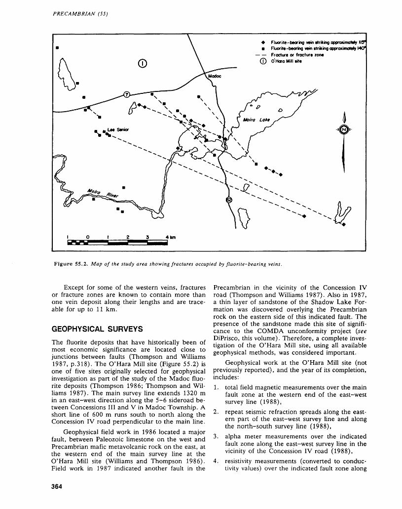
PRECAMBRIAN (55)
* Fluorite -tearing vein striking approximately 119" m Fluorite-bearing vein striking approximately MO*
— — Fracture or fracture zone O'Hora Mill site
10123 4km
Figure 55.2. Map of the study area showing fractures occupied by fluorite-bearing veins.
Except for some of the western veins, fractures or fracture zones are known to contain more than one vein deposit along their lengths and are trace able for up to 11 km.
GEOPHYSICAL SURVEYS
The fluorite deposits that have historically been of most economic significance are located close to junctions between faults (Thompson and Williams 1987, p.318). The O'Hara Mill site (Figure 55.2) is one of five sites originally selected for geophysical investigation as part of the study of the Madoc fluo rite deposits (Thompson 1986; Thompson and Wil liams 1987). The main survey line extends 1320 m in an east-west direction along the 5-6 sideroad be tween Concessions III and V in Madoc Township. A short line of 600 m runs south to north along the Concession IV road perpendicular to the main line.
Geophysical field work in 1986 located a major fault, between Paleozoic limestone on the west and Precambrian mafic metavolcanic rock on the east, at the western end of the main survey line at the O'Hara Mill site (Williams and Thompson 1986). Field work in 1987 indicated another fault in the
Precambrian in the vicinity of the Concession IV road (Thompson and Williams 1987). Also in 1987, a thin layer of sandstone of the Shadow Lake For mation was discovered overlying the Precambrian rock on the eastern side of this indicated fault. The presence of the sandstone made this site of signifi cance to the COMDA unconformity project (see DiPrisco, this volume). Therefore, a complete inves tigation of the O'Hara Mill site, using all available geophysical methods, was considered important.
Geophysical work at the O'Hara Mill site (not previously reported), and the year of its completion, includes:1. total field magnetic measurements over the main
fault zone at the western end of the east-west survey line (1988),
2. repeat seismic refraction spreads along the east ern pan of the east-west survey line and along the north-south survey line (1988),
3. alpha meter measurements over the indicated fault zone along the east-west survey line in the vicinity of the Concession IV road (1988),
4. resistivity measurements (converted to conduc tivity values) over the indicated fault zone along
364
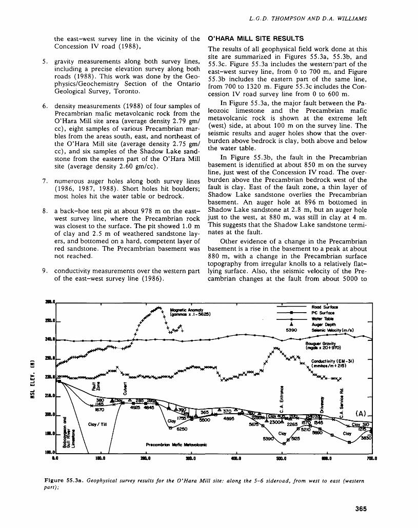
L. G.D. THOMPSON AND D. A. WILLIAMS
the east-west survey line in the vicinity of the Concession IV road (1988),
5. gravity measurements along both survey lines, including a precise elevation survey along both roads (1988). This work was done by the Geo physics/Geochemistry Section of the Ontario Geological Survey, Toronto.
6. density measurements (1988) of four samples of Precambrian mafic metavolcanic rock from the O'Hara Mill site area (average density 2.79 gm/ cc), eight samples of various Precambrian mar bles from the areas south, east, and northeast of the O'Hara Mill site (average density 2.75 gm/ cc), and six samples of the Shadow Lake sand stone from the eastern part of the O'Hara Mill site (average density 2.60 gm/cc).
7. numerous auger holes along both survey lines (1986, 1987, 1988). Short holes hit boulders; most holes hit the water table or bedrock.
8. a back-hoe test pit at about 978 m on the east- west survey line, where the Precambrian rock was closest to the surface. The pit showed 1.0 m of clay and 2.5 m of weathered sandstone lay ers, and bottomed on a hard, competent layer of red sandstone. The Precambrian basement was not reached.
9. conductivity measurements over the western part of the east-west survey line (1986).
O'HARA MILL SITE RESULTSThe results of all geophysical field work done at this site are summarized in Figures 55.3a, 55.3b, and 55.3c. Figure 55.3a includes the western'part of the east-west survey line, from O to 700 m, and Figure 55.3b includes the eastern part of the same line, from 700 to 1320 m. Figure 55.3c includes the Con cession IV road survey line from O to 600 m.
In Figure 55.3a, the major fault between the Pa leozoic limestone and the Precambrian mafic metavolcanic rock is shown at the extreme left (west) side, at about 100 m on the survey line. The seismic results and auger holes show that the over burden above bedrock is clay, both above and below the water table.
In Figure 55.3b, the fault in the Precambrian basement is identified at about 850 m on the survey line, just west of the Concession IV road. The over burden above the Precambrian bedrock west of the fault is clay. East of the fault zone, a thin layer of Shadow Lake sandstone overlies the Precambrian basement. An auger hole at 896 m bottomed in Shadow Lake sandstone at 2.8 m, but an auger hole just to the west, at 880 m, was still in clay at 4 m. This suggests that the Shadow Lake sandstone termi nates at the fault.
Other evidence of a change in the Precambrian basement is a rise in the basement to a peak at about 880 m, with a change in the Precambrian surface topography from irregular knolls to a relatively flat- lying surface. Also, the seismic velocity of the Pre cambrian changes at the fault from about 5000 to
210.0
290.0
240.0
290.0
220.0
210.0
200.0
190.0
100.0
. Magnetic Anomaly \ (gamma* x.l-5623)
Rood Surface PC Surface Water Table Auger Depth
539O Seismic VWocity ( m /s )
L,. Conductivity (EM-31) (mmhos/m 1215)
0.0 100.0 300.0 400.0 SOO.O 700.0
Figure 55.3a. Geophysical survey results for the O'Hara Mill site: along the 5-6 sideroad, from west to east (western part);
365
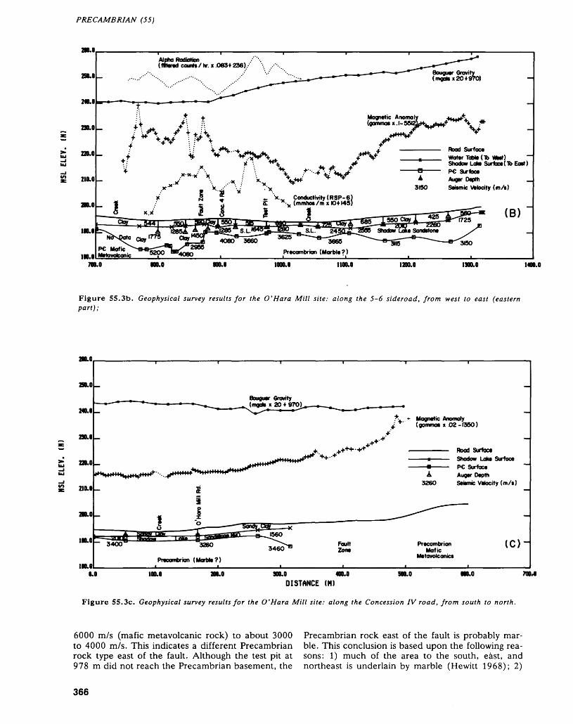
PRECAMBRIAN (55)
210.0
250.0-
240.0
230.0-
S 220.0-
210.0-
200.0
100.0 b
100.0700.0
Alpha Radiation(mind counts/hr. x .0694 236)
Bouguer Gravity (nogahx20*970)
Magnetic Anoma (gamma* x. l
Rood SurfaceWater Table (16 Whet) Shadow Lake Surface(Tb Ea))PC Surface Auger Depth Seismic Vstoctty (m/s)
Conductivity (RSP-6) (mmhoe /m x KH145)
24
3665
Precambrian (Marble?)
900.0 1000.0 1100.0 1200.0 1300.0 1400.0
Figure 55.3b. Geophysical survey results for the O'Hora Mill site: along the 5-6 sideroad, from west to east (eastern part);
200.0
250.0
Bouguer Gravity
240.0
230.0
2 220.0
210.0
200.0
190.0 s:100.0
Magnetic Anomaly (gomnxK x .02-1360)
Road Surfacei——— Shadow Lake Surface
—m——— PC Surface A Auger Depth
3260 Seismic Velocity (m/s)
PrecambrianMafic
Metovolc antes
( C ) "~
0.0 100.0 200.0 300.0 500.0 000.0 TOMDISTANCE (H)
Figure 55.3c. Geophysical survey results for the O'Hara Mill site: along the Concession IV road, from south to north.
6000 m/s (mafic metavolcanic rock) to about 3000 Precambrian rock east of the fault is probably mar- to 4000 m/s. This indicates a different Precambrian ble. This conclusion is based upon the following rea- rock type east of the fault. Although the test pit at sons: 1) much of the area to the south, east, and 978 m did not reach the Precambrian basement, the northeast is underlain by marble (Hewitt 1968); 2)
366
L. G.D. THOMPSON AND D. A. WILLIAMS
the relatively flat basement surface east of the fault is typical of a marble surface; and 3) the lower seis mic velocities are in the velocity range for marble (Thompson and Williams 1987, p.319).
Also of interest is the change in the magnetic anomaly profile and an apparent conductivity anom aly over the fault zone. The Bouguer gravity profile shows a steady increase east of the fault. This is not likely caused by the different Precambrian rock types on either side of the fault because their densi ties (assuming marble on the eastern side) are nearly the same (2.79 and 2.75 gm/cc). The increase ap pears to be the result of the denser, wedge-shaped layer of Shadow Lake sandstone (2.75 gm/cc) re placing the wet clay (about 2.2 gm/cc) that exists west of the fault.
Figure 55.3c confirms the presence of the Shadow Lake sandstone and of a low velocity Pre cambrian basement under the Concession IV road both south and north of the 5-6 sideroad. The fault in the Precambrian, identified in Figure 55.3b, evi dently cuts across the Concession IV road at about 400 m. This is indicated in Figure 55.3c by the sud den drop of the Precambrian basement surface and the known outcrop hill of mafic metavolcanic rock to the north.
CONCLUSIONS1. Exploration for fluorite deposits should be con
ducted along the mineralized fractures indicated in Figure 55.2 and their possible extensions. There are other possible mineralized fractures in the western part of the study area which have not yet been traced.
2. The usefulness of geophysical methods in locat ing faults and identifying different bedrock types in areas covered by overburden has been dem onstrated.
3. The presence of mineralized fracture zones may possibly be detected by seismic bedrock profiles as well as by magnetic, conductivity, and alpha radiation surveys.
4. Geophysical surveys across extensions of the strikes of the mineralized fractures shown in Fig ure 55.2 would be beneficial to the fluorite study project.
ACKNOWLEDGMENTSThe assistance of the Geophysics/Geochemistry Sec tion of the Ontario Geological Survey in conducting the gravity survey is greatly appreciated. In particu lar, thanks are given to Roger Barlow, Chief, and Vinod Gupta, Geophysicist, for their supervision, and to David Wadge and Peter Mark, Geophysical Assistants, who performed the field work.
REFERENCESHewitt, D.F.1968: Geology of Madoc Township and the North Part of
Huntingdon Township, Hastings County; Ontario De partment of Mines, Geological Report 73, 45p. Ac companied by Map 2154, scale 1:31 680 or l inch to 1/2 mile.
Thompson, L.G.D.1986: Eastern Resident Geologist's Area, Eastern Region:
Geophysical Study of Fluorite Deposits; p.296-304 in Report of Activities 1985, Regional and Resident Ge ologists, edited by C.R. Kustra, Ontario Geological Survey, Miscellaneous Paper 128, 340p.
Thompson, L.G.D., and Williams, D.A.1987: Geological and Geophysical Studies of the Madoc
Fluorite Area, Southern Ontario; p.316-323 in Sum mary of Field Work and Other Activities 1987, by the Ontario Geological Survey, edited by R.B. Barlow, M.E. Cherry, A.C. Colvine, Burkhard O. Dressler, and Owen L. White, Ontario Geological Survey, Mis cellaneous Paper 137, 429p.
Williams, D.A., and Thompson, L.G.D.1986: Structural Setting of the Fluorite Vein Deposits of the
Madoc Area, Southern Ontario; p.347-350 in Sum mary of Field Work and Other Activities 1986, by the Ontario Geological Survey, edited by P.C. Thurston, Owen L. White, R.B. Barlow, M.E. Cherry, and A.C. Colvine, Ontario Geological Survey, Miscella neous Paper 132, 435p. Accompanied by l chart.
367
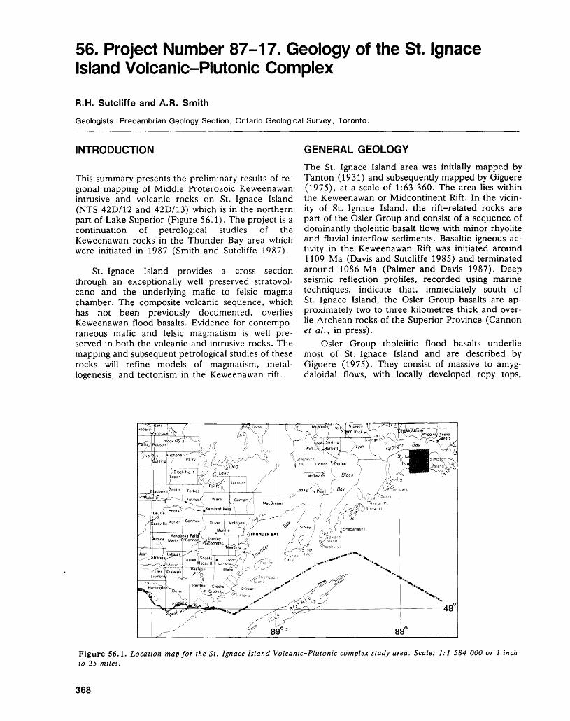
56. Project Number 87-17. Geology of the St. Ignace Island Volcanic-Plutonic Complex
R.H. Sutcliffe and A.R. Smith
Geologists, Precambrian Geology Section, Ontario Geological Survey, Toronto.
INTRODUCTION
This summary presents the preliminary results of re gional mapping of Middle Proterozoic Keweenawan intrusive and volcanic rocks on St. Ignace Island (NTS 42D/12 and 42D/13) which is in the northern part of Lake Superior (Figure 56.1). The project is a continuation of petrological studies of the Keweenawan rocks in the Thunder Bay area which were initiated in 1987 (Smith and Sutcliffe 1987).
St. Ignace Island provides a cross section through an exceptionally well preserved stratovol cano and the underlying mafic to felsic magma chamber. The composite volcanic sequence, which has not been previously documented, overlies Keweenawan flood basalts. Evidence for contempo raneous mafic and felsic magmatism is well pre served in both the volcanic and intrusive rocks. The mapping and subsequent petrological studies of these rocks will refine models of magmatism, metal- logenesis, and tectonism in the Keweenawan rift.
GENERAL GEOLOGYThe St. Ignace Island area was initially mapped by Tanton (1931) and subsequently mapped by Giguere (1975), at a scale of 1:63 360. The area lies within the Keweenawan or Midcontinent Rift. In the vicin ity of St. Ignace Island, the rift-related rocks are part of the Osler Group and consist of a sequence of dominantly tholeiitic basalt flows with minor rhyolite and fluvial interflow sediments. Basaltic igneous ac tivity in the Keweenawan Rift was initiated around 1109 Ma (Davis and Sutcliffe 1985) and terminated around 1086 Ma (Palmer and Davis 1987). Deep seismic reflection profiles, recorded using marine techniques, indicate that, immediately south of St. Ignace Island, the Osler Group basalts are ap proximately two to three kilometres thick and over lie Archean rocks of the Superior Province (Cannon et al., in press).
Osler Group tholeiitic flood basalts underlie most of St. Ignace Island and are described by Giguere (1975). They consist of massive to amyg daloidal flows, with locally developed ropy tops,
Figure 56.1. Location map for the St, Ignace Island Volcanic-Plutonic complex study area. Scale: 1:1 584 000 or l inch to 25 miles.
368
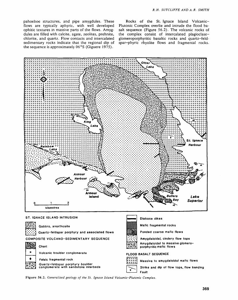
R.H. SUTCLIFFE AND A. R. SMITH
pahoehoe structures, and pipe amygdules. These flows are typically aphyric, with well developed ophitic textures in massive parts of the flows. Amyg dules are filled with calcite, agate, zeolites, prehnite, chlorite, and quartz. Flow contacts and intercalated sedimentary rocks indicate that the regional dip of the sequence is approximately 06 0 S (Giguere 1975).
Rocks of the St. Ignace Island Volcanic- Plutonic Complex overlie and intrude the flood ba salt sequence (Figure 56.2). The volcanic rocks of the complex consist of intercalated plagioclase- glomeroporphyritic basaltic rocks and quartz-feld- spar-phyric rhyolite flows and fragmental rocks.
WVVWWWWWWWWWWWWWVWWWWWWVWWWWVW V V W VWWWWWWWWVWWWVWWVWVWVWWWWVWWWvwwvwwwwwvwvwwwwwww vyvvvyvyvvvvvvvvwvvvv vwwwwwwwwwwwvwwvw v^^rfl^iv^vW^.vV?5*NLy wwvwww wwvwwwwvwwwwwww . ~ ...VWWWW i W W VWV WWW W WvvvvvvvvvAvvvvvvvvvvvvvvvvvvVWWWW li VVVVVVVVVVVVVWVVV WVWWWVWWWWWWWWV V VVVVVVVVVVVV VVVV VVVV VVVV V WWW -3WN IT" WWWWVWWW
wvvvvw Wvvvww wv w w wWVVVWW WWW VVVwvvvvw wvvvvw wvvvvw wwwwWWW Wwwww
"vvvvvvvvvvvvvvvvwwvvwwwwwwwwwwvwww,vwwwwwwwvwwwwwwwwwwwvwwwwwwwwwwvwwwvwvwwwwwwwWWWWWWWWWVw wwvwww w vwvwwwvwwwwww
wwww vwv wvvv w vwv wwv; wwwvwwwwwvvwwwwv vwwwwwwwwwwwwwv wwvwwwwwwwwwwwv wwwwwwvwww v'v w w w v
/vvvvvvvvvvvvvvvvvvvvvv wwwwvvwvwwwwv/VVVVVVVVVVVVVVVVVVVVVV V;/vvvvvvvvvvvvvvvvvvvvvvwwwwvwwwwwvwvvwwvwvwwwwvwwwvwwwwwwwwwwwwwvwwvwwwwwwwwwwwvwwwwwwvwwwwwwwwvw
wwwwwwwwwwwwwwwvv'WWVWWW WWW VVVV WWV
/wwwvwwwwvwwwvwwvwvwwv wwwwwwvwwwwwwvwwwww wv vwwvwvwwwwvwww vwwwwWWWWVVWVWWVWWWWVVWWWW
WWWWWWWWWWWWWWW//'wwwwvvwvwwvvw
vwwwwwwwww vwwwwwvwvwwWWWVWWWWWW Bj/x. . . . .WVWWVWWWWW**" " ' ' "
vwwwwvwvw wvwvwwvw
vvwvwwwwwvwwwwvwv — y w vvv w vvv w vwv wwww w v Otter \ty vvwwwwwwwwwvvvw
wvwwwwvwwwwwvv vvvvvvvvvvvvvvvvvvvvvv wwwwvvvwwwww wwwwvvvwwwww
vwv w vwv vwwww vwwwwwwwww
vvwwwvV ^jvvvvvvvvvvvvvvvvvvvvWWWW V"*-*-JV VWWWWWVWVWWvvwvwvw vi v vwwwwwwwww vwwww vV v vwvwwwvvwwvvVVVVVVVVVVVVVVVVVVVVVVVVVVVVVwvvvvw v\v wwvvwwwwww
V V V V W VI V WVVVVWVWVWWW VVVV VV WWWWWWWWVV
vwvwywwwwwwwvvvv wwv Vwwwwwwwww y vwv vy w vvww w v w v w v
V V V W VV/ VWWWWWWWVi KS.Vv wwi/wvwwwwwwv
•" 'VWWWWWWWVtwwwwwvww rwwwwwww
fVVVVVVVVVVVVV 'VVVVVVVVVVVV fWWWWWVVkvvvvvvvvvvvv
' v v v vvv wwv v v jr—v vvvv *iv v"v vvv v v
syvvvvvvv V/ v v v v v v
sy v w v v [ vv wv
'VVVv vwwwwv v v ~~r~ v v v
wvv vwwww 'j'.'.'.'.'.'Xa^y vwwwvvv•^™""^™^^^ '""^^ S f. Ignace
Harbour
v w v v wwwww
vwwww vwwww
WWW WWvwwvvww,XxXxXftfsp^^^fe^
::::::::::::::S^K^i
Lake Superior
kilometres
ST. IGNACE ISLAND INTRUSION
Gabbro, anorthosite
Quartz-feldspar porphyry and associated flows
COMPOSITE VOLCANO-SEDIMENTARY SEQUENCE
Chert
ffiVolcanic boulder conglomerate
Felsic fragmental rockQuartz-feldspar porphyry boulder conglomerate with sandstone interbeds
Diabase dikes
Mafic fragmental rocks
Ponded coarse mafic flows
Amygdaloidal, cindery flow topsAmygdaloidal to massive glomero porphyritic mafic flows
FLOOD BASALT SEQUENCE
Massive to amygdaloidal mafic flows
Strike and dip of flow tops, flow banding Fault
Figure 56.2. Generalized geology of the St. Ignace Island Volcanic-Plutonic Complex.
369
PRECAMBRIAN (56)
Heterolithic and monolithic volcanic conglomerate units and associated sandstone lenses are inter bedded with the flows. The intrusive rocks of the complex consist of a gabbro to anorthosite ring dike, gabbroic sills, diabase dikes, and a central quartz- feldspar porphyry stock. The volcanics are inter preted to be the extrusive equivalents of the gabbro and porphyry on the basis of the textural and min eralogical similarities. The volcanic section is ex posed in the southern part of the complex due to the tilting of Keweenawan strata toward Lake Superior.
Basaltic volcanic rocks of the St. Ignace Island Complex are characterized by glomeroporphyritic and fluxion textures defined by plagioclase laths up to 1.5 cm long. The basalts occur as massive to amygdaloidal flows which commonly exhibit frag mental flow tops. Flows up to 30 m thick are present and are characterized by a gradation from very coarse, massive basalt with 0.5 to 1.5 cm grain sizes to plagioclase-phyric amygdaloidal basalt with inter sertal texture.
Felsic volcanic rocks intercalated with the ba salts range from massive and flow-banded rhyolite to rhyolite breccia and welded tuff. The rhyolite contains phenocryst assemblages of quartz, quartz 4- blocky feldspar (possibly alkali feldspar), and quartz + blocky feldspar -i- plagioclase laths. The felsic vol canics are characterized by numerous inclusions of plagioclase-phyric to glomeroporhyritic basalt, gab bro, and andesitic to dacitic porphyry.
Sedimentary rocks interbedded with the vol canic sequence are preserved in the vicinity of Bullers Bay and Armour Island. A monolithic vol canic conglomerate exposed on the northern side of Bullers Bay contains rounded boulders of red and grey quartz-feldspar porphyry in a clastic matrix, with cross-bedded sandstone lenses. A heterolithic volcanic conglomerate was outlined on the southern shore of Armour Island. In this unit, centimetre- to metre-sized fragments, ranging in composition from amygdaloidal and glomeroporphyritic basalt to quartz-feldspar porphyry, are supported in a sandy matrix. Rare sandstone interbeds within the volcanic flows are oxidized and range from 5 to 50 cm in thickness. Narrow chert beds from 2 to 30 cm thick occur between glomeroporphyritic flows on the southern shore of Bullers Bay.
Gabbroic rocks form the ring dike and smaller sills which are intrusive into the volcanic rocks. These intrusive rocks range in composition from gabbro to anorthosite and consist of plagioclase, clinopyroxene, olivine, and opaques. The gabbroic rocks are coarse-grained, with 0.5 to 2 cm grain sizes, and exhibit wispy modal layering and igneous lamination. At contacts with the volcanic rocks, the gabbro is chilled and contains plagioclase phenocrysts in an aphanitic matrix.
The central quartz-feldspar porphyry stock is oval in shape, with long and short axis dimensions of
7 km and 3.5 km, respectively. The stock is com posed predominantly of massive, red to grey, quartz-feldspar porphyry with phenocryst assem blages identical to those of the felsic volcanic rocks. Massive grey- to buff-coloured porphyry, character ized by abundant plagioclase phenocrysts and rare quartz phenocrysts, is locally observed in the zone between the gabbro ring dike and the red quartz- feldspar porphyry core, and is interpreted to be in termediate in composition. Fine- to medium- grained plagioclase-phyric mafic inclusions are abundant in the intrusive core near the contact with the gabbro ring dike.
Ophitic and plagioclase-phyric diabase dikes in trude the gabbro, quartz-feldspar porphyry, and the volcanic rocks. These dikes range in thickness from a few decimetres to ten metres and often exhibit co lumnar jointing. Some of the diabase dikes form a pattern which is radial to the central felsic stock and gabbroic ring dike.
Textures in the rocks of the complex indicate that mafic and felsic magmatism were contempora neous and that localized magma mixing occurred. Rounded, chilled mafic inclusions are common in both the felsic intrusive and volcanic rocks. These inclusions are associated with hybrid compositions in areas such as the outer part of the porphyry stock. Vesicular basaltic fragments are present in felsic welded tuff and preliminary petrographic observa tions indicate that plagioclase phenocrysts in felsic rocks are locally rimmed by aphanitic basalt.
ECONOMIC GEOLOGYExploration interest on St. Ignace Island has been primarily for copper and silver. Mineralization of in terest in this area includes the presence of native copper in amygdaloidal basalt, and the occurrence of native copper and silver in calcite-quartz-chalco- cite-chalcopyrite veins cutting host basalts. To date, no economically significant mineralization has been discovered in the area. Information on exploration activities reported here is from the Resident Geolo gist's Office, Ministry of Northern Development and Mines, Thunder Bay. Most information given here pertains to exploration in volcanic rocks on St. Ig nace Island.
Early exploration work in the area was com pleted in 1955 by Horlac Mines Limited. Properties on the southeastern side of St. Ignace Harbour and at the northern end of Moffat Strait were investi gated by diamond drilling (16 holes, 338 m) and trenching. The Moffat Strait Property was drilled again in 1964 by R.V. Oja Limited (6 holes, 469 m). Assays to 15.2 percent silver and 3.2 per cent copper were reportedly obtained from drill core.
A property on the northwestern corner of St. Ig nace Island was diamond drilled by Sutherland and Company in 1961 (2 holes, 455 m), and again in
370
R.H. SUTCLIFFE AND A. R. SMITH
1968 (l hole, 280 m). Another property in this same area was investigated in this same year by J.L. Carroll (Prospector, N.Y.C.) with diamond drilling (8 holes, 261 m).
An extensive soil geochemical survey and a stream sediment sampling program were completed on a large part of St. Ignace Island in 1968 by Og den Prospecting Syndicate. This work detected two minor copper anomalies on the western side of the Island. In 1970, Addicks Canadian Properties In corporated completed ground magnetic and electro magnetic surveys on a Moffat Strait property to test for anomalies associated with known copper-silver mineralization. The survey outlined six east-trending anomalies which were interpreted to be concentra tions of magnetite in basalt flows.
The occurrence of copper at the northern end of Moffat Strait was examined during the current mapping project. A carbonate-quartz vein within a deformation zone cutting basalt flows was observed to contain disseminated chalcocite, chalcopyrite, and bornite. A grab sample from a trench exposure of a 5 cm wide part of this vein returned 3070 ppm Cu.
Minor copper mineralization was encountered in intermediate intrusive rocks of the central porphyry core during the current mapping project. Fractured feldspar-porphyritic rocks exhibiting argillic altera tion and disseminated chalcopyrite were encoun tered along the northwestern edge of the central core in close proximity to the gabbro ring dike. This type of rock represents an exploration target for por phyry-copper-type mineralization.
The gabbro and anorthositic gabbro of the ring dike are possible exploration targets for platinum group elements (PGE). Minor sulphide mineraliza tion detected during the current mapping appears magmatic in texture, but no anomalous values of PGE were obtained on samples collected by the field party. Exploration efforts should focus on outlining and assaying similar sulphide mineralization by pros pecting within the gabbroic rocks.
CONCLUDING REMARKS
The St. Ignace Island Complex has close similarities with the central complexes of the British Tertiary Volcanic Province such as the Mull and Ardnamur- chan Complexes, which have been described by Bailey et al. (1924), Richey (1932) and Thompson (1982). Features of the St. Ignace Island Complex which are similar to the British complexes include: a rift-related tectonic setting, the presence of volcanic rocks underlain by eogenetic central intrusions, co existing basaltic and felsic magmas with evidence of hybridization, and emplacement of magmas con trolled by ring fractures.
At St. Ignace Island, planned investigations will address petrologic problems such as the characteri zation and origin of magma types, the nature of in teraction between mafic magmas and sialic crust, and the extent of mixing between mafic and felsic magmas. The study will provide a basis for the com parison of the mineral potential of gabbroic rocks in the St. Ignace Island area with Cu-Ni-PGE- mineralized Keweenawan intrusions such as the Crystal Lake Gabbro.
REFERENCESBailey, E.B., Clough, C.T., Wright, W.B., Richey, J.E.,
and Wilson, G. 1924: The Tertiary and Post-Tertiary Geology of Mull, Loch
Aline, and Oban; Geological Survey of Scotland,Memoir.
Cannon, W.F., Green, A.G., Hutchinson, D.R., Lee, M., Milkereit, B., Behrendt, J.C., Halls, H.C., Green, J.C., Dickas, A.B., Morey, G.B., Sutcliffe, R., and Spencer, C.
In Press: The Midcontinent Rift beneath Lake Superior from GLIMPCE Seismic Reflection Profiling; Tectonics.
Davis, D.W., and Sutcliffe, R.H.1985: U-Pb Ages from the Nipigon Plate and Northern Lake
Superior; Geological Society of America, Bulletin,Volume 96, p. 1572-1579.
Giguere, J.F.1975: Geology of St. Ignace Island and Adjacent Islands,
District of Thunder Bay; Ontario Division of Mines, Geological Report 118, 35p. Accompanied by Map 2285, scale 1:63 360 or l inch to l mile.
Palmer, H.C., and Davis, D.W.1987: Paleomagnetism and U-Pb Geochronology of Vol
canic Rocks from Michipicoten Island, Lake Supe rior, Canada: Precise Calibration of the Keweenawan Polar Wander Track; Precambrian Research, Volume 37, p.151-171.
Richey, J.E.1932: Tertiary Ring Structures in Britain; Geological Society
of Glasgow, Transactions, Volume 19, p.42-140.
Smith, A.R., and Sutcliffe, R.H.1987: Keweenawan Intrusive Rocks in- the Thunder Bay
Area; p.248-255 in Summary of Field Work and Other Activities 1987, by the Ontario Geological Sur vey, edited by R.B. Barlow, M.E. Cherry, A.C. Col vine, Burkhard O. Dressler, and Owen L. White, Ontario Geological Survey, Miscellaneous Paper 137, 429p.
Tanton, T.L.1931: Fort William and Port Arthur and Thunder Cape Map
Areas, Thunder Bay District, Ontario; Geological Survey of Canada, Memoir 167, 222p. Accompanied by 3 maps.
Thompson, R.N.1982: Magmatism of the British Tertiary Province; Scottish
Journal of Geology, Volume 18, p.49-107.
371


Special Studies
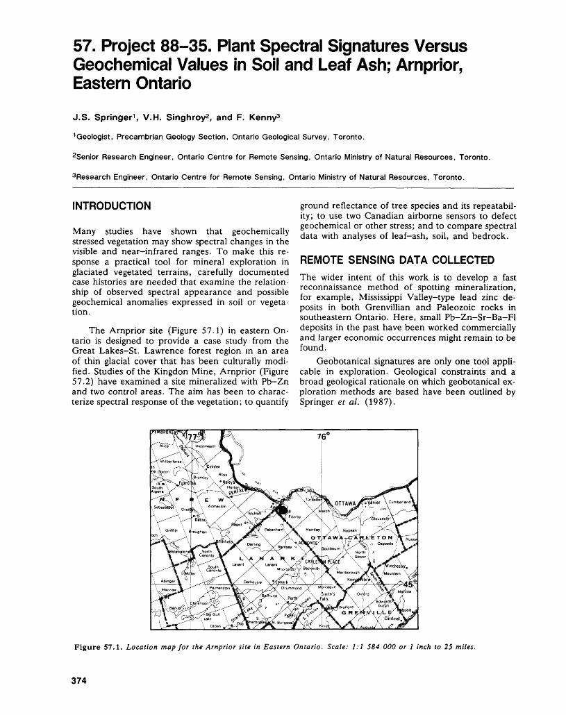
57. Project 88-35. Plant Spectral Signatures Versus Geochemical Values in Soil and Leaf Ash; Arnprior, Eastern Ontario
J.S. Springer1 , V.H. Singhroy2 , and F. Kenny3
1 Geologist, Precambrian Geology Section, Ontario Geological Survey, Toronto.
2Senior Research Engineer, Ontario Centre for Remote Sensing, Ontario Ministry of Natural Resources, Toronto.
3Research Engineer, Ontario Centre for Remote Sensing, Ontario Ministry of Natural Resources, Toronto.
INTRODUCTION
Many studies have shown that geochemically stressed vegetation may show spectral changes in the visible and near-infrared ranges. To make this re sponse a practical tool for mineral exploration in glaciated vegetated terrains, carefully documented case histories are needed that examine the relation ship of observed spectral appearance and possible geochemical anomalies expressed in soil or vegeta tion.
The Arnprior site (Figure 57.1) in eastern On tario is designed to provide a case study from the Great Lakes-St. Lawrence forest region in an area of thin glacial cover that has been culturally modi fied. Studies of the Kingdon Mine, Arnprior (Figure 57.2) have examined a site mineralized with Pb-Zn and two control areas. The aim has been to charac terize spectral response of the vegetation; to quantify
ground reflectance of tree species and its repeatabil ity; to use two Canadian airborne sensors to defect geochemical or other stress; and to compare spectral data with analyses of leaf-ash, soil, and bedrock.
REMOTE SENSING DATA COLLECTEDThe wider intent of this work is to develop a fast reconnaissance method of spotting mineralization, for example, Mississippi Valley-type lead zinc de posits in both Grenvillian and Paleozoic rocks in southeastern Ontario. Here, small Pb-Zn-Sr-Ba-Fl deposits in the past have been worked commercially and larger economic occurrences might remain to be found.
Geobotanical signatures are only one tool appli cable in exploration. Geological constraints and a broad geological rationale on which geobotanical ex ploration methods are based have been outlined by Springer et al. (1987).
Figure 57.1. Location map for the Arnprior site in Eastern Ontario. Scale: 1:1 584 000 or l inch to 25 miles.
374
J.S. SPRINGER, V. SINGHROY, AND F. KENNY
SPECTRAL REGION
DOMINANT FACTOR CONTROLLING LEAF REFLECTANCE
LANDSAT THEMATIC MAPPER BANDS
VISIBLEm Z ^r; i ui i Q3 B H
E
NEAR INFRARED
(NIR) l SHORT WAVE INFRARED (SWIR)
LEAF r-LL PIGMENTS STRC|LTURE LEAF WATER CONTENT
w 60-oJDC O
DC
LANDSAT MULTISPECTRAL SCANNER BANDS
Hill MEIS Binds PMl Band
0.4 0.6 0.8 1.0 1.2 1.4 1.6 1.8 2.0 2.2 2.4Wavelength
Figure 57.2. Graph of Percentage Reflectance Versus Wavelength (Jim).
m)
Data collected simultaneously on an airborne mission in early September 1985 include:1. colour infrared-photography at a scale of
1:15 000, for identifying vegetation types and selecting sites for field sampling, and
2. narrow band MEIS II (Multispectral Electro- optical imaging Scanner) data with a spatial resolution of 4.2 m, at nanometer wavelengths of 680, 713, 753, and 798, using the geobotany filter set.The flight was scheduled for late August in the
hope that stress, induced by drought or early winter ing, would enhance the spectral shift at the edge be tween red and blue wave lengths.
The Arnprior site was flown in July 1987, using the Programmable Multispectral Imager (formerly the Fluorescence Line Imager), developed by Moniteq Limited, to yield a comparative data set. The flight was scheduled for earlier in the year than the previous flight to evaluate the effects of senes cence on the reflectance values.
The wavelength of the MEIS filters relative to the wavelengths at which physiologically important
plant functions cause reflectance changes is shown in Figure 57.2. The broader range scanned by the FLI (PMI) sensor is also shown.
FIELD SAMPLING
Data sets of spectra measured at ground level for five major tree species, namely trembling aspen, white birch, red oak, bur oak and maple, now exist for the years 1985 to 1988, together with other ob servations for white cedar, juniper, hemlock, and ash. The leaves are collected on site from the crown and upper surface of the trees (areas that would be visible from the air), sealed in plastic bags, and cooled until their spectra can be read under stan dard, controlled indoor conditions. This must be done within four hours to prevent artifacts due to wilting and chlorophyll destruction. Ground observa tions of spectra have been obtained from one mineralized and two control sites.
At these same sites, 50 by 50 m grids have pro vided a basis for sampling soil and the first year growth of tree species. The leaves are stripped and placed in paper bags for later oven drying, prelimi nary steps to ashing, dissolution, and analysis by
375
PRECAMBRIAN (57)
qualitative inductively coupled plasma spectrometry. Soil samples undergo the same analysis.
RESULTS
SOIL AND VEGETATION DATA
So far, the analytical data show a distinct anomaly for base metals at the mineralized site. Figure 57.3 takes zinc as an example, where the average back ground value in the "B" soil horizon is less than 200 ppm and in the mineralized soil values averages over 3000 ppm.
It appears that the vegetation, species by spe cies, achieves characteristic metal levels in the leaf ash, and that even high values of metal content in the surrounding soil do not increase that uptake by more than twofold. The typical level appears to vary, species by species, to a much greater extent; thus, maples at the unmineralized site average 40 ppm, whereas birch averages about ten times that value (440 ppm). In each case at the mineralized site, the leaf ash enrichment is only about twofold, although the soil enrichment is nearly 20 time's.
GROUND SPECTRAL DATA
Characteristic displacements of the spectral curve were repeatedly found in the foliage analyzed. Fig ure 57.4 illustrates data from 20 trembling aspen samples from the mineralized site. In the visible range, increased reflectance and yellowing (chloro sis) of the leaves appear, indicative of chlorophyll destruction. At the red edge, the curve is shifted to ward blue wavelengths, suggesting damage to cell wall structure. At the shoulders of the curve, in the 680 nm range, there is increased reflectance which appears to denote water loss and wilting.
REMOTELY SENSED SPECTRAL DATA
The images obtained by the MEIS II and the PM l sensors were enhanced using the wavelengths found in the ground data to be most sensitive to change. When this is done, broad patterns of stressed vegeta
tion become apparent. This revealed that anomalous growth occurs in a wide halo around the mine site, along power lines that cross the area, and along ac cess roads to the mine.
The PM l image in particular, analyzed using the 680 nm wave band which marks abundant chlo rophyll in a normally photosynthesizing plant, showed broad swathes of lowered chlorophyll pro duction along cultural features. This revealed that the 'background' control area was itself an area of depressed growth. As a consequence, a new control site was selected and a fresh suite of soil, vegetation, and ground spectral data have been collected.
CONCLUSIONS1. Analysis of leaf ash is probably not a sensitive
test of anomalous soil metal contents, because the physiological activity of the vegetation buff ers the metal uptake.
2. Spectral reflectance in the visible and near infra red ranges shows consistent and predictable vari ation at the mineralized site. The differences ap pear at characteristic positions on the reflec tance curve and perhaps correspond to physi ological changes such as chlorophyll destruction, damage to cell walls, and dehydration that lead to wilting.Ground measurements, at this stage, are vital to
successful interpretation of remotely sensed spectral observation.3. Both MEIS and PMI imaging are sensitive to
stressed vegetation. The PMI data, in particular at the 680 nm wavelength, detect depressed chlorophyll production with good sensitivity.
4. In this study, at present, the distinction between stress related to cultural activities and stress re lated to mineralization cannot be made. In this study, the effects of cultural activities related to the mine overprint the site-specific signature of the vein mineralization itself. More work is needed to permit screening out the cultural overprint.
SOIL "B"
VEGETATIONBirchT. AspenMapleBur Oak
BACKGROUND(ppm)
170
440500
4030
MINERALIZED(ppm)
3300
800760
7060
ENRICHMENT1.8x1.5x1.9x1.9x
Figure 57.3. Zinc values, Arnprior (Kingdon Mine).
376
J. S. SPRINGER, V. SINGHROY, AND F. KENNY
LABORATORY SPECTRAL MEASUREMENT KINGDOM MINE, TREMBLING ASPEN JULY 1987.
EVIDENCE OF METAL
REFLECTION; EVIDENCE OF CHLOROSIS VISIBLE
Ms 20 MINERALIZED
8=15 BACKGROUND
500 700 900 1100
PMI Band L J-JMEIS
Filter Bands
WAVELENGTH (nm)
Figure 57.4. Laboratory Spectral Measurement, Kingdon Mine, July 1987.
Test of means at 95 'fc Test of variances at 95 %
REFERENCESpringer, J.S., Singhroy, V., and Mussakowski, R.S. 1987: Remote Sensing of Mineral Target Areas: Two Exam
ples from Eastern Ontario; p. 350-360 in Summary of
Field Work and Other Activities 1987, by the Ontario Geological Survey, edited by R.B. Barlow, M.E. Cherry, A.C. Colvine, Burkhard O. Dressler, and Owen L. White, Ontario Geological Survey, Mis cellaneous Paper 137, 429p.
377
58. Project Number 88-32. Field Implementation of a Developmental Computer-Based Digital Mapping and Data Storage SystemB. Brodaric 1 and J.A. Fyon2
1 Systems Officer, Precambrian Geology Section, Ontario Geological Survey, Toronto.
2Geologist, Precambrian Geology Section, Ontario Geological Survey, Toronto.
INTRODUCTION
The recent development of powerful portable micro computers and complementary data base and graph ics software presents an opportunity to shift from tra ditional manual manipulation of geological field data. The Precambrian Geology Section of the Ont ario Geological Survey (OGS) has embarked upon a developmental program to incorporate this technol ogy into field programs. The program began this summer with field testing of an interactive com puter-based field note system, having integrated car tographic and relational data base capability. A "386" AutoCAD-dBASE 1 package was deployed in four Precambrian Section field crews. While the shift to digital map production and maintenance from tra ditional cartographic methods is labour-economic, and possesses great potential for reducing manual drafting loads, it is in the area of analysis where pos sibly the greatest gains are to be realized. Available to the geologist is the technological capability to ana lyze large amounts of diverse quantitative and quali tative data, and to produce a spectrum of geological maps ranging from conventional comprehensive maps (e.g. standard Preliminary Series maps) to at tribute-specific maps (e.g. distribution of sheared rhyolite flows bearing S3 foliation). Having this ca pability available in the field facilitates data entry, because of available manpower and time, when the data are most familiar to the geologist, and contrib utes to the identification of significant relationships. More comprehensive data analysis can follow in the office environment, as more and varied data become available (e.g. petrographical, geochemical, geo physical data).
The archival loss of geological data is minimized and future data access should be enhanced because the data are recorded in a relational data base, as opposed to field notebooks. Such data storage and the capability to select a spectrum of data for "in stantaneous" map output should significantly reduce the time required for a new geologist to become fa-
and dBASE are registered trademarks of Autodesk, Incorporated and Ashton-Tate Company, respectively.
miliar with an area, and should facilitate comparison between adjacent areas. The digital approach will ul timately enhance the transfer of information be tween organizations, both within and outside the Ontario Geological Survey.
DESIGN PHILOSOPHYThe hardware and software components of the sys tem were selected, linked, and modified to satisfy certain philosophical design criteria. As a primary objective, the error rate associated with data entry had to be minimized, insofar as the value of any data base rapidly diminishes as data errors are intro duced. Two types of error were anticipated: 1) typo graphical, and 2) incorrect data location and assign ment. Type "2" errors are virtually eliminated and type "l" errors are minimized when data are input into the data base interactively with a graphics dis play. The geologist obtains an instantaneous visual presentation of the data value, location, and assign ment in terms of quantity and symbology (e.g. folia tion orientation, dip value, and station location).
As a second principal requirement, the system had to be easily adaptable to a spectrum of geologi cal projects of varying objectives and geological ex pertise, and hence, a multifile relational data base approach was adopted. In addition, it was desirable to provide a package for which data entry was not onerous and which did not require a sophisticated level of computer and software familiarity (i.e. user friendly).
TECHNOLOGICAL DESIGNPortable "80386" processor-based IBM compatible microcomputers with 2 Mb of memory, a 40 Mb hard disk, a high resolution screen, and a digitizing pad were employed. The high resolution screen, larger memory and faster processor speeds were re quired for adequate graphics and database process ing, while maintaining the ability to integrate with the in-house computer network. An EPSON FX-86e dot matrix printer allowed working maps to be printed. The units functioned favourably in var ied field conditions, including operation from small generators in remote locations.
378
B. BRODARIC AND J. A. FYON
SOFTWARE SELECTION
Construction of the map and data base was carried out through interactive data input within a popular cartographic software package (AutoCAD) and a re lational database (dBASE). Apart from its strong cartographic abilities, customization features, and wide market popularity, an initial attraction to this system over more standard Geographic Information Systems (GIS) was its adaptability to field-suitable technology. Extensive customization of AutoCAD was necessary to implement the structured data en try format. This was accomplished using AutoLISP2 , a high level programming language within AutoCAD, which interacted with several dedicated dBASE batch programs required to manipulate the data base. dBASE was selected as the relational data base because of its adequacy of use, its wide industry ac ceptance, and its familiarity within the OGS.
MODULAR DATA BASE DESIGN
The data base design is modular. This requires that project objectives be logically broken into several geological divisions, each of which has an equivalent related data base file. Conceptually, a typical map ping project will encounter lithological, structural, al teration, and commodity problems. This conceptual structure is then translated into a relational data base consisting of lithological, structural, alteration, and commodity modules. These are defined by the project geologist to fit his expertise and project in itiatives prior to the onset of mapping. The division of geological data, while intended primarily to eco nomically structure the data base, has the added benefit of organizing the nature of the geological problem, and contributes to the processes of prob lem formulation and analysis.
For data entry, the geologist is presented with a series of prompts, determined by the module se lected. As the system was designed for flexibility in dealing with 1 diverse geological problems, geologists completely tailor the input prompts, and, therefore, the information to be stored in the data base and displayed on the map. This structure can be modi fied at any time, allowing for the deletion of un wanted items and the addition of pertinent prompts. Changing the input prompts results in appropriate modification to the data base format, removing or adding the required space and data. This mainte nance is carried out by an easy-to-use auxiliary pro gram. Once the project needs are established by the geologist and translated both into AutoCAD prompts and dBASE data bases, the actual data entry in AutoCAD is routine, requiring minimal computer knowledge and experience.
Users can recall data from the data base and alter it through the interactive input mode, as well as
2AutoLISP is a registered trademark of Autodesk, Incorpo rated.
perform global changes to the map and data base. This is particularly useful when the field legend must be changed or condensed. In these aspects, the sys tem generally resembles a typical GIS. Although the AutoCAD/dBASE amalgamation is somewhat lim ited in typical GIS spatial analysis capabilities, AutoCAD is unsurpassed in its cartographic scope and portability, while adhering to the spatially refer enced data base construction that broadly defines a GIS.
Although the input of data into the modular data base is not dependent on the style in which data is recorded in the field, formatted notes were found to be inherently more efficient. Another important feature of the present cartographic input system is its adaptability to other relational data bases, although the conversion of existing data bases to this modular system does require some custom programming.
FIELD PROJECT SELECTIONFour field parties were selected to test this package. The projects with which these parties were associ ated represent in total a spectrum of geological ob jectives and geological specialization. Mapping took place on reconnaissance (1:50 000), township (1:15 840), and detailed (1:8000 to 1:1000) scales. The emphasis of the projects included a reconnais sance sedimentological study and lithological, struc tural, alteration, and commodity studies at township and detailed scales.
DIGITAL BASE MAPSGeographical base maps were digitized by hand, in AutoCAD, to allow a degree of selectivity in the type and detail of information recorded. A trend to using existing digital maps, or maps generated by optical scanning techniques is foreseen for the future.
DAILY ENTRY OF DATAFollowing each traverse, an air photo mylar overlay, marked with the daily traverse and outcrop patterns, is fixed to the digitizing board and coordinated to the digital base map. Each outcrop is traced (digit ized) from the mylar overlay. The user then selects an appropriate module (e.g. lithology module), rele vant to that outcrop. Appropriate data are entered in response to a sequence of prompts, which add geological symbols to the digitized base map. For displayed data, the geologist is required to select the appropriate symbol (e.g. oldest inclined foliation), identify the symbol's position on the map, and enter any other required qualifications (e.g. strike and dip of a planar feature). This sequence is repeated itera- tively for each outcrop, and the data are periodically exported to the relational data base. Both prompts and map appear on the computer screen simultane ously, yielding a traditional cartographic feel to the map development, as well as enabling users to moni tor and visually confirm data entry at input time.
379
PRECAMBRIAN (58)
The time required to log the daily collection of data when the basic field data were collected in a data was variable, depending on the complexity of less structured manner, the outcrop; however, data entry time averaged two to four times that required to plot the same data on ^. iiuiiui AQV a conventional mylar working map. It is anticipatedthat this time investment in the field will be re- The field tesdng demonstrated that the hardware couped m the office environment, where data analy- and software configurations operated under rigorous sis will continue and drafting requirements will be conditions . The developed system allows for "instan- reduced. taneous" map generation and allows for data and
A variety of field note styles were adopted by map modification. Further testing and development the parties, ranging from free format to structured will continue over the winter and into the next field code. In general, a longer time was required to input season.
380
59. Project Number 88-31. Petrographic Characteristics of Archean Granitoid RocksJ.A. Fyon and K.J. Wheatley
Geologists, Precambrian Geology Section, Ontario Geological Survey, Toronto.
INTRODUCTIONThe intent of this project is to develop a basic petrographic data base describing the mineralogical and textural characteristics of Archean granitoid rocks and to assess the degree to which these data constrain the granitoid crystallization history, includ ing the evolution of magmatic fluids. When com bined with geochemical data, this analysis will con tribute to our understanding of Archean granitoid petrogenesis, and attendant thermal and tectonic conditions. Additional constraints will be provided for some proposed Archean metallogenic models which appeal to magmatic processes (e.g. genesis of gold mineralization). Initially, three granitoid intru sions in the Uchi Greenstone Belt and one from the Temagami Greenstone Belt have been examined to evaluate the approach.
UCHI LAKE GREENSTONE BELT
TROUT LAKE BATHOLITH
The Trout Lake Batholith is a composite tonalite and trondhjemite external batholith, consisting of migmatitic trondhjemite gneiss, banded diorite- granodiorite gneiss, and trondhjemite-diorite-grano- diorite phases (Donaldson 1963, Noble et al. 1984, 1985, 1988).
Oligoclase-andesine plagioclase occurs as eu hedral to subhedral crystals up to 5 mm in length and both albite and carlsbad twins are developed. All crystals show normal compositional zonation. Most plagioclase is replaced to some extent by white mica and epidote; generally alteration of the core is more extensive than the rim. Poikilitic microcline is present in virtually all samples and contains inclu sions of plagioclase. Hornblende is present in trace amounts, but is absent from most samples. Biotite occurs in all samples and has been replaced variably by chlorite and white mica. Euhedral to subhedral epidote, up to l mm in length, occurs in virtually every sample, where it is associated intimately with biotite. Some of these euhedral to subhedral epidote crystals are commonly twinned.
MAIN PRIZE LAKE BATHOLITH
A pink, microcline megacrystic granite-granodiorite (Main Prize Lake Batholith, Beakhouse and McNeil 1986) intrudes the northwestern part of the green
stone belt (Greig 1927). The most distinctive meso scopic feature of this intrusion are coarse (l to 5 cm), poikilitic microcline feldspar. These micro cline crystals enclose and embay quartz, biotite, and hornblende. Compositionally zoned oligoclase pla gioclase is intergrown with the megacrystic micro cline feldspar. Microcline also occurs in a second habit, as distinctly smaller crystals ^1 mm) associ ated with the other matrix silicate minerals. Sub hedral to anhedral hornblende occurs in lesser amounts and biotite occurs as rare inclusions within the plagioclase. Euhedral to subhedral sphene oc curs in minor amounts, often as an inclusion in biotite.
SWAIN LAKE STOCK
This is a poorly exposed, feldspar-rich internal trondhjemitic stock (Furse 1933). Samples exam ined consist almost entirely of plagioclase, with mi nor amounts of hornblende and rare quartz. Euhedral to subhedral plagioclase feldspar consti tutes about 65^o of the rock. This feldspar is badly altered and has been replaced by white mica and epidote. In general, the cores of grains are more al tered than the rims, suggesting that the cores were originally more calcic than the rims. Relic twinning and compositional zoning are still discernible, al though no crystal was fresh enough to provide a petrographic compositional estimate. Hornblende occurs as subhedral phenocrysts, many of which have been replaced by chlorite and epidote. No bio tite was observed.
TEMAGAMI GREENSTONE BELT
STRATHY-CHAMBERS BATHOLITH
This is a tonalite-trondhjemite intrusion, which con tains minor amounts of pegmatite and aplite. Plagio clase (albite to oligoclase) occurs as subhedral to euhedral laths, primarily in crystal aggregates. Most grains exhibit albite twinning; multiple twinning is less common. Normal compositional zoning is pre sent in most samples. Plagioclase generally contains inclusions of apatite, zircon, opaque minerals, quartz, and femic minerals. Perthitic, poikilitic, al kali feldspar encloses and sometimes embays inclu sions of plagioclase, quartz, femic minerals, and euhedral opaque minerals. Microcline twinning is variably developed and generally patchy. The so dium feldspar component of patch perthite some-
381
PRECAMBRIAN (59)
times exhibits albite twinning. A second, less com mon habit of the alkali feldspar is finer grained, blocky crystals (0.5 mm) which occur as part of the interlocking network of matrix grains. Quartz is gen erally anhedral, equant, and percrystalline. It is in terstitial to, contains inclusions of, and is included in the other constituent mineral grains. Chlorite is the dominant femic mineral and is invariably associated with epidote. It is uniformly distributed throughout the rock in clusters of stout flakes. Hornblende is rare, but is present in some samples as subhedral to euhedral, tabular to prismatic crystals, up to 3 mm in length. It contains inclusions of quartz, plagio clase, apatite, zircon, and opaque minerals. Biotite occurs as tight clusters of stout flakes and contains inclusions of epidote, zircon, and quartz. Epidote occurs as anhedral to subhedral, granular to sub- prismatic grains. Both chlorite and epidote have a second occurrence as hydrothermal alteration prod ucts of plagioclase. Sphene occurs as accessory sub hedral grains, intergrown with the femic minerals. It also occurs as a secondary alteration product of pla gioclase and as granular to sub-prismatic crystals, partially rimming epidote and iron-oxides. In some' samples, there are a few occurrences of euhedral sphene as inclusions in plagioclase, suggesting a third, earlier generation of sphene. Euhedral zircon and apatite are common accessory minerals, which occur as inclusions in all the other mineral grains.
The degree of alteration of plagioclase varies from minor to extreme. Most grains are highly al tered to sericite, and to a lesser degree, to epidote, clinozoisite, chlorite, sphene, and calcite. Alkali feldspar is less altered than plagioclase. Hornblende is variably replaced by chlorite, epidote, calcite, and sphene. Biotite is replaced by chlorite, epidote, clinozoisite, calcite, and sericite. Calcite also occurs as a secondary alteration product and fills randomly oriented, narrow veinlets that cut the rock.
MAGMATIC EPIDOTEMagmatic epidote has been described in Phanero zoic tonalite and granodiorite plutons, where it dis plays textural habits suggesting that it precipitated later in the magmatic paragenesis (Zen and Ham- marstrom 1984). The spatial and textural relation ships between magmatic epidote and biotite in the Phanerozoic intrusions (Zen and Hammarstrom 1984) are very similar to those observed in the Trout Lake and Strathy-Chambers Batholith samples, al though no intergrowth with plagioclase or inclusions of hornblende within epidote have been observed in these Archean samples. Experimental data show that biotite and epidote have overlapping crystalliza tion fields, but such is not the case for hornblende and epidote (Naney 1983) and hornblende usually reacts out during epidote crystallization. Thus, the relatively ubiquitous epidote of possible magmatic origin in the Trout Lake and Strathy-Chambers Batholiths is consistent with the rarity of hornblende.
IMPLICATIONS FOR GRANITOID PETROLOGYBecause of the few number of samples examined to date, implications of these observations regarding the magmatic crystallization history and related mag matic fluid evolution of the intrusions are regarded as preliminary. In addition, only one aspect of the crystallization history is examined in the context of the mineralogy and textures—the contribution of water to the total volatile pressure ambient during crystallization.
HYPERSOLVUS INTRUSIONS
Virtually all samples of the Trout Lake, Main Prize, and Strathy-Chambers Batholiths contain two feld spars: oligoclase and microcline. The sodium feld spar (albite) component of the alkali feldspar occurs primarily as an exsolution product in microcline. These feldspar relationships are consistent with those of hypersolvus intrusions, which crystallized al kali feldspar at a temperature above the solvus in the binary system NaAlSi3O8-KAlSi3O8 . The tempera ture was therefore as high as 660 0 C, and perhaps as high as 900 0 C, and the ambient water pressure dur ing crystallization may have been less than 5 Kb (Tuttle and Bowen 1958).
In the Swain Lake Stock, plagioclase is the dominant feldspar and only one grain of orthoclase (tentatively identified) was observed. Based on lim ited data, it is cautiously concluded that the Swain Lake Stock is also an hypersolvus intrusion, which underwent relatively rapid cooling to inhibit the in version of orthoclase to microcline.
SIGNIFICANCE OF PERTHITIC MICROCLINE
Tuttle and Bowen (1958) suggested that perthitic ex solution texture unmixes very rapidly in the presence of an aqueous phase. Therefore, the preservation of perthitic alkali feldspar in the Trout Lake, Main Prize Lake, and Strathy-Chambers Batholiths may indicate rapid cooling of the intrusions and/or cool ing under volatile-reduced (low activity of H2O) conditions, perhaps below 5 Kb (equivalent water pressure). However, the grain size of the magmatic quartz, plagioclase, and microcline (0.25 to 5 cm) in these intrusions is not consistent with rapid crystalli zation. Thus, it is concluded that the Trout Lake, Main Prize Lake, and Strathy-Chambers Batholiths are hypersolvus intrusions which cooled under low water pressure ^5 Kb?).
MAGMATIC EPIDOTE
Epidote of possible magmatic origin is commonly as sociated with biotite in the Trout Lake Batholith and chlorite in the Strathy-Chambers Batholith. Experi mental data show that crystallization of magmatic epidote in rocks of this bulk composition takes place at elevated confining pressure ^5 Kb, Naney 1983). This has been confirmed by the application of the
382
J.A. FYON AND K. J. WHEATLEY
aluminum hornblende geobarometer (Hammarstrom and Zen 1986, Hollister et al. 1987), where only those plutons which crystallized at confining pres sures greater than 5 Kb contained magmatic epi dote.
Note that the inferred total pressure estimate for Trout Lake and Strathy-Chambers Batholith crystal lization, based on the presence of "magmatic" epi dote, is higher than the water pressure estimate im plied by the alkali feldspar petrography. This contra dictory pressure estimate could indicate that: 1) the epidote observed in the Trout Lake and Strathy- Chambers Batholiths is not magmatic, or 2) the mag mas did in fact evolve under higher pressure condi tions, but that the component of total pressure con tributed by water was less than about 5 Kb. This lat ter possibility would allow the preservation of the perthitic texture, because water activity was low. If QH2 O was low, then to satisfy the high pressure re quirement implied by the presence of magmatic epidote, the volatile phase may have been multicom- ponent. If CO2 were present, the total volatile pres sure could have exceeded 5 Kb, while water pres sure could have remained less than 5 Kb.
CONCLUSIONS
The principal results of this preliminary petrographic study are:
1) The feldspar relationships are consistent with those typical of hypersolvus intrusions, which crystallized under water pressures less than 5 Kb.
2) The preservation of the perthitic exsolution in microcline is consistent with alkali feldspar crys tallization under volatile (aqueous) reduced con ditions ^5 Kb).
3) Epidote of possible magmatic origin occurs in the Trout Lake and Strathy-Chambers Batho liths. These bodies may have crystallized under total pressures greater than 5 Kb, but in the presence of a "mixed" water-CO2 fluid phase.
While simplistic, these tentative conclusions demonstrate that additional insight to the crystalliza tion history and magmatic fluid evolution of an in trusive body is provided by petrographic data. The short term objective of this project remains the addi tion of data from more diverse intrusions and a more complete characterization of intrusive bodies from the Uchi and Temagami Greenstone Belts. Realisti cally, interpretation of the observations must be made in terms of complex fluid evolution, including the exsolution and release of CO2-rich vapour ali- quots, early in the crystallization history.
REFERENCESBeakhouse, G.P., and McNeil, A.M.1986: Geology of the Northwestern Birch Lake Area, Dis
trict of Kenora (Patricia Portion); p.20-24 in Sum mary of Field Work and Other Activities 1986, by the Ontario Geological Survey, edited by P.C. Thurston, Owen L. White, R.B. Barlow, M.E. Cherry, and A.C. Colvine; Ontario Geological Survey, Miscella neous Paper 132, 435p. Accompanied by l Chart.
Donaldson, J.A.1963: Trout Lake, Ontario; Geological Survey of Canada,
Map 1200A, scale 1:253 440.
Furse, G.D.1933: Geology of the Shabumeni-Birch Lakes Area; Ontario
Department of Mines, Volume 42, Part 6, p.21-51.Accompanied by Map 42d, scale l inch to l mile(1:63 360).
Greig, J.W.1927: Woman and Narrow Lakes Area, District of Kenora;
Ontario Department of Mines, Volume 36, Part 3, p.85-110. Accompanied by Map 36e, scale 2 miles to l inch (1:126 720).
Hammarstrom, J.M., and Zen, E-An1986: Aluminum in Hornblende: An Empirical Igneous
Geobarometer; American Mineralogist, Volume 71,p.1297-1313.
Hollister, L.S., Grissom, G.C., Peters, E.K., Sfowell, H.H.and Sisson, V.B.
1987: Confirmation of the Empirical Correlation of Al inHornblende with Pressure of Solidification of Calc-Alkaline Plutons; American Mineralogist, Volume72, p.231-239.
Naney, M.T.1983: Phase Equilibria of Rock-Forming Ferromagnesian
Silicates in Granitic Systems; American Journal ofScience, Volume 283, p.993-1033.
Noble, S.R., Evensen, N.M., and Krogh, T.1984: Petrogenesis of Mineralized Horizons in Uchi Lake
Metavolcanic Rocks, Grant 168; p. 188-195 in Geos cience Research Grant Program, Summary of Re search 1983-1984, edited by V.G. Milne, Ontario Geological Survey, Miscellaneous Paper 121, 252p.
1985: Petrogenesis of Mineralized Horizons in Uchi Lake Metavolcanic Rocks, Grant 168; p.73-86 in Geos cience Research Grant Program, Summary of Re search 1984-1985, edited by V.G. Milne, Ontario Geological Survey, Miscellaneous Paper 127, 246p.
1988: Petrogenesis of Mineralized Horizons in Uchi Lake Metavolcanics, Grant 168; Geoscience Research Grant Program, Summary of Research 1987-1988, edited by V.G. Milne, Ontario Geological Survey, Miscellaneous Paper, in preparation.
Tuttle, O.F, and Bowen, N.L.1958: Origin of Granite in the Light of Experimental Studies
in the System NaAlSi3O8-KAlSi3O8-SiO2-H2O;Geological Society of America, Memoir 74, 153p.
Zen, E-an, and Hammarstrom, J.M.1984: Magmatic Epidote and its Petrologic Significance; Ge
ology, Volume 12, p.515-518.
383
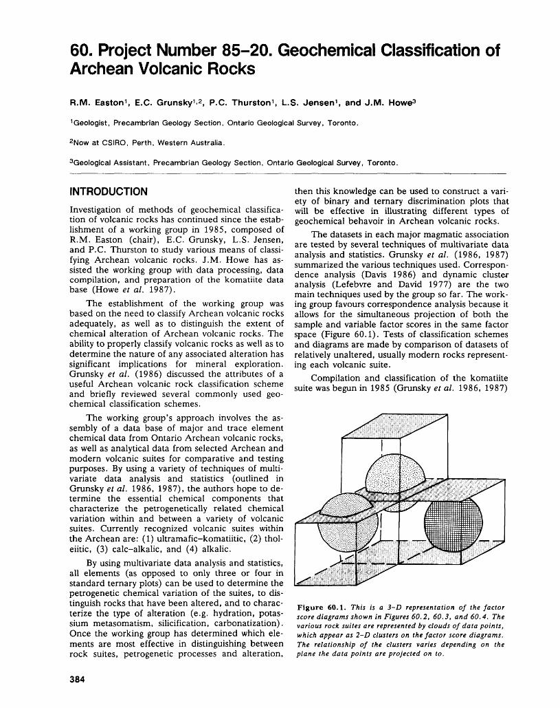
60. Project Number 85-20. Geochemical Classification of Archean Volcanic Rocks
R.M. Easton 1 , B.C. Grunsky 1 . 2 , P.C. Thurston 1 , L.S. Jensen 1 , and J.M. Howe3
1 Geologist, Precambrian Geology Section, Ontario Geological Survey, Toronto.
2Now at CSIRO, Perth, Western Australia.
3Geological Assistant, Precambrian Geology Section, Ontario Geological Survey, Toronto.
INTRODUCTIONInvestigation of methods of geochemical classifica tion of volcanic rocks has continued since the estab lishment of a working group in 1985, composed of R.M. Easton (chair), E.G. Grunsky, L.S. Jensen, and P.C. Thurston to study various means of classi fying Archean volcanic rocks. J.M. Howe has as sisted the working group with data processing, data compilation, and preparation of the komatiite data base (Howe et al. 1987).
The establishment of the working group was based on the need to classify Archean volcanic rocks adequately, as well as to distinguish the extent of chemical alteration of Archean volcanic rocks. The ability to properly classify volcanic rocks as well as to determine the nature of any associated alteration has significant implications for mineral exploration. Grunsky et al. (1986) discussed the attributes of a useful Archean volcanic rock classification scheme and briefly reviewed several commonly used geo chemical classification schemes.
The working group's approach involves the as sembly of a data base of major and trace element chemical data from Ontario Archean volcanic rocks, as well as analytical data from selected Archean and modern volcanic suites for comparative and testing purposes. By using a variety of techniques of multi variate data analysis and statistics (outlined in Grunsky et al. 1986, 1987), the authors hope to de termine the essential chemical components that characterize the petrogenetically related chemical variation within and between a variety of volcanic suites. Currently recognized volcanic suites within the Archean are: (1) ultramafic-komatiitic, (2) thol eiitic, (3) calc-alkalic, and (4) alkalic.
By using multivariate data analysis and statistics, all elements (as opposed to only three or four in standard ternary plots) can be used to determine the petrogenetic chemical variation of the suites, to dis tinguish rocks that have been altered, and to charac terize the type of alteration (e.g. hydration, potas sium metasomatism, silicification, carbonatization). Once the working group has determined which ele ments are most effective in distinguishing between rock suites, petrogenetic processes and alteration,
then this knowledge can be used to construct a vari ety of binary and ternary discrimination plots that will be effective in illustrating different types of geochemical behavoir in Archean volcanic rocks.
The datasets in each major magmatic association are tested by several techniques of multivariate data analysis and statistics. Grunsky et al. (1986, 1987) summarized the various techniques used. Correspon dence analysis (Davis 1986) and dynamic cluster analysis (Lefebvre and David 1977) are the two main techniques used by the group so far. The work ing group favours correspondence analysis because it allows for the simultaneous projection of both the sample and variable factor scores in the same factor space (Figure 60.1). Tests of classification schemes and diagrams are made by comparison of datasets of relatively unaltered, usually modern rocks represent ing each volcanic suite.
Compilation and classification of the komatiite suite was begun in 1985 (Grunsky et al. 1986, 1987)
Figure 60.1. This is a 3-D representation of the factor score diagrams shown in Figures 60.2, 60.3, and 60.4. The various rock suites are represented by clouds of data points, which appear as 2-D clusters on the factor score diagrams. The relationship of the clusters varies depending on the plane the data points are projected on to.
384
R.M. EASTON ET AL.
and the komatiite data base was published in 1987 (Howe et di. 1987). Compilation of geochemical data of the tholeiitic, calc-alkalic, and alkalic suites and their classification were carried out in the past year, and some preliminary results are described be low.
CLASSIFICATION OF VOLCANIC ROCKSAnalysis of the suites outlined below to date is based solely on major elements; Si, Al, FeO(t), Mg, Ca, Na, K, Ti, Mn, P, and total volatiles being those components considered. Total iron is used because not all analyses include both ferrous and f eric iron. Work began initially using the major elements be cause: (1) most analyses of rocks in the PETROCH data base of the Ontario Geological Survey have complete major element analyses. Trace element analyses are not available for many older analyses, and where present, no consistent set of trace ele ments is used; (2) there are many existing discrimi nation plots based on the major elements; (3) volatiles and the alkalis provide an indication of al teration; and (4) the group's work with the komatiite suite using the major element was fruitful. Except for the komatiite data base, the nature of which is de scribed in Howe et al. (1987), samples were se lected from the PETROCH data base of the Ontario Geological Survey. Selection criteria for the komatiites are given in Grunsky et al. (1987). Simi lar broad criteria were used in selecting the tholeiite, and calc-alkalic rocks from the PETROCH data base. Samples in PETROCH classed in the field as tholeiitic, volcanic, and having less than 1096 MgO, and between 4896 and 6596 SiO2 were used to con struct the tholeiite data base. Samples classed in the field as calc-alkalic, volcanic, and greater than 5096 SiO2 , greater than 1596 A12O3 , less than 1096 FeO(t), less than 696 MgO, less than 696 K2O, and between 296 and 796. Na2O were included in the calc-alkalic data base. The field designation, com monly based on stratigraphy, was used in the selec tion as a means to broadly separate the two suites; this approach was preferred to using strictly chemical criteria to separate the suites. In the case of the alkalic rocks, the group presently has selected only well documented samples in the PETROCH data base with clear geological relationships. This ap proach has been taken because no diagnostic chemi cal criteria exist at present for classifying these rocks.
Initially, broad criteria have been used in select ing samples in order to determine if we can indeed discriminate between altered and unaltered samples, and between the different suites. If this method is valid, then we should be able to recognize misclas- sified or extremely altered samples.
THOLEIITE SUITE
Last year (Grunsky et al. 1987) the working group reported on a preliminary analysis of 100 tholeiites
from the Kenojevis Group, Abitibi Greenstone Belt. During the past year, the group has added to the Archean tholeiite data base. It now contains 2536 samples, all from within Ontario. Although addi tional analyses are available, it has been found that this is an appropriate number for statistical data processing based on the knowledge that these 2536 samples have well defined geological attributes and reliable geochemistry.
Results for correspondence analyses of the 2536 tholeiite suite rocks are tabulated in Table 60.1, and illustrated in Figures 60.2a, 60.2b, and 60.2c. The first factor accounts for a third of the variation (36.096). The first factor is dominated by the vari ation of K (43.296), Ca (23.296), volatiles (H2O and CO2) (l 1.496), and Mg and Fe (16.696). The sec ond factor (17.396 of the total variation) is domi nated by the volatiles (48.296) and K (37.196). Ca, K, and Na are significant in both Factors l and 2 and, therefore, it is not possible to clearly separate the effects of plagioclase fraction versus alteration on the Factor l versus Factor 2 plot (Figure 60.2a). Normally, one would expect that the primary igne ous variation (Ca, Fe, Mg, Na, K) would be ac counted for within the first factor. However, the variation of Mg, Fe, and Ca is significantly less in the first factor than the variation of K, Na, and the volatiles. Hence, the main igneous trend is obscured by alteration effects. In Figure 60.2a, it can be seen that the compositional trend that is related to feld spar fractionation in the tholeiites is shared between Factors l and 2. The cluster of points between Ca and Na represent the compositional variation related to feldspar composition, whereas the cloud of points that spread out toward K represent K-enriched al tered tholeiites.
The third factor, contributing 13.996 of the vari ation, is dominated by Na, volatiles, and Ca, and probably represents Na alteration. Figure 60.2b shows that the Na-enriched samples are displaced from the main cloud of points that are associated with Ca. These Na-enriched samples may be the re sult of metamorphism on the sea-floor after deposi tion or later spilitization. Factors 4 and 5 account for 1296 and 6.996 of the variation of the data, respec tively, and are dominated by Fe in Factor 4 and Mg in Factor 5. Dynamic cluster analysis also separates the Fe- and Mg-tholeiites readily. However, as shown in Figure 60.2c, a plot of Factor 4 versus Factor 5 does not show two separate clusters, be cause the main tholeiite iron-enrichment trend ob scures these two factors. Plotting of the group centres obtained during dynamic cluster analysis re sults in a similar plotting effect, although the individ ual groups are either Fe or Mg rich. It is possible that recalculation of the samples to anhydrous val ues, or elimination of the more highly altered sam ples in the dataset, or both, might enhance the sepa ration of Factors 4 and 5 on a factor score plot.
385
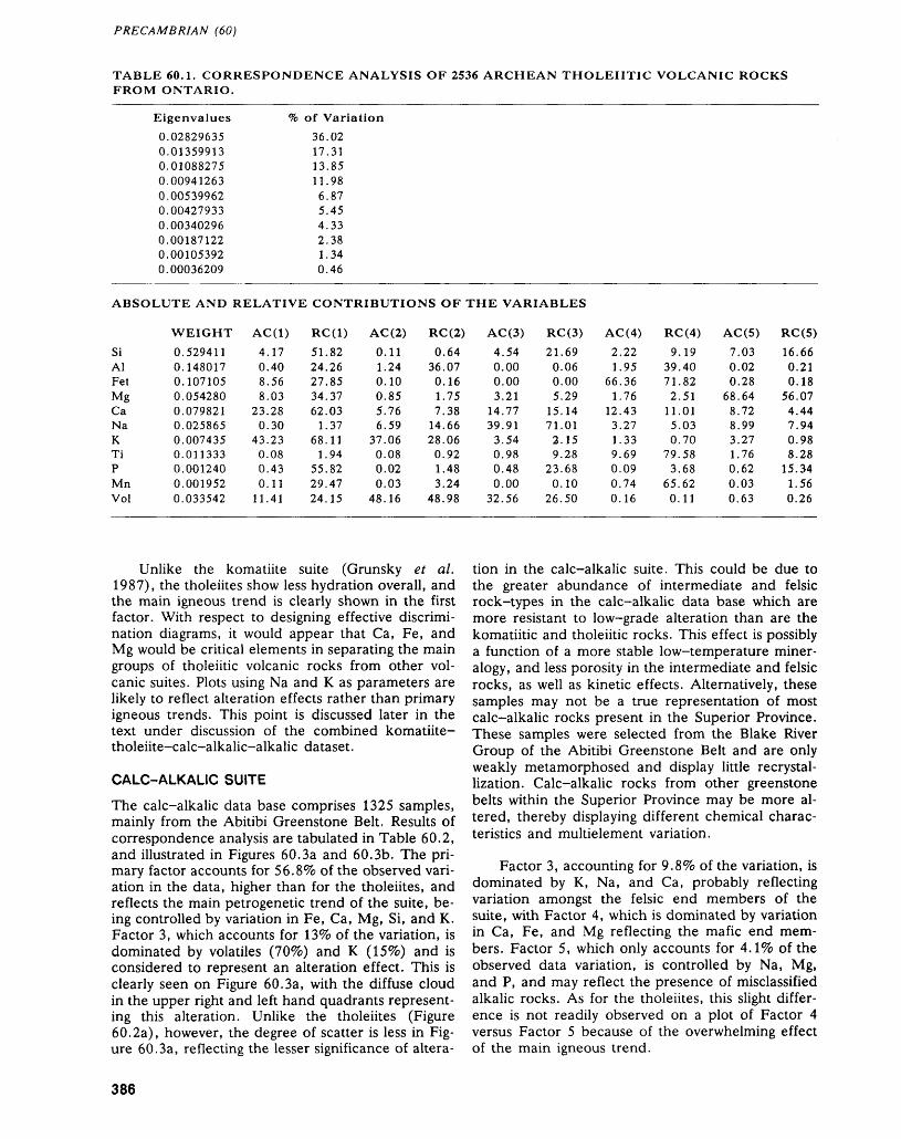
PRECAMBRIAN (60)
TABLE 60.1. CORRESPONDENCE ANALYSIS OF 2536 ARCHEAN THOLEIITIC VOLCANIC ROCKS FROM ONTARIO.
Eigenvalues0.028296350.013599130.010882750.009412630.005399620.004279330.003402960.001871220.001053920.00036209
Ve of Variation36.0217.3113.8511.986.875.454.332.381.340.46
ABSOLUTE AND RELATIVE CONTRIBUTIONS OF THE VARIABLES
SiAlFetMgCaNaKTiPMnVol
WEIGHT0.5294110.1480170.1071050.0542800.0798210.0258650.0074350.0113330.0012400.0019520.033542
AC(1)4.170.408.568.03
23.280.30
43.230.080.430.11
11.41
RC(1)51.8224.2627.8534.3762.03
1.3768.11
1.9455.8229.4724.15
AC(2)0.111.240.100.855.766.59
37.060.080.020.03
48.16
RC(2)0.64
36.070.161.757.38
14.6628.060.921.483.24
48.98
AC(3)4.540.000.003.21
14.7739.91
3.540.980.480.00
32.56
RC(3)21.690.060.005.29
15.1471.012.159.28
23.680.10
26.50
AC(4)2.221.95
66.361.76
12.433.271.339.690.090.740.16
RC(4)9.19
39.4071.82
2.5111.015.030.70
79.583.68
65.620.11
AC(5)7.030.020.28
68.648.728.993.271.760.620.030.63
RC(5)16.660.210.18
56.074.447.940.988.28
15.341.560.26
Unlike the komatiite suite (Grunsky et al. 1987), the tholeiites show less hydration overall, and the main igneous trend is clearly shown in the first factor. With respect to designing effective discrimi nation diagrams, it would appear that Ca, Fe, and Mg would be critical elements in separating the main groups of tholeiitic volcanic rocks from other vol canic suites. Plots using Na and K as parameters are likely to reflect alteration effects rather than primary igneous trends. This point is discussed later in the text under discussion of the combined komatiite- tholeiite-calc-alkalic-alkalic dataset.
CALC-ALKALIC SUITE
The calc-alkalic data base comprises 1325 samples, mainly from the Abitibi Greenstone Belt. Results of correspondence analysis are tabulated in Table 60.2, and illustrated in Figures 60.3a and 60.3b. The pri mary factor accounts for 56.896 of the observed vari ation in the data, higher than for the tholeiites, and reflects the main petrogenetic trend of the suite, be ing controlled by variation in Fe, Ca, Mg, Si, and K. Factor 3, which accounts for 139c of the variation, is dominated by volatiles (7096) and K (159&) and is considered to represent an alteration effect. This is clearly seen on Figure 60.3a, with the diffuse cloud in the upper right and left hand quadrants represent ing this alteration. Unlike the tholeiites (Figure 60.2a), however, the degree of scatter is less in Fig ure 60.3a, reflecting the lesser significance of altera
tion in the calc-alkalic suite. This could be due to the greater abundance of intermediate and felsic rock-types in the calc-alkalic data base which are more resistant to low-grade alteration than are the komatiitic and tholeiitic rocks. This effect is possibly a function of a more stable low-temperature miner alogy, and less porosity in the intermediate and felsic rocks, as well as kinetic effects. Alternatively, these samples may not be a true representation of most calc-alkalic rocks present in the Superior Province. These samples were selected from the Blake River Group of the Abitibi Greenstone Belt and are only weakly metamorphosed and display little recrystal lization. Calc-alkalic rocks from other greenstone belts within the Superior Province may be more al tered, thereby displaying different chemical charac teristics and multielement variation.
Factor 3, accounting for 9.89c of the variation, is dominated by K, Na, and Ca, probably reflecting variation amongst the felsic end members of the suite, with Factor 4, which is dominated by variation in Ca, Fe, and Mg reflecting the mafic end mem bers. Factor 5, which only accounts for 4.19& of the observed data variation, is controlled by Na, Mg, and P, and may reflect the presence of misclassified alkalic rocks. As for the tholeiites, this slight differ ence is not readily observed on a plot of Factor 4 versus Factor 5 because of the overwhelming effect of the main igneous trend.
386
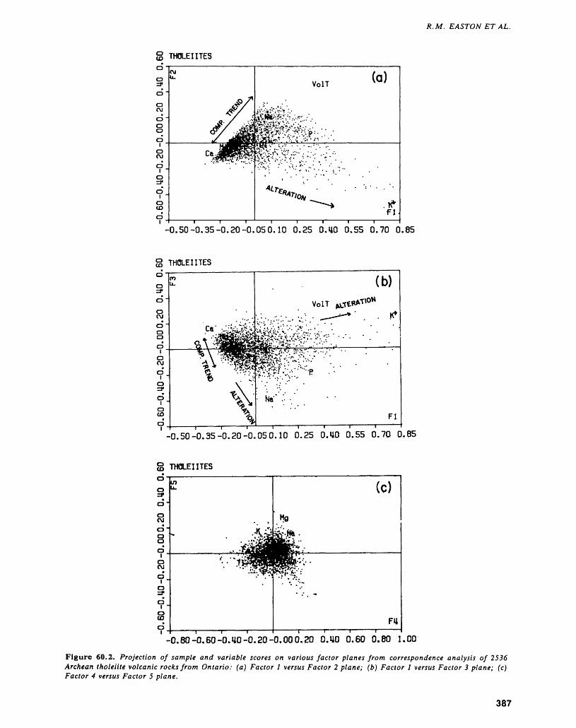
R.M. EASTON ET AL.
THOLEIITES
-0.50-0.35-0.20-0.050.10 0.25 O.UO 0.55 0.70 0.85
g THOLEIITES o
' -0.50-0.35-0.20-0.050.10 0.25 O.UO 0.55 0.70 0.85
g THOLEIITES
-0.80-0.60-O.UO-0.20-0.000.20 O.UO 0.60 0.80 1.00
Figure 60.2. Projection of sample and variable scores on various factor planes from correspondence analysis of 2536 Archean tholeiite volcanic rocks from Ontario: (a) Factor l versus Factor 2 plane; (b) Factor l versus Factor 3 plane; (c) Factor 4 versus Factor 5 plane.
387
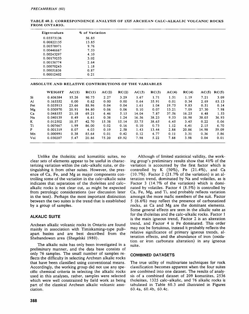
PRECAMBRIAN (60)
TABLE 60.2. CORRESPONDENCE ANALYSIS OF 1325 ARCHEAN CALC-ALKALIC VOLCANIC ROCKS FROM ONTARIO.
Eigenvalues0.033731360.008221350.005789710.004466670.002432970.001792530.001567740.000702430.000518360.00012402
Ve of Variation56.8513.859.767.534.103.022.641.180.870.21
SiAlFetMgCaNaKTiPMnVol
WEIGHT0.6063840.1653520.0559130.0309700.0485550.0401390.0125020.0076670.0013190.0009910.030207
AC(1)15.260.00
23.6620.9121.180.49
10.571.990.070.385.47
RC(1)90.730.62
88.9684.8069.21
6.6142.7086.004.03
85.6420.86
AC(2)2.270.000.040.066.460.38
15.380.020.190.01
75.20
RC(2)3.290.000.040.065.151.24
15.140.162.580.42
69.92
AC(3)1.670.641.610.10
14.0416.5655.750.101.430.127.98
RC(3)1.71
35.911.040.077.87
38.2338.650.73
13.444.775.22
AC(4)1.510.01
19.7513.2137.569.536.451.122.880.117.88
RC(4)1.190.349.837.09
16.2516.983.456.41
20.863.313.98
AC(5)7.212.690.51
27.306.48
38.050.222.15
14.980.360.04
RC(5)3.09
63.130.147.981.53
36.930.066.70
59.095.860.01
Unlike the tholeiitic and komatiitic suites, no clear sets of elements appear to be useful in charac terizing variation within the calc-alkalic suite, or dis tinguishing it from other suites. However, the pres ence of Ca, Fe, and Mg as major components con trolling some of the variation in the calc-alkalic suite indicates that separation of the tholeiites and calc- alkalic rocks is not clear cut, as might be expected from petrologic considerations (see discussion later in the text). Perhaps the most important distinction between the two suites is the trend that is established by a group of samples.
ALKALIC SUITE
Archean alkalic volcanic rocks in Ontario are found mainly in association with Timiskaming-type pull- apart basins and are best described from the Shebandowan area (Shegelski 1980).
The alkalic suite has only been investigated in a preliminary manner, and the data base consists of only 76 samples. The small number of samples re flects the difficulty in selecting Archean alkalic rocks that have been classified using conventional means. Accordingly, the working group did not use any spe cific chemical criteria in selecting the alkalic rocks used in this analyses, rather, samples were selected which were well constrained by field work as being part of the classical Archean alkalic volcanic asso ciation.
Although of limited statistical validity, the work ing group's preliminary results show that 4196 of the variation is accounted by the first factor which is controlled by K (5096), Fe (21.496), and Ca (10.796). Factor 2 (21.796 of the variation) is an al teration trend, dominated by Na and volatiles, as is Factor 3 (14.796 of the variation) which is domi nated by volatiles. Factor 4 (8.596) is controlled by Ca, Fe, Mg, and Ti, and probably reflects variation amongst the more mafic members of the suit. Factor 5 (6.6^0) may reflect the presence of carbonatized rocks, as Ca and Mg are the dominant elements. Some general effects are seen in the alkalic suite as for the tholeiites and the calc-alkalic rocks. Factor l is the main igneous trend, Factor 2 is an alteration trend, and Factor 4 is Fe dominated. This order may not be fortuitous, instead it probably reflects the relative significance of primary igneous trends, al teration effects, and the abundance of iron (oxida tion or iron carbonate alteration) in any igneous suite.
COMBINED DATASETS
The true utility of multivariate techniques for rock classification becomes apparent when the four suites are combined into one dataset. The results of analy sis of a combined dataset of 209 komatiites, 2536 tholeiites, 1325 calc-alkalic, and 76 alkalic rocks is tabulated in Table 60.3 and illustrated in Figures 60.4a, 60.4b, 60.4c.
388
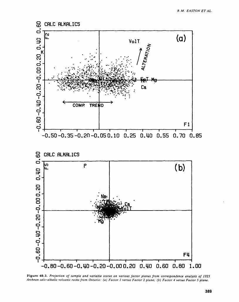
R. M. EASTON ET AL.
O (O CRLC RLKRLICS
-0.50-0.35-0.2n-0.050.10 0.25 O.UO 0.55 0.70 0.85
g CflLC RLKRLICS
o ra*
CM
OO O
d oCM
oa*O
oCD
m (b)
FU
-0.80-0.60-O.UO-0.20-0.00 0.20 0.40 0.60 0.80 1.00Figure 60.3. Projection of sample and variable scores on various factor planes from correspondence analysis of 1325 Archean calc-alkalic volcanic rocks from Ontario: (a) Factor l versus Factor 2 plane; (b) Factor 4 versus Factor 5 plane.
389
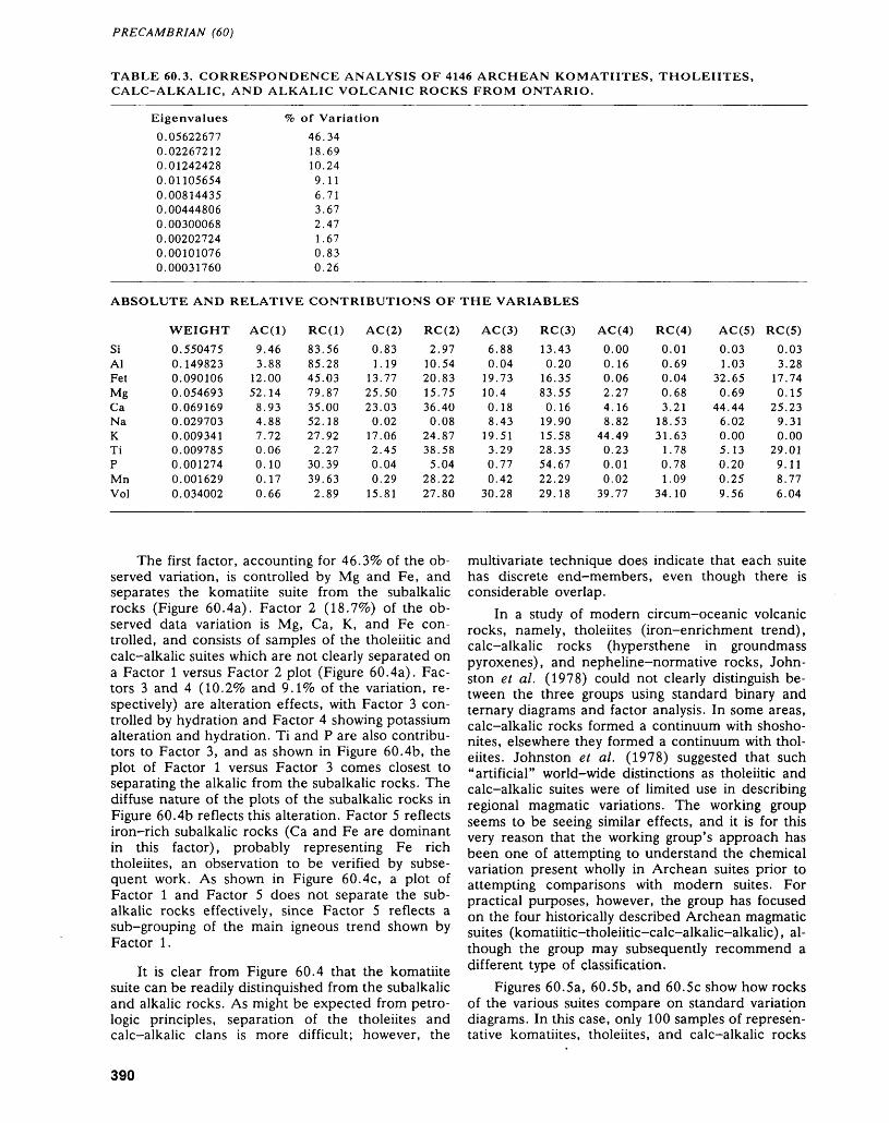
PRECAMBRIAN (60)
TABLE 60.3. CORRESPONDENCE ANALYSIS OF 4146 ARCHEAN KOMATIITES, THOLEIITES, CALC-ALKALIC, AND ALKALIC VOLCANIC ROCKS FROM ONTARIO.
Eigenvalues
0.056226770.022672120.012424280.011056540.008144350.004448060.003000680.002027240.001010760.00031760
of Variation
46.3418.6910.249.116.713.672.471.670.830.26
ABSOLUTE AND RELATIVE CONTRIBUTIONS OF THE VARIABLES
SiAlFetMgCaNaKTiPMnVol
WEIGHT0.5504750.1498230.0901060.0546930.0691690.0297030.0093410.0097850.0012740.0016290.034002
AC(1)9.463.88
12.0052.148.934.887.720.060.100.170.66
RC(1)83.5685.2845.0379.8735.0052.1827.922.27
30.3939.632.89
AC (2)0.831.19
13.7725.5023.030.02
17.062.450.040.29
15.81
RC(2)2.97
10.5420.8315.7536.400.08
24.8738.585.04
28.2227.80
AC(3)6.880.04
19.7310.40.188.43
19.513.290.770.42
30.28
RC(3)13.430.20
16.3583.550.16
19.9015.5828.3554.6722.2929.18
AC(4)0.000.160.062.274.168.82
44.490.230.010.02
39.77
RC(4)0.010.690.040.683.21
18.5331.63
1.780.781.09
34.10
AC(5)0.031.03
32.650.69
44.446.020.005.130.200.259.56
RC(5)0.033.28
17.740.15
25.239.310.00
29.019.118.776.04
The first factor, accounting for 46.39k of the ob served variation, is controlled by Mg and Fe, and separates the komatiite suite from the subalkalic rocks (Figure 60.4a). Factor 2 (IS.7%) of the ob served data variation is Mg, Ca, K, and Fe con trolled, and consists of samples of the tholeiitic and calc-alkalic suites which are not clearly separated on a Factor l versus Factor 2 plot (Figure 60.4a). Fac tors 3 and 4 (10. 2^o and Q.1% of the variation, re spectively) are alteration effects, with Factor 3 con trolled by hydration and Factor 4 showing potassium alteration and hydration. Ti and P are also contribu tors to Factor 3, and as shown in Figure 60.4b, the plot of Factor l versus Factor 3 comes closest to separating the alkalic from the subalkalic rocks. The diffuse nature of the plots of the subalkalic rocks in Figure 60.4b reflects this alteration. Factor 5 reflects iron-rich subalkalic rocks (Ca and Fe are dominant in this factor), probably representing Fe rich tholeiites, an observation to be verified by subse quent work. As shown in Figure 60.4c, a plot of Factor l and Factor 5 does not separate the sub alkalic rocks effectively, since Factor 5 reflects a sub-grouping of the main igneous trend shown by Factor 1.
It is clear from Figure 60.4 that the komatiite suite can be readily distinquished from the subalkalic and alkalic rocks. As might be expected from petro logic principles, separation of the tholeiites and calc-alkalic clans is more difficult; however, the
multivariate technique does indicate that each suite has discrete end-members, even though there is considerable overlap.
In a study of modern circum-oceanic volcanic rocks, namely, tholeiites (iron-enrichment trend), calc-alkalic rocks (hypersthene in groundmass pyroxenes), and nepheline-normative rocks, John ston et al. (1978) could not clearly distinguish be tween the three groups using standard binary and ternary diagrams and factor analysis. In some areas, calc-alkalic rocks formed a continuum with shosho- nites, elsewhere they formed a continuum with thol eiites. Johnston et al. (1978) suggested that such "artificial" world-wide distinctions as tholeiitic and calc-alkalic suites were of limited use in describing regional magmatic variations. The working group seems to be seeing similar effects, and it is for this very reason that the working group's approach has been one of attempting to understand the chemical variation present wholly in Archean suites prior to attempting comparisons with modern suites. For practical purposes, however, the group has focused on the four historically described Archean magmatic suites (komatiitic-tholeiitic-calc-alkalic-alkalic), al though the group may subsequently recommend a different type of classification.
Figures 60.5a, 60.5b, and 60.5c show how rocks of the various suites compare on standard variation diagrams. In this case, only 100 samples of represen tative komatiites, tholeiites, and calc-alkalic rocks
390
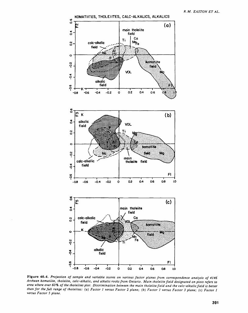
R. M. EASTON ET AL.KOMATIITES, THOLEIITES, CALC-ALKALICS, ALKALICS
-0.8 -0.6 -0.4 -0.2
-ae -0.6 -0.4
•-•----
-0.8 -0.6 -0.4
Figure 60.4. Projection of sample and variable scores on various factor planes from correspondence analysis of 4146 Archean komatiite, tholeiite, calc-alkalic, and alkalic rocks from Ontario. Main tholeiite field designated on plots refers to area where over 60'fa of the tholeiites plot. Discrimination between the main tholeiite field and the calc-alkalic field is better than for the full range of tholeiites: (a) Factor l versus Factor 2 plane; (b) Factor l versus Factor 3 plane; (c) Factor l versus Factor 5 plane.
391
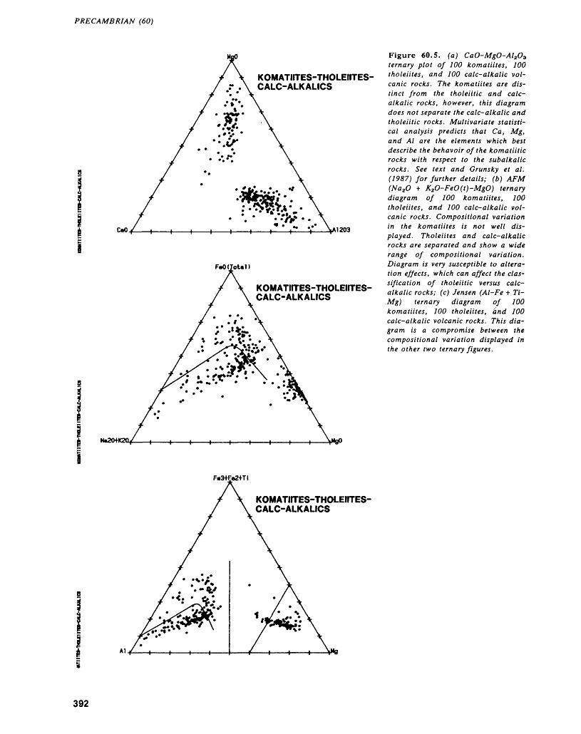
PRECAMBRIAN (60)
KOMATIITES-THOLEIITES- CALC-ALKALICS
CaO A1203
FeO(Total)
KOMATIfTES-THOLEIITES- CALC-ALKALICS
NaZO+KZCL
Figure 60.5. (a) CaO-MgO-Al2O3 ternary plot of 100 komatiites, 100 tholeiites, and 100 calc-alkalic vol canic rocks. The komatiites are dis tinct from the tholeiitic and calc- alkalic rocks, however, this diagram does not separate the calc-alkalic and tholeiitic rocks. Multivariate statisti cal analysis predicts that Co., Mg, and Al are the elements which best describe the behavoir of the komatiitic rocks with respect to the subalkalic rocks. See text and Grunsky et al. (1987) for further details; (b) AFM (Na2O * K2O-FeO(t)-MgO) ternary diagram of 100 komatiites, 100 tholeiites, and 100 calc-alkalic vol canic rocks. Compositional variation in the komatiites is not well dis played. Tholeiites and calc-alkalic rocks are separated and show a wide range of compositional variation. Diagram is very susceptible to altera tion effects, which can affect the clas sification of tholeiitic versus calc- alkalic rocks; (c) Jensen (Al-Fe t 7V- Mg) ternary diagram of 100 komatiites, 100 tholeiites, and 100 calc-alkalic volcanic rocks. This dia gram is a compromise between the compositional variation displayed in the other two ternary figures.
KOMATHTES-THOLEirTES- CALC-ALKALICS
392
R. M. EASTON ET AL.
are shown. As noted by Grunsky e t al. (1987), Mg, Ca, and Al control igneous variation in the komatiite suite, hence the CaO-MgO-Al2O3 ternary (Figure 60.5a) is useful in separating komatiites from the subalkalic rocks. As noted earlier in this paper, Ca is a significant element in both the tholeiitic and calc- alkalic suites, hence, the CaO-MgO-Al2O3 is not ef fective in discriminating these suites. The AFM plot (Figure 60.5b) is of limited effectiveness, in part be cause it does not display Ca variation, and in part because Na and K are likely to be affected by altera tion, which is a significant factor in all of the suites. The Jensen plot (Figure 60.5c) is more effective than the AFM diagram because it eliminates to some degree the effects of alteration, and can separate komatiitic and subalkalic rocks.
FUTURE WORKWork over the past year has been promising, and it is clear that multivariate techniques can be a used successfully to classify Archean volcanic rocks, in part because it is capable of discriminating between the different suites, and in recognizing a variety of alteration trends in a particular group of samples. The difficulties found in classifying some of the sub alkalic and alkalic rocks are not unexpected given petrologic principles. In particular, the difficulty in classifying Archean alkalic rocks reflects more on the poor state of knowledge of these rocks then in herent problems in the method.
Work in 1989 will continue on preparing the data bases for publication, examining classification problems of the subalkalic and alkalic rocks, and in testing a variety of binary and ternary variation dia grams, both existant and of the working group's own design based on interpretation of their statistical re sults. The group also hopes to be able to include a variety of trace elements into its studies, particularly with respect to distinguishing rocks of the tholeiitic, calc-alkalic, and alkalic suites. Ultimately, the work ing group hopes to be able to construct a number of datasets typical of the various suites, so that small groups of samples can be combined with a known suite, and discriminated accordingly using multi
variate techniques. In this way, the working group hopes to be able to adapt these methods to datasets commonly encountered by the average field and to identify simple techniques which are effective in dis tinguishing the different types of chemical variation observed in Archean (and younger) volcanic rocks.
REFERENCESDavis, J.C.1986: Statistics and Data Analysis in Geology, Second Edi
tion; John Wiley and Sons, 646p.
Grunsky, B.C., Easton, R.M., Thurston, P.C., Jensen, L.S., and Howe, J.M.
1986: Geochemical Classification of Archean Volcanic Rocks; p. 152-162 in Summary of Field Work and Other Activities 1986, by the Ontario Geological Sur vey, edited by P.C. Thurston, Owen L. White, R.B. Barlow, M.E. Cherry, and A.C. Colvine, On tario Geological Survey, Miscellaneous Paper 132, 435p.
1987: Geochemical Classification of Archean Volcanic Rocks; p.337-346 in Summary of Field Work and Other Activities 1987, by the Ontario Geological Sur vey, edited by R.B. Barlow, M.E. Cherry, A.C. Col vine, Burkhard O. Dressler, and Owen L. White, Ontario Geological Survey, Miscellaneous Paper 137, 429p.
Howe, J.M., Easton, R.M., Grunsky, B.C., Jensen, L.S., and Thurston, P.C.
1987: Komatiite Database; Ontario Geological Survey, Open File Report 5677, Part I, 202p., 12 tables; Part II, 3 ASCII disks or 4 DIP disks in back pocket.
Johnson, R.W., Mackenzie, D.E., and Smith, I.E.M.1978: Volcanic Rock Associations at Convergent Plate
Boundaries: Reappraisal of the Concept Using Case Histories from Papua New Guinea; Geological Society of America, Bulletin, Volume 89, p.96-106.
Lefebrve, D., and David, M.1977: Dynamic Clustering and Strong Patterns Recognition:
New Tools in Automatic Classification; Canadian Journal of Earth Sciences, Volume 14, p.2232-2246.
Shegelski, R.J.1980: Archean Cratonization, Emergence, and Red Bed De
velopment, Lake Shebandowan Area, Canada; Pre cambrian Research, Volume 12, p.331-347.
393


Engineering and Terrain Geology Programs
61. Summary of Activities of the Engineering and Terrain Geology Section, 1988
C. L. Baker
Supervisor, Quaternary Geology Subsection, Engineering and Terrain Geology Section, Ontario Geological Survey, Toronto.
INTRODUCTIONDuring the 1988 field season, the Engineering and Terrain Geology Section un dertook 16 field projects. Activities took place in all areas of the province from Windsor to the James Bay Lowland, and Fort Frances to Matheson.
Nine of the Section's projects involved geological mapping at various scales. These supply both the government and private sector with a data base suitable for land use planning and resource exploration. This type of mapping is in line with the Ontario Geological Survey's mandate to delineate and characterize the geo logical materials within the province.
QUATERNARY SUBSECTIONThe Quaternary subsection was involved in nine projects. Six of these projects cover basic Quaternary mapping, two emphasize reconnaissance till sampling, and one applied research project examined airborne radar applications in Quaternary mapping.
Mapping was started in the Essex County area of southern Ontario by T.F. Morris to determine the environment and mode of deposition of Quaternary sedi ments. Such information is important in delineating the extent of materials both at ground level and in the subsurface. Morris" recognition of the sand and gravel comprising the Leamington Moraine as preglacial sub-aqueous fan deposits has implications in the search for additional aggregate resources in the area. Under standing of the stratigraphic sequence in the area is critical for effective land management decisions such as those related to the siting of sanitary landfills.
Mapping in the adjacent Wheatley area was undertaken by R.I. Kelly. Map ping of the surface sediments and features will be integrated with extensive infor mation from the bluff sections on the Lake Erie shoreline to provide an under standing of stratigraphic relationships. This is an important factor given the large tracts of flat undissected land within the project area. Planning requirements in the Wheatley area are similar to Essex County, particularly the scarcity of aggre gate resources. Knowledge of the distribution and characteristics of the surficial materials will have equivalent benefits.
P.J. Barnett continued mapping in the Barrie-Elmvale area, Simcoe County. The 1:50 000 scale mapping is revealing a complex glacial history including three till units with associated glaciolacustrine sediments. Barnett's work is leading to the development of an original hypothesis concerning glacial and glaciofluvial processes and deposits in the area. This work could change our understanding of ice mass dynamics in the Great Lakes area during the final phase of the last glaciation. Such ideas may seem academic, however, the occurrence of glacio fluvial material has a strong and direct impact on land values, planning, and de velopment. Pre- and post-glacial features of note in the Barrie-Elmvale area are the solution weathering (karst) on the Paleozoic bedrock surface and the numer ous glacial lake shorelines.
P.S.G. Kor's mapping in the Sundridge-Burk's Falls area is a continuation of his previous two years' work to the west. In general, the volume of Quaternary
396
C. L. BAKER
deposits increases eastward from the shore of Georgian Bay, although the thick ness of glacial sediments in any of his study areas is not great. Kor's work will a) delineate the distribution of materials, including aggregate; and b) determine the composition and character of the various sediments. This information will advance understanding of the glacial history of the area and the relationships of the surficial sediments.
Work in the Shining Tree area was completed by P.W. Alcock. This area is covered by extensive glacial deposits and will be of major interest in mineral exploration overburden sampling programs. Detailed knowledge of the type and transport history of surficial sediments is needed to establish methodologies suit able to the geological conditions and to ensure that data are interpreted correctly. Till sampling from this project will provide valuable assistance for detailed mineral exploration programs.
F.J. Kristjansson completed field work in the Beardmore-Geraldton-Longlac area. This study was a joint program with the Geological Survey of Canada. The work was undertaken in several overlapping stages: Quaternary mapping, surface till sampling, and deep overburden drilling. The work has yielded several notable observations: a) the till in this area of northern Ontario has a complex transport and depositional history, b) the composition of the upper till unit in the area is due to a streaming effect in ice mass flow, and c) the lowest till unit is an excel lent sampling medium for mineral exploration. The high number of gold grains recovered from the lower till unit indicates the area has a high mineral potential which can be investigated using drift prospecting techniques. Kristjansson's work also illustrates that effective overburden sampling programs require attention to the type and origin of the sediments being sampled.
In the Fort Frances-Rainy River area, A.F. Bajc completed the second and final phase of an overburden drilling project and in the Matheson area, the drill program supervised by K.G. Steele was the final stage of the five-year Black River-Matheson (BRIM) project. The sequence of field activities in both areas was Quaternary mapping at a 1:50 000 scale, backhoe trenching in areas of shal low drift followed by rotasonic drilling in areas of deep overburden.
The Fort Frances area is characterized by at least two ice flow directions, one from the northeast and the other from the west. The nature of the deposits asso ciated with each advance is markedly different as is their use in drift prospecting programs. The more useful till unit is often buried; defining its distribution and continuity is part of Bajc's work. Geochemical assessment of the till samples will provide information on areas of mineral potential and exploration interest.
The Matheson area has long demonstrated a high mineral potential and has attracted considerable exploration interest. In recent years an increasing amount of work has taken place in areas of glacial cover. The results of the BRIM pro gram have shown that interpreting overburden sample results is not an easy task as up to three drift packages are present in the region. The data gathered in the Matheson area will allow a determination of the ice directions associated with each advance and provide an exploration database that will be of use for the foreseeable future.
The work described by V.H. Singhroy and P.J. Barnett represents a commit ment on the part of the Ontario Geological Survey to investigate new tools and techniques that may assist in the mapping of the province. Although the marriage between remote sensing and Quaternary geology is not new, the goal of finding methods that will allow rapid, yet accurate, mapping continues. The work pre sented by these authors, while preliminary, is intriguing and warrants continued study.
PALEOZOIC SUBSECTIONThe Paleozoic Subsection undertook three field projects in 1988. Two of these represent basic geoscience and mineral deposit inventory, and the third repre sents applied research.
Demand for rock derived resources such as building and crushed stone is rapidly moving outward from the population centres of southern Ontario.
397
ENGINEERING AND TERRAIN (61)
D.K. Armstrong's mapping in the central Bruce Peninsula will delineate and evaluate potential resources in the Bruce Peninsula now, as a basis for effective land use and zoning decisions in the future. Based on Armstrong's observations of numerous karst features on the Paleozoic surface, care must be taken when planning susbsurface investigations. Karst structures can affect the design require ments and performance of man-made structures.
The project completed by R.K. Bezys provides an evaluation of gypsum de posits in the James Bay Lowland. The gypsum resources of the Moose River Basin have been known for sometime, however, their setting and geology were poorly documented, thus their potential was unclear. Bezys' work describes and defines the surface extent of the gypsum beds to assist exploration and development in terest in the deposits. This study will provide a geological report identifying the potential resource supply which will compliment a market evaluation study being carried out by the Mineral Development Section, Mineral Development and Lands Branch.
Applied research work carried out by G.H. McFall, O.L. White, and A. Al lam in Prince Edward County on bedrock structural features is unique in its scope and design. The authors are investigating neotectonic activity as reflected by post-glacial (?) faults and stress relief features (pop-ups). The investigation was undertaken by a variety of methods including field mapping, remote sensing, and geophysics. Perhaps the most interesting implication of this work is that if large tracts of bedrock, which traditionally have been considered stable, are shown to be subject to neotectonic activity, it will have direct repercussions on the planning and siting of environmentally sensitive structures.
AGGREGATE ASSESSMENT OFFICEFour projects involving field work were completed by the staff of the Aggregate Assessment Office. Three of these are basic mineral resource inventories while the fourth project involves some applied research.
C.J. Dawson and S. Szoke's work in Peterborough County confirmed the limited Quaternary gravel resources in the area. In this county, the shortage is so severe that weathered Grenville gneisses have been used as road fill. The Paleo zoic Gull River Formation occurs in the county and is quarried as a source of crushed aggregate but care must be taken to avoid alkali-carbonate reactive beds during extraction. Much the same situation exists in Victoria County, however, some deposits containing limited amounts of gravel are present. The Middle Or dovician Bobcaygeon and Gull River formations provide sources of crushed stone available for extraction.
The aggregate inventory of the towns of Bracebridge and Gravenhurst is re ported by R.G. Gorman and S. Szoke. Aggregate information in this area is re quired for land use planning decisions. The authors report that the study area contains large sand resources and limited amounts of gravel. The gravel is found within Quaternary glaciofluvial outwash and ice-contact deposits as well as deltaic deposits.
The work of G.R. Jones and S. Szoke identifying the aggregate resources northwest of Fort Frances was undertaken for the purpose of locating quality aggregate sources for future forest access road construction. This information is also useful in selecting the routes so that haul distances can be kept to a mini mum. Potential sources of aggregate located in the area include moraines, the largest of which is the Rainy Lake-Lake of the Wood Moraine, eskers, and ice- contact ridges. The identification of these features will help alleviate potential sand and gravel shortages in the area.
An applied research project being carried out by D.G. Vanderveer and S. Szoke examines the problem of defining aggregate resources buried by other non-economic materials. The work involves developing methods and techniques which can locate and delineate buried aggregate deposits. The Pinehurst and Leamington gravel deposits in southwestern Ontario have been used as test sites. Issues surrounding the development of these deposits illustrate some of the aggre gate related problems in this part of the province: a general scarcity of high.qual ity material, conflicting land use demands, and environmental concerns.
398
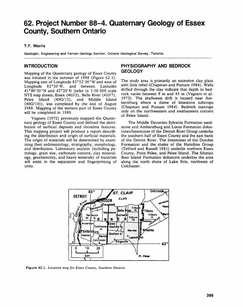
62. Project Number 88-4. Quaternary Geology of Essex County, Southern Ontario
T. F. Morris
Geologist, Engineering and Terrain Geology Section, Ontario Geological Survey, Toronto.
INTRODUCTIONMapping of the Quaternary geology of Essex County was initiated in the summer of 1988 (Figure 62.1). Mapping east of Longitude 82 0 52'30"W and west of Longitude 82 0 30'W, and between Latitudes 41 0 40'30"N and 42 0 20'N (refer to 1:50 000 scale NTS map sheets; Essex (40J/2), Belle River (40J/7), Pelee Island (40G/15), and Middle Island (40G/10)), was completed by the end of August 1988. Mapping of the western part of Essex County will be completed in 1989.
Vagners (1972) previously mapped the Quater nary geology of Essex County and defined the distri bution of surficial deposits and shoreline features. This mapping project will produce a report describ ing the distribution and origin of surficial materials. The origin of materials will be determined by exam ining their sedimentology, stratigraphy, morphology, and distribution. Laboratory analysis (including pe trology, grain size, carbonate content, clay mineral ogy, geochemistry, and heavy minerals) of materials will assist in the separation and fingerprinting of units.
PHYSIOGRAPHY AND BEDROCK GEOLOGY
The study area is primarily an extensive clay plain with little relief (Chapman and Putnam 1984). Wells drilled through the clay indicate that depth to bed rock varies between 9 m and 45 m (Vagners et al. 1973). The shallowest drift is located near Am herstburg where a dome of limestone subcrops (Chapman and Putnam 1984). Bedrock outcrops only on the northwestern and southeastern corners of Pelee Island.
The Middle Devonian Sylvania Formation sand stone and Amherstburg and Lucas Formation dolos- tones/limestones of the Detroit River Group underlie the southern half of Essex County and the east bank of the Detroit River. The limestones of the Dundee Formation and the shales of the Hamilton Group (Telford and Russell 1981) underlie northern Essex County, Point Pelee, and Pelee Island. The Silurian Bass Island Formation dolostone underlies the area along the north shore of Lake Erie, northwest of Colchester.
Figure 62.1. Location map for Essex County, Southern Ontario.
399
ENGINEERING AND TERRAIN (62)
OBSERVATIONS ON THE GLACIAL GEOLOGY
Several key observations were made during the Qua ternary mapping of eastern Essex County this past summer. Interpretation of field observations and data generated from laboratory analysis of collected samples should clarify the Quaternary history of eastern Essex County.
The oldest glacial deposit found in the study area is a red, clast-poor, massive, silty clay diamic ton found below lake level at the foot of a bluff east of Kingsville. Capping this red diamicton is a thin (2 to 5 cm) organic bed. The organic bed is overlain by a grey, clast-poor, massive silty clay diamicton sepa rated from a second similar diamicton by bedded sands. If the organics formed during the Erie Inter stadial (Dreimanis and Karrow 1972), deposition of the red diamicton occurred during the Nissouri Stadial (or earlier), and the overlying diamictons and bedded sand were deposited during the Port Bruce Stadial. Alternatively, if the organic layer was deposited during the Port Talbot or Plum Point in- terstadials, deposition of the red diamicton occurred during the Early Wisconsinan, and the overlying diamictons and bedded sands during the Nissouri and/or Port Bruce stadials.
North of the bluffs, an aggregate operation, known locally as the Bondi pit, is located in what is probably a proglacial delta. The stratigraphy and sediments within this delta indicate that its develop ment was influenced by the ice-marginal positions of ice flowing from both the Lake Erie and Lake Huron basins. Shells and organics deposited on top of a grey, clast-poor, massive silty clay diamicton overlying bedded sands may represent the Lake Whittlesey-Lake Arkona transition (Barrett 1985).
North of the Bondi pit, three man-made exca vations provide excellent exposures. The general se quence observed in all three excavations is a grey, clast-poor, massive silty clay diamicton capped by a reddish-brown, rhythmically laminated silty clay with red clay "clasts". The structure and fabric of the lower grey diamicton suggests that it is a till de posited by ice flowing south from the Lake Huron Basin. The reddish-brown rhythmically laminated silty clay is probably glaciolacustrine in origin, de posited as ice retreated northward into the Lake Huron basin.
The most impressive landform within the study area is a large kidney-shaped body of sand north west of Leamington in which there are a number of excavations (including the Bondi pit). A similar de posit is located farther west, south of Harrow. These deposits are probably proglacial subaqueous deltas. Northwest of the Leamington sand deposit is an ex tensive cobbly sand deposit which is probably progla cial subaqueous outwash. This subaqueous outwash was likely deposited by meltwaters originating from
ice flowing out of the Lake Huron basin as indicated by the presence of jasper conglomerate and tillite within the cobbly sand.
Buried and partially buried glacial features are located on top of the Leamington sand deposit. These include: a) an esker net (oriented north- south); b) at least one proglacial subaqueous out wash fan; and c) a possible moraine. Other ridges composed of gravel and sand are located around the base of the Leamington sand deposit, and inland from the north shore of Lake Erie. When the orien tations of these ridges are plotted, they define a se ries of ice-marginal positions indicating northward ice retreat. There are at least two north-south- trending eskers (possibly a third) located north and east of the Leamington sand deposit.
Weathered brown/grey glaciolacustrine silty clay which occurs north of Harrow and Leamington is occasionally mantled by thin deposits ^20 cm) of sand and/or gravel. The distribution of these sand and/or gravel deposits also defines recessional ice front positions.
Large grooves and flutes occur on outcropping bedrock at four locations on Pelee Island. Their ori entations vary from 265 0 to 275 0 . Striae located at South Bay, Pelee Island indicate at least two flow directions; one set oriented at 190 0 is cut by a sec ond set oriented at 265 0 .
Several beach sand ridges occur parallel to the shorelines of lakes St. Clair and Erie. On the surface of one sand ridge east of Leamington, shells were found and collected for radiocarbon dating.
Shells and organics were found l km east of the Albuna Township line road and 0.5 km north of the fourth concession. A farmer reported finding a mas todon tooth in sediments of a dried-up pond. Shells and cedar wood were collected from these pond sediments l m below the surface.
A prominent northwest-trending ridge underlies the towns of Cottam, North Ridge, and Essex. In the northwest, the ridge core is composed of a silty clay diamicton as observed in two house excavations in the town of Essex. The eastern side of the ridge drops sharply and is mantled by a layer of beach sand greater than l m thick which thins to 20 cm less than 0.5 km from the ridge. The western side of the ridge has a gentler slope and is mantled by a cobbly sand which is probably glaciolacustrine in ori gin. The cobbly sand grades into a weathered glacio lacustrine silty clay within 2 km of the ridge.
RELATED RESEARCHSeveral related Quaternary geological mapping pro jects within Essex County and the surrounding area have recently been completed or are in progress. These include: a) a B.Se. Thesis on the lithology, structure and stratigraphy of the upper clayey diamicton from three boreholes drilled in the
400
T. F. MORRIS
Courtright-Port Lambton area (Ansell 1988); b) a B.Se. Thesis examining heavy minerals from till samples collected in Essex and Kent counties (Ar- royes 1988); c) an M.Se. Thesis on the Bedford Formation and overlying Quaternary sediments in the Lake St. Clair region (G. Brown, Department of Geology, University of Western Ontario, personal communication); and d) an Ontario Geological Sur vey mapping project for the Chatham-Wheatley area (Kelly, this volume).
REFERENCESAnsell, S.1988: Lithology and Stratigraphy of Quaternary Cores from
Lambton County, Southern Ontario; Unpublished B.Se. Thesis, Department of Geology, University of Western Ontario, 32p.
Arroyas, J-L.G.1988: Lobal Affinities and Heavy Mineral Provenance of
Subsurface Till between Windsor and Lake St. Clair, Ontario; Unpublished B.Se. Thesis, Department of Geology, University of Western Ontario, 29p.
Barrett, P.J.1985: Glacial Retreat and Lake Levels, North Central Lake
Erie Basin, Ontario; p. 185-193 in Quaternary Evolu tion of the Great Lakes, edited by P.P. Karrow and
P.E. Calkin, Geological Association of Canada, Spe cial Paper 30.
Chapman, L.J., and Putnam, D.F.1984: The Physiography of Southern Ontario; Ontario Geo
logical Survey, Special Volume 2, 270p. Accompa nied by Map P.2715 (coloured), scale 1:600 000.
Dreimanis, A., and Karrow, P.P.1972: Glacial History of the Great Lakes-St. Lawrence Re
gion; the Classification of the Wisconsin (an) Stage and its Correlatives. 24th International Geological Congress, Section 12, p.5-15.
Telford, P.O., and Russell, D.J.1981: Paleozoic Geology of the Windsor-Essex and Pelee Is
land Area, Southern Ontario, Ontario Geological Sur vey, Preliminary Map P.2396, Geological Series, scale 1:250 000.
Vagners, U.J.1972: Quaternary Geology of the Windsor-Essex Area
(Eastern Part), Southern Ontario, Ontario Depart ment of Mines and Northern Affairs, Preliminary Map P.750, Geological Series, scale 1:50 000.
Vagners, U.J., Sado, E.V., and Yundt, S.E.1973: Drift Thickness of the Windsor-Essex Area (Western
Part), Southern Ontario, Ontario Division of Mines, Preliminary Map P.814, Drift Thickness Series, scale 1:50 000.
401
63. Project Number 88-26. Quaternary Geology of the Wheatley Area, Southern Ontario
R.I. Kelly
Geologist, Engineering and Terrain Geology Section, Ontario Geological Survey, Toronto.
INTRODUCTIONThe Wheatley area is situated between Latitudes 42 0 15' and 42 0 00'N and Longitudes 82 0 00' and 82 0 30'W. The towns of Wheatley and Merlin are located within the map area (NTS 40 J/l). Lake Erie occupies the southeastern corner of the map sheet (Figure 63.1).
Quaternary geological mapping of the Wheatley area was previously undertaken by Sado (1981). Additional mapping was conducted in the area dur ing the summer of 1988. Emphasis was placed on the collection of surface information and on the ex amination of bluff sections exposed along the north shore of Lake Erie. Examination of bluff sections was conducted to examine stratigraphic relationships and sedimentological characteristics of the exposed Quaternary deposits.
PHYSIOGRAPHYThe map area lies within the physiographic region of the St. Clair Clay Plain as described by Chapman and Putnam (1984). This region has been subdi vided by these authors into the Essex Clay Plain,
Lambton Clay Plain, Chatham Flats, and St. Clair Delta. The Essex Clay Plain is the only subregion present in the map area.
The Essex Clay Plain is essentially a low relief till plain smoothed by the action of glacial lakes which covered the area following final glacial retreat. The low relief of the area and the fine texture of the soils result in poor natural drainage. As a result, the use of tile drains throughout the area is extensive.
The continuity of the clay plain is interrupted by a thin, discontinuous cover of glaciolacustrine sand and silt near the town of Wheatley which extends southwest to the sand spit of Point Pelee.
A gravel-rich ridge rises a few metres above the clay plain east of Wheatley and extends eastward to the map boundary. Highway 3 closely follows the trend of this ridge. Also present in the eastern part of the map area are a series of low relief stoney ridges which parallel the southwest trend of the Blenheim Moraine. The main body of this moraine is located to the east of the map area.
The economy of the area is based primarily on agriculture. The warm climate and long growing sea son allow for the production of a wide variety of ten-
Figure 63.1. Location map for the Wheatley Area.
402
R.I. KELLY
der fruits and vegetables in addition to more tradi tional crops.
BEDROCK GEOLOGYThe map area is underlain by Middle and Upper Devonian shales and limestones. Middle Devonian limestone of the Dundee Formation subcrops in the southwestern corner of the map sheet near the town of Wheatley and further east near the hamlet of Port Alma. Shales and limestones of the Middle Devonian Hamilton Group overlie the Dundee For mation. The Hamilton Group subcrops over much of the western half of the map sheet and also in the extreme eastern part. The youngest rock unit in the area is the Upper Devonian Kettle Point Formation. The black shale of this formation covers most of the eastern portion of the map.
Throughout the area, the bedrock is overlain by thick deposits of Quaternary sediments. No bedrock outcrops are known to exist in the map area.
QUATERNARY GEOLOGYThe oldest glacial sediment exposed in this area is a clast poor, grey, clayey silt to silty clay till. This unit is present over much of the map area but is best exposed in Lake Erie bluff sections. Pebble fabrics and shear structures within this till indicate that it was deposited by ice which advanced northwestward out of the Erie Basin. This deposit has previously been attributed to the Port Bruce Stadial (Sado 1981).
The till for the most part is massive, contains shear planes, and exhibits a fissile nature. Stratified diamictons also occur within the massive till but more commonly overlie it. The stratified diamicton contains mud pellets and weakly developed lamina tion. A peculiar feature of the stratified diamicton is the presence of reddish coloured, clay-rich (diamic ton) pellets 'and lenses up to 2 m in length. A similar reddish diamicton unit was also noted within some bluff sections just above lake level where it had been incorporated by the overlying massive grey till. This reddish diamicton unit has been reported further west near the town of Kingsville (Morris, this vol ume) where it underlies a thin layer of organic mate rial. The age of this organic material is unknown but may be of early Late Wisconsinan age, that is, be longing to the Erie Interstade (Dreimanis and Kar row 1972). If this speculation is correct, then the reddish diamicton incorporated into the massive grey till could represent a Nissouri Stade or earlier deposit.
Following the retreat of glacial ice from the area, a series of proglacial lakes formed and covered southwestern Ontario. In the area surrounding Wheatley, glaciolacustrine sands and silts accumu lated mantling the till. These sediments are often thin and discontinuous. Eolian action subsequently
modified these materials in some areas. Glacio lacustrine gravels and sands also formed a low relief beach ridge which parallels the present day Lake Erie shore. This ridge extends from east of Wheatley to the eastern edge of the map sheet.
Glaciofluvial sediments are present in the ex treme eastern part of the map sheet. Bluff sections near the hamlet of Dealtown reveal a 5 to 15 m thick coarsening up sequence of rhythmically bed ded silts and clays, rippled sands, and crossbedded gravels and sands. Paleocurrent analysis from sec tions indicates paleoflow to the southwest. This coarsening up sequence is overlain by glaciofluvial gravels which formed a narrow southwest trending ridge. This ridge ends at the lake bluffs and extends northeastward through the hamlet of Cedar Springs.
ECONOMIC GEOLOGYThe map area is largely devoid of large, good quality surface aggregate deposits. Remaining gravel re sources are concentrated in a narrow, thin beach ridge deposit which parallels Highway 3 and the Lake Erie bluff. Sand deposits are concentrated in the Wheatley area. The discontinuous nature and thinness of these deposits makes them an uneco nomical resource.
Buried aggregate resources exist in the extreme eastern part of the map sheet. Examination of bluff sections in this area reveal the presence of thick (5 to 15 m), largely sand-rich deposits. The extent and thickness of these deposits inland is unknown.
The production of oil and gas in this area has continued since the last century. Recent discoveries of oil in Ordovician strata near Wheatley has spawned an increase in drilling. The apparent suc cess of this activity will likely ensure continuation of exploration and drilling for a number of years to come.
RELATED RESEARCHThe Lake Erie bluffs provide the best subsurface ex posures of Quaternary sediments in the map area. These bluffs are the focus of a B.Se. Thesis by K. O'Keefe at the University of Guelph. Her. work will concentrate on the stratigraphy and sedimentol ogy of the sediments present in the bluffs.
REFERENCESChapman, L.J., and Putnam, D.F.1984: The Physiography of Southern Ontario, Third Edition;
Ontario Geological Survey, Special Volume 2, 270p.Accompanied by Map P.2715 (coloured), scale1:600 000.
Dreimanis, A., and Karrow, P.P.1972: Glacial History of the Great Lakes-St. Lawrence Re
gion, the Classification of the Wisconsin (an) Stage and its Correlatives; 24th International Geological Congress, Section 12, p.5-15. Montreal.
403
ENGINEERING AND TERRAIN (63)
Sado, E.V.1981: Quaternary Geology of the Chatham (40J/8) and
Wheatley (40J/1) Areas, Kent County; p. 109-110 in Summary of Field Work 1981, by the Ontario Geo logical Survey, edited by John Wood, O.L. White, R.B. Barlow and A.C. Colvine, Ontario Geological Survey, Miscellaneous Paper 100, 255p.
404
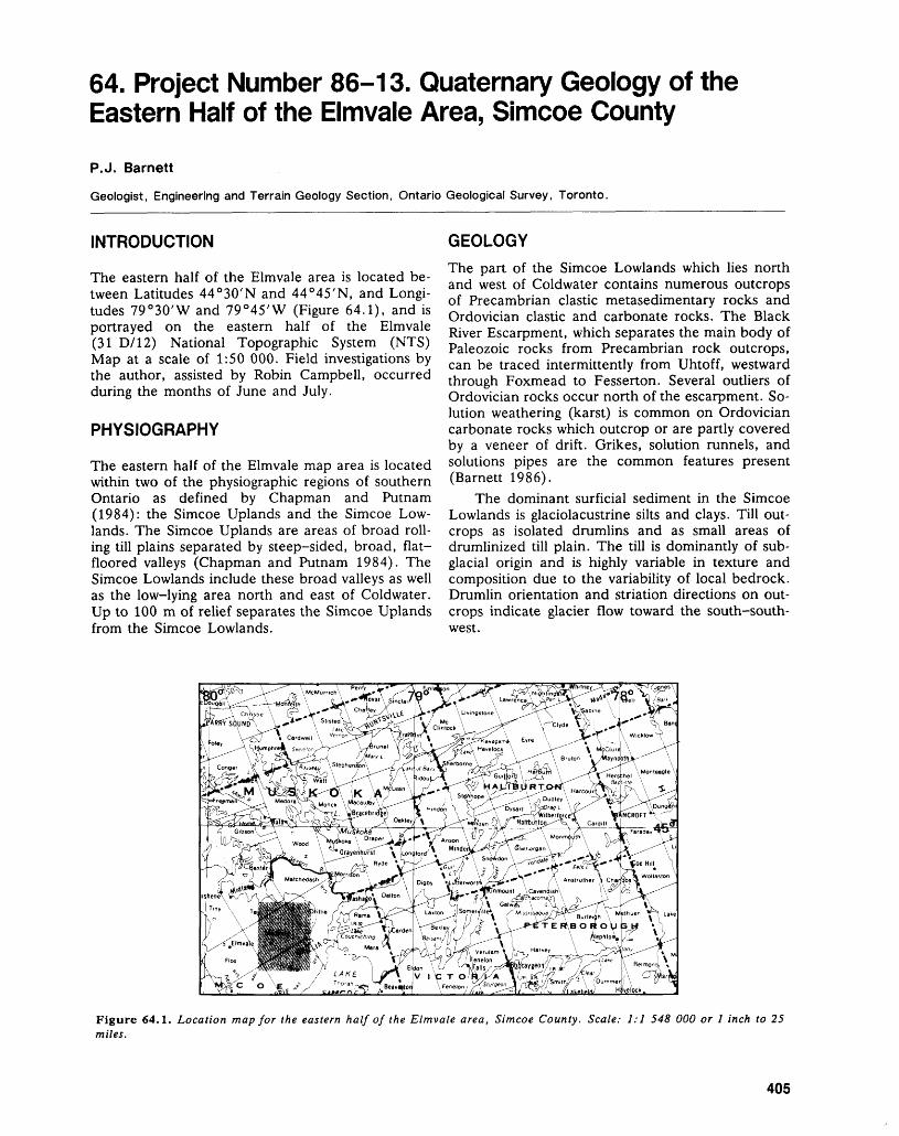
64. Project Number 86-13. Quaternary Geology of the Eastern Half of the Elmvale Area, Simcoe County
P.J. Barnett
Geologist, Engineering and Terrain Geology Section, Ontario Geological Survey, Toronto.
INTRODUCTION
The eastern half of the Elmvale area is located be tween Latitudes 44 0 30'N and 44 0 45'N, and Longi tudes 79 0 30'W and 79 0 45'W (Figure 64.1), and is portrayed on the eastern half of the Elmvale (31 D/12) National Topographic System (NTS) Map at a scale of 1:50 000. Field investigations by the author, assisted by Robin Campbell, occurred during the months of June and July.
PHYSIOGRAPHY
The eastern half of the Elmvale map area is located within two of the physiographic regions of southern Ontario as defined by Chapman and Putnam (1984): the Simcoe Uplands and the Simcoe Low lands. The Simcoe Uplands are areas of broad roll ing till plains separated by steep-sided, broad, flat- floored valleys (Chapman and Putnam 1984). The Simcoe Lowlands include these broad valleys as well as the low-lying area north and east of Coldwater. Up to 100 m of relief separates the Simcoe Uplands from the Simcoe Lowlands.
GEOLOGYThe part of the Simcoe Lowlands which lies north and west of Coldwater contains numerous outcrops of Precambrian clastic metasedimentary rocks and Ordovician clastic and carbonate rocks. The Black River Escarpment, which separates the main body of Paleozoic rocks from Precambrian rock outcrops, can be traced intermittently from Uhtoff, westward through Foxmead to Fesserton. Several outliers of Ordovician rocks occur north of the escarpment. So lution weathering (karst) is common on Ordovician carbonate rocks which outcrop or are partly covered by a veneer of drift. Grikes, solution runnels, and solutions pipes are the common features present (Barnett 1986).
The dominant surficial sediment in the Simcoe Lowlands is glaciolacustrine silts and clays. Till out crops as isolated drumlins and as small areas of drumlinized till plain. The till is dominantly of sub glacial origin and is highly variable in texture and composition due to the variability of local bedrock. Drumlin orientation and striation directions on out crops indicate glacier flow toward the south-south west.
Figure 64.1. Location map for the eastern half of the Elmvale area, Simcoe County. Scale: 1:1 548 000 or l inch to 25 miles.
405
ENGINEERING AND TERRAIN (64)
The floor of one of the large valleys which di vides the Simcoe Uplands is underlain by glacio lacustrine fine- to medium-grained sands, silts, and clays deposited during high level post-glacial lakes in the Lake Huron basin. More than six ancestral shoreline levels were observed during field mapping, including one level above the Main Algonquin level, as defined by Deane (1950).
The sediment types and relationships occurring within the Simcoe Uplands are much more complex. The surface sediment in the uplands is a sandy silt to silty sand diamicton with clasts consisting mainly of Precambrian rock types. It is commonly thinly bed ded; associated with stratified sediments, and is be lieved to be of debris flow origin (flow tills). This sediment is often found in patches of low-relief, sinuous ridges that are orientated roughly north- south; the "ice-block ridges" of Deane (1950).
Three units of subglacial tills are present in the upland areas; each associated with and separated by glaciolacustrine sediments (Barnett 1986). As of yet, there is no indication of the absolute age of these subglacial till units.
ECONOMIC GEOLOGYOrdovician bedrock is currently being extracted at Nelson Aggregates Quarry at Uthoff for numerous products, including crushed stone, agricultural lime, and armour stone. Crushed stone from the Cold- water Quarry is being used for road and bridge con
struction in the vicinity of Waubaushene. Extraction of sand and gravel resources occurs at 21 licensed sand and gravel properties within the eastern half of the Elmvale map area. Sand and gravel products are distributed locally, south to the Toronto market, and as far north as the Huntsville area (W.D. Fitzgerald, District Geologist, Ministry of Natural Resources, Midhurst, and R. Gorman, Resource Geologist, Ministry of Northern Development and Mines, per sonal communications, 1988).
Sand and gravel is being extracted predomi nantly from ice-contact stratified drift deposits, in cluding eskers, and subaqueous fan deposits, and ancestral shorelines features.
REFERENCESBarnett, P.J.1986: Quaternary Geology of the Eastern Halves of the
Barrie and Elmvale Areas, Simcoe County; p.193-194 in Summary of Field Work and Other Ac tivities 1986, by the Ontario Geological Survey, edited by P.C. Thurston, Owen L. White, R.B. Barlow, M.E. Cherry, and A.C. Colvine, Ontario Geological Survey, Miscellaneous Paper 132, 435p.
Chapman, L.J., and Putnam, D.F.1984: Physiography of Southern Ontario, Third Edition;
Ontario Geological Survey, Special Volume 2, 270p.Deane, R.E.1950: Pleistocene Geology of the Lake Simcoe District, On
tario; Geological Survey of Canada, Memoir 256, 108p.
406
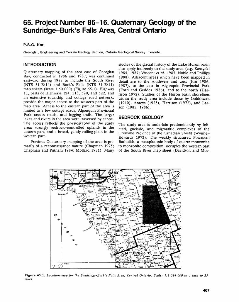
65. Project Number 86-16. Quaternary Geology of the Sundridge-Burk's Falls Area, Central Ontario
P.S.G. Kor
Geologist, Engineering and Terrain Geology Section, Ontario Geological Survey, Toronto.
INTRODUCTIONQuaternary mapping of the area east of Georgian Bay, conducted in 1986 and 1987, was continued eastward during 1988 to include the South River (NTS 31 E/14) and Burk's Falls (NTS 31 E/ll) map sheets (scale 1:50 000) (Figure 65.1). Highway 11, parts of Highways 124, 518, 520, and 522, and an extensive township and cottage road network, provide the major access to the western part of the map area. Access to the eastern part of the area is limited to a few cottage roads, Algonquin Provincial Park access roads, and logging trails. The larger lakes and rivers in the area were traversed by canoe. The access reflects the physiography of the study area: strongly bedrock-controlled uplands in the eastern part, and a broad, gently rolling plain in the western part.
Previous Quaternary mapping of the area is pri marily of a reconnaissance nature (Chapman 1975; Chapman and Putnam 1984; Mollard 1981). Many
studies of the glacial history of the Lake Huron basin also apply indirectly to the study area (e.g. Kaszycki 1985, 1987; Vincent e t al. 1987; Noble and Phillips 1988). Adjacent areas which have been mapped in detail are to the southwest and west (Kor 1986, 1987), to the east in Algonquin Provincial Park (Ford and Geddes 1986), and to the north (Har rison 1972). Studies of the Huron basin shorelines within the study area include those by Goldthwait (1910), Antevs (1925), Harrison (1972), and Lar son (1985, 1986).
BEDROCK GEOLOGYThe study area is underlain predominantly by foli ated, gneissic, and migmatitic complexes of the Grenville Province of the Canadian Shield (Wynne- Edwards 1972). The weakly structured Powassan Batholith, a metaplutonic body of quartz monzonite to monzonite composition, occupies the western part of the South River map sheet (Davidson and Mor-
Figure 65.1. Location map for the Sundridge-Burk's Falls Area, Central Ontario. Scale: 1:1 584 000 or l inch to 25 miles.
407
ENGINEERING AND TERRAIN (65)
gan 1980). All rocks in the area are of Precambrian age.
QUATERNARY GEOLOGYThe direction of the last (Late Wisconsinan) glacial advance over the region is south-southwesterly. Ice- flow indicators, primarily striations, range between 146 0 and 222 0 azimuth, with the majority ranging between 170 0 and 190 0 azimuth. The present map area was deglaciated about 11 500 B.P. (Before Pre sent) , at which time the western part of the area was inundated by an expanding glacial Lake Algonquin. Veillette (1986) suggested that the Laurentide Ice Sheet was subdivided into two lobes upon deglacia tion, with a major north-south suture zone along the present Highway 11 corridor. Great volumes of ice- contact and glaciofluvial sediments were deposited in this suture zone. These were subsequently partly buried by glaciolacustrine sediments deposited in glacial Lake Algonquin and post-Algonquin phases.
As deglaciation of the uplands to the east pro gressed, Harrison (1972) proposed that the first eastern outlet of glacial Lake Algonquin opened up through the study area. The South River outlet is thought to have flowed north and east through the Smyth Creek valley, Kawawaymog Lake, Amable du Fond River to North Tea Lake and beyond to the Petawawa River. Further ice retreat opened the Genesee outlet, in part diverting flow west of Kawawaymog Lake northward, through Genesee Lake to the Upper Petawawa River. The present study and observations made by Ford and Geddes (1986) suggest that fluvial activity through these sys tems was not as great as would be required by Har- risons's hypothesis. It is probable that eastward drainage of the lake commenced once the ice re treated north of the Trout Creek area. Subsequent eastward drainage through the Fossmill and North Bay areas had the effect of lowering the lake, and may account for the topographically lower deltaic and glaciolacustrine deposits north of Sundridge. Southern outlets subsequently lowered the lake rap idly to the Hough Phase, exposing the entire map area for the first time. Continued uplift and erosion produced the present landscape.
The distribution and thickness of glacial drift in the study area varies greatly. Generally, the eastern part of the map area, and all areas above 405 m (1250 foot) contour, consist of extensive bedrock- drift complex and areas of thick (M m) till. The till in these areas generally does not mask the underly ing bedrock topography, though extensive rock ex posure is not common. The western parts of the area are underlain by thick sequences of ice-contact stratified drift and glaciolacustrine sediments which effectively mask the character of the bedrock.
Till is the dominant deposit on the bedrock- controlled uplands. A single till sheet with two dis tinct facies is recognized. The dominant facies is blu
ish-grey, loose, stony (10 to 30 percent clasts by vol ume) and has a sandy matrix. Sandy lenses and stringers occur throughout this till facies, particularly in association with larger clasts and at the drift-rock interface. Occasionally, a more compact, clast-poor (*c!0 percent), slightly fissile till facies was observed to occur on the stoss (up-ice) sides of bedrock walls. Bullet-shaped clasts and stringers of sorted sands are common in this facies. The till is considered to have formed under conditions of stagnating ice by basal meltout. The tills are commonly deeply weath ered. Supraglacial and flow till facies are also pre sent in the study area and form a minor component of the till sheet.
Ice-contact deposits occur in abundance in bed rock-controlled valleys through the eastern uplands, and below glaciolacustrine sediments in the low-ly ing areas in the western parts of the study area. Kames occur sporadically as individual mounds and as complexes, particularly between Highway 11 and the eastern uplands north of Bernard Lake. In the bedrock valley sites, kames are commonly associ ated with eskers. The eskers are generally short, narrow, steep-sided ridges in braided patterns with intervening kettles. The eskers usually protrude from kettled outwash deposits, and are composed of gravelly sands with a very high boulder content. Un- differentiated ice-contact deposits are common on the leeside of bedrock scarps. These deposits are composed of poorly sorted to crudely bedded sands and gravels of highly variable texture with an abun dance of boulders.
Ice-contact subaquatic outwash fan deposits, usually overlain by deltaic sand and gravel, were identified in a number of lowland depressions along the Highway 11 corridor. The sediments consist of laminated silts, sands, and fine gravels, commonly deformed by loading and dewatering, with associated massive sand and diamict flows. They are believed to have been deposited subglacially or near the ice margin by glacial meltwaters exiting into glacial Lake Algonquin. Subsequent drainage of surface melt waters into Algonquin and post-Algonquin lake phases resulted in the deposition of the overlying deltaic sand and gravel. The subaquatic outwash fan deposits may be quite extensive beneath the glaciolacustrine cover, but the lack of topographic and tonal expression of these deposits on air- photographs makes it difficult to determine their ex act extent.
Glaciofluvial outwash deposits, predominantly sand and gravel, occur in abundance along the bed rock valley systems throughout the eastern uplands. Braided outwash also occurs across the deltaic de posits in the lower areas to the west of the highlands. The flat upper surfaces of these deposits are occa sionally kettled. The glaciofluvial outwash deposits represent meltwater channels active after glacial lake levels dropped from their high phases.
408
P.S.G. KOR
Along the Highway 11 corridor, the predomi nant deposits consist of sand and fine gravel of glaciolacustrine origin, often in the form of large flat plains. These are commonly confined by bedrock uplands. Sections within deltaic deposits exhibit pla nar laminated, ripple to cross-bedded sand and fine gravel, usually flat lying to gently dipping to the south and southwest. The upper surfaces of these deposits generally lie below expected Main Algon- quin uplift curve elevations, and are therefore inter preted to represent post-Algonquin levels. The pau city of raised shoreline features cut into the glaciolacustrine deposits is attributed to the ice form ing the shore of glacial Lake Algonquin at the time of deposition of these deposits.
Glaciolacustrine fine-grained deposits, predomi nantly grey silt and red clay rhythmites, occur spo radically in the low-lying areas of the western part of the study area. They are locally abundant and may be up to 4 m thick. While Antevs (1925) noted up to 18 m of sediment containing over 300 couplets in composite sections near Trout Creek and South River, the present study only noted slightly more than 100 couplets at any one site. The rhythmic se quences commonly grade upward to a greyish-red, massive, blocky-textured silt-clay. These fine grained sediments are commonly folded and faulted and are overlain by sand and fine gravel. The silts and clays represent distal and quiescent lake condi tions during relatively stable lake phases in the post- Algonquin basin. Sand and gravel was deposited in shallow water conditions as the lake dropped to lower levels.
Extensive alluvial deposits along rivers and creeks represent reworking of the glacial substrate by post-glacial rivers. Large tracts of organic terrain oc cur on the lowlands and occupy innumerable bed rock depressions in the uplands. Modern beaches occur where sufficient material exists on windward lakeshores to allow the reworking of the sediment.
ECONOMIC GEOLOGY
A number of large sand and gravel operations ex ploit the ice-contact stratified drift and glacio lacustrine stratified sediments along the Highway 11 corridor. It is expected that in the short term, these deposits will produce adequate volumes of aggregate to meet local needs. The ice-contact sediments are frequently too variable in texture to be economically significant, although they are utilized locally east of Highway 11. Till and outwash deposits are also used in the uplands east of Highway 11 for local road construction and landfill.
Cal Graphite Limited is setting up an open pit graphite operation near Graphite Lake in Butt Township (Garland 1987). It has been reported that aggregates south of this deposit contain enough graphite to restrict its use.
REFERENCESAntevs, E.1925: Retreat of the Last Ice-Sheet in Eastern Canada;
Geological Survey of Canada, Memoir 146, 142p.Chapman, L.J.1975: The Physiography of the Georgian Bay-Ottawa Valley
Area of Southern Ontario; Ontario Division of Mines, Geoscience Report 128, 33p. Accompanied by Map 2228, scale 1:253 440 or l inch to 4 miles.
Chapman, L.J., and Putnam, D.F.1984: The Physiography of Southern Ontario, Third Edition;
Ontario Geological Survey, Special Volume 2, 270p.Accompanied by Map P.2715 (coloured), scale1:600 000.
Davidson, A., and Morgan, W.C.1980: Preliminary Notes on the Geology East of Georgian
Bay, Grenville Structural Province; p.291-298 in Cur rent Research, Part A, Geological Survey of Canada, Paper 81-1A, 404p.
Ford, M.J., and Geddes, R.S.1986: Quaternary Geology of the Algonquin Park Area; On
tario Geological Survey, Open File Report 5600, 87p.Garland, M.I.1987: A Detailed Petrological Study of the Cal Graphite
Limited Graphite Deposit in Butt Township, Central Ontario; p.332-334 in Summary of Field Work and Other Activities 1987, by the Ontario Geological Sur vey, edited by R.B. Barlow, M.E. Cherry, A.C. Col vine, Burkhard O. Dressler, and Owen L. White, Ontario Geological Survey, Miscellaneous Paper 137, 429p.
Goldthwait, J.W.1910: An Instrumental Survey of the Shorelines of the Ex
tinct Lakes Algonquin and Nipissing in Southwestern Ontario; Geological Survey of Canada, Memoir 10, 57p.
Harrison, J.E.1972: Quaternary Geology of the North Bay-Mattawa Re
gion; Geological Survey of Canada, Paper 71-26, 37p.
Kaszycki, C.A.1985: History of Glacial Lake Algonquin in the Haliburton
Region, South Central Ontario; p. 109-123 in Quater nary Evolution of the Great Lakes, edited by P.F. Karrow and P.E. Calkin, Geological Associa tion of Canada, Special Paper 30, 258p.
1987: A Model for Glacial and Pro-Glacial Sedimentation in the Shield Terrain of Southern Ontario; Canadian Journal of Earth Sciences, Volume 24, p.2373-2391.
Kor, P.S.G.1986: Quaternary Geology of the Parry Sound Area;
p. 190-192 in Summary of Field Work and Other Ac tivities 1986, by the Ontario Geological Survey, edited by P.C. Thurston, Owen L. White, R.B. Barlow, M.E. Cherry, and A.C. Colvine, Ontario Geological Survey, Miscellaneous Paper 132, 435p.
1987: Quaternary Geology of the Parry Sound Area; p.377-379 in Summary of Field Work and Other Ac tivities 1987, by the Ontario Geological Survey, edited by R.B. Barlow, M.E. Cherry, A.C. Colvine, Burkhard O. Dressler, and Owen L. White, Ontario Geological Survey, Miscellaneous Paper 137, 429p.
409
ENGINEERING AND TERRAIN (65)
Larson, C.E. Veillette, J.J.1985: Rethinking Lake Algonquin and the Hinge Line; U.S. 1986: Former Southwesterly Ice Flows in Abitibi-Temis-
Geological Survey, Unpublished paper, 68p. camingue: Implications for the Configuration of the1986: Geologic History of Lake Algonquin and the Upper Late Wisconsinan Ice Sheet; Canadian Journal of
Great Lakes; U.S. Geological Survey, Unpublished Earth Sciences, Volume 23, p. 1724-1741.Paper, 58p. Vincent, J-S., Veillette, J., Allard, M., Richard, P.J.H.,
Mollard, D.G. Hardy, L., and Hillaire-Marcel, C.1981: Southern Ontario Engineering Geology Terrain Study, 1987: The Last Glacial Cycle and Ice-Retreat from the Up-
Data Base Map, Sundridge, 31E/NW; Ontario Geo- per Ottawa River Valley to Southeastern Hudson Bay;logical Survey, Open File Report, 2p. Xllth INQUA Congress Field Excursion C-10, Na-
Noble, T.N., and Phillips, B.A.M. tional Research Counci1 ' 85P'
1988: Earth Science Theme Study: Glacial and Contempo- Wynne-Edwards, H.R.rary Landforms; Consultant's Report to Ontario Min- 1972: The Grenville Province; p.264-334 in Variations inistry of Natural Resources, Parks and Recreational Tectonic Styles in Canada, edited by R.A. Price andAreas Branch, Northeastern Region, Sudbury, On- R.J.W. Douglas, Geological Association of Canada,tario, 73p. Special Paper 11, 688p.
410
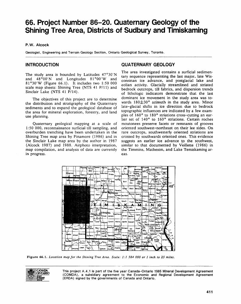
66. Project Number 86-20. Quaternary Geology of the Shining Tree Area, Districts of Sudbury and Timiskaming
P.W. Alcock
Geologist, Engineering and Terrain Geology Section, Ontario Geological Survey, Toronto.
INTRODUCTION
The study area is bounded by Latitudes 47 0 30'N and 48 0 00'N and Longitudes 81 0 00'W and 81 0 30'W (Figure 66.1). It includes two 1:50 000 scale map sheets: Shining Tree (NTS 41 P/ll) and Sinclair Lake (NTS 41 P/14).
The objectives of this project are to determine the distribution and stratigraphy of the Quaternary sediments and to expand the geological database of the area for mineral exploration, forestry, and land use planning.
Quaternary geological mapping at a scale of 1:50 000, reconnaissance surficial till sampling, and overburden trenching have been undertaken in the Shining Tree map area by Finamore (1986) and in the Sinclair Lake map area by the author in 1987 (Alcock 1987) and 1988. Airphoto interpretation, map compilation, and analysis of data are currently in progress.
QUATERNARY GEOLOGYThe area investigated contains a surficial sedimen tary sequence representing the last major, late Wis consinan ice advance, and postglacial lake and eolian activity. Glacially streamlined and striated bedrock outcrops, till fabrics, and dispersion trends of lithologic indicators demonstrate that the last dominant ice movement in the study area was to wards 180db30 0 azimuth in the study area. Minor late-glacial shifts in ice direction due to bedrock topographic influences are indicated by a few exam ples of 160 0 to ISO 0 striations cross-cutting an ear lier set of 140 0 to 160 0 striations. Certain roches moutonees preserve facets or remnants of grooves oriented southwest-northeast on their lee sides. On rare outcrops, southwesterly oriented striations are crossed by southwards oriented ones. This evidence suggests an earlier ice advance to the southwest, similar to that documented by Veillette (1986) in the Timmins, Matheson, and Lake Temiskaming ar eas.
Figure 66.1. Location map for the Shining Tree Area. Scale: 1:1 584 000 or l inch to 25 miles.
This project A.4.1 is part of the five year Canada-Ontario 1985 Mineral Development Agreement (COMDA), a subsidiary agreement to the Economic and Regional Development Agreement (ERDA) signed by the governments of Canada and Ontario.
411
ENGINEERING AND TERRAIN (66)
Drift thicknesses in the study area range from less than l m to more than 50 m.
Only rare carbonate lithology clasts have been found in the study area, usually in glaciofluvial de posits. This indicates the area is south and east of the limit of carbonate drift as mapped by Karrow and Geddes (1987).
One till sheet was found over the study area, which usually forms a veneer ^lm) over bedrock but ranges up to 4 m or more in thickness. Both subglacial and supraglacial till facies were identified using sedimentological and structural characteristics. All till at surface has been affected by soil forming processes, oxidation, and translocation of matrix carbonate to a depth of at least l to 2 m.
Subglacially deposited till facies are common at or near surface in areas of till veneers over bedrock and in areas of thick till. The melt-out till facies ap pears as loose to moderately compact till with thin sorted and deformed sand bands, commonly grading down into a compact lodgement till facies which in turn overlies striated bedrock. The lodgement facies commonly has a higher content of fines and a higher percentage of local rock types than the melt-out facies. The composition of subglacially deposited till facies often strongly reflects local bedrock.
The supraglacially deposited till facies are found as thin units overlying subglacially deposited facies. Flow till facies are often found on or between bed rock knobs and consist of moderately to loosely compacted sandy till with some glacially faceted and striated clasts, sorted sand stringers, and crude banding or layering of flow units. Ablation till facies are commonly thin, loose, sandy tills with frequent subrounded exotic cobbles and boulders. These supraglacial till types often poorly reflect the local bedrock.
Glaciofluvial ice-contact deposits consist of cob bly to bouldery sand and gravel and occur as seg mented and beaded eskers, kames, and other stag nant ice features. In the major valleys and in the broad, bedrock-controlled topographic lows, large, discontinuous and occasionally compound esker complexes are often present. Locally, small kames are found in valley bottoms among drift—veneered bedrock knobs.
Glaciofluvial outwash deposits, consisting of peb bly to gravelly sand, flank the esker systems. Occa sionally, fans of outwash sediments are found at the downstream end of esker segments. Extensive tracts of kettled and occasionally terraced outwash occupy large sections of the southeastern portion of the Shining Tree map area and the north and central parts of the Sinclair Lake map area. Minor glaciofluvial deposits occur in local valleys.
Glaciolacustrine deposits, consisting of rhythmi cally laminated to massive silt, fine sand and occa sional clay, occupy broad lows and the margins of
the major north-south valleys. These deposits are exposed along the shores of Kapiskong, Sinclair, Marne, and Mattagami lakes and are locally up to 15 m in thickness. Thin but extensive glaciolac ustrine deposits occupy the sites of former shallow proglacial lakes near Granite Lake and Shining Tree Lake in the Shining Tree map area and near Bur rows, Halliday, Relic, and Seveninch lakes in the Sinclair Lake map area. No definite shoreline fea tures have been identified from these glacial lakes, suggesting they were quite shortlived.
Eolian deposits consist of well sorted, finely laminated coarse silt to fine sand and form dunes and a widespread, thin surficial veneer over bed rock-drift complex, till, and glaciofluvial deposits. Parabolic and longitudinal sand dunes up to 20 m in height are common. Dune fields occur near Nabak- wasi Lake, Waonga Lake, and Claw Lake in the Shining Tree map area and near Loonwing Lake, Bardwell Lake, the Grassy River, Edleston Lake, and Jumping Moose Lake in the Sinclair Lake map area. Dune fields are located on and down-paleo- wind direction (southeast) -from parent deposits of fine-grained glaciofluvial outwash and glaciolac ustrine sands.
Recent alluvial deposits consist of sand, silt, gravel and some organic material and are found along those larger watercourses which cut through glaciofluvial deposits. Alluvial deposits are present along the Donnegana River and West Montreal River in the Shining Tree map area and the Grassy River in the Sinclair Lake map area. Most deposits are of very restricted areal extent and thickness.
Deposits of peat and muck up to a few metres in thickness are found in bogs and swamps occupying local topographic depressions and along the mean dering streams and rivers. Thin organic deposits oc cur over extensive areas on glaciolacustrine sand plains.
APPLIED QUATERNARY GEOLOGYA reconnaissance till sampling program has been carried out to create a geochemical database and de termine how overburden sampling can be effectively used as a mineral exploration technique in the study area. A total of 170 samples of weathered surface till were collected and geochemical analyses performed for Ag, As, Au, Ba, Co, Cr, Cu, Fe, Li, Mn, Mo, Ni, Pb, Pd, Pt, Sb, and Zn. A total of 137 samples of weathered and unweathered till were collected for heavy mineral concentrate (S.G. greater than 3.3) preparation, gold grain counts, and heavy mineral grain counts. Statistical analysis of the data is in pro gress.
Preliminary results indicate that boulder tracing, surface till sampling, and backhoe trenching are ef fective exploration methods in those areas with till at or near surface. Traditional soil geochemical sam pling would not be effective in those areas where
412
P. W. ALCOCK
non-local glaciolacustrine or eolian sand forms the soil parent material.
RELATED RESEARCH
J.T. Aultman (1988) completed a B.Se. honours thesis at the University of Western Ontario on the nature of gold dispersal in till in the Shining Tree area. Results from surface till samples collected up to several hundred metres down-ice of known gold occurrences indicate gold grains are present in the sand-sized heavy mineral fraction. Further work has also indicated anomalous gold geochemical values in the silt and clay fraction of these samples.
REFERENCESAlcock, P.W.1987: Quaternary Geology of the Shining Tree Area, Dis
tricts of Sudbury and Timiskaming; p.374-376 in Summary of Field Work and Other Activities 1987, by the Ontario Geological Survey, edited by R.B. Bar low, M.E. Cherry, A.C. Colvine, Burkhard O.
Dressler, and Owen L. White, Ontario Geological Survey, Miscellaneous Paper 137, 429p.
Aultman, J.T.1988: Gold Dispersal and Till Genesis, Beilby Lake Area,
Churchill Township, District of Sudbury; Unpublished B.Se. Thesis, University of Western Ontario, Lon don, Ontario, 70p.
Finamore, P.F.1986: Quaternary Geology of the Shining Tree Area, Dis
tricts of Sudbury and Timiskaming; p. 187-189 in Summary of Field Work and Other Activities 1986, by the Ontario Geological Survey, edited by P.C. Thurston, Owen L. White, R.B. Barlow, M.E. Cherry, and A.C. Colvine, Ontario Geological Survey, Miscellaneous Paper 132, 435p. Accompa nied by l Chart.
Karrow, P.P., and Geddes, R.S.1987: Drift Carbonate on the Canadian Shield; Canadian
Journal of Earth Sciences, Volume 24, p. 365-369.Veillette, J.J.1986: Former Southwesterly Ice Flows in the Abitibi-Timis-
kaming Region: Implications for the Configuration of the Late Wisconsinan Ice Sheet; Canadian Journal of Earth Sciences, Volume 23, p. 1724-1741.
413
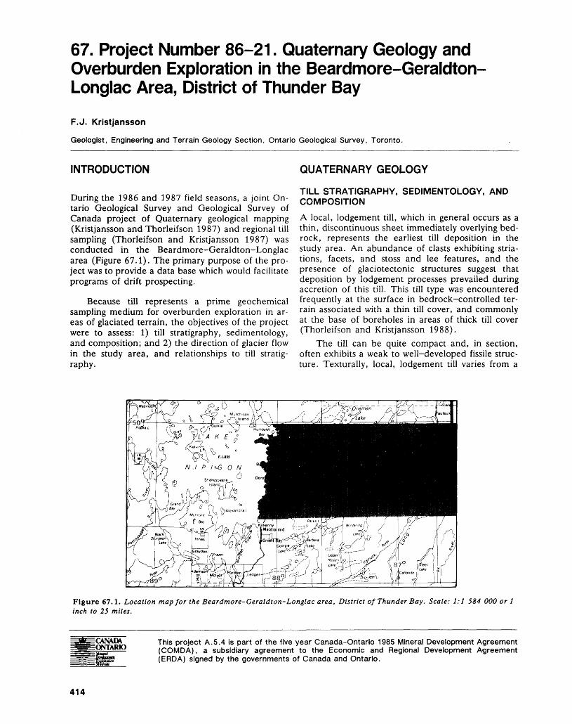
67. Project Number 86-21. Quaternary Geology and Overburden Exploration in the Beardmore-Geraldton- Longlac Area, District of Thunder Bay
F.J. Kristjansson
Geologist, Engineering and Terrain Geology Section, Ontario Geological Survey, Toronto.
INTRODUCTION
During the 1986 and 1987 field seasons, a joint On tario Geological Survey and Geological Survey of Canada project of Quaternary geological mapping (Kristjansson and Thorleifson 1987) and regional till sampling (Thorleifson and Kristjansson 1987) was conducted in the Beardmore-Geraldton-Longlac area (Figure 67.1). The primary purpose of the pro ject was to provide a data base which would facilitate programs of drift prospecting.
Because till represents a prime geochemical sampling medium for overburden exploration in ar eas of glaciated terrain, the objectives of the project were to assess: 1) till stratigraphy, sedimentology, and composition; and 2) the direction of glacier flow in the study area, and relationships to till stratig raphy.
QUATERNARY GEOLOGY
TILL STRATIGRAPHY, SEDIMENTOLOGY, AND COMPOSITION
A local, lodgement till, which in general occurs as a thin, discontinuous sheet immediately overlying bed rock, represents the earliest till deposition in the study area. An abundance of clasts exhibiting stria- tions, facets, and stoss and lee features, and the presence of glaciotectonic structures suggest that deposition by lodgement processes prevailed during accretion of this till. This till type was encountered frequently at the surface in bedrock-controlled ter rain associated with a thin till cover, and commonly at the base of boreholes in areas of thick till cover (Thorleifson and Kristjansson 1988).
The till can be quite compact and, in section, often exhibits a weak to well-developed fissile struc ture. Texturally, local, lodgement till varies from a
Figure 67.1. Location map for the Beardmore-Geraldton-Longlac area, District of Thunder Bay. Scale: 1:1 584 000 or l inch to 25 miles.
CANADA. ONTARIO
This project A.5.4 is part of the five year Canada-Ontario 1985 Mineral Development Agreement (COMDA), a subsidiary agreement to the Economic and Regional Development Agreement (ERDA) signed by the governments of Canada and Ontario.
414
F. J. KRISTJANSSON
moderately clast-rich, clayey silt to a clast-rich, silty sand. Textural variation would appear to be related to the lithologies present in the source area. For ex ample, local, gritty, clayey silt till would reflect deri vation from a source area dominated by pelitic metasedimentary rocks. Local, gritty, silty sand till reflects a source area dominated by metavolcanic or arenaceous metasedimentary rocks. The clast com position of this till variety is dominated by rock types of local provenance. A high percentage of angular- subangular Archean greenstone clasts is characteris tic. Many of the heavy mineral concentrates derived from samples of this particular till contained visible gold grains.
Nonlocal, carbonate-rich till overlies both bed rock and local, lodgement till. Generally, deposits of this till variety are thick and laterally extensive, par ticularly in the- central part of the study area. A lower, gritty, silt facies and an upper, gritty, sandy silt facies have been defined.
The lower facies is extremely compact and, in section, exhibits a blocky to fissile fracture. The ubiquitous presence of clasts exhibiting striations, facets, and stoss and lee features; the presence of boulder pavements; and the presence of glaciotec tonic structures suggest that the lower, gritty, silt facies was deposited predominantly through lodge ment processes under dynamic ice conditions.
The upper facies is loose to moderately com pact. In section, massive, diamictic zones were often observed in association with stringers, lenses, and other variously shaped units of sand. It is suggested that this phase of the nonlocal, carbonate-rich till was deposited predominantly through melt-out proc esses.
The lithologic composition of nonlocal, carbon ate-rich till is dominated by an abundance of sub rounded pebbles and occasional cobbles of Prot erozoic and Paleozoic clastic and chemical sedimen tary rocks derived from the James Bay and Hudson Bay lowlands. Generally, heavy mineral concentrates derived from samples of this exotic till variety did not contain visible gold grains.
A local, melt-out till occurs as a thin, discon tinuous veneer overlying bedrock or nonlocal, car bonate-rich till. This till variety was observed in the southern part of the study area, which is underlain by bedrock of the Quetico Metasedimentary-Mig- matitic Belt, and in an area underlain predominantly by felsic plutonic bedrock north and northwest of Geraldton. There appears to be a strong spatial rela tionship between the presence of local, melt-out till and bedrock-dominated upland areas. To date, the author has not observed this till type within those parts of the study area underlain by the Onaman- Tashota Belt and the Beardmore-Geraldton Belt.
In summary, and in stratigraphic order, four va rieties of till were observed in the Beardmore- Geraldton-Longlac area: 1) local, lodgement till;
2) nonlocal, lodgement till; 3) nonlocal, melt-out till; and 4) local, melt-out till.
GLACIAL FLOW AND TILL STRATIGRAPHY
Glacial striae, glacier-streamlined bedrock forms and drumlins indicate an early glacial advance to the south and a more recent glacial advance to the southwest. Evidence of the early advance are rare, planar, erosional bedrock facets with striations rang ing from about 190 0 in the Geraldton area to about 210 0 in the Beardmore area. Ice direction features of the most recent advance indicate a diverging or radial flow pattern. Generally, ice flow indicators ex amined in the eastern, central, and western parts of the study area trend about 200 0 to 220 0 , 220 0 to 240 0 , and 240 0 to 260 0 , respectively.
On the basis of the trend of striations on bed rock pavements underlying local, lodgement till; the trend of striations on boulder pavements observed within sequences of nonlocal, carbonate-rich till; and the orientation of drumlins composed of nonlo cal, carbonate-rich till, it is considered that the en tire till sequence was deposited during the later epi sode of glacier flow. The possibility that some occur rences of local, lodgement till, at the base of boreholes in areas of thick till cover, are representa tive of the early episode or even an undocumented episode of glacier flow should not be dismissed.
SUMMARY AND CONCLUSION1. Local, lodgement till represents the prime sam
pling horizon for till geochemistry programs. The fact that this till type was encountered frequently in thin till/bedrock terrain, and commonly at the base of boreholes in thick till terrain, suggests that there has been substantial glacier dispersion of local bedrock. More importantly, such obser vations indicate that there has been good preser vation of this till variety.
2. Nonlocal, carbonate-rich till, due to its obvious distant-source composition, represents a con straining factor with respect to till geochemistry programs.
3. Surface till and soil sampling represent viable overburden exploration strategies in areas of thin till/bedrock terrain. This is especially the case in the area of the Beardmore-North Wind Lake map sheet.
4. Overburden drilling is required in areas of thick till terrain. A thick and widespread till sheet overlies a substantial portion of the Beardmore- Geraldton Belt. The till sheet has proved to be a distinct impediment to conventional programs of mineral exploration. A program of reverse circu lation or sonic drilling is recommended for this area.
5. The importance of accurate till identification cannot be over-emphasized.
415
ENGINEERING AND TERRAIN (67)
REFERENCES Thorleifson, L.H., and Kristjansson, F.J.1987: Gold Grains in Surface Till Samples, Beardmore-
Kristjansson, F.J., and Thorleifson, L.H. Geraldton Area, District of Thunder Bay; Ontario 1987: Quaternary Geology of the Beardmore-Geraldton Geological Survey, Map P.3105, Geological Series-
Area, District of Thunder Bay; p.368-373 in Sum- Preliminary Map, scale 1:100 000. Geology 1986, mary of Field Work and Other Activities 1987, by the 1987.Ontario Geological Survey, edited by R.B. Barlow, 1988: Visible Gold Content and Lithology of Till from Over-M.E. Cherry, A.C. Colvine, Burkhard O. Dressler, burden Drillholes, Beardmore-Geraldton Area, Dis-and Owen L. White, Ontario Geological Survey, Mis- trict of Thunder Bay, Northern Ontario; Geologicalcellaneous Paper 137, 429p. Survey of Canada, Open File 1756, 21p.
416
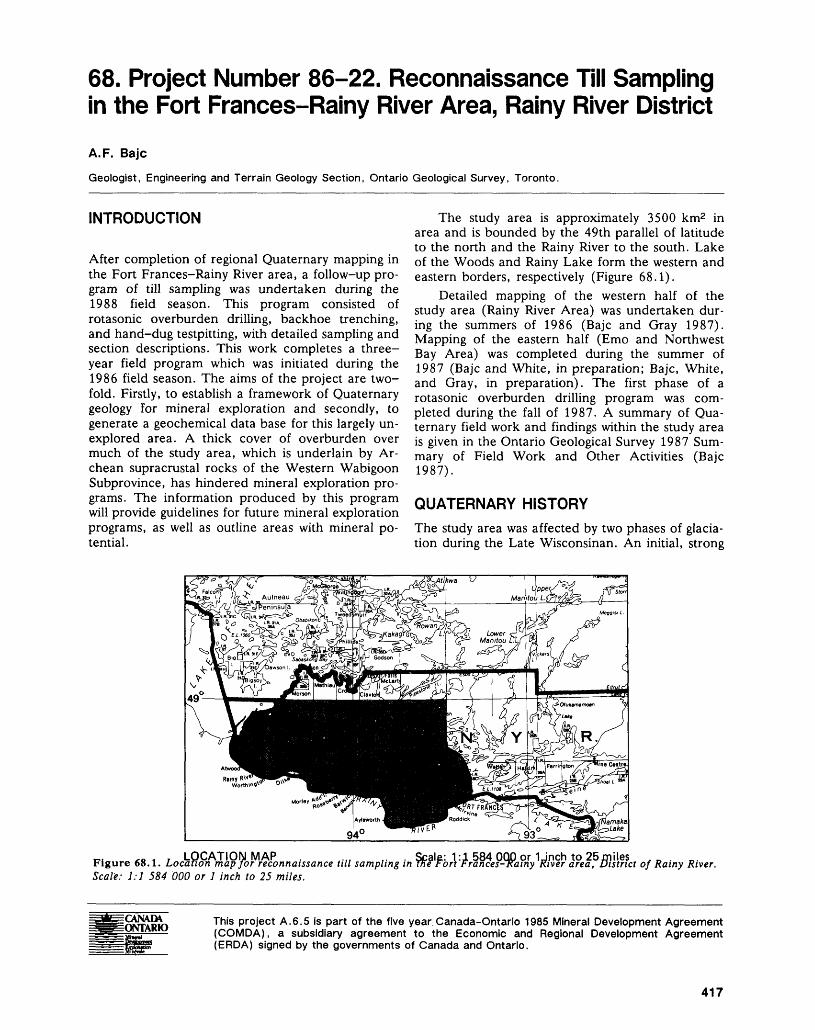
68. Project Number 86-22. Reconnaissance Till Sampling in the Fort Frances-Rainy River Area, Rainy River District
A. F. Bajc
Geologist, Engineering and Terrain Geology Section, Ontario Geological Survey, Toronto.
INTRODUCTION
After completion of regional Quaternary mapping in the Fort Frances-Rainy River area, a follow-up pro gram of till sampling was undertaken during the 1988 field season. This program consisted of rotasonic overburden drilling, backhoe trenching, and hand-dug testpitting, with detailed sampling and section descriptions. This work completes a three- year field program which was initiated during the 1986 field season. The aims of the project are two fold. Firstly, to establish a framework of Quaternary geology for mineral exploration and secondly, to generate a geochemical data base for this largely un explored area. A thick cover of overburden over much of the study area, which is underlain by Ar chean supracrustal rocks of the Western Wabigoon Subprovince, has hindered mineral exploration pro grams. The information produced by this program will provide guidelines for future mineral exploration programs, as well as outline areas with mineral po tential.
The study area is approximately 3500 km2 in area and is bounded by the 49th parallel of latitude to the north and the Rainy River to the south. Lake of the Woods and Rainy Lake form the western and eastern borders, respectively (Figure 68.1).
Detailed mapping of the western half of the study area (Rainy River Area) was undertaken dur ing the summers of 1986 (Bajc and Gray 1987). Mapping of the eastern half (Emo and Northwest Bay Area) was completed during the summer of 1987 (Bajc and White, in preparation; Bajc, White, and Gray, in preparation). The first phase of a rotasonic overburden drilling program was com pleted during the fall of 1987. A summary of Qua ternary field work and findings within the study area is given in the Ontario Geological Survey 1987 Sum mary of Field Work and Other Activities (Bajc 1987).
QUATERNARY HISTORYThe study area was affected by two phases of glacia tion during the Late Wisconsinan. An initial, strong
ir. ** i 7 LOCATION MAPFigure 68.1. Location map for reconnaissanceScale: 1:1 584 000 or l inch to 25 miles.
.... ,. . Scale: 1:1 584 OQp or 1Jnch to 25/piles.till sampling in me Fort Frances-T(ainy River area, District of Rainy River.
CANADA ONTARIO This project A.6.5 is part of the five year Canada-Ontario 1985 Mineral Development Agreement
(COMDA), a subsidiary agreement to the Economic and Regional Development Agreement (ERDA) signed by the governments of Canada and Ontario.
417
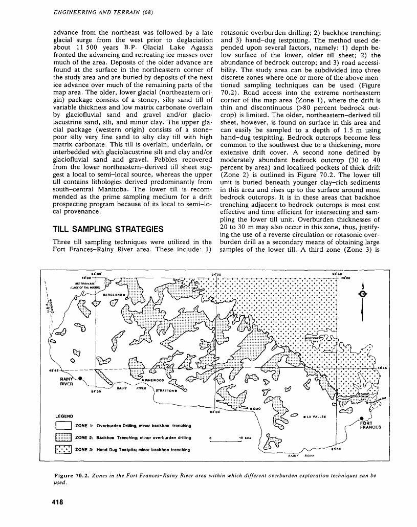
ENGINEERING AND TERRAIN (68)
advance from the northeast was followed by a late glacial surge from the west prior to deglaciation about 11 500 years B.P. Glacial Lake Agassiz fronted the advancing and retreating ice masses over much of the area. Deposits of the older advance are found at the surface in the northeastern corner of the study area and are buried by deposits of the next ice advance over much of the remaining parts of the map area. The older, lower glacial (northeastern ori gin) package consists of a stoney, silty sand till of variable thickness and low matrix carbonate overlain by glaciofluvial sand and gravel and/or glacio lacustrine sand, silt, and minor clay. The upper gla cial package (western origin) consists of a stone- poor silty very fine sand to silty clay till with high matrix carbonate. This till is overlain, underlain, or interbedded with glaciolacustrine silt and clay and/or glaciofluvial sand and gravel. Pebbles recovered from the lower northeastern-derived till sheet sug gest a local to semi-local source, whereas the upper till contains lithologies derived predominantly from south-central Manitoba. The lower till is recom mended as the prime sampling medium for a drift prospecting program because of its local to semi-lo cal provenance.
TILL SAMPLING STRATEGIESThree till sampling techniques were utilized in the Fort Frances-Rainy River area. These include: 1)
rotasonic overburden drilling; 2) backhoe trenching; and 3) hand-dug testpitting. The method used de pended upon several factors, namely: 1) depth be low surface of the lower, older till sheet; 2) the abundance of bedrock outcrop; and 3) road accessi bility. The study area can be subdivided into three discrete zones where one or more of the above men tioned sampling techniques can be used (Figure 70.2). Road access into the extreme northeastern corner of the map area (Zone 1), where the drift is thin and discontinuous ^80 percent bedrock out crop) is limited. The older, northeastern-derived till sheet, however, is found on surface in this area and can easily be sampled to a depth of 1.5 m using hand-dug testpitting. Bedrock outcrops become less common to the southwest due to a thickening, more extensive drift cover. A second zone defined by moderately abundant bedrock outcrop (30 to 40 percent by area) and localized pockets of thick drift (Zone 2) is outlined in Figure 70.2. The lower till unit is buried beneath younger clay-rich sediments in this area and rises up to the surface around most bedrock outcrops. It is in these areas that backhoe trenching adjacent to bedrock outcrops is most cost effective and time efficient for intersecting and sam pling the lower till unit. Overburden thicknesses of 20 to 30 m may also occur in this zone, thus, justify ing the use of a reverse circulation or rotasonic over burden drill as a secondary means of obtaining large samples of the lower till. A third zone (Zone 3) is
LEGEND
l^^^^l ZONE 1: Overburden Drilling, minor backhoe trenching
ZONE 2: Backhoe Trenching; minor overburden drilling
4 * ZONE 3: Hand Dug Testpits; minor backhoe trenchingRAJNY RIVf.K
Figure 70.2. Zones in the Fort Frances-Rainy River area within which different overburden exploration techniques can be used.
418
A.F. BAJC
characterized by sporadic outcrops ^5 percent by area) and overburden thicknesses commonly in ex cess of 30 m, and occasionally up to 60 m. This zone is present along the modern course of the Rainy River and occupies large, extensive tracts in the extreme western and southeastern parts of the map area. Less extensive and irregular areas of Zone 3 are found within the central part of the map area. It is within Zone 3 that deep overburden drill ing techniques, such as rotasonic and reverse circu lation, are necessary. Backhoe trenching adjacent to the widely scattered bedrock outcrops of Zone 3 is also a useful means of obtaining additional samples of the lower till.
SUMMARY OF THE 1987 AND 1988 SONIC DRILLING PROGRAMSDuring the fall of 1987, a 16-day rotasonic drilling program was undertaken during which 34 continu ously cored boreholes were completed. This drilling yielded relatively undisturbed cores, 9 cm in diame ter. Nearly 1060 m .of overburden and 70 m of bed rock core were recovered from the drilling program. Refer to Table 68.1 for a summary of drilling statis tics. A total of 28 of the 34 boreholes intersected the lower till. The thickest accumulations of the lower till are 17 m in the western end of the study area and approximately 3.5 m in the eastern end.
The second phase of drilling was undertaken during the fall of 1988 with 37 boreholes completed over a period of 25 days. There was 996 m of over burden and 77 m of bedrock core recovered from the drilling program. Table 68.1 summarizes perti nent drill program information. A total of 36 of the 37 boreholes intersected the lower, northeastern-de-
TABLE 68.1. SUMMARY OF 1987 AND 1988 SONIC DRILLING PROGRAMS.
1987 1988
Number of hours drilled 156.75 214.25Number of holes drilled 34 37Average number of holes per 2.1 1.5
12-hour shift (including drilling, moving, and down time)
Metres drilled per Jiour 7.2 5.0 Total overburden drilled (m) 1058.9 995.7Average overburden thickness 31.1 26.9
per hole (m)Total bedrock drilled 69.2 76.5
Average bedrock drilled per hole (m) 2.0 2.1 Percentage of holes upper till 100 92
encounteredPercentage of holes lower till 82 97
encountered
rived till. The thickest accumulations of this till are approximately 22 m in the western end of the study area and 9 m in the eastern end.
SUMMARY OF 1988 BACKHOE TRENCHING PROGRAMA 10-day backhoe trenching program was under taken during the past field season on road allow ances adjacent to bedrock outcrops. A total of 37 trenches were dug in the area outlined by Zone 2 of Figure 68.2 and 7 trenches in Zone 1. Samples of the older, locally derived till were obtained from all of the trenches dug in Zone l and 27 of the 37 trenches dug in Zone 2. Of the 37 trenches dug in Zone 2, 8 were placed on the northern, 9 on the southern, 12 on the eastern, and 8 on the western sides of the bedrock outcrops. There does not ap pear to be a side along which the lower till is prefer entially preserved. However, the till appears to be looser and contains more stringers and lenses of stratified sediment on the southern and western sides of the bedrock outcrops. Tills recovered from these sides have been interpreted primarily as leeside till derived from subglacial meltout of debris. Tills recovered from the northern and eastern sides of the bedrock outcrops are denser, fissile, appear more massive, and display structures suggestive of deposition by grounded, active ice. Shear planes and extension fractures indicating southwesterly ice flow were noted in several exposures of till on the north ern and eastern sides of bedrock outcrops. Pebble counts on the ^.6 mm (-1-4 mesh) fraction of the till suggest a local to semi-local source for this lower till sheet. Samples of till ranging from 8 to 10 kg were taken for heavy mineral separation, gold grain counts, geochemistry, grain size, and carbonate analysis.
TILL SAMPLE INVENTORY (1986-1988)During the summers of 1986 and 1987, 197 hand- dug surface till samples ranging from 5 to 10 kg were collected from the map area. An additional 19 sur face till samples were collected in areas of higher mineral potential from hand-dug surface testpits during the past field season. As part of the 10-day backhoe trenching program undertaken during the 1988 field season, 44 till samples were collected. All testpit and backhoe samples will undergo geochemi cal, grain size, and carbonate analysis. The 1987 rotasonic overburden drilling program yielded 238 till samples for geochemical analysis and 216 till samples for grain size and carbonate analysis. The 1988 rotasonic overburden drilling program yielded 202 till samples for geochemical analysis and 166 till samples for grain size and carbonate analysis. All till samples collected are processed to concentrate the -10 mesh (-2 mm) heavy minerals ^3.3 S.G.) for subsequent geochemical analysis. A subsample is sieved to obtain the -250 mesh fraction which is also
419
ENGINEERING AND TERRAIN (68)
analyzed. Other data generated for each sample in cludes gold grain counts and mineralogical identifi cations of 100 grains from the non-magnetic heavy mineral fractions.
OTHER RELATED RESEARCH
The second phase of a Geological Survey of Canada reflection seismic program was undertaken during the summer of 1988. Six common offset profiles were run over sonic boreholes drilled during the 1987 drilling program. Holes with depths in excess of 30 m and a complex stratigraphy were chosen for the program. Three additional holes cased with 2.5 inch (outside diameter) PVC pipe during the 1987 drilling program were used as test sites for a downhole seismic program. This program is aimed at establishing seismic velocity changes down the hole and across lithological breaks.
John Halstead is undertaking a B.Se. Thesis at Brock University and will be describing the nature of the lower, northeastern-derived till sheet at 37 se lected sites along a northeast-southwest transect in the central part of the map area. Special emphasis will be placed on the physical and chemical proper
ties of the till sheet and their relationship to prove nance and mode of deposition.
REFERENCESBajc, A.F.1987: Quaternary Geology of the Fort Frances Area;
p.364-367 in Summary of Field Work and Other Ac tivities 1987, by the Ontario Geological Survey, edited by R.B. Barlow, M.E. Cherry, A.C. Colvine, Burkhard O. Dressler, and Owen L. White, Ontario Geological Survey, Miscellaneous Paper 137, 429p.
Bajc, A.F., and Gray, P.A.1987: Quaternary Geology of the Rainy River Area, District
of Rainy River; Ontario Geological Survey, Map P.3065, Geological Series-Preliminary Map, scale 1:50 000. Geology 1986.
Bajc, A.F., and White, T.N.In Prep.: Quaternary Geology of the Emo Area, District of
Rainy River; Ontario Geological Survey, Geological Series-Preliminary Map, scale 1:50000. Geology 1987.
Bajc, A.F., White, T.N., and Gray, P.A.In Prep.: Quaternary Geology of the Northwest Bay Area,
District of Rainy River; Ontario Geological Survey, Geological Series-Preliminary Map, scale 1:50 000. Geology 1987.
420
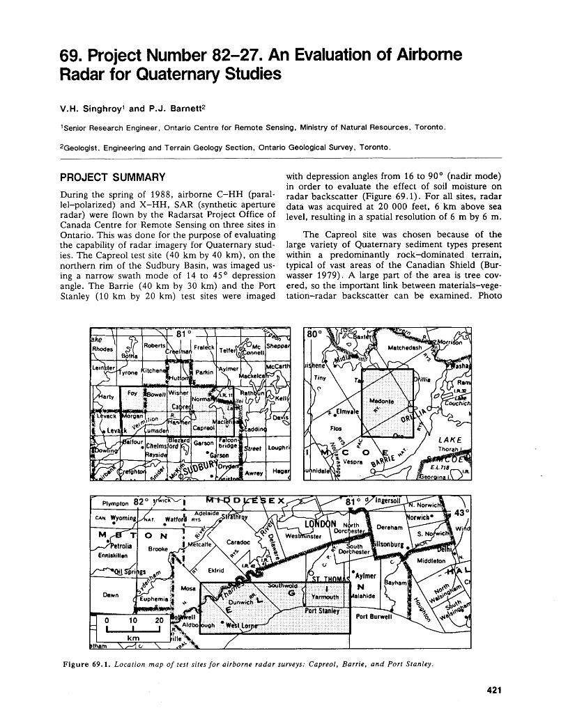
69. Project Number 82-27. An Evaluation of Airborne Radar for Quaternary Studies
V.H. Singhroy 1 and P.J. Barnett2
1 Senior Research Engineer, Ontario Centre for Remote Sensing, Ministry of Natural Resources, Toronto.
2Geologist, Engineering and Terrain Geology Section, Ontario Geological Survey, Toronto.
PROJECT SUMMARYDuring the spring of 1988, airborne C-HH (paral lel-polarized) and X-HH, SAR (synthetic aperture radar) were flown by the Radarsat Project Office of Canada Centre for Remote Sensing on three sites in Ontario. This was done for the purpose of evaluating the capability of radar imagery for Quaternary stud ies. The Capreol test site (40 km by 40 km), on the northern rim of the Sudbury Basin, was imaged us ing a narrow swath mode of 14 to 45 0 depression angle. The Barrie (40 km by 30 km) and the Port Stanley (10 km by 20 km) test sites were imaged
with depression angles from 16 to 90 0 (nadir mode) in order to evaluate the effect of soil moisture on radar backscatter (Figure 69.1). For all sites, radar data was acquired at 20 000 feet, 6 km above sea level, resulting in a spatial resolution of 6 m by 6 m.
The Capreol site was chosen because of the large variety of Quaternary sediment types present within a predominantly rock-dominated terrain, typical of vast areas of the Canadian Shield (Bur wasser 1979). A large part of the area is tree cov ered, so the important link between materials-vege tation-radar backscatter can be examined. Photo
CAN. Wyoming ^TAT WatfoA RYS
Port Burweir^sf \ V***f ^
Figure 69.1. Location map of test sites for airborne radar surveys: Capreol, Barrie, and Port Stanley.
421
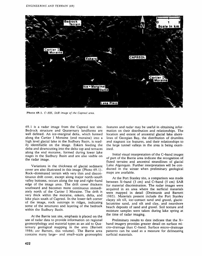
ENGINEERING AND TERRAIN (69)
Photo 69.1. C-HH, SAR image of the Capreol area.
69.1 is a radar image from the Capreol test site. Bedrock structure and Quaternary landforms are well defined. An ice-marginal delta, which formed along the Cartier I Moraine (end moraine) into a high level glacial lake in the Sudbury Basin, is read ily identifiable on the image. Eskers feeding the delta and downcutting into the delta top and terraces along the end moraine, formed during lower lake stages in the Sudbury Basin and are also visible on the radar image.
Variations in the thickness of glacial sediment cover are also illustrated in this image (Photo 69.1). Rock-dominated terrain with very thin and discon tinuous drift cover, except along major north-south valley bottoms, occurs along the top and right-hand edge of the image area. The drift cover thickens southward and becomes more continuous immedi ately north of the Cartier I Moraine. The drift is very thick within the moraine, eskers, delta, and lake plain south of Capreol. In the lower-left corner of the image, rock outcrops in ridges, indicating some of the structures and layering of the bedrock within the Sudbury Basin.
At the Barrie test site, emphasis is placed on the use of radar data to provide information on regional geomorphology and material types as an aid to Qua ternary geological mapping in the area (Barnett 1986; see Barnett, this volume). The Barrie area contains many large- and small-scale geomorphic
features and radar may be useful in obtaining infor mation on their distribution and relationships. The location and extent of ancestral glacial lake shore lines of Georgian Bay, the distribution of drumlins and stagnant ice features, and their relationships to the large tunnel valleys in the area is being exam ined.
Initial visual interpretation of the C-band images of part of the Barrie area indicate the recognition of fluted terrains and ancestral strandlines of glacial Lake Algonquin. Further interpretation will be con ducted in the winter when preliminary geological maps are available.
At the Port Stanley site, a comparison was made between X-band (3 cm) and C-band (5 cm) SAR for material discrimination. The radar images were acquired in an area where the surficial materials were mapped in detail (Dreimanis and Barnett 1985). Materials present include the Port Stanley clayey silt till, ice-contact sand and gravel, glacio lacustrine sand, and silt and clay, and nearshore beach deposits of sand and gravel. Soil texture and moisture samples were taken during lake spring at the time of radar imaging.
Preliminary results to date indicate that the X- band imagery provides greater detail on surface mi cro-drainage than C-band. Surface micro-drainage patterns can be used as a measure for delineating surficial materials.
422
V.H. SINGHROY AND P. J. BARNETT
ACKNOWLEDGMENTS Barrie and Elmvale Areas, Simcoe County;p. 193-194 in Summary of Field Work and Other Ac-
This study is part of the Memorandum of Under- tivities 1986, by the Ontario Geological Survey, editedstanding signed between the Government of Canada bv p - c - Thurston, Owen L. White, R.B. Barlow,(Canada Centre for Remote Sensing) and the Gov- M - E - Cherry, and A.C. Colvine, Ontario Geologicalernment of Ontario (Ontario Centre for Remote Survey- Miscellaneous Paper 132, 435P .Sensing) for the evaluation of airborne C-band ra- Burwasser, G.J.dar data for several resource mapping programs in 1979: Qu'aternary Geology of the Sudbury Basin Area; On-Ontario. tario Geological Survey, Report 181, 103p.
Dreimanis, A., and Barnett, P.J.1985: Quaternary Geology of the Port Stanley Area, South-
Barnett, P.J. ern Ontario; Ontario Geological Survey, Preliminary 1986: Quaternary Geology of the Eastern Halves of the Map P.2827, Geological Series, scale 1:50 000.
423
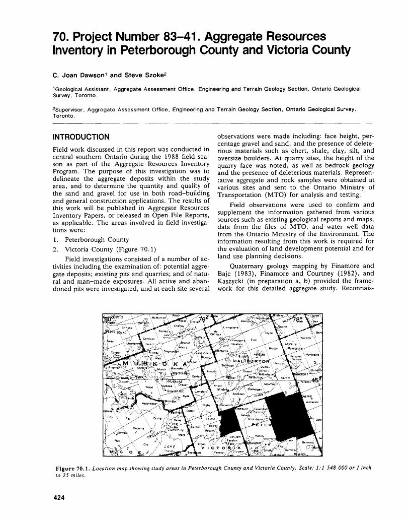
70. Project Number 83-41. Aggregate Resources Inventory in Peterborough County and Victoria CountyC. Joan Dawson 1 and Steve Szoke2
1 Geological Assistant, Aggregate Assessment Office, Engineering and Terrain Geology Section, Ontario Geological Survey, Toronto.
Supervisor, Aggregate Assessment Office, Engineering and Terrain Geology Section, Ontario Geological Survey, Toronto.
INTRODUCTIONField work discussed in this report was conducted in central southern Ontario during the 1988 field sea son as part of the Aggregate Resources Inventory Program. The purpose of this investigation was to delineate the aggregate deposits within the study area, and to determine the quantity and quality of the sand and gravel for use in both road-building and general construction applications. The results of this work will be published in Aggregate Resources Inventory Papers, or released in Open File Reports, as applicable. The areas involved in field investiga tions were:1. Peterborough County2. Victoria County (Figure 70.1)
Field investigations consisted of a number of ac tivities including the examination of: potential aggre gate deposits; existing pits and quarries; and of natu ral and man-made exposures. All active and aban doned pits were investigated, and at each site several
observations were made including: face height, per centage gravel and sand, and the presence of delete rious materials such as chert, shale, clay, silt, and oversize boulders. At quarry sites, the height of the quarry face was noted, as well as bedrock geology and the presence of deleterious materials. Represen tative aggregate and rock samples were obtained at various sites and sent to the Ontario Ministry of Transportation (MTO) for analysis and testing.
Field observations were used to confirm and supplement the information gathered from various sources such as existing geological reports and maps, data from the files of MTO, and water well data from the Ontario Ministry of the Environment. The information resulting from this work is required for the evaluation of land development potential and for land use planning decisions.
Quaternary geology mapping by Finamore and Bajc (1983), Finamore and Courtney (1982), and Kaszycki (in preparation a, b) provided the frame work for this detailed aggregate study. Reconnais-
Figure 70. 1. Location map showing study areas in Peterborough County and Victoria County. Scale: 1:1 548 000 or l inch to 25 miles.
424
C. JOAN DAWSON AND STEVE SZOKE
sance level geological studies by Chapman (1975) and Chapman and Putnam (1984) also cover the area.
PETERBOROUGH COUNTY
The geographic townships of Burleigh, Anstruther, Chandos, and Methuen were investigated in Peter borough County. Gravel resources are scarce in all four townships, and only in Chandos Township are there extensive sand deposits.
The main sources of sand are the outwash de posits found near Jack Lake, and in the valleys of Eels Creek and the Crowe River. These valleys acted as conduits for meltwater flowing from the ice front towards the Kawartha Lakes. This system served as an outlet for glacial Lake Algonquin following de glaciation of the area (Chapman and Putnam 1984).
Ice-contact features provide a limited supply of gravel suitable for low specification road-building and general construction uses. These hummocky de posits are scattered throughout Anstruther and Chandos townships and the northern part of Bur leigh Township. Till deposits have been used for cot tage road construction in some of the areas where aggregate resources are scarce. However, till is gen erally unsuitable for use as aggregate because of the presence of excess fines and abundant oversize clasts.
The four townships are underlain by Precam brian rocks of the Central Metasedimentary Belt (Wynne-Edwards 1972) of the Grenville Province. This Belt consists mainly of gneisses, marbles, and granites (Bartlett et al. 1982; Bright 198la, 198Ib, 1988; Easton 1988; Shaw 1962). Marble has been quarried in two locations in the study area and it may be suitable for use as crushed stone. In north ern Methuen Township, where naturally occurring sand and gravel deposits are almost nonexistent, highly weathered gneisses were being quarried pri marily for use on cottage roads. Indusmin Limited operates a large system of quarries in central Methuen Township, extracting nepheline syenite for use in glass manufacturing.
Outliers of sedimentary rock of Paleozoic age are located in the southern part of Burleigh and Methuen townships (Carson 1980a, 1980b). Two quarries have been opened in the limestone beds of the Gull River Formation. The Gull River Formation is a valuable potential source of crushed stone be cause of the very limited supplies of crushable gravel in this area. Although aggregate may meet specifica tions, certain beds of the Gull River Formation may contain alkali-carbonate reactive rocks and for this reason may not be accepted by MTO for use in con crete aggregate. To alleviate this problem, MTO sug gests either selective extraction to avoid reactive beds, or dilution of the aggregate with non-reactive rocks (Rogers 1985).
VICTORIA COUNTYSomerville Township, Victoria County, was also in vestigated during the 1988 field season. Sand depos its are abundant in this township, however, gravel resources are limited. The most significant sand de posits were formed by meltwater which flowed from the ice front down the valley of the Burnt River to ward the Kawartha Lakes (Chapman and Putnam 1984). Isolated remnants of glaciolacustrine sedi ments border thick deposits of clean outwash sand which flank the Burnt River. Although the fine grained glaciolacustrine sediments are suitable only for use as fill, the coarser outwash materials can be used in low specification aggregate products. Gravel suitable for high specification aggregate uses is gen erally found only in ice-contact features. A knoll located north of the settlement of Rosedale appears to have the highest potential for supplying crushable gravel to the area. Several eskers located in the southern part of the township are largely depleted of material. In the southeastern part of the township, there has been sporadic extraction of till from the hummocky Dummer Moraines (Chapman and Put nam 1984), however, the till contains excess fines and abundant oversize clasts, and is usually suitable only for use as fill.
The northeastern half of Somerville Township is underlain by rocks of the Central Metasedimentary Belt (Wynne-Edwards 1972) of the Grenville Prov ince. This area consists mainly of gneisses with small areas of marbles and granites (Easton and Bartlett 1984). No quarries have been developed in these Precambrian rocks.
Paleozoic age sedimentary rocks underlie the southwestern half of Somerville Township (Caley and Liberty 1952). The Shadow Lake Formation lies unconformably atop the Precambrian bedrock and consists of sandstone, siltstone, and shale. These rocks are generally not acceptable for use as aggregate. Overlying the Shadow Lake Formation are the limestones of the Gull River and Bobcaygeon formations. These limestones have been quarried for crushed stone for many years and are a valuable source of aggregate in this area. Although aggregate may meet specifications, certain beds of the Gull River Formation may contain alkali-carbonate reac tive rocks and for this reason may not be accepted by MTO for use in concrete aggregate. Selective ex traction to avoid reactive beds, or dilution of the ag gregate with non-reactive rocks may resolve this problem (Rogers 1985).
REFERENCESBartlett, J.R., Moore, J.M., Jr., and Murray, M.J.1982: Precambrian Geology of Belmont and Southern
Methuen Townships, Southern Ontario; Ontario Geo logical Survey, Map P.2488, Geological Series-Pre liminary Map, scale 1:15 840 or l inch to 1/4 mile. Geology 1980.
425
ENGINEERING AND TERRAIN (70)
Bright, E.G.1981a: Precambrian Geology of Anstruther Township (North
ern Part), Peterborough County, Southern Ontario; Ontario Geological Survey, Preliminary Map P.2422, Geological Series, scale 1:15 840 or l inch to 1/4 mile. Geology 1975, 1976, 1977.
1981b: Precambrian Geology of Anstruther Township (South ern Part), Peterborough County, Southern Ontario; Ontario Geological Survey, Preliminary Map P.2423, Geological Series, scale 1:15 840 or l inch to 1/4 mile. Geology 1975, 1976, 1977.
1988: Precambrian Geology of the Burleigh Falls Area, Peterborough County; Ontario Geological Survey, Map P.3096, Geological Series-Preliminary Map, scale 1:50 000. Geology 1975 to 1980.
Caley, J.F., and Liberty, B.A.1952: Fenelon Falls, Victoria, Peterborough and Haliburton
Counties, Ontario (Map and Descriptive Notes); Geological Survey of Canada, Paper 52-31, 8p. Pre liminary Map 52-31 A, scale 1:63 360 or l inch to l mile.
Carson, D.M.1980a: Paleozoic Geology of the Bannockburn-Campbellford
Area, Southern Ontario; Ontario Geological Survey, Preliminary Map P.2374, Geological Series, scale 1:50 000. Geology 1979.
1980b: Paleozoic Geology of the Burleigh Falls-Peterborough Area, Southern Ontario; Ontario Geological Survey, Preliminary Map P.2337, Geological Series, scale 1:50 000. Geology 1979.
Chapman, L.J.1975: The Physiography of the Georgian Bay-Ottawa Valley
Area of Southern Ontario; Ontario Division of Mines, Geoscience Report 128, 33p. Accompanied by Map 2228, scale 1:253 440 or l inch to 4 miles.
Chapman, L.J., and Putnam, D.F.1984: The Physiography of Southern Ontario, Third Edition;
Ontario Geological Survey, Special Volume 2, 270p.Accompanied by Map P.2715, scale 1:600 000.
Easton, R.M.1988: Precambrian Geology of the Minden Area, Halibur
ton, Peterborough, and Victoria Counties, and Mus
koka District; Ontario Geological Survey, Map P.3106, Geological Series-Preliminary Map, scale 1:50 000. Geology 1983 to 1986. Compilation 1987.
Easton, R.M., and Bartlett, J.R.1984: Precambrian Geology of the Howland Area, Halibur
ton, Peterborough, and Victoria Counties; Ontario Geological Survey, Map P.2699, Geological Series- Preliminary Map, scale 1:15 840 or l inch to 1/4 mile. Geology 1983.
Finamore, P.F., and Bajc, A.F.1983: Quaternary Geology of the Fenelon Falls Area, South
ern Ontario; Ontario Geological Survey, Preliminary Map P.2596, Geological Series-Preliminary Map, scale 1:50 000. Geology 1981, 1982.
Finamore, P.F., and Courtney, S.J.1982: Quaternary Geology of the Coe Hill Area, Southern
Ontario; Ontario Geological Survey, Map P.2536, Geological Series-Preliminary Map, scale 1:50 000. Geology 1980.
Kaszycki, C.A.In Prep, a: Quaternary Geology of the Gooderham (31 D/16)
Map Sheet; Geological Survey of Canada. In Prep, b: Quaternary Geology of the Minden (31 D/15)
Map Sheet; Geological Survey of Canada.
Rogers, C.A.1985: Alkali Aggregate Reactions, Concrete Aggregate Test
ing and Problem Aggregates in Ontario - A Review; Ontario Ministry of Transportation and Communica tions, Engineering Materials Office, Report EM-31, 5th Revised Edition, November, 44p.
Shaw, D.M.1962: Geology of Chandos Township, Peterborough County;
Ontario Department of Mines, Geological Report 11, 28p. Accompanied by Map 2019, scale 1:31 680 or l inch to 1/2 mile.
Wynne-Edwards, H.R.1972: The Grenville Province; p.263-334 in Variations in
Tectonic Style in Canada, edited by R.A. Price and R.J.W. Douglas, Geological Association of Canada, Special Paper 11, 688p.
426
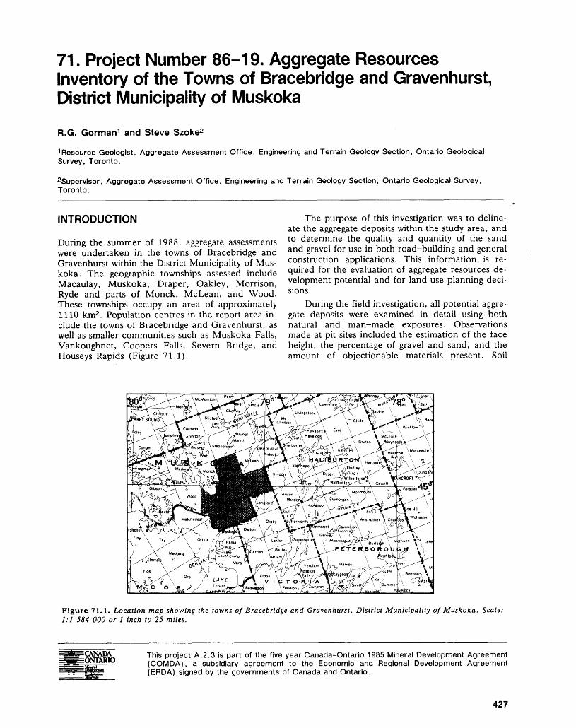
71. Project Number 86-19. Aggregate Resources Inventory of the Towns of Bracebridge and Gravenhurst, District Municipality of Muskoka
R.G. Gorman 1 and Steve Szoke2
"•Resource Geologist, Aggregate Assessment Office, Engineering and Terrain Geology Section, Ontario Geological Survey, Toronto.
Supervisor, Aggregate Assessment Office, Engineering and Terrain Geology Section, Ontario Geological Survey, Toronto.
INTRODUCTION
During the summer of 1988, aggregate assessments were undertaken in the towns of Bracebridge and Gravenhurst within the District Municipality of Mus koka. The geographic townships assessed include Macaulay, Muskoka, Draper, Oakley, Morrison, Ryde and parts of Monck, McLean, and Wood. These townships occupy an area of approximately 1110 km2 . Population centres in the report area in clude the towns of Bracebridge and Gravenhurst, as well as smaller communities such as Muskoka Falls, Vankoughnet, Coopers Falls, Severn Bridge, and Houseys Rapids (Figure 71.1).
The purpose of this investigation was to deline ate the aggregate deposits within the study area, and to determine the quality and quantity of the sand and gravel for use in both road-building and general construction applications. This information is re quired for the evaluation of aggregate resources de velopment potential and for land use planning deci sions.
During the field investigation, all potential aggre gate deposits were examined in detail using both natural and man-made exposures. Observations made at pit sites included the estimation of the face height, the percentage of gravel and sand, and the amount of objectionable materials present. Soil
Figure 71.1. Location map showing the towns of Bracebridge and Gravenhurst, District Municipality of Muskoka. Scale: 1:1 584 000 or l inch to 25 miles.
CANADA ONTARIO
This project A.2.3 is part of the five year Canada-Ontario 1985 Mineral Development Agreement (COMDA), a subsidiary agreement to the Economic and Regional Development Agreement (ERDA) signed by the governments of Canada and Ontario.
427
ENGINEERING AND TERRAIN (71)
probing, hand augering, and geophysical techniques were used to assess subsurface materials in areas of limited exposure. A number of test holes were exca vated using a backhoe, and aggregate samples were collected for quality testing.
Quaternary geological mapping by D.R. Sharpe (Geologist, Geological Survey of Canada, Ottawa, written communication, 1988) and Kaszycki (in preparation a, b) provided the framework for the detailed aggregate study. Reconnaissance level geo logical studies by Chapman (1975) and Chapman and Putnam (1984), and engineering terrain studies by Mollard (1980a, 1980b) also cover the area. Pre vious aggregate assessment work in the District Mu nicipality of Muskoka has been undertaken by the Staff of the Algonquin Region of the Ministry of Natural Resources (1983).
BEDROCKThe bedrock in the project area is part of the Cen tral Gneiss Belt of the Grenville Province. It consists largely of strongly foliated gneissic and migmatitic rock composed of quartz, feldspar, and biotite with garnet as a common accessory mineral (Meadows et al. 1987; Sharpe 1978). These rocks form promi nent northwest-southeast-trending structural fea tures which exerted strong control on glacial and glaciofluvial deposition (D.R. Sharpe, Geologist, Geological Survey of Canada, Ottawa, written com munication, 1988). In general, the bedrock is hard and resistant to weathering, and may be considered a potential source of aggregate.
SURFICIAL GEOLOGYA discontinuous cover of till was deposited within the project area by glacial ice which advanced in a south-southwesterly direction (Sharpe 1978). Expo sures of this loose, stony, silty sand till are generally scarce. Where found, the till exists as a thin veneer over bedrock. Till is usually not well suited for aggre gate use because it often contains excess fines and abundant oversize clasts. However, till may be a suit able source of fill in some localities.
Other glacial sediments in the area are generally located within bedrock-controlled valleys or basins. Such is the case with the glaciofluvial features which were deposited as the ice front melted back to the north. Two types of glaciofluvial deposits are repre sented in the project area:1. ice-contact deposits which were laid down on or
in close proximity to ice, including esker ridges; and
2. glaciofluvial outwash which was deposited by meltwaters flowing beyond the ice margin.As the ice front melted northward, the area was
inundated by glacial lakes. Where meltwaters flowed into these water bodies, glaciolacustrine deltas or
subaqueous fans were formed. A considerable amount of glaciolacustrine sand, silt, and clay were deposited on the floor of these glacial lakes. These lakebed sediments occupy low-lying areas, notably near the centre of the Town of Bracebridge and along the branches of the Muskoka River (Sharpe 1978).
AGGREGATE DISTRIBUTION AND QUALITY
Glaciofluvial outwash deposits are the main sources of aggregate in the report area. Many of the major outwash deposits overlie bedrock-controlled plains and terraces above topographic lows adjacent to the north and south branches of the Muskoka River and adjacent valleys (D.R. Sharpe, Geologist, Geological Survey of Canada, Ottawa, written communication, 1988). The outwash largely consists of well stratified and uniformly bedded sand and gravel, and has been a traditional source of aggregate in the area. In some areas the outwash consists predominately of uniformly bedded sand, although concentrations of crushable gravel may occur locally.
The ice-contact deposits scattered throughout the project area are generally small; however, many of the deposits are important local sources of aggre gate. Material exposed in these deposits varies from fine silty sand to coarse gravel suitable for crushing. The gravels frequently contain abundant oversize clasts which could be processed using a primary crusher. The occurrence of bedrock ridges in both outwash and ice-contact deposits is a common pit- workability problem that can hamper pit operations and estimation of remaining resources.
Scattered throughout the report area, especially north of the centre of the Town of Gravenhurst, sig nificant aggregate resources are available from del taic deposits. The deltas generally consist of strati fied and uniformly bedded sand and gravel. Both pit run and crusher run construction products are pro duced from these features. Gravel is usually concen trated in pockets and/or in the upper levels of the pits. These deltaic deposits are generally well situ ated with respect to local markets.
An extensive subaqueous fan deposit located along King's Highway 11, in Morrison Township, is a major source of aggregate in the Town of Graven hurst. Typically, the fan consists of fine to coarse sand, but also contains fine to coarse gravel. The aggregate in this feature tends to become finer near the surface, with fine to coarse gravel being concen trated in the lower levels of pits. In places the fan is capped by silt and clay. To avoid contamination of the underlying material, the silt and clay should be removed by stripping prior to aggregate extraction. In some areas, the fan contains gravel suitable for crushing if selective extraction and sand control measures are employed.
428
R. G. GORMAN AND STEVE SZOKE
In general, the aggregate in the report area is hard and durable and suitable for a variety of road- building and general construction applications. The gravel generally contains low percentages of weath ered and friable rock that could restrict its use in high specification products. Products available from pits in the area include asphaltic aggregate, as well as granular base course aggregate. Sandy aggregate has been found to be suitable for such uses as road sub base, septic beds, and fill. Silt and clay seams, as well as silty fine sand units, are common in some pits and should be avoided during extraction for high specification aggregate uses. Although the aggregate from this area may meet Ministry of Transportation (MTO) aggregate testing specifications, based on field performance the local gravels are not accepted by MTO for use in portland cement concrete which will be exposed to de-icing salts. There is a bonding problem between the cement and gravel which re sults in spalling of the concrete. This spalling prob lem was observed on a bridge structure located north of the project area at Burks Falls (Armour Town ship, District of Parry Sound). Consequently, crushed limestone aggregate is imported from north ern Simcoe County for high specification use.
In general, the report area contains large re sources of sand. Resources of crushable gravel, how ever, are restricted, especially in Wood, Monck, and Draper townships. In many parts of the project area, much of the crushable gravel has been depleted and sand now dominates. In both the towns of Graven hurst and Bracebridge, large tracts of land contain little or no aggregate resources. Consequently, aggre gate may have to be transported lengthy distances to supply construction.
REFERENCESChapman, L.J.1975: The Physiography of the Georgian Bay-Ottawa Valley
Area of Southern Ontario; Ontario Division of Mines,
Geoscience Report 128, 33p. Accompanied by Map 2228, scale 1:253 440 or l inch to 4 miles.
Chapman, L.J., and Putnam, D.F.1984: The Physiography of Southern Ontario, Third Edition;
Ontario Geological Survey, Special Volume 2, 270p.Accompanied by Map P.2715, scale 1:600 000.
Kaszycki, C.A.In Prep a: Quaternary Geology of the Haliburton (31 E/2)
Map Sheet; Geological Survey of Canada. In Prep b: Quaternary Geology of the Minden (31 D/15) Map
Sheet; Geological Survey of Canada.Meadows, J.R., Fouts, C.R., and Telford, P.G.1987: Mid-Ontario Building Stone Project, Muskoka-Parry
Sound Area; p.398-400 in Summary of Field Work and Other Activities 1987, by the Ontario Geological Survey, edited by R.B. Barlow, M.E. Cherry, A.C. Colvine, Burkhard O. Dressler, and Owen L. White, Ontario Geological Survey, Miscellaneous Pa per 137, 429p.
Mollard, D.G.1980a: Southern Ontario Engineering Geology Terrain Study
Maps: Bancroft and Haliburton; Ontario Geological Survey, Open File Report 5317, 2p. Accompanied by 4 maps, scale 1:100 000.
1980b: Southern Ontario Engineering Geology Terrain Study, Data Base Map, Muskoka Area, Parry Sound and Muskoka Districts (31 E/SW); Ontario Geological Survey, Open File Report 5323, 2p., l map, scale 1:100 000.
Sharpe, D.R.1978: Quaternary Geology of the Gravenhurst, Bracebridge
and Huntsville Areas, District Municipality of Mus koka; p. 152-154 in Summary of Field Work 1978, by the Ontario Geological Survey, edited by V.G. Milne, O.L. White, R.B. Barlow, and J.A. Robertson, On tario Geological Survey, Miscellaneous Paper 82, 235p.
Staff of the Algonquin Region1983: Aggregate Resources Assessment, District Municipal
ity of Muskoka; Ontario Geological Survey, Open File Report 5457, 14p., Accompanied by 12 maps, scale 1:50 000.
429
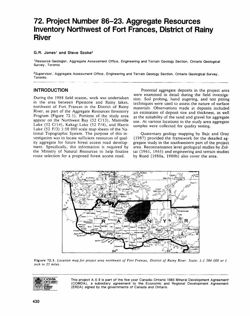
72. Project Number 86-23. Aggregate Resources Inventory Northwest of Fort Frances, District of Rainy River
G.R. Jones 1 and Steve Szoke2
1 Resource Geologist, Aggregate Assessment Office, Engineering and Terrain Geology Section, Ontario Geological Survey, Toronto
Supervisor, Aggregate Assessment Office, Engineering and Terrain Geology Section, Ontario Geological Survey, Toronto.
INTRODUCTIONDuring the 1988 field season, work was undertaken in the area between Pipestone and Rainy lakes, northwest of Fort Frances in the District of Rainy River, as part of the Aggregate Resources Inventory Program (Figure 72.1). Portions of the study area appear on the Northwest Bay (52 C/13), Mainville Lake (52 C/14), Kakagi Lake (52 F/4), and Harris Lake (52 F/3) 1:50 000 scale map sheets of the Na tional Topographic System. The purpose of this in vestigation was to locate sufficient resources of qual ity aggregate for future forest access road develop ment. Specifically, this information is required by the Ministry of Natural Resources to help finalize route selection for a proposed forest access road.
Potential aggregate deposits in the project area were examined in detail during the field investiga tion. Soil probing, hand augering, and test pitting techniques were used to assess the nature of surface materials. Observations made at deposits included an estimation of deposit size and thickness, as well as the suitability of the sand and gravel for aggregate use. At various locations in the study area aggregate samples were collected for quality testing.
Quaternary geology mapping by Bajc and Gray (1987) provided the framework for the detailed ag gregate study in the southwestern part of the project area. Reconnaissance level geological studies by Zol tai (1961, 1965) and engineering and terrain studies by Roed (1980a, 1980b) also cover the area.
Figure 72.1. Location map for project area northwest of Fort Frances, District of Rainy River. Scale: 1:1 584 000 or l inch to 25 miles.
CANADA ONTARIO
This project A.6.6 is part of the five year Canada-Ontario 1985 Mineral Development Agreement (COMDA), a subsidiary agreement to the Economic and Regional Development Agreement (ERDA) signed by the governments of Canada and Ontario.
430
G. R. JONES AND STEVE SZOKE
BEDROCK
The project area lies within the southwestern part of the Superior Province of the Canadian Shield. Most of the area is underlain by granitic rocks (Blackburn 1981). The exception is a belt of predominantly metavolcanic rock which extends from Burditt Lake to Furlonge Lake along the western and northern boundaries of the study area. In general, the bed rock is hard and resistant to weathering, and is con sidered a potential source of aggregate.
SURFICIAL GEOLOGY
A discontinuous cover of till was deposited through out the project area by glacial ice which advanced in a southwesterly direction (Zoltai 1961, 1965; Bajc 1987; Bajc and Gray 1987; Cowan 1987). This sandy till generally exists as a thin veneer over bed rock, although in several areas significant thick nesses can be observed. These thicker till accumula tions often flank bedrock knobs. Till is usually not well suited for aggregate use as it often contains ex cess fines and abundant oversize clasts. However, it may be a suitable source of fill in some localities.
As the ice front melted back, sand and gravel were deposited within a limited number of ice-con tact features, including moraines which form north west- to southeast-trending ridges in the area. The moraines were laid down during temporary halts of the melting ice margin as the area was deglaciated. An esker ridge trends in a northeastern to south western direction near Calder Lake. The esker was deposited by meltwaters flowing in a tunnel complex under the ice or in a re-entrant at the ice front. Ice- contact material was also deposited in kame-like features along the southern flank of several bedrock knobs and ridges.
During deglaciation, much of the land surface was submerged beneath glacial lake waters. On the floors of these lakes, silty fine sand, silt, and clay were deposited. These lakebed sediments occupy low-lying tracts throughout the project area. A thin, discontinuous layer of silt and clay also caps a num ber of the ice-contact features.
AGGREGATE DISTRIBUTION AND QUALITY
Moraine ridges are important potential sources of aggregate in the area. A major moraine, known as the Rainy Lake-Lake of the Woods Moraine (Zoltai 1961), is situated along the southwestern boundary of the report area. Significant aggregate resources also occur within moraines located near Furlonge and Gussie lakes, and between Loonhaunt and Kaiarskons lakes. The aggregate available from the moraines is of varying quality. In some locations, clean sandy gravel suitable for a variety of aggregate
uses is exposed, while in other areas, the aggregate consists of lower quality material containing abun dant fines and/or oversize clasts.
The esker ridge, located near Calder Lake in the central part of the project area, rises between 5 and 18m above the surrounding terrain. Sandy fine to medium gravel, well suited for road construction purposes, is the predominant material in the ridge. This esker should be capable of providing aggregates for a significant length of road.
Ice-contact features which flank the south sides of bedrock ridges are scattered throughout the area. Although these deposits are usually of limited areal extent, many of the deposits are well situated within the proposed road corridor. Material exposed in these features usually ranges from medium sand to coarse gravel. Some of the deposits may contain variable amounts of oversize clasts and/or fines.
Despite a general lack of known sand and gravel deposits in the area, sufficient resources were dis covered to help alleviate potential aggregate short ages during future forest access road construction, and to reduce long haulage distances. The exception is an area located north of Ottertail and West Jack fish lakes in which aggregate resources are extremely limited.
REFERENCESBajc, A.F.1987: Quaternary Geology of the Fort Frances Area; p. 364-
367 in Summary of Field Work and Other Activities 1987, edited by R.B. Barlow, M.E. Cherry, A.C. Colvine, Burkhard O. Dressler, and Owen L. White, Ontario Geological Survey, Miscellaneous Paper 137, 429p.
Bajc, A.F., and Gray, P.A.1987: Quaternary Geology of the Rainy River Area, District
of Rainy River; Ontario Geological Survey, Map P.3065, Geological Series-Preliminary Map, scale 1:50 000. Geology 1986.
Blackburn, C.E.1981: Kenora-Fort Frances, Kenora and Rainy River Dis
tricts; Ontario Geological Survey, Map 2443, Geo logical Compilation Series, scale 1:253 440.
Cowan, W.R.1987: Quaternary Geology, Lake of the Woods Region,
Northwestern Ontario, Progress Report for Year l, Wabigoon Lake-Gold Rock Areas; Geological Survey of Canada, Open File Report 1697, 62p. Accompa nied by 2 maps.
Roed, M.A.1980a: Rainy Lake Area (NTS 52C/NW), District of Rainy
River; Ontario Geological Survey, Northern Ontario Engineering Geology Terrain Study 53, 15p. Accom panied by Map 5069, scale 1:100 000.
1980b: Rowan Lake Area (NTS 52F/SW1), Districts of Kenora and Rainy River; Ontario Geological Survey, Northern Ontario Engineering Geology Terrain Study 37, 13p. Accompanied by Map 5060, scale 1:100 000.
431
ENGINEERING AND TERRAIN (72)
Zoltai, S.C.1961: Glacial History of Part of Northwestern Ontario; Pro
ceedings of the Geological Association of Canada, Volume 13, p.61-83.
1965: Surficial Geology, Kenora-Rainy River; Ontario De partment of Lands and Forests, Map SI65, scale 1:506 880 or l inch to 8 miles. Surficial Geology 1958-1960.
432
73. Project Number 88-19. The Delineation of Buried Aggregate Resources in the Pinehurst and Leamington Areas of Southwestern Ontario Using Electromagnetic ConductivityDouglas G. Vanderveer1 and Steve Szoke2
1 Aggregate Resources Specialist, Aggregate Assessment Office, Engineering and Terrain Geology Section, Ontario Geological Survey, Toronto.
Supervisor, Aggregate Assessment Office, Engineering and Terrain Geology Section, Ontario Geological Survey, Toronto.
INTRODUCTION
Surficial deposits of good quality sand and gravel are limited in Essex, Kent, and Lambton counties, southwestern Ontario. The material in most known deposits is generally of poor quality because of high shale and silt contents, and as such, is generally un suitable for use in concrete or asphaltic aggregate ap plications. There are, however, two deposit areas which contain notable quantities of quality aggre gate: (a) the subsurface "Pinehurst" deposit (infor mal name) located 11 km east of Chatham in Har wich Township, Kent County; and (b) the Leamington deposits, spread over a 21 km2 area im mediately west and northwest of the Town of Leamington, within North Gosfield, South Gosfield, and Mersea townships of Essex County (Figure 73.1). Pits in the Pinehurst and Leamington deposits are amongst the few known local sources of high quality aggregates located in this part of southwest ern Ontario. Local supplies of quality aggregates are supplemented by materials imported by truck from
surrounding regions to the west and northwest, or shipped into the area by lake freighter from more distant sources in Canada and the U.S.A. (James Lau, Petroleum Resources Geologist, Ministry of Natural Resources, personal communication, 1987).
PROJECT OBJECTIVESThe objective of this multiyear project during the 1988 field season was to determine the best methods to effectively delineate the boundaries of buried ag gregate deposits, using the Pinehurst and Leaming ton deposits as test cases. Particular emphasis was placed on those areas of sand and gravel that are buried by other glacial, fine-grained glaciolacustrine or eolian sediments. The results of this methodologi cal assessment will be incorporated into a broader- based program to complete the aggregate inventory in southwestern Ontario. In future years, the project will focus on locating and delineating additional ag gregate reserves, most of which are expected to be buried in a setting similar to those at Pinehurst and Leamington. These materials are required to satisfy
Figure 73.1. Location map for the Pinehurst and Leamington survey areas.
433
ENGINEERING AND TERRAIN (73)
an increasing demand for aggregates in southwestern Ontario.
SELECTION OF SURVEY METHODOLOGIES
Previous aggregate assessments (Ontario Geological Survey, in preparation) and Quaternary mapping programs (Kelly, this volume; Morris, this volume) in the area have not focused on defining the boundaries of buried aggregate deposits. To accom plish this task, a method with the capability of "see ing" through the overlying mantle of glacial till or glaciolacustrine sediments in order to delineate the sands or gravels beneath, was required. The use of drilling and/or backhoe testpits alone was not ac ceptable because of the amount of time and the high costs associated with the detailed grid pattern (100 to 200 m spacing between holes) survey necessary for adequate- delineation. In addition, difficulty in obtaining permission to access private properties for a large-scale drilling or testpitting program was an ticipated. An alternative method, such as a geo physical or remote sensing technique, was therefore required.
A review of remote sensing technology and three applicable geophysical techniques (seismic, resis tivity, and conductivity) was undertaken prior to the 1988 field season. Remote sensing may have some application in identifying potential areas of buried deposits that are partly exposed at or near the sur face. However, it was eliminated as a detailed de lineation tool since burial beneath a few metres or more of overburden effectively prevents the detec tion of buried aggregates using current remote sens ing technologies.
Based on previous work concerning buried ag gregates in eastern Ontario (Gorrell, in preparation), it appeared that seismic reflection surveys could have some application in areas of deeper overbur den. Such is the case at Leamington, where the depth to bedrock is in the range of 60 m. Seismic reflection was not effective in areas of shallower ma terials, such as at Pinehurst, where the depth to bed rock is approximately 20 m. Refraction primary compressional waves (P waves) do not normally pro vide a reflector from a lower velocity sand or gravel beneath a higher velocity clay or till layer, whereas shear wave (S wave) refraction soundings may allow identification of buried granular materials (Lloyd Thompson, Regional Geophysicist, Southern Ontario Region, Ministry of Northern Development and Mines, Tweed, personal communication, 1988).
Computer modeling, based on the stratigraphy of the Pinehurst deposit and the anticipated resis tivities of the various units, indicated that resistivity soundings should be able to identify buried sand or gravel layers a minimum of 5 to 10 m thick. This
would be the case provided there was a sufficient resistivity contrast between the sand and the overly ing clay or till, and that the latter had a maximum thickness of 10 m. Similar modeling of conductivity soundings and a review of a similar study to locate aggregates conducted for the Ministry of Transporta tion (Bird and Hale Ltd. 1987), indicated that the Geonics EMS l and EM34-3 conductivity instru ments might be useful in distinguishing areas under lain by sand and gravel. The limitations with regard to the effectiveness of these instruments in identify ing aggregates below the water table, or within multi layer sequences of varying conductivities was un known. To obtain information about the stratigraphy of buried deposits would require more intensive and time consuming EM techniques.
Based on the results of these studies, the 1988 field program was designed to evaluate various geo physical equipment and techniques. As a result of this evaluation, technique (s) were identified that are cost and time effective, for both local and regional surveys, while being capable of providing sufficient data for deposit delineation. Drilling and testpitting to verify the geophysical results'and to obtain sam ples for quality testing was included in the program.
PINEHURST AREA
OVERBURDEN SEQUENCE
The buried sand and gravel deposit at Pinehurst was deposited in association with other glacial and glaciolacustrine sediments. The local stratigraphy is represented in a newly developed pit owned by Huron Gravel Limited of Chatham (for location see Figure 73.2). The exposure reveals a discontinuous mantle of fine eolian tan brown sands (up to 3 m thick) capping l to 2 m of mottled brown to grey- brown silt and clay, that in turn overlies l to 4 m of grey silt- and clay-rich, compact till. In the thickest parts of the aggregate deposit, greater than 15 m of sand and gravel occur beneath this till unit. Bedrock is not exposed, but Kettle Point Shale is expected to underlie the area.
The majority of the extractable sands and grav els in the area occur beneath the impervious silt/clay and till units, and are below the water table. Extrac tion of this material is accomplished using drag lines and bucket dredges. The material is stockpiled for subsequent processing and benefication using heavy media separation to remove deleterious shale parti cles. Currently, there are two operators in the area; Huron Gravel Limited and Adams Sand and Gravel Limited. The latter is expected to cease extraction in the near future because of a lack of reserves (Don Mason, General Manager, Adams Sand and Gravel Limited, Harwich Township, personal communica tion, 1988). A licence has recently been issued to the Township of Harwich to operate a pit on a site adjacent to Huron Gravel Limited.
434
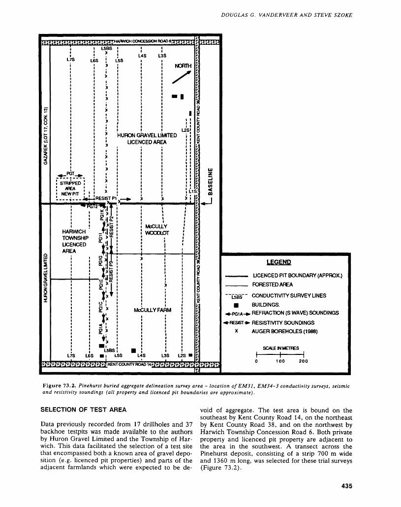
DOUGLAS G. VANDERVEER AND STEVE SZOKE
?T
^gK*
ie.*:UJ
1O
q1
1o*
r.HAHWCH CONCtSSON HOAU e.'iTi'i'I'J
L5BS 1
L * U
^ PGT ^
STRJPPEDfPEA
NEWPfT |
X5S j
XiXiX11x
x1xiX i
X,x1x1xiX
—— .^...JWi-* RESIST
r\an ^•pl *
! 5 x
L
P1
fg! |'s
HARWICH .f l| ffiTOWNSHIP 5 " cLICENCED illAREA X*,
o Jsis
.
r
l
i
Wuj ^*flfi !
^ !Q x
J'''
gx
ji
l
L5BSL r5 L65 Ml
LSB
HURON GUCEN
—— ̂ NX^^^
i —————
.
Md
H
4S L:
RAVEL LICEDARE
i
S
NORTH
•1
1
L2S^rrEDA
Y
Y
Y
Y fY
Y
Y VY
Y
Y
XJf',
2
tt
|
|
g
5!J jxjxjt*.Y-
X;xjxj **
xjv!
1.1 i.;
X
1
McCULLY WOODLOT
i 1
:
DULLY FA M
LSfe LAS L35 LZS m
xj
4^Xj
xjxjxj xj xjxjxjxjxjX;
UlzUl(0
ea1•*— 1
9o
15Bxx xxxxxxxtxxxx x
LEGEND
————— LICENCED PIT BOUNDARY (APPROX.)Fy^QP^TTT-n AQCA
" ~L5BS~ " CONDUCTIVITY SURVEY LINES
H BUILDINGS.•*-PGiA-*. REFRACTION (S WAVE) SOUNDINGS
PRESET *- RESISTIVITY SOUNDINGS
X AUGER BOREHOLES (1988)
SCALE IN METRES
l |0 100 200
Figure 73.2. Pinehurst buried aggregate delineation survey area - location of EMS l, EM34-3 conductivity surveys, seismic and resistivity soundings (all property and licenced pit boundaries are approximate).
SELECTION OF TEST AREA
Data previously recorded from 17 drillholes and 37 backhoe testpits was made available to the authors by Huron Gravel Limited and the Township of Har wich. This data facilitated the selection of a test site that encompassed both a known area of gravel depo sition (e.g. licenced pit properties) and parts of the adjacent farmlands which were expected to be de
void of aggregate. The test area is bound on the southeast by Kent County Road 14, on the northeast by Kent County Road 38, and on the northwest by Harwich Township Concession Road 6. Both private property and licenced pit property are adjacent to the area in the southwest. A transect across the Pinehurst deposit, consisting of a strip 700 m wide and 1360 m long, was selected for these trial surveys (Figure 73.2).
435
ENGINEERING AND TERRAIN (73)
TABLE 73.1. EXPLORATION DEPTHS FOR EM31 AND EM34-3 AT VARIOUS INTERCOIL SEPARATIONS (AFTER MCNEIL 1980).
Unit
EM31EM34-3EM34-3EM34-3
IntercoilSpacing(metres)
N/A102040
HorizontalDipole
(metres)
3.07.5
1530
VerticalDipole
(metres)
6.0153060
A northeast-southwest trending baseline parallel to, and midway between, Kent County Road 14 and Harwich Township Concession Road 6 was posi tioned over the main part of the unmined portion of the Pinehurst deposit. Grid lines perpendicular to the baseline were selected at roughly 100 m intervals along the baseline. The location of each line was subsequently chained in along the baseline.
FIELD TRIALS
A Geonics EMS l Conductivity Meter, a Geonics EM34-3 Conductivity Unit, and a Soiltest Strata Scout Resistivity Meter were evaluated in the first week of field work. The use of refraction P waves and S waves were evaluated by Lloyd Thompson, Regional Geophysicist, Southern Ontario Region, Ministry of Northern Development and Mines. John Greenhouse, Head, Department of Earth Sciences, University of Waterloo, visited the area and con ducted additional resistivity soundings. The location of each of these soundings within the test area is shown on Figure 73.2.
The EMS l and the EM34-3 can provide pro files across materials of varying conductivities with a variable frequency of soundings (e.g. every 10, 20, or 40 m along survey lines). This cannot be readily achieved using refraction seismic or resistivity sound ings. The EM31 measures the conductivity of the upper 3 m of the surface when operated in a hori zontal dipole mode, and up to 6 m when in the ver tical dipole mode. The EMS l provided conductivity soundings indicative of: (a) thin surface ridges of fine-grained sands (lower conductivity); (b) near surface layers of clay or till (higher conductivity); and (c) areas where aggregates occur very near the surface (lower conductivity). The EM34-3 has a greater depth of sounding penetration and can dis tinguish sand and gravel buried deeper beneath clay and till (Table 73.1). A survey using both the EM31 and the EM34-3 collected a variety of conductivity data associated with different penetration depths of sounding. Various coil configurations (horizontal and vertical dipoles) for each unit, and varying inter- coil spacings (10, 20, and 40 m) for the EM34-3, were employed to determine the optimum tech nique. For a more detailed description of these in
struments and techniques the reader is referred to McNeil (1980).
Resistivity work with the Soiltest Strata Scout unit was unsuccessful in obtaining a sounding. This may, in part, have been because of a lack of mois ture in the surface units, or because of the low am perage output of the unit. Greenhouse's work using a resistivity unit with a much higher amperage output was able to provide adequate soundings within the area (see Resistivity Soundings, Figure 73.2). Inter pretation of these soundings using the computer pro gram "RESIST" revealed a five-layer model for all soundings (John Greenhouse, personal communica tion, 1988). This result is comparable to the sedi ments exposed in section in the nearby pit (de scribed previously) and identified in drilling records.
Thompson conducted various refraction surveys including P wave and S wave refraction soundings at selected sites. The majority of these were carried out along Line 5B South (see Refraction Soundings, Fig ure 73.2). Preliminary interpretation of this data in dicates that the S wave refraction soundings were successful in identifying the upper boundary (reflec tor) of aggregates buried 4 to 10m beneath clay or till (Lloyd Thompson, personal communication, 1988). The contact between the clays and till was not distinguished using S wave refraction, whereas P wave refraction soundings provided a reflector of this interface, but not of the till-aggregate boundary. A bedrock surface reflector, 20 to 22 m below the surface, was identified during S wave soundings. The S wave refraction technique, therefore, appears suited to the identification and determination of the thickness of sand and gravel beneath till or clay overburden, provided there is a sufficient velocity contrast between the aggregate materials and the overburden.
RESULTS OF CONDUCTIVITY SURVEY
Test trials at Pinehurst were successful in providing a range of readings for the soundings using both the EM31 and the EM34-3, and enabled the construc tion of conductivity profiles for the deposit. The EMS l gave more consistent readings when operated in the vertical dipole orientation and, although sometimes erratic between stations, the soundings could be used along some lines to define the location of major sand and gravel deposition. This was par ticularly true where the aggregate was exposed at or very near the surface (Figure 73.3a). The EMS l readings obtained using the vertical dipole were gen erally 3 to 10 mmhos/metre higher than readings ob tained using the horizontal dipole, and showed greater contrast between areas where aggregate was near the surface (e.g. O to 400 m south of Baseline, Figure 73.3a) and areas known to be devoid of ag gregates (e.g. 500 to 800 m south of Baseline, Fig ure 73.3a).
The EM34-3 operated with a 20 m coil spacing using the horizontal dipole position (coils held in a
436
DOUGLAS G. VANDERVEER AND STEVE SZOKE
. o
o UJ
LU (O
ffi
UJ Oz
(O5
oL o
"5 ^
AllAllOnQNOO
W O U) O
AiiAiionaNOO
.2 ^o o, t*.g 53
.1*1
S! *3^"03 ^- ^
03 c- •o s
•^ a ft.
(8J19UI/80MIUUI) AllAllOnaNOO
Q t?
Ks: i-si
8?
5 "S
pue AilAllOnQNOO
437
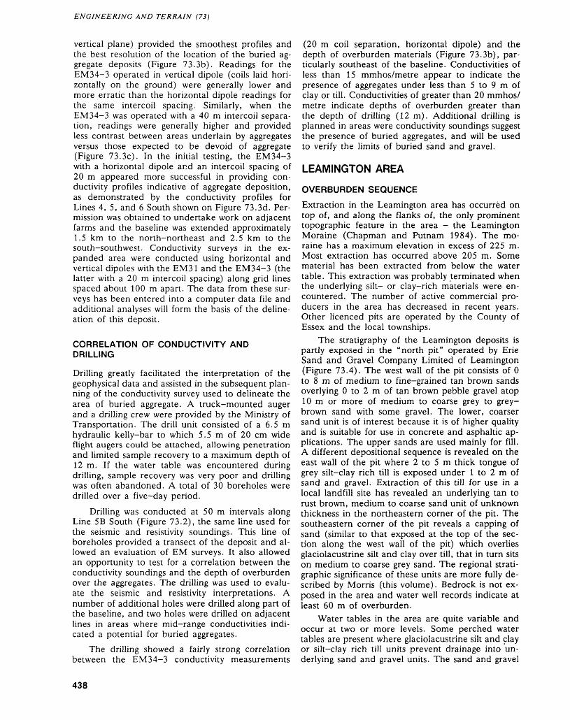
ENGINEERING AND TERRAIN (73)
vertical plane) provided the smoothest profiles and the best resolution of the location of the buried ag gregate deposits (Figure 73.3b). Readings for the EM34-3 operated in vertical dipole (coils laid hori zontally on the ground) were generally lower and more erratic than the horizontal dipole readings for the same intercoil spacing. Similarly, when the EM34-3 was operated with a 40 m intercoil separa tion, readings were generally higher and provided less contrast between areas underlain by aggregates versus those expected to be devoid of aggregate (Figure 73.3c). In the initial testing, the EM34-3 with a horizontal dipole and an intercoil spacing of 20 m appeared more successful in providing con ductivity profiles indicative of aggregate deposition, as demonstrated by the conductivity profiles for Lines 4, 5, and 6 South shown on Figure 73.3d. Per mission was obtained to undertake work on adjacent farms and the baseline was extended approximately 1.5 km to the north-northeast and 2.5 km to the south-southwest. Conductivity surveys in the ex panded area were conducted using horizontal and vertical dipoles with the EM31 and the EM34-3 (the latter with a 20 m intercoil spacing) along grid lines spaced about 100 m apart. The data from these sur veys has been entered into a computer data file and additional analyses will form the basis of the deline ation of this deposit.
CORRELATION OF CONDUCTIVITY AND DRILLING
Drilling greatly facilitated the interpretation of the geophysical data and assisted in the subsequent plan ning of the conductivity survey used to delineate the area of buried aggregate. A truck-mounted auger and a drilling crew were provided by the Ministry of Transportation. The drill unit consisted of a 6.5 m hydraulic kelly-bar to which 5.5 m of 20 cm wide flight augers could be attached, allowing penetration and limited sample recovery to a maximum depth of 12 m. If the water table was encountered during drilling, sample recovery was very poor and drilling was often abandoned. A total of 30 boreholes were drilled over a five-day period.
Drilling was conducted at 50 m intervals along Line 5B South (Figure 73.2), the same line used for the seismic and resistivity soundings. This line of boreholes provided a transect of the deposit and al lowed an evaluation of EM surveys. It also allowed an opportunity to test for a correlation between the conductivity soundings and the depth of overburden over the aggregates. The drilling was used to evalu ate the seismic and resistivity interpretations. A number of additional holes were drilled along part of the baseline, and two holes were drilled on adjacent lines in areas where mid-range conductivities indi cated a potential for buried aggregates.
The drilling showed a fairly strong correlation between the EM34-3 conductivity measurements
(20 m coil separation, horizontal dipole) and the depth of overburden materials (Figure 73.3b), par ticularly southeast of the baseline. Conductivities of less than 15 mmhos/metre appear to indicate the presence of aggregates under less than 5 to 9 m of clay or till. Conductivities of greater than 20 mmhos/ metre indicate depths of overburden greater than the depth of drilling (12 m). Additional drilling is planned in areas were conductivity soundings suggest the presence of buried aggregates, and will be used to verify the limits of buried sand and gravel.
LEAMINGTON AREA
OVERBURDEN SEQUENCE
Extraction in the Leamington area has occurred on top of, and along the flanks of, the only prominent topographic feature in the area - the Leamington Moraine (Chapman and Putnam 1984). The mo raine has a maximum elevation in excess of 225 m. Most extraction has occurred above 205 m. Some material has been extracted from below the water table. This extraction was probably terminated when the underlying silt- or clay-rich materials were en countered. The number of active commercial pro ducers in the area has decreased in recent years. Other licenced pits are operated by the County of Essex and the local townships.
The stratigraphy of the Leamington deposits is partly exposed in the "north pit" operated by Erie Sand and Gravel Company Limited of Leamington (Figure 73.4). The west wall of the pit consists of O to 8 m of medium to fine-grained tan brown sands overlying O to 2 m of tan brown pebble gravel atop 10 m or more of medium to coarse grey to grey- brown sand with some gravel. The lower, coarser sand unit is of interest because it is of higher quality and is suitable for use in concrete and asphaltic ap plications. The upper sands are used mainly for fill. A different depositional sequence is revealed on the east wall of the pit where 2 to 5 m thick tongue of grey silt-clay rich till is exposed under l to 2 m of sand and gravel. Extraction of this till for use in a local landfill site has revealed an underlying tan to rust brown, medium to coarse sand unit of unknown thickness in the northeastern corner of the pit. The southeastern corner of the pit reveals a capping of sand (similar to that exposed at the top of the sec tion along the west wall of the pit) which overlies glaciolacustrine silt and clay over till, that in turn sits on medium to coarse grey sand. The regional strati graphic significance of these units are more fully de scribed by Morris (this volume). Bedrock is not ex posed in the area and water well records indicate at least 60 m of overburden.
Water tables in the area are quite variable and occur at two or more levels. Some perched water tables are present where glaciolacustrine silt and clay or silt—clay rich till units prevent drainage into un derlying sand and gravel units. The sand and gravel
438
DOUGLAS G. VANDERVEER AND STEVE SZOKE
i i i i io o o o oo o in o TCO (O CO (VI O-J -J -i -t -J
l1
11
x*GOSFEJDN.TP. ii r^ rjfc rA r^ j^ ?* ?* ^iGOSFIELD S. TP. L
t'ERESAND t xAND GRAVEL liCO. LTD. " XLICENCE A iPENONG T X
i K l
t! i*2 v \
jx ili, '2 X i
W ' iT x !i iAX 1
Ix io: X
J- i
* *X j Stj-N*. Mt*-|
S0CC
i iH
x xNORTH PfTERESAND AND GRAVELCO. LTD.
X
W; m im iL o fm o o •IB 0 B 0 "J• B CD B] to BB en•It -fi
SDNRO
1
BJ iAoe'-*^
1
—— i
MERSEA B TOWNSHPLICENSED — AREA
a: 30 Co *CM C-1
, J
1
B
~
i
5t ̂ t "t "t "t rSriri rt "t rt yt y CONCESSONROAOS^^"
f;' * i' m\r T
1 1^11'
fb
^
*)t *x r/t TJ
1ffiS
5j
!
]]
IASELINE
LEGEND
_____ LICENCED PIT BOUNDARY (APPROX.)^/^ikirM i/^TH/rrx/ 01 IDX/CX/ i IMCO
L600WB BUILDINGS
•*-RS -^ REFRACTION (S WAVE) SOUNDINGS
^-RP -*. REFRACTION (P WAVE) SOUNDINGS
•^-RF-*- REFLECTION SOUNDINGS X AUGER BOREHOLES (1988)
( SCALE W METRES
0 200 400 600
Figure 73.4. Leamington buried aggregate delineation survey area - location of conductivity survey lines and seismic soundings (all property and licenced pit boundaries are approximate).
are extracted by front end loaders, or by larger backhoes in areas of perched water tables.
SELECTION OF TEST AREA
Although there are substantial amounts of sand ex posed in various pits in the area, most is of poor quality for concrete or asphaltic applications. There is a limited supply of higher quality materials such as that found in the lower levels of the northern pit (described above) operated by Erie Sand and Gravel Company Limited.
Efforts to assess techniques that could be used to delineate high quality sand buried either beneath poorer quality sand, or clay or till were concentrated along the northern edge of the depositional area. Test pit data on property recently optioned to Erie Sand and Gravel Company Limited was made avail able and provided a preliminary means of validating the conductivity readings obtained during the initial EM surveys along lines L600W and L800W in this area (Figure 73.4).
An east-west trending baseline along South Gos field Township Concession Road 5, perpendicular to Essex County Road 31 in South Gosfield and Mer sea townships, was selected (Figure 73.4). Grid lines off the baseline, parallel to Essex County to Road 31 and spaced 150 to 200 m apart, were established between Concession Road 5 and Concession Road 6. These were extended into areas expected to be devoid of aggregates in order to establish the back ground range of conductivities in areas of clay or till. Two lines (L600W and L800W) were selected for the trial surveys. Based on experience gathered at Pinehurst, the survey concentrated on collecting conductivity readings using the EM34-3 in the hori zontal dipole mode using both a 20 m and a 40 m intercoil separation.
FIELD TRIALSIn areas expected to be underlain by 10 to 18 m of sand, the EM34-3 soundings using the 20 m coil separation had very low conductivities (5 to 10 mmhos/metre) (Figure 73.5). Between 1000 and
439
ENGINEERING AND TERRAIN (73)
* EM34-3 20M coil Q EM34-3 40M coil
Overburden
200 400 800 1000 1200 1400 1600
DISTANCE NORTH OF BASELINE (metres)
Figure 73.5. EM34-3 conductivity profiles (horizontal di- poles, Line 600 West) and overburden thickness from boreholes (combined Line 600/800 West), Leamington area.
1100 m north, the conductivity increased, then de creased across a band of glacial till exposed at the surface. The conductivity then increased north of 1400 m indicating deepening overburden and/or the absence of aggregates below the surface. These pre liminary results indicate that the EM34-3, operated in a horizontal dipole mode with a 20 m coil spac ing, adequately defines the presence of thick near- surface sands or gravels with very low conductivities.
The conductivity soundings (10 to 18 mmhos/ metre), using a 20 m intercoil separation, indicated that the area in the vicinity of Concession Road 6 may be underlain by a sand unit not previously iden tified. This hypothesis was substantiated by later seismic work and confirmed by subsequent drilling.
Soundings using the EM34-3 (horizontal dipole) and a 40 m coil spacing generally showed slightly higher readings and variations not recorded using a 20 m coil spacing. This is perhaps a reflection of variations in conductivities of either more deeply buried unconsolidated units or within the bedrock.
Seismic surveys along test lines L600W and L800W (Figure 73.4), were conducted by Thompson. These surveys included: refraction P wave soundings in areas of deep sand and gravel ex pected to be devoid of significant layers or seams of clay or till; and, reflection and refraction S wave soundings in areas suspected to be underlain by till or clay. Refraction P wave soundings identified the following contacts: (a) the topsoil mantle over fine grained sands; and, (b) the water table. This tech nique could not distinguish the contact between the poorer quality sands and the underlying coarser sand and gravel units (Lloyd Thompson, personal com munications, 1988). Reflection soundings (P wave) in areas of complex stratigraphy provided the most information. Reflectors are thought to indicate the topsoil/till, till/sand-gravel, and sand-gravel/bed rock contacts. Shear wave refraction in areas of till over sand and gravel discerned the contact between the till and underlying aggregates, but gave no fur
ther reflectors because the thickness of sediments absorbed or diminished the seismic signal.
CORRELATION OF CONDUCTIVITY AND DRILLING
Boreholes were drilled using the Ministry of Trans portation drill along lines L600W and L800W (Fig ure 73.4). There is a strong correlation between the conductivity results and the thickness of sand and the amount of overlying material (Figure 73.5). In areas with lower conductivities (less than 10 mmhos/ metre), little silt or clay cover was encountered and drilling (to a maximum depth of 12 m) terminated in sand. Boreholes in areas with conductivities of 10 to 18 mmhos/metre, encountered 4 to 9 m of clay or till over sand. Drilling in areas of higher conduc tivities (greater than 20 mmhos/metre) revealed only overburden.
FACTORS AFFECTING CONDUCTIVITY SURVEYDrawbacks to the use of conductivity surveys in clude: (a) difficulty in obtaining stable readings dur ing periods of atmospheric electrical interference; and (b) abnormally high or low readings for all con figurations of the EM31 and EM34-3 when readings are taken within 50 to 100 m of power and buried gas lines, or near water lines, drainage tiles, metal fences, or open water. This is particularly evident if the intercoil orientation is parallel to the trend of these linear features. In these situations, the instru ment is often electronically overloaded and no accu rate reading is possible. These limitations must be addressed during planning for a conductivity survey, and when interpreting the data collected. In general, the EM31 operated in a vertical dipole mode and the EM34-3 operated in the horizontal dipole posi tion with a 20 m coil spacing are not as susceptible to these types of interference.
CONCLUSIONSThe EM conductivity surveys are time efficient and cost effective methods of delineating buried aggre gates. These techniques are most effective when combined with drilling and supplemented by select geophysical and resistivity soundings.
The results of drilling in the middle range of conductivities (10 to 18 mmhos/metre) in the Pine- hurst and Leamington areas verify the value of using the Geonics EM34-3 as a means of locating and de lineating aggregates buried beneath upwards of 9 to 12 m of conductive overburden. The survey in the Leamington area indicates that conductivities of less than 10 mmhos/metre indicate sand or gravel ex ceeding 12 m in thickness with little or no silt- or clay-bearing cover.
Shear wave refraction soundings are useful in es tablishing the depth to the top of buried sand or
440
DOUGLAS G. VANDERVEER AND STEVE SZOKE
gravel units. In areas of shallower bedrock (less than 25 m), they provide the depth to the bedrock sur face, enabling the thickness of the sand or gravel to be determined. Resistivity soundings and reverse modeling are useful indicators of stratigraphy and unit thicknesses. Both resistivity and seismic sound ings, although adding valuable data concerning the stratigraphy of a site, are extremely time consuming in comparison to an EM conductivity survey. The EM34-3 operated in the horizontal dipole with a coil spacing of 20 m is the preferred method to de lineate buried aggregates in southwestern Ontario, and should be useful in surveys to locate additional buried reserves in this region.
ACKNOWLEDGMENTS
The program benefited from the cooperation of nu merous private individuals and pit operators who provided test pit and drilling data as well as access to private properties. The authors benefited from dis cussions about glacial stratigraphy with Bern Feenstra, Regional Geologist, Southern Ontario Re gion, London, Ministry of Northern Development and Mines. Thanks are also extended to Lloyd Thompson and John Greenhouse for their respective contributions and discussions of the geophysical techniques used in this study. The use of the Ontario Ministry of Transportation's drilling rig and drilling crew is gratefully acknowledged. Derek Finley, Rob
Bucci (on loan from the Ministry of Northern Devel opment and Mines, London Regional Geologist's Office), and Joel Mejilla were cheerful and capable assistants and are thanked for their significant con tribution to the project.
REFERENCESBird and Hale Ltd.1987: Development of a Ground Resistivity Technique for
Locating Buried Granular Deposits; Technical Report ME-87-14, Published by The Research and Develop ment Branch, Ontario Ministry of Transportation and Communications, 115p.
Chapman, L.J., and Putnam, D.F.1984: The Physiography of Southern Ontario, 3rd Edition;
Ontario Geological Survey, Special Volume 2, 270p.Accompanied by Map P.2715, scale 1:600 000.
Gorrell, G.A.In Prep.: Buried Sand and Gravel Features and Blending
Sands in Eastern Ontario; Ontario Geological Survey, Open File Report, Ministry of Northern Development and Mines Regional Office, Tweed.
McNeil, J.D.1980: Electromagnetic Terrain Conductivity Measurement at
Low Induction Numbers; Technical Note TN-6,Geonics Ltd., Mississauga, Ontario.
Ontario Geological SurveyIn Prep.: Aggregate Resources Inventory of Raleigh and Har
wich Townships, Kent County, Southern Ontario; Ag gregate Resources Inventory Paper 126.
441
74. Project Number 88-37. Paleozoic Geology of the Gypsum Deposits in the James Bay Lowland
R.K. Bezys 1 and M.P. Bradshaw2
1 Geologist, Paleozoic/Mesozoic Geology Subsection, Engineering and Terrain Geology Section, Ontario Geological Survey, Toronto.
2Staff Geologist, Ministry of Northern Development and Mines, Timmins.
INTRODUCTIONDetailed Paleozoic mapping of the Middle Devonian Moose River Formation was undertaken in the James Bay Lowland in 1988, to delineate the distri bution of its gypsiferous horizons.
A previous study of the gypsum deposits was un dertaken by Guillet (1964), who conducted a gen eral mapping expedition in the area. Since that time, there has been considerable interest in the geology and subsurface areal- extent of these deposits. In the fall of 1987, reconnaissance work on the gypsum de posits was carried out by the Mineral Development Section of the Ontario Ministry of Northern Devel
opment and Mines, Toronto. As a result of encour aging data from this reconnaissance study, the pre sent project was undertaken. The objective of the James Bay Lowland gypsum study is to present de tailed geological information on, and a resource map of, these gypsum deposits.
The Moose River Formation outcrops along the Kwataboahegan, Cheepash, Moose, North French, Wakwayokastic, and Kiasko rivers, and at Gypsum Mountain in the James Bay Lowland. The main gyp sum deposits are exposed along the banks of the Cheepash and Moose rivers, and at Gypsum Moun tain (local name).
Figure 74.1. Location of study area.
This project D.1.6. is part of the five year Canada-Ontario 1985 Mineral Development Agreement (COMDA), a subsidiary agreement to the Economic and Regional Development Agreement (ERDA) signed by the governments of Canada and Ontario.
442
R.K. BEZYS AND M.P. BRADSHAW
LOCATIONThe study area is 60 km southwest of Moosonee and approximately 270 km due north of Timmins (see Figure 74.1). The area lies within the Moose River Basin. The study area is delineated by Latitudes 50 0 37' and 51 0 05'N, and Longitudes 80 0 45' and 81 0 25'W. The areas mapped include: approximately 18 km of river bank exposures on the Cheepash River (both sides) in Roebuck and Maher townships; about 9 km of exposure on the Moose River in Can field, Carroll, and Ebbitt townships; and approxi mately l km2 of exposure at Gypsum Mountain (Stapells Township and the Kiasko River Area).
ACCESS
The study area is low lying and poorly drained, with significant bog development despite the presence of numerous rivers. The area can be accessed in the summer by train (the Ontario Northland Railway travels from Cochrane to Moosonee), river (canoe or inflatable boat), or helicopter. In the winter, ac cess may also be gained by winter roads. For this field season, field equipment was transported by train to the community of Moose River (see Figure 74.1). From Moose River, a helicopter was used to transport the field equipment to the first base camp on an island in the middle of the Moose River (2.5 km northeast of Moose River). Halfway through the season, a camp move was made by heli copter to a second base camp on the Cheepash River, approximately 30 km north of Moose River.
The Moose River Formation outcrops along the Moose River were accessed with an inflatable boat (Zodiac®) fitted with a 9.9 HP motor. The low water level (and numerous rapids) on the Cheepash River required the use of a 17-foot aluminum ca noe. The outcrops at Gypsum Mountain were ac cessed with the Zodiac®, after being flown into the area by helicopter.
GENERAL GEOLOGYThe Moose River Formation was first defined by Dyer (1929, 1930), but Martison (1953) redefined the stratigraphy and considered the Moose River Formation to be represented by the middle member of the Abitibi Formation. Sanford et al. (1968), and Sanford and Norris (1975), reinstated the term "Moose River Formation" to apply to Dyer's original definition of the unit.
The Moose River Formation appears in outcrop as an unfossiliferous sequence of limestone, argil laceous limestone, minor pelletoidal limestone, dolomitic limestone, brecciated carbonates, and gyp sum. Shale, secondary selenite, and anhydrite may also be present (Sanford and Norris 1975). The Moose River Formation has a sharp contact with the overlying Murray Island Formation, a banded se quence of fossiliferous calcareous dolostone, lime
stone, and argillaceous limestone. The Moose River Formation is underlain by the Kwataboahegan For mation, which is a fossiliferous biostromal and biohermal limestone (Figure 74.2). Nowhere in the Moose River Basin is a complete section of the Moose River Formation exposed. The thickest known outcrop sequence is 17 m, on the Abitibi River at Long Rapids. The thickest drillhole se quence is the Mike Island drillhole at Moose River, at 89 m (Sanford and Norris 1975). Exposures of Moose River Formation limestone are rare on both the Moose and Cheepash rivers, and where present consist of a dark brown to tan, very finely to finely crystalline, laminated to massive limestone.
The maximum development of gypsum occurs along the Moose River Arch, a broad anticlinal northwest-trending basement high. This belt of gyp sum is approximately 70 km long and about 17 km wide. In holes drilled to the southwest and northeast of this belt, only minor amounts of gypsum were in tersected.
Gypsum was first reported in the Moose River Basin by R. Bell (1877). Subsequent reports by J.M. Bell (1904) and Dyer (1929) described in greater detail the gypsum sections, and the possible economic development of the deposits. The most re cent publication describing the gypsum deposits was by Guillet (1964), who carried out a geological and economic investigation of the gypsum, augmented with drilling results from a program conducted by the Moosonee Gypsum and Exploration Company in 1963.
MOOSE RIVER GYPSUM EXPOSURES
Exposures of gypsum occur on the Moose River, north of the Ontario Northland Railway bridge at the community of Moose River. The north bank out crops extend for approximately 4 km, and the south bank exposures extend for approximately 3.5 km. A second outcrop of gypsum, approximately l km in length, occurs 11 km east of the railway bridge on the south bank of the Moose River.
The Moose River gypsum exposures consist pre dominantly of two units: 1) massive to banded pure gypsum; overlain by, 2) gypsum breccia. Outcrop ex posures of both units range in thickness from- less than 0.5 m to 5 m, with an average thickness of 2.5 m. The lower gypsiferous unit typically consists of medium to finely crystalline massive white gyp sum, with a chickenwire mosiac texture. The colour of the gypsum varies through white, orange, pink, brown, and grey. The massive gypsum in some expo sures grades into an interbanded unit of dark brown selenite and white gypsum. Some outcrops of mas sive white gypsum have abundant, medium to finely crystalline, dark brown selenite eyes, which give them a distinctive appearance.
The massive white gypsum unit has a sharp con tact with the overlying gypsum breccia unit. The breccia is a conspicuous rock type on the Moose
443
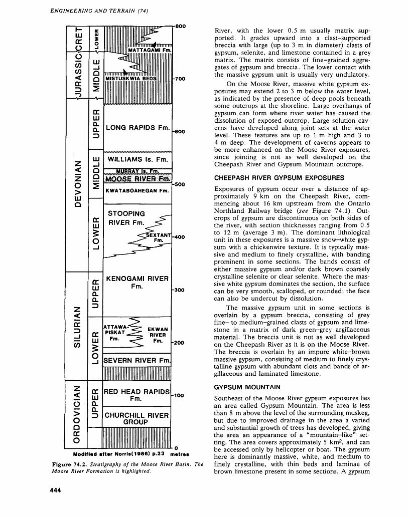
ENGINEERING AND TERRAIN (74)
h-LLJ DC O
JURASSIC
Z<z o>LU O
SILURIAN
NVIOIAOC
i—iDC O
E lil
0-iL. MA!u^aii-J k ^HO 1 IIIIIIIIIOT1IIIIIQ MISTUSKWIA
i
DC LUQ; LONG RAID
111 WILLIAM.JLJ MURRAYQ
KWATABOA
STOOPS g RIVER F
5O --—1 ^ — ̂
3. KENOGA lil Fr 0. O.ID
-*^ATTAWA-^
^ PISKAT^^
HI Fm- ^
>
S SEVERN F
DC RED HEAIW Fn Q.O. D CHURCHII
GRC
II IIIIJ4P1" *""' [P^
W" AIIIIIIIMlllllllllI
ITAGAMI Fm.q [Mm k B -700
P|OS Fm. .600
S Is. Fm.f tinlin. ' m
-500 HEGAN Fm.
'G ^m. ^^
^EXTANT .4OO ^m^
Ml RIVERn " -300
>^ EKWAN ^ RIVER^ Fw- -200
MVER Fm
D RAPIDS . 100
uL RIVER HIP
,, ,, ,, ,.,, ,, . Q
Modified after Norrls(1986) p.23 metres
Figure 74.2. Stratigraphy of the Moose River Basin. The Moose River Formation is highlighted.
River, with the lower 0.5 m usually matrix sup ported. It grades upward into a clast-supported breccia with large (up to 3 m in diameter) clasts of gypsum, selenite, and limestone contained in a grey matrix. The matrix consists of fine-grained aggre gates of gypsum and breccia. The lower contact with the massive gypsum unit is usually very undulatory.
On the Moose River, massive white gypsum ex posures may extend 2 to 3 m below the water level, as indicated by the presence of deep pools beneath some outcrops at the shoreline. Large overhangs of gypsum can form where river water has caused the dissolution of exposed outcrop. Large solution cav erns have developed along joint sets at the water level. These features are up to l m high and 3 to 4 m deep. The development of caverns appears to be more enhanced on the Moose River exposures, since jointing is not as well developed on the Cheepash River and Gypsum Mountain outcrops.
CHEEPASH RIVER GYPSUM EXPOSURES
Exposures of gypsum occur over a distance of ap proximately 9 km on the Cheepash River, com mencing about 16 km upstream from the Ontario Northland Railway bridge (see Figure 74.1). Out crops of gypsum are discontinuous on both sides of the river, with section thicknesses ranging from 0.5 to 12 m (average 3 m). The dominant lithological unit in these exposures is a massive snow-white gyp sum with a chickenwire texture. It is typically mas sive and medium to finely crystalline, with banding prominent in some sections. The bands consist of either massive gypsum and/or dark brown coarsely crystalline selenite or clear selenite. Where the mas sive white gypsum dominates the section, the surface can be very smooth, scalloped, or rounded; the face can also be undercut by dissolution.
The massive gypsum unit in some sections is overlain by a gypsum breccia, consisting of grey fine- to medium-grained clasts of gypsum and lime stone in a matrix of dark green-grey argillaceous material. The breccia unit is not as well developed on the Cheepash River as it is on the Moose River. The breccia is overlain by an impure white-brown massive gypsum, consisting of medium to finely crys talline gypsum with abundant clots and bands of ar gillaceous and laminated limestone.
GYPSUM MOUNTAIN
Southeast of the Moose River gypsum exposures lies an area called Gypsum Mountain. The area is less than 8 m above the level of the surrounding muskeg, but due to improved drainage in the area a varied and substantial growth of trees has developed, giving the area an appearance of a "mountain-like" set ting. The area covers approximately 5 km2 , and can be accessed only by helicopter or boat. The gypsum here is dominantly massive, white, and medium to finely crystalline, with thin beds and laminae of brown limestone present in some sections. A gypsum
444
R.K. BEZYS AND M.P. BRADSHAW
breccia unit can overlie the massive gypsum unit in some outcrops. Large natural bridges of gypsum can be seen spanning the muskeg.
ECONOMIC GEOLOGY
The gypsum deposits of the Moose River Basin have been the focus of considerable interest ever since they were first described by Robert Bell in 1875. Ex ploration and evaluation of the gypsum outcrops had been hampered by the inaccessibility of the area in the first few decades of this century. However, with completion of the Ontario Northland Railway to Moosonee, sporadic exploration by various compa nies has taken place. In 1923, W. Tees Curran ac quired patents on 12 claims he staked along the banks of the Moose River. In 1955, the Atlas Gyp sum Corporation Limited staked 32 claims surround ing the Curran property on the north side of the Moose River. Some preliminary work was carried out, but the claims were allowed to lapse. During the fall of 1963, the Moosonee Gypsum Company car ried out an 18-hole Drilling Program on the Cheepash River, to test the lateral extent of the gyp sum beds. In 1985, Edward Jerome staked 16 claims in Carroll and Canfield townships on the west shore of the Moose River. No work was ever reported on the claims and they were subsequently cancelled in June of 1986.
Results from the geological mapping carried out this summer indicate that the most attractive of the gypsum deposits may be that of the Cheepash River. Geochemical analyses carried out this fall will help determine the purity of the gypsum on the Cheepash River, and in the other locations. Stratigraphic cor relation of the two units between the significant ex posures will be attempted.
To complement the summer field work, the Mineral Development Section of the Ministry of Northern Development and Mines, Toronto, is also undertaking an assessment of high-purity gypsum markets in North America. The results of this study should be known early next year. These results will be combined with the data from the geological study and published as an Industrial Mineral Background Paper.
ACKNOWLEDGMENTSThe author is indebted to Andrea Henry and Joel Mejilla for their able assistance during this field-sea son. Special thanks are extended to the staff of the Ontario Ministry of Northern Development and Mines office in Timmins, and to the Ontario Minis try of Natural Resources Timmins Fire Centre, who arranged for helicopter support.
REFERENCESBell, J.M.1904: Economic Resources of the Moose River Basin; Ont
ario Bureau of Mines, Annual Report for 1904, Vol ume 13, Part l, p. 135-197.
Bell, R.1877: Report on an Exploration in 1875 Between James Bay
and Lakes Superior and Huron; Geological Survey of Canada, Report on Progress 1875-1876, p.294-342.
Dyer, W.S.1929: Geology and Economic Deposits of the Moose River
Basin; Ontario Department of Mines, Annual Report for 1928, Volume 37, Part 6, p. 1-80. Accompanied by Map 37p.
1930: General Review of Non-Metallic Mineral Resources; Ontario Department of Mines, Annual Report for 1929, Volume 38, Part 4, p. 1-18.
Guillet, G.R.1964: Gypsum in Ontario; Ontario Department of Mines,
Industrial Mineral Report No. 18, 126p.Martison, N.W.1953: Petroleum Possibilities of the James Bay Lowland
Area; Ontario Department of Mines, Annual Report for 1952, Volume 61, Part 6, p. l-58, plus appendi ces, p.59-95. Accompanied by Map 1952-53.
Norris, A.W.1986: Review of Hudson Platform Stratigraphy and
Biostratigraphy; p. 17-42 in Canadian Inland Seas, edited by I.P. Martini, Elsevier, Amsterdam, 494p.
Sanford, B.V., Norris, A.W., and Bostock, H.H.1968: Geology of the Hudson Bay Lowlands (Operation
Winisk); Geological Survey of Canada, Paper 67-60, p. 1-45, 4 figures, 23 plates, and Preliminary Series Map 17-1967.
Sanford, B.V., and Norris, A.W.1975: Devonian Stratigraphy of the Hudson Platform, Part
1: Stratigraphy and Economic Geology, Part 2: Out crop and Subsurface Sections; Geological Survey of Canada, Memoir 379. Part l, 124p.; Part 2, 248p.
445
75. Project Number 88-2. Paleozoic Geology of the Central Bruce PeninsulaO.K. Armstrong
Geologist, Paleozoic/Mesozoic Geology Subsection, Engineering and Terrain Geology Section, Ontario Geological Survey, Toronto.
INTRODUCTION
The Paleozoic strata exposed in the central portion of the Bruce Peninsula was mapped during the sum mer of 1988. This was the second year of a multi- year geological mapping project designed to cover the entire Bruce Peninsula. The northern portion of the Bruce Peninsula was mapped during the summer of 1987 (Armstrong 1987) and the preliminary geol ogy map covering that area is forthcoming (Arm strong and Dubord, in preparation).
The overall objective of the Bruce Peninsula Pa leozoic Mapping Project is to produce 1:50 000 scale geological maps of the Peninsula, incorporating updated stratigraphic terminology and new outcrop and subsurface information. Among other uses, these maps will aid in the delineation and evaluation of potential resources such as building and crushed stone.
Specific objectives in the 1988 field season in cluded a) documentation of the geologic setting of building stone quarries in the map area; b) investiga tion of karst features such as pavements, caves, and dissolution widened joints; c) systematic measure ment of joints and other structural features; d) in vestigation of known zinc occurrences; e) continued investigation of the relationship of the Eramosa
Member with the Amabel and Guelph formations; and f) utilization of subsurface information from the Ontario Geological Survey's regional stratigraphic drillhole, OGS-82-4, drilled 6 km northwest of Wiarton in 1982 (Johnson et al, 1985).
LOCATIONThe 1988 map area (see Figure 75.1) includes the central Bruce Peninsula between Latitudes 44 0 45'N and 45 0 00'N. This area is covered by 1:50 000 scale NTS map sheets of Cape Croker (41 A/14) and White Cloud Island (41 A/15). The map area can be accessed by Highway 6 via Owen Sound and Wiarton. Most of the map area is readily accessible via public and private roads and trails, and by the Bruce Trail.
GENERAL GEOLOGYThe Paleozoic units exposed on the central Bruce Peninsula are listed in the stratigraphic column in Figure 75.2. They range in age from the Upper Or dovician Georgian Bay Formation to the Middle Si lurian Guelph Formation. The stratigraphic nomen clature used in this study is modified after previous investigators of Paleozoic geology on the Bruce Pen insula (Williams 1919; Caley 1945; Bolton 1953,
Figure 75.1. Location of the Central Bruce Peninsula map area. Scale: 1:1 584 000 or l inch to 25 miles.
446
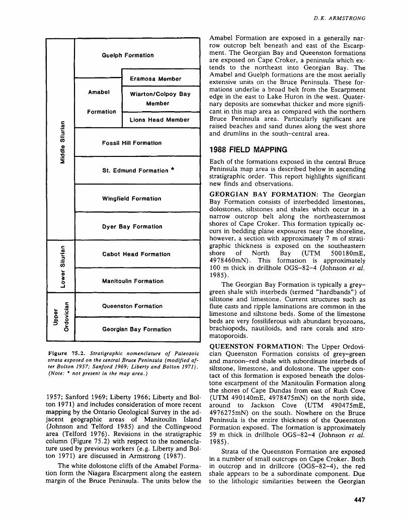
D.K. ARMSTRONG
cCOk.3
0)0)•o •o2
Lower Silurian
c co15 o a > a o^ "2
O
Guelph Formation
~" — Eramosa Membc
Amabel Wiarton/ColpoyMember
Formation - ——————————— ————
jr
Bay
Lions Head Member
Fossil Hill Formation
St. Edmund Formation *
Wingfield Formation
Dyer Bay Formation
Cabot Head Formation
Manitoulin Formation
Queenston Formation
Georgian Bay Formation
Figure 75.2. Stratigraphic nomenclature of Paleozoic strata exposed on the central Bruce Peninsula (modified af ter Bolton 1957; Sanford 1969; Liberty and Bolton 1971). (Note: * not present in the map area.)
1957; Sanford 1969; Liberty 1966; Liberty and Bol ton 1971) and includes consideration of more recent mapping by the Ontario Geological Survey in the ad jacent geographic areas of Manitoulin Island (Johnson and Telford 1985) and the Collingwood area (Telford 1976). Revisions in the stratigraphic column (Figure 75.2) with respect to the nomencla ture used by previous workers (e.g. Liberty and Bol ton 1971) are discussed in Armstrong (1987).
The white dolostone cliffs of the Amabel Forma tion form the Niagara Escarpment along the eastern margin of the Bruce Peninsula. The units below the
Amabel Formation are exposed in a generally nar row outcrop belt beneath and east of the Escarp ment. The Georgian Bay and Queenston formations are exposed on Cape Croker, a peninsula which ex tends to the northeast into Georgian Bay. The Amabel and Guelph formations are the most aerially extensive units on the Bruce Peninsula. These for mations underlie a broad belt from the Escarpment edge in the east to Lake Huron in the west. Quater nary deposits are somewhat thicker and more signifi cant in this map area as compared with the northern Bruce Peninsula area. Particularly significant are raised beaches and sand dunes along the west shore and drumlins in the south-central area.
1988 FIELD MAPPINGEach of the formations exposed in the central Bruce Peninsula map area is described below in ascending stratigraphic order. This report highlights significant new finds and observations.GEORGIAN BAY FORMATION: The Georgian Bay Formation consists of interbedded limestones, dolostones, siltstones and shales which occur in a narrow outcrop belt along the northeasternmost shores of Cape Croker. This formation typically oc curs in bedding plane exposures near the shoreline, however, a section with approximately 7 m of strati graphic thickness is exposed on the southeastern shore of North Bay (UTM 500180mE, 49784 60mN). This formation is approximately 100 m thick in drillhole OGS-82-4 (Johnson et al. 1985).
The Georgian Bay Formation is typically a grey- green shale with interbeds (termed "hardbands") of siltstone and limestone. Current structures such as flute casts and ripple laminations are common in the limestone and siltstone beds. Some of the limestone beds are very fossiliferous with abundant bryozoans, brachiopods, nautiloids, and rare corals and stro- matoporoids.QUEENSTON FORMATION: The Upper Ordovi cian Queenston Formation consists of grey-green and maroon-red shale with subordinate interbeds of siltstone, limestone, and dolostone. The upper con tact of this formation is exposed beneath the dolos tone escarpment of the Manitoulin Formation along the shores of Cape Dundas from east of Rush Cove (UTM 490140mE, 4978475mN) on the north side, around to Jackson Cove (UTM 490475mE, 4976275mN) on the south. Nowhere on the Bruce Peninsula is the entire thickness of the Queenston Formation exposed. The formation is approximately 59 m thick in drillhole OGS-82-4 (Johnson et al. 1985).
Strata of the Queenston Formation are exposed in a number of small outcrops on Cape Croker. Both in outcrop and in drillcore (OGS-82-4), the red shale appears to be a subordinate component. Due to the lithologic similarities between the Georgian
447
ENGINEERING AND TERRAIN (75)
Bay and Queenston formations, outcrops which lack red shale are difficult to assign (i.e. at the northeast end of Cape Croker).
The Queenston Formation contains numerous sedimentary structures indicative of shallow water deposition. These include ripples, mudcracks, and burrows. Locally, in some red shale outcrops, mud cracks are grey-green.
MANITOULIN FORMATION: The Lower Silu rian Manitoulin Formation is well exposed in low es carpments along the shores of Cape Dundas (UTM 490815mE, 4977830mN), Cape Paulette (UTM 491850mE, 4974250mN), and Sydney Bay (UTM 492480mE 4970825mN), on the east side of the Bruce Peninsula. In the map area, the maximum thickness of this formation in outcrop is 8 m. Its up per contact, however, is not exposed. In drillhole OGS-82-4 the Manitoulin Formation is 12.5 m thick (Johnson e t al. 1985).
The Manitoulin Formation is a thin-bedded, light grey-brown dolostone unit which is sparsely to very fossiliferous. Chert nodules and lenses are com mon and the fauna is typically silicified. The forma tion commonly exhibits sedimentary structures such as parallel lamination, bioturbation, and locally, low angle cross-bedding. Gypsum nodules, up to 10 cm in diameter, were discovered in the lower part of this formation east of Rush Cove (UTM 490270mE, 4978485mN).
In the lower few metres of the Manitoulin For mation, the dolostone beds become more argil laceous and thin interbeds of grey-green shale oc cur. This suggests that the basal contact of the Lower Silurian Manitoulin Formation with the underlying Upper Ordovician Queenston Formation is lithologi- cally gradational in this area.
CABOT HEAD, DYER BAY, AND WINGFIELD FORMATIONS: The Lower Silurian Cabot Head Formation, and Middle Silurian Dyer Bay and Wingfield formations are shale, dolostone, and shale-dominated units, respectively. The mainly dolostone St. Edmund Formation overlies the Wing field Formation in the northern Bruce Peninsula area but does not occur in this map area.
The lowest of these units, the Cabot Head For mation, is poorly exposed in the map area. In the northern Bruce Peninsula map area, this formation is predominantly a red shale with subordinate grey- green shale beds occurring at the top and as thin interbeds. In the central Bruce Peninsula map area, it is best exposed in a road cut just above Rush Cove (UTM 487400mE, 4977900mN) where approxi mately 2 m of grey-green and red shales of the Cabot Head Formation directly underlie approxi mately 3 m of thin-bedded dolostones of the Dyer Bay Formation. The basal contact of the Cabot Head Formation is not exposed in the map area.
This formation is approximately 25 m thick in drillhole OGS-82-4 (Johnson et al. 1985).
The Dyer Bay Formation is best exposed in the road cut above Rush Cove (UTM 487400mE, 4977900mN). Other, thinner exposures of this for mation occur on Cape Croker as subordinate escarp ments on the slopes below and east of Sydney Bluff (UTM 492455mE, 4973235mN), south of Kings Point Bluff (UTM 496375mE, 4968155mN), and south of Sydney Bluff (UTM 491860mE, 4970225mN). The formation is approximately 5 m thick in drillhole OGS-82-4 (Johnson et al. 1985).
The Dyer Bay Formation consists of very thin- to medium-bedded, light to dark grey, fine- to me dium-crystalline dolostones and argillaceous dolos tones. It is generally fossiliferous containing abun dant bryozoans and brachiopods with fewer corals and gastropods. Sedimentary structures are abun dant and include burrows, planar and ripple lamina tions, and soft sediment deformation features.
The Wingfield Formation consists of inter bedded grey-green shale and grey to grey-brown, fine- to medium-crystalline, thin-bedded dolos tone. The shaly interbeds cause this unit to weather recessively and result in poor exposures. The upper most beds (typically less than 0.5 m thick interval) of the Wingfield Formation are commonly exposed immediately beneath escarpments of the overlying Fossil Hill Formation. The thickest exposure of the Wingfield Formation (2 m) occurs on the shore of Isthmus Bay, just north of Lion's Head (UTM 490105mE, 4982255mN). In drillhole OGS-82-4 (Johnson et al. 1985) the Wingfield Formation is approximately 5 m thick.
The Wingfield Formation is non-fossiliferous, however, burrows are present in some beds. The dolostone beds are locally planar- to ripple-lami nated and commonly contain mudcracks and argil laceous stringers or shale lithoclasts.FOSSIL HILL FORMATION: The Middle Silurian Fossil Hill Formation is well exposed at many locali ties in the map area as a subordinate escarpment beneath the main Niagara Escarpment. It is best ex posed in spectacular bedding plane and small cliff outcrops along the shores of Isthmus Bay (UTM 480100mE, 4982230mN), north of Lion's Head. Other good exposures of the Fossil Hill Formation include escarpments at Barrow Bay (UTM 482050mE, 4978290mN), on the road into Hope Bay (UTM 487135mE, 4971830mN), south of Syd ney Bay (UTM 493560mE, 4969945mN), and the escarpment which trends from the southwest end of Jones Bluff (UTM 494375mE, 49692 lOmN) through Coveney's Hill (UTM 494850mE, 4967570mN) to Malcolm Bluff (UTM 495690mE, 4967180mN to UTM 497250mE, 4966565mN). The thickest exposed interval of the Fossil Hill For mation is the 7 m thick escarpment south of Sydney Bay (UTM 493560mE, 4969945mN). In drillhole OGS-82-4, 17 km to the southwest, the Fossil Hill
448
D. K. ARMSTRONG
Formation is less than 4 m thick (Johnson et al. 1985).
The Fossil Hill Formation consists of very fos- siliferous, fine- to coarse-crystalline, light tan- brown to brown, thin- to medium-bedded dolos tone. Chert is common as thin nodules or lenses. The fauna, which is typically silicified, is dominated by pentamerid brachiopods, however, a variety of corals and stromatoporoids are also plentiful. The paleontology of the Fossil Hill Formation is docu mented by Johnson (1979).
A non-fossiliferous, bioturbated, very fine- to fine-crystalline dolostone interval occurs in the mid dle to lower portion of the Fossil Hill Formation. This "barren zone" thins from a thickness of ap proximately 2 m at Isthmus Bay to less than 20 cm at Cape Croker. The base of this "barren zone" typically occurs about l m above the base of the for mation.
AMABEL FORMATION: The Amabel Formation is formally subdivided into three members (Figure 75.2), however, recent geological investigations on the Bruce Peninsula (Armstrong and Meadows 1988; Armstrong and Dubord, in preparation) have indicated that the uppermost of these, the Eramosa Member, may in fact be more closely associated with the overlying Guelph Formation. This uncertainty in the stratigraphic placement of the Eramosa Member is indicated in Figure 75.2 and the Eramosa Mem ber unit is discussed separately below.
Excluding the Eramosa Member, the Amabel Formation consists of three lithofacies which com prise two members, the Lions Head and the Wiar- ton/Colpoy Bay members. In drillhole OGS-82-4, these two members total approximately 25 m in thickness (Johnson et al. 1985).
The first Amabel Formation lithofacies A consti tutes the Lions Head Member and is a thin- to thick-bedded, fine- to medium-crystalline, light tan to light grey-tan, variably mottled (typically purple- red mottles), sparsely fossiliferous dolostone. It typi cally exhibits flaggy to blocky parting, locally con tains silicified fossils (commonly corals) and chert nodules, and has local minor wispy microstylolites. The lower contact of the Lions Head Member, and of the Amabel Formation, with the underlying Fossil Hill Formation was only discovered at two locations in the map area: at the western end of Kings Point Bluff (UTM 495890mE, 4968275mN); and at Mal colm Bluff (UTM 497250mE, 4966565mN). The contact is sharp with a dramatic decrease in fossil and chert content and the appearance of mottles in the Lions Head Member. However, the matrix dolo mite of both the Fossil Hill Formation and the Lions Head Member appear macroscopically similar.
The Wiarton/Colpoy Bay Member of the Amabel Formation consists of two lithofacies: B the non-biohermal; and C, the biohermal/biostromal.
These are both typically thick- to massive-bedded, planar to undulatory parted, light grey to light grey- tan, variably mottled (typically blue-grey mottles), medium- to coarse-crystalline dolostones. The non- biohermal lithofacies B is sparsely to moderately fos siliferous with crinoids predominating. A variety of other fossil types are also present, including corals, bryozoans, brachiopods, pelecypods, and rare gas tropods and trilobites. Another characteristic of this lithofacies is the fine ribbing exhibited on weathered faces oriented perpendicular to bedding. The ribs are commonly 5 to 10 cm apart and are thought to be related to original bedding. Locally, the geometry of this ribbing suggests cross-bedding. Lithofacies B is thought to constitute most of the Wiarton/Colpoy Bay Member and the Amabel Formation in this map area.
The biohermal/biostromal lithofacies C of the Wiarton/Colpoy Bay Member differs from lithofacies B in the abundance and type of fossils present. Al though crinoids still dominate, frame-building or ganisms, such as large (up to 0.5 m diameter) coral heads and bryozoans become more significant. The lack of distinct flanking beds makes it difficult to discern whether this lithofacies is biostromal or biohermal. Generally, lithofacies C appears to occur towards the top of the Amabel Formation interval.
ERAMOSA MEMBER: Bituminous, thin-bedded dolostone beds occurring in the vicinity of the Guelph/Amabel Formational contact have previ ously been assigned to the Eramosa Member of the Amabel Formation (Bolton 1957; Liberty and Bol ton 1971). A recent investigation of the Eramosa Member on the Bruce Peninsula (Armstrong and Meadows 1988) recognized that the Eramosa strata is contained within (i.e. interbedded with) Guelph Formation strata indicating that the Eramosa Mem ber should perhaps be reassigned to the Guelph For mation. This is supported by regional mapping in the northern Bruce Peninsula (Armstrong 1987; Arm strong and Dubord, in preparation) which identified strata with Eramosa-type characteristics (i.e. bitumi nous, thin-bedded and laminated) occurring well up into the Guelph Formation interval. Formal reas signment of this unit to the Guelph Formation must await completion of the Bruce Peninsula mapping project and comparisons with the Eramosa Member exposed elsewhere in southern Ontario.
Armstrong and Meadows (1988) identified four lithofacies in the Eramosa Member. Their Eramosa lithofacies l A and IB are both laminated and con tain abundant planar microstylolites, however, IB is darker in colour and more bituminous. Their Eramosa lithofacies 2 is light tan-brown to grey- brown, non-laminated, very slightly bituminous dolostone (very similar to Guelph Formation litho facies B described below), and their Eramosa litho facies 3 is bituminous, light to dark brown, with abundant microstylolites. Eramosa lithofacies 3 is thought to be transitional between the laminated
449
ENGINEERING AND TERRAIN (75)
lithofacies 1A and IB and lithofacies 2. In addition to the Eramosa Member lithofacies identified by Armstrong and Meadows (1988), a fifth Eramosa lithofacies, lithofacies 4, is identified in this study as thin to thick, bituminous, coral- and stromato- poroid-rich biostromal dolostone beds.
Liberty and Bolton (1971) designated the road cut at the south end of Sky Lake (UTM 479940mE, 4960130mN) as the reference section for the Eramosa Member on the Bruce Peninsula. This sec tion is approximately 10 m thick and consists of in terbedded Eramosa lithofacies 3, IB and 4 (in order of abundance). Similar, but thinner sequences were discovered to the northwest along the western shore of Sky Lake (UTM 479480mE, 4960625mN) and at the southwest end of Beattie Lake (UTM 478200mE, 4963365mN). Eramosa lithofacies 3, with local minor IB, also occurs in the northwest portion of the map area along the northern and east ern shores of Stokes Bay, around Look About Bay (UTM 471475mE, 4977515mN), and at the east end of Pike Bay (UTM 474800mE, 4968700mN). At the last locality, chert occurs as small nodules and as rare silicified fossils.
Along the eastern shore of Stokes Bay (UTM 4707lOmE, 4981800mN) Eramosa lithofacies 3 is a limestone. This is the only known occurrence of limestone in the entire Middle Silurian sequence on the Bruce Peninsula. Elsewhere in the Stokes Bay and Look About Bay areas, the dolostone of lithofacies 3 is only slightly calcareous.
The Eramosa Member lithofacies 1A is exposed along the southern boundary of the map sheet in an arcuate belt which includes the Ebel, Owen Sound Ledgerock, and Amlan (formerly Ross) quarries and continues to the west almost to Isaac Lake (from UTM 486300mE, 4955200mN to UTM 482480mE, 4956860mN).
In the southern portion of the map area, Eramosa-type lithofacies l A also occurs less than 750 m north of the inactive Cook Quarry (UTM 485535mE, 4956065mN; and 486075mE, 4956375mN), on the west side of the hill north of Wiarton (UTM 488360mE, 4955175mN and vicin ity), and on the top of the upper road cut immedi ately north of Wiarton (UTM 488775mE, 4955350mN).
In the central portion of the map area, Eramosa-type lithofacies 1A beds occur in elongate domes overlying biohermal ridges which are tenta tively assigned to the Guelph Formation. This area extends from the McLay Quarry on the east side of Highway 6 (UTM 481400mE, 4968500mN), west to the presently inactive Bruce Marble and Stone Quarry (UTM 479230mE, 49683lOmN). Beds of Eramosa-type lithofacies 1A were also discovered just northwest of Beattie Lake (UTM 479040mE, 4964570mN).
It is apparent from these occurrences of the Eramosa-type lithofacies and those in the northern Bruce Peninsula (Armstrong and Dubord, in prepa ration), that Eramosa-type lithofacies may occur at various stratigraphic levels in the Guelph Formation interval.GUELPH FORMATION: The Middle Silurian Guelph Formation is the highest stratigraphic unit exposed in the central Bruce Peninsula map area. It has not previously been subdivided into formal members on the Bruce Peninsula, however, three main lithofacies have been recognized in this study.
The dominant Guelph Formation lithofacies A consists of thin- to thick-bedded, fine— to medium- crystalline, light grey-tan to tan, sparsely to moder ately fossiliferous dolostone. The fossil assemblage in lithofacies A is varied and includes gastropods, brachiopods, crinoids, cephalopods, and pele- cypods. Guelph Formation lithofacies B is a thin- to thick-bedded, fine-crystalline, light tan to light brown, slightly bituminous, sparsely fossiliferous dolostone with brown microstylolite swarms or bands. Guelph lithofacies B is lithologically grada- tional with lithofacies of the Eramosa Member (de scribed above).
The biohermal/biostromal Guelph Formation lithofacies C consists of medium- to thick-bedded, fine- to coarse-crystalline, light grey-tan to light creamy tan, variably mottled, sparsely to very fos siliferous dolostone. The variety of fossil types in this lithofacies is similar to that of lithofacies A, except they tend to be more abundant and larger in litho facies C. Locally, large crinoid columnals predomi nate and large coral heads (up to 0.75 m in diame ter) are diagnostic. In some cases, the preponder ance of frame-building organisms and adjacent sub- horizontal (flanking?) beds of lithofacies A or B in dicate that lithofacies C is biohermal.
Three types of Guelph Formation bioherms or biostromes are recognized in the central Bruce Pen insula map area. The first type are small (less than approximately 3 m diameter) mounds or domes which occur on the western shore of the Peninsula. These are typically stromatolitic or stromatoporoidal, but may also contain corals, bryozoans, brachi opods, gastropods, and cephalopods.
The second type of organic build-up in the Guelph Formation are biohermal ridges, typically oriented northwest-southeast, in the order of 10 to 20 m wide by 100 m long, and with very well devel oped flanking or draping beds. These bioherms are most abundant in the central portion of the map area where a zone or "swarm" of them crosses High way 6 (UTM 481140mE, 4968750mN) approxi mately 11.5 km south of Ferndale. At this locality, the biohermal ridges are readily recognizable both on the 1:50 000 scale topography map (NTS 41 A/14) and on 1:10 000 scale aerial photographs. West of Highway 6, this biohermal ridge zone con tinues to the north in a zone from 1.5 to 5 km west
450
D.K. ARMSTRONG
of the highway up to at least Spry, 7.5 km southwest of Ferndale. These ridges are overlain by Guelph lithofacies A and B beds to the west. East of High way 6, the biohermal ridge zone continues for up to 5 km and appears in another zone south of Al bemarle Brook to north of Berford Lake.
The third type of Guelph Formation bioherms cover very large areas (up to l by 3 km) and locally trend approximately northeast-southwest (may be glacially modified). A good example of this type of bioherm occurs approximately 4 km southwest of Ferndale (UTM 476500mE, 4977900mN). A large biohermal zone south and west of Berford Lake may also be of this type. These large bioherms may sim ply be composites of the second type of Guelph bioherm.
The Guelph Formation biohermal lithofacies C and Amabel Formation biohermal lithofacies C are similar in many respects: bedding thickness, colour, mottling, crystal size, faunal abundance and type. The best criteria for distinguishing between the two are the presence and lithofacies type of associated flanking beds.
ECONOMIC GEOLOGYQuarrying has been an important part of the Bruce Peninsula economy since the turn of the century. A number of dolostone units, including the Manitoulin, Amabel and Guelph formations, have been quarried for building stone, aggregate, and lime. Currently, the Eramosa Member and the Wiar- ton/Colpoy Bay Member are quarried for building stone in the central and southern portion of the Bruce Peninsula. In addition, the Wiarton/Colpoy Bay Member and the Manitoulin Formation are quarried for aggregate in the Owen Sound area. Al though the Guelph Formation is quarried in south ern Ontario for lime and construction aggregate, it remains an ,untested potential resource on the Bruce Peninsula.
In the central Bruce Peninsula map area, there are four quarries actively excavating the Eramosa Member for a variety of building stone products, in cluding landscaping and dimension stone. There are also at least three inactive or abandoned Eramosa quarries. A new quarry, the McLay Quarry, began operation this past summer in lot 5, concession III East, in Albemarle Township (UTM 481400mE, 4968500mN). This quarry is extracting thin-bedded Eramosa Member lithofacies 1A dolostone for flag stone. The Bruce Marble and Stone Quarry in lot 3, concession I East of the same township (UTM 479230mE, 49683lOmN) ceased operation in 1987.
The west side of the Ross Quarry in lot 11, con cession XXV of Amabel Township (UTM 484550mE, 4956600mN) was purchased by Amlan Landscaping Ltd. in 1987 and is now operating un der that name.
Adair Marble Quarries, a division of Arriscraft Corp., is excavating mill blocks from the Wiarton/ Colpoy Bay Member of the Amabel Formation in lots 7 and 8, concession VIII in Albemarle Town ship (UTM 487200mE, 4969350mN). This past summer, this company expanded operations across the road from the main quarry into lot 7, concession IX.
The Wiarton/Colpoy Bay Member exposed in the Adair quarries is dominantly typical Amabel lithofacies B, with minor small zones of dominantly blue, more fossiliferous, harder and more brittle dolostone. A light tan variety of lithofacies B with microstylolite swarms is exposed in the northwestern part of the main quarry and is termed "sepia" by the quarry operator.
A number of zinc occurrences are known on the Bruce Peninsula and have been the subject of peri odic exploration activity since early this century (Guillet 1967) and a number of academic investiga tions (eg. Sangster and Liberty 1971; Tworo 1985). The Bruce Peninsula Zinc or Albemarle Zinc Prop erty (Ontario Geological Survey, Assessment Files Research Office, Mineral Deposit Inventory #SO0666), now owned by R. Pasarich of Owen Sound, is located in lot 30, concession III East (UTM 485115mE, 4958800mN). On this property, sphalerite, largely examined from material excavated out of old trenches, mainly occurs in-filling and re placing fossils. The mineralization at this property, and in the vicinity, occurs in the Guelph Formation biohermal lithofacies C which appears to constitute a large biohermal zone south and west of Berford Lake.
Zinc mineralization has also been reported (Lib erty and Bolton 1971) in lots 4 and 5, concession III East of Albemarle Township on the McLay Quarry property (UTM 481400mE, 4968500mN). Here, sphalerite occurs in Eramosa Member lithofacies 1A as small coarse-crystalline nodules surrounded by haloes of fine-crystalline sphalerite replacing the dolomite matrix. At the north end of the Owen Sound Ledgerock Wiarton Quarry (UTM 484900mE, 4955200mN), sphalerite occurs as small nodules and small fracture fillings, also in Eramosa Member lithofacies l A. At both of these pccur- rences, a white hydrozincite weathering halo is de veloped around the sphalerite mineralization.
STRUCTURAL GEOLOGY AND KARSTDuring field mapping, an effort was made to system atically document all structural features. This was done in part to evaluate the tectonic model for southern Ontario hypothesized by Sanford et al. (1985) and to investigate the association of these structures to karst development, zinc mineralization, oil and gas migration and entrapment, and regional hydrogeology of the Bruce Peninsula area.
Beds with non-horizontal dips are common and are generally related, by either differential compac-
451
ENGINEERING AND TERRAIN (75)
tion or off-lapping, to nearby biohermal develop ment. In some cases, such as at the upper road cut immediately north of Wiarton (UTM 488775mE, 4955350mN), the bioherm is not evident (probably eroded).
Neotectonic structures (i.e. pop-ups) were ob served in the Owen Sound Ledgerock Wiarton Quarry and in the Adair Marble Quarry. Pop-ups were also discovered in the thinly interbedded shales, siltstones and limestones of the Queenston Formation west of Benjamin Point (UTM 497440mE, 4979170mN) on Cape Croker and in the Fossil Hill Formation southwest of Cape Croker (UTM 495265mE, 4966040mN).
No structural features were discovered in the vi cinity of zinc mineralization. More detailed mapping of these prospects, however, is required to ade quately investigate potential structural controls on mineralization.
Karst features on the Bruce Peninsula were the subject of an investigation by Cowell (1976) and subsequent publication by Cowell and Ford (1980). During this past field season, systematic documenta tion was undertaken of various karst features which include pavements, dissolution widened joints, and caves. Karst pavements vary from pitting which is well developed on beds of fossiliferous dolostones of Guelph Formation lithofacies A, best exposed along the west side of the Peninsula, to runnels which are common on tops of fluted outcrops of either Guelph or Amabel formations in the central and eastern part of the Peninsula.
The most obvious structures observed on the Bruce are dissolution widened or enhanced joints. The orientation, opening width, dissolution evi dence, regularity of spacing and pattern, and persis- tance or length of joints were systematically docu mented. Dissolution widened joints are typically wider opened and deeper on the eastern and topographically higher side of the Bruce Peninsula. Generally, dissolution widened joints are open from 10 to 20 cm. Within the first tens of metres back from the Escarpment face, joint openings of up to l m (UTM 496200mE, 4967140mN) suggest that stress release is locally significant in opening joints.
Within a zone l to 2 km back from the Escarp ment face, joint patterns are recognizable on 1:10 000 scale aerial photographs in open fields with thin overburden cover. These joint patterns occur in fields underlain by either the Amabel or Fossil Hill formations and are particularly evident in the area just southwest of Cape Croker.
Excavations at the Adair Marble Quarry (UTM 487200mE, 4969350mN) near Hope Bay have en abled examination of the depth of dissolution in joints. In areas of the quarry which were exposed as outcrops before excavation, dissolution widened joints (5 to 10 cm open) extend down less than 4 m from the surface. Below this, the joints are almost
closed, they exhibit little evidence of dissolution, and are commonly cemented with calcite. In areas of the quarry which were covered by overburden prior to excavation, dissolution along joints appears to be minimal.
The Mar Caves, located on the northwestern side of Berford Lake (UTM 484775mE, 4961775mN), are dissolution caves which were de veloped in sinkhole-like structures in biohermal lithofacies C of the Guelph Formation. Joints appear to have partially controlled the development of these caves (Cowell 1976). Grieg's Caves, a popular tour ist attraction located on the southern side of Barrow Bay (UTM 488800mE, 4977750mN), are "sea caves" (Cowell 1976) developed near the base of the Amabel Formation during a higher lake level. Although formed primarily by wave action, joint controlled dissolution has also played a role (Cowell 1976). Sea caves are common along the Escarpment at various elevations (Cowell 1976).
ACKNOWLEDGMENTSThe author appreciated the assistance of Caroline Czank during the field season. The author would like to thank the Chippewas of Nawash Band for permission to enter the Cape Croker Indian Reserve (I.R. 27) and the Band Administrator, Patricia Chegahno, for her assistance. The author also ap preciates the continuing assistance of the various quarry operators in the map area: Bevan Ratcliffe of Adair Marble Quarries, Bill McKendrick of the Am- lan Quarry, Allen Bridge of the McLay Quarry, Griff Ebel of Ebel Quarries, and Harold Stobbe of Owen Sound Ledgerock Ltd.
REFERENCESArmstrong, D.K.1987: Paleozoic Geology of the Northern Bruce Peninsula;
p.392-395 in Summary of Field Work and Other Ac tivities 1987, by the Ontario Geological Survey, edited by R.B. Barlow, M.E. Cherry, A.C. Colvine, Burkhard O. Dressler, and Owen L. White, Ontario Geological Survey, Miscellaneous Paper 137, 429p.
Armstrong, D.K., and Dubord, M.P.In Prep.: Paleozoic Geology of the Northern Bruce Peninsula;
Ontario Geological Survey, Geological Series-Prelimi nary Map, scale 1:50 000. Geology 1987.
Armstrong, D.K., and Meadows, J.R.1988: Stratigraphy and Resource Potential of the Eramosa
Member (Amabel Formation), Bruce Peninsula, On tario; Ontario Geological Survey, Open File Report 5662, 89p., l map.
Bolton, T.E.1953: Silurian Formations of the Niagara Escarpment in
Ontario; Geological Survey of Canada, Paper 53-23,19p.
1957: Silurian Stratigraphy and Paleontology of the NiagaraEscarpment in Ontario; Geological Survey of Canada,Memoir 289, 145p.
452
D.K. ARMSTRONG
Caley, J.F.1945: Preliminary Map, Owen Sound, Ontario; Geological
Survey of Canada, Paper 45-18, 2 maps with mar ginal notes.
Cowell, D.W.1976: Karst Geomorphology of the Bruce Peninsula, On
tario; McMaster University, Unpublished M.Se. The sis, 231p.
Cowell, D.W., and Ford, D.C.1980: Hydrochemistry of a Dolomite Karst: the Bruce Pen
insula of Ontario; Canadian Journal of Earth Science, Volume 17, p.520-526.
Guillet, G.R.1967: Notes on Zinc-Lead Mineralization in Silurian Dolo
mite of the Niagara Escarpment and Bruce Peninsula, Ontario; Ontario Department of Mines, Miscellane ous Paper 8, 25p.
Johnson, M.D.1979: The Biostratigraphy and Paleoecology of the Fossil
Hill Formation on the Bruce Peninsula of Ontario;University of Windsor, Unpublished M.Se. Thesis,154p.
Johnson, M.D., Russell, D.J., and Telford, P.O.1985: Oil Shale Assessment Project Drillholes for Regional
Correlation 1983/84; Ontario Geological Survey,Open File Report 5565, 49p.
Johnson, M.D., and Telford, P.O.1985: Paleozoic Geology of the Manitowaning Area, District
of Manitoulin; Ontario Geological Survey, Map P.2672, Geological Series-Preliminary Map, scale 1:50 000. Geology 1979 to 1981.
Liberty, B.A.1966: Geology of the Bruce Peninsula; Geological Survey of
Canada, Paper 65-41, 8p. and 13 maps.Liberty, B.A., and Bolton, T.E.1971: Paleozoic Geology of the Bruce Peninsula Area, On
tario; Geological Survey of Canada, Memoir 360, 163p.
Sanford, B.V.1969: Silurian of Southwestern Ontario; Ontario Petroleum
Institute, Eighth Annual Conference Proceedings, Technical Paper Number Five, p. l-44.
Sanford, B.V., Thompson, F.J., and McFall, G.H.1985: Plate Tectonics-A Possible Controlling Mechanism in
the Development of Hydrocarbon Traps in Southwest ern Ontario; Bulletin of Canadian Petroleum Geology, Volume 33, p.52-71.
Sangster, D.F., and Liberty, B.A.1971: Sphalerite Concretions from Bruce Peninsula Southern
Ontario, Canada; Economic Geology, Volume 66,p.1145-1152.
Telford, P.G.1976: Paleozoic Geology of the Collingwood-Nottawasaga
Area, Southern Ontario; Ontario Division of Mines,Map 2341, scale 1:50 000.
Tworo, A.G.1985: The Nature and Origin of Lead-Zinc Mineralization,
Middle Silurian Dolomites, Southern Ontario; Univer sity of Waterloo, Unpublished M.Se. Thesis, 276p.
Williams, M.Y.1919: The Silurian Geology and Faunas of Ontario Penin
sula, and Manitoulin and Adjacent Islands; Geologi cal Survey of Canada, Memoir 111, 195p.
453
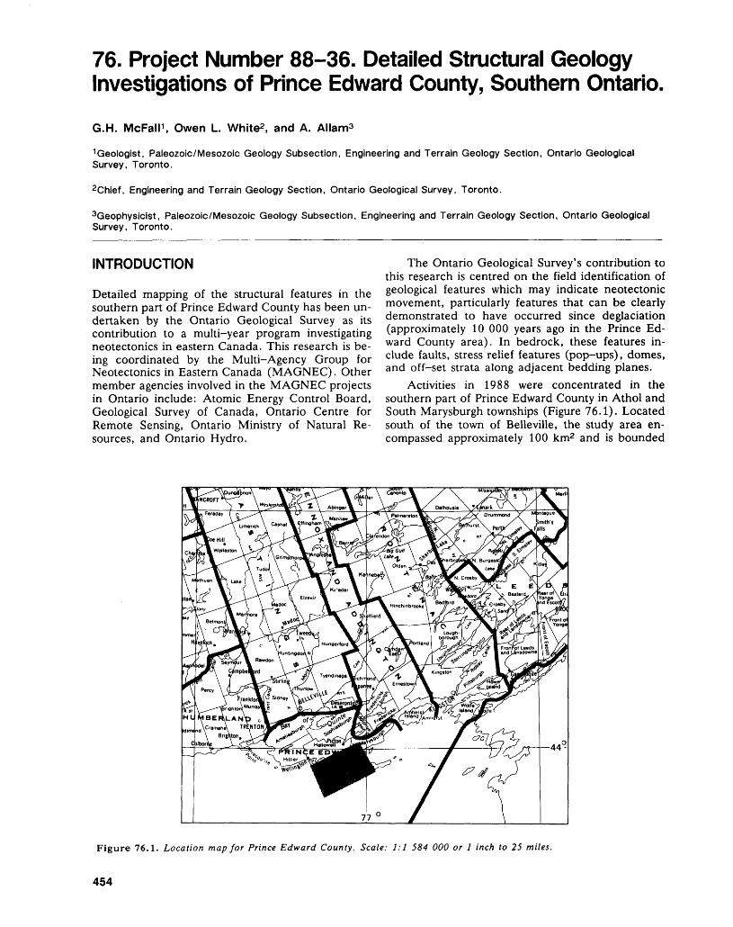
76. Project Number 88-36. Detailed Structural Geology Investigations of Prince Edward County, Southern Ontario.
G.H. McFall 1 , Owen L. White2 , and A. Alland
1 Geologist, Paleozoic/Mesozoic Geology Subsection, Engineering and Terrain Geology Section, Ontario Geological Survey, Toronto.
2Chief, Engineering and Terrain Geology Section, Ontario Geological Survey, Toronto.
Geophysicist, Paleozoic/Mesozoic Geology Subsection, Engineering and Terrain Geology Section, Ontario Geological Survey, Toronto.
INTRODUCTION
Detailed mapping of the structural features in the southern part of Prince Edward County has been un dertaken by the Ontario Geological Survey as its contribution to a multi-year program investigating neotectonics in eastern Canada. This research is be ing coordinated by the Multi-Agency Group for Neotectonics in Eastern Canada (MAGNEC). Other member agencies involved in the MAGNEC projects in Ontario include: Atomic Energy Control Board, Geological Survey of Canada, Ontario Centre for Remote Sensing, Ontario Ministry of Natural Re sources, and Ontario Hydro.
The Ontario Geological Survey's contribution to this research is centred on the field identification of geological features which may indicate neotectonic movement, particularly features that can be clearly demonstrated to have occurred since deglaciation (approximately 10 000 years ago in the Prince Ed ward County area). In bedrock, these features in clude faults, stress relief features (pop-ups), domes, and off-set strata along adjacent bedding planes.
Activities in 1988 were concentrated in the southern part of Prince Edward County in Athol and South Marysburgh townships (Figure 76.1). Located south of the town of Belleville, the study area en compassed approximately 100 km2 and is bounded
Figure 76.1. Location map for Prince Edward County. Scale: 1:1 584 000 or l inch to 25 miles.
454
G.H. MCFALL, OWEN L. WHITE, AND A. ALLAM
by the Lake Ontario shoreline, Latitude 43 0 56'N, Longitude 77 0 12' and Longitude 77 0 03'W. In addi tion to detailed field mapping, activities this year in cluded the drilling of two boreholes into the largest stress relief feature (pop-up) in the region, and de tailed geophysical surveys over selected structural features. Resource assistance for this work was sup plied by Ontario Hydro, University of Waterloo, the Tweed office of the Resident Geologist, Ontario Ministry of Northern Development and Mines, and the Napanee District office of the Ontario Ministry of Natural Resources.
GENERAL GEOLOGYPaleozoic strata exposed in the southern part of Prince Edward County are the Middle Ordovician Verulam and Lindsay formations. These overlie the Ordovician Bobcaygeon and Gull River formations (Simcoe Group), which in turn overlie Precambrian basement rocks (Grenville Province). At some loca tions, a thin veneer of clastic material separates the Paleozoic from the Precambrian rocks. Total Paleo zoic cover in the Belleville area amounts to approxi mately 210 m (Carson 1981). Regional mapping of the area by Carson (1981) suggested that the Paleo zoic stratigraphy was relatively simple. Detailed map ping was subsequently undertaken in adjacent east ern Ontario, east of the Frontenac Axis (Williams, in preparation). This work included a redefinition of the Bobcaygeon/Gull River Formation contact and suggested that Carson's (1981) interpretation of the Paleozoic stratigraphy in the Belleville area required further revision.
The Verulam Formation, as most recently de fined by Williams (in preparation), consists of an interbedded microcrystalline to coarse-crystalline limestone with up to 15 cm thick interbeds of dark grey calcareous shale. The Lindsay Formation, as recently defined by Russell and Telford (1983), has two members. There is a lower unnamed member consisting of microcrystalline to coarse-crystalline fossiliferous limestone with undulating shaly partings, and an upper member termed the Collingwood which is a black to dark brown, calcareous, organic- rich shale and limestone unit. The Collingwood Member has not yet been identified within the study area.
DRILLING PROGRAMA limited drilling program was initiated prior to the field investigations. Two boreholes, located near UTM 4859360mN 332120mE, were drilled on the largest stress relief feature (pop-up) in the study area. This feature, informally named the East Duck Pond pop-up, trends northwestwards from UTM 4859200mN 332500mE to UTM 4859500mN 331800mE. The locations of the boreholes were chosen for three reasons: first, to test the subsurface
configuration of the structure and the possibility of an axial fault; second, to examine the stratigraphy; and third, to obtain samples for experimental stress testing.
The first borehole was drilled to a depth of 59.5 m (195 feet) with complete recovery of the core. Breakdown of the drilling equipment resulted in the abandonment of the second borehole at 3.9 m (13 feet). The core from these two boreholes is presently stored in the Drill Core Library at Tweed, Ontario. Arrangements to view the core can be made through the Resident Geologist's Office, Ministry of Northern Development and Mines, P.O. Box 70, Tweed, Ontario, KOK 3JO.
GEOPHYSICAL SURVEYSMany of the bedrock structural features scattered throughout the study area are partially blanketed by Quaternary deposits making direct observation diffi cult. Several obscured structural features were ex amined using single and twelve channel refraction seismic surveys and resistivity exploration. Five indi vidual structural features and two areas were exam ined. These included three potential fault zones and three stress relief features (pop-ups). Surveys were conducted on a scale compatible with the size of the feature.
In addition, two of the regional features were examined in detail: the extension of the Picton fault (Liberty 1960) that trends northeasterly through the western part of the study area, and the Eastern Duck Pond pop-up. A series of refraction seismic surveys and resistivity exploration were conducted across each of the features at three locations in order to test for changes in the configuration of the bedrock structure.
FIELD MAPPINGThe best exposures of the Paleozoic bedrock in the study area occur along the Lake Ontario shoreline. These exposures are naturally occurring and exhibit little influence of, or disturbance by, man's activi ties. A stereographic examination of airphotographs of the shoreline regions of Prince Edward County was conducted by Creasy (1976) who identified a number of unusual structural features. Detailed mapping of the bedding attitudes, joints, and frac ture systems was carried out in order to evaluate the regional structural framework and the structures identified by Creasy. Man-made exposures, such as abandoned pits or quarries, excavated cattle ponds, road-cuts, and bulldozer-cleared bedrock outcrops were also examined in detail.
Over 250 features, identified from infrared air photographs and previous mapping (Creasy 1976; Liberty 1960), were examined. Eight probable pop- ups, three of which were confirmed by bedrock ex posures, were identified by field checking. Numer ous dissolution features were also identified includ-
455
ENGINEERING AND TERRAIN (76)
ing open fractures (grikes) and possible sink holes. Not all of the open fractures appear to have been formed by dissolution alone but may have opened in response to changes in regional stress. There are also indications of the presence of small scale faults in the study area.
Several stress relief features (pop-ups) were ex cavated to expose the flanks and axis and to observe the nature of the Quaternary cover across these fea tures. The axis of these features were clearly defined by opposing dips of bedrock layers, gaping of the bedrock, and the presence of calcite veins.
South of the western duck pond (UTM 4857900mN 328820mE), a glacially polished area abuts unpolished bedrock across a lineament identi fied on airphotographs. The unpolished outcrop oc curs at a higher elevation than the adjacent polished part. This suggests the presence of a post-glacial fault. Excavation of the contact confirmed that 1) a fracture was present; 2) the bedding was indeed dis continuous across the feature; and 3) there were lenses of grainy, weathered calcite present in the fracture zone.
The presence of neotectonic features in south ern Ontario has important implications for the con struction of environmentally sensitive structures such as nuclear power developments, toxic waste storage facilities, and pipelines. A clear understanding of
these features, the stresses which formed them, and how they will act in the future will permit an accu rate assessment of these potential construction haz ards.
REFERENCESCarson, D.M.1981: Paleozoic Geology of the Belleville-Wellington Area,
Southern Ontario; Ontario Geological Survey Prelimi nary Map P.2412, Geological Series, scale 1:50 000. Geology 1980.
Creasy, D.E.J.1976: Faults and Joint Sets in Prince Edward County: an
Aerial Photographic Interpretation Approach; Unpub lished B.Se. Thesis, Queen's University, Kingston, Ontario, 93p.
Liberty, B.A.1960: Belleville and Wellington Map Areas, Ontario; Geo
logical Survey of Canada Paper 60-31, 9p.Russell, D.J., and Telford, P.O.1983: Revisions to the Stratigraphy of the Upper Ordovician
Collingwood Beds of Ontario, a Potential Oil Shale;Canadian Journal of Earth Science, Volume 20,Number 12, p. 1780-1790.
Williams, D.A.In Prep.: Paleozoic Geology of the Ottawa-St. Lawrence
Lowland, Southern Ontario; Ontario Geological Sur vey, Open File Report.
456

Geophysics/Geochemistry Programs
77. Summary of Activities 1988, Geophysics/Geochemistry Section
R.B. Barlow
Section Chief, Geophysics/Geochemistry Section, Ontario Geological Survey, Toronto.
GEOPHYSICAL PROGRAMDuring the 1988 field season, a project to research the potential for detecting and tracing conductive strata in Precambrian rocks under thick Huronian sediments continued (Hanneson and Huxter, this volume). Approximately 110 km of grav ity and 80 km of transient electromagnetic coverage was completed at 50 m in tervals near the town of Cobalt, Ontario. A further 120 km of transient electro magnetic data and 8 km of EM sounding experiments are planned for the Fall and Winter months. Field surveying on this project followed extensive computer modeling and field orientation so as to optimize surveying parameters and proce dures. This project is funded under the Canada/Ontario 1985 Mineral Develop ment Agreement (COMDA), a subsidiary aggreemerit to the Economic and Re gional Development Aggrement (ERDA) signed by the governments of Canada and Ontario.
Gravity profiling was carried out during the fall (1987) and winter (1988) months by staff of the Geophysics/Geochemistry Section along planned seismic reflection transects which were completed as part of two major Lithoprobe pro jects (Barlow and Wadge, this volume}. Over 1850 gravity stations were estab lished with a station spacing of 200 m on seismic traverse lines located along highways and lumber and forest access roads within three areas. Profiles and digital data resulting from the field work will be released during the winter of 1989.
A compilation of reconnaissance scale gravity and magnetic data in the Prov ince together with a summary of the major potential field geophysical anomalies began and will be completed over the next few years. This work is being under taken in co-operation with the Geological Survey of Canada. The generation of gridded information at a smaller interval will improve the high frequency content of the information as well as provide a future data base for the production of colour maps for special studies.
An interpretation of recent gravity data acquired over the Archean mafic to ultramafic intrusions in the Lac des Iles area, approximately 80 km northwest of Thunder Bay has been completed. Gravity models over the main intrusion (mean density 3.13 g/cm3) and the Tib Gabbro (mean density 2.97 g/cm3) show these bodies to be shallow features with depth extents ranging between 3 to 5 km. The intrusions of the Lac des Iles area appear, from the results, to represent emplace ments by discrete pulses of mantle-derived magma.
Two airborne electromagnetic-magnetic surveys, covering areas of high min eral potential, were completed in 1988 (Barlow, this volume). A survey of ap proximately 44 000 line km in the Tashota-Geraldton-Long Lac area as well as a survey of approximately 36 000 line km in the Detour-Burntbush-Abitibi area will be released in the spring of 1989.
GEOCHEMISTRY PROGRAMThe fifth and final year of a reconnaissance till sampling project, carried out in co-operation with the Engineering and Terrain Geology Section as part of the BRIM program, will continue until March 1989 (Steele, this volume). Clastic sections of the core are subjected to heavy mineral separation so that independ-
458
R.B, BARLOW
ent gold grains may be counted and examined for their size and shape to help in determining their provenance. Quaternary stratigraphy and till geochemistry data collected in 1987 and 1988 will be released in standard formats followed by a summary report in the near future.
During July and August 1988, the remaining lake sediment and water sam pling (947 samples) required for a regional geochemical survey of the Batchawana Greenstone Belt was completed (Fortescue, this volume). This rep resents the second phase of a three-year project carried out as part of the Can ada/Ontario 1985 Mineral Development Agreement (COMDA). The purpose of the regional geochemical survey is to provide geochemical information which is of direct importance to exploration in the Batchawana Greenstone Belt. This is done either by confirming and, possibly, extending areas of known mineralization, or by indicating new areas within which mineralization may occur.
A program to verify positive geochemical results obtained in 1987 during a regional lake sediment geochemical survey in the Goudreau Lake area was com pleted in March 1988 (Fortescue, this volume). The verification procedure is based on the geochemistry of segments of long lake sediment cores which extend from the surficial sediment at the bottom of the lake into the mineral matter below the zone of organic matter. Experience indicated that the distribution of an element in a long lake sediment core was usually relatively uniform from 25 cm below the bottom of the lake to a metre depth or further. It was reasoned that long cores taken at the same sample points as those found to have positive geo chemistry in the regional survey would provide a basis for verification of the re gional survey results.
During September 1988, a small-scale regional geochemical survey based on lake sediments and waters was completed in a 400 km2 area in the vicinity of the Magpie River situated 30 km north of Wawa, Ontario (Fortescue and Nakashima, this volume). The purpose of regional geochemical surveys of this type is to provide verified geochemical information which is of direct importance in mineral exploration. The Magpie River area is of particular interest at this time because it lies to the west of the Goudreau Lake area in which new gold deposits are currently being developed. The geochemical survey of the Magpie River area is important because parts of the area are covered by surficial deposits where outcrops of bedrock are relatively rare. Like the Goudreau Lake geochemical survey which was completed last year, the Magpie River survey can be considered as part of an orientation survey for regional geochemical coverage of the entire Wawa Greenstone Belt at some future time.
459
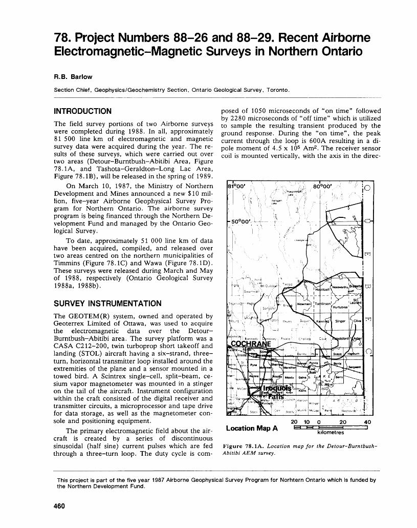
78. Project Numbers 88-26 and 88-29. Recent Airborne Electromagnetic-Magnetic Surveys in Northern Ontario
R. B. Barlow
Section Chief, Geophysics/Geochemistry Section, Ontario Geological Survey, Toronto.
INTRODUCTIONThe field survey portions of two Airborne surveys were completed during 1988. In all, approximately 81 500 line km of electromagnetic and magnetic survey data were acquired during the year. The re sults of these surveys, which were carried out over two areas (Detour-Burntbush-Abitibi Area, Figure 78.1A, and Tashota-Geraldton-Long Lac Area, Figure 78. IB), will be released in the spring of 1989.
On March 10, 1987, the Ministry of Northern Development and Mines announced a new S10 mil lion, five-year Airborne Geophysical Survey Pro gram for Northern Ontario. The airborne survey program is being financed through the Northern De velopment Fund and managed by the Ontario Geo logical Survey.
To date, approximately 51 000 line km of data have been acquired, compiled, and released over two areas centred on the northern municipalities of Timmins (Figure 78.1C) and Wawa (Figure 78.ID). These surveys were released during March and May of 1988, respectively (Ontario Geological Survey 1988a, 1988b).
SURVEY INSTRUMENTATIONThe GEOTEM(R) system, owned and operated by Geoterrex Limited of Ottawa, was used to acquire the electromagnetic data over the Detour- Burntbush-Abitibi area. The survey platform was a CASA C212-200, twin turboprop short takeoff and landing (STOL) aircraft having a six-strand, three- turn, horizontal transmitter loop installed around the extremities of the plane and a sensor mounted in a towed bird. A Scintrex single-cell, split-beam, ce sium vapor magnetometer was mounted in a stinger on the tail of the aircraft. Instrument configuration within the craft consisted of the digital receiver and transmitter circuits, a microprocessor and tape drive for data storage, as well as the magnetometer con sole and positioning equipment.
The primary electromagnetic field about the air craft is created by a series of discontinuous sinusoidal (half sine) current pulses which are fed through a three—turn loop. The duty cycle is com
posed of 1050 microseconds of "on time" followed by 2280 microseconds of "off time" which is utilized to sample the resulting transient produced by the ground response. During the "on time", the peak current through the loop is 600A resulting in a di pole moment of 4.5 x l O5 Am2 . The receiver sensor coil is mounted vertically, with the axis in the direc-
20 10 O 20 40Location Map A t~| F-* kilometres
Figure 78.1A. Location map for the Detour-Burntbush- Abitibi AEM survey.
This project is part of the five year 1987 Airborne Geophysical Survey Program for Norhtern Ontario which is funded by the Northern Development Fund.
460
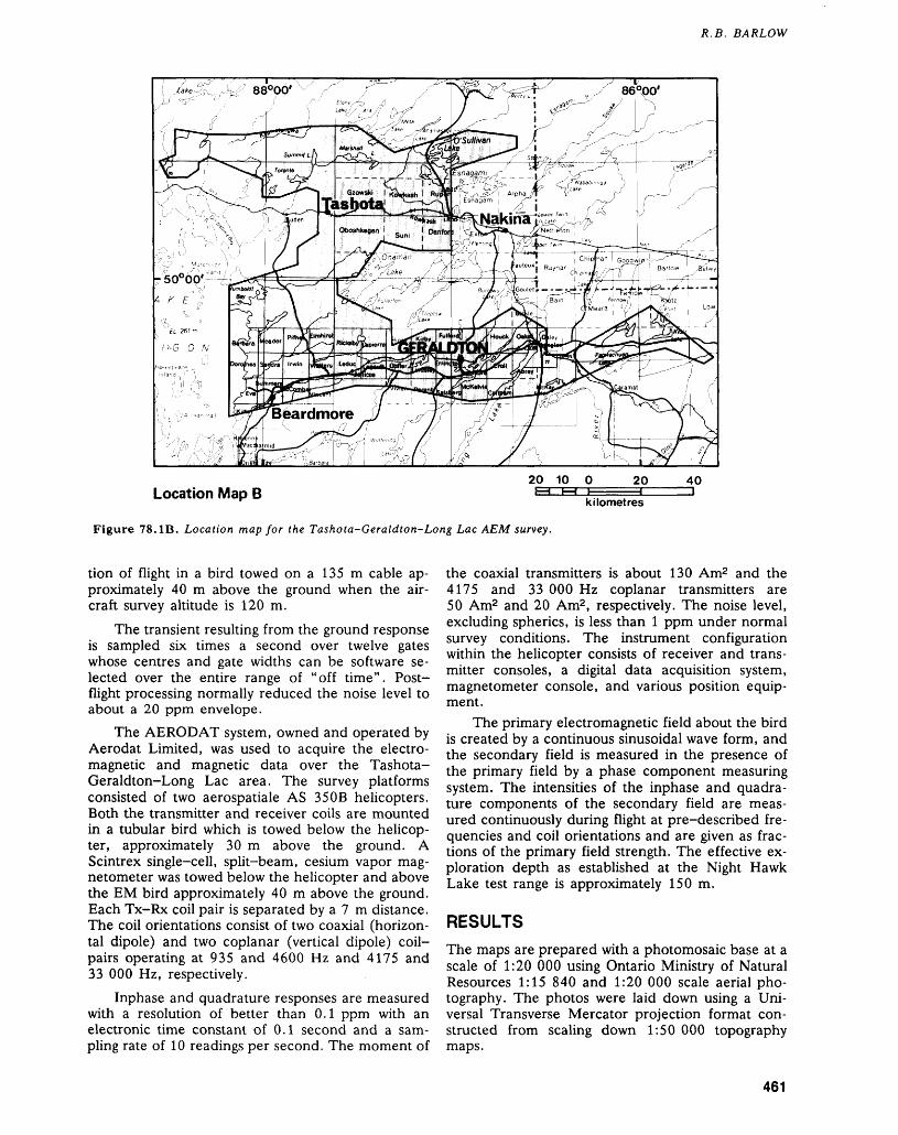
R.B. BARLOW
86*00'
Location Map B20 10 O 20 40
kilometres
Figure 78. IB. Location map for the Tashota-Geraldton-Long Lac AEM survey.
tion of flight in a bird towed on a 135 m cable ap proximately 40 m above the ground when the air craft survey altitude is 120 m.
The transient resulting from the ground response is sampled six times a second over twelve gates whose centres and gate widths can be software se lected over the entire range of "off time". Post- flight processing normally reduced the noise level to about a 20 ppm envelope.
The AERODAT system, owned and operated by Aerodat Limited, was used to acquire the electro magnetic and magnetic data over the Tashota- Geraldton-Long Lac area. The survey platforms consisted of two aerospatiale AS 35OB helicopters. Both the transmitter and receiver coils are mounted in a tubular bird which is towed below the helicop ter, approximately 30 m above the ground. A Scintrex single-cell, split-beam, cesium vapor mag netometer was towed below the helicopter and above the EM bird approximately 40 m above the ground. Each Tx-Rx coil pair is separated by a 7 m distance. The coil orientations consist of two coaxial (horizon tal dipole) and two coplanar (vertical dipole) coil- pairs operating at 935 and 4600 Hz and 4175 and 33 000 Hz, respectively.
Inphase and quadrature responses are measured with a resolution of better than 0.1 ppm with an electronic time constant of 0.1 second and a sam pling rate of 10 readings per second. The moment of
the coaxial transmitters is about 130 Am2 and the 4175 and 33 000 Hz coplanar transmitters are 50 Am2 and 20 Am2 , respectively. The noise level, excluding spherics, is less than l ppm under normal survey conditions. The instrument configuration within the helicopter consists of receiver and trans mitter consoles, a digital data acquisition system, magnetometer console, and various position equip ment.
The primary electromagnetic field about the bird is created by a continuous sinusoidal wave form, and the secondary field is measured in the presence of the primary field by a phase component measuring system. The intensities of the inphase and quadra ture components of the secondary field are meas ured continuously during flight at pre-described fre quencies and coil orientations and are given as frac tions of the primary field strength. The effective ex ploration depth as established at the Night Hawk Lake test range is approximately 150 m.
RESULTSThe maps are prepared with a photomosaic base at a scale of 1:20 000 using Ontario Ministry of Natural Resources 1:15 840 and 1:20 000 scale aerial pho tography. The photos were laid down using a Uni versal Transverse Mercator projection format con structed from scaling down 1:50 000 topography maps.
461
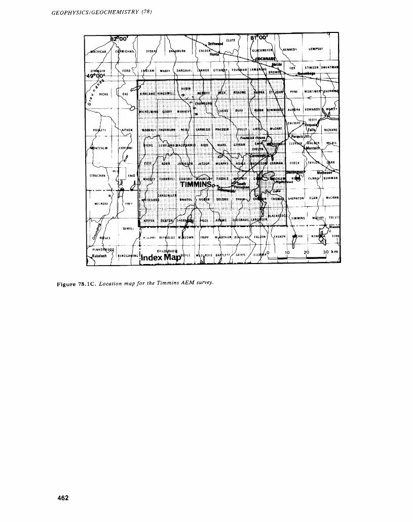
GEOPHYSICS/GEOCHEMISTRY (78)
Figure 78.1C. Location map for the Timmins AEM survey.
462
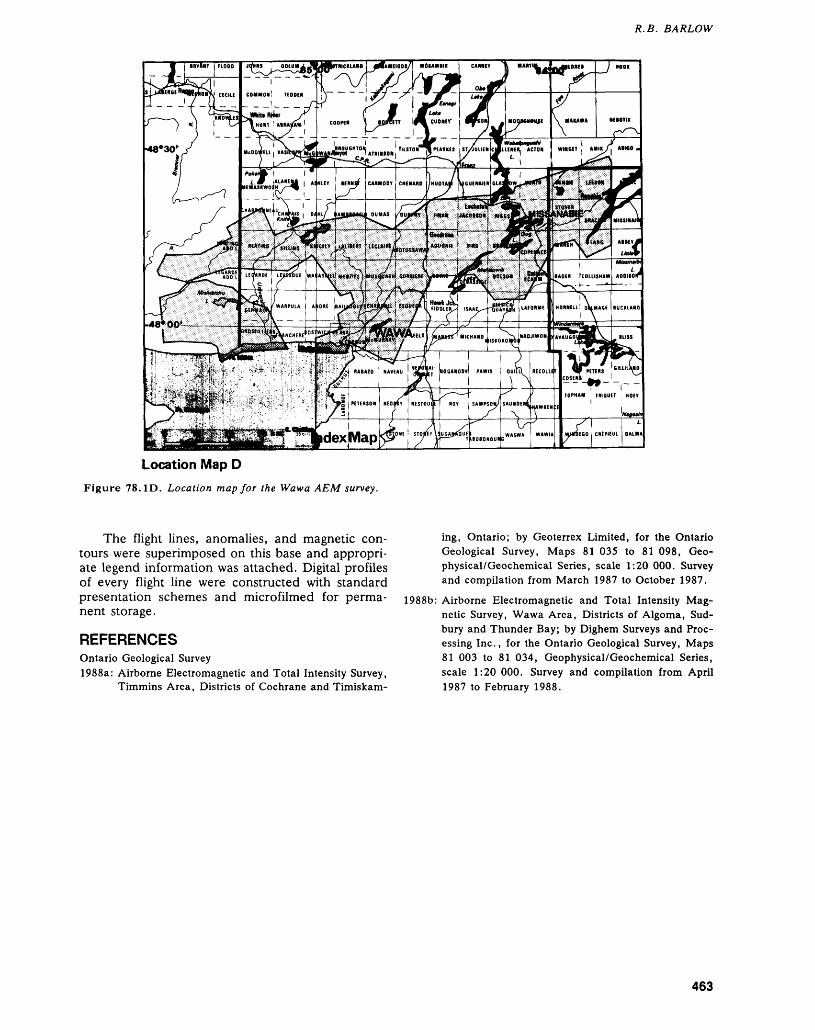
R.B. BARLOW
Location Map DFigure 78. ID. Location map for the Wawa AFM survey.
The flight lines, anomalies, and magnetic con tours were superimposed on this base and appropri ate legend information was attached. Digital profiles of every flight line were constructed with standard presentation schemes and microfilmed for perma nent storage.
REFERENCESOntario Geological Survey1988a: Airborne Electromagnetic and Total Intensity Survey,
Timmins Area, Districts of Cochrane and Timiskam
ing, Ontario; by Geoterrex Limited, for the Ontario Geological Survey, Maps 81 035 to 81 098, Geo- physical/Geochemical Series, scale 1:20 000. Survey and compilation from March 1987 to October 1987.
1988b: Airborne Electromagnetic and Total Intensity Mag netic Survey, Wawa Area, Districts of Algoma, Sud bury and Thunder Bay; by Dighem Surveys and Proc essing Inc., for the Ontario Geological Survey, Maps 81 003 to 81 034, Geophysical/Geochemical Series, scale 1:20 000. Survey and compilation from April 1987 to February 1988.
463
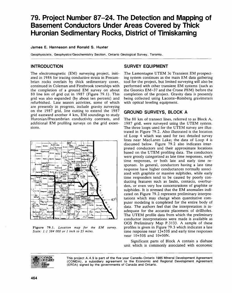
79. Project Number 87-24. The Detection and Mapping of Basement Conductors Under Areas Covered by Thick Huronian Sedimentary Rocks, District of Timiskaming
James E. Hanneson and Ronald S. Huxter
Geophysicists, Geophysics/Geochemistry Section, Ontario Geological Survey, Toronto.
INTRODUCTIONThe electromagnetic (EM) surveying project, initi ated in 1986 for tracing conductive strata in Precam brian rocks overlain by thick sedimentary cover, continued in Coleman and Firstbrook townships with the completion of a ground EM survey on about 80 line km of grid cut in 1987 (Figure 79.1). This grid was also expanded (by about ten percent) and refurbished. Late season activities, some of which are presently in progress, include gravity surveying on the 1987 grid, line cutting to extend the 1987 grid eastward another 4 km, EM soundings to study Huronian/Precambrian conductivity contrasts, and additional EM profiling surveys on the grid exten sions.
Figure 79.1. Location map for the EM survey. Scale: 1:1 584 000 or l inch to 25 miles.
SURVEY EQUIPMENTThe Lamontagne UTEM 3c Transient EM prospect ing system continues as the main EM data gathering tool for the project, but limited surveying will also be performed with other transient EM systems (such as the Geonics EM-37 and the Crone PBM) before the completion of the project. Gravity data is presently being collected using Lacoste-Romberg gravimeters with optical leveling equipment.
GROUND SURVEYS, BLOCK AThe 80 km of transect lines, referred to as Block A, 1987 grid, were surveyed using the UTEM system. The three loops used for the UTEM survey are illus trated in Figure 79.2. Also illustrated is the location of Loop 4 which was used for two detailed survey lines near MacLaren Lake; the data of Loop 4 is discussed below. Figure 79.2 also indicates inter preted conductors and their approximate locations based on the UTEM profiling data. The conductors were grossly categorized as late time responses, early time responses, or both late and early time re sponses. In general, conductors having a late time response have higher conductances normally associ ated with graphite or massive sulphides, while early time responders tend to be caused by poorly con ducting features such as faults, contacts, overbur den, or even very low concentrations of graphite or sulphides. It is stressed that the EM anomalies indi cated on Figure 79.2 represent preliminary interpre tations which may change when quantitative com puter modeling is completed for the entire body of data. The authors feel that the interpretation is in adequate for the accurate placement of drillholes. The UTEM profile data from which the preliminary conductor interpretations were made is available as OGS Preliminary Map P.3133. A sample of these profiles is given in Figure 79.3 which indicates a late time response near 13+5 OS and early time responses near 10+50S and 10+OON.
Significant parts of Block A contain a diabase unit which is commonly associated with economic
This project A.4.9 is part of the five year Canada-Ontario 1985 Mineral Development Agreement (COMDA), a subsidiary agreement to the Economic and Regional Development Agreement (ERDA) signed by the governments of Canada and Ontario.
464
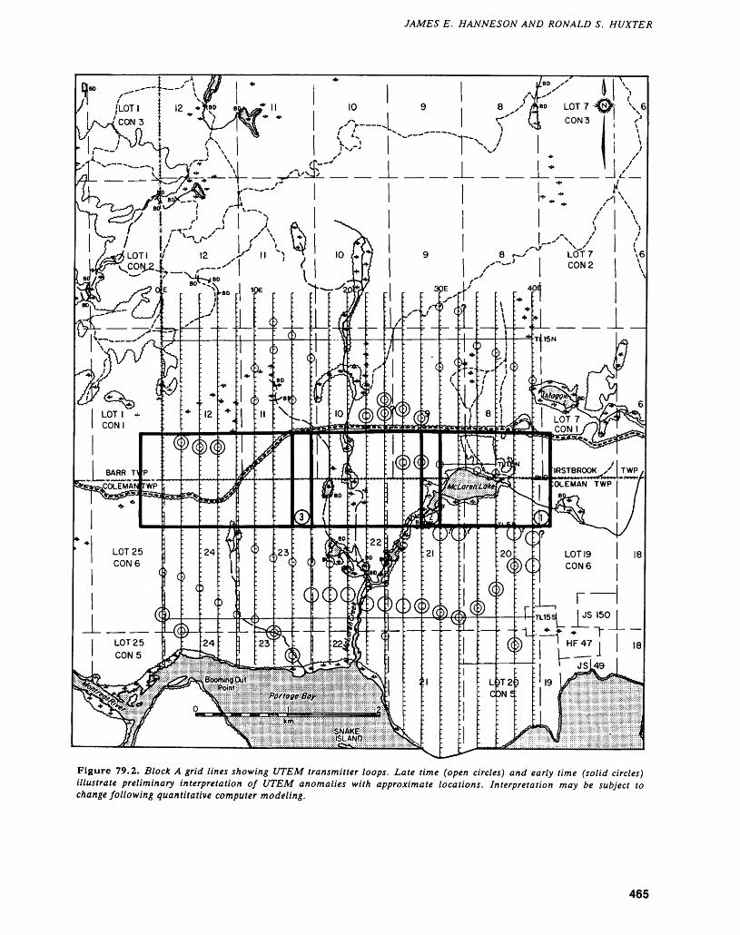
JAMES E. HANNESON AND RONALD S. HUXTER
-1.*—— J/.
Figure 79.2. Block A grid tines showing UTEM transmitter loops. Late time (open circles) and early time (solid circles) illustrate preliminary interpretation of UTEM anomalies with approximate locations. Interpretation may be subject to change following quantitative computer modeling.
465
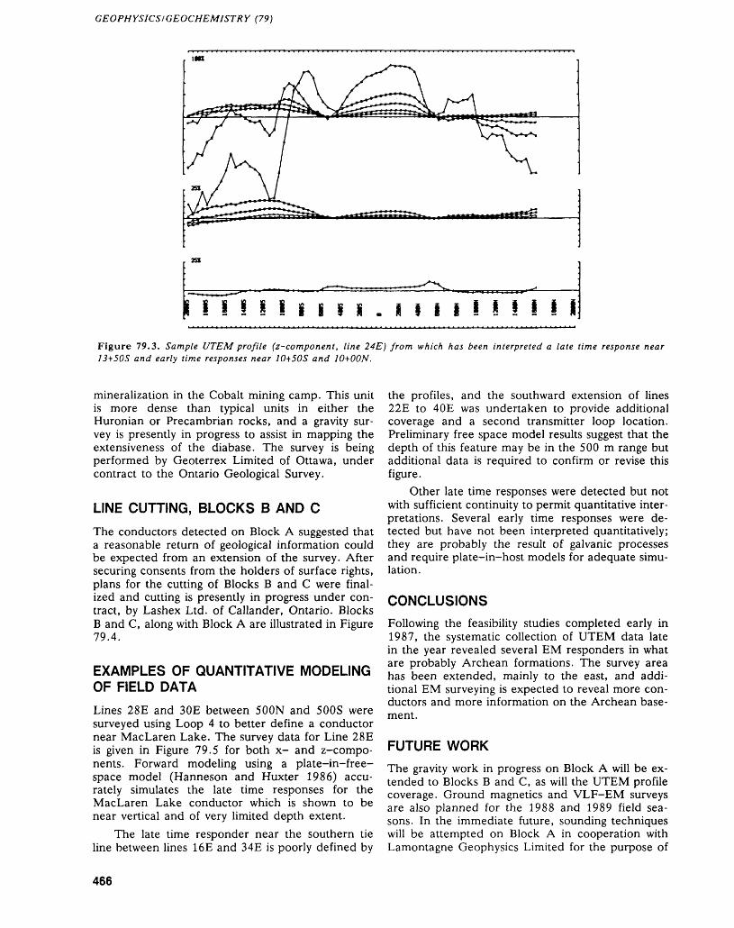
GEOPHYSICS!GEOCHEMISTRY (79)
l l li I i i s i . i i i i i l l ! i iFigure 79.3. Sample UTEM profile (z~component, line 24E) from which has been interpreted a late time response near 13+50S and early time responses near 10+50S and 10+OON.
mineralization in the Cobalt mining camp. This unit is more dense than typical units in either the Huronian or Precambrian rocks, and a gravity sur vey is presently in progress to assist in mapping the extensiveness of the diabase. The survey is being performed by Geoterrex Limited of Ottawa, under contract to the Ontario Geological Survey.
LINE CUTTING, BLOCKS B AND CThe conductors detected on Block A suggested that a reasonable return of geological information could be expected from an extension of the survey. After securing consents from the holders of surface rights, plans for the cutting of Blocks B and C were final ized and cutting is presently in progress under con tract, by Lashex Ltd. of Callander, Ontario. Blocks B and C, along with Block A are illustrated in Figure 79.4.
EXAMPLES OF QUANTITATIVE MODELING OF FIELD DATALines 28E and 30E between SOON and 500S were surveyed using Loop 4 to better define a conductor near MacLaren Lake. The survey data for Line 28E is given in Figure 79.5 for both x- and z-compo- nents. Forward modeling using a plate-in-free- space model (Hanneson and Huxter 1986) accu rately simulates the late time responses for the MacLaren Lake conductor which is shown to be near vertical and of very limited depth extent.
The late time responder near the southern tie line between lines 16E and 34E is poorly defined by
the profiles, and the southward extension of lines 22E to 40E was undertaken to provide additional coverage and a second transmitter loop location. Preliminary free space model results suggest that the depth of this feature may be in the 500 m range but additional data is required to confirm or revise this figure.
Other late time responses were detected but not with sufficient continuity to permit quantitative inter pretations. Several early time responses were de tected but have not been interpreted quantitatively; they are probably the result of galvanic processes and require plate-in-host models for adequate simu lation.
CONCLUSIONSFollowing the feasibility studies completed early in 1987, the systematic collection of UTEM data late in the year revealed several EM responders in what are probably Archean formations. The survey area has been extended, mainly to the east, and addi tional EM surveying is expected to reveal more con ductors and more information on the Archean base ment.
FUTURE WORKThe gravity work in progress on Block A will be ex tended to Blocks B and C, as will the UTEM profile coverage. Ground magnetics and VLF-EM surveys are also planned for the 1988 and 1989 field sea sons. In the immediate future, sounding techniques will be attempted on Block A in cooperation with Lamontagne Geophysics Limited for the purpose of
466
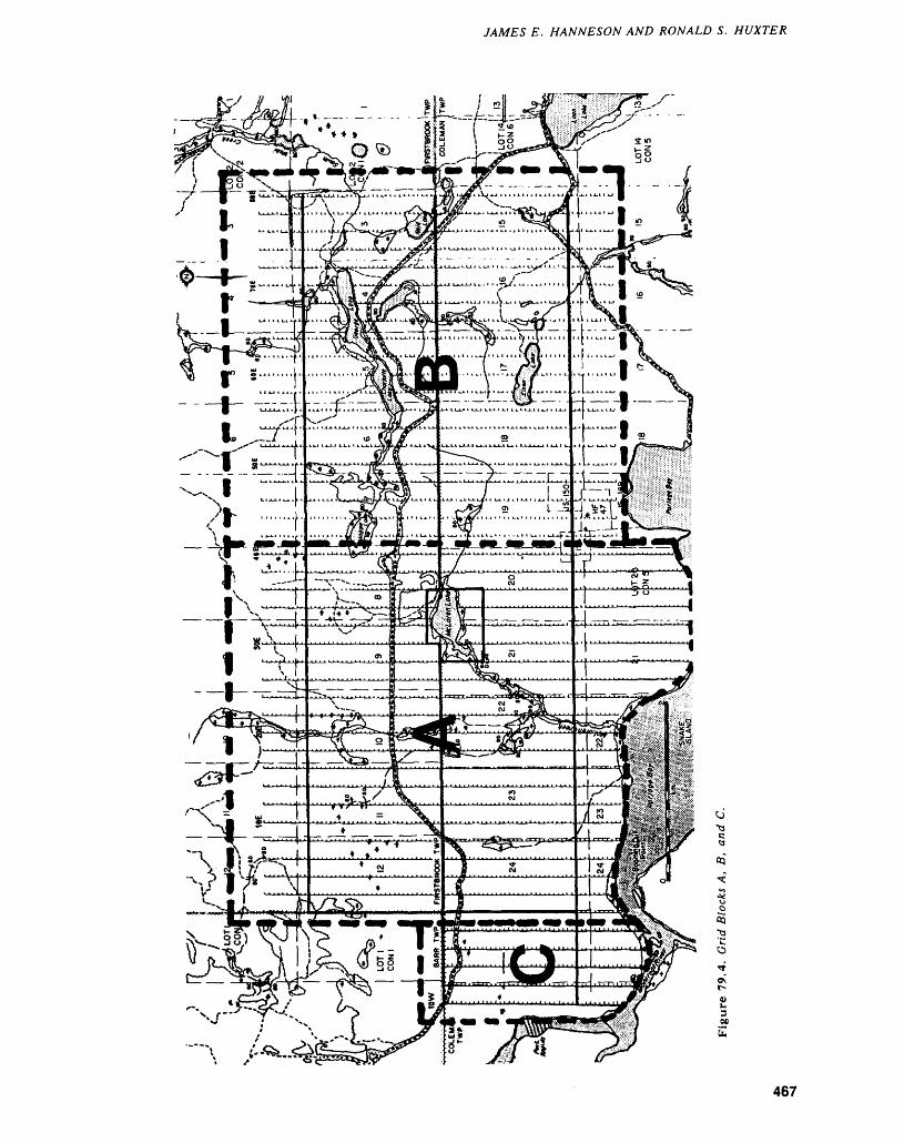
JAMES E. HANNESON AND RONALD S. HUXTER
O
00
b
467
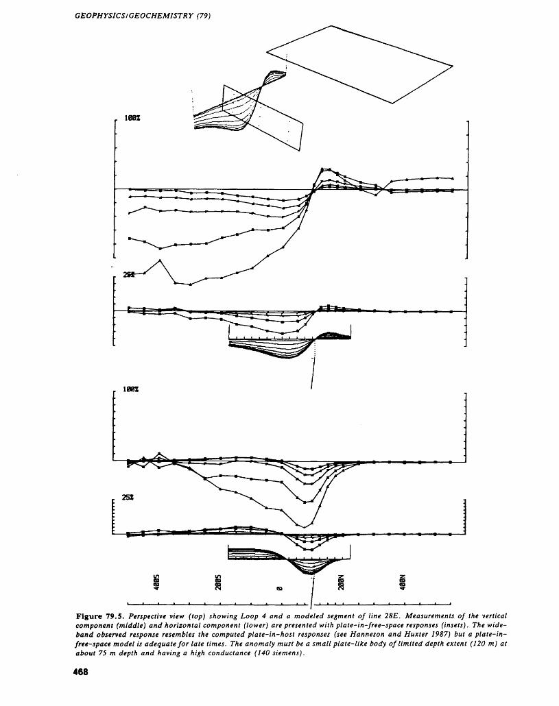
GEOPHYSICS/GEOCHEMISTRY (79)
Figure 79.5. Perspective view (top) showing Loop 4 and a modeled segment of line 28E. Measurements of the vertical component (middle) and horizontal component (lower) are presented with plate-in-free-space responses (insets). The wide band observed response resembles the computed plate-in-host responses (see Hanneson and Huxter 1987) but a plate-in- free-space model is adequate for late times. The anomaly must be a small plate-like body of limited depth extent (120 m) at about 75 m depth and having a high conductance (140 Siemens).
468
JAMES E. HANNESON AND RONALD S. HUXTER
determining conductivities in the Huronian and Ar- Rocks, District of Timiskaming; p.225-233 in Sum-chean rocks and, if different, the depth to the un- marY of Field Work and Other Activities 1986, by theconformity in areas remote from basement conduc- Ontario Geological Survey, edited by P.C. Thurston,tors. Modeling studies will continue with the imple- Owen L - White - R - B - Barlow, M.E. Cherry, andmentation of plate-in-host EM algorithms for the A - c - Colvine - Ontario Geological Survey, Miscella-purpose of simulating all EM transient channels neous Paper 132 ' 435p 'rather than just late time channels as is presently 1987: The Detection and Mapping of Basement Conductorspossible with free space models. Under Areas Covered by Thick Huronian Sedimentary
Rocks, District of Timiskaming; p.406-410 in Sum-pp——ppmppQ mary of Field Work and Other Activities 1987, by theMtl"tMtNLrtO Ontario Geological Survey, edited by R.B. Barlow,Hanneson, J.E., and Huxter, R.S. M.E. Cherry, A.C. Colvine, Burkhard O. Dressler,1986: The Detection and Mapping of Basement Conductors and Owen L. White, Ontario Geological Survey, Mis-
Under Areas Covered by Thick Huronian Sedimentary cellaneous Paper 137, 429p.
469
80. Project Number 88-38. Lithoprobe GravityProfiles—Chapleau, Kapuskasing and Kirkland Lake AreasR. B. Barlow 1 and D. R. Wadge2
""Chief, Geophysics/Geochemistry Section, Ontario Geological Survey, Toronto.
Geophysical Assistant, Geophysics/Geochemistry Section, Ontario Geological Survey, Toronto.
INTRODUCTIONGravity profiling was carried out during the fall (1987) and winter (1988) months by staff of the Geophysics/Geochemistry Section of the Ontario Geological Survey, along planned seismic reflection transects which were completed as part of two major Lithoprobe projects. Lithoprobe is an umbrella pro gram in which multidisciplinary earth science pro jects are proposed, approved, and carried out by geoscience agencies and university departments in order to explore crustal features across Canada, thereby advancing our understanding of geological processes historically active within the earth's crust.
This program is largely funded by the Govern ment of Canada (Energy, Mines and Resources), however, the Ontario Geological Survey and the Ministere de 1'Energie et des Ressources, Quebec have sponsored seismic reflection transects in key areas of the Abitibi Belt. As well, the Ontario Geo logical Survey funded and carried out the gravity profiling of most seismic transects which were com pleted in Ontario during the same period. The grav
ity measurements and subsequent results were ob tained cost effectively because of the existence of first order leveling and positioning data obtained as part of the seismic work.
LOCATIONThe Chapleau-Foleyet survey area is bounded by Latitudes 47 0 30'N and 48 0 30'N and Longitudes 82 0 00'W and 84 0 00'W, covering the southern por tion of the Kapuskasing Structural Zone. The Kapuskasing survey area is bounded by Latitudes 49 0 00'N and 49 0 30'N and Longitudes 82 0 00'W and 82 0 30'W. The Kirkland Lake survey area is bounded by Latitudes 48 0 00'N and 48 0 45'N and Longitudes 79 0 30'W and 80 0 00'W, centrally lo cated in the Abitibi Greenstone Belt and crossed by the Destor-Porcupine and Kirkland Lake-Larder Lake Fault Zones on the north and south respec tively.
The location of the areas is shown in Figure 80.1.
Figure 80. la. Location map for the Kapuskasing and Kirkland Lake areas.
470
R. B. BARLOW AND D. R. WADGE
Figure 80. Ib. Location map for the Chapleau area.
GRAVITY SURVEY
During September and October of 1987, and Janu ary of 1988, over 1850 gravity stations were estab lished on seismic traverse lines located along high ways, and lumber and forest access roads within the three areas.
Lacoste-Romberg gravimeter G-294 was used for the survey with a station spacing of 200 m along the lines. The gravity observations were tied to local control stations that form part of the National Grav ity Network.
Vertical control (or elevation) of the gravity sta tions was provided by taking readings at surveyed seismic vibe points. Surveying of the lines was car ried out by Eagle Surveys Ltd. of Calgary. Horizon tal control of the station locations was obtained from Eagle Surveys as U.T.M. northings and eastings.
The gravity survey was carried out to the specifi cations and procedures of the Gravity Division of the Geological Survey of Canada, where the data was processed. Profiles and digital data resulting from the field work will be released during the winter of 1989.
471
81. Project Number 87-29. Reconnaissance Till Sampling Program, Matheson-Lake Abitibi Area, District of Cochrane
K.G. Steele
Geologist, Engineering and Terrain Geology Section, Ontario Geological Survey, Toronto.
INTRODUCTION
A reconnaissance scale overburden sampling pro gram in the Black River-Matheson (BRIM) area be gan in 1984 and is to be completed in 1989 (Figure 81.1). The program is a combined effort of the Geo physics/Geochemistry and the Engineering and Ter rain Geology sections of the Ontario Geological Sur vey. The BRIM area has extensive and thick drift cover; less than 5 percent of the area is outcrop. The regional Quaternary (glacial) stratigraphy and a till geochemistry data base are being established from the results of the till sampling program. The data and interpretations produced by the program are of practical importance for exploration.
TILL SAMPLINGThree till sampling methods were used in the pro gram: sonic drilling, backhoe trenching, and hand- dug pits. This combination of methods was cost ef fective in providing samples from surface to bedrock in a study area with variable drift thickness. Using several sampling methods also allowed an even dis tribution of sample sites over the area.
In areas of shallow drift, or when till occurs at surface, backhoe trenching was used to search for and sample till. When these areas were only accessi ble by boat or floatplane, pits were dug by hand.
In areas of thick drift, a sonic drill was used be cause it furnishes a continuous, relatively undis-
Figure 81.1. Location map for the reconnaissance till sampling program, Matheson-Lake Abitibi area, District of Cochrane. Scale: 1:1 584 000 or l inch to 25 miles.
This project is part of Operation Black River-Matheson (BRIM) which is funded by the Ontario Ministry of Northern Devel opment and Mines.
472
K. G. STEELE
turbed, 88 mm diameter core from all formations including bedrock. The core provides a detailed stratigraphic record for the interpretation of deposi tional environments, and large, complete samples for geochemical analyses. Drilling methodology and operations are described in Baker et al. (1985) and Averill et al. (1986).
Till samples collected by drill, backhoe, and hand were processed in a similar manner. Processing steps and analytical procedures used were outlined in Baker et al. (1985) and Bloom (1987). By com bining geochemical, mineralogical, texture, carbon ate, and clast data, units can often be separated within a drillhole or correlated between sampling sites.
PREVIOUS SAMPLING PROGRAMSIn the period from July 1984 to June 1987, three sonic drilling and four near surface till sampling (backhoe trenching and hand-dug pits) programs were carried out in the BRIM area. Prior to the 1988 field work, 282 near surface till samples had been collected and 173 sonic drillholes had been completed (Figure 81.2). From the drill core 810 till, 365 glaciofluvial sand, and 170 bedrock samples were collected.
Core for holes drilled in the Larder Lake Mining Division (all of the study area except for the four westernmost townships) is stored at the Kirkland Lake Drill Core Library. Core for holes drilled in the Porcupine Mining Division (holes drilled in Shera ton, Stock, Bond, and Clergue townships) is stored at the Timmins Drill Core Library. All bedrock and till core from the 1984, 1985, and 1987 sonic drill programs is available for public inspection.
SAMPLING IN 1988During February and March 1988, a 52-hole sonic drilling program was completed in the eastern part of the BRIM area (Figure 81.2). Holes were sited along existing roads and trails cleared for this pro gram, newly constructed winter roads, and on the ice of Lake Abitibi. The program included drilling at 40 sites which are inaccessible during summer months and detailed stratigraphic drilling at 12 sites located near three previous drillholes. This program completes overburden sampling in the BRIM area.
The 1988 drill program was completed over a 35-day period, using two 12-hour shifts per day. A tracked vehicle (Go-Trac) mounted drill system was utilized for all drillholes except those on Lake Abitibi. The weight of this system necessitated a change to a skid mounted drill system for holes on the lake ice. In the 52-hole program, 1698 m of drift and 103 m of bedrock were drilled. Hole 88-19 on Lake Abitibi was abandoned before reaching bedrock because the drill shifted as water flowed onto the ice. The average overburden thick
ness (excluding four holes drilled in the northwest ern part of the BRIM area) was 30.5 m. This com pares with average overburden thicknesses of 35 m, 42 m, and 36 m in the 1984, 1985, and 1987 drill programs, respectively. The reduction in average overburden thickness for the 1988 program indicates that, in general, drift is thinner in the eastern part of the BRIM area.
In selection of 1988 drill sites, the following cri teria were deemed most important: an even distribu tion of data points over the study area; locating holes over east-west oriented bedrock valleys as inter preted from airborne electromagnetic data; avoid ance of esker sediments; and siting holes in areas of complex or unknown bedrock geology. Sites drilled in 1988 were concentrated in Tannahill, Elliott, Stoughton, and Holloway townships. Holes were also drilled in Dokis, Garrison, Harker, Marriott, Frecheville, and Rand townships, Abitibi Indian Re serve 70, and on Lake Abitibi. For stratigraphic in formation, fences of holes were drilled in Walker, Lamplugh, and Harker townships about holes 87-21, 85-42, and 85-39, respectively.
From the 1988 drill core 269 till, 42 glaciofluvial sand or sand and/or till, and 50 bedrock samples were collected. Analytical and stratigraphic results of the 1988 drilling program are expected to be re leased in data sheet and floppy diskette formats dur ing the spring of 1989. Preliminary information on the number and distribution of visible gold grains in the sonic drill core samples is available in Steele (1988).
QUATERNARY HISTORY/STRATIGRAPHY
SURFACE MAPPING AND RECONNAISSANCE DRILLING
The most recent glacial advance across the BRIM area was toward 170 0 azimuth and deposited the Matheson till (informal name). During the latter stages of ice cover, esker systems, which trend paral lel to the ice flow direction, were developed. As the ice front receded northward approximately 10 000 years before present, it was fronted by glacial lakes Barlow and Ojibway. The existence of these bodies of water resulted in the deposition of thick and ex tensive glaciolacustrine clay deposits which mask most of the bedrock and lap onto the esker systems.
Evidence of an earlier ice movement is exposed at the Maude Lake pit (northwest Beatty Township), where 170 0 azimuth striae cross-cut 240 0 azimuth striae. Southwest-trending striae in the BRIM area have also been reported by Richard and McClenag- han (1985) and Veillette (1986).
Sonic drilling in the BRIM area has indicated the presence of two glacial packages under the Matheson till. The regional composite Quaternary (glacial) stratigraphy can be summarized, from top (youngest) to bottom, as follows:
473
GEOPHYSICS/GEOCHEMISTRY (81)
o z oQ
0 Do
o z8 0 n OJO0 Bo
S o
o oDO o
en
8
o o~ a 0O O
O -J
o3 c l 0
D Q
3 ocn a os *^ m
o oa aQa a
oa |oo00
a OD
o
uj Oz
0 o
qb
cP D ana: a
,0
CL
2.21 "a
lw
Sen-Si*S ?
(/)-off)*tC*lininr^- CDOOCD
O)ID CO~~.00
din en co . ~)in'.COr en oo —. en ^j- co
^ O) OJ
8 CU d)
-c ^11o -E .-EO i- u.
GO QQDO*
474
A:. G. STEELE
1. Matheson package - Glaciolacustrine sediments (largely varved clay and silt) overlying till. Glaciofluvial sand occasionally occurs between these units. The glaciolacustrine sediments de posited in proglacial lakes Barlow and Ojibway can be up to 75 m thick. Till thicknesses are usually less than 10 m; however, up to 30 m of Matheson till has been encountered in the BRIM area. Deposits of this package are associ ated with ice which advanced toward 170 0 azi muth.
2. Middle package - This package is restricted in areal extent and was encountered in approxi mately 30 percent of drillholes and in sections at the Maude Lake pit (northwest Beatty Town ship) . The stratigraphy of the package is glacio lacustrine sediments overlying glaciofluvial sand which in turn overlies till. The most common sediment sequence encountered is varved clay and silt overlying sandy silt to silty sand till. At some drill sites and the Maude Lake pit, till was the only sediment of this package present. As determined from striae and pebble fabric data, sediments of this package are associated with ice which advanced toward 240 0 azimuth.
3. Lowest package - This package is very restricted in areal extent and has not been seen in section. The largest known subcrop of the Lowest pack age is in central Currie Township. The usual stratigraphy of this package is varved clay and silt overlying till. The varved sediments are not always present. There is evidence in the Tim mins area that the Lowest glacial package is as sociated with ice which advanced toward 150 0 azimuth (Alcock, in preparation).
DETAILED STRATIGRAPHIC STUDIES
In 1988, three fences of holes were drilled for stratigraphic studies (Figure 81.2). In all cases, holes were drilled 100 m apart or away from previous sonic drillholes. Geochemical data is not presently available for the 1988 drill program. The following interpretations are based on unit and parameter changes observed during logging of 1988 drill core, and drill core descriptions and analytical results for the 1985 and 1987 drillholes.
Two of the three fences encountered two glacial packages. The fence in Lamplugh Township, at hole 85-42 (Figure 81.2), has a consistent stratigraphy over its 600 m length. At this fence, the Matheson package overlies till from an older (probably Mid dle) package which in turn overlies bedrock. The stratigraphy of the Matheson package is varved clay and silt overlying sand (and occasionally gravel) which overlies a grey-coloured till. In the seven holes, the thickness of Matheson till ranges between 10 m and 37 m. The sharp break between the Matheson till and the underlying till is marked by changes in matrix colour and clast lithologies. The
older till has a distinct green colour and abundant Paleozoic carbonate clasts. Preliminary results indi cate that this till has higher concentrations of gold, particularly within 3 m above bedrock (Steele 1988). The older till is up to 17 m thick and, in general, thins toward the west.
The fence in Harker Township, at hole 85-39 (Figure 81.2), is sited on an ice-contact delta. Two of the three holes encountered two glacial packages. At these holes, the Matheson package consists of deltaic sand overlying interbedded till and sand. The top of the older package is marked by varved clay and silt. Beneath these glaciolacustrine sediments are till, sand and gravel units to bedrock. One hole in this fence may contain only the Matheson pack age or Matheson and an older package. If two pack ages are present, the older package consists only of till. The description and stratigraphy of the drill core did not provide adequate information to determine the number of glacial packages. Future analytical re sults may indicate the presence of one or two pack ages.
Units encountered and descriptions made during logging of hole 87-21, Walker Township (Figures 81.2 and 81.3), indicated the presence of three gla cial packages. A 14.3 m thick unit of glacio lacustrine sand and clay at the 29.0 m depth marked the top of the Middle glacial package. An oxidized surface on a till unit at the 51.1 m depth and shifts in chemical results between 51.1 m and 60.4 m confirmed the presence of the Lowest glacial package.
In 1988, holes were drilled 100 m west (88-49), north (88-50), south (88-51), and east (88-52) of hole 87-21 in an attempt to trace the three packages (Figure 81.3). All holes were sited on a flat, level glaciolacustrine clay plain.
Both holes 88-49 and 88-50 encountered bed rock at a much shallower depth than the original hole. Only two glacial packages are present at these two holes. At hole 88-50, the shallowest hole, the Middle glacial package is represented by glacio lacustrine sediments only. At hole 88-49, the Mid dle package consists of varved clay and silt overlying till on bedrock.
Holes 88-51 and 88-52 were approximately the same depth as the original hole. The stratigraphy at these two holes clearly represents three glacial pack ages. At the top of each package is a significant thicknesses of glaciolacustrine clay, silt and/or sand. The three glacial packages can easily be correlated between holes 87-21, 88-51, and 88-52.
The fence of holes about hole 87-21 illustrates the influence of the bedrock surface on the occur rence and preservation of sediments beneath the Matheson till. The bedrock surface rises to the north and west and lowers to the east of hole 87-21. Holes 87-21, 88-51, and 88-52 are in the lee of a bed rock high for the earliest, 150 0 azimuth ice advance. Till of the Lowest package may have only been de-
475
GEOPHYSICS/GEOCHEMISTRY (81)
Matheson G.R
Middle G.R
MathesonGlacialPackage(I700 azimuth
ice advance)
Middle Glacial Package(240" azimuth ice advance)
Lowest Glacial Package(I500 azimuth ice advance?)
Matheson G. P.
Middle G. P.
VERTICAL SCALE
GLACIOLACUSTRINE VARVED CLAYS 8 SILTS
l: Matheson Till TILL 2: Middle Till
3 Lowest TinBEDROCK
Figure 81.3. Detailed Quaternary stratigraphy at hole 87-21, northeastern Walker Township.
posited in the lee-side cavity, with glaciolacustrine sediments filling up the remainder of the bedrock depression. During the next glacial event, ice ad vancing toward 240 0 azimuth rode up over the bed rock high eroding any glaciolacustrine sediments that had been deposited on it. However, sediments along the shoulder of the bedrock high (at holes 87-21, 88-51, and 88-52) were protected from erosion. During this period of glacial activity, the Middle till was deposited (except at hole 88-50). This was fol lowed by the deposition of a thick sequence of glaciolacustrine sediments, leaving a relatively level surface. The Matheson glacial event resulted in a
relatively uniform sediment sequence being depos ited over the area. This sequence consists of till, with sand horizons, overlain by clay, silt and sand depos ited in proglacial lakes Barlow and Ojibway.
PUBLICATIONS
Maps, data sheets, and reports containing informa tion and interpretations on the BRIM till sampling program that were published as of December 1987, are listed in Steele and Baker (1987). The following maps and data sheets were published between De cember 1987 and December 1988:
476
K. G. STEELE
Data Sheets1987 Sonic drillholes; Ontario Geological Sur vey, Maps 81099 to 811351986 and 1987 Surface till samples; Ontario Geological Survey, Maps 81136 and 81137
Gold Grains Map1988 Drilling; Ontario Geological Survey, Map P.3130
It is expected that data sheets for the 1988 drilling and bedrock maps for the 1987 and 1988 drilling will be published in the spring of 1989. Review of the data by the BRIM program has resulted in an overview of the regional glacial stratigraphy by Steele et al. (in press) and a discussion of the occurrence of gold in till in the study area by Bloom and Steele (in press).
Data for overburden samples collected from the 1984 through 1987 BRIM sonic drilling and backhoe trenching programs, is available as a series of ASCII files on five-and-a-^quarter inch PC-DOS/MS- DOS-compatible floppy diskettes. Sample locations and material types, mineralogical, geochemical, and lithological analyses are provided. Documentation included describes individual file contents and for mats. Requests for data must be accompanied by eight (8) formatted double-sided, double-density five-and-a-quarter inch floppy diskettes. There is no charge to copy the data onto these diskettes. Re quests should be forwarded to the author (Tele phone 416-965-1183).
Data for overburden samples from the 1988 BRIM sonic drilling program will be available on diskettes when the data sheets for these drillholes are published in the spring of 1989.
ACKNOWLEDGMENTS
Field work described herein was completed with the competent assistance of B.R. Hart, S.E. Sparks, C.L. Horvath, R.S. Ramshaw, and B. Antal. The Ontario Geological Survey wishes to thank the indi viduals and companies who were party to discus sions, who provided access and allowed construction of winter roads and drilling on their properties.
REFERENCESAlcock, P.W.In Prep.: Quaternary Geology of the Timmins Area, Districts
of Cochrane, Timiskaming and Sudbury; OntarioGeological Survey, Open File Report.
Averill, S.A., MacNeil, K.A., Huneault, R.G., and Baker, C.L.
1986: Rotasonic Drilling Operations (1984) and Overburden Heavy Mineral Studies, Matheson Area, District of Cochrane; Ontario Geological Survey, Open File Re port 5569, 61p., 5 figures, 3 tables, and l map.
Baker, C.L., Steele, K.G., and Mcclenaghan, M.B.1985: Reconnaissance Till Sampling Program, Matheson-
Lake Abitibi Area, Cochrane District; p.329-333 in Summary of Field Work and Other Activities 1985, Ontario Geological Survey, edited by John Wood, Owen L. White, R.B. Barlow, and A.C. Colvine, Ontario Geological Survey, Miscellaneous Paper 126, 351p.
Bloom, L.B.1987: Analytical Methods, Quality Control Data and Previ
ously Unpublished Geochemical Results: Reconnais sance Till Sampling Program, Matheson Area, Cochrane District; Ontario Geological Survey, Open File Report 5653, 47p., 3 appendices, 4 figures, and 21 tables.
Bloom, L.B., and Steele, K.G.In Press: Gold in Till, Preliminary Results from the Matheson
Area, Ontario; in Drift Prospecting 1987, edited by R.N.W. DiLabio and W.B. Coker, Geological Sur vey of Canada Paper.
Richard, J.A., and Mcclenaghan, M.B.1985: Quaternary Geology of the Porquis Junction Area,
District of Cochrane; Ontario Geological Survey, Map P.2949, Geological Series-Preliminary Map, scale 1:50 000. Geology 1984.
Steele, K.G.1988: Gold Grains in Sonic Drill Core Samples (1988) from
the Lake Abitibi-Matheson Area, District of Cochrane; Ontario Geological Survey, Map P.3130, Geophysical/Geochemical Series-Preliminary Map, scale 1:100 000. Geology 1988.
Steele, K.G., and Baker, C.L.1987: Reconnaissance Till Sampling Program, Matheson-
Lake Abitibi Area, District of Cochrane; p.415-419 in Summary of Field Work and Other Activities 1987, by the Ontario Geological Survey, edited by R.B. Bar low, M.E. Cherry, A.C. Colvine, Burkhard O. Dressler, and Owen L. White, Ontario Geological Survey, Miscellaneous Paper 137, 429p.
Steele, K.G., Baker, C.L., and Mcclenaghan, M.B.In Press: Models of Glacial Stratigraphy Determined from
Drillcore, Matheson Area, Northeastern Ontario, Canada; in Drift Prospecting 1987, edited by R.N.W. DiLabio and W.B. Coker, Geological Sur vey of Canada Paper.
Veillette, J.J.1986: Former Southwesterly Ice Flow in the Abitibi-Timis-
kaming Region: Implications for the Configuration of the Late Wisconsinan Ice Sheet; Canadian Journal of Earth Sciences, Volume 23, p. 1724-1741.
477
82. Project Number 87-25. A Regional Geochemical Survey of Part of the Batchawana Greenstone Belt, District of Algoma
John A.C. Fortescue
Research Geochemist, Geophysics/Geochemistry Section, Ontario Geological Survey, Toronto.
INTRODUCTIONDuring 1987, the sampling for the first part of a three year regional geochemical survey of the Batchawana Greenstone Belt was completed in the Wart Lake area (Fortescue and Stahl 1987a). Dur ing July and August 1988, the remaining lake sedi ment and water sampling required for the project was completed (see Figure 82.1). In 1988, a total of 947 lake sediment core and water samples were col lected from an area of 2475 km2 . When these are combined with 531 samples collected from the area previously, this makes a grand total of 1478 sample sites for the entire area at an average density of one per 1.67 km2 . The extent of the regional geochemi cal survey in relation to the entire Batchawana Sy
noptic Map area (as described by Grunsky 1982) is indicated on Figure 82.2. An example of the sample density and distribution in the regional geochemical survey is provided in a square inset to Figure 82.2, where each dot indicates a sample site location.
The purpose of the regional geochemical survey is to provide geochemical information of direct im portance to exploration in the Batchawana Green stone Belt. This is done either by confirming, and possibly extending, areas of known mineralization, or by indicating new areas within which mineraliza tion may occur. The COMDA regional geochemical mapping project covers the central and western part of the Batchawana Greenstone Belt and includes
Montreal River/: Harbour
Theano Pt
Figure 82.1. Location of study area.
CANADA ONTARIO This project A.8.1. is part of the five year Canada-Ontario 1985 Mineral Development Agreement
(COMDA), a subsidiary agreement to the Economic and Regional Development Agreement (ERDA) signed by the governments of Canada and Ontario.
478
J.A. C. FORTESCUE
Mafic to intermediate meto volcanics* * "HtlJ Intermediate to felsic plutonic rocks— , . . . . ,. . . . .4- +P* a. u. ~a * * . * i . . * - i Felstc to intermediate metavokxmics 4- Massive felsic intrusive rocksMetosediments Keweenawan volcanics and sediments * t.'l'.f *.(.Ironstone** *** ************* +ES3 Ptxinerozoic Rocks * * *.* *******
Figure 82.2. Generalized geological map of the Batchawana Synoptic Project area showing the limit of the regional geochemical survey and, as an inset, the sample density for lake waters and sediments.
some areas which are relatively inaccessible and poorly explored (Figure 82.2).
OBJECTIVES
The objectives of the survey are:
1. to collect water and pre-Ambrosia (i.e. over 100 years old; see Fortescue and Stahl 1987b) lake sediment core material from at least one point in all lakes and ponds accessible by heli copter within the 2475 km2 area included in the geochemical survey
2. to provide in hard copy (and in computer read able form) data on pH, and on the Ca and Mg contents of the water samples; and data on lev els of Ag, Al, As, Au, Ba, Be, Br, Ca, Cr, Cu, Co, Fe, Hf, K, La, Lu, Mg, Mn, Mo, Na, Ni, P, Pb, Sb, Se, Sr, Ta, Th, Ti, U, V, W, and Zn in pre-Ambrosia lake sediment samples collected from the entire area covered by the regional geochemical survey
3. to provide a summary of the geochemical be haviour of elements occurring in these samples that are of importance to mineral exploration, using univariate, bivariate, and multivariate sta tistical analyses of the geochemical data
GEOLOGICAL SETTING OF THE BATCHAWANA REGIONAL GEOCHEMICAL MAP AREA
The Batchawana regional geochemical map area in cludes all of Raaflaub, Runnalls, Running, Tol monen, Tronsen, Vibert, Way White, Norberg, Ol sen, Davieaux, Desbiens, Wishart, Brule, Grenoble, Dablon, Kincaid, Nicolet, Ryan, and Palmer town ships; and parts of Larsen, Loach, McAughey, McParland, Home, Tilley, Archibald, Marne, Slater, Smilsky, Herrick, and Fisher townships (see Figure 82.1).
The bedrock lithology of the entire Batchawana Greenstone Belt is summarized on Figure 82.2. Briefly, Grunsky (1981) divided the area into three major geological domains. These are the Archean metavolcanic, metasedimentary supracrustal do main; the Archean felsic plutonic (including gneissic and migmatitic) domain; and the Keweenawan vol canic, sedimentary, felsite, and mafic intrusive do main (Figure 82.2). It is evident from Figure 82.2 that the regional geochemical survey covers areas underlain by all of the three geological domains. More detailed geological information on the area may be obtained from Grunsky (1981, 1982), Siragusa (1986), and the recently released 1:50 000 scale geological maps of the Batchawana Synoptic area (Grunsky 1987a, 1987b).
479
GEOPHYSICS/GEOCHEMISTRY (82)
METHODOLOGYThe sampling of lake sediments and waters for the Batchawana regional geochemical survey was com pleted during 1987 and 1988, using a crew of two and a Bell 206 helicopter mounted on floats. Sam pling at each site involved the collection of one, or more, lake sediment cores plus the collection of a l L water sample. Surface water samples were col lected from sites less than 5 m deep and deeper wa ters were sampled using a plastic tube sampler which collected water down to 5 m.
The feasibility of collecting lake sediment cores for regional geochemical surveys was established in 1986 (Fortescue and Stahl 1987b). During the 1987 survey, sediment core sample collection involved two stages, the collection of cores on the helicopter float and the extrusion of the cores at base camp. In 1988, the cores were extruded on the helicopter float immediately after collection when a sample of pre-Ambrosia material was obtained.
REVISED LAKE SEDIMENT SAMPLING
The technique employed to collect and extrude lake sediment cores on a helicopter float is illustrated in three photographs included as Photo 82.1. Photo 82.la illustrates the equipment required for the col lection and extrusion of lake sediment cores on a helicopter float. In Photo 82.la the gravity sampler
(A) is connected to a spool of rope (B); the acrylic sampling tube (C) is a push fit inside the gravity sam pler. The PVC extrusion tube (D) is anchored at one end on the helicopter float. During sampling, a rubber bung (E) is inserted into the sample tube af ter the core has been hauled to just below the water surface. The sample tube (including the core and bung) is then removed from the sampler and mounted onto the extrusion tube. The sample tube is then pushed down the outside of the extrusion tube; the bung acts as a piston forcing first water, and then the core, out of the sample tube. The ex truded sample is then retained in a plastic bag (F). Photo 82.Ib shows the gravity sampler, complete with sample tube ready for sampling. Photo 82. le shows a sample being extruded, using the bung as a piston (the letters correspond to the descriptions for Photo 82.la).
During the Batchawana survey, only the sedi ment deeper than 18 cm (i.e. "pre-Ambrosia"; see Fortescue and Stahl 1987a) was retained for chemi cal analysis, unlike the procedure used in the Mag pie River area (Fortescue and Nakashima, this vol ume) , where both the pre- and post-Ambrosia sam ples were obtained from the on-float extrusion of cores.
Photo 82. la. The equipment for lake sediment core sam pling and extrusion which is normally used on a helicopter float (for an explanation of the letters in the photographs, refer to the text).
Photo 82. Ib. For an explanation of the letters in the pho tographs, refer to the text.
480
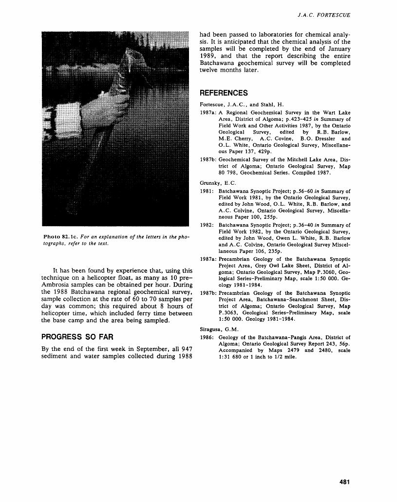
J.A. C. FORTESCUE
Photo 82. le. For an explanation of the letters in the pho tographs, refer to the text.
It has been found by experience that, using this technique on a helicopter float, as many as 10 pre- Ambrosia samples can be obtained per hour. During the 1988 Batchawana regional geochemical survey, sample collection at the rate of 60 to 70 samples per day was common; this required about 8 hours of helicopter time, which included ferry time between the base camp and the area being sampled.
PROGRESS SO FARBy the end of the first week in September, all 947 sediment and water samples collected during 1988
had been passed to laboratories for chemical analy sis. It is anticipated that the chemical analysis of the samples will be completed by the end of January 1989, and that the report describing the entire Batchawana geochemical survey will be completed twelve months later.
REFERENCESFortescue, J.A.C., and Stahl, H.1987a: A Regional Geochemical Survey in the Wart Lake
Area, District of Algoma; p.423-425 in Summary of Field Work and Other Activities 1987, by the Ontario Geological Survey, edited by R.B. Barlow, M.E. Cherry, A.C. Covine, B.O. Dressler and O.L. White, Ontario Geological Survey, Miscellane ous Paper 137, 429p.
1987b: Geochemical Survey of the Mitchell Lake Area, Dis trict of Algoma; Ontario Geological Survey, Map 80 798, Geochemical Series. Compiled 1987.
Grunsky, E.G.1981: Batchawana Synoptic Project; p.56-60 in Summary of
Field Work 1981, by the Ontario Geological Survey, edited by John Wood, O.L. White, R.B. Barlow, and A.C. Colvine, Ontario Geological Survey, Miscella neous Paper 100, 255p.
1982: Batchawana Synoptic Project; p.36-40 in Summary of Field Work 1982, by the Ontario Geological Survey, edited by John Wood, Owen L. White, R.B. Barlow and A.C. Colvine, Ontario Geological Survey Miscel laneous Paper 106, 235p.
1987a: Precambrian Geology of the Batchawana Synoptic Project Area, Grey Owl Lake Sheet, District of Al goma; Ontario Geological Survey, Map P.3060, Geo logical Series-Preliminary Map, scale 1:50 000. Ge ology 1981-1984.
1987b: Precambrian Geology of the Batchawana Synoptic Project Area, Batchawana-Searchmont Sheet, Dis trict of Algoma; Ontario Geological Survey, Map P.3063, Geological Series-Preliminary Map, scale 1:50 000. Geology 1981-1984.
Siragusa, G.M.1986: Geology of the Batchawana-Pangis Area, District of
Algoma; Ontario Geological Survey Report 243, 56p. Accompanied by Maps 2479 and 2480, scale 1:31 680 or l inch to 1/2 mile.
481
83. Project Number 87-26. The Use of the Geochemistry of Long Lake Sediment Cores for Verification of Regional Geochemical Results: Goudreau Lake Area, District of AlgomaJohn A.C. Fortescue
Research Geochemist, Geophysics/Geochemistry Section, Ontario Geological Survey, Toronto.
INTRODUCTION
During June 1987, a regional geochemical survey, based on lake sediments and waters, was completed in a 500 km2 area centred on Goudreau Lake some 40 km northeast of Wawa (Fortescue and Stahl 1987a) (Figure 83.1). To avoid the possibility of fallout from the Wawa sintering plant influencing the results, the lake sediment geochemical data was ob tained from sediment which was laid down over 100 years ago (i.e. in "pre-Ambrosia" time (Fortescue and Stahl 1987b)). Some of these "pre-Ambrosia" samples were found to have positive geochemical re sults which needed verification prior to the publica tion of the regional lake sediment survey.
The verification procedure is based on the geo chemistry of segments of long, lake sediment cores which extend from the surficial sediment at the bot tom of the lake into the mineral matter below the zone of organic matter. The geochemistry of lake sediment cores of this type had been examined pre viously by the Ontario Geological Survey (Fortescue 1986) in the Wawa area. When the historical succes
sion of plant cover types since glaciation (9000 years B.P. as determined by palynology) were related to the distribution of 14 elements in segments of long cores, certain interesting geochemical relationships were found.
This experience indicated that the distribution of an element in a long, lake sediment core was usually relatively uniform from 25 cm below the bottom of the lake to a metre depth or further. The top 25 cm portion of the core included the "post-Ambrosia" material, laid down during the past 100 years, which in the Goudreau Lake area is contaminated by fall out from the Wawa smelter. As the 1987 geochemi cal survey was based on short core "pre-Ambrosia" sediment, it was reasoned that long cores taken at the same sample points as those found to have posi tive geochemistry in the regional survey would pro vide a basis for verification of the regional survey results.
In order to test this hypothesis, 13 long cores were collected from the Goudreau Lake area during March 1988 by a four-man crew including the writer, an assistant from the Ontario Geological Sur-
Figure 83.1. Location map for the Goudreau Lake area. Scale: 1:1 584 000 or l inch to 25 miles.
482
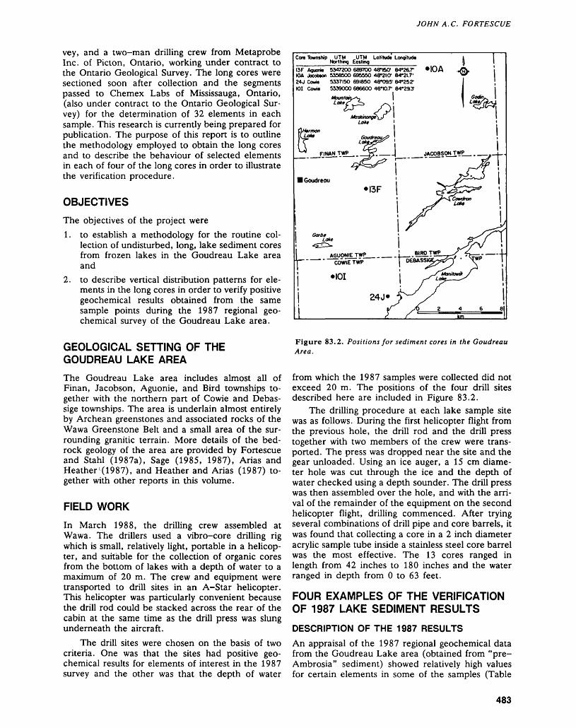
JOHN A. C. FORTESCUE
vey, and a two-man drilling crew from Metaprobe Inc. of Picton, Ontario, working under contract to the Ontario Geological Survey. The long cores were sectioned soon after collection and the segments passed to Chemex Labs of Mississauga, Ontario, (also under contract to the Ontario Geological Sur vey) for the determination of 32 elements in each sample. This research is currently being prepared for publication. The purpose of this report is to outline the methodology employed to obtain the long cores and to describe the behaviour of selected elements in each of four of the long cores in order to illustrate the verification procedure.
OBJECTIVESThe objectives of the project were1. to establish a methodology for the routine col
lection of undisturbed, long, lake sediment cores from frozen lakes in the Goudreau Lake area and
2. to describe vertical distribution patterns for ele ments in the long cores in order to verify positive geochemical results obtained from the same sample points during the 1987 regional geo chemical survey of the Goudreau Lake area.
The Goudreau Lake area includes almost all of Finan, Jacobson, Aguonie, and Bird townships to gether with the northern part of Cowie and Debas sige townships. The area is underlain almost entirely by Archean greenstones and associated rocks of the Wawa Greenstone Belt and a small area of the sur rounding granitic terrain. More details of the bed rock geology of the area are provided by Fortescue and Stahl (1987a), Sage (1985, 1987), Arias and Heather'(1987), and Heather and Arias (1987) to gether with other reports in this volume.
FIELD WORK
In March 1988, the drilling crew assembled at Wawa. The drillers used a vibro-core drilling rig which is small, relatively light, portable in a helicop ter, and suitable for the collection of organic cores from the bottom of lakes with a depth of water to a maximum of 20 m. The crew and equipment were transported to drill sites in an A-Star helicopter. This helicopter was particularly convenient because the drill rod could be stacked across the rear of the cabin at the same time as the drill press was slung underneath the aircraft.
The drill sites were chosen on the basis of two criteria. One was that the sites had positive geo chemical results for elements of interest in the 1987 survey and the other was that the depth of water
Cor* Township UTM UTM Latitude Longitude Northing Easting
I3F Aguorw 5347200 6897OO 48*60' 84*26.r IOA Jacobson 53S8SOO 696550 48-2I.01 84*21.7' 24J Cowie 5337150 691850 48*095' 84*25.2" 101 Cowie 5339000 686600 48*10.7' 84*233'
MOA
Figure 83.2. Positions for sediment cores in the Goudreau Area.
from which the 1987 samples were collected did not exceed 20 m. The positions of the four drill sites described here are included in Figure 83.2.
The drilling procedure at each lake sample site was as follows. During the first helicopter flight from the previous hole, the drill rod and the drill press together with two members of the crew were trans ported. The press was dropped near the site and the gear unloaded. Using an ice auger, a 15 cm diame ter hole was cut through the ice and the depth of water checked using a depth sounder. The drill press was then assembled over the hole, and with the arri val of the remainder of the equipment on the second helicopter flight, drilling commenced. After trying several combinations of drill pipe and core barrels, it was found that collecting a core in a 2 inch diameter acrylic sample tube inside a stainless steel core barrel was the most effective. The 13 cores ranged in length from 42 inches to 180 inches and the water ranged in depth from O to 63 feet.
FOUR EXAMPLES OF THE VERIFICATION OF 1987 LAKE SEDIMENT RESULTS
DESCRIPTION OF THE 1987 RESULTSAn appraisal of the 1987 regional geochemical data from the Goudreau Lake area (obtained from "pre- Ambrosia" sediment) showed relatively high values for certain elements in some of the samples (Table
483
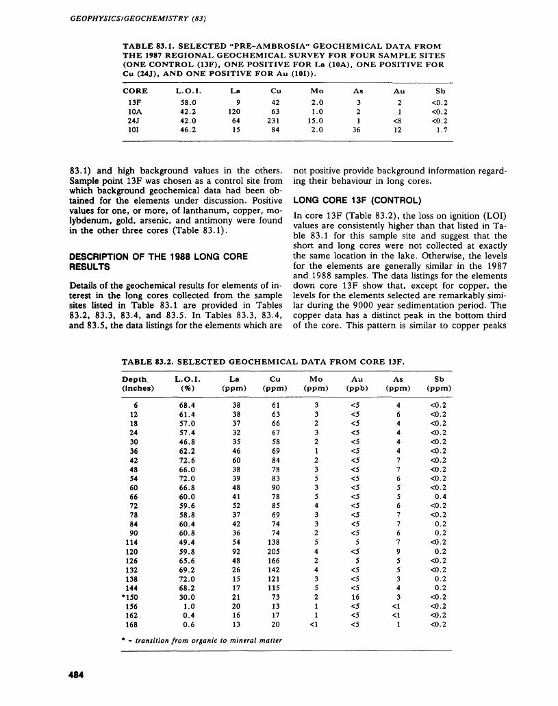
GEOPHYSICS/GEOCHEMISTRY (83)
TABLE 83.1. SELECTED "PRE-AMBROSIA" GEOCHEMICAL DATA FROM THE 1987 REGIONAL GEOCHEMICAL SURVEY FOR FOUR SAMPLE SITES (ONE CONTROL (13F), ONE POSITIVE FOR La (10A), ONE POSITIVE FOR Cu (24J), AND ONE POSITIVE FOR Au (101)).
CORE13F10A24J101
L.O.I.58.042.242.046.2
La9
1206415
Cu4263
23184
Mo2.01.0
15.02.0
As321
36
Au21
^12
Sb0.2O.2O.2
1.7
83.1) and high background values in the others. Sample point 13F was chosen as a control site from which background geochemical data had been ob tained for the elements under discussion. Positive values for one, or more, of lanthanum, copper, mo lybdenum, gold, arsenic, and antimony were found in the other three cores (Table 83.1).
DESCRIPTION OF THE 1988 LONG CORE RESULTS
Details of the geochemical results for elements of in terest in the long cores collected from the sample sites listed in Table 83.1 are provided in Tables 83.2, 83.3, 83.4, and 83.5. In Tables 83.3, 83.4, and 83.5, the data listings for the elements which are
not positive provide background information regard ing their behaviour in long cores.
LONG CORE 13F (CONTROL)In core 13F (Table 83.2), the loss on ignition (LOI) values are consistently higher than that listed in Ta ble 83.1 for this sample site and suggest that the short and long cores were not collected at exactly the same location in the lake. Otherwise, the levels for the elements are generally similar in the 1987 and 1988 samples. The data listings for the elements down core 13F show that, except for copper, the levels for the elements selected are remarkably simi lar during the 9000 year sedimentation period. The copper data has a distinct peak in the bottom third of the core. This pattern is similar to copper peaks
TABLE 83.2. SELECTED GEOCHEMICAL DATA FROM CORE 13F.
Depth, (inches)
61218243036424854606672788490
114120126132138144
•150156162168
L.O.I.W
68.461.457.057.446.862.272.666.072.066.860.059.658.860.460.849.459.865.669.272.068.230.01.00.40.6
La(ppm)
38383732354660383948415237423654924826151721201613
Cu (ppm)
61636667586984788390788569747413820516614212111573131720
Mo(ppm)
332321235354332542435211
*cl
Au As (ppb) (ppm)
^ 4^ 6^ 4^ 4^ 4^ 4^ 7^ 7^ 6^ 5^ 5^ 6^ 7^ 7^ 65 7^ 95 5^ 5^ 3^ 416 3^ "CI^ -CI^ 1
Sb (ppm)
0.20. 20. 20.20. 20. 20. 20. 20. 20. 20.40. 20.20.20.20. 20.20.20. 20.20.20.20.20. 20. 2
- transition from organic to mineral matter
484
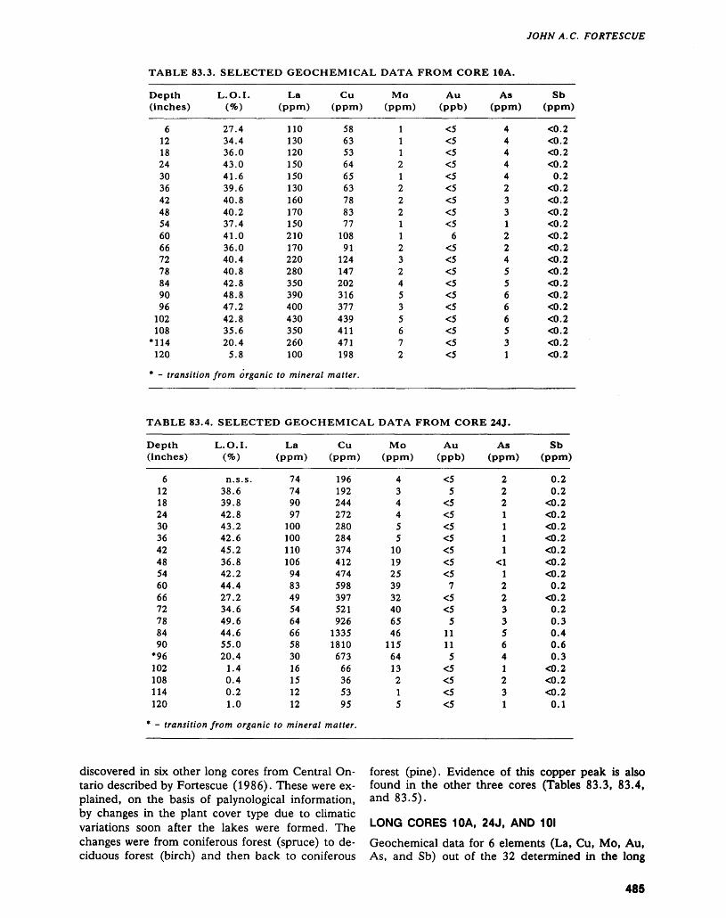
JOHN A. C. FORTESCUE
TABLE 83.3. SELECTED GEOCHEMICAL DATA FROM CORE 10A.
Depth(inches)
6121824303642485460667278849096
102108
*114120
L.O.I.W
27.434.436.043.041.639.640.840.237.441.036.040.440.842.848.847.242.835.620.4
5.8
* - transition from organic
TABLE 83.4.
Depth(inches)
61218243036424854606672788490
*96102108114120
La(ppm)
110130120150150130160170150210170220280350390400430350260100
to mineral
Cu(ppm)
586353646563788377
10891
124147202316377439411471198
matter.
SELECTED GEOCHEMICAL
L.O.I.W
n.s.s.38.639.842.843.242.645.236.842.244.427.234.649.644.655.020.4
1.40.40.21.0
* - transition from organic
La(ppm)
74749097
100100110106948349546466583016151212
to mineral
Cu(ppm)
196192244272280284374412474598397521926
13351810673
66365395
matter.
Mo Au(ppm) (ppb)
1 ^1 ^1 ^2 ^1 ^2 ^2 ^2 ^1 ^1 62 ^3 ^2 ^4 ^5 ^3 ^5 ^6 ^7 ^2 ^
DATA FROM CORE
Mo Au(ppm) (ppb)
4 ^3 54 ^4 ^5 ^5 ^
10 ^19 ^25 ^39 732 ^40 ^65 546 11
115 1164 513 ^2 ^1 ^5 ^
As(ppm)
44444233122455666531
24 J.
As(ppm)
2221111
xCl122335641231
Sb(ppm)
0. 20. 20. 20. 2
0.20.20. 20. 20. 20.20.20. 20. 20. 20. 2O.20.20. 2O.20. 2
Sb(ppm)
0.20.2
0. 2O.20. 20. 2O.2O.20. 20.2
0. 20.20.30.40.60.3
0.20. 20. 2
0.1
discovered in six other long cores from Central On tario described by Fortescue (1986). These were ex plained, on the basis of palynological information, by changes in the plant cover type due to climatic variations soon after the lakes were formed. The changes were from coniferous forest (spruce) to de ciduous forest (birch) and then back to coniferous
forest (pine). Evidence of this copper peak is also found in the other three cores (Tables 83.3, 83.4, and 83.5).
LONG CORES 10A, 24J, AND 101
Geochemical data for 6 elements (La, Cu, Mo, Au, As, and Sb) out of the 32 determined in the long
485
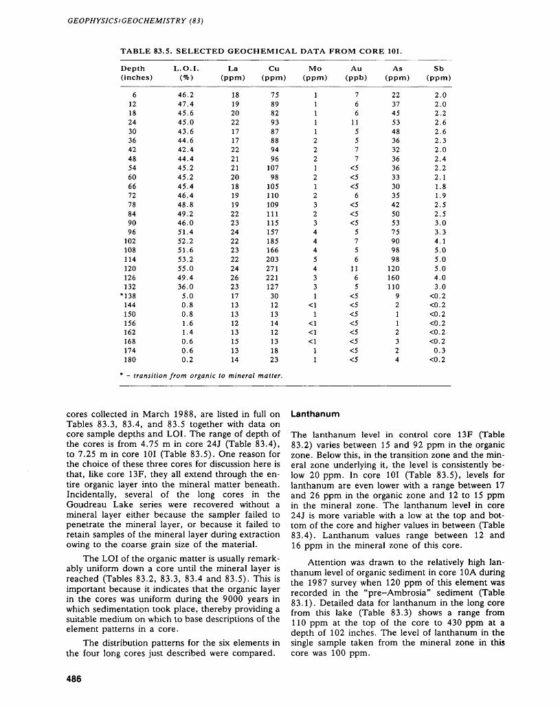
GEOPHYSICS l GEOCHEMISTRY (83)
TABLE 83.5. SELECTED GEOCHEMICAL DATA FROM CORE 101.
Depth (inches)
6121824303642485460667278849096
102108114120126132M38144150156162168174180
L.O.I.(*0
46.247.445.645.043.644.642.444.445.245.245.446.448.849.246.051.452.251.653.255.049.436.05.00.80.81.61.40.60.60.2
* - transition from organic
La(ppm)
181920221717222121201819192223242223222426231713131213151314
to mineral
Cu(ppm)
7589829387889496
107981051101091111151571851662032712211273012131412131823
matter.
Mo(ppm)
11111222121232344454331
*tt1
•CI*a^
11
Au (ppb)
766
115577^^^6^^^5756
1165^^^^^^^^
As (ppm)
22374553483632363633303542505375909898
120160110
92112324
Sb (ppm)
2.02.02.22.62.62.32.02.42.22.11.81.92.52.53.03.34.15.05.05.04.03.00.20.20.20. 20. 20. 20.30.2
cores collected in March 1988, are listed in full on Tables 83.3, 83.4, and 83.5 together with data on core sample depths and LOI. The range of depth of the cores is from 4.75 m in core 24J (Table 83.4), to 7.25 m in core 101 (Table 83.5). One reason for the choice of these three cores for discussion here is that, like core 13F, they all extend through the en tire organic layer into the mineral matter beneath. Incidentally, several of the long cores in the Goudreau Lake series were recovered without a mineral layer either because the sampler failed to penetrate the mineral layer, or because it failed to retain samples of the mineral layer during extraction owing to the coarse grain size of the material.
The LOI of the organic matter is usually remark ably uniform down a core until the mineral layer is reached (Tables 83.2, 83.3, 83.4 and 83.5). This is important because it indicates that the organic layer in the cores was uniform during the 9000 years in which sedimentation took place, thereby providing a suitable medium on which to base descriptions of the element patterns in a core.
The distribution patterns for the six elements in the four long cores just described were compared.
Lanthanum
The lanthanum level in control core 13F (Table 83.2) varies between 15 and 92 ppm in the organic zone. Below this, in the transition zone and the min eral zone underlying it, the level is consistently be low 20 ppm. In core 101 (Table 83.5), levels for lanthanum are even lower with a range between 17 and 26 ppm in the organic zone and 12 to 15 ppm in the mineral zone. The lanthanum level in core 24J is more variable with a low at the top and bot tom of the core and higher values in between (Table 83.4). Lanthanum values range between 12 and 16 ppm in the mineral zone of this core.
Attention was drawn to the relatively high lan thanum level of organic sediment in core 10A during the 1987 survey when 120 ppm of this element was recorded in the "pre-Ambrosia" sediment (Table 83.1). Detailed data for lanthanum in the long core from this lake (Table 83.3) shows a range from 110 ppm at the top of the core to 430 ppm at a depth of 102 inches. The level of lanthanum in the single sample taken from the mineral zone in this core was 100 ppm.
486
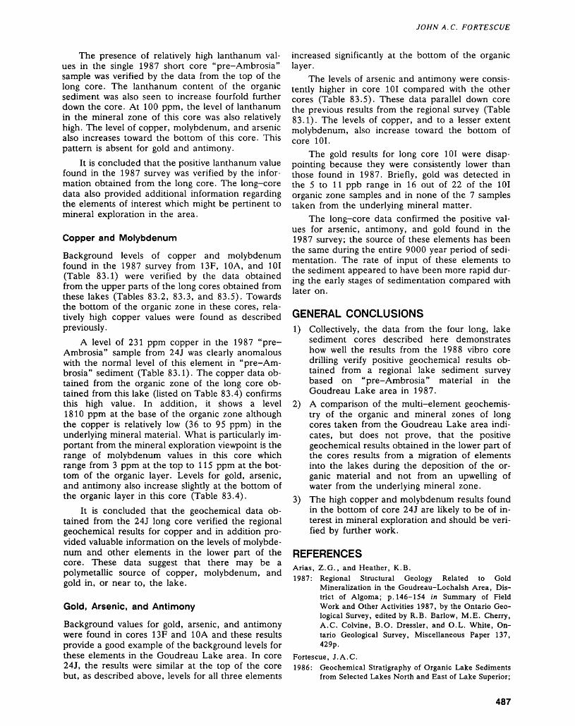
JOHN A. C. FORTESCUE
The presence of relatively high lanthanum val ues in the single 1987 short core "pre-Ambrosia" sample was verified by the data from the top of the long core. The lanthanum content of the organic sediment was also seen to increase fourfold further down the core. At 100 ppm, the level of lanthanum in the mineral zone of this core was also relatively high. The level of copper, molybdenum, and arsenic also increases toward the bottom of this core. This pattern is absent for gold and antimony.
It is concluded that the positive lanthanum value found in the 1987 survey was verified by the infor mation obtained from the long core. The long-core data also provided additional information regarding the elements of interest which might be pertinent to mineral exploration in the area.
and molybdenum 13F, 10A, and 101the data obtained
cores obtained from and 83.5). Towards in these cores, rela- found as described
Copper and Molybdenum
Background levels of copper found in the 1987 survey from (Table 83.1) were verified by from the upper parts of the long these lakes (Tables 83.2, 83.3, the bottom of the organic zone tively high copper values were previously.
A level of 231 ppm copper in the 1987 "pre- Ambrosia" sample from 24J was clearly anomalous with the normal level of this element in "pre-Am brosia" sediment (Table 83.1). The copper data ob tained from the organic zone of the long core ob tained from this lake (listed on Table 83.4) confirms this high value. In addition, it shows a level 1810 ppm at the base of the organic zone although the copper is relatively low (36 to 95 ppm) in the underlying mineral material. What is particularly im portant from the mineral exploration viewpoint is the range of molybdenum values in this core which range from 3 ppm at the top to 115 ppm at the bot tom of the organic layer. Levels for gold, arsenic, and antimony also increase slightly at the bottom of the organic layer in this core (Table 83.4).
It is concluded that the geochemical data ob tained from the 24J long core verified the regional geochemical results for copper and in addition pro vided valuable information on the levels of molybde num and other elements in the lower part of the core. These data suggest that there may be a polymetallic source of copper, molybdenum, and gold in, or near to, the lake.
Gold, Arsenic, and Antimony
Background values for gold, arsenic, and antimony were found in cores 13F and 10A and these results provide a good example of the background levels for these elements in the Goudreau Lake area. In core 24J, the results were similar at the top of the core but, as described above, levels for all three elements
increased significantly at the bottom of the organic layer.
The levels of arsenic and antimony were consis tently higher in core 101 compared with the other cores (Table 83.5). These data parallel down core the previous results from the regional survey (Table 83.1). The levels of copper, and to a lesser extent molybdenum, also increase toward the bottom of core 101.
The gold results for long core 101 were disap pointing because they were consistently lower than those found in 1987. Briefly, gold was detected in the 5 to 11 ppb range in 16 out of 22 of the 101 organic zone samples and in none of the 7 samples taken from the underlying mineral matter.
The long-core data confirmed the positive val ues for arsenic, antimony, and gold found in the 1987 survey; the source of these elements has been the same during the entire 9000 year period of sedi mentation. The rate of input of these elements to the sediment appeared to have been more rapid dur ing the early stages of sedimentation compared with later on.
GENERAL CONCLUSIONS1) Collectively, the data from the four long, lake
sediment cores described here demonstrates how well the results from the 1988 vibro core drilling verify positive geochemical results ob tained from a regional lake sediment survey based on "pre-Ambrosia" material in the Goudreau Lake area in 1987.
2) A comparison of the multi-element geochemis try of the organic and mineral zones of long cores taken from the Goudreau Lake area indi cates, but does not prove, that the positive geochemical results obtained in the lower part of the cores results from a migration of elements into the lakes during the deposition of the or ganic material and not from an upwelling of water from the underlying mineral zone.
3) The high copper and molybdenum results found in the bottom of core 24J are likely to be of in terest in mineral exploration and should be veri fied by further work.
REFERENCESArias, Z.G., and Heather, K.B.1987: Regional Structural Geology Related to Gold
Mineralization in the Goudreau-Lochalsh Area, Dis trict of Algoma; p. 146-154 in Summary of Field Work and Other Activities 1987, by the Ontario Geo logical Survey, edited by R.B. Barlow, M.E. Cherry, A.C. Colvine, B.O. Dressler, and O.L. White, On tario Geological Survey, Miscellaneous Paper 137, 429p.
Fortescue, J.A.C.1986: Geochemical Stratigraphy of Organic Lake Sediments
from Selected Lakes North and East of Lake Superior;
487
GEOPHYSICS/GEOCHEMISTRY (83)
Ontario Geological Survey, Map 80 757, Geochemical tivities 1987, by the Ontario Geological Survey, edited Series. Compiled 1985. by R.B. Barlow, M.E. Cherry, A.C. Colvine,
- T . - . - ,, TT B.O. Dressler, and O.L. White, Ontario Geological Fortescue, J.A.C., and Stahl, H. 0 ,,. ,. n 10 ^ .- nSurvey, Miscellaneous Paper 137, 429p.1987a: A Regional Geochemical Survey in the Goudreau Lake
Area, District of Algoma; p.420-422 in Summary of Sa8e ' R - p -Field Work and Other Activities 1987, by the Ontario 1985: Goudreau-Lochalsh Area, District of Algoma;Geological Survey, edited by R.B. Barlow, p.90-94 in Summary of Fieldwork and Other Activi-M.E. Cherry, A.C. Colvine, B.O. Dressler, and ties 1985 - Ontario Geological Survey, edited by JohnO.L. White, Ontario Geological Survey, Miscellane- Wood, Owen L. White, R.B. Barlow, and A.C. Col-ous Paper 137 429p. vine, Ontario Geological Survey, Miscellaneous Paper
1987b: Geochemical Survey of the Mitchell Lake Area, Dis- 126 ' 351p 'trict of Algoma; Ontario Geological Survey, Map 80 1987: Geology of the Goudreau-Lochalsh and Kabenung798, Geochemical Series. Compiled 1987. Lake areas - District of Algoma; p. 134-137 in Sum
mary of Field Work and Other Activities 1987, by theHeather, K.B., and Arias, Z.G. Ontario Geological Survey, edited by R.B. Barlow,1987: Geological Setting of Gold Mineralization in the M.E. Cherry, A.C. Colvine, B.O. Dressler, and
Goudreau-Lochalsh Area, District of Algoma; O.L. White, Ontario Geological Survey, Miscellane-p. 155-162 in Summary of Field Work and Other Ac- ous Paper 137, 429p.
488
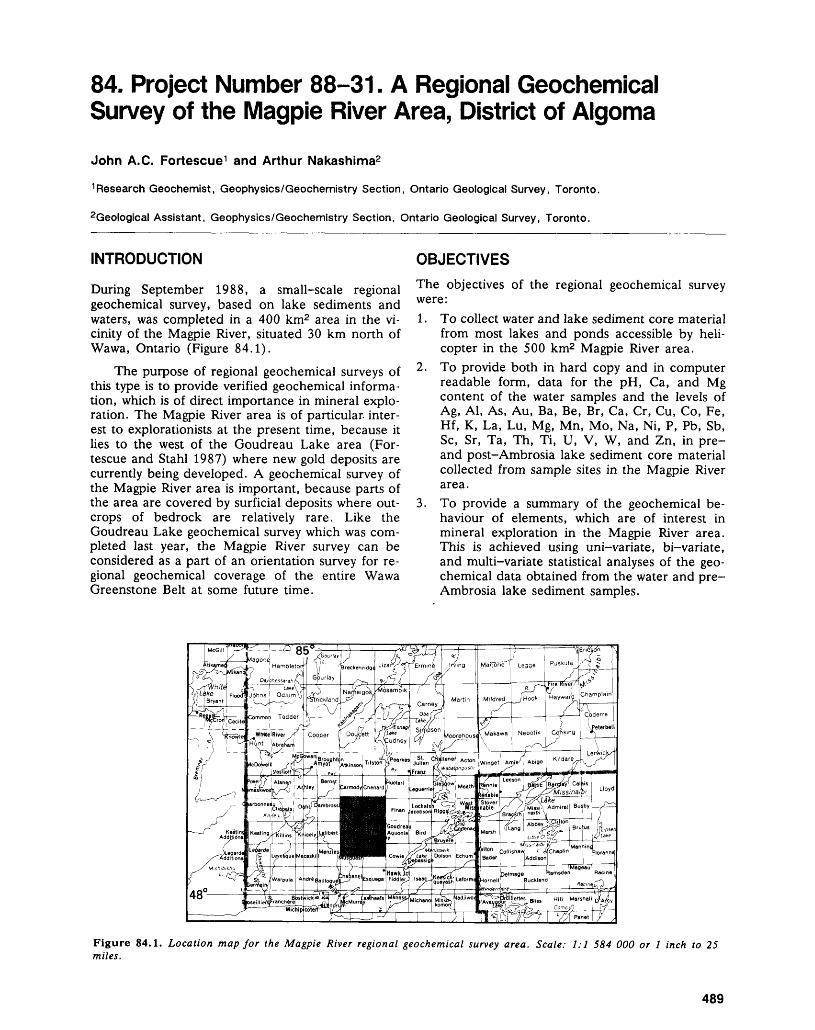
84. Project Number 88-31. A Regional Geochemical Survey of the Magpie River Area, District of Algoma
John A.C. Fortescue 1 and Arthur Nakashima2
1 Research Geochemist, Geophysics/Geochemistry Section, Ontario Geological Survey, Toronto.
2Geological Assistant, Geophysics/Geochemistry Section, Ontario Geological Survey, Toronto.
INTRODUCTION
During September 1988, a small-scale regional geochemical survey, based on lake sediments and waters, was completed in a 400 km2 area in the vi cinity of the Magpie River, situated 30 km north of Wawa, Ontario (Figure 84.1).
The purpose of regional geochemical surveys of this type is to provide verified geochemical informa tion, which is of direct importance in mineral explo ration. The Magpie River area is of particular, inter est to explorationists at the present time, because it lies to the west of the Goudreau Lake area (For tescue and Stahl 1987) where new gold deposits are currently being developed. A geochemical survey of the Magpie River area is important, because parts of the area are covered by surficial deposits where out crops of bedrock are relatively rare. Like the Goudreau Lake geochemical survey which was com pleted last year, the Magpie River survey can be considered as a part of an orientation survey for re gional geochemical coverage of the entire Wawa Greenstone Belt at some future time.
OBJECTIVESThe objectives of the regional geochemical survey were:1. To collect water and lake sediment core material
from most lakes and ponds accessible by heli copter in the 500 km2 Magpie River area.
2. To provide both in hard copy and in computer readable form, data for the pH, Ca, and Mg content of the water samples and the levels of Ag, Al, As, Au, Ba, Be, Br, Ca, Cr, Cu, Co, Fe, Hf, K, La, Lu, Mg, Mn, Mo, Na, Ni, P, Pb, Sb, Se, Sr, Ta, Th, Ti, U, V, W, and Zn, in pre- and post-Ambrosia lake sediment core material collected from sample sites in the Magpie River area.
3. To provide a summary of the geochemical be haviour of elements, which are of interest in mineral exploration in the Magpie River area. This is achieved using uni-variate, bi-variate, and multi-variate statistical analyses of the geo chemical data obtained from the water and pre- Ambrosia lake sediment samples.
Figure 84.1. Location map for the Magpie River regional geochemical survey area. Scale: 1:1 584 000 or l inch to 25 miles.
489
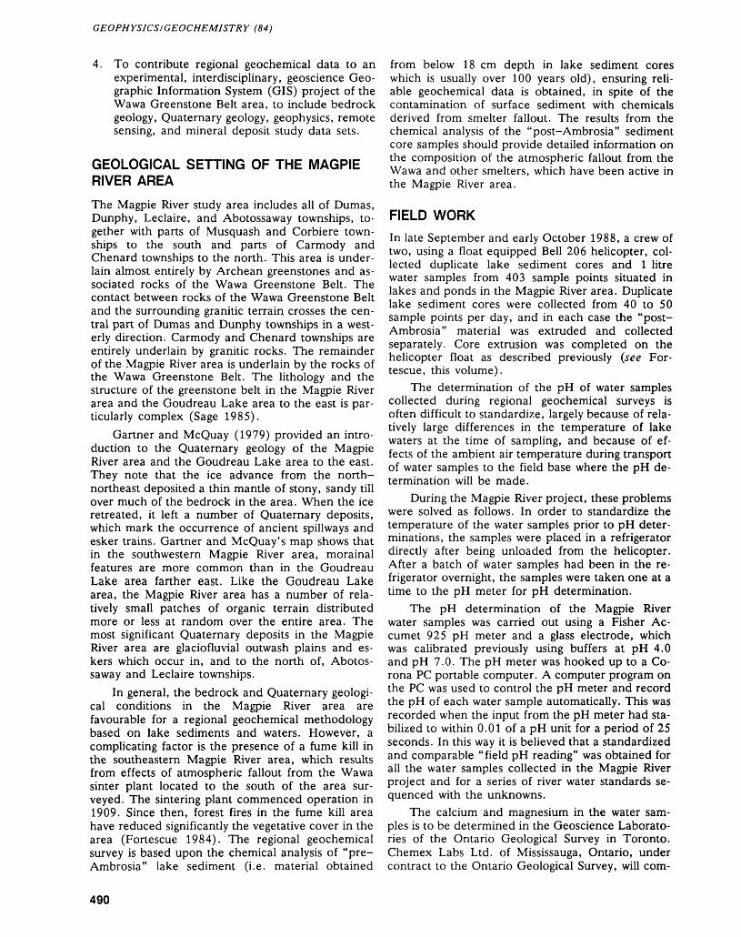
GEOPHYSICS/GEOCHEMISTRY (84)
4. To contribute regional geochemical data to an experimental, interdisciplinary, geoscience Geo graphic Information System (GIS) project of the Wawa Greenstone Belt area, to include bedrock geology, Quaternary geology, geophysics, remote sensing, and mineral deposit study data sets.
GEOLOGICAL SETTING OF THE MAGPIE RIVER AREA
The Magpie River study area includes all of Dumas, Dunphy, Leclaire, and Abotossaway townships, to gether with parts of Musquash and Corbiere town ships to the south and parts of Carmody and Chenard townships to the north. This area is under lain almost entirely by Archean greenstones and as sociated rocks of the Wawa Greenstone Belt. The contact between rocks of the Wawa Greenstone Belt and the surrounding granitic terrain crosses the cen tral part of Dumas and Dunphy townships in a west erly direction. Carmody and Chenard townships are entirely underlain by granitic rocks. The remainder of the Magpie River area is underlain by the rocks of the Wawa Greenstone Belt. The lithology and the structure of the greenstone belt in the Magpie River area and the Goudreau Lake area to the east is par ticularly complex (Sage 1985).
Gartner and McQuay (1979) provided an intro duction to the Quaternary geology of the Magpie River area and the Goudreau Lake area to the east. They note that the ice advance from the north- northeast deposited a thin mantle of stony, sandy till over much of the bedrock in the area. When the ice retreated, it left a number of Quaternary deposits, which mark the occurrence of ancient spillways and esker trains. Gartner and McQuay's map shows that in the southwestern Magpie River area, morainal features are more common than in the Goudreau Lake area farther east. Like the Goudreau Lake area, the Magpie River area has a number of rela tively small patches of organic terrain distributed more or less at random over the entire area. The most significant Quaternary deposits in the Magpie River area are glaciofluvial outwash plains and es- kers which occur in, and to the north of, Abotos saway and Leclaire townships.
In general, the bedrock and Quaternary geologi cal conditions in the Magpie River area are favourable for a regional geochemical methodology based on lake sediments and waters. However, a complicating factor is the presence of a fume kill in the southeastern Magpie River area, which results from effects of atmospheric fallout from the Wawa sinter plant located to the south of the area sur veyed. The sintering plant commenced operation in 1909. Since then, forest fires in the fume kill area have reduced significantly the vegetative cover in the area (Fortescue 1984). The regional geochemical survey is based upon the chemical analysis of "pre- Ambrosia" lake sediment (i.e. material obtained
from below 18 cm depth in lake sediment cores which is usually over 100 years old), ensuring reli able geochemical data is obtained, in spite of the contamination of surface sediment with chemicals derived from smelter fallout. The results from the chemical analysis of the "post-Ambrosia" sediment core samples should provide detailed information on the composition of the atmospheric fallout from the Wawa and other smelters, which have been active in the Magpie River area.
FIELD WORKIn late September and early October 1988, a crew of two, using a float equipped Bell 206 helicopter, col lected duplicate lake sediment cores and l litre water samples from 403 sample points situated in lakes and ponds in the Magpie River area. Duplicate lake sediment cores were collected from 40 to 50 sample points per day, and in each case the "post- Ambrosia" material was extruded and collected separately. Core extrusion was completed on the helicopter float as described previously (see For tescue, this volume).
The determination of the pH of water samples collected during regional geochemical surveys is often difficult to standardize, largely because of rela tively large differences in the temperature of lake waters at the time of sampling, and because of ef fects of the ambient air temperature during transport of water samples to the field base where the pH de termination will be made.
During the Magpie River project, these problems were solved as follows. In order to standardize the temperature of the water samples prior to pH deter minations, the samples were placed in a refrigerator directly after being unloaded from the helicopter. After a batch of water samples had been in the re frigerator overnight, the samples were taken one at a time to the pH meter for pH determination.
The pH determination of the Magpie River water samples was carried out using a Fisher Ac- cumet 925 pH meter and a glass electrode, which was calibrated previously using buffers at pH 4.0 and pH 7.0. The pH meter was hooked up to a Co rona PC portable computer. A computer program on the PC was used to control the pH meter and record the pH of each water sample automatically. This was recorded when the input from the pH meter had sta bilized to within 0.01 of a pH unit for a period of 25 seconds. In this way it is believed that a standardized and comparable "field pH reading" was obtained for all the water samples collected in the Magpie River project and for a series of river water standards se- quenced with the unknowns.
The calcium and magnesium in the water sam ples is to be determined in the Geoscience Laborato ries of the Ontario Geological Survey in Toronto. Chemex Labs Ltd. of Mississauga, Ontario, under contract to the Ontario Geological Survey, will com-
490
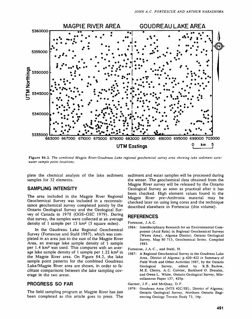
JOHN A. C. FORTESCUE AND ARTHUR NAKASHIMA
MAGPIE RIVER ARE A GOUDREAULAKE AREA5360000
5355000
CO
c* 5350000
5345000
5340000
5335000
* * * *** * * * t
• * '••. *
663000 667000 671000 675000 679000 683000 687000 691000 695000 699000 703000O km 5UTM Eastings
Figure 84.2. The combined Magpie River l Gaudreau Lake regional geochemical survey area showing lake sediment core/ water sample point locations.
plete the chemical analysis of the lake sediment samples for 32 elements.
SAMPLING INTENSITY
The area included in the Magpie River Regional Geochemical Survey was included in a reconnais sance geochemical survey completed jointly by the Ontario Geological Survey and the Geological Sur vey of Canada in 1978 (OGS-GSC 1979). During that survey, the samples were collected at an average density of l sample per 13 km2 (5 square miles).
In the Gaudreau Lake Regional Geochemical Survey (Fortescue and Stahl 1987), which was com pleted in an area just to the east of the Magpie River Area, an average lake sample density of l sample per 1.4 km2 was used. This compares with an aver age lake sample density of l sample per 1.22 km2 in the Magpie River area. On Figure 84.2, the lake sample point patterns for the combined Goudreau Lake/Magpie River area are shown, in order to fa cilitate comparisons between the lake sampling cov erage in the two areas.
PROGRESS SO FAR
The field sampling program at Magpie River has just been completed as this article goes to press. The
sediment and water samples will be processed during the winter. The geochemical data obtained from the Magpie River survey will be released by the Ontario Geological Survey as soon as practical after it has been checked. High element values found in the Magpie River pre-Ambrosia material may be checked later on using long cores and the technique described elsewhere in Fortescue (this volume).
REFERENCESFortescue, J.A.C.1984: Interdisciplinary Research for an Environmental Com
ponent (Acid Rain) in Regional Geochemical Surveys (Wawa Area), Algoma District; Ontario Geological Survey, Map 80 713, Geochemical Series. Compiled 1983.
Fortescue, J.A.C., and Stahl, H.1987: A Regional Geochemical Survey in the Goudreau Lake
Area, District of Algoma; p.420-422 in Summary of Field Work and Other Activities 1987, by the Ontario Geological Survey, edited by R.B. Barlow, M.E. Cherry, A.C. Colvine, Burkhard O. Dressler, and Owen L. White, Ontario Geological Survey, Mis cellaneous Paper 137, 429p.
Gartner, J.F., and McQuay, D.F.1979: Goudreau Area (NTS 42C/SE), District of Algoma;
Ontario Geological Survey, Northern Ontario Engi neering Geology Terrain Study 73, 14p.
491
GEOPHYSICS/GEOCHEMISTRY (84)
Ontario Geological Survey-Geological Survey of Canada Sage, R.P.(OGS-GSC) 1985: Goudreau-Lochalsh Area, District of Algoma;
1979: Regional Lake Sediment and Water Geochemical Re- p.90-94 in Summary of Field Work and Other Activi- connaissance Data, Eastern Shore Lake Superior, ties 1985, Ontario Geological Survey, edited by John Ontario, NTS 42C, 42F (S/2); Ontario Geological Wood, Owen L. White, R.B. Barlow, and A.C. Col- Survey, Open File Report 5267, 85p., 16 maps, scale vine, Ontario Geological Survey, Miscellaneous Paper 1:250 000. 126, 351p.
492

Geoscience Laboratories Programs

85. Summary of Activities 1988, Geoscience Laboratories Section
Chris Riddle
Section Chief, Geoscience Laboratories Section, Ontario Geological Survey, Toronto.
INTRODUCTIONThe Geoscience Laboratories of the Ontario Geological Survey were given Sec tion status in 1987 and articles from the Section appear in this Summary of Ac tivities for the first time. In addition to the production of routine geoanalytical data, the Laboratories Section performs analytical methods development work in support of Ontario Geological Survey programs.
This summary of scientific project work highlights recent achievements in the Laboratories' three subsections. To place these achievements in perspective, the interested reader is directed to the Laboratories' Manual and synopsis of "Ana lytical capabilities". A new edition of the former should be available in 1989; the latter is available from the Laboratories, on request.
MINERAL SCIENCE SUBSECTIONPeter Lightfoot, Supervisor of the Mineral Science Subsection, has been responsi ble for the introduction of new techniques related to routine production. He has also initiated work on a new method for the determination of the platinum group elements.
GRAIN SIZE ANALYSIS
Grain size analysis is used in the engineering classification of soils. Convention ally, the size distribution of particles with diameters in excess of 74 ji is deter mined by dry sieving, while the size distribution of particles with diameters less than 74 p. is determined by a sedimentation process using a hydrometer (ASTM procedure D422-54T). Both procedures are slow and require manual operation. In 1988, the Mineral Science Subsection acquired a particle size analysis system which allows the automated determination of grain size distributions from 2 to 700 ji. This first stage upgrade of grain size analysis has resulted in a doubling of productivity and the establishment of improved quality controls.
MINERAL SEPARATION
The use of toxic heavy organic liquids in the separation of mineral phases has been largely discontinued following the development of a non-toxic, high density agent (sodium polytungstate), a solution of which has a density adjustable up to 3.1 g/cm3 .
PLATINUM GROUP ELEMENTSA procedure has been developed for the pre-concentration of the platinum group elements into a nickel sulphide fire assay button, together with a chemical proce dure for the removal of the nickel sulphide to produce a noble metal concentrate. Access to the University of Toronto SLOWPOKE reactor and counting facilities permits routine neutron activation analysis of the concentrates for the entire spec trum of noble metals. Plans exist, in the Spectroscopy Subsection, for the devel opment of an inductively-coupled-plasma mass-spectrometric (ICP-MS) method for the determination of the platinum group elements using these same noble metal concentrates.
Five new in-house reference materials have been developed for the platinum group elements. These were collected by James MacDonald, of the Precambrian
494
CHRIS RIDDLE
Section, with assistance from the Laboratories Section, and come from the Sud bury igneous complex, Ontario, and the Stillwater complex, Montana. Approxi mate concentration ranges (parts per billion) are as follows: gold, 300 to 6000; platinum, 700 to 7000; palladium, 1000 to 250 000; osmium, 10 to 300; iridium, 40 to 300; ruthenium, 60 to 750; rhodium, 150 to 2500.
Access to the SLOWPOKE facility also enables the Laboratories Section to perform routine determinations of tantalum and hafnium at the part per million level in rock samples.
MINERALOGY AND PETROLOGY
An X-Ray Diffraction (XRD) method, to replace the conventional Chittick method for the determination of calcite:dolomite ratios, is under development. Preliminary results on reference materials indicate that XRD will provide im proved precision, accuracy, and productivity.
Routine access to electron microprobe facilities have been arranged with the University of Toronto to develop micromineralogical expertise within the Labora tories Section. Projects involving the analysis of mineral phases in samples submit ted by staff geologists are in progress.
Methods have been developed within the Section for the separation and con centration of mineral phases from rock samples using a combination of tech niques such as: isodynamic (Frantz) separation, specific gravity differentiation (high density reagents), and hand-picking of crystals. These methods have been applied to studies of two samples of Nipissing diabase with subsequent rare earth element analysis.
CHEMISTRY SUBSECTIONChris Chan, Supervisor of the Chemistry Subsection, has participated in a wide- ranging review of sample preparation techniques, and has continued development of flow-injection analysis as applied to trace element analysis.
SAMPLE PREPARATION
Most methods for the determination of trace elements in geological materials require the preparation of a solution sample. The quality of analytical data for rock samples is therefore directly affected by the quality of the decomposition. Three sample preparation projects have been completed.
First, a common dissolution procedure, using acid digestion, has been devel oped for atomic absorption (AA) and inductively coupled plasma (ICP) based methods. This has increased productivity, and allows a single solution to be used for a variety of determinations.
Second, a procedure has been developed for "total decomposition" of rock samples in cases where the presence of intractable mineral phases renders acid digestion incomplete. This procedure involves acid digestion followed by fusion of the remaining residue. It produces a solution of relatively low salt content suitable for analysis by AA and ICP instrumentation.
Third, a robotic system has been installed to automate acid digestion.
FLOW INJECTION ANALYSISFlow-injection analysis is a technique that allows a discrete solution sample to be inserted into a carrier stream, without being diluted by the carrier, thereby en hancing analytical sensitivity. The technique has been successfully applied to the determination of selenium (Chan 1985) and chlorine (as per Fuge 1985) in rock samples, providing improved methods for these elements. No significant improve ment over existing methodology resulted when the technique was applied to the determination of fluorine and mercury.
TRACE ELEMENT METHODS
A sensitive automated method for the determination of mercury using the tech nique of flameless AA (Kennedy and Crock 1987) has been applied to more than
495
GEOSCIENCE LABORATORIES (85)
50 international geological reference materials (Chan and Bina, in press). The results attest to the accuracy of the method and provide new data for those refer ence materials lacking well-defined mercury values.
In support of the current geochemistry program, a sensitive method for the determination of gold in waters, based on work of McHugh (1984), has been brought into routine operation. Gold is extracted into methyl isobutyl ketone and measured using graphite furnace AA spectrometry. The determination limit is 3 ng/1 (0.003 ppb) which is approximately the background level of gold in natural waters.
SPECTROSCOPY SUBSECTIONTony Vander Voet, Supervisor of the Spectroscopy Subsection, returned from a leave of absence during which he accepted a Canadian International Develop ment Agency assignment in Bangkok as a trainer and consultant in analytical chemistry to the Department of Mineral Resources, Government of Thailand. While there he prepared a training manual and assisted in the development of quality control procedures.
Development work in the subsection has been focused on methods for the determination of trace elements using the techniques of ICP-Optical Emission Spectrometry (OES) and ICP-Mass Spectrometry (MS).
DEVELOPMENTS IN ICP-OESA re—evaluation of ICP-OES methodology has resulted in revised procedures for the following elements, with the determination limits indicated: beryllium (l ppm); scandium (2 ppm); strontium, vanadium, yttrium, cobalt, copper, nickel, and zinc (5 ppm); tungsten (50 ppm).
A new ICP-OES instrument, using a photodiode array detector system, has been under evaluation in the subsection. It has been applied to the determination of molybdenum, boron, and conventional geoanalytical multi-element packages.
DEVELOPMENTS IN ICP-MSAs one of the first analytical laboratories in the world to acquire an ICP-MS instrument, the Geoscience Laboratories Section has played a major role in geoanalytical applications of the technique and has published a review of the field (Riddle, Vander Voet, and Doherty 1988).
The Laboratories Section has developed a capability for high quality rare earth element (REE) analytical data (see Table 85.1), suitable for the production of chondrite plots. Initial work resulted in the first comprehensive ICP-MS study of REE in certified geological reference materials (Doherty and Vander Voet 1985). Doherty (in press) has now published the results of an internal standardi zation procedure which has increased significantly the accuracy and precision of ICP-MS measurements. The high quality of the data was confirmed by the inter national certification study of Ailsa Craig Granite (AC-E); the first such program to include ICP-MS data (Govindaraju 1987).
In addition to the REE, five other elements are now routinely determined by ICP-MS. These elements, with their corresponding determination limits in rock, are: thorium (50 ppb); uranium (50 ppb); lead (50 ppb); thallium (50 ppb); and tin (500 ppb).OTHER ACTIVITIESAs part of a co-operative program with the Department of Mineral Resources of the Government of Thailand, the Mineral Sciences Subsection participated in training programs for two scientists from Bangkok. Srisopa Maranate worked in mineralogy; Wanachai Saisook in fire assay.
Wanachai Saisook was also trained in spectroscopic trace analysis using flameless AA, hydride generation AA, and graphite furnace AA in the Chemistry Subsection.
The Spectroscopy Subsection provided training to an Indonesian scientist, Dr. Wuryanto, sponsored by Atomic Energy of Canada.
496
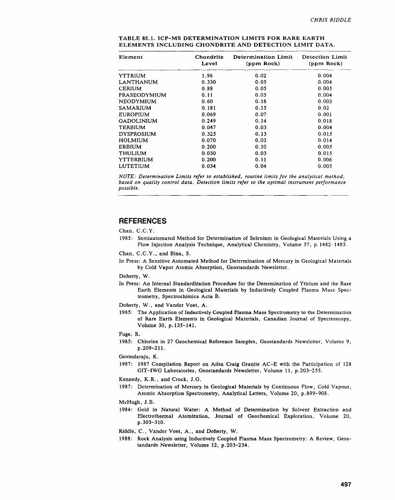
CHRIS RIDDLE
TABLE 85.1. ICP-MS DETERMINATION LIMITS FOR RARE EARTH ELEMENTS INCLUDING CHONDRITE AND DETECTION LIMIT DATA.
Element
YTTRIUMLANTHANUMCERIUMPRASEODYMIUMNEODYMIUMSAMARIUMEUROPIUMGADOLINIUMTERBIUMDYSPROSIUMHOLMIUMERBIUMTHULIUMYTTERBIUMLUTETIUM
Chondrite Determination Limit Detection Limit Level (ppm Rock) (ppm Rock)
1.960.3300.880.110.600.1810.0690.2490.0470.3250.0700.2000.0300.2000.034
0.020.050.050.050.180.150.070.140.030.130.030.100.030.110.04
0.0040.0040.0050.0040.0030.020.0010.0180.0040.0150.0140.0050.0150.0060.005
NOTE: Determination Limits refer to established, routine limits for the analytical method, based on quality control data. Detection limits refer to the optimal instrument performance possible.
REFERENCESChan, C.C.Y.1985: Semiautomated Method for Determination of Selenium in Geological Materials Using a
Flow Injection Analysis Technique, Analytical Chemistry, Volume 57, p. 1482-1485.Chan, C.C.Y., and Bina, S.In Press: A Sensitive Automated Method for Determination of Mercury in Geological Materials
by Cold Vapor Atomic Absorption, Geostandards Newsletter.Doherty, W.In Press: An Internal Standardization Procedure for the Determination of Yttrium and the Rare
Earth Elements in Geological Materials by Inductively Coupled Plasma Mass Spec trometry, Spectrochimica Acta B.
Doherty, W., and Vander Voet, A.1985: The Application of Inductively Coupled Plasma Mass Spectrometry to the Determination
of Rare Earth Elements in Geological Materials, Canadian Journal of Spectroscopy,Volume 30, p. 135-141.
Fuge, R.1985: Chlorine in 27 Geochemical Reference Samples, Geostandards Newsletter, Volume 9,
p.209-211.Govindaraju, K.1987: 1987 Compilation Report on Ailsa Craig Granite AC-E with the Participation of 128
GIT-IWG Laboratories, Geostandards Newsletter, Volume 11, p.203-255.Kennedy, K.R., and Crock, J.G.1987: Determination of Mercury in Geological Materials by Continuous Flow, Cold Vapour,
Atomic Absorption Spectrometry, Analytical Letters, Volume 20, p.899-908.McHugh, J.B.1984: Gold in Natural Water: A Method of Determination by Solvent Extraction and
Electrothermal Atomization, Journal of Geochemical Exploration, Volume 20,p.303-310.
Riddle, C., Vander Voet, A., and Doherty, W.1988: Rock Analysis using Inductively Coupled Plasma Mass Spectrometry: A Review, Geos
tandards Newsletter, Volume 12, p.203-234.
497
86. Project 88-01. The Determination of Trace Concentrations of Rare Earth Elements at the Geoscience Laboratories, Ontario Geological Survey
Anthony Vander Voet
Supervisor, Spectroscopy Laboratory, Geoscience Laboratories Section, Ontario Geological Survey.
INTRODUCTION
In order to establish a reliable analytical method for the determination of yttrium and the rare earth ele ments (REE), the Spectroscopy Sub-section of the Geoscience Laboratories, Ontario Geological Survey (GLOGS), has undertaken a number of develop mental projects. This report surveys the work which has been carried out over the past ten years, and describes the current methods.
The stimulus for the development of analytical methods for the determination of trace level REE has been the use of these elements as indicators of petrogenetic processes. On the assumption that the original magmatic REE concentration distribution is approximated by that in chondritic meteorites, REE concentration data are normalized relative to chondrites and are plotted (as their logarithms) against atomic numbers. Where the distribution of REE approximates that in the original magma, chondrite plots are expected to exhibit relatively smooth slopes; anomalous changes in distribution are observed as sharp deviations in the plots. Be cause of the low chondrite normalizing values and the manner in which the data are treated for plot ting, rare earth element concentrations in the range 0.02 to 100 ppm must be determined with unusually high precision and accuracy.
Much of the REE data appearing in geological or chemical literature have been obtained by instru mental neutron activation analysis (INAA), and al though capable of providing excellent data, INAA is difficult, expensive, and subject to interferences. Other methods have included mass spectrometry (MS), X-ray fluorescence (XRF), atomic absorp tion spectroscopy (AAS), and emission spectrogra phy. In the past ten years, inductively coupled plas ma optical emission spectroscopy (ICP-OES) and, more recently, ICP mass spectrometry (ICP-MS) have been applied to REE determinations. ICP-OES has proven useful for the routine determination of REE because of its sensitivity, its ability to correct for spectral interferences, and its ability to perform simultaneous multi-element determinations. Al though direct ICP-OES analysis of solutions of rocks and minerals (decomposed by acid digestion or fu sion) can be applied to samples containing relatively high concentrations of REE, separation of the REE
analytes from matrix elements is generally required for trace level (chondrite) determinations.
The excellent sensitivity, relative freedom from spectral interferences, and rapid sequential nature of ICP-MS permit REE determinations with detection limits at or below chondrite levels without REE sepa ration or preconcentration. The application of ICP- MS to the analysis of geological materials was re viewed recently by C. Riddle, A. Vander Voet and W. Doherty (Geoscience Laboratories, OGS) in an article published in Geostandards Newsletter (Riddle et al. 1988).
Development work in the determination of REE at the GLOGS has included studies in XRF, ICP- OES, and ICP-MS. Considerable attention has been paid to the separation of REE from matrix elements for XRF and ICP-OES determinations by column ion exchange, high performance liquid chromatogra phy (HPLC), and robotic techniques. Recently, a reliable, well-documented REE determination method for the ICP-MS has been developed, and is in current use for routine determinations. Full dis cussion of experimental details, reference material data, and work by other groups is reviewed in the Geoscience Laboratories' laboratory guide and man ual (Riddle and Vander Voet, in preparation).
SAMPLE PREPARATION AND ANALYTE SEPARATIONSpectroscopic determinations of REE in geological matrices are generally complicated by: a) the gener ally low concentration levels of REE relative to in strument detection limits; b) the high concentrations of major elements and the presence of other minor and trace elements, which can be sources of chemi cal or spectral interference; and c) the lack of well- defined "usable" concentration values for certified reference (rock) materials (CRMs).Rock matrices are among the most difficult sample systems for trace element analysis. The ideal rock analytical subsample is a fine, well-homogenized pulp of a representative field sample. Thus, for ex ample, REE determinations in pressed powder pel lets by XRF would be a preferred method (as it uses 5 g of rock pulp), were it not for the fact that XRF detection limits are not sufficiently low. Solid sam ples are also used in DC-Arc spectroscopy, and
498
ANTHONY VANDER VOET
more recently, in direct solid, electrothermal vapori zation, and arc and laser ablation techniques for ICP-OES and ICP-MS. The disadvantage of matrix (spectral) interferences, as well as the sample sizes used, limit their general application to the determi nation of REE in geological samples to samples con taining relatively high analyte concentrations (Riddle et al. 1988).
Conventional ICP techniques employ solution nebulization to deliver the sample to the plasma. The requirement for total decomposition of samples can present some major problems, especially in the determination of REE. Low temperature acid diges tion (using HF, HC1O4 , and either HNO3 or HC1) is the most popular method of sample decomposition, and is used by many laboratories, including those at the USGS (Crock and Lichte 1982) and the GLOGS (Bolton et al. 1983; Aulis et al. 1985; Doherty and Vander Voet 1985). This technique is generally sat isfactory, except where the rock contains acid-resis tant minerals, e.g. zircons. Although fusion tech niques can decompose most rocks and minerals ef fectively (including zircons), they introduce addi tional total dissolved solids, resulting in possible deleterious transport effects in solution nebulization to flames and plasmas, and deterioration of detec tion limits.
In order to minimize matrix problems and sim plify the determination of REE, it has been custom ary to separate the REE analytes from the matrix elements, thereby preconcentrating the analytes and overcoming limitations in instrumental detection lim its. Separation techniques have included chemical separations, solvent extraction, ion exchange, and high performance liquid chromatography (HPLC). The popular cation exchange procedure is based on the preference of the trivalent REE ions for sites on a cation resin (conditioned with an acid medium). Dilute acid (HCl or HNO3) is used to elute most of the matrix ions from the column. REE ions are re moved'at higher acid concentrations (6 to S N HCl or HNO3). Ion exchange was used for the separation and preconcentration of REE for XRF analysis by Eby (1972), employing Dowex 50W-X8 resin and HCl. In this separation, all the cations except scan dium, barium, yttrium, thorium, zirconium, and the REE could be eluted with the dilute acid. Experi ments at the GLOGS showed that the separation was relatively inefficient, i.e. wide ion "band widths", es pecially for calcium and strontium. Similar ion ex change procedures were followed by other groups in cluding Strelow and Jackson (1974), Walsh et al. (1981), and Brenner et al. (1984) for their ICP studies. At the United States Geological Survey (USGS) laboratories, Crock and Lichte (1982) (see also Crock, Lichte and Wildeman 1984) also used cation exchange separation, but found HNO3 to be more efficient in removing matrix ions, including calcium and barium, in the first step. Iron, which was retained on the column, even after elution with
concentrated acid, was removed by an anion ex change step with HCl. Analysts at the GLOGS adapted the separation scheme proposed by Eby (1972) for XRF work, modifying it for ICP-OES (Bolton e t al. 1983). They further modified the separation in later work, using both dilute HCl and HNO3 in the first step, and concentrated HNO3 (6 to 8 TV) for fraction collection.
Column exchange is slow, and resin panicle size is relatively large; resulting in significant band spreading and potential overlap in matrix element and REE appearances. Large volumes of acids are required, introducing post-separation sample prepa ration steps and increasing time for analysis. High performance liquid chromatography (HPLC) is ca pable of reducing many of the problems found in open column systems. Control of flow rates results in significant decrease in separation time. The particle size of column packing material is reduced, increas ing separation efficiency.
The combination of HPLC with ICP spectro- scopic detection (OES and MS) is becoming increas ingly popular; spectroscopic detection provides the sensitivity and the element selectivity needed to dis tinguish column effluents by chemical composition. It is especially powerful in the case of multi-channel OES or rapid MS detection, where "spectroscopic separation" can enhance chromatographic separa tion.
In our HPLC studies (Aulis et al. 1985), the HPLC outlet was connected directly to nebulizer in let on the ICP-OES spectrometer. Chromatographic flow rates were matched to conventional nebulizer flow rates (l to 3 ml/min). In order to obtain time- based data for all channels on the 36-channel spec trometer, the entrance slit "profile routine" (stan dard system software) was employed with the slit- drive stepping motor turned off. Because of acid concentration limitations to the HPLC instrumenta tion and the ion exchange column packing, aqueous solutions of NaNO3 and MgCl2 were tested as eluents. Separation tests indicated Mg"1" 2 was prefer able to Na*, since lower concentrations of the Mg*2 counter ion could be used, and separations proved more efficient. Experiments with solutions of di gested rock residues resulted in the development of a double gradient procedure to effect the separation. Matrix elements were removed by applying a small "burst" of Mg*2 , and after a brief water rinse, a sec ond gradient increase was used to remove the yt trium and REE.
Linear calibration curves were obtained by plot ting expected analyte concentrations (in synthetic rock base solutions spiked with REE) against chromatographic "profile" peak areas. Inter-REE spectral interference coefficients were obtained us ing conventional nebulization and applied directly to the chromatographic data. Yttrium and selected REE were determined for a number of reference materials and agreement was satisfactory. Determi-
499
GEOSCIENCE LABORORATORIES (86)
nation limits (lowest quantitatively determinable concentration, LQD) were found to be: •ci ppm for europium and ytterbium; l to 2 ppm for lanthanum, dysprosium, gadolinium, and yttrium; 5 ppm for sa marium; and 10 ppm for cerium and neodymium. Experimental results indicated that HPLC-ICP-OES could be applied to the determination of REE in geological materials. The technique does not involve fraction collection and reduces the need for constant operator attendance. The disadvantages of HPLC, including the need for a relatively large amount of instrument time, and the relatively poor determina tion limits compared to those for observed for open- column exchanged systems, indicated that this tech nique was not suitable for routine chondrite-level work.
In order to perform more efficient batch column ion exchange of REE in geological samples, K. Govindaraju of the Centre de Recherches Petro- graphiques et Geochimiques (France) developed a robotic system, the LABROB, (Govindaraju, Lang, Mevelle and Janssens (1984); Govindaraju, Mevelle and Lang (1984)). This system consisted of a rack of small ion exchange columns and a rack of sample introduction tubes, with a computer-controlled robotic arm to move the racks between rows of sam ple, eluent, and collection vials. As the GLOGS was becoming recognized for its work in REE, the manu facturers of the LABROB invited it to evaluate the prototype system. Since the chemistry of the separa tion was the same as that used successfully with open columns (as discussed previously), most of the evaluation involved optimization of separation pa rameters and modification of software to introduce experimental flexibility. The LABROB system was found to be relatively successful for the separation of REE. However, the main problem with the system, i.e. the non-equivalence and irreproducibility of flow rates through the twelve columns and the subse quent need for manual intervention, led us to con clude that the prototype system did not offer any significant degree of improvement over the manual procedure.
TABLE 86.1.
The spectroscopic technique first employed at the GLOGS for REE was based on the XRF method de scribed by Eby (1972). Digestion of a rock sample with mineral acids was followed by ion exchange separation of the REE as described. Thulium (100 ppm) was used as an internal standard and added to the sample before decomposition. After decomposition and separation, barium (which was eluted from the column with the REE) was precipi tated from the REE fraction (as BaSO4), and the final solution evaporated on cation exchange resin loaded filter papers, which were then submitted for
ElementYttriumLanthanumCeriumNeodymium SamariumEuropium GadoliniumDysprosium Ytterbium
YLaCeNd SmEu GdDy Yb
Wavelength371.030 nm379.478413.765406.109 359.260381.967 342.247353.170 328.937
Commentmost sensitive ICP linesecond most sensitivemost sensitivethird most sensitive most sensitivemost sensitive most sensitivemost sensitive most sensitive
XRF analysis 1 . Examination of the wavelength tables for analyte lines, as well as potential interfering lines, indicates that extensive interference correction is re quired to correct XRF data. Each analyte requires individual calibration to obtain the required concen tration and interference correction factors. The in stability of the PW1540 spectrometer, made it nec essary to monitor drift, and to use extensive recalibration and checking of interference coeffi cients. After XRF measurement at each analyte and interferent wavelength (for both sides of the sample paper), intensity data were corrected and converted to concentrations. Data were then normalized with respect to the thulium internal standard and (except for thulium) reported.
The need for extensive interference correction and data normalization was a major impediment to accuracy of the method. Both sample preparation and XRF measurements were labour intensive and slow (e.g. M hour/sample to accumulate XRF counts); productivity levels averaged about 4 sam ples per technician-week.
The JY48P (Instruments S.A.) ICP-OES spec trometer system purchased by the GLOGS was con figured to include selected REE channels (yttrium, cerium, lanthanum, neodymium, samarium, euro pium, gadolinium, dysprosium, and ytterbium) on the 36-channel polychromator. Each of the REE has many lines in the optical emission spectrum; in order to maximize the spectral information, espe cially for low concentrations of REE, it was impor tant to choose analyte wavelengths of high sensitivity and as free from spectral interferences as possible. The following lines were chosen (see Table 86.1).
Recognizing that the high concentrations of ma trix elements in rock samples would severely limit detection limits for REE, the sample preparation and separation steps used in the XRF method were adapted for ICP-OES analysis. After collection of the REE fraction from the ion exchange column, the solution was brought to dryness and the residue dis-
GLOGS method was developed originally for the Philips PW1540 XRF spectrometer (since replaced), using a tungsten target X-ray tube, an LiF(200) crys tal, flow counter detection; count time at all peaks was 100 s.
500
ANTHONY VANDER VOET
solved in a small volume of dilute acid (15 ml). This solution was then nebulized into the ICP, and the REE channels monitored. Sample through-put in creased significantly, as the spectroscopic measure ment time was considered trivial.
Detection and determination limits for the REE depend on the analyte wavelength used, and on the matrix of the sample solution and the need for inter ference correction. Instrumental detection limits (DL) reflect instrument stability under ideal condi tions and are defined as 2a of the background (or blank), are generally obtained from replicate meas urement during a single nebulization of a pure (spec troscopic) standard. Determination limits, often ex pressed as "(lower) limit of quantitative determina tion" (LQD or LLQD), reflect the non-ideality of the sample, the need for interference corrections, and errors associated with sample preparation. They are often approximated as 5x the instrumental DL (or lOa)2 . LQD values for REE (ion exchange) de terminations were reported (Bolton e t al. 1983) to be: lanthanum, 0.5; cerium, 6; neodymium, 2; sa marium, 2; europium, 0.1; gadolinium, 1; dyspro sium, 0.5; and ytterbium, 0.1 (all in ppm rock). These values were similar to determination limits re ported by Walsh et al. (1981) and Brenner et al. (1984), and indicate the procedure to be capable of measuring REE concentrations near chondrite lev els.
Data for certified reference (rock) materials are conventionally used to assess the accuracy of an analytical method. Experimental results are often compared to values (or ranges of values) appearing in the chemical literature or in compilations such as that by Abbey (1980, 1983). CRM results have been reported by the GLOGS (see Bolton et al. 1983; Aulis et al. 1985) and by other groups (see also Walsh et al. 1981; Crock and Lichte 1982; Yoshida and Haraguchi 1984 (REE determinations by HPLC-ICP-OES); Brenner et al. 1984)3. The agreement observed between groups is often better than agreement with accepted values; this generally reflects the uncertainty in the "accepted" value, rather than the quality of experimental data.
ICP-MS DETERMINATION OF RARE EARTH ELEMENTSThe recently developed technique of inductively coupled plasma mass spectrometry (ICP-MS) has had considerable impact on the determination of
^Determination limits can also be obtained from 2(7 calcu lations for replicate preparations of samples contain ing low levels of analyte (near the expected determi nation limit).
^Tables of ICP-OES data are compared to literature and ICP-MS data in a review by Riddle and Vander Voet (in preparation).
trace elements in geological materials. Given the complexity inherent in the determination of trace elements in geological materials, the advantages of a mass spectroscopic technique in a relatively "a-fford- able" form aroused a great deal of interest in the geo-analytical community. Among the first geo-ana- lytical applications to be contemplated by laborato ries in North America and Europe was the determi nation of "difficult elements", i.e. those requiring extensive pretreatment and/or elements present in low concentrations. In fact, REE results observed on the prototype system were instrumental in convinc ing GLOGS scientists of the benefits of acquiring an ICP-MS system. Because of its high sensitivity and the small number of (predictable) mass interfer ences, ICP-MS was felt to be well suited to the de termination of chondrite level REE in solutions of digested geological samples, without the need for ion exchange separation. (For details on applications of ICP-MS, as well as a compilation of published data (to December 1987) on REE and other elements see Riddle et al. 1988.) Following the acquisition of an ICP-MS system in our laboratory, (ELAN Model 250 ICP-MS system -Sciex/Perkin Elmer)., we ex amined the determination of REE in geological ma terials (Doherty and Vander Voet 1985); Doherty, in press).
The well-recognized advantages of ICP-MS in clude: a) excellent sensitivity (detection limits, typi cally *c0.1 ppb in solution, which is better than those obtained by ICP-OES and comparable to those for graphite furnace atomic absorption spectrometry (GFAAS) (Selby and Hieftje 1987)) and wide dy namic range; b) analyte selectivity; c) spectral sim plicity; d) low and uniform background; e) rapid, multielement capability; f) uniform instrument re sponse over limited mass ranges; and g) isotope in formation (ratios, isotope dilution).
As most elements have at least one isotope of unique mass, and as many elements have a number of isotopes of reasonably high abundance, it is gen erally possible to select suitable analyte peak posi tions for selective analysis of a single element or a group of elements. There are relatively few mass (spectral) interferences, and, apart from polyatomic or multiple charged ions, these can be predicted and accounted for on the basis of isotopic mass and natural abundance data.
The application of ICP-MS to multi-element (REE) determinations in a complex and variable rock matrix illustrates some of the limitations of the technique, i.e. spectral and non-spectral interfer ences. The principal mass interferences are those due to isotopic mass overlaps and isobaric interfer ences. Interferences can also arise from other spe cies present in the plasma or formed during the ex periment, and may include diatomic oxide ions, doubly charged ions, and to a lesser extent, hydrox ide, chloride, and other molecular ion species. Al though they can be minimized by control of operat-
501
GEOSCIENCE LABORORATORIES (86)
TABLE 86.2: CHONDRITE CONCENTRATIONS, ICP-MS DETECTION AND DETERMINATION LIMITS FOR RARE EARTH ELEMENTS
Element Chon. 1
Detection/De termination Limits (ppm rock)
II3 III4 IV5
YLaCePrNdSmEuGdTbDyHoErTmYbLu
1.960.3300.880.110.600.1810.0690.2490.0470.3250.0700.2000.0300.2000.034
0.020.050.050.050.180.150.070.140.030.130.030.100.030.110.04
0.0020.0020.0020.0090.0060.0030.0110.0020.0070.0020.0070.0020.0060.002
0.0040.0040.0050.0040.0030.020.0010.0180.0040.0150.0140.0050.0150.0060.005
0.050.030.030.030.140.130.050.30.050.20.050.20.030.20.05
^Chondrite values from Hanson (1980).
^Values from Doherty and Vander Voet (1985); determination limits based on 4 times stan dard deviation of counts at analyte positions for replicate blank determinations.•^Values from Lichte, Meier and Crock (1987); detection limits based on 3 times standard deviation of U background.^Values from Doherty (in press); RR-ISCP-ICP-MS detection limits based on 3 times stan dard deviation of counts at analyte positions for replicate blank.^Values from Longerich et al. (1987); detection limits based on 3 times standard deviation of background (Poisson counting statistics).
ing conditions, these interferences cannot be elimi nated and must be taken into account when select ing analyte isotope masses, and in data reduction. There are also a number of non-spectroscopic ma trix effects, which appear to be dependent on the total dissolved salt content of the sample being intro duced into the plasma (generally via solution nebulization). They include transport effects, ioniza tion interferences, and ion-sampling effects (Riddle e t al. 1988), and can result in errors in analytical accuracy.
Among the first geo-analytical data appearing in the literature were REE data for standard reference silicates, SY-3, GSP-1, and NIM-G, reported by Date and Gray (1985). This report illustrated, for the first time, the potential of ICP-MS to geological analysis. In 1985, Doherty and Vander Voet (1985) reported their initial results on the determination of yttrium and REE by ICP-MS and presented data for a series of reference materials, with generally good agreement between experimental and accepted val ues. The determination limits for rock digests (with out ion exchange separation) were found to be at or below "chondrite levels", and are listed in Table 86.2). Rare earth element determinations by ICP- MS have been investigated at the USGS (Lichte, Meier and Crock 1987) and at Memorial University, Newfoundland (Longerich et al. 1987). Detection
limits obtained by these authors are also tabulated in Table 86.2. Date and Hutchinson (1987) have also studied ICP-MS determination of REE, presenting data for a variety of reference materials.
Recently, Doherty (in press) has examined non specific matrix interference effects and their effect on analytical error. In an extensive series of experi ments, employing alternate skimmer designs4 and in cluding concomitant studies, he found that the level of analyte recovery (error in accuracy) was depend ent on the analyte mass. Using the well character ized CRM BCR-1 (see Table 86. 3) as a primary reference, Doherty developed a double internal standard procedure using "Ru and 187Re analyte peaks to bracket the REE masses. This Ru-Re inter nal standardization correction procedure (RR-ISCP) was able to compensate for many matrix environ ments, including samples spiked with exaggeratedly high "interferent" levels, and resulted in a signifi cant improvement in long-term precision and accu racy required for routine analysis. The validity of the
4In experiments dealing with skimmer design, W. Doherty discovered that by blunting the skimmer lip (as op posed to the conventional knife-edge design), he was able to obtain significant improvement in sensitivity (factor 10 to 100 in detection limit) extended skim mer lifetime and improved long term instrument pre cision.
502
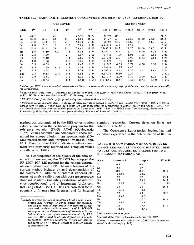
ANTHONY VANDER VOET
TABLE 86.3: RARE EARTH ELEMENT CONCENTRATIONS (ppm) IN USGS REFERENCE BCR-la.
OBSERVED REFERENCEd
REE Ib II III IV vc Ref.l Ref.2 Ref.3 Ref.4 Ref.5 Ref.6
YLaCePrNdSmEuGdTbDyHoErTmYbLu
28.723.250.87.0
27.86.62.26.31.05.91.33.50.52.90.5
26.754.47.0
28.96.801.997.101.086.591.293.740.533.55
- 0.54
292250
624
5.2
1.14
0.49
27577.6
317.827.40.66.71.34.20.53.60.4
35.4024.8053.707.26
28.406.541.996.661.066.431.343.730.543.390.516
35.9025.1053.307.37
29.206.742.036.701.096.631.363.810.543.320.511
35-4024-2750-59
6.4-7.325-33.56.5-7.1
1.9-26.3-7.01.0-1.2
6.3-71.2-1.43.5-3.80.5-0.63.3-3.7
0.5-0.55
392553.76.9
28.76.61.966.71.056.351.253.60.593.390.51
26.6053.807.29
29.706.701.986.901.006.721.403.800.573.700.524
25.3054
28.606.701.956.63
6.30
3.61
3.390.54
25.053.7
28.76.581.966.68
6.35
3.61
3.390.536
38.525.352.56.68
30.56.692.016.781.076.341.293.710.5913.390.536
a Values for BCR-1 are tabulated extensively as there is a reasonable amount of high quality, i.e. benchmark data (IDMS) for comparison.b Experimental Data from I (Doherty and Vander Voet 1985); II (Lichte, Meier and Crock 1987); III (Longerich et al. 1987); IV (Date and Hutchinson 1987); V (Doherty, in press).c RR-ISCP data from Doherty (in press) using two different skimmer'designs.^Reference values include: Ref. l = Range of reference values quoted in Doherty and Vander Voet (1985); Ref. 2 - Govin- daraju (1984); Ref. 3 - ICP-OES data (with ion exchange) used for comparison in Lichte, Meier and Crock (1987); Ref. 4 = ID-MS data from Hanson (1976) (quoted in Lichte et al. 1987); Ref. 5 = IDMS data from Gladney, Burns and Roelandts (1983); Ref. 6 = NAA data from Gladney, Burns and Roelandts (1983).
method was substantiated by the REE concentration values submitted in the certification program for the reference material (IWG) AC-E (Govindaraju 1987). Values submitted are compared to those sub mitted for isotope dilution mass spectrometric (ID MS) measurements and "proposed" values in Table 86.4 . Data for other CRMs indicate excellent agree ment with previously reported and compiled values (Riddle et al. 1988).
As a consequence of the quality of the data ob tained in these studies, the GLOGS has adopted the RR-ISCP-ICP-MS method for the routine determi nation of yttrium and REE. The main features of this current method include: a) acid decomposition of the sample5 ; b) addition of internal standard ele ments; c) analyte calibration with pure spectroscopic standard solutions (including evaluation of interfer ence contributions); and d) instrument (drift) con trol using CRM BHVO-1. Data are corrected for in strument drift, mass interferences, and for internal
^Quality of decomposition is monitored by a) a semi-quan titative XRF "screen" to define matrix composition, and flag potentially high amounts of elements associ ated with acid-insoluble minerals; and b) ICP-MS semi-quantitative determination of zirconium in so lution. Comparison of the zirconium results by XRF and ICP-MS is used to identify difficulties in sample preparation. ICP-MS results for yttrium can also be compared to XRF "screen" results to monitor quality of decomposition.
standard recoveries. Current detection limits are listed in Table 86.2.
The Geoscience Laboratories Section has had extensive experience in the determination of REE in
TABLE 86.4: COMPARISON OF CONTRIBUTED ICP-MS REE VALUES 1 TO CONTRIBUTED IDMS VALUES AND SUGGESTED VALUES FOR IWG REFERENCE MATERIAL AC-E
REEYLaCePrNdSmEuGdTbDyHoErTmYbLu
Contrib. 2185
6216023.5092252.05
285.10
326.60
192.80
182.50
Comp.3184
5915422.29224.22.0
264.8
296.5
17.72.6
17.42.45
IDMS3
156.3
93.124.7
1.9326.3
30.5
18.4
17.7
^All concentrations in ppm^Contribution from Geoscience Laboratories, OGS. 2Comp. = recommended values and IDMS contributions as listed in Govindaraju (1987).
503
GEOSCIENCE LABORORATOR1ES (86)
geological materials. Experience from early develop ments in XRF and ICP-OES methodology, as well as pioneering studies in the field of ICP-MS, has cul minated in the current RR-ISCP/ICP-MS method. Rare earth element data for reference materials ob tained during the development of the method are considered comparable to results obtained by ID- MS - considered by many to be a "benchmark" technique. Data obtained on a routine basis can be considered among the best available.
ACKNOWLEDGMENTS
Research into methods for the determination of REE was initiated by C. Riddle, who introduced the XRF method to the Laboratories in the late 1970s, and arranged for the purchase of the ICP-OES system. The Spectroscopy sub-section acknowledges the sus tained efforts of past and present staff members in volved in the development of REE methods, includ ing W. Doherty, P. Wong, J. Hwang, R. Faulkner; Waterloo CO-OP students A. Bolton, and R. Aulis. We also acknowledge the support of C. Riddle, Chief Analyst GLOGS, A. Pitts and G. Soucie (past managers, Geoservices), E. Pye (former director OGS) and V.G. Milne, Director, Ontario Geological Survey.
REFERENCESAbbey, S.1980: Studies in "Standard Samples" for Use in the General
Analysis of Silicate Rocks and Materials: Part 6: 1979Edition of "Usable Values"; Geological Survey ofCanada Paper 80-14, 30p.
1983: Studies in "Standard Samples" of Silicate Rocks andMinerals 1969-1982; Geological Survey of CanadaPaper 83-15, 114p.
Aulis, R., Bolton, A., Doherty, W., Vander Voet, A., and Wong, P.
1985: Determination of Yttrium and Selected Rare Earth Elements in Geological Materials Using High Per formance Liquid Chromatographic Separation and ICP Spectrometric Detection; Spectrochimica Acta, Volume 40B, p.377-387.
Bolton, A., Hwang, J., and Vander Voet, A.1983: The Determination of Scandium, Yttrium and Se
lected Rare Earth Elements in Geological Materials by Inductively Coupled Plasma Optical Emission Spec trometry; Spectrochimica Acta, Volume 38B, p.165-174.
Brenner, I.E., Jones, E.A., Watson, A.E., and Steele, T.W.
1984: The Application of a N2~Ar Medium Power ICP and Cation Exchange Chromatography for the Spectromet ric Determination of the Rare Earth Elements in Geo logical Materials; Chemical Geology, Volume 45, p.135-148.
Crock, J.G., and Lichte, F.E.1982: Determination of Rare Earth Elements in Geological
Materials by Inductively Coupled Argon Plasma/
Atomic Emission Spectrometry; Analytical Chemis try, Volume 54, p. 1329-1332.
Crock, J.G., Lichte, F.E., and Wildeman, T.R.1984: The Group Separation of the Rare Earth Elements and
Yttrium from Geological Materials by Cation Ex change Chromatography; Chemical Geology, Volume 45, p.149-163.
Date, A.R., and Gray, A.L.1985: Determination of Trace Elements in Geological Sam
ples by Inductively Coupled Plasma Source Mass Spectrometry; Spectrochimica Acta, Volume 40B, p.115-122.
Date, A.R., and Hutchinson, D.1987: Determination of Rare Earth Elements in Geological
Samples by Inductively Coupled Plasma Source Mass Spectrometry; Journal of Analytical Atomic Spec trometry, Volume 2, p.269-276.
Doherty, W.In Press: An Internal Standardization Procedure for the De
termination of Yttrium and the Rare Earth Elements in Geological Materials by Inductively Coupled Plas ma Mass Spectrometry; Spectrochimica Acta.
Doherty, W., and Vander Voet, A.1985: The Application of Inductively Coupled Plasma Mass
Spectrometry to the Determination of Rare-earth Ele ments in Geological Materials; Canadian Journal of Spectroscopy, Volume 30, p. 135-141.
Eby, G.N.1972: Determination of Rare Earths, Yttrium and Scandium
Abundances in Rocks and Minerals by an Ion Ex change-X-ray Fluorescence Procedure; Analytical Chemistry, Volume 44, p.2137-2143.
Gladney, E.S., Burns, C.E., and Roelandts, I.1983: 1982 Compilation of Elemental Concentrations in
Eleven United States Geological Survey Rock Stan dards; Geostandards Newsletter, Volume 7, p.3-226.
Govindaraju, K.1984: 1984 Compilation of Working Values for 170 Interna
tional Reference Samples of Mainly Silicate Rocks and Minerals; Geostandards Newsletter, Volume 8, 87p. (special issue).
1987: 1987 Compilation Report on Ailsa Craig Granite AC-E with the Participation of 128 GIT-IWG Labo ratories; Geostandards Newsletter, Volume 11, p.203-255.
Govindaraju, K., Lang, Y., Mevelle, G., and Janssens, E.1984: LABROB JY308 Computer Controlled Laboratory
Ion-exchange Robotic System, Winter Conference on Plasma Spectrochemistry, San Diego, California, January, (1984).
Govindaraju, K., Mevelle, G., and Lang, Y.1984: ICP-ES Trace Rock Analysis After Automated
Batch-wise Ion Exchange Separations Using LABROB JY308, Winter Conference on Plasma Spectrochemistry, San Diego, California, January (1984).
Hanson, G.N.1976: Accuracy in Trace Analysis; p.937-949 in Sampling,
Sample Handling, Analysis; edited by P.D. LaFleur, National Bureau of Standards, Washington DC, Spe cial Publication Number 422, Volume II.
1980: Rare Earth Elements in Petrogenetic Studies of Igne ous Systems, Annual Review of Earth and Planetary Science, Volume 8, p.371-406.
504
ANTHONY VANDER VOET
Lichte, F.E., Meier, A.L., and Crock, J.G.1987: Determination of the Rare-earth Elements in Geologi
cal Materials by Inductively Coupled Plasma Mass Spectrometry; Analytical Chemistry, Volume 59, p.1150-1157.
Longerich, H.P., Fryer, B.J., Strong, D.F., and Kantipuly,C.J.
1987: Effects of Operating Conditions on the Determinationof the Rare Earth Elements by Inductively CoupledPlasma Mass Spectrometry (ICP-MS); Spectro-chimica Acta, Volume 42B, p.75-92.
Riddle, C., and Vander Voet, A.In Prep: The Spectroscopic Determination of Rare Earth Ele
ments in Geological Materials, in Chemical Analysis of Geological Materials, A Practical Guide, Manu script in Preparation for Publication as an OGS Mis cellaneous Publication.
Riddle, C., Vander Voet, A., and Doherty W.1988: Rock Analysis Using Inductively Coupled Mass Spec
trometry: A Review; Geostandards Newsletter, Vol ume 12, p.203-234.
Selby, M., and Hieftje, G.M.1987: Inductively Coupled Plasma Mass Spectrometry: a
Status Report; American Laboratory, Volume 19, p.16-28.
Strelow, F.W.E., and Jackson, P.F.S.1974: Determination of Trace and Ultratrace Quantities of
Rare Earth Elements by Ion-exchange Chromatogra- phy-Mass Spectrography; Analytical Chemistry, Vol ume 46, p.1481-1486.
Walsh, J.N., Buckley, F., and Barker, J.1981: The Simultaneous Determination of the Rare Earth
Elements in Rocks Using Inductively Coupled Plasma Source Spectrometry; Chemical Geology, Volume 33, p.141-153.
Yoshida, K., and Haraguchi, H.1984: Determination of Rare Earth Elements by Liquid
Chromatography/Inductively Coupled Plasma Atomic Emission Spectrometry; Analytical Chemistry, Vol ume 56, p.2580-2585.
505

Index of Authors
Alcock, P.W., 411 Allam, A., 454 Armstrong, O.K., 446 Atkinson, B., 28 Avermann, M.E., 297 Ayer, J.A., 132 Ayres, L.D., 68, 71
BBajc, A.F., 417Baker, C.L., 396Barlow, R.B., 458, 460, 470Barnett, P.J., 405, 421Beakhouse, G.P., 108, 149Berger, B., 145Bezys, R.K., 442Black, S.J., 359Blackburn, C.E., 163Born, P., 281Bradshaw, M.P., 442Breaks, F.W., 81, 89Brodaric, B., 378Buck, S., 257
Carter, M.W., 179 Chorlton, L., 153 Colvine, A.C., 2 Conrod, W.D., 319 Cortis, A.L., 18, 28
Dawson, C.J., 424 DiPrisco, G., 330
Easton, R.M., 278, 300, 384 Edwards, G.R., 68, 120
Fortescue, J.A.C., 478, 482, 489 Fyon, J.A., 212, 378, 381
GGoad, B.E., 342 Gorman, R.G., 427
Grant, W.T., 347 Grunsky, E.G., 384
HHammar, D.J., 309 Hanneson, J.E., 464 Heather, K.B., 257 Hitch, M.W., 281 Howe, J.M., 384 Hrabi, R.B., 212 Huxter, R.S., 464
Jackson, S.L., 206 Jensen, L.S., 384 Johns, G.W., 124, 163 Jones, G.R., 430
KKelly, R.J., 402 Kenny, F., 374 Kettles, K., 197 Kor, P.S.G., 407 Kresz, D.U., 173 Kristjansson, F.J., 414
LeBaron, P.S., 351
MMacfie, R.I., 309, 315 MacKinnon, A., 359 Maitland, W.M., 212 Marmont, C., 319 McFall, G.H., 454 McRoberts, G.D., 309 Meyn, H.D., 339 Morris, T.F., 399 Mueller-Mohr, V., 297 Muir, T.L., 226 Mussakowski, R.S., 271
NNakashima, A., 489
O'Hanley, D.S., 219
Osmani, LA., 28, 53
Parker, J.R., 126 Perrault, M., 126 Piroshco, D.W., 197
Reilly, B.A., 249 Rice, R.J., 288 Riddle, C., 494
Sage, R.P., 242 Sanborn-Barrie, M., 98 Singhroy, V.H., 374, 421 Siragusa, G.M., 222 Smith, A.R., 188, 368 Smith, P.M., 138 Springer, J.S., 335, 374 Stauffer, M.R., 120 Steele, K.G., 472 Stephenson, C.D., 138 Stone, D., 75 Stott, G.M., 12, 28, 53 Sutcliffe, R.H., 186, 188, 368 Szoke, S., 424, 427, 430, 433
Thompson, L.G.D., 363 Thurston, P.C., 5, 12, 28, 384 Tremblay, M.L., 326 Trowell, N.F., 271
Vandervoet, A., 498 Vanderveer, D.G., 433
WWadge, D.R., 470 Wheatley, K.J., 381 White, O.L., 454 Williams, D.A., 363 Williams, H.R., 116, 169
Zayachivsky, B., 173 Zuberec, P.M., 319
507

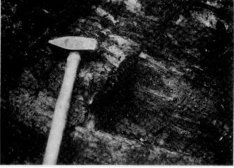
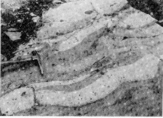
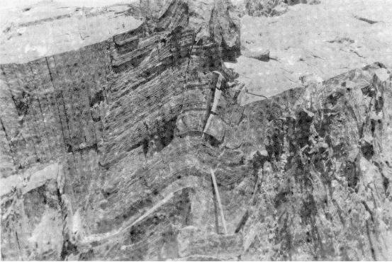
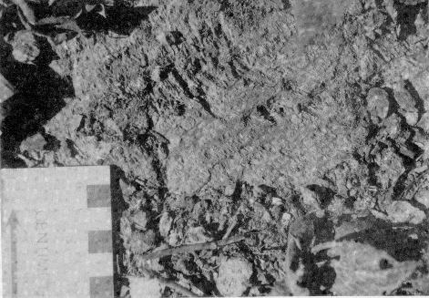
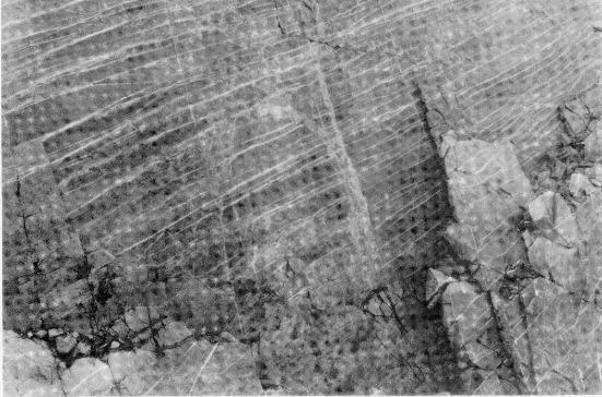
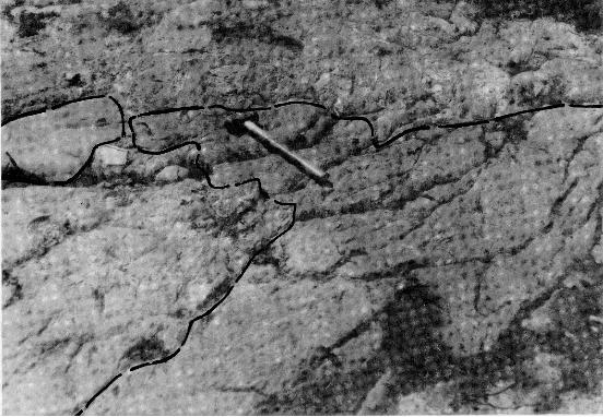
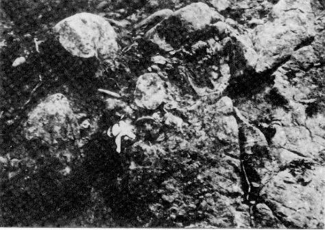
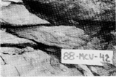
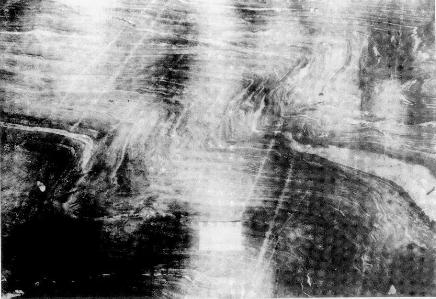
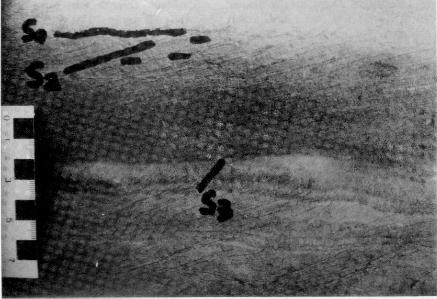

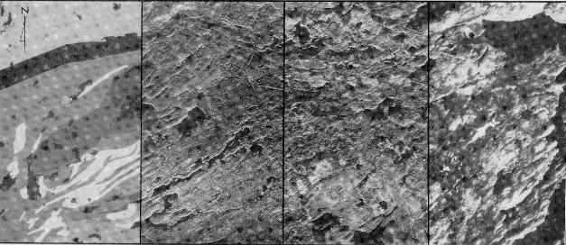
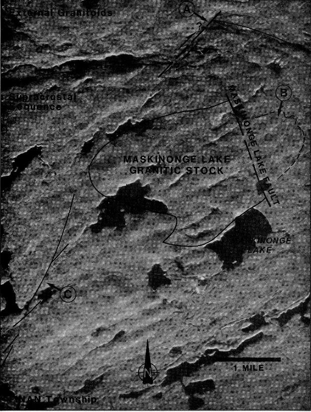
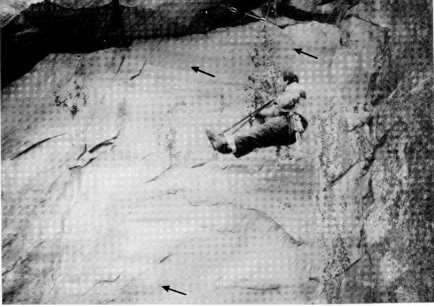
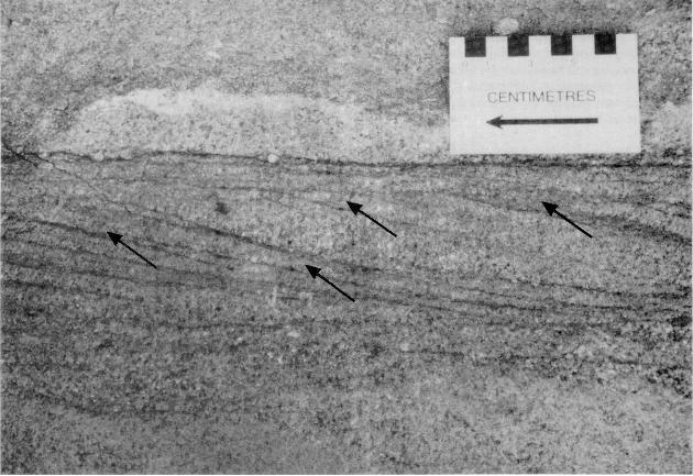
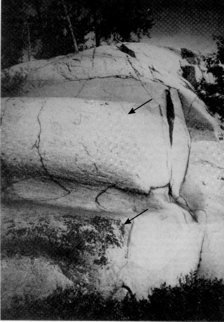
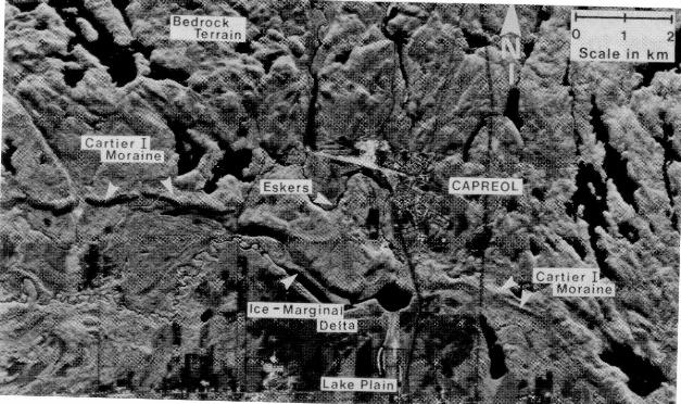
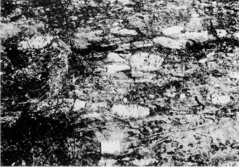
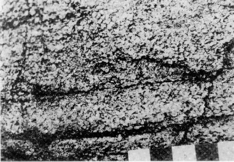
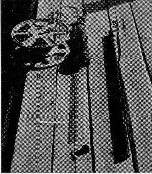
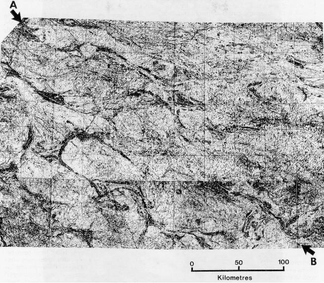
Kilometres
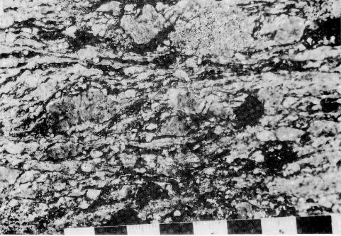
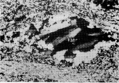
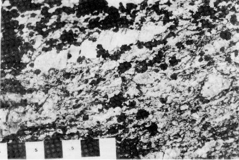
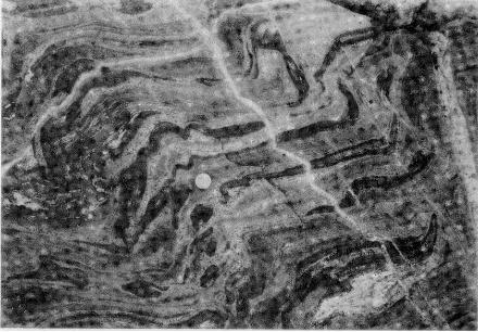
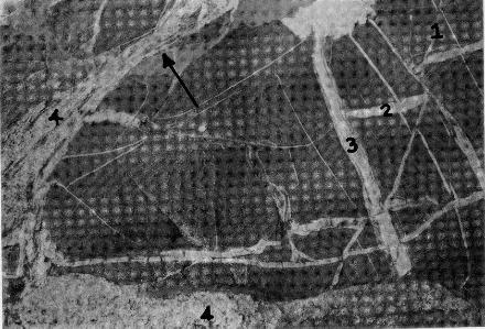
4