Embed Size (px)
Citation preview
THESE TERMS GOVERN YOUR USE OF THIS DOCUMENT
Your use of this Ontario Geological Survey document (the “Content”) is governed by the terms set out on this page (“Terms of Use”). By downloading this Content, you (the
“User”) have accepted, and have agreed to be bound by, the Terms of Use.
Content: This Content is offered by the Province of Ontario’s Ministry of Northern Development and Mines (MNDM) as a public service, on an “as-is” basis. Recommendations and statements of opinion expressed in the Content are those of the author or authors and are not to be construed as statement of government policy. You are solely responsible for your use of the Content. You should not rely on the Content for legal advice nor as authoritative in your particular circumstances. Users should verify the accuracy and applicability of any Content before acting on it. MNDM does not guarantee, or make any warranty express or implied, that the Content is current, accurate, complete or reliable. MNDM is not responsible for any damage however caused, which results, directly or indirectly, from your use of the Content. MNDM assumes no legal liability or responsibility for the Content whatsoever. Links to Other Web Sites: This Content may contain links, to Web sites that are not operated by MNDM. Linked Web sites may not be available in French. MNDM neither endorses nor assumes any responsibility for the safety, accuracy or availability of linked Web sites or the information contained on them. The linked Web sites, their operation and content are the responsibility of the person or entity for which they were created or maintained (the “Owner”). Both your use of a linked Web site, and your right to use or reproduce information or materials from a linked Web site, are subject to the terms of use governing that particular Web site. Any comments or inquiries regarding a linked Web site must be directed to its Owner. Copyright: Canadian and international intellectual property laws protect the Content. Unless otherwise indicated, copyright is held by the Queen’s Printer for Ontario. It is recommended that reference to the Content be made in the following form: <Author’s last name>, <Initials> <year of publication>. <Content title>; Ontario Geological Survey, <Content publication series and number>, <total number of pages>p. Use and Reproduction of Content: The Content may be used and reproduced only in accordance with applicable intellectual property laws. Non-commercial use of unsubstantial excerpts of the Content is permitted provided that appropriate credit is given and Crown copyright is acknowledged. Any substantial reproduction of the Content or any commercial use of all or part of the Content is prohibited without the prior written permission of MNDM. Substantial reproduction includes the reproduction of any illustration or figure, such as, but not limited to graphs, charts and maps. Commercial use includes commercial distribution of the Content, the reproduction of multiple copies of the Content for any purpose whether or not commercial, use of the Content in commercial publications, and the creation of value-added products using the Content. Contact:
FOR FURTHER INFORMATION ON PLEASE CONTACT: BY TELEPHONE: BY E-MAIL:
The Reproduction of Content
MNDM Publication Services
Local: (705) 670-5691 Toll Free: 1-888-415-9845, ext.
5691 (inside Canada, United States)
The Purchase of MNDM Publications
MNDM Publication Sales
Local: (705) 670-5691 Toll Free: 1-888-415-9845, ext.
5691 (inside Canada, United States)
Crown Copyright Queen’s Printer Local: (416) 326-2678 Toll Free: 1-800-668-9938
(inside Canada, United States)
LES CONDITIONS CI-DESSOUS RÉGISSENT L'UTILISATION DU PRÉSENT DOCUMENT.
Votre utilisation de ce document de la Commission géologique de l'Ontario (le « contenu ») est régie par les conditions décrites sur cette page (« conditions d'utilisation »). En
téléchargeant ce contenu, vous (l'« utilisateur ») signifiez que vous avez accepté d'être lié par les présentes conditions d'utilisation.
Contenu : Ce contenu est offert en l'état comme service public par le ministère du Développement du Nord et des Mines (MDNM) de la province de l'Ontario. Les recommandations et les opinions exprimées dans le contenu sont celles de l'auteur ou des auteurs et ne doivent pas être interprétées comme des énoncés officiels de politique gouvernementale. Vous êtes entièrement responsable de l'utilisation que vous en faites. Le contenu ne constitue pas une source fiable de conseils juridiques et ne peut en aucun cas faire autorité dans votre situation particulière. Les utilisateurs sont tenus de vérifier l'exactitude et l'applicabilité de tout contenu avant de l'utiliser. Le MDNM n'offre aucune garantie expresse ou implicite relativement à la mise à jour, à l'exactitude, à l'intégralité ou à la fiabilité du contenu. Le MDNM ne peut être tenu responsable de tout dommage, quelle qu'en soit la cause, résultant directement ou indirectement de l'utilisation du contenu. Le MDNM n'assume aucune responsabilité légale de quelque nature que ce soit en ce qui a trait au contenu. Liens vers d'autres sites Web : Ce contenu peut comporter des liens vers des sites Web qui ne sont pas exploités par le MDNM. Certains de ces sites pourraient ne pas être offerts en français. Le MDNM se dégage de toute responsabilité quant à la sûreté, à l'exactitude ou à la disponibilité des sites Web ainsi reliés ou à l'information qu'ils contiennent. La responsabilité des sites Web ainsi reliés, de leur exploitation et de leur contenu incombe à la personne ou à l'entité pour lesquelles ils ont été créés ou sont entretenus (le « propriétaire »). Votre utilisation de ces sites Web ainsi que votre droit d'utiliser ou de reproduire leur contenu sont assujettis aux conditions d'utilisation propres à chacun de ces sites. Tout commentaire ou toute question concernant l'un de ces sites doivent être adressés au propriétaire du site. Droits d'auteur : Le contenu est protégé par les lois canadiennes et internationales sur la propriété intellectuelle. Sauf indication contraire, les droits d'auteurs appartiennent à l'Imprimeur de la Reine pour l'Ontario. Nous recommandons de faire paraître ainsi toute référence au contenu : nom de famille de l'auteur, initiales, année de publication, titre du document, Commission géologique de l'Ontario, série et numéro de publication, nombre de pages. Utilisation et reproduction du contenu : Le contenu ne peut être utilisé et reproduit qu'en conformité avec les lois sur la propriété intellectuelle applicables. L'utilisation de courts extraits du contenu à des fins non commerciales est autorisé, à condition de faire une mention de source appropriée reconnaissant les droits d'auteurs de la Couronne. Toute reproduction importante du contenu ou toute utilisation, en tout ou en partie, du contenu à des fins commerciales est interdite sans l'autorisation écrite préalable du MDNM. Une reproduction jugée importante comprend la reproduction de toute illustration ou figure comme les graphiques, les diagrammes, les cartes, etc. L'utilisation commerciale comprend la distribution du contenu à des fins commerciales, la reproduction de copies multiples du contenu à des fins commerciales ou non, l'utilisation du contenu dans des publications commerciales et la création de produits à valeur ajoutée à l'aide du contenu. Renseignements :
POUR PLUS DE RENSEIGNEMENTS SUR VEUILLEZ VOUS
ADRESSER À : PAR TÉLÉPHONE : PAR COURRIEL :
la reproduction du contenu
Services de publication du MDNM
Local : (705) 670-5691 Numéro sans frais : 1 888 415-9845,
poste 5691 (au Canada et aux États-Unis)
l'achat des publications du MDNM
Vente de publications du MDNM
Local : (705) 670-5691 Numéro sans frais : 1 888 415-9845,
poste 5691 (au Canada et aux États-Unis)
les droits d'auteurs de la Couronne
Imprimeur de la Reine
Local : 416 326-2678 Numéro sans frais : 1 800 668-9938
(au Canada et aux États-Unis)
Ministry ofNorthern Development and Mines
Ontario
Summary of Field Workand Other Activites
Ontario Geological Survey Miscellaneous Paper 151
edited by M.E. Cherry, B.O. Dressler, O.L. White, R.B. Barlow and RG. Lightfoot
1990
Queen's Printer for Ontario, 1990 ISSN 0704-2752 (series)ISSN 0829-8203 (sub-series)
Publications of the Ontario Geological Survey and the Ministry of Northern Develop ment and Mines are available from the following sources. Orders for publications should be accompanied by cheque or money order payable to the Treasurer of Ontario.
Reports, maps and price lists (personal shopping or mail order):Public Information Centre, Ministry of Natural ResourcesRoom 1640, Whitney Block, Queen's ParkToronto, Ontario M7A 1W3(416) 965-1348 Collect calls accepted
Reports and accompanying maps only (personal shopping): Publications Ontario Main Floor, 880 Bay Street Toronto, Ontario M7A 1N8
Every possible effort is made to ensure the accuracy of the information contained in this report, but the Ministry of Northern Development and Mines does not assume any liability for errors that may occur. Source references are included in the report and us ers may wish to verify critical information.
If you wish to reproduce any of the text, tables or illustrations in this report, please write for permission to the Director, Ontario Geological Survey, Ministry of Northern Development and Mines, lith Floor, 77 Grenville Street, Toronto, Ontario M7A1W4.
Parts of this publication may be quoted if credit is given. It is recommended that refer ence be made in the following form:Williams, H.R. and Breaks, F.W. 1990. Geological studies in the Manitouwadge-
Hornepayne region; in Summary of Field Work and Other Activities 1990, Ontario Geological Survey, Miscellaneous paper 151, p.41-47.
Scientific Editor: M.E. Grant Deyell-1500-90
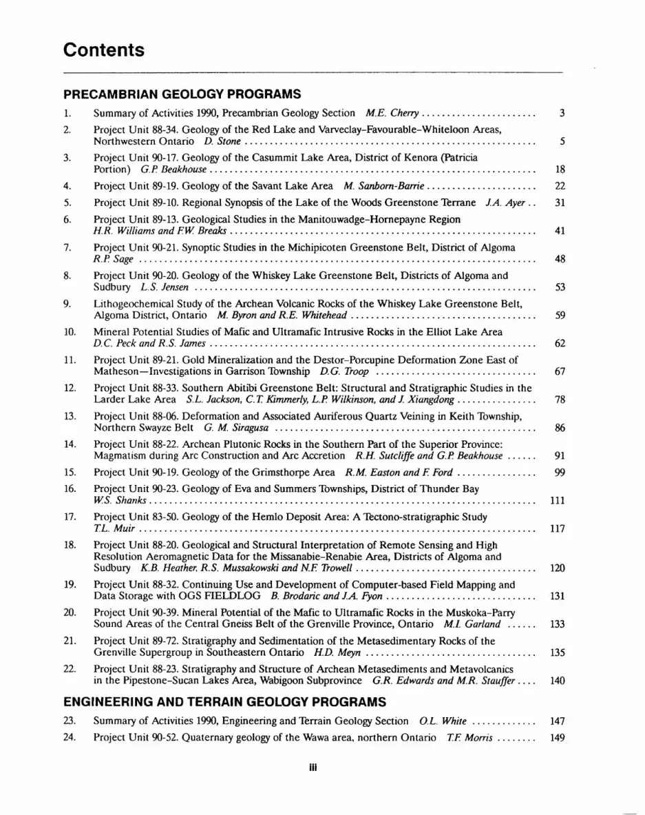
Contents
PRECAMBRIAN GEOLOGY PROGRAMS1. Summary of Activities 1990, Precambrian Geology Section M.E. Cherry ....................... 3
2. Project Unit 88-34. Geology of the Red Lake and Varveclay-Favourable-Whiteloon Areas,Northwestern Ontario D. Stone .......................................................... 5
3. Project Unit 90-17. Geology of the Casummit Lake Area, District of Kenora (PatriciaPortion) G.P. Beakhouse ................................................................. 18
4. Project Unit 89-19. Geology of the Savant Lake Area M. Sanbom-Barrie ...................... 22
5. Project Unit 89-10. Regional Synopsis of the Lake of the Woods Greenstone Terrane J.A. Ayer .. 31
6. Project Unit 89-13. Geological Studies in the Manitouwadge-Hornepayne RegionH.R. Williams andF.W. Breaks ..................................;.......................... 41
7. Project Unit 90-21. Synoptic Studies in the Michipicoten Greenstone Belt, District of AlgomaR.P. Sage ............................................................................... 48
8. Project Unit 90-20. Geology of the Whiskey Lake Greenstone Belt, Districts of Algoma andSudbury L.S. Jensen .................................................................... 53
9. Lithogeochemical Study of the Archean Volcanic Rocks of the Whiskey Lake Greenstone Belt,Algoma District, Ontario M. Byron and R.E. Whitehead ..................................... 59
10. Mineral Potential Studies of Mafic and Ultramafic Intrusive Rocks in the Elliot Lake AreaD.C. Peck and R.S. James ................................................................. 62
11. Project Unit 89-21. Gold Mineralization and the Destor-Porcupine Deformation Zone East ofMatheson Investigations in Garrison Township D.G. Troop ................................ 67
12. Project Unit 88-33. Southern Abitibi Greenstone Belt: Structural and Stratigraphic Studies in theLarder Lake Area S.L. Jackson, C. T. Kimmerly, L.P. Wilkinson, and J. Xiangdong ................ 78
13. Project Unit 88-06. Deformation and Associated Auriferous Quartz Veining in Keith Township,Northern Swayze Belt G. M. Siragusa .................................................... 86
14. Project Unit 88-22. Archean Plutonic Rocks in the Southern Part of the Superior Province:Magmatism during Arc Construction and Arc Accretion R.H. Sutcliffe and G.P. Beakhouse ...... 91
15. Project Unit 90-19. Geology of the Grimsthorpe Area R.M. Easton and E Ford ................ 99
16. Project Unit 90-23. Geology of Eva and Summers Townships, District of Thunder BayW.S. Shanks ............................................................,................ 111
17. Project Unit 83-50. Geology of the Hemlo Deposit Area: A Tectono-stratigraphic StudyT.L. Muir ............................................................................... 117
18. Project Unit 88-20. Geological and Structural Interpretation of Remote Sensing and High Resolution Aeromagnetic Data for the Missanabie-Renabie Area, Districts of Algoma and Sudbury K.B. Heather, R.S. Mussakowski and N.E Trowell .................................... 120
19. Project Unit 88-32. Continuing Use and Development of Computer-based Field Mapping andData Storage with OGS FIELDLOG B. Brodaric andJ.A. Fyon .............................. 131
20. Project Unit 90-39. Mineral Potential of the Mafic to Ultramafic Rocks in the Muskoka-ParrySound Areas of the Central Gneiss Belt of the Grenville Province, Ontario M.I. Garland ...... 133
21. Project Unit 89-72. Stratigraphy and Sedimentation of the Metasedimentary Rocks of theGrenville Supergroup in Southeastern Ontario H.D. Meyn .................................. 135
22. Project Unit 88-23. Stratigraphy and Structure of Archean Metasediments and Metavolcanicsin the Pipestone-Sucan Lakes Area, Wabigoon Subprovince G.R. Edwards and M.R. Stauffer .... 140
ENGINEERING AND TERRAIN GEOLOGY PROGRAMS23. Summary of Activities 1990, Engineering and Terrain Geology Section O.L. White ............. 147
24. Project Unit 90-52. Quaternary geology of the Wawa area, northern Ontario T.F. Morris ........ 149
Hi
25. Project Unit 90-33. Quaternary Geology of the Huntsville-Bracebridge Area A.F. Bajc ......... 152
26. Project Number 86-13. Stratigraphic Drilling of Quaternary Sediments in the Barrie area,Simcoe County P.J. Barnett .............................................................. 157
27. Project Unit 90-30. Paleozoic Mapping and Alkali Reactive Aggregate Studies in the LakeSimcoe Area D.K. Armstrong ............................................................ 159
28. Project Unit 90-26. Aggregate Resources Inventory of the Moosonee Area, NortheasternOntario R.G. Gorman and D.K. Armstrong ................................................ 162
29. Project Unit 89-66. Aggregate Resources Inventory of the Sioux Lookout Area, NorthwesternOntario R.G. Gorman .................................................................. 166
30. Project Units 90-27, 90-28 and 90-29. Aggregate Resources Inventory in Victoria, Peterboroughand Haliburton Counties G.R. Jones ..................................................... 169
31. Project Unit 89-65. Aggregate Resources Inventory of the Mishibishu Lake Area, NorthernOntario G.R. Jones ..................................................................... 172
GEOPHYSICS/GEOCHEMISTRY PROGRAMS
32. Summary of Activities 1990, Geophysics/Geochemistry Section R.B. Barlow ................... 177
33. Project Unit 90-24. A Search for an "Overbank" Geochemical Sample Site in the GoulaisRiver Valley near Sault Ste. Marie J.A. C. Fortescue and B. Bolviken .......................... 178
34. Project Unit 90-25. The Design Considerations for a Mobile Laboratory Unit (MLU) toSupport Geochemical Mapping in Ontario J.A. C. Fortescue ................................. 185
35. Project Unit 87-22. Regional Gravity Map of Part of the Abitibi Greenstone Belt, OntarioVK. Gupta and LA. Osmani ............................................................... 190
36. Project Unit 89-45. An Examination of the Suitability of the Shallow Reflection SeismicTechnique for use in Southern Ontario M.A. Lockhard and R.B. Barlow ...................... 198
37. Project Unit 90-40, 41, 42, 43. Recent Airborne Electromagnetic-Magnetic Surveys in NorthernOntario R.B. Barlow ................................................................... 201
GEOSCIENCE LABORATORIES PROGRAMS
38. Summary of Activities 1990, Geoscience Laboratories Section PC. Lightfoot .................. 207
39. Project Unit 88-01. Modal Analysis of Granites Using a Quantitative Powder X-Ray DiffractionMethod. H.A.F. de Souza and D. Rowell ................................................... 212
40. Project Unit 89-01. Determination of ppb Au in Geological Materials by Lead Fire Assay Graphite Furnace Atomic Absorption Spectroscopy D.C. Crabtree, M. Ghobrial, and A.E. Hodges ................................................ 219
41. Project Unit 89-01. Automation of Acid Digestion of Geological Samples via RoboticsC.Y Chan .............................................................................. 223
42. Project Unit 88-01. Quality Control for Rare Earth Elements in Geological Materials: Comparison of XRF and ICP-MS Zirconium Determinations J.M. Richardsonl W. Doherty and J. Tsigaris .................................................. 228
43. Project Unit 89-01. Determination of 22 Trace Elements in Geological Materials byInductively Coupled Plasma Mass Spectrometry W. Doherty, P. Wong, A.E. Hodges ............. 235
IV
Foreword
During 1990, the Ontario Geological Survey carried out independent detailed, regional and province-wide compilation geoscience studies throughout the province. In addi tion, projects were undertaken in co-operation with Mines and Minerals Division geol ogists, personnel from the Ministry of Natural Resources, universities and local munic ipalities. Special geoscience programs were also undertaken in several areas, with Northern Development Fund support. Project involvement by the various participants is summarized in individual reports.
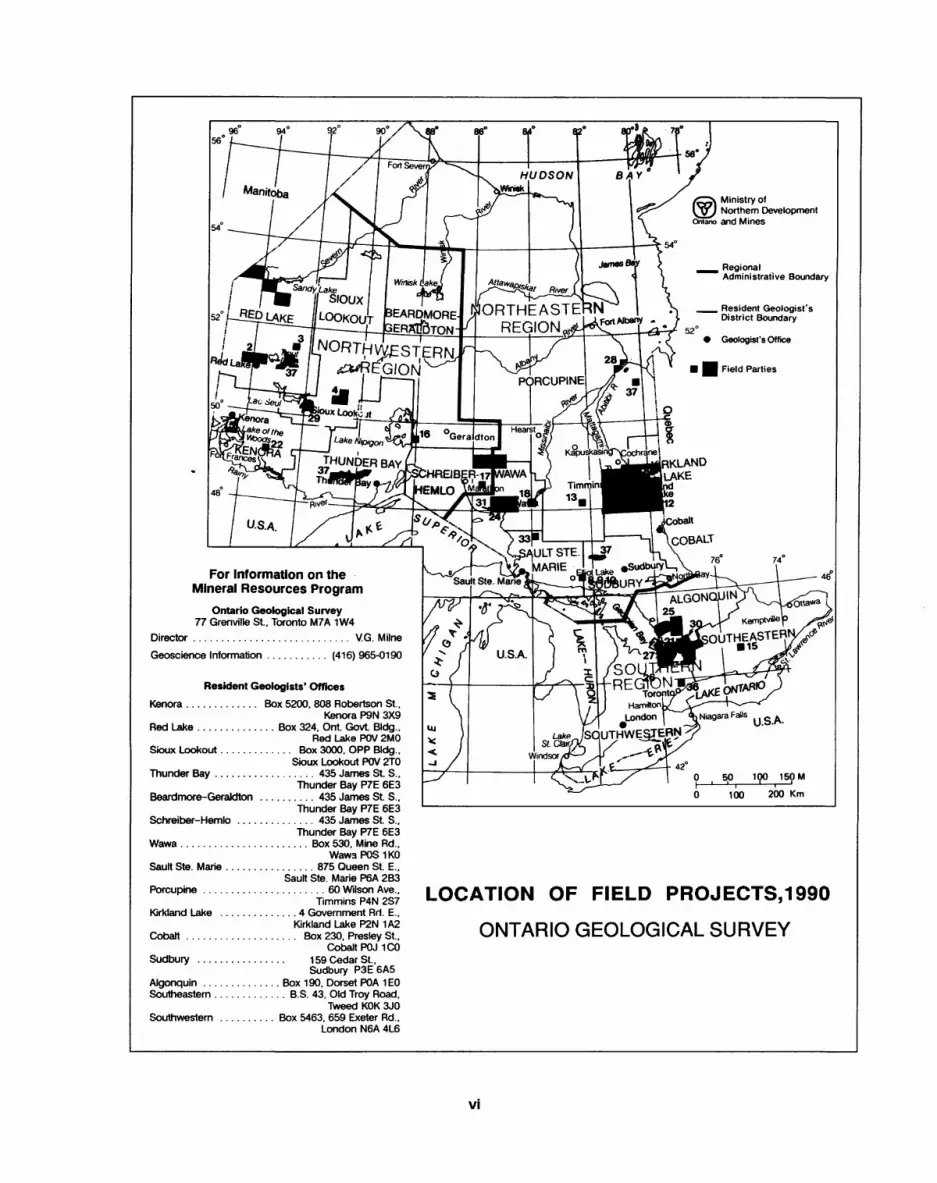
The locations of the areas investigated in 1990 are compiled on a map of the prov ince at the beginning of this report. Preliminary results of field work and other activities are outlined in this summary, which contains reports prepared by leaders and principal investigators for each of the projects. The aim of the Ontario Geological Survey in pro ducing this summary, immediately following the field season, is to provide quick access to new information for mineral resource evaluation of these areas, which will be of val ue in current mineral exploration and resource planning. In addition, the wide spec trum of research in this report is of interest to the geoscience community as a whole.
Survey geoscientists will conduct more detailed research and analysis of the field work data through the winter and will be preparing reports on these investigations for publication. In the interim, uncoloured preliminary maps with comprehensive margin al notes will be released for distribution. Notices of these releases will be mailed out to all persons or organizations on the Mines and Minerals Division publications release notification list, and selected releases may be publicized in technical journals and other media.
V.G. Milne
DirectorOntario Geological Survey
Ministry ofNorthern Development
ano and Mines
ORTHEASTERN Resident Geologist s District Boundary
REGION,NORTHWESTERN
RE
UTHWEgTERN
l
For Information on the Mineral Resources Program
Ontario Geological Survey77 Grenville St.. Toronto M7A 1W4
Director ............................ V.G. Milne
Geoscience Information ........... (416) 965-0190
Resident Geologists' Offices
Kenora ............. Box 5200, 808 Robertson St.,Kenora P9N 3X9
Red Lake .............. Box 324. Ont. Govt. Bldg..Red Lake POV 2MO
Sioux Lookout............. Box 3000. OPP Bldg.,Sioux Lookout POV 2TO
Thunder Bay .................. 435 James St. S.,Thunder Bay P7E 6E3
Beardmore-Geraldton .......... 435 James St. S.,Thunder Bay P7E 6E3
Schreiber-Hemlo .............. 435 James St. S..Thunder Bay P7E 6E3
Wawa ....................... Box 530, Mine Rd..WawaPOSIKO
Sault Ste. Marie ................ 875 Queen St. E..Sault Ste. Marie P6A 2B3
Porcupine ...................... 60 Wilson Ave..Timmins P4N 2S7
Kirkland Lake .............. 4 Government Rri. E..Kirkland Lake P2N 1A2
Cobalt .................... Box 230. Presley St..Cobalt POJ 1CO
Sudbury ................ 159 Cedar St.,Sudbury P3E6A5
Algonquin .............. Box 190, Dorset POA 1EOSoutheastern ........... .. B.S. 43, Old Troy Road.
Tweed KOK 3JO Southwestern .......... Box 5463, 659 Exeter Rd..
London N6A 4L6
LOCATION OF FIELD PROJECTS,1990
ONTARIO GEOLOGICAL SURVEY
vi
NORTHEASTERN
NORTHWESTERN ^REGION
WLOOlmW^ ~
SOUTHER REGION
Mines and Minerals Division Regional OfficesCITY OFFICE(S) ADDRESS
Kenora Box 5050, 12 Main St. S. P9N 3X9Box 5200. 808 Robertson St. P9N 3X9 Box 5200, 808 Robertson St. P9N 3X9 860 Fourth Ave. S. P9N 2A1
Red Lake Box 324, Ont. Govt. Bldg. POV 2MO Box 324, Ont. Govt. Bldg. POV 2MO
Sioux Lookout Box 3000, OPP Bldg. POV 2TO Box 3000, OPP Bldg. POV 2TO
Thunder Bay (3) 435 James St. S. P7E 6E3 435 James St S. P7E 6E3
* 335 Euclid Ave. P7E 6G6 Wawa * Box 530, Mine Rd. POS 1KO
Sault Ste. Marie 9 B 875 Queen Si E. P6A 2B3* 64 Church St. P6A 5L5
Timmins O 9 B 60 Wilson Ave. P4N 2S7* 896 Riverside Dr. P4N 3W2
Kirkland Lake 9 4 Government Rd. E. P2N 1A2 B 4 Government Rd. E. P2N 1A2
Swastika A * Box 129 POK1TO
Cobalt * Box 230, Presley St. POJ ICOSudbury 9 2nd floor, 159 Cedar St. P3E 6A5
B 2nd floor, 159 Cedar St. P3E 6A5Dorset 9 Box 190 POA1EO
Tweed 9 Jjc B.S. 43, Old Troy Rd. KOK 3JO
Bancroft A * Box. 3000, Highway 28 KOL ICO
Toronto B 1st floor, 10 Wellesley St. E. M4Y 1G2 O 1st floor, 10 Wellesley St. E. M4Y 1G2
London 9 Box 5463, 659 Exeter Rd. N6A 4L6
TELEPHONE
(807) 468-3135 (807) 468-3658 (807) 468-8492 (807) 468-3658(807) 727-3272 (807) 727-3284
(807) 737-2039 (807) 737-2034
(807)475-1331 (807)475-1311 (807)475-1331 (705)856-4883
(705) 949-1231 (70S) 949-1231
(705) 267-1401 (705) 267-1401(705) 567-5242 (705)567-9242
(705)642-3222
(705)679-8558
(705)670-7325 (705)670-7321(705)766-2494
(613)478-2330
(613) 332-4875
(416)965-1322 (416)965-3611
(519)661-2773
FAX
(807)468-6298 (807)468-9451 (807)468-9451
(807)727-3553 (870) 727-3553(807) 737-1727 (807)737-1727(807)475-5312 (807) 475-5312
(705)856-4282
(705)949-0014
(705)264-8723
(705) 567-5621 (705) 567-5621(705) 642-3323
(705)679-5584
(705)670-7223 (705)670-7223(705)766-9976'
(613)478-6247
(613) 332-1800
(416) 963-0257 (416)963-0257
(519)661-2819
vii


Precambrian Geology Programs

1. Summary of Activities 1990, Precambrian Geology Section
M.E. Cherry
Chief Geologist. Precambrian Geology Section, Ontario Geological Survey.
INTRODUCTIONIn 1990, the Precambrian Geology Section's program operated at a level that could be carried out largely by the Section's permanent staff. Externally funded pro grams such as the recently completed Canada-Ontario Mineral Development Agreement (COMDA) were largely completed in 1989. The 1990 program included significant new work, and continued the progress in a number of projects.
MAPPING PROGRAMBedrock mapping projects operated in 1990 at several different scales. Detailed (1:15 840 and 1:20 000 scales) mapping was carried out in the Casummit (Birch) Lake area in northwestern Ontario, in Eva and Summers townships east of Lake Nipigon, in the Whiskey Lake greenstone belt east of Elliot Lake, and in the Grimsthorpe area of eastern Ontario. These projects reflect the continuing commitment of the Ontario Geological Survey (OGS) to provide detailed maps for the mineral exploration indus try.
Regional mapping (1:50 000 and 1:100 000 scales) was carried out in the Berens Riv er Subprovince north of Red Lake, and in the southeastern Abitibi greenstone belt near Larder Lake. These regional-scale mapping projects are addressing larger scale problems in the interpretation of the geology of the Superior Province in Ontario. The Berens River project has succeeded in defining significant subdivisions in a large gra nitic terrane, and has identified several previously unrecognized greenstone remnants within those terranes. The Abitibi project is examining the stratigraphy and structural geology of a transect of the Abitibi belt. This project is part of a larger program to reas sess the geology and mineralization of the entire Abitibi belt. It is also providing infor mation to the LITHOPROBE Abitibi transect program.
Synoptic mapping projects continued in the Lake of the Woods greenstone belt and in the Michipicoten greenstone belt. These two synoptic studies will synthesize re cently completed, major, detailed mapping programs in the Lake of the Woods and Wawa areas. Similar programs are being completed in the Savant-Sturgeon lakes area and in the Manitouwadge-Hornepayne area; the latter two projects have entailed a considerable amount of new mapping at 1:50000 and 1:100000 scales.
Several specialized projects continued in 1990. Two of these a study of structure, stratigraphy and alteration around the Destor-Porcupine Fault Zone near Matheson, and studies of gold occurrences in the Swayze belt are part of a larger exercise to reas sess the geology and mineralization of the Abitibi belt. Linked to these are a detailed mapping project of the area around the Hemlo deposit, and an investigation of felsic magmatism in the Abitibi belt.
The Precambrian Geology Section continued to explore new and innovative meth ods of acquiring and interpreting geological data in 1990. During the field season, six of the Section's mapping crews employed OGS FIELDLOG, a computerized storage and display tool for geological mapping developed by Precambrian Geology Section person nel. FIELDLOG was also used in the field school programs of several Canadian uni versities, by several mineral exploration companies, and by the Geological Survey of Canada. Enhancements to FIELDLOG 1.0, completed during 1990, are reported herein (see Paper 19, this volume).
Investigations of applications of remote sensing to geology continued with the analysis of an integrated data base for the Wawa area. Work in this project has shown
PRECAMBRIAN (1)
both the advantages and disadvantages to geological work, of techniques commonly used in interpreting remote sensing data.
In 1990, the Precambrian Geology Section supported geological field work by sev eral Canadian universities. Two projects were initiated in the Elliot Lake area by the Geology Department of Laurentian University, Sudbury, in collaboration with Section personnel conducting bedrock mapping in the same area. These projects are funded by grants from the Ontario Ministry of Northern Development and Mines. A detailed ex amination of stratigraphy and structure in a portion of the Manitou Lakes belt in north western Ontario was completed by researchers from Athabaska University, Athabaska, Alberta, as a contribution to the Geology of Ontario project.
Several projects, which are not described in the summaries which follow, provided significant contributions to the Section's 1990 program. A long-term project to produce new, upgraded, 1:250000 scale compilation maps continued with the preparation of manuscripts for the Atikokan-Lakehead and White River-Marathon sheets. A project to reassess the geology of the area northwest of Timmins, was begun late in the 1990 field season: the data gathered so far are insufficient to report on at this time.
GEOLOGY OF ONTARIO PROJECTThe Geology of Ontario project was initiated to provide an overview of the bedrock and surficial geology of the Province after 100 years of investigations by the Ontario Geo logical Survey and its predecessors. The release of the products of this major project, including a series of 1:1000 000 scale maps and an accompanying volume, is scheduled to begin in 1991, marking the centennial of the OGS.
Significant progress has been made in 1990 towards completing these products. Manuscripts for the bedrock geology and surficial geology maps have been completed, and cartography is currently underway as the final step prior to printing. Geophysical maps, including a total-field shadow magnetic map, a first vertical derivative magnetic map, a Bouguer gravity map, and a derivative gravity map, are in similar states of com pletion.
Perhaps the most ambitious map being compiled is the tectonic assemblage map of Ontario. This map will be accompanied by a set of charts which will 1) list tectonic as semblages and plutonic suites and describe their lithological characteristics, 2) summa rize the structural and tectonic history of Ontario, and 3) display a time-space summary of the major magmatic, sedimentary and other events of the Archean subprovinces and of the Proterozoic orogenic cycles. These complex charts will allow the correlation of events and dated units on the charts with the information and interpretations shown on the tectonic assemblage map. The map and accompanying charts are currently being edited and prepared for cartography.
OTHER ACTIVITIESIn addition to this ambitious program of data acquisition and analysis, and subsequent preparation of maps and reports, Precambrian Geology Section personnel participated in a wide range of public and professional gatherings to illustrate the Province's geology and mineral potential to interested parties, including academics and explorationists. Section personnel were invited to present papers and posters at many conferences, symposia and other gatherings during 1990. In addition to the Ministry's annual Geosci ence Seminars in Toronto, Timmins and Thunder Bay, these included, among others, a conference on Archean gold deposits sponsored by the Geological Association of Can ada, the 3rd Archean Symposium, the 7th International Association on the Geology of Ore Deposits Conference, the Annual Meeting of the Meteoritical Society, a Penrose conference on transpressional tectonics sponsored by the Geological Society of Ameri ca, and the annual meetings of several provincial, national, and international geosci ence and mineral exploration societies.
Finally, the establishment of an OGS Advance Office in Sudbury in the autumn of 1990 marked the first effects on the Section of the impending move of the OGS to Sud bury. The Advance Office will initially include approximately one-third of the Precam brian Geology Section's staff. This number may continue to grow, until the entire OGS moves to Sudbury upon completion of its new building on the campus of Laurentian University.
2. Project Unit 88-34. Geology of the Red Lake and Varveclay-Favourable-Whiteloon Areas, Northwestern Ontario
D. Stone
Geologist, Precambrian Geology Section, Ontario Geological Survey.
INTRODUCTION
Field work was initiated, in 1988, to explore the geology, structure, and economic potential of two areas in the northern and southern Berens River Subprovince (Stone 1989). Although both areas are underlain by mainly felsic plutonic rocks and greenstone remnants, each has a unique pattern of contact geometry. In the south, lobate batholiths intrude the Red Lake green stone belt. In the north, a large, inclusion-rich batholith with southeasterly striking fabric lies at the faulted mar gin of the Favourable Lake greenstone belt.
The objectives of the field work reported here were to characterize the subprovince boundaries and to study the structural relations of felsic plutonic rocks of the Berens River Subprovince to the greenstone belts on ei ther side. A large component of the field work was done in the Red Lake and Favourable Lake greenstone belts. This report describes field investigations in the Red Lake (NTS sheets 52 M/l and 52 N/4) and Varveclay- Favourable-Whiteloon Lakes (NTS sheets 53 E/l, 2, and 53 C/ll, 13) areas, shown in Figures 2.1 and 2.2.
RED LAKE AREA
Mineral ExplorationThe Red Lake greenstone belt is a major gold producer. Durocher et al. (1987) listed 14 past- and present- producing mines, most of which extracted ore from carbonate-quartz veins in mafic metavolcanic rocks and granitic plutons internal to the belt.
In 1990, the Campbell Mine (Placer Dome Incorpo rated) and the Arthur W. White Mine (Dickenson Mines Limited) continued gold production. Inco Gold Incorporated began bulk sampling to determine the fea sibility of putting the Cochenour Willans Mine back into production, and Chevron Minerals Limited continued exploration on several Goldquest Exploration Incorpo rated properties throughout the Red Lake greenstone belt (B. Atkinson, Resident Geologist, Ministry of Northern Development and Mines, personal communi cations, 1990). Underground exploration and develop ment work was done recently on several gold properties, including the Abino (Goldquest Exploration Incorpo rated), Red Lake Buffalo (Wilanour Resources Lim ited), McFinley (McFinley Red Lake Mines Limited),
Figure 2.1. Location map, Red Lake area, scale 1:1 584 000.
PRECAMBRIAN (2)
Figure 2.2. Location map, Varveclay-Favourable-Whiteloon area, scale 1:1 584 000.
Mount Jamie (Jamie Frontier Resources Incorporated) and Rowan Lake (Goldquest Exploration Incorporated) properties.
Purpose of the Present WorkAided by geochronological studies, recent models for genesis of gold ores in the Red Lake greenstone belt (e.g., Andrews et al. 1986) have linked gold mineraliza tion to metamorphism, deformation, and alteration caused by emplacement of felsic piutons within, and ad jacent to, the belt. Although many felsic intrusions with in the Red Lake greenstone belt are well mapped and dated, the same is not true of the external batholiths. One objective of the present work is to define bound aries and lithology of felsic intrusions that lie beyond the margins of the Red Lake greenstone belt. This informa tion may help to refine models for the origin of gold in one of Ontario's major mining camps.
General GeologyThe geology of the Red Lake greenstone belt has been studied extensively (Wallace et al. 1986 and references therein). An array of existing detailed maps has been used to compile geology of the belt (Figures 2.3 and 2.4), including maps by Ferguson (1965, 1966, 1968), Riley (1975, 1976, 1978a, 1978b), Pirie and Sawitzky (1977a, 1977b), Pirie and Grant (1978a, 1978b), Pirie and Kita (1979a, 1979b, 1979c), Durocher et al. (1987) and B. At kinson (unpublished data).
The present mapping (Figures 2.3 and 2.4) concen trated on the felsic plutonic areas beyond the margins of the Red Lake greenstone belt, and resulted in the defi nition of several new supracrustal units. These include enclaves of conglomerate and ultramafic to mafic m eta-
volcanic rocks in the Douglas Lake stock (see Figure 2.3). Some units of gneisses appear to contain a compo nent of supracrustal rocks. For example, tonalite to granodiorite gneisses at the extreme west side of Figure 2.3 (Murdock Lake area) are locally gradational to am phibole gneiss of probable volcanic origin. Several out crops of garnetiferous metasedimentary migmatite are identified within the unit of mafic tonalite gneiss be tween Indian House Lake and Pipestone Bay of Red Lake (see Figure 2.3).
Predominantly pillowed and gneissic mafic meta- volcanic rocks and tuffaceous, intermediate metavol- canic rocks occur in the Anderson Lake area (northeast corner of Figure 2.4). These units were possibly severed from the northeastern Red Lake greenstone belt by in trusion of megacrystic granitic phases of the Trout Lake Batholith.
Felsic plutonic rocks of the Berens River Subpro- vince have been classified by Stone (1989) and are sum marized in Table 2.1. Predominant rock types are horn blende and biotite-bearing tonalite to granodiorite of the sodic suite and megacrystic and nonmegacrystic bio tite granodiorite to granite of the potassic suite.
The present mapping shows parts of the Uchi and southern Berens River Subprovinces to be underlain by large lobate to irregular sodic and potassic intrusions, four of which abut against the Red Lake greenstone belt. These are the Douglas Lake stock, the Little Ver milion Lake batholith, the Hammell Lake stock, and the Trout Lake Batholith. Intrusive contacts at the margins of the Red Lake greenstone belt are sharp and not faulted.
Most felsic intrusions are massive to weakly foliated; only one ductile deformation zone, in the Nungesser Lake area, has been noted (Stone 1989).

D. STONE
94"3Q'
94"OO'
Biotite granodiorite to granite
K-feldspar megacrystic granodiorite to granite
Biotite tonalite to granodiorite
Hornblende tonalite to granodiorite
-3--I-IHr Tonalite to granodiorite gneiss
X//
/
Foliation; vertical, known, unknown dip
Pillowed flow
Mineral occurrence
Fault
Mafic to ultramafic intrusions
Intermediate to felsic metavolcanic rocks
Mafic metavolcanic rocks
Figure 2.3. Geology and mineral occurrences. Pipestone Bay of Red Lake area, northwest Ontario.
PRECAMBRIAN (2)
94 000'
Biotite granodiorite to granite
K - feldspar megacrystic granodiorite to granite
Diorite
Biotite tonalite to granodiorite
Hornblende tonalite to granodiorite
Mafic to ultramafic intrusions
Metasediments
Intermediate to felsic metavolcanic
Mafic metavolcanic rocks
rocks
Foliation; vertical, known, unknown dip
y Gneissosity; known dip
v' Bedding overturned
C/ Pillowed flow
a Producing mine
A Mineral occurrence
* Fault
Figure 2.4. Geology and mineral occurrences, Red Lake (east) area, northwest Ontario.
D. STONE
Table 2.1. Characteristics of predominant felsic plutonic rocks in the Berens River Subprovince; rock type names after Streckeisen (1976).
Rock Type Colour Grain Size Fabric Colour Index Form Age (Ma)
Biotite granodiorite pink variable, massive, has < 10 to granite usually coarse assimilated
inclusions
K-feldspar megacrystic pink coarse weakly foliated, 5-15 biotite granodiorite megacrystic to granite
Gneissic hornblende- white, variable layered 5-20 biotite granodiorite pink to granite
Hornblende-biotite red, variable inequigranular, 5-15 syenite, quartz grey mafic clots monzonite, quartz monzodiorite, diorite
Two-mica granodiorite white coarse to massive, < 10 to granite pegmatitic protomylonitic
Biotite tonalite white, medium to foliated, gneissic, 5-15 to granodiorite grey coarse quartz or feldspar
megacrystic
Biotite-hornblende grey coarse foliated, feldspar 10-30tonalite to megacrystic,granodiorite mafic clots
large batholiths
irregularbatholiths,inclusions
belts
oval plutons
elongate intrusions
.irregular to lobate bodies, inclusions
irregularbodies,inclusions
2720- 2697
2717
2696
2731
Brittle fractures are common, however. Epidote- and chlorite-filled fractures, many of which are small dis placement faults with red alteration halos, occur in most outcrops and indicate pervasive, but weak, brittle defor mation. Fractures and alteration are common in out crops west of Pipestone Bay of Red Lake, suggesting that a brittle fault zone extends about 10 km west from the end of the Red Lake greenstone belt.
VARVECLAY-FAVOURABLE- WHITELOON AREA
Mineral Exploration and Economic GeologyThe Favourable Lake area, which has been explored since 1927, hosts a wide variety of metals including gold, silver, copper, lead, zinc, molybdenum and uranium. Many mineral showings within the Favourable Lake greenstone belt have polymetallic assemblages of base and precious metals that show high Ag/Au ratios. An ex ample is the Murray-Stewart showing (Figure 2.5, local ity 3), where quartz veins are mineralized with argentif erous galena.
In the Borland Lake area (see Figure 2.5, locality 1), pyrrhotite, pyrite, galena and sphalerite occur as string ers and disseminations in the melanosome segments of metasedimentary migmatites. A grab sample collected by the author assayed 3370 ppb Au (Table 2.2). Mineral ization at localities l and 3, Figure 2.5, has been investi gated recently by Master Resources and Development Ltd. and Massive Energy Limited. These two mineral
occurrences and occurrences 4, 5, 6 and 7, Figure 2.5, are described by Stone (1989).
In 1951, Madsen Red Lake Gold Mines Limited and Orlac Red Lake Gold Mines Limited investigated "sheared quartz porphyry" that contained a stringer of argentiferous galena and pyrite at locality 2, Figure 2.5. This showing could not be located by the author.
Several gossan zones, possibly representing meta morphosed iron formation, occur within metasediments and metavolcanic rocks of the western Favourable Lake greenstone belt. Grab samples from localities 8 and 9 (Figure 2.5) yielded anomalously high gold values (see Table 2.2).
Granitic rocks south of Azure Lake host an east-striking zone of supracrustal inclusions; urano phane stain is present on granitic rocks that contain me tasedimentary remnants at locality 11 (Figure 2.5). An inclusion of mafic to ultramafic metavolcanic rocks, ap proximately 50 by 500 m (see Figure 2.5, locality 10), is mineralized with disseminated sulphides in shears. A sulphide-bearing grab sample from a sheared zone assayed 1600 ppb Au (see Table 2.2).
The Berens River Mine (Figure 2.6, locality 13) pro duced 4461 kg gold, 160926 kg silver, 2769578 kg lead and 815 147 kg zinc from ore hosted by quartz veins in felsic pyroclastic rocks (Ayres 1970). After ceasing pro duction in 1948, the Berens River Mine (now owned by Zahavy Mines Limited) underwent several surface and underground evaluations, notably by Golsil Mines Lim ited (1960-65), Getty Canadian Metals Limited (1980-87) and, most recently, Noramco Explorations In corporated. Parts of the Favourable Lake greenstone
PRECAMBRIAN (2)
0)2
Sg® W ~ * o. *: O -2 c *" oli fll 111 plS |I|l! IU lil lili III+ H
* H
.•-•.'
: : : : : : :Wj^:
S
xV \7i'..'V-','
o U
O
10
D. STONE
Table 2.2. Selected assays, Varveclay-Cobham-Borland area; location code refers to numbers on Figure 2.5.
Location code
1
8
9
10
11
12
Au (ppb)
3370
70
95
1600
-
-
Ag (ppm)
170
<2
<2
<2
-
-
Cu(ppm)
412
-
-
91
-
-
Pb Zn (ppm) (ppm)
2580 28700
-
-
38
-
-
U Pt (ppm) (ppb)
-
-
-
2
200
700
Pd(ppb)
-
-
-
290
-
-
belt adjacent to the Berens River Mine have also been investigated for base and precious metals. Noramco Ex plorations Incorporated, Royalstar Resources Limited and Greystar Resources Limited recently examined an area that extends from the Setting Net Lake batholith to approximately the east edge of the area shown in Figure 2.6.
Predominantly mafic metavolcanic rocks, intruded by felsic plutons north and east of Setting Net Lake, are mineralized with disseminated pyrite, pyrrhotite, chal copyrite, gold and silver. Examples of these mineral showings are at localities 14 and 15, Figure 2.6. Showings in these areas have been explored sporadically since 1927. Geotest Corporation recently completed a geo logic evaluation and geophysical surveys east of Setting Net Lake.
Fractures in the north end of the Setting Net Lake stock (see Figure 2.6, locality 16) are mineralized with molybdenite and chalcopyrite and were examined by Conwest Exploration Company Limited and Minorex Limited from 1969 through 1971. Assays of core drilled by Caspian Resources Limited, in 1978, gave values of up to 0.196 MoS2 and D.04% Cu (Assessment Files, Red Lake Resident Geologist's office, Ministry of Northern Development and Mines).
A series of uranium occurrences lies within granitic rocks south of the Favourable Lake greenstone belt, from the Manitoba border southeast to North Spirit Lake (see Figures 2.5, 2.6, and 2.7). Typical showings are marked by patches of uranophane stain and anomalous radioactivity. Grab samples taken by the author re turned assays of up to 700 ppm U (see Table 2.2).
Uranium mineralization usually occurs in coarse- grained to pegmatitic, white, two-mica granite that con tains accessory tourmaline, garnet and apatite. South of the Favourable Lake greenstone belt (see Figure 2.5, locality 6), Noranda Exploration Company, Limited in vestigated uranium showings in coarse, pink, biotite granite. Cam Mines Limited, Favourable Mines Lim ited, Keevil Mining Group Limited, New Dickenson Mines Limited, Sigasco Exploration Limited and Tudale Exploration Limited explored for uranium, mainly in
the area between Favourable Lake and Bear Head Lake, from 1956 through 1970.
Little exploration is recorded for the Whiteloon Lake area. Bateman (1939b) reported gold associated with quartz veins at localities 17 and 18 (Figure 2.7). Cam Mines Limited and Keevil Mining Group Limited did spectrometer and very low frequency electromag netic (VLF-EM) surveys on a series of claim groups straddling the Bear Head Fault Zone. A uranium show ing, which consists of uranophane stain on two-mica granite enriched in tourmaline and apatite, was identi fied in the present survey (see Figure 2.7). Several small gossan zones, mineralized with pyrite, occur in metase- diments.
General GeologyThe Varveclay, Favourable and Whiteloon areas (north half of Figure 2.5 and all of figures 2.6 and 2.7) are un derlain by mixed plutonic and supracrustal rocks of Archean age, and straddle the boundary of the Berens River and Sachigo Subprovinces roughly 200 km north of Red Lake. The Cobham Lake and Borland Lake areas (south half of Figure 2.5) were previously mapped and are described by Stone (1989).
A reconnaissance survey by Douglas (1926) was fol lowed by prospecting that led to discovery of gold and gold-silver-lead-zinc occurrences in the Favourable Lake area. Hurst (1930) described prospecting develop ments up to 1929 and investigated the geology of the Favourable Lake-Sandy Lake area. Prospecting and mining developments in the Favourable Lake area were subsequently reviewed by Bateman (1939a) concurrent with surveys of the North Spirit Lake (Bateman 1939b) and the Sandy Lake (Satterly 1939) areas. The Favour able Lake area was examined by Ayres (1970,1972,1974) and Ayres et al. (1973), whose maps have been compiled to show the geology of the southeast part of Figure 2.6.
The geology of the Varveclay Lake area was investi gated by Derry and MacKenzie (1931), Bennett et al. (1969) and, most recently, by Herd et al. (1987) as part of a regional survey of the Island Lake area in Manitoba. The North Spirit Lake area, including the southwest corner of the area shown in Figure 2.7, was mapped by Wood (1977).
11
940OO 53*00'
93" 30'
Biotite granodiorite to granite
K-feldspar megacrystte granodiorite to grantite
Granodiorite to granite gneiss
Two-mica granodiorite to granite
Biotite tonalite to granodiorite Foliation; vertical, known, unknown dip
Hornblende tonalite to granodiorite
Early mafic tonalite
Mafic to ultramafic intrusions
52M5'
Intermediate to felsic metavolcanic rocks
Mafic metavolcanic rocks
Thrust fault
Dike
Mineral occurrence
Past producing mine
12
93030' 52045'
^r~\ (CHALLIS a^O^~O J LAKE
^~i — f
SACHIGO SUBPROVINCE
93TDO 1Biotite granodiorite to granite
K - feldspar megacrystic granodiorite to granite
Granodiorite to granite gneiss
Two-mica granodiorite to granite
Biotite tonalite to granodiorite
yTJ'7 Foliation; vertical, known,
XX
//
unknown dip
Gneissosity; vertical, known dip
Mineral lineation
Fault
Hornblende tonalite to granodiorite Mineral occurrence
Metasediments
Mafic metavolcanic rocks
Figure 2.7. Geology and mineral occurrences, Whiteloon Lake area, northwest Ontario.
13
PRECAMBRIAN (2)
The geology of the Varveclay-Favourable- Whiteloon area is dominated by the Favourable Lake greenstone belt that extends east and southeast from the Manitoba border and bifurcates north and south of the Setting Net Lake batholith (see Figures 2.5,2.6). The northern branch broadens and eventually dissipates east of the area shown in Figure 2.6 (Ayres 1972). The narrow southern branch extends discontinuously to the North Spirit Lake area.
The Favourable Lake greenstone belt is composed of several varieties of metavolcanic and metasedimenta- ry rocks. Small ultramafic flows were noted at eastern Favourable Lake and in the Setting Net Lake area (Ayres 1988). Massive to pillowed mafic flows are com mon and tend to be metamorphosed to black amphibole gneiss at the margins of the belt and in the unit west of Whiteloon Lake (see Figure 2.7). Inclusions of mafic metavolcanic rocks are common in granitic gneisses southwest of Duckling Lake.
Mainly fragmental, intermediate to felsic metavol canic rocks are concentrated northwest of Favourable Lake, and underlie parts of the belt north of Setting Net Lake where they host base and precious metal mineral ization at the Berens River Mine.
Metamorphosed wacke and conglomerate underlie the extreme western end of the Favourable Lake green stone belt and occur at several localities throughout the eastern Favourable Lake greenstone belt. Metasedi- mentary units northwest of North Spirit Lake (see Fig ure 2.7) are composed of mainly black pelitic schists.
Interbedded quartz arenite and marble crop out along the contact of intermediate to felsic metavolcanic rocks with metawackes in the western Favourable Lake greenstone belt, near locality 2, Figure 2.5. Marble was also noted: 1) as inclusions in two-mica granites at Bor land Lake, near locality l, Figure 2.5; 2) at the small lake north of Favourable Lake (see Figure 2.5); 3) interlay- ered with metavolcanic rocks at the northwest tip of Favourable Lake (see Figure 2.6); 4) south of Lemonade Lake (see Figure 2.6); and 5) in the eastern Favourable Lake greenstone belt (Ayres 1970).
Felsic plutonic rocks in the Varveclay-Favourable- Whiteloon area are, for the most part, similar to those in the Red Lake area (see Table 2.1). Exceptions include an enclave of early mafic tonalite in the North Trout Lake batholith, and two-mica granites developed at the Sachigo-Berens River Subprovince boundary. The en clave of early mafic tonalite, dated at 2950 Ma (Corfu et al. 1985), is a remnant of the earliest known plutonic event in the area (Hillary and Ayres 1980).
Hornblende tonalite to granodiorite is present in both the Berens River and Sachigo subprovinces, usual ly in the form of irregular, elongate units. Concentra tions of these units are found in the Cobham Lake area (southwest part of Figure 2.5), in the North Trout Lake batholith, and in the Setting Net Lake area. Hornblende tonalite to granodiorite crystallized nearly contempora neously at 2732 Ma in the North Trout Lake batholith (Corfu et al. 1985) and at 2731 Ma in the Little Vermil
ion Lake batholith of the Red Lake area (Corfu and An drews 1987).
Biotite tonalite to granodiorite is the most wide spread sodic plutonic rock in the area. Partly assimilated inclusions are common in outcrops of the Bear Head Lake batholith; several large units occur southwest of Favourable Lake (see Figure 2.5). Belt-like and irregular units of foliated biotite tonalite to granodiorite lie at the margins of the Severn batholith and in the North Trout Lake batholith. An extremely large tonalitic body of un known lateral extent underlies the northeast half of the Whiteloon Lake area (see Figure 2.7). Although un dated, intrusive relations suggest that biotite tonalite to granodiorite postdates hornblende tonalite to granodio rite in some places, whereas elsewhere, it crystallized earlier.
A series of elongate bodies of two-mica granite is distributed along the Sachigo-Berens River Subpro vince boundary, from west of Favourable Lake to North Spirit Lake. Other units occur within, and marginal to, the Severn batholith. Two-mica granites contain biotite and muscovite, with accessory garnet, tourmaline and apatite. Migmatitic inclusions are common, implying derivation of the granite by melting of metasediments; the age of crystallization is unknown.
Relatively homogeneous biotite granodiorite to granite occurs within large lobate batholilhs along the southwest margin of the Sachigo Subprovince. Similar rock makes up the Bear Head Lake batholith of the Ber ens River Subprovince, although most outcrops show an inequigranular grain size and partly assimilated tonalite inclusions. Available age dates are 2711 Ma for the Set ting Net Lake batholith and phases of the North Trout Lake batholith, and 2697 Ma for the Bear Head Lake batholith (Corfu and Ayres 1984; Corfu et al. 1985).
Two north-striking olivine-gabbro dikes cut the Favourable Lake greenstone belt and are the youngest lithologic units in the area.
Structure
Structural StylesContrasting structural styles can be seen in the southern Sachigo and northern Berens River subprovinces. The southern Sachigo Subprovince has large oval batholiths composed of massive granite emplaced late in the plu tonic evolution of the area. Older sodic intrusive rocks, gneisses and supracrustal rocks are typically well- foliated and occur as belts between the batholiths and at the Subprovince boundary. Foliations in sodic and supra crustal rocks are locally parallel to the batholithic boundaries but, in general, maintain a regional south- east orientation.
Oval structures are absent in the northern Berens River Subprovince. The large, Bear Head Lake batho lith is irregular in shape and contains inclusions of sodic plutonic rocks that are elongate southwesterly, impart ing a large-scale uniformity to structural orientations.
14
D. STONE
Structure of the Favourable Lake Greenstone Belt
Advanced metamorphism and deformation in the west ern Favourable Lake greenstone belt have obliterated pillows and graded beds such that local younging direc tions and fold axes could not be identified. However, highly curved contact geometry of supracrustal units suggests complex folding northwest of Favourable Lake.
Ayres (1970, 1972, 1974) defined several fold axes and prominent, north-striking faults, north of Setting Net Lake. U-Pb geochronology studies (Corfu and Ayres 1987) showed that three volcanic sequences must be tectonically juxtaposed in the belt, and are possibly separated by thrust faults (see Figure 2.6).
Bear Head Fault
The Bear Head Fault is marked by a zone of mylonite several hundred metres in width, extending southeast erly, more-or-less at the margin of the Favourable Lake greenstone belt. At its northwest end, the fault divides into several splays that curve westerly (see Figure 2.5). Several megascopic, Z-shaped deflections in the south margin of the Favourable Lake greenstone belt suggest dextral shear strain associated with the fault, in this area.
Previously, the Bear Head Fault was thought to ex tend to the southwest of the North Spirit Lake green stone belt, thus defining the Berens River-Sachigo Sub- province boundary. For example, Osmani and Stott (1988) interpreted mylonites at MacDowell Lake (south of North Spirit Lake) as a southeast continuation of the Bear Head Fault. The present mapping shows, however, that the Bear Head Fault does not everywhere separate the volcano-plutonic terrane of the Sachigo Subpro- vince from plutonic rocks of the Berens River Subpro- vince.
The position of the Bear Head Fault with respect to the thin belt of supracrustal rocks extending from Favourable Lake to North Spirit Lake is noteworthy. At Bear Head Lake (see Figure 2.6), the fault lies mainly within the thin belt of supracrustal rocks. However, south of Setting Net Lake, it cuts through the supracrus tal belt. In the Whiteloon Lake area (see Figure 2.7), the Bear Head Fault lies north of the supracrustal belt and passes through the Whiteloon batholith, curving easter ly along the north margin of the North Spirit Lake greenstone belt into the Sachigo Subprovince.
Evidently, the mylonites at MacDowell Lake are part of a separate structure, possibly parallel to and en-echelon with, the Bear Head Fault.
MetamorphismMineral assemblages indicate amphibolite-facies meta morphic conditions in the western Favourable Lake greenstone belt. Ayres (1978) reported that the Favour able Lake greenstone belt in the Setting Net Lake area
is metamorphically zoned, with a greenschist-facies core and an amphibole-facies rim of approximately 1500 m width.
During the 1989 season, metasediments from the western Favourable Lake greenstone belt were sampled for thin section and microprobe analysis. Assemblages of garnet-biotite, garnet-biotite-cordierite and garnet- biotite-sillimanite-plagioclase-quartz were noted. Co existing andalusite and sillimanite occur at Borland Lake (see Figure 2.5, locality 1).
The garnet-biotite geothermometer of Ferry and Spear (1978) was applied to results of microprobe analy ses of 7 samples and indicated temperatures ranging from 597" to 721 "C for garnet core compositions and 515" to 701 "C using garnet rim compositions. The data show a slight trend of decreasing temperatures toward the east.
The geobarometer of Koziol and Newton (1988) was applied to 2 samples from near locality 9, Figure 2.5, which contain a biotite-garnet-sillimanite-plagioclase- quartz assemblage. Pressures of 450 and 620 MPa were estimated using garnet core compositions; garnet rims gave 440 and 490 MPa.
SUMMARY
Mapping in the Red Lake area has defined several small supracrustal enclaves beyond the margins of the Red Lake greenstone belt. Boundaries and rock types of four large felsic plutons that intrude the Red Lake green stone belt, and may have influenced gold mineralization in the belt, have been established. The south margin of the Berens River Subprovince is marked by an intrusive contact of felsic plutons with the Red Lake greenstone belt. With the exception of a small structure west of Pipestone Bay on Red Lake, there are no major faults at the boundary.
In the Varveclay-Favourable-Whiteloon area, mapping has significantly revised boundaries and litho logic subdivision of the Favourable Lake greenstone belt, particularly west of Bear Head Lake. The presence of quartz arenite and carbonate rocks suggests that part of the Favourable Lake greenstone belt is a platform se quence (cf. Thurston and Chivers 1990).
Two-mica granites, derived from melted sediments, are concentrated at the Subprovince boundary between Favourable Lake and North Spirit Lake. The presence of these granites implies that the Subprovince boundary may have been a sedimentary basin at an early stage of evolution.
The best available criterion for marking the Subpro vince boundary may be the lithologic transition from biotite granite and granite gneiss of the Berens River Subprovince to supracrustal rocks or two-mica granites of the Sachigo Subprovince. The Bear Head Fault is de veloped along part of the boundary and curves east into the Sachigo Subprovince at North Spirit Lake.
15
PRECAMBRIAN (2)
REFERENCESAndrews, A.J., Hugon, H., Durocher, M.,Corfu, F. and Lavigne, M.J.
1986. The anatomy of a gold-bearing greenstone belt: Red Lake, northwestern Ontario, Canada; in Proceedings of Gold '86, an International Symposium on the Geology of Gold: Toronto, 1986, p.3-22.
Ayres, L.D. 1970. Setting Net Lake area, District of Kenora (Patricia Portion); Ontario Department of Mines, Preliminary Map P.538 (Revised), scale 1:15840.
1972. Northwind Lake area, District of Kenora (Patricia Por tion); Ontario Division of Mines, Preliminary Map P.756, scale 1:15840.
1974. Geology of the Trout Lakes area, District of Kenora (Pa tricia Portion); Ontario Division of Mines, Geological Report 113, 199p.
1978. Metamorphism in the Superior Province of northwestern Ontario and its relationship to crustal development; in Metamor phism in the Canadian Shield, Geological Survey of Canada, Pa per 78-10, p.25-36.
1988. Occurrences of komatiites in the Favourable Lake green stone belt, northwestern Ontario; in Summary of Field Work and other Activities 1988, Ontario Geological Survey, Miscellaneous Paper 141, p.71-74.
Ayres, L.D., Raudsepp, M., Averill, S.A. and Edwards, G.R. 1973. Fa vourable Lake-Berens Lake; Ontario Geological Survey, Map 2262, scale 1:253 440.
Bateman, J.D. 1939a. Recent developments in the Favourable Lake area; Ontario Department of Mines, Annual Report, 1938, v.47, pt.7, p.79-92.
1939b. Geology of the North Spirit Lake area; Ontario Depart ment of Mines, Annual Report, 1938, v.47, pt.7, p.44-78.
Bennett, G., Riley, R.A. and Davies, J.C. 1969. Stull Lake-Sandy Lake sheet, Kenora District; Ontario Department of Mines, Map 2178, scale 1:253 440.
Corfu, F. and Andrews, A.J. 1987. Geochronological constraints on the timing of magmatism, deformation and gold mineralization in the Red Lake greenstone belt, northwestern Ontario; Cana dian Journal of Earth Sciences, v.24, p.1302-1320.
Corfu, F, and Ayres, L.D. 1984. U-Pb age and genetic significance of heterogeneous zircon populations in rocks from the Favourable Lake area, northwestern Ontario; Contributions to Mineralogy and Petrology, v.88, p.86-101.
1987. U-Pb geochronology of polycyclical volcanism and felsic plutonism, Favourable Lake greenstone belt, northwestern On tario; Geological Association of Canada-Mineralogical Associ ation of Canada, Program with Abstracts, v.12, p.35.
Corfu, F, Krogh, TE. and Ayres, L.D. 1985. U-Pb zircon and sphene geochronology of a composite Archean granitoid batholith, Fa vourable Lake area, northwestern Ontario; Canadian Journal of Earth Sciences, v.22, p. 1436-1451.
Derry, D.R. and MacKenzie, G.S. 1931. Geology of the Ontario-Ma nitoba Boundary (12th Base Line to Latitude 54); Ontario De partment of Mines, Annual Report, 1931, v.40, pt.2, p.1-20.
Douglas, G.V. 1926. Reconnaissance from Red Lake to Favourable Lake, District of Patricia; Ontario Department of Mines, Annual Report, 1925, v.35, pt.4, 28p.
Durocher, M.E., Burchell, P. and Andrews, A.J. 1987. Gold occur rences, prospects and deposits of the Red Lake area; Ontario Geological Survey, Open File Report 5558, v.l, 704p.
Ferguson, S.A. 1965. Geology of the eastern part of Baird Township, District of Kenora; Ontario Department of Mines, Geological Report 39, 47p.
1966. Geology of Dome Township, District of Kenora; Ontario Department of Mines, Geological Report 45, 98p.
1968. Geology of the northern part of Heyson Township, Dis trict of Kenora; Ontario Department of Mines, Geological Re port 56, 54p.
Ferry, J.M. and Spear, FS. 1978. Experimental calibration of the par titioning of Fe and Mg between biotite and garnet; Contributions to Mineralogy and Petrology, v.66, p.113-117.
Herd, R.K., Currie, K.L. and Ermanovics, I.F. 1987. Geology, Island Lake, Manitoba-Ontario; Geological Survey of Canada, Map 1646A, scale 1:250000.
Hillary, E.M., and Ayres, L.D. 1980. Trondhjernitic basement enclave near the Archean Favourable Lake volcanic complex; northwest ern Ontario, Canada; Canadian Journal of Earth Sciences, v.17, p.652-667.
Hurst, M.E. 1930. Geology of the area between Favourable Lake and Sandy Lake, District of Kenora (Patricia Portion); Ontario De partment of Mines, Annual Report, 1929, v.38, pt.2, p.49-84.
Koziol, A.M. and Newton, R.C. 1988. Redetermination of the anor thite breakdown reaction and improvement of the plagio- clase-garnet-A^SiOs-quartz geobarometer; American Mineral ogist, v.73, p.216-223.
Osmani, LA. and Stott, G.M. 1988. Regional-scale shear zones in Sa chigo Subprovince and their economic significance; in Summary of Field Work and Other Activities 1988, Ontario Geological Survey, Miscellaneous Paper 141, p.53-67.
Pirie, J. and Grant, A. 1978a. Balmer Township area, District of Keno ra (Patricia Portion); Ontario Geological Survey, Preliminary Map P.1976, scale 1:10560.
1978b. Bateman Township, District of Kenora (Patricia Por tion); Ontario Geological Survey, Preliminary Map P.1569-A, scale 1:12000.
Pirie, J. and Kita, J.H. 1979a. Byshe Township, District of Kenora (Pa tricia Portion); Ontario Geological Survey, Preliminary Map P.2213, scale 1:12 000.
1979b. Ranger Township, District of Kenora (Patricia Portion); Ontario Geological Survey, Preliminary Map P.2212, scale 1:12000.
1979c. Willans Township, District of Kenora (Patricia Portion); Ontario Geological Survey, Preliminary Map P.2214, scale 1:12000.
Pirie, J. and Sawitzky, E. 1977a. Graves Township, District of Kenora (Patricia Portion); Ontario Geological Survey, Preliminary Map P.1239, scale 1:12000.
1977b. McDonough Township, District of Kenora (Patricia Por tion); Ontario Geological Survey, Preliminary Map P1240, scale 1:12000,
Riley, R.A. 1975. Ball Township, Kenora District; Ontario Division of Mines, Map 2265, scale 1:12 000.
1976. Mulcahy Township, Kenora District; Ontario Division of Mines, Map 2295, scale 1:12000.
1978a. Fairlie Township, Kenora District; Ontario Geological Survey, Map 2407, scale 1:12 000.
1978b. Todd Township, Kenora District; Ontario Geological Survey, Map 2406, scale 1:12 000.
Satterly, J. 1939. Geology of the Sandy Lake area; Ontario Depart ment of Mines, Annual Report, 1938, v.47, pt.7, p.1-43.
Stone, D. 1989. Geology of the Berens River Subprovince: Cobham Lake and Nungesser Lake areas; in Summary of Field Work and Other Activities 1989, Ontario Geological Survey, Miscella neous Paper 146, p. 22-31.
Streckeisen, A. 1976. To each plutonic rock its proper name; Earth Science Reviews, v.12, p.1-33.
Thurston, PC., and Chivers, K.M. 1990. Secular variation in green stone sequence development emphasizing Superior Province, Canada; Precambrian Research, v.46, p.21-58.
16

D. STONE
Wallace, H., Thurston, PC. and Corfu, F. 1986. Developments in Wood, J. 1977. Geology of North Spirit Lake area, District of Kenora stratigraphic correlation: western Uchi Subprovince; in Volca- (Patricia Portion); Ontario Division of Mines, Geoscience Re- nology and Mineral Deposits, Ontario Geological Survey, Mis- port 150, 60p. cellaneous Paper 129, p.88-102.
17
3. Project Unit 90-17. Geology of the Casummit Lake Area, District of Kenora (Patricia Portion)
G.P. Beakhouse
Geologist. Precambrian Geology Section, Ontario Geological Survey.
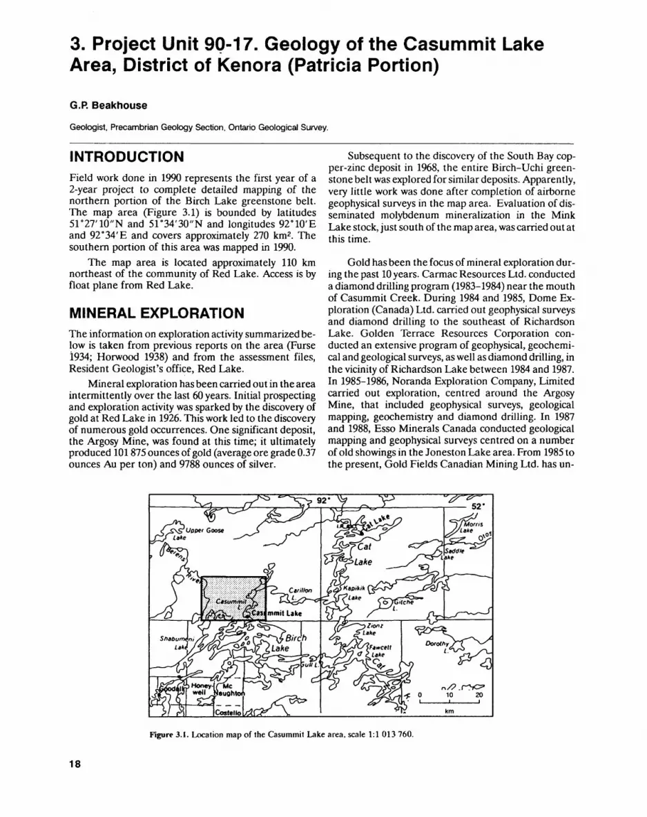
INTRODUCTIONField work done in 1990 represents the first year of a 2-year project to complete detailed mapping of the northern portion of the Birch Lake greenstone belt. The map area (Figure 3.1) is bounded by latitudes 51 0 27'10"N and 51 0 34'30"N and longitudes 92 e 10'E and 92 0 34'E and covers approximately 270 km2 . The southern portion of this area was mapped in 1990.
The map area is located approximately 110 km northeast of the community of Red Lake. Access is by float plane from Red Lake.
MINERAL EXPLORATIONThe information on exploration activity summarized be low is taken from previous reports on the area (Furse 1934; Horwood 1938) and from the assessment files, Resident Geologist's office, Red Lake.
Mineral exploration has been carried out in the area intermittently over the last 60 years. Initial prospecting and exploration activity was sparked by the discovery of gold at Red Lake in 1926. This work led to the discovery of numerous gold occurrences. One significant deposit, the Argosy Mine, was found at this time; it ultimately produced 101875 ounces of gold (average ore grade 0.37 ounces Au per ton) and 9788 ounces of silver.
Subsequent to the discovery of the South Bay cop per-zinc deposit in 1968, the entire Birch-Uchi green stone belt was explored for similar deposits. Apparently, very little work was done after completion of airborne geophysical surveys in the map area. Evaluation of dis seminated molybdenum mineralization in the Mink Lake stock, just south of the map area, was carried out at this time.
Gold has been the focus of mineral exploration dur ing the past 10years. Carmac Resources Ltd. conducted a diamond drilling program (1983-1984) near the mouth of Casummit Creek. During 1984 and 1985, Dome Ex ploration (Canada) Ltd. carried out geophysical surveys and diamond drilling to the southeast of Richardson Lake. Golden Terrace Resources Corporation con ducted an extensive program of geophysical, geochemi cal and geological surveys, as well as diamond drilling, in the vicinity of Richardson Lake between 1984 and 1987. In 1985-1986, Noranda Exploration Company, Limited carried out exploration, centred around the Argosy Mine, that included geophysical surveys, geological mapping, geochemistry and diamond drilling. In 1987 and 1988, Esso Minerals Canada conducted geological mapping and geophysical surveys centred on a number of old showings in the Joneston Lake area. From 1985 to the present, Gold Fields Canadian Mining Ltd. has un-
Figure 3.1. Location map of the Casummit Lake area, scale 1:1 013 760.
18
G.P. BEAKHOUSE
dertaken geophysical surveys, geological mapping and diamond drilling.
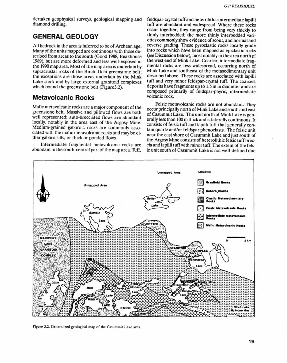
GENERAL GEOLOGYAll bedrock in the area is inferred to be of Archean age. Many of the units mapped are continuous with those de scribed from areas to the south (Good 1988; Beakhouse 1989), but are more deformed and less well-exposed in the 1990 map area. Most of the map area is underlain by supracrustal rocks of the Birch-Uchi greenstone belt; the exceptions are those areas underlain by the Mink Lake stock and by large external granitoid complexes which bound the greenstone belt (Figure3.2).
Metavolcanic RocksMafic metavolcanic rocks are a major component of the greenstone belt. Massive and pillowed flows are both well represented; auto-brecciated flows are abundant locally, notably in the area east of the Argosy Mine. Medium-grained gabbroic rocks are commonly asso ciated with the mafic metavolcanic rocks and may be ei ther gabbro sills, or thick or ponded flows.
Intermediate fragmental metavolcanic rocks are abundant in the south-central part of the map area. Tuff,
feldspar-crystal tuff and heterolithic intermediate lapilli tuff are abundant and widespread. Where these rocks occur together, they range from being very thickly to thinly interbedded; the more thinly interbedded vari eties commonly show evidence of scour, and normal and reverse grading. These pyroclastic rocks locally grade into rocks which have been mapped as epiclastic rocks (see Discussion below), most notably in the area north pf the west end of Mink Lake. Coarser, intermediate frag mental rocks are less widespread, occurring north of Mink Lake and southeast of the metasedimentary unit described above. These rocks are associated with lapilli tuff and very minor feldspar-crystal tuff. The coarsest deposits have fragments up to 1.5 m in diameter and are composed primarily of feldspar-phyric, intermediate volcanic rock.
Felsic metavolcanic rocks are not abundant. They occur principally north of Mink Lake and south and east of Casummit Lake. The unit north of Mink Lake is gen erally less than 100 m thick and is laterally continuous. It consists of felsic tuff and lapilli tuff that generally con tain quartz and/or feldspar phenoclasts. The felsic unit near the east shore of Casummit Lake and just south of the Argosy Mine consists of heterolithic felsic tuff brec cia and lapilli tuff with minor tuff. The extent of the fels ic unit south of Casummit Lake is not well-defined due
Granitoid Rocks
i Gabbro .Diorite
Clastic Matasedlmentary Rocks
Intermediate Metavolcanic Rocka
Figure 3.2. Generalized geological map of ihe Casummit Lake area.
19
PRECAMBRIAN (3)
to limited exposure. This unit is characterized by the presence of rounded quartz phenocrysts and/or pheno- clasts and is typically highly deformed and altered. Little textural evidence to indicate whether this unit represents a tuff, flow or shallow-level intrusion was ob served.
Metasedimentary RocksClastic metasedimentary rocks are not extensive. Feld spathic arenite to wacke, together with minor siltstone, occurs north of Mink Lake. On the basis of their feld spathic composition and their close spatial association with feldspar phenoclastic intermediate metavolcanic rocks, as well as the rare occurrence of pebbly sandstone with intermediate volcanic fragments, these rocks are thought to be closely related to intermediate metavol canic rocks. Wacke-siltstone exposed locally along the western shore of Mink Lake may be related to the are- nites and wackes discussed above, but, although feld spathic, contain more quartz and are less obviously re lated to intermediate volcanism. The only other signifi cant occurrence of clastic metasedimentary rocks is on the north shore of Casummit Lake. Here, wacke-silt- stone, much of it highly deformed, is interbedded locally with magnetite ironstone.
Chemical metasedimentary rocks include magne tite ironstone associated with wacke-siltstone, plus nu merous, widespread, thin units consisting of one or more beds of chert, ferruginous chert and magnetite ironstone. The latter are especially common within maf ic metavolcanic rocks.
Mafic Intrusive RocksMedium- to coarse-grained, equigranular mafic igneous rocks are primarily associated with mafic metavolcanic rocks and are likely closely related (thick or ponded flows or related sills). The principal exception occurs northwest of Richardson Lake, where gabbroic to diorit- ic rocks may form a discrete pluton. Narrow, recessively weathering mafic dikes observed in a well-exposed burned area to the southeast of the Argosy Mine are provisionally interpreted to be lamprophyres.
Felsic Intrusive RocksFelsic intrusive rocks have been divided into 4 major units.1. The Mainprize Lake complex, consists largely of
potassium-feldspar megacrystic granodiorite which grades to a quartz monzodioritic to tonalitic compo sition near the contact with the greenstone belt. These rocks intrude the greenstone belt and their emplacement has been interpreted to be responsi ble for some of the deformation of this belt (Beak house 1989).
2. The Retter Lake complex, consists primarily of potassium-feldspar megacrystic granodiorite.
3. The Mink Lake stock is composed of a predominant biotite granodiorite phase (with and without quartz phenocrysts) and greatly subordinate aplitic, granit ic dike phases. Disseminated molybdenum mineral ization associated with quartz veins occurs within the part of this pluton which is just to the south of the map area.
4. Numerous, small, locally occurring, intermediate to felsic dikes, which variously contain feldspar, am phibole or quartz phenocrysts.
STRATIGRAPHYStratigraphic relationships are poorly defined due to the generally poor and discontinuous nature of the out crops, and the intense and complex deformation that has been superimposed on the rocks. Only in the inter mediate metavolcanic and metasedimentary rocks north of Mink Lake and in the mafic metavolcanic rocks east of the Argosy Mine, are indications of direction of stratigraphic younging sufficiently clear and abundant to unambiguously infer way-up.
STRUCTURAL GEOLOGYMuch of the greenstone belt is characterized by the presence of a moderately well- to intensely developed planar tectonic fabric that, in most cases, is parallel, or nearly so, to bedding. Near the contacts with the exter nal granitoid complexes, the fabric is oriented parallel to the boundaries of the greenstone belt. Away from the contact area, bedding and the subparallel planar fabric have a more variable but generally easterly strike. Some of the variation in the strike is due to gentle to open fold ing about axes which plunge steeply to the north. A frac ture cleavage or penetrative planar fabric locally cuts the early bedding-parallel fabric and is approximately parallel to the axial planes of the folds. Northwesterly and, less commonly, northeasterly striking shears also deform the earlier fabric and may be related to the de formation responsible for the folding and axial planar fabric.
The earlier, bedding-parallel fabric corresponds to the D2 fabric described for the area to the south (Good 1988; Beakhouse 1989) and the folding and deformation of the fabric corresponds to the D3 deformation de scribed for the northern Birch Lake area (Beakhouse 1989).
ECONOMIC GEOLOGYThe map area has the potential for the discovery of addi tional gold deposits. During the course of this investiga tion, little evidence for conditions favourable for the formation of volcanogenic massive sulphide deposits was encountered, although the possibility of finding such deposits cannot be completely discounted. The poorly exposed felsic unit south of Casummit Lake may be a quartz porphyry analogous to that associated with the South Bay copper-zinc deposit (Pryslak 1970). The
20
G.P. BEAKHOUSE
Mink Lake stock may host additional disseminated mo lybdenum mineralization which, based on the known oc currence just south of the map area, may have asso ciated gold mineralization (Durocher 1981).
All of the greenstone belt has potential for the dis covery of additional gold deposits but, on the basis of the distribution of structures which host significant alter ation, quartz-carbonate veins and disseminated sul phide mineralization, as well as known occurrences, a triangular area with apices (1) north of Mink Lake, (2) near Richardson Lake, and (3) near Mcintyre Bay of Birch Lake (see Figure 3.2) would appear to be most fa vourable. Both D2 and D3 structures appear to host al teration and veining associated with gold mineraliza tion, and consequently almost any orientation of miner alized structure is to be expected in this area. Some very poorly exposed areas, such as an area extending from Joneston Lake through the southern part of Casummit Lake and along Casummit Creek, are thought to be strongly deformed and have variously altered zones with good potential for gold mineralization.
REFERENCESBeakhouse, G.P. 1989. Geology of the western Birch Lake area, Keno
ra District, Patricia Portion; Ontario Geological Survey, Open File Report 5700, 106 p.
Durocher, M.E. 1981.1980 Report of the Red Lake Resident Geolo gist; in Annual Report of the Regional and Resident Geologists 1980, Ontario Geological Survey, Miscellaneous Paper 95, p. 17-29.
Furse, G.D. 1934. Geology of the Shabumeni-Birch Lakes area; On tario Department of Mines, Annual Report, 1933, v.42, pt.6, p.21-51.
Good, D.J. 1988. Geology of the east half of the Birch Lake area, Dis trict of Kenora, Patricia Portion; Ontario Geological Survey, Open File Report 5685,131p.
Horwood, H.C. 1938. Geology of the Casummit Lake area and the Argosy Mine; Ontario Department of Mines, Annual Report, 1937, v.46, pt.7, 30p.
Pryslak, A.P. 1970. Dent Township, District of Kenora (Patricia Por tion); Ontario Department of Mines, Preliminary Map P.592, scale 1:15840.
21

4. Project Unit 89-19. Geology of the Savant Lake Area
M. Sanborn-Barrie
Geologist, Precambrian Geology Section, Ontario Geological Survey.
INTRODUCTIONThis field season marked the second year of lithologic and structural mapping of the Savant Lake greenstone belt in the Wabigoon Subprovince of northwest Ontario. The intent of this project is to re-examine the strati graphic and structural framework of the Savant Lake greenstone belt, in order to assess the effects of defor mation on the stratigraphy of the belt and the manner in which deformation has controlled or affected volcano genic massive sulphide and precious metal mineraliza tion in the belt. This, in turn, is intended to provide a stronger geologic data base with which to compare styles of alteration and mineralization in the Savant Lake greenstone belt with that of the Sturgeon Lake green stone belt to the south.
To meet these objectives, mapping focussed on:1. critical assessment of the attitudes of bedding and
directions of younging of supracrustal rocks2. recognition of technically modified units, particu
larly those whose present attitudes largely reflect a tectonic, rather than stratigraphic direction
3. determination of the number of episodes of defor mation imposed on the Savant Lake greenstone belt, and the style of deformation that characterizes each event
4. investigation of the likelihood that stratigraphic units have been tectonically juxtaposed in this greenstone belt, which has historically been inter preted to comprise relatively undisturbed se quences that stratigraphically face in one direction (Bond 1977, 1979, 1980; Trowell 1986).
Units that are out of stratigraphic sequence are now rec ognized at several localities in northwestern Ontario (i.e., the Rainy Lake area (Davis et al. 1989), the Sioux Lookout area (Davis et al. 1988), and the Pickle Lake area (Corfu and Stott 1989)), and may be typical of, but as yet unrecognized in, many other greenstone belts.
The Savant Lake greenstone belt is bounded by lati tudes 50 0 15'N and 50M5'N and longitudes 90 0 10'W and 91 0 10' W (Figure 4.1). Access to the central part of the area is gained by Highway 599, which runs northward to link the towns of Ignace and Pickle Lake, and by Hiehwav 516 which runs east from Sioux Lookout to
Figure 4.1. Location map for the Savant Lake area, northwestern Ontario, scale 1:1 013 760.
22
M. SANBORN-BARRIE
Highway 599. A network of logging roads provides good access to the southern part of the area. These roads ap pear on Ontario Basic Mapping (OEM) aerial photo graphs taken in 1983, which are available for the region south of latitude 50"25'N. The area east of Savant Lake can be reached by a north-trending logging road which extends some 60 km from Highway 599. Several lakes in the area, including Savant Lake, require float-equipped aircraft for access. Winter roads from Highway 599 to Savant Lake are not accessible by four-wheel drive ve hicle during the summer months. Information regarding previous mapping and exploration history of the Savant Lake greenstone belt, and preliminary results from the 1989 field season, are summarized in Sanborn-Barrie (1989).
During the 1990 field season, lithologic and struc tural mapping was concentrated in two areas of poten tial interest for base and precious metal exploration. One area includes an extensive sequence of predomi nantly intermediate and felsic volcanic rocks which are exposed north and northwest of the town of Savant Lake, and south of the Schist Lake-Kashaweogama Lake water system. This volcanic sequence, designated the Handy Lake volcanic group (HLVG) by Trowell (1986), has been the focus of base metal exploration since the early 1970s, following the discovery of the Mat tabi and Lyon Lake copper-zinc massive sulphide depos its in felsic volcanic rocks of the Sturgeon Lake green stone belt to the south. The second area is in the vicinity of Kashaweogama Lake, where highly tectonized and altered rocks have been the focus of exploration for gold mineralization in recent years. In addition, to supple ment observations made during the 1989 season, one week was spent mapping rocks exposed on Savant Lake. Supracrustal and plutonic rocks exposed along Highway 599 and in the Armit Lake, Dickson Lake and Winsome Lake areas were also examined as part of the 1990 map ping program.
The major stratigraphic units of the Savant Lake greenstone belt are briefly introduced below, preceding a more thorough discussion of the geology and structure of the HLVG and the Kashaweogama Lake area.
GENERAL GEOLOGY
Much of the Savant Lake greenstone belt was mapped in detail (1:15840 scale) in the early 1970s by Bond (1977, 1978, 1980), Trowell (1981) and Trusler (1982). The stratigraphy of the area has been subdivided into in formal groups and formations on the basis of lithology and geographic distribution (Trowell 1986). These ma jor units, described briefly below, are shown in Figure 4.2 and referred to throughout this report.
The Jutten volcanic group (JVG) forms the lower most sequence of massive and pillowed tholeiitic basalt, with minor ultramafic rocks and chert-magnetite iron stone. A sequence of conglomeratic wackes and quartz arenites, designated the Jutten sedimentary sequence
(JSS), occurs near the base of the JVG in the northeast part of the Savant Lake area. A polymictic conglomer ate unit, the Savant Narrows formation (SNF), uncon- formably overlies the JVG. This unit contains clasts of volcanic, intrusive (granitic) and possibly sedimentary origin. West of Savant Lake, the SNF was interpreted by Trowell (1986) to have a transitional contact with inter mediate pyroclastic rocks and flows of the Whimbrel Lake formation (WLF). In the South Arm of Savant Lake, the SNF has been interpreted as defining the base of the Savant sedimentary group (SSG) (Trowell 1986).
The central part of the Savant Lake area is domi nated by the SSG and the Handy Lake volcanic group (HLVG). The SSG comprises feldspathic wacke and lithic wacke with interbeds of magnetite chert iron stone. The HLVG consists of volcanic flows and pyro clastic rocks of variable composition, interrupted locally by metasedimentary units.
Uranium-lead ages are available for two supracrus tal units from the Savant Lake area. Zircons from a da- citic pyroclastic unit of the HLVG, located about l km southwest of Evans Lake, gave a crystallization age of 2745,Ys9 Ma (Davis and Trowell 1982). A clast of me dium-grained tonalite, collected from conglomerate of the SNF from Kashaweogama Lake, yielded a U-Pb zir con age of 2703.7 1.2 Ma from three zircon fractions (Davis et al. 1988). This represents the age of magmatic emplacement of the source of the clast, and is a maxi mum age for the deposition of the SNF conglomerate in the Kashaweogama Lake area. A clast of blue-quartz- bearing tonalite, collected a few metres from the me dium-grained tonalite clast, gave a 207Pb7206Pb age of 2723 2 Ma.
Felsic to intermediate plutons intrude the supra crustal rocks of the Savant Lake greenstone belt. Meta morphosed intrusions include porphyritic stocks ex posed on Elwood and Seldom lakes, porphyritic sills ex posed throughout the HLVG, the Conant Lake intru sion, the Hough Lake stock and the Heron Lake stock. Tonalite from the Heron Lake stock yielded two discor dant U-Pb ages of 2675 3 Ma and 2854 3 Ma (Davis et al. 1988). The younger age has been suggested as the age of emplacement of the Heron Lake stock, whereas the older age is interpreted as the age of unrelated ma terial incorporated into the stock (Davis et al. 1988). Late-tectonic to posttectonic intrusions include the the Grebe Lake stock, the Wiggle Creek stock and the Dick son Lake stock.
Foliated and gneissic granitoid rocks border the Savant Lake greenstone belt. For instance, a homoge neous, foliated, quartz-porphyritic granodiorite intru sion is exposed throughout the North Arm of Savant Lake. The Northeast Arm is occupied by tonalite gneiss and foliated intrusive rocks of tonalitic to monzogranitic composition. Gneissic rocks are also exposed east of Savant Lake. Granitoid rocks, which border the south- east part of the belt, are predominantly massive to fo liated rocks of granodioritic to tonalitic composition.
23

PRECAMBRIAN (4)
C Conant and Handy Lake intrusions + + + H. + + + + + + + + + + + + + ±s~r^f:s\* ±*D Dickson Lake stock G Grebe Lake stock He Heron Lake stock Ho Hough Lake stock T Tersha Lake stock W Wiggle Creek stock
Mafic Intrusions Handy Lake volcanic group
Conant Lake formation (Cf) Evans Lake formation (Ef)
Savant sedimentary group Whimbrel Lake formation Savant Narrows formation Jutten sedimentary sequence Jutten volcanic group (JVG)
4- 4- H- -f -f
railwayaxial trace of anticline, syncline
-.. fault
Granitoid RocksC Conant and Handy Lake intrusionsD Dickson Lake stockG Grebe Lake stockHe Heron Lake stockHo Hough Lake stockT Tersha Lake stockW Wiggle Creek stock
Mafic Intrusions Handy Lake volcanic group
Conant Lake formation (Cf)Evans Lake formation (Ef)
Savant sedimentary group Whimbrel Lake formation Savant Narrows formation Jutten sedimentary sequence Jutten volcanic group
railway
axial trace of F1 anticline, syncline j-^-K- axial trace of F2 antiform, synform
snear zone
Figure 4.2. Regional scale folds and shear zones in Ihe Savant Lake area; a)afier Bond (1977, 1979, 1980), b) preliminary interpretations of this study.
24
M. SANBORN-BARRIE
The HLVG consists primarily of flows, pyroclastic rocks and volcanogenic metasedimentary rocks of mafic, in termediate and felsic composition. The HLVG has been subdivided into the lowermost Evans Lake formation and uppermost Conant Lake formation, by Trowell (1986), based on a l km wide sequence of clastic and chemical metasedimentary rocks occurring midway through the lithologic sequence of the HLVG (Bond 1977, 1979, 1980; Trowell 1986).
The basal member of the Evans Lake formation comprises massive, pillowed and porphyritic flows, and fragmental zones of mafic composition (Bond 1977, 1979, 1980; Trowell 1986). This unit is exposed west of Harris Lake in the eastern part of the belt, and between Lewis Lake and Farrington Lake in the western part of the belt. Between these two localities, the mafic meta- volcanic unit is intruded and interrupted by the Lewis Lake batholith. Overlying the mafic sequence are flows and pyroclastic rocks of felsic and intermediate compo sition. The coarsest pyroclastic rocks occur north and west of Evans Lake, and, accordingly, the Evans Lake area has been interpreted as a possible site of a volcanic vent (Trowell 1986). The upper member of the Evans Lake formation consists of mafic metavolcanic flows and minor pyroclastic rocks. Interbedded volcanogenic metasedimentary rocks occur in the upper part of the formation, south and east of Evans Lake.
Clastic metasedimentary rocks, interpreted as sepa rating the Evans Lake and Conant Lake formations, comprise predominantly feldspathic and lithic wacke with subordinate chemical sedimentary rocks consisting of laminated to thinly bedded magnetite ironstone, chert and silicate-facies ironstone.
The Conant Lake formation comprises predomi nantly felsic and intermediate pyroclastic rocks, includ ing tuff, lapilli tuff and tuff breccia. Near Handy Lake, this sequence is intruded by felsic to intermediate feld spar- and quartz-feldspar-porphyritic sills which have been interpreted as subvolcanic intrusions (Bond 1980, Trowell 1986). The Conant Lake intrusion is spatially as sociated with the Handy Lake porphyritic sills, and is a sill-like body of granodioritic to tonalitic composition. This pluton is similarly interpreted as a subvolcanic in trusion emplaced within its associated co-magmatic vol canic pile (Bond 1979). The upper part of the Conant Lake formation consists of intermediate and felsic vol canic rocks with interbedded clastic and chemical sedi mentary units. Sedimentary units include thinly bedded magnetite ironstone, fine-grained tuffaceous beds, and conglomerate.
Structural GeologyHistorically, the entire sequence of supracrustal rocks in the Savant Lake greenstone belt has been interpreted as forming a major synclinal structure (Moore 1929;
Rittenhouse 1936; Skinner 1969). However, on the basis of younging determinations, Bond (1979, 1980) inter preted volcanic rocks of the HLVG as a "homofacing" sequence which is asymmetrically folded about a major anticlinal axis (Figure 4.2a). The asymmetric nature of the anticline proposed by Bond (1979,1980) is reflected by a contrasting "long" west limb of the fold, where bed ding is interpreted as striking east, and a "short" east limb of the fold where units strike north to northeast (Figure 4.2a). The anticline is interpreted by Bond (1979, 1980) as plunging east to northeast with a steep east-dipping fold axis that is curvilinear; that is, the fold axis strikes 025 0 near Evans Lake, strikes 080" south of Conant Lake, and strikes 025" east of Conant Lake (Fig ure 4.2a).
Observations made during this project reveal that the volcanic rocks of the HLVG have been subject to two episodes of folding (Figure 4.2b). Evidence of two folding events is provided by:1. refolded fold patterns observed on an outcrop scale2. the presence of folds whose axial-plane surfaces
strike either north or east; an axial planar cleavage is associated with each
3. opposing structural facing directions (cf. Borradaile 1976) throughout the HLVG
Bedding attitudes, although variable, generally strike northwestward to northward throughout the HLVG. Variations in the attitude of bedding are the result of two folding events and localized shearing.
Ductile shear zones transect the HLVG (Figure 4.2b) and appear to post-date folding, although shearing may be temporally associated with the second folding event. Throughout the HLVG, shear zones generally strike east (065" to 100") and dip steeply (075 0 to 088 0 ) to the north. The most prominent of these is the Kasha weogama Lake shear zone, which coincides with the northern boundary of the HLVG and separates the HLVG from the JVG to the north. Shearing within the HLVG, has transposed supracrustal units, particularly ironstone-bearing metasedimentary units, into east- striking attitudes.
Metamorphism and AlterationIn general, the Savant Lake greenstone belt has been metamorphosed to greenschist and almandine amphi bolite facies. In the Evans Lake area, however, rocks of the HLVG contain indicator minerals such as staurolite, andalusite, kyanite, cordierite and sillimanite (Figure 4.3). These minerals occur with increasing distance from granitoid batholiths, which intrude both the east and west margins of the greenstone belt. The development of these minerals suggests that hydrothermal alteration of rocks in this region took place prior to the main meta morphic event. Consequently, an alumina surplus was created, probably by the leaching of alkalis and possibly accompanied by the addition of magnesium. The peralu minous nature of altered rocks of the HLVG is similar to that observed in footwall rocks beneath the Mattabi
25
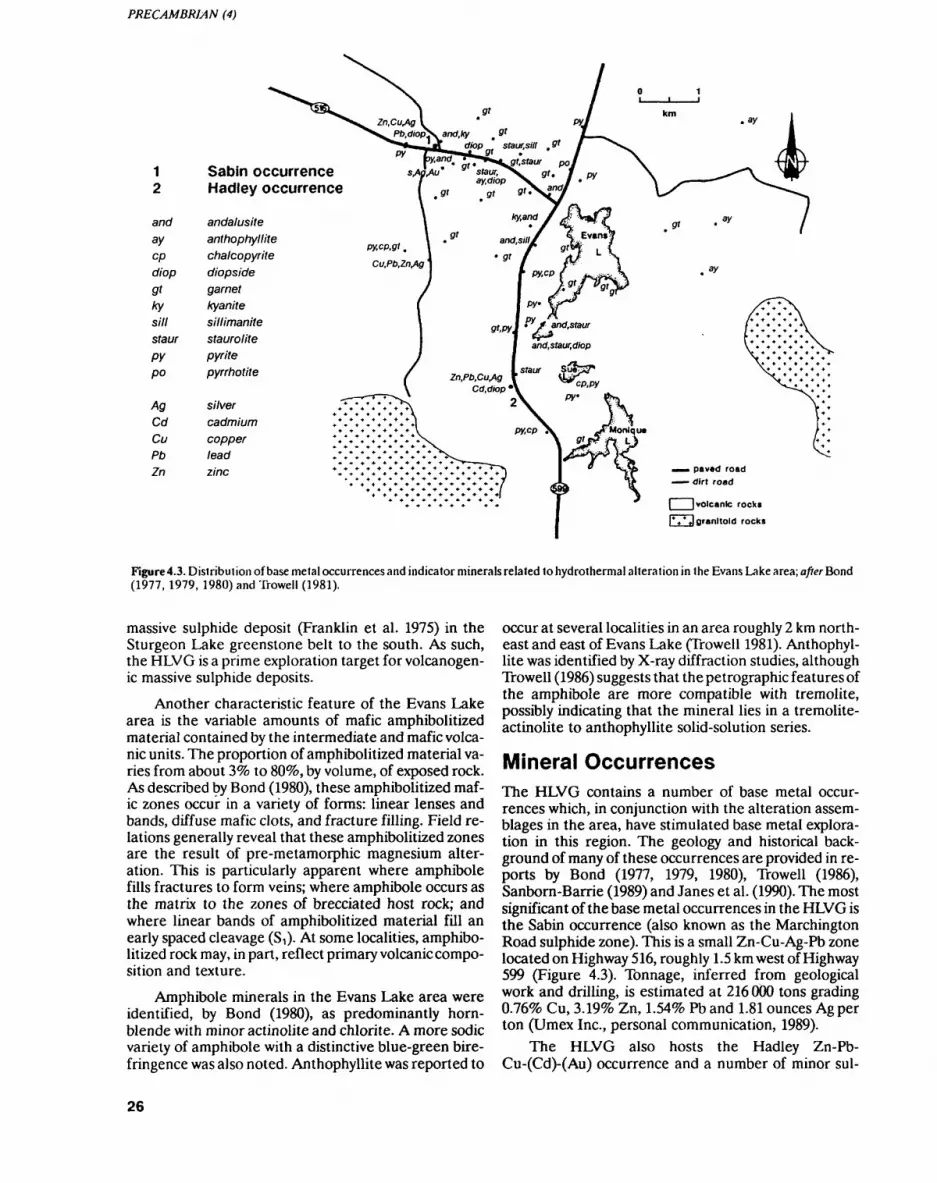
1 Sabin occurrence2 Hadley occurrence
and andalusiteay anthophyllitecp chalcopyritediop diopsidegt garnetky kyanitesill sillimanitestaur staurolitepy pyritepo pyrrhotite
Ag silverCd cadmiumCu copperPb leadZn zinc
| | volcanic rock*
l* 4 * J granitoid rocks
Figure 4.3. Distribution of base metal occurrences and indicator minerals related to hydrothermal alteration in the Evans Lake area; afterBond (1977, 1979, 1980) and Trowell (1981).
massive sulphide deposit (Franklin et al. 1975) in the Sturgeon Lake greenstone belt to the south. As such, the HLVG is a prime exploration target for volcanogen ic massive sulphide deposits.
Another characteristic feature of the Evans Lake area is the variable amounts of mafic amphibolitized material contained by the intermediate and mafic volca nic units. The proportion of amphibolitized material va ries from about 3^ to 80*fo, by volume, of exposed rock. As described by Bond (1980), these amphibolitized maf ic zones occur in a variety of forms: linear lenses and bands, diffuse mafic clots, and fracture filling. Field re lations generally reveal that these amphibolitized zones are the result of pre-metamorphic magnesium alter ation. This is particularly apparent where amphibole fills fractures to form veins; where amphibole occurs as the matrix to the zones of brecciated host rock; and where linear bands of amphibolitized material fill an early spaced cleavage (S,). At some localities, amphibo litized rock may, in part, reflect primary volcanic compo sition and texture.
Amphibole minerals in the Evans Lake area were identified, by Bond (1980), as predominantly horn blende with minor actinolite and chlorite. A more sodic variety of amphibole with a distinctive blue-green bire fringence was also noted. Anthophyllite was reported to
occur at several localities in an area roughly 2 km north east and east of Evans Lake (Trowell 1981). Anthophyl lite was identified by X-ray diffraction studies, although Trowell (1986) suggests that the petrographic features of the amphibole are more compatible with tremolite, possibly indicating that the mineral lies in a tremolite- actinolite to anthophyllite solid-solution series.
Mineral OccurrencesThe HLVG contains a number of base metal occur rences which, in conjunction with the alteration assem blages in the area, have stimulated base metal explora tion in this region. The geology and historical back ground of many of these occurrences are provided in re ports by Bond (1977, 1979, 1980), Trowell (1986), Sanborn-Barrie (1989) and Janes et al. (1990). The most significant of the base metal occurrences in the HLVG is the Sabin occurrence (also known as the Marchington Road sulphide zone). This is a small Zn-Cu-Ag-Pb zone located on Highway 516, roughly 1.5 km west of Highway 599 (Figure 4.3). Tonnage, inferred from geological work and drilling, is estimated at 216 000 tons grading Q.76% Cu, 3.199& Zn, 1.549& Pb and 1.81 ounces Agper ton (Umex Inc., personal communication, 1989).
The HLVG also hosts the Hadley Zn-Pb- Cu-(Cd)-(Au) occurrence and a number of minor sul-
26
M. SANBORN-BARRIE
phide showings in the Evans Lake-Sue Lake area. The Hadley occurrence (Figure 4.3) is a lenticular pod of massive sphalerite and galena, with minor chalcopyrite, pyrite and pyrrhotite, hosted in felsic to intermediate metavolcanic flows. The mineralized zone extends about 4.5 m along strike, and is about l m wide. Mineral ized showings in the Sue Lake area (Figure 4.3) include a silicified sericitic-pyritic showing at Sue Lake, anoma lous Cu and Zn values in sodium-depleted felsic meta volcanic rocks, sphalerite-bearing felsic tuff, and pyrite- pyrrhotite stringers in sericitic felsic schist. During 1990, stripping and trenching, south of the Sue Lake showings exposed pyritic mineralization, with minor chalcopyrite, sphalerite and galena, within strongly altered felsic rocks, on claims held by A. Best immediately west of Highway 599.
GEOLOGY OF THE KASHAWEOGAMA LAKE AREA
Highly tectonized and altered rocks occur in the Kasha weogama Lake area, in a linear zone that extends at least 45 km from Schist Lake in the west to the centre of the western shore of Savant Lake. This tectonic zone represents the most prominent and laterally continuous zone of ductile deformation in the Savant Lake area and has been a focus for precious metal exploration in recent years. In addition, this zone coincides with the contact between the JVG, exposed north of Kashaweogama Lake, and the SSG and HLVG exposed to the south. The conglomerate of the SNF is exposed sporadically on Schist, Fairchild and Kashaweogama lakes, and also serves to demarcate the contact between the JVG to the north, and the SSG and HLVG to the south.
The JVG, exposed north of Kashaweogama Lake, comprises predominantly mafic metavolcanic flows with minor intermediate to felsic metavolcanic rocks and clastic metasedimentary rocks. Units of chert-magne tite and chert, several metres wide, are exposed on the northwest shore of Kashaweogama Lake. The strike of bedding at several localities in the Armit Lake, Win some Lake and Kashaweogama Lake areas is northwest. Supracrustal rocks of the JVG are intruded by several plutonic bodies including the Heron Lake stock, the Dickson Lake stock and the Fairchild Lake intrusion.
The SNF conglomerate, bearing clasts of volcanic and plutonic provenance, unconformably overlies the JVG and serves to separate the JVG from stratigraphi- cally higher units of the SSG and HLVG, exposed to the south. The compositions of clasts in the conglomerate commonly reflect the local geology of the JVG to the north. For instance, clasts of a porphyritic phase of the Fairchild Lake intrusion exposed on the north shore of Schist Lake occur within conglomerate exposed in cen tral Schist Lake. Similarly, clasts of ultramafic composi tion occur in conglomerate on Kashaweogama Lake, south of presently exposed ultramafic rocks. The pres ence of clasts of stratigraphically lower units within the SNF conglomerate reveals an unconformable relation
ship between the JVG and the SNF. The angular rela tionship between bedding in the JVG and the SNF is largely obscured by the highly strained nature of the SNF, which rarely allows recognition of bedding atti tudes and younging directions within the conglomeratic unit. However, at two localities on Fairchild Lake, rela tively continuous beds of medium-grained feldspathic wacke are interbedded with conglomerate. These wacke beds strike eastward, slightly discordant to the strong foliation in this area. If the attitude of bedding at these localities reflects primary bedding attitudes within the SNF, an angular relationship may be demonstrated be tween these two major stratigraphic units whereby the JVG is oriented roughly 45' clockwise to the SNF.
Rocks exposed south of the Schist Lake-Kashaweo- gama Lake system include wacke and magnetite iron stone of the SSG, and mafic, intermediate and felsic metavolcanic rocks of the HLVG. In addition, sedimen tary rocks of volcanic provenance are exposed immedi ately south of the SNF on the shores of western Kasha weogama Lake and on Fairchild Lake. On existing maps (Bond 1980; Trowell 1988), these epiclastic rocks are considered as part of the volcanic stratigraphy.
Structural GeologyThe Kashaweogama Lake fault was interpreted by Bond (1977,1980) as a major, relatively late, zone of fracturing developed in response to the folding that affected the HLVG. The trace of the fault was delineated by Bond (1980) on the basis of: 1) abrupt terminations of strati graphic units; 2) shearing and kink band development within mafic metavolcanic rocks on the south shore of Kashaweogama Lake; 3) development of cataclastic tex tures in conglomerate and granitoid rocks of the Fair child Lake intrusion; and 4) the presence of a prominent airphoto lineament, which coincides with this region. The trace of the fault was interpreted by Bond (1980) to strike east through Fairchild Lake and western Kasha weogama Lake, and northeast in the eastern part of Ka shaweogama Lake (Figure 4.2a). Movement on the fault was interpreted as strike-slip (Bond 1980), although nei ther the sense of movement nor amount of displace ment was known.
The western part of Kashaweogama Lake was ex amined in detail by Northern Dynasty Explorations Ltd., during 1987 and 1988, in the exploration for gold mineralization (assessment files, Resident Geologist's office, Sioux Lookout). In the opinion of Northern Dy nasty, the sense of movement on the Kashaweogama Lake fault was left-handed, strike-slip movement based on the curvature in the strike of stratigraphic units ex posed north and south of the fault (G. Gorzynski, Northern Dynasty Explorations Ltd., personal commu nication, 1990).
Structural mapping of the Kashaweogama Lake area during 1989 and 1990 revealed that a zone of de formed rocks (l to 3 km wide) can be traced roughly 45 km along strike, from Schist Lake in the west, through Fairchild and Kashaweogama lakes, across Highway 599, through the northern part of Whimbrel Lake to the
27
PRECAMBRIAN (4)
west shore of Savant Lake (see Figure 4.2b). This tecton ic zone is referred to here as the Kashaweogama Lake shear zone (KLSZ). Within the KLSZ, rocks deformed in a ductile manner possess an intensely developed shear foliation (C-fabric) which strikes OSO 0 , parallel to the strike of the shear zone, and dips steeply (79 0 to 86") to the north. Mineral lineations and dimensional linea- tions, represented mainly by ellipsoidal clasts in con glomerate, plunge steeply (65" to 85") to the east in the eastern part of Kashaweogama Lake and the Whimbrel Lake areas; and plunge steeply (68 0 to 88") west throughout Schist, Fairchild and western Kashaweoga ma lakes. The significance of steeply plunging mineral and dimensional lineations throughout the KLSZ is that these lineations parallel the direction of maximum fi nite extension, and reflect subvertical, oblique-slip movement on the KLSZ.
Kinematic indicators, used in the field to assess the sense of steep oblique-slip movement across the KLSZ, consistently reveal major south-side-down displace ment and minor strike-slip movement along the length of the zone. A major component of south-side-down dis placement was confirmed in a microstructural study of the eastern KLSZ by Cote (1990). The result of south-side-down, dip-slip movement on the KLSZ is that the JVG is tectonically juxtaposed against younger sequences of the HLVG and the SSG. As a result of ero sion across this major tectonic break, an extreme discor dance is observed between stratigraphic units presently exposed across the KLSZ.
A minor component of strike-slip movement was in dicated on the KLSZ since lineations on the shear foli ation do not plunge strictly down-dip (i.e., 90"). A minor component of left-handed strike-slip movement was in terpreted in the eastern part of the KLSZ by Cote (1990). Minor left-handed displacement is consistent with steep, east-plunging lineations and major south- side-down displacement across the eastern KLSZ. How ever, steep, west-plunging lineations, combined with south-side-down displacement, along the western part of the KLSZ, are best explained by minor right-lateral, strike-slip movement. Horizontal exposures of the west ern KLSZ (between Schist Lake and central Kashaweo gama Lake) display steeply plunging, asymmetric Z-folds and dextral C-S fabric relations in accordance with a minor component of right-handed displacement.
ALTERATION AND MINERAL OCCURRENCES
Moderate to intense iron-carbonate alteration is perva sive throughout much of western and central Kasha weogama Lake. Lesser degrees of silicification and seri citization are observed in the central part of Kashaweo gama Lake, and a green mica is sporadically observed. Alteration is spatially associated with the KLSZ. Tecto- nized rocks south of the KLSZ and northwest of Hough Lake also possess strong iron-carbonate alteration. The
distribution of iron-carbonate alteration in this area is shown on the geological map by Bond (1980).
The highly tectonized and altered rocks within the KLSZ have been the focus of exploration for gold min eralization in recent years. The Wiggle Creek prospect, located immediately northeast of Kashaweogama Lake, is hosted in magnetite-bearing ironstone with associated feldspathic wacke and mafic metavolcanic rocks. Values of Au and Ag, up to 0.5 to 1.0 ounce per ton, respective ly, have been found associated with arsenopyrite in quartz-carbonate veins and breccia zones within pyritic and carbonate-rich facies of ironstone (Raylloyd Re sources Ltd., assessment files, Resident Geologist's of fice, Sioux Lookout).
The Sidore prospect (also known as the Johnston showing) occurs on a small island in the central part of Kashaweogama Lake. Gold mineralization occurs in several quartz veins (15 to 25 cm wide) containing minor amounts of galena, pyrite and arsenopyrite. The quartz .veins are hosted in a 10 m wide section of the KLSZ with associated carbonate and sericite alteration. The shear zone transects the SNF conglomerate and can be traced for at least 85 m along strike. Trenching and sampling by Redaurum Red Lake Mines Limited in the vicinity of the Sidore prospect yielded assays of 330 ppb Au from grab samples of pyritiferous magnetite ironstone (Re daurum Red Lake Mines Limited, assessment files, Resident Geologist's office, Sioux Lookout). Trenching near Duck Pond, by Redaurum Red Lake Mines Lim ited, uncovered pyritic bands in mudstone that assayed 1337 ppb Au (Janes et al. 1990).
The Cliff Sulphide showing (R. Ramsay, Prospec tor, personal communication, 1990), currently held by R. Ramsay and G.M. Hogg, is located about l km north west of the Sidore prospect. Mafic and felsic metavol canic rocks containing shear- and vein-hosted pyrite and chalcopyrite mineralization assayed up to 650 ppb Au, 359 ppm Cu, 82 ppm Pb and 76 ppm Zn (Janes et al. 1990).
The Hoey showing, located in western Kashaweo gama Lake, is hosted in strongly tectonized and locally altered (silicified carbonatized) mafic metavolcanic rocks of the JVG. Gold occurs in fractured grey and blue-grey quartz veins, stringers and pods with pyrite, minor chalcopyrite and galena. Flecks of visible gold are erratically disseminated throughout the quartz veins. The veins are commonly parallel to the strong east- striking foliation and are folded, revealing that the veins have been rotated parallel to the tectonic fabric. Veins vary in width from 2 to 25 cm and are continuous for l to 4 m in length. Mineralization also occurs in pyritic zones adjacent to small shear zones and fractures.
Northern Dynasty Explorations Ltd. explored for gold in the Kashaweogama Lake area during 1987 and 1988, and investigated a number of previously known and recently discovered gold showings west of the Hoey showing. The best values, up to 1.47 ounces Au per ton, came from highly tectonized and altered rocks where gold mineralization occurs in iron-carbonate-pyrite- quartz veins and pyritized shear zones. Alteration in-
28
M. SANBORN-BARRIE
eludes iron- and calcium-carbonatization, sericitization, silicification and the development of talc and chromium mica. Work done by Northern Dynasty Explorations Ltd. culminated in a 925 m diamond-drilling program, which tested structures and geophysical anomalies asso ciated with these gold showings.
DISCUSSION AND CONCLUSIONS
In addition to the observations made in the HLVG and the Kashaweogama Lake area, structural data were col lected from a number of localities throughout the Sa vant Lake area. These data will be considered, with data from the 1989 field season and from previous detailed mapping, in an effort to advance our understanding of the lithologic and tectonic development of the Savant Lake greenstone belt. The focus on structural aspects of the geology of the belt is intended to provide those ex ploring for base and precious metals with further insight as to stratigraphic correlation and the effects of defor mation on the greenstone belt and its mineralization.
One significant difference readily apparent, be tween the Savant Lake greenstone belt and the Stur geon Lake greenstone belt to the south, is the degree of strain which characterizes each. The Savant Lake area is characterized by high strain, related to at least two ma jor folding events and significant east-striking shearing. In contrast, the southern part of the Sturgeon Lake belt, the host of several base metal deposits, is characterized by low strain and the remarkable preservation of prima ry volcanic structures and textures (Groves et al. 1988). A recent study by Dube et al. (1989) does, however, re veal the controlling influence of folding on the localiza tion of mineralization at the Lyon Lake deposit, and suggests the potential for stratigraphic repetition by re verse faulting in this part of the greenstone belt.
The location of the Savant Lake greenstone belt, along the northern margin of the Wabigoon Subpro- vince, in contrast to the Sturgeon Lake greenstone belt, which forms the central part of the subprovince, may ac count for the significant difference in the intensity and style of deformation within these contiguous belts. Re cent regional-scale structural studies across subpro- vinces in northwestern Ontario have revealed that the complexity and intensity of deformation of greenstone belts increases toward the boundaries of the subpro- vinces (Thurston and Stott 1988). As a result of this, greenstone belts in the margins of subprovinces are characterized by higher total strain; they commonly show evidence of two regional-scale deformation events, and are transected by a higher proportion of duc tile shear zones which are discordant to bedding (Stott 1985; Stott 1986; Sanborn-Barrie, in prep.). In terms of mineral potential, these attributes may be both benefi cial and detrimental. Ductile shear zones that transect greenstone belts close to subprovince boundaries are fa vourable targets for gold mineralization (Colvine et al. 1988); however, multiple regional-scale deformation events may obscure and complicate alteration and min
eralization associated with volcanogenic base metal de posits.
ACKNOWLEDGMENTSI thank Jennifer Chown, Shannon Pohl, Mathew Schofield and Michele Cote for their assistance in the field. I particularly appreciate the assistance of Michele Cote, who was responsible for independent mapping during the 1990 field season, and who displayed consid erable expertise and patience in the implementation of a computer-assisted program for the storage, processing and display of geological data throughout 1989 and 1990.
REFERENCESBond, W.D. 1977. Geology of McCubbin, Poisson, and McGillis town
ships (Savant Lake area) District of Thunder Bay; Ontario Divi sion of Mines, Geoscience Report 160, 78p.
1979. Geology of Conant, Jutten, and Smye townships (Savant Lake area) District of Thunder Bay; Ontario Geological Survey, Report 182, 113p.
1980. Geology of the Hough ton-Hough lakes area (Savant Lake area); Ontario Geological Survey, Report 195, 112p.
Borradaile, G.J. 1976. "Structural Facing" (Shackleton's Rule) and the Paleozoic rocks of the Malaguide complex near Velez Rubio, SE Spain; Proceedings of the Koninklijike Nederlandse Akade- mie van Wetenschappen, Amsterdam, series B, v.79, no.5.
Colvine, A.C., Fyon, J.A., Heather, K.B., Marmont, S., Smith, P.M. and Troop, D.G. 1988. Archean Lode Gold deposits in Ontario; Ontario Geological Survey, Miscellaneous Paper 139, 136 p.
Corfu, F. and Stott, G.M. 1989. U-Pb geochronology of the central Uchi subprovince, NW-Ontario; Program with Abstracts, Geo logical Association of Canada, v.14, p.A55.
Cote, M.C. 1990. Structural geology of part of the Kashaweogama Lake shear zone in the Savant Lake greenstone belt, northwest ern Ontario; unpublished BSc thesis, University of Toronto, To ronto, Ontario 29p.
Davis.D.W. and Trowell, N.F. 1982. U-Pb zircon ages from the eastern Savant Lake-Crow Lake metavolcanic-metasedimentary belt, northwest Ontario; Canadian Journal of Earth Sciences, v.19, p.868-877.
Davis, D.W, Poulsen, K.H. and Kamo, S.L. 1989. New insights into Archean crustal development from geochronology in the Rainy Lake area, Superior Province, Canada; Journal of Geology, v.97, no.4, p.379-398.
Davis, D.W, Sutcliffe, R.H. and Trowell, N.F. 1988. Geochronologi- cal constraints on the tectonic evolution of a late Archean green stone belt, Wabigoon Subprovince, northwest Ontario, Canada; Precambrian Research, v.39, p.171-191.
Dube, B., Koopman, E.R., Franklin, J.M., Poulsen, K.H. and Patter son, M.R. 1989. Preliminary study of the stratigraphic and struc tural controls of the Lyon Lake massive sulphide deposit, Wabi goon Subprovince, northwestern Ontario; in Current Research, Part C, Canadian Shield, Geological Survey of Canada, Paper 89-1C, p.275-284.
Franklin, J.M., Kasarda, J. and Poulsen, K.H. 1975. Petrology and chemistry of the alteration zone of the Mattabi massive sulphide deposit; Economic Geology, v.70, p.63-79.
Groves, D.A., Morton, R.L. and Franklin, J.M. 1988. Physical volca nology of the footwall rocks near the Mattabi massive sulphide deposit, Sturgeon Lake, Ontario; Canadian Journal of Earth Sciences, v.25, p.280-291.
Janes, D.A., Seim, G.W. and Storey, C.C. 1990. Sioux Lookout Resi dent Geologist's District-1989; in Report of Activities 1989, Resident Geologists, Ontario Geological Survey, Miscellaneous Paper 147, p.69-100.
29
PRECAMBRIAN (4)
Moore, E.S. 1929. Lake Savant area, District of Thunder Bay; Ontario 1986. A structural analysis of the central part of the ArcheanDepartment of Mines, Annual Report, 1928, v.37, pt. 4, p.53-82. Shebandowan greenstone belt and a crescent-shaped granitoid
Rittenhouse, G. 1936. Geology of a portion of the Savant Lake area, P1 " 1?".' northwestern Ontario; unpublished PhD thesis, Universi-Ontario; Journal of Geology, v. 44, p. 451-478. * of loronto' Toronto, Ontario, 285p.
Sanborn-Barrie, M. 1989. Geology of the Savant Lake area; in Sum- Thurston, PC. and Stott, G. M. 1988. Northwestern Superior Prov-niaryof Field Work and Other Activities 1989, Ontario Geologi- ince; in Summary of Field Work and Other Activities 1988,cal Survey, Miscellaneous Paper 146, p. 54-62. Ontario Geological Survey, Miscellaneous Paper 141, p.12-17.
, in preparation. Structural geology and tectonic history of the Trowe,, N F 19gl Geo, of ,he Becking(on j^ are3) District of)eastern Lake of the Woods greenstone belt, Kenora District, Thunder B Ontario Geologica , Slll-vey, Report 200, 62p.northwestern Ontario; Ontario Geological Survey, Open File Re port, 61p. 1986. Geology of the Savant Lake area; Ontario Geological
Skinner, R. 1969. Geology of the Sioux Lookout map-area, Ontario, a Survey, Open File Report 5606, 181p.part of the Superior Province of the Precambrian shield (52 J); ^^^ , nooGeological Survey of Canada, Paper 68-45, lOp. l 19,88 '. Precambrian geology of the Savant Lake area, Ontario
0 J rt- Geological Survey, Preliminary Map P.3099, scale 1:50 000. Stott, G. M. 1985. Regional stratigraphy and structure of the Lake St.
Joseph area, central Uchi Subprovince; in Summary of Field Trusler, J. R. 1982. Geology of the Farrington Lake area, District ofWork and Other Activities 1985, Ontario Geological Survey, Kenora; Ontario Geological Survey, Open File Report 5354,Miscellaneous Paper 126, p.17-22. lOlp.
30
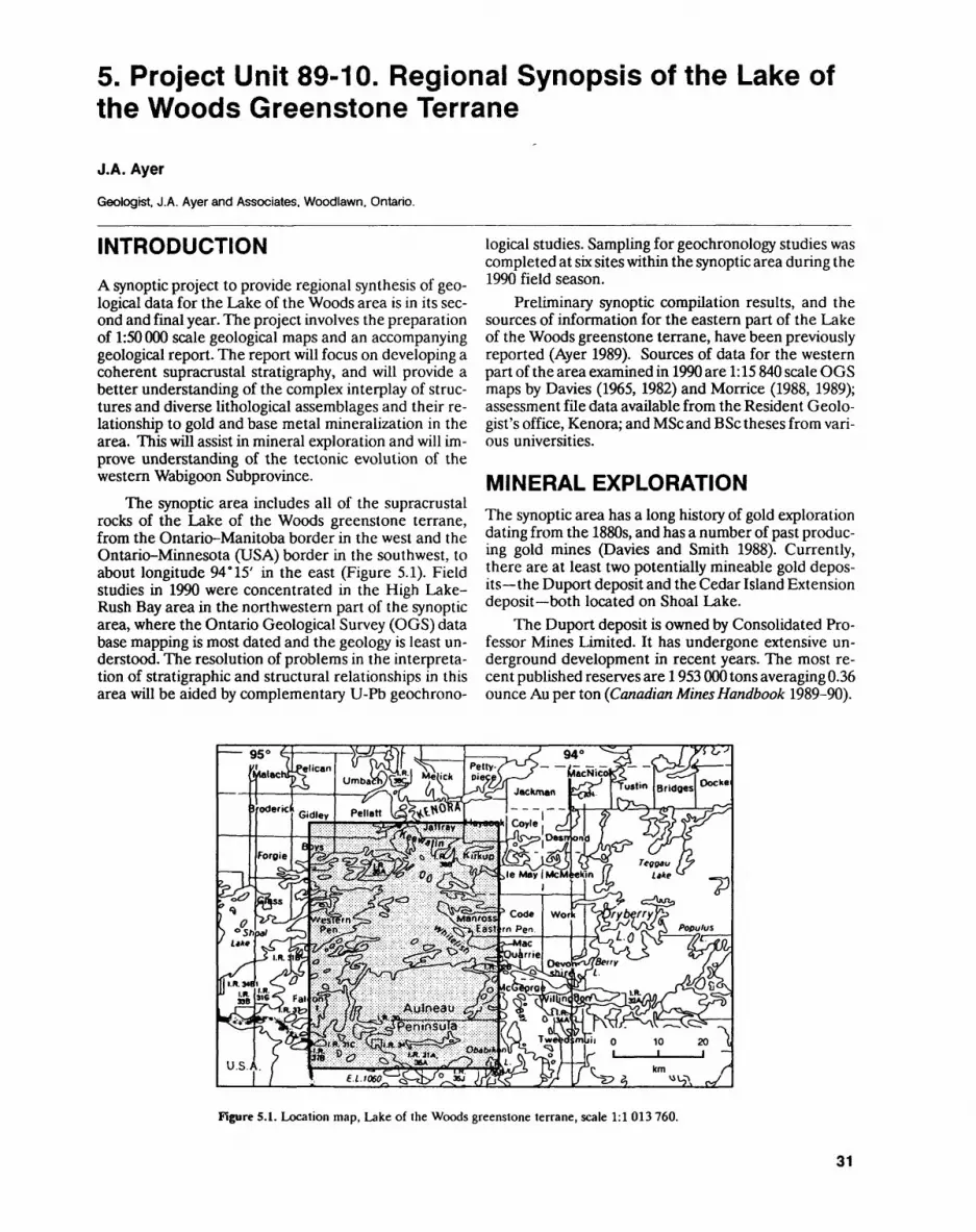
5. Project Unit 89-10. Regional Synopsis of the Lake of the Woods Greenstone Terrane
J.A. Ayer
Geologist. J.A. Ayer and Associates. Woodlawn, Ontario.
INTRODUCTION
A synoptic project to provide regional synthesis of geo logical data for the Lake of the Woods area is in its sec ond and final year. The project involves the preparation of 1:50 000 scale geological maps and an accompanying geological report. The report will focus on developing a coherent supracrustal stratigraphy, and will provide a better understanding of the complex interplay of struc tures and diverse lithological assemblages and their re lationship to gold and base metal mineralization in the area. This will assist in mineral exploration and will im prove understanding of the tectonic evolution of the western Wabigoon Subprovince.
The synoptic area includes all of the supracrustal rocks of the Lake of the Woods greenstone terrane, from the Ontario-Manitoba border in the west and the Ontario-Minnesota (USA) border in the southwest, to about longitude 94*15' in the east (Figure 5.1). Field studies in 1990 were concentrated in the High Lake- Rush Bay area in the northwestern part of the synoptic area, where the Ontario Geological Survey (OGS) data base mapping is most dated and the geology is least un derstood. The resolution of problems in the interpreta tion of stratigraphic and structural relationships in this area will be aided by complementary U-Pb geochrono-
logical studies. Sampling for geochronology studies was completed at six sites within the synoptic area during the 1990 field season.
Preliminary synoptic compilation results, and the sources of information for the eastern part of the Lake of the Woods greenstone terrane, have been previously reported (Ayer 1989). Sources of data for the western part of the area examined in 1990 are 1:15 840 scale OGS maps by Davies (1965, 1982) and Morrice (1988, 1989); assessment file data available from the Resident Geolo gist's office, Kenora; and MSc and BSc theses from vari ous universities.
MINERAL EXPLORATIONThe synoptic area has a long history of gold exploration dating from the 1880s, and has a number of past produc ing gold mines (Davies and Smith 1988). Currently, there are at least two potentially mineable gold depos its the Duport deposit and the Cedar Island Extension deposit both located on Shoal Lake.
The Duport deposit is owned by Consolidated Pro fessor Mines Limited. It has undergone extensive un derground development in recent years. The most re cent published reserves are 1953 000 tons averaging 0.36 ounce Au per ton (Canadian Mines Handbook 1989-90).
Figure 5.1. Location map, Lake of the Woods greenstone terrane, scale 1:1 013 760.
31
PRECAMBRIAN (5)
The Cedar Island Extension deposit is currently op tioned from the Kenora Prospectors St. Miners Limited by Bond Gold Canada Incorporated. The most recent published reserves, based on diamond drilling, are 1401 801 tons averaging 0.25 ounce Au per ton (Cana dian Mines Handbook 1989-90).
vSeveral exploration programs in the area have been reported in 1990. Noranda Exploration Company, Lim ited is exploring 2 claim blocks, including several pat ented claims, on polymetallic gold and base metal por phyry mineralization north of the High Lake stock. Ex ploring for base metal sulphides west of Bare Hill Lake, Rio Algom Limited diamond drilled l hole on a geo physical anomaly. Bond Gold Canada Incorporated planned an exploration program for gold mineralization on a group of claims south of Crowduck Lake. The pro gram included mapping, geophysics and sampling.
REGIONAL STRATIGRAPHYFigure 5.2 outlines the distribution of metamorphosed supracrustal rocks and associated granitoid intrusions of the Lake of the Woods greenstone terrane, part of the western Wabigoon Subprovince of the Archean Superi or Province. It is bounded to the north by the largely metaplutonic Winnipeg River Subprovince. Strati graphic subdivisions proposed as a result of this synoptic study were used to compile Figure 5.2. Rock types asso ciated with this proposed stratigraphy and their inter preted depositional environments are indicated in Table 5.1. This informal stratigraphy may be revised as a con sequence of the continuing program of geochronologi- cal studies.
Over the past 100 years, the Lake of the Woods greenstone terrane has been the subject of a number of stratigraphic studies, resulting in several different inter pretations and a confusing proliferation of stratigraphic nomenclature (Lawson 1885; Thompson 1937; Goodwin 1965; Wilson and Morrice 1977; Davies 1978; Smith 1987a). As the many stratigraphic interpretations sug gest, there are many difficulties in establishing strati graphic relations in a granite-greenstone terrane as complex as the Lake of the Woods area. For example, mixed volcanic-sedimentary sequences evolve from more than one volcanic centre, which invariably results in complex interdigitation of varying lithologic composi tions and textures, with commonly abrupt lateral and vertical facies changes. In addition, tectonically induced structures such as isoclinal folds and deformation zones are very numerous in the Lake of the Woods greenstone terrane (see Ayer 1989) and make lithostratigraphic cor relations difficult.
The stratigraphy proposed for the Lake of the Woods greenstone terrane, as a result of the synoptic studies, is divided into 3 supergroups, each with 2 or more groups which may or may not be contiguous at the surface. Because this subdivision is more detailed than past interpretations, a number of new names have been introduced (see Figure 5.2 and Table 5.1). Historical names have been utilized as much as possible. Strati
graphic units have been correlated on the basis of ob served superposition, lithologic similarities, interpreted tectonic environments and geochronological data. U-Pb ages for the High Lake-Rush Bay and Shoal Lake areas are based on Davis and Smith (in press). U-Pb ages for the southern Lake of the Woods area are based on cor relation with the Kakagi Lake-Rowan Lake greenstone terrane, east of the synoptic area (Davis and Edwards 1986). Figure 5.3 displays stratigraphic columns for four different parts of the synoptic area.
GEOLOGY OF THE HIGH LAKE-RUSH BAY AREAThe southeast portions of the High Lake-Rush Bay area have been geologically mapped at a scale of 1:126 720 by Lawson (1885) and at a scale of 1:63 360 by Greer (1931). The entire area was mapped at a scale of 1:15 840 by Da vies (1965,1982). The southern part of the map area was mapped by Smith, as 1) part of an MSc thesis project on the structural control of gold mineralization at the Du- port Mine (Smith 1987a); and 2) as detailed (1:9937 scale) mapping around the east end of the High Lake stock to investigate metal zonation, alteration patterns, and sedimentary rocks of the Crowduck Lake group (Smith 1987b).
Figure 5.4 is a general geological-stratigraphic map of the High Lake-Rush Bay area, based on geology maps by Davies (1965,1982) and Smith (1987a), with re- interpretations based on observations made in the 1990 field season. Widely spaced traverses were utilized to compare and contrast rock types with the remainder of the synoptic area and to sample for further petrographic and lithogeochemical studies; the results of these stu dies will be included in the final report. In addition, ob served structural features and a number of new strati graphic facing indicators have aided in the stratigraphic interpretation (see Figure 5.4).
The oldest rock types in the High Lake-Rush Bay area are the granitoids of the Winnipeg River Subpro vince, which are interpreted to be in tectonic contact with the Wabigoon Subprovince to the south (Davis et al. 1988). Supracrustal rocks of the Wabigoon Subpro vince within the present study area occupy a large, com plex synclinorium. The oldest of these supracrustal rocks are mafic metavolcanic rocks of the Deception Bay and Cedar Island groups of the Lower Keewatin Su pergroup, which occur at the north and south margins of the synclinorium, respectively. In the central part of the synclinorium, diverse mafic to felsic metavolcanic and metasedimentary rocks of the Upper Keewatin Super group conformably overlie the Lower Keewatin Super group. Both the Upper Keewatin Supergroup and the eastern phase of the High Lake stock are unconform- ably overlain by metasedimentary rocks of the Crow duck Lake group (Davies 1965; Smith 1987b).
Two periods of deformation have affected the su pracrustal rocks of the High Lake-Rush Bay area. The first deformation event (D,) is manifested as light to iso clinal, southeast- to northeast-striking F, folds, and the
32

J.A. AYER
CWDZ
SDZ BIF MDZPCDZ
Intrusive ContactSupergroup ContactInternal Group ContactFault or Deformation ZoneCrowduck Lake - Witch BayDeformation ZoneShoal Lake Deformation Zone l iBarrier Islands Fault |__| Upper Keewatin SupergroupMonument Bay Deformation Zone B1 Clearwater Bay GroupPipestone - Cameron Deformation Zone B2 Indian Bay Group
B3 Andrew Bay GroupGranitoids B4 Monument Bay Group
BS Royal Island Group B6 Warclub Group
Electrum Lake Supergroup B7 Lon9 BaV Grou P A1 White Partridge Bay Group B8 Wendigo Islands Group A2 Crowduck Lake Group
Lower Keewatin Supergroup C1 Deception Bay Group C2 Bigstone Bay Group C3 Cedar Island Group C4 Barrier Islands Group C5 Snake Bay Group
Figure 5.2. Stratigraphy of the Lake of the Woods greenstone terrane.
second deformation event (D2) is characterized by east-striking, tight, F2 folds, which locally refold F^ fold axes.
Geochronological studies in the vicinity of the study area indicate that the Winnipeg River Subprovince con tains orthogneisses which are more than 300 million years older than the rocks of the Wabigoon Subprovince.
Orthogneisses at Tannis Lake, just north of the contact with the Wabigoon Subprovince, are dated as early as 3051 Ma (Davis et al. 1988). In marked contrast, Davis and Smith (in press) dated felsic melavolcanic rocks within the Upper Keewatin Supergroup to about 2723 Ma, the early eastern phase of the High Lake stock to about 2727 Ma, a late western phase of the High Lake
33
PRECAMBRIAN (5)
eEc8
w"3
B2
1
1
1 le
ct Relations!
2o U
a'E
Js
1o
5rdinate
Z
s'S D"55 u'si2"o
3c eeeEoQ
ratigraphic Unit
W3
^
a.a.
1gfIL
ectrum Lake Su
verlies UKS)
w^S
uO.C 3 'C
11 00 co
J. iJ^
— D.2 o'•i .S
O QQ U
rmably over
l
JSgy re
|'vi
Q
82S g
o '"so .- CO
8^"5 **^"™" -T—
"fi 3*- G
cTCQCXt^^
n.3 OSora^
QQ uDO•o
'C
(2w
12^
"ra
VrajO
••Jj*
'lO Q.
1
formably ov
uncon
toi ^0 0"3 2
h.a S**H —5
gg.a -S•gjj0 0
11In nj
co"•H
s mco" O
S —U "J
O HI"ZV^c [J0?
U,Q.3 Oli 00u J*3st o-o
pu
SD
I1
pper Keewatin S
nderlies ELS)
33
u•cS
JOM
|"ra
en
d
Q li W o-o
S3 — 3
|||
CT3 t)
2"eU co
IIhemical s itic mafic
PO *-o
11
.8
•i0 ^
li.0 g
1 ®re **""*l o— IS0^
CQy,ex o
learwater Bay gr
U
uc 'C reE.0trt
j2"ra-5
x:oi03 oU *"
"03 S< ^•o2 w
'c c 82
'5
Sjs^80 0re o o >
CO
O
i^re
o•^o~0
~
1dian Bay group
.5
(DC"CreEC/l
J"ra
•oc ra
islij*r- cra -o E G
lea Sea
ra gs O""53•-S4} TO
hemical s oleiitic m
0 JC
^i s g11
""is. y
— si13 .y .^ oral u
-H '55O *4-
0
ex0
S-,COeau
c
ouc "Cre
Z)3CO ""^
0 US3 rera -D
J3 3
•o
S
i15II 8S
Su 5
;j-j .2 J3
l "i 8'C co" fr:s u rere f c E o g
:| 8.Slly~C o
J2.a gE o 2'e
IJJ
Oy
.y "ura
.V O
T. y— "ra3S
^^^O
o.o
onument Bay gr
2
ra
li*™ ra •re E"•2 •o 55
O QQ S
1
re
,o0 u
0
0
ras co -2155 S
lomerat volcan
11
ojo-S*"
5s5,
CO-ora
"ra
1
rt
1,O 'C*~ ra "re E'•o Lo
T3C ra
OPQ
uoS 0C3 *TJ
11
Si^. M•2*~
6'
3 O
"o
^
U
reE
J2en
"ra
•oc reO
1jSj. JO (J
ii
J2^2^^ j^ra ^
f,Skomatiitil
: sedimen
2 'S
li
~~ -*y '-J
s. y1-3rel u
— J2S*
IO 00
SO
.3
4JC'C
iX)
CO
^o"reJZ
si3 reug
8
"re•-JSlat3 g-.
liO Wl
o-iS. y1-3re -*l u— 133^
^—
j*o. o
c: —~!n
I
4J^
o
ea Er\via.uu •o
fT3
3
COraJ3
w
0
Sra0
- ^'o"o*"
9JSW'
o CQM) Q
1 s-)wer Keewatin S
nderlies UKS)
eception Bay grc
33 Q
8
teii M.S'c
^8
CL)
reo
CO
Q.U O)•o
g^5 w
1113-SsG J^.™
^ C^Sra ^* o joQ o
CO
0
o
re
0
;^Uo*"
PQpTj
l 00
coracdu Oa3
CJ
'C re
JD3
O.Uu•o
o
u •o3
ra
1
o
raE
0 co
0 0;sq3'C .y.e E
0D,
:dar Island grou
U
u"Cre E
JO3
O.IUw •o
liu •o3
3 - Sea
o c o ra
J2 8
^o'co
U t**
CO
0
y
Eo;2U"o^
10.3
srrier Islands grc
CQ
CJ
'C re
JDSD.U U•o
1. li
runcated by au batholith rmably unde
111
M
OC ore
o; j2UO*"
Stolake Bay group (
brt
34
g Electrum Lake c SupergroupZQ..a fi Upper Keewatin c Supergroupo oo IBI ,
^ Lower Keewatin * Supergroup
Winnipeg River Subprovince
^^*UivXi-i'
V^;'•H.
/WWW /WWW /WWW /WWW /WWW T- T~T- T'
* * t t * t t *
* -f * -f t- * t -f
* * t *^^^^/l ^—— VB^M
Crowduck Lake Group
. High Lake Stock (Early Phase -2727 Ma)
. Clearwater Bay Group (2722 Ma)Deception Bay Group
Tannis Lake Gneiss O 3051 Ma)
UpperKeewatinSupergroup
Lower Keewatin Supergroup
i * * *\/ * 'V V VV V V WWW WWW WWW
/WWW /WWW /WWW /WWW / V V.V V V V
Indian Bay Group
Andrew Bay Group (2723 Ma)
Cedar Island Group
SHOAL LAKE AREA (south to north)
HIGH LAKE - RUSH BAY AREA (north to south)
UpperKeewatinSupergroup
Lower Keewatin Supergroup
/WWW /WWW /WWWv v v v v v
Royal Island Group
Monument Bay Group
Barrier Islands Group
CENTRAL LAKE OF THE WOODS (north to south)
r* *iv vw. ^^ */ w
Royal Island Group
Monument Bay Group
Warclub Group (2714 Ma)
Long Bay Group
/vwvw e , - ~ rv v v v v v - Snake Bay GroupO 2732 Ma)
- Aulneau Batholith (2715 - 2709 Ma)
LEGEND
tOD Conglomeratic Metasediments LJ Gneissic Granitoid Rocks
j l Mafic to Felsic Metavolcanics Fault
H) Arenaceous Metasediments --- Intrusive Contact SOUTHERN LAKE OF THE WOODS
Q Mafic Metavolcanics ,wv Unconformity * south to north)
f/TI Massive Granitoid Rocks Conformable Contact
Figure 5.3. Stratigraphic columns for the Lake of the Woods greenstone terrane.
stock to about 2711 Ma, and the Canoe Lake stock to about 2709 Ma.
Orthogneisses of the Winnipeg River SubprovinceThe orthogneisses of the Winnipeg River Subprovince in the High Lake-Rush Bay area are highly strained to- nalitic gneisses with numerous amphibolitic dikes and inclusions. They occur along the northern margin of the map area and have been interpreted to be in either un conformable (Beakhouse 1985) or tectonic contact with the Wabigoon Subprovince (Davis et al. 1988).
Lower Keewatin SupergroupThe Lower Keewatin Supergroup is represented in the study area by the Deception Bay and Cedar Island groups.
DECEPTION BAY GROUP
The Deception Bay group consists predominantly of mafic metavolcanic rocks, now highly strained amphibo- lites, in a homoclinal, south-facing sequence up to about
l km thick. Pillows with garnet-rich, highly flattened, anastomosing selvages are locally observed. Pillowed flows with coalesced variolitic cores are also evident in the stratigraphically uppermost portions of the unit (i.e., along the southern margin). Wacke and garnetiferous- wacke, in three separate units along the north margin of the group, were mapped by Davies (1965). Synoptic in vestigations in these areas suggest that the rocks shown by Davies (1965) as metasedimentary rocks are highly strained, garnetiferous amphibolites of probable flow origin. Very minor chemical metasedimentary rocks, consisting of thinly laminated magnetite ironstone and chert beds up to l m wide and intercalated with amphi bolites, do occur locally near the north margin of the group.
CEDAR ISLAND GROUPThe Cedar Island group trends northeast through the central part of Shoal Lake, extending into north-central Lake of the Woods. The northern portion of the group is truncated by the Canoe Lake stock (see Figure 5.2). In the Shoal Lake area, the rocks of this group, which ex tend into southeastern part of the High Lake-Rush Bay area, have been identified by Smith (1987a) as the Cedar Island formation. The formation is composed of tho-
35
PRECAMBRIAN (5)
Geological Contact""""~ Fault/Deformation Zone—r— Syncline
•t Anticline
^ t Facing Direction
vvvvv v(^y v v v vVVV VV^V V V V VVVVVVMVVV
- ^ ^ . ^ 1J/^ "VVVVVVVV
v-. i-/' 7 f-' r^Tv vvvvvvvvv .'V -t L \ 'xv vvvvvvvvw
vvvvvvvv vvvvvvvv VVB . .vvv vvDlCvvv vvyvjM/vvv
WWW VM/Vitv^vVV VVV V V V V WAWfVV V V V V V V V Vv vvxv v *wwvvwvwV-V^V V V W W W V W V V Wvwvwwvwvwwvvvvvvvvvvvvvvvvwwvwvwvvvvvvvvvvwv vvwvvvvv CWDZ vvvvvwvvwvw"\/v v v v v v
VVVVVVVVVVVVVVVVVVVVyvvvvvvvvvvvvvvvvvvv
LITHOID GIES
|3 Massive Granitoids
|x x| Gneissic Granitoids|:::;| Conglomerate Metasediments
^| Arenaceous Metasediments
k^J Felsic Metavolcanicsl——l Mixed Mafic to aFelsicl——l Metavolcanics 4 Sedimentsiy,y,| Mafic Metavolcanics
STRATIGRAPHY (coding similar to Rgure .2)
Electrum Lake SupergioupA1 Crowduck Lake Group
Upper Keewatin SupergroupB1 Clearwater Bay Group
B1a Clearwater Bay Formation B1b Whiteshell River Formation B 1c High Lake Formation Bid Zigzag Island Formatiion
B2 Indian Bay Group B3 Andrew Bay Group
Lower Keewatin Supergroup C1 Deception Bay Group C3 Cedar Island Group
km
Figure 5.4. General geology and stratigraphy for the High Lake-Rush Bay area, Lake of the Woods greenstone terrane.
leiitic to komatiitic, mafic metavolcanic rocks and syn- volcanic mafic intrusions.
Upper Keewatin SupergroupIn the High Lake-Rush Bay area, the Upper Keewatin Supergroup comprises the Clearwater Bay, Andrew Bay and Indian Bay groups.
CLEARWATER BAY GROUP
The Clearwater Bay group consists of a highly diverse assemblage of rock types, and has been subdivided into 4 formations in the High Lake-Rush Bay area (Figure 5.4) the Clearwater Bay, Whiteshell River, High Lake and Zigzag Island formations.
36
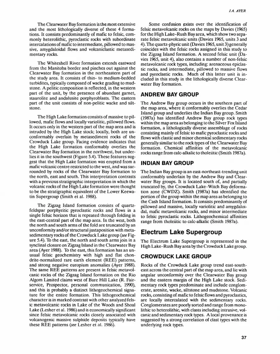
J.A. AYER
The Clearwater Bay formation is the most extensive and the most lithologically diverse of these 4 forma tions. It consists predominantly of mafic to felsic, com monly heterolithic, pyroclastic rocks with subordinate intercalations of mafic to intermediate, pillowed to mas sive, amygdaloidal flows and volcaniclastic metasedi- mentary rocks.
The Whiteshell River formation extends eastward from the Manitoba border and pinches out against the Clearwater Bay formation in the northeastern part of the study area. It consists of thin- to medium-bedded turbidites, typically composed of wacke grading to mud stone. A pelitic composition is reflected, in the western part of the unit, by the presence of abundant garnet, staurolite and andalusite porphyroblasts. The eastern part of the unit consists of non-pelitic wacke and silt stone.
The High Lake formation consists of massive to pil lowed, mafic flows and locally variolitic, pillowed flows. It occurs only in the western part of the map area and is intruded by the High Lake stock; locally, both are un- conformably overlain by metasediment rocks of the Crowduck Lake group. Facing evidence indicates that the High Lake formation conformably overlies the Clearwater Bay formation in the northwest, but under lies it in the southwest (Figure 5.4). These features sug gest that the High Lake formation was erupted from a mafic volcanic centre restricted to the west, and was sur rounded by rocks of the Clearwater Bay formation to the north, east and south. This interpretation contrasts with a previous stratigraphic interpretation in which the volcanic rocks of the High Lake formation were thought to be the stratigraphic equivalent of the Lower Keewa tin Supergroup (Smith et al. 1988).
The Zigzag Island formation consists of quartz- feldspar porphyritic pyroclastic rocks and flows in a single felsic horizon that is repeated through folding in the east-central part of the map area. In the west, both the north and south arms of the fold are truncated by an unconformity and/or structural juxtaposition with meta- sedimentary rocks of the Crowduck Lake group (see Fig ure 5.4). To the east, the north and south arms join in a synclinal closure on Zigzag Island in the Clearwater Bay area (Ayer 1988). To the east, this formation has an un usual felsic geochemistry with high and flat chon- drite-normalized rare earth element (REE) patterns, and strong negative europium anomalies (Ayer 1988). The same REE patterns are present in felsic metavol- canic rocks of the Zigzag Island formation on the Rio Algom Limited claims west of Bare Hill Lake (R. Fair- service, Prospector, personal communication, 1990), and this is probably a distinct lithogeochemical signa ture for the entire formation. This lithogeochemical character is in marked contrast with other analyzed fels ic metavolcanic rocks in Lake of the Woods and Shoal Lake (Lesher et al. 1986) and is economically significant since felsic metavolcanic rocks closely associated with volcanogenic massive sulphide deposits typically have these REE patterns (see Lesher et al. 1986).
Some confusion exists over the identification of felsic metavolcanic rocks on the maps by Davies (1965) for the High Lake-Rush Bay area, which show two sepa rate felsic metavolcanic units (Davies 1965, units 3 and 4). The quartz-phyric unit (Davies 1965, unit 3) generally coincides with the felsic rocks assigned in this study to the Zigzag Island formation. A second felsic unit (Da vies 1965, unit 4), also contains a number of non-felsic metavolcanic rock types, including: arenaceous epiclas tic rocks, and intermediate, pillowed to massive flows and pyroclastic rocks. Much of this latter unit is in cluded in this study in the lithologically diverse Clear water Bay formation.
ANDREW BAY GROUP
The Andrew Bay group occurs in the southern part of the map area, where it conformably overlies the Cedar Island group and underlies the Indian Bay group. Smith (1987a) has identified Andrew Bay group rock types within the map area as belonging to the Silver Fox Island formation, a lithologically diverse assemblage of rocks consisting mainly of felsic to mafic pyroclastic rocks and flows with clastic and minor chemical sedimentary rocks generally similar to the rock types of the Clearwater Bay formation. Chemical affinities of the metavolcanic rocks range from calc-alkalic to tholeiitic (Smith 1987a).
INDIAN BAY GROUP
The Indian Bay group is an east-northeast-trending unit conformably underlain by the Andrew Bay and Clear water Bay groups. It is located south of, and partially truncated by, the Crowduck Lake-Witch Bay deforma tion zone (CWDZ). Smith (1987a) has identified the portion of the group within the map area as belonging to the Cash Island formation. It consists predominantly of pillowed and massive, locally variolitic and amygdaloi dal, mafic metavolcanic rocks, and minor intermediate to felsic pyroclastic rocks. Lithogeochemical affinities range from tholeiitic to calc-alkalic (Smith 1987a).
Electrum Lake SupergroupThe Electrum Lake Supergroup is represented in the High Lake-Rush Bay area by the Crowduck Lake group.
CROWDUCK LAKE GROUP
Rocks of the Crowduck Lake group trend east-south east across the central part of the map area, and lie with angular unconformity over the Clearwater Bay group and the eastern margin of the High Lake stock. Sedi mentary rock types predominate and include conglom erate, arenite, wacke, siltstone and mudstone. Volcanic rocks, consisting of mafic to felsic flows and pyroclastics, are locally intercalated with the sedimentary rocks. Conglomerates are poorly sorted and range from mono lithic to heterolithic, with clasts including intrusive, vol canic and sedimentary rock types. A local provenance is suggested by a strong correlation of clast types with the underlying rock types.
37
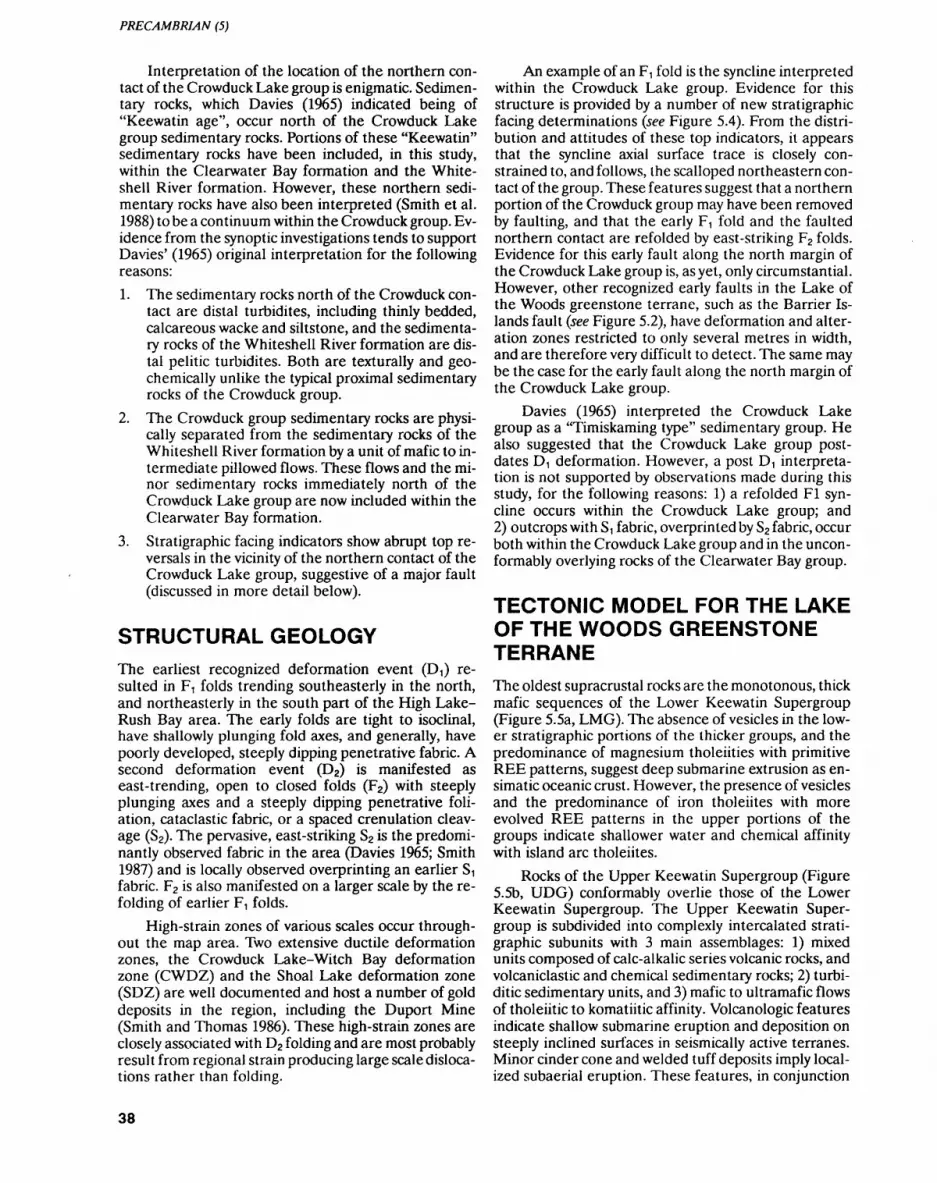
PRECAMBRIAN (5)
Interpretation of the location of the northern con tact of the Crowduck Lake group is enigmatic. Sedimen tary rocks, which Davies (1965) indicated being of "Keewatin age", occur north of the Crowduck Lake group sedimentary rocks. Portions of these "Keewatin" sedimentary rocks have been included, in this study, within the Clearwater Bay formation and the White- shell River formation. However, these northern sedi mentary rocks have also been interpreted (Smith et al. 1988) to be a continuum within the Crowduck group. Ev idence from the synoptic investigations tends to support Davies' (1965) original interpretation for the following reasons:
1. The sedimentary rocks north of the Crowduck con tact are distal turbidites, including thinly bedded, calcareous wacke and siltstone, and the sedimenta ry rocks of the Whiteshell River formation are dis tal pelitic turbidites. Both are texturally and geo- chemically unlike the typical proximal sedimentary rocks of the Crowduck group.
2. The Crowduck group sedimentary rocks are physi cally separated from the sedimentary rocks of the Whiteshell River formation by a unit of mafic to in termediate pillowed flows. These flows and the mi nor sedimentary rocks immediately north of the Crowduck Lake group are now included within the Clearwater Bay formation.
3. Stratigraphic facing indicators show abrupt top re versals in the vicinity of the northern contact of the Crowduck Lake group, suggestive of a major fault (discussed in more detail below).
STRUCTURAL GEOLOGY
The earliest recognized deformation event (D,) re sulted in F, folds trending southeasterly in the north, and northeasterly in the south part of the High Lake- Rush Bay area. The early folds are tight to isoclinal, have shallowly plunging fold axes, and generally, have poorly developed, steeply dipping penetrative fabric. A second deformation event (D2) is manifested as east-trending, open to closed folds (F2) with steeply plunging axes and a steeply dipping penetrative foli ation, cataclastic fabric, or a spaced crenulation cleav age (S2). The pervasive, east-striking S2 is the predomi nantly observed fabric in the area (Davies 1965; Smith 1987) and is locally observed overprinting an earlier ST fabric. F2 is also manifested on a larger scale by the re folding of earlier F, folds.
High-strain zones of various scales occur through out the map area. Two extensive ductile deformation zones, the Crowduck Lake-Witch Bay deformation zone (CWDZ) and the Shoal Lake deformation zone (SDZ) are well documented and host a number of gold deposits in the region, including the Duport Mine (Smith and Thomas 1986). These high-strain zones are closely associated with D2 folding and are most probably result from regional strain producing large scale disloca tions rather than folding.
An example of an FT fold is the syncline interpreted within the Crowduck Lake group. Evidence for this structure is provided by a number of new stratigraphic facing determinations (see Figure 5.4). From the distri bution and attitudes of these top indicators, it appears that the syncline axial surface trace is closely con strained to, and follows, the scalloped northeastern con tact of the group. These features suggest that a northern portion of the Crowduck group may have been removed by faulting, and that the early F, fold and the faulted northern contact are refolded by east-striking F2 folds. Evidence for this early fault along the north margin of the Crowduck Lake group is, as yet, only circumstantial. However, other recognized early faults in the Lake of the Woods greenstone terrane, such as the Barrier Is lands fault (see Figure 5.2), have deformation and alter ation zones restricted to only several metres in width, and are therefore very difficult to detect. The same may be the case for the early fault along the north margin of the Crowduck Lake group.
Davies (1965) interpreted the Crowduck Lake group as a "Timiskaming type" sedimentary group. He also suggested that the Crowduck Lake group post dates DT deformation. However, a post D, interpreta tion is not supported by observations made during this study, for the following reasons: 1) a refolded FI syn cline occurs within the Crowduck Lake group; and 2) outcrops with ST fabric, overprinted by S2 fabric, occur both within the Crowduck Lake group and in the uncon- formably overlying rocks of the Clearwater Bay group.
TECTONIC MODEL FOR THE LAKE OF THE WOODS GREENSTONE TERRANEThe oldest supracrustal rocks are the monotonous, thick mafic sequences of the Lower Keewatin Supergroup (Figure 5.5a, LMG). The absence of vesicles in the low er stratigraphic portions of the thicker groups, and the predominance of magnesium tholeiities with primitive REE patterns, suggest deep submarine extrusion as en simatic oceanic crust. However, the presence of vesicles and the predominance of iron tholeiites with more evolved REE patterns in the upper portions of the groups indicate shallower water and chemical affinity with island arc tholeiites.
Rocks of the Upper Keewatin Supergroup (Figure 5.5b, UDG) conformably overlie those of the Lower Keewatin Supergroup. The Upper Keewatin Super group is subdivided into complexly intercalated strati graphic subunits with 3 main assemblages: 1) mixed units composed of calc-alkalic series volcanic rocks, and volcaniclastic and chemical sedimentary rocks; 2) turbi- ditic sedimentary units, and 3) mafic to ultramafic flows of tholeiitic to komatiitic affinity. Volcanologic features indicate shallow submarine eruption and deposition on steeply inclined surfaces in seismically active terranes. Minor cinder cone and welded tuff deposits imply local ized subaerial eruption. These features, in conjunction
38
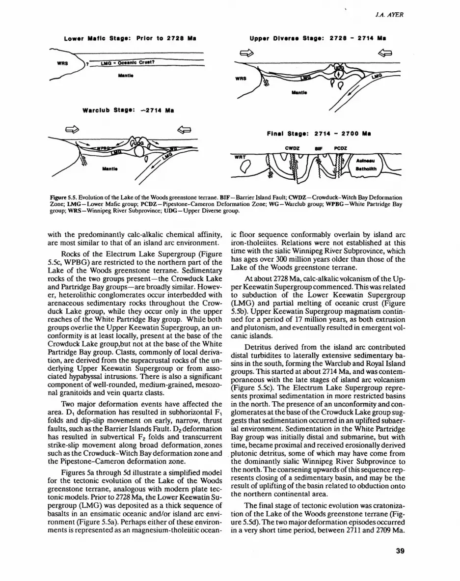
J.A. AYER
Lower Mafic Stage: Prior to 2728 Ma
LMQ - Oceanic Crust?
Mantle
Warelub Stage: -2714 Ma
Upper Diverse Stage: 2728 - 2714 Ma
WRS
Final Stage: 2714 - 2700 Ma
CWDZ BIF PCDZ
Figure 5.5. Evolution of the Lake of the Woods greenstone terrane. BIF Barrier Island Fault; CWDZ Crowduck-Witch Bay Deformation Zone; LMG Lower Mafic group; PCDZ Pipestone-Cameron Deformation Zone; WG Warelub group; WPBG White Partridge Bay group; WRS Winnipeg River Subprovince; UDG Upper Diverse group.
with the predominantly calc-alkalic chemical affinity, are most similar to that of an island arc environment.
Rocks of the Electrum Lake Supergroup (Figure 5.5c, WPBG) are restricted to the northern part of the Lake of the Woods greenstone terrane. Sedimentary rocks of the two groups present the Crowduck Lake and Partridge Bay groups are broadly similar. Howev er, heterolithic conglomerates occur interbedded with arenaceous sedimentary rocks throughout the Crow duck Lake group, while they occur only in the upper reaches of the White Partridge Bay group. While both groups overlie the Upper Keewatin Supergroup, an un conformity is at least locally, present at the base of the Crowduck Lake group,but not at the base of the White Partridge Bay group. Clasts, commonly of local deriva tion, are derived from the supracrustal rocks of the un derlying Upper Keewatin Supergroup or from asso ciated hypabyssal intrusions. There is also a significant component of well-rounded, medium-grained, mesozo- nal granitoids and vein quartz clasts.
Two major deformation events have affected the area. D, deformation has resulted in subhorizontal FT folds and dip-slip movement on early, narrow, thrust faults, such as the Barrier Islands Fault. D2 deformation has resulted in subvertical F2 folds and transcurrent strike-slip movement along broad deformation, zones such as the Crowduck-Witch Bay deformation zone and the Pipestone-Cameron deformation zone.
Figures 5a through 5d illustrate a simplified model for the tectonic evolution of the Lake of the Woods greenstone terrane, analogous with modern plate tec tonic models. Prior to 2728 Ma, the Lower Keewatin Su pergroup (LMG) was deposited as a thick sequence of basalts in an ensimatic oceanic and/or island arc envi ronment (Figure 5.5a). Perhaps either of these environ ments is represented as an magnesium-tholeiitic ocean
ic floor sequence conformably overlain by island arc iron-tholeiites. Relations were not established at this time with the sialic Winnipeg River Subprovince, which has ages over 300 million years older than those of the Lake of the Woods greenstone terrane.
At about 2728 Ma, calc-alkalic volcanism of the Up per Keewatin Supergroup commenced. This was related to subduction of the Lower Keewatin Supergroup (LMG) and partial melting of oceanic crust (Figure 5.5b). Upper Keewatin Supergroup magmatism contin ued for a period of 17 million years, as both extrusion and plutonism, and eventually resulted in emergent vol canic islands.
Detritus derived from the island arc contributed distal turbidites to laterally extensive sedimentary ba sins in the south, forming the Warelub and Royal Island groups. This started at about 2714 Ma, and was contem poraneous with the late stages of island arc volcanism (Figure 5.5c). The Electrum Lake Supergroup repre sents proximal sedimentation in more restricted basins in the north. The presence of an unconformity and con glomerates at the base of the Crowduck Lake group sug gests that sedimentation occurred in an uplifted subaer ial environment. Sedimentation in the White Partridge Bay group was initially distal and submarine, but with time, became proximal and received erosionally derived plutonic detritus, some of which may have come from the dominantly sialic Winnipeg River Subprovince to the north. The coarsening upwards of this sequence rep resents closing of a sedimentary basin, and may be the result of uplifting of the basin related to obduction onto the northern continental area.
The final stage of tectonic evolution was cratoniza- tion of the Lake of the Woods greenstone terrane (Fig ure 5.5d). The two major deformation episodes occurred in a very short time period, between 2711 and 2709 Ma.
39
PRECAMBRIAN (5)
D! deformation would have begun as the island arc ap proached the Winnipeg River Subprovince. Obduction would have caused dip-slip thrust faults and subhorizon- tal FT folds. D2 deformation may have occurred during island arc-continental collision, which would have re sulted in further deformation that turned upright and overprinted the initially gently-dipping D^ structures, and in transcurrent strike-slip movement in the defor mation zones. Finally, detachment and partial melting of the subducted oceanic plate beneath the Winnipeg River Subprovince would result in the late, post-tecton ic plutonic activity that extended to about 2695 Ma and affected both subprovinces.
RECOMMENDATIONS FOR MINERAL EXPLORATION
The area has obvious potential for economic gold min eralization as seen by the presence of numerous occur rences, past producers and the discovery of two new mineable deposits in recent years (see "Mineral Explora tion"). It is beyond the scope of this report to discuss in detail the gold mineralization in the Lake of the Woods greenstone terrane, which has already been presented in: previous Summary of Field Work articles, geological reports of each area that has been mapped in detail, and overview reports such as Davies and Smith (1988).
The Lake of the Woods greenstone terrane has seen a moderate revival of interest in its base metal po tential due to the recent increases in base metal prices and declining national reserves of copper, lead and zinc. Specific areas which appear to have some potential for volcanogenic massive sulphide (VMS) deposits include: 1) the Eastern Peninsula, west and south of the Viola Lake stock (see Figure 5.2) based on a number of copper and zinc occurrences (Ayer and Buck 1989); and 2) with in the Zigzag Island formation in the northwest (Figure 5.4), based on the unusual and distinctive REE patterns of the felsic metavolcanic rocks (see "Clearwater Bay Group") typical of rhyolites closely associated with VMS deposits (Lesher et al. 1986).
REFERENCESAyer, J.A. 1988. Geology of the Clearwater Bay area, Lake of the
Woods, District of Kenora; Ontario Geological Survey, Open File Report 5684, 149p.
1989. Regional geology of the Lake of the Woods; in Summary of Field Work and Other Activities 1989, Ontario Geological Survey, Miscellaneous Paper 146, p.40-45.
Ayer, J.A. and Buck, S. 1989. Geology of the Chisholm Island area, Lake of the Woods, District of Kenora; Ontario Geological Sur vey, Open File Report 5710, 177p.
Beakhouse, G.P. 1985. The relationship of the supracrustal sequences to a basement complex in the western English River Subprovince; in Evolution of Archean Supracrustal Sequences, Geological As sociation of Canada, Special Paper 28, p. 169-192.
Davies, J.C. 1965. Geology of the High Lake-Rush Bay area, District of Kenora; Ontario Department of Mines, Report 41, 57p.
1978. Geology of the Shoal Lake-Western Peninsula area, Dis trict of Kenora; Ontario Geological Survey, Open File Report 5242, 131p.
1982. Bag Bay, District of Kenora; Ontario Geological Survey, Map 2422, scale 1:31 680.
Davies, J.C. and Smith, P.M. 1988. The geological setting of gold oc currences in the Lake of the Woods area, District of Kenora; On tario Geological Survey, Open File Report 5685, 381p.
Davis, D. W. and Edwards, G.R. 1986. Crustal evolution of Archean rocks in the Kakagi Lakes area, Wabigoon Subprovince, Ontario, as interpreted from high-precision U-Pb geochronology; Cana dian Journal of Earth Sciences, v.23, p.182-192.
Davis, D.W. and Smith, P.M., in press. The inter-relationship of gold mineralization with tectonic and magmatic activity in the Lake of the Woods area, Superior Province, Canada: evidence precise U-Pb geochronology; Journal of Geology.
Davis, D.W, Sutcliffe, R.H. and Trowell, N.F. 1988. Geochronological constraints on the tectonic evolution of a Late Archean green stone belt, Wabigoon Subprovince, northwest Ontario, Canada; Precambrian Research, v.39, p.171-191.
Goodwin, A.M. 1965. Preliminary report on volcanism and mineral ization in the Lake of the Woods-Manitou Lake-Wabigoon re gion of northwestern Ontario; Ontario Department of Mines, Preliminary Report 1965-2, 63p.
Greer, L. 1931. Geology of the Shoal Lake (west) area, District of Ke nora; Ontario Department of Mines, Annual Report, 1930, v.39, pt.3, p.42-56.
Lawson, A.C. 1885. Report on the geology of the Lake of the Woods region with special reference to the Keewatin (Huronian?) belt of the Archean rocks; Geology and Natural History Survey of Cana da, Annual Report, 1885, v.l, pt.CC, 151p.
Lesher, C.M., Goodwin, A.M., Campbell, I.H. and Gorton, M.P. 1986. Trace-element geochemistry of ore-associated and barren, felsic melavolcanic rocks in the Superior Province, Cana da; Canadian Journal of Earth Sciences, v.23, p.222-237.
Morrice, M.G. 1988. Geology of the Northwest Angle Inlet area, Lake of the Woods, District of Kenora; Ontario Geological Survey, Open File Report 5683, 139p.
1989. Precambrian geology, Monument Bay area, Lake of the Woods; Ontario Geological Survey, Report 265, 69p.
Smith, P.M. 1987a. Geological setting, timing and controls of gold mineralization at the Duporl Deposit, Shoal Lake, Ontario; un published MSc thesis, University of Waterloo, Waterloo, Ontar io, 316p.
1987b. Geology of the High Lake area, Ewart Township, Dis trict of Kenora; in Summary of Field Work and Other Activities 1987, Ontario Geological Survey, Miscellaneous Paper 137, p.61-65.
Smith, P.M., Ayer, J.A., Buck, S., Morrice, M.G., Sanborn-Barrie, M., Blackburn, C.E., Brown, P.E. and Davis, D.W. 1988. Style, con trols and timing of gold mineralization in the Lake of the Woods greenstone belt, northwestern Ontario, Canada: evidence for a plutonic connection; in Bicentennial Gold 88, Geological Society of Australia, Abstract Series, v.23, p.45-47.
Smith, P.M. and Thomas, D.A. 1986. Interrelationship of gold miner alization and the Canoe Lake stock, northwestern Lake of the Woods area; in Summary of Field Work and Other Activities 1986, Ontario Geological Survey, Miscellaneous Paper 132, p.242-251.
Thomson, J.E. 1937. Geology of the north central part of the Lake of the Woods, Kenora District; Ontario Department of Mines, An nual Report, 1936, v.45, pt.3, p.1-43.
Wilson, H.D.B. and Morrice, M.G. 1977. The volcanic sequence in Archean shields; in Volcanic Regimes in Canada, Geological As sociation of Canada, Special Paper 16, p.355-374.
40
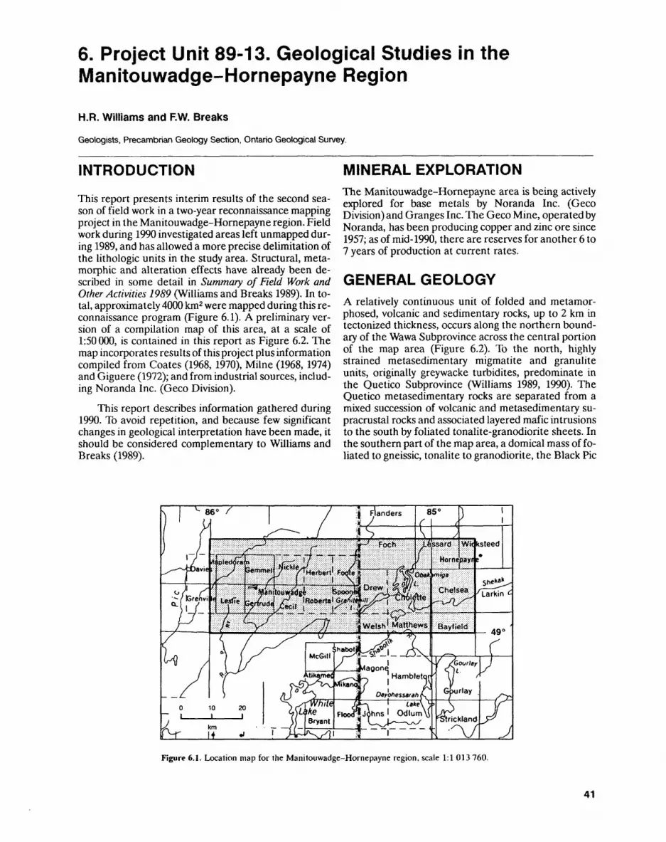
6. Project Unit 89-13. Geological Studies in the Manitouwadge-Hornepayne Region
H.R. Williams and F.W. Breaks
Geologists, Precambrian Geology Section, Ontario Geological Survey.
INTRODUCTION
This report presents interim results of the second sea son of field work in a two-year reconnaissance mapping project in the Manitouwadge-Hornepayne region. Field work during 1990 investigated areas left unmapped dur ing 1989, and has allowed a more precise delimitation of the lithologic units in the study area. Structural, meta morphic and alteration effects have already been de scribed in some detail in Summary of Field Work and Other Activities 1989 (Williams and Breaks 1989). In to tal, approximately 4000 km2 were mapped during this re connaissance program (Figure 6.1). A preliminary ver sion of a compilation map of this area, at a scale of 1:50 000, is contained in this report as Figure 6.2. The map incorporates results of this project plus information compiled from Coates (1968, 1970), Milne (1968, 1974) and Giguere (1972); and from industrial sources, includ ing Noranda Inc. (Geco Division).
This report describes information gathered during 1990. To avoid repetition, and because few significant changes in geological interpretation have been made, it should be considered complementary to Williams and Breaks (1989).
MINERAL EXPLORATIONThe Manitouwadge-Hornepayne area is being actively explored for base metals by Noranda Inc. (Geco Division) and Granges Inc. The Geco Mine, operated by Noranda, has been producing copper and zinc ore since 1957; as of mid-1990, there are reserves for another 6 to 7 years of production at current rates.
GENERAL GEOLOGYA relatively continuous unit of folded and metamor phosed, volcanic and sedimentary rocks, up to 2 km in tectonized thickness, occurs along the northern bound ary of the Wawa Subprovince across the central portion of the map area (Figure 6.2). To the north, highly strained metasedimentary migmatite and granulite units, originally greywacke turbidites, predominate in the Quetico Subprovince (Williams 1989, 1990). The Quetico metasedimentary rocks are separated from a mixed succession of volcanic and metasedimentary su pracrustal rocks and associated layered mafic intrusions to the south by foliated tonalite-granodiorite sheets. In the southern part of the map area, a domical mass of fo liated to gneissic, tonalite to granodiorite, the Black Pic
Figure 6.1. Location map for the Manitouwadge-Hornepayne region, scale 1:1 013 760.
41
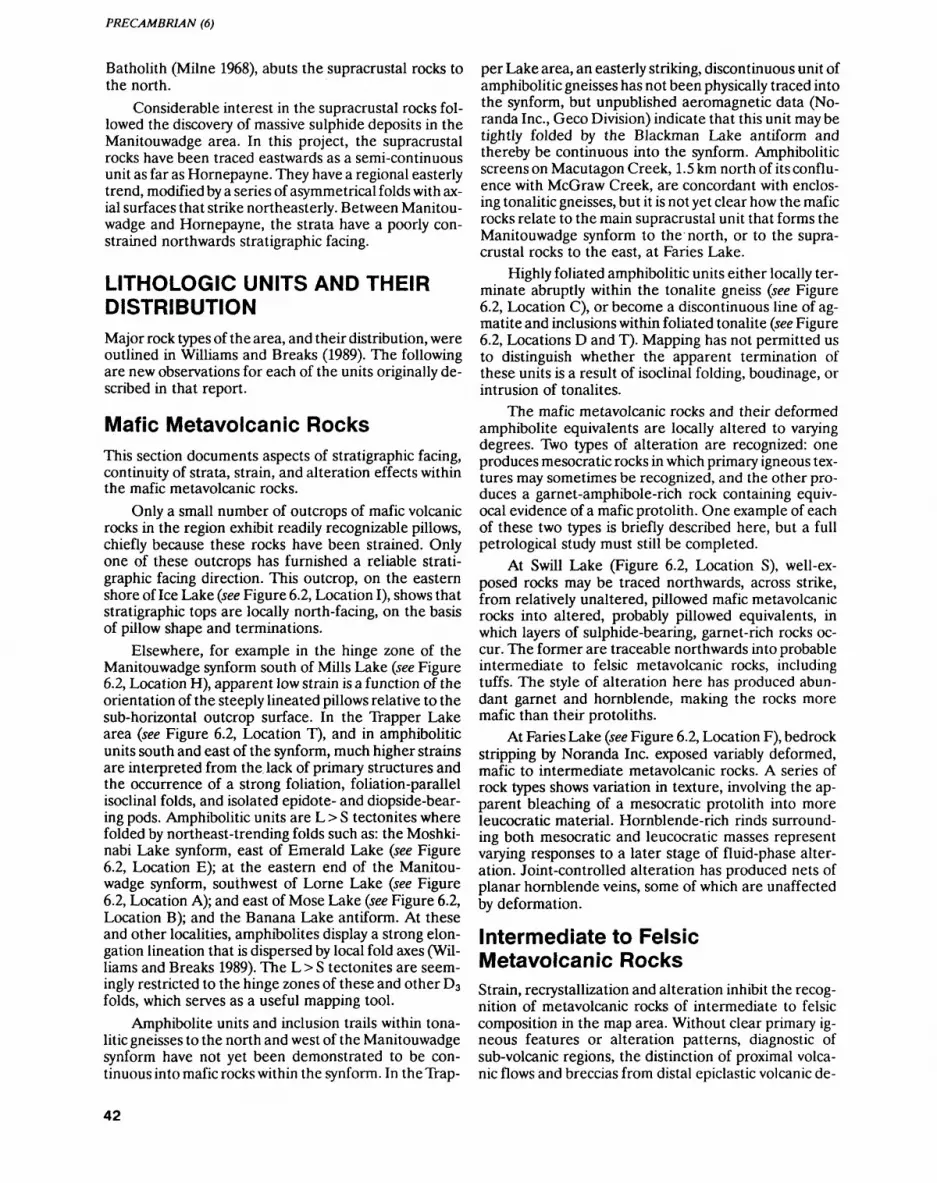
PRECAMBRIAN (6)
Batholith (Milne 1968), abuts the supracrustal rocks to the north.
Considerable interest in the supracrustal rocks fol lowed the discovery of massive sulphide deposits in the Manitouwadge area. In this project, the supracrustal rocks have been traced eastwards as a semi-continuous unit as far as Hornepayne. They have a regional easterly trend, modified by a series of asymmetrical folds with ax ial surfaces that strike northeasterly. Between Manitou wadge and Hornepayne, the strata have a poorly con strained northwards stratigraphic facing.
LITHOLOGIC UNITS AND THEIR DISTRIBUTIONMajor rock types of the area, and their distribution, were outlined in Williams and Breaks (1989). The following are new observations for each of the units originally de scribed in that report.
Mafic Metavolcanic RocksThis section documents aspects of stratigraphic facing, continuity of strata, strain, and alteration effects within the mafic metavolcanic rocks.
Only a small number of outcrops of mafic volcanic rocks in the region exhibit readily recognizable pillows, chiefly because these rocks have been strained. Only one of these outcrops has furnished a reliable strati graphic facing direction. This outcrop, on the eastern shore of Ice Lake (see Figure 6.2, Location I), shows that stratigraphic tops are locally north-facing, on the basis of pillow shape and terminations.
Elsewhere, for example in the hinge zone of the Manitouwadge synform south of Mills Lake (see Figure 6.2, Location H), apparent low strain is a function of the orientation of the steeply lineated pillows relative to the sub-horizontal outcrop surface. In the Trapper Lake area (see Figure 6.2, Location T), and in amphibolide units south and east of the synform, much higher strains are interpreted from the lack of primary structures and the occurrence of a strong foliation, foliation-parallel isoclinal folds, and isolated epidote- and diopside-bear- ing pods. Amphibolide units are L > S tectonites where folded by northeast-trending folds such as: the Moshki- nabi Lake synform, east of Emerald Lake (see Figure 6.2, Location E); at the eastern end of the Manitou wadge synform, southwest of Lorne Lake (see Figure 6.2, Location A); and east of Mose Lake (see Figure 6.2, Location B); and the Banana Lake antiform. At these and other localities, amphibolites display a strong elon gation lineation that is dispersed by local fold axes (Wil liams and Breaks 1989). The L > S tectonites are seem ingly restricted to the hinge zones of these and other D3 folds, which serves as a useful mapping tool.
Amphibolite units and inclusion trails within tona- litic gneisses to the north and west of the Manitouwadge synform have not yet been demonstrated to be con tinuous into mafic rocks within the synform. In theTrap-
per Lake area, an easterly striking, discontinuous unit of amphibolitic gneisses has not been physically traced into the synform, but unpublished aeromagnetic data (No- randa Inc., Geco Division) indicate that this unit may be tightly folded by the Blackman Lake antiform and thereby be continuous into the synform. Amphibolitic screens on Macutagon Creek, 1.5 km north of its conflu ence with McGraw Creek, are concordant with enclos ing tonalitic gneisses, but it is not yet clear how the mafic rocks relate to the main supracrustal unit that forms the Manitouwadge synform to the north, or to the supra crustal rocks to the east, at Paries Lake.
Highly foliated amphibolitic units either locally ter minate abruptly within the tonalite gneiss (see Figure 6.2, Location C), or become a discontinuous line of ag matite and inclusions within foliated tonalite (see Figure 6.2, Locations D and T). Mapping has not permitted us to distinguish whether the apparent termination of these units is a result of isoclinal folding, boudinage, or intrusion of tonalites.
The mafic metavolcanic rocks and their deformed amphibolite equivalents are locally altered to varying degrees. Two types of alteration are recognized: one produces mesocratic rocks in which primary igneous tex tures may sometimes be recognized, and the other pro duces a garnet-amphibole-rich rock containing equiv ocal evidence of a mafic protolith. One example of each of these two types is briefly described here, but a full petrological study must still be completed.
At Swill Lake (Figure 6.2, Location S), well-ex posed rocks may be traced northwards, across strike, from relatively unaltered, pillowed mafic metavolcanic rocks into altered, probably pillowed equivalents, in which layers of sulphide-bearing, garnet-rich rocks oc cur. The former are traceable northwards into probable intermediate to felsic metavolcanic rocks, including tuffs. The style of alteration here has produced abun dant garnet and hornblende, making the rocks more mafic than their protoliths.
At Paries Lake (see Figure 6.2, Location F), bedrock stripping by Noranda Inc. exposed variably deformed, mafic to intermediate metavolcanic rocks. A series of rock types shows variation in texture, involving the ap parent bleaching of a mesocratic protolith into more leucocratic material. Hornblende-rich rinds surround ing both mesocratic and leucocratic masses represent varying responses to a later stage of fluid-phase alter ation. Joint-controlled alteration has produced nets of planar hornblende veins, some of which are unaffected by deformation.
Intermediate to Felsic Metavolcanic RocksStrain, recrystallization and alteration inhibit the recog nition of metavolcanic rocks of intermediate to felsic composition in the map area. Without clear primary ig neous features or alteration patterns, diagnostic of sub-volcanic regions, the distinction of proximal volca nic flows and breccias from distal epiclastic volcanic de-
42
QZ HIOUJ
g- i oM (U ^
i?31 il?

PRECAMBRIAN (6)
posits is problematic. However, there are alteration fea tures within these rocks, such as enrichment of calcium and formation of pseudo-clasts, that have been consid ered by a number of observers to be typical of a proximal volcanic environment. Petrological examination of these rocks is in progress.
Two areas of intermediate to felsic rocks of prob able volcanic origin were studied at Swill Lake and the Willroy open stope. At Swill Lake, a northwards transi tion from mafic to felsic rocks coincides with develop ment of garnetiferous rocks, alteration in the form of lo cal bleaching, vein formation and sulphide mineraliza tion. The felsic rocks in the northern part of the area consist of units laminated on a centimetre scale, and massive, grey units. In the felsic metavolcanic rocks, hornblende-rich veins and segregations are both con cordant with, and cut, the layering. Bleaching is super imposed on this alteration adjacent to the many tonalitic sheets that are mildly discordant to the layering. At the Willroy open stope area, immediately west of the Geco Mine (Williams et ai. 1990), is another transition from possible mafic rocks southwards into felsic metavolcanic rocks. Garnet-staurolite-amphibole rocks, possibly orig inally mafic in composition, are succeeded southwards by quartz-muscovite-sillimanite schists, which grade into aplitic quartzofeldspathic rocks of probable volca nic origin. The aplitic rocks contain ellipsoidal masses, on a centimetre to decimetre scale, that may be clasts.
Metasedimentary RocksClastic metasedimentary rocks are confined to the cen tral part of the Manitouwadge synform, and to Quetico metasedimentary rocks in the northern part of the re gion (see Figure 6.2). Ironstone units occur in proximity to the contact between mafic and felsic metavolcanic rocks, and as discontinuous layers within, or adjacent to, amphibolitic rocks outside the synform.
Isolated outcrops of ironstone (magnetite-quartz- ite) have been found associated with a thin amphibolite unit northwest of the Manitouwadge synform. In the Hornepayne area, interbanding of metasedimentary and metavolcanic rocks on a kilometre scale has been recognized.
Mafic Layered Intrusive SuiteConsiderable effort was spent in 1990 to delimit the lay ered igneous rocks that were defined in 1989 as the Pa ries Lake and Moshkinabi Lake suites (Williams and Breaks 1989). Although apparently absent from the Manitouwadge synform, these layered igneous rocks have been found west of the synform, within a thin mafic unit (see Figure 6.2). The Moshkinabi and Paries Lake suites have a maximum thickness of 700 m and are con tiguous west of Ice Cream Lake. We therefore combine these two suites as the Faries-Moshkinabi suite. A band of mafic metavolcanics and the associated gabbro and anorthositic rocks of the Faries-Moshkinabi suite may be traced eastwards through Ice Lake, to Hornepayne,
where it is a series of pods engulfed by tonalite. In the Paries Lake area, the anorthositic rocks structurally overlie a series of mafic to felsic metavolcanic rocks.
Northeast of Manitouwadge, adjacent to the Hill- sport Road, anorthosite and gabbro inclusions occur within the tonalitic gneisses. Similarly, south of Trapper Lake, a trail of amphibolite, gabbro and anorthositic in clusions is traceable from near Manitou Falls to Fox Lake. Anorthositic and gabbroic rocks therefore seem to be absent from the supracrustal rocks within the Manitouwadge synform, but occur within the much thinner supracrustal amphibolites along strike from the attenuated limbs of the synform.
Diorite-Tonalite-Granodiorite SuiteThe massive, foliated to gneissic tonalite suite was stud ied in some detail, especially regarding its variability in texture and composition, and its contacts with supra crustal and anorthositic rocks. A relatively undeformed, unmigmatized, probably late-stage diorite-breccia suite is located within the Faries-Moshkinabi suite.
TONALITE-GRANODIORITE
On an outcrop scale, the tonalite-granodiorite suite is compositionally variable; inclusions of dioritic rock within tonalite are sporadic, but ubiquitous. Granodio- ritic to granitic sheets commonly cut tonalite. Larger scale, mappable compositional variation does occur, as, for example, in the Everest Lake pluton (see Figure 6.2, Location X), which is a melanocratic dioritic phase of the tonalite-granodiorite suite.
Massive to faintly foliated, inclusion-free tonalite and granodiorite are typical of the Garnham Lake area in the south-central portion of the map area (see Figure 6.2, Location G).
Garnetiferous tonalitic and granodioritic rocks oc cur as sheet-like injections in amphibolitic rocks within the core of the Manitouwadge synform. A series of out crops, displaying magnetite-rich rocks, may be due to the incorporation of banded ironstone by the tonalite. Garnetiferous tonalite also occurs near the termination of the Paries Lake complex near McGraw Lake (see Fig ure 6.2, Location C).
Tonalitic gneisses to the north of the dominant supracrustal unit that forms the Manitouwadge synform are very different in appearance from the less foliated and rarely gneissose tonalites to the south of the supra crustal unit.
Original relationships between supracrustal rocks and intrusions of tonalite, and between the Faries- Moshkinabi suite and tonalite, are obscured by shearing and emplacement of granitic pegmatite parallel with the mutual contact. Deformation at these contacts has been sufficient to produce mylonite, composed of interleaved tonalite, anorthosite and amphibolite. Mylonitization is most obvious when pegmatitic granitoid sheets and coarse-grained anorthositic gabbro are converted into augen gneisses. Associated with mylonitization is the
44
H.R. WILLIAMS and F.W. BREAKS
production of gneisses containing isoclinal folds co-pla nar to the foliation. The contact between anorthosite and tonalite is well exposed on the east shore of Paries Lake, where east-dipping anorthosites structurally overlie tonalite gneisses. Slices of tonalite which lie within anorthosite, and vice versa, form an imbricate zone in which kinematic indicators, such as s/c fabrics, minor folds and asymmetric augen, indicate that the sense of slip on the east-dipping surfaces is reverse, that is, top to the west.
LATE DIORITE MASSES AND ASSOCIATED BRECCIA BODIES
A relatively unfoliated dioritic mass, enclosed com pletely within the Faries-Moshkinabi suite, is consid ered to be a late tectonic intrusion. Around it, near or at its contacts with more highly foliated metavolcanic and layered igneous rocks, are a number of undeformed breccia bodies and pegmatitic diorites (appinite) that are described in the following section. Ultramafic, typically hornblendite, units are associated with the marginal portions of the diorite; these contain sulphide and may be part of an appinite suite.
A number of outcrops of heterolithic to near-mono lithic breccia bodies occur within, and adjacent to, the mesocratic, homogeneous dioritic mass that appears to occur within, and cut, the Faries-Moshkinabi suite. Breccia bodies not proximal to a diorite mass occur on the southeast shore of Agonzon Lake (see Figure 6.2, Location J) and l km east of Gaugino Lake (see Figure 6.2, Location K). Breccia fragments or clasts are angular to sub-rounded and lie within an aplitic to coarse- grained granitic matrix. Modal matrix is negligible in many instances, and it is always less than 5*26. All breccia bodies are undeformed and several are cut by unde formed granitic pegmatites.
Granitic SuiteGranites and associated pegmatites occur ubiquitously in the region as bodies of outcrop dimension, but rarely as mappable units, for example, the Loken Lake Pluton (Figure 6.2, Location L). Many pegmatites are asso ciated with granitic sheets in the tonalite-granodiorite masses. However, south of Quacker Lake (see Figure 6.2, Location Q), within the Moshkinabi Complex, peg matites stretching for several kilometres are discordant to the layering and are undeformed. The pegmatites dis play a simple mineralogy, consisting of albite crystals up to 0.5 m long in a quartz-albite-muscovite matrix. No rare-element minerals were observed.
STRUCTURAL GEOLOGY
Williams and Breaks (1989) documented a deformation scheme in which isoclinal folding D, and D2 of the strati graphic succession occurred prior to the development of northeasterly striking asymmetric folds (D3). As out lined in Williams and Breaks (1989), there is abundant
mineral and stretching lineation evidence within the Manitouwadge synform to support the hypothesis of a folding deformation of early lithologic layering. How ever, in the absence of recognizable mesoscopic hinge zones or fold closures, and of reliable top indicators, the recognition of early folds is conjectural. This year, top indicators have been inferred within restricted parts of the Manitouwadge synform and outlying supracrustal rocks from lithostratigraphic associations within transi tions from mafic to felsic volcanic rocks, and their alter ation patterns; and determined from graded bedding in metasedimentary rocks, and from the shape of pillowed mafic volcanic rocks in one locality. Tkken together, these top indicators present a consistent pattern of stratigraphic facing to the north, except in one region, within the core of the Manitouwadge synform, along strike from the Geco Mine. An interpretation of this anomalous area on the northern part of the east-trend ing limb is that the supracrustal rocks within the synform were isoclinally folded prior to the imposition of the D3 synform structure. Notwithstanding the reservations of Williams and Breaks (1989) regarding the recognition of a small-scale stratigraphic succession, the tectonized large-scale lithologic succession is probably representa tive of the original succession, because much of the strain appears to have been accommodated by layer-par allel slip, intensifying the original layering. We now con sider the lithologic succession to be an upward succes sion of pillowed mafic metavolcanic rocks, intermediate to felsic metavolcanic rocks, and metasedimentary rocks. Figure 6.2 shows the inward facing stratigraphy on the east-striking limb of the synform. The economic significance of this structure is discussed in a later sec tion. No such repetition of the stratigraphy has yet been recognized in the northeasterly striking limb of the syn form, or in the much thinner supracrustal units outside the synform.
Many of the rocks in the region have a dominant fo liation (S) that parallels the lithologic layering. On this foliation is a variably developed mineral or stretching li neation (L). In contrast to this regional L-S fabric, hinge zones of D3 folds exhibit a strongly developed lineation on a foliation that may only be weakly developed, typical of L > S tectonites. The relative strengths of L and S are useful mapping aids in locating the D3 fold structures. Examples of L^ tectonites occur to the southeast of Ice Cream Lake (see Figure 6.2, Location M) and north of Wowun Lake (see Figure 6.2, Location W).
In the area west of McGraw Lake, the southerly ex tension of the Paries Lake Complex, and its enclosing mafic supracrustal rocks, apparently terminates. This may be interpreted in two ways: either tonalitic rocks to tally engulf or cut out the supracrustal rocks, or the su pracrustal rocks represent a keel that plunges west wards into the tonalite.
West of the synform, to the south of Kern Lake (see Figure 6.2, Location N), fold interference patterns are locally developed, involving north-northeast- to north east-striking upright folds superimposed on a shallowly dipping planar fabric. In no other part of the area are
45
PRECAMBRIAN (6)
folds of this orientation seen; they may be a local re sponse to the sinistral shear zone developed west of the Manitouwadge synform.
Within the foliated to gneissic tonalites exposed in the Highway 614 roadcut, and notably at Morley and Agonzon lakes (see Figure 6.2, Location J), planar fab rics predominate, and lineations tend to be only weakly developed.
Between Ice Cream and Emerald lakes (see Figure 6.2, Location E), the Faries-Moshkinabi suite and its en closing mafic metavolcanic rocks join in a triple-point structure. It is not yet clear how such a structure might develop by folding alone. More likely, the structure formed as a combined response to D3 folding and em placement of the late-stage homogeneous diorite.
In the area west of Hornepayne and east of Armi- tage Lake (see Figure 6.2, Location O), the contact be tween mafic metavolcanic rocks, now amphibolites, and the metasedimentary migmatites of the Quetico Sub- province is marked by repetitive sequences of amphibo lite and paragneiss. Sporadic exposure and lack of strati graphic facing observations prevent us from determin ing whether the distribution of rock types represents a cyclic stratification, a fold, or strata stacked by thrusting.
DISTRIBUTION AND CHARACTER OF METAMORPHISM
Much of the exposed rock in the Manitouwadge-Horne- payne region is metamorphosed to upper amphibolite facies, as determined from supracrustal rocks contain ing mineral assemblages that include cordierite, stauro lite, garnet, anthophyllite and gedrite. Only in the far north of the region is orthopyroxene present, within rocks dominantly of metasedimentary composition. A granulite-facies zone is elongate along the regional strike, stretching from the Caramat Road in the west, to south Lessard Township in the east (see north of Loca tion O, Figure 6.2). To the south and west of this zone of granulite-facies rocks, sporadic outcrops with microc- line-magnetite-hornblende-bearing quartzofeldspathic assemblages, granitoid pegmatites, and migmatitic leucosomes with biotite as the chief dark mineral, are examples of rocks of significantly higher grade than those to the south.
ECONOMIC GEOLOGY
Base metal sulphides have, for some time, dominated evaluations of the mineral potential of this region. This report describes a number of sulphide occurrences, and includes an assessment of other potentially mineralized rocks.
Base metal sulphide showings appear to be devel oped in 4 lithostructural environments:
1. sporadically, as veins and disseminations within mafic metavolcanic rocks
2. associated with garnet-amphibole-rich rocks adja cent to contacts between mafic, and intermediate to felsic, metavolcanic units
3. within metamorphosed, layered, gabbroic to anort- hositic intrusions
4. as segregations within ultramafic rocks associated with late-stage dioritic intrusions
Within the major mafic metavolcanic unit that traverses the Mantouwadge-Hornepayne region, sulphide occur rences are numerous, but not well documented. For ex ample, in the hinge zone of the Manitouwadge synform, where metamorphic grades and degree of strain are somewhat lower than elsewhere, disseminated sulphide occurs within the mafic rocks. Disseminated sulphide occurs: along, and adjacent to, outcrop-scale shear zones paralleling the schistosity; associated with minor felsic intrusions; and in late-stage veins and fractures. The Swill Lake area contains a number of sulphide oc currences of this type.
The Geco Mine, the adjacent Willroy and Big Nama Creek Mines, and numerous outcrops, such as those at Swill Lake (see Figure 6.2, Location S) and Fanes Lake (see Figure 6.2, Location F), occur at, or close to, major lithologic boundaries between mafic, and intermediate to felsic, metavolcanic rocks (Friesen et al. 1982; Wil liams et al. 1990). Commonly, at these contacts, an iron stone composed of magnetite-quartzite or sul- phide-quartzite is developed. Also associated with this contact are highly schistose muscovite-rich rocks, some of which may have developed from hydration and meta somatic alteration of felsic volcanic rocks. It is not yet clear when the alteration and sulphide development oc curred.
Deformation in the form of folding and shearing, especially along a strongly developed foliation, pro duced sulphide bodies that are elongated along a strong ly developed rodding lineation, and folded across Z-style asymmetric folds that are a metre to tens of metres in amplitude. It is highly significant that the lith ologic sequence and associated alteration at Swill Lake face north, whereas those at the Geco and Willroy Mines face south; these relationships may be used to support an hypothesis that there was pre-D3 isoclinal folding of the lithostratigraphic units and their atten dant alteration.
At Paries Lake (see Figure 6.2, Location F), alter ation of both mafic, and intermediate to felsic, metavol canic rocks has been observed. This alteration was de scribed in a previous section. Alteration of the mafic rocks involves a general bleaching and the redistribution of amphibole into veins. Alteration of the more felsic rocks has involved redistribution of mafic material into rims surrounding original clasts, and into veins.
Hornblendite and melagabbroic bodies, associated with the marginal portions of the late-stage dioritic body enclosed within the Moshkinabi Lake complex, contain sporadic sulphide mineralization (see Figure 6.2, Loca tions P and R). The sulphide occurs as rusty patches as sociated with coarse-grained amphibole.
46
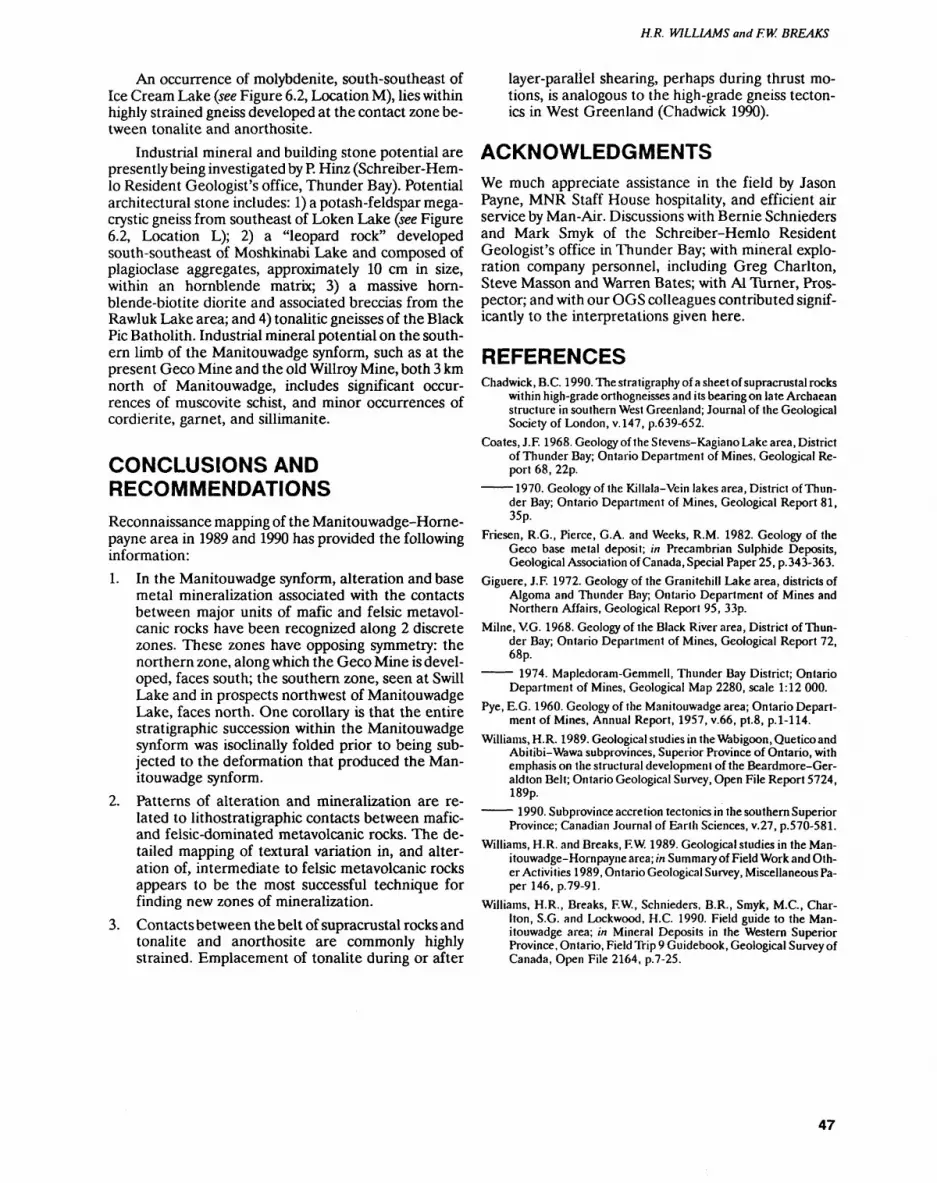
H. R. WILLIAMS and F. W. BREAKS
An occurrence of molybdenite, south-southeast of Ice Cream Lake (see Figure 6.2, Location M), lies within highly strained gneiss developed at the contact zone be tween tonalite and anorthosite.
Industrial mineral and building stone potential are presently being investigated by P. Hinz (Schreiber-Hem- lo Resident Geologist's office, Thunder Bay). Potential architectural stone includes: 1) a potash-feldspar mega- crystic gneiss from southeast of Loken Lake (see Figure 6.2, Location L); 2) a "leopard rock" developed south-southeast of Moshkinabi Lake and composed of plagioclase aggregates, approximately 10 cm in size, within an hornblende matrix; 3) a massive horn- blende-biotite diorite and associated breccias from the Rawluk Lake area; and 4) tonalitic gneisses of the Black Pic Batholith. Industrial mineral potential on the south ern limb of the Manitouwadge synform, such as at the present Geco Mine and the old Willroy Mine, both 3 km north of Manitouwadge, includes significant occur rences of muscovite schist, and minor occurrences of cordierite, garnet, and sillimanite.
CONCLUSIONS AND RECOMMENDATIONSReconnaissance mapping of the Manitouwadge-Horne- payne area in 1989 and 1990 has provided the following information:1. In the Manitouwadge synform, alteration and base
metal mineralization associated with the contacts between major units of mafic and felsic metavol- canic rocks have been recognized along 2 discrete zones. These zones have opposing symmetry: the northern zone, along which the Geco Mine is devel oped, faces south; the southern zone, seen at Swill Lake and in prospects northwest of Manitouwadge Lake, faces north. One corollary is that the entire stratigraphic succession within the Manitouwadge synform was isoclinally folded prior to being sub jected to the deformation that produced the Man itouwadge synform.
2. Patterns of alteration and mineralization are re lated to lithostratigraphic contacts between mafic- and felsic-dominated metavolcanic rocks. The de tailed mapping of textural variation in, and alter ation of, intermediate to felsic metavolcanic rocks appears to be the most successful technique for finding new zones of mineralization.
3. Contacts between the belt of supracrustal rocks and tonalite and anorthosite are commonly highly strained. Emplacement of tonalite during or after
layer-parallel shearing, perhaps during thrust mo tions, is analogous to the high-grade gneiss tecton ics in West Greenland (Chadwick 1990).
ACKNOWLEDGMENTSWe much appreciate assistance in the field by Jason Payne, MNR Staff House hospitality, and efficient air service by Man-Air. Discussions with Bernie Schnieders and Mark Smyk of the Schreiber-Hemlo Resident Geologist's office in Thunder Bay; with mineral explo ration company personnel, including Greg Charlton, Steve Masson and Warren Bates; with Al Turner, Pros pector; and with our OGS colleagues contributed signif icantly to the interpretations given here.
REFERENCESChadwick, B.C. 1990. The stratigraphy of a sheet of supracrustal rocks
within high-grade orthogneisses and its bearing on late Archaean structure in southern West Greenland; Journal of the Geological Society of London, v.147, p.639-652.
Coates, J.F. 1968. Geology of the Stevens-Kagiano Lake area, District of Thunder Bay; Ontario Department of Mines, Geological Re port 68, 22p.
1970. Geology of the Killala-Vein lakes area, District of Thun der Bay; Ontario Department of Mines, Geological Report 81, 35p.
Friesen, R.G., Pierce, G.A. and Weeks, R.M. 1982. Geology of the Geco base metal deposit; in Precambrian Sulphide Deposits, Geological Association of Canada, Special Paper 25, p. 343-363.
Giguere, J.F. 1972. Geology of the Granitehill Lake area, districts of Algoma and Thunder Bay; Ontario Department of Mines and Northern Affairs, Geological Report 95, 33p.
Milne, V.G. 1968. Geology of the Black River area, District of Thun der Bay; Ontario Department of Mines, Geological Report 72, 68p.
1974. Mapledoram-Gemmell, Thunder Bay District; Ontario Department of Mines, Geological Map 2280, scale 1:12 000.
Pye, E.G. 1960. Geology of the Manitouwadge area; Ontario Depart ment of Mines, Annual Report, 1957, v.66, pt.8, p.1-114.
Williams, H.R. 1989. Geological studies in the Wabigoon, Quetico and Abitibi-Wawa subprovinces, Superior Province of Ontario, with emphasis on the structural development of the Beardmore-Ger- aldton Belt; Ontario Geological Survey, Open File Report 5724, 189p.
1990. Subprovince accretion tectonics in the southern Superior Province; Canadian Journal of Earth Sciences, v.27, p.570-581.
Williams, H.R. and Breaks, F.W. 1989. Geological studies in the Man- itouwadge-Hornpaynearea; in Summary of Field Work and Oth er Activities 1989, Ontario Geological Survey, Miscellaneous Pa per 146, p.79-91.
Williams, H.R., Breaks, F.W., Schnieders, B.R., Smyk, M.C., Char lton, S.G. and Lockwood, H.C. 1990. Field guide to the Man itouwadge area; in Mineral Deposits in the Western Superior Province, Ontario, Field Trip 9 Guidebook, Geological Survey of Canada, Open File 2164, p.7-25.
47

7. Project Unit 90-21. Synoptic Studies in the Michipicoten Greenstone Belt, District of Algoma
R.P. Sage
Geologist. Precambrian Geology Section, Ontario Geological Survey.
INTRODUCTION
The Ontario Geological Survey has recently completed 10 years of geologic mapping in the central portion of the Michipicoten greenstone belt (Figure 7.1). In 1982, three years after the start of this program, geochrono logical investigations were initiated to resolve problems in correlation arising from the mapping. The Michipico ten greenstone belt is ideal for geochronological stu dies, since abundant exposure provides ample sampling sites. This report presents interim results of a synoptic study of the Michipicoten greenstone belt, part of which is designed to reconcile the results of these geochrono logical investigations with the geological data base de veloped during bedrock mapping.
Most of the geochronological data comprise U-Pb age determinations by A. Turek at the University of Windsor (Turek et al. 1984, 1988; Turek, Sage and Van Schmus 1990; Turek, Keller and Van Schmus 1990), mainly using samples collected by Ontario Geological Survey mapping crews. Turek's efforts have been di rected towards understanding the volcanic-plutonic re lationships in the Michipicoten belt. More recently, F. Corfu, of the Jack Satterly Geochronology Laboratory at the Royal Ontario Museum, has investigated the metasedimentary rocks by dating a trondhjemite boul
der from the Dore metasediments (Corfu and Sage 1987).
GENERAL GEOLOGYThe Michipicoten greenstone belt contains a complexly folded and faulted sequence of supracrustal rock, repre senting at least three cycles of volcanism (mafic to felsic rock compositions) and their eroded products. Multi- cyclic volcanism was first recognized by Goodwin (1962), but the lack of geochronological data prevented him from assigning absolute ages to the cycles.
Geological mapping has indicated that: 1) the inter mediate to felsic metavolcanic rocks, for each cycle, are similar in appearance; 2) the mafic portions of the two younger cycles are identical in composition; 3) the mafic portion of the older cycle consists of basaltic to perido- titic komatiite; and 4) the two older volcanic cycles are capped by iron formations, which provide prominent geophysical and geological marker horizons. Mapping within the intermediate to felsic portion of the youngest cycle has indicated that the Dore metasediments inter- finger with, and are likely derived from, the felsic meta volcanic rocks of the cycle. The mapping of this complex supracrustal stratigraphy delineated a number of prob lems requiring geochronological study.l. What are the relative ages of the volcanic cycles?
Figure 7.1. Location map of study area, scale 1:1 013 760.
48

R.P. SAGE
2. What are the temporal relations between the supra crustal rocks and internal and external plutonic rocks?
3. Can the repetition of stratigraphic sections, which cannot be recognized in the field due to similarity in rock types and conformable contacts, be recognized through geochrone!ogical studies?
4. Are the iron formations lying on an unconformity, even though they appear to be conformable with stratigraphy?
5. Can geochronology constrain models for the evolu tion of the Michipicoten greenstone belt?
PRELIMINARY GEOCHRONOLOGICAL RESULTSThe results cited here are preliminary, since geochrono- logical studies are currently still in progress and some conclusions will likely be modified. All dates reported were determined by U-Pb techniques, using magmatic zircons (Table 7.1; Figure 7.2).
Intermediate to Felsic Metavolcanic Rocks
The three volcanic cycles in the Michipicoten green stone belt are dated at approximately 2700, 2750 and 2900 Ma. Goodwin (1962) recognized three volcanic cycles; however, his youngest cycle, located in the north western portion of the greenstone belt, is likely a re peated section. Goodwin (1962) did not recognize the oldest cycle, which is located immediately east of the community of Wawa. Age dates were only determined for the intermediate to felsic metavolcanic rocks at the top of the volcanic cycles and it is therefore not possible to estimate how long it took each cycle to develop. A rel atively large gap in ages exists between the 2750 and 2900 million-year-old cycles (see Figure 7.2); thus, an un conformity in the stratigraphy between those cycles must be considered. No breaks or hiatuses in volcanism have been identified geochronologically in, or between, the 2700 and 2750 million-year-old cycles.
Turek et al. (1982) obtained an age of 2749 2 Ma for intermediate to felsic metavolcanic footwall rocks located below the Michipicoten iron formation, at the top of the 2750 million-year-old cycle, and an age of 2744 10 Ma, at the base of the cycle. These data failed to indicate the time required to deposit the approxi mately 2500 m of intermediate to felsic metavolcanic rocks of this cycle.
Internal Granitoid Stocks
Geochronological studies indicate a close, temporal re lationship between the intermediate to felsic metavol canic rocks and some internal stocks within the 2750 and 2900 million-y ear-old cycles. The Hawk Lake granitic stock, dated at 2888 2 Ma (Turek et al. 1984), and the Jubilee Stock, dated at 2745 3 Ma (Sullivan et al. 1985),
Table 7.1. U-Pb zircon ages for the Michipicoten and Mishibishu Lake greenstone btflts. "Figure codes" provide a key to Figure 7.3.
Figure code Rock type Age (MA) Reference
External Granites - South
G GrDi 2737+7-6K Ton 2747 +/-6L GrDi 2694+7-3
External Granites - West
O GrDi 2698 + /- l
External Granites - North
QC
JNY
DD
HIUWAA
S
MP RTVXZ BBEE
GrDiGrDi
Volcanics - 2700Ma
FVFVFV
Sediments
Trdj Bldr
Volcanics - 2750 Ma
FVFVFVFVFV
Volcanics - 2900 Ma
FV
Internal Granitic Stocks
GrDiTrdj QDiQFPQMZQFPSyQDiTon
2662 + /- 52686 + /- 13
2696 + /- 22698 + /- 112701 + /- 8
2698 +I-2
2744 + /- 102749 +/-22729 +/-32747 +/- 112746 + /- 15
2889 + /- 9
2888 + /- 22722 +/- 1 2745 +/-12881 +A-42702 + /- 302742 + /- 62673 +/-S 2663 +/-62685 + /- 3
Mishibishu Greenstone Belt
ABCD EF
FVGabTonPorp TonGrDi
2677 + /- 72671 +/-42673 +/- 122696 + /- 7 2693 + /- 72721 +/-4
Rock types: GrDi—granodiorite; Ton —tonalite; FV—felsic volcanics: Trdj bldr—trondjhemite boulder; Trdj — trondjhemite; QDi —quartz diorite; QFP—quartz-feldspar porphyry; QMZ —quartz monzonite; Sy syenite; Gab —gabbro; Porp —porphyry.
References: l -Corfu and Sage (1987); 2-Frarey and Kiogh (1986); 3-Sullivan et al. (1985); 4-Turek et al. (1982); 5-Turek et al. (1984): 6-Turek et al. (1988): 7-Turek, Sage and Van Schmus (1990); 8-Turek, Keller and Van Schmus (1990).
49
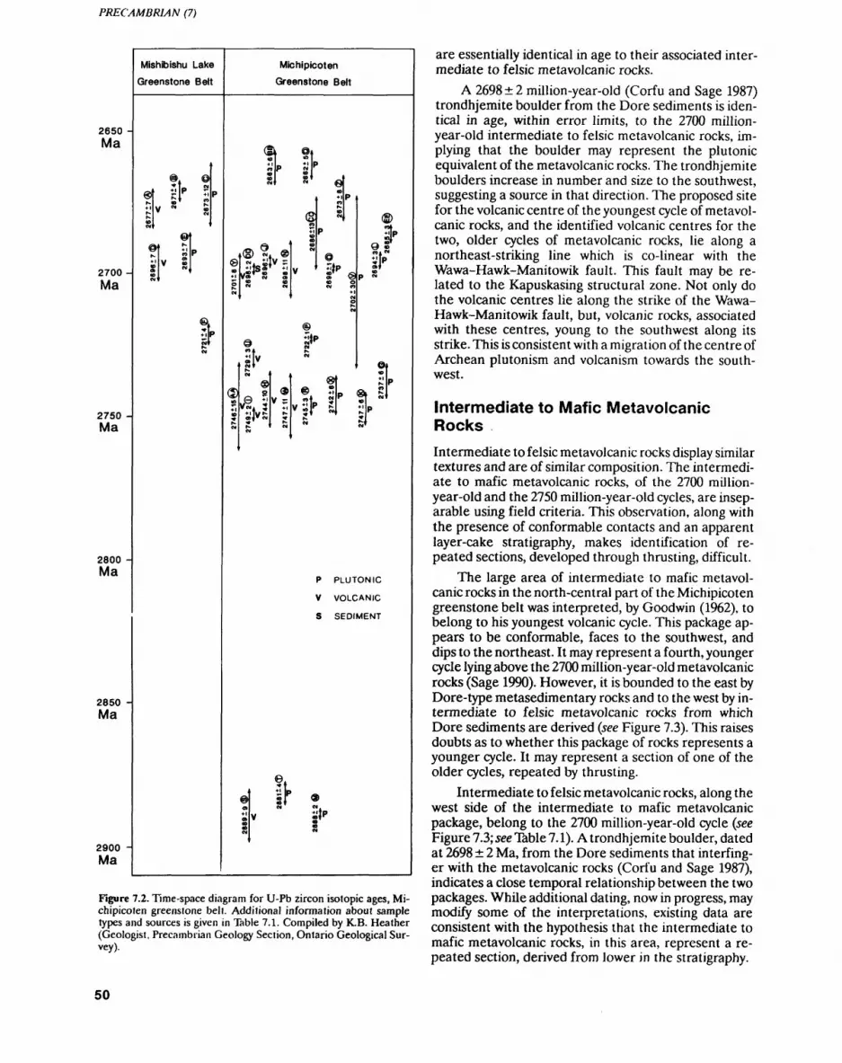
PRECAMBRIAN (7)
2650Ma
2700
Ma
2750Ma
2800 -Ma
2850 -Ma
2900 -Ma
Mishibishu Lake Greenstone Belt
®
B y [P Z\
Michipicoten
Greenstone Belt
(S
©
@
9
at"
St"
Stof
vt 5vw. ^V j:
®f SPill 5'
P PLUTONIC
V VOLCANIC
S SEDIMENT
Figure 7.2. Time-space diagram for U-Pb zircon isotopic ages, Mi chipicoten greenstone belt. Additional information about sample types and sources is given in Table 7.1. Compiled by K.B. Heather (Geologist, Precambrian Geology Section, Ontario Geological Sur vey).
are essentially identical in age to their associated inter mediate to felsic metavolcanic rocks.
A 2698 2 million-year-old (Corfu and Sage 1987) trondhjemite boulder from the Dore sediments is iden tical in age, within error limits, to the 2700 million- year-old intermediate to felsic metavolcanic rocks, im plying that the boulder may represent the plutonic equivalent of the metavolcanic rocks. The trondhjemite boulders increase in number and size to the southwest, suggesting a source in that direction. The proposed site for the volcanic centre of the youngest cycle of metavol canic rocks, and the identified volcanic centres for the two, older cycles of metavolcanic rocks, lie along a northeast-striking line which is co-linear with the Wawa-Hawk-Manitowik fault. This fault may be re lated to the Kapuskasing structural zone. Not only do the volcanic centres lie along the strike of the Wawa- Hawk-Manitowik fault, but, volcanic rocks, associated with these centres, young to the southwest along its strike. This is consistent with a migration of the centre of Archean plutonism and volcanism towards the south- west.
Intermediate to Mafic Metavolcanic Rocks
Intermediate to felsic metavolcanic rocks display similar textures and are of similar composition. The intermedi ate to mafic metavolcanic rocks, of the 2700 million- year-old and the 2750 million-year-old cycles, are insep arable using field criteria. This observation, along with the presence of conformable contacts and an apparent layer-cake stratigraphy, makes identification of re peated sections, developed through thrusting, difficult.
The large area of intermediate to mafic metavol canic rocks in the north-central part of the Michipicoten greenstone belt was interpreted, by Goodwin (1962), to belong to his youngest volcanic cycle. This package ap pears to be conformable, faces to the southwest, and dips to the northeast. It may represent a fourth, younger cycle lying above the 2700 million-year-old metavolcanic rocks (Sage 1990). However, it is bounded to the east by Dore-type metasedimentary rocks and to the west by in termediate to felsic metavolcanic rocks from which Dore sediments are derived (see Figure 7.3). This raises doubts as to whether this package of rocks represents a younger cycle. It may represent a section of one of the older cycles, repeated by thrusting.
Intermediate to felsic metavolcanic rocks, along the west side of the intermediate to mafic metavolcanic package, belong to the 2700 mill ion-y ear-old cycle (see Figure 7.3; see Table 7.1). A trondhjemite boulder, dated at 2698 2 Ma, from the Dore sediments that interfing- er with the metavolcanic rocks (Corfu and Sage 1987), indicates a close temporal relationship between the two packages. While additional dating, now in progress, may modify some of the interpretations, existing data are consistent with the hypothesis that the intermediate to mafic metavolcanic rocks, in this area, represent a re peated section, derived from lower in the stratigraphy.
50
R.P SAGE
,84044'
470 59'-
Carbonatite intrusive rocks
External granitic rocks
Mafic to intermediate volcanics
Intermediate to felsic volcanics
Clastic metasediments
Iron formation
Mafic to ultramafic intrusive
Felsic intrusive rocks
Alkalic intrusions
Figure 7.3. Selected U-Pb zircon isotopic ages with respect to the 2700 million-year-old volcanic cycle and the Dore melasedimentary rocks.
Iron Ranges
Turek et al. (1982) report an age of 2749 2 million years for footwall rocks immediately below the Helen Iron Range, near Wawa, and an age of 2729 3 million years, (Turek et al. 1988) for footwall rocks immediately below the Morrison No. l Iron Range, near Goudreau. These two iron ranges are interpreted, after removing folding and faulting, and correlating similar rock packages, to: 1) occupy the same stratigraphic position within the su pracrustal rocks, along a strike length of almost 100 km; and 2) mark the break between the mafic and felsic por tions of two volcanic cycles. This possibility was also rec ognized by Collins and Quirke (1926). These two iron ranges display an identical facies distribution, with the exception of the presence of calcite rather than siderite in some of the iron formations near Goudreau. The iron formation at Goudreau has a more extensive develop ment of the sulphide facies than does that at Wawa. However, in the Wawa area, the relative position of a particular facies never varies within the iron formation, even though the degree of development of those facies can vary dramatically along short strike lengths.
The different ages of rocks which are the footwall to the iron formation suggest that the iron formations in the Wawa and Goudreau areas: 1) could be different for mations; or 2) were laid down on a regional unconfor mity at the top of the 2750 million-year-old cycle. The unconformity cannot be recognized beneath individual iron ranges because the lower contacts are sheared and
all appear to be conformable. This shearing also sug gests that the iron formations, and the metavolcanic rocks along their base, could be tectonically juxtaposed. However, the position of the iron formation, at the pre cise break in the composition of the volcanism through out the region, suggests that the contact is a primary fea ture overprinted by deformation. The intermediate to felsic metavolcanic rocks below the Helen Iron Range display evidence of reworking, such as thin beds with clast size gradations, indicating that erosion took place and perhaps exposed rocks lower in the stratigraphy. There is no evidence for reworking of footwall rocks be neath the Morrison No. l iron formation and the author prefers the unconformity interpretation.
Structural Geology Concerns
Any structural model proposed for the supracrustal rocks must adequately explain the U-Pb age dates. For example, Goodwin (1962) correlated the intermediate to felsic metavolcanic rocks, near the Helen Iron Range, with intermediate to felsic metavolcanic rocks of similar appearance, located immediately to the north, across the Magpie River. On the basis of this correlation, a fold axis, referred to as the "South Range Syncline", was drawn. However, the difference in age between the 2749 2 million-year-old footwall rocks beneath the Helen Iron Range and the 2698 11 million-year-old rocks north of the Magpie River (Turek et al. 1982,1984) precludes their stratigraphic correlation, and suggests
51
PRECAMBRIAN (7)
that they belong to different volcanic cycles which were juxtaposed by faulting.
External Granitoids
Preliminary geochronological data suggest that the ex ternal granites, which enclose the Michipicoten green stone belt, are younger than the supracrustal rocks, and therefore, these external granitoid rocks may not repre sent the elusive "basement" to the greenstone belt. Pb-Pb isotopic data for galena from mineralized veins (Thorpe 1987) suggest that old crustal material was in volved in the genesis of the belt; however, the where abouts of this suspect crustal material remains elusive. Using whole rock, rare earth element and minor ele ment data from the 2700 million-year-old volcanic cycle, Sylvester et al. (1987) also proposed that sialic crust was involved in development of the Michipicoten supracrus tal sequence.
On the south side of the Michipicoten greenstone belt, Turek et al. (1982) obtained an age of 2747 6 mil lion years for hornblende tonalite. This age is equivalent to the age of the intermediate to felsic metavolcanic up per portion of the 2750 million-year-old cycle. This hornblende tonalite could represent basement on which the youngest cycle evolved.
Tonalitic rocks, similar in appearance, are wide spread along the south flank of the greenstone belt. These tonalites contain xenoliths of older rocks and are extensively intruded by younger granitic rocks, some of which are dated at 2694 3 Ma (Turek et al. 1984). If old granitic rocks, possibly basement to the lower part of the supracrustal sequence, are present, their remnants are likely present in, or have been incorporated into, this mixed-rock terrain. The granitic terrain on the south side of the Michipicoten greenstone belt may contain older granitoid rocks (from 2750 Ma) which have not been identified on the north side. This suggests that the age distribution of external granites is asymmetrical from north to south, i.e., across the belt. Pending addi tional geochronological investigation, it is concluded that the granitic terrains, north and south of the Michi picoten supracrustal sequence, may have a different his tory.
CONCLUSIONS
Geochronology can help identify repeated and faulted stratigraphic sections in apparently conformable se quences, and possible regional unconformities, where shearing has modified original contact relations. Geo chronology places constraints on the types of struct ural-
deformational models, as any such model must explain the distribution of ages. The geochronological data available firmly establish the fact that the anatomy of a greenstone belt cannot be resolved with a limited amount of such data. Rather, it takes a systematic, and sometimes tedious, program of age dating to uncover the many hidden variables. One should never assume that plulons or volcanic packages that are separated, but of similar appearance, are the same age.
REFERENCESCollins, W.H., Quirke, TT. and Thomson, E. 1926. Michipicoten Iron
Ranges; Geological Survey of Canada, Memoir 147, 175p.
Corfu, F. and Sage, R.P. 1987. A precise U-Pb zircon age for a trondh jemite clast in the Dore conglomerate, Wawa, Ontario; in Pro ceedings and Abstracts, Institute on Lake Superior Geology, v.33, pt.l,p.!8.
Frarey, M.J. and Krogh, TE. 1986. U-Pb zircon ages of late internal plutons of the Abitibi and eastern Wawa subprovinces, Ontario and Quebec; in Current research, Part A, Geological Survey of Canada, Paper 86-1A, p.43-48.
Goodwin, A.M. 1962. Structure, stratigraphy, and origin of iron for mations, Michipicoten area, Algoma District, Ontario, Canada; Geological Society of America Bulletin, v.73, p.561-586.
Sage, R.P. 1990. Michipicoten iron-formation in the Wawa area, Ontario; in Field Trip Guidebook, 8th International Association on the Genesis of Ore Deposits, Field Trip 8, p.36-66.
Sullivan, R.W, Sage, R.P. and Card, K.D. 1985. U-Pb zircon age of the Jubilee Stock in the Michipicoten greenstone belt near Wawa, Ontario; in Current Research, Part B, Geological Survey of Can ada, Paper 85-1B, p.361-365.
Sylvester, P.J., Attoh. K. and Schulz, K.J. 1987. Tectonic setting of late Archean bimodal volcanism in the Michipicoten (Wawa) green stone belt, Ontario: Canadian Journal of Earth Sciences, v.24, p. 1120-1134.
Thorpe, R.I. 1987. Lead isotope data; in Field Trip Guidebook, Geol ogy and Stratigraphy of the Michipicoten Iron Formation, Insti tute on Lake Superior Geology, v.33, pt.3, p.46-55.
Turek, A., Keller, R. and Van Schmus, W.R. 1990. U-Pb zircon ages of volcanism and plutonism in the Mishibishu greenstone belt near Wawa, Ontario; Canadian Journal of Earth Sciences, v.27, p.649-656.
Turek, A., Sage, R.P. and Van Schmus, W.R. 1990. Advances in geo chronology of the Michipicoten greenstone belt; in Proceedings, Institute on Lake Superior Geology, v.36, pt.l, p.110-111.
Turek, A., Smith, P.E. and Van Schmus, W.R. 1982. Rb-Sr and U-Pb ages of volcanism and granite emplacement in the Michipicoten belt Wawa, Ontario; Canadian Journal of Earth Sciences, v. 19, p. 1608-1626.
1984. U-Pb zircon ages and the evolution of the Michipicoten plutonic-volcanic terrane of the Superior Province, Ontario; Canadian Journal of Earth Sciences, v.21, p.457-464.
Turek, A., Van Schmus, W.R. and Sage, R.P. 1988. Extended volca nism in the Michipicoten greenstone belt, Wawa, Ontario; in Program with Abstracts, Geological Association of Canada- Mineralogical Association of Canada-Canadian Society of Petroleum Gelogists, v.13, p.A127.
52

8. Project Unit 90-20. Geology of the Whiskey Lake Greenstone Belt, Districts of Algoma and Sudbury
L.S. Jensen
Geologist, Precambrian Geology Section. Ontario Geological Survey.
INTRODUCTIONField investigations of the Archean rocks near Elliot Lake were initiated in 1990 to increase the present geo logical data base in the Elliot Lake area, and to stimu late mineral development subsequent to the recent clo sure of uranium mines in the area. This study focusses on the Archean Whiskey Lake greenstone belt and adja cent Archean mafic intrusive rocks located south and east of Elliot Lake. Concurrent to this mapping project, lithogeochemical studies of these Archean rocks are be ing carried out by the Geology Department of Lauren tian University (see Byron and Whitehead, Paper 09, this volume).
The Whiskey Lake greenstone belt is a 40 km long arcuate, greenstone belt centred approximately 25 km west of Elliot Lake. The belt is bounded to the north by Proterozoic sedimentary rocks of the Quirke Syncline, and to the south and east by gabbroic and granitoid rocks of Archean and Proterozoic age (Collins 1925; Douglas 1926; Robertson 1961, 1962, 1977).
During the 1990 field season, approximately 100 km2 were mapped at a scale of 1:15000. This area included parts of Proctor, Joubin, Gaiashk and Deagle
townships (Figure 8.1). This mapping has revealed a pre viously unrecognized calc-alkalic volcanic complex with associated sulphide mineralization, and several fracture systems that may be of economic importance.
Highway 108 crosses the western portion of the Whiskey Lake belt. Farther east, access to the belt is provided by secondary roads to Pecors Lake and by elec tric power line maintenance roads. McCarthy Lake and the Serpent River provide boat access to the south part of the belt.
MINERAL EXPLORATIONMineral exploration in the Elliot Lake area has been largely confined to the search for uranium deposits near the base of the Proterozoic age, sedimentary, Matinen- da Formation. Almost all of this exploration work has been summarized by Robertson (1961, 1962, 1977). Ex ploration for other types of mineralization in the adjoin ing Archean supracrustal rocks has been limited and largely restricted to the search for base metals, between 1950 and 1970 (Robertson 1961,1962,1977). To date, no known exploration programs for precious metals have been carried out in the map area.
Figure 8.1. Location map of the Whiskey Lake greenstone belt area, scale 1:1 584 000.
53

PRECAMBRIAN (08)
Base metal exploration in the Archean supracrustal rocks of the Whiskey Lake belt has focussed on sulphide-bearing units of banded iron formation and mafic intrusive rocks. The following information has been summarized from files of the Assessment Files Re search office, Ontario Geological Survey.
From 1951 through 1953, Teck Exploration Compa ny Limited carried out geological and geophysical map ping in search of iron and base metals among the iron formations and gabbro bodies south of Pecors Lake in Joubin and Gaiashk townships. At least 30 diamond- drill holes, totalling 8736.7 feet, were drilled. Isolated low values of Cu and Zn were reported from the iron formation zones and a metre-wide sulphide-bearing zone with up to G.5% Ni was found within a gabbro plu ton.
In 1954, Jamaica International Explorations Lim ited did a ground magnetometer survey in southeast Joubin Township. No further work was carried out as a result of this survey.
In 1955, Algom Uranium Mines Limited (Rio Al- gom Mining Corporation) located minor copper miner alization in a 122 m long diamond-drill hole in northwest Proctor Township.
In 1955, Ameranium Mines Limited carried out scintillometer and magnetometer surveys in north- central Proctor Township in search of radioactive miner alization.
In 1967, Kerr-McGee Corporation sank 2 diamond- drill holes, totalling 368 m, in sulphide-bearing banded iron formation in northwest Proctor Township. Trace amounts of Cu and Ni mineralization were found.
In 1988, BP Canada Inc. undertook airborne mag netic and very low frequency electromagnetic (VLF- EM) surveys over 9 claims in southeast Joubin Town ship. No further work was reported.
GENERAL GEOLOGYThe Archean supracrustal rocks of the Whiskey Lake belt form an east-striking, 10 by 30 km, synclinal green stone belt that extends from Elliot Lake eastward to Bull Lake (formerly East Bull Lake). The belt is bounded to the south by granitoid rocks and to the east by gabbroic rocks interpreted to be Archean to Protero zoic in age. On the north side of the belt, the supracrus tal Archean rocks are unconformably overlain by a syn clinal sequence (Quirke Syncline) composed of Protero zoic volcanic and sedimentary rocks (Figure 8.2). Below the unconformity, the Archean supracrustal rocks ex tend northward to the north limb of the.Quirke Syncline (Robertson 1961; ODM-GSC 1963, 1964). Here, the Archean supracrustal rocks are truncated by the Arch ean granitoid rocks exposed on the north side of the Quirke Syncline (Robertson 1961).
The Archean supracrustal rocks comprise komatiit- ic, tholeiitic and calc-alkalic metavolcanic rocks cut by metamorphosed, subvolcanic, calc-alkalic, porphyritic
dikes and sills. In places, interflow metasedimentary rocks, that include banded iron formation, chert, wacke and siltstone, occur in the metavolcanic rocks.
The Archean granitoid rocks are mainly gneissic to massive tonalites. They are cut by trondhjemites, which in turn, are intruded by fine-grained to megacrystic gra nodiorite and quartz monzonite bodies, some of which may be of Proterozoic age (McCrank et al. 1982).
The Proterozoic supracrustal rocks of the Huronian Supergroup, which unconformably overlie the Archean rocks, have, at their base, tholeiitic volcanic rocks underlain in places by a thin, boulder conglomerate. The volcanic rocks are considered to be part of the Thes salon Formation (G. Bennett, Resident Geologist, Min istry of Northern Development and Mines, personal communication, 1990). The uranium-bearing Matinen- da Formation of the Elliot Lake Group overlies the vol canic rocks. A boulder conglomerate or a quartz-pebble conglomerate grading up into arkosic quartzite occurs at the base of the Matinenda Formation. Detailed descrip tions of the Huronian Supergroup, from the Matinenda Formation upward in the succession, are given by Rob ertson (1961, 1962, 1977).
Gabbro sills and diabase dikes of four, or possibly five ages, comprise the mafic intrusive rocks of the area. Most of the dikes are west-northwest-striking and the different generations are difficult to distinguish from one another in the field. The mafic intrusive rocks range in age from Archean to Meso- or Neoproterozoic. No olivine diabase dikes were noted in the area.
During the Archean, the supracrustal rocks under went greenschist- to amphibolite-grade regional meta morphism. The emplacement of the Archean granitoid rocks was accompanied by contact metamorphism. Mi nor retrograde metamorphism is also present. Narrow, contact metamorphism also occurs along the contacts of Proterozoic mafic intrusive rocks.
Localized zones of metasomatism and alteration in clude synvolcanic silicification and epidotization, and later carbonatization and chloritization along shear zones.
The Archean supracrustal rocks have been affected by several deformational events. The Archean events include syndepositional folding and tilting, followed by further folding and faulting during the emplacement of the Archean granitoid rocks. The Archean supracrustal rocks have a penetrative foliation that is not observed in the overlying Proterozoic rocks.
Sinistral, northeast-striking faults, and possible east-striking rifts developed prior to and during the de position of the Thessalon(?) volcanic rocks. Additional postdepositional, east-striking faults affected the Thes salon volcanic rocks prior to deposition of the Matinen da Formation.
Rocks of the Huronian Supergroup and the sur rounding Archean rocks were affected by folding and faulting during formation of the Quirke Syncline.
Mafic magmatism occurred during and after the folding of the Quirke Syncline. Simultaneously, the area
54
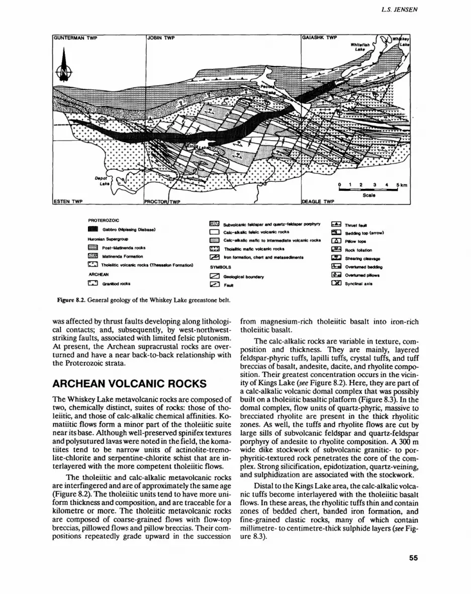
LS. JENSEN
PROTEROZOIC
Hi Gabbro (Nipissing Diabase)
Huronian Supergroup
l"i:i Post-Matlnenda rocks
KiSM Matinenda Formation
l-"1 -'! Tholeiitic volcanic rocks (Thessalon Formation)
ARCHEAN
r^l Qranltiod rocks
E**?;! subvolcanic feldspar and quartz-feldspar porphyry
l l Calc-akaNc felsic volcanic rocks
EBil Calc-alkalic mafic to intermediate volcanic rocks
K S a Tholeltic mafic volcanic rocks
1.^*1 Iron formation, chert and metasediments
SYMBOLS
\^\ Geological boundary
^•"^ Fautt
b d Thrust fault
C2LJ Beddtag top (arrow)
f fl l Pillow tops
l*3^ Rock foliation
CS3 Shearing cleavage
^*J Overturned bedding
I4**al Overturned pillows
r^fl Synclinal axis
Figure 8.2. General geology of the Whiskey Lake greenstone belt.
was affected by thrust faults developing along lithologi- cal contacts; and, subsequently, by west-northwest- striking faults, associated with limited felsic plutonism. At present, the Archean supracrustal rocks are over turned and have a near back-to-back relationship with the Proterozoic strata.
ARCHEAN VOLCANIC ROCKSThe Whiskey Lake metavolcanic rocks are composed of two, chemically distinct, suites of rocks: those of tho leiitic, and those of calc-alkalic chemical affinities. Ko- matiitic flows form a minor part of the tholeiitic suite near its base. Although well-preserved spinifex textures and polysutured lavas were noted in the field, the koma- tiites tend to be narrow units of actinolite-tremo- lite-chlorite and serpentine-chlorite schist that are in- terlayered with the more competent tholeiitic flows.
The tholeiitic and calc-alkalic metavolcanic rocks are interfingered and are of approximately the same age (Figure 8.2). The tholeiitic units tend to have more uni form thickness and composition, and are traceable for a kilometre or more. The tholeiitic metavolcanic rocks are composed of coarse-grained flows with flow-top breccias, pillowed flows and pillow breccias. Their com positions repeatedly grade upward in the succession
from magnesium-rich tholeiitic basalt into iron-rich tholeiitic basalt.
The calc-alkalic rocks are variable in texture, com position and thickness. They are mainly, layered feldspar-phyric tuffs, lapilli tuffs, crystal tuffs, and tuff breccias of basalt, andesite, dacite, and rhyolite compo sition. Their greatest concentration occurs in the vicin ity of Kings Lake (see Figure 8.2). Here, they are part of a calc-alkalic volcanic domal complex that was possibly built on a tholeiitic basaltic platform (Figure 8.3). In the domal complex, flow units of quartz-phyric, massive to brecciated rhyolite are present in the thick rhyolitic zones. As well, the tuffs and rhyolite flows are cut by large sills of subvolcanic feldspar and quartz-feldspar porphyry of andesite to rhyolite composition. A 300 m wide dike stockwork of subvolcanic granitic- to por- phyritic-textured rock penetrates the core of the com plex. Strong silicification, epidotization, quartz-veining, and sulphidization are associated with the stockwork.
Distal to the Kings Lake area, the calc-alkalic volca nic tuffs become interlayered with the tholeiitic basalt flows. In these areas, the rhyolitic tuffs thin and contain zones of bedded chert, banded iron formation, and fine-grained clastic rocks, many of which contain millimetre- to centimetre-thick sulphide layers (see Fig ure 8.3).
55
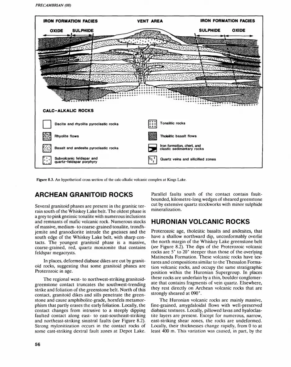
PRECAMBRIAN (08)
IRON FORMATION FACIES
OXIDE SULPHIDE
VENT AREA IRON FORMATION FACIES
SULPHIDE OXIDE
1 i ' ~V 'lil'iiii^n'lilH Iff \* 'i III 'il iTi ii hi 'l I.V'l " I""'! li I'fiiii f ' i i l iii
CALC-ALKALIC ROCKS
i? m.
Dacite and rhyolite pyroclastic rocks
Rhyolite flows
Basalt and andesite pyroclastic rocks
Subvolcanic feldspar and quartz-feldspar porphyry
",'
Tonalitic rocks
Tholeiitic basalt flows
Iron formation, chert, and clastic sedimentary rocks
Quartz veins and silicified zones
Figure 8.3. An hypothetical cross section of the calc-alkalic volcanic complex at Kings Lake.
ARCHEAN GRANITOID ROCKS
Several granitoid phases are present in the granitic ter rain south of the Whiskey Lake belt. The oldest phase is a grey to pink gneissic tonalite with numerous inclusions and remnants of mafic volcanic rock. Numerous stocks of massive, medium- to coarse-grained tonalite, trondh jemite and granodiorite intrude the gneisses and the south edge of the Whiskey Lake belt, with sharp con tacts. The youngest granitoid phase is a massive, coarse-grained, red, quartz monzonite that contains feldspar megacrysts.
In places, deformed diabase dikes are cut by granit oid rocks, suggesting that some granitoid phases are Proterozoic in age.
The regional west- to northwest-striking granitoid- greenstone contact truncates the southwest-trending strike and foliation of the greenstone belt. North of this contact, granitoid dikes and sills penetrate the green stone and cause amphibolite-grade, hornfels metamor phism that partly erases the early foliation. Locally, the contact changes from intrusive to a steeply dipping faulted contact along east- to east-southeast-striking and northeast-striking sinistral faults (see Figure 8.2). Strong mylonitization occurs in the contact rocks of some east-striking dextral fault zones at Depot Lake.
Parallel faults south of the contact contain fault- bounded, kilometre-long wedges of sheared greenstone cut by extensive quartz stockworks with minor sulphide mineralization.
HURONIAN VOLCANIC ROCKSProterozoic age, tholeiitic basalts and andesites, that have a shallow northward dip, unconformably overlie the north margin of the Whiskey Lake greenstone belt (see Figure 8.2). The dips of the Proterozoic volcanic rocks are 5 0 to 20" steeper than those of the overlying Matinenda Formation. These volcanic rocks have tex tures and compositions similar to the Thessalon Forma tion volcanic rocks, and occupy the same stratigraphic position within the Huronian Supergroup. In places these rocks are underlain by a thin, boulder conglomer ate that contains fragments of vein quartz. Elsewhere, they rest directly on Archean volcanic rocks that are strongly sheared at 090".
The Huronian volcanic rocks are mainly massive, fine-grained, amygdaloidal flows with well-preserved diabasic textures. Locally, pillowed lavas and hyaloclas tite layers are present. Except for numerous, narrow, east-striking shear zones, the rocks are undeformed. Locally, their thicknesses change rapidly, from O to at least 400 m. This variation was caused, in part, by the
56
L S. JENSEN
sharp relief in the pre-existing topography formed by re sistant scarps of Archean cherts and rhyolitic units.
HURONIAN SEDIMENTARY ROCKS
In this study, only the lower part of the Matinenda For mation of the Huronian Supergroup was examined. In the map area, the Matinenda Formation dips north from 10" to 20". Except where it is offset by west-northwest- striking faults, its base appears to be quite smooth and regular for kilometres. However, the few places where the base of the Matinenda is exposed suggest that the paleotopography was quite variable. Boulder conglom erate rests unconformably on Archean supracrustal rocks west of Pecors Lake and on Huronian volcanic rocks east of Pecors Lake. Elsewhere quartz-pebble conglomerate and arkosic quartzite rest directly on Hu ronian volcanic rock. In places at the contact, the under lying Huronian volcanic rocks have a schistosity parallel to the contact, suggesting that the Matinenda Forma tion may, in places, be in fault contact with the volcanics, or was deposited directly on east-striking fault scarps.
MAFIC INTRUSIVE ROCKS
Mafic dikes of Archean and Proterozoic ages, not shown on Figure 8.2, intrude the Whiskey Lake greenstone belt. Their relative ages can be recognized only by subtle composition and textural variations and by other field relationships. The older, pre-Huronian dikes do not penetrate the overlying Huronian volcanic and sedi mentary rocks. Some are offset by the northeast-striking faults; others are not. Some may have been the feeders for Huronian volcanic rocks, since eroded away. In spite of their different ages, all the diabase dikes strike 100" to 120" and are parallel to subparallel with the regional strike and foliation of the volcanic rocks.
The young mafic intrusive rocks include a large east- to east-northeast-striking dike of Nipissing(?) gab bro which transects both Archean and Huronian strata (Robertson 1961). This gabbroic body contains meso cratic to leucocratic phases, weakly developed mineral layering and granophyric phases. Quartz veins and car- bonatized zones occur within this intrusion.
Some late east-southeast-striking dikes merge into the gabbro, suggesting that they are comagmatic. Other dikes transect the gabbro, suggesting that an additional episode of mafic magmatism occurred after the gabbro emplacement. In addition, rare, narrow, north-striking dikes of fine-grained, magnetic diabase cut both the gab bro and the east-southeast-striking diabase dikes.
STRUCTURAL GEOLOGY
The Archean supracrustal rocks of the Whiskey Lake greenstone belt underwent folding and faulting prior to and during the emplacement of the early gneissic tona-
lites, and have only been modified by subsequent Prot erozoic faulting events.
The volcanic rocks of the Whiskey Lake greenstone belt strike 100" to 120 0 and have a strike-parallel foli ation (see Figure 8.2). A syncline extends diagonally across the belt, north of Kings Lake. Dips of the limbs of the syncline are 40" to 65" north-northeast. Local east-southeast-striking strike-slip shears also indicate that faulting occurred during the early folding. These shears may be related to dextral drag folding and mylo nitization found in the gneissic tonalite-greenstone con tacts at Depot Lake. It is likely that strata on the north limb of the syncline were overturned during the early folding, since overlying Proterozoic rocks remain gently northward dipping.
Subsequent to the emplacement of the massive granitoid rocks south of the Whiskey Lake belt, the area underwent northeast-striking subvertical faulting with an oblique displacement having a significant sinistral component. This faulting offsets the granitoid- greenstone contact and units within the greenstone belt, but does not seem to penetrate the Huronian volcanic rocks. Given these characteristics, the faulting must have occurred prior to the Huronian volcanism and al lowed the formation of steep scarps in the paleotopo graphy. The scarps were likely caused by the erosion of resistant siliceous felsic volcanic and sedimentary rocks overlying more mafic volcanic rocks. Eroded topograph ic depressions that extended down into the mafic volca nic rocks were later filled by Proterozoic conglomerate and tholeiitic volcanic rocks.
The Huronian volcanism was possibly associated with east-striking rift faults focussed in the area of the Quirke Syncline. In places, strong east-striking shears are present in the Archean rocks at their contacts with the Huronian volcanic rocks, and numerous east- striking shears occur in the Huronian volcanic rocks. Within the Archean rocks farther south, east-striking shears are not prominent.
The formation of the Quirke Syncline and the em placement of the gabbro bodies occurred after deposi tion of the Huronian strata. Thrust faults affecting the gabbros and sedimentary rocks formed near the margins of the syncline.
The last event in the area was the formation of west-northwest-striking faults, which offset the Arch ean and the Huronian strata along strongly developed shears. These shears are strongly carbonatized and chlo- ritized and, in places, contain undeformed feldspar por phyry dikes. Some of these late faults may represent older, reactivated faults in the Archean supracrustal basement.
ECONOMIC GEOLOGYUranium is the main commodity of the Elliot Lake min ing camp. The distribution of uranium within the quartz-pebble conglomerate of the Matinenda Forma tion is well-defined (Roberston 1961,1962,1977). Large ly unknown is the mineral potential of the basement
57
PRECAMBRIAN (08)
Archean supracrustal rocks adjacent to the mining camp. This study has revealed several geological fea tures in the Archean Whiskey Lake greenstone belt that are favourable for both precious and base metal miner alization exploration.1. A felsic calc-alkalic volcanic complex occurs in the
vicinity of Kings Lake (see Figure 8.2). This complex should be explored for gold, copper, zinc and possi bly molybdenum. The complex comprises a subvol canic granitic feeder pipe capped by massive rhyo lite flows and associated andesite, dacite and rhyo lite tuff-breccias, and tuffs that are pyritic in many places. Quartz stockworks and sulphide-bearing zones of silicification and epidotization occur mar ginal to the feeder pipe and in the overlying rocks. The sulphides in the zones of alteration, and in some of the subvolcanic porphyries and granit- ic-textured rocks, are disseminated pyrite and, in places, chalcopyrite. Molybdenite was also noted in the granitic rocks close to the feeder pipe.
2. Low values of Cu, Zn and Ni have been reported in the sulphide-bearing banded iron formations (Rob ertson 1962). The iron formations should be pros pected for gold and possibly base metals. The pyritic to nonpyritic iron formations are interbedded with pyrite-bearing rhyolite tuffs, cherts, and fine grained metasedimentary rocks. The sulphides occur finely disseminated in millimetre-thick layers and, at some locations, as massive sulphides, either layered or concentrated along fractures. Both sedi mentary and replacement sulphide textures were recognized.
3. Zones containing low concentrations of Ni have been reported in the massive gabbroic intrusive rocks. These rocks should be explored for platinoid elements and gold and silver. Sulphides were noted along fractures, quartz-carbonate veins, and in car- bonatized zones of the gabbro and some diabases. Some mafic intrusive rocks also contain greater than 396 disseminated pyrrhotite and pyrite.
4. Many shear zones contain chlorite alteration asso ciated with sulphides. The east-southeast-striking fault zones, in particular those southeast of Pecors Lake (see Figure 8.2), are favourable to exploration for precious metals. They contain zones of highly carbonatized and chloritized sheared rock, greater than 50 m wide, which, in places, is strongly pyritic.
Feldspar porphyry dikes containing up to 3 7o pyrite are associated with these shears.
5. Extensive quartz stockworks, associated with sul phide mineralization, occur in the granitoid rocks north of McCarthy Lake near the granitoid- greenstone contact (Robertson 1977). The quartz veins are associated with east-southeast-striking faults that contain fault-bounded wedges of non- migmatized calc-alkalic volcanic rock. Veins and sulphides occur in both the granitoid and volcanic rocks, and should be prospected for precious met als.
6. Abundant detrital sulphides are present in the con glomerates at the base of the Huronian volcanics and at the base of the Matinenda Formation. Assays of their gold and base metal contents should be done to check for anomalous concentrations that might lead to mineralized sources or to paleo- placer deposits of possible economic value within the Quirke Syncline.
7. Many of the Huronian basalts have amygdules of chalcopyrite. It is possible that sizeable concentra tions of hydrothermal copper may be present in the Huronian volcanic rocks.
REFERENCESCollins, W.H. 1925. North shore of Lake Huron; Geological Survey of
Canada, Memoir 143,160p.
Douglas, G.V 1926. The Whiskey Lake area (District of Algoma); Ontario Department of Mines, Annual Report, 1925, v.34, pt.4, p. 34-49.
McCrank, G.D.F., Stone, D., Kamineni, D.C., Zayachivsky, B. and Vincent, G. 1982. Regional geology of the East Bull Lake area; Geological Survey of Canada, Open File 873.
Ontario Department of Mines-Geological Survey of Canada 1963. Whiskey Lake Sheet, Algoma and Sudbury districts; Ontario De partment of Mines-Geological Survey of Canada, Map 2256G, scale 1:63 360.
1964. Elliot Lake Sheet, Algoma District; Ontario Department of Mines-Geological Survey of Canada, Map 3237G, scale 1:63 360.
Robertson, J.A. 1961. Geology of Townships 143 and 144; Ontario Department of Mines, Geological Report 4, 65p.
1962. Geology of Townships 137 and 138, District of Algoma; Ontario Department of Mines, Geological Report 10, 94p.
1977. Geology of the Cutler area, District of Algoma; Ontario Division of Mines, Geoscience Report 147, 73p.
58
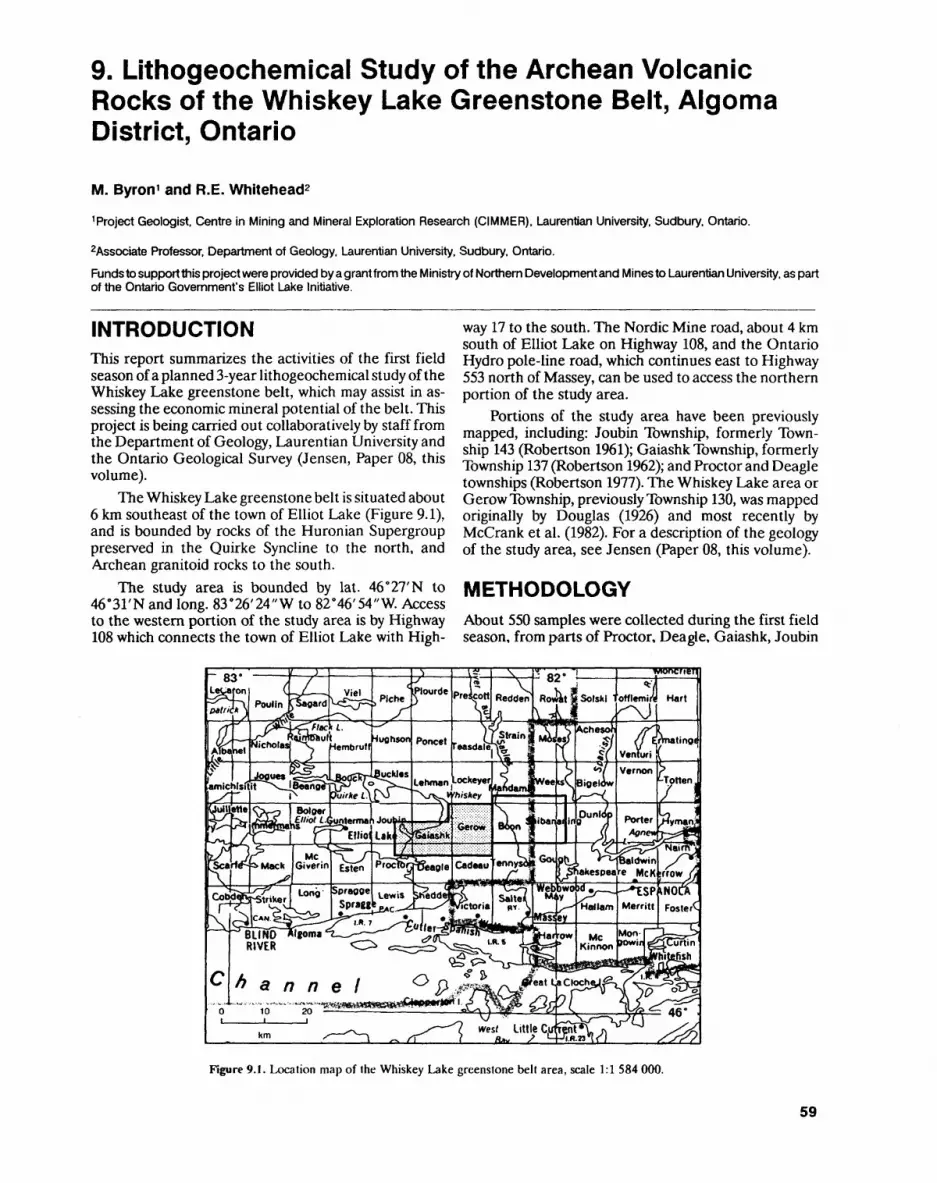
9. Lithogeochemical Study of the Archean Volcanic Rocks of the Whiskey Lake Greenstone Belt, Algoma District, Ontario
M. Byron 1 and R.E. Whitehead2
1 Project Geologist. Centre in Mining and Mineral Exploration Research (CIMMER), Laurentian University. Sudbury. Ontario.
Associate Professor. Department of Geology. Laurentian University. Sudbury. Ontario.
Funds to support this project were provided by a grant from the Ministry of Northern Development and Mines to Laurentian University, as part of the Ontario Government's Elliot Lake Initiative.
INTRODUCTIONThis report summarizes the activities of the first field season of a planned 3-year lithogeochemical study of the Whiskey Lake greenstone belt, which may assist in as sessing the economic mineral potential of the belt. This project is being carried out collaboratively by staff from the Department of Geology, Laurentian University and the Ontario Geological Survey (Jensen, Paper 08, this volume).
The Whiskey Lake greenstone belt is situated about 6 km southeast of the town of Elliot Lake (Figure 9.1), and is bounded by rocks of the Huronian Supergroup preserved in the Quirke Syncline to the north, and Archean granitoid rocks to the south.
The study area is bounded by lat. 46"27'N to 46 0 31'N and long. 83 0 26'24"W to 82*46'54"W. Access to the western portion of the study area is by Highway 108 which connects the town of Elliot Lake with High
way 17 to the south. The Nordic Mine road, about 4 km south of Elliot Lake on Highway 108, and the Ontario Hydro pole-line road, which continues east to Highway 553 north of Massey, can be used to access the northern portion of the study area.
Portions of the study area have been previously mapped, including: Joubin Township, formerly Town ship 143 (Robertson 1961); Gaiashk Township, formerly Township 137 (Robertson 1962); and Proctor and Deagle townships (Robertson 1977). The Whiskey Lake area or Gerow Township, previously Township 130, was mapped originally by Douglas (1926) and most recently by McCrank et al. (1982). For a description of the geology of the study area, see Jensen (Paper 08, this volume).
METHODOLOGYAbout 550 samples were collected during the first field season, from parts of Proctor, Deagle, Gaiashk, Joubin
Figure 9.1. Location map of the Whiskey Lake greenstone belt area, scale 1:1 584 000.
59

PRECAMBRIAN (9)
and Gerow townships. Samples were collected along pace and compass traverses controlled by air photos, and laid out to ensure a relatively consistent, unbiased, 400 m sample spacing. In order to ensure that reliable background values were obtained, care was taken to col lect representative samples of each major volcanic rock type encountered. Where interesting alteration, miner alization or deformation was encountered, additional, more closely spaced samples were taken for assay.
All samples will be analyzed for Au, Na, Ca, Se, Cr, Fe, Co, Ni, Zn, As, Se, Br, Rb, Sr, Mo, Ag, Sb, Cs, Ba, La, Ce, Nd, Sm, Eu, Pb, Yb, Lu, Hf, la, W, Ir, Th, and U, by neutron activation. Major element analyses and CO2 determinations will be done for selected samples. To date, over 200 neutron activation analyses have been carried out. The geochemical data will be entered into the OGS FIELDLOG program (Brodaric and Fyon 1989; Paper 19, this volume) to generate a digital data base and to facilitate comparison with geological fea tures documented by the bedrock mapping program.
Using the abundances of pathfinder elements known to be elevated in proximity to massive base metal sulphide and gold mineralization (Byron 1990; White head and Davies 1988; Beaudoin et al. 1987; Parslow 1987; Whyte and Nichol 1987; Lesher et al. 1986; Govett 1983; Thurston and Fryer 1983; Davies et al. 1982), the lithogeochemical data will be evaluated for anomalous metal concentrations. The evaluation of the geochemi cal variations will be done in the context of the geology of the study area.
The results of the geochemical study will be pres ented on anomaly maps to: 1) help delineate areas which possess anomalous geochemical and geological features suggestive of economic mineralization; and 2) provide geochemical data to assist in the interpretation of the regional geology, under investigation by Jensen (Paper 08, this volume). The problems and limitations asso ciated with reconnaissance multielement geochemical surveys of this nature have been addressed by Chork and Mazzucchelli (1989), Armour-Brown and Olesen (1984), Govett (1983), and Govett et al. (1975), and will be taken into consideration during the course of this study.
MINERAL EXPLORATION
Most of the exploration activity in this region has focussed on uranium in rocks of the Huronian Super group to the north of the greenstone belt. The Whiskey Lake greenstone belt has not been explored extensively for precious and base metal mineralization. Few signs of recent or past exploration activity were encountered during the sampling program.
In the early 1950s, Teck Exploration Company Lim ited carried out an exploration program in search of nickel and copper. In December 1956, El Pen-Key Oil and Mines Limited drilled 9 diamond-drill holes on a group of 27 claims within Gerow Township, looking for
copper and nickel mineralization. In 1967, Kerr-McGee Corporation drilled 2 diamond-drill holes near the pres ent site of the Elliot Lake airport in Proctor Township, and l diamond-drill hole in Joubin Township, looking for gold mineralization. In May 1988, BP Canada Inc. conducted a helicopter-borne magnetometer and a very low frequency electromagnetic (VLF-EM) survey on a 9 claim group within Joubin Township.
FUTURE WORK
By the end of the 1991 field season, the entire Whiskey Lake greenstone belt will have been sampled. Lithogeo chemical evaluations will be carried out in the context of the bedrock geology of the area, currently being mapped by Jensen (Paper 08, this volume). The digital recording of geochemical and geological data, using the OGS FIELDLOG program (Brodaric and Fyon 1989; Paper 19, this volume), will facilitate the search for correla tions between areas of anomalous geochemistry and specific geological features. Anomalous geochemistry will be presented in the form of anomaly maps. Areas that display anomalous geochemistry, or which are char acterized by geology known elsewhere to be favourably disposed to the presence of massive base metal sulphide or gold mineralization, will be investigated in greater detail.
REFERENCESArmour-Brown, A. and Olesen, B.L. 1984. Condensing multi-element
reconnaissance geochemical data from South Greenland using empirical discriminant analysis; Journal of Geochemical Explo ration, v.21, p.395-404.
Beaudoin, A., Perrault, G. and Bouchard, M. 1987. Distribution of gold, arsenic, antimony and tungsten around the Dest-Or ore body, Noranda District, Abitibi, Quebec; Journal of Geo chemical Exploration, v.28, p.41-70.
Brodaric, B. and Fyon, J.A. 1989. OGS FIELDLOG: a micro computer-based methodology to store, process and display map-related data; Ontario Geological Survey, Open File Report 5709, 73p. and l magnetic diskette.
Byron, M. 1990. Pathfinder and immobile element evaluation of the Upper Canada option, Gauthier Township, Ontario; unpublished report, Inco Exploration and Technical Services, 17p.
Chork, C.Y. and Mazzucchelli, R.H. 1989. Spatial filtering of explora tion geochemical data using EDA and robust statistics; Journal of Geochemical Exploration, v.34, p.221-243.
Davies, J.F., Whitehead, R.E.S., Cameron, R.A. and Duff, D. 1982. Regional and local patterns of CO2-K-Rb-As alteration; a guide to gold in the Timmins area; in Geology of Canadian Gold De posits, Canadian Institute of Miningand Metallurgy, Special Vol ume 24, p.1-14.
Douglas, G. V. 1926. The Whiskey Lake area (District of Algoma); On tario Department of Mines, Annual Report, 1925, v.34, pt.4, p. 34-49.
Govett, G.J.S. 1983. Rock geochemistry in mineral exploration; in Handbook of Exploration Geochemistry, Elsevier, Amsterdam, v.3, 461p.
Govett, G.J.S., Goodfellow, W.D., Chapman, R.P. and Chork, C.Y. 1975. Exploration geochemistry - distribution of elements and recognition of anomalies; Mathematical Geology, v.7, p.415.445.
60
M. BYRON and R. E. WHITEHEAD
Lesher, CM., Goodwin, A.M., Campbell, I.H. and Gorton, M.P. 1986. 1962. Geology of Townships 137 and 138, District of Algoma; Trace-element geochemistry of ore associated and barren, felsic Ontario Department of Mines, Geological Report 10, 94p. metavolcanic rocks in the Superior Province, Canada; Canadian Journal of Earth Science, v.23. p.222-237. 1977 Geology of the Cu|ler area Dist rici of Algoma; Ontario
Division of Mines, Geoscience Report 147, 73p. McCrank, G.D.F., Stone, D., Kamineni, D.C., Zayachivsky, B. and , --, , - .. , , rt0 . , , ,
Vincent, G. 1982. Regional geology of the East Bull Lake area, Thurston, PC and Fryer, B.J. 1983. The geochemistry of repetitive Ontario; Geological Survey of Canada, Open File 873. cyclical volcanism from basalt through rhyolite m the Uch,-Con-
federation Greenstone Belt, Canada; Contributions to Mmeralo-
Parslow, G.R. 1987. Lithogeochemical data from the East Amisk area 'of the Flin Flon-Snow Lake volcanic belt: implications for rain- Whitehead, R.E. and Davies, J.F. 1988. Discriminant analysis involv-eral exploration; Journal of Geochemical Exploration, v.28, ing COa/CaO and arsenic in gold exploration; Journal of Geo-p.133-148. chemical Exploration, v.30, p.243-253.
Whyte, J.B. and Nichol, I. 1987. Geochemical alteration associatedRobertson, J. A. 1961. Geology of Townships 143 and 144; Ontario with the Selbaie copper-zinc-silver deposit; Journal of Geochem-
Department of Mines, Geological Report 4, 65p. ical Exploration, v.28, p. 165-182.
61
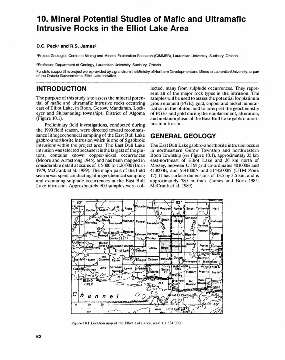
10. Mineral Potential Studies of Mafic and Ultramafic Intrusive Rocks in the Elliot Lake Area
D.C. Peck 1 and R.S. James2
1 Project Geologist, Centre in Mining and Mineral Exploration Research (CIMMER), Laurentian University, Sudbury, Ontario.
2Professor. Department of Geology, Laurentian University, Sudbury, Ontario.
Funds to support this project were provided by a grant from the Ministry of Northern Development and Mines to Laurentian University, as part of the Ontario Government's Elliot Lake Initiative.
INTRODUCTIONThe purpose of this study is to assess the mineral poten tial of mafic and ultramafic intrusive rocks occurring east of Elliot Lake, in Boon, Gerow, Mandamin, Lock eyer and Shibananing townships, District of Algoma (Figure 10.1).
Preliminary field investigations, conducted during the 1990 field season, were directed toward reconnais sance lithogeochemical sampling of the East Bull Lake gabbro-anorthosite intrusion which is one of 5 gabbroic intrusions within the project area. The East Bull Lake intrusion was selected because it is the largest of the plu- tons, contains known copper-nickel occurrences (Moore and Armstrong 1945), and has been mapped in considerable detail at scales of 1:5 000 to 1:20 000 (Born 1979; McCrank et al. 1989). The major part of the field season was spent conducting lithogeochemical sampling and examining sulphide occurrences in the East Bull Lake intrusion. Approximately 500 samples were col
lected, many from sulphide occurrences. They repre sent all of the major rock types in the intrusion. The samples will be used to assess the potential for platinum group element (PGE), gold, copper and nickel mineral ization in the pluton, and to interpret the geochemistry of PGEs and gold during the emplacement, alteration, and metamorphism of the East Bull Lake gabbro-anort hosite intrusion.
GENERAL GEOLOGYThe East Bull Lake gabbro-anorthosite intrusion occurs in northeastern Gerow Township and northwestern Boon Township (see Figure 10.1), approximately 35 km east-northeast of Elliot Lake and 30 km north of Massey, between UTM grid co-ordinates 401000E and 413000E, and 5141000N and 51445000N (UTM Zone 17). It has surface dimensions of 13.5 by 3.5 km, and is approximately 780 m thick (James and Born 1985; McCrank et al. 1989).
Figure 10.1.Location map of the Elliot Lake area, scale 1:1 584 000.
62

D.C. PECK and R.S. JAMES
The geology of the East Bull Lake gabbro- anorthosite intrusion was described in detail by Born (1979), Kamineni et al. (1984), James and Born (1985), and McCrank et al. (1989). The following summary is derived from their work. The 2480 Ma intrusion (see McCrank et al. 1989 for a summary of radiometric ages for the intrusion) was emplaced into older Archean gra nitic rocks occurring to the north and east, and Archean metavolcanic rocks of the Whiskey Lake greenstone belt occurring to the southwest (Moore and Armstrong 1945; Jensen, Paper 08, this volume). The gabbroic rocks are in faulted contact with a large body of syenite (Pari- sien Lake syenite), which occurs to the southeast. The syenite is believed to be older than the East Bull Lake intrusion on the basis of an U-Pb radiometric age of 2665 Ma (Krogh et al. 1984).
The East Bull Lake gabbro-anorthosite intrusion comprises massive and rhythmically layered gabbroic and anorthositic rocks. Layering occurs on a scale of a few centimetres to several metres, and is defined by both modal and textural variations. Igneous layering generally strikes parallel to the margins of the intrusion and dips shallowly towards its interior. Anorthositic rocks are prevalent towards the margins of the intru sion, whereas more mafic rocks are found in the interior of the pluton. Rare pyroxenite layers, and irregularly shaped pods up to a few tens of centimetres in length, are the only ultramafic rocks in the intrusion. Most of the gabbroic and anorthositic rocks display primary tex tures that are characteristic of cumulates (Irvine 1982). Other important observed rock types are ophitic and sub-ophitic gabbro, dendritic and harrisitic gabbro, nod ular anorthositic rocks, and rare intrusive breccias. Sedi mentary-type layering features are uncommon.
Stratigraphic variations in the intrusion have gener ally been defined by previous workers on the basis of changes in layering styles, unique textures, relative pro portions of anorthositic and gabbroic rock types, and geochemistry. Primary minerals in the intrusion include calcic plagioclase (An45.8 i), clinopyroxene (augite), orthopyroxene (hypersthene and inverted pigeonite), titanomagnetite, olivine (Foei-eg), and rare quartz and apatite (Born 1979; James and Born 1985; McCrank et al. 1989). Fine-grained, disseminated sulphides, primar ily chalcopyrite and pyrrhotite, are present in trace amounts in many parts of the intrusion. The mineral compositions and whole-rock geochemistry show sys tematic variations with stratigraphic elevation, which suggest that the intrusion was derived from 2 or 3 sepa rate pulses of tholeiitic magma (James and Born 1985; McCrank et al. 1989). These features suggest that the East Bull Lake intrusion was formed under open- system conditions, which is characteristic of mafic- ultramafic plutons containing stratiform-style PGE de posits (e.g., Prendergast and Keays 1989).
The East Bull Lake intrusion experienced several episodes of metamorphism following its initial emplace ment. Kamineni et al. (1987) have suggested that meta morphic recrystallization in the intrusion was largely retrogressive and fracture-controlled, and ranged from
epidote-amphibolite facies to low-temperature (less than 100 e C), rock-water interaction. This interpretation is consistent with the extremely variable degree of pres ervation of primary mineral assemblages, and the gen eral absence of metamorphic fabrics in the intrusion. Most of the rocks collected during the current program display some recrystallization, generally involving saus suritization of plagioclase and recrystallization of pyroxene to calcic amphibole.
The East Bull Lake intrusion is cut by a number of sub-parallel faults and shear zones which commonly strike 110 0 to 120 0 . The largest of these structures is the Folson Lake fault, which intersects the southern part of the pluton and extends for several kilometres to either side of the intrusion. The Folson Lake fault and related structures appear to have been important loci for hydro thermal sulphide mineralization in the East Bull Lake gabbro-anorthosite intrusion.
Mafic dikes in the area include: 1) Nipissing dia base; 2) a younger set of amphibolite and feldspar por phyry dikes; and 3) later olivine diabase dikes belonging to the Sudbury swarm. Only the amphibolite dikes and rare olivine diabase dikes intrude the gabbroic rocks of the East Bull Lake intrusion. Most of the dikes within the intrusion strike east-northeasterly and dip steeply towards the northeast.
MINERAL EXPLORATIONThe East Bull Lake intrusion hosts a number of pyrrhotite and chalcopyrite occurrences which were ex amined briefly by several independent explorers during the early to middle part of this century. Previous explo ration was undertaken prior to 1943 by several prospec tors (Moore and Armstrong 1945). More significant ac tivity took place between 1950 and 1962, involving a number of mining and exploration companies: Noranda Mines Ltd., El Pen-Rey Oil and Mines Ltd., Sylvanite Gold Mines Ltd., and The Mining Corporation of Cana da Ltd. Most of this activity focussed on copper-nickel sulphide mineralization, which primarily occurs in the southeastern part of the intrusion. Geophysical work (ground magnetometer and ground electromagnetic surveys), trenching and diamond drilling were carried out but no economic concentrations of mineralization were found. Pyrrhotite-chalcopyrite mineralization was detected in gabbroic rocks and diabase dikes along the southern margin of the intrusion, in close proximity to the Archean granite and the Parisien Lake syenite.
Gallo Exploration Services Inc. holds a series of contiguous claims south and east of Bull Lake (formerly East Bull Lake). These claims encompass anorthositic and gabbroic rocks that correspond to the basal parts of the East Bull Lake intrusion and contain sporadic pyrr hotite and chalcopyrite mineralization. The claims ad join a large block of land, encompassing much of the central and western parts of the intrusion, that has been withdrawn from staking, at the request of Atomic Energy of Canada Ltd., since the early 1980s. Explora tion activities carried out during 1989 and 1990 by Gallo
63
Exploration include: excavation and clearing of outcrop, blasting, geological mapping, and surface sampling of the sulphide occurrences. Initial assay results indicate that significant palladium, platinum and lesser gold mineralization occurs in association with sulphides, with up to 5 g/t of combined Pt-Pd detected in pyrrhotite and chalcopyrite mineralization in gabbroic rocks (E. Gallo, Gallo Exploration Services Incorporated, personal communication, 1990).
ECONOMIC GEOLOGYThree styles of pyrrhotite and chalcopyrite mineraliza tion have been observed in the East Bull Lake intrusion. No assay data are presently available from the samples collected during the current field season, but assay re sults obtained by Gallo Exploration Services Incorpor ated show that elevated platinum, palladium and gold values occur in most of the mineralized samples, indi cating a strong association between the sulphides and the PGEs and gold. Many of the sulphide-bearing gabbroic rocks examined by Gallo Exploration Services Incorporated contain from l to 5 g/t Pt-Pd, with Pd/Pt ratios generally in the range of l to 5, and Cu/Ni ratios showing considerable variation (less than 0.1 to greater than 10) (M. Hauseux, Gallo Exploration Services In corporated, personal communication, 1990). Grab sam ples taken from the sulphide occurrences contain up to 9.4 0 Cu, S.3% Ni and 1.29& Co (M. Hauseux, Gallo Exploration Services Incorporated, personal communi cation, 1990). Pentlandite has been identified in associ ation with pyrrhotite in several specimens collected from the sulphide occurrences (S. Surmacz, Prospector, personal communication, 1990). These preliminary assay results are extremely encouraging and highlight the need for detailed PGE-copper-nickel exploration in the East Bull Lake gabbro-anorthosite intrusion.
Type 1 Sulphide MineralizationWeakly disseminated to semi-massive pyrrhotite and chalcopyrite mineralization occurs within and adjacent to several easterly striking shear zones. Most of these structures are parallel to, and in close proximity to, the Folson Lake fault. Sulphides commonly occur as weak disseminations along shear planes, joints and irregular fractures in abundances of less than T.%, but locally form semi-massive to massive lenses a few tens of centi metres in length. They are typically fine grained and form rounded to irregularly shaped aggregates that are less than l cm in diameter. In the semi-massive mineral ization, both pyrrhotite and chalcopyrite are coarser grained than in the disseminations.
The host rocks include variably altered anorthosite, gabbroic anorthosite, anorthositic gabbro and, rarely, gabbro. Within larger shear zones, the gabbroic rocks are locally recrystallized to chlorite schists containing sparse sulphide mineralization along cleavage planes.
The sulphide minerals are commonly associated with zones of silicified and feldspathized meta-
anorthositic rocks. They also occur as fracture fillings in association with pink alkali feldspar and blue to purple quartz, and locally with calcite and epidote. Most of the mineralization is clearly related to the movement of hy drothermal fluids, both along the shear zones and adja cent to them, through strongly jointed rocks. However, the gabbroic rocks which host the sulphides commonly contain minor disseminated sulphides, possibly of mag matic origin. Therefore, type l sulphide mineralization may, in part, reflect remobilization of primary sulphides.
The shear zones appear to have been long-lived structures with multiple episodes of hydrothermal activ ity leading to several distinctive alteration styles (Kamineni el al. 1987); any one of these periods of hy drothermal activity may have introduced and/or remobi- lized the sulphide mineralization. Detailed petro graphic examination of the occurrences is required to determine their paragenesis.
Type 2 Sulphide MineralizationMinor pyrrhotite and chalcopyrite mineralization oc curs in nodular gabbroic anorthosite and nodular anort hositic gabbro in the eastern most part of the intrusion. To date, type 2 sulphide mineralization has only been ob served in excavated bedrock, occurring on a sandy plain approximately 2 km east of the eastern side of Bull Lake. However, nodular anorthositic rocks are also re ported further to the east (McCrank et al. 1989) and were observed at another locality within the central part of Gallo Exploration Services Inc.'s claim block. The ex tent of sulphide mineralization in these areas has not yet been established.
The nodular anorthositic rocks are believed to occupy a relatively basal position in the stratigraphic succession. They are composed of ovoid to elliptical ag gregates of medium- to coarse-grained anorthosite set in a discontinuous matrix of pyroxenite or mafic gabbro, which locally contains minor blue quartz. The nodules are commonly 5 to 10 cm in diameter and may contain minor amounts of interstitial pyroxene. The pyroxene has been pseudomorphically replaced by calcic amphi bole and displays a wide range of grain sizes, from less than l mm to 5 cm.
The nodular texture is similar to spherulitic- textured lavas and may reflect rapid cooling and acceler ated growth of cumulus plagioclase, with nucleation oc curring about early-formed plagioclase in the magma. Pyroxene apparently crystallized from intercumulus liquids trapped between the nodules. Alternatively, as proposed by McCrank et al. (1989), the nodules may rep resent fragments of pre-existing anorthositic layers dis rupted by repeated injections of gabbroic magma.
Sulphide mineralization in these rocks occurs in as sociation with the interstitial pyroxene. It comprises ir regularly disseminated, fine-grained pyrrhotite and chalcopyrite in variable proportions. Locally, the sul phides form irregularly shaped blebs, up to l cm in diam eter, which rarely display the net-textures (poikilitically enclosing early-formed silicates) indicative of a primary,
64
D.C. PEC K and R. S. JAMES
magmatic origin. The majority of the sulphides occur as thin scales which appear to have nucleated around the pyroxene crystals, and are interpreted to represent intercumulus minerals.
The nodular anorthositic rocks are apparently over lain by a more mafic, gabbroic unit which displays a weak nodular (semi-nodular) texture of less than 20*26 anorthositic nodules, grading to a glomeroporphyritic texture in which isolated, irregularly shaped bodies of anorthosite up to several centimetres in length are en closed by a medium-grained gabbro or mafic gabbro ma trix. The gabbro is locally vari-textured, displaying large, unsystematic variations in grain size, from fine-grained to pegmatitic, over short distances (i.e., less than l m). This semi-nodular gabbro locally contains angular anorthositic bodies which may represent fragments of originally larger, more rounded nodules.
Both pyrrhotite and chalcopyrite occur in the semi-nodular gabbro, displaying similar textures and abundances to the sulphides found within the nodular anorthositic rocks. In both examples, the sulphides form distinctive gossans in weathered outcrop.
In addition to the intercumulus sulphide occur rences, minor amounts of structurally controlled pyrrhotite and chalcopyrite, +1- pyrite, mineralization is present in both the semi-nodular and nodular rock types. The sulphides coat microfractures and joints in the host rocks and commonly occur in abundances of 2 to 396. They are typically scaly in habit, and are found together with calcite or colourless, translucent quartz, and less commonly with pink alkali feldspar. This sec ondary mineralization may reflect remobilization of the primary, intercumulus sulphides during hydrothermal alteration.
Type 3 Sulphide MineralizationGabbroic rocks occurring along the exposed margins of the East Bull Lake intrusion locally display a distinctive zonation in alteration styles and sulphide content. To date, the zonation has been identified immediately south of Bull Lake, along the northern and eastern mar gins of an isolated body of massive, medium-grained granite (approximately 2 km2 in area) that lies between the gabbro and the Parisien Lake syenite. The age of the granite is uncertain, but McCrank et al. (1989) consider it to be younger than the East Bull Lake intrusion. Sys tematically altered gabbroic rocks are also observed along the northern margin of the East Bull Lake intru sion, approximately l km north of the northwestern end of Bull Lake. Here, Archean granite is in contact with the gabbro.
The granite-gabbro contact in both of these areas does not appear to be faulted, as is commonly observed in the western part of the intrusion. In both areas, the gabbroic rocks immediately adjacent to the granite are silicified and have experienced potassium metasomat ism. The presence of irregularly shaped blocks of granite in altered gabbro at both localities, suggests that the alteration resulted from partial assimilation of the
granite during emplacement of the East Bull Lake in trusion; therefore, in both cases, the granite is older than the gabbro. The presence of small granitic veins in the altered gabbro zone may reflect a post-Archean pe riod of granite magmatism or, alternatively, partial melting and remobilization of the Archean granite dur ing emplacement of the gabbroic intrusion. Detailed mapping of this contact is needed to clarify these age re lations.
An altered gabbro zone has been traced for approxi mately 1.5 km along the western and northern margins of the isolated granite mass occurring south of Bull Lake. The zone is typically 100 to 200 m wide, and is composed of fine- to medium-grained metagabbro con sisting of subidiomorphic plagioclase and actinolite, less than 196 to 2096 blue quartz, and trace amounts to sev eral modal percent fine-grained disseminated pyrite. Plagioclase is typically saussuritized and is locally al tered to pink potassium feldspar. Where extremely al tered, the gabbro is easily mistaken for a granitic rock.
Moving away from the granite-gabbro contact, the altered gabbro zone gives way to a medium- to coarse- grained anorthositic gabbro or gabbroic anorthosite con taining up to 596 pyrrhotite and chalcopyrite. The sul phides are present in an irregular gossan zone, typically 30 to 50 m wide, which always occurs immediately adja cent to the altered gabbro. The zone has been traced for approximately l km along the northwestern margin of the granite body. Several partially overgrown pits were observed in this area, which was staked by Noranda Mines Ltd. in the 1950s. These pits are situated within the area withdrawn from staking. The sulphide mineral ization is sporadic, occurring as isolated, lensoidal gossans up to 30 cm long, in weakly mineralized or un- mineralized anorthositic rocks.
The mineralization comprises medium-grained ag gregates of pyrrhotite and chalcopyrite which commonly partially enclose secondary silicate minerals (amphi bole, chlorite, saussuritized plagioclase). It is locally as sociated with fine- to medium-grained blue quartz. The sulphide aggregates are irregularly distributed within a given gossan, have irregular morphologies, and are typi cally several millimetres in length. Pyrrhotite and chal copyrite occur both separately and together.
The irregular distribution of the sulphide occur rences, and the total recrystallization of the host rocks to secondary silicates, are suggestive of an hydrothermal origin for the sulphides. However, there is no compel ling evidence for structural controls on the mineraliza tion. It is tentatively suggested that the sulphide miner alization represents recrystallized immiscible sulphides that formed in response to assimilation of the granite. The gradational contact between the altered gabbro zone and the gossan zone may reflect an inward de crease in the amount of assimilated granite away from the gabbro-granite contact. The gossan zone contains only minor amounts of quartz and potassium feldspar, and hosts pyrrhotite and chalcopyrite mineralization as opposed to the pyrite mineralization seen in the altered gabbro zone. The activity of silica in the gabbroic magma
65
PRECAMBRIAN (10)
may represent the fundamental control on the forma tion of these sulphide occurrences, with higher silica ac tivities favouring pyrite crystallization, and lower silica activities leading to pyrrhotite and chalcopyrite mineral ization.
Samples collected from type 3 sulphide occurrences have not yet been analyzed for PGEs and Au. If the sul phides are enriched in precious metals, then the granite-gabbro contact represents an important target for future exploration because of its significant strike length in the East Bull Lake intrusion. Furthermore, the remaining gabbroic intrusions in the project area are also largely contained within older granitic rocks. These intrusions will be examined in detail in 1991.
REFERENCESBorn, P. 1979. Geology of the East Bull Lake layered gabbro complex,
District of Algoma,Ontario; unpublished MSc thesis, Laurentian University, Sudbury, Ontario, 147p.
Irvine, T.N. 1982. Terminology for layered intrusions; Journal of Petrology, v.23, p.127-162.
James, R.S. and Born, P. 1985. Geology and geochemistry of the East Bull Lake intrusion, District of Algoma, Ontario; Canadian Journal of Earth Sciences, v.22, p.968-979.
Kamineni, D.C., McCrank, G.F, Stone, D., Ejeckam, R.B., Flin- dall, R. and Sikorsky, R. 1984. Geology of the central plateau of the East Bull Lake pluton, northeastern Ontario; in Current Re search, Part B, Geological Survey of Canada, Paper 84-1B, p.75-83.
Kamineni, D.C., McCrank, G.F.D. and Stone, D. 1987. Multiple alter ation events in the East Bull Lake anorthosite-gabbro layered complex, NE Ontario, Canada: evidence from fracture mineralo gy and 40Ar-39Ar dating; Applied Geochemistry, v.2, p.73-80.
Krogh, T.E., Davis, D.W. and Corfu, F. 1984. Chapter 20, Precise U-Pb zircon and baddeleyite ages for the Sudbury area; in The Geology and Ore Deposits of the Sudbury Structure. Ontario Geological Survey, Special Volume l, p.431-446.
McCrank, G.F.D., Kamineni, D.C., Ejeckam, R.B. and Sikorsky, R. 1989. Geology of the East Bull Lake gabbro-anorthosite pluton, Algoma District, Ontario; Canadian Journal of Earth Sciences, v.26, p.357-375.
Moore, E.S. and Armstrong, H.S. 1945. Geology of the East Bull Lake area; Ontario Department of Mines, Annual Report, 1943, v.52, pt.6, 19p.
Prendergast, M.D. and Keays, R.R. 1989. Controls of platinum-group element mineralization and the origin of the PGE-rich main sul fide zone in the Wedza subchamber of the Great Dyke, Zimbabwe: implications for the genesis of, and exploration for, stratiform PGE mineralization in layered intrusions; in Magmat ic Sulfides - The Zimbabwe Volume, Institution of Mining and Metallurgy, p.43-69.
66

11. Project Unit 89-21. Gold Mineralization and the Destor-Porcupine Deformation Zone East of Matheson Investigations in Garrison Township
D.G. Troop
Geologist, Precambrian Geology Section, Ontario Geological Survey.
INTRODUCTION
During the 1990 field season, the geological characteris tics of the Destor-Porcupine deformation zone (DPDZ) and environs were examined in Garrison Township (Fig ure 11.1). This represents a continuation of the 1989 program, during which the DPDZ was examined in His lop, Guibord and Michaud townships, directly to the west of the 1990 field area (Troop 1989). Described in this summary are the results of detailed mapping, in 1990, that concentrated on the structural, metamorphic and alteration characteristic of Archean supracrustal and plutonic rocks in Garrison Township. Observations from specific gold properties, and a general discussion of gold mineralization in the field area, are also pro vided. The primary goal of this project is to aid in the in terpretation of gold metallogeny in the Matheson area, by providing a comprehensive and updated view of the regional geological and structural relationships in this area.
During the 1990 field season, the majority of the bedrock exposures in Garrison Township were ex amined. Bedrock locations were ascertained primarily
from the 1:12000 scale geological map of Satterly (1949a), and from 1980 aerial photographs. Bedrock outlines and locations were digitized directly from these sources and added to Ontario Basic Mapping (OEM) digital topographic base maps, using a field-portable computer system similar to that employed during 1989 (Troop 1989; Brodaric and Fyon 1988). Diamond drill and reverse circulation drill hole data from mineral ex ploration assessment reports for Garrison Township were also included, in a fashion similar to that used in 1989. This provides useful, although somewhat biased, lithologic and alteration data in areas of complex geolo gy and/or poor exposure.
LITHOLOGY AND STRATIGRAPHYIn general, the lithologic assignments of Satterly (1949a) are accurate, and have been modified only slightly dur ing this study. A simplified geological map of the town ship is presented in Figure 11.2. For the most part, a gen eral description of the major lithologies encountered in Garrison Township does not differ markedly from those presented for the 1989 field area (Troop 1989). The few exceptions are dealt with below. However, there are ma-
Figure 11.1. Location map of the Michaud. Garrison and Harker townships area, scale 1:1 584 000.
67
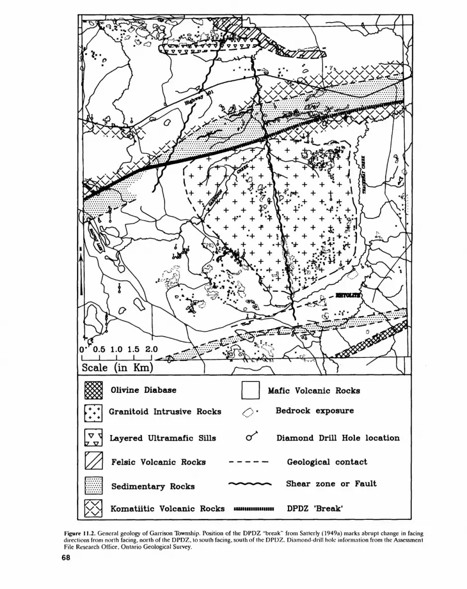
Olivine Diabase
Granitoid Intrusive Rocks
Layered Ultramafic Sills
Felsic Volcanic Rocks
Sedimentary Rocks
Komatiitic Volcanic Rocks uuiiiiiimnim DPDZ 'Break'
Mafic Volcanic Rocks
Bedrock exposure
OT Diamond Drill Hole location
Geological contact
**-^-^*-^ Shear zone or Fault
Figure 11.2. General geology of Garrison Township. Position of the DPDZ "break" from Satterly (1949a) marks abrupt change in facing directions from north facing, north of the DPDZ, to south facing, south of the DPDZ. Diamond-drill hole information from the Assessment File Research Office, Ontario Geological Survey.
68
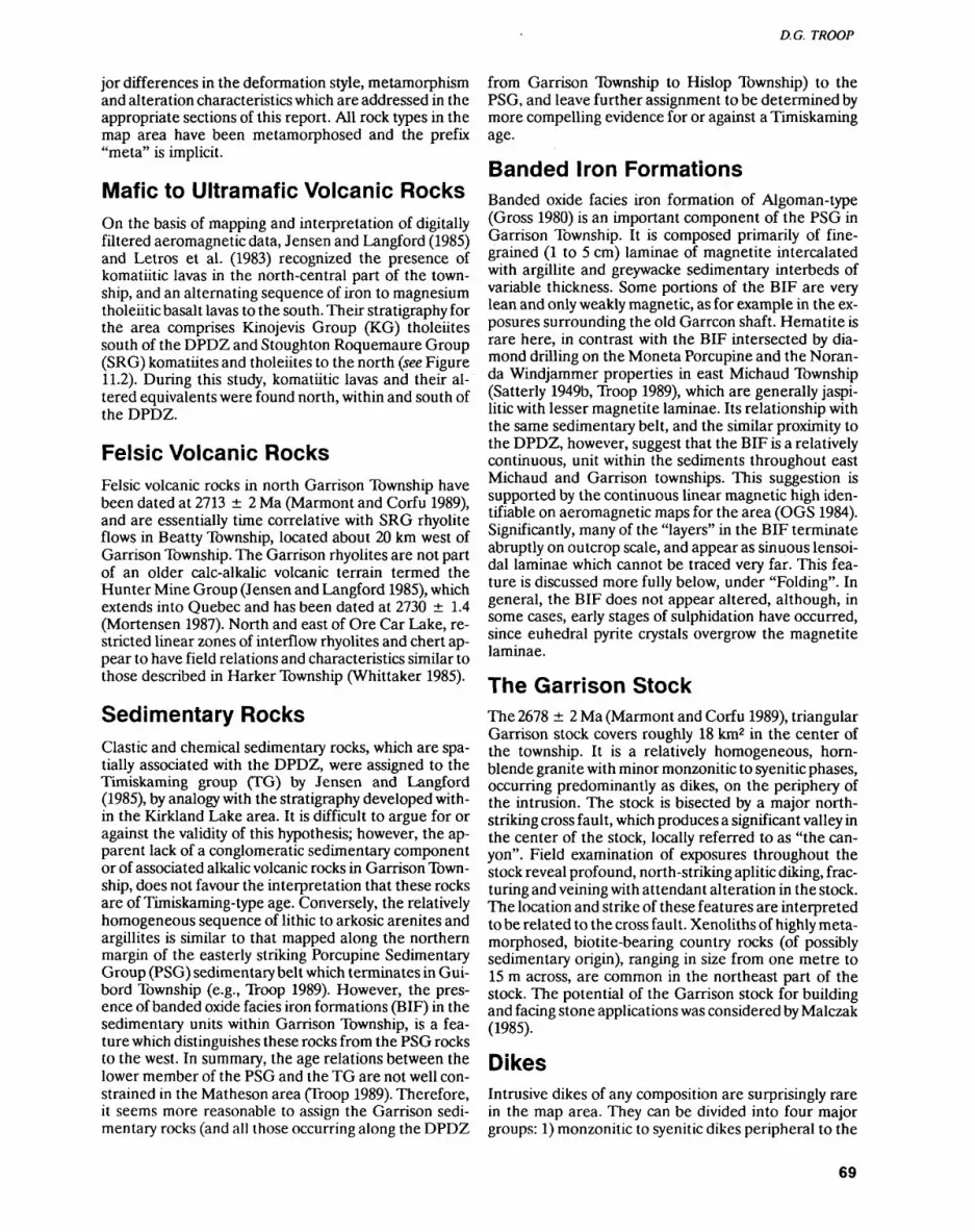
D. G. TROOP
jor differences in the deformation style, metamorphism and alteration characteristics which are addressed in the appropriate sections of this report. All rock types in the map area have been metamorphosed and the prefix "meta" is implicit.
Mafic to Ultramafic Volcanic RocksOn the basis of mapping and interpretation of digitally filtered aeromagnetic data, Jensen and Langford (1985) and Letros et al. (1983) recognized the presence of komatiitic lavas in the north-central part of the town ship, and an alternating sequence of iron to magnesium tholeiitic basalt lavas to the south. Their stratigraphy for the area comprises Kinojevis Group (KG) tholeiites south of the DPDZ and Stoughton Roquemaure Group (SRG) komatiites and tholeiites to the north (see Figure 11.2). During this study, komatiitic lavas and their al tered equivalents were found north, within and south of the DPDZ.
Felsic Volcanic RocksFelsic volcanic rocks in north Garrison Township have been dated at 2713 2 Ma (Marmont and Corfu 1989), and are essentially time correlative with SRG rhyolite flows in Beatty Township, located about 20 km west of Garrison Township. The Garrison rhyolites are not part of an older calc-alkalic volcanic terrain termed the Hunter Mine Group (Jensen and Langford 1985), which extends into Quebec and has been dated at 2730 1.4 (Mortensen 1987). North and east of Ore Car Lake, re stricted linear zones of interflow rhyolites and chert ap pear to have field relations and characteristics similar to those described in Harker Township (Whittaker 1985).
Sedimentary RocksClastic and chemical sedimentary rocks, which are spa tially associated with the DPDZ, were assigned to the Timiskaming group (TG) by Jensen and Langford (1985), by analogy with the stratigraphy developed with in the Kirkland Lake area. It is difficult to argue for or against the validity of this hypothesis; however, the ap parent lack of a conglomeratic sedimentary component or of associated alkalic volcanic rocks in Garrison Town ship, does not favour the interpretation that these rocks are of Timiskaming-type age. Conversely, the relatively homogeneous sequence of lithic to arkosic arenites and argillites is similar to that mapped along the northern margin of the easterly striking Porcupine Sedimentary Group (PSG) sedimentary belt which terminates in Gui bord Township (e.g., Troop 1989). However, the pres ence of banded oxide facies iron formations (BIF) in the sedimentary units within Garrison Township, is a fea ture which distinguishes these rocks from the PSG rocks to the west. In summary, the age relations between the lower member of the PSG and the TG are not well con strained in the Matheson area (Troop 1989). Therefore, it seems more reasonable to assign the Garrison sedi mentary rocks (and all those occurring along the DPDZ
from Garrison Township to Hislop Township) to the PSG, and leave further assignment to be determined by more compelling evidence for or against a Timiskaming age.
Banded Iron FormationsBanded oxide facies iron formation of Algoman-type (Gross 1980) is an important component of the PSG in Garrison Township. It is composed primarily of fine grained (l to 5 cm) laminae of magnetite intercalated with argillite and greywacke sedimentary interbeds of variable thickness. Some portions of the BIF are very lean and only weakly magnetic, as for example in the ex posures surrounding the old Garrcon shaft. Hematite is rare here, in contrast with the BIF intersected by dia mond drilling on the Moneta Porcupine and the Noran- da Windjammer properties in east Michaud Township (Satterly 1949b, Troop 1989), which are generally jaspi- litic with lesser magnetite laminae. Its relationship with the same sedimentary belt, and the similar proximity to the DPDZ, however, suggest that the BIF is a relatively continuous, unit within the sediments throughout east Michaud and Garrison townships. This suggestion is supported by the continuous linear magnetic high iden tifiable on aeromagnetic maps for the area (OGS 1984). Significantly, many of the "layers" in the BIF terminate abruptly on outcrop scale, and appear as sinuous lensoi- dal laminae which cannot be traced very far. This fea ture is discussed more fully below, under "Folding". In general, the BIF does not appear altered, although, in some cases, early stages of sulphidation have occurred, since euhedral pyrite crystals overgrow the magnetite laminae.
The Garrison StockThe 2678 2 Ma (Marmont and Corfu 1989), triangular Garrison stock covers roughly 18 km2 in the center of the township. It is a relatively homogeneous, horn blende granite with minor monzonitic to syenitic phases, occurring predominantly as dikes, on the periphery of the intrusion. The stock is bisected by a major north- striking cross fault, which produces a significant valley in the center of the stock, locally referred to as "the can yon". Field examination of exposures throughout the stock reveal profound, north-striking aplitic diking, frac turing and veining with attendant alteration in the stock. The location and strike of these features are interpreted to be related to the cross fault. Xenoliths of highly meta morphosed, biotite-bearing country rocks (of possibly sedimentary origin), ranging in size from one metre to 15 m across, are common in the northeast part of the stock. The potential of the Garrison stock for building and facing stone applications was considered by Malczak (1985).
DikesIntrusive dikes of any composition are surprisingly rare in the map area. They can be divided into four major groups: 1) monzonitic to syenitic dikes peripheral to the
69
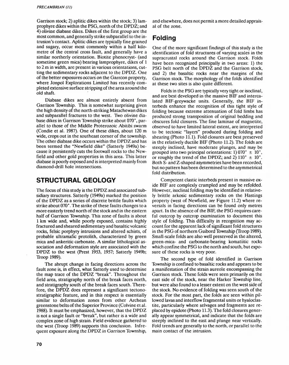
PRECAMBRIAN (11)
Garrison stock; 2) aplitic dikes within the stock; 3) lam prophyre dikes within the PSG, north of the DPDZ; and 4) olivine diabase dikes. Dikes of the first group are the most common, and generally strike subparallel to the in trusion's contact. Aplitic dikes are typically fine grained and sugary, occur most commonly within a half kilo metre of the central cross fault, and generally have a similar northerly orientation. Biotite phenocryst- (and sometime green mica) bearing lamprophyre, dikes of l to 2 m in width, are present in various orientations, cut ting the sedimentary rocks adjacent to the DPDZ. One of the better exposures occurs on the Garrcon property, where Jonpol Explorations Limited has recently com pleted extensive surface stripping of the area around the old shaft.
Diabase dikes are almost entirely absent from Garrison Township. This is somewhat surprising given the high density of the north-striking Matachewan dikes and subparallel fractures to the west. Two olivine dia base dikes in Garrison Township strike about 070 c , par allel to those of the Middle Proterozoic Abitibi swarm (Condie et al. 1987). One of these dikes, about 120 m wide, crops out in the southeast corner of the township. The other diabase dike occurs within the DPDZ and has been termed the "Newfield dike" (Satterly 1949a) be cause it persistently cuts the footwall rocks to the New field and other gold properties in this area. This latter diabase is poorly exposed and is interpreted mainly from diamond-drill hole intersections.
STRUCTURAL GEOLOGYThe focus of this study is the DPDZ and associated sub sidiary structures. Satterly (1949a) marked the position of the DPDZ as a series of discrete brittle faults which strike about 070 0 . The strike of these faults changes to a more easterly trend north of the stock and in the eastern half of Garrison Township. This zone of faults is about l km wide and, while poorly exposed, contains highly fractured and sheared sedimentary and basaltic volcanic rocks, felsic porphyry intrusions and altered schists, of probable ultramafic protolith, characterized by green mica and ankeritic carbonate. A similar lithological as sociation and deformation style are associated with the DPDZ to the west (Prest 1953, 1957; Satterly 1949b; Troop 1989).
The abrupt change in facing directions across the fault zone is, in effect, what Satterly used to determine the map trace of the DPDZ "break". Throughout the field area, stratigraphy north of the break faces north, and stratigraphy south of the break faces south. There fore, the DPDZ does represent a significant tectono- stratigraphic feature, and in this respect is essentially similar to deformation zones from other Archean greenstone belts of the Superior Province (Colvine et al. 1988). It must be emphasized, however, that the DPDZ is not a single fault or "break", but rather is a wide and complex zone of high strain. Field evidence gathered to the west (Troop 1989) supports this conclusion. Infre quent exposure along the DPDZ in Garrison Township,
and elsewhere, does not permit a more detailed apprais al of the zone.
FoldingOne of the more significant findings of this study is the identification of fold structures of varying scales in the supracrustal rocks around the Garrison stock. Folds have been recognized principally in two areas: 1) the PSG belt north of the DPDZ and the Garrison stock, and 2) the basaltic rocks near the margins of the Garrison stock. The morphology of the folds identified at these two sites is also quite different.
Folds in the PSG are typically very tight or isoclinal, and are best developed in the massive BIF and interca lated BIF-greywacke units. Generally, the BIF in- terbeds enhance the recognition of this tight style of folding because extreme attenuation of fold limbs has produced strong transposition of original bedding and obscures fold closures. The fine laminae of magnetite, observed to have limited lateral extent, are interpreted to be tectonic "layers" produced during folding and shearing (Photo 11.1). Fold closures are best preserved in the relatively ductile BIF (Photo 11.2). The folds are steeply inclined, have moderate plunges, and may be grouped into two principal orientations: 1) 070 0 10", or roughly the trend of the DPDZ; and 2) HO 0 10". Both S- and Z-shaped asymmetries have been recorded, but no pattern has been determined to the asymmetrical fold distribution.
Competent clastic interbeds present in massive ox ide BIF are complexly crumpled and may be refolded. However, isoclinal folding may be identified in relative ly brittle arkosic sedimentary rocks on the Hastings property (west of Newfield, see Figure 11.2) where re versals in facing directions can be found only metres apart. In the absence of the BIF, the PSG requires care ful outcrop by outcrop examination to document this style of folding. This difficulty in recognition may ac count for the apparent lack of significant fold structures in the PSG of northern Guibord Township (Troop 1989). Small-scale folds are also well preserved in the altered, green-mica- and carbonate-bearing komatiitic rocks which confine the PSG to the north and south, but expo sure of these rocks is very poor.
The second type of fold identified in Garrison Township is confined to basaltic rocks and appears to be a manifestation of the strain aureole encompassing the Garrison stock. These folds were seen primarily on the east side of the stock, near the Harker Township line, but were also found to a lesser extent on the west side of the stock. No evidence of folding was seen south of the stock. For the most part, the folds are seen within pil lowed lavas and interflow fragmental units or hyaloclas tite, particularly where selvages and fragments are re placed by epidote (Photo 11.3). The fold closures gener ally appear symmetrical, and indicate that the folds are steeply inclined to the east and plunge near vertically. Fold trends are generally to the north, or parallel to the main contact of the intrusion.
70
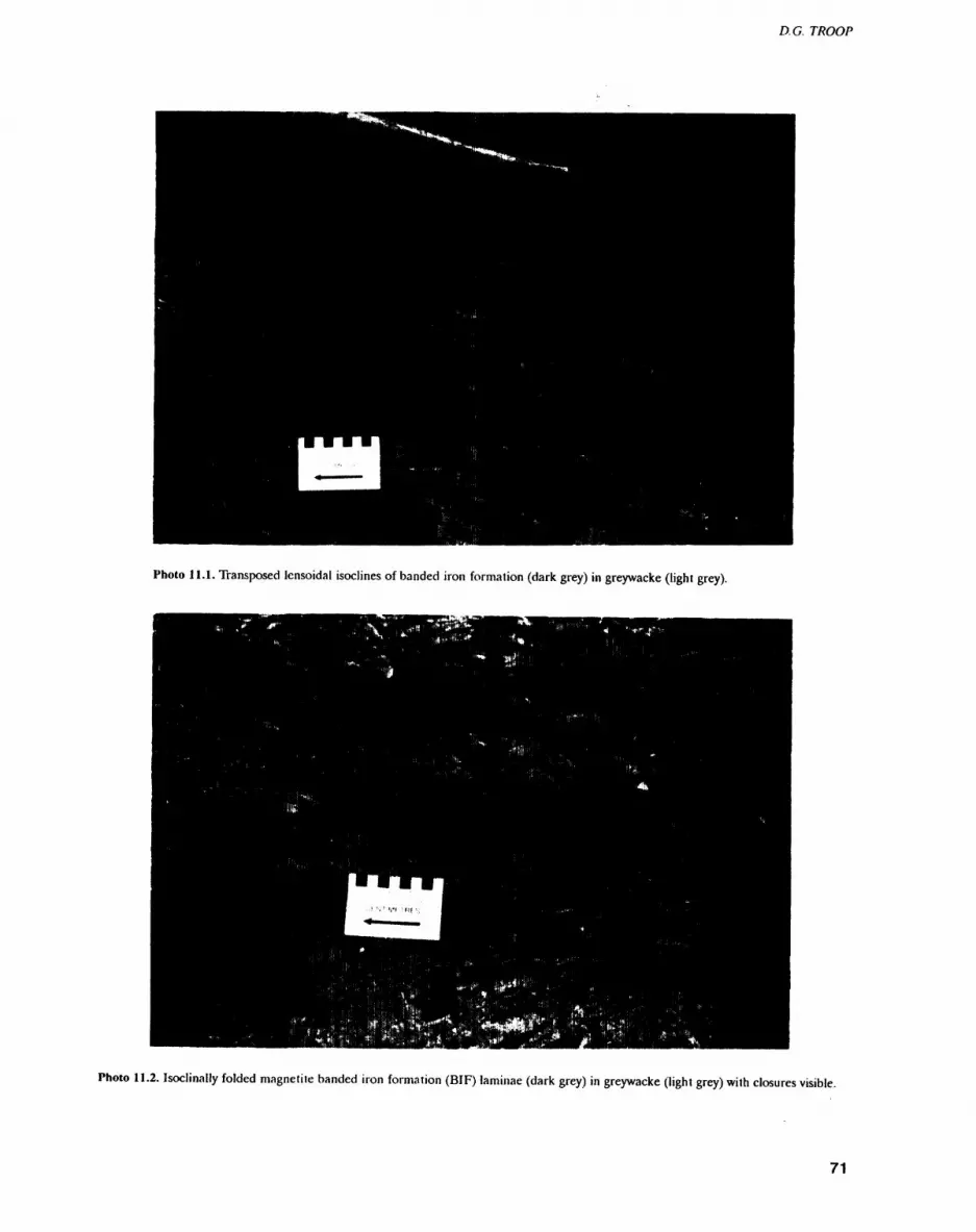
D. G. TROOP
Photo 11.1. Transposed lensoidal isoclines of banded iron formation (dark grey) in greywacke (light grey).
Photo 11.2. Isoclinally folded magnetite banded iron formation (BIF) laminae (dark grey) in greywacke (light grey) with closures visible.
71
PRECAMBRIAN (11)
Photo 11.3. Tight symmetrical folds of epidotized pillow selvedges and interflow fragments.
Penetrative Fabrics and Fracturing
Generally, penetrative fabrics (specifically schistosities and cleavages) were found to be far more prevalent in Garrison Township than in the three townships to the west (Troop 1989). However, discrete shear zones of de finable width were less frequently seen in Garrison Township. Some of the penetrative fabrics reflect the strain aureole present around the margin of the Garrison stock, interpreted to be a flattening fabric. Similarly, a large number of cleavages, axial planar to the isoclinal and tight folds described above, were re corded, particularly in the PSG and in the altered green-mica-bearing ultramafic schists nearby. Their orientations generally reflect the trend of the folds and the DPDZ. A strong shear zone striking 110" was lo cated in rhyolites north of Highway 101 and southeast of the Bird-Ginn asbestos mine. No fabric overprinting or overprinting by the intrusion's strain aureole was found in the vicinity of the Buffonta (Murphy Garrison) gold deposit, but the two shear zones here are reported as striking 142" and 068 0 , respectively (Satterly 1949a).
The occurrence and density of fractures appear es sentially similar to those documented to the west (Troop 1989). However, quartz veins are far less common, with the greatest density of veins occurring within and adja cent to the Garrison stock. Most of the latter are com posed of massive white quartz, with little associated al teration or sulphide mineralization. The relationship of fracture and vein orientations to the overall tectonic de velopment of the area remains as yet unresolved.
North-striking fracture systems, which are prominent west of the field area (Troop 1989), remain strong in Garrison Township. Absent are Matachewan diabase dikes, which commonly occupy these fracture systems further to the west.
Cross FaultsCross faults, striking generally in a northerly to north easterly direction, form an important component of the tectonic framework in Garrison Township. The most prominent of these is the north-striking fault passing di rectly through the center of the stock (see Figure 11.2). It is clearly identifiable as a lineament on aerial photo graphs and as a negative anomaly on aeromagnetic maps (Letros et al. 1983). Other cross faults are clearly identi fiable from truncations and offsets of magnetic patterns on an unpublished first vertical derivative map (see Fig ure 11.2) based on aeromagnetic data from an 1984 air borne survey (OGS 1984).
METAMORPHISMMetamorphic grade within the field area is generally of greenschist facies, with local elevation to amphibolite facies. There is a significant contact metamorphic au reole around the Garrison stock, which is identified from exposures on the west, south and east sides of the intrusion. In these areas, the aureole is characterized by the development of metamorphic veins and pods of epi dote, red-brown garnet and quartz, and by an increase in strain towards the intrusion. Concentric rings of silica
72

D. G. TROOP
appear in basaltic pillows within the aureple. Generally, the main contact between the plutdn and the supracrus tal rocks is not exposed. The contact and strain aureole appears to be almost a kilometre wider on the east side of the stock than on the west. Coupled with the fact that most of the structures developed about the stock dip steeply to moderately to the east, it seems likely that the entire stock also plunges to the east.
Satterly (1949a) referred to a section of biotite- cordierite gneiss intersected by diamond drilling along the northern contact of the stock. This may represent contact metamorphosed PSG or interflow sediments within the volcanic stratigraphy (the latter favoured by Satterly). Regardless, their description is quite similar to the xenolithic blocks described above, which occur in the north part of the stock. The latter may represent sloped blocks from the contact zone.
GOLD MINERALIZATION AND ALTERATION
Garrison Township has not been a prolific producer of gold, but the number of gold properties, most discov ered before 1950, certainly points toward high potential. In 1990, there were no operating mines in the township, although Jonpol Explorations Ltd. is engaged in an ad vanced underground exploration program on the New- field property. During the summer months of 1990, ac tivity here was dormant, apart from some surface drill ing.
Areas of gold mineralization in the township consist of a number of old showings and properties within the PSG straddling the DPDZ, the Buffonta property on the west central margin of the stock, and two areas in which felsic volcanic rocks and interflow chert occur. One of the latter type is on the north township line just east of the Indian Reserve 70 road, while the other is southeast of the stock. Also, the Windjammer property, of Noranda Exploration Company Limited straddles the Michaud-Garrison township line in the vicinity of Half way Lake. There are no bedrock exposures at Windjam mer.
Alteration consists of the usual suite of minerals as sociated with Archean gold deposits in greenschist fa cies rocks (Colvine et al. 1988). Ankeritic carbonate, ser icite and green mica are commonly present in rocks as sociated with the DPDZ. Calcite is commonly found in vugs and fracture fillings, but generally well away from both the stock and the DPDZ. Hematite, either dissemi nated or as specularite fracture coatings, is a very com mon alteration mineral here. The importance of hema tite alteration has been documented previously in the BRiM area (Whittaker 1986; Troop 1986), and similar occurrences were documented throughout the 1989 field area, particularly in close proximity to syenitic in trusions. Pink feldspar veinlets and fracture coatings are common around the Buffonta deposit, but are also seen generally within the contact aureole zone. There fore, the origin for this feldspar, which might be either
metamorphic osr hvdrpthermal, is unknown. Similarly, silicified basalt'^hll/cjl' basaltic hornfels are prominent at the Buffonta deposit, but a hydrothermal versus con tact metamorphic origin for these rocks could not be verified in the field. Variolitic-like textures seen in the basalts here may represent a silica alteration phenome non.
Satterly (1949a) subdivided gold mineralization in Garrison Township into four broad categories: 1) dis seminated sulphides in interflow chert, 2) pyrite in por phyry intrusions along the DPDZ, 3) pyritic sheeted veins associated with pegmatites close to the stock, and 4) quartz vein-type mineralization. The last three cate gories can be combined to describe the important prop erties in the township. Two of these are described below.
Buffonta (Murphy Garrison) DepositDiscovered in 1919, the Buffonta has sporadically pro duced small amounts of gold. In 1982, Kerr Addison mined 70000 tons from the open pit, at 0.12 ounces Au per ton (Meyer et al. 1988). The deposit was held by Silversides Resources Inc., Proteus Resources Inc. and Perrex Resources Limited until recently, when Deak Resources purchased an interest in the property with the intention of bringing the Buffonta back into produc tion (The Northern Miner, October 8,1990, p. 17). Miner alization is exposed in an open pit, now flooded, which was mapped by Cherry (1982). The mineralization is hosted by highly strained and contact metamorphosed mafic volcanic rocks within several hundred metres of the Garrison Stock contact. Flattened spherules (va- rioles) and pillows, boudinaged and folded garnet-epi- dote-amphibole and quartz veins and pods (Photo 11.4) are all steeply inclined and reflect the strain aureole about the stock.
Gold mineralization is confined to relatively flat dipping (O 0 to 30" N) fractures filled with, and mantled by, coarse pyrite, rusty weathering carbonate, and quartz. These fractures are somewhat irregular and complex in appearance, and cut the steep fabrics. Therefore, the mineralized veins may be considerably younger than plutonism and related deformation. Shear zones, oriented at 038" and 068", were reported from exploration work (Satterly 1949a), but could not be lo cated at surface. Visible gold occurs in the deep cut on the south side of the pit, where several highly strained syenitic dikes are also present. Current reserves are es timated at 610000 tons grading 0.18 ounce Au per ton (Meyer et al. 1988).
The mineral assemblage at the Buffonta is quite similar to that found in skarn-type gold deposits (Meinert 1989) and also in alkalic porphyry copper and gold deposits. There are problems with this interpreta tion, however. Firstly, the development of calc-silicate mineralogy is generally the last stage in such systems. In this case, however, gold-bearing veins appear to post date the calc-silicate veins. Secondly, the calc-silicate
73
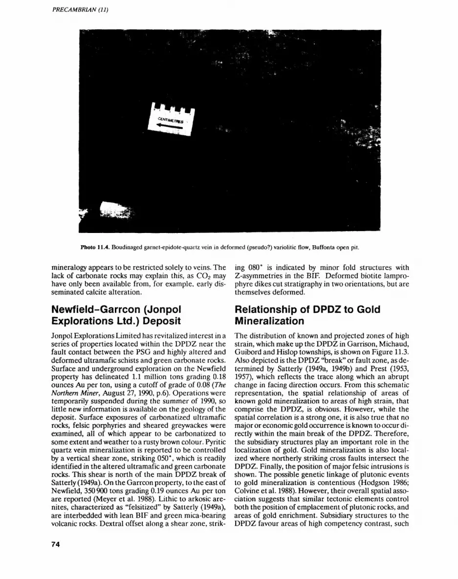
PRECAMBRIAN (11)
Photo 11.4. Boudinaged garnet-epidote-quartz vein in deformed (pseudo?) variolitic flow, Buffonta open pit.
mineralogy appears to be restricted solely to veins. The lack of carbonate rocks may explain this, as CO2 may have only been available from, for example, early dis seminated calcite alteration.
Newfield-Garrcon (Jonpol Explorations Ltd.) DepositJonpol Explorations Limited has revitalized interest in a series of properties located within the DPDZ near the fault contact between the PSG and highly altered and deformed ultramafic schists and green carbonate rocks. Surface and underground exploration on the Newfield property has delineated 1.1 million tons grading 0.18 ounces Au per ton, using a cutoff of grade of 0.08 (The Northern Miner, August 27, 1990, p.6). Operations were temporarily suspended during the summer of 1990, so little new information is available on the geology of the deposit. Surface exposures of carbonatized ultramafic rocks, felsic porphyries and sheared greywackes were examined, all of which appear to be carbonatized to some extent and weather to a rusty brown colour. Pyritic quartz vein mineralization is reported to be controlled by a vertical shear zone, striking OSO 0 , which is readily identified in the altered ultramafic and green carbonate rocks. This shear is north of the main DPDZ break of Satterly (1949a). On the Garrcon property, to the east of Newfield, 350900 tons grading 0.19 ounces Au per ton are reported (Meyer et al. 1988). Lithic to arkosic are- nites, characterized as "felsitized" by Satterly (1949a), are interbedded with lean BIF and green mica-bearing volcanic rocks. Dextral offset along a shear zone, strik
ing 080" is indicated by minor fold structures with Z-asymmetries in the BIF. Deformed biotite lampro phyre dikes cut stratigraphy in two orientations, but are themselves deformed.
Relationship of DPDZ to Gold MineralizationThe distribution of known and projected zones of high strain, which make up the DPDZ in Garrison, Michaud, Guibord and Hislop townships, is shown on Figure 11.3. Also depicted is the DPDZ "break" or fault zone, as de termined by Satterly (1949a, 1949b) and Prest (1953, 1957), which reflects the trace along which an abrupt change in facing direction occurs. From this schematic representation, the spatial relationship of areas of known gold mineralization to areas of high strain, that comprise the DPDZ, is obvious. However, while the spatial correlation is a strong one, it is also true that no major or economic gold occurrence is known to occur di rectly within the main break of the DPDZ. Therefore, the subsidiary structures play an important role in the localization of gold. Gold mineralization is also local ized where northerly striking cross faults intersect the DPDZ. Finally, the position of major felsic intrusions is shown. The possible genetic linkage of plutonic events to gold mineralization is contentious (Hodgson 1986; Colvine et al. 1988). However, their overall spatial asso ciation suggests that similar tectonic elements control both the position of emplacement of plutonic rocks, and areas of gold enrichment. Subsidiary structures to the DPDZ favour areas of high competency contrast, such
74
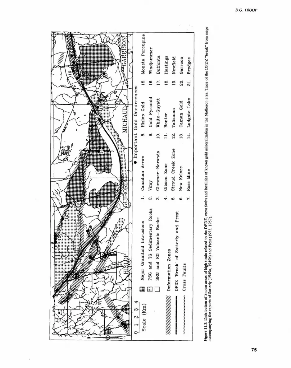
S.ra S
O
S •ol
"t) T3t- C C W2^i: o\CO Tl-
• oT** a\O Tfwi O\ea i— i^) ^ _ CO -*^p Jj
sic "C•s a3 U .0 Ul
"C u .2 -(5 Md'i4-H CS
st

PRECAMBRIAN (11)
as those produced at the contacts of ultramafic rocks with porphyry intrusions or with quartzose sedimentary rocks.
SUMMARY OF RESULTSThe principal findings and conclusions reached from the 1990 field season can be summarized as follows:
Significant isoclinal folding and transposition are recognized in the PSG along the DPDZ. The rela tive sense of movement within the DPDZ appears complex and is as yet unresolved. A second type of more open folding occurs marginal to the Garrison stock and is related to emplacement of the intru sion.
1.
2. Komatiitic volcanic rocks and their altered equiva lents occur north of the DPDZ, within the main break and just north of the northern margin of the Garrison stock. Where exposed the contacts be tween komatiites and the PSG are always sheared.
3. The Garrison stock is encompassed by a significant contact metamorphic and strain aureole, character ized by an epidote-garnet-quartz pink feldspar mineral assemblage occurring as veins and pods, and by a strong flattening fabric generally parallel to the intrusion margins.
4. The contact strain aureole around the stock is much wider on the east side and, coupled with the easterly dip of related fabrics, indicates a similar easterly plunge for the intrusion.
5. The occurrence of hematite and specularite are widespread alteration phenomena in Garrison Township, as in the area to the west, despite the ap parent lack of appreciable syenide magmatism so common to the west.
6. Gold-bearing structures at the Buffonta deposit postdate the strain aureole and the calc-silicate mineral assemblage imposed by the Garrison stock; however, the actual time gap is unknown and may be insignificant in relation to the overall tectonic development of the area.
7. The conjunction of areas of high strain within the DPDZ but subsidiary to the main fault, with signifi cant intersecting cross faults and lithological com petency contrast, such as that found in felsic por phyry intrusions adjacent to ultramafic volcanic rocks, appears to form the most favourable environ ment for gold mineralization in this area.
ACKNOWLEDGEMENTSNumerous exploration and mining companies and their personnel provided permission for access to various mineral properties during the summer, and my grati tude is expressed to all of them. Special thanks go to Noranda Exploration Company, Limited and to Jonpol Explorations Ltd. Peter Atherton of Goldpost Re
sources Ltd. is thanked for arranging a drill core presen tation of the Kelore property in Hislop Township; and appreciation is extended to Barry Manchuk of Stroud Resources for his impromptu presentation on the Stroud Creek Zone, also in Hislop Township. Excellent field and office assistance was provided throughout the summer by Chris Morino of the University of Toronto. Finally, Jiang Xiangdong, a visiting geologist from the Shandong Bureau of Geology and Mineral Resources, Jinan, China, produced an excellent map from the old Hislop Gold property in Hislop Township. He was ably assisted by Seppo Kakko of the University of Windsor.
REFERENCESBrodaric, B. and Fyon, J.A. 1988. Field implementation of a develop
mental computer-based digital mapping and data storage system; in Summary of Field Work and Other Activities 1988, Ontario Geological Survey, Miscellaneous Paper 141, p.378-380.
Cherry, M.E. 1982. Felsic intrusion associated lode gold deposits in the Matheson area, Cochrane District; in Summary of Field Work 1982, Ontario Geological Survey, Miscellaneous Paper 106, p.176-179.
Colvine, A.C., Fyon, J.A., Heather, K.B., Marmont, S., Smith, P.M. and Troop, D.G. 1988. Archean lode gold deposits in Ontario; Ontario Geological Survey, Miscellaneous Paper 139, 136p.
Condie, C.K., Bobrow, D.J., Card, K.D. 1987. Geochemistry of Pre cambrian mafic dikes from the southern Superior Province; in Mafic dike swarms, Geological Association of Canada, Special Paper 34, p.95-108.
Gross, G.A. 1980. A classification of iron formations based on deposi tional environments; Canadian Mineralogist, v.18, p.215-222.
Hodgson, C.J. 1986. Place of gold ore formation in the geological de velopment of the Abitibi greenstone belt, Ontario, Canada; Transactions of the Institution of Mining and Metallurgy (Section B: Applied earth science), v.95, p.B183-B194.
Jensen, L.S. and Langford, F.F. 1985. Geology and petrogenesis of the Archean Abitibi Belt in the Kirkland Lake area, Ontario; Ontar io Geological Survey, Miscellaneous Paper 123, 130p.
Letros, S., Strangway, D.W., Tasillo-Hirt, A.M., Geissman, J.W. and Jensen, L.S. 1983. Aeromagnetic interpretation of the Kirkland Lake Larder Lake portion of the Abitibi greenstone belt, On tario; Canadian Journal of Earth Sciences, v.20, p.548-560.
Malczak, J. 1985. Industrial mineral potential of the Black River Matheson (BRiM)area, District of Cochrane; in Summa ry of Field Work and Other Activities 1985, Ontario Geological Survey, Miscellaneous Paper 126, p.326-328.
Marmont, S. and Corfu, F. 1989. Timing of gold introduction in the late Archean tectonic framework of the Canadian Shield: evi dence from U-Pb zircon geochronology of the Abitibi subpro- vince; Economic Geology, Monograph 6, p. 101-111.
Meinert, L.D. 1989. Gold skarn deposits geology and exploration criteria; Economic Geology, Monograph 6, p.537-552.
Meyer, G., Grabowski, G., Lovell, H., Guindon, D. and Bath, A. 1988. Kirkland Lake Resident Geologist's District-1988; Ontario Geological Survey, Miscellaneous Paper 143, 136p.
Mortensen, J.K. 1987. Preliminary U-Pb zircon ages for volcanic and plutonic rocks of the Noranda Lac Abitibi area, Abitibi sub- province, Quebec; Geological Survey of Canada, Paper 87-1A, p.581-590.
Ontario Geological Survey 1984. Airborne electromagnetic and total intensity magnetic survey, Matheson-Black River area, Michaud and Garrison townships, District of Cochrane; Ontario Geological Survey, Maps 80597 and 80598, scale 1:20000.
Prest, V.K. 1953. Geology of Guibord Township: Ontario Department of Mines, Annual Report, 1951, v.6(), pt.9, 56p.
76
D. G. TROOP
1957. Geology of Hislop Township; Ontario Department of 1989. Geological investigations of the Destor-Porcupine defor- Mines, Annual Report, 1956, v.65, pt.5, 48p. mation zone east of Matheson; in Summary of Field Work and
Other Activities 1989, Ontario Geological Survey, Miscella-Satterly, J. 1949a. Geology of Garrison Township; Ontario Depart- neous Paper 146, p.136-143.
ment of Mines, Annual Report, 1949, v.58, pt.4, 33p. whittaker, P.J. 1985. Metallogenetic studies in the Black River-
1949b. Geology of Michaud Township; Ontario Department of U^T f?' o' af Cochrane;m Summary of Field Work-. o aMines, Annual Report, 1948, v.57, pt.4, 27p. and Other Ac ^^1985 Ontano Geolog.cal Survey, M.scella-
K ' ' r ' r neous Paper 126, p.312-315.
Troop, D.G. 1986. Multiple orebody types and vein morphologies, 1986. Gold metallogenesis along the Pipestone and Destor-Ross Mine, District of Cochrane; in Summary of Field Work and Porcupine deformation zones and associated structures; in Sum-Other Activities 1986, Ontario Geological Survey, mary of Field Work and Other Activities 1986, OntarioMiscellaneous Paper 132, p.413-420. Geological Survey, Miscellaneous Paper 132, p.404-407.
77
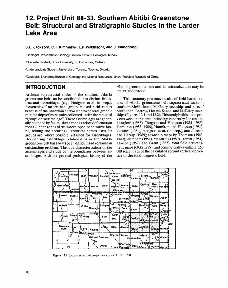
12. Project Unit 88-33. Southern Abitibi Greenstone Belt: Structural and Stratigraphic Studies in the Larder Lake Area
S.L. Jackson 1 , C.T. Kimmerly2 , L.R Wilkinson3, and J. Xiangdong4
1 Geologist. Precambrian Geology Section, Ontario Geological Survey.
2Graduate Student, Brock University, St. Catharines, Ontario.
3Undergraduate Student, University of Toronto, Toronto, Ontario.
4Geologist. Shandong Bureau of Geology and Mineral Resources, Jinan, People's Republic of China.
INTRODUCTIONArchean supracrustal rocks of the southern Abitibi greenstone belt can be subdivided into distinct lithos- tructural assemblages (e.g., Hodgson et al. in prep.). "Assemblage" rather than "group" is used in this report because of the uncertain and/or unproved stratigraphic relationships of most units collected under the status of "group" or "assemblage". These assemblages are gener ally bounded by faults, shear zones and/or deformation zones (linear zones of well-developed penetrative fab ric, folding and shearing). Historical names used for groups are, where possible, retained for assemblages. Deciphering assemblage relationships in the Abitibi greenstone belt has always been difficult and remains an outstanding problem. Through characterization of the assemblages and study of the boundaries between as semblages, both the general geological history of the
Abitibi greenstone belt and its mineralization may be better understood.
This summary presents results of field-based stu dies of Abitibi greenstone belt supracrustal rocks in southern Mcvittie and McGarry townships and parts of McFadden, Rattray, Hearst, Skead, and McElroy town ships (Figures 12.1 and 12.2). This study builds upon pre vious work in the area including: reports by Jensen and Langford (1985), Toogood and Hodgson (1985, 1986), Hamilton (1983, 1986), Hamilton and Hodgson (1984), Downes (1981), Hodgson et al. (in prep.), and Jackson and Harrap (1989); township maps by Thomson (1943, 1949), Abraham (1951), Mandziuk (1980), Hewitt (1951), Lawton (1959), and Grant (1963); total field aeromag netic maps (OGS1979); and commercially available 1:50 000 scale maps of the calculated second vertical deriva tive of the total magnetic field.
Figure 12.1. Location map of project area, scale 1:1 013 760.
78
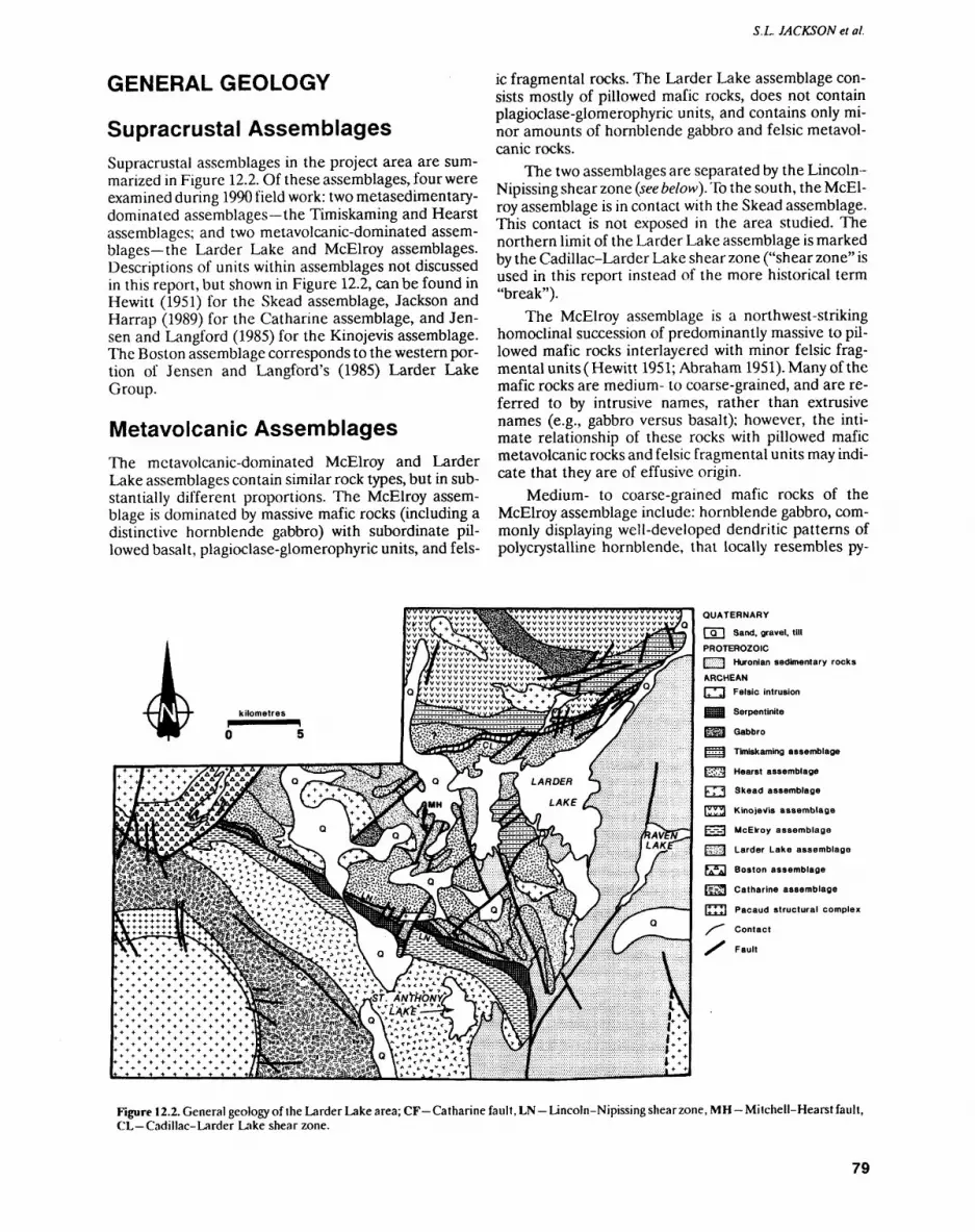
S.L. JACKSON et al.
GENERAL GEOLOGY
Supracrustal AssemblagesSupracrustal assemblages in the project area are sum marized in Figure 12.2. Of these assemblages, four were examined during 1990 field work: two metasedimentary- dominated assemblages the Timiskaming and Hearst assemblages; and two metavolcanic-dominated assem blages the Larder Lake and McElroy assemblages. Descriptions of units within assemblages not discussed in this report, but shown in Figure 12.2, can be found in Hewitt (1951) for the Skead assemblage, Jackson and Harrap (1989) for the Catharine assemblage, and Jen sen and Langford (1985) for the Kinojevis assemblage. The Boston assemblage corresponds to the western por tion of Jensen and Langford's (1985) Larder Lake Group.
Metavolcanic AssemblagesThe metavolcanic-dominated McElroy and Larder Lake assemblages contain similar rock types, but in sub stantially different proportions. The McElroy assem blage is dominated by massive mafic rocks (including a distinctive hornblende gabbro) with subordinate pil lowed basalt, plagioclase-glomerophyric units, and fels
ic fragmental rocks. The Larder Lake assemblage con sists mostly of pillowed mafic rocks, does not contain plagioclase-glomerophyric units, and contains only mi nor amounts of hornblende gabbro and felsic metavol- canic rocks.
The two assemblages are separated by the Lincoln- Nipissing shear zone (see below). To the south, the McEl roy assemblage is in contact with the Skead assemblage. This contact is not exposed in the area studied. The northern limit of the Larder Lake assemblage is marked by the Cadillac-Larder Lake shear zone ("shear zone" is used in this report instead of the more historical term "break").
The McElroy assemblage is a northwest-striking homoclinal succession of predominantly massive to pil lowed mafic rocks interlayered with minor felsic frag mental units (Hewitt 1951; Abraham 1951). Many of the mafic rocks are medium- to coarse-grained, and are re ferred to by intrusive names, rather than extrusive names (e.g., gabbro versus basalt); however, the inti mate relationship of these rocks with pillowed mafic metavolcanic rocks and felsic fragmental units may indi cate that they are of effusive origin.
Medium- to coarse-grained mafic rocks of the McElroy assemblage include: hornblende gabbro, com monly displaying well-developed dendritic patterns of percrystalline hornblende, that locally resembles py-
QUATERNARY
|~Q~| Sand, gravel, till
PROTEROZOIC[gxv'ffi Huronian sedimentary rocksARCHEANI+^J Felsic intrusion
BOS Serpentinite
EH Gabbro
\---j Timiskaming assemblage
t-Soj Hearst assemblage
h; 1 Skead assemblage
[33^1 Kinojevls assemblage
Egg McElroy assemblage
p^j Larder Lake assemblage
fAnA| Boston assemblage
tSK3 Catharine assemblage
inil Pacaud structural complex/"*" Contact
pau|t
Figure 12.2. General geology of the Larder Lake area; CF-Catharine fault, LN-Lincoln-Nipissingshearzone, MH-Milchell-Hearst fault, CL Cadillac-Larder Lake shear zone.
79
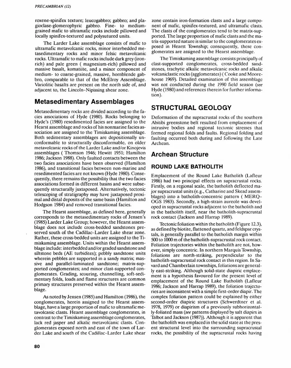
PRECAMBRIAN (12)
roxene-spinifex texture; leucogabbro; gabbro; and pla- gioclase-glomerophyric gabbro. Fine- to medium- grained mafic to ultramafic rocks include pillowed and locally spinifex-textured and polysutured units.
The Larder Lake assemblage consists of mafic to ultramafic metavolcanic rocks, minor interbedded me- tasedimentary rocks and minor felsic metavolcanic rocks. Ultramafic to mafic rocks include dark grey (iron- rich) and pale green ( magnesium-rich) pillowed and massive basalt, komatiite, and a minor component of medium- to coarse-grained, massive, hornblende gab bro, comparable to that of the McElroy Assemblage. Variolitic basalts are present on the north side of, and adjacent to, the Lincoln-Nipissing shear zone.
Metasedimentary AssemblagesMetasedimentary rocks are divided according to the fa cies associations of Hyde (1980). Rocks belonging to Hyde's (1980) resedimented facies are assigned to the Hearst assemblage and rocks of his nonmarine facies as sociation are assigned to the Timiskaming assemblage. Both sedimentary assemblages are depositionally un conformable to structurally disconformable, on older metavolcanic rocks of the Larder Lake and/or Kinojevis assemblages ( Thomson 1946; Hewitt 1951; Hamilton 1986; Jackson 1988). Only faulted contacts between the two facies associations have been observed (Hamilton 1986), and transitional facies between non-marine and resedimented facies are not known (Hyde 1980). Conse quently, there remains the possibility that the two facies associations formed in different basins and were subse quently structurally juxtaposed. Alternatively, tectonic telescoping of stratigraphy may have juxtaposed proxi mal and distal deposits of the same basin (Hamilton and Hodgson 1984) and removed transitional facies.
The Hearst assemblage, as defined here, generally corresponds to the metasedimentary rocks of Jensen's (1985) Larder Lake Group; however, the Hearst assem blage does not include cross-bedded sandstones pre served south of the Cadillac-Larder Lake shear zone. Rather, these cross-bedded units are assigned to the Ti miskaming assemblage. Units within the Hearst assem blage include: interbedded and/or graded sandstone and siltstone beds (AE turbidites); pebbly sandstone units wherein pebbles are supported in a sandy matrix; mas sive and parallel-laminated sandstone; matrix-sup ported conglomerates; and minor clast-supported con glomerates. Grading, scouring, channelling, soft-sedi mentary folds, loads and flame structures are common primary structures preserved within the Hearst assem blage.
As noted by Jensen (1985) and Hamilton (1986), the conglomerates, herein assigned to the Hearst assem blage, have a large proportion of mafic to ultramafic me tavolcanic clasts. Hearst assemblage conglomerates, in contrast to the Timiskaming assemblage conglomerates, lack red jasper and alkalic melavolcanic clasts. Con glomerates exposed north and east of the town of Lar der Lake and south of the Cadillac-Larder Lake shear
zone contain iron-formation clasts and a large compo nent of mafic, spinifex-textured, and ultramafic clasts. The clasts of the conglomerates tend to be matrix-sup ported. The large proportion of mafic clasts and the ma trix-supported nature is similar to the conglomerates ex posed in Hearst Township; consequently, these con glomerates are assigned to the Hearst assemblage.
The Timiskaming assemblage consists principally of clast-supported conglomerates, cross-bedded sand stones, trachytic alkalic metavolcanic rocks and alkalic volcaniclastic rocks (agglomerates) (Cooke and Moore house 1969). Detailed examination of this assemblage was not conducted during the 1990 field season (see Hyde (1980) and references therein for further informa tion).
STRUCTURAL GEOLOGYDeformation of the supracrustal rocks of the southern Abitibi greenstone belt resulted from emplacement of intrusive bodies and regional tectonic stresses that formed regional folds and faults. Regional folding and faulting occurred both during and following the Late Archean.
Archean Structure
ROUND LAKE BATHOLITHEmplacement of the Round Lake Batholith (Lafleur 1986) had two principal effects on supracrustal rocks. Firstly, on a regional scale, the batholith deflected ma jor supracrustal units (e.g., Catharine and Skead assem blages) into a batholith-concentric pattern ( MERQ- OGS 1983). Secondly, a high-strain aureole was devel oped in supracrustal rocks adjacent to the batholith and in the batholith itself, near the batholith-supracrustal rock contact (Jackson and Harrap 1989).
Tectonic foliation within the batholith (Figure 12.3), as defined by biotite, flattened quartz, and feldspar crys tals, is generally parallel to the batholith margin within 500 to 1000 m of the batholith-supracrustal rock contact. Foliation trajectories within the batholith are not, how ever, simply concentric. In northern Marquis Township, foliations are north-striking, perpendicular to the batholith-supracrustal rock contact in this region. In Sa vard and Chamberlain townships, foliations are general ly east-striking. Although solid-state diapiric emplace ment is a hypothesis favoured for the present level of emplacement of the Round Lake Batholith (Lafleur 1986; Jackson and Harrap 1989), the foliation trajecto ries are inconsistent with a simple first-order diapir. The complex foliation pattern could be explained by either second-order diapiric structures (Schwerdtner et al. 1978, 1979) or diapirism of a previously subhorizontal- ly-foliated mass (see patterns displayed by salt diapirs in Talbot and Jackson (1987)). Although it is apparent that the batholith was emplaced in the solid state at the pres ent structural level into the surrounding supracrustal rocks, the possibility of the supracrustal rocks having
80
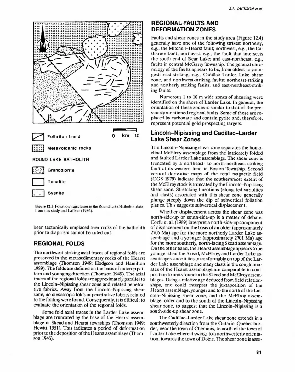
S.L. JACKSON el al.
X Jv^V r jfrv J y //rv vv^jvvvvvv v w vvvv v w jjf\ v v vx^ t-^^* v V X .^ r* v v v v W( v vvvvvvvvvvvvvv
Foliation trend O km 10
Metavolcanic rocks
ROUND LAKE BATHOLITH
{^~7J Granodiorite
J | Tonalite
ITVI Syenite
Figure 12.3. Foliation trajectories in the Round Lake Batholith, data from this study and Lafleur (1986).
been tectonically emplaced over rocks of the batholith prior to diapirism cannot be ruled out.
REGIONAL FOLDSThe northwest-striking axial traces of regional folds are preserved in the metasedimentary rocks of the Hearst assemblage (Thomson 1949; Hodgson and Hamilton 1989). The folds are defined on the basis of outcrop pat tern and younging direction (Thomson 1949). The axial traces of the regional folds are approximately parallel to the Lincoln-Nipissing shear zone and related penetra tive fabrics. Away from the Lincoln-Nipissing shear zone, no mesoscopic folds or penetrative fabrics related to the folding were found. Consequently, it is difficult to evaluate the orientation of the regional folds.
Some fold axial traces in the Larder Lake assem blage are truncated by the base of the Hearst assem blage in Skead and Hearst townships (Thomson 1949; Hewitt 1951). This indicates a period of deformation prior to the deposition of the Hearst assemblage (Thom son 1946).
REGIONAL FAULTS AND DEFORMATION ZONESFaults and shear zones in the study area (Figure 12.4) generally have one of the following strikes: northerly, e.g., the Mitchell-Hearst fault; northwest, e.g., the Ca tharine fault; northeast, e.g., the fault that intersects the south end of Bear Lake; and east-northeast, e.g., faults in central McGarry Township. The general chro nology of the faults appears to be, from oldest to youn gest: east-striking, e.g., Cadillac-Larder Lake shear zone, and northwest-striking faults; northeast-striking and northerly striking faults; and east-northeast-strik ing faults.
Numerous l to 10 m wide zones of shearing were identified on the shore of Larder Lake. In general, the orientation of these zones is similar to that of the pre viously mentioned regional faults. Some of these are re placed by carbonate and contain pyrite and, therefore, represent potential gold prospecting targets.
Lincoln-Nipissing and Cadillac-Larder Lake Shear ZonesThe Lincoln-Nipissing shear zone separates the homo clinal McElroy assemblage from the intricately folded and faulted Larder Lake assemblage. The shear zone is truncated by a northeast- to north-northeast-striking fault at its western limit in Boston Township. Second vertical derivative maps of the total magnetic field (OGS 1979) indicate that the southernmost extent of the McElroy stock is truncated by the Lincoln-Nipissing shear zone. Stretching lineations (elongated variolites and clasts) associated with this shear zone generally plunge steeply down the dip of subvertical foliation planes. This suggests subvertical displacement.
Whether displacement across the shear zone was north-side-up or south-side-up is a matter of debate. Corfu et al. (1989) interpret a north-side-up component of displacement on the basis of an older (approximately 2705 Ma) age for the more northerly Larder Lake as semblage and a younger (approximately 2701 Ma) age for the more southerly, north-facing Skead assemblage. On the other hand, the Hearst assemblage appears to be younger than the Skead, McElroy, and Larder Lake as semblages since it lies unconformably on top of the Lar der Lake assemblage and many clasts in the conglomer ates of the Hearst assemblage are comparable in com position to units found in the Skead and McElroy assem blages. Using a relative age deduced from field relation ships, one could interpret the juxtaposition of the Hearst assemblage, younger and to the north of the Lin coln-Nipissing shear zone, and the McElroy assem blage, older and to the south of the Lincoln-Nipissing shear zone, to suggest that the Lincoln-Nipissing is a south-side-up shear zone.
The Cadillac-Larder Lake shear zone extends in a southwesterly direction from the Ontario-Quebec bor der, near the town of Cheminis, to north of the town of Larder Lake where it swings to a northwesterly orienta tion, towards the town of Dobie. The shear zone is asso-
81
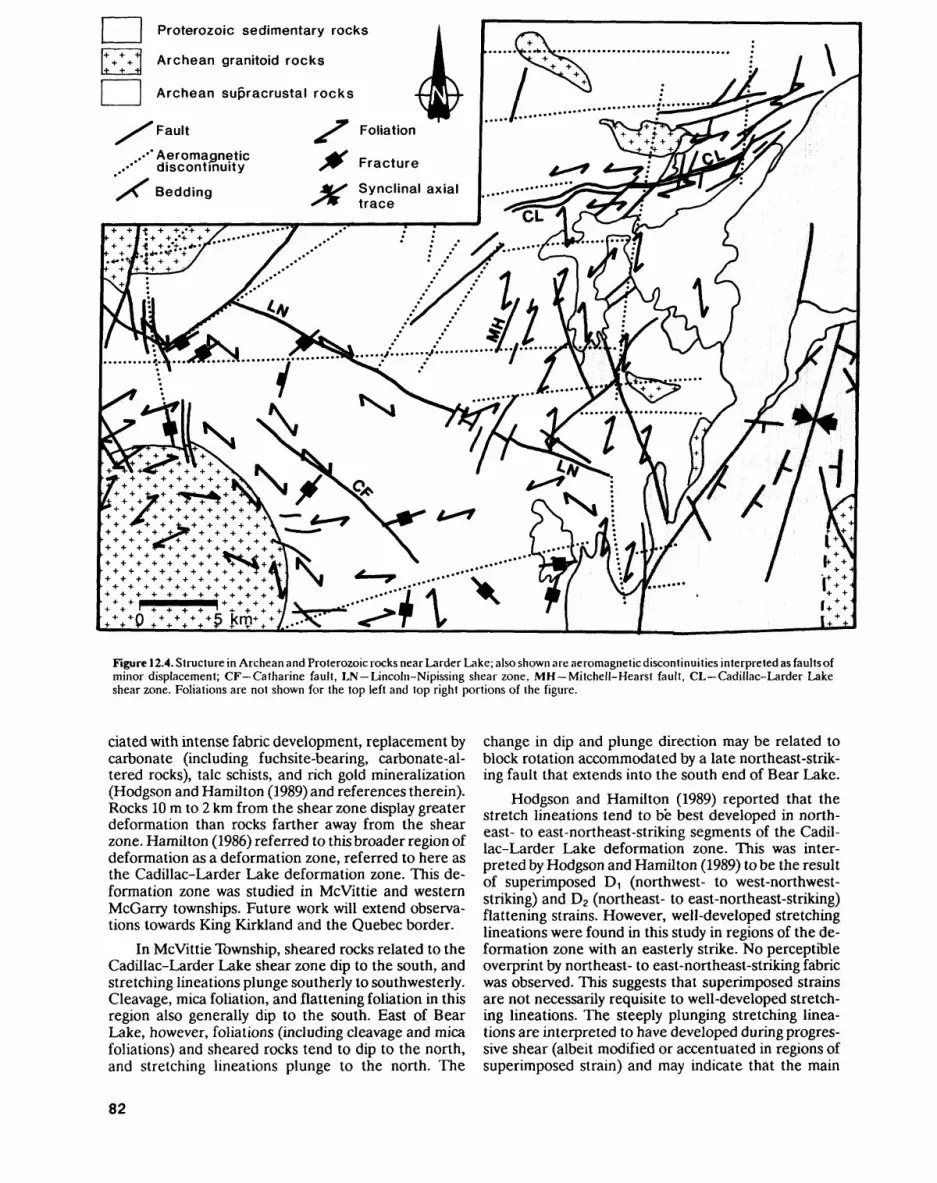
* -t-4- 4-
4 +
4
-f
Proterozoic sedimentary rocks
Archean granitoid rocks
Archean supracrustal rocks
Fault ^r Foliation
.-•* Aeromagnetic discontinuity
yX\ Bedding
Figure 12.4. Structure in Archean and Proterozoic rocks near Larder Lake; also shown are aeromagnetic discontinuities interpreted as faults of minor displacement; CF Catharine fault, LN Lincoln-Nipissing shear zone, MH Mitchell-Hearst fault, CL Cadillac-Larder Lake shear zone. Foliations are not shown for the top left and top right portions of the figure.
elated with intense fabric development, replacement by carbonate (including fuchsite-bearing, carbonate-al tered rocks), talc schists, and rich gold mineralization (Hodgson and Hamilton (1989) and references therein). Rocks 10 m to 2 km from the shear zone display greater deformation than rocks farther away from the shear zone. Hamilton (1986) referred to this broader region of deformation as a deformation zone, referred to here as the Cadillac-Larder Lake deformation zone. This de formation zone was studied in Mcvittie and western McGarry townships. Future work will extend observa tions towards King Kirkland and the Quebec border.
In Mcvittie Township, sheared rocks related to the Cadillac-Larder Lake shear zone dip to the south, and stretching lineations plunge southerly to southwesterly. Cleavage, mica foliation, and flattening foliation in this region also generally dip to the south. East of Bear Lake, however, foliations (including cleavage and mica foliations) and sheared rocks tend to dip to the north, and stretching lineations plunge to the north. The
change in dip and plunge direction may be related to block rotation accommodated by a late northeast-strik ing fault that extends into the south end of Bear Lake.
Hodgson and Hamilton (1989) reported that the stretch lineations tend to be best developed in north east- to east-northeast-striking segments of the Cadil lac-Larder Lake deformation zone. This was inter preted by Hodgson and Hamilton (1989) to be the result of superimposed D, (northwest- to west-northwest- striking) and D2 (northeast- to east-northeast-striking) flattening strains. However, well-developed stretching lineations were found in this study in regions of the de formation zone with an easterly strike. No perceptible overprint by northeast- to east-northeast-striking fabric was observed. This suggests that superimposed strains are not necessarily requisite to well-developed stretch ing lineations. The steeply plunging stretching linea tions are interpreted to have developed during progres sive shear (albeit modified or accentuated in regions of superimposed strain) and may indicate that the main
82
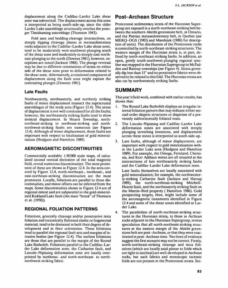
S.L. JACKSON ei al.
displacement along the Cadillac-Larder Lake shear zone was subvertical. The displacement across this zone is interpreted as being south-side-up, since the older Larder Lake assemblage structurally overlies the youn ger Timiskaming assemblage (Thomson 1943).
Fold axes and bedding-cleavage intersections, on steeply dipping cleavage planes in metasedimentary rocks adjacent to the Cadillac-Larder Lake shear zone, tend to be moderately west-southwest-plunging south of the shear zone and moderately to steeply east-north east-plunging to the north (Downes 1981); however, ex ceptions are noted (Jackson 1988). The plunge reversal may be due to different orientations of strata on either side of the shear zone prior to deformation related to the shear zone. Alternatively, a rotational component of displacement along the fault zone might explain the contrasting plunges (Downes 1981).
Late FaultsNorthwesterly, northeasterly, and northerly striking faults of minor displacement transect the supracrustal assemblages of the study area (Figure 12.4). The sense of displacement is not well constrained for all the faults; however, the northeasterly striking faults tend to show sinistral displacement. In Hearst Township, north- northeast-striking to northeast-striking and north- northwest-striking faults are numerous (see Figure 12.4). Although of minor displacement, these faults are important with respect to localization of gold mineral ization (Hodgson and Hamilton 1989).
AEROMAGNETIC DISCONTINUITIESCommercially available 1:50000 scale maps, of calcu lated second vertical derivative of the total magnetic field, reveal numerous discontinuities. The most promi nent of these are shown in Figure 12.4. In the area cov ered by Figure 12.4, north-northeast-, northeast-, and east-northeast-striking discontinuities are the most prominent. Locally, foliations are parallel to these dis continuities, and minor offsets can be inferred from the maps. Some discontinuities shown in Figure 12.4 are of regional extent and are subparallel to the gold-mineral ized Kirkland Lake fault (the main "break" of Thomson et al. (1950)).
REGIONAL FOLIATION PATTERNSFoliations, generally cleavage and/or penetrative mica foliation and tectonically flattened clastic or fragmental material, tend to be domainal in both their degree of de velopment and in their orientation. These foliations tend to parallel the regional fault sets and margins of in trusive bodies (see Figure 12.4). The earliest foliations are those that are parallel to the margin of the Round Lake Batholith. Foliations parallel to the Cadillac-Lar der Lake deformation zone, the Catharine fault, and Lincoln-Nipissing deformation zone are locally over printed by northeast- and north-northeast- to north- northwest-striking fabric.
Post-Archean StructureProterozoic sedimentary strata of the Huronian Super group are exposed in a north-northeast-striking belt be tween the southern Abitibi greenstone belt, in Ontario, and the Pontiac metasedimentary belt, in Quebec (see MERQ-OGS (1983) and Mandziuk (1980) for descrip tion of units). The distribution of the Proterozoic rocks is controlled by north-northeast-striking structures. The western margin of the Huronian strata is, in part, de fined by north-northeast-striking faults. In addition, an open, gently south-southwest-plunging regional sync line was mapped in the Huronian Supergroup in McFad- den and Rattray townships (see Figure 4). Strata gener ally dip less than 15" and no penetrative fabrics were ob served lobe related to this fold. The Huronian strata are also cut by northwesterly striking faults.
SUMMARYThis year's field work, combined with earlier results, has shown that:1. The Round Lake Batholith displays an irregular in
ternal foliation pattern that may indicate either sec ond-order diapiric structures or diapirism of a pre viously subhorizontally foliated mass.
2. The Lincoln-Nipissing and Cadillac-Larder Lake deformation zones are associated with steeply plunging stretching lineations, and displacement across these zones is interpreted as south-side-up.
3. Late faults, although of minor displacement, are important with respect to gold mineralization with in the Larder Lake area (Hodgson and Hamilton 1989). For example, the Omega, Fernland, Chemi- nis, and Kerr Addison mines are all situated at the intersections of late northeasterly striking faults and the Cadillac-Larder Lake deformation zone.Late faults themselves are locally associated with gold mineralization; for example, the northwester ly-striking Catharine fault (Jackson and Harrap 1989), the north-northeast-striking Mitchell- Hearst fault, and the northeasterly striking fault on the Martin-Bird property ( Hamilton 1986). Gold prospecting targets, then, might include some of the aeromagnetic lineaments identified in Figure 12.4 and some of the shear zones identified at Lar der Lake.
4. The parallelism of north-northeast-striking struc tures in the Huronian strata, to those in Archean rocks adjacent to the Huronian Supergroup, invites speculation that all north-northeast-striking struc tures at the eastern margin of the Abitibi green stone belt are post-Archean, or that they were reac tivated in post-Archean time. Two lines of evidence suggest the first scenario may not be correct. Firstly, north-northeast-striking cleavage and mica foli ations (which are locally axial planar to folds which are tight to isoclinal) are well-developed in Archean rocks, but such fabrics and mesoscopic tectonic folds are not present in the Proterozoic strata. See-
83
PRECAMBRIAN (12)
ondly, some north-northeast-striking faults in the Archean rocks are intensely foliated, carbonatized, and gold-mineralized and, thus, are assumed to be of Archean age. The parallel north-northeast-strik ing Late Archean structures and those in the Prot erozoic strata might, alternatively, be explained by reactivation of Archean structure beneath the Prot erozoic sedimentary cover.
5. Foliations are domainal and tend to be subparallel to regional faults or the margins of large intrusive bodies.
6. The McElroy and Larder Lake assemblages, sepa rated by the Lincoln-Nipissing shear zone, contain some similar types of rocks, but in substantially dif ferent proportions. The structural style of the two assemblages also differs. Future work will address possible relationships between the two assem blages.
ASSOCIATED WORKC.T. Kimmerly is conducting an MSc thesis (Brock Uni versity, St. Catharines, Ontario) on the petrology of the McElroy and Larder Lake assemblages, with an aim to characterizing and comparing the rocks and their geo chemistry. Detailed study of the structural evolution of the Round Lake Batholith margin and the adjacent highly deformed supracrustal rocks will be conducted by R.M. Harrap (PhD thesis, Queen's University, King ston, Ontario).
ACKNOWLEDGEMENTSS. Kakko and E. Lau are thanked for their assistance in the field. The staff of the Resident Geologist's office in Kirkland Lake (especially F. Boucher, G. Grabowski, and G. Meyer) is thanked for logistical support and dis cussions. The Berries are thanked for their technical support during mapping of the Huronian strata.
REFERENCESAbraham, E.M. 1951. Geology of McElroy and part of Boston town
ships; Ontario Department of Mines, Annual Report, 1950, v.59, pt.6, p. l-66.
Corfu, R, Krogh.TE., Kwok, Y.Y. and Jensen, L.S. 1989. U-Pb zircon geochronology in the southwestern Abitibi greenstone belt, Su perior Province; Canadian Journal of Earth Sciences, v.26, p.1747-1763.
Cooke, D.L. and Moorehouse, W.W. 1969. Timiskaming volcanism in the Kirkland Lake area, Ontario, Canada; Canadian Journal of Earth Sciences, v.6, p.117-132.
Downes, M.J. 1981. Structural and stratigraphic aspects of gold min eralization in the Larder Lake area, Ontario; Ontario Geological Survey, Miscellaneous Paper 97, p. 66-70.
Grant, J.A. 1963. Geology of Catharine and Marter townships, Dis trict of Timiskaming; Ontario Department of Mines, Geological Report 18, 20p.
Hamilton, J.V 1983. Geological study of the area of the Kirkland Lake-Larder Lake break in central McGarry Township; in Sum mary of Field Work 1983, Ontario Geological Survey, Miscella neous Paper 116, p. 179-184.
1986. The structural and stratigraphic setting of gold mineral ization in the vicinity of Larder Lake, south-central Abitibi greenstone belt, northeastern Ontario; unpublished MSc thesis, Queen's University, Kingston, Ontario.
Hamilton, J.V and Hodgson C.J. 1984. Structural geology and gold mineralization in the Kirkland Lake-Larder Lake deformation zone; in Summary of Field Work 1984, Ontario Geological Sur vey, Miscellaneous Paper 119, p.220-225.
Hewitt, D.F. 1951. Geology of Skead Township, Larder Lake area; Ontario Department of Mines, Annual Report, 1949, v.58, pt.6, p.1-4 3.
Hodgson, C.J. and Hamilton, J.V. 1989. Gold mineralization in the Abitibi greenstone belt: end stage result of Archean collisional tectonics?; in The Geology of Gold Deposits: The Perspective in 1988, Economic Geology, Monograph 6, p.86-100.
Hodgson, C.J., Hamilton, J.V. and Guimond, R.P in preparation. Re lationship between gold deposits and the tectonic framework of the Abitibi greenstone belt in the Kirkland Lake-Larder Lake area; Ontario Geological Survey, Open File Report.
Hyde, R.S. 1980. Sedimentary facies in the Archean Timiskaming Group and their tectonic implications, Abitibi greenstone belt, northeastern Ontario, Canada; Precambrian Research, v.12, p.161-195.
Jackson, S.L. 1988. The Abitibi greenstone belt near Larder Lake: structural and stratigraphic studies; in Summary of Field Work and Other Activities 1988, Ontario Geological Survey, Miscella neous Paper 141, p.206-211.
Jackson, S.L. and Harrap, R.M. 1989. Geology of parts of Pacaud, Ca tharine, and southernmost Boston and McElroy townships; in Summary of Field Work and Other Activities 1989, OntarioGeo- logical Survey, Miscellaneous Paper 146, p.125-131.
Jensen, L.S. 1985. Synoptic mapping of the Kirkland Lake-Larder Lake areas, District of Timiskaming; in Summary of Field Work and Other Activities 1985, Ontario Geological Survey, Miscella neous Paper 126, p. 112-120.
Jensen, L.S. and Langford, F.F. 1985. Geology and petrogenesis of the Archean Abitibi greenstone belt in the Kirkland Lake area, On tario; Ontario Geological Survey, Miscellaneous Paper 123, 130p.
Lafleur, P J. 1986. The Archean Round Lake Batholith, Abitibi green stone belt: a synthesis; unpublished PhD thesis, University of Ot tawa, Ottawa, Ontario, 245p.
Lawton, K.D. 1959. Geology of Boston Township and part of Pacaud Township; Ontario Department of Mines, Annual Report, 1957, v.66, pt.5, p.1-55.
Mandziuk, Z.L. 1980. Geology of McFadden and Rattray townships, District of Timiskaming; Ontario Geological Survey, Report 204, 49p.
Ministere de 1'Energie et des Ressources-Ontario Geological Survey 1983. Lithostratigraphic map of the Abitibi Subprovince; Ontar io Geological Survey-Ministere de 1'Energie et des Ressources, Quebec; Map 2484 in Ontario and Dv 83-16 in Quebec, scale 1:1000000.
Ontario Geological Survey. 1979. Airborne electromagnetic and total intensity magnetic survey, Kirkland Lake area, District of Timis kaming; Ontario Geological Survey, Preliminary Maps P2271 to P2267, scale 1:20 000.
Schwerdtner, W.M., Sutcliffe, R.H. andTroeng, B. 1978. Patterns of total strain in the crestal region of immature diapirs; Canadian Journal of Earth Sciences, v.15, p.1437-1447.
Schwerdtner, W.M., Stone, D., Osadetz, K., Morgan, J. and Stott, G.M. 1979. Granitoid complexes and the Archean tecton ic record in the southern part of northwestern Ontario; Canadian Journal of Earth Sciences, v.16, p. 1965-1977.
Talbot, C.J. and Jackson, M.P. 1987. Salt tectonics; Scientific Ameri can, v.257, no.2, p.70-79.
Thomson, J.E. 1943. Geology of McGarry and Mcvittie townships, Larder Lake area; Ontario Department of Mines, Annual Re port, 1941, v.50, pt.7, p.1-99.
84

S.L. JACKSON et al.
— 1946. The Keewatin-Timiskaming unconformity in the Kirk- Toogood, D.J. and Hodgson, C.J. 1985. A structural investigation be-land Lake District; Transactions of the Royal Society of Canada, tween the Kirkland and Larder Lakes gold camps; in GeoscienceSection IV, p.113-124. Research Grant Program, Summary of Research 1984-1985,On-
1949. Geology of Hearst and Mcfadden townships; Ontario *ario Geological Survey, Miscellaneous Paper 127, p.200-205.Department of Mines, Annual Report, 1947, v.56, pt.8, p.1-34.
Thomson,I.E., Charlewood, G.H.,Griffin,K.,Hawley, I.E.,Hopkins, 1986 - Relationship between gold deposits and the tectonic H., Macintosh, C.G., Ogrizlo, S.P., Perry, O.S. and Ward, W. framework of the Abitibi greenstone belt m the Kirkland Lake- 1950. Geology of the main ore zone at Kirkland Lake; Ontario Larder Lake area; in Geoscience Research Grant Program, Sum- Department of Mines, Annual Report, 1948, v.57, pt.5, mary of Research 1985-1986, Ontario Geological Survey, Mis- p.54-188. cellaneous Paper 130, p.79-86.
85
13. Project Unit 88-06. Deformation and Associated Auriferous Quartz Veining in Keith Township, Northern Swayze Belt
G. M. Siragusa
Geologist, Precambrian Geology Section, Ontario Geological Survey.
INTRODUCTIONThe field work in Keith Township (Figure 13.1) reported here is part of an ongoing study of the gold mineraliza tion in the Swayze belt (Siragusa 1988,1989). This work consisted of mapping a recently stripped outcrop area east of the Joburke Mine, at a scale of 1:250, and sam pling the area for a lithogeochemical study. Reconnais sance visits to other localities in the area were also car ried out.
GENERAL GEOLOGICAL SETTINGThe area of detailed work, and the other localities vis ited during the 1990 field season, are within a west-trending strip of land which is roughly 3 km wide and extends from the eastern boundary of Keith Town ship, through MacKeith Lake, to a point approximately 5 km west of the lake. Previous work by Prest (1951) indi cates that:1. The northern half of this area is underlain by mafic
metavolcanic rocks containing numerous elongate, broadly east-striking units of mafic to ultramafic in trusive rocks, clastic metasedimentary rocks and iron formation.
2. The southern part of the map area is underlain by west-striking intermediate to felsic metavolcanic rocks forming a prominent unit intermittently ex posed on the south side of MacKeith Lake.
3. All these units are affected by several faults which are strike-parallel west of MacKeith Lake, and in tersect the units at low angles east of the lake (Prest 1951, Map 1950-4).
The Joburke Mine, which is located within the metavol canic rocks south of MacKeith Lake, produced approxi mately 512 kg (16467 ounces) of gold (Gordon et al. 1979). The mine is now flooded. A photomicrograph of a polished section of ore from this mine, from a sample collected and studied by Sage (Thurston et al. 1977, p. 210), shows that the gold occurs in pyrite.
DETAILED WORKThe mapped clearing, henceforth referred to as the map area, has an elongate, southeast-trending outline with length and maximum width of approximately 400 m and 140 m, respectively. It includes the Hoodoo prospect (Gordon et al. 1979), close to the southeastern end of the area, and the Patricia showing, the site of a gold dis covery made in 1987, at the opposite end of the area.
Figure 13.1.Localion map of the Keith Township area, scale 1:1 013 760.
86

G.M. SIRAGUSA
Data on the ore grades of the Patricia showing were summarized by Luhta et al. (1989, p.258, "Marshall Min erals Corporation"). Apparently, in the summer of 1990, no exploration was carried out in the map area by mining companies. A large part of the Patricia showing was cov ered by a pond about 75 by 58 m in size, and smaller bodies of water covered other parts of the area. Evi dence of recent exploration included several drill holes collared around the Patricia showing, shallow trenches and test pits made to investigate quartz-carbonate vein- ing in other parts of the map area, and piles of mineral ized rock close to the Patricia showing and Hoodoo pros pect. In some places, mapping was hindered by the pres ence of blasting rubble, which was particularly abundant at the Hoodoo prospect.
The map area is lithologically simple and structural ly complex. It is underlain by variably deformed and car- bonatized tholeiitic basalt of greenschist facies meta morphic rank, and intruded by pretectonic or syntecton ic felsic porphyry dikes which are commonly quartz and feldspar porphyritic. Primary features include vesicles (common), and locally recognizable chloritized pillow margins. The basalt is host to quartz-carbonate veins, some of which are sulphide-bearing (pyrite, chalcopy rite) and auriferous. Pyrite cubes and dodecahedra up to 2 cm in size also occur in sheared carbonatized basalt ad jacent to some quartz-carbonate veins.
The structural complexity reflects tectonism rang ing from moderate, through intense, to extreme defor mation of the basalt and the porphyry dikes that in truded it. Fracturing, of presumably local nature, is also present. Tectonism produced a northwest-striking, 90 m wide ductile deformation zone which extends through out the length of the map area and dips steeply to the northeast. Clockwise deflection of prominent porphyry dikes in the northwestern parts of the map area indi cates a dextral component of horizontal slip. In broad terms, the strain increases from southwest to northeast across this zone, and the higher the strain, the greater are the extent and pervasiveness of carbonatization. The frequency, size, and distribution of the quartz-car bonate veins vary, depending on the intensity of defor mation.
Moderate DeformationModerate deformation is characteristic of a relatively narrow central zone in the map area. It is typified by slightly carbonatized, subvertical fractures which are generally more obvious on weathered surfaces because of preferential erosion of the carbonates. Although the fractures may follow different trends, two dominant sets are usually present. Each set comprises rectilinear, sub- parallel fractures: the angle at which the two dominant sets intersect is commonly less than 50 0 . This results in a variably pronounced rhomb-like fracture pattern ori ented so that its bisector tends to be parallel to the northwest strike of the deformation zone. Less common curviplanar fractures, the result of merging of subordi nate into prominent sinuous fractures, mimic the atti
tude of the folds with which they are closely associated. Thin carbonate veinlets, hosted by the fractures, are commonly disharmonically crenulated, reflecting con tinued adjustment after the initial fracturing and carbo natization of the basalt. In most cases, little quartz vein- ing is associated with this (brittle) mode of deformation.
Intense deformationIntense deformation is characterized by generally sub- vertically plunging, metre-sized (mesoscopic) tight folds, associated minor folds of complex geometry, and locally conspicuous associated quartz veining. Strongly carbonatized felsic porphyry dikes, or distorted dike rel ics, are invariably present at the core, or along the limbs, of the mesoscopic folds. Ductile deformation of the por phyry dikes is manifested by narrowed dike tips that can be sinuous or wispy, so as to merge imperceptibly with the quartz-carbonate veins associated with this defor mation state. Folds exhibiting such features can be found only a few metres from fractured basalt, thus indi cating a relatively abrupt change from brittle to ductile deformation. Ductility contrast between the porphyry dikes and basalt, combined with locally intensified car bonatization, may account for this change in deforma tion conditions.
The quartz veining associated with intense defor mation comprises complex quartz-carbonate clusters mainly confined to subsidiary plications; small en echelon veins patterned after hinges or limbs of folds; and, less commonly, pinnate veining stemming from veins sub normal to fold limbs. In general, both the numbers, widths and traceability of the veins associated with this mode of deformation decrease significantly with in creasing distance from the folds. Sulphide-bearing quartz veins, up to 80 cm thick, thin out within distances of up to about 50 m.
No assay data are yet available from samples of these veins collected in the exposed part of the Patricia showing, the Hoodoo prospect, and other places be tween these occurrences. However, if these veins prove to have higher gold values, it indicates that the forma tion of quartz veins of potential economic interest likely peaked with the development of mesoscopic folding, not afterward. That is, although quartz vein formation con tinued with progressive deformation, quartz veins hosted by early folds could have been affected by shear ing associated with subsequent extreme deformation. Field evidence consistent with this possibility comprises a few three-dimensional exposures of subsidiary folds which are disrupted by axial-plane shearing that af fected the folds horizontally, as well as vertically.
Extreme DeformationExtreme deformation is characterized by: 1) intense de velopment of foliation; 2) overall parallelism of foli ation, quartz veining, and porphyry dikes, where por phyry and/or quartz are present; and 3) pervasive carbo natization, such that (formerly green) basalt and (for merly light grey) porphyry were rendered a red-
87
PRECAMBRIAN (13)
dish-brown colour (ankerite) on both the weathered and fresh surfaces. At this strain state, carbonatization ap pears to have acted as a tectonic lubricant which, in some cases, contributed to the development of unusual deformational features. For example, the southern tip of a northwest-striking porphyry dike was deflected backward 180" so as to abut against, and be re-attached to, the main body of the dike. The resulting shape is that of a dike ending with a closed, elongate loop. As indi cated by north-plunging S-type drag folds in adjacent ba salt, the loop originated from east-side-up drag of the tip of the dike. In this and other cases, fragments of basalt were completely enclosed by deformed porphyry, so as to appear as oddly shaped inclusions within the latter.
The quartz veins associated with extreme deforma tion are typified by arrays of subparallel quartz-carbon ate veinlets and small lenses, so closely spaced that hundreds of them can occur in a cross-strike section of a few metres. While individually these veinlets are ob viously of no interest, their number, as well as the rela tively predictable trend of the arrays, justify testing. Part of the present sampling program was designed to assess the gold potential of this type of quartz vein.
Later Brittle DeformationLater brittle deformation is shown by an unusually straight main fracture which occurs near the Hoodoo prospect. The fracture trends 270", dips 82 0 N, and was intruded by a lamprophyre dike. Only about 50 cm of dextral horizontal displacement is associated with this fracture. Other possible late fractures, some of which are filled by quartz veins, dip shallowly to the south and southeast (e.g., Hoodoo prospect). At one locality, east of the Hoodoo prospect, subvertical quartz veins are cut by a south-dipping (8 0 to 12") fracture, also filled by a quartz vein. Slight drag folding of the subvertical veins indicates south-side-down displacement along the frac ture. It is not known if these subhorizontal fractures sig nificantly offset the earlier, subvertical quartz veins.
RECONNAISSANCE VISITSFigure 13.2 shows the locations of areas visited in a re connaissance fashion. All these areas are sites of recent surface work, but no active exploration was noted during the summer of 1990. The lithologic and structural fea tures observed at localities l to 5 represent a 1.5 km sec tion across the strike of a regionally extensive deforma tion zone, called the Keith-Penhorwood Zone (KPZ).
Locality 1The long segment of this L-shaped area trends east, is 160 m long, and has a uniform width of about 20 m. The short segment of the "l!' is a flooded, north-trending trench approximately 95 m long and 14 m wide. De formed and carbonatized felsic metavolcanic rocks are exposed along the east-trending segment of the clear ing. Deformation is manifested as rhomb-like fractures
of the type previously described, foliation, localized shearing, and localized folding. The trend of the acute bisector of the fracture pattern is 284' to 293', parallel to the strike of steeply north-dipping foliation in the area. A subvertically dipping shear zone, about 40 cm wide and striking 304 e , occurs at the west end of the clearing. Remnants of a few tight folds occur at the east end of the clearing, near a strongly carbonatized, sinu ous, felsic porphyry dike. The best preserved structure is an 80 cm wide Z-fold which plunges 75" to the north west. This fold contains quartz veins which carry dis seminated pyrite and chalcopyrite, and indicates that quartz veining is associated with south-side-up drag of the felsic metavolcanic rocks.
Assays of quartz from this, and the next, locality (lo cality 2) were reported to have returned high gold values (G. Ross, Prospector, personal communication, 1990).
Locality 2The workings found in this location comprise a large clearing, excavations, and deep trenches in terrain slop ing gently eastward. Outcrops are poorly exposed due to blasting and abundance of rubble. Small outcrops, near the eastern edge of the clearing, consist of a fractured and sheared plagioclase porphyritic grey rock, inter preted as being andesite; an east-striking porphyry dike bending southward; and minor dark green, chlo- rite-hornblende schist. The schist strikes east and dips subvertically. The andesite is carbonatized, but signifi cantly less so than the porphyry dike. The presence of tight folding is indicated by the bend of the porphyry
Figure 13.2. Sketch map showing locations of areas mentioned in the text. The solid circle (M.A.) indicates the approximate centre of the area of detailed mapping and sampling. Circles LI to L6 are the ap proximate centres of the localities covered by reconnaissance visits. Solid, thick lines represent good quality, gravel roads.
88
G.M. SIRAGUSA
dike, by shearing in the host andesite, and by the attitude LOC31 ItV 4 of quartz-carbonate veins. Gossan is locally present, particularly in quartz, but no visible sulphide mineral ization occurs in these outcrops. The collars of 7 drill holes, 4 south-dipping and 3 north-dipping, were noted near these outcrops.
One outcrop, approximately 120 m north of the ex posures just mentioned, consists of a quartz synform, with an east-striking axial plane, which is about 4 m wide; it is rimmed by a narrow envelope of carbonatized basalt, affected by paper-thin shearing. Based on the at titude of lineation in the basalt, the synform plunges westward at 55 ' . The width of quartz is 10 to 20 cm in the nose of the synform and is up to about l m on both limbs, due to the presence of complex subsidiary folding. A quartz vein, up to 90 cm wide and curved so as to parallel the northern limb of the synform, occurs a few metres east of the latter. Possibly, this vein also extends on the south side of the synform, beneath the overburden. The exposed geometry suggests the presence of east-striking synformal en echelon veins dipping west. As in the pre vious case, no sulphide mineralization is visible, but gos san is present.
Locality 3The subvertically dipping rocks found here are exposed across a width of about 30 m. The units may strike 300", although this is uncertain because of interference from magnetite-bearing iron formations. From south to north, the series comprises: 1) andesite, 2) lapilli tuff, 3) iron formation interbedded with lapilli tuff, 4) felsic pyroclastic breccia, 5) iron formation, and 6) andesitic breccia.
The felsic breccia (unit 4, above) contains subangu lar to lens-like clasts (up to 1.7 by 4.3 m) of felsic meta- volcanic rocks, and subordinate chert, iron formation, and quartz clasts in an andesitic matrix. The volume of clasts far exceeds the volume of matrix. Weathering of pyrite and chalcopyrite, which are disseminated mainly in the matrix, has produced a gossan which is noticeably more intense in the western part of the breccia outcrop.
The andesitic breccia (unit 6, above) is similar to this felsic breccia, except that the volume of matrix exceeds that of the clasts. The strain in this area appears to have been relatively low, and mainly confined to sinistral drag along the iron formation units. Apart from some possi bly flattened clasts, strain is manifested by vertically plunging, drawn out, S-folds developed in the iron for mation units.
A vein of bluish quartz occurring at, and close to, the contact between andesite and lapilli tuff (units l and 2, above) pinches out to the east. It most likely pinches out westward as well, although this is not a certainty due to overburden. The vein is unusually straight, at least 27 m long, and up to l m thick. It contains disseminated, and locally abundant, massive stringers of fine-grained pyrrhotite, chalcopyrite, and pyrite.
At this locality, a small outcrop of serpentinite is ex posed on the east side of a south-trending flooded trench. The outcrop, as well as the abundant rubble par tially covering it, is slightly gossanous. This gossan does not extend to other small outcrops of white-weathering serpentinite a few metres east of the trench. The ser pentinite is textured by (unidentified) phenocrysts which have a purple colour and are up to 2 mm in size.
Locality 5The exposure found here is a narrow outcrop, about 25 by 9 m in size, on the north side of a west-trending, flooded trench bending northward at its west end. Abundant blasting rubble has been left on the north side of the outcrop.
The outcrop consists of an intensely deformed con tact zone between basalt and a 3 to 4 m thick interbed of felsic metavolcanic rock. Deformation, best exposed at the water's edge on the west side of the outcrop, is mani fested as a Z-fold with an axial plane which strikes 306 0 , and dips 75" to the northwest. Congruent subsidiary folds of the felsic metavolcanic rock occur in the south ern limb of this structure. The northern limb of the fold is severed by a narrow shear which is subvertically dip ping, and strikes 290 0 . These conditions point to south-side-up drag followed by axial plane shearing.
The folded metavolcanic rocks are affected by irreg ularly distributed gossans, formed by the weathering of disseminated pyrite and chalcopyrite. A few quartz veins and short quartz lenses occur, but are mainly confined to the felsic unit.
Locality 6Recent exposures south of MacKeith Lake, including several clearings and trenches, were briefly examined. Sheared and carbonatized felsic metavolcanic rocks oc cur in some of these exposures, similar in style to those observed in the map area. This suggests that the out crops at all localities may lie within the same structural zone. Some gold values are reported from this locality (P. Cooper, Noranda Exploration Company Limited, personal communication, 1990).
CONCLUSIONSBased on field observations in Keith Township, ductile shearing, folding, faulting and pervasive carbonatiza tion are the principal characteristics of a large deforma tion zone which is largely covered by overburden. At the large scale, the deformation zone strikes easterly, but its strike is variable due to gentle megascopic flexures. The total width of the deformation zone is unknown. Field data from the map area and other localities suggest that the deformation zone consists of a central subzone of higher strain and carbonatization up to about 90 m in width, which is flanked by similar, but narrower, outer deformation subzones. It is not known if the width of the
89
PRECAMBRIAN (13)
central subzone is persistent, or if the outer subzones parallel or splay from the central subzone.
The deformation zone extends for at least 1.5 km west of the map area and for an unknown distance east ward. Along strike from the rrjap area: 1) an east-striking area of carbonatization occurs at the boundary of Keith and Penhorwood townships ( Prest 1951, Map 1950-4); and 2) intense carbonatization and shearing occur in the Jehann Lake area of Penhorwood Township (Milne 1972). In a broader regional context, it should be noted that east-striking faults in the adjacent Kukatush-Se- well lakes area could be manifestations of the Destor- Porcupine fault zone (Milne 1972), to which the Keith- Penhorwood deformation zone (KPZ) may be related. The Joburke, Patricia, and Hoodoo gold occurrences are within the KPZ which, quite possibly, is also the setting of lead-silver-copper-gold mineralization south of Prim er Lake in Penhorwood Township (Milne 1972).
The map area represents a short segment of the KPZ underlain principally by basalt. In this area, ductil ity contrast between basalt and felsic porphyry dikes ap pears to have been the condition that triggered the de velopment of localized mesoscopic folding and complex plications hosting auriferous quartz veins. During pro gressive deformation, the porphyry dikes were variably folded, transposed and disrupted; and, apparently, the partial or total obliteration of the dikes reduced the ten dency of basalt to react to further deformation by fold ing. Thus, in broad terms, where there is no porphyry, there are no mesoscopic folds and, hence, no individual quartz veins of significant size.
Reconnaissance visits to other localities near the map area have indicated that, within the KPZ, there are mafic, felsic, and pyroclastic metavolcanic rocks, as well as iron formation and ultramafic rocks. Conceivably, quartz veining related to ductility contrast between dif ferent rock types could be more persistent along the strike of regional shearing, or along the limbs of folds resulting from such shearing, than quartz veining asso ciated with deformation of porphyry dikes that are com monly less than l m thick. This inference is consistent
with the presence of diverse rock types in the Joburke Mine area, i.e., mafic and felsic metavolcanic rocks, and with the fact that this mine is a past producer. The map area, however, being underlain by only one supracrustal type, i.e., basalt, is atypical of the KPZ. Also, at the Jo burke Mine, auriferous, east-plunging, S-type quartz folds are hosted by west-plunging, Z-folded metavol canic rocks (Prest 1951, p.36), but no consistent relation ships of this kind occur in the map area.
In essence, the lithologic and structural features of the map area represent a set of specific conditions that resulted in gold mineralization. Other potentially fa vourable conditions may occur along the KPZ. Addi tional detailed work in Keith and Penhorwood town ships is needed to better assess this deformation zone.
REFERENCESGordon, J.B., Lovell, H.L., de Grijs, J. and Davie, R.F. 1979. Gold
Deposits of Ontario, part 2: part of District of Cochrane, districts of Muskoka, Nipissing, Parry Sound, Sudbury, and Timiskaming, and counties of southern Ontario; Ontario Geological Survey, Mineral Deposits Circular 18, 25 3p.
Luhta, L.E., Sangster, P.J., Draper, D.M., Ireland, J.C., Bradshaw, M.P. and Hamblin, C.D. 1989. Timmins Resident Geologist's District-1988; m Report of Activities 1988, Resident Geolo gists, Ontario Geological Survey, Miscellaneous Paper 142, p.219-265.
Milne, V.G. 1972. Geology of the Kukatush-Sewell Lake area, District of Sudbury; Ontario Division of Mines, Geological Report 97, 116p.
Prest, V.K. 1951. Geology of the Keith-Muskego townships area; On tario Department of Mines, Annual Report, 1950, v.59, pt.7, p. 1-44.
Siragusa, G.M. 1988. Geological setting of gold mineralization in the southern Swayze belt; in Summary of Field Work and Other Acti vities 1988, Ontario Geological Survey, Miscellaneous Paper 141, p.222-225.
1989. The geological setting of gold mineralization in the Hor wood lake area of the Swayze belt; in Summary of Field Work and Other Activities 1989, Ontario Geological Survey, Miscella neous Paper 146, p.132-135.
Thurston, P.C., Siragusa, G.M. and Sage, R.P. 1977. Geology of the Chapleau area, districts of Algoma, Sudbury, and Cochrane; Ontario Division of Mines, Geological Report 157, 293p.
90
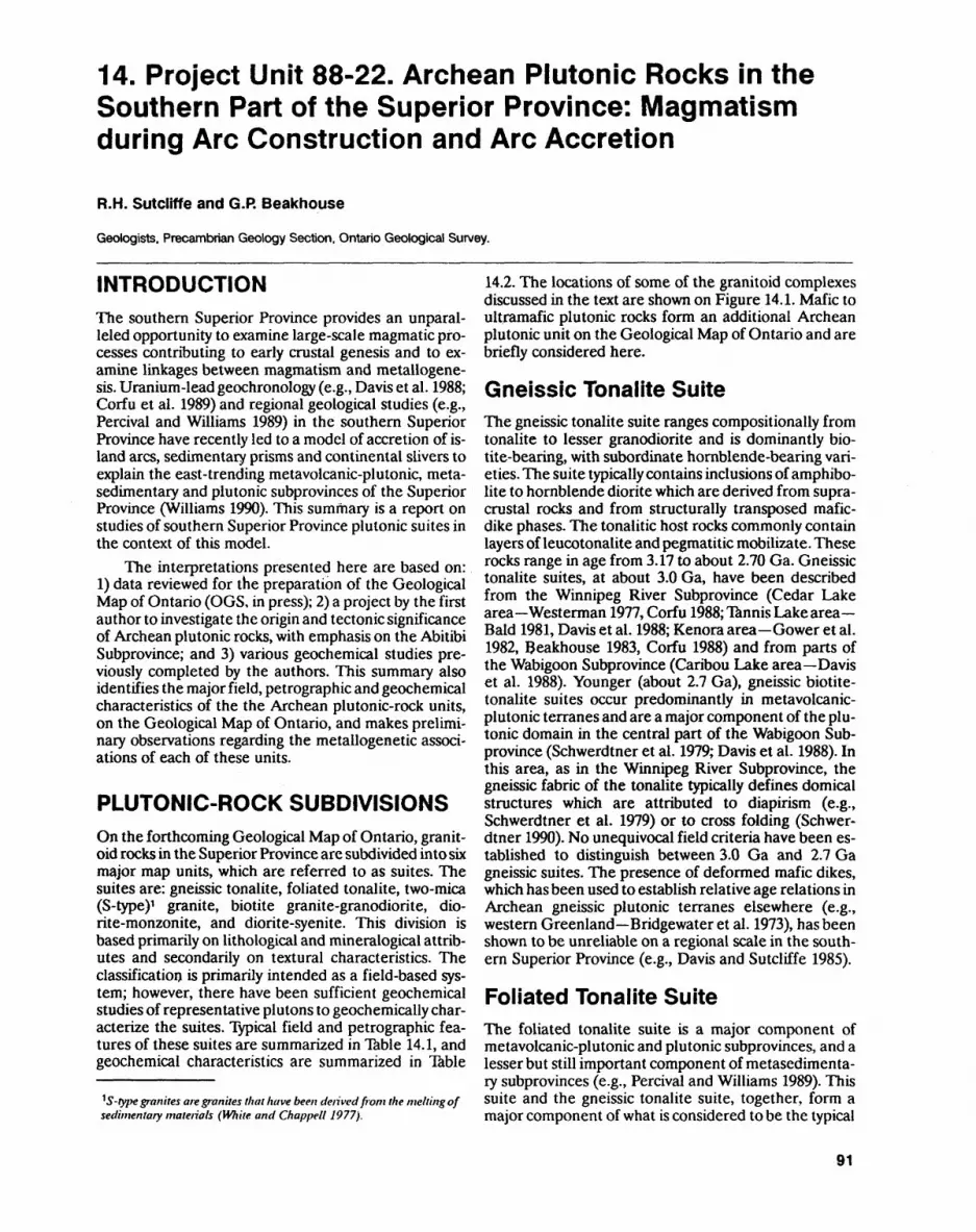
14. Project Unit 88-22. Archean Plutonic Rocks in the Southern Part of the Superior Province: Magmatism during Arc Construction and Arc Accretion
R.H. Sutcliffe and G.R Beakhouse
Geologists. Precambrian Geology Section. Ontario Geological Survey.
INTRODUCTIONThe southern Superior Province provides an unparal leled opportunity to examine large-scale magmatic pro cesses contributing to early crustal genesis and to ex amine linkages between magmatism and metallogene- sis. Uranium-lead geochronology (e.g., Davis et al. 1988; Corfu et ai. 1989) and regional geological studies (e.g., Percival and Williams 1989) in the southern Superior Province have recently led to a model of accretion of is land arcs, sedimentary prisms and continental slivers to explain the east-trending metavolcanic-plutonic, meta- sedimentary and plutonic subprovinces of the Superior Province (Williams 1990). This summary is a report on studies of southern Superior Province plutonic suites in the context of this model.
The interpretations presented here are based on: 1) data reviewed for the preparation of the Geological Map of Ontario (OGS, in press); 2) a project by the first author to investigate the origin and tectonic significance of Archean plutonic rocks, with emphasis on the Abitibi Subprovince; and 3) various geochemical studies pre viously completed by the authors. This summary also identifies the major field, petrographic and geochemical characteristics of the the Archean plutonic-rock units, on the Geological Map of Ontario, and makes prelimi nary observations regarding the metallogenetic associ ations of each of these units.
PLUTONIC-ROCK SUBDIVISIONSOn the forthcoming Geological Map of Ontario, granit oid rocks in the Superior Province are subdivided into six major map units, which are referred to as suites. The suites are: gneissic tonalite, foliated tonalite, two-mica (S-type)1 granite, biotite granite-granodiorite, dio- rite-monzonite, and diorite-syenite. This division is based primarily on lithological and mineralogical attrib utes and secondarily on textural characteristics. The classification is primarily intended as a field-based sys tem; however, there have been sufficient geochemical studies of representative plutons to geochemically char acterize the suites. Typical field and petrographic fea tures of these suites are summarized in Table 14.1, and geochemical characteristics are summarized in Table
1 S-type granites are granites that have been derived from the melting of sedimentary materials (White and Chappell 1977).
14.2. The locations of some of the granitoid complexes discussed in the text are shown on Figure 14.1. Mafic to ultramafic plutonic rocks form an additional Archean plutonic unit on the Geological Map of Ontario and are briefly considered here.
Gneissic Tonalite SuiteThe gneissic tonalite suite ranges compositionally from tonalite to lesser granodiorite and is dominantly bio- tite-bearing, with subordinate hornblende-bearing vari eties. The suite typically contains inclusions of amphibo lite to hornblende diorite which are derived from supra crustal rocks and from structurally transposed mafic- dike phases. The tonalitic host rocks commonly contain layers of leucotonalite and pegmatitic mobilizate. These rocks range in age from 3.17 to about 2.70 Ga. Gneissic tonalite suites, at about 3.0 Ga, have been described from the Winnipeg River Subprovince (Cedar Lake area Westerman 1977, Corfu 1988;Tannis Lake area- Bald 1981, Davis et al. 1988; Kenora area Gower et al. 1982, Beakhouse 1983, Corfu 1988) and from parts of the Wabigoon Subprovince (Caribou Lake area Davis et al. 1988). Younger (about 2.7 Ga), gneissic biotite- tonalite suites occur predominantly in metavolcanic- plutonic terranes and are a major component of the plu tonic domain in the central part of the Wabigoon Sub province (Schwerdtner et al. 1979; Davis et al. 1988). In this area, as in the Winnipeg River Subprovince, the gneissic fabric of the tonalite typically defines domical structures which are attributed to diapirism (e.g., Schwerdtner et ai. 1979) or to cross folding (Schwer dtner 1990). No unequivocal field criteria have been es tablished to distinguish between 3.0 Ga and 2.7 Ga gneissic suites. The presence of deformed mafic dikes, which has been used to establish relative age relations in Archean gneissic plutonic terranes elsewhere (e.g., western Greenland Bridgewater et al. 1973), has been shown to be unreliable on a regional scale in the south ern Superior Province (e.g., Davis and Sutcliffe 1985).
Foliated Tonalite SuiteThe foliated tonalite suite is a major component of metavolcanic-plutonic and plutonic subprovinces, and a lesser but still important component of metasedimenta- ry subprovinces (e.g., Percival and Williams 1989). This suite and the gneissic tonalite suite, together, form a major component of what is considered to be the typical
91
PRECAMBRIAN (14)
:. v. .Grenville -.-. .1 . . •.'.~. Province.•.'.•y.'.•. -
Figure 14.1 .Subprovincesof the Superior Province (Card and Ciesielski 1986) showing locations of representative granitoid suites named in the tables. Foliated tonalite suites: Aulneau 4, Atikwa Batholith 7, Lac des Iles tonalites 12, Abitibi Batholith 15. Gneissic tonalite suites: Kenora area 3, Rainy Lake area 9. Granite-granodiorite suite: Lount Lake Batholith 2. Diorite-monzonite suite: Trout Lake pluton l, Jackfish Lake Pluton 8, Roaring River complex 11. Two-mica granite suite: Perrault Fallsarea 5,Ghost Lake Batholith 6, Quetico area migmatites 14. Diortte-syenite suite: Sturgeon Narrows area 10, Poohbah Lake area 13, Otto Stock 16.
Archean tonalite-trondhjemite-granodiorite (TTG) suite (e.g., Martin 1986).
The foliated tonalite suite ranges from strongly fo liated tonalite-granodiorite plutons, with recrystallized textures and having biotite as the predominant mafic mineral^ to massive to foliated tonaliter with primary hy pidiomorphic igneous textures and containing horn blende in addition to biotite. The strongly foliated type is similar to the gneissic tonalite suite and is common in plutonic subprovinces (i.e., Dalles tonalite-granodi orite, Winnipeg River Subprovince Gower et al. 1983; Beakhouse 1983) and in major granitoid terranes exter nal to greenstone belts where the foliated tonalites are often gradational with gneissic tonalite (i.e., the central part of the Wabigoon Subprovince Schwerdtner et al. 1979). The massive to foliated type occurs mainly within greenstone terranes and typically occurs in composite gabbro-diorite-tonalite-granodiorite batholiths that, in some cases, are coeval with calc-alkalic volcanism (e.g., Atikwa Batholith, Wabigoon Subprovince Davis and Edwards 1986).
Two-Mica Granite SuiteTwo-mica (museovite-biotite) granite to granodiorite, associated predommatly with the metasedimentary Quetico, English River and Pontiac subprovinces, formed between 2.69and2.67 Ga antf postdate tonalitic intrusions in these areas (Breaks et al. 1978; Percival 1988). These two-mica granites form concordant sheets to irregularly shaped plutons-that typically are intimate ly associated with high-grade metasedimentary migma- tites (Breaks et al. 1985; Percival and Williams 1989). The granites are also locally associated with rare- element-hosting pegmatites.
Granite-Granodiorite SuiteLarge plutons of massive, commonly microcline- megacrystic, biotite granite to granodiorite are a wide spread component of metavolcanic-plutonic and plu tonic subprovinces. Members of this suite typically in trude rocks of the gneissic and foliated tonalite suites (e.g., White Otter Batholith, Wabigoon Subprovince Schwerdtner et al. 1979; Lount Lake Batholith, Winni-
92
Ontario.
0Vuc
southern Superior Provi
u
suites in
.Ho"3
"B. o
cs of granitoi
.^2 S T3See
"o
-g"o.
221
i o(Q
2"u
E vwzg
RepreMntative Suites
ITextures
8
*
Feldspars
a
ii
i*
iet
H (a
1s S"3 00
2 2
Aulneau Batholith (Beakhouse and M Lac des Iles tonalite (Sutcliffe 1989) Atikwa Batholith (Davis and Edwards Abitibi Batholith (Sutcliffe et al. 1990]
Tl
often coeval with calc-alkalic volcanic rocks; locally associate)
with gabbroic plutons; magma mixing texture*
M
usually foh'ated, medium to coarse-grained, bypidiomorph
or recrystallized; equigranular
y
1NeD.
a H I
aS3fi.2JO
S -?.*ifo S i.-S od O"
3o
iS
1
sSs?IsRainy Lake tonalite (Sutcliffe 1980; Si Kenora area gneisses (Gower et al. 19
amphibolite/diorite enclaves; locally with deformed mafic dikes; leuco-tonalite and
pegmatitic mobilizates
gneissic to strongly foliated, recrystallized;
equigranular, medium grained
Ics-
tl*Ci.
Swo 'S
w
f -2
i! 1" 3E O
.H
u a O
o"
2:o^
3
?Z
Lount Lake Batholith (Beakhouse and
pegmatites,
tonalitic cumulates
massive to foliated (primary), medium grained to pegmatitic;
hypidiomorphic to allotriomorphic;
me commonly megacrystic
ff
li
2 I II f. J,
o 'S
o
"" 1 -t!'c a "3 a a aSb w 2
o
g oS 2o r
PCOo*li i i
sss ^f L,111 i!| Sli^?I "i 1 tili if III 2f i * 3 1 ill iti5 M ?a S- S s^"tl If Ulil III lil
s s -a Silflii tin isIffli 1! li.8 ? S ^ B SB g s11 1 H f 1 II1 t I 8 1 1 ? i 12 g g 1 1 |g g |
fs f I ili if S*afi H -i ,*?Hiiifll illi l!ll!2 |2|'is 2 2|S S 1 1 S 1
lfM.ll> filf Hillu s j? MI rin Hits
l -J 1i s s* *8- a I 8-
M S
ill 1 ^ fels
ilil H JilJfaa
SI I 1 s
i f j * ! ! n u. ^ m tt tl
.S u | S u .S" S S 2S 'S S o c 'C 2 2 o 'S 'S1 l 1 rf * 5 - 1 I 1 w- f rf ^ S- 1 a 8 a -2 | s s 8 s 1 i i 1 * i S222. 2 S3 S2j?g ?2.28-S"SaoS-scrn MI M i 6 S1 6 -5 c S E
u'S(S
U OD
fi l e s .8 C i -"C
^f 1 H
H
JLif
"v5
8
Voc
1o1c2o
2*^c
J28
T3'o
C3CO"o
entative siles
VELei
fistics of
yo f 5
JS.o"Hu'so
13)*o
fraBg3to
d——l
c XJi, 5f 55*{ 0'S 5'Q
w'Sf* jrf O a!B *J U M
V5 2s 5l 0
1 1i 1125 a
no1 115dO C
•- 1RUO
V.tsGneissic tonal Rainy Lake
a
J.t! u"3 2i**•o2.2 3*s
2
1
V CM 0 00 ^ 1 S *^ S ~ v
i 15 i "^ i T* o^u o2o2ovcvo g g "* vo ^
l)00
CM•— C)
^•i* ^o^S 0 *!
2 1 1 S i s S TS i ^CO |
OO.—1 1
oX, ^ J g S g **
C T3 Cv|oo 5
(V)
*A^ o^ooor*"" t~^ *Q f** fs^ ps| \Q y't O J t 1 1 i^ f S S S ^
i
ir i r-- .-. o o 3 r-,-. ^wloT^'Sb o ' "g o V o o '-i, r- 2 -* CM CM Jp
c fv e
00 g o ~ r~,-( T*-r?S rT^-i'co
1 j J3 ' X/ ' 1 13vo *2P v^ c*^ ^ S^
.s cs c
® o —P^ ^000^-^^ ' -w S v S ?3 "g5
15 "* c
^J*•*" 9.o ^ ^
^ 5J* 9, ,. ^ 13J — ' -|- f3 p C ^D O
M O O1* C^J5iM1cJ5SuSw
5o'I
'5(S
•^o
j^
Q ^
ci s
^
?i lo\ ^( r^ 3
I
03 -^-lv tl
? S
~ Ov ^J
U t; S^ S IIt3 C ^
U! Ill
R.H. SUTCLIFFE and G.P. BEAKHOUSE
peg River Subprovince Beakhouse and McNutt, in press). These rocks are typically younger than 2.7 Ga, in the Winnipeg River Subprovince (e.g., Lount Lake Batholith Beakhouse et al. 1988) and younger than 2.70 Ga, in the Abitibi Subprovince (e.g., Abitibi Batho lith Mortensen 1987), but major batholiths in the Wabigoon Subprovince have not yet been precisely dated.
Diorite-Monzonite SuiteZoned diorite - monzodiorite - monzonite - granodiorite plutons are a common component of metavolcanic- plutonic subprovinces, where they occur both as stocks intrusive into supracrustal sequences and as plutons in trusive either into tonalite suites or along the interface between earlier tonalite and metavolcanics in compos ite granitoid complexes (Schwerdtner et al. 1979). Dio- ritic rocks of this suite are also locally present in the Winnipeg River Suprovince (e.g., Trout Lake Pluton Beakhouse 1983). Hornblende is the dominant mafic mineral in this suite, but biotite and/or pyroxenes may be present (e.g., Jackfish Lake Pluton, Wabigoon Sub province Sutcliffe et al. 1990). These rocks are com monly late tectonic, with ages of less than 2.71 Ga in the Wabigoon Subprovince (Davis et al. 1988) and less than 2.70 Ga in the Abitibi Subprovince (Corfu et al. 1989). Fabrics, where present, have been attributed to primary mechanisms of emplacement (e.g., Schwerdtner et al. 1983). The late-tectonic diorite-monzodiorite-monzo- nite suite (and the less common syenite suite see be low) is also associated with both amphibole- or bio- tite-rich, mafic lamprophyre dikes and amphibole- or pyroxene-rich cumulus phases which are similar to rocks of the appinite suite (Sutcliffe et al. 1990).
Diorite-Syenite SuiteLate-tectonic, syenitic and associated rocks, which are silica over- to undersaturated, form, volumetrically, a minor suite. This suite is generally the youngest Arch ean plutonic suite in a given area. In the Abitibi Sub province, this suite is closely associated, both spatially and temporally, with "Timiskaming-type" supracrustal sequences; these rocks range in age from 2.68 to 2.66 Ga (Corfu et al., in prep.).
Mafic-Ultramafic Plutonic RocksMafic to ultramafic, plutonic rocks display highly vari able compositional variations and spatial associations. Although these plutons, in the past, have been com monly thought to be almost exclusively associated with volcanism in greenstone belts, recent studies have also demonstrated a close link between some mafic, mantle- derived plutons and granitoid emplacement (Morrison et al. 1985; Barrie and Davis 1990; Sutcliffe et al. 1990).
Examples of mafic intrusions related to volcanism include: concordant, mafic to ultramafic sills in the tho leiitic and/or komatiitic volcanic sequences (e.g., Kati-
miagamak Sills, Wabigoon Subprovince Davis and Ed wards 1986); layered anorthosite and gabbroic anortho site complexes (e.g., Bad Vermillion complex, Wabigoon Subprovince Ashwal et al. 1983) and, locally, with per- idotitic cumulate bases (e.g., Big Trout Lake Gabbro Whittaker 1986), which are probably associated with mafic tholeiitic volcanism (Phinney 1988); and layered, neritic to gabbronoritic intrusions, such as the 2.73 Ga Mulcahy Gabbro, in the Wabigoon Subprovince (Morri son et al. 1986), and the 2.71 Ga Kamiskotia Gabbroic [sic] Complex, in the Abitibi Subprovince (Barrie and Davis 1990), which are closely associated with compos ite, intravolcanic plutonic complexes and calc-alkalic volcanics of similar age.
In contrast to mafic intrusions related to volcanism, late-tectonic, zoned and/or layered, ultramatic-mafic complexes, such as the Lac des Iles Complex (Wabigoon Subprovince Sutcliffe et al. 1989) which is dated at 2.69 Ga (D.W. Davis, personal communication, Royal Ontario Museum, 1990), are similar in age to posttec tonic, diorite-monzodiorite suite rocks with which they are spatially associated. These late-tectonic, ultramafic to mafic complexes resemble "Alaskan-type" complexes occurring in Mesozoic orogenic terranes.
PLUTONIC SUITES AND THEIR TECTONIC ASSOCIATIONSFoliated tonalite-suite plutons occur in several associ ations. Pretectonic, 2.75 to 2.71 Ga, tonalite plutons, encompassing a compositional range of diorite-tona- lite-granodiorite and locally with layered gabbro cumu lates, form composite batholiths spatially and temporal ly associated with calc-alkalic volcanism in metavol- canic-plutonic subprovinces. These rocks have geo chemical attributes suggesting a derivation from melt ing of a continuum between metasomatized mantle and basaltic slab in a subduction zone (Sutcliffe et al. 1990; Beakhouse and McNutt, in press).
Foliated tonalite suite rocks also occur with gneissic tonalite suite rocks in 3.17 to 2.83 Ga complexes, which are present in some metavolcanic-plutonic and plutonic subprovinces and predate the the main stage of volca nism (Davis et al. 1988). Foliated tonalite and gneissic tonalite suites are also present as syntectonic, 2.71 to 2.69 Ga complexes that were emplaced into mid-crustal levels (Percival and Krogh 1983) during the major thrust and fold deformation of the metavolcanic-plutonic sub provinces (Jackson and Sutcliffe 1990). The syntectonic complexes form the voluminous, high-silica, sodic com positions, with a heavy rare earth element (HREE) de pletion, that are typically considered to be derived from the partial melting of basaltic lithosphere (e.g., Martin 1986).
The late- to posttectonic, 2.71 to 2.66 Ga gran- ite-granodiorite suite commonly forms large batholiths which are microcline megacrystic. In the Winnipeg River Subprovince, these rocks have an elemental and isotopic composition indicating that they were derived from the melting of tectonically thickened assemblages
95
PRECAMBRIAN (14)
of basalt and older tonalitic crust (Beakhouse and McNutt, in press). This suite is also abundant in raeta- volcanic-plutonic subprovinces where some members of the suite may be older (synvolcanic) and have a chemical affinity to the foliated tonalite suite.
The late- to posttectonic, 2.70 to 2.67 Ga dio- rite-monzonite suite is present in all subprovince types and includes a spectrum of silica-saturated to oversatu rated compositions, ranging from diorite to alkali gran ite, with monzodiorite, monzonite and granodiorite pre dominating (Stern et al. 1989). These rocks have compo sitional similarities to pretectonic, calc-alkalic tonalite suite rocks but are distinquished by higher abundances of large ion lithophile elements (LIL) and range from calc-alkalic to shoshonitic. The suite is associated with comagmatic lamprophyre dikes, amphibole-rich cumu late and dike rocks (appinites), and, locally, ultramafic to gabbroic intrusions (Sutcliffe et al. 1990). Elemental and isotopic characteristics indicate that the dio rite-monzonite suite and associated rocks are derived from enriched mantle sources (Shirey and Hanson 1984) and have compositions modified by both amphibole fractionation (Sutcliffe et al. 1990) and crustal assimila tion (Gariepy and Allegre 1985).
Two-mica granite suite rocks, with "S-type" geo chemical attributes, are largely restricted to the metase- dimentary subprovinces a geologic terrane inter preted to be accretionary prisms which developed adja cent to coeval volcanic arcs. The late- to posttectonic, two-mica granites, ranging in age from 2.67 to 2.65 Ga, are derived from the melting of metasedimentary sources (Sawyer 1987; Percival and Williams 1989; Breaks 1989).
The posttectonic (less than 2.68 Ga), silica-satu rated to undersaturated diorite-syenite suite is composi- tionally gradational with the LIL-enriched diorite-mon- zonite suite, together representing a continuum of melt ing of progressively less hydrous and more LIL-en riched mantle sources (Sutcliffe et al. 1990).
PLUTONIC SUITES AND THEIRMETALLOGENETICASSOCIATIONSMany of the plutonic rock suites distinguished as map units on the forthcoming Geological Map of Ontario, bedrock geology theme, have characteristic metalloge netic associations. Foliated tonalite suite rocks that are synvolcanic are locally associated with volcanogenic massive-sulphide deposits. An example of a pluton in this category is the Beidelman Bay Pluton near Stur geon Lake (Trowell and Johns 1986). Two-mica suite granites (S-type) have a well-defined petrogenetic rela tionship with rare element (Be, Li, Ta, rare earth ele ments) enriched pegmatites (Breaks 1989). An example of a pluton associated with mineralization of this type is the Ghost Lake Batholith, with associated mineralized pegmatites, near Dryden (Breaks 1989). Plutons of the diorite-monzonite and diorite-syenite suites are often
spatially associated with gold mineralization, as occurs, for example, in the Kirkland Lake area of the Abitibi Subprovince. In the Abitibi Subprovince, isotopic evi dence from accessory minerals in altered rocks and au riferous veins, however, shows that the mineralization occurred significantly later (greater than 30 Ma) than the youngest magmatism (Jemielita et al., in press). This type of mineralization may possibly be linked to similar, lower-crust or upper-mantle processes which give rise to LIL enrichments in the diorite-monzonite and dio rite-syenite suites.
Pretectonic, layered, ultramafic-mafic plutons asso ciated with tholeiitic volcanism contain significant accu mulations of chromium, titanium and local concentra tions of platinum group elements (PGE). Examples of plutons with this type of mineralization are the Big Trout Lake Gabbro (Whittaker 1986) and the Bad Ver- million Anorthosite (Ashwal et al. 1983). Late- to post tectonic, mafic-ultramafic complexes, which are tempo rally associated with diorite-monzonite suite rocks, are host to PGE and Cu-Ni mineralization. The Lac des Iles Complex (Sutcliffe et al. 1989), in northwestern Ont ario, is an example of this type of intrusion.
CONCLUSIONSThe evolution of mantle- and crustal-derived melts, in the Archean terranes of the southern Superior Prov ince, can largely be viewed as analogous to processes in Phanerozoic arc development and arc accretion. Al though, in detail, variations in magma sources and frac tionation processes may result in overlapping composi tional fields, we consider that each of the suites can be generally associated with particular stages in the tecton ic evolution of the accretionary process. Foliated tona lite and gneissic tonalite suite plutons, older than 2.8 Ga, represent cratonic slivers that predate the main arc development. Foliated tonalite suite rocks, that oc cur as composite plutons associated with volcanic rocks, formed during the main period of arc construction and predate tectonism. Syntectonic, 2.7 Ga, gneissic and fo liated tonalite suite rocks were emplaced during colli sion and, together with collision-generated thrusting, contributed to crustal thickening. Late- to posttectonic, mantle-derived, diorite-monzonite and diorite-syenite suite plutons, and associated shoshonitic to alkalic vol canic rocks, are similar to those developed in the termi nal stages of subduction in Phanerozoic regimes. These mantle-derived suites are coeval with late- to posttec tonic, granite-granodiorite and two-mica granite suite rocks that postdate arc-arc and arc-continent collision, and are derived from the melting of technically thick ened crust.
ACKNOWLEDGMENTSThis study is being undertaken jointly by the authors with colleagues at the Ontario Geological Survey. P.C. Thurston and H. Williams (geologists, OGS) are grate fully acknowledged for having provided critical discus sion.
96
R. H. SUTCLIFFE and G.P. BEAKHOUSE
REFERENCESAshwal, L.D., Morrison, D.A., Phinney, W.C. and Wood, J. 1983. Ori
gin of Archean anorthosiles: evidence from the Bad Vermillion Anorthosite Complex, Ontario; Contributions to Mineralogy and Petrology, v.82, p.259-273.
Bald, R.C. 1981. Petrogenesis of early Archean gneissic tonalite-gra- nodiorite from the English River Subprovince, Gundy Lake area, northwestern Ontario; MSc thesis, University of Manitoba, Win nipeg, Manitoba, 120p.
Barrie, C.T. and Davis, D.W. 1990. Timing of magmatism and defor mation in the Kamiskotia-Kidd Creek area, western Abitibi Sub province, Canada; Precambrian Research, v.46, p.217-240.
Beakhouse, G.P. 1983. Geological, geochemical, and Rb-Sr and U-Pb zircon geochronological investigations of granitoid rocks from the Winnipeg River belt, northwestern Ontario and southeastern Manitoba; PhD thesis, McMaster University, Hamilton, Ontario.
Beakhouse, G.P, McNutt, R.H. and Krogh, TE. 1988. Comparative Rb-Sr and U-Pb zircon geochronology of late- to post-tectonic plutons in the Winnipeg River belt, northwestern Ontario, Canada; Chemical Geology (Isotope Geoscience Section), v.72, p.337-351.
Beakhouse, G.P. and McNutt, R.H., in press. Contrasting types of late Archean plutonic rocks in northwestern Ontario: implications for crustal evolution of the Superior Province; Precambrian Re search.
Breaks, F.W. 1989. Origin and evolution of peraluminous granite and rare-element pegmatite in the Dryden area, Superior Province of northwestern Ontario; unpublished PhD Thesis, Carleton Uni versity, Ottawa.
Breaks, F.W., Bond, W.D. and Stone, D. 1978. Preliminary geological synthesis of the English River Subprovince and its bearing on mineral exploration; Ontario Geological Survey, Miscellaneous Paper 72, 55p.
Breaks, F.W, Cherry, M.E. and Janes, D.A. 1985. Metallogeny of Archean granitoid rocks of the English River Subprovince, Su perior Province, Ontario, Canada: a review; in High Heat Production Granites, Hydrothermal Circulation and Ore Gene sis, The Institute of Mining and Metallurgy, p.9-31.
Bridgewater, D., Watson, J. and Windley, B.F. 1973. The Archaean craton of the North Atlantic region; Philosophical Transactions of the Royal Society of London, V.A273, p.493-512.
Card, K.D. and Ciesielski, A. 1986. Subdivisions of the Superior Prov ince of the Canadian Shield; Geoscience Canada, v.13, p.5-13.
Corfu, F. 1988. Differential response of U-Pb systems in coexisting ac cessory minerals, Winnipeg River Subprovince, Canadian Shield: implications for Archean crustal growth and stabilization; Con tributions to Mineralogy and Petrology, v.98, p.312-325.
Corfu, E, Jackson, S.L. and Sutcliffe, R.H., in preparation. U-Pb ages and tectonic significance of late Archean alkalic magmatism and non-marine sedimentation, Timiskaming Group, southern Abitibi belt, Ontario; Canadian Journal of Earth Sciences.
Corfu, R, Krogh, T.E., Kwok, Y.Y., Marmont, S. and Jensen, L.S. 1989. U-Pb zircon geochronology in the southwestern Abitibi greenstone belt, Superior Province; Canadian Journal of Earth Sciences, v.26, p.1747-1763.
Davis, D.W. and Edwards, G.R. 1986. Crustal evolution of Archean rocks in the Kakagi Lake area, Wabigoon Subprovince, Ontario, interpreted from high-precision U-Pb zircon geochronology; Canadian Journal of Earth Sciences, v.23, p.182-192.
Davis, D.W. and Sutcliffe, R.H. 1985. U-Pb ages from the Nipigon plate and northern Lake Superior; Geological Society of Ameri ca Bulletin, v.96, p.1572-1579.
Davis, D.W, Sutcliffe, R.H. and Trowell, N.F. 1988. Geochronological constraints on the tectonic evolution of a late Archean green stone belt, Wabigoon Subprovince, northwest Ontario, Canada; Precambrian Research, v.39, p.171-191.
Gariepy, C. and Allegre, C. J. 1985. The lead isotope geochemistry and geochronology of late-kinematic intrusions from the Abitibi greenstone belt and the implications for late Archean crustal evo lution; Geochimica et Cosmochimica Acta, v.49, p.2371-2383.
Gower, C.F., Crocket, J.H. and Kabir, A. 1983. Petrogenesis of Arch ean granitoid plutons from the Kenora area, English River Sub province, northwestern Ontario; Precambrian Research, v.22, p.245-270.
Gower, C.F., Paul, D.K. and Crocket, J.H. 1982. Protoliths and petro genesis of Archean gneisses from the Kenora area, English River Subprovince, northwestern Ontario; Precambrian Research, v.17, p.245-274.
Jackson, S.L. and Sutcliffe, R.H. 1990. Central Superior Province geology: evidence for an allochthonous, ensimatic, southern Abi tibi greenstone belt; Canadian Journal of Earth Sciences, v.27, p.582-589.
Jemiellta, R.A., Davis, D.W. and Krogh, T.E., in press. U-Pb evidence that Abitibi gold is unrelated to greenstone belt magmatism and metamorphism; Nature.
Martin, H. 1986. Effect of steeper Archean geothermal gradients on geochemistry of subduction zone magmas; Geology, v.14, p.753-756.
Morrison, D.A., Davis, D.W, Wooden, J.L., Bogard, D.D., MacZuga, D.E., Phinney, W.C. and Ashwal, L.D. 1985. Age of the Mulcahy Lake Intrusion, northwestern Ontario and implications for the evolution of greenstone-granite terrains; Earth and Planetary Science Letters, v.73, p.306-316.
Morrison, D.A., MacZuga, D.E., Phinney, W.C. and Ashwal, L.D. 1986. Stratigraphy and petrology of the Mulcahy Lake Layered Gabbro: an Archean intrusion in the Wabigoon Subprovince, Ontario; Journal of Petrology, v.27, p.303-341.
Mortensen, J.K. 1987. Preliminary U-Pb ages for the volcanic and plu tonic rocks in the Noranda-Lac Abitibi area, Abitibi Sub- province, Quebec, in Current Research, Part A, Geological Sur vey of Canada, Paper 87-1A, p.581-590.
Ontario Geological Survey, in press. Bedrock geology of Ontario; Ontario Geological Survey, maps 2541 to 2545, scale 1:1000000.
Percival, J.A. 1988. Age constraints on the evolution of the Quetico Belt, Superior Province, Ontario; in Radiogenic and Isotopic Studies, Report 2, Geological Survey of Canada, Paper 88-2, p.97-107.
Percival, J.A. and Krogh, TE. 1983. U-Pb geochronology of the Kapuskasing structural zone and vicinity in the Chapleau Fo leyet area, Ontario; Canadian Journal of Earth Sciences, v.20, p.830-843.
Percival, J.A. and Williams, H.R. 1989. Late Archean Quetico accre tionary complex, Superior Province, Canada; Geology, v.17, p.23-25.
Phinney, W.C. 1988. Anorthosites and related megacrystic units in the evolution of the Archean crust; Journal of Petrology, v.29, p.1283-1323.
Sage, R.P. 1988a. Geology of carbonatite-alkalic rock complexes in Ontario: Poohbah Lake alkalic rock complex, District of Rainy River; Ontario Geological Survey, Study 48, 68p.
I988b. Geology of carbonatite-alkalic rock complexes in Ontario: Sturgeon Narrows and Squaw Lake alkalic rock com plexes, District of Thunder Bay; Ontario Geological Survey, Study 49, 117p.
Sawyer, E. W 1987. The role of partial melting and fractional crystalli zation in determining discordant migmatite leucosome composi tions; Journal of Petrology, v.28, p.445-474.
Schwerdtner, W.M. 1990. Structural tests of the diapir hypothesis in Archean crust of Ontario; Canadian Journal of Earth Sciences, v.27, p.387-402.
97
PRECAMBRIAN (14)
Schwerdtner, W.M., Stone, D., Osadetz, K., Morgan, J. and Stott, G. M. 1979. Granitoid complexes and the Archean tectonic re- cord in the southern part of northwestern Ontario, Canada; Canadian Journal of Earth Sciences, v.16, p. 1965-1977.
Schwerdtner, W.M., Stott, G.M. and Sutcliffe, R.H. 1983. Strain pat- terns m the crescent.c granitoid plutons m the Archean granitoid plutons m the Archean greenstone terrain of Ontario; Journal of Structural Geology, v.5, p.419-430.
Shirey, S.B. and Hanson, G.N. 1984. Mantle-derived Archean monzo- diorites and trachyandesite*; Nature, v.310, p.222-224.
Stern, R.A., Hanson, G.N. and Shirey, S.B. 1989. Petrogenesis of mantle-derived, LILE-enriched Archean monzodiorites and tra- chyandesites (sanukitoids) in southwestern Superior Province; Canadian Journal of Earth Sciences, v.26, p.1688-1712.
Sutcliffe, R.H. 1980. Evolution of the Rainy Lake granitoid complex;unpublished MSc thesis, University of Toronto, Ibronto.y J
1989. Magma mixing in late Archean tonalitic and mafic rocks in the Lac des Iles area, western Superior Province; Precambrian Research, v.44, p.81-101.
Sutcliffe, R.H., Smith, A.R., Doherty, W. and Barnett, R.L. 1990. Mantle derivation of Archean amphibole-bearing granitoid and associated mafic rocks: evidence from the southern Superior Province, Canada; Contributions to Mineralogy and Petrology, v.105, p.255-274.
Sutcliffe, R.H., Sweeny, J.M. and Edgar, A.R. 1989. The Lac des Iles Complex, Ontario: petrology and mineralization in an Archean mafjc intrusion; Canadian Journal of Earth Sciences, v.26, p 1408-1427.
^^^ N.F. and Johns, G.W. 1986. Stratigraphic correlation of the slf rn. wf b"goon Subprovmce, northwestern Ontario; Ontario Geological Survey, Miscellaneous Paper 129, p.50-61.
Westerman, C. J. 1977. Tectonic evolution of part of the English River Subprovince, northwestern Ontario; PhD thesis, McMaster Uni- versity, Hamilton, Ontario.
whjte A ; R and chappell, B. W. 1977. Ultrametamorphism and granitoid genesis; Tectonophysics, v.43, p. 7-22.
Whittaker, P.J. 1986. Chromite deposits m Ontario; Ontario Geologi- cal Survey, Study 55, 97p.
Williams, H.R. 1990. Subprovince accretion tectonics in the south-central Superior Province; Canadian Journal of Earth Sciences, v.27, p.570-581.
98
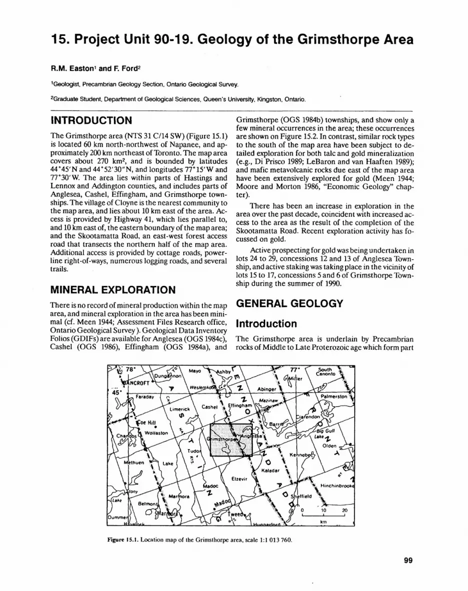
15. Project Unit 90-19. Geology of the Grimsthorpe Area
R.M. Easton 1 and F. Ford2
1 Geologist. Precambrian Geology Section, Ontario Geological Survey.
2Graduate Student, Department of Geological Sciences, Queen's University, Kingston, Ontario.
INTRODUCTIONThe Grimsthorpe area (NTS 31 C/14 SW) (Figure 15.1) is located 60 km north-northwest of Napanee, and ap proximately 200 km northeast of Toronto. The map area covers about 270 km2, and is bounded by latitudes 44"45'Nand44 0 52'30"N, and longitudes IT 15' W and 77 0 30'W. The area lies within parts of Hastings and Lennox and Addington counties, and includes parts of Anglesea, Cashel, Effingham, and Grimsthorpe town ships. The village of Cloyne is the nearest community to the map area, and lies about 10 km east of the area. Ac cess is provided by Highway 41, which lies parallel to, and 10 km east of, the eastern boundary of the map area; and the Skootamatta Road, an east-west forest access road that transects the northern half of the map area. Additional access is provided by cottage roads, power- line right-of-ways, numerous logging roads, and several trails.
MINERAL EXPLORATIONThere is no record of mineral production within the map area, and mineral exploration in the area has been mini mal (cf. Meen 1944; Assessment Files Research office, Ontario Geological Survey ). Geological Data Inventory Folios (GDIFs) are available for Anglesea (OGS 1984c), Cashel (OGS 1986), Effingham (OGS 1984a), and
Grimsthorpe (OGS 1984b) townships, and show only a few mineral occurrences in the area; these occurrences are shown on Figure 15.2. In contrast, similar rock types to the south of the map area have been subject to de tailed exploration for both talc and gold mineralization (e.g., Di Frisco 1989; LeBaron and van Haaften 1989); and mafic metavolcanic rocks due east of the map area have been extensively explored for gold (Meen 1944; Moore and Morton 1986, "Economic Geology" chap ter).
There has been an increase in exploration in the area over the past decade, coincident with increased ac cess to the area as the result of the completion of the Skootamatta Road. Recent exploration activity has fo- cussed on gold.
Active prospecting for gold was being undertaken in lots 24 to 29, concessions 12 and 13 of Anglesea Town ship, and active staking was taking place in the vicinity of lots 15 to 17, concessions 5 and 6 of Grimsthorpe Town ship during the summer of 1990.
GENERAL GEOLOGY
IntroductionThe Grimsthorpe area is underlain by Precambrian rocks of Middle to Late Proterozoic age which form part
Figure 15.1. Location map of the Grimsthorpe area, scale 1:1 013 760.
99

PRECAMBRIAN (15)
440S2'30-N
v ve/vvvvvvvvvvvvv "fty v v v v v v v v v v v v v' vvvvvvvvvvvvv vvvvvvvvvvvvv vvvvvvvvvvvvv vvvvvvvvvvvvv
- ^i vvvvvvvvvvvvVVVVVVVVVVV
WWW•v vvv v
VVV V f/ W V V
vyvvvvv w w
'+ + + + + r + + + + + + + * \^V?X"Q^Q:^;yQ^+ + -H + + + + + + * A * A * i *J^teratioite^^f^#-Yfi^^
*vW **** Weslemkoon . * . * . * . Af^bne^^ •?8F^''\\'K *"'*'*\-^K -X' 8^V**t^*T*V***VtJSrK^g8!^^o^Jf * * * -t-Txman*tt *.*^*^^T^H^Au^t2ff^xia.^7*c.M. ^^xxxx
44"45'N Western Block Eastern Block
Syenite
[ * 1" -f ^| Tonalite, Granodiorite
Diorite- gabbro
Gabbro, hornblendite
Mafic and felsic volcanics of the Marble Lake area
Volcaniclastic metasedimentary rocks, volcanic conglomerate
AmphiboliteC metaflows), fine-grained gabbros
Protomylonite gabbros
^ Fault
^r Shear zone
/^ Geological contact
S' 1500 gamma magnetic contour
A Known mineral occurrence
• Mineral occurrence found by field party personnel
Jl Intrusion breccia zone
United Reef Petroleum Ltd. propertyReference sections Killer Creek gabbro suite
Pb Lead
po Pyrrhotite
Figure 15.2. Generalized geologic map of the Grimsthorpe area showing major structural elements, crustal blocks, and mineral occurrences; the shaded block outlines area shown in detail in Figure 15.4.
of the Central Metasedimentary Belt of the Grenville Structural Province. The area lies within the Elzevir Terrane of the Central Metasedimentary Belt (Moore 1982). East-striking faults, possibly related to the Ottawa-Bonnechere graben system, cut through the northern half of the map area (see Figure 15.2). Meta morphic grade in the area is upper greenschist facies, al though middle amphibolite-facies rocks are found adja cent to the Weslemkoon and Canniff tonalites. Defor mation in the map area is generally weak, although lo calized areas of intense deformation are concentrated in several distinct shear zones in the area, and adjacent to the margins of the Weslemkoon and Canniff tonalites.
Precambrian rocks in the Grimsthorpe area are sep arated into an eastern and a western block by the north-northeast-striking Partridge Creek shear zone, which is coincident with the western margin of the Killer Creek Gabbro Suite (see Figure 15.2). In addition, another north-striking deformation zone, termed the Mooroton shear zone, lies just east of the map area, and separates rocks of the eastern block from metavolcanic and metasedimentary rocks of the Marble Lake area to the east (Moore and Morton 1986).
The western block is characterized by a package of mafic volcaniclastic rocks, minor mafic flow rocks, and
100
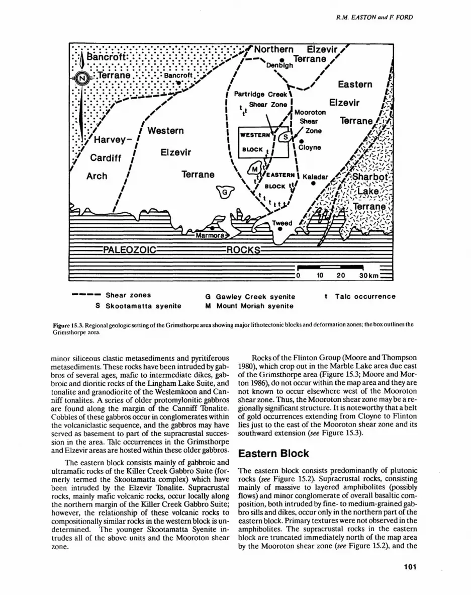
R. M. EASTON and F. FORD
f :i bancroft:
.Terrane . : . : . : . : . : Bancroft. '-.
^Northern Elzevir f—s * Terrane X
Denbigh x
Eastern
: i :/
y
/Harvey- ' :/ 7
Cardiff
; Western
Partridge Creek \ Zone '
.Elzevir
A Mooroton /V~jshear Terrane/T'-A
Arch
PALEOZOIC ROCKS:
1Q PO Mil |rm
———— Shear zones
S Skootamatta syeniteG Gawley Creek syenite M Mount Moriah syenite
t Talc occurrence
Figure 15.3. Regional geologic setting of the Grimsthorpe area showing major lithotectonic blocks and deformation zones; the box outlines the Grimsthorpe area.
minor siliceous clastic metasediments and pyritiferous metasediments. These rocks have been intruded by gab- bros of several ages, mafic to intermediate dikes, gab broic and dioritic rocks of the Lingham Lake Suite, and tonalite and granodiorite of the Weslemkoon and Can- niff tonalites. A series of older protomylonite gabbros are found along the margin of the Canniff Tonalite. Cobbles of these gabbros occur in conglomerates within the volcaniclastic sequence, and the gabbros may have served as basement to part of the supracrustal succes sion in the area. Talc occurrences in the Grimsthorpe and Elzevir areas are hosted within these older gabbros.
The eastern block consists mainly of gabbroic and ultramafic rocks of the Killer Creek Gabbro Suite (for merly termed the Skootamatta complex) which have been intruded by the Elzevir Tonalite. Supracrustal rocks, mainly mafic volcanic rocks, occur locally along the northern margin of the Killer Creek Gabbro Suite; however, the relationship of these volcanic rocks to compositionally similar rocks in the western block is un determined. TTie younger Skootamatta Syenite in trudes all of the above units and the Mooroton shear zone.
Rocks of the Flinton Group (Moore and Thompson 1980), which crop out in the Marble Lake area due east of the Grimsthorpe area (Figure 15.3; Moore and Mor ton 1986), do not occur within the map area and they are not known to occur elsewhere west of the Mooroton shear zone. Thus, the Mooroton shear zone may be a re gionally significant structure. It is noteworthy that a belt of gold occurrences extending from Cloyne to Flinton lies just to the east of the Mooroton shear zone and its southward extension (see Figure 15.3).
Eastern BlockThe eastern block consists predominantly of plutonic rocks (see Figure 15.2). Supracrustal rocks, consisting mainly of massive to layered amphibolites (possibly flows) and minor conglomerate of overall basaltic com position, both intruded by fine- to medium-grained gab bro sills and dikes, occur only in the northern part of the eastern block. Primary textures were not observed in the amphibolites. The supracrustal rocks in the eastern block are truncated immediately north of the map area by the Mooroton shear zone (see Figure 15.2), and the
101

PRECAMBRIAN (15)
Partridge Creek shear zone separates them from litho- logically similar rocks in the western block.
The supracrustal rocks, and the gabbroic rocks that intrude them, are cut by the Killer Creek Gabbro Suite, a plutonic mass that ranges from hornblendite, through gabbro and gabbroic anorthosite to anorthosite, in com position. The core of the pluton is little deformed, and locally is only partly recrystallized, with primary plagio clase laths (Photo 15.1) and pyroxene cores locally pre served. Spectacular igneous layering is preserved in sev eral places in the pluton, south of the Skootamatta Road. The western margin of the pluton is mylonitized along the Partridge Creek shear zone, and rocks similar to the Killer Creek Gabbro Suite are not present in the western block. The body extends roughly 2 km further south into the Elzevir area (Di Prisco 1989) where it wedges out against the Elzevir Tonalite and the Partridge Creek shear zone.
The Killer Creek Gabbro Suite has been previously termed the Skootamatta complex (e.g., Di Prisco 1989) or the northwestern gabbro (Connelly 1986). We recom mend that the term Skootamatta complex be abandoned for two reasons. First, this will eliminate confusion with the better known and more established term, the Skoot amatta Syenite. Second, the Killer Creek Gabbro Suite is intruded by the roughly 1270 million-year-old Elzevir Tonalite, which is itself roughly 180 to 200 million years older than the Skootamatta Syenite. Thus, the Killer Creek body is clearly a unique intrusion, perhaps one of the oldest in the Central Metasedimentary Belt, and, therefore, deserving of a distinctive name. The body is named for Killer Creek, along which it is well exposed, particularly in roadcuts on the Skootamatta Road. Reference sections are labelled in Figure 15.2 and in clude:1. a l km stretch of the Skootamatta Road along Killer
Creek, west of Skootamatta Lake, which exposes gabbroic and anorthositic rocks
2. a section along a logging road 2 km south of the Skootamatta Road, which exposes gabbroic and anorthositic rocks and numerous outcrops of ig neous layered rocks
3. an area l km south of Sheldrake Lake, which ex poses hornblendites and melanocratic gabbros of the Killer Creek Gabbro Suite.
The term Suite rather than Complex is used since all the major phases of the body (equivalent of lithodemes) are plutonic in origin.
The Elzevir Tonalite consists of two main plutonic masses in the map area. The northeastern mass consists of roughly equal proportions of coarse-grained tonalite and granodiorite, both containing large quartz clots. This mass intrudes the Killer Creek Gabbro Suite. As the contact with the tonalite is approached, dikes be come more abundant in the gabbroic rocks, and a sharp contact between the two bodies is difficult to define. This is especially true south of Sheldrake and Skoota matta lakes, where a complex intrusion breccia zone is found between the Elzevir Tonalite and the Killer Creek body. The hornblendites and melanocratic gab bros of the Killer Creek Gabbro Suite are particularly abundant in this intrusion breccia zone, which has not been described previously.
The southwestern mass, which extends south into the Elzevir area, is a medium-grained tonalite with only very localized granodioritic patches. This mass also lacks the distinctive quartz clots of the northeastern mass. The southwestern mass has a sharp contact with the gab bros, and dikes of this rock type extending into the gab bros and gabbro xenoliths are much less abundant along the tonalite-gabbro contact in this part of the area.
Fine-grained tonalite and plagioclase-porphyritic dikes of tonalite composition cut gabbroic and tonalitic rocks in the eastern block, and volcaniclastic melasedi- mentary rocks in the western block. Several of these younger dikes are found in the vicinity of the United
Photo 15.1. Well-preserved plagioclase laths in gabbro of the Killer Creek Gabbro Suite; location: UTM 316890E 4967180N.
102
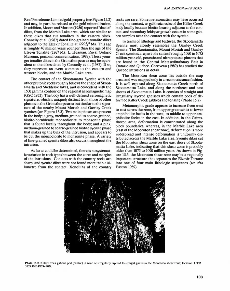
R.M. EASTON and F. FORD
Reef Petroleums Limited gold property (see Figure 15.2) and may, in part, be related to the gold mineralization. In addition, Moore and Morton (1986) reported "dacite" dikes, from the Marble Lake area, which are similar to these dikes that cut tonalites in the eastern block. Connelly et al. (1987) dated fine-grained tonalite dikes adjacent to the Elzevir Tonalite at 1229V 1 Ma. This age is roughly 40 million years younger than the age of the Elzevir Tonalite (1267 Ma; L. Heaman, Royal Ontario Museum, personal communication, 1989). These youn ger tonalite dikes in the Grimsthorpe area may be equiv alent to the dikes dated by Connelly et al. (1987). If so, they represent an event common to the eastern and western blocks, and the Marble Lake area.
The contact of the Skootamatta Syenite with the other plutonic rocks roughly follows the shape of Skoot amatta and Sheldrake lakes, and is coincident with the 1500 gamma contour on the regional aeromagnetic map (GSC 1952). The body has a well-defined aeromagnetic signature, which is uniquely distinct from those of other plutons in the Grimsthorpe area but similar to the signa ture of the nearby Mount Moriah and Gawley Creek syenites (see Figure 15.3). Two main phases are present in the body; a grey, medium-grained to coarse-grained, biotite-hornblende monzodiorite to monzonite phase that is found locally throughout the body; and a pink, medium-grained to coarse-grained biotite syenite phase that makes up the bulk of the intrusion, and appears to be cut the monzodiorite to monzonite phase. A variety of fine-grained syenite dikes also occurs throughout the intrusion.
As far as could be determined, there is no systemat ic variation in rock types between the cores and margins of the intrusions. Contacts with the country rocks are sharp, and syenite dikes were not found more than a ki lometre from the contact. Xenoliths of the country
rocks are rare. Some metasomatism may have occurred along the contact, as gabbroic rocks of the Killer Creek body locally become biotite-bearing adjacent to the con tact, and secondary feldspar growth occurs in some gab bro samples near the contact with the syenite.
In terms of lithology and textures, the Skootamatta Syenite most closely resembles the Gawley Creek Syenite. The Skootamatta, Mount Moriah and Gawley Creek syenites are part of a suite of roughly 1090 to 1075 million-year-old, potassic and ultrapotassic plutons that are found in the Central Metasedimentary Belt in Ontario and Quebec. Corriveau (1989) has studied the Quebec intrusions in detail.
The Mooroton shear zone lies outside the map area, and was mapped only in a reconnaissance fashion. It is well exposed along Skootamatta Creek north of Skootamatta Lake, and along the northeast and east shores of Skootamatta Lake. It consists of straight and irregularly layered gneisses which contain pods of de formed Killer Creek gabbros and tonalite (Photo 15.2).
Metamorphic grade appears to increase from west to east across the zone, from upper greenschist to lower amphibolite facies in the west, to middle to upper am phibolite facies in the east. In addition, in the Grims thorpe area, deformation is concentrated along the block boundaries, whereas, in the Marble Lake area (east of the Mooroton shear zone), deformation is more widespread and intense deformation is uniformly dis tributed across the Marble Lake area. Syenite dikes cut the Mooroton shear zone on the east shore of Skoota matta Lake, indicating that this shear zone is probably older than 1075 to 1090 million years. As shown in Fig ure 15.3, the Mooroton shear zone may be a regionally important structure that separates the Elzevir Terrane into one of four main lithologic sequences (see also Easton 1989).
Photo 15.2. Killer Creek gabbro pod (centre) in zone of irregularly layered to straight gneiss in the Mooroton shear zone; location: UTM 322430E 4969480N.
103
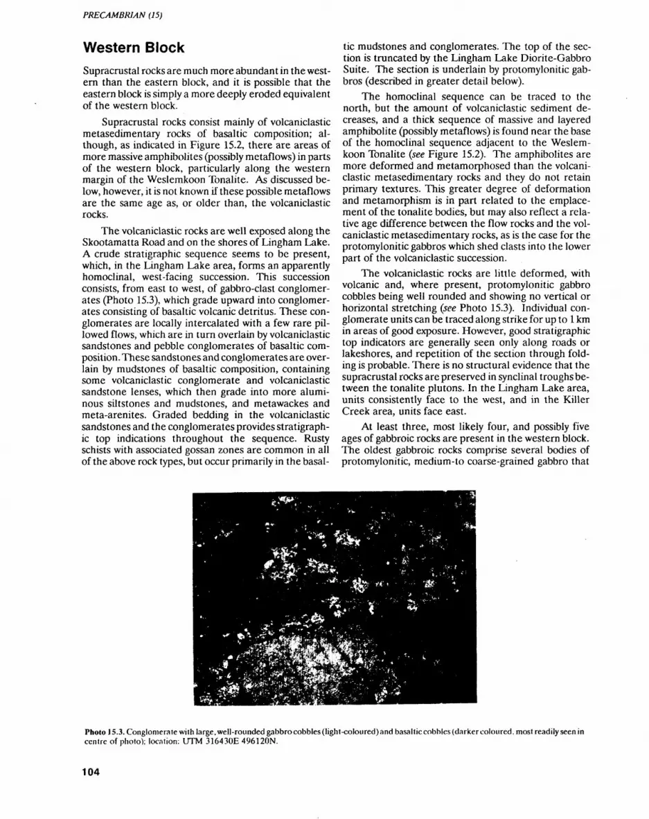
PRECAMBRIAN (15)
Western BlockSupracrustal rocks are much more abundant in the west ern than the eastern block, and it is possible that the eastern block is simply a more deeply eroded equivalent of the western block.
Supracrustal rocks consist mainly of volcaniclastic metasedimentary rocks of basaltic composition; al though, as indicated in Figure 15.2, there are areas of more massive amphibolites (possibly metaflows) in parts of the western block, particularly along the western margin of the Weslemkoon Tonalite. As discussed be low, however, it is not known if these possible metaflows are the same age as, or older than, the volcaniclastic rocks.
The volcaniclastic rocks are well exposed along the Skootamatta Road and on the shores of Lingham Lake. A crude stratigraphic sequence seems to be present, which, in the Lingham Lake area, forms an apparently homoclinal, west-facing succession. This succession consists, from east to west, of gabbro-clast conglomer ates (Photo 15.3), which grade upward into conglomer ates consisting of basaltic volcanic detritus. These con glomerates are locally intercalated with a few rare pil lowed flows, which are in turn overlain by volcaniclastic sandstones and pebble conglomerates of basaltic com position. These sandstones and conglomerates are over lain by mudstones of basaltic composition, containing some volcaniclastic conglomerate and volcaniclastic sandstone lenses, which then grade into more alumi nous siltstones and mudstones, and metawackes and meta-arenites. Graded bedding in the volcaniclastic sandstones and the conglomerates provides stratigraph ic top indications throughout the sequence. Rusty schists with associated gossan zones are common in all of the above rock types, but occur primarily in the basal
tic mudstones and conglomerates. The top of the sec tion is truncated by the Lingham Lake Diorite-Gabbro Suite. The section is underlain by protomylonitic gab- bros (described in greater detail below).
The homoclinal sequence can be traced to the north, but the amount of volcaniclastic sediment de creases, and a thick sequence of massive and layered amphibolite (possibly metaflows) is found near the base of the homoclinal sequence adjacent to the Weslem koon Tonalite (see Figure 15.2). The amphibolites are more deformed and metamorphosed than the volcani clastic metasedimentary rocks and they do not retain primary textures. This greater degree of deformation and metamorphism is in part related to the emplace ment of the tonalite bodies, but may also reflect a rela tive age difference between the flow rocks and the vol caniclastic metasedimentary rocks, as is the case for the protomylonitic gabbros which shed clasts into the lower part of the volcaniclastic succession.
The volcaniclastic rocks are little deformed, with volcanic and, where present, protomylonitic gabbro cobbles being well rounded and showing no vertical or horizontal stretching (see Photo 15.3). Individual con glomerate units can be traced along strike for up to l km in areas of good exposure. However, good stratigraphic top indicators are generally seen only along roads or lakeshores, and repetition of the section through fold ing is probable. There is no structural evidence that the supracrustal rocks are preserved in synclinal troughs be tween the tonalite plutons. In the Lingham Lake area, units consistently face to the west, and in the Killer Creek area, units face east.
At least three, most likely four, and possibly five ages of gabbroic rocks are present in the western block. The oldest gabbroic rocks comprise several bodies of protomylonitic, medium-to coarse-grained gabbro that
Photo 15.3. Conglomerate with large, well-rounded gabbro cobbles (light-coloured) and basaltic cobbles (darker coloured, most readily seen in centre of photo); location: UTM 316430E 496120N.
104
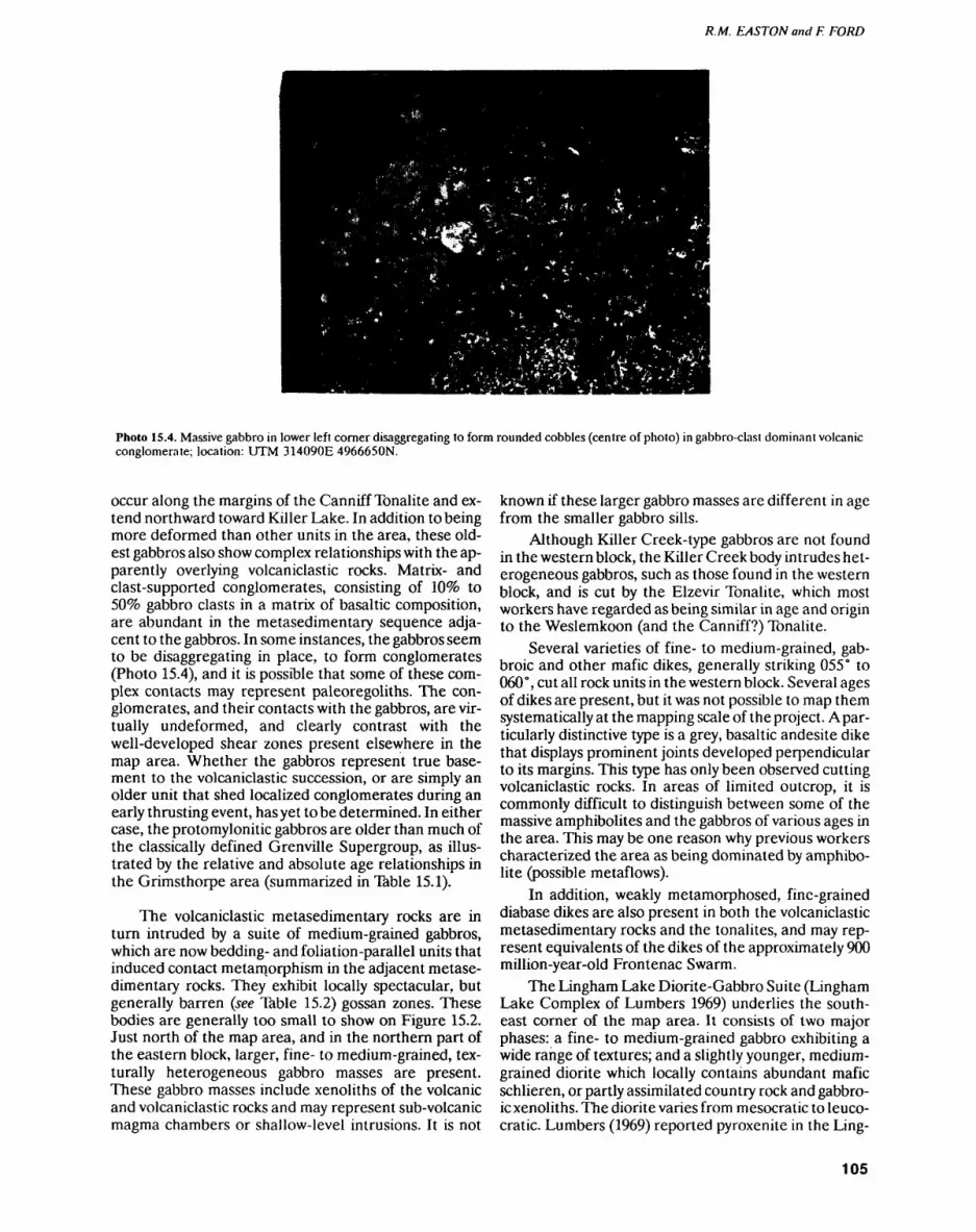
R.M. EASTON and F. FORD
Photo 15.4. Massive gabbro in lower left corner disaggregating to form rounded cobbles (centre of photo) in gabbro-clast dominant volcanic conglomerate; location: UTM 314090E 4966650N.
occur along the margins of the Canniff Tbnalite and ex tend northward toward Killer Lake. In addition to being more deformed than other units in the area, these old est gabbros also show complex relationships with the ap parently overlying volcaniclastic rocks. Matrix- and clast-supported conglomerates, consisting of 109fc to 509& gabbro clasts in a matrix of basaltic composition, are abundant in the metasedimentary sequence adja cent to the gabbros. In some instances, the gabbros seem to be disaggregating in place, to form conglomerates (Photo 15.4), and it is possible that some of these com plex contacts may represent paleoregoliths. The con glomerates, and their contacts with the gabbros, are vir tually undeformed, and clearly contrast with the well-developed shear zones present elsewhere in the map area. Whether the gabbros represent true base ment to the volcaniclastic succession, or are simply an older unit that shed localized conglomerates during an early thrusting event, has yet to be determined. In either case, the protomylonitic gabbros are older than much of the classically defined Grenville Supergroup, as illus trated by the relative and absolute age relationships in the Grimsthorpe area (summarized in Table 15.1).
The volcaniclastic metasedimentary rocks are in turn intruded by a suite of medium-grained gabbros, which are now bedding- and foliation-parallel units that induced contact metamorphism in the adjacent metase dimentary rocks. They exhibit locally spectacular, but generally barren (see Table 15.2) gossan zones. These bodies are generally too small to show on Figure 15.2. Just north of the map area, and in the northern part of the eastern block, larger, fine- to medium-grained, tex- turally heterogeneous gabbro masses are present. These gabbro masses include xenoliths of the volcanic and volcaniclastic rocks and may represent sub-volcanic magma chambers or shallow-level intrusions. It is not
known if these larger gabbro masses are different in age from the smaller gabbro sills.
Although Killer Creek-type gabbros are not found in the western block, the Killer Creek body intrudes het erogeneous gabbros, such as those found in the western block, and is cut by the Elzevir Tonalite, which most workers have regarded as being similar in age and origin to the Weslemkoon (and the Canniff?) Tonalite.
Several varieties of fine- to medium-grained, gab broic and other mafic dikes, generally striking 055" to 060 0 , cut all rock units in the western block. Several ages of dikes are present, but it was not possible to map them systematically at the mapping scale of the project. Apar- ticularly distinctive type is a grey, basaltic andesite dike that displays prominent joints developed perpendicular to its margins. This type has only been observed cutting volcaniclastic rocks. In areas of limited outcrop, it is commonly difficult to distinguish between some of the massive amphibolites and the gabbros of various ages in the area. This may be one reason why previous workers characterized the area as being dominated by amphibo lite (possible metaflows).
In addition, weakly metamorphosed, fine-grained diabase dikes are also present in both the volcaniclastic metasedimentary rocks and the tonalites, and may rep resent equivalents of the dikes of the approximately 900 million-year-old Frontenac Swarm.
The Lingham Lake Diorite-Gabbro Suite (Lingham Lake Complex of Lumbers 1969) underlies the south- east corner of the map area. It consists of two major phases: a fine- to medium-grained gabbro exhibiting a wide range of textures; and a slightly younger, medium- grained diorite which locally contains abundant mafic schlieren, or partly assimilated country rock and gabbro ic xenoliths. The diorite varies from mesocratic to leuco cratic. Lumbers (1969) reported pyroxenite in the Ling-
105

PRECAMBRIAN (15)
Table 15.1. Relative and absolute ages of rock units in the Grimsthorpe area.
Western Block Eastern Block Marble Lake area
Mount Moriah Syenite
absent
absent
tonalite dikes
gabbro dikes
Canniff Si. Weslemkoon tonalites; Lingham Lk. Diorite-Gabbro Suite
absent
absent
gabbro intrusions
volcaniclastic metasedimentary rocks unconformity
Skootamatta Syenite (ea. 1075-1090 Ma)
absent
absent
tonalite dikes(1229+ 11 Ma)
gabbro dikes
Elzevir Tbnalite (ea. 1270 Ma)
Killer Creek Gabbro Suite
absent
gabbro intrusions
volcaniclastic metasedimentary rocks unconformity"?
absent
Flinton Gp. (ea. 1150 Ma)
unconformity
granitic plutons
"dacite" dikes
absent?
Northbrook & Cross Lake tonalites (may be faulted in)
diorites gabbros
carbonate SL siliceous clastic metasedimentary rocks; volcaniclastic meta sedimentary rocks; mafic intermediate, Si felsic volcanic rocks
absent?
absent?
post-Grenville Supergroup supracrustal rocks
Grenville Supergroup supracrustal rocks
amphibolites(metaflows?)
protomyloniticgabbros
amphibolites(metaflows?)
absent?
absent?
absent
pre-GrenvilleSupergroupsupracrustal rocks
ham Lake Diorite-Gabbro Suite but none was observed within the map area. Much of the core of the Lingham Lake Diorite-Gabbro Suite is relatively inaccessible by foot, due to an abundance of swamps and distance from roads and watercourses.
Two tonalite intrusions are present in the western block. The Canniff Tonalite is a fine- to medium-grained tonalite which is locally transitional into granodiorite, particularly along the western margin of the pluton. The second tonalite intrusion in the area is the Weslemkoon Tonalite, of which only the southern lobe is present. It consists mainly of medium-grained tonalite with coarse quartz clots. Apart from being slightly finer-grained, it is similar to the northern lobe of the Elzevir Tonalite in the eastern block of the map area.
North and east of Partridge Creek is a zone of alter ation, silicification and intrusion of felsites (see Figure 15.2), roughly 5 km in length and about 500 m wide, that is coincident with an anomaly on the regional aeromag netic map of the area (GSC 1952). In several places, most notably just south of Partridge Creek, this anomaly is intense enough to deflect compass readings by up to
90". Assay results indicate that samples from this zone (see Table 15.2) are depleted in a number of metals. The zone is not associated with any significant shearing, and no other zones of this scale or intensity were found else where in the Grimsthorpe area.
ECONOMIC GEOLOGY
Assay ResultsField party personnel collected samples for assay from a variety of rock units within the map area, and Table 15.2 presents the results of some of these assays. Data can be grouped into four main categories: assays from rusty schist units; assays from, and adjacent to, an east- striking fault zone parallel to the Skootamatta Road; as says from known gold occurrences and quartz veins; and assays from gabbroic and ultramafic rocks.
Assays of rusty schists, which include gossanous black schists (metamudstones) as well as gossan zones in both metaconglomerates and volcaniclastic and metase dimentary rocks adjacent to mafic dikes, locally show very minor enrichments in copper, nickel, or zinc
106
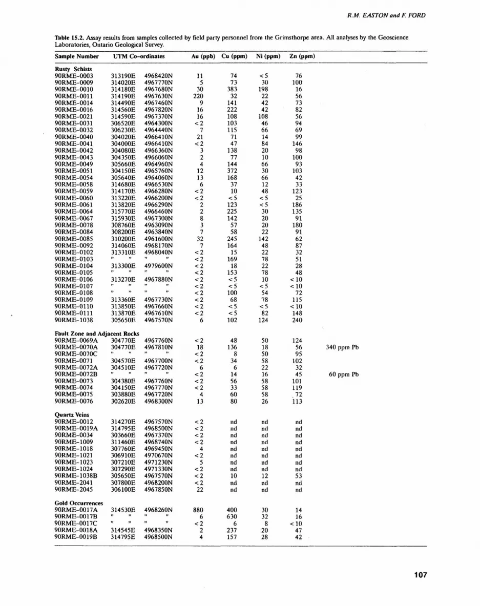
R.M. EASTON and F. FORD
Table 15.2. Assay results from samples collected by field party personnel from the Grimsthorpe area. All analyses by the Geoscience Laboratories, Ontario Geological Survey.
Sample Number
Rusty Schists90RME-000390RME-000990RME-001090RME-001190RME-001490RME-001690RME-002190RME-003190RME-003290RME-004090RME-004190RME-004290RME-004390RME-004990RME-005190RME-005490RME-005890RME-005990RME-006090RME-006190RME-006490RME-006790RME-007890RME-008490RME-008590RME-009290RME-010290RME-010390RME-010490RME-010590RME-010690RME-010790RME-010890RME-010990RME-011090RME-011190RME-1038
UTM Co-ordinates
313190E314020E314180E314190E314490E314560E314590E306520E306230E304020E304000E304080E304350E305660E304150E305640E314680E314170E313220E313820E315770E315930E308760E308200E310200E314060E313310E" "313300E" "313270E" "" "313360E313850E313870E305650E
4968420N4967770N4967680N4967630N4967460N4967820N4967370N4964300N4964440N49664 ION4966410N4966 360N4966060N4964960N4965760N4964060N49665 30N4966280N4966200N4966 290N4966460N4967300N4963090N4963840N4961600N4968170N4968040N" "4979600N" "4967880N" "" "4967730N4967660N4967610N4967570N
Au (ppb) Cu (ppm)
115
30220
91616
<27
21<2
324
1213
6<2<2
22837
327
<2<2<2<2<2<2<2<2<2<2
6
7473
38332
141222108103115
7147
13877
144372168
3710
<5123225142
5758
245164
15169
18153<5<510068
<5<5102
Ni (ppm) Zn (ppm)
<530
198224242
1084666148420106630661248^5<530202022
142482278227810
<55478
<582
124
76100
1656738256946999
14698
10093
1034233
12325
18613591
18091628732512848
c 10 c 10
72115
c 10148240
Fault Zone and Adjacent Rocks90RME-0069A90RME-0070A90RME-0070C90RME-007190RME-0072A90RME-0072B90RME-007390RME-007490RME-007590RME-0076
Quartz Veins90RME-001290RME-0019A90RME-003490RME-100990RME-101890RME-102190RME-102390RME-102490RME-1038B90RME-204190RME-2045
Gold Occurrences90RME-0017A90RME-0017B90RME-0017C90RME-0018A90RME-0019B
304770E304770E" "304570E304510E" "304380E304150E303880E302620E
314270E314795E303660E311460E307760E306910E307210E307290E305650E307800E306100E
314530E" "" "314545E314795E
4967760N4967810N" "4967700N4967720N" "4967760N4967770N4967720N4968300N
4967570N4968500N4967 370N4968740N4969450N4970670N4971230N4971 330N4967570N4968200N4967850N
4968260Nt. ,," "4968350N4968500N
<218
<2<2
6<2<2<2
413
<2<2<2<2
4<2
5<2<2<222
8806
<224
48136
834
61456336080
ndndndndndndndnd10ndnd
400630
6237157
50185058221658585826
ndndndndndndndnd12ndnd
3032
82028
12456 340 ppm Pb95
1023245 60 ppm Pb
10111972
113
ndndndndndndndnd53ndnd
1416
-c 104742
107

PRECAMBRIAN (15)
Table 15.2. Continued.
Sample Number UTM Co-ordinates Au (ppb) Cu (ppm) Ni (ppm) Zn (ppm)
Others90RME-008190RME-009590RME-026190RME-026690RME-100490RME-1013A90RME-1013B
309180E318840E309080E301995E311910E3085 30E" "
4962840N4967 120N4963805N4978200N4968970N4968460N" "
<23
<2<2<2<2
2
65475233173
318490
124807244
148250
64
9110610178917971
13 ppb Pt, 15 ppb Pd
Gabbroic and Ultramafic RocksAu (ppb) Cu (ppm) Ni (ppm) Zn (ppm) Cr (ppm) Pt (ppb) Pd (ppb)
90RME-0117 90RME-0250 90RME-1067 90RME-1068 90RME-1071 90RME-1072
317090E 318460E 317580E 317800E 318060E 319250E
4966730N 4963825N 4967990N 4968220N 4968380N 49691 SON
9 3 7
<2<2
4
19311733669
720132
2614286
54044
180
53123144162154139
138526358
2040120456
223 5
10 -ci
Detection limit for Au is 2 ppb, < 5 ppm for Cu, Ni and Cr. and < 10 ppm for Zn. Background, levels in area are generally close to detection limits, nd = not detennined
(Table 15.2). Only one sample (90RME-0011) showed anomalously high gold values. "Phis sample was col lected from a location on strike with, but 500 m south- east of, the gold-bearing United Reef Petroleums Lim ited property where the sample that returned the high est gold value listed in Table 15.2 (90RME-0017A) was collected. Samples 90RME-0102 through 90RME-0111 were collected from a north-striking zone of alteration and local silicification that also has a strong aeromag netic expression (see Figure 15.2). The most silicified samples are strongly depleted in copper, gold, nickel, and zinc. Further exploration of this zone is needed be fore its economic significance can be determined.
Samples 90RME-0069 through 90RME-0072 were collected from fault gouge present along an east- striking fault that parallels the Skootamatta Road in the northwest part of the map area. All samples listed in Table 15.2 were analyzed for lead, but only samples 90RME-0070A and 90RME-0072B contained signifi cant amounts; all other samples contained lead below the 10 ppm detection limit. Barite-carbonate-lead veins are associated with Paleozoic faults elsewhere in the Central Metasedimentary Belt in Ontario and the anomalous lead values found in the two samples from the fault zone may indicate the presence of this type of mineralization along this fault.
Samples collected from quartz veins throughout the map area were barren with respect to gold (see Table 15.2). Quartz veins are more abundant in the Weslem- koon Tonalite adjacent to the east-striking fault noted above, and may be related to it.
The highest gold values were obtained from a sam ple (90RME-0017A) collected in a trench in a silicified, rusty-weathering metaconglomerate outcrop on a prop erty of United Reef Petroleums Limited located on Lot 28, Concession 14, Anglesea Township. Other sam ples from the same trench (90RME-0017B and 90RME-0017C) contained negligible amounts of gold.
Samples 90RME-0019A and 90RME-0019B, collected from a nearby trench on Lot 27, Concession 14, Angle sea Township, also a United Reef Petroleums Limited property, showed no enrichment in gold. The sample population in Table 15.2 would seem to indicate that background levels for gold in the map area are about 10 ppb or less, thus sample 90RME-0017A is clearly anomalous from a regional perspective.
All gabbro and ultramafic samples listed in Table 15.2 are from the Killer Creek Gabbro Suite. Hornblen dite samples from the Killer Creek Gabbro Suite show enrichments in both copper and chromium, and were also analyzed for platinum and palladium (see Table 15.2). Sample 90RME-1071 also contained 159& to 2096 magnetite. The presence of igneous layering, including ilmenite and magnetite-rich layers, within the Killer Creek body, and the high chromium content of sample 90RME-1068, indicate that the body has potential for oxide, and possibly platinum, mineralization, and war rants additional exploration. Assay results from other gabbro bodies in the area were unavailable at the time of report preparation.
GoldThe presence of known gold occurrences east and west of the Grimsthorpe area, the abundance of mafic volca nic rocks as indicated on regional scale maps, and the lack of much previous exploration have all made the Grimsthorpe area a target area for gold exploration over the past few years. The results of the current project ne cessitate a re-evaluation of the gold potential of the area.
Two factors to be accounted for in any future explo ration are the significance of the Mooroton and Partridge Creek shear zones and the abundance of mafic volcaniclastic rocks in the area. The Mooroton shear zone is significant from the standpoint that it separates the eastern Elzevir Terrane and rocks of the Flinton
108
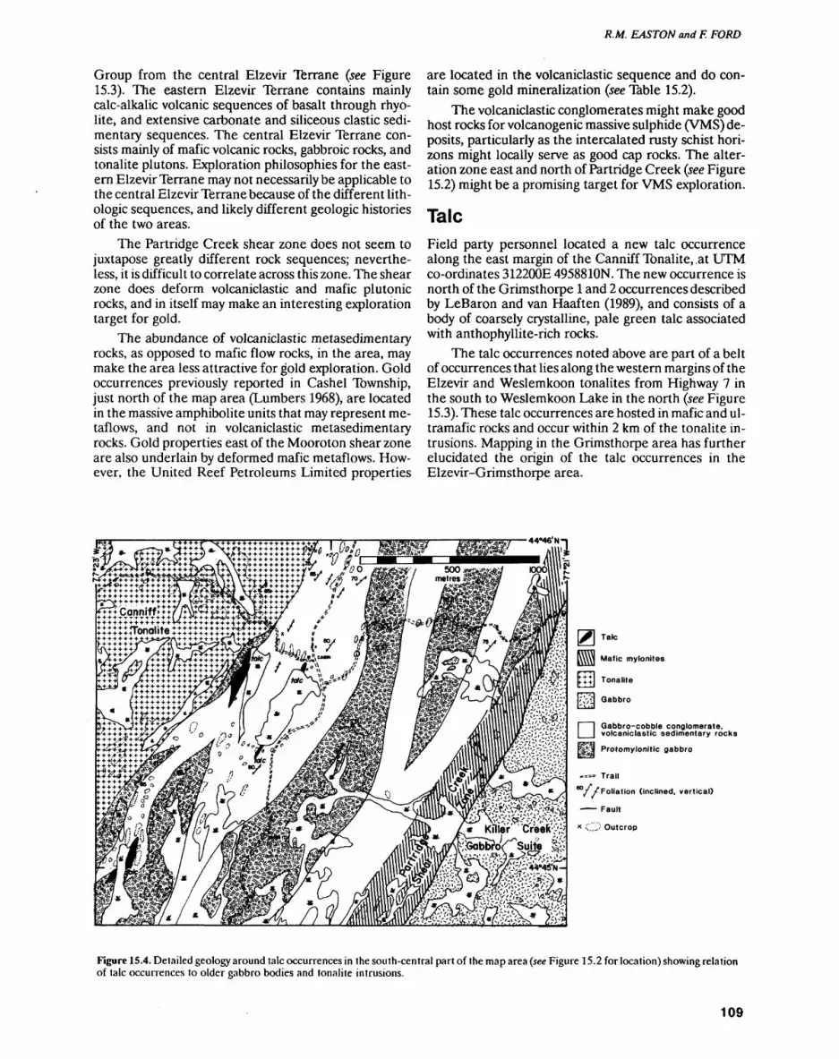
R.M. EASTON and F. FORD
Group from the central Elzevir Terrane (see Figure 15.3). The eastern Elzevir Terrane contains mainly calc-alkalic volcanic sequences of basalt through rhyo lite, and extensive carbonate and siliceous clastic sedi mentary sequences. The central Elzevir Terrane con sists mainly of mafic volcanic rocks, gabbroic rocks, and tonalite plutons. Exploration philosophies for the east ern Elzevir Terrane may not necessarily be applicable to the central Elzevir Terrane because of the different lith ologic sequences, and likely different geologic histories of the two areas.
The Partridge Creek shear zone does not seem to juxtapose greatly different rock sequences; neverthe less, it is difficult to correlate across this zone. The shear zone does deform volcaniclastic and mafic plutonic rocks, and in itself may make an interesting exploration target for gold.
The abundance of volcaniclastic metasedimentary rocks, as opposed to mafic flow rocks, in the area, may make the area less attractive for gold exploration. Gold occurrences previously reported in Cashel Township, just north of the map area (Lumbers 1968), are located in the massive amphibolite units that may represent me- taflows, and not in volcaniclastic metasedimentary rocks. Gold properties east of the Mooroton shear zone are also underlain by deformed mafic metaflows. How ever, the United Reef Petroleums Limited properties
are located in the volcaniclastic sequence and do con tain some gold mineralization (see Table 15.2).
The volcaniclastic conglomerates might make good host rocks for volcanogenic massive sulphide (VMS) de posits, particularly as the intercalated rusty schist hori zons might locally serve as good cap rocks. The alter ation zone east and north of Partridge Creek (see Figure15.2) might be a promising target for VMS exploration.
TalcField party personnel located a new talc occurrence along the east margin of the Canniff Tonalite,,at UTM co-ordinates 312200E 49588ION. The new occurrence is north of the Grimsthorpe l and 2 occurrences described by LeBaron and van Haaften (1989), and consists of a body of coarsely crystalline, pale green talc associated with anthophyllite-rich rocks.
The talc occurrences noted above are part of a belt of occurrences that lies along the western margins of the Elzevir and Weslemkoon tonalites from Highway 7 in the south to Weslemkoon Lake in the north (see Figure15.3). These talc occurrences are hosted in mafic and ul tramafic rocks and occur within 2 km of the tonalite in trusions. Mapping in the Grimsthorpe area has further elucidated the origin of the talc occurrences in the Elzevir-Grimsthorpe area.
[IT] E t-d
Mafic mylonites
Tonalite
Gabbro
D Gabbro-cobble conglomerate, volcaniclastic sedimentary rocks
F^.'i Protomylonitic gabbro
-*" Trail
a/ V Foliation (inclined, vertical)
—— Fault
* C.'-"' Outcrop
Figure 15.4. Detailed geology around talc occurrences in the south-central part of the map area (see Figure 15.2 for location) showing relation of talc occurrences to older gabbro bodies and tonalite intrusions.
109

PRECAMBRIAN (15)
The talc occurrences are found only in areas where the older gabbros (see Figures 15.2 and 15.4) occur along the margins of the plutons. In particular, they occur as isolated pods lying adjacent to larger bodies of the older gabbro, generally in areas that have been more intensely deformed. They are closely associated with gabbro-clast conglomerates of the volcaniclastic succession. The greater abundance of talc bodies in the Elzevir area to the south might reflect only more extensive exploration; however, deformation does become more intense to the south, possibly related to the intrusion of the Mount Moriah Syenite and a narrowing of the belt of protomy- lonitic gabbros and supracrustal rocks; and might be a factor in the origin of talc mineralization.
Three factors may thus be responsible for talc min eralization in the Elzevir-Grimsthorpe area: 1) a fa vourable composition of the protolith which may have undergone an early deformation or alteration (protomy- lonitic gabbros of basaltic komatiite composition); 2) metamorphism and fluid movement related to em placement of tonalite plutons in the area; and 3) defor mation associated either with, or subsequent to, tonalite emplacement. Exploration should focus on areas where these three factors are concurrent.
Building Stone
Although the Skootamatta Syenite is close to major roads in the area, it is commonly fractured and jointed, and field party personnel did not locate any areas that appeared to be reasonable prospects for extracting the syenite as a building stone. LeBaron et al. (1989) de scribe two prospects from the Skootamatta Syenite. The Mount Moriah Syenite prospect (LeBaron et al. 1989) is much more attractive from a production standpoint.
The Killer Creek Gabbro Suite contains a variety of textures and colours, and might yield attractive stone products. The best prospects are located north and south of Killer Creek, adjacent to the reference locali ties shown in Figure 15.2. LeBaron et al. (1989) describe the potential of one site along the Skootamatta Road by Killer Creek.
Most tonalite prospects lie far from existing roads. This, combined with the fact that several stone pros pects are present in the Elzevir Tonalite to the south of the map area (LeBaron et al. 1989), makes the building stone potential of the Elzevir, Weslemkoon and Canniff tonalites in the Grimsthorpe area unattractive at this time. LeBaron et al. (1989) describe two potential sites in the Weslemkoon Tonalite.
REFERENCESConnelly, J.N. 1986. The emplacement history of the Elzevir Batho
lith relative to regional deformation of the supracrustal rocks in the Central Metasedimentary Belt, Grenville Province, south eastern Ontario; unpublished MSc thesis, Queen's University, Kingston, Ontario, 153p.
Connelly, J.N., van Breemen, O. and Hanmer, S.K. 1987. The age of deformation related to the emplacement of the Elzevir Batholith and its regional implications, Grenville Province, southeastern Ontario; in Radiogenic Age and Islopic Studies, Report l, Geo logical Survey of Canada, Paper 87-2, p.51-54.
Corriveau, L. 1989. Potassic alkaline plutonism in the southwestern Grenville Province; unpublished PhD thesis, McGill University, Montreal, Quebec, 26 3p.
Di Frisco, G. 1989. Geology of the Elzevir Area, Hastings and Lennox and Addington Counties; in Summary of Field Work and Other Activities 1989; Ontario Geological Survey, Miscellaneous Paper 146, p.169-175.
Easton, R.M. 1989. Regional mapping and stratigraphic studies, Grenville Province; in Summary of Field Work and Other Activi ties 1989; Ontario Geological Survey, Miscellaneous Paper 146, p.153-157.
Geological Survey of Canada 1952. Mazinaw Lake sheet, Hastings, Frontenac, and Lennox and Addington counties, Ontario; Geological Survey of Canada, Map 97G, scale 1:50 000.
LeBaron, P.S. and van Haaften, S. 1989. Talc in southeastern Ontario; Ontario Geological Survey, Open File Report'5714, 240p.
LeBaron, P.S., Verschuren, C.P., Papertzian, VC. and Kingston, P.W. 1989. Building stone potential in eastern Ontario; Ontario Geological Survey, Open File Report 5706, 539p.
Lumbers, S.B. 1968. Geology of Cashel Township; Ontario Depart ment of Mines, Geological Report 71, 54p.
1969. Geology of Limerick and Tudor townships; Ontario Department of Mines, Geological Report 67, HOp.
Meen, V.B. 1944. Geology of the Grimsthorpe-Barrie area; Ontario Department of Mines, Annual Report, 1942, v.51, pt.4, p.1-50.
Moore, J.M. 1982. Stratigraphy and tectonics of the Grenville orogen in eastern Ontario; Abstract Volume, 1982 Grenville Workshop, Friends of the Grenville, p.7.
Moore, J.M. and Morion, R.L. 1986. Geology of the Marble Lake area, counties of Frontenac and Lennox and Addington; Ontario Geological Survey, Report 238, 63p.
Moore, J.M and Thompson, P. 1980. The Flinton Group: a late Pre cambrian metasedimentary succession in the Grenville Province of eastern Ontario; Canadian Journal of Earth Sciences, v.17, p.1685-1707.
Ontario Geological Survey. 1984a. Effingham Township, Lennox and Addington counties; Geological Data Inventory Folio 79, com piled by the staff of the Resident Geologist's office, Tweed.
1984b. Grimsthorpe Township, Hastings County; Geological Data Inventory Folio 85, compiled by the staff of the Resident Geologist's office, Tweed.
1984c. Anglesea Township, Lennox and Addington counties; Geological Data Inventory Folio 86, compiled by the staff of the Resident Geologist's office, Tweed.
1986. Cashel Township, Hastings County; Geological Data Inventory Folio 334, compiled by the staff of the Regional Miner als Specialist's office, Bancroft.
110

16. Project Unit 90-23. Geology of Eva and Summers Townships, District of Thunder Bay
W.S. Shanks
Geologist. Precambrian Geology Section, Ontario Geological Survey.
INTRODUCTION
Eva and Summers townships (Figure 16.1), east of Lake Nipigon, lie within the Beardmore-Geraldton Belt, a transitional supracrustal belt between the Quetico and Wabigoon subprovinces (Kehlenbeck 1986). The map area, approximately 184 km2, is bounded by latitudes 49 0 34'30" and 49 0 40'00" and by longitudes 88 0 10'00" and 87 0 54'00". The town of Beardmore, situated within Summers Township, is about 150 km northeast of Thunder Bay.
Formerly known as the Sturgeon River gold belt (Mason and White 1986), the Beardmore-Geraldton Belt (BOB; Figure 16.2) has yielded at least 4 million ounces of gold. At the western end of the BOB is the Beardmore gold camp which has itself produced at least l million ounces of gold since 1934 (Mason and White 1986). Past producers in the map area include the North ern Empire, Sand River and Leitch mines. Although gold mineralization within the Beardmore camp is typi cally of vein type, recent studies elsewhere in the BOB suggest gold mineralization may also be associated with large dislocation structures (Mason and White 1986). This important finding has led, in general, to a re-evalu ation of the BOB and specifically, to the re-mapping of Eva and Summers townships.
This summary of field work is a preliminary report of the results of 10 weeks of field mapping, the objec tives of which were to:1. refine existing geological maps (i.e., Mackasey
1970a, 1970b)2. locate potential exploration targets3. test whether the structure of the metavolcanic-
metasedimentary rock assemblage is mainly due to shearing (Williams 1987) or to large-scale folding (Kehlenbeck 1983, 1986; Mason and White 1986).
MINERAL EXPLORATIONInformation on exploration work was obtained from assessment work on file in the Resident Geologist's of fice (Beardmore-Geraldton), Ontario Ministry of Northern Development and Mines (Thunder Bay) and from the Mines Library and Assessment Files Research office, Ontario Geological Survey.
In the early 1900s, exploration was centred on the search for iron ore deposits and several large ore bodies were discovered in Eva Township (Mason and White 1986). Although averaging at least 309& Fe and of large tonnage, the deposits were not developed.
In 1925, the discovery of an auriferous quartz- carbonate vein eventually lead to the opening of the
Figure 16.1. Location map of Eva and Summers lownships, scale 1:1 584 000.
111
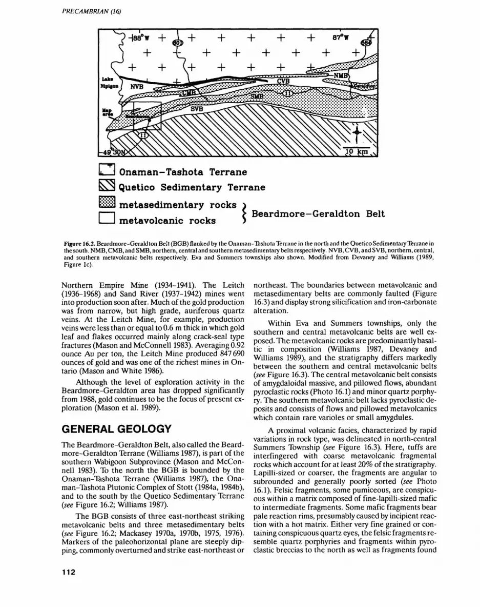
PRECAMBRIAN (16)
Onaman-Tashota Terrane Quetico Sedimentary Terrane
iiSi-S metasedimentary rocks
metavolcanic rocksBeardmore-Geraldton Belt
Figure 16.2. Beardmore-Geraldton Belt (BGB) flanked by the Onaman-Tashota Terrane in the north and the Quetico Sedimentary Terrane in the south. NMB, CMB, and SMB, northern, central and southern metasedimentary belts respectively. NVB, CVB, and SVB, northern, central, and southern metavolcanic belts respectively. Eva and Summers townships also shown. Modified from Devaney and Williams (1989, Figure le).
Northern Empire Mine (1934-1941). The Leitch (1936-1968) and Sand River (1937-1942) mines went into production soon after. Much of the gold production was from narrow, but high grade, auriferous quartz veins. At the Leitch Mine, for example, production veins were less than or equal to 0.6 m thick in which gold leaf and flakes occurred mainly along crack-seal type fractures (Mason and McConnell 1983). Averaging 0.92 ounce Au per ton, the Leitch Mine produced 847 690 ounces of gold and was one of the richest mines in On tario (Mason and White 1986).
Although the level of exploration activity in the Beardmore-Geraldton area has dropped significantly from 1988, gold continues to be the focus of present ex ploration (Mason et al. 1989).
GENERAL GEOLOGYThe Beardmore-Geraldton Belt, also called the Beard more-Geraldton Terrane (Williams 1987), is part of the southern Wabigoon Subprovince (Mason and Mccon nell 1983). To the north the BGB is bounded by the Onaman-Tashota Terrane (Williams 1987), the Ona man-Tashota Plutonic Complex of Stott (1984a, 1984b), and to the south by the Quetico Sedimentary Terrane (see Figure 16.2; Williams 1987).
The BGB consists of three east-northeast striking metavolcanic belts and three metasedimentary belts (see Figure 16.2; Mackasey 1970a, 1970b, 1975, 1976). Markers of the paleohorizontal plane are steeply dip ping, commonly overturned and strike east-northeast or
northeast. The boundaries between metavolcanic and metasedimentary belts are commonly faulted (Figure 16.3) and display strong silicification and iron-carbonate alteration.
Within Eva and Summers townships, only the southern and central metavolcanic belts are well ex posed. The metavolcanic rocks are predominantly basal tic in composition (Williams 1987, Devaney and Williams 1989), and the stratigraphy differs markedly between the southern and central metavolcanic belts (see Figure 16.3). The central metavolcanic belt consists of amygdaloidal massive, and pillowed flows, abundant pyroclastic rocks (Photo 16.1) and minor quartz porphy ry. The southern metavolcanic belt lacks pyroclastic de posits and consists of flows and pillowed metavolcanics which contain rare varioles or small amygdules.
A proximal volcanic facies, characterized by rapid variations in rock type, was delineated in north-central Summers Township (see Figure 16.3). Here, tuffs are interfingered with coarse metavolcanic fragmental rocks which account for at least 2Q^o of the stratigraphy. Lapilli-sized or coarser, the fragments are angular to subrounded and generally poorly sorted (see Photo 16.1). Felsic fragments, some pumiceous, are conspicu ous within a matrix composed of fine-lapilli-sized mafic to intermediate fragments. Some mafic fragments bear pale reaction rims, presumably caused by incipient reac tion with a hot matrix. Either very fine grained or con taining conspicuous quartz eyes, the felsic fragments re semble quartz porphyries and fragments within pyro clastic breccias to the north as well as fragments found
112
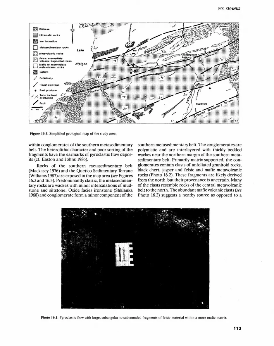
W.S. SHANKS
tfJH Diabase
Ultramafic rocks
Iron formation
Metasedimentary rocks
Metavolcanic rocks
-lil ' e'slc intermediateLd volcanic fragmental rocks
Past producer ^WMM^'^ . .. . x-? ^RS^i^v?
"^-r-;* ^V^W^II-—!!^ i^' -"
r1 ^0^^^!^f^ii;iii
Figure 16.3. Simplified geological map of the study area.
within conglomerates of the southern metasedimentary belt. The heterolithic character and poor sorting of the fragments have the earmarks of pyroclastic flow depos its (cf. Easton and Johns 1986).
Rocks of the southern metasedimentary belt (Mackasey 1976) and the Quetico Sedimentary Terrane (Williams 1987) are exposed in the map area (see Figures 16.2 and 16.3). Predominantly clastic, the metasedimen tary rocks are wackes with minor intercalations of mud stone and siltstone. Oxide facies ironstone (Shklanka 1968) and conglomerate form a minor component of the
southern metasedimentary belt. The conglomerates are polymictic and are interlayered with thickly bedded wackes near the northern margin of the southern meta sedimentary belt. Primarily matrix supported, the con glomerates contain clasts of unfoliated granitoid rocks, black chert, jasper and felsic and mafic metavolcanic rocks (Photo 16.2). These fragments are likely derived from the north, but their provenance is uncertain. Many of the clasts resemble rocks of the central metavolcanic belt to the north. The abundant mafic volcanic clasts (see Photo 16.2) suggests a nearby source as opposed to a
Photo 16.1. Pyroclastic flow with large, subangular to subrounded fragments of felsic material within a more mafic matrix.
113
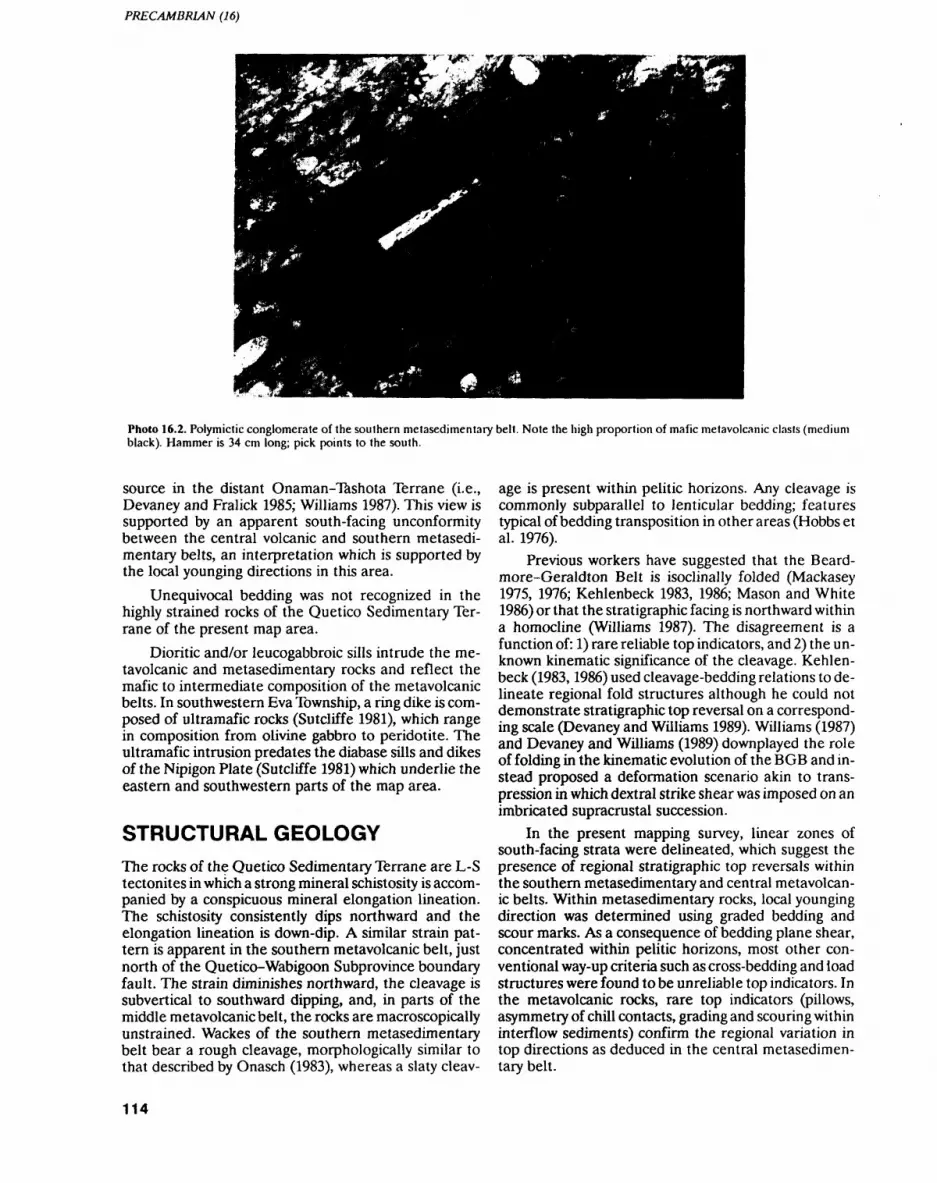
PRECAMBRIAN (16)
Photo 16.2. Polymictic conglomerate of the southern metasedimentary belt. Note the high proportion of mafic metavolcanic clasts (medium black). Hammer is 34 cm long; pick points to the south.
source in the distant Onaman-Tashota Terrane (i.e., Devaney and Fralick 1985; Williams 1987). This view is supported by an apparent south-facing unconformity between the central volcanic and southern metasedi mentary belts, an interpretation which is supported by the local younging directions in this area.
Unequivocal bedding was not recognized in the highly strained rocks of the Quetico Sedimentary Ter rane of the present map area.
Dioritic and/or leucogabbroic sills intrude the me- tavolcanic and metasedimentary rocks and reflect the mafic to intermediate composition of the metavolcanic belts. In southwestern Eva Township, a ring dike is com posed of ultramafic rocks (Sutcliffe 1981), which range in composition from olivine gabbro to peridotite. The ultramafic intrusion predates the diabase sills and dikes of the Nipigon Plate (Sutcliffe 1981) which underlie the eastern and southwestern parts of the map area.
STRUCTURAL GEOLOGYThe rocks of the Quetico Sedimentary Terrane are L-S tectonites in which a strong mineral schistosity is accom panied by a conspicuous mineral elongation lineation. The schistosity consistently dips northward and the elongation lineation is down-dip. A similar strain pat tern is apparent in the southern metavolcanic belt, just north of the Quetico-Wabigoon Subprovince boundary fault. The strain diminishes northward, the cleavage is subvertical to southward dipping, and, in parts of the middle metavolcanic belt, the rocks are macroscopically unstrained. Wackes of the southern metasedimentary belt bear a rough cleavage, morphologically similar to that described by Onasch (1983), whereas a slaty cleav
age is present within pelitic horizons. Any cleavage is commonly subparallel to lenticular bedding; features typical of bedding transposition in other areas (Hobbs et al. 1976).
Previous workers have suggested that the Beard- more-Geraldton Belt is isoclinally folded (Mackasey 1975, 1976; Kehlenbeck 1983, 1986; Mason and White 1986) or that the stratigraphic facing is northward within a homocline (Williams 1987). The disagreement is a function of: 1) rare reliable top indicators, and 2) the un known kinematic significance of the cleavage. Kehlen beck (1983,1986) used cleavage-bedding relations to de lineate regional fold structures although he could not demonstrate stratigraphic top reversal on a correspond ing scale (Devaney and Williams 1989). Williams (1987) and Devaney and Williams (1989) downplayed the role of folding in the kinematic evolution of the BOB and in stead proposed a deformation scenario akin to trans- pression in which dextral strike shear was imposed on an imbricated supracrustal succession.
In the present mapping survey, linear zones of south-facing strata were delineated, which suggest the presence of regional stratigraphic top reversals within the southern metasedimentary and central metavolcan ic belts. Within metasedimentary rocks, local younging direction was determined using graded bedding and scour marks. As a consequence of bedding plane shear, concentrated within pelitic horizons, most other con ventional way-up criteria such as cross-bedding and load structures were found to be unreliable top indicators. In the metavolcanic rocks, rare top indicators (pillows, asymmetry of chill contacts, grading and scouring within interflow sediments) confirm the regional variation in top directions as deduced in the central metasedimen tary belt.
114
W.S. SHANKS
The regional top reversals may be due to: 1) strati graphic inversion of panels of rock within an imbricate thrust wedge or 2) large-scale high-amplitude folding. The hypothetical hinge zones of the oppositely facing panels lack obvious faults, an observation consistent with the latter interpretation. The pattern of over turned beds is consistent with either a family of east ward-trending antiformal synclines and synformal anti clines or with a first-order set of folds which have elasti- cas style.
Because the kinematic significance of the cleavage is unclear, cleavage-bedding relations cannot as yet be used to infer the closure direction of folds nor used along with local younging directions, to determine the overall structural facing-direction of the strata (cf. Borradaile 1976). A microscopic survey of representa tive rock samples is underway in order to determine the kinematic significance of the cleavage.
MINERALIZATIONMason and White (1986) complied a comprehensive list of mineralization throughout the BOB and recom mended that Eva and Summers townships be pros pected for Leitch-type auriferous quartz veins. They also recommended that folded iron formation and zones of strong deformation be investigated for gold mineral ization.
The stratigraphy between the Standingstone and Sandy Creek faults represents a proximal volcanic as semblage and should be explored for massive sulphides. Strong iron-carbonate alteration, and silicification along parts of the Sandy Creek Fault and within a topo graphic dome north of Eva Lake (see Figure 16.3) make these structures inviting targets for future gold explora tion.
A layered ultramafic intrusion in southwestern Eva Township should be prospected for chromium and plati num group elements (Sutcliffe 1981).
CONCLUSIONS ANDPRELIMINARYRECOMMENDATIONS1. Newly discovered, linear zones of south-facing stra
ta point to regional stratigraphic top reversals with in the southern metasedimentary and central meta- volcanic belts.
2. The subparallelism between cleavage and bedding is suggestive of transposed bedding. Whether the transposition is mainly due to regional-scale high- amplitude buckling, or to large-scale strike shear imposed on previously folded rocks, is unknown.
3. The angular discordance between the stratigraphy of the central metavolcanic and southern metasedi mentary belts suggests an unconformity unless any tranposition was highly domainal.
4. The abu ndance of coarse volcaniclastic material be tween .Standingstone and Sandy Creek faults repre sents a proximal volcanic facies which should be considered a prime exploration target. Moreover, zones of strong iron-carbonate alteration, seritiza- tion and silicification, along parts of the Sandy Creek Fault and elsewhere, are also inviting explo ration targets.
REFERENCESBorradaille, G.J. 1976. Structural facing (Shackleton's rule) and
Paleozoic rocks of the Malaguide Complex near Velez Rubio, SE Spain; in Proceedings, Koninklijke Nederlandse Akademie van Wetenschappen, Serie B: Physical Sciences, v.79, p.330-336.
Devaney, I.R. and Fralick, P.W. 1985. Regional sedimentology of the Namewaminikan Group, northern Ontario: Archean fluvial fans, braided rivers, deltas and an aquabasin; in Current Research, Part B, Geological Survey of Canada, Paper 85-1B, p.125-132.
Devaney, J.R. and Williams, H.W. 1989. Evolution of an Archean sub- province boundary: a sedimentological and structural study of part of the Wabigoon-Quetico boundary in northern Ontario; Canadian Journal of Earth Sciences, v.26, p.1013-1026.
Easton, R.M. and Johns, G.W. 1986. Volcanology and mineral explo ration: the application of physical volcanology and facies studies; i/i Volcanology and mineral deposits, Ontario Geological Survey, Miscellaneous Paper 129, p.2-40.
Hobbs, B.E., Means, W.D. and Williams, RF. 1976. An outline of structural geology; Wiley and Sons, Toronto, 571p.
Kehlenbeck, M.M. 1983. Structural studies in the Beardmore- Geraldton area; in Summary of Field Work 1983, Ontario Geo logical Survey, Miscellaneous Paper 116, p.201-203.
1986. Folds and folding in the Beardmore-Geraldton fold belt; Canadian Journal of Earth Sciences, v.23, p.158-171.
Mackasey, W.O. 1970a. Eva Township, District of Thunder Bay; On tario Division of Mines, Preliminary Map P.601, scale 1:15 840.
1970b. Summers Township, District of Thunder Bay; Ontario Division of Mines, Preliminary Map P.602, scale 1:15 840.
1975. Geology of Dorothea, Sandra, and Irwin townships, Dis- iricl of Thunder Bay; On l a rio Division of Mines, Geoscience Re port 122, 83p.
1976. Geology of Walters and Leduc townships, District of Thunder Bay; Ontario Division of Mines, Geoscience Report 149, 58p.
Mason, J.K. and McConnell, C.D. 1983. Gold mineralization in the Beardmore-Geraldton area; in The Geology of Gold in Ontario, Ontario Geological Survey, Miscellaneous Paper 110, p.84-97.
Mason, J.K. and White, G.D. 1986. Gold occurrences, prospects, and deposits of the Beardmore-Geraldton area, districts of Thunder Bay and Cochrane; Ontario Geological Survey, Open File Re port 5630, 680p.
Mason, J.K., White, G.D., Speed, A.A., Gaudino, S., Sarvas, P and Stott, G.M. 1989. Beardmore-Geraldton Resident Geologist's District-l 989; in Report of Activities 1989, Resident Geolo gists, Ontario Geological Survey, Miscellaneous Paper 147, p.115-137.
Onasch, C.M. 1983. Origin and significance of microstructures in sandstones of the Martinsburg Formation, Maryland; American Journal of Science, v.283, p.936-966.
Shklanka, R. 1968. Iron deposits of Ontario; Ontario Department of Mines, Mineral Resources Circular 11, p.377-378.
Slott.G.M. 1984a. Lake Nipigon sheet, Thunder Bay District; Ontar io Geological Survey, Preliminary Map P257 (Revised), scale 1:126720.
—— 1984b. Geraldton sheet, Thunder Bay and Cochrane districts; Ontario Geological Survey, Preliminary Map P.241 (Revised), scale 1:126720.
115
PRECAMBRIAN (16)
Sutcliffe, R.H. 1981. Geology of the Wabigoon-Quetico Subprovince Williams, H.R. 1987. Ontario geoscience research grant program,boundary in the Lake Nipigon area, District of Thunder Bay; in grant no. 242: Structural studies in the Wabigoon and QueticoSummary of Field Work 1981, Ontario Geological Survey, Mis- subprovinces; Ontario Geological Survey, Open File Reportcellaneous Paper 100, p.26-29. 5668,163p.
116
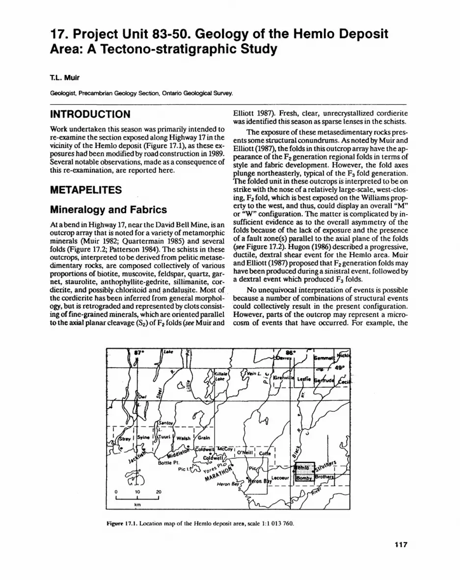
17. Project Unit 83-50. Geology of the Hemlo Deposit Area: A Tectono-stratigraphic Study
T.L. Muir
Geologist. Precambrian Geology Section. Ontario Geological Survey.
INTRODUCTIONWork undertaken this season was primarily intended to re-examine the section exposed along Highway 17 in the vicinity of the Hemlo deposit (Figure 17.1), as these ex posures had been modified by road construction in 1989. Several notable observations, made as a consequence of this re-examination, are reported here.
METAPELITES
Mineralogy and FabricsAt a bend in Highway 17, near the David Bell Mine, is an outcrop array that is noted for a variety of metamorphic minerals (Muir 1982; Quartermain 1985) and several folds (Figure 17.2; Patterson 1984). The schists in these outcrops, interpreted to be derived from pelitic metase- dimentary rocks, are composed collectively of various proportions of biotite, muscovite, feldspar, quartz, gar net, staurolite, anthophyllite-gedrite, sillimanite, cor dierite, and possibly,chloritoid and andalusite. Most of the cordierite has been inferred from general morphol ogy, but is retrograded and represented by clots consist ing of fine-grained minerals, which are oriented parallel to the axial planar cleavage (S2) of F2 folds (see Muir and
Elliott 1987). Fresh, clear, unrecrystallized cordierite was identified this season as sparse lenses in the schists.
The exposure of these metasedimentary rocks pres ents some structural conundrums. As noted by Muir and Elliott (1987), the folds in this outcrop array have the ap pearance of the F2 generation regional folds in terms of style and fabric development. However, the fold axes plunge northeasterly, typical of the F3 fold generation. The folded unit in these outcrops is interpreted to be on strike with the nose of a relatively large-scale, west-clos ing, F2 fold, which is best exposed on the Williams prop erty to the west, and thus, could display an overall "M" or "W" configuration. The matter is complicated by in sufficient evidence as to the overall asymmetry of the folds because of the lack of exposure and the presence of a fault zone(s) parallel to the axial plane of the folds (see Figure 17.2). Hugon (1986) described a progressive, ductile, dextral shear event for the Hemlo area. Muir and Elliott (1987) proposed that F2 generation folds may have been produced during a sinistral event, followed by a dextral event which produced F3 folds.
No unequivocal interpretation of events is possible because a number of combinations of structural events could collectively result in the present configuration. However, parts of the outcrop may represent a micro cosm of events that have occurred. For example, the
Vitals! {?V*inL. V* A (^ LI*. J V/J -/BrthviU,
*HP^' v. •\S 0 Leco*i* Heronlti? T0* BtL__
Figure 17.1. Location map of the Hemlo deposit area, scale 1:1 013 760.
117
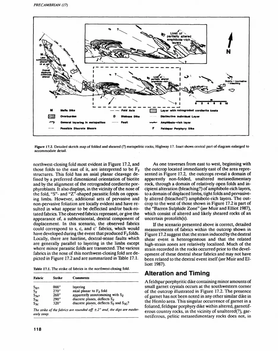
PRECAMBRIAN (17)
.Umit ol ^
partially altered amphibole-ri
Quartz * tourmalin btacMng
9 10
— — Fold tala
D Oiabaaa Dike
—- F.UH
Layer with retrograded cordierite knola
Distinctive individual Layer
Amphibole-rich layer
Feldapar Porphyry Dike
Figure 17.2. Detailed sketch map of folded and sheared (?) metapelitic rocks, Highway 17. Inset shows central part of diagram enlarged to accommodate detail.
northwest-closing fold most evident in Figure 17.2, and those folds to the east of it, are interpreted to be F2 structures. This fold has an axial planar cleavage de fined by a preferred dimensional orientation of biotite and by the alignment of the retrograded cordierite por- phyroblasts. It also displays, in the vicinity of the nose of the fold, "S"- and "Z"-shaped parasitic folds on oppos ing limbs. However, additional sets of pervasive and non-pervasive foliation are locally evident and have re sulted in what appear to be deflected and/or back-ro tated fabrics. The observed fabrics represent, or give the appearance of, a subhorizontal, dextral component of displacement. In this scenario, the observed fabrics could correspond to s, c, and c' fabrics, which would have developed during the event that produced F3 folds. Locally, there are hairline, dextral-sense faults which are generally parallel to layering in the limbs except where minor parasitic folds are transected. The various fabrics in the nose of this northwest-closing fold are de picted in Figure 17.2 and are summarized in Table 17.1.
Table 17.1. The strike of fabrics in the northwest-closing fold.
Fabric Strike Comments
So/1S2Sas?SacS3C
000*270*260*290*320*
layeringaxial planar to F2 foldapparently anastomosing with S2discrete planes, deflects S2discrete planes, deflects S2 and 83^?
The strike of the fabrics are rounded off ±2' and, the dips are moder ately steep.
As one traverses from east to west, beginning with the outcrop located immediately east of the area repre sented in Figure 17.2, the outcrops reveal a domain of apparently non-folded, unaltered metasedimentary rock, through a domain of relatively open folds and in cipient alteration (bleaching?) of amphibole-rich layers, to a domain of displaced limbs, tight folds and pervasive ly altered (bleached?) amphibole-rich layers. The out crop to the west of those shown in Figure 17.2 is part of the "Barren Sulphide Zone" (see Muir and Elliot 1987), which consist of altered and likely sheared rocks of an uncertain protolith(s).
If the scenario presented above is correct, detailed measurements of fabrics within the outcrop shown in Figure 17.2 suggest that the strain induced by the dextral shear event is heterogeneous and that the related high-strain zones are relatively localized. Much of the strain recorded in the rocks occurred prior to the devel opment of these dextral shear fabrics and may not have been related to the dextral event itself (see Muir and El liott 1987).
Alteration and TimingA feldspar porphyritic dike containing minor amounts of small garnet crystals occurs at the southwestern corner of the outcrop illustrated in Figure 17.2. The presence of garnet has not been noted in any other similar dike in the Hemlo area. This singular occurrence of garnet in a foliated, feldspar porphyry dike within altered, garnetif erous country rocks, in the vicinity of unaltered(?), gar netiferous, pelitic metasedimentary rocks does not, in
118
T.L. MUIR
itself, allow a distinction to be made between the timing of any of the following possible events: 1) dike intrusion prior to deposit-related hydrothermal alteration; 2) in trusion prior to regional metamorphism; 3) assimilation of aluminous country rocks, prior or subsequent to al teration or regional metamorphism; or 4) combinations of the above possibilities.
The timing of dike and pluton intrusion with respect to the deposit-related alteration and mineralization is important as some of the dikes have been dated at 2680-2690 Ma (Corfu and Muir 1989). Dikes in the min eralized zone are enriched in Au, Mo, Hg, Sb and Ba, and contain muscovite poikiloblasts, which suggests that they may have predated the alteration and mineraliza tion. However, it is also possible that the dikes post-date the intense period of alteration and mineralization, but were emplaced during a protracted hydrothermal and/ or metamorphic event which exposed them to circulat ing fluids within a potassium- and metal-rich environ ment. Based on a variety of overall observations, the dikes are interpreted to intrude the gold mineralization (Kuhns 1988; Corfu and Muir 1989).
The above timing relations may be further clarified, through extrapolation, by the existence of a green- mica-bearing xenolith of altered argillite within a feld spar porphyritic dike at the Northern Eagle barite show ing. At this showing, located about 20 km west of the Hemlo deposit, some of the alteration is similar to that at Hemlo. Some of the country rock between several feldspar porphyry dikes is unaltered, very dark grey ar gillite, whereas other country rock is interpreted to be feldspathized and/or serialized argillite that locally contains green mica. The geometric relations between the green-mica alteration and the dikes at the Northern Eagle showing suggests that at least some of the alter ation preceded intrusion.
At Hemlo, if the alteration and dikes are coeval, and if the alteration is directly related to the gold miner alization, a minimum age for the gold mineralization is about 2680-2690 Ma, based on geochronological data by Corfu and Muir (1889). The gold mineralization has been sheared and folded during the D3 event, but the re lations among the mineralization, dikes, and the fabrics and structures attributed to the dextral shear indicate that the mineralization and intrusion preceded the dex tral shear.
REFERENCESCorfu, F. and Muir, TL. 1989. The Hemlo-Heron Bay greenstone belt
and Hemlo Au-Mo deposit, Superior Province, Ontario, Canada: 1. sequence of igneous activity determined by zircon U-Pb geo chronology; Chemical Geology, v.79, p. 183-200.
Hugon, H. 1986. The Hemlo gold deposit, Ontario, Canada: a central portion of a large scale, wide zone of heterogeneous ductile shear; in Proceedings of Gold '86, an Internationa! Symposium on the Geology of Gold, p.379-387.
Kuhns, R.J. 1988. The Golden Giant Deposit, Hemlo, Ontario: geo logic and geochemical relationships between mineralization, al teration, metamorphism, magmatism and tectonism; Unpub lished PhD thesis, University of Minnesota, Minneapolis, Minne sota, 458p.
Muir.TL. 1982. Geology of the Hemlo area, District of Thunder Bay; Ontario Geological Survey, Report 217, 65p.
Muir, T.L. and Elliott, C.G. 1987. Hemlo tectono-stratigraphic study, District of Thunder Bay; in Summary of Field Work and Other Activities 1987, Ontario Geological Survey, Miscellaneous Pa per 137, p.117-129.
Patterson, G.C. 1984. Field trip guidebook to the Hemlo area; Ontar io Geological Survey, Miscellaneous Paper 118, 33p.
Quartermain, R. 1985. Road guide to the geology of the Teck-Corona Mine at Hemlo, Ontario; in Gold and Copper-Zinc Metallogeny Within Metamorphosed Greenstone Terrain, Hemlo-Manitou- wadge-Winston Lake, Ontario, Canada; Geological Association of Canada-Canadian Institute of Mining and Metallurgy, p. 39-46.
119
18. Project Unit 88-20. Geological and Structural Interpretation of Remote Sensing and High Resolution Aeromagnetic Data for the Missanabie-Renabie Area, Districts of Algoma and Sudbury
K.B. Heather 1 , R.S. Mussakowski2 and N.F. Trowell 1
1 Geologist, Precambrian Geology Section. Ontario Geological Survey.
2 Staff Scientist, Ontario Centre for Remote Sensing, Surveys, Ministry of Natural Resources.
INTRODUCTION
The Ontario Geological Survey and the Ontario Centre for Remote Sensing are jointly investigating both the utilization of remote sensing for bedrock mapping and the integration of remote sensing data into digital geo science data bases. The initial phases of this investiga tion (Mussakowski and Trowell 1988, 1989a, 1989b, 1989c, 1990; Mussakowski, Trowell and Heather, in press; Mussakowski, Trowell, Sage and Heather 1990) demonstrated the usefulness of remotely sensed data, specifically LANDS AT Thematic Mapper (TM) and air borne C-band radar (SAR), in interpreting digital geo logical data bases e.g., bedrock geology, structural geology, and total field aeromagnetics (OGS 1987) for the Goudreau-Lochalsh area of the Michipicoten greenstone belt (Area A, Figure 18.1).
During the spring of 1990, a structural interpreta tion of airborne C-band radar (SAR), LANDSAT TM, 1:50 000 scale airphoto mosaic and high-resolution aero
magnetic data was completed for the Missanabie-Rena bie area (see Area B, Figure 18.1). This was followed by field-based investigations to verify the existence of the interpreted structural features. Preliminary results from this investigation indicate that many of the region al features interpreted from the remote sensing and aeromagnetic data are structurally important. Many of the features are large scale manifestations of regional foliation trends and high-strain zones that had previous ly been mapped by Heather and Buck (1988) and Heath er (1989), while others are previously unidentified struc tures.
GEOLOGY OF THE STUDY AREAThe general geology of the Missanabie-Renabie area (Glasgow, Riggs, Meath, West, Rennie and Stover townships) has been documented previously at a scale of 1:15 840 by Bruce (1944), Riley (1971), Bennett (1978), and Srivastava and Bennett (1978), and is summarized in Heather and Buck (1988). The general geology of Lees-
Figure 18.1. Location of ihe Goudreau-Lochalsh (area A) and Missanabie-Renabie (area B) study areas, scale 1:1 584 000.
120
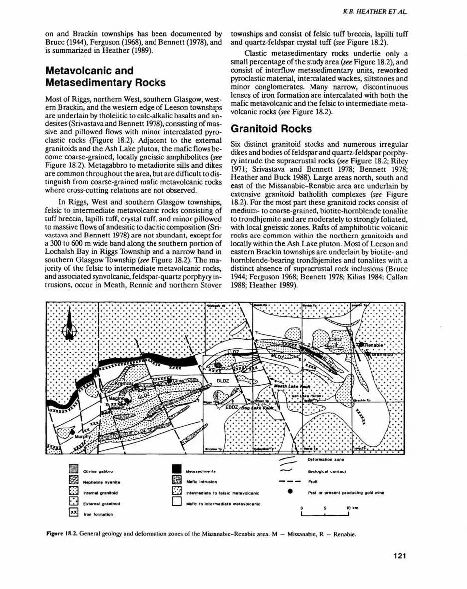
K.B. HEATHER ETAL.
on and Brackin townships has been documented by Bruce (1944), Ferguson (1968), and Bennett (1978), and is summarized in Heather (1989).
Metavolcanic and Metasedimentary RocksMost of Riggs, northern West, southern Glasgow, west ern Brackin, and the western edge of Leeson townships are underlain by tholeiitic to calc-alkalic basalts and an- desites (Srivastava and Bennett 1978), consisting of mas sive and pillowed flows with minor intercalated pyro clastic rocks (Figure 18.2). Adjacent to the external granitoids and the Ash Lake pluton, the mafic flows be come coarse-grained, locally gneissic amphibolites (see Figure 18.2). Metagabbro to metadiorite sills and dikes are common throughout the area, but are difficult to dis tinguish from coarse-grained mafic metavolcanic rocks where cross-cutting relations are not observed.
In Riggs, West and southern Glasgow townships, felsic to intermediate metavolcanic rocks consisting of tuff breccia, lapilli tuff, crystal tuff, and minor pillowed to massive flows of andesitic to dacitic composition (Sri vastava and Bennett 1978) are not abundant, except for a 300 to 600 m wide band along the southern portion of Lochalsh Bay in Riggs Township and a narrow band in southern Glasgow Township (see Figure 18.2). The ma jority of the felsic to intermediate metavolcanic rocks, and associated synvolcanic, feldspar-quartz porphyry in trusions, occur in Meath, Rennie and northern Stover
townships and consist of felsic tuff breccia, lapilli tuff and quartz-feldspar crystal tuff (see Figure 18.2).
Clastic metasedimentary rocks underlie only a small percentage of the study area (see Figure 18.2), and consist of interflow metasedimentary units, reworked pyroclastic material, intercalated wackes, siltstones and minor conglomerates. Many narrow, discontinuous lenses of iron formation are intercalated with both the mafic metavolcanic and the felsic to intermediate meta volcanic rocks (see Figure 18.2).
Granitoid RocksSix distinct granitoid stocks and numerous irregular dikes and bodies of feldspar and quartz-feldspar porphy ry intrude the supracrustal rocks (see Figure 18.2; Riley 1971; Srivastava and Bennett 1978; Bennett 1978; Heather and Buck 1988). Large areas north, south and east of the Missanabie-Renabie area are underlain by extensive granitoid batholith complexes (see Figure 18.2). For the most part these granitoid rocks consist of medium- to coarse-grained, biotite-hornblende tonalite to trondhjemite and are moderately to strongly foliated, with local gneissic zones. Rafts of amphibolide volcanic rocks are common within the northern granitoids and locally within the Ash Lake pluton. Most of Leeson and eastern Brackin townships are underlain by biotite- and hornblende-bearing trondhjemites and tonalites with a distinct absence of supracrustal rock inclusions (Bruce 1944; Ferguson 1968; Bennett 1978; Kilias 1984; Callan 1988; Heather 1989).
Olivine gabbro
Nepheline syenite
Internal granitoid
External granitoid
Iron formation
D
Metasediments
Mafic intrusion
Intermediate to felsic metavolcanic
Mafic to intermediate metavolcanic
Deformation zone
Geological contact
— Fault
Past or present producing gold mine
10 km
Figure 18.2. General geology and deformation zones of the Missanabie-Renabie area. M — Missanabie, R — Renabie.
121
PRECAMBRIAN (18)
Late Mafic to Ultramafic IntrusionsLate mafic to ultramafic intrusions include numerous diabase, lamprophyre and ultramafic dikes, and a large olivine gabbro stock (see Figure 18.2, Manitou Mountain stock). At least three types of mafic (lamprophyre?) dikes have been identified, based on intrusive relations and strain state. Mafic dikes, which are predeformation- al to syndeformational in age, are variably schistose and consist of biotite and iron-carbonate. Later biotite lam prophyre dikes cut all the deformation fabrics and the gold-bearing quartz veins. Northwest- and northeast- trending diabase dikes cut all rock types in the area; however, their relation to the late biotite lamprophyres is equivocal.
STRUCTURAL GEOLOGYA brief summary of some structural features recognized in the area is provided as the basis for comparison with, and interpretation of, the remote sensing data. Several regional zones of brittle, brittle-ductile and ductile (Ramsay 1980) deformation were delineated (Heather and Buck 1988; Heather 1989). Riley (1971), Bennett (1978) and Srivastava and Bennett (1978) defined sever al major east- to southeast-trending, anticlinal and syn clinal fold structures. The best defined of these folds is the southeast-trending, "isoclinally" folded Baltimore Lake Syncline" (Riley 1971), which is coincident with the Baltimore Lake deformation zone (Heather and Buck 1988). Early regional isoclinal folding is locally evi dent; however, superimposed progressive shear folding, transposition and ductile shearing, characteristic of many of the regional deformation zones modify earlier synformal-antiformal geometries such that they may now be impossible to delineate.
Two prominent fault trends, 020* to 060 0 and 320 0 to 350*, have been defined in the area by Riley (1971) and Srivastava and Bennett (1978), and are recognized in some of the remote sensing data sets (e.g., Feature 7, see below). The 320" to 350 0 set is more prevalent and is best exemplified by the regionally extensive Meath Lake fault (see Figure 18.2), which sinistrally offsets all geo logical features, including major deformation zones, by at least 0.8 km (Srivastava and Bennett 1978; Heather and Buck 1988). The amount of vertical offset is not known, but the dichotomous character of both the su pracrustal stratigraphy and the structural style across the fault (Heather and Buck 1988) is consistent with a significant component of vertical displacement.
The presence of northwest-striking foliation on parts of Dog Lake is attributed to a parallel, north west-striking structure referred to here as the Dog Lake fault (see Figure 18.2). No significant displacement is documented on this fault (Heather and Buck 1988).
The northwest-striking faults appear to have local ized diabase dikes, as, to a lesser degree, have the north east-striking faults. The northwest-striking faults exhib it dominantly sinistral displacement, while the north
east set are dextral; however, there are local exceptions to this pattern (Riley 1971; Srivastava and Bennett 1978).
MINERALIZATIONThe Missanabie-Renabie area contains the Renabie gold mine, which has produced in excess of one million ounces of gold, as well as several smaller gold occur rences localized within discrete, brittle-ductile, high- strain zones within regional zones of deformation. There are several, small, base metal sulphide (e.g.; Con- boy Lake Zn-Ag Pb-Cu-Au, see Heather and Buck 1988, Figure 37.7) and pyrite-pyrrhotite (e.g.; Loch Lomond, see Heather and Buck 1988, Figure 37.7) occurrences in the area which are also coincident with high strain zones.
METHODOLOGYThe procedures for data acquisition and analysis used in this project have been adapted from work previously conducted by the authors in the adjoining Goudreau- Lochalsh area (Mussakowski et al. 1988,1989). The data sets employed include LANDSAT TM (Photo 18.1), SAR (Photo 18.2) and high resolution total field aero- magnetics (Figure 18.3), and are small subsets of larger data sets that cover the Mishibishu Lake and Michipico ten greenstone belts (Mussakowski et al. 1988,1989). A more traditional 1:50 000 scale black and white airphoto mosaic was also incorporated into the study for compar ative purposes (Photo 18.3). All of the data sets utilized in this study, with the exception of the aiq^hoto mosaic, are in a digital format, which allowed: 1) selective en hancements to accentuate specific details, 2) superposi tion of data sets, and 3) viewing of merged or separate images. Conventional visual interpretive techniques were applied to each of the data sets, both in hardcopy format and directly at a computer terminal.
The interpretation process involved the identifica tion and mapping of all linear, curvilinear, semicircular or other pronounced geomorphic and bedrock struc tures on each of the data sets. Each of these individual interpretations was colour-coded and transferred onto a 1:50000 scale airphoto mosaic (see Photo 18.3), which served as a geographic reference base to form a compos ite structural interpretation. This colour-coded compos ite, illustrated here in black and white (Figure 18.4), al lowed visual assessment of which remote sensing tech nique best displayed certain types and/or orientations of geomorphic features. For example, some features were evident on the SAR and LANDS AT TM images, but not on the airphoto mosaic or the total-field aeromagnetic image.
A field program of "ground-truthing" was carried out to verify the presence and possible cause of the geo morphic features. Features were selected for ground truthing on the basis of how they were manifested on the colour-coded composite and their potential geological importance. Outcrops at, or as near as possible to, the
122
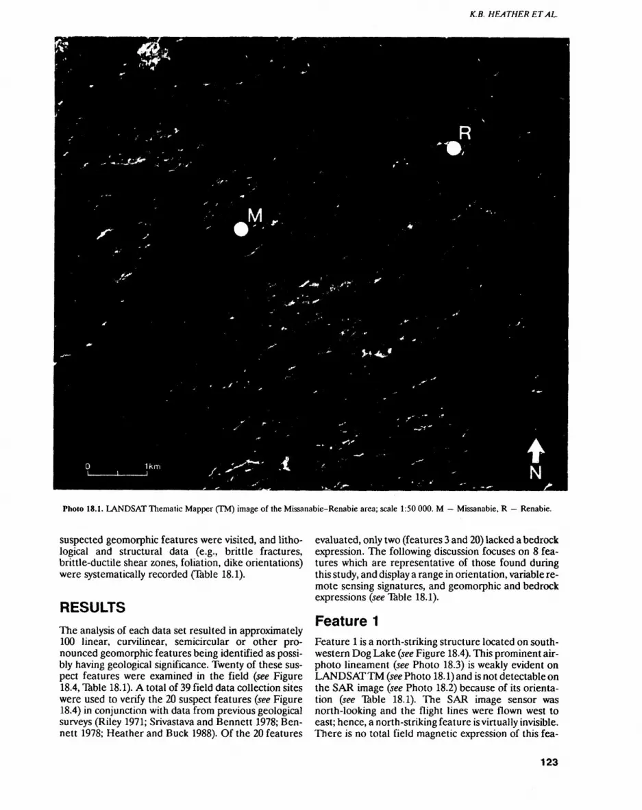
K.B. HEATHER ETAL.
Photo 18.1. LANDSAT Thematic Mapper (TM) image of the Missanabie-Renabie area; scale 1:50 000. M Missanabie, R Renabie.
suspected geomorphic features were visited, and litho- logical and structural data (e.g., brittle fractures, brittle-ductile shear zones, foliation, dike orientations) were systematically recorded (Table 18.1).
RESULTSThe analysis of each data set resulted in approximately 100 linear, curvilinear, semicircular or other pro nounced geomorphic features being identified as possi bly having geological significance. Twenty of these sus pect features were examined in the field (see Figure 18.4, Table 18.1). A total of 39 field data collection sites were used to verify the 20 suspect features (see Figure 18.4) in conjunction with data from previous geological surveys (Riley 1971; Srivastava and Bennett 1978; Ben nett 1978; Heather and Buck 1988). Of the 20 features
evaluated, only two (features 3 and 20) lacked a bedrock expression. The following discussion focuses on 8 fea tures which are representative of those found during this study, and display a range in orientation, variable re mote sensing signatures, and geomorphic and bedrock expressions (see Table 18.1).
Feature 1Feature l is a north-striking structure located on south western Dog Lake (see Figure 18.4). This prominent air photo lineament (see Photo 18.3) is weakly evident on LANDSAT TM (see Photo 18.1) and is not detectable on the SAR image (see Photo 18.2) because of its orienta tion (see Table 18.1). The SAR image sensor was north-looking and the flight lines were flown west to east; hence, a north-striking feature is virtually invisible. There is no total field magnetic expression of this fea-
123
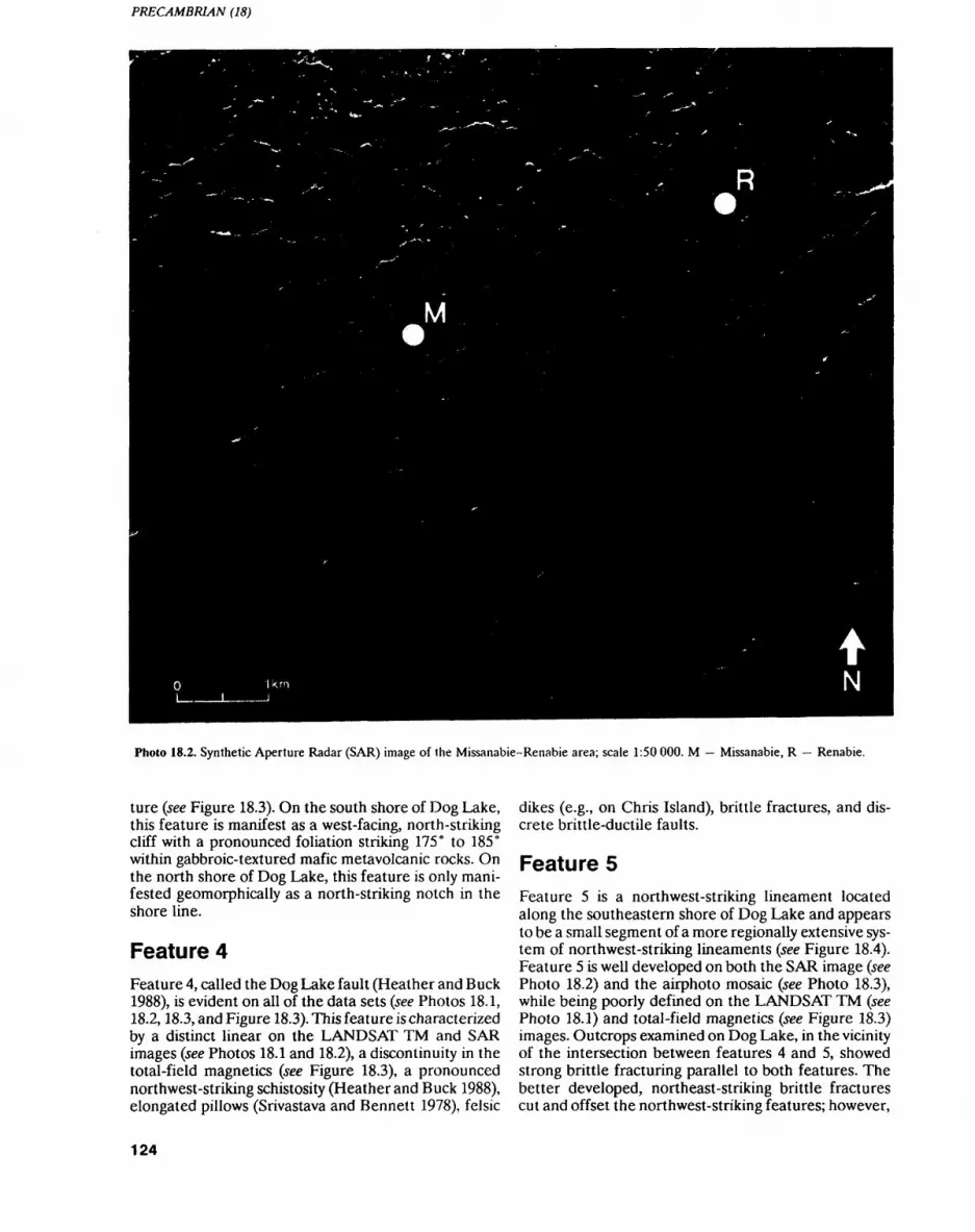
PRECAMBRIAN (18)
Photo 18.2. Synthetic Aperture Radar (SAR) image of the Missanabie-Renabie area; scale 1:50 000. M Missanabte, R Renabie.
ture (see Figure 18.3). On the south shore of Dog Lake, this feature is manifest as a west-facing, north-striking cliff with a pronounced foliation striking 175 0 to 185 0 within gabbroic-textured mafic metavolcanic rocks. On the north shore of Dog Lake, this feature is only mani fested geomorphically as a north-striking notch in the shore line.
Feature 4Feature 4, called the Dog Lake fault (Heather and Buck 1988), is evident on all of the data sets (see Photos 18.1, 18.2,18.3, and Figure 18.3). This feature is characterized by a distinct linear on the LANDSAT TM and SAR images (see Photos 18.1 and 18.2), a discontinuity in the total-field magnetics (see Figure 18.3), a pronounced northwest-striking schistosity (Heather and Buck 1988), elongated pillows (Srivastava and Bennett 1978), felsic
dikes (e.g., on Chris Island), brittle fractures, and dis crete brittle-ductile faults.
Feature 5Feature 5 is a northwest-striking lineament located along the southeastern shore of Dog Lake and appears to be a small segment of a more regionally extensive sys tem of northwest-striking lineaments (see Figure 18.4). Feature 5 is well developed on both the SAR image (see Photo 18.2) and the airphoto mosaic (see Photo 18.3), while being poorly defined on the LANDSAT TM (see Photo 18.1) and total-field magnetics (see Figure 18.3) images. Outcrops examined on Dog Lake, in the vicinity of the intersection between features 4 and 5, showed strong brittle fracturing parallel to both features. The better developed, northeast-striking brittle fractures cut and offset the northwest-striking features; however,
124
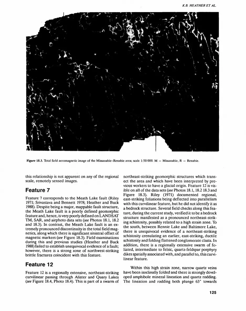
K.B. HEATHER ETAL.
Figure 18.3. Total field aeromagnetic image of the Missanabie-Renabie area; scale 1:50000. M Missanabie, R Renabie.
this relationship is not apparent on any of the regional scale, remotely sensed images.
Feature 7Feature 7 corresponds to the Meath Lake fault (Riley 1971; Srivastava and Bennett 1978; Heather and Buck 1988). Despite being a major, mappable fault structure, the Meath Lake fault is a poorly defined geomorphic feature and, hence, is very poorly defined on LANDSAT TM, SAR, and airphoto data sets (see Photos 18.1, 18.2 and 18.3). In contrast, the Meath Lake fault is an ex tremely pronounced discontinuity in the total field mag netics, along which there is significant sinistral offset of magnetic markers (see Figure 18.3). Field examinations during this and previous studies (Heather and Buck 1988) failed to establish unequivocal evidence of a fault; however, there is a strong zone of northwest-striking brittle fractures coincident with this feature.
Feature 12Feature 12 is a regionally extensive, northeast-striking curvilinear passing through Alister and Quary Lakes (see Figure 18.4, Photo 18.4). This is part of a swarm of
northeast-striking geomorphic structures which trans ect the area and which have been interpreted by pre vious workers to have a glacial origin. Feature 12 is vis ible on all of the data sets (see Photos 18.1,18.2 18.3 and Figure 18.3). Riley (1971) documented regional, east-striking foliations being deflected into parallelism with this curvilinear feature, but he did not identify it as a bedrock structure. Several field checks along this fea ture, during the current study, verified it lobe a bedrock structure manifested as a pronounced northeast-strik ing schistosity, possibly related to a high strain zone. To the south, between Rennie Lake and Baltimore Lake, there is unequivocal evidence of a northeast-striking schistosity crenulating an earlier, east-striking, ductile schistosity and folding flattened conglomerate clasts. In addition, there is a regionally extensive swarm of fo liated, intermediate to felsic, quartz-feldspar porphyry dikes spatially associated with, and parallel to, this curvi linear feature.
Within this high strain zone, narrow quartz veins have been isoclinally folded and there is strongly devel oped amphibole mineral lineation and quartz rodding. The lineation and rodding both plunge 63 0 towards
125
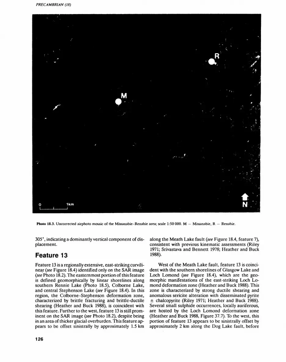
PRECAMBRIAN (18)
Photo 18.3. Uncorrected airphoto mosaic of the Missanabie-Renabie area; scale 1:50 000. M Missanabie, R Renabie.
305 0 , indicating a dominantly vertical component of dis placement.
Feature 13Feature 13 is a regionally extensive, east-striking curvili near (see Figure 18.4) identified only on the SAR image (see Photo 18.2). The easternmost portion of this feature is defined geomorphically by linear shorelines along southern Rennie Lake (Photo 18.5), Colborne Lake, and central Stephenson Lake (see Figure 18.4). In this region, the Colborne-Stephenson deformation zone, characterized by brittle fracturing and brittle-ductile shearing (Heather and Buck 1988), is coincident with this feature. Further to the west, feature 13 is still prom inent on the SAR image (see Photo 18.2), despite being in an area of thicker glacial overburden. This feature ap pears to be offset sinistrally by approximately 1.5 km
along the Meath Lake fault (see Figure 18.4, feature 7), consistent with previous kinematic assessments (Riley 1971; Srivastava and Bennett 1978; Heather and Buck 1988).
West of the Meath Lake fault, feature 13 is coinci dent with the southern shorelines of Glasgow Lake and Loch Lomond (see Figure 18.4), which are the geo morphic manifestations of the east-striking Loch Lo mond deformation zone (Heather and Buck 1988). This zone is characterized by strong ductile shearing and anomalous sericite alteration with disseminated pyrite chalcopyrite (Riley 1971; Heather and Buck 1988). Several small sulphide occurrences, locally auriferous, are hosted by the Loch Lomond deformation zone (Heather and Buck 1988, Figure 37.7). To the west, this portion of feature 13 appears to be sinistrally offset by approximately 2 km along the Dog Lake fault, before
126
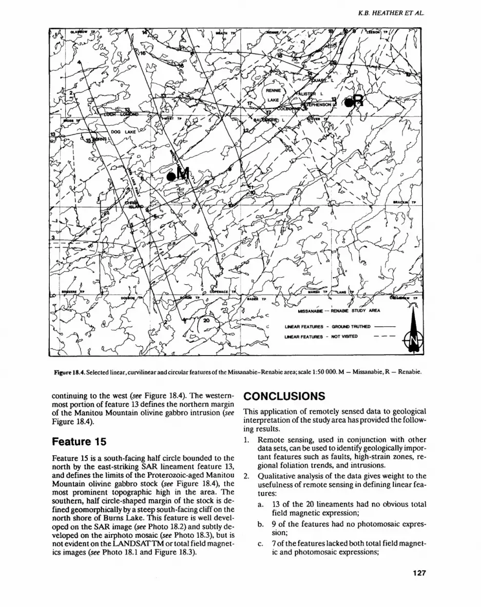
K.B. HEATHER ETAL.
LINEAR FEATURES - GROUND TRUTHED
LINEAR FEATURES - NOT VISITED
Figure 18.4. Selected linear, curvilinear and circular features of the Missanabie-Renabie area; scale 1:50000.M Missanabie, R Renabie.
continuing to the west (see Figure 18.4). The western most portion of feature 13 defines the northern margin of the Manitou Mountain olivine gabbro intrusion (see Figure 18.4).
Feature 15Feature 15 is a south-facing half circle bounded to the north by the east-striking SAR lineament feature 13, and defines the limits of the Proterozoic-aged Manitou Mountain olivine gabbro stock (see Figure 18.4), the most prominent topographic high in the area. The southern, half circle-shaped margin of the stock is de fined geomorphically by a steep south-facing cliff on the north shore of Burns Lake. This feature is well devel oped on the SAR image (see Photo 18.2) and subtly de veloped on the airphoto mosaic (see Photo 18.3), but is not evident on the LANDSATTM or total field magnet ics images (see Photo 18.1 and Figure 18.3).
CONCLUSIONSThis application of remotely sensed data to geological interpretation of the study area has provided the follow ing results.1. Remote sensing, used in conjunction with other
data sets, can be used to identify geologically impor tant features such as faults, high-strain zones, re gional foliation trends, and intrusions.
2. Qualitative analysis of the data gives weight to the usefulness of remote sensing in defining linear fea tures:a. 13 of the 20 lineaments had no obvious total
field magnetic expression;b. 9 of the features had no photomosaic expres
sion;c. 7 of the features lacked both total field magnet
ic and photomosaic expressions;
127

PRECAMBRIAN (18)
TABLE 18.1. Characteristics of suspect linear features identified on remote sensing data and investigated by ground truthing.
Feature
1
23
4
56789
101112
1314
151617
181920
Identified in:Thematic Mapper
X
-X
x-x-xxxxx-x-xxx--
Radar
.
XX
xxx-xxxxxxxxxxxxx
Magnetics
X
-X
x--x-x--x--
-NA-
X-x
Airphoto
.
-X
X
Xx--x--x--
-xxx--
Field
X
X-
x
xxxxxxxxxxxxxxx-
Structure
Foliation - parallelto linear,
brittle fracturesVery weak fabric
Brittle fractures
Brittle fracturesFoliation
Brittle fracturesBrittle fractures
FoliationBrittle fracturesBrittle fracturesBrittle fractures,ductile schistosityHigh strain zoneStrongly foliated
zoneSteep cliff
Brittle fracturesStrong compositionallayering, schistosity
FoliationCircular high
Geomorphological Reference Expression
Cliff faceshore line
CliffShore line
notchFault zone 1Channel
Channel2,3
Low swamp
Shore line 1Ridge
References: 'Heather & Buck (19SS), 2Riley (1971), Srivastava and Bennett (197S) NA = Not available
d. 7 of the features were identified on radar and LANDSAT TM images.
3. The structural features discussed in this paper are of regional extent and readily detectable via remote sensing. None of the techniques was successful in detecting the discrete, l to 20 m wide and several hundred metres long, high-strain zones which host the gold occurrences in the area. The resolution of each of the techniques (Mussakowski and Trowell 1988) is too coarse to identify these individual high-strain zones; however, some of the regional scale deformation zones that contain the discrete high-strain zones are detectable.
4. The late northwest- and northeast-striking faults previously defined by Riley (1971) and Srivastava and Bennett (1978) were confirmed, and a previous ly unknown curvilinear east-striking set of features was identified on the radar imagery.
5. One of these east-striking features (see Figure 18.4, No. 13) is spatially related to a structure known to host sulphide gold mineralization in the Loch Lomond area, as well as to the Colborne-Stephen- son deformation zone which may be the westward extension of the east-striking structure hosting the Renabie gold mine (Heather and Buck 1988; Heath er 1989, Figure 17.2).
6. Airphotos are, and always will be, an essential part of any mapping program. Airborne SAR data pro vided the largest amount of structural information; however, LANDSAT TM data provide much the same information as the airphoto mosaic, as well as the radar data set. Considering its wide availability and relatively low cost, use of the LANDSAT TM data is highly recommended.
7. The coincidence of aeromagnetic linear trends with remotely sensed lineaments not only served to re inforce their existence, but also, in some cases, aided in understanding their genesis.
More generally, this study has illustrated the usefulness of remote sensing in investigations into the regional geology and structure of a given area. More importantly, it emphasizes the advantages and abilities of each type of remote sensing data, and demonstrates that the maxi mum amount of information is gained by integrating all of the remotely sensed data sets.
ACKNOWLEDGMENTSWe thank Delio Tortosa and Ed Frey (Resident Geolo gist's Office, Wawa) for their logistical help and support of this project. We also thank R.P. Sage (Geologist, On tario Geological Survey) for his continuing support of this project and for providing a wealth of knowledge about the Wawa area.
128
K.B. HEATHER ETAL.
Photo 18.4. Northeast-striking curvilinear (see Figure 18.4, feature 12) that passes through Alister and Quarry lakes (looking south- west).
Photo 18.5. East-striking linear shore line (see Figure 18.4, feature 13) of southern Rennie Lake (looking west).
REFERENCESArias, Z.G. and Heather, K.B. 1987. Regional structural geology re
lated to gold mineralization in the Goudreau-Lochalsh area, District of Algoma; in Summary of Field Work and Other Activi ties 1987, Ontario Geological Survey, Miscellaneous Paper 137, p.146-154.
Barlow, R.B. 1987. Recent airborne electromagnetic-magnetic sur veys in northern Ontario; in Summary of Field work and Other Activities 1987, Ontario Geological Survey, Miscellaneous Paper 137, p.404-405.
1988. Total magnetic field colour image developed from digital archivesof the Ontario Geological Survey, Wawa area, districts of Thunder Bay, Algoma and Sudbury; Ontario Geological Survey, Map 81 143, scale 1:100 000.
Bennett, G. 1978. Geology of the Crooked Lake area, District of Sud bury; Ontario Geological Survey, Report 172, 46p.
Bruce, E.L. 1944. Geology of the Rennie-Leeson Area; Ontario De partment of Mines, Annual Report, 1942, v.51, pt.8, p.1-26.
1948. The Renabie gold mine; in Structural Geology of Cana dian Ore Deposits,Canadian Institute of Mining and Metallurgy, p.436-438.
Burwash, E.M. 1935. The Michipicoten-Missanabie area; Ontario Department of Mines, Annual Report, 1935, v.44, pt.8, p.1-26.
Callan, N.J. 1988. Syn-deformational shear zone-hosted Au-quartz vein mineralization in TTG host rocks, Renabie Mine area, north Ontario: Structural analysis, microstructural characteristics and vein paragenesis; unpublished MSc thesis, University of Toronto, Toronto, Ontario.
Canada Centre For Remote Sensing. 1988. CCRS/OCRS cooperate in SAR application development; Remote Sensing in Canada, v.16, no. 3, 13p.
Ferguson, S.A. 1968. Renabie Mines Limited, Nudulama Mines Lim ited and adjoining properties, surface geology; Ontario Depart ment of Mines, Preliminary Map P.492, scale 1:6000.
Heather, K.B. and Arias, Z.G. 1987. Geological setting of gold miner alization in the Goudreau-Lochalsh area, District of Algoma; in Summary of Field Work and Other Activities 1987, Ontario Geo logical Survey, Miscellaneous Paper 137, p.155-162.
Heather, K.B. and Buck, S. 1988. The geological and structural setting of gold mineralization in the Missanabie-Renabie District of Mi chipicoten greenstone belt, Wawa, Ontario; in Summary of Field Work and Other Activities 1988, Ontario Geological Survey, Miscellaneous Paper 141, p.257-270.
Heather, K.B. 1989. The geological and structural selling of gold min eralization in the Renabie portion of the Missanabie-Renabie gold district, Wawa Gold Camp, Wawa; in Summary of Field Work and Other Activities 1989, Ontario Geological Survey, Miscellaneous Paper 146, p.99-107.
129
PRECAMBRIAN (18)
Horwood, H.C. 1944. Geology and mineralization in the northern part of Stover Township; Ontario Department of Mines, Annual Re port, 1942, v.51, pt.8, p.27-42.
Kilias, S. 1984. Genesis of gold deposits, Renabie area, Sudbury Dis trict, Ontario; unpublished MSc thesis, University of Ottawa, Ot tawa, Ontario, 21 Op.
Mussakowski, R.S. and Trowell, N.F. 1988. Digital integration of re mote sensing data into a geoscience data base for the Goudreau- Lochalsh study area, Michipicoten greenstone belt; in Summary of Field Work and Other Activities 1988, Ontario Geological Survey, Miscellaneous Paper 141, p.271-275.
1989a. Applications of remote sensing in geology; in Summary of Field Work and Other Activities 1989, Ontario Geological Survey, Miscellaneous Paper 146, p.189-193.
1989b. Remote sensing activities in the Wawa area; in Geosci ence Research Seminar, Abstracts, Ontario Geological Survey, p.8.
1989c. Digital integration of remote sensing and geoscience data for the Goudreau-Lochalsh study area, Michipicoten greenstone belt, Ontario; Poster Session, CIS - Remote Sensing: "Forging the Link", Ontario Ministry of Natural Resources, To ronto. Ontario, November 28, 1989.
——— 1990. Wawa non-renewable resources airborne SAR Project; Tasks 89-33,88-33,87-56; in Part B: Project Summaries, RDDP (Radar Data Development program) Workshop, Canada Centre for Remote Sensing, Energy, Mines and Resources, Canada, Ga nanoque, Ontario.
Mussakowski, R.S., Trowell, N.F. and Heather, K.B. in press. Digital integration of remote sensing and geoscience data for the Gou dreau-Lochalsh study area, Michipicoten Belt, Wawa, Ontario; Canadian Journal of Remote Sensing.
Mussakowski, R.S.,Trowell, N.F, Sage, R.P. and Heather, K.B. 1990. Digital integration of remote sensing and geoscience data for the Goudreau-Lochalsh study area, Michipicoten greenstone belt, Ontario; in Proceedings, Seventh Thematic Conference, Remote Sensing for Exploration Geology, p.1051-1065.
Ontario Geological Survey 1987. Airborne electromagnetic and total intensity magnetic survey, Wawa area, districts of Thunder Bay, Algoma and Sudbury, Ontario; Ontario Geological Survey, Maps 81 003 to 81 034, scale 1:20 000.
Ramsay, J.G. 1980. Shear zone geometry: a review; Journal of Struc tural Geology, v.2, p.83-89.
Riley, R.A. 1971. Geology of Glasgow, Meath, and Rennie townships, districts of Algoma and Sudbury; Ontario Department of Mines, Geological Report 90, 55p.
Srivastava, P. and Bennett, G. 1978. Geology of Riggs and West town ships, District of Algoma; Ontario Geological Survey, Report 174, 56p.
130

19. Project Unit 88-32. Continuing Use and Development of Computer-based Field Mapping and Data Storage with OGS FIELDLOG
B. Brodaric1 and J.A. Fyon2
1 Systems Officer, Precambrian Geology Section, Ontario Geological Survey.
2Geologist, Precambrian Geology Section, Ontario Geological Survey.
INTRODUCTIONTwo methods have been developed in the Ontario Geo logical Survey to digitally store field data using OGS FIELDLOG (Brodaric and Fyon 1989). In "data base mode", data are entered directly into dBase III PLUS or dBase IV data bases, without the construction of a companion geological map, which is later generated and edited from the data base. Alternatively, using Auto CAD linked to OGS FIELDLOG, the geologist oper ates in "map mode" and constructs a geological map, while data are also stored into dBase III PLUS or dBase IV data bases.
In the 1990 field season, 6 OGS crews utilized these computer-aided mapping tools. Two crews utilized the map mode, building maps on a daily basis in the field. Three crews entered data into the data bases directly, for later quantitative treatment and thematic map gen eration. A sixth field party operated in both modes, en tering location-related data through AutoCAD , while numeric and interpretive details were keyed directly into the data bases. Using OGS FIELDLOG, this sixth crew created different layers of map data, which were subsequently added to the evolving geological map. Each project geologist tailored the structure of the data bases to reflect the unique nature of their project, and their geological expertise.
An updated version of the OGS FIELDLOG soft ware, as reported in Brodaric and Fyon (1989a,b) was utilized in all six crews. The expanded capabilities allow greater flexibility in entering data and in overall map construction. Enhancements to the OGS FIELDLOG program are discussed below.
ENHANCEMENTS TO DATA BASE ENTRY MODENew capabilities within the data base mode include:1. When a map is generated from the data base, a
single attribute from the data base can selectively be offset from the outcrop position using an offset vector defined by the user. Previously, attributes were superimposed at the location of the outcrop.
2. Multiple numeric (e.g., dip) or text attributes in the data base can be placed in 8 predetermined posi
tions around a geological symbol when a map is gen erated, without overlapping on the symbol. Each at tribute preserves its orientation with respect to the symbol as the symbol is rotated.
3. Any attribute can be displayed on a map as a user-defined symbol (e.g., a particular alteration type displayed as triangle) at the location co-ordi nates of an outcrop.
4. Maps can be updated directly from the data base, such that map information reflects the contents of the data bases. This enables geologists to edit the data bases and have those edits transferred to the map, where the information can also be revised.
5. OGS FIELDLOG now handles up to 27 fields per data base, and up to 15 data bases in total, for any given project.
6. Hercules graphics and DOS 4.0 or higher are now supported.
Modifications l and 3 allow the geologist to generate map layers from the data bases, reducing subsequent editing as compared with earlier releases of OGS FIELDLOG.
ENHANCEMENTS TO GRAPHICS ENTRY MODEEnhancements to the map mode include:1. Geological symbols can be added to the map rela
tive to a non-north zero angle. This capability ac commodates changes in declination.
2. During data entry, attributes at a specific location can be designated by a choice of user-defined sym bols. For example, outcrop locations can be por trayed as crosses, or triangles, etc. Attributes at a specific location can also be entered without a sym bol designator. In either case, the Universal Trans verse Mercator (UTM) position of the point in question is returned to the database so that a spatial co-ordinate is recorded for each attribute in the data base.
3. The "RETRIEVE" command no longer interac tively returns data from the data base for editing, but only allows editing of the most recently entered data. Data which do not appear on the map, but re-
131
PRECAMBRIAN (19)
side only in the data base, are now edited by direct REFERENCES access to the data base.
Brodaric, B. and Fyon, J.A. 1989a. Development and implementationThese changes to OGS FIELDLOG have been made m Of a computer-based digital mapping and data storage system; m response to requests for better capability to generate Summary of Field Work and Other Activities 1989, Ontario Geo-maps from the data bases, in order to reduce the amount Io8ical SurveV' Miscellaneous Paper 146, p. 186-188.of editing required tO construct a geological map, layer Brodaric, B. and Fyon, J.A. 1989b. OGS FIELDLOG: a microcom- by layer from the data bases. puter-based methodology to store, process and display map-re
lated data; Ontario Geological Survey, Open File Report 5709,
ACKOWLEDGMENTS 73pAutoCAD is a registered trademark of AutoDesk, Inc.;dBase III PLUS and dBase IV are registered trade marks of Aston late Co.
132
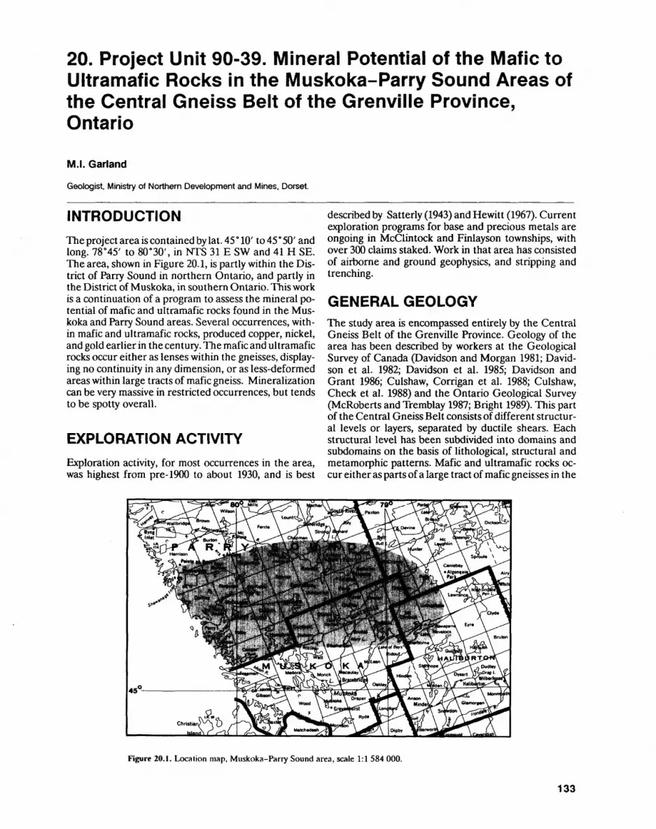
20. Project Unit 90-39. Mineral Potential of the Mafic to Ultramafic Rocks in the Muskoka-Parry Sound Areas of the Central Gneiss Belt of the Grenville Province, Ontario
M.I. Garland
Geologist, Ministry of Northern Development and Mines. Dorset.
INTRODUCTIONThe project area is contained by lat. 45 0 10' to 45' 50' and long. 78 045' to 80 0 30', in NTS 31 E SW and 41 H SE. The area, shown in Figure 20.1, is partly within the Dis trict of Parry Sound in northern Ontario, and partly in the District of Muskoka, in southern Ontario. This work is a continuation of a program to assess the mineral po tential of mafic and ultramafic rocks found in the Mus koka and Parry Sound areas. Several occurrences, with in mafic and ultramafic rocks, produced copper, nickel, and gold earlier in the century. The mafic and ultramafic rocks occur either as lenses within the gneisses, display ing no continuity in any dimension, or as less-deformed areas within large tracts of mafic gneiss. Mineralization can be very massive in restricted occurrences, but tends to be spotty overall.
EXPLORATION ACTIVITYExploration activity, for most occurrences in the area, was highest from pre-1900 to about 1930, and is best
described by Satterly (1943) and Hewitt (1967). Current exploration programs for base and precious metals are ongoing in Mcclintock and Finlayson townships, with over 300 claims staked. Work in that area has consisted of airborne and ground geophysics, and stripping and trenching.
GENERAL GEOLOGYThe study area is encompassed entirely by the Central Gneiss Belt of the Grenville Province. Geology of the area has been described by workers at the Geological Survey of Canada (Davidson and Morgan 1981; David son et al. 1982; Davidson et al. 1985; Davidson and Grant 1986; Culshaw, Corrigan et al. 1988; Culshaw, Check et al. 1988) and the Ontario Geological Survey (McRoberts and Tremblay 1987; Bright 1989). This part of the Central Gneiss Belt consists of different structur al levels or layers, separated by ductile shears. Each structural level has been subdivided into domains and subdomains on the basis of lithological, structural and metamorphic patterns. Mafic and ultramafic rocks oc cur either as parts of a large tract of mafic gneisses in the
Figure 20.1. Location map, Muskoka-Parry Sound area, scale 1:1 584 000.
133
PRECAMBRIAN (20)
western Parry Sound Domain, or as shear-bounded lenses within the gneisses of the lowermost structural layer.
The western Parry Sound Domain is characterized by gabbro and amphibolite and their gneissic equiva lents, gabbroic anorthosite, and anorthosite. Base and precious metal occurrences in the Parry Sound Domain were previously mapped as amphibole or mafic gneiss. In several of the occurrences, the host rocks were ac tually gabbro or gabbroic gneiss, occurring as less- deformed sections of the overall mafic gneiss sequence. The shear-bounded, lens-type, mafic to ultramafic rocks range from gabbro through norite and pyroxenite; to peridotite. The intensity of foliation and gneissosity va ries from virtually not developed to well developed. Contacts with the surrounding gneisses have been sheared, parallel to the gneissosity.
ECONOMIC GEOLOGY
In the Muskoka-Parry Sound area there are approxi mately 100 reported occurrences of base metals and/or gold, many of which underwent exploration, and even production. The occurrences in the Parry Sound Do main consist of: 1) copper-gold mineralization within gabbroic rocks in mafic gneisses; and 2) copper-nickel, copper-zinc mineralization located along a contact be tween a felsic and mafic gneiss.
The two most noted occurrences of copper-gold within gabbroic rocks are the Richmond Lake occur rence and the McGown Mine, which are on strike with each other. The mineralization consists of sulphides contained in quartz stringers within the gabbroic rock. Ore shipped from the McGown Mine, at the turn of the century, ran 1596 Cu, 0.2 ounce Au per ton, and 1.0 ounce Ag per ton. These values can be reproduced; however, the mineralization is very spotty.
The copper-nickel and copper-zinc occurrences, si tuated along the contact between a felsic and mafic gneiss, appear to be unique in the area. There are nu merous, small deposits located along the contact, some of which produced copper bet ween 1900 and 1940. Min eralization consists of massive sulphides (chalcopyrite, pyrite, pyrrhotite, sphalerite) associated with coarse- grained, massive, blue quartz in the contact between a quartzofeldspathic-biotite gneiss and a hornblende gneiss.
Another type of occurrence consists of sulphide mineralization within gabbro, norite, pyroxenite or per idotite rocks, which form lenses or pods within the gneisses, and are found within domains of the first or lowermost structural byer. Many of these occurrences have undergone, or are now undergoing, exploration.
The Nickel Cliff Mine, in Armour Township, was mined in 1900. Previously noted as sulphides in an am phibolite gneiss, the host rock is actually a norite, con
taining pyrite and pyrrhotite mineralization, which oc curs as a thick lens within quartzofeldspathic gneisses.
The nickel showings in Mcclintock Township have been recently restaked. Airborne very low frequency electromagnetic (VLF-EM) and magnetometer surveys were flown over the central part of the township. In 1990, exploration work consisted of ground geophysical follow-up of the airborne anomalies, and geological mapping by private individuals. In the nickel showings, mineralization occurs within norite lenses, and to some extent pyroxenite lenses, within the gneisses. These lenses appear to pinch and swell or are boudinaged, resulting in small occurrences.
There is not enough information to define good prospects or to rule out prospects. The gold and copper mineralization in quartz veins within gabbro and norite rocks in the Parry Sound area is interesting, and de serves further work. The norite and pyroxenite lenses within the gneisses can yield sulphide concentrations, but, as yet, these have been small in size and of re stricted strike length.
REFERENCESBright, E.G. 1989. Geology of the Whitestone Lake area, District of
Parry Sound; Ontario Geological Survey, Open File Report 5697, 184p.
Culshaw, N.G., Check, G., Corrigan, D., Drage, J., Gower, R., Hag- gert, M.J., Wallace, P and Wodicka, N. 1988. Georgian Bay geo logical synthesis: Dillon to Twelve Mile Bay, Grenville Province of Ontario; in Current Research, Part C, Geological Survey of Canada, Paper 89-1C, p.157-163.
Culshaw, N.G., Corrigan, D. Drage, J. and Wallace, P. 1988. Georgian Bay geological synthesis: Key Harbour to Dillon, Grenville Prov ince of Ontario; in Current Research, Part C, Geological Survey of Canada, Paper 88-1C, p.129-133.
Davidson, A. and Grant, S.M. 1986. Reconnaissance geology of west ern and central Algonquin Park and detailed study of coronitic olivine metagabbro, Central Gneiss Belt, Grenville Province of Ontario; in Current Research, Part B, Geological Survey of Can ada, Paper 86-1B, p.837-848.
Davidson, A. and Mor^n, W.C. 1981. Preliminary notes on the geolo gy east of Georgian Bay, Grenville Structural Province, Ontario; in Current Research, Part A, Geological survey of Canada, Paper 81-1A, p.291-298.
Davidson, A., Culshaw, N.G. and Nadeau, L. 1982. A tectono- metamorphic framework for part of the Grenville Province, On tario; in Current Research, Part A, Geological Survey of Canada, Paper 82-1A, p.175-190.
Davidson, A., Nadeau, L., Grant, S.M. and Piyer, L.L. 1985. Studies in the Grenville Province of Ontario; in Current Research, Part A, Geological Survey of Canada, Paper 85-1A, p.463-483.
Hewitt, D.F. 1967. Geology and mineral deposits of the Parry Sound- Huntsville area; Ontario Department of Mines, Geological Re port 52, 65p.
McRoberts, G.D. and Tremblay, M.L. 1987. Ferrie River area, Parry Sound District; in Summary of Fieldwork and Other Activities, 1987, Ontario Geological Survey, Miscellaneous Paper 137, p.234-239.
Satterly, J. 1943. Mineral occurrences in the Parry'Sound District; Ontario Department of Mines, Annual Report, 1942, v.51, pt.2, p. l-86.
134
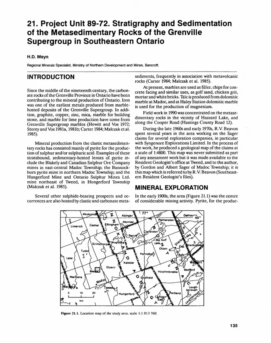
21. Project Unit 89-72. Stratigraphy and Sedimentation of the Metasedimentary Rocks of the Grenville Supergroup in Southeastern Ontario
H.D. MeynRegional Minerals Specialist, Ministry of Northern Development and Mines. Bancroft.
INTRODUCTION
Since the middle of the nineteenth century, the carbon ate rocks of the Grenville Province in Ontario have been contributing to the mineral production of Ontario. Iron was one of the earliest metals produced from marble- hosted deposits of the Grenville Supergroup. In addi tion, graphite, copper, zinc, mica, marble for building stone, and marble for lime production have come from Grenville Supergroup marbles (Hewitt and Vos 1972; Storey and Vos 1981a, 1981b; Carter 1984; Malczak et al. 1985).
Mineral production from the clastic metasedimen- tary rocks has consisted mainly of pyrite for the produc tion of sulphur and/or sulphuric acid. Examples of these stratabound, sedimentary-hosted lenses of. pyrite in clude the Blakely and Canadian Sulphur Ore Company mines in east-central Madoc Township; the Bannock burn pyrite mine in northern Madoc Township; and the Hungerford Mine and Ontario Sulphur Mines Ltd. mine northeast of Tweed, in Hungerford Township (Malczak et al. 1985).
Several' other sulphide-bearing prospects and oc currences are also hosted by clastic and carbonate meta-
sediments, frequently in association with metavolcanic rocks (Carter 1984; Malczak et al. 1985).
At present, marbles are used as filler, chips for con crete facing and similar uses, as golf sand, chicken grit, mortar and white bricks. Talc is produced from dolomitic marble at Madoc, and at Haley Station dolomitic marble is used for the production of magnesium.
Field work in 1990 was concentrated on the metase- dimentary rocks in the vicinity of Hazzard Lake, and along the Cooper Road (Hastings County Road 12).
During the late 1960s and early 1970s, R.V. Beavon spent several years in the area working on the Sager claims for several exploration companies, in particular with Syngenore Explorations Limited. In the process of the work, he produced a geological map of the claims at a scale of 1:4800. This map was never submitted as part of any assessment work but it was made available to the Resident Geologist's office at Tweed, and to the author, by Gordon and Albert Sager of Madoc Township; it is this map which is referred to by R.V. Beavon (Southeast ern Resident Geologist's files).
MINERAL EXPLORATIONIn the early 1900s, the area (Figure 21.1) was the centre of considerable mining activity. Pyrite, for the produc-
Figure 21.1. Location map of the study area, scale 1:1 013 760.
135
PRECAMBRIAN (21)
tion of sulphuric acid, was produced from the Canadian Sulphur Ore Company and the Blakely pyrite mines. Gold was produced from the Sophia (Diamond) Mine. Details of the history of these mines can be found in Malczak et al.(1985).
Stoklosar Marble Quarries Limited produces marble chips of several colours, for both terrazzo-tile manufacture and other uses, from a number of quarries in Madoc Township. Two of their abandoned quarries are located near Hazzards Corners; to the north, along the east side of Cooper Road, is the abandoned dolomite quarry of Grenville Aggregates Specialties Limited. Madoc Township also hosts several felsite quarries from which roofing granules are produced.
From the 1930s to the present day, members of the Sager family Earl Sager in particular have kept ex ploration, for base metals and gold, active in the area. Several mining companies have, over the years, had op tions on the Sager claims and each did a variety of work. The area is pockmarked with exploration pits and trenches. Numerous holes were drilled over the last few decades. In 1989, and presumably continuing into 1990, the Sager claims were optioned to Faith Mines Limited, a subsidiary of Arbor Resources Incorporated.
Local borrow pits have provided sand and gravel for both the personal uses of area residents and town ship-road construction.
GENERAL GEOLOGYLittle detailed work has been done on either the meta- sedimentary rocks, in general, or the marbles, in partic ular, in the Central Metasedimentary Belt of the Gren ville Province in Ontario. Among the earliest workers were Adams and Barlow (1910) who recognized amphi bolite layers in marble as metasediments, and Miller and Knight (1914) who synthesized the Precambrian geology of southeastern Ontario. A more general over view of the local and regional metasedimentary geology is given by Lumbers (1964) and Hewitt (1968).
In the last two decades, R.V. Beavon (Southeastern Resident Geologist's files), Sangster (1970), C. Verschu ren (Geologist, Southeastern Resident Geologist's Of fice), Carter (1984) and Malczak et al. (1985) examined the area from various aspects but none of them were particularly interested in the area's sedimentology.
It seems to be generally accepted, in the study area, that mafic metavolcanic rocks are overlain by a se quence of rocks of intermediate to felsic composition, classified as either metavolcanic or metasedimentary rocks. This sequence is followed by a thick upper marble sequence. The whole package was intruded by felsic plu- tons and, together, they are cut by late diabase dikes.
The mafic metavolcanic rocks at the base of the se quence were found to contain very considerable amounts of gabbro (Meyn 1989). This sequence is more extensively exposed to the east, in Elzevir Township, and is mapped and described by LeBaron et al. (1987), LeBa- ron (1988) and Di Prisco (1989).
In the metasedimentary rocks, many of the details are still far from being resolved. The major point requir ing resolution is the matter of the sedimentary-ver- sus-volcanic origin of many of the rocks of the "Queens- borough Acid Volcanic Centre" in the "Queensborough Syncline" (Hewitt 1968). In many instances, the outcrop exposure is too limited to resolve stratigraphic prob lems. As well, evidence is mounting that the area was subjected to several generations and directions of fault ing, and correlation across faults is frequently difficult. Facing criteria in the metamorphosed sediments are rare and they are seldom unequivocal.
However, in the course of this summer's field work, it has become clear that in the litharenites occurring west and northwest of the Canadian Sulphur Ore Com pany shafts, tops from graded bedding are southward. This litharenite was mapped as a felsite unit 6a by Hewitt (1968).
Similarly, the conglomerates, arenites and mud- stones exposed immediately southwest of Hazzard Lake are now identified as turbidites with a clear younging di rection to the southwest, that is, with tops up. Several facies of turbidites are present, but exposure is inade quate to map them out. North of Hazzard Lake, the me tasedimentary rocks are part of a breccia with very large fragments ranging in size from a few tens-of-centime- ters to tens-of-metres. Local top determinations may contradict each other from one block to the next, which frequently means from one outcrop to the next.
In the vicinity of Rimington, ripple cross-lamina tions are preserved in fine- to very fine grained calc-are- nites (marbles) which indicate that stratigraphic tops face to the southwest. Paleocurrents were, in a very gen eral way, from east to west.
All of the above observations are based on only three or four outcrops that have just the correct amount of exposure and weathering to show these sedimentary features. It is frequently possible to identify a particular facies, but to make reliable top determinations is rarely possible.
Outcrops made smooth by ice sheets or glacial melt water, particularly those exposed as flat outcrops in fields and meadows, are very difficult to sample. Fortu nately, in some hand specimens, small-scale sedimenta ry features such as graded bedding, the loading of sand into mud beds, small slumps, and the occasional small-scale cross-lamination allow top determinations to be made. Nonetheless, the original sample orienta tion will have had to have been recorded for the infor mation to be useful. With both very slow, meticulous collection of numerous oriented hand samples and use of the occasional top information that may be present in them, it may be possible to enlarge the number of top determinations and to extend stratigraphically any con tinuity existing between sections.
On an outcrop scale, these calc-areniles contain ho rizons and sequences of litharenites, and what is inter preted to be tuffs, that may be useful as stratigraphic markers. The amount of outcrop is frequently too lim ited and the amount of tectonism too severe to trace
136
H.D. MEYN
small beds, but thicker packages or sequences may be identifiable and traceable.
Rusty schists and felsites are two rock types of par ticular regional interest and are described in greater de tail below.
FelsiteFelsite and felsite breccia are terms used by many work ers in the area. Based on igneous texture seen in thin section, Miller and Knight (1914, p.93) concluded that the felsite occurs as a major intrusive body. They also recognized brecciation of the felsite near the Blakely and Canadian Sulphur Ore Company mine workings.
Hewitt (1968, p.7) describes the felsite as a "fine-grained buff-coloured rock composed of angular quartz and feldspar, rhyolite fragments, and some car bonate. It is an acid volcanic fragmental intrusive rock that cuts the marble''.
Sangster (1970, p.71), based largely on work by R.V. Beavon, regards the felsite as a broadly conformable, ei ther intrusive or extrusive unit that shows some possible flow banding but no chilled contacts against the adjacent rocks.
C. Verschuren (see Carter 1984, p.223-232; Malczak et al. 1985, p.96-100) does not use the term felsite and presumably includes the felsites of other authors in his felsic metavolcanics. He argues that essentially all of the noncarbonate rocks in the vicinity of the Blakely and Ca nadian Sulphur Ore Company pyrite mines are volcanic in origin. He does not, however, mention an intrusive relationship for any of these rocks.
The term felsite, as it hasbeen used in Madoc Town ship, probably includes massive or fragmental felsic vol canic rocks, felsic volcaniclastic rocks, and massive are- nites.
In 1989, the author distinguished eight types of fel site, with several subtypes (Meyn 1989). It may well turn out that one or more of these categories of felsite will be shown to be volcanic and others sedimentary in origin. The author does not support the view of an intrusive ori gin for the felsites.
Occurrences of massive, highly siliceous rocks also mapped as felsite seem to be of uncertain affinity. Their protolith may no longer be identifiable. Easton (1989) suggests that the silicification may be caused by subsurface apophyses of the Deloro intrusion. He also proposes the term "porcellanite" to be used for these rocks. If the silicification is related to the proximi ty and shape of a subsurface intrusion, the resulting pat tern of silicification may have suggested an intrusive ori gin of these felsites to previous workers.
Hewitt (1968) shows a felsite breccia unit le on on the west side of the Cooper Road, north of Hazzards Corners. Exposures, made available by new roadcuts, show this map unit to be a silicified breccia of uncertain mechanical or tectonic origin. The breccia fragments are thinly laminated, fine-grained sandstone to mud
stone, surrounded by a matrix whose character and ori gin remain unidentified. Subsequent to the brecciation, the rock was silicified to its present condition.
On the north side of Hastings County Road 20, just east of Hazzards Corners, there is an outcrop of thinly bedded, turbiditic sandstones and mudstones that could well be the protolith of the rocks in the sedimentary breccia.
Southeast of Hazzards Corners, Hewitt (1968) shows a rhyolite breccia unit Id. This rock is composed of interbedded to interlaminated, fine- to medium- grained, silicified arenites and mudstones. In one out crop, the original sedimentary bedding is clearly pre served. Farther east, there are additional outcrops wherein the sedimentary origin of the rock is no longer provable. If these outcrops were mapped first, one might well label the rock "felsite" or perhaps "porcella nite". A reappraisal might then be sought, given the in terspersed, presumably originally interbedded, calcitic and dolomitic marble that is present.
Southwest of Hazzard Lake, Hewitt (1968) mapped a grey-coloured felsite unit 6a. With a detailed exami nation, this area could be shown to be a turbiditic unit composed of a repeated sequence of massive, normally graded beds of medium-grained litharenite, from 2 to 30 cm thick (Bouma division A), overlain by interbedded, thinly laminated, parallel-bedded, very fine grained li tharenite and mudstone from 2 to 20 cm thick (Bouma division B).
However, north of Hazzard Lake and striking northeasterly, another felsite unit 6a is shown (He witt 1968). This was not amenable to further resolution; moreover, no trace of a sedimentary origin could be es tablished. It is reasonable to believe that it is another si licified sediment, probably originally part of the turbi dite sequence.
Rusty SchistRusty schist is also a term used by many of the authors that have worked in the area. Miller and Knight (1914, p.92) state:
The rusty schists, or pyritous slates, are perhaps the least extensive of any of the sediments...They occur in disconnected beds rarely exceeding 100 feet in width...They are fine-grained, grey to black in color, and possess a slaty cleavage in places. Their composition is variable, and they include quartzose and feldspathic facies with iron pyrites, and in places pyrrhotite dis seminated through them. In addition to iron pyrites, graphite oc curs in fine flakes, and sometimes predominates over any other mineral, giving the rock its dark color.
They conclude:The chemical composition of the rusty schists points to a
sedimentary origin.
Hewitt (1968) does not mention rusty schists in his re port or on his map. Presumably they are included in the various stratigraphic units in which they occur.
C. Verschuren (see Malczak et al. 1985, p. 100) states:
The rusty schist is a grey to black, fine-grained, strongly fo liated unit composed of variable amounts of quartz, sericite, py-
137
PRECAMBRIAN (21)
rite and graphite. Zones of disseminated graphite and dissemi nated and banded pyrite occur parallel to the foliation...The rusty schist is generally narrow and discontinuous and conforms to local structural trends...
The essence of the two quotations above is that these rusty schists may be black slates but they may also in clude quartzose and feldspathic facies; moreover, they are generally narrow, discontinuous lenses conformable to local structures. This means that any of the local me- tavolcanic or metasedimentary rocks may, with enough sulphides added, become and be mapped as a rusty schist.
One rusty schist, west of Hazzard Lake, that was ex amined this summer is composed of very severely folded, interlaminated grey siltstone and black mud stone. The pronounced, sulphide-filled schistosity is parallel to the axial plane of these folds.
This summer's field work essentially confirms the above general conclusions. When mapping any rock that has a moderate amount of gossan on it, or is stained deep black from sulphide weathering, it is virtually im possible to obtain a sample fresh enough for petrogra phy by just using a geological pick. Measuring structural trends in such gossans is also very difficult. What the work so far has revealed is that a deep rust stain, reflect ing pyrite (sulphide) weathering, is present to various degrees in many of the rock types in the area. Aside from the mined pyrite lenses occurring at the Canadian Sulphur Ore Company and the Blakely mines, there are also rusty zones in several of the different types of fel site, in the conglomerate, and in the garnet-amphibole schist. These are in addition to the several outcrops so small and so badly weathered that they could only be mapped as rusty schist. As more of the units are mapped in detail, the various lenses of rusty schist maybe assign able to a particular stratigraphic unit.
Economically, the most important rusty schist is the pyritiferous black shale and/or slate that is closely asso ciated with the pyrite lenses at the Canadian Sulphur Ore Company mine. These slates are seen on the mine dump but were not seen in outcrop. Notwithstanding, Miller and Knight (1914, p.98-99) also mention quartzite and quartzose phases in close association with the pyrite lenses at the Canadian Sulphur Ore Company mine. These phases are also seen in rock samples on the mine dump.
STRUCTURAL GEOLOGYIt is not unexpected that the contact between metavol- canic and metasedimentary rocks should have been the locus of tectonic transport. This is found to be the case where this contact exists near the Madoc-Elzevir town ships boundary. Here, shear zones oriented northwest, subparallel to the contact, are present over a width of several hundred meters. Tectonic-transport direction is thought to be west-side northwestward (dextral).
The amount of offset along these shears is not clear. If the fine-grained rocks observed in the shear zones
were originally coarse-grained volcanics or gabbros, then the mylonitization is quite intense and the amount of tectonic transport probably significant. If, however, shearing is concentrated in the metasedimentary and/or tuffaceous horizons, then clast reduction is not nearly as pronounced and the total shearing and consequent off set may not be as important.
Near what is currently assumed to be the top of the volcanic sequence in western Elzevir and eastern Ma doc townships, volcaniclastic and clastic metasedimen tary rocks, also containing minor marble and chert, are interbedded with the metavolcanic rocks suggesting the beginning of the transition from volcanic to sedimentary processes. This may indicate that the amount of missing sedimentary stratigraphy is not very large.
The "Queensborough Syncline" (Hewitt 1968) may be maintained as a working concept. However, prelimi nary indications from the few areas with somewhat bet ter exposure are that the structure of the metasedimen tary sequence is considerably more complex than that evoked by a simple syncline. Indeed, the top determina tions made in the metasedimentary rocks strongly sug gest that from the vicinity of Hazzard Lake to just north west of the Canadian Sulphur Ore Company mine, the structure is an anticline. This interpretation introduces quite interesting new problems, regarding both the rela tionship between the marbles and the clastic sediments, and the relationship between the sediments with the supposedly underlying volcanics.
The author hopes to be able resolve some of these problems with additional mapping.
ECONOMIC GEOLOGYIn the past, the area has seen production of pyrite, gold, and stone for roofing granules. Mineral production is confined to marble-chip production, by Stoklosar Marble Quarries Limited, from various small quarries in Madoc Township and aggregate production from a quarry in Ordovician limestone in Lot 14, Concession 7, Madoc Township, just west of the Cooper Road. Sand and gravel for local needs is produced from local borrow pits. Although much of the area is covered with Pleisto cene deposits, there are few good sand or gravel depos its in the area.
There is the potential for additional production of precious metals and base metals in the study area. Malc zak et al. (1985, p.95), in their description of the Blakely pyrite mine, report a 15 cm wide drillhole intersection by Syngenore Explorations Limited, which yielded an assay of 297.1 ounces Ag per ton, 0.46 ounce Au per ton, 2.1596 Cu, 5.4096 Pb and S.79% Sb. In addition to these results, a grab sample assayed 1.3 ounces Ag per ton, 0.03 ounce Au per ton, Q.34% Sb, Q.205% As and 8.9696 Zn.
Exploration for gold in quartz veins in clastic meta- sediments has been intermittent in the vicinity of Ban nockburn.
138
H.D. MEYN
REFERENCESAdams, F.D. and Barlow, A.E. 1910. Geology of the Haliburton and
Bancroft areas, Province of Ontario; Geological Survey of Cana da, Memoir 6, 419p.
Carter, T.R. 1984. Metallogeny of the Grenville Province, southeast ern Ontario; Ontario Geological Survey, Open File Report 5515, 422p.
Di Prisco, G. 1989. Geology of the Elzevir area, Hastings and Lennox and Addington counties; in Summary of Field Work and Other Activities 1989, Ontario Geological Survey, Miscellaneous Paper 146, p.169-175.
Easton, R.M. 1989. Regional alteration patterns and mineralization associated with the Deloro Granite, Grenville Province, Madoc area; in Summary of Field Work and Other Activities 1989, On tario Geological Survey, Miscellaneous Paper 146, p.158-168.
Hewitt, D.F. 1968. Geology of Madoc Township and the north part of Huntingdon Township; Ontario Department of Mines, Geologi cal Report 73, 45p.
Hewitt, D.F. and Vos, M.A. 1972. The limestone industries of Ontario; Ontario Division of Mines, Industrial Mineral Report 39, 79p.
LeBaron, P.S., MacKinnon, A. and Kingston, P.W. 1987. Koma- tiite-hosted talc in the Tudor Formation, Elzevir, Madoc and Grimsthorpe townships, southeastern Ontario; in Summary of Field Work and Other Activities 1987, Ontario Geological Sur vey, Miscellaneous Paper 137, p.301-306.
LeBaron, P.S. 1988. Geology and beneficiation of talc in the Tudor Formation, southeastern Ontario; in Summary of Field Work and Other Activities 1988, Ontario Geological Survey, Miscella neous Paper 141, p.351-358.
Lumbers, S.B. 1964. Preliminary report on the relationship of mineral deposits to intrusive rocks and metamorphism in part of the Grenville Province of southeastern Ontario; Ontario Depart ment of Mines, Preliminary Report PR.1964-4, 37p.
Malczak, J., Carter, T.R. and Springer, J.S. 1985. Base metal, molyb denum, and precious metal deposits of the Madoc-Sharbot Lake area, southeastern Ontario; Ontario Geological Survey, Open File Report 5548, 374p.
Meyn, H.D. 1989. Stratigraphy and sedimentation of the metasedi- mentary rocks of the Grenville Supergroup in southeastern On tario; in Summary of Field Work and Other Activities 1989, On tario Geological Survey, Miscellaneous Paper 146, p.176-179.
Miller, W.G. and Knight, C.W. 1914. The Pre-Cambrian geology of southeastern Ontario; Ontario Bureau of Mines, Annual Report, v.22, pt.2, 151p.
Sangster, A.L. 1970. Metallogeny of base metal, gold, and iron depos its of the Grenville Province of southeastern Ontario; unpub lished PhD thesis, Queen's University, Kingston, Ontario, 356p.
Storey, C.C. and Vos, M.A. 198la. Industrial minerals of the Pem broke-Renfrew area, part 1: marble; Ontario Geological Survey, Mineral Deposits Circular 21, 132p.
1981b. Industrial minerals of the Pembroke-Renfrew area, part 2; Ontario Geological Survey, Industrial Minerals Circular 22, 214p.
139
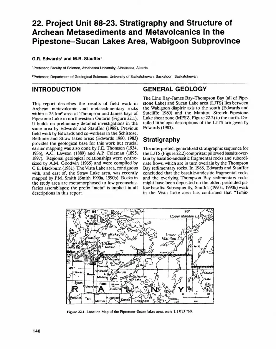
22. Project Unit 88-23. Stratigraphy and Structure of Archean Metasediments and Metavolcanics in the Pipestone-Sucan Lakes Area, Wabigoon Subprovince
G.R. Edwards 1 and M.R. Stauffer2
1 Professor. Faculty of Science. Athabasca University, Athabasca, Alberta
2Professor, Department of Geological Sciences, University of Saskatchewan. Saskatoon. Saskatchewan
INTRODUCTION
This report describes the results of field work in Archean metavolcanic and metasedimentary rocks within a 25 km2 area at Thompson and James bays of Pipestone Lake in northwestern Ontario (Figure 22.1). It builds on preliminary detailed investigations in the same area by Edwards and Stauffer (1988). Previous field work by Edwards and co-workers in the Schistose, Bethune and Straw lakes areas (Edwards 1980, 1983) provides the geological base for this work but crucial earlier mapping was also done by J.E. Thomson (1934, 1936), A.C. Lawson (1889) and A.P. Coleman (1895, 1897). Regional geological relationships were synthe sized by A.M. Goodwin (1965) and were compiled by C.E. Blackburn (1981). The Vista Lake area, contiguous with, and east of, the Straw Lake area, was recently mapped by P.M. Smith (Smith 1990a, 1990b). Rocks in the study area are metamorphosed to low greenschist facies assemblages; the prefix "meta" is implicit in all descriptions in this report.
GENERAL GEOLOGYThe Line Bay-James Bay-Thompson Bay (all of Pipe stone Lake) and Sucan Lake area (LJTS) lies between the Wabigoon diapiric axis to the south (Edwards and Sutcliffe 1980) and the Manitou Stretch-Pipestone Lake shear zone (MPSZ, Figure 22.2) to the north. De tailed lithologic descriptions of the LJTS are given by Edwards (1983).
StratigraphyThe interpreted, generalized stratigraphic sequence for the LJTS (Figure 22.2) comprises: pillowed basalts over lain by basaltic-andesitic fragmental rocks and subordi nate flows, which are in turn overlain by the Thompson Bay sedimentary rocks. In 1988, Edwards and Stauffer concluded that the basaltic-andesitic fragmental rocks and the overlying Thompson Bay sedimentary rocks might have been deposited on the older, prefolded pil low basalts. Subsequently, Smith's (1990a, 1990b) work in the Vista Lake area has confirmed that "Timis-
Figure 22.1. Location Map of the Pipestone-Sucan lakes area, scale 1:1 013 760.
140
G.R. EDWARDS and M.R. STAUFFER
Pillowed and massive basalt (PB)Fragmental basalt to andesite with some pillowed lava and sedimentary rock (BAF)Thompson Bay sedimentary rocks (TBS)
LEGEND, Manitou Stretch-Pipestone
Lake shear zone (MPSZ)
Stratigraphic facing direction
Major contact (interpreted as an angular unconformity)
Axial traces of D, folds determined from pillow- facing directionsAxial traces of D2 folds (see Figure 22.3)
Axial trace of D3 syncline
Figure 22.2. Geological map of the Line Bay-James Bay-Thompson Bay Portion of Pipestone Lake, and Sucan Lake (modified from Edwards 1983).
kaming-type" sediments between Esox and Alonghill lakes lie unconformably on older (Keewatin) volcanic rocks (Thomson 1935). However, in contrast to the Esox Lake-Alonghill Lake sedimentary rocks, the Thompson Bay sedimentary rocks do not lie directly on the pre- folded pillow basalts. Instead, they conformably overlie (and are locally intercalated with) the basaltic-andesitic fragmental rocks which, in turn, are inferred to lie un conformably on the older pillowed basalts.
The older pillowed basalts consist predominantly of plagioclase-phyric, pillowed flows which have a variably developed spherulitic texture. A characteristic of this unit is that the flows are intruded by composite, layered, mafic to ultramafic sills and less common, discordant, mafic to ultramafic masses. In the central Pipestone Lake area, sparse, isolated and altered ultramafic sheets, with occasional spinifex texture, occur, and may represent komatiite flows. Based on the widest exposed homoclinal panel of pillowed basalts, the original strati graphic thickness of the unit must have been at least 2.25 km.
The basaltic-andesitic fragmental rocks comprise a l km thick sequence, largely composed of basalt to ande site flow breccia and pyroclastic rocks. Northeast of Line Bay, and between Thompson Bay and Sucan Lake, the
pyroclastic rocks are probably dacitic. The basalt to an desite lava flows are massive, or sparsely pillowed, and are plagioclase- and/or pyroxene-phyric. Plagioclase phenocrysts in the basaltic-andesitic fragmental unit are more tabular than those in the pillowed basalt unit. The basaltic-andesitic fragmental rocks are overlain by Thompson Bay sediments, but the contact between these units at Thompson Bay is partly gradational. The base of the fragmental unit, where observed in James Bay, Sucan Lake and between Thompson Bay and Su can Lake, is marked by a semi-continuous band of carbo naceous, pyritic mudstone to fine sandstone (cf. Thom son 1934, p. 9-11). Preliminary analytical studies (semi- quantitative lithochemistry and carbon isotope determi nations) indicate that the carbonaceous rock contains only about 2*7o carbon and that the carbon probably had an organic origin. Below these sediments, presumably in the pillowed basalts, there is a breccia of basalt frag ments in a carbonaceous shale matrix that grades down wards into an unusually fractured, massive, mafic lava flow. The fractures are up to l cm wide, and normally contain comminuted mafic material, although some car bonaceous material may be present. Calcite-filled frac tures are uncommon. The breccia is interpreted as a fea ture of paleo-weathering at the unconformity on the
141
PRECAMBRIAN (22)
Figure 22.3. Mapping showing the distribution 0(84 cleavage form lines in the Thompson Bay-James Bay-Sucan Lake region. Legend symbols as on Figure 22.2 except for the addition of phase 2 (D2) axial trace symbols {bed-facing panel boundaries of Figure 22.2). For explanation of abbreviations, see Figure 22.2.
older pillowed basalt unit. Similar breccias, perhaps also a result of paleo-weathering, are present in subvol canic quartz-feldspar porphyry underlying the Thomp son Bay sedimentary rocks at Esox Lake.
The sedimentasry rocks at Sucan Lake are the thickened extension, along strike, of those that lie on the unconformity at the base of the basaltic-andesitic fragmental unit. Near their base, the sedimentary rocks at Sucan Lake are carbonaceous mudstones. The unit top is marked by a rapid upward transition to basaltic- andesitic fragmental rocks. In the transition zone, north of Sucan Lake, mafic to intermediate tuff and lapilli tuff (ash flows?) are interbedded with the sedimentary rocks. The volcanic rocks between Sucan Lake and Straw Lake are thus part of the fragmental unit.
In Thompson Bay, the basaltic-andesitic fragmental rocks are rapidly transitional upward into the Thompson Bay sedimentary unit. Except for the presence of a few outcrops of rhythmically bedded, turbiditic, fine sand stone to mudstone in the upper part of the sequence, the general impression is that most of the Thompson Bay sediments were deposited near an active volcanic environment.
STRUCTURAL GEOLOGYStrata between the Wabigoon diapiric axis and the Manitou Stretch-Pipestone Lake shear zone (MPSZ, Figures 22.2 and 22.3) are complexly folded. Although interpretation is encumbered by the paucity of strati
graphic facing criteria in some areas, and by locally sparse outcrop, a tentative scheme involving seven phases of deformation is presented here.
The first phase of deformation (D^ is represented by isoclinal folds in the older pillowed basalt unit. The axial traces of D, folds, shown on Figure 22.2, are the boundaries of panels of mainly pillowed basalt with op posing stratigraphic facing directions. D, axial planes are vertical but hinge line orientations are unknown. All bedding seen (in all rock types) is subvertical, suggesting that fold hinge lines are subvertical. These folds are re stricted to the older pillowed basalt unit and do not ap pear to cross the unconformity into the overlying basal tic-andesitic fragmental and Thompson Bay sedimenta ry units.
The second phase of deformation (D2) comprises folds that have been found only in the Thompson Bay sedimentary unit. However, as the boundary between the sedimentary rocks and the basaltic-andesitic frag mental rocks is transitional, this phase of deformation must have affected both rock groups. D2 folds, however, have not been recognized in the older pillowed basalt unit. At present, D2 fold axial traces are identified only by panels of opposing stratigraphic facing in the Thomp son Bay sedimentary unit (see Figures 22.2 and 22.3). D2 folds are isoclinal, have subvertical axial planes, and, like D! folds, may have steeply plunging hingelines.
The third phase of deformation (D3) is recognized by a single fold in the fragmental and sedimentary units, where it folds the D2 axial traces and creates a structural basin in the rocks above the unconformity. The axial
142

G. R. EDWARDS and M. R. STAUFFER
plane strikes northeast, is subvertical, and the hinge line probably plunges moderately to the northeast.
The fourth phase of deformation (D4) is repre sented by a pervasive cleavage (S4) that is axial planar to locally developed small folds. The S4 cleavage varies from not recognizable in some outcrops to a well- developed slaty cleavage in others. It is oriented 080 0 780 0 S (Figure 22Aa) and is equally developed in all rock types. D4 deformation shows in the older pillowed basalt unit as flattened pillows; in the basaltic-andesitic fragmental unit, mainly as flattened fragments; and in the Thompson Bay sedimentary unit, as distorted pri mary sedimentary structures or slaty cleavage. In both the Thompson Bay sedimentary rocks and the basal tic-andesitic fragmental rocks, S4 is locally zonal and anastomosing. Locally, in the sedimentary unit, the rock is striped by S4 (suggesting the possible importance of pressure solution). Folds related to S4 are reclined, vary from about 20 cm to several metres across, and form open rounded kink folds to tightly closed structures.
In most of the exposed Thompson Bay sedimentary unit, bedding strikes about 115 0 790 0 ; here D4 folds have a Z asymmetry (Figure 22.4b). However, along the cen tral eastern border of the unit, bedding strikes to the northeast and D4 folds have an S asymmetry (Figure 22.4b). Such variation in asymmetry is consistent with D4 folds being superimposed on an already existing D3 structural basin. In some outcrops, there are small faults subparallel to S4 cleavage, locally varying by up to 15 0 from S4 . Most of these display sinistral offsets on hori zontal outcrop surfaces, but some are dextral.
Phase five deformation (D5) is represented only by locally developed spaced (fracture?) cleavages (S5) ori ented 050 0 780'SE (Figure 22.4c and 22.4d). Edwards and Stauffer (1988) considered S4 and S5 to be eogenetic,
riS4a. c. nss
Figure 22.4. a) Sterograms of poles to 89 S4 cleavage measurements from the Thompson Bay sedimentary unit. Contours at 196, 109fc, and 259fc areas, General S4 plane is 080V80*SE. b) Sketches of S4 cleavages and related folds as seen on horizontal outcrop surfaces, c) Sterogram of poles to 34 S5 cleavage measurements. General S5 plane is 050 V80* SE. d) Appearance of S5 in the Thompson Bay sed imentary unit on horizontal outcrop surfaces, where it is well devel oped and crosses both S0 and S4 .
but subsequent work has located outcrops in which S5 clearly cuts S4, and in some places S5 transects D4 folds (see Figure 22.4b and 22.4d). To date, S5 has been recog nized only in the Thompson Bay sedimentary rocks.
The Manitou Stretch-Pipestone Lake shear zone cuts the D, to D3 structures and thus represents late-stage faulting. Its relationship to other structures is unknown and it is tentatively designated as a D6 struc ture. The MPSZ is a zone of intense, parallel, subverti cal cleavage (S6) and all rock types within the zone are reduced to a fine-grained slate-like rock.
Finally, a subhorizontal kink banding occurs in many Thompson Bay sedimentary rocks with well- developed S4, S5 or S6 cleavages. These kink bands con sistently display north-side-up vergence and represent the seventh phase (D7) of deformation.
REGIONAL CORRELATIONThe older pillowed basalt unit is probably correlative with the folded, predominantly mafic volcanic sequence underlying the unconformity at Esox Lake (Smith 1990a, 1990b). However, no evidence was found during this study for the fold structures indicated by Smith (1990a, 1990b) to extend from Esox Lake toward Pipestone Lake.
It is tempting to conjecture that the older pillowed basalt unit may be the same age as the 3 billion-year-old rocks in the Lumby Lake greenstone belt (Davis and Jackson 1988). The presence of komatiite in both the pil lowed basalt unit (uncommon as it is) and in the Lumby Lake greenstone belt, combined with its apparent ab sence elsewhere in the Western Wabigoon Subprovince, also suggests that these are correlative sequences.
The Thompson Bay sedimentary rocks are similar to the Schistose Lake sedimentary rocks (Edwards 1980) in that both sequences were probably deposited near ac tive volcanism; except near their tops, where the sedi mentary rocks of both sequences are turbiditic. The Schistose Lake sedimentary rocks were derived partly from the underlying Phinney-Dash Lakes rhyodacite complex and partly from the mafic to intermediate pyro clastic rocks of the Kakagi Lake Group (Edwards 1980). If the Thompson Bay and Schistose Lake sedimentary rocks are correlative, the basaltic-andesitic fragmental unit may be the equivalent, along strike, of the Kakagi Lake Group, which has been dated at 2725 Ma (Davis and Edwards 1982). The Esox Lake sedimentary rocks are more turbiditic, finer grained and have less volcanic debris than either the Thompson Bay or the Schistose Lake sedimentary rocks. This correlation requires more detailed work on the structure between Thompson Bay and Esox Lake.
SUGGESTIONS FOR FURTHER WORKFurther work should be done to investigate the relations between the isoclinal folds in the Thompson Bay sedi-
143

PRECAMBRIAN (22)
mentary rocks and structures in both the basaltic- andesitic fragmental unit and the pillowed basalt unit. Microstructures in the pillowed basalt unit should be ex amined in detail for evidence of style and stages of de formation. Detailed structural analysis must be done on the rock units between Sucan Lake and Esox Lake to understand the relations between the Thompson Bay and Esox Lake sedimentary rocks and to trace the un conformity on the pillowed basalt unit. It is also impor tant to obtain U-Pb age determinations on rocks in the pillowed basalt unit. Potential sample sites for geochro- nological studies occur at Esox Lake and northeast of Line Bay. Regional study of the Manitou Stretch- Pipestone shear zone should be undertaken to deter mine its sense of motion, and its associated style(s) of mineralization. This, in turn, will lead to an increased knowledge of the setting for gold mineralization in the area.
ACKNOWLEDGMENTSAdditional financial support for this project was pro vided by a research grant from the Academic Research Committee, Athabasca University. Preliminary carbon isotope and semi-quantitative analysis of carbonaceous sediments was done at the Geochemistry Laboratory of the Department of Geological Sciences, University of Saskatchewan, under the direction of T.K. Kyser.
REFERENCESBlackburn, C.E. 1981. Kenora-Fort Frances; Ontario Geological
Survey, Map 2443, scale 1:253 440.
Coleman, A.P. 1895. Gold in Ontario: its associated rocks and miner als; Ontario Bureau of Mines, Annual Report, 1894, v.4, Section 2, p.35-100.
1897. Third report on the west Ontario gold region; Ontario Bureau of Mines, Annual Report, 1896, v.6, Section 2, p.71-124.
Davis, D.W. and Edwards, G.R. 1982. Zircon U-Pb ages from the Ka kagi Lake area, Wabigoon Subprovince, northwestern Ontario; Canadian Journal of Earth Sciences, v.19, p.1235-1245.
Davis, D.W. and Jackson, M.C. 1988. Geochronology of the Lumby Lake greenstone belt: a 3 Ga Complex within the Wabigoon Subprovince northwest Ontario; Geological Society of America Bulletin, v. 100, p.818-824.
Edwards, G.R. 1980. Geology of the Schistose Lake area, District of Kenora; Ontario Geological Survey, Report 194, 67p.
1983. Geology of the Bethune Lake area, districts of Kenora and Rainy River; Ontario Geological Survey, Report 201, 59p.
Edwards, G.R. and Stauffer, M.R. 1988. Stratigraphy and structure of Archean metasediments and metavolcanics in the Thompson and James Bay areas (Pipestone Lake), Wabigoon Subprovince; in Summary of Field Work and Other Activities 1988, Ontario Geo logical Survey, Miscellaneous Paper 141, p.120-122.
Edwards, G.R. and Sutcliffe, R.H. 1980. Archean granitoid terranes of the western Superior Province, Ontario; Geological Associ ation of Canada-Mineralogical Association of Canada, Program with Abstracts, v.5, p.50.
Goodwin, A.M. 1965. Preliminary report on volcanism and mineral ization in the Lake of the Woods-Manitou Lake-Wabigoon region of northwestern Ontario; Ontario Department of Mines, Preliminary Report 1965-2, 63p.
Lawson, A.C. 1889. On the geology of the Rainy Lake region; Geology and Natural Historical Survey of Canada, Annual Report 1887-88 (New Series), v.3, Report F, 183p.
Smith, P.M. 1990a. Precambrian geology, Vista Lake area, west part; Ontario Geological Survey, Preliminary Map P.3178, scale 1:15840.
1990b. Precambrian geology. Vista Lake area, east part; Ontar io Geological Survey, Preliminary Map P.3179, scale 1:15 840.
Thomson, .I.E. 1934. Geology of the Straw-Manitou lakes area; Ontario Department of Mines, Annual Report, 1934, v.43, pt.4, p. 1-32.
1936. Geology of the Rowan-Straw lakes area; Ontario Department of Mines, Annual Report, 1935, v.44, pt.4, p.1-28.
144

Engineering and Terrain Geology Programs


23. Summary of Activities 1990, Engineering and Terrain Geology Section
O.L. White
Chief. Engineering and Terrain Geology Section. Ontario Geological Survey.
In the past year, the staff of the Engineering and Terrain Geology Section have been involved in eight field projects, three of which were undertaken in the fall of 1989, and the remaining five in the summer of 1990. The number of field projects undertaken in 1990 is very low and reflects the changes in funding and staffing which have occurred over the past twelve or so months.
The staff of the Quaternary Geology Subsection are reporting three projects. P.J. Barnett reports the results of stratigraphic drilling in the Barrie area, to supplement several seasons of previous field work. A.F. Bajc and T.F. Morris report on two first year projects, one in southern Ontario and the other in northern Ontario. O.K. Armstrong, of the Paleozoic/Mesozoic Geology Subsection, reports on the start of a new project, in the Lake Simcoe area, to assist in the planning and use of Ordovician bedrock, used to a very large degree for aggregate production. The Aggregate Assessment Office reports on four projects, three in northern Ontario, and one in southern Ontario; a situation that reflects a growing interest in aggregate resources in northern communities, both large and small.
P.J. Barnett reports the preliminary results from eight boreholes, six of which were geophysically logged by the University of Waterloo. These investigations supplement three years of field work and will provide very valuable data in an area with some very complex subsurface stratigraphy. The drilling results and the geophysical logging will be published in early 1991, and should provide much useful information for the detailed investigation of ground water and aggregate resources. The drilling results also have extended the knowledge of the range of organic-bearing deposits, buried beneath till sheets in southern Ontario, and will considerably add to the data base of regional strati graphic studies.
A.F. Bajc commenced a planned, three-year co-operative study in the Muskoka area with the mapping of the Huntsville-Bracebridge area. This mapping will add con siderably to the data base of Quaternary sediments in south-central Ontario. The infor mation acquired will be used in the immediate future by the District Municipality of Muskoka and the Ontario Ministry of Natural Resources, in considering sites for the Muskoka Heritage Areas Program and the Areas of Natural and Scientific Interest (ANSI) Program. In addition to identifying significant landform features, and recognis ing these recurring facies of till, project results have updated the available information on aggregate resources, which remain in high demand from only a limited number of economically useful deposits.
T.F. Morris initiated the mapping of the Quaternary geology of the Hawk Junction map sheet, in the Wawa area, in order to provide basic data for planning operations and for the use of the surficial deposits in a variety of construction and development activi ties. The history of glaciation in the area was clarified and two till-types were recog nised. These probably represents two different depositional processes rather than two distinct advances of the ice. Proglacial outwash systems, including spectacular paired terraces, were delineated. These deposits provide extensive supplies of aggregate, the demand for which was increasing while the field work was underway. Fine-grained de posits, generally found in glacial lake basins, are not extensive but are sought for use in local dam construction and for liners in landfill operations. Samples of till were taken for analysis, to determine the baseline amounts of base and precious metals in case the tills could be used as an exploration tool in the future.
O.K. Armstrong has initiated the mapping of limestones of Middle Ordovician age in the Lake Simcoe area. This is being done to determine the regional distribution of particular beds within the sequence, which give rise to alkali-carbonate reaction when used as crushed stone in concrete products. This project has been undertaken in co-op-
147
ENGINEERING AND TERRAIN (23)
eration with the Ontario Ministry of Transportation (MOT) who have been, and are, concerned with the presence of alkali-reactive stone in aggregate supplied for heavy-duty concrete. The MOT will undertake extensive physical and mechanical labo ratory testing but the Ontario Geological Survey will be responsible for all field work, the logging of existing drill core, the drilling of new boreholes and geochemical analy ses.
In the late summer and fall of 1989, R.G. Gorman and G.R. Jones undertook field studies for the aggregate assessment of the Sioux Lookout and Mishibishu Lake areas, respectively. The evaluation of the aggregate resources in these areas had been re quested urgently by local authorities, and the results of the study have been made avail able to them.
R.G. Gorman evaluated potential aggregate resources in an area encompassed by a radius of 25 km around Sioux Lookout. The available resources are of high quality but are deficient in crushable gravel and reasonably plentiful in very sandy gravel; supplies of high-quality aggregate are almost non-existent in some of the surrounding town ships.
G.R. Jones looked at the aggregate resources in the vicinity of the Mishibishu Lake area, some 50 km west of Wawa. Plentiful supplies are found north of Mishibishu Lake, although the resources are not currently accessible by road. South of the lake, the situa tion is the opposite, supplies are very limited but reasonably accessible. Most deposits, north and south of the lake, are to be found in, or associated with, eskers.
During the past field season, G.R. Jones continued with the regular program of aggregate resource assessment through field studies in Victoria, Peterborough and Haliburton counties. In Victoria County, two of the townships are deficient in gravel and two townships have a reasonable supply. The material available occurs largely in esker-related landforms and is of reasonable quality. When crushed stone resources are required, the local distributors tend to favour stone from limestone quarries rather than from Precambrian bedrock sources. Galway and Cavendish townships in Peterbo rough County are quite deficient in sand and gravel resources and most of the material consumed here must be imported from surrounding areas. Two townships (Anson and Hindon) in the Haliburton area, were also investigated, with results similar to that in Peterborough County. Esker and esker-related landforms in this area contain materi als which have much higher percentages of sand than is desired.
In the Moosonee area, R.G. Gorman, in association with O.K. Armstrong of the Paleozoic/Mesozoic Subsection, are involved in a granular assessment in the Mooso nee area. This project was noteworthy in the degree to which the various components of government, the users and the communities co-operated and supported the project. Deposits of surficial materials and bedrock were investigated in the geographic town ships of Moose and Horden, and in some unsurveyed areas. Samples of the various ma terials were dispatched to MOT for testing. Materials are not widely available, but with the present study, areas of potential value will be recognised, and as such, will assist local planners in avoiding action which might adversely affect the utilization of the lim ited available resources. The Ministry of Natural Resources, Moosonee District Office, played the lead role in involving the Ontario Geological Survey, MOT and themselves, and in bringing in the communities to participate. While in the area, the opportunity was taken to sample the materials used in more northern communities such as Attawa piskat, Fort Albany and Peawanuk, so that we might add more data to the somewhat scanty information known about those areas. Currently, high-quality materials are im ported by train from Cochrane but current and immediate future demands should be met by quarrying Kwataboahegan Formation limestones and limited surficial sands.
As this is the last summary of the field activities of the Engineering and Terrain Geology Section that I shall prepare, I would take this opportunity of saying "thank you" to all of my colleagues in the Section, both past and present, who have been re sponsible for contributing to these and earlier reports.
148
24. Project Unit 90-52. Quaternary geology of the Wawa area, northern Ontario
T.R Morris
Geologist, Engineering and Terrain Geology Section, Ontario Geological Survey.
INTRODUCTION
Quaternary geology mapping in the Wawa area, specifi cally the NTS 42 C/2 Hawk Junction map sheet (Figure 24.1), was initiated in the spring of 1990. This map sheet is bounded by longitudes 84 0 30'W and 85 0 00'W; and latitudes 48 0 00'N and 48 0 15'N. The map area is just north of the town of Wawa.
Surficial materials of the Wawa area were first de lineated at a regional scale by Boissonneau (1966,1968). A more detailed engineering and terrain geology map of the Wawa area was compiled by Gartner and McQuay (1979); the purpose of which was to provide a guide for engineering and resource planning functions by compil ing an inventory of regional engineering terrain condi tions. Frey (1987) defined and described several glacial outwash systems and glacial landforms of the Wawa area. The current work season will refine and compile data from the previous work, defining the distribution and origin of surface materials and landforms.
Remotely sensed imagery (black and white aerial photographs at a scales of 1:15840 and 1:50000, radar imagery at a scale of 1:50 000, and Landsat imagery) was used to initially define glacial landforms. Field work then defined materials related to the landforms. The
origin of the materials and the landforms was deter mined by examining their sedimentology, stratigraphy (through man-made and natural exposures) and distri bution. Laboratory analyses of materials, including pe trology, grain-size distribution, carbonate content and geochemistry will assist in separation and characteriza tion of material units.
PHYSIOGRAPHYThe topography in the Wawa area is described as moder ate to undulating by Boissoneau (1966, 1968) and mod erately to severely rugged by Gartner and McQuay (1979). The landscape is locally flat with abrupt rises in elevation of over 150 m.
The northeasterly orientation of two major lakes, Wawa and Hawk lakes, is controlled by the Wawa fault (Sage, Rebic, Abercrombie, Neale, MacMillan, England and Calvert 1982). Numerous rivers and streams are also controlled by fault systems such as the McViegh Creek Fault (Sage et al. 1984), the Lena Fault (Sage, Rebic, Abercrombie, Neale, MacMillan and Calvert 1982), the Firesand Fault (Sage et al. 1982a) and the Tremblay Fault (Mandziuk and Studemeister 1981). The presence of these faults results in a generally northerly and easterly orientation of stream and river courses.
NeBbnai-onfluet J, Jr.. t-tL Noganosh Pawi
Figure 24.1. Location map of the Wawa area, scale 1:1 013 760.
149
ENGINEERING AND TERRAIN (24)
BEDROCK GEOLOGYThe study area is largely underlain by the Michipicoten greenstone belt. This greenstone belt extends 150 km east-northeast from Wawa. The Michipicoten green stone belt contains supracrustal rocks of the Wawa Sub- province and of the Archean Superior Province. There are four major sedimentary and volcanic lithologic types recognized within the greenstone belt (Goodwin 1962; Sage, Rebic, Abercrombie, Neale, MacMillan, England and Calvert 1982; Sage, Rebic, Abercrombie, Neale, MacMillan and Calvert 1982; Sage et al. 1982a; Sage et al. 1982b; Sage, England et al. 1982; McGill and Shrady 1986). These lithologic types include: 1) intermediate mafic volcanic rocks, 2) intermediate felsic volcanic rocks, 3) clastic sedimentary rocks and 4) chemical sedi mentary rocks. Granitic rocks comprise the remainder of the map area.
OBSERVATIONS ON THE GLACIAL GEOLOGYTerrain topography is controlled by bedrock topography within the Hawk Junction map area. Evidence for glaci ation and ice recession is indicated by numerous types of glacial deposits and features. These include common features such as striations, glacial grooves, chatter marks, nail heads and ice moulded bedrock, in addition to less common features such as "P" forms and potholes.
Striations, glacial grooves and whalebacks are pre served on smooth and unweathered bedrock surfaces. Strialions were observed in all parts of the map area. Glacial grooves and whalebacks were less pervasive. Two sets of striations exist: 1) an older set orientated be tween 180" and 210", which are present throughout the area; and 2) a younger set orientated between 220" and 245", which are restricted to the southwest part of the map sheet. This younger set of striations represents a later, weaker ice flow of the same glacier, controlled by bedrock topography. In the southwest part of the map, bedrock ridges have a southwest strike apparently de veloped by the streamlining effect of the late, south western glacial ice flow.
A thin, sandy silt to sandy till exists over bedrock throughout most of the map area. This till thickens over bedrock depressions and is thin to non-existent over bedrock highs.
Field observations suggest at least two different de positional processes for till in the Hawk Junction map area. The first depositional process occurs on the up-ice, or stoss, side of bedrock knolls or ridges. These locations have a compact, massive till with angular clasts and a weak fabric which was probably deposited by the lodge ment process. The second depositional process pro duced a compact till with pockets and stringers of sand and angular clasts but has no preferred fabric. This till, which was also observed enclosed within the coarse pro glacial outwash sands and gravels, was likely deposited
by flow or meltout (supraglacial and subglacial) pro cesses.
The ice margin receded rapidly northwards from the study area (Frey 1987), leaving areas of isolated, stagnant ice. The melting of this stagnant ice produced dead ice moraine and fans, composed of coarse mate rial.
Recessional moraines are rare and those observed are boulder ridges of restricted size. Crossing two of the outwash systems are linear, ice-contact gravel ridges. One ridge has a rounded crest and an irregular surface profile while the second has a flattened crest. A minor ice advance over proglacial outwash likely formed these ridges.
An apparently massive silt overlies the till through out the map area. The silt thickness varies from l to 22 cm. This silt may represent an eolian deposit derived from urock flour" deposited within glacial lakes and out wash systems as glacial ice retreated from the area.
During the retreat of the ice front, deposition of eight proglacial outwash systems occurred in the Molyb denite, Dore, Catfish, Magpie, Hawk Junction and Fire- sand river systems, and the Wawa-Manitowik lakes and Grant Lake troughs. These outwash systems consist of coarse-grained aggregate composed of well-rounded boulders within a sand matrix. Paleocurrent directions obtained from the outwash indicate flows were general ly south or southwest, down the valley or lake basins. Two separate deltas exist within the Wawa-Manitowik and Dore outwash systems. These deltas formed within Glacial Lake Minong.
Six spectacularly paired terraces exist within the up per reaches of the Magpie River outwash system. The terraces formed when the rivers downcut through older alluvium or outwash. Downcutting occurred during the regression of glacial lake waters from Lake Minong (9000 to 9500 years BP; Geddes et al. 1987). The Magpie River terraces consist of varved silts overlain by greater than 30 m of sand and l to 2 m of coarse gravel. At least seven different glacial lake levels may have existed over the southern part of the Hawk Junction map sheet. These include the three Minong and four post-Minong (Dorion) glacial lake levels (Bajc 1986; Cowan 1985; Far- rand 1960).
The "P" forms are water erosion features scoured into the bedrock surface beneath glacial ice, by water flowing under high pressure. These "P" forms were identified along the shores of Wawa Lake, within valleys north of Wawa Lake and on plateau surfaces within the Wawa treeless area. The "P" forms on the plateaus have the same orientation as the regional striations (180* to 210"). This indicates that water initially flowed beneath the ice parallel with the regional direction of glaciation and was not controlled by local bedrock topography. During later stages of the same glaciation, when ice flow was controlled by bedrock valleys, subglacial water flow was controlled by bedrock topography. The "P" forms are also aligned along the valley in the southwest por tions of the map area.
150
T.E MORRIS
Following the evacuation of water from beneath the glacier, ice again came into contact with the bedrock sur face. Evidence for this is striations within "P" forms, both on the plateau surfaces and within the valleys.
A pothole was identified (E. Frey, Ministry of Northern Development and Mines, personal communi cation, 1990) between Hawk and Wawa lakes. This pot hole likely formed during the last deglaciation as glacial meltwater flowing between these two lakes was chan nelled through a narrow pass. A water vortex was created, forming the pothole. One other pothole exists southwest of Lena Lake (G. McGill, University of Mas sachusetts, personal communication, 1990).
ECONOMIC GEOLOGYThe distribution and boundaries of potential aggregate resources are defined by this mapping project. The ma jority of the aggregate lies within the eight outwash sys tems. Aggregate bulk samples collected from these out wash systems will be tested for grain size and petrology. These test results will help define aggregate properties useful in evaluating the material for construction and engineering purposes.
Fine-grained materials (clay and silt) are in demand for construction (R. Rupert, Citadel Mines, personal communication, 1990). The fine-grained material is re quired locally for dam construction and as liner material for landfills. Fine-grained material is rare within the Hawk Junction map sheet.
Samples of the "B" horizon in tills were collected throughout the area. Geochemical analysis of the sam ples will be completed to determine baseline levels of base and precious metals and several indicator ele ments. These results will also serve to characterize or "fingerprint" the till in the Wawa area.
REFERENCESBajc A.F. 1986. Molluscan paleoecology and Superior Basin water
levels, Marathon, Ontario; unpublished MSc thesis, University of Waterloo, Waterloo, Ontario, 222p.
Boissonneau A.N. 1966. Glacial history of northeastern Ontario I. The Cochrane-Hearst area; Canadian Journal of Earth Sciences, v.3, p.559-578.
Boissonneau A.N. 1968. Glacial history of northeastern Ontario II. The Timiskaming-Algoma area; Canadian Journal of Earth Sciences, v.5, p.97-109.
Cowan W.R. 1985. Deglacial Great Lakes shoreline at Sault Ste. Ma rie , Ontario; in Quaternary Evolution of the Great lakes, Geolog ical Association of Canada, Special Paper 30, p.33-37.
Farrand W.R. 1960. Former shorelines in western and northern Lake Superior Basin; PhD dissertation, University of Michigan, Ann Arbour, Michigan, 226p.
Frey E.D. 1987. Stops 1-6, 2-12 Wawa area; in Quaternary features and scenery along the north shore of Lake Superior; 12th Con gress International Union for Quaternary Research, Ottawa Ex cursion Guide Book C-12, p. 13-19.
Gartner J.F. and McQuay D.F. 1979. Goudreau area (NTS 42 C/SE), District of Algoma; Ontario Geological Survey, Northern On tario Engineering and Terrain Study 73, 14p.
Geddes, R.S., Kristjansson, F.J. and Teller, J.T. 1987. Quaternary fea tures and scenery along the north shore of Lake Superior; in Con gress Field Excursion C-12, XII International Union for Quater nary Research, 62p.
Goodwin A.M. 1962. Structure, stratigraphy and origin of iron forma tion, Michipicoten area, Algoma District, Ontario, Canada; Geo logical Society of America Bulletin, v.73, p.561-586.
Mandziuk Z.L. and Studemeister RA. 1981. Precambrian geology of the Molybdenite Lake area, covering parts of Andre and Baillo quet townships, Algoma District; Ontario Geological Survey, Preliminary Map P.2406, scale 1:15 840.
McGill G.E. and Shrady C.H. 1986. Evidence for a complex Archean formational history, southwestern Michipicoten Greenstone Belt, Ontario; Journal of Geophysical Research, v.91, No.Bl3, p.E281-289.
Sage R.P., Rebic Z., Abercrombie S., Neale K., MacMillan D., England D. and Calvert T 1982. Precambrian geology of Chaba nel Township, Algoma District; Ontario Geological Survey, Pre liminary Map P.2439, scale 1:15 840.
Sage R.P., Rebic Z., Abercrombie S., Neale K., MacMillan D. and Calvert T. 1982. Precambrian geology of Esquega Township, Wawa area, Algoma District; Ontario Geological Survey, Prelim inary Map P.2440, scale 1:15 840.
Sage R.P., Sawitsky E., Turner J., Leeselleur P. and Sagle E. 1982a. Precambrian geology of McMurray Township, Wawa area, Algo ma District; Ontario Geological Survey, Preliminary Map P.2569, scale 1:15 840.
Sage R.P., Sawitsky E., Turner J., Leeselleur P. and Sagle E. 1982b. Precambrian geology of Lastheels Township, Wawa area, Algoma District; Ontario Geological Survey, Preliminary Map P.2442, scale 1:15 840.
Sage R.P., England D., Calvert T, Ouderk G., Worona R. and Koscius- ko K. 1982. Precambrian geology of Musquash Township, Algo ma District; Ontario Geological Survey, Preliminary Map P.2569, scale 1:15 840.
Sage R.P., Calvert T, Epstein R., England D., Kosciusko K., Worona R., Ouderk G., Lockwood M. and Thomas D. 1984. Precam brian geology of Corbiere Township, Algoma District; Ontario Geological Survey, Preliminary Map P.2607, scale 1:15 840.
151
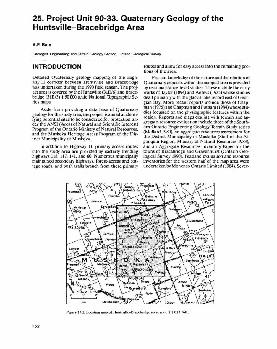
25. Project Unit 90-33. Quaternary Geology of the Huntsville-Bracebridge Area
A.F. Bajc
Geologist. Engineering and Terrain Geology Section, Ontario Geological Survey.
INTRODUCTIONDetailed Quaternary geology mapping of the High way 11 corridor between Huntsville and Bracebridge was undertaken during the 1990 field season. The proj ect area is covered by the Huntsville (31E/6) and Brace bridge (31E/3) 1:50000 scale National Topographic Se ries maps.
Aside from providing a data base of Quaternary geology for the study area, the project is aimed at identi fying potential sites to be considered for protection un der the ANSI (Areas of Natural and Scientific Interest) Program of the Ontario Ministry of Natural Resources, and the Muskoka Heritage Areas Program of the Dis trict Municipality of Muskoka.
In addition to Highway 11, primary access routes into the study area are provided by easterly trending highways 118, 117, 141, and 60. Numerous municipally maintained secondary highways, forest-access and cot tage roads, and bush trails branch from these primary
routes and allow for easy access into the remaining por tions of the area.
Present knowledge of the nature and distribution of Quaternary deposits within the mapped area is provided by reconnaissance-level studies. These include the early works of Taylor (1894) and Antevs (1925) whose studies dealt primarily with the glacial-lake record east of Geor gian Bay. More recent reports include those of Chap man (1975) and Chapman and Putnam (1984) whose stu dies focussed on the physiographic features within the region. Reports and maps dealing with terrain and ag gregate-resource evaluation include those of the South ern Ontario Engineering Geology Terrain Study series (Mollard 1980), an aggregate-resources assessment for the District Municipality of Muskoka (Staff of the Al- gonquin Region, Ministry of Natural Resources 1983), and an Aggregate Resources Inventory Paper for the towns of Bracebridge and Gravenhurst (Ontario Geo logical Survey 1990). Peatland evaluation and resource inventories for the western half of the map area were undertaken by Monenco Ontario Limited (1984). Sever-
Armour \ p"X""t ^ 79' urk's Falls
Figure 25.1. Location map of Hunlsville-Bracebridge area, scale 1:1 013 760.
152

A.F. BAJC
al graduate and undergraduate theses dealing with as pects of the Quaternary geology of the Huntsville-Bra- cebridge area have been completed as well (Warner 1978; Jamieson 1979; Vasco 1987; Delorme 1989).
Information obtained during the 1990 field season was supplemented with data collected from an earlier mapping program (Sharpe 1978). Funding for the cur rent mapping program was provided by the Ontario Ministry of Natural Resources, the District Municipality of Muskoka, and the Ontario Geological Survey.
BEDROCK GEOLOGY
The Huntsville-Bracebridge area lies within the Cen tral Gneiss Bell of the Grenville Province; a structural subdivision of the Canadian Shield (Wynne-Edwards 1972). The belt consists mainly of quartzofeldspathic gneissic and migmatitic rocks which have been meta morphosed to upper amphibolite and, locally, to granu lite facies. The dominant structures and foliations with in these rocks are northwest trending. Most of the gneisses are believed to be of igneous origin although metasedimentary counterparts have been recognized (Davidson et al 1985). The metasedimentary rocks are concentrated primarily within the northeastern corner of the map area (Hewitt 1967).
The Central Gneiss Belt consists of a variety of Archean to Mesoproterozoic crustal segments, several of which have been recognized within the map area. These crustal segments, referred to as domains and sub- domains, are defined by their geophysical characteris tics, rock assemblages, structural styles and metamor phic overprints. They are separated by subparallel zones of intense deformation (Davidson et al 1985). Deep- seated, northwest-directed ductile thrusting and imbri cation during the Grenville orogeny resulted in the stacking of these segments into their present positions. Areally, the Novar, Seguin, Huntsville, Fishog and Ros- seau subdomains account for well over 909& of the map area.
Skeleton Lake is located in the west-central part of the map area and is contained within a circular depres sion which truncates the regional geological and physio graphic trends of the local Precambrian gneisses and migmatites. Geologic and geophysical evidence sup ports the hypothesis that Skeleton Lake is the eroded remnant of a meteorite impact crater which formed dur ing the Early Paleozoic (Waddington and Dence 1979). An erosional remnant or outlier of Ordovician, fossilif- erous limestone, with lesser amounts of arkosic sand stone and siltstone, remains on the lake bottom (Vasco 1987).
Small, plug-like, mafic to ultramafic intrusions are randomly scattered throughout the map area. Many of these have been investigated for their base metal poten tial. An intrusion worth noting is the Port Cunnington peridotite, located in Franklin Township, which is in tensely weathered to an unknown depth. This friable
rock has been exploited as a local source of aggregate (Hewitt 1967).
QUATERNARY GEOLOGYThe Quaternary deposits observed within the study area are believed to be late Wisconsinan and Holocene in age. There is no direct evidence for the presence of de posits older than those of the last ice advance.
The direction of the last glacial advance was south ward across the study area. Over 115 ice-flow indica tors including glacial striae, crescentic fractures, crag- and-tail features, and fluted till surfaces were mea sured. Together, they suggest an ice flow towards 190" with a standard deviation of 11" to 12" and a range of 155 0 to 220". Local variations from the mean are best explained by minor deflections around local topographic obstructions during the waning stages of glaciation.
Thicknesses of glacial and nonglacial deposits are extremely variable throughout the study area. Much of the region is characterized by a rock-dominated terrain where drift only locally attains thicknesses of several tens of metres. The overburden cover generally be comes more extensive towards the lowland in the south- west corner of the study area. The thickest sediment se quences are found along the major drainage routes. The thickest accumulation of drift occurs along the Big East River and along the North and South branches of the Muskoka River where overburden depths in excess of 100 m have been documented.
The Huntsville-Bracebridge area was deglaciated approximately 11000 years BP. Glacial Lake Algonquin fronted the retreating margin of the ice sheet, over most of the western half of the study area, and facilitated the ice sheet's rapid northward retreat by calving. Ice stag nation on the eastern highland resulted in a glacial land scape quite unlike that found to the west. Progressive retreat of the ice margin to the vicinity of South River uncovered the first of a series of low outlets to the Otta wa River valley. Consequently, water levels dropped by as much as 50 m (Chapman 1975) and exposed much of the glacial lakebed, within the study area, to subaerial conditions. By 10 000 years BP, the Huron basin shore line had regressed to a position far west of the study area.
Till most commonly occurs as a thin, highly weath ered veneer over bedrock in highland areas, although it may locally attain substantial thicknesses in bedrock troughs or depressions transverse to ice flow and on lee- side slopes of bedrock-controlled topographic highs. The most extensive accumulations have been found within the east-central portions of the mapped area.
Several facies of till have been identified:1. A loose, silty, sandy, stone-poor till with numerous
stringers of stratified sand and a high proportion of abraded and faceted clasts; this facies is interpreted as a deposit of subglacial meltout.
2. A loose, sandy, stony till with a high proportion of stratified sediment and very few abraded clasts; this
153
ENGINEERING AND TERRAIN (25)
facies is confined to the upland regions along the eastern half of the study area. It is interpreted as a deposit of supraglacial meltout with subsequent re sedimentation by flow. Similar deposits have been encountered on the lee sides of bedrock obstruc tions and are interpreted as subglacial meltout tills derived from the melting of debris-rich ice charged with local bedrock.
3. Sandy, silty, stone-poor till with contorted stringers of lacustrine silt and clay interspersed; this facies is confined exclusively to low-lying areas within the western half of the study area. It is interpreted as the deposit of a subaqueous debris flow originating at the glacier margin. Few till exposures exhibiting features indicative of grounded, active ice were dis covered during the course of mapping.
Deposits of ice-contact stratified drift occur sporadically throughout the study area. In highland areas, they occur as small, sinuous esker ridges generally not exceeding 10 rn in height; as flat-topped kame terraces fringing valley walls; and as isolated kame hummocks in low-ly ing areas. Compositionally, these features are extreme ly variable, consisting of boulder gravel to very fine sand and silt. A largely unexploited esker ridge, terminating in a fan-shaped deposit, occurs 2.5 km west of Britannia in Huntsville Town Municipality.
In low-lying areas, ice-contact deposits occur as bu ried eskers ridges and ice-contact deltas. Many of the buried eskers terminate in subaquatic outwash fans and are therefore concealed beneath thick sequences of fine sand. They are usually confined to bedrock valleys and are difficult to trace at depth. The sand and gravel ex traction operation, 2.5 km south of Lake Vernon, is a no table example, because of its large size and excellent ex posures. This deposit has a north-trending ice-contact core which is buried in places by well over 20 m of fine sand to silt. The ice-contact core was probably deposited subglacially within a conduit and was later buried by pro glacial subaquatic outwash sands. Subglacial drainage systems, buried by subaquatic outwash fan deposits, ex tend along the North Branch Muskoka River and along the lowland south of Skeleton and Three Mile lakes as well. Numerous sand and gravel operations are situated along these present-day drainage corridors. Ice-contact deltas occur at Siding Lake, 4 km south of Lake Vernon; on Highway 518, 4 km east of Sprucedale; and at Fish Lake, l km east of Novar. They occur at approximately 305, 335 and 335 m above sea level (asl), respectively, and are composed of poorly sorted cobble gravel to fine sand. In both cases, north-sloping ice-contact faces are well preserved.
Both subaerial and subaquatic outwash deposits have been recognized within the study area. Subaquatic deposits are found at elevations below 335 m asl at the northern end of the study area and at elevations below 300 m asl at the southern end. They consist almost exclu sively of massive, rippled, and planar-laminated, fine to very fine sands and silts. They are usually confined to bedrock depressions and are closely associated with a
feeder conduit. Notable systems of subaquatic outwash are found along the North Branch Muskoka River valley, the Big East River valley, and in an intricate net work of interconnecting, low-lying areas situated over much of the northwestern corner of the study area. The deposits, some of which were laid down in water depths of 50 to 70 m, generally fine both upward and to the south in response to what was then a retreating ice mar gin. Loading and dewatering structures are commonly observed within these deposits.
Deposits of subaerial outwash are generally con fined to the eastern half of the study area. They are found primarily along the upper reaches of the Big East River valley, along the south shore of Lake of Bays, and along the South Branch Muskoka River valley. Aside from those deposits along the south shore of Lake of Bays and the upper parts of the North Branch Muskoka River, most of the subaerial outwash is sandy and con tains negligible crushable material.
Distal subaquatic outwash deposits grade both lat erally and vertically into horizontally laminated, glacio lacustrine sands, silts, and clays of glacial Lake Algon- quin and its successors. Massive to horizontally lami nated, fine to very fine sands are confined primarily to those low-lying areas around Fox Lake, Buck Lake, Lake Vernon and the north shore of Lake of Bays. Fin er-grained lacustrine sediments consist of massive to faintly laminated silts and rhythmically laminated silts and clays which probably represent annual deposition. The rhythmites are associated with deeper basinal set tings, as occur around the perimeters of Lake Muskoka, Three Mile Lake, Fairy Lake, Lake Vernon and Mary Lake. Ice-rafted debris is uncommon. At least 15 m of rhythmically laminated silts and clays have been ob served along Sharpe Creek, 2 to 3 km east of the town of Bracebridge. Fine-grained, regressive sands often blan ket the sediment sequence.
Aside from ice-contact deltas, constructional litto ral glaciolacustrine features are uncommon within the study area. Notable exceptions include a 2.5 m capping of nearshore pebble gravels, probably associated with the Main Algonquin shoreline, at the Bracebridge town dump. The deposit occurs at an elevation of approxi mately 305 m asl. Varved silts and clays exposed in a sand and gravel pit, located 3 km north of Milford Bay, are capped by 2 to 3 m of steeply dipping fine sands. The sands are found at an elevation of 260 m asl and were probably deposited as a nearshore bar in a post-Algon quin lake.
Wave-cut notches and boulder lags are common within the study area although they are difficult to trace through the densely forested terrain. An intricate archi pelago of islands probably dampened the effects of nearshore processes and prevented the development of shoreline features across the region. Of the shorelines identified, the highest occurs at or just above 335 m asl between Huntsville and Novar. The level of this shore line falls to the south to approximately 305 m asl near Bracebridge. Several lower levels have been identified as well.
154
A.F. BAJC
Falling Huron basin water levels resulted in the in cision of valleys and the development of the present drainage systems. The Big East River and the North and South branches of the Muskoka River all follow ances tral meltwater discharge routes. At least one perched fluvial terrace has been identified along the southern course of the South Branch Muskoka River valley. The terrace occurs at an elevation of 260 m asl and is prob ably graded to a post-Algonquin lake level.
Eolian deposits, consisting of well sorted, fine to very fine sand, have been identified at a few scattered localities throughout the study area. They are devel oped on the abandoned Lake Algonquin plain and are derived from the reworking of nearshore sands. Para bolic dunes have been identified along Highway 518, 2 km east of Sprucedale. Eolian sands have also been identified along the South Branch Muskoka River valley, l km southwest of High Falls Generating Station.
Deposits of peat and muck are found both in wet lands, which occupy local topographic depressions, and along the courses of meandering streams and rivers. De posits in excess of 12 m in thickness have been identified. Many of the smaller peat bogs are underlain by "diato maceous earth" a siliceous sedimentary deposit of the skeletal remains of diatoms which flourished within iso lated basins following drainage of glacial Lake Algon quin (Hewitt 1967).
POTENTIAL GEOLOGICAL HERITAGE AREASSeveral candidate sites have been identified within the study area to be considered for protection under the Muskoka Heritage Areas and ANSI programs. These include:1. The Skeleton Lake basin, a presumed meteorite
impact crater, floored by Ordovician carbonate and clastic rocks, remnants of which have been dis persed southward out of the lake basin by glacial processes.
2. Intensely weathered, unmetamorphosed, late Pre cambrian, ultramafic intrusive rocks exposed in a small pit near Port Cunnington, Franklin Township. This saprolite, a probable Cretaceous weathering product, is overlain by up to 4 m of subglacial melt- out and flow till, a deposit common to Muskoka Dis trict Municipality. The contact between the two is sharp and undulating, attesting to the passive mode of deposition of the till.
3. A wave-cut notch and foreshore platform of Main Lake Algonquin is well developed on the highland bordering the south shore of Fairy Lake. Shoreline features of this glacial lake are generally poorly de veloped and difficult to trace over most of the re gion. The abandoned shoreline is situated at an ele vation of 335 m asl, over 50 m above the level of Fairy Lake. A narrow estuary of glacial Lake Algon quin occupied the lowland within which Fairy and Peninsula lakes are now situated.
4. Varved silts and clays exposed at several locations along the valley of Sharpe Creek contain a record of glacial lake sedimentation which spans well over 500 years of Lake Algonquin history (Jamieson 1979). Many of the rhythmites contain remnant trace fossils (burrows and tracks) attributed to bur rowing and bottom-dwelling organisms which flour ished 11000 years BP in Lake Algonquin.
5. The lower course of the Big East River is incised 20 to 30 m below the upper surface of valley-fill glacio fluvial sands and gravels. Numerous steep, cutbank exposures, the most notable being "Big Bend Look out" in Arrowhead Provincial Park, can be found along the river's length. The river, a complex of me ander channels and oxbow lakes, traverses a flat valley floor which attains a width of l to 2 km over much of its length. A large, sandy, river-dominated delta with several distributary channels has formed at its mouth along the eastern shore of Lake Ver non.
ECONOMIC GEOLOGYThe major producing sand and gravel operations within the Huntsville-Bracebridge area are situated along the Highway 11 corridor. Reserves of high quality, coarse, crushable material are available at only a few locations within the corridor and are rapidly being depleted. The aggregate in the area is considered hard and durable and is generally suitable for most usual applications (Ont ario Geological Survey 1990).
An esker system along Highway 592, north of Novar, is largely unexploited and may prove useful as a future aggregate source. Reserves of unexploited coarse aggregate are also present in north-central Macauley Township along the North Branch Muskoka River and southwest McLean Township along the South Branch Muskoka River.
Most of the exploited deposits along the High way 11 corridor are situated within subaquatic outwash fans. These deposits contain large volumes of fine to very fine sand thereby limiting their use. Smaller depos its of sand and gravel occur sporadically throughout the area and serve the local markets. Those deposits si tuated immediately south of Skeleton Lake may contain up to 70 percent limestone and friable siltstone clasts in the pebble fraction. These deposits have been avoided when high-quality aggregates were required.
The local clay deposits of the area have been ex ploited for drainage tile and brick production. These plants ceased production in the late 1960s (Hewitt 1967).
Diatomite is commonly encountered beneath and intercalated with peat throughout the study area. At tempts to produce commercial diatomite products have been short lived because of the impurities and small size of the deposits (Hewitt 1967). Diatomaceous muds reach thicknesses of 2 to 5 m in places. Unfortunately, many of these deposits grade only 10*2^ to 209& diato mite.
155
ENGINEERING AND TERRAIN (25)
Presently there are no known commercial peat op erations within the study area. Reconnaissance evalua tions and resource inventories have been conducted for a large peatland immediately north of Axe Lake and a smaller peatland just north of Round Lake (Monenco Ontario Limited 1984). More detailed work is needed to systematically evaluate and identify the potential peat resources of the region.
REFERENCESAntevs, E. 1925. Retreat of the last ice sheet in eastern Canada; Geo
logical Survey of Canada, Memoir 146, 142 p.Chapman, L.J. 1975. The physiography bf the Georgian Bay-Ottawa
Valley area of southern Ontario; Ontario Division of Mines, Geo logical Report 128, 35p.
Chapman, L.J. and Putnam, D.F. 1984. The physiography of southern Ontario, 3rd ed.; Ontario Geological Survey, Special Volume 2, 270p.
Davidson, A., Nadeau, L., Grant, S.M. and Pryer, L.L. 1985. Studies in the Grenville Province of Ontario; in Current Research, Part A, Geological Survey of Canada, Paper 85-1A, p.463-483.
Delorme, R.J. 1989. A sediinentological study of subaquatic outwash fans, in bedrock controlled terrain near Ullswater, Ontario; Un published MSc Thesis, University of Waterloo, Waterloo, Ontar io, 181p.
Hewitt, D.F. 1967. Geology and mineral deposits of the Parry Sound- Huntsville area; Ontario Department of Mines, Geological Re port 52, 65p.
Jamieson, G.R. 1979. Correlation, sedimentology and nature of grain-size distribution of Pleistocene glacial varves of the Brace- bridge-Hunlsville area, Ontario, Canada; Unpublished BSc thesis, University of Waterloo, Waterloo, Ontario, 78p.
Mollard, D.G. 1980. Southern Ontario engineering geology terrain study data base map, Muskoka area, Parry Sound and Muskoka districts; Ontario Geological Survey, Open File Report 5323,2p.
Monenco Ontario Limited 1984. Peat and peatland evaluation of the Parry Sound area, volume 1; Ontario Geological Survey, Open File Report 5488, 5 volumes, 194p.
Ontario Geological Survey 1990. Aggregate resources inventory of the towns of Bracebridge and Gravenhurst; Ontario Geological Sur vey, Aggregate Resources Inventory Paper 147, 69p.
Sharpe, D.R. 1978. Quaternary geology of the Gravenhurst, Brace bridge and Huntsville areas, District of Muskoka; in Summary of Field Work, 1978, Ontario Geological Survey, Miscellaneous Pa per 82, p.152-154.
Staff of the Algonquin Region, Ministry of Natural Resources 1983. Aggregate resources assessment, District Municipality of Musko ka; Ontario Geological Survey, Open File Report 5457,14p.
Taylor, F.B. 1894. The limit of postglacial submergence in the high lands east of Georgian Bay; The American Geologist, v.14, no.5, p.273-289.
Waddington, E.D. and Dence, M.R. 1979. Skeleton Lake, Ontar io evidence for a Paleozoic impact crater; Canadian Journal of Earth Sciences, v.16, p.256-263.
Warner, B.C. 1978. The origin and depositional history of the East River glacial delta, Huntsville, Ontario; Unpublished BES thesis, University of Waterloo, Waterloo, Ontario, 95p.
Vasco, C.T 1987. Carbonaceous glacial deposits south of Skeleton Lake, Ontario; Unpublished BSc thesis, University of Waterloo, Waterloo, Ontario, 70p.
Wynne-Edwards, H.R. 1972. The Grenville Province; in Variations in Tectonic Styles in Canada, Geological Association of Canada, Special Paper 11, p.264-334.
156
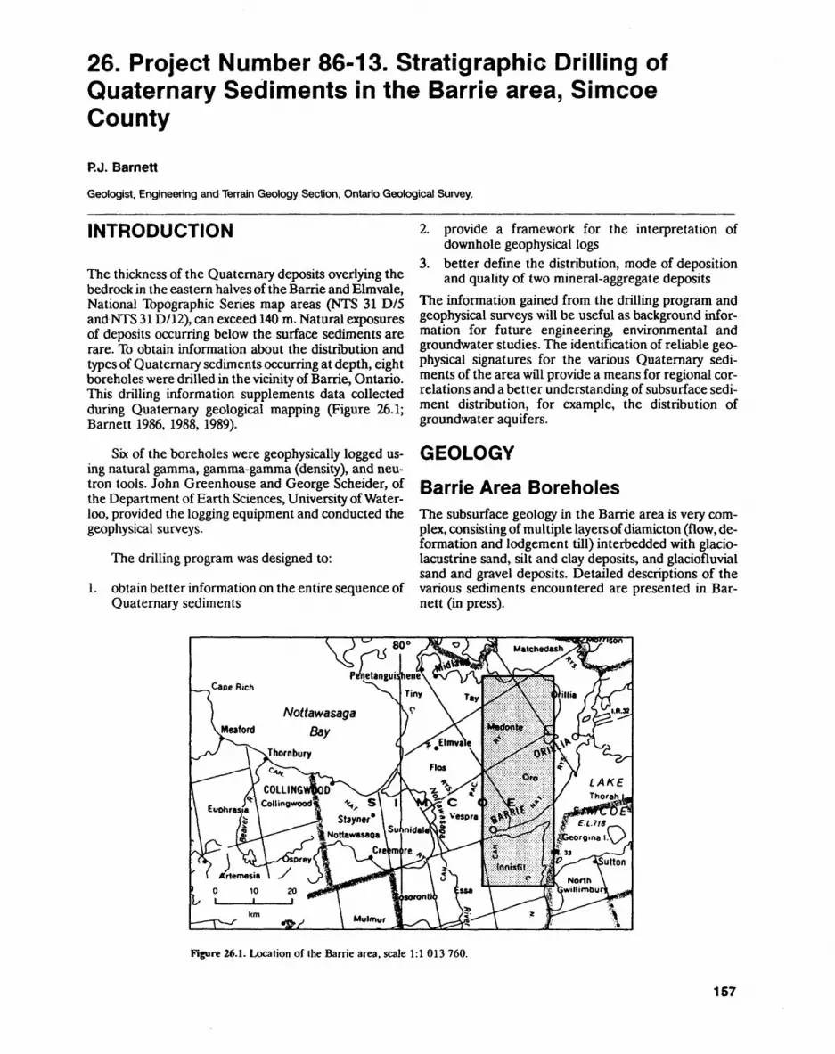
26. Project Number 86-13. Stratigraphic Drilling of Quaternary Sediments in the Barrie area, Simcoe County
P.J. BarnettGeologist. Engineering and Terrain Geology Section. Ontario Geological Survey.
INTRODUCTION
The thickness of the Quaternary deposits overlying the bedrock in the eastern halves of the Barrie and Elmvale, National Topographic Series map areas (NTS 31 D/5 and NTS 31D/12), can exceed 140 m. Natural exposures of deposits occurring below the surface sediments are rare. To obtain information about the distribution and types of Quaternary sediments occurring at depth, eight boreholes were drilled in the vicinity of Barrie, Ontario. This drilling information supplements data collected during Quaternary geological mapping (Figure 26.1; Barnett 1986, 1988, 1989).
Six of the boreholes were geophysically logged us ing natural gamma, gamma-gamma (density), and neu tron tools. John Greenhouse and George Scheider, of the Department of Earth Sciences, University of Water loo, provided the logging equipment and conducted the geophysical surveys.
The drilling program was designed to:
1. obtain better information on the entire sequence of Quaternary sediments
2. provide a framework for the interpretation of downhole geophysical logs
3. better define the distribution, mode of deposition and quality of two mineral-aggregate deposits
The information gained from the drilling program and geophysical surveys will be useful as background infor mation for future engineering, environmental and groundwater studies. The identification of reliable geo physical signatures for the various Quaternary sedi ments of the area will provide a means for regional cor relations and a better understanding of subsurface sedi ment distribution, for example, the distribution of groundwater aquifers.
GEOLOGY
Barrie Area BoreholesThe subsurface geology in the Barrie area is very com plex, consisting of multiple layers of diamicton (flow, de formation and lodgement till) interbedded with glacio lacustrine sand, silt and clay deposits, and glaciofluvial sand and gravel deposits. Detailed descriptions of the various sediments encountered are presented in Bar nett (in press).
Figure 26.1. Location of the Barrie area, scale 1:1 013 760.
157

ENGINEERING AND TERRAIN (26)
Several major glacial events are indicated in the se quence of sediments encountered. Minor ice marginal fluctuations of the same glacier are also recorded. The ice margin appears to have been in contact with, and supporting, proglacial lakes in the Barrie and Elmvale map areas. Fine-grained till layers, the product of the in corporation or deformation of fine-grained glaciolacus trine sediments, occur in several of the boreholes. In particular, boreholes OGS-90-8 and OGS-90-15 contain fine-grained till overlying highly deformed and sheared glaciolacustrine silt and clay rhythmites.
Boreholes OGS-90-5, OGS-90-6, and OGS-90-7 were drilled in the Hillsdale area and sited at the base of the upland, on the top of the upland surface, and near the centre of the broad valley along which Highway 400 is located, respectively. This series of boreholes was de signed to give a complete record of the Quaternary sedi ments making up the upland in this area and a record of the Quaternary sediment sequence that occurs beneath the valley. They were also designed to test the recent "tunnel valley" hypothesis on the origin of the large val leys in the Barrie and Elmvale areas, as well as a related hypotheses on the origin and distribution of buried and partially buried sand and gravel deposits (Barnett 1990). Borehole OGS-90-6 would provide information on the extent of partially buried sand and gravel deposits lo cated in lot 7 and 8, Concession III, Medonte Township.
The results from the drilling of these three bore holes indicate that the uplands are composed of several layers of till interbedded primarily with glaciolacustrine sediments. The partially buried sand and gravel deposits located in lots 7 and 8, Concession III, Medonte Town ship appear to pinch out with only two metres or so of sand and gravel being encountered in borehole OGS-90-6. This would suggest that the deposit of sand and gravel was deposited only along the valley wall, and does not extend very far into the upland. The stratigra phy of the sediments below the valley floor was quite dif ferent from those found in the upland. Thick glacioflu vial deposits of very coarse sand with minor gravel occur beneath postglacial glaciolacustrine sediments and above one layer of till that rests on the bedrock surface. The stratigraphic relationships observed in these bore holes lend support to the "tunnel valley" hypothesis.
Boreholes OGS-90-8, OGS-90-9, and OGS-90-15 provided additional information on the composition and stratigraphy of the Oro or Bass Lake Moraine, and bore holes OGS-90-10 and OGS-90-11 gave additional re gional stratigraphic information.
Of particular interest is the occurrence of detrital organic material beneath several layers of fine-grained till in borehole OGS-90-10. The organic material, pri
marily small pieces of wood, was recovered below a depth of 57 m. This finding, combined with an in situ or ganic deposit found near Bradford (discussed below), extends the northern range of buried organic sites be neath till in southwestern Ontario and will provide valu able information on climatic conditions in this part of Ontario during the Late Pleistocene.
Bradford Area BoreholesThree short boreholes were drilled in Bradford in co-operation with the Peter Storck, Royal Ontario Mu seum and W.D. Fitzgerald, Huronia District, Ministry of Natural Resources. The boreholes were drilled to verify a reported occurrence of flesh buried beneath glacial and glacial lake sediments in a water well. Although no flesh was found in any of the three Bradford area bore holes, an organic-bearing silt unit up to 3 m thick was encountered beneath three layers of till.
The flesh was dated as modern (Peter Storck, Royal Ontario Museum, personal communications, 1990) and probably originated from within the surface fill (up to 3 m thick) which occurs at the original water-well drill site. The piece of flesh may have entered the borehole along with sandy fill material by piping, through a small gap between the bottom of the casing (at a depth of about 2.4 m) and the top of the uppermost till (3 m be low the surface) on which the surface aquifer is perched. The pollen and macrofossils of the organic bearing unit are currently being studied by T.W. Anderson of the Geological Survey of Canada. Work on the local and re gional stratigraphic settings of the boreholes is continu ing.
REFERENCESBarnett, P.J. 1986. Quaternary geology of the eastern halves of the
Barrie and Elmvale areas, Simcoe County; in Summary of Field Work and Other Activities 1986, Ontario Geological Survey, Miscellaneous Paper 132, p.193-194.
1988. Quaternary geology of the eastern half of the Elmvale area, Simcoe County; in Summary of Field Work and Other Acti vities 1988, Ontario Geological Survey, Miscellaneous Paper 141, p.405-406.
1989. Quaternary geology of the Barrie and Elmvale area; in Summary of Field Work and Other Activities 1989, Ontario Geo logical Survey, Miscellaneous Paper 146, p.205-206.
1990. Tunnel valleys: evidence of catastrophic release of subgla cial meltwater, central-southern Ontario, Canada; in Abstracts with Programs, Geological Society of America, Northeastern Section, Syracuse, New York, p.3.
Barnett, P.J. in press. Preliminary report on the stratigraphic drilling of Quaternary sediments in the Barrie area, Simcoe County, Ontar io (Project Number 86-13); Ontario Geological Survey.
158
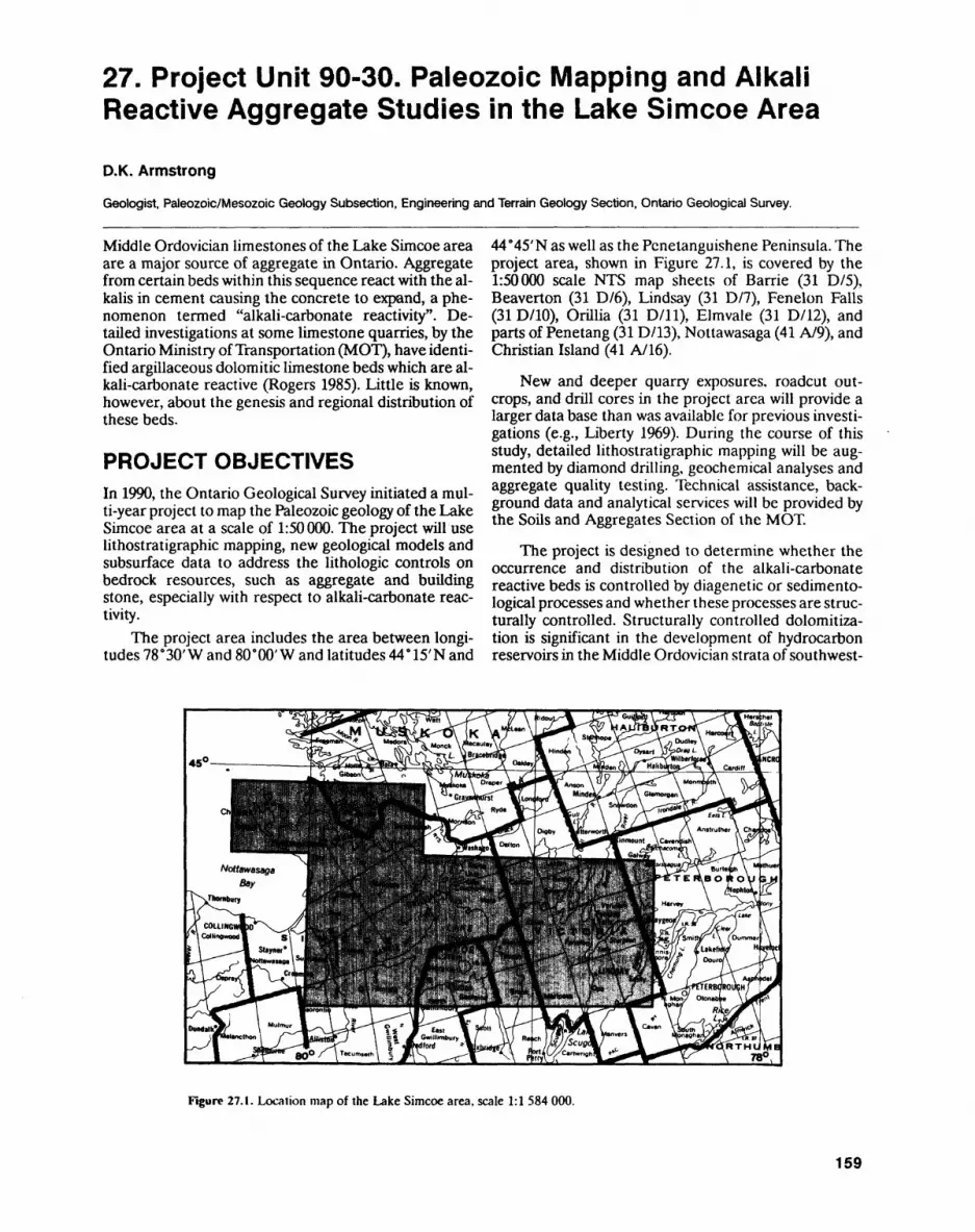
27. Project Unit 90-30. Paleozoic Mapping and Alkali Reactive Aggregate Studies in the Lake Simcoe Area
O.K. Armstrong
Geologist. Paleozoic/Mesozoic Geology Subsection, Engineering and Terrain Geology Section. Ontario Geological Survey.
Middle Ordovician limestones of the Lake Simcoe area are a major source of aggregate in Ontario. Aggregate from certain beds within this sequence react with the al kalis in cement causing the concrete to expand, a phe nomenon termed "alkali-carbonate reactivity". De tailed investigations at some limestone quarries, by the Ontario Ministry of Transportation (MOT), have identi fied argillaceous dolomitic limestone beds which are al kali-carbonate reactive (Rogers 1985). Little is known, however, about the genesis and regional distribution of these beds.
PROJECT OBJECTIVESIn 1990, the Ontario Geological Survey initiated a mul ti-year project to map the Paleozoic geology of the Lake Simcoe area at a scale of 1:50000. The project will use lithostratigraphic mapping, new geological models and subsurface data to address the lithologic controls on bedrock resources, such as aggregate and building stone, especially with respect to alkali-carbonate reac tivity.
The project area includes the area between longi tudes 78'30' W and SOW W and latitudes 44 e 15'N and
44"45'N as well as the Penetanguishene Peninsula. The project area, shown in Figure 27.1, is covered by the 1:50000 scale NTS map sheets of Barrie (31 D/5), Beaverton (31 D/6), Lindsay (31 D/7), Fenelon Falls (31 D/10), Orillia (31 D/ll), Elmvale (31 D/12), and parts of Penetang (31 D/13), Nottawasaga (41 A/9), and Christian Island (41 A/16).
New and deeper quarry exposures, roadcut out crops, and drill cores in the project area will provide a larger data base than was available for previous investi gations (e.g., Liberty 1969). During the course of this study, detailed lithostratigraphic mapping will be aug mented by diamond drilling, geochemical analyses and aggregate quality testing. Technical assistance, back ground data and analytical services will be provided by the Soils and Aggregates Section of the MOT.
The project is designed to determine whether the occurrence and distribution of the alkali-carbonate reactive beds is controlled by diagenetic or sedimento- logical processes and whether these processes are struc turally controlled. Structurally controlled dolomitiza tion is significant in the development of hydrocarbon reservoirs in the Middle Ordovician strata of southwest-
Figure 27.1. Location map of the Lake Simcoe area, scale 1:1 584 000.
159
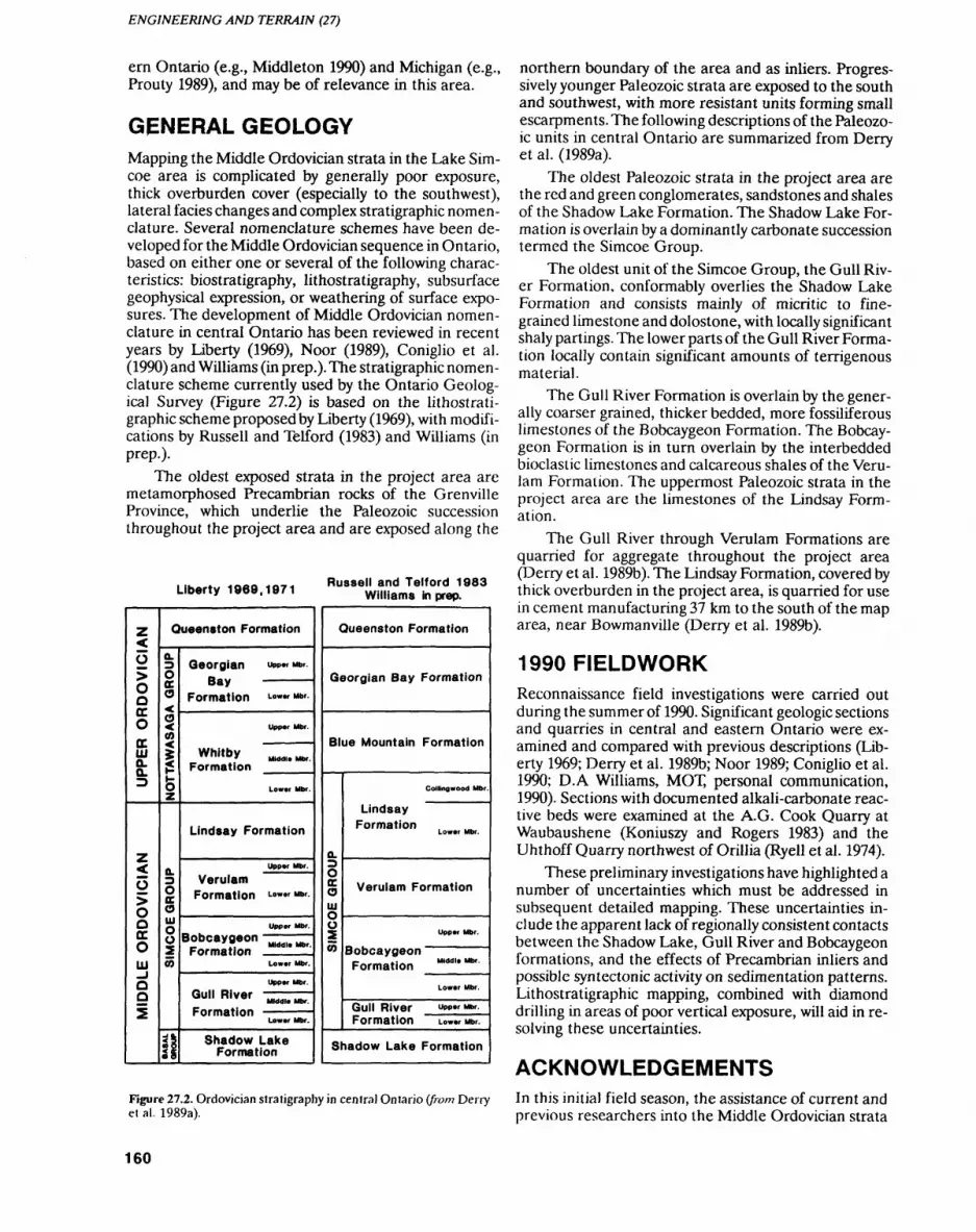
ENGINEERING AND TERRAIN (27)
ern Ontario (e.g., Middleton 1990) and Michigan (e.g., Prouty 1989), and may be of relevance in this area.
GENERAL GEOLOGYMapping the Middle Ordovician strata in the Lake Sim coe area is complicated by generally poor exposure, thick overburden cover (especially to the southwest), lateral facies changes and complex stratigraphic nomen clature. Several nomenclature schemes have been de veloped for the Middle Ordovician sequence in Ontario, based on either one or several of the following charac teristics: biostratigraphy, lithostratigraphy, subsurface geophysical expression, or weathering of surface expo sures. The development of Middle Ordovician nomen clature in central Ontario has been reviewed in recent years by Liberty (1969), Noor (1989), Coniglio et al. (1990) and Williams (in prep.). The stratigraphic nomen clature scheme currently used by the Ontario Geolog ical Survey (Figure 27.2) is based on the lithostrati graphic scheme proposed by Liberty (1969), with modifi cations by Russell and Telford (1983) and Williams (in prep.).
The oldest exposed strata in the project area are metamorphosed Precambrian rocks of the Grenville Province, which underlie the Paleozoic succession throughout the project area and are exposed along the
Liberty 1969,1971 Russell and Telford 1983 Williams in prep.
UPPER ORDOVICIAN
MIDDLE ORDOVICIAN
Queenston Formation
NOTTAWASAGA GROUP
SIMCOE GROUP
i!
Georgian UPP* Mbr. Bay ————
Formation I-OKW Mbr.
Upper Mbr.
Whitby ^.^ Formation
Lower Mbr.
Lindsay Formation
Upper Mbr.
Verulam Formation Lo"*r Mbr
Upper Mbr.
Bobcaygeon -^^Formation
Lower Mbr.
Upper Mbr.
G"" R^r M,.,,. Mb,Formation ————
Lower Mbr.
Shadow Lake Formation
Queenston Formation
Georgian Bay Formation
Blue Mountain Formation
SIMCOE GROUP
Collingwood Mbr.
Lindsay Formation
Lower Mbr.
Verulam Formation
Upper Mbr.
Bobcaygeon Formation M"w" Mbr
Lower Mbr.
Gull River Upper Mbr.
Formation Lower Mbr.
Shadow Lake Formation
Figure 27.2. Ordovician stratigraphy in central Ontario (from Derry et al. 1989a).
northern boundary of the area and as inliers. Progres sively younger Paleozoic strata are exposed to the south and southwest, with more resistant units forming small escarpments. The following descriptions of the Paleozo ic units in central Ontario are summarized from Derry et al. (1989a).
The oldest Paleozoic strata in the project area are the red and green conglomerates, sandstones and shales of the Shadow Lake Formation. The Shadow Lake For mation is overlain by a dominantly carbonate succession termed the Simcoe Group.
The oldest unit of the Simcoe Group, the Gull Riv er Formation, conformably overlies the Shadow Lake Formation and consists mainly of micritic to fine grained limestone and dolostone, with locally significant shaly partings. The lower parts of the Gull River Forma tion locally contain significant amounts of terrigenous material.
The Gull River Formation is overlain by the gener ally coarser grained, thicker bedded, more fossiliferous limestones of the Bobcaygeon Formation. The Bobcay geon Formation is in turn overlain by the interbedded bioclastic limestones and calcareous shales of the Veru lam Formation. The uppermost Paleozoic strata in the project area are the limestones of the Lindsay Form ation.
The Gull River through Verulam Formations are quarried for aggregate throughout the project area (Derry et al. 1989b). The Lindsay Formation, covered by thick overburden in the project area, is quarried for use in cement manufacturing 37 km to the south of the map area, near Bowmanville (Derry et al. 1989b).
1990 FIELDWORKReconnaissance field investigations were carried out during the summer of 1990. Significant geologic sections and quarries in central and eastern Ontario were ex amined and compared with previous descriptions (Lib erty 1969; Derry et al. 1989b; Noor 1989; Coniglio et al. 1990; D.A Williams, MOT, personal communication, 1990). Sections with documented alkali-carbonate reac tive beds were examined at the A.G. Cook Quarry at Waubaushene (Koniuszy and Rogers 1983) and the Uhthoff Quarry northwest of Orillia (Ryell et al. 1974).
These preliminary investigations have highlighted a number of uncertainties which must be addressed in subsequent detailed mapping. These uncertainties in clude the apparent lack of regionally consistent contacts between the Shadow Lake, Gull River and Bobcaygeon formations, and the effects of Precambrian inliers and possible syntectonic activity on sedimentation patterns. Lithostratigraphic mapping, combined with diamond drilling in areas of poor vertical exposure, will aid in re solving these uncertainties.
ACKNOWLEDGEMENTSIn this initial field season, the assistance of current and previous researchers into the Middle Ordovician strata
160
D.K. ARMSTRONG
in Ontario, and into alkali reactivity in this Succession of Middleton, K. 1990. Dolomitization and porosity development inrocks, was invaluable. These included: D.A. Williams Mif Jf Ordovician carbonate reservoirs, southwestern Ontario;
, A A n o-i j A *o*- x*^-n m Subsurface geology of southwestern Ontario: A core work-and C.A. Rogers, Soils and Aggregates Section, MO f; shop Ontario |etro um Institute Inc., L^^ 146p.M. Coniglio, University of Waterloo: M.E. Brookfield, ., . inon . . 4 , t t . . . . . . . . .. .TT . .6 * P -. , . J . ^. ' . , . ,. . i Noor, I. 1989. Lithostratigraphy, environmental interpretation and University of Guelph; and B. Fitzgerald, Ministry of paleogeography of the Middle Ordovician Shadow Lake, Gull Natural Resources, Huronia District. River and Bobcaygeon formations; unpublished PhD thesis, Uni
versity of Toronto, Toronto, Ontario, 262p.
Prouty C.E. 1989. Trenton exploration and wrenching tectonics -(REFERENCES Michigan Basin and environs, in The Trenton Group (Upper Or
dovician Series) of Eastern North America; American Associ- Coniglio, M.,Melchin.M.J. and Brookfield, M.E. 1990. Stratigraphy, ation of Petroleum Geologists, Studies in Geology #29,
sedimentology and biostratigraphy of Ordovician rocks of the p.207-236.Peterborough-Lake Simcoe area of southern Ontario, Fieldlrip Rogers, C.A. 1985. Alkali aggregate reactions, concrete aggregateno. 3 Guidebook; Ontario Petroleum Institute Inc., London, On- testing and problem aggregates in Ontario a review; Ontariotario, 82p. Ministry of Transportation and Communications, Report
Derry, Michener, Booth A Wahl and Ontario Geological Survey EM-31, 5th ed., 44p.1989a. Limestone Industries of Ontario, Volume I; Ontario Min- Russell, D.J. and Telford, RG. 1983. Revisions to the stratigraphy ofistry of Natural Resources, 158p. the Upper Ordovician Collingwood Beds of Ontario a poten-
- .,. t - . . ,,,.. , ^ . ^ , . , - tial oil shale; Canadian Journal of Earth Sciences, v.20, Derry, Michener, Booth Se, Vfam and Ontario Geological Survey 1780-1790
1989b. Limestone Industries of Ontario, Volume III; OntarioMinistry of Natural Resources, 175p. RyeH. J -. Chojnacki, B., Woda, G. and Koniuszy, Z.D. 1974. The
Uh t hoff Quarry alkali-carbonate rock reaction: a laboratory and Koniuszy, Z. and Rogers, C. 1983. A summary of aggregate durability, fold performance study, in Cement-Aggregate Reactions; Na-
investigations of A.G. Kook Quarry, Wfoubaushene, Ontario; On- t jonal Research Council, TMishington, D.C. Technical Researchtario Ministry of Transportation and Communications, Materials Record 525, p.43-54.Information No. 54,27p. ^ * . - ^ , - , f , ^Williams, D.A. m preparation. Paleozoic geology of the Ottawa-St.
Liberty, B.A. 1969. Paleozoic geology of the Lake Simcoe area, On- Lawrence Lowland, southern Ontario; Ontario Geological Sur- tario; Geological Survey of Canada, Memoir 355, 201p. vey, Open File Report, 421p.
161
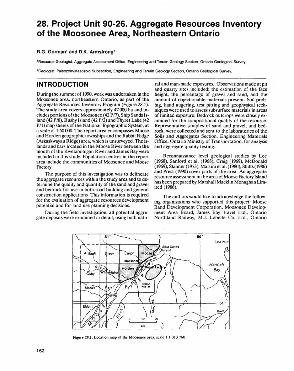
28. Project Unit 90-26. Aggregate Resources Inventory of the Moosonee Area, Northeastern Ontario
R.G. Gorman 1 and O.K. Armstrong2
1 Resource Geologist, Aggregate Assessment Office, Engineering and Terrain Geology Section, Ontario Geological Survey.
2Geologist, Paleozoic/Mesozoic Subsection, Engineering and Terrain Geology Section, Ontario Geological Survey.
INTRODUCTIONDuring the summer of 1990, work was undertaken in the Moosonee area, northeastern Ontario, as part of the Aggregate Resources Inventory Program (Figure 28.1). The study area covers approximately 47 000 ha and in cludes portions of the Moosonee (42 P/7), Ship Sands Is land (42 P/8), Bushy Island (42 P/2) and Thyret Lake (42 P/l) map sheets of the National Topographic System, at a scale of 1:50 000. The report area encompasses Moose and Horden geographic townships and the Rabbit Ridge (Askaskwayau Ridge) area, which is unsurveyed. The is lands and bars located in the Moose River between the mouth of the Kwetabohigan River and James Bay were included in this study. Population centres in the report area include the communities of Moosonee and Moose Factory.
The purpose of this investigation was to delineate the aggregate resources within the study area and to de termine the quality and quantity of the sand and gravel and bedrock for use in both road-building and general construction applications. This information is required for the evaluation of aggregate resources development potential and for land use planning decisions.
During the field investigation, all potential aggre gate deposits were examined in detail; using both natu
ral and man-made exposures. Observations made at pit and quarry sites included: the estimation of the face height, the percentage of gravel and sand, and the amount of objectionable materials present. Soil prob ing, hand augering, test pitting and geophysical tech niques were used to assess subsurface materials in areas of limited exposure. Bedrock outcrops were closely ex amined for the compositional quality of the resource. Representative samples of sand and gravel, and bed rock, were collected and sent lo the laboratories of the Soils and Aggregates Section, Engineering Materials Office, Ontario Ministry of Transportation, for analysis and aggregate quality testing.
Reconnaissance level geological studies by Lee(1968), Sanford et al. (1968), Craig (1969), McDonald(1969), Skinner (1973), Martini et al. (1980), Shilts (1986) and Prest (1990) cover parts of the area. An aggregate resource assessment in the area of Moose Factory Island has been prepared by Marshall Macklin Monaghan Lim ited (1986).
The authors would like to acknowledge the follow ing organizations who supported this project: Moose Band Development Corporation, Moosonee Develop ment Area Board, James Bay Travel Ltd., Ontario Northland Railway, M.J. Labelle Co. Ltd., Ontario
Figure 28.1. Location map of the Moosonee area, scale 1:1 013 760.
162

R.G. GORMAN and O.K. ARMSTRONG
Ministry of Natural Resources, and Ontario Ministry of Transportation.
PHYSIOGRAPHY AND SURFICIAL GEOLOGYThe report area is located within the Hudson Bay Low land physiographic region (Bostock 1969). This lowland is a flat-lying, featureless, swampy plain that slopes gradually towards James Bay at an average gradient of l m/1.5 km (Ontario Ministry of Environment 1978). The study area is largely overlain by extensive peatlands. Stunted black spruce is the dominant tree cover, with the best growth along streams, creeks and rivers.
Within the project area, a discontinuous cover of till was deposited by glacial ice which advanced in a south westerly direction (Prest 1990). Exposures of this stony, silty sand till are generally scarce. Where found, the till exists as a thin veneer over bedrock. Till is usually not well suited for aggregate use because it often contains excess fines and abundant oversize clasts. Till may, how ever, be a suitable source of fill in some localities.
During deglaciation, as the margin of the Pleisto cene glacier melted back to the north, the Hudson Bay Lowland was inundated by marine waters from Hudson Strait (Skinner 1973; Martini et al. 1980). This sea, known as the Tyrrell Sea, covered the report area ap proximately 8000 years BP (Lee 1960, 1968; Skinner 1973). In the deeper waters of this sea, horizontally bedded marine clay and silt were deposited. Thick sec tions of marine clay and silt underlie most of the report area, except for local bedrock highs. During the reces sion of the Tyrrell Sea, prominent sand and gravel beach ridges were formed. These beach deposits are consid ered lobe important sand and gravel resources. Particu larly notable are the raised beach deposits located at Rabbit Ridge which represent the most significant surfi cial aggregate resources within the study area.
Postglacial and erosional processes have been of some importance in changing the land surface of the project area. Since the recession of the Tyrrell Sea, the land surface of the report area has been subjected to ac tive rebound, and is still rising at a rate of 70 to 120 centi metres per century (Barnett 1966; Webber et al. 1970; Martini et al. 1980). Tides along the James Bay coastline are of the semidiurnal form and range from 2 to 3 m in height at the mouth of the Moose River (Environment Canada 1977). The Moose River is affected by tides as far south as the mouth of the North French River (B. Hunter, Ministry of Natural Resources, personal com munication, 1990). Extensive, low-lying, featureless tid al flat deposits, consisting primarily of fine-grained sedi ments, occur near the mouth of the Moose River. Nu merous river bars and islands occur in the Moose River between the mouth of the Kwetabohigan River and James Bay. Some of these river bars located between Moosonee and Moose Factory Island have been tradi tional suppliers of sandy aggregate. Thin accumulations
of ice-rafted coarse gravel commonly occur on many of the bars and islands.
BEDROCK GEOLOGYRecent and glacial sediments in the project area are un derlain by Devonian limestone and dolostone strata of the Stooping River and Kwataboahegan formations. These strata dip gently to the southwest, towards the centre of the Moose River sedimentary basin. The gen eral Paleozoic geology of the Moose River Basin is de scribed by Sanford et al. (1968), and the Devonian strata in the basin are described by Telford (1988), Stoakes (1978) and Sanford and Norris (1975a, 1975b).
The Lower Devonian Stooping River Formation underlies surficial sediments in the northern third of the project area. Although not exposed in the project area, this formation was encountered in Moose Factory Drill Hole No. l, drilled on Moose Factory Island by the Canadian Department of Public Works, in 1949 (San ford and Norris 1975b). In this drill hole, the Stooping River Formation occurs between 35.1 and 95.5 m below the normal high-tide elevation, and consists predomi nantly of grey, variably argillaceous, fossiliferous and cherty, limestone, dolomitic limestone, minor dolo stone and calcareous sandstone. The siliciclastic and cherty constituents of this formation restrict its aggre gate potential.
In the southern two-thirds of the project area, the Stooping River Formation is overlain by the Middle De vonian Kwataboahegan Formation. This formation is generally covered by more than 3 m of surficial sedi ments, although exposures can be found in the Labelle quarry, in the floor of some of the sand and gravel pits on Rabbit Ridge, and at various locations along the Kweta bohigan River. Bedrock samples were obtained for ag gregate quality testing from each of these three sites. The Kwataboahegan Formation consists of thin- to thick-bedded, light grey to tan-brown, fine- to coarse- grained, very fossiliferous limestone with subordinate interbeds of sparsely to moderately fossiliferous, bitu minous dolostone. Fossil types, in general order of abundance, include: rugose corals, tabulate corals, stro- matoporoids, brachiopods, crinoids, cephalopods, gas tropods, pelecypods and trilobites. This formation ap pears suitable for a wide range of aggregate products.
The Tyrrell Sea beach deposits are important potential sources of aggregate within the report area. The largest beach deposits encircle the Rabbit Ridge area and con sist of material ranging from sand to coarse crushable gravel.
This material has been used for both pit-run and crusher-run material, however, the presence of silt and/ or very fine sand beds may limit high specification uses of the aggregate in certain sections. The extraction of aggregate from these deposits only occurs during the
163
ENGINEERING AND TERRAIN (28)
winter because access to the site is restricted in the sum mer by the surrounding swampy terrain. The presence of bedrock close to the surface limits the depth of sand and gravel extraction, however, should the bedrock prove to be suitable for aggregate, it may be extracted in addition to the sand and gravel, thus enhancing the po tential of this area.
Elsewhere in the study area, in Moose and Horden geographic townships, beach deposits are sparse and of limited size and thickness. These deposits consist of ma terial ranging from silt to fine sand with a limited amount of poorly sorted, subangular gravel.
River bars have also been sources of aggregate with in the study area. Although numerous bars are located in Moose River between the mouth of the Kwetabohi- gan River and James Bay, extractive activity has been concentrated on those located between Moosonee and Moose Factory Island. Medium to coarse sand and fine gravel is dredged from these bars during winter months.
In general, the sand and gravel resources in Moose and Horden geographic townships are considered to be limited. The Rabbit Ridge area is an exception, as it ap pears to contain locally significant deposits of sand and gravel. The sand and gravel deposits within the study area often show wide variations with respect to aggre gate quality. Many of the deposits contain clean sandy aggregate well suited for the production of a variety of sand products. Some of the deposits, however, contain enough fines to limit their use as high specification ag gregate. Silt and clay seams and silty, fine sand units are common in some of these deposits. Currently, stone and sand for high specification concrete are imported by rail from Cochrane, to supply ready-mix operations in Moosonee.
Crushed bedrock is an alternative source of aggre gate in the study area. The limestone of the Kwataboa hegan Formation is hard and resistant to weathering, and is being extracted from the Labelle quarry for a vari ety of aggregate products. The Labelle quarry was opened in 1970 in response to a shortage of surficial de posits containing crushable gravel in Moose and Horden geographic townships (M. Labelle, M.J. Labelle Co. Ltd., personal communication, 1990). Due to a high water table, all overburden stripping, drilling, blasting and primary crushing are performed during the winter months (Derry, Michener, Booth &L Wahl and Ontario Geological Survey 1989). A wide range of crushed stone products, suitable for a variety of road-building and gen eral construction requirements, are produced from this quarry. Asphalt stone has also been produced, for use in a cold-mix application for the Moosonee airport runway. Field performance of this cold-mix application is gener ally good. The presence of shaly partings within the Kwataboahegan Formation may restrict the use of the aggregate for certain high-specification products. Pend ing aggregate quality testing, the bedrock underlying the Rabbit Ridge beach deposits is also a potential source of aggregate.
A reconnaissance flight was organized, by the Min istry of Natural Resources, to sample raised beach de posits along the coastline of James and Hudson bays be tween Attawapiskat and Peawanuk. Aggregate quality testing of the samples will be carried out by the Soils and Aggregate Section, Engineering Materials Office, On tario Ministry of Transportation.
REFERENCESBarnett, D.M. 1966. A re-examination and re-interpretation of tide
gauge data for Churchill, Manitoba; Canadian Journal of Earth Sciences, v.3, p.77-88.
Bostock.H.S. 1969. Physiographic regions of Canada; Geological Sur vey of Canada, Map 1254A, scale 1:5 000 000.
Craig, E.G. 1969. Late-glacial and post-glacial history of the Hudson Bay region; in Earth Science Symposium on Hudson Bay, Geo logical Survey of Canada, Paper 68-53, p.63-77.
Deny, Michener, Booth Si Wahl and Ontario Geological Survey 1989. Limestone industries of Ontario, volume II - Limestone indus tries and resources of eastern and northern Ontario; Ontario Ministry of Natural Resources, Land Management Branch, 196p.
Environment Canada 1977. Canadian tide and current tables; Arctic and Hudson Bay, v.4, 7Ip.
Lee, H. A. 1960. Late glacial and post-glacial Hudson Bay Sea episode; Science, v.131, p.1609-1611.
1968. Quaternary geology; in Science, History and Hudson Bay, Department of Energy, Mines and Resources, v.2, chapter 9, pt.l,p.503-543.
Marshall Macklin Monaghan Limited 1986. Aggregate resources assessment in the area of Moose Factory Island, Ontario; unpub lished report, Marshall Macklin Monaghan Limited, Toronto, Ontario, lOlp.
Martini, I.P., Cowell, D.W. and Wickware, G.M. 1980. Geomorpholo gy of southwestern James Bay: a low energy emergent coast; in The Coastline of Canada, Geological Survey of Canada, Paper 80-10, p.293-301.
McDonald, B.C. 1969. Glacial and interglacial stratigraphy, Hudson Bay Lowland; in Earth Science Symposium on Hudson Bay, Geo logical Survey of Canada, Paper 68-53, p.78-98.
Ontario Ministry of Environment 1978. Northern Ontario water re sources studies, ground-water resources; Ministry of Environ ment, Water Resources Report lib, 121p.
Prest, V.K. 1990. Laurentide ice-flow patterns: a historical review and implications of the dispersal of Belcher Island erratics; Geo graphic physique et Quaternaire, v.44, no.2, p. 113-136.
Sanford, B.V, Norris, A.W. and Bostock, H.H. 1968. Geology of the Hudson Bay Lowlands (Operation Winisk); Geological Survey of Canada, Paper 67-60, p. 1-45.
Sanford, B.V. and Norris, A.W. 1975a. Devonian stratigraphy of the Hudson Platform, part 1: stratigraphy and economic geology; Geological Survey of Canada, Memoir 379,124p.
1975b. Devonian stratigraphy of the Hudson Platform, part 2: outcrop and subsurface sections; Geological Survey of Canada, Memoir 379, 248p.
Shilts, W.W. 1986. Glaciation of the Hudson Bay region; in Canadian Inland Seas, Elsevier Oceanography Series, p.55-77.
Skinner, R.G. 1973. Quaternary stratigraphy of the Moose River Basin, Ontario; Geological Survey of Canada, Bulletin 225,77p.
Stoakes, FA. 1978. Lower and Middle Devonian strata in the Moose River Basin, Ontario; in Proceedings 17th Annual Conference, Ontario Petroleum Institute Inc., v.17, Paper 4, 29p.
Telford, P.G. 1988. Devonian stratigraphy of the Moose River Basin, James Bay Lowland, Ontario, Canada; in Proceedings of the Second International Symposium on the Devonian System, v.l, p.123-132.
164
R.G. GORMAN and O.K. ARMSTRONG
Webber, P.J., Richardson, J.W. and Andrew, J.T. 1970. Post-glacial uplift and substrate age at Cape Henrietta Maria, southeastern Hudson Bay, Canada; Canadian Journal of Earth Sciences, v.7, p.317-325.
165
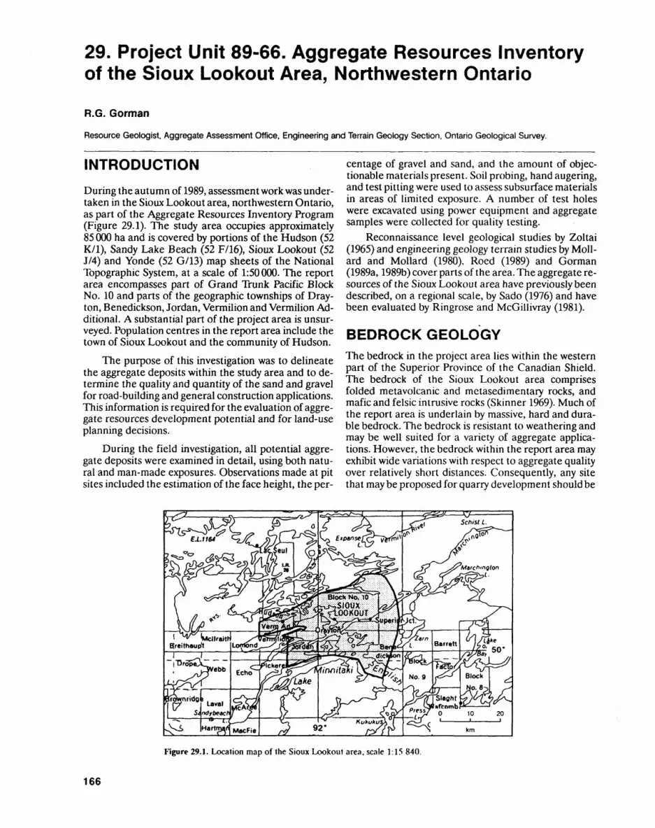
29. Project Unit 89-66. Aggregate Resources Inventory of the Sioux Lookout Area, Northwestern Ontario
R.G. Gorman
Resource Geologist. Aggregate Assessment Office. Engineering and Terrain Geology Section. Ontario Geological Survey.
INTRODUCTION
During the autumn of 1989, assessment work was under taken in the Sioux Lookout area, northwestern Ontario, as part of the Aggregate Resources Inventory Program (Figure 29.1). The study area occupies approximately 85 000 ha and is covered by portions of the Hudson (52 K/l), Sandy Lake Beach (52 F/16), Sioux Lookout (52 J/4) and Yonde (52 G/13) map sheets of the National Topographic System, at a scale of 1:50000. The report area encompasses part of Grand Trunk Pacific Block No. 10 and parts of the geographic townships of Dray ton, Benedickson, Jordan, Vermilion and Vermilion Ad ditional. A substantial part of the project area is unsur- veyed. Population centres in the report area include the town of Sioux Lookout and the community of Hudson.
The purpose of this investigation was to delineate the aggregate deposits within the study area and to de termine the quality and quantity of the sand and gravel for road-building and general construction applications. This information is required for the evaluation of aggre gate resources development potential and for land-use planning decisions.
During the field investigation, all potential aggre gate deposits were examined in detail, using both natu ral and man-made exposures. Observations made at pit sites included the estimation of the face height, the per
centage of gravel and sand, and the amount of objec tionable materials present. Soil probing, hand augering, and test pitting were used to assess subsurface materials in areas of limited exposure. A number of test holes were excavated using power equipment and aggregate samples were collected for quality testing.
Reconnaissance level geological studies by Zoltai (1965) and engineering geology terrain studies by Moll ard and Mollard (1980), Roed (1989) and Gorman (1989a, 1989b) cover parts of the area. The aggregate re sources of the Sioux Lookout area have previously been described, on a regional scale, by Sado (1976) and have been evaluated by Ringrose and McGillivray (1981).
BEDROCK GEOLOGYThe bedrock in the project area lies within the western part of the Superior Province of the Canadian Shield. The bedrock of the Sioux Lookout area comprises folded metavolcanic and metasedimentary rocks, and mafic and felsic intrusive rocks (Skinner 1969). Much of the report area is underlain by massive, hard and dura ble bedrock. The bedrock is resistant to weathering and may be well suited for a variety of aggregate applica tions. However, the bedrock within the report area may exhibit wide variations with respect to aggregate quality over relatively short distances. Consequently, any site that may be proposed for quarry development should be
Figure 29.1. Location map of the Sioux Lookout area, scale 1:15 840.
166
R. G. GORMAN
carefully investigated before extraction operations com mence, to ensure successful and economic crushed stone production.
SURFICIAL GEOLOGYA discontinuous cover of till was deposited over large sections of the report area by glacial ice, which advanced in a southwesterly direction (Hurst 1933; Zoltai 1961, 1965; Johnston 1972). This stony, silty sand till generally exists as a thin veneer over bedrock, although, signifi cantly thicker deposits can be observed in several areas. These thicker till accumulations often flank bedrock knobs. Till is usually not well suited for aggregate use because it often contains excess fines and abundant oversize clasts. Till may, however, be a suitable source of fill, in some localities.
During temporary halts of the ice margin, as it melted northward, several moraines were laid down. The largest of these moraines, the Sioux Lookout mo raine (Zoltai 1965), is situated in the centre of the study area. This prominent northeast-trending moraine is ap proximately 7 km long and rises to a maximum of 9 m above the surrounding terrain. Glaciofluvial features, which were deposited as the ice margin melted back to the north are scattered throughout the project area. Two types of glaciofluvial deposits are represented in the project area: 1) ice-contact deposits, which include undifferentiated ice-contact deposits, lee side ice-con tact deposits and esker ridges; and 2) glaciofluvial out wash.
During deglaciation, much of the land surface was submerged beneath Glacial Lake Agassiz (Zoltai 1961; Teller et al. 1983). In the deeper waters of this glacial lake, silt and clay were deposited. Layers of silt and clay cap many of the glacial deposits located southeast of the town of Sioux Lookout. Glaciolacustrine plain sedi ments, consisting predominantly of silty fine sand, were laid down in the shallower parts of the lake.
AGGREGATE DISTRIBUTION AND QUALITYIn the report area, moraine ridges are important poten tial sources of aggregate. The Sioux Lookout moraine (Zoltai 1965) consists predominantly of substratified, slumped and faulted pockets of sand, silt, gravel and till-like material. In some localities, pockets of coarse, crushable gravel, suitable for a wide variety of aggregate uses are exposed; but in other areas the aggregate con sists of lower quality material containing abundant fines and/or oversize clasts.
Eskers form segmented, sinuous ridges in the proj ect area. A major undeveloped esker system is located between Walton and Kirk lakes. Material exposed in this esker system ranges from sand to coarse, crushable gravel suitable for a wide range of aggregate uses. A
large esker located near Frog Rapids has been a source of aggregate for many years.
Ice-contact deposits are usually complex features that originated in a variety of depositional environ ments. Lee side, ice-contact features form ridges along the southern flank of bedrock knobs and usually have a local relief of 1.5 to 5 m. Although these deposits are generally small, they have been traditional sources of road-building materials in the report area. The material exposed in these deposits ranges from fine sand to coarse, crushable gravel. Large, undifferentiated, ice- contact, stratified drift deposits, which were deposited on or in close proximity to the ice, are also considered important local sources of aggregate. Examples of these types of hummocky deposits are located in the eastern and western parts of the report area. Some of these de posits may contain variable amounts of oversized clasts and/or fines.
The outwash features in the report area were de posited by meltwaters flowing into bedrock controlled valleys or basins beyond the ice margin. Major outwash deposits are located in the southeastern part of the study area, east of East Bay, Minnitaki Lake. The depos its are situated in valleys presently occupied by the Min- nikau Creek (local name, Tata River) and Forty Mile Creek. The outwash largely consists of well-stratified and uniformly bedded sandy aggregate. Fine to coarse gravel may be concentrated near the surface in many de posits. The well-stratified sand and gravel, contained within many of these outwash deposits, is generally well suited for aggregate use.
The sand and gravel in the study area is generally of high quality and is well suited for most road-building and general construction uses. The material varies from sandy aggregate, suitable for road sub-base, to coarse gravel, suitable for crushing. In general, the report area contains large resources of sandy aggregate and limited resources of crushable gravel. Resources of crushable gravel in Vermilion, Jordan and Benedickson geograph ic townships are especially limited. Within the report area, large tracts of land contain little or no aggregate resources. Consequently, aggregate may have to be transported long distances to supply construction re quirements in certain areas.
The predominance of cobbles and boulders poses a major pit-workability problem within the Sioux Lookout area. It is possible, though, to produce coarse aggregate by crushing the boulders which are less than 60 cm in di ameter. Additional pit-workability problems that affect many deposits in the area include the presence of bed rock ridges and clay, silt and/or very fine sand beds. The occurrence of bedrock ridges in both ice-contact and outwash deposits can hamper pit operations and the es timation of remaining resources in some of the area's pits. Selective extraction measures are recommended to avoid sections containing abundant lenses of clay, silt and/or very fine sand.
167
ENGINEERING AND TERRAIN (29)
REFERENCESGorman, W.A. 1989a. Marchington Lake; Ontario Geological Survey,
Northern Ontario Engineering Geology Terrain Study, Data Base Map 5114, scale 1:100 000.
1989b. Vaughan Lake; Ontario Geological Survey, Northern Ontario Engineering Geology Terrain Study, Data Base Map 5110, scale 1:100 000.
Hurst, M.E. 1933. Geology of the Sioux Lookout area; Ontario De partment of Mines, Annual Report, 1932, v.41, pt.6, p.1-33.
Johnston, F.J. 1972. Geology of the Vermilion-Abram lakes area, Dis trict of Kenora; Ontario Department of Mines, Report 101,51p.
Mollard, D.G. and Mollard, J.D. 1980. Press Lake area, District of Kenora; Ontario Geological Survey, Northern Ontario Engin eering Geology Terrain Study 23, 26p.
Ringrose, S. and McGillivray, P. 1981. Aggregate resources of the Sioux Lookout area; Ontario Geological Survey, Open File Re port 5362, pt.l, 61 p.
Roed, M.A. 1989. Wabigoon Lake; Ontario Geological Survey, Northern Ontario Engineering Geology Terrain Study, Data Base Map 5059, scale 1:100000.
Sado, E.V. 1976. Quaternary aggregate resources in northwestern Ontario; in Summary of Field Work, Ontario Division of Mines, Miscellaneous Paper 67, p.150-152.
Skinner, R. 1969. Geology of the Sioux Lookout map-area, Ontario, a part of the Superior Province of the Precambrian shield; Geolog ical Survey of Canada, Paper 68-45, lOp.
Teller, J.T., Thorleifson, L.H., Dredge, L.A., Hobbs, H.C. and Schreiner, T. 1983. Maximum extent and major features of Lake Agassiz; in Glacial Lake Agassiz, Geological Association of Can ada, Special Paper 26, p.43-45.
Zoltai, S.C. 1961. Glacial history of part of northwestern Ontario; in Proceedings of the Geological Association of Canada, v.13, p.61-83.
1965. Surficial geology, Kenora-Rainy River; Ontario Depart ment of Lands and Forests, Map 5165, scale 1:506 880.
168
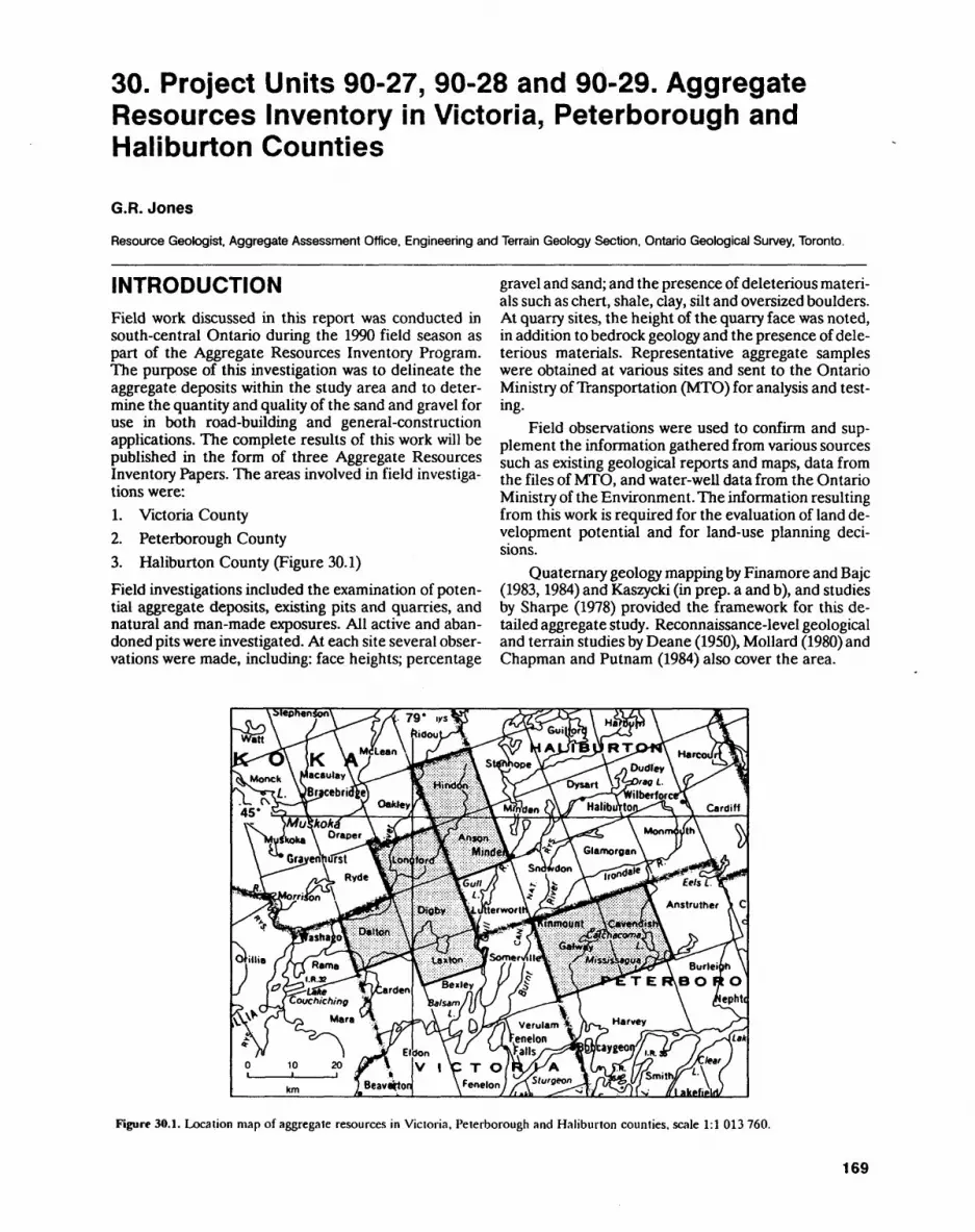
30. Project Units 90-27, 90-28 and 90-29. Aggregate Resources Inventory in Victoria, Peterborough and Haliburton Counties
G.R.Jones
Resource Geologist. Aggregate Assessment Office. Engineering and Terrain Geology Section, Ontario Geological Survey, Toronto.
INTRODUCTIONField work discussed in this report was conducted in south-central Ontario during the 1990 field season as part of the Aggregate Resources Inventory Program. The purpose of this investigation was to delineate the aggregate deposits within the study area and to deter mine the quantity and quality of the sand and gravel for use in both road-building and general-construction applications. The complete results of this work will be published in the form of three Aggregate Resources Inventory Papers. The areas involved in field investiga tions were:L Victoria County2. Peterborough County3. Haliburton County (Figure 30.1)
Field investigations included the examination of poten tial aggregate deposits, existing pits and quarries, and natural and man-made exposures. All active and aban doned pits were investigated. At each site several obser vations were made, including: face heights; percentage
gravel and sand; and the presence of deleterious materi als such as chert, shale, clay, silt and oversized boulders. At quarry sites, the height of the quarry face was noted, in addition to bedrock geology and the presence of dele terious materials. Representative aggregate samples were obtained at various sites and sent to the Ontario Ministry of Transportation (MTO) for analysis and test ing.
Field observations were used to confirm and sup plement the information gathered from various sources such as existing geological reports and maps, data from the files of MTO, and water-well data from the Ontario Ministry of the Environment. The information resulting from this work is required for the evaluation of land de velopment potential and for land-use planning deci sions.
Quaternary geology mapping by Finamore and Bajc (1983,1984) and Kaszycki (in prep, a and b), and studies by Sharpe (1978) provided the framework for this de tailed aggregate study. Reconnaissance-level geological and terrain studies by Deane (1950), Mollard (1980) and Chapman and Putnam (1984) also cover the area.
"" ""Wa*^Burlei
T E R\B OROepht
rdenIsam
-f /s. l J*f Verulam jenelon
Eldon \^ ~ "Malls V l C T 0/R/KA
Figure 30.1. Location map of aggregate resources in Victoria, Peterborough and Haliburton counties, scale 1:1 013 760.
169
ENGINEERING AND TERRAIN (30)
VICTORIA COUNTY
The aggregate resources were assessed in the geo graphic townships of Longford, Dalton, Digby and Lax ton, all in Victoria County. In general, resources of sand and gravel are scarce in these townships and the only major aggregate deposits are located in Dalton and Lax ton geographic townships.
Most of the aggregate resources in the area are con centrated in two northeast-striking ice-contact systems in Dalton and Laxton geographic townships. The system in Dalton geographic township extends from the north ern boundary of the township southwest to Young Lake for a distance of 11 km. The ice-contact system situated along the eastern boundary of Laxton geographic town ship is also about 11 km in length. The ice-contact mate rial in these 2 systems has been modified and reworked by glacial lake waters (Finamore and Bajc 1983, 1984) and may have been deposited subaqueously. Typically, the deposits consist of fine to coarse sand with localized pockets of fine to coarse gravel. Gravel tends to be con centrated either in high-relief ridges or at depth within the deposits. Silt seams and an upper layer of l to 2 m of silty fine sand are common in some pit exposures. A variable fines content is the major factor influencing aggregate quality within the deposits. Products ranging from crushed gravel to Select Subgrade Material (SSM) have been produced from pits developed in both of these ice-contact systems.
In addition, abundant resources of sand suitable for low-specification aggregate uses, such as SSM, are avail able from outwash deposits located alongside the Black River, in Longford geographic township. These deposits consist predominantly of silty, fine to medium sand with only minor occurrences of fine gravel. The remaining granular deposits in the 4 geographic townships are largely small, isolated bodies of ice-contact, outwash, subaqueous fan or glaciolacustrine beach material that may be suitable for small-scale pit development.
Bedrock of Precambrian age underlies much of the northern part of the area and consists predominantly of gneisses of both the Central Gneiss Belt and Central Metasedimentary Belt Boundary Zone (Wynne- Edwards 1972; Easton 1988). Hard and durable varieties of the bedrock may be well suited for aggregate use, however, Paleozoic limestone is generally the preferred source of crushed stone in the area. Paleozoic strata of the Shadow Lake, Gull River and Bobcaygeon forma tions overlie Precambrian bedrock in the southern parts of Dalton and Digby geographic townships and most of Laxton geographic township (Liberty 1969). The Shadow Lake Formation consists of sandstone, siltstone and shale which are unsuitable for most aggregate prod ucts. Limestone of the Gull River and Bobcaygeon for mations overlies rocks of the Shadow Lake Formation and is extracted from quarries in Carden and Somerville townships, located just outside the study area. A wide variety of aggregate products has been produced from
these particular quarries (OGS 1981; Derry, Michener, Booth A Wahl and OGS 1989).
In general, the limestone becomes thicker and the suitability for quarrying for aggregate increases as the distance from the Paleozoic-Precambrian contact in creases. Although the limestone is generally well suited for most aggregate products, certain beds within the Gull River Formation may contain alkali carbonate reactive rocks (Rogers 1985). For this reason, aggregate from these beds may not be accepted by MTO for use in concrete aggregate. Also, the presence of black-chert nddules and lenses within the Bobcaygeon Formation may restrict use of the aggregate for certain concrete products.
PETERBOROUGH COUNTYGalway and Cavendish geographic townships, situated in the northeastern part of Peterborough County, were also investigated during the 1990 field season. Sand and gravel resources are extremely limited in these town ships. The demand for high-quality aggregates is cur rently being met largely by importing crushed limestone from the immediate surrounding area.
Outwash deposits consisting predominantly of sand are situated near Kinmount, a second southeast of Catchacoma Lake and a third at the north end of Bottle Lake. Sand, suitable for use as SSM, and limited amounts of sandy gravel, suitable for use as Granular B Type I, are potentially available from the deposits near Kinmount. The deposits at Catchacoma Lake are cur rently nearing depletion and extraction is prohibited at Bottle Lake as the area lies within Kawartha Highlands Provincial Park. Limited amounts of sand are also avail able from two subaqueous fan deposits situated near Bass Lake. One small esker deposit consisting of coarse gravel is located 1.2 km south of Union Lake.
Because of the lack of local supplies of sand and gravel, weathered gneisses and granites have been ex tracted as alternate sources of road subbase and fill for the construction of bush and cottage roads. Typically, the upper l to 2 m of the weathered bedrock, which has a grain-size distribution similar to coarse sand, is stripped off the underlying, more-competent bedrock units. The gneisses, granites and marbles which underlie much of the townships form part of the Central Metasedimen tary Belt of the Grenville Province (Wynne-Edwards 1972; Bright 1980, 1988).
Sedimentary rocks of Paleozoic age underlie the southwestern corner of the project area and occur as 'outliers surrounded by Precambrian rock. The outliers are located 2 km northwest of Bass Lake, 3 km northeast of De Gaulle Lake and l km west of Mountain Lake. The Paleozoic formations present in the area include the Shadow Lake, Gull River and Bobcaygeon forma tions (Liberty 1969; Carson 1980). The resource poten tial for these formations is similar to that previously de scribed for Victoria County.
170
O.K. JONES
HALIBURTON COUNTYThe last townships to be investigated during the 1990 field season were Anson and Hindon geographic town ships, situated along the western boundary of Halibur ton County. These townships are dominated by the typi cal rocky icnob-and-ridge topography of the Canadian Shield (Mollard 1980; Chapman and Putnam 1984). Ag gregate resources are scarce in these townships, and sand and gravel deposits are generally concentrated in depressions in the bedrock surface.
Three major glaciofluvial systems are identified in the townships. One system, consisting of esker and asso ciated outwash deposits, strikes southwest from Pine Springs to Brady Lake in Hindon geographic township. Material exposed in these deposits ranges from coarse gravel to fine to medium sand. Large amounts of pre dominantly fine to medium sand, suitable for low-speci fication aggregate use, are potentially available from an outwash system along the Black River in the northwest ern corner of Hindon geographic township. An ice-con tact system trends southwest in the southeastern corner of Anson geographic township, close to local markets in Minden. Deposits within the system consist of material ranging from coarse gravel, suitable for crushing, to silty fine sand. Some deposits within the system may have been deposited in a subaquatic environment (Kaszycki 1985).
The bedrock in the area consists predominantly of gneisses of the Central Gneiss Belt and Central Meta- sedimentary Belt Boundary Zone (Wynne-Edwards 1972; Easton and Van Kranendonk 1987; Easton 1988). Hard and durable varieties of bedrock in the area maybe suitable for quarrying but production costs would prob ably be greater than the usual cost of extracting sand and gravel.
REFERENCESBright, E.G. 1980. Eels Lake area, southern Ontario; Ontario Geo
logical Survey, Preliminary Map P.2205, scale 1:63 360. 1988. Precambrian geology of the Burleigh Falls area, Peter
borough County; Ontario Geological Survey, Preliminary Map P3096, scale 1:50 000.
Carson, D.M. 1980. Paleozoic geology of the Burleigh Falls-Peter borough area, southern Ontario; Ontario Geological Survey, Preliminary Map P2337, scale 1:50 000.
Chapman, L.J. and Putnam, D.F. 1984. The physiography of southern Ontario, 3rd ed.; Ontario Geological Survey, Special Volume 2, 270p.
Deane, R.E. 1950. Pleistocene geology of the Lake Simcoe District, Ontario; Geological Survey of Canada, Memoir 256, 108p.
Deny, Michener, Booth &L Wahl and Ontario Geological Survey 1989. Limestone industries of Ontario, Volume 3 Limestone indus tries and resources of central and southwestern Ontario; Ontario Ministry of Natural Resources, 175p.
Easton, R.M. 1988. Precambrian geology of the Minden area, Haliburton, Peterborough and Victoria counties and Muskoka District; Ontario Geological Survey, Preliminary Map P.3106, scale 1:50000.
Easton, R.M. and Van Kranendonk, M. 1987. Precambrian geology of the Lochlin Lake area, Haliburton County; Ontario Geological Survey, Preliminary Map P.3071, scale 1:15 840.
Finamore, PF. and Bajc, A.F. 1983. Quaternary geology of the Fenelon Falls area, southern Ontario; Ontario Geological Sur vey, Preliminary Map P.2596, scale 1:50 000.
1984. Quaternary geology of the Orillia area, southern Ontario; Ontario Geological Survey, Preliminary Map P.2697, scale 1:50 000.
Kaszycki, C.A. 1985. Hislory of glacial Lake Algonquin in the Hali burton region, south-central Ontario; in Quaternary Evolution of the Great Lakes, Geological Association of Canada, Special Paper 30, p.109-123.
in preparation a. Quaternary geology of the Gooderham (31 D/16) map sheet; Geological Survey of Canada, scale 1:50000.
in preparation b. Quaternary geology of the Minden (31 D/15) map sheet; Geological Survey of Canada, scale 1:50 000.
Liberty, B.A. 1969. Paleozoic geology of the Lake Simcoe area, Ontario; Geological Survey of Canada, Memoir 355, 201p.
Mollard, D.G. 1980. Southern Ontario engineering geology terrain study maps: Bancroft and Haliburton; Ontario Geological Survey, Open File Report 5317, 2p.
Ontario Geological Survey 1981. Aggregate resources inventory of Carden Township, Victoria County; Ontario Geological Survey, Aggregate Resources Inventory Paper 48, 32p.
Rogers, C.A. 1985. Alkali aggregate reactions, concrete aggregate testing and problem aggregates in Ontario a review; Ontario Ministry of Transportation and Communications, Report EM-31, 5th revised ed., 44p.
Sharpe, D.R. 1978. Quaternary geology of the Gravenhurst, Bracebridge and Huntsville areas, District Municipality of Muskoka; in Summary of Field Work 1978, Ontario Geological Survey, Miscellaneous Paper 82, p. 152-154.
Wynne-Edwards, H.R. 1972. The Grenville Province; in Variations in Tectonic Style in Canada, Geological Association of Canada, Special Paper 11, p.263-334.
171
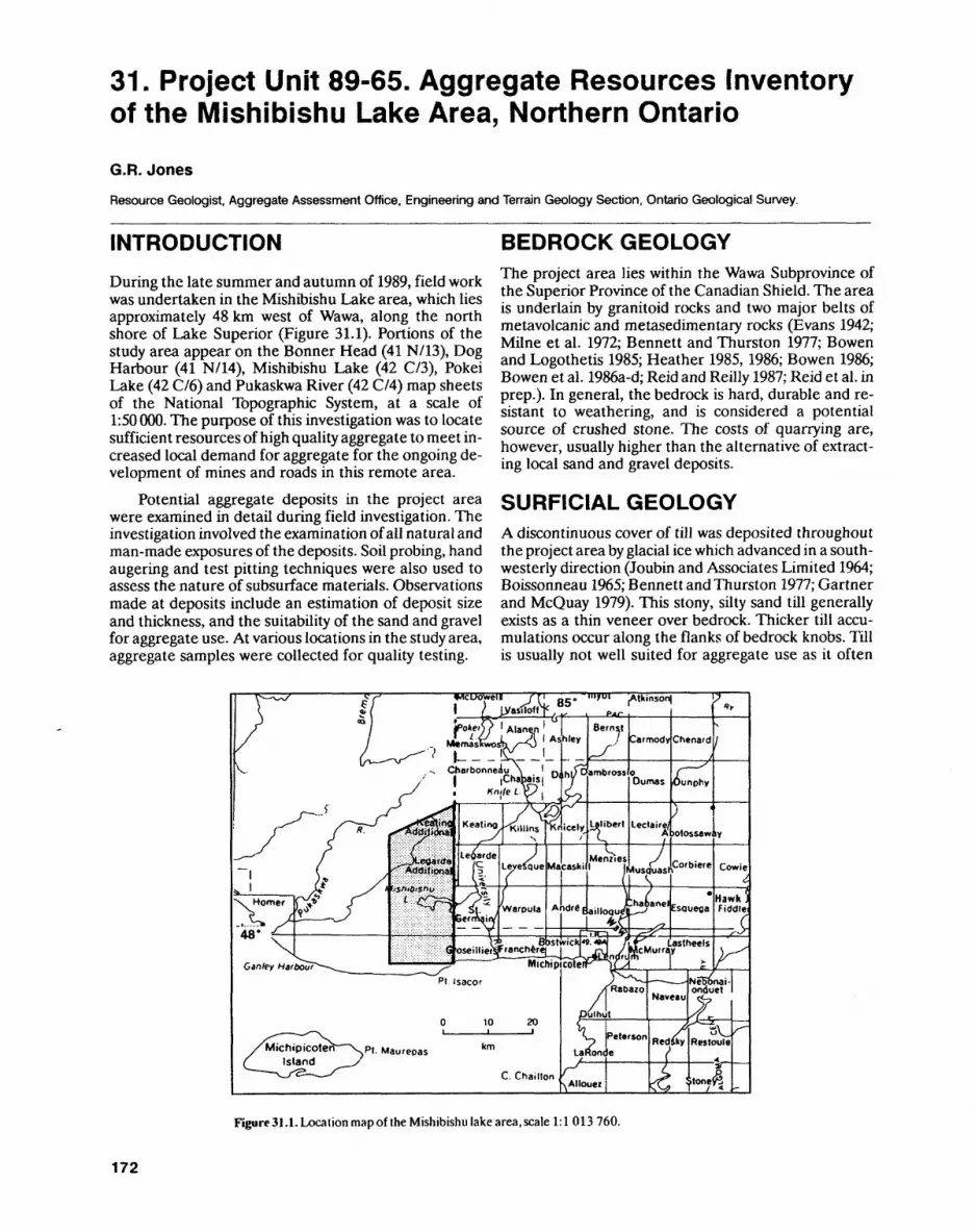
31. Project Unit 89-65. Aggregate Resources Inventory of the Mishibishu Lake Area, Northern Ontario
G.R.JonesResource Geologist. Aggregate Assessment Office. Engineering and Terrain Geology Section. Ontario Geological Survey.
INTRODUCTIONDuring the late summer and autumn of 1989, field work was undertaken in the Mishibishu Lake area, which lies approximately 48 km west of Wawa, along the north shore of Lake Superior (Figure 31.1). Portions of the study area appear on the Bonner Head (41 N/13), Dog Harbour (41 N/14), Mishibishu Lake (42 C/3), Pokei Lake (42 C/6) and Pukaskwa River (42 C/4) map sheets of the National Topographic System, at a scale of 1:50 000. The purpose of this investigation was to locate sufficient resources of high quality aggregate to meet in creased local demand for aggregate for the ongoing de velopment of mines and roads in this remote area.
Potential aggregate deposits in the project area were examined in detail during field investigation. The investigation involved the examination of all natural and man-made exposures of the deposits. Soil probing, hand augering and test pitting techniques were also used to assess the nature of subsurface materials. Observations made at deposits include an estimation of deposit size and thickness, and the suitability of the sand and gravel for aggregate use. At various locations in the study area, aggregate samples were collected for quality testing.
BEDROCK GEOLOGYThe project area lies within the Wawa Subprovince of the Superior Province of the Canadian Shield. The area is underlain by granitoid rocks and two major belts of metavolcanic and metasedimentary rocks (Evans 1942; Milne et al. 1972; Bennett and Thurston 1977; Bowen and Logothetis 1985; Heather 1985, 1986; Bowen 1986; Bowen et al. 1986a-d; Reid and Reilly 1987; Reid et al. in prep.). In general, the bedrock is hard, durable and re sistant to weathering, and is considered a potential source of crushed stone. The costs of quarrying are, however, usually higher than the alternative of extract ing local sand and gravel deposits.
SURFICIAL GEOLOGYA discontinuous cover of till was deposited throughout the project area by glacial ice which advanced in a south westerly direction (Joubin and Associates Limited 1964; Boissonneau 1965; Bennett and Thurston 1977; Gartner and McQuay 1979). This stony, silty sand till generally exists as a thin veneer over bedrock. Thicker till accu mulations occur along the flanks of bedrock knobs. Till is usually not well suited for aggregate use as it often
Figure31.1. Location mapof the Mishibishu lake area,scale 1:1 013760.
172

G.R. JONES
contains excess fines and abundant oversize clasts, how ever, it may be a suitable source of fill in some locations.
As the ice front melted back, sand and gravel was deposited to form a number of ice-contact features, in cluding moraines and eskers. A prominent moraine ridge trends across the northern part of the study area. Surface exposures in the ridge reveal poorly sorted, dirty sand and gravel with abundant boulders. This ma terial is considered suitable only for use as low specifica tion aggregate.
Esker deposits form segmented, sinuous ridges that trend in a general south or southwest direction in the area. They consist of irregularly bedded sand and gravel, and contain a significant proportion of the area's poten tial resources of crushable gravel. Several deposits of undifferentiated ice-contact stratified drift were also laid down in close proximity to the ice front as it melted back. These deposits are typified by a hummocky topog raphy and are often associated with esker systems. Ma terial exposed in these deposits ranges from sand to coarse gravel.
In the Mishibishu Lake area, the outwash features were deposited by meltwaters flowing in bedrock de pressions beyond the ice margin. These deposits gener ally consist of well-stratified sand and gravel. Outwash deposited close to the ice front, such as that deposited near the moraine, usually contains coarser gravel. Far ther away from the ice margin, sand is the predominant sediment exposed in the outwash deposits.
AGGREGATE DISTRIBUTION AND QUALITYThe northern part of the project area, north of Mishibi shu Lake, contains relatively abundant aggregate depos its. Outwash deposits are common along the East Pukaskwa River and its tributaries. An extensive esker system is situated along the mine access road west of El len Lake. The esker segments in this system rise more than 15 m above the surrounding terrain and have been the major source of aggregate in the area. Sand deposits which flank the eskers may also prove to be valuable as potential sources of mine backfill. Another esker system extends from eastern Katzenbach Lake to north of Mishi Lake. The deposits associated with this system contain significant potential resources of aggregate, but they are currently inaccessible by road.
Resources of sand and gravel had been perceived to be extremely limited south of Mishibishu Lake along the Central Crude road. During field investigation, howev er, several deposits were discovered which should help meet demands in this area. Major deposits along the Central Crude road include esker and associated ice-contact deposits located between Mishi Creek and Mishibishu Lake. In places, these deposits have local re lief of over 15 m.
Perhaps the deposits which demonstrate the high est potential for large-scale pit development near the
road are three esker deposits located just northeast of Cameron Lake. The easternmost esker may be the best suited for extractive development as it is situated well away from any major watercourses. Two, small, ice- contact deposits and an esker, delineated west of Eagle River, may also contain valuable resources. The depos its are estimated to range between 3 and 6 m in thick ness and contain material ranging from gravel to gravel ly sand. They lie approximately 2.5 km from existing road access.
The gravel in the area is generally hard and durable, and suitable for most road-building and general con struction applications. The deposits contain aggregate which ranges in size from sand to coarse, crushable gravel. Quality problems, which may be encountered in some deposits, ace usually a result of a high fines con tent and/or an abundance of oversized clasts.
REFERENCESBennett, G. and Thurston, P.C. 1977. Geology of the Pukaskwa River-
University River area, districts of Algoma and Thunder Bay; Ontario Division of Mines, Geoscience Report 153, 60p.
Boissonneau, A.N. 1965. Surficial geology of Algoma-Cochrane; Ontario Department of Lands and Forests, Map S365, scale 1:506 880.
Bowen, R.P. 1986. Mishibishu Lake area, districts of Algoma and Thunder Bay; in Summary of Field Work 1986, Ontario Geolog ical Survey, Miscellaneous Paper 132, p. 107-110.
Bowen, R.P. and Logothetis, J. 1985. Mishibishu Lake area, districtsof Algoma and Thunder Bay; in Summary of Field Work 1985, Ontario Geological Survey, Miscellaneous Paper 126, p.78-82.
Bowen, R.P, Logothetis, J. and Heather K.B. 1986a. Precambrian geology of the Mishibishu Lake area, north-central section, dis tricts of Thunder Bay and Algoma; Ontario Geological Survey, Preliminary Map P.2969, scale 1:15 840.
1986b. Precambrian geology of the Mishibishu Lake area, northeastern section, districts of Thunder Bay and Algoma; Ontario Geological- Survey, Preliminary Map P.2970, scale 1:15 840.
1986c. Precambrian geology of the Mishibishu Lake area, south-central section, districts of Thunder Bay and Algoma; Ontario Geological Survey, Preliminary Map P.2971, scale 1:15 840.
1986d. Precambrian geology of the Mishibishu Lake area, southeastern section, districts of Thunder Bay and Algoma; Ontario Geological Survey, Preliminary Map P.2972, scale 1:15 840.
Evans, E.L. 1942. Geology of the Mishibishu Lake area; Ontario Department of Mines, Annual Report, 1940, v.49, pt.9, 14p.
Gartner, J.F. and McQuay, D.F. 1979. Pukaskwa River area (including Michipicoten Island), districts of Algoma and Thunder Bay; Ontario Geological Survey, Northern Ontario Engineering Geology Terrain Study 72, 15p.
Heather, K.B. 1985. Gold showings of the Mishibishu Lake area, Thunder Bay District; in Summary of Field Work 1985, Ontario Geological Survey, Miscellaneous Paper 126, p.83-89.
1986. Mineralization of the Mishibishu Lake greenstone belt; in Summary of Field Work 1986, Ontario Geological Survey, Miscellaneous Paper 132, p.283-291.
Joubin, F.R. and Associates Limited 1964. Pleistocene geology. Mishibishu Lake-Poke! Lake, District of Algoma; Algoma Cen tral and Hudson Bay Railway Company, scale 1:63 360.
173
ENGINEERING AND TERRAIN (31)
Milne, V.G., Giblin, P.E., Bennett, G., Thurston, P., Wolfe, W.J., Giguere, J.F., Leahy, E.J. and Rupert, R.J. 1972. Manitou wadge-Wawa sheet, Algoma, Cochrane, Sudbury and Thunder Bay districts; Ontario Division of Mines, Map 2220, scale 1:253440.
Reid, R.G., Bowen, R.P., Reilly, B.A., Logothetis, J. and Heather, K.B. in preparation. Geology, structure and economic geology of the Mishibishu Lake area, districts of Algoma and Thunder Bay; Ontario Geological Survey, Open File Report.
Reid, R.G. and Reilly, B.A. 1987. Mishibishu Lake area, districts of Algoma and Thunder Bay; m Summary of Field Work and Other Activities 1987, Ontario Geological Survey, Miscellaneous Paper 137, p.138-145.
174

Geophysics/Geochemistry Programs

32. Summary of Activities 1990, Geophysics/Geochemistry Section
R.B. Barlow
Chief, Geophysics/Geochemistry Section, Ontario Geological Survey.
GEOPHYSICS PROGRAMAn interpretation of recent gravity data, acquired over part of the Abitibi greenstone belt in the Kirkland Lake-Matheson-Iroquois Falls area, has begun. Approximately 5000 gravity stations were established over three field seasons. This study, to map and define the deeper geological, lithologic and structural characteristics of the belt based on the gravitational field, will improve our understanding of the evolution of the belt and its associated mineral deposits.
A program to research improved methods of overburden sounding is in its second year. Improved methods of objectively identifying layering and overburden materials are considered timely. This is in response to the increasing environmental and land-use planning pressure with respect to issues such as groundwater conservation, waste man agement, subsurface excavation and site investigation in populated areas of the prov ince. The objective of the current project is to improve a practical methodology for shallow seismic reflection surveying and data presentation, for conditions typical of southern Ontario subsurface environments. Recent advances in shallow electromag netic sounding methods are being tested for their applicability to areas which exhibit complex layering in the subsurface.
Four airborne electromagnetic-magnetic surveys, covering areas of high mineral potential, were initiated in 1990. Approximately 54 000 line-kilometres will be surveyed in the Birch Lake-Uchi Lake, Shebandowan, Partridge River and Benny areas. The results of 5 electromagnetic-magnetic surveys conducted during 1989-1990 have been released or are in press. The Batchawana area is covered by26 maps; the north Swayze- Montcalm area, by 39 maps; the Sturgeon Lake-Savant Lake area, by 46 maps; the Shining Tree area, by 46 maps; and the Rainy River area, by 32 maps.
GEOCHEMISTRY PROGRAMThe planning and design of a mobile laboratory unit (MLU) was started in April 1990. The proposed MLU would carry out methods research in the winter months, and rou tine analysis at a rate of 100 samples per day in the field during the summer. Designed to have a life of at least 10 years, the MLU would provide: a) quick turnaround of sam ples; b) higher quality of analyses for more elements of interest in mineral exploration, and c) a continuity of data during the life of the laboratory.
A small orientation project, to investigate the feasibility of using "overbank" sam pling as a method for regional geochemical surveying, began last year with the detailed examination and sampling of Quaternary sections exposed on the banks of the Goulais River, near Sault Ste. Marie, Ontario. Unconsolidated sediments, which have been de posited unconformably due to catastrophic floods, are considered a preferred sample medium for regional geochemical surveys in Europe. Potential for this method is shown to be favourable when sampling is applied in this major river valley.
177
33. Project Unit 90-24. A Search for an "Overbank" Geochemical Sample Site in the Goulais River Valley near Sault Ste. Marie
J.A.C. Fortescue 1 and B. Bolviken2
1 Research Geochemist. Geophysics/Geochemistry Section, Ontario Geological Survey.
2Chief Geochemist, Norwegian Geological Survey.
INTRODUCTION
Geochemical mapping based on "overbank" material has become popular in Europe since 1985 (Ottersen et al. 1989). For example, Geological Surveys of 21 countries have recently combined to produce a plan for a geochemical map of Western Europe based on 9000 overbank samples. The overall sample density proposed for this geochemical map is one sample per 500 km2 (Bolviken et al. 1990).
Prior to August 1989, no attempt to collect over bank samples for geochemical mapping, in Ontario, were known. Indeed, the feasibility of such sampling in Ontario was doubted in some quarters. For this reason, B. Bolviken, Chief Geochemist of the Norwegian Geo logical Survey, visited the writer's field party in Sault Ste. Marie on August 20, 1989. The objective of his trip was to demonstrate the feasibility of overbank sampling in the Sault Ste. Marie area. Most the day was spent on the Goulais River, north of the community of Search mont, where it was demonstrated that suitable overbank sample sites could be located in that area.
A spectacular overbank section was spotted on the Goulais River below Searchmont on our evening return to Sault Ste. Marie. The writer, assisted by members of his field crew, sampled this section a few days later. This article describes the geology and geochemistry of this in teresting site.
The Quaternary Geology of the Lower Goulais River AreaThe lower Goulais River area is a classic locality for Quaternary geology. According to Cowan (1978, p.2026), Quaternary sections in the Lower Goulais Riv er were first described by Sir William Logan in 1863 (Logan et al. 1863), as follows:
. .. there is a deposit of the roots and limbs of trees, im bedded in a bluish scaly material, apparently a mass of com pressed leaves and moss, which rests on a bed of clay, and is over laid by a mixture of clay and, sand; the whole, with a stratum of sand at the top, constitutes a bank from twenty to twenty-four feet high.
Cowan (1978) described several Quaternary sections on the Goulais River downstream from the community of Kirby's Corner to Lake Superior, and provided 7 radio-
Figure 33.1. Location map of the Goulais River valley area, scale 1:1 584 000.
178
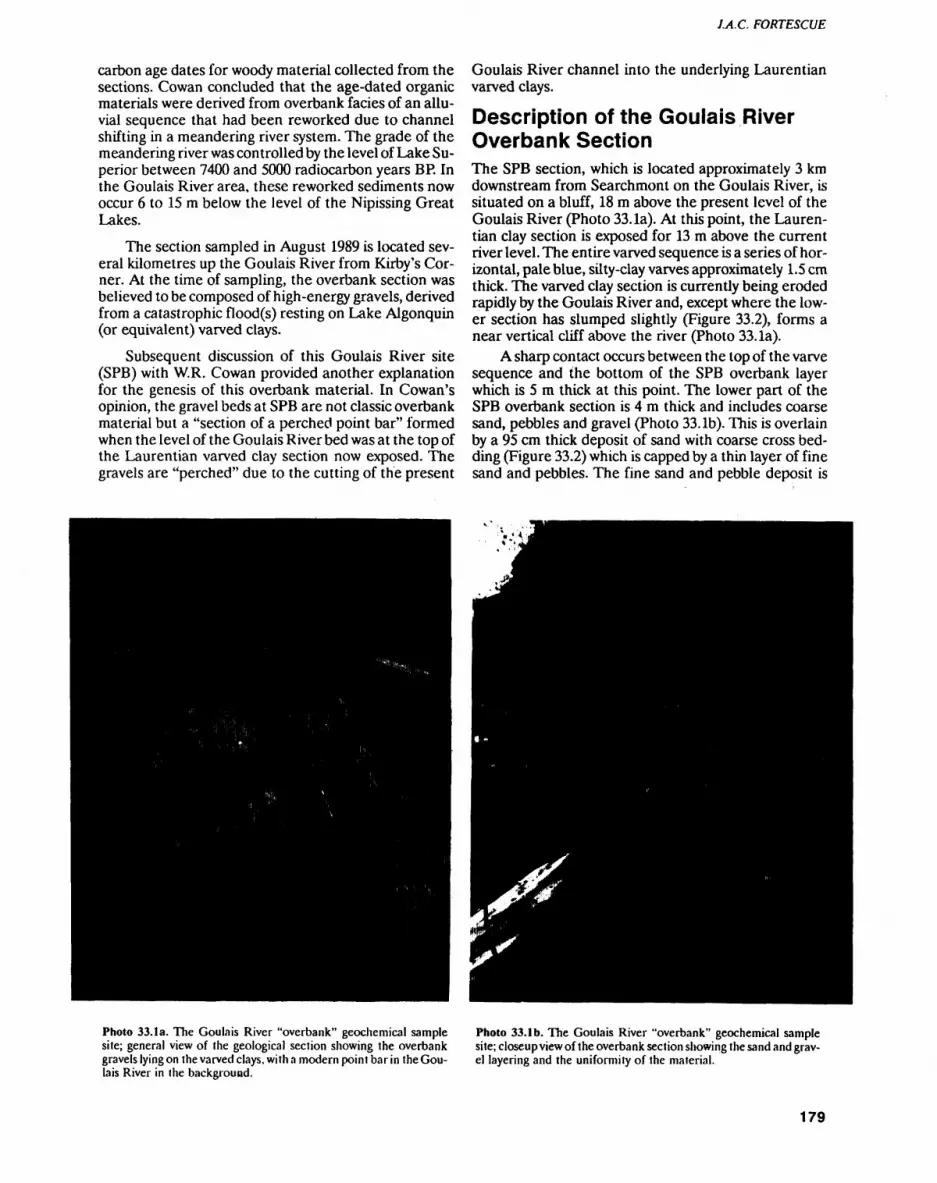
J.A.C. FORTESCUE
carbon age dates for woody material collected from the sections. Cowan concluded that the age-dated organic materials were derived from overbank facies of an allu vial sequence that had been reworked due to channel shifting in a meandering river system. The grade of the meandering river was controlled by the level of Lake Su perior between 7400 and 5000 radiocarbon years BR In the Goulais River area, these reworked sediments now occur 6 to 15 m below the level of the Nipissing Great Lakes.
The section sampled in August 1989 is located sev eral kilometres up the Goulais River from Kirby's Cor ner. At the time of sampling, the overbank section was believed to be composed of high-energy gravels, derived from a catastrophic flood(s) resting on Lake Algonquin (or equivalent) varved clays.
Subsequent discussion of this Goulais River site (SPB) with W.R. Cowan provided another explanation for the genesis of this overbank material. In Cowan's opinion, the gravel beds at SPB are not classic overbank material but a "section of a perched point bar" formed when the level of the Goulais River bed was at the top of the Laurentian varved clay section now exposed. The gravels are "perched" due to the cutting of the present
Goulais River channel into the underlying Laurentian varved clays.
Description of the Goulais River Overbank SectionThe SPB section, which is located approximately 3 km downstream from Searchmont on the Goulais River, is situated on a bluff, 18 m above the present level of the Goulais River (Photo 33. la). At this point, the Lauren tian clay section is exposed for 13 m above the current river level. The entire varved sequence is a series of hor izontal, pale blue, silty-clay varves approximately 1.5 cm thick. The varved clay section is currently being eroded rapidly by the Goulais River and, except where the low er section has slumped slightly (Figure 33.2), forms a near vertical cliff above the river (Photo 33. la).
A sharp contact occurs between the top of the varve sequence and the bottom of the SPB overbank layer which is 5 m thick at this point. The lower part of the SPB overbank section is 4 m thick and includes coarse sand, pebbles and gravel (Photo 33. Ib). This is overlain by a 95 cm thick deposit of sand with coarse cross bed ding (Figure 33.2) which is capped by a thin layer of fine sand and pebbles. The fine sand and pebble deposit is
Photo 33.1a. The Goulais River "overbank" geochemical sample site; general view of the geological section showing the overbank gravels lying on the varved clays, with a modern point bar in the Gou lais River in the background.
Photo 33. l b. The Goulais River "overbank" geochemical sample site; closeup view of the overbank section showing the sand and grav el layering and the uniformity of the material.
179
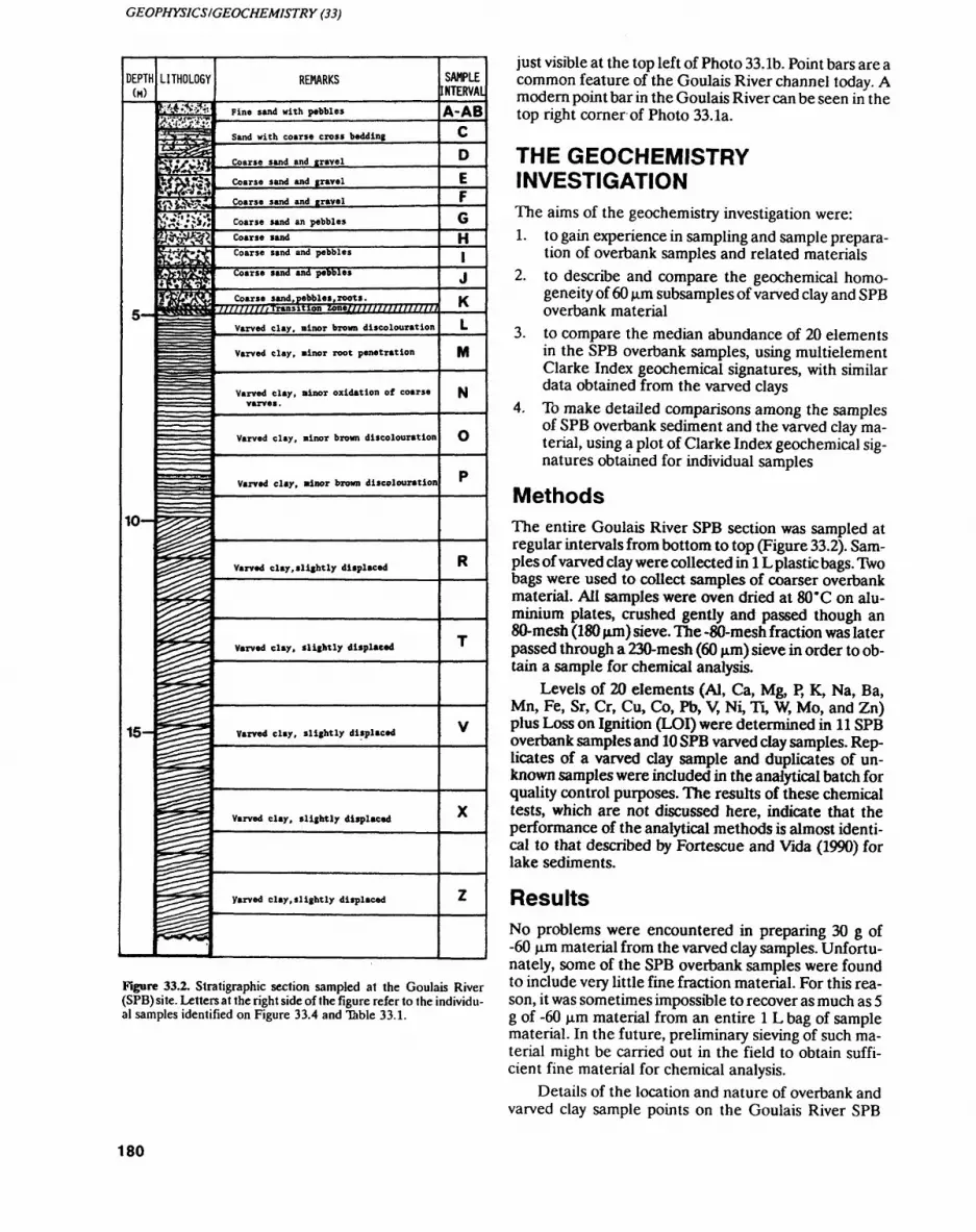
GEOPHYSICS/GEOCHEMISTRY (33)
DEPTH (M)
10-
15-
LITHOL06Y
3T*
m
REMARKS
Fine sand with pebbles
Sand with coarse cross bedding
Coarse sand and gravel
Coarse sand and travel
Coarse sand and gravel
Coarse sand an pebbles
Coarse sandCoarse sand and pebbles
Varved clay, ninor root penetration
Varved clay, ninor oxidation of coarse varve*.
Varved clay, ninor brown discolouration
Varved clay, ninor brown discolouration
Varved clay,slightly displaced
Varved clay, slightly displaced
Varved clay, slightly displaced
Varved clay, slightly displaced
Varved clay,slightly displaced
SAMPLE JNTERVAUA-AB
H
M
N
Figure 33.2. Stratigraphic section sampled at the Goulais River (SPB) site. Letters at the right side of the figure refer to the individu al samples identified on Figure 33.4 and Table 33.1.
just visible at the top left of Photo 33. Ib. Point bars are a common feature of the Goulais River channel today. A modern point bar in the Goulais River can be seen in the top right corner of Photo 33. la.
THE GEOCHEMISTRY INVESTIGATIONThe aims of the geochemistry investigation were:1. to gain experience in sampling and sample prepara
tion of overbank samples and related materials2. to describe and compare the geochemical homo
geneity of 60 jjim subsamples of varved clay and SPB overbank material
3.
4.
to compare the median abundance of 20 elements in the SPB overbank samples, using multielement Clarke Index geochemical signatures, with similar data obtained from the varved claysTo make detailed comparisons among the samples of SPB overbank sediment and the varved clay ma terial, using a plot of Clarke Index geochemical sig natures obtained for individual samples
MethodsThe entire Goulais River SPB section was sampled at regular intervals from bottom to top (Figure 33.2). Sam ples of varved clay were collected in l L plastic bags. Two bags were used to collect samples of coarser overbank material. All samples were oven dried at 80"C on alu minium plates, crushed gently and passed though an 80-mesh (180 jim) sieve. The -80-mesh fraction was later passed through a 230-mesh (60 jim) sieve in order to ob tain a sample for chemical analysis.
Levels of 20 elements (Al, Ca, Mg, P, K, Na, Ba, Mn, Fe, Sr, Cr, Cu, Co, Pb, V, Ni, Ti, W, Mo, and Zn) plus Loss on Ignition (LOI) were determined in 11 SPB overbank samples and 10 SPB varved clay samples. Rep licates of a varved clay sample and duplicates of un known samples were included in the analytical batch for quality control purposes. The results of these chemical tests, which are not discussed here, indicate that the performance of the analytical methods is almost identi cal to that described by Fortescue and Vida (1990) for lake sediments.
ResultsNo problems were encountered in preparing 30 g of -60 p.m material from the varved clay samples. Unfortu nately, some of the SPB overbank samples were found to include very little fine fraction material. For this rea son, it was sometimes impossible to recover as much as 5 g of -60 jjim material from an entire l L bag of sample material. In the future, preliminary sieving of such ma terial might be carried out in the field to obtain suffi cient fine material for chemical analysis.
Details of the location and nature of overbank and varved clay sample points on the Goulais River SPB
180
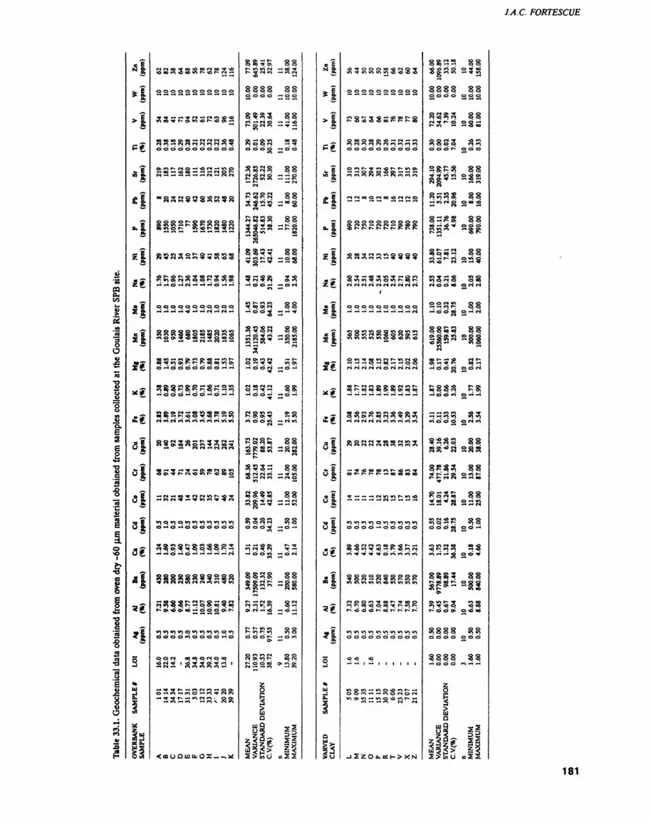
LA. C. FORTESCUE
Table 33.1. Geochemical data obtained from oven dry -60 fxm material obtained from samples collected at the Goulais River SPB site.
•s!* i
*1
s*
*sfi l "I "I&1 if
a!si** ai5 I "Is|
3 I3?
af
5*
*I
S•ku Ei
x1"Is!
(NfSCOTOOOOOfNCOT-O*oooe^i*ooovjr**oi^.rs*-*
ooooooooooo
TT*-**-^Toi*^r|i(n*o*o 1000*0^(^0*0*01^*00*—
S ooooooQ'^CNnr'i^ooo m — cNrir4(S(noifS-i7
O^rtt~CNO — *OC* — 1OO
" S S S S 3 S S S 5 S
f SSSf^SSSSSS V)Ot*- *O *O f- 00 ^ *N
R99^2P;??KSS
SK^?iSSSP5^S
oooooto*o*noin."o tO(nm2eBQaoao^(n4i f)Oo^^vw*^^roooo
oov)*-*(*)O^ r^P^^o*Hity'tr^ *OT'oa**c-r^f;'Ooootna^
S83P8:.s;?o;?23
•np*o*rs— 001009000*0 oooo — r-*oov*or-— "o
oor*i'r'O'"t~5Vr*i —-l^s^sasass
4O*-*lV*-*^r*-tOvQOfNQimoo^^t^r^^Oior^^Soo
*-ir4*^oo^'dci4mr^\p^' *-*cor4*?^^in*fn^r^Fr^
*oo*n*o*.o*n.wi*nirtioio
sss^^gssggs
ISISlg^sfg
^SSSP^Sg5?S
0000*^0000— o
OON 00 00 O fM O OO
2S2 ' SSSS552 '
— T**t~— rnMro — OOv o — en— mo— fiTNcn — •***r~ — m*sro* oo* — wi— wi — rt ^. r**i n
<alOQUU,OX_-,U!
o* o\ — r- o o o oo T o o or- in 10 CN — oo t1^- T CN rt — rt CS
*O —
gggg gg O O O O — O O
g^S3 ggrt — (N O — — *Or~ o *N m — T —
assa 25000 S S 00
rt 00 M rt O gpjsas ns o— t- — CN
•N
P2.5S 88•*|v;,o -oog
(N OO 00 rt O O
3-52S ^PSm o v* co
g S3 S ggSgSS 22S
5S5R 5Srt —
vi r* rt rt o oTt 00 O* (N 00-003 --T
*o 10 *o (N o o m v o CN o oaM 5* 3 S^ •^CN o* "^ f — r- o — T v vi o*
8292 SS
Rg5!3 23
rt f** O f* O O t— O CN OO O Ort gi oo rt — o r*i *O r- oo 10 — CN op-p. srt-SSS ggS CN CN CO — -* VI
— CN f^ — CN O
CN *O O V) O Q OO O -9 00 O Ort 0* T *TN — — (Mrt O *-^ T — *-* vi
S5SSS 3g
— — *o o r- TTrt CN ** CN T —
rt —
SSPig ggO o* r*i t~ — ea o rt 3 — CN 10
r- — r*i o* o CN CN rt v. rt "O —
t~ r- vi 10 o oo o o r- — o rt o* —
S rt en c*i o o o vi r- oo CNMEAN 27
VARIANCE 110
STANDARD DEVIATION 10
C.V.(*) 38
n 9 MINIMUM 13
MAXIMUM 39
a l*! "IH#
*I
S l
*I
*I
H
4e Es g:
sg
x*,
S*
3 l a l s l 3 I31
*l
*t
*l
S•k ttO.
Q
So
iotioioioio*o*O*o*o
oooooooooo
fno'^T'O — ^oot^o f^*o*o*o*oootlifc C"".r*oo
rtCNrtCNCNCNrtmrtrtoooooooooo
Ortr^T****or-*r-ioo — — oo*o*oo\— — ?* rtrtf**cN***j — cNrtrtrt
(NrNooonoo*ocNCNO
S8328cN'2 0,floS
xOOO^rfM^IOOQOOrtCNrtfiro — T-*****
S T — ooTvjrr— ort tovi^viovic-oot^r*cNcNcNcNr*icNr*icNCN
y
oooooooooo
moioioooviovivi *oovicNvi*oocNo — iovimiovto*o*ovi*o
ovivoovicNr-vicN*o— — -t o — oo — — ooCNCNCNCNCNOCNCNCNCN
oor-rNi-io^ONCXCNrtt- oor-cooooooioooioooo
s s s 28 a s s 8 s
o*or*cN**opoocNviTCNfNCNCNCNCNrtrtrtrt
— T*OOOOOrtt— *OrtT
T— — — CNvivir^vi'O
o o o o — ooooo
Qv*ONOI(tOOO^*Ot^*-4 OO*OIOT*O— P-*OrtCN
Sg828T*3c38t?(oioiowiioeoioioioio
cNoortToor--Tooo rtC-oo*ooooTt-V),r-
uiioioioiomioioiouioooooooooo
o -o *o
lootio — v)O*ortc-~ — oort — — rtocNocN ino*"! — mo'Ornr-'-* tri ~ -* rt rt r*i
JSzOo.o:(->x^^
SS22 ggSjf.8.7? 23S
gggg ggo o o o o o o
S M O* T O O •O S CN 0 O
M -w r- o o o — t- m t-i *i 9 oo
m g o o (N mo o o t- o o o
S8P8 88•w T# vi 10 o 'O o*Rg*** ~iss
S^^g gg-H in r* o o oo -o
g2iS5 ggSSS' 2SSr*- tt *o r^
o t"- ** ol o ooo o oo ** o o i-i .4 c~ m o vi o•o 10 w •— -x *
•O T ^ -p VI Qm o CN S o Jor*i o o oo o (S r*
22SS 88-00.5 o-n
ggSS 8825 S S S S g S
oo c- *H \o r* r-O^ -i * r- oo *-t-x O O 0 0 0 fS
5ggS PS
•-H *-4 m m *o i-^ — rO m VI lo
ssss ggaa*?s assgf5gj gg2P:sa 22SSv
ssss gg2s*a ssain CN O m o o0 0 O OJ 00 —
n 10 r* oo oo -o •o r- rt en — *ort —
SSS? 88r^ eo 06 r~ o o o *o r* o — *-4 o ^ iX r* vi oo O*
o* *o r* f m oo n T *o o vo oo
3888 33
MEAN 1.60 0 VARIANCE 0.00 0. STANDARD DEVIATION 0.00 0.
C.V.C*) 0.00 0.
n 3 10
MINIMUM 1.60 0. MAXIMUM 1.60 0.
181
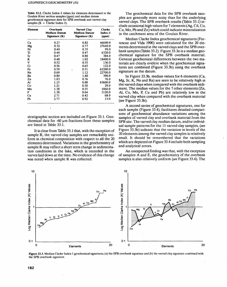
GEOPHYSICS/GEOCHEMISTRY (33)
Table 33.2. Clarke Index-I values for elements determined in the Goulais River section samples (ppm) and median datum geochemical signature data for SPB overbank and varved clay samples (K = Clarke Index-I).
Element
CaMgNiTiSrKVCrFeNaBaZnAlCoMnPCuPb
Overbank Medium Datum Signature (K)
0.270.320.400.440.470.480.520.560.590.690.801.031.151.211.381.382.712.77
Varved Clay Medium Datum Signature (K)
0.820.770.350.470.801.020.550.650.511.121.400.760.880.500.550.640.420.92
Clarke Index-1 (ppm)
46600.027640.0
99.06320.0
384.018400.0
136.0122.0
62200.022700.0
390.076.0
83600.029.0
1060.01120.0
68.013.0
stratigraphic section are included on Figure 33.1. Geo chemical data for -60 jjtrn fractions from these samples are listed in Table 33.1.
It is clear from Table 33.1 that, with the exception of sample R, the varved clay samples are remarkably uni form in chemical composition with respect to all the 20 elements determined. Variations in the geochemistry of sample R may reflect a short term change in sedimenta tion conditions in the lake, which is recorded in the varves laid down at the time. No evidence of this change was noted when sample R was collected.
The geochemical data for the SPB overbank sam ples are generally more noisy than for the underlying varved clays. The SPB overbank results (Table 33.1) in clude occasional high values for 7 elements (Ag, Cd, Co, Cu, Mo, Pb and Zn) which could indicate mineralization in the catchment area of the Goulais River.
Median Clarke Index geochemical signatures (For tescue and Vida 1990) were calculated for the 20 ele ments determined in the varved clays and the SPB over bank samples (Table 33.2). Figure 33.3a is a median geo chemical signature for the SPB overbank material. General geochemical differences between the two ma terials are clearly evident when the geochemical signa tures are combined (Figure 33.3b) using the overbank signature as the datum.
In Figure 33.3b, median values for 6 elements (Ca, Mg, Sr, K, Na and Ba) are seen to be relatively high in the varved clays when compared with the overbank sedi ment. The median values for the 7 other elements (Zn, Al, Co, Mn, P, Cu and Pb) are relatively low in the varved clay when compared with the overbank material (see Figure 33.3b).
A second series of geochemical signatures, one for each sample (Figure 33.4), facilitates detailed compari sons of geochemical abundance variations among the samples of varved clay and overbank material from the SPB site. The varved clay median datum, and/or individ ual sample patterns for the 11 varved clay samples, (see Figure 33.3b) indicate that the variation in levels of the 20 elements among the varved clay samples is relatively small. It should be remembered that the variations which are depicted on Figure 33.4 include both sampling and analytical errors.
An unexpected finding was that, with the exception of samples A and E, the geochemistry of the overbank samples is also relatively uniform (see Figure 33.4). The
10
(D T3
o O
0.1
Na
Elements 20 Elements
Figure 33.3. Median Clarke lndex-1 geochemical signatures; (a) the SPB overbank signature and (b) the varved clay signature combined with the SPB overbank signature.
182
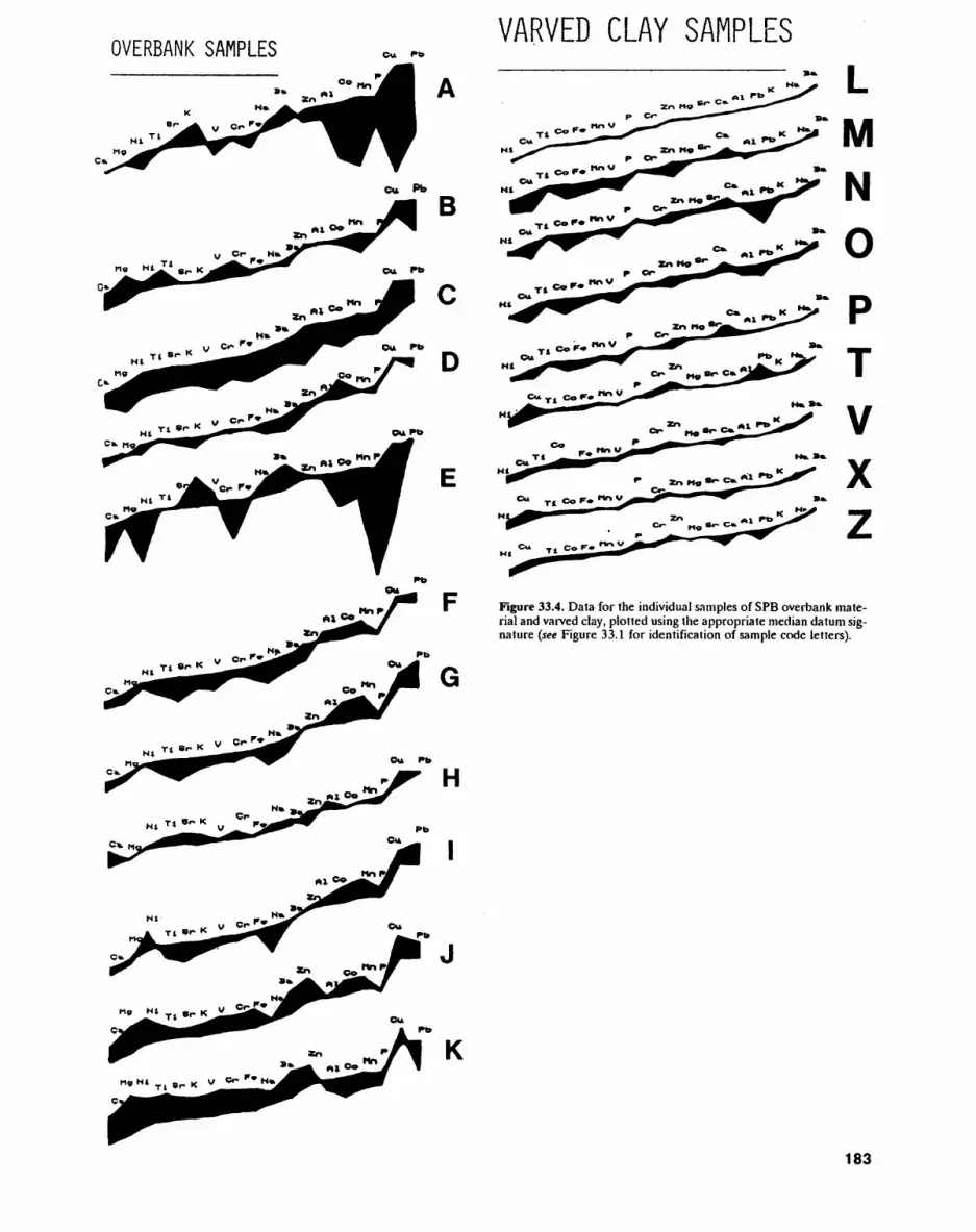
OVERBANK SAMPLESVARVED CLAY SAMPLES
B
Figure 33.4. Data for the individual samples of SPB overbank mate rial and varved clay, plotted using the appropriate median datum sig nature (see Figure 33.1 for identification of sample code letters).
183
GEOPHYSICS/GEOCHEMISTRY (33)
shape of the geochemical signatures for samples A and E (see Figure 33.4) resemble the median varved clay sig nature (see Figure 33.3b). This resemblance could be due to two landslips of varved clay into the ancestral Goulais River, upstream from the SPB, as the bar was being formed.
In summary, an attempt to locate an overbank sam pling site on the lower Goulais River failed. This was be cause the material sampled as "overbank" was almost certainly deposited as a point bar in the ancestral Gou lais River.
In spite of this, valuable experience in geochemical sampling and processing of overbank material was ob tained during the project. The chemical data obtained from the SBP overbank and varved clay samples pro vided useful information on the geochemical homo geneity of gravels and varved clays. These results will be important for comparative purposes in future overbank sampling throughout Ontario.
ConclusionsIt was concluded that overbank sampling for geochemi cal mapping is feasible in major river valleys in the Sault Ste. Marie area of Ontario, provided that the Quaterna ry geology of prospective geochemical sample sites is in vestigated first. It was also concluded that the geochem ical sampling, analysis and data-plotting methods de scribed here may be applied with confidence during fu ture geochemical mapping based on overbank samples in Ontario.
ACKNOWLEDGEMENTSThanks are due to Bjorn B01viken for visiting Sault Ste. Marie during a busy schedule and for comments on this paper. Thanks are also due to Elizabeth A. Vida and Graeme Lillie who assisted with the field sampling and Rhjendra Samaroo who sieved the samples. Chemical analyses were completed by Chemex Ltd. of Mississau- ga, under contract to the Ontario Geological Survey. Drafting of the figures was completed by Anna M. Duic and data was processed by Elizabeth A. Vida.
REFERENCESB01viken B., Demetriades A., Hindel, R., Locutura J., O'Connor P.,
Ottesen R.T., Plant J., Ridgeway J., Salminen R., Salpeleur I., Schermann O. and Volden T. 1990. Geochemical mapping of western Europe towards the year 2000. Project Proposal; NGU Report 90-106, 12p.
Cowan W.R. 1978. Radiocarbon dating of Nipissing Great Lakes events near Sault Ste. Marie, Ontario; Canadian Journal of Earth Science, v.15, p.2026-2030.
Fortescue J.A.C. and Vida E.A. 1990. Geochemical survey, Herman Lake area; Ontario Geological Survey, Map 80 803.
Logan WE., Murray A., HuntT.S. and Billings E. 1863. Report on the geology of Canada; in Geological Survey of Canada report of progress from its commencement to 1863, Geological Survey of Canada. 893p.
Ottersen R.T., Bogen J., Bolviken B. and Volden T. 1989. Overbank sediment; a representative sample medium for regional geo chemical mapping; Journal of Geochemical Exploration, v.32, p.257-277.
184

34. Project Unit 90-25. The Design Considerations for a Mobile Laboratory Unit (MLU) to Support Geochemical Mapping in Ontario
J.A.C. Fortescue
Research Geochemist. Geophysics/Geochemistry Section, Ontario Geological Survey.
INTRODUCTIONSince April of 1987, a standardized regional geochemi- cal-mapping methodology has been developed by the Ontario Geological Survey (OGS) to provide Ontario prospectors and explorationists with modern geochemi cal maps. The methodology has two products. One is a hard-copy, regional geochemical map, including a pre liminary description of "geochemical patterns" and "geochemical anomalies" (Fortescue and Vida 1989, 1990, in prep.) and the other is a microcomputer (PC) diskette with the complete geochemical data base from which the map was produced. The release of these maps resulted in an immediate, positive response from pros pectors and the mineral exploration industry who are known to have staked claims as a result of them.
The goal of the proposed Mobile Laboratory Unit (MLU) is to enhance still further the scientific tenor of OGS geochemical maps and to ensure that they can be prepared more rapidly and efficiently in the future.
The Need For An OGS-Operated Mobile Lab UnitIt was estimated recently that 147 000 km2 of Ontario has high mineral potential (M. Cherry, OGS, personal communication, 1990). The appraisal of most of these areas will require new geophysical, geochemical and re mote-sensing data bases capable of being included in geoscience geographical information systems (GIS). To be effective, these data bases must always be prepared in advance of fresh geological mapping activities by the OGS. Ontario Geological Survey geological mapping activities are often planned at short notice in response to popular demand. Therefore, it is important that the survey be capable of undertaking regional geochemical mapping projects, with short lead time, and completing them quickly. The OGS-MLU is designed to reduce the time taken for the preparation of geochemical maps from the present 24 months, to under 6 months.
The second reason for the development of an OGS-MLU is to provide continuity in Ontario geo- chemical-map data bases. This is essential because expe rience in geochemical mapping in Alaska, Finland, Nor way and the United Kingdom has demonstrated that for effective geochemical mapping, all the chemical analyses must be done by the same laboratory where exactly the same, rigorous, quality-control procedures are always
applied to samples. Time and time again, the prepara tion of geochemical maps has been delayed by failure to observe this protocol. For example, Bloom (1987) re cently described a problem of this type in geochemical data obtained from the OGS Black River-Matheson (BRiM) project. In order to avoid this problem during the proposed Western European Geological Surveys (WEGS) geochemical-mapping program, all 9000 over bank geochemical samples involved (collected from 21 countries) would be analyzed by the same chemical labo ratory (Demetriades et al. 1990). The OGS-MLU will ensure the continuity of sample preparation and tech niques of chemical analysis in all future OGS geochemi- cal-map data bases prepared by the Geophysics/Geo chemistry Section.
A third reason for an OGS-MLU is that geochemi cal mapping has recently undergone a remarkable change in scientific emphasis. From using geochemical maps solely to discover "geochemical anomalies" in data bases, the change is toward the use of geochemical maps to discover "geochemical anomalies" and subtle pat terns for many elements which were previously thought to be of little interest in mineral exploration (e.g., La in lake sediments Fortescue 1988b; Ca in waters For tescue and Vida 1990). The latter demand requires 1) more reliable sampling methods, 2) more accurate chemical data, and 3) a broader coverage of elements than that used in geochemical maps produced in the 1980s. For example, at a meeting of geochemists to plan a "global geochemical map", during the "Exploration '87" Conference in Toronto in 1987, it was proposed to include "under 10 elements" on the world map. At a similar meeting in Prague in August, 1990, firm plans were made to include 60 to 65 elements on this world map.
The geochemical significance of large, multiele ment data bases has been stressed by several writers. For example, Edmunds et al. (1989) summarized the signifi cance of multielement geochemical analysis of ground- water (Figure 34.1).
It is evident from Figure 34.1 that, lobe effective in mineral resource appraisal in the 1990s, the OGS-MLU should determine levels of additional elements to Ca and Mg which are currently determined in waters. Simi larly, in addition to the 35 elements determined at pres ent by the OGS (Table 34.1), the OGS-MLU must be ca pable of determining other elements (e.g., the rare earth elements) in lake sediments. This will increase the
185
GEOPHYSICS/GEOCHEMISTRY (34)
CONCENTRATIONS IN DILUTE, OXYGENATED CROUNDWATER AT pH 7
TRACE ELEMENTS - MAJOR ELEMENTS
- INCREASING CONCENTRATION -1 PART IN TEN
. . THOUSAND 1 ng L' MILLION 1 Mg L 1 mg C
•CO.OOOOI
HRu
Rh
Pd
In
Hf
Ta
Re
Os
Ir
Pt
Po
Au
0.00001- 0.0001
Cs
Zr
| Mo |
Ag'E
Th
Ce and REE
Hg————— -,
Se j'"sT
Sn j:::::::::;
Te i1 —— 'Tl
Bi
W
Ca
Ge
0.0001- 0.001
i Rb ir- ———— -~1
l La i! _____ i'[v|
1 [sT|'['AS"]
1 cdJH1H
1 Pb1 AI
Y
0.001- 0.01
[J-L!Jf— ~ — "]
l Ba j'j^ifj'\lto]
U
| 1 |
0.01 -0.1
mj
B
Br
'LfLl
2| Zn |
0.1-1.0
[Z!^i — """' "iPi _ i
1.0-10
raT"g~l
10-100
1H2f — "- — —i
l Ca |
'[soTI'fq"!'H
>100
|HCO3|
ESSENTIAL ELEMENTSl f. l Elements considered essential 'or humanl v-u l or animal health.
! Sr i Elements probably essential for health.
Pb Non-essential elements.
TOXIC ELEMENTS1 Cd Elements considered to be toxic or
undesirable in excessive amounts andfor which maximum admissibleconcentrations (MAC) have been set bythe CEC. (1980).
V Other elements considered undesirablein excess but for which no statutory limithas been set by the CEC. (1980).
Figure 34.1. Trace elements in groundwater and their significance in terms of health and environmental protection (Edmunds et al. 1989).
scientific tenor of OGS geochemical maps to world stan dards and enable the geochemical data to be used freely in advanced geoscience GISs.
In summary, an OGS-MLU will: 1) reduce the time required currently to prepare OGS geochemical maps; 2} ensure long-term continuity in OGS multielement geochemical data bases; and 3) determine additional elements in geochemical samples, to meet modern de mands of mineral resource appraisal methodologies.
Preliminary Considerations in Planning of the OGS-MLUThe OGS-MLU is designed like a small factory. Its goal is to process relatively large numbers of geochemical samples in the field, reliably and rapidly, with a mini mum of effort and resources. The plan for the MLU calls for a throughput of 100 samples of water and 100 samples of stream sediment per day.
These figures were determined on the basis of cur rent field statistics. Regional geochemical survey crews of the Ontario Geological Survey collect about 75 sam ples of lake sediment and lake water per day (Fortescue 1988a). The other 25 samples would be blanks and stan dards for quality-control purposes. As time progresses,
if 200 or even 300 samples of each material are col lected per day, the OGS-MLU could be modified to work around the clock in order to process them.
The design of an MLU includes four stages which are briefly described here: 1) the preparation of a work plan for the routine MLU operation in the field; 2) the choice of sample-processing and chemical-analysis methodologies to implement the plan; 3) the selection of equipment to apply the chosen methods in a vehicle laboratory; and 4) the design of custom MLU vehicles to ensure that the laboratory is mobile and selfcontained, and able to operate in the field for several weeks with a minimum of resupply.
THE OGS-MLU WORK PLANThe MLU is designed to process lake sediments and wa ters, for as many geochemical parameters as possible, for mineral resource appraisal, bearing in mind the con straints of mobile laboratory operation. The operation of the OGS-MLU is based on two "production lines": one for waters and the other for lake sediments.
Water AnalysisAs mentioned above, not all the analyses of waters, listed on Figure 34.1, are required for mineral explora tion. The current plan for the MLU calls for water sam ples to be analyzed routinely for pH, F, and 15 other ele ments ( Ca, Mg, Fe, Mn, Al, Sr, P, Zn, Ba, Cu, Co, Cu, Cr, Pb and As). If practical, sulphate, chloride and, poss ibly, nitrate could also be determined. If the MLU is to be used for environmental geochemistry at a later date, it is recommended that other mobile laboratory vehicles be constructed to carry out biochemical and biological analyses of water samples.
Lake-Sediment AnalysisAnalysis of lake sediments is much more complicated than analysis of waters. The MLU work plan calls for the determination of both Loss on Ignition (LOI) and, even tually, abundances of over 60 elements in lake-sediment samples.
Ideally, almost all elements listed on Table 34.1 should be determined in lake sediments. In practice, there are two problems with this plan. One problem is that the determination of low levels of several elements (e.g., S, CI, I, Se, Hg) is relatively difficult and slow when undertaken for lake sediments, and could require spe cial equipment. The other problem is that the routine determination of some elements (e.g., As, Sb, Bi, Mo) in lake sediments requires a preconcentration step prior to their determination by a multielement instrumental method. For these reasons, the work plan for the MLU initially calls for the routine determination of around 40 elements, selected from the following group: Si, Al, Fe, Mg, Ca, Na, K, Mn, Ti, P, Cu, Pb, Zn, Ga, Cr, Ni, Co, V, Sr, Se, Y, La, Th, As, Sb, B, Bi, Cd, Sn, W, Mo, Bi, Li, Be, Ce, and rare earth elements. A problem which requires special research is how to bring low levels of elements,
186
J.A.C. FORTESCUE
Table 34.1. Elements required for modern mineral resource appraisal geochemical mapping.
MAJOR ELEMENTS (10):
MINOR ELEMENTS (20):
TRACE ELEMENTS (21):
RARE EARTHS (14):
PLATINIUM GROUP (6): ELEMENTS
Si, Al, Fe, Mg, Ca, Na, K, Mn, Ti, P
Cu, Pb, Zn, Ga, Cr, Ni, Co, V, Si; Ba, Se, Y, La, Nb, [S], [CI], Th, Rb, U, Zr
As, Sb, Bi, [Hg], Cd, Au, Ag, Se, Sn, W, Mo, B, [F], Li, Be, Tl, In, Ge, [I, Se], Ta
Ce, Pr, Nd, Pm, Sm, Eu, Gd, Tb, Dy, Ho, Er, Tm, Yb, Lu
[Pt, Pd, Ir, Rh, Ru, Os]
Elements in square brackets (J are determined by special methods.Elements in italics are cunently included in the OGS geochemical mapping program.
such as Sb, Bi, W, Mo and Bi, into solution and keep them there until the solution is processed by the detec tor. At present, the routine determination of low levels of Au and platinum group elements (PGE) is not consid ered practical in the OGS-MLU proposal, and, to main tain continuity, these should be performed by the OGS Geoscience Laboratories Section.
Summary of Work PlanIn summary, the OGS-MLU work plan calls for the rou tine determination of pH and 15 elements in waters, and LOI plus 40 (or more) elements in lake sediments, at a rate of 100 samples per day while the laboratory is parked at a field location.
When garaged in the new Mines and Minerals Re search Centre, in Sudbury, the MLU would be used for 1) analytical-methods development, 2) routine analysis of samples already collected, and 3) geochemical-map- ping research. Another advantage of the operation of the MLU in the Sudbury facility would be that it affords an excellent opportunity for interaction with the OGS Geoscience Laboratories Section. Such interaction could involve advice on updating the methodologies in the MLU (e.g., sample preparation, element extraction, analytical and instrumental expertise) and interlabora- tory checks on samples of special interest, collected, prepared and archived when the MLU was in the field.
CHOICE OF METHODOLOGIESThe choice of methods for use in the mobile laboratory is subject to several additional constraints to those con sidered for a laboratory in a building. These include 1) safe and appropriate use of hazardous chemicals; 2) the reduction of vibration, heat and levels of chemical va pours in the atmosphere of the laboratory; and 3) the provision of an ample, stable, power source for instru ments and computers when the laboratory is parked at a remote location. These considerations affect the choice of methods to be employed in the MLU.
In order to obtain the latest information on the state-of-the-art in sample preparation and the geo chemical analysis of waters and lake sediments, the writ er attended two conferences and visited geochemical
departments in the geological surveys of Canada, Fin land, Norway and Britain, during 1990. As a result of these discussions and consultations with the staff of the OGS, the following provisional methodology plan has been drawn up for the MLU.
Analysis Of WatersFresh-water samples, in the containers used for collec tion, will be cooled in a fridge for a few hours prior to a small portion being taken for F and pH determinations. The remainder of the sample will be acidified, passed through a 45 |u.m filter and boiled with nitric acid to re duce the volume and destroy most of the organic matter. The concentrated waters will be passed through an in strument which will determine the levels of 15 elements simultaneously.
Analysis of Lake SedimentsThe wet lake sediments will be air dried at 80"C and ground to a fine powder. The LOI of the powder will be determined by dry ashing in a furnace. The residue from the LOI determination will be mixed with a flux and sintered at 500"C. The sintered material will be dis solved in dilute acid and divided into several portions. One portion will be passed directly to a spectrometer for determination of major and some trace elements. Trace elements, in the other portions of the solution, will be preconcentrated using different techniques and later passed through the spectrometer.
The determination of elements either present in the flux (e.g., Na), driven off during drying (e.g., Se, Hg), or lost during ashing (e.g., As, Sb) presents a problem. At present, this could be solved by finely wet-grinding a portion of the wet lake sediment and then preconcen- trating the elements (e.g., by hydride generation) prior to passing the sample as a slurry through the detector.
Summary of MethodologiesIn summary, a combination of the methodologies just outlined should achieve the goals of the OGS-MLU work plan. From the practical viewpoint, the water-anal ysis methodology would be set up first in the OGS-MLU. Then, based on this experience, the lake-sediment-sample preparation methodology will be
187
GEOPHYSICS/GEOCHEMISTRY (34)
developed. The establishment of routine methods for the analysis of lake sediments may require extensive ex perimentation in the forthcoming OGS facility in Sud bury prior to its application at a field site. We believe that safety in the OGS-MLU has been addressed by se lecting methods which require a minimum of acid de composition and/or stabilization, and which would re quire no organic solvents. It should be noted that argon would be the only gas used routinely in the mobile labo ratory. The storage and disposal of such hazardous chemicals as are required has been given special consid eration.
CHOICE OF EQUIPMENTThe success of the OGS-MLU will largely depend on the correct choice of equipment to implement the meth ods just outlined. The final choice of equipment for each task in the OGS-MLU will depend upon the availability and cost of each item at the time the laboratory in con structed. Consequently, the descriptions of equipment, given below, are general and without reference to spe cific products.
Sample-Preparation Equipment
WatersThe pH of waters will be determined automatically us ing a 50 (or 100) place sample-changer combined with an automated pH meter. The same, or a similar, system will be used for F determination and, later on, for the deter mination of anions. Filtering of water samples will be completed using simple apparatus. The reduction of wa ter volume and/or nitric acid digestion step will be car ried out using a semiautomated hot plate.
Sample Preparation
Lake SedimentsThe drying of 100 samples of lake sediment per day may require custom-made drying cabinets with forced (fil tered) air drafts and programmable temperature con trol. Grinding of dried lake sediment can be done manu ally, one sample at a time, or automatically, using com mercially available equipment.
The weighing of scooped volumes of dry sediment for LOI determination on the scale required is time con suming and automation of this procedure is worth con templating. The samples will then be placed in a tem perature-controlled furnace and, after ignition, cooled in a dry-box prior to reweighing.
When the second weighing is completed, addition and mixing of a flux with the ash derived from the LOI determination will occur prior to sintering. Sintering of samples will occur in a similar, but different, furnace from that used for LOI determinations.
The sintered material will be dissolved in beakers on a warm hotplate. Aliquots from these solutions will be either passed to the detector directly, or subjected to preconcentration procedures which have yet to be worked out.
The SpectrometerIn theory, an inductively coupled plasma mass spectro graph (ICP-MS) instrument would be the obvious choice as a detector for the MLU. For practical reasons, the de cision has been taken to use an inductively coupled plas ma optical emission spectrograph (ICP-OES), because ICP-MS instruments are not yet developed sufficiently for installation in an MLU. If this situation changes in the mid-1990s, an ICP-MS could be retrofitted into the MLU.
Ideally, the chosen ICP spectrometer in the OGS-MLU should be a combined polychrometer- monochrometer design, with proven ability to withstand the vibration and temperature changes associated with travel in a vehicle. The detector should be capable of de termining 45 to 50 elements simultaneously and rou tinely, in solutions derived from waters and lake sedi ments by the techniques described above. In addition, the detector should be capable of determining a small number of additional elements sequentially, using the monochrometer. The ICP torch should have a relatively low consumption of Ar, provided that it does not inter fere with the simultanuous determination of many ele ments in the same matrix. The spectrometer should also have a supersonic nebulizer for direct determination of low levels of elements in waters.
Summary of Equipment RequirementsIn summary, it is currently believed that an OGS-MLU, equipped with the instrumentation similar to that just described, is capable of producing geochemical data in the volume required for the regional geochemical-map- ping program. The writer believes that all the equip ment required will withstand routine use in a mobile laboratory. Prior to the purchase of an ICP, proof of its ability to withstand travel in a vehicle (and perform per fectly with a minimum of setup time) will be required as part of the selection process.
Furthermore, it is believed that the equipment de scribed above, when installed in the OGS-MLU, will be able to provide geochemical data of the quality and quantity required for geochemical mapping during the 1990s.
DESIGN OF THE MLU VEHICLEConsiderable thought has been given to the design of a vehicle suitable for the installation of the instrumenta tion just described. A "tractor-trailer" design, including a custom-built, 1-ton "tractor" and a 32-foot-long, metal "trailer", is currently favoured.
188
J.A.C. FORTESCUE
Briefly, an MLU of this type would provide a level floor with storage compartments below it for tents and stores accessible from the outside. The trailer would be divided into a series of rooms. At the front of the ve hicle, there would be a small laboratory for water analy sis, followed rearwards by the ICP laboratory, a small balance room, and a chemical laboratory.
During road travel, a large room located at the back of the vehicle (over the dual, tandem rear axels) would house heavy equipment and the Ar supply, on a series of trolleys.
After arrival at a field location, the MLU would be secured on jacks and the heavy equipment off-loaded. Lake-sediment dryers, lake-sediment grinders, fur naces, and a fume hood would be off-loaded on trolleys and set up either in a building nearby or in tents. The space in the trailer, vacated by this equipment, would be used for sample preparation and office work by the staff.
Power for the laboratory trailer and equipment would be provided by diesel generators mounted on the custom-built pickup truck. The drying, grinding and fur nace equipment would be serviced by separate genera tors.
Fire-extinguishing equipment in the laboratory would be by an installed Halon-based system. All win dows and doors in the laboratory would be of the push-out type.
Summary of Vehicle DesignIn summary, the plan for the OGS-MLU currently calls for a custom-built, 32-foot-long, metal laboratory "trac tor-trailer" plus an accompanying one-ton pickup truck. Such a design will ensure a flat floor in the entire labora tory. Preliminary design studies have shown that the equipment needed for the OGS-MLU could be in stalled in such a vehicle as described above.
GENERAL COMMENTSEven though much of the design of the OGS-MLU is new, the concept is definitely feasible. It is envisaged that if a spectrochemist were hired and a fully equipped OGS-MLU were delivered in September of year one, the laboratory should be capable of analyzing waters and preparing lake-sediment samples during the summer of year two. Full operation of the laboratory in the field would then commence in the summer of year three.
Full field operation of the OGS-MLU would re quire an experienced spectrochemist and an assistant in the ICP laboratory, plus three pairs of field samplers. Ideally, the samplers would spend one day in three sam
pling from a helicopter, and the rest of the time prepar ing their samples for the ICP-OES laboratory. A geo- chemist and/or party chief would oversee the entire op eration.
An OGS-MLU team of this type should be able to collect data for a regional geochemical map involving 1000 samples of lake sediment and water during a fif teen-day working period. When the OGS-MLU is fully operational, five regional geochemical maps (e.g., For tescue and Vida 1989), covering an entire greenstone belt, might be produced during a single summer's field program.
CONCLUSIONSTwo significant points may be stated:1. Design studies described above have shown that it is
feasible to provide a mobile laboratory unit to ser vice the OGS regional geochemical-mapping pro gram in the 1990s and beyond.
2. The use of such a laboratory would increase the scientific tenor of OGS geochemical maps currently being produced and make a significant contribution to mineral resource appraisal in Ontario.
REFERENCESBloom, L.B. 1987. Analytical methods, quality control data and pre
viously unpublished geochemical results: reconnaissance till sam pling program, Matheson area, Cochrane District; Ontario Geo logical Survey, Open File Report 5653, 47p.
Commission of the European Communities 1980. The quality of water for human consumption; Directive 80/778, CEC, Brussels, Bel gium, 13p.
Demetriades, A., Ottesen, R.T., and Locutura, J. (eds.) 1990. Geo chemical mapping of Western Europe towards the Year 2000: pi lot project report; NGU Report 90-105, 9p.
Edmunds, W.M., Cook, J.M., Kinniburgh, D.G., Miles, D.L. andTraf- ford, J.M. 1989. Trace-element occurrence in British groundwa- ters; British Geological Survey, Research Report SD/89/3,424p.
Fortescue, J.A.C. 1988a. A regional geochemical survey of part of the Batchawana greenstone belt, District of Algoma; in Summary of Field Work and Other Activities 1988, Ontario Geological Sur vey, Miscellaneous Paper 141, p.478-481.
1988b. The use of the geochemistry of long lake-sediment cores for verification of regional geochemical results: Goudreau Lake area, District of Algoma; in Summary of Field Work and Other Activities 1988, Ontario Geological Survey, Miscellaneous Paper 141 p.482-488.
Fortescue, J.A.C. and Vida, E.A. 1989. Geochemical survey, Trout Lake area; Ontario Geological Survey, Map 80 803, scale 1:50000.
1990. Geochemical survey, Herman Lake area; Ontario Geo logical Survey, Map 80 804, scale 1:50 000. , in preparation. Geochemical Survey, Hanes Lake area; Ontar io Geological Survey, Map 80 806, scale 1:50 000.
189
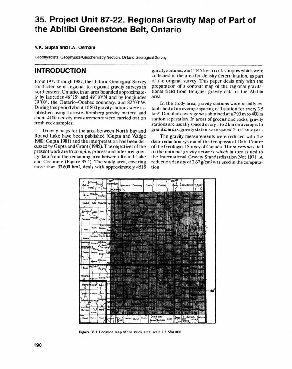
35. Project Unit 87-22. Regional Gravity Map of Part of the Abitibi Greenstone Belt, Ontario
V.K. Gupta and I.A. Osmani
Geophysicists. Geophysics/Geochemistry Section, Ontario Geological Survey.
INTRODUCTIONFrom 1977 through 1987, the Ontario Geological Survey conducted semi-regional to regional gravity surveys in northeastern Ontario, in an area bounded approximate ly by latitudes 46" 15' and 49"10'N and by longitudes 79 0 00', the Ontario-Quebec boundary, and 82 0 00'W. During this period about 10 800 gravity stations were es tablished using Lacoste-Romberg gravity meters, and about 4100 density measurements were carried out on fresh rock samples.
Gravity maps for the area between North Bay and Round Lake have been published (Gupta and Wadge 1980; Gupta 1981) and the interpretation has been dis cussed by Gupta and Grant (1985). The objectives of the present work are to compile, process and interpret grav ity data from the remaining area between Round Lake and Cochrane (Figure 35.1). The study area, covering more than 33 600 km2, deals with approximately 4518
gravity stations, and 1145 fresh rock samples which were collected in the area for density determination, as part of the original survey. This paper deals only with the preparation of a contour map of the regional gravita tional field from Bouguer gravity data in the Abitibi area.
In the study area, gravity stations were usually es tablished at an average spacing of l station for every 3.5 km2 . Detailed coverage was obtained at a 200 m to 400 m station separation. In areas of greenstone rocks, gravity stations are usually spaced every l to 2 km on average. In granitic areas, gravity stations are spaced 3 to 5 km apart.
The gravity measurements were reduced with the data-reduction system of the Geophysical Data Centre of the Geological Survey of Canada. The survey was tied to the national gravity network which in turn is tied to the International Gravity Standardization Net 1971. A reduction density of 2.67 g/cm3 was used in the computa tion.
Figure 35.1.Location map of Ihe study area, scale 1:1 584 000
190
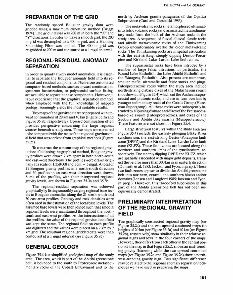
V.K. GUPTA and LA. OSMANI
PREPARATION OF THE GRIDThe randomly spaced Bouguer gravity data were gridded using a maximum curvature method (Briggs 1974). ITie grid interval was 200 m in both the "X" and "Y" directions. In order to make a smooth grid, the 200 m grid was desampled to a 400 m grid, and a Manning Smoothing Filter was applied. The 400 m grid was re-gridded to 200 m and contoured at a l mgal interval.
REGIONAL-RESIDUAL ANOMALY SEPARATIONIn order to quantitatively model anomalies, it is essen tial to separate the Bouguer anomaly field into its re gional and residual components. Numerous automated computer-based methods, such as upward continuation, spectrum factorization, or polynomial surface fitting, are available to separate these components. However, it is our experience that the graphical separation method, when employed with the full knowledge of mapped geology, seemingly yields the most suitable results.
Two maps of the gravity data were prepared with up ward continuation of 20 km and 40 km (Figure 35.2a and Figure 35.2b, respectively). Upward continuation often provides perspective concerning the large regional sources beneath a study area. These maps were created to be compared with the map of the regional gravitation al field that was derived from graphical methods (Figure 35.2c).
To construct the contour map of the regional gravi tational field using the graphical method, Bouguer grav ity profiles were drawn 7 km apart in both north-south and east-west directions. The profiles were drawn origi nally at a scale of 1:250 000 and l cm = 5 mgal. A total of 21 Bouguer gravity profiles in a north-south direction and 30 profiles in an east-west direction were drawn. Some of the profiles, with their interpreted regional gravity levels, are shown in Figures 35.3a and 35.3b.
The regional-residual separation was achieved graphically by fitting smoothly varying regional base lev els to Bouguer anomalies along the 21 north-south and 30 east-west profiles. Geology and rock densities were often used in the estimation of the local base levels. The assumed base levels were then joined such that smooth regional levels were maintained throughout the north- south and east-west profiles. At the intersections of all the profiles, the value of the regional gravitational field was kept the same. The regional field on each profile was digitized and the values were placed on a 7 km by 7 km grid. The resultant regional gridded data were then contoured at a l mgal interval (see Figure 35.2c).
GENERAL GEOLOGYFigure 35.4 is a simplified geological map of the study area. The area, which is part of the Abitibi greenstone belt, is bounded to the south by Proterozoic metasedi- mentary rocks of the Cobalt Embayment and to the
north by Archean granite-paragneiss of the Opatica Subprovince (Card and Ciesielski 1986).
The metavolcanic rocks (metamorphosed ultramaf ic to felsic volcanic rocks) and associated metasedimen- tary rocks form the bulk of the Archean rocks in the study area. A sequence of fluvial-alluvial clastic rocks and alkalic metavolcanic rocks of the Timiskaming Group unconformably overlie the older metavolcanic rocks. The Timiskaming rocks are in spatial association with the east-striking, steeply dipping Destor-Porcu- pine and Kirkland Lake-Larder Lake fault zones.
The supracrustal rocks have been intruded by a number of large felsic intrusions, in particular, the Round Lake Batholith, the Lake Abitibi Batholith and the Watageag Batholith. Also present are numerous, smaller mafic, ultramafic and felsic stocks and plugs. Paleoproterozoic rocks within the study area include north-striking diabase dikes of the Matachewan swarm (not shown in Figure 35.4) which cut the Archean supra crustal and plutonic rocks, and are in turn overlain by younger sedimentary rocks of the Cobalt Group (Huro nian Supergroup). All these rocks were subseqently in truded by Nipissing diabase and dikes of the Preissac dia base-dike swarm (Paleoproterozoic), and dikes of the Sudbury and Abitibi dike swarms (Mesoproterozoic). These features are not shown in Figure 35.4.
Large structural features within the study area (see Figure 35.4) include the easterly plunging Blake River synclinorium, the east-striking Destor-Porcupine fault zone (DPFZ) and the Kirkland Lake-Larder Lake fault zone (KLFZ). These fault zones are located along the northern and southern limbs of the synclinorium, re spectively. The steeply dipping DPFZ and KLFZ, which are spatially associated with major gold deposits, trans ect the belt for more than 300 km in an easterly direction (Dimroth et al. 1983; Jackson and Fyon, in prep.). These two fault zones appear to divide the Abitibi greenstone belt into northern, central, and southern blocks and/or domains (Jensen and Langford 1985; Jackson and Fyon, in prep.). However, this three-fold subdivision in this part of the Abitibi greenstone belt has not been un equivocally demonstrated.
PRELIMINARY INTERPRETATION OF THE REGIONAL GRAVITY FIELDThe graphically constructed regional gravity map (see Figure 35.2c) and the two upward-continued maps (to heights of 20 km (see Figure 35.2a) and 40 km (see Figure 35.2b), respectively) show similarity in their relative re gional highs and lows in the four corners of the maps. However, they differ from each other in the central por tion of the map in that Figure 35.2c shows an east-trend ing gravity flattening while the two upward-continued maps (see Figure 35.2a and Figure 35.2b) show a north west-trending gravity high. This significant difference may be related to the regional anomaly separation tech niques we have used in preparing the maps.
191
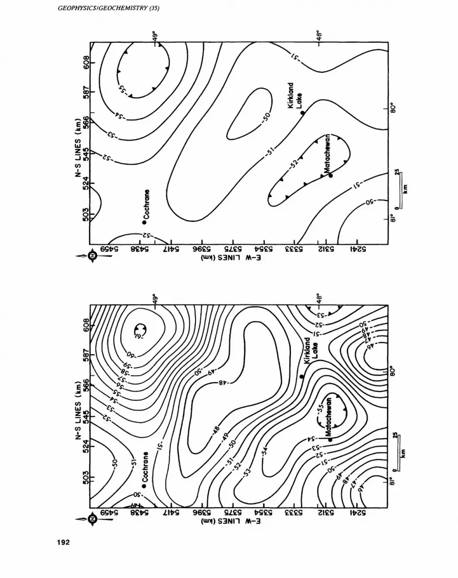
GEOPHYSICS l GEOCHEMISTRY (35)
CO
(O
S -i to(O
l l
00
962Q 2129M-3
192
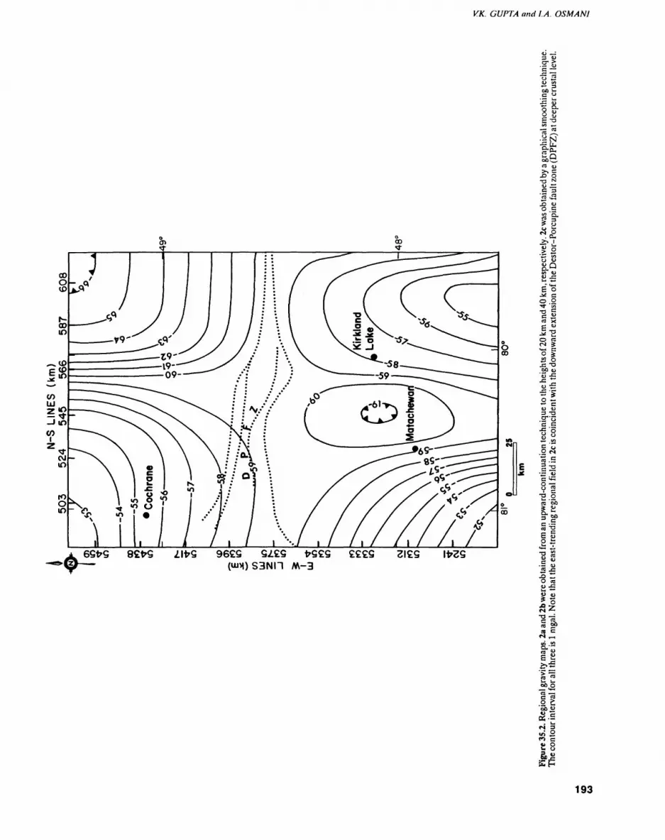
V.K. GUPTA and J.A. OSMANI
-
o.o
liea x
00 dj'5 -S•Si IIu u 3 -a .2"o c c
11c GO Mli•
o JS•a ga So
II5-g S S
O To SSO 0
li1100 O"1^ o S;'So
f) e2 0 o
193
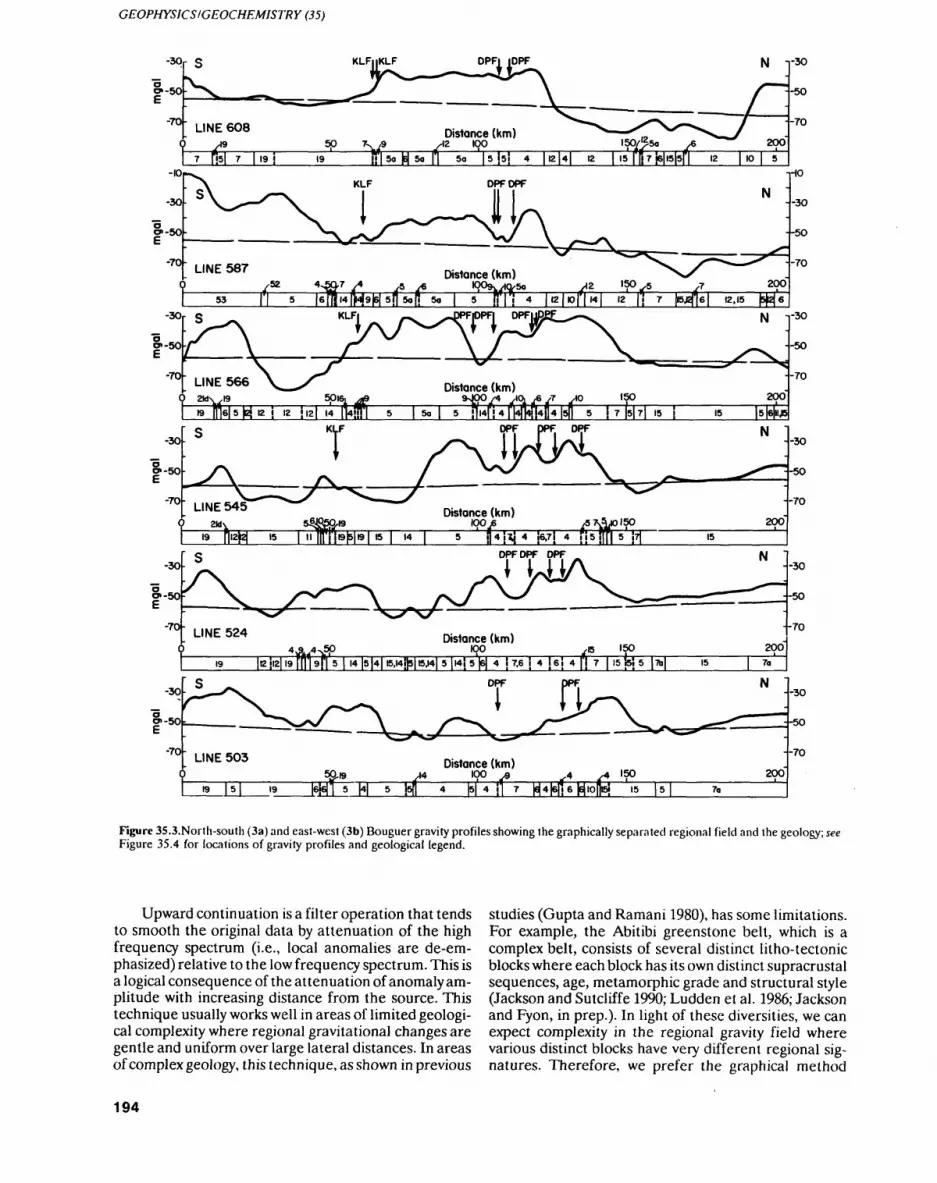
GEOPHYSICS /GEOCHEMISTRY (35)
-30r
o*-50-
-70-
-30
--5O
--70
7 fei 7 l 19 S 19 So [j 5o J S \5\ 4 \\2\4\ 12 | 15 fR 7 \S\K\5\\ 12 | 10 [ 5
B ||T6|5MB| .Z llEl H MTI 5 l So l 5 J1.4|!4rNHri4H4|5n 5 J7|5|7|.5J .5
is i n||ri|B|5|B| IS l M l 5 i6-7 ! 4 SiMlll 5 M
19 |l2JI2| 19 ffi |9|l 5 l l4 IS H I5.l4i|5|l5j4| 5 |I4J 5 fi 4 i 7.6 l 4 l 6J 4 | j 7 | 15 iSJ 5 |7b| 15
lyu /g ,. . y4 .. ^ ' j4 N 4 j] 7 161416116161451 ISLU____" 1*11 5 M
Figure 35.3.Norlh-south (3a) and east-west (3b) Bouguer gravity profiles showing the graphically separated regional field and the geology; see Figure 35.4 for locations of gravity profiles and geological legend.
Upward continuation is a filter operation that tends to smooth the original data by attenuation of the high frequency spectrum (i.e., local anomalies are de-em phasized) relative to the low frequency spectrum. This is a logical consequence of the attenuation of anomaly am plitude with increasing distance from the source. This technique usually works well in areas of limited geologi cal complexity where regional gravitational changes are gentle and uniform over large lateral distances. In areas of complex geology, this technique, as shown in previous
studies (Gupta and Ramani 1980), has some limitations. For example, the Abitibi greenstone belt, which is a complex belt, consists of several distinct lilho-tectonic blocks where each block has its own distinct supracrustal sequences, age, metamorphic grade and structural style (Jackson and Sutcliffe 1990; Ludden et al. 1986; Jackson and Fyon, in prep.). In light of these diversities, we can expect complexity in the regional gravity field where various distinct blocks have very different regional sig natures. Therefore, we prefer the graphical method
194
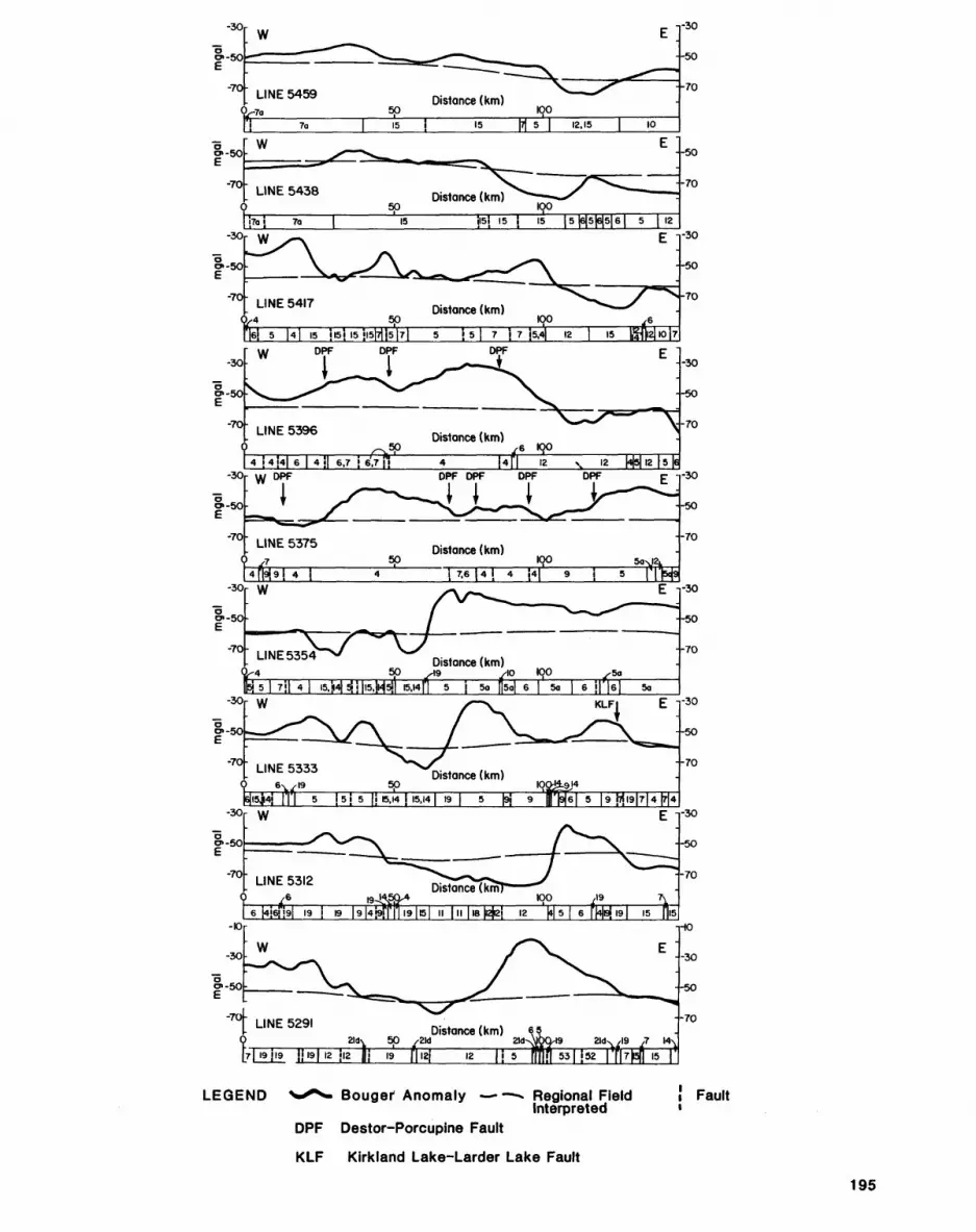
-30r
15 j______15_____[7| 5 j 12.15 j 10
-30
--50
--70
•-50
--70
-30
o.-50
-70-
WE -
LINE 5417 Distance (km)
5 H 15 jis'j IS Jl5[7|i5[7| 5 j 5 | 7 j 7 J5.4| 12 | IS
--so
N-70
DPF DPF
-70-
M-30r VI/
LINE 53757
-30
--50
•-70
Distance (km) so________ 1904 39 4 TT6J4T4 ?4f 9 j
&-501-
-70-LINE 53544 5
Distance (km)
-30j 5 | 7j| 4 | l5.J4Klll5.H5ir 15.14[l 5 j 5a Q5a| 6 [ So
!5J 5 IJE..4J.5..4I .9 j 5 N 9 r|9|6| 5 19 J7J. 9 |7| 4
6 i4i6i!9| 19 j 19 |9|4!9j|T|l9|t5 II j II | 16 ^2J 12 \t\5\ 6 \\^j 191 15 ||lS
-30
-30
•-50
--70
MI9JI9 Jjl9|l2 JI2 Hi 19 fi IZJ 12 |J5 fill fi 53^52
LEGEND ^*^- Bouger Anomaly —-—-* Regional Field ! FaultInterpreted '
DPF Destor-Porcupine Fault
KLF Kirkland Lake-Larder Lake Fault
195
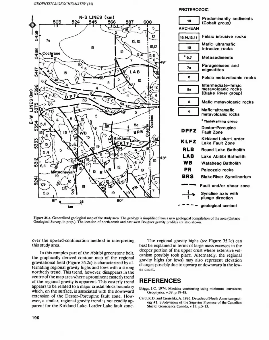
GEOPHYSICS l GEOCHEMISTRY (35)
503N-S LINES (km)
524 545 566 587 608
^ 'VxV C-N\ K r^l s ^~~' * V\4 N( \5 \J5 U"i^vTW l,-st4^X7^..teio Y).-\ VX—^. . IKV ^ L^RKV-X
ro K - io ^—
8le 25
" .\9^?^7800
490
480
PROTEROZOIC
19 Predominantly sediments (Cobalt group)
ARCHEAN
15,14,12,111 Felsic intrusive rocks
10
9,7
7a
Mafic-ultramafic intrusive rocks
Metasediments
Paragneisses and migmatites
j Felsic metavolcanic rocks
km
Intermediate-felsic metavolcanic rocks (Blake River group)
Mafic metavolcanic rocks
Mafic-ultramafic metavolcanic rocks* Timiskaming group
Destor-Porcupine Fault ZoneKirkland Lake-Larder Lake Fault ZoneRound Lake Batholith Lake Abitibi Batholith Watabeag Batholith Paleozoic rocks Blake River Synclinorium
Fault and/or shear zone
Syncline axis with plunge direction
- ~" ~ — — geological contact
DPFZ
KLFZ
RLB LAB WB PR BRS
Figure 35.4. Generalized geological map of the study area. The geology is simplified from a new geological compilation of the area (Ontario Geological Survey, in prep.). The location of north-south and east-west Bouguer gravity profiles are also shown.
over the upward-continuation method in interpreting this study area.
In this complex part of the Abitibi greenstone belt, the graphically derived contour map of the regional gravitational field (Figure 35.2c) is characterized by al ternating regional gravity highs and lows with a strong northerly trend. This trend, however, disappears in the centre of the map area where a prominent easterly trend of the regional gravity is apparent. This easterly trend appears to be related to a major crustal block boundary which, on the surface, is associated with the downward extension of the Destor-Porcupine fault zone. How ever, a similar, regional gravity trend is not readily ap parent for the Kirkland Lake-Larder Lake fault zone.
The regional gravity highs (see Figure 35.2c) can best be explained in terms of large mass excesses in the deeper portion of the upper crust where extensive vol canism possibly took place. Alternately, the regional gravity highs (or lows) may also represent elevation changes possibly due to upwarp or downwarp in the low er crust.
REFERENCESBriggs, I.C. 1974. Machine contouring using minimum curvature;
Geophysics, v.39, p.39-48.
Card, K.D. and Ciesielski, A. 1986. Decades of North American geol ogy #1. Subdivisions of the Superior Province of the Canadian Shield; Geoscience Canada, v.13, p.5-13.
196
VK. GUPTA and LA. OSMANI
Dimroth, E., Imreh, L. and Rocheleau, M. 1983. Evaluation of the Jackson, S.L. and Fyon, J.A., in preparation. The Abitibi Subprovince;south-central segment of Ihe Archean Abitibi Belt, Quebec. Part in Geology of Ontario, Ontario Geological Survey, Special Vol-III:Plutonic and metamorphic evolution and geotectonic model; ume 4.Canadian Journal of Earth Sciences, v.20, p.1374-1388.
Gupta, VK. 1981. Bouguer gravity and generalized geological map of Jackson, S.L. and Sutcliffe, R.H. 1990. Central Superior Provincethe Sudbuiy-Onaping Lake area, Districts of Sudbury and Algo- geology: evidence for an allochthonous, ensimatic, southern Abi-ma; Ontario Geological Survey, Preliminary Map P2482, scale tib ' greenstone belt; Canadian Journal of Earth Sciences, v.27,1:100000. p.582-589.
Gupta, VK. and Grant, F.S. 1985. Mineral exploration aspects of erav- , , c ,, f , rT, , noc r- \ j - r. L ' . ,. - .1 c ju rf- i i4 r^ 4 Jensen, L.S. and Langford, F.F. 1985. Geology and petrogenesis of theity and aeromagnetic surveys in the Sudbury-Cobalt area, Ontar- ' , .u-.-i-i i.- .1 v i i ji i r\ . /-. .- T-I 114 -r*, t n i /- ^ j \, .-A i Archean Abitibi belt m the Kirkland Lake area, Ontario; Ontario10; m The Utility ot Regional Gravity and Magnetic Anomaly ~ . . , 0 x .. ,. ^ m n^,.,, c - i tc i 4- r- i - on? AT* Geological Survey, Miscellaneous Paper 123, 130p.Maps; Society ol Exploration Geophysics, p. 392-412. r r
Gupta, VK. and Ramani, N. 1980. Some aspects of regional-residual Hidden, J., Hubert, C. and Gariepy, C. 1986. The tectonic evolutionseparation of gravity anomalies in a Precambrian terrain; Geo- of the Abitibi greenstone belt of Canada; Geological Magazine,physics, v.45, p.1412-1426. v 123, p.153-166.
Gupta, VK. and Wadge, D.R. 1980. Bouguer gravity and generalizedgeological map of the Temagami-Engiehart area, Districts of Ti- Ontario Geological Survey, in preparation. Bedrock geology of Ontar-miskaming, Nipissing and Sudbury; Ontario Geological Survey, io, east-central sheet; Ontario Geological Survey, Map 2543.Preliminary Map P.2296, scale 1:100 000. scale 1:1 000 000.
197
36. Project Unit 89-45. An Examination of the Suitability of the Shallow Reflection Seismic Technique for use in Southern Ontario
M.A. Lockhard 1 and R.B. Barlow2
Geophysicist, Geophysics/Geochemistry Section, Ontario Geological Survey.
2Chief, Geophysics/Geochemistry Section, Ontario Geological Survey.
INTRODUCTIONThe overburden sounding research program initiated in the summer of 1989 was continued this year. The prima ry objective of the program is to improve the methodolo gy of geophysical techniques so that they are more effec tive for mapping subsurface Quaternary sequences in southern Ontario. These techniques may then be more successfully applied in groundwater studies, the explor ation for waste disposal sites, sand and gravel deposits and various subsurface pollution mapping problems. This summer, efforts were concentrated on improving the shallow reflection seismic method developed by Hunter et al. (1982) so that it could be eventually used to delineate the Laurentian buried bedrock valley in the region around the town of Newmarket.
Spencer (1891) suggested that a buried bedrock valley extends from the southern tip of Georgian Bay, past Lake Simcoe, to Lake Ontario (near the Toronto area). This was based on a depth to bedrock contour map derived from available water-well reports. This finding was supported by White and Karrow (1971) when they compiled updated water-well reports. The maps from
Figure 36.1. Location map of the Bruce's Mill Conservation Area, scale 1:1013760.
White and Karrow (1971) were examined in conjunction with more recent water-well data compiled by John Ruby of the Engineering Department of the Municipal ity of York, in an attempt to locate the trend of the Laur entian buried bedrock valley in the area south of New market. After reviewing these data, it was hypothesized that Bruce Creek is a surface expression of the bedrock valley in this area. Field work was carried out in the Bruce's Mill Conservation Area, located approximately 8 km west of the town of Stouffville, in an area that is traversed by the creek (Figure 36.2). The study area is accessible from Stouffville Road, east of Highway 404.
SURVEY METHODOLOGYBruce Creek flows southward through the middle of the conservation area, so an east-west survey line was estab lished. The survey line started approximately 500 m east of the creek, and extended about 600 m west of the creek ( Figure 36.2). Three rotasonic drill holes were established so as to straddle the creek and provide con trol for the relevant portion of the line. The middle hole was placed immediately adjacent to the creek, while the other two holes were each about 250 m distant from the creek on either side.
Seismic reflection data was collected with 100 Hz marsh geophones spaced every 2.5 m and buried to a depth of 10 to 20 cm and recorded on a Scintrex S-2 Echo engineering seismograph. Each trace is 150 ms long and was recorded using a 300 to 1000 Hz bandpass analog fil ter. An energy source prototype, similar to the one de scribed by Pullan and MacAuley (1987), was used throughout the survey. The prototype makes use of stock or modified shotgun loads which are detonated at a depth of approximately l m below the surface. A gas powered auger with a 5 cm diameter drill bit was used to prepare the shot holes.
Most traces required 3-fold stacking to ensure that sufficient signal amplitude, and hence, signal-to-noise ratio, was achieved on each record. Stacking is used to increase the amplitude of weaker events, making reflec tors more visible in the seismic section, and at the same time, it is used to increase the signal-to-noise ratio. However, the practice of limited stacking must be viewed with caution when traces are not added exactly in-phase. Small-scale static shifting, resulting from trig ger timing variations, will cause a repeated event which
198
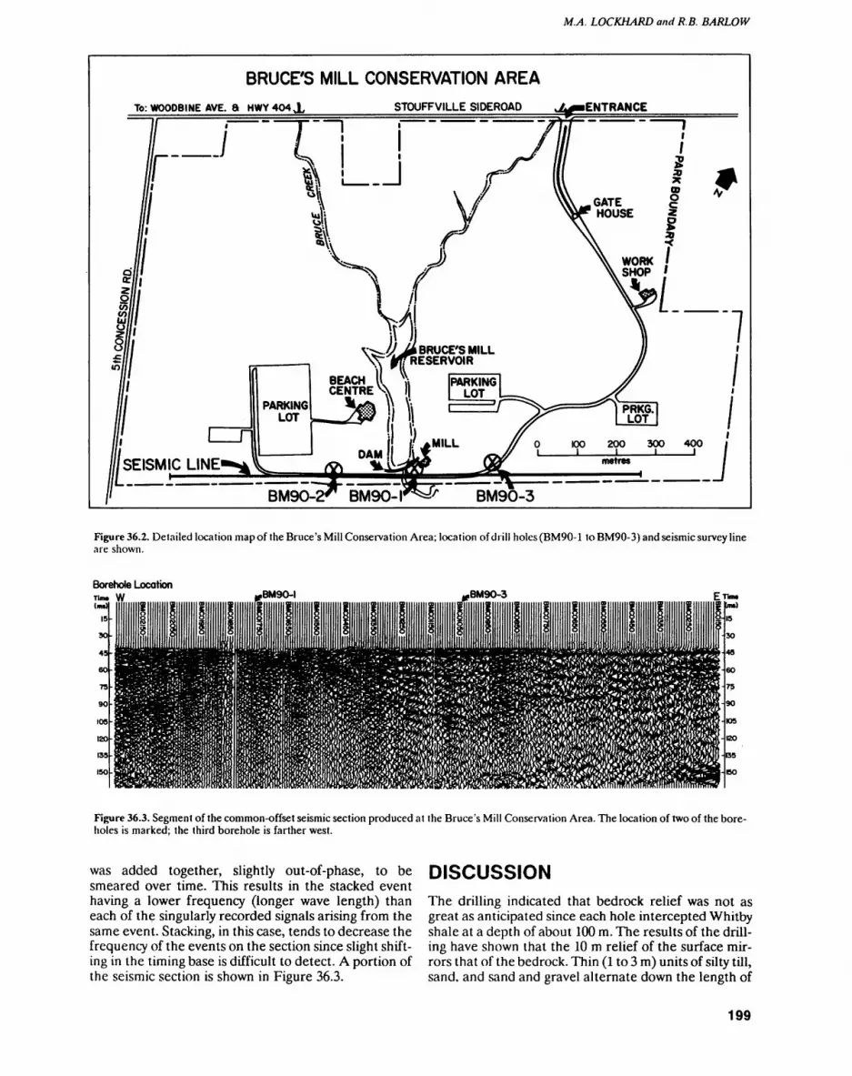
M.A. LOCKHARD and R.B. BARLOW
BRUCE'S MILL CONSERVATION AREATo: WOODBINE AVE. 8 HWY 404X STOUFFVILLE SIDEROAD
BRUCE'S MILL RESERVOIR
Figure 36.2. Detailed location map of the Bruce's Mill Conservation Area; location of drill holes (BM90-1 to BM90-3) and seismic survey line are shown.
Borehole Location.BM9O-I BM90-3
Figure 36.3. Segment of the common-offset seismic section produced at the Bruce's Mill Conservation Area. The location of two of the bore holes is marked; the third borehole is farther west.
was added together, slightly out-of-phase, to be smeared over time. This results in the stacked event having a lower frequency (longer wave length) than each of the singularly recorded signals arising from the same event. Stacking, in this case, tends to decrease the frequency of the events on the section since slight shift ing in the timing base is difficult to detect. A portion of the seismic section is shown in Figure 36.3.
DISCUSSIONThe drilling indicated that bedrock relief was not as great as anticipated since each hole intercepted Whitby shale at a depth of about 100 m. The results of the drill ing have shown that the 10 m relief of the surface mir rors that of the bedrock. Thin (l to 3 m) units of silty till, sand, and sand and gravel alternate down the length of
199

GEOPHYSICS/GEOCHEMISTRY (36)
the holes. With the exception of a 10 to 15 m thick till unit, stratigraphic correlation between the three holes is not possible with the current level of data.
The boreholes show that a bedrock valley of limited depth is present, and the drill logs indicate an infilled scour feature within the overburden.
It was concluded that the buried bedrock valley would be an interesting test site, as alternating Quater nary units usually have different physical characteristics and the overburden thickness offers a good challenge for the seismic technique to image the overburden-bed- rock interface.
Data quality deteriorates between records BMCO1550 and BMCO1950, which cover the ground across Bruce Creek. This may reflect the fact that sur face material along this section of the survey line is com posed of fill; or it may be the result of a change in sub surface characteristics caused by stream sediment re working, in combination with groundwater seepage un der the toe of a dam located about 10 m north of the sur vey line.
Horizontal shifting of the stream bed over time would tend to rework the stream sediments toward a coarser, more permeable medium. In near surface units, where the grain size distribution is absent in clay and silt size fractions, both shot and geophones are often poorly coupled. This area of the section contains rather unique subsurface conditions which have resulted in poor signal transmission and reception, as evidenced by inspection of Figure 36.3. Future research will investigate the geo logical character of the near surface sediments in this area, as sampled in the borehole, in order to substanti ate the reason for the poor records obtained over this zone and to develop a remedial methodology for im proved imaging of the subsurface in this area.
Velocity analysis indicates an interval velocity of about 1800 m/s down to 100 m/s for this portion of the section. Thus, bedrock at a depth of 100 m should occur as an event around 115 ms on the seismic section. The lack of a coherent reflector at this time maybe the result of two factors. Firstly, the velocity contrast between the dense till and the bedrock may be so small that the re flection coefficient is too small for a proper reflection event; or secondly, the signal produced at the surface does not contain sufficient energy to penetrate the dense till.
This section will now be used as a reference for fu ture work. This fall, different methods of data process ing, along with new field techniques and equipment, will be examined at the University of Waterloo and the site, respectively, in an effort to improve the shallow reflec tion seismic technique. These improvements will then be tested along the complete line (or along a line in the same region) next year, to determine which methods are best suited to areas of high acoustic attenuation which are typical of southern Ontario overburden conditions.
Surface and borehole electromagnetic methods will be applied across the section to compliment the strati graphic mapping exercise and advance the interpreta tion of the area.
ACKNOWLEDGEMENTSThe authors are grateful to the staff of the Bruce's Mill Conservation Area for their excellent co-operation dur ing all phases of the field work. In addition, we are grate ful to M. Barua, C. Clark and R. Huxter for their assis tance in carrying out the field work. Appreciation is also extended to C. Baker and T.F. Morris of the Engineering and Terrain Geology Section for their support in logging Quaternary sequences and arranging the overburden drilling in the area.
REFERENCESEyles, N., Clark, B.M., Kaye, E.G., Howard, K.W.F. and Eyles, C.H.
1985. The application of basin analysis techniques to glaciated terrains: an example from the Lake Ontario Basin, Canada; Geo science Canada, v.12, p.22-32.
Hunter, J.A., Burns, R.A., Good, R.L., MacAuley, H.A. and Gagne, R.M. 1982. Optimum field techniques for bedrock reflection mapping with the multichannel engineering seismograph; in Cur rent Research Part B, Geological Survey of Canada, Paper 82-lb, p.125-138.
Pullan, S.E. and MacAuley, H. A. 1987. An in-hole shotgun source for engineering seismic surveys; Geophysics, v.52, no.7, p.985-996.
Sibul, V, Wang, K.T and Vallery, D. 1977. Ground-water resources of the Duffins Creek Rouge River drainage basins; Ministry of Environment, Water Resources Paper 8, I09p.
Spencer, J.W. 1891. Origin of the basins of the Great Lakes of Ameri ca; The American Geologist, v.7, p.86-97.
White, O.L. and Karrow, P.P. 1971. New evidence for Spencer's Lau rentian River; in Proceedings, 14th conference, Great Lakes Re sources, p. 394-400.
200
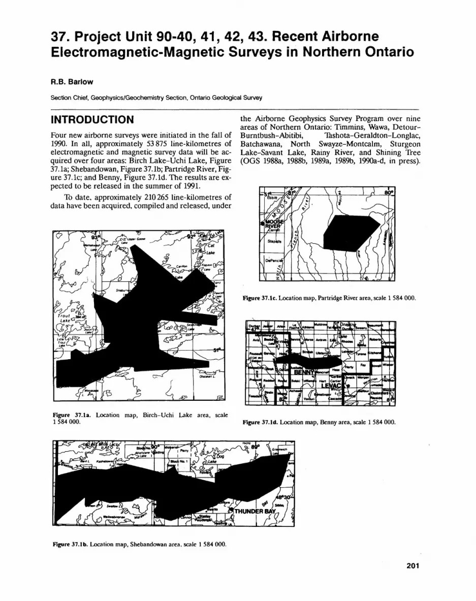
37. Project Unit 90-40, 41, 42, 43. Recent Airborne Electromagnetic-Magnetic Surveys in Northern Ontario
R.B. Barlow
Section Chief, Geophysics/Geochemistry Section. Ontario Geological Survey
INTRODUCTIONFour new airborne surveys were initiated in the fall of 1990. In all, approximately 53875 line-kilometres of electromagnetic and magnetic survey data will be ac quired over four areas: Birch Lake-Uchi Lake, Figure 37. la; Shebandowan, Figure 37. Ib; Partridge River, Fig ure 37. le; and Benny, Figure 37. Id. The results are ex pected to be released in the summer of 1991.
To date, approximately 210265 line-kilometres of data have been acquired, compiled and released, under
the Airborne Geophysics Survey Program over nine areas of Northern Ontario: Timmins, Wawa, Detour- B urn tbush-Abitibi, Tashota-Geraldton-Longlac, Batchawana, North Swayze-Montcalm, Sturgeon Lake-Savant Lake, Rainy River, and Shining Tree (OGS 1988a, 1988b, 1989a, 1989b, 1990a-d, in press).
Figure 37.1c. Location map, Partridge River area, scale l 584 000.
Figure 37.1a. Location map, Birch-Uchi Lake area, scale l 584 000. Figure 37.1d. Location map, Benny area, scale l 584 000.
Figure 37.1 b. Location map, Shebandowan area, scale l 584 000.
201
GEOPHYSICS/GEOCHEMISTRY (37)
The airborne survey program is financed through the Northern Development Fund and managed by the On tario Geological Survey.
SURVEY INSTRUMENTATIONThe GEOTEM system, owned and operated by Geo- terrex Limited, Ottawa, will be used to acquire the elec tromagnetic data over the Birch Lake-Uchi Lake area. The survey platform is a CASA C212-200, twin turbo prop, short takeoff and landing (STOL) aircraft having a six-strand, three-turn, horizontal transmitter loop in stalled around the extremities of the plane, and a sensor mounted in a towed bird. A Scintrex single-cell, split- beam, cesium vapour magnetometer is mounted in a stinger on the tail of the aircraft. Instrumentation with in the aircraft consists of the digital receiver and trans mitter circuits, a microprocessor and tape drive for data storage, the magnetometer console, and positioning equipment.
The primary electromagnetic field about the air craft is created by a series of discontinuous sinusoidal (half sine) current pulses which are fed through the three-turn loop. The duty cycle is composed of 1050 jis of "on time" followed by 2280 JJLS of "off time" which is utilized to sample the transient decay produced by the ground response which is induced by the time-varying primary field. During the "on time", the peak current through the loop is 600 A, resulting in a dipole moment of 4.5 x 10⁵ Am2. The receiver coil is mounted vertically, with the axis in the direction of flight, in a bird. The bird is suspended on a 135 m cable approximately 40 m above the ground when the aircraft is at the survey altitude of 120m.
The transient decay from the ground response is sampled six times a second over twelve gates, whose centres and gate widths can be software selected over the entire range of "off time". Postflight processing nor mally reduces the noise level to about a 20 ppm enve lope (relative to the primary field). The effective explo ration depth, as established at the Night Hawk test range, is approximately 300 m.
The AERODAT system, owned and operated by Aerodat Ltd., will be used to acquire electromagnetic and magnetic data over the Shebandowan, Partridge River and Benny areas. The survey platform consists of an Aerospatiale AS 350D helicopter. Both the transmit ter (Tx) and receiver (Rx) coils are mounted in a tubular bird which is towed below the helicopter, approximately 30 m above the ground. A Scintrex single-cell, split- beam, cesium vapour magnetometer is towed approxi mately 40 m above the ground in a separate housing, be low the helicopter and above the EM bird. Each Tx-Rx coil pair is separated by a 7 m distance. The coil orienta tions consist of two coaxial (horizontal dipole) and two coplanar (vertical dipole) coil-pairs operating at 935 Hz and 4600 Hz, and 4175 Hz and 33 000 Hz, respectively.
In-phase and quadrature responses are measured with a resolution of better than 0.1 ppm, with an elec
tronic time constant of 0.1 second and sampling rate of 10 readings per second. The dipole moment of the coax ial transmitters is about 130 Am2 and the moment of the 4175 Hz and 33 000 Hz coplanar transmitters is 50 Am2 and 20 Am2, respectively. The noise level, excluding spherics, is less than l ppm (relative to the primary field) under normal survey conditions. Instrumentation with in the helicopter consists of receiver and transmitter consoles, a digital data acquisition system, a magnetom eter console, and positioning equipment.
The primary electromagnetic field about the bird is created by a continuous sinusoidal waveform, and the secondary field is measured in the presence of the pri mary field by a phase component measuring system. The intensities of the in-phase and quadrature components of the secondary field are measured continuously during flight at pre-described frequencies and coil orientations, and are given as fractions of the primary field strength. The effective exploration depth, as established at the Night Hawk test range, is approximately 150 m.
RESULTSThe maps are prepared with a photomosaic base at a scale of 1:20000 using Ontario Ministry of Natural Re sources 1:15840 and 1:20000 scale aerial photography. The photos are laid down using a Universal Transverse Mercator projection format constructed from scaled down 1:50000 topographic maps.
The flight lines, anomalies, and magnetic contours are superimposed on this base and appropriate legend information is attached. Digital profiles of every flight line are constructed with standard presentation schemes and permanently stored on microfilm.
REFERENCESOntario Geological Survey 1988a. Airborne electromagnetic and
total intensity magnetic survey, Timmins area, Districts of Coch rane and Timisikaming; Ontario Geological Survey, Maps 81 035 to 81 098, scale 1:20000.
1988b. Airborne electromagnetic and total intensity magnetic survey, Wawa area, Districts of Algoma, Sudbury and Thunder Bay; Ontario Geological Survey, Maps 81 003 to 81 034, scale 1:20000.
1989a. Airborne electromagnetic and total intensity magnetic survey, Detour-Burnlbush-Abitibi area. District of Cochrane; Ontario Geological Survey, Maps 81 171 lo 81 258, scale 1:20 000.
1989b. Airborne electromagnetic and total intensity magnetic survey, Tashota-Geraldton-Longlac area, District of Thunder Bay; Ontario Geological Survey. Maps 81 259 to 81 348, scale 1:20000.
1990a. Airborne electromagnetic and total intensity magnetic survey, Batchawana area; Ontario Geological Survey, Maps 81 434 to 81 459, scale 1:20 000.
1990b. Airborne electromagnetic and total intensity magnetic survey, North Swayze-Montcalm area; Ontario Geological Sur vey, Maps 81 349 to 81 387, scale 1:20 000.
1990c. Airborne electromagnetic and total intensity magnetic survey, Sturgeon Lake-Savant Lake area; Ontario Geological Survey, Maps 81 460 to 81 505, scale 1:20 000.
1990d. Airborne electromagnetic and total intensity magnetic survey, Rainy River area; Ontario Geological Survey, Maps 81 506 to 81 537, scale 1:20000.
202

R.B. BARLOW
in press. Airborne electromagnetic and total intensity magnetic survey, Shining Tree area; Ontario Geological Survey, Maps 81 388 to 81 433, scale 1:20 000.
203


Geoscience Laboratories Programs

38. Summary of Activities 1990, Geoscience Laboratories Section
RG. Lightfoot
Acting Chief. Geoscience Laboratories Section, Ontario Geological Survey.
INTRODUCTIONThe Geoscience Laboratories Section of the Ontario Geological Survey produces geoanalytical data in support of the Mineral Resources Activity programs. These activi ties include: 1) the provision of analytical data on geological materials, 2) research and development of methods and techniques suitable for the analysis of geological materi als in order to satisfy present and anticipated client requirements, and 3) the provision of advice to the public and the minerals industry.
The methodologies which form the basis of the Analytical Capabilities and Services guide (available from the Geoscience Laboratories Section) were published in 1990 as MP 149 (OGS 1990), entitled The Analysis of Geological Materials. Volume II: A Manual of Methods.
The Laboratories also published An Introductory Guide to Sampling for Geoanalysis (Lightfoot and Riddle 1990). This was intended to be a simple and concise guide to the collection of samples, and highlights sampling problems due to grain size and the nug get effect. The goal was to raise awareness in the geological community of the princi ples of systematic sampling protocols based on the criteria of Gy (1979) and Ingamells and Switzer (1973).
Geoanalysis 90A highlight of the year was Geoanalysis 90 An International Symposium on the Anal ysis of Geological Materials, presented by the Spectroscopy Society of Canada in co-op eration with the Geological Survey of Canada, the Ontario Geological Survey, and the International Working Group of the Association Nationale de la Recherche Tech nique, Paris. The meeting was held in Huntsville June 3 to 7, 1990. C. Riddle of the Geoscience Laboratories Section and G. Hall of the Geological Survey of Canada were joint organizers of the symposium. The Geoscience Laboratories Section was involved in: 1) the staging and production of a Laboratories Design Workshop (Geoscience Lab oratories 1990) and a series of laboratory tours, 2) the organization of the meeting itself (Geoanalysis 90 Program 1990), 3) contributions at organized sessions on geostandards and quality control and assurance, and 4) presentation of a paper on achievements in inductively coupled plasma mass spectrometry (ICP-MS) together with some applica tions (Lightfoot and Doherty 1990). During the three-day meeting, papers were pres ented by scientists and technical experts from over 16 countries on topics that included quality control and assurance, geostandards, methods development, and geoanalysis in the Third World.
Laboratory Information Management SystemA laboratory information management system (LIMS) was acquired in 1989. The soft ware package runs on an IBM compatible local area network (LAN). The LIMS soft ware enables the Laboratories Section to track samples more effectively, capture data directly from analytical instruments, process quality control results more efficiently, and report assay and job results. The customized software was written and developed by 8MB Compuscience Ltd. of Milton, Ontario.
Scientific BoardThe Scientific Board of the Geoscience Laboratories Section met with client geologists in 1990, and subsequently revised the list of project priorities based on this meeting.
207
GEOSCIENCE LABORATORIES (38)
The Scientific Board also updated the "Center of Excellence" document, which is in tended to present the aims of the Scientific Board in terms of activities to be pursued in the laboratories of the Mines and Minerals Research Center (MMRC) in Sudbury. In 1990, the Laboratories Section presented a series of 4 short talks on the capabilities of the MMRC laboratories, and highlighted the aims encapsulated in this document.
The Scientific Board has reported data for the CANMET standard MA-Ib (Smith and Bowman 1990), and is gathering data for the USGS certification program on BSK-1. In 1990-91, the Laboratories Section will be working towards Standards Coun cil of Canada accreditation.
This summary of activities highlights achievements in the Laboratory Section's 3 subsections. Specific project activities are reported by individual authors following this summary.
MINERAL SCIENCE SUBSECTIONThe Mineral Science Subsection has contributed to a number of co-operative projects with other sections of the Ontario Geological Survey (OGS) and with the University of Toronto. These projects are designed to develop an applied mineral sciences capability, and include: 1) assistance in the formulation of geochemical analysis programs in sup port of the Wawa synopsis, and preliminary interpretation of the data; 2) petrogenetic studies of the Keweenawan basalt sequence at Mamainse Point and on the Black Bay Peninsula (Lightfoot et al., in prep.) with emphasis on understanding the origin of min eralization associated with different alteration styles; 3) studies of the platinum group element (PGE) potential of the Nipissing diabase in relation to parental magma com position (with the Geological Survey of Canada); 4) determination and standardization of PGE abundances in the OGS standard reference materials, using nickel sulfide but tons prepared in-house and analysed using ISOTRACE by G. Wilson (Wilson et al., in prep.); 5) further development of the capability to separate and analyze (by ICP-MS) discrete mineral grains; and 6) joint collaborative ventures with universities.
X-ray DiffractionWork has continued in the Geoscience Laboratories Section to develop quantitative X-ray diffraction (XRD) techniques for the modal analysis of rock samples (Rowell, in press; De Souza and Rowell 1990), powders, and thin sections, and the determination of clay mineral identities and proportions. The system used is equipped with a Pelti- er-cooled detector, which provides a significantly better peak resolution compared to the conventional XRD equipped with gas proportional counter. Results on two varia nts of the internal standard method for the modal analysis of granite follow this sum mary (see Paper 39, this volume).
Micromineralogical StudiesIn preparation for the installation of a fully equipped micromineralogical laboratory in the new Sudbury facility, Hugh de Souza, the Laboratories Mineralogist, has undertak en a number of projects using the scanning electron microscope in the Department of Geology, University of Toronto, and the microprobe in the Department of Geology, University of Western Ontario. Notable projects underway include a study of the Sidney Lake fault zone mylonites, and chromite ore from the Shebandowan Mine.
Fire AssayA fire assay method for the preparation of small (about l g) buttons of nickel sulphide is under investigation by D. Crabtree. This preparation protocol could form the basis for the development of an ICP-MS method for the determination of all of the PGEs and Au.
The Pb fire assay procedure continues to be a significant component of the Labora tories Section's client support activities. A poster was presented by D. Crabtree, M. Ghobrial and T. Hodges on the "Determination of ngg 1 Gold in Geological Materials by Lead Fire Assay GF-AAS" (Crabtree et al. 1990) at the 36th Canadian Spectrosco py Conference, Brock University, St. Catharines. In an article following this summary,
208
PC. LIGHTFOOT
the authors discuss in more detail some of the pitfalls in carrying out highly sensitive gold analyses by fire assay-graphite furnace atomic absorption spectroscopy (AAS) (see Paper 40, this volume).
Mineral StudiesIn preparation for the Sudbury laboratory facility for the determination of trace ele ment abundances and isotopic ratios in rocks and minerals, work continues in the de velopment of mineral separation and concentration capabilities using the Frantz isody namic magnetic separator, heavy liquids and binocular microscope.
GeostandardsValidation of the available OGS standards continues, with emphasis on the Au and PGE materials.
The Mineral Science Subsection has developed a number of new in-house refer ence materials suitable for validation of geoanalytical data and methods development. These include:1. a tholeiitic Keweenawan basalt standard prepared from pulps of the Osler volcanic
sequence2. a peridotite from the Kanichee Deposit north of Temagami3. a diabase prepared from the Nipissing Intrusion at Basswood Lake (Lightfoot et al.
1987)4. a granodiorite prepared from pulps of the felsic phase of the Nipissing Intrusion at
Basswood Lake (Lightfoot et al. 1987).
A rhyolite standard from the Mamainse Point volcanic sequence is in preparation.These materials are now used in the blind-duplicate program to validate all geoa
nalytical data, and can be used as the basis for quality control (QC) data submissions accompanying manuscripts (e.g., Lightfoot et al., in prep.).
A library of standard reference mineral phases for quantitative XRD analysis and materials suitable for micromineralogical standards was established. The Mineral Sciences Subsection welcomes contributions of suitable mineral phases from client geologists.
CHEMISTRY SUBSECTIONC. Chan, Supervisor of the Chemistry Subsection, has continued to develop analytical methods involving robotic digestion of samples, automated colorimetric determination of chlorine in geological materials and flow-injection determination of bismuth in geo logical materials.
RoboticsN. Vigneault will be working on the further development of the robotic sample decom position system. Routine digestion of rock-pulp samples for analysis by solution-based techniques is outlined following this summary (see Paper 41, this volume).
Work on "An Automated Colorimetric Method for Determination of Chlorine in Geological Materials Using Flow Injection Analysis" (Chan 1990) is reported in a re cent paper.
Flow-injectionWork on a method to accurately and precisely determine Bi in geological materials at levels as low as 10 ppb with an analysis rate of more than 50 digested samples per hour has been completed and a paper entitled "Determination of Bismuth in Geological Materials by Flow Injection Hydride Generation Atomic Absorption Spectrometry" (Chan, in press) has been prepared.
209
GEOSCIENCE LABORATORIES (38)
SPECTROSCOPY SUBSECTION ICP Laboratory
W. Doherty has been involved in the following projects:1. development of an HF stabilization procedure for the determination of elements
which are typically not stable in solution (Hf, Ta, Nb, Zr, etc.)2. a fusion-decomposition technique for the complete digestion of samples carrying
minerals like zircon, chromite, and cassiterite3. preliminary investigation of an ICP-MS technique for the determination of the
PGEs and Au.Results to date have been reported by Doherty (1990a, 1990b, 1990d) and Doherty and Richardson (1990).
The "Trace 4" (rare earth elements (REEs) and Y) and new "Trace 5" analytical packages continue to be in heavy demand by the client groups. "Trace 5" provides high quality, sensitive determinations of Hf, Ta, Rb, Sr, Zr, Nb, and Cs at levels of 200 ppb or lower. Continued refinement of the internal calibration scheme for the accurate and precise determination of Th and U at equally low abundance levels is ongoing.
J. Richardson, W. Doherty, and J. Tsigaris report quality control protocols which have been developed for the determination of Zr, Y, and REEs in geological materials (see Paper 44, this volume).
Richardson (1990) and Richardson et al. (1990) reviewed the geological applica tions of Os isotope analyses by ICP-MS. Osmium isotopes provide critical petrogenetic information concerning the age and origin of PGE deposits in mafic and ultramafic rocks. A pilot project is in progress to investigate the possibility of performing similar work at the OGS.
Determination of Ni, Cu, Co and Zn, traditionally performed by AAS, together with V and Se, are now determined by inductively coupled plasma optical emission spectroscopy (ICP-OES).
The combined OGS-Leco Corporation assessment of the Ontario-designed and built high-resolution inductively coupled plasma-optical emission spectrometer has concluded. This instrument was purchased to perform PGE determinations and the "Trace 2" package of elements in samples with high Fe and Ni. The system can also determine REEs at the higher abundance levels. Plans are progressing to publish the vast amount of hitherto unavailable high-resolution ICP spectral data gathered in this pilot project.
XRF LaboratoryA new 6-position automatic fluxer was made operational in 1990. Production of fused glass discs for XRF analysis has increased by over 15096, and beads are much more uni form in composition. There has been much interest from industry, university, and gov ernment agencies regarding this robotic aid to sample preparation. This will be the sub ject of a poster display at the 1990 Ontario Mines and Minerals Symposium.
Quality Control - Method ComparisonIn a continuing effort to report top quality analytical data to clients, and assess the ana lytical procedures with respect to geological problems, a combined effort between the ICP and XRF laboratories has resulted in an innovative procedure to ensure that total REE analyses are reported in a cost effective manner. This will ensure that the results for the REEs are not dependent on the method used to analyse the samples (e.g., the case documented by Hall and Plant (1990)).
This comparison involves 2 analytical techniques and 3 sample preparation meth ods. It identifies samples which have undissolved REEs in insoluble mineral phases (Richardson et al. 1990). A fusion technique is available for the preparation of these problem samples.
REFERENCESChan, C., in press. Determination of bismuth in geological materials by flow injection hydride generation
atomic absorption spectrometry; Analytical Letters.
210
PC. LIGHTFOOT
Chan, C. 1990. An automated colorimetric method for the determination of chlorine in geological materials using flow injection analysis; Laboratory Robotics and Automation, v.2, p.83-88.
Crabtree, D.C., Ghobrial, M. and Hodges, A.E. 1990. Determination of ngg' 1 gold in geological materials by lead fire assay GF-AAS; in Abstracts Volume, 36th Canadian Spectroscopy Conference.
De Souza, H. and Rowell, D. 1990. Quantitative X-ray diffraction in mineralogy: applications to the modal analysis of granites and determination of calcite dolomite ratio; in Program Abstracts, Canadian Miner al Analysts-Society of Mineral Analysts Joint Conference.
Doherty, W. 1990a. Determination of 22 trace elements in geological materials by 1CP-MS; in Proceedings, Winter Plasma Conference.
Doherty, W. 1990b. Sample preparation for geological analysis by ICP-MS: elemental analysis; in Proceed ings, Recent Developments in Plasma Spectrometry.
Doherty, W. 1990c. A practical skimmer design for ICP-MS; in Proceedings, 36th Canadian Spectroscopy Conference.
Doherty, W. 1990d. A practical skimmer design for inductively coupled plasma mass spectrometry: gas dy namic and analytical considerations; unpublished MSc thesis, York University, Downsview, Ontario.
Doherty, W. and Richardson, J.M. 1990. Procedures to negate the impact of high dissolved solid contents on the determination of geological materials by ICP-MS; in 36th Canadian Spectroscopy Conference, p.69-70.
Geoscience Laboratories 1990. Laboratory Design Workshop; unpublished report, Geoscience Laborato ries.
Gy, P.M. 1979. Sampling of particulate materials theory and practice; Developments in Geomathematics 4, Elsevier Scientific Publishing Company, New York, 43 Ip..
Hall, G.E.M. and Plant, J.A. 1990. Are your REE results total? Explore, no.68, p. 18-19.
Ingameils, C.O. and Switzer, E 1973. A proposed sampling constant for use in geochemical analysis; Tantala, v.20, p.547-568.
Lightfoot, PC., Conrod, D., Naldrett, A.J. and Evensen, N. 1987. Grant 230, petrological, chemical, isoto pic, and economic potential studies of the Nipissing Diabase, in Geoscience Research Grant Program, Summary of Research 1986-1987, Ontario Geological Survey, Miscellaneous Paper 136, p.4-26.
Lightfoot, PC. and Riddle, C. 1990. An introductory guide to sampling for geoanalysis; Ontario Geological Survey, 18p.
Lightfoot, PC. and Doherty, W. 1990. Significance of precise determination of trace element abundances by ICP-MS in continental flood basalts with specific reference to the Keweenawan and Siberian traps; in Proceedings, Geoanalysis 90 An International Symposium of the Analysis of Geological Materials.
Lightfoot, P.C., Sutcliffe, R.H. and Doherty, W, in preparation. Crustal contamination identified in Keween awan Osler Group tholeiites, Ontario: a trace element perspective.
Ontario Geological Survey 1990. The analysis of geological materials volume II: a manual of methods; Ontar io Geological Survey, Miscellaneous Paper 149.
Richardson, J. 1990. Sample preparation for geological materials, 1. quantitative elemental analysis, 2. isoto pic analysis: high precision; in Proceedings, Recent Advances in Plasma Spectrometry, p.8.
Richardson, J.M., Dickin, A.P. and McNutt, R.H. 1990. Osmium isotope analyses by inductively coupled plasma mass spectrometry: review and geological applicationsj/'/i Proceedings from 3rd Surrey Confer ence on ICP-MS, p.43.
Richardson, J.M., Doherty, W. and Tsigaris, J. 1990. Quality control for Zr, Y, and REE in geological materi als: comparison of XRF and ICP-MS determinations; in 36th Canadian Spectroscopy Conference, p.69.
Rowell, D., in press. Quantitative determination of the calcite-dolomite ratio using X-ray diffraction: a review of two tested methods; Geoscience Canada.
Smith, C.W. and Bowman, W.S. 1990. MA-lb: A Certified Gold Reference Ore. CANMET Publication: CCRMP 90-2F, 24p.
Wilson, G.C., Kilius, L.R. and Rucklidge. J.C., in preparation. In-situ, parls-per-billion analysis of precious metals in polished mineral samples and sulphide "standards" by accelerator mass spectrometiy.
211
39. Project Unit 88-01. Modal Analysis of Granites Using a Quantitative Powder X-R ay Diffraction Method.
H.A.F. de Souza 1 and D. Rowell2
1 Acting Supervisor, Mineral Science Laboratory, Geoscience Laboratories Section, Ontario Geological Survey
2Administrative Assistant, Ontario Geological Survey, Advance Office, Sudbury.
INTRODUCTIONOver the last 25 years, the introduction of instrumental methods and the widespread use of computers has ac celerated the production of geochemical data. It is now possible to generate vast arrays of data and employ for midable statistical packages in their interpretation. Yet often, one critical parameter in these packages, that is the mineralogical content of the samples being ana lyzed, is either ignored or receives superficial attention. The main reason for this is the time required to produce good quantitative mineralogical data, as methods in this area have failed to keep up with the explosive develop ment in geoanalytical techniques. A number of recent studies have illustrated the value of quantitative miner alogical data, whether it be in reconnaissance mapping (Pawloski 1985), detailed studies of ore bodies (Marquis et al. 1990), or in the evaluation of industrial minerals (Carter et al. 1987).
In this article, we outline the approach taken by the Geoscience Laboratories Section of using X-ray diffrac tion (XRD) as a general method for the routine modal analysis of rocks. This is part of a project of the Labora tories Section to provide a mineralogical report to ac company the chemical data. Such an approach is not new; indeed, it was normal in the past to provide a min eralogical description of samples submitted for chemi cal analysis, based either on a visual inspection of assay samples or on a thin section examination of those sam ples submitted for whole rock analysis. This practice is often abandoned as the number of samples submitted for analysis has increased in response to the improve ments in methodology.
EXISTING METHODS FOR MODAL ANALYSISThe modal content of each mineral phase in a rock may be determined by a variety of methods (see Hutchison 1974), most of which are tedious and time-consuming and therefore not suitable for routine use. The most commonly used method is point counting, either on thin sections or on stained rock slabs. For very fine-grained rocks this technique has serious limitations because mineral identification can be problematic, while for coarse-grained samples the average thin section is often not representative.
The determination of calcite/dolomite ratios is of ten required by geologists studying sedimentary rocks and tills. Numerous methods have been developed to measure this ratio, such as microscopic examination with staining, gasometric determination and use of the air comparison pycnometer. The standard method used in the Geoscience Laboratories Section is the Chittick gasometric method which is simple, but lacks accuracy and has poor precision (1.596 at mid range). There are many sources of error, and where one mineral predomi nates there can be considerable error in the determina tion (Ontario Geological Survey 1990). The unconsoli dated and fine-grained nature of much of the material submitted for analysis precludes the use of other meth ods to determine this ratio. The same limitations apply to determination of minerals in fine-grained mill feed or in any type of powdered material used in an industrial process.
The search for alternatives to both of the above- mentioned methods currently in use in the Laboratories Section has led us to examine the feasibility of using an XRD technique for quantitative mineralogical data. The method had been little used for such work until the advent of automated diffractometer. However, in many other applications, particularly in the monitoring of dusts in the environmental health field, quantitative XRD is perceived as being a versatile technique that can be applied to a wide range of crystalline material. A number of studies (Davies and Walawender 1982; Man- iar and Cooke 1987; Wadsworth and Baird 1989) have demonstrated that XRD can be used for the modal anal ysis of granitoids; however, not all minerals were ana lyzed and the methods used did not lend themselves to routine analysis.
ADVANTAGES OF USING X-RAY DIFFRACTION FOR QUANTITATIVE MINERALOGYThere are 3 advantages to using XRD for the quantita tive analysis of mineralogy:1. It allows objective identification of minerals based
on their crystal structure; unlike optical determina tions which are dependent on the skills of the pe trographer.
2. The technique can be automated, with calculations being performed by computer.
212

H.A.F. de SOUZA and D. ROWELL
3. It can provide modal analysis on a wide range of ma terials, from unconsolidated tills and soils to solid rocks. XRD is essential for clay mineral identifica tion. For very fine particles, it is probably the only method for quantification of mineral abundances in bulk samples.
QUANTITATIVE X-RAY DIFFRACTION METHODS USEDQuantitative XRD is based on the principle that the dif fraction pattern obtained from a mixture of phases is the sum of the characteristic patterns of each phase, with the intensity of the peaks in that pattern being propor tional to the amount present in the mixture, after cor recting for absorption. Three quantitative XRD meth ods derived from the basic quantitative equation of Klug and Alexander (1974) were used in this study. These methods all use an internal standard to avoid having to measure the bulk absorption coefficient of the mixture.1. The Internal Standard (IS) method is the most gen
eral of the methods (Snyder and Bish 1989) and does not require determination of all phases in the mixture. A known amount of the internal standard is added to the standards and the samples to be de termined. Calibration constants for each phase and analytical line are derived from a series of standards and are applicable only to the instrument and set of conditions under which they were determined.
2. The Reference Intensity Ratio method (Hubbard and Snyder 1988) uses reference intensity ratios (RIRs) determined from 50-50 mixtures of the min eral and an internal standard, which is usually co rundum. In the latter case, and when the most in tense line of each phase is used, the RIR is referred to as I/Icorundum and the values of this ratio are sup posed to be universal constants which could be used on any instrument.
3. The H value method was developed by Hooten and Giorgetta (1977) to avoid mixing in an internal stan dard; instead, one of the minerals present becomes the internal standard and the others are calculated with reference to it. This method is similar to the matrix flushing method of Chung (1974) with the H value being equivalent to the inverse of (RIR x Ire() (Ire i is the relative intensity). H constants, which are instrument specific, are measured on mineral-co rundum mixtures; the method requires all compo nents in the mixture to be identified.
Our initial work on developing a quantitative XRD method (Rowell, in press) used the H value method of Hooten and Giorgetta (1977) for the determination of calcite/dolomite ratios. This work has now been ex tended to cover other minerals.
INSTRUMENTATIONFor this study we used a Philips 1820 automated powder diffractometer equipped with:
1. an automatic divergence slit (Jenkins 1989) which permits a constant area of the sample to be illumi nated by the X-ray beam when scanning from low to high angles. This is especially important in granites as the peaks are measured between 8" and 50 0 26.
2. a peltier-cooled, solid state, lithium-drifted silicon (Psi) detector in place of the standard proportional counter. With its large collection angle, high quan tum efficiency, and excellent energy resolution, it eliminates the use of monochromators (along with the monochromator polarization correction) and beta filters, thus increasing beam intensity (Bish and Chipera 1989). This results in excellent peak- to-background ratios and lower detection limits which are very useful when the analyst has to select a small peak because the major peak is heavily over lapped by reflections from other phases, as occurs in granites.
3. an automatic sample changer4. a sample spinner which increases the number of
particles measured during the analysis and reduces preferred orientation effects; the dramatic im provement in precision in the measurement of the peak area and peak height, as a result of the use of a sample spinner, is illustrated by the measurements given below for the plagioclase 002 peak.
SPINNER ON OFF
PEAK AREA (cps)
792 12 Cl.6%) 784 164 (20.99fc)
PEAK HEIGHT (cps)
14185 58 (G.4%) 14805 1828 (U.3%)
SAMPLE PREPARATIONGood sample preparation is critical and is the key to good analysis. Quantitative XRD is based on a precise and accurate measurement of intensity; therefore, all factors which cause intensity variations, other than those due to concentration, must be eliminated or re duced to a minimum. There are 2 main causes of intensi ty variation in rock samples.1. Sample particle sizes: large particle sizes in the sam
ple are an important source of intensity variation in XRD work (Klug and Alexander 1974). Several stu dies have shown (e.g., Parrish and Huang 1983) that accurate intensities can only be measured on par ticles 10 jam or smaller. Some of the problems that occur when the sample contains large particles in clude extinction and microabsorption effects, and poor particle statistics (Bish and Reynolds 1989). All of these can be minimized by the use of particle sizes in the l to 10 jim range.
2. Preferred orientation: minerals such as micas and feldspars in granites are prone to preferred orienta tion, causing intensity variations unrelated to their concentration. These effects can be eliminated (e.g., Davies 1986), but generally the techniques to do this are very involved and do not lend themselves to routine production (Bish and Reynolds 1989). In most cases, grinding the sample tends to reduce preferred orientation from fibrous minerals and
213
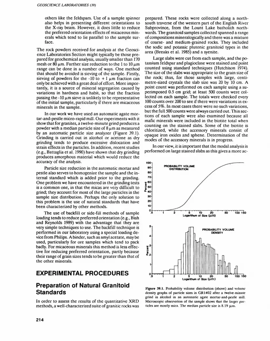
GEOSCIENCE LABORATORIES (39)
others like the feldspars. Use of a sample spinner also helps in presenting different orientations to the X-ray beam. However, it does little to reduce the preferred orientation effects of micaceous min erals which tend to lie parallel to the sample sur face.
The rock powders received for analysis at the Geosci ence Laboratories Section might typically be those pre pared for geochemical analysis, usually smaller than 170 mesh or 80 jo.m. Further size reduction to the l to 10 jim range can be done in a number of ways. One method that should be avoided is sieving of the sample. Firstly, sieving of powders for the -10 to + l jo.m fraction can only be achieved with a great deal of effort. More impor tantly, it is a source of mineral segregation caused by variations in hardness and habit, so that the fraction passing the -10 jxm sieve is unlikely to be representative of the initial sample, particularly if there are micaceous minerals in the sample.
In our work we have used an automatic agate mor- tar-and-pestle micro-rapid mill. Our experiments with it show that for granites, a twelve-minute grind produces a powder with a median particle size of 8 ja.m as measured by an automatic particle size analyzer (Figure 39.1). Grinding is carried out in alcohol or acetone as dry grinding tends to produce excessive dislocation and strain effects in the particles. In addition, recent studies (e.g., Battaglia et al. 1990) have shown that dry grinding produces amorphous material which would reduce the accuracy of the analysis.
Particle size reduction in the automatic mortar and pestle also serves to homogenize the sample and the in ternal standard which is added prior to the grinding. One problem we have encountered in the grinding tests is a common one, in that the micas are very difficult to grind; they account for most of the large particles in the sample size distribution. Perhaps the only solution to this problem is the use of natural standards that have been characterized by other methods.
The use of backfill or side-fill methods of sample loading tends to reduce preferred orientation (e.g., Bish and Reynolds 1989) with the advantage that they are very simple techniques to use. The backfill technique is performed in our laboratory using a special loading de vice from Philips. A binder, such as amyl acetate, may be used, particularly for ore samples which tend to pack badly. For micaceous minerals this method is less effec tive for reducing preferred orientation, partly because their range of grain sizes tends to be greater than that of the other minerals.
EXPERIMENTAL PROCEDURES
Preparation of Natural Granitoid StandardsIn order to assess the results of the quantitative XRD methods, a well-characterized suite of granitic rocks was
prepared. These rocks were collected along a north- south traverse of the western part of the English River Subprovince, from the Lount Lake batholith north wards. The granitoid samples collected spanned a range of compositions mineralogically and there was a mixture of coarse- and medium-grained rocks. They included the sodic and potassic plutonic granitoid types in the area (Breaks et al. 1985) and a syenite.
Large slabs were cut from each sample, and the po tassium feldspar and plagioclase were stained and point counted using standard techniques (Hutchison 1974). The size of the slabs was appropriate to the grain size of the rock; thus, for those samples with large, centi metre-sized crystals the slab size was 20 by 10 cm. A point count was performed on each sample using a su perimposed 0.5 cm grid; at least 500 counts were col lected on each sample. The totals were checked every 100 counts over 200 to see if there were variations in ex cess of 596. In most cases there were no such variations, but the full 500 counts were always carried out. Thin sec tions of each sample were also examined because all mafic minerals were included in the biotite total when counting on the stained slabs. Some of the biotite is chloritized, while the accessory minerals consist of opaque iron oxides and sphene. Determination of the modes of the accessory minerals is in progress.
In our view, it is important that the modal analysis is performed on large stained slabs as this gives a more ac-
1009O
80
70I 602505 40-
3020-l
10
O
PROBABILITY VOLUME DISTRIBUTION
5 10 20 Logarithum of Size (u,m)
SO 100 150
5-
4
l 3
io-2
1
-
r-rf
-
1-.
-j"-PROBABILITY VOLUME
DENSITY
-,
-
-
-'j p
1 L M.5 1 5 10 20
Logarithum of Size (Jim)50 100 150
Figure 39.1. Probability volume distribution (above) and volume density graphs of particle sizes in GR1402 after a twelve-minute grind in alcohol in an automatic agate mortar-and-pestle mill. Microscopic observation of the sample shows that the larger par ticles are mostly mica. The median particle size is 8.19 jo.ni.
214
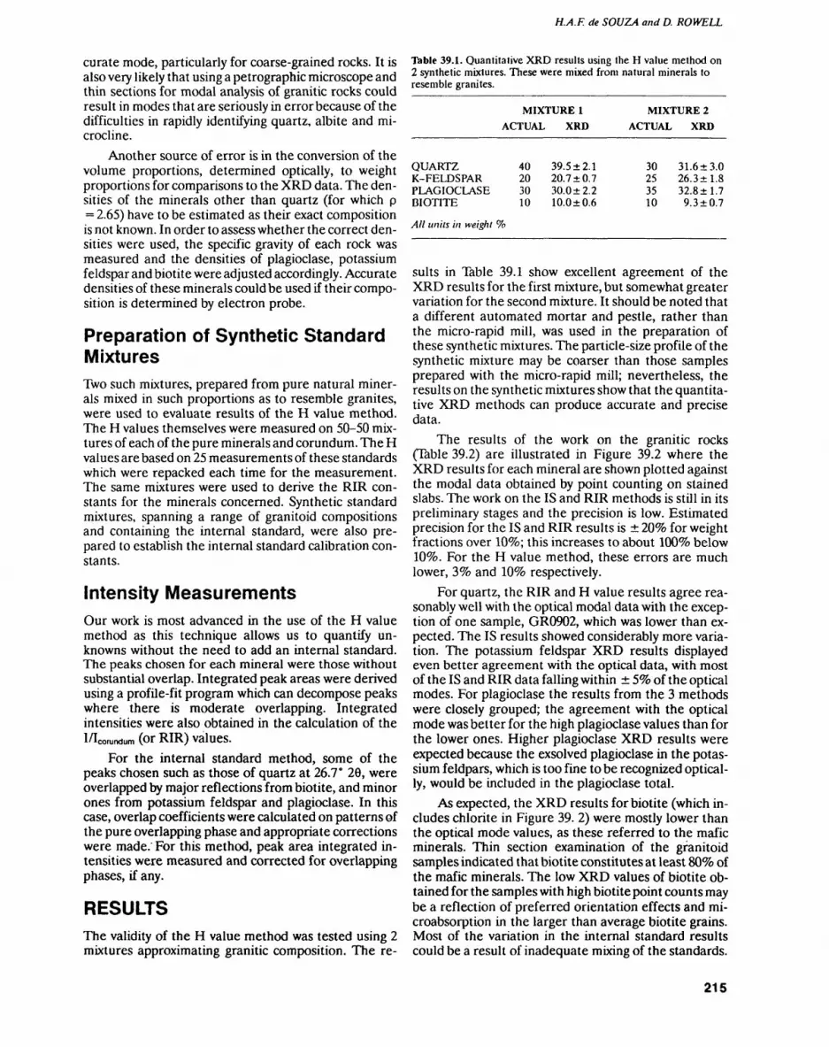
H.A.F. de SOUZA and D. ROWELL
curate mode, particularly for coarse-grained rocks. It is also very likely that using a petrographic microscope and thin sections for modal analysis of granitic rocks could result in modes that are seriously in error because of the difficulties in rapidly identifying quartz, albite and mi crocline.
Another source of error is in the conversion of the volume proportions, determined optically, to weight proportions for comparisons to the XRD data. The den sities of the minerals other than quartz (for which p = 2.65) have to be estimated as their exact composition is not known. In order to assess whether the correct den sities were used, the specific gravity of each rock was measured and the densities of plagioclase, potassium feldspar and biotite were adjusted accordingly. Accurate densities of these minerals could be used if their compo sition is determined by electron probe.
Preparation of Synthetic Standard MixturesTwo such mixtures, prepared from pure natural miner als mixed in such proportions as to resemble granites, were used to evaluate results of the H value method. The H values themselves were measured on 50-50 mix tures of each of the pure minerals and corundum. The H values are based on 25 measurements of these standards which were repacked each time for the measurement. The same mixtures were used to derive the RIR con stants for the minerals concerned. Synthetic standard mixtures, spanning a range of granitoid compositions and containing the internal standard, were also pre pared to establish the internal standard calibration con stants.
Intensity MeasurementsOur work is most advanced in the use of the H value method as this technique allows us to quantify un knowns without the need to add an internal standard. The peaks chosen for each mineral were those without substantial overlap. Integrated peak areas were derived using a profile-fit program which can decompose peaks where there is moderate overlapping. Integrated intensities were also obtained in the calculation of theI/Icorundum (or RIR) valUCS.
For the internal standard method, some of the peaks chosen such as those of quartz at 26.7* 20, were overlapped by major reflections from biotite, and minor ones from potassium feldspar and plagioclase. In this case, overlap coefficients were calculated on patterns of the pure overlapping phase and appropriate corrections were made. For this method, peak area integrated in tensities were measured and corrected for overlapping phases, if any.
RESULTSThe validity of the H value method was tested using 2 mixtures approximating granitic composition. The re-
Table 39.1. Quantitative XRD results using the H value method on 2 synthetic mixtures. These were mixed from natural minerals to resemble granites.
MIXTURE l
ACTUAL XRD
MIXTURE 2
ACTUAL XRD
QUARTZ K-FELDSPAR PLAGIOCLASE BIOTITE
All units in weight
40203010
39.5 2.1 20.7 0.7 30.0 2.2 10.0 0.6
30253510
31.6 3.026.3 1.832.8 1.79.3 0.7
suits in Table 39.1 show excellent agreement of the XRD results for the first mixture, but somewhat greater variation for the second mixture. It should be noted that a different automated mortar and pestle, rather than the micro-rapid mill, was used in the preparation of these synthetic mixtures. The particle-size profile of the synthetic mixture may be coarser than those samples prepared with the micro-rapid mill; nevertheless, the results on the synthetic mixtures show that the quantita tive XRD methods can produce accurate and precise data.
The results of the work on the granitic rocks (Table 39.2) are illustrated in Figure 39.2 where the XRD results for each mineral are shown plotted against the modal data obtained by point counting on stained slabs. The work on the IS and RIR methods is still in its preliminary stages and the precision is low. Estimated precision for the IS and RIR results is 2096 for weight fractions over 1096; this increases to about 10096 below 1096. For the H value method, these errors are much lower, 396 and 1096 respectively.
For quartz, the RIR and H value results agree rea sonably well with the optical modal data with the excep tion of one sample, GR0902, which was lower than ex pected. The IS results showed considerably more varia tion. The potassium feldspar XRD results displayed even better agreement with the optical data, with most of the IS and RIR data falling within 596 of the optical modes. For plagioclase the results from the 3 methods were closely grouped; the agreement with the optical mode was belter for the high plagioclase values than for the lower ones. Higher plagioclase XRD results were expected because the exsolved plagioclase in the potas sium feldpars, which is too fine to be recognized optical ly, would be included in the plagioclase total.
As expected, the XRD results for biotite (which in cludes chlorite in Figure 39. 2) were mostly lower than the optical mode values, as these referred to the mafic minerals. Thin section examination of the granitoid samples indicated that biotite constitutes at least 8096 of the mafic minerals. The low XRD values of biotite ob tained for the samples with high biotite point counts may be a reflection of preferred orientation effects and mi- croabsorption in the larger than average biotite grains. Most of the variation in the internal standard results could be a result of inadequate mixing of the standards.
215
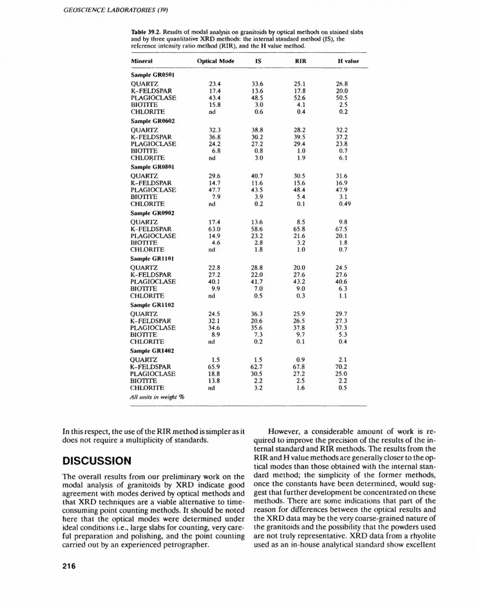
GEOSCIENCE LABORATORIES (39)
Table 39.2. Results of modal analysis on granitoids by optical methods on stained slabs and by three quantitative XRD methods: the internal standard method (IS), the reference intensity ratio method (RIR), and the H value method.
Mineral
Sample GR0501QUARTZK-FELDSPARPLAGIOCLASEBIOTITECHLORITESample GR0602
QUARTZK-FELDSPARPLAGIOCLASEBIOTITECHLORITESample GR0801QUARTZK-FELDSPARPLAGIOCLASEBIOTITECHLORITESample GR0902QUARTZK-FELDSPARPLAGIOCLASEBIOTITECHLORITESample GR1101
QUARTZK-FELDSPARPLAGIOCLASEBIOTITECHLORITESample GR1 102QUARTZK-FELDSPARPLAGIOCLASEBIOTITECHLORITESample GR1402QUARTZK-FELDSPARPLAGIOCLASEBIOTITECHLORITEAll units in weight ^o
Optical Mode
23.417.443.415.8nd
32.336.824.26.8
nd
29.614.747.7
7.9nd
17.463.014.94.6
nd
22.827.240.1
9.9nd
24.532.134.68.9
nd
1.565.918.813.8nd
IS
33.613.648.5
3.00.6
38.830.227.2
0.83.0
40.711.643.5
3.90.2
13.658.623.2
2.81.8
28.822.041.7
7.00.5
36.320.635.67.30.2
1.562.730.52.23.2
RIR
25.117.852.64.10.4
28.239.529.4
1.01.9
30.515.648.4
5.40.1
8.565.821.6
3.21.0
20.027.643.2
9.00.3
25.926.537.89.70.1
0.967.827.2
2.51.6
H value
26.820.050.5
2.50.2
32.237.223.8
0.76.1
31.616.947.9
3.10.49
9.867.520.1
1.80.7
24.527.640.6
6.31.1
29.727.337.3
5.30.4
2.170.225.0
2.20.5
In this respect, the use of the RIR method is simpler as it does not require a multiplicity of standards.
DISCUSSIONThe overall results from our preliminary work on the modal analysis of granitoids by XRD indicate good agreement with modes derived by optical methods and that XRD techniques are a viable alternative to time- consuming point counting methods. It should be noted here that the optical modes were determined under ideal conditions i.e., large slabs for counting, very care ful preparation and polishing, and the point counting carried out by an experienced petrographer.
However, a considerable amount of work is re quired to improve the precision of the results of the in ternal standard and RIR methods. The results from the RIR and H value methods are generally closer to the op tical modes than those obtained with the internal stan dard method; the simplicity of the former methods, once the constants have been determined, would sug gest that further development be concentrated on these methods. There are some indications that part of the reason for differences between the optical results and the XRD data may be the very coarse-grained nature of the granitoids and the possibility that the powders used are not truly representative. XRD data from a rhyolite used as an in-house analytical standard show excellent
216

H.A.F. de SOUZA and D. ROWELL
50
40-QUARTZ
• IS A RIR *H values
~5 10 15 20 S S 35 MODE WT*.
POTASSIUM-FELDSPAR
•IS ARIR .H values
.-'5''"'' i-*'-'"'"'''*
*,c--'i'"'
~io 20 30 40 50 60~ MODE WT1*
60
50-
40-
i ! 20-
10-
0
PLAGIOCLASE
•IS ARIR *H values
8."*
20 30 MODE WT1*,
BIOTITE
IS A RIR * H values
f I
MODE WT1*10 12 14 16
Figure 39.2. XRD results for quartz, potassium feldspar, plagioclase, and biotite (including chlorite) in the granitoids plotted against the modal weight Vo measured using optical point counting techniques. The lines mark the 59fc error in the optical data. (*)IS - internal standard method, (A)RIR - reference intensity method, (*)H value - H value method of Hooten and Giorgetta (1977).
precision. Unfortunately, optical modes are not avail able for comparison, because of the fine-grained nature of the rock, which is undoubtedly a reason for the good precision of the data.
Additional uncertainty may be introduced because of the lack of precise knowledge of the minerals used to make up the standards. For the feldspars, the errors are a result of exsolution; for the micas and chlorites, differ ences in the Fe contents between standards and un knowns can be the source of large errors, a result of the great differences in absorption coefficients between Fe and Mg varieties. However, many of these errors could be minimized by the use of well-characterized rocks as standards.
CONCLUSIONSThe results of our quantitative XRD study indicate that it is a promising way of obtaining quantitative mineral ogical data:1. Data can be generated with reasonable precision
and in great volumes.2. Careful sample preparation is required to reduce
particle sizes to the l to 10 jim range.3. It is important to avoid preferred orientation by us
ing appropriate sample loading methods; backfill methods are a reasonable compromise in this re spect.
4. The RIR and H value methods are simpler, more versatile and give better results than the internal standard method.
Looking to the future, exciting new methods of quanti tative analysis using the full pattern are in prospect (Smith 1989; Snyder and Bish 1989). These methods minimize some of the errors described above, especially preferred orientation, by considering all the reflections generated by a particular crystal structure. The Rietveld method (Snyder and Bish 1989), in particular, has the potential of using detailed crystallographic parameters to quantify phases that are of very similar composition; such methods will be of great value in quantifying rocks containing different amphiboles, or muscovite and bio tite, or even individual members of the plagioclase se ries.
ACKNOWLEDGMENTSWe are most grateful to Fred Breaks for guidance in col lecting the granitoid samples; to Raj Samaroo, Dave Crabtree and Mila Hanousek for helping in sample preparation and experimental work, and to Peter Light foot for many discussions and reviews of the manuscript.
REFERENCESBattaglia, S., Franzini, M. and Ecochard, F. 1990. Influence of grind
ing methods on the 101 X-ray powder diffraction line of a-quartz; Powder Diffraction, v.5, p.101-103.
Bish, D.L, and Chipera, S.J. 1989. Comparison of a solid-state Si de tector to a conventional scintillation detector-monochromator system in X-ray powder diffraction analysis; Powder Diffraction, v.4, p.137-143.
Bish, D.L. and Reynolds, R.C. 1989. Sample preparation for X-ray diffraction; in Reviews in Mineralogy, v.20, Modern Powder Dif fraction, Mineralogical Society of America, p.73-100.
217
GEOSCIENCE LABORATORIES (39)
Breaks, F.W., Cherry, M.E. and Janes, D.A. 1985. Metallogeny of Archean granitoid rocks of the English River Subprovince, Supe rior Province, Ontario, Canada: a review; m High Heat Produc tion Granites, Hydrothermal Circulation and Ore Genesis, Insti tute of Mining and Metallurgy, p.9-31.
Carter, I.R., Hatcher, M.T. and Di Carlo, L. 1987. Quantitative analy sis of quartz and cristobalite in bentonite clay based products by X-ray diffraction; Analytical Chemistry, v.59, p.513-519.
Chung, F.H. 1974. Quantitative interpretation of X-ray diffraction patterns. I. matrix-flushing method of quantitative multicom- ponent analysis; Journal of Applied Crystallography v.7, p.519-525.
Davies, B.L. 1986. A tubular aerosol suspension chamber for the prep aration of powder samples for X-ray diffraction analysis; Powder Diffraction, v.l, p.240-243.
Davies, B.L. and Walawender, M.J. 1982. Quantitative mineralogical analysis of granitoid rocks: a comparison of X-ray and optical techniques; American Mineralogist, v.67, p.1135-1143.
Hooten, D.H. and Giorgetta, N.E. 1977. Quantitative X-ray diffrac tion by a direct calculation method; X-ray Spectrometry, v.6, p.2-6.
Hubbard, C.R. and Snyder, R.L. 1988. RIR - measurement and use in quantitative XRD; Powder Diffraction, v.3, p.74-77.
Hutchison, C.S. 1974. Laboratory handbook of petrographic tech niques; John Wiley and Sons, Toronto, 527p.
Jenkins, R. 1989. Instrumentation; in Reviews in Mineralogy, v.20, Modern Powder Diffraction, Mineralogical Society of America, p. 19-46.
Jones, M.P. 1987. Applied mineralogy: a quantitative approach; Gra ham and Trotman, london, 259p.
Klug, H.P. and Alexander, L.E. 1974. X-ray diffraction procedures for polycrystalline and amorphous material; John Wiley and Sons, Toronto, 966p.
Maniar, P. and Cooke, G.A. 1987. Modal analysis of granitoids by quantitative X-ray diffraction; American Mineralogist, v.72, p.433-437.
Marquis, P., Brown, A.C., Hubert, C. and Rigg, D.M. 1990. Progres sive alteration associated with auriferous massive sulfide bodies at the Dumagami Mine, Abitibi greenstone belt, Quebec; Eco nomic Geology, v.85, p.746-764.
Ontario Geological Survey 1990. The analysis of geological materials, volume II: a manual of methods; Ontario Geological Survey, Mis cellaneous Paper 149.
Parrish, W. and Huang, T.C. 1983. Accuracy and precision of intensi ties in X-ray polycrystalline diffraction; Advances in X-ray Anal ysis, v.26, p.35-44.
Pawloski, G.A. 1985. Quantitative determination of mineral content of geological samples by X-ray diffraction; American Mineralo gist, v.70, p.663-667.
Rowell, D., in press. Quantitative determination of the calcite-dolo- mite ratio using X-ray diffraction: a review of two methods; Geo science Canada.
Smith, D.K. 1989. Computer analysis of diffraction data; in Reviews in Mineralogy, v.20, Modern Powder Diffraction, Mineralogical Society of America, p.183-216.
Snyder, R.L. and Bish, D.L. 1989. Quantitative analysis; in Reviews in Mineralogy, v.20, Modern Powder Diffraction, Mineralogical Society of America, p.101-144.
Wadsworth, W.B. and Baird, A.K. 1989. Modal analysis of granitic rocks by X-ray diffraction; Canadian Mineralogist v.27, p.323-341.
218
40. Project Unit 89-01. Determination of ppb Au in Geological Materials by Lead Fire Assay—Graphite Furnace Atomic Absorption Spectroscopy
D.C. Crabtree 1 , M. Ghobrial2 , and A.E. Hodges3
technician. Mineral Sciences Subsection, Geoscience Laboratories Section, Ontario Geological Survey,
technician, Chemistry Subsection, Geoscience Laboratories Section, Ontario Geological Survey.
3Scientist, Chemistry Subsection. Geoscience Laboratories Section, Ontario Geological Survey.
INTRODUCTION
The noble metals contribute significantly towards On tario's mineral wealth. Traditionally, the Geoscience Laboratories have supported demands for analytical work from within the Ministry and from external client groups such as prospectors. It is important to realize that ultra-trace precious metal abundances vary systematic ally with mineralogy, with other trace elements (such as As, S, Se), and with the geological environment. This in formation is leading towards very promising exploration models.
Gold and 2 platinum group elements (PGEs), Pt and Pd, are routinely determined in the Geoscience Laboratories Section down to a level of a few ppb. A combined lead fire assay (Pb-FA) preconcentration and graphite furnace atomic absorption spectroscopic (GF-AAS) method is used. This is the most appropriate analytical method because:
1. The concentration of the analyte (in this case, Au) is increased by the Pb-FA preconcentration step.
2. Matrix interferences, which often cause problems during determination, are, for the most part, elim inated.
3. A representative sample can be analyzed, thereby avoiding the "nugget effect" which may result from using a smaller sample in a wet-chemical acid diges tion.
Much effort has gone into refining the Pb-FA-GF-AAS method in a dedicated attempt to maintain the best pos sible precision and accuracy at abundance levels of only a few ppb. In this report we present some of the experi ences of the Geoscience Laboratories staff. We remark on the importance of representative sampling, outline the method used to determine Au at the ppb level, de scribe some of the limitations of the method, and ex plore potential avenues for future development work in support of the minerals industry.
SAMPLING STRATEGYPotential exists for considerable error in the determina tion of Au in geological materials if either the original sample of rock, or the analyzed split of that sample, are not representative of the original formation (Clifton et al. 1969; Gy 1979). The so-called "nugget effect" be comes pronounced when biased sampling creates an anomalous concentration of Au in the aliquot selected for analysis. An analysis of such an aliquot is unlikely to be truly representative of the formation from which the rock sample was collected.
The single most important consideration in sam pling is the grain size of the original material. For gold-bearing samples, the geologist should take into consideration the possibility that large Au grains maybe present in the formation. To illustrate this point, Clifton et al. (1969) showed that in order for a representative value for Au lobe determined, the subsample submitted for analysis must contain a certain number of Au par ticles. As one might expect, those rocks with a large number of relatively small Au particles will require a smaller sample than those rocks containing only a few large Au particles. To ensure that a subsample is repre sentative of the original rock, a large sample mass should be used. In Figure 40. l, Clifton et al. (1969) dem onstrate the variable precision or reproducibility for subsamples of 3 different sizes collected from an auri ferous beach sand. The diagram illustrates the increased precision as the sample size becomes progressively larg er. In the case where only a few relatively large Au par ticles are present, it may be necessary to perform a "me- tallics sieve" of the sample. This involves pulverizing a large amount of the sample, and assaying all of the coarse fraction, and a subfraction of the fine sieve frac tion, from the resulting pulp. A representative concen tration of Au in the sample may then be calculated ac cordingly. Thus, the quality of the result is very much in the hands of the geologist who collects the samples. Tru ly representative determinations of Au in geological ma terials are critically dependent on the sampling strategy. For this reason, the Geoscience Laboratories Section has emphasized the importance of appropriate sampling procedures in a publication entitled An Introductory
219

GEOSCIENCE LABORATORIES (40)
•20
-3a
10 20 30 Blank Determinations
40 50
Figure 40.1. Distribution of gold determinations from 3 separate weight fractions of gold-bearing beach sand (after Clifton el al. 1969).
Guide to Sampling for Geoanalysis (Lightfoot and Riddle 1990).
METHOD
1. Sample PreparationAll samples submitted to the Geoscience Laboratories are crushed using a jaw crusher equipped with steel plates. The crushed rock is then split down to approxi mately 100 g in a riffler. The 100 g split is then pulverized in a chromium steel vibratory-ring pulverizer and ground until a -170 mesh (less than 90 jim) rock pulp is attained (OGS 1990).
2. Lead Fire Assay PreconcentrationA 10 g sample is placed in a fire assay crucible with ap proximately 100 g of premixed flux. The flux, which con tains 559k PbO, 28^o Na2CO3, S9& Na2B4O7 , 17o SiO2, and 29o flour, is mixed thoroughly with the sample. A drop of silver nitrate (409o) solution is then added to the charge to provide enough visible metal, in the form of a silver prill, for collection following cupellation. Fusion is carried out at 1000 0 C for 30 minutes, during which time the lead oxide is reduced to molten lead by the car bon in the flour. The Au, Pt and Pd are strongly parti tioned into the molten lead, and this dense immiscible phase accumulates below the less dense residual boro- silicate slag. Following fusion, the sample is poured and the resulting lead button is retrieved from the slag. It is then cubed to remove any adhering glass. The lead cube is placed in a calcium phosphate cupel and cupelled at 950"C under oxidizing conditions, so the molten lead is converted to lead oxide. Bone-ash cupels are porous lo molten lead oxide, but not to the molten noble metals, thereby allowing the separation of the lead from the noble metals.
Generally, most samples analyzed for Au at pbb concentrations are silicates, and require the addition of flour (or any source of organic carbon) to aid in the re duction of lead oxide to lead. Occasionally, reducing ores, such as those high in sulphides, are encountered and do not require the addition of flour to the flux. Highly reducing ores require the addition of an oxidant, usually KNO3 to oxidize excess sulphides, thereby pre venting the formation of a lead sulphide "matte", which interferes with the collection process.
3. AnalysisFollowing the preconcentration procedure, the silver prill is then digested by acid attack, and the Au in the resulting solution is determined by GF-AAS. The opti mum working range for the determination is between 2 and 40 ppb in rock. For concentrations of Au greater than 40 ppb, a flame atomic absorption spectroscopy technique is used for the final determination (OGS 1990).
DISCUSSIONThe determination limit for this method is controlled by the level of Au present in the premixed flux, and by the detection limitations of the GF-AAS instrument. The mean (m) and standard deviation (cr) obtained for 50 blank determinations for gold is 1.77 0.52 ppb, based on a sample:volume ratio of 1. This distribution is shown in Figure 40.2 on a Shewhart quality control chart (Dux 1986). The determination limit for this method is quoted at the 3cr level, and is approximately 1.5 ppb. Only values above 2 ppb are reported by the laboratory.
The GF-AAS technique was developed prior to the emergence of multielement techniques such as induc tively coupled plasma optical emission spectroscopy (ICP-OES) and inductively coupled plasma mass spec troscopy (ICP-MS), and remains a useful technique since Au, Pt and Pd are the most important precious metals. Theoretically, the determination limit for Au, using the GF-AAS technique, could approach the de tection limits defined by the manufacturer of the instru ment. However, this would require the use of ultra-pure fluxes to reduce the level of Au in the blank signal, add ing significantly to the costs of the procedure.
Quality assurance measures are taken to ensure that stringent quality control standards are maintained during the sample preparation, preconcentration, and determination stages. Measures taken at the prepara tion stage include logging of the sample sequence and cleaning equipment between samples. At the fusion stage, boil overs, lead button size, and the quality of the pour are monitored. Blanks and standards are moni tored at the determination stage, and the instrument is recalibrated at frequent intervals lo control instrumen tal drift.
Contamination at the sample preparation stage is monitored by maintaining a log of the grinding sequence for all materials submitted for analysis. In the event that
220
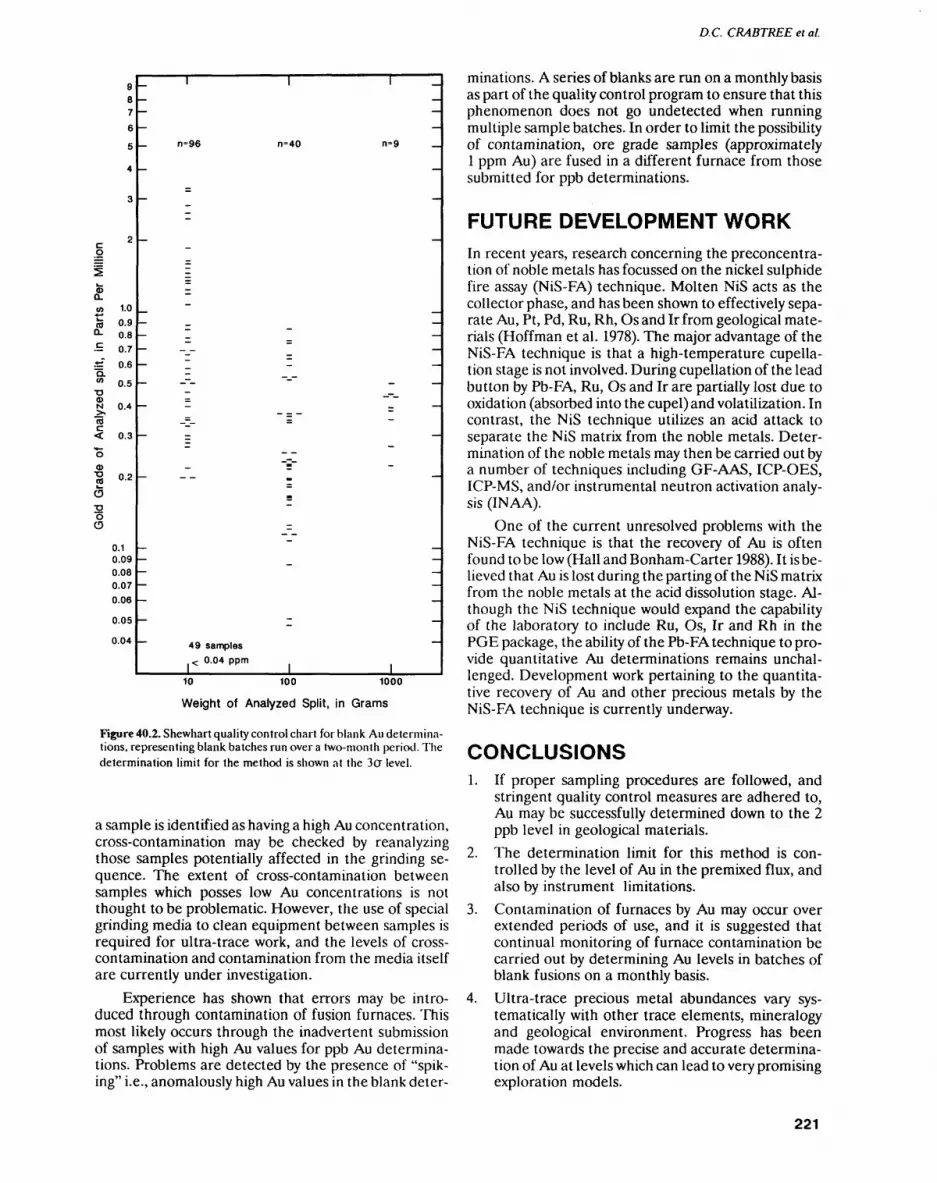
D.C. CRABTREE ei al.
(D TD OS
O
72OO
to 0.90.8 0.7 0.6
0.5
0.4
0.3
0.2
0.10.090.080.070.06
0.05
0.04
0=96 0=40 0=9
49 samples *z 0.04 ppm
10 100 1000
Weight of Analyzed Split, in Grams
Figure 40.2. Shewhart quality control chart for blank Au determina tions, representing blank batches run over a two-month period. The determination limit for the method is shown at the 30" level.
a sample is identified as having a high Au concentration, cross-contamination may be checked by reanalyzing those samples potentially affected in the grinding se quence. The extent of cross-contamination between samples which posses low Au concentrations is not thought to be problematic. However, the use of special grinding media to clean equipment between samples is required for ultra-trace work, and the levels of cross- contamination and contamination from the media itself are currently under investigation.
Experience has shown that errors may be intro duced through contamination of fusion furnaces. This most likely occurs through the inadvertent submission of samples with high Au values for ppb Au determina tions. Problems are detected by the presence of "spik ing" i.e., anomalously high Au values in the blank deter
minations. A series of blanks are run on a monthly basis as part of the quality control program to ensure that this phenomenon does not go undetected when running multiple sample batches. In order to limit the possibility of contamination, ore grade samples (approximately l ppm Au) are fused in a different furnace from those submitted for ppb determinations.
FUTURE DEVELOPMENT WORKIn recent years, research concerning the preconcentra- tion of noble metals has focussed on the nickel sulphide fire assay (NiS-FA) technique. Molten NiS acts as the collector phase, and has been shown to effectively sepa rate Au, Pt, Pd, Ru, Rh, Os and Ir from geological mate rials (Hoffman et al. 1978). The major advantage of the NiS-FA technique is that a high-temperature cupella tion stage is not involved. During cupellation of the lead button by Pb-FA, Ru, Os and Ir are partially lost due to oxidation (absorbed into the cupel) and volatilization. In contrast, the NiS technique utilizes an acid attack to separate the NiS matrix from the noble metals. Deter mination of the noble metals may then be carried out by a number of techniques including GF-AAS, ICP-OES, ICP-MS, and/or instrumental neutron activation analy sis (IN AA).
One of the current unresolved problems with the NiS-FA technique is that the recovery of Au is often found to be low (Hall and Bonham-Carter 1988). It is be lieved that Au is lost during the parting of the NiS matrix from the noble metals at the acid dissolution stage. Al though the NiS technique would expand the capability of the laboratory to include Ru, Os, Ir and Rh in the PGE package, the ability of the Pb-FA technique to pro vide quantitative Au determinations remains unchal lenged. Development work pertaining to the quantita tive recovery of Au and other precious metals by the NiS-FA technique is currently underway.
CONCLUSIONS1. If proper sampling procedures are followed, and
stringent quality control measures are adhered to, Au may be successfully determined down to the 2 ppb level in geological materials.
2. The determination limit for this method is con trolled by the level of Au in the premixed flux, and also by instrument limitations.
3. Contamination of furnaces by Au may occur over extended periods of use, and it is suggested that continual monitoring of furnace contamination be carried out by determining Au levels in batches of blank fusions on a monthly basis.
4. Ultra-trace precious metal abundances vary sys tematically with other trace elements, mineralogy and geological environment. Progress has been made towards the precise and accurate determina tion of Au at levels which can lead to very promising exploration models.
221
GEOSCIENCE LABORATORIES (40)
REFERENCESClifton, H.E., Hunter, R.E., Swanson, F.J. and Phillips, R.W. 1969.
Sample size and meaningful gold analysis; in United Stales Geo logical Survey, Professional Paper 625-C, 17p.
Dux, J.P. 1986. Handbook of quality assurance for the analytical labo ratory; Van Nostrand Reinhold Company, New York.
Gy, P.M. 1979. Sampling of paniculate materials theory and prac tice: developments in geomathematics 4; Elsevier Scientific Pub lishing Company, New York, 431p.
Hall, G.E.M. and Bonham-Carter. G.F. 1988. Review of the methods to determine gold, platinum and palladium in production-orien tated geochemical laboratories, with application of a statistical procedure to test for bias; Journal of Geochemical Exploration, v.30, p.255-286.
Hoffman, E.L., Naldrett, A.J., Van Loon, J.C., Hancock, R.G.V and Manson, A. 1978. The determination of all the platinum group elements and gold in rocks and ore by neutron activation analysis after preconcentration by a nickel sulphide fire-assay technique on large samples; Analytical Chimica Acta, v.102, p.157-166.
Lightfoot, PC. and Riddle, C. 1990. An introductory guide to sam pling for geoanalysis; Ontario Geological Survey, 18p.
Ontario Geological Survey, 1990. The analysis of geological materials volume II: a manual of methods; Ontario Geological Survey, Mis cellaneous Paper 149.
222
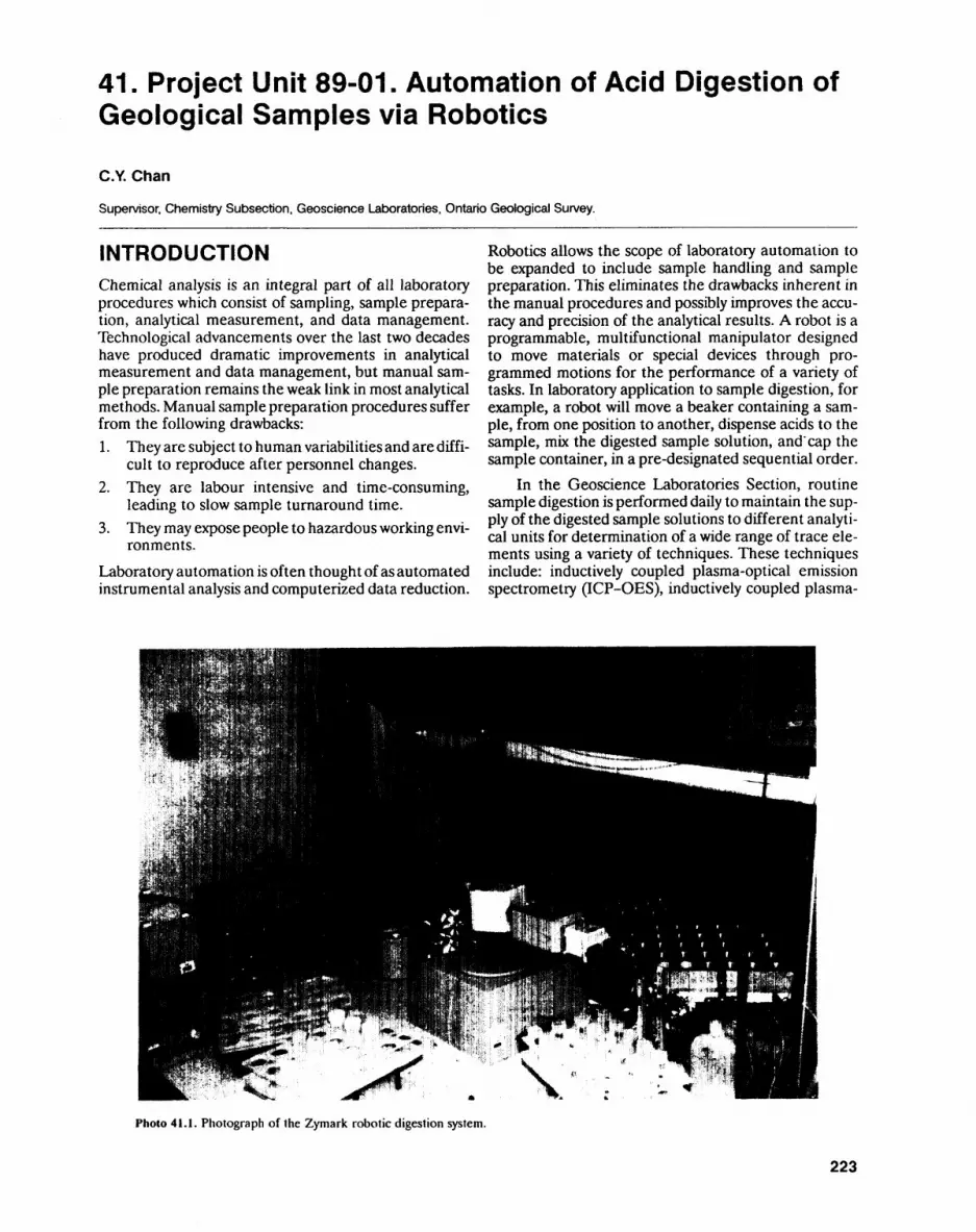
41. Project Unit 89-01. Automation of Acid Digestion of Geological Samples via Robotics
C.Y. Chan
Supervisor. Chemistry Subsection, Geoscience Laboratories. Ontario Geological Survey.
INTRODUCTIONChemical analysis is an integral part of all laboratory procedures which consist of sampling, sample prepara tion, analytical measurement, and data management. Technological advancements over the last two decades have produced dramatic improvements in analytical measurement and data management, but manual sam ple preparation remains the weak link in most analytical methods. Manual sample preparation procedures suffer from the following drawbacks:1. They are subject to human variabilities and are diffi
cult to reproduce after personnel changes.2. They are labour intensive and time-consuming,
leading to slow sample turnaround time.3. They may expose people to hazardous working envi
ronments.
Laboratory automation is often thought of as automated instrumental analysis and computerized data reduction.
Robotics allows the scope of laboratory automation to be expanded to include sample handling and sample preparation. This eliminates the drawbacks inherent in the manual procedures and possibly improves the accu racy and precision of the analytical results. A robot is a programmable, multifunctional manipulator designed to move materials or special devices through pro grammed motions for the performance of a variety of tasks. In laboratory application to sample digestion, for example, a robot will move a beaker containing a sam ple, from one position to another, dispense acids to the sample, mix the digested sample solution, and'cap the sample container, in a pre-designated sequential order.
In the Geoscience Laboratories Section, routine sample digestion is performed daily to maintain the sup ply of the digested sample solutions to different analyti cal units for determination of a wide range of trace ele ments using a variety of techniques. These techniques include: inductively coupled plasma-optical emission spectrometry (ICP-OES), inductively coupled plasma-
Photo 41.1. Photograph of the Zymark robotic digestion system.
223
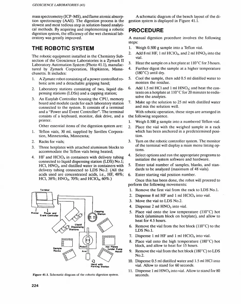
GEOSCIENCE LABORATORIES (41)
mass spectrometry (ICP-MS), and flame atomic absorp tion spectroscopy (AAS). The digestion process is the slowest and most tedious step in solution-based analyti cal methods. By acquiring and implementing a robotic digestion system, the efficiency of the wet chemical lab oratory was greatly improved.
THE ROBOTIC SYSTEMThe robotic equipment installed in the Chemistry Sub section of the Geoscience Laboratories is a Zymark II Laboratory Automation System (Photo 41.1), manufac tured by Zymark Corporation, Hopkinton, Massa chusetts. It includes:1. A Zymate robot consisting of a power controlled ro
botic arm and a detachable gripping hand;2. Laboratory stations consisting of two, liquid dis
pensing stations (LDSs) and a capping station;3. An Easylab Controller housing the CPU, memory
board and module cards for each laboratory station connected to the system. It consists of a terminal and a "Power and Event Controller". The terminal consists of a keyboard, monitor, disk drive, and a printer.Other essential items of the digestion system are:
1. Teflon vials, 30 ml, supplied by Savillex Corpora tion, Minnetonka, Minnesota;
2. Racks for vials;3. Three hotplates with attached aluminum blocks to
accommodate the Teflon vials being heated;4. HF and HC1O4 in containers with delivery tubing
connected to liquid dispensing station (LDS) No.l; HC1, HNO3, and distilled water in containers with delivery tubing connected to LDS No.2. (All the acids used are concentrated acids, i.e., HF, HC1, 38^0; HNO3, 7096; and HCIO4, 60%.)
Terminal
J l Printer Power and
Event Controller
Sample Racks
Hot Plate*(under Fume
P"uo^x. Hood) o Oo)
Hand with Parking Station
Figure 41.1. Schematic diagram of the robotic digestion system.
A schematic diagram of the bench layout of the di gestion system is displayed in Figure 41.1.
PROCEDUREA manual digestion procedure involves the following steps:1. Weigh 0.500 g sample into a Teflon vial.2. Add 8 ml HF, l ml HC1O4 , and 2 ml HNO3 into the
vial.3. Heat the sample on a hot plate at 110 0 C for 3 hours.4. Further digest the sample at a higher temperature
(180 0 C) until dry.5. Cool the sample, then add 0.5 ml distilled water to
moisten the residue.6. Add 1.5 ml HC1 and l ml HNO3; and heat the con
tents on a hotplate at 110"C for 20 minutes to redis- solve the analytes.
7. Make up the solution to 25 ml with distilled water and mix the solution well.With robotic operation, these steps are arranged in
the following sequence.1. Weigh 0.500 g sample into a numbered Teflon vial.2. Place the vial with the weighed sample in a rack
which has been anchored in a predetermined posi tion.
3. Turn on the robotic controller system. The monitor of the terminal will display a main menu listing op tions.
4. Select options and run the appropriate programs to initialize the system software and hardware.
5. Enter total number of samples, blanks, and stan dards to be analyzed (maximum of 48 vials).
6. Enter starting vial position number.Once this has been done, the robot will proceed to
perform the following movements:1. Remove the first vial from the rack to LDS No.l.
2. Dispense 8 ml HF and l ml HC1O4 into vial.3. Move the vial to LDS No.2.4. Dispense 2 ml HNO3 into vial.5. Place vial onto the low temperature (l 10" C) hot
block (aluminum block on hotplate), and allow to heat for 4.5 hours.
6. Remove the vial from the hot block (110"C) to the LDS No.l.
7. Dispense l ml HF and l ml HC1O4 into vial.8. Place vial onto the high temperature (180 0 C) hot
block, and allow to heat for 15 hours.9. Remove the vial from the hot block (l80"C) to LDS
No.2.10. Dispense 0.5 ml distilled water and 1.5 ml HC1 into
vial. Allow to stand for 60 seconds.11. Dispense l ml HNO3 into vial. Allow to stand for 80
seconds.
224
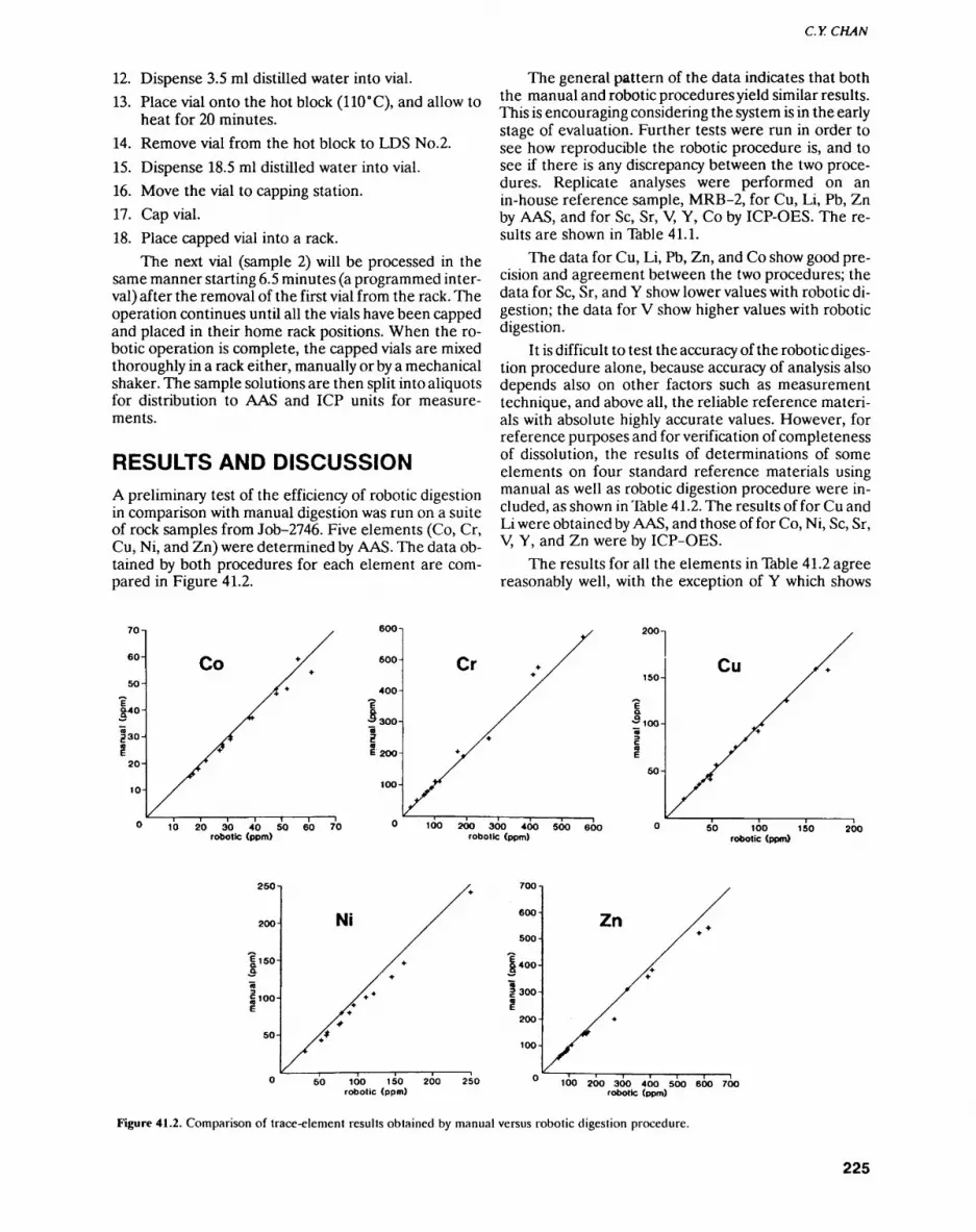
C.YCHAN
12. Dispense 3.5 ml distilled water into vial.13. Place vial onto the hot block (110 0 C), and allow to
heat for 20 minutes.14. Remove vial from the hot block to LDS No.2.15. Dispense 18.5 ml distilled water into vial.16. Move the vial to capping station.17. Cap vial.18. Place capped vial into a rack.
The next vial (sample 2) will be processed in the same manner starting 6.5 minutes (a programmed inter val) after the removal of the first vial from the rack. The operation continues until all the vials have been capped and placed in their home rack positions. When the ro botic operation is complete, the capped vials are mixed thoroughly in a rack either, manually or by a mechanical shaker. The sample solutions are then split into aliquots for distribution to AAS and ICP units for measure ments.
RESULTS AND DISCUSSIONA preliminary test of the efficiency of robotic digestion in comparison with manual digestion was run on a suite of rock samples from Job-2746. Five elements (Co, Cr, Cu, Ni, and Zn) were determined by AAS. The data ob tained by both procedures for each element are com pared in Figure 41.2.
The general pattern of the data indicates that both the manual and robotic procedures yield similar results. This is encouraging considering the system is in the early stage of evaluation. Further tests were run in order to see how reproducible the robotic procedure is, and to see if there is any discrepancy between the two proce dures. Replicate analyses were performed on an in-house reference sample, MRB-2, for Cu, Li, Pb, Zn by AAS, and for Se, Sr, V, Y, Co by ICP-OES. The re sults are shown in Table 41.1.
The data for Cu, Li, Pb, Zn, and Co show good pre cision and agreement between the two procedures; the data for Se, Sr, and Y show lower values with robotic di gestion; the data for V show higher values with robotic digestion.
It is difficult to test the accuracy of the robotic diges tion procedure alone, because accuracy of analysis also depends also on other factors such as measurement technique, and above all, the reliable reference materi als with absolute highly accurate values. However, for reference purposes and for verification of completeness of dissolution, the results of determinations of some elements on four standard reference materials using manual as well as robotic digestion procedure were in cluded, as shown in Table 41.2. The results of for Cu and Li were obtained by AAS, and those of for Co, Ni, Se, Sr, V, Y, and Zn were by ICP-OES.
The results for all the elements in Table 41.2 agree reasonably well, with the exception of Y which shows
70-i
60-
50-
|40
JZ30-
l 20-
10-
Co
600
500
400-
Cr Cu
10 20 30 40 SO 60 70 robotic (ppm)
100 2OO 300 400 500 600 robotic (ppm)
SO 100 150 200 robotic (ppm)
250-
200 -J
|150- 3
Ni
700-j
600-
500-
|400-
fsoo-
200-
100-
Zn
50 10O 150 200 250 robotic (ppm)
100 200 300 400 500 600 700 robotic (ppm)
Figure 41.2. Comparison of trace-element results obtained by manual versus robotic digestion procedure.
225
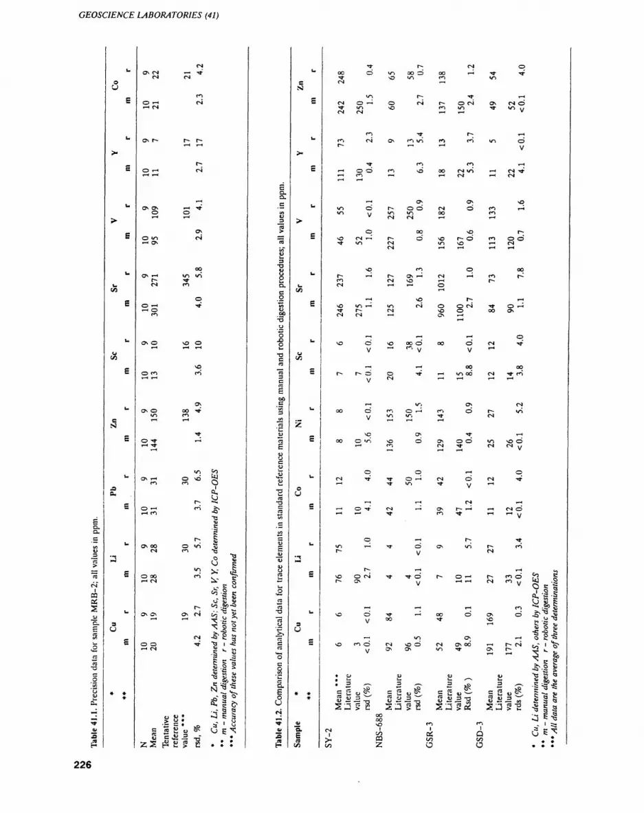
GEOSCIENCE LABORATORIES (41)
eQ.a.
CO
ra>"ra. ^
01lm
05S"E.
TO
•2ra
•S.5 ^S2'u u
*-4TT
Ol
f*
u
OU
E
E
u
^.
E
U
^
CO
E
fc-o
C/i
E
u
cS)
E
JS
S
u
aE
L.
3O
E
* * *
01
ON OI T-H TtOI Csl
fio T-H oiT-H OI
ON r-- r- r-
r~o t-H oit-H T-H
T-H
ON ON T-H TtO Ot-H T-H
ON O Vi oiT-I ON
OO
ON t-H VI Vit** TtCsl fi
oO t-H TtT-H O
fi
ON O NO OT-H T-H t-H
NO
O fi fiT-H l— 1
ONON O oo Tt
VI fiT-H T-H
Tt
O Tt t-Jt-H Tt
Vi JOON t-* o NO y
fi fi O
. ^r^ "-tO T-H fi ^.
T-H fi -O
.C
5-. S
ON OO O Vi ^
N " o -2xJ C
O oo fi . ^J*T-I 01 X g
C^N N^
- ** m
(~- "^ '-IP'SON ON ON o! C/i ^.
1—1 *~H ^C -~ O X 0 |
c, *1aoo Tt -Q i -e'-KN g K. ^
'S ~
111l-ll
^ c fr
S. O * ^"^ "** O*~* s * s* ' *j
8 e J3 J2 -Q- *ZS[^Si5i2 ***
cd.o.c
i1"ra
Sa•o
Q.C0
S^"
op'-SooS-ocra
"ra3c:ra S00c"55
in.2
eascwu"w
•o ra
TJ
2cin
CE
— "o(DUra*^Ui
•2rara-a
"ra o
cC3*o
1aEa
rsiT?
4)
3H
U
SSI
E
L.
E
**
5^
c
L.
UCO
E
**
u
E
L.
-
Z
E
u
0CJ
G
u
ac
3U
M
* *
*
TV"o.
nCO
Tt r^ ol oOO O Vi OO O OO t-HTt TtTt NO V4 fi V)01 T-H
V) r- Tt T-H01 o T-H o oi r-ooi ONOIOTtV) NO fi V) TtVlt/ Ol 01 T-H T-I V
fi Tt r- T-Hfi oi ON fi vi fi fivi OP-- T-H T-I y
Tt f) fi T-I
T-HOO fi NO ooolvi T-HolTtT-H fi T^ j-! (VI r* 01
t-H ON ON NO
vi o'r-oo'oi o'fi I-HVI v/ Vi Vi OO fi
V 01 01 T-H T-H
o oo NO r- NO oi t — * i^- o NO r** o fi o oTt VI Ol Vi NO t-H Ol
Ol T— 1 T-H T-H l— l
NO fi O OOr- T—l O* ON T— 1 Ol T-H fi f^fi 01 NO t-H r~Ol T-H T-H O
T-H
-H \q r-; t-HNO Vi T-H Vi OJ O O Ol Tt O t-H
Tt r- Ol NO O oo ONOl Ol t-H ON t-H
T-H
1—— 1 T— 1 T-* O
NO ONOOOO'OO OOl rty — f . y y T-I
———l T—— 1 OO OO
r-* r"~ c^ c^ Tt T— i vi oo oi Tt fii/ Ol T-H 1 — 1 T-H T-H
t-H Vi ON Oloo o fi o t-* fi Or~ vi
y Vi V, Tt 01
NO ON Tt T-; OO ^^ ift NO ^D ON -^3 ^D VI NO C^
t-H fi Ol Tt Ol Ol y
O O T-4 O
Ol Tt Tf O T-H OJ O Ol TtT-H Tt Vi Tt y i-H
* — ' CD Tt Ol * — i ON f"-- T-H T-H ol CDt-H t— i Tt flTt t— It— 1 y
O I-H r-; Tt ift i — i Tt CD ON vi r^ fit- y ^
t-- T-H ^H c,
NO ooi Tt Tto r~ o i— ' r~ fi o ?^ 5f^ ON yy t-H t-H Ol fi v/ ^J -S
N^ Si f51 Q 2
(X, '3 -5
NO S Sr-J -H ^H fi ^ -
NO OTt T-HOO OON C5 -Q1 ^Jy 00 tt NO ^ .y T3
T-H m ON T-H o 2 "SNO fiO Ol NO O Ol ONOO T-H t^f^cX" 1 ^
y ON ON VI Tt ON t^ ,2 i^T-* t-H 3 Sjj
Hs 2^v Q ^
: 1 ^ | ^ 1 7 |^|.l|G 5o^, ^2o^ C 5u^^ ^So^, s— ^
^S '"t rt r/y *^ "~s C3 ift *t^ ""8 CQ .j *Cj -** (Q -Q ftj JJ^J>i:: -iJ>I2 ^J>a ^;^_l>c "QaS
00 "~( 5 -S00 "J K ^5NO fi fi ^ 1 ^2
rsi 1 1 1 3 ~ TTt
i w 05 Q ^J *?lo z o o . : :
226
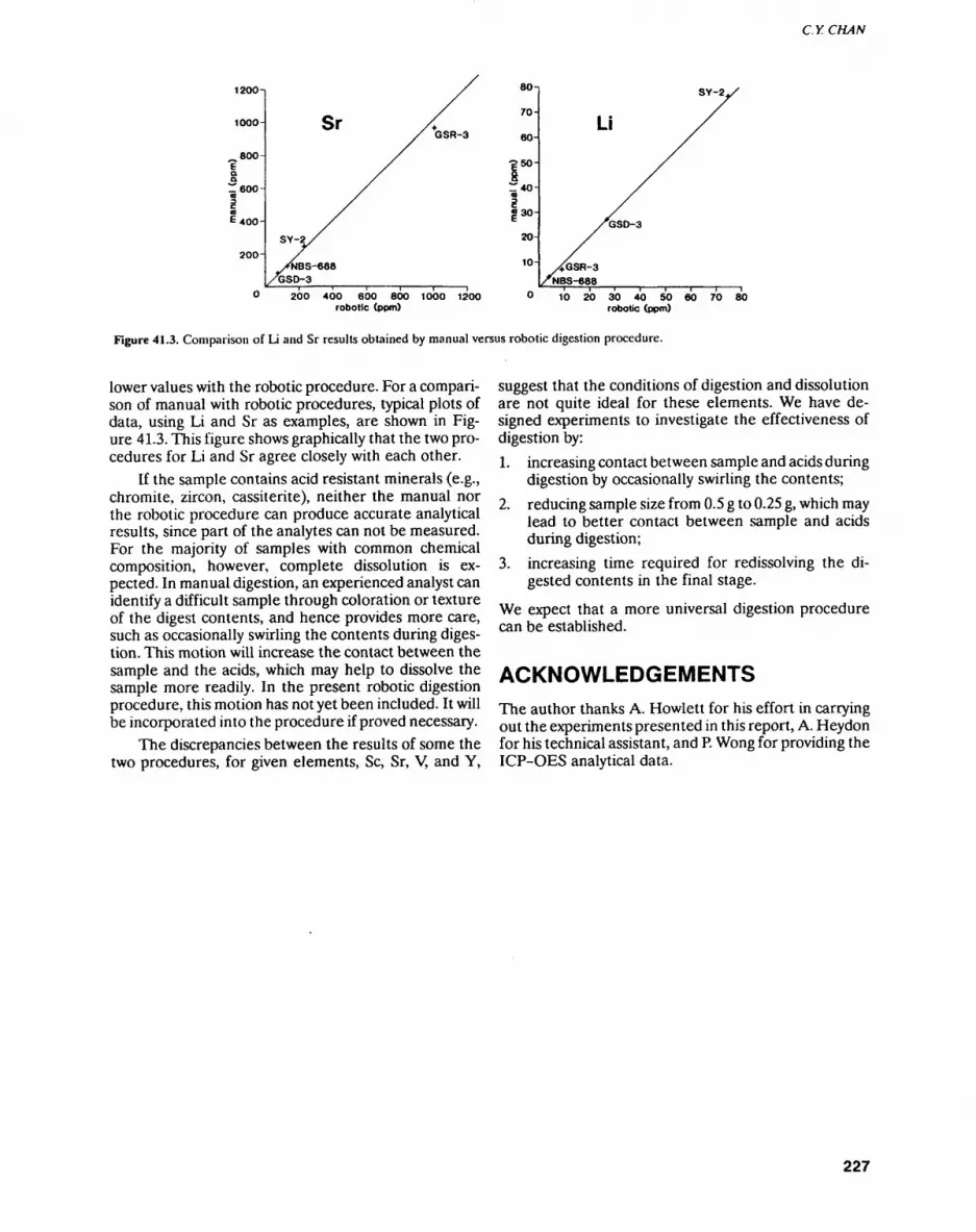
C.YCHAN
1200-
1000-
800-
ea E 400-
SrGSR-3
200 400 600 800 1000 12OO robotic (ppm)
80-j
70-
60-
gso-~ co
|30-|
20-
10-
SY-2.
Li
1O 20 30 40 SO 60 70 80 robotic (ppm)
Figure 41.3. Comparison of Li and Sr results obtained by manual versus robotic digestion procedure.
lower values with the robotic procedure. For a compari son of manual with robotic procedures, typical plots of data, using Li and Sr as examples, are shown in Fig ure 41.3. This figure shows graphically that the two pro cedures for Li and Sr agree closely with each other.
If the sample contains acid resistant minerals (e.g., chromite, zircon, cassiterite), neither the manual nor the robotic procedure can produce accurate analytical results, since part of the analytes can not be measured. For the majority of samples with common chemical composition, however, complete dissolution is ex pected. In manual digestion, an experienced analyst can identify a difficult sample through coloration or texture of the digest contents, and hence provides more care, such as occasionally swirling the contents during diges tion. This motion will increase the contact between the sample and the acids, which may help to dissolve the sample more readily. In the present robotic digestion procedure, this motion has not yet been included. It will be incorporated into the procedure if proved necessary.
The discrepancies between the results of some the two procedures, for given elements, Se, Sr, V, and Y,
suggest that the conditions of digestion and dissolution are not quite ideal for these elements. We have de signed experiments to investigate the effectiveness of digestion by:1. increasing contact between sample and acids during
digestion by occasionally swirling the contents;
2. reducing sample size from 0.5 g to 0.25 g, which may lead to better contact between sample and acids during digestion;
3. increasing time required for redissolving the di gested contents in the final stage.
We expect that a more universal digestion procedure can be established.
ACKNOWLEDGEMENTSThe author thanks A. Hewlett for his effort in carrying out the experiments presented in this report, A. Heydon for his technical assistant, and P. Wong for providing the ICP-OES analytical data.
227
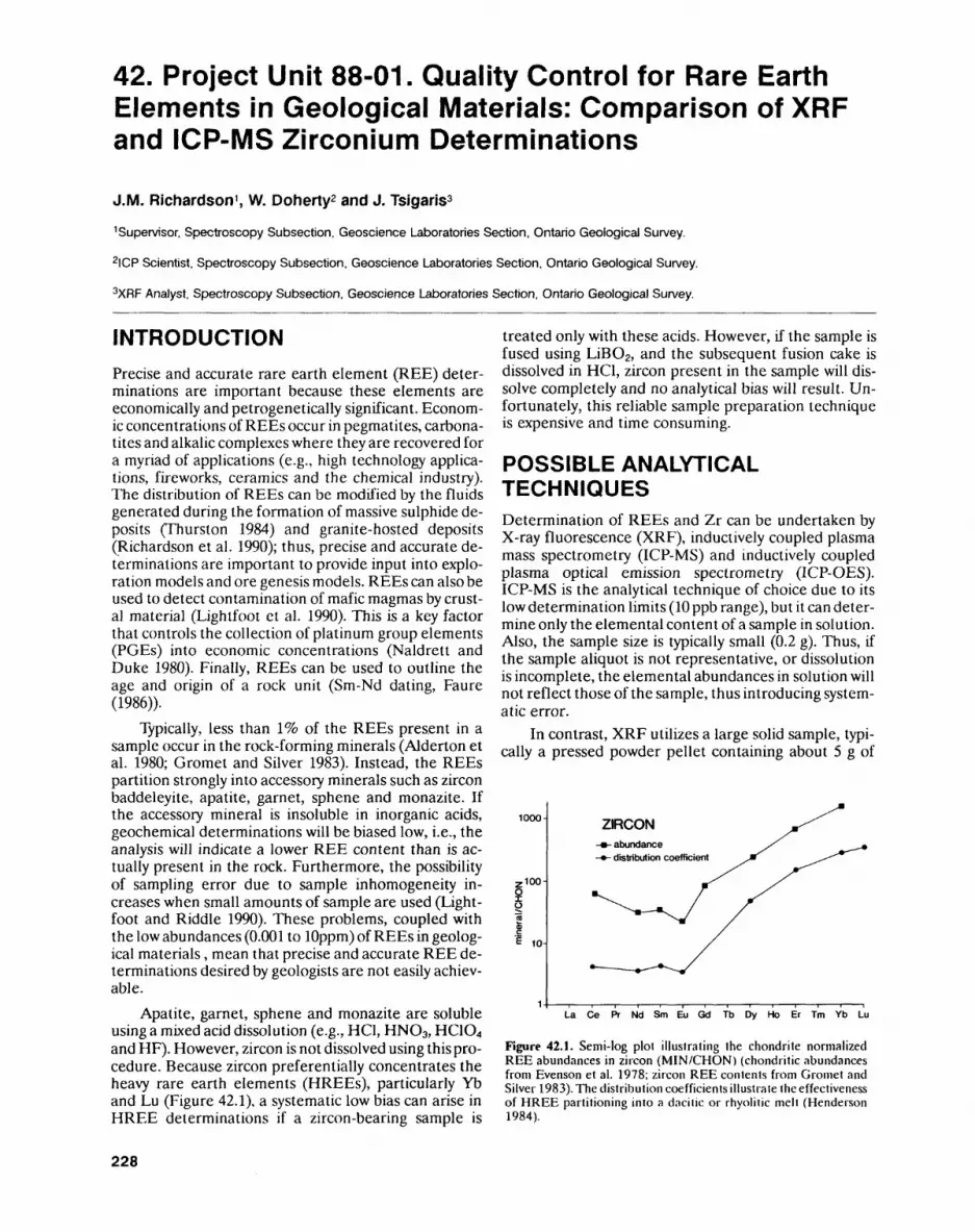
42. Project Unit 88-01. Quality Control for Rare Earth Elements in Geological Materials: Comparison of XRF and ICP-MS Zirconium Determinations
J.M. Richardson 1 , W. Doherty2 and J. Tsigaris3
Supervisor, Spectroscopy Subsection, Geoscience Laboratories Section, Ontario Geological Survey.
2ICP Scientist. Spectroscopy Subsection, Geoscience Laboratories Section, Ontario Geological Survey.
3XRF Analyst, Spectroscopy Subsection, Geoscience Laboratories Section, Ontario Geological Survey.
INTRODUCTIONPrecise and accurate rare earth element (REE) deter minations are important because these elements are economically and petrogenetically significant. Econom ic concentrations of REEs occur in pegmatites, carbona- tites and alkalic complexes where they are recovered for a myriad of applications (e.g., high technology applica tions, fireworks, ceramics and the chemical industry). The distribution of REEs can be modified by the fluids generated during the formation of massive sulphide de posits (Thurston 1984) and granite-hosted deposits (Richardson et al. 1990); thus, precise and accurate de terminations are important to provide input into explo ration models and ore genesis models. REEs can also be used to detect contamination of mafic magmas by crust al material (Lightfoot et al. 1990). This is a key factor that controls the collection of platinum group elements (PGEs) into economic concentrations (Naldrett and Duke 1980). Finally, REEs can be used to outline the age and origin of a rock unit (Sm-Nd dating, Faure (1986)).
Typically, less than 196 of the REEs present in a sample occur in the rock-forming minerals (Alderton et al. 1980; Gromet and Silver 1983). Instead, the REEs partition strongly into accessory minerals such as zircon baddeleyite, apatite, garnet, sphene and monazite. If the accessory mineral is insoluble in inorganic acids, geochemical determinations will be biased low, i.e., the analysis will indicate a lower REE content than is ac tually present in the rock. Furthermore, the possibility of sampling error due to sample inhomogeneity in creases when small amounts of sample are used (Light foot and Riddle 1990). These problems, coupled with the low abundances (0.001 to lOppm) of REEs in geolog ical materials, mean that precise and accurate REE de terminations desired by geologists are not easily achiev able.
Apatite, garnet, sphene and monazite are soluble using a mixed acid dissolution (e.g., HC1, HNO3, HC1O4 and HF). However, zircon is not dissolved using this pro cedure. Because zircon preferentially concentrates the heavy rare earth elements (HREEs), particularly Yb and Lu (Figure 42.1), a systematic low bias can arise in HREE determinations if a zircon-bearing sample is
treated only with these acids. However, if the sample is fused using LiBO2, and the subsequent fusion cake is dissolved in HC1, zircon present in the sample will dis solve completely and no analytical bias will result. Un fortunately, this reliable sample preparation technique is expensive and time consuming.
POSSIBLE ANALYTICAL TECHNIQUESDetermination of REEs and Zr can be undertaken by X-ray fluorescence (XRF), inductively coupled plasma mass spectrometry (ICP-MS) and inductively coupled plasma optical emission spectrometry (ICP-OES). ICP-MS is the analytical technique of choice due to its low determination limits (10 ppb range), but it can deter mine only the elemental content of a sample in solution. Also, the sample size is typically small (0.2 g). Thus, if the sample aliquot is not representative, or dissolution is incomplete, the elemental abundances in solution will not reflect those of the sample, thus introducing system atic error.
In contrast, XRF utilizes a large solid sample, typi cally a pressed powder pellet containing about 5 g of
1000-
.100-
10-
ZIRCON-abundance- distribution coefficient
La Ce Pr Nd Sm Eu Gd Tb Dy Ho Er Tm Yb Lu
Figure 42.1. Semi-log plot illustrating the chondrite normalized REE abundances in zircon (MIN/CHON) (chondritic abundances from Evenson et al. 1978; zircon REE contents from Gromet and Silver 1983). The distribution coefficients illustrate the effectiveness of HREE partitioning into a dacilic or rhyolitic melt (Henderson 1984).
228
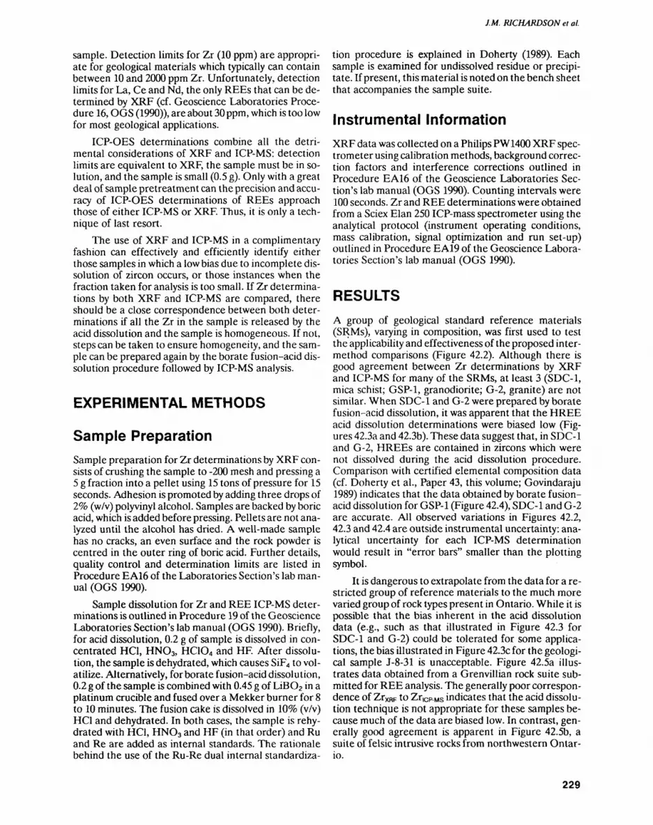
J.M. RICHARDSON et al.
sample. Detection limits for Zr (10 ppm) are appropri ate for geological materials which typically can contain between 10 and 2000 ppm Zr. Unfortunately, detection limits for La, Ce and Nd, the only REEs that can be de termined by XRF (cf. Geoscience Laboratories Proce dure 16, OGS (1990)), are about 30 ppm, which is too low for most geological applications.
ICP-OES determinations combine all the detri mental considerations of XRF and ICP-MS: detection limits are equivalent to XRF, the sample must be in so lution, and the sample is small (0.5 g). Only with a great deal of sample pretreatment can the precision and accu racy of ICP-OES determinations of REEs approach those of either ICP-MS or XRF. Thus, it is only a tech nique of last resort.
The use of XRF and ICP-MS in a complimentary fashion can effectively and efficiently identify either those samples in which a low bias due to incomplete dis solution of zircon occurs, or those instances when the fraction taken for analysis is too small. If Zr determina tions by both XRF and ICP-MS are compared, there should be a close correspondence between both deter minations if all the Zr in the sample is released by the acid dissolution and the sample is homogeneous. If not, steps can be taken to ensure homogeneity, and the sam ple can be prepared again by the borate fusion-acid dis solution procedure followed by ICP-MS analysis.
EXPERIMENTAL METHODS
Sample PreparationSample preparation for Zr determinations by XRF con sists of crushing the sample to -200 mesh and pressing a 5 g fraction into a pellet using 15 tons of pressure for 15 seconds. Adhesion is promoted by adding three drops of J.% (w/v) polyvinyl alcohol. Samples are backed by boric acid, which is added before pressing. Pellets are not ana lyzed until the alcohol has dried. A well-made sample has no cracks, an even surface and the rock powder is centred in the outer ring of boric acid. Further details, quality control and determination limits are listed in Procedure EA16 of the Laboratories Section's lab man ual (OGS 1990).
Sample dissolution for Zr and REE ICP-MS deter minations is outlined in Procedure 19 of the Geoscience Laboratories Section's lab manual (OGS 1990). Briefly, for acid dissolution, 0.2 g of sample is dissolved in con centrated HC1, HNO3, HC1O4 and HF. After dissolu tion, the sample is dehydrated, which causes SiF4 to vol atilize. Alternatively, for borate fusion-acid dissolution, 0.2 g of the sample is combined with 0.45 g of LiBO2 in a platinum crucible and fused over a Mekker burner for 8 to 10 minutes. The fusion cake is dissolved in 1096 (v/v) HC1 and dehydrated. In both cases, the sample is rehy- drated with HC1, HNO3 and HF (in that order) and Ru and Re are added as internal standards. The rationale behind the use of the Ru-Re dual internal standardiza
tion procedure is explained in Doherty (1989). Each sample is examined for undissolved residue or precipi tate. If present, this material is noted on the bench sheet that accompanies the sample suite.
Instrumental InformationXRF data was collected on a Philips PW1400 XRF spec trometer using calibration methods, background correc tion factors and interference corrections outlined in Procedure EA16 of the Geoscience Laboratories Sec tion's lab manual (OGS 1990). Counting intervals were 100 seconds. Zr and REE determinations were obtained from a Sciex Elan 250 ICP-mass spectrometer using the analytical protocol (instrument operating conditions, mass calibration, signal optimization and run set-up) outlined in Procedure EA19 of the Geoscience Labora tories Section's lab manual (OGS 1990).
RESULTSA group of geological standard reference materials (SRMs), varying in composition, was first used to test the applicability and effectiveness of the proposed inter- method comparisons (Figure 42.2). Although there is good agreement between Zr determinations by XRF and ICP-MS for many of the SRMs, at least 3 (SDC-1, mica schist; GSP-1, granodiorite; G-2, granite) are not similar. When SDC-1 and G-2 were prepared by borate fusion-acid dissolution, it was apparent that the HREE acid dissolution determinations were biased low (Fig ures 42.3a and 42.3b). These data suggest that, in SDC-1 and G-2, HREEs are contained in zircons which were not dissolved during the acid dissolution procedure. Comparison with certified elemental composition data (cf. Doherty et al., Paper 43, this volume; Govindaraju 1989) indicates that the data obtained by borate fusion- acid dissolution for GSP-1 (Figure 42.4), SDC-1 and G-2 are accurate. All observed variations in Figures 42.2, 42.3 and 42.4 are outside instrumental uncertainty: ana lytical uncertainty for each ICP-MS determination would result in "error bars" smaller than the plotting symbol.
It is dangerous to extrapolate from the data for a re stricted group of reference materials to the much more varied group of rock types present in Ontario. While it is possible that the bias inherent in the acid dissolution data (e.g., such as that illustrated in Figure 42.3 for SDC-1 and G-2) could be tolerated for some applica tions, the bias illustrated in Figure 42.3c for the geologi cal sample J-8-31 is unacceptable. Figure 42.5a illus trates data obtained from a Grenvillian rock suite sub mitted for REE analysis. The generally poor correspon dence of ZrXRF to Zricp.MS indicates that the acid dissolu tion technique is not appropriate for these samples be cause much of the data are biased low. In contrast, gen erally good agreement is apparent in Figure 42.5b, a suite of felsic intrusive rocks from northwestern Ontar io.
229
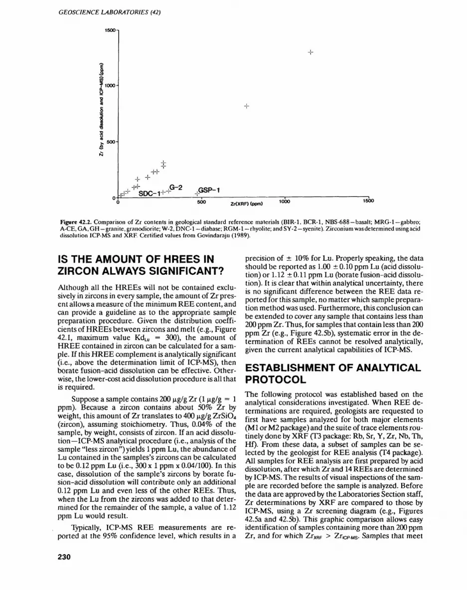
GEOSCIENCE LABORATORIES (42)
1500-
1000-
500-
-H-
SDC-1,G-2
,GSP-1500 Zr(XRF) (ppm) 1000 1500
Figure 42.2. Comparison of Zr contents in geological standard reference materials (BIR-1, BCR-1, NBS-688 basalt; MRG-1 gabbro; A-CE, GA, GH granite, granodiorite; W-2, DNC-1 diabase; RGM-1 rhyolite; and SY-2 syenite). Zirconium was determined using acid dissolution ICP-MS and XRF. Certified values from Govindaraju (1989).
IS THE AMOUNT OF HREES IN ZIRCON ALWAYS SIGNIFICANT?Although all the HREEs will not be contained exclu sively in zircons in every sample, the amount of Zr pres ent allows a measure of the minimum REE content, and can provide a guideline as to the appropriate sample preparation procedure. Given the distribution coeffi cients of HREEs between zircons and melt (e.g., Figure 42.1, maximum value KdLu = 300), the amount of HREE contained in zircon can be calculated for a sam ple. If this HREE complement is analytically significant (i.e., above the determination limit of ICP-MS), then borate fusion-acid dissolution can be effective. Other wise, the lower-cost acid dissolution procedure is all that is required.
Suppose a sample contains 200 jjig/g Zr (l ng/g = l ppm). Because a zircon contains about 5096 Zr by weight, this amount of Zr translates to 400 p-g/g ZrSiO4 (zircon), assuming stoichiometry. Thus, D.04% of the sample, by weight, consists of zircon. If an acid dissolu tion ICP-MS analytical procedure (i.e., analysis of the sample "less zircon") yields l ppm Lu, the abundance of Lu contained in the samples's zircons can be calculated to be 0.12 ppm Lu (i.e., 300 x l ppm x 0.04/100). In this case, dissolution of the sample's zircons by borate fu sion-acid dissolution will contribute only an additional 0.12 ppm Lu and even less of the other REEs. Thus, when the Lu from the zircons was added to that deter mined for the remainder of the sample, a value of 1.12 ppm Lu would result.
Typically, ICP-MS REE measurements are re ported at the 959o confidence level, which results in a
precision of IQVo for Lu. Properly speaking, the data should be reported as 1.00 0.10 ppm Lu (acid dissolu tion) or 1.12 0.11 ppm Lu (borate fusion-acid dissolu tion). It is clear that within analytical uncertainty, there is no significant difference between the REE data re ported for this sample, no matter which sample prepara tion method was used. Furthermore, this conclusion can be extended to cover any sample that contains less than 200 ppm Zr. Thus, for samples that contain less than 200 ppm Zr (e.g., Figure 42.5b), systematic error in the de termination of REEs cannot be resolved analytically, given the current analytical capabilities of ICP-MS.
ESTABLISHMENT OF ANALYTICAL PROTOCOLThe following protocol was established based on the analytical considerations investigated. When REE de terminations are required, geologists are requested to first have samples analyzed for both major elements (Ml or M2 package) and the suite of trace elements rou tinely done by XRF (T3 package: Rb, Sr, Y, Zr, Nb, Th, Hf). From these data, a subset of samples can be se lected by the geologist for REE analysis (T4 package). All samples for REE analysis are first prepared by acid dissolution, after which Zr and 14 REEs are determined by ICP-MS. The results of visual inspections of the sam ple are recorded before the sample is analyzed. Before the data are approved by the Laboratories Section staff, Zr determinations by XRF are compared to those by ICP-MS, using a Zr screening diagram (e.g., Figures 42.5a and 42.5b). This graphic comparison allows easy identification of samples containing more than 200 ppm Zr, and for which ZrXRF > ZriCP. MS. Samples that meet
230
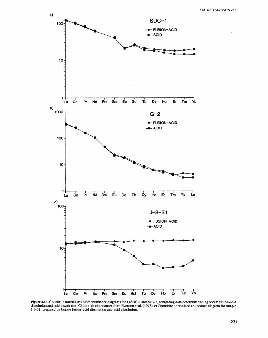
J.M. RICHARDSON el al.a)
100-
10-
1
SDC-1- FUSION-ACID-ACID
La Ce Pr Nd Pm Sm Eu Gd Tb Dy Ho Er Tm Ybb)
1000 n G-2
"- FUSION-ACID i-ACID
100^
10-
La Ce Pr Nd Sm Eu Gd Tb Dy Ho Er Tm Yb Lu
c)100-1
10-
J-8-31
-•-FUSION- ACID-•-ACID
La Ce Pr Nd Pm Sm Eu Gd Tb Dy Ho Er Tm Yb
Figure 42.3. Chondrite normalized REE abundance diagrams for a) SDC-1 and b) G-2, comparing data determined using borate fusion-acid dissolution and acid dissolution. Chondritic abundances from Evenson et al. (1978). c) Chondrite normalized abundance diagram for sample J-8-31, prepared by borate fusion-acid dissolution and acid dissolution.
231
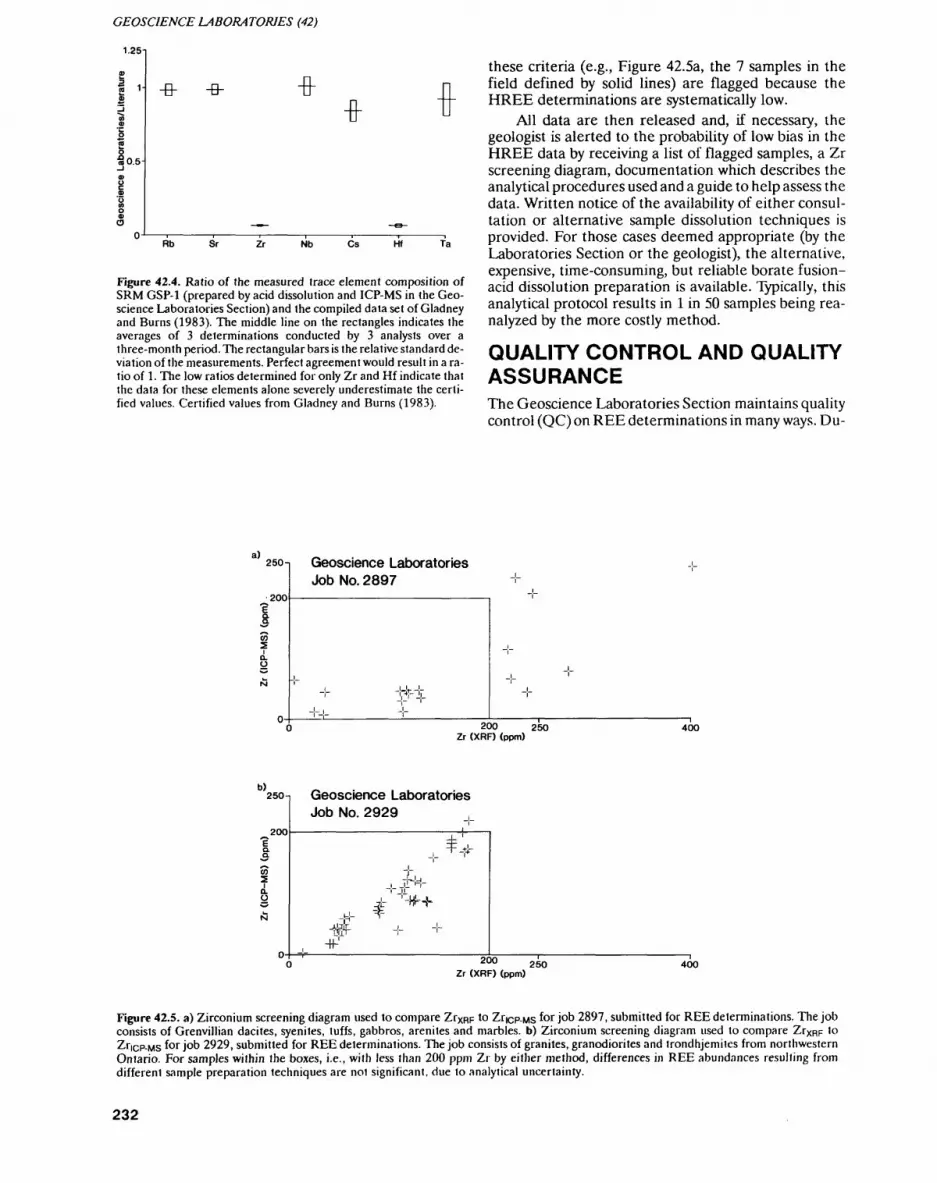
GEOSCIENCE LABORATORIES (42)
1.25i
1-
i 0.5
-B- -B- -B--B-
Rb Sr Zr Nb Cs Ta
Figure 42.4. Ratio of the measured trace element composition of SRM GSP-1 (prepared by acid dissolution and ICP-MS in the Geo science Laboratories Section) and the compiled data set of Gladney and Burns (1983). The middle line on the rectangles indicates the averages of 3 determinations conducted by 3 analysts over a three-month period. The rectangular bars is the relative standard de viation of the measurements. Perfect agreement would result in a ra tio of 1. The low ratios determined for only Zr and Hf indicate that the data for these elements alone severely underestimate the certi fied values. Certified values from Gladney and Burns (1983).
these criteria (e.g., Figure 42.5a, the 7 samples in the field defined by solid lines) are flagged because the HREE determinations are systematically low.
All data are then released and, if necessary, the geologist is alerted to the probability of low bias in the HREE data by receiving a list of flagged samples, a Zr screening diagram, documentation which describes the analytical procedures used and a guide to help assess the data. Written notice of the availability of either consul tation or alternative sample dissolution techniques is provided. For those cases deemed appropriate (by the Laboratories Section or the geologist), the alternative, expensive, time-consuming, but reliable borate fusion- acid dissolution preparation is available. Typically, this analytical protocol results in l in 50 samples being rea nalyzed by the more costly method.
QUALITY CONTROL AND QUALITY ASSURANCEThe Geoscience Laboratories Section maintains quality control (QC) on REE determinations in many ways. Du-
a) 250 T Geoscience Laboratories Job No. 2897
200
200 250 Zr (XRF) (ppm)
400
b)250 -i
200
Geoscience Laboratories Job No. 2929
-t#-TT-'
200 Zr (XRF) (ppm)
250 400
Figure 42.5. a) Zirconium screening diagram used to compare Zrxpp to Zricp-ws for job 2897, submitted for REE determinations. The job consists of Grenvillian dacites, syenites, tuffs, gabbros, arenites and marbles, b) Zirconium screening diagram used to compare ZrXRp 'o Zricp-MS fQr job 2929, submitted for REE determinations. The job consists of granites, granodiorites and trondhjemiles from northwestern Ontario. For samples within the boxes, i.e., with less than 200 ppm Zr by either method, differences in REE abundances resulting from different sample preparation techniques are not significant, due lo analytical uncertainty.
232

J. M. RICHARDSON et al.
plicates, and instrument and digestion check samples are run with each batch of samples. Solutions prepared by both acid dissolution and borate fusion-acid dissolu tion are visually monitored for insoluble residue or pre cipitates. Zirconium results from ICP-MS and XRF de terminations are compared, and if the results are signifi cantly different, the samples are flagged. An effective, but costly and slow, borate fusion-acid dissolution pro cedure is available for flagged samples.
Such a quality control program has numerous bene fits beyond a precise and accurate elemental determina tion. Most importantly, procedures have been put in place to eliminate or monitor the serious impact that the complex nature of geological materials can have on ana lytical determinations. Resources (time, money and equipment) are utilized as efficiently as possible. Quali ty control transcends individual procedures and is com parative in nature. Two units within the Laboratories Section (ICP and XRF) are involved, thus increasing communication among analysts.
Quality assurance (QA) is the written documenta tion that outlines the steps that are taken to assure that a method is valid and being used properly (sample prep aration, instrumental determinations, QC and QA). Quality assurance associated with REE determinations at the Geoscience Laboratories Section is sixfold. All methods are written up in a publicly accessible lab man ual (OGS 1990). Scientists and technicians within the Laboratories Section must sign-off that the method(s) used has been completed as intended and written. The Laboratories Section also provides written and verbal consultation to geologists before and after the data are released. The analysts are educated as to the signifi cance of the complexity of geological material and the geologists are informed about the geoanalytical consid erations in written releases. Thus, the data are gener ated and used in an informed way.
IMPLICATIONS FOR MINERAL EXPLORATION, PROCESS CONTROL AND PETROGENETIC APPLICATIONS
The Geoscience Laboratories Section provides respon sible, accurate and precise elemental determinations for geological materials in a cost-effective and efficient manner. Advertised analytical capabilities are based on long-term ( greater than 5 year), multi-batch precision and accuracy studies. Sample preparation and instru mental techniques available for geological materials are optimized and the data are reported with caveats, if nec essary. This method of data reporting puts the onus on the geologist to determine if the data, as reported, are acceptable. Acceptability is obviously controlled by the end use of the data and the absolute abundances of REEs present in the sample. The Laboratories Section is capable and willing to provide follow-up consultation.
and has supplementary techniques available to address special requests or samples.
Specifically, this means that a geologist must decide if all REE data generated for a suite of samples can be used without hesitation for any purpose. If not, specific samples should either be reanalyzed or ignored, de pending on the significance of the sample. Alternative ly, it is possible that biased data can be used, when the level of bias is known.
For instance, some sets of data are normalized against the composition of chondritic meteorites (e.g., Masuda 1962; Coryell et al. 1963) to yield plots such as Figures 42.3a to 42.3c. Such relative graphical portrayals can be used to characterize and compare rock suites or document changes due to geological processes. Typical examples include igneous fractionation or alteration by fluids related to ore deposits (Richardson et al. 1990). In these cases, analytical bias can be tolerated if it is within the compositional range of the data in question. Howev er, it is critical to know the degree of bias (determined from a graph such as Figure 42.5a) and ascertain that it does not exceed that due to geological processes. This approach is particularly appropriate when the elemental abundances are well above chondritic values.
However, in the instances where the absolute ele mental abundance data is to be used, and the contents are very close to chondritic values or the analytical bias is great, acid dissolution data is not likely to be appropri ate. Examples of such applications include exploration or ore processing decisions based on absolute abun dances (i.e., ppm values), or modelling petrogenetic processes using elemental abundances or ratios (e.g., Lightfoot et al. 1990). In these instances, a Zr screening diagram can be used to quickly and effectively deter mine which samples require the more costly and time- consuming sample preparation procedure. This results in a high level of confidence in decisions based upon the data.
APPLICABILITY OF THIS ANALYTICAL APPROACHThe results of this study highlight the problems involved with method development, and steps that must be taken to ensure that determinations are both cost effective and accurate for routine elemental analysis. Complicat ing spectroscopic and chemical factors are documented and can be taken into account. However, the complex nature of geological materials (many elements in nu merous mineral phases) means that method develop ment is difficult and must be approached carefully. Method validation, using a small group of standard ref erence materials, is not adequate to ensure precise and accurate results for the range of geological samples that are encountered in many analytical facilities (e.g., gov ernment, private and university laboratories).
Geologists and geoanalysts using REE data for ei ther geological samples or SRMs (e.g., Abbey 1983; Go- vindaraju, 1989) should be discriminating in their accep tance of data. As indicated by Hall and Plant (1990),
233
GEOSCIENCE LABORATORIES (42)
there are numerous reports listing the successful appli cation of ICP-MS to REE analysis. However, these workers all employed acid dissolution procedures to prepare the SRMs, and thus the application of these procedures and data indiscriminately to a wide variety of unknown samples will result in erroneous data.
Thoughtful understanding of the nature of geologi cal materials and the end use of geochemical data is vital to both successful routine analyses, and the cost-effec tive use of analytical instrumentation. The superb de termination limits of ICP-MS can be utilized by the geo logical community at large, given these restrictions. The intermethod comparison described above is in routine use in the Geoscience Laboratories Section, and is a cost-effective procedure which eliminates the uncer tainty that arises due to mineralogical and sample prep aration considerations. As a result, geologist, analyst and management satisfaction is high. Such a package could be easily accommodated by private sector labora tories to offer "high-quality" REE packages for numer ous commercial applications.
CONCLUSIONSIGP-MS is the technique of choice for REE analyses due to its low detection limits and ability to determine 14 REEs. However, this technique requires that the sam ple be introduced as a liquid. Zircons do not readily dis solve in inorganic acids, and thus it is possible that the HREEs, which are concentrated in this mineral, are in accurately determined in some samples. To address this problem in all zircon-bearing geological materials, the Geoscience Laboratories Section has developed an cost-effective and efficient analytical protocol that con sists of sample preparation by: acid dissolution or borate fusion-acid dissolution, XRF and ICP-MS instrumental techniques, and data-screening procedures with accom panying QC and QA documentation. In keeping with the Ministry's mandate to provide leadership in seeking and identifying new developmental opportunities and promote economic development, these procedures are further described elsewhere and are available from the Geoscience Laboratories, Ontario Geological Survey (OGS (1990).
ACKNOWLEDGMENTSDenver Stone and Michael Easton of the Precambrian Geology Section of the Ontario Geological Survey kindly allowed the use of their data. Sample J-8-31 was provided by Gwendy Hall, Geological Survey of Cana da. The Ontario Geological Survey's ICP-mass spec trometer was purchased with the assistance of the Prov ince of Ontario BILD program. Co-operation with Sciex has resulted in the high quality of the data achieved here.
REFERENCESAbbey, S. 1983. Studies in "standard samples" of silicate rocks and
minerals 1969-1982; Geological Survey of Canada, Paper 83-15, 114p.
Alderton, D.H.M., Pearce, J.A. and Potts, P.J. 1980. Rare earth ele ment mobility during granite alteration: evidence from southwest England; Earth and Planetary Science Letters, v.49, p.149-165.
Coryell, C.G., Chase, J.W. and Winchester, J.W. 1963. A procedure for geochemical interpretation of terrestrial rare-earth abun dance patterns; Journal of Geophysical Research, v.68, p.559-566.
Doherty, W. 1989. An internal standardization procedure for the de termination of yttrium and the rare earth elements in geological materials by inductively coupled plasma mass spectrometry; Spectrochimica Acta, V.44B, p.263-280.
Evenson, N.M., Hamilton, P.J. and O'Nions, R.K., 1978. Rare earth abundances in chondritic meteorites; Geochimica et Cosmo- chimica Acta, v.42, p.1199-1212.
Faure, G. 1986. Principles of isotope geology, John Wiley and Sons, Toronto, 589p.
Gladney, E.S. and Burns, C.E. 1983. 1982 Compilation of elemental concentrations in eleven United States Geological Survey rock standards; Geostandards Newsletter, v.7, p.3-226.
Govindaraju, K. 1989. 1989 Compilation of working values and sam ple descriptionvfor 272 geostandards; Geostandards Newsletter, v.13, p.1-113.
Gromet, PL. and Silver, L.T. 1983. Rare earth element distributions among minerals in a granodiorite and their petrogenetic implica tions; Geochemica et Cosmochimica Acta, v.47, p.925.
Hall,G.E.M. and Plant, J. 1990. Are your REE results total?; Explore, v.68, p. 18-19.
Henderson, P. 1984. General geochemical properties and abundances of the rare earth elements; in Rare Earth Element Geochemistry, Elsevier Scientific Publishing Company, p.1-32.
Lightfoot, PC. and Riddle, C. 1990. An introductory guide to sam pling for geoanalysis; Ontario Geological Survey, 18p.
Lightfoot, PC., Naldrett, A.J., Gorbachev, N.S., Doherty, W. and Fe- dorenko, V.A. 1990. Geochemistry of the Siberian Trap of the Noril'sk area, USSR, with implications for the relative contribu tions of crust and mantle to flood basalt magmatism; Contribu tions to Mineralogy and Petrology, v.104, p.631-644.
Masuda, A. 1962. Regularities in variation of relative abundances of lanthanide elements and an attempt to analyze separation index patterns of some minerals; Journal Earth Science Nagoya Uni versity, v.lO, p.173.
Naldrett, A.J. and Duke, M.J. 1980. Pt metals in magmatic sulphide ores: the occurrence of these metals is discussed in relation to the formation and importance of these ores; Science, v.208, p.1417-1424.
Ontario Geological Survey, 1990. The analysis of geological materials, volume II: a manual of methods; Ontario Geological Survey, Mis cellaneous Paper 149.
Richardson, J. M., Bell, K., Watkinson, D.H. and Blenkinsop, J. 1990. Genesis and fluid evolution of the East Kemptville grei- sen-hosted tin deposit, southwestern Nova Scotia; in Ore-Bear ing Granite Systems: Petrogenesis and Mineralization Processes, Geological Society of America Special Paper 246.
Thurston, P.C. 1984. Economic evaluation of Archean felsic volcanic rocks using REE geochemistry; in Geological Society of Austra lia, Special Publication No. 7, p.439-450.
234
43. Project Unit 89-01. Determination of 22 Trace Elements in Geological Materials by Inductively Coupled Plasma Mass Spectrometry
W. Doherty1 , P. Wong2, A.E. Hodges3
1 ICP Scientist. Geoscience Laboratories Section, Ontario Geological Survey.
2ICP Technician. Geoscience Laboratories Section. Ontario Geological Survey.
Scientist, Geoscience Laboratories Section. Ontario Geological Survey.
INTRODUCTION
Recent studies at the Ontario Geological Survey (OGS), such as those involving the application of trace element discrimination diagrams as indicators of the tectonic setting of rocks and their mineral potential (e.g.. Lightfoot et al. 1990), have demanded the accu rate, precise, reproducible and cost effective analysis for Y, Rb, ST, Zr, Nb, Hf, Ta, Cs and the naturally occurring rare earth elements (REEs) in rocks with low REE abundances. A method has been developed which al lows the determination of all the elements of interest down to 0.05 ppm with high accuracy (about 2 to 5^o) and low precision (less than SVo relative standard deviation (rsd), long term reproducibility) using a single, simple, sample preparation procedure, and inductively coupled plasma mass-spectrometry (ICP-MS) as the analytical finish. This paper will summarize the details of the pro cedures used to achieve this performance, and the quali ty control data that have been established for the meth od.
EXPERIMENTAL METHODS
INSTRUMENTATION
An Elan 250 ICP mass spectrometer manufactured by Sciex (Thornhill, Ontario) was used. This instrument was purchased by the Geoscience Laboratories Section in 1985, through the Province of Ontario Board of In dustrial Leadership and Development (BILD) program. Details of the instrument operating conditions and ana lytical procedures have been presented elsewhere (Doherty 1989). Problems associated with geoanalytical applications of ICP-MS led to modifications of the de sign of the supersonic inlet of the ICP-MS interface (Doherty 1990) which have: extended the running time of the instrument; significantly lowered the detection limits, by about a factor of 10; and lowered operating costs by more than S30 000 over 3 years. These modifica tions have been incorporated into the current genera tion of commercial instruments.
SAMPLE PREPARATIONThe details of the acid dissolution procedure have been presented elsewhere (OGS 1990). Briefly, a three-stage mineral acid dissolution procedure is used to dissolve 0.200 g of rock powder. Each investigator prepared a set of 22 international reference materials using this proce dure. Each solution was analyzed in triplicate for the 22 elements of interest, using the ICP-MS procedures out lined elsewhere (OGS 1990). A comparison of the ICP-MS results for Zr with literature values derived from X-ray fluorescence (XRF) and neutron activation analysis (NAA) data sets readily identified those refer ence materials where acid insoluble zirconium-bearing mineral phases were present.
A sample preparation procedure was developed to ensure quantitative analyses when acid insoluble miner al phases are present in the sample. Briefly, the material is first fused with lithium metaborate and the resulting sample bead is treated with the three-step acid dissolu tion procedure. The details of the procedure have been given elsewhere (OGS 1990).
DATA REDUCTIONThe analytical error associated with the effects of physi cal processes occurring within the instrument during analyte signal measurement are compensated for by use of internal standards, and by a mathematical correction procedure which was originally developed for the deter mination of Y and the REEs in geological materials (Doherty 1989). This correction procedure has been ex tended in this work to apply to Rb, Cs, Sr, Zr, Nb, Hf and Ta.
DIGESTION CONTROLAn in-house basalt reference material (collected from the Osler Group volcanic sequence of the Black Bay Peninsula, Ontario) was used as a digestion control stan dard. Over a 2-month period, each investigator pre pared 8 aliquots of the pulp using the acid dissolution procedure. The 24 solutions were then analyzed for all of the elements of interest. The means and standard de viations calculated from this data set were used to estab lish the upper and lower warning and control limits for the digestion procedure.
235
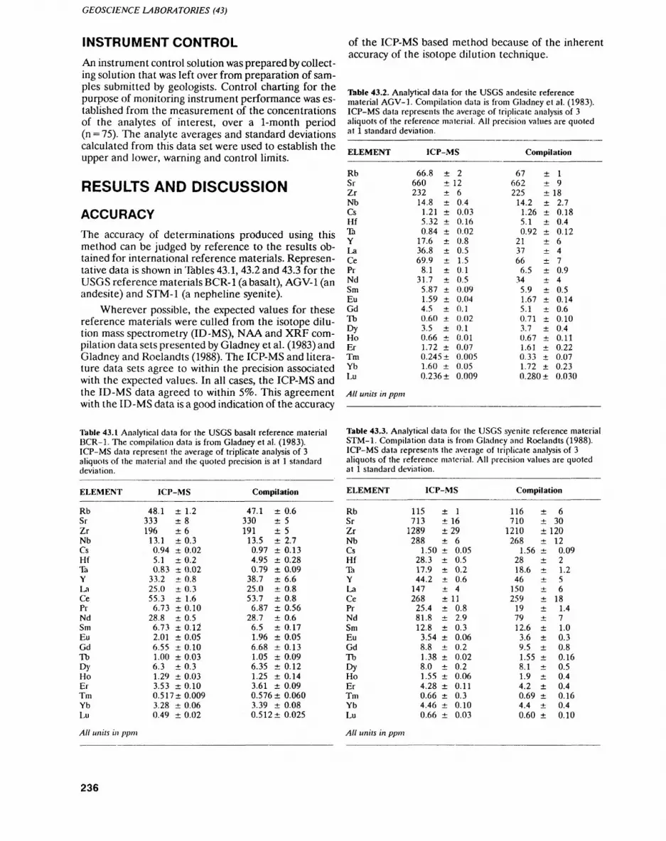
GEOSCIENCE LABORATORIES (43)
INSTRUMENT CONTROLAn instrument control solution was prepared by collect ing solution that was left over from preparation of sam ples submitted by geologists. Control charting for the purpose of monitoring instrument performance was es tablished from the measurement of the concentrations of the analytes of interest, over a 1-month period (n = 75). The analyte averages and standard deviations calculated from this data set were used to establish the upper and lower, warning and control limits.
RESULTS AND DISCUSSION
ACCURACYThe accuracy of determinations produced using this method can be judged by reference to the results ob tained for international reference materials. Represen tative data is shown in Tables 43.1, 43.2 and 43.3 for the USGS reference materials BCR-1 (a basalt), AGV-1 (an andesite) and STM-1 (a nepheline syenite).
Wherever possible, the expected values for these reference materials were culled from the isotope dilu tion mass spectrometry (ID-MS), NAA and XRF com pilation data sets presented by Gladney et al. (1983) and Gladney and Roelandts (1988). The ICP-MS and litera ture data sets agree to within the precision associated with the expected values. In all cases, the ICP-MS and the ID-MS data agreed to within 596. This agreement with the ID-MS data is a good indication of the accuracy
of the ICP-MS based method because of the inherent accuracy of the isotope dilution technique.
Table 43.2. Analytical dala for the USGS andesite reference material AGV-1. Compilation data is from Gladney et al. (1983). ICP-MS data represents the average of triplicate analysis of 3 aliquots of the reference material. All precision values are quoted at l standard deviation.
ELEMENT
RbSrZrNbCsHflaYLaCePiNdSmEuGdTbDyHoErTmYbLu
All units in ppm
ICP-MS
66.8 2660232
14.81.215.320.84
17.636.869.9
8.131.7
5.871.594.50.603.50.661.72
1260.40.030.160.020.80.51.50.10.50.090.040.10.020.10.010.07
0.245 ± 0.0051.60 ± 0.050.236 ± 0.009
Compilation
67 ± 1662225
14.21.265.10.92
213766
6.5345.91.675.10.713.70.671.610.331.72
9182.70.180.40.126470.940.50.140.60.100.40.110.220.070.23
0.280 0.030
Table 43.1 Analytical data for the USGS basalt reference material BCR-1. The compilalion data is from Gladney et al. (1983). ICP-MS data represent the average of triplicate analysis of 3 aliquots of the material and the quoted precision is at l standard deviation.
ELEMENT ICP-MS
RbSrZrNbCsHfTaYLaCePiNdSmEuGdTbDyHoErTmYbLu
48.1333196
13.10.945.10.83
33.225.055.36.73
28.86.732.016.551.006.31.293.530.5173.280.49
± 1.2± 8±6± 0.3± 0.02±0.2± 0.02± 0.8± 0.3± 1.6± 0.10± 0.5± 0.12± 0.05± 0.10± 0.03± 0.3± 0.03± 0.10± 0.009± 0.06± 0.02
Compilation
47.1 0.6330191
13.50.974.950.79
38.725.053.76.87
28.76.51.96
552.70.130.280.096.60.80.80.560.60.170.05
6.68 ± 0.131.05 ± 0.096.35 ± 0.121.25 ± 0.143.61 ± 0.090.576 ± 0.0603.39 ± 0.080.512 ± 0.025
Table 43.3. Analytical data for the USGS syenite reference material STM-1. Compilation data is from Gladney and Roelandts (1988). ICP-MS data represents the average of triplicate analysis of 3 aliquots of the reference material. All precision values are quoted at i standard deviation.
ELEMENT
RbSrZrNbCsHfTaYLaCePrNdSmEuGdTbDyHoErTmYbLu
ICP-MS
115 1713
1289288
1.5028.317.944.2
147268
25.481.812.8
3.548.81.388.01.554.280.66
1629
60.050.50.20.64
110.82.90.30.060.20.020.20.060.110.3
4.46 ± 0.100.66 ± 0.03
Compilation
116 ± 6710 ± 30
1210 ±120268
1.562818.646
150259
197912.6
3.69.51.558.11.94.2
120.0921.256
181.471.00.30.80.160.50.40.4
0.69 ± 0.164.4 ± 0.40.60 ± 0.10
AU units in ppm All units in ppm
236
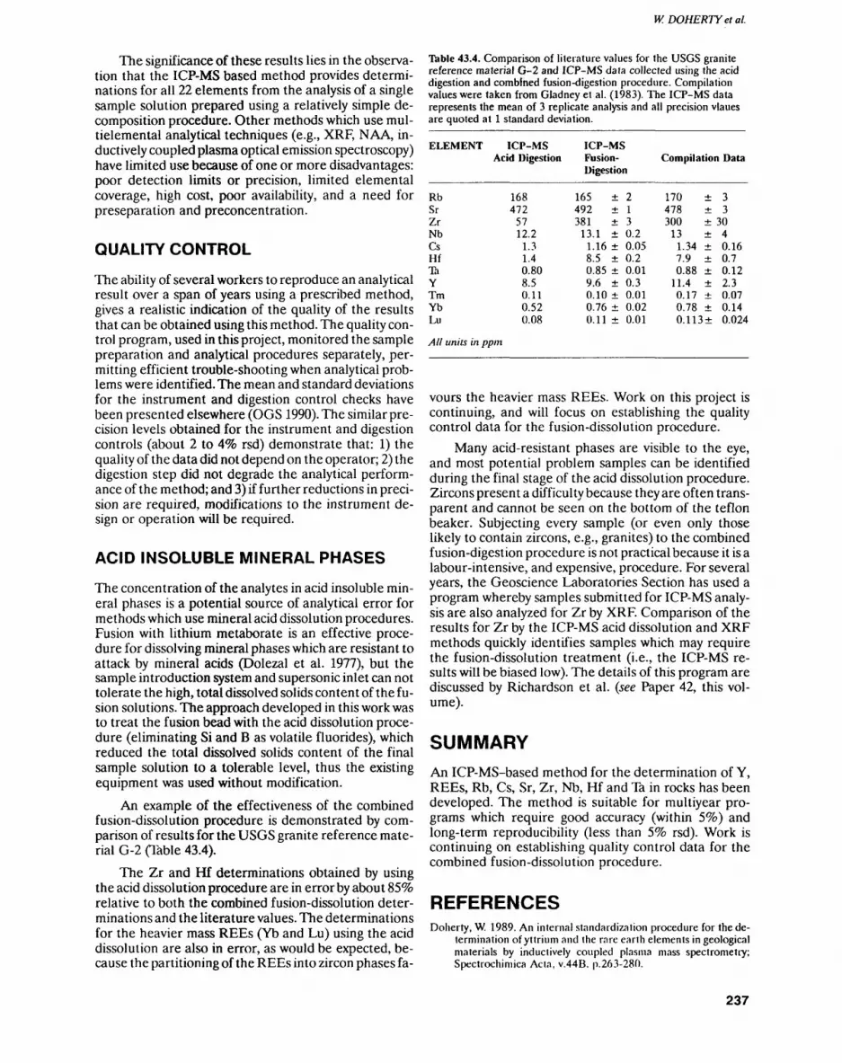
W. DOHERTY et al.
The significance of these results lies in the observa tion that the ICP-MS based method provides determi nations for all 22 elements from the analysis of a single sample solution prepared using a relatively simple de composition procedure. Other methods which use mul- tielemental analytical techniques (e.g., XRF, NAA, in ductively coupled plasma optical emission spectroscopy) have limited use because of one or more disadvantages: poor detection limits or precision, limited elemental coverage, high cost, poor availability, and a need for preseparation and preconcentration.
QUALITY CONTROL
The ability of several workers to reproduce an analytical result over a span of years using a prescribed method, gives a realistic indication of the quality of the results that can be obtained using this method. The quality con trol program, used in this project, monitored the sample preparation and analytical procedures separately, per mitting efficient trouble-shooting when analytical prob lems were identified. The mean and standard deviations for the instrument and digestion control checks have been presented elsewhere (OGS 1990). The similar pre cision levels obtained for the instrument and digestion controls (about 2 to 496 rsd) demonstrate that: 1) the quality of the data did not depend on the operator; 2) the digestion step did not degrade the analytical perform ance of the method; and 3) if further reductions in preci sion are required, modifications to the instrument de sign or operation will be required.
ACID INSOLUBLE MINERAL PHASES
The concentration of the analytes in acid insoluble min eral phases is a potential source of analytical error for methods which use mineral acid dissolution procedures. Fusion with lithium metaborate is an effective proce dure for dissolving mineral phases which are resistant to attack by mineral acids (Dolezal et al. 1977), but the sample introduction system and supersonic inlet can not tolerate the high, total dissolved solids content of the fu sion solutions. The approach developed in this work was to treat the fusion bead with the acid dissolution proce dure (eliminating Si and B as volatile fluorides), which reduced the total dissolved solids content of the final sample solution to a tolerable level, thus the existing equipment was used without modification.
An example of the effectiveness of the combined fusion-dissolution procedure is demonstrated by com parison of results for the USGS granite reference mate rial G-2 (Table 43.4).
The Zr and Hf determinations obtained by using the acid dissolution procedure are in error by about SSVo relative to both the combined fusion-dissolution deter minations and the literature values. The determinations for the heavier mass REEs (Yb and Lu) using the acid dissolution are also in error, as would be expected, be cause the partitioning of the REEs into zircon phases fa-
Table 43.4. Comparison of literature values for the USGS granite reference material Q-2 and ICP-MS data collected using the acid digestion and combined fusion-digest ion procedure. Compilation values were taken from Gladney et al. (1983). The ICP-MS data represents the mean of 3 replicate analysis and all precision vlaues are quoted at l standard deviation.
ELEMENT
RbSrZrNbCsHflaYTmYbLu
ICP-MSAcid Digestion
168472
5712.2
1.31.40.808.50.110.520.08
ICP-MS Fusion- Digestion
165 2492 1381 3
13.1 0.21.16 0.058.5 0.20.85 0.019.6 0.30.10 0.010.76 ± 0.020.11 ± 0.01
Compilation Data
170 3478 3300 30
13 41.34 0.167.9 0.70.88 0.12
11.4 2.30.17 0.070.78 0.140.113 0.024
All units in ppm
vours the heavier mass REEs. Work on this project is continuing, and will focus on establishing the quality control data for the fusion-dissolution procedure.
Many acid-resistant phases are visible to the eye, and most potential problem samples can be identified during the final stage of the acid dissolution procedure. Zircons present a difficulty because they are often trans parent and cannot be seen on the bottom of the teflon beaker. Subjecting every sample (or even only those likely to contain zircons, e.g., granites) to the combined fusion-digestion procedure is not practical because it is a labour-intensive, and expensive, procedure. For several years, the Geoscience Laboratories Section has used a program whereby samples submitted for ICP-MS analy sis are also analyzed for Zr by XRF. Comparison of the results for Zr by the ICP-MS acid dissolution and XRF methods quickly identifies samples which may require the fusion-dissolution treatment (i.e., the ICP-MS re sults will be biased low). The details of this program are discussed by Richardson et al. (see Paper 42, this vol ume).
SUMMARYAn ICP-MS-based method for the determination of Y, REEs, Rb, Cs, Sr, Zr, Nb, Hf and Ta in rocks has been developed. The method is suitable for multiyear pro grams which require good accuracy (within 59k) and long-term reproducibility (less than 5*??? rsd). Work is continuing on establishing quality control data for the combined fusion-dissolution procedure.
REFERENCESDoherty, W. 1989. An internal standardization procedure for the de
termination of yttrium and the rare earth elements in geological materials by inductively coupled plasma mass spectrometry; Spectrochimica Acta, v.44B. p.263-280.
237
GEOSCIENCE LABORATORIES (43)
—— 1990. A practical skimmer design for inductively coupled plas ma mass spectrometry: gas dynamic and analytical consider ations; unpublished MSc thesis, York University, North York, Ontario, 92p.
Dolezal, J., Sulcek, Z. and Povondra, P. 1977. Decomposition proce dures in inorganic analysis; Critical Reviews in Analytical Chem istry, v.6, p.255-323.
Gladney, E.S. and Roelandls, 1.1988. 1987 Compilation of elemental concentration data for USGS, BHVO-1. MAG-1, QLO-1, RGM-1, SCo-1, SDC-1, SGR-1 and STM-1; Geostandards Newsletter, v.12, p.253-362.
Gladney, E.S., Burns, C.E. and Roelandts, I. 1983. 1982 Compilation of elemental concentrations in eleven United States Geological Survey Rock Standards; Geostandards Newsletter, v.7, p.3-226.
Lightfoot, PC., Naldrett, A. J., Gorbachev, N.S., Doherty, W. and Fed- erenko, VA. 1990. Geochemistry of the Siberian Trap of the No- ril'sk area, USSR, with implications for the relative contributions of crust and mantle to flood basalt magmatism; Contributions to Mineralogy and Petrology, v.104, p.631-644.
Ontario Geological Survey 1990. The ana lysis of geological materials, volume II: a manual of methods; Ontario Geological Survey, Mis cellaneous Paper 149.
238
Armstrong, D.K., 159, 162 Ayer, J.A., 31
BBajc,A.E, 152 Barlow, R.B., 177, 198, 201 Barnett, P.J., 157
Beakhouse, G.P., 18, 91 B0Iviken, B., 178 Breaks, F.W, 41
Brodaric, B., 131
Byron, M., 59
Chan, C.Y., 223 Cherry, M.E., 3 Crabtree, D.C., 219
de Souza, H.A.F., 212 Doherty, W, 228, 235
Easton, R.M., 99 Edwards, G.R., 140
Ford, F, 99Fortescue, J.A.C., 178, 185
Fyon, J.A., 131
Garland, M.I., 133 Ghobrial, M., 219 Gorman, R.G., 162, 166 Gupta, VK., 190
HHeather, K.B., 120 Hodges, A.E., 219, 235
Jackson, S.L., 78 James, R.S., 62 Jensen, L.S., 53 Jones, G.R., 169, 172
KKimmerly, C.T., 78
Ughtfoot, PC., 207 Lockhard, M.A., 198
MMeyn, H.D., 135 Morris, TF, 149 Muir.TL., 117 Mussakowski, R.S., 120
OOsmani, LA., 190
pPeck, D.C., 62
Richardson, J.M., 228
Rowell, D., 212
Sage, R.P., 48
Sanborn-Barrie, M., 22
Shanks,W.S.,lll
Siragusa, G.M., 86
Stauffer, M.R., 140
Stone, D., 5
Sutcliffe, R.H., 91
Troop, D.G., 67
Trowell, N.F., 120
"Bigaris, J., 228
WWhite, O.L., 147
Whitehead, R.E., 59
Wilkinson, L.P., 78
Williams, H.R., 41
Wong, P., 235
XXiangdong, J., 78
239
CONVERSION FACTORS FOR MEASUREMENTS IN ONTARIO GEOLOGICAL SURVEY PUBLICATIONS
Conversion from SI to Imperial
SI Unit Multiplied by Gives
Conversion from Imperial to SI
Imperial Unit Multiplied by Gives
1 mm1 cm1 m1 m1 km
1 cm21 m21 km21 ha
1 cm31 m31 m3
1 L1 L1 L
1 g1 81 kg1 kg1 t1 kg1 t
1 g/t
1 g/t
0.039 370.393 703.280 840.049 709 70.621 371
0.155 010.763 90.386 102.471 054
0.061 0235.314 7
1.308 0
1.759 7550.879 8770.219 969
0.035 273 960.032 150 752.204 620.001 102 31.102 3110.000 984 210.984 206 5
0.029 166 6
0.583 333 33
LENGTHinches 1 inch 25.4inches 1 inch 2.54feet 1 foot 0.304 8chains 1 chain 20.116 8miles (statute) 1 mile (statute) 1.609 344
AREAsquare inches 1 square inch 6.451 6square feet 1 square foot 0.092 903 04square miles 1 square mile 2.589 988acres 1 acre 0.404 685 6
VOLUMEcubic inches 1 cubic inch 16.387 064cubic feet 1 cubic foot 0.028 316 85cubic yards 1 cubic yard 0.764 555
CAPACITYpints 1 pint 0.568 261quarts 1 quart 1.136 522gallons 1 gallon 4.546 090
MASSounces (avdp) 1 ounce (avdp) 28.349 523ounces (troy) 1 ounce (troy) 31.103 476 8pounds (avdp) 1 pound (avdp) 0.453 592 37tons (short) 1 ton (short) 907.184 74tons (short) 1 ton (short) 0.907 184 74tons (long) 1 ton (long) 1016.046 908 8tons (long) 1 ton (long) 1.016 046 908
CONCENTRATIONounce (troy)/ 1 ounce (troy)/ 34.285 714 2ton (short) ton (short)pennyweights/ 1 pennyweight/ 1.714 285 7ton (short) ton (short)
mmcmmm
km
cm2m2
km2ha
cm3m3m3
LLL
gg
kgkg
tkg
8 t
g/t
g/t
OTHER USEFUL CONVERSION FACTORS
l ounce (troy) per ton (short) l pennyweight per ton (short)
Multiplied by 20.0
0.05pennyweights per ton (short) ounces (troy) per ton (short)
Note: Conversion factors which are in bold type are exact. The conversion factors have been taken from or have been derived from factors given in the Metric Practice Guide for the Canadian Min ing and Metallurgical Industries, published by the Mining Association of Canada in co-operation with the Coal Association of Canada.
240
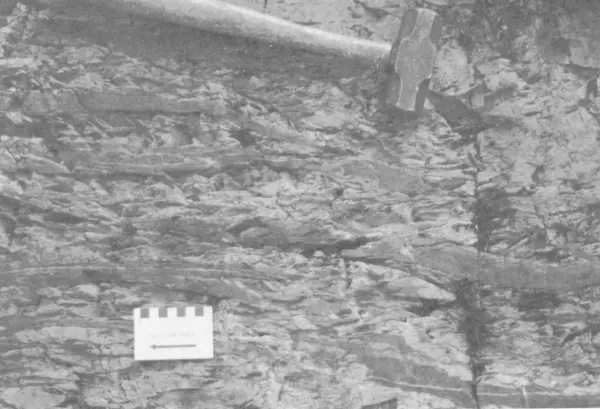
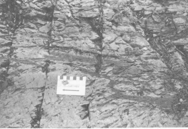
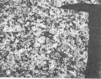


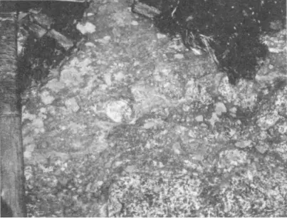
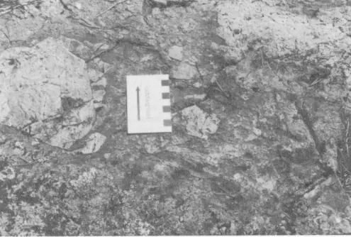
V
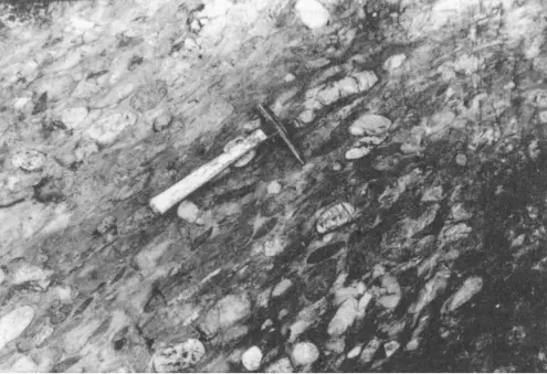
'•f* *\
, V
-f*'
R