Embed Size (px)
Citation preview
THESE TERMS GOVERN YOUR USE OF THIS DOCUMENT
Your use of this Ontario Geological Survey document (the “Content”) is governed by the terms set out on this page (“Terms of Use”). By downloading this Content, you (the
“User”) have accepted, and have agreed to be bound by, the Terms of Use.
Content: This Content is offered by the Province of Ontario’s Ministry of Northern Development and Mines (MNDM) as a public service, on an “as-is” basis. Recommendations and statements of opinion expressed in the Content are those of the author or authors and are not to be construed as statement of government policy. You are solely responsible for your use of the Content. You should not rely on the Content for legal advice nor as authoritative in your particular circumstances. Users should verify the accuracy and applicability of any Content before acting on it. MNDM does not guarantee, or make any warranty express or implied, that the Content is current, accurate, complete or reliable. MNDM is not responsible for any damage however caused, which results, directly or indirectly, from your use of the Content. MNDM assumes no legal liability or responsibility for the Content whatsoever. Links to Other Web Sites: This Content may contain links, to Web sites that are not operated by MNDM. Linked Web sites may not be available in French. MNDM neither endorses nor assumes any responsibility for the safety, accuracy or availability of linked Web sites or the information contained on them. The linked Web sites, their operation and content are the responsibility of the person or entity for which they were created or maintained (the “Owner”). Both your use of a linked Web site, and your right to use or reproduce information or materials from a linked Web site, are subject to the terms of use governing that particular Web site. Any comments or inquiries regarding a linked Web site must be directed to its Owner. Copyright: Canadian and international intellectual property laws protect the Content. Unless otherwise indicated, copyright is held by the Queen’s Printer for Ontario. It is recommended that reference to the Content be made in the following form: <Author’s last name>, <Initials> <year of publication>. <Content title>; Ontario Geological Survey, <Content publication series and number>, <total number of pages>p. Use and Reproduction of Content: The Content may be used and reproduced only in accordance with applicable intellectual property laws. Non-commercial use of unsubstantial excerpts of the Content is permitted provided that appropriate credit is given and Crown copyright is acknowledged. Any substantial reproduction of the Content or any commercial use of all or part of the Content is prohibited without the prior written permission of MNDM. Substantial reproduction includes the reproduction of any illustration or figure, such as, but not limited to graphs, charts and maps. Commercial use includes commercial distribution of the Content, the reproduction of multiple copies of the Content for any purpose whether or not commercial, use of the Content in commercial publications, and the creation of value-added products using the Content. Contact:
FOR FURTHER INFORMATION ON PLEASE CONTACT: BY TELEPHONE: BY E-MAIL:
The Reproduction of Content
MNDM Publication Services
Local: (705) 670-5691 Toll Free: 1-888-415-9845, ext.
5691 (inside Canada, United States)
The Purchase of MNDM Publications
MNDM Publication Sales
Local: (705) 670-5691 Toll Free: 1-888-415-9845, ext.
5691 (inside Canada, United States)
Crown Copyright Queen’s Printer Local: (416) 326-2678 Toll Free: 1-800-668-9938
(inside Canada, United States)
LES CONDITIONS CI-DESSOUS RÉGISSENT L'UTILISATION DU PRÉSENT DOCUMENT.
Votre utilisation de ce document de la Commission géologique de l'Ontario (le « contenu ») est régie par les conditions décrites sur cette page (« conditions d'utilisation »). En
téléchargeant ce contenu, vous (l'« utilisateur ») signifiez que vous avez accepté d'être lié par les présentes conditions d'utilisation.
Contenu : Ce contenu est offert en l'état comme service public par le ministère du Développement du Nord et des Mines (MDNM) de la province de l'Ontario. Les recommandations et les opinions exprimées dans le contenu sont celles de l'auteur ou des auteurs et ne doivent pas être interprétées comme des énoncés officiels de politique gouvernementale. Vous êtes entièrement responsable de l'utilisation que vous en faites. Le contenu ne constitue pas une source fiable de conseils juridiques et ne peut en aucun cas faire autorité dans votre situation particulière. Les utilisateurs sont tenus de vérifier l'exactitude et l'applicabilité de tout contenu avant de l'utiliser. Le MDNM n'offre aucune garantie expresse ou implicite relativement à la mise à jour, à l'exactitude, à l'intégralité ou à la fiabilité du contenu. Le MDNM ne peut être tenu responsable de tout dommage, quelle qu'en soit la cause, résultant directement ou indirectement de l'utilisation du contenu. Le MDNM n'assume aucune responsabilité légale de quelque nature que ce soit en ce qui a trait au contenu. Liens vers d'autres sites Web : Ce contenu peut comporter des liens vers des sites Web qui ne sont pas exploités par le MDNM. Certains de ces sites pourraient ne pas être offerts en français. Le MDNM se dégage de toute responsabilité quant à la sûreté, à l'exactitude ou à la disponibilité des sites Web ainsi reliés ou à l'information qu'ils contiennent. La responsabilité des sites Web ainsi reliés, de leur exploitation et de leur contenu incombe à la personne ou à l'entité pour lesquelles ils ont été créés ou sont entretenus (le « propriétaire »). Votre utilisation de ces sites Web ainsi que votre droit d'utiliser ou de reproduire leur contenu sont assujettis aux conditions d'utilisation propres à chacun de ces sites. Tout commentaire ou toute question concernant l'un de ces sites doivent être adressés au propriétaire du site. Droits d'auteur : Le contenu est protégé par les lois canadiennes et internationales sur la propriété intellectuelle. Sauf indication contraire, les droits d'auteurs appartiennent à l'Imprimeur de la Reine pour l'Ontario. Nous recommandons de faire paraître ainsi toute référence au contenu : nom de famille de l'auteur, initiales, année de publication, titre du document, Commission géologique de l'Ontario, série et numéro de publication, nombre de pages. Utilisation et reproduction du contenu : Le contenu ne peut être utilisé et reproduit qu'en conformité avec les lois sur la propriété intellectuelle applicables. L'utilisation de courts extraits du contenu à des fins non commerciales est autorisé, à condition de faire une mention de source appropriée reconnaissant les droits d'auteurs de la Couronne. Toute reproduction importante du contenu ou toute utilisation, en tout ou en partie, du contenu à des fins commerciales est interdite sans l'autorisation écrite préalable du MDNM. Une reproduction jugée importante comprend la reproduction de toute illustration ou figure comme les graphiques, les diagrammes, les cartes, etc. L'utilisation commerciale comprend la distribution du contenu à des fins commerciales, la reproduction de copies multiples du contenu à des fins commerciales ou non, l'utilisation du contenu dans des publications commerciales et la création de produits à valeur ajoutée à l'aide du contenu. Renseignements :
POUR PLUS DE RENSEIGNEMENTS SUR VEUILLEZ VOUS
ADRESSER À : PAR TÉLÉPHONE : PAR COURRIEL :
la reproduction du contenu
Services de publication du MDNM
Local : (705) 670-5691 Numéro sans frais : 1 888 415-9845,
poste 5691 (au Canada et aux États-Unis)
l'achat des publications du MDNM
Vente de publications du MDNM
Local : (705) 670-5691 Numéro sans frais : 1 888 415-9845,
poste 5691 (au Canada et aux États-Unis)
les droits d'auteurs de la Couronne
Imprimeur de la Reine
Local : 416 326-2678 Numéro sans frais : 1 800 668-9938
(au Canada et aux États-Unis)
irOntario
Division of Mines
HONOURABLE LEO BERNIER, Minister of Natural Resources
Dr. J. K. REYNOLDS, Deputy Minister of Natural ResourcesG. A. Jewett, Executive Director, Division of Mines E. G. Pye, Director, Geological Branch
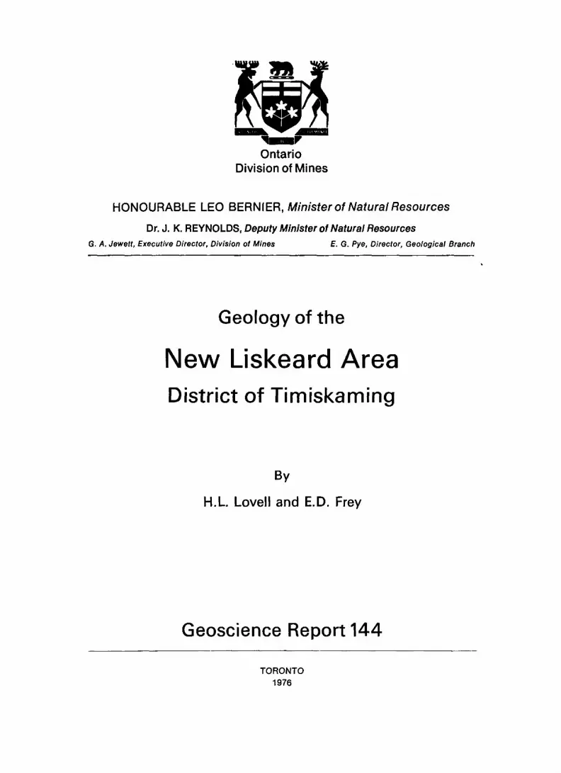
Geology of the
New Liskeard AreaDistrict of Timiskaming
By
H.L Lovell and E.D. Frey
Geoscience Report 144
TORONTO 1976
© ODM 1972
Publications of the Ontario Division of Minesand price list
are obtainable through theOntario Ministry of Natural Resources, Map Unit, Public Service Centre,
Parliament Buildings, Queen's Park, Toronto, Ontarioand
The Ontario Government Bookstore 880 Bay Street, Toronto, Ontario.
Orders for publications should be accompanied by cheque, or money order, payable to Treasurer of Ontario.
Parts of this publication may be quoted if credit is given to the Ontario Division of Mines. It is recommended that reference to this report be made in the following form:
Lovell, H.L., and Frey, E.D.1976: Geology of the New Liskeard Area, District of Timiskaming, Ontario Div. Mines,
GR 144, 34p. Accompanied by Maps 2300 and 2301, scale l inch to ^ mile (1:31,680).
1000-300-76-Car
CONTENTSPAGE
Abstract ........................................................................... vIntroduction ........................................................................ l
Previous Geological Work .................................................... .2Field Work ................................................................. .2Acknowledgments ............................................................ 2Topography and Drainage .... ................................................. 3Resources ..........,......................................................... 3
General Geology ................................................................... .4Table of Lithologic Units ............................................. 5
Precambrian ..................................................................... .4Early Precambrian (Archean) .................................................... .4
Metasediments and Mafic Intrusive Rocks ...................................... .4Middle Precambrian ............................... .............................. 6
Huronian Supergroup ......................... ......... ...... . ................ 6Cobalt Group ............................................................. .6
Gowganda Formation ............................. ........................ 6Coleman Member ...................................................... 6Firstbrook Member ..................................................... 7
Lorrain Formation ........................................................ 7Depositional Environment ...... ........................................... 8Metamorphism ........................................................... 8
Mafic Intrusive Rocks (Nipissing) ......................... ...................... 9Late Precambrian .............................................................. 12
Mafic Intrusive Rocks (Keweenawan) ............................. .............. 12Phanerozoic ..................................................................... 13
Paleozoic ....................................................... ............ 13Ordovician .... .............................................................. 13
Middle and Upper Ordovician ............................................... 13Silurian ..... ... ............................................................. 14
Lower and Middle Silurian ................................................. 14Cenozoic ...................................................................... 15
Quaternary ................................... .............................. 15Pleistocene and Recent ..................................................... 15
Structural Geology ................................. ..... ........................... 16Faults .............................................. ............................ 16Folds .......................................................................... .18
Economic Geology ..................................... ............................ 18Water .......................................................................... 18Limestone ...................................................................... 19Clay .......................................................................... .20Peat ............................................................................21Metals ......................................................................... .21Description of Properties ........................................... .. ..... ........ 23
Hudson Township ...................... ....................................... 23Colebucke Mines Ltd. (1949) (1) ............................................. .23Lindquist Occurrence (2) .................................................... .24Milberta Creek Occurrence (3) ................................................ 24Spencer Occurrence (4) ....................................................... 24
Kerns Township .............................................................. .25Pollard, B. (1952) (5) ........................................................ .25
References ................................... ...................... ............... 27Index .............................................................................33
iii
TABLE
l—Table of Lithologic Units for the New Liskeard Area . . .. . . . . ..... . . . . .. . ..... . .. . .... 5
FIGURES
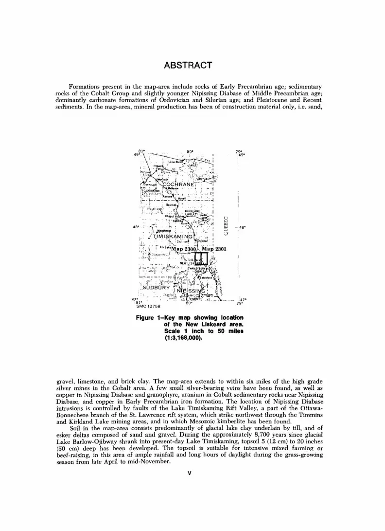
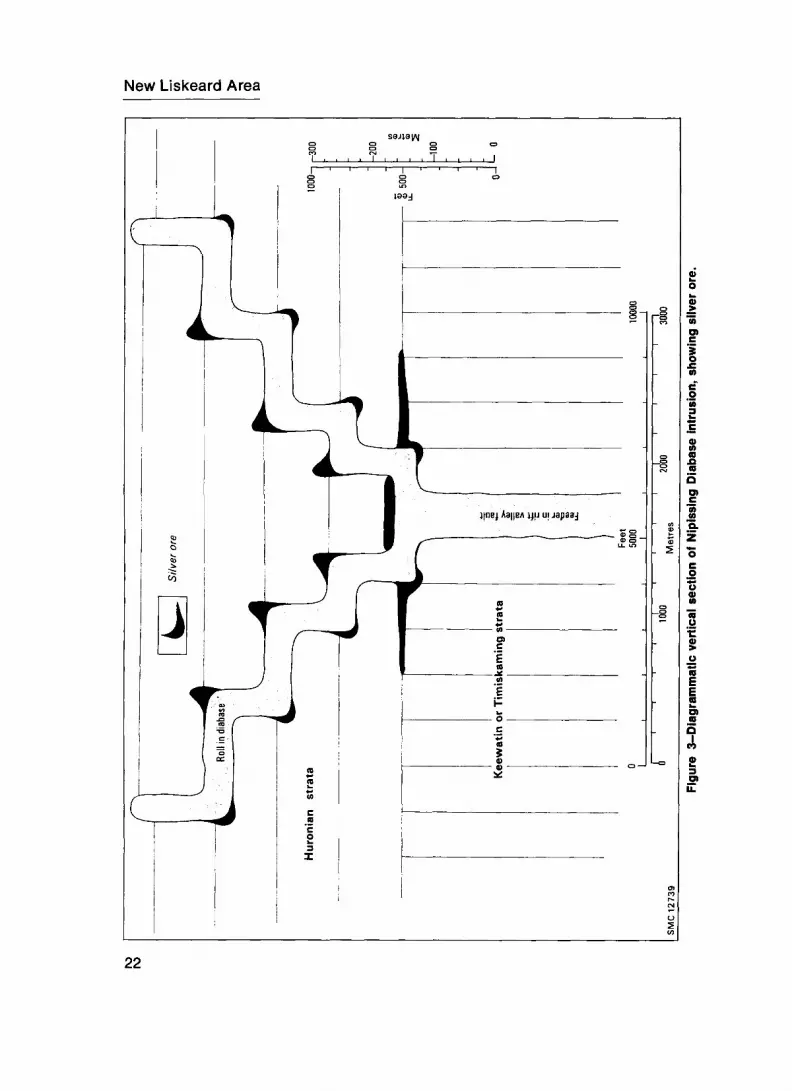
1—Key map showing location of the New Liskeard Area . . .. . . . ...... . .... . . ..... . . .. .... v2—Diagrammatic composite vertical section of Fisher's Rock, Hudson Township . . ... ..... . 103—Diagrammatic vertical section of Nipissing Diabase intrusion, showing silver ore .. . .... . 22
PHOTOGRAPHS
1—Haileybury Recreation Centre, note limestone foundation . . .. . ........ . .............. 192—New Liskeard Public Library, note limestone dimension stone ... ....... . ......... .... .20
GEOLOGICAL MAPS
(back pocket)Map 2300 (coloured)—Kerns and Hudson Townships, District of Timiskaming.
Scale l inch to tt mile (1:31,680).Map 2301 (coloured)—Harley and Dymond Townships, District of Timiskaming.
Scale l inch to tt mile (1:31,680).
CHART A
(back pocket)Water Well Locations and Overburden Characteristics in the New Liskeard Area.
Scale l inch to l mile (1:63,360).
IV
ABSTRACT
Formations present in the map-area include rocks of Early Precambrian age; sedimentary rocks of the Cobalt Group and slightly younger Nipissing Diabase of Middle Precambrian age; dominantly carbonate formations of Ordovician and Silurian age; and Pleistocene and Recent sediments. In the map-area, mineral production has been of construction material only, i.e. sand,
f--*-- 1 — --- -K,—"- *- -l—----li' , BouikeiJ
'"!" tfiWajA ' '7j 1 ' /! i K M KIRKLAND,i"; i*' -^i^s^gpr; o- -r-:' r^^^^m^ g
48" : -' -If' ' -f-: : ' ^X*^ , '7 ' w -48"
;^.j- ,j l Elkl""Map 2300AMap 2301"•'i l I&GOW,,,.'.*, d" ^-^—^i'\ l ;•T'v-1 - r - •V'i-unil.ikl; 1,^.
-- -T -i--" li NFW IKKltpli J V.y
Figure 1-Key map showing location of the New Liskeard area. Scale 1 inch to 50 miles (1:3,168,000).
gravel, limestone, and brick clay. The map-area extends to within six miles of the high grade silver mines in the Cobalt area. A few small silver-bearing veins have been found, as well as copper in Nipissing Diabase and granophyre, uranium in Cobalt sedimentary rocks near Nipissing Diabase, and copper in Early Precambrian iron formation. The location of Nipissing Diabase intrusions is controlled by faults of the Lake Timiskaming Rift Valley, a part of the Ottawa- Bonnechere branch of the St. Lawrence rift system, which strike northwest through the Timmins and Kirkland Lake mining areas, and in which Mesozoic kimberlite has been found.
Soil in the map-area consists predominantly of glacial lake clay underlain by till, and of esker deltas composed of sand and gravel. During the approximately 8,700 years since glacial Lake Barlow-Ojibway shrank into present-day Lake Timiskaming, topsoil 5 (12 cm) to 20 inches (50 cm) deep has been developed. The topsoil is suitable for intensive mixed farming or beef-raising, in this area of ample rainfall and long hours of daylight during the grass-growing season from late April to mid-November.

Geology
of the
New Liskeard AreaDistrict of Timiskaming
by
H.L. Lovell 1 and E.D. Frey2
INTRODUCTION
The map-area comprises the townships of Kerns, Harley, Hudson, and Dymond, and includes the town of New Liskeard and adjacent farmland and cottage-recreation areas. The maps and report have been produced to aid land-use planning around existing com munities, particularly the Tri-Town growth area, and to aid mineral exploration. High grade silver mines of the Cobalt type are 6 miles (10 km) south and also 2 miles (3 km) east and 20 miles (32 km) west of the map-area; the Kirkland Lake gold-copper-iron mining area is about 25 miles (40 km) to the north. The community of New Liskeard is in the southeast part of the map-area, and Thornloe straddles the centre of the northern boundary. Both are farming centres; New Liskeard is also part of the Tri-Town (Cobalt- Haileybury-New Liskeard) complex of varied industries. In addition to the Ontario Northland Railway, excellent access is provided by Highways 11, l IB, 65 562, 569, and 571, as well as numerous concession and lot line roads. Highway 11 is the north-south arterial road between Toronto and the northern part of northeastern Ontario, and Highway 65 is the branch highway west to the Elk Lake-Gowganda area and east to the northwestern part of Quebec province. High voltage electric power transmission lines traverse the map-area; electrical and telephone lines serve most of the map-area; and the natural gas pipeline of Trans-Canada Pipe Lines Limited traverses Kerns, Hudson, and Dymond Townships. The area office for Ontario Hydro is at New Liskeard, and the control station for the Lower Notch hydroelectric power generating plant, the Dymond transformer station, is situated in Dymond Township.
iResident Geologist, Ontario Ministry of Natural Resources, Kirkland Lake. 2Resident Geologist's Assistant, Ontario Ministry of Natural Resources, Kirkland Lake. Manuscript approved for publication by the Chief, Resident Geologists' Section, Geological
Branch, Ontario Division of Mines, 25th August 1972.
1
New Liskeard Area
Mineral production from the map-area has been confined to construction materials; sand, gravel, limestone for road fill and for lime kilns, and clay for brick and tile making.
Previous Geological Work
In 1922, a map and report by A.G. Burrows and P.E. Hopkins describing the Blanche River area were published by the Ontario Department of Mines. The map and report deal with 25 townships, including the present map-area. A 1925 report by G.S. Hume of the Geological Survey of Canada describes the Paleozoic outlier of Lake Timiskaming, Ontario and Quebec, and includes the present map-area. A 1952 soil survey map and report by Hoffman, Wicklund, and Richards describe 26 townships, including the map- area. G. Winston Sinclair (1965) described the succession of Ordovician rocks at Lake Timiskaming. M.J. Copeland (1965) described Ordovician Ostracoda from Lake Timis kaming, Ontario, and T.E. Bolton (1970) described Echinodermata from the Ordovician and Silurian of Lake Timiskaming region, Ontario and Quebec. Lovell and Caine (1970) defined the Lake Timiskaming Rift Valley. A study in progress by Munro, Lynch, and Barnes (1971) concerns the paleoecology and conodont faunas of Ordovician rocks of the Lake Timiskaming Paleozoic outlier.
Field Work
Base maps of the townships were prepared by the Cartographic Section, Ontario Division of Lands, from Forest Resources Inventory sheets of the Ontario Division of Lands. These were provided at the scale one inch to one-quarter mile (1:15,840), as were air photographs from the Ontario Division of Lands.
Many of the outcrops were once wave-washed islands and reefs in Pleistocene glacial Lake Barlow-Ojibway (Boissonneau 1965; Lovell and Caine 1970, p.6), and on the air photographs of the Little Clay Belt are readily discernible against the background of the glacial lake bottom deposits (Hoffman et al. 1955, p.21; Cook 1964, p.52). Pre sumably, few outcrops escaped examination during the field mapping, although field work totalled only 18 man weeks of mapping.
Acknowledgments
In 1970 during the mapping of the four townships the writers were assisted by T.W. Caine, and unpublished reconnaissance mapping by Robert Thomson served as a reference. W.O. Link, water well drilling contractor, donated core from some of the holes he has drilled. Roy Armstrong, farmer and prospector, guided the senior author to some of the points of interest in the map-area.
A soil survey of the New Liskeard-Englehart area by the Dominion Department of Agriculture and the Ontario Agricultural College (Hoffman et al. 1955) was used to outline soil types on the maps. Contoured maps of the National Topographic Series at the scale 1:50,000 are the sources of topographic contours on Maps 2300 and 2301 (back pocket). Water well records were obtained from the Hydrologic Data Branch, Division of Water Resources, Ontario Water Resources Commission.
Topography and Drainage
Flat clay belt farmland comprises most of the map-area. The farmland is disrupted by two fault-originated northwest-trending escarpments, towards which the underlying bedrock dips gently southwest, forming homoclines, and by trellis-patterned waterways incised deeply into the clay. One escarpment is along the extension of the Cross Lake Fault (Lovell and Caine 1970, p.2) northwest from Cobalt; the southwestern side, which is upthrown, is about 200 feet (60 m) higher than the northeastern side, and contains the highest point in the map-area (more than 1,150 feet [350 m] above sea-level). The lowest land in the map-area is on the shore of Lake Timiskaming, which is 575 (175 m) to 589 feet (180 m) above sea-level. In the map-area, the land on the south western (upthrown) side of the Lake Timiskaming West Shore Fault (Lovell and Caine 1970, p.2) is about 150 feet (46 m) higher than the lowland on which New Liskeard is built. This upper northwest-trending farmland terrace extends southwest to the Cross Lake Fault escarpment described above.
The main drainage system is the Wabi Creek and its tributaries, which generally form a trellis pattern. The Wabi Creek drains southeastward along the strike of the lowest rift valley fault block, and empties into Lake Timiskaming, which is a part of the Ottawa River. The mouth of the Wabi Creek is at New Liskeard.
Additional drainage in this area occurs along eskers and faults, particularly faults of the Lake Timiskaming Rift System (Lovell and Caine 1970). The course of the underground drainage is indicated by Bowers and Spring Lakes in Hudson Township and by the frequency and high flow capacity of springs, artesian wells, etc., that are on the down-dropped side of the Cross Lake Fault. The Bowers-Spring Lakes area is 6 miles (10 km) from the Tri-Town at New Liskeard, for which it is a reserve source of high quality water.
Resources
For general industrial potential (agriculture, tourism, manufacturing, forestry, and mining) the Tri-Town (Cobalt-Haileybury-New Liskeard) is one of the most ideally located communities in northern Ontario. The Tri-Town is within a one-day drive of 50 million potential tourists in Canada and northeastern U.S.A. Natural resources in the Tri-Town area include low-magnesium limestone suitable for smelters and pulp mills (Hume 1925, p.56); brick clay (Hume 1925, p.57; Baker 1906, p.83), sand and gravel (Boissonneau 1965); silver-cobalt-nickel-copper ore (Marshall Macklin Monaghan Limited 1968, p.13); pulpwood (spruce, balsam, and jackpine); lumber (spruce and pine); poplar for plywood and particle board; year-round recreational land including
New Liskeard Area
cottage-lake country, snowmobile bush trails, etc.; high-quality municipal water supplies; and (in Lake Timiskaming) the largest volume of flow of fresh water of any munici pality in Ontario (Coles 1972) except for those farther downstream along the Ottawa River, and the Great Lakes-St. Lawrence system. Secondary industry includes a concrete products plant (manufacturing culvert and drainage tiles); a brick clay plant, foundries, diamond drill equipment manufacturing, and forest products plants.
The Tri-Town is at the centre of the Little Clay Belt, the most prosperous farmland (i.e. the highest value of production) of any of the farming areas of northeastern Ontario (MacDonald 1971, p.151) and has plenty of land suitable for building. Within a 75-mile (120 km) radius are eight hydro-electric dams, four of them newly built, and the Extra High Voltage (500 Kilovolt) transmission line from the new dams of the Moose River basin to Toronto. The control station for the new Lower Notch hydro electric dam (319,000 Kilovolt amperes for two "peak usage" hours per day) is at New Liskeard. The Trans Canada natural gas pipeline passes through the Tri-Town, and work has begun to twin the existing line. The Tri-Town area is served by the main line of the Ontario Northland Railway, which connects with lines to Toronto and Montreal, and to the deep water port of Quebec City, about 605 miles (970 km) via either Ottawa (Neil 1972) or a northern route through Noranda, Quebec. By highway, Toronto and Ottawa are each only 300 miles (480 km) away. In addition, the Tri-Town area is served by Norontair at a Ministry of Transport airport, and by bush-planes of Earlton Airways at the mouth of Wabi Creek.
GENERAL GEOLOGY
The oldest rock in the map-area is iron formation of Early Precambrian age. Middle Precambrian rocks are well represented by the Gowganda and Lorrain Formations of the Cobalt Group of sedimentary rocks, and by Nipissing Diabase and associated transition rock and granophyre. Paleozoic rocks consist of Ordovician and Silurian limestone, dolostone shale, and sandstone. Northeast from (i.e. on the downdropped side of) the Cross Lake Fault escarpment, most of the bedrock is covered by silt and clay soil of glacial Lake Barlow-Ojibway.
Precambrian
EARLY PRECAMBRIAN (ARCHEAN)
Metasediments and Mafic Intrusive Rocks
Interbedded greywacke, conglomerate, and iron formation recorded in the core logs of drill holes in the southeastern part of Hudson Township constitute the only known Early Precambrian (Archean) rocks in the map-area. The iron formation is described in core logs by T.C. Keefer (1949) as dark grey chert with interbanded breccia and massive pyrite and pyrrhotite. Disseminated sulphides and "clots" of chlorite also occur. Greywacke and conglomerate are of the jasper-bearing Timiskaming type (Keefer 1949).
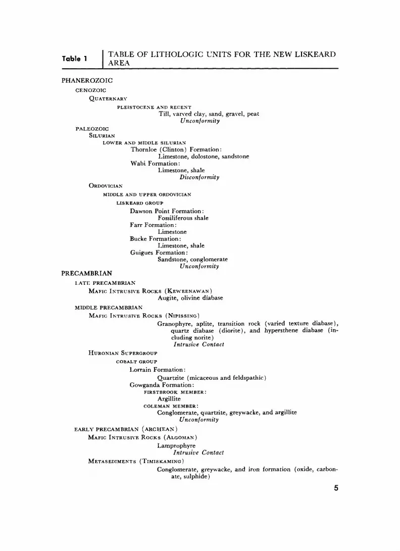
T . , . TABLE OF LITHOLOGIC UNITS FOR THE NEW LISKEARD Table l AD r-A AREA
PHANEROZOICCENOZOIC
QUATERNARYPLEISTOCENE AND RECENT
Till, varved clay, sand, gravel, peatUnconformity
PALEOZOIC SILURIAN
LOWER AND MIDDLE SILURIANThornloe (Clinton) Formation:
Limestone, dolostone, sandstone Wabi Formation:
Limestone, shaleDisconformity
ORDOVICIANMIDDLE AND UPPER ORDOVICIAN
LISKEARD GROUPDawson Point Formation:
Fossiliferous shale Farr Formation:
Limestone Bucke Formation:
Limestone, shale Guigues Formation:
Sandstone, conglomerateUnconformity
PRECAMBRIANLATE PRECAMBRIAN
MAFIC INTRUSIVE ROCKS (KEWEENAWAN)Augite, olivine diabase
MIDDLE PRECAMBRIAN
MAFIC INTRUSIVE ROCKS (NIPISSING)Granophyre, aplite, transition rock (varied texture diabase),
quartz diabase (diorite), and hypersthene diabase (in cluding norite) Intrusive Contact
HURONIAN SUPERGROUP COBALT GROUP
Lorrain Formation:Quartzite (micaceous and feldspathic)
Gowganda Formation:FIRSTBROOK MEMBER:
Argillite COLEMAN MEMBER:
Conglomerate, quartzite, greywacke, and argillite Unconformity
EARLY PRECAMBRIAN (ARCHEAN)MAFIC INTRUSIVE ROCKS (ALGOMAN)
LamprophyreIntrusive Contact
METASEDIMENTS (TIMISKAMING)Conglomerate, greywacke, and iron formation (oxide, carbon
ate, sulphide)
New Liskeard Area
Chalcopyrite, sphalerite, and galena are disseminated in all these rocks and in numerous quartz-carbonate stringers. Epidote and hematite are present in places, as well as diabasic rock, some of it serpentinized and some of it having associated aplitic material. This Hudson Township Archean iron formation is the rock type known in the Cobalt area as "interflow bands", which characteristically underlie the most productive silver ore zones (Thomson 1957, p.382)
MIDDLE PRECAMBRIAN
Huronian Supergroup
COBALT GROUP
Sedimentary rocks of the Cobalt Group constitute the bedrock in about one-quarter of the map-area. The Cobalt sedimentary rocks form part of the largest area of Middle Precambrian sedimentary rocks in Ontario, known as the Cobalt Plate (Stockwell 1970, p.46). They comprise representatives of the following rock-units of the Cobalt Group: the Coleman and Firstbrook Members of the Gowganda Formation, and the overlying Lorrain Formation (Thomson 1965, p.22).
In Henwood, the township west of the map-area township of Kerns, a drill hole intersected the thickest vertical section of Cobalt sedimentary rocks ever encountered to date. This hole was collared in and drilled through about 965 feet (308 m) of Lorrain Formation, plus about 4,600 feet (1,400 m) of Gowganda Formation, in which the hole was stopped (Thomson 1968, p.5), and in addition intersected a total of 1,097 feet (335 m) of intercalated intrusives (e.g. diabase). The total depth of this approximately vertical diamond drill hole is 7,662 feet (2,335 m), with a thickness in Gowganda Formation of 5,152 feet (1,545 m). The core is stored with the Resident Geologist, Kirkland Lake. The Lorrain Formation and the Firstbrook Member of the Gowganda Formation in Henwood, the township west of Kerns, are described in detail by Thomson (1966, p.6 to 17). The Gowganda (Coleman and Firstbrook) and Lorrain Formations of the Maple Mountain area (extending east as far as six miles {10 km] west of Hudson Township) were described by Card et al. ( 1970), p.61-92).
Gowganda Formation
COLEMAN MEMBER
In the Coleman Member of the Gowganda Formation, rock-units form a continuous series from conglomerate to argillite. This continuous series exists partially or even com pletely within some individual beds of the Coleman Member. Beds adjacent vertically however are generally of more contrasting members of the series, indicating fairly abrupt changes in the depositional environment from bed to bed. The classification represents a gradational and continuous series from conglomerate (distinguished by boulders, cobbles, and pebbles composed of fragments of many different types of source rocks) through coarse broken grains (mainly of relatively unaltered feldspars and quartz) and
quartzite or greywacke (broken grains of many types of minerals, some of them some what susceptible to alteration by weathering), to argillite (broken clastic mineral grains that have been still more finely ground). Borderline types, therefore, had to be dis tinguished by estimates of proportions of the various ingredients. For example, the rock was called conglomerate if it has more than 10 percent of pebbles greater than 2 mm diameter, as suggested by Petti john (1957, p.243). Most of the argillite of the Coleman Member actually is siliceous argillite (massive to laminated quartzose mudstone) com posed mainly of quartz fragments with lesser amounts of feldspars, and with chlorite interstitial and along slip surfaces. The bedding typically is defined by discontinuous lenses and blebs of darker green, softer chloritic material in the hard greyish quartzite. Some chloritic lenses are "swirled" somewhat, possibly as a result of soft sediment slump ing. This feature, soft sediment slumping, causes some of the wide range in dip in some beds, and some reversals of dips as bedding tops were overturned. Most laminae (beds) are less than 10 mm thick, and the average is about 2 mm. Some beds are slightly coarser grained, with distinguishable white feldspar grains.
The Coleman Member greywacke and (impure) quartzite contain clastic sand size grains of pink and white feldspar, and lithic fragments and also some pebbles, cobbles, and the rare boulders possibly transported by ice-rafting. The greenish grey matrix of indurated mud is composed of finely ground rock fragments and clastic grains of minerals derived from the same and similar source rocks as are the coarse clasts. The Coleman Member arkose consists mainly of fresh, broken grains of feldspars and quartz. The pebbles, cobbles, and boulders in the Coleman Member consist of Early Precambrian (Archean) granitic, gneissic, and some volcanic rocks from source areas north of the map-area.
FIRSTBROOK MEMBER
The Firstbrook Member argillite is well bedded, graded bedded, or varved (average l cm thick) mudstone, having reddish or pale grey slightly coarser grained quartzitic lower parts, and greenish grey thinner argillaceous upper parts of beds. At some loca tions it is suitable for use as flagstones. On some cream coloured bottom surfaces of bedding plane partings ripple marks have been preserved, but no mud cracks were found. A tentative conclusion from the above limited evidence is that the Firstbrook Member of the Cobalt area consists of shallow water muds deposited on the bottoms of a series of lake basins.
Lorrain Formation
Although in Henwood Township less than two miles (3 km) west of Kerns Town ship a drill hole intersected a vertical depth of 1,045 feet (320 m) of Lorrain Formation (Thomson 1966, p.9), only two outcrops were found in the map-area. One is in Fisher's Rock, Hudson Township, where a large amount of probable Lorrain Formation is inter bedded with and overlies the Firstbrook Member.
Although quartzite beds of the "Lorrain" (Thomson I960, p. 16) Formation in Hudson Township grade upwards into argillite similar to the Firstbrook Member argillite, most of the slightly argillaceous quartzite and quartzitic arkose that is typical of the Lorrain Formation forms thick beds. This thick bedded characteristic contrasts sharply with the thin bedded character of the Firstbrook Member. Also the source rocks of the Lorrain Formation seem to have been more felsic than those of the Gowganda Formation
New Liskeard Area
in general. The basal quartzitic arkose of the Lorrain Formation that is interbedded with the Firstbrook Member in places forms wedges along rift fault escarpments. The main source of the Lorrain Formation might be granitic, but other sources are Coleman grey wacke, argillite, arkose, and impure quartzites, which are near the Lorrain Formation throughout the Cobalt Plate, and provide a ready supply of fresh clastic grains of quartz and feldspar.
Depositional Environment
Conglomerate of the Coleman (lower) Member of the Gowganda Formation is areally less extensive in the map-area, which is in the central part of the Cobalt Plate, than in the Matachewan-Kenogami and Bourkes areas about 30 miles (48 km) to the north (Lovell 1971a), and bedding is much more evident indicating that most of the Coleman Member in the map-area was laid down in fairly deep water. This can perhaps be reconciled with Lindsay's (1969) hypothesis of the glacial origin of the Gowganda Formation if the conglomerates were deposited in a glacial lake or a sea marginal to glaciated terrain to the north (Lindsay 1969). The Coleman Member in the map-area consists of conglomerate interbedded with lenses of graded, thin bedded (varved) argillite and in some places the conglomerate itself has a matrix of bedded argillite. This relationship might be explained by glacier calving into the sea or lake, resulting in till and ice-rafted dropstones inter mingled with sea-bed mud. In contrast, the Coleman Formation in the Bourkes area (Lovell 1971a), farther north, may have been deposited in fjords, and the Coleman Formation of the Matachewan-Kenogami area could have originated as a terminal moraine. Much further detailed study is required to confirm this hypothesis.
Along with the adjacent township of Henwood (Thomson 1966, p.ll), the map-area is the northernmost known locale of the Firstbrook Member (i.e. the upper Gowganda Formation), which is composed of well-bedded fine-grained detritus probably deposited in quiet water. The lower part of the Lorrain Formation (mainly quartzitic arkoses) in northeastern Ontario is thought (Wood 1971, p.73, 74) to have originated as deposits in shallow water under conditions of high energy and cool climate, and the middle and upper parts of the Lorrain Formation during a climatic regime that warmed to tropical temperatures because the upper part of the Lorrain Formation is more "altered" (e.g. some feldspar is altered to diaspore and kaolinite) than the lower part (Wood 1971).
Hadley (1968) concluded that the basal arkosic part of the Lorrain Formation was deposited in a shallow marine environment. Whether the water in the New Liskeard map- area was marine or fresh was not investigated by the present authors, but obviously condi tions of deposition in the part of the sedimentary basin located within the map-area changed markedly from the quiet conditions required for deposition of the graded argil- lites of the Firstbrook Member to much higher energy conditions required for sorting, maturing and deposition of the Lorrain arkosic quartzites (probably in shallow water). Eight miles (13 km) south of the map-area, a basal part of the Lorrain Formation is cross-bedded whitish quartzite probably deposited in a fluvial environment, as Wood (1971, p-74) described for the Lorrain Formation near Elliot Lake.
Metamorphism
Regional metamorphism in the Gowganda and Lorrain Formations of the Cobalt Plate in general is of very low rank, prehnite-pumpellyite rank or less. Fractures and mud
8
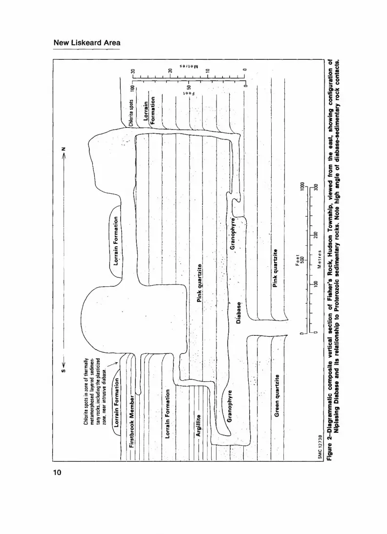
contraction cracks are filled with sediments, and a few possible incipient stylolites are present in Fisher's Rock, Hudson Township. Sparsely disseminated pyrite is widespread throughout the argillaceous rocks and chlorite exists as lenses and along slip surfaces, and as "spotting" near younger intrusives. In parts of Fisher's Rock the argillite contains snowflake-shaped aggregates of white feldspar, which may be metacrysts formed as a result of contact metamorphism by nearby intrusive dikes. Very close to the contact of Nipissing Diabase with Lorrain Formation, for example near the northern end of Fisher's Rock, the Lorrain Formation quartzite dips about 55 0 , but a few feet farther away from the contact, the quartzite dips about 20 0 , the difference probably being caused by the diabase intrusion disrupting the sedimentary beds. In some places, e.g. gently dipping Nipissing Diabase, forming sills on similarly gently dipping beds of the Cobalt Group, continue to form apparently conformable sills although deflected upward, because the Cobalt Group beds in contact with the diabase are altered, crumpled, and apparently heated until rendered plastic, so that steep dips parallel to the contact with the deflected diabase (Figure 2) are impressed upon them. The "plasticized" Lorrain Formation contains chloritic alteration spots, dragfolds indicating the upward movement of the diabase, and bedding is less distinct due to metamorphic recrystallization. Diabase near the contact tends to be paler coloured, finer grained quartz diabase with closely spaced fractures.
Diabase contact metamorphism in the map-area is best exemplified by chlorite spots. According to Jambor (1971b), chlorite spots occur in rocks within 330 feet (100 m) of Nipissing Diabase contacts, and the spotting effect is more intense in rocks that are argil laceous and sufficiently coarse-grained to permit intergranular movement of matrix com ponents. The chlorite spots are pre-ore and hence neither the presence nor intensity of spotting coincides with the occurrence of productive veins, necessarily.
Mafic Intrusive Rocks (Nipissing)
Nipissing Diabase in the Cobalt-Gowganda area occurs as a series of step-sided cone- shaped intrusions (Jambor 1971f, p-36) (figure 2), known locally as "basins", producing circular to oval outcrop patterns centred on northwest-striking faults of the Lake Timis kaming Rift Valley (Lovell and Caine 1970, p.2; Lovell 1971b, p.49-51). Their deepest known extremities (probably feeders), which are in or near the rift valley faults, can be detected mineralogically. The probable diabase feeder in the north central part of Hudson Township, for example, contains minerals more mafic than does Nipissing Diabase in general. Gravity surveys (Gibb et al. 1969), based on the specific gravity of the feeders, which are more mafic (Jambor 1971 f, p. 34) and therefore more dense, detected gravity highs over the diabase basins. One of the two highest gravity anomalies in the Sudbury- Cobalt nickeliferous region is over the probable diabase feeder in Hudson Township (Innes I960, map); the other is at Sudbury itself. The high gravity anomaly in Hudson Township actually is the highest in northeastern Ontario, other than in the Kapuskasing zone of gravity highs (compare Gibb e t al. 1969, gravity map with Innes 1968, gravity map). The gravity anomaly in Hudson Township is almost circular in outline (R.A. Gibb 1970, Canada Dept. Energy, Mines and Resources, personal communication), and may be caused by a feeder of the Nipissing Diabase intrusion centred in the extension of the Cross Lake Fault through the map-area. The main generator of interest in Nipissing Diabase of the Cobalt-Gowganda area is its spatial and genetic relationship (Jambor 1971a; Petruk 1968) to the famous silver-cobalt-copper-nickel ore. All known occcurrences
New Liskeard Area
o wil•s*c oo "-
z *
*2. S -•o
o
O) CD rt^0-
-g
leo
3 S X C
K w mm o|s.12u. oj
C oo -S
-l
g?i:coQi?(D 'S O, .2n a
10
of this type of ore are in, or within 700 feet (210 m) of Nipissing Diabase, near the Archean-Huronian unconformity, and most of it is genetically related (Jambor 1971g, p.402) to the Nipissing Diabase intrusion that has its feeder (Lovell and Caine 1970, p.9-11) in the Cross Lake Fault near Cobalt.
Nipissing Diabase of the general Cobalt area is tholeiitic. As pointed out by Hris- kevich (1952, p.9) six distinct facies of Nipissing Diabase are readily recognized in the field. Most of the following descriptions are summarized from Hriskevich (1952) and Jambor (1972).
The chilled margin at the base of the Nipissing Diabase is quartz "diabase" (or quartz diorite). The quartz diabase grades upward into hypersthene "diabase" or quartz "norite" regarded by Satterly (1933, p.23) as related to the Sudbury nickel-copper type of norite. This hypersthene diabase, in turn, grades upward into "varied texture diabase", the transitional phase to the generally uppermost granophyric differentiate of Nipissing Diabase. Intrusive into the varied texture diabase and less commonly into the upper part of the hypersthene diabase are schlieren, patches, and dikes of diabase pegmatite. Also, granophyric diabase and granophyre occur within the varied texture diabase. Narrow aplite dikes occur throughout the diabase, but are more abundant in the upper parts. In places, the varied texture diabase grades upward into the quartz diabase zone of the roof contact.
Near the contact with country rocks, the quartz diabase is fine-grained dense greenish black rock, and away from the contact it grades into medium-grained greyish black rock in which plagioclase and pyroxene are recognizable megascopically. The pyroxenes are augite and pigeonite. The quartz diabase of the chilled zone is holocrystalline and glomero porphyritic. Some of the crystallites of plagioclase and pyroxene have a plumose sheaf structure and some form radial rosettes. The plagioclase crystallites are acicular and average 0.1 mm long. The plagioclase ranges from Ab33 An67 in the core to Ab54 An46 in the rim. Pyroxene occurs as granules interstitial to the plagioclase. Magnetite and flakes of biotite are present in small amounts. Alteration products consist of antigorite and chlorite after augite and pigeonite, and white mica and zoisite after plagioclase. Phenocrysts are mostly laths of plagioclase, with lesser amounts of pyroxene and olivine.
The hypersthene diabase is medium-grained dark grey rock with phenocrysts of waxy brown hypersthene, augite, and very little olivine or quartz. The hypersthene weathers out and leaves brown pits on the weathered surface. The hypersthene-orthopyroxene forms blocky subhedral grains a maximum of 10 mm long. Some of the hypersthene is inter- grown with diopside, and rim areas of some pyroxenes are replaced by uralite. Olivine is generally present, and is veined by serpentine and magnetite and in places is rimmed by hypersthene. In the olivine-bearing hypersthene diabase, normal and oscillatory zoning are present in the plagioclase, which ranges in composition from Abi7 An83 in the core to Ab-io Aneo in the rim. In the pigeonite-bearing diabase above the olivine phase, the plagioclase ranges from Ab27 An73 in the core to Ab3i An69 in the rim. About two-thirds of the diabase in the central part of a basin is the hypersthene variety.
The varied texture diabase is characterized by irregularly-shaped patches of coarse- grained minerals, largely plagioclase, augite, and pigeonite, grading into a groundmass of the same minerals but finer grained. Quartz and micropegmatite occur interstitially. The plagioclase ranges from Abgi Aneo in the core to Ab4 5 An^ in the rim. In the zones of varied texture diabase are diabase pegmatite patches and dikes containing bronze-coloured blade-like crystals of augite and white to pink plagioclase, with the average grain size about l cm. Where zoned, the plagioclase ranges from Ab30 An70 in the core to Ab46 An54 in the rim. Some of the pegmatite contains minor amounts of quartz and ilmenite. At a rim or flexure in a diabase basin, the dominant diabase is the varied texture type.
11
New Liskeard Area
The granophyre is hypidiomorphic and equigranular, and contains pink microcline intergrown with quartz, elongate crystals of amphibole, augite, pigeonite, titaniferous magnetite, and acicular crystals of apatite. The plagioclase is generally uniform in com position, being about Abas An5 to Ab90 An10 in composition. Also present are miarolites, partially filled with some of the following minerals—carbonates, quartz, feldspar, chlorite, epidote, amphibole, magnetite, apatite, and chalcopyrite. Dark brown stilpnomelane is present in interstices and along grain boundaries in some granophyres, and dark brown needles of allanite, sphene, prehnite, and talc alteration also may be present. Jambor (1971a) stated that some of the granophyre is myrmekite and graphic granite, and some is actually micropegmatite with fine-grained mineralogical intergrowths.
pink to pale grey aplite dikes are hypidiomorphic and equigranular and consist
t. -m**'-
\ ti i
ji
j n
ji
ijii \
1
'i' —————————————————————————————————————————————————————————————————————————————————————————————————————————————————————————————— .
t iI
; '1 j
*
Phanerozoic
PALEOZOIC
The Paleozoic rocks of the Lake Timiskaming area outlier are of Ordovician and Silurian age. The nearest Ordovician bedrock is in Lake Nipissing (Hume 1925, p-13), and the nearest Silurian bedrock related to the Wabi Formation is in the James Bay Low lands and Manitoulin Island (Sanford et al. 1968) and for the Thornloe Formation is the Fossil Hill Formation of southern Ontario (Hume 1925; Bolton 1966, p.5; Sanford et al. 1968, p.25). In the map-area the distribution of Paleozoic rocks is controlled by central fault blocks of the Lake Timiskaming Rift Valley (Lovell and Caine 1970). The main controlling Rift Valley fault is the Lake Timiskaming West Shore Fault. In most places Paleozoic rocks extend only short distances southwest from this fault. Only a narrow strip of Paleozoic rocks remains on the relatively upthrown side of the fault (where they extend to the early Ordovician fault line scarp), except near New Liskeard, where they extend from the scarp westward more than a mile (1.6 km).
For purposes of the present mapping program, the Paleozoic rocks were subdivided only into Ordovician rocks and two Silurian formations. The Paleozoic stratigraphy of the Lake Timiskaming outlier has been studied by several workers, however, and the Table of Lithologic Units used in this report and in the legend on the accompanying maps lists the most up-to-date formational classification of these Paleozoic rocks (Bolton 1970).
Ordovician
MIDDLE AND UPPER ORDOVICIAN
The Ordovician formations all belong to the Liskeard Group (Bolton 1970, p.59). The oldest Paleozoic formation in the Lake Timiskaming outlier (the New Liskeard map- area problably contains strata of all the outlier's formations) is the Middle Ordovician Guigues Formation (Sinclair 1965). The thickest and most complete vertical section of Paleozoic rocks known in the Lake Timiskaming outlier is 1.4 miles (2.2 km) south of the southeast part of Dymond Township (Thomson 1965), where 814 feet (250 m) were intersected.
The Guigues Formation overlies the Precambrian basement rocks unconformably, and consists of sandstone and limy conglomerate, which contain a few poorly preserved fossils that suggest a Wilderness age (Sanford 1965, p.4). Sanford (1970, p.257) cor related the Guigues Formation with the Black River Group of southwestern Ontario.
Conformably overlying the Guigues Formation is the Bucke Formation, which is mainly limy and sandy beds and dark, soft fissile shales (Sinclair 1965, p.3). A study of more than 70 ostracod species of the Middle Ordovician "Liskeard Formation" (Bucke and Farr Formations) by Copeland (1965, p.4) showed their relationship to those at Frobisher Bay, and indicated that they are of (late) Wilderness age. A study of conodonts
13
New Liskeard Area
(Munro et al. 1971), however, indicates the Guigues and Bucke Formations to be early Barneveld in age. Also, Sanford (1970, p.257) correlated the Bucke Formation with the upper Black River and lower Trenton Groups of southwestern Ontario.
Unconformably overlying the Bucke Formation (Munro et al. 1971) is the Farr Formation of dense beds of mottled limestone, as in Dymond Township, concession I, lots 4 and 5, and where Highway 11 crosses the line between Bucke and Dymond Town ships (Sinclair 1965). The study of conodonts (Munro et al. 1971) indicated the Farr Formation to be late Barneveld or Edenian in age. Sinclair (1965) regarded the Farr Formation as being late Barneveld in age, and correlated its fauna with the Cobourg Formation at Ottawa, but mentioned their similarity with the fauna at Silliman's Fossil Mount, at Frobisher Bay in Baffinland. Munro et al. ( 1971) regard the conodonts of the Lake Timiskaming outlier as northwestern subprovincial fauna commonly associated else where with the Arctic Ordovician megafauna.
Disconformably overlying the Farr Formation is the Dawson Point Formation, known to exist only in a drill hole 1.4 miles (2.2 km) south of the southeast part of Dymond Township (Thomson 1965). It is soft green or grey shale with abundant fossils, most of which are graptolites of generalized climacograptid or diplograptid type, along with several brachiopods (Lingula). Because the most significant fossils are the trilobite Triarthrus cf. rougensis Parks and Leptobolus insignis Hall, the age of the Dawson Point Formation can be given with certainty as Edenian (Sinclair 1965, p-2).
Silurian
LOWER AND MIDDLE SILURIAN
The Silurian formations present in the Lake Timiskaming Paleozoic outlier have the locally-derived names of Wabi and Thornloe. The older is the Wabi Formation, which disconformably overlies the Dawson Point Formation in the drill hole 1.4 miles (2.2 km) south of the southeast part of Dymond Township (Thomson 1965, p.5). The Wabi Formation, or Wabi "Group", which compares lithologically with the Cataract Group of Manitoulin Island and the Bruce Peninsula (Sanford 1970, p.271), consists of impure limestones interbedded with thin layers of shale. The limestone is more dolomitic and more coarse grained toward the top of the formation (Ollerenshaw and MacQueen I960, p. 109). Ripple marks and probable mud cracks occur in the shale. Most strata are grey, but a few greenish or buff-coloured beds are present. Most beds are thin, except those near the top of the Wabi Formation. The limestone of the Thornloe Formation has been burnt for lime at several places.
On the basis of ostracod fauna, Ollerenshaw and MacQueen (I960, p.110) considered the Wabi Formation to be of early Niagaran age. Sanford (1970, p.271) correlated lithologically the Wabi Formation of Ollerenshaw and MacQueen (I960) with the forma tions that comprise the Cataract Group of the Bruce Peninsula and Manitoulin Island (the lowest unit there is the Manitoulin Formation, which is overlain by the following succession: Cabot Head Formation, Dyer Bay Formation, and St. Edmund Formation).
Sanford et al. (1968, p-23) correlated the upper part of the Wabi Group with the lower strata of the Severn River Formation of the James Bay Lowlands and the Dyer Bay Formation of Manitoulin Island. Bolton (1966, p.5) regarded Wabi faunas as early Niagaran, equivalent to similar zones in the Dyer Bay-Wingfield-St. Edmund Formations
14
of southwestern Ontario and to strata found in northern Michigan. He cited the hemi- cystid Hemicystites bawkesi n. sp. and the crinoids Protaxocrinus amii n. sp. and Mac- namaratylus murray* n. sp. as Echinodermata characteristic of the middle Silurian Wabi and Thornloe Formations.
The Thornloe Formation (Ollerenshaw and MacQueen I960, p.105) consists of yellowish brown to pale grey strata that were originally fragmental limestones, and are now dolomitic, and small lenses of pale grey chert. The grain size is medium to coarse, and some beds retain their original very coarse texture of bioclastic material as relict framework. Some of the organic fragments are silicified. Fossils are abundant, and include corals, stromatoporoids, trilobites, brachiopods, bryozoans, crinoids, and cephalopods. Porosity is rather high, and in places the texture is vuggy.
Of corals, twelve different genera and at least twenty-five different species were identified, tabulate corals predominating, with Favosites niagarensis being the most abundant. The corals are widely dispersed, some in situ but others forming bioclastic material suggesting biostromal deposits probably deposited on the bottom of a warm shallow sea.
The Thornloe Formation is correlative with the Fossil Hill Formation of southern Ontario (Ollerenshaw I960, p.110; Sanford 1970).
CENOZOIC
Quaternary
PLEISTOCENE AND RECENT
During Pleistocene time, the map-area was subjected to "Wisconsin" continental glaciation (Prest 1970, Figure XII-15). Glaciers advanced from two major centres; Hudson Bay and Labrador. Advancing lobes of glaciers from the Hudson Bay centre, as well as glacial melt waters, and indeed Recent watercourses, flowed along linear bedrock depressions in a generally southward direction. Two sets of linear bedrock depressions are present in the map-area, one striking south and the other striking south- east. These depressions are the surface expressions of faults; the older fault set strikes south and its earliest movement occurred before the intrusion of Matachewan diabase (2,485 million years in age; Fahrig 1963, p.935). The younger set of faults strikes southeast and its earliest movement occurred prior to Cobalt sedimentation (2,280 million years in age; Fairbairn et al. 1968, p. 107). Movement occurred along these faults on many occasions throughout their history, in order to release tensions and pressures built up in the earth's crust, and prominent depressions exist in the bedrock along these faults.
On the southwestern flank of a Hudson Bay-centred glacier that flowed southeastward down the Lake Timiskaming Rift Valley, a spillway developed on an interlobate end moraine, allowing melt water to flow southward along the strike of the minor (N-S) set of faults in the map-area. Sediments deposited in this spillway delta form the "Twin Lakes" (Hammond Lake) sandy beach-and-cottage country seven miles (11 km) due west of New Liskeard. Glacial Lake Barlow formed mainly on the northeastern side of the Cross Lake Fault, as the ice receded. On the glacial lake bottom, the seasonally varved
15
New Liskeard Area
clay and silt of the Little Clay Belt were deposited on the glacial till that mantles the bedrock, and on the delta apron sand that covers the glacial till in places. Thus a generalized section through the overburden consists of basal glacial lodgement till overlying the bedrock which in many places was polished by glaciers; deltaic sand, where present, above the lodgement till and containing admixed ablation till; and lake bottom clay and silt above the sand. During the post-glacial period of about 8,700 years since glacial Lake Barlow drained (Prest 1970, p.722), about 8 (20 cm) to 20 inches (50 cm) of top soil has developed on the clay, silt, and loam, and this constitutes the fertile farmland of the Little Clay Belt.
The maximum depth of overburden on the fault block striking northwest from and including New Liskeard is about 250 feet (75 m), although it is much shallower around Earlton. The maximum depth of overburden on the upper terrace of farmland (the fault block bounded by the Cross Lake Fault and the Lake Timiskaming West Shore Fault) is about 80 feet (24 m).
STRUCTURAL GEOLOGY
Faults
The map-area is in the Lake Timiskaming Rift Valley (Lovell and Caine 1970), and the most prominent faulting in the map-area is of the northwest-trending rift system. The Lake Timiskaming Rift System is a branch of the Ottawa-Bonnechere Graben, which is itself a branch of the seismically active St. Lawrence River Rift System (Kumarapeli and Saull 1966, p.649). A less prominent fault system in the New Liskeard area is made up of north-striking faults probably related to the Onaping system of the Sudbury area; i.e. the Mattagami River system of the Timmins area (Kirwan 1969) into which, in the Matachewan area, diabase dikes have intruded in such extensive swarms as to justify its designation as the type area for "Matachewan diabase" (Dyer 1935, p.25-27).
The most important northwest-striking faults in the map-area are the Cross Lake Fault and the Lake Timiskaming West Shore Fault (i.e. the Wabi Creek Fault). The Cross Lake Fault apparently provided the channelway for the intrusion of the large Nipissing Diabase "basin" that has its feeder centred in Hudson Township, concession VI, lot 10. (Most of the silver ore at Cobalt is genetically related to the Nipissing Diabase [Jambor 1971g, p.402], presumably to the adjacent intrusion, which also has its feeder in Cross Lake). The land on the down-dropped (northeast) side of the Cross Lake Fault is the topographically highest fault block of the Lake Timiskaming Rift Valley to have been under the waters of glacial Lake Barlow during a long enough period of time for lake bottom sediments to be deposited in a thick mantle over bedrock. The escarpment on the relatively upthrown side of the Cross Lake Fault formed the rock-bound shore line of Lake Barlow during most of its existence except for a gap west from Kerns Township through Henwood and Cane into Barber Township, where Lake Barlow was bounded by a still higher fault block, the block on the southwestern side of the Montreal River Fault.
The fault line scarp of the Lake Timiskaming West Shore Fault divides the upper farmland terrace from the lower farmland terrace, on which New Liskeard is situated.
16
The limestone escarpment is exposed in rock cuts on Highway 11 near New Liskeard, but farther northwest lake bottom clay draped over the limestone escarpment obscures it almost entirely. The Lake Timiskaming West Shore Fault itself is actually under the lower farmland terrace which is northeast of the fault line scarp, and is followed approxi mately by the Ontario Northland Railway tracks. The Lake Timiskaming West Shore Fault has undergone post-Paleozoic movement, whereby the Paleozoic formations on its northeast side were displaced downward (relatively) 770 feet (235 m) to more than 1,000 feet (305 m) (Hume 1925, p.48).
According to Miller (1913, p. 119) post-glacial faulting has occurred in the Cobalt area. Also, the series of strong earthquakes epi-centred near Timiskaming Station, Quebec, registered strongly in the New Liskeard area. The shock and after-shocks of this earth quake occurred in 1935 on November l, 2, 5, 7, 15, 25, 27, and December 15, and in 1936 on January 20 and March 25. As a result of the Timiskaming earthquakes more than 100 feet of Canadian National Railways right of way (Smith 1966, p.96) slid into a lake near Parent, Quebec. Hamilton (1967, p.3) predicted an earthquake of consider able magnitude somewhere in the Saguenay-Cornwall-Timiskaming region within the next few decades. In view of the foregoing features, it seems advisable not to build near the banks of the Wabi Creek, which is parallel and close to the Lake Timiskaming West Shore Fault. Furthermore, the Wabi Creek banks are undergoing rapid erosion, and should therefore be stabilized by soil-binding vegetation.
ry^t- irnnnrrapr nnrfh-.sfrikinp ffmk^Jn^the map-area is the assumed fault
New Liskeard Area
Folds
The Early Precambrian (Archean) strata in the map-area dip steeply, but too few outcrops were observed to draw conclusions as to the folding of this strata.
The only folds seen in the map-area are those in Cobalt sedimentary rocks affected by thermal and dynamic metamorphism resulting from intrusion by Nipissing Diabase.
The main expanse of Paleozoic strata forms a homocline diooin^ penrlv
T WHtt ^^^Er^ in i s ! tt i l
-^^^^^"' mnwiri-IKICITM* aiTK I
4444 4444—r~m i m i " j-M—i-I r-4~*-r4.I^^IUI J^^^^^J^ JRMMMMMb JBHHI^^^fc
ODM9233
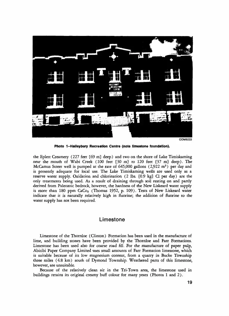
Photo 1-Haileybury Recreation Centre (note limestone foundation).
the Eplett Creamery (227 feet [69 m] deep) and two on the shore of Lake Timiskaming near the mouth of Wabi Creek (100 feet [30 m] to 120 feet [37 m} deep). The McCamus Street well is pumped at the rate of 645,000 gallons (2,922 m3 ) per day and is presently adequate for local use. The Lake Timiskaming wells are used only as a reserve water supply. Oxidation and chlorination (2 Ibs. [0.9 kg} CI per day) are the only treatments being used. As a result of draining through soil resting on and partly derived from Paleozoic bedrock, however, the hardness of the New Liskeard water supply is more than 180 ppm CaCo3 (Thomas 1952, p. 109). Tests of New Liskeard water indicate that it is naturally relatively high in fluorine; the addition of fluorine to the water supply has not been required.
Limestone
Limestone of the Thornloe (Clinton) Formation has been used in the manufacture of lime, and building stones have been provided by the Thornloe and Farr Formations. Limestone has been used also for coarse road fill. For the manufacture of paper pulp, Abitibi Paper Company Limited uses small amounts of Farr Formation limestone, which is suitable because of its low magnesium content, from a quarry in Bucke Township three miles (4.8 km) south of Dymond Township. Weathered parts of this limestone, however, are unsuitable.
Because of the relatively clean air in the Tri-Town area, the limestone used in buildings retains its original creamy buff colour for many years (Photos l and 2).
19
New Liskeard Area
ODM9234
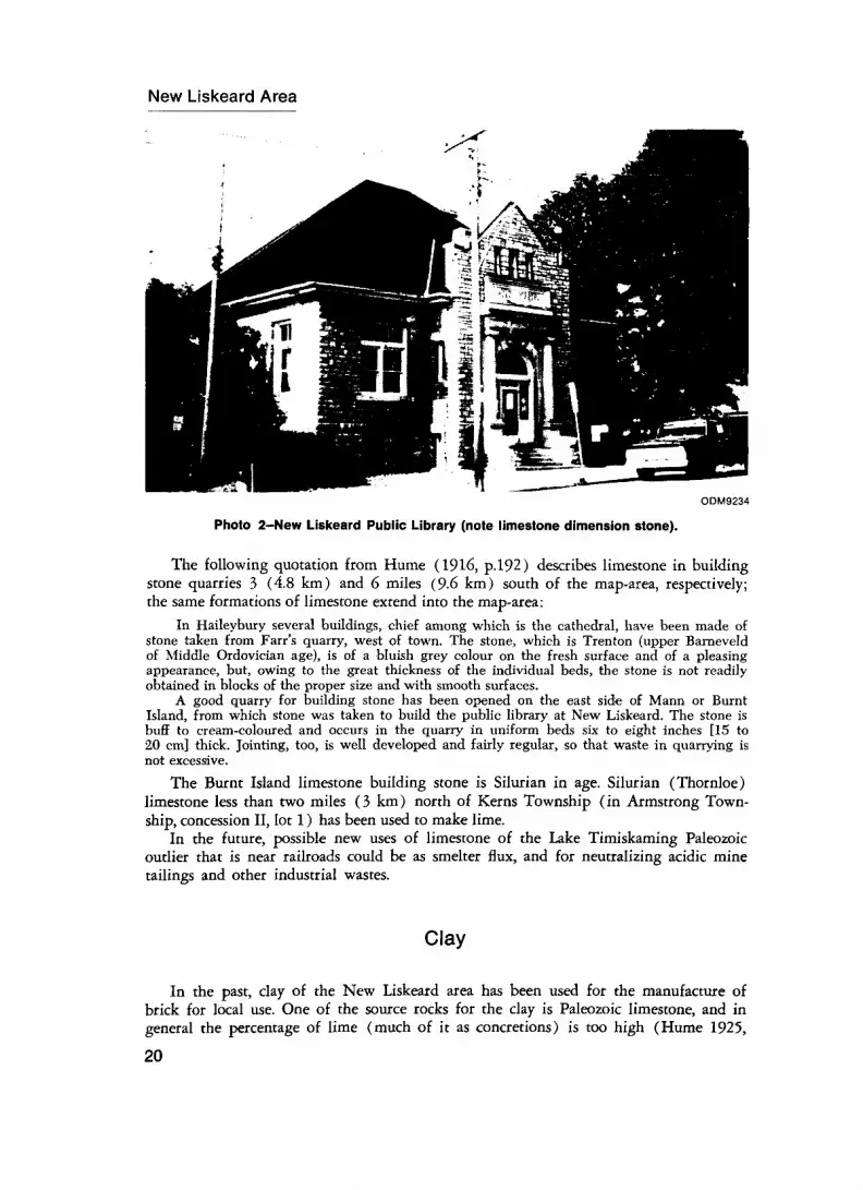
Photo 2-New Liskeard Public Library (note limestone dimension stone).
The following quotation from Hume (1916, p.192) describes limestone in building stone quarries 3 (4.8 km) and 6 miles (9-6 km) south of the map-area, respectively; the same formations of limestone extend into the map-area:
In Haileybury several buildings, chief among which is the cathedral, have been made of stone taken from Farr's quarry, west of town. The stone, which is Trenton (upper Barneveld of Middle Ordovician age), is of a bluish grey colour on the fresh surface and of a pleasing appearance, but, owing to the great thickness of the individual beds, the stone is not readily obtained in blocks of the proper size and with smooth surfaces.
A good quarry for building stone has been opened on the east side of Mann or Burnt Island, from which stone was taken to build the public library at New Liskeard. The stone is buff to cream-coloured and occurs in the quarry in uniform beds six to eight inches [15 to 20 cm] thick. Jointing, too, is well developed and fairly regular, so that waste in quarrying is not excessive.
The Burnt Island limestone building stone is Silurian in age. Silurian (Thornloe) limestone less than two miles (3 km) north of Kerns Township (in Armstrong Town ship, concession II, lot l) has been used to make lime.
In the future, possible new uses of limestone of the Lake Timiskaming Paleozoic outlier that is near railroads could be as smelter flux, and for neutralizing acidic mine tailings and other industrial wastes.
Clay
In the past, clay of the New Liskeard area has been used for the manufacture of brick for local use. One of the source rocks for the clay is Paleozoic limestone, and in general the percentage of lime (much of it as concretions) is too high (Hume 1925,
20
p-58) for the best brick-making capability. However, by the addition of sand or of finely ground diabase from mills at the Cobalt mines, a suitable quality of brick is obtained. Baker (1906, p.83, 84) described operations of the Liskeard Brick, Coal and Lumber Company. The "Saugeen" clay used was very strong, so that working it and drying it was difficult. The upper 6 feet (1.8 m) typically burned to a rich red colour, the 4 feet (1.2 m) below burned to a pink colour, and blue laminated clay still deeper burned to a creamy white brick. All the clays are strong, and are worked only with difficulty. To prevent breakage caused by direct heat or draught during drying, red sand is added to the red clay and grey sand to the blue clay. Output for the yard was planned to be about one million bricks per season.
In 1906, R. Scott was operating a brick yard with a yearly output of about 300,000 bricks. The railroad was built over part of the area of the brick yard. An early analysis (Baker 1906, p.26) of the Saugeen clay yielded the following percentages: silica 58.30; alumina 15.70; ferrie oxide 5.41; lime 5.10; magnesia 3.27; soda 2.04; potash 2.73; sulphur trioxide 0.04; loss by heat 7.30.
In 1965, a new tile yard was built by V.G. Shepherdson in Dymond Township 21/2 miles (4 km) west of New Liskeard (Guillet 1967, p.180). Drain tile was the major product. Clay was taken from the valley of the south branch of Wabi Creek about 500 feet (150 m) east of the plant. Drilling has proven about 85 feet (26 m) of buff-burning varved clay below the plant site. Mr. Shepherdson also has a source of red-burning clay about 2 miles (3 km) from the plant.
Peat
In adjacent northern parts of Kerns and Harley Townships is the Maybrooke peat bog. The peat is composed principally of sphagnum heavily mixed with carex, eriophorum and other plants (Burrows and Hopkins 1922, p.19). The extent of the bog is about 1,281 acres (520 hectares) made up as follows:
Acres Depth of peat in feet {average] Volume in cubic yards232(93.9har) [4] (1.2m) 1,498,000 (1,139,000m3 )671(271 har) 5 to 10 [7] (2.1 m) 6,890,000 (5,097,000 m3 )378(153 har) 10to 15 [11} (3.4m) 6,705,000 (5,097,000m3 )
Metals
Cobalt-type silver occurrences have been found in the map-area, although to date apparently none have been deemed to warrant much development.
Points to be kept in mind during future metals exploration include the following: silver ore deposition occurred between about 1,450 and 2,162 million years ago, shortly after intrusion of the Nipissing Diabase (Jambor 1971c, p.23, 24), which is considered the source of the metals, and these metals were concentrated into silver ore probably by a process of fractionation from the diabase (Jambor 1971d, p.7-10).
21
2ol "35
O)
J m
-l 5Q O)
Q.Zo.0
o
O)a
5I01
The general configuration of a Nipissing Diabase intrusion is believed to be that of a step-sided cone-shaped body centred roughly on a northwest-striking fault of the Lake Timiskaming Rift Valley (Lovell and Caine 1970, p.8, 12). A vertical section of a hypothetical Nipissing Diabase cone-shaped intrusion, with the ore loci indicated (after Petruk 1968, p.40, 41), is shown in Figure 3.
The age, environment, form, petrography, and mineralization of the ore deposits related to the Nipissing Diabase, as well as their similarity to those of Sudbury, have been described by Lovell (l 971 b, p.47-52). The silver ore of the Cobalt-Gowganda area consists of epithermal (deposited at high level of intrusions, at shallow depths in the earth's crust) carbonate veins containing minerals of nickel, copper, cobalt, and silver. The nickel content of the Nipissing Diabase averages 50 to 60 ppm (Jambor 1971e, p.42); occurring in the silicates and oxides of the early differentiate phases as a result of extraction from the magma, and in sulphide form with progressive fractionation to the granophyric differentiate (extensive areas of which are in the map-area, in Kerns Township).
The Sudbury Irruptive lies just west of the Middle Precambrian Huronian rocks of the Cobalt Plate and is in large part intrusive into Early Precambrian basement. The nickel ores of the Irruptive are believed to be of deep seated or mesothermal character (Yates 1948, p.602). The silver ores associated with the Nipissing Diabase, on the other hand, occur in downfaulted blocks of the Huronian rocks within the Cobalt Plate and are considered to be of epithermal shallow level character (Petruk 1968). Lithologic similarities, such as the neritic character of the Sudbury and Nipissing intrusives, suggest that nickel sulphide mineralization may be present at deeper levels of Nipissing Diabase intrusions, in, for example, feeder zones such as postulated for in Hudson Township.
Description of Properties
HUDSON TOWNSHIP
Colebucke Mines Limited [1949] 1 (1) 2
Hudson Township, concession I, lots 4 and 5, Nl/2, were geologically mapped by Colebucke Mines Limited in 1948. This property is the reputed location of a high grade silver lens, discovered in the early days of prospecting in the Cobalt area. A low-frequency electromagnetometer survey in 1949 did not detect an anomaly (Resident Geologist's Files, Ministry of Natural Resources, Kirkland Lake). A widely scattered gossan zone in Timiskaming metasediments was grab sampled and diamond drilled in 1949 by the company. Specks of chalcopyrite or cobalt bloom were reported from four narrow quartz-carbonate vein systems. Eighteen holes totalling 1,298 feet (365 m) in length were drilled; most yielded trace assays of gold, silver, and cobalt. Best assays were 0.53 oz.
lrThe date in brackets indicates the last year of unencouraging exploration activity. 2The number in parenthesis refers to property number on Geological Map 2300.
23
New Liskeard Area
Ag per ton from a core length of 4 inches (10 cm) and 2.40 02. Ag per ton from a narrow calcite vein in one drill hole (Resident Geologist's Files). Scattered blebs of sphalerite and galena were also reported from several drill holes. No further work was reported and the claim lapsed.
Lindquist Occurrence (2)
In 1969 E. Lindquist opened a 6-foot (1.8 m) deep trench 10 feet (3 m) by 13 feet (3.9 m) in Coleman conglomerate in concession I, lot 5, Nl/2, SE1/4 (Resident Geologist's Files).
Milberta Creek Occurrence (3)
In Hudson Township, concession III, lot 6, Nl/2, SW1/4, an abandoned adit (circa 1905) is cut into Nipissing quartz diabase, approximately 30 feet (9m) below the upper surface of the diabase escarpment. Its length is greater than 50 feet (15 m). Grab samples of chalcopyrite-mineralized quartz-carbonate veinlets collected by the junior author from the dump at the entrance were assayed by the Mineral Research Branch of the Ontario Division of Mines, and yielded trace to 0.68 percent copper, trace nickel, trace cobalt, and nil platinum.
Spencer Occurrence (4)
In Hudson Township, concession VI, lot 12, Nl/2, trenching and packsack diamond drilling by W.A. Spencer in 1949-1950 discovered copper mineralization in quartz- carbonate veinlets in a fracture zone in Nipissing quartz diabase. "A 10 feet [3 m] x 80 feet [24 m] x 12 feet [3.6 m] deep trench did not expose economic concentrations of chalcopyrite" (Thomson 1966, p.38). Additional bedrock trenching was done by Roy Armstrong, a farmer-prospector from Kerns Township (Resident Geologist's Files, Ontario Ministry of Natural Resources, Kirkland Lake) in 1968 and 1969-
Unidentified Uranium mineralization was also discovered in the above area by W.A. Spencer and is described by Thomson (1966, p.38-39) as follows: "It is within a 250-foot [76 m] long breccia zone occupying fractures up to l foot [.3 m] wide in Firstbrook argillite. Ontario and Federal Government Laboratory assays of 40 samples yielded nil to 0.21 percent U308 equivalent."
24
KERNS TOWNSHIP
B. Pollard [1952] (5)
In Kerns Township, concession I, lot 12, Sl/2, NW1/4, SE part, one drill hole, 240 feet (73 m) long, was collared by Byron Pollard in quartz diabase in 1952, and remained in unmineralized diabase throughout its length (Resident Geologist's Files).
25

REFERENCES
Armstrong, R.1969: Sketch Maps of Trenches in Hudson Township; Resident Geologist's files, Ontario
Ministry of Natural Resources, Kirkland Lake.
Baker, M.B.1906: Clay and the Clay Industry of Ontario; Ontario Bur. Mines, Vol.15, pt.2, 127p.
Boissonneau, A.N.1965: Algoma Sudbury, Timiskaming and Nipissing, Surficial Geology: Ontario Dept.
Lands and Forests, Map S465, scale l inch to 8 miles. Surficial Geology 1962 to 1963.
Bolton, T.E.1966: Illustrations of Canadian Fossils—Silurian Faunas of Ontario; Geol. Surv. Canada,
Paper 66-5, 46p. 1970: Echinodermata From the Ordovician (Pleurocystites, Cremacrinus) and Silurian
(Hemicystites, Protaxocrinus, Macnamaratylus) of Lake Timiskaming Region,Ontario and Quebec; p.59-66 in Contributions to Canadian Paleontology,Geol. Surv. Canada, Bull 187, 123p. with plates.
Burrows, A.G., and Hopkins, P.E.1922: Blanche River Area; Ontario Dept. Mines, Vol.31, pt.3, 22p. Accompanied by
Map No.31b, scale l inch to l mile.
Card, K.D., Mcilwaine, W.H., and Meyn, H.D.1970: Operation Maple Mountain, Districts of Timiskaming, Nipissing and Sudbury;
Ontario Dept. Mines and Northern Affairs, OFR5050, 275p. Accompanied by Maps P.584 and P.585, scale l inch to l mile.
Coles, G.A.1972: Written Correspondence, Ontario Water Resources Commission.
Cook, M.F.1964: Agricultural Land in Timiskaming District; p.52-53 in Economic Survey of the
District of Timiskaming; Northeastern Ontario Development Association, North Bay.
Copeland, M.J.1965: Ordovician Ostracoda from Lake Timiskaming, Ontario; Geol. Surv. Canada,
Bull. 127, 52p. and plates.
Dean, W.G. (Editor)1969: Economic Atlas of Ontario; Published for the Government of Ontario by the
University of Toronto Press, Toronto, 113 plates.
Dyer, W.S.1935: Geology and Ore Deposits of the Matachewan-Kenogami Area; Ontario Dept.
Mines, Vol.44, pt.2, p.1-55 (published 1936). Accompanied by Map No.44a, scale l inch to 2,000 feet, and Map No.44b, scale l inch to l mile.
Fahrig, W.H., and Wanless, R.K.1963: Age and Significance of Diabase Dyke Swarms of the Canadian Shield; Nature,
Vol.200, No.4910, p.934-937.
27
New Liskeard Area
Fairbairn, H.W., Hurlye, P.M., Knight, C.J., and Pinson, W.H. Jr.1968: Evidence from Gowganda, Ontario, For the Age of Nipissing Diabase and
Associated Huronian; Massachusetts Inst. Tech., Dept. of Geology and Geo physics, Sixteenth Annual Progress Report for 1968 (M.I.T.—1381-16), p.107-114.
Gibb, R.A., van Boeckel, J.J.G.M., and Hornal, R.W.1969: A Preliminary Analysis of the Gravity Anomaly Field1 in the Timmins-Senneterre
Mining Areas; Canada Dept. Energy, Mines and Resources, Observatories Branch, Gravity Map Series, No.58, 25p. and 2 maps.
Gould, B. 1953: Diamond drill core logs for B. Pollard; Resident Geologist's files, Ontario Ministry
of Natural Resources, Kirkland Lake.
Guillet, G.R.1967: The Clay Products Industry of Ontario; Ontario Dept. Mines, IMR22, 206p.
Accompanied by Map Nos. 2130 and 2131, scale l inch to 16 miles.
Hadley, D.G.1968: The Sedimentology of the Huronian Lorrain Formation, Ontario and Quebec,
Canada; Unpublished Ph.D. Thesis, The Johns Hopkins University, 444p.
Hamilton, A.C.1967: Seismic Regionalization of Eastern Canada; Canada Dept. Energy, Mines and
Resources, Observatories Branch, Seismological Series of the Dominion Observatory 1966-3, 19p.
Hoffman, D.W., Wicklund, R.E., and Richards, N.R.1955: Soil Survey of New Liskeard-Englehart Area, Timiskaming District, Ontario;
Canada Dept. Agriculture and Ontario Agricultural College, Report No.21 of the Ontario Soil Survey, 90p. Accompanied by one map, scale l inch to l mile.
Hriskevich, M.E.1952: Petrology of the Nipissing Diabase Sheet of the Cobalt Area of Ontario; Un
published Ph.D. Thesis, Princeton University, Princeton, New Jersey, 129p.1968: Petrology of the Nipissing Diabase Sill of the Cobalt Area, Ontario, Canada; Geol.
Soc. America Bull., Vol.79, No.10, p.1387-1403.
Hume, G.S.1917: Palaeozoic Rocks of Lake Timiskaming; p. 188-192 in Geol. Surv. Canada, Sum
mary Report for 1916, 419p.1920: The Stratigraphy and Geologic Relations of the Palaeozoic Outlier of Lake Timis
kaming; American J. Sci., Series 4, Vol.50, p.293-309.1925: The Palaeozoic Outlier of Lake Timiskaming, Ontario and Quebec; Geol. Surv.
Canada, Mem. 145, 129p.
Innes, M.J.S.1960: Gravity and Isostasy in Northern Ontario and Manitoba; Canada Dept. Mines and
Technical Surveys, Dominion Observatories, Vol.21, No.6, p.263-338 and l map.
Jambor, J.L.1971a: The Nipissing Diabase; Geol. Surv. Canada, preprint, 66p.1971b: Spotted Chloritic Alteration; p.305-319 in The Silver-Arsenide Deposits of the
Cobalt-Gowganda Region, Ontario, editor L.G. Berry, Canadian Mineral., Vol.11, pt.l, 429p.
1971c: General Geology; p. 12-33 in The Silver-Arsenide Deposits of the Cobalt-Gow ganda Region, Ontario, editor L.G. Berry, Canadian Mineral., Vol.11, pt.l, 429p.
1971d: Origin of the Silver Veins of the Cobalt-Gowganda region; Geol. Surv. Canada, preprint, 15p.
28
1971e: Distribution of some minor elements in the Nipissing Diabase of the Cobalt-Gowganda region; Geol. Suiv. Canada, preprint, 49p.
1971f: The Nipissing Diabase; p.34-75 in The Silver-Arsenide Deposits of the Cobalt-Gowganda Region, Ontario, editor L.G. Berry, Canadian Mineral., Vol.11, pt.l,429p.
1971g: Origin of the Silver Veins of the Cobalt-Gowganda Region; p.402-413 in TheSilver-Arsenide Deposits of the Cobalt-Gowganda Region, Ontario, editor L.G.Berry, Canadian Mineral., Vol.11, pt.l, 429p.
Keefer, T.C.1949: Unpublished report on Geological Survey of Claims T29180, T29182 Hudson
Township, Ontario; Resident Geologist's files, Ontario Ministry of Natural Resources, Kirkland Lake.
Kirwan, J.L.1969: The Mattagami River Fault System, Ontario; paper in preparation. Draft copy on
file, Resident Geologist's office, Kirkland Lake.
Kumarapeli, P.S., and Saull, V.A.1966: The St. Lawrence Valley System: A North American Equivalent of the East
African Rift Valley System; Canadian J. Earth Sci., Vol.3, No.5, p.639-658.
Lindquist, E.1969: Unpublished Sketch Map of Trench con. I, lot 5, Hudson Township; Resident
Geologist's files, Ontario Ministry of Natural Resources, Kirkland Lake.
Lindsay, D.A.1969: Glacial Sedimentology of the Precambrian Gowganda Formation, Ontario, Canada;
Geol. Soc. America Bull., Vol.80, No.9, p.1685-1702.
Lovell, H.L.1970: Kerns, Harley, Hudson, and Dymond Townships, District of Timiskaming; p.80-81
in Summary of Field Work, 1970, by the Geological Branch, edited by E.G.Pye, Ontario Dept. Mines and Northern Affairs, MP43, 96p.
1971a: Geology of the Bourkes Area, District of Timiskaming; Ontario Dept. Mines andNorthern Affairs, GR92, 37p. Accompanied by Maps 2213, 2214, and 2215,scale l inch to lk mile.
1971b: Kirkland Lake District; p.29-55 in Annual Report of Resident Geologist's Section,Geological Branch, 1970, edited by G.R. Guillet, Ontario Dept. Mines andNorthern Affairs, MP46, 175p.
Lovell, H.L., and Caine, T.W.1970: Lake Timiskaming Rift Valley; Ontario Dept. Mines, MP39, 16p.
MacDonald, H.I.1971: Design for Development, Northeastern Region, Phase I Analysis; Ontario Dept.
Treasury and Economics, 296p.
Marshall Macklin Monaghan Limited1968: Official Plan, Tri-Town and Area, Vol.1; Don Mills, Ontario.
Munro, I., Lynch, H.G., and Barnes, C.R.1971: Sedimentary Environments and Conodont Faunas, Lake Timiskaming Ordovician
Outlier; p.49-50 in Abstracts of Papers, Geol. Assoc. Canada-Mineral. Assoc. Canada, Joint Annual Meeting, Laurentian University, Sudbury, Ontario, May 13-15, 1971, 80p.
Nell, Edward1972: Personal Communication, Ontario Northland Railway Freight Office, North Bay,
Ontario.
Ollerenshaw, N.C., and MacQueen, R.W.1960: Ordovician and Silurian of the Lake Timiskaming Area; Proc. Geol. Assoc.
Canada, Vol.12, p.105-115.
29
New Liskeard Area
Petruk, W.1968: The ore deposits of the Cobalt-Gowganda area in Ontario; Canada Dept. Energy,
Mines and Resources, MS PP 69-38, 45p. 1971: General Characteristics of the Deposits; p.76-107 in The Silver-Arsenide Deposits
of the Cobalt-Gowganda Region, Ontario, editor L.G. Berry, Canadian Mineral.,Vol.11, pt.l, 429p.
Pettijohn, F.J.1957: Sedimentary Rocks; Second Edition, Harper and Row, Publishers, New York,
718p.
Poole, W.H., Sanford, B.V., Williams, H., and Kelley, D.G.1970: Geology of Southeastern Canada; p.229-304 m Geology and Economic Minerals
of Canada, Geol. Surv. Canada, Economic Geology Report No.l. 838p.
Prest, V.K.Quaternary Geology of Canada; p.676-746 in Geology and Economic Minerals
of Canada, Geol. Surv. Canada, Economic Geology Report No.l, 838p.
Sanford, B.V., Norris, A.W., and Bostock, H.H.1968: Geology of the Hudson Bay Lowlands (Operation Winisk); Geol. Surv. Canada,
Paper 67-60, 45p.
Satterly, J.A.1928: The Nipissing Diabase of Cobalt, South Lorrain and Gowganda, Ontario; Un
published M.Se. Thesis, University of Toronto, Toronto, 25p.
Sinclair, G.W.1965: Succession of Ordovician Rocks at Lake Timiskaming; Geol. Surv. Canada, Paper
65-34, 6p.
Smith, W.E.T.1966: Earthquakes of Eastern Canada and Adjacent Areas, 1928-1959; Canada Dept.
Mines and Technical Surveys, Observatories Branch, Vol.32, No.3, 121p.
Stockwell, C.H., McGlynn, J.C., Emslie, R.F., Sanford, B.V., Norris, A.W., Donaldson, J.A., Fahrig, W.F., and Currie, K.L.
1970: Geology of the Canadian Shield; p.44-150 in Geology and Economic Minerals of Canada, Geol. Surv. Canada, Economic Geology Report, No.l, 838p.
Thomas, J.F.J.1952: Industrial Water Resources of Canada, Ottawa River Drainage Basin, 1947-48;
Canada Dept. Energy, Mines and Resources, Water Survey Report No.2, 144p. and l map.
Thomson, R.1956: Township of Bucke, District of Timiskaming, Ontario; Ontario Dept. Mines,
Map No. 1956a, scale l inch to V4 mile. Geology to 1955. 1957: Part IV-Cobalt Camp; p.377-388 in Structural Geology of Canadian Ore
Deposits, Vol.2, CIM Congress Volume, 524p. 1960: Preliminary Report on the Geology of the North Part of Lorrain Township
(Concessions VII to XII), District of Timiskaming; Ontario Dept. Mines,PR1960-1, 60p.
1965: Casey and Harris Townships, District of Timiskaming; Ontario Dept. Mines,GR36, 77p. Accompanied by Map 2066, scale l inch to Vz mile.
1966: Geology of Henwood Township, District of Timiskaming; Ontario Dept. Mines,MP5, 48p. Accompanied by Map 2126, scale l inch to ^ mile.
1968: Proterozoic Rocks Intersected by a 7000-foot Drillhole in Henwood Township,District of Timiskaming; Ontario Dept. Mines, OFR5019, 16p. Accompaniedby Map 2126, scale l inch to *h mile.
30
Wood, J.1971: Environments During Deposition of Upper Huronian Rocks of the Rawhide
Lake-Flack Lake Area, Ontario; p.73-75 in Abstracts of Papers, Geol. Assoc. Canada-Mineral. Assoc. Canada, Joint Annual Meeting, Laurentian University, Sudbury, Ontario, May 13-15, 1971, 80p.
Yates, A.B.1948: Properties of International Nickel Company of Canada; p.596-617 in Structural
Geology of Canadian Ore Deposits, CIM Jubilee Volume, 948p.
31

INDEX
PAGEAbitibi Paper Co. Ltd. .... ..... .... .. ...... 19Aquifer ....... ..... .. ... ...... ... . ....... 17Argillite .. ............................. .7, 8Arkose, quartzitic . ...... ... ......... ....... 8
Bower Lake ........................... 3, 17Brick, manufacture of .... ....... ... ....... 20Bucke Formation .. ...... ... ........... 13, 14
Chalcopyrite . ................... ...... .6, 24See also: Copper.
Chlorite ........ ...... ............ ........ .9Chlorite clots .... ... ...................... .4Chloritic lenses ............................ 7Clay:
Saugeen ...............................21Varved ............................. 16, 21
Cobalt .......................... ........ .23Cobalt bloom ............................ .23Cobalt Group:
Folds in ...............................18Section of ............................... 6
Cobalt Tectonic Plate ..................... .6Colebucke Mines Ltd. . ... ................ .23Conglomerate .................... .4, 6, 8, 13Copper .......... ........ ................23Cross Lake Fault . . ... ........... .. .3, 16, 17
Dawson Point Formation ........ ...... ..... 14Depositional Environment:
Coleman Member ........ .. .............. 8Firstbrook Member ..... ......... ........ 8Lorrain Formation ......... . ... .......... 8
Diabase feeder .. .. ... ...... ... ...... ... ... .9Diabase, hypersthene . ... ...... ... ...... ... 11Diabase, quartz . ...... ..... .... ........... 11Dikes:
Aplite .......... ....................... 12Diabase ........... ........... .......... 12
Diorite, quartz . . .. . . . . . .. . . . . . . . . . . . . .. . . . 11Dragfolds ................................ .9Drainage ................... . .... .......... 3Dymond Tp. ............................. 13
Epidote .................................. .6Escarpment, fault origin ... ... .. ... ........ .3
Farr Formation ....................... 14, 17Faults .........................3, 13, 16, 17Fisher's Rock ....... ......... ..... .. .8, 9, 10Fossils:
Climacograptid ......... ... .......... ... 14Conodonts ................. ..... .... 13, 14Corals .......... ...... ... .............. 15Diplograptid .............. ... .......... 14Favosites niagarensis .................... 15
Hemicystites hawkesin, sp. ............... 15Leptobolus insignis Hall ................. 14Lingula ....................... ... ...... 14Macnamaratylus murrayi n.sp. ............ 15Ostracods .......................... 13, 14Protaxocrinus amii n.sp. .................. 15Triarthrus cf. rougensis Parks ............. 14
Galena .... ................ ................ 6Geophysics, gravity survey ................. .9Glacial deposits ........ ............... 16, 17Glacial Lake Barlow ............... .... 15, 16Glaciation, Wisconsin ..... ............ ..... 15Gold .....................................23Gossan Zone ............................ .. 23Gowganda Formation, members of ........ 6, 7Graben, Ottawa-Bonnechere ............. ... 16Granophyre . . . . . . . . . . . . . . . . . . . . . . . . . . . . . . 12Greywacke ............................ .4, 7Guigues Formation ........ ....... ..... 13, 14
Hammond Lake ........ .. ... .............. 15Harley Tp. ........................... 18, 21Hematite .............. ..... ....... ... ..... 6Homocline .......... ....... ... .. ......... 18Hudson Tp. ................ . ... .. ........ .4
Iron formation ............................ .4
Kerns Tp. ..................... ....... 12, 21
Lake Timiskaming ......... ... ............. 3Lake Timiskaming Paleozoic outlier . ........ 13Lake Timiskaming Rift System .... ... ... .3, 16Lake Timiskaming Rift Valley .......... .9, 16Lake Timiskaming West Shore
Fault ........................3, 13, 16, 17Limestone ................ ................ 14Lindquist, E. ............................ .24Liskeard' Brick, Coal and Lumber Co. ..... . .21Lithologic units, table of .............. .. ... . 5Little Clay Belt ........ ..... ..... ......... 16Lorrain Formation:
Interbedded with Gowganda .............. 8Source area ............................. 8
Metamorphism: Contact ................................ .9Gowganda Formation ........ ......... ... 8Lorrain Formation ........... .. .......... 8Rank, prehnite-pumpelleyite ..... ... ...... 8
Munro Esker ....... ..... ..... .. .......... 17
Nickel ...................................23Nipissing Diabase ......................... 24
Cone-shaped intrusion ................ 9, 23
33
New Liskeard Area
PAGE PAGE
Ordovician: Silurian:Ages of rock .. . ... . . . . . . . ... .. . . .. . . ... 14 Correlation ... . ... . .... . .. ....... .... 14-15Correlation . . ... ..... . . . . . .... . . . . .. . 13-14 Formations . . . . ... . ...... . . .. .... .. .. 14-15Formations . ... ..... . . .. . ..... . . . . . . . 13-14 Silver . . .. . ....... .... ...... . .. . ..... . ... .23
Outlier, Lake Timiskaming Paleozoic .. .. . . . . 13 Slumping, soft sediment . . .. . . ... . . .. . ...... 7Spencer, W.A. . . . . . . . . . . . . . . . . . . . . . . . . . . . . 24
Paleozoic rocks, ages . .... . . . .. . ...... . ... . 13 c u i .. 0Pollard, B. ..... ........................25 Sphalerite .................................6Pyrite .... .... ... ..... . .. . ..... . . .. .... .4, 9 Styollte - - - - - - - - - - - - - - - - - - - - - - - - - - - - - - - - - - -9Pyrrhotite . ...... . ... ..... . . . ........ ..... .4 Sudbury Irruptive .. . . . ..... . .. . ..... . . ... .23
Sulphide minerals Quartzite .... . .. ...... . .. . ..... . ... . .. .8, 17 See . chalcopyrite; Galena; Pyrite; Pyrrhotite;
Rift Systems ..... . .... .... . .... ........ 3, 16 SphaleriteRipple marks ..... ... ...... ............. 7, 14
Thornloe Formation .. .. ... . ... . .. .... . 15, 17Sand, deltaic .... . .. . ..... . ... ....... .... . 16 Till-Sandstone .... . ... ..... . .. . ...... ......... 13 A ui *- i ftc j. Ablation . . . . . . . . . . . . . . . . . . . . . . . . . . . . . . . loSedimentary structures: T , ,,,Gowganda Formation ....................l Lodgement .. . ..... . . ... . .... . ... . .... . .16
Lorrain Formation .... . .. . ..... . . .... ... .9 Tri-Town, definition of .... . . . . ..... . ... . . . .3Silurian . ......... ..... . . .. . ..... . ... ... 14
Shale ...... . ........ . . . . ..... . . . .. . .. 13, 14 Wabi Creek . . .. . ..... . .. ... . .... ... .. .3, 17Silt . ... . .. . .... . ....... . . . . . . . ..... . . . ... 16 Wabi Formation ..... ..... . .... . . .. . ... 14-15
34
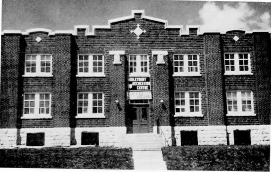
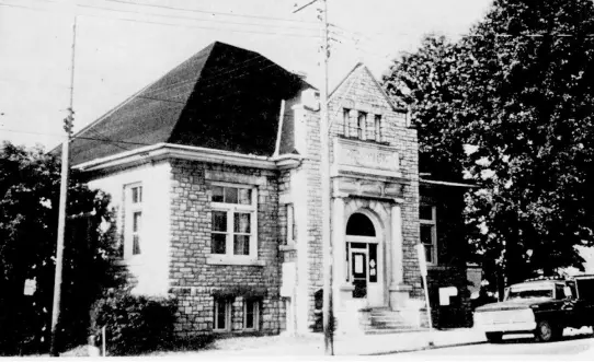
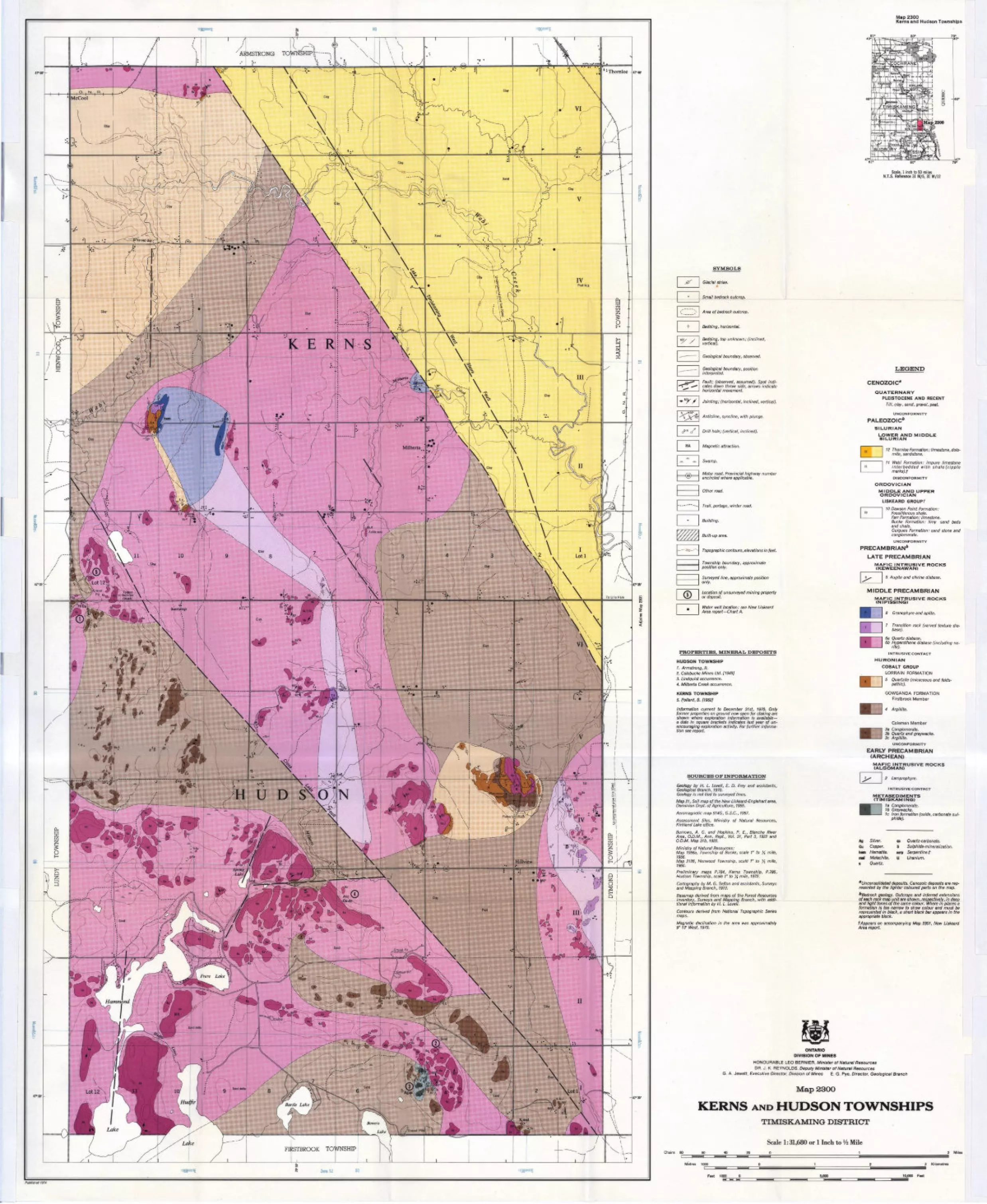
1; Thornloe w w
"'ARMSTRONG TOWNSHIP!
t A iK E RJN S
STBROOK TOWNSHIP
-47" 35'
-47" 30'
Map 2300Kerns and Hudson Townships
+
l OOH
-950-
3YMBOLS
Glacial striae.t
Small bedrock outcrop.
Area of bedrock outcrop.
Bedding, horizontal.
Bedding, top unknown; (inclined, vertical),
Geological boundary, observed.
Geological boundary, position interpreted.
Fault; (observed, assumed). Spot indi cates down throw side, arrows indicate horizontal movement.
Jointing; (horizontal, inclined, vertical).
Anticline, syncline, with plunge.
Drill hole; (vertical, inclined}.
Magnetic attraction.
Swamp.
Motor road. Provincial highway number encircled where applicable.
Other road.
Trail, portage, winter road.
Building.
Built-up area.
Topographic contours, elevations in feet.
Township boundary, approximate position only.
Surveyed line, approximate position only.
Location of unsurveyed mining property or deposit.
Water well location: see New Liskeard Area report—Chart A.
PROPERTIES, MINERAL DEPOSITS
HUDSON TOWNSHIP
1. Armstrong, FI.2. Colebucke Mines Ltd. [1949}3. Lindquist occurrence.4. Milberta Creek occurrence.
iKERNS TOWNSHIP5. Pollard, B. [1952]
Information current to December 31st, 1970. Only former properties on ground now open for staking are shown where exploration information is available— a date in square brackets indicates last year of un- encouraging exploration activity. For further informa tion see report.
SOURCES OF INFORMATION
Geology by H. L. Lovell, E. D. Frey and assistants,Geological Branch, 1970.Geology is not tied to surveyed lines.Map 21, Soil map of the New Liskeard-Englehart area, Dominion Dept. of Agriculture, 1955.
Aeromagnetic map 514G, G.S.C., 1957.
Assessment files, Ministry of Natural Resources, Kirkland Lake office.
Burrows, A. G. and Hopkins, P. E., Blanche River Area, O.D.M., Ann. Repi, Vol. 31, Part 3, 1922 and O.D.M.Map31b, 1922.
Ministry of Natural Resources:Map 1956a, Township of Bucke, scale 1" to X mile,1956.Map 2126, Henwood Township, scale 1" to ^ mile,1966.Preliminary maps P.784, Kerns Township, P.786, Hudson Township, scale 1" to X rnite, 1972.
Cartography by M. G. Sefton and assistants, Surveys and Mapping Branch, 1973.
Basemap derived from maps of the Forest Resources Inventory, Surveys and Mapping Branch, with addi tional information by H. L. Lovell.
Contours derived from National Topographic Series maps.
Magnetic declination in the area was approximately 90 13' West, 1970.
Scale, l inch to 50 miles N.T.S. Reference 31 M/5, 31 M/12
LEGEND
CENOZOIC*
QUATERNARYPLEISTOCENE AND RECENT
Till, clay, sand, gravel, peat.
UNCONFORMITY
PALEOZOIC*
SILURIAN
LOWER AND MIDDLE SILURIAN
12 Thornloe Formation: limestone, dolo mite, sandstone.
11 Wabi Formation: impure limestone interbedded with shale (ripple marks), fDISCONFORMITY
ORDOVICIAN
MIDDLE AND UPPER ORDOVICIAN
LISKEARD GROUP/
10 Dawson Point Formation: Fossil/Serous shale. Farr Formation: limestone. Bucke Formation: limy sand beds and shale.Guigues Formation: sand stone and conglomerate.UNCONFORMITY
PRECAMBRIAN6
LATE PRECAMBRIAN
MAFIC INTRUSIVE ROCKS (KEWEENAWAN)
9 Augite and olivine diabase.
MIDDLE PRECAMBRIAN
MAFIC INTRUSIVE ROCKS (NIPISSING)
8 Granophyre and aplite.
7 Transition rock (varved texture dia base).
6a Quartz diabase.6b Hypersthene diabase (including no
rite).INTRUSIVE CONTACT
HURONIAN
COBALT GROUPLORRAIN FORMATION
5 Quartzite (micaceous and felds pathic).
GOWGANDA FORMATION Firstbrook Member
4 Argillite.
Coleman Member3a Conglomerate.3b Quartz and graywacke.3c Argillite.
UNCONFORMITY
EARLY PRECAMBRIAN (ARCHEAN)
MAFIC INTRUSIVE ROCKS (ALGOMAN)
2 Lamprophyre.
l IMTRUSIVE CONTACT
METASEDIMENTS (TIMISKAMING)
1 a Conglomerate. 1b Greywacke.1c Iron formation (oxide, carbonate sul
phide).
Ag Silver. ne Quartz-carbonate.Cu Copper. S Sulphide-mineralization.hem Hematite. serp Serpentine.fma! Malachite. U Uranium.q Quartz.
'Unconsolidated deposits. Cenozoic deposits are rep resented by the lighter coloured parts on the map.
^Bedrock geology. Outcrops and inferred extensions of each rock map unit are shown, respectively, in deep and light tones of the same colour. Where in places a formation is too narrow to show colour and must be represented in black, a short black bar appears in the appropriate block.f Appears on accompanying Map 2301, New Liskeard Area report.
ONTARIO DIVISION OF MINES
HONOURABLE LEO BERNIER, Minister of Natural ResourcesDR. J. K. REYNOLDS, Deputy Minister of Natural Resources
G. A. Jewett. Executive Director. Division of Mines E. G. Pye, Director. Geological Branch
MapSSOO J
KERNS AND HUDSON TOWNSHIPSTIMISKAMING DISTRICT
Scale 1:31,680 or l Inch to V* MileChains 80
Published 1974
G 60 40
Metres 1000
Feet 1000 0
20 0 1 2 Miles
0123 Kilometres
5.000 10,000 Feet——^ \—— ——— i i—— —— -l l ————— , i ————— H
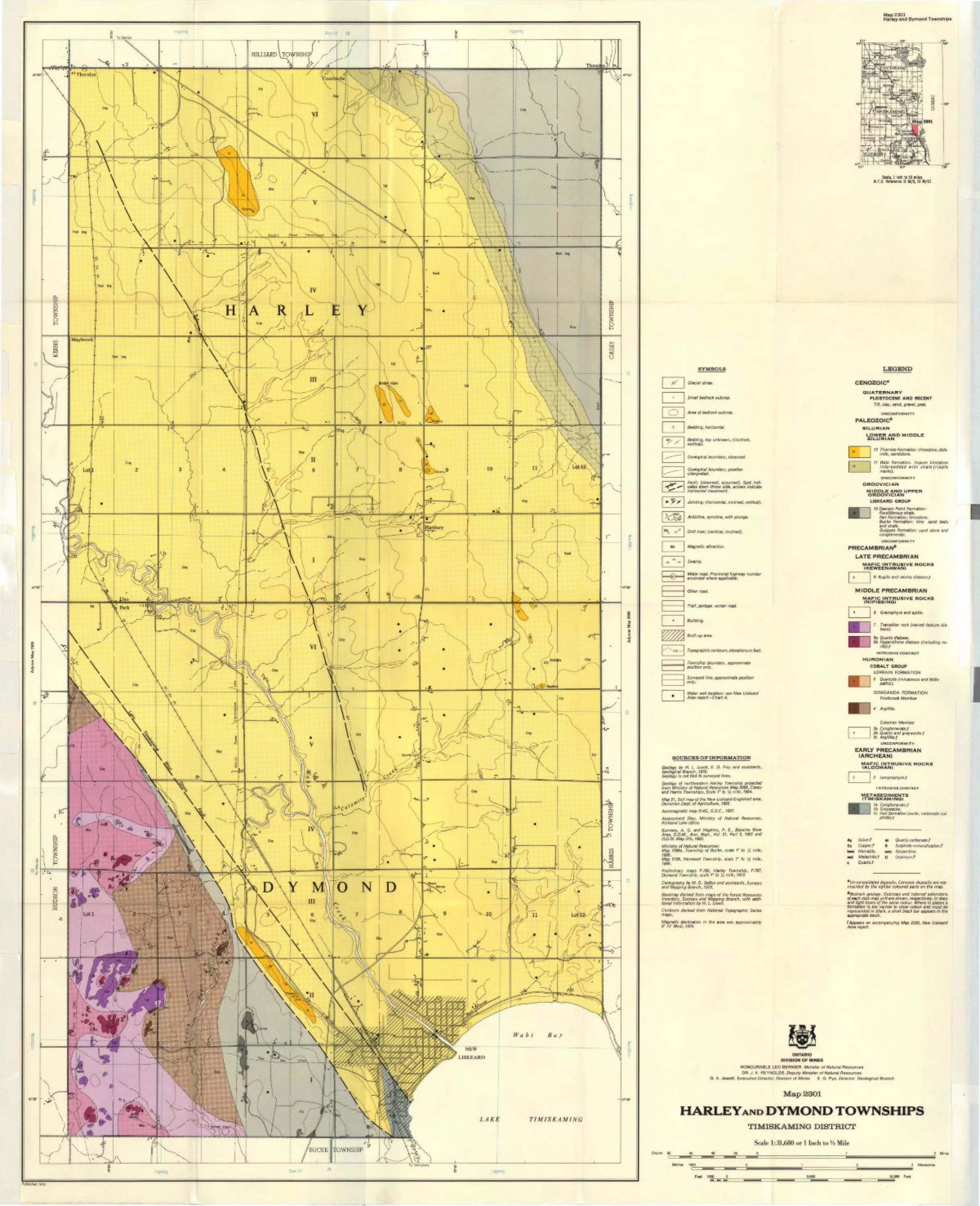
HILLIARD \TOWNSHIP
O N 'D
47 030
Map 2301Harley and Dymond Townships
SYMBOLS
Glacial striae.
Small bedrock outcrop.
Area of bedrock outcrop.
Bedding, horizontal.
Bedding, top unknown; (inclined, vertical).
Geological boundary, observed.
Geological boundary, position interpreted.
Fault; (observed, assumed). Spot indi cates down throw side, arrows indicate horizontal movernent.
Jointing; (horizontal, inclined, vertical).
Anticline, syncline, with plunge.
Drill hole; (vertical, inclined),
Magnetic attraction.
Swamp.
Motor road. Provincial highway number encircled where applicable.
Other mad.
Trail, portage, winter road.
Building.
Built-up area.
Topographic contours, elevations in feet.
Township boundary, approximate position only.
Surveyed line, approximate position only.
Water well location: see New Liskeard Area report—Chart A.
SOURCES OF INFORMATION
Geology by H. L. Lovell, E. D. Frey and assistants,Geological Branch, 1970.Geology is not tied to surveyed lines.
Geology of northeastern Harley Township projected from Ministry of Natural Resources Map 2066, Casey and Harris Townships, Scale 1" to fA mile, 1964.
Map 21, Soil map of the New Liskeard-Englehart area, Dominion Dept. of Agriculture, 1955.
Aeromagnetic map 514G, G.S.C., 1957.
Assessment files, Ministry of Natural Resources, Kirkland Lake office.
Burrows, A. G. and Hopkins, P. E., Blanche River Area, O.D.M., Ann. Repi., Vol. 31, Part 3, 1922 and O.D.M. Map 31b, 1922.
Ministry of Natural Resources:Map 1956a, Township of Bucke, scale V to X mile,1956.Map 2126, Henwood Township, scale 1" to y2 mile,1966.Preliminary maps P.785, Harley Township, P.787, Dymond Township, scale 1" to y4 mile, 1972.
Cartography by M. G. Sefton and assistants, Surveys and Mapping Branch, 1973.
Basemap derived from maps of the Forest Resources Inventory, Surveys and Mapping Branch, with addi tional information by H. L. Lovell.Contours derived from National Topographic Series maps.
Magnetic declination in the area was approximately 9" 13' West, 1970.
Scale, l inch to 50 miles H.T.S. Reference 31 M/5, 31 M/12
LEGEND
CENOZOIC*
QUATERNARY
PLEISTOCENE AND RECENTTill, clay, sand, gravel, peat.
UNCONFORMITY
PALEOZOIC*
SILURIAN
LOWER AND MIDDLE SILURIAN
12 Thornloe Formation: limestone, dolo mite, sandstone.
11 Wabi Formation: impure limestone interbedded with shale(ripple marks).DISCONFORMITY
ORDOVICIAN
MIDDLE AND UPPER ORDOVICIAN
LISKEARD GROUP
W Dawson Point Formation: Fossi/iferous shale. Farr Formation: limestone. Bucke Formation: limy sand beds and shale.Guigues Formation: sand stone and conglomerate.UNCONFORMITY
PRECAMBRIAN*
LATE PRECAMBRIAN
MAFIC INTRUSIVE ROCKS (KEWEENAWAN)
9 Augite and olivine diabase.?
MAFIC INTRUSIVE ROCKS (NIPISSING)
MIDDLE PRECAMBRIAN
8 Granophyre and aplite.
7 Transition rock (varved texture dia base).
6a Quartz diabase.6b Hypersthene diabase (including no
rite).?INTRUSIVE CONTACT
HURONIAN
COBALT GROUPLORRAIN FORMATION
5 Quartzite (micaceous and felds pathic).
GOWGANDA FORMATION Firstbrook Member
4 Argillite.
Coleman Member3a Conglomerate.?3b Quartz and graywacke,?3c Argillite.?
UNCONFORMITY
EARLY PRECAMBRIAN (ARCHEAN)
MAFIC INTRUSIVE ROCKS (ALGOMAN)
2 lamprophyre.?
l NTRUSIVE CONTACT
METASEDIMENTS (TIMISKAMING)
1a Conglomerate.? 1b Greywacke.1c Iron formation (oxide, carbonate sul
phide).?
Ag Silver.? qc Quartz-carbonate.?Cu Copper.? S Sulphide-mineralization.?hem Hematite. serp Serpentine.mal Malachite,? U Uranium.?q Quartz.?
aUnconsolidated deposits. Cenozoic deposits are rep resented by the lighter coloured parts on the map.
^Bedrock geology. Outcrops and inferred extensions of each rock map unit are shown, respectively, in deep and light tones of the same colour. Where in places a formation is too narrow to show colour and must be represented in black, a short black bar appears in the appropriate block.
t Appears on accompanying Map 2300, New Liskeard Area report.
ONTARIO
DIVISION OF MINES
HONOURABLE LEO BERNIER, Minister of Natural ResourcesDR. J. K. REYNOLDS, Deputy Minister of Natural Resources
G. A. Jewett, Executive Director, Division of Mines E. G. Pye, Director, Geological Branch
Map 2301
HARLEYAND DYMOND TOWNSHIPSTIMISKAMING DISTRICT
Scale 1:31,680 or l Inch to V2 MileChains 80 60 2 Miles
Metres 1000 3 Kilometres
Feet 1000 O 5,000 10,000 Feet