Embed Size (px)
Citation preview
Physical geology
Unit :2
Interior of the Earth.
Internal structure based on the travel time of seismic waves.
When an earthquake occurs the seismic waves (P and S waves) spread out in all directions through the Earth's interior. Seismic stations located at increasing distances from the earthquake epicenter will record seismic waves that have traveled through increasing depths in the Earth.
Seismic velocities depend on the material properties such as composition, mineral phase and packing structure, temperature, and pressure of the media through which seismic waves pass. Seismic waves travel more quickly through denser materials and therefore generally travel more quickly with depth. Anomalously hot areas slow down seismic waves. Seismic waves move more slowly through a liquid than a solid. Molten areas within the Earth slow down P waves and stop S waves because their shearing motion cannot be transmitted through a liquid. Partially molten areas may slow down the P waves and attenuate or weaken S waves.
When seismic waves pass between geologic layers with contrasting seismic velocities (when any wave passes through media with distinctly differing velocities) reflections, refraction (bending), and the production of new wave phases (e.g., an S wave produced from a P wave) often result. Sudden jumps in seismic velocities across a boundary are known as seismic discontinuities.
Crust.
Seismic stations within about 200 km of a continental earthquake (or other seismic disturbance such as a dynamite blast) report travel times that increase in a regular fashion with distance from the source. But beyond 200 km the seismic waves arrive sooner than expected, forming a break in the travel time vs. distance curve. Mohorovicic (1909) interpreted this to mean that the seismic waves recorded beyond 200 km from the earthquake source had passed through a lower layer with significantly higher seismic velocity.
This seismic discontinuity is now know as the Moho (much easier
than "Mohorovicic seismic discontinuity") .It is the boundary between the
felsic/mafic crust with seismic velocity around 6 km/sec and the denser
ultramafic mantle with seismic velocity around 8 km/sec. The depth to the Moho
beneath the continents averages around 35 km but ranges from around 20 km
to 70 km. The Moho beneath the oceans is usually about 7 km below the seafloor
(i.e., ocean crust is about 7 km thick).
Mantle.
Low Velocity Zone Seismic velocities tend to gradually increase with depth in the mantle due to the increasing pressure, and therefore density, with depth. However, seismic waves recorded at distances corresponding to depths of around 100 km to 250 km arrive later than expected indicating a zone of low seismic wave velocity. Furthermore, while both the P and S waves travel more slowly, the S waves are attenuated or weakened. This is interpreted to be a zone that is partially molten, probably one percent or less (i.e., greater than 99 percent solid). Alternatively, it may simply represent a zone where the mantle is very close to its melting point for that depth and pressure that it is very "soft." Then this represents a zone of weakness in the upper mantle. This zone is called the asthenosphere or "weak sphere."
The asthenosphere separates the strong, solid rock of the uppermost mantle and crust above from the remainder of the strong, solid mantle below. The combination of uppermost mantle and crust above the asthenosphere is called the lithosphere. The lithosphere is free to move (glide) over the weak asthenosphere. The tectonic plates are, in fact, lithospheric plates.The 670 km discontinuity is thought to represents a major boundary separating a less dense upper mantle from a more dense lower mantle.
Core.
Seismic waves recorded at increasing distances from an earthquake indicate that seismic velocities gradually increase with depth in the mantle (exceptions: see Low Velocity Zone and 670 km Discontinuity above). However, at arc distances of between about 103° and 143° no P waves are recorded. Furthermore, no S waves are record beyond about 103°. Gutenberg (1914) explained this as the result of a molten core beginning at a depth of around 2900 km. Shear waves could not penetrate this molten layer and P waves would be severely slowed and refracted (bent).
The Inner Core Between 143° and 180° from an earthquake another refraction is recognized (Lehman, 1936) resulting from a sudden increase in P wave velocities at a depth of 5150 km. This velocity increase is consistent with a change from a molten outer core to a solid inner core.
Seismic boundaries and discontinuities.
Three types of seismic boundaries:
(1) lithological ones which separate rocks of different compositions and age,
(2) tectonic boundaries referred to the faults and
(3) mechanical ones confined to zones of different porosity or cracking. Seismic
studies have shown that the first two types of boundaries have a very
complicated structure and are characteristic of the upper crust; below depths of
10–15 km a definite near-horizontal stratification of the lithosphere is observed.
In the middle part of the crust of ancient platforms a weakened layer is formed
due to dilatancy, with lower velocities and higher electrical conductivity. In the
lower crust, at depths of 25–30 km, a boundary is formed as the result of
material differentiation, it probably separates crustal rocks from more basic
(mantle) rocks.
The nature of the M boundary is apparently dual i.e., chemical and phase. The
phase component is evident in the considerable mobility of the boundary in the
process of geological evolution: it rises with increase of temperature and sinks
as the crust cools off. Beneath the ancient platforms, the M boundary is confined
to the level where the rocks are in a state of true plasticity; this makes them
impermeable to fluids and causes physicochemical transformations.
Seismic discontinuities are the regions in the earth where seismic waves behave a lot different compared to the surrounding regions due to a marked change in physical or chemical properties.
Mohorovicic Discontinuity (Moho): separates the crust from the mantle. Asthenosphere: highly viscous, mechanically weak and ductile part of
mantle. Gutenberg Discontinuity: lies between the mantle and the outer core.
Shadow zone.
The shadow zone is the area of the earth from angular distances of 104 to
140 degrees from a given earthquake that does not receive any direct P
waves. The shadow zone results from S waves being stopped entirely by the
liquid core and P waves being bent (refracted) by the liquid core.
Earthquake.
Earthquake, any sudden shaking of the ground caused by the passage of seismic
waves through Earth’s rocks. Seismic waves are produced when some form of
energy stored in Earth’s crust is suddenly released, usually when masses of rock
straining against one another suddenly fracture and “slip.” Earthquakes occur
most often along geologic faults, narrow zones where rock masses move in
relation to one another. The major fault lines of the world are located at the
fringes of the huge tectonic plates that make up Earth’s crust.
Seismic wave type.
There are two broad classes of seismic waves: body waves and surface waves.
Body waves travel within the body of Earth. They include P, or primary, waves
and S, or secondary, waves.
P waves cause the ground to compress and expand, that is, to move back and
forth, in the direction of travel. They are called primary waves because they
are the first type of wave to arrive at seismic recording stations. P waves can
travel through solids, liquids, and even gases.
S waves shake the ground in a shearing, or crosswise, motion that is
perpendicular to the direction of travel.
These are the shake waves that move the ground up and down or from side to
side. S waves are called secondary waves because they always arrive after P
waves at seismic recording stations. Unlike P waves, S waves can travel only
through solid materials.
After both P and S waves have moved through the body of Earth, they are
followed by surface waves, which travel along Earth’s surface. Surface waves
travel only through solid media. They are slower-moving than body waves but
are much larger and therefore more destructive.
The two types of surface waves are named Love waves and Rayleigh waves,
after the scientists who identified them.
Love waves have a horizontal motion that moves the surface from side to side
perpendicular to the direction the wave is traveling. Of the two surface waves,
Love waves move faster.
Rayleigh waves cause the ground to shake in an elliptical pattern. This motion
is similar to that observed in ocean waves. Of all the seismic waves, Rayleigh
waves spread out the most, giving them a long duration on seismograph
recordings.
Basic properties –generation of seismic waves in the earth.
At all distances from the focus, mechanical properties of the rocks, such as incompressibility, rigidity, and density, play a role in the speed with which the waves travel and the shape and duration of the wave trains. The layering of the rocks and the physical properties of surface soil also affect wave characteristics. In most cases, elastic behaviour occurs in earthquakes, but strong shaking of surface soils from the incident seismic waves sometimes results in nonelastic behaviour, including slumping (that is, the downward and outward movement of unconsolidated material) and the liquefaction of sandy soil.
When an earthquake occurs, the shockwaves of released energy that shake the Earth and temporarily turn soft deposits, such as clay, into jelly (liquefaction) are called seismic waves, from the Greek ‘seismos’ meaning ‘earthquake’. Seismic waves are usually generated by movements of the Earth’s tectonic plates but may also be caused by explosions, volcanoes and landslides.
Location of earthquake.
Focus(hypocentre).
The focus is the place inside Earth’s crust where an earthquake originates. The
point on the Earth’s surface directly above the focus is the epicenter. When
energy is released at the focus, seismic waves travel outward from that point in
all directions.
Epicentre.
Epicentre, point on the surface of the Earth that is directly above the
underground point (called the focus) where fault rupture commences,
producing an earthquake. The effects of the earthquake may not be most severe
in the vicinity of the epicentre. The epicentre can be located by computing arcs
from each of three or more seismic observatories, with the arcs’ radii
proportional to the time of travel of seismic waves from the focus to each
station. The point of intersection of the arcs marks the epicentre.
Seismogram and seismograph.
A seismogram is the recording of the ground shaking at the specific location of
the instrument. On a seismogram, the HORIZONTAL axis = time (measured in
seconds) and the vertical axis= ground displacement (usually measured in
millimeters). When there is NO EARTHQUAKE reading, there is just a straight line
except for small wiggles caused by local disturbance or "noise" and the time
markers. Seismograms are digital now - there are no more paper recordings.
Seismographs are instruments used to record the motion of the ground during an earthquake. They are installed in the ground throughout the world and operated as part of a seismographic network. The earliest "seismoscope" was invented by the Chinese philosopher Chang Heng in A.D. 132. This did not, however, record earthquakes; it only indicated that an earthquake was occurring. The first seismograph was developed in 1890.
A seismograph is securely mounted onto the surface of the earth so that when the earth shakes, the entire unit shakes with it EXCEPT for the mass on the spring, which has inertia and remains in the same place. As the seismograph shakes under the mass, the recording device on the mass records the relative motion between itself and the rest of the instrument, thus recording the ground motion. In reality, these mechanisms are no longer manual, but instead work by measuring electronic changes produced by the motion of the ground with respect to the mass.
The causes of earthquake.
Earthquakes are usually caused when rock underground suddenly breaks along a fault. This sudden release of energy causes the seismic waves that make the ground shake. When two blocks of rock or two plates are rubbing against each other, they stick a little. They don't just slide smoothly; the rocks catch on each other. The rocks are still pushing against each other, but not moving. After a while, the rocks break because of all the pressure that's built up. When the rocks break, the earthquake occurs. During the earthquake and afterward, the plates or blocks of rock start moving, and they continue to move until they get stuck again. The spot underground where the rock breaks is called the focus of the earthquake. The place right above the focus (on top of the ground) is called the epicenter of the earthquake.
Earthquake-like seismic waves can also be caused by explosions underground.
These explosions may be set off to break rock while making tunnels for roads,
railroads, subways, or mines. These explosions, however, don't cause very
strong seismic waves. You may not even feel them. Sometimes seismic waves
occur when the roof or walls of a mine collapse. These can sometimes be felt by
people near the mine. The largest underground explosions, from tests of nuclear
warheads (bombs), can create seismic waves very much like large earthquakes.
This fact has been exploited as a means to enforce the global nuclear test ban,
because no nuclear warhead can be detonated on earth without producing such
seismic waves.
Prediction and remedial measures.
Personal measures Seek shelter under stable tables or under door frames. If outside, stay away from buildings, bridges and electricity pylons and move
to open areas. Avoid areas at risk from secondary processes, such as landslides, rockfall and
soil liquefaction. After an earthquake, check gas, water and electricity pipes and lines for
damage. Listen to the radio and follow the instructions issued by the authorities. Technical/biological measures No measures can be taken to prevent earthquakes themselves, however
limited measures exist that can counteract their secondary effects like landslides, rockfall and soil liquefaction.
Earthquake-proof planning and design of buildings The microzoning of the local geological substratum provides indicators of
areas in which tremors will have a particularly strong or attenuated effect. Organisational measures At present, earthquake prediction is insufficiently precise to provide the
public with sufficient advance warning. For this reason, adequate preparedness and assistance in catastrophes is extremely important in areas affected by earthquakes. Measures of this nature enable numbers of human lives to be saved.
Seismic zones.
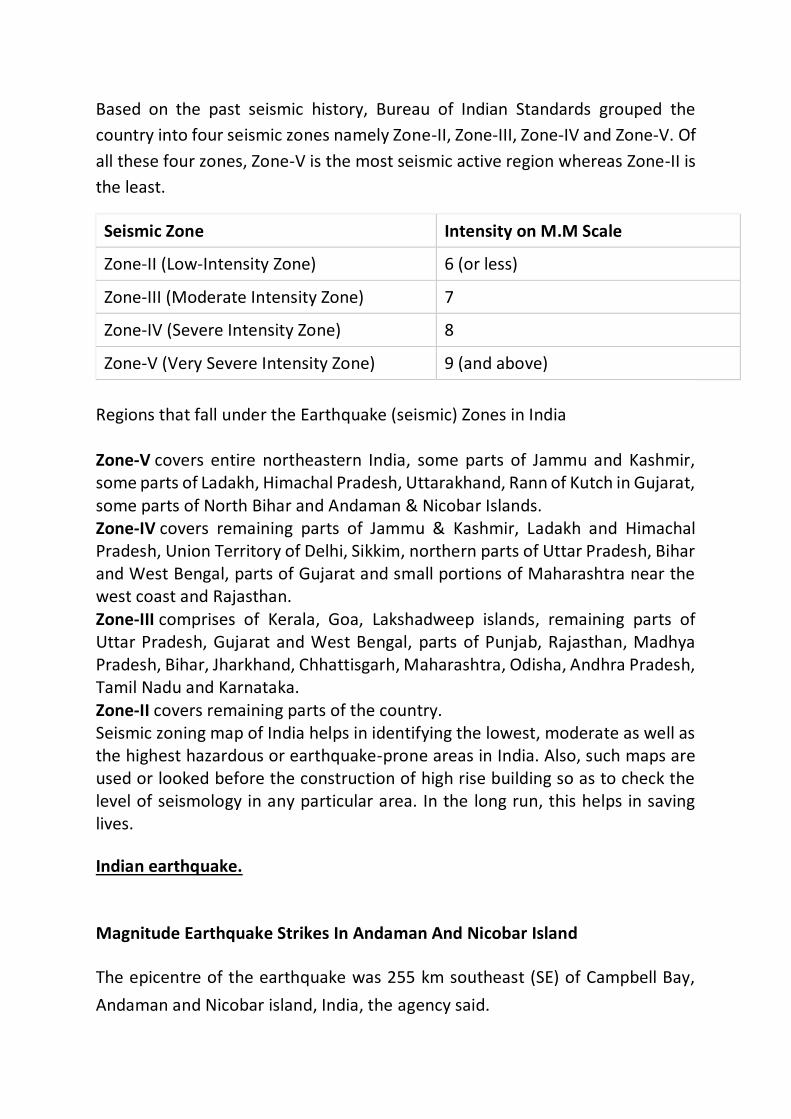
Based on the past seismic history, Bureau of Indian Standards grouped the
country into four seismic zones namely Zone-II, Zone-III, Zone-IV and Zone-V. Of
all these four zones, Zone-V is the most seismic active region whereas Zone-II is
the least.
Seismic Zone Intensity on M.M Scale
Zone-II (Low-Intensity Zone) 6 (or less)
Zone-III (Moderate Intensity Zone) 7
Zone-IV (Severe Intensity Zone) 8
Zone-V (Very Severe Intensity Zone) 9 (and above)
Regions that fall under the Earthquake (seismic) Zones in India Zone-V covers entire northeastern India, some parts of Jammu and Kashmir, some parts of Ladakh, Himachal Pradesh, Uttarakhand, Rann of Kutch in Gujarat, some parts of North Bihar and Andaman & Nicobar Islands. Zone-IV covers remaining parts of Jammu & Kashmir, Ladakh and Himachal Pradesh, Union Territory of Delhi, Sikkim, northern parts of Uttar Pradesh, Bihar and West Bengal, parts of Gujarat and small portions of Maharashtra near the west coast and Rajasthan. Zone-III comprises of Kerala, Goa, Lakshadweep islands, remaining parts of Uttar Pradesh, Gujarat and West Bengal, parts of Punjab, Rajasthan, Madhya Pradesh, Bihar, Jharkhand, Chhattisgarh, Maharashtra, Odisha, Andhra Pradesh, Tamil Nadu and Karnataka. Zone-II covers remaining parts of the country. Seismic zoning map of India helps in identifying the lowest, moderate as well as the highest hazardous or earthquake-prone areas in India. Also, such maps are used or looked before the construction of high rise building so as to check the level of seismology in any particular area. In the long run, this helps in saving lives.
Indian earthquake.
Magnitude Earthquake Strikes In Andaman And Nicobar Island
The epicentre of the earthquake was 255 km southeast (SE) of Campbell Bay,
Andaman and Nicobar island, India, the agency said.
Earthquake Strikes Near Surat In Gujarat India News | NDTV Newsdesk | Saturday November 7, 2020 An earthquake of magnitude 4.2 was reported near Surat in Gujarat on Saturday afternoon, according to India's National Center for Seismology.
Earthquake With Magnitude 4.4 In Meghalaya:The epicentre of the
earthquake was 71 km west-southwest (WSW) of Nongpoh, the agency said. The
earthquake struck at 1:13 am at a depth of 10km from the surface.
Earthquake in Uttarakhand with Magnitude 3.9 Strikes Near Pithoragarh
India News | NDTV Newsdesk | Monday October 26, 2020
An earthquake of magnitude 3.9 was reported near Pithoragarh in Uttarakhand on Sunday night, according to India's National Center for Seismology.
Earthquake In Manipur With Magnitude 5.3 Strikes Near Bishnupur India News | NDTV Newsdesk | Sunday October 11, 2020
An earthquake of magnitude 5.3 was reported near Bishnupur in Manipur on Saturday night, according to India's National Center for Seismology.
Earthquake Strikes Near Jammu and Kashmir's Gulmarg India News | NDTV Newsdesk | Saturday September 26, 2020
An earthquake of magnitude 4.5 was reported near Gulmarg in Jammu and Kashmir on Saturday afternoon, according to India's National Center for Seismology.
Earthquake in Maharashtra with Magnitude 3.5 Strikes Near Mumbai India News | NDTV Newsdesk | Tuesday September 22, 2020
An earthquake of magnitude 3.5 was reported near Mumbai in Maharashtra on Tuesday morning, according to India's National Center for Seismology.Earthquake In Ladakh With Magnitude 3.6 Strikes Near Kargil .An earthquake of magnitude 3.6 was reported near Kargil in ladakh on Saturday morning, according to India's National Center for Seismology.
Earthquake Of Magnitude 4.8 Strikes Near Pangin In Arunachal Pradesh
India News | NDTV Newsdesk | Thursday September 17, 2020
An earthquake of magnitude 4.8 was reported near Pangin in Arunachal Pradesh this morning, according to India's National Center for Seismology.
Tsunamis and seismic waves.
Definition.
Tsunamie also called wave train, is a series of large ocean waves (or "wave
train") of extremely long wavelength and period, usually generated when a
gigantic body of water, such as an ocean, is suddenly displaced on a massive
scale by an underwater disturbance such as an earthquake occurring on or near
the sea floor or a volcanic eruption.
After a sudden displacement of a large water volume by seismic activity (earthquake), the ocean floor is raised or dropped and large tsunami waves can be formed by gravitational forces.
Waves travel outward from the quake zone in all directions in a ripple effect (propagation). The resulting waves can be extremely dangerous and devastating to low-lying coastal areas as they enter shallow water and hit the shoreline.
A tsunami can occur at any state of the tide and even at low tide it will inundate coastal areas if the incoming waves surge high enough. Tsunamis may occur in large lakes. About 86% of all tsunamis result from so-called sea-quakes.
Types of tsunamis.
There are two types of tsunami generation: Local tsunami and Far Field or
distant tsunami. The coastal areas in the Philippines especially those facing the
Pacific Ocean, South China Sea, Sulu Sea and Celebes Sea can be affected by
tsunamis that may be generated by local earthquakes. Local tsunamis are
confined to coasts within a hundred kilometers of the source usually
earthquakes and a landslide or a pyroclastics flow. It can reach the shoreline
within 2 to 5 minutes. Far field or distant tsunamis can travel from 1 to 24 hours
before reaching the coast of the nearby countries. These tsunamis mainly
coming from the countries bordering Pacific Ocean like Chile, Alaska in USA and
Japan. The Pacific Tsunami Warning Center (PTWC) and Northwest Pacific
Tsunami Advisory Center (NWPTAC) are the responsible agencies that closely
monitor Pacific-wide tsunami event and send tsunami warning to the countries
around the Pacific Ocean.
Generation of tsunamis.
Tsunamis are gravity‐driven water waves. Most are generated by vertical
displacement of the seabed that propagates through the water column to the
sea surface. The resulting elevated surface wave collapses through gravity and
then propagates outward from the source. Dispersion of the initial wave
generates a multiple wave train. Tsunamis are mainly (∼80%) generated by
earthquakes, but other mechanisms include subaerial and submarine landslides
and volcanic collapse and eruption. Other, less frequent, tsunami mechanisms
include bolide (asteroid) impact and weather events (meteotsunamis), but these
are generated at the water surface, respectively, from external impact and from
wind friction.
There are three main aspects of a tsunami; (i) initial wave generation, (ii) propagation, and (iii) onland run‐up. Initial wave generation from earthquakes is mainly from seabed vertical displacement, and a rule of thumb suggests that in most instances the maximum initial wave elevation is up to twice this. The maximum initial wave elevation from a landslide tsunami is theoretically determined by the ocean depth and thus could be thousands of meters.
Local tsunami run‐up elevations vary with source mechanism and vary considerably. Although dependent on local bathymetry and topography, these are likely to be more elevated and focused from submarine landslides than from earthquakes. The different mechanisms generate different tsunami wave frequencies; these determine travel distances, with the low frequency tsunamis from earthquakes traveling much farther than tsunamis from landslides, which are much higher frequency. Final onland run‐up is mainly dependent on source mechanism as well as local offshore bathymetry and coastal topography.
Remedial measures.
Tsunamis are large ocean waves generated by major earthquakes beneath the
ocean floor or major landslides into the ocean. Rising to several feet or higher,
they can strike the coast with devastating force. People on beaches or in low
coastal areas, such as estuaries and rivers, need to be aware that a tsunami
could arrive within minutes of a severe earthquake – and the danger period can
continue for many hours. Tsunamis can occur any time of year, day or night.
Top Tips
To escape a tsunami, go as high and as far as you can – ideally to a spot 100 feet
above sea level or 2 miles away.Map your evacuation route—not just for your
home, but work, school or caregivers, or any place else where your family
tends to be. Know how to get to safety on foot—roads may not always be
feasible. Have your evacuation plan ready and rehearsed now. That way,
Richards says, "You don't have to think about it. You just go and do it." Keep an
emergency kit or "go bag" handy at home or in your car. The American Red
Cross offers tips for stocking it here, including food, water, and a cell phone
with chargers. Every foot inland or upward may make a difference!If you can
see the wave, you are too close for safety.The most important step in staying
safe during a tsunami—or any natural disaster, for that matter—is to know
how vulnerable your area is in the first place. Many local governments map
hazard areas and evacuation routes for communities at risk, while the U.S.
National Weather Service offers a nationwide map with links to resources.
Indian tsunamis.
Indian Ocean tsunami of 2004, tsunami that hit the coasts of several countries of South and Southeast Asia in December 2004. The tsunami and its aftermath were responsible for immense destruction and loss on the rim of the Indian Ocean.
On December 26, 2004, at 7:59 AM local time, an undersea earthquake with a magnitude of 9.1 struck off the coast of the Indonesian island of Sumatra. Over the next seven hours, a tsunami—a series of immense ocean waves—triggered by the quake reached out across the Indian Ocean, devastating coastal areas as far away as East Africa. Some locations reported that the waves had reached a height of 30 feet (9 metres) or more when they hit the shoreline.
The tsunami killed at least 225,000 people across a dozen countries, with Indonesia, Sri Lanka, India, Maldives, and Thailand sustaining massive damage. Indonesian officials estimated that the death toll there alone ultimately exceeded 200,000, particularly in northern Sumatra’s Aceh province. Tens of thousands were reported dead or missing in Sri Lanka and India, a large number
of them from the Indian Andaman and Nicobar Islands territory. The low-lying island country of Maldives reported more than a hundred casualties and immense economic damage. Several thousand non-Asian tourists vacationing in the region also were reported dead or missing. The lack of food, clean water, and medical treatment—combined with the enormous task faced by relief workers trying to get supplies into some remote areas where roads had been destroyed or where civil war raged—extended the list of casualties. Long-term environmental damage was severe as well, with villages, tourist resorts, farmland, and fishing grounds demolished or inundated with debris, bodies, and plant-killing salt water.
Reference
www.nationalgeographic.org
www.geol.umd.edu
Earthquake.usgs
www.bbc.co.uk
www.britannica.com
www.usgs.gov
www.geo.mtu.edu
Oceanservice.noa.gov