Embed Size (px)
Citation preview
Assessement Report on
Geology exploration and VLF Surveys Sakoose Grid Property
Lower Manitou Lake Area, Ontario International Precious Metals Group Inc.
Ref. 10-39 June, 2010
Assessment Report on Geology exploration and VLF Surveys Sakoose Grid Property Lower Manitou Lake Area, Ontario
For : International Precious Metals Group Inc. 7480 Magistrate Terrace Mississauga, ON L5W 1L2 Tel : 416.707.4230
By : JVX Ltd.
60 West Wilmot Street, Unit 22 Richmond Hill, Ontario L4B 1M6 Tel: 905.731.0972 Fax: 905.731.9312 www.jvx.ca
Ref. 10-39 June, 2010
Table Of Contents Page
1.0 Summary 1 2.0 Introduction and Terms of Reference 1 3.0 Disclaimer 3 4.0 Accessibility, Climate, Local resources, Infrastructure and Physiography 3 5.0 Property Location and Description 3 6.0 History 4 7.0 Regional Geology 4 8.0 Current Work Program 8
8.1 Property Geology 8 8.2 Structural Geology 10 8.3 Mineralization 10 8.4 Geophysical Geology 11
9.0 Sampling Method and Analyses 13 10.0 Interpretation and Conclusions 13 11.0 Bibliography 13
List of Figures Fig. 1 Current Claim Information 2 Fig. 2 Area map 5 Fig. 3 Regional Geology Map 6 Fig. 4 Claim Map, Local Geology, Sample Locations Map and VLF Data 9 Fig. 5 Sakoose Grid layout 11 Fig. 6 VLF offset profiles over colour/line contours of fraser filtered inphase 12
List of Tables
Table 1 Production summary 11
Attachments Instrument Specification Sheet 15
1
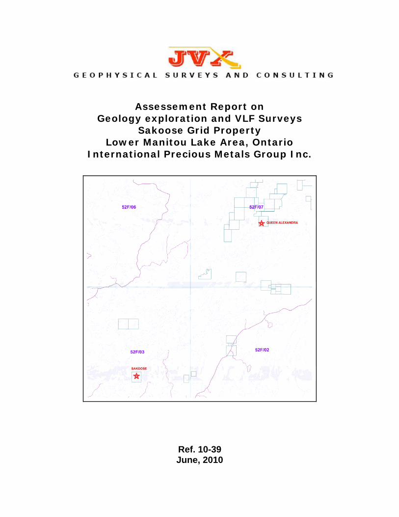
1.0 Summary International Precious Metals Group Inc. and JVX Limited (“JVX”) engaged Nathan R. Cleven to conduct reconnaissance geological mapping of a portion of the Sakoose property and to complete portions of an assessment report describing this work. The Sakoose property, claim 3013711, (figure 1) is located about 140 kilometres south of the Town of Dryden, or approximately 900 km northwest of Toronto. The approximate geographical coordinates of the claims are 49° 07’ N and 93° 07’ W, within NTS 52 F/03 quadrangle. The property consists of: The western part of the Archean age Wabigoon Subprovince is underlain by supracrustal rocks consisting of volcanic and lesser sedimentary rocks ranging in age from 3.0 to 2.71 Ga, which are intruded by granitoid batholiths and gabbroic sills and stocks which range in age from 3.0 to 2.69 Ga. Ten greenstone belts have been recognized in this portion of the subprovince, of which the current property is situated in the Eagle-Wabigoon-Manitou Lakes greenstone belt. This greenstone belt trends northeast and is bounded on the northwest by the Atikwa granitoid batholith and on the southeast by the Irene-Eltrut Lakes batholith, and the Meggissi granitoid pluton. The northeast trending, steeply southeast dipping Manitou Straits Fault has been traced over a distance of 65 km along strike and bisects the greenstone belt. (figure 3) A line cutting and VLF survey was conducted by Bob Major (claim holder) in Feb. 2009. The results were interpreted by the staff at JVX ealy June 2010. The author conducted a mapping and sampling program on International Precious Metals Group’s Sakoose property from June 1st to June 3rd 2010, which covered 2.2 km of proposed grid lines located on the south of Manitou Lake. A total of 11 samples were collected by the author. The area mapped is underlain by a sequence of mafic, intermediate and felsic volcanic rocks. The predominant trend of the foliation in the rocks in the area is northeast. One north-south trending shear zone is interpreted to transect coincident with the proposed 0E line. This structure may represent zones of enhanced dilation and deformation. In the absence of the analytical results from the sampling, as well as the results of any geophysical surveying, it is difficult to determine specific recommendations. However, the author is of the opinion that geophysical surveying should be completed over the entire proposed grid during the fall and winter months. The exact positioning and orientation of the grid lines should be determined upon receipt of all of the relevant data, in order to test the possibility that zones of exploration interest may strike both northeast, as well as northerly. 2.0 Introduction and Terms of Reference International Precious Metals Group Inc. (“IPMG”) and JVX Limited (“JVX”) engaged Nathan Cleven to conduct reconnaissance geological mapping of a portion of the Sakoose property in the Manitou lake area, and to complete portions of an assessment report describing this work.
HomeMines and MineralsNorthern DevelopmentNewsSite MapContact Us
Mining Claim Abstract| Main Menu | Back |
KENORA - Division 10 Claim No: K 3013711 Status: ACTIVE
Due Date: 2010-Jun-14 Recorded: 2008-Feb-14Work Required: $ 6,400 Staked: 2008-Jan-31 16:00
Total Work: $ 0 Township/Area: NAPANEE LAKE AREA (G-2690)Total Reserve: $ 0 Lot Description:Present WorkAssignment: $ 0 Claim Units: 16
Claim Bank: $ 0
Claim Holders
Recorded Holder(s) Percentage Client NumberMAJOR, ROBERT JOSEPH ( 10.00 %) 300058INTERNATIONAL PRECIOUS METALS GROUP INC. ( 90.00 %) 405430
Transaction Listing
Type Date Applied Description Performed NumberSTAKER 2008-Feb-14 RECORDED BY MAJOR, ROBERT JOSEPH (1000143) R0810.01744ORDER 2008-Apr-21 RECORDER'S ORDER. NOTICE OF COMPLIANCE DUE
ON OR BEFORE 2008-MAY-21D0810.00290
ORDER 2008-May-07 NOTICE OF COMPLIANCE WITH ORDER(D081000290) RECEIVED
D0810.01053
TRAN 2008-Jun-17 MAJOR, ROBERT JOSEPH (300058) TRANSFERS 90.00% TO INTERNATIONAL PRECIOUS METALS GROUPINC. (405430)
T0810.00344
ORDER 2010-Feb-12 MINISTER'S ORDER EXTENDS TIME UNTIL ANDINCLUDING 2010-JUN-14 FOR WORK AND FILING
O1010.00039
Mining Lands - Mining Divisions of Ontario http://www.mci.mndm.gov.on.ca/Claims/Cf_Claims/clm_cssm.CFM?Cla...
1 of 2 6/10/2010 12:01 PM
3
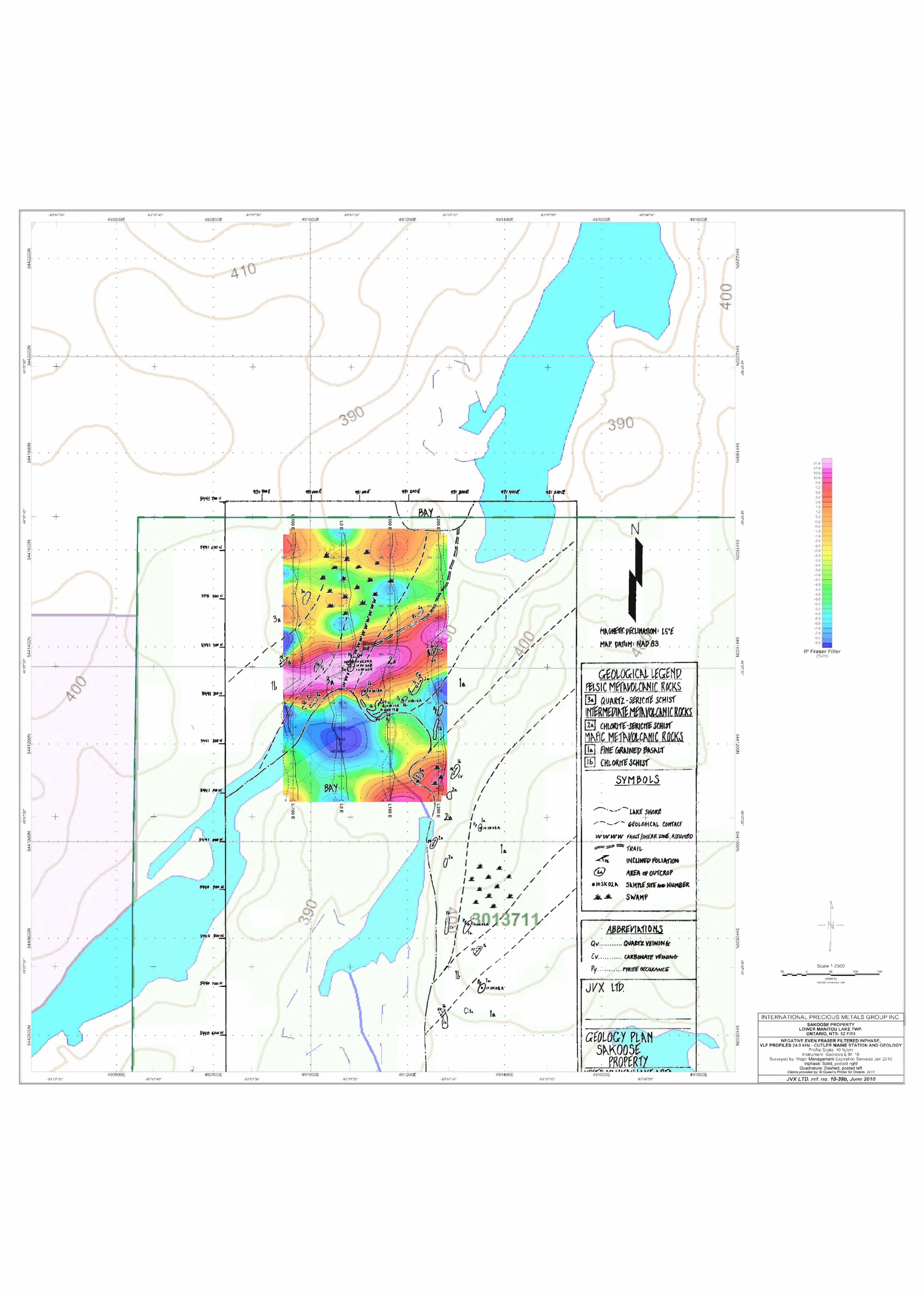
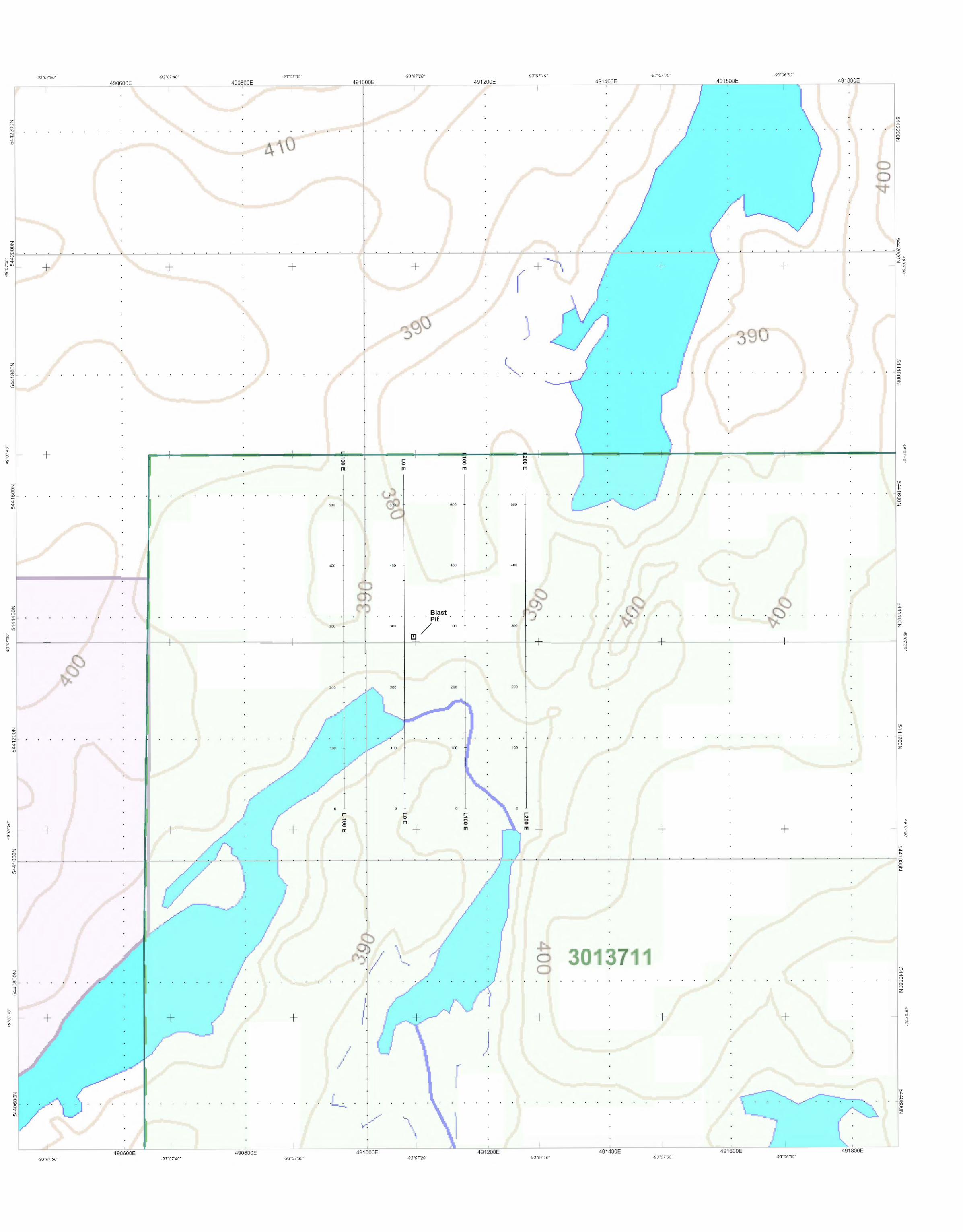
3.0 Disclaimer This report is prepared solely for filing with the Ontario Ministry of Northern Development and Mines (“MNDM”) for assessment credit. This report has not been completed to National Instrument 43-101 specifications and is not intended for any other use than that previously specified. In writing this report, Nathan Cleven has reviewed the reports of previous workers in the area, but cannot assure the accuracy of the data collected or the results of that work. Assay data reported by previous workers have not been confirmed, but are reported as data relevant to the property. In addition, information regarding land ownership and mining rights was obtained form files maintained by the MNDM; the MNDM disclaims the accuracy and subsequent use of these files. 4.0 Accessibility, Climate, Local resources, Infrastructure and Physiography The Sakoose property is located near the historic Gold Rock Mining Camp, about 140 kilometres (“km”) south of the Town of Dryden, or approximately 900 km northwest of Toronto (Figure 2). Year round access is best achieved by fixed wing aircraft or helicopter charter. Highway 502 connecting Dryden and Fort Francis intersects with the Cedar Narrows forestry road approximately 115km South of Dryden. Access to the site by motorboat can be achieved launching from Esox Landing, 29km along Cedar Narrows road, with a 35-minute boat ride up Manitou lake. Boat rental was provided by the Timber Wolf Lodge. Accommodation was provided by Chalet Inn, Dryden. Access to the property grid, from the boat drop-off point, was by foot following an old trail for a distance of about 200m to L 0E. The prevailing climatic conditions are typical of the northern boreal forest, with warm summer days from mid-May to late September. Thunder and lightning storms are common in late May / early June. Winter conditions are characterized by moderate snowfall and sub-zero temperatures. Most preliminary exploration activities can be carried out year round, except for geological and geochemical surveys, which are restricted to the summer months. Local resources on the properties include abundant fresh water, stands of pine, spruce, fir and poplar, as well as limited quantities of aggregates. Electrical power is available at a distance of about 35 km East of the claims. The Town of Dryden is the closest source of commercial enterprises and transportation facilities. The topography is typical of the Canadian Shield. The mean elevation is about 350 metres (“m”) above sea level, with local relief of about 20 m at the tops of rounded hills. The peneplaned surface is punctuated with lakes connected by short rivers and streams. Muskeg is abundant in the low-lying areas. Bedrock composition and geological structure, coupled with regional glaciation control the size, shape and distribution of the lakes and muskeg areas. Lakes adjacent property flow westward into Rainy River via Lower Manitou Lake. Drainage from this area flows westward into Lake Winnipeg and ultimately Hudson’s Bay. 5.0 Property Location and Description
The Sakoose property consists of claim 3013711 with 16 claims units, (figure 1) registered to International Precious Metals Group Inc. (90%) and Robert Joseph Major (10%). The Sakoose

D Volcanic rocks
I I Sedimentary rockf;
I I Granitic rocks
- Mafic intrusion
-- Major fault
0 0 • CY) C)
e Gold occurence
0 20 40 60
kilometres
Regional Geology Map Upper Manitou Lake Area, Ontario
NTS 52 Fl7
4
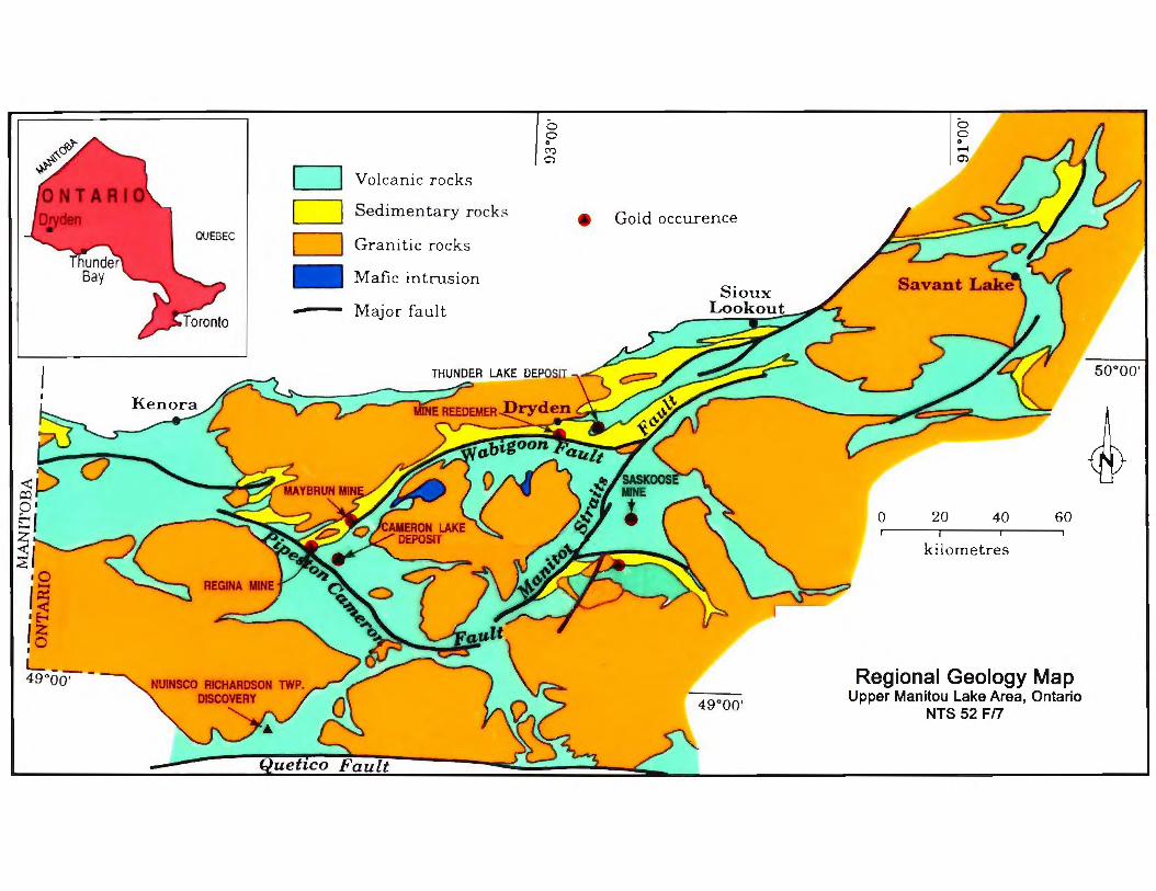
property is located near the historic Gold Rock Mining Camp, about 140 kilometres (“km”) south of the Town of Dryden, or approximately 900 km northwest of Toronto. 6.0 History According to Harron (2003), the first geological reconnaissance of the area was undertaken by W. McInnes (1902) for the Geological Survey of Canada in the 1896-98 period. Gold deposits and in the Manitou Lakes-Lake of the Woods areas are documented by Coleman (1895, 1897, 1898), Bow (1898, 1900), Bow and Carter (1901), Carter (1902, 1904, 1905), Miller (1903), Corkill (1906, 1907, 1908, 1909, 1910), Parsons (1911, 1912) and Bruce (1925). In 1932, Thomson mapped the geology in the Manitou-Stormy Lakes area, and in 1933 mapped the adjacent Straw-Manitou Lakes area (Thomson, 1934). In 1937, Thomson (1942) described the gold occurrences at Gold Rock. Detailed mapping was undertaken by Blackburn (1976, 1979, 1981) in the area during 1972 and 1975, which is summarized in a report (Blackburn, 1982). Airborne electromagnetic and magnetic surveys were completed over the greenstone belt in 1979-80 (OGS, 1980), and in 2001 (OGS, 2001). Gold was first discovered in the Manitou Lakes region before 1894, and the local “gold rush” occurred from 1895 till 1912. Historically there were about 20 “mines” in the Gold Rock area, which would be currently classified as prospects. The principal mines in the camp were the Big Master (production 1900-06, and 1942-43), the Laurentian (production 1906-09), and the Jubilee (Elora) with production from 1906-1907, and 1939. Interest in the area was renewed in the 1930’s, and some of the old mines and prospects were re-examined. This period also saw additional production from the Elora (1939) and the Big Master (1942-43 and 1947) deposits. After this activity, the area was once again dormant until the 1980’s. In 1983 a prospector staked ground covering the peep Bay occurrence and the East Manitou stretch property, which was optioned to Spartan Resources. Spartan Resources carried out an extensive program of geological mapping, soil sampling and geophysical surveying. Followup trenching, bedrock sampling, drilling occurred. In 1989 Homestake mineral Development Company underwent a Total field and gradiometer magnetic, VLF-EM survey on part of the land now occupied by the current claim. 7.0 Regional Geology According to Harron (2003), the western part of the Archean age Wabigoon Subprovince is underlain by supracrustal rocks consisting of volcanic and lesser sedimentary rocks ranging in age from 3.0 to 2.71 Ga, which are intruded by granitoid batholiths and gabbroic sills and stocks which range in age from 3.0 to 2.69 Ga. Ten greenstone belts have been recognized in this portion of the subprovince, of which the current property is situated in the Eagle-Wabigoon-Manitou Lakes greenstone belt. This greenstone belt trends northeast and is bounded on the northwest by the Atikwa granitoid batholith and on the southeast by the Irene-Eltrut Lakes batholith, and the Meggissi granitoid pluton. The northeast trending, steeply southeast dipping Manitou Straits Fault (“MSF”) has been traced over a distance of 65 km along strike and bisects the greenstone belt. This fault is also considered to represent the eastern extension of the Pipestone-Cameron Fault located on the southwestern side of the Atikwa batholith (Figure 3).
7
On the northwestern side of the MSF, the Blanchard Lake group apparently occupies the axial portion of the Manitou Anticline (Goodwin, 1970) and is considered to be the lowest stratigraphic assemblage in the area northwest of the MSF. The axis of the anticline strikes northeast and plunges northeast; however, the anticline is overturned as both limbs dip southeast. The Blanchard Lake Group tholeiitic basalts are predominately fine-to medium-grained pillowed and massive flows with well-developed flow top breccias. The western portion of the assemblage has been metamorphosed to amphibolite grade due to the intrusion of the Atikwa felsic batholith. Unconformably overlying the Blanchard Lake basalts is a thick assemblage of coarse calc-alkaline pyroclastics of intermediate to felsic composition, with a subordinate amount of interbedded tholeiitic basalts occurring along the limbs of the Manitou Anticline and called the Upper Manitou Lake Group . Interbedded tuff breccias, lapilli tuff and fine-grained bedded tuff are the main rock units. The upper stratigraphic contact with the Benson Bay Subgroup of the Pincher Lake group is characterized by decreasing amounts of pyroclastic material and an increase in the quantity of basalt. The Benson Bay Subgroup tholeiitic basalts are amygdaloidal, mainly massive flows, with lesser amounts of pillowed flows exhibiting well-developed flow top breccias. The western part of this sequence also exhibits amphibolite grade metamorphism caused by the Atikwa bathloith. Near its margin, the batholith comprises porphyritic and fine-grained phases of quartz monzonite, granodiorite and trondjemite. Radiometric age dates and the presence of basalt xenoliths imply that the marginal phases of the batholith are synvolcanic. All of the supracrustal rocks have been intruded by numerous northeast striking felsic dykes and sills of Archean age. Diabase dykes of Mesoproterozoic age also intrude the entire supracrustal rock sequence. Balckburn (1976) mapped the MSF as a > 60 metre wide zone composed of carbonate-altered, highly fissile, schistose rocks. As interpreted by Parker (1989), there is about a 4 to 5 km wide belt of discreet, anastomosing sheared and altered structures to the northwest from the MSF. This broad alteration/tectonic zone is referred to as the Manitou Straits Deformation Zone (“MSDZ”) and it extends northeast through the Gold Rock area and encompasses most of the gold occurrences and past producing deposits. Airborne magnetic maps of the area (OGS Maps 82164, 82168) show a strong magnetic pattern trending northeast along the margins of the MSDZ. Within the confines of the MSDZ, the magnetic fabric is more chaotic, reflecting the presence of carbonate alteration, subsidiary structures and a mixed lithology of felsic and mafic volcanics, as well as both felsic and mafic intrusions. The MSF, as interpreted by Blackburn represents the southeastern boundary fault of the broader MSDZ. Airborne magnetic data shows a good correlation with the mapped geology. Elevated magnetic intensity occurs on areas mapped as mafic volcanic rocks, with a concurrent decrease in the magnitude of the response over areas of felsic volcanic rocks. Linear magnetic lows within positive magnetic features, which follow the mapped bedrock structures can be correlated with shearing and hydrothermal alteration. Detailed mapping by Leonard (1984) indicates that the basal portion of the Benson Bay Subgroup comprises mostly chlorite schist with abundant magnetite mineralization. This unit has the highest magnetic susceptibility shown in Figure 5, and its distribution helps in the definition of the Manitou Anticline. The past producing mines of the Gold Rock district also appear to be associated with this positive feature. Airborne electromagnetic conductors within the MSDZ either mimic the strongly developed northeast striking magnetic and structural/stratigraphic fabric, or appear as “S” or “Z”-shaped conductive zones extending over several kilometers (Figure 5). This is consistent with re-activation of portions of the fault system with both dextral and sinistral shearing. Parker’s (1989)

8
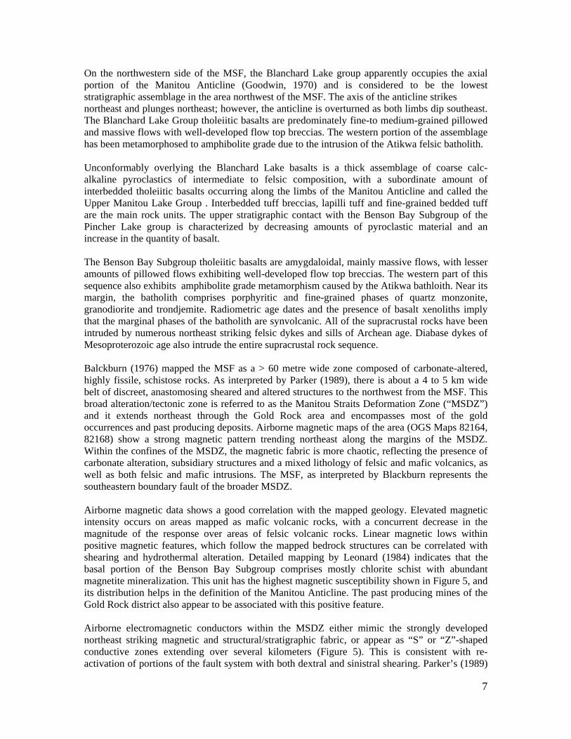
study of the gold deposits in the district showed that vein geometries reflected a history of both dextral and sinistral deformation overprinted by later vertical movement. Outside of the MSDZ, the magnetic pattern is more random and the electromagnetic conductors are defined as discrete responses. There are 61 known gold showings, occurrences, prospects and deposits in the Upper Manitou Lake area (Gold Rock mining camp), including three past producers: Laurentian Mine (1906-09), Elora (Jubilee) Mine (1906-07) and the Big Master Mine (1900-06, 1942-43). Ninety percent of the known occurrences are located within the MSDZ. Shear zones internal to the MSDZ trending north-northeast, northeast and east-west are the principal mineralized structures in the camp. Northerly trending brittle cross faults in the area appear to be post-mineralization and are associated with brecciation and fracturing of the host rocks. The Jubilee vein at the Laurentian and Elora mines, as well as the veins at the Big Master mine are all spatially associated with feldspar phyric mafic volcanic rocks. Wallrock alteration consisting of bleaching at all three deposits comprises sericitization, chloritization, ferroan and calcium carbonatization, and pyritization (1-5%) accompanied by tourmaline and fuschite over widths of 1.5 to 1.8 m. The mineralized veins consist of numerous grey-white quartz veins, stringers and lenses with visible gold and minor pyrite. The mineralized structures have strike lengths of 1 to 1.5 km, and the veins within them vary from a few centimeters to 4 metres in width. The highly variable width is attributed to boudinaging and/or tectonic thickening. Total production from the camp amounts to approximately 376.4 kg gold derived from 43,627 tonnes mined sporadically during the 1900-1943 period. 8.0 Current Work Program The current work program consisted of geological surveying and sampling of zones of interest on the proposed grid, as proposed by Bob Major, 2009, after conducting a VLF geophysical survey. 2.2km of N-S lines are proposed. Mapping was conducted approximately along the proposed baselines, with particular effort devoted to establishing the location and structure involved with the mineral occurrence. The VLF survey was conducted January 2009 and the mapping portion of the field-work was conducted during the period from June 1st to June 3rd 2010. 8.1 Property Geology The mapping demonstrated that the property is underlain by mafic, intermediate and felsic volcanic rocks. Basalt and chlorite-sericite schist are the main rock types encountered, with basalt predominating on the south and east parts of the grid, and chlorite-sericite schist predominating to the west and north. Please refer to Figure 4. Mafic Metavolcanic Rocks 1a Basalt This unit is typically aphanitic, though locally may have hornblende phenocrysts. Most outcrops show a strong chlorite alteration, and minor sericite alteration from minor plagioclase content. It generally weathers medium to dark green-grey, with local dark green chloritic spots and is dark grey-green on the fresh surface. With increasing degrees of foliation, commonly in small localized zones, the rock grades into chlorite schist. The rock may consist of up to 40% plagioclase.
- ....
II
'?>~(\::)
¥
~ • '-
(""'
)
/
/ /
/ /
//
/
/ /
/ .I
I I
/ /
/ /
/
/
/ /
/ N / ._ , /
I /
/
/
" /
/ /
/ /
/ /
/ /
/
I I
I I
I I
I
I • 1'8···· I I
0~ : I.
N
I """"'-~·IIi Kll-~~Q
,-._,.,-ua flililll ,-- ....._.,.. .. .,..,M1l .. \· tltlffll:l ft'WIIllttt'ltiM.fiJ/tiiiM. ... ........O
.-< ---@ IIA•~J~~<W' ..... .._. ,..liffil __ ___
A.ll. SlrA.Ill'
~~ ~ ......... MON:ttwr•••• ! .. ... ,. ... _ ~.,..,.,.
,. . .... ,, ,_,.ltf~
JVX
• 1. l
1
' i
10
1b Chlorite Schist This rock is generally fine-grained, chlorite-rich and is strongly foliated. It is dark green on the fresh surface, and weathers a dark green-grey colour. Intermediate Metavolcanic Rocks 2a Chlorite-Sericite Schist This rock is strongly foliated and consists of chlorite and sericite in various proportions. It breaks apart into fairly thin plates. It generally weathers a tan to pale-medium green-grey colour with dark green streaks and pale grey patches. Fresh surfaces are tan with pale-medium green-grey streaks. It is generally fine-grained texturally. Locally can be silicified and very hard. Felsic Metavolcanic Rocks 3a Quartz-Sericite Schist The quartz-sericite schist is fine-grained, and it weathers from a tan colour to blotchy pale grey. Where minor disseminated pyrite is present, the partings are rusty. On the fresh surface it is shiny, and varies from pale to medium grey or greenish grey and tan coloured with local brown spots. It is very fissile and breaks apart into thin plates. Locally it is silicified and hard. 8.2 Structural Geology Foliations in the majority of the map area trend northeasterly, whereas one foliation measurement on L 100 E approximately 0 N (proposed grid lines) trend southeasterly. The foliation at the suspected showing (L 0 E, 50 N, proposed grid lines) trends N-S. The presence of alternating sequences of chlorite (sericite) schist and undeformed basalt in the eastern portion of the map area suggests localized minor shear zones focused in the schistose units trending parallel to the major structural features of the Manitou lake area. The deformation intensity, with finely laminated quartz-sericite schist and centimeter scale folding of the foliation, at the suspected showing suggests the presence of a shear zone extending along L 0 E. This interpreted shear zone would also explain the complex position of the lithologic units in this area. It is postulated that this shear zone strikes approximately 190° and dips 70° W to vertically. 8.3 Mineralization An outcrop of basalt was observed at L 100 W/ 250N (proposed grid). It contains 1-5% euhedral cubes of pyrite (mostly weathered) up to 2cm in size. The southern end of the outcrop is very foliated northeasterly and the undeformed rocks contiguous with the foliated section are mineralized with approximately 5% disseminated euhedral pyrite grains. A small blast pit measuring 4m by 3m was located at UTM 491079E, 5441367N, about 5m East of L 0E/300N. This location does not correlate with the GPS location provided with the chargeability survey provided by Bob Major, though its position on the map, with respect to geographic features such as local lakeshores and hills, is strikingly similar. Samples 10-SK-20-A, B, and C were collected from a small blast pit. The lithology is characterized as silicified quartz-sericite schist, finely foliated, with pyrite bearing quartz veins. Pyrite also occurs as sub-millimeter disseminated euhedral grains. Both the foliation and mineralized veins are locally folded at an approximately 5cm scale, and the greatest concentrations of mineralization occur within and near the folds. These features are possibly indicative of a northerly striking shear zone.
11
Other than the mineral occurrence in the above mentioned blast pit, no mineralization was observed in either carbonate or quartz veins. In all other locations veins were observed to cross cut the foliation, whereas the veins in the occurrence in the blast pit were parallel to the foliation. A series of outcrops in the southeast portion of the mapped area pyrite mineralized undeformed basalts in the southeast corner of the mapped area. Sample 10-SK-06-A collected at UTM 491326E, 5440830N shows disseminated euhedral pyrite content up to approximately 2%, and a single sub-millimeter bleb of visible gold. This is not directly linked to a structural feature though the surrounding area was outside the area of interest. Further exploration and mapping is recommended.
8.4 Geophysical Geology
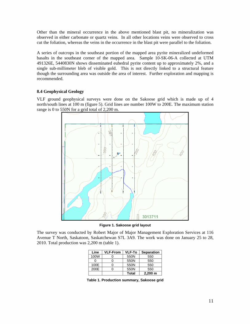
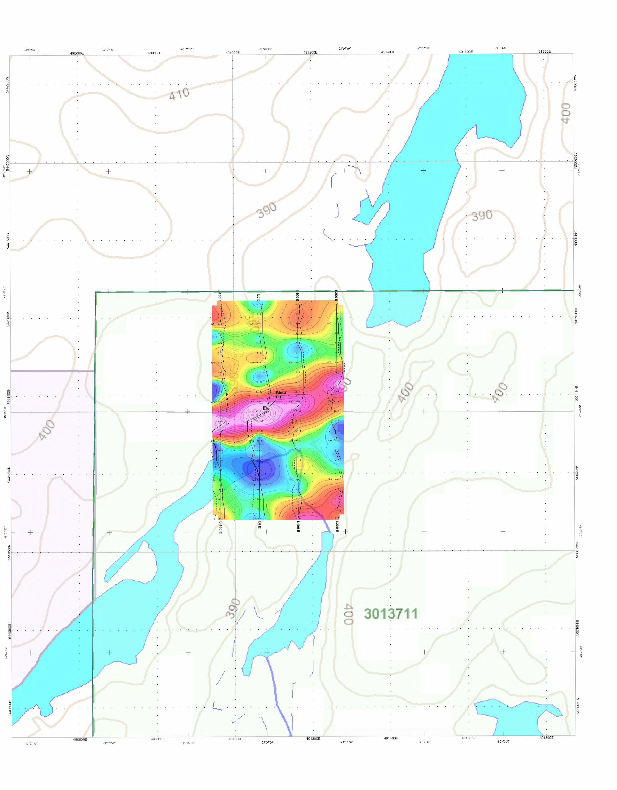
VLF ground geophysical surveys were done on the Sakoose grid which is made up of 4 north/south lines at 100 m (figure 5). Grid lines are number 100W to 200E. The maximum station range is 0 to 550N for a grid total of 2,200 m.
Figure 1. Sakoose grid layout
The survey was conducted by Robert Major of Major Management Exploration Services at 116 Avenue T North, Saskatoon, Saskatchewan S7L 3A9. The work was done on January 25 to 28, 2010. Total production was 2,200 m (table 1).
Line VLF-From VLF-To Separation100W 0 550N 550
0 0 550N 550 100E 0 550N 550 200E 0 550N 550
Total 2,200 m
Table 1. Production summary, Sakoose grid
12
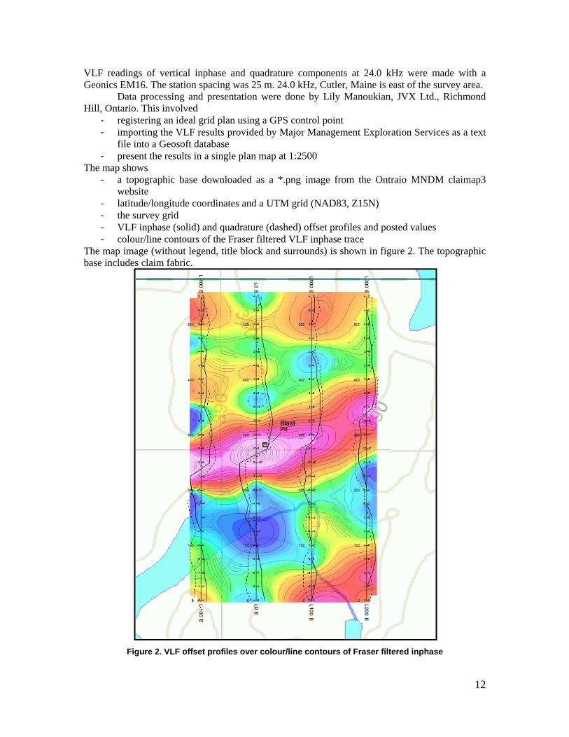
VLF readings of vertical inphase and quadrature components at 24.0 kHz were made with a Geonics EM16. The station spacing was 25 m. 24.0 kHz, Cutler, Maine is east of the survey area. Data processing and presentation were done by Lily Manoukian, JVX Ltd., Richmond Hill, Ontario. This involved
‐ registering an ideal grid plan using a GPS control point ‐ importing the VLF results provided by Major Management Exploration Services as a text
file into a Geosoft database ‐ present the results in a single plan map at 1:2500
The map shows ‐ a topographic base downloaded as a *.png image from the Ontraio MNDM claimap3
website ‐ latitude/longitude coordinates and a UTM grid (NAD83, Z15N) ‐ the survey grid ‐ VLF inphase (solid) and quadrature (dashed) offset profiles and posted values ‐ colour/line contours of the Fraser filtered VLF inphase trace
The map image (without legend, title block and surrounds) is shown in figure 2. The topographic base includes claim fabric.
Figure 2. VLF offset profiles over colour/line contours of Fraser filtered inphase
13
9.0 Sampling Method and Analyses The author collected grab samples of any rocks which appeared to be of interest. These include highly sheared material, quartz veined material as well as any material containing appreciable sulphide mineralization. Samples were located with respect to UTM co-ordinates (datum NAD 83 Canada). A total of 11 samples were collected by the author. 10.0 Interpretation and Conclusions The author conducted a mapping and sampling program on IMPG’s Sakoose property from June 1st to June 3rd 2010, which covered 2.2 km of proposed grid lines located near the southern shore of Manitou lake. A total of 11 samples were collected by the author. Unfortunately the analytical results from the samples have not yet been received. Consequently, the interpretation and conclusions in this report are preliminary in nature and will be expanded upon when all of the data have been received. The area mapped is underlain by a sequence of mafic, intermediate and felsic volcanic rocks. The predominant trend of the foliation in the rocks in the area is northeast. One North trending shear zone was inferred along L 0 E. This structure may represent a zone of enhanced dilation and contains second-order structures such as shear folding. Samples 10-SK-20-A, B, and C were collected from a small blast pit at UTM 491079E, 5441367N, about 15M East of L 0E/300N (proposed grid). This area is characterized by silicified quartz-sericite schist, finely foliated, with pyrite bearing quartz veins. Both the foliation and mineralized veins are locally folded at an approximately 5cm scale. This material is possibly indicative of a northerly striking shear zone. If any gold values of significance are reported from the samples, this zone will represent an exploration target. A further target may be the lightly pyrite mineralized undeformed basalts in the southeast corner of the mapped area. Sample 10-SK-06-A collected UTM 491326E, 5440830N shows disseminated euhedral pyrite content up to approximately 2%, and a sub-millimeter bleb of visible gold/Chalcopyrite. This is not directly linked to a structural feature though the surrounding area was outside the area of interest. Further exploration and mapping is recommended. In the absence of the analytical results from the sampling, as well as the results of any geophysical surveying, it is difficult to determine specific recommendations. However, the author is of the opinion that the geophysical surveying should be extended to the east and south during the fall and winter months. The exact orientation of the grid lines should be determined upon receipt of all of the relevant data, lines trending E-W should be considered, in order to test the possibility that zones of exploration interest may strike both northeast, as well as north-south. 11.0 Bibloigraphy
Blackburn, C.E., 1976, Geology of the Lower Manitou-Uphill Lakes Area, District of Kenora; Ontario Div. Of Mines, Geoscience Report 142, 81p., accompanied Map 2320, scale 1:31,680. Carter, W.E.H., 1905, Mines of Western Ontario; Ont. Bur. Mines, ANN. Rpt., V.XIIV, pt. 1, sec3, p. 43-75.
14
Goodwin, A. M. 1970, Archean Volcanic Studies in the Lake of the Woods-Manitou Lake-Wabigoon Region of Western Ontario; Ontario Dept. of Mines, OFR 5042, 47p. Accompanied by eleven tables and one map, scalee 1 inch to 4 miles. Hamilton, W.S. 2007, Geology report on the Gold Rock Property, boyer Lake area Kenora Mining Division for Goldeye Explorations Limited, Internal document. Harron, G.A., 2003, Qualifying report on the Goldrock Property for Goldeye Explorations Limited, Kenora M.D., Ontario, 27p. Leonard, K.W., 1984, Report on a geological survey, Goldrock Claim Group; St. Joe Canada Inc., Ont Geol. Surv. Assessment File #2.7374. McIvor, D., 1989, The results of geophysical surveys on the east Manitou srech property, napanee lake and vista lake areas, kenora mining division, Ontario, ON Geol. Surv. Assesment Report File #52F07NE0006 Parker, J.R., 1989, Geology, gold mineralization and property visits in the area investigated by Dryden-Ignace Economic Geologist, 1984-1987; Ontario geol. Surv. Open File 5723, 306p. Thompson, J.E., 1933, Geology of the Manitou-Stormy Lakes Area; Ontario Dept. Mines, Vol.42, pt.4, p.1-40 (published 1934). Accompanied by Map 42c, scale 1 inch to 1 mile.
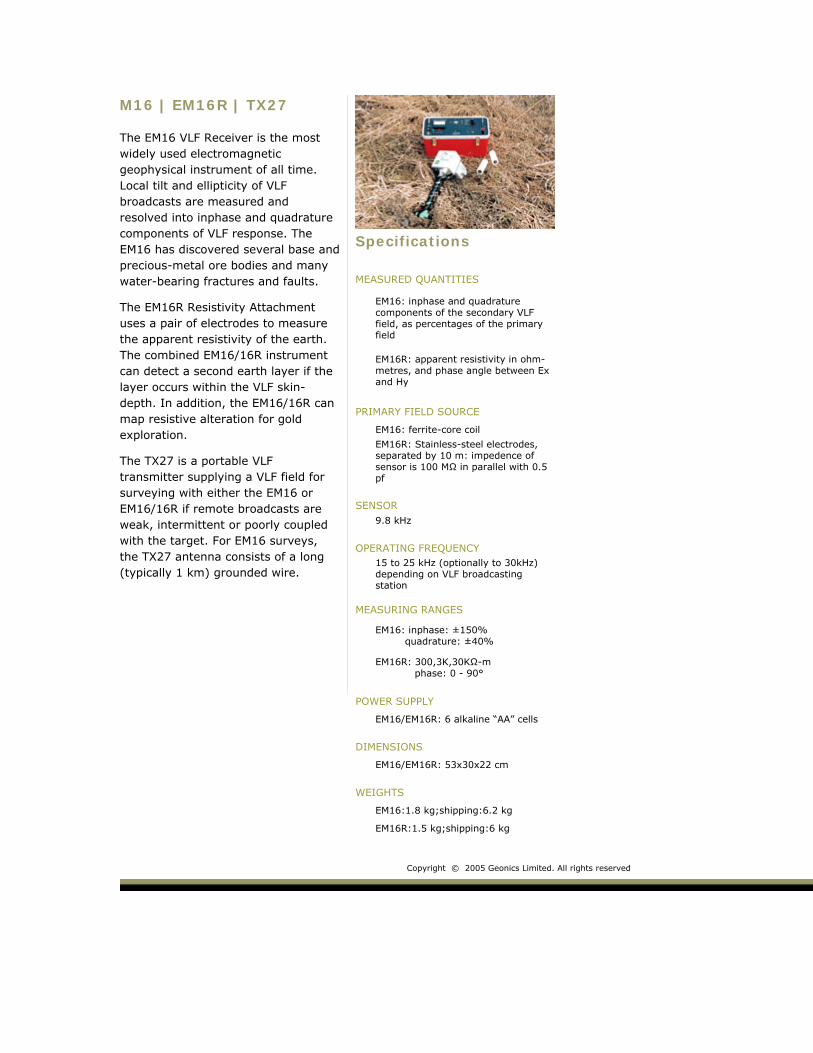
M16 | EM16R | TX27
The EM16 VLF Receiver is the most widely used electromagnetic geophysical instrument of all time. Local tilt and ellipticity of VLF broadcasts are measured and resolved into inphase and quadrature components of VLF response. The EM16 has discovered several base and precious-metal ore bodies and many water-bearing fractures and faults.
The EM16R Resistivity Attachment uses a pair of electrodes to measure the apparent resistivity of the earth. The combined EM16/16R instrument can detect a second earth layer if the layer occurs within the VLF skin-depth. In addition, the EM16/16R can map resistive alteration for gold exploration.
The TX27 is a portable VLF transmitter supplying a VLF field for surveying with either the EM16 or EM16/16R if remote broadcasts are weak, intermittent or poorly coupled with the target. For EM16 surveys, the TX27 antenna consists of a long (typically 1 km) grounded wire.
Specifications
MEASURED QUANTITIES
EM16: inphase and quadrature components of the secondary VLF field, as percentages of the primary field
EM16R: apparent resistivity in ohm-metres, and phase angle between Ex and Hy
PRIMARY FIELD SOURCE
EM16: ferrite-core coil
EM16R: Stainless-steel electrodes, separated by 10 m: impedence of sensor is 100 MΩ in parallel with 0.5 pf
SENSOR
9.8 kHz
OPERATING FREQUENCY
15 to 25 kHz (optionally to 30kHz) depending on VLF broadcasting station
MEASURING RANGES
EM16: inphase: ±150% quadrature: ±40%
EM16R: 300,3K,30KΩ-m phase: 0 - 90°
POWER SUPPLY
EM16/EM16R: 6 alkaline “AA” cells
DIMENSIONS
EM16/EM16R: 53x30x22 cm
WEIGHTS
EM16:1.8 kg;shipping:6.2 kg
EM16R:1.5 kg;shipping:6 kg
Copyright © 2005 Geonics Limited. All rights reserved
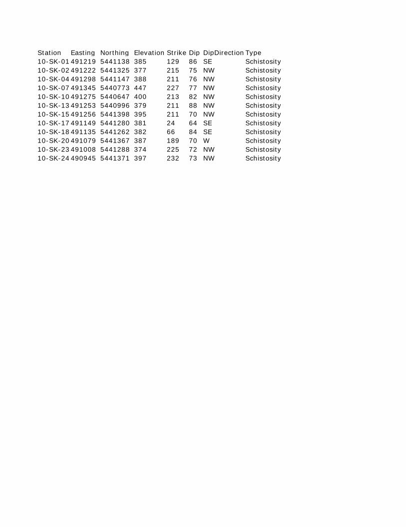
Station Easting Northing Elevation Strike Dip DipDirection Type10-SK-01 491219 5441138 385 129 86 SE Schistosity10-SK-02 491222 5441325 377 215 75 NW Schistosity10-SK-04 491298 5441147 388 211 76 NW Schistosity10-SK-07 491345 5440773 447 227 77 NW Schistosity10-SK-10 491275 5440647 400 213 82 NW Schistosity10-SK-13 491253 5440996 379 211 88 NW Schistosity10-SK-15 491256 5441398 395 211 70 NW Schistosity10-SK-17 491149 5441280 381 24 64 SE Schistosity10-SK-18 491135 5441262 382 66 84 SE Schistosity10-SK-20 491079 5441367 387 189 70 W Schistosity10-SK-23 491008 5441288 374 225 72 NW Schistosity10-SK-24 490945 5441371 397 232 73 NW Schistosity
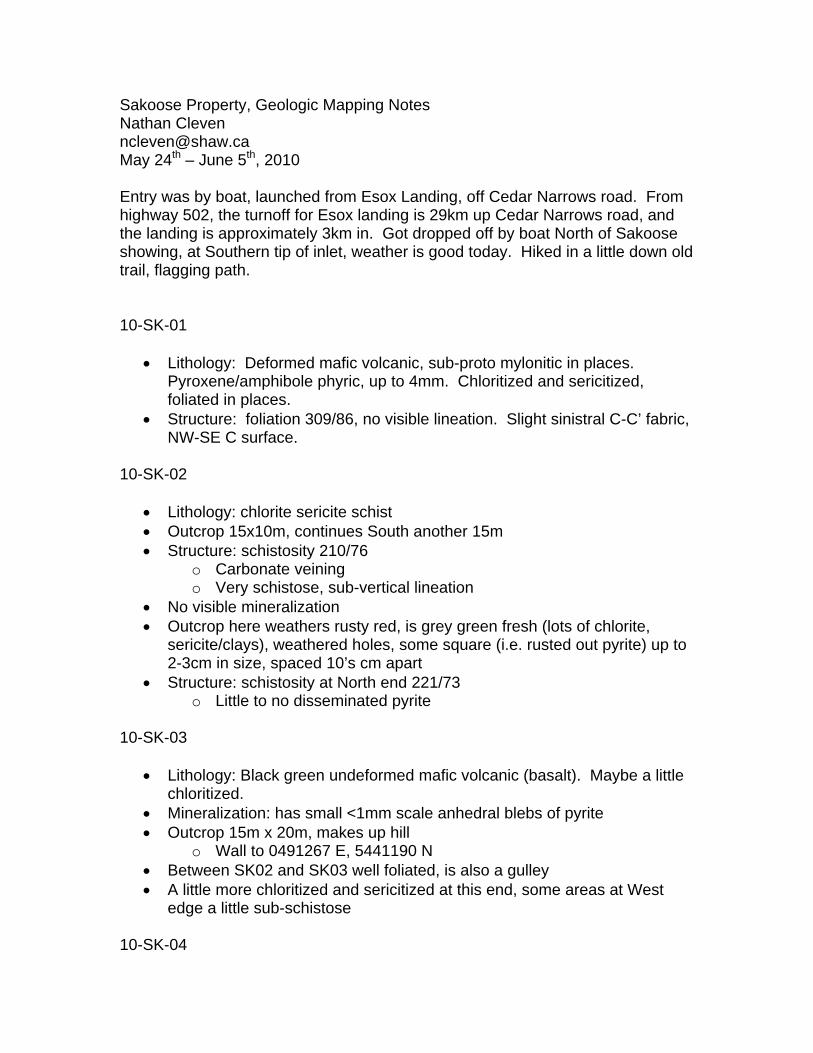
Sakoose Property, Geologic Mapping Notes Nathan Cleven [email protected] May 24th – June 5th, 2010 Entry was by boat, launched from Esox Landing, off Cedar Narrows road. From highway 502, the turnoff for Esox landing is 29km up Cedar Narrows road, and the landing is approximately 3km in. Got dropped off by boat North of Sakoose showing, at Southern tip of inlet, weather is good today. Hiked in a little down old trail, flagging path. 10-SK-01
• Lithology: Deformed mafic volcanic, sub-proto mylonitic in places. Pyroxene/amphibole phyric, up to 4mm. Chloritized and sericitized, foliated in places.
• Structure: foliation 309/86, no visible lineation. Slight sinistral C-C’ fabric, NW-SE C surface.
10-SK-02
• Lithology: chlorite sericite schist • Outcrop 15x10m, continues South another 15m • Structure: schistosity 210/76
o Carbonate veining o Very schistose, sub-vertical lineation
• No visible mineralization • Outcrop here weathers rusty red, is grey green fresh (lots of chlorite,
sericite/clays), weathered holes, some square (i.e. rusted out pyrite) up to 2-3cm in size, spaced 10’s cm apart
• Structure: schistosity at North end 221/73 o Little to no disseminated pyrite
10-SK-03
• Lithology: Black green undeformed mafic volcanic (basalt). Maybe a little chloritized.
• Mineralization: has small <1mm scale anhedral blebs of pyrite • Outcrop 15m x 20m, makes up hill
o Wall to 0491267 E, 5441190 N • Between SK02 and SK03 well foliated, is also a gulley • A little more chloritized and sericitized at this end, some areas at West
edge a little sub-schistose 10-SK-04
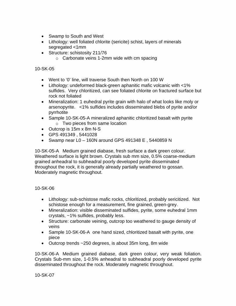
• Swamp to South and West • Lithology: well foliated chlorite (sericite) schist, layers of minerals
segregated <1mm • Structure: schistosity 211/76
o Carbonate veins 1-2mm wide with cm spacing 10-SK-05
• Went to ‘0’ line, will traverse South then North on 100 W • Lithology: undeformed black-green aphanitic mafic volcanic with <1%
sulfides. Very chloritized, can see foliated chlorite on fractured surface but rock not foliated
• Mineralization: 1 euhedral pyrite grain with halo of what looks like moly or arsenopyrite. <1% sulfides includes disseminated blebs of pyrite and/or pyrrhotite
• Sample 10-SK-05-A mineralized aphanitic chloritized basalt with pyrite o Two pieces from same location
• Outcrop is 15m x 8m N-S • GPS 491349 , 5441028 • Swamp near L0 – 160N around GPS 491348 E , 5440859 N
10-SK-05-A Medium grained diabase, fresh surface a dark green colour. Weathered surface is light brown. Crystals sub mm size, 0.5% coarse-medium grained anheadral to subheadral poorly developed pyrite disseminated throughout the rock, it is generally already partially weathered to gossan. Moderately magnetic throughout. 10-SK-06
• Lithology: sub-schistose mafic rocks, chloritized, probably sericitized. Not schistose enough for a measurement, fine grained, green-grey.
• Mineralization: visible disseminated sulfides, pyrite, some euhedral 1mm crystals, ~1% sulfides, probably less.
• Structure: carbonate veining, outcrop too weathered to gauge density of veins
• Sample 10-SK-06-A one hand sized, chloritized basalt with pyrite, one piece
• Outcrop trends ~250 degrees, is about 35m long, 8m wide 10-SK-06-A Medium grained diabase, dark green colour, very weak foliation. Crystals Sub-mm size, 1-0.5% anheadral to subheadral poorly developed pyrite disseminated throughout the rock. Moderately magnetic throughout. 10-SK-07
• Another sub-schistose fine grained mafic. Not mineralized. • Structure: schistose foliation ~227/77 • Outcrop NE-SW, 15-20m by 10m • Green grey fresh surface, chlorite, sericite, no veins
10-SK-08
• Lithology: undeformed chloritized mafic volcanic (basalt). Generally aphanitic.
• Mineralization: Disseminated sulfides, with pyrite, anhedral, up to 1mm concentrations. Rock is <<1% sulfide.
• Outcrop is 15m x 10m • Some occasional concentrations of mineralization, blebs 1mm long • Sample 10-SK-08-A, basalt with 1% pyrite
10-SK-08-A Medium grained basalt, dark to medium green-grey colour on fresh surface, mottled brown on weathered surface. No structure or foliation. Less than 0.5% medium grained pyrite disseminated throughout and 2 discontinuous stringers of blebby pyrite found within sample. Moderately magnetic throughout. 10-SK-09
• Lithology: more undeformed volcanic, mafic, very chloritized and sericitized, not mineralized. Visible relict plagioclase, 1-2mm.
• Outcrop 10m x 5m, N-S 10-SK-10
• Lithology: undeformed chloritized basalt, minerals segregated, very chloritized, very foliated. Foliation anastamozes. Chlorite (sericite) schist at South end. Not obviously mineralized.
• Structure: schistosity 213/82 at one end, exposed at base of fallen tree. 10-SK-11
• Lithology: schistose mafic volcanic, chloritized heavily • Structure: carbonate veins 221/78 • Outcrop too covered for details, 25m long along strike, 8m wide
10-SK-12
• Same deal, gotta run – thunder • Outcrop NE-SW 15 x 5m
10-SK-13
• Lithology: schistose rocks, finely foliated, chlorite sericite schist • Structure: schistosity 211/88 • Outcrop is 15m x 5m along strike
10-SK-14
• Same, 10x5m outcrop, chlorite sericite schist 10-SK-15
• Lithology: Chlorite (sericite) schist • Structure: Well Foliated
o 211/70, schistose foliation o Carbonate veins, cross cutting foliation
• Mineralization: sulfide mineralized, <1%, pyrite clusters, up to 8mm • Outcrop 10m x 5m, extending along strike • Sample: 10-SK-15-A Chlorite schist with pyrite clusters
10-SK-15-A Chlorite schist, fine grained basalt composition, fresh surfaces dark green colour, weathered surface dark brown. Foliation is strong and consistent. Clusters of medium grained anheadral pyrite occur within white quartz pods and make up less than 0.5% of rock. Moderately magnetic throughout. 10-SK-16
• Continuation of SK-02 o At South end of outcrop
• Slightly silicified zone at end, with lots of pyrite mineralization. Euhedral pyrite up to ~6mm. Rock is ~5% sulfide. Mineralized just beside silicified zone.
• Sample: 10-SK-16-A Chlorite schist with pyrite o 1 bag
10-SK-16-A Mineralized chlorite schist, medium grey green colour on fresh surface, gossanized on weathered surface. Very fine grained, probably basalt composition. Moderate to strong foliation. 3-15% randomly oriented 2-8mm cubic pyrite found disseminated throughout. Not magnetic. 10-SK-17
• At lakeshore • Lithology: Still chloritized and sericitized mafic volcanic with carbonate
veins • Structure: schistosity not as developed here
o Foliated area to NE very schistose o Foliation 024/64 in NW
• Sample: 10-SK-17-A Blue-grey schist with pyrite o 3 pieces o at GPS
• Sample: 10-SK-17-B Schist with larger pyrite o 1 piece
• Mineralization: mineralized here, <<1%, with small pyrite and blue-grey fine dusting (graphite, or iron stains?)
• Outcrop 30m x 20m 10-SK-17-A Medium grained diabase, fresh surface a dark green colour. Weathered surface is light brown. Very weak foliation, schist not evident in samples. Crystals sub mm size, trace very fine grained pyrite mineralization. Non magnetic. 10-SK-17-B Medium grained diabase, fresh surface a dark green colour. Weathered surface is light brown. Very weak foliation, schist not evident in samples. 1% Anheadral medium grained pyrite mineralization. Non magnetic. 10-SK-18
• Near SK-17 • Starts at GPS, heads in West • River blocking access to South, won’t try to cross alone • This should be right along strike from SK-16 • Lithology: chlorite schist • Structure: very foliated, but generally barren of mineralization
o 066/84, schistosity • Outcrop continues along river 25m, back into woods, with 10m break
10-SK-19
• Lithology: still in Chloritized – sericitized mafic volcanic schist • Structure: very foliated • Mineralization: <<1% pyrite, mm sized cubes • Outcrop: 20m long, 8m wide • Sample: 10-SK-19-A mineralized schist, with pyrite • GPS at North end
10-SK-19-A Chlorite schist, fresh surfaces dark green colour, fine basalt composition. Strongly foliated. Large 2-4mm cubic pyrite found disseminated throughout rock. Non Magnetic. 10-SK-20
• Well foliated, but also silicified • Bands of grey silicified material • Lots of foliation parallel veins • Outcrop small, 5m x 15m • Quartz veins, boudinaged, or at least necked, also folded • Veins mineralized, looks like layer made up of fine grains pyrite, almost
continuous. • Mineralization is probably pyrite • Could this be the trench/showing? I think so. • Rock doesn’t look so mafic, more phyllitic • Structure: 189/70, foliation • GPS at North end, outcrop extends along strike • Sample: 10-SK-20-A outside foliated zone • Sample: 10-SK-20-B foliated, folded w/ quartz veins, silicified,
mineralized • Sample: 10-SK-20-C foliated, folded w/ quartz veins, silicified,
mineralized 10-SK-20-A silicified Quartz-sericite schist, weathered surface is strongly gossanized. Fresh surface is light to medium grey in colour and has discontinuous wormy veins and areas of highly silicified rock as well as one 1cm continuous quartz vein. Minor Beige coloured Sericite and white muscovite occurs throughout. Fine grained pyrite occurs in a blebs associated with a larger vein and disseminated throughout. 3% overall Pyrite is not commonly found within the veins but in proximity to them in the host rock. Foliation is strong and continuous. Non magnetic. 10-SK-20-B Quartz-sericite schist, weathered surface is weakly gossanized. Fresh surface is medium grey in colour and has wormy folded veins. Minor Beige coloured Sericite occurs throughout. Veins and sericite alteration highlight strong foliation and minor folding. Mineralization occurs both as fine grained disseminated pyrite and blebby anheadral pyrite bands. Non magnetic. 10-SK-20-C silicified Quartz-sericite schist, weathered surface is strongly gossanized with pyrite dissolved leaving cubic voids. Fresh surface is medium grey in colour and has discontinuous wormy veins and areas of highly silicified rock. Minor Beige coloured Sericite occurs throughout. Mineralization occurs throughout however is concentrated in 5% overall 1-2mm cubic silvery grey arsenopyrite cubes in association to the silicified veins. Very fine grained pyrite also occurs in a bleb associated with a larger vein. Pyrite is not commonly found within the veins but in proximity to them in the host rock. Non magnetic 10-SK-21
• Lithology: Non-mineralized chlorite sericite schist • Structure: very foliated
• Outcrop: extends along strike, 10m x 5m • Somewhat silicified and veined
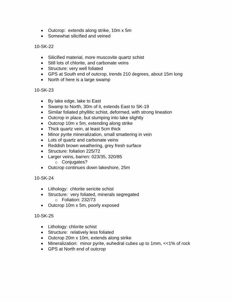
10-SK-22
• Silicified material, more muscovite quartz schist • Still lots of chlorite, and carbonate veins • Structure: very well foliated • GPS at South end of outcrop, trends 210 degrees, about 15m long • North of here is a large swamp
10-SK-23
• By lake edge, lake to East • Swamp to North, 30m of it, extends East to SK-19 • Similar foliated phyllitic schist, deformed, with strong lineation • Outcrop in place, but slumping into lake slightly • Outcrop 10m x 5m, extending along strike • Thick quartz vein, at least 5cm thick • Minor pyrite mineralization, small smattering in vein • Lots of quartz and carbonate veins • Reddish brown weathering, grey fresh surface • Structure: foliation 225/72 • Larger veins, barren: 023/35, 320/85
o Conjugates? • Outcrop continues down lakeshore, 25m
10-SK-24
• Lithology: chlorite sericite schist • Structure: very foliated, minerals segregated
o Foliation: 232/73 • Outcrop 10m x 5m, poorly exposed
10-SK-25
• Lithology: chlorite schist • Structure: relatively less foliated • Outcrop 20m x 10m, extends along strike • Mineralization: minor pyrite, euhedral cubes up to 1mm, <<1% of rock • GPS at North end of outcrop
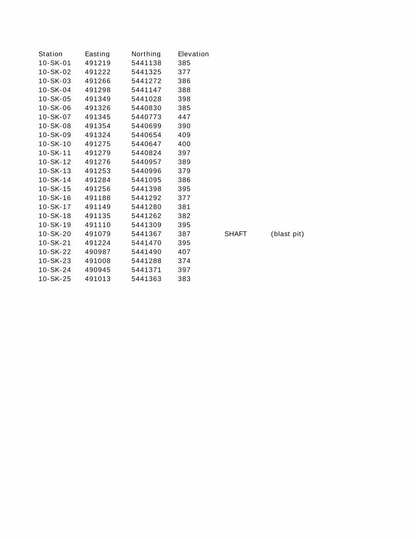
Station Easting Northing Elevation10-SK-01 491219 5441138 38510-SK-02 491222 5441325 37710-SK-03 491266 5441272 38610-SK-04 491298 5441147 38810-SK-05 491349 5441028 39810-SK-06 491326 5440830 38510-SK-07 491345 5440773 44710-SK-08 491354 5440699 39010-SK-09 491324 5440654 40910-SK-10 491275 5440647 40010-SK-11 491279 5440824 39710-SK-12 491276 5440957 38910-SK-13 491253 5440996 37910-SK-14 491284 5441095 38610-SK-15 491256 5441398 39510-SK-16 491188 5441292 37710-SK-17 491149 5441280 38110-SK-18 491135 5441262 38210-SK-19 491110 5441309 39510-SK-20 491079 5441367 387 SHAFT (blast pit)10-SK-21 491224 5441470 39510-SK-22 490987 5441490 40710-SK-23 491008 5441288 37410-SK-24 490945 5441371 39710-SK-25 491013 5441363 383
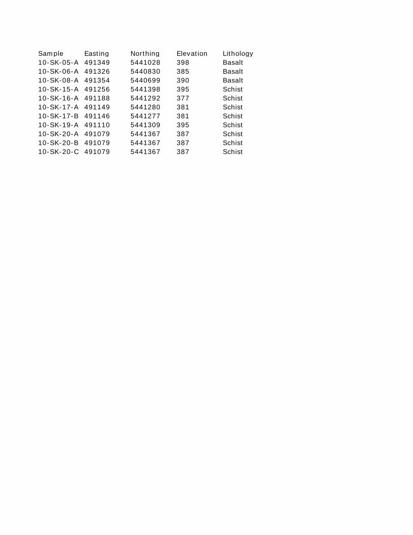
Sample Easting Northing Elevation Lithology10-SK-05-A 491349 5441028 398 Basalt10-SK-06-A 491326 5440830 385 Basalt10-SK-08-A 491354 5440699 390 Basalt10-SK-15-A 491256 5441398 395 Schist10-SK-16-A 491188 5441292 377 Schist10-SK-17-A 491149 5441280 381 Schist10-SK-17-B 491146 5441277 381 Schist10-SK-19-A 491110 5441309 395 Schist10-SK-20-A 491079 5441367 387 Schist10-SK-20-B 491079 5441367 387 Schist10-SK-20-C 491079 5441367 387 Schist
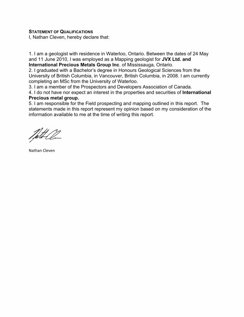
STATEMENT OF QUALIFICATIONS I, Nathan Cleven, hereby declare that: 1. I am a geologist with residence in Waterloo, Ontario. Between the dates of 24 May and 11 June 2010, I was employed as a Mapping geologist for JVX Ltd. and International Precious Metals Group Inc. of Mississauga, Ontario. 2. I graduated with a Bachelor’s degree in Honours Geological Sciences from the University of British Columbia, in Vancouver, British Columbia, in 2008. I am currently completing an MSc from the University of Waterloo. 3. I am a member of the Prospectors and Developers Association of Canada. 4. I do not have nor expect an interest in the properties and securities of International Precious metal group. 5. I am responsible for the Field prospecting and mapping outlined in this report. The statements made in this report represent my opinion based on my consideration of the information available to me at the time of writing this report.
Nathan Cleven
z 0 0 N N
~
z 0 0
"' ~ ~
z 0 0 N ~
~
z 0 0 0 ~ .,. ;I
z 0 0
"' 0 .,. ;I
-93"07'50" -93"07'40"
+
+ +
- .- . - ·- · . - ·-··--·--"- t·r-··--·--··-::·'
+ +
490600E -93"07'50" -93"07'40"
\
490800E
-93"07'30"
/ ~/+
/ /
+
. / /
1b
~~--~--·- ·
+
-93"07'30"
. I
I f
. I
.... c m
-93"07'20"
,,.
+
. - ·-··---;..----·--·- ·- ·- ·
-L.
491000E
... , \ \
-93"07'20"
c c m
·- ·--·--·-·{
)
r
491200E
-93"07'10" -93"07'00"
/ ./
./ ./ ./
/ ·
+
/ /
/
/ ./
/
/ / / /
_/,· / / ~ / / . cs,./_
I ~./
-93"06'50"
+
N
0 0 ~
t N
g z
~ "" ~ "' 0 0 z
t ~
"" 0 0 z
~-~---· _/_- -~*---H-- ---:""'J'"'"-" -"' .-...=F-.-.... .-/
lea.
/ /
/ '
/
/ /
/
I I
I I
I I I I·
·' f>y 13·· JI(05"
I
./ I
/
/ /
/
/ /
+
/ /
/
·r · ·- ·- · ·- ·- . / I le. / I Ji. ... / I /
\
I .it _.. ..il /
. I ... .iLJIL .11:.// / ' I .L . _.. I /
l. ;:l~ ,.. / . / /
. I . //~ . /' 1 / ·r!fJ /
. j' >(/ ///
l/ 1~ /,. . • / ~10 JICO&A'
/ .
+
ll / '~~/ Ot ·~ .
// tl , ..
491400E -93"07'10" -93"07'00"
J!kSlC.M[~NIIC...KOCKS. ~ QUAR1t. -StRICift SCHisf ~~RM£lll~1IlflM'tUAtUC ROCKS (ill CHIJ,(!~ -~IC~ StHisf'
lThfiC .. M~iN'Jl.CM!.CJOC~ [};] fiNE C4WN~ ~1 . ITfJ CK~Ofl.~ SCHIJf ---~ - - ··- ·· ........ - ----·""""'-·--·- .___
SYM~O~S
.-. . .....-·-. Lt.Kf _f't!MI! _.....- ___ _.,. ... "OC..06-IC~L- b»ff'AGf
~ "" ~ N 0 0 z
WWWW f~lilof ~.A§UfitO t 1--·--·-··--la
.p:= ::::<" = fRA II- ~
..&; INCUHJP FOLIId'Jt)N
@ AKEA ~ OllfC~Y .
eiOSI<OJ.II 5t..l1n! ,-ar- Ntt148~
-*. ..:li. SWAI1fi
. . . . . . . - . Q~ ........ ... OIJAI.'f'Z V~IHJN k
Cv ...... ..... ~llBilHAll! vf1NIIII6-
Py. : .. · ...... f'YRITI! ola.w~NCE"
- -----_ ......... .......... ........ . --o== '
491600E 491 800E -93"06'50"
~ "" 0
"' 0 0 z
50
2 1.6
17.6 13.8
10.6
8.6 7.2
5.6 4.0 2.6
1.8 1.2
0.2 -0.2
-0.8 -1.2
-1 .6
-2.0 -2.4
-2.6
-2.8 -3.2
-3.4 -3.6
-3.8
-4.0 -4 .2
-4.4
-4 .8 -5.0 -5_2 -5.4
-5.8 -6.0 -6.6
-7.0 -7 .4 -8.0
-9.2
IP Fraser Filter (%/m )
Scale 1 :2500 0 50
(meters) NAD831UTM ZOM 15N
100 150
INTERNATIONAL PRECIOUS METALS GROUP INC. SAKOOSE PROPERTY
LOWER MANITOU LAKE TWP. ONTARIO, NTS: 52 F/03
NEGATIVE EVEN FRASER FILTERED IN PHASE, VLF PROFILES 24.0 kHz- CUTLER MAINE STATION AND GEOLOGY
Profile Scale: 10 %/em Instrument: Geonocs E.M. 16
Surveyed by: Major Management Expiration Services Jan 2010 lnphase: Solid, posted right
Quadrature: Dashed, posted left Claims provided by:© Queen's Printer for Ontario, 2010
JVX LTD. ref. no. 10-39b, June 2010
CERTIFICATE OF ANALYSIS
Innovative Technologies Quality Analysis ...
Invoice No.:
Invoice Date:
Date Submitted:
Your Reference:
21-Jul-10
QUEEN ALEXANDRIA
13-Jul-10
A10-3869
International Precious Metals Group Inc.
7480 Magistrate TerraceMississauga ON L5W 1L2Canada
Jeff HunterATTN:
This report may be reproduced without our consent. If only selected portions of the report are reproduced, permission
must be obtained. If no instructions were given at time of sample submittal regarding excess material, it will be
discarded within 90 days of this report. Our liability is limited solely to the analytical cost of these analyses. Test results
are representative only of material submitted for analysis.
ACTIVATION LABORATORIES LTD.
1336 Sandhill Drive, Ancaster, Ontario Canada L9G 4V5 TELEPHONE +1.905.648.9611 or
+1.888.228.5227 FAX +1.905.648.9613
E-MAIL [email protected] ACTLABS GROUP WEBSITE www.actlabs.com
Emmanuel Eseme , Ph.D.
CERTIFIED BY :
REPORT A10-3869
Notes:
7 Rock samples were submitted for analysis.
Code 1A2 Au - Fire Assay AA
Code 1E Aqua Regia ICP(AQUAGEO)
If value exceeds upper limit we recommend reassay by fire assay gravimetric-Code 1A3
Values which exceed the upper limit should be assayed for accurate numbers.
Quality Control
The following analytical packages were requested:
Activation Laboratories Ltd. Report: A10-3869
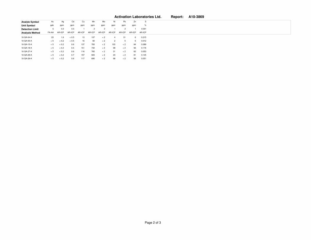
Au Ag Cd Cu Mn Mo Ni Pb Zn SAnalyte Symbol
ppb ppm ppm ppm ppm ppm ppm ppm ppm %Unit Symbol
5 0.2 0.5 1 2 2 1 2 1 0.001Detection Limit
FA-AA AR-ICP AR-ICP AR-ICP AR-ICP AR-ICP AR-ICP AR-ICP AR-ICP AR-ICPAnalysis Method
23 1.6 13 10710-QA-04-A < 2 4 31 6 0.215< 0.5
< 5 < 0.2 16 6010-QA-05-A < 2 2 5 6 0.012< 0.5
< 5 < 0.2 137 78310-QA-15-A < 2 103 < 2 64 0.0890.6
< 5 < 0.2 151 73210-QA-18-A < 2 99 < 2 56 0.1760.5
< 5 < 0.2 116 76510-QA-27-A < 2 31 < 2 63 0.0530.6
< 5 < 0.2 157 94510-QA-28-A < 2 23 < 2 81 0.1450.7
< 5 < 0.2 117 69510-QA-29-A < 2 68 < 2 58 0.0510.6
Page 2 of 3

Activation Laboratories Ltd. Report: A10-3869
Quality Control
Au Ag Cd Cu Mn Mo Ni Pb Zn SAnalyte Symbol
ppb ppm ppm ppm ppm ppm ppm ppm ppm %Unit Symbol
5 0.2 0.5 1 2 2 1 2 1 0.001Detection Limit
FA-AA AR-ICP AR-ICP AR-ICP AR-ICP AR-ICP AR-ICP AR-ICP AR-ICP AR-ICPAnalysis Method
28.1 1200 734GXR-1 Meas 14 32 582 674 0.1843.3
31.0 1110 852GXR-1 Cert 18.0 41.0 730 760 0.2573.30
3.7 6510 134GXR-4 Meas 323 40 42 74 1.7860.8
4.00 6520 155GXR-4 Cert 310 42.0 52.0 73.0 1.770.860
0.4 72 1030GXR-6 Meas < 2 24 98 130 0.0140.8
1.30 66.0 1010GXR-6 Cert 2.40 27.0 101 118 0.01601.00
967CDN-CGS-13 Meas
1010CDN-CGS-13 Cert
0.9 2550OREAS 13b (4-Acid) Meas
10 2390 57 1.203
0.86 2327OREAS 13b (4-Acid) Cert
9.0 2247 133 1.20
< 510-QA-18-A Orig
< 510-QA-18-A Dup
< 5Method Blank Method Blank
< 0.2 < 1 < 2Method Blank Method Blank
< 2 < 1 < 2 < 1 < 0.001< 0.5
Page 3 of 3

CERTIFICATE OF ANALYSIS
Innovative Technologies Quality Analysis ...
Invoice No.:
Invoice Date:
Date Submitted:
Your Reference:
20-Jul-10
SAKOOSE
13-Jul-10
A10-3868
International Precious Metals Group Inc.
7480 Magistrate TerraceMississauga ON L5W 1L2Canada
Jeff HunterATTN:
This report may be reproduced without our consent. If only selected portions of the report are reproduced, permission
must be obtained. If no instructions were given at time of sample submittal regarding excess material, it will be
discarded within 90 days of this report. Our liability is limited solely to the analytical cost of these analyses. Test results
are representative only of material submitted for analysis.
ACTIVATION LABORATORIES LTD.
1336 Sandhill Drive, Ancaster, Ontario Canada L9G 4V5 TELEPHONE +1.905.648.9611 or
+1.888.228.5227 FAX +1.905.648.9613
E-MAIL [email protected] ACTLABS GROUP WEBSITE www.actlabs.com
Emmanuel Eseme , Ph.D.
CERTIFIED BY :
REPORT A10-3868
Notes:
11 Rock samples were submitted for analysis.
Code 1A2 Au - Fire Assay AA
Code 1E Aqua Regia ICP(AQUAGEO)
If value exceeds upper limit we recommend reassay by fire assay gravimetric-Code 1A3
Values which exceed the upper limit should be assayed for accurate numbers.
Quality Control
The following analytical packages were requested:
Activation Laboratories Ltd. Report: A10-3868
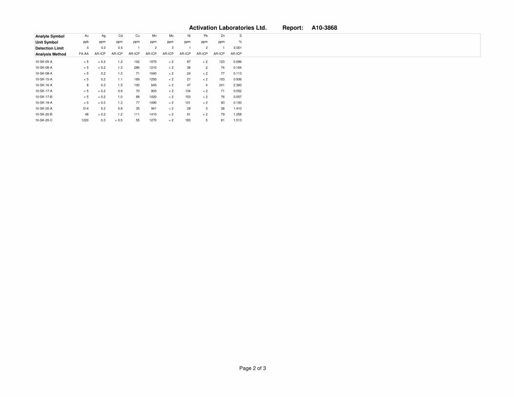
Au Ag Cd Cu Mn Mo Ni Pb Zn SAnalyte Symbol
ppb ppm ppm ppm ppm ppm ppm ppm ppm %Unit Symbol
5 0.2 0.5 1 2 2 1 2 1 0.001Detection Limit
FA-AA AR-ICP AR-ICP AR-ICP AR-ICP AR-ICP AR-ICP AR-ICP AR-ICP AR-ICPAnalysis Method
< 5 < 0.2 102 107010-SK-05-A < 2 87 < 2 123 0.0961.2
< 5 < 0.2 286 121010-SK-06-A < 2 36 2 74 0.1641.3
< 5 0.2 71 104010-SK-08-A < 2 24 < 2 77 0.1131.3
< 5 0.2 169 125010-SK-15-A < 2 27 < 2 103 0.9361.1
8 0.3 100 64510-SK-16-A < 2 47 4 241 2.3601.5
< 5 < 0.2 70 90310-SK-17-A < 2 134 < 2 71 0.0520.9
< 5 < 0.2 68 102010-SK-17-B < 2 153 < 2 76 0.0571.0
< 5 < 0.2 77 109010-SK-19-A < 2 101 < 2 93 0.1501.3
514 0.2 35 94110-SK-20-A < 2 28 3 38 1.4100.8
48 < 0.2 111 141010-SK-20-B < 2 61 < 2 79 1.2581.2
1220 0.3 55 127010-SK-20-C < 2 183 5 61 1.513< 0.5
Page 2 of 3
Activation Laboratories Ltd. Report: A10-3868
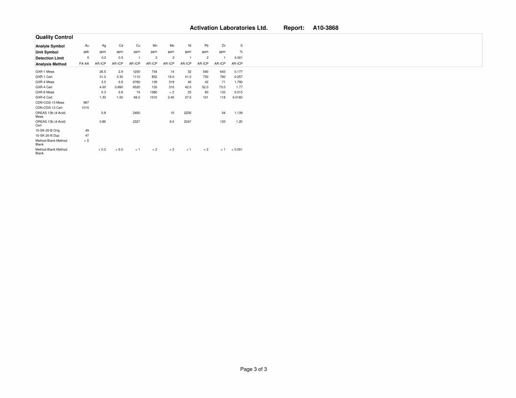
Quality Control
Au Ag Cd Cu Mn Mo Ni Pb Zn SAnalyte Symbol
ppb ppm ppm ppm ppm ppm ppm ppm ppm %Unit Symbol
5 0.2 0.5 1 2 2 1 2 1 0.001Detection Limit
FA-AA AR-ICP AR-ICP AR-ICP AR-ICP AR-ICP AR-ICP AR-ICP AR-ICP AR-ICPAnalysis Method
26.5 1200 734GXR-1 Meas 14 32 540 643 0.1772.9
31.0 1110 852GXR-1 Cert 18.0 41.0 730 760 0.2573.30
3.5 6760 139GXR-4 Meas 319 40 42 71 1.7900.8
4.00 6520 155GXR-4 Cert 310 42.0 52.0 73.0 1.770.860
0.3 74 1080GXR-6 Meas < 2 25 93 133 0.0150.8
1.30 66.0 1010GXR-6 Cert 2.40 27.0 101 118 0.01601.00
967CDN-CGS-13 Meas
1010CDN-CGS-13 Cert
0.8 2450OREAS 13b (4-Acid) Meas
10 2230 54 1.139
0.86 2327OREAS 13b (4-Acid) Cert
9.0 2247 133 1.20
4910-SK-20-B Orig
4710-SK-20-B Dup
< 5Method Blank Method Blank
< 0.2 < 1 < 2Method Blank Method Blank
< 2 < 1 < 2 < 1 < 0.001< 0.5
Page 3 of 3